uranium deposits in magmatic and metamorphic
TRANSCRIPT
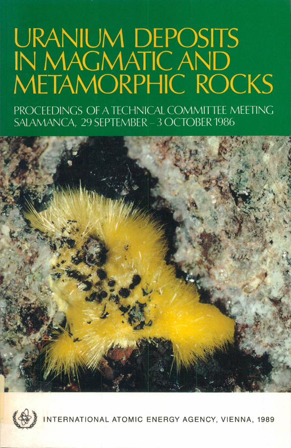
PROCEEDINGS OF A TECHNICAL COMMITTEE MEETING SALAMANCA, 29 SEPTEMBER - 3 OCTOBER 1986
3 I N T E R N A T I O N A L A T O M IC E N E R G Y AG E N C Y , V IE N N A , 1989
URANIUM DEPOSITS IN MAGMATIC AND METAMORPHIC ROCKS
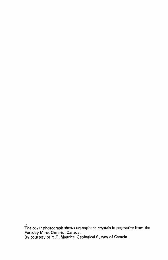
The cover photograph shows uranophane crystals in pegmatite from the Faraday Mine, Ontario, Canada.By courtesy of Y .T. Maurice, Geological Survey of Canada.
URANIUM DEPOSITS IN MAGMATIC AND
METAMORPHIC ROCKS
NUCLEAR SAFETY
INFORMATION LIBRARY
PL EASE RETURN
The following States are Members of the International Atomic Energy Agency:
AFGHANISTANALBANIAALGERIAARGENTINAAUSTRALIAAUSTRIABANGLADESHBELGIUMBOLIVIABRAZILBULGARIABURMABYELORUSSIAN SOVIET
SOCIALIST REPUBLIC CAMEROON CANADA CHILE CHINA COLOMBIA COSTA RICA COTE D'IVOIRE CUBA CYPRUSCZECHOSLOVAKIA DEMOCRATIC KAMPUCHEA DEMOCRATIC PEOPLE’S
REPUBLIC OF KOREA DENMARKDOMINICAN REPUBLICECUADOREGYPTEL SALVADORETHIOPIAFINLANDFRANCEGABONGERMAN DEMOCRATIC REPUBLIC GERMANY, FEDERAL REPUBLIC OF GHANA GREECE
GUATEMALAHAITIHOLY SEEHUNGARYICELANDINDIAINDONESIAIRAN, ISLAMIC REPUBLIC OFIRAQIRELANDISRAELITALYJAMAICAJAPANJORDANKENYAKOREA, REPUBLIC OF KUWAIT LEBANON LIBERIALIBYAN ARAB JAMAHIRIYALIECHTENSTEINLUXEMBOURGMADAGASCARMALAYSIAMALIMAURITIUSMEXICOMONACOMONGOLIAMOROCCONAMIBIANETHERLANDSNEW ZEALANDNICARAGUANIGERNIGERIANORWAYPAKISTANPANAMA
PARAGUAYPERUPHILIPPINESPOLANDPORTUGALQATARROMANIASAUDI ARABIASENEGALSIERRA LEONESINGAPORESOUTH AFRICASPAINSRI LANKASUDANSWEDENSWITZERLANDSYRIAN ARAB REPUBLICTHAILANDTUNISIATURKEYUGANDAUKRAINIAN SOVIET SOCIALIST
REPUBLIC UNION OF SOVIET SOCIALIST
REPUBLICS UNITED ARAB EMIRATES UNITED KINGDOM OF GREAT
BRITAIN AND NORTHERN IRELAND
UNITED REPUBLIC OF TANZANIA
UNITED STATES OF AMERICA URUGUAY VENEZUELA VIET NAM YUGOSLAVIA ZAIRE ZAMBIA ZIMBABWE
The Agency’s Statute was approved on 23 October 1956 by the Conference on the Statute of the IAEA held at United Nations Headquarters, New York; it entered into force on 29 July 1957. The Headquarters of the Agency are situated in Vienna. Its principal objective is “ to accelerate and enlarge the contribution of atomic energy to peace, health and prosperity throughout the world” .
© IAEA, 1989
Permission to reproduce or translate the information contained in this publication may be obtained by writing to the International Atomic Energy Agency, Wagramerstrasse 5, P.O. Box 100, A-1400 Vienna, Austria.
Printed by the IAEA in Austria April 1989
PANEL PROCEEDINGS SERIES
URANIUM DEPOSITS INMAGMATIC AND
METAMORPHIC ROCKS
PROCEEDINGS OF A TECHNICAL COMMITTEE MEETING ON URANIUM DEPOSITS IN
MAGMATIC AND METAMORPHIC ROCKS ORGANIZED BY THE
INTERNATIONAL ATOMIC ENERGY AGENCY AND HELD IN SALAMANCA, 29 SEPTEMBER - 3 OCTOBER 1986
INTERNATIONAL ATOMIC ENERGY AGENCY VIENNA, 1989
URANIUM DEPOSITS IN MAGMATIC AND METAMORPHIC ROCKS
IAEA, VIENNA, 1989 STI/PUB/767
ISBN 92-0-141089-1 ISSN 0074-1876
FOREWORD
The association of uranium with certain types of magmatic and metamorphic rocks is well known. These rocks have been the sources of much of the uranium produced in the first stages of the development of the worldwide uranium industry. They have consequently been explored and studied quite extensively. In recent years interest in them has been eclipsed by the discovery of larger, lower cost deposits in other geological environments. Nonetheless, magmatic and metamorphic rocks continue to be important sources of uranium and large areas of the Earth’s crust with such rocks are prospective locations for additional discoveries. Individual deposits in these environments can be quite large and economically competitive and constitute worthwhile exploration targets. As future exploration and development could be more difficult the full importance of individual deposits may not be recognized until after many years of investigation and experience.
In addition to being important host rocks, magmatic and metamorphic rocks have been of considerable interest to uranium geologists as they are considered to be important source rocks for uranium and thus can lead to deposits nearby in other environments. Furthermore, these rocks provide important information on the geochemical cycle of uranium in the Earth’s crust and mantle. Such information can lead to identification of uranium provinces and districts and to a basic understanding of processes of formation of uranium deposits.
In order to gather and exchange the information on this topic that has resulted from the exploration, field studies and research work of recent years, the International Atomic Energy Agency convened a Technical Committee Meeting on Uranium Deposits in Magmatic and Metamorphic Rocks. The meeting also sought to identify topics needing additional study. The meeting was held in Salamanca, Spain, under the auspices of the University of Salamanca, from 29 September to 3 October 1986. It was followed by a two day field trip to uranium deposits in the Ciudad Rodrigo and Don Benito areas. The meeting was attended by 48 participants from 22 countries. Two panels were organized for discussion of the following topics: (1) ore deposit genesis and characterization and (2) exploration and resource assessment. The technical papers together with the panel reports form this publication.
The scope and variety of the papers included and the panel reports provide a good coverage of current knowledge and thinking on uranium in magmatic and metamorphic rocks. This volume is one of a series on geology released by the IAEA in recent years covering the important types of uranium deposit and the underlying
processes of uranium deposit formation. A list of these publications is included at the end of the book.
The IAEA wishes to extend its appreciation to the authors, to the panel chairmen and spokesmen, and to the participants in the meeting for their contributions to this project. Special thanks are extended to A. Arribas of the University of Salamanca for hosting the meeting and making many arrangements and for serving as general chairman. Thanks are also extended to the university and its staff for providing the meeting facilities and supporting services, and to the Empresa Nacional de Uranio, SA (ENUSA), for welcoming the group to visit its mining operations.
EDITORIAL NOTE
The Proceedings have been edited by the editorial staff o f the IAEA to the extent considered necessary for the reader’s assistance. The views expressed remain, however, the responsibility o f the named authors or participants. In addition, the views are not necessarily those o f the governments o f the nominating Member States or o f the nominating organizations.
Although great care has been taken to maintain the accuracy o f information contained in this publication, neither the IAEA nor its Member States assume any responsibility for consequences which may arise from its use.
The use o f particular designations o f countries or territories does not imply any judgement by the publisher, the IAEA, as to the legal status o f such countries or territories, o f their authorities and institutions or o f the delimitation o f their boundaries.
The mention o f names o f specific companies or products (whether or not indicated as registered) does not imply any intention to infringe proprietary rights, nor should it be construed as an endorsement or recommendation on the part o f the IAEA.
The authors are responsible for having obtained the necessary permission for the IAEA to reproduce, translate or use material from sources already protected by copyrights.
Material prepared by authors who are in contractual relation with governments is copyrighted by the IAEA, as publisher, only to the extent permitted by the appropriate national regulations.
CONTENTS
Uranium deposits in the foothills of a granite massif in thesoutheastern Alps (IAEA-TC-571/1) ............................................................. 1S.D. Simov
Uranium enrichment processes in peraluminous magmatism(IAEA-TC-571/2) ........................................................................................... 11M.H. Friedrich, M. Cuney
Uraniferous granitic veins in the Svecofennian schist belt in Nummi-Pusula, southern Finland (IAEA-TC-571/3) .............................................................. 37E. RaisanenDiscussion ....................................................................................................... 43
A uranium-zirconium mineralization in Revsund granite at Bjorkr&myran,northern Sweden (IAEA-TC-571/4) .............................................................. 45F. KullmanDiscussion ....................................................................................................... 56
Microfracturing and regional stress fields: Relation with fluid chronologyand hydrothermal quartz leaching (episyenitization) (IAEA-TC-571/5) ..... 57M. LespinasseDiscussion ....................................................................................................... 76
Characteristics and regional geological environments of uranium depositsin Mesozoic volcanics in east China (IAEA-TC-571/6) ............................. 77Shiqing YuDiscussion ....................................................................................................... 92
Uranium metallogenesis of coarse grained granite in Area H, China(IAEA-TC-571/7) ........................................................................................... 93Jiashu Rong, Zehong Han, Yuliang Xia
Uranium mineralization in some typical igneous-metamorphicenvironments of India (IAEA-TC-571/8) ..................................................... 113R.K. Gupta, N.V.A.S. Perumal, S. Sagar, L.D. Upadhyaya, H.M. Verma
Uranium occurrences in magmatic and metamorphic rocks ofnorthern Pakistan (IAEA-TC-571/9) ............................................................. 131K.A. ButtDiscussion ....................................................................................................... 153
Release of uranium through cataclastic deformation of Mansehragranite gneiss and its precipitation in the overlying intramontane basinin northern Pakistan (IAEA-TC-571/10) ...................................................... 155K.A. Butt
Genetic significance of inclusions and fracture fillings in magmatic and metamorphic rocks from selected Canadian uranium occurrences(IAEA-TC-571/11) ........................................................................................ 167J. RimsaiteDiscussion ....................................................................................................... 187
Global metallotects and regional basement controls of the unconformity typeuranium deposits in the Athabasca Basin, Canada (IAEA-TC-571/12) ..... 189J.G. Stmad
Uranium mineralization at the Felch Prospect, Upper Peninsula,Michigan, United States of America (Summary) (IAEA-TC-571/13) ........ 213J. HunterDiscussion ....................................................................................................... 215
Uranium potential of the Bushveld Complex, South Africa: A study of theacid igneous rocks (IAEA-TC-571/14) ......................................................... 217P. R. Simpson, D. Twist, R.N. Crockett, J. HurdleyDiscussion ....................................................................................................... 237
Panel 1: Ore Deposit Genesis and Characterization ....................................... 239Panel 2: Exploration and Resource Assessment .............................................. 245
List of Participants ............................................................................................. 249Recent IAEA Publications on Uranium Geology ............................................. 253
IAEA-TC-571/1
URANIUM DEPOSITS IN THE FOOTHILLS OF A GRANITE MASSIF IN THE SOUTHEASTERN ALPS
S.D. SIMOVGeological Committee of Bulgaria,Sofia, Bulgaria
Abstract
URANIUM DEPOSITS IN THE FOOTHILLS OF A GRANITE MASSIF IN THE SOUTHEASTERN ALPS.
The geology and genesis of young uranium deposits located within granites adjacent to and in the periphery of a granite massif in the southeastern Alps are discussed. The uranium content of the granites is high (6-10.5 ppm) and they are considered as a local uranium source. The low Th/U ratio of the granites (0.92-3.18) confirms the geological evidence for their origin through granitization. Uranium is distributed mainly in biotites, amphiboles and feldspars. The granites are of two generations: the older ones (42-45 Ma) which built up the massif are intruded by small bodies of fine grained granites (36-38 Ma). The uranium deposits are located along the margins of the granite massif as well as in the foothills of the massif. The latter deposits are older (4 Ma), in contrast to the deposits within the massif, which are almost contemporary (1 Ma). Both kinds of deposit are of the vein type. Zeolites and silicates of tetravalent and hexavalent uranium fill up cracks in the granites. The ore bodies have been formed by heated mineralized groundwaters driven downwards by gravity and upwards by convection as well as by pressure in hydropressure systems. The uranium deposits are spatially associated with thermal springs.
1. INTRODUCTION
Uranium deposits are located within the margins and in the foothills of a granite massif covering an area of about 8000 km2 in the southeastern Alps. Migmatites, gneisses, marbles and metamorphic schists of Palaeozoic and possibly Proterozoic age are exposed around the massif. It was activated during the Mesozoic, when granites of different types and ages were formed. The massif was uplifted during the Upper Tertiary and Quaternary and granites were exposed on the surface. Small bodies of granodiorites formed in the northern exocontact of the massif. These granitic rocks were intruded along a fault developed in the foothills.
2. GRANITES
Three types of granite built up the massif: coarse to medium grained porphyritic biotite granites and medium and fine grained granites chiefly of biotite
2 SEMOV
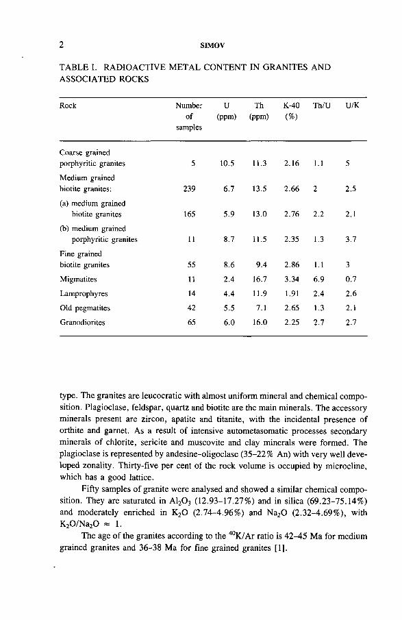
TABLE I. RADIOACTIVE METAL CONTENT IN GRANITES AND ASSOCIATED ROCKS
Rock Numberof
samples
U(ppm)
Th(ppm)
K-40(%)
Th/U U/K
Coarse grained porphyritic granites 5 10.5 11.3 2.16 1.1 5
Medium grained biotite granites: 239 6.7 13.5 2.66 2 2.5
(a) medium grained biotite granites 165 5.9 13.0 2.76 2.2 2.1
(b) medium grained porphyritic granites 11 8.7 11.5 2.35 1.3 3.7
Fine grained biotite granites 55 8.6 9.4 2.86 1.1 3
Migmatites 11 2.4 16.7 3.34 6.9 0.7
Lamprophyres 14 4.4 11.9 1.91 2.4 2.6
Old pegmatites 42 5.5 7.1 2.65 1.3 2.1
Granodiorites 65 6.0 16.0 2.25 2.7 2.7
type. The granites are leucocratic with almost uniform mineral and chemical composition. Plagioclase, feldspar, quartz and biotite are the main minerals. The accessory minerals present are zircon, apatite and titanite, with the incidental presence of orthite and garnet. As a result of intensive autometasomatic processes secondary minerals of chlorite, sericite and muscovite and clay minerals were formed. The plagioclase is represented by andesine-oligoclase (35-22% An) with very well developed zonality. Thirty-five per cent of the rock volume is occupied by microcline, which has a good lattice.
Fifty samples of granite were analysed and showed a similar chemical composition. They are saturated in A120 3 (12.93-17.27%) and in silica (69.23-75.14%) and moderately enriched in K20 (2.74-4.96%) and Na20 (2.32-4.69%), with K20/Na20 * 1.
The age of the granites according to the 40K/Ar ratio is 42-45 Ma for medium grained granites and 36-38 Ma for fine grained granites [1].
IAEA-TC-571/1 3
The closed chemical composition of the granitic rocks does not affect the distribution of the radioactive metals, except for the lower content of silica in granodi- orites. Nevertheless the latter are comparatively enriched in uranium — 6 ppm (Table I). The highest uranium content is fixed in the coarse grained porphyritic granites — 10.5 ppm. The limited geographic distribution of these rocks restricts their potential as a local source of uranium. The fine grained granites are also enriched in uranium (8.6 ppm), but they have a moderate geographic distribution too. The most important as a local source of uranium are the medium grained granites. They form almost 80% of the massif and have a uranium enrichment of 6.7 ppm. The highest uranium content is fixed in the porphyritic facies of these granites — 8.7 ppm (Table I).
A common feature of all granites is the low Th/U ratio, 1.1-2, which characterizes repeated activation and differentiation of the rock and/or formation of granites through granitization. The migmatites have a high Th/U ratio (6.9) mainly because the uranium content is very low (2.4 ppm), owing to the low uranium content in the primary metasediments. There is a correlation between the high grade of rock microclinization and the uranium enrichment of the granites. The intensity of granitization is irregular and depends on the original structure of the primary rocks. As a result, in some parts of the massif the granites do not have a typical structure.
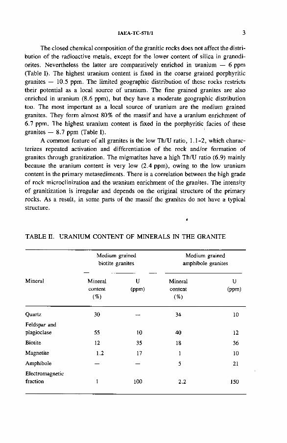
TABLE II. URANIUM CONTENT OF MINERALS IN THE GRANITE
Medium grained biotite granites
Medium grained amphibole granites
Mineral Mineralcontent
(%)
U(ppm)
Mineralcontent
(%)
U(ppm)
Quartz 30 — 34 10
Feldspar and plagioclase 55 10 40 12
Biotite 12 35 18 36
Magnetite 1.2 17 1 10
Amphibole — 5 21
Electromagneticfraction 1 100 2.2 150
4 SIMOV
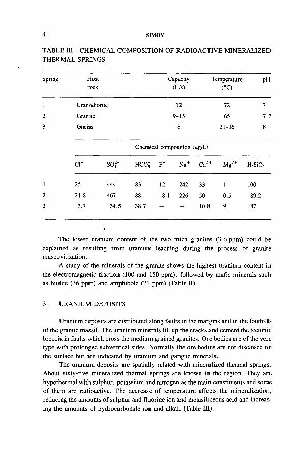
TABLE III. CHEMICAL COMPOSITION OF RADIOACTIVE MINERALIZED THERMAL SPRINGS
Spring Hostrock
Capacity(L/s)
Temperature(°C)
PH
1 Granodiorite 12 72 7
2 Granite 9-15 65 7.7
3 Gneiss 8 21-36 8
Chemical composition (fig/L)
c r S 042' HCO3 F ' Na + Ca24 Mg2 + H2Si02
1 25 444 83 12 242 33 1 100
2 21.8 467 88 8.1 226 50 0.5 89.2
3 3.7 34.5 38.7 — — 10.8 9 87
The lower uranium content of the two mica granites (3.6 ppm) could be explained as resulting from uranium leaching during the process of granite muscovitization.
A study of the minerals of the granite shows the highest uranium content in the electromagnetic fraction (100 and 150 ppm), followed by mafic minerals such as biotite (36 ppm) and amphibole (21 ppm) (Table II).
3. URANIUM DEPOSITS
Uranium deposits are distributed along faults in the margins and in the foothills of the granite massif. The uranium minerals fill up the cracks and cement the tectonic breccia in faults which cross the medium grained granites. Ore bodies are of the vein type with prolonged subvertical sides. Normally the ore bodies are not disclosed on the surface but are indicated by uranium and gangue minerals.
The uranium deposits are spatially related with mineralized thermal springs. About sixty-five mineralized thermal springs are known in the region. They are hypothermal with sulphur, potassium and nitrogen as the main constituents and some of them are radioactive. The decrease of temperature affects the mineralization, reducing the amounts of sulphur and fluorine ion and metasiliceous acid and increasing the amounts of hydrocarbonate ion and alkali (Table III).
IAEA-TC-571/1 5
There is a well developed mineral zonality. Ore bodies located in the uplifted granite massif are formed by silicates of hexavalent uranium in an association of zeolite gangue minerals. In contrast, in uranium deposits located in the foothills of the massif only minerals of tetravalent uranium are represented, mainly silicates, such as coffinite, and occasionally pitchblende. They also associate with zeolite gangue minerals and occasionally with calcite and, in the deeper parts of a few deposits, with chalcedony. The zeolites dominate in both mineral zones and are represented by stilbite in the uplifted massif and by laumontite in the foothills. Small veins of stilbite fill up the cracks in the granites and also cement the granite pieces
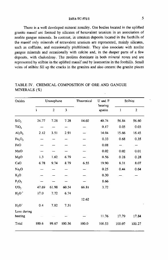
TABLE IV. CHEMICAL COMPOSITION OF ORE AND GANGUE MINERALS (%)
Oxides Uranophane Theoretical U and F bearing apatite
Stilbite
1 2 3 1 2
Si02 24.77 7.28 7.28 14.02 40.74 56.84 56.60
TiOj — — — 0.17 0.05 0.03
a i2o 3 2.12 3.51 2 91 — 14.04 15.66 16.45
Fe20 3 — — — — 0.33 0.68 0.35
FeO — — — — 0.08 — —
MnO — — — — 0.02 0.02 0.01
MgO 1.3 1.62 6.79 — 0.56 0.28 0.28
CaO 6.78 9.74 8.79 6.55 19.90 8.31 8.07
Na20 — — — — 0.25 0.44 0.64
k 2o — — — — 0.30 — —
P20 5 — — — — 8.66
uo3 47.69 61.98 60.54 66.81 3.72
h 2o + 17.0 7.72 6.74
12.62
H20 ‘ 0.4 7.82 7.51
Loss during heating — — — — 11.76 17.79 17.84
Total 100.6 99.67 100.56 100.0 100.53 100.07 100.27
6 SIMOV
in the tectonic breccia. The colour of stilbite varies from white to red with an iron content of up to 1 %, indicating the chemical formation conditions (Table IV). Alternation of pink stilbite with uranophane can be seen in some deposits.
Uranophane predominates over uranium silicates [2] and can be seen as thin veins, as a cement cover of the zeolite in the tectonic breccia and also as monomineral aggregates with sizes up to 10 cm. Its colour varies from orange in the centre of the aggregates to bright yellow in their margins. There is a difference between the theoretical uranophane chemical composition and that of the deposits studied (Table IV). The presence of A120 3 can be explained by the presence of stilbite in the samples studied. Palchin et al. [2] also mentioned the presence of P20 5 and CaO above their theoretical contents in uranophane, which is due to the presence of fluorine apatite in the samples studied.
Uranium bearing fluorine apatite is distributed together with uranophane as a mineral coating of stilbite and has a beige to white colour. The chemical composition of uranium bearing fluorine apatite is (in per cent) Si02 40.74, Ti02 0.17, A120 3 14.04, Fe20 3 0.33, FeO 0.08, MnO 0.02, MgO 0.56, CaO 19.90, K20 0.30, Na200.25, P2Os 5.66, U03 3.72 and H20 14.78 [2],
Wall rock alteration is limited to zeolitization of the granites in the massif and to zeolitization and chloritization in uranium deposits in the foothills.
The age of the uranium deposits was determined by the uranium-lead technique as 1 Ma for deposits within the uplifted massif and 4 Ma for the deposits in the foothills [2],
4. GENESIS OF URANIUM DEPOSITS
Low grade wall rock alteration and mineral assemblages of the deposits indicate ore formation by low temperature solutions. Oxygen bearing groundwaters leach uranium and other chemical elements from granites during the descent of solutions and transport uranium as uranyl ion. The fluorine content in the groundwaters is a result of chemical reaction between the waters and fluorine bearing micas. The chlorine content of the solutions is due to the decomposition of some alumosilicates and micas. Sodium is leached from albite through the effect of groundwater which contains C 02, and as a result kaolinite and sodium are produced, according to the chemical reaction [3]:
2NaAlSi3Og + C02 + 2H20 - Al2Si20 5(0H)4 + 2Na+ + C032’ + 4Si02
The period of groundwater accumulation before uranium mineral formation was characterized by low grade water dynamics. During this period the groundwater was driven by gravity and convection in a closed system of geoconvection cells
IAEA-TC-571/1 7
+ + + + + + +
+ + + + + + + +
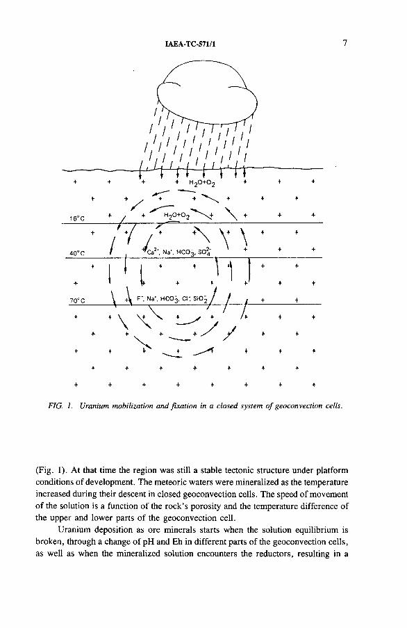
FIG. 1. Uranium mobilization and fixation in a closed system o f geoconvection cells.
(Fig. 1). At that time the region was still a stable tectonic structure under platform conditions of development. The meteoric waters were mineralized as the temperature increased during their descent in closed geoconvection cells. The speed of movement of the solution is a function of the rock’s porosity and the temperature difference of the upper and lower parts of the geoconvection cell.
Uranium deposition as ore minerals starts when the solution equilibrium is broken, through a change of pH and Eh in different parts of the geoconvection cells, as well as when the mineralized solution encounters the reductors, resulting in a
8 SIMOV
+ + + + + +
t f f f f ! I (Thermal source (geothermal energy, radiogenic heat)
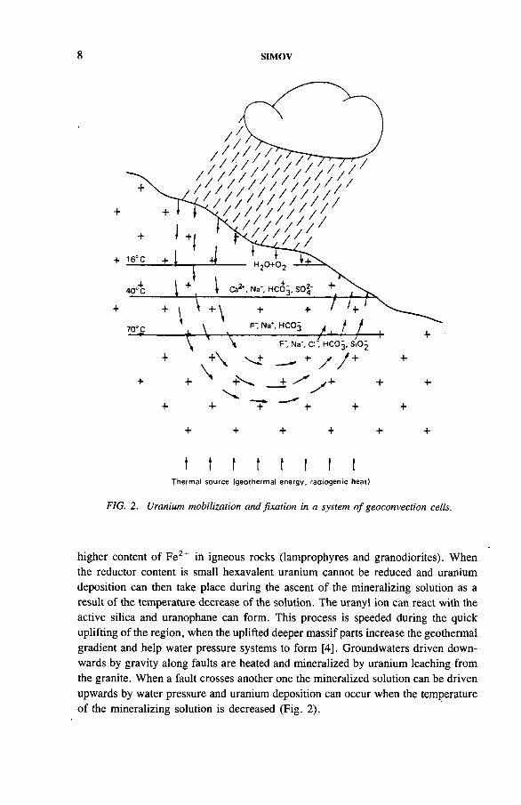
FIG. 2. Uranium mobilization and fixation in a system o f geoconvection cells.
higher content of Fe2+ in igneous rocks (lamprophyres and granodiorites). When the reductor content is small hexavalent uranium cannot be reduced and uranium deposition can then take place during the ascent of the mineralizing solution as a result of the temperature decrease of the solution. The uranyl ion can react with the active silica and uranophane can form. This process is speeded during the quick uplifting of the region, when the uplifted deeper massif parts increase the geothermal gradient and help water pressure systems to form [4], Groundwaters driven downwards by gravity along faults are heated and mineralized by uranium leaching from the granite. When a fault crosses another one the mineralized solution can be driven upwards by water pressure and uranium deposition can occur when the temperature of the mineralizing solution is decreased (Fig. 2).
IAEA-TC-571/1 9
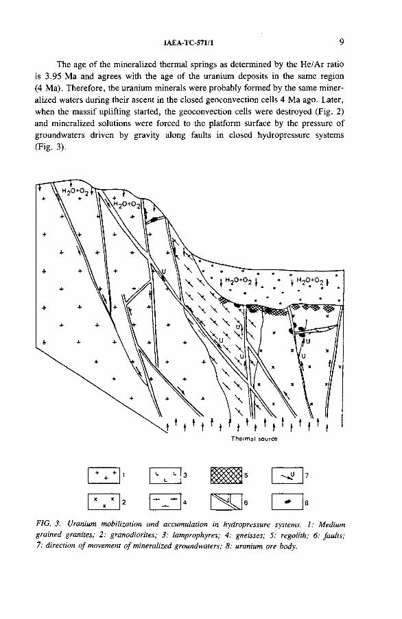
The age of the mineralized thermal springs as determined by the He/Ar ratio is 3.95 Ma and agrees with the age of the uranium deposits in the same region (4 Ma). Therefore, the uranium minerals were probably formed by the same mineralized waters during their ascent in the closed geoconvection cells 4 Ma ago. Later, when the massif uplifting started, the geoconvection cells were destroyed (Fig. 2) and mineralized solutions were forced to the platform surface by the pressure of groundwaters driven by gravity along faults in closed hydropressure systems (Fig. 3).
L L L
k : 8
FIG. 3. Uranium mobilization and accumulation in hydropressure systems. 1: Medium grained granites; 2: granodiorites; 3: lamprophyres; 4: gneisses; 5: regolith; 6: faults; 7; direction o f movement o f mineralized groundwaters; 8: uranium ore body.
10 SIMOV
REFERENCES
[1] PALCHIN, I.G., SIMOV, S.D., ARAKELYANTS, M.M., CHERNISHEV, I.V., “ The absolute age of Alpine activation affecting the Rhodope medium massif, Bulgaria” , Proc. Acad. Sci. USSR, Geol. Ser. 4 (1974) 13.
[2] PALCHIN, I.G., SIMOV, S.D., VALCHANOVA, E.P., VALCHANOV, A.P., “ The geology and formation conditions of uranium bearing fluorine-apatite in regions of Alpine activation” , Hydrothermal Uranium Deposits, Nedra, Moscow (1978).
[3] KRASNIKOVA, A.V., HAGVANKAN, M.A., BAHMAN, V.N., “ Chemistry of mineral water” , Principles of Health Resorts, Vol. 1, Medgiz, Moscow (1956).
[4] SIMOV, S.D., Uranium Migration and Uranium Provinces, Technica, Sofia (1984).
IAEA-TC-571/2
URANIUM ENRICHMENT PROCESSES IN PERALUMINOUS MAGMATISM
M.H. FRIEDRICH, M. CUNEY CREGU and GS CNRS-CREGU,Vandceuvre-les-Nancy, France
Abstract
URANIUM ENRICHMENT PROCESSES IN PERALUMINOUS MAGMATISM.The main magmatic differentiation process in peraluminous granites consists of the
progressive removal of poorly soluble mineral species and a correlated enrichment of incompatible elements. In leucocratic evolved facies, uranium is mainly located in uraninite crystals. On the other hand, uranium in the cafemic facies is mainly located in accessory minerals weakly soluble in peraluminous magma (monazite, zircon, apatite). The whole rock uranium content increases with the evolution grade of the magma. Additional uranium enrichments are related to uraninite concentrations in late magmatic (viscous state) shear zones associated with mineralogical evidence of an orthoderived fluid phase (rich in F, B, Li, Sn, Be, phosphate, Zr and light rare earth elements (LREE)). This fluid is related to adjacent (in a vicinity of tens to hundreds of metres) endogranitic intrusions displaying a syntectonic emplacement. Such late magmatic uraninite enrichments related to highly evolved granitic facies are observed in many major intragranitic deposits. The partial preservation of such anomalous uranium contents through supergene alteration (in west European examples) is demonstrated and therefore careful ground surface sampling may provide a rough estimation of original uranium behaviour. The early processes obviously account for a strong increase of the available uranium stock but subsolidus redistribution and concentration are other decisive factors. Hence, it appears that the uraniferous fertility (i.e. the known ore bodies) of a granitic massif is mostly related to the extent of the spatial overlap between structurally controlled magmatic enrichments and hydrothermal reworkings.
1. INTRODUCTION
Economic uranium deposits genetically related to granitoids are mostly hosted by anatectic granitoids or located in strongly peraluminous leucogranites [1, 2], Minor economic deposits are associated with monzonitic granites, such as the Midnite deposit [3], or with alkaline granites, such as the Ross-Adams deposit [4]. The Rossing deposit, where uranium dominantly occurs as disseminated uraninite, is the best example of a mineralization related to a melt formed by a low degree of partial melting of metasediments and acid metavolcanics [5, 6], Uranium deposits associated with peraluminous granites occur in veins or as disseminations, principally in the European Hercynian Belt [2, 7-11], in the North American
11
12 FRIEDRICH and CUNEY
Hercynian Belt [12], in the Yanshanian granitoids of southeast China [13] and in Argentina [14],
Ore deposition is related to subsolidus alterations induced by convective hydrothermal circulation of fluids through brittle structures. Moreover, a large time gap occurs between the end of magmatic activity and mineralizing processes in many Hercynian deposits [2]. Therefore, the role of the granitic environment of uranium deposits is questioned.
Several observations suggest that host granites provide the uranium supply. Mineralized peraluminous granitoids, compared with average granitic rocks, always display high uranium content, mostly expressed in the form of uraninite [15], This mineral represents an easily leachable uranium source for oxidizing hydrothermal solutions and is generally considered as the most evident and direct source for intragranitic deposits. Uraninite abundance is one of the major factors controlling the amount of mineralization. The origin of uraninite, a matter of discussion until recently, is now well characterized and is clearly magmatic. Hence, a careful appraisal of the behaviour of uranium and uraninite abundance resulting from differentiation processes of peraluminous magmatism became necessary and constitutes the main topic of this paper. The distribution of uranium in fresh samples is not homogeneous. Significant magmatic enrichments, structurally controlled, enhance the efficiency of subsequent mineralization processes. Intragranitic prospecting guidelines can be deduced.
2. MAIN FEATURES OF PERALUMINOUS GRANITE PETROGENESISAND DIFFERENTIATION
2.1. Emplacement and petrogenesis of peraluminous granites
Several peraluminous leucogranites are considered, related either to the European Variscides (Hercynian Orogen, 380-300 Ma) or to the Himalayan Orogen (40-15 Ma). The two orogenies display similar features with complex intracontinental deformation, including major thrusting tectonism related to a continental collision and a subsequent progressive crustal thickening [16]. Synthesis of the structural data concerning the deformation patterns of metamorphic, anatectic and granitic rocks of the French Massif central gives evidence of a close analogy with the Himalayan Range. Both tectonometamorphic piles acted as huge zones of flat shearing, reactivated at different stages of their respective orogenies. The magmatic structures, imprinted during viscous state flow, are consistent with geophysical data (detailed gravimetry and seismic refraction study) and mostly provide evidence of a slab shaped granitic massif. However, some deep seated, wedge shaped massifs are described in the Variscan Chain. But in both geodynamic environments, transcurrent movements along major ductile shear zones and thrusting planes are imprinted in
IAEA-TC-571/2 13
viscous and solid (high temperature) states, thus determining the massifs margins with country rocks. The emplacement of these granites is consequently considered as synkinetic of a regional tectonism [17-19].
The felsic peraluminous rocks, such as the two mica granites, are known for their highly fractionated, leucocratic and distinctive chemical signatures with marked enrichments in B, F, Li, Sn, W and U. The essential mineralogy is characterized by the abundance of A1 + K species (Al-biotite, muscovite, sillimanite, andalusite and cordierite). Plagioclase is acidic; the anorthite component rarely exceeds An 20. Mesonormative compositions are commonly close to the eutectic minima and cotectic lines in the haplogranitic system, yielding some evidence of a H20 saturated partial fusion origin. The chemical typology of French Hercynian granitoids using multicationic diagrams [20, 21] demonstrates geochemical and mineral- ogical evolutions involving mainly orthoclase, plagioclase and biotite fractionation. The leucocratic differentiates are either silico-sodic or silico-potassic, respectively hosting Li, Sn, W, Nb, Ta and U, Be, W, Au occurrences and deposits. The peralu- minosity index remains nearly unchanged, or slightly increases with differentiation.
The similarities of the geochemical signatures (isotopes and major and trace elements) of the Himalayan and Hercynian leucogranites suggest that the petrogenetic processes were comparable [22], The proposed model, well exemplified in the Tibetan Manaslu massif [23], is based on the partial fusion of a crustal protolith. In both groups, isotopic ratios suggest a metasedimentary source with a particularly long time of crustal residence if it is considered that the latter provides the Manaslu melts.
The above described fractionation and petrogenetic processes are shared by additional examples of well described peraluminous suites of various ages and different locations [24-27], Hence, these processes may be considered as characteristic of peraluminous magmatism.
2.2. Paragenesis of accessory minerals
In peraluminous leucogranites accessory mineral paragenesis comprises zircon, apatite, monazite, ilmenite, anatase, subordinated xenotime and thorium poor uraninite [11, 15, 28-33]. The fact that uraninite is the main contributor to the high uranium content of these rocks is in general agreement with the conclusions of various investigations. Ranchin [29], Basham et al. [34] and Pagel [11, 32] have demonstrated that, for a granitoid of U content close to 20 ppm, 25-35% of the uranium is incorporated mainly in zircon, monazite and apatite, and 5-6% is attributable to a disseminated and adsorbed form. Uraninite may account for an average of 60% of the whole rock uranium. But this proportion is highly dependent on the monazite and uraninite relative abundances and admits large variations, as will be illustrated below.
14 FRIEDRICH and CUNEY
2.3. Magmatic evolution processes
Present studies concerning peraluminous granites demonstrate that their magmatic evolution dominantly results from partial melting processes [23, 35, 36].
Thorium, zirconium and light rare earth elements (LREE) display a marked compatible behaviour and are well correlated with Ca, Fe, Mg, Ti, Ba, Sr, V, Cr, Ni and Co [37], The low solubility of monazite (the main Th bearing phase), apatite and zircon in such melts [1, 24, 38-42] induces their early fractionation together with calcic oligoclase, barium rich orthoclase, biotite and ilmenite in the melting zone and during subsequent fractional crystallization.
Monazite is generally very resistant to common types of subsolidus alteration (meteoric, pervasive chloritization and argillization). Therefore, Th content may be considered as a valid differentiation index. Facies enriched in poorly soluble species (‘restite’) are Th rich, whereas facies close to pure liquid compositions are Th poor. Trace element and isotopic geochemistry demonstrates the contribution of different protoliths providing clearly heterogeneous melts but emplaced in a limited time interval.
3. URANIUM DISTRIBUTION IN MAGMATIC PROCESSES
3.1. Uranium behaviour in unaltered samples
An accurate evaluation of uranium behaviour at the magmatic stage requires samples free of subsolidus and meteoric alterations. According to many studies, the latter may induce an important uranium depletion in surface samples. Uraninite is easily leached in supergene conditions. Two samplings of unweathered peraluminous granites are considered here. The large uranium mining activities developed in the Hercynian St. Sylvestre massif of the northwest Massif central (38 000 t of uranium metal already proved) allow extensive sampling in mine levels, open pits and drill cores (Fig. 1). The Himalayan Manaslu massif displays no significant alterations (either hydrothermal or meteoric): ignition losses are very low (average ignition loss is 0.73, see Table I) and the stable isotope characteristics of the minerals give clear magmatic signatures [43].
The main facies of St. Sylvestre granite displays coarse grained and porphyroid textures. Numerous fine and medium grained granitic stocks and dykes intrude the coarse grained facies before its total crystallization. Their mineralogical and geochemical features are fully described in Refs [1, 35, 36, 41].
The Manaslu is either coarse or medium grained and is cross-cut by numerous dykes and veinlets of tourmaline bearing aplites and pegmatites.
IAEA-TC-571/2 15
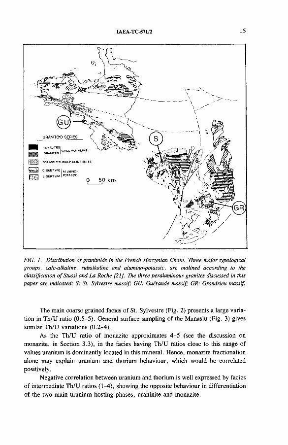
FIG. I. Distribution o f granitoids in the French Hercynian Chain. Three major typological groups, calc-alkaline, subalkaline and alumino-potassic, are outlined according to the classification o f Stussi and La Roche [21]. The three peraluminous granites discussed in this paper are indicated: S: St. Sylvestre massif; GU: Guerande massif; GR: Grandrieu massif.
The main coarse grained facies of St. Sylvestre (Fig. 2) presents a large variation in Th/U ratio (0.5-5). General surface sampling of the Manaslu (Fig. 3) gives similar Th/U variations (0.2-4).
As the Th/U ratio of monazite approximates 4-5 (see the discussion on monazite, in Section 3.3), in the facies having Th/U ratios close to this range of values uranium is dominantly located in this mineral. Hence, monazite fractionation alone may explain uranium and thorium behaviour, which would be correlated positively.
Negative correlation between uranium and thorium is well expressed by facies of intermediate Th/U ratios (1-4), showing the opposite behaviour in differentiation of the two main uranium hosting phases, uraninite and monazite.

16 FRIEDRICH and CUNEY
TABLE I. AVERAGE VALUES AND STANDARD DEVIATIONS FOR U AND Th CONTENT AND IGNITION LOSS OF FOUR PERALUMINOUS GRANITIC MASSIFS
u Th IL(ppm) (ppm) (%)
av. a av. a av. a
St. Sylvestre, coarse grained, unweathered (n == 62) 22.0 9.4 24.1 13.6 0.97 0.14weathered (n == 63) 13.0 6.2 18.5 14.0 1.22 0.35
St. Sylvestre, fine grained, unweathered (n == 45) 17.3 9.2 65.8 46.9 1.02 0.2
Manaslu, unweathered (n == 90) 9.0 4.3 6.2 3.5 0.73 0.22
Guerande, weathered (n == 70) 5.9 2.0 5.0 1.9 1.62 0.44
Grandrieu, weathered (n == 76) 9.1 3.8 7.6 4.0 1.27 0.23
U (ppm)
FIG. 2. Th-U plot for unaltered samples o f the St. Sylvestre massif coarse grained facies (northwest Massif central, France). The box, present in all Th-U diagrams, indicates the granitic clarke [44].
IAEA-TC-571/2 17
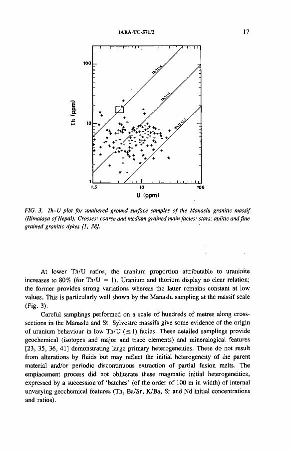
U (ppm)
FIG. 3. Ih -U plot fo r unaltered ground surface samples o f the Manaslu granitic massif (Himalaya o f Nepal). Crosses: coarse and medium grained main facies; stars: aplitic and fine grained granitic dykes [1, 38],
At lower Th/U ratios, the uranium proportion attributable to uraninite increases to 80% (for Th/U = 1). Uranium and thorium display no clear relation; the former provides strong variations whereas the latter remains constant at low values. This is particularly well shown by the Manaslu sampling at the massif scale (Fig. 3).
Careful samplings performed on a scale of hundreds of metres along cross- sections in the Manaslu and St. Sylvestre massifs give some evidence of the origin of uranium behaviour in low Th/U ( s i ) facies. These detailed samplings provide geochemical (isotopes and major and trace elements) and mineralogical features [23, 35, 36, 41] demonstrating large primary heterogeneities. These do not result from alterations by fluids but may reflect the initial heterogeneity of the parent material and/or periodic discontinuous extraction of partial fusion melts. The emplacement process did not obliterate these magmatic initial heterogeneities, expressed by a succession of ‘batches’ (of the order of 100 m in width) of internal unvarying geochemical features (Th, Ba/Sr, K/Ba, Sr and Nd initial concentrations and ratios).
18 FRIEDRICH and CUNEY
U (ppm)
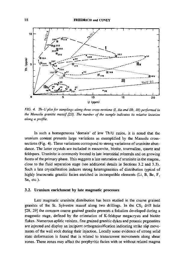
FIG. 4. Th-U plot fo r samplings along three cross-sections (I, Ila and lib, III) performed in the Manaslu granitic massif [23], The number o f the sample indicates its relative location along a profile.
In such a homogeneous ‘domain’ of low Th/U ratios, it is noted that the uranium content presents large variations as exemplified by the Manaslu cross- sections (Fig. 4). These variations correspond to strong variations of uraninite abundance. The latter crystals are included in muscovite, biotite, tourmaline, quartz and feldspars. Uraninite is commonly located in late interstitial minerals and on growing facets of the primary phase. This suggests a late saturation of uraninite in the magma, close to the fluid separation stage (see additional details in Sections 3.2 and 3.3). Such a late crystallization induces strong heterogeneities of distribution typical of highly leucocratic granitic facies enriched in incompatible elements (Li, B, Be, F, Sn, etc.).
3.2. Uranium enrichment by late magmatic processes
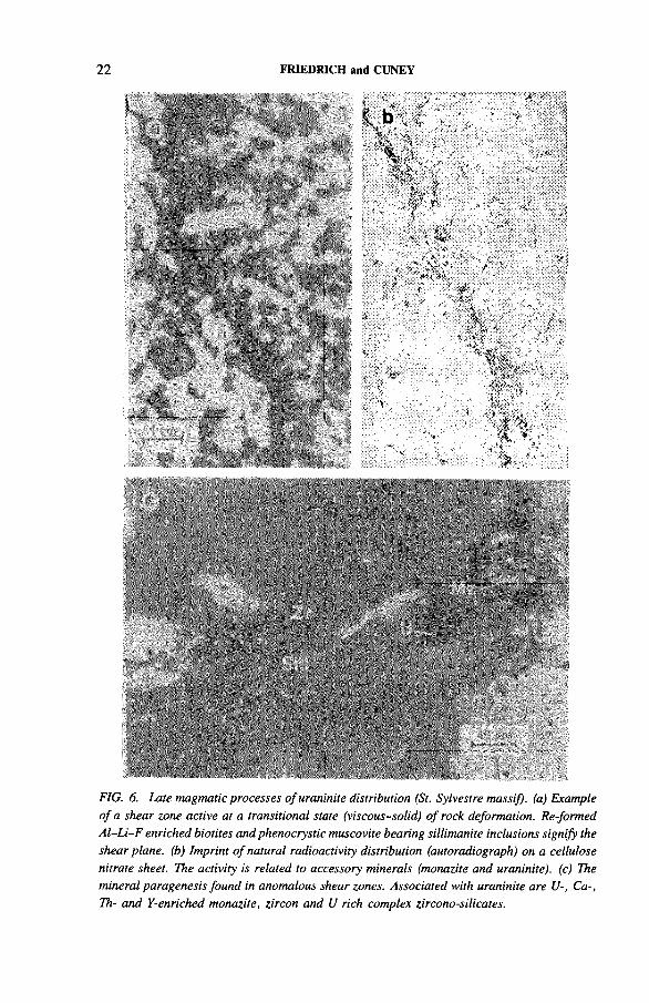
Late magmatic uraninite. distribution has been studied in the coarse grained granites of the St. Sylvestre massif along two drillings. In the CS2 drill hole [28, 29] the common coarse grained granite presents a foliation developed during a magmatic stage, defined by the orientation of K-feldspar megacrysts and biotite flakes. Numerous aplitic veinlets, fine grained granitic dykes and potassic pegmatites are injected and display an incipient orthogneissification indicating strike slip movements of the wall rock during their injection. Locally some evidence of strong solid state deformation is found that is related to transcurrent movements along shear zones. These zones may affect the porphyritic facies with or without related magma
IAEA-TC-571/2 19
injection. The strain increase is expressed by a progressive reduction of the size of the crystals in the mesostasis to submillimetric grain. Formation of potassic feldspar porphyroclasts occurs frequently. Layers of biotite a few millimetres thick containing abundant fibrolitic sillimanite express the foliation. In the most deformed facies, textural patterns evolve to granoblastic polygonization with biotite, plagioclase, orthoclase and quartz recrystallization in neograins. All these features demonstrate the near magmatic level of the strain temperature. In these shear zones, uranium and thorium contents increase (av. U 35 ppm, av. Th 40 ppm) relative to undeformed porphyroid granite (av. U 8 ppm, av. Th 10 ppm). The abundance of uraninite located in biotite, fibrolite and apatite is closely related to the whole rock uranium content [45, 46].
In the second case study, carried out on drill cores denoted as FS [28, 29], marked heterogeneities of uraninite distribution were also noticed. The uranium enrichments (U > 40 ppm) are all related to fine grained dykes of granitic composition. These dykes cross-cut porphyritic biotite granites and migmatites (av. U 6 ppm). These veins display a magmatic foliation generated by post-injection strike slip movements of the vein walls. Magmatic state deformation may be followed by an incipient orthogneissification of the vein margins. These fine grained granites are peraluminous, leucocratic and enriched in B, Li and F. A fluid oversatu- ration during their emplacement produced local miarolitic and pegmatitic textural patterns. Within the limits of a single dyke, uraninite abundance increases steadily with high temperature orthogneissification.
In both case studies U-, Ca-, Th- and Y-rich monazite (Table II, Figs 5 and 6), elongated zircon with particular pyramidal facets, apatite and an association of anatase and ilmenite formed in a primary phase (see also Section 3.3) were found to be associated with uraninite.
The two drill core examples provide evidence of a uranium distribution process, active at a late magmatic stage (transitional: viscous to solid state), involving a transcurrent shear zone with metre to millimetre width.
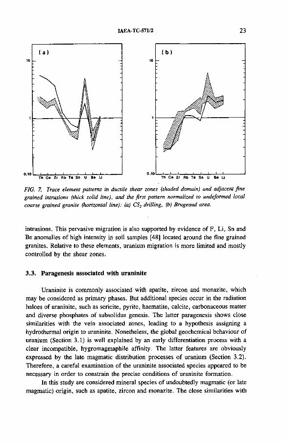
A close relation between the above mentioned late magmatic uranium enrichments and the emplacement and fluid oversaturation of fine grained granite intrusions is supported by field, structural, geochemical and mineralogical data. The structural study of the anomalous shear zones [17, 18] demonstrates that they are dominantly developed in a viscous state and occur at the margins of fine grained intrusions. They are also duplicated with the same direction in the intruded coarse grained granites. The trace element patterns of these shear zones closely reflect the geochemical characteristics of adjacent fine grained granites (Fig. 7). For example, in the CS2 drill core samples [46] shear zones and neighbouring fine grained granites are enriched in U, Th, LREE and Zr and depleted in Ta, Sn and Be relative to enclosing coarse grained granite. In contrast, another anomalous shear zone shows enrichment in U, Sn, Rb and Ta but not in Th and LREE, as in a fine grained granite observed in the vicinity (Brugeaud mine outcrops, Bessines). The biotites located in these
20 FRIEDRICH and CUNEY
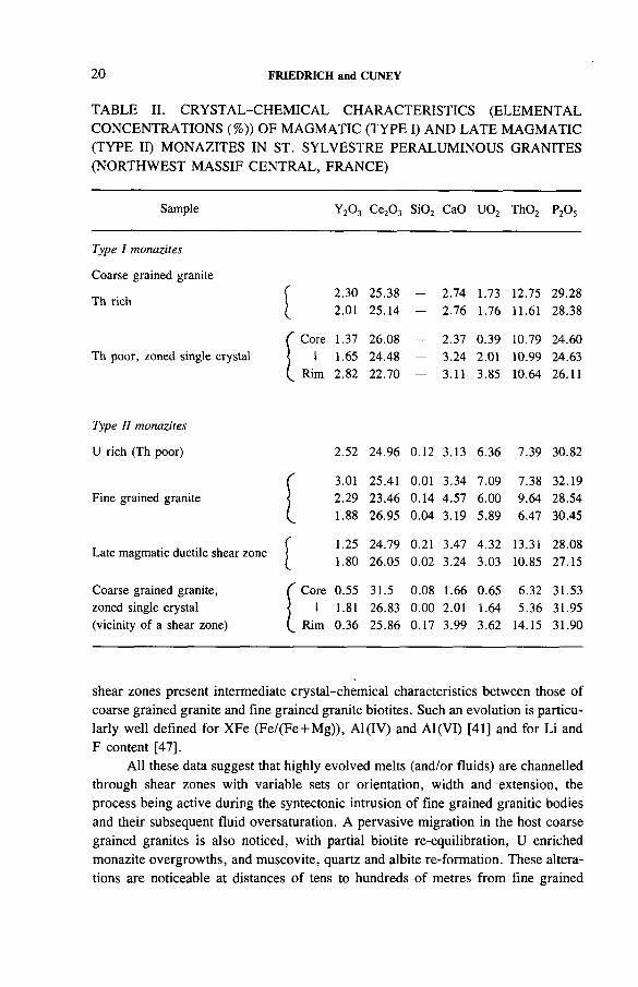
TABLE II. CRYSTAL-CHEMICAL CHARACTERISTICS (ELEMENTAL CONCENTRATIONS (%)) OF MAGMATIC (TYPE I) AND LATE MAGMATIC (TYPE II) MONAZITES IN ST. SYLVESTRE PERALUMINOUS GRANITES (NORTHWEST MASSIF CENTRAL, FRANCE)
Sample y 2o 3 CejC^ Si02 CaO U 02 Th02 p2o5
Type I monazites
Coarse grained granite
Th rich f 2.30 25.38 — 2.74 1.73 12.75 29.28
I 2.01 25.14 — 2.76 1.76 11.61 28.38
C Core 1.37 26.08 — 2.37 0.39 10.79 24.60Th poor, zoned single crystal 1 1.65 24.48 — 3.24 2.01 10.99 24.63
Rim 2.82 22.70 — 3.11 3.85 10.64 26.11
Type II monazites
U rich (Th poor) 2.52 24.96 0.12 3.13 6.36 7.39 30.82
r 3.01 25.41 0.01 3.34 7.09 7.38 32.19Fine grained granite 2.29 23.46 0.14 4.57 6.00 9.64 28.54
L 1.88 26.95 0.04 3.19 5.89 6.47 30.45
Late magmatic ductile shear zone{
1.251.80
24.7926.05
0.210.02
3.473.24
4.323.03
13.3110.85
28.0827.15
Coarse grained granite, C Core 0.55 31.5 0.08 1.66 0.65 6.32 31.53zoned single crystal 1 1.81 26.83 0.00 2.01 1.64 5.36 31.95(vicinity of a shear zone) Rim 0.36 25.86 0.17 3.99 3.62 14.15 31.90
shear zones present intermediate crystal-chemical characteristics between those of coarse grained granite and fine grained granite biotites. Such an evolution is particularly well defined for XFe (Fe/(Fe + Mg)), Al(IV) and Al(VI) [41] and for Li and F content [47].
All these data suggest that highly evolved melts (and/or fluids) are channelled through shear zones with variable sets or orientation, width and extension, the process being active during the syntectonic intrusion of fine grained granitic bodies and their subsequent fluid oversaturation. A pervasive migration in the host coarse grained granites is also noticed, with partial biotite re-equilibration, U enriched monazite overgrowths, and muscovite, quartz and albite re-formation. These alterations are noticeable at distances of tens to hundreds of metres from fine grained
IAEA-TC-571/2 21
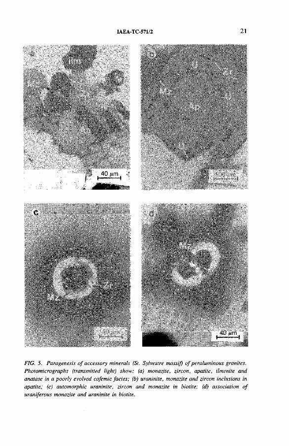
FIG. 5. Paragenesis o f accessory minerals (St. Sylvestre massif) o f peraluminous granites. Photomicrographs (transmitted light) show: (a) monazite, zircon, apatite, ilmenite and anatase in a poorly evolved cafemic facies; (b) uraninite, monazite and zircon inclusions in apatite; (c) automorphic uraninite, zircon and monazite in biotite; (d) association o f uraniferous monazite and uraninite in biotite.
^ -.mmmmt-,; :;r' :\ - •' • t '-y ^I *>* V * 1 1 . ' " I
b \ ’r/ , ‘ . * ^ !
22 FRIEDRICH and CUNEY
j?i: 'W 't - V . . f '' ■ ' ' -P;!• ^ K “ I - • ••-. " • • •"
'. . ‘ v ..... *' : , , v-Mi'ii; -~ :s v ;*: *»h v ■. jt ■ ,..:>fl:r
;.:&■>■■ •> ..-te ,, * V , <<* > ‘ * • ' ’••'■' * v •• • r - ^ ' ̂ V? .» ̂ ’*::"..;:',̂ i.<;$$£.:.■;.-:■>■:;.•;./•.;:. X:> : v-.&£=.• .y;
i;:',:': ".*"■' •*< "fW ** ■*"'■ :.ys\ •/.y* ‘
* ‘ . ' ■:% V ' ' Aii?.. '- • ..
■.'*- ■' ■' >■■■%*,W;*^4 . , ' - ’p y ......... .' '". . . .®5s%.a.s; '■;■<; .< r>, ' u •■
* * -,y % ; .K. ■'-:> •*«'.:••. .. ' <’ ■ , ■ '' '-H ' ’ ,*V
1
mmSBmH |
FIG. 6. Late magmatic processes o f uraninite distribution (St. Sylvestre massif), (a) Example o f a shear zone active at a transitional state (viscous-solid.) o f rock deformation. Re-formed A l-Li-F enriched biotites and phenocrystic muscovite bearing sillimanite inclusions signify the shear plane, (b) Imprint o f natural radioactivity distribution (autoradiograph) on a cellulose nitrate sheet. The activity is related to accessory minerals (monazite and uraninite). (c) The mineral paragenesis found in anomalous shear zones. Associated with uraninite are U-, Ca-, Th- and Y-enriched monazite, zircon and U rich complex zircono-silicates.
IAEA-TC-571/2 23
(a ) (b )
: :10
, . ; k ;
i i i I l. _ i —I---1---1------------ 0.10 1 1 I l l 1 I 1 .1 . . .
T h C e Z r R b T a Sn U Be U T h C e Z r Rb T a Sn u Be LI
FIG. 7. Trace element patterns in ductile shear zones (shaded domain) and adjacent fine grained intrusions (thick solid line), and the first pattern normalized to undeformed local coarse grained granite (horizontal line): (a) CS2 drilling, (b) Brugeaud area.
intrusions. This pervasive migration is also supported by evidence of F, Li, Sn and Be anomalies of high intensity in soil samples [48] located around the fine grained granites. Relative to these elements, uranium migration is more limited and mostly controlled by the shear zones.
3.3. Paragenesis associated with uraninite
Uraninite is commonly associated with apatite, zircon and monazite, which may be considered as primary phases. But additional species occur in the radiation haloes of uraninite, such as sericite, pyrite, haematite, calcite, carbonaceous matter and diverse phosphates of subsolidus genesis. The latter paragenesis shows close similarities with the vein associated zones, leading to a hypothesis assigning a hydrothermal origin to uraninite. Nonetheless, the global geochemical behaviour of uranium (Section 3.1) is well explained by an early differentiation process with a clear incompatible, hygromagmaphile affinity. The latter features are obviously expressed by the late magmatic distribution processes of uranium (Section 3.2). Therefore, a careful examination of the uraninite associated species appeared to be necessary in order to constrain the precise conditions of uraninite formation.
In this study are considered mineral species of undoubtedly magmatic (or late magmatic) origin, such as apatite, zircon and monazite. The close similarities with
24 FRIEDRICH and CUNEY
uraninite of their textural locations (see Figs 5 and 6) suggest a genetic relationship. Uraninite is commonly observed in close association with monazite of specific composition (see below) and zircon in its typical locations such as di- and triocta- hedral micas (50-60%), quartz (10-20%), plagioclase and orthoclase (10-15%) and apatite (10-20%) [49, 50], Moreover, this accessory mineral association is frequently located in clearly late magmatic occurrences: orthoclase cracks sealed with quartz, albite and muscovite, and growing facets of apatite, quartz, albite, muscovite and orthoclase. In certain examples displaying an incipient, high temperature orthogneissification, uraninite may be located in fibrolitic sillimanite.
Further light may be shed by considering the crystal-chemical features of the primary accessory mineral species. Their low solubility in felsic peraluminous melts (Section 2) implies that they are present throughout magma evolution. Hence, these accessory minerals display strong chemical zonation and may give some indications of the uraninite formation conditions.
Crystal-chemical variations of monazite are most accessible through electronic microprobe studies based on specific elemental analysis programmes. The elements Ca, Fe, Si, P, Al, Th, Ce, Y and U, all present in monazite up to several weight per cent, are easily analysed. Apatite and zircon, for instance, do not provide such diverse elemental variations at high enough concentrations to make microprobe studies useful.
In monazite, substitutions may affect the LREE with their progressive replacement by Th, U, Y, MREE and HREE. A combined substitution affects P, with replacement by Si(Ca,Mg). Two substitution end members are known, huttonite (ThSi04) and cheralite (ThP04), both isostructural with monazite (for comprehensive studies see Refs [51-53]). Monazite is a common accessory mineral of felsic peraluminous magmatism [30, 32, 33]. In the St. Sylvestre granitic complex this phase is ubiquitous, and very abundant in ‘restite’ enriched facies (Section 2). The most common type of monazite (type I) occurs as inclusions or associations with early crystallized or even inherited host phases: Al-biotite, ilmenite, anatase, orthoclase, apatite and phenocrystic muscovite. Such locations suggest an inherited origin (with or without melt re-equilibration) during partial melting processes. Nonetheless, the monazites observed in the facies with anomalous uraninite content (shear zones of porphyritic facies, and fine grained granites) yield a different origin, clearly re-formed by evolved melts and fluid oversaturated (type II). Hence, a particular (high) solubility of monazite in melts is suggested by these late magmatic occurrences. High contents of F, Be, Li, Sn, etc., in such a melt modify its structure and may account for such an unexpected solubility, shared by other species such as apatite, zircon and uraninite.
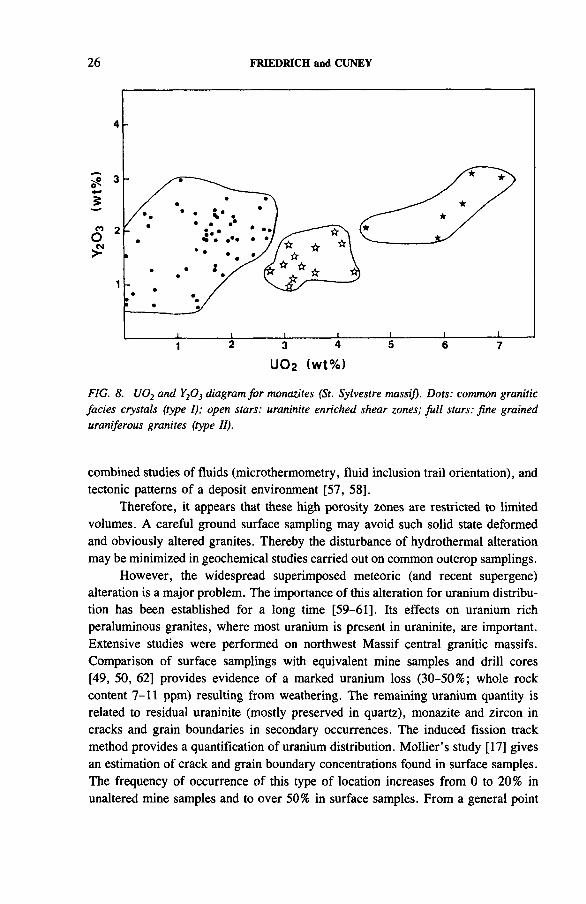
The crystal-chemical characteristics of these two generations of monazite in the St. Sylvestre massif are clearly different (Fig. 8, Table I I ). High U, Y, Ca, Th, MREE and LREE contents are observed in monazite (type II) of the facies strongly enriched in uraninite anomalous facies. These form progressive zoning in recry
IAEA-TC-571/2 25
stallized monazite, located in late magmatic ductile shear zones and in close association with uraninite. These enrichments are lacking in corresponding undeformed porphyroid facies. The uraninite enriched fine grained facies of type II hence is easily distinguishable from the common porphyroid facies of type I (Fig. 8). The uranium and thorium content ranges noted in the St. Sylvestre massif monazites are large (respectively 0-6.8 and 6-14 wt% oxide). The observed maxima (mainly related to monazite II) far exceed those mentioned by Overstreet [51] and Overstreet et al. [52] and seem fairly uncommon. Therefore, it may be pointed out that such strong zonations and high contents of U, Th, Ca, Y and LREE are typical of uraninite bearing granitic facies.
From a more general point of view, the late stages of peraluminous magmatism evolution provide leucocratic, silico-sodic melts close to fluid oversaturation. They usually display significant F, Li and Sn enrichment and solubility of Ca and LREE phosphates. Zircon abundance seems to increase steadily as compared with common peraluminous melts. The uraninite solubility increases as well, and 50-100 ppm uranium concentrations are related to these evolved melts.
4. CHARACTERIZATION OF FERTILE GRANITES
4.1. Disturbance of primary distribution
Hydrothermal and supergene alterations strongly disturb the magmatic and late magmatic distribution of uranium. Dissolution of uraninite depends on the physicochemical characteristics of the altering fluids and mostly on their oxidation and complexing capacity [54]. Thorium poor uraninite is easily leachable by oxidizing and C02 rich fluids.
The mineralogical, geochemical and isotopic studies of the St. Sylvestre massif alteration facies give evidence of two successive hydrothermal circulation systems supplied by meteoric water [2]. The mineralization occurs in mixing zones involving connate or metamorphic waters and meteoric waters [9, 55]. According to Turpin [55] and Leroy [9], the grade of uranium depletion is directly related to water-rock (W-R) ratios. For example, a pervasive chloritization of low W-R ratio induces a slight uranium loss, though probably not significant [55],
The same type of hydrothermal circulation (meteoric water) but with high W-R ratios causes several mineral transformations (dequartzification) proceeding to episyenitic facies and accompanied by strong uranium loss [56]. The remaining uranium is here strictly located in alteration resistant accessory phases (monazite, zircon, apatite); the uraninite attributable proportion is entirely extracted. These high W-R ratios are measured in high porosity zones: transcurrent ductile shear zones, brittle structures and orthogneissified marginal granitic facies, as shown by
26 FRIEDRICH and CUNEY
FIG. 8. U 02 and Y20 3 diagram for monazites (St. Sylvestre massif). Dots: common granitic facies crystals (type I); open stars: uraninite enriched shear zones; fu ll stars: fine grained uraniferous granites (type II).
combined studies of fluids (microthermometry, fluid inclusion trail orientation), and tectonic patterns of a deposit environment [57, 58],
Therefore, it appears that these high porosity zones are restricted to limited volumes. A careful ground surface sampling may avoid such solid state deformed and obviously altered granites. Thereby the disturbance of hydrothermal alteration may be minimized in geochemical studies carried out on common outcrop samplings.
However, the widespread superimposed meteoric (and recent supergene) alteration is a major problem. The importance of this alteration for uranium distribution has been established for a long time [59-61]. Its effects on uranium rich peraluminous granites, where most uranium is present in uraninite, are important. Extensive studies were performed on northwest Massif central granitic massifs. Comparison of surface samplings with equivalent mine samples and drill cores [49, 50, 62] provides evidence of a marked uranium loss (30-50%; whole rock content 7-11 ppm) resulting from weathering. The remaining uranium quantity is related to residual uraninite (mostly preserved in quartz), monazite and zircon in cracks and grain boundaries in secondary occurrences. The induced fission track method provides a quantification of uranium distribution. Mollier’s study [17] gives an estimation of crack and grain boundary concentrations found in surface samples. The frequency of occurrence of this type of location increases from 0 to 20% in unaltered mine samples and to over 50% in surface samples. From a general point
IAEA-TC-571/2 27
U (ppm)
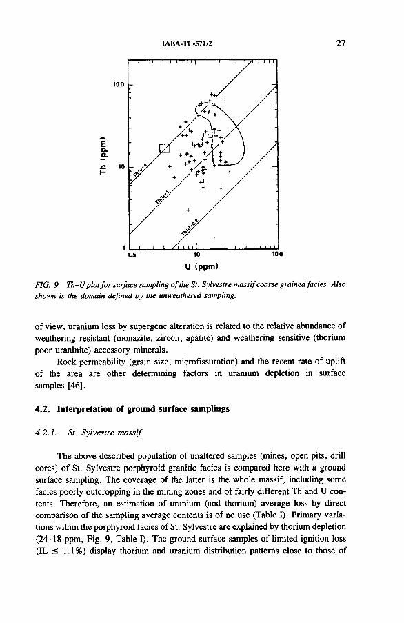
FIG. 9. Th-U plot fo r surface sampling o f the St. Sylvestre massif coarse grained facies. Also shown is the domain defined by the unweathered sampling.
of view, uranium loss by supergene alteration is related to the relative abundance of weathering resistant (monazite, zircon, apatite) and weathering sensitive (thorium poor uraninite) accessory minerals.
Rock permeability (grain size, microfissuration) and the recent rate of uplift of the area are other determining factors in uranium depletion in surface samples [46].
4.2. Interpretation of ground surface samplings
4.2.1. St. Sylvestre massif
The above described population of unaltered samples (mines, open pits, drill cores) of St. Sylvestre porphyroid granitic facies is compared here with a ground surface sampling. The coverage of the latter is the whole massif, including some facies poorly outcropping in the mining zones and of fairly different Th and U contents. Therefore, an estimation of uranium (and thorium) average loss by direct comparison of the sampling average contents is of no use (Table I). Primary variations within the porphyroid facies of St. Sylvestre are explained by thorium depletion (24-18 ppm, Fig. 9, Table I). The ground surface samples of limited ignition loss (IL < 1.1%) display thorium and uranium distribution patterns close to those of
28 FRIEDRICH and CUNEY
unaltered mine samples. The apparent uranium loss, even when partially invalidated by the primary differences between the two considered groups of samples, approximates 40%, falling in a common grade of depletion. In such alteration conditions, well characterized on French Hercynian granitoids, uraninite remains partly preserved, and a significant part of the uranium stock is not exported but moves to microcracks, grain boundaries and subsolidus alteration phases (Section 4.1). Therefore, above clarke values of uranium initially related to uraninite (basic fertility criteria) may be still determined with careful ground surface sampling and in limited weathering conditions.
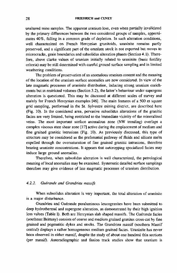
The problem of preservation of an anomalous uranium content and the meaning of the location of the uranium surface anomalies are now considered. In view of the late magmatic processes of uraninite distribution, inducing strong uranium enrichments but in restricted volumes (Section 3.2), the latter’s behaviour under supergene alteration is questioned. This may be discussed at different scales of survey and mainly for French Hercynian examples [46]. The main features of a 500 m square grid sampling, performed in the St. Sylvestre mining district, are described here (Fig. 10). In the considered area, pervasive subsolidus alterations of the granitic facies are very limited, being restricted to the immediate vicinity of the mineralized veins. The most important surface anomalous zone (NW trending) overlaps a complex viscous state shear zone [17] active during the emplacement of medium and fine grained granitic intrusions (Fig. 10). As previously discussed, this type of structure may be considered as the preferential pathway of fluids and silicate melts expelled through the oversaturation of fine grained granitic intrusions, therefore bearing uraninite concentrations. It appears that outcropping specialized facies may induce large ground anomalies.
Therefore, when subsolidus alteration is well characterized, the petrological meaning of local anomalies may be examined. Systematic detailed surface samplings therefore may give evidence of late magmatic processes of uranium distribution.
4.2.2. Guerande and Grandrieu massifs
When subsolidus alteration is very important, the total alteration of uraninite is a major disturbance.
Grandrieu and Guerande peraluminous leucogranites have been submitted to deep hydrothermal and supergene alteration, as demonstrated by their high ignition loss values (Table I). Both are Hercynian slab shaped massifs. The Guerande facies (southeast Brittany) consists of coarse and medium grained granites cross-cut by fine grained and pegmatitic dykes and stocks. The Grandrieu massif (southern Massif central) displays a rather homogeneous medium grained facies. Uraninite has never been observed in either massif, despite the study of about one hundred thin sections (per massif). Autoradiographic and fission track studies show that uranium is
IAEA-TC-571/2 29
FIG. 10. Surface map o f uranium ground anomalies shown in their petrological and structural environments. Indicated are: the shape o f the fine grained granite intrusion (shaded areas), the orientation and dip o f the magmatic foliations and the sense o f movement o f the major shear zones (arrows). Mines and open pits: Fa: Fanay; Ma: Margnac; Sa: Santrop (compilation from Refs [17, 41]).
generally located in microfissures, adsorbed on phyllites (chlorites, sericites) or related to autunite [63, 64],
In spite of a total mobilization of uranium related to uraninite at a subsolidus stage, the Grandrieu massif average content remains significantly high (av. U 9.1 ppm). The Guerande massif displays a lower uranium content (av. U 5.9 ppm); it is noteworthy that a large number of samples have U contents close to the clarke values. These concentrations corroborate the uraniferous potential of each massif. Gu6rande intragranitic mineralizations are very limited (70 t U metal produced). Peribatholithic veins (470 t U metal) occur in the immediate vicinity of specific granitic facies which provided some uraninite crystals observed on drill core samples (160 m depth). The Grandrieu intragranitic mineralizations are much more significant (5000 t U metal).
These features suggest that even under severe supergene alteration conditions (i.e. complete mobilization of uraninite), an anomalous initial average content is not completely depleted and may remain to significantly high levels. Near clarke values, even observed in highly altered facies, indicate probable barren granitic facies.
30 FRIEDRICH and CUNEY
Nonetheless, some additional comprehensive studies are required to establish accurate conclusions.
5. CONCLUSION
The uranium distribution observed in peraluminous granitoids results from five main phenomena: partial melting processes, magmatic and late magmatic differentiation, and hydrothermal and meteoric alteration. These parameters, all discussed in Ref. [46], influence intragranitic uraniferous fertility.
The magmatic evolution of peraluminous melts occurs mostly through progressive partial fusion processes. Uraninite associated with a typical accessory mineral paragenesis displays a late magmatic crystallization stage in highly leucocratic peraluminous melts. On the other hand, facies with cafemic enriched ‘restite’ display a greater abundance of common accessory minerals (monazite, xenotime, zircon), which behave as major host phases for uranium, precluding any abundant uraninite crystallization. Considering the latter as a major uranium source for the veins, therefore, the differentiation stage of peraluminous melts may be considered as a first criterion of fertility gradation. Total uranium content does not automatically give a measure of fertility. An accurate specification of the percentage of uranium host minerals is required in the different stages of magma evolution.
In a complex granitic massif (like St. Sylvestre or Manaslu) several periods of magma emplacement are distinguished. The different pulses, all peraluminous, have their own evolution and variable geochemical and mineralogical characteristics. The St. Sylvestre studies provide evidence of a strong increase in uranium content in a group of late emplaced (as dykes and stocks) granites. These are generally fine grained, in close relation with aplitic and pegmatitic veins. Uraninite is abundant in the most evolved facies of the different intrusions and crystallizes at a late magmatic stage, close to the orthoderived fluid demixing.
The different pathways of the evolved melts and fluids are significantly enriched in uranium and in other trace elements, closely following the geochemical pattern of the parental magma. The uranium contents measured in these facies usually fall within the 50-100 ppm grade. This means a 2-5 enrichment factor for the St. Sylvestre average content (Table I) and a factor of 12-25 for the granitic clarke [44]. Such an increase of the uranium quantity available for subsolidus reworkings obviously favours the mineralizing efficiency of the hydrothermal circulations.
It is important to note that many of the world’s major intragranitic deposits show, in their vicinity, a similar magmatic (and late magmatic) concentrating mechanism, for example the Hercynian Bois noir-Limouzat deposit (northeast Massif central [8, 65]), the South Mountain Batholith (Nova Scotia [12, 66]) and the Upper Jurassic (Yanshanian) granites of the Guidong massif (southwest China [67]).
IAEA-TC-571/2 31
These three additional examples, as mentioned in Ref. [46], suggest that such specific late intrusions (‘inner granite’) and their related uraninite concentrations are an important clue to intragranitic uraniferous fertility.
However, the development of such processes in a poorly mineralized but unaltered granitic massif (Himalayan Manaslu) demonstrates that they are not sufficient to form deposits.
It is obvious that, for the generation of deposits, these necessary primary magmatic processes are not the only ones. The role of post-magmatic, hydrothermal processes in uranium deposits need not be questioned [8-11, 58, 68, 69]. But the subsolidus reworkings of uranium primary stock are restricted to high palaeopermea- bility facies (brittle structures, etc.) of limited volume.
Therefore, it appears that major intragranitic mineralizations are not the result of a slight depletion of primary uranium content of almost massif scale volumes, followed by a random hydrothermal concentration. On the contrary, our experience of the St. Sylvestre massif suggests that the most important factor enhancing the fertility of granitoids is the extent of the spatial overlap between two enrichment processes: late magmatic uraninite preconcentration related to syntectonic specific endogranites on one hand and adequate hydrothermal circulation along tectonic pathways on the other.
Both processes are restricted to limited volumes controlled by multistage tectonism (viscous state and solid state shear zones, brittle structures). These enrichments (hydrothermal and late magmatic) occur at variable grades of concentration and in numerous peraluminous granitoids displaying highly different uranium reserves. Hence, the clue to major vein type deposit development in intragranitic environments seems to be the degree of connection between these two important enrichment mechanisms.
REFERENCES
[1] CUNEY, M., FRIEDRICH, M., POTY, B., P6trologieet geochimie des radioelements dans les granites et dans les leucogranites en particulier. Consequences g£ndtiques et applications & la prospection, BRGM-79, Bureau de recherches gdologiques et minieres, Orleans (1984) 91-125.
[2] POTY, B., et al., “ Uranium deposits spatially related to granites in the French part of the Hercynian orogen” , Vein Type Uranium Deposits, IAEA-TECDOC-361, IAEA, Vienna (1986) 215-246.
[3] NASH, I.J., LEHRMAN, N., Geology of the Midnite uranium mine, Stevens County, Washington, a preliminary report, Geol. Soc. Am., Abstr. 7 5 (1975) 634-635.
[4] STAATZ, M.H., I and L uranium and thorium vein system, Bokan Mountain, southeastern Alaska, Econ. Geol. 73 (1978) 512-523.
[5] CUNEY, M ., Comportement de l’uranium et du thorium au cours du metamorphisme.R61e de l’anatexie dans la genfese des magmas riches en radio-616ments, Thesis, Inst,natl polytechnique de Lorraine, Nancy (1981) 520 pp.
[6] CUNEY, M., “ Processus de concentration de l’uranium et du thorium au cours de lafusion partielle et de la cristallisation fractionn6e” , Uranium Exploration Methods (Proc. Symp. Paris, 1982), OECD/NEA, Paris (1982) 277-292.
[7] MOREAU, M., “ L ’uranium et les granitoi'des: essai d ’interpretation” , Geology, Mining and Extractive Processing of Uranium (Proc. Symp. London, 1977), Instn of Mining and Metallurgy, London (1977) 83-102.
[8] CUNEY, M., Geologic environment, mineralogy and fluid inclusions of the Bois noirs Limouzat uranium vein, Forez, France, Econ. Geol. 73 (1978) 1567-1610.
[9] LEROY, J., The Margnac and Fanay uranium deposits of the La Crouzille district (western Massif central, France): Geologic and fluid inclusion studies, Econ. Geol. 73 (1978) 1611-1634.
[10] CATHELINEAU, M., “ Les gisements d ’uranium lies spatialement aux leucogranites sudarmoricains et & leur encaissant metamorphique” , Mem. Sci. Terre (Nancy) 42 (1981) 475 pp.
[11] PAGEL, M., Facteurs de distribution et de concentration de l ’uranium et du thorium dans quelques granites de la chaine hercynienne d ’Europe, Thesis, Inst, natl polytechnique de Lorraine, Nancy (1981) 566 pp.
[12] CHATTERJEE, A.K., STRONG, D .F., Discriminant and factor analysis of geochemical data from granitoid rocks hosting the Millet Brook uranium mineralization, South Mountain Batholith, Nova Scotia, Uranium 1 (1984) 289-305.
[13] JIASHU, R., ZEHONG, H., “ Form of uranium occurrence and its distribution in uraniferous granites” , Geology of Granites and Their Metallogenic Relations (Proc. Symp. Nanjing, 1982), Univ. Sciences Editions (1984) 621-635.
[14] RODRIGO, F., BELLUCO, A.E., “ Programa nacional de desarrollo de los recursos uraniferos de la Argentina” , Uranium Deposits in Latin America: Geology and Exploration (Proc. Regional Advisory Group Mtg Lima, 1978), IAEA, Vienna (1981) 395-414.
[15] BARBIER, J., CARRAT, H.G., RANCHIN, G., Presence d ’uraninite en tant que mineral accessoire usuel dans les' granites & deux micas uraniferes du Limousin et de la Vend6e, C.R. Acad. Sci., S6r. D 264 (1967) 2436-2439.
[16] MATTE, P., Tectonics and plate tectonics model for the Variscan belt of Europe, Tectonophysics 126 (1986) 329-374.
[17] MOLLIER, B., Le granite de Brame-St. Sylvestre-St. Goussaud. Ses structures magmatiques. Une 6tude de la distribution de l’uranium a l’6chelle du grain, Geol. Gfiochim. Uranium, M£m. (Nancy) 7 (1984) 148 pp.
[18] MOLLIER, B., BOUCHEZ, J.L ., CUNEY, M., FRIEDRICH, M., Magmatic and late-magmatic structure of the St. Sylvestre peraluminous granitic complex (Limousin, France). Implication on uranium metallogenesis, Terra Cognita 5 (1985) 256.
[19] JOVER, O., BOUCHEZ, J.L ., Mise en place syntectonique des granitoi'des de l’ouest du Massif central fran?ais, C.R. Acad. Sci., S6r. 2 303 10 (1986) 969-974.
32 FRIEDRICH and CUNEY
IAEA-TC-571/2 33
[20] LA ROCHE, H. de, STUSSI, J.M ., CHAURIS, L., Les granites a deux micas hercyniens franijais. Essais de cartographie et de correlations g6ochimiques appuyes sur une banque de donnees. Implications petrologiques et metallogeniques, Sci. Terre (Nancy) 24 (1980) 5-121.
[21] STUSSI, J.M ., LA ROCHE, H. de, Le magmatisme orog£nique granitique de la chaine varisque fran?aise. Typologie chimique et repartition spatiale, C.R. Acad. Sci., Ser. 2 298 2 (1984) 43-48.
[22] VIDAL, P., et al., Geochemical comparison between Himalayan and Hercynian leucogranites, Phys. Earth Planet. Inter. 35 (1984) 179-190.
[23] DENIEL, C., Apport des isotopes de Sr, Nd et Pb a la connaissance de Manaslu (Himalaya-N6pal), Thesis, Univ. of Clermont-Ferrand (1985).
[24] MITTLEFEHLDT, D.W., MILLER, C.F., Geochemistry of the Sweetwater Wash Pluton, California: Implications for ‘anomalous’ trace element behaviour during differentiation of felsic magmas, Geochim. Cosmochim. Acta 47 (1983) 109-124.
[25] PRICE, R.C., Geochemistry of peraluminous granitoid suite from northeastern Victoria, southeastern Australia, Geochim. Cosmochim. Acta 47 (1983) 31-42.
[26] WHALEN, J.B., The Ackley City batholith, Southeastern Newfoundland: Evidence for crystal versus liquid-state fractionation, Geochim. Cosmochim. Acta 47 (1983) 1443-1457.
[27] CLEMENS, J.D., WALL, V.J., Origin and evolution of a peraluminous silicic ignimbrite suite: The Violet Town Volcanics, Contrib. Mineral. Petrol. 88 (1984) 354-371.
[28] RANCHIN, G., Contribution a l’etude de la repartition de l’uranium a l’etat de traces dans les roches granitiques saines. Les granites & teneur 61ev6e de massif de St. Sylvestre, Sci. Terre (Nancy) 13 (1968) 159-205.
[29] RANCHIN, G., La geochimie de l’uranium et la differenciation granitique dans la province uranifere du Nord Limousin, Rep. CEA-R-4034 (1971) 467 pp.
[30] CUNEY, M., LEROY, J., PAGEL, M., Comportement de l’uranium et du thorium dans les granites uraniferes frangais, Sci. Terre, Ser. Inf. Geol. (Nancy) 13 (1979) 55-63.
[31] BALL, T.K., BASHAM, I.R ., Radioactive accessory minerals in granites from Southwest England, Proc. Ussher Soc. 44 3 (1979) 437-448.
[32] PAGEL, M., “ Successions paragenetiques et teneurs en uranium des mineraux accessoires dans les roches granitiques, guides pour la recherche des granites favorables a la presence d’uranium” , Uranium Exploration Methods (Proc. Symp. Paris, 1982), OECD/NEA, Paris (1982) 445-456.
[33] CUNEY, M., FRIEDRICH, M., Physicochemical and crystal-chemical controls on accessory mineral paragenesis in granitoids: Implications on uranium metallogenesis, Bull. Mineral. 110 2-3 (1987) 235-248.
[34] BASHAM, I.R ., VAIRINHO, M.M.B., BOWLES, J.F.W ., “ Uranium-bearing accessory minerals in the Sao Pedro do Sul granite, Portugal” , Vein-type and Similar Uranium Deposits in Rocks Younger than Proterozoic (Proc. Tech. Comm. Mtg Lisbon, 1979), IAEA, Vienna (1982) 279-298.
[35] FRIEDRICH, M., CUNEY, M., POTY, B., Polygenetic origin of peraluminous granites (St. Sylvestre complex, Massif central, France), Terra Cognita"5 (1985) 232.
34 FRIEDRICH and CUNEY
[36] FRIEDRICH, M., MOLLIER, B., CUNEY, M., Influence du contexte tectonique sur la petrologie des ensembles granitiques d ’origine anatectique, Soc. Geol. Fr. Editions, Paris (1986) 69.
[37] CUNEY, M., FRIEDRICH, M., DRIN, N., Traitement par l’analyse statistique de donnees multivariables sur le complexe de Brame, St. Sylvestre, St. Goussaud. Differentiation magmatique et polygenisme, Sci. Terre, Ser. Inf. G6ol. (Nancy) 23 (1985) 1-25.
[38] CUNEY, M., LE FORT, P., WANG, Z.X., “ Uranium and thorium geochemistry and mineralogy in the Manaslu leucogranite (Nepal, Himalaya)” , Geology of Granites and Their Metallogenetic Relations (Proc. Symp. Nanjing, 1982), Univ. Sciences Editions (1984) 853-873.
[39] GREEN, T.H., WATSON, E.B., Crystallization of apatite in natural magmas under high pressure hydrous conditions with particular reference to orogenic series, Contrib. Mineral. Petrol. 79 (1982) 96-105.
[40] WATSON, E.B., HARRISON, T.M., Zircon saturation revisited: Temperature and composition effects in a variety of crustal magma types, Earth Planet. Sci. Lett. 64 (1983) 295-304.
[41] FRIEDRICH, M., Le complexe granitique hyperalumineux de St. Sylvestre (nord- ouest du Massif central franca is), Geol. Geochim. Uranium, Mem. (Nancy) 5 (1984) 361 pp.
[42] MONTEL, J.M ., Is monazite guilty? Experimental determination of Ce-monazite solubility in Na20 , K20 , Si02, A120 3 melts, Terra Cognita S (1985) 330.
[43] FRANCE-LANORD, C., LE FORT, P., SHEPPARD, S.M.F., Le leucogranite du Manaslu (Haut Himalaya). Compositions isotopiques D/H et origine de fluides magma- tiques, Soc. Geol. Fr. Editions, Paris (1986).
[44] ROGERS, J.J.W ., ADAMS, J.A.S., “ Geochemistry of uranium” , Handbook of Geochemistry, Vol. 2 (WEDEPOHL, K.H., Ed.), Springer-Verlag, Berlin (West) (1969) Ch. 5.
[45] FRIEDRICH, M., CUNEY, M., Cristallisation de l’uraninite et polyg6nisme dans le complexe granitique de St. Jouvent, Brame, St. Sylvestre (Limousin), C.R. Acad. Sci., S£r. D 296 (1983) 1249-1252.
[46] FRIEDRICH, M., CUNEY, M., POTY, B., Uranium geochemistry in peraluminous leucogranites, Uranium (in press).
[47] MONIER, G., Cristallochimie des micas des leucogranites. Nouvelles donnees experimentales et applications petrologiques, Thesis, Univ. of Orleans (1985) 299 pp.
[48] BURNOL, L ., Geochimie du beryllium et types de concentration dans les leucogranites du Massif central frangais, Mem. Bur. Rech. Geol. Min. 85 (1973) 168 pp.
[49] BARBIER, J., RANCHIN, G., Geochimie de l’uranium dans le massif de St. Sylvestre. Occurrences de l’uranium geochimique primaire et processus de remanie- ments, Rep. CEA-R-3684 (1969) 119-157.
[50] BARBIER, J., RANCHIN, G., Influence de 1’alteration meteorique sur l’uranium a l’6tat de traces dans le granite a deux micas de St. Sylvestre, Geochim. Cosmochim. Acta 33 (1969) 39-47.
[51] OVERSTREET, W .C., The Geologic Occurrence of Monazite, US Geol. Surv., Prof. Pap. 530 (1967) 327 pp.
IAEA-TC-571/2 35
[52] OVERSTREET, W.C., WHITE, A.M., WARR, J.J., Jr., Uranium-rich monazites in the United States, US Geol. Surv., Prof. Pap. 700-D (1970) D.169-D.175.
[53] PRICE, V., COOK, J.R., FAY, W.M., KARFUNKEL, B.S., “ Chemical variations in monazite from the southeastern United States” , Uranium Exploration Methods (Proc. Symp. Paris, 1982), OECD, Paris (1982).
[54] DUBESSY, J., et al., Physical and chemical controls (f02, T, pH) of the opposite behaviour of U and Sn-W as exemplified by hydrothermal deposits in France, Great Britain and by solubility data, Bull. Mineral, (in press).
[55] TURPIN, L., Alterations hydrothermales et caracterisation isotopique (O-H-C) des mineraux et des fluides dans le massif uranifere de St. Sylvestre. Extension a d’autres gisements intragranitiques d ’uranium frangais, Geol. Geochim. Uranium, Mem. (Nancy) 6 (1984) 190 pp.
[56] LEROY, J., personal communication.[57] LESPINASSE, M., Contexte structural des gisements d’uranium de la Marche
Occidentale: fracturation, circulation fluides, propagation de l’episyenitisation, Geol. Geochim. Uranium, Mem. (Nancy) 8 (1984) 200 pp.
[58] LESPINASSE, M., PECHER, A., Microfracturing and regional stress field: A study of the preferred orientations of fluid inclusions planes in a granite from the Massif central, France, J. Struct. Geol. 8 2 (1986) 169-180.
[59] NEUERBURG, G.J., “ Uranium in igneous rocks of the United States of America” , Peaceful Uses of Atomic Energy (Proc. Conf. Geneva, 1955), Vol. 6, UN, New York (1955) 231.
[60] HAMILTON, E.H., Distribution of radioactivity in rocks and minerals and the effects of weathering on determination of uranium, Nature (London) 181 (1958) 697-698.
[61] ROUBAULT, M., COPPENS, R., “ Influence de l’alteration sur la repartition des elements radioactifs dans les roches” , Proc. 84th Congr. Soc. Sav. (1959) 287-295.
[62] BARBIER, J., Alterations chimiques et remaniements de l’uranium dans le sondage profond effectue dans le granite des Monts de Blond, Sci. Terre (Nancy) 13 (1968) 361-378.
[63] GUILLET, P ., Structure et microstructure du granite de Guerande, unpublished report, DEA, Univ. of Nantes, 1980, 55 pp.
[64] PEYROU, E., Petrographie et geochimie du leucogranite de Grandrieu (Margeride, Massif central), Rep. 81-3, CREGU, Vandoeuvre-les-Nancy (1981) 42 pp.
[65] LE, V.T., Geochimie de l’uranium et du thorium dans les granitoi'des et formations associees de la Montagne Bourbonnaise (Massif central frangais), Thesis, Inst, natl polytechnique de Lorraine, Nancy (1975) 372 pp.
[66] CHATTERJEE, A.K., STRONG, D.F., “ Geochemical characteristics of the polymetallic tin domain, southwestern Nova Scotia, Canada” , Granite-related Mineral Deposits (TAYLOR, R.P., STRONG, D.F., Eds) (1985) 41-52.
[67] LI, Tiangang, HUANG, Zhizhang, “ Vein uranium deposits in granites of Xiazhuang ore field” , Vein Type Uranium Deposits, IAEA-TECDOC-361, IAEA, Vienna (1986) 359-376.
[68] CATHELINEAU, M., The hydrothermal alkali metasomatism effects on granitic rocks: Quartz dissolution and related subsolidus changes, J. Petrol. 27 (1986) 945-965.
[69] CATHELINEAU, M., U, Th, REE mobility during albitization and quartz dissolution in granitoids: Evidence from southeast French Massif central, Bull. Mineral, (in press).

IAEA-TC-571/3
URANIFEROUS GRANITIC VEINS IN THE SVECOFENNIAN SCHIST BELT IN NUMMI-PUSULA, SOUTHERN FINLAND
E. RAISANEN Geological Survey of Finland,Espoo, Finland
Abstract
URANIFEROUS GRANITIC VEINS IN THE SVECOFENNIAN SCHIST BELT IN NUMMI-PUSULA, SOUTHERN FINLAND.
In the migmatized Svecofennian schist belt in southern Finland a few uranium and thorium bearing occurrences are known, most of them connected with granitic and pegmatitic parts of the migmatites. In the 1980s the Geological Survey of Finland discovered a new small uranium province in Nummi-Pusula, 80 km west of Helsinki. The province was found by airborne measurements and contains several uranium mineralizations, two of which have been drilled. The province is located at the marginal zone of a late kinematic microcline granite in chemically variable gneisses: garnet bearing gneisses (occasionally with cordierite), quartz-feldspar gneisses and pyroxene bearing charnockites. Along the contact zone in similar geological and tectonic environments uraniferous granitic rocks can be found. The Palmottu deposit in Nummi-Pusula is estimated to have an average grade of 0.10% U and to contain about 1000 t of uranium. Uranium occurs as uraninite crystals in pegmatitic and granitic veins in folded garnet bearing mica gneisses. Molybdenite occurs in small amounts. Two types of uraniferous vein can be found: in normal feldspar-quartz pegmatites, and quartz rich veins with biotite accumulations.
1. INTRODUCTION
Since the 1950s the Geological Survey of Finland and State owned mining companies as well as independent domestic companies have been involved in uranium exploration. In the 1980s the exploration activities have been considerably slowed down. The principal responsibility within Finland for uranium exploration has now been assigned to the Geological Survey of Finland. The Geological Survey maintains minimum levels of activity and expertise in uranium exploration, mainly for interpretation and follow-up studies of the airborne radiometric survey.
As a result several small uranium occurrences have been discovered, most of them in the Proterozoic rocks. The occurrences found so far are too small or too low grade to be of economic interest. The reasonably assured resources in Finland recoverable at a cost of US $80- 130/kg U amount to 1500 t of uranium and the estimated additional resources in the same price category to 2900 t.
37
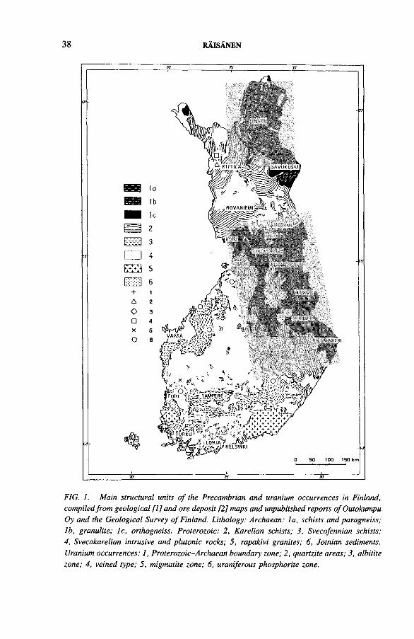
38 RAISANEN
FIG. 1. Main structural units o f the Precambrian and uranium occurrences in Finland, compiled from geological [1] and ore deposit [2] maps and unpublished reports o f Outokumpu Oy and the Geological Survey o f Finland. Lithology: Archaean: la , schists and paragneiss; lb , granulite; lc , orthogneiss. Proterozoic: 2, Karelian schists; 3, Svecofennian schists; 4, Svecokarelian intrusive and plutonic rocks; 5, rapakivi granites; 6, Jotnian sediments. Uranium occurrences: 1, Proterozoic-Archaean boundary zone; 2, quartzite areas; 3, albitite zone; 4, veined type; 5, migmatite zone; 6, uraniferous phosphorite zone.
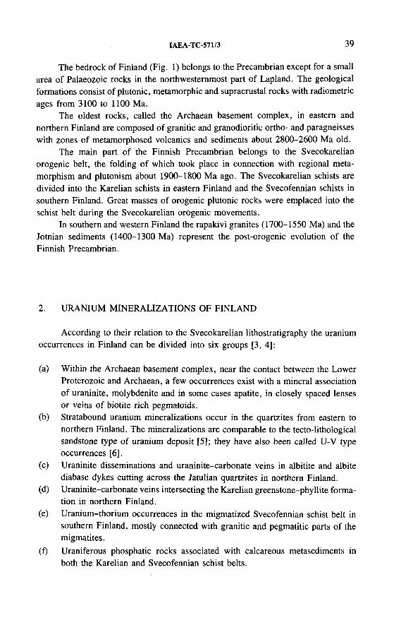
IAEA-TC-571/3 39
The bedrock of Finland (Fig. 1) belongs to the Precambrian except for a small area of Palaeozoic rocks in the northwesternmost part of Lapland. The geological formations consist of plutonic, metamorphic and supracrustal rocks with radiometric ages from 3100 to 1100 Ma.
The oldest rocks, called the Archaean basement complex, in eastern and northern Finland are composed of granitic and granodioritic ortho- and paragneisses with zones of metamorphosed volcanics and sediments about 2800-2600 Ma old.
The main part of the Finnish Precambrian belongs to the Svecokarelian orogenic belt, the folding of which took place in connection with regional metamorphism and plutonism about 1900-1800 Ma ago. The Svecokarelian schists are divided into the Karelian schists in eastern Finland and the Svecofennian schists in southern Finland. Great masses of orogenic plutonic rocks were emplaced into the schist belt during the Svecokarelian orogenic movements.
In southern and western Finland the rapakivi granites (1700-1550 Ma) and the Jotnian sediments (1400-1300 Ma) represent the post-orogenic evolution of the Finnish Precambrian.
2. URANIUM MINERALIZATIONS OF FINLAND
According to their relation to the Svecokarelian lithostratigraphy the uraniumoccurrences in Finland can be divided into six groups [3, 4]:
(a) Within the Archaean basement complex, near the contact between the Lower Proterozoic and Archaean, a few occurrences exist with a mineral association of uraninite, molybdenite and in some cases apatite, in closely spaced lenses or veins of biotite rich pegmatoids.
(b) Stratabound uranium mineralizations occur in the quartzites from eastern to northern Finland. The mineralizations are comparable to the tecto-lithological sandstone type of uranium deposit [5]; they have also been called U-V type occurrences [6],
(c) Uraninite disseminations and uraninite-carbonate veins in albitite and albite diabase dykes cutting across the Jatulian quartzites in northern Finland.
(d) Uraninite-carbonate veins intersecting the Karelian greenstone-phyllite formation in northern Finland.
(e) Uranium-thorium occurrences in the migmatized Svecofennian schist belt in southern Finland, mostly connected with granitic and pegmatitic parts of the migmatites.
(f) Uraniferous phosphatic rocks associated with calcareous metasediments in both the Karelian and Svecofennian schist belts.
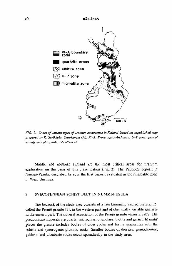
40 RAISANEN
HD
m quartzite arei
migmatite zor
Pt-A boundar zone
albitite zone
U -P zone
Q25'
FIG. 2. Zones o f various types o f uranium occurrence in Finland (based on unpublished map prepared by R. Sarikkola, Outokumpu Oy). Pt-A: Proterozoic-Archaean; U-P zone: zone o f uraniferous phosphatic occurrences.
Middle and northern Finland are the most critical areas for uranium exploration on the basis of this classification (Fig. 2). The Palmottu deposit in Nummi-Pusula, described here, is the first deposit evaluated in the migmatite zone in West Uusimaa.
3. SVECOFENNIAN SCHIST BELT IN NUMMI-PUSULA
The bedrock of the study area consists of a late kinematic microcline granite, called the Pernio granite [7], in the western part and of chemically variable gneisses in the eastern part. The mineral association of the Pernio granite varies greatly. The predominant minerals are quartz, microcline, oligoclase, biotite and garnet. In many places the granite includes bodies of older rocks and forms migmatites with the schists and synorogenic plutonic rocks. Smaller bodies of diorites, granodiorites, gabbros and ultrabasic rocks occur sporadically in the study area.
IAEA-TC-571/3 41
The Svecofennian schists were originally sediments, grey wacky to arkosic in composition. The sediments metamorphosed under conditions of amphibolite facies, partly under conditions of granulite facies. The gneisses of the marginal zone of the Pernio granite and the schists in the study area are folded mica gneisses, mostly garnet bearing gneisses (occasionally with cordierite), quartz-feldspar gneisses and pyroxene bearing charnockites. The mica gneisses in the study area are intensely recrystallized and show only indistinct banding of different layers owing to the primary variation in the sedimentary strata. In the northernmost parts of the study area some relic structures of volcanics indicate a volcanic origin of the amphibolites.
4. URANIFEROUS GRANITES AND GRANITIC VEINS IN THESVECOFENNIAN SCHIST BELT
Since the 1950s several uranium and/or thorium bearing occurrences have been known to exist in the migmatized Svecofennian schists in southern Finland. They are mainly connected with granitic and pegmatitic parts of the migmatites. The main uranium bearing minerals in these occurrences are uraninite, zircon, monazite and allanite.
In 1979 the Geological Survey of Finland discovered by airborne measurements the Palmottu deposit in Nummi-Pusula, 80 km west of Helsinki (Fig. 3). In the 1980s the survey carried out geological, geophysical and geochemical prospecting in the schist areas southwest and northeast of Palmottu, especially checking geological environments including folds similar to where the deposit was found. Several uraniferous granitic veins and granites were found, unfortunately most of them uneconomic at present.
Two of the discoveries have been drilled: the Palmottu deposit and the Hyrkkola mineralization 10 km northeast of Palmottu. The Palmottu deposit lies in a fold structure in garnet bearing mica gneisses (occasionally with cordierite). Thin layers of hornblende-plagioclase gneisses exist also. There are two types of uraniferous vein: coarse grained feldspar-quartz-biotite pegmatites and sheared granitic veins rich in quartz and biotite. Uranium occurs mainly as disseminated uraninite; a minor amount of molybdenite occurs sporadically in both types of vein. The U/Th ratio is usually 2:1 or more, but is also variable. In Palmottu the Geological Survey has drilled 62 drill holes of a total length of 9100 m. The deposit contains 1 000 000 t of ore with an average grade of 0.10% uranium. The ore body is not continuous and its thickness varies from 1 to 15 m; the dip is 70-80° to the west and it plunges 30° to the north, the deposit being partly under Lake Palmottu.
The Hyrkkola mineralization was found by car-borne measurements (Scintrex BGS-3 on the floor of a car). There are several boulder fans in the area indicating a number of veins with mineralizations. The boulders contain 0.05-0.2% uranium. The drillings, however, showed the veins to be too small to be economic. At
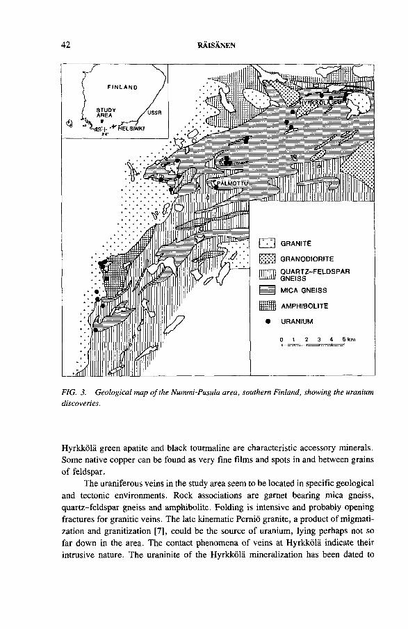
42 RAISANEN
FIG. 3. Geological map o f the Nummi-Pusula area, southern Finland, showing the uranium discoveries.
Hyrkkola green apatite and black tourmaline are characteristic accessory minerals. Some native copper can be found as very fine films and spots in and between grains of feldspar.
The uraniferous veins in the study area seem to be located in specific geological and tectonic environments. Rock associations are garnet bearing mica gneiss, quartz-feldspar gneiss and amphibolite. Folding is intensive and probably opening fractures for granitic veins. The late kinematic Pernio granite, a product of migmati- zation and granitization [7], could be the source of uranium, lying perhaps not so far down in the area. The contact phenomena of veins at Hyrkkola indicate their intrusive nature. The uraninite of the Hyrkkola mineralization has been dated to
IAEA-TC-571/3 43
1774 Ma, a little younger than the late kinematic orogenic rocks (1830 Ma) in the area. Also, a preliminary result indicates that the uraninite of the Palmottu deposit could be still younger, of the rapakivi age.
5. CONCLUSION
In the migmatized Svecofennian schist belt in southern Finland uraniferous granitic veins are found in specific geological and tectonic environments, so the study area can be interpreted as a small uranium province. The age of the mineralizations is about 1700-1800 Ma and the ore type is disseminated uraninite in granitic veins of migmatitic mica gneisses. The occurrences found so far are too small and uneconomic at present.
REFERENCES
[1] SIMONEN, A., The Precambrian in Finland, Geol. Surv. Finl., Bull. 304 (1980) 58.[2] KAHMA, A., SALTIKOFF, B., LINDBERG, E., Ore Deposits of Finland,
1:1 000 000 Map, Geological Survey of Finland, Espoo (1976).[3] AIKAS, O., “ Uraniferous phosphorite and apatite-bearing gneisses in the Proterozoic
of Finland” , Uranium in the Pine Creek Geosyncline (Proc. Int. Symp. Sydney, 1979), IAEA, Vienna (1980) 675-681.
[4] SARIKKOLA, R., Suomen uraanimalmeista, Geologi 26 (1974) 61-64.[5] DAHLKAMP, F.J., Classification of uranium deposits, Miner. Deposita 13 (1978)
83-104.[6] PIIRAINEN, T., “ General geology and metallogenetic features of Finland” , Metal-
logeny of the Baltic Shield (Proc. Symp. Helsinki, 1978), Academy of Finland, Helsinki (1978) 1-19.
[7] SALLI, I., Explanation to the Map of Rocks, Lehti — Sheet 2023 Suomusjarvi, Geological Map of Finland, Geological Survey of Finland, Espoo (1955).
DISCUSSION
M.H. FRIEDRICH: Do you have any idea of the uranium content in the mica gneisses before partial fusion? Are they anomalous?
E. RAISANEN: I have not analysed them in detail, but I think they are not anomalous.
M.H. FRIEDRICH: Do you interpret these pegmatoid and granitic facies as early melts from partial fusion of these mica gneisses, or as coming from lower levels?
E. RAISANEN: They are coming from lower levels.
44 RAISANEN
M.H. FRIEDRICH: Is it not the immediate host rocks, the mica gneisses, which melted and finally gave this pegmatoid? Do you have any idea of the source rocks of this granitic mass?
E. RAISANEN: The uraniferous granite source, I think, is the Pernio granite in the west. It can lie under the mica gneisses, and the veins could come from it.
IAEA-TC-571/4
A URANIUM-ZIRCONIUM MINERALIZATION IN REVSUND GRANITE AT BJORKRAMYRAN, NORTHERN SWEDEN
F. KULLMANSwedish Geological Company,Lulea, Sweden
Abstract
A URANIUM-ZIRCONIUM MINERALIZATION IN REVSUND GRANITE AT BJOR- KRAMYRAN, NORTHERN SWEDEN.
Several uranium-zirconium mineralizations have been detected along a major fracture zone in the Bjorkr&myran area. Diamond drilling at one of the mineralizations has proven more than 1300 t U with an average uranium content of 0.16% and a zirconium content of approximately 0.48%. Interpretation of airborne geophysics survey data indicates that the extension of the mineralized structure is more than 10 km. The mineralization at Bjorkr&myran is situated in a tectonically controlled, strongly sodium metasomatic zone in Revsund granite. Discontinuous tectonic activity resulted in a cyclic precipitation of zirconium rich and uranium rich albitites. During later tectonic movements these albitites were fractured and transformed into fine grained, albite rich cataclasites. The high content of sodium in the albitite generating fluids has made an anomalously high zirconium mobility possible. In the mineralization zirconium occurs in zircon and in a metamict Zr-U-Si phase; the latter is by far the most dominating uranium phase. The uranium- and zirconium-rich albitites in the mineralization have probably been generated from a mixture of locally generated uranium rich solutions and regionally occurring Na-Zr rich metasomatic solutions.
1. INTRODUCTION
The Bjorkramyran area is situated in Vasterbotten County, northern Sweden (Fig. 1). Between 1982 and 1985 the Swedish Geological Company was prospecting for uranium in the region on behalf of the Swedish Nuclear Fuel and Waste Management Company (SKB). The work was initiated after the discovery in 1982 of three uranium-zirconium mineralized glacial boulder trains of good quality during the follow-up of a regional airborne radiometric survey.
Since all the boulders consisted of cataclastically metamorphosed Revsund granite, it was obvious that the mineralizations were associated with fracture zones. At Bjorkr&myran detailed boulder mapping revealed a very intense boulder train (200 m in length) oriented perpendicular to the ice movement direction. This proved to be superior to the other two and hence was given the highest priority. An attempt to trace the fracture zone by ground magnetometry and VLF was made in the autumn
45
46 KULLMAN
FIG. 1. Uranium mineralizations in Sweden.
of 1982, but with no success. However, on the basis of an interpretation of the Quaternary geology of the area a drilling programme was started during the winter of 1983. As a result, low grade mineralizations were intersected by several drill holes, but it was not until 1984 that mineralizations of comparable quality to that of the boulder train were found. When the drilling programme of 1985 was completed, the full extent of the mineralization was still not known, but the project was abandoned for political reasons.
The complete drilling programme included 87 diamond drill holes with a total length of 7765 m. Ore calculations using the profile method gave more than 1300 t U with an average uranium grade of 0.16% within the investigated area. No special calculation has been made of the zirconium content, but since the U/Zr ratio is — 1:3, the corresponding zirconium content is estimated to be 3900 t Zr, with an average grade of 0.48% [1].
2. GEOLOGY
Bjorkr&myran is situated in an area largely dominated by coarse, porphyritic Revsund granite and somewhat discontinuous massifs of mainly metasediments
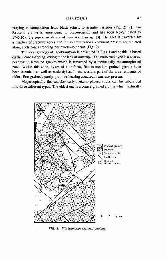
IAEA-TC-571/4 47
varying in composition from black schists to arenitic varieties (Fig. 2) [2]. The Revsund granite is serorogenic to post-orogenic and has been Rb-Sr dated to 1745 Ma; the supracrustals are of Svecokarelian age [3]. The area is traversed by a number of fracture zones and the mineralizations known at present are situated along such zones trending northwest-southeast (Fig. 2).
The local geology of Bjorkr&myran is presented in Figs 3 and 4; this is based on drill core mapping, owing to the lack of outcrops. The main rock type is a coarse, porphyritic Revsund granite which is traversed by a tectonically metamorphosed zone. Within this zone, dykes of a uniform, fine to medium grained granite have been intruded, as well as basic dykes. In the western part of the area remnants of older, fine grained, partly graphite bearing metasediments are present.
Megascopically the cataclastically metamorphosed rocks can be subdivided into three different types. The oldest one is a coarse grained albitite which texturally
FIG. 2. Bjdrkramyran regional geology.
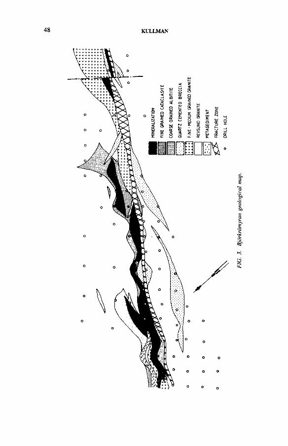
48 KULLMAN
FIG.
3.
Bjor
krdm
yran
ge
olog
ical
m
ap.
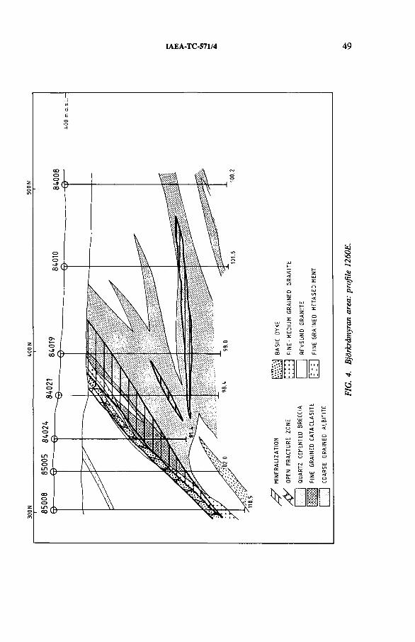
NOOS N
OO'Tf NOOE
IAEA-TC-571/4 49
FIG.
4.
BjOr
kr&
myra
n ar
ea:
prof
ile
1260
E.
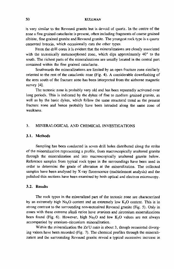
50 KULLMAN
is very similar to the Revsund granite but is devoid of quartz. In the centre of the zone a fine grained cataclasite is present, often including fragments of coarse grained albitite, fine grained granite and Revsund granite. The youngest rock type is a quartz cemented breccia, which occasionally cuts the other types.
From the drill cores it is evident that the mineralizations are closely associated with the tectonically metamorphosed zone, which dips approximately 40° to the south. The richest parts of the mineralizations are usually located in the central part contained within the fine grained cataclasite.
Southwards the mineralizations are limited by an open fracture zone similarly oriented to the rest of the cataclastic zone (Fig. 4). A considerable downfaulting of the area south of the fracture zone has been interpreted from the airborne magnetic survey [4].
The tectonic zone is probably very old and has been repeatedly activated over long periods. This is indicated by the dykes of fine to medium grained granite, as well as by the basic dykes, which follow the same structural trend as the present fracture zone and hence probably have been intruded along the same zone of weakness.
3. MINERALOGICAL AND CHEMICAL INVESTIGATIONS
3.1. Methods
Sampling has been conducted in seven drill holes distributed along the strike of the mineralization representing a profile, from macroscopically unaltered granite through the mineralization and into macroscopically unaltered granite below. Reference samples from typical rock types in the surroundings have been used in order to determine the grade of alteration at the mineralization. The collected samples have been analysed by X-ray fluorescence (multielement analysis) and the polished thin sections have been examined by both optical and electron microscopy.
3.2. Results
The rock types in the mineralized part of the tectonic zone are characterized by an extremely high Na20 content and an extremely low K20 content. This is in strong contrast to the surrounding non-tectonized Revsund granite (Fig. 5). Only in zones with these extreme alkali ratios have uranium and zirconium mineralizations been found (Fig. 6). However, high Na20 and low K20 values are not always accompanied by uranium-zirconium mineralization.
Within the mineralization the Zr/U ratio is about 3, though occasional diverging values have been recorded (Fig. 7). The chemical profiles through the mineralization and the surrounding Revsund granite reveal a typical successive increase in
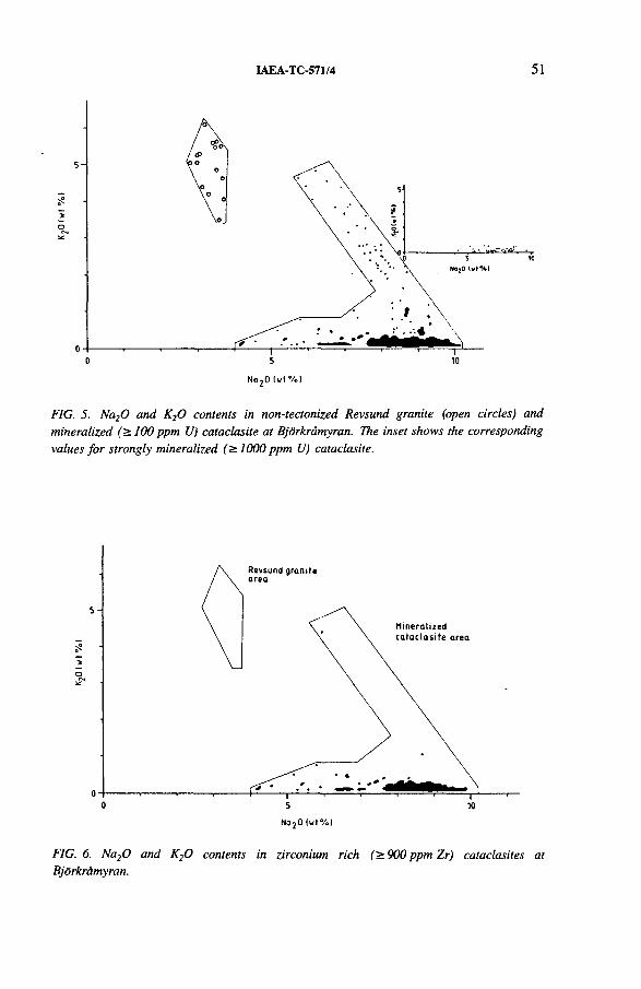
IAEA-TC-571/4 51
Nq20 ( w l% l
FIG. 5. Na20 and K20 contents in non-tectonized Revsund granite (open circles) and mineralized (>100 ppm U) cataclasite at Bjorkramyran. The inset shows the corresponding values for strongly mineralized (>1000 ppm U) cataclasite.
No20 (w t% )
FIG. 6. Na20 and K20 contents in zirconium rich (>900 ppm Zr) cataclasites at Bjdrkrdmyran.
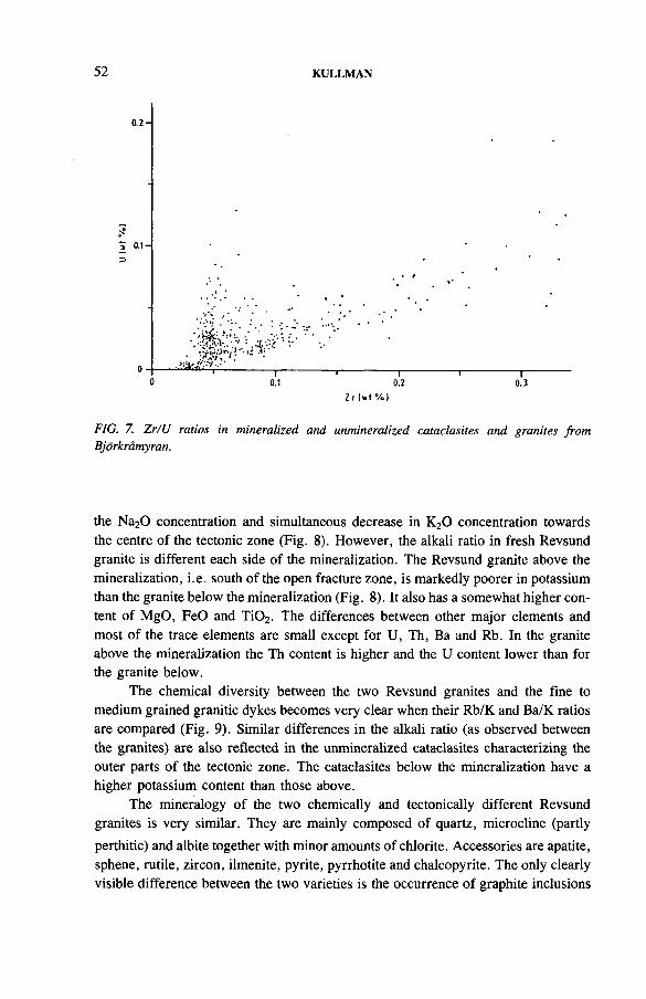
52 KULLMAN
FIG. 7. Zr/U ratios in mineralized and unmineralized cataclasites and granites from Bjdrkramyran.
the Na20 concentration and simultaneous decrease in K20 concentration towards the centre of the tectonic zone (Fig. 8). However, the alkali ratio in fresh Revsund granite is different each side of the mineralization. The Revsund granite above the mineralization, i.e. south of the open fracture zone, is markedly poorer in potassium than the granite below the mineralization (Fig. 8). It also has a somewhat higher content of MgO, FeO and Ti02. The differences between other major elements and most of the trace elements are small except for U, Th, Ba and Rb. In the granite above the mineralization the Th content is higher and the U content lower than for the granite below.
The chemical diversity between the two Revsund granites and the fine to medium grained granitic dykes becomes very clear when their Rb/K and Ba/K ratios are compared (Fig. 9). Similar differences in the alkali ratio (as observed between the granites) are also reflected in the unmineralized cataclasites characterizing the outer parts of the tectonic zone. The cataclasites below the mineralization have a higher potassium content than those above.
The mineralogy of the two chemically and tectonically different Revsund granites is very similar. They are mainly composed of quartz, microcline (partly perthitic) and albite together with minor amounts of chlorite. Accessories are apatite, sphene, rutile, zircon, ilmenite, pyrite, pyrrhotite and chalcopyrite. The only clearly visible difference between the two varieties is the occurrence of graphite inclusions
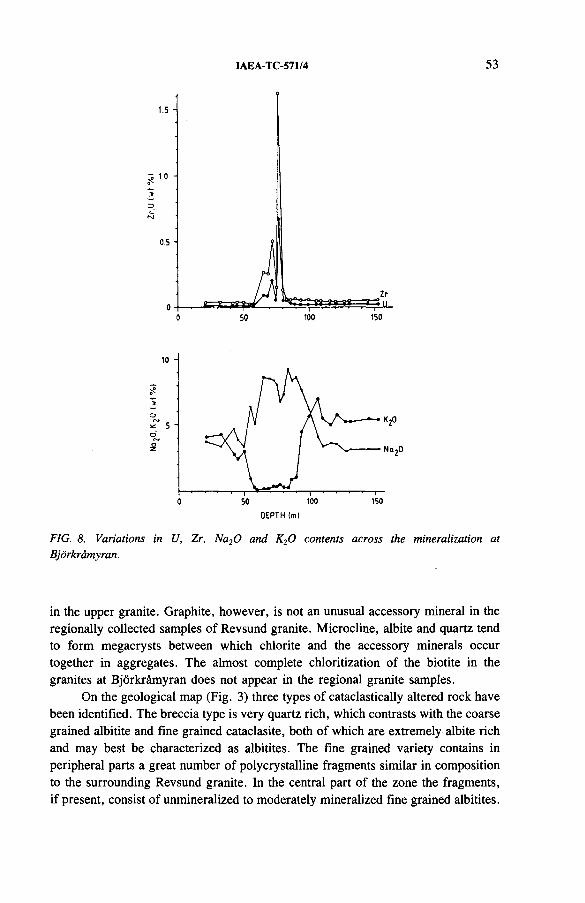
IAEA-TC-571/4 53
DEPTH (ml
FIG. 8. Variations in U, Zr, Na20 and K20 contents across the mineralization at Bjorkramyran.
in the upper granite. Graphite, however, is not an unusual accessory mineral in the regionally collected samples of Revsund granite. Microcline, albite and quartz tend to form megacrysts between which chlorite and the accessory minerals occur together in aggregates. The almost complete chloritization of the biotite in the granites at Bjorkramyran does not appear in the regional granite samples.
On the geological map (Fig. 3) three types of cataclastically altered rock have been identified. The breccia type is very quartz rich, which contrasts with the coarse grained albitite and fine grained cataclasite, both of which are extremely albite rich and may best be characterized as albitites. The fine grained variety contains in peripheral parts a great number of polycrystalline fragments similar in composition to the surrounding Revsund granite. In the central part of the zone the fragments, if present, consist of unmineralized to moderately mineralized fine grained albitites.
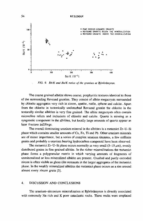
54 KULLMAN
° FINE-MEOIUM GRAINEO GRANITE
4 REVSUNO GRANITE BELOW THE M INERALIZATION
a REVSUND GRANITE ABOVE THE M INERALIZATION
A * * .A
U | j - , ( J . . . . . . . . . J
0 100 200 300 400
Bq /K (10-c )
FIG. 9. Rb/K and Ba/K ratios o f the granites at Bjdrkr&myran.
The coarse grained albitite shows coarse, porphyritic textures identical to those of the surrounding Revsund granites. They consist of albite megacrysts surrounded by chlorite aggregates very rich in zircon, apatite, rutile, sphene and calcite. Apart from the chlorite in tectonically undisturbed Revsund granite the chlorite in the texturally similar albitites is very fine grained. The albite megacry sts often contain microcline relicts and inclusions of chlorite and calcite. Quartz is missing as a syngenetic component in the albitites, but locally large amounts of quartz appear as later fracture infillings.
The overall dominating uranium mineral in the albitites is a metamict Zr-U-Si phase which contains smaller amounts of Ca, Fe, Ti and Pb. Other uranium minerals are of minor importance, but a series of complex uranium titanates, a few coffmite grains and probably a uranium bearing hydrocarbon compound have been observed.
The metamict Zr-U-Si phase occurs normally as very small (5-15 /im), evenly distributed grains in fine grained albitite. In the richer mineralizations the metamict phase forms a polygranular matrix in which varying amounts of fragments of unmineralized or less mineralized albitite are present. Crushed and partly corroded zircon is often visible as ghost-like remnants in the larger aggregates of the metamict phase. In the weakly mineralized albitites the metamict phase occurs as a rim around almost every zircon grain [5].
4. DISCUSSION AND CONCLUSIONS
The uranium-zirconium mineralization at Bjorkr&myran is directly associated with extremely Na rich and K poor cataclastic rocks. These rocks were emplaced
100-
5 0 -
-QCC

IAEA-TC-571/4 55
along a tectonically active zone in Revsund granite. Their formation has been discontinuous, which has resulted in the existence of varying amounts of fragments both from the surrounding Revsund granite and from various generations of albitites in the cataclastic rocks.
The difference in content of the K-isomorphic trace elements Rb and Ba in the Revsund granites above and below the mineralization cannot be explained by an influence from the albitite generating fluids since the albitites generally are very poor in Rb and Ba. Leaching of Rb and Ba through these fluids cannot explain the differences either, because with identical granites on each side of the mineralization leaching would have resulted in identical losses on each side. Instead, the explanation of the chemical differences must be that two blocks of Revsund granite, of somewhat different chemistry, have been moving a considerable distance along the tectonic zone in which the albitites were emplaced. This is also confirmed by the airborne magnetic investigation, from which downfaulting of the area south of the fracture zone has been interpreted.
The coarse grained albitites have assumed the texture of the surrounding Revsund granite. Sometimes their albite megacrysts also include corroded microcline remnants, which further points to their metasomatic character. The albitites consequently are the result of a strong Na + —K + metasomatism with accompanying Si depletion, but later movements along the tectonic zone have to a large extent deleted the original texture, as well as possible lateral chemical variations within the zone.
Many textural indications show that albite, zircon and the metamict Zr-U-Si phase were formed during the Na metasomatism, although not simultaneously.
The first precipitated albitites were poorer in Zr and U than the later ones. Within each tectonically initiated albitite precipitation cycle, zircon and other accessories crystallized earlier than the Zr-U-Si phase.
The paradoxical chemical character of the albitites, which includes high concentrations of both geochemically mobile elements (e.g. Na and U) and immobile elements (e.g. Zr and Ti), does not seem to allow the simultaneous precipitation of albite and U-Zr phases, which the textural character of the albitites indicates. However, examples of similar Zr mineralizations in late magmatic, pneumatolytic and even hydrothermal Na metasomatites do exist. A number of occurrences have been investigated and described, especially in the Soviet Union. The reason for the abnormal Zr mobility is considered to be the forming of Na-Zr carbonate complexes. Premises for a similar mechanism at Bjorkramyran have existed within the tectonic zone. Sodium is present in very high concentrations and the high concentration of calcite in the intergranular mineral aggregates in the coarse grained albitites proves the existence of high carbonate concentrations.
Strong Zr enrichment in an albitized tectonic zone in Revsund granite 15 km south of Bjorkramyran indicates that the precipitation of Zr rich albitites may be a regional phenomenon. In this zone, however, the Na metasomatism is not
56 KULLMAN
accompanied by U mineralization. Closer to Bjorkramyran a number of U mineralized tectonic zones occur in the granite; only one of them (Bjorkramyran 2) is not accompanied by Na metasomatism and Zr enrichment.
These circumstances indicate that the U source for the mineralizations is of local character. During local retrograde metamorphism, which has affected the Revsund granites at Bjorkramyran, large amounts of U may have been leached, resulting in U rich solutions which have subsequently precipitated U along permeable tectonic zones. Precipitation has initially resulted from a mixture of U rich percolating solutions and regionally occurring Na- and Zr-rich solutions. In later tectonic zones U precipitation may have taken place directly from the U rich solutions derived from the granite.
REFERENCES
[1] KULLMAN, F., Bjorkramyran, Malmberakning 1985, Internal Rep. IRAP 85039, SKB, Stockholm, 1985.
[2] GERLACH, R., Bjorkr&myranomr&det. Kortfattad Beskrivning till Oversiktlig Berggrundsgeologisk Karta i Skala 1:50 000, Internal Rep. IRAP 85045, SKB, Stockholm, 1985.
[3] WELIN, E., et al., Radiometric Age of Intrusive Rock in Northern Sweden II, Rep. SGU C 731 (1977).
[4] SVENSSON, T., Regionalgeofysisk Tolkning, Bjorkr&myran, Internal Rep. IRAP 85034, SKB, Stockholm, 1985.
[5] HALENIUS, U., Bjorkrimyran. Mineralogi, Internal Rep. IRAP 85052, SKB, Stockholm, 1985.
DISCUSSION
R.K. BALLHORN: Did you observe some correlation between different phases of movement, and different phases of albitization?
F. KULLMAN: Yes, we have several generations of albitites in the zone. There are fragments of the coarse grained albitites in the finer grained albitites in the central zone where we have the best mineralization.
IAEA-TC-571/5
MICROFRACTURING AND REGIONAL STRESS FIELDS: RELATION WITH FLUID CHRONOLOGY AND HYDROTHERMAL QUARTZ LEACHING (EPISYENITIZATION)
M. LESPINASSECREGU and GS CNRS-CREGU,Vandceuvre-les-Nancy,France
Abstract
MICROFRACTURING AND REGIONAL STRESS FIELDS: RELATION WITH FLUID CHRONOLOGY AND HYDROTHERMAL QUARTZ LEACHING (EPISYENITIZATION).
The study of the deformation of the La Marche granitic massif (northwest Central massif) indicates relations between palaeostress fields and the geometry of microfractures as defined by fluid inclusion trails. The fluid inclusions form rectilinear trails which correspond to healed microcracks. These contain percolating aqueous fluids associated with episyenitiza- tion and mineralization deposition. Simultaneous studies of the orientations in space of these trails and of the chemistry of these inclusions (microthermometric characteristics) indicate that: (a) fluid inclusion trails are extensional cracks which can be used as excellent markers of palaeostress fields; (b) several generations of fluids can be distinguished according to their physico-chemical characteristics (composition and temperature), corresponding to different stages of hydrothermal activity. The Le Bernardan uranium ore deposit shows that the relations between regional stress fields, the geometry of the fluid inclusion trails and the microthermometric characteristics of the fluids may be used to establish the chronology of both faulting and fluid circulation during a region’s geological evolution and to predict the proximity of ore bodies.
1. INTRODUCTION
In the French Hercynian granites, two morphological types of uranium ore deposit can be distinguished: vein type [1-5] and disseminated type [1,2, 6-9]. The disseminated type, called episyenite in French terminology, results from the dissolution of magmatic quartz by hydrothermal alteration [10], This alteration transforms granite into vuggy feldspathic assemblages which constitute good host rocks for later alteration or mineralization [1, 2, 11-13]. Some authors [3, 4, 14-16] have shown that the percolation of hydrothermal fluid occurred through a dense set of fractures on all scales. But a geometric description of fracturing is not sufficient to relate the different stages of fluid percolation to the quartz dissolution and so to predict the location of episyenitic columns.
57
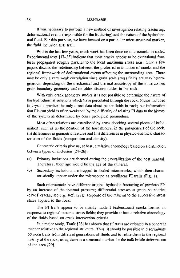
58 LESPINASSE
It was necessary to perform a new method of investigation relating fracturing, deformational events (responsible for the fracturing) and the nature of the hydrothermal fluid. For this purpose, we have focused on a particular microstructural marker, the fluid inclusion (FI) trail.
Within the last few years, much work has been done on microcracks in rocks. Experimental tests [17-23] indicate that most cracks appear to be extensional fractures propagated roughly parallel to the local maximum stress axis. Only a few papers discuss the relationship between the preferred orientation of cracks and the regional framework of deformational events affecting the surrounding area. There may be only a very weak correlation since grain scale stress fields are very heterogeneous, depending on the mechanical and thermal anisotropy of the minerals, on grain boundary geometry and on older discontinuities in the rock.
With only crack geometry studies it is not possible to determine the nature of the hydrothermal solutions which have percolated through the rock. Fluids included in crystals provide the only direct data about palaeofluids in rock; but information that FIs can yield is often weakened by the difficulty of relating FI data to the history of the system as determined by other geological parameters.
Most often relations are established by cross-checking several pieces of information, such as (i) the position of the host mineral in the paragenesis of the rock,(ii) differences in geometric features and (iii) differences in physico-chemical characteristics of the fluids (composition and density).
Geometric criteria give us, at best, a relative chronology based on a distinction between types of inclusion [24-26]:
(a) Primary inclusions are formed during the crystallization of the host mineral.Therefore, their age would be the age of the mineral.
(b) Secondary inclusions are trapped in healed microcracks, which then characteristically appear under the microscope as rectilinear FI trails (Fig. 1).
Such microcracks have different origins: hydraulic fracturing of previous FIs by an increase of the internal pressure; differential stresses at grain boundaries (dP/dT cracks, see e.g. Ref. [27]); response of the mineral to the successive stress states applied to the rock.
The FI trails appear to be mainly mode I (extensional) cracks formed in response to regional tectonic stress fields; they provide at best a relative chronology of the fluids based on crack intersection criteria.
In a major study, Tuttle [28] has shown that FI trails are oriented in a coherent manner relative to the regional structure. Thus, it should be possible to discriminate between trails from different generations of fluids and to relate them to the regional history of the rock, using them as a structural marker for the bulk brittle deformation of the area [29].
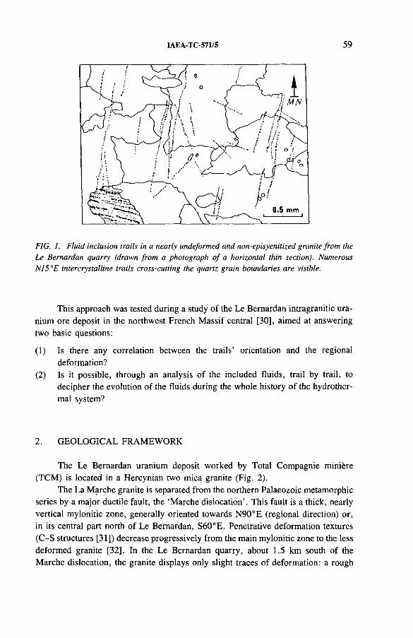
IAEA-TC-571/5 59
FIG. 1. Fluid inclusion trails in a nearly undeformed and non-episyenitized granite from the Le Bernardan quarry (drawn from a photograph o f a horizontal thin section). Numerous N15°E intercrystalline trails cross-cutting the quartz grain boundaries are visible.
This approach was tested during a study of the Le Bernardan intragranitic uranium ore deposit in the northwest French Massif central [30], aimed at answeringtwo basic questions:
(1) Is there any correlation between the trails’ orientation and the regional deformation?
(2) Is it possible, through an analysis of the included fluids, trail by trail, to decipher the evolution of the fluids during the whole history of the hydrothermal system?
2. GEOLOGICAL FRAMEWORK
The Le Bernardan uranium deposit worked by Total Compagnie miniere (TCM) is located in a Hercynian two mica granite (Fig. 2).
The La Marche granite is separated from the northern Palaeozoic metamorphic series by a major ductile fault, the ‘Marche dislocation’. This fault is a thick, nearly vertical mylonitic zone, generally oriented towards N90°E (regional direction) or, in its central part north of Le Bernardan, S60°E. Penetrative deformation textures (C-S structures [31]) decrease progressively from the main mylonitic zone to the less deformed granite [32]. In the Le Bernardan quarry, about 1.5 km south of the Marche dislocation, the granite displays only slight traces of deformation: a rough
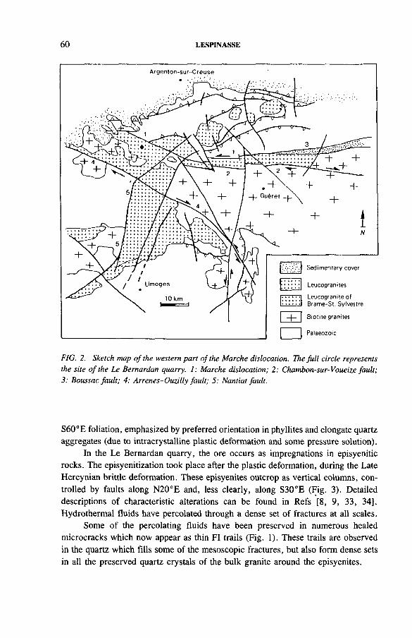
60 LESPINASSE
FIG. 2. Sketch map o f the western part o f the Marche dislocation. The full circle represents the site o f the Le Bemardan quarry. 1: Marche dislocation; 2: Chambon-sur-Voueize fault; 3: Boussac fault; 4: Arrenes-Ouzilly fault; 5: Nantiat fault.
S60°E foliation, emphasized by preferred orientation in phyllites and elongate quartz aggregates (due to intracrystalline plastic deformation and some pressure solution).
In the Le Bernardan quarry, the ore occurs as impregnations in episyenitic rocks. The episyenitization took place after the plastic deformation, during the Late Hercynian brittle deformation. These episyenites outcrop as vertical columns, controlled by faults along N20°E and, less clearly, along S30°E (Fig. 3). Detailed descriptions of characteristic alterations can be found in Refs [8, 9, 33, 34], Hydrothermal fluids have percolated through a dense set of fractures at all scales.
Some of the percolating fluids have been preserved in numerous healed microcracks which now appear as thin FI trails (Fig. 1). These trails are observed in the quartz which fills some of the mesoscopic fractures, but also form dense sets in all the preserved quartz crystals of the bulk granite around the episyenites.
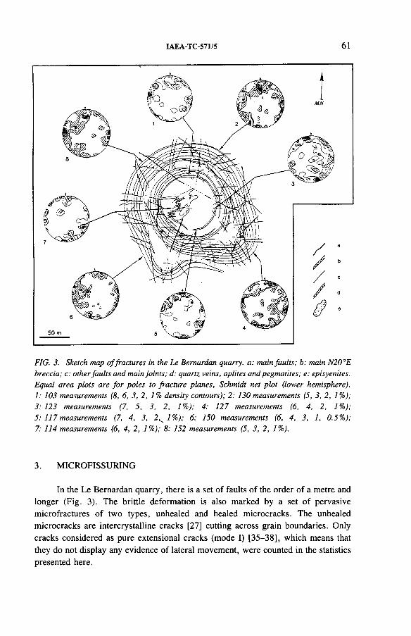
IAEA-TC-571/5 61
FIG. 3. Sketch map o f fractures in the Le Bemardan quarry, a: main faults; b: main N20°E breccia; c; other faults and main joints; d: quartz veins, aplites and pegmatites; e: episyenites. Equal area plots are for poles to fracture planes, Schmidt net plot (lower hemisphere). 1: 103 measurements (8, 6, 3 ,2 , 1% density contours); 2; 130 measurements (5, 3, 2, 1%);3; 123 measurements (7, 5, 3, 2, 1%); 4: 127 measurements (6, 4, 2, 1%);5: 117 measurements (7, 4, 3, 2,^1% ); 6; 150 measurements (6, 4, 3, 1, 0.5%);7; 114 measurements (6, 4, 2, 1%); 8; 152 measurements (5, 3, 2, 1%).
3. MICROFISSURING
In the Le Bernardan quarry, there is a set of faults of the order of a metre and longer (Fig. 3). The brittle deformation is also marked by a set of pervasive micro fractures of two types, unhealed and healed microcracks. The unhealed microcracks are intercrystalline cracks [27] cutting across grain boundaries. Only cracks considered as pure extensional cracks (mode I) [35-38], which means that they do not display any evidence of lateral movement, were counted in the statistics presented here.
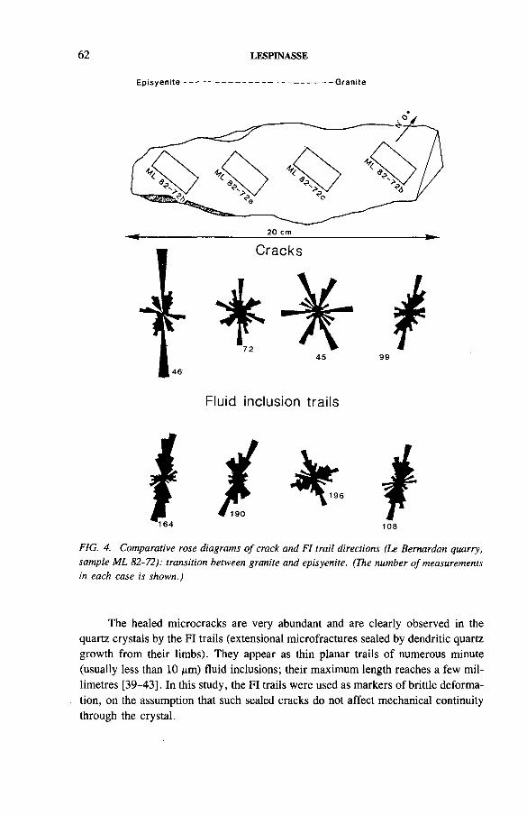
62 LESPINASSE
E p i s y e n i te - * G ra n i te
20 cm
Cracks
164
Fluid inclusion trails
108
FIG. 4. Comparative rose diagrams o f crack and FI trail directions (Le Bernardan quarry, sample ML 82-72): transition between granite and episyenite. (The number o f measurements in each case is shown.)
The healed microcracks are very abundant and are clearly observed in the quartz crystals by the FI trails (extensional microfractures sealed by dendritic quartz growth from their limbs). They appear as thin planar trails of numerous minute (usually less than 10 /xm) fluid inclusions; their maximum length reaches a few millimetres [39-43], In this study, the FI trails were used as markers of brittle deformation, on the assumption that such sealed cracks do not affect mechanical continuity through the crystal.
IAEA-TC-571/5 63
Microfracturing has been studied in 19 samples scattered throughout the 200 m width of the Le Bernardan quarry. Only samples of fresh unaltered granite were investigated. Most of the microcracks are steep to nearly vertical; thus, we obtain a good representation of them by taking into account only their trace in horizontal thin sections. The measurements are presented in rose diagrams in which the cracks are shown in 10° classes.
4. MICROCRACKS VERSUS FLUID INCLUSION TRAILS
To test the preliminary assumption that FI trails are equivalent to other microcracks, and to test the homogeneity of fracturing of the specimen, measurements of both microcracks and FI trails were made in four sections of a sample of unaltered granite collected in the wall of a N20°E episyenitic lens (Fig. 3).
Figure 4 shows the rather homogeneous fracture pattern of both cracks and FI trails. There is an increase in the number of N20°E fractures from section 4 to section 1; more numerous N20°E fractures occur closer to the episyenite. There is a very strong similarity between crack and trail diagrams. Thus, the unhealed and healed cracks are equivalent markers, although why some of the cracks are unhealed is unknown. Possibly they were cracks unconnected with the general network of other microfractures, and stayed ‘dry’ at the time of fluid percolation.
5. FLUID INCLUSION TRAILS ACROSS THE QUARRY
On the scale of the quarry, rose diagrams (Fig. 5) show more clearly the homogeneity of the microfracture orientations throughout the quarry. A dominant and ubiquitous N20°E direction stands out, together with much less dense, but regular, sets following the N70-80°E, S65°E and S20-40°E directions. The regularity of the microfracturing is only disturbed in the vicinity of faults. As can be seen, dense S20-50°E microfractures occur near the right-lateral strike slip fault oriented S60°E; these microfractures are on an extension direction compatible with the sense of movement of the fault.
In the same way, a N45°E microfracturing direction appears in samples k and f, close to the S10°E dextral fault. Insofar as FI trails are equivalent to mode I cracks, these orientations suggest a local deviation of the extensional direction in the vicinity of the compressive large fault (second order extensional fracturing accompanying a first order discontinuity).
i64 LESPINASSE
M N
FIG. 5. Preferred orientations o f FI trails (Le Bemardan quarry). The rose diagrams correspond to the linear density o f trails, i.e. the total length o f the trails per unit area in a given 10° class o f direction (cm~'). Sample a: maximum value 3.7 for the class o f direction N40-50°E. Sample b: 3.4, S20-30°E. Sample c: 2.9, N10-20°E; submaxima: 2.3, N60-70°E, and 1.8, S50-60°E. Sample d: 3.2, S30-40°E; 3.1, S0-10°E; and 2.4, N30-40°E. Sample e: 3.7, S60-70°E; and 2.0, N30-40°E. Sample f: 2.4, N30-40°E; and 1.6, S40-50°E. Sample g: 2.2, N30-40°E. Sample h: 3.5, N10-20°E. Sample i: 3.6, N30-40°E; and 2.1, S0-10°E. Sample j: 2.8, N20-30°E; 2.5, N40-50°E; and 1.7, N80-90°E. Sample k: 3.1, N10-20°E; 3.2, N30-40°E; and 2.6, S40-50°E. Sample I: 2.7, N30-40°E. Sample m: 3.2, N20-30°E. Sample n: 2.5, S20-30°E. Sample o: 4.8, N10-20°E; and 3. 7, N60-70°E. Sample p: 2.4, N10-20°E. Numbers 1-4 refer to the samples on which microthermometric measurements were done (for corresponding rose diagrams see Fig. 7). The three main fractures observed in the quarry and the main episyenitic lenses are shown.
IAEA-TC-571/5 65
FIG. 6. Linear density o f trails as a function o f the distance o f the sample from the episyenite. Full circles: samples in apparently unaltered granite (no quartz dissolution); open circles: samples in episyenitized granite.
6. DENSITY OF MICROFRACTURES
When considering the density of the main trail family (N0-50°E) as a function of the distance between the sample and the episyenitic column (Fig. 6), a clear increase in the microfissuring towards the episyenite can be seen, with a drastic drop inside the episyenite itself. In fact, this drop is not very significant, as it reflects mainly the much smaller amount of quartz present in the partially episyenitized granite.
Thus, there is a geometric relation between episyenitized zones and the density of microfractures which can be compared to the geometry of the successive zones of increasing hydrothermal alteration from the unaltered granite to the episyenites; it shows that the microcracks considered here indicate the true percolation pattern of the hydrothermal fluids.
Finally, Figs 4-6 show the following main points:
(a) Planes of FI trails have orientations similar to other extensional cracks observed in the granite.
(b) FI trails are aligned along several well defined directions. They are good indicators of the microfissure pattern at the time when hydrothermal fluids were percolating.
66 LESPINASSE
(c) The N20°E microfissuring, oriented parallel to the main direction of the episyenite column sections, is denser towards them and should correspond to the flow paths of the hydrothermal fluids responsible for quartz dissolution.
7. FLUIDS IN CRACKS IN DIFFERENT DIRECTIONS
Extensional cracks such as FI trails display no relative displacement of their walls; thus, classical failure criteria, based on intersection displacements, are inappropriate. Because of the lack of geometric criteria, data on the physico-chemical characteristics of the fluids trapped in the inclusions (from microthermometric studies) were used to establish a chronology.
Previous studies of fluids associated in the La Marche granite [8, 34] and in a similar setting elsewhere [6] have indicated significant changes in the chemistry and temperature of the hydrothermal fluids during the evolution of the hydrothermal system. In the Le Bernardan quarry, the values obtained are widely spread, with temperatures of melting of the ice (Tm) between - 7 and 0°C (i.e. salinity, in equivalent weight of NaCl, ranges from 10 to 0%) and temperatures of homogenization (Th) in the liquid phase ranging from 180 to more than 350°C. The fluid responsible for the hydrothermal quartz leaching (episyenitization) would have been hotter and richer in salt and would have occurred early in the hydrothermal evolution.
New measurements have been carried out, splitting the FIs of the different trails as observed in oriented sections; as a result, each FI can be defined by four parameters:
(1) The melting temperature of the ice, which indicates the salinity;(2) The homogenization temperature of the fluid, which gives the density of fluid;(3) The orientation of the trail in which the FI occurs;(4) The distance between the sample and the nearest episyenitic lens.
Thermometric measurements were performed using a Chaix-Meca heating- freezing stage [44]. Unfortunately, most of the FIs are very small, close to 5 /im, and are at the limit of resolution of the apparatus. Thus, for many trails only partial measurements could be made. Finally, only four sections have provided enough complete data for systematic study [45].
Sample 1 (82-192) (Fig. 7(1)) was taken in the granite 30 m east of the N20°E breccia zone along which the three main episyenitic columns are located (Fig. 5). This sample yields data about S30°E trails, but only poor data about the N10-30°E ones. There are two homogenization temperatures, scattered around 210°C and in the range 280-380°C. Melting temperatures are between 0 and —0.8°C (0-3% eq. wt NaCl).
Sample 2 (82-190) (Fig. 7(2)) was taken 20 m west of the same breccia zone. In this sample, the two trail directions N10-40°E and N80°E are well expressed,
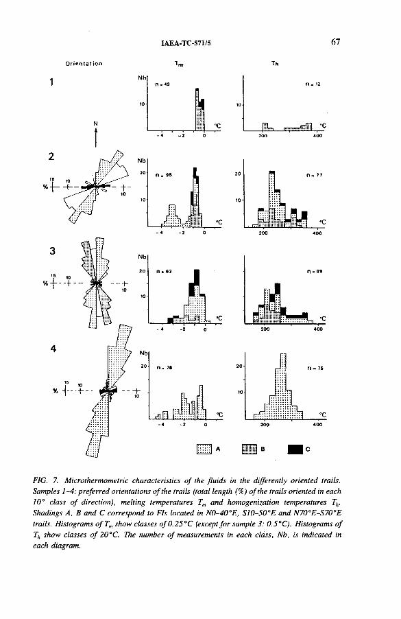
IAEA-TC-571/5 67
O r ie n ta t i o n T h
N bn « *9
n. n = 12
’0
"C OIL, ,------- diiil “C- « -2 0
FIG. 7. Microthermometric characteristics o f the fluids in the differently oriented trails. Samples 1-4: preferred orientations o f the trails (total length (%) o f the trails oriented in each 10° class o f direction), melting temperatures Tm and homogenization temperatures Th. Shadings A, B and C correspond to FIs located in N0-40°E, S I0-50°E and N70°E-S70°E trails. Histograms o fT m show classes o f 0.25 °C (except for sample 3: 0.5°C). Histograms o f Th show classes o f 20°C. The number o f measurements in each class, Nb, is indicated in each diagram.
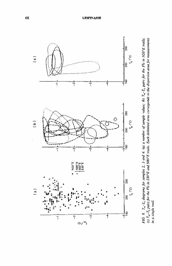
LESPINASSE
FIG.
8.
Tm-T
h di
agra
ms
for
samp
les
2, 3
and
4: (a)
a
num
ber
of sa
mple
valu
es;
(b)
Tm-T
h pa
irs f
or
the
FIs
in N2
0°E
trai
ls;
(c)
Tm-T
h pai
rs f
or
the
FIs
in S3
0°E
and
N80°
E tra
ils.
Each
de
limite
d ar
ea
corr
espo
nds
to the
di
sper
sion
area
fo
r m
easu
rem
ents
in
a sin
gle
trai
l.
IAEA-TC-571/5 69
and measurements were also possible on the few S30°E trails. Homogenization temperatures range from 160 to 360°C, with a rather sharp maximum at 230°C; approximately the same dispersion is observed when trails of different directions are taken individually. The melting temperature histogram displays two maxima at —0.9 and -3 °C (4 and 9% eq. wt NaCl, respectively); these two maxima are still visible if we retain only the FIs of the N20°E trails, whereas the N90°E and S30-40°E trails display values between -0 .2 and -1.2°C (1 and 5% eq. wt NaCl, respectively).
Sample 3 (82-196) (Fig. 7(3)), taken in the western part of the quarry 10 m from another episyenitic column (the ‘eastern body’), shows the three main directions of trails: N20°E, N90°E and S30°E. Homogenization temperatures are spread between 160 and 380°C (mostly between 180 and 280°C); this dispersion is mainly due to values measured in the FIs of the N20°E and N90°E trails, whereas values for the fluids of the S30°E trails are much less scattered. Melting temperatures are close to -0 .8°C (3% eq. wt NaCl).
Sample 4 (82-201) (Fig. 7(4)) was taken less than 3 m from the previousepisyenitic column. In this sample, the N20°E direction is predominant, and allmeasurements have been done on trails of this direction. The homogenization temperature histogram is rather narrow, with a maximum at 280°C, i.e. a higher temperature than in the other samples. Melting temperatures are more scattered, there being some rather low values around -4 .5°C (higher salinities, around 8% eq. wt NaCl).
Thus, the homogenization temperatures and the salinities decrease with the distance from the episyenite. However, the FIs form inhomogeneous groups, their microthermometric characteristics varying from one trail direction to another.
This becomes evident when we separate the FIs in a Tm-Th diagram as a function of trail direction, and not only as a function of their distance from the episyenite. In Fig. 8, each bounded domain corresponds to the Tm-Th pairs measured for theFIs of a single crack. It appears that:(a) The FIs of a single trail are restricted to a rather small area of the diagram,
much less extended than the area defined by the entire data set for trails of the same direction. This is particularly true for the salinities: each trail gives a brine of well defined salinity, significantly different from the salinity observed in a neighbouring trail.
(b) The Tm-Th pairs for the N20°E trails are scattered over a large range of values. It can be deduced that: (1) the N20°E direction has been a preferred direction of failure during most of the evolution of the hydrothermal system, and (2) once a crack has sealed, it does not act as a mechanical discontinuity for later failure. There is a restoration of the mechanical continuity in the crystal, a phenomenon also shown by the ‘crack seal’ type opening of veins described by Ramsay [46].
(c) The data from trails of other directions are much less scattered except again for the Th values: the N90°E and S30°E trails have fossilized only very low salinity fluids.
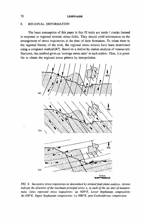
70 LESPINASSE
8. REGIONAL DEFORMATION
The basic assumption of this paper is that FI trails are mode I cracks formed in response to regional tectonic stress fields. They should yield information on the arrangement of stress trajectories at the time of their formation. To relate them to the regional history of the rock, the regional stress tensors have been determined using a computer method [47]. Based on a station by station analysis of mesoscopic fractures, this method gives an ‘average stress state’ at each station. Thus, it is possible to obtain the regional stress pattern by interpolation.
FIG. 9. Successive stress trajectories as determined by striated fault plane analysis. Arrows indicate the direction o f the maximum principal stress a, in each o f the six sites o f measurement. Lines represent stress trajectories: (a) N20°E, Lower Stephanian compression; (b) S30°E, Upper Stephanian compression; (c) N80°E, post-Carboniferous compression.
IAEA-TC-571/5 71
A study of 520 striated planes in six stations (Fig. 9) showed that the Late Hercynian fracturing results from the superposition of at least three different stress states. The main stress a, was oriented at N20°E (the most accurately defined direction), N80°E and S30°E. The mechanical assumptions used to differentiate the stress tensor do not yield information about the relative order of the stress states, which can only be established on the basis of criteria such as fault intersections and superposition of striae.
It appears that the N20°E compression occurred first. This was responsible for the late ductile deformation of the granite around 310 Ma [32], and later for the emplacement in the St. Sylvestre granite of N20°E lamprophyre dykes, dated at 295 Ma [48]. Thus, this direction was probably the main regional compression direction from the Visean to the Stephanian.
It was followed by a S30°E compression. In the St. Sylvestre granite, this compression is related to the dextral S60°E faults, which displace the lamprophyric dykes, to the sinistral reactivation of older N-S faults, and to the S30°E faults penecontemporaneous with ore deposition [1-3, 15], dated at 275 Ma [49], Thus, the age of the S30°E compression is probably Stephanian-Autunian.
The N80°E direction is the youngest of the three compression directions. It is defined by faults observed both in the Hercynian basement and in its Mesozoic cover. It is at least partly post-Jurassic, and could be a response to the distant late Alpine mountain building episode [50, 51].
9. DISCUSSION
The aim of this paper was not to discuss the mechanisms of the hydrothermal quartz leaching (episyenitization), nor the results that a simultaneous study of the physico-chemical parameters of the fluids and their successive distributions in time and space can yield. But the Le Bernardan example, as in the previous work of Tuttle[28], clearly shows the possibility of considering the trails of secondary FIs in the same way as any structural marker, i.e. of considering not only their relative age but also their orientation and position:
(1) Planes of fluid inclusions (FI trails) which are believed to have originated as extensional microcracks which subsequently became healed by solution and deposition of silica have orientations similar to other extensional cracks observed in the granite.
(2) FI trails are aligned along several well defined directions, uniformly oriented over large areas (hundreds or even thousands of metres in size). Thus, preferred orientations of trails must be dependent on the average regional stress field and only slightly affected by local heterogeneities.
(3) Successive regional stress trajectories (Fig. 9) fit well with the observed preferred orientations of trails. This correlation cannot be accidental: the early N20°E maximum compressive stress and the N20°E FI trails (which seem also to be the oldest from the fluid data) must be related, as well as the S30-50°E and N70-90°E trails with the later S30°E and N80°E maximum compressive stresses.
(4) FI trails are mode I (extensional) cracks which formed parallel to the average direction of ax and perpendicular to the average direction of ct3 in the bulk rock. FI planes, typical features in quartz of crystalline rocks, should provide, in the absence of (or in addition to) mesostructural markers, a practical way of constructing extension direction trajectories.
(5) The previous assumptions about the preferred orientations of FI trails must also be valid for other types of extensional microcrack.
72 LESPINASSE
10. CONCLUSION
Fluid inclusion trails appear to be very useful tools, (a) They do not disrupt the mechanical continuity of mineral grains and thus they may be capable of reflecting slight angular rotations in the direction of the elongation axis, (b) In the context of fluid behaviour during deformation, FI trails appear to be fossilized pathways of hydrothermal solution migration. Thus, one can use the physico-chemical differences in the included fluids to separate different sets of trails; alternatively, it should be possible to use trails to relate the different stages of fluid percolation to a regional succession of deformational events.
A similar approach can be (and often is) made using mesoscopic veins or lenses instead of FI trails observed in the bulk rock. But the formation of a vein introduces a strong mechanical discontinuity in the material. Thus, except for very late ones, a vein will have normally channelled various fluids successively. In contrast, a healed microcrack does not disrupt the mechanical continuity of the host rock: it is then easier to distinguish between the different stages of percolation, particularly if the regional stress field, which has the same orientation as the trails, rotates during the evolution of the system.
Of course, such an approach requires that measurements be made in oriented sections, and that the orientation of the trail be considered with the other parameters of the inclusion.
It seems that this technique, as developed above, could be used for all kinds of mineralization.
IAEA-TC-571/5 73
ACKNOWLEDGEMENTS
This study is part of a research programme at the Centre de recherches sur la geologie de l’uranium (CREGU) at Vandoeuvre-les-Nancy. The author would like to express gratitude to P. Jamet and all the geologists involved with the Le Bernardan ore deposit, and to J. Leroy and A. Pecher for helpful discussions.
REFERENCES
[1] SARCIA, J., SARCIA, J.A., “ Gites et gisements du Limousin” , Les minerais urani- feres frangais, Presses univ. de France, Paris (1962) 185-292.
[2] MARQUAIRE, C., MOREAU, M., Esquisse geologique du Nord Limousin et repartition des mineralisations uraniferes, Rep. CEA-R-3684 (1969) 7-40.
[3] MOREAU, M., RANCHIN, G., “ Alterations hydrothermales et controles tectoniques dans les gites filoniens d ’uranium intragranitiques du Massif central frangais” , Les roches plutoniques dans leurs rapports avec les gites mineraux (Colloque Raguin, Paris, 1977), Masson, St. Germain (1977) 77-100.
[4] CATHELINEAU, M., Les gisements uraniferes de la presqu’ile Guerandaise (Sud- Bretagne), approche structurale et metallogenique, Miner. Deposita 16 (1981) 227-240.
[5] POTY, B., et al., “ Uranium deposits spatially related to granites in the French partof the Hercynian orogeny” , Vein Type Uranium Deposits, IAEA-TECDOC-361,IAEA, Vienna (1986) 215-246.
[6] LEROY, J., The Margnac and Fanay uranium deposits of the La Crouzille district (western Massif central, France), geologic and fluid inclusion studies, Econ. Geol. 73 (1978) 1611-1634.
[7] MARTIN, S., Episyenitisation et mineralisation dans le leucogranite d’Hyverneresse(Nord Millevaches, M .C.F.), Thesis, Univ. of Clermont II (1981) 222 pp.
[8] LEROY, J., Episyenitisation dans le gisement d’uranium du Bernardan (Marche).Comparaison avec des gisements similaires du nord-ouest du Massif central frangais, Miner. Deposita 19 (1984) 26-35.
[9] MICHEL, J.J., Episyenite et concentrations uraniferes associees dans le massif de St. Sulpice-Les-Feuilles (Hte Vienne), Thesis, Inst, natl polytechnique de Lorraine, Nancy (1983) 461 pp.
[10] CATHELINEAU, M., Quartz leaching and hydrothermal alkali metasomatism in granites, J. Petrol, (in press).
[11] ALABOSI, M., Les alterations hydrothermales associees aux gisements d’uranium de Ty Gallen, Poulprio et Prat M6rien (Massif de Pontivy, Morbihan, France), These 3feme cycle, Inst, natl polytechnique de Lorraine, Nancy (1984) 113 pp.
[12] LEROY, J., CATHELINEAU, M., Les mineraux phylliteux dans les gisements hydrothermaux d’uranium, I: Cristallochimie des micas herites et neoformes, Bull. Mineral. 105 (1982) 99-109.
74 LESPINASSE
[13] CATHELINEAU, M., Potassic alteration in French hydrothermal uranium deposits, Miner. Deposita 18 (1983) 89-97.
[14] LILLIE, F ., Analyse tectonique et fracturation des gisements uraniferes de Vendee, Thesis, Univ. of Strasbourg (1974) 101 pp.
[15] DE FRAIPONT, P., Approche multiscalaire de la fracturation du massif granitique de Saint Sylvestre, te!6detection et analyse tectonique appliquees aux gisements d’uranium de la division de la Crouzille (Cog6ma), Limousin, Massif central frangais, Thesis, Univ. of Strasbourg (1982) 201 pp.
[16] SIRNA, C., Tectonique cassante des granites de Grandrieu, Margeride: Recherches appliquees aux gisements d ’uranium de Langogne (Lozere, Massif central frangais), Thesis, Univ. of Strasbourg (1980) 111 pp.
[17] BRACE, W .F ., BONBOLAKIS, E.G ., A note on brittle crack growth in compression, J. Geophys. Res. 68 (1963) 3709-3713.
[18] FRIEDMAN, M., LOGAN, J.M ., Microscopic feather fractures, Geol. Soc. Am., Bull. 81 (1970) 3417-3420.
[19] PENG, S., JOHNSON, A.M., Crack growth and faulting in cylindrical specimens of Chelmsford granite, Int. J. Rock Mech. Min. Sci. 9 (1972) 37-86.
[20] TAPPONNIER, P., BRACE, W.P., Stress induced microcracks in Westerly granite, Int. J. Rock Mech. Min. Sci. 13 (1976) 103-112.
[21] KRANTZ, R.L., Crack growth and development during creep of Barre granite, Int. J. Rock Mech. Min. Sci. 16 (1979) 23-35.
[22] KRANTZ, R.L., Crack-crack and crack-pore interactions in stressed granite, Int. J. Rock Mech. Min. Sci. 16 (1979) 37-47.
[23] KRANTZ, R.L., Microcracks in rocks: A review, Tectonophysics 100 (1983) 449-480.
[24] EADINGTON, P .J., WILKINS, R.W ., The origin, interpretation, and chemical analysis of fluid inclusions in minerals, Technical Communication No. 69, CSIRO, Melbourne (1980) 30 pp.
[25] ROEDDER, E., Problems in the use of fluid inclusions to investigate fluid-rock interactions in igneous and metamorphic processes, Fortschr. Mineral. 59 (1981) 267-302.
[26] WEISBROD, A., POTY, B., TOURET, J., Utilisation des inclusions fluides en geochimie, petrologie, tendances actuelles, Bull. Soc. Fr. Mineral. Cristallogr. 99 (1976) 140-152.
[27] SIMMONS, G., RICHTER, D., “ Microcracks in rocks” , The Physics and Chemistry of Minerals and Rocks (STRENS, R.G.J., Ed.), Wiley, New York (1976) 105-137.
[28] TUTTLE, O .F., Structural petrology of planes of liquid inclusions, J. Geol. 57 (1949) 331-356.
[29] LESPINASSE, M., PECHER, A., Microfissuring and regional stress field: The example of the Marche granite, Massif central, France, J. Struct. Geol. 8 2 (1986) 169-180.
[30] LESPINASSE, M., Contexte structural des gisements d ’uranium de la Marche occiden- tale. Fracturation, circulations fluides, propagation de l’episy6nitisation, Geol. G6ochim. Uranium, M6m. (Nancy) 8 (1984) 1-200.
[31] BERTHE, D., CHOUKROUNE, P., JEGOUZO, P., Orthogneiss, mylonite and noncoaxial deformation of granites: The example of the South Armorican shear zone, J. Struct. Geol. 1 (1979) 31-42.
IAEA-TC-571/5 75
[32] LESPINASSE, M., PECHER, A., Deformation ductile et rupturelle au voisinage de la faille de la Marche: donnees sur les orientations de raccourcissement tardi- hercyniennes dans le nord-ouest du Massif central frangais, C.R. Acad. Sci., Ser. D 298 (1984) 17-20.
[33] MICHEL, J.J., Caracterisations petrographiques et geochimiques des episyenitisations uraniferes du Bernardan (Haute Vienne, France), Bull. Soc. Geol. Fr. 24 7 (1982) 234-248.
[34] LEROY, J . , Le gisement du Bernardan: etudes mineralogiques, chimiques et des inclusions fluides de l’episyenitisation, Rep. 82-1, CREGU, Vandoeuvre-les-Nancy (1982) 93 pp.
[35] ENGELDER, T., Is there a genetic relationship between selected regional joints and contemporary stress within the lithosphere of North America? Tectonics 1 (1982) 161-177.
[36] SCHEIDEGGER, A.E., Comment on “ Is there a genetic relationship between selected regional joints and contemporary stress within the lithosphere of North America?” by T. Engelder, Tectonics 1 (1982) 463-464.
[37] ENGELDER, T., Reply to Scheidegger’s comment, Tectonics 1 (1982) 465-470.[38] HANCOCK, P.L., Brittle microtectonics: Principles and practice, J. Struct. Geol. 7
(1985) 437-457.[39] LEMMLEIN, G.C., KLIYA, M.O., Distinctive features of the healing of a crack in
a crystal under conditions of declining temperature, Int. Geol. Rev. 2 (1960) 125-128.[40] SHELTON, K.L., ORVILLE, P.M., Formation of synthetic fluid inclusions in natural
quartz, Am. Mineral. 65 (1980) 1233-1236.[41] PECHER, A., Experimental decrepitation and reequilibration of fluid inclusions in
synthetic quartz, Tectonophysics 78 (1981) 567-584.[42] PECHER, A ., BOULLIER, A .M ., Evolution a pression et temperature elevees d ’inclu-
sions fluides dans un quartz synthetique, Bull. Mineral. 107 (1984) 139-153.[43] SMITH, D.L., EVANS, B., Diffusional crack healing in quartz, J. Geophys. Res. 89
(1984) 4125-4135.[44] POTY, B., LEROY, J., JACHIMOWICZ, L., Un nouvel appareil pour la mesure des
temperatures sous le microscope: l’installation de microthermometrie Chaix-Meca, Bull. Soc. Fr. Mineral. Cristallogr. 99 (1976) 182-186.
[45] PECHER, A., LESPINASSE, M., LEROY, J., Relation between fluid inclusion trails and regional stress field: A tool for fluid chronology. The example of an intragranitic uranium ore deposit, north-west Massif central, France, Lithos 18 (1985) 229-237.
[46] RAMSAY, J.G ., The crack-seal mechanism of rock deformation, Nature (London) 284 (1980) 137-139.
[47] ETCHECOPAR, A., VASSEUR, G., DAIGNIERES, M., An inverse problem in microtectonics for determination of stress tensors from fault striation analysis, J. Struct. Geol. 3 (1981) 51-65.
[48] LEROY, J., SONET, J., Contribution a F etude geochronologique des filons lampro- phyres recoupant le granite a deux micas de Saint Sylvestre (Limousin, Massif central fransais), C.R. Acad. Sci., Ser. D. 283 (1976) 1477-1480.
[49] LEROY, J., HOLLIGER, P., Mineralogical, chemical and isotopic (U-Pb method) studies of Hercynian uraniferous mineralizations (Margnac and Fanay mines, Limousin, France), Chem. Geol. 45 (1984) 121-134.
[50] LEROUGE, G., QUENARDEL, J.M., ROLIN, P., “ La zone de cisaillement de la Marche-Combrailles, son importance dans la tectonique carbonifere du nord-ouest du Massif central frangais” , Int. Geol. Correlation Programme Project 27 (Proc. Conf. Rabat, 1983), UNESCO, Paris (1983).
[51] LEROUGE, G., Contribution a l’etude de la fracturation du nord-ouest du Massif central et du sud du bassin de Paris, Thesis, Univ. of Orleans (1984).
76 LESPINASSE
DISCUSSION
J.M. MATOS DIAS: Is the intrusion of the lamprophyres after the granite intrusion not important?
M. LESPINASSE: In these regions there is no lamprophyre. Just one, which is oriented N20°W. However, in the south, in the La Crouzille ore deposits, there are many lamprophyres, oriented N20°W and related with those events.
J.M. MATOS DIAS: Is the episyenitization related with lamprophyre intrusion?
M. LESPINASSE: I have not studied the geochemical, mineralogical and petrological problems, only the structural problems. However, I think it is necessary to have hydrothermal circulation but not necessary to have lamprophyres.
IAEA-TC-571/6
CHARACTERISTICS AND REGIONAL GEOLOGICAL ENVIRONMENTS OF URANIUM DEPOSITS IN MESOZOIC VOLCANICS IN EAST CHINA
Shiqing YUNanchang Institute of Uranium Geology,Nanchang, Jiangxi,China
Abstract
CHARACTERISTICS AND REGIONAL GEOLOGICAL ENVIRONMENTS OF URANIUM DEPOSITS IN MESOZOIC VOLCANICS IN EAST CHINA.
The Mesozoic volcanics in east China, in which uranium deposits occur, overlie felsic basements that underwent multiple tectonic magmatism. The host rocks are products of Mesozoic continental volcanism. There exist certain associations between magmas and uranium mineralization in this area. The metallogenic belts are controlled strictly by regional deep, large fault zones. Their subordinate faults, going through the basement and overlying volcanics, control the uranium ore fields in combination with volcanic structures. The Cretaceous red basins, formed in a tension environment, are adjacent to rtietallogenic areas and have ages concordant with those for the formation of uranium deposits. The main characteristics of deposits of this type are summarized as follows: all the deposits occur in volcanic rocks and their adjacent rocks, and were formed at the same time, closely following the volcanism. Time intervals between the volcanism and the uranium mineralization are not long. According to the altered minerals and the data on the temperature of fluid-vapour inclusions, the uraniferous hydrothermal solutions were of medium to low temperature. The main accompanying elements in the uranium ores are Mo, Th, P, Pb and Ag. Their occurrence has no apparent direct relationship with their content in the host rocks. Some of the elements, e.g. P, are distributed with a certain local regionality. The data on isotopes of O, C and S suggest that the hydrothermal solutions are of the ‘mixed type’ with regard to fluid and uranium sources.
1. INTRODUCTION
Being part of the circum-Pacific metallogenetic belt, east China is one of the main uranium provinces of China. The ore deposits in the Mesozoic volcanics play an important role in this area. Some systematic investigations in this respect have been done [1-3]. This paper briefly describes the regional geological settings and main characteristics of the ore deposits in the Mesozoic volcanics of east China, on the basis of data from exploration and research completed in recent years.
77
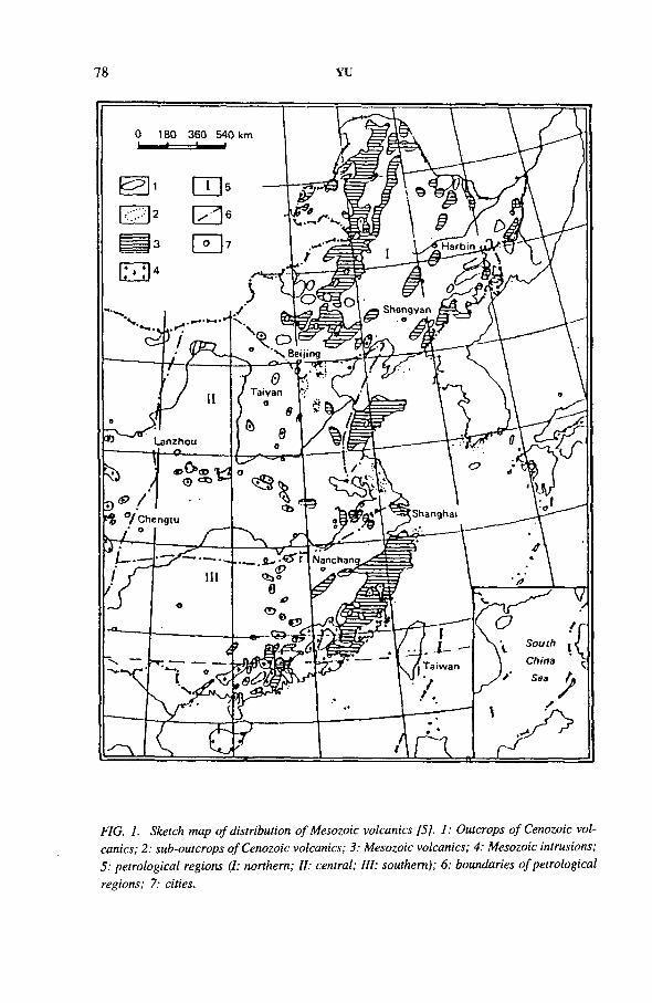
78 YU
FIG. 1. Sketch map o f distribution o f Mesozoic volcanics [5], 1: Outcrops o f Cenozoic vol- canics; 2 : sub-outcrops o f Cenozoic volcanics; 3: Mesozoic volcanics; 4; Mesozoic intrusions; 5: petrological regions (I; northern; II; central; III: southern); 6: boundaries o f petrological regions; 7: cities.
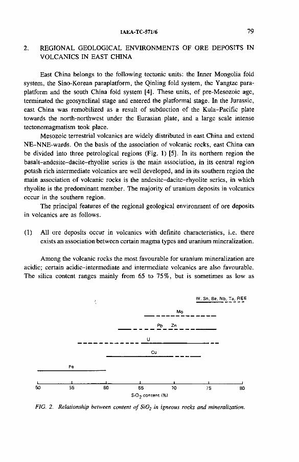
IAEA-TC-571/6 79
2. REGIONAL GEOLOGICAL ENVIRONMENTS OF ORE DEPOSITS IN VOLCANICS IN EAST CHINA
East China belongs to the following tectonic units: the Inner Mongolia fold system, the Sino-Korean paraplatform, the Qinling fold system, the Yangtze para- platform and the south China fold system [4]. These units, of pre-Mesozoic age, terminated the geosynclinal stage and entered the platformal stage. In the Jurassic, east China was remobilized as a result of subduction of the Kula-Pacific plate towards the north-northwest under the Eurasian plate, and a large scale intense tectonomagmatism took place.
Mesozoic terrestrial volcanics are widely distributed in east China and extend NE-NNE-wards. On the basis of the association of volcanic rocks, east China can be divided into three petrological regions (Fig. 1) [5], In its northern region the basalt-andesite-dacite-rhyolite series is the main association, in its central region potash rich intermediate volcanics are well developed, and in its southern region the main association of volcanic rocks is the andesite-dacite-rhyolite series, in which rhyolite is the predominant member. The majority of uranium deposits in volcanics occur in the southern region.
The principal features of the regional geological environment of ore deposits in volcanics are as follows.
(1) All ore deposits occur in volcanics with definite characteristics, i.e. there exists an association between certain magma types and uranium mineralization.
Among the volcanic rocks the most favourable for uranium mineralization are acidic; certain acidic-intermediate and intermediate volcanics are also favourable. The silica content ranges mainly from 65 to 75%, but is sometimes as low as
W. Sn. Be. Nb. Ta, REE
Mo
Pb Zn
U__________________________
Cu
Fe
I________________ I________________ i________________I________________ 1________________ I________________ l50 55 60 65 70 75 80
Si0 2 c ontent {%)
FIG. 2. Relationship between content o f S i02 in igneous rocks and mineralization.
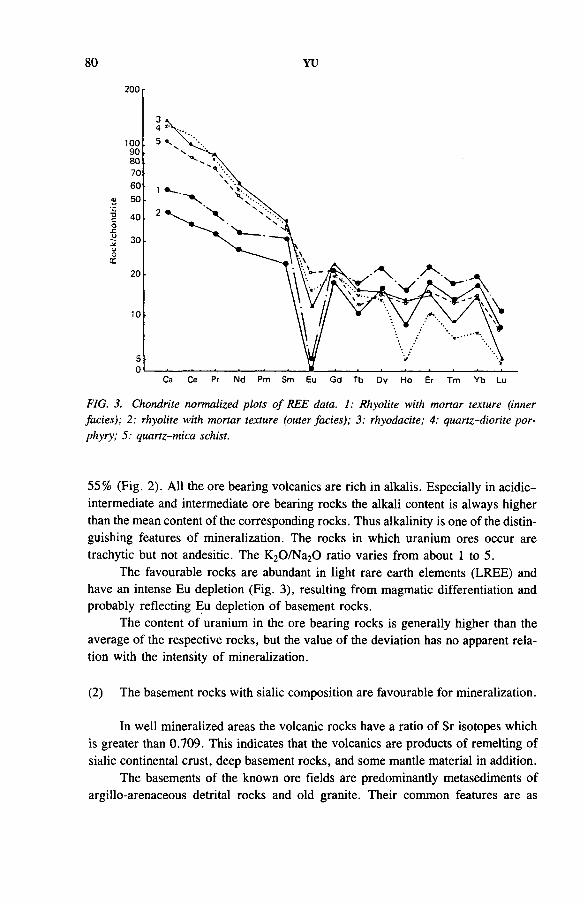
80 YU
FIG. 3. Chondrite normalized plots o f REE data. 1: Rhyolite with mortar texture (inner facies); 2: rhyolite with mortar texture (outer facies); 3: rhyodacite; 4: quartz-diorite porphyry; 5: quartz-mica schist.
55% (Fig. 2). All the ore bearing volcanics are rich in alkalis. Especially in acidic- intermediate and intermediate ore bearing rocks the alkali content is always higher than the mean content of the corresponding rocks. Thus alkalinity is one of the distinguishing features of mineralization. The rocks in which uranium ores occur are trachytic but not andesitic. The K20/Na20 ratio varies from about 1 to 5.
The favourable rocks are abundant in light rare earth elements (LREE) and have an intense Eu depletion (Fig. 3), resulting from magmatic differentiation and probably reflecting Eu depletion of basement rocks.
The content of uranium in the ore bearing rocks is generally higher than the average of the respective rocks, but the value of the deviation has no apparent relation with the intensity of mineralization.
(2) The basement rocks with sialic composition are favourable for mineralization.
In well mineralized areas the volcanic rocks have a ratio of Sr isotopes which is greater than 0.709. This indicates that the volcanics are products of remelting of sialic continental crust, deep basement rocks, and some mantle material in addition.
The basements of the known ore fields are predominantly metasediments of argillo-arenaceous detrital rocks and old granite. Their common features are as
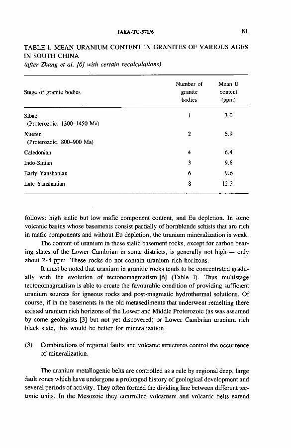
IAEA-TC-571/6 81
TABLE I. MEAN URANIUM CONTENT IN GRANITES OF VARIOUS AGES IN SOUTH CHINA(after Zhang et al. [6] with certain recalculations)
Stage of granite bodiesNumber of
granite bodies
Mean U content (ppm)
Sibao 1 3.0(Proterozoic, 1300-1450 Ma)
Xuefen 2 5.9(Proterozoic, 800-900 Ma)
Caledonian 4 6.4
Indo-Sinian 3 9.8
Early Yanshanian 6 9.6
Late Yanshanian 8 12.3
follows: high sialic but low mafic component content, and Eu depletion. In some volcanic basins whose basements consist partially of hornblende schists that are rich in mafic components and without Eu depletion, the uranium mineralization is weak.
The content of uranium in these sialic basement rocks, except for carbon bearing slates of the Lower Cambrian in some districts, is generally not high — only about 2-4 ppm. These rocks do not contain uranium rich horizons.
It must be noted that uranium in granitic rocks tends to be concentrated gradually with the evolution of tectonomagmatism [6] (Table I). Thus multistage tectonomagmatism is able to create the favourable condition of providing sufficient uranium sources for igneous rocks and post-magmatic hydrothermal solutions. Of course, if in the basements in the old metasediments that underwent remelting there existed uranium rich horizons of the Lower and Middle Proterozoic (as was assumed by some geologists [3] but not yet discovered) or Lower Cambrian uranium rich black slate, this would be better for mineralization.
(3) Combinations of regional faults and volcanic structures control the occurrence of mineralization.
The uranium metallogenic belts are controlled as a rule by regional deep, large fault zones which have undergone a prolonged history of geological development and several periods of activity. They often formed the dividing line between different tectonic units. In the Mesozoic they controlled volcanism and volcanic belts extend
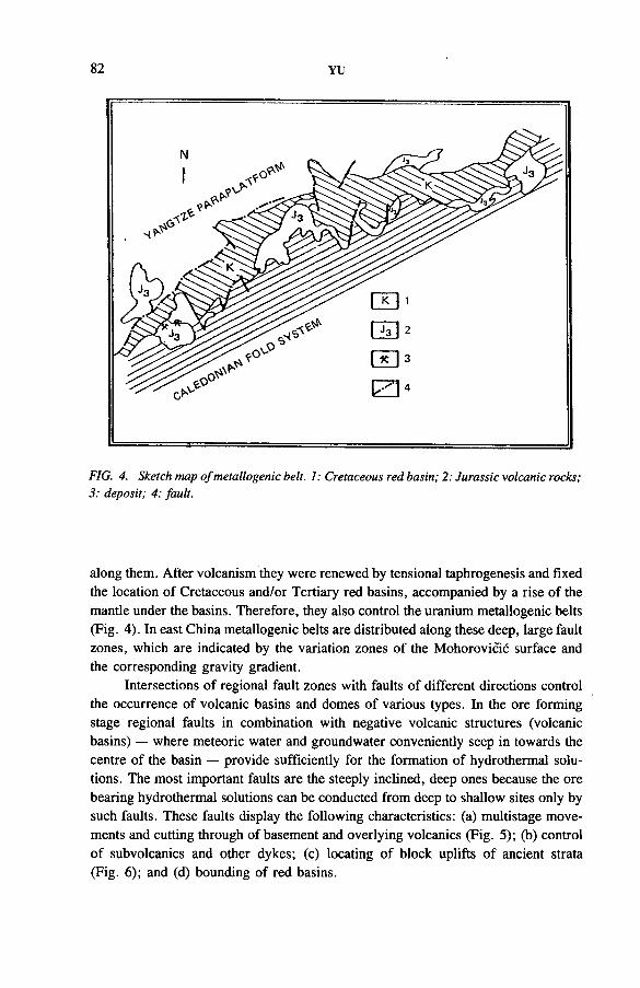
82 YU
FIG. 4. Sketch map ofmetallogenic belt. 1: Cretaceous red basin; 2: Jurassic volcanic rocks; 3; deposit; 4: fault.
along them. After volcanism they were renewed by tensional taphrogenesis and fixed the location of Cretaceous and/or Tertiary red basins, accompanied by a rise of the mantle under the basins. Therefore, they also control the uranium metallogenic belts (Fig. 4). In east China metallogenic belts are distributed along these deep, large fault zones, which are indicated by the variation zones of the Mohorovicic surface and the corresponding gravity gradient.
Intersections of regional fault zones with faults of different directions control the occurrence of volcanic basins and domes of various types. In the ore forming stage regional faults in combination with negative volcanic structures (volcanic basins) — where meteoric water and groundwater conveniently seep in towards the centre of the basin — provide sufficiently for the formation of hydrothermal solutions. The most important faults are the steeply inclined, deep ones because the ore bearing hydrothermal solutions can be conducted from deep to shallow sites only by such faults. These faults display the following characteristics: (a) multistage movements and cutting through of basement and overlying volcanics (Fig. 5); (b) control of subvolcanics and other dykes; (c) locating of block uplifts of ancient strata (Fig. 6); and (d) bounding of red basins.
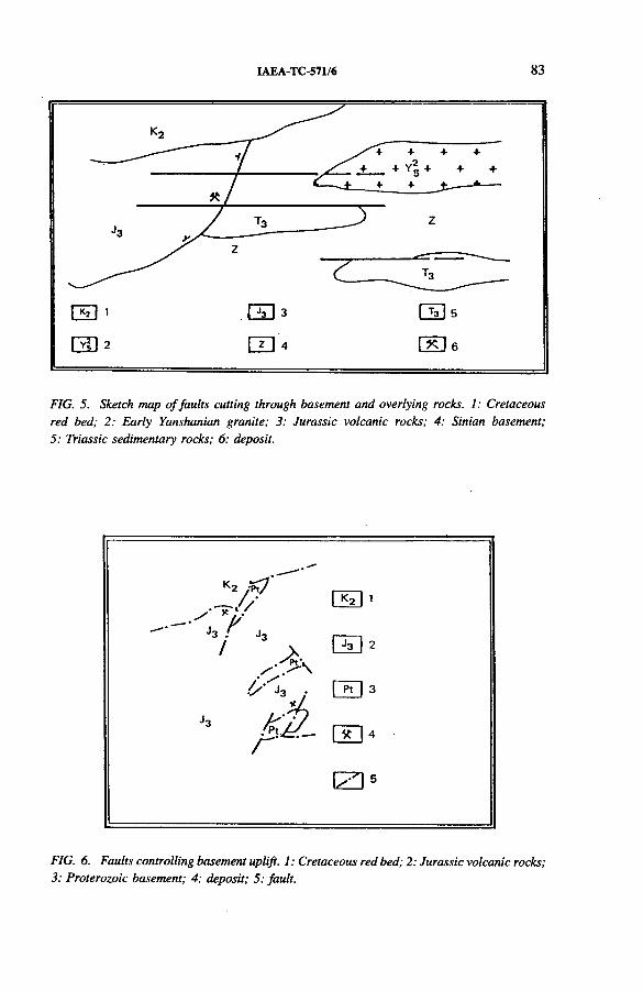
IAEA-TC-571/6 83
FIG. 5. Sketch map o f faults cutting through basement and overlying rocks. 1: Cretaceous red bed; 2; Early Yanshanian granite; 3; Jurassic volcanic rocks; 4; Sinian basement; 5; Triassic sedimentary rocks; 6; deposit.
FIG. 6. Faults controlling basement uplift. 1: Cretaceous red bed; 2: Jurassic volcanic rocks; 3: Proterozoic basement; 4: deposit; 5; fault.
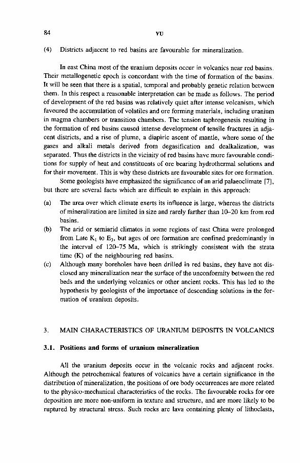
84 YU
(4) Districts adjacent to red basins are favourable for mineralization.
In east China most of the uranium deposits occur in volcanics near red basins. Their metallogenetic epoch is concordant with the time of formation of the basins. It will be seen that there is a spatial, temporal and probably genetic relation between them. In this respect a reasonable interpretation can be made as follows. The period of development of the red basins was relatively quiet after intense volcanism, which favoured the accumulation of volatiles and ore forming materials, including uranium in magma chambers or transition chambers. The tension taphrogenesis resulting in the formation of red basins caused intense development of tensile fractures in adjacent districts, and a rise of plume, a diapiric ascent of mantle, where some of the gases and alkali metals derived from degasification and dealkalization, was separated. Thus the districts in the vicinity of red basins have more favourable conditions for supply of heat and constituents of ore bearing hydrothermal solutions and for their movement. This is why these districts are favourable sites for ore formation.
Some geologists have emphasized the significance of an arid palaeoclimate [7], but there are several facts which are difficult to explain in this approach:
(a) The area over which climate exerts its influence is large, whereas the districts of mineralization are limited in size and rarely farther than 10-20 km from red basins.
(b) The arid or semiarid climates in some regions of east China were prolonged from Late Kt to E3, but ages of ore formation are confined predominantly in the interval of 120-75 Ma, which is strikingly consistent with the strata time (K) of the neighbouring red basins.
(c) Although many boreholes have been drilled in red basins, they have not disclosed any mineralization near the surface of the unconformity between the red beds and the underlying volcanics or other ancient rocks. This has led to the hypothesis by geologists of the importance of descending solutions in the formation of uranium deposits.
3. MAIN CHARACTERISTICS OF URANIUM DEPOSITS IN VOLCANICS
3.1. Positions and forms of uranium mineralization
All the uranium deposits occur in the volcanic rocks and adjacent rocks. Although the petrochemical features of volcanics have a certain significance in the distribution of mineralization, the positions of ore body occurrences are more related to the physico-mechanical characteristics of the rocks. The favourable rocks for ore deposition are more non-uniform in texture and structure, and are more likely to be ruptured by structural stress. Such rocks are lava containing plenty of lithoclasts,
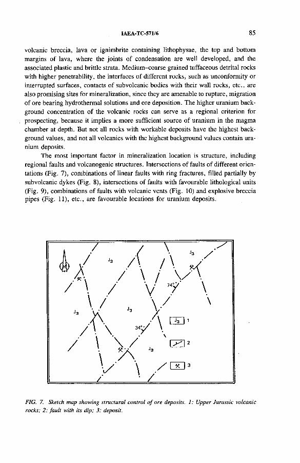
IAEA-TC-571/6 85
volcanic breccia, lava or ignimbrite containing lithophysae, the top and bottom margins of lava, where the joints of condensation are well developed, and the associated plastic and brittle strata. Medium-coarse grained tuffaceous detrital rocks with higher penetrability, the interfaces of different rocks, such as unconformity or interrupted surfaces, contacts of subvolcanic bodies with their wall rocks, etc., are also promising sites for mineralization, since they are amenable to rupture, migration of ore bearing hydrothermal solutions and ore deposition. The higher uranium background concentration of the volcanic rocks can serve as a regional criterion for prospecting, because it implies a more sufficient source of uranium in the magma chamber at depth. But not all rocks with workable deposits have the highest background values, and not all volcanics with the highest background values contain uranium deposits.
The most important factor in mineralization location is structure, including regional faults and volcanogenic structures. Intersections of faults of different orientations (Fig. 7), combinations of linear faults with ring fractures, filled partially by subvolcanic dykes (Fig. 8), intersections of faults with favourable lithological units (Fig. 9), combinations of faults with volcanic vents (Fig. 10) and explosive breccia pipes (Fig. 11), etc., are favourable locations for uranium deposits.
FIG. 7. Sketch map showing structural control o f ore deposits. 1: Upper Jurassic volcanic rocks; 2: fault with its dip; 3: deposit.
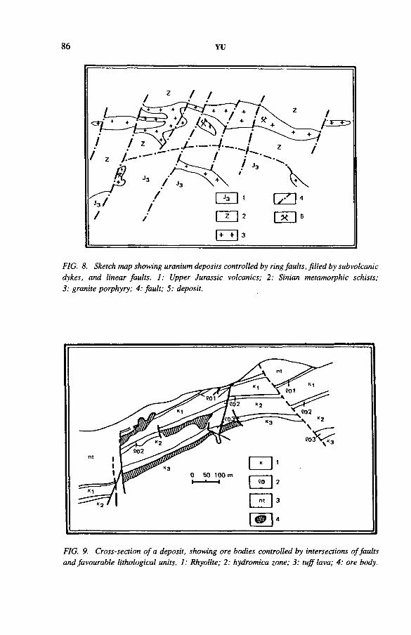
86 YU
FIG. 8. Sketch map showing uranium deposits controlled by ring faults, filled by subvolcanic dykes, and linear faults. 1: Upper Jurassic volcanics; 2: Sinian metamorphic schists; 3: granite porphyry; 4; fault; 5: deposit.
FIG. 9. Cross-section o f a deposit, showing ore bodies controlled by intersections o f faults and favourable lithological units. 1; Rhyolite; 2; hydromica zone; 3; tuff lava; 4: ore body.
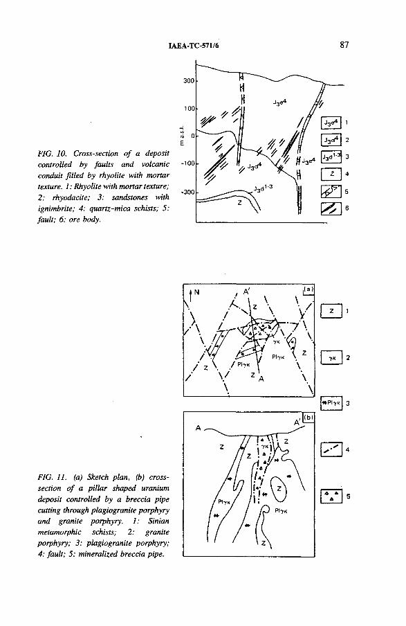
IAEA-TC-571/6 87
FIG. 10. Cross-section o f a deposit controlled by faults and volcanic conduit filled by rhyolite with mortar texture. 1: Rhyolite with mortar texture; 2: rhyodacite; 3: sandstones with ignimbrite; 4; quartz-mica schists; 5: fault; 6; ore body.
FIG. 11. (a) Sketch plan, (b) cross- section o f a pillar shaped uranium deposit controlled by a breccia pipe cutting through plagiogranite porphyry and granite porphyry. 1; Sinian metamorphic schists; 2: graniteporphyry; 3: plagiogranite porphyry; 4: fault; 5: mineralized breccia pipe.
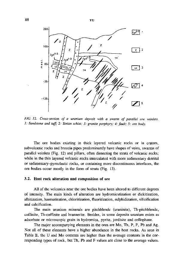
88 YU
(Z3 4
(ZD5
FT75!1
FIG. 12. Cross-section o f a uranium deposit with a swarm o f parallel ore veinlets. 1: Sandstone and tujf; 2: Sinian schist; 3; granite porphyry; 4; fault; 5; ore body.
The ore bodies existing in thick layered volcanic rocks or in craters, subvolcanic rocks and breccia pipes predominantly have shapes of veins, swarms of parallel veinlets (Fig. 12) and pillars, often dissecting the strata of volcanic rocks; while in the thin layered volcanic rocks intercalated with more sedimentary detrital or sedimentary-pyroclastic rocks, or containing more discontinuous interfaces, the ore bodies occur mostly in the form of strata (Fig. 13).
3.2. Host rock alteration and composition of ore
All of the volcanics near the ore bodies have been altered to different degrees of intensity. The main kinds of alteration are hydromicatization or dickitization, albitization, haematization, chloritization, fluoritization, sulphidization, silicification and calcification.
The main uranium minerals are pitchblende (uraninite), Th-pitchblende, coffmite, Th-coffinite and brannerite. Besides, in some deposits uranium exists as adsorbate or microscopic grain in hydromica, pyrite, jordisite and collophane.
The major accompanying elements in the ores are Mo, Th, P, F, Pb and Ag. Not all of these elements have a higher abundance in the host rocks. As seen in Table II, the U and Mo contents are higher than the average contents in the corresponding types of rock, but Th, Pb and F values are close to the average values.
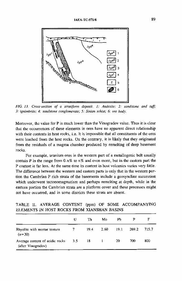
IAEA-TC-571/6 89
FIG. 13. Cross-section o f a stratiform deposit. 1: Andesite; 2: sandstone and tuff; 3: ignimbrite; 4: sandstone conglomerate; 5: Sinian schist; 6; ore body.
Moreover, the value for P is much lower than the Vinogradov value. Thus it is clear that the occurrences of these elements in ores have no apparent direct relationship with their contents in host rocks, i.e. it is impossible that all constituents of the ores were leached from the host rocks. On the contrary, it is likely that they originated from the residuals of a magma chamber produced by remelting of deep basement rocks.
For example, uranium ores in the western part of a metallogenic belt usually contain P in the range from 0.n% to n% and even more, but in the eastern part the P content is far less. At the same time its content in host volcanics varies very little. The difference between the western and eastern parts is only that in the western portion the Cambrian P rich strata of the basements include a geosyncline succession which underwent tectonomagmatism and perhaps remelting at depth, while in the eastern portion the Cambrian strata are a platform cover and these processes might not have occurred, and in some districts these strata are absent.
TABLE II. AVERAGE CONTENT (ppm) OF SOME ACCOMPANYING ELEMENTS IN HOST ROCKS FROM XIANSHAN BASINS
U Th Mo Pb P F
Rhyolite with mortar texture (n=30)
7 19.4 2.60 19.1 269.2 715.7
Average content of acidic rocks (after Vinogradov)
3.5 18 1 20 700 800
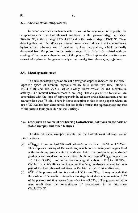
90 YU
3.3. Mineralization temperatures
In accordance with inclusion data measured for a number of deposits, the temperatures of the hydrothermal solutions in the pre-ore stage are about 340-260°C, in the ore stage 227-115°C and in the post-ore stage 113-83°C. These data together with the alteration mineral association indicate that the uraniferous hydrothermal solutions are of medium to low temperature, which gradually decreased from the pre-ore to the post-ore stage. It is likely to be related with the cooling of the magma chamber and of the plume. This implies that ore formation cannot take place at the ground surface, but results from descending solutions.
3.4. Metallogenetic epoch
The data on isotopic ages of ores of a few good deposits indicate that the metallogenetic epoch of uranium deposits mainly falls within two time intervals: 140-116 Ma and 105-75 Ma, which closely follow volcanism and subvolcanic activity. The interval between them is not long. These ages of ore formation are concordant with the time of taphrogenesis in adjacent areas (Cretaceous), and are scarcely less than 75 Ma. There is some exception to this in one deposit where an age of 22 Ma has been determined, but just in this district the taphrogenesis and rise of the mantle took place during the Tertiary.
3.5. Discussion on source of ore bearing hydrothermal solutions on the basis of stable isotopes and other features
The data on stable isotopes indicate that the hydrothermal solutions are of mixed sources:
(a) 518Oh2o of pre-ore hydrothermal solutions varies from —0.51 to +5.2700. This implies a mixing of the solutions, which consist mainly of magma fluid with circulating groundwater in addition. Later, the portion of groundwater gradually increased with mineralization. In the ore stage S18Oh2o ranges from —5.5 to +3.28°/oo, and in the post-ore stage it is about —12.2 to +0.187oo (Table III), which allows one to assume that the groundwater became the main part of the hydrothermal solutions in the late period of mineralization.
(b) <513C of the pre-ore solution is about —4.36 to —4.390/00. It may indicate that the carbon of the earlier mineralization stage is of deep magma origin. <513C of the post-ore solution ranges from —3.95 to —9.73700. The greater variation may result from the contamination of groundwater in the late stage (Table HI) [8],
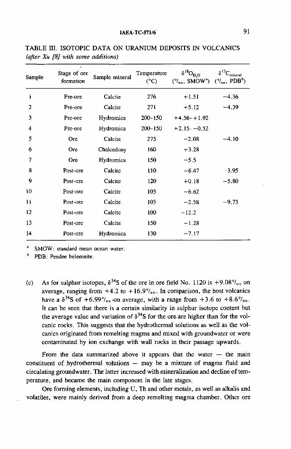
IAEA-TC-571/6 91
TABLE III. ISOTOPIC DATA ON URANIUM DEPOSITS IN VOLCANICS (after Xu [8] with some additions)
SampleStage of ore
formationSample mineral
Temperature(6C)
S180 „2o (7 00, SMOWa)
c 13/i° '-'mineral
(7 00, PDBb)
1 Pre-ore Calcite 276 + 1.51 -4 .3 6
2 Pre-ore Calcite 271 +5.12 -4 .3 9
3 Pre-ore Hydromica 200-150 +4.56- +1.92
4 Pre-ore Hydromica 200-150 + 2 .1 5 --0 .5 2
5 Ore Calcite 275 -2 .0 8 -4 .1 0
6 Ore Chalcedony 160 + 3.28
7 Ore Hydromica 150 -5 .5
8 Post-ore Calcite 110 -6 .4 7 -3 .95
9 Post-ore Calcite 120 +0.18 -5 .8 0
10 Post-ore Calcite 103 -6 .6 2
11 Post-ore Calcite 103 -2 .5 8 -9 .7 3
12 Post-ore Calcite 100 -1 2 .2
13 Post-ore Calcite 150 -1 .2 8
14 Post-ore Hydromica 130 -7 .1 7
a SMOW: standard mean ocean water. b PDB: Peedee belemnite.
(c) As for sulphur isotopes, 634S of the ore in ore field No. 1120 is +9.087oo on average, ranging from +4.2 to +16.9°/0o. In comparison, the host volcanics have a S34S of +6.99700'On average, with a range from +3.6 to +8.6700. It can be seen that there is a certain similarity in sulphur isotope content but the average value and variation of <534S for the ore .are higher than for the volcanic rocks. This suggests that the hydrothermal solutions as well as the volcanics originated from remelting magma and mixed with groundwater or were contaminated by ion exchange with wall rocks in their passage upwards.
From the data summarized above it appears that the water — the main constituent of hydrothermal solutions — may be a mixture of magma fluid and circulating groundwater. The latter increased with mineralization and decline of temperature, and became the main component in the late stages.
Ore forming elements, including U, Th and other metals, as well as alkalis and volatiles, were mainly derived from a deep remelting magma chamber. Other ore
92 YU
forming elements may have come from the wall rocks. Some of the alkalis and vola- tiles may have originated from the mantle as a result of its dealkalization and degasification. The possibility should not be excluded that a fraction of the ore forming components joined the hydrothermal solutions as solutes of groundwater.
The heat needed for the formation of hydrothermal solutions and normal geothermal energy were mainly supplied by the residual heat of the magma chamber and by the ascent of the plume, a result of the rise of the mantle during taphrogenesis.
Tension tectonics, resulting in taphrogenesis and the formation of red basins, caused existing faults to be renewed and produced new tensile fractures in adjacent districts. These faults and fractures presented themselves as pressure reducing zones and caused the hydrothermal solutions to migrate upwards. Then the ore forming elements were deposited as ore in more shallow sites. This seems to be the principal mechanism of ore formation.
REFERENCES
[1] CHEN, Zhaobo,“ ‘Double mixing’ genetic model of uranium deposits in volcanic rocks and the relationship between China’s Mesozoic vein-type uranium deposits and Pacific plate tectonics” , Metallogenesis of Uranium (Proc. 26th Int. Geol. Congr. Paris, 1980), Geoinstitute, Belgrade (1981) 65-97.
[2] WANG, Chuanwen, CHEN, Zhaobo, XIE, Youxin, “ Uranium deposits in the Shangyuan volcanic basins, South China” , ibid., pp. 33-50.
[3] CHEN, Zhaobo, et al., Uranium deposits in Mesozoic volcanics in South-East China, Acta Geol. Sin. 56 3 (1982) 235.
[4] HUAN, Jeqin, et al., Basic geotectonic outline of China, Acta Geol. Sin. 51 2 (1977).[5] WU, Liren, et al., Mesozoic volcanic rocks in the eastern part of China, Acta Geol.
Sin. 56 3 (1982) 223.[6] ZHANG, Zhuhuan, et al., The Granitoids of Different Periods of South China and
Their Metallogenetic Relations, Nanjing Univ., Beijing (1981).[7] CHEN, Zuyi, et al., The stages of development of fault-block movement and
continental red beds with respect to the regional uranium mineralization in South China, Acta Geol. Sin. 57 3 (1983) 294.
[8] XU, Guoqing, A study on metallogenetic model of uranium ore field No. 1120,Uranium Geol. 1 5 (1985) 1-8.
DISCUSSION
S.D. SIMOV: Is there any tuff or volcanic ash in the sediments?Shiqing YU: In the red beds there are no acidic or acidic-intermediate
volcanic tuffs that were extruded at that time. But as a result of mantle diapiric movement during the period of taphrogenesis there are a few basic intrusives and extrusives such as diabases, basalts and others. There are also many fragments of volcanic rocks which are products of erosion of underlying strata.
IAEA-TC-571/7
URANIUM METALLOGENESIS OF COARSE GRAINED GRANITE IN AREA H, CHINA
Jiashu RONG, Zehong HAN,Yuliang XIAResearch Institute of Uranium Geology,Beijing, China
Abstract
URANIUM METALLOGENESIS OF COARSE GRAINED GRANITE IN AREA H, CHINA.
The paper discusses uranium mineralization of magmatic genesis in a coarse grained granite. The mineralized matter mainly consists of dispersed uraninite, with pitchblende and other, undetermined black uranium minerals in minor amounts. The granite was crystallized from a uranium rich magma which has a lower REE content (175 ppm) and very low thorium content (7.6 ppm), and the Th/U ratio is only 0.05-2. Because the amount of REE rich accessory minerals in the granite is small, the uranium might be crystallized in the form of uraninite. Metallic mineral association can be divided into two groups, primary (uraninite, molybdenite, grained pyrite) and regenerated (amorphous pyrite, galena, pitchblende and relict black uranium minerals). The results of an isotopic study have proved that the formation of the surrounding rocks was no later than the Early Proterozoic. The host rock, granite, containing uranium mineralization has an age of 1700-1750 Ma. Through the study of the evolution of the isotopic system, the age of mineralization has been dated at about 1800 Ma. It indicates that uranium mineralization and the host rock are syngenetic. In addition, an age of reworking of about 300 Ma has been determined.
1. GEOLOGICAL SETTING
This paper discusses uranium mineralization in a coarse grained granite body located in the western part of the fault bounded zone of the Longshoushan Group in the west of the North China Platform (Figs 1,2). The Longshoushan Group is the oldest exposed rock in the area. This rock, intruded by the coarse grained granite, is mainly composed of biotite-hornblende-plagioclase schist and marble with a total thickness of about 3600 m. Through the analysis of Rb-Sr isochrons for the wall rock samples, the authors have obtained an age of 1927^259 Ma for three hornblende- plagioclase schist samples and 1652^™ Ma for four biotite-plagioclase schist samples (errors given are 2a). This shows that the group underwent regional metamorphism during the period of the Luliang movement (about 1800 Ma ago), and may be attributed to the Lower Proterozoic.
93
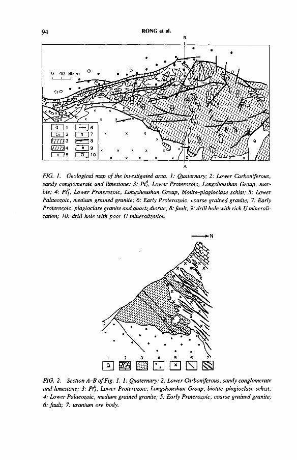
94B
RONG et al.
FIG. 1. Geological map o f the investigated area. 1: Quaternary; 2: Lower Carboniferous, sandy conglomerate and limestone; 3; Ptj, Lower Proterozoic, Longshoushan Group, marble; 4: Pt1], Lower Proterozoic, Longshoushan Group, biotite-plagioclase schist; 5: Lower Palaeozoic, medium grained granite; 6: Early Proterozoic, coarse grained granite; 7: Early Proterozoic, plagioclase granite and quartz diorite; 8; fault; 9; drill hole with rich U mineralization; 10: drill hole with poor U mineralization.
FIG. 2. Section A -B o f Fig. 1. 1; Quaternary; 2: Lower Carboniferous, sandy conglomerate and limestone; 3: Pt1}, Lower Proterozoic, Longshoushan Group, biotite-plagioclase schist; 4; Lower Palaeozoic, medium grained granite; 5; Early Proterozoic, coarse grained granite; 6; fault; 7; uranium ore body.
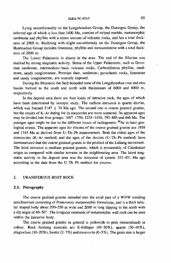
IAEA-TC-571/7 95
Lying unconformably on the Longshoushan Group, the Dunzigou Group, the inferred age of which is less than 1400 Ma, consists of striped marble, metamorphic sandstone and phyllite with a minor amount of volcanic rocks, and has a total thickness of 2000 m. Reclining with slight unconformity on the Dunzigou Group, the Hanmushan Group includes limestone, phyllite and metasandstone with a total thickness of 2000 m.
The Lower Palaeozoic is absent in the area. The end of the Silurian was marked by strong magmatic activity. Strata of the Upper Palaeozoic, such as Devonian sandstone, intermediate-basic volcanic rocks, Carboniferous phyllite, sandstone, sandy conglomerate, Permian slate, sandstone, pyroclastic rocks, limestone and sandy conglomerate, are scarcely exposed.
During the Mesozoic the fault bounded zone of the Longshoushan rose and two basins formed to the south and north with thicknesses of 6000 and 4000 m, respectively.
In the deposit area there are four kinds of intrusive rock, the ages of which have been determined by isotopic study. The earliest intrusion is quartz diorite, which was formed 2147 + 74 Ma ago. The second one is coarse grained granite, but the results of K-Ar dating for its muscovite are more scattered. Its apparent ages may be divided into four groups: 1697-1750, 1235-1456, 793-885 and 446 Ma. The younger ages might be due to the different losses of radiogenetic 40Ar in later geological events. The apparent ages for zircons of the coarse grained granite are 1959 and 1745 Ma as derived from U-Th-Pb measurement. Both the oldest ages of the muscovites (K-Ar method) and the ages of the zircons (U-Th-Pb method) have demonstrated that the coarse grained granite is the product of the Luliang movement. The third intrusion is medium grained granite, which is presumably of Caledonian origin as compared with similar terrains in the neighbouring area. The latest magmatic activity in the deposit area was the intrusion of syenite 351-451 Ma ago according to the data from the U-Th-Pb method for zircons.
2. URANIFEROUS HOST ROCK
2.1. Petrography
The coarse grained granite intruded into the axial part of a WNW trending anticlinorium consisting of Proterozoic metamorphic formations, and is a thick tabular shaped body about 200-250 m wide and 2000 m long dipping to the north with a dip angle of 40-50°. The irregular remnants of metamorphic wall rock can be seen within the intrusive body.
The coarse grained granite in general is yellowish to pink (mineralized) in colour. Rock forming minerals are K-feldspar (40-50%), quartz (30-40%), plagioclase (10-20%), biotite (2-7%) and muscovite (0-5%). The grain size is larger
96 RONG et al.
than usual and reaches 5 cm for K-feldspar or 2 cm for quartz. Originally the granite possessed granitic and eutectic textures. The rock underwent widespread intense changes so that the grain boundaries became complicated. The changes occurred in the following order.
(a) Autometamorphism
Both earlier albitization and later potassic feldspar alteration occurred at the grain boundary between two differently oriented feldspars. Newly formed albite is up to 1.5 mm thick, which is much more than in common granite, while potassic feldspar alteration developed on a much smaller scale [1]. In addition there was mus- covitization, chloritization and quartzification.
(b) Compression
Compression is characterized by the creep deformation of some rock forming minerals, such as curved twinning planes of plagioclase and a folded form of biotite.
(c) Cataclasm
Grains in the rock are cut by branched tension cracks filled with hydromica, chlorite and carbonate. It is assumed that cataclasm took place when the confining pressure reduced with the regional uplifting.
2.2. Rock chemistry
The chemical composition of the coarse grained granite is shown in Table I. Wang’s parameters [2] calculated from the chemical composition are presented in Table II. Owing to the comparatively high values for quartz and Ot (orthoclase content in total feldspar), the rock could be identified as normal granite trending to leucocratic, and even be considered as alaskite with pegmatitic features.
Chemical data show that the composition of the rock is basically stable. The projected points of samples are located in the middle of the quartz-orthoclase-albite (Q-Or-Ab) ternary system triangle (Fig. 3) near the eutectic point (E) obtained from the experiment of Winkler [3] where PH2q = 2 kbar (200 MPa) and Ab/An = 3.8 (An = 20.8). Therefore, the temperature of rock formation might be suggested as 695 °C.
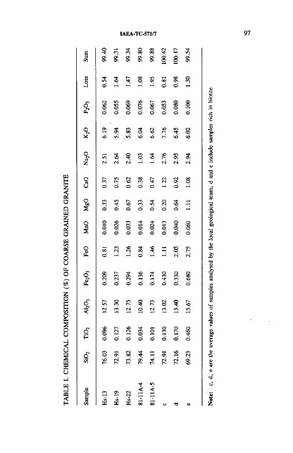
TABL
E I.
CHEM
ICAL
CO
MPO
SITI
ON
(%)
OF
COAR
SE
GRAI
NED
GR
AN
ITE
IAEA-TC-571/7 97
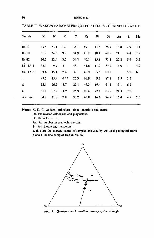
98 RONG et al.
TABLE n. WANG’S PARAMETERS (%) FOR COARSE GRAINED GRANITE
Sample K N C Q Or PI Ot An Bi Ms
Hs-13 33.6 23.1 1.9 35.1 45 13.6 76.7 13.8 2.9 3.1
Hs-19 31.9 24.6 3.9 31.9 41.9 18.4 69.5 21 4.4 2.9
Hs-22 30.3 22.4 3.2 34.8 40.1 15.8 71.8 20.2 5.6 3.3
8i-llA-4 32.3 9.7 2 48 44.8 11.7 79.4 16.9 3 4.7
81-11A-5 33.6 15.4 2.4 37 45.9 5.5 89.3 5.3 6
c 45.5 25.4 0.23 26.3 61.9 9.2 87.1 2.5 2.5
d 35.1 26.9 3.7 27.1 46.3 19.4 61.1 19.1 6.2
e 31.1 27.2 4.9 25.9 40.4 22.8 63.9 21.3 9.2
Average 34.2 21.8 2.8 33.2 45.8 14.6 74.9 16.4 4.9 2.5
Notes: K, N, C, Q: ideal orthoclase, albite, anorthite and quartz.Or, PI: revised orthoclase and plagioclase.Ot: Or in Or + PI.An: An number in plagioclase series.Bi, Ms: biotite and muscovite.c, d, e are the average values of samples analysed by the local geological team; d and e include samples rich in biotite.
Q
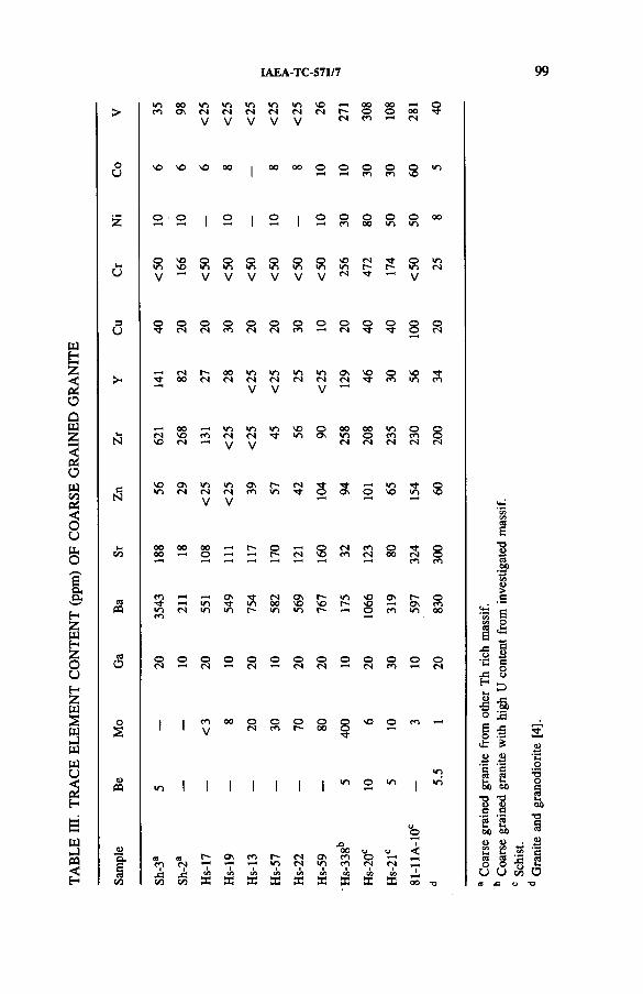
TA
BL
E
ffl.
TR
AC
E
EL
EM
EN
T
CO
NT
EN
T
(ppm
) OF
C
OA
RSE
G
RA
INE
D
GR
AN
ITE
IAEA-TC-571/7 99
oo vo VO »o VO 1— 1 oo 00 ,—1 o> co ON CN CN cn cn CN CN r- O o 00V V V V V CN CO CN
Co vo so VO 00 00 00 O o 30 30 s <o
... o ■ o 1 o i o 1 o o O o o 00z 1 1 1 CO 00 lO VO
o VO o o o o o o SO CN T}- o lOt-H »o SO lO *o 10 lO »o »0 10 r- r- •o CNu V V V V V V V CN t}- V
3 © O o o o o o o o o o Q ou CN cn co CN CN co 1"^ CN T f © CN
CN r- 00 m 10 10 m Os SO o vO T f> T j- 00 CN CN CN CN CN CN CN T t CO CO
V V V
00 <0 »o <o SO o 00 00 <0 o ©S-i cn SO co CN CN »o Os *n o CO CO ©N VO cn V V CN CN CN CN CN
SO Os lO ■O O n r- CN »o Qc 10 CN CN cn CO 10 © Os o VO lO m dN V V
u 00 00 00 t-* o Q CN CO o Tf ©CO 00 o *-N r- CN CO CN 00 CN ©CO CO
CO Ov CN ON VO VO Ov r- oed T f r-H •O T f 10 00 VO SO r-* SO ON COCO cn >0 «0 r- <n r- o CO VO 00co
CO O o © o o o o o O o o © oo cn cn cn CN CN CN CO CN
o 1 1 CO 00 o o O O O SO o COs 1 1 V CN CO r- 00 ©
T j-
lO1 l 1 1 1 i 1 «n O VO 1 »oCQ «o 1 1 1 I 1 1 1 1
oo1<00 o<0 CB r- Ov CO r-* CN Ov co Oco cn *7* »n CN 10 co CN CN ,—4
§ f* j3 Gfl C/5 C/3 C/3 CA on C/5 CO C/3 1CO CO CO s DC E s s X 52 a: X 00 *o
So£o
COt-r0 0
oC/31-C9Ou Co
arse
graine
d gra
nite
with
high
U co
ntent
from
invest
igated
m
assif
. Sc
hist.
Gran
ite
and
gran
odior
ite
[4],
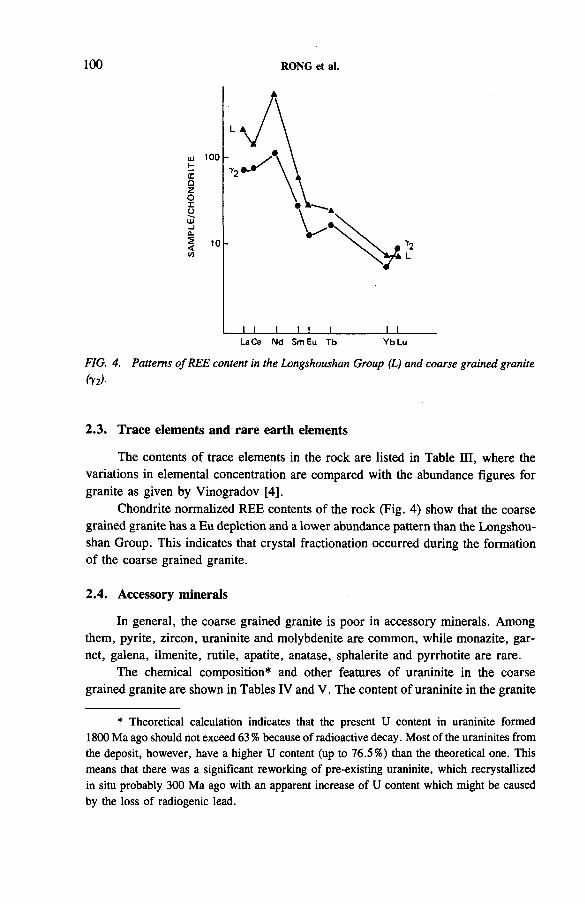
100 RONG et al.
FIG. 4. Patterns o f REE content in the Longshoushan Group (L) and coarse grained granite hi)-
2.3. Trace elements and rare earth elements
The contents of trace elements in the rock are listed in Table m , where the variations in elemental concentration are compared with the abundance figures for granite as given by Vinogradov [4],
Chondrite normalized REE contents of the rock (Fig. 4) show that the coarse grained granite has a Eu depletion and a lower abundance pattern than the Longshoushan Group. This indicates that crystal fractionation occurred during the formation of the coarse grained granite.
2.4. Accessory minerals
In general, the coarse grained granite is poor in accessory minerals. Among them, pyrite, zircon, uraninite and molybdenite are common, while monazite, garnet, galena, ilmenite, rutile, apatite, anatase, sphalerite and pyrrhotite are rare.
The chemical composition* and other features of uraninite in the coarse grained granite are shown in Tables IV and V. The content of uraninite in the granite
* Theoretical calculation indicates that the present U content in uraninite formed 1800 Ma ago should not exceed 63 % because of radioactive decay. Most of the uraninites from the deposit, however, have a higher U content (up to 76.5%) than the theoretical one. This means that there was a significant reworking of pre-existing uraninite, which recrystallized in situ probably 300 Ma ago with an apparent increase of U content which might be caused by the loss of radiogenic lead.
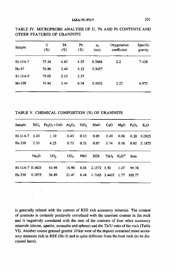
IAEA-TC-571/7 101
TABLE IV. MICROPROBE ANALYSIS OF U, Th AND Pb CONTENTS AND OTHER FEATURES OF URANINITE
SampleU
(%)Th(%)
Pb(%)
ao(nm)
Oxygenationcoefficient
Specificgravity
81-11A-7 75.34 4.60 4.55 0.5468 2.2 7.428
Hs-57 76.86 3.40 4.12 0.5457
81-11A-5 79.05 2.13 2.53
Hs-338 74.84 3.44 6.58 0.5452 2.27 6.975
TA BLE V . CH EM ICA L COM PO SITION (%) O F U RA N IN ITE
Sample Si02 Fe20 3+ F e0 A120 3 T i02 MnO CaO MgO P2O5 K20
81-11A-7 1.43 1.10 0.43 0.13 0.05 0.49 0.08 0.20 0.0925
Hs-338 2.33 4.25 0.73 0.31 0.07 0.74 0.18 0.02 0.1875
Na20 U 02 U 03 PbO REE Th02 HzO1 Sum
81-11A-7 0.1625 63.98 16.90 8.01 2.1572 3.50 1.07 99.78
Hs-338 0.1875 54.89 21.47 8.48 1.7165 3.4422 1.77 100.77
is generally related with the content of REE rich accessory minerals. The content of uraninite is certainly positively correlated with the uranium content in the rock and is negatively correlated with the sum of the contents of four other accessory minerals (zircon, apatite, monazite and sphene) and the Th/U ratio of the rock (Table VI). Another coarse grained granite 10 km west of the deposit contained more accessory minerals rich in REE (Sh-3) and is quite different from the host rock (to be discussed later).
102 RONG et al.
TABLE VI. COMPARISON OF SUM OF CONTENTS OF FOUR ACCESSORY MINERALS (x) WITH URANINITE (Ur), U, Th AND REE CONTENTS AND Th/U
SampleX
(g / t )
Ur( g / t )
U(ppm)
Th(ppm)
Th/UREE(ppm)
Sh-3 7796 — 10.1 628a 62.18 5631
Sh-4 3390 — 8.5 34.4 4.05 855
Hs-17 59 + 6.6 16.0 2.46 153
Hs-19 36 + + 7.9 6.1 0.77 117
Hs-13 38 0.02 10.1 8.4 0.83 133
Hs-57 — 4.0 98.4 7.4 0.08 NAb
Hs-22 + + 6.1 29.7 24.5 0.83 33
Hs-59 5 34.0 630.0 40.6 0.06 NAb
Hs-338 — 1421.7 6350.0 431.0C 0.07 198
a The high Th content may be from REE rich accessory minerals. b NA: not available.c The high Th content may be from uraninite.
2.5. Uranium content and partition
The uranium content of the uraniferous host rock varies widely and is independent of the variation of major chemical components, as seen from correlation analysis and cluster analysis. However, the thorium content is comparatively low and Th/U < 1.
According to the partition of uranium in the rock, the predominant portion of the uranium (up to 80%) is in uraninite. The uranium portion in microfissures in the form of regenerated black uranium minerals and pitchblende may reach 20-30%, while the uranium portion in the rock forming minerals and uraniferous accessory minerals remains less than 3%.
In summary, the uraniferous host rock was formed from a magma with very low thorium and EREE contents.
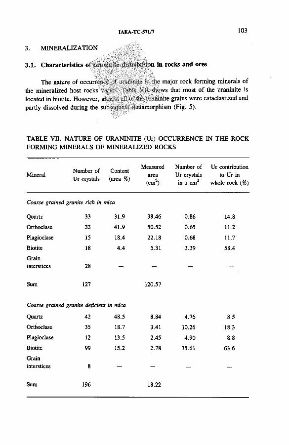
IAEA-TC-571/7 103
3. MINERALIZATION
3.1. Characteristics o in in rock s an d ores
The nature of occuri the mineralized host rocks located in biotite. However, a partly dissolved during the sul
e major rock forming minerals of ws that most of the uraninite is
..inite grains were cataclastized and .wiamorphism (Fig. 5).
TABLE Vn. NATURE OF URANINITE (Ur) OCCURRENCE IN THE ROCK FORMING MINERALS OF MINERALIZED ROCKS
MineralNumber of Ur crystals
Content (area %)
Measuredarea
(cm2)
Number of Ur crystals in 1 cm2
Ur contribution to Ur in
whole rock (%)
Coarse grained granite rich in mica
Quartz 33 31.9 38.46 0.86 14.8
Orthoclase 33 41.9 50.52 0.65 11.2
Plagioclase 15 18.4 22.18 0.68 11.7
Biotite 18 4.4 5.31 3.39 58.4
Graininterstices 28 — —
Sum 127 120.57
Coarse grained granite deficient in mica
Quartz 42 48.5 8.84 4.76 8.5
Orthoclase 35 18.7 3.41 10.26 18.3
Plagioclase 12 13.5 2.45 4.90 8.8
Biotite 99 15.2 2.78 35.61 63.6
Graininterstices 8 — —
Sum 196 18.22
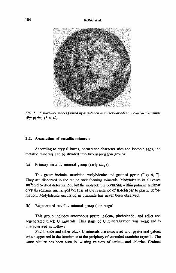
104 RONG et al.
FIG. 5. Fissure-like spaces formed by dissolution and irregular edges in corroded uraninite (Py: pyrite) (7 x 40).
3.2. Association of metallic minerals
According to crystal forms, occurrence characteristics and isotopic ages, the metallic minerals can be divided into two association groups:
(a) Primary metallic mineral group (early stage)
This group includes uraninite, molybdenite and grained pyrite (Figs 6 , 7). They are dispersed in the major rock forming minerals. Molybdenite in all cases suffered twisted deformation, but the molybdenite occurring within potassic feldspar crystals remains unchanged because of the resistance of K-feldspar to plastic deformation. Molybdenite occurring in uraninite has never been observed.
(b) Regenerated metallic mineral group (late stage)
This group includes amorphous pyrite, galena, pitchblende, and relict and regenerated black U minerals. This stage of U mineralization was weak and is characterized as follows.
Pitchblende and other black U minerals are associated with pyrite and galena which appeared in the interior or at the periphery of corroded uraninite crystals. The same picture has been seen in twisting veinlets of sericite and chlorite. Grained
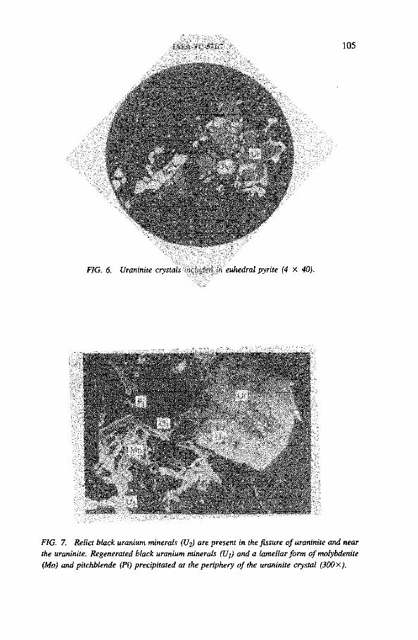
FIG. 6. Uraninite crystals i euhedral pyrite (4 x 40).
FIG. 7. Relict black uranium minerals (U2) are present in the fissure o f uraninite and near the uraninite. Regenerated black uranium minerals (U{) and a lamellar form o f molybdenite (Mo) and pitchblende (Pi) precipitated at the periphery o f the uraninite crystal (300x).
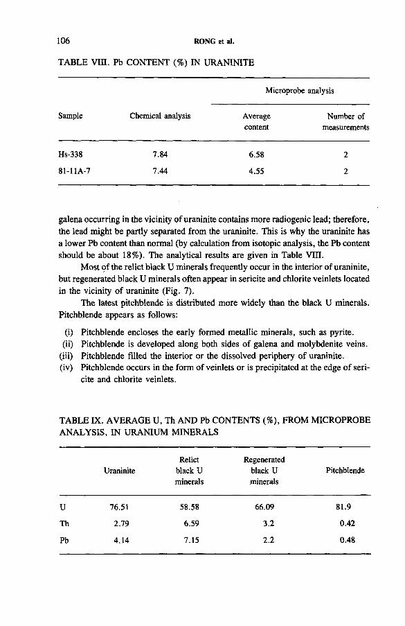
TABLE VIII. Pb CONTENT (%) IN URANINITE
106 RONG et al.
Microprobe analysis
Sample Chemical analysis Average Number ofcontent measurements
Hs-338 7.84 6.58 2
81-11A-7 7.44 4.55 2
galena occurring in the vicinity of uraninite contains more radiogenic lead; therefore, the lead might be partly separated from the uraninite. This is why the uraninite has a lower Pb content than normal (by calculation from isotopic analysis, the Pb content should be about 18%). The analytical results are given in Table VIII.
Most of the relict black U minerals frequently occur in the interior of uraninite, but regenerated black U minerals often appear in sericite and chlorite veinlets located in the vicinity of uraninite (Fig. 7).
The latest pitchblende is distributed more widely than the black U minerals. Pitchblende appears as follows:
(i) Pitchblende encloses the early formed metallic minerals, such as pyrite.(ii) Pitchblende is developed along both sides of galena and molybdenite veins.
(iii) Pitchblende filled the interior or the dissolved periphery of uraninite.(iv) Pitchblende occurs in the form of veinlets or is precipitated at the edge of seri
cite and chlorite veinlets.
TABLE IX. AVERAGE U, Th AND Pb CONTENTS (%), FROM MICROPROBE ANALYSIS, IN URANIUM MINERALS
Relict RegeneratedUraninite black U black U Pitchblende
minerals minerals
U 76.51 58.58 66.09 81.9
Th 2.79 6.59 3.2 0.42
Pb 4.14 7.15 2.2 0.48
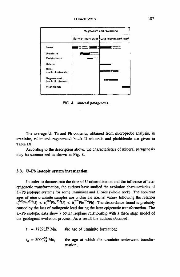
IAEA-TC-571/7 107
M agmatism and reworking
Early prim ary stage Late regenerated stage
Pyrite
U raninite m m m z z -
M olybdenite
Galena i -
Relictblack U minerals
Regenerated black U m inerals ■ ■ ■ M M
Pitchblende
FIG. 8. Mineral paragenesis.
The average U, Th and Pb contents, obtained from microprobe analysis, in uraninite, relict and regenerated black U minerals and pitchblende are given in Table IX.
According to the description above, the characteristics of mineral paragenesis may be summarized as shown in Fig. 8 .
3.3. U-Pb isotopic system investigation
In order to demonstrate the time of U mineralization and the influence of later epigenetic transformation, the authors have studied the evolution characteristics of U-Pb isotopic systems for some uraninites and U ores (whole rock). The apparent ages of nine uraninite samples are within the normal values following the relation t(2 0 6 Pb/2 3 8 U) < t(2 0 7 Pb/2 3 5 U) < t(2 0 7 Pb/2 0 6 Pb). The discordance found is probably caused by the loss of radiogenic lead during the later epigenetic transformation. The U-Pb isotopic data show a better isoplane relationship with a three stage model of the geological evolution process. As a result the authors obtained:
t, = 1739^61 Ma, the age of uraninite formation;
t2 = 300+4® Ma, the age at which the uraninite underwent transformation;
108 RONG et al.
/*]** = 9.0 ± 3, indicating that the evolution of the first stage wasproceeding in a normal evolutionary series;
fu*** = 3.6-26.8, indicating that there was a loss of lead or a gain ofuranium at t2.
The values of tj and t2 obtained with U-Pb concordia plotting coincide completely with the results obtained with the U-Pb three stage model in Fig. 9.
The age t! of uraninite formation also coincides with the largest age of muscovite and the apparent age of zircon to within the error limits. As for the uraninite, the U-Pb isotopic data for 12 ore samples also show a better evolution relationship of U-Pb with the three stage model. As a result the authors obtained:
t, = 182911H Ma, the age of rock formation;
t2 = 3431 , 4 7 Ma, the age at which the coarse grained granite underwenttransformation;
m = 10.7 ± 1, corresponding to a normal evolutionary series of thefirst stage;
fu = 0.65-9.75, indicating that there was a loss of lead or a gain ofuranium at t2.
The values of tj and t2 obtained with U-Pb concordia plotting (Fig. 10) also correspond to those in Fig. 9 to within the error limits. This shows that uraninite and the whole rock underwent the same evolutionary history in terms of the U-Pb isotopic systems.
4. METALLOGENESIS
The metallogenesis of magmatic type U mineralization as compared with other deposits is unique. A possible scheme of U concentration in coarse grained granite could be expressed as follows.
An anatexis happened in the formation of the Longshoushan Group after the intense metamorphism during the Luliang Orogeny (Early Proterozoic). Arkoses and
** n: 238U/204Pb ratio.
***fu: the ratio of the measured U content (third stage) to the calculated U content (second stage).
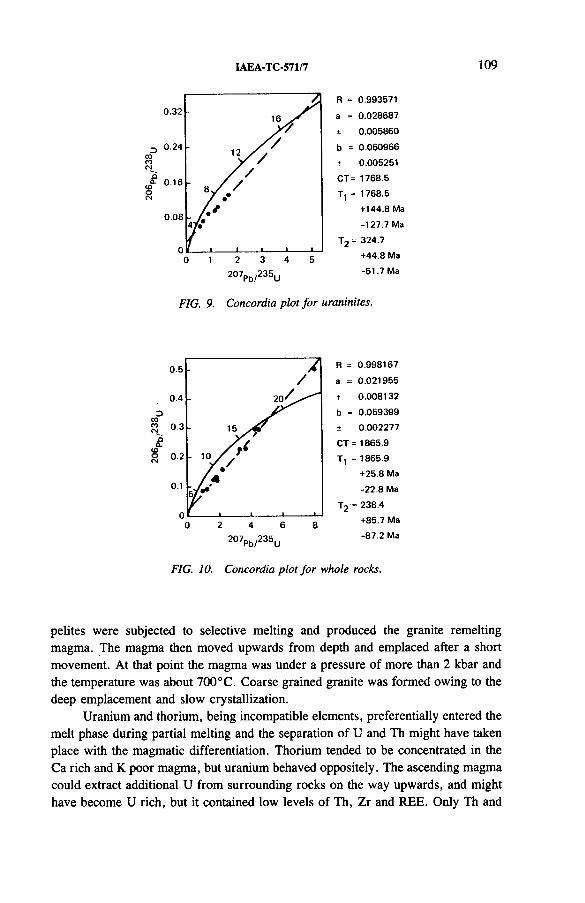
IAEA-TC-571/7 109
oCO
0.32
0.24
,o- 0 .16
0 .08
R = 0.993571
a = 0 .028687
t 0 .005860
b = 0 .060966
< 0.005251
CT = 1768.5
T , = 1768.5
+ 144.8 Ma
-127 .7 Ma
T , = 324.7
Dcoi*>
1 2 3 4 5 +44.8 Ma
207pb/ 2 3 5u -5 1 .7 Ma
FIG. 9. Concordia plot for uraninites.
0.5 b *R = 0 .998167
/ a = 0 .021955
0.4
3oCMt t 0 .008132
b = 0 .059399
0.3 15 ± 0 .002277
CT = 1865.90.2
■ 10/ /T , = 1865.9
/ • / A
+25.8 Ma0.1
5 / - '-2 2 .8 Ma
n ' t i l t T2 •= 238.4u
3 2 4 6 8 +85.7 Ma
207pb /2 3 5 u -8 7 .2 Ma
FIG. 10. Concordia plot fo r whole rocks.
pelites were subjected to selective melting and produced the granite remelting magma. The magma then moved upwards from depth and emplaced after a short movement. At that point the magma was under a pressure of more than 2 kbar and the temperature was about 700° C. Coarse grained granite was formed owing to the deep emplacement and slow crystallization.
Uranium and thorium, being incompatible elements, preferentially entered the melt phase during partial melting and the separation of U and Th might have taken place with the magmatic differentiation. Thorium tended to be concentrated in the Ca rich and K poor magma, but uranium behaved oppositely. The ascending magma could extract additional U from surrounding rocks on the way upwards, and might have become U rich, but it contained low levels of Th, Zr and REE. Only Th and
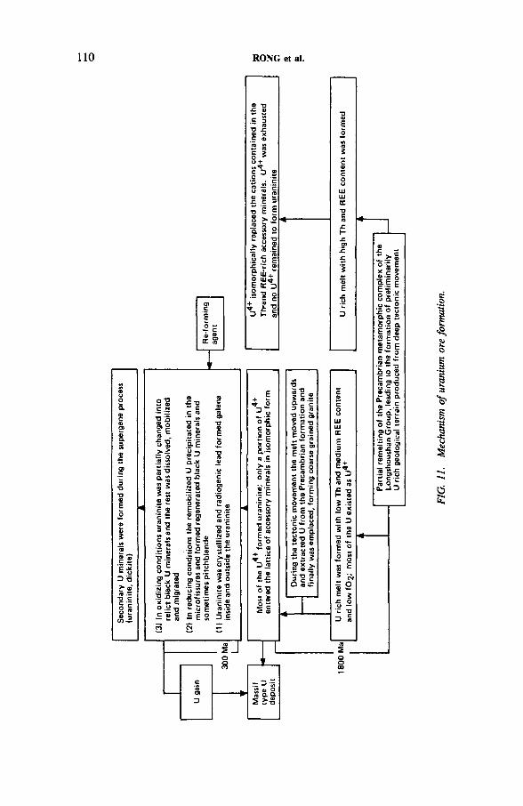
Seco
ndar
y U
min
eral
s we
re
form
ed
durin
g the
su
perg
ene
proc
ess
110 RONG et al.
U ric
h ge
olog
ical
te
rrai
n pr
oduc
ed
from
deep
te
cton
ic
mov
emen
t
IAEA-TC-571/7 111
REE, instead of U, were enriched in the coarse grained granite in contact with marbles, which is quite different from the case of the Rossing uraniferous alaskites [5, 6 ].
According to a study by Calas [7], besides U4+ the magma might have contained U5+ and U6+, but finally they were all changed into U4+ in reducing conditions. Most of the U was crystallized in the form of uraninite if the contents of Th, Zr, Nb, Ta and REE in the magma were low. Conversely, if there was a great amount of Th and REE in the original magma, U4+ should have existed in the Th- and REE-rich accessory minerals, isomorphically replacing the cations of similar ion radius, and therefore no primary U minerals should have formed. For example, the coarse grained granite body located 1 0 km west of the deposit area is unmineralized but has high contents of Th (up to 628 ppm) and REE (up to 5631 ppm) and a high Th/U ratio (up to 62).
Uraninite is frequently concentrated in the biotite enriched marginal part of the granite massif comprising the rich ore body. The biotite bands might result from local contamination or fractionation of biotite from the magma. Like other accessory minerals, uraninite crystallized a little earlier than biotite, in which uraninite could easily have been enclosed. The rest was included in quartz and feldspar. It can be concluded from the discussion that rock and ore forming processes were essentially contemporaneous, and that both granite and uraninite were formed during the Luliang Orogeny about 1800 Ma ago.
Uraninite underwent strong reworking about 300 Ma ago and recrystallized, and the radiogenic lead produced formed galena inside and outside the uraninite. Uranium content was increased in recrystallized uraninite, which had undergone cataclasis and oxidation and been transformed into relict black U minerals. Part of the uraninite was dissolved and mobilized and migrated. In the subsequent reducing conditions regenerated black U minerals were formed near the original uraninite. Finally, pitchblende precipitated in the microfissures. Regenerated black U minerals are developed widely but the amount is minor.
After reworking, the total U content did not decrease but increased slightly, although the primary U content was high and the ferrous minerals and sulphides were less abundant, which is contrary to the conclusion suggested by Speer [8 ]. In short, uraninite (as well as relict black U minerals) represents the largest fraction in U partition; the superimposed part of the regenerated U, as observed today, only has secondary significance.
The massif appearance of this U deposit is the characteristic feature of this mineralization.
To summarize, the metallogenesis of magmatic type U mineralization as a mechanism of the U ore forming process might be synthesized as shown in Fig. 11.
112 RONG et al.
REFERENCES
[1] RONG, Jiashu, “ Microscopic observation on metasomatic phenomena of rock-forming minerals in granites” , Petrological Research, Vol. 1, Geol. Inst, of Academia Sinica, Beijing (1982) (in Chinese).
[2] WANG, Yanting, RONG, Jiashu, “ A new method of petrochemical calculation developed for granitoids” , Metallogenesis of Uranium (Proc. 26th Int. Geol. Congr. Paris, 1980), Vol. 2, Mineralogy, Petrology and Geochemistry, Geoinstitute, Belgrade (1981).
[3] WINKLER, H .G.F., Petrogenesis of Metamorphic Rocks, 4th edn, Springer-Verlag, Berlin (West) (1976).
[4] VINOGRADOV, A.P., Average content of chemical elements in the main types of erupted mineral rocks of the Earth’s crust, Geokhimia No. 7 (1962) (in Russian).
[5] CUNEY, M., “ Processus de concentration de l ’uranium et du thorium au cours de la fusion partielle et de la cristallisation des magmas granitiques” , Uranium Exploration Methods (Proc. Symp. Paris, 1982), OECD, Paris (1982) 277-292.
[6] CUNEY, M., Preliminary results on the petrology and fluid inclusions of the Rossing uraniferous alaskites, Trans. Geol. Soc. S. Afr. 83 (1980) 39-45.
[7] CALAS, G., Etude experimentale du comportement de 1’uranium dans les magmas: dtats d ’oxydation et coordinance, Geochim. Cosmochim. Acta 43 (1979) 1521-1531.
[8] SPEER, J. A ., SOLBERG, T .N ., BECKER, S.W ., Petrography of the uranium-bearing minerals of the Liberty Hill pluton, South Carolina: Phase assemblages and migration of uranium in granitoid rocks, Econ. Geol. 76 (1981) 2162-2175.
IAEA-TC-571/8
URANIUM MINERALIZATION IN SOME TYPICAL IGNEOUS-METAMORPHIC ENVIRONMENTS OF INDIA
R.K. GUPTA, N.V.A.S. PERUMAL, S. SAGAR,L.D. UPADHYAYA, H.M. VERMA Atomic Minerals Division,Department of Atomic Energy,Government of India,Hyderabad, India
Abstract
URANIUM MINERALIZATION IN SOME TYPICAL IGNEOUS-METAMORPHIC ENVIRONMENTS OF INDIA.
The paper presents the characteristics of uranium mineralization in three distinctive geological environments, two of which are related to magmatic and post-magmatic processes of enrichment and one to metamorphic processes aiding uranium mineralization. Granitoids emplaced into migmatitic complexes host uranium mineralization along shear zones in the Surguja-Palamau belt of Madhya Pradesh and Bihar. At Jajawal in the Surguja District of Madhya Pradesh sheared migmatite and associated amphibolites are the main hosts; in addition there is minor uranium mineralization in the associated feldspathic biotite schist. Uraninite and coffmite occur as veins and fracture fillings in intimate association with autunite, fluorite, pyrite and minor chalcopyrite and pyrrhotite. In the granitoids of the Binda-Nagnaha area of the Palamau District, Bihar, uraninite is the chief uranium mineral. Microgranites and rhyo- litic dykes emplaced into the acid-basic volcanic sequences of the Proterozoic (Dongargarh Supergroup) of Madhya Pradesh have intrinsically higher contents of uranium, and are further enriched along shear zones, resulting in the formation of uraninite with some U-Ti complexes. In all the above cases it is believed that processes of mobilization of uranium from host rocks by action of water-fluorine systems possibly led to redistribution of uranium and its concentration along the shear zones dissecting rocks already having a relatively high content of uranium. In the Sikkim Himalayas uranium mineralization is encountered in the phosphatic phyllites of the marine Daling-Buxa sequences deposited originally under euxinic conditions. Uranium mineralization occurs as microveinlets of uraninite intimately associated with apatite and at places with pyrite and chalcopyrite. The role of metamorphic processes leading to ore formation is exemplified by these occurrences. The original syngenetic uranium in the phosphatic shales appears to have been remobilized during metamorphic recrystallization to give rise to an epigenetic type of mineralization. The tectonics of the region are characterized by the presence of large thrust sheets, some of which slide along the lithostratigraphic contact zones. As a consequence, there is an enrichment of uranium along the shears which has more or less lithological control. The exploration strategy in identifying deposits of uranium in the igneous and metamorphic environments calls for an integrated approach of interpretation of Landsat images with airborne gamma ray spectrometric data followed up largely by radiometric surveys, geological mapping and exploratory drilling.
113
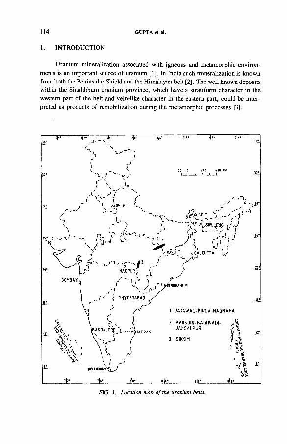
114 GUPTA et al.
1. INTRODUCTION
Uranium mineralization associated with igneous and metamorphic environments is an important source of uranium [1]. In India such mineralization is known from both the Peninsular Shield and the Himalayan belt [2], The well known deposits within the Singhbhum uranium province, which have a stratiform character in the western part of the belt and vein-like character in the eastern part, could be interpreted as products of remobilization during the metamorphic processes [3].
FIG. 1. Location map o f the uranium belts.
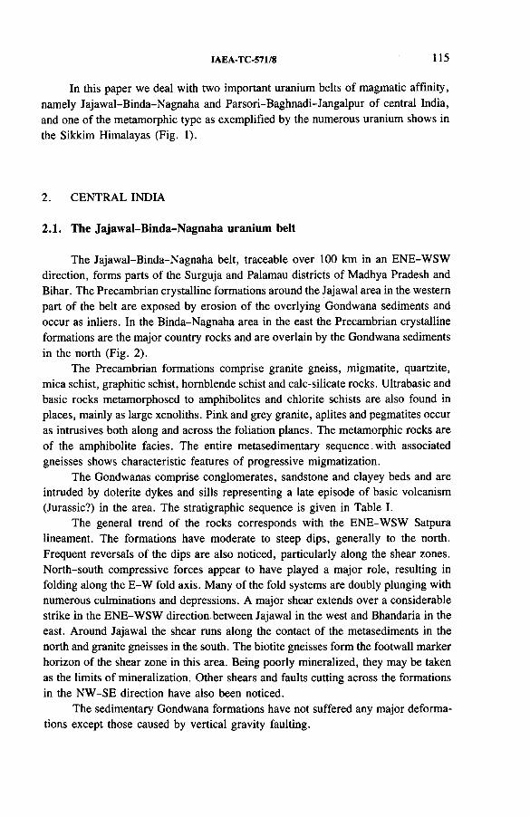
IAEA-TC-571/8 115
In this paper we deal with two important uranium belts of magmatic affinity, namely Jajawal-Binda-Nagnaha and Parsori-Baghnadi-Jangalpur of central India, and one of the metamorphic type as exemplified by the numerous uranium shows in the Sikkim Himalayas (Fig. 1).
2. CENTRAL INDIA
2.1. The Jajawal-Binda-Nagnaha uranium belt
The Jajawal-Binda-Nagnaha belt, traceable over 100 km in an ENE-WSW direction, forms parts of the Surguja and Palamau districts of Madhya Pradesh and Bihar. The Precambrian crystalline formations around the Jajawal area in the western part of the belt are exposed by erosion of the overlying Gondwana sediments and occur as inliers. In the Binda-Nagnaha area in the east the Precambrian crystalline formations are the major country rocks and are overlain by the Gondwana sediments in the north (Fig. 2).
The Precambrian formations comprise granite gneiss, migmatite, quartzite, mica schist, graphitic schist, hornblende schist and calc-silicate rocks. Ultrabasic and basic rocks metamorphosed to amphibolites and chlorite schists are also found in places, mainly as large xenoliths. Pink and grey granite, aplites and pegmatites occur as intrusives both along and across the foliation planes. The metamorphic rocks are of the amphibolite facies. The entire metasedimentary sequence with associated gneisses shows characteristic features of progressive migmatization.
The Gondwanas comprise conglomerates, sandstone and clayey beds and are intruded by dolerite dykes and sills representing a late episode of basic volcanism (Jurassic?) in the area. The stratigraphic sequence is given in Table I.
The general trend of the rocks corresponds with the ENE-WSW Satpura lineament. The formations have moderate to steep dips, generally to the north. Frequent reversals of the dips are also noticed, particularly along the shear zones. North-south compressive forces appear to have played a major role, resulting in folding along the E-W fold axis. Many of the fold systems are doubly plunging with numerous culminations and depressions. A major shear extends over a considerable strike in the ENE-WSW direction between Jajawal in the west and Bhandaria in the east. Around Jajawal the shear runs along the contact of the metasediments in the north and granite gneisses in the south. The biotite gneisses form the footwall marker horizon of the shear zone in this area. Being poorly mineralized, they may be taken as the limits of mineralization. Other shears and faults cutting across the formations in the NW-SE direction have also been noticed.
The sedimentary Gondwana formations have not suffered any major deformations except those caused by vertical gravity faulting.
GUPTA et al.
FIG
. 2.
Gen
eral
geo
logi
cal
map
of the
Ja
jaw
al-B
inda
-Nag
naha
ar
ea
(bas
ed
on La
ndsa
t im
ager
y in
terp
reta
tion
and
grou
nd
surv
eys)
.
IAEA-TC-571/8 117
TABLE I. STRATIGRAPHIC SUCCESSION OF THE JAJAWAL-BINDA- NAGNAHA BELT
Recent sediments
------------------------------------------------- Unconformity ---------------------------------------------------
Upper Palaeozoic Arkosic sandstone, clays and conglomerates
----------- Unconformity -------------------------------------------------
Granites and pegmatites
Migmatite complex, consisting of granitic gneisses interbanded with quartzites, mica schist, graphitic schist, calc-silicate rocks and metabasics (amphibolites)
Na20 (V .)
FIG. 3. Na20 -K 20 and Na20 -K 20 -C a 0 plots o f the granitoids o f the Jajawal-Binda- Nagnaha area (data from Ref. [4]).
2.1.1. Petrology o f the granitic rocks
The granitic rocks are coarse to medium grained and are composed essentially of quartz, K-feldspar (both orthoclase and microcline), plagioclase (albite- oligoclase), and some biotite and chlorite with accessories such as epidote, zircon, garnet and magnetite. Myrmekitic and perthitic textures are common. Signs of shearing and deformation are manifested by fracturing of feldspar and granulation
Middle to Upper Proterozoic
Archaean to Lower Proterozoic
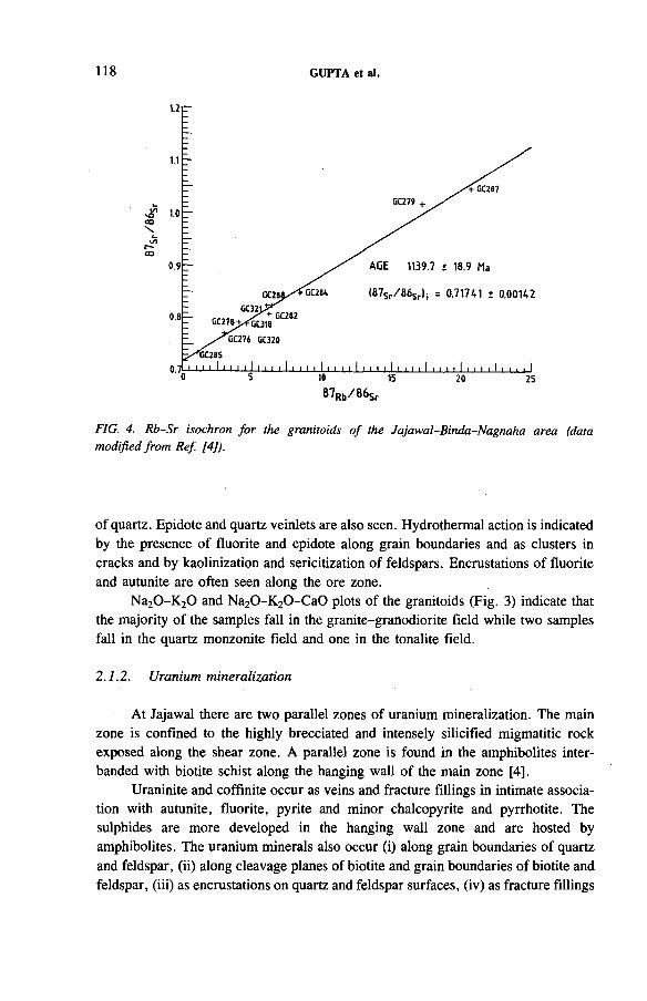
118 GUPTA et al.
FIG. 4. Rb-Sr isochron for the granitoids o f the Jajawal-Binda-Nagnaha area (data modified from Ref. 14]).
of quartz. Epidote and quartz veinlets are also seen. Hydrothermal action is indicated by the presence of fluorite and epidote along grain boundaries and as clusters in cracks and by kaolinization and sericitization of feldspars. Encrustations of fluorite and autunite are often seen along the ore zone.
Na2 0-K 20 and Na2 0-K 2 0-C a0 plots of the granitoids (Fig. 3) indicate that the majority of the samples fall in the granite-granodiorite field while two samples fall in the quartz monzonite field and one in the tonalite field.
2.1.2. Uranium mineralization
At Jajawal there are two parallel zones of uranium mineralization. The main zone is confined to the highly brecciated and intensely silicified migmatitic rock exposed along the shear zone. A parallel zone is found in the amphibolites interbanded with biotite schist along the hanging wall of the main zone [4].
Uraninite and coffinite occur as veins and fracture fillings in intimate association with autunite, fluorite, pyrite and minor chalcopyrite and pyrrhotite. The sulphides are more developed in the hanging wall zone and are hosted by amphibolites. The uranium minerals also occur (i) along grain boundaries of quartz and feldspar, (ii) along cleavage planes of biotite and grain boundaries of biotite and feldspar, (iii) as encrustations on quartz and feldspar surfaces, (iv) as fracture fillings
IAEA-TC-571/8 119
and (v) very closely associated with fluorite. The occurrence along grain boundaries is, however, the most common type.
Uranium mineralization in the Binda-Nagnaha area is mainly due to uraninite, brannerite, thorite and allanite, found as irregular disseminations in the pegmatitic, quartzo-feldspathic and granitic host rocks.
2.1.3. Age o f mineralization
The Rb-Sr isochron for the granitoids of the Jajawal-Binda-Nagnaha area has given an age of 1140 ± 20 Ma (Fig. 4). Biotites and muscovites separated from the pegmatitic rock samples near Dumhat indicated an age of 940-900 Ma by the Rb-Sr method [5]. The uranium mineralization in these rocks may therefore be assigned to the Middle to Late Proterozoic period [6 ]. Biotite from Dhabi granite occurring near Dumhat (Fig. 2) has been dated by the K-Ar method at 880 ± 20 Ma [7], whichapparently dates the last major thermal episode in this region and may alsocorrespond with the age of mineralization in the shear zone. The older age of 1700 Ma from the Pb isochron for the primary uranium mineralization given by Mukerjee [7] for Dhabi, however, needs to be reconciled.
The initial 8 7 Sr/86Sr ratio of 0.717 41 ± 0.001 42 is higher than the valuesgenerally accepted for granites generated in the upper mantle. It is thus possible that the granitic rocks described above may be of crustal origin and of the anatectonic type. The uranium mineralization is possibly brought out at the end phase of this anatexis by remobilization of uranium through circulating solutions migrating into low pressure areas along the shear zones.
2.2. The Parsori-Baghnadi-Jangalpur uranium belt
The Parsori-Baghnadi-Jangalpur tract forms part of the Raj Nandgaon, Durg and Bhandara Districts of Madhya Pradesh and Maharashtra in central India. It is bounded to the west by the older Sakoli synclinorium of Late Archaean to Lower Proterozoic age and to the east by the Chattisgarh-Cuddapah formations of Upper Proterozoic age. The formations of this 150 km long and 90 km wide belt have been grouped by Sarkar [8 ] into the Dongargarh Supergroup (Fig. 5). They comprise a suite of acid and basic effusives, intruded by the Dongargarh granite, followed by the Khairagarh Group, consisting of alternating beds of conglomerates, grits, shales and sandstones and basic volcanics (Table II) [9].
These rock formations have undergone several episodes of tectonic activity and deformation resulting in folding, faulting, shearing and metamorphism of green schist to amphibolite facies. Some of the major faults and shear zones have acted as loci for base metal (copper) and fluorite mineralization at a few places in the neighbourhood and for uranium at others (Fig. 5).
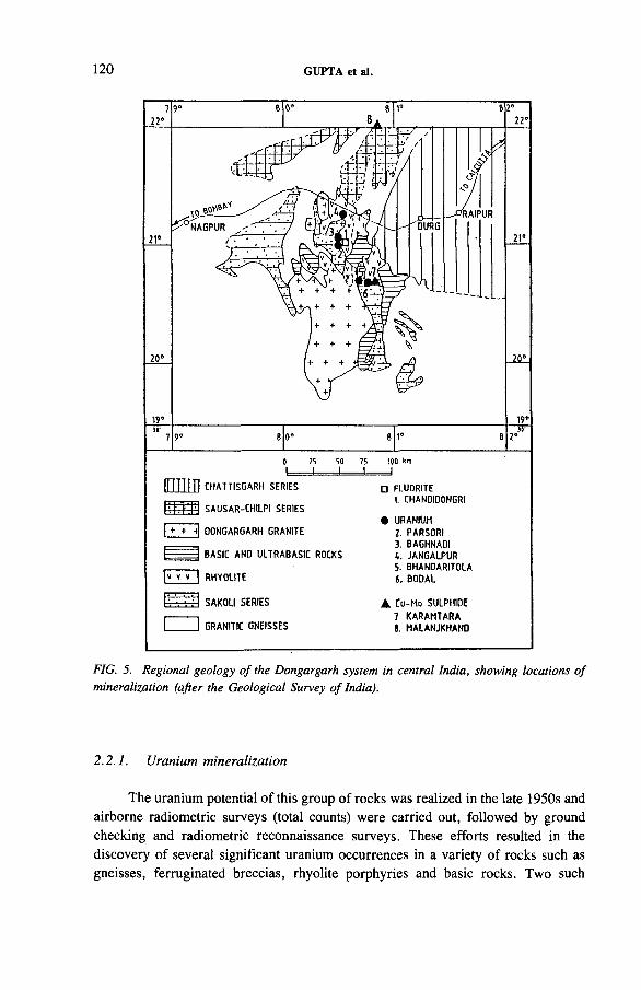
120 GUPTA et al.
CHATT ISGARH SER IE S
t t t r f f l SA U SAR -CH ILP I SER IE S
I + + -t| 00NGARGARH GRAN ITE
BA S IC AND U LTRA B A S IC ROCKS
|» v » I RH YO U TE
[ ' . ■ : I SA KO L I S ER IE S
I I GRANITIC GN EISSES
□ FLUORITE
1. CHANDIDONGRI
• URANIUM
2. PARSO R I
3. BAGHNAOI
4 . JANGALPU R
5. BHANDARITOLA
i . BO DAL
A Cu-Mo SULPH IDE
7 KARAM TARA
S. HALAN JKHAND
FIG. 5. Regional geology o f the Dongargarh system in central India, showing locations o f mineralization (after the Geological Survey o f India).
2.2.1. Uranium mineralization
The uranium potential of this group of rocks was realized in the late 1950s and airborne radiometric surveys (total counts) were carried out, followed by ground checking and radiometric reconnaissance surveys. These efforts resulted in the discovery of several significant uranium occurrences in a variety of rocks such as gneisses, ferruginated breccias, rhyolite porphyries and basic rocks. Two such
IAEA-TC-571/8 121
deposits at Bodal and Bhandaritola were identified and prospected, resulting in the discovery of significant reserves. The Bodal occurrence has been described in some detail in an earlier publication [10]. Being associated with shear zones in basic and acidic rocks, the mineralizations in these areas have been considered to be of the hydrothermal type. Uranium mineralizations of the magmatic-syngenetic type have been found in a number of other areas such as Jangalpur, Parsori and Baghnadi, and these are described in this paper.
TABLE II. REGIONAL STRATIGRAPHIC SUCCESSION IN THE DONGARGARH BELT [9]
570 Ma
Upper Proterozoic Chattisgarh Raipur Group Limestones and shalesSupergroup Chandrapur Group Sandstones and shales
900 Ma ------------------- -------------------Khairagarh Orogeny----------------------------------------
Middle Proterozoic Khairagarh Group Andesites, sandstonesand shales 1443-1610 Ma
1600 Ma DongargarhSupergroup -------------------------------- Unconformity---------------------------------
c. 2200 Ma Dongargarh granitePitepani volcanics
Lower Proterozoic Nandgaon Group Bijli rhyolites
-------------------- Unconformity -----------------------------
Sakoli Group Tuffaceous shales,banded haematite, quartzites and meta- basic rocks
c. 2300 Ma .............................................Amgaon Orogeny.............................................. ..........
Archaean Amgaon Group Schistose formations,quartzites and amphi- bolites (granitized)
122 GUPTA et al.
Uranium mineralization at Jangalpur is found to be associated with rhyolites and felsites. The rhyolites occur as inliers and show effects of crushing and breccia- tion. They are also profusely intruded by quartz veins. The rhyolites are prominently sheared along the NW-SE direction. Along these shears, felsite dykes and veins have intruded which record significant radioactivity due to uranium. Secondary encrustations of autunite are also observed.
The mineralizations at Parsori and Baghnadi are hosted in sheared porphyries, rhyolites, devitrified pitchstone and hardened ash beds. The rhyolites vary from porphyritic to non-porphyritic types, the former carrying up to 50% phenocrysts (quartz and K-feldspar). The phenocrysts show features of magmatic corrosion, crushing and granulation attesting to the complex magmatic and subsequent tectonic effects. The groundmass is extremely fine grained with micro- to cryptocrystalline aggregates of quartz and feldspars. Spherulitic textures are not uncommon and devitrification can be seen in the glassy parts.
Uranium mineralization is confined to the NNW-SSE trending shears and fractures. Secondary uranium minerals, identified as autunite and uranophane, are seen as bright yellow, yellowish-green or orange-red coatings. The large abundance of these secondary minerals strongly suggests the possible presence of primary uranium phases such as uraninite or pitchblende which could be easily oxidized to uranophane. Other radioactive minerals identified include cyrtolite and some euxenite-polyerase group(?) minerals. Clusters of pyrite and fluorite are also seen apart from the frequent quartz veins (up to a metre thick) in the ore zones.
These shears trending NNW-SSE appear to have developed parallel to the two major faults of the area, namely the great Darekasa Fault 10 km to the east and the Phukineta Fault 3 km to the west.
Available data suggest that the acid effusives contain varying abundances of uranium ranging from 1.2 to 9.7 ppm [10]. Some of the higher abundances in these localities are attributed to normal processes of differentiation, while in the majority of cases structural deformation leading to foliated fabric and shearing has facilitated uranium remobilization and concentration in conducive localities.
3. SIKKIM
The regional geology of the Sikkim Himalayas has been studied by a number of workers [11, 12]. The oldest rocks of the area are the Buxa and Daling formations (Middle Proterozoic), which constitute a large thrust sheet overriding the younger Gondwana formations, exposed in a window along the Rangit Valley. Uranium mineralizations, however, are confined to some lithological units within the Buxa- Daling sequence. Sinha Roy [12] has classified the Sikkim and Darjeeling Himalayas into four tectonic belts, namely (i) the Foothills Belt, (ii) the Inner Belt, (iii) the Axial Belt and (iv) the Trans-axial Belt, as shown in Table III.
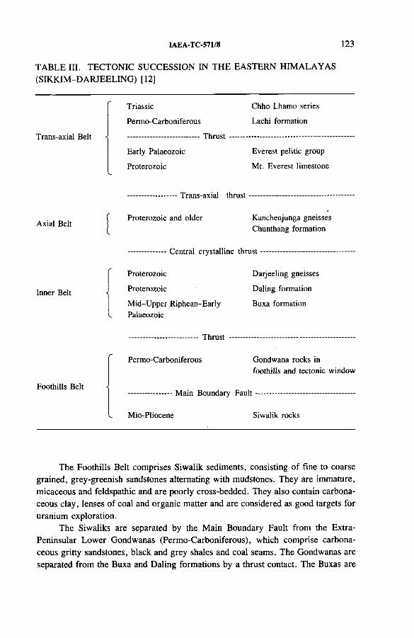
IAEA-TC-571/8 123
TABLE III. TECTONIC SUCCESSION IN THE EASTERN HIMALAYAS (SIKKIM-DARJEELING) [12]
Trans-axial Belt
Triassic
Permo-Carboniferous
Early Palaeozoic
Proterozoic
Thrust
Chho Lhamo series
Lachi formation
Everest pelitic group
Mt. Everest limestone
Axial Belt
Inner Belt
Foothills Belt
...................— Trans-axial thrust
Proterozoic and older Kanchenjunga gneisses Chunthang formation
Central crystalline thrust
Proterozoic
Proterozoic
Darjeeling gneisses
Daling formation
Mid-Upper Riphean-Early Buxa formationPalaeozoic
Thrust
Permo-Carboniferous Gondwana rocks in foothills and tectonic window
...................— Main Boundary F au lt------------------
Mio-Pliocene Siwalik rocks
The Foothills Belt comprises Siwalik sediments, consisting of fine to coarse grained, grey-greenish sandstones alternating with mudstones. They are immature, micaceous and feldspathic and are poorly cross-bedded. They also contain carbonaceous clay, lenses of coal and organic matter and are considered as good targets for uranium exploration.
The Siwaliks are separated by the Main Boundary Fault from the Extra- Peninsular Lower Gondwanas (Permo-Carboniferous), which comprise carbonaceous gritty sandstones, black and grey shales and coal seams. The Gondwanas are separated from the Buxa and Daling formations by a thrust contact. The Buxas are
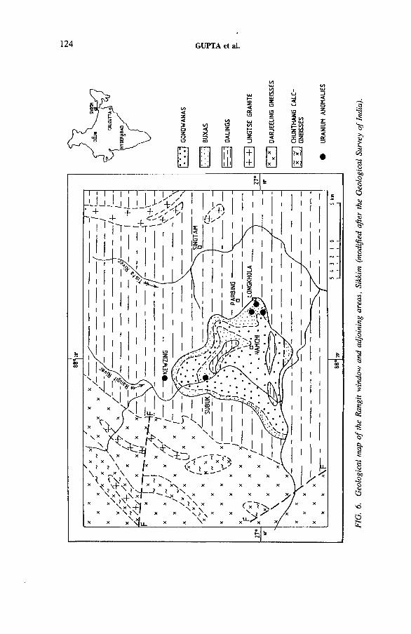
124 GUPTA et al.
FIG.
6.
Geo
logi
cal
map
of the
Ra
ngit
wind
ow
and
adjo
inin
g ar
eas,
Sikkim
(m
odifi
ed
after
the
G
eolo
gica
l Su
rvey
of
Indi
a).
IAEA-TC-571/8 125
represented by orthoquartzites, dolomitic limestone, slates and phyllites whereas the Daling formation comprises mostly phyllites, schists and quartzites grading into the Darjeeling gneisses. Further north the Chunthang calc-granulites and gneisses and the Kanchenjunga gneisses are exposed. The Lingtse granite is well exposed near Rangli and Gangtok, whereas younger tourmaline bearing granites are exposed in the upper reaches of the Lachen and Lachung valleys.
3.1. Structure
The overall structure of the Sikkim Himalayas is a major domal structure, the N-S axis of which is followed by the Tista River. Three episodes of folding (pre- Gondwana, post-Gondwana and post-Siwalik) accompanied by polymetamorphic mineral paragenesis have been identified in the Inner and Axial Belt formations [12]. The most important among these is the second episode, corresponding to the main Himalayan tectonism of this region which has resulted in major recumbent folds culminating in large scale thrusting and major dislocations along lithostratigraphic contacts.
The Rangit River cuts through the Dalings and exposes the younger but tectonically placed Buxa and Gondwana formations comprising the Rangit tectonic window.
3.2. Uranium mineralization
As already pointed out, significant occurrences of uranium in Sikkim are mostly confined to the central part around the periphery of the Rangit tectonic window and are mostly associated with the metasediments of the Buxa and Daling formations (Fig. 6 ). The Buxas here consist of dolomites, grey quartzites and chloritic phyllites. The Dalings comprise phyllites and quartzites. The radioactivity is mainly associated with chloritic phyllite interbedded with quartzites as seen in Parbing-Maniram-Longkhola in the eastern part and Mamring-Kewzing in the northern part of the Rangit window. In the western part it is found associated with dolomite near Subuk.
The radioactive phyllites consist of porphyroblasts of streaky and lensoid quartz in a dominant chloritic and lesser ferruginous matrix. Other minerals identified include cyrtolite, goethite, haematite, ilmenite, rutile, brookite, chamosite, sphene and uraninite. Uranium is partly associated with a weakly magnetic ilmeno- haematite complex and partly adsorbed on the mineral grains as indicated by the presence of very finely crystalline uranyl phosphate in all the size fractions along with fluorapatite.
It is pertinent here to point out the presence of chamosite, which with glauconite is generally cited as mineralogical evidence to indicate moderate depths
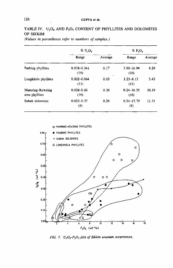
TABLE IV. U3 0 8 AND P2 Os CONTENT OF PHYLLITES AND DOLOMITES OF SIKKIM(Values in parentheses refer to numbers o f samples.)
126 GUPTA et al.
% UjOg % P20 5
Range Average Range Average
Parbing phyllites 0.078-0.341 0.17 3.00-16.94 8.29(16) (16)
Longkhola phyllites 0.002-0.064 0.03 1.23-8.13 3.43(11) ( 11)
Mamring-Kewzing 0.008-0.66 0.36 0.24-16.35 10.19area phyllites (16) (16)
Subuk dolomites 0.033-0.37 0.24 6.21-17.79 11.31(4) (4)
O MAMRING-KEWZING P H Y LU T ES
FIG. 7. U30 8-P20 5 plot o f Sikkim uranium occurrences.
IAEA-TC-571/8 127
of the sediments deposited under marine/deltaic conditions. The continuous persistence of even thin beds in the quartzitic rocks of the Buxa-Daling sequences for long distances and the absence of current bedding are suggestive of a marine environment.
The U3Og and P2 0 5 abundances of some of the radioactive phyllites and dolomites from Parbing-Longkhola, Kewzing and Subuk are given in Table IV. The results indicate that these radioactive phyllites can be termed as phosphatic phyllites owing to their moderate to high content of P2 O5 . Bivariant plots of the abundances (Fig. 7) indicate a moderate to weak positive correlation, the variations among the different areas being probably related to uranium distribution in more than one phase as outlined previously.
Thus, the mineralization of the Parbing-Maniram-Longkhola and Kewzing areas seems to have formed in a marine euxinic environment and uranium originally deposited in phosphatic shales probably adsorbed onto colloidal complexes. Subsequently, during the Late Proterozoic period structural disturbances and metamorphism led to the mobilization of uranium, especially under low grade metamorphic conditions. This episode was followed by the second major tectonic movement during the post-Gondwana period, which led to the formation of large thrust sheets. A second phase of uranium enrichment probably took place during this period, especially along the lithostratigraphic contact zones, which have also been the planes of thrust movement.
4. EXPLORATION STRATEGY
On the basis of available literature and geological data, target areas for radio- metric survey, detailed prospecting and exploration were fixed in the areas described above. A preliminary airborne gamma ray spectrometer and magnetometer survey in the Jajawal-Binda-Nagnaha and Parsori-Baghnadi-Jangalpur tracts has helped in narrowing down the target areas for exploration. The follow-up car-borne scintillometer survey, ground radiometry, ground checking radon emanometry and geochemical and geophysical survey revealed many radioactive occurrences and zones of interest. These were further delineated by conventional test pitting, trenching, shielded probe logging and channel sampling, etc., and explored by diamond core drilling. Exploratory mining has also been taken up at Jajawal.
5. CONCLUSIONS
The uranium mineralization in the Jajawal-Binda-Nagnaha belt appears to have originated from granitoids of anatectic origin. Tectonic episodes during the Middle to Upper Proterozoic apparently remobilized the uranium along favourable structural and lithological horizons.
128 GUPTA et al.
The acid intrusives and effusives of the Dongargarh Supergroup have widely varying contents of uranium which has concentrated at favourable loci through magmatic differentiation as well as redistribution during structural deformation, along shears.
The syngenetic uranium associated with the phosphatic shales of the Buxa- Daling sequence in Sikkim was remobilized and concentrated during the process of metamorphism and tectonism. Such a view is supported by the extremely fine disseminations with local enrichment as well as by the stratabound character of the uranium mineralization.
ACKNOWLEDGEMENTS
The authors are highly grateful to T.M. Mahadevan, Director, Atomic Minerals Division, Department of Atomic Energy, for his deep interest and guidance in formulating some of the concepts presented in this paper. Acknowledgements are due to A.C. Saraswat, Deputy Director, Atomic Minerals Division, for his valuable suggestions and discussions on various aspects of geological and exploration work. The authors are indebted to P. Krishnamurthy and G.S. Ravi who helped in drafting and finalizing the paper. The excellent facilities extended by the Planning and Management Services Group of the Atomic Minerals Division are also gratefully acknowledged.
REFERENCES
[1] INTERNATIONAL URANIUM RESOURCES EVALUATION PROJECT, World Uranium Geology and Resource Potential, Miller Freeman, San Francisco, CA (1980).
[2] SARASWAT, A.C., KRISHNAMOORTHY, P., MAHADEVAN, T.M ., “ Uranium provinces of the Indian subcontinent and surroundings” , Uranium Deposits in Asia and the Pacific: Geology and Exploration (Proc. Tech. Comm. Mtg Jakarta, 1985), IAEA, Vienna (1988) 39-57.
[3] MAHADEVAN, T.M ., “ Characterisation and genesis of the Singhbhum Uranium Province, India” , Recognition of Uranium Provinces (Proc. Tech. Comm. Mtg London, 1985), IAEA, Vienna (1988) 337-369.
[4] NIKAM, P.S., Status of Investigations of Jajawal Prospect, unpublished report, Atomic Minerals Division, Dept, of Atomic Energy, Hyderabad, 1986.
[5] PANDE, B.K., UPADHYAYA, L.D., SINHA, K.K., NEGI, B.S., “ Geochronology of Jajawal-Binda-Nagnaha granitoids in relation to uranium mineralisation” , paper presented at Symp. on Isotope Based Studies on Problems of Indian Geology, Calcutta, 1986.
[6] MAHADEVAN, T.M ., Space-time controls in Precambrian uranium mineralisation in India, J. Geol. Soc. India 27 (1986) 47-62.
IAEA-TC-571/8 129
[7] MUKERJEE, D., “ Geochemistry of uranium mineralisation at Dhabi in Satpura Precambrian Belt, Madhya Pradesh, India” , paper presented at Symp. on Metallogeny of the Precambrian (IGCP Project 91), Bangalore, 1982.
[8] SARKAR, S.N., Stratigraphy and tectonics of the Dongargarh system: A new system in the Precambrian of Bhandara-Durg-Balaghat area, Bombay and Madhya Pradesh, J. Sci. Ind. Res. (1958) 143-160, 237-286.
[9] SARKAR, S.N., New data on the geochronology of the Precambrians of Bhandara- Durg, central India, Indian J. Earth Sci. 8 2 (1981) 131-151.
[10] SINHA, R.M., et al., “ The discovery of Bodal uranium deposit in the metabasic rock in the Raj Nandgaon-Durg uranium province, Madhya Pradesh, India. A case history of uranium exploration” , paper presented at Int. Geol. Congr. Moscow, 1984.
[11] GANSSER, A., Geology of the Himalayas, Interscience, London (1964).[12] SINHA ROY, S., Tectonic Elements in the Eastern Himalaya and Geodynamic Model
of Evolution of the Himalaya, Geol. Surv. India, Misc. Publ. 34 Part 1 (1976) 57-74.


IAEA-TC-571/9
URANIUM OCCURRENCES IN MAGMATIC AND METAMORPHIC ROCKS OF NORTHERN PAKISTAN
K.A. BUTTAtomic Energy Minerals Centre,Pakistan Atomic Energy Commission,Peshawar, Pakistan
Abstract
URANIUM OCCURRENCES IN MAGMATIC AND METAMORPHIC ROCKS OF NORTHERN PAKISTAN.
Uranium prospecting in magmatic and metamorphic terrain of the Pakistan Himalayas and Karakorams has yielded numerous radiometric and geochemical uranium anomalies in varied geological environments. A brief description of some of the significant occurrences discovered in granites, graphitic metapelites, anatectic granitoids and carbonatites is presented.
1. INTRODUCTION
1.1. Geology
Magmatic and metamorphic rocks in Pakistan are mainly restricted to the northern mountain area, with the exception of minor exposure of granitic rock in Nagar Parkar, some younger granitic and acid volcanic rocks of the Baluchistan Basin, and ultrabasic and related rocks of the axial belt which separates the Baluchistan Basin from the Indus Basin (Fig. 1). The Main Boundary Thrust (MBT), which runs essentially from west to east from Kohat through Murree and Muzaffarabad and makes the syntaxial bend of Hazara to continue further west, marks the northern boundary of the Mesozoic and younger sedimentary sequences. Areas north of the MBT are composed essentially of granitic and regionally metamorphosed sedimentary-volcanic-plutonic rocks. However, some intramontane minor basins may contain younger sedimentary strata.
The geology of the northern mountain area can be conveniently described with respect to three distinct geological domains:
(a) The area between the MBT and the Main Mantle Thrust (MMT) (Fig. 2),(b) The area between the MMT and the Main Karakoram Thrust (MKT),(c) The area north of the MKT.
131
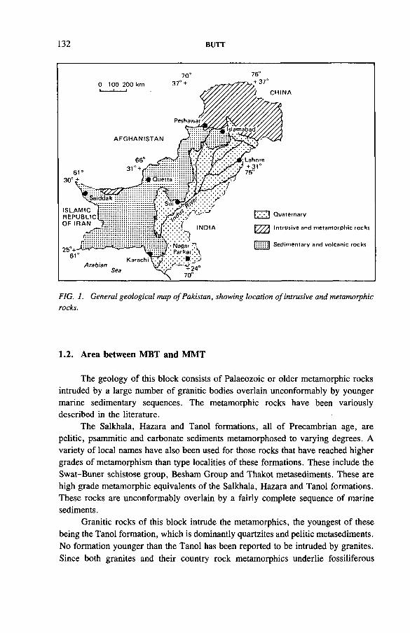
132 BUTT
FIG. 1. General geological map o f Pakistan, showing location o f intrusive and metamorphic rocks.
1.2. Area between MBT and MMT
The geology of this block consists of Palaeozoic or older metamorphic rocks intruded by a large number of granitic bodies overlain unconformably by younger marine sedimentary sequences. The metamorphic rocks have been variously described in the literature.
The Salkhala, Hazara and Tanol formations, all of Precambrian age, are pelitic, psammitic and carbonate sediments metamorphosed to varying degrees. A variety of local names have also been used for those rocks that have reached higher grades of metamorphism than type localities of these formations. These include the Swat-Buner schistose group, Besham Group and Thakot metasediments. These are high grade metamorphic equivalents of the Salkhala, Hazara and Tanol formations. These rocks are unconformably overlain by a fairly complete sequence of marine sediments.
Granitic rocks of this block intrude the metamorphics, the youngest of these being the Tanol formation, which is dominantly quartzites and pelitic metasediments. No formation younger than the Tanol has been reported to be intruded by granites. Since both granites and their country rock metamorphics underlie fossiliferous
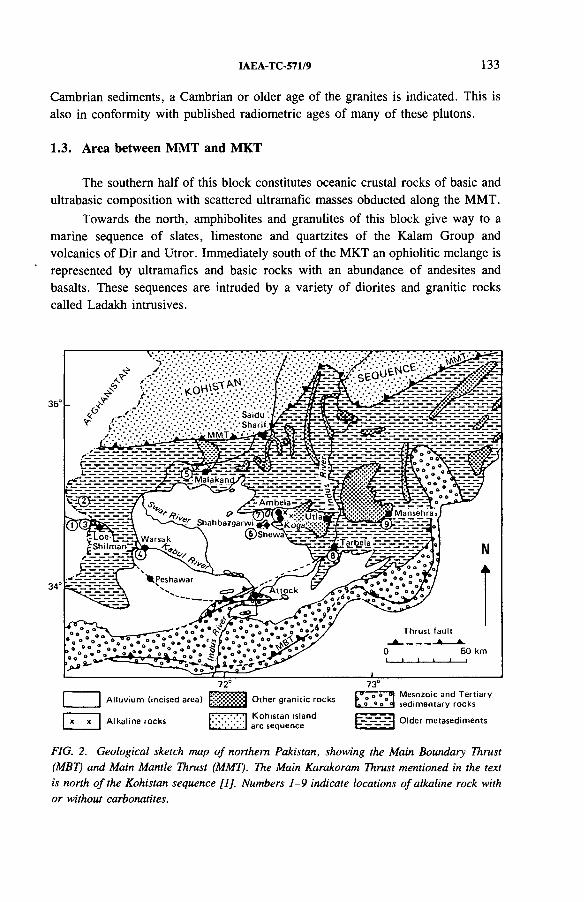
IAEA-TC-571/9 133
Cambrian sediments, a Cambrian or older age of the granites is indicated. This is also in conformity with published radiometric ages of many of these plutons.
1.3. Area between MMT and MKT
The southern half of this block constitutes oceanic crustal rocks of basic and ultrabasic composition with scattered ultramafic masses obducted along the MMT.
Towards the north, amphibolites and granulites of this block give way to a marine sequence of slates, limestone and quartzites of the Kalam Group and volcanics of Dir and Utror. Immediately south of the MKT an ophiolitic melange is represented by ultramafics and basic rocks with an abundance of andesites and basalts. These sequences are intruded by a variety of diorites and granitic rocks called Ladakh intrusives.
35°
34°
72° 73°
Alluvium (incised area) E g g g g j O ther granitic rocks °
Alkaline rocks Kohistan island arc sequence □ — - - I Older m etasedim ents
FIG. 2. Geological sketch map o f northern Pakistan, showing the Main Boundary Thrust (MBT) and Main Mantle Thrust (MMT). The Main Karakoram Thrust mentioned in the text is north o f the Kohistan sequence [I], Numbers 1-9 indicate locations o f alkaline rock with or without carbonatites.
134 BUTT
1.4. Area north of MKT
This area contains a variety of metamorphosed marine sequences including slates, schists and marbles intruded by central Karakoram granodiorites.
2. REGIONAL GEOLOGICAL SET-UP AND FAVOURABILITY FOR URANIUM DEPOSITS
The regional geology of the three major tectonic domains summarized above presents some general constraints with respect to their favourability for uranium deposits. The area bounded by the MBT and MMT rates highest because its geology is dominated by Precambrian to Cambrian metamorphic rocks, including graphitic metapelites intruded by granites of comparable and younger ages.
The tectonic block between the MMT and MKT contains a southern ultramafic zone followed by a thick mass of amphibolites — garnet amphibolites, garnet granu- lites, pyroxene granulites/norites intruded by diorites, trondhjemites and acid porphyries. Further north, this tectonic block is predominantly of intermediate composition overlain by acid volcanics and sediments. The uranium favourability of this tectonic block is therefore rather limited. The acid intrusives as well as extru- sives and their associated sediments may, however, offer environments for small size concentrations of ore grade.
The tectonic block north of the MKT is dominated by a large batholith called the central Karakoram granodiorite batholith and possibly other younger granitic rocks. Although this environment as a whole provides a large uranium source area, leaching of uranium from some rocks and reconcentration in the host rocks is a problem to be investigated before a large scale venture is warranted in this rather remote area of northern Pakistan. It is therefore concluded that from both the accessibility and uranium favourability viewpoints the southernmost block of the northern mountain area of Pakistan offers the best potential for uranium deposits related to igneous and metamorphic rocks.
3. URANIUM OCCURRENCES IN MAGMATIC AND METAMORPHIC AREAS OF PAKISTAN
Despite the difficulty of the terrain in the northern mountain area, a modest start has been made through the discovery of several interesting uranium prospects in hard rocks of Pakistan. These prospects can be broadly classified as follows:
(1) Anatectic pegmatoid related uranium mineralization(2) Intrusive granite related uranium mineralization(3) Carbonatite/alkaline rock related uranium mineralization(4) Graphitic metapelite related uranium mineralization.
IAEA-TC-57X/9 135
3.1. Anatectic pegmatoid related mineralization
A number of areas of migmatites in northern Pakistan have been described, the best known being the migmatites of the Nanga Parbat-Haramosh massif made famous through the classic work of Misch [2], Since then a number of other areas have also been described, e.g. Thakot and Parachinar. Radiometric prospecting in these areas revealed radiometric anomalies which turned out to be uranium bearing. Geological data obtained to date on two such occurrences are presented here.
3.1.1. Thakot area
Location. The area is located at the western border of the Mansehra and Swat districts, which is here defined by the Indus River.
Geology. The Thakot area lies in the MMT-MBT block, which is considered to be part of the Indian subcontinent involved in the continent-continent collision resulting in the rise of the Himalayan Orogen. The Thakot area lies about 30 miles1
short of the MMT. Another tectonic feature which is important is an indent in the MMT which hosts the migmatites of the Thakot area. The geology of the area has been studied by a number of workers. The western part has been mapped as the lower Swat-Buner schistose group intruded by Swat granites. Gansser [3] mapped the area as part of the Salkhala formation intruded by granitic rocks. A geological map of the area is given in Fig. 3.
The area contains a metasedimentary complex with such diverse lithologies as pelitic schists, psammitic schists, garnet-mica schists, marbles, talc schists, talc- mica schists, quartzites, amphibolites and graphitic schists. These rocks are invariably invaded by concordant pegmatoid rocks of at least three different ages/episodes as indicated by their stage of deformation and cross-cutting relationships. The variability in the geology of the area is a function of the variability in the proportion of metamorphics to pegmatitic material. Although not mappable, the variability is in general such that broad zones of dominantly metamorphic or dominantly pegmatoid composition can be delineated.
Figure 4 shows the distribution of anatectic pegmatoid and granitic rocks considered to have formed by coalescence and subsequent solidification of anatectic melt in situ [4],
Two types of uranium occurrence have been identified in the Thakot area:
(a) Vein type uraninite-base metal sulphide mineralization(b) Disseminated uraninite or uraninite bearing biotite pegmatoid and granitic
rocks.
1 1 mile = 1.609 km.
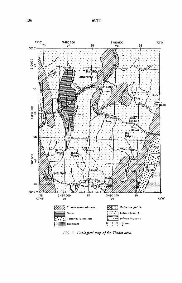
136 BUTT
72° 0 ' 3 4 8 0 0 0 0yd
73°0 '
'Aii 7 ‘- ‘*’*yjtera 7 * - • * ^ar Band
7572°45 ' 73°0 '
T hakot m etasedim ent
f ° Vq° ° 1 Tanawal form ation
Dolomite
Mansehra granite
[ . • • ] Lahore granite
Inferred con tact
0 1 2 3 km1 i i____ i
FIG. 3. Geological map o f the Thakot area.
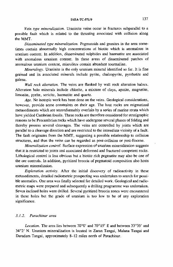
IAEA-TC-571/9 137
Vein type mineralization. Uraninite veins occur in fractures subparallel to a possible fault which is related to the thrusting associated with collision along the MMT.
Disseminated type mineralization. Pegmatoids and granites in the area sometimes contain abnormally high concentrations of biotite which is anomalous in uranium content. In addition, disseminated sulphides and haematite are associated with anomalous uranium content. In these areas of disseminated patches of anomalous uranium content, miarolites contain abundant tourmaline.
Mineralogy. Uraninite is the only uranium mineral identified so far. It is fine grained and its associated minerals include pyrite, chalcopyrite, pyrrhotite and galena.
Wall rock alteration. The veins are flanked by wall rock alteration haloes. Alteration halo minerals include chlorite, a mixture of clays, apatite, magnetite, limonite, pyrite, sericite, haematite and quartz.
Age. No isotopic work has been done on the veins. Geological considerations, however, provide some constraints on their age. The host rocks are migmatized metasediments which are unconformably overlain by a series of marine strata which have yielded Cambrian fossils. These rocks are therefore considered for stratigraphic reasons to be Precambrian rocks which have undergone several phases of folding and thereby possess several cleavages. The veins are controlled by joints which are parallel to a cleavage direction and are restricted to the immediate vicinity of a fault. The fault originates from the MMT, suggesting a possible relationship to collision structures, and thus the veins can be regarded as post-collision or post-Eocene.
Mineralization control. Surface expression of uranium mineralization suggests that it is restricted to joints and associated deformed and fractured competent rocks. Lithological control is less obvious but a biotite rich pegmatite may also be one of the ore controls. In addition, pyritized breccia of pegmatoid composition also hosts uranium mineralizaion.
Exploration activity. After the initial discovery of radioactivity in these metasediments, detailed radiometric prospecting was undertaken to search for possible anomalies. One area was finally selected for detailed work. Geological and radio- metric maps were prepared and subsequently a drilling programme was undertaken. Seven inclined holes were drilled. Several pyritized breccia zones were encountered in these holes but the grade of uranium is too low to be of any exploration significance.
3.1.2. Parachinar area
Location. The area lies between 70°0' and 70°15' E and between 33°35' and 34°2' N. Uranium mineralization is located in Zaran Tangai, Malana Tangai and Daradam Tangai, approximately 8-12 miles north of Parachinar.
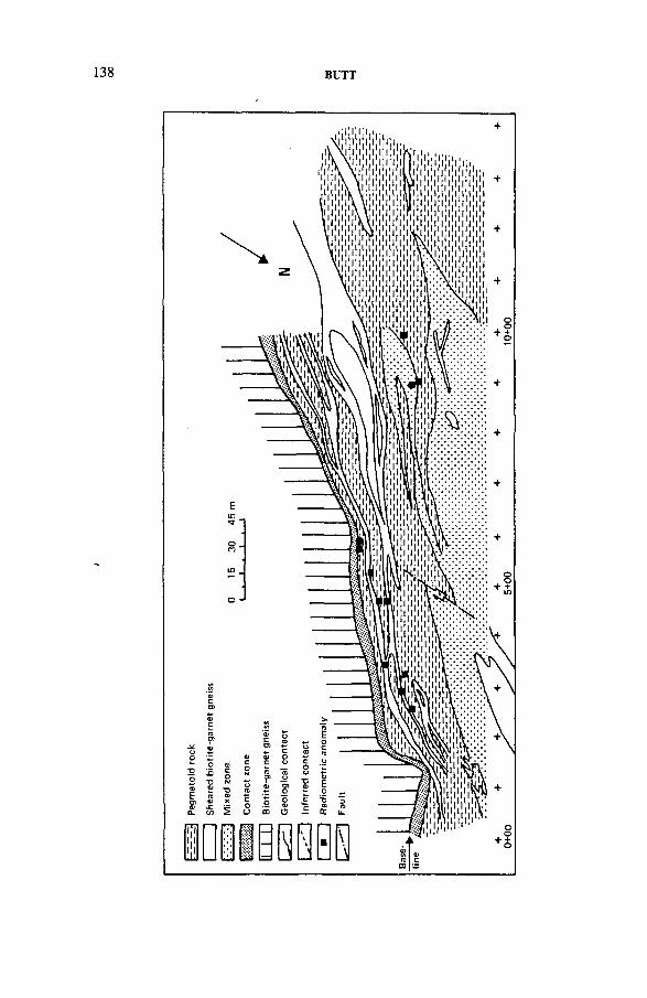
BUTT
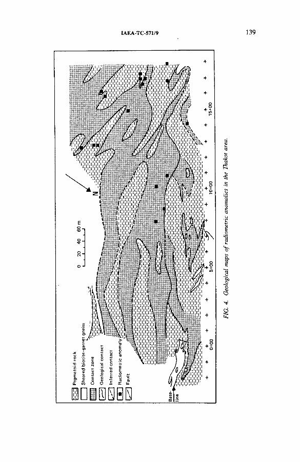
IAEA-TC-571/9 139
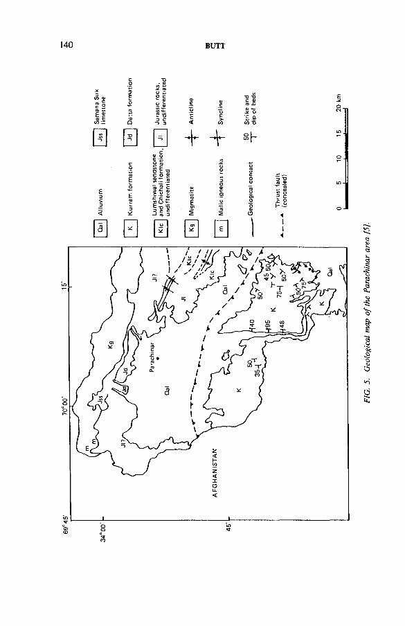
69°4
5'
70°
00'
140 BUTT
3i/i a>s i
cotoEo
•o > a> ̂COo ̂O c »- a>
.a®QJc O)c
T3 -Q c * (0 .u<0 S> E SCO t i/i —
njCDQ
s i3 C “> 3
"oc<
~uc>-CO
dJ »*-.* ot .e-(/) T3
0 0 □0) C
+ + s h
co 2c o »
J2oo o<0
£3‘>
EoE(0
S ~ .5 15 2 c SoJ £££
0)(0E
3O0)cO)o
ooTooo>o
3 *0 (0 ® "*■ <0 ♦- a) 2? o1 §3
< 3* I? ?-1 (0 3os CO5
o0)Oh- — 1
Qal
0 0 0 0 )II
Eo .
::1
FIG.
5.
Geo
logi
cal
map
of the
Pa
rach
inar
ar
ea
[5],
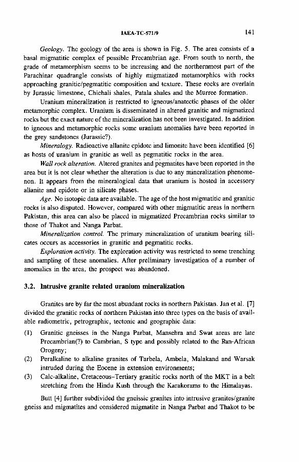
IAEA-TC-571/9 141
Geology. The geology of the area is shown in Fig. 5. The area consists of a basal migmatitic complex of possible Precambrian age. From south to north, the grade of metamorphism seems to be increasing and the northernmost part of the Parachinar quadrangle consists of highly migmatized metamorphics with rocks approaching granitic/pegmatitic composition and texture. These rocks are overlain by Jurassic limestone, Chichali shales, Patala shales and the Murree formation.
Uranium mineralization is restricted to igneous/anatectic phases of the older metamorphic complex. Uranium is disseminated in altered granitic and migmatized rocks but the exact nature of the mineralization has not been investigated. In addition to igneous and metamorphic rocks some uranium anomalies have been reported in the grey sandstones (Jurassic?).
Mineralogy. Radioactive allanite epidote and limonite have been identified [6 ] as hosts of uranium in granitic as well as pegmatitic rocks in the area.
Wall rock alteration. Altered granites and pegmatites have been reported in the area but it is not clear whether the alteration is due to any mineralization phenomenon. It appears from the mineralogical data that uranium is hosted in accessory allanite and epidote or in silicate phases.
Age. No isotopic data are available. The age of the host migmatitic and granitic rocks is also disputed. However, compared with other migmatitic areas in northern Pakistan, this area can also be placed in migmatized Precambrian rocks similar to those of Thakot and Nanga Parbat.
Mineralization control. The primary mineralization of uranium bearing silicates occurs as accessories in granitic and pegmatitic rocks.
Exploration activity. The exploration activity was restricted to some trenching and sampling of these anomalies. After preliminary investigation of a number of anomalies in the area, the prospect was abandoned.
3.2. Intrusive granite related uranium mineralization
Granites are by far the most abundant rocks in northern Pakistan. Jan et al. [7] divided the granitic rocks of northern Pakistan into three types on the basis of available radiometric, petrographic, tectonic and geographic data:
(1) Granitic gneisses in the Nanga Parbat, Mansehra and Swat areas are late Precambrian(?) to Cambrian, S type and possibly related to the Ran-African Orogeny;
(2) Peralkaline to alkaline granites of Tarbela, Ambela, Malakand and Warsak intruded during the Eocene in extension environments;
(3) Calc-alkaline, Cretaceous-Tertiary granitic rocks north of the MKT in a belt stretching from the Hindu Kush through the Karakorams to the Himalayas.
Butt [4] further subdivided the gneissic granites into intrusive granites/granite gneiss and migmatites and considered migmatite in Nanga Parbat and Thakot to be
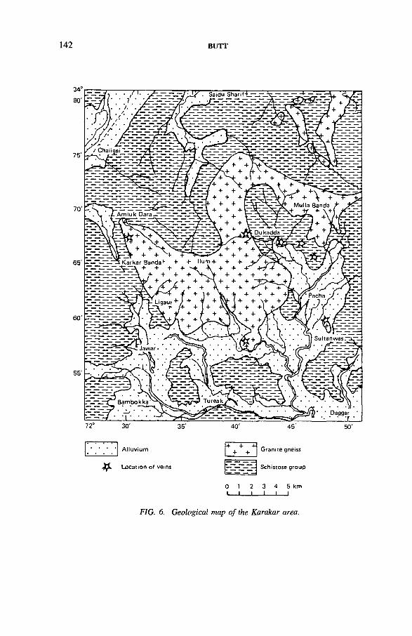
142 BUTT
Location of veir
0 1 2 3 4 5 kmI—L. I _J___I__I
FIG. 6. Geological map o f the Karakar area.
IAEA-TC-571/9 143
still older than the gneisses in Swat and Mansehra on the basis of apophyses of Mansehra granite in Lahore granite near Thakot.
Radiometric prospecting and sampling in northern Pakistan have revealed the existence of uranium in almost all types of granitic rock. A brief summary of the work done on intrusive granite and granite gneisses in two areas is presented below:(a) Karakar granite gneiss and (b) the Ahl area (Mansehra granite).
3.2.1. Karakar granite gneiss
Location. The Karakar granite gneiss is a small isolated pluton within the Indo- Pakistani plateau block bounded in the north by the MMT and in the south by the MBT. A geological map of the pluton is given in Fig. 6 .
The Karakar granite gneiss is an isolated sheet-like body exposed at the Ilum peak and surroundings. It is coarse grained and porphyritic, with an overall light grey colour. Gneissosity is well developed and feldspar and quartz augen are characteristic. Both these minerals exhibit extensive stretching parallel to the dominant foliation direction. Quartz and microcline make the bulk of the rock, with minor quantities of muscovite and biotite. Magnetite, limonite, garnet and tourmaline are the accessories. Xenoliths of the country rock are common. Modal estimates for granite suggest a potassic character dominated by microcline in the groundmass as well as phenocrysts.
In addition to gneissic granite which makes the bulk of the pluton, undeformed grey granite with a minor fracture cleavage was also encountered near Amluk Dara (Fig. 6 ). The granite is medium to coarse grained, hypidiomorphic and granular. It is a non-porphyritic phase but contains essentially the same constituents as described for the gneissic rocks. Field data were not sufficient to establish it as intrusive in the Ilum granite gneiss.
The granite is characterized by a distinct lack of pegmatitic facies, in contrast to its alleged counterparts across the Indus River, i.e. the Mansehra granite gneiss [8 ]. However, a variety of hydrothermal veins, filling the joint systems, have been found. The following types of vein have been encountered within the contact aureole of the Ilum granite:
— Pure quartz veins— Feldspar veins and irregular pods— Quartz-feldspar veins— Quartz-feldspar-epidote-muscovite veins— Quartz-feldspar-muscovite-beryl veins— Quartz-feldspar-monazite-zircon veins— Quartz (smoky) uranothorite veins— Base metal sulphide-monazite-uranothorite veins— Magnetite-uranothorite veins
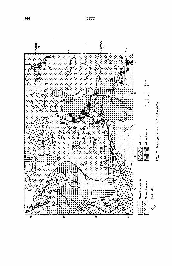
144 BUTT
CO5 0)5K +HK + H- + «(K + -K + -
*
FIG
. 7.
Geo
logi
cal
map
of the
Ah
l ar
ea.
IAEA-TC-571/9 145
— Q uartz-m uscovite-m icrocline-haem atite-b io tite-thorite-allan ite-m onazite-zircon veins (thorite, uranothorite, zircon, huttonite and monazite have beenidentified by an X-ray diffraction powder method).
Age relationships of these veins were not established owing to the unavailability of an area where all these veins are present. In the absence of cross-cutting relationships and because of the similarity of their modes of occurrence it is believed that they are synchronous. A variety of mineral parageneses may be related to changing pressure and temperature conditions of the hydrothermal systems formed by the intrusion of the granite pluton. Boudinage stretching of these veins is common and a changing paragenesis is sometimes encountered in detached parts of what was previously a single vein.
In addition, the contact of granite with the country rock contains abundant secondary uranium minerals but primary uranium was not reported.
Wall rock alteration. Wall rock alteration around the veins is minimal. However, minor chloritization, epidotization and haematization and the introduction of tourmaline are observed.
Age. The age of the gneiss has been variously interpreted to be Precambrian but no isotopic data are available. The age of mineralization has not been investigated.
Mineralization control. Joints, fractures and granite-country rock contact.Exploration activity. Preliminary exploration work was conducted on three
occurrences:
— Quartz-uranothorite vein type mineralization— Uranothorite-base metal sulphide-monazite type mineralization— Granite-country rock contact mineralization.
Adit mining and diamond core drilling have revealed that all these are minor veins of little exploration significance. The contact secondary uranium mineralization turned out to be a surface phenomenon related to present day groundwater seeping along the contacts. This occurrence has no subsurface continuity.
3.2.2. Ahl area (Mansehra district)
Location. Ahl is located 63 km north of Abbottabad on the Karakoram Highway.
Geology. The area is composed of metasediments of the Salkhala and Tanol formations, both of Precambrian age, intruded by Mansehra granite gneiss and pegmatite (Cambrian).
An extensive crushed zone within the granite at Ahl (Fig. 7) is the main area where secondary uranium mineralization is located. In addition, Pleistocene carbonaceous sands and clays deposited possibly in glacio-fluvial lakes also contain anomalous uranium.
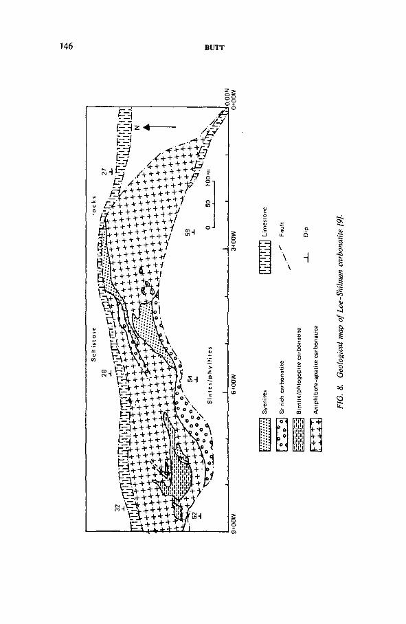
146 BUTT
FIG.
8.
Geo
logi
cal
map
of Lo
e-Sh
ilman
ca
rbon
atite
[9
].
IAEA-TC-571/9 147
Mineralogy. Uranophane and andersonite have been identified in certain zones within the altered granite. No primary mineral has been detected so far. Uranium minerals in sands and clays have not been identified so far.
Mineralization control. Secondary mineralization is controlled by shear zones and faults which allow the passage of groundwater, leaching of uranium and its subsequent precipitation at the surface through evaporation.
Sands and clays of possible Pleistocene age overlying this crushed granite have a U3 0 8 content of the order of 0.03%. This is controlled by highly carbonaceous sandstone and clays. Certain carbonaceous varved clays may contain up to 0.2%u3o8.
Classification. Orthomagmatic/allogenic class.
3.3. Carbonatite/alkaline rock related uranium mineralization
The distribution of alkaline rocks in northern Pakistan is shown in Fig. 2. They occur in the Mohmand Agency, the Khyber Agency, Warsak, Malakand, the Kog- Ambela Complex, Tarbela and possibly Mansehra. The rock types described in the literature include alkaline granites and microgranites, albitites, syenite and carbona- tites intruded generally along fault zones into Precambrian metasediments. They are thought to be associated with structures caused partly by relief tension or compression release, perhaps during the very late Cretaceous or early Tertiary following collision of the Indo-Pakistani and Eurasian plates, with intervening formation of island arcs and microcontinents.
Two carbonatite occurrences have been investigated for their uranium potential and the results to date are summarized below.
3.3.1. Loe-Shilman (Khyber Agency)
Location. Loe-Shilman is located at 34° 13' to 34°23' N and 70°09' to 70°26' E, about 40 miles northwest of Peshawar (Fig. 8 ).
Geology. The geology of the Shilman area comprises an east-west trending and northward dipping fault zone separating rocks in the north from the Precambrian slates in the south. The fault zone is occupied by a sill-like, complex alkaline intrusion consisting of carbonatites, syenitic intrusions, lamprophyric rock and hydrothermal veins rich in thorium.
Three types of carbonatite have been identified in the area and uranium is associated with amphibole bearing carbonatites. Other varieties include phlogopite carbonatite and strontianite carbonatite.
Mineralogy. Uranium is present in pyrochlore. Other minerals of carbonatite are calcite, dolomite, apatite, strontianite, magnesio-arfvedsonite, magnesio- riebeckite, biotite, phlogopite, sphene, aegirine-augite, alkali feldspar, monazite and zircon.
148 BUTT
Age. Not known.Mineralization control. No controls have been established except that
pyrochlore occurs solely in amphibole carbonatite. Pyrochlore distribution within the carbonatite follows no pattern. Uranium mineralization occurs in the form of isolated patches of different sizes and shapes.
Classification. Orthomagmatic.
3.3.2. Sillai Patti area (Malakand)
This occurrence is geologically identical to the one described earlier. The carbonatite, however, has several layers of pyrochlore enrichment. The grades are 0.1-0.2% U3 0 8 with rare earths and up to 7% phosphate. Further investigation of the area is in progress.
3.4. Graphitic metapelite related uranium mineralization
Uranium mineralization related to graphitic metapelites of possible Precambrian age has also been identified in northern Pakistan. Precambrian metasediments are exposed in the southern block of northern Pakistan. The distribution of these rocks is controlled by the MBT in the south and the MMT in the north.
Regional mapping in this metamorphic terrain has revealed a facies distribution dominated by pelagic pelites in the west, bank carbonates and reef complexes in the middle, and lagoonal graphitic metapelites and associated evaporite complexes now represented by bedded gypsum in the east. Graphitic metapelites in the eastern part of this basin are highly radioactive but the uranium content is generally very low. However, a number of explosion/collapse breccias have yielded ore grade material. A summary of a geological investigation of two localities is given below.
3.4.1. Reshian area
Location. Reshian-Mauji and adjoining areas are located in the Muzaffarabad Azad district, Kashmir, between 73°44' and 73°50' E and between 34°14' and 34°19' N.
Geology. The area consists of metamorphic rocks of the Salkhala formation with the following lithological variations:
(i) Pelitic schists: These rocks show a wide areal distribution. They are characterized by the presence of very fine micaceous minerals with well developed foliation and microscopic banding. The pelitic rocks display metamorphic grades ranging from chlorite to almandine.
(ii) Quartzitic schists: These are also fine grained with minor micaceous content. They are interbedded with pelitic schists.
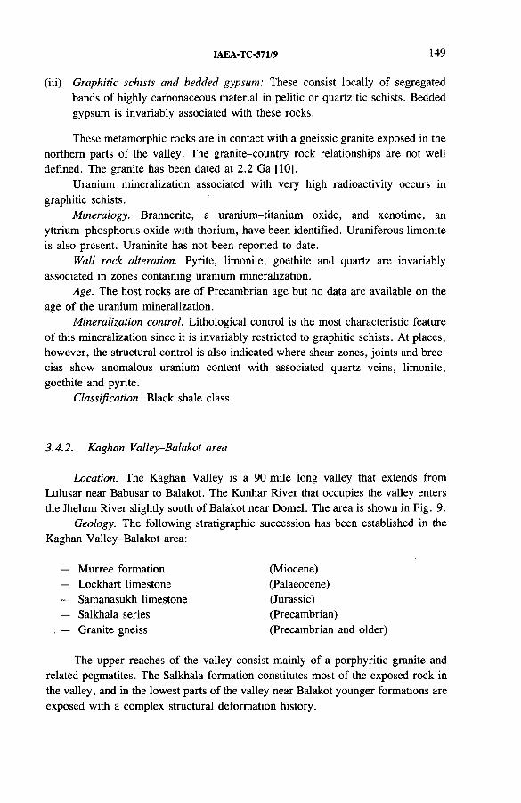
IAEA-TC-571/9 149
(iii) Graphitic schists and bedded gypsum: These consist locally of segregated bands of highly carbonaceous material in pelitic or quartzitic schists. Bedded gypsum is invariably associated with these rocks.
These metamorphic rocks are in contact with a gneissic granite exposed in the northern parts of the valley. The granite-country rock relationships are not well defined. The granite has been dated at 2.2 Ga [10].
Uranium mineralization associated with very high radioactivity occurs in graphitic schists.
Mineralogy. Brannerite, a uranium-titanium oxide, and xenotime, an yttrium-phosphorus oxide with thorium, have been identified. Uraniferous limonite is also present. Uraninite has not been reported to date.
Wall rock alteration. Pyrite, limonite, goethite and quartz are invariably associated in zones containing uranium mineralization.
Age. The host rocks are of Precambrian age but no data are available on the age of the uranium mineralization.
Mineralization control. Lithological control is the most characteristic feature of this mineralization since it is invariably restricted to graphitic schists. At places, however, the structural control is also indicated where shear zones, joints and breccias show anomalous uranium content with associated quartz veins, limonite, goethite and pyrite.
Classification. Black shale class.
3.4.2. Kaghan Valley-Balakot area
Location. The Kaghan Valley is a 90 mile long valley that extends from Lulusar near Babusar to Balakot. The Kunhar River that occupies the valley enters the Jhelum River slightly south of Balakot near Domel. The area is shown in Fig. 9.
Geology. The following stratigraphic succession has been established in the Kaghan Valley-Balakot area:
Murree formation Lockhart limestone Samanasukh limestone Salkhala series Granite gneiss
(Miocene)(Palaeocene)(Jurassic)(Precambrian) (Precambrian and older)
The upper reaches of the valley consist mainly of a porphyritic granite and related pegmatites. The Salkhala formation constitutes most of the exposed rock in the valley, and in the lowest parts of the valley near Balakot younger formations are exposed with a complex structural deformation history.
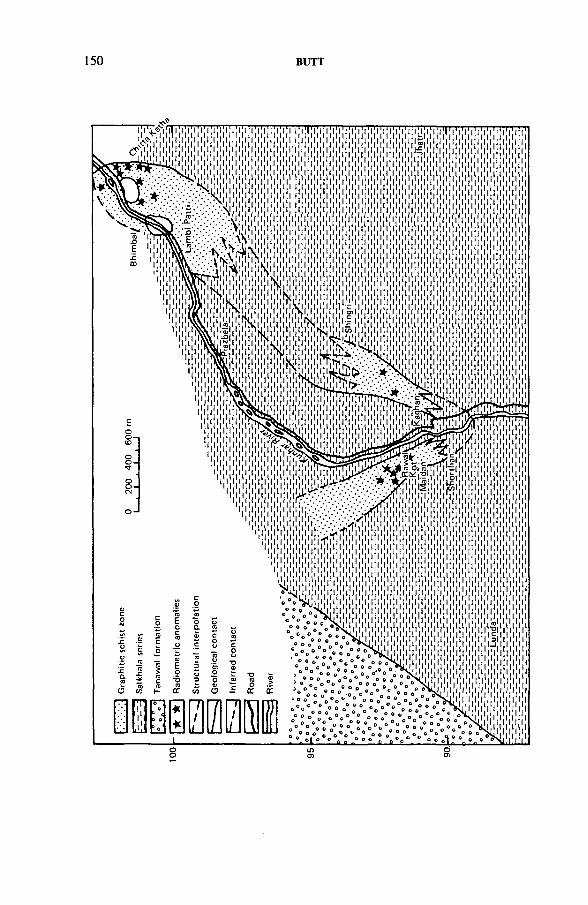
200
400
600
m
150 BUTT
IAEA-TC-571/9 151
FIG.
9.
Geo
logi
cal
maps
of
the
Kagh
an
Valle
y ar
ea.
152 BUTT
. Uranium mineralization is associated with graphitic schists of the Salkhala formation. The graphitic schists are interbedded with pyritiferous slates as well as marbles. Extensive leaching of uranium from the host rock is demonstrated by high radioactivity with a very low uranium content in the area.
Mineralogy. No mineralogical data on uranium mineralization are available from this area. However, considering the similarity to the mineralization at Reshian, it is assumed that it also contains brannerite and xenotime with uraniferous limonite.
Wall rock alteration. In the area where mineralization seems to be structurally controlled, quartz veins, haematite, limonite, pyrite and quartz are invariably associated and can be considered as an alteration assemblage. No detailed alteration studies have been conducted so far.
Age. The age of the host rock is Precambrian. No isotopic data on uraniummineralization are available. It has been suggested that brannerite and xenotime inthe graphitic schists are syngenetic and must therefore have the same age as the host rock. The age of the structurally controlled mineralization is difficult to ascertain.
Mineralization control. Lithological control is the most characteristic feature of uranium mineralization in this area. However, at places iron stained shear zones, joints and breccia zones have also been recorded as containing mineralization. These suggest structurally controlled mineralization as well.
Classification. Black shale class.
4. CONCLUSIONS
(a) Anatectic pegmatoid and granite related occurrences are generally minor, with little exploration potential.
(b) Alkaline rock and carbonatite type uranium mineralization may yield smalldeposits of uranium with valuable by-products such as rare earths andphosphates.
(c) Graphitic metapelites have not yielded any significant anomalies but their geological similarity to graphitic metapelite related occurrences in Canada and Africa makes them the areas of greatest potential in Pakistan.
REFERENCES
[1] KEMPE, D.R.C., “ Alkaline granites, syenites and associated rocks of Peshawar Plain alkaline igneous province, NW Pakistan” , Granites of Himalayas, Karakoram and Hindu Kush (SHAMS, F.A., Ed.), Punjab Univ., Lahore (1983).
[2] MISCH, P., Metasomatic granitization of batholithic dimension, Am. J. Sci. 247 (1949) 209-245.
[3] GANSSER, A., Geology of Himalayas, Interscience, London (1964).
IAEA-TC-571/9 153
[4] BUTT, K.A., “ Petrology and geochemical evolution of Lahore pegmatoid/granite complex, north Pakistan, and genesis of associated Pb-Zr-M o and uranium mineralization” , Granites of Himalayas, Karakoram and Hindu Kush (SHAMS, F.A., Ed.), Punjab Univ., Lahore (1983).
[5] MEISSNER, C.R., HUSSAIN, M „ RASHID, M.A., SETHI, U.B., Geology of Parachinar Quadrangle, Pakistan, US Geol. Surv., Prof. Pap. 716-6 (1975) P-20.
[6] RAHMAN, M.A., JASIMUDDIN, M., Uranium Minerals in Parachinar, unpublished report, Atomic Energy Minerals Centre, Lahore, 1978.
[7] JAN, Q.M., ASIF, M., TAHIRKHELI, T ., KAMAL, M., Tectonic subdivision ofgranite rocks of northern Pakistan, Geol. Bull. Univ. Peshawar 14 (1981) 159-182.
[8] SHAMS, F.A ., A preliminary account of geology of Mansehra area, District Hazara,Geol. Bull. Punjab Univ., Lahore 1 (1961) 57-67.
[9] QURESHI, A.A., BAIG, M .I., BABAR, A.N., “ The radioactive carbonatite of Loe-Shilman” , paper presented at seminar jointly organized by Pakistan Atomic Energy Commission and Kernforschungszentrum Karlsruhe, Oct. 1980.
[10] JAN, Q.M., personal communication.
DISCUSSION
R.K. BALLHORN: This seems to be a quite recent process. Is the uranium in disequilibrium?
K.A. BUTT: Yes, there is disequilibrium with high uranium. The processes are still going on.
M.H. FRIEDRICH: Do you have metal occurrences other than uranium? Do you have tin?
K.A. BUTT: Tin has not been reported and I must mention that we have really looked for it but we have not been able to find tin in any of the granites in Pakistan.
P.R. SIMPSON: Regarding the Karakoram granodiorite: what is the approximate extent of it? It looks like a very long but very narrow batholith.
K.A. BUTT: This batholith, along the strike, goes for about 400 to 500 km and it is very narrow and straight. There is mostly glacial cover in this area. It is a very high mountain area and all the streams cutting the granodiorite have concentrations of detrital uraninite; that is a possible contribution of uraninite to the uraninite going to the Indus River in the Hunza Valley. Our efforts to locate a source have been unsuccessful.
P.R. SIMPSON: Is that the only source of detrital uraninite in the area? Are there other possible sources contributing to the uraninite in the Indus?
K.A. BUTT: I think there may be several sources contributing because pegmatite dykes with uraninite are also present in this area.
P.R. SIMPSON: Regarding the graphitic metapelites, in your opinion has the uranium been introduced into the graphitic metapelites, or is it syngenetic with them and possibly remobilized locally?
154 BUTT
K.A. BUTT: We have been able to find a lot of radiometric anomalies but very little chemical uranium in these areas. From microprobe analysis we can conclude that the uranium now in graphitic metapelite is in brannerite and other titanium minerals. But the question remains. There is an abundance of uranium daughters present in certain areas of these graphitic metapelites, so much that the ordinary scintillation counters are unable to read the high levels of radioactivity. But this much leaching of uranium could not have happened if all the uranium was locked in brannerite and other resistant minerals. So I suspect that in this area that has been uplifted at a tremendous rate — some studies have shown a rate of 2 cm per year — an enormous amount of leaching has been going on. The surface expression is not really a representation of what actually was or what is at depth. We have never found any associated uraninite.
IAEA-TC-571/10
RELEASE OF URANIUM THROUGH CATACLASTIC DEFORMATION OF MANSEHRA GRANITE GNEISS AND ITS PRECIPITATION IN THE OVERLYING INTRAMONTANE BASIN IN NORTHERN PAKISTAN
K.A. BUTTAtomic Energy Minerals Centre,Pakistan Atomic Energy Commission,Peshawar, Pakistan
Abstract
RELEASE OF URANIUM THROUGH CATACLASTIC DEFORMATION OF MANSEHRA GRANITE GNEISS AND ITS PRECIPITATION IN THE OVERLYING INTRAMONTANE BASIN IN NORTHERN PAKISTAN.
The Mansehra pluton belongs to a discontinuous belt of two mica granites of the Lesser Himalayas. The Mansehra granite is generally foliated except in the area around Mansehra. Several phases of granitic activity have been reported from the Mansehra Complex. Shams and Rahman have demonstrated that the younger phases tend to be enriched in Na20 . Ashraf extensively studied minor bodies ranging from albitites through aplites to pegmatites and suggested a late stage albitization event. The northern edge of this sheet-like granitic mass has undergone extensive cataclastic deformation, resulting in the formation of shear zones, mylonites and cataclasites. A chemical comparison of crushed granite with granite outside the shear zone suggests little chemical reconstitution in terms of major elements during cataclastic deformation. A huge shear zone in albitized granite gneiss has yielded secondary uranium minerals at water seepages, suggesting a liberation of uranium. Hydrogeochemical surveys of the crushed granite and adjoining areas suggest that uranium from crushed granite was easily leachable in comparison with rocks outside the shear zone. The uranium thus liberated was trapped in a Pleistocene sequence of clays and unsorted fluviatile sand overlying the granite and country rock metamorphics.
1. INTRODUCTION
Uranium mineralization was discovered as greenish-yellow uranophane and yellowish-green andersonite on the Karakoram Highway at Ahl, Mansehra district. The mineralization is in the form of encrustation over the exposed surface of altered granite along the roadside and at a few other places. Crushed granite forms a 4.5 km long lenticular body and is a part of the Mansehra pluton (see Fig. 7 of Ref. [1]), of Cambrian age, which covers an area about 1800 km long between the Kunhar and Indus rivers.
155
156 BUTT
This paper presents details of geological work carried out in the mineralized zone at Ahl and in the surrounding area. The work done in the Ahl area involved detailed mapping, sampling, drilling, etc., in order to understand the behaviour of mineralization for preliminary evaluation of uranium potential. The surrounding area has been geologically mapped and studied in order to locate other similar radioactive zones.
2. GENERAL GEOLOGY
In northern Pakistan, between the Main Boundary Thrust and the Main Mantle Thrust, there exists a belt of metasediments intruded by a series of granitic rocks. This belt, roughly trending in an east-west direction, covers an area about 1800 km long from Nepal to Jalalabad in Afghanistan. The belt consists of slates, phyllites, schists, quartzites, crystalline limestones and dolomites. The main mass of the metasediments is composed of the Salkhala, Hazara, Tanawal and Abbottabad formations, all representing various levels of the Precambrian stratigraphy of Pakistan [2, 3].
The Salkhala formation consists of quartz-feldspar gneisses, calcareous and graphitic schists and marbles. The Hazara formation includes slates and phyllites with minor layers of limestone and graphitic schists. The Tanawal formation mainly consists of extensive quartzite beds but quartz schists and conglomeritic beds are also present locally. The Abbottabad formation is heterogeneous and consists of conglomeritic beds, sandstones/quartzites and dolomites, etc.
The granitic rocks in this belt consist of more than 15 bodies of different sizes, ranging from numerous smaller intrusions to plutons of batholithic dimensions with typical and similar characteristics, and are exposed in the Nanga Parbat, Neelum Valley, Kaghan Valley, Mansehra, Swat, Ambela, Shewa-Shahbaz Garhi, Malakand and Warsak areas. These have been divided by Jan et al. [4] into two groups on the basis of available radiometric, petrographic, geochemical, geotectonic and geophysical data. Granites date from Late Cambrian to Cambrian in age. The rocks range in composition from quartz diorites to granites. In addition to the normal mineralogical suite, cordierite has been recognized in almost all the granites of the belt.
The Mansehra granite is one of the largest granite plutons in the belt. This intrudes mainly into the Tanawal formation and covers an area of about 2000 km2. It extends from Mansehra to north of Batagram and is bounded by the Kunhar River to the east and the Indus River to the west. The main mass of the Mansehra pluton is porphyritic with euhedral crystals of K-feldspar and a medium sized matrix. The K-feldspar crystals are up to 15 cm whereas rectangular cordierite crystals are up to 3 cm in size. The granite is aluminous, quartz rich and deficient in feldspar and sodium [5]. Towards the north the pluton has developed a gneissic texture and is
IAEA-TC-571/10 157
characterized by porphyroblasts of K-feldspar and flow structure. Some workers have suggested that the granite was emplaced as a sheet which was deformed during the Himalayan Orogeny, resulting in intense gneissification in the northern portion. Mineralogically it is typical granite consisting of quartz, K-feldspar, plagioclase, biotite, muscovite, cordierite, tourmaline, apatite, kyanite and sillimanite. Aplites, minor bodies of pegmatites, albitites and granite porphyries are commonly seen within the granitic mass. The grade of metamorphism increases towards the north from chlorite to sillimanite.
Several phases of granitic intrusion in the Mansehra Complex have been reported [6 - 8 ]. Shams and Rahman [9] demonstrated that the younger phases tend to be enriched in Na2 0 . Ashraf [10-17] extensively studied small bodies ranging in composition from albitites through aplites to pegmatites and postulated a late stage albitization event.
3. GEOLOGY OF AHL AND SURROUNDING AREA
3.1. Geological mapping
The area under study is composed of metasediments and igneous rocks (see Fig. 7 of Ref. [1]). The metasediments mainly consist of the Tanawal and Salkhala formations intruded by Cambrian granites and pegmatites [5],
3.1.1. Metasediments
The thick series of metasediments of the Tanawal formation is dominantly psammitic. The series consists of phyllites, grits, quartzites and schists, extending from Kashmir to Kaghan and continuing further to the west through the area of the present study. The Tanawal formation here comprises the majority of the metasediments and is mainly composed of quartz-mica schist. The main minerals of the rocks of the formation are feldspar, quartz and mica while chlorite, garnet, andalusite and epidote are seen in places. The formation also includes well banded, light grey quartzite beds having thicknesses up to 50 m. The quartzite bands consist of well rounded quartz grains, mica flakes and chlorite.
Quartz veins of different dimensions, mostly filling fractures, have been seen in many places. As a result of five episodes of igneous activity in the Tanawal formation a wide variety of basic to intermediate rocks have been established.
A part of the area in the east consists of rocks of the Salkhala series. They consist of low grade schists of pelitic nature with local bands of marble. The Salkhala schists consist of feldspar, mica, chlorite and graphite. In places rocks of phyllitic nature and quartzite bands are found within the rock of this series.
158 BUTT
3.1.2. Igneous rocks
The two rock units of igneous origin are granite of light grey colour and medium to coarse grained, characterized by the presence of twinned microcline phenocrysts, and pegmatite. The granite is part of the Mansehra pluton and as usual has a varied composition resulting in many varieties. The varieties are so mixed that they cannot be mapped separately. Mylonitic granite forms the major mass and is exposed widely on the Nilli Shang-Battagram road in the Hor-Nakka and Malkan area. Porphyritic granite, sometimes gneissic in texture, is found in the southern part of the area. The phenocrysts of quartz and feldspar can be recognized with the naked eye. The other minerals include mica, tourmaline, hornblende and opaques. Contact aureoles and alteration in the country rocks have not been noted anywhere in the area.
Pegmatites are abundant in the metasedimentary rocks, especially close to the granite contact. They are usually bimineralic but complex varieties consisting of quartz, feldspar, mica and tourmaline are also found. Some of these pegmatitic bodies are sufficiently big that they have been exploited for mica and feldspar. At present two such pegmatites located at Bagrian on the Oghi-Battagram road and at Karmang are being worked for feldspar. At certain other places thin quartz veins and minor pegmatites show lead and copper(?) mineralization.
3.2. Structure
The Mansehra granite emplaced during the Cambrian has undergone a number of orogenic episodes, resulting in very strong deformation. It is believed that during the Himalayan Orogeny the whole mass was underthrusted along the Main Mantle Thrust. The tight isoclinal folding and subduction of the granite body under the metasediments (south of Ahl) imply that the Mansehra pluton was emplaced as a sheet-like body. Flow structures and concordant to subconcordant contact with the country rocks in the northern portion of the Mansehra granite indicate an intense gneissification. Some later movement between the granite and country rocks which has resulted in stretching of minerals and deformation of granite and metasediments has also been noted.
3.3. Uranium mineralization
Two types of mineralization were encountered in the area during radiometric prospecting:
(a) Secondary mineralization in crushed granite(b) Carbonaceous black clays (Pleistocene).
IAEA-TC-571/10 159
Pleistocene fluviatile sands are also interbedded with black to grey, in places varved, clays. These sands are cross-bedded and arkosic in composition and contain abundant organic material. Surface radiometric checking did not reveal any anomalous radioactivity in these sands. One bed of black clays, however, gave highly anomalous radioactivity readings, i.e. 400 times the background level. Chemical analyses showed a 0.28% U3 Og content in these clays.
3.4. Zone of crushed granite at Ahl
The crushed zone which contains the main uranium occurrence in the Ahl area occurs at the contact of the granite and Tanawal formation as a SE-NW trending lenticular body 4.5 km long and 1.75 km wide. The altered mass consists of a huge deposit of soft, friable, whitish looking material. This has repeatedly been investigated for kaolin but detailed chemical, microscopic and spectrophotometric analyses proved that the crushed material is chemically similar to the associated granite/gneiss and contains little kaolinization. A chemical comparison is given in Tables I and II. Data for the crushed granites are devoid of any endothermic peaks, suggesting the absence of clay minerals in these zones. The chemical composition and absence of clay minerals from these rocks contradict a previously held idea that the whitish looking friable rocks at Ahl are kaolinized granites. Instead, it is suggested that they merely result from tectonic/cataclastic crushing of granite.
Uranium mineralization was identified in the form of greenish-yellow uranophane, Ca(U0 2 )2 (Si0 3 )2 (0 H)2 -5 H2 0 , and yellowish-green andersonite, Na2 Ca(U0 2 )(C0 3 ) 3 • 6H2 0 . The minerals occur as encrustations on exposed surfaces along the roadside at Ahl over an area about 100 m long and as small stringers near Kurmang Utla.
3.5. Hydrogeochemistry
Spring water was collected from areas underlain by crushed granite and by unaltered granite. The data are plotted in Fig. 1. It is evident that groundwater in the crushed granite area is anomalous in uranium content whereas the unaltered granite has not been subjected to removal of uranium by groundwater. A similar, adjoining basin containing Pleistocene sands and clays resting largely on country rock metasediments of Precambrian age was also sampled for hydrogeochemical analysis and yielded no anomalies, thus ruling out the possibility of uranium being contributed to groundwater from a metasedimentary source. It therefore appears that uranium contained in the granite was made available by crushing.
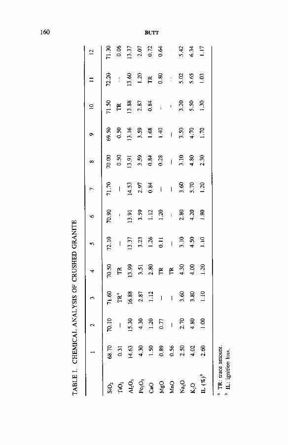
160 BUTT
WH2
2oQMX
a: ua.ooo >- i— I < £ < J < uHH2wKU
w►403<H
CM O cn so© r-*cn r-© CMr-» s |<N•Tf cn
r- © cn <N © o 1 in so
o(N ©VO ©<N CC©00 |
CM© mSO cn©rir- cn H d 1 in iri
ooin 04
0000 r-00 00 i 1©<N ©in ©cn
r-* H cn CM d 1 1 cn in
Os©in ©m so osin 00so © 1 ©in ©r- ©r--OSso d cn cn 1 cn
OO
©© ©m O)osin 00 00CM © ©00 ©cn
©r- d cn cn d d cn tj* CM
© cnin Os ■"fr00 ©so ©r- ©<Nr- ri- (N d cn in
so©Os On Osin CM ©CM ©00 ©CN ©00©r- cn cn CM Tt-
in©
1r-cn cncs SOCM - © ©in ©
csr-1 cn cn © cn
©m CCOsOs m ©00 &
©cn ©© ©CMN ©r- H cn cn <N H H
cn©SO to
a tH
oo00 r-~00 CMi
©sq ©oo ©
r-* sd CM 1 cn cn
<N©
1 ©cn ©cn ©<N r-r- 1© ©00 ©©
©r-*1 <n d 1 CM
-
68.7
0
0.31
14.6
3
4.30
1.50
680 0.56
2.50
4.02
09
Z
o£5
C-loH
<*■>OfN<
O(NOUn CaO
MgO
MnO
OC-l03z
O
.c
sJHH TR
: tra
ce
amou
nt.
IL:
igni
tion
loss
.
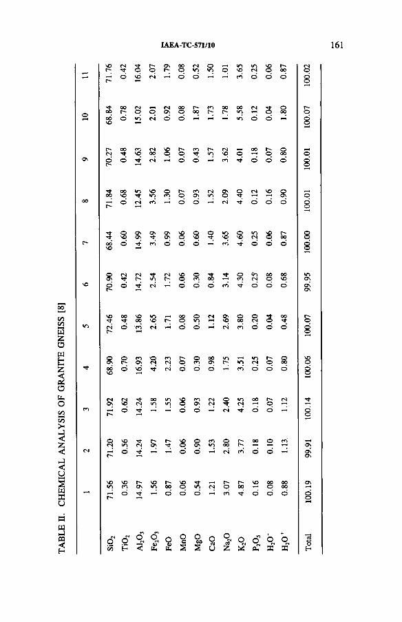
TABL
E II.
CH
EMIC
AL
ANAL
YSIS
OF
GR
ANIT
E GN
EISS
[8
]
IAEA-TC-571/10 161
VO <N 3 © O nr- 00O fNjin oin o mvq in<N vOo r-00
=r-* o VO <s O o co o d o
oo 00r— <N© q <NOn 00o r*-00 co 00r- 00in <N s o0000VO o in fS O o in d o
r-cs 00 mVO CN00 vOo r-o coTt r-in <NvO o 00 r-o O00On ©r** d2
csi o o co t}- o o o
00 00VO in VOIT) oCO r-*o coON csin Ono oTfr rM vo oON00 r- o (N rS d o (N Tfr d o o
s oVO On Os OnOn vOo so mvO oVO mCN VOo r->00c-» 00VO o CO O d d co o o o
oOn n r-̂ Tj- es VOo oco 00 H oco Go<N OOo 00voVO ©r- o ri o o o co Tf o d o
VO 00Tj- VO00 invO 00o om (N OnvO o00 o<N s00
m csr-» o cn <N d o ri CO o d o
o°) or- <<•>On © cn(S r-*o oco 00On mr*'' in incs r-o o0000VO o vb Tj- <N o o O co o o o
(NO n
csVO (S 00in •nin VOo coOv <s(N oTf in 00 r-*o fS
r- o Tf o O cs o o
oCS VOm rj-(N r*- r- vOq OO n
coin ooo r--r- 0 0 o co
t- d d O (N co d o
VOin socn r-*O n
VOin r-oo VOo Tf<n cs r-o r -00 vo 00o
00oor -
d d d o co d d O
oCO
fSOH
o<N
<
fOO6*tu
O
Urn MnO
MgO
CaO O
(S' O
£
morsCU
O<Ne
+O<NX
100.1
9 99
.91
100.1
4 10
0.06
100.0
7 99
.95
100.0
0 10
0.01
10
0.01
10
0.07
100.
02
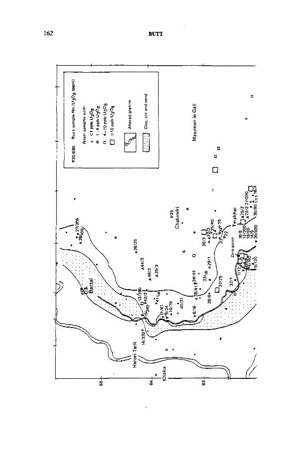
162 BUTT
+
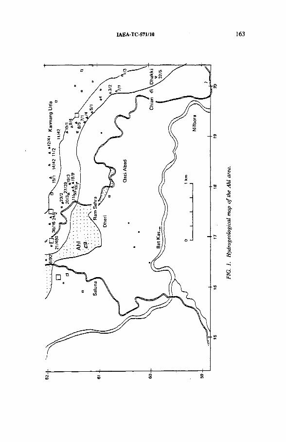
IAEA-TC-571/10 163
FIG.
1.
Hyd
roge
olog
ical
ma
p of
the
Ahl
area
.
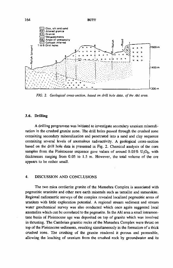
164 BUTT
LL-^J C ta y , s ilt a n d sa n d A lte re d g ra n ite
!•» + 1 G ra n ite
i v * M e ta se d im e n ts
3.6. Drilling
A drilling programme was initiated to investigate secondary uranium mineralization in the crushed granite zone. The drill holes passed through the crushed zone containing secondary mineralization and penetrated into a sand and clay sequence containing several levels of anomalous radioactivity. A geological cross-section based on the drill hole data is presented in Fig. 2. Chemical analysis of the core samples from the Pleistocene sequence gave values of around 0.03% U3 0 8, with thicknesses ranging from 0.05 to 1.5 m. However, the total volume of the ore appears to be rather small.
4. DISCUSSION AND CONCLUSIONS
The two mica cordierite granite of the Mansehra Complex is associated with pegmatitic uraninite and other rare earth minerals such as tantalite and samarskite. Regional radiometric surveys of the complex revealed localized pegmatitic areas of uranium with little exploration potential. A regional stream sediment and stream water geochemical survey was also conducted which once again suggested local anomalies which can be correlated to the pegmatite. In the Ahl area a small intramontane basin of Pleistocene age was deposited on top of granite which was involved in thrusting. The Cambrian granitic rocks of the Mansehra Complex were thrust on top of the Pleistocene sediments, resulting simultaneously in the formation of a thick crushed zone. The crushing of the granite rendered it porous and permeable, allowing the leaching of uranium from the crushed rock by groundwater and its
IAEA-TC-571/10 165
subsequent deposition in the organic rich clays and sands of the basin. Chemical data on the crushed rocks as well as on rocks outside the crushed zone attest to the fact that the only difference between the two is the induced porosity and permeability due to crushing. Hydrogeochemical properties of the area also support this view as the groundwater is only anomalous in the crushed zone, there being no groundwater anomalies in the uncrushed granite.
The following sequence of events is therefore suggested for uranium mineralization in the area:
(1) Uplift of the Cambrian granite of the Mansehra Complex,(2) Deposition of sands and clays by glacio-fluvial waters in a small intramontane
basin at Ahl,(3) Pleistocene thrusting of granite onto the sediment,(4) Leaching of uranium from granite by groundwater and its precipitation in
organic rich Pleistocene clays and sands,(5) Precipitation of secondary uranium minerals encountered in the crushed
granite through evaporation of groundwater.
REFERENCES
[1] BUTT, K.A., IAEA-TC-571/9, these Proceedings.[2] LATIF, M.A., A Cambrian age for Abbottabad group of Hazara, Pakistan, Geol. Bull.
Punjab Univ., Lahore 10 (1974) 1-20.[3] CALKINS, J.A., OFFIELDS, T.W ., ABDULLAH, S.K.M., ALI, S.T.A., Geology
of the Southern Himalayas in Hazara, Pakistan, and Adjacent Area, US Geol. Surv., Prof. Pap. 716-c (1975).
[4] JAN, Q.M ., ASIF, M., TAHIRKHELI, T., KAMAL, M., Tectonic subdivision of granitic rocks of northern Pakistan, Geol. Bull. Univ. Peshawar 14 (1981) 159-182.
[5] LE FORT, P., DEBON, F., SONET, J., The ‘Lesser Himalayan’ cordierite granite belt. Typology and age of the pluton of main Mansehra (Pakistan), Geol. Bull. Univ. Peshawar 13 (1980) 51-61.
[6] SHAMS, F.A ., A preliminary account of geology of Mansehra area, district Hazara, Geol. Bull. Punjab Univ., Lahore 1 (1961) 57-67.
[7] SHAMS, F.A., Granites of the Mansehra-Amb State Area and the Associated Metamorphic Rock, PhD Thesis, Punjab Univ., Lahore (1967).
[8] SHAMS, F.A ., “ Granites of NW Himalayas in Pakistan” , Granites of Himalayas, Karakoram and Hindu Kush (SHAMS, F.A., Ed.), Punjab Univ., Lahore (1983).
[9] SHAMS, F.A., RAHMAN, F.U ., The petrochemistry of the granitic complex of the Mansehra-Amb State area, northwest Pakistan, J. Sci. Res. Punjab Univ., Lahore 2(1966) 47-55.
[10] ASHRAF, M., Geochemistry and Petrogenesis of Acid Minor Bodies of Mansehra andBatagram Area, Hazara District, PhD Thesis, Punjab Univ., Lahore (1974).
166 BUTT
[11] ASHRAF, M ., Geochemistry and petrology of acid minor bodies from Mansehra and Batagram area, Hazara district, Pakistan, Geol. Bull. Punjab Univ., Lahore 11 (1974)81-88.
[12] ASHRAF, M., The geochemistry and petrogenesis of albitite from Mansehra and Batagram area, Hazara district, Pakistan, Geol. Bull. Punjab Univ., Lahore 11 (1974) 97.
[13] ASHRAF, M., CHAUDHRY, M.N., Geology of Dadar pegmatites, Mansehra area, Hazara district, Geol. Bull. Punjab Univ., Lahore 10 (1974) 59-66.
[14] ASHRAF, M., Composite albitite-aplite and pegmatite from Mansehra and Batagram area, Hazara district, Pakistan, Fortschr. Mineral. 52 (1975) 329-344.
[15] ASHRAF, M., CHAUDHRY, M.N., Geology and classification of acid minor bodies of Mansehra and Batagram area, Hazara division, Pakistan, Geol. Bull. Punjab Univ., Lahore 12 (1976) 1-16.
[16] ASHRAF, M., CHAUDHRY, M.N., Origin of chess-board albite present in the acid minor bodies of Mansehra and Batagram area, Hazara division, Pakistan, Geol. Bull. Punjab Univ., Lahore 13 (1976) 93-98.
[17] ASHRAF, M., “ Geochemistry of acid minor bodies associated with Hazara granitic complex, Hazara Himalayas, N. Pakistan” , Granites of Himalayas, Karakoram and Hindu Kush (SHAMS, F.A., Ed.), Punjab Univ., Lahore (1983).
IAEA-TC-571/11
GENETIC SIGNIFICANCE OF INCLUSIONS AND FRACTURE FILLINGS IN MAGMATIC AND METAMORPHIC ROCKS FROM SELECTED CANADIAN URANIUM OCCURRENCES
J. RIMSAITEGeological Survey of Canada,Ottawa, Ontario,Canada
Abstract
GENETIC SIGNIFICANCE OF INCLUSIONS AND FRACTURE FILLINGS IN MAGMATIC AND METAMORPHIC ROCKS FROM SELECTED CANADIAN URANIUM OCCURRENCES.
The common source of radioactivity in magmatic and metamorphic rocks is radioactive inclusions in their accessory and rock forming minerals and/or in their crusts and fracture fillings. Radioactive mineral inclusions constitute deposits with disseminated uranium mineralization, whereas radioactive crusts and fracture fillings form autochthonous or allochthonous vein type deposits. In selected radioactive occurrences, notably at the contact between metamorphic and pegmatitic rocks, disseminated and vein type mineralizations may occur together. A study of paragenesis, mode of occurrence and sequence of crystallization of radioactive inclusions, crusts and fracture fillings in relation to their host minerals indicates the following relationships between U mineralization and evolution of their host rocks, (a) Under conditions of high grade metamorphism thorium rich uraninite crystallizes at early stages in mafic minerals, such as pyroxene and amphibole. (b) Uraninite and uranothorite grains crystallize during the main pegmatitic phase in xenotime, cyrtolite and other accessory minerals, and during the late pegmatitic stage in interstitial feldspar, tourmaline and REE mineral aggregates, (c) Thorium poor, Y bearing uraninite, associated with pyrochlore and partly replaced by uranothorite, enclosed in rims of calcite, fluorite, REE mineral aggregates and/or diverse layer silicates and sulphides, crystallizes in allanite, in titanite and in interstices, notably between biotite and muscovite during the late pegmatitic hydrothermal and deuteric phases, (d) Alteration of early crystallized radioactive minerals, associated with mobilization of U and other ions, takes place during the deuteric stage and continues after fracturing and subsequent hydration and weathering of host rocks. At these stages of alteration, disseminated U mineralization can coexist with autochthonous vein type mineralization. During advanced alteration, elements liberated from altered minerals migrate along fractures and precipitate as secondary U minerals and as chemically complex U -Pb-Th-REE-Zr-Ti-Fe bearing crusts. During the ultimate stages of alteration and replacement by phyllosilicates and oxides, radioactive elements removed from their host can become a potential source for allochthonous vein type deposits. Isotopic ages of minerals range from 230 to 1090 Ma.
167
168 RIMSAITE
1. INTRODUCTION
The purpose of this paper is to discuss the environment of crystallization and properties of radioactive minerals in relation to the sequence of crystallization of their host minerals and evolution of their host rocks. The study is based on microscope and microbeam studies of polished thin sections of radioactive rocks collected by the author from three radioactive areas in the Grenville Structural Province(Fig- 1)-
Studies of the geology and mineral deposits of the Canadian Shield began in the nineteenth century and have continued up to the present time [1-3]. Petro- graphic, petrochemical and mineralogical studies of the three selected areas have been carried out at the Geological Survey of Canada (Research Project 770061) [4-11].
FIG. 1. Geological map showing subdivision o f the Canadian Shield and sampling locations in the Grenville Structural Province: B, Bancroft area, Ontario; ML, Mont Laurier area, and BJB, Baie Johan Beetz area, Quebec (geology after Stockwell et al. [1] and Lang et al. [2]).
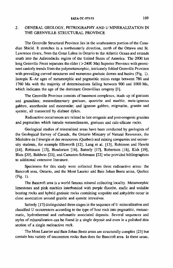
IAEA-TC-571/11 169
2. GENERAL GEOLOGY, PETROGRAPHY AND U MINERALIZATION INTHE GRENVILLE STRUCTURAL PROVINCE
The Grenville Structural Province lies in the southeastern portion of the Canadian Shield. It stretches in a northeasterly direction, north of the Ottawa and St. Lawrence rivers, from the Great Lakes in Ontario to the Atlantic Ocean and extends south into the Adirondacks region of the United States of America. The 2000 km long Grenville Front separates the older (> 2400 Ma) Superior Province with prominent easterly trends from the poly metamorphic, intricately folded Grenville Province with prevailing curved structures and numerous gneissic domes and basins (Fig. 1). Isotopic K-Ar ages of metamorphic and pegmatitic micas range between 780 and 1760 Ma with the majority of determinations falling between 900 and 1000 Ma, which indicates the age of the dominant Grenvillian orogeny [1].
The Grenville Province consists of basement complexes, made up of gneisses and granulites; metasedimentary gneisses, quartzite and marble; meta-igneous gabbro, anorthosite and monzonite; and igneous gabbro, migmatite, granite and syenite, all transected by diabase dykes.
Radioactive occurrences are related to late orogenic and post-orogenic granites and pegmatites which intrude metasediments, gneisses and calc-silicate rocks.
Geological studies of mineralized areas have been conducted by geologists of the Geological Survey of Canada, the Ontario Ministry of Natural Resources, the Ministere de l’energie et des ressources (Quebec) and mining companies and university students, for example Ellsworth [12], Lang et al. [13], Robinson and Hewitt[14], Robinson [15], Henderson [16], Satterly [17], Robertson [18], Kish [19], Blais [20], Baldwin [21], and Cameron-Schimann [22] who provided bibliographies to additional extensive literature.
Specimens for this study were collected from three radioactive areas: the Bancroft area, Ontario, and the Mont Laurier and Baie Johan Beetz areas, Quebec (Fig. 1).
The Bancroft area is a world famous mineral collecting locality. Metamorphic limestones and pink marbles interbanded with purple fluorite, mafic and sodalite bearing rocks and hybrid gneissic rocks containing scapolite and anhydrite occur in close association around granite and syenite intrusives.
Satterly [17] distinguished three stages in the sequence of U mineralization and classified U occurrences according to the type of host rock into pegmatitic, metasomatic, hydrothermal and carbonatite associated deposits. Several sequences and styles of mineralization can be found in a single deposit and even in a polished thin section of a single radioactive rock.
The Mont Laurier and Baie Johan Beetz areas are structurally complex [23] but contain less variety of uncommon rocks than does the Bancroft area. In these areas,
170 RIMSAITE
A
FIG. 2. Distribution o f mafic minerals and their radioactive inclusions in high grade U, Th and REE ore which contains 23 400 ppm U.A: Photomicrograph o f a polished thin section taken in transmitted light showing dark pleochroic allanite, titanite, biotite and poikilitic tourmaline filling interstices, and grey cyrto- lite and apatite in a white groundmass o f albite and microcline.B: Autoradiograph o f the polished thin section in A, showing spotted distribution pattern o f radioactive minerals in high grade U ore o f disseminated type. Some allanite prisms are weakly radioactive. They contain between 1.1 and 1.5 wt% 77i02 and 0.8 wt% UO2 in their rims [24].
IAEA-TC-571/11 171
U mineralization occurs in white hybrid and pink pegmatites and in associated quartzite, gneiss and calc-silicate and mafic rocks.
Several U mines operated periodically in the Bancroft area, depending on the price and demand for uranium.
3. URANINITE IN PYROXENE AND AMPHIBOLE FROMMELANOCRATIC ORE IN HIGH GRADE METAMORPHIC- METASOMATIC ROCKS
Characteristic features of radioactive occurrences in the Grenville Province are relatively well preserved early crystallized radioactive mineral inclusions in accessory and rock forming minerals and their crystallization at the contacts between mafic rocks and xenoliths and feldspar pegmatites (Fig. 2). In this high grade U, Th and REE ore, dark minerals are mainly titanite, allanite (long prisms) and Li-F- biotite, barrel shaped zoned cyrtolite (grey) in a groundmass made up of albite and microcline, some quartz and interstitial tourmaline and amorphous Y bearing mineral aggregates (Fig. 2A). Euhedral inclusions of uraninite and uranothorite produce a spotted pattern on the autoradiograph of the thin polished section (Fig. 2B). High resolution backscattered electron images (BEIs) and energy dispersive spectra (EDS) of the accessory minerals (Fig. 3) and of their contained radioactive inclusions surrounded by REE bearing rims as depicted in Fig. 2 illustrate methods used in this study.
The mafic ore can be found in the former Bicroft, Dyno, Halo, Greyhawk and Faraday mines in the Bancroft area (Fig. 15 of Ref. [13]) and in mafic calc-silicate rocks north of Mont Laurier. The mafic ore occurs as narrow bands and patches adjacent to feldspar pegmatite, anhydrite and/or fluorite bands. In the Bancroft area, mafic ore is either mineralized metagabbro, metapyroxenite or biotite-amphibole gneiss, impregnated with alkali feldspars and/or anhydrite. The principal radioactive minerals are uraninite, uranothorite and, less commonly, thorianite which occurs in pyroxenite impregnated with carbonates and fluorite.
Euhedral crystals of uraninite, some associated with uranothorite, commonly crystallize in alkali pyroxene, amphibole and/or biotite, magnetite and titanite. The radioactive minerals reach a few millimetres in size and are commonly surrounded by red, 10 /xm wide rims which consist of serpentine-like Fe rich phyllosilicates and contain minute disseminated pyrite and Sn bearing inclusions 1-2 ^m in size. Red, Fe rich phyllosilicate rims, some containing sulphides, arsenides and Fe oxides, extend into fractures of adjacent feldspars in the groundmass, making prominent red haloes a few centimetres in width around radioactive inclusions (Fig. 4). Some titanite grains contain pyrite inclusions and are overgrown by uraninite. Uraninite also replaces magnetite and pyrite and occurs rarely as small 1 nm specks in pyroxene. The coarse grained uraninite from biotite which is associated with amphibole
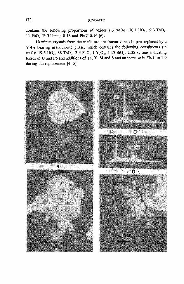
172 RIMSAITE
contains the following proportions of oxides (in wt%): 70.1 U 02, 9.3 Th02, 11 PbO, Th/U being 0.13 and Pb/U 0.16 [6 ].
Uraninite crystals from the mafic ore are fractured and in part replaced by a Y-Fe bearing uranothorite phase, which contains the following constituents (in wt%): 19.5 U02, 36 Th02, 3.9 PbO, 1 Y2 0 3, 14.3 Si02, 2.35 S, thus indicating losses of U and Pb and additions of Th, Y, Si and S and an increase in Th/U to 1.9 during the replacement [4, 5],
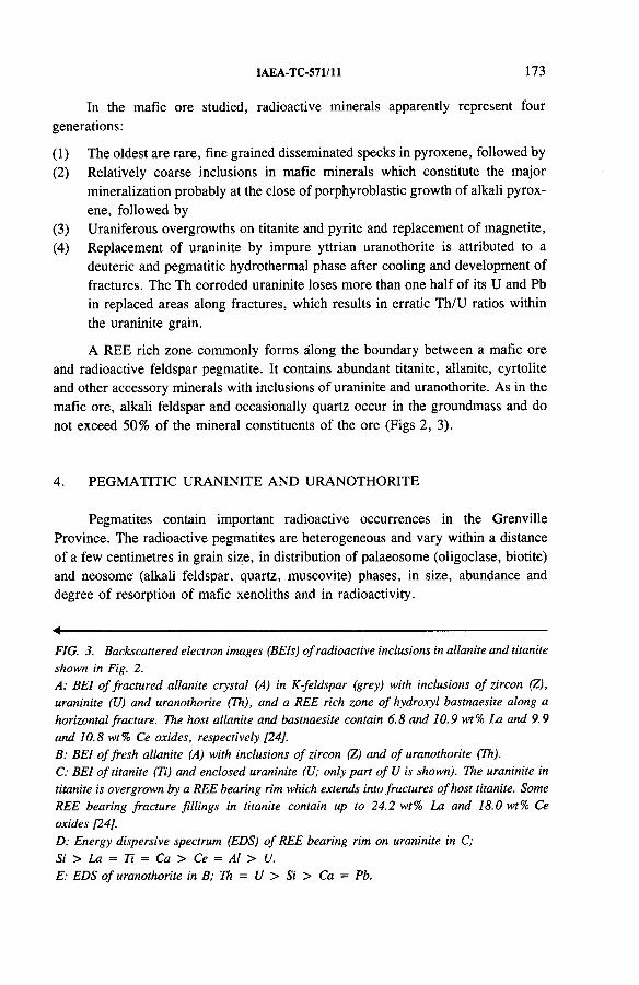
IAEA-TC-571/11 173
In the mafic ore studied, radioactive minerals apparently represent four generations:
(1) The oldest are rare, fine grained disseminated specks in pyroxene, followed by(2) Relatively coarse inclusions in mafic minerals which constitute the major
mineralization probably at the close of porphyroblastic growth of alkali pyroxene, followed by
(3) Uraniferous overgrowths on titanite and pyrite and replacement of magnetite,(4) Replacement of uraninite by impure yttrian uranothorite is attributed to a
deuteric and pegmatitic hydrothermal phase after cooling and development of fractures. The Th corroded uraninite loses more than one half of its U and Pb in replaced areas along fractures, which results in erratic Th/U ratios within the uraninite grain.
A REE rich zone commonly forms along the boundary between a mafic ore and radioactive feldspar pegmatite. It contains abundant titanite, allanite, cyrtolite and other accessory minerals with inclusions of uraninite and uranothorite. As in the mafic ore, alkali feldspar and occasionally quartz occur in the groundmass and do not exceed 50% of the mineral constituents of the ore (Figs 2, 3).
4. PEGMATITIC URANINITE AND URANOTHORITE
Pegmatites contain important radioactive occurrences in the Grenville Province. The radioactive pegmatites are heterogeneous and vary within a distance of a few centimetres in grain size, in distribution of palaeosome (oligoclase, biotite) and neosome (alkali feldspar, quartz, muscovite) phases, in size, abundance and degree of resorption of mafic xenoliths and in radioactivity.
4-------------------------------------------------------FIG. 3. Backscattered electron images (BEIs) o f radioactive inclusions in allanite and titanite shown in Fig. 2.A: BEI o f fractured allanite crystal (A) in K-feldspar (grey) with inclusions o f zircon (Z), uraninite (XJ) and uranothorite (Th), and a REE rich zone o f hydroxyl bastnaesite along a horizontal fracture. The host allanite and bastnaesite contain 6.8 and 10.9 wt% La and 9.9 and 10.8 wt% Ce oxides, respectively [24].B: BEI o f fresh allanite (A) with inclusions o f zircon (Z) and o f uranothorite (Th).C: BEI o f titanite (Ti) and enclosed uraninite (U; only part o fU is shown). The uraninite in titanite is overgrown by a REE bearing rim which extends into fractures o f host titanite. Some REE bearing fracture fillings in titanite contain up to 24.2 wt% La and 18.0 wt% Ce oxides [24].D: Energy dispersive spectrum (EDS) o f REE bearing rim on uraninite in C;Si > La = Ti = Ca > Ce = Al > U.E: EDS o f uranothorite in B; Th = U > Si > Ca = Pb.
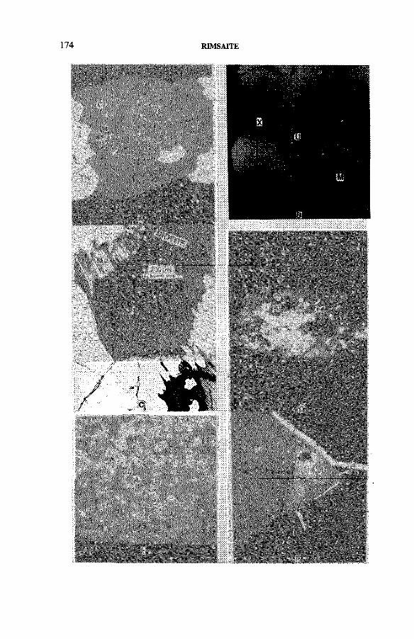
174 RIMSAITE
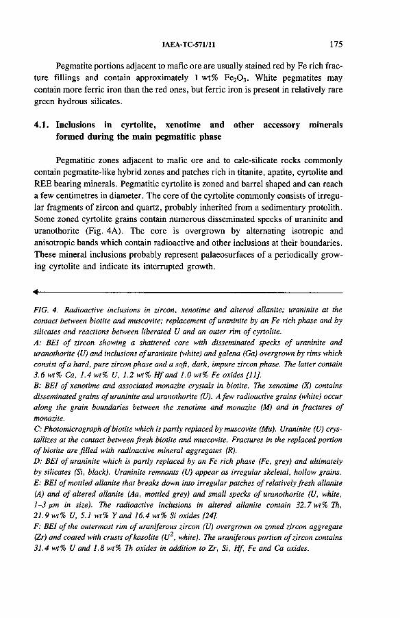
IAEA-TC-571/11 175
Pegmatite portions adjacent to mafic ore are usually stained red by Fe rich fracture fillings and contain approximately 1 wt% Fe2 0 3. White pegmatites may contain more ferric iron than the red ones, but ferric iron is present in relatively rare green hydrous silicates.
4.1. Inclusions in cyrtolite, xenotime and other accessory minerals formed during the main pegmatitic phase
Pegmatitic zones adjacent to mafic ore and to calc-silicate rocks commonly contain pegmatite-like hybrid zones and patches rich in titanite, apatite, cyrtolite and REE bearing minerals. Pegmatitic cyrtolite is zoned and barrel shaped and can reach a few centimetres in diameter. The core of the cyrtolite commonly consists of irregular fragments of zircon and quartz, probably inherited from a sedimentary protolith. Some zoned cyrtolite grains contain numerous disseminated specks of uraninite and uranothorite (Fig. 4A). The core is overgrown by alternating isotropic and anisotropic bands which contain radioactive and other inclusions at their boundaries. These mineral inclusions probably represent palaeosurfaces of a periodically growing cyrtolite and indicate its interrupted growth.
4-------------------------------------------------------FIG. 4. Radioactive inclusions in zircon, xenotime and altered allanite; uraninite at the contact between biotite and muscovite; replacement o f uraninite by an Fe rich phase and by silicates and reactions between liberated U and an outer rim o f cyrtolite.A: BEI o f zircon showing a shattered core with disseminated specks o f uraninite and uranothorite (U) and inclusions o f uraninite (white) and galena (Ga) overgrown by rims which consist o f a hard, pure zircon phase and a soft, dark, impure zircon phase. The latter contain 3.6 wt% Ca, 1.4 wt% U, 1.2 wt% H f and 1.0 wt% Fe oxides [11].B: BEI o f xenotime and associated monazite crystals in biotite. The xenotime (X) contains disseminated grains o f uraninite and uranothorite (U). A few radioactive grains (white) occur along the grain boundaries between the xenotime and monazite (M) and in fractures o f monazite.C: Photomicrograph o f biotite which is partly replaced by muscovite (Mu). Uraninite (U) crystallizes at the contact between fresh biotite and muscovite. Fractures in the replaced portion o f biotite are filled with radioactive mineral aggregates (R).D: BEI o f uraninite which is partly replaced by an Fe rich phase (Fe, grey) and ultimately by silicates (Si, black). Uraninite remnants (U) appear as irregular skeletal, hollow grains. E: BEI o f mottled allanite that breaks down into irregular patches o f relatively fresh allanite (A) and o f altered allanite (Aa, mottled grey) and small specks o f uranothorite (U, white, 1-3 pm in size). The radioactive inclusions in altered allanite contain 32.7 wt% Th, 21.9 wt% U, 5.1 wt% Y and 16.4 wt% Si oxides [24],F: BEI o f the outermost rim o f uraniferous zircon (U) overgrown on zoned zircon aggregate (Zr) and coated with crusts ofkasolite (U2, white). The uraniferous portion o f zircon contains 31.4 wt% U and 1.8 wt% Th oxides in addition to Zr, Si, Hf, Fe and Ca oxides.
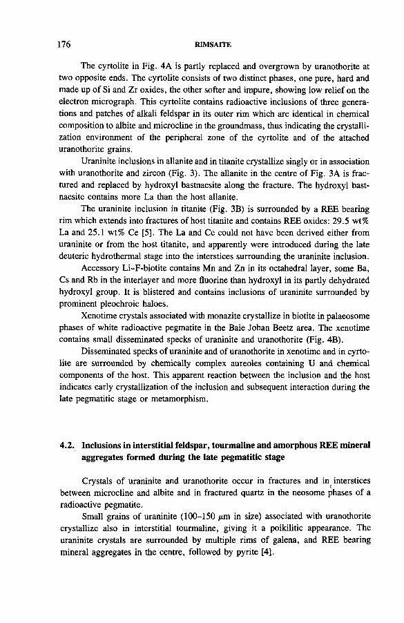
176 RIMSAITE
The cyrtolite in Fig. 4A is partly replaced and overgrown by uranothorite at two opposite ends. The cyrtolite consists of two distinct phases, one pure, hard and made up of Si and Zr oxides, the other softer and impure, showing low relief on the electron micrograph. This cyrtolite contains radioactive inclusions of three generations and patches of alkali feldspar in its outer rim which are identical in chemical composition to albite and microcline in the groundmass, thus indicating the crystallization environment of the peripheral zone of the cyrtolite and of the attached uranothorite grains.
Uraninite inclusions in allanite and in titanite crystallize singly or in association with uranothorite and zircon (Fig. 3). The allanite in the centre of Fig. 3A is fractured and replaced by hydroxyl bastnaesite along the fracture. The hydroxyl bast- naesite contains more La than the host allanite.
The uraninite inclusion in titanite (Fig. 3B) is surrounded by a REE bearing rim which extends into fractures of host titanite and contains REE oxides: 29.5 wt% La and 25.1 wt% Ce [5]. The La and Ce could not have been derived either from uraninite or from the host titanite, and apparently were introduced during the late deuteric hydrothermal stage into the interstices surrounding the uraninite inclusion.
Accessory Li-F-biotite contains Mn and Zn in its octahedral layer, some Ba, Cs and Rb in the interlayer and more fluorine than hydroxyl in its partly dehydrated hydroxyl group. It is blistered and contains inclusions of uraninite surrounded by prominent pleochroic haloes.
Xenotime crystals associated with monazite crystallize in biotite in palaeosome phases of white radioactive pegmatite in the Baie Johan Beetz area. The xenotime contains small disseminated specks of uraninite and uranothorite (Fig. 4B).
Disseminated specks of uraninite and of uranothorite in xenotime and in cyrtolite are surrounded by chemically complex aureoles containing U and chemical components of the host. This apparent reaction between the inclusion and the host indicates early crystallization of the inclusion and subsequent interaction during the late pegmatitic stage or metamorphism.
4.2. Inclusions in interstitial feldspar, tourmaline and amorphous REE mineral aggregates formed during the late pegmatitic stage
Crystals of uraninite and uranothorite occur in fractures and in interstices between microcline and albite and in fractured quartz in the neosome phases of a radioactive pegmatite.
Small grains of uraninite (100-150 /*m in size) associated with uranothorite crystallize also in interstitial tourmaline, giving it a poikilitic appearance. The uraninite crystals are surrounded by multiple rims of galena, and REE bearing mineral aggregates in the centre, followed by pyrite [4].
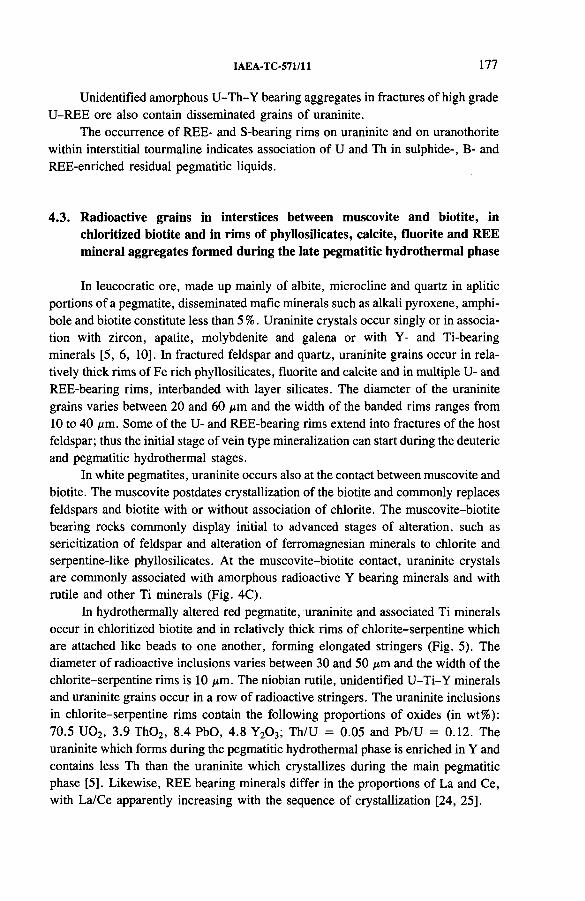
IAEA-TC-571/11 177
Unidentified amorphous U-Th-Y bearing aggregates in fractures of high grade U-REE ore also contain disseminated grains of uraninite.
The occurrence of REE- and S-bearing rims on uraninite and on uranothorite within interstitial tourmaline indicates association of U and Th in sulphide-, B- and REE-enriched residual pegmatitic liquids.
4.3. Radioactive grains in interstices between muscovite and biotite, in chloritized biotite and in rims of phyllosilicates, calcite, fluorite and REE mineral aggregates formed during the late pegmatitic hydrothermal phase
In leucocratic ore, made up mainly of albite, microcline and quartz in aplitic portions of a pegmatite, disseminated mafic minerals such as alkali pyroxene, amphibole and biotite constitute less than 5 %. Uraninite crystals occur singly or in association with zircon, apatite, molybdenite and galena or with Y- and Ti-bearing minerals [5, 6 , 10]. In fractured feldspar and quartz, uraninite grains occur in relatively thick rims of Fe rich phyllosilicates, fluorite and calcite and in multiple U- and REE-bearing rims, interbanded with layer silicates. The diameter of the uraninite grains varies between 2 0 and 60 /xm and the width of the banded rims ranges from 10 to 40 /jm. Some of the U- and REE-bearing rims extend into fractures of the host feldspar; thus the initial stage of vein type mineralization can start during the deuteric and pegmatitic hydrothermal stages.
In white pegmatites, uraninite occurs also at the contact between muscovite and biotite. The muscovite postdates crystallization of the biotite and commonly replaces feldspars and biotite with or without association of chlorite. The muscovite-biotite bearing rocks commonly display initial to advanced stages of alteration, such as sericitization of feldspar and alteration of ferromagnesian minerals to chlorite and serpentine-like phyllosilicates. At the muscovite-biotite contact, uraninite crystals are commonly associated with amorphous radioactive Y bearing minerals and with rutile and other Ti minerals (Fig. 4C).
In hydrothermally altered red pegmatite, uraninite and associated Ti minerals occur in chloritized biotite and in relatively thick rims of chlorite-serpentine which are attached like beads to one another, forming elongated stringers (Fig. 5). The diameter of radioactive inclusions varies between 30 and 50 ixm and the width of the chlorite-serpentine rims is 10 /xm. The niobian rutile, unidentified U-Ti-Y minerals and uraninite grains occur in a row of radioactive stringers. The uraninite inclusions in chlorite-serpentine rims contain the following proportions of oxides (in wt%): 70.5 U02, 3.9 Th02, 8.4 PbO, 4.8 Y2 0 3; Th/U = 0.05 and Pb/U = 0.12. The uraninite which forms during the pegmatitic hydrothermal phase is enriched in Y and contains less Th than the uraninite which crystallizes during the main pegmatitic phase [5], Likewise, REE bearing minerals differ in the proportions of La and Ce, with La/Ce apparently increasing with the sequence of crystallization [24, 25],
RIMSAITE
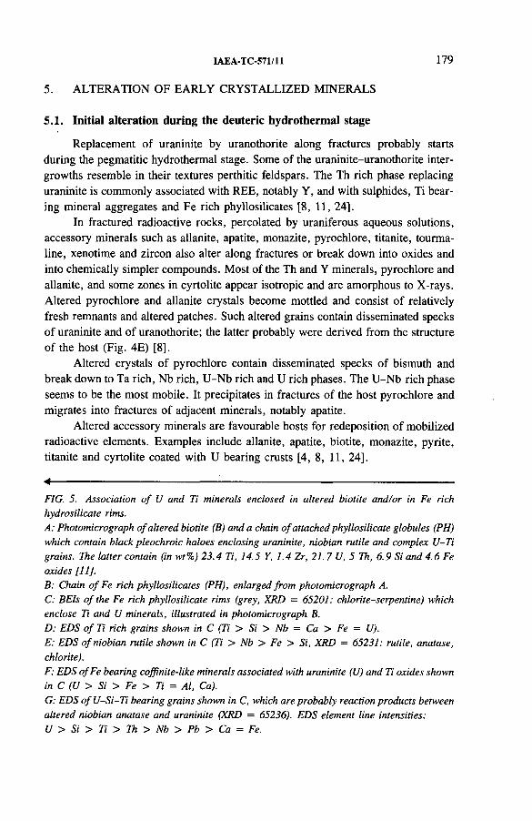
IAEA-TC-571/11 179
5. ALTERATION OF EARLY CRYSTALLIZED MINERALS
5.1. Initial alteration during the deuteric hydrothermal stage
Replacement of uraninite by uranothorite along fractures probably starts during the pegmatitic hydrothermal stage. Some of the uraninite-uranothorite intergrowths resemble in their textures perthitic feldspars. The Th rich phase replacing uraninite is commonly associated with REE, notably Y, and with sulphides, Ti bearing mineral aggregates and Fe rich phyllosilicates [8 , 11, 24].
In fractured radioactive rocks, percolated by uraniferous aqueous solutions, accessory minerals such as allanite, apatite, monazite, pyrochlore, titanite, tourmaline, xenotime and zircon also alter along fractures or break down into oxides and into chemically simpler compounds. Most of the Th and Y minerals, pyrochlore and allanite, and some zones in cyrtolite appear isotropic and are amorphous to X-rays. Altered pyrochlore and allanite crystals become mottled and consist of relatively fresh remnants and altered patches. Such altered grains contain disseminated specks of uraninite and of uranothorite; the latter probably were derived from the structure of the host (Fig. 4E) [8 ],
Altered crystals of pyrochlore contain disseminated specks of bismuth and break down to Ta rich, Nb rich, U-Nb rich and U rich phases. The U-Nb rich phase seems to be the most mobile. It precipitates in fractures of the host pyrochlore and migrates into fractures of adjacent minerals, notably apatite.
Altered accessory minerals are favourable hosts for redeposition of mobilized radioactive elements. Examples include allanite, apatite, biotite, monazite, pyrite, titanite and cyrtolite coated with U bearing crusts [4, 8 , 11, 24],
4-----------------------:--------------------------------FIG. 5. Association o f U and Ti minerals enclosed in altered biotite and/or in Fe rich hydrosilicate rims.A: Photomicrograph o f altered biotite (B) and a chain o f attached phyllosilicate globules (PH) which contain black pleochroic haloes enclosing uraninite, niobian rutile and complex U-Ti grains. The latter contain (in wt%) 23.4 Ti, 14.5 Y, 1.4 Zr, 21. 7 U, 5 Th, 6.9 Si and 4.6 Fe oxides [11].B: Chain o f Fe rich phyllosilicates (PH), enlarged from photomicrograph A.C: BEIs o f the Fe rich phyllosilicate rims (grey, XRD = 65201: chlorite-serpentine) whichenclose Ti and U minerals, illustrated in photomicrograph B.D: EDS o f Ti rich grains shown in C (Ti > Si > Nb = Ca > Fe = U).E: EDS o f niobian rutile shown in C (Ti > Nb > Fe > Si, XRD = 65231: rutile, anatase,chlorite).F: EDS ofFe bearing coffinite-like minerals associated with uraninite (U) and Ti oxides shown in C (U > Si > Fe > Ti = Al, Ca).G: EDS ofU -Si-T i bearing grains shown in C, which are probably reaction products between altered niobian anatase and uraninite (XRD = 65236). EDS element line intensities:U > Si > Ti > Th > Nb > Pb > Ca = Fe.
180 RIMSAITE
5.2. Advanced alteration and replacement by phyllosilicates
In all polished thin sections studied by electron microprobe, most of the uraninite crystals and their host rocks show evidence of alteration, such as sericitiza- tion of feldspars and chloritization of biotite.
With advanced alteration, uraninite crystals are gradually replaced by uranyl bearing mineral aggregates, by Fe rich oxides and silicates, by Fe rich gummite and ultimately by sericite and clay [8 , 9, 11], Altered and partly replaced minerals disintegrate into bands with skeletal grains or patches of relatively fresh original mineral in a Si rich groundmass, which invades the decomposing crystal along fractures and ultimately replaces the whole grain (Fig. 4D).
Alteration of radioactive minerals is accompanied by changes in their U/Th, Pb/U and Pb/Th ratios, which increase or decrease depending on the preferential removal of U, Th and Pb. Chemical changes accompanying alteration of radioactive and REE minerals and partial semiquantitative energy dispersive spectrometer analyses of various phases during disintegration of minerals and of chemically complex radioactive crusts in fractures have been tabulated in previous papers by the author [5, 11, 24].
5.3. Reactions between adjacent minerals
Radioactive and other ions liberated during mineral alteration migrate from the host into adjacent minerals, thus forming chemically complex unidentified U-Ti-Si, U-Th-Zr-Si and U-Th-Y compounds, hydrous phosphates of uranium, commonly autunite, torbernite and phosphuranylite, and hydrous uranyl silicates, carbonates and sulphates (Fig. 4F).
Allanite and monazite alter to bastnaesite and to other REE carbonates and are ultimately replaced by phyllosilicates [5, 8 , 9, 11].
Titanite grain overgrown by uraninite reacts with U and is gradually replaced by a U-Ti-Si phase. Cyrtolite crystals enclosed in thorogummite also react with U and Th, forming unidentified U-Th-Zr bearing replacements of the cyrtolite.
5.4. Mobilization of radioactive and other ions during alteration, and theirmigration, interaction and precipitation as U-Pb-Th-REE-Zr-Ti-Fe-Siand/or sulphide bearing crusts in fractures
Some of the mobilized ions from altered minerals can be fixed in adjacent minerals or in secondary minerals. The others migrate along fractures. Some of the migrating radioactive solutions can be trapped in fractures and radioactive crusts precipitate along fracture walls. Fractures filled with kasolite and with complex Ti- U-Si-Ca-Fe-Pb bearing mineral aggregates are common in biotite [6 , 9].
IAEA-TC-571/11 181
Chemically complex radioactive Zr bearing crusts form adjacent to thorogum- mite and zircon.
Rocks which contain remnant crystals of uraninite and U bearing crusts filling interstices between albite and microcline or basal fractures in biotite exhibit features of disseminated U mineralization and of autochthonous vein type mineralization. With advanced alteration of radioactive grains, U and some Th are trapped only in fractures and thus the disseminated type of mineralization grades into vein type mineralization. At the initial stage of such a transition, radioactive fracture fillings may consist of chemically complex mineral aggregates and the host rock may contain accessory minerals of unusual chemical composition with additions of U, Th and REE. Such autochthonous vein type U occurrences have been observed on and near the weathered surface of radioactive pegmatites and thus they can be considered as indicators of disseminated mineralization at depth.
Mobilized radioactive and REE ions which have not been fixed in secondary minerals and in fracture coatings can be removed by percolating aqueous solutions and redeposited under favourable physico-chemical conditions away from the host, thus forming allochthonous deposits.
6 . PRELIMINARY RESULTS OF ISOTOPE STUDIES
With the exception of concordant Pb/U, Pb/Th and 2 0 6 Pb/207Pb isotopic ages obtained on thorianite (1090 Ma) and uraninite (1045 Ma), all minerals yielded discordant ages and fell on two parallel discordia lines which intersected the concor- dia curve at 1090 and 980 Ma at the upper intersections and at 90 and 70 Ma at the lower intersections [4, 11], Thorianite enclosed in fluorite from pyroxenite yielded the oldest concordant age. The fluorite probably restrained radioactive and radiogenic elements from migration.
The youngest isotopic age was obtained on pyrochlore which crystallized during the late pegmatitic hydrothermal phase in fractures of coarse pegmatitic feldspar, enclosed in white mica. Prismatic crystals of pyrochlore have a mottled appearance and consist of fresh and altered patches which vary in chemical composition. The pyrochlore has the lowest Pb/U ratio of 0.04 and the lowest isotopic Pb/U and 2 °6 pb/2°7pb apparent age of 230 Ma, probably as a result of relatively young age and preferential loss of lead due to structural breakdown [1 1 ],
Tourmaline overgrown by radioactive crusts yielded an isotopic Pb/U ratio that fell at the lower portion of the discordia line, followed by allanite, zircon, uraninite, monazite with uraniferous crusts, thorianite, which fell on the concordia curve, and radioactive crusts in biotite.
Some radioactive crusts in biotite fractures consist of kasolite which contains a high proportion of lead with a Pb/U ratio of 0.7, whereas in fresh uraninite from the same radioactive occurrence the Pb/U ratio is 0.15. Minerals which have excess
182 RIMSAITE
radiogenic lead and less than 1 % common lead yielded isotopic Pb/U ratios that fell above the concordia curve. On the other hand, some radioactive crusts in feldspar and uraniferous overgrowths on titanite contained as much as 84% common lead, thus indicating that both radiogenic and common lead can be incorporated into secondary radioactive mineral aggregates [6 ],
Minerals from the Mont Laurier and Baie Johan Beetz areas yielded somewhat lower discordant isotopic ages than those from the Bancroft area. Their isotopic Pb/U ratios fell mainly on the lower discordia line, which at the upper end intersected the concordia curve at 980 Ma.
Isotopic ages of zircon are also discordant because of the presence of radiogenic and radioactive inclusions of three generations, the heterogeneous nature and zonal growth of cyrtolite, and the removal and addition of radioactive and radiogenic components (Figs 4A, F) [7].
Results of isotopic K/Ar studies on micas which host inclusions of uraninite from the Bancroft area and studies of thermal stability of micas indicated that the isotopic K/Ar ages of micas are lower than the isotopic Pb/U ages of their uraninite inclusions [15, 26, 27], Furthermore, the lower K/Ar age apparently results from the loss of radiogenic argon, which is correlative with the degree of dehydration of the hydroxyl group in the mica structure. Fluor-phlogopite yielded a K/Ar age of 1060 Ma, which is 30 Ma lower than that obtained on thorianite in fluorite, 1090 Ma. On the other hand, blistered and partly dehydrated biotite yielded a K/Ar age of 937 Ma, younger by 114 Ma than the 2 0 6 Pb/207Pb apparent age of uraninite (1051 Ma) and younger by 74 Ma than the apparent age obtained on cyrtolite (1011 Ma), but older by 37 Ma than the apparent age of allanite (900 Ma) from the Madawaska mine.
The fluor-phlogopite has the highest thermal stability of all micas. Heated at 1000°C, it loses about 10% of its fluorine and most of its hydroxyl; only at 1200°C does it lose almost the entire fluorine and recrystallize to anhydrous phases, olivine and leucite.
The blistered, hydroxyl deficient fluor-biotite, heated at 650°C, does not lose any fluorine, but loses 10% of its radiogenic Ar and 75% of the hydroxyl, whose oxygen is used up to oxidize its octahedral iron.
The hydrothermally more stable F-phlogopite retains its radiogenic Ar better than the blistered type, which loses hydroxyl and apparently more Ar at an elevated temperature.
Considering the complex history of crystallization of minerals and the mobility of radioactive and radiogenic elements, the present isotopic data obtained on a few minerals can be considered as preliminary; they indicate the following apparent age relationships between early crystallized, pegmatitic and secondary radioactive minerals:
IAEA-TC-571/11 183
1090 Ma: Crystallization of thorianite in metasomaticpyroxenite.
1050-1020 Ma: Crystallization of uraninite and of hostpegmatitic cyrtolite in the Bancroft area,Ontario.
980 Ma: Crystallization of late pegmatitic minerals inthe Baie Johan Beetz and Mont Laurier areas, Quebec.
940-900 Ma: Hydrothermal alteration of minerals andcrystallization of U bearing crusts on accessory minerals.
821 Ma: Formation of radioactive crusts on titanite.These contain 84% common lead.
230 Ma: Apparent 2 0 6 Pb/207Pb age of pyrochlore;this young apparent age is probably a result of continuous breakdown of the pyrochlore atomic structure due to the radiation damage which was accompanied by losses of its radiogenic lead. This isotopic age should be compared with the isotopic ages of associated muscovite and host feldspar.
Mobilization and migration of radioactive and other elements and their precipitation in fractures of radioactive rock exposed to surface weathering continue to the present day.
7. SUMMARY AND CONCLUSIONS
Results of the petrographic and microbeam studies of minerals in polished thin sections of U bearing rocks from selected radioactive occurrences in the Grenville Structural Province, Canada, indicate the presence of different styles of U mineralization in a single occurrence. Radioactive mineral inclusions occur in rock forming and accessory minerals in a great variety of metamorphic-metasomatic rocks, impregnated by alkali feldspars and/or anhydrite and in syenite and granite pegmatites preferentially adjacent to mafic xenoliths.
The radioactive minerals represent several periods of crystallization from early impregnations of country rocks by pegmatitic fluids and through the main and late phases of crystallization of the pegmatite, and during the deuteric and hydrothermal phases.
The chemical composition of uraninite, notably its Th/U ratio, varies depending on the sequence of crystallization. The early formed uraninite inclusions in mafic
184 RIMSAITE
metamorphic-metasomatic minerals and in palaeosome portions of a radioactive pegmatite contain more Th and less Y than uraninites formed during the late pegmatitic and hydrothermal stages.
Uraninite crystals show evidence of various degrees of alteration, resorption and replacement by Th rich, Fe rich, Ti rich and Si rich phases and by hydration.
The alteration is accompanied by either relative enrichment or depletion of radiogenic lead and Th, which results in discordant isotopic Pb/U and Pb/Th ages and, to a lesser extent, 2 0 6 Pb/207Pb apparent ages.
Alteration of radioactive, accessory and rock forming minerals is accompanied by mobilization of various elements. During the initial stages of alteration, which commences during the hydrothermal stage, the mobilized elements commonly interact, forming chemically complex U-Th-Si, U-Th-Y-Si, U-Th-Zr, U-Th-Y-Si, U-Pb-Si and U-P bearing and other unidentified mineral phases at the grain boundaries, or crystallize as fine grained mineral aggregates filling fractures.
During advanced stages of alteration and replacement by phyllosilicates the mobilized radioactive elements can be removed by aqueous solutions from their host rock.
In hydrothermally altered rocks, one portion of the radioactive elements can be fixed in U bearing mineral inclusions which constitute a disseminated type of U mineralization whereas the other portion can crystallize in fractures, thus grading into an autochthonous vein type mineralization. The further removed radioactive elements from the disseminated and autochthonous vein type U occurrences can form allochthonous vein type deposits in favourable environments.
The apparent isotopic ages of most minerals are discordant as a result of the removal and/or addition of radioactive and radiogenic elements. Some secondary radioactive mineral aggregates contain as much as 84% common lead; however, in most minerals common lead rarely exceeds 1%. Minerals which contain excess radiogenic lead, such as kasolite, yielded isotopic Pb/U ratios which fell above the concordia curve.
The concordant ages of radioactive inclusions in metasomatic and pegmatitic minerals yielded 1090 Ma and 1050 Ma.
Uraninite from serpentine-like aggregates representing the pegmatitic hydrothermal phase yielded a discordant apparent age of 980 Ma, and radioactive crusts in basal fractures of biotite and on titanite and monazite yielded apparent isotopic ages from 820 to 900 Ma, which date the initial time of transition from disseminated type to autochthonous vein type U mineralization.
Accessory minerals exhibit variable structural stability in a radioactive environment. Continuous radioactivity causes destruction of atomic structures of minerals, which results also in their chemical breakdown, a heterogeneous mottled appearance and preferential losses of radiogenic elements. Heterogeneous, partly decomposed minerals which are amorphous to X-rays, notably pyrochlore and allanite, yielded the lowest apparent isotopic ages.
IAEA-TC-571/11 185
ACKNOWLEDGEMENTS
The author gratefully acknowledges colleagues at the Geological Survey of Canada for analytical support of Research Project 770061 and preparation of illustrations, and especially R.T. Bell and V. Ruzicka for discussion and improvement of the manuscript. The author is grateful to G.L. Cumming of the University of Alberta, Edmonton, for isotope analyses.
Thanks are due to the Geological Information Division and DSS of the Geological Survey of Canada for formal permission to use the following illustrations from the author’s earlier papers: [5, Fig. 21.2], [6 , Fig. 6 .6 ], [7, Figs 9.3, 9.4], [8 , Figs 31.5, 31.6], [9, Figs 4.2, 4.3], [10, Figs 17.3, 17.4, 17.5].
REFERENCES
[1] STOCKWELL, C.H., et al., “ Geology of the Canadian Shield” , Geology and Economic Minerals of Canada (DOUGLAS, R.J.W ., Ed.), Geol. Surv. Can., Econ. Geol. Ser. No. 1 (1970) 45-150.
[2] LANG, A.H., et al., “ Economic minerals of the Canadian Shield” , ibid., pp. 151-226.
[3] DAVIDSON, A., NADEAU, L., GRANT, S.M., PRYER, L.L., “ Studies in the Grenville Province of Ontario” , Current Research, Part A, Geol. Surv. Can., Pap. 85-1A (1985) 463-483.
[4] RIMSAITE, J., “ Mineralogy of radioactive occurrences in the Grenville Structural Province: A progress report” , Current Research, Part A, Geol. Surv. Can., Pap. 80-1A (1980) 253-264.
[5] RIMSAITE, J., “ Selected mineral associations in radioactive and REE occurrences in the Baie-Johan-Beetz area, Quebec: A progress report” , Current Research, Part A, Geol. Surv. Can., Pap. 84-1A (1984) 129-145.
[6] RIMSAITE, J., “ Petrography, petrochemistry and mineral associations of selected rocks and radioactive occurrences north of Mont-Laurier, Quebec: A progress report” , Current Research, Part A, Geol. Surv. Can., Pap. 85-1A (1985) 47-64.
[7] RIMSAITE, J., “ Mineralogy of radioactive occurrences in the Grenville Structural Province, Ontario and Quebec: A preliminary report” , Current Research, Part B, Geol. Surv. Can., Pap. 78-1B (1978) 49-58.
[8] RIMSAITE, J., “ The leaching of radionuclides and other ions during alteration and replacement of accessory minerals in radioactive rocks” , Current Research, Part B, Geol. Surv. Can., Pap. 82-1B (1982) 253-266.
[9] RIMSAITE, J., “ Isotope, scanning electron microscope, and energy dispersive spectrometer studies of heterogeneous zircons from radioactive granites in the Grenville Structural Province, Quebec and Ontario” , Current Research, Part B, Geol. Surv. Can., Pap. 81-1B (1981) 25-35.
[10] RIMSAITE, J . , “ Petrochemical and mineralogical evolution of radioactive rocks in the Baie-Johan-Beetz area, Quebec: A preliminary report” , Current Research, Part A, Geol. Surv. Can., Pap. 81-1A (1981) 115-131.
186 RIMSAITE
[11] RIMSAITE, J., “ Mobilization and preservation of radioactive and rare-earth elements in some Canadian vein-type and granite-hosted uranium deposits of Precambrian age” , Mineral Parageneses (CRAIG, J.R., et al., Eds), Theophrastus, Athens (1986) 345-385.
[12] ELLSWORTH, H.V., Rare-Element Minerals of Canada, Geol. Surv. Can., Econ. Geol. Ser. No. 11 (1939) 212.
[13] LANG, A.H., GRIFFITH, J.W ., STACEY, H.R., Canadian Deposits of Uranium and Thorium, Geol. Surv. Can., Econ. Geol. Ser. No. 16 (1962) 324.
[14] ROBINSON, S.C., HEWITT, D.F., “ Uranium deposits of the Bancroft Region, Ontario” , Peaceful Uses of Atomic Energy (Proc. Int. Conf. Geneva, 1958), Vol. 2, UN, New York (1958) 498-501.
[15] ROBINSON, S.C., “ Note on the interpretation of U-Pb, Th-Pb and K-Ar ages in the Bancroft, Ontario region” , Isotopic Ages (LOWDON, J.A., Ed.), Geol. Surv. Can., Pap. 60-17 (1960) 41.
[16] HENDERSON, M., “ Lithological and structural setting of uraniferous pegmatites near Mekos, Mont-Laurier, Quebec” , Current Research, Part B, Geol. Surv. Can., Pap.82-1A (1982) 261-264.
[17] SATTERLY, J., Radioactive Mineral Occurrences in the Bancroft Area, Ontario, Annual Report, Part 6 (1956) 178; Geological Map 1957b, Haliburton-Bancroft Area, Ontario Dept, of Mines, Toronto.
[18] ROBERTSON, J.A., “ Uranium deposits in Ontario” , Short Course in Uranium Deposits: Their Mineralogy and Origin (KIMBERLY, M.M., Ed.), Mineralogical Assoc, of Canada, Toronto (1978) 229-280.
[19] KISH, L., Patibre (Axe) Lake Area, Preliminary Report, Rep. DPV-487, Service des gites minSraux, Ministfere des richesses naturelles, Toronto (1977) 13.
[20] BLAIS, R., Rapport pr&iminaire sur la region de Pashashibou Comt6 de Saguenay, Provence de Quebec, Rep. RP 316, Ministere des mines, Quebec (1956) 8.
[21] BALDWIN, A.D., Uranium and thorium occurrences on the north shore of the Gulf of St. Lawrence, Can. Min. Metall. Bull. 63 (1970) 699-707.
[22] CAMERON-SCHIMANN, M., Electron Microprobe Study of Uranium Minerals and its Application to Some Canadian Deposits, PhD Thesis, Univ. of Alberta, Edmonton (1978) 337.
[23] WYNNE-EDWARDS, H.R., GREGORY, A.F., HAY, P.W ., GIOVANELLA, C.A., REINHARDT, E.W., Mount Laurier and Kempt Lake Map-Areas, Quebec, Geol. Surv. Can., Pap. 66-32 (1966) 32.
[24] RIMSAITE, J., Selected mineral associations in radioactive occurrences in the Grenville Structural Province: A progress report, Current Research, Part B, Geol. Surv. Can., Pap. 83-1B (1983) 23-37.
[25] VAN WAMBEKE, L., The Karonge rare-earth deposits, Republic of Burundi, Miner. Deposita 3 (1977) 373-380.
[26] RIMSAITE, J.H.Y., Studies of rock-forming micas, Geol. Surv. Can., Bull. 149(1967) 87.
[27] RIMSAITE, J., “ DTA, TG, IR and isotopic analyses and properties of phlogopite, biotite, muscovite and lepidolite in temperature range of metamorphic reactions” , Proc. 3rd ICTA Conf. on Thermal Analysis, Davos, 1971, pp. 683-695.
IAEA-TC-571/11 187
DISCUSSION
R.K. BALLHORN: Concerning age dating using concentrates of zircon and other so-called refractory minerals, I am worried about the movement of uranium and lead which may have taken place according to the alteration effects you have observed. Such alteration processes may occur over a long time interval. I wonder what significance some of the age dates have.
J. RIMSAITE: Everything depends on the personal approach of the investigators and on the instrumentation. I can refer you to a paper1 by G.L. Cumming of the University of Alberta and myself describing our isotope studies of minerals representing different phases of crystallization and alteration in vein type uranium deposits in Saskatchewan. However, for a deposit, a common model assumes the presence of only one mineralization and a closed system for radioactive and radiogenic components. It is assumed that nothing is lost and nothing is added to the deposit. This is not so and with sensitive instrumentation and patience to separate different mineral phases we can date periods of mineralization, of mobilization of radioactive and radiogenic elements, and of formation of secondary U minerals. It is very difficult to separate those secondary minerals so we concentrated biotites which had those secondary minerals in fractures. In spite of difficulties in preparing suitable samples, we obtained notable differences in isotopic ages, from 1285 to 200 Ma. The best technique would be to use the ion probe on single minerals.
M.H. FRIEDRICH: Some of the microphotographs and paragenesis you have presented suggest a subsolidus alteration of pegmatite mineral species. For instance, associations of monazite and LREE rich phases (bastnaesite?) are good evidence of such an alteration. Current studies at the Centre de recherches sur la geologie de 1’uranium (CREGU), recently published, describe similar phenomena. Negga et al . 2 mention the alteration of monazite to apatite and allanite during a retromorphic event, involving aqueous fluids (T = 300-350°C) with high Ca activity. Moreover, this reaction liberates uranium and therefore contributes metal for local vein mineralization. Maruejol and Cuney3 give additional evidence of monazite destabilization
1 CUMMING, G.L., RIMSAITE, J., Isotopic studies of lead-depleted pitchblende, secondary radioactive minerals, and sulphides from the Rabbit Lake uranium deposit, Saskatchewan, Can. J. Earth Sci. 16 (1979) 1702-1715.
2 NEGGA, H.S., SHEPPARD, S.M .F., ROSENBAUM, J.M ., CUNEY, M., Late Hercynian U-vein mineralization in the Alps: Fluid inclusion and C, O, H isotopic evidence for mixing between two externally derived fluids, Contrib. Mineral. Petrol. 93 (1986) 179-186.
3 MARUEJOL, P., CUNEY, M., Xihuashan tungsten-bearing granites (Jiangxi, China): Mineralogical controls on REE, Y, Th, U mobility during magmatic evolution and hydrothermal alteration, Fortschr. Mineral. 63 1-2 (1985) 149.
188 RIMSAITE
during early albitization of a leucogranitic apex at Xihuashan, southern Jiangai, China. A fluorine- and C 02-rich fluid induces monazite alteration to parisite, with a global loss of LREE. In your environments, bastnaesite may result from monazite. The stability of monazite is discussed in a recent paper of Cuney and Friedrich. 4
J. RIMSAITE: In the same deposit we can see different reactions, which take place on a microscale, so in the same rock we see several types and sequences of alteration.
A.H. RAZAFINIPARANY: You mentioned allanites in your presentation. What is the role of allanites?
J. RIMSAITE: Allanites commonly occur at the contact of granite calc-silicate rocks. We do have very different allanites and very often we have epidote or altered allanites depleted in REE. Rare earths, bearing fresh allanite, are overgrowing the epidote, or vice versa. Also, we have allanites that are overgrown by uraniferous minerals and contain 1 or 2% thorium. Altered allanites, like biotites, are favourable hosts for uranium and also for REE bearing mineral aggregates. When allanite starts disintegrating it can react with liberated ions, thus forming unidentified REE bearing and radioactive phases, thereby retaining part of the mobilized radioactive ions in the deposit.
4 CUNEY, M., FRIEDRICH, M., Physicochemical and crystal-chemical controls on accessory mineral paragenesis in granitoids: Implications for uranium metallogenesis, Bull. Mineral. 110 2-3 (1987) 235-248.
IAEA-TC-571/12
GLOBAL METALLOTECTS AND REGIONAL BASEMENT CONTROLS OF THE UNCONFORMITY TYPE URANIUM DEPOSITS IN THE ATHABASCA BASIN, CANADA
J.G. STRNADUranerz Exploration and Mining Limited,Saskatoon, Saskatchewan,Canada
Abstract
GLOBAL METALLOTECTS AND REGIONAL BASEMENT CONTROLS OF THE UNCONFORMITY TYPE URANIUM DEPOSITS IN THE ATHABASCA BASIN, CANADA.
Although some unconformity type uranium deposits are hosted primarily within the metamorphic basement, most of the deposits occurring within the Athabasca Basin of Saskatchewan which belong to this general classification straddle a narrow zone on either side of the unconformity which separates the basement and the overlying sedimentary rocks of the basin. The study described has extended beyond the local deposit factors and contributes mainly by the introduction of regional parameters. The plate tectonics and global tectonics contexts have also been added; although their effectiveness is of lesser practical value they may help towards a better understanding of the mechanism and style of the structural development. The lateral location (geographic) of the deposits is controlled by lithostructural basement parameters. Regional metallotects are a necessary complement to well developed local controls in the formation of a sizeable uranium accumulation in this region.
1. GENERAL CHARACTERISTICS OF THE METALLOGENIC PROVINCE
1.1. Structural location
The Athabasca Basin uranium province includes both the unmetamorphosed and subhorizontally resting Middle Proterozoic aged Athabasca Basin and the immediate lateral extension of the subjacent folded and metamorphosed Archaean and Lower Proterozoic basement. The basin rests above the ensialic structural units within the Hudsonian Orogen consolidated Churchill Structural Province of the Canadian Shield.
189
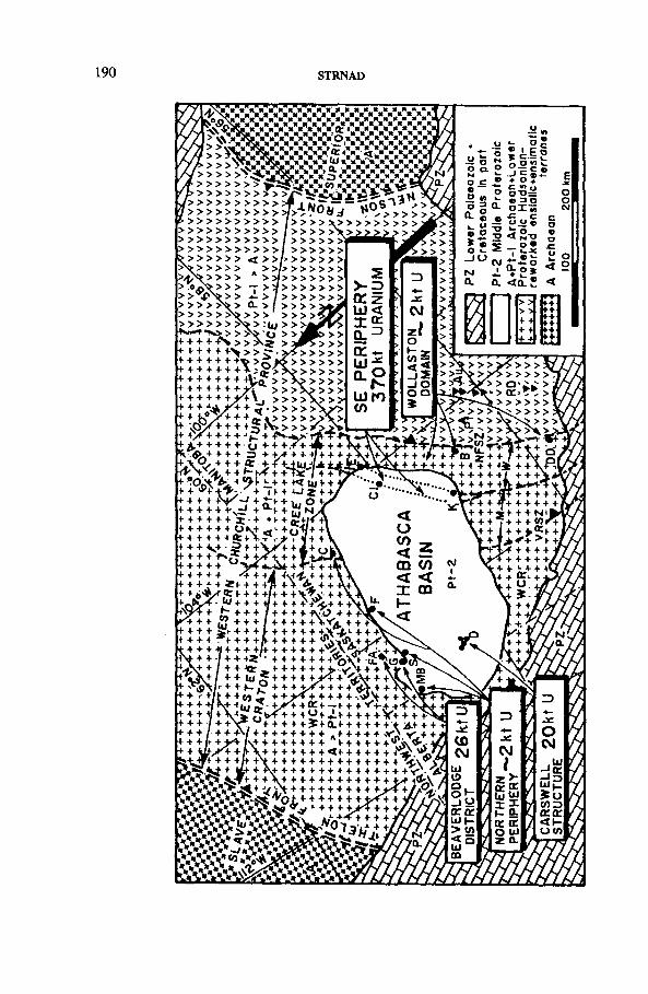
STRNAD
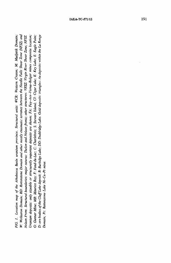
IAEA-TC-571/12
192 STRNAD
1.2. Clustering and types of uranium deposits
Currently available data allow for an estimate of approximately 420 kt of drill proven uranium within the metallogenic province as defined in this study (Fig. 1). Of this, the so-called unconformity type hosts 93% and the albitite type 6 %, and other types carry less than 1 % of the total uranium reserves.
Most of this uranium is found at the unconformity beneath the basin, and especially so at its extremities (75% ), while one quarter rests in the immediate basement laterally beyond the present extension of the basin. The formerly producing Beaver- lodge district (on the north rim of the basin) has produced a little more than all the uranium confined within the Carswell Structure located in the western half of the basin. Almost 90% of the uranium identified is within a 175 km X 20 km belt where the SE rim of the basin overlaps the subjacent Transition Zone of the Mudjatik Domain and part of the Wollaston Domain. The present study refers to this belt as the ‘SE Periphery’ (SEP) or the principal belt.
Within the SEP, the three largest deposits (Cigar Lake, Key Lake and Eagle Point) contain 77% of all the uranium known within 22 deposits of the belt (Fig. 2), or 67% of the whole province. This group of deposits represents a basic statistical set from which most of the conclusions on structural control were derived. (In the view of some geologists the size of this data set is too limited and does not allow a conclusive definition of features distinguishing large from small deposits.)
1.3. Types of ore
Three deposits of the principal belt (Key Lake, Cigar Lake and Midwest Lake) yield approximately 240 kt of uranium, and eight other metals (each with above 400 ppm in the U ore) may total a further 260 kt. The Key Lake deposit is the largest contributor of these metals, followed by Cigar Lake and Midwest Lake. Key Lake uranium ore is typified by Ni, V, Co, Zn and As, and Cigar Lake contributes Cu, Pb and Mo.
If polymetallic envelopes (above, on-strike and especially in the subjacent roots) surrounding the commercial U ore are added, the belt possibly contains nearly the same amount of non-U metals collectively as the uranium proper. These are, in descending order: As, Ni-Pb, Cu, V-Co, Zn and Mo (dashes indicate major concentration gaps).
Since the deposit contains a considerable amount of these elements, and not only because of its mineralogical complexity, the author prefers the term ‘polymetallic type’ rather than ‘complex mineralogy’ for the metallogenic characterization both of these deposits and of this part of the province.
IAEA-TC-571/12 193
The principal representatives of the monometallic type are the Eagle Point and Rabbit Lake deposits, both hosted exclusively by the basement. Also, the deepest (basement hosted) portion of the otherwise polymetallic Key Lake uranium ore contains only uranium.
2. LOCAL STRUCTURAL CONTROL
Though a number of phenomena appear to be similar within broad areas, this part of the study focuses on those which are observable partially on a deposit scale. Other local parameters are the subject of intensive attention; however, these remain undiscussed in this presentation.
2.1. Physico-mechanical inhomogeneity of the lithological sequence
Probably the most important feature of the basement lithologies is that the basal portion of the Lower Proterozoic Wollaston Group is dominated by ductile carbonaceous metapelites, and that these are sandwiched between the rigid Archaean granitoid basement and the overlying competent meta-arkosic sequence. It is this particular arrangement of alternating mechanical properties and not the individual lithologies per se which exerts a fundamental tectonic control and makes both the basal Wollaston Group and its broader contact with the subjacent Archaean the principal controlling units.
2.2. Thrusting within the basement, a common denominator
Nearly all of the deposits contain some form of stratabound tectonism, mostly thrusts or reverse faults. The latter prevail at the sub-Athabasca unconformity.
2.2.1. Temporal sequence o f thrusting
Prior to metamorphism, the older phases of the compressional regime could have resulted in the separation of the soft Aphebian (Wollaston Group) envelope from the rigid Archaean basement along decollement thrusts analogous to those seen in modern orogens. If the decollement thrusting did occur, the consequent metamorphism would have fused the Archaean basement with the allochthonous Aphebian, and thus any direct assessment of Archaean sources would become complicated. In any event, the consequent metamorphic generation of the graphite sandwiched now between even more competent rocks of the folds would further enhance the development of the younger phase of the stratabound ductile and brittle deformation.
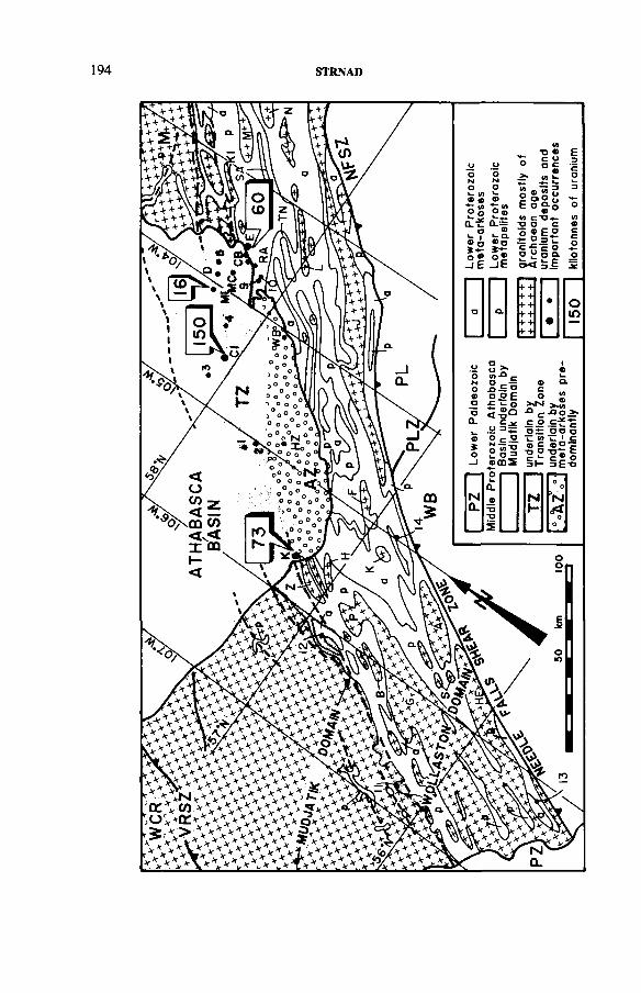
194 STRNAD
IAEA-TC-571/12
196 STRNAD
2.2.2. Two principal types o f thrust
The prevailing thrusting in the deeper portions of a supracrustal synform originates at some structural weakness within the sub-Aphebian basement. It follows mechanical anisotropies both at the Archaean-Aphebian contact and within the softness of the graphite proper, and propagates up-dip by traversing the Aphebian strata. Steeper and flatter segments are formed at competent and less competent lithologies, respectively. These types of thrust or reverse fault (steeper than the foliation) carry older above younger rocks and at many uranium deposits this has generated a repetition of strata.
Subordinate in number are thrusts which are flatter than the foliation. These are rooted at some subsynformal irregularity and carry younger strata above the older ones. Though it is difficult to visualize such a thrust and the allochthonity of the subjacent granites at the Collins Bay deposits as was proposed earlier [2], this type may be present elsewhere. This would explain in part stratigraphically higher lithologies being located close to the Archaean.
2.2.3. Thrusting as a triggering mechanism for hydrothermal cells
Thrusting with a sizeable vertical component brings warmer rocks from their original deeper position above the cooler rocks. If the upthrusted block consists of mostly impermeable older basement rocks and the downfaulted block of porous, fluid rich younger rocks, the newly formed local thermal gradient would be retained more effectively. (Sub-basement and thrust induced traps are also known among the prominent oil bearing structures.) Hydrothermal cells of such a thrust triggered origin have been proposed as a mechanism for some uranium deposits [3-5]. In environments where graphitic lithologies are suddenly piled up by thrusting, another type of localized enhancement of the thermal gradient would be formed owing to the relatively higher thermal conductivity [4, 6 , 7] of the graphite within the sequence of less foliated rocks. Deeper and possibly more uniform sources of heat would be transmitted higher up by the above structural arrangements and become more differentiated and more localized.
2.3. Younger tectonics
Following the compressional regime, the pre-Athabasca uplift and the post- Athabasca erosional reloading generated a complex system of localized perisurface tectonics.
During the pre-Athabasca uplift large portions of the earlier compressed competent rock of the basement (especially the Archaean antiforms) released part of their stored elastic energy and formed a system of normal faults. These would have been generated down-dip in front of the descending erosional level and would gener
IAEA-TC-571/12 197
ally have surrounded those Archaean domes and other competent lithologies (Aphebian quartzites) which were affected by erosion.
This process would have been subdued during the sedimentation of the Athabasca Group sandstones but would once again have been partly restored by the sudden erosional unloading of the Athabasca plate. In addition, by unloading of the lithostatic pressure, the compressed elastic Aphebian would rebound and tend to flow partially above the borders of Archaean domes and minor thrusting would occur.
Undoubtedly such young tectonic overprints of older thrusting prepared the basement for the emplacement of younger and principal (post-Athabascan) phases of the ore formation.
3. REGIONAL CONTROL
Included here are those parameters which are either observable or easier to compare within the domainal and interdomainal context.
3.1. Selected basement lithologies
Earlier studies have ascribed some higher U values to Aphebian protores. Subsequent work has shown that the graphitic gneisses, metapelites and granites do not carry enhanced uranium either regionally or at the deposits [4, 5, 8 ], This is consistent with the regionally low yield of the airborne radiometric survey in the Cree Lake Zone, which includes these lithologies.
Only rarely were higher U values reported in localities distant from deposits [9, 10]. More recently, at one U deposit, granites yielded a uniquely high value of 40 ppm U. Nickel remains comparatively low in most environments tested. Of interest, in the author’s view, are some higher values of arsenic (up to 39 ppm) and their association with mafic gneisses of the Earl River Complex in the Cluff Lake area (Carswell Structure) [11],
Undoubtedly all the above values are residual post-metamorphic yields. By judging the present face values in such terranes we come no closer to unravelling the pre-metamorphic yields. More importantly, because of the generally low values found, the common simplistic favouritism for enhanced regional values would not lead to the proposal of this domain as being of prime interest, and obviously this would be wrong.
3.2. Strike orientation of Aphebian synforms, graphite rich lithologies, anddeposits
The idea underlying some structural studies is that the most visible and therefore prevailing trend has the greatest chance of being the most favourable.
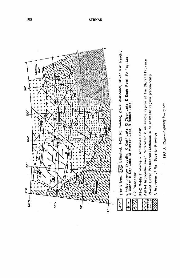
198 STRNAD
IAEA-TC-571/12 199
One study, which made use of advanced technologies, interpreted the Landsat image of the eastern rim of the Athabasca Basin. The authors [12] concluded that by having the predominating NE trending linear zones in focus, the prospective area would be reduced to 20-30%. This preference for the NE trends would have led to the discovery of only 10% of the uranium, because principal deposits such as Cigar Lake, Key Lake and Midwest Lake fall far away from outlined priority areas.
Another paper [13] noted that most of the uranium deposits appear associated with faults trending within the NE quadrant. While this is true, of more practical value are only two specific directions: the ENE to E-W (70-90° E), which hosts seven deposits and 84% of the uranium, and the NNE (0-30° E), containing two deposits and 8 % of the uranium. Almost half of the quadrant (30-70° E) centring around the predominant NE trend of the Wollaston Domain includes more than half of the deposits (1 2 ); however, these contain only 8 % of the total metal.
In this respect, the deposits, and more specifically the bulk of the uranium of the principal belt, are confined to exclusive rather than to prevailing structures. The above observation also implies that there is a different regional control for sizeable deposits while the array of local parameters is quite similar for both the large and the small deposits.
3.3. Transdomainal latitudinal gravity lows and other E-W oriented structures
One of the most intriguing problems is the nature of the basement beneath and between simatized terranes to the west of the Nelson Front (NF) (Fig. 1). Green et al. [14] have stated that the rupturing at the NF affected the Superior Craton. Because the eastern side (Superior Province) displays an E-W trending pattern, the terrane to the west might contain traces of this orientation as well. While Lewry et al. [15] emphasized no continuation of the Superior style terrane to the west of the NF, Fig. 3 suggests the presence of E-W structures across the entire western Churchill Province. This study does not propose that all E-W structures here are of Archaean age. They simply appear to be of Archaean orientation and may be rather inherited from such a basement or modified by Hudsonian overprinting. Neither does this study claim a specific nature for such gravity lows. Tectonism and/or lighter granitoids could be assumed, both of which in their ultimate provenance indicate zones of weakness, and this is considered of significance in the metallogenic analysis.
While focusing on the traditional trends (NE, NW and N-S) commonly reported from the region (including the OECD/NEA-IAEA Wollaston test area), only rarely has the early attention [4] centred on E-W trends. The Cigar Lake deposit discovery [16] has definitely accentuated this particular structural element.
Of specific interest are four latitudinal gravity lows bordering or transecting the Athabasca Basin (Fig. 3). Invariably the largest deposits are located in the vicinity of such zones, with Cigar Lake being located right on one of these (No. 7,
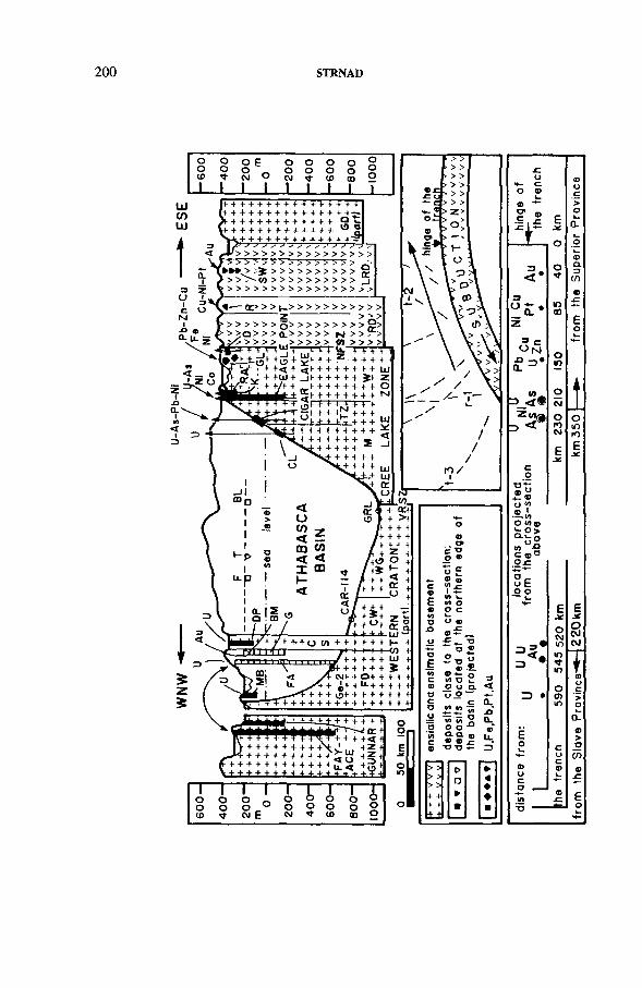
200 STRNAD
IAEA-TC-571/12
202 STRNAD
Fig. 3). It should also be noted that in this context the Carswell Structure is in a position analogous to a principal cluster of deposits at the SE rim of the basin.
East-west striking magnetic low trends were found at most deposits and the NE orientation occurred at 80% of the deposits. Since the NE trend is ubiquitous the E-W orientation is stressed as an important factor.
3.4. Principal NE oriented structures
Figure 2 emphasizes both the NE oriented linearity of the Wollaston Domain and its parallelism with a major structure, the Needle Falls Shear Zone (NFSZ).
In the area not covered by the Athabasca Basin the width of the Wollaston Domain is almost constant, about 62 km. Within this belt, granites (mostly Archaean) occupy 40% of the surface and are organized into five sub-belts. The average spacing of their axial portions is only 13 km, which in comparison with some terranes in the Baltic Svekocarelides [17, 18] suggests an extreme compression and elongation of granitic antiforms. This in turn underlines the expressive NE trending parallelism of the internal parts and also of the NW extremity of the Wollaston Domain with the NFSZ.
The above pattern helps in interpreting the basement covered by the Athabasca Basin. The distance of 62 km from the NFSZ seems to define the predominant boundary position of the Mudjatik Domain, i.e. including the Transition Zone. The Eagle Point, Collins Bay, Rabbit Lake and Key Lake deposits straddle this boundary (Figs 2 and 4). An approximately 21 km wide belt extending further to the NW is proposed here as a Transition Zone. Its predominant NW boundary is 83 km from the NFSZ and hosts other major deposits (Cigar Lake and Midwest Lake). The area between, i.e. the Transition Zone itself (in other words the main extent of the principal uranium belt), hosts the majority of the deposits, although much less of the uranium total. The term Transition Zone is not new, and it is retained here because it expresses well the mixture of both the Wollaston linear grain and the Mudjatik Domain’s broad polygonal elements. Both boundaries are complex and their locations in the regional context are therefore considered as predominant ones and remain marked as a line (Fig. 2). On a local scale, the NW contact is especially disturbed by embayments of the Wollaston Domain style or vice versa. The first variant of irregularity extends the U potential further into the Mudjatik Domain and deeper beneath the Athabasca Basin, as proved by the Close Lake discovery.
4. PLATE TECTONICS CONSIDERATIONS
Following the interpretation of Camfield and Gough [19] of specific structural boundaries in the western Churchill Province, the plate tectonics model in the region has been further developed by Ray [20] and recently variously applied by Green et
IAEA-TC-571/12 203
al. [14, 21], Thomas and Gibb [22], Lewry et al. [15] and Klasner and King [23]. Currently, at least some components of the plates’ interaction are accepted in the explanation of the development of this structural province.
Since certain parts of this region include world class uranium deposits and relatively abundant other metals in other deposits, it is tempting to present uranium accumulation in a wider metallogenetic context and together with other mineralization within the plate tectonics framework.
4.1. Timing of deposition of uranium hosting (meta-)sediments
The key parameter is the mafic Molson dykes system. The dykes occur at the NF, approximately 350 km east of the principal uranium bearing belt. Their age is 2.38 + 0.27 Ga [24]. Several important examples from modern terranes have led Bott [25] to suggest that the earliest volcanics may have preceded doming and that this, in turn, developed prior to rifting and sedimentation. Applied to our case, this would mean that the dykes are older than the ocean floor spreading of Green et al. [14, 21]. In this context the Needle Falls Group could be of Early Aphebian age (2.4-2.3 Ga). Its temporal counterpart would be the upper (clastic) portion of the Huronian Supergroup. Not without interest, the Needle Falls Group also includes a smaller stratabound U deposit [26].
The deposition of the younger Wollaston Group sediments, which host the roots of most U deposits, probably covers the time of the reversal from divergent to convergent plate motion. In chronostratigraphic terms its age could be placed roughly in Upper Early Aphebian or Lower Middle Aphebian.
4.2. Location and style of brittle deformation associated with plate tectonicsregimes
The plate movement carries a specific set of brittle tectonics affecting the rigid upper part of the crust. Depending on the particular phase within the cycle, subparallel faults separating individual blocks are formed. These could be both tensional and compressional and may traverse either the Archaean basement only or the entire basement, i.e. together with its Aphebian cover. In our analysis of potential tectonics we are concerned with the situation in the cratonic foreland to the west of the NFSZ, which includes all uranium mineralization.
Four potential sets of faults could be outlined according to the progressive stages of the cycle:
(1) Normal faults associated with rifting
The rift related faulting would affect the Archaean prior to the deposition of the Wollaston Group. In our domain of interest, such normal faults would dip to the east as required by a rift symmetry [27],
204 STRNAD
(2) Normal faults associated with continental separation and sea floor spreading
By the moving apart of continental blocks, a considerable subsidence of the crust occurs and this leads to the formation of a continental slope. This principal flexure together with other contemporaneous faults would have transected both the Archaean and the Needle Falls Group. Their location would control the configuration of the depositional environment for the future Wollaston Group lithologies. Among these, the key lithology controlling the U deposits, the carbonaceous shales of the Wollaston Group, would be deposited on the shelf margin in a similar way to that proposed by Boucot and Gray [28] for their possible equivalent, the Palaeozoic black shales. Younger phases of spreading could generate faults during the sedimentation of the Wollaston Group. Both the earlier and the later faults of this provenance would dip to the east and their frequency would increase closer to the NFSZ.
(3) Faults associated with subduction of the oceanic plate
The change from spreading to subduction leads generally to a compressional regime in the overriding part of the crust. This is, however, not a unique regime generated during the subduction. In Dewey’s [29] variants, the combination of differing velocities and configurations of individual segments in the upper plate may lead to both compressional and tensional regimes. The thrusts in the frontal sliver and in the trailing block would dip to the west and east, respectively. Tensional faults generally develop when either the whole overriding plate or its trailing part advances at a lower rate than the retreat of the subduction hinge. If the vectors of the motion are oblique, strike slip faults are formed. Most of the tectonics evolved during the subduction would affect unmetamorphosed sediments, and among the thrusts the decollement type may separate the Aphebian envelope from its Archaean basement.
(4) Thrusts associated with final stage of convergent regime
During the final stage, syn- and post-metamorphic thrusts would modify the folded belt. Their dip, similar to that of phase 3, depends on the configuration and relative motion of individual blocks of the overriding plate. In the domain of principal interest (60-90 km west of the NFSZ) the general direction of the late folds is towards the northwest with thrust planes dipping to the southeast. The observed stacking of the graphitic units evolved during this specific phase.
4.3. Distribution of mineral deposits within the context of plate tectonics
In the study region, the first correlation of polymetallic and gold mineralization with ‘island arc development’ was proposed as early as 1979 by Coombe [26]. The
IAEA-TC-571/12 205
present study extends more to the west and includes uranium deposits. Especially in this part of the presentation the author emphasizes the alignment of individual deposits within distinct belts which parallel structural boundaries.
4.3.1. Relation to extremities o f the structural province
Within the western Churchill Province (Fig. 1), two principal U bearing belts (the SEP of the Athabasca Basin and the composite of the Beaverlodge district and Carswell Structure, BC) occur relatively deep within the interior of the Western Craton. The first belt, SEP, is located 350 km west of the Superior Province, and the second, subordinate belt, BC, 220 km east of another Archaean terrane — the Slave Province.
Both distances are well within a range of structural influence observed above the modern subducted plates. A 700 km distance and the fairly distant (600 km) Virgin River Shear Zone were postulated [22] as the limit and the most distant structure, respectively, within the influence of the NF. Such a broad area easily accommodates the 350 km distant SEP and some mineralization to the east of it.
The second and smaller U belt, BC, is rather attributable to the influence of the Thelon Front (TF) (Fig. 1), which in turn has been suggested [22] as an analogue of the NF. The albitite associated uraninite from the Nonacho Basin (Northwest Territories), the earliest post-Archaean granitoids in the Carswell Structure [30] and some other intrusions from the Western Craton are grossly Blezardian (pre- Hudsonian) in Stockwell’s terminology [31]. This seems to support the assumption [22] that the Slave-Churchill collision preceded the Superior-Churchill collision. However, the Hearne dykes at the TF are younger [32] than the Molson dykes at the NF (2.1 and 2.4 Ga, respectively). The Hearne dykes likely indicate a rejuvenated rifting, otherwise the plate tectonics at this boundary (TF) would follow rather than precede the development at the NF. Such an overprint is consistent with Hoffman’s view [32] of the Athapuscow rift (2.1 Ga) as being developed along the TF, an “ older boundary separating the Slave Province from the Taltson block” .
4.3.2. Relation to structural boundaries within the province
The cross-section in Fig. 4 displays the situation in the overriding crust above the oceanic plate subduction. The trench, in accordance with previous studies, is tentatively located between the Glennie and La Ronge domains.
Nearest to the trench occurs Au, generally hosted by the volcanic dominated La Ronge Domain. This is followed by Cu-Ni-Pt occurrences in the eastern part of the equally ensimatic Rottenstone Domain. The nearest ensialic block, the Wollaston Domain, and its boundary with the Mudjatik Domain host stratabound base metal deposits and beyond these the most important U bearing belt (Eagle Point). This
206 STRNAD
sequence of U following the fringes of base metal belts is similar to the sequence known above the modern Nazca plate subduction [33-35],
The distances of U belts from the present Nazca trench are considerable, 600-800 km and 600 km for the Mexican and Bolivian segments, respectively. The distance in our case is 220 km for the principal (Eagle Point) U belt as measured from the trench and 350 km from the Superior Province. On the other hand, important Mesozoic U deposits of south central China [36] would be located some 350 km from the synchronous (Yanshanian) subduction outlined by Yang [37], This is a distance comparable with the study terrane.
The dip of the subduction is usually claimed as a major factor influencing the situation in the overriding plate. However, the Nazca plate in the Bolivian sector and the Pacific plate in the southern China segment dip almost similarly, 30° and 20°, respectively, while the U belts’ distances differ substantially. Other factors [38, 39] such as the geometries of plate interaction and the type and age of subducted material may participate in the above complexities. In addition, considerable differences in the zoning could be expected by contrasting the erosional levels in the ancient and modern orogens. At the moment, a further detailed analysis of the reasons for the particular distances observed in our terrane would be obviously speculative.
5. GLOBAL TECTONICS
On various occasions uranium mineralization has been attributed to several narrower time spans. In addition, the initial uranium mineralization has been found [40] as several synchronous events visiting distal and structurally differing parts of the Canadian Shield. This aspect, however, has been left unextended in the present study.
This section focuses on the global (latitudinal) position and the orientation of important structures at the time of their generation.
Palaeomagnetic data have been used occasionally for the interpretation of modern deposits [41-43]. Only rarely are palaeomagnetic data available for the Precambrian areas. Among such terranes the Canadian Shield has provided, through the work of Irving [44, 45] and others, a unique opportunity to look at the Athabasca Basin uranium province in this context. On the basis of older data [44] the present author stressed [46] that the ancient E-W geometry dominated all key events in the study region during the Precambrian, ending with the emplacement of the post- Athabasca Mackenzie dykes.
Updated data [45] allow the following interpretation. Though only tentative positions are now proposed [45] for the oldest rocks, the orientation of the present day E-W trending structures for which a Kenoran age would be assumed was also grossly E-W, and the Wollaston Domain was located within some 20-30° of the Equator.
IAEA-TC-571/12 207
At the beginning of the Hudsonian Orogeny (1.9-1.85 Ga) the Wollaston Domain, which is presently oriented NE, was moving at low velocities (2 cm/a) at middle latitudes (45°) and attained an average NE direction. Between 1.85 and1.8 Ga it acquired the highest velocity (minimum of 9 cm/a) and by maintaining this same orientation it crossed the Equator. Approximately 1.8 Ga ago the Laurentian Shield (including our local domains) began behaving as a single entity [45]. Between1.8 and 1.75 Ga, a mild rotation occurred during movement away from the Equator. At 1.7 Ga by further rotation the domain was elongated E-W and positioned at 25° beyond the Equator.
Older data [44] for the early post-Athabascan period (1.5-1.2 Ga), now considered [45] as more complex, would suggest that the two earliest pulses of Mackenzie diabase (recently striking NW and contemporaneous with the oldest pitchblende phases of the post-Athabasca mineralization) were oriented E-W and occupied a peri-equatorial position [46].
Though still of a complex nature, the palaeomagnetic data record shorter periods of extreme speed of lithospheric plate motions, major rotations and tendencies for E-W orientation at the Equator during the principal geological changes in the development of the basement of this uranium province.
Because comparable data from other uranium provinces are missing it is nearly impossible to declare how specific these positions and orientations are. However, it is worth noting the remarkably parallel observation of Irving et al. [42], who have found that the giant oil deposits (which mimic oil shales in their distribution) are also ultimately controlled by “ large embayments opened astride the equator in the timetable of plate tectonics” . If further progress in the interpretation of palaeomagnetic data confirms the above tentative positions, it would seem to be of some value that such parameters dominated at least one major Precambrian metallogenic province and its remarkable concentration of uranium in particular.
6. CONCLUSION
This study has extended several components of the original Key Lake exploration model into a broader set of basement derived parameters suggested here as being of either a concurrent or controlling nature.
Among the regional controls the following were outlined: (i) the most productive strike of Aphebian synforms, graphites and associated deposits is approximately E-W and thus substantially differs from the predominant NE grain of the hosting structural domain; (ii) prominent accumulations of uranium in the province are located in the vicinity of regional E-W striking gravity lows; and (iii) the largest uranium deposits within the principal belt also occur in two NE oriented zones parallel to the major tectonic structure of the domain.
208 STRNAD
Plate tectonic elements indicate that the two principal uranium belts of the province are located in the overriding sialic plate, at distances (as measured from the subduction trench) variously comparable with some modern orogens, and at tectonic features broadly conditioned by a subduction.
Global tectonics based on palaeomagnetic data indicate that the study area attained rather specific motion velocities, low latitudinal positions and mostly E-W orientations at the times of major structural reconstruction prior to the deposition of the Athabasca Basin.
In conclusion, this study suggests the following:
(a) The recognition of well developed local parameters is necessary, but they alone are insufficient to produce an important accumulation of uranium if left without an overprinting by a regional control.
(b) The lateral location (geographic) of the deposits is controlled by the basement; their type and vertical position are conditioned and modified by the sedimentary cover.
ACKNOWLEDGEMENTS
Thanks are due to the managements of Uranerz Exploration and Mining Limited, Saskatoon, and Uranerzbergbau GmbH, Bonn, for the interest and support provided in this study.
REFERENCES
[1] GRACIE, A.J., “ Mineral exploration in northern Saskatchewan” , Sask. Geol. Surv., Summary of Investigations (1986) 164-167.
[2] SIBBALD, T.I.I., “ Geology of the crystalline basement, NEA/IAEA Athabasca Test Area” , Uranium Exploration in Athabasca Basin, Saskatchewan, Canada (CAMERON, E.M ., Ed.), Geol. Surv. Can., Pap. 82-11 (1983) 1-14.
[3] LOBATO, L.M ., FORMAN, J.M .A., FUZIKAWA, K., FYFE, W.S., KERRICH, R., Uranium enrichment in Archean basement: Lagoa Real, Brazil, Rev. Bras. Geocienc. 12 1-3 (1982) 484-486.
[4] STRNAD, J., “ The evolution of Lower Proterozoic epigenetic stratabound uranium deposits (a concept)” , Metallogenesis of Uranium (Proc. 26th Int. Geol. Congr. Paris, 1980), Geoinstitute, Belgrade (1981) 99-162.
[5] STRNAD, J., “ Contribution to the problems on pre-Variscan precursors of uranium vein deposits in the Bohemian M assif’, Vein Type Uranium Deposits, IAEA- TECDOC-361, IAEA, Vienna (1986) 319-333.
IAEA-TC-571/12 209
[6] TILSLEY, J.E., “ Continental weathering and development of palaeosurface-related uranium deposits: Some genetic considerations” , Uranium in the Pine Creek Geosyn- cline (Proc. Symp. Sydney, 1979), IAEA, Vienna (1980) 721-732.
[7] HOEVE, J., QUIRT, D., Mineralization and host rock alteration in relation to clay mineral diagenesis and evolution of the Middle Proterozoic, Athabasca Basin, Northern Saskatchewan, Canada, Econ. Geol. (in press).
[8] STRNAD, J., Orientative lithogeochemistry of the Archean and Aphebian basement in the Key Lake uranium deposit region, J. Geochem. Explor. 19 (1983) 13.
[9] MUNDAY, R.J., “ Investigation of radiometric anomalies within Crown Reserves” , Sask. Geol. Surv., Summary of Investigations (1975) 114-119.
[10] LEWRY, J.F ., SIBBALD, T.I.I., “ A review of pre-Athabasca basement geology in Northern Saskatchewan” , Uranium Exploration Techniques (PARSLOW, G.R., Ed.), Sask. Geol. Soc., Spec. Publ. No. 4 (1979) 19-58.
[11] BELL, K., CACCIOTTI, A.D., SCHNESSL. J.H ., “ Petrography and geochemistry of the Earl River Complex, Carswell Structure” , The Carswell Structure Uranium Deposits (LAINE, R., et al., Eds), Geol. Assoc. Can., Spec. Pap. 29 (1985) 69-80.
[12] OFFIELD, T.W ., RAINES, G.L., MILLER, G.B., RAMAEKERS, P., “ Unconformity-vein uranium setting in Saskatchewan, Canada: Preliminary Landsat study” , Proc. Symp. on Uranium Exploration Methods, Paris, 1982, OECD/NEA, Paris (1982) 25-49.
[13] FOGWILL, W .D., “ Canadian and Saskatchewan uranium deposits: Compilation, metallogeny, models, exploration” , Geology of Uranium Deposits (SIBBALD, T.I.I., PETRUK, W., Eds), Can. Inst. Min. Metall., Spec. Vol. 32 (1985) 3-19.
[14] GREEN, A.G., WEBER, W., HAJNAL, Z., Evolution of Proterozoic terrains beneath the Williston Basin, Geology 13 (1985) 624-628.
[15] LEWRY, J.F ., SIBBALD, T.I.I., SCHLEDEWITZ, D.C.P., “ Variation in character of Archean rocks in the western Churchill province and its significance” , Evolution of Archean Supracrustal Sequences (AYERES, L.D., et al., Eds), Geol. Assoc. Can., Spec. Pap. 28 (1985) 239-261.
[16] FOUQUES, J.P., FOWLER, M., KNIPPING, H.D., SCHIMANN, K., Le gisement d ’uranium de Cigar Lake: decouverte et charactdristiques g6n6rales, CIM Bull. 79 886 (1986) 70-82.
[17] COBBOLD, P.R., FERGUSON, C.C., Description and origin of spatial periodicity in tectonic structures, J. Struct. Geol. 1 1 (1979) 93-97.
[18] SORVACHEV, K.K., Plastic deformations in granite-gneiss structures, Trans. Acad. Sci. USSR 319 (1978) 124 (in Russian).
[19] CAMFIELD, P.A., GOUGH, D.I., A possible Proterozoic plate boundary in North America, Can. J. Earth Sci. 14 (1977) 1229-1238.
[20] RAY, G.E., “ Geology of the Parker Lake-Nelson Lake vicinity” , Sask. Geol. Surv. Rep. 190 (1980) 39.
[21] GREEN, A.G., HAJNAL, Z., WEBER, W., An evolutionary model of the western Churchill province and western margin of the Superior province in Canada and north- central United States, Tectonophysics 116 (1985) 281-322.
210 STRNAD
[22] THOMAS, M.D., GIBB, R.A., “ Proterozoic plate subduction and collision: Process for reactivation of Archean crust in the Churchill province” , Evolution of Archean Supracrustal Sequences (AYERES, L.D., et al., Eds), Geol. Assoc. Can., Spec. Pap. 28 (1985) 263-279.
[23] KLASNER, J.S., KING, E.R., Precambrian basement geology of North and South Dakota, Can. J. Earth Sci. 23 (1986) 1083-1102.
[24] CUMMING, G.L., ECSTRAND, O.R., PEREDEY, W.V., Geochronological interpretation of Pb isotope ratios in nickel sulphides of the Thompson belt, Manitoba, Can. J. Earth Sci. 19 (1982) 2306-2324.
[25] BOTT, M .H.P., “ Crustal doming and the mechanism of continental rifting” , Mechanism of Graben Formation (ILLIES, J.H., Ed.), Elsevier, Amsterdam (1981) 1-8.
[26] COOMBE, W., “ Mineral deposits and regional metallogeny, southeastern Shield” , Sask. Geol. Surv., Summary of Investigations (1979) 120-133.
[27] ARTYUSHKOV, E.V., “ Mechanism of continental riftogenesis” , Mechanism of Graben Formation (ILLIES, J.H., Ed.), Elsevier, Amsterdam (1981) 9-14.
[28] BOUCOT, A.J., GRAY, J., “ A Cambro-Permian Pangaeic model consistent with lithofacies and biogeographic data” , The Continental Crust and its Mineral Deposits (STRANGWAY, D.W., Ed.), Geol. Assoc. Can., Spec. Pap. 20 (1980) 390-419.
[29] DEWEY, J.F., “ Episodicity, sequence, and style at convergent plate boundaries” , ibid., pp. 553-573.
[30] BELL, K., “ Geochronology of the Carswell area, Northern Saskatchewan” , The Carswell Structure Uranium Deposits (LAINE, R., et al., Eds), Geol. Assoc. Can., Spec. Pap. 29 (1985) 33-46.
[31] STOCKWELL, C.H., “ Proposals for time classification and correlation of Precambrian rocks, part 1” , Geol. Surv. Can., Pap. 80-19 (1982) 135.
[32] HOFFMAN, P.F., “ Wopmay Orogen: A Wilson cycle of early Proterozoic age in the northwest of the Canadian Shield” , The Continental Crust and its Mineral Deposits (STRANGWAY, D.W ., Ed.), Geol. Assoc. Can., Spec. Pap. 20 (1980) 523-552.
[33] CLARK, K.F., FOSTER, C.T., DAMON, P.E., Cenozoic mineral deposits and subduction-related magmatic arcs in Mexico, Geol. Soc. Am., Bull. 93 (1982) 533-544.
[34] PARK, C .F., Relationships between subduction zones and ore deposits in the Pacific Basin, Global Tectonics and Metallogeny 2 3-4 (1984) 187-194.
[35] TERRONES, A. J .L ., Overview of the mineral resources potential of Latin America in relation to global tectonics and metallogenic controls, Global Tectonics and Metallogeny 2 3-4 (1984) 213-256.
[36] CHEN, Zhaobo, FANG, Xiheng, “ Main characteristics and genesis of Phanerozoic vein-type uranium deposits” , Uranium Deposits in Volcanic Rocks (Proc. Tech. Comm. Mtg El Paso, 1984), IAEA, Vienna (1985) 69-82.
[37] YANG, C., “ On specialization of granitoids of different genetic types in south China” , The Crust (WU, L., et al., Eds), Theophrastus, Athens (1985) 365-387.
[38] DICKINSON, W.R., “ Plate tectonics and key petrologic associations” , The Continental Crust and its Mineral Deposits (STRANGWAY, D.W., Ed.), Geol. Assoc. Can., Spec. Pap. 20 (1980) 341-360.
IAEA-TC-571/12 211
[39] UYEDA, S., NISHIWAKI, C., “ Stress field, metallogenesis and mode of subduction” , ibid., pp. 323-339.
[40] STRNAD, J., “ Temporal position of the initial epigenic uranium mineralization within the Precambrian of the Canadian Shield” , paper presented at IUGS Int. Symp. on Metallogeny of the Early Precambrian, Changchun, China, 1985.
[41] KUTINA, J., Lithospheric plate motions — One of the factors controlling distribution of ore deposits in some mineral belts, Miner. Deposita 11 (1976) 83-92.
[42] IRVING, E., NORTH, F.K., COUILLARD, R., “ Oil, climate, and tectonics” , Mineral Deposits, Continental Drift and Plate Tectonics (WRIGHT, J.B., Ed.), Benchmark Papers in Geology No. 44 (1977) 353-374.
[43] RONA, P., “ Global plate motion and mineral resources” , The Continental Crust and its Mineral Deposits (STRANGWAY, D.W., Ed.), Geol. Assoc. Can., Spec. Pap. 20 (1980) 607-622.
[44] IRVING, E., Paleopoles and paleolatitudes of North America and speculations about displaced terrains, Can. J. Earth Sci. 16 (1979) 669-694.
[45] IRVING, E., McGLYN, J.C., “ On the coherence, rotation and paleolatitude of Laurentia in the Proterozoic” , Precambrian Plate Tectonics (KRONER, A., Ed.), Elsevier, Amsterdam (1981) 561-598.
[46] STRNAD, J., “ Regional paleo-structural setting of uranium deposits in the Athabasca Basin, Canada” , Abstracts of Conf. on IAGOD/CTOD Parameters Controlling the Distribution of Large Ore Deposits, Santa Fe, 1985, p. 7.

IAEA-TC-571/13
URANIUM MINERALIZATION AT THE FELCH PROSPECT, UPPER PENINSULA, MICHIGAN, UNITED STATES OF AMERICA(Summary)
J. HUNTERBritish Civil Uranium Procurement Organisation,Central Electricity Generating Board,London, United Kingdom
The Central Electricity Generating Board (CEGB) has participated in a uranium exploration joint venture operated by Minatome Corporation in the Upper Peninsula of Michigan for several years. The targets sought were intragranitic and of the unconformity vein type and, initially, of the palaeoplacer type in units equivalent to the Huronian at Elliot Lake. Field crews were encouraged by the widespread scatter of radioactive occurrences throughout the district. Detailed exploration, however, was frustrated by a lack of distinctive geophysical signals from the mineralization, by the lack of outcrop and by the thick glacio-fluvial cover which is geochemically inert yet electrically conductive as regards the application of electromagnetic exploration techniques. Complex land ownership and severe environmental restrictions added to the physical problems.
The regional geological setting of the project area is complex. It is located near to the southern margin of the Superior Craton, straddling the boundary between the early Archaean gneiss terrain in Minnesota and Wisconsin and the later Archaean granite-greenstone terrain in Ontario. The crystalline basement is unconformably overlain by a varying succession of Lower Proterozoic supracrustal rocks which changes in lithological and tectonic style across the boundary. To the north of the boundary the supracrustal rocks are thin and relatively undeformed shelf facies sediments and volcanics which were partly deposited in local platforms and troughs. South of the boundary they consist of a thick succession of ‘eugeosynclinal’ basinal sediments and volcanics which was deformed and metamorphosed during the 2.0-1.7 Ga Penokean Orogeny, an event broadly equivalent to the Hudsonian of Canada. The boundary has been interpreted as an Archaean suture or hinge zone which was reactivated during the Penokean but there is disagreement over the prior existence of an oceanic basin or simply an intracratonic rift. The remnants of the Baraboo sequence, an extensive cover of continental quartzites and rhyolites comparable in setting to the Athabasca Group of Saskatchewan, partly overlie the stabilized and eroded orogen. Tectonic activity was renewed around 1.1 Ga with the development of the Keeweenawan midcontinental rift system across the suture, a feature which obscures the Lower Proterozoic rocks in the area and complicates
213
214 HUNTER
geological correlations across Lake Superior. The Grenville Front lies to the east of the Upper Peninsula of Michigan and the Grenville Orogeny did not affect the region. Finally, the long period of exposure and deep weathering during the Late Precambrian was brought to an end by a cover of transgressive Cambrian marine sediments spreading from the adjacent Michigan Basin.
Small vein and disseminated occurrences of primary uranium minerals have been found in the Upper Peninsula in a variety of rock types and settings but principally in gneisses and amphibolites of the Archaean basement ‘cores’ and in black shales and oxidized iron formations of the Lower Proterozoic supracrustals. Where examined, the small radioactive sections of the basal quartz pebble conglomerate horizon known as the East Branch Arkose were found to be due to detrital thorium minerals. Exploration activity for the past three seasons (1984-1986) has been devoted to the Felch Prospect, located 24 km (15 miles) north of Iron Mountain on the narrow Gene Lake Gneiss complex. The gneiss complex is generally considered to be an Archaean inlier surrounded by Lower Proterozoic metasediments and metavolcanics but the contacts are not exposed and the exact relationship between the rock units remains unresolved. The dominant lithologies are pink potassic feld- spathic gneiss units containing irregular, lenticular and steeply plunging amphibolite bodies. No definite textural or petrological evidence has been found which will classify the gneiss as being either an orthogneiss or a paragneiss. Indistinct zones within the gneiss units have been brecciated and rehealed, resulting in a rock best described as ‘granofels’. Other zones along rehealed fractures have been enriched in K- and occasionally Na-feldspar and grade into microbrecciated quartz syenite and syenite. Several outcrops of syenite are vuggy and ‘episyenitic’ in appearance and contain accessory calcite, chlorite and haematite with occasional accompanying uranium mineralization. Whole rock Rb-Sr age dates from samples of syenite fall within the range of the Penokean orogenic event. Linear networks of small veinlets of pitchblende were located in outcrop in several of the amphibolite bodies. They appear to be largely confined to the north side of a major east-west fault. The largest surface radioactive occurrences were drilled but the deepest mineralized intersection was at 85 m and the strike lengths are similarly limited. The pitchblende is always associated with calcite, haematite and minor chlorite gangue and weak haematization of the host rock. Minor elements such as silver, arsenic, boron, vanadium and lead were found in geochemically anomalous quantities with the mineralization.
The locations of the main radioactive outcrops at Felch are close, in a lateral sense, to recently discovered small, unconformable outliers of Cambrian Munising sandstone. Similarly, the outcrops are also presumed to be close, in a vertical sense, to the level of the pre-existing Cambrian unconformity. Uranium-lead and chemical lead age dates from the pitchblende span the Lower Palaeozoic period (700-300 Ma) and the mineral paragenesis is consistent with a low temperature origin. This evidence all suggests that the origin of the uranium at Felch is unrelated to the alteration facies seen in the Gene Lake Gneiss and, together with many other uraniferous
IAEA-TC-571/13 215
occurrences in the Upper Peninsula, is of supergene origin and related to the Cambrian unconformity. The source of the uranium is thought to be simply the Archaean granitic gneiss basement cores in the district, some of which have slightly elevated background values. Localization of the uranium at Felch is thought to be due to favourable structural sites created by shearing of the brittle amphibolite units. No further investigation of this mineralization is planned for the near future.
The results of the exploration activity briefly described here were all produced by the joint venture operator, Minatome Corporation. In particular, the contribution made to the project by S. Menicucci and G. Lehman deserves specific reference and is gratefully acknowledged.
DISCUSSION
P.R. SIMPSON: Around greenstone granite terrain one often sees major megalineament shearing structures which may be very tight but are often mineralized. Would you care to comment on that?
J. HUNTER: There are some major shear zones in the district but most of the mineralization is confined to very small scale fractures. In some cases there is no displacement, in others you can measure it in centimetres. None of the major shear zones have been found to be mineralized.
P.R. SIMPSON: What about possibilities for gold mineralization in that area?J. HUNTER: We have done multielement analyses on core and trench samples
from our area. The mineralization is essentially monometallic with very little else accompanying the uranium.
R.K. BALLHORN: In your description of the geological environment, I was more reminded of the general geological environment of the Michelin deposit in Labrador (acidic gneisses, basic dykes, metasomatic phenomena, shear zones and fracture related pitchblende) than of environments of unconformity type deposits. We never thought of it as supergene.
B.O. HOLDAR: What is the genetic connection between the pitchblende and the iron ores?
J. HUNTER: Using our supergene model, uranium was mobilized during the weathering prior to the Cambrian transgression. Also at that time the iron formations were oxidized and enriched to mineable ore. In the iron mines where you find pitchblende it is generally found near the contact between oxidized iron ore and graphitic black shales. It seems rather like a very crude roll front or redox front model. The iron ore was produced by in situ oxidation of the original chemical sediment, and uranium was carried down with oxidizing solutions and precipitated at the redox interface.

IAEA-TC-571/14
URANIUM POTENTIAL OF THE BUSHVELD COMPLEX, SOUTH AFRICA: A STUDY OF THE ACID IGNEOUS ROCKS
P.R. SIMPSON*, D. TWIST**,R.N. CROCKETT*, J. HURDLEY*
* British Geological Survey,London, United Kingdom
**Bushveld Institute,University of Pretoria,Pretoria, South Africa
Abstract
URANIUM POTENTIAL OF THE BUSHVELD COMPLEX, SOUTH AFRICA: A STUDY OF THE ACID IGNEOUS ROCKS.
Studies are in progress to evaluate the U potential of the Bushveld Complex in South Africa. The complex, which has principal dimensions of 480 km E-W by 240 km N-S, is of great economic importance owing to the associated major deposits of V, Cr, Pt group elements, Ni, Sn and F and resources of Fe and Ti. The study described in the paper considers the acid igneous rocks such as the Rooiberg Group Felsite and the Rashoop Granophyre but is mainly concerned with the Lebowa Granite Suite, an extensive suite of granitic rocks for which radiometric ages have been obtained that range from 2052 ± 48 to 1290 ± 30 Ma, and its association with U mineralizing systems related to the complex. Although the Lebowa Granite is compositionally variable, the more evolved Sn-U-F rich varieties apparently provide a primary control for ore forming processes and are associated with an extensive range of monomineralic and polymetallic mineral deposits, including U, formed by the action of F- and B-rich solutions, which pervasively metasomatized and mineralized the granite following its emplacement. Surface radiometric anomalies, which are also approximately coincident with ore deposits of Sn and F, are bounded by ENE and WNW trending quasi- orthogonal rectilinear sets of paired major lineaments in the regional tectonic and structural fabric. These lineaments dissect the Bushveld Complex in zones that are up to 30 km wide and can be traced in the basement for up to 650 km. Country rocks such as the dolomites and shales of the Transvaal Sequence probably provided then, as now, important high level aquifers for these granite related mineralizing events and were also locally hydrothermally altered and mineralized by the granites. The Waterberg Group, for which the age of formation is poorly constrained but which may be approximately coeval with the Bushveld Complex, contains uraniferous sedimentary mineralization derived from the Bushveld Complex on the basal unconformity. Because the Waterberg is also affected by later folding and faulting, it too may have potential for hydrothermal U mineralization at or near the Lebowa Granite- Waterberg unconformity, especially in zones of tectonic disturbance. The Karoo Sequence, which is renowned for its highly uraniferous coals which await the development of appropriate technology for their treatment, blankets much of the complex and is a potential host for
217
218 SIMPSON et al.
reworked Bushveld age U mineralization. Further possibilities for U mineralization exist in the potential for a major hidden ore body of Olympic Dam type, possibly located at the margin of graben and horst structures and presently undetected owing to the lack of any associated surface expression in younger cover.
1. INTRODUCTION
Discoveries of major U deposits associated with Proterozoic alkalic granites, such as the Olympic Dam Cu-Au-U deposit at Roxby Downs, Australia [1], and Athabasca type U deposits [2, 3], which are possibly associated with a major buried batholith, have stimulated further investigation of the possibility of major and as yet undetected U ore reserves associated with other comparable geological environments, of which the Bushveld Complex is a good example. The study described here is therefore principally concerned with an assessment of the possible role of Bushveld acid igneous rocks and especially the Lebowa Granite Suite in U mineralizing systems associated with the complex and their potential for the formation of as yet undiscovered U ore deposits.
2. GENERAL GEOLOGY AND STRUCTURE OF THEBUSHVELD COMPLEX
The complex (Fig. 1) and associated igneous rocks are considered to reflect five major and closely related tectonomagmatic events, two of which predate the main intrusive phase [6, 7]. The initial event involved the intrusion of a multitude of dolerite sills, which were emplaced at various levels in the Pretoria Group of the Transvaal Sequence [8]. Sill intrusion was probably roughly contemporaneous with volcanism, which ranged in composition from basaltic and andesitic (Dullstroom Basalt Formation) to rhyolitic (Rooiberg Group), at approximately 2150 Ma [5], The Rooiberg Group Felsite, which locally exceeds 5 km in thickness and which may represent an erupted volume of more than 300 000 km3, is dominated by rhyolitic to dacitic rheoignimbrites that were emplaced as very hot particulate flows which were sintered into siliceous liquids before flowing and brecciating like lavas [9]. There are also minor associated sedimentary rock types. The Rooiberg episode essentially terminated the volcanic activity in the Transvaal Basin [10]. Both the Rooiberg Group Felsite and the Dullstroom Basalt Formation are thus spatially and temporally related to the complex, with the Dullstroom Formation in places forming its ‘floor’ and the Rooiberg Group its ‘roof’.
IAEA-TC-571/14 219
The main intrusive phases of the complex consist of three distinct groups of rocks, which have yielded the following radiometric ages: the Rustenburg Layered Suite: 2050 ± 12 Ma [11, 12]; the Rashoop Granophyre Suite: 2050 ± 30 Ma [13]; and the Lebowa Granite Suite with several events in the range 2052-1290 Ma. The Lebowa Granite Suite has yielded U-Pb ages of 2052 + 48 Ma for the Bushveld Granite [14], 1920 ± 40 Ma for the Nebo Granite, 1670 ± 70 Ma for the Makhutso Granite, 1400 ± 190 for the Klipkloof Granite [13] and 1290 + 30 Ma for the Sekhukhune Granite [15], The Klipkloof Granite has, however, also yielded a Rb-Sr mineral isochron of 2042 + 34 Ma [16]. However, gradational contacts have been observed between the Nebo and Klipkloof granites and it is likely (with the possible exception of the Makhutso Granite) that all these granites are coeval. The intrusive activity was probably therefore largely completed by 2000 ± 70 Ma, with many of the younger ages which have been obtained by various workers attributed to resetting of the isotopic systems in younger, post-intrusive mineralizing events [17].
The Lebowa Granite Suite is generally coarse grained and pink to grey in colour: it consists of sodic plagioclase, perthite, quartz, biotite and hornblende, with a wide variety of accessories including muscovite, zircon, magnetite, ilmenite and allanite. The Rashoop Granophyre is a variably textured rock ranging from coarse grained through medium to fine grained with extremely well developed granophyric textures. It is composed of K-feldspar, quartz and plagioclase as well as hornblende and minor biotite with accessory amounts of iron oxide and zircon [13, 18],
The Bushveld Complex is underlain by shales and dolomites of the Transvaal Sequence, which forms a ‘floor’ to and updomed inliers within the complex such as the ‘Rooiberg Fragment’ [19]; it is overlain by the Rooiberg Felsite and by younger sedimentary sequences such as the Waterberg Group, for which the age of formation is poorly constrained but which may be approximately coeval with the Bushveld Complex, and the Karoo Sequence. The latter is noted for uraniferous coals where it is underlain by the complex.
Studies of eastern Botswana and the northern Transvaal [20] suggest that Waterberg Group sedimentation took place mainly in a series of graben-like rectilinear basins whose margins were defined by a number of sets of persistent major faults or boundary zones of structural disturbance, some of which were initiated in pre-Waterberg time and may have been active while the Waterberg rocks themselves were being laid down. The corresponding uplifted areas adjacent to these basins show only minor and thinly developed examples of Waterberg sedimentation. The basement on which the Waterberg is deposited in northwest Transvaal is not known. However, in the major subrectangular basin centred on Vaalwater, the Lebowa Granite Suite outcrops to the north, south, east and west of this basin. It would therefore seem to be a reasonable assumption that some portion of the Waterberg is underlain by the Lebowa Granite and Rustenburg Layered Suite (i.e. Bushveld mafic rocks) interspersed with Archaean granite gneiss terrain. Transvaal Sequence deposits are probably restricted to the southern part of the basin.
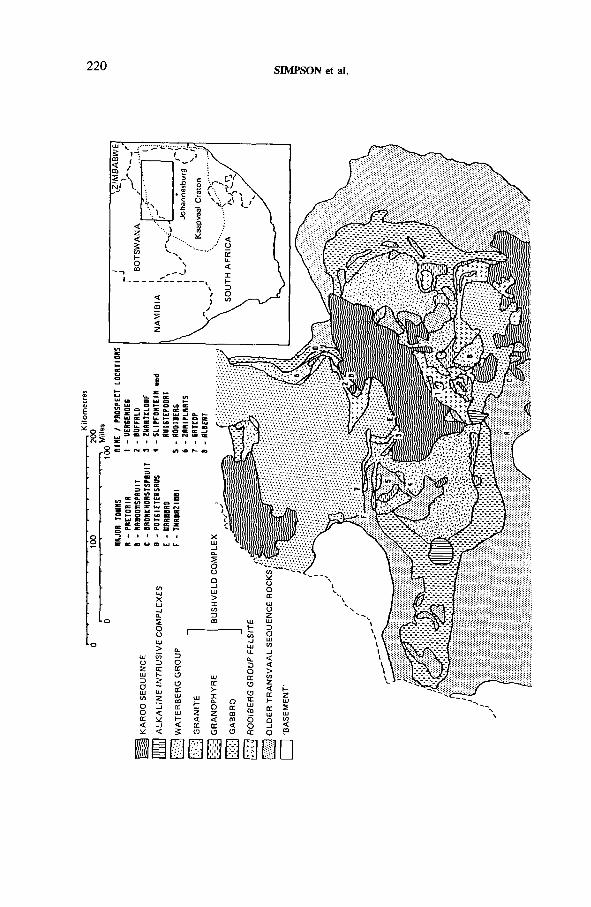
220 SIMPSON et al.
IAEA-TC-571/14
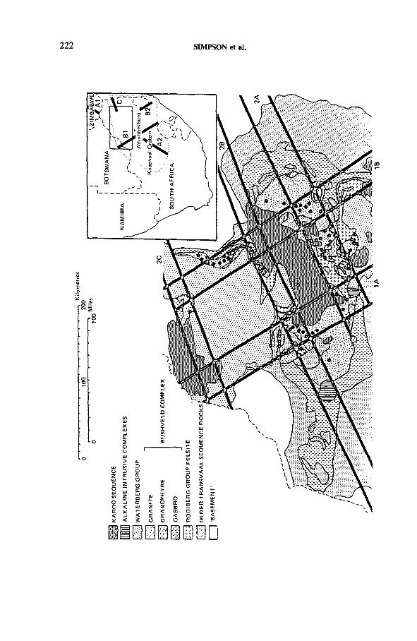
Kil
om
etr
es
222 SIMPSON et al.
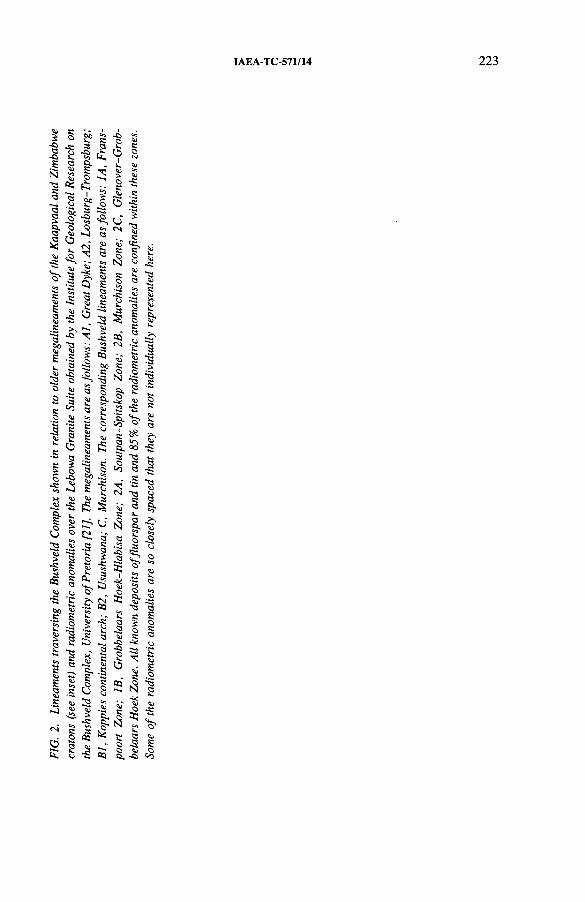
IAEA-TC-571/14
224 SIMPSON et al.
A series of saturated and undersaturated alkaline complexes also intrude the Bushveld Complex (Fig. 1). These appear to be related to major lineament directions, which dissect the complex and surrounding basement and which are thought to control mineralizing processes in the region; these lineaments are superimposed on the geological map of the complex in Fig. 2.
3. METHOD
Since there are no known ore deposits of uranium in the Bushveld Complex at the present time, the approach adopted here in the assessment of the uranium potential of the Bushveld Complex is threefold: firstly, to determine whether any of the Bushveld acid igneous rocks were anomalously uraniferous when emplaced (Section 4); secondly, to determine whether such uranium as was present has been remobilized (dispersed and/or concentrated), and if so when and by what processes (Sections 5 and 6); and thirdly, to evaluate the resultant potential for uranium mineralization in the region and to indicate possibilities for further research (Sections 7 and 8).
4. URANIUM CONTENT OF BUSHVELD ACID IGNEOUS ROCKS
Direct measurement of the U content of Bushveld acid igneous rocks commenced with the work of Watterson [22], who provided high quality data from instrumental neutron activation analysis for selected samples of the Lebowa Granite Suite. MacCaskie [23] has provided some additional multielement analyses of the Nebo Granite from Sekhukhuneland, a local variety of the Lebowa Granite Suite. These data sets together provide a total of 32 high quality multielement analyses (including U) on which to base whole rock distribution studies for U. More recently Coetzee [24] has provided more than 700 U analyses from the granites around Zaaiplaats Tin Mine. Furthermore Walraven et al. [25] recently published data obtained by Kleeman [26] from a new geochemical campaign to study the Lebowa Granite and presented results of U-Th scattergrams for about 120 samples of the Nebo and Klipkloof granites, with values ranging from about 2 up to 30 ppm U and with Th/U ratios varying from greater than 7.7 to less than 2. The lower ratios predominate in samples with the greatest U content, which are therefore probably also mineralized.
In order to study U occurrence and distribution it was considered necessary to have the widest possible multielement geochemical coverage and it was therefore necessary to utilize all the available published data normalized to primordial mantle. Consequently additional multielement analyses, which lack U data but which cover
IAEA-TC-571/14 225
a broader spectrum of Bushveld acid igneous rocks, were also considered and used where relevant [23, 27, 28], These data are presented in Figs 3 and 4.
In previous studies [21] the close geochemical affinities of Bushveld acid igneous rocks such as the Rooiberg Group Felsite, Rashoop Granophyre and Lebowa Granite Suite were demonstrated. It was shown that these rocks may be considered as a continuous evolutionary geochemical sequence with geochemical characteristics ranging from calc-alkalic to alkalic; the most evolved, most alkalic and generally most uraniferous being represented by younger and locally developed members of the Lebowa Granite Suite such as the Rooiberg Granite (most evolved), Lease Granite, Bobbejaankop Granite and Foothills Granite, all of which are closely associated with Sn mineralization. This relationship is demonstrated in Fig. 3, where the Lebowa Granite samples are arbitrarily classified into three groups on the basis of their increasing geochemical evolution.
Hence it was shown by these earlier studies that U concentration and enrichment by primary magmatic processes in the Bushveld acid igneous rocks is quite extensive and is best developed in the more evolved members of the Lebowa Granite Suite. These varieties are also notably enriched in Sn and are closely associated with, for example, the Sn mineralization at Zaaiplaats Tin Mine. Although alkalic varieties of Lebowa Granite probably provide an important primary control on the occurrence of U mineralization, their regional distribution throughout the Bushveld Complex has not been mapped in detail. Over much of the complex their occurrence may also be obscured by younger formations such as the Waterberg and Karoo. Nevertheless the preliminary results indicate that further regional information on the occurrence and distribution of these metalliferous and uraniferous variants would be useful since their occurrence is now known to be closely associated with mineralization of F, Sn and possibly U.
The geochemical results are also compatible with von Gruenewaldt’s genetic model for the Rashoop Granophyre [32], in which the latter is regarded as the product of complete remelting of the Rooiberg Group Felsite when it was intruded by the Rustenburg Layered Suite, a concept that is supported by heat flow modelling [33, 34]. Indeed the Rashoop Granophyre studied here coincides with the Rooiberg Group Felsite and Lebowa Granite Suite Group 1 (Fig. 3) in composition so far as to be geochemically indistinguishable from either of them.
5. URANIUM REMOBILIZATION
Indirect evidence for U remobilization from the Lebowa Granite comes from three main sources: firstly, examination of the geochemical data presented in the form of primordial mantle normalized trace element diagrams (Section 5.1 and Fig. 4); secondly, isotopic data, especially Rb-Sr and U-Pb data (Section 5.2); and thirdly, metallogenetic and field evidence (Section 5.3).
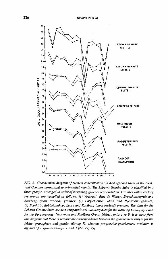
226 SIMPSON et al.
LEBOWA GRANITE SU ITE 3
LEBOWA GRANITE SUITE 2
LEBOWA GRANITE SUITE I
ROOIBERG FELSITE
NYLSTROOMFELSITE
POTGIETERSRUSFELSITE
RASHOOPGRANOPHYRE
FIG. 3. Geochemical diagram o f element concentrations in acid igneous rocks in the Bushveld Complex normalized to primordial mantle. The Lebowa Granite Suite is classified into three groups, arranged in order o f increasing geochemical evolution. Granites within each o f the groups are compiled as follows: (I ) Veekraal, Rust de Winter, Bronkhorstspruit and Rooiberg (least evolved) granites; (2) Potgietersrus, Main and Nylstroom granites; (3) Foothills, Bobbejaankop, Lease and Rooiberg (most evolved) granites. The data for the Lebowa Granite Suite are also compared with summary data for the Rashoop Granophyre and for the Potgietersrus, Nylstroom and Rooiberg Group felsites, units I to 9. It is clear from this diagram that there is remarkable correspondence between the geochemical ranges for the felsite, granophyre and granite (Group 1), whereas progressive geochemical evolution is apparent fo r granite Groups 2 and 3 [22, 27, 29].
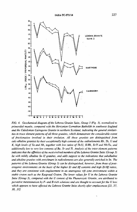
IAEA-TC-571/14 227
LEBOWA GRANITE SUITE 3
DARTMOOR
C A IR N G O R M
FIG. 4. Geochemical diagram o f the Lebowa Granite Suite, Group 3 (Fig. 3), normalized to primordial mantle, compared with the Hercynian Comubian Batholith in southwest England and the Caledonian Cairngorm Granite in northern Scotland, indicating the general similarities in trace element patterns o f all three granites, which demonstrate the considerable extent o f fractionation involved in their evolution. All these granites are distinguished from calc-alkaline granites by their exceptionally high contents o f the radioelements Rb, Th, U and K, high levels o f Ta and Nb, together with low ratios o f Th/U, K/Rb, Sr/Y and Nb/Ta, and additionally low to very low contents ofBa, Sr and Ti. Analysis o f the trace element patterns indicates that the affinities o f the most evolved members o f the Lebowa Granite Suite (Group 3) lie with mildly alkaline Sn-U granites, and adds support to the indications that subalkaline and alkaline granites with enrichment in radioelements are also generally enriched in Sn. The patterns o f the Lebowa Granite (Group 3) can be distinguished, however, from those o f post- orogenic environments on the basis o f the higher Zr and H f contents and high Zr/H f ratios, and they are consistent with emplacement in an anorogenic rift zone environment within a stable craton such as the Kaapvaal Craton. The lower values for U in the Lebowa Granite Suite (Group 3), compared with the U content o f the Phanerozoic Granite, are attributed to pervasive metasomatism by F- and B-rich solutions and are thought to account for the U loss which appears to have affected the Lebowa Granite Suite shortly after emplacement [22, 27, 30, 31].
228 SIMPSON et al.
5.1. Uranium geochemical data
The normalized geochemical data for the Bushveld granites show, in some cases, especially where the granites are associated with mineralization, that whole rock U values are significantly low relative to Th when compared with similarly metalliferous (but non-mineralized) granites in the Phanerozoic, such as the Cairngorm Granite in the Scottish Caledonides and unmineralized portions of the Dartmoor Granite in southwest England (Fig. 4). This implies that many of the rocks selected for analysis as typical Bushveld granites in the earlier studies [22] may have undergone a cryptic but pervasive U loss event. From consideration of the summary account of U-Pb zircon ages available from several workers it appears most likely that this depletion probably occurred during the very early emplacement history of the granites. Later events are characterized by loss of radiogenic Pb from metamict high U zircons [25].
5.2. Isotopic data
There is now abundant evidence for disturbance of the isotopic systems in the Rooiberg Group Felsite, Rashoop Granophyre and Lebowa Granite. In the case of Rb-Sr systematics Walraven et al. [25] reported lowering of the apparent ages of these rocks units with retention of isochron behaviour of the data points. They attributed this result to the widespread removal of radiogenic Sr from K-feldspar (but not coexisting biotite) during hydrothermal activity. These phenomena are attributed to extensive hydrothermal activity after granite emplacement.
5.3. Metallogenetic and Held evidence
Several ore deposits that contain F, Sn, Ag and U in varying amounts and which are genetically related to the Lebowa Granite Suite were recently visited by two of the authors (P.R.S. and D.T.) in order to obtain a better understanding of metallogenetic processes, especially U ore formation involved with the granite. In view of the general relevance that this may have to the study and understanding of U ore forming processes, a brief account of these field studies follows.
5.3 .1 . Fluorite deposits
5.3.1.1. Vergenoeg Mine
Crocker [35] has recently described the spectacular volcanogenic fluorite- haematite deposits at Vergenoeg in the Rust de Winter area, 70 km NNE of Pretoria on the farms Kromdraai 209 JR and Naauwpoort 208 JR. They occur within a circular breccia pipe vent which cuts the uppermost Rooiberg Group rhyolites and
IAEA-TC-571/14 229
which is located on the rim of a basin, possibly a caldera, filled with Waterberg and Karoo sediments which opens northeastwards onto the Springbok Flats. Pyroclastic rocks which are believed to have erupted through the breccia pipe are located on the western margin of this structure. The mineralization in the vent is thought to be derived from underlying Lebowa Granite (though not seen in the vicinity of the mine) shortly after its emplacement.
The close association between high uranium (up to 100 ppm) and tin (about 100 ppm) values and disseminated fluorite in a late to post-magmatic volcanogenic setting has genetic significance for the understanding of the uranium mineralization potential of the Bushveld Complex.
The Vergenoeg deposit has several important similarities to the Olympic Dam deposits at Roxby Downs, Australia [1], and is therefore of great relevance to studies concerned with the development of a model for the U potential of the Bushveld Complex. In particular, the Olympic Dam and Vergenoeg deposits bear comparison because both are of Proterozoic age, were emplaced in a continental setting, are associated with alkalic granites and contain haematized breccias with anomalous Cu, U and F contents.
Preliminary multielement geochemical data are reported for two vertical cores through the Vergenoeg deposit, one of which penetrated to a depth of 612 m within the mineralized pipe. Crocker particularly noted the similar and high values for U, Th and Y, which also positively correlate with fluorite abundance data in scatter- grams for the analysed cores. Indeed he concluded that these elements are either included within the fluorite or concentrated in rare earth minerals such as xenotime, monazite, fluorcerite and bastnaesite which are known to form inclusions in the fluorite. The latter explanation would seem to be more likely, however, since a major intersection in one of the cores consists of a massive crackle breccia plug comprising siderite and magnetite veins cementing fluorite; values for U, Th, Y and other elements such as Sn and Nb fall below the detection limit in this rock.
5.3.1.2. Buffalo Fluorite Mine
The mine is located about 5 km NW of Naboomspruit. Several ore bodies appear to reflect structural control on both the regional and the local scale, being emplaced in the roof contact zone of a highly evolved member of the Lebowa Granite Suite (Bobbejaankop type granite). Second order shear structures, related to a major regional fault system, are very common and one of the ore bodies is centred on one of these, which is thought to have provided access for a mineralizing hydrothermal system.
High purity fluorite mineralization occurs as veins in roof pendants of rocks (locally termed ‘leptite’) described by Watson and Snyman [36] as Rooiberg Group Felsite, which have been incorporated within the roof zone of a coarse grained Lebowa Granite intrusive. Fluorite mineralization occurs in the leptite as a
230 SIMPSON et al.
stockwork and along subparallel partings thought to represent possible primary flow banding structures. The mineralization is thus hydrothermal and post-magmatic, the leptite providing a favourable host environment for hydrothermal/pneumatolytic mineralization.
5.3.1.3. Zwartkloof Fluorite Mine
Fluorite mineralization is to be found in the centre of an open pit mine (now defunct) 10 km WNW of Warmbad [37]. The mine is structurally controlled and is hosted by strongly haematized Rooiberg Group Felsite, which lies on the southern flank of the WNW trending Zwartkloof Anticline, which is cored by Lebowa Granite. Mineralization consists of massive deep purple, white and yellow fluorite, which is associated with siderite, magnetite and minor sulphides. The assemblage is anomalously radioactive, probably related to U concentrated in siderite in the fluorite matrix. The mineralization has similarities to that of the Vergenoeg Mine and is believed by Crocker [35] to represent a deeper portion of a comparable hydrothermal vent system.
5.3.1.4. Slipfontein and Ruigtepoort prospects
This area has been described by Crocker [38], There is abundant field evidence in many areas within the Lebowa Granite that metasomatic activity was so extensive that major U loss probably occurred in several places. This is represented, for example, by zones of extensive and pervasive hydrothermal activity, especially in the region between Slipfontein and Ruigtepoort as indicated on the Mineral Map of the Republic of South Africa [39]. In this area the biotite is extensively chloritized and there is abundant disseminated fluorite. Chloritization of F rich biotite presumably resulted in release of F, which then further reacted with the rock to release more F. Since U is often contained in accessory minerals in biotite, this would tend also to remobilize U for transport in U-F complexes. This area is readily identified on false colour infrared photographs as a relatively featureless zone of metasomatized granite (I.T. Crocker, personal communication).
5.3 .2 . Tin deposits
5.3.2.1. Rooiberg tin field
The Rooiberg tin field is situated 64 km west of Warmbad within the upper Pretoria Group sedimentary rocks of the Transvaal Sequence [19]. Cassiterite is the only economic mineral recovered from the four mines in the area and the mineralization is attributed to the intrusion of Lebowa Granite, which outcrops along the margin of the Rooiberg Fragment on which the mines are located and which is
IAEA-TC-571/14 231
thought possibly to represent an updomed segment of the ‘floor’ to the Bushveld Complex [19]. All mineralization is believed to be structurally controlled.
5.3.2.2. Zaaiplaats Tin Mine
The extensive mine workings are located 25 km NW of Potgietersrus within highly evolved members of the Lebowa Granite Suite (Bobbejaankop and Lease granites) which have recently been remapped as a deep seated pluton in preference to a sheeted complex as previously indicated [24, 40]. From an examination of the maps prepared by the mine geologists it is apparent that the mineralization is both geochemically and structurally controlled. Tin mineralization occurs in three main forms: (1) high grade pipe-like bodies in the Lease and Bobbejaankop granites,(2) low grade disseminated mineralization in the Bobbejaankop Granite, and(3) greisenized, usually low grade bodies in the Lease Granite. The pipe-like bodies, ranging from a few centimetres to 15 m in diameter, have no surface expression, and from our study of the mine geologists’ maps of the mineral workings it could be clearly demonstrated that they tend to occur at the intersections of conjugate fissure systems in the granite. All types of mineralization are hydrothermal in nature.
From our own direct observations in the mine it can be demonstrated that the earliest metasomatic phase of the mineralization is B rich, depositing tourmaline in fractures and fissures. Boron rich veins have been subsequently remobilized and cut by later cassiterite mineralization associated with W, Cu, F and REE.
5.3 .3 . Uranium mineralization
5.3.3.1. Gatkop prospect
The Waterberg sediments in the vicinity of Gatkop, 40 km east of Thabazimbi, are overthrust by Lebowa Granite in the south and contain U mineralization. The generally flat lying Waterberg sediments are tilted vertically immediately to the north of the overthrust. It is thus possible to examine at the surface the U distribution at the southwestern margin of the Waterberg Basin. The presence of coarse granite clasts up to half a metre in diameter in an arkosic matrix tends to confirm the basal nature of these sediments, probably near to the original basin margin. It also indicates that this portion of the basin postdated emplacement of at least some members of the Lebowa Granite Suite.
Uranium mineralization is confined to discrete horizons with up to 70 m lateral extent which are notable for the presence of coarse granitic cobbles 5-10 cm in diameter. This relationship was noted and confirmed by total gamma radiometric readings on other outcrops nearby. Radiometric readings in the overthrust were, however, at normal background levels, indicating no further introduction of U at this stage.
232 SIMPSON et al.
It was concluded that the U mineralization is essentially detrital in origin since it was apparently controlled by the observed primary sedimentological features presumably involving deposition of small, higher density Ti- and U-bearing detrital accessory minerals in the interstices between coarse basal cobbles. These were probably diagenetically altered and replaced to form pitchblende and brannerite, owing to remobilization of U within the conglomeratic units which were more porous, prior to lithification. In one notable case a small pitchblende nodule developed as a result of this secondary enrichment. The ultimate source of the U in this locality is therefore thought to be derived from weathering, transportation, deposition and diagenetic alteration of uraniferous mineralization from locations to the south in the Lebowa Granite Suite.
5.3.3.2. Albert Silver Mine
This defunct mine, which lies to the north of Bronkhorstspruit on Roodepoortje 250 JR, occurs in an E-W trending vein system cutting the Verena Granite (also known as Klipkloof Granite). The U mineralization consists primarily of pitchblende with minor metazeunerite [41]. Primary chalcopyrite and specularite are replaced by covellite, bornite, chalcocite and limonite in a zone of supergene enrichment. The polymetallic mineralization is probably hydrothermal.
6. LINEAMENTS RELATED TO THE BUSHVELD COMPLEX
The Bushveld Complex is located at the approximate intersection of three major crustal lineaments which dissect the basement; all were in existence long before the emplacement of the complex (Fig. 2). A close genetic link has been inferred [42] between the formation of the Transvaal Basin, the elliptical arrangement of feeders, and magma generation centred on the Great Dyke lineament. Furthermore the role of these lineaments in controlling subsequent U ore forming processes related to Bushveld acid igneous rocks has recently been recognized by Simpson and Hurdley [21]. A brief account of directions thought to be relevant to magma emplacement and subsequent ore forming processes is given below.
The Murchison direction (ENE-WSW) corresponds to the alignment of the tectonic and structural fabric in the linear Archaean greenstone remnant which constitutes the Murchison mountain range in the northeastern part of the Transvaal. This is also parallel to the Glenover-Grobbelaars Hoek Zone to the north, and this coincides with the zone of transcurrent faulting defining the southern flank of the Limpopo Domain. The Murchison direction is also parallel to the Soutspan-Spitskop Alkaline Complex Zone to the south.
The Franspoort direction (NNW-SSE) corresponds to the ‘Franspoort line’ of alkalic intrusions occurring within the southern part of the complex to the northeast
IAEA-TC-571/14 233
of Pretoria. This direction is also related to the axial zone of the Koppies continental arch to the south which bisects the Kaapvaal Craton. The Franspoort direction also parallels the Grobbelaars Hoek-Hlabisa Zone; this is coaxial with the Usushwana Complex in Swaziland, which was emplaced in a major NNW trending graben and has a probable age of 2750-3000 Ma [43].
The Great Dyke (NNE-SSW) is a major linear mafic and ultramafic dyke complex 2460 Ma in age and about 500 km in length; it occurs several hundreds of kilometres north of the Bushveld Complex in Zimbabwe. This direction is coaxial with the Losberg and Trompsburg complexes to the south of the Bushveld Complex with approximate ages of 1881 + 282 Ma and 1372 + 142 Ma, respectively.
The lineaments briefly outlined above, especially the Murchison and Franspoort directions (Fig. 2), can be related to all the known fluorite and Sn mineralization in the Bushveld Complex [21], They also coincide with 85% of the 115 radiometric anomalies in the complex evident on an unpublished geological map prepared by the Institute for Geological Research on the Bushveld Complex, University of Pretoria (Fig. 2). Thus, although U increases owing to magmatic fractionation in the more evolved and later members of the Lebowa Granite Suite, ore bodies of U are only likely to occur in tectonically unstable regions within the complex related to major crustal fractures. These are aligned along several ENE and WNW quasi-orthogonal rectilinear sets of major lineaments in the regional tectonic and structural fabric which dissect the Bushveld Complex and which are up to 30 km in width and can be traced in the basement for up to 650 km [20, 21],
7. SIGNATURES OF THE URANIUM ORE FORMING PROCESSES
The Lebowa Granite thus provides a primary control for possible U ore forming processes and is also associated with an extensive range of mineral deposits formed by the action of F- and B-rich solutions, which pervasively metasomatized and mineralized the granites shortly after emplacement. Consideration of the available data suggests that a five part signature, discussed below, is required for the formation of U ore bodies in the Bushveld Complex: (1) source granite enriched in U, F and large ion lithophile (LIL) elements with (2) a high post-emplacement heat production due to radioactive decay of 40K, 232Th, 235U and 238U, which supplements the heat from other sources and promotes the development of postemplacement geothermal mineralizing systems; (3) a tectonically unstable region with major fracture zones and related tensional splays within the granites and country rocks; (4) suitable trap environments in the granites or their country rocks or roof rocks (Waterberg Group); (5) a source of B from Transvaal series sediments and of mineralizing fluids from aquifers in the aureole, since the granites must be essentially dry if they are not to freeze adiabatically as they rise through the crust.
234 SIMPSON et al.
The potential for as yet undiscovered U ore deposits of hydrothermal origin associated with the Bushveld Complex is apparently fairly high since the granites seem to have lost major amounts of U in post-emplacement hydrothermal events. In addition, U has been reconcentrated by uplift, erosion and sedimentation to form younger deposits such as those at the base of the Waterberg Group and in the Karoo Sequence (Fig. 1), which is noted for the occurrence of extensive and highly uraniferous coal deposits. However, uplift and erosion would also appear to have destroyed and dispersed high level U deposits within the Lebowa Granite Suite and the possibility of finding deposits at the present time at the current level of erosion in therefore low.
Further evaluation of the potential for hydrothermal vein type ore bodies at depth should be concentrated in those areas where the five factors discussed in this study and shown to be important for the formation of U deposits occur in conjunction. Perhaps the most interesting possibility therefore for further investigation is the Waterberg Group-Lebowa Granite unconformity, especially in zones which are tectonically disturbed along megalineament directions, because any deposits formed at this level would probably have been preserved from subsequent uplift and erosion.
ACKNOWLEDGEMENT
This paper is published by permission of the Director, British Geological Survey (Natural Environment Research Council).
REFERENCES
[1] ROBERTS, D.E., HUDSON, G.R.T., The Olympic Dam Copper-Uranium-Gold Deposit, Roxby Downs, South Australia, Econ. Geol. 78 (1983) 799-822.
[2] DARNLEY, A.G., “ The relationship between uranium distribution and some major crustal features in Canada” , Uranium 81 (SIMPSON, P.R., PLANT, J.A., BROWN, G.C., Eds), Mineralogical Soc., London (1982) 53-64.
[3] CAMERON, E.M ., BECK, L.S., DARNLEY, A.G., “ A review of exploration research and development projects in the NEA/IAEA Athabasca Basin test area, Saskatchewan” , Uranium Exploration Methods, OECD/NEA, Paris (1982) 909-932.
[4] Geological Map of the Republic of South Africa and the Kingdoms of Lesotho and Swaziland (Scale 1:1 000 000), Geological Survey, Pretoria (1970).
[5] SOUTH AFRICAN COMMITTEE FOR STRATIGRAPHY, Stratigraphy of South Africa. Part 1 (KENT, L.E., Comp.), Lithostratigraphy of the Republic of South Africa, South West Africa, Namibia, and the Republics of Bophuthatswana, Transkei and Venda, Handbook of the Geological Survey of South Africa, Vol. 8, Geological Survey, Pretoria (1980).
8. CONCLUSIONS
IAEA-TC-571/14 235
[6] WILLEMSE, J . , The geology of the Bushveld Igneous Complex, the largest depository of magmatic ore deposits in the world, Econ. Geol. 64 (1969) 1-22.
[7] VON GRUENEWALDT, G., SHARPE, M.R., HATTON, C.J., The Bushveld Complex: Introduction and review, Econ. Geol. 80 (1985) 803-812.
[8] SHARPE, M.R., Petrography, classification and chronology of mafic sill intrusions beneath the eastern Bushveld Complex, S. Afr. Geol. Surv. Bull. 77 (1984) 40 pp.
[9] TWIST, D., HARMER, R.E., Voluminous rheoignimbrites in the Bushveld Complex: Field relations and petrogenesis, Abstracts Vol. of Int. Volcanological Congr. Hamilton, New Zealand, 1986.
[10] TWIST, D., FRENCH, B.M., Voluminous acid volcanism in the Bushveld Complex: A review of the Rooiberg Felsite, Bull. Volcanol. 46 3 (1983) 225-242.
[11] HAMILTON, P.J., Sr isotope and trace element studies of the Great Dyke and Bushveld mafic phase and their relation to Early Proterozoic magma genesis in southern Africa, J. Petrol. 18 1 (1977) 24-52.
[12] CAHEN, L., et al., The Geochronology and Evolution of Africa, Clarendon Press, Oxford (1984) 512 pp.
[13] COERTZE, F.J., BURGER, A.J., WALRAVEN, F., MARLOW, A.G., MacCASKIE, D.R., Field relations and age determinations in the Bushveld Complex, Trans. Geol. Soc. S. Afr. 81 (1978) 1-11.
[14] WALRAVEN, F., BURGER, A.J., ALLSOPP, H.L., Summary of age determinations carried out during the period April 1979 to March 1980, Ann. Geol. Surv. 15 (1981) 89-94.
[15] BURGER, A .J., WALRAVEN, F ., Summary of age determinations carried out during the period April 1976 to March 1977, Ann. Geol. Surv. 12 (1979) 199-207.
[16] WALRAVEN, F., The Klipkloof granite of the Bushveld Complex — An example of systematic radiogenic Sr loss, Ann. Geol. Surv. 15 (1981) 49-53.
[17] TWIST, D., HARMER, R.E., Geochemistry of contrasting siliceous magmatic suites in the Bushveld Complex: Genetic aspects and implications for tectonic discrimination diagrams, J. Volcanol. Geotherm. Res. (in press).
[18] WALRAVEN, F., Textural, Geochemical and Genetical Aspects of the Granophyric Rocks of the Bushveld Complex, PhD Thesis, Univ. of Witwatersrand, Johannesburg (1982) 251 pp.
[19] STEAR, W.M., The stratabound tin-deposits and structure of the Rooiberg Fragment,Trans. Geol. Soc. S. Afr. 80 (1976) 67-78.
[20] CROCKETT, R.N., JONES, M .T., Some aspects of the geology of the WaterbergSystem in Eastern Botswana, Trans. Geol. Soc. S. Afr. 78 (1975) 1-10.
[21] SIMPSON, P.R., HURDLEY, J., “ Relationship between metalliferous mineralisation and Sn-U-F-rich mildly alkaline high heat production (HHP) granites in the Bushveld Complex, South Africa” , High Heat Production (HHP) Granites, Hydrothermal Circulation and Ore Genesis, Instn of Mining and Metallurgy, London (1985) 365-382.
[22] WATTERSON, J.I.W ., Instrumental Neutron Activation Analysis and the Classification of Granites from the Bushveld Igneous Complex, PhD Thesis, Univ. of Witwatersrand, Johannesburg (1975) 360 pp.
[23] MacCASKIE, D.R., Differentiation of the Nebo Granite (Main Bushveld Granite),South Africa, PhD Thesis, Univ. of Oregon, Eugene (1983) 145 pp.
236 SIMPSON et al.
[24] COETZEE, J., A Geochemical and Petrographic Investigation of the Low-Grade Tin Deposits in the Bobbejaankop Granite at the Zaaiplaats Tin Mine, MSc Thesis, Univ. of Pretoria (1984) 119 pp.
[25] WALRAVEN, F., KLEEMAN, G.J., ALLSOPP, H.L., “ Disturbance of trace- element and isotope systems and its bearing on mineralisation in acid rocks of the Bushveld Complex, South Africa” , High Heat Production (HHP) Granites, Hydrothermal Circulation and Ore Genesis, Instn of Mining and Metallurgy, London (1985) 393-408.
[26] KLEEMAN, G .I., The Geochemistry and Petrology of the Roof Rocks of the Bushveld Complex East of Groblersdal, MSc Thesis, Univ. of Pretoria (1985) 175 pp.
[27] FOURIE, P.J., Die Geochemie van granitiese gesteentes van die Bosveldstollingkom- pleks, DSc Thesis, Univ. of Pretoria (1969) 291 pp.
[28] LENTHALL, D.H., HUNTER, D.R., The geochemistry of the Bushveld granites in the Potgietersrus tin-field, Precambrian Res. 5 (1977) 359-400.
[29] TWIST, D., Geochemical evolution of the Rooiberg silicic lavas in the Loskop Dam area, southeastern Bushveld, Econ. Geol. 80 (1985) 1153-1165.
[30] SIMPSON, P.R., PLANT, J.A., “ Role of high heat production granites in uranium province formation” , Uranium Geochemistry, Mineralogy, Geology, Exploration, and Resources (DE VIVO, B., IPPOLITO, F., CAPALDI, G., SIMPSON, P.R., Eds), Instn of Mining and Metallurgy, London (1984) 167-178.
[31] WATSON, J.V., FOWLER, M.B., PLANT, J.A., SIMPSON, P.R., Variscan- Caledonian comparisons: Late orogenic granites, Proc. Ussher Soc. 6 (1984) 2-12.
[32] VON GRUENEWALDT, G., The origin of the roof-rocks between Tauteshoogte and Paardekop in the eastern Transvaal, Trans. Geol. Soc. S. Afr. 75 (1972) 121-134.
[33] IRVINE, T.N ., Heat transfer during solidification of layered intrusions, 1. Sheets and sills, Can. J. Earth Sci. 7 (1970) 1031-1061.
[34] WALRAVEN, F., Genetic aspects of the granophyric rocks of the Bushveld Complex, Econ. Geol. 80 (1985) 1166-1180.
[35] CROCKER, I.T., Volcanogenic fluorite-hematite deposits and associated pyroclastic rock suite at Vergenoeg, Bushveld Complex, Econ. Geol. 80 (1985) 1181-1200.
[36] WATSON, M.D., SNYMAN, P., The geology and mineralogy of the fluorite deposits at the Buffalo fluorspar mine on Buffelsfontein, 347 KR, Naboomspruit District, Trans. Geol. Soc. S. Afr. 78 (1975) 137-151.
[37] PRINGLE, I.C ., The Fluorite Deposits on Zwartkloof 707 KR, West of Warmbaths, Transvaal, MSc Thesis, Univ. of Pretoria (1975).
[38] CROCKER, I.T., Metallogenic aspects of the Bushveld granites: Fluorite, tin and associated rare metal-carbonate mineralisation, Geol. Soc. S. Afr., Spec. Publ. 5 (1979) 275-295.
[39] Mineral Map of the Republics of South Africa, Transkei, Bophuthatswana, Venda and Ciskei and the Kingdoms of Lesotho and Swaziland (Scale 1:1 000 000), Geological Survey, Pretoria (1981).
[40] VON GRUENEWALDT, G., STRYDOM, J.H., Geochemical distribution patterns surrounding tin-bearing pipes and the origin of the mineralising fluids at the Zaaiplaats Tin Mine, Potgietersrus District, Econ. Geol. 80 (1985) 1201-1211.
IAEA-TC-571/14 237
[41] CHAMPION, A.T., The occurrence of an uranium mineral of the metazeunerite type in the Albert Silver Mine, Transvaal, Trans. Geol. Soc. S. Afr. 76 (1973) 319-320.
[42] SHARPE, M.R., BAHAT, D., VON GRUENEWALDT, G., The concentric elliptical structure of feeder sites to the Bushveld Complex and possible economic implications, Trans. Geol. Soc. S. Afr. 84 (1981) 239-244.
[43] WILSON, J.G., The major controls of tin mineralization in the Bushveld Igneous Complex, South Africa, Geol. Soc. Malaysia Bull. 11 (1979) 239-251.
DISCUSSION
M.H. FRIEDRICH: What is the basis for the megalineaments shown?P.R. SIMPSON: Thesis work based on geological mapping, metallogenetic
studies, magmatic intrusions and remote sensing. Crockett independently evolved a similar set of lineaments, based on facies analysis in Botswana.
E. SHEI NDZI: Is this a field method or approach to define prospective exploration areas?
P.R. SIMPSON: Yes, that is the idea. We have identified a late stage event within these paired lineament structures with high fluorine metasomatism that has apparently removed uranium, in part by destruction of biotite which is now completely absent in the granites affected. The uranium now may be found in younger rocks such as the Karoo coals and also in the Waterberg formation.
J.M. MATOS DIAS: Does the stage of the reworking phase matter? Earlier phases may be less favourable as the uranium is more likely to be lost.
P.R. SIMPSON: This is an important point. The importance of the stage would depend on the availability of suitable cover rocks acting as traps for mineralizing systems and the subsequent geological history.

PANEL 1
ORE DEPOSIT GENESIS AND CHARACTERIZATION
Chairman: R.K. Ballhorn (Federal Republic of Germany)
Participants
J.N. Faurie (South Africa) M.H. Friedrich (France) Zehong Han (China)M. Lespinasse (France)B. Mauthier (France)
L.E. Perez (Chile)A.H. Razafiniparany (Madagascar) J. Rimsaite (Canada)M.A. Rodrigues Pires (Portugal) Shiqing Yu (China)
1. INTRODUCTION
The importance of granites for uranium has been recognized for many decades. However, not all the processes involved are yet clear, though many detailed studies have improved understanding and knowledge a great deal. The panel discussed two enrichment processes leading to the formation of uranium deposits: (a) granitic mag- matism and (b) hydrothermal processes.
2. GRANITIC MAGMATISM
Uranium enrichment is confined to anatectic melts of granitic composition. Of great importance are the nature and chemistry of the source material from which the melts are generated, the oxygen fugacity, the content of volatiles, the availability of elements leading to the formation of refractory minerals (Zr, Ti, REE, Ta, Nb, etc.), and temperature. In all cases the granitic melt has travelled some distance from its place of origin to its final location of emplacement, and has interacted with the enclosing rocks on its upward migration. The large variety which is observed in the uranium bearing granitic rocks is the result of complex interactions of all the processes and parameters mentioned above.
In general the main uranium carrier in favourable granitic rocks is uraninite. Its very irregular distribution is largely controlled by local phenomena such as contacts with basic inclusions or country rocks, and Fe2+ bearing minerals.
239
240 PANEL 1
Three types of granite hosting uranium deposits may be distinguished:
— Metaluminous granites of alaskitic composition, as exemplified by Rossing,Namibia, and Currais Novos, northeast Brazil (Pan-African age);
— Granites of peraluminous character, such as those of the Massif central, France(Carboniferous-Permian age);
— Alkaline granites, such as at Bokan Mountain, Alaska.
The first type of granite is post-tectonic and of highly intrusive character, forming bodies and veins of very irregular shape. Late stage hydrothermal alteration is absent, as is synkinematic deformation. The ore is formed by magmatic differentiation processes. The grade appears to be mostly related to interactions between wall rock and granitic melt.
In contrast, the uranium distribution in the other two types of granite is highly dependent on their tectonic history and on late stage and post-magmatic hydrothermal activity. These processes, which are of great significance for the formation of uranium deposits, will be dealt with in Section 2.1.
The peraluminous granite type hosts the most actively mined mineralized districts in western Europe (Variscan granites) and southeast China (Yanshanian granites). Moreover, these granitoids host numerous showings and subeconomic deposits in the Variscan belts of North and South America. The uraniferous fertility of these granitoids, generated by intracontinental collisions, must be discussed at different levels. Within the limits of the French Hercynian Chain, where this type of magmatism is abundant, a geochemical typology performed by Stussi1 demonstrated that uranium, tin, beryllium and lithium deposits are related to a particular generation of peraluminous granites. This generation, emplaced during the final phase of the Variscan Orogen (330-300 Ma), results from a pure crustal partial fusion related to well defined thermal domes.
One of these fertile granitoids, the St. Sylvestre massif (discussed by Friedrich and Cuney in this volume), provides evidence of a highly heterogeneous uranium distribution related to magmatic differentiation processes. Late silico-sodic intrusions of limited volume and related aplitic veins display high primary uranium contents (50-100 ppm, almost entirely located in uraninite) combined with anomalous concentrations of tin, fluorine, lithium, tantalum and beryllium. Such grades contrast strongly with the common contents observed in nearly 90% of the outcropping granitic facies (10-20 ppm of uranium). A spatial relationship may be observed at various scales between the economic veins of hydrothermal origin (270 Ma old) and the occurrences of fertile facies.
Hence it appears that within the limits of a fertile granitic complex some particular facies increase strongly, but in restricted volumes, the amount of uranium available for subsequent hydrothermal leaching.
1 STUSSI, J.M ., Fortschr. Mineral. 63 (1985) 229.
PANEL 1 241
2.1. Post-magmatic aspects
This section deals with subsolidus alterations related to the northwest Massif central uranium vein deposits and other examples related to the Proterozoic granitoids of the northeast Amazonian Shield (Guyana) and Sarraya (Mali-Senegal border). The post-magmatic enrichment processes produce the ore by successive reworking of magmatic (and late) uraninite. Their mineralogical and geochemical features and the physico-chemical and isotopic characteristics of the associated fluids have been studied and described in numerous papers.2
As mentioned by Poty et al.,3 two morphological types of uranium occurrence may be distinguished in the northwest Massif central deposits: (a) vein type, related strictly to brittle structures, and (b) disseminated type, associated with strongly altered granites, called episyenites. Nonetheless, both types of occurrence are the consequence of similar mineralization processes. The progressive liberation of granitic uranium and its subsequent concentration in veins results from a succession of alteration episodes. The post-magmatic chloritization of granitic biotites occurs during the convective circulation of a fluid of meteoric origin, at temperatures around 350-450°C. The water-rock ratio was not very high, and intense chloritization is related to high permeability zones, with incipient solid state deformation. In regions of low porosity, the fluids are channelled through localized microfractured zones. Therefore, very high water-rock ratios lead to the dissolution of quartz and the formation of episyenite.4 Pervasive chloritization induces a slight uranium depletion. But some major changes of uranium location are observed: granitic uraninite recrystallizes in microcracks with iron sulphides and hence becomes highly sensitive to subsequent alteration. Episyenitic zones, on the other hand, display strong uranium depletion, the intensity of which seems therefore to be related to the water-rock ratio.
A similar fluid is responsible for late episyenitic facies but more restricted to brittle structures. These early alteration episodes are dated to 300 Ma.5 The ore deposition occurred later (270 Ma) in the mixing zone of two fluids: the previously discussed meteoric fluid and an additional water of connate origin, which is observed only in mineralized facies. Such fluids, sedimentary or metamorphic in origin, have been recognized in most Hercynian intragranitic uranium and tin-tungsten deposits.
2 LEROY, J., Econ. Geol. 73 (1978) 1611-1634.LEROY, J., Miner. Deposita 19 (1984) 26-35.TURPIN, L., Geol. Geochim. Uranium, Mem. (Nancy) 6 (1984) 290 pp.CATHELINEAU, M „ J. Petrol. 27 (1986) 945-965.
3 POTY, B., et al., in Vein Type Uranium Deposits, IAEA-TECDOC-361, IAEA,Vienna (1986) 215-246.
4 LESPINASSE, M „ PECHER, A., J. Struct. Geol. 8 2 (1986) 169-180.5 TURPIN, L., Terra Cognita 5 2-3 (1985) 280-281.
TURPIN, L., SHEPPARD, S.M .F., Terra Cognita 3 (1983) 176.
242 PANEL 1
The mineralization processes seem to involve limited quantities of water and the structural control is therefore enhanced. The observed temperatures of deposition are variable, in the 150-300°C range.
Detailed information concerning alteration paragenesis and the mineralization stages of the most important Hercynian deposits in France is available in the Poty et al. paper.6
Other similar examples of subsolidus alterations can be found in granites of Proterozoic ages, where successive hydrothermal alterations lead to uranium mobilization and concentration (in particular, Lower Proterozoic granites of Guyana and Senegal). Several successive stages of alteration are emphasized: an earlier stage of high temperature (~450°C) disconnected from a low temperature (< 150°C) secondary stage providing the ore.
The alteration processes of the earlier stage are characterized by a well developed dequartzification associated with a general pervasive chloritization. These patterns are expressed along major shear zones of variable width (tens of metres in Guyana, hundreds of metres in Sarraya). An associated chloritization process leads to thinly disseminated U-Ti complexes. A subsequent (strongly developed) sodic metasomatism is controlled by the dequartzified channels (Guyana) or by a pervasive microfracturing of the granite (Senegal). The U-Ti minerals become unstable and, depending on the local f02 and fS2 (haematitic or pyritic environments), uranium is separated from titanium, the latter being recrystallized as automorphous anatase. The former reprecipitates in suitable structures near the margins of the albitization front associated with the Fe-chloritic zone. Mobilization of other elements such as Zr and P occurs, with the albitization well expressed in the Guyana monzogranites. Remaining vugs (dissolved quartz crystals) are partly filled with metasomatic dolomite and chlorite. The achievement of this former hydrothermal stage is expressed by a silico- potassic re-equilibration, restricted to limited occurrences, as a transformation of the former sodi-calcic alteration. A development of secondary quartz and a partial K- feldspar replacement of albite are related to this final step.
Ore of economic grade is produced by late hydrothermal circulation controlled by brittle structures cross-cutting the preceding Fe-chloritic alteration zone. Ore is associated with a simple low temperature paragenesis (pyrite, chlorite, illite, smectite and calcite). These last features clearly demonstrate the independence of the two hydrothermal circuits but also the spatial relation of the ore grade with the albitization processes.
6 POTY, B., et al., in Vein Type Uranium Deposits, IAEA-TECDOC-361, IAEA, Vienna (1986) 215-246.
PANEL 1 243
2.2. Future activities concerning granitic deposits
Deposits of intragranitic (and to a lesser extent perigranitic) type, commonly of low grade, receive little consideration by the still running prospecting programmes, which focus mainly on unconformity related high grade deposits. Nevertheless, in many countries intragranitic (and perigranitic) deposits constitute very significant locations of uranium reserves (central and western Europe, Argentina, the Malaysian peninsula and southeast China). Moreover, numerous intracontinental collision orogens, displaying a priori favourable potential, remain poorly explored for uranium.
The most dissuasive property of intragranitic (and perigranitic) deposits is the discontinuous character of the ore grade and distribution at various scales, creating serious estimation difficulties. The panel stressed the importance of in-depth study of the various phases of exploration work in granitic environments, especially at the intermediate stage, i.e. between the granitic complex limits and the showing.
Moreover, considering that high grade ore (0.2-2% U metal) is regularly encountered in French Massif central mines, the key factors leading to such enrichments are therefore of major interest. Basic studies dealing with such phenomena would (partly) restore the economic interest in this type of deposit.

PANEL 2
EXPLORATION AND RESOURCE ASSESSMENT
Chairman: P.R. Simpson (United Kingdom)
Participants
A. Alves de Campos (Portugal)J. Arnaiz de Guizala (Spain)A. Arribas (Spain)J.-L. Ballery (France)F. Barthel (Federal Republic of Germany)M.J. Botelho da Ponte (Portugal)K.A. Butt (Pakistan)D.W.F. Clasen (Federal Republic of Germany)B.P. de Saint-Andrl (France)Y. Demirok (Turkey)J.P. Donnadieu (France)J.A. Ferndndez (Spain)A.E. Guimas (Portugal)R.K. Gupta (India)B.O. Holdar (Sweden)J. Hunter (United Kingdom)P. Isarangkoon (Thailand)J. Komfnek (Czechoslovakia)
F. Kullman (Sweden)J. Manges (Spain)A. Martin-Izard (Spain) J.M. Matos Dias (Portugal) M. Monnier (Spain)E. Raisanen (Finland)R. Requilon (Spain)B. Ruiz (Spain)J. Ruiz (Spain)M.E. Sauinier (Argentina)E. Shei Ndzi (Cameroon)S.D. Simov (Bulgaria)J.G. Strnad (Canada)C. Vintern (Portugal)U. Vulkan (Israel)U Soe Win (Burma)M.A. Yiiksel (Turkey)H. Zafrir (Israel)
Scientific Secretary: J.A. Patterson (IAEA)
1. INTRODUCTION
This topic appeared, from the interest shown, to be an aspect of current work of great importance to the participants. This would suggest that even at the present low level of exploration activity, plans are being made for renewed exploration when market and political conditions justify it. Indeed the present time was an ideal opportunity to plan and prepare for the anticipated upturn in resource development.
2. EXPLORATION STRATEGY AND ORGANIZATION
The exploration strategy should first consider the nature and scale of world class deposits of this type, which was the principal topic of discussion of Panel 1.
245
246 PANEL 2
In addition to those mentioned in Panel 1 the Schwartzwalder, Midnite Mine, Beaverlodge, Novazza (volcanic hosted), Azere and Nisa deposits should be presented as examples. Panel 2 also considered the case of Roxby Down, where the alkalic granite underlying the deposit exhibits a vital genetic influence on the deposit formation. Furthermore, Roxby Down does not fit into any other existing category of the classification scheme of the International Atomic Energy Agency. In the circumstances, and until the matter is resolved, the deposit is included by the panel as one of a type that should be carefully evaluated in conjunction with granitic U models. It is clear from this approach that deposits of the type under review cover a broad spectrum in terms of size and importance and the panel therefore saw no reason why the search for such deposits on the global scale should be discontinued in favour of other types which are known to yield large, high grade targets.
There was a strong opinion, voiced by several contributors, that U deposits in granitic aureoles should be considered as part of this topic, since granites are considered as sources of both heat and metals and exploration strategy for U deposits in granites usually involves assessment of the possibility of associated mineralization in the aureole. For example, exploration in northern Pakistan for U deposits spatially associated with granitic rocks has been based hitherto on the assumption that granitic plutonism provided the source of the metals. However, in most cases this has never been conclusively demonstrated. Indeed in some of the U occurrences the country rock in the aureole of the granite may have contributed U to the deposits and the granites mainly provided heat and a channel for fluids carrying U. Exploration strategy for U in granitic rocks may therefore require some reconsideration. In Cameroon the contact regions of U bearing granites, syenites and alaskites constitute favourable environments for formation of U deposits. The significance of such contacts is further enhanced where the country rocks are of low metamorphic grade (greenschist facies), providing water for hydrothermal circulation and having higher porosity and permeability. Black graphitic schists are particularly favourable and shales and carbonates are also favourable.
There are still regions to be studied at the surface, especially where possible U deposits are obscured by recent sedimentation and tropical weathering. In other areas, where potential for near surface deposits has been exhausted, either by prospecting or exploitation, potential exists for more deeply buried deposits, for whose detection a conceptual model approach may be required.
3. EXPLORATION TECHNIQUES
The move to integrated exploration strategies for ore deposits of many types, using computer readable magnetic tapes which can be studied interactively, is rapidly becoming the state of the art in several Member States, in governmental and industrial private sectors alike. The particular approach can be modified to suit special needs and local conditions.
PANEL 2 247
Particular emphasis is being placed on recent developments in geophysics which enable drilling targets to be identified more readily, and this is regarded as an area for important new developments. One such example is the confirmed use of gravity and electromagnetic methods which led to the discovery of the Cigar Lake deposit in the Athabasca Sandstone. Furthermore, additional orientation studies are particularly required for the application of regional geochemistry in tropical weathering environments.
4. RESOURCE EVALUATION PROCEDURES
The IAEA classification is widely accepted and used in Member States for the classification and systematic evaluation of their deposits. The main weakness reported, however, is that the classification takes no account of the environmental, geopolitical and strategic aspects of resource evaluation. These aspects exert a very strong controlling effect on the possibilities for development in many parts of the world.
5. PROMISING EXPLORATION AREAS
(a) Orogenic belts: for U-Sn-W post-tectonic granites and acid volcanics. Particularly favourable regions are located in southeast China, Afghanistan and the Islamic Republic of Iran.
(b) Stable cratons: for anorogenic U-Sn granites. Examples are the Bushveld Complex, South Africa, and alkali syenites in Cameroon.
(c) Metamorphic basement complexes: for alaskites in Namibia and pegmatites in Canada.
6. RECOMMENDATIONS
(1) An in-depth study should be made to evaluate and report on the presently available geophysical exploration methods in the following areas: airborne reconnaissance surveys, ground follow-up surveys and evaluation techniques. All available geophysical methods should be considered (not just radiometric methods). This work should follow the same standards as that previously carried out by the NEA/IAEA Joint Groups of Experts on radon methods, radiometric logging and radiometric surveying.
(2) A test site should be developed for geochemical and geophysical studies in a zone of tropical weathering in Africa. Cameroon may have a suitable area for such a site, and this possibility should be further evaluated. Further test sites
248 PANEL 2
for geochemistry and geophysics in a variety of climatic environments should be considered to provide accurate information which is relevant to local conditions. Commercial exploration companies could be involved to demonstrate the application of particular techniques in such areas.
(3) Additional studies of the application of integrated data sets to exploration strategies should be made using a multinational approach.
(4) Predictive exploration models for the location of blind or buried ore deposits should be developed which take account of the geological, geochemical and structural setting of the granites in relation to their environment. Attention should especially be paid to emplacement of U rich granites in tectonically unstable low grade metamorphic terranes with carbonaceous shales.
LIST OF PARTICIPANTS
Alves de Campos, A.
Arnaiz de Guizala, J.
Arribas, A.
Ballery, J.-L.
Ballhom, R.K.
Barthel, F.
Botelho da Ponte, M J.
Butt, K.A.
Clasen, D.W.F.
de Saint-Andre, B.P.
Demirok, Y.
Minas da Urgeiriga,Empresa Nacional de Uranio, EP,3525 Canas de Senhorim, Portugal
Departamento de Exploraci6n,Empresa Nacional del Uranio, SA,Apartado 28, 37500 Ciudad Rodrigo,Salamanca, Spain
Department of Geology and Mineralogy,University of Salamanca,Padre Camara 9, Salamanca, Spain
Commissariat a l’energie atomique,31-33, rue de la F6d6ration, F-75015 Paris, France
Urangesellschaft mbH,Bleichstrasse 60-62, D-6000 Frankfurt am Main 1, Federal Republic of Germany
Bundesanstalt fur Geowissenschaften und Rohstoffe, Stilleweg 2, Postfach 51 01 53, D-3000 Hanover 51, Federal Republic of Germany
Minas da Urgeiriga,Empresa Nacional de Uranio, EP,3525 Canas de Senhorim, Portugal
Hardrock Division, Atomic Energy Minerals Centre, Pakistan Atomic Energy Commission,Peshawar, Pakistan
Interuran, Saarberg-Interplan Uran GmbH,Malstatter Markt 11, Postfach 50, D-6600 Saarbrucken, Federal Republic of Germany
Laboratoire de chimie isotopique,University des sciences et techniques du Languedoc, Place E. Bataillon, F-34060 Montpellier Cedex, France
Mineral Research and Exploration Institute of Turkey (MTA),
Eski§ehir yolu, Ankara, Turkey
249
250 LIST OF PARTICIPANTS
Donnadieu, J.P.
Faurie, J.N.
Fernandez, J.A.
Friedrich, M.H.
Guimas, A.E.
Gupta, R.K.
Han, Zehong
Holdar, B.O.
Hunter, J.
Isarangkoon, P.
Komfnek, J.
Kullman, F.
Mines du Cellier,Compagnie franchise de Mokta,St. Jean la Fouillouse,F-48170 Chateauneuf de Randon, France
Atomic Energy Corporation of South Africa, Private Bag X256, Pretoria, South Africa
Empresa Nacional del Uranio, SA,Santiago Rusinol 12, 28040 Madrid, Spain
Centre de recherches sur la geologie de l’uranium,3, rue du Bois de la Champelle, B.P. 23,F-54501 Vandoeuvre-les-Nancy Cedex, France
Minas da Urgeiriga,Empresa Nacional de Uranio, EP,3525 Canas de Senhorim, Portugal
Atomic Minerals Division,Department of Atomic Energy,Government of India,Begumpet, Hyderabad 500 016, India
Beijing Research Institute of Uranium Geology, P.O. Box 764, Beijing, China
Geological Survey of Sweden,P.O. Box 670, S-75128 Uppsala, Sweden
British Civil Uranium Procurement Organisation, Central Electricity Generating Board,Sudbury House, 15 Newgate Street,London EC1A 7AU, United Kingdom
Economic Geology Division,Department of Mineral Resources,Rama 6 Road, Bangkok 10400, Thailand
Czechoslovak Uranium Industry,Trida V (tezneho unora 184,CS-261 02 Pribram VII, Czechoslovakia
Sveriges Geologiska AB,Box 801, S-95128 Lulea, Sweden
LIST OF PARTICIPANTS 251
Lespinasse, M.
Manges, J. Martin-Izard, A.
Matos Dias, J.M.
Mauthier, B.
Monnier, M.
Patterson, J.A. (Scientific Secretary)
P6rez, L.E.
Raisanen, E.
Razafiniparany, A.H.
Requil'on, R.
Rimsaite, J.
Rodrigues Pires, M.A.
Ruiz, B.Ruiz, J.
Centre de recherches sur la geologie de l’uranium,3, rue du Bois de la Champelle, B.P. 23,F-54501 Vandoeuvre-les-Nancy Cedex, France
University of Salamanca,Padre Camara 9, Salamanca, Spain
Empresa Nacional de Uranio, EP,3525 Canas de Senhorim, Portugal
Cogema,2, rue Paul Dautier,F-78140 Velizy-Villacoublay, France
Compania Iberica de Materias Primas y Energetica, SA,
Avenida Alberto Alcocer 40, 28016 Madrid, Spain
Division of Nuclear Fuel Cycle,International Atomic Energy Agency, Wagramerstrasse 5, P.O. Box 100,A-1400 Vienna, Austria
Comisi6n Chilena de Energfa Nuclear,Amunategui No. 95, Casilla 188-D, Santiago, Chile
Geological Survey of Finland,Kivimiehentie I, SF-02150 Espoo, Finland
Service de geologie,Etablissement d ’enseignement superieur des sciences,B.P. 906 Antananarivo, Madagascar
University of Salamanca,Padre Camara 9, Salamanca, Spain
Geological Survey of Canada,601 Booth Street, Ottawa, Ontario K1A 0E8, Canada
Direcgao Geral de Geologia e Minas,Rua Diogo Couto 1-30, 1100 Lisbon, Portugal
Departamento de Exploraci6n,Empreso Nacional del Uranio, SA,Apartado 28, 37500 Ciudad Rodrigo,Salamanca, Spain
Saulnier, M.E.
Shei Ndzi, E.
Simov, S.D.
Simpson, P.R.
Strnad, J.G.
VintSm, C.
Vulkan, U.
Win, U Soe
Yu, Shiqing
Yuksel, M.A.
Zafrir, H.
252
Comisi6n Nacional de Energi'a At6mica, Avenida del Libertador 8250,1429 Buenos Aires, Argentina
Department of Mines and Geology,Ministry of Mines and Power,B.P. 1855, Yaounde, Cameroon
Geological Committee of Bulgaria,G. Dimitrov Street 22, 1000 Sofia, Bulgaria
British Geological Survey,64-78 Gray’s Inn Road,London WC1X 8NG, United Kingdom
Uranerz Exploration and Mining Limited,1300 Saskatoon Square, 410 22nd Street East, Saskatoon, Saskatchewan S7K 5T6, Canada
Direcgao Geral de Geologia e Minas,Rua Diogo Couto 1-30, 1100 Lisbon, Portugal
Soreq Nuclear Research Center,70600 Yavne, Israel
Technical Services Corporation,Kaba Aye Pagoda Road, CRC Compound, Yankin P.O., Rangoon, Burma
Nanchang Institute of Uranium Geology,P.O. Box 79, Nanchang, Jiangxi, China
Mineral Research and Exploration Institute of Turkey (MTA),
Eski§ehir yolu, Ankara, Turkey
Soreq Nuclear Research Center,70600 Yavne, Israel
LIST OF PARTICIPANTS
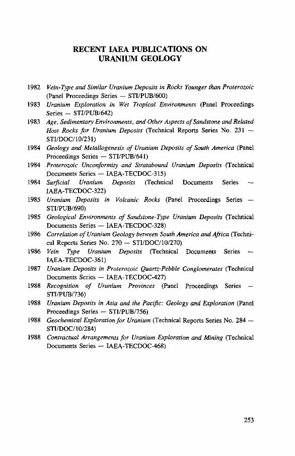
1982
1983
1983
1984
1984
1984
1985
1985
1986
1986
1987
1988
1988
1988
RECENT IAEA PUBLICATIONS ON URANIUM GEOLOGY
Vein-Type and Similar Uranium Deposits in Rocks Younger than Proterozoic (Panel Proceedings Series — STI/PUB/600)Uranium Exploration in Wet Tropical Environments (Panel Proceedings Series — STI/PUB/642)Age, Sedimentary Environments, and Other Aspects of Sandstone and Related Host Rocks for Uranium Deposits (Technical Reports Series No. 231 — STI/DOC/10/231)Geology and Metallogene sis of Uranium Deposits of South America (Panel Proceedings Series — STI/PUB/641)Proterozoic Unconformity and Stratabound Uranium Deposits (Technical Documents Series — IAEA-TECDOC-315)Surficial Uranium Deposits (Technical Documents Series —IAEA-TECDOC-322)Uranium Deposits in Volcanic Rocks (Panel Proceedings Series —STI/PUB/690)Geological Environments o f Sandstone-Type Uranium Deposits (Technical Documents Series — IAEA-TECDOC-328)Correlation of Uranium Geology between South America and Africa (Technical Reports Series No. 270 - STI/DOC/10/270)Vein Type Uranium Deposits (Technical Documents Series —IAE A-TECDOC-361)Uranium Deposits in Proterozoic Quartz-Pebble Conglomerates (Technical Documents Series — IAEA-TECDOC-427)Recognition of Uranium Provinces (Panel Proceedings Series —STI/PUB/736)Uranium Deposits in Asia and the Pacific: Geology and Exploration (Panel Proceedings Series — STI/PUB/756)Geochemical Exploration for Uranium (Technical Reports Series No. 284 — STI/DOC/lO/284)Contractual Arrangements for Uranium Exploration and Mining (Technical Documents Series — IAEA-TECDOC-468)
253

HOW TO ORDER IAEA PUBLICATIONSAn exclusive sales agent for IA E A publications, to whom all orders
and inquiries should be addressed, has been appointed in the following country:
UNITED STATES OF AMERICA UNIPUB, 4611-F Assembly Drive, Lanham, MD 20706-4391
■ j H In the following countries IA E A publications may be purchased from thesales agents or booksellers listed or throughmajor local booksellers. Payment can be made in localcurrency or with U N E S C O coupons.
ARGENTINA Comision Nacional de Energia Atomica, Avenida del Libertador 8250, RA-1429 Buenos Aires
AUSTRALIA Hunter Publications, 58 A Gipps Street, Collingwood, Victoria 3066BELGIUM Service Courrier UNESCO, 202, Avenue du Roi,B-1060 Brussels
CHILE Comisi6n Chilena de Energfa Nuclear, Venta de Publicaciones, Amunategui 95, Casilla 188-D, Santiago
CHINA IAEA Publications in Chinese:China Nuclear Energy Industry Corporation, Translation Section,P.O. Box 2103, BeijingIAEA Publications o ther than in Chinese:China National Publications Im port & Export Corporation, Deutsche Abteilung, P.O. Box 88, Beijing
CZECHOSLOVAKIA S.N.T.L., Mikulandska 4 , CS-11686 Prague 1Alfa, Publishers, Hurbanovo namestie 3, CS-815 89 Bratislava
FRANCE Office International de D ocum entation et L ibrairie,48, rue Gay-Lussac, F-75240 Paris Cedex 05
HUNGARY Kultura, Hungarian Foreign Trading Company, P.O. Box 149, H-1389 Budapest 62
INDIA Oxford Book and Stationery Co., 17, Park Street, Calcutta-700 016 Oxford Book and Stationery Co.,Scindia House, New Delhi-110 001
ISRAEL Heiliger & Co. Ltd.23 Keren Hayesod Street, Jerusalem 94188
ITALY Libreria Scientifica, Dott. Lucio de Biasio "aeiou", Via Meravigli 16, 1-20123 Milan
JAPAN Maruzen Company, L td, P.O. Box 5050,100-31 Tokyo InternationalPAKISTAN Mirza Book Agency, 65, Shahrah Quaid-e-Azam, P.O. Box 729, Lahore 3
POLAND Ars Polona-Ruch, Centrala Handlu Zagranicznego, Krakowskie Przedmiescie 7, PL-00-068 Warsaw
- ROMANIA llexim, P O. Box 136-137, BucharestSOUTH AFRICA Van Schaik Bookstore (Pty) Ltd, P.O. Box 724, Pretoria 0001
SPAIN Diaz de Santos, Lagasca 95, E-28006 Madrid Diaz de Santos, Balmes 417, E-08022 Barcelona
SWEDEN AB Fritzes Kungl. Hovbokhandel, Fredsgatan 2 ,P.O. Box 16356, S-10327 Stockholm
UNITED KINGDOM Her Majesty's Stationery Office, Publications Centre, Agency Section, 51 Nine Elms Lane, London SW8 5DR
USSR M ezhdunarodnaya Kniga,Smolenskaya-Sennaya 32*34, Moscow G-200YUGOSLAVIA Jugoslovenska Knjiga, Terazije 27, P.O. Box 36, YU-11001 Belgrade
■ Orders from countries where sales agents have not yet been appointed and requests for information should be addressed directly to:
f Division of Publications■> li International Atom ic Energy Agency
Wagramerstrasse 5, P.O. Box 100, A-1400 Vienna, Austria

00oocnoo
CM

o

INTERNATIO NAL SUBJECT GROUP: IVA TO M IC E N E R G Y A G E N C Y Chemistry, Geology and Raw Materials/V IE N N A , 1989 Geology