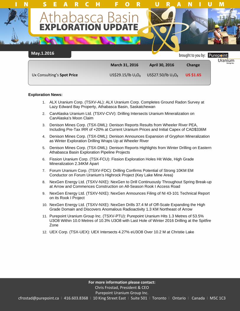
may.1.2016 - purepoint uranium group inc
TRANSCRIPT
1 | P a g e
May.1.2016
March 31, 2016 April 30, 2016 Change
Ux Consulting’s Spot Price US$29.15/lb U3O8 US$27.50/lb U3O8 US $1.65
Exploration News:
1. ALX Uranium Corp. (TSXV-AL): ALX Uranium Corp. Completes Ground Radon Survey at Lazy Edward Bay Property, Athabasca Basin, Saskatchewan
2. CanAlaska Uranium Ltd. (TSXV-CVV): Drilling Intersects Uranium Mineralization on CanAlaska’s Moon Claim
3. Denison Mines Corp. (TSX-DML): Denison Reports Results from Wheeler River PEA, Including Pre-Tax IRR of +20% at Current Uranium Prices and Initial Capex of CAD$336M
4. Denison Mines Corp. (TSX-DML): Denison Announces Expansion of Gryphon Mineralization as Winter Exploration Drilling Wraps Up at Wheeler River
5. Denison Mines Corp. (TSX-DML): Denison Reports Highlights from Winter Drilling on Eastern Athabasca Basin Exploration Pipeline Projects
6. Fission Uranium Corp. (TSX-FCU): Fission Exploration Holes Hit Wide, High Grade Mineralization 2.34KM Apart
7. Forum Uranium Corp. (TSXV-FDC): Drilling Confirms Potential of Strong 10KM EM Conductor on Forum Uranium’s Highrock Project (Key Lake Mine Area)
8. NexGen Energy Ltd. (TSXV-NXE): NexGen to Drill Continuously Throughout Spring Break-up at Arrow and Commences Construction on All-Season Rook I Access Road
9. NexGen Energy Ltd. (TSXV-NXE): NexGen Announces Filing of NI 43-101 Technical Report on its Rook I Project
10. NexGen Energy Ltd. (TSXV-NXE): NexGen Drills 37.4 M of Off-Scale Expanding the High Grade Domain and Discovers Anomalous Radioactivity 1.3 KM Northeast of Arrow
11. Purepoint Uranium Group Inc. (TSXV-PTU): Purepoint Uranium Hits 1.3 Metres of 53.5% U3O8 Within 10.0 Metres of 10.3% U3O8 with Last Hole of Winter 2016 Drilling at the Spitfire Zone
12. UEX Corp. (TSX-UEX): UEX Intersects 4.27% eU3O8 Over 10.2 M at Christie Lake
For more information please contact: Chris Frostad, President & CEO Purepoint Uranium Group Inc.
[email protected] I 416.603.8368 I 10 King Street East I Suite 501 I Toronto I Ontario I Canada I M5C 1C3
2 | P a g e
ALX Uranium Corp. (TSXV-AL): ALX Uranium Corp. Completes Ground Radon Survey at Lazy Edward Bay Property, Athabasca Basin, Saskatchewan – On April 7, it was announced that a follow-up radon-in-water sampling program had been completed at ALX Uranium Corp.'s Lazy Edward Bay property located at the southern margin of the Athabasca Basin, Saskatchewan.
The Lazy Edward Bay property encompasses 18,916 hectares (46,741 acres) and is about 55 kilometres west of the Key Lake mill and historic uranium mine. The property covers several shallow exploration targets.
Exploration on the property at the Bay trend consisted of 143 radon-in-water samples collected by RadonEx Ltd. of St-Lazare, Que., which has electret-ionization-chamber technology that has been successful in drill targeting at the Triple R deposit within the Patterson Lake South camp.
The survey was designed to be an extension of the 2014 radon-in-soil program along the conductive corridor of the Bay trend carried out on land to the southwest. The 2016 reconnaissance-scale survey covered a 1,400-metre-by-450-metre area of Lazy Edward Bay. Grid lines were spaced 200 metres apart with stations spaced 25 metres apart.
The survey resulted in eight highly anomalous one-point samples above 100 picocuries per litre, including four strong anomalies that are above 200 picocuries per litre. The anomalous samples are located approximately 200 metres northeast of historical drill hole LE-50, which returned anomalous uranium in the basement rocks (reported at 908 parts per million triuranium octoxide). Many of the anomalous radon samples appear to lie along a northeast-striking linear trend in the central portion of the grid, which overlies historical conductors found by previous explorers.
"Within the Athabasca basin, historical results are used to guide exploration that could ultimately produce a new discovery," stated Jon Armes, president of ALX Uranium. "At Lazy Edward Bay, given the proximity of the highly anomalous radon samples to historical drill hole LE-50, which was never followed up with drilling along strike, the results of this radon survey demonstrate the significant exploration potential at Lazy Edward Bay."
CanAlaska Uranium Ltd. (TSXV-CVV): Drilling Intersects Uranium Mineralization on CanAlaska’s Moon Claim – On April 5, CanAlaska Uranium Ltd. provided an update. The exploration team from Denison Mines Corp. has reported intersecting 2,200 counts per second of radioactivity at the unconformity in the first drill hole on the Moon South property. The elevated radioactivity corresponds to a 0.5-metre section of 0.102 per cent triuranium octoxide (U3O8) assayed in core recovered from the drill hole at that location. Additional drilling is now being planned.
Moon South project
This first drill hole was designed to test a conductive trend mapped by a direct-current resistivity survey. The drill site is located within a prominent magnetic low, which is thought to represent the location of major cross-structures. There is elevated uranium mineralization averaging over one parts per million (ppm) U3O8 for 30 metres above the intersection, with further elevated uranium mineralization up to 1.2 ppm for 200 metres above the unconformity. Moderately graphitic pelites were intersected in the basement. A graphitic fault and a clay-altered breccia were observed in this unit.

3 | P a g e
The drill intersection confirms basement fluid flow containing elevated base metals and uranium mineralization.
President Peter Dasler commented: "Denison's exploration team have found a very interesting new target, in an area of the Athabasca basin known to have excellent potential for uranium mineralization in the past. This initial drill success now gives a robust target for further exploration."
Denison Mines Corp. (TSX-DML): Denison Reports Results from Wheeler River PEA, Including Pre-Tax IRR of +20% at Current Uranium Prices and Initial Capex of CAD$336M – On April 4, Denison Mines Corp. released the results of a preliminary economic assessment on its 60-per-cent-owned Wheeler River project, including a base-case pretax internal rate of return of 20.4 per cent at current uranium prices, based on today's long-term contract price for uranium, and Denison's share of estimated initial capital expenditures of $336-million ($560-million on 100-per-cent-ownership basis).
The PEA considers the potential economic merit of co-developing the high-grade Gryphon and Phoenix deposits as a single underground mining operation, and assumes processing at Denison's 22.5-per-cent-owned McClean Lake mill, located in the infrastructure-rich eastern portion of the Athabasca basin.
Highlights of the PEA:
Current uranium price: base-case scenario uses today's long-term contract price for uranium of $44 (U.S.) per pound of triuranium octoxide, leading to a pretax internal rate of return of 20.4 per cent and a pretax net present value of $513-million (Denison's share: $308-million);
Exposure to rising uranium price: strong profitability at today's price offers lower-risk exposure to rising prices, as evidenced by a $62.60-(U.S.)-per-pound-triuranium-octoxide production-case scenario resulting in a pretax IRR of 34.1 per cent and pretax NPV of $1.42-billion (Denison's share: $852-million);
Strategic development plan: designed to minimize risk, generate higher upfront margins and reduce initial capital financing requirements -- by development of the conventionally mined basement-hosted Gryphon deposit first, followed by the unconformity-hosted Phoenix deposit;
Existing infrastructure and reduced risk: decreased project risk, capital expenditures and schedule by utilizing existing infrastructure in the eastern Athabasca basin (including excess milling capacity, provincial highways and the provincial power grid), justifying an 8-per-cent discount rate and leading to initial project capex of $560-million (Denison's share: $336-million);
Cash operating costs: the Gryphon deposit is expected to produce 40.7 million pounds U3O8 over a seven-year mine life at a cash operating cost of $14.28 (U.S.) per pound U3O8. The Phoenix deposit is expected to produce 64.0 million pounds U3O8 over a nine-year mine life at a cash operating cost of $22.15 (U.S.) per pound U3O8;
Resource upside: ability to incorporate potential resource growth at the Gryphon deposit, as demonstrated by the high-grade intersections previously reported from the winter 2016 exploration program (not included in the PEA), including drill holes WR-641, with 3.9 per cent equivalent triuranium octoxide over 9.2 metres, and WR-633D1, with 1.7 per cent eU3O8 over 7.6 metres, including 6.3 per cent eU3O8 over 1.7 metres (see Denison news release dated March 10, 2016).

4 | P a g e
David Cates, president and chief executive officer of Denison, commented: "We are very pleased with the positive results of the PEA -- particularly being able to illustrate that the project has potential to generate robust economics based on today's uranium price and with our current resource base. Thanks to the existing infrastructure in the eastern Athabasca basin, our ownership interest in the McClean Lake mill, and a project designed to minimize risk and upfront capex, the Wheeler River project has the potential to emerge as one of the next producing assets in the region.
"With the opportunity for resource growth at Gryphon and higher uranium prices on the horizon, the PEA provides Denison with a solid foundation to work from and supports our decision to continue to explore on the property and advance the project immediately into a prefeasibility study."
Wheeler River PEA summary
The Wheeler River project, host to both the Phoenix and Gryphon deposits, is a joint venture between Denison (60 per cent), Cameco Corp. (30 per cent) and JCU (Canada) Exploration Company Ltd. (10 per cent). In September, 2015, Denison commissioned SRK Consulting (Canada) Inc. and Amec Foster Wheeler Americas Ltd. to prepare a PEA for the project.
The PEA is based on the exploration drilling completed on the property through to the end of the summer 2015 exploration program and the mineral resources estimated for the Wheeler River project prepared by Roscoe Postle Associates Inc. (RPA), with an effective date of Sept. 25, 2015, as disclosed in the report titled "Technical Report on a Mineral Resource Estimate for the Wheeler River Property, Eastern Athabasca Basin, Northern Saskatchewan, Canada," dated Nov. 25, 2015, which is available on Denison's website, and under Denison's profile on SEDAR and EDGAR.
The PEA contemplates the underground development of the Gryphon deposit, followed by the Phoenix deposit, over a 16-year mine life, producing a total of 104.8 million pounds U3O8 and processing of the mine production at the company's 22.5-per-cent-owned McClean Lake mill (Areva Resources Canada Inc. 70 per cent, OURD (Canada) Co. Ltd. 7.5 per cent). Preproduction activities are estimated to begin in 2021 with first production from the Gryphon deposit in 2025. The PEA considers two distinct pricing scenarios as a result of the long lead time to production and the current uranium market: a base-case scenario using the long-term contract price as quoted by the Ux Consulting Company LLC (UxC) as of March 28, 2016; and a production-case scenario using the mid-case projected long-term price for the year 2026 per UxC's uranium market outlook for first quarter 2016. Key assumptions and financial results of the PEA are summarized in the table.
SUMMARY OF PEA ASSUMPTIONS AND FINANCIAL HIGHLIGHTS Assumption/financial results Base Production case case Uranium price per lb U3O8 US$44.00 US$62.60 Exchange rate ($Cdn:$US) 1.35 1.35 Net Sask. royalties(1) 7.25% 7.25% Discount rate 8.00% 8.00% Pretax IRR(2) 20.4% 34.1% Pretax NPV(2) @ 100% $513M $1,420M Payback period(3) approx. three years approx. 18 months Initial capital costs $560M Sustaining capital costs $543M Average operating cost per lb U3O8 $25.67 Average operating cost per lb U3O8 ($US) $19.01

5 | P a g e
(1) Net Saskatchewan royalties are included in the pretax NPV and consist of the following: resource surcharge (3 per cent); basic uranium royalty (5 per cent); and offset by resource credit of (0.75 per cent). The profit from operations is subject to an additional uranium profit royalty, which is treated as an income tax. (2) NPV and IRR are calculated to the start of preproduction activities in 2021 (3) Payback period is stated as number of years to payback from the start of commercial production.
The PEA is preliminary in nature and includes inferred mineral resources that are considered too speculative geologically to have the economic considerations applied to them to be categorized as mineral reserves, and there is no certainty that the preliminary economic assessment will be realized. Mineral resources are not mineral reserves and do not have demonstrated economic viability. Additional definition drilling is required to improve the confidence in the existing mineral resources estimated for the Gryphon deposit and is expected to be completed as the company advances the project toward the completion of a prefeasibility study.
Geology, mineral resources and mining methods
The Gryphon deposit consists of a set of parallel, stacked, elongate lenses that are broadly conformable with the basement geology and associated with a significant fault zone that separates a thin unit of quartzite (quartz-pegmatite) from an overlying graphitic pelite (upper graphite). The lenses dip moderately to the southeast and plunge moderately to the northeast. The deposit is approximately 450 metres long in the plunge direction and 80 metres wide across the plunge. The deposit is centred at 720 metres below surface and approximately 220 metres below the sub-Athabasca unconformity. A total of 55 drill holes have delineated the Gryphon deposit, which is estimated to contain inferred mineral resources of 834,000 tonnes at a grade of 2.31 per cent U3O8 for a total of 43.0 million pounds U3O8.
The more moderate grades and style of mineralization at the Gryphon deposit are expected to allow for conventional underground mining methods. For the PEA, a longitudinal long-hole mining method has been assumed. Based on an assessment of available geotechnical data and in comparison with other mining operations, this method is expected to be suitable for the safe and cost-efficient extraction of uranium mineralization from the Gryphon deposit.
Approximately three kilometres to the southeast of Gryphon is the Phoenix deposit, one of the highest-grade undeveloped deposits in the world. Phoenix is located at the unconformity between the Athabasca basin sandstone and basement rocks, approximately 400 metres below surface. Mineralization has been defined over a strike length of approximately one kilometre and is coincident with a significant steeply dipping fault zone. A total of 196 drill holes have delineated two distinct zones (A and B) of high-grade uranium mineralization lying horizontally at the unconformity. The Phoenix deposit is estimated to contain indicated mineral resources of 166,400 tonnes at a grade of 19.14 per cent U3O8 for a total of 70.2 million pounds U3O8 and inferred mineral resources of 8,600 tonnes at a grade of 5.80 per cent U3O8 for a total of 1.1 million pounds U3O8.
The higher-grade Phoenix deposit is expected to require the use of remote mining methods to safely extract the uranium mineralization. In addition, the proximity to the sub-Athabasca unconformity and the associated complexities with the water-saturated Athabasca sandstone above the deposit are expected to require ground freezing to prevent uncontrolled water inflows. The jet-boring mining method, used at Cameco's Cigar Lake mine, has been successful in extracting uranium ore hosted in these conditions and depths. As a result, the jet-boring mining method has been assumed as the preferred mining method for the Phoenix deposit. The jet-boring method produces a uranium-bearing slurry as mine production, which is transported from underground to surface by pumping.
Strategic development plan
Although the Phoenix deposit is much higher grade, the Gryphon deposit is expected to be the more profitable deposit due to lower capital and operating costs. Being located well below the unconformity and

6 | P a g e
in stronger ground conditions allows for conventional development and mining practices. Conversely, at Phoenix the unconformity-style mineralization requires more sophisticated lateral development and ground freezing, as well as remote extraction methods necessitated by the high uranium grades and associated radiation levels. The mining of Phoenix also carries increased technical risk associated with mining at the unconformity, which may lead to delays in production. Sequencing Phoenix production after Gryphon also carries additional advantages, including:
Allows time to develop a three-kilometre underground connection drift, rather than a second production shaft and headframe, further reducing and deferring capital costs;
Allows time to complete freezing from underground at Phoenix rather than from surface, leading to a significant reduction in the schedule and capital costs associated with freezing;
Permits additional time for engineering on the Phoenix mining method to minimize schedule risk.
As a result of the strategic approach, the main facilities for the project will be located in proximity to the Gryphon deposit, eliminating the need for secondary facilities at the Phoenix site.
Mineral processing and production plan
The preliminary metallurgical test results from both Gryphon and Phoenix composite samples indicated the mineralization is amenable to processing at any of the existing uranium mills in the eastern Athabasca basin. Over all, uranium process recovery has been estimated at 97.0 per cent for Gryphon and 98.1 per cent for Phoenix. Due to the excess processing capacity expected at Denison's 22.5-per-cent-owned McClean Lake mill, by the end of 2016, the PEA assumes mineral processing will be completed at McClean Lake.
The production plan for the Gryphon and Phoenix deposits aligns well with the current production plan for the McClean Lake mill. The mill is currently in the final stages of an upgrade that is expected to increase the facility's annual production capacity to up to 24 million pounds U3O8, which will enable processing of up to 18 million pounds U3O8 per year from the Cigar Lake mine, under a toll-milling agreement, and up to six million pounds U3O8 from other mine feeds. Based on the current schedule, Cigar Lake phase 1 ore feed is expected to peak at 18 million pounds U3O8 and decreases toward the end of phase 1 in the late 2020s. Co-milling of Wheeler River and Cigar Lake ore feeds is expected to utilize the full capacity of the mill and improve processing economics for both feed sources. As such the PEA has aligned mine production with predicted mill capacity at the following rates:
Gryphon deposit -- seven-year mine life at six million pounds U3O8 per year (399 tonne per day); Phoenix deposit -- nine-year mine life at seven million pounds U3O8 per year (73 t/d).
In order to co-mill the full tonnage of the Gryphon deposit feed with the Cigar Lake phase 1 feed, the PEA has incorporated the costs of an expansion to the No. 1 leaching circuit at the McClean Lake mill, as well as increasing the capacities of the solid/liquid separation circuits and installation of piping to transfer slurry to the No. 1 leach circuit from the slurry load-out facilities. Over all the expected modifications to the mill are minor in nature and in areas that are not used for Cigar Lake processing.
Reduced risk profile
The eastern Athabasca basin is host to several existing and historic uranium mining operations. As a result, the area has amassed considerable regional infrastructure, which plays a key role in the development of new projects. The importance of this infrastructure cannot be understated, particularly from a risk standpoint, when considering capital costs and project scheduling. Key regional infrastructure includes the following:

7 | P a g e
Existing milling facility with excess capacity: Denison's 22.5-per-cent owned McClean Lake mill, which is located approximately 160 kilometres to the northeast of the Wheeler River property, is currently in operation and processing 100 per cent of the ore produced by the Cigar Lake mine under a toll-milling agreement. The McClean Lake mill was built in 1997 and is in the process of being upgraded, at the expense of the Cigar Lake joint venture, to an annual capacity of up to 24 million pounds U3O8. With Cigar Lake expected to produce 18 million pounds U3O8 per year, starting in 2017, the mill is expected to have excess capacity of up to six million pounds U3O8 per year. In addition, the McClean Lake operation also includes a Canadian Nuclear Safety Commission-approved and permitted tailings facility.
Existing provincial highways and provincial power grid: Existing mining and milling facilities are currently accessed by all-weather provincial highways and source their power from the provincial power grid. This existing infrastructure is located on the eastern edge of the Wheeler River property within six kilometres of the proposed Gryphon mine facilities.
Established mining jurisdiction and social infrastructure: Saskatchewan was ranked as the second-most-attractive jurisdiction for mining investment globally in 2015 by the Fraser Institute's annual survey of mining companies, and current operations in the eastern Athabasca basin have supported the development of community infrastructure, including airports, vendors for equipment and supplies, as well as skilled labour and contractors with expertise in the uranium mining sector.
Taken together with the company's strategic development plan designed to reduce project risk, the Wheeler River project is supported by several elements that present a reduced risk profile. This has allowed for the use of an 8-per-cent discount rate in the company's base-case and production-case NPV estimates.
Capital and operating costs
Capital costs include all costs associated with surface construction and underground development up to the point of contact with mineralization of the Wheeler River site, as well as the required modifications to the McClean Lake mill. Capital costs include initial and sustaining costs, and are expressed in 2015 Canadian dollars to a bottom-line accuracy of plus or minus 40 per cent. Initial capital costs are based on the five-year period from Jan. 1, 2021, through to Dec. 31, 2025, and sustaining capital costs are for the period from Jan. 1, 2026, through to decommissioning in 2045. Total capital costs are estimated at $1,103-million, which includes a contingency of 26 per cent, as shown in the table.
WHEELER RIVER PROJECT CAPITAL COST ESTIMATE (In millions) Capital costs Initial Sustaining Total Surface infrastructure $166 $7 $174 Mine $220 $334 $554 Mineral processing $19 $60 $79 Owners costs $25 $0 $25 Decommissioning $0 $40 $40 ------ ------ ------ Subtotal $429 $442 $871 ------ ------ ------ Contingency $131 $101 $232 ------ ------ ------ Total capital $560 $543 $1,103 ====== ====== ======

8 | P a g e
Operating costs have been estimated separately for each deposit, based on the differences in geology and mining methods selected. For the Gryphon and Phoenix deposits, operating costs are estimated at $19.28 per pound U3O8 and $29.90 per pound U3O8, respectively. The combined average operating cost of both deposits is estimated to be $25.67 or $19.01 (U.S.) per pound U3O8. The table shows the projected operating cost estimates for each deposit.
WHEELER RIVER PROJECT OPERATING COST ESTIMATE ($/lb U3O8) Operating costs Gryphon Phoenix Mining $3.45 $17.45 Surface transportation $1.63 $0.85 Mineral processing (including toll mill fees) $10.03 $8.03 General and administration $4.17 $3.57 ------ ------ Total ($/lb U3O8) $19.28 $29.90 ------ ------ Total (US$/lb U3O8) $14.28 $22.15 ====== ======
Future outlook
Denison intends to proceed with the commencement of a PFS for the Wheeler River project and associated environmental assessment studies, as part of the budget approved by the Wheeler River joint venture and consistent with the company's financial plan for 2016. Denison expects the PFS will take 12 to 18 months and will address the following key items:
The potential growth in mineral resources at or in proximity to the Gryphon deposit and an increase in the level of confidence associated with the mineral resources estimated for the Gryphon deposit;
The potential to optimize the project for increased rates of production based on a combination of resource growth and increased milling capacity through capital investment or other opportunities;
The result of a formal review and evaluation of toll milling and other processing options with applicable joint venture partners;
The detailed evaluation of key engineering designs including shaft development, material movement and mining methods;
The inclusion of environmental baseline information and radiological assessments to ensure safe and environmentally responsible development plans.
Indicative posttax results for Denison
The PEA is prepared on a pretax basis, as each of the partners to the Wheeler River joint venture has different circumstances from a taxation standpoint. Denison has completed an indicative posttax assessment based on its 60-per-cent ownership stake in the Wheeler River project and the recovered toll mill fees from its 22.5-per-cent interest in the McClean Lake joint venture. Based on the company's current and expected tax balances, as well as the prevailing federal and provincial taxation regulations, the results are summarized in the table.

9 | P a g e
SUMMARY OF DENISON'S POSTTAX RESULTS (60-per-cent ownership basis) Assumptions/financial results Base Production case case Uranium price per lb U3O8 US$44.00 US$62.60 Exchange rate ($Cdn:$US) 1.35 1.35 Discount rate 8% 8% Denison posttax IRR(1) 17.8% 29.2% Denison posttax NPV(1) $206M $548M Payback period(2) approx. 3 years approx. 18 months Initial capital costs $336M Sustaining capital costs $325M (1) NPV and IRR are calculated to the start of preproduction activities in 2021. (2) Payback period is stated as number of years to payback from the start of commercial production.
The PEA is preliminary in nature and includes inferred mineral resources that are considered too speculative geologically to have the economic considerations applied to them to be categorized as mineral reserves, and there is no certainty that the preliminary economic assessment will be realized. Mineral resources are not mineral reserves and do not have demonstrated economic viability.
Denison Mines Corp. (TSX-DML): Denison Announces Expansion of Gryphon Mineralization as Winter Exploration Drilling Wraps Up at Wheeler River – On April 18, Denison Mines Corp. announced that it had expanded the mineralized zone discovered immediately north of the Gryphon deposit and had completed a successful winter exploration drilling program on the company's 60-per-cent-owned Wheeler River property in Northern Saskatchewan. A total of 21,800 metres of diamond drilling, in 32 drill holes, were completed at Wheeler River during the winter exploration program.
The final weeks of the winter exploration program were highlighted by positive results from the follow-up of the high-grade basement-hosted mineralization previously reported in drill holes WR-633D1 and WR-641, both of which tested the area immediately north and northwest of the Gryphon deposit on Section 5200GP earlier in the winter program. Despite limited time for follow-up this winter, Denison successfully identified additional mineralization on Section 5200GP (drill holes WR-644 and WR-648) and encountered additional high-grade mineralization on Section 5150GP (drill holes WR-646 and WR-651), representing a 50-metre step-out to the southwest of Section 5200GP. These results have added several new lenses of mineralization to the company's geological model for the area north of the Gryphon deposit and highlight the potential for the discovery of additional lenses with further follow-up drilling.
In addition to testing in the immediate vicinity of Gryphon, the 2016 winter exploration program was designed to explore for new uranium mineralization to the southwest of the Gryphon deposit along the K-North trend. Step-out drill testing in this area was successful in extending the mineralized K-North trend roughly 1.4 kilometres southwest of Gryphon. Mineralization was encountered at or near the sub-Athabasca unconformity and continues to suggest that there is potential for a material discovery to occur at the unconformity or within the basement rock along the trend.

10 | P a g e
Denison's president and chief executive officer, David Cates, commented: "The 2016 winter exploration program at Wheeler River has been a tremendous success. Following the April 4, 2016, release of the company's findings from the preliminary economic assessment for the Wheeler River project, which returned a pretax internal rate of return of 20.4 per cent using the current long-term price for uranium, we are very pleased to be drilling a new zone of high-grade mineralization in very close proximity to the Gryphon deposit. Gryphon is a key part of the strategic development plan for Wheeler, and the potential to add pounds near Gryphon is very exciting and potentially meaningful from an economic standpoint. Planning for a roughly 25,000-metre 2016 summer drill program, at Wheeler River, is under way, and is expected to focus on further expansion of the mineralization at Gryphon as well as testing of other high-priority target areas."
Wheeler River project
On April 4, 2016, Denison announced the results of a preliminary economic assessment for the Wheeler River project, which, based on today's long-term contract price for uranium, included a pretax internal rate of return of 20.4 per cent, an indicative posttax IRR to Denison of 17.8 per cent, and Denison's share of estimated initial capital expenditures of $336-million ($560-million on a 100-per-cent-ownership basis). The PEA is preliminary in nature and includes inferred mineral resources that are considered too speculative geologically to have the economic considerations applied to them to be categorized as mineral reserves, and there is no certainty that the preliminary economic assessment will be realized. Mineral resources are not mineral reserves and do not have demonstrated economic viability. Results from the winter 2016 drilling program have not been incorporated into the current resource estimates or the PEA.
The Wheeler River property is a joint venture between Denison (60 per cent and operator), Cameco Corp. (30 per cent) and JCU (Canada) Exploration Company Ltd. (10 per cent), and is host to the high-grade Gryphon and Phoenix uranium deposits discovered by Denison in 2014 and 2008, respectively. The Gryphon deposit is hosted in basement rock and is currently estimated to contain inferred resources of 43.0 million pounds triuranium octoxide (above a cut-off grade of 0.2 per cent U3O8) based on 834,000 tonnes of mineralization at an average grade of 2.3 per cent U3O8. The Phoenix unconformity deposit is located approximately three kilometres to the southeast of Gryphon, is estimated to include indicated resources of 70.2 million pounds U3O8 (above a cut-off grade of 0.8 per cent U3O8) based on 166,000 tonnes of mineralization at an average grade of 19.1 per cent U3O8 and is the highest-grade undeveloped uranium deposit in the world.
Mineralized zone north of Gryphon expands with initial follow-up
During the winter 2016 program, drill testing within 200 metres north and northwest of the Gryphon deposit returned numerous high-grade intersections within the basal pegmatite unit. This stratigraphic unit occurs footwall to the Gryphon deposit and has undergone little previous drill testing. Initial high-grade intersections were obtained on Section 5200GP highlighted by 3.9 per cent equivalent triuranium octoxide over 9.2 metres, including 6.7 per cent eU3O8 over 5.3 metres, in drill hole WR-641 and 1.7 per cent eU3O8 over 7.6 metres, including 6.3 per cent eU3O8 over 1.7 metres, in drill hole WR-633D1 (see Denison news release dated March 10, 2016).
A further four holes were completed on Section 5200GP, all of which intersected mineralization in excess of 0.1 per cent eU3O8 over one m. As warranted by these results, additional follow-up drilling commenced on adjacent sections, roughly 50 metres along strike to the southwest (Section 5150GP, two holes) and to the northeast (Section 5250GP, two holes). The results from Section 5150GP are highlighted by drill hole WR-651, which returned 7.1 per cent eU3O8 over two metres, including 9.3 per cent eU3O8 over 1.5 metres, and drill hole WR-646, which intersected 4.2 per cent eU3O8 over 2.8 metres, including 8.2 per cent eU3O8 over 1.4 metres. The highlights of the winter 2016 drilling program, for the area immediately north and northwest of the Gryphon deposit, are presented in the table. Denison reports its initial exploration results as radiometric equivalent uranium from a calibrated, total-gamma,
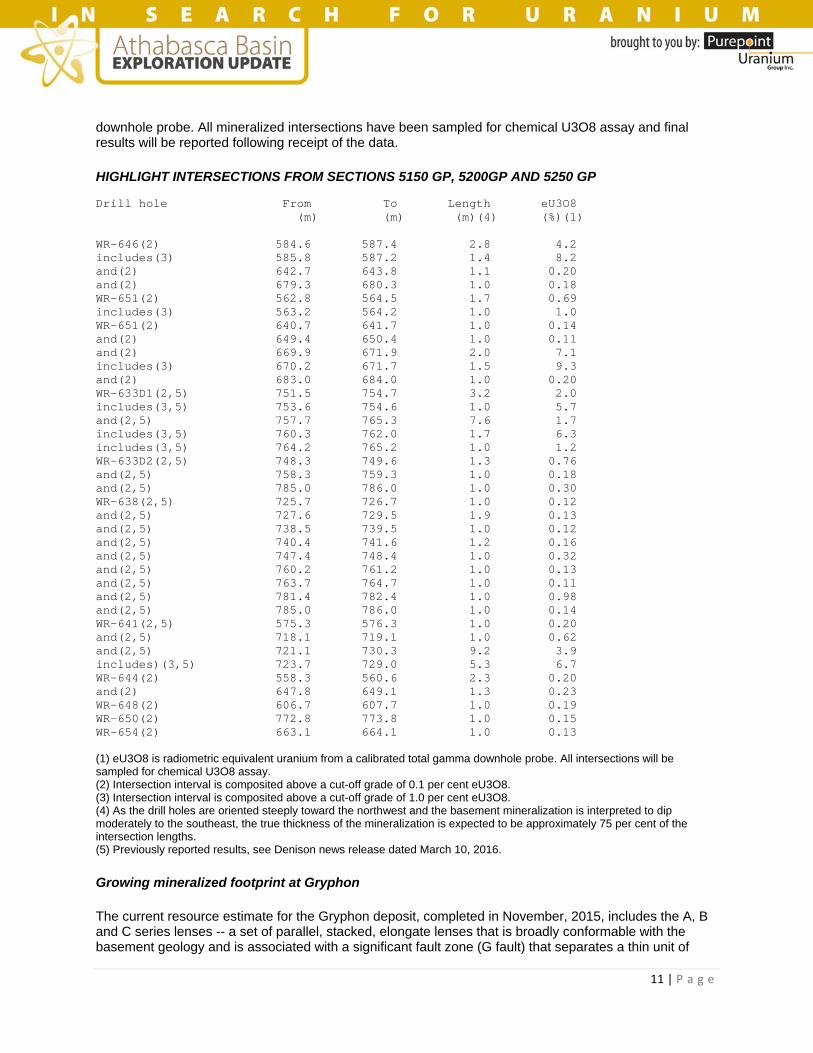
11 | P a g e
downhole probe. All mineralized intersections have been sampled for chemical U3O8 assay and final results will be reported following receipt of the data.
HIGHLIGHT INTERSECTIONS FROM SECTIONS 5150 GP, 5200GP AND 5250 GP Drill hole From To Length eU3O8 (m) (m) (m)(4) (%)(1) WR-646(2) 584.6 587.4 2.8 4.2 includes(3) 585.8 587.2 1.4 8.2 and(2) 642.7 643.8 1.1 0.20 and(2) 679.3 680.3 1.0 0.18 WR-651(2) 562.8 564.5 1.7 0.69 includes(3) 563.2 564.2 1.0 1.0 WR-651(2) 640.7 641.7 1.0 0.14 and(2) 649.4 650.4 1.0 0.11 and(2) 669.9 671.9 2.0 7.1 includes(3) 670.2 671.7 1.5 9.3 and(2) 683.0 684.0 1.0 0.20 WR-633D1(2,5) 751.5 754.7 3.2 2.0 includes(3,5) 753.6 754.6 1.0 5.7 and(2,5) 757.7 765.3 7.6 1.7 includes(3,5) 760.3 762.0 1.7 6.3 includes(3,5) 764.2 765.2 1.0 1.2 WR-633D2(2,5) 748.3 749.6 1.3 0.76 and(2,5) 758.3 759.3 1.0 0.18 and(2,5) 785.0 786.0 1.0 0.30 WR-638(2,5) 725.7 726.7 1.0 0.12 and(2,5) 727.6 729.5 1.9 0.13 and(2,5) 738.5 739.5 1.0 0.12 and(2,5) 740.4 741.6 1.2 0.16 and(2,5) 747.4 748.4 1.0 0.32 and(2,5) 760.2 761.2 1.0 0.13 and(2,5) 763.7 764.7 1.0 0.11 and(2,5) 781.4 782.4 1.0 0.98 and(2,5) 785.0 786.0 1.0 0.14 WR-641(2,5) 575.3 576.3 1.0 0.20 and(2,5) 718.1 719.1 1.0 0.62 and(2,5) 721.1 730.3 9.2 3.9 includes)(3,5) 723.7 729.0 5.3 6.7 WR-644(2) 558.3 560.6 2.3 0.20 and(2) 647.8 649.1 1.3 0.23 WR-648(2) 606.7 607.7 1.0 0.19 WR-650(2) 772.8 773.8 1.0 0.15 WR-654(2) 663.1 664.1 1.0 0.13 (1) eU3O8 is radiometric equivalent uranium from a calibrated total gamma downhole probe. All intersections will be sampled for chemical U3O8 assay. (2) Intersection interval is composited above a cut-off grade of 0.1 per cent eU3O8. (3) Intersection interval is composited above a cut-off grade of 1.0 per cent eU3O8. (4) As the drill holes are oriented steeply toward the northwest and the basement mineralization is interpreted to dip moderately to the southeast, the true thickness of the mineralization is expected to be approximately 75 per cent of the intersection lengths. (5) Previously reported results, see Denison news release dated March 10, 2016.
Growing mineralized footprint at Gryphon
The current resource estimate for the Gryphon deposit, completed in November, 2015, includes the A, B and C series lenses -- a set of parallel, stacked, elongate lenses that is broadly conformable with the basement geology and is associated with a significant fault zone (G fault) that separates a thin unit of
12 | P a g e
quartzite (quartz-pegmatite) from an overlying graphitic pelite (upper graphite). The lenses dip moderately to the southeast and plunge moderately to the northeast. The deposit is approximately 450 metres long in the plunge direction and 80 metres wide across the plunge. The deposit is centred at 720 metres below surface and approximately 220 metres below the sub-Athabasca unconformity.
The mineralization intersected within the basal pegmatite unit during the winter 2016 program is interpreted to represent a series of stacked southeasterly dipping lenses, conformable to the pelitic gneiss subunits with which they are typically associated and broadly conformable to the Gryphon deposit A, B and C lenses. These lenses have been designated as D series lenses. Reasonable continuity of the mineralized lenses could be interpolated between Section 5200GP and Section 5150GP, which suggests a similar northeast plunge as the Gryphon deposit lenses. Further drilling is still required to test whether these lenses are continuous with the previously identified D series lenses, which were drilled in 2014 and occur approximately 100 m upplunge to the southwest. The D series lenses are not included in the current resource estimate for the Gryphon deposit or the Wheeler River PEA.
On Section 5250GP, the northeasternmost drill section at Gryphon, the limited drilling completed this winter (two holes) failed to intersect any significant high-grade mineralization within the basal pegmatite unit; however, the weak mineralization intersected, as well as the continuation of faulting, hydrothermal alteration and subunits of graphitic pelitic gneiss, suggest the mineralizing system continues to the northeast, and further drilling is warranted on this section and to the northeast. In this regard, the mineralization within the basal pegmatite unit is still considered to be open in all directions.
Exploration southwest of Gryphon along the K-North trend
Drill testing for unconformity or basement-hosted mineralization has continued to the southwest of the Gryphon deposit, along the K-North trend. During 2015, numerous mineralized intercepts were obtained along this trend over a 1.5-kilometre strike length -- including drill hole WR-597 (Section 4000GP), which intersected 4.5 per cent U3O8 over 4.5 metres. The mineralization is located at or proximal to the unconformity, and is associated with structurally disrupted, clay altered and geochemically anomalous sandstone and basement rocks, typical of other Athabasca unconformity deposit settings. This portion of the 2016 winter program focused on testing for additional zones of mineralization at the unconformity along strike of the southernmost hole drilled in 2015, WR-628 (Section 3200GP), which intersected the most significant sandstone alteration and anomalous geochemistry of the 2015 program.
A total of 13 drill holes were completed, commencing on Section 3200GP and continuing along strike to the southwest on sections at 200 metres, 600 metres, 1,000 metres and 1,400 metres. Weak mineralization and/or anomalous radioactivity were intersected in almost every hole, including 0.10 per cent eU3O8 over 10.4 m in drill hole WR-634 and 0.11 per cent eU3O8 over 6.1 m in drill hole WR-655. The mineralization is generally located at or proximal to the unconformity.
Although no significant high-grade mineralization has been intersected, the favourable alteration and structure along the K-North trend, within the sandstone and basement, indicate further priority drilling is warranted to test targets at the unconformity and within the basement below. The trend remains untested for approximately 3.5 kilometres along strike to the southwest before reaching the K-Central area. Historic drilling from the K-Central area encountered significant alteration and anomalous geochemistry within the sandstone and basement lithologies.
SUMMARY OF INTERSECTIONS FROM SECTION 3200GP TO 1800GP Drill hole From To Length eU3O8 (m) (m) (m)(4) (%)(1) WR-629 No significant mineralization WR-629D1 No significant mineralization

13 | P a g e
WR-634(3) 472.2 482.6 10.4 0.10 and(3) 486.8 487.8 1.0 0.09 and(3) 492.4 493.4 1.0 0.13 and(2) 498.9 499.1 0.2 0.05 WR-634D1 No significant mineralization WR-634D2(3) 455.1 456.3 1.2 0.07 WR-643 No significant mineralization WR-645(2) 467.9 468.2 0.3 0.09 WR-647(2) 516.5 516.7 0.2 0.09 WR-649(2) 520.5 520.8 0.3 0.11 and(2) 548.9 549.3 0.4 0.14 WR-655(3) 480.5 486.6 6.1 0.11 and(2) 582.8 583.1 0.3 0.06 WR-656(2) 585.3 585.7 0.4 0.07 WR-652 No significant mineralization WR-653(2) 465.8 466.2 0.4 0.18 and(2) 466.3 466.6 0.3 0.13 and(2) 522.7 522.8 0.1 0.06 (1) eU3O8 is radiometric equivalent uranium from a calibrated total gamma downhole probe. All intersections will be sampled for chemical U3O8 assay. (2) No cut-off grade applied to the intersection interval. (3) Intersection interval is composited above a cut-off grade of 0.05 per cent eU3O8. (4) As the drill holes are oriented steeply toward the northwest and the basement mineralization is interpreted to dip moderately to the southeast, the true thickness of the mineralization is expected to be approximately 75 per cent of the intersection lengths.
Denison Mines Corp. (TSX-DML): Denison Reports Highlights from Winter Drilling on Eastern Athabasca Basin Exploration Pipeline Projects – On April 21, Denison Mines Corp. announced that it had completed the winter 2016 drilling programs on its high-priority exploration pipeline projects, highlighted by the intersection of uranium mineralization and favourable geological settings on several properties.
Apart from Denison's flagship Wheeler River project, the company has an extensive portfolio of uranium exploration projects located in the infrastructure-rich eastern Athabasca basin, covering over 340,000 hectares of ground. The projects are at various stages of exploration and provide a long-term pipeline of potential resource growth opportunities. During the winter 2016 programs, approximately 9,300 metres of diamond drilling were completed in 23 holes on Denison-operated properties -- including Murphy Lake (3,695 metres, 10 holes), Crawford Lake (1,104 metres, two holes), Bell Lake (2,382 metres, four holes), Torwalt Lake (612 metres, two holes), Marten Lake (1,021 metres, four holes) and Moon Lake South (516 metres, one hole). Geophysical surveys are still under way on several properties as planning continues for the development of the summer drilling programs.
Denison's vice-president, exploration, Dale Verran, commented: "While much attention has been given to the results at Wheeler River this winter, we are highly encouraged by the winter results from our high-priority pipeline projects in the eastern Athabasca. Further intersections of mineralization and alteration at Murphy Lake continue to suggest we are dealing with a sizable mineralizing system with deposit potential along strike. At Crawford Lake and Moon Lake South, reconnaissance drilling on the largely untested CR-3 trend yielded exciting mineralized results suggesting potential for future discovery in both the basement rocks and at the unconformity. These results, in addition to those from Marten and Bell Lake, reiterate the potential of Denison's pipeline projects and the team's sound exploration approach."

14 | P a g e
An additional 8,100 metres of diamond drilling were completed in 31 holes on two non-Denison-operated properties. At Mann Lake, operated by Cameco Corp., a total of 2,800 metres of diamond drilling were completed in four holes. At Wolly, operated by AREVA Resources Canada Inc., a total of 5,300 metres of diamond drilling were completed in 27 holes.
Murphy Lake: mineralized trend extended
Murphy Lake continues to be one of Denison's highest-priority exploration projects. The project is located approximately 30 kilometres from the McClean Lake mill and adjacent to the company's Waterbury Lake project in the northern portion of the eastern Athabasca basin. During the winter 2016 season, Denison completed a diamond drilling program, as well as ground gravity and DC-IP resistivity surveys on the Murphy Lake project (68.8 per cent Denison, 31.2 per cent Eros Resources Corp.). Approximately 3,700 metres were drilled over 10 drill holes during the program. The majority of the drilling was designed to test targets identified along strike and on section of MP-15-03 (a 2015 drill hole which intersected 0.25 per cent triuranium octoxide over six metres in strongly altered sandstones, immediately above the unconformity). Drilling confirmed the continuity of the intense hydrothermal sandstone alteration system, identified in 2015, over a strike length of 850 metres. Weak uranium mineralization was intersected in the sandstone associated with intense hematite and clay alteration in three drill holes: MP-16-08, MP-16-11 and MP-16-17. Drill hole MP-16-08, drilled on section with MP-15-03, identified uranium mineralization associated with a parallel graphitic fault zone approximately 70 metres to the south. Drill holes MP-16-11 and MP-16-17 were both drilled along strike to the west of drill hole MP-15-03 at 200 metres and 100 metres, respectively. The table provides the highlights from drilling on the property to date.
MURPHY LAKE 2016 DRILL RESULTS Drill hole From To Length(4) U3O8 (m) (m) (m) (%) MP-15-03(2,5) 270.0 276.0 6.0 0.25 MP-16-08(1) 275.65 278.55 2.9 0.19(1) MP-16-11(2) 267.5 282.0 14.5 0.13 includes(2) 271.0 272.0 1.0 0.46 and(2) 277.5 278.0 0.5 0.49 MP-16-17(3) 259.0 275.0 16.0 0.04 includes(3) 262.5 263.0 0.5 0.12 and(3) 268.0 268.5 0.5 0.13 (1) Significant core loss. Result reported as radiometric equivalent uranium (eU3O8) from a calibrated total gamma downhole probe and composited above a cut-off grade of 0.05 per cent eU3O8. (2) Intersection interval is composited above a cut-off grade of 0.05 per cent U3O8. (3) A cut-off grade has not been applied. (4) As the drill holes dip steeply to the south and the unconformity mineralization is expected to be flat lying, the true thickness of the mineralization is expected to be approximately 90 per cent of the intersection lengths. (5) Results reported previously in the company's press release dated Oct. 22, 2015.
An additional 2.2 kilometres of interpreted strike length remain entirely untested both to the east and west of the mineralized zone noted above. Within the current DC-IP resistivity coverage, which extends 0.8 kilometre east and 1.4 kilometres west of the mineralized zone, several priority targets have been identified for drill testing. The ground gravity survey has produced gravity-low targets, in some cases coincident with DC-IP resistivity targets, and has delineated potential areas of unconformity offset to the north of the mineralized zone, which constitutes a further target area.
Crawford Lake and Moon Lake South: mineralization discovered on CR-3 conductive trend
At the Crawford Lake property (100 per cent Denison owned), a two-hole program was designed to test targets on the CR-5 and CR-3 conductive trends, respectively. Previous drilling on the CR-3 conductive trend included one historic hole and one hole drilled by Denison in 2015 (CR-15-24), which intersected

15 | P a g e
strong basement alteration and structure associated with graphite-bearing pelitic gneisses. During the winter 2016 drilling program, drill hole CR-16-26, located approximately 800 metres to the northeast of CR-15-24, extended the strike of the graphite-bearing pelitic gneisses and confirmed further strong basement alteration and structure with associated elevated uranium pathfinder elements.
In January, 2016, Denison entered into an earn-in option agreement with CanAlaska Uranium Ltd. on the Moon Lake property, which is contiguous with Crawford Lake and covers the northeasterly extent of the CR-3 conductive trend. A single drill hole was completed during the winter 2016 program which was designed to test the CR-3 conductive trend on Moon Lake South, immediately north of the southern property boundary with Crawford Lake. The drill hole, MS-16-01, intersected 0.102 per cent triuranium octoxide over 0.5 metre at the unconformity and anomalous uranium in the overlying sandstone. This hole is located approximately 1.5 kilometres northeast from CR-16-26. The Moon Lake South option agreement allows for Denison to acquire an initial 51-per-cent interest in claim S-107558 by completing exploration expenditures of $200,000 and allows for Denison to increase its interest to 75 per cent for a further $500,000. The option agreement includes provisions for the formation of a joint venture and a 2-per-cent net-smelter-return royalty, which will be automatically granted if either party's interest is diluted to below 10 per cent. The NSR royalty may be purchased by the non-diluting party for $500,000.
The drilling results obtained during the winter 2016 drilling program, including extensive basement alteration and structure on Crawford Lake, and uranium mineralization at the unconformity on Moon Lake South, have confirmed the CR-3 conductive trend to be highly prospective. Further drilling is warranted to evaluate this trend for unconformity and basement-hosted uranium mineralization.
Other property highlights
Marten Lake (50 per cent Denison, 50 per cent JOGMEC)
Three of the four holes completed during the winter program, testing DC-IP resistivity targets along a northeast-southwest trend, intersected significant structure and alteration. The westernmost hole encountered a significant reverse fault zone at the sub-Athabasca unconformity with 96 metres of a vertical offset, and associated brecciation and alteration. These features attest to a favourable geological setting for unconformity-related uranium mineralization and suggest follow-up exploration is warranted along this fault zone. Follow-up plans will be finalized upon receipt and interpretation of the geochemical assay and clay alteration data.
Bell Lake -- north (100 per cent Denison)
Of the four drill holes completed during the winter program, two intersected favourable sandstone structure and alteration and one intersected significant structure in the basement. Elevated radioactivity was intersected at or immediately above the sub-Athabasca unconformity in all four drill holes. Drilling was reconnaissance in nature and focused on testing ground electromagnetic targets on widely spaced survey lines. These results, obtained in a new target area with no previous drilling, meet several of the important exploration criteria for unconformity-related uranium mineralization. Interpretation of the results is continuing, and follow-up work will be assessed once geochemical assay and clay alteration data have been received and interpreted.
Mann Lake (30 per cent Denison, 52.5 per cent Cameco and operator, 17.5 per cent AREVA)
During 2014 and 2015, a significant zone of unconformity mineralization was discovered by Cameco along the granite contact fault over a 600-metre strike length, highlighted by 6.7 per cent U3O8 over 3.9 metres in drill hole MN-066-01 (see company press release dated Feb. 4, 2015). The winter 2016 drilling program was focused on testing the underexplored southern extent of the GC fault, which is interpreted to extend approximately 2.4 kilometres to the southern property boundary away from the mineralized zone.

16 | P a g e
Two holes were completed at 1.2 kilometres and 2.1 kilometres, respectively, to the south of the existing zone of mineralization and aimed at the extension of the GC fault. The southernmost hole intersected a significant zone of structural disruption and alteration in the sandstone, and indicated an 80-metre vertical offset of the sub-Athabasca unconformity. A follow-up hole, collared approximately 100 metres to the east on section, intersected encouraging sandstone and up-thrown basement rocks, including quartzite and structured, graphite-rich pelitic gneisses. The results suggest the optimal unconformity target may be located farther to the west, between the two holes completed on the section.
Fission Uranium Corp. (TSX-FCU): Fission Exploration Holes Hit Wide, High Grade Mineralization 2.34KM Apart – On April 18, Fission Uranium Corp. announced that it had hit new high-grade mineralization at four zones (R840W, R600W, R780E and R1620E) at its Patterson Lake South property, host to the Triple R deposit, in Canada's Athabasca Basin region. The assay results include hole PLS16-460 on zone R1620E (line 1500E) with five metres at 10.95 per cent triuranium octoxide and three m at 7.56 per cent U3O8 within a larger interval of 40.0 m at 2.64 per cent U3O8. The wide, high-grade mineralization encountered by this hole, located 385 m east of the Triple R deposit, as well as hole PLS16-465, located 135 m west of the Triple R deposit, highlights the rapidly increasing exploration potential of PLS. In total, Fission has assay results from 10 holes: two holes drilled on the newly discovered R840W zone, one drilled on the R600W zone, two on the R780E zone and five on the rapidly growing R1620E zone.
Ross McElroy, president, chief operating officer and chief geologist for Fission, commented: "These results show it's still very early days here at PLS. Fission's exploration drilling has delivered high-grade, near-surface assays 2.34 kilometres apart on a 2.58 km mineralized trend that is already the largest footprint in the Athabasca basin region. In other words, exploration growth has been strong this winter and we have a number of exciting exploration targets on our hit list for this summer. The latest results highlight how we have driven the trend west towards the huge high-grade boulder field and east towards the border with our neighbours, and they reaffirm what we've been saying for some time -- we have barely scratched the surface of PLS's potential."
Assay highlights follow.
R840W zone (newly discovered this winter and not included in Triple R deposit resource estimate)
PLS16-462 (line 840W) key interval:
22.0 m at 1.10 per cent U3O8 (160.0 m to 182.0 m); Including 8.5 m at 2.54 per cent U3O8 (163.5 m to 172.0 m).
R1620E zone (transformed into a high-grade zone this winter and not included in Triple R deposit resource estimate)
PLS16-460 (line 1500E) key interval:
40.0 m at 2.64 per cent U3O8 (66.0 m to 106.0 m); Including three m at 7.56 per cent U3O8 (79.5 m to 82.5 m); Five m at 10.95 per cent U3O8 (100.0 m to 105.0 m).

17 | P a g e
PLS16-464 (line 1485E) key interval:
50.0 m at 2.69 per cent U3O8 (71.0 m to 121.0 m); Including 9.5 m at 7.58 per cent U3O8 (106.5 m to 116.0 m).
PLS mineralized trend and Triple R deposit summary
Uranium mineralization at PLS occurs within the Patterson Lake conductive corridor and has been traced by core drilling approximately 2.58 kilometres of east-west strike length in five separated mineralized zones. From west to east, these zones are: R840W, R600W, R00E, R780E and R1620E. Thus far only the R00E and R780E zones have been included in the Triple R deposit resource estimate.
The discovery hole of what is now referred to as the Triple R uranium deposit was announced on Nov. 5, 2012, with drill hole PLS12-022, from what is considered part of the R00E zone. Through successful exploration programs completed to date, it has evolved into a large, near-surface, basement-hosted, structurally controlled high-grade uranium deposit.
The Triple R deposit consists of the R00E zone on the western side and the much larger R780E zone farther on strike to the east. Within the deposit, the R00E and R780E zones have an overall combined strike length validated by a resource estimate of approximately 1.05 kilometres with the R00E zone measuring approximately 105 m in strike length and the R780E zones measuring approximately 945 m in strike length. A 225 m gap separates the R00E zone to the west and the R780E zones to the east, though sporadic narrow, weakly mineralized intervals from drill holes within this gap suggest the potential for further significant mineralization in this area. The R780E zone is located beneath Patterson Lake which is approximately six metres deep in the area of the deposit. The entire Triple R deposit is covered by approximately 50 m to 60 m of overburden.
Mineralization remains open along strike both to the western and eastern extents. Mineralization is both located within and associated with a metasedimentary lithologic corridor, associated with the PL-3B basement electromagnetic conductor. Recent very positive drill results returning wide and strongly mineralized intersections from the R600W zone and the newly discovered R840W zone, located 480 m and 765 m, respectively, to the west along strike, have significantly upgraded the prospectivity of these areas for further growth of the PLS resource on land to the west of the Triple R deposit. The recently discovered high-grade mineralization in the R1620E zone, located 300 m to the east along strike, has significantly upgraded the prospectivity for further growth of the PLS resource to the east of the Triple R deposit.
An updated map and drill results table can be found on the company's website.
Patterson Lake South property
The 31,039-hectare PLS project is 100 per cent owned and operated by Fission Uranium. PLS is accessible by road with primary access from all-weather Highway 955, which runs north to the former Cluff Lake mine and passes through the nearby UEX-Areva Shea Creek discoveries located 50 km to the north, currently under active exploration and development.

18 | P a g e
Forum Uranium Corp. (TSXV-FDC): Drilling Confirms Potential of Strong 10KM EM Conductor on Forum Uranium’s Highrock Project (Key Lake Mine Area) – On April 7, Forum Uranium Corp. announced that it had completed eight widely spaced diamond drill holes totalling 1,362 metres along a 10-kilometre-long electromagnetic (EM) conductor on its 100-per-cent-owned Highrock property, interpreted to be the same unit that hosts the Key Lake uranium mine located 15 kilometres to the north. This first-pass drill program has successfully identified several areas of interest for further drilling along this significant trend. Geochemical results are expected in May.
Drilling targeted a series of gravity lows (an indication of alteration associated with uranium mineralization) and several major crosscutting structures along a strong graphitic conductor. Holes HR-05, HR-06 and HR-07 targeted gravity lows at the interpreted intersection of a crosscutting northeast-orientated structure within the north-south graphitic conductor. All three holes intersected zones of strong tectonization and alteration, with holes HR-06 and HR-07 being exceptionally well developed with sections of missing core, fault gouges and bleaching. HR-07 returned three weakly elevated zones of radioactivity at 90.9 metres to 91.3 metres (up to 410 counts per second), 118 metres to 120 metres (up to 322 counts per second) and 155.9 metres to 156.9 metres (up to 314 counts per second). HR-01 also returned three zones of elevated radioactivity with 119.3 metres to 119.5 metres returning up to 820 counts per second, and HR-03 returned one zone from 86.7 metres to 88.1 metres with a peak of 704 counts per second. Further drilling in these areas has been strongly recommended by the company's technical team.
Hole HR-08 tested a very strong gravity low at the north end of the property where the main conductor trends to the northeast. Weak alteration along a strong conductor was encountered in this hole. Future drilling will test this large gravity low farther to the northeast, where Forum's property borders Cameco's Key Lake mine property. Several kilometres of this 10-kilometre-long electromagnetic conductor with associated gravity lows remain untested, particularly to the south.
Core samples have been delivered to the Saskatchewan Research Council laboratories for geochemical analysis for uranium, boron and associated elements. In addition, six samples will be analyzed for gold in a massive sulphide zone intersected in holes HR-04 and HR-05. Historical reverse circulation drilling on the property indicated anomalous gold values were present in the overburden.
The Highrock claims lie just outside the southern edge of the Athabasca basin, which has the potential to host shallow-depth, high-grade basement deposits. Existing infrastructure in the Highrock area is excellent and includes a nearby all-weather road and power line to the Key Lake mill site.
NexGen Energy Ltd. (TSXV-NXE): NexGen to Drill Continuously Throughout Spring Break-up at Arrow and Commences Construction on All-Season Rook I Access Road – On April 4, NexGen Energy Ltd. announced that it would continue drilling in 2016 uninterrupted from the end of the winter through to the commencement of summer. Additionally, the company has been approved and issued a permit to construct an all-season access road to the project located on the 100-per-cent-owned Rook I property, Athabasca basin, Saskatchewan.
As a result of the winter 2016 program success, the company has decided to continue its drill program uninterrupted through the shoulder season of mid-April to early June before the summer 2016 program is scheduled to begin. This shoulder season program will comprise 7,500 metres drilled with three diamond drill rigs that will all be utilizing TECH directional drilling. This program will focus on the 180 m southwest
19 | P a g e
extension of Arrow (see news releases dated March 15 and March 30, 2016) and the infilling the A2 high-grade domain (which includes the higher-grade A2 subzone). The budget for this program is $3-million.
Additionally, NexGen is pleased to announce it has been approved and issued a permit by the Saskatchewan Ministry of Environment to construct an all-season access road from Provincial Highway 955 to the Rook I project, which will span approximately 13 kilometres that will primarily utilize existing trails. This road will support the rapidly developing Arrow deposit, and further optimize exploration and development at the Rook I property, in a highly capital-efficient manner. Construction of this access road will commence shortly and is scheduled to take approximately two months to complete with a budget of $1.25-million.
NexGen has $34-million cash on hand and is well financed for all planned drilling and development programs well into 2017.
Garrett Ainsworth, vice-president, exploration and development, commented: "The winter 2016 drill program has been exceptionally successful. We are very pleased to continue drilling in between the winter and summer 2016 programs. The ability to drill through spring breakup at the Arrow deposit is attributed to its land-based location with overburden that has good drainage."
Leigh Curyer, chief executive officer, commented: "The decision to continue drilling uninterrupted is in direct response to the high level of success we have had this winter program with the infill of the A2 high-grade domain and the newly discovered southwest extension at Arrow. The decision to construct the all-weather road to the project reflects our commitment to exceptionally high standards of operations incorporating safety as our priority. We would like to thank the Saskatchewan Ministry of Environment for their diligent work in processing our permit application for our camp access road as we progress Arrow along its development path."
NexGen Energy Ltd. (TSXV-NXE): NexGen Announces Filing of NI 43-101 Technical Report on its Rook I Project – On April 15, NexGen Energy Ltd. announced that it had filed a technical report prepared in accordance with National Instrument 43-101 (standards of disclosure for mineral projects). The technical report supports the disclosure made by the company in its March 3, 2016, news release announcing a maiden inferred mineral resource estimate for the Arrow deposit of 201.9 million pounds at 2.63 per cent triuranium octoxide.
There are no material differences in the mineral resource estimate contained in the technical report from that disclosed in the news release.
The technical report bearing an effective date of April 13, 2016, is entitled: "Technical report on the Rook I property, Saskatchewan, Canada," and was prepared by Mark Mathisen, CPG, senior geologist at RPA, and David Ross, PGeo, director of resource estimation and principal geologist at RPA. Both are independent of NexGen and qualified persons for the purposes of NI 43-101.
The technical report is available for review under the company's profile on SEDAR and on the company's website.

20 | P a g e
NexGen Energy Ltd. (TSXV-NXE): NexGen Drills 37.4 M of Off-Scale Expanding the High Grade Domain and Discovers Anomalous Radioactivity 1.3 KM Northeast of Arrow – On April 18, NexGen Energy Ltd. released further results from its recently expanded winter-spring drilling program on its 100-per-cent-owned Rook I property, Athabasca Basin, Saskatchewan.
Drill hole AR-16-78c4 has intersected dense accumulations of massive pitchblende, which has expanded the higher-grade A2 subzone which makes up part of the A2 high-grade domain. The mineralization was intersected 59 metres downdip and northeast of AR-15-44b and features 37.4 m of off-scale radioactivity (greater than 10,000 to greater than 61,000 counts per second). This included 5.5 m at a minimum of greater than 61,000 cps, of which 4.5 m was continuous. On a radioactivity basis, AR-16-78c4 ranks as one of the best holes ever drilled at Arrow. Importantly, the high-grade mineralization encountered in hole -78c4 was predominately intersected outside of the current boundary of A2 high-grade domain.
The A2 high-grade domain hosts a National Instrument 43-101-compliant inferred mineral resource estimate of 120.5 million pounds of triuranium octoxide contained in 410,000 tonnes grading 13.26 per cent U3O8, which is within the total Arrow deposit inferred mineral resource estimate of 201.9 million pounds U3O8 contained in 3.48 million tonnes grading 2.63 per cent (see news release dated March 3, 2016). The maiden resource estimate on Arrow includes drill holes to October, 2015, and does not include the 40 drill holes completed so far in 2016.
In addition, anomalous radioactivity sourced from uranium (confirmed with RS-125 spectrometer scintillometer) has been drilled approximately 1.3 kilometres northeast of the Arrow deposit. This new area, named Cannon, is coincident with a gravity low and weakened VTEM conductor. The area has very similar geophysical, lithological and alteration features to the Arrow deposit. To date, 11 holes have been drilled at Cannon, all of which intersected strong-to-intense hydrothermal alteration. Furthermore, four holes have intersected anomalous radioactivity of up to 1,300 cps (measured by RS-120 hand-held scintillometer). At least two highly prospective graphitic mylonite shear zones with large envelopes of strong to intense clay alteration have been identified. Cannon is open in all directions and is largely untested at the unconformity updip from basement structures that host anomalous radioactivity.
Highlights
A2 shear
AR-16-78c4 (59 m downdip and northeast from AR-15-44b) intersected 120.5 m of total composite mineralization including 37.4 m of total composite off-scale radioactivity (greater than 10,000 to greater than 61,000 cps) within a 203.5 m section (441.5 to 645.0 m), featuring 4.5 m of continuous mineralization at a minimum of greater than 61,000 cps in the subzone.
Arrow, activities and financial:
The land-based and basement-hosted Arrow zone currently covers an area of 865 m by 280 m with a vertical extent of mineralization commencing from 100 m to 920 m, and remains open in all directions and at depth.
The winter 2016 six-drill-rig program comprising 30,000 m of drilling is currently transitioning to the company's spring 2016, 7,500 m drilling program.
The company has cash on hand of $33-million to finance its 2016 programs.
Garrett Ainsworth, vice-president, exploration and development, commented: "Drilling in the A2 high-grade domain continues to return exceptional results as shown by the abundant dense accumulations of massive to semi-massive pitchblende in drill hole AR-16-78c4, which has materially expanded this domain. In addition, our regional drilling 1.3 km northeast of the Arrow deposit has discovered anomalous radioactivity at Cannon. This new area confirms the large and robust nature of the uranium-mineralizing

21 | P a g e
system responsible for the Arrow deposit and Bow zone, which hosts potential for additional discoveries along the Patterson conductor corridor."
Leigh Curyer, chief executive officer, commented: "The objectives for the winter 2016 drilling program have been met on all fronts. Arrow infill drilling continues to confirm the robustness of mineralization with AR-16-78c4 ranking as one of the best radioactive results to date at Arrow. The early signs at Cannon are very encouraging and will be a focus of summer 2016 drill program balanced with continual Arrow infill, zone expansion and testing to the southwest along the conductor corridor. These results place multiple demands on the available drill rigs and management will continue to systematically allocate metres in an optimal manner within the program objectives."
Arrow deposit drilling
AR-16-78c4
Hole AR-16-78c4 was a directional hole that departed pilot hole AR-16-78c3 at a depth of 265 m. It tested the A2 shear 28 m downdip and northeast of AR-15-34b (2.20 per cent U3O8 over 70.0 m in the A2 shear). Directional drilling was initiated at 279 m and the A2 shear was intersected at an inclination of minus-74 degrees.
Since the hole departed the pilot hole below the unconformity, no Athabasca group sandstones were intersected. Basement lithologies consisted largely of semi-pelitic gneiss to granofel, and relatively narrow intervals of pelitic gneiss and mylonite (the A2 shear). The hole successfully intersected weakly to strongly anomalous radioactivity in the higher-grade subzone of the A2 shear that was associated with dense accumulations of massive pitchblende. Stringers, worm-rock style, chemical solution fronts, blebs and flecks of pitchblende were also intersected. A total composite mineralization of 147.0 m including 37.4 m of off-scale radioactivity (greater than 10,000 to greater than 61,000 cps) was intersected within a 313.5 m section (369.5 to 683.0 m). The hole was terminated at 705 m.
AR-16-79
Hole AR-16-79 was a collared from surface at an angled orientation (minus-70-degree dip) to the southeast (140-degree azimuth). It was designed to test for the presence of mineralization 630 m southwest of the Arrow deposit in an area of no previous drilling.
The hole intersected one m of bleached Athabasca group sandstones above the unconformity at 85 m. Basement lithologies consisted of largely of semi-pelitic gneiss to granofel, and relatively narrow intervals of pelitic gneiss, orthogneiss, garnetite and mylonite. Highly prospective graphitic shear zones were intersected over several intervals in the hole which are interpreted to correspond to those that host the Arrow deposit. No anomalous radioactivity was encountered in the hole before it was terminated at 954 m. More drilling is required to fully assess this highly prospective area.
AR-16-80c1
Hole AR-16-80c1 was a directional hole collared from surface at an angled orientation (minus-70-degree dip) to the southeast (147-degree azimuth). It tested the A2 shear 23 m updip and southwest of AR-15-54c1 (7.03 per cent U3O8 over 39.5 m in the A2 shear), and the A3 shear 28 m downdip and southwest of AR-15-58c2 (0.61 per cent U3O8 over 9.5 m in the A3 shear). Directional drilling was initiated at 228 m. The A2 and A3 shears were both intersected at an inclination of minus-63 degrees.
The hole intersected pervasively bleached and desilicified Athabasca group sandstones between 90.0 m and the unconformity at 112.2 m. Basement lithologies consisted largely of semi-pelitic gneiss to granofel, and relatively narrow intervals of pelitic gneiss and mylonite (the A2 through A4 shears). The hole

22 | P a g e
successfully intersected widespread anomalous radioactivity in the A2 through A4 shears that was associated with semi-massive veins, blebs and flecks of pitchblende. A total composite mineralization of 61.0 m including 0.45 m of off-scale radioactivity (greater than 10,000 to 32,000 cps) was intersected within a 308.5 m section (433.5 to 742.0 m). In the A2 shear, 24.5 m of composite mineralization were intersected including 0.25 m of off-scale radioactivity. In the A3 shear, 27.0 m of composite mineralization were intersected including 0.2 m of off-scale radioactivity. In the A4 shear, 9.5 m of composite mineralization were intersected. The hole was terminated at 792 m.
AR-16-80c2
Hole AR-16-80c2 was a directional hole that departed pilot hole AR-16-80c1 at a depth of 231 m. It tested the A2 shear 20 m updip and northeast of AR-15-59c2 (5.42 per cent U3O8 over 68.5 m in the A2 shear). Directional drilling was initiated at 243 m and the A2 shear was intersected an inclination of minus-64 degrees.
Since the hole departed the pilot hole below the unconformity, no Athabasca group sandstones were intersected. Basement lithologies consisted largely of semi-pelitic gneiss to granofel, and relatively narrow intervals of pelitic gneiss and mylonite (the A2 shear). The hole successfully intersected widespread anomalous radioactivity in the A2 shear that was associated with semi-massive to massive veins, stringers, chemical solution fronts, blebs and flecks of pitchblende. A total composite mineralization of 14.5 m including three m of off-scale radioactivity (greater than 10,000 to greater than 61,000 cps) was intersected within a 72.0 m section (456.0 to 528.0 m) before the hole was terminated at 561 m.
AR-16-80c3
Hole AR-16-80c3 was a directional hole that departed pilot hole AR-16-80c2 at 246 m. It tested the A2 shear 26 m updip and northeast of AR-15-59c2 (5.42 per cent U3O8 over 68.5 m in the A2 shear). Directional drilling was initiated at 276 m and the A2 shear was intersected at an inclination of minus-65 degrees.
Since the hole departed the pilot hole below the unconformity, no Athabasca group sandstones were intersected. Basement lithologies consisted largely of semi-pelitic gneiss to granofel, and relatively narrow intervals of pelitic gneiss and mylonite (the A2 shear). The hole successfully intersected widespread anomalous radioactivity in the A2 shear that was associated with stringers, chemical solution fronts, blebs and flecks of pitchblende. A total composite mineralization of 38.5 m including 2.4 m of off-scale radioactivity (greater than 10,000 to 45,000 cps) was intersected within a 94.0 m section (450.5 to 544.5 m) before the hole was terminated at 585 m.
AR-16-81c1
Hole AR-16-81c1 was a directional hole collared from surface at an angled orientation (minus-69-degree dip) to the southeast (145-degree azimuth). It tested the A2 shear 21 m updip and southwest of AR-15-59c2 (5.42 per cent U3O8 over 68.5 m in the A2 shear), and the A3 shear 21 m updip and southwest of AR-15-59c1 (0.46 per cent U3O8 over 6.5 m in the A3 shear). Directional drilling was intersected at 249 m. The A2 and A3 shears were both intersected at an inclination of minus-64 degrees.
The hole intersected strongly to intensely bleached and desilicified Athabasca group sandstones between 90.5 and the unconformity at 111.0 m. Basement lithologies consisted largely of semi-pelitic gneiss to granofel, and relatively narrow intervals of pelitic gneiss and mylonite (the A2 through A4 shears). The hole successfully intersected widespread anomalous radioactivity in the A2 through A4 shears that was associated with stringers, chemical solution fronts, blebs and flecks of pitchblende. A total composite mineralization of 81.5 m including 2.3 m of off-scale radioactivity (greater than 10,000 to 56,000 cps) was intersected within a 324.0 m section (474.5 to 798.5 m). In the A2 shear, 22.0 m of composite

23 | P a g e
mineralization were intersected including 1.65 m of off-scale radioactivity. In the A3 shear, 10.0 m of composite mineralization were intersected including 0.15 m of off-scale radioactivity. In the A4 shear, 49.5 m of composite mineralization including 0.5 m of off-scale radioactivity were intersected. The hole was terminated at 850 m.
AR-16-82c1
Hole AR-16-82c1 was a directional hole collared from surface at an angled orientation (minus-75-degree dip) to the southeast (140-degree azimuth). It tested the A4 shear as a 120 m updip and northeast step-out from AR-16-77c2 (2.3 m of off-scale radioactivity in the A4 shear; assays pending). Directional drilling was initiated at 159.0 m and the A4 shear was intersected at an inclination of minus-70 degrees.
Basement lithologies were intersected beginning at 93.0 m which consisted largely of semi-pelitic gneiss to granofel, and relatively narrow intervals of pelitic gneiss and mylonite (the A2 through A4 shears). No Athabasca group sandstones were intersected. The hole successfully intersected anomalous radioactivity to southeast of the A4 shear that was associated with stringers of and fracture-controlled pitchblende mineralization. A total composite mineralization of 3.5 m including 0.25 m of off-scale radioactivity (greater than 10,000 to 14,000 cps) was intersected within a 195.0 m section (604.5 to 799.5 m) before the hole was terminated at 834 m.
AR-16-83
Hole AR-16-83 was collared from surface at an angled orientation (minus-70-degree dip) to the southeast (140-degree azimuth). It was collared 125 m southeast of AR-16-79 and designed to test for the presence of mineralization 600 m southwest of the Arrow deposit in an area of no previous drilling.
Basement lithologies were intersected beginning at 87.0 m which consisted largely of semi-pelitic gneiss to granofel, and relatively narrow intervals of pelitic gneiss and mylonite. No Athabasca group sandstones were intersected. Highly prospective graphitic shear zones were intersected over several intervals in the hole which are interpreted to correspond to those that host the Arrow deposit. No anomalous radioactivity was encountered in the hole before it was terminated at 792 m. More drilling is required to fully assess this highly prospective area.
Cannon area drilling
Holes CN-16-01 through CN-16-11 were collared at angled orientations to the northwest, mostly at azimuths of 335 degrees with dips of minus-70 degrees. Athabasca group sandstones of various thickness were intersected in every hole. Basement lithologies consisted largely of semi-pelitic gneiss, pelitic gneiss, quartzite and orthogneiss, with relatively narrow intervals of chloritic and graphitic mylonite. All 11 holes intersected strong to intense hydrothermal alteration envelopes typically marked by illite-sudoite-hemaite-mineral assemblages. Holes CN-16-01, -02, -06 and -10 intersected narrow zones of anomalous radioactivity from greater than 300 to 1,300 cps over intervals from 0.5 to 1.5 m of core length, which were in close association with mylonitic shear zones. Note that for regional holes, the company defines anomalous radioactivity as greater than 300 cps as measured on the drill core by hand-held scintillometer (RS-120). The alteration zones remain open in all directions and at the unconformity, and further drilling is planned for the summer 2016 program.
Updated maps and tables can be found on the company's website.

24 | P a g e
Purepoint Uranium Group Inc. (TSXV-PTU): Purepoint Uranium Hits 1.3 Metres of 53.5% U3O8 Within 10.0 Metres of 10.3% U3O8 with Last Hole of Winter 2016 Drilling at the Spitfire Zone – On April 21, Purepoint Uranium Group Inc. reported that it had encountered the strongest uranium mineralization drilled to date within the Spitfire zone, intersected by hole HK16-53, returning an assay result of 53.3 per cent triuranium octoxide over 1.3 metres within a 10.0-metre interval that assayed 10.3 per cent U3O8. Purepoint is the operator of the Hook Lake project on behalf of its joint venture partners, Cameco Corp. and AREVA Resources Canada Inc.
The HK16-53 mineralized intercept is situated only 220 metres below surface and is approximately 10 metres east of the HK16-43 mineralization.
"The structure hosting the shallow, high-grade uranium at Spitfire remains open in most directions," said Scott Frostad, BSc, MASc, PGeo, vice-president of exploration at Purepoint. "This winter's program further defined the structural controls of the Spitfire mineralization allowing us to anticipate further success as we continue to test the mineralized structure along strike and to depth."
Highlights:
Spitfire zone drill hole HK16-53 has returned assay results of 10.3 per cent triuranium octoxide over 10.0 metres and includes 53.5 per cent U3O8 over 1.3 metres.
Geochemical assays for all remaining holes drilled at Spitfire during the 2016 winter drill season are provided in this release including drill hole HK16-43 with grades returning as high as 40.3 per cent over 0.3 metre.
A budget for ground geophysics over the Spitfire zone and the area immediately north has been approved by the Hook Lake JV pending the review of the drill results at next month's technical committee meeting.
Details of the Hook Lake summer exploration program and regional drill results will be provided in the coming weeks.
SPITFIRE ASSAY RESULTS Drill hole ID From To Width U3O8 (m) (m) (m) (%) HK16-43 225.8 233.0 7.2 0.71 236.9 241.6 4.7 1.19 244.5 247.6 3.1 4.07 Incl. 245.2 245.5 0.3 40.3 250.3 253.4 3.1 0.14 262.4 262.7 0.3 0.15 HK16-47 194.5 205.6 11.1 0.17 216.5 236.6 20.1 0.88 Incl. 220.6 224.5 3.9 2.31 HK16-49 222.9 224.1 1.2 0.27 239.9 241.8 1.9 1.24 245.0 245.5 0.5 0.08 251.1 253.5 2.4 0.77 HK16-51 332.7 338.5 5.8 0.13 HK16-52 197.2 199.3 2.1 0.17 232.5 250.0 18.1 0.74 Incl. 248.9 250.0 1.1 6.82 HK16-53 231.7 232.6 0.9 0.08 237.6 247.6 10.0 10.3 Incl. 243.9 245.2 1.3 53.5 HK16-54 369.2 370.2 1.0 1.16 Note: Reported uranium grades are composited by length using a cut-off of 0.05 per cent U3O8 and maximum internal

25 | P a g e
dilution of two metres. Down-hole thicknesses are reported; true width varies depending on drill hole dip; most 2016 drill holes were aimed at intersecting the mineralized structures close to perpendicular, therefore true widths are close to downhole widths (approximately 65-per-cent to 75-per-cent ratio)
Assay results for HK16-43 showed the mineralized zone to contain intervals less than the cut-off of 0.05 per cent U3O8 over widths greater than the maximum internal dilution of two metres. The downhole probe results for HK16-47, provided in the Purepoint press release dated March 16, 2016, estimated the mineralized intercept as 0.82 per cent equivalent triuranium octoxide over 19.6 metres that is comparable with the assay results of 0.88 per cent U3O8 over 20.1 metres. Probe results for HK16-52 provided an estimate of 18.5 metres at 0.68 per cent eU3O8 while the assay results returned 18.1 metres of 0.74 per cent U3O8.
Final Spitfire holes of winter 2016 drill program
Drill hole HK16-53 was drilled from the same set-up as HK16-52 using the same azimuth but using a shallower angle of minus-83 degrees to intersect mineralization at a higher elevation. Overburden was cased to a depth of 99 metres then moderately hematized, locally bleached and desilicified Athabasca sandstone was encountered to the unconformity at 148 metres. Strong clay alteration of gneissic, granitoid rocks occurs from 148 to 192 metres. Weakly mineralized (0.8 metres of 0.12 per cent eU3O8), graphitic, pelitic gneiss with carbonate fracture fill was intersected between 192 to 196 metres. Moderate to strongly silicified metasediments, with silicification apparently overprinting earlier clay alteration, are present to 242 metres and host a late brittle fault that is expressed as numerous five- to 20-centimetre-wide gouges between 231 and 236 metres. The mineralized, graphitic shear zone occurs from 241.6 to 267.3 metres. Mineralization occurs immediately above and within the graphitic shear returning 10.0 m of 10.3 per cent U3O8 between 237.6 and 247.6 metres. The strongest occurrence of uranium mineralization is expressed as semi-massive pitchblende present at the upper contact of the graphitic shear zone and returned 1.3 metres of 53.5 per cent U3O8. Moderate to strongly clay-altered granitoid gneisses intercalated with lesser metasediments occur until 370 metres then unaltered granitic gneiss is present until end of hole at 404 metres.
Drill hole HK16-54 was collared 30 metres behind HK16-51 (southeast) and drilled with the same azimuth of 315 degrees and a dip of minus-85 degrees. Due to the presence of pressurized sand seams, no core was recovered until 160 metres and the unconformity occurs at approximately 153 metres. Moderate to strong clay-altered granitoid gneisses intercalated with lesser metasediments occur from 160 to 221 metres, including a pelitic interval with approximately 1 per cent graphite from 218 to 221 metres. From 221 to 364 metres, moderately chloritized rocks of lithologies similar to those previous are present. The targeted brittle-ductile graphitic shear zone occurs from 364 to 408 metres with alteration, graphite content and degree of shear being variable throughout the unit. Assay results returned one metre of 1.16 per cent U3O8 between 369.2 and 370.2 metres from a fractured, pitted interval that included scattered pitchblende grains and trace sulphides. Granitoid gneisses with weak chlorite and clay alteration occur until 480 metres after which unaltered granitoid gneisses occur until end of hole at 500 metres.
Geochemical assaying
Core samples are submitted directly to the Saskatchewan Research Council (SRC) geoanalytical laboratories in Saskatoon. The SRC facility is ISO/IEC 17025:2005 accredited by the Standards Council of Canada (scope of accreditation No. 537). The samples are analyzed using partial and total digestion inductively coupled plasma methods for boron by sodium oxide fusion and for uranium by fluorimetry.
Hook Lake JV project
The Hook Lake JV project is owned jointly by Cameco (39.5 per cent), AREVA Resources Canada (39.5 per cent) and Purepoint Uranium Group (21 per cent), and consists of nine claims totalling 28,683 hectares situated in the southwestern Athabasca basin. The Hook Lake JV is considered one of the

26 | P a g e
highest-quality uranium exploration projects in the Athabasca basin due to its location along the prospective Patterson Lake trend and the relatively shallow depth to the unconformity.
Current exploration is targeting the Patterson Lake corridor that hosts Fission's Triple R deposit (indicated mineral resource of 79.61 million pounds U3O8 at an average grade of 1.58 per cent U3O8), NexGen Energy's Arrow deposit (inferred mineral resource of 201.9 million pounds U3O8 at an average grade of 2.63 per cent U3O8) and the Spitfire discovery by the Hook Lake JV.
UEX Corp. (TSX-UEX): UEX Intersects 4.27% eU3O8 Over 10.2 M at Christie Lake – On April 13, UEX Corp. released the results of the first three drill holes completed on the Christie Lake project, where UEX is currently undertaking a $2.75-million drill program which commenced in late February. The project is owned 10 per cent by UEX and 90 per cent by JCU (Canada) Exploration Co. Ltd. UEX holds an option to earn up to a 70-per-cent interest in the project.
Hole CB-92 intersected high-grade uranium mineralization that averaged 4.27 per cent triuranium octoxide equivalent (eU3O8) over 10.2 metres (494.65 to 504.85 m), confirming the location and high-grade characteristics of the Paul Bay deposit. This intersection included a higher-grade core of 13.24 per cent eU3O8 over 3.1 m that in turn contained an interval of 21.69 per cent eU3O8 over 1.7 m, supports that the Christie Lake deposits have the potential to host high-grade uranium. The eU3O8 grade, otherwise known as the radiometric-equivalent uranium grade, was estimated in situ within the drill hole using calibrated downhole radiometric gamma probes. The estimation of uranium grades using downhole probe radioactivity is industry-standard practice and used by Athabasca basin uranium producers to calculate equivalent grades in both mine and exploration settings.
Hole CB-90A intersected uranium mineralization that averaged 0.38 per cent eU3O8 over 9.1 m (535.05 to 544.15 m) including 2.94 per cent eU3O8 over 0.6 m. Due to greater-than-expected drill hole deviation, this hole intersected the Paul Bay deposit much farther to the east than was originally intended.
Hole CB-91B encountered only minor uranium mineralization when the hole deviated in a different direction than hole CB-90A and missed its target by approximately 50 m to the west.
Samples have been collected for assay analysis to confirm these equivalent grades. The samples will be analyzed at the geoanalytical laboratory at the Saskatchewan Research Council in Saskatoon, Sask.
The objectives of the current exploration program at Christie Lake are to confirm the location of the historic mineralization at the Paul Bay and Ken Pen deposits and to extend them in the downdip direction where they appear to be open for expansion. The depth of the unconformity in the Paul Bay deposit area is approximately 425 m.
About the Christie Lake project
UEX currently holds a 10-per-cent interest in the Christie Lake project and is working under an option agreement to earn up to a 70-per-cent interest. The project is located approximately nine kilometres northeast and along strike of Cameco's McArthur River mine, the world's largest uranium producer. The P2 fault, the controlling structure for all of the McArthur River deposits, continues to the northeast beyond the mine. UEX believes that through a series of en echelon steps the northeast strike extension of the P2

27 | P a g e
fault not only crosses the project but also controls the two known uranium deposits on Christie Lake, the Paul Bay and Ken Pen deposits.
The Paul Bay and Ken Pen deposits are estimated to host a combined 20.87 million pounds of triuranium octoxide at an average grade of 3.22 per cent U3O8 and were discovered in 1989 and 1993, respectively. This is a historic resource estimation which does not use resource classifications consistent with National Instrument 43-101. The historical resource estimate was presented in an internal report titled Christie Lake project, geological resource estimate completed by PNC Tono Geoscience Center, resource analysis group, dated Sept. 12, 1997. The historical resource was calculated using a 3-D block model using block sizes of two m by two m by two m, and block grades interpolated using the inverse-distance-squared method over a circular search radius of 25 m and one m height. Specific gravities for each deposit were averaged from specific gravity measures of individual samples collected for assay. UEX plans to complete additional infill drilling on the deposits during the option earn-in period to upgrade these historic resources to indicated and inferred. A qualified person has not done sufficient work to classify the historic estimate as current mineral resources or mineral reserves. UEX is not treating the historic estimate as current mineral reserves or mineral resources.