transkei and algoa exploration areas - centre for
TRANSCRIPT

Delivering sustainable solutions in a more competitive world
Transkei and Algoa Exploration Areas Environmental Management Programme (EMPr)
Final Report June 2013 www.erm.com

Impact Africa
Transkei and Algoa Exploration Areas: Environmental Management Programme (EMPr)
Final Report June 2013
This report has been prepared by Environmental Resources Management the trading name of Environmental Resources Management Limited, with all reasonable skill, care and diligence within the terms of the Contract with the client, incorporating our General Terms and Conditions of Business and taking account of the resources devoted to it by agreement with the client. The report has been prepared for submission to the Petroleum Agency of South Africa (PASA) in support of Impact Africa’s application for an Exploration Right for the Transkei Algoa Exploration Area. Any other use, distribution or publication of this report is prohibited without the prior written approval of ERM and the Client.
For and on behalf of Environmental Resources Management Approved by: Henry Camp Signed: Position: Partner Date: 26 June 2013

IMPACT AFRICA PART A: EXECUTIVE SUMMARY TRANSKEI AND ALGOA EXPLORATION AREAS
ENVIRONMENTAL RESOURCES MANAGEMENT JUNE 2013
FINAL REPORT
I
EXECUTIVE SUMMARY
INTRODUCTION
Impact Africa Limited (Impact Africa) has submitted an application to the Petroleum Agency of South Africa (PASA) for an Exploration Right in terms of Section 79 of the Mineral and Petroleum Resources Development Act (MPRDA) to explore for oil and gas in the Transkei and Algoa Exploration Areas (hereafter referred to as the Exploration Areas) off the East Coast of South Africa. The Exploration Areas comprise license blocks license blocks 3425D, 3426C and 3426D (Algoa Exploration Area) and 3327B, 3327D, 3427B, 3328 (A-C), 3228 C and D, 3229 (A-C), 3129D, and 3130 (A-C) (Transkei Exploration Area). PASA accepted Impact Africa’s application on 1 March, 2013. In terms of the MPRDA, Impact Africa is required to submit an Environmental Management Programme (EMPr) to cover the proposed activities to PASA for consideration and for approval by the Minister of Mineral Resources. Impact Africa has appointed Environmental Resources Management (ERM) to prepare this EMPr. The process of preparing the EMPr involved the evaluation of the environmental and social setting, identification of potential impacts, and development of mitigations or actions to avoid or reduce impacts. This EMPr summarises the process followed in the compilation of the EMPr. It provides a description of the proposed exploration activities and the environmental and socio-economic conditions of the receiving environment. The EMPr also provides an assessment of the potential environmental and socio-economic impacts of the proposed activities and identifies the mitigation and management measures to be implemented in order to avoid or reduce negative impacts. Much of the information contained in the EMPr was sourced from PASA’s generic EMPr. It also draws on ERM’s experience preparing EMPrs for similar activities and in similar settings as well as conducting environmental assessments for oil and gas exploration activities globally. It also incorporates the results of studies of specific topic areas including: • Marine fish and fishing activities by David Japp of CapFish; • Marine fauna by Dr Andrea Pulfrich of Pisces Environmental Services; and • Marine archaeology by Jonathan Sharfman of African Centre for Heritage
Activities.
IMPACT AFRICA PART A: EXECUTIVE SUMMARY TRANSKEI AND ALGOA EXPLORATION AREAS
ENVIRONMENTAL RESOURCES MANAGEMENT JUNE 2013
FINAL REPORT
II
Location
The proposed Exploration Areas are located between Port Elizabeth in the Eastern Cape Province (33° 54 ′S, 23° 36′E), and Ramsgate in the KwaZulu-Natal Province (30°40’S, 30°20’E) (Figure I.1). The Transkei Exploration Area extends along a narrow strip of the continental shelf to a maximum distance of approximately 135 km off the Eastern Cape coastline (Figure I.1). The Algoa Exploration Area is located further offshore immediately south of the continental shelf, approximately 100 km from the Port Elizabeth shoreline. The proposed Exploration Areas cover an area of approximately 45,838 km². The proposed exploration activities (described in Chapter 2) may be undertaken over much of the Exploration Areas.

Groendal Nature Reserve
Pondoland offshore Controlled Zone
Pondoland inshore Controlled Zone
Trafalgar MPA
Christmas Rock to Gxulu River mouth
Nahoon Point to Gonubie Point
Nyara River mouth to Great Kei River mouth
Dwesa-Cwebe MPA
Hluleka MPA
ALGOAEXPLORATION AREA
Bird Island MPA
Sardinia Bay MPA
TRANSKEI EXPLORATION AREA
Gariep Senqu
Tsolwana
Makana
Elundini
Lukanji
Amahlathi
Maletswai
NxubaMnquma
Inkwanca
Nkonkobe
Mbhashe
Blue Crane Route
Mhlontlo
Emalahleni
Mbizana
Engcobo Nyandeni
Inxuba Yethemba
Buffalo City
Ngquza Hill
Umzimvubu
Ngqushwa
Intsika Yethu
Ndlambe
Sakhisizwe
Great Kei
Sundays River Valley
Mohokare
King Sabata Dalindyebo
Ntabankulu
Port St Johns
MatatieleUMuziwabantu
Nelson Mandela Bay
EzingoleniHibiscus Coast
Umzumbe
Ugie
Sada
Indwe
UmtataLibode
Bizana
ElliotMolteno
Hofmeyr
Idutywa
Kei Road
KirkwoodBathurst
Bethulie
Lady Grey
Tarkastad
Patterson
Alicedale
Cookhouse
Steynsburg
Venterstad
Blinkwater
Willowvale
Burgersdorp
Riebeek East
Mount Ayliff
KeiskammahoekSomerset East
Mount Fletcher
Cala
Bell
Tsomo
Alice
Komga
Uvongo
Peddie
Kokstad
NtafufuMatombe
Oviston
Maclear
Cradock
Bedford
Seymour
Hamburg
GonubiePotsdam
Thistles
Adelaide
Cathcart
Swartkops
Flagstaff
Tabankulu
Jamestown
Dordrecht
Cofimvaba
Lusikisiki
Lady Frere
Whittlesea
Queenstown
Alexandria
Brooks Nek
Port Edward
Barkly East
Sterkstroom
East London
Stutterheim
Butterworth
Port Alfred
Grahamstown
Mount Frere
Aliwal North
BraunschweigFort Beaufort
Port Elizabeth
Port Shepstone
Port St. Johns
King Williams Town
31°0'0"E
31°0'0"E
30°40'0"E
30°40'0"E
30°20'0"E
30°20'0"E
30°0'0"E
30°0'0"E
29°40'0"E
29°40'0"E
29°20'0"E
29°20'0"E
29°0'0"E
29°0'0"E
28°40'0"E
28°40'0"E
28°20'0"E
28°20'0"E
28°0'0"E
28°0'0"E
27°40'0"E
27°40'0"E
27°20'0"E
27°20'0"E
27°0'0"E
27°0'0"E
26°40'0"E
26°40'0"E
26°20'0"E
26°20'0"E
26°0'0"E
26°0'0"E
25°40'0"E
25°40'0"E
30°4
0'0"
S
30°4
0'0"
S
31°0
'0"S
31°0
'0"S
31°2
0'0"
S
31°2
0'0"
S
31°4
0'0"
S
31°4
0'0"
S
32°0
'0"S
32°0
'0"S
32°2
0'0"
S
32°2
0'0"
S
32°4
0'0"
S
32°4
0'0"
S
33°0
'0"S
33°0
'0"S
33°2
0'0"
S
33°2
0'0"
S
33°4
0'0"
S
33°4
0'0"
S
34°0
'0"S
34°0
'0"S
34°2
0'0"
S
34°2
0'0"
S
34°4
0'0"
S
34°4
0'0"
S
35°0
'0"S
35°0
'0"S
35°2
0'0"
S
35°2
0'0"
S
SIZE:
TITLE:
DATE: June 2013
DRAWN: AB
CHECKED: CA
APPROVED: HC
PROJECT: 0194759
DRAWING: REV:
A3
Location of the Algoa -Transkei Exploration Area
Location of the Algoa-Transkei Exploration Areas Rev1.mxd 1
CLIENT:
±SCALE:
T:\G
is P
roje
cts\
0194
759_
XO
M A
lgoa
Tra
nske
i Exp
lora
tion\
Map
ping
\MX
D\L
ocat
ion
of th
e A
lgoa
-Tra
nske
i Exp
lora
tion
Are
as R
ev1.
mxd
Projection: Geographic , Datum: Wgs84Source: ENPAT (2001) SANBI (2012) NGI, British Oceanographic Data Centre (BODC) - GEBCODataInset Map: Esri Data and Maps
SCALE: 1 : 2 000 000
It is unlawful for any firm or individual to reproduce copyrighted maps, graphics or drawings, in whole or in part, without permission of the copyright owner, ERM Southern Africa (Pty) Ltd ·
LegendTowns
Perennial Rivers
LocalMunicipalities
National Parks (2011)Marine Protected Areas (MPA)
Areas of Interest
10km Coastal Seismic Buffer Zone (no airgun firing)2km MPA Seismic Buffer Zone (no airgun firing)
NAMIBIA
BOTSWANA
NORTHERN CAPE
LIMPOPO
EASTERN CAPE
FREE STATE
WESTERN CAPE
NORTH WEST
ZIMBABWE
KWAZULU-NATAL
MPUMALANGA
LESOTHO
GAUTENG SWAZILAND
Study Areas
1000
2000
3000
4000
5000
>4000
4000
3000
2000
1000
0
0Depth in Metres
Height in Metres
0 0.2 0.4 0.6 0.8 1
Kilometres
ERM2nd Floor, The Great Westerford240 Main RoadRonderbosch, 7725Cape TownTel: +27 21 681 5400Fax: +27 21 686 0736
0 20 40 60 80 100

ENVIRONMENTAL RESOURCES MANAGEMENT JUNE 2013
FINAL REPORT
IV
PROJECT DESCRIPTION
Impact Africa’s proposed 3-year work programme currently consists of the following activities: • Airborne geophysics (gravity and magnetics) data will be acquired for
identification of prospective areas of structural trap development and to address depth to basement/magnetic source.
• 2D or 3D seismic data will be acquired, and or licensed, processed, and
interpreted. • Surface heat flow measurements will be taken to determine thermal
regime and calibrate thermal models. • Seabottom bathymetry will be determined using a multibeam
echosounder to look for hydrocarbon seepages and constrain boundary conditions.
• A seabed and water column sampling program will be carried out to
identify seabed and near surface features indicative of natural hydrocarbon seepage.
The purpose of undertaking such exploration activities is to investigate the subsea geological structures to determine the presence of naturally occurring hydrocarbons (i.e. oil and gas). A seismic buffer zone of 10 km from the coast, and 2km around the MPAs will be implemented, within which there will be no firing of airguns. No exploration activities will occur within the Marine Protected Areas. KEY ASPECTS OF THE AFFECTED ENVIRONMENT
Salient features related to the baseline environmental conditions within the East Coast area in general, and the proposed exploration areas, in particular, are presented below: • The main features affecting weather patterns are the mid-latitude cyclone
and South Atlantic and Indian Ocean anticyclone cells. • Easterly winds predominate during austral summer and westerly winds
during austral winter. • The majority of waves (reaching a maximum of 10 m high), although
westward-traveling, develop under prevailing easterly winds during summer and autumn.
• Water temperatures vary seasonally and in relation to the distance offshore, increasing offshore towards the centre of the Agulhas Current.

ENVIRONMENTAL RESOURCES MANAGEMENT JUNE 2013
FINAL REPORT
V
• Faunal communities within the offshore marine habitat are comparatively homogenous, largely as a result of the greater consistency in water temperature at depths around the South African coastline, than in the shallower coastal waters.
• There are numerous intertidal and shallow subtidal reefs that support a wide diversity of marine flora and fauna and a relatively high percentage of endemic species.
• Two important benthic habitats (i.e. Port Elizabeth Offshore Area and the Protea Banks) have been identified within the proposed exploration areas.
• Biological communities occurring in the proposed exploration areas comprise plankton, fish and marine mammal diversities, which often displaying considerable temporal and spatial variability (even at small scales).
• Only three species of birds (Grey-headed gull, Caspian tern and Swift tern are thought to breed regularly along the East Coast, within the proposed exploration areas (CSIR 1998). Despite this, many of the river mouths and estuaries along this coastline serve as important roosting and foraging sites for a variety of other seabirds.
• The continental shelf waters support greater and more variable concentrations of plankton biomass than offshore waters, with species composition varying seasonally.
• During the winter months of June to August, the penetration of northerly-flowing cooler water along the Eastern Cape coast and up to southern KwaZulu-Natal effectively expands the suitable habitat available for pilchards, resulting in a ‘leakage’ of large shoals northwards along the coast in what has traditionally been known as the ‘sardine run’. The shoals can attain lengths of 20-30 km and are typically pursued by Great White Sharks, Copper Sharks, Common Dolphins, Cape Gannets and various other large pelagic predators.
• Numerous commercially important fish species are found within the proposed exploration areas, including kingklip, hake, anchovy and pilchards. Squid and rock lobsters are also prevalent within these parts.
• There are between 28 and 38 species of cetaceans (whales and dolphins) that are known (historic sightings or strandings) or likely (habitat projections based on known species parameters) to occur in the region and one seal species, the Cape fur seal (Arctocephalus pusillus).
• Of the migratory cetaceans that may pass through the proposed exploration areas the blue, sei and humpback whales are listed as “Endangered” and the Southern Right and Fin whales as “Vulnerable”.
• The demersal trawl, mid-water trawl and demersal long-line, handline, rock lobster and squid jig fisheries all have proportions of fishing grounds that overlap with small portions of the proposed exploration areas, particularly the western part of the proposed Algoa Exploration Area.
• A high proportion of the pelagic longline fishery grounds occur within the proposed exploration areas, in both the Transkei and Algoa Exploration Areas.

ENVIRONMENTAL RESOURCES MANAGEMENT JUNE 2013
FINAL REPORT
VI
• There is a high distribution of shipping traffic within the proposed exploration areas. This traffic is located relatively close to shore, and generally includes commercial and fishing vessels.
• There is a high presence of recreational uses along the coastline, predominantly within inshore waters in the vicinity of coastal towns and holiday resorts.
• The East Coast, particularly the Transkei coastal area, is home to a large poor rural community that is directly reliant on the coast/marine resources to supplement their livelihoods.
• There are four MPAs that extend a few nautical miles from the shoreline within the proposed exploration areas, including the Amathole (Gxulu, Gonubie, and Kei) MPA, the Dwesa-Cwebe, Hluleka and Pondoland MPAs.
• There are some 188 estuaries located along the East Coast region, between Gonubie (near East London) and Isipingo (near Durban).
• The coastal region is considered to be rich in maritime and underwater cultural heritage.
• Four mariculture farms are located within the proposed Transkei Exploration Area, and one mariculture farm (oyster) is located just to the west of the project area, near to the town of Port Alfred.
CONSULTATION ACTIVITIES
The consultation process followed was in accordance with the requirements contained within the Minerals and Petroleum Resources Development Act (Act 28 of 2002) (MPRDA), the MPRDA Regulations GN 527 of 2004, and the generic EMPr guideline and template documents. The following activities were undertaken as part of the consultation: • A stakeholder database was developed through stakeholder analysis and
using previous studies in the area. • A Background Information Document was compiled and distributed to all
identified I&APs. • Adverts were placed on Friday 22 March 2013 in The Times, Die Burger
(Eastern Cape), The Herald and the Daily Dispatch, notifying the public about the proposed project and providing details of the consultation process and information on how members of the public could provide input forthcoming survey and inviting their comment.
• A period of 21 calendar days (22 March 2013 to 12 April 2013) was allowed for I&APs to submit issues or concerns for consideration in the compilation of the EMPr. This period also allowed for members of the public to register as I&APs and/or submit issues or concerns.
• All issues raised were compiled into a short Comments and Responses Report that formed part of the draft EMPr.

ENVIRONMENTAL RESOURCES MANAGEMENT JUNE 2013
FINAL REPORT
VII
• The draft EMPr was made available to I&APs for a period of 30 calendar days (24 May – 24 June) on the project website. Notification was sent directly to all I&APs.
• During the disclosure period ERM conducted a series of face-to-face engagements including group meetings (in an open house format) and focused group meetings (in a standard meeting format) as part of the stakeholder engagement process. All Interested & Affacted Parties (I&APs) on the stakeholder database were notified of and invited to the group meetings.
• All comments received on the EMPr have been compiled and documented in the Comments and Responses report. No substantive changes have been made to the EMPr in preparing the Final Report for submission to PASA.
Key issues raised during the initial comment period related to the following: • Potential for impacts on sensitive marine fauna; • Potential impacts on fisheries in the area. • Potential for adverse impacts on marine heritage resources in the area; and • Proximity to the sensitive Marine Protected Areas (MPA). A number of mitigation measures are recommended within the impact assessment to avoid or reduce the impacts and are summarised in the Implementation Plan contained in Part B of the EMPr. SUMMARY OF IMPACT ASSESSMENT
The impact assessment identifies and assesses the actual and potential environmental effects of the proposed exploration activities associated with different stages of the project. In addition, measures to mitigate negative impacts and enhance of positive impacts are described. Of the proposed exploration activities, the potential impacts associated with airborne geophysics, multi-beam bathymetry and the seabed sampling programme are briefly discussed in Chapter 6, as these activities are expected to have low associated impacts. The impacts of seismic surveys are assessed in more detail. The impact assessment identified two impacts relating to seismic surveys where the residual (post mitigation) impact is deemed to be of low significance: • The potential impacts on cetaceans is deemed to be of low to medium
significance (prior to mitigation) and of negligible to low significance after the implementation of mitigation measures such as soft-starts and not initiating shooting until confirmation that there are no cetaceans within
ENVIRONMENTAL RESOURCES MANAGEMENT JUNE 2013
FINAL REPORT
VIII
500 m of the seismic vessel, as well as the avoidance of certain important migration time periods..
• The impacts on commercial and recreational fishing are deemed to be of
low to medium significance (prior to mitigation) due to the potential reduction in catch as a result of disturbance of fishing gear, the implementation of the exclusion zone and potential movement of fish from the usual fishing habitat and grounds. After the implementation of mitigation measures such as liaison and notification of fishing operators, this impact is deemed to be of negligible to low significance.
The impacts on fish, turtles, seabirds and mariculture are deemed to be of low significance (prior to mitigation) and negligible after mitigation. The remainder of the impacts assessed are deemed to be of negligible significance (post mitigation). In terms of socio-economic impacts the impacts associated with tourism and recreation are deemed to be low (before and after mitigation), and the impact to diving and underwater related activities is deemed to be low- medium (prior to mitigation) and low after the implementation of mitigation measures. The impact on sites of historic, archaeological and cultural interest (including shipwrecks) is deemed insignificant after the implementation of mitigation measures. Mitigation measures identified within the impact assessment are summarised into an Implementation Plan which describes the framework for implementation of environmental and social controls during all phases of the exploration activities. In order to facilitate the implementation of controls, the Implementation Plan specifies the appointment of a Fisheries Liaison Officer (FLO) and a Marine Mammal Observer (MMO) during certain activities. Key mitigation measures for seismic activities also include the use of soft start procedures (only initiated once key marine fauna species are confirmed – as far as possible - to not be within 500 m of the exploration vessel), MMOs to perform visual observations to monitor impacts on cetaceans, diving birds and turtles and specifically ensure that the seismic vessel does not fire within 500 m of these species. An MMO will also be required on board during the undertaking of the bathymetric survey in order to ensure the minimisation of impacts to marine fauna. The use of Passive Acoustic Monitoring (PAM) is recommended, specifically during night time when visual observations are not possible. Monitoring, auditing and reporting requirements are defined within the Implementation Plan to monitor Impact Africa’s compliance with the EMPr. In addition a seismic buffer zone of 10 km from the coast, and 2km around the MPAs will be implemented, within which there will be no firing of airguns. No exploration activities will occur within the MPAs (i.e. Amathole, Dwesa-Cwebe, Hluleka and Pondoland MPAs).

CONTENTS
1 GENERAL INFORMATION 1-1
1.1 INTRODUCTION 1-1 1.2 LEGISLATIVE REQUIREMENTS 1-2 1.2.1 Minerals and Petroleum Resources Development Act and Regulations 1-2 1.2.2 National Environmental Management Act 1-3 1.2.3 Impact Africa’s Environmental Policy and Monitoring 1-4 1.2.4 Petroleum Agency South Africa Requirements 1-4 1.2.5 Exploration Right Applicant Details 1-5 1.3 PROPOSED ACTIVITIES 1-7 1.4 DESCRIPTION OF THE EXPLORATION AREA 1-8 1.4.1 Location 1-8 1.4.2 Subsea Geology and Hydrocarbon Potential 1-10 1.4.3 Location of Other Oil and Gas Activities 1-10 1.5 PURPOSE AND NEED 1-13 1.6 STRUCTURE OF THIS EMPR 1-14
2 DESCRIPTION OF THE PROPOSED ACTIVITIES .......................................... 2-1
2.1 OVERVIEW .................................................................................................................. 2-1 2.2 AIRBORNE GEOPHYSICS PROGRAMME INCLUDING GRAVITY GRADIOMETRY ..... 2-1 2.3 SEISMIC SURVEY ........................................................................................................ 2-2 2.3.1 Overview ................................................................................................................... 2-2 2.3.2 2D and 3D Seismic Surveys .................................................................................... 2-3 2.3.3 Seismic Vessel and Equipment ............................................................................... 2-4 2.3.4 Sound Sources ........................................................................................................... 2-5 2.3.5 Recording Equipment .............................................................................................. 2-7 2.3.6 Exclusion Zone ......................................................................................................... 2-8 2.3.7 Specifics of the Seismic Survey Programme ...................................................... 2-10 2.4 SURFACE HEAT FLOW MEASUREMENTS, SEABED AND WATER COLUMN SAMPLING
PROGRAMME ........................................................................................................... 2-12 2.5 MULTI-BEAM ECHO SOUNDER AND SUB-BOTTOM PROFILE PROGRAMME (SONAR
TECHNIQUES) ........................................................................................................... 2-14 2.6 SEDIMENT CORING PROGRAMME .......................................................................... 2-15 2.7 SUPPORT OPERATIONS ........................................................................................... 2-17 2.8 NOISE, WASTE EMISSIONS AND DISCHARGES ....................................................... 2-18
3 DESCRIPTION OF THE AFFECTED ENVIRONMENT 3-1
3.1 INTRODUCTION 3-1 3.2 GENERAL LOCATION 3-1 3.3 METEOROLOGY 3-3 3.4 PHYSICAL OCEANOGRAPHY 3-4 3.4.1 Waves 3-6 3.4.2 Tides 3-6 3.4.3 Bathymetry and Sediments 3-7

3.4.4 Water Masses 3-7 3.4.5 Circulation 3-9 3.4.6 Upwelling 3-11 3.4.7 Seamounts 3-11 3.4.8 Nutrient Distributions 3-12 3.4.9 Turbidity 3-12 3.5 BIOLOGICAL ENVIRONMENT 3-12 3.5.1 Phytoplankton 3-13 3.5.2 Zooplankton 3-14 3.5.3 Ichthyoplankton 3-14 3.5.4 Invertebrates 3-15 3.5.5 Benthic Biota 3-17 3.5.6 Pelagic and Demersal Fish 3-19 3.5.7 Turtles 3-23 3.5.8 Seabirds 3-25 3.5.9 Marine Mammals 3-27 3.6 HUMAN UTILISATION 3-37 3.6.1 Fisheries 3-37 3.6.2 Shipping Transport 3-52 3.6.3 Recreational Uses 3-56 3.6.4 Subsistence fishers 3-56 3.6.5 Mining and Prospecting Rights and Activities 3-58 3.6.6 Marine Protected Areas 3-60 3.6.7 Heritage Sites 3-69 3.6.8 Other 3-71 3.6.9 Summary 3-76
4 CONSULTATION WITH INTERESTED AND AFFECTED PARTIES 4-1
4.1 CONSULTATION PROCESS 4-1 4.1.1 Identification of Interested and Affected Parties 4-1 4.1.2 Description of Consultation Activities 4-1 4.2 SUMMARY OF ISSUES RAISED 4-3 4.2.1 Sensitive Marine Fauna 4-3 4.2.2 Fishing 4-3 4.2.3 Marine Heritage Resources 4-4 4.2.4 Public Participation Process 4-4 4.3 GRIEVANCE MECHANISM 4-4
5 SOCIO-ECONOMIC IMPACT ASSESSMENT 5-1
5.1 PROPOSED EXPLORATION ACTIVITIES 5-1 5.1.1 Impacts on the Economy 5-1 5.1.2 Job Creation 5-1 5.1.3 Impacts on Tourism Activities 5-2 5.1.4 Impacts on Diving and Underwater Related Recreational Activities 5-3 5.1.5 Impacts on Sites of Historic, Archaeological and Cultural Interest including
Shipwrecks 5-6 5.1.6 Impacts on Recreation 5-8
6 ENVIRONMENTAL IMPACT ASSESSMENT 6-1

6.1 AIRBORNE GEOPHYSICS SURVEY 6-1 6.1.1 Background 6-1 6.1.2 Impacts on Seal and Bird Breeding Colonies 6-2 6.1.3 Impacts to Cetaceans during Breeding and Mating Season 6-3 6.2 MULTI-BEAM SEABED BATHYMETRY SURVEY 6-5 6.3 SEABED SAMPLING PROGRAMME 6-7 6.4 IMPACT ASSOCIATED WITH SURVEY VESSELS AND SUPPORT VESSELS 6-8 6.5 SEISMIC SURVEYS 6-9 6.5.1 Establishment Phase 6-10 6.5.2 Operational Phase 6-11 6.5.3 Decommissioning and Post-Closure Phases 6-51 6.6 SUMMARY 6-52
7 CONCLUSION 7-1
TABLES
Table 1.1 Structure of this EMPr 1-14 Table 3.1 Tide levels (m) at East London (South African Tides Tables, 1979). 3-7 Table 3.2 Important demersal and pelagic linefish species landed by commercial and
recreational boat fishers and shore anglers along the South and East Coasts3-22 Table 3.3 Some of the Chondrichthyan Species Occurring along the South and East
Coasts 3-23 Table 3.4 Breeding resident seabirds present along the South Coast 3-25 Table 3.5 Resident and fairly-common to common visiting seabirds present along the
East Coast (from CSIR 1998). 3-26 Table 3.6 Cetaceans occurrence off the South and East Coasts of South Africa, their
seasonality and likely encounter frequency with proposed seismic survey operations 3-30
Table 3.7 List of commercial fisheries that operate in the vicinity of the proposed exploration areas 3-37
Table 3.8 Number of Vessels calling at South African Ports and Sailing Past 3-53 Table 3.9 Key objectives, stakeholders and management considerations for each of the
offshore biodiversity protection focus areas 3-65 Table 3.10 Key Estuaries of the Wild Coast 3-67 Table 6.1 Timing for Recovery of Seabed Habitats after Dredging (after Ellis 1996). 6-8 Table 6.2 Comparison of Underwater Noise Types 6-15 Table 6.3 Summary of the Significance of Identified Impacts of the Proposed Seismic
Surveys within the proposed Exploration Areas 6-53 Table 6.4 Summary of Scheduling Interactions based on Breeding, Migration, Fishing
Seasons and Weather Conditions 6-54 FIGURES

Figure 1.1 Transkei and Algoa Exploration Areas 1-9 Figure 1.2 Locality map showing the delineation of other neighbouring projects 1-11
Figure 2.1 Illustration of the Principles of Offshore Seismic Acquisition Surveys 2-3 Figure 2.2 The Configuration of a Typical 3D Seismic Survey Operation 2-4 Figure 2.3 Seismic Vessel Conducting a 3D Seismic Survey 2-5 Figure 2.4 A Typical Marine Airgun 2-6 Figure 2.5 Diagram Representing 3D Seismic Survey Layout 2-7 Figure 2.6 A Typical Marine Streamer Containing Hydrophones 2-8 Figure 2.7 Safe Operational Limit around a 3D Seismic Survey Array 2-9 Figure 2.8 Schematic Illustrating the Movement of a 3D Seismic Vessel 2-10 Figure 2.9 Example of Heat Flow Probe 2-13 Figure 2.10 The multibeam system uses a fan of sound beams to construct a 3-D picture of
the seafloor. 2-14 Figure 2.11 Example of a Piston Corer 2-16 Figure 2.12 Diagram Illustrating a Piston Core Operation at the Seabed 2-17 Figure 3.1 Map of the Transkei and Algoa Exploration Areas 3-2 Figure 3.2 Main Weather Systems Associated with Southern Africa 3-3 Figure 3.3 Important Physical Processes and Features associated with the South African
Coastal Region. 3-5 Figure 3.4 Annual wind (A) and swell rose (B) gathered by VOS in the area 32° 34’ S, 27°
29’ E. 3-6 Figure 3.5 Offshore bathymetry of the South African EEZ. The continental shelf break is
shown in red, and the 1800m and 3500m isobaths are shown in brown and blue respectively. 3-7
Figure 3.6 Location of Areas A, B and C in analyses of water temperatures along the East Coast 3-9
Figure 3.7 Sea Surface Temperature (September 2010) and the Agulhas Current (black arrows) 3-10
Figure 3.8 The Inshore and Offshore Bioregions occurring in the Proposed Exploration Areas (red outline) 3-13
Figure 3.9 Important Fishing Banks, Seamounts, and Spawning Areas in Relation to the Proposed Exploration Areas 3-15
Figure 3.11 Offshore Benthic Communities Occurring on Reefs on the Central Agulhas Bank 3-19
Figure 3.12 The South Coast Reefs Support a Wide Diversity of Teleost Species Including Musselcracker (left) and Red Stumpnose (right) 3-21
Figure 3.13 Leatherback (left) and loggerhead turtles (right) occur along the East Coast of South Africa 3-25
Figure 3.14 Toothed whales that occur on the South and East Coasts include the Bottlenose dolphin (left) and the Indo-pacific humpback dolphin (right) 3-34
Figure 3.15 Map Depicting the Location of the Bird Island Group 3-35 Figure 3.16 Colony of Cape fur seals 3-36 Figure 3.17 Distribution of Small Pelagic Purse-seine Catches (tons per annum) with
respect to the Proposed Exploration Areas (1987 – 2011) 3-38 Figure 3.18 Schematic Diagram of Trawl Gear typically used by Deep-Sea Demersal Trawl
Vessels 3-39 Figure 3.19 Distribution of Demersal Trawling Activity over the Period 2006 to 2011 in
relation to the Proposed Exploration Areas 3-40

Figure 3.20 Schematic Diagram Showing the Typical Configuration of Mid-water Trawl Gear 3-42
Figure 3.21 Distribution of Fishing Effort of the Mid-water Trawl Fishery in the Vicinity of the Proposed Exploration Areas. 3-43
Figure 3.22 Schematic Diagram showing a Typical Configuration of Long-line Gear used to Target Demersal Fish Species 3-44
Figure 3.23 Distribution of Fishing Effort of the Demersal Long-line Fisheries for Hake (2002 – 2011) in the Vicinity of the proposed Exploration Areas 3-45
Figure 3.24 Catch Distribution of the Demersal Long-line Fisheries for Shark (2005 – 2008) in the vicinity of the Proposed Exploration Areas 3-46
Figure 3.25 Typical Pelagic Long-line Gear Configuration Targeting Tuna, Swordfish and Shark Species 3-47
Figure 3.26 Distribution of Long-Line Fishing Effort Targeting Large Pelagic Species (Tuna, Shark and Swordfish) from 1997 to 2011 in relation to the Proposed Exploration Areas 3-48
Figure 3.27 Distribution of the South Coast Rock Lobster Trap Fishery in Relation to the Proposed Exploration Areas 3-49
Figure 3.28 Approximate Range of Traditional Line and Hake Hand-line Fisheries in relation to the Proposed Exploration Areas 3-51
Figure 3.29 Distribution of the Squid Jig Fishery in Relation to the Proposed Exploration Areas 3-52
Figure 3.30 Major Shipping Routes along the South Coast 3-53 Figure 3.31 Safe Shipping Routes around the Coast of South Africa 3-55 Figure 3.32 Map Showing the Eight Coastal Regions (A–H) and the Locations of
Subsistence Fishing Communities 3-57 Figure 3.33 Proportion of Marine and Estuarine Subsistence Fishers and Typical Resources
Harvested 3-58 Figure 3.34 Schematic of Manganese Nodules off Southern Africa 3-59 Figure 3.35 Project - Environment Interaction Points on the Southeast Coast 3-60 Figure 3.36 Pondoland MPA Zones 3-63 Figure 3.37 The Ten Focus Areas for Offshore Biodiversity Protection through MPAs or other types of Spatial Management. 3-64 Figure 3.38 Estuaries along the Wild Coast. The Estuaries in Red are Estuary Protected
Areas (EPAs). 3-67 Figure 3.39 Aerial Photograph of the Mngazana Estuary 3-69 Figure 3.40 Schematic Diagram of the Location of Undersea Cables 3-72 Figure 3.41 Farms in Operation during 2010 and the Distribution of Cultured Marine
Aquaculture Species in each Province 3-73 Figure 3.42 Mariculture per Province 3-74 Figure 3.43 Location of Ammunition Dump Sites along the South Coast 3-75 Figure 3.44 Location of Ammunition Dump Sites along the East Coast 3-76 Figure 6.1 Example of Turtles Trapped in Tail Buoy 6-28

LIST OF ACRONYMS
2 D Two-Dimensional 3 D Three-Dimensional BID Background Information Document CBO Community Based Organisation CCA Crowther Campbell and Associates CPUE Catch per Unit Area CSIR Council for Scientific and Industrial Research DEA Department of Environmental Affairs DMR Department of Mineral Resources EIA Environmental Impact Assessment EMPR Environmental Management Programme ER Exploration Rights ERM Environmental Resources Management FLO Fisheries Liaison Officer HESS High Energy Seismic Survey Team IADC International Association for Drilling contractors IAGC International Association of Geophysical contractors; I&APs Interested & Affected Parties IMO International Marine Organisation IPIECA International Petroleum Industry Environmental Conservation
Association ISO International Standards Organization; JNCC Joint Nature Conservation Committee LFAS Low Frequency Active Sonar MARPOL International Convention for the Protection of Pollution from
Ships, 1973 as modified by the Protocol of 1978 MMO Marine Mammal Observer MPA Marine Protected Area MRPDA Mineral & Petroleum Recourses Development Act NEMA National Environmental Management Act NGO Non-Governmental Organisation NSMRL Naval Submarine Medical Research Laboratory OGP International Association for Oil and Gas Producers ONR Office of Naval Research PAM Passive Acoustic Monitoring PASA Petroleum Agency of South Africa PTS Permanent Threshold Shifts RSA Republic of South Africa SB/R Spawning Biomass per Recruit SHE Safety, Health and Environment SAMSA South African Maritime Safety Authority SAN South African Navy TCP Technical Cooperation Permits TTS Temporary Threshold Shifts VPA Virtual Population Analysis

IMPACT AFRICA PART A: GENERAL INFORMATION TRANSKEI AND ALGOA EXPLORATION AREAS
ENVIRONMENTAL RESOURCES MANAGEMENT JUNE 2013
FINAL REPORT
1-1
1 GENERAL INFORMATION
1.1 INTRODUCTION
Impact Africa Limited (Impact Africa) has submitted an application to the Petroleum Agency of South Africa (PASA) for an Exploration Right in terms of Section 79 of the Mineral and Petroleum Resources Development Act (MPRDA) to explore for oil and gas in the Transkei and Algoa Exploration Areas (hereafter referred to as the Exploration Areas) off the East Coast of South Africa. The Exploration Areas comprise license blocks 3425D, 3426C and 3426D (Algoa Exploration Area) and 3327B, 3327D, 3427B, 3328 (A-C), 3228 C and D, 3229 (A-C), 3129D, and 3130 (A-C) (Transkei Exploration Area). PASA accepted Impact Africa’s application on 1 March, 2013. In terms of the MPRDA, Impact Africa is required to submit an Environmental Management Programme (EMPr) to cover the proposed activities to PASA for consideration and for approval by the Minister of Mineral Resources. Impact Africa has appointed Environmental Resources Management (ERM) to prepare this EMPr. The process of preparing the EMPr involved the evaluation of the environmental and social setting, identification of potential impacts, and development of mitigations or actions to avoid or reduce impacts. This EMPr summarises the process followed in the compilation of the EMPr. It provides a description of the proposed exploration activities and the environmental and socio-economic conditions of the receiving environment. The EMPr also provides an assessment of the potential environmental and socio-economic impacts of the proposed activities and identifies the mitigation and management measures to be implemented in order to avoid or reduce negative impacts. Much of the information contained in the EMPr was sourced from PASA’s generic EMPr. It also draws on ERM’s experience preparing EMPrs for similar activities and in similar settings as well as conducting environmental assessments for oil and gas exploration activities globally. It also incorporates the results of studies of specific topic areas including: • Marine fish and fishing activities by David Japp of CapFish; • Marine fauna by Dr Andrea Pulfrich of Pisces Environmental Services; and • Marine archaeology by Jonathan Sharfman of African Centre for Heritage
Activities. Curriculum Vitae of the environmental assessment practitioners and the relevant specialists are attached in Part C.

IMPACT AFRICA PART A: GENERAL INFORMATION TRANSKEI AND ALGOA EXPLORATION AREAS
ENVIRONMENTAL RESOURCES MANAGEMENT JUNE 2013
FINAL REPORT
1-2
1.2 LEGISLATIVE REQUIREMENTS
The proposed exploration activities are regulated by two environmental regulations: • Minerals and Petroleum Resources Development Act (No. 28 of 2002)
(MPRDA); and • National Environmental Management Act (No. 107 of 1998), as amended
(NEMA). Both of these laws are described below in further detail.
1.2.1 Minerals and Petroleum Resources Development Act and Regulations
On 1 May 2004, the Minerals and Petroleum Resources Development Act (MPRDA) (No. 28 of 2002) was promulgated replacing the former Minerals Act (No. 50 of 1991). The MPRDA gives effect to Section 24 of the Constitution requiring that the nation’s mineral and petroleum resources are developed in an orderly and ecologically sustainable manner while promoting justifiable social and economic development. In terms of Section 79 of the MPRDA, certain oil and gas exploration activities require the granting of an Exploration Right by PASA, the current designated controlling agency. This involves the submission of an application form and the subsequent submission of an EMPr within 120 days following notice of acceptance of the application. Section 52 of the MPRDA Regulations (Government Notice Regulations (GNR) 527 of 23 April 2004) sets out the content requirements for an EMPr (Box 1.1).
Box 1.1 Contents of an EMPr required by the MPRDA regulations
• Description of the environment likely to be affected by the proposed exploration operation; • Assessment of the potential impacts of the proposed exploration operation on the
environment, socio-economic conditions and cultural heritage, if any; • Summary of the assessment of the significance of the potential impacts and the proposed
mitigation and management measures to minimise adverse impacts and benefits; • Financial provision which must include the determination of the quantum of the financial
provision contemplated in regulation 54 and details of the method providing for the financial provision contemplated in regulation 53;
• Planned monitoring and performance assessment of the EMPr; • Closure and environmental objectives; • Record of the public participation undertaken and the results thereof; and • Undertaking by the applicant regarding the execution of the environmental management
plan (EMPr).

IMPACT AFRICA PART A: GENERAL INFORMATION TRANSKEI AND ALGOA EXPLORATION AREAS
ENVIRONMENTAL RESOURCES MANAGEMENT JUNE 2013
FINAL REPORT
1-3
1.2.2 National Environmental Management Act
General Requirements
Section 37 of the MPRDA requires that the EMPr is compiled according to the
principles of Integrated Environmental Management (IEM). These IEM
principles are listed in terms of Section 2 of NEMA. They apply to all organs
of State and alongside other considerations (including socio-economic
considerations) and guide the administration and interpretation of
environmental management legislation in South Africa. Relevant NEMA
principles include the following:
• Development must be socially, environmentally and economically
sustainable.
• Promotion of environmental justice and equitable access to environmental
resources.
• Avoidance, minimisation and remediation of ecosystem disturbance and
biodiversity loss.
• Waste must be avoided or reduced, reused and recycled.
• Participation of interested and affected parties must be promoted and their
views must be taken into account.
• Specific attention must be given to sensitive, vulnerable and highly
dynamic ecosystems.
• Lifecycle responsibility must be ensured.
Chapter 5 of NEMA, as amended, outlines the general objectives and
implementation of Integrated Environmental Management (IEM). This
provides a framework for the integration of environmental issues into the
planning, design, decision-making and implementation of plans and
development proposals that are likely to have a detrimental effect on the
environment.
Listed Activities
Regulations governing the environmental authorisation process are also
promulgated in terms of NEMA. In this regard, GNR 544 and GNR 545 of 18
June 2010 list activities requiring environmental authorisation from the
Department of Environmental Affairs (or provincial departments).
Activity 21 of GNR 545 lists “any activity which requires an exploration right
or renewal thereof as contemplated in sections 79 and 81 respectively of the
Mineral and Petroleum Resources Development Act, 2002 (Act No. 28 of
2002)” as requiring an environmental authorisation.
However, in terms of Section 14(2) of the National Environmental
Management Amendment Act No. 62 of 2008, the provisions of NEMA and

IMPACT AFRICA PART A: GENERAL INFORMATION TRANSKEI AND ALGOA EXPLORATION AREAS
ENVIRONMENTAL RESOURCES MANAGEMENT JUNE 2013
FINAL REPORT
1-4
the listed activities made under NEMA relating to prospecting, mining,
exploration and production will only commence 18 months after the
commencement of the Mineral and Petroleum Resources Development
Amendment Act, 2008 (“MPRD Amendment Act”).
The MPRD Amendment Act came into force on 7 June 2013 and as such the
activity listed in GNR 545 regarding the requirement for an exploration right
(or renewal) will commence on 7 December 2014. As the activity has not as
yet commenced, the proposed exploration activities, including the
environmental aspects, are currently regulated solely by the MPRDA.
Despite the above, should any further drilling or production activities be
required, Impact Africa would have to apply for authorisation in terms of the
Environmental Impact Assessment (EIA) Regulations and apply for further
rights in terms of the MPRDA. Furthermore, additional public consultation
activities would be required in terms of both pieces of legislation (MPRDA
and NEMA).
1.2.3 Impact Africa’s Environmental Policy and Monitoring
The operator would undertake a number of actions as required by their
corporate environmental policies and procedures.
This would include appropriate monitoring during the proposed exploration
activities as presented in the Implementation Plan in Part B. The operator
would track performance against objectives and targets specified in this EMPr.
The operator would appoint an Environmental Officer to undertake
monitoring on an on-going basis to verify the protection of the environment
and the safety of personnel and contractors. The monitoring activities would
generate a list of recommended corrective actions, which would be used as a
tool to document all corrective actions taken and how they were performed.
In addition, the operator would conduct a performance assessment as
determined by PASA.
At the conclusion of each exploration activity a close-out report would be
prepared, which would include monitoring and performance assessments.
This report would outline the implementation of the EMPr and
Implementation Plan (Part B) and highlight any problems and issues that
arose during the seismic survey.
1.2.4 Petroleum Agency South Africa Requirements
Background
In 1967, the government of the Republic of South Africa granted to Soekor
(Pty) Ltd (under exploration Lease OP26) the right to explore for oil and gas in
the whole of the offshore region of the South African Coast (with the
exception of the area under the now defunct OP8, a five nautical mile coastal

IMPACT AFRICA PART A: GENERAL INFORMATION TRANSKEI AND ALGOA EXPLORATION AREAS
ENVIRONMENTAL RESOURCES MANAGEMENT JUNE 2013
FINAL REPORT
1-5
strip between Cape Town and the Wilderness). In 1994, the offshore region to approximately the 2 000 m isobath was divided into licence blocks numbered 1 to 18 for the purposes of licensing acreage for oil and gas exploration to international companies. In 1996, the Soekor Petroleum Licensing Unit, now the Petroleum Agency of South Africa (PASA), was created with the prime function of attracting international exploration companies to prospect for offshore oil and gas. The OP26 Lease was transferred to PASA in October 2000. Technical Cooperation Permits (TCP) and Exploration Rights
On 4 September 2012, the South African Government executed a 12 month Technical Cooperation Permit (TCP) with Impact Africa for the Transkei Algoa Exploration Area. As allowed by the TCP, Impact Africa applied for an Exploration Right for the same area prior to expiry of the TCP. In terms of the Exploration Right application, Impact Africa is required to submit an EMPr for the proposed exploration activities on or before 28 June 2013. Financial Provision and Competence
The financial provision for the proposed exploration work programme is estimated to be USD 10.1 million, which is the estimated cost for management and/or rehabilitation of potential negative impacts that may be incurred during the proposed exploration work programme. The determination of the amount of the financial provision is set out in Part C. Discussions are being held with PASA regarding the method to put in place the financial provision. Notification Requirements
PASA requires that prior to each survey, an Environmental Notification containing full details of the planned survey is sent to Interested and Affected Parties (I&APs) for comment and subsequent authorisation by PASA. A copy of each notification will be appended to the EMPr. At the end of each survey an Environmental Close-Out Report will be compiled and a copy submitted to the Department of Mineral Resources (DMR) and PASA. Each Environmental Close-Out Report will be compiled in accordance with the MPRDA and associated regulations contained within GN 527 of 2004.
1.2.5 Exploration Right Applicant Details
Details of the Exploration Right applicant are given below: (a) TCP holder: Impact Africa
Effective Date of TCP: 4 September 2012

IMPACT AFRICA PART A: GENERAL INFORMATION TRANSKEI AND ALGOA EXPLORATION AREAS
ENVIRONMENTAL RESOURCES MANAGEMENT JUNE 2013
FINAL REPORT
1-6
(b) Name of Operator & contact details:
Impact Africa Limited Physical Address: Griffin House West Street Woking, Surrey GU21 6BS UNITED KINGDOM VAT : GB 113 9452 26 Postal Address: Griffin House West Street Woking, Surrey GU21 6BS UNITED KINGDOM VAT : GB 113 9452 26 Contact: Nicole Lomberg
Email: [email protected] Tel: +44 (0) 1483 750 588
(d) Name of South African manager/responsible person: See above.

IMPACT AFRICA PART A: GENERAL INFORMATION TRANSKEI AND ALGOA EXPLORATION AREAS
ENVIRONMENTAL RESOURCES MANAGEMENT JUNE 2013
FINAL REPORT
1-7
1.3 PROPOSED ACTIVITIES
Impact Africa’s proposed 3-year work programme currently consists of the following activities: • Airborne geophysics (gravity and magnetics) data will be acquired for
identification of prospective areas of structural trap development and to address depth to basement/magnetic source
• 2D or 3D seismic data will be acquired and or licensed, processed, and
interpreted. • Surface heat flow measurements will be taken to determine thermal
regime and calibrate thermal models. • Seabottom bathymetry will be determined using a multibeam
echosounder to look for hydrocarbon seepages and constrain boundary conditions.
• A seabed and water column sampling program will be carried out to
identify seabed and near surface features indicative of natural hydrocarbon seepage.
It is anticipated that the exploration programme would commence with the airborne geophysics survey in 2014. It should, however, be noted that some of the phases might occur in parallel or the final order of activities may change. The purpose of undertaking such exploration activities is to investigate the subsea geological structures to determine the presence of naturally occurring hydrocarbons (i.e. oil and gas). No additional work is anticipated during the three year Exploration Right period.

IMPACT AFRICA PART A: GENERAL INFORMATION TRANSKEI AND ALGOA EXPLORATION AREAS
ENVIRONMENTAL RESOURCES MANAGEMENT JUNE 2013
FINAL REPORT
1-8
1.4 DESCRIPTION OF THE EXPLORATION AREA
1.4.1 Location
Impact Africa Limited is proposing to undertake exploration for hydrocarbon reserves in the Transkei and Algoa Exploration Areas off the East Coast of South Africa (refer to Figure 1.1). The proposed Exploration Areas are located between Port Elizabeth in the Eastern Cape Province (33° 54 ′S, 23° 36′E), and Ramsgate in the KwaZulu-Natal Province (30°40’S, 30°20’E). The Exploration Areas comprise license blocks 3425D, 3426C and 3426D (Algoa Exploration Area) and 3327B, 3327D, 3427B, 3328 (A-C), 3228 C and D, 3229 (A-C), 3129D, and 3130 (A-C) (Transkei Exploration Area). A narrow strip (approximately 5 km to 45 km wide) of the continental shelf is found along the northern extent of the Transkei Exploration Area. This shelf area broadens westwards towards the Algoa Exploration Area. The shelf drops off rapidly at the northern boundary of the Algoa Exploration Area, to depths of approximately 4,000 m. The proposed Exploration Areas are made up of a group of whole and partial license blocks covering an area of approximately 45,838 km² which generally stretches from the shoreline to an outer range of between 100 km and 180 km offshore. Proposed exploration activities (described in Chapter 2) could potentially be undertaken over much of the above defined Exploration Areas. Two thirds of the Explorations Area lies within the Agulhas (Marine) Bioregion, with the remaining north eastern portion within the Natal (Marine) Bioregion. (1) Marine Protected Areas (MPAs), declared in terms of the Marine Living Resources Act (No. 18 of 1998), that fall within the proposed Exploration Areas are the Amathole, Dwesa-Cwebe, Hluleka and Pondoland MPAs (for further details refer to Chapter 3).
Major settlements closest to the Exploration Areas include Port Elizabeth, Port Alfred, East London, Port St Johns, Port Edward and Ramsgate.
(1) Defined by the South African National Spatial Biodiversity Assessment, Lombard et al. 2004

Groendal Nature Reserve
Pondoland offshore Controlled Zone
Pondoland inshore Controlled Zone
Trafalgar MPA
Christmas Rock to Gxulu River mouth
Nahoon Point to Gonubie Point
Nyara River mouth to Great Kei River mouth
Dwesa-Cwebe MPA
Hluleka MPA
ALGOAEXPLORATION AREA
Bird Island MPA
Sardinia Bay MPA
TRANSKEI EXPLORATION AREA
Gariep Senqu
Tsolwana
Makana
Elundini
Lukanji
Amahlathi
Maletswai
NxubaMnquma
Inkwanca
Nkonkobe
Mbhashe
Blue Crane Route
Mhlontlo
Emalahleni
Mbizana
Engcobo Nyandeni
Inxuba Yethemba
Buffalo City
Ngquza Hill
Umzimvubu
Ngqushwa
Intsika Yethu
Ndlambe
Sakhisizwe
Great Kei
Sundays River Valley
Mohokare
King Sabata Dalindyebo
Ntabankulu
Port St Johns
MatatieleUMuziwabantu
Nelson Mandela Bay
EzingoleniHibiscus Coast
Umzumbe
Ugie
Sada
Indwe
UmtataLibode
Bizana
ElliotMolteno
Hofmeyr
Idutywa
Kei Road
KirkwoodBathurst
Bethulie
Lady Grey
Tarkastad
Patterson
Alicedale
Cookhouse
Steynsburg
Venterstad
Blinkwater
Willowvale
Burgersdorp
Riebeek East
Mount Ayliff
KeiskammahoekSomerset East
Mount Fletcher
Cala
Bell
Tsomo
Alice
Komga
Uvongo
Peddie
Kokstad
NtafufuMatombe
Oviston
Maclear
Cradock
Bedford
Seymour
Hamburg
GonubiePotsdam
Thistles
Adelaide
Cathcart
Swartkops
Flagstaff
Tabankulu
Jamestown
Dordrecht
Cofimvaba
Lusikisiki
Lady Frere
Whittlesea
Queenstown
Alexandria
Brooks Nek
Port Edward
Barkly East
Sterkstroom
East London
Stutterheim
Butterworth
Port Alfred
Grahamstown
Mount Frere
Aliwal North
BraunschweigFort Beaufort
Port Elizabeth
Port Shepstone
Port St. Johns
King Williams Town
31°0'0"E
31°0'0"E
30°40'0"E
30°40'0"E
30°20'0"E
30°20'0"E
30°0'0"E
30°0'0"E
29°40'0"E
29°40'0"E
29°20'0"E
29°20'0"E
29°0'0"E
29°0'0"E
28°40'0"E
28°40'0"E
28°20'0"E
28°20'0"E
28°0'0"E
28°0'0"E
27°40'0"E
27°40'0"E
27°20'0"E
27°20'0"E
27°0'0"E
27°0'0"E
26°40'0"E
26°40'0"E
26°20'0"E
26°20'0"E
26°0'0"E
26°0'0"E
25°40'0"E
25°40'0"E
30°4
0'0"
S
30°4
0'0"
S
31°0
'0"S
31°0
'0"S
31°2
0'0"
S
31°2
0'0"
S
31°4
0'0"
S
31°4
0'0"
S
32°0
'0"S
32°0
'0"S
32°2
0'0"
S
32°2
0'0"
S
32°4
0'0"
S
32°4
0'0"
S
33°0
'0"S
33°0
'0"S
33°2
0'0"
S
33°2
0'0"
S
33°4
0'0"
S
33°4
0'0"
S
34°0
'0"S
34°0
'0"S
34°2
0'0"
S
34°2
0'0"
S
34°4
0'0"
S
34°4
0'0"
S
35°0
'0"S
35°0
'0"S
35°2
0'0"
S
35°2
0'0"
S
SIZE:
TITLE:
DATE: June 2013
DRAWN: AB
CHECKED: CA
APPROVED: HC
PROJECT: 0194759
DRAWING: REV:
A3
Location of the Algoa -Transkei Exploration Area
Location of the Algoa-Transkei Exploration Areas Rev1.mxd 1
CLIENT:
±SCALE:
T:\G
is P
roje
cts\
0194
759_
XO
M A
lgoa
Tra
nske
i Exp
lora
tion\
Map
ping
\MX
D\L
ocat
ion
of th
e A
lgoa
-Tra
nske
i Exp
lora
tion
Are
as R
ev1.
mxd
Projection: Geographic , Datum: Wgs84Source: ENPAT (2001) SANBI (2012) NGI, British Oceanographic Data Centre (BODC) - GEBCODataInset Map: Esri Data and Maps
SCALE: 1 : 2 000 000
It is unlawful for any firm or individual to reproduce copyrighted maps, graphics or drawings, in whole or in part, without permission of the copyright owner, ERM Southern Africa (Pty) Ltd ·
LegendTowns
Perennial Rivers
LocalMunicipalities
National Parks (2011)Marine Protected Areas (MPA)
Areas of Interest
10km Coastal Seismic Buffer Zone (no airgun firing)2km MPA Seismic Buffer Zone (no airgun firing)
NAMIBIA
BOTSWANA
NORTHERN CAPE
LIMPOPO
EASTERN CAPE
FREE STATE
WESTERN CAPE
NORTH WEST
ZIMBABWE
KWAZULU-NATAL
MPUMALANGA
LESOTHO
GAUTENG SWAZILAND
Study Areas
1000
2000
3000
4000
5000
>4000
4000
3000
2000
1000
0
0Depth in Metres
Height in Metres
0 0.2 0.4 0.6 0.8 1
Kilometres
ERM2nd Floor, The Great Westerford240 Main RoadRonderbosch, 7725Cape TownTel: +27 21 681 5400Fax: +27 21 686 0736
0 20 40 60 80 100

IMPACT AFRICA PART A: GENERAL INFORMATIO TRANSKEI AND ALGOA EXPLORATION AREAS
ENVIRONMENTAL RESOURCES MANAGEMENT JUNE 2013
FINAL REPORT
1-10
1.4.2 Subsea Geology and Hydrocarbon Potential
The primary exploration concept in this area is a hypothesized deep water sandstone play. The blocks are partially covered by 1970’s-vintage, regional 2D seismic surveys (10-20 kilometre line spacing), which are located in the north-western portion of the area. No wells have been drilled in this acreage, to date. Impact Africa is currently studying the inventory of data from the area to determine the best methods for further exploration. This involves reprocessing and analysis of appropriate lines of older seismic data to develop a work programme for future exploration.
1.4.3 Location of Other Oil and Gas Activities
The following is a description of other known oil and gas related activities in the proximity of the Exploration Areas. See Figure 1.2. • Silver Wave Energy has a TCP for an area to the southeast, adjacent to
both the Transkei and Algoa Exploration Areas. • The northeast section of the Transkei exploration area is bordered by an
area under application for an Exploration Right by Sasol Petroleum International and an ExxonMobil TCP.
• Between the Algoa and Transkei blocks is a block under TCP by OK
Energy. OK Energy has recently applied for an Exploration Right • NewAGE has recently undertaken seismic surveys within the Algoa
Gamtoos block, located between the shore and the Algoa Exploration Area.
• PGS has applied for a Reconnaissance Permit to undertake a speculative
seismic survey. The area under application covers the entire Transkei and Algoa Exploration Areas as well as the area further offshore.
This section covers only applications for oil and gas activities.

Figure 1.2 Locality map showing the delineation of other neighbouring projects
Source: http://www.petroleumagencysa.com
IMPACT AFRICA PART A: GENERAL INFORMATION TRANSKEI AND ALGOA EXPLORATION AREAS
ENVIRONMENTAL RESOURCES MANAGEMENT JUNE 2013
FINAL REPORT
1-13
1.5 PURPOSE AND NEED
Exploration is carried out by international and local companies that are awarded an exploration right by the South African government. The main objective of further exploration is to investigate the subsea geological structures to determine the presence of naturally occurring hydrocarbons (i.e. oil and gas), ultimately ensuring the optimal development of the natural oil and gas resources of the Republic of South Africa. Current interest in exploration in South Africa by experienced international exploration companies, in the face of a very competitive market for exploration acreage, indicates that the potential exists in the South African offshore for commercial oil and gas discoveries. This will be to the benefit of both the country and its people through additional government revenues, job creation, security of the supply of South Africa’s oil and gas products, and contribution to economic growth. The activities described in Chapter 2 form an essential basis of hydrocarbon exploration campaigns and allow the petroleum industry to gain an understanding of potential sources of oil and gas.

IMPACT AFRICA PART A: GENERAL INFORMATION TRANSKEI AND ALGOA EXPLORATION AREAS
ENVIRONMENTAL RESOURCES MANAGEMENT JUNE 2013
FINAL REPORT
1-14
1.6 STRUCTURE OF THIS EMPR
As per the Generic PASA EMPr report, this report comprises three parts, the structure and contents of which is summarised below:
Table 1.1 Structure of this EMPr
Section Chapter Description PA
RT
A
Chapter 1 General Information An introduction to the EMPr and background information regarding the project and the lease agreement
Chapter 2 Project Description: Introduction Provides background and describes the proposed exploration activities
Chapter 3 Description of the Affected Environment Describes the current baseline conditions of the potentially affected environment
Chapter 4 Consultation with Interested and Affected Parties An overview of the consultation process followed in the development of the EMPr
Chapter 5 Socio-economic Assessment Provides an overview and brief assessment of the socio-economic impacts associated with the project
Chapter 6 Environmental Assessment Provides an overview and brief assessment of the Environmental impacts associated with the project
Chapter 7 Conclusion Provides a conclusion of the EMPr
Chapter 8 References Provides a list of references
PAR
T B Implementation
Plan Implementation Plan A framework tool for the implementation of the mitigation measures during the seismic survey
PAR
T C
Supporting Documentation
Supporting Documentation Contains supporting and administrative documentation

IMPACT AFRICA PART A: PROJECT DESCRIPTION TRANSKEI AND ALGOA EXPLORATION AREAS
ENVIRONMENTAL RESOURCES MANAGEMENT JUNE 2013
FINAL REPORT
2-1
2 DESCRIPTION OF THE PROPOSED ACTIVITIES
2.1 OVERVIEW
In the application for an Exploration Right, Impact Africa Limited is proposing a three-year exploration programme. The proposed exploration programme would be conducted in phases. Some of the phases might occur in parallel or the final order of phases and activities may change. The proposed exploration programme is currently envisaged to include the following activities: • Airborne geophysics survey using a fixed wing aircraft to identify
geological structural trends and prospective areas of structural trap development and to address depth to basement/magnetic sources.
• Acquisition and or licensing, processing and interpretation of 2D and/or
3D seismic data. • Measurement of surface heat flow to determine thermal regime and
calibrate thermal models. • Determination of seabottom bathymetry using a multibeam echosounder
to look for hydrocarbon seepages and constrain boundary conditions. • Sampling and analysis of the seabed and water column to identify seabed
and near surface features indicative of natural hydrocarbon seepage.
The proposed exploration programme would likely commence with airborne geophysics acquisition in 2014. Thereafter the integrated water column analysis and seabed sampling programme would be undertaken in order to identify seabed features that are indicative of natural hydrocarbon seepage and to sample sediments and associated hydrocarbons at and just below the seabed. Based on the findings of the seabed sampling programme target areas would be identified for seismic data acquisition. These activities are discussed in more detailed in the following Sections.
2.2 AIRBORNE GEOPHYSICS PROGRAMME INCLUDING GRAVITY GRADIOMETRY
Impact Africa proposes to acquire airborne high-resolution gravity gradiometry data, as well as gravity and magnetic data covering all or parts of the Exploration Areas up to 45,838 km2. Acquisition of these data sets and integration of the airborne geophysical data with well data, and other geologic and geophysical data sets, will support future seismic acquisition planning

IMPACT AFRICA PART A: PROJECT DESCRIPTION TRANSKEI AND ALGOA EXPLORATION AREAS
ENVIRONMENTAL RESOURCES MANAGEMENT JUNE 2013
FINAL REPORT
2-2
programmes, as well as support integrated seismic interpretation efforts, exploration concepts and exploration strategies. Acquisition would be accomplished using a fixed wing aircraft. To obtain data and resolution to the proper quality, the survey design would likely include relatively low flight altitudes (typically at a 120 m terrain or sea level clearance) and relatively close line spacing of generally less than 1 km parallel spaced lines, typically oriented at right angles to the main geological structure orientation. Impact Africa proposes to acquire airborne gravity and magnetic data covering all or parts of the Transkei Algoa Exploration Area with a minimum of 7,500 km2, which in that case would take in the conservative order of 60 days. If data were to be acquired over the entire Transkei Algoa Exploration Area then this would take in the order of 180 days to complete. Acquisition of these data sets and integration of the airborne geophysical data with well data, and other geologic and geophysical data sets, would provide support for future seismic acquisition planning programmes, as well as support integrated seismic interpretation efforts, exploration concepts and exploration strategies.
2.3 SEISMIC SURVEY
2.3.1 Overview
Seismic surveys are carried out in the investigation of sub-sea geological formations during marine oil and gas prospecting. During the seismic surveys high level, low frequency acoustics are directed towards the seabed from near-surface acoustic sources that are towed by a seismic vessel. Signals reflected from geological interfaces below the sea floor are recorded by multiple receivers (or hydrophones) towed in a single or multiple streamer (see Figure 2.1). Analyses of the returned signals allow for interpretation of sub-sea geological formations.

IMPACT AFRICA PART A: PROJECT DESCRIPTION TRANSKEI AND ALGOA EXPLORATION AREAS
ENVIRONMENTAL RESOURCES MANAGEMENT JUNE 2013
FINAL REPORT
2-3
Figure 2.1 Illustration of the Principles of Offshore Seismic Acquisition Surveys
Source: ERM, 2006
2.3.2 2D and 3D Seismic Surveys
Seismic surveys are undertaken to collect either two-dimensional (2D) or three-dimensional (3D) data. The 2D surveys provide a vertical slice through the earth’s crust along the survey trackline. The vertical scales on displays of such profiles are generally in two-way sonic time, which can be converted to depth displays by using sound velocity data. 2D surveys are typically applied to obtain regional data from widely spaced survey grids (tens of kilometres). Infill 2D surveys on closer grids (down to 1 km spacing) are applied to provide more detail over specific areas of interest such as potentially drillable petroleum prospects. For a 2D survey the entire seismic array from the tow-ship to the end of the streamer may be up to 12 000 m or more in length. Advances in position-fixing of the vessel and streamer tail buoys as well as computer processing and display has allowed 3D data sets to be obtained. A typical 3D seismic survey configuration is illustrated in Figure 2.2 and comprises three components: • a towed airgun array; • up to 12 or more lines of hydrophones spaced 5 to 10 m apart (Figure 2.2)
and between 3 m and 25 m below the water surface. The array can be upwards of 12 000 m long and 1 200 m wide;
• a control and recording system co-ordinating the firing of shots, the
recording of returned signals and accurate position fixing.

IMPACT AFRICA PART A: PROJECT DESCRIPTION TRANSKEI AND ALGOA EXPLORATION AREAS
ENVIRONMENTAL RESOURCES MANAGEMENT JUNE 2013
FINAL REPORT
2-4
Figure 2.2 The Configuration of a Typical 3D Seismic Survey Operation
Source: CCA, 2001 The data is gathered as a 3D data set, which can be processed and displayed in a variety of ways. The 3D surveys are typically applied to promising petroleum prospects to assist in fault line interpretation, distribution of sand bodies, estimates of oil and gas in place, and the location of exploration wells. As data acquisition requires that the position of the survey vessel and the array be accurately known, seismic surveys utilise accurate navigation of the sound source over pre-determined survey transects. As a result, the array and the hydrophone streamers need to be towed in a set configuration behind the seismic vessel, means that the survey operation has limited manoeuvrability while operating, and is unable to deviate from the planned seismic lines. Ship tracks in a 3D survey are typically up to 1200 m apart because of the wide turning circle (~ 6 km) of the vessel and its streamer dimensions.
2.3.3 Seismic Vessel and Equipment
A seismic vessel travels along transects of a prescribed grid that is carefully chosen to cross any known or suspected geological structure in the area. The acoustic source is fired at approximately 6-20 second intervals. The sound waves are reflected by boundaries between sediments of different densities and velocities and returned signals are computer processed after being recorded by the hydrophone streamers. During surveying vessels travel at a speed of four to six knots. The seismic survey would involve a towed airgun array, which provides the seismic source energy for the profiling process, and a seismic wave detector system, usually known as a hydrophone streamer (see Figure 2.3). The anticipated airgun and hydrophone array would be dependent on whether a
HYDROPHONE STREAMERS

IMPACT AFRICA PART A: PROJECT DESCRIPTION TRANSKEI AND ALGOA EXPLORATION AREAS
ENVIRONMENTAL RESOURCES MANAGEMENT JUNE 2013
FINAL REPORT
2-5
2D or 3D seismic survey is undertaken. The sound source or airgun array (one for 2D and two for 3D) would be situated some 80 m to 150 m behind the vessel at a depth of 3 m to 25 m below the surface. A 2D survey typically involves a single streamer, whereas 3D surveys use multiple streamers (up to 12 streamers spaced 100 m apart). The array can be up to 12,000 m long. The streamer/s would be towed at a depth of between 6 m and 30 m and would not be visible, except for the tail-buoy at the far end of the cable. A typical 3D seismic survey configuration and safe operational limits are illustrated in Figure 2.7 below.
Figure 2.3 Seismic Vessel Conducting a 3D Seismic Survey
2.3.4 Sound Sources
Sound sources (commonly referred to as ‘airguns’) are underwater pneumatic devices from which high-pressure air is released suddenly into the surrounding water (see Figure 2.4). On release of pressure the resulting bubble pulsates rapidly producing an acoustic signal that is proportional to the rate of change of the volume of the bubble. The acoustic signal propagates through the water and the subsurface and reflections are transmitted back to the surface. The sound source must be submerged in the water, typically at a depth of 5 to 25 m. Airguns are used on an individual basis (usually for shallow water surveys) or in arrays. Arrays of airguns are made up of towed parallel strings of airguns

IMPACT AFRICA PART A: PROJECT DESCRIPTION TRANSKEI AND ALGOA EXPLORATION AREAS
ENVIRONMENTAL RESOURCES MANAGEMENT JUNE 2013
FINAL REPORT
2-6
(usually comprised of between 12 and 70 airguns in total) and are normally towed between 50 m and 100 m behind the seismic vessel (refer to S1 & S2 in
Figure 2.5). The airgun would be fired at approximately 10 to 20 second intervals at an operating pressure of between 2,000 to 2,500 psi and a volume of 3,000 to 5,000 cubic inches. Such airgun source arrays would be expected to produce sound levels of around 220 dB re 1 µPa2 m. However, based on analogue sound sources, sound levels for the seismic survey can theoretically be expected to attenuate below 160 dB at distances of less than approximately 1325 m from the source array. The frequency of the signal depends on the energy of the compressed air prior to discharge. The majority of energy produced is in the 0 - 120 Hz bandwidth, although energy at much higher frequencies is also recorded. High-resolution surveys and shallow penetration surveys require relatively high frequencies of 100-1000 Hz, while the optimum wavelength for deep seismic work is in the 10-80 Hz range.
Figure 2.4 A Typical Marine Airgun
Source: OGP/IAGC 2002
One of the required characteristics of a seismic shot is that it is of short duration (the main pulse is usually between 5 and 30 milliseconds). The main pulse is followed by a negative pressure reflection from the sea surface of several lower magnitude bubble pulses. Although the peak levels during the shot may be high the overall energy is limited by the duration of the shot.
.

IMPACT AFRICA PART A: PROJECT DESCRIPTION TRANSKEI AND ALGOA EXPLORATION AREAS
ENVIRONMENTAL RESOURCES MANAGEMENT JUNE 2013
FINAL REPORT
2-7
Figure 2.5 Diagram Representing 3D Seismic Survey Layout
Source: ERM, 2006
2.3.5 Recording Equipment
Signals reflected from geological boundaries below the sea floor are recorded by hydrophones mounted inside streamer cables. Hydrophones are typically made from piezoelectric material encased in a plastic hose. This hose containing the hydrophones is called a streamer. A typical marine streamer containing hydrophones is illustrated in Figure 2.6. The reflected acoustic signals are recorded and transmitted to the seismic vessel for electronic processing. Analyses of the returned signals allow for interpretation of subsea geological formations. The length of streamers can range from 2 000 m to 12 000 m or more. A 2D survey involves only one length of streamer towed behind the vessel, while 3D surveys typically involve an array of up to 12 streamers, spaced 50 m to 100 m apart.

IMPACT AFRICA PART A: PROJECT DESCRIPTION TRANSKEI AND ALGOA EXPLORATION AREAS
ENVIRONMENTAL RESOURCES MANAGEMENT JUNE 2013
FINAL REPORT
2-8
Figure 2.6 A Typical Marine Streamer Containing Hydrophones
Source: ERM, 2006
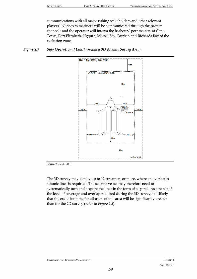
2.3.6 Exclusion Zone
Under the International Maritime Organization (IMO) Convention on the International Regulations for Preventing Collisions at Sea (COLREGS, 1972, Part A, Rule 10), a seismic survey vessel that is engaged in surveying is defined as a ‘vessel restricted in its ability to manoeuvre’ which requires that power-driven and sailing vessels give way to a vessel restricted in her ability to manoeuvre. Vessels engaged in fishing shall, so far as possible, keep out of the way of the seismic survey operation. As such, it is protected by a 500 m safety zone and it is an offence for unauthorised vessel to enter the safety zone. In addition to a statutory 500 m safety zone, a seismic contractor will request a safe operational limit (that is greater than the 500 m safety zone) that it would like other vessels to stay beyond. Typical safe operational limits are illustrated in Figure 2.7. Under the South Africa Marine Traffic Act, 1981 (No. 2 of 1981), a seismic survey vessel and its array of airguns and hydrophones fall under the definition of an “offshore installation” and as such it is protected by a 500 m safety buffer zone. It is an offence for an unauthorised vessel to enter the safety zone. In addition to the statutory limit, the seismic vessel would also request an additional safety buffer zone during operations of typically 8 km fore and aft of the vessel and 6 km abeam during daylight and 12 km fore and aft and 9 km abeam during the night. For semi-industrial, industrial and recreational fishers and other related activities, the operator will communicate the seismic survey journey plan and exclusion areas well in advance so that the appropriate planning can be done. The operator will develop a communication plan which will include
IMPACT AFRICA PART A: PROJECT DESCRIPTION TRANSKEI AND ALGOA EXPLORATION AREAS
ENVIRONMENTAL RESOURCES MANAGEMENT JUNE 2013
FINAL REPORT
2-9
communications with all major fishing stakeholders and other relevant players. Notices to mariners will be communicated through the proper channels and the operator will inform the harbour/ port masters at Cape Town, Port Elizabeth, Ngqura, Mossel Bay, Durban and Richards Bay of the exclusion zone.
Figure 2.7 Safe Operational Limit around a 3D Seismic Survey Array
Source: CCA, 2001 The 3D survey may deploy up to 12 streamers or more, where an overlap in seismic lines is required. The seismic vessel may therefore need to systematically turn and acquire the lines in the form of a spiral. As a result of the level of coverage and overlap required during the 3D survey, it is likely that the exclusion time for all users of this area will be significantly greater than for the 2D survey (refer to Figure 2.8).

IMPACT AFRICA PART A: PROJECT DESCRIPTION TRANSKEI AND ALGOA EXPLORATION AREAS
ENVIRONMENTAL RESOURCES MANAGEMENT JUNE 2013
FINAL REPORT
2-10
Figure 2.8 Schematic Illustrating the Movement of a 3D Seismic Vessel
Source: ERM, 2006
2.3.7 Specifics of the Seismic Survey Programme
Overview
For this investigation Impact Africa is proposing to undertake acquisition of a 2D seismic survey. However, if it is determined by on-going analysis of existing data as well as data collected through proposed surveys, that acquisition of a seismic dataset utilising 3D seismic techniques might be a more advantageous approach for data collection, then a 3D seismic survey might be substituted for the 2D survey or may be done in addition to the 2D seismic survey. The proposed 2D seismic survey would be approximately 5,000 km of seismic survey lines in length comprising a number of low density spaced survey lines over the Exploration Areas. In terms of timing, although survey commencement would ultimately depend on date of Exploration Right approval, availability of seismic contractors and other factors, it is anticipated that the survey would be undertaken during the summer of 2014/2015 and would take approximately 150 days to complete.

IMPACT AFRICA PART A: PROJECT DESCRIPTION TRANSKEI AND ALGOA EXPLORATION AREAS
ENVIRONMENTAL RESOURCES MANAGEMENT JUNE 2013
FINAL REPORT
2-11
Specific details of the seismic survey would be developed based on the results of other studies and following selection of a seismic survey contractor and survey vessel. The specific details of the survey will be submitted to PASA through a formal Environmental Notification. Appointment of Seismic Contractor
Specific seismic survey projects that are undertaken after the submission of the EMPr will be recorded as Environmental Notifications appended to the EMPr documentation. Details of the actual operation will be included in the Environmental Notifications for these projects. The seismic contractor for this survey has not yet been appointed. The operator will only appoint seismic acquisition contractors that are members of the International Association of Geophysical Contractors (IAGC) which requires that members adhere to a strict code of environmental conduct associated with the following guidelines: • Environmental Management in Oil & Gas Exploration & Production.
254 May 1997;
• Guidelines for Waste Management 413 Sep 2008; • Environmental Manual for Worldwide Geophysical Operations. PDF
format only IAGC 2001; and • Guidelines for HSE Auditing in the Geophysical Industry. Report 6.53/245
September 1996. At this stage no specific contractor or vessel has been contracted for the proposed survey and thus specific details of the seismic survey will only be set when the operator has engaged the contractor. The specifics of the survey will be detailed in an Environmental Notification that will be submitted to PASA for acceptance. The Environmental Notification will provide the following details: • Survey location and journey management plan; • Survey schedule and duration; • Vessel specifications; • Certification of contractor and vessel compliance; • Environmental, health and safety plan (including Emergency Response
Plan); and • Relevant insurances.

IMPACT AFRICA PART A: PROJECT DESCRIPTION TRANSKEI AND ALGOA EXPLORATION AREAS
ENVIRONMENTAL RESOURCES MANAGEMENT JUNE 2013
FINAL REPORT
2-12
Employment and Vessel Supplies
Any additional labour for the survey will be employed through the seismic acquisition contractor. The size and nature of the crew will depend on the size of the vessel, and is expected to consist of between 35 and 50 people on-board at any one time. Highly skilled and experienced crew and seismic operators are required for the seismic operations. Given the specific technical and experience requirements the crew is likely to consist of international specialists of various nationalities. On-board marine mammal observers (MMOs) as well as some unskilled and semi-skilled workers should be sourced from South Africa where reasonably possible. Vessel supplies, including food and water will likely be loaded at either of the Ports at Cape Town, Durban, or Port Elizabeth. The operator will inspect the seismic vessel before the start of the seismic acquisition activities. Fuel and lubricants used during the seismic acquisition period will likely be purchased at Cape Town, Durban, or Port Elizabeth. Bunkering of the seismic survey vessel is anticipated to be undertaken at the Port of Cape Town, Durban, or Port Elizabeth but refuelling while at sea would be also considered.
2.4 SURFACE HEAT FLOW MEASUREMENTS, SEABED AND WATER COLUMN SAMPLING PROGRAMME
The heat flow measurements would be conducted using heat flow probes, which would measure both the temperature and thermal conductivity of sediments in situ up to 12 m below the seabed. The measurement probe typically consists of a 6 cm diameter solid alloy steel bar, which extends from the wire termination at the top through the 500 kg lead-fill weight stand, down to the tip of the heat flow probe. The out-rigged thermistor string is attached parallel to the steel bar. The measurement device would be dropped from a vessel into the seabed, allowed to equilibrate and then recovered to the surface. No samples or other materials would be recovered with the heat flow probe. Acquisition of this data would be used to determine the thermal regime and calibrate thermal models to understand hydrocarbon system potential.

IMPACT AFRICA PART A: PROJECT DESCRIPTION TRANSKEI AND ALGOA EXPLORATION AREAS
ENVIRONMENTAL RESOURCES MANAGEMENT JUNE 2013
FINAL REPORT
2-13
Figure 2.9 Example of Heat Flow Probe
Source: XOM, 2013 Heat flow probe (http://www.tdi-bi.com/field_services/hf_info/description.htm). It is anticipated that up to 50 measurements may be collected across the Exploration Areas, which would take in the order of 60 days to complete. The water column samples may be measured or samples may be taken for analysis such as naturally occurring hydrocarbon, heavy and trace metal analysis. Additionally a Conductivity, Temperature, Depth (CTD) profiler may be deployed to measure additional parameters such as salinity, temperature, dissolved oxygen and turbidity. An estimated number of water sample stations has yet to be determined, however, for each station it is expected that three water depths will be sampled, including: • near surface (~1 m below surface); • mid-water; and • near bottom. Mid-water samples will likely be taken approximately 10 m below a measureable (distinct) thermocline. The depth of the thermocline will be determined using a single deployment of the CTD profiler. If a distinct thermocline does not exist, or cannot be established, the mid-water sample will be taken at a depth that is nominally half-way between the water’s surface and the seabed. Although specific water sampling equipment selections are yet to be made, there are many discrete water sampling devices available. Niskin™ and Go-

IMPACT AFRICA PART A: PROJECT DESCRIPTION TRANSKEI AND ALGOA EXPLORATION AREAS
ENVIRONMENTAL RESOURCES MANAGEMENT JUNE 2013
FINAL REPORT
2-14
Flo™ are examples of commonly available discrete samplers suitable for water column sampling and can be deployed singularly, in chains separated at pre-defined depth intervals, or attached to intelligent depth actuated clusters (rosettes).
2.5 MULTI-BEAM ECHO SOUNDER AND SUB-BOTTOM PROFILE PROGRAMME (SONAR TECHNIQUES)
The multi-beam bathymetry survey would be undertaken over the majority of the Exploration Areas. This system produces a digital terrain model of the seafloor (refer to Figure 2.10). A marine survey vessel would be equipped with a multi-beam echo sounder to obtain swath bathymetry and a sub-bottom profiler to image the seabed and the near surface geology. The multi-beam system provides depth sounding information on either side of the vessel’s track across a swath width of approximately two times the water depth. The multi-beam echo sounder emits a fan of acoustic beams from a transducer at frequencies ranging from 10 kHz to 200 kHz and typically produces sound levels in the order of 207 db re 1μPa at 1m. The sub-bottom profiler emits an acoustic pulse from a transducer at frequencies ranging from 3 kHz to 40 kHz and typically produces sound levels in the order of 206 db re 1μPa at 1m. The operating frequencies of the acoustic equipment used in sonar surveys typically fall into the high frequency kHz range.
Figure 2.10 The multibeam system uses a fan of sound beams to construct a 3-D picture of the seafloor.

IMPACT AFRICA PART A: PROJECT DESCRIPTION TRANSKEI AND ALGOA EXPLORATION AREAS
ENVIRONMENTAL RESOURCES MANAGEMENT JUNE 2013
FINAL REPORT
2-15
Source: http://www.niwa.co.nz/our-science/oceans/common-questions/all/seafloor-mapping The bathymetric data alone is not sufficient to identify all possible hydrocarbon seeps, as many seeps have no bathymetric expression. Backscatter data is typically collected concurrently by multi-beam echosounders as it can measure several properties of the seafloor associated with hydrocarbon seeps including; hardness; roughness; and volumetric heterogeneity. One or more of these three properties can result in an increase in backscatter intensity recorded by the multi-beam system and aid in the identification of potential natural hydrocarbon seeps on the seafloor in the survey area. The data acquired by these sonar techniques will be used to identify, prioritise, and target potential piston coring and heat-flow measurement locations. Selected sites could then be sampled with navigated piston cores. It is anticipated that data acquisition would take in the order of 150 days to complete assuming a vessel speed of 5 knots.
2.6 SEDIMENT CORING PROGRAMME
The Sediment Coring Programme would include piston coring in order to sample for natural hydrocarbon seepage. A piston corer would be used to collect seabed samples. Piston coring is one of the more common methods used to collect seabed samples for geochemical analysis (Figure 2.11). The piston coring operation is carried out (Figure 2.12) by winching the tool over the side of the vessel and lowering the corer to just above the seabed (A). As the trigger weight hits the bottom (B), it releases the weight on the trigger arm and the trigger arm begins to rise. Once the trigger arm has risen through its full 1.2 m of travel (C), the corer is released to free-fall the 3 m distance to the bottom, forcing the core barrel to travel down over the piston into the sediment. When the corer hits the end of its 3 m slack loop, the piston starts up the core barrel (D) creating suction below the piston, and expelling the water out the top of the corer. When forward momentum of the core has stopped, a slow pullout on the winch is begun. The suction created by the core sample in the liner prevents movement of the piston to the top of the core barrel in response to tension on the core wire. This suction triggers the separation of the top and bottom sections of the piston (E). The bottom half of the piston remains in place over the sediment to maintain integrity of the sample, while the top half (attached to the coring wire) "fetches up" against the stop in the core head, allowing the corer to be pulled out of the sediment. The entire assembly, including the sample, is retrieved onboard the vessel.

IMPACT AFRICA PART A: PROJECT DESCRIPTION TRANSKEI AND ALGOA EXPLORATION AREAS
ENVIRONMENTAL RESOURCES MANAGEMENT JUNE 2013
FINAL REPORT
2-16
Figure 2.11 Example of a Piston Corer
Source: //www.whoi.edu/cms/images/instruments/2005/12/pistoncorer_n_17289.jpg and http://nsm1.nsm.iup.edu/hovan/research/splat/SPLAT-Images/20.jpg The recovered cores are visually examined at the surface for indications of hydrocarbons (gas hydrate, gas parting, or oil staining) and three sets of sub-samples are retained for further geochemical analysis in a laboratory. Any material having geologic or environmental interest would be preserved for further study. The remaining sediment would be returned to the seabed.

IMPACT AFRICA PART A: PROJECT DESCRIPTION TRANSKEI AND ALGOA EXPLORATION AREAS
ENVIRONMENTAL RESOURCES MANAGEMENT JUNE 2013
FINAL REPORT
2-17
Figure 2.12 Diagram Illustrating a Piston Core Operation at the Seabed
Source: TDI-Brooks It is anticipated that up to 50 core samples would be collected across the Exploration Areas. Each individual core would have a disturbance area and volume of 0.01 m² and 0.07 m³, respectively, resulting in a total disturbance area and volume of approximately 0.39 m² and 3.53 m³, respectively. The number of cores samples and the exact location would be identified following the analysis of the multi-beam bathymetric survey results. It is anticipated that the initial seabed sampling programme would take in the order of 120 days to complete.
2.7 SUPPORT OPERATIONS
Seismic Survey
While seismic survey tracks are planned (where possible) to avoid submerged obstacles such as fishing gear, once on track a seismic survey vessel towing streamers is unable to easily change course to avoid smaller, more transient obstacles such as fishing gear/ fish traps and boats. Therefore, support vessels in the form of a ‘sweeper vessel’ and chase boat will accompany the seismic vessel. The ‘sweeper vessel’ will travel ahead of the seismic vessel removing fishing gear and other obstacles from the path of the vessel, or liaising with fishing operators to do so. The chase boat would be equipped with radar and communications systems to patrol the area during the survey

IMPACT AFRICA PART A: PROJECT DESCRIPTION TRANSKEI AND ALGOA EXPLORATION AREAS
ENVIRONMENTAL RESOURCES MANAGEMENT JUNE 2013
FINAL REPORT
2-18
so that other vessels adhere to the safety buffer operational limits. The chase boat would assist in alerting other vessels (e.g. fishing, transport, etc.) about the survey and the lack of manoeuvrability of the survey vessel. The chase boat would also provide logistics support to the survey vessel. In addition, helicopters may be utilised for crew/supply transfers from the seismic and support vessels.
2.8 NOISE, WASTE EMISSIONS AND DISCHARGES
Atmospheric Emissions
Air emissions would be generated by combustion of diesel fuel to power the exploration survey vessels and aircraft. The air emissions from the survey and support vessels would be no greater than that from any other vessel of a similar tonnage. Depending on how the vessel contracted for the survey is fitted, certain types of non-hazardous waste may be incinerated on-board the vessel. The incineration of any waste on-board would release soot as well as minor amounts of air pollutants (CO, CO2). If the vessel does not have an incinerator on-board waste would be transported to shore for disposal. Discharges to the Sea
All survey vessels will comply with international agreed standards regulated under MARPOL 73/78, as well as the South African Marine Pollution Act (Act 2 of 1986 -which incorporate MARPOL 73/78 standards) and the Dumping at Sea Control Act. The International Association of Geophysical Contractors have a ‘no dumping at sea’ policy. Noise Emissions
The noise emissions from survey vessels and aircraft above the surface of the sea would be no greater than that from any other vessel of a similar size.

ENVIRONMENTAL RESOURCES MANAGEMENT JUNE 2013
FINAL REPORT
3-1
3 DESCRIPTION OF THE AFFECTED ENVIRONMENT
3.1 INTRODUCTION
This Chapter describes the existing biophysical and socioeconomic baseline conditions of the Transkei and Algoa Exploration Areas and surroundings. This provides the basis from which the potential impacts are predicted. Information is provided for the East Coast which for the purposes of this report extends from Cape Padrone 33 S 2 30 E to the Mo ambi ue Border at Ponta do Ouro (2 0 S 32 2 E . The Exploration Areas are predominantly located in the southern portion of the East Coast with the Transkei Exploration Area located directly adjacent to the coast and the Algoa Exploration Area further offshore. Much of the information contained within this Chapter is based on the Generic EMPr for Oil and Gas Prospecting off the Coast of South Africa (CCA and CMS 2001 . This information was supplemented by specialist studies of marine fauna (Pisces Environmental Services (Pty Ltd 2013 marine heritage (African Centre for eritage Activities 2013) and fisheries (CapFish SA (Pty Ltd 2013 . Please refer to Part C for complete versions of each of the respective specialist reports.
3.2 GENERAL LOCATION
The proposed Exploration Areas are located between Port Eli abeth in the Eastern Cape Province (33 S 23 3 E and Ramsgate in the wa ulu-Natal Province (30°40’S 30°20’E (refer to Figure 3.1 . The Transkei Exploration Area extends along a narrow strip of the continental shelf to a maximum distance of approximately 135 km off the Eastern Cape coastline (Figure 3.1 . The Algoa Exploration Area is located further offshore immediately south of the continental shelf approximately 100 km from the Port Eli abeth shoreline. The proposed Exploration Areas cover an area of approximately 45 3 km . The proposed exploration activities (described in Chapter 2 may be undertaken over much of Exploration Areas.

Pond
olan
d of
fsho
re C
ontro
lled
Zone
Pond
olan
d in
shor
e Co
ntro
lled
Zone
Traf
alga
r MPA
Chris
tmas
Roc
k to
Gxu
lu R
iver
mou
th
Naho
on P
oint
to G
onub
ie P
oint
Nyar
a Riv
er m
outh
to G
reat
Kei
Rive
r mou
th
Dwes
a-Cw
ebe M
PA
Hlul
eka
MPA
ALG
OA
EX
PLO
RA
TIO
N A
RE
A
Bird
Isla
nd M
PA
Sard
inia
Bay
MPA
TR
AN
SK
EI
EX
PLO
RA
TIO
N A
RE
A
Garie
pSe
nqu
Tsol
wana
Maka
na
Elun
dini
Luka
nji
Amah
lathi
Malet
swai
Nxub
a
Mnqu
ma
Inkwa
nca Nk
onko
be
Mbha
she
Blue
Cra
ne R
oute
Mhlo
ntlo
Emala
hlen
i
Mbiza
na
Engc
obo
Nyan
deni
Inxub
a Yet
hem
ba
Buffa
lo Ci
ty
Ngqu
za H
ill
Umzim
vubu
Ngqu
shwa
Intsik
a Yet
hu
Ndlam
be
Sakh
isizw
e
Grea
t Kei
Sund
ays R
iver V
alley
Moho
kare
King
Sab
ata
Dalin
dyeb
o
Ntab
anku
lu Port
St Jo
hns
Mata
tiele
UMuz
iwab
antu
Nelso
n Ma
ndela
Bay
Ezin
golen
iHi
bisc
us C
oast
Umzu
mbe
Ugi
e
Sad
a
Indw
e
Um
tata
Libo
de
Biz
ana
Elli
otM
olte
no
Hof
mey
r
Idut
ywa
Kei
Roa
d
Kirk
woo
dB
athu
rst
Lady
Gre
y
Tark
asta
d
Pat
ters
on
Alic
edal
e
Coo
khou
se
Ste
ynsb
urg
Vent
erst
ad
Blin
kwat
er
Will
owva
le
Bur
gers
dorp
Rie
beek
Eas
t
Mou
nt A
yliff
Kei
skam
mah
oek
Som
erse
t Eas
t
Mou
nt F
letc
her
Cal
a
Bel
l
Tsom
o
Alic
e
Kom
ga
Uvo
ngo
Ped
die
Kok
stad Nta
fufu
Mat
ombe
Ovi
ston
Mac
lear
Cra
dock
Bed
ford
Sey
mou
r
Ham
burg
Gon
ubie
Pot
sdam
This
tles
Ade
laid
e
Cat
hcar
t
Sw
artk
ops
Flag
staf
f
Taba
nkul
u
Jam
esto
wn D
ordr
echt
Cof
imva
ba
Lusi
kisi
ki
Lady
Fre
re
Whi
ttles
eaQue
enst
own
Ale
xand
ria
Bro
oks
Nek
Por
t Edw
ard
Bar
kly
Eas
t
Ste
rkst
room
Eas
t Lon
don
Stu
tterh
eim
But
terw
orth
Por
t Alfr
ed
Gra
ham
stow
n
Mou
nt F
rere
Aliw
al N
orth
Bra
unsc
hwei
gFo
rt B
eauf
ort
Por
t Eliz
abet
h
Por
t She
psto
ne
Por
t St.
John
s
Kin
g W
illia
ms
Tow
n
31°0
'0"E
31°0
'0"E
30°4
0'0"
E
30°4
0'0"
E
30°2
0'0"
E
30°2
0'0"
E
30°0
'0"E
30°0
'0"E
29°4
0'0"
E
29°4
0'0"
E
29°2
0'0"
E
29°2
0'0"
E
29°0
'0"E
29°0
'0"E
28°4
0'0"
E
28°4
0'0"
E
28°2
0'0"
E
28°2
0'0"
E
28°0
'0"E
28°0
'0"E
27°4
0'0"
E
27°4
0'0"
E
27°2
0'0"
E
27°2
0'0"
E
27°0
'0"E
27°0
'0"E
26°4
0'0"
E
26°4
0'0"
E
26°2
0'0"
E
26°2
0'0"
E
26°0
'0"E
26°0
'0"E
25°4
0'0"
E
25°4
0'0"
E
30°40'0"S
30°40'0"S
31°0'0"S
31°0'0"S
31°20'0"S
31°20'0"S
31°40'0"S
31°40'0"S
32°0'0"S
32°0'0"S
32°20'0"S
32°20'0"S
32°40'0"S
32°40'0"S
33°0'0"S
33°0'0"S
33°20'0"S
33°20'0"S
33°40'0"S
33°40'0"S
34°0'0"S
34°0'0"S
34°20'0"S
34°20'0"S
34°40'0"S
34°40'0"S
35°0'0"S
35°0'0"S
35°20'0"S
35°20'0"S
SIZ
E:
TITL
E:
DA
TE
: Jun
e 20
13
DR
AW
N: A
B
CH
EC
KE
D: C
A
AP
PR
OV
ED
: HC
PR
OJE
CT:
019
4759
DR
AW
ING
:R
EV
: A3
Loca
tion
of th
e A
lgoa
-Tra
nske
i Exp
lora
tion
Are
a
Loca
tion
of th
e A
lgoa
-Tra
nske
i Exp
lora
tion
Area
s R
ev1.
mxd
1
CLI
EN
T:
±S
CA
LE:
T:\Gis Projects\0194759_XOM Algoa Transkei Exploration\Mapping\MXD\Location of the Algoa-Transkei Exploration Areas Rev1.mxd
Proj
ectio
n: G
eogr
aphi
c , D
atum
: Wgs
84So
urce
: EN
PAT
(200
1) S
AN
BI (
2012
) N
GI,
Briti
sh O
cean
ogra
phic
Dat
a C
entre
(BO
DC
) - G
EBC
OD
ata
Inse
t Map
: Esr
i Dat
a an
d M
aps
SC
ALE
: 1 :
2 00
0 00
0
It is
unl
awfu
l for
any
firm
or i
ndiv
idua
l to
repr
oduc
e co
pyrig
hted
map
s, g
raph
ics
or d
raw
ings
, in
who
le o
r in
part,
with
out p
erm
issi
on o
f the
cop
yrig
ht o
wne
r, ER
M S
outh
ern
Afric
a (P
ty) L
td ·
Lege
ndTo
wns
Pere
nnia
l Riv
ers
Loca
lMun
icip
aliti
es
Nat
iona
l Par
ks (2
011)
Mar
ine
Pro
tect
ed A
reas
(MPA
)
Area
s of
Inte
rest
10km
Coa
stal
Sei
smic
Buf
fer Z
one
(no
airg
un fi
ring)
2km
MPA
Sei
smic
Buf
fer Z
one
(no
airg
un fi
ring)
NA
MIB
IA
BOTS
WAN
A
NO
RTH
ER
N C
APE
LIM
PO
PO
EAST
ERN
CA
PE
FREE
STA
TE
WES
TER
N C
APE
NO
RTH
WE
ST
ZIM
BA
BWE
KWAZ
ULU
-NAT
AL
MP
UM
ALAN
GA
LESO
THO
GA
UTE
NG
SWAZ
ILAN
D
Stud
y Ar
eas
1000
2000
3000
4000
5000
>400
0
400
0
300
0
200
0
100
0
0 0D
epth
in M
etre
s
Hei
ght i
n M
etre
s
00.
20.
40.
60.
81
Kilo
met
res
ERM
2nd
Flo
or, T
he G
reat
Wes
terfo
rd24
0 M
ain
Roa
dR
onde
rbos
ch, 7
725
Cap
e T
own
Tel:
+27
21 6
81 5
400
Fax:
+27
21
686
0736
0
20
4
0
60
80
100

ENVIRONMENTAL RESOURCES MANAGEMENT JUNE 2013
FINAL REPORT
3-3
3.3 METEOROLOGY
Weather patterns along the southern portion of the East Coast (Cape Padrone to southern wa ulu-Natal are affected by both mid-latitude cyclones developing in the westerly wind belt and South Atlantic and Indian Ocean anticyclone cells (Schumann 1 (Figure 3.2 . Eastward travelling mid-latitude cyclones and associated coastal low pressure systems are prevalent throughout the year although north-easterly winds increase during the South African summer (Schumann 1 . Conversely berg winds tend to occur during the winter months (Wiseman et al. 1 3 . Land and sea bree es are common and occur along the southern section of the East Coast although they vary seasonally (Schumann et al. 1 1 . The climate off the East Coast is also affected by other less regular weather patterns such as low pressure cells that may remain to the northeast of Durban for several days cut-off low pressure cells and tropical cyclones during summer and autumn ( unter 1 Schumann 1 .
Figure 3.2 Main Weather Systems Associated with Southern Africa
Source Roberts 2005 Basic weather patterns along the East Coast are linked to the eastward movement of coastal low pressures that form on the West Coast during pre-frontal conditions (Hunter 1 . These coastal low pressure systems are typically around 100 km wide and travel in an anti-clockwise path along the South African coast at a speed of between -30 m/sec (Jury et al. 1 0 Schumann 1 . Moving at this speed they can traverse the east coast region

ENVIRONMENTAL RESOURCES MANAGEMENT JUNE 2013
FINAL REPORT
3-4
in under three days (CSIR 1 a . Northeasterly wind speeds increase (occasionally to gale force as the coastal low reaches the coastline and then drop to very strong (often gale force south-easterly winds with these conditions regularly continuing for 24 hours before returning to the northeast (CCA 2001 .
3.4 PHYSICAL OCEANOGRAPHY
The East Coast region is situated along the eastern extension of the Agulhas Bank which at its southern-most point extends over 10° of longitude to some 250 km offshore at its widest point at approximately 21° 00’ E directly south of Cape Agulhas (Jackson et al. 2012 . A transition one between the warm Agulhas Current waters to the east and the cool waters of the Benguela Current system to the west occurs on the bank (Figure 3.1 . While the western Agulhas Bank (particularly its inshore region is viewed as part of the Benguela Current upwelling system the eastern Agulhas Bank is directly influenced by the warm southward flowing Agulhas Current. The oceanography of the region (particularly the inshore area is largely dependent on the local coastline and bathymetric orientation in relation to the prevailing easterly and westerly winds (Boyd and Shillington 1 4 . A number of physical processes and features associated with the South African coastal region are illustrated in Figure 3.3. The following Section provides a summary of the key physical processes and features which affect the physical oceanography of the Exploration Areas.
Figu
re 3
.3
Impo
rtan
t Phy
sica
l Pro
cess
es a
nd F
eatu
res
asso
ciat
ed w
ith
the
Sout
h A
fric
an C
oast
al R
egio
n.
Sour
ce: R
ober
ts 2
005.

ENVIRONMENTAL RESOURCES MANAGEMENT JUNE 2013
FINAL REPORT
3-
3.4.1 Waves
Swell rose data gathered by Voluntary Observing Ships (VOS in the area 32° 34’ S and 2 ° 2 ’ E (located southwest of East London are provided in Figure 3.4 (Wiseman et al. 1 3 . Swells typically travel in a northeasterly direction reaching a maximum of 10 m high although westward-traveling swells develop under prevailing easterly winds during South African summer and autumn (Wiseman et al. 1 3 . Less regular weather systems generating large swells along the East Coast include low pressure weather cells to the northeast of Durban cut-off low pressure cells and tropical cyclones (Hunter 1 Schumann 1 .
Figure 3.4 Annual wind (A) and swell rose (B) gathered by VOS in the area 32° 34’ S, 27° 29’ E.
Source: Wiseman et al. 1 3
3.4.2 Tides
Tides are semi-diurnal along the East Coast (Schumann 1 . There is a marginal increase in tidal range from west to east such that tides along the
wa ulu-Natal coastline occur almost simultaneously (Schumann 1 . Tidal levels for East London are provided in Table 3.1.

ENVIRONMENTAL RESOURCES MANAGEMENT JUNE 2013
FINAL REPORT
3-7
Table 3.1 Tide levels (m) at East London (South African Tides Tables, 1979).
3.4.3 Bathymetry and Sediments
The bathymetry of the East Coast is generally characterised by a narrow continental shelf (the shelf area between Richards Bay and Port Eli abeth varies in width from 5 km to 45 km wide that drops off rapidly (Figure 3.5 . In the region of Algoa Bay the narrow shelf widens with depth increasing gradually to the shelf break at a depth of 140 m off Port Eli abeth 130 m off Cape St Francis and 300 m south of Cape Agulhas (Birch & Rogers 1 73 . Between 22 and 2 ° E the shelf break indents towards the coast (refer to Figure 3.5 forming the Agulhas ‘bight’ (Schumann 1 . Outside the shelf break depth increases rapidly to more than 1 000 m (Hutchings 1 4 . Along the coast of the Eastern Cape Province the continental shelf descends into the Transkei Basin (refer to Figure 3.5 below (CCA 2001 .
Figure 3.5 Offshore bathymetry of the South African EEZ. The continental shelf break is shown in red, and the 1800m and 3500m isobaths are shown in brown and blue respectively.
Source: CCA 2001 Redrawn from Dingle et al. (1 7 .

ENVIRONMENTAL RESOURCES MANAGEMENT JUNE 2013
FINAL REPORT
3-
3.4.4 Water Masses
The oceanic waters of the East Coast and within the proposed Exploration Areas comprise numerous water masses. Surface waters are a combination of Tropical Surface Water from the South E uatorial Current and Subtropical Surface Water from the mid-latitude Indian Ocean which regularly enters the Agulhas Current from the east at depths of between 150 and 300 m. The surface waters are warmer than 20°C and of a lower salinity than the South Indian Ocean E uatorial Indian Ocean and Central water masses present below. However the characteristics of surface water do vary due to isolation and mixing (Schumann 1 . Water temperatures along the East Coast vary seasonally and in relation to the distance offshore increasing offshore towards the centre of the Agulhas Current. Gr ndlingh (1 7 found that seasonal variation (warmest in summer and coldest in winter only occurs in the upper 50 m of the water column with insignificant variations occurring deeper down. According to Schumann (1 water temperatures within the Agulhas Current may exceed 25° C in summer and 21° C in winter and are permanently warmer than the water inshore and offshore of it. Water temperatures also decrease with depth with temperatures at 50 m below the surface being 4° C cooler than the surface in summer and 1° C cooler in winter. Seasonal variation in temperatures is limited to the upper 50 m of the water column (Gr ndlingh 1 7 increasing offshore towards the core waters of the Agulhas Current. South of Mbashe and East London a persistent wedge of cooler water is present over the continental shelf during summer (Beckley & Van Ballegooyen 1 2 extending northwards to the southern wa ulu-Natal coast in winter. This wedge is typically cooler than 1 ° C but may be cooler than 1 ° C between East London and Port Alfred and south of Mbashe. Inshore waters are warmest during South African autumn with warm water tongues found off Cape Recife (near Port Eli abeth from January to March and off nysna (west of the Exploration Areas from October to January and during August. Strong and persistent thermoclines are common over the shelf extending inshore during the summer but breaking down during the cooler and windier winter conditions (Schumann & Beekman 1 4 Boyd & Shillington 1 4 . Thermoclines at the eastern edge of the South Coast are located at 20 to 40 m depth (Largier & Swart 1 7 . The Agulhas Current cools as it moves southward. Gründlingh (1 7 recorded the water temperature in three offshore areas ( 400 m approximately 170 km offshore of St Lucia Port Edward and East London (Figure 3.6 . The blocks thus fell outside the central stream of the Agulhas Current thus minimising the temperature variances from lateral movement of the current (Gründlingh 1 3 .

ENVIRONMENTAL RESOURCES MANAGEMENT JUNE 2013
FINAL REPORT
3-
Beckley and Van Ballegooyen (1 2 note that offshore surface waters are generally warmer than 22° C along the East Coast. They report that during summer a wedge of cooler water is situated over the continental shelf to the south of Mbashe and East London. During winter this wedge extends northwards to the southern wa ulu-Natal coast. The temperature of this wedge typically ranges between 1 ° and 1 ° C but may drop below 1 ° C in the section between East London and Port Alfred and to the south of Mbashe. Off Mbashe there is also a substantial temperature front along the inshore edge of the Agulhas Current (Beckley and Van Ballegooyen 1 2 Pearce et al. 1 7 .
Figure 3.6 Location of Areas A, B and C in analyses of water temperatures along the East Coast
Source: Grundlingh 1 7 in CCA 2001
3.4.5 Circulation
The Agulhas Current forms part of the western boundary of the anticyclonic Indian Ocean gyre (Shannon 1 Jackson et al. 2012 . The current develops between 25° and 30° S and travelling in a southwesterly direction along the east coast of Southern Africa before veering away from the coast between 1 ° and 20° E (Figure 3.7 . The Agulhas Current is about 100 km wide and 1000 m deep (Schumann 1 e uating to a volume of about 75 × 10 m3/sec at Port

ENVIRONMENTAL RESOURCES MANAGEMENT JUNE 2013
FINAL REPORT
3-10
Edward increasing by × 10 m3/sec 100 km south (Gründlingh 1 0 . The current flows rapidly along the edge of the continental shelf (Grundlingh 1 3 travelling at a surface speed of 1-1.5m/s in the centre although speeds above 2.5 m/sec have been recorded (Pearce et al. 1 7 .
Figure 3.7 Sea Surface Temperature (September 2010) and the Agulhas Current (black arrows)
Source: Jackson et al. 2012 Note: Grey lines indicate the bathymetry in 1000 m intervals. Small circles indicate eddies and acronyms indicate the following: CA for Cape Agulhas MB for Mossel Bay TS for Tsitsikamma SFB for St. Francis Bay and AB for Algoa Bay. Four distinct current regions have been identified at the surface by Pearce 1 77. These include:
The inshore region which is characterised by relatively cool slow moving water over the continental shelf.
The western boundary of the current which experiences intense hori ontal shear and a relatively strong temperature gradient (1 to 2° C in 10 km . The current core where current speeds are greater than 1 m/sec. Temperatures in this one vary from around 22° C in August to 27° C in March. The eastern boundary of the current consisting of weak gradients offshore of the core region. Both current speed and temperature gradually reduce away from the coast.

ENVIRONMENTAL RESOURCES MANAGEMENT JUNE 2013
FINAL REPORT
3-11
3.4.6 Upwelling
Upwelling in the Agulhas Current has been proposed to take place in a number of ways and locations. Gründlingh and Pearce (1 0 report that a degree of dynamic upwelling could be caused by eddies in the large clockwise loops (deeper than 100m that occur between Richards Bay and Durban. Lutjeharms et al. (2000 1 found that a wedge of cold upwelling water is often present along the Natal Bight. The upwelling has a base length of between 50 and 130 km and is usually situated off Richards Bay. Although such upwelling only lasts for up to two days the effects often remain longer. For instance cold water filaments from this upwelling area often extend up to 1 0 km southward along the Agulhas Current. According to Lutjeharms et al. (1 the upwelling is created by the relationship between the coastal offset and the Agulhas Current. More recently Schumann (1 reported that the upwelling of cold water moves onto the continental shelf from the inner edge of the Agulhas Current especially to the south of East London. Cold water rises over the shelf at Ekman veering in the lowest boundary layer with evidence of this taking place from Port Edward (Schumann 1 . These mechanisms are aided by upwelling at the coast.
3.4.7 Seamounts
Geological features of note in the vicinity of the Exploration Areas include various banks knolls and seamounts (all collectively referred here as ‘seamounts’ . These seabed features protrude into the water column and are subject to and interact with the water currents surrounding them. The effects of such seabed features on the surrounding water masses can include the up-welling of relatively cool nutrient-rich water into nutrient-poor surface water (refer to Section 3.4.6 above thereby resulting in higher levels of primary productivity (Clark et al. 1 which can in turn strongly influence the distribution of organisms on and around seamounts. Compared to the surrounding deep-sea environment seamounts typically form biological hotspots with a distinct abundant and diverse fauna many species of which remain unidentified. Conse uently the fauna of seamounts is usually highly uni ue and may have a limited distribution restricted to a single geographic region a seamount chain or even a single seamount location (Rogers et al. 200 . Levels of endemism on seamounts are also relatively high compared to the deep sea. South Africa’s seamounts and their associated benthic communities have not been sampled by either geologists or biologists (Sink & Samaai 200 . However SANBI (2011 has recognised two important seamounts located offshore to the west of the proposed exploration areas (Figure 3.36Figure 3.3 . These include the Protea Seamount and the Southwest Indian Seamount (refer to Figure 3.36 . Neither of these seamounts fall within the proposed exploration areas.

ENVIRONMENTAL RESOURCES MANAGEMENT JUNE 2013
FINAL REPORT
3-12
3.4.8 Nutrient Distributions
Nitrate-nitrogen concentrations in Agulhas Current source water range from 7 to 10 M/l while those of subthermocline water may be up to 20 M/l (Carter et al., 1 7 . Primary production is nitrogen-limited in the upper layers of the euphotic one but light-limited in the sub-surface chlorophyll maximum layer (Probyn and Lucas 1 7 . During winter when the water column is well mixed bottom nutrients mix upwards and nutrient concentrations in the surface waters are higher than in summer (CSIR and CCA 1 .
3.4.9 Turbidity
Natural turbidity and/or suspended sediment concentration measurements from the East Coast are sparse. Suspended sediment distributions within South African near-shore waters range between 5 mg – 5 g/l ( outendyk 1 5 . The higher values are associated with high wave conditions resulting from storms and/or flood-waters as substantial sediment loads are deposited into the East Coast marine environment by summer river run-off (Flemming and Hay 1 .
3.5 BIOLOGICAL ENVIRONMENT
A considerable portion of the proposed exploration areas is located beyond the 50 m depth contour. Communities within the offshore marine habitat are comparatively homogenous largely as a result of the greater consistency in water temperature at depths around the South African coastline than in the shallower coastal waters. Nonetheless there are a number of inshore and offshore bioregions that fall into the proposed Exploration Areas given their extent and distribution (Lombard et al. 2004 . The most prominent of these is the West Indian Offshore Bioregion as illustrated in Figure 3.8 below.

ENVIRONMENTAL RESOURCES MANAGEMENT JUNE 2013
FINAL REPORT
3-13
Figure 3.8 The Inshore and Offshore Bioregions occurring in the Proposed Exploration Areas (red outline)
Source: Adapted from Lombard et al. 2004 The biological communities occurring in the proposed Exploration Areas consist of many hundreds of species often displaying considerable temporal and spatial variability (even at small scales . The nearshore and offshore marine ecosystems comprise a limited range of habitats namely unconsolidated seabed sediments deep-water reefs and the water column. The biological communities ‘typical’ of these habitats are described in the following Sections focussing both on dominant commercially important and conspicuous species as well as sensitive species such as threatened species.
3.5.1 Phytoplankton
The nutrient-poor characteristics of the Agulhas Current water are reflected in comparatively low primary productivity in the southern portion of the proposed Exploration Areas with mean chlorophyll a concentrations averaging between 1 to 2 mg/m³ over the whole year in the top 30 m of the water column. Chlorophyll a concentrations vary seasonally being minimal in winter and summer (< 1 to 2 mg/m³ and maximal (2 to 4 mg/m³ in spring and autumn (Brown 1 2 . Along the eastern half of the South Coast phytoplankton concentrations are usually higher than further west comprising predominantly large cells (Hutchings 1 4 . Along the wa ulu-Natal coast primary productivity in inshore areas is low with chlorophyll a concentrations ranging between 0.03 and 3. g/l (Carter & Schleyer 1 .

ENVIRONMENTAL RESOURCES MANAGEMENT JUNE 2013
FINAL REPORT
3-14
3.5.2 Zooplankton
On the South Coast the biomass of meso ooplankton increases from west ( 0.5- 1.0 g C/m2 to east ( 1.0- 2.0 g C/m2 mirroring the eastward increase in chlorophyll a concentrations. Dense swarms of euphausiids dominate this ooplankton component and form an important food source for pelagic fishes (Cornew et al. 1 2 Verheye et al. 1 4 . On the East Coast continental shelf waters support greater and more variable concentrations of ooplankton biomass than offshore waters (Beckley & Van Ballegooyen 1 2 with species composition varying seasonally (Carter & Schleyer 1 . Copepods represent the dominant species group (Carter & Schleyer 1 but chaetognaths are also abundant (Schleyer 1 5 .
3.5.3 Ichthyoplankton
Ichthyoplankton comprises both fish eggs and larvae and although a small component of the overall plankton is an important due to the commercial importance of fisheries. Along the East Coast ichthyoplankton is primarily confined to inshore waters with larval concentrations varying between 0.005 and 4.57 larvae/m3. Concentrations however decrease rapidly with distance offshore (Beckley & Van Ballegooyen 1 2 . A variety of pelagic species including anchovy pilchard and horse mackerel are reported to spawn east of Cape Agulhas (approximately 300 km to the west of the proposed Exploration Areas (Crawford 1 0 Hutchings 1 4 Roel & Armstrong 1 1 (Figure 3.9 . In the case of pilchards (Sardinops sagax adults move eastwards and northwards after spawning. After the sardine run in June and July pilchard eggs occur in inshore waters along the Eastern Cape and the southern wa ulu-Natal coast (Anders 1 75 Connell 1 . Anchovy (Engraulis japonicus eggs have also been reported in the water column during December as far north as St Lucia (Anders 1 75 . There is thus an overlap of egg and larval distributions of these species within the proposed Transkei Exploration Area. Of the demersal species kingklip spawn off the shelf edge to the south of St Francis and Algoa Bays coincident with the Algoa Exploration Area (Hutchings 1 4 . S uid (Loligo spp. larvae are also widely distributed in inshore waters (<50 m in close proximity to the north-west boundary of the Algoa Exploration Area (Augustyn et al. 1 4 (refer to Section 3.5.4 below .

ENVIRONMENTAL RESOURCES MANAGEMENT JUNE 2013
FINAL REPORT
3-15
Figure 3.9 Important Fishing Banks, Seamounts, and Spawning Areas in Relation to the Proposed Exploration Areas
Source: Anders 1 75 Crawford et al. 1 7 Hutchings 1 4 Note: 200 m depth contour shown in blue.
3.5.4 Invertebrates
The intertidal and shallow subtidal reefs along the East Coast of South Africa support a wide diversity of marine flora and fauna and a relatively high percentage of endemic species (Turpie et al. 2000 Awad et al. 2002 . However information about benthic reef communities and hard grounds in the proposed Transkei Exploration Area is limited to descriptions of reef ecosystems in the Pondoland area (1 (Celliers et al. 2007 . Pondoland stretches between the Mthatha River and the Mtamvuna River in the Eastern Cape Province along a coastal strip that is a maximum of 50 km wide. The following description is summarised from this study and from descriptions of South Africa’s reef types provided in SANBI’s Reef Atlas Project. The nearshore reefs of the Pondoland coast shelter a mix of subtropical and warm-temperate fauna that manifest both a latitudinal and longitudinal shift
(1 Pondoland is a natural region located in the coastal belt off the Eastern Cape province of South Africa. Its territory is the former Pondo ingdom and the traditional region of the Pondo people.

ENVIRONMENTAL RESOURCES MANAGEMENT JUNE 2013
FINAL REPORT
3-1
in benthic composition over a relatively short distance. There is a change from low-diversity macroalgae dominated communities on the shallow high-profile reefs in the north to high-diversity (and comparatively high total living cover and high biomass communities dominated by sponges ascidians and bryo oans on low-profile deeper reefs and reefs to the south. The shallow-water algae-dominated habitats also harbour hard corals (Stylophora pistillata with wave action strongly influencing the community structure. This shift is concomitant with a reduction in available light associated with increased water turbidity. The shift from a habitat defined primarily by phototropism to a benthic community dominated by suspension-feeders is probably driven by higher sediment loads and the greater availability of nutrients coming from the numerous rivers along this portion of the coast. The reduction in available light with depth similarly allows non-phototrophic species — such as sponges and ascidians — to compete with algae for space on the reef. Further south in the Port Eli abeth area inshore reefs to -30 m depth also show relatively distinct changes in community structure being characterised by diverse reef assemblages dominated by cauliflower soft coral (Sink et al. 2011 . Further south off Goukamma the reefs are characterised by e ually distributed high and low profile areas. The benthic taxa are dominated by bryo oans and sponges (22. percent and 21.1 percent respectively followed by gorgonians (1 .4 percent ascidians (13.7 percent and algae (10.1 percent . Crinoids ( .4 percent and hydro oans (7.5 percent constitute < 10 percent of the overall occurrence. Community composition in this area is strongly affected by linefishing with higher abundance of algae and crinoids at fished sites and higher sponge cover on reefs within the Goukamma Marine Protected Area (MPA . Squid
The s uid (Loligo vulgaris reynaudii occurs extensively on the Agulhas Bank out to the shelf edge (500 m depth contour increasing in abundance towards the easternmost boundary of the South Coast region between Plettenberg Bay and Algoa Bay (Augustyn 1 0 Sauer et al. 1 2 Augustyn et al. 1 4 . Adults are normally distributed in waters greater than 100 m in depth except along the eastern half of the South Coast where they also occur inshore forming dense spawning aggregations at depths between 20 to 130 m. These spawning aggregations are a seasonal occurrence reaching a peak in November and December. Rock Lobster and Crayfish
The deep-water rock lobster (Palinurus gilchristi occurs on rocky substrate in depths of 0 to 170 m between Cape Agulhas and southern wa ulu-Natal. Larvae drift southwards in the Agulhas Current settling in the south of the

ENVIRONMENTAL RESOURCES MANAGEMENT JUNE 2013
FINAL REPORT
3-17
Agulhas Bank before migrating northwards again against the current to the adult grounds (Branch et al. 2010 . The species is fished commercially along the southern Cape Coast between the Agulhas Bank and East London with the main fishing grounds being in the 100 to 200 m depth range south of Cape Agulhas on the Agulhas Bank and off Cape St Francis Cape Recife and Bird Island. Other deep-water crustaceans that may occur in the proposed Exploration Areas are the shovel-nosed crayfish (Scyllarides elisabethae and the Natal deep-sea rock lobster (Palinurus delagoae . The shovel-nosed crayfish occurs primarily on gravelly seabed at depths of around 150 m although it is sometimes found in shallower water. Its distribution range extends from Cape Point to Maputo in Mo ambi ue. The Natal rock lobster similarly occurs on open areas of mud and rubble at depths of 1 0-300 m. Larvae settle offshore with juveniles and adults migrating inshore as they age. Other rock lobster species occurring in shallower waters on the south and east coasts include the West Coast rock lobster (Jasus lalandii East Coast rock lobster (Panulirus homarus Longlegged spiny lobster (Panulirus longipes the ornate spiny lobster (Panulirus ornatus and the painted spiny lobster (Panulirus versicolor all of which are typically associated with shallow-water reefs although the West Coast lobster has been recorded at depths of 120 m (Branch et al. 2010 .
3.5.5 Benthic Biota
The benthic biota of offshore soft bottom substrates constitutes invertebrates that live on (epifauna or burrow within (infauna the sediments and are generally divided into megafauna (animals 10 mm macrofauna ( 1 mm and meiofauna (<1 mm . The structure and composition of benthic soft-bottom communities is primarily a function of abiotic factors such as water depth and sediment grain si e but others such as current velocity and organic content abundance also play a role (Snelgrove & Butman 1 4 Flach & Thomsen 1 Ellingsen 2002 . Further shaping is derived from biotic factors such as predation food availability larval recruitment and reproductive success. The high spatial and temporal variability for these factors results in seabed communities being both patchy and variable. In nearshore waters where sediment composition is naturally patchy and significant sediment movement may be induced by the dynamic wave and current regimes (Fleming & Hay 1 the benthic macrofauna are typically adapted to fre uent disturbance. In contrast further offshore where near-bottom conditions are more stable the macrofaunal communities will primarily be determined by sediment characteristics and depth.

ENVIRONMENTAL RESOURCES MANAGEMENT JUNE 2013
FINAL REPORT
3-1
There is insufficient information available on benthic invertebrates in the proposed Exploration Areas to allow for a description of the oogeographic distribution of benthic macrofaunal communities (McClurg 1 . However from studies conducted off the West Coast it can be deduced that in general species diversity abundance and biomass is relatively low on inshore substrates but increases from the shore to the 0 m depth. Communities are characterised e ually by polychaetes crustaceans (of which amphipods copepods and ostracods are the dominant types echinoderms and molluscs. Further offshore to 120 m depth the midshelf is a particularly rich benthic habitat where biomass can attain 0 g/m2 dry weight (Christie 1 74 Steffani 2007b . The comparatively high benthic biomass in this midshelf region represents an important food source to carnivores such as the mantis shrimp cephalopods and demersal fish species. Outside of this rich one biomass declines to 4. g/m2 at 200 m depth and then is consistently low (<3 g/m2 on the outer shelf (Christie 1 74 . The meiobenthos includes the smaller species such as nematode worms flat worms harpacticoid copepods ostracods and gastrotriches. Some of the meiofauna are adept at burrowing while others live in the interstitial spaces between the sand grains. The benthic fauna of the continental slope beyond 450 m depth are poorly known largely due to limited opportunities for sampling and to date very few areas of the continental slope off the South and East Coasts have been surveyed. With minimal changes in sea floor topography and hard substrate such areas are likely to offer minimal habitat diversity or niches for animals to occupy. Detritus-feeding crustaceans holothurians and echinoderms tend to be the dominant epi-benthic organisms of such habitats. Also associated with soft-bottom substrates are demersal communities that comprise bottom-dwelling invertebrate species many of which are dependent on the invertebrate benthic macrofauna as a food source. In recent years there has also been increasing interest in deep-water corals and sponges because of their likely sensitivity to disturbance and long generation times. These benthic filter-feeders generally occur at depths exceeding 150 m. Some coral species form reefs while others are smaller and remain solitary. Corals and sponges add structural complexity to otherwise uniform seabed habitats thereby creating areas of higher biological diversity (Bree e et al. 1 7 MacIssac et al. 2001 . Their frameworks offer refugia for a greater variety of invertebrates and fish (including commercially important species within or in association with the living and dead frameworks. The Agulhas Bank hosts a diversity of deep-water corals and sponges (Figure 3.10 that have establish themselves below the thermocline where there is a continuous and regular supply of concentrated particulate organic matter caused by the flow of a relatively strong current. Substantial shelf areas should thus potentially be capable of supporting rich deep-water benthic filter-feeding communities. Offshore benthic communities occurring on reefs on the central Agulhas Bank

ENVIRONMENTAL RESOURCES MANAGEMENT JUNE 2013
FINAL REPORT
3-1
include protected cold water porcelain coral Allopora nobilis sponges crinoids and bryo oans (Figure 3.10 left photo whereas a variety of habitat-forming sponges colonial ascidians and hydroids occur on sandy seabed (Figure 3.10 right photo .
Figure 3.10 Offshore Benthic Communities Occurring on Reefs on the Central Agulhas Bank
Source: Andrew Penney from Pulfrich 2013 Despite the lack of information on the subject small parts of two focus areas (refer to Section 3.6.6 with important benthic habitats have been identified within the proposed Exploration Areas. These include the shelf and shelf edge between Cape St Francis and Port Alfred including the area offshore of Port Eli abeth (within the proposed Algoa Exploration Area and the area offshore of the wa ulu-Natal South Coast (called Protea Banks . A summary of these areas is provided in Section 3.6.6 below.
3.5.6 Pelagic and Demersal Fish
The South and East Coast ichthyofauna is diverse comprising a mixture of temperate and tropical species. As a transition one between the Agulhas and Benguela current systems the South Coast ichthyofauna includes many species occurring also along the West and/or East Coasts. The seabed of the Agulhas Bank substrate is also diverse comprising areas of sand mud and coral thereby contributing to increased benthic fauna and thus fish species. Small pelagic shoaling species occurring along the South Coast include anchovy (Engraulis encrasicolus pilchard (Sardinops sagax round herring (Etrumeus japonicas chub mackerel (Scomber japonicas and horse mackerel (Trachurus trachurus capensis . Anchovies are usually located between the cool upwelling ridge and the Agulhas Current (Hutchings 1 4 and are larger than those of the West Coast. Having spawned intensively in an area around the 200 m depth contour between Mossel Bay and Plettenberg Bay between October and January most adults move inshore and eastwards ahead of warm

ENVIRONMENTAL RESOURCES MANAGEMENT JUNE 2013
FINAL REPORT
3-20
Agulhas Current water. The Agulhas Bank area is however not considered an important anchovy recruitment ground (Hampton 1 2 . Round herring juveniles similarly occur inshore along the South Coast but move offshore with age (Roel et al. 1 4 Hutchings 1 4 . Pilchards are typically found in water between 14 °C and 20 °C. Spawning occurs on the Agulhas Bank during spring and summer (Crawford 1 0 with recruits being found inshore along the South Coast (Hutchings 1 4 . It is thought that the Agulhas Bank may be a refuge for pilchard under low population levels and therefore vital for the persistence of the species (CCA & CSIR 1 . During the winter months of June to August the penetration of northerly-flowing cooler water along the Eastern Cape coast and up to southern wa ulu-Natal effectively expands the suitable habitat available for this species resulting in a ‘leakage’ of large shoals northwards along the coast in what has traditionally been known as the ‘sardine run’. The cool band of inshore water is critical to the sardine run as the sardines will either remain in the south or only move northwards further offshore if the inshore waters are above 20 °C. The shoals can attain lengths of 20-30 km and are typically pursued by great white sharks copper sharks common dolphins cape gannets and various other large pelagic predators (www.sardinerun.co. a . Catch rates of several important species in the recreational shoreline fishery of
wa ulu-Natal have been shown to be associated with the timing of the sardine run (Fennessey et al. 2010 . Other pelagic species that migrate along the coast include elf (Pomatomus saltatrix geelbek (Atractoscion aequidens yellowtail (Seriola lalandi kob (Argyrosomus sp seventy-four (Cymatoceps nasutus strepie (Sarpa salpa cape stumpnose (Rhabdosargus holubi and mackerel (Scomber japonicus which are all regular spawners particularly within wa ulu-Natal waters (Van der Elst 1 . Large migratory pelagic species that occur in offshore waters and beyond the shelf break include dorado (Coryphaena hippurus sailfish (Istiophorus platypterus and black blue and striped marlin (Makaira indica, M. nigricans, Tetrapturus audax frigate tuna (Auxis thazard skipjack (Katsuwonus pelamis longfin tuna/albacore (Thunnus alalunga bigeye tuna (Thunnus obesus yellowfin tuna (Thunnus albacares Southern bluefin tuna and bluefin tuna (Thunnus maccoyii and T. thynnus thynnus respectively (Van der Elst 1 Smale et al. 1 4 . There is a high diversity of Teleosts (bony fish and Chondrichthyans (cartilaginous fish associated with the inshore and shelf waters of the South and East Coasts many of which are endemic to the Southern African coastline and form an important component of the demersal trawl and long-line fisheries. The Cape hake (Merluccius capensis is distributed widely on the Agulhas Bank while the deep-water hake (Merluccius paradoxus is found further offshore in deeper water (Boyd et al. 1 2 Hutchings 1 4 . Juveniles

ENVIRONMENTAL RESOURCES MANAGEMENT JUNE 2013
FINAL REPORT
3-21
of both species occur throughout the water column in shallower water than the adults. ingklip (Genypterus capensis is also an important demersal species with adults distributed in deeper waters along the whole of the South Coast especially on rocky substrate (Japp et al. 1 4 . They are reported to spawn in an isolated area beyond the 200 m isobaths between Cape St Francis and Port Eli abeth during spring (see Figure 3.9 . Juveniles occur further inshore. The Agulhas or East Coast sole (Austroglossus pectoralis inhabits inshore muddy seabed (<125 m on the shelf between Cape Agulhas and Algoa Bay (Boyd et al. 1 2 . Apart from the above-mentioned target species numerous other by-catch species are landed by the South Coast demersal trawling fishery including panga (Pterogymnus laniarius) kob (Argyrosomus hololepidotus gurnard (Chelidonichthyes spp. monkfish (Lophius sp. John Dory (Zeus capensis and angel fish (Brama brama . The shallower inshore areas (<100 m along the South and East Coasts comprise a varied habitat of rocky reefs and soft-bottom substrates which support a high diversity of endemic sparid and other teleost species (Smale et al. 1 4 (Figure 3.11 some of which move into inshore protected bays to spawn (Buxton 1 0 or undertake spawning migrations up the coast to
wa ulu-Natal. Those species that undertake migrations along the South and East Coasts include red steenbras white steenbras (summer kob geelbek and elf (winter . Spawning of the majority of species endemic to the area occurs in spring and summer. Many of these species form an important component of the commercial and recreational line fishery. Furthermore there are numerous pelagic species that fre uent near shore waters and are targeted by line-fishermen (Table 3.2 .
Figure 3.11 The South Coast Reefs Support a Wide Diversity of Teleost Species Including Musselcracker (left) and Red Stumpnose (right)
Source: http://spearfishingsa.co. a www.easterncapescubadiving.co. a from Pulfrich 2013

ENVIRONMENTAL RESOURCES MANAGEMENT JUNE 2013
FINAL REPORT
3-22
Table 3.2 Important demersal and pelagic linefish species landed by commercial and recreational boat fishers and shore anglers along the South and East Coasts
Common Name Species Name Demersal teleosts Bank steenbras Chirodactylus grandis Belman Umbrina canariensis Blacktail Diplodus sargus Blue hottentot Pachymetopon aeneum Bron e bream Pachymetopon grande Cape bank steenbras Chirodactylus grandis Cape stumpnose Rhabdosargus holubi Carpenter Argyrozona argyrozona Dageraad Chrysoblephus christiceps Englishman Chrysoblephus anglicus Fransmadam Boopsoidea inornata Galjoen Dichistius capensis Grey chub Kyphosus biggibus
ob Argyrosomus hololepidotus Mini kob Johnius dussumieri Musselcracker Sparodon durbanensis Natal stumpnose Rhabdosargus sarba Poenskop Cymatoceps nasutus Pompano Cymatoceps nasutus Red roman Chrysoblephus laticeps Red steenbras Petrus rupestris Red stumpnose Chrysoblephus gibbiceps River bream Acanthopagrus berda Rockcod Epinephalus spp. Sand steenbras Lithognathus mormyrus Santer Cheimerius nufar Scotsman Polysteganus praeorbitalis Seventyfour Polysteganus undulosus Slinger Chrysoblephus puniceus Snapper salmon Otolithes ruber Spotted grunter Pomadasys commersonnii S uaretail kob Argyrosomus thorpei Steentjie Spondyliosoma emarginatum Strepie Sarpa salpa White steenbras Lithognathus lithognathus White stumpnose Rhabdosargus globiceps Wreckfish Polyprion americanus
ebra Diplodus cervinus Pelagic teleosts Elf Pomatomus saltatrix Garrick/leerfish Lichia amia Geelbek Atractoscion aequidens Green jobfish Aprion virescens
ing mackerel Scomberomorus commerson ingfish species Caranx spp.
Queenfish Scomberoides commersonianus Queen mackerel Scomberomorus plurilineatus Tenpounder Elops machnata

ENVIRONMENTAL RESOURCES MANAGEMENT JUNE 2013
FINAL REPORT
3-23
Common Name Species Name Wahoo Acanthocybium solandri Yellowtail Seriola lalandi Source: Adapted from CCA & CMS 2001 A wide variety of chondrichthyans occur in nearshore waters of the South Coast (Table 3.3 some of which such as St Joseph shark (Callorhincus capensis soupfin shark (Galeorhinus galeus and biscuit skate (Raja straeleni are also landed by the trawl and line fishery. Table 3.3 below lists a number of other chondrichthyan species that occur along the South and East Coasts of South Africa.
Table 3.3 Some of the Chondrichthyan Species Occurring along the South and East Coasts
Common Name Species Name Great white shark Carcharodon carcharias Ragged-tooth shark Odontaspis taurus Bron e whaler shark Carcharhinus brachyurus Dusky shark Carcharhinus obscures Blacktip shark Carcharhinus limbatus Hammerhead shark Sphyrna spp. Lesser Sandshark Rhinobatus annulatus Milkshark Rhizoprionodon acutus Gully shark Triakis megalopterus Skates Rajiformes Stingrays Dasyatidae St Joseph shark Callorhincus capensis Soupfin shark Galeorhinus galeus Diamond ray Gymnura natalensis Tiger catshark Tiger catshark I ak Halohalaelurus regani Puffadder shyshark Haploblepharus edwardsii Houndsharks Mustelus spp. Bullray Myliobatis aquilla Yellowspotted catshark Scyliorhinus capensis Spiny dogfish Squalus spp Electric ray Torpedo fuscomaculata Source: Adapted from CCA & CMS 2001
3.5.7 Turtles
Three species of turtle occur along the South Coast most fre uently the leatherback (Dermochelys coriacea and occasionally the loggerhead (Caretta caretta and the green (Chelonia mydas turtle. Along the East Coast the olive ridley (Lepidochelys olivacea and hawksbill turtle (Eretmochelys imbricata may also be encountered. In the IUCN Red listing the leatherback and hawksbill

ENVIRONMENTAL RESOURCES MANAGEMENT JUNE 2013
FINAL REPORT
3-24
are described as Critically Endangered the loggerhead and green turtles are ‘Endangered’ and the olive ridley is ‘Vulnerable’ on a global scale. Leatherback turtles are thus in the highest categories in terms of need for conservation in CITES (Convention on International Trade in Endangered Species and CMS (Convention on Migratory Species . As a signatory of CMS South Africa has endorsed and signed a CMS International Memorandum of Understanding specific to the conservation of marine turtles. South Africa is thus committed to conserve these species at an international level. Leatherback turtles (Figure 3.13 left inhabit the deeper waters of the Atlantic Ocean and are considered a pelagic species. They travel the ocean currents in search of their prey (primarily jellyfish and may dive to over 00 m and remain submerged for up to 54 minutes (Hays et al. 2004 Lambardi et al. 200 thus making them difficult to observe from the surface and vulnerable to injury from vessel operations including seismic survey. They come into coastal bays and estuaries to mate and lay their eggs on the adjacent beaches. Leatherback turtles from the east South African population have been satellite tracked swimming around the west coast of South Africa and remaining in the warmer waters west of the Benguela ecosystem (Lambardi et al. 200 . Loggerheads (Figure 3.13 right tend to keep more inshore hunting around reefs bays and rocky estuaries along the African East Coast where they feed on a variety of benthic fauna including crabs shrimp sponges and fish. In the open sea their diet includes jellyfish flying fish and s uid (www.oceansafrica.com/turtles.htm . The green turtle is a non-breeding resident along the East Coast of South Africa and together with loggerhead turtles are expected to occur only as occasional visitors along the South Coast. The hawksbill turtle occurs only as a visitor to our coast as it breeds in Madagascar and Mauritius. The Olive Ridley turtle is rare in South African waters occurring as occasional strays. Both the leatherback and the loggerhead turtle nest on the beaches of the northern wa ulu-Natal coastline between October and February extending into March. The southern extremity of the nesting area is located over 400 km to the north of the proposed seismic area. Hatchlings are born from late January through to March when the Agulhas Current is warmest. Once hatchlings enter the sea they move southward in the Agulhas Current and are thought to remain in the southern Indian Ocean gyre for the first five years of their lives as there is an absence of turtles between 10 - 0 cm from the southern African East Coast. Beach strandings of juvenile loggerhead and leatherback turtles along the South African coast suggest that juvenile turtles occur in the Agulhas Current between Algoa Bay and Mossel Bay (Hughes 1 74 .

ENVIRONMENTAL RESOURCES MANAGEMENT JUNE 2013
FINAL REPORT
3-25
Since concerted turtle conservation efforts began in wa ulu-Natal in the early 1 0 the average number of nesting leatherback females has risen from only five in 1 to over 0 in the early 2000s. The number of loggerhead turtles has also risen from less than 100 in the early 1 0s to 2 000 currently nesting annually within the Maputaland Marine Reserve (Mann-Lang 2000 www.southafricablog.co. a/archives/loggerhead-turtle/ .
Figure 3.12 Leatherback (left) and loggerhead turtles (right) occur along the East Coast of South Africa
Source: etos Ecology 200 www.a uaworld-crete.com
3.5.8 Seabirds
Thirteen of the 0 species of seabirds known to or thought likely to occur along the South Coast also breed within the region (refer to Table 3.4 including Cape gannets (Algoa Bay islands African penguins (Algoa Bay islands Cape cormorants (a small population at Algoa Bay islands and mainland sites whitebreasted cormorant roseate tern (Bird and St Croix Islands swift term (Stag Island and kelp gulls. Although the Algoa Bay Islands do not fall directly within the proposed exploration areas they are in close enough proximity for the seabird species to be encountered during exploration activities.
Table 3.4 Breeding resident seabirds present along the South Coast
Common Name Species Name Global IUCN Status African penguin Spheniscus demersus Endangered Great cormorant Phalacrocorax carbo Least Concern Cape cormorant Phalacrocorax capensis Near Threatened Bank cormorant Phalacrocorax neglectus Endangered Crowned cormorant Phalacrocorax coronatus Least Concern Cape gannet Morus capensis Vulnerable
elp gull Larus dominicanus Least Concern

ENVIRONMENTAL RESOURCES MANAGEMENT JUNE 2013
FINAL REPORT
3-2
Common Name Species Name Global IUCN Status Greyheaded gull Larus cirrocephalu Least Concern Hartlaub s gull Larus hartlaubii Least Concern Caspian tern Hydroprogne caspia Vulnerable Swift tern Sterna bergii Least Concern Roseate tern Sterna dougallii Least Concern Damara tern Sterna balaenarum Near Threatened Source: Adapted from CCA & CMS 2001 In the vicinity of the proposed exploration areas sea-birds at times intensively target shoals of pelagic fish particularly during the ‘sardine run’. Small pelagic species such as anchovy and pilchard form important prey items for seabirds particularly the Cape gannet and the African penguin and the various cormorant species. Most of the breeding resident seabird species feed on pelagic shoaling fish species (with the exception of the gulls which scavenge and feed on molluscs and crustaceans . Feeding strategies include surface plunging (gannets and terns pursuit diving (cormorants and penguins and scavenging and surface sei ing (gulls . All these species feed relatively close inshore although gannets and kelp gulls may feed further offshore. In particular African penguins forage at sea with most birds being found within 20 km of the coast and to the south of Cape Recife and thus inshore of the proposed Algoa Exploration Area. Forty-six seabird species occur commonly along the East Coast (Table 3.5 . As the East Coast provides few suitable breeding sites for coastal and seabirds only three species (Grey-headed gull Caspian tern and Swift tern breed regularly along the coast (CSIR 1 . Many of the river mouths and estuaries along the East Coast however serve as important roosting and foraging sites for coastal and seabirds birds (Underhill & Cooper 1 2 Turpie 1 5 .
Table 3.5 Resident and fairly-common to common visiting seabirds present along the East Coast (from CSIR 1998).
Species name Common name Status

ENVIRONMENTAL RESOURCES MANAGEMENT JUNE 2013
FINAL REPORT
3-27
Diomedea exulans Diomedea cauta Diomedea melanophris Diomedea chlororhynchos Macronectes giganteus Macronectes halli Daption capense Pterodroma macroptera Pterodroma mollis Pachyptila vittata Procellaria aequinoctialis Calonectris diomedea Puffinus gravis Puffinus griseus Hydrobates pelagicus Oceanodroma leucorhoa Oceanites oceanicus Morus capensis Stercorarius parasiticus Catharacta skua Larus dominicanus Larus cirrocephalus Hydroprogne caspia Sterna bergii Sterna paradisaea Sterna sandvicensis Sterna bengalensis Sterna albifrons Sterna hirundo
Wandering albatross Shy albatross Blackbrowed albatros Yellownosed albatross Southern giant petrel Northern giant petrel Pintado petrel Greatwinged petrel Softplumaged petrel Broadbilled prion Whitechinned petrel Cory s shearwater Great shearwater Sooty shearwater European storm petrel Leach s storm petrel Wilson s storm petrel Cape gannet Arctic skua Antarctic skua
elp gull Greyheaded gull Caspian tern Swift tern Arctic tern Sandwich tern Lesser crested tern Little tern Common tern
Non-breeding winter visitor Non-breeding winter visitor Non-breeding winter visitor Non-breeding winter visitor Non-breeding winter visitor Non-breeding winter visitor Non-breeding visitor mainly in winter Non-breeding winter visitor Non-breeding visitor mainly in winter Non-breeding visitor mainly in winter Non-breeding visitor mainly in winter Summer visitor Summer vagrant Non-breeding visitor mainly in winter Non-breeding visitor mainly in summer Summer vagrant Non-breeding visitor common year round Common follows sardine run Summer visitor from Palaearctic Present all year more abundant in winter Year-round visitor from South & West Coast Coastal breeding resident Coastal breeding resident Coastal breeding resident Summer visitor from Palaearctic Summer visitor from Palaearctic Visitor to the coast mainly in summer Palaearctic migrant common in summer Summer visitor from Palaearctic
3.5.9 Marine Mammals
The marine mammal fauna of the South and East Coasts comprises between 2 and 3 species of cetaceans (whales and dolphins known (historic sightings or strandings or likely (habitat projections based on known species parameters to occur here (Table 3.6 and one seal species the Cape fur seal (Arctocephalus pusillus (Findlay 1 Findlay et al. 1 2 Ross 1 4 Peddemors 1 . The offshore areas have been particularly poorly studied with almost all available information from deeper waters ( 200 m arising from historic whaling records. Information on smaller cetaceans in deeper waters is particularly poor. Of the migratory cetaceans listed in Table 3.6 the blue sei and humpback whales are listed as Endangered and the southern right and fin whale as Vulnerable in the IUCN Red Data book.

ENVIRONMENTAL RESOURCES MANAGEMENT JUNE 2013
FINAL REPORT
3-2
The distribution of whales and dolphins on the South and East Coasts can largely be split into those associated with the continental shelf and those that occur in deep oceanic waters. Species from both environments may however be found associated with the shelf (200 – 1 000 m making this the most species-rich area for cetaceans. Cetacean density on the continental shelf is usually higher than in pelagic waters as species associated with the pelagic environment tend to be wide-ranging across 1 000s of kilometres. The most common species within the proposed Exploration Areas (in terms of likely encounter rate not total population si es are likely to be the common bottlenose dolphin long finned pilot whale southern right whale and humpback whale. Cetaceans comprise two basic taxonomic groups: the mysticetes (filter-feeding baleen whales and the odontocetes (toothed predatory whales and dolphins . Due to large differences in their si e sociality communication abilities ranging behaviour and acoustic behaviour these two groups are considered separately. The majority of baleen whales fall into the family Balaenidae. Those occurring in the proposed Exploration Areas include the blue fin sei minke dwarf minke and two populations of Bryde’s whale. Most of these species occur in pelagic waters with only occasional visits into shelf waters. All of these species show some degree of migration either to or through the proposed exploration areas when en route between higher-latitude feeding grounds (Antarctic or Subantarctic and lower-latitude breeding grounds. Depending on the ultimate location of these feeding and breeding grounds seasonality off South Africa can be either unimodal (usually in June-August e.g. minke and blue whales or bimodal (usually May-July and October-November e.g. fin whales reflecting a northward and southward migration through the area. As whales follow geographic or oceanographic features the northward and southward migrations may take place at difference distances from the coast thereby influencing the seasonality of occurrence at different locations. Due to the complexities of the migration patterns each species is discussed in further detail below. Bryde’s Whales
Two types of Bryde’s whales are recorded from South African waters - a smaller neritic form (of which the taxonomic status is uncertain and a larger pelagic form described as Balaenoptera brydei. The migration patterns of Bryde’s whales differ from those of all other baleen whales in the region as they are not linked to seasonal feeding patterns. The inshore population is uni ue in that it is resident year round on the Agulhas Bank only undertaking occasional small seasonal excursions up the East Coast during winter. Sightings over the last two decades suggest that the distribution of this

ENVIRONMENTAL RESOURCES MANAGEMENT JUNE 2013
FINAL REPORT
3-2
population has shifted eastwards with sightings on the West Coast very rare compared to pre-1 0s whaling records (Best 2001 2007 Best et al. 1 4 . Although this is a very small population which is possibly decreasing in si e (Penry 2010 its current distribution implies that it is likely to be encountered in the proposed exploration areas. The offshore population of Bryde’s whale lives off the continental shelf (>200 m depth and migrates between wintering grounds off e uatorial West Africa (Gabon and summering grounds off the South African West Coast (Best 2001 . Its seasonality within South African waters is thus opposite to the majority of the balaenopterids with abundance on the West Coast highest in January-February. This population of Bryde’s whales is unlikely to be encountered in the proposed Exploration Areas. Sei Whales
Sei whales migrate through South African waters where they were historically hunted in relatively high numbers to unknown breeding grounds further north. Their migration pattern thus shows a bimodal peak with numbers on the east coast highest in June (on the northward migration and with a second larger peak in September. All whales were caught in waters deeper than 200 m with deepest more than 1 000 m (Best & Lockyer 2002 . Almost all information is based on whaling records 1 5 -1 3 and there is no current information on abundance or distribution patterns in the region.

Tabl
e 3.
6 Ce
tace
ans
occu
rren
ce o
ff th
e So
uth
and
East
Coa
sts
of S
outh
Afr
ica,
thei
r sea
sona
lity
and
likel
y en
coun
ter f
requ
ency
wit
h pr
opos
ed se
ism
ic s
urve
y op
erat
ions
Com
mon
Nam
e Sp
ecie
s Sh
elf
Off
shor
e Se
ason
ality
Li
kely
enc
ount
er fr
eq.
Del
phin
ids
Com
mon
bot
tleno
se
dolp
hin
Turs
iops
trun
catu
s Ye
s Ye
s Ye
ar ro
und
Mon
thly
Indo
-Pac
ific
bottl
enos
e do
lphi
n Tu
rsio
ps a
dunc
us
Yes
Ye
ar ro
und
Mon
thly
Com
mon
(sho
rt b
eake
d
dolp
hin
Delp
hinu
s delp
his
Yes
Yes
Year
roun
d M
onth
ly
Com
mon
(lon
g be
aked
do
lphi
n D
elphi
nus c
apen
sis
Yes
Ye
ar ro
und
Mon
thly
Fras
er’s
dol
phin
La
geno
delp
his h
osei
Ye
s Ye
ar ro
und
Occ
asio
nal
Spot
ted
dolp
hin
Sten
ella
atte
nuat
a Ye
s Ye
s Ye
ar ro
und
Occ
asio
nal
Stri
ped
dolp
hin
Sten
ella
coer
uleo
alba
Yes
Year
roun
d O
ccas
iona
l
Indo
-Pac
ific
hum
pbac
k do
lphi
n So
usa
chin
ensis
Ye
s
Year
roun
d M
onth
ly
Long
-finn
ed p
ilot w
hale
G
lobi
ceph
ala
mela
s
Yes
Year
roun
d <W
eekl
y
Shor
t-fin
ned
pilo
t wha
le
Glo
bice
phal
a m
acro
rhyn
chus
Yes
Year
roun
d <W
eekl
y
iller
wha
le
Orc
inus
orc
a O
ccas
iona
l Ye
s Ye
ar ro
und
Occ
asio
nal
Fals
e ki
ller w
hale
Ps
eudo
rca
cras
siden
s O
ccas
iona
l Ye
s Ye
ar ro
und
Mon
thly
Riss
o’s
dolp
hin
Gra
mpu
s gris
eus
Yes
(edg
e
Yes
Year
roun
d O
ccas
iona
l
Pygm
y ki
ller w
hale
Fe
resa
atte
nuat
a
Yes
Year
roun
d O
ccas
iona
l
Sper
m w
hale
s
Pygm
y sp
erm
wha
le
Kogi
a br
evic
eps
Ye
s Ye
ar ro
und
Occ
asio
nal
Dw
arf s
perm
wha
le
Kogi
a sim
a
Yes
Year
roun
d O
ccas
iona
l
Sper
m w
hale
Ph
yset
er m
acro
ceph
alus
Yes
Year
roun
d O
ccas
iona
l

Com
mon
Nam
e Sp
ecie
s Sh
elf
Off
shor
e Se
ason
ality
Li
kely
enc
ount
er fr
eq.
Beak
ed w
hale
s
Cuv
ier’
s Zi
phiu
s cav
irost
ris
Ye
s Ye
ar ro
und
Occ
asio
nal
Arn
oux’
s Be
radi
us a
rnou
xii
Ye
s Ye
ar ro
und
Occ
asio
nal
Sout
hern
bot
tleno
se
Hyp
eroo
don
plan
ifron
s
Yes
Year
roun
d O
ccas
iona
l
Hec
tor’
s
Mes
oplo
don
hect
ori
Ye
s Ye
ar ro
und
Occ
asio
nal
Laya
rd’s
M
esop
lodo
n la
yard
ii
Yes
Year
roun
d O
ccas
iona
l
Long
man
’s
Mes
oplo
don
paci
ficus
Yes
Year
roun
d O
ccas
iona
l
True
’s
Mes
oplo
don
miru
s
Yes
Year
roun
d O
ccas
iona
l
Gra
y’s
Mes
oplo
don
gray
i
Yes
Year
roun
d O
ccas
iona
l
Blai
nvill
e’s
Mes
oplo
don
dens
irost
ris
Ye
s Ye
ar ro
und
Occ
asio
nal
Bale
en w
hale
s
Min
ke
Bala
enop
tera
bon
aere
nsis
Ye
s Ye
s >W
inte
r M
onth
ly
Dw
arf m
inke
B.
acu
toro
stra
ta
Yes
Ye
ar ro
und
Occ
asio
nal
Fin
wha
le
B. p
hysa
lus
Ye
s M
JJ &
ON
rare
ly in
su
mm
er
Occ
asio
nal
Blue
wha
le
B. m
uscu
lus
Ye
s M
JJ O
ccas
iona
l
Sei w
hale
B.
bor
ealis
Yes
MJ &
ASO
O
ccas
iona
l
Bryd
e’s (
insh
ore
B
bryd
ei (s
ubsp
p)
Ye
s Ye
ar ro
und
Occ
asio
nal
Pygm
y ri
ght
Cape
rea
mar
gina
ta
Yes
Ye
ar ro
und
Occ
asio
nal
Hum
pbac
k M
egap
tera
nov
aean
glia
e Ye
s Ye
s A
MJJA
SON
D
Dai
ly
Sout
hern
righ
t Eu
bala
ena
aust
ralis
Ye
s
JJASO
N
Dai
ly
Sour
ce: A
dapt
ed fr
om S
. Elw
en M
amm
al R
esea
rch
Inst
itute
per
s. c
omm
. Be
st 2
007

ENVIRONMENTAL RESOURCES MANAGEMENT JUNE 2013
FINAL REPORT
3-32
Fin Whales
Fin whales were historically caught off the South African East Coast with a unimodal winter (June - July peak in catches off Durban. However as northward moving whales were still observed as late as August/September the return migration may occur further offshore. Some juvenile animals may feed year round in deeper waters off the shelf (Best 2007 . There are no recent data on abundance or distribution of fin whales off Southern Africa. Blue Whales
Blue whales were historically caught in high numbers off Durban showing a single peak in catches in June/July. Sightings of the species in the area between 1 -1 75 were rare and concentrated in March to May (Branch et al. 2007 . However scientific search effort (and thus information in pelagic waters is very low. The chance of encountering the species in the proposed exploration areas is considered low. Minke Whales
Minke whales are present year-round with a large portion of this population consisting of small sexually immature animals that primarily occur beyond 30 nautical miles from the coast during summer and autumn. Off Durban Minke whales are reported to increase in numbers in April and May remaining at high levels through June to August and peaking in September (Best 2007 . Southern Right Whales
The most abundant baleen whales off the coast of South Africa are southern right and humpback whales. Southern rights migrate to the southern Africa subcontinent to breed and calve where they tend to have an extremely coastal distribution mainly in sheltered bays ( 0percent <2 km from shore Best 1 0 Elwen & Best 2004 . Winter concentrations have been recorded all along the southern and eastern coasts of South Africa as far north as Maputo Bay with the most significant concentration currently on the South Coast between Cape Town and Port Eli abeth. They typically arrive in coastal waters off the South Coast between June and November each year although animals may be sighted as early as April and as late as January. While in local waters southern rights are found in groups of 1-10 individuals with cow-calf pairs predominating in inshore nursery areas. From July to October animals aggregate and become involved in surface-active groups which can persist for several hours.
Best (2000 estimated that southern right population was increasing at approximately 7 percent per annum. The most recent abundance estimate for the South African Southern right whale population (200 puts the population at approximately 4 00 individuals of all age and sex classes which is thought to be at least 23 percent of the original population si e (Brand o et al. 2011 .

ENVIRONMENTAL RESOURCES MANAGEMENT JUNE 2013
FINAL REPORT
3-33
Humpback Whales
The majority of humpback whales on the South and East Coasts of South Africa are migrating past the southern African continent. The main winter concentration areas for Humpback whales on the east coast include Mo ambi ue Madagascar enya and Tan ania. Three principal migration routes for Humpbacks in the south-west Indian Ocean have been proposed. On the first route up the East Coast the northern migration reaches the coast in the vicinity of nysna continuing as far north as central Mo ambi ue. The second route approaches the coast of Madagascar directly from the south possibly via the Mo ambi ue Ridge. The third less well established route is thought to travel up the centre of the Mo ambi ue Channel to Aldabra and the Comore Islands (Findlay et al. 1 4 Best et al. 1 . Humpbacks have a bimodal distribution off the East coast most reaching southern African waters around April continuing through to September/October when the southern migration begins and continues through to December. The calving season for Humpbacks extends from July to October peaking in early August (Best 2007 . Cow-calf pairs are typically the last to leave southern African waters on the return southward migration although considerable variation in the departure time from breeding areas has been recorded (Barendse et al. 2010 . Off Cape Vidal whale abundances peak around June/July on their northward migration although some have been observed still moving north as late as October. Southward moving animals on their return migration were first seen in July peaking in August and continuing to late October (Findlay & Best 1 a b . Sperm Whales
All information about sperm whales in the southern African sub-region results from data collected during commercial whaling activities prior to 1 5 (Best 2007 . Sperm whales are the largest of the toothed whales and have a complex well-structured social system with adult males behaving differently from younger males and female groups. They live in deep ocean waters occasionally coming into depths of 500-200 m on the shelf (Best 2007 . Seasonality of catches off the East Coast suggest that medium- and large-si ed males are more abundant during winter while female groups are more abundant in summer although animals occur year round (Best 2007 . Although considered relatively abundant worldwide (Whitehead 2002 no current data are available on density or abundance of sperm whales in African waters. Sperm whales feed at great depth during dives in excess of 30 minutes making them difficult to detect visually. The regular echolocation clicks made by the species when diving however make them relatively easy to detect acoustically using Passive Acoustic Monitoring (PAM .

ENVIRONMENTAL RESOURCES MANAGEMENT JUNE 2013
FINAL REPORT
3-34
Smaller Odontocetes
There are almost no data available on the abundance distribution or seasonality of the smaller odontocetes (including the beaked whales and dolphins known to occur in oceanic waters off the shelf of south and east South Africa. Beaked whales are all considered to be true deep water species usually being seen in waters in excess of 1 000 - 2 000 m depth (see various species accounts in Best 2007 . Their presence in the area may fluctuate seasonally but insufficient data exist to define this clearly. Of the smaller odontocetes the common bottlenose dolphin (Figure 3.13 left and humpback dolphins (Figure 3.13 right are known to be resident on the shelf and offshore and are likely to be fre uently encountered in the proposed exploration areas. Similarly the long-finned pilot whale which is usually associated with the shelf edge and is regularly reported by MMOs fishermen and other observers (S. Elwen pers comms is likely to be commonly encountered. False killer whales killer whales and the offshore form of the bottlenose dolphin are also likely to be encountered with some regularity in deeper waters (Findlay et al. 1 2 Best 2007 .
Figure 3.13 Toothed whales that occur on the South and East Coasts include the Bottlenose dolphin (left) and the Indo-pacific humpback dolphin (right)
Source: www.fish-wallpapers.com www.shutterstock.com Cape Fur Seal
The Cape fur seal (Arctocephalus pusillus pusillus is the only seal species that has breeding colonies along the South Coast (Figure 3.15 namely at Seal Island in Mossel Bay on the northern shore of the Robberg Peninsula in Plettenberg Bay and at Black Rocks (Bird Island group in Algoa Bay (refer to Figure 3.14 below . The timing of the annual breeding cycle is very regular occurring between November and January after which the breeding colonies break up and disperse. Breeding success is highly dependent on the local abundance of food territorial bulls and lactating females being most vulnerable to local fluctuations as they feed in the vicinity of the colonies prior to and after the pupping season (Oosthui en 1 1 .
ENVIRONMENTAL RESOURCES MANAGEMENT JUNE 2013
FINAL REPORT
3-35
Figure 3.14 Map Depicting the Location of the Bird Island Group
Seals are highly mobile animals with a general foraging area covering the continental shelf up to 120 nautical miles offshore (Shaughnessy 1 7 with bulls ranging further out to sea than females. The movement of seals from the three South Coast colonies are poorly known however although limited tracking of Algoa Bay animals has suggested these seals to be feeding in the inshore region south of Cape Recife. The diet varies with season and availability and includes pelagic species such as horse mackerel pilchard and hake as well as s uid and cuttlefish. Historically the Cape fur seal was heavily exploited for its luxurious pelt. Sealing restrictions were first introduced to southern Africa in 1 3 and harvesting was controlled until 1 0 when it was finally prohibited. The protection of the species has resulted in the recovery of the populations and numbers continue to increase. Conse uently their conservation status is not regarded as threatened.
ENVIRONMENTAL RESOURCES MANAGEMENT JUNE 2013
FINAL REPORT
3-3
Figure 3.15 Colony of Cape fur seals
Source: Dirk Heinrich Summary
In summary the majority of data available on the seasonality and distribution of large whales in the proposed exploration areas is largely the result of commercial whaling activities mostly dating from the 1 0s. Changes in the timing and distribution of migration may have occurred since these data were collected due to extirpation of populations or behaviours (e.g. migration routes may be learnt behaviours . The large whale species for which there are current data available are the humpback and southern right whale although with almost all data being limited to the continental shelf. Whaling data indicates that several other large whale species are also abundant on the South and East Coasts for much of the year: fin whales peak in May-July and October-November and sei whale numbers peak in May-June and again in August-October. Of the migratory cetaceans the blue sei and humpback whales are listed as Endangered and the southern right and fin whale as Vulnerable in the IUCN Red Data book. All whales and dolphins are given protection under the South African Law. The Marine Living Resources Act 1 (No. 1 of 1 states that no whales or dolphins may be harassed (1 killed or fished. No vessel or aircraft may approach closer than 300 m to any whale and a vessel should move to a
(1 In the Regulations for the management of boat-based whale watching and protection of turtles as part of the Marine Living Resources Act of 1 the definition of harassment is given as behaviour or conduct that threatens disturbs or torments cetaceans

ENVIRONMENTAL RESOURCES MANAGEMENT JUNE 2013
FINAL REPORT
3-37
minimum distance of 300 m from any whales if a whale surfaces closer than 300 m from a vessel or aircraft.
3.6 HUMAN UTILISATION
3.6.1 Fisheries
Background
The South African fishing industry consists of at least 20 commercial fishing sectors operating within the country’s 200 nautical mile Exclusive Economic
one (EE . The most economically valuable of these are the demersal trawl and long-line fisheries targeting the cape hakes Merluccius paradoxus and M. capensis. Secondary commercial species landed in the hake-directed fisheries include an assemblage of demersal fish of which monk fish (Lophius vomerinus kingklip (Genypterus capensis and snoek (Thyrsites atun are the most important. However the largest fishery by volume is the small pelagic species using small pelagic purse-seine gear. This fishery targets sardine (Sardinops sagax anchovy (Engraulis encrasicolus and round herring (Etrumeus whitheadii . Other fisheries active on the South and West Coasts are the pelagic long-line fishery for tunas and swordfish and the tuna pole and traditional linefish sectors (commercial and recreational . South Coast rock lobster (Jasus lalandii is an important commercial trap fishery exploited close to the shoreline. The commercial sectors that operate in the vicinity of the proposed exploration areas are listed in Table 3.7 below.
Table 3.7 List of commercial fisheries that operate in the vicinity of the proposed exploration areas
No. Fishery Gear Type Targeted Species 1. Small pelagic
purse-seine Purse-Seine Sardine (Sardinops sagax Anchovy
(Engraulis encrasicolus Round herring (Etrumeus whitheadii
2. Demersal offshore trawl
Demersal trawl Cape hakes (Merluccius paradoxus, M. capensis
3. Mid-water trawl Mid-water trawl Horse mackerel (Trachurus capensis 4. Demersal long-
line Demersal long-line Cape hakes (M. paradoxus, M. capensis
5. Demersal shark Demersal long-line Soupfin shark (Galeorhinus galeus Smooth-hound shark (Mustelus spp.
. Large pelagic long-line
Pelagic long-line Yellowfin tuna (Thunnus albacares Bigeye tuna (T. obesus Swordfish (Xiphias gladius Mako shark (Isurus oxyrinchus Blue shark (Prionace glauca
7. South Coast rock lobster
Long-line trap Palinurus gilchristi
. Traditional line fish & Hake hand line
Hand line or rod-and-reel
Snoek (Thyrsites atun Yellowtail (Seriola lalandi Longfin tuna (Thunnus alalunga Yellowfin (Thunnus albacares abeljou (Argyrosomus inodorus Geelbek (Atractoscion aequidens sparidae

ENVIRONMENTAL RESOURCES MANAGEMENT JUNE 2013
FINAL REPORT
3-3
scombridae sciaenidae . S uid Jig Hand line jig S uid (Loligo vulgaris reynaudii)
Small Pelagic Purse-Seine Fishery
The small pelagic fishery is the largest South African fishery by volume and the second most important in terms of value. It operates predominantly inshore on the West Coast with some fishing activity in the inshore bay areas of the South Coast. Given the above mentioned geographic distribution fishing effort is not expected to be conducted in the vicinity of the proposed exploration areas (refer to Figure 3.16 . In light of this no further assessment of this Fishery is considered necessary.
Figure 3.16 Distribution of Small Pelagic Purse-seine Catches (tons per annum) with respect to the Proposed Exploration Areas (1987 – 2011)
Demersal Trawl Fishery
The demersal trawl fishery is South Africa’s most important fishery and for the last decade it has accounted for more than half of the income generated from commercial fisheries. Prior to 1 7 a single demersal trawl fishery targeted the two Cape hake species off southern Africa. After this date the fishery was formally separated into an offshore sector targeting deep-water hake (M. paradoxus and an inshore sector targeting shallow-water hake (M.

ENVIRONMENTAL RESOURCES MANAGEMENT JUNE 2013
FINAL REPORT
3-3
capensis and Agulhas sole (Austroglossus pectoralis . The Total Allowable Catch (TAC of hake for the demersal trawl fishery was set at 144 741 tons in 2012. The deep-sea fleet is segregated into wet fish and free er vessels which differ in terms of the capacity for the processing of fish offshore (at sea and in terms of vessel si e and capacity (shaft power of 750 – 3000 kW . Wet fish vessels have an average length of 45 m are generally smaller than free er vessels which may be up to 0 m in length. While free er vessels may work in an area for up to a month at a time wet fish vessels fish may only remain in an area for about a week before returning to port. Trawl gear configurations are similar for both free er and wet fish vessels. Typical trawl gear configuration consists of (refer to Figure 3.17 : 1. Steel warps up to 32 mm diameter - in pairs up to 3 km long when towed 2. A pair of trawl doors (500 kg to 3 tons each which keep the mouth of the
net open 3. Net footropes which may have heavy steel bobbins attached (up to 24"
diameter as well as large rubber rollers ( rock-hoppers and 4. Net mesh (diamond or s uare shape is normally wide at the net opening
whereas the bottom end of the net (or cod-end has a 130 mm stretched mesh.
Figure 3.17 Schematic Diagram of Trawl Gear typically used by Deep-Sea Demersal Trawl Vessels
Source: http://goodfishbadfish.com.au/ Generally trawlers tow their gear at 3.5 knots for up to four hours per drag. When towing gear the distance of the trawl net from the vessel is usually between two and three times the depth of the water. The hori ontal net

ENVIRONMENTAL RESOURCES MANAGEMENT JUNE 2013
FINAL REPORT
3-40
opening may be up to 50 m in width and 10 m in height. The swept area on the seabed between the doors may be up to 150 m. The majority of vessels licensed to conduct hake deep-sea trawling are registered at the ports of Cape Town and Saldanha Bay with 15 of a total of vessels registered at South and East Coast harbours. Although these vessels are restricted in manoeuvrability when gear is deployed the gear can be recovered within a period of 30-minutes or the vessel can take avoiding action at its trawl speed. A small proportion of the trawling grounds overlap with the northern boundary of the Algoa Exploration Area inshore of the 200 m isobath (see Figure 3.18 . As such it is possible that both free er and wet fish trawler vessels would be encountered within the proposed Algoa Exploration Area and there is generally no seasonal differentiation in effort levels between these two vessels. Approximately 57 km² of trawling grounds coincide with this exploration area which is e uivalent to approximately 0. percent of the total trawl ground available to the fishery. Over the period 200 to 2011 0.0 percent of the total effort of the demersal trawl fishery was conducted within this exploration area at an average of 27 trawls per year.
Figure 3.18 Distribution of Demersal Trawling Activity over the Period 2006 to 2011 in relation to the Proposed Exploration Areas
Source: CapFish 2013 Trawling is non-selective and is associated with a higher level of bycatchcompared to other fishing methods. Apart from the above-mentioned target

ENVIRONMENTAL RESOURCES MANAGEMENT JUNE 2013
FINAL REPORT
3-41
species kingklip panga kabeljou gurnard chub mackerel monkfish (Lophius sp Cape dory (Zeus capensis angel fish (Brama brama s uid skates and rays and numerous other by-catch species are landed by the South African demersal trawling sector. Mid-Water Trawl
There are currently 15 rights holders within this fishing sector: however the majority of effort is undertaken by a single dedicated vessel which operates all year round. A large factory vessel capable of sustained operation has made economically viable targeting of horse mackerel possible. The fishery targets adult horse mackerel (Trachurus capensis . Mid-water trawling is defined in the Marine Living Resources Act (No. 1 of 1 (MLRA as any net which can be dragged by a fishing vessel along any depth between the sea bed and the surface of the sea without continuously touching the bottom. In practice mid-water trawl gear does occasionally come into contact with the seafloor. Mid-water trawling gear configuration is similar to that of demersal trawlers (refer to Figure 3.19 below except that the net is manoeuvred vertically through the water column. The towed gear may extend up to 1 km astern of the vessel and comprises trawl warps a net and a cod-end. Trawl warps are between 32 and 3 mm in diameter. The trawl doors (3.5 t each maintain the net opening which ranges from 120 to 130 m in width and from 40 m to 0 m in height. Weights in front of and along the ground-rope provide for vertical opening of the trawl. The cable transmitting acoustic signal from the net sounder might also provide a lifting force that maximises the vertical trawl opening. To reduce the resistance of the gear and achieve a large opening the front part of the trawl net is usually made from very large rhombic or hexagonal meshes. The use of nearly parallel ropes instead of meshes in the front part is also a common design. Once the gear is deployed the net is towed for several hours at a speed of 4. to . knots predominantly parallel with the shelf break. Given the si e of the nets and the associated width of the net openings the trawlers are severely restricted in their ability to manoeuvre which can interfere with other surface navigation and vessels.

ENVIRONMENTAL RESOURCES MANAGEMENT JUNE 2013
FINAL REPORT
3-42
Figure 3.19 Schematic Diagram Showing the Typical Configuration of Mid-water Trawl Gear
Source: CapFish 2013 As mentioned above the fishery targets adult horse mackerel which aggregate in highest concentration on the Agulhas Bank. Shoals of commercial abundance are found in limited areas and the spatial extent of mid-water trawl activity is relatively limited when compared to that of demersal trawling sector. Fishing grounds are therefore condensed into three areas on the shelf edge of the South and East coasts. The first lies between 22 °E and 23 °E at a distance of approximately 70 nm offshore from Mossel Bay and the second extends from 24 °E to 27 °E at a distance of approximately 30 nm offshore (see Figure 3.20 .
Trawl door : 3500 kg
Trawl net
Cod-end
Warp

ENVIRONMENTAL RESOURCES MANAGEMENT JUNE 2013
FINAL REPORT
3-43
Figure 3.20 Distribution of Fishing Effort of the Mid-water Trawl Fishery in the Vicinity of the Proposed Exploration Areas.
Source: CapFish 2013 Note: Data are presented on a 10 by 10 grid for the period 2000 to 2011. The mid-water trawl fishery operates on the eastern extent of the South Coast (up to 2 °E in water depths greater than 100 m and therefore coincides with a small portion of the proposed Algoa Exploration Area. Approximately 4.4 percent of the mid-water trawl fishing grounds overlaps with the Algoa Exploration Area which constitutes about 0.3 percent (or 430 kg of the total cumulative catch for the years 2000 - 2011. Demersal Long-Line Fisheries
The demersal long-line fishing techni ue is used to target bottom-dwelling species of fish. Two fishing sectors utilise this method of capture namely the long-line fishery for Cape hakes and the shark long-line sector targeting only the demersal species of shark. A demersal long-line vessel may deploy either a double or single line which is weighted along its length to keep it close to the seafloor (see Figure 3.21 . Steel anchors of 40 to 0 kg are placed at the ends of each line to anchor it. These anchor positions are marked with an array of floats. If a double line system is used top and bottom lines are connected by means of dropper lines. Since the top-line (polyethylene 10 – 1 mm diameter is more buoyant than the bottom line it is raised off the seafloor and minimises the risk of snagging or fouling. The purpose of the top-line is to aid in gear retrieval if the bottom line breaks at any point along the length of the line. Lines are typically 20 – 30

ENVIRONMENTAL RESOURCES MANAGEMENT JUNE 2013
FINAL REPORT
3-44
nautical miles in length. Baited hooks are attached to the bottom line at regular intervals (1 to 1.5 m by means of a snood. Gear is usually set at night at a speed of 5 – knots. Once deployed the line is left to soak for up to eight hours before it is retrieved. A line hauler is used to retrieve gear (at a speed of approximately 1 knot and can take six to ten hours to complete. During hauling operations manoeuvrability would be severely restricted and direct communications from the survey vessel would be re uired in order to keep vessels and gear clear of the survey vessel.
Figure 3.21 Schematic Diagram showing a Typical Configuration of Long-line Gear used to Target Demersal Fish Species
Source: CapFish 2013 Hake-Directed Long-line Fishery
Like the demersal trawl fishery the target species of this fishery is the Cape hakes with a small non-targeted commercial by-catch that includes kingklip. A total nominal catch weight of 4 3. tons was set for this fishery in 2012 which increased 10 percent from the previous year. The hake long-line fishery is a relatively new fishery in South Africa having started in 1 4 as an experimental fishery with long-term commercial rights being allocated in 2004. Fishing takes place along the West and South-East coasts in areas similar to those targeted by the demersal trawl fleet. The catch is landed predominantly prime uality hake for export to Europe. The catch is packed unfro en on ice and the value is approximately 50 percent higher than that of trawled hake. There are currently 4 vessels licensed within the sector operating from all major harbours including Cape Town Hout Bay Mossel Bay and Port Eli abeth. Secondary points of deployment include St Helena Bay Saldanha Bay Hermanus Gansbaai Plettenberg Bay and Cape St Francis however there is far less activity from these areas than from the main

ENVIRONMENTAL RESOURCES MANAGEMENT JUNE 2013
FINAL REPORT
3-45
harbours. Vessels vary from 1 m to 50 m in length and remain at sea for four to seven days at a time. The fishery is directed in both inshore and offshore areas. Inshore long-line operations are restricted by the number of hooks that may be set per line while offshore operations may only take place in waters deeper than 110 m and is restricted to the use of no more than 20 000 hooks per line.
Figure 3.22 Distribution of Fishing Effort of the Demersal Long-line Fisheries for Hake (2002 – 2011) in the Vicinity of the proposed Exploration Areas
Source: CapFish 2013 Shark-Directed Long-Line Fishery
Capture of demersal shark species occurs primarily in the demersal shark long-line fishery whilst catches of pelagic shark species occurs primarily in the large pelagic sector that targets tuna and swordfish. Prior to 200 both demersal and pelagic shark catches were managed as a single shark fishery. The demersal shark fishery targets soupfin shark (Galeorhinus galeus smooth-hound shark (Mustelus spp. spiny dogfish (Squalus spp St Joseph shark (Callorhinchus capensis Charcharhinus spp. rays and skates. Other species which are not targeted but may be landed include cape gurnards (Chelidonichthys capensis jacopever (Sebastichthys capensis and smooth hammerhead shark (Sphyrna zygaena . Catches are landed at the harbours of Cape Town Hout Bay Mossel Bay Plettenberg Bay Cape St Francis Saldanha Bay St Helena Bay Gansbaai and Port Eli abeth and currently six permit holders have been issued with long-term rights to operate within the fishery. The fishery operates relatively close to shore inshore of the 100 m isobath.

ENVIRONMENTAL RESOURCES MANAGEMENT JUNE 2013
FINAL REPORT
3-4
Demersal shark longline fishing is also not permitted in False Bay between Cape Hangklip and Cape Point or in tidal lagoons estuaries and Marine Protected Areas (MPAs .
The demersal shark-directed longline fishing grounds do not coincide (see Figure 3.23 with the proposed exploration areas. As such no further assessment of this fishery is considered necessary.
Figure 3.23 Catch Distribution of the Demersal Long-line Fisheries for Shark (2005 – 2008) in the vicinity of the Proposed Exploration Areas
Source: CapFish 2013 Large Pelagic Long-Line Fishery
The target species within the South African pelagic long-line sector are yellowfin tuna bigeye tuna swordfish and shark species (primarily mako shark . Due to the highly migratory nature of these species stocks straddle the EE s of a number of countries and international waters. As such they are managed at an international level through country allocations and global effort control. It is at this level that Regional Fisheries Management Organisations (RFMOs such as the International Commission for the Conservation of Atlantic Tunas (ICCAT the Indian Ocean Tuna Commission (IOTC and the Commission for the Conservation of Southern Bluefin Tuna (CCBT are instrumental in managing the pelagic long-line sector around the South African coast. Nominal reported landings of 2 13 tons were recorded

ENVIRONMENTAL RESOURCES MANAGEMENT JUNE 2013
FINAL REPORT
3-47
within the fishery for the year 200 within the South African EE and on the high seas.
Twenty-nine foreign and South-African-flagged vessels operate within South African waters. Trip lengths range from three weeks to three months in duration. Although most vessels operate from the Cape Town harbour the areas of operation are extensive within the entire South African EE . Tuna are targeted at thermocline fronts predominantly along and offshore of the shelf break. Pelagic long-line vessels set a drifting mainline up to 50-100 km in length and are marked at intervals along its length with radio buoys (Dahn and floats to facilitate later retrieval (see Figure 3.24 . Various types of buoys are used in combinations to keep the mainline near the surface and locate it should the line be cut or break for any reason. Between radio buoys the mainline is kept near the surface or at a certain depth by means of ridged hard-plastic buoys (connected via a buoy-lines of approximately 20 to 30 m . The buoys are spaced approximately 500 m apart along the length of the mainline. Hooks are attached to the mainline on branch lines (droppers which are clipped to the mainline at intervals of 20 to 30 m between the ridged buoys. The main line can consist of twisted tarred rope ( to mm diameter nylon monofilament (5 to 7.5 mm diameter or braided monofilament mm in diameter. A line may be left drifting for up to 1 hours before retrieval by means of a powered hauler at a speed of approximately 1 knot. During hauling a vessel’s manoeuvrability is severely restricted however in an emergency situation the line may be dropped to be hauled in at a later stage.
Figure 3.24 Typical Pelagic Long-line Gear Configuration Targeting Tuna, Swordfish and Shark Species
Source: CapFish 2013 Note: The gear floats close to the surface of the sea and would present a potential obstruction to surface navigation. Pelagic long-line effort extends along and offshore of the 200 m isobath. A high proportion of the pelagic long-line grounds occur within the proposed exploration areas (in both the Transkei and Algoa Exploration Areas (see

ENVIRONMENTAL RESOURCES MANAGEMENT JUNE 2013
FINAL REPORT
3-4
Figure 3.25 . Within the South African and foreign-flagged fleets combined approximately seven percent of the total national effort is conducted within this area (approximately 130 00 hooks per year and six percent of the total national catch is taken by this fishery (approximately 5 tons per year .
Figure 3.25 Distribution of Long-Line Fishing Effort Targeting Large Pelagic Species (Tuna, Shark and Swordfish) from 1997 to 2011 in relation to the Proposed Exploration Areas
Source: CapFish 2013 South Coast Rock Lobster
The South Coast rock lobster fishery is a deep-water long-line trap fishery. Barrel-shaped plastic traps set for periods ranging from 24 hours to several days. Each vessel typically hauls and resets approximately 2 000 traps per day in sets of 100 to 200 traps per line. They will set between ten lines and 1 lines per day each of which may be up to 2 km in length. Each line will be weighted to lie along the seafloor and will be connected at each end to a marker buoy at the sea surface. Vessels are large ranging from 30 m to 0 m in length. Those that have on-board free ing capacity will remain at sea for up to 40 days per trip while those retaining live catch will remain at sea between seven and 10 days before discharging at port. The fishery operates year-round with the month of October showing relatively low activity within the fishery. There were seven vessels operating within the fishery in 2012.

ENVIRONMENTAL RESOURCES MANAGEMENT JUNE 2013
FINAL REPORT
3-4
South Coast Rock Lobster (Palinurus gilchristi occurs on the continental shelf of the South Coast between depths of 50 m and 200 m. One area along the East coast (within the western portion of the Transkei Exploration Area is commercially viable to fish namely within 50 km of the shoreline between Port Eli abeth and East London (see Figure 3.26 . The fishery is restricted by the Agulhas Current from operating far offshore but would be expected to operate within the proposed Transkei Exploration Area as mentioned above (refer to Figure 3.26 . This area coincides with approximately five percent (2 00 km2 of the total South Coast rock lobster fishing grounds on the Agulhas Bank. Within the proposed exploration area approximately 21 400 traps were set between 2001 and 2011 which is three percent of the total effort conducted within South African waters by the South Coast rock lobster fishery. The catch of rock lobster taken from the area amounted to three percent of the total catch taken by the fishery between the years 2001 - 2011.
Figure 3.26 Distribution of the South Coast Rock Lobster Trap Fishery in Relation to the Proposed Exploration Areas
Source: CapFish 2013 Note: Data are presented as the average annual number of traps hauled on a 10 by 10 grid basis for the period 2001 to 2011 Traditional Line Fishery
The traditional line fishery is based on approximately 35 species. Different assemblages of species are targeted according to the region in which they are being fished and include tuna species and a diversity of other species in the famillae (sparidae serranidae caragidae scombridae and sciaenidae . On the West Coast the dominant species targeted is snoek (Thyrsites atun . This fishery is split between recreational commercial and subsistence sectors

ENVIRONMENTAL RESOURCES MANAGEMENT JUNE 2013
FINAL REPORT
3-50
jointly landing approximately 14 100 tons per annum (200 . Historically the sector incorporated the tuna pole fishery and was ranked third according to volume of landings and overall economic value. Currently the volume of fish caught by the traditional line fishery is much lower than many other commercial sectors but is one of the most important in terms of the number of active participants. Almost all of the traditional line-fish catch is consumed locally. The commercial fishery operates between Port Nolloth on the West Coast to Cape Vidal on the East Coast from the coast out to approximately the 100 m depth contour. Gear consists of hand line or rod-and-reel. Recreational permit-holders use ski boats (fast motor boats or fish from the shore (anglers whereas the commercial sector is purely boat-based. Subsistence permit-holders are shore-based and estuarine (purely based on the East Coast . It should be noted that the hake handline fishery (although currently not in operation targets M. capensis on the south coast in similar areas as the linefish sector. Line fishers are restricted to a maximum of ten hooks per line but a single fisherman may operate several lines at a time. Due to the diversity of the fishery there are many launch sites with an extensive operational range and is therefore managed on an effort rather than on a catch basis. There are currently about 450 commercial vessels operating extensively around the coast and many more ski boats used in the recreational sector which may be launched from a number of slipways and harbours. Line-fish and hake hand-line activity is expected to occur predominantly in the proposed Transkei Exploration Area particularly in the inshore regions (< 100 m where the seismic survey vessel is likely to transit during inshore line changes. Line-fish data is not readily available at present therefore known historical distribution of line-fish effort is shown in Figure 3.27.
ENVIRONMENTAL RESOURCES MANAGEMENT JUNE 2013
FINAL REPORT
3-51
Figure 3.27 Approximate Range of Traditional Line and Hake Hand-line Fisheries in relation to the Proposed Exploration Areas
Source: CapFish 2013 Squid Jig
Chokka s uid (Loligo vulgaris reynaudii is distributed from the border of Namibia to the East Coast of South Africa. Along the eastern extent of the South Coast adult s uid is targeted (at depths of between 20 m and 120 m in spawning aggregations that extend from Plettenberg Bay to Port Alfred (see Figure 3.28 . The fishery is seasonal with most effort conducted between November and March. The method of fishing involves hand-held jigs and bright lights which are used to attract s uid at night. The catch is fro en at sea or at land-based facilities at harbours between Plettenberg Bay and Port Alfred. The s uid fishery is managed in terms of the Total Allowable Effort (TAE allowed within the fishery and also sees an annual four week closure period between October and November during which time DAFF undertakes a survey on spawning aggregations in the bay areas. Fishing rights were issued to 121 companies for the period 200 to 2013 with the number of crew and vessels active within the fishery listed as 2422 and 13 respectively. A maximum landed catch of 12 000 tons was recorded in 2003/4 with a levelling-off thereafter to 000 tons between 2005 and 200 . Currently the catch in the fishery approximates 000 tons and the annual average catch value is about 1 0 million AR.

ENVIRONMENTAL RESOURCES MANAGEMENT JUNE 2013
FINAL REPORT
3-52
The distribution of fishing effort is mostly concentrated in the bay areas around Cape St Francis and Port Eli abeth (See Figure 3.28 . Approximately six percent (25 5 km² of the s uid jig fishing grounds coincide with the Transkei/Algoa Exploration Area. The effort or number of fishing events that occur inside the proposed area amounts to 0.4 percent (25 events of the total effort.
Figure 3.28 Distribution of the Squid Jig Fishery in Relation to the Proposed Exploration Areas
Source: CapFish 2013
3.6.2 Shipping Transport
A large number of vessels navigate along the East Coast. Table 3.8 and Figure 3.29 and Figure 3.30 illustrate the extent and distribution of shipping traffic along the coast of South Africa and the separation of east and west-bound traffic. This traffic is located relatively close to shore and includes commercial and fishing vessels. North– and south-bound cargo vessels generally remain above the mid-shelf (100 m isobath . In contrast tankers and bulk carriers remain further offshore unless needing to move inshore to avoid extremely rough conditions that develop in the Agulhas Current. As depicted in Figure 3.29, the main shipping routes pass through the exploration area and its vicinity. Maritime regulations re uire that tankers carrying more than a half percent of their deadweight tonnage should remain more than 12 miles off a line joining Cape Recife Great Fish Point Hood Point Mbashe Point and South Sand Bluff. Should such tankers have to cross this line they have to do so at right

ENVIRONMENTAL RESOURCES MANAGEMENT JUNE 2013
FINAL REPORT
3-53
angles. Important East Coast commercial harbours include Port Eli abeth East London Durban and Richards Bay. During the austral winter season vessels are advised to remain on course until they reach the boundary line of the Winter one after which they should remain as close as possible to it. Charted Traffic Separation Schemes which are International Maritime Organisation (IMO adapted and other relevant information are listed in the South African Annual Notice to Mariners No. 5 of 1 .
Figure 3.29 Major Shipping Routes along the South Coast
Source: CCA 2001
Table 3.8 Number of Vessels calling at South African Ports and Sailing Past
Vessel type
No of Cape Point Roundings
No of Vessels calling in at Port
Cape Town
Durban East London
Mossel Bay
Port Eli abeth
Richard’s Bay
Saldanha
Bulk 135 421 14 1 10 3 15 Cargo 113 1 1444 103 4 2 2 2 7 1 Unknown 12 Vehicle Carrier
12 54 130 7 2 13 1
Container Carrier
74 72 52 45 37 25 2
Miscellaneous
7
Tanker 140 217 570 70 30 7 1 3

ENVIRONMENTAL RESOURCES MANAGEMENT JUNE 2013
FINAL REPORT
3-54
Vessel type
No of Cape Point Roundings
No of Vessels calling in at Port
Total Vessels/ year
0 2325 3 10 243 34 37 15 7 217
Source: Silvermine Maritime Intelligence CCA 2001

Figu
re 3
.30
Safe
Shi
ppin
g R
oute
s ar
ound
the
Coa
st o
f Sou
th A
fric
a
Sour
ce: S
A N
otic
es to
Mar
iner
No.
10
of 2
013

ENVIRONMENTAL RESOURCES MANAGEMENT JUNE 2013
FINAL REPORT
3-5
3.6.3 Recreational Uses
Recreational use of the East Coast marine environment involves both consumptive and non-consumptive uses. The former involves coastal users removing marine resources for their own consumption while the latter involves sea users making use of the marine environment without removing any marine resources from the area. Consumptive uses
This includes recreational shore and boat-based anglers (Brouwer et al. 1 7 and spearfishers (Mann et al 1 7 divers collecting subtidal invertebrates and exploiters of intertidal organisms. Most of the recreational exploitation of marine resources along the East Coast occurs within inshore waters in the vicinity of coastal towns and holiday resorts. Shore and boat-based fishers often target the same linefish species as the commercial anglers although shore anglers and spearfishers also land species not caught by commercial. Skin divers collect rock lobsters (either Jasus lalandii or Panulirus homarus perlemoen (Haliotis midae mussels limpets red bait alikreukel (Turbo sarmaticus and sand mussels along the South Coast intertidal areas. Non-consumptive uses
Non-consumptive utilisation of the marine environment includes water sports such as surfing boating SCUBA diving nature watching and beach recreation. According to Jackson and Lipschit (1 4 225 recreational sites are situated along the East Coast with the majority being located near coastal settlements. Non-consumptive utilisation practices are typically undertaken for the aesthetic value of the region and in particular the diversity of marine life. There are also several popular diving locations along the coast including Aliwal Shoal Protea Bank Sodwana Bay regions and surrounding reefs.
3.6.4 Subsistence fishers
The East Coast is home to a large poor rural population many of whom are directly reliant on the coast for their livelihoods (Clark et al. 2002 . These subsistence fisher communities include predominantly low income local Xhosa or Pondo people who live in the eastern part of the country generally in the traditional ‘homelands’ areas (1 including the Transkei Ciskei and
wa ulu. Resultant high population densities and the virtual absence of infrastructure and any prospects for employment in these areas has meant that many of these people have been forced to adopt or return to a traditional subsistence lifestyle (Clark et al. 2002 .
(1 Ten self-governing territories for different black ethnic groups were established as part of the policy of apartheid.

ENVIRONMENTAL RESOURCES MANAGEMENT JUNE 2013
FINAL REPORT
3-57
In 2002 it was estimated that there are about 147 fishing communities an estimated 2 33 fisher households and 2 233 people who potentially could be considered as subsistence fishers in South Africa (Clark et al. 2002 . Of these approximately 75 percent were considered to be living along the East Coast in areas such as the Transkei and wa ulu Natal. Specific subsistence communities identified along the shoreline within the Transkei Exploration Area are shown in Figure 3.31.
Figure 3.31 Map Showing the Eight Coastal Regions (A–H) and the Locations of Subsistence Fishing Communities
Source: Clark et al. 2002.
Apart from harvesting the available line-fish the fishers also collect various invertebrates (eg mussels oysters winkles and other benthic bait (eg red bait mud/sand and penaid prawns from the rocky shoreline and/or nearby estuaries. Figure 3.32 provides an indication of the types of marine resources that are harvested by subsistence fishers within the proposed Transkei
Region E Region F 0. Cape Recife 1. Port Eli abeth
Harbour 2. Swartkops 3. Colchester/Sundays 4. Nankos 5.
Bushmans/ lipfontein . Marselle
7. ariega . Port Alfred/ owie
. Fish River 70. Bira 71. eiskamma West 72. eiskamma East 73. Chulumna 74. idd’s Beach 75. Cove Rock 7 . Fuller’s Bay 77. East London7 . Gonubie 7 . ei Mouth
0. Qolora 1. Nci ele 2. Debese 3. obon aba 4. Maxambeni 5. Ma eppa . Mkawuka i
7. Ngadla . Xa ini. Mahasana
0. wa Bitsha1. N abarana 2. Ntubeni 3. Mpume 4. Mendwana 5. Hobeni
. Cwebe 7. Nkanya . Qatywa . Bulungulu
100. Mdikana 101. itulele 102. Coffee Bay 103. Madakeni 104. Ndungunyeni105. Sikolweni 10 . Mtentu107. Skhombe 10 . Mtolane 10 . Mnyameni 110. Mpahlane 111. M amba112. N e a

ENVIRONMENTAL RESOURCES MANAGEMENT JUNE 2013
FINAL REPORT
3-5
Exploration Area. According to this study subsistence fishers within the proposed Transkei Exploration Area predominantly harvest resources from marine habitats as opposed to estuarine habitats. Both subsistence fishers from Area F (along the Transkei coastal region and Area E (southern part of the Eastern Cape harvest a high proportion of rocky intertidal invertebrates. However while fishers in Area F harvest a relatively higher proportion of oysters and rock lobsters fishers in Area E harvest a higher proportion of fish and abalone (refer to Figure 3.33 .
Figure 3.32 Proportion of Marine and Estuarine Subsistence Fishers and Typical Resources Harvested
Source: Clark et al. 2002.
3.6.5 Mining and Prospecting Rights and Activities
Glauconite and Phosphorite Prospecting
Glauconite pellets (an iron and magnesium rich clay mineral and bedded and peletal phosphorite occur on the seafloor over large areas of the continental shelf on the West and South Coasts but not on the East Coast. Prospecting for Manganese Nodules in Ultra-deep Water
Manganese nodules (refer to Figure 3.33 enriched in valuable metals occur in deep water areas (> 3 000 m on the East Coast (Rogers 1 5 Rogers and Bremner 1 1 . However nickel copper and cobalt contents of the nodules fall below the current mining economic cut-off grade of 2 percent over most of the area. No prospecting permits have been applied for to date.

Figu
re 3
.33
Sche
mat
ic o
f Man
gane
se N
odul
es o
ff So
uthe
rn A
fric
a
Sour
ce: R
oger
s 1
5 an
d Fu
ggle
and
Rab
ie 1
2 in
CC
A 2
001

ENVIRONMENTAL RESOURCES MANAGEMENT JUNE 2013
FINAL REPORT
3- 0
3.6.6 Marine Protected Areas
Numerous marine protected areas (MPAs exist along the South and East coasts (Figure 3.34 . There are four MPAs on the Western Cape Province coast east of Cape Agulhas (1 and six MPAs along the Eastern Cape Province coast four of which fall within the Transkei Exploration Area. These include the Amathole (Gxulu Gonubie and ei MPA and the Dwesa-Cwebe Hluleka and Pondoland MPAs located on the Wild Coast. The two remaining MPAs include Sardinia Bay and the Bird Island Group. Figure 3.34 also illustrates the location of seabird and seal colonies seasonal whale populations and marine protected areas within and adjacent to the Exploration Areas.
Figure 3.34 Project - Environment Interaction Points on the Southeast Coast
Source: Pisces Environmental Services 2013. Amathole MPA
The Amathole MPA consists of three separate marine areas. These lie between Christmas Rock and the Gxulu River mouth Nahoon Point and Gonubie Point and Nyara River mouth and the ei River mouth. The coastline of these areas generally coincides with the Eastern Cape Province’s terrestrial Nature Reserves.
(1 De Hoop Goukamma Robberg and Tsitsikama

ENVIRONMENTAL RESOURCES MANAGEMENT JUNE 2013
FINAL REPORT
3- 1
The MPA was declared to provide long-term protection to the marine habitat and biodiversity in the Amathole Region and a sanctuary for species that have experienced boat-based overexploitation. It was also declared to encourage scientific research that supports the protection and conservation of biodiversity and ecosystem processes and to reduce the risks of habitat degradation. At present the MPA only includes sea areas (not estuaries . However only shore-based angling spearfishing and bait collection is allowed. Fishing vessels may cross the MPA but may not fish or stop the vessel except at authorised launch sites. Dwesa-Cwebe MPA
The Dwesa-Cwebe Marine Protected Area (MPA is a no-take MPA (1 located adjacent to the Dwesa Nature Reserve about half way between East London and Port St Johns in the Eastern Cape Province. The shoreline of the MPA is 14 km in length and extends from the western bank of the Suku River mouth (Elliotdale District to Human’s Rock (Willowvale District . The MPA also includes the tidal portion of the Mbashe River which divides the reserve. The MPA extends nautical miles (approximately 11 km seaward of the high water mark and has a total are of 1 2 3 hectares. The Dwesa-Cwebe MPA is situated on the transition one of the temperate and sub-tropical bioregions. Both the reserve and MPA are of high ecological value with the reserve holding one of the largest remaining areas of indigenous coastal forest in the Eastern Cape Province. Similarly the MPA is also of high ecological importance as it marks the transition in the Agulhas Current between tropical systems to the north-east and cold water systems to the south-west. In particular it is an important habitat for several fish species especially large sparids (Rhabdosargus thorpei . It is also an important spawing area (one of the only two for the white steenbras (Lithognathus lithognathus and threatened red steenbras (Petrus rupesrtris . There are also a number of important estuaries that act as nursery grounds for a number of marine fish species. Hluleka MPA
The Hluleka MPA is a narrow no-take MPA situated about 30km south east of Port St. Johns between the Mnenu River in the north and a beacon just north of the Hluleka village in the south. Although the reserve is fenced access to the MPA is possible via the coastline. The MPA extends for approximately 4.5 km along the coastline and nautical miles (approximately 11km seaward of the high water mark. The MPA is approximately 4 0 hectares in si e.
(1 No marine living resource extraction is permitted.

ENVIRONMENTAL RESOURCES MANAGEMENT JUNE 2013
FINAL REPORT
3- 2
The Hluleka MPA was initially proclaimed in 1 1 under the Transkei Decree and then later re-proclaimed under the Marine Living Resources Act (1 of 1 . Pondoland MPA
The Pondoland MPA is South Africa’s largest MPAs stretching along the Eastern Cape Province coast for 0 km between the M amba River in the north and the Um imvubu River in the south. It also extends offshore to the 1000 m isobaths (depth which lies between 10 to 15 km offshore. The Pondoland has high levels of marine biodiversity and many endemic species. This is supported by the wide variety of marine and coastal habitats including rocky and sandy shores sub-tidal reefs and some of the most pristine estuaries in South Africa. From a biodiversity perspective the area provides a one for the recuperation of certain overexploited linefish species including the red steenbras (Petrus rupestris black musselcracker (Cymatoceps nasutus and seventy-four (Polysteganus undulosus as well as intertidal invertebrates such as the brown mussel (Perna perna oyster (Crassostrea margaritacea and limpet (Helcion sp. that were historically heavily harvested. The MPA is made up of different ones including restricted (i.e. no-take and controlled (i.e. limited use ones (Figure 3.35 . Fishing is prohibited in the restricted one which is situated between the Sikombe and Mbotyi Rivers to encourage the recovery of depleted linefish stocks.

ENVIRONMENTAL RESOURCES MANAGEMENT JUNE 2013
FINAL REPORT
3- 3
Figure 3.35 Pondoland MPA Zones
Source: South African National Spatial Biodiversity Assessment 2004 Bird Island MPA
Although the Bird Island MPA is located outside of the Exploration Areas a brief description is included here due to its proximity to the proposed Algoa Exploration Area. For instance species such as the Cape fur seal (Arctocephalus pusillus pusillus) and Cape Gannet (Morus capensis feed in the Algoa Exploration Area. The Bird Island group consisting of the Bird Seal Stag and Black Rock Islands is situated at the eastern side of Algoa Bay off Woody Cape. The MPA was formed in 2004 and then included in Addo Elephant National Park in 2005. These islands (and St Croix Islands also in Algoa Bay are classified as Important Bird Areas (IBA . Not only are they the only important seabird islands in 1 00 km stretch of coastline between Dyer Island in the Western Cape Province and Inhaca Island in Mo ambi ue but they regularly host a significant population of internationally threatened seabird species (Barnes 1 . The islands are also home to five keystone species including the African penguin (Spheniscus demersus cape gannet (Morus capensis roseate (Sterna dougallii and antarctic (Sterna vittata terns and the kelp gull (Larus dominicanus . In addition the islands include a number of distinct habitats and endemic species of invertebrate seaweed and fish such as santer (Cheimerius nufar and red roman (Chrysoblephus laticeps . Black Rocks also

ENVIRONMENTAL RESOURCES MANAGEMENT JUNE 2013
FINAL REPORT
3- 4
hosts an important seal colony and is a great white shark (Carcharodon carcharias feeding area. The Offshore Marine Protected Area (MPA) Project
The Offshore MPA project (SANBI 2011 was established to address the inshore bias in South Africa’s protected area system. Furthermore it was envisaged that such a project could support ecosystem based management and spatial planning in the offshore environment and identify a potential network of offshore MPAs or other types of effective spatial management for this coastal one (Sink and Attwood 200 . As part of the Project ten focus areas were identified for offshore biodiversity protection. The location of these specific focus areas is shown in Figure 3.36. Two of the identified focus areas fall partially within the proposed Exploration Areas. These include the shelf and shelf edge between Cape St Francis and Port Alfred including the area offshore of Port Eli abeth (i.e. Port Eli abeth Offshore and the area offshore of the wa ulu-Natal south coast (i.e. Protea Banks . Table 3.9 provides a summary of the key objectives stakeholders and management considerations that apply to each of these offshore biodiversity protection focus areas.

3-5
Figu
re 3
.36
Ten
Focu
s A
reas
for O
ffsho
re B
iodi
vers
ity
Prot
ecti
on th
roug
h M
PAs
or o
ther
type
s of
Spa
tial
Man
agem
ent
Sour
ce: O
ffsho
re M
arin
e Pr
otec
ted
Are
a Pr
ojec
t (SA
NBI
201
1

3-
Table 3.9 Key objectives, stakeholders and management considerations for each of the offshore biodiversity protection focus areas
Focus Area Protection objectives Affected stakeholders Management considerations Offshore Port Eli abeth
Offshore benthic habitat representation and protection Fisheries sustainability (kingklip hake linefish s uid Bycatch management and Protection of threatened species.
Inshore and offshore fisheries and
Petroleum companies.
Seabed Protection ones Fishery Management Areas and expansion of existing or proposed Marine Protected Areas. Trade-off between irreplaceable offshore aspects and relatively high cost values in this area. Suite of smaller appropriately
oned areas across this focus area could be appropriate (ie proposed Addo MPA and existing seasonal kingklip closure areas to be considered .
Protea Bank Offshore benthic habitat representation and protection Pelagic habitats and Processes representation Fisheries sustainability (linefish Threatened species (linefish
Linefishery Recreational fishers Scuba divers Large pelagic fishery (if offshore of 20 nm
A oned Marine Protected Area with the potential to provide for non-consumptive resource use. The presence of 4 submarine canyons deep reefs and 7cold water coral records highlight the need for effective seabed protection in this area although there is evidence that this area is important for pelagic processes (high fre uency of fronts and sharks. This area could contribute to reef types that are currently underprotected in the bioregion and could help recovery of overexploited linefish. Conflict between divers and fishers needs to be addressed but there is currently some voluntary effort to stop fishing in some areas.
Source: Adapted from SANBI 2011 At this stage these focus areas only represent preliminary delineations for the spatial management of South Africa’s offshore based on best available information. As such practical proposed boundaries for each focus area will need to be properly determined (in subse uent stages through finer-scale interrogation of available spatial data and further stakeholder consultation. Despite this it is important to take note of such developments as it may have future implications for the proposed project. In this regard specific types of spatial management measures that could be implemented in such areas could

3- 7
include amongst others oned Marine Protected Areas or Fisheries Management Areas promulgated through South Africa’s Marine Living Resources Act. Estuaries
There are some 1 estuaries located along the East Coast region between Gonubie (near East London and Isipingo (near Durban . Figure 3.37 below shows the location of estuaries and estuary protected areas (EPAs located along the ‘Wild Coast’ within the Eastern Cape coastal region. These are all found within the boundary of the proposed Transkei Exploration Area. Estuarine environments are considered to be valuable habitats as they provide essential ecosystem services such as nursery functions to coastal fisheries freshwater flows to the marine environment replenishment of nutrients and organic material to coastal habitats flood and sea storm protection carbon se uestration safe bathing areas and cultivation of plants for biofuels without freshwater (Van Niekerk & Turpie 2012 . They are also considered to be resilient systems by nature because their dynamic nature means that fauna and flora that inhabit these ecosystems are generally adapted to living in conditions of extreme change. As such those species that can tolerate the estuarine environment are often very successful and abundant in their chosen environment (e.g. sand/mud prawns mullet and bottom feeding fish or fish that eat plankton .
Figure 3.37 Estuaries along the Wild Coast. The Estuaries in Red are Estuary Protected Areas (EPAs).
Source: Reyers & Ginsburg 2005.

3-
A large proportion of the Estuaries along the East Coast (particularly those found along the ‘Wild Coast’ (1 have been identified nationally as being of high biodiversity and ecological importance (i.e. the Mnga ana and Mbashe estuaries . This relates to the pristine nature of many of the estuaries found along this coastline. In particular Mnga ama estuary (found along the ‘Wild Coast’ has been rated in the top 20 estuaries in South Africa while another have been rated within the top 50 estuaries in South Africa (Reyers & Ginsburg 2005 . Table 3.10 provides a list of the key estuaries of the ‘Wild Coast’ which are listed in terms of their overall conservation importance.
Table 3.10 Key Estuaries of the Wild Coast.
Estuary Type Size (ha) Mnga ana Permanent 224. Mbashe Permanent 132 Mtata Permanent 1 . M imvubu River mouth 151 Xora Permanent 150. Nxaxo/Ng usi Permanent 15 .5 Great ei Permanent 222.4 M amba Permanent 70. 4 Mtentu Permanent 52. 3 Qora Permanent . 3 Mtakatye Permanent 11 . Mdumbi Permanent 7 .07 Mntafufu Permanent 24.07 Mbotyi Temporary 50.3 N abara Permanent 10 .7 Qolora Temporary 22. Mtamvuna Temporary 3.53 Mnenu Temporary 0.52 Ntlonyane Temporary 41.34 Msikaba Permanent 15.13
Limited research has been undertaken in recent years to determine the biodiversity make-up of the estuaries found within this coastal region. In this regard the National Biodiversity Assessment (Van Niekerk & Turpie 2012 acknowledges that existing research is outdated and that new studies urgently need to be undertaken in a once-off effort that is comparable with that of earlier surveys. Despite this a short summary of the key biophysical elements associated with the Mnga ana Estuary (one of the key estuaries located in the proposed Transkei Exploration Area are provided below. Mnga ana Estuary
The Mnga ana Estuary (Figure 3.38 is a permanently open estuary (approximately km in length that is located south of Port St Johns along the Eastern Cape coastline. The full length of the estuary is approximately km
(1 The ‘Wild Coast’ is a section of the coast of the Eastern Cape South Africa. The region stretches from East London in the south to the border of wa ulu-Natal in the north.

3-
in length however this is subject to tidal exchanges (USAID 2005 . The estuary itself is regarded as one of the most important estuaries in the Eastern Cape as it forms part of a 140 hectare stand of mangroves which have been identified to comprise the third largest stand in South Africa.
Figure 3.38 Aerial Photograph of the Mngazana Estuary
Source: http://www.ecdc.co. a/ Mnga ana plays host to a diverse number of both invertebrate and fish communities. This includes temperate tropical and subtropical species predominating in the lower middle and head reaches respectively. De Wet (2004 reports 20 invertebrate and 2 fish species of which many are juveniles of tropical species had been identified within the estuary up to the date of the study (2004 . Furthermore three species of Red Data listed crabs have been identified in the estuary (Sgwabe et al. 2004 . The vegetation of the Mnga ana Estuary comprises a number of plant communities with the mangrove swamp as the main feature. There is also sea-grass and salt-marsh communities with dune forests along the east bank of the estuary mouth. The fauna in the vicinity of the Mnga ana Estuary is poorly documented (De Wet 2004 . It is thought to correlate with fauna predominantly found in the region including small mammals like water mongoose bush buck bush pigs and blue duiker (De Wet 2004 . Finally over 100 species of birds have been recorded including rare species such as the Mangrove kingfisher (Sgwabe et al. 2004 .

3-70
3.6.7 Heritage Sites
Archaeological sites
There are over 2000 shipwrecks along the South African coastline (Gribble 1 7 . Many of these are located in the Algoa and Transkei Exploration Areas which is rich in Maritime and Underwater Cultural Heritage (MUCH . Xhosa and ulu mythologies and intangible heritage include several references to water particularly in terms of ancestor and origin lore. Furthermore the Eastern Cape formed the front line of contact between European settlers and indigenous Africans from the mid-1 th Century and hosts numerous wreck sites as a result. It is no enigma as to the origin of the Wild Coast name. For centuries mariners have battled through this section of ocean. Rough seas rogue waves historically poor maps and unforgiving shorelines have resulted in the loss of copious ships. Some of South Africa’s most well know shipwrecks including the Waratah (1 0 the English East Indiaman Grosvenor (17 2 the Dutch East Indiaman Stavenisse (1 and several Portuguese trade vessels engaged in the carreira da India lie within the exploration areas. As a result exploration and sampling in the area should be approached with caution and care. The earliest known shipwreck within the proposed Transkei Exploration Area is the Portuguese carrack Sao Joao (1552 near Port Edward. This does not exclude the possibility of earlier unrecorded wrecks being located in the Exploration Area. Arab traders and explorers were active in southern Mo ambi ue at least as early as the 13th Century and may have sailed deep into the current South African waters. Shipwrecks have occurred at fre uent intervals since 1552 the most recent being the BBC China wrecked in 2004.
Most of the known wrecks on the East Coast are situated in fairly shallow water (within the 15 m depth contour close to the shoreline (Turner 1 and many older than 0 years have been recorded (see Part C for List of Recorded Shipwrecks . This is important as wrecks older than 50 years old are important archaeological sites and are thus declared national monuments (Gribble 1 7 . Further if any shipwreck remains which are regarded as archaeological are to be disturbed a permit is re uired from the South African Heritage Resources Agency (SAHRA . The list in Part C is based on the last version of the SAHRA National Database of shipwrecks and was compiled by various researchers from a wide range of sources. From this list regions or areas of sensitivity can be identified. Because most of the sites described on the shipwreck list in Part C have been documented only through survivor accounts archival descriptions and eyewitness reports many remain uncharted and undiscovered it is not possible therefore to provide accurate location data. Many of the sites are located in relation to geographical landmarks cities and other wreck sites. Although the exact location of vessels cannot be provided areas of particular sensitivity are as follows:

3-71
The southern portion of the Transkei Exploration Area from north of Port Alfred to Gonubie contains the largest proportion of wreck sites.
The area from the 15m depth contour to the shore encompasses the majority of sites since most vessels were lost through being driven ashore during storms or through poor navigation.
Areas where 1 th and 17th Century Portuguese shipwrecks are located namely Port Edward Msikaba River mouth Port St Johns Mtata River mouth Double Mouth to Hagga-Hagga Cannon Rocks near Woody Cape Bon a Bay and the Cefane River mouth.
Areas where Dutch East India Company shipwrecks may be located namely Coffee Bay and the Mtana River mouth.
Port Grosvenor. The wreck of the Grosvenor (17 2 lies just offshore of this small holiday village.
The deep water of the proposed Algoa Exploration Area is less sensitive however the possibility of shipwreck discovery cannot be excluded.
3.6.8 Other
Undersea Cables
During 2001 Telkom installed a fibre optics cable SAT-3 between Melkbosstrand on the West Coast and Mtun ini on the East Coast (Figure 3.39 . Where seafloor conditions permitted the SAT-3 cable was buried 0.7 m below the seafloor from the landing points to 1000 m water depth. There is an activity exclusion one applicable to the telecommunication cables one nautical mile each side of the cable in which no anchoring is permitted. Although the SAT-3 passes through the exploration areas the same exclusion
one would apply the use of sediment sampling for exploration purposes. There are a number of additional undersea cables landing along the South African Coast WACS on the west coast (Y erfontein Western Cape and EASSY and Seacom on the east coast (Mtun ini in northern wa ulu-Natal respectively and will not affect the Exploration Areas. Possible connections between the landings at Y erfontein and Mtun ini are planned with connections to Port Eli abeth and East London however the details of these have not as yet been confirmed.

Figu
re 3
.39
Sche
mat
ic D
iagr
am o
f the
Loc
atio
n of
Und
erse
a Ca
bles
Sour
ce: T
elko
m S
A

ENVIRONMENTAL RESOURCES MANAGEMENT JUNE 2013
FINAL REPORT
3-73
Mariculture Industries
According to the Department of Agriculture Forestry and Fisheries (2011 mariculture production in South Africa has increased by 5 percent since 2001 with a total tonnage in 2010 around 2 000 tons from 33 marine a uaculture farms (Refer to Figure 3.40 . Although the Western Cape Province accounts for
percent of total production (by weight (Figure 3.41 the remaining 11percent is produced in the Eastern Cape Province within three subsectors namely abalone (Haliotis midae finfish (various edible species and oysters (Crassostrea margaritacea . The Northern Cape and wa ulu-Natal Provinces account for less than 1percent Four mariculture farms are located within the proposed Transkei Exploration Area and one mariculture farm (oyster is located just to the west of the Exploration Area near to the town of Port Alfred. The farms in the Exploration Areas include three finfish farms and an abalone farm (see Figure 3.40 .
Figure 3.40 Farms in Operation during 2010 and the Distribution of Cultured Marine Aquaculture Species in each Province

ENVIRONMENTAL RESOURCES MANAGEMENT JUNE 2013
FINAL REPORT
3-74
Figure 3.41 Mariculture per Province
Source: A uaculture Technical Services in DAFF 2011 Marine Outfall/intake Pipes
There are 3 sewage outfall pipes located along the South African Coast. Due to inade uate treatment they are responsible for marine pollution and pose a threat to human health (DAFF 2010 . The most important pipeline in the vicinity of the exploration areas includes the sewerage outfall at Port Eli abeth that discharges 0 000 m3/day of treated water through a 100 m pipeline. Other less important outfalls are those off Cape Recife Drift Sands and Fishwater Flats in Port Eli abeth and the West Bank/ Hood Point outfall. The proposed Exploration Activities are unlikely to interfere with any water discharge infrastructure. Ammunition Dump Sites
Figure 3.42 and Figure 3.43 depict the location of the ammunition dump sites along the East Coast. Trawlers and seismic vessels are advised to exercise the greatest caution in these areas. Nautical charts of the bay (e.g. INT 7531 SAN 1024 ‘Approaches to Port Eli abeth’ warn mariners of projectiles and badly corroded mustard gas containers have been reported in the area between Cape St Francis and Bird Island out to depths of 400 m. Further information for the remaining sections of the East Coast is currently unavailable. Details of ammunitions dumping areas are given on the relevant SAN charts which indicate an ammunition dump within the exploration areas (Figure 3.42). Caution should be taken when conducting seabed sampling in the western portion of the Algoa Exploration Area which is located between two ammunition dump sites (red box and in the vicinity of a third ammunition dump site situated about 100 km offshore of East London. These dumps will not be physically impacted by the seismic activities as they are located on the

ENVIRONMENTAL RESOURCES MANAGEMENT JUNE 2013
FINAL REPORT
3-75
seafloor. Seismic surveys have also been used to identify marine ammunition dumping sites in other parts of the world ( och et al 200 and it is therefore assumed that the risks of explosion are low. Confirmation of the benign effects of seismic noise on ammunition dumping sites or additional mitigation measures are suggested within the EMPr should seismic surveys be re uired directly over the munitions dumping site.
Figure 3.42 Location of Ammunition Dump Sites along the South Coast
Source: CCA 2001

ENVIRONMENTAL RESOURCES MANAGEMENT JUNE 2013
FINAL REPORT
3-7
Figure 3.43 Location of Ammunition Dump Sites along the East Coast
Source: CCA 2001
3.6.9 Summary
Salient features related to the baseline environmental conditions within the East Coast area in general and the proposed exploration areas in particular are presented below:
The main features affecting weather patterns are the mid-latitude cyclone and South Atlantic and Indian Ocean anticyclone cells. Easterly winds predominate during austral summer and westerly winds during austral winter.

ENVIRONMENTAL RESOURCES MANAGEMENT JUNE 2013
FINAL REPORT
3-77
The majority of waves (reaching a maximum of 10 m high although westward-traveling develop under prevailing easterly winds during summer and autumn. Water temperatures vary seasonally and in relation to the distance offshore increasing offshore towards the centre of the Agulhas Current. Faunal communities within the offshore marine habitat are comparatively homogenous largely as a result of the greater consistency in water temperature at depths around the South African coastline than in the shallower coastal waters. There are numerous intertidal and shallow subtidal reefs that support a wide diversity of marine flora and fauna and a relatively high percentage of endemic species. Two important benthic habitats (i.e. Port Eli abeth Offshore Area and the Protea Banks have been identified within the proposed exploration areas. Biological communities occurring in the proposed exploration areas comprise plankton fish and marine mammal diversities which often displaying considerable temporal and spatial variability (even at small scales . Only three species of birds (Grey-headed gull Caspian tern and Swift tern are thought to breed regularly along the East Coast within the proposed exploration areas (CSIR 1 . Despite this many of the river mouths and estuaries along this coastline serve as important roosting and foraging sites for a variety of other seabirds. The continental shelf waters support greater and more variable concentrations of plankton biomass than offshore waters with species composition varying seasonally. Numerous commercially important fish species are found within the proposed exploration areas including kingklip hake anchovy and pilchards. S uid and rock lobsters are also prevalent within these parts. There are between 2 and 3 species of cetaceans (whales and dolphins that are known (historic sightings or strandings or likely (habitat projections based on known species parameters to occur in the region and one seal species the Cape fur seal (Arctocephalus pusillus . Of the migratory cetaceans that may pass through the proposed exploration areas the blue sei and humpback whales are listed as
Endangered and the Southern Right and Fin whales as Vulnerable . During the winter months of June to August the penetration of northerly-flowing cooler water along the Eastern Cape coast and up to southern
wa ulu-Natal effectively expands the suitable habitat available for pilchards resulting in a ‘leakage’ of large shoals northwards along the coast in what has traditionally been known as the ‘sardine run’. The shoals can attain lengths of 20-30 km and are typically pursued by Great White Sharks Copper Sharks Common Dolphins Cape Gannets and various other large pelagic predators. The demersal trawl mid-water trawl and demersal long-line handline rock lobster and s uid jig fisheries all have proportions of fishing grounds

ENVIRONMENTAL RESOURCES MANAGEMENT JUNE 2013
FINAL REPORT
3-7
that overlap with small portions of the proposed exploration areas. Particularly the western part of the proposed Algoa Exploration Area. A high proportion of the pelagic longline fishery grounds occur within the proposed exploration areas in both the Transkei and Algoa Exploration Areas. There is a high distribution of shipping traffic within the proposed exploration areas. This traffic is located relatively close to shore and generally includes commercial and fishing vessels. There is a high presence of recreational uses along the coastline predominantly within inshore waters in the vicinity of coastal towns and holiday resorts. The East Coast particularly the Transkei coastal area is home to a large poor rural community that is directly reliant on the coast/marine resources to supplement their livelihoods. There are four MPAs that extend a few nautical miles from the shoreline within the proposed exploration areas including the Amathole Dwesa-Cwebe Hluleka and Pondoland MPAs. There are some 1 estuaries located along the East Coast region between Gonubie (near East London and Isipingo (near Durban . The coastal region is considered to be rich in maritime and underwater cultural heritage. Four mariculture farms are located within the proposed Transkei Exploration Area and one mariculture farm (oyster is located just to the west of the project area near to the town of Port Alfred.

IMPACT AFRICA PART A: PUBLIC CONSULTATION TRANSKEI AND ALGOA EXPLORATION AREAS
ENVIRONMENTAL RESOURCES MANAGEMENT JUNE 2013
FINAL REPORT I
4-1
4 CONSULTATION WITH INTERESTED AND AFFECTED PARTIES
This Chapter describes the process that was followed to notify, consult, and consider the input of Interested and Affected Parties (I&APs).
4.1 CONSULTATION PROCESS
The consultation process followed was in accordance with the requirements contained within the Minerals and Petroleum Resources Development Act (Act 28 of 2002) (MPRDA), the MPRDA Regulations GN 527 of 2004, and the generic EMPr guideline and template documents. The following describes the activities that were undertaken as part of the consultation process.
4.1.1 Identification of Interested and Affected Parties
Potential Interested and Affected Parties were identified through analysis of potential stakeholder and based on stakeholders engaged in previous similar studies in the area. A listing of I&APs was created for use in the consultation programmes. The list included government authorities (local and regional), Non-Governmental Organisations (NGO), Community-Based Organisations (CBO) and industry groups (including the fishing industry). The list was further expanded through feedback and suggestions received following consultation and disclosure activities. A full list of I&APs identified is provided in Appendix B-3.
4.1.2 Description of Consultation Activities
Background Information Document
A Background Information Document (BID) was prepared providing an overview of the proposed exploration activities and locations. The information was provided in a non-technical format. The BID also provided instruction for submitting comments and input for consideration in the EMPr process. See Appendix A for a copy of the BID that was distributed. The BID was distributed via electronic mail to all I&APs that had been identified. It was also made available on the project information website:

IMPACT AFRICA PART A: PUBLIC CONSULTATION TRANSKEI AND ALGOA EXPLORATION AREAS
ENVIRONMENTAL RESOURCES MANAGEMENT JUNE 2013
FINAL REPORT I
4-2
http://www.erm.com/TranskeiAlgoa-EMPR Public Notification and Initial Comment Period
The general public was notified about the proposed activities and of the consultation process through public notice. Adverts were placed on Friday, 22 March 2013 in the Times, Die Burger (Eastern Cape), The Herald and the Daily Dispatch informing the broader public about the proposed exploration activities. Copies of the adverts are provided as (Appendix B-1). The adverts provided details of the consultation process and provided information on how members of the public could provide input. A period of 21 calendar days (22 March 2013 to 12 April 2013) was allowed for I&APs to submit issues or concerns for consideration in the compilation of the EMPr. This period also allowed for members of the public to register as I&APs and/or submit issues or concerns. Further I&APs were identified through this process. Comment and Response Process
Receipt of comments received during the initial comment period was formally acknowledged to the sender and comments were registered. Where possible at that time, a response or additional information was provided. Copies of electronic mail correspondence received during the initial comment period are provided in Appendix B-2 and a list of I&APs identified through this process is provided in Appendix B-3. Issues raised and comments submitted during the initial comment period have been compiled into a Comments and Responses Report attached as Appendix B-4. Comment Period
The draft EMPr was made available to I&APs for a period of 30 calendar days (24 May – 24 June 2013) on the project website: http://www.erm.com/TranskeiAlgoa-EMPR Notification of availability was sent directly to all I&APs. Copies of electronic mail correspondence received during this comment period are provided in Appendix B-2. The EMPr has been updated based on comments received during the comment period. All comments received on the EMPr during the comment period have been compiled and documented in the Comments and Responses
IMPACT AFRICA PART A: PUBLIC CONSULTATION TRANSKEI AND ALGOA EXPLORATION AREAS
ENVIRONMENTAL RESOURCES MANAGEMENT JUNE 2013
FINAL REPORT I
4-3
report and the updated document will be submitted to PASA as Appendix B-4
of this report.
Consultation Meetings
During the comment period a series of face-to-face engagements were
conducted including group meetings (in an open house format) and focused
group meetings (in a standard meeting format) as part of the stakeholder
engagement process. All I&APs on the stakeholder database were notified of
and invited to the group meetings.
Three group meetings were held, one each in Port Elizabeth (3 June 2013), East
London (4 June 2013) and Port St Johns (5 June 2013). In addition, two focused
group meetings were held with:
• Provincial Environmental Authorities (Eastern Cape Parks and Tourism
Agency and Department of Economic Development, Environmental
Affairs and Tourism) in East London (4 June 2013); and
• Two traditional monarchs and their senior advisors were met in Mthatha,
as well as Richard Stephenson who is mandated to represent the 4 of the
Transkei Kingdoms regarding this project. (1)
4.2 SUMMARY OF ISSUES RAISED
The issues presented in this Section have been summarised from the issues
raised and comments submitted by I&APs during the initial comment period
(Appendix B-2). In summary the issues raised pertained to:
• Potential for impacts on sensitive marine fauna;
• Potential for impacts on fishing;
• Potential for adverse impacts on marine heritage resources in the area; and
• Proximity to the sensitive Marine Protected Areas (MPA).
Detailed comments and responses can be found in the Comments and
Response Report in Appendix B-4.
(1)The Royal Monarchs Council has subsequently been formed which represents the following Kingdoms:
• Thembuland- King Zwelibanzi Dalindyebo;
• Western Pondoland – King Mangaliso Ndamase; and
• Xhosaland – King Zwelonke Sigcau.

IMPACT AFRICA PART A: PUBLIC CONSULTATION TRANSKEI AND ALGOA EXPLORATION AREAS
ENVIRONMENTAL RESOURCES MANAGEMENT JUNE 2013
FINAL REPORT I
4-4
4.2.1 Sensitive Marine Fauna
A number of I&APs expressed concern that the proposed exploration activities, in particular seismic surveys, would result in the disturbance of the sensitive marine life in the area. The baseline description of the sensitive marine fauna within the survey block and potential impacts on marine mammals and seabirds are discussed and assessed in Chapter 3 and Chapter 6 respectively. A number of mitigation measures will be adopted specifically to address potential impacts to marine fauna.
4.2.2 Fishing
A number of stakeholders raised concern regarding the potential impacts to fish and fishing in the area. Stakeholders referenced concerns raised by Norwegian fisherman. A study has been undertaken by Det Norske Veritas (1) which concludes that seismic activities on the Norwegian continental shelf have little effect on fish. Studies show there is negligible direct physical damage, but that there may be a behavioural change in the vicinity of the seismic source. Seismic surveys will have an impact on fish behaviour, but the reported magnitude of the area covered by this impact is variable. A specialist fisheries impact assessment has been undertaken in order to assess the potential impact to fishing in the exploration areas. Baseline information is provided in Chapter 3 and the impact assessment in Chapter 6. Mitigations that will be adopted to avoid or reduce impacts to fish and fishing are detailed in Chapter 6 and the Implementation Plan in Part B.
4.2.3 Marine Heritage Resources
The South African Heritage Resources Agency (SAHRA) expressed concern over the possible impacts of the proposed exploration activities on maritime heritage resources in the exploration area. Numerous historic shipwrecks have occurred in the area, mainly closer to shore. In response a specialist maritime archaeologist was contracted to provide an opinion on the proposed project and its potential impacts on marine archaeology. The potential impacts on heritage resources are discussed and assessed in Chapter 5. (1) Effects of seismic surveys on fish, fish catches and sea mammals Report for the Cooperation group - Fishery Industry and Petroleum Industry Report no.: 2007-0512 written by John Dalen, Institute for Marine Research; Egil Dragsund, Arne Næss, DNV; Olav Sand, University of Oslo, 24 April 2007

IMPACT AFRICA PART A: PUBLIC CONSULTATION TRANSKEI AND ALGOA EXPLORATION AREAS
ENVIRONMENTAL RESOURCES MANAGEMENT JUNE 2013
FINAL REPORT I
4-5
4.2.4 Public Participation Process
Concern was raised by one I&AP regarding the need for robust public consultation. This party felt the Background Information Document (BID) did not constitute a full consultation process. In response, the full public consultation process was outlined. This included the distribution of the BID to relevant stakeholders, advertising in key national and regional newspapers, and notification that further consultation would take place during the draft EMPr comment period. The party was also encouraged to identify additional I&APs that should be included on the process. Further consultation activities (as outlined above) were also held in early June.
4.3 GRIEVANCE MECHANISM
A grievance mechanism will be developed to address exploration-related individual and community concerns and grievances. This mechanism is an important element of the stakeholder engagement process as it creates opportunities to identify problems and develop solutions with communities. The objective will be for the operator to receive record, respond to and address any complaints made due to exploration activities. The grievance process will allow complaints to be responded to as quickly as possible, avoiding escalation of the issue, reducing potential adverse impact to the local population and maintaining a positive attitude towards the exploration activities. The grievance process will be based on five steps: 1. Advertising and communicating the process to stakeholders; 2. Receiving and registering grievance; 3. Reviewing and investigating grievance; 4. Resolution, response and close-out; 5. Monitoring and evaluation.

IMPACT AFRICA PART A: SOCIO-ECONOMIC IMPACT ASSESSMENT TRANSKEI AND ALGOA EXPLORATION AREAS
ENVIRONMENTAL RESOURCES MANAGEMENT JUNE 2013
FINAL REPORT
5-1
5 SOCIO-ECONOMIC IMPACT ASSESSMENT
5.1 PROPOSED EXPLORATION ACTIVITIES
The direct and potential positive and adverse impacts of proposed exploration activities on socio-economic activities are presented in this Chapter. These are discussed together for all phases of the proposed project. Identified and described in this Chapter are impacts on the: • Economy; • Job Creation; • Tourism Activities; • Diving and Underwater Related Recreational Activities; • Sites of Historic, Archaeological and Cultural Interest including
Shipwrecks; and • Recreation.
5.1.1 Impacts on the Economy
Direct revenues will be generated as a result of the exploration work programme. Revenue generating activities are related to the actual operations and include: refuelling; vessel or gear repair; port dues; helicopter services; hire of local vessels for chase or support vessels; employment of environmental services such as Marine Mammal Observers (MMOs) and environmental consulting work. Due to the short duration and the relatively small amounts of additional revenue generated, the exploration work programme is predicted to have a negligible positive impact on the macro economy of the region. While fishing is an important economic activity in the Exploration Areas (see Chapter 6 for detailed discussion on the impacts on fishing) and certain fisheries could be more impacted than others, after mitigation the overall impacts on commercial, subsistence and recreational fishing (displacement of fishing activities, change in catch sizes and disturbance of fishing gear) are considered to be of low significance. Due to the short duration of the fishing impacts, there are unlikely to be impacts on employment, and the economic impact of decreased catch is also expected to be negligible as it is expected to be short term. The overall adverse economic impact of the proposed exploration activities is therefore deemed to be of negligible significance.

IMPACT AFRICA PART A: SOCIO-ECONOMIC IMPACT ASSESSMENT TRANSKEI AND ALGOA EXPLORATION AREAS
ENVIRONMENTAL RESOURCES MANAGEMENT JUNE 2013
FINAL REPORT
5-2
5.1.2 Job Creation
New job creation associated with the proposed project will be limited as the proposed exploration work activity will be of relatively short duration (duration of a typical seismic survey is 90 to 120 days). In addition, the crew undertaking the proposed exploration activities will predominantly be made up of specialists trained to conduct such work aboard the specially designed and contracted vessels. These specialists are typically foreign nationals that are engaged full time for similar exploration work around the world. Limited short-term employment will be created for local South Africans to provide environmental management support (MMO, FLO) and crew for support vessels and aircraft. In terms of impacts on governmental institutions, the proposed project will not require the creation of new functions, the reallocation of existing functions, or the creation of new institutions in the Department of Mineral Resources (DMR), PASA or any other government department. While the new direct and indirect job opportunities that will be created represent a positive impact associated with the Project, they will only be short-term and limited in nature. As a result, the overall positive impact of the proposed project on job creation is judged to be of negligible significance.
5.1.3 Impacts on Tourism Activities
Tourism in the Exploration Areas includes recreational fishing, water sports (such as diving and boating), nature watching, charter flights, beach recreation and other tourism-related recreational activities (which can be done in one’s private capacity). There are also a number of local tourism operators, offering boat-based tours and diving trips, particularly within and around the proposed Transkei Exploration Area. The impacts on tourism during the exploration work programme could be as a result of airborne geophysics acquisition, the multi-beam bathymetric survey and the seismic survey activities. The proposed activities may have some behavioral impacts on marine fauna such as whales, although activities would be undertaken outside of their migration season/s. See Chapter 6 for more information on the assessment of impacts on marine fauna and the associated mitigation measures. The seismic surveys could also have impacts of medium significance on the dive and fishing tourism industry, although the exact standoff distances for divers and fishers will depend on source levels to be utilised in the survey (refer to Section 5.1.4 below). A seismic buffer zone of 10 km from the coast, and 2km around the MPAs will be implemented, within which there will be no firing of airguns. No exploration activities will occur within the MPAs (i.e. Amathole, Dwesa-Cwebe, Hluleka and Pondoland MPAs).

IMPACT AFRICA PART A: SOCIO-ECONOMIC IMPACT ASSESSMENT TRANSKEI AND ALGOA EXPLORATION AREAS
ENVIRONMENTAL RESOURCES MANAGEMENT JUNE 2013
FINAL REPORT
5-3
The tourism operators in the region operate primarily in the inshore areas. As the exploration vessels and aircraft will enter into the coastal zone in some areas and will be, at closest, approximately 5 - 10 km from the coast, mitigation measures will need to be established in these areas to avoid any disturbance to either activity. Tourism and exploration vessels could temporarily occupy the same region in the coastal area, which stretches from Port Elizabeth in the west to Ramsgate in the east and incorporates several MPAs. Taking such factors into account, the overall impact on marine tourism activities prior to mitigation is considered to be of low significance. See Chapter 6 for more information on the assessment of impacts of the proposed exploration and associated mitigation measures. Mitigation of Impact on Tourism Activities • A communication plan with regards to the exploration activities timing
and potential impacts should be developed. This should involve local newspaper advertisements and a notice to mariners prior to the commencement of the exploration activities. The communication plan should include information on the grievance mechanism as outlined in Chapter 4. As far as possible, direct notification of tourism operators in the area between Jeffery’s Bay in the west, to Port Shepstone in the east should be undertaken prior to the exploration activities.
Residual Impact on Tourism Activities • Given suitable management and adherence to the above mentioned
mitigation measures, the disturbance to marine tourism activities as a result of the proposed exploration activities would likely be of low significance.
5.1.4 Impacts on Diving and Underwater Related Recreational Activities
The proposed core sampling activities are expected to result in the disturbance and loss of benthic macrofauna through removal of sediments, placement of the trigger weight and penetration of the heat flow probe. This would result in potential crushing of benthic epifauna within the trigger weight footprint and immediate surroundings. This is expected to have impacts of negligible significance for divers (and their observance of marine fauna), owing to the highly localised nature of such activities, the distance from the shoreline (> 5 -10 km) at which they will be undertaken, the limited amount of samples to be taken (total cumulative area of 0.4 m² and removing a maximum of 3.6 m³ of sediment) and the rapid recolonisation that will occur from adjacent undisturbed sediments following the sampling/measurement.

IMPACT AFRICA PART A: SOCIO-ECONOMIC IMPACT ASSESSMENT TRANSKEI AND ALGOA EXPLORATION AREAS
ENVIRONMENTAL RESOURCES MANAGEMENT JUNE 2013
FINAL REPORT
5-4
The impacts of exploration activities on sensitive diving and under-water recreational activities would therefore be primarily restricted to the effects of increased underwater noise as a result of the seismic and bathymetric surveys. Recreational diving in or near the Exploration Areas is typically in waters less than approximately 30 m and thus relatively close inshore (generally within approximately 5km of the coastline). Survey vessels may interact with this area however seismic airguns will not be fired within 10 km of the coastline. Risk to close exposure is therefore limited. There is the potential that noise would propagate to areas where diving occurs. The following describes potential effects. Three types of injury to humans could result from exposure to high underwater sound levels: • Shifts of hearing threshold: repeated or continual exposure to high level
sound results in a gradual deterioration of hearing through permanent threshold shifts (1) (PTS) or temporary threshold shifts (TTS).
• Tissue damage: tissue damage usually arises from the near instantaneous
increase in pressure, which forms shock waves of explosive pulses. As rise times are not rapid in non-explosive seismic sources (such as those that will be generated during the seismic surveys), tissue damage from such sources is likely to be negligible.
• Acoustically induced decompression sickness: Crum and Mao (1996)
suggested that significant acoustically induced bubble formation could be expected at received levels of over 210 dB.
Much of the limited information available on the impact of underwater noise on humans is from military sources. The U.S. Navy has conducted two studies of relevance (see www.surtass-lfa-eis.com): • The Applied Research laboratory of the University of Texas carried out 437
tests on 87 divers over the period 1993 to 1995. Divers were subject to a nine 100 second 50 percent duty cycle 160 dB pulses of varying frequency above 160 Hz. The study did not induce any long term effects on major organ systems and concluded that sound pressure levels of below 160 dB would “not be expected” to cause physiological damage to a diver.
• Studies conducted by the U.S. Office of Naval Research (ONR) and the
U.S. Naval Submarine Medical Research Laboratory (NSMRL) in conjunction with a consortium of university and military laboratories
(1) Permanent Threshold Shift (PTS) refers to an increase in the threshold of hearing that is permanent, not temporary. It is an unrecoverable deafening due to physiological damage to the hearing organs that does not diminish with time. PTS may occur as a result of long-term exposures and/or extremely loud noises. Repeated exposures that cause to temporary threshold shift (TTS) can induce PTS as well.

IMPACT AFRICA PART A: SOCIO-ECONOMIC IMPACT ASSESSMENT TRANSKEI AND ALGOA EXPLORATION AREAS
ENVIRONMENTAL RESOURCES MANAGEMENT JUNE 2013
FINAL REPORT
5-5
developed guidance for safe exposure limits for recreational and commercial divers to low frequency sound, particularly SURTASS Low Frequency Active Sonar (LFAS). The studies concluded that the maximum intensity used during tests (received level of 157 dB) did not produce physiological evidence of damage in human subjects. A two percent “very severe” aversion reaction was recorded in divers at a level of 148 dB. The NSMRL therefore determined (by scaling back the intensity by 3 dB (a 50 percent reduction in signal strength) that a received level of 145 dB would provide a suitable margin of safety for divers. Consequently, in June 1999, NSMRL set interim guidance for the operation of low frequency underwater sound sources in the presence of recreational divers at 145 dB. This guidance has been endorsed by both the Navy’s Bureau of Medicine and Surgery and the Naval Sea System Command (British Ministry of Defence, 2004).
Richardson et al (1995) also noted a number of vertigo and discomfort effects to human divers from underwater sounds. The underwater seismic array emissions are expected to be in the order of 220 - 250 dB re 1μPa at 1 m at source. Richardson et al (1995) noted that in water depths of 25 to 50 m deep, airgun arrays are often audible to ranges of 50-75 km and that detection ranges can exceed 100 km with efficient propagation or in deep water. Application of such attenuation rates suggest that seismic sounds could be heard by divers for considerable distances from source. Despite these detection ranges, the distances from source (i.e. airgun) to receptor (i.e. human diver) levels in which physical damage could occur is a much smaller range and the UK Diving Medical Advisory Committee (DMAC) guidance on the Safe Distance from Seismic activities does not call for mitigation unless diving and seismic activities will occur within 10km of each other. In shallow water (20 to 110m deep) basic cylindrical spreading modeling suggests that the limit for human detection would be met at around 56 km from the source. However, this does not include the effect of bottom attenuation, which could affect the result by a factor of five. There are numerous dive sites along the East Coast where recreational diving and spearfishing takes place: Kwelera Nature Reserve, Nahoon Reef, Orient Beach and Danger Point in East London; as well as various informal places along the Transkei coastline. There are also tourism operators who offer diving tours in the region. Over and above potential pathological injury, a reduced diving experience may result from exposure to increased background noise resulting from the proposed surveys, particularly in the coastal area between Port Alfred and Port Edward, where the seismic vessel is expected to be firing its airguns at closest, 10 km off the coast. The overall potential impacts of the exploration activities on recreational diving before mitigation are deemed to be low – medium and low after mitigation.

IMPACT AFRICA PART A: SOCIO-ECONOMIC IMPACT ASSESSMENT TRANSKEI AND ALGOA EXPLORATION AREAS
ENVIRONMENTAL RESOURCES MANAGEMENT JUNE 2013
FINAL REPORT
5-6
Mitigation of Impact on Diving and Underwater Related Activities • A detailed communication plan, including a grievance procedure, with
regards to the survey timing and potential impacts should be developed. This plan should also list the contact details of dive operators and spearfishing organisations in the region and these groups should be contacted before the commencement of the proposed surveys.
• Should it be shown that diving and seismic activities may occur within 10km of each other, more detailed discussions with dive operators and spearfishing organisations will be required in order to as far as possible avoid diving within 10 km of seismic activities.
• If diving within 10 km of the seismic survey is unavoidable the UK Diving Medical Advisory Committee (DMAC): Safe Distance from Seismic Surveying Operations (DMAC 12 Rev. 1 – July 2011) document guidance should be followed.
Residual Impact on Diving and Underwater Related Activities • Given suitable management, the significance of pathological impact of
seismic surveys on divers would likely be negligible. Due to the low noise levels and the temporary nature of the impact residual impacts on diving, including the overall diving experience, are deemed to be of low significance.
5.1.5 Impacts on Sites of Historic, Archaeological and Cultural Interest including Shipwrecks
The proposed core sampling activities and heat flow probe (used for surface heat flow measurements) are expected to result in localized disturbance of the seabed. This could also disturb any heritage resources found within in the trigger weight footprint. No impact on archaeological or culturally sensitive sites is envisaged in relation to seismic survey activities. In this regard, the seismic activities, including the generation of noise bubbles from the airguns and the deployment of the geophone streamers, occurs no deeper than 25 m from the surface of the sea and will not impact any of the archaeologically sensitive receptors which are primarily located on the seabed. Whilst the exact location of vessels cannot be provided, there are a number of areas that can be regarded as having a high incidence of shipwrecks. These include the following:
• The southern portion of the Transkei Exploration Area from north of Port Alfred to Gonubie contains the largest proportion of wreck sites.

IMPACT AFRICA PART A: SOCIO-ECONOMIC IMPACT ASSESSMENT TRANSKEI AND ALGOA EXPLORATION AREAS
ENVIRONMENTAL RESOURCES MANAGEMENT JUNE 2013
FINAL REPORT
5-7
• The area from the 15m depth contour to the shore encompasses the majority of sites since most vessels were lost through being driven ashore during storms or through poor navigation.
• Areas where 16th and 17th Century Portuguese shipwrecks are located,
namely Port Edward, Msikaba River mouth, Port St Johns, Mtata River mouth, Double Mouth to Hagga-Hagga, Cannon Rocks near Woody Cape, Bonza Bay and the Cefane River mouth.
• Areas where Dutch East India Company shipwrecks may be located,
namely Coffee Bay and the Mtana River mouth. • Port Grosvenor where the wreck of the Grosvenor (1782) lies just offshore
of this small holiday village. • The deep water of the Algoa Exploration Area is less sensitive, but the
possibility of shipwreck discovery cannot be excluded. Despite the high potential for shipwrecks in the Exploration Areas, the disturbance as a result of the piston coring will be limited to the area directly below the coring infrastructure, which means that the impact will be highly localised (i.e. confined to the core/probe footprint). These impacts can therefore be avoided by surveying and demarcating no go areas for piston coring. As long as proper mitigation measures (described below) are implemented to ensure that coring/probes are taken outside of identified heritage sites, the impact can confidently be rated as being insignificant. Mitigation of Impact on sites of historic, archaeological and cultural interest including Shipwrecks • Avoid undertaking any coring/probing activities within areas of the
seabed where known resources of historic, archaeological and/or cultural interest have been identified (specifically shipwrecks).
• Where the activity sequencing allows, analysis of data of the non-interventive surveys should be done by a specialist archaeologist to confirm the presence of any shipwrecks and demarcate areas to be avoided for the piston coring of the seabed.
• The neutral observer on board should remain aware of the potential for marine coring/probing activities to disturb and even destroy potentially significant heritage resources. They should be present during coring/ probing activities. Should any shipwrecks or sections of shipwrecks be identified in the vicinity of where such activities are being undertaken, HWC and/ or SAHRA should be notified. These authorities should also be notified should any heritage resources show up in removed seabed samples.

IMPACT AFRICA PART A: SOCIO-ECONOMIC IMPACT ASSESSMENT TRANSKEI AND ALGOA EXPLORATION AREAS
ENVIRONMENTAL RESOURCES MANAGEMENT JUNE 2013
FINAL REPORT
5-8
5.1.6 Impacts on Recreation
The impacts of the exploration activities on recreational fishing activities are discussed in Chapter 6. The mobilisation of the exploration vessels would result in negligible increase in marine traffic in the area, and therefore no impact on recreational activities. However, some impacts to recreational users of the marine environment could occur along much of the inshore areas within the Transkei Exploration Area coastal area, where the seismic vessel is expected to be, at closest, approximately 5 km from the coast during line turns, no airgun firing will occur within 10km of the coastline. Recreational uses of the marine environment include surfing and related practices, wind surfing, boating, diving, nature watching and beach recreation along the shores of major towns/holiday resorts along the Transkei and KwaZulu Natal coastlines. The above mentioned recreational practices are mostly undertaken near coastal settlements (i.e. Port St Johns, Coffee Bay, Hole in the Wall) and within the specified nature reserves. A seismic buffer zone of 10 km from the coast, and 2 km around MPAs will be implemented within which there will be no firing of airguns. No exploration activities will occur within the Marine Protected Areas. Due to the short duration of the exploration activities (particularly the seismic surveys), the distance such vessels and activities will be from the shoreline (> 5 km) and alternative sites available for such activities, the impacts on recreational activities are deemed to be low prior to mitigation. Mitigation of Impact on Recreational Activities • A communication plan, including a grievance procedure, with regards to
the timing and potential impacts of exploration activities should be developed. This should involve local newspaper advertisements and prior notification of the relevant stakeholders, particularly management of recreational sites in the coastal area closet to the survey.
• As far as possible activities within 10km of the coastline in the Transkei Exploration Area should avoid the December/January school holiday period.
Residual Impact on Recreational Activities • Given suitable management, the significance of disruption to recreational
activities in the region would likely be low after mitigation.

IMPACT AFRICA PART A: ENVIRONMENTAL IMPACT ASSESSMENT TRANSKEI AND ALGOA EXPLORATION AREAS
ENVIRONMENTAL RESOURCES MANAGEMENT JUNE 2013
FINAL REPORT
6-1
6 ENVIRONMENTAL IMPACT ASSESSMENT
This Chapter identifies and assesses the actual and potential environmental impacts of the proposed exploration activities associated with different stages of the project. In addition, measures to mitigate negative impacts and enhance positive impacts (DEAT, 2003) are described. As discussed in Chapter 2, the activities to be undertaken during the proposed exploration are as follows: • Airborne geophysics survey using fixed wing aircraft to identify
geological structural trend and prospective areas of structural development and to address depth to basement/magnetic sources
• Acquisition and or licensing, processing and interpretation of 2D or 3D seismic data
• Measurement of surface heat flow to determine thermal regime and calibrate thermal models.
• Determination of seabottom bathymetry using a multibeam echosounder to look for hydrocarbon seepages and constrain boundary conditions
• Sampling and analysis of the seabed and water column to identify seabed and near surface features indicative of natural hydrocarbon seepage.
The potential impacts associated with airborne geophysics, multi-beam bathymetry and the seabed sampling programme are briefly discussed, as these activities are expected to have relatively low impact. The impacts of seismic surveys are assessed in more detail.
6.1 AIRBORNE GEOPHYSICS SURVEY
6.1.1 Background
The impacts associated with airborne geophysics data acquisition are related to the use of fixed wing aircrafts in the marine and coastal environments. There is the potential for disturbance to marine fauna from the noise generated by the aircraft’s engines and movement. Fixed-wing aircrafts will be used to acquire airborne high-resolution gravity gradiometry data. The survey generally includes relatively low flight altitudes (typically at a 120 m terrain or sea level clearance) and relatively close line spacing of generally no more than 1 km parallel spaced lines.

IMPACT AFRICA PART A: ENVIRONMENTAL IMPACT ASSESSMENT TRANSKEI AND ALGOA EXPLORATION AREAS
ENVIRONMENTAL RESOURCES MANAGEMENT JUNE 2013
FINAL REPORT
6-2
A sound wave propagating from an aircraft engine must enter the water at an angle of incidence of 13° or less from the vertical for the wave to continue propagating under the water’s surface. At greater angles of incidence, the water surface acts as an effective reflector of the sound wave and allows very little penetration of the wave below the water (Urick, 1983). Water depth and bottom conditions strongly influence propagation and levels of underwater noise from passing aircraft. For low-altitude flights, such as those proposed, sound levels reaching the water surface would be higher, but the transmission area would be smaller. As an aircraft gains altitude, sound reaching the water surface diminishes, but the possible transmission area increases. Underwater sound from aircraft over flights has been modelled for some airframes. Eller and Cavanagh (2000) modelled underwater sound pressure level as a function of time at various depths (2, 10, and 50 m) for F/A-18 Hornet aircraft subsonic over flights (250 knots) at various altitudes (300, 1,000, and 3,000 m). For the worst modelled case of an F/A-18 at the lowest altitude (300 m), the sound level at two meters below the surface peaked at 152 dB re 1 μPa, and the sound level at 50 meters below the surface peaked at 148 dB re 1 μPa. When F/A-18 flight was modelled at 3,000 meters altitude, peak sound level at 2 meters depth dropped to 128 dB re 1 μPa. Underwater sounds from aircraft are strongest just below the surface directly under the aircraft. When the aircraft is overhead, levels decrease with increasing aircraft altitude or increasing receiver depth. The level and frequency content of the aircraft sounds propagating in the water are strongly affected by water depth and bottom conditions. The lateral distance at which the aircraft noise becomes undetectable varies with local ambient noise conditions, water depth, and bottom reflectivity, but is generally less than the corresponding distance in the air. Hence, underwater noise from a passing aircraft is generally brief in duration, especially when compared with the duration of audibility in the air.
6.1.2 Impacts on Seal and Bird Breeding Colonies
Indiscriminate or direct flying over seabird or seal colonies or flying low level parallel to the coast where birds and seals occur could have a disturbance impact on breeding success, or even lead to resultant mortalities of juveniles. In terms of seabirds that occur within and around the proposed Exploration Areas, this could result in temporary abandonment of nests by the adults and thus exposure of eggs and chicks leading to increased predation risk. Although 46 species of seabird occur commonly on the East Coast, only three species breed regularly along the coast (grey-headed gull, Caspian tern and swift tern). In addition, many river mouths and estuaries along the East Coast (refer to Section 3.6.6) are important roosting and foraging grounds for coastal seabirds occupying these areas (Underhill & Cooper 1982; Turpie 1995).

IMPACT AFRICA PART A: ENVIRONMENTAL IMPACT ASSESSMENT TRANSKEI AND ALGOA EXPLORATION AREAS
ENVIRONMENTAL RESOURCES MANAGEMENT JUNE 2013
FINAL REPORT
6-3
In addition to risk to birds, low altitude flight paths over seal colonies might cause stampedes of animals to the sea, resulting in trampling of pups and nesting seabirds within seal colonies. There is a seal breeding colony located at Black Rocks (Bird Island group) in Algoa Bay. This is located approximately 80 km inshore of the Algoa Exploration Area. The timing of the annual breeding cycle is very regular, generally occurring between November and January. As such, properly planned flight paths should significantly negate/avoid such disturbances (refer to Mitigation Table below). Fixed wing aircrafts and helicopters could have a direct negative impact (behavioural and disturbance) on both seal and breeding bird colonies, if the aircraft flight path crosses a breeding colony at an altitude of less than 500 m (based on literature review). Such impacts would be local in extent and temporary in nature, as they would only impact the affected colony. However, they may have wider ramifications over the range of affected species and are thus deemed to range from low to high intensity. Despite this, the limited number of seal and bird breeding colonies found within the proposed Exploration Areas, means that the likelihood of the impact occurring is considered to be unlikely. In light of this, the impact of airborne geophysics acquisition on coastal birds and seals is considered of low to medium significance before mitigation and negligible with mitigation.
6.1.3 Impacts to Cetaceans during Breeding and Mating Season
Available data indicates that the expected frequency range and dominant tones of sound produced by fixed-wing aircraft and helicopters overlap with the hearing capabilities of most toothed whales (odontocetes) and baleen whales (mysticetes) (Richardson et al. 1995; Ketten 1998). Determining the reactions of cetaceans to over flights is difficult, however, since most observations are made from either the disturbing aircraft itself (Richardson & Würsig 1997), or from a small nearby vessel. Reactions to aircraft flyovers vary both within and between species, and range from no or minimal observable behavioural response (Belugas: Stewart et al. 1982, Richardson et al. 1991; Sperm: Clarke 1956, Gambell 1968, Green et al. 1992), to avoidance by diving, changes in direction or increased speed of movement away from the noise source (Gray: Withrow 1983; Belugas: Richardson et al. 1991, Patenaude et al. 2002; Sperm: Clarke 1956; Fritts et al. 1983, Mullin et al. 1991, Würsig et al. 1998; Minke: Leatherwood et al. 1982; Bowhead: Patenaude et al. 2002; Humpbacks: Smultea et al. 1995), separation of cow-calf pairs (Gray: Withrow 1983), increased surface intervals (Belugas: Awbrey & Stewart 1983; Stewart et al. 1982; Patenaude et al. 2002), changes in vocalisation (Sperm whales: Watkins & Schevill 1977, Richter et al. 2003, 2006) and dramatic behavioural changes including breaching and lobtailing (Minke: Leatherwood et al. 1982; Sperm: Fritts et al. 1983; Bowhead: Patenaude et al. 2002; Beluga: Patenaude et

IMPACT AFRICA PART A: ENVIRONMENTAL IMPACT ASSESSMENT TRANSKEI AND ALGOA EXPLORATION AREAS
ENVIRONMENTAL RESOURCES MANAGEMENT JUNE 2013
FINAL REPORT
6-4
al. 2002), and active and tight clustering behaviour at the surface (Sperm: Smultea et al. 2007). Most authors established that the reactions resulted from the animals presumably receiving both acoustic and visual cues (the aircraft and/or its shadow). As would be expected, sensitivity of whales to disturbance by an aircraft generally lessened with increasing distance, or if the flight path was off to the side and downwind, and if its shadow did not pass directly over the animals (Watkins 1981; Smultea et al. 2007). Smultea et al. (2007) concluded that the observed reactions of whales to brief over flights were short-term and isolated occurrences were probably of no long-term biological significance. Furthermore, Stewart et al. (1982) suggested that disturbance could be largely eliminated or minimised by avoiding flying directly over whales and by maintaining a flight altitude of at least 300 m. However, repeated or prolonged exposures to aircraft over flights have the potential to result in significant disturbance of biological functions, especially in important nursery, breeding or feeding areas (Richardson et al. 1995), such as the proposed Exploration Areas. In terms of the Marine Living Resources Act, 1998 (No. 18 of 1998) it is illegal for any vessel, including aircraft, to approach to within 300 m of whales within South African waters. Disturbance of cetaceans by helicopter would depend on the distance and altitude of the aircraft from the animals (particularly the angle of incidence of helicopter noise to the water surface) and the prevailing sea conditions. It is also an offence in terms of the Sea Birds and Seals Protection Act, 1973 (No. 46 of 1973) to wilfully disturb seals on the coast or on offshore islands. Aircraft operators will therefore need to take measures to avoid interaction with whales. Low altitude flights are therefore determined to have a direct negative impact on cetaceans if encountered, specifically during breeding and mating seasons. This impact would be temporary in nature and confined to those cetaceans that are using coastal waters in close proximity to the aircraft. Taking these factors into account, the significance of the potential impact on cetaceans is considered to be of low to medium significance, if aircraft flight paths cross any of these areas at an altitude of less than 300 m. However, should the mitigation measures, as described below, be implemented, the residual impact would be expected to be of negligible significance to cetaceans species. Mitigation of impacts related to the use of fixed-wing aircrafts and helicopters • Avoid planning airborne geophysical surveys during the movement of
migratory cetaceans (particularly baleen whales) from their southern feeding grounds into low latitude waters (June to November). As no

IMPACT AFRICA PART A: ENVIRONMENTAL IMPACT ASSESSMENT TRANSKEI AND ALGOA EXPLORATION AREAS
ENVIRONMENTAL RESOURCES MANAGEMENT JUNE 2013
FINAL REPORT
6-5
seasonal patterns of abundance are known for odontocetes occupying the proposed Exploration Area, a precautionary approach to avoiding impacts throughout the year is recommended.
• As far as possible, flight paths must be pre-planned to avoid flying over seal and seabird colonies, coastal reserves or marine islands.
• Extensive coastal flights (parallel to the coast within 1 nautical mile of the shore) should be avoided.
• Aircraft shall not approach to within 300 m of whales in terms of the Marine Living Resources Act, 1998.
• The operator must comply with the Seabirds and Seals Protection Act, 1973, which prohibits the wilful disturbance of seals on the coast or on offshore islands.
• The contractor should comply fully with aviation and authority guidelines and rules.
• All pilots should be briefed on ecological risks associated with flying at a low level parallel to the coast.
6.2 MULTI-BEAM SEABED BATHYMETRY SURVEY
The multi-beam bathymetry survey would be undertaken over the majority of the Exploration Areas, in order to produce a digital terrain model of the seafloor. The survey vessel would be equipped with a multi-beam echo sounder to obtain swath bathymetry, and a sub-bottom profiler to image the seabed and the near-surface geology. Multi-beam technology is a complex sonar array that allows surveying of the seafloor at a resolution and accuracy sufficient to image the typical scale of active seafloor seeps. The multi-beam system provides depth-sounding information on either side of the vessel’s track across a swath width of approximately two times the water depth, thereby allowing for highly accurate imaging and mapping of seafloor topography in the form of digital terrain models. The multi-beam echo sounder emits a fan of acoustic beams from a transducer at frequencies ranging from 10 kHz to 200 kHz and typically produces sound levels in the order of 207 db re 1 μPa at 1 m. The sub-bottom profiler emits an acoustic pulse from a transducer at frequencies ranging from 3 kHz to 40 kHz and typically produces sound levels in the order of 206 db re 1 μPa at 1 m. Active sonar systems operate at frequency ranges >10 kHz, producing levels of sound pressure ranging from about 200 dB re 1μPa to 240 dB re 1μPa. Although these higher frequency sounds attenuate more rapidly in seawater than do lower frequency sounds, and are typically well beyond the hearing abilities of marine animals, they do have the potential to impact marine fauna. There are significant differences in the effects of seismic and multi-beam/side-scan surveys. Despite having similar sound levels to seismic surveys, the

IMPACT AFRICA PART A: ENVIRONMENTAL IMPACT ASSESSMENT TRANSKEI AND ALGOA EXPLORATION AREAS
ENVIRONMENTAL RESOURCES MANAGEMENT JUNE 2013
FINAL REPORT
6-6
higher frequency emissions utilised in normal multi-beam operations tend to be dissipated to safe levels over a relatively short distance. The anticipated radius of influence of multi-beam sonar would thus be significantly less than that for an airgun array used in seismic surveys. Hence the most likely scenario for injury to an animal by acoustic equipment would be if the equipment were turned on full power while the animal was very close (Anon 2007). In 2003, the German Federal Environmental Agency (UBA) placed restrictions on the use of multi-beam systems in Antarctic waters, with the argument that marine mammals could theoretically be ensonified by the fan-shaped sonar beam, potentially resulting in a temporary threshold shift (TTS) or permanent threshold shift (PTS), and leading to disorientation. However, the statistical probability of crossing a cetacean with a narrow multi-beam fan several times, or even once, is very small. In contrast, the US National Marine Fisheries Service (NMFS) believed that marine mammals were unlikely to be harassed or injured from the multi-beam sonar or the sub-bottom profiler as the multi-beam sonar had an anticipated radius of influence significantly less than that for an airgun array. It is thus generally understood that in open coastal waters the effects of multi-beam sonars on marine fauna are negligible (O’Brein et al. 2005). Multibeam surveys are therefore assessed to have an impact of negligible significance on marine fauna. Although the impacts associated with this activity are considered insignificant some mitigation measures have been established as precaution against impacts on marine fauna. The UK Joint Nature Conservation Committee (JNCC) guidelines (these have been adapted for the specific context) for marine sonar operations are included as mitigation below. Mitigation of impacts related to marine sonar operations • Use of the lowest practicable power levels to achieve the required result. • On-board Marine Mammal Observers should scan the area for the
presence of cetaceans within 500 m of the working vessel for approximately 30 minutes before commencement of the survey.
• Where equipment allows, use “soft starts” for a period of at least 20 minutes to give adequate time for marine mammals to leave the vicinity.
• Care should be taken with survey line lay outs to avoid restricting the ability of cetaceans to avoid the source.
• Equipment should be shut down if cetaceans are identified within a distance of the vessel defined by the power source, directionality and propagation characteristics.
• No exploration activities to occur within Marine Protected Areas (MPAs). • Avoid planning multi-beam surveys during the movement of migratory
cetaceans (particularly baleen whales) from their southern feeding

IMPACT AFRICA PART A: ENVIRONMENTAL IMPACT ASSESSMENT TRANSKEI AND ALGOA EXPLORATION AREAS
ENVIRONMENTAL RESOURCES MANAGEMENT JUNE 2013
FINAL REPORT
6-7
grounds into low latitude waters (beginning of June to end of November), and avoid blocking of migration paths by sonar operations.
6.3 SEABED SAMPLING PROGRAMME
The proposed core sampling activities are expected to result in the disturbance and loss of benthic macrofauna through removal of sediments and potential crushing of benthic epifauna within the trigger weight footprint. In the case of the heat flow probe, penetration of the probe into the seabed may lead to disturbance of benthic macrofauna in the 6-cm diameter footprint of the probe. Assuming a core diameter of 100 mm, each drop-core sample will remove a surface area of ~0.008 m². Core barrels are typically 6 – 9 m in length thus resulting in the removal of 0.048 m³ or 0.072 m³ of sediment, respectively per sample at maximum penetration. It is proposed to take in the order of 50 cores, thereby impacting a total cumulative area of 0.4 m² and removing a maximum of 3.6 m³ of sediment. Benthic fauna typically inhabit the top 20 - 30 cm of sediment and thus removal of the sediment samples will result in the elimination of the benthic faunal and epifaunal biota in the sample footprint. Considering the available area of similar habitat on the Exploration Area, this reduction in benthic biodiversity is negligible. Depending on the texture of the sediments at the target sites, slumping of adjacent unconsolidated sediments into the area of coring could be expected over the very short-term. Although this may result in localised disturbance of macrofauna associated with these sediments and alteration of sediment structure, on the other hand it also serves as a means of natural recovery. Studies have shown that some mobile benthic animals are capable of actively migrating vertically through overlying sediment thereby significantly affecting the recolonisation of impacted areas and the subsequent recovery of disturbed areas of seabed (Maurer et al. 1979, 1981a, 1981b, 1982, 1986; Ellis 2000; Schratzberger et al. 2000; but see Harvey et al. 1998; Blanchard & Feder 2003). Natural rehabilitation of the seabed following dredging (and as would be expected following core sampling) through a process involving influx of sediments and recruitment of invertebrates, has been demonstrated for the southern African continental shelf (Penney & Pulfrich 2004; Steffani 2007b, 2009a, 2009b, 2010a, 2010c). Recovery rates of impacted communities are variable and dependent on the sampling approach, sediment influx rates and the influence of natural disturbances on succession communities. Ellis (1996) gives typical recovery rates for different grained deposits based on several

IMPACT AFRICA PART A: ENVIRONMENTAL IMPACT ASSESSMENT TRANSKEI AND ALGOA EXPLORATION AREAS
ENVIRONMENTAL RESOURCES MANAGEMENT JUNE 2013
FINAL REPORT
6-8
sources (see Table 6.1). These average time scales conform to those from other studies (see Newell et al. 1998).
Table 6.1 Timing for Recovery of Seabed Habitats after Dredging (after Ellis 1996).
Sediment type Recovery time Fine-grained deposits: muds, silts, clays, which can contain some rocks and boulders
1 year
Medium-grained deposits: sand, which can contain some silts, clay and gravel
1-3 years
Coarse-grained deposits: gravels, which can contain some finer fraction and some rock and boulders
5 years
Coarse-grained deposits: gravels with many rocks and boulders
>5 years
Taking this all into account, while the direct negative impact of sediment removal is unavoidable, the associated impact will be localised (i.e. confined to the core footprints), with a small total cumulative area affected. Overall, the impact of core sampling activities on the seabed and associated benthic fauna is considered to be of negligible significance. Some disturbance or loss of adjacent benthic biota could also be expected as a result of the placement on the seabed of the trigger weight, and the penetration into the sediments of the heat flow probe. Epifauna and infauna beneath the footprint of the weight may be smothered or crushed resulting in a small reduction in benthic biodiversity. Furthermore, crushing is likely to primarily affect soft-bodied species, as some molluscs and crustaceans may be robust enough to survive (see for example Savage et al. 2001). The resultant impacts to benthic biota will be permanent in nature. Despite this, they will be highly localised and short-term in nature as recolonisation will occur rapidly from adjacent undisturbed sediments. In light of this, the impact is assessed to be of medium to high intensity. The potential impact is consequently also deemed to be of negligible significance.
6.4 IMPACT ASSOCIATED WITH SURVEY VESSELS AND SUPPORT VESSELS
Impacts relating to the use of marine vessels for exploration activities are relevant to all activities where vessels are used (multi-beam bathymetry, sea and seabed sampling programme and seismic surveys). These are discussed below. Air Quality
Emissions to the atmosphere during the exploration activities may include exhaust gases from the combustion of hydrocarbon fuels in generators, motors, and engines, and the burning of wastes.

IMPACT AFRICA PART A: ENVIRONMENTAL IMPACT ASSESSMENT TRANSKEI AND ALGOA EXPLORATION AREAS
ENVIRONMENTAL RESOURCES MANAGEMENT JUNE 2013
FINAL REPORT
6-9
The atmospheric emissions from the survey vessels are expected to be similar to those from similar vessels of comparable tonnage (approximately 3 000 tonnes), except with the addition of the emissions from the compressors used to operate the airguns. This would include relatively low amounts of sulphur dioxide, nitrogen oxides and particulate matter. The volume of solid waste incinerated on board, and hence also the volume of atmospheric emissions would be minimal and incineration must comply with the relevant MARPOL 73/78 (1) standards intended to control emissions to the air. The potential impact of emissions to the atmosphere during exploration operations would be mostly limited to the proposed Exploration Areas and is considered to be of negligible significance with or without the implementation of mitigation measures. Water Quality
All survey vessels must comply with international agreed standards regulated under MARPOL 73/78 and relevant South African legislation for the disposal of waste. These regulations are intended to control release of pollutants to the marine environment. The impacts on water quality after mitigation are deemed to be of negligible significance.
6.5 SEISMIC SURVEYS
A matrix of the environmental impacts at the various stages of seismic survey activities are given in Table 6.3. The phases of the seismic survey are as follows: • Establishment Phase - this phase includes the finalisation of the seismic
contractors, the hiring and training of staff, mobilisation of the seismic vessel and chase vessel, travel to the seismic acquisition area, testing of equipment, deployment of the geophone array (just before the vessel reaches the seismic acquisition area and planned seismic lines) and preparation for beginning firing of the airguns.
• Operation Phase - during this phase, the seismic survey vessel undertakes the actual survey, as described in Chapter 2. The majority of potential impacts will be associated with this phase.
• Decommissioning and Post-Closure Phases - this phase includes the gathering, dismantling and loading of the seismic lines and geophones, demobilisation of the seismic vessel and any chase vessels, travel from the
(1) The International Convention for the Prevention of Pollution from Ships, 1973 as modified by the Protocol of 1978.

IMPACT AFRICA PART A: ENVIRONMENTAL IMPACT ASSESSMENT TRANSKEI AND ALGOA EXPLORATION AREAS
ENVIRONMENTAL RESOURCES MANAGEMENT JUNE 2013
FINAL REPORT
6-10
seismic acquisition area back to the port and disposal of any generated waste during the seismic activities.
The following sections provide a summary of the findings as appropriate to seismic activities for the various phases of operation.
6.5.1 Establishment Phase
This phase includes the finalisation of the seismic contractors, the hiring and training of staff, mobilisation of the seismic vessel and chase vessel, travel to the seismic acquisition area, testing of equipment, deployment of the geophone array (just before the vessel reaches the seismic acquisition area and planned seismic lines) and preparation for beginning firing of the airguns. Geology, Sediment and Oceanography
No impact will occur as staff and vessel mobilisation do not have physical impacts on the geology, sediments, and physical oceanography of the seabed or coastline. The seismic activities, including the deployment of the geophone streamers occur no deeper than 30 m from the surface of the sea. Physical Nature of Surrounding Areas
No impact is envisaged, as the staff and vessel mobilisation and preparation for the seismic surveys do not have any direct effect on the physical nature of the receiving marine or coastal environment. Air Quality
Emissions to the atmosphere during the establishment phase will result mainly from movement of the seismic vessel onto site and from the burning of wastes. Refer to Section 6.4 for more detail on specific emission sources. The impact on air quality would be negligible and emission would be no greater than those emitted from another vessel of similar size during normal operation. Water Quality
All survey vessels must comply with international agreed standards regulated under MARPOL 73/78 and relevant South African legislation for the disposal of waste. The impacts on water quality after mitigation are deemed to be negligible. Fauna and Flora
No impact on flora or fauna is envisaged as the vessel would be steered as an ordinary vessel to the proposed Exploration Areas.

IMPACT AFRICA PART A: ENVIRONMENTAL IMPACT ASSESSMENT TRANSKEI AND ALGOA EXPLORATION AREAS
ENVIRONMENTAL RESOURCES MANAGEMENT JUNE 2013
FINAL REPORT
6-11
Marine Transport Routes and Fishing
Any impacts on marine traffic and commercial or recreational fishing would be related to interference with (caused by) the streamers. The seismic equipment and geophone array will not be deployed until the vessel is close to the operational area, just before operation (firing of the airgun). The operator will provide details of the seismic survey plan to mariners and fishing operators in advance of the initiation of seismic activities and to other mariners by notice through the SAN Hydrographic office and to the public via advertisement in advance to allow commercial and recreational fishers to plan their fishing activities in the area. As a result, movement of the seismic vessels onto site is expected to have a negligible impact on transport routes after mitigation. Mariculture Activities
There will be no impact on mariculture activities. The mobilisation of the vessel would result in no particular increase in marine traffic levels in the area and no significant changes to the physical nature of the area which may impact mariculture activities. Mining Activities
There will be no impact on mining activities as no mining activities are currently being undertaken within the proposed Exploration Areas. Communication Infrastructure
Although the SAT3 cable (the only undersea cable which currently runs along this section of the South and East Coast) is located within the proposed Algoa Exploration Area, no sediment sampling will be undertaken during the establishment phase. Furthermore, there is an exclusion zone applicable to the telecommunication cables one nautical mile each side of the cable in which no anchoring is permitted. As long as this requirement is strictly adhered to, no effects of seismic vessel movements during the establishment phase on submarine fibre optic cables, linkage boxes or repeaters are expected.
6.5.2 Operational Phase
During the operational phase, the survey vessel travels along the planned seismic lines at a speed of between 4 to 6 knots towing streamers up to 12 000 m in length with an attached array of hydrophones. The airgun sound source (2 D) or array of airguns (3 D), are attached approximately 300 m behind the vessel at a depth of 5-10 m below the surface and produces sound of 220-230 dB re 1 mPa @ 1m (single airgun) or 250 dB re 1 mPa @ 1m (airgun array) mainly within the 0 - 120 Hz bandwidth.

IMPACT AFRICA PART A: ENVIRONMENTAL IMPACT ASSESSMENT TRANSKEI AND ALGOA EXPLORATION AREAS
ENVIRONMENTAL RESOURCES MANAGEMENT JUNE 2013
FINAL REPORT
6-12
The seismic vessel will need to turn at the end of the seismic line and will discontinue shooting, turn in an arc, and then resume shooting once on the next seismic line. Geology and Sediment
There will be no impact on the seafloor or underlying rocks during the operational phase. The seismic survey activities occur offshore and within the uppermost 25 m of the water column. The seismic pulses generated are not of sufficient energy to have an impact on the geology or sediment of the seabed. Physical Oceanography
There will be no effects on physical oceanography other than that for any other vessel at sea. The movement of the seismic vessel, the towing of the hydrophones and the seismic noise do not have any effect on the physical oceanography of the area. Physical Nature of Surrounding Areas
The normal controlled operations of the seismic vessel will not alter the physical characteristics of the coastline or seabed. There are no impacts on the physical nature of the surrounding areas. Air Quality
In order to support various operations, fuel oil will be used in turbines, generators, compressors and other equipment associated with the survey vessel. Use of fuel in combustion processes will produce combustion gases such as oxides of nitrogen and sulphur. Manufacturer’s instructions for the operation and maintenance of the equipment will be followed so that equipment operation can be carried out efficiently. This will also assist in maintaining emissions such as carbon dioxide and carbon monoxide to minimum possible levels. These gases will be emitted to the atmosphere and emissions have the potential of causing short-term changes in the air quality of the area, but due to the small amounts and easy dispersion, this would be of negligible significance. Mitigation of Impacts on Air Quality • Regular maintenance of motors and generators to ensure that equipment is
operated and maintained in good working order, to manufacturer’s specification.

IMPACT AFRICA PART A: ENVIRONMENTAL IMPACT ASSESSMENT TRANSKEI AND ALGOA EXPLORATION AREAS
ENVIRONMENTAL RESOURCES MANAGEMENT JUNE 2013
FINAL REPORT
6-13
Residual Impacts on Air Quality • Air quality impacts are regarded as negligible given the short duration of
the seismic survey. Water Quality
Wastes, discharges and emissions that will be generated during the proposed seismic survey will include liquid effluents including deck drainage, drainage from machinery spaces and sewage, kitchen and other solid waste and hazardous wastes. Untreated drainage will be limited to rainwater and sea spray run-off from uncontaminated areas and this would have a negligible impact on the water quality and on the ecology of the receiving waters. All other drainage would be treated in accordance with the MARPOL convention, as described below, before being released into the sea. The following mitigation measures are proposed to help minimise pollution. Mitigation of Impacts on Water Quality • All survey vessels must comply with international agreed standards
regulated under MARPOL 73/78 and relevant South African legislation for the disposal of waste, specifically:
• Drainage from machinery spaces will be treated according to MARPOL 73/78 limits (so that it does not contain more than 15 mg/l of oil)
• Oily drainage from all other areas will be treated and stored on the vessel prior to discharge at an appropriate facility for the shallow water area and discharged to sea for the deep water areas
• All other discharges will be treated according to MARPOL 73/78 limits (average monthly oil content is does not exceed 40 mg.l-1). The instantaneous oil content of all discharges will not exceed 100 mg/l.
• No plastics or garbage will be discharged to sea. These will either be burnt in trash baskets on-board the vessel or be segregated, quantified and accounted for prior to disposal at dedicated facilities.
• Food wastes will be macerated and discharged offshore, more than 12 nautical miles (21.6 km) from the nearest land or island, or brought to shore for disposal.
• Sewage discharges will either be treated and disinfected in an approved treatment plant and discharged more than 12 nautical miles (21.6 km) from shore (mainland and islands), or contained and discharged at dedicated facilities.
• Hazardous waste (used lubricating oil, filters, batteries etc) will be disposed at dedicated onshore hazardous waste disposal facilities.
Residual Impacts on Water Quality

IMPACT AFRICA PART A: ENVIRONMENTAL IMPACT ASSESSMENT TRANSKEI AND ALGOA EXPLORATION AREAS
ENVIRONMENTAL RESOURCES MANAGEMENT JUNE 2013
FINAL REPORT
6-14
The overall residual impacts of emissions and waste generated on air and water quality are considered to be negligible. General Impacts on Fauna and Flora
Characteristics of Seismic Noise Seismic explorations use high intensity sound to create an image of the structure and nature of soil layers of the ocean floor (Green Jr. and Moore 1995, Hildebrand 2005). Airgun arrays are primarily responsible for the production of sound during these seismic operations. In this regard, the airguns used in modern seismic surveys produce some of the most intense non-explosive sound sources used by humans in the marine environment (Gordon et al. 2004). The transmission and attenuation of seismic sound is probably of equal or greater importance in the assessment of environmental impacts than the produced source levels themselves, as transmission losses and attenuation are very site specific, and are affected by propagation conditions, distance or range, water and receiver depth and bathymetrical aspect with respect to the source array. In water depths of 25 - 50 m airgun arrays are often audible to ranges of 50 -75 km, and with efficient propagation conditions such as experienced on the continental shelf or in deep oceanic water, detection ranges can exceed 100 km and 1,000 km, respectively (Bowles et al. 1991; Richardson et al. 1995; see also references in McCauley 1994). The signal character of seismic shots also changes considerably with propagation effects. Reflective boundaries include the sea surface, the sea floor and boundaries between water masses of different temperatures or salinities, with each of these preferentially scattering or absorbing different frequencies of the source signal. This results in the received signal having a different spectral makeup from the initial source signal. In shallow water (< 50 m) at ranges exceeding 4 km from the source, signals tend to increase in length from < 30 milliseconds, with a frequency peak between 10-100 Hz and a short rise time, to a longer signal of 0.25-0.75 seconds, with a downward frequency sweep of between 200 - 500 Hz and a longer rise time (McCauley 1994; McCauley et al. 2000). Similarly, sound pressure levels of airgun arrays at the source (1 m) are in the region of 230-258 dB re 1 µPa-m (McCauley, 1994; Richardson et al, 1995, both in CCA, 2001). Also despite the fact that most of the energy of the pulses is of relatively low frequency (50 – 100 Hz), airgun array pulses can contain some energy up to 500 - 1000 Hz (Richardson et al, 1995, in CCA, 2001). Analysis of broadband spectra of seismic survey airgun emissions has shown considerable energy at around 22 kHz (90 dB re 1 µPa2 Hz-1 at 750 m).

IMPACT AFRICA PART A: ENVIRONMENTAL IMPACT ASSESSMENT TRANSKEI AND ALGOA EXPLORATION AREAS
ENVIRONMENTAL RESOURCES MANAGEMENT JUNE 2013
FINAL REPORT
6-15
In contrast, in deep water received levels vary widely with range and depth of the exposed animals, and exposure levels cannot be adequately estimated using simple geometric spreading laws (Madsen et al. 2006). These authors found that the received levels fell to a minimum between 5 - 9 km from the source and then started increasing again at ranges between 9 – 13 km, so that absolute received levels were as high at 12 km as they were at 2 km, with the complex sound reception fields arising from multi-path sound transmission. For an organism to respond to sound, the sound has to exceed that of the ambient noise, which has either non-biological or biological origins. McCauley (1994) (in CCA, 2001) noted that non-biological underwater noise has three principal sources, namely wind (including waves and the surf zone), rain and anthropogenic causes. Noise increases with increasing wind speed, with most of the noise being generated by bubble oscillations within waves (Cato, 1978, Banner and Cato, 1988, both in CCA, 2001). Rain produces broad-frequency spectra sounds, increasing with the intensity of the downpour. Shipping sounds cover a wide range of spectra, and include extremely loud noises when the source is in close proximity. Table 6.2 summarises the sources of marine noise and provides some expected ranges in relation to the proposed activities.
Table 6.2 Comparison of Underwater Noise Types
Source Frequency and Strength Wind 1Hz - 25 kHz; 95 dB at 100-200 Hz (Force 12) Rain Broad spectrum; 80 dB-m (heavy rain) Ships (depending on vessel size) 1 Hz - 1 kHz; 150 - 200 dB-m Invertebrates 2-10 kHz; < 140 dB-m Fish 100 Hz - 5 kHz; < 140 dB-m Mammals 12 Hz – 160 kHz Drilling (from fixed platform) 5 Hz – 1.2 kHz; 119-127 dB Drilling (from semi-submersible) 29-70 Hz; 125 dB Seismic survey 0-120 Hz, 220-230 dB-m Source: ERM, 2005 Underwater biological noises are produced by a wide variety of marine organisms, particularly during reproduction, displays of territoriality and echo-location. Marine invertebrates, for example rock lobster Panulirus spp (McCauley, 1994, in CCA, 2001) and snapper shrimp Alpheus spp (Cato and Bell, 1992, in CCA, 2001), generally utilise frequency spectra greater than 2 kHz. Sounds produced by fish have a wider frequency range, from 100 Hz to about 5 kHz. Marine mammals demonstrate the greatest range of frequencies during sound production, ranging from 12 Hz in large baleen whales such as blue whale Balaenoptera musculus (Watkins et al, 1987, in CCA,
IMPACT AFRICA PART A: ENVIRONMENTAL IMPACT ASSESSMENT TRANSKEI AND ALGOA EXPLORATION AREAS
ENVIRONMENTAL RESOURCES MANAGEMENT JUNE 2013
FINAL REPORT
6-16
2001) to 160 kHz in harbour porpoises Phocoena phocoena (Mohl and Andersen, 1973, in CCA, 2001). For a sound signal to be detected, it must contain sufficient energy to exceed any ambient noise present at frequencies near the signal frequency. The signal to noise ratio (at the receiver) is determined by the source level, the transmission through air or water, the ambient noise level and the sensitivity of the receiver. In summary, the impact of noise on marine fauna is largely dependent on the received levels of noise against the background or ambient noise that is present, and the hearing sensitivity of the receiver. The received level is dependent on a number of parameters including the source characteristics (level and frequency), the transmission or propagation loss and the receptive capabilities of the animal. The transmission or propagation loss of sound through water obviously results in sound levels decreasing with distance from the source. Consequently, the distance of the receiver from the source probably has the greatest influence on the sound levels that are perceived. Generic Impacts of Noise on Marine Biota Three distance zones can be defined around a sound source in terms of the influence of the sound on marine fauna. These are: (i) the zone of pathological injury; (ii) the zone of behavioural response; and (iii) the zone of audibility (where the sound is audible but has no detectable
effect on the animal or its behaviour). A fourth zone, the zone of masking, exists but is difficult to quantify (Richardson et al. 1995, in CCA, 2001). The potential effects of noise on marine organisms can be categorised as follows: • Behavioural changes: These are often hard to detect, but generally involve
a cessation of normal activities and the commencement of avoidance or ‘startle’ behaviour as a result of the detection of sound from marine construction activity. Continued exposure often results in habituation to the sound, followed by a recommencement of normal behaviour.
• Interference with and masking of sounds: Interference and masking of
sounds produced by animals for communication purposes is also difficult to assess, but is likely to result in the temporary cessation of sound production, or a muffling of sounds.
IMPACT AFRICA PART A: ENVIRONMENTAL IMPACT ASSESSMENT TRANSKEI AND ALGOA EXPLORATION AREAS
ENVIRONMENTAL RESOURCES MANAGEMENT JUNE 2013
FINAL REPORT
6-17
• Physical damage or injury: These could arise from the differential rate of transmission of sound pressure waves through tissues of varying densities. The effect is particularly marked at interfaces between tissues and gas-filled cavities, for example, the swim-bladders of fishes or the lungs of mammals. The sound-receiving apparatus of most organisms is generally comprised of sensory hair cells, which are extremely sensitive to vibrations. Over-stimulation of these could potentially lead to pathological injury (including disorientation, stunning and any associated predation).
• Shifts of hearing threshold: Repeated or continual exposure to high level
sound results in a gradual deterioration of hearing through permanent threshold shifts (PTS) or temporary threshold shifts (TTS).
• Acoustically induced decompression sickness: Crum and Mao (1996)
suggested that significant acoustically induced bubble formation could be expected at received levels of over 210 dB.
The significance (if applicable) of these effects for the different groups of marine fauna encountered within and surrounding the proposed Exploration Areas are discussed below. Impacts on Phytoplankton and Zooplankton (including Ichthyoplankton)
As the movement of phytoplankton and zooplankton is largely limited by currents and they are not able to actively avoid the seismic vessel, they are likely to come into close contact with associated sound sources. Despite this, phytoplankton are not known to be affected by seismic surveys and are unlikely to show any significant effects of exposure to airgun impulses outside of a 10 m distance. As such, although high level seismic sounds such as seismic firing could result in pathological injury or mortality of plankton, the documented effects of impulsive seismic type sounds on plankton are limited to the extreme vicinity (within 10 m) of the source (Kosheleva 1992; McCauley 1994). Zooplankton is comprised of meroplankton (organisms which spend a portion of their life cycle as plankton, such as fish and invertebrate larvae and eggs) and holoplankton (organisms that remain planktonic for their entire life cycle, such as siphonophores, nudibranchs and barnacles). As discussed in Chapter 3, the abundance and spatial distribution of zooplankton is highly variable and dependent on factors such as fecundity, seasonality in production, tolerances to temperature, length of time spent in the water column, hydrodynamic processes and natural mortality. The amount of exposure to the influence of seismic airgun arrays is thus dependent on a wide range of variables. Despite this, zooplankton densities are generally considered to be low and patchily distributed within the proposed Exploration Areas.

IMPACT AFRICA PART A: ENVIRONMENTAL IMPACT ASSESSMENT TRANSKEI AND ALGOA EXPLORATION AREAS
ENVIRONMENTAL RESOURCES MANAGEMENT JUNE 2013
FINAL REPORT
6-18
Some invertebrate members of plankton have gas-filled flotation aids, which may make them more receptive to the sound effects associated with seismic airgun arrays. With respect to this, the range of effects may extend further for these species than for other species of plankton. However, for a large seismic array, a physiological effect out to 10 m from the array is considered a generous value with known effects demonstrated to 5 m only (Kostyuchenko 1971). McCauley (1994) concludes that when compared with total population sizes or natural mortality rates of planktonic organisms, the relative influence of seismic sound sources on these populations can be considered insignificant. In this regard McCauley (1994) states that the wash from ships propellers and bow waves can be expected to have a similar, if not greater, volumetric effect on plankton than the sounds generated by airgun arrays. Regeneration time of phytoplankton is rapid (although subject to nutrient availability) so that a region vacated by mortality would be rapidly re-colonised by phytoplankton, the impact on plankton as a result of seismic noise is therefore considered negligible. Re-colonisation times of a water column by zooplankton, however, would depend on a number of variables, including seasonality of zooplankton spawning, water movement, vertical migration of plankton species and proximity of breeding adult populations and the impacts on zooplankton would thus vary with these parameters. Potential impacts of seismic pulses on plankton and fish eggs and larvae would include mortality or physiological injury in the immediate vicinity of the airgun sound source. Impacts will thus be of high intensity at very close range (< 5 m from the airguns) only, and no more significant than the effect of the wash from ships propellers and bow waves. However, as plankton distribution is naturally temporally and spatially variable and natural mortality rates are high, any impacts would thus be of low to negligible intensity across the survey area and for the duration of the survey only (short-term). The potential impact of seismic noise on plankton is consequently deemed to be of negligible significance both with and without mitigation. Mitigation of Impacts on Phytoplankton and Zooplankton (including Ichthyoplankton) Dalen et al. (1996) recommended that seismic survey activities should avoid areas of concentrated spawning or spawning migration paths by 50 km, particularly areas subjected to repeated, high intensity surveys. For the current proposed seismic survey, there is potential overlap of the target area with the spawning grounds of various pelagic and demersal species (i.e. anchovy, pilchards and kingklip). Various reef fish are also reported to spawn on deep-water reefs along the South Coast and undertake spawning migrations eastwards along the coast to KwaZulu-Natal. Despite this, considering the spatial extent of the spawning areas and the limited time

IMPACT AFRICA PART A: ENVIRONMENTAL IMPACT ASSESSMENT TRANSKEI AND ALGOA EXPLORATION AREAS
ENVIRONMENTAL RESOURCES MANAGEMENT JUNE 2013
FINAL REPORT
6-19
of the proposed survey, active avoidance of the spawning grounds is not deemed necessary. As such, no mitigation measures for potential impacts on plankton and fish egg and larval stages are feasible or deemed necessary. Impacts on Invertebrates
Although some marine invertebrates have mechanoreceptors or statocyst organs that are sensitive to hydroacoustic disturbances, most do not possess hearing organs that perceive sound pressure. Potential impacts of seismic pulses on invertebrates include physiological injury and behavioural avoidance of seismic survey areas. Masking of environmental sounds and indirect impacts due to effects on predators or prey has not been documented. Physiological injury and mortality There is little published information on the effects of seismic surveys on invertebrate fauna. It has been postulated, however, that shellfish, crustaceans and most other invertebrates can only hear seismic survey sounds at very close range, such as less than 15 m away (Richardson et al. 1995). This implies that only surveys conducted in very shallow water will have any detrimental effects on invertebrates associated with the seabed. Species of potential concern in the proposed survey area are the commercially fished deep-water rock lobster (Palinurus gilchristi), which occurs on rocky substrate in depths of 90 - 170 m, and the squid (Loligo vulgaris reynaudii) which typically occurs in waters of > 100 m. However, adult squid also occur in dense spawning aggregations at depths between 20 - 130 m around Algoa Bay and further south. These spawning aggregations are a seasonal occurrence reaching a peak in November and December, and would thus likely fall outside of the timing of the seismic survey (1). However, as the survey in the Algoa Exploration Area would be conducted at depths between 200 - 4000 m, the received noise at the seabed would be within the far-field range, and outside of distances at which physiological injury of these invertebrates would be expected. Although causative links to seismic surveys have not been established with certainty, giant squid strandings coincident with seismic surveys have been reported (Guerra et al. 2004). The animals showed no external damage, but all had severe internal injuries (including disintegrated muscles and unrecognisable organs) indicative of having ascended from depth too quickly.
(1) This period lines up with the end of the cetacean exclusionary period.

IMPACT AFRICA PART A: ENVIRONMENTAL IMPACT ASSESSMENT TRANSKEI AND ALGOA EXPLORATION AREAS
ENVIRONMENTAL RESOURCES MANAGEMENT JUNE 2013
FINAL REPORT
6-20
Given the short-term duration of the seismic survey, the water depths at which the surveys will predominantly take place (i.e. > 50 m), the potential impact of seismic noise on physiological injury or mortality of invertebrates is deemed of low to negligible intensity across the proposed Exploration Areas. As such, for the survey duration this impact is considered to be of negligible significance both with and without mitigation. No mitigation measures for potential impacts on marine invertebrates and their larvae are feasible or deemed necessary. Behavioural avoidance Similarly, there is little published information on the effects of seismic surveys on the response of invertebrate fauna to seismic impulses. Limited avoidance of airgun sounds may occur in mobile neritic and pelagic invertebrates and is deemed to be of low intensity. As the received noise at the seabed would be within the far-field range, and outside of distances at which avoidance of benthic invertebrates would be expected, the potential impact of seismic noise on invertebrate behaviour is consequently deemed of low to negligible intensity across the survey area and for the survey duration and is considered to be of negligible significance both with and without mitigation. Squid are reported to significantly alter their behaviour at an estimated 2 to 5 km from an approaching large seismic source (McCauley et al. 2000), so avoidance of airgun sounds by squid during their spawning aggregations may occur. However, although avoidance for squid is deemed to be of medium intensity across the survey area and for the survey duration of the operational phase (short-term), the impacts on invertebrates in general are considered to be of negligible significance both without and with mitigation. Mitigation of Impacts on Invertebrates • The survey will utilise “soft starts” to enable invertebrates to move away
from and avoid the seismic noise sources. “Soft starts” refer to the practice of increasing the source level of a sound source array gradually rather than to commence firing all sound sources at full volume, after a period when seismic sources have been silent or about to start. This procedure intends to allow any marine fauna that are close to the array to move away before they are exposed to noise emissions at full power. Prior to the start of seismic shooting, sound levels will be increased gradually by 6dB per minute over a period of at least 20 minutes.
Residual Impacts on Invertebrates Overall residual impacts on invertebrates are considered to be negligible.

IMPACT AFRICA PART A: ENVIRONMENTAL IMPACT ASSESSMENT TRANSKEI AND ALGOA EXPLORATION AREAS
ENVIRONMENTAL RESOURCES MANAGEMENT JUNE 2013
FINAL REPORT
6-21
Impacts on Fish
Fish hearing has been reviewed by numerous authors including Popper and Fay (1973), Hawkins (1973), Tavolga et al. (1981), Lewis (1983), Atema et al. (1988), and Fay (1988). Fish have two different systems to detect sounds namely: 1) the ear (and the otolith organ of their inner ear) that is sensitive to sound
pressure; and 2) the lateral line organ that is sensitive to particle motion. Certain species utilise separate inner ear and lateral line mechanisms for detecting sound; each system having its own hearing threshold (Tavolga & Wodinsky 1963), and it has been suggested that fish can shift from particle velocity sensitivity to pressure sensitivity as frequency increases (Cahn et al. 1970, in Turl 1993). Fish that possess a coupling between the ear and swim-bladder have probably the best hearing of fish species (McCauley 1994). Most species of fish and elasmobranchs are able to detect sounds from well below 50 Hz (some as low as 10 or 15 Hz) to upward of 500 - 1,000 Hz (Popper & Fay 1999; Popper 2003; Popper et al. 2003), and consequently can detect sounds within the frequency range of most widely occurring anthropogenic noises. Within the frequency range of 100 - 1,000 Hz at which most fish hear best, hearing thresholds vary considerably (50 and 110 dB re 1 µPa). They are able to discriminate between sounds, determine the direction of a sound, and detect biologically relevant sounds in the presence of noise. In addition, some clupeid fish can detect ultrasonic sounds to over 200 kHz (Popper & Fay 1999; Mann et al. 2001; Popper et al. 2004). Potential impacts on fish species related to the operation of survey airgun arrays include pathological trauma or mortality and behavioural avoidance of seismic sound sources Indirect effects of seismic shooting on fish include reduced catches resulting from changes in feeding behaviour or vertical distribution (Skalski et al. 1992), but information on feeding success of fish (or larger predators) in association with seismic survey noise is lacking. Indirect impacts are discussed in more detail below. Pathological Trauma or Mortality In fish, the proximity of the swim-bladder to the inner ear is an important component in the hearing as it acts as the pressure receiver and vibrates in phase with the sound wave. Vibrations of the otoliths, however, result from both the particle velocity component of the sound as well as stimulus from the swim-bladder. The resonant frequency of the swim-bladder is important in the assessment of impacts of sounds as species with swim-bladders of a resonant frequency similar to the sound frequency would be expected to be

IMPACT AFRICA PART A: ENVIRONMENTAL IMPACT ASSESSMENT TRANSKEI AND ALGOA EXPLORATION AREAS
ENVIRONMENTAL RESOURCES MANAGEMENT JUNE 2013
FINAL REPORT
6-22
most susceptible to injury. Although the higher frequency energy of received seismic impulses needs to be taken into consideration, the low frequency sounds of seismic surveys would be most damaging to swim-bladders of larger fish. The lateral line is sensitive to low frequency (between 20 and 500 Hz) stimuli through the particle velocity component of sound. Consequently, there is a wide range of susceptibility among fish to seismic sounds; however those with a swim-bladder will be more susceptible to anthropogenic sounds than those without this organ. Assessment of the pathological effects of impulsive airgun type sounds on fish species have usually involved the exposure of captive or caged fish to nearby sound sources (see McCauley, 1994 and Turnpenny and Nedwell, 1994, in CCA, 2001). The following experimental case studies provide some evidence of injury or mortality to fish species. • Weinhold and Weaver (1972, in Turnpenny and Nedwell, 1994, in CCA,
2001) found no lethal effects of 330 and 660 cm3 airguns (the estimated received level of which Turnpenny and Nedwell (1994) (in CCA, 2001) suggested to be approximately 214-216 dB re 1 μPa) to exposed caged Coho salmon (Oncorhynchus kisutch) smolts.
• Falk and Lawrence (1973) (in CCA, 2001) exposed caged, juvenile
coregonid fish to an operating airgun (which Turnpenny and Nedwell (1994) (in CCA, 2001) estimate resulted in a received level of 226-234 dB re 1 μPa) and found certain of the fish suffered swimbladder damage.
• Kosheleva (1992) (in CCA, 2001) investigated the effects of single and
arrayed airguns of between 1000 and 20,000 cm3 (which Turnpenny and Nedwell (1994) (in CCA, 2001) suggested had peak sound pressure levels of between 220 and 240 dB re 1 μPa) on benthos, phytoplankton and fish and found that exposure at distance of greater than 1 m or more resulted in no pathological damage to the fish.
• Hastings (1990, in Turnpenny and Nedwell, 1994) (in CCA, 2001) found
that lethal thresholds for fish began at 229 dB and transient stunning was reported at 192-198 dB received, but that captive fish usually recovered after 30 minutes. Turnpenny and Nedwell (1994) (in CCA, 2001) noted that such transient stunning could be lethal in the wild due to an increase in predation.
• McCauley (1994) (in CCA, 2001) reviewed experiments in which fish were
exposed to black powder detonations and stated that the signal from detonation of black powder has similar characteristics to that of airguns. He noted that Hubbs and Reichner (1952, in McCauley, 1994) (in CCA, 2001) found that peak pressures as high as 240 dB re 1 μPa peak did not result in fish mortalities. However, no received levels are given in this text.

IMPACT AFRICA PART A: ENVIRONMENTAL IMPACT ASSESSMENT TRANSKEI AND ALGOA EXPLORATION AREAS
ENVIRONMENTAL RESOURCES MANAGEMENT JUNE 2013
FINAL REPORT
6-23
• McCauley et al (2000) (in CCA, 2001) reported preliminary results of
pathological examinations of pink snapper (Chrysophrys aurata) exposed to airguns in experimental trials. Fish were exposed to a maximum level of sound which corresponds to an approximate rms level of 193 dB re 1 μPa. Examinations of maculae showed ablated or damaged hair cells on the saggital otoliths (1). Although the extent of such temporary damage was low, the authors note that it may be indicative of greater damage and reduced fitness after exposure. The authors noted however that the results are preliminary and that the duration of injury is at present unknown. McCauley et al (2003) (in CCA, 2001) found injury to fish hearing organs remained for 58 days after being subject to airgun pulses and that full hearing recovery may have taken four months.
Although the above studies provide evidence of the possibility that pathological trauma or mortality will occur if the fish is in close proximity to airguns, given the general high mobility of fish, it is generally assumed that the majority of fish species would avoid seismic noise at lower levels than where pathological injury or mortality would occur. As such, the pathological injury/ mortality impacts are deemed to be of low significance. The physiological effects of seismic sounds from airgun arrays will mainly affect the younger life stages of fish such as eggs, larvae and fry, many of which form a component of the meroplankton and thus have limited ability to escape from their original areas in the event of various influences. Numerous studies have been undertaken experimentally exposing the eggs and larvae of various fish species to airgun sources (Kostyuchenko 1971; Dalen & Knutsen 1987; Holliday et al. 1987; Booman et al. 1992; Kosheleva 1992; Popper et al. 2005, amongst others). These studies generally identified mortalities and physiological injuries at very close range (<5 m) only. For example, increased mortality rates for fish eggs were proven out to ~5 m distance from the air guns. A mortality rate of 40-50% was recorded for yolk sac larvae (particularly for turbot) at a distance of 2-3 m (Booman et al. 1996), although mortality figures for yolk sac larvae of anchovies at the same distances were lower (Holliday et al. 1987). Yolk sac larvae of cod experienced significant eye injuries (retinal stratification) at a distance of 1 m from an air gun array (Matishov 1992), and Booman et al. (1996) report damage to brain cells and lateral line organs at <2 m distance from an airgun array. Increased mortality rates (10 - 20percent) at later stages (larvae, post-larvae and fry) was demonstrated for several species at distances of 1-2 m. Changes have also been observed in the buoyancy of the organisms, in their ability to avoid predators and effects that affect the general condition of larvae, their growth rate and thus their ability to survive. Temporary disorientation of juvenile fry
(1) The hearing system of fish is made up of sets of organs containing calcareous stones termed the saggital, utricle and lagena otoliths. In most boney fish the saggital otoliths are the primary hearing transducers. Each otolith has a surrounding sensory epithelium termed the macula, which is lined with hair cells. Movement of the otolith results in pressure on the macula hair cells and the nervous response.

IMPACT AFRICA PART A: ENVIRONMENTAL IMPACT ASSESSMENT TRANSKEI AND ALGOA EXPLORATION AREAS
ENVIRONMENTAL RESOURCES MANAGEMENT JUNE 2013
FINAL REPORT
6-24
was recorded for some species (McCauley 1994). Fish larvae with swim-bladders may be more receptive to the sounds produced by seismic airgun arrays, and the range of effects may extend further for these species than for others. From a fish resource perspective, these effects may potentially contribute to a certain diminished net production in fish populations. However, Sætre & Ona (1996) calculated that under the "worst case" scenario, the number of larvae killed during a typical seismic survey was 0.45 percent of the total larvae population. When more realistic "expected values" were applied to each parameter of the calculation model, the estimated value for killed larvae during one run was equal to 0.03 percent of the larvae population. If the same larval population was exposed to multiple seismic runs, the effect would add up for each run. For species such as cod, herring and capelin, the natural mortality is estimated at 5-15 percent per day of the total population for eggs and larvae. This declines to 1-3 percent per day once the species reach the 0 group stage i.e. at approximately 6 months (Sætre & Ona 1996). Consequently, Dalen et al. (1996) concluded that seismic-created mortality is so low that it can be considered to have a negligible impact on recruitment to the populations. A considerable amount of migratory fish species have been identified to move through the proposed Exploration Areas (i.e. the ‘sardine run’ and species listed in Table 3.2). As such, the likelihood of encountering feeding aggregations of large pelagic, demersal and nearshore reef species is relatively high. The potential physiological impact on migratory pelagic species, would be of high intensity, but the duration of the impact on the population would be limited to the short-term. The potential physiological impact on demersal and nearshore reef species would, however, be negligible as they would only be affected in the far-field range. In light of this, the impact is therefore considered to be of low significance without the implementation of mitigation measures, and of negligible significance with mitigation measures. Behavioural Avoidance of Seismic Survey Areas Behavioural responses to impulsive sounds are varied and include leaving the area of the noise source (Suzuki et al. 1980; Dalen & Rakness 1985; Dalen & Knutsen 1987; Løkkeborg 1991; Skalski et al. 1992; Løkkeborg & Soldal 1993; Engås et al. 1996; Wardle et al. 2001; Engås & Løkkeborg 2002; Hassel et al. 2004), changes in depth distribution (Chapman & Hawkins 1969; Dalen 1973; Pearson et al. 1992; Slotte et al. 2004), spatial changes in schooling behaviour (Slotte et al. 2004), and startle response to short range start up or high level sounds (Pearson et al. 1992; Wardle et al. 2001). In some cases behavioural responses were observed at up to 5 km distance from the firing airgun array (Santulli et al. 1999; Hassel et al. 2004). Behavioural effects are generally short-term, however, with duration of the effect being less than or equal to the duration of exposure, although these vary between species and individuals, and are dependent on the properties of the received sound (McCauley et al.

IMPACT AFRICA PART A: ENVIRONMENTAL IMPACT ASSESSMENT TRANSKEI AND ALGOA EXPLORATION AREAS
ENVIRONMENTAL RESOURCES MANAGEMENT JUNE 2013
FINAL REPORT
6-25
2000). In some cases behaviour patterns returned to normal within minutes of commencement of surveying indicating habituation to the noise. Disturbance of fish is believed to cease at noise levels below 160 dB re 1μPa. The ecological significance of such effects is therefore expected to be low, except in cases where they influence reproductive activity. The potential impact on fish behaviour could therefore be of high intensity (particularly in the near-field of the airgun array), over the short term, but limited to the survey area. Consequently it is considered to be of low significance without mitigation and negligible significance with mitigation. Reproductive success / spawning Fish populations can be further impacted if behavioural responses result in deflection from migration paths or disturbance of spawning. If fish on their migration paths or spawning grounds are exposed to powerful external forces, they may be disturbed or even cease spawning altogether thereby affecting recruitment to fish stocks. The magnitude of effect in these cases will depend on the biology of the species and the extent of the dispersion or deflection. Dalen et al. (1996), however, recommended that in areas with concentrated spawning or spawning migration seismic shooting be avoided at a distance of ~50 km from these areas. For the current proposed seismic survey, there is potential overlap of the target area with the spawning grounds (particularly inshore of the Transkei Exploration Area) of various pelagic and demersal species along the East Coast. Various reef fish are also reported to spawn on deep-water reefs along the South Coast and undertake spawning migrations through the Exploration Areas along the East Coast to KwaZulu-Natal. As such, the likelihood of encountering spawning aggregations of large pelagic (i.e. kingklip), demersal (i.e. anchovy and pilchard) and near shore reef species is relatively high. Despite this, considering the wide range over which the potentially affected species occur, the relatively short-term duration of the proposed survey and that the migration routes do not constitute narrow restricted paths, the impact is considered to be of low significance without the implementation of mitigation measures, and of negligible significance with mitigation measures. Masking of Environmental Sounds and Communication Communication and the use of environmental sounds by fish in the offshore environment off the South African East Coast are unknown. Some near shore reef species, however, are likely to produce isolated sounds or to call in choruses. Impacts arising from masking of sounds are expected to be of low intensity due to the duty cycle of seismic surveys in relation to the more continuous biological noise. Furthermore, as the survey would be conducted at depths in excess of 100 m, any effects on demersal fish species would be in the far field. Such impacts would occur across the survey area and for the

IMPACT AFRICA PART A: ENVIRONMENTAL IMPACT ASSESSMENT TRANSKEI AND ALGOA EXPLORATION AREAS
ENVIRONMENTAL RESOURCES MANAGEMENT JUNE 2013
FINAL REPORT
6-26
duration of the survey and are consequently considered of negligible significance both with and without mitigation. Indirect Impacts The assessment of indirect effects of seismic surveys on fish is limited by the complexity of trophic pathways in the marine environment. The impacts are difficult to determine, and would depend on the diet make-up of the fish species concerned and the effect of seismic surveys on the diet species. Indirect impacts of seismic surveying could include attraction of predatory species such as sharks and tunas to pelagic fish stunned by seismic noise. In such cases where feeding behaviour overrides a flight response to seismic survey sounds, injury or mortality could result if the seismic sound source is initiated at full power in the immediate vicinity of the feeding predators. Little information is available on the feeding success of large migratory species in association with seismic survey noise. Considering the extensive range of the survey area, the impact is likely to be of negligible significance with and without mitigation. The overall impacts of the seismic survey on fish before mitigation are judged to be of low significance before mitigation and negligible-low significance after mitigation. Mitigation of Impacts on Fish • All initiation of airgun firing be carried out as “soft-starts” of at least 20
minutes duration, allowing fish to move out of the survey area and thus avoid potential physiological injury as a result of seismic noise.
• No seismic airgun firing to be undertaken within MPAs. • A seismic buffer zone of 10 km from the coast, and 2km around the MPAs
will be implemented, within which there will be no firing of airguns. Residual Impacts on Fish The residual impacts on fish is deemed to be of low significance after the implementation of “soft starts” and given the temporary nature of seismic surveys, the ability of the fish to move away from high sound levels and the large distribution range of fish species negating any possible feeding or predation impacts. Impacts on Turtles
The effects of seismic noise on turtle species could include:

IMPACT AFRICA PART A: ENVIRONMENTAL IMPACT ASSESSMENT TRANSKEI AND ALGOA EXPLORATION AREAS
ENVIRONMENTAL RESOURCES MANAGEMENT JUNE 2013
FINAL REPORT
6-27
• Physiological injury (including disorientation), mortality from seismic
noise or collision with or entanglement in towed seismic apparatus; • Behavioural avoidance of seismic survey areas; • Influences to reproductive success; • Masking of environmental sounds and communication; and • Indirect effects due to effects on prey. Physiological Injury or Mortality Although no information could be sourced on physiological injury to turtle hearing as a result of seismic sounds, the overlap of their hearing sensitivity with the higher frequencies produced by airguns, suggest that turtles may be considerably affected by seismic noise. Recent evidence, however, suggests that turtles only detect airguns at close range (< 10 m) or are not sufficiently mobile to move away from approaching airgun arrays (particularly if basking). Initiation of a sound source at full power in the immediate vicinity of a swimming or basking turtle would be expected to result in physiological injury. This applies particularly to hatchlings and juveniles as they are unable to avoid seismic sounds whilst being transported in the Agulhas Current, and consequently are more susceptible to seismic noise. The potential impact could therefore be of high intensity, but remain within the short-term. The abundance of adult turtles and hatchlings along the East Coast is low as is the likelihood of encountering turtles during the proposed survey. In light of this, the potential physiological impact of seismic sounds on turtles is considered to be of low significance without mitigation, and negligible significance with mitigation. Although collisions between turtles and vessels are not limited to seismic ships, the large amount of equipment towed astern of survey vessels does increase the potential for collision, or entrapment within seismic equipment and towed surface floats. Basking turtles are particularly slow to react to approaching objects and may not be able to move rapidly away from approaching airguns. Entrapment occurs either as a result of 'startle diving' in front of towed equipment or following foraging on barnacles and other organisms growing along seismic cables and surfacing to breathe immediately in front of the tail buoy (primarily loggerhead and olive ridley turtles). In the first case the turtle becomes stuck within the angled gap between the chains and the underside of the buoy, lying on their sides across the top of the chains and underneath the float with their ventral surface facing the oncoming water thereby causing the turtle to be held firmly in position (Figure 6.1, left). Furthermore, the presence of the propeller in the undercarriage of some buoy-designs prohibits turtles that have entered the undercarriage from travelling out of the trailing end of the buoy (Figure 6.1, right). Once stuck inside or in front of a tail buoy, the water pressure generated by the 4–6 knot towing speed, would hold the animal against/inside the buoy with little chance of escape due to the angle of its body in relation to the forward movement of the

IMPACT AFRICA PART A: ENVIRONMENTAL IMPACT ASSESSMENT TRANSKEI AND ALGOA EXPLORATION AREAS
ENVIRONMENTAL RESOURCES MANAGEMENT JUNE 2013
FINAL REPORT
6-28
buoy. For a trapped turtle this situation will be fatal, as it will be unable to reach the surface to breathe (Ketos Ecology 2009). To prevent entrapment, the seismic industry has implemented the use of “turtle guards” on all tailbuoys.
Figure 6.1 Example of Turtles Trapped in Tail Buoy
Source: Ketos Ecology, 2009 Turtles commonly become trapped in front of the undercarriage of the tail buoy in the area between the buoy and the towing chains (left), and inside the 'twin-fin' undercarriage structure (right) The potential for collision between adult turtles and the seismic vessel, or entanglement of turtles in the towed seismic equipment and surface floats, is highly dependent on the abundance and behaviour of turtles in the survey area at the time of the survey. As the breeding areas for turtles are located in northern KwaZulu-Natal, turtles encountered during the survey are likely to be migrating vagrants and impacts through collision or entanglement would be of low intensity and short-term. The impact on turtles through collision or entanglement of seismic equipment is thus considered to be of low significance without mitigation and negligible significance with mitigation, such as the use of “turtle guards”. Behavioural avoidance of seismic survey areas Behavioural changes in response to anthropogenic sounds have been reported for some sea turtles and include startle response (Lenhardt et al. 1983), an increase in swim speed and erratic behaviour indicative of avoidance (O’Hara & Wilcox 1990; McCauley et al. 2000). Further trials carried out on caged loggerhead and green turtles indicated that significant avoidance response occurred at received levels ranging between 172 and 176 dB re 1 µPa at 24 m, and repeated trails several days later suggest either temporary reduction in hearing capability or habituation with repeated exposure. Hearing however returned after two weeks (Moein et al. 1994; McCauley et al. 2000).
The impact of seismic sounds on turtle behaviour is of high intensity. It would persist only for the duration of the survey (short-term) and be restricted to the survey area (local). In light of this, and given the general extent of turtle migrations relative to seismic survey target grids, the impact of seismic noise

IMPACT AFRICA PART A: ENVIRONMENTAL IMPACT ASSESSMENT TRANSKEI AND ALGOA EXPLORATION AREAS
ENVIRONMENTAL RESOURCES MANAGEMENT JUNE 2013
FINAL REPORT
6-29
on turtle migrations is deemed to be of low significance without mitigation and negligible with mitigation. Influences to reproductive success Following their emergence on the beaches of northern KwaZulu-Natal between January and March, hatchlings maintain mostly a pelagic existence offshore in the Agulhas Current. This will transport them into the Exploration Areas during the seismic survey, which is expected to take place during the austral summer. As hatchlings are weak swimmers they are more vulnerable to collision with the towed equipment, and to direct seismic noise impacts from the airguns, which may stun them and render them more vulnerable to predation. Parts of the proposed survey area are located in deep waters of the Agulhas Current and hatchling survival may thus be affected. The effect of seismic surveys on recruitment success will be of high intensity but will vary with the distance offshore and timing of the specific survey. If recruitment success is affected, this could impact population size beyond the short-term to the medium-term. However, the likely low encounter rates would result in the impact of seismic noise or potential collision on hatchling survival to be of low significance without mitigation and negligible with mitigation. Masking of Environmental Sounds and Communication Breeding adult loggerhead and leatherback turtles undertake large migrations between distant foraging areas and their nesting sites on the beaches of northern KwaZulu-Natal during the summer months October to March, with peak nesting during December and January. Although it is speculated that turtles may use acoustic cues for navigation during migrations, information on turtle communication is lacking. There is no information available in the literature on the effect of seismic noise in masking environmental cues and communication in turtles, but their expected low abundance in the survey area during the likely scheduling of the survey (November - May) would suggest that the potential significance of this impact (should it occur) would be negligible. Indirect Impacts The diets of the three common South African turtle species are remarkably diverse. As the proposed survey area is located away from any shallow water habitats known to be important for turtle feeding, destruction or adverse modification of critical habitat would thus be insignificant, and the effects of seismic surveys on the feeding behaviour of turtles is thus expected to be negligible both with and without mitigation.

IMPACT AFRICA PART A: ENVIRONMENTAL IMPACT ASSESSMENT TRANSKEI AND ALGOA EXPLORATION AREAS
ENVIRONMENTAL RESOURCES MANAGEMENT JUNE 2013
FINAL REPORT
6-30
The overall impact on turtles before mitigation is expected to be of low significance before mitigation and negligible after mitigation. Mitigation of Impacts on Turtles • Implement at least 20 minute “soft starts” at the initiation of all shooting
activity to reduce noise impacts on turtles and allow time for the turtles to move from the area before pathological seismic noise levels are reached.
• An area of radius of 500 m will be scanned by an independent observer for the presence of turtles prior to the commencement of “soft starts” and these will be delayed until such time as this area is clear of turtles.
• Initiation of firing should only begin after observations have confirmed (as far as possible) that the visual area around the vessel to a distance of 500 m (safety zone) is clear of all turtle species.
• Daylight observations of the survey region should be carried out by on-board Independent Observers and incidence of turtles and their responses to seismic shooting should be recorded.
• Seismic shooting should be terminated when obvious negative changes to turtle behaviour is observed from the survey vessel, or animals are observed within the immediate vicinity (within 500 m) of operating airguns and appear to be approaching firing airgun.
• Any obvious mortality or injuries to turtles as a direct result of the survey should result in temporary termination of operations.
• Ensure that ‘turtle-friendly’ tail buoys are used by the survey contractor or that existing tail buoys are fitted with either exclusion or deflector 'turtle guards'.
Residual Impacts on Turtles Given the mobility of turtles to avoid seismic noise, the impact of the surveys on turtle populations are expected to be of negligible significance. Impacts on Seabirds
Among the marine avifauna occurring along the East Coast of South Africa, it is the species that feed by plunge-diving or that rest on the sea surface, which may be affected by the underwater noise of seismic surveys. Of these, only the African penguin (Spheniscus demersus) (SA Red Data species listed as Vulnerable) which is flightless (and consequently more susceptible to underwater seismic noise) and Cape gannet (Morus capensis) (SA Red Data species listed as Concerned) are considered. In African penguins the best hearing is in the 600 Hz to 4 kHz range with the upper limit of hearing at 15 kHz and the lower limit at 100 Hz (Wever et al. 1969). No critical ratios have, however, been measured. Principal energy of vocalisation of African

IMPACT AFRICA PART A: ENVIRONMENTAL IMPACT ASSESSMENT TRANSKEI AND ALGOA EXPLORATION AREAS
ENVIRONMENTAL RESOURCES MANAGEMENT JUNE 2013
FINAL REPORT
6-31
penguins was found at < 2 kHz, although some energy was measured at up to 6 kHz (Wever et al. 1969). Potential impacts of seismic pulses to diving birds could include physiological injury, behavioural avoidance of seismic survey areas and indirect impacts due to effects on prey. The seabird species are all highly mobile and would be expected to flee from approaching seismic noise sources at distances well beyond those that could cause physiological injury, but initiation of a sound source at full power in the immediate vicinity of diving seabirds could result in injury or mortality where feeding behaviour override a flight response to seismic survey sounds. The potential for physiological injury or behavioural avoidance in non-diving seabird species is considered negligible and will not be discussed further here. Physiological injury The continuous nature of the intermittent seismic survey pulses suggest that African penguins and other diving birds would hear the sound sources at distances where levels would not induce mortality or injury, and consequently be able to flee an approaching sound source. Of the plunge diving species that occur along the coastline, only the Cape Gannet regularly feeds as far offshore as 100 km, the rest foraging in near shore areas up to 40 km from the coast. The nearest nesting grounds for Cape Gannet and African penguins are at the Algoa Bay islands which are situated approximately 90 km to the north of the Algoa Exploration Area. There is therefore a high probability of encountering gannets in the survey area, particularly during spring and summer when pelagic shoaling species frequent the area during their spawning migrations. Although African penguins are known to forage up to 60 km offshore, they are unlikely to be affected by the seismic survey in the Algoa Bay Exploration Area as it is located beyond 90 km offshore. However, juveniles have been reported to travel up the coast regularly, such that there is a high probability of their entering the survey operation in the Transkei Exploration Area (which boarders the shoreline). There is thus a high likelihood of the survey encountering foraging penguins in the inshore regions of the licence area, and Cape gannets are likely to be encountered further offshore, particularly if the survey schedule overlaps with the annual ‘sardine run’ between June and August. The potential for physiological impact of seismic noise on diving birds and African penguins could be of high intensity but would be limited to the survey area and survey duration (short term). The potential physiological impact on diving species is, however, considered to be of low significance without mitigation, and negligible significance with mitigation. Behavioural avoidance

IMPACT AFRICA PART A: ENVIRONMENTAL IMPACT ASSESSMENT TRANSKEI AND ALGOA EXPLORATION AREAS
ENVIRONMENTAL RESOURCES MANAGEMENT JUNE 2013
FINAL REPORT
6-32
Behavioural avoidance by diving seabirds would be limited to the vicinity of the operating airgun within the survey area (local) over the duration of the survey period (short term). The impact is likely to be of medium to high intensity. The potential impact on the behavioural avoidance of feeding areas by diving seabirds is considered to be of low significance without mitigation, and negligible significance with mitigation. Indirect impacts due to effects on prey As with other vertebrates, the assessment of indirect effects of seismic surveys on diving seabirds is limited by the complexity of trophic pathways in the marine environment. The impacts are difficult to determine, and would depend on the diet make-up of the bird species concerned and the effect of seismic surveys on the diet species. No information is available on the feeding success of seabirds in association with seismic survey noise. The broad ranges of potential fish prey species (in relation to potential avoidance patterns of seismic surveys of such prey species) and extensive ranges over which most seabirds feed suggest that indirect impacts would be negligible with and without mitigation. As there is a relatively high probability of encountering gannets and penguins in closer inshore areas (due to the location of important bird breeding colonies relatively close to the exploration area) the overall impacts of the seismic surveys on seabirds are deemed to be of low significance due to their high mobility and large feeding ranges. Mitigation of Impacts on Seabirds • Initiation of airgun firing will be carried out as “soft-starts” of at least 20
minutes duration. • An area with a radial length of 500 m shall be scanned by an independent
observer for the presence of diving seabirds prior to the commencement of “soft starts” and these will be delayed until such time as this area is clear of seabirds.
• Seabird incidence and behaviour should be recorded by an on-board Independent Observer. Any obvious mortality or injuries to seabirds as a direct result of the survey should result in temporary termination of operations.
• Any attraction of predatory seabirds (by mass disorientation or stunning of fish as a result of seismic survey activities) and incidents of feeding behaviour among the hydrophone streamers should be recorded by an on-board Independent Observer.
• The surveys should be scheduled outside of the ‘sardine run’ period (i.e. June and July).

IMPACT AFRICA PART A: ENVIRONMENTAL IMPACT ASSESSMENT TRANSKEI AND ALGOA EXPLORATION AREAS
ENVIRONMENTAL RESOURCES MANAGEMENT JUNE 2013
FINAL REPORT
6-33
Residual Impact on Seabirds The overall residual impact on seabirds is likely to be negligible, given the transitory nature and short duration of the seismic surveys and the large feeding range of the seabird species that are able to hear the seismic noise and move away from the source. Impacts on Seals
The Cape fur seal (Arctocephalus pusillus pusillus) is the only seal species living along the South African coast. It forages over the continental shelf to depths of over 200 m and would consequently be expected to occur within the proposed Exploration Areas. It is widely distributed, particularly along the South and Western Coasts of South Africa. In terms of the Exploration Areas, there is only one significant seal colony situated at Black Rocks (Bird Island group) in Algoa Bay, to the south of the proposed Algoa Exploration Area. Underwater behavioural audiograms have been obtained for two species of Otariidae (sea lions and fur seals), but no audiograms have been measured for Cape fur seals. Extrapolation of these audiograms to below 100 Hz would result in hearing thresholds of approximately 140-150 dB re 1 µPa for the California sea lion and well above 150 dB re 1 µPa for the Northern fur seal. The range of greatest sensitivity in fur seals lies between the frequencies of 2-32 kHz (McCauley 1994). Underwater critical ratios have been measured for two northern fur seals and averaged ranged from 19 dB at 4 kHz to 27 dB at 32 kHz. The audiograms available for otariid pinnipeds suggest they are less sensitive to low frequency sounds (<1 kHz) than to higher frequency sounds (>1 kHz). The range of low frequency sounds (30-100 Hz) typical of seismic airgun arrays thus falls below the range of greatest hearing sensitivity in fur seals. This generalisation should, however, be treated with caution as no critical ratios have been measured for Cape fur seals. Seals produce underwater sounds over a wide frequency range, including low frequency components. Although no measurement of the underwater sounds have been made for the Cape fur seal, such measurements have been made for a con-generic species Arctocephalus philippii, which produced narrow-band underwater calls at 150 Hz. Aerial calls of seals range up to 6 Hz, with the dominant energy in the 2-4 kHz band. However, these calls have strong tonal components below 1 kHz, suggesting some low frequency hearing capability and therefore some susceptibility to disturbance from the higher frequency components of seismic airgun sources (Goold & Fish 1998; Madsen et al. 2006). The potential impact of seismic survey noise on seals could include physiological injury to individuals, behavioural avoidance of individuals (and subsequent displacement from key habitat), masking of important

IMPACT AFRICA PART A: ENVIRONMENTAL IMPACT ASSESSMENT TRANSKEI AND ALGOA EXPLORATION AREAS
ENVIRONMENTAL RESOURCES MANAGEMENT JUNE 2013
FINAL REPORT
6-34
environmental or biological sounds and indirect effects due to effects on predators or prey. Physiological injury or mortality The physiological effects of loud low frequency sounds on seals are not well documented, but include cochlear lesions following rapid rise time explosive blasts (Bohne et al. 1985; 1986), temporary threshold shifts (TTS) following exposure to octave-band noise (frequencies ranged from 100 Hz to 2000 Hz, octave-band exposure levels were approximately 60–75 dB, while noise-exposure periods lasted a total of 20–22 min) (Kastak et al. 1999), with recovery to baseline threshold levels within 24 h of noise exposure. Using measured discomfort and injury thresholds for humans, Greenlaw (1987) modelled the pain threshold for seals and sea lions and speculated that this pain threshold was in the region of 185 – 200 dB re 1 µPa. The impact of physiological injury to seals from seismic noise is deemed to be low as it is assumed that highly mobile creatures such as fur seals would avoid severe sound sources at levels below those at which discomfort occurs. However, noise of moderate intensity and duration may be sufficient to induce TTS under water in pinniped species (Kastak et al. 1999). Reports of seals swimming within close proximity of firing airguns should thus be interpreted with caution in terms of the impacts on individuals as such individuals may well be experiencing hearing threshold shifts. The potential for physiological injury to seals from seismic noise is expected to be low as being highly mobile, fur seals would avoid severe sound sources at levels well below those at which discomfort occurs. Past studies suggest that noise of moderate intensity and duration is sufficient to induce TTS in seals, as individuals did not appear to avoid the survey area. Their tendency to swim at or near the surface will also expose them to reduced sound levels when in close proximity to an operating airgun array. Seal colonies in the vicinity of the proposed survey area are located at Seal Island in Mossel Bay, on the northern shore of the Robberg Peninsula in Plettenberg Bay and at Black Rocks (Bird Island group) in Algoa Bay. As seals are known to forage up to 120 nautical miles offshore, the proposed survey area therefore potentially falls within the foraging range of seals from the nearby colonies, particularly in the Algoa Bay area. It is therefore probable that seals will be encountered within the proposed survey area; however on a sporadic basis. The potential impact of physiological injury to seals as a result of seismic noise is therefore deemed to be of medium intensity and would be limited to the survey area (local), although injury could extend beyond the survey duration. The duration of the impact would extend for the period of the survey (short term). The significance of the impact without mitigation is negligible with and without mitigation. Behavioural avoidance

IMPACT AFRICA PART A: ENVIRONMENTAL IMPACT ASSESSMENT TRANSKEI AND ALGOA EXPLORATION AREAS
ENVIRONMENTAL RESOURCES MANAGEMENT JUNE 2013
FINAL REPORT
6-35
Information on the behavioural response of fur seals to seismic exploration noise is lacking (Richardson et al. 1995; Gordon et al. 2004). Reports of studies conducted with Harbour and Grey seals include initial startle reaction to airgun arrays, and range from partial avoidance of the area close to the vessel (within 150 m) (Harris et al. 2001) to fright response (dramatic reduction in heart rate), followed by a clear change in behaviour, with shorter erratic dives, rapid movement away from the noise source and a complete disruption of foraging behaviour (Gordon et al. 2004). In most cases, however, individuals quickly reverted back to normal behaviour once the seismic shooting ceased and did not appear to avoid the survey area. Seals seem to show adaptive responses by moving away from airguns and reducing the risk of sustaining hearing damage. Potential for long-term habitat exclusion and foraging disruption over longer periods of exposure (i.e. during full-scale surveys conducted over extended periods) is however a concern. Although partial avoidance (to less than 250 m) of operating airguns has been recorded for some seals species, Cape fur seals appear to be relatively tolerant to loud noise pulses and, despite an initial startle reaction, individuals quickly reverted back to normal behaviour. The potential impact of seal foraging behaviour changing in response to seismic surveys is thus considered to be of low to medium intensity and limited to the survey area (local) and duration (short term). The significance of behavioural avoidance impacts is consequently deemed negligible, both with and without mitigation. Masking of environmental sounds and communication The use of underwater sounds for environmental interpretation and communication by Cape fur seals is unknown, although masking is likely to be limited by the low duty cycle of seismic pulses (one firing every 10 to 15 seconds). The impacts of masking are considered negligible, both with and without mitigation. Indirect effects due to the effects of seismic sounds on prey species As with other vertebrates, the assessment of indirect effects of seismic surveys on Cape fur seals is limited by the complexity of trophic pathways in the marine environment. The impacts are difficult to determine, and would depend on the diet make-up of the species (and the flexibility of the diet), and the effect of seismic surveys on the diet species. The broad ranges of fish prey species (in relation to the avoidance patterns of seismic surveys of such prey species) and the extended foraging ranges of Cape fur seals suggest that indirect impacts due to effects on predators or prey would be negligible, both with and without mitigation. The overall impact on seals is deemed to be negligible due to their high mobility and minimal behavioural impacts.

IMPACT AFRICA PART A: ENVIRONMENTAL IMPACT ASSESSMENT TRANSKEI AND ALGOA EXPLORATION AREAS
ENVIRONMENTAL RESOURCES MANAGEMENT JUNE 2013
FINAL REPORT
6-36
Mitigation of Impacts on Seals • All initiation of airgun firing will be carried out as “soft-starts” of at least
20 minutes duration. • An area with a radial length of 500 m will be scanned by an independent
observer for the presence of seals prior to the commencement of “soft starts” and these will be delayed until such time as this area is clear of seals. If after a period of 30 minutes seals are still within 500 m of the airguns, the normal “soft start” procedure should be allowed to commence for at least 20-minutes duration.
• Daylight observations of the survey region should be carried out by on-board Marine Mammal Observers (MMOs) and incidence of seals and their responses to seismic shooting should be recorded.
• Seismic shooting should be terminated when obvious negative changes to seal behaviour are observed from the survey vessel.
• Any obvious mortality or injuries to seals as a direct result of the survey should be recorded.
Residual Impact on Seals The overall impact on seals is deemed to be negligible due to their high mobility and minimal behavioural impacts. Impacts on Cetaceans (Whales and Dolphins)
A wide diversity of cetaceans (whales and dolphins) occurs off the East Coast of South Africa. The majority of migratory cetaceans in South African waters are baleen whales (mysticetes), although toothed whales (odontocetes) may be resident or migratory. Potential impacts of seismic pulses to whales and dolphins could include physiological injury, behavioural avoidance of seismic survey areas, masking of environmental sounds and communication, and indirect impacts due to effects on prey. The factors that affect the response of marine mammals to sounds in their environment include the sound level and its prevailing acoustic characteristics, the ecological features of the environment in which the animal encounters the sound and the physical and behavioural state of the animal. When discussing the potential effects of seismic surveys on marine mammals we should bear in mind the lack of data, and resultant uncertainty, concerning the auditory capabilities and thresholds of impacts on the different species encountered and the individual variability in hearing thresholds and behavioural responses which are likely to influence the degree of impact (Luke et al. 2009; Gedamke et al. 2011). This uncertainty and variability can

IMPACT AFRICA PART A: ENVIRONMENTAL IMPACT ASSESSMENT TRANSKEI AND ALGOA EXPLORATION AREAS
ENVIRONMENTAL RESOURCES MANAGEMENT JUNE 2013
FINAL REPORT
6-37
have a large impact on how risk to marine mammals is assessed. Assessing the impact of seismic activity on populations in the Agulhas system is further hampered by a poor understanding of the abundance and distribution of many of the species found here. Marked differences occur in the hearing of baleen whales (mysticete cetaceans) and toothed whales and dolphins (odontocete cetaceans). The vocalisation and estimated hearing range of baleen whales (centred at below 1 kHz) overlap the highest peaks of the power spectrum of airgun sounds and consequently these animals may be more affected by disturbance from seismic surveys (Nowacek et al. 2007). In contrast, the hearing of toothed whales and dolphins is centred at frequencies of between 10 and 100 kHz, suggesting that these may react to seismic shots at long ranges, but that hearing damage from seismic shots is only likely to occur at close range. Mysticete and odontocete cetaceans are thus assessed separately below. Physiological injury There is little information available on the levels of noise that would potentially result in physiological injury to cetaceans, and no permanent threshold shifts have been recorded. Available information suggests that the animal would need to be in close proximity to operating airguns to suffer physiological injury, and being highly mobile it is assumed that they would avoid sound sources at distances well beyond those at which injury is likely to occur. Deep-diving cetacean species (e.g. sperm whale) may, however, be more susceptible to acoustic injury, particularly in the case of seafloor-focussed seismic surveys, where the downward focussed impulses could trap deep diving cetaceans within the survey pulse, as escaping towards the surface would result in exposure to higher sound level pulses. The majority of baleen whales migrate to the southern African subcontinent to breed during winter months. Humpback whales are reported to reach the coast in the vicinity of Knysna on their northern migrations around April, continuing through to September/October when the southern migration begins and continues through to December. Southern right whales arrive in coastal waters on the East Coast in June, building up to a maximum in September/October and departing again in December. The proposed Exploration Areas thus lies both within the migration paths of humpback whales, and adjacent to nearshore areas frequented by southern right whales. As the survey is proposed for the summer months (December to May) encounters with migrating whales should be minimal, although some humpbacks on their return journey in November/December may still be encountered. However, the survey is likely to frequently encounter resident odontocetes such as common dolphins and pilot whales which are present year-round, and may encounter sperm whales in offshore areas.

IMPACT AFRICA PART A: ENVIRONMENTAL IMPACT ASSESSMENT TRANSKEI AND ALGOA EXPLORATION AREAS
ENVIRONMENTAL RESOURCES MANAGEMENT JUNE 2013
FINAL REPORT
6-38
The impact of potential physiological injury to both mysticete and odontocete cetaceans as a result of high-amplitude seismic sounds is deemed to be of high intensity, but would be limited to the immediate vicinity of operating airguns within the survey area. The impact is therefore considered to be of medium significance without mitigation for resident odontocetes, and of medium significance without mitigation for mysticetes (mainly Humpbacks in November/December). Significance would reduce to low with mitigation. Behavioural avoidance Avoidance of seismic survey activity by cetaceans, particularly mysticete species, begins at distances where levels of approximately 150 to 180 dB are received. More subtle alterations in behaviour may occur at received levels of 120 dB. Although behavioural avoidance of seismic noise in the proposed survey area by baleen whales is highly likely, such avoidance is generally considered of minimal impact in relation to the distances of migrations of the majority of baleen whale species. The timing of the survey relative to seasonal breeding cycles (such as those observed in migrating baleen whales) may influence the degree of stress induced by noise exposure (Tyack 2008). Displacement from critical habitat is particularly important if the sound source is located at an optimal feeding or breeding ground or areas where mating, calving or nursing occurs. It is likely that the proposed survey area overlaps with migration routes of both humpback and southern right whales to and from their breeding grounds. The humpback whale has its winter breeding concentrations on the east coast of Africa, from northern KwaZulu-Natal northwards and therefore over 400 km to the north-east of the northern boundary of the proposed survey areas. Southern right whales, however, currently have their most significant winter concentrations on the South African South Coast between Port Elizabeth and Cape Town. The nearshore areas of the De Hoop MPA and St. Sebastian Bay at Cape Infanta ranks as probably the most important nursery area for Southern Right whales in the world, containing 70-80% of the cow-calf pairs on the South African coast. The proposed survey area in the Algoa Block is located beyond the 200 m isobath and therefore does not overlap with such known areas. The southern boundary of the Transkei Block is located ~150 km to the northeast and thus similarly does not overlap with important nursery area for southern right whales. However the paucity of fine scale data from offshore waters on the distribution and seasonal occurrence of most cetacean species prevents prediction where such critical habitat might be with any certainty. The potential impact of behavioural avoidance of seismic survey areas by mysticete cetaceans is considered to be of high intensity, across the survey area and for the duration of the survey. Considering the distribution ranges of most species of cetaceans, the impact of seismic surveying is considered of

IMPACT AFRICA PART A: ENVIRONMENTAL IMPACT ASSESSMENT TRANSKEI AND ALGOA EXPLORATION AREAS
ENVIRONMENTAL RESOURCES MANAGEMENT JUNE 2013
FINAL REPORT
6-39
low (southern rights) and medium (humpbacks in November/December) significance before mitigation. Limiting seismic surveys to outside of the winter/spring (June to December) migration would reduce the intensity of potential impacts to low resulting in negligible significance with mitigation. As the survey is likely to commence before the end of the return migration of humpbacks (November/December), additional mitigation measures (PAM) will need to be implemented, and although the intensity of potential impacts would remain high, significance with mitigation would be low. Information available on behavioural responses of toothed whales and dolphins to seismic surveys is more limited than that for baleen whales. No seasonal patterns of abundance are known for odontocetes occupying the proposed study area and information on breeding and calving areas and seasons is also lacking. Furthermore, as there is less evidence of avoidance of seismic surveys by toothed whales (including dolphins), a precautionary approach to avoiding impacts is thus recommended. Consequently the impact of seismic survey noise on the behaviour of toothed whales is considered to be of medium to high intensity over the survey area and duration. A number of toothed whale species have a more pelagic distribution and are thus likely to be encountered further offshore. The overall significance will therefore vary between species, and consequently ranges between low and negligible before mitigation and negligible with mitigation. Masking of environmental sounds and communication Baleen whales appear to vocalise almost exclusively within the frequency range of the maximum energy of seismic survey noise, while toothed whales vocalise at frequencies higher than these. As the by-product noise in the mid-frequency range can travel far, masking of communication sounds produced by whistling dolphins and blackfish (1) is likely. In the migratory baleen whale species, vocalisation increases once they reach the breeding grounds and on the return journey in November/December when accompanied by calves. However, masking of communication signals is likely to be limited by the low duty cycle of seismic pulses. Consequently, the intensity of impact on baleen whales is likely to be low over the survey area and duration, but high in the case of toothed whales. Whereas for mysticetes the significance is rated as negligible, both with and without mitigation, for odontocetes it is rated as low without mitigation and negligible with mitigation. Indirect impacts due to effects on prey As with other vertebrates, the assessment of indirect effects of seismic surveys on resident odontocete cetaceans is limited by the complexity of trophic
(1) The term blackfish refers to the delphinids: Melon-headed whale, Killer whale, Pygmy Killer Whale, False Killer Whale, Long-finned Pilot Whale, Short-finned Pilot Whale.

IMPACT AFRICA PART A: ENVIRONMENTAL IMPACT ASSESSMENT TRANSKEI AND ALGOA EXPLORATION AREAS
ENVIRONMENTAL RESOURCES MANAGEMENT JUNE 2013
FINAL REPORT
6-40
pathways in the marine environment. However, it is likely that both fish and cephalopod prey of toothed whales and dolphins may be affected over limited areas, although the impacts are difficult to determine. The broad ranges of prey species (in relation to the avoidance patterns of seismic surveys of such prey species) suggest that indirect impacts due to effects on prey would be of negligible significance with and without mitigation. Baleen whales do not feed while in the proposed survey area so the significance of indirect effects on their food source is negligible. Other potential impacts Given the slow speed (about 4 - 6 knots) of the vessel while towing the seismic array, ship strikes are unlikely. However, entanglement in gear is possible. The overall impact on cetaceans during the seismic survey is deemed to be of medium significance prior to mitigation due to the incidence of cetaceous species within the exploration area, and their ability to move away from the sound source. Mitigation of Impacts on Cetaceans • The regulations for Boat-based Whale Watching and Protection of Turtles
(R 725) as part of the Marine Living Resources Act (Act No. 18 of 1998) stipulate that an aircraft or survey vessel must maintain a minimum distance of 300 m from any whale. As this may be both impractical and impossible, an exemption permit must be applied for through the Department of Environmental Affairs and Tourism.
• As far as possible, avoid planning seismic surveys during the movement of migratory cetaceans (particularly baleen whales) from their southern feeding grounds into low latitude waters (June to November), and ensure that migration paths are not blocked by seismic operations. In addition, avoid surveying during December when humpback whales may still be moving through the area on their return migrations. If surveying during this time cannot be avoided all other mitigation measures must be stringently enforced, and PAM technology, which detects cetaceans through their vocalisations, must be implemented 24-hours a day.
• As no seasonal patterns of abundance are known for odontocetes occupying the study area, a precautionary approach to avoiding impacts is recommended.
• Survey vessels should accommodate dedicated independent MMOs with experience in seabird, turtle and marine mammal identification and observation techniques, to carry out daylight observations of the survey region and record incidence of marine mammals, and their responses to seismic shooting. Data collected should include position, distance from the vessel, swimming speed and direction, and obvious changes in behaviour (e.g. startle responses or changes in surfacing/diving

IMPACT AFRICA PART A: ENVIRONMENTAL IMPACT ASSESSMENT TRANSKEI AND ALGOA EXPLORATION AREAS
ENVIRONMENTAL RESOURCES MANAGEMENT JUNE 2013
FINAL REPORT
6-41
frequencies, breathing patterns). Both the identification and the behaviour of the animals must be recorded accurately along with current seismic noise levels.
• All initiations of seismic surveys must be carried out as “soft-starts” for a minimum of 20 minutes (JNCC 2010). This requires that the sound source be ramped from low to full power, thus allowing a flight response to outside the zone of injury or avoidance. The rational for the 20 minute “soft-start” period is based on the flight speeds of cetacean species.
• Initiation of firing is only to begin after observations by MMOs have deemed the visual area around the vessel to a distance of 500 m to be clear of all large cetacean species for at least 30 minutes prior to firing, so that deep- or long-diving species can be detected. In the case of small cetacean (particularly dolphins), which are common in inshore waters and often attracted to survey vessels, “soft start” procedures should, if possible, only commence once it has been confirmed that there is no small cetacean activity within 500 m of the airguns, in particular the Indo-Pacific humpback dolphin (Sousa chinensis) or the Indo-Pacific Bottlenose Dolphin (Tursiops aduncus), listed in the South African Red Data Book as ‘vulnerable’ and ‘endangered’ respectively. If after a period of 30 minutes small cetaceans are still within 500 m of the airguns, the normal “soft start” procedure should be allowed to commence for at least a 20-minutes duration. The MMO should monitor small cetacean behaviour during “soft starts” to determine if the animals display any obvious negative responses to the airguns and gear or if there are any signs of injury or mortality as a direct result of seismic shooting operations.
• All breaks in airgun firing of longer than 20 minutes must be followed by a “soft-start” procedure of at least 20 minutes prior to the survey operation continuing. Breaks shorter than 20 minutes should be followed by a “soft-start” of similar duration.
• Seismic shooting should be terminated when obvious negative changes to cetacean behaviour is observed, or animals are observed within the immediate vicinity (within 500 m) of operating airguns and appear to be approaching firing airgun.
• During night-time line changes low level warning airgun discharges should be fired at regular intervals in order to keep animals away from the survey operation while the vessel is repositioned for the next survey line.
• All data recorded by MMOs should at minimum form part of a survey close–out report. Furthermore, daily or weekly reports should be forwarded to the necessary authorities to ensure compliance with the mitigation measures.
• Seabird, turtle and marine mammal incidence data and seismic source output data arising from surveys should be made available on request to the Marine Mammal Institute, Department of Agriculture, Fisheries and Forestry, and the Petroleum Agency of South Africa for analyses of survey impacts in local waters.
• Should the survey schedules overlap with the start of the sensitive period in terms of large mammals migrating through the area, ensure that PAM

IMPACT AFRICA PART A: ENVIRONMENTAL IMPACT ASSESSMENT TRANSKEI AND ALGOA EXPLORATION AREAS
ENVIRONMENTAL RESOURCES MANAGEMENT JUNE 2013
FINAL REPORT
6-42
technology is implemented to confirm that no cetaceans are present in the vicinity of the vessel. PAM is also to be used when surveying at night or during adverse weather conditions and thick fog. During the commencement of night-time operations, visual watches should be maintained using night-vision/infra-red binoculars.
• The use of PAM is encouraged by most international guidelines as a mitigation tool to detect marine mammals through their vocalisations, particularly if species of particular conservation importance are likely to be encountered in the proposed survey area, or where a given species or group is difficult to detect by visual observation alone. Such monitoring can provide distance and bearing of the animals from the survey vessel. Although PAM would only identify animals that are calling or vocal, it has the advantage of 24 hour per day availability as opposed to visual monitoring, which can only be confidently carried out during daylight hours, or under adequate visibility conditions. Considering that most of the offshore migrating baleen whale species likely to be encountered are listed as “Endangered”, every effort should be made to ensure that the vessel is fitted with PAM technology.
• The use of the lowest practicable airgun volume should be defined and enforced, and airgun use should be prohibited outside of the licence area.
• No seismic survey-related activities are to take place within declared Marine Protected Areas.
• A seismic buffer zone of 10 km from the coast, and 2km around the MPAs will be implemented, within which there will be no firing of airguns.
Residual Impact on Cetaceans (Whales and Dolphins) The overall impact on cetaceans is deemed to be low after the implementation of mitigation measures due to the high levels of mobility, the short duration of the seismic surveys and the avoidance of the winter migration times. Marine Transport Routes
Seismic surveys require accurate navigation of the sound source and receiver streamers over pre-determined survey transects. This and the fact that the array and the hydrophone streamers need to be towed in a set configuration and at a set speed behind the seismic vessel, means that the survey operation has little manoeuvrability while operating. Consequently, other vessels may be required to alter course to avoid the towed array and hydrophone streamers and to keep clear of the exclusion zone. The displacement of transport shipping will be limited to within the extreme near vicinity of the seismic vessel and array and will be of very temporary extent (hours). Chase vessels will be present in front and behind the seismic vessel to ensure that there is a clear path. The impact of such displacement is

IMPACT AFRICA PART A: ENVIRONMENTAL IMPACT ASSESSMENT TRANSKEI AND ALGOA EXPLORATION AREAS
ENVIRONMENTAL RESOURCES MANAGEMENT JUNE 2013
FINAL REPORT
6-43
not significantly greater than displacement associated with any other vessel restricted in her ability to manoeuvre and is deemed to be of negligible significance after mitigation. Mitigation of Impacts on Marine Transport Routes • A notice of the seismic operations will be provided to mariners of through
the SA Navy Hydrographic Office and port captains of the Port of Port Elizabeth and the Port of Ngqura.
Residual Impacts on Marine Transport Routes The impact on marine transport routes is considered to be negligible due to the short duration of the survey. Mariculture Activities
Four mariculture farms are located within the proposed Transkei Exploration Area (near to East London), and one mariculture farm (oyster) is located just to the west of the project area, near to the town of Port Alfred. These farms include three fin fish farms and an abalone farm. These farms are mainly located onshore with some close inshore activities and are therefore unlikely to be impacted by the proposed activities. Although negligible impacts are expected in relation the oyster farming operations and the operation of the seismic airguns (particularly as these are land based or very near shore), impacts associated with seismic operations and fin fish farms are assessed to be comparative to those described in the ‘Impact on Fish’ Section above. This would include the potential for pathological trauma, mortality or behavioural responses of the fish to the noise generated by the airguns. Furthermore, indirect effects, such as changes to feeding success of the fish, could ensue; however information on such impacts is lacking. Pathological trauma or mortality may occur if the fin fish farm is located in close proximity to the operating airguns, as the fish will not be mobile enough to avoid seismic noise levels that may cause such effects. The extent of the impact would be limited to those farms in close proximity to the seismic survey pathways (local) over the duration of the survey period (short term). As such, and owing to the fact that the existing fin fish farms within the proposed Transkei Exploration Area are either land based or located within the near shore area, the intensity of the impact is considered to be low, as the fish would only be affected in the far-field range in the worst case scenario. In

IMPACT AFRICA PART A: ENVIRONMENTAL IMPACT ASSESSMENT TRANSKEI AND ALGOA EXPLORATION AREAS
ENVIRONMENTAL RESOURCES MANAGEMENT JUNE 2013
FINAL REPORT
6-44
light of this, the impact is therefore considered to be of low significance without the implementation of mitigation measures, and of negligible significance with mitigation measures. Mitigation of Impacts on Fin Fish Mariculture • Confirm exact locations of mariculture activities prior to undertaking
seismic surveys. If necessary, as determined by the applicant, establish a seismic buffer around fin fish mariculture operations to reduce potential impacts to these facilities.
Residual Impacts on Fish The residual impacts on fin fish mariculture activities is deemed to be of negligible significance after the implementation of mitigation as fish would only be affected in the far-field range, in the worst case scenario. Commercial, Recreational and Subsistent Fishing
Seismic surveys could potentially impact the fishing industries through: (i) temporary cessation or displacement of fishing activities within the
proposed seismic survey area; (ii) alteration in the rates and/or distribution of fish catches; or (iii) interaction with fishing gear. The impact proposed seismic activities could have on commercial, recreational and subsistent fishing sectors that operate within and around the proposed exploration area is discussed in more detail below. Temporary Cessation or Displacement of Fishing Activities
Small Pelagic Purse-Seine Fishery The Small Pelagic Purse-Seine Fishery operates predominantly inshore on the West Coast with some fishing activity occurring in the inshore bay areas of the South Coast. No operations are undertaken in and/or around the vicinity of the proposed Exploration Areas. Given the above mentioned geographic distribution, the proposed Project is expected to have no impact on the small pelagic fishery. Furthermore, the degree of confidence for this assessment is considered to be high. In light of this, no further assessment is considered necessary.

IMPACT AFRICA PART A: ENVIRONMENTAL IMPACT ASSESSMENT TRANSKEI AND ALGOA EXPLORATION AREAS
ENVIRONMENTAL RESOURCES MANAGEMENT JUNE 2013
FINAL REPORT
6-45
It should however be noted, that if the seismic vessel moves out and inshore of the proposed Algoa exploration area, the likelihood of the towed array encountering small pelagic gear will increase. Trawling A small proportion of the trawling grounds overlap with the north-western boundary of the Algoa Exploration Area. This relates to approximately 857 km² of trawling grounds, which coincide with this exploration area. This is equivalent to approximately 0.6 % of the total trawl ground available to the fishery. Over the period 2006 to 2011, 0.08 % of the total effort of the demersal trawl fishery was conducted within this area at an average of 27 trawls per year. The displacement of fishing effort or activities will be limited to areas in close proximity to the seismic vessel, during the operational phase of the survey. There is therefore potential that trawlers will be directly affected by seismic vessels for a short-term period, when both the trawling and seismic vessels are in the same area. During these periods trawlers would need to shift their effort to adjacent grounds. Because trawl grounds are located in the Algoa Exploration Area, activity that reduces operational trawling time, especially when weather conditions and fish availability are favoured, will impact negatively on trawl operations. Given the low percentage of total trawl grounds that fall within the proposed Exploration Areas, the intensity of the impact is assessed to be low. In light of this, the impact significance rating is assessed to be negligible to low. Demersal Trawl Fishery The demersal trawl fishery is South Africa’s most important fishery and, for the last decade, it has accounted for more than half of the income generated from commercial fisheries. It is formally separated into an offshore sector, which targets deep-water hake (M. paradoxus) and an inshore sector targeting shallow-water hake (M. capensis) and Agulhas sole (Austroglossus pectoralis). It is likely that both freezer and wet fish trawler vessels would be encountered within the proposed Algoa Exploration Area. Although these vessels are restricted in manoeuvrability when gear is deployed the gear can be recovered within a period of 30-minutes or the vessel can take avoiding action at its trawl speed. Therefore, direct communication from the survey vessel would be required in order to keep trawl vessels clear of the survey vessel. The impact of the proposed survey operations on the demersal trawl sector is considered to be of local extent and short-term duration. The status of the impact is assessed to be negative, of low intensity and of overall negligible significance. It is probable that the impact would occur and the degree of confidence of the assessment for this fishery is high.

IMPACT AFRICA PART A: ENVIRONMENTAL IMPACT ASSESSMENT TRANSKEI AND ALGOA EXPLORATION AREAS
ENVIRONMENTAL RESOURCES MANAGEMENT JUNE 2013
FINAL REPORT
6-46
Mid Water Trawling The mid-water trawl fishery operates on the eastern extent of the South Coast (up to 28°E) in water depths greater than 100 m and therefore coincides with the proposed Algoa Exploration Area. This relates to approximately 4.4% of the mid-water trawl fishing grounds that overlap with the Algoa exploration area. This constitutes about 0.3% (or 430 kg) of the total cumulative catch for the years 2000 - 2011. The impact of the proposed survey operations on the mid-water trawl fishery is considered to be of local extent and short-term duration. The status of the impact is assessed to be negative, of low intensity and of overall negligible significance. It is probable that the impact would occur and the degree of confidence of the assessment for this fishery is high. Longlining Longlines would be affected by the proposed seismic surveys because of their length and potential drift patterns. All longline gear would need to be removed from the water or fishing efforts directed elsewhere during the survey period to avoid any gear entanglements and disruptions to both activities. Clear communication will need to be facilitated between the longline and survey vessels to ensure that this occurs. The impact seismic activities may have on both long-line fishing sectors, found within the proposed Exploration Areas (i.e. hake-directed and shark-directed long-line fisheries), are discussed individually below. Hake-Directed Long-line Fishery Demersal hake long-line fishing activities would be expected to occur within the western portion of proposed Algoa Exploration Area. In this regard, long-line grounds coincide with approximately 4,564 km² of this area, which is estimated to be 2 percent of the total grounds fished by the hake demersal long-line fishery. The impact of the proposed survey operations on the demersal hake-directed long-line sector is considered to be of local extent and short-term duration. The status of the impact is assessed to be negative, of low intensity and of overall negligible significance. It is probable that the impact would occur and the degree of confidence of the assessment for this fishery is high. Given the very low total catch for this sector within the proposed Exploration Areas, the significance of the impact on the hake-directed long-line fisheries is expected to be negligible, as effort could be directed elsewhere. Shark-Directed Long-Line Fishery

IMPACT AFRICA PART A: ENVIRONMENTAL IMPACT ASSESSMENT TRANSKEI AND ALGOA EXPLORATION AREAS
ENVIRONMENTAL RESOURCES MANAGEMENT JUNE 2013
FINAL REPORT
6-47
The demersal shark-directed longline fishing grounds do not coincide with the proposed Exploration Areas. As such, no impact is expected on the shark directed longline industry and the degree of confidence of the assessment for this fishery is high. As such, no further assessment of this sector is considered necessary. It should be noted that if the seismic vessel moves out and inshore of the Algoa Exploration Area, the likelihood of the towed array encountering demersal longline gear increases. Large Pelagic Long-Line Fishery Pelagic long-line effort extends along and offshore of the 200 m isobath. A high proportion of the pelagic longline grounds occur within the proposed Exploration Areas (in both the Transkei and Algoa Exploration Areas). Within the South African and foreign-flagged fleets combined approximately 7 % of the total national effort is conducted within this area (approximately 130 800 hooks per year), and 6 % of the total national catch is taken by this fishery (approximately 85 tons per year). The impact of the proposed survey operations on the large pelagic long-line sector is considered to be of regional extent and short-term duration. The status of the impact is assessed to be negative, of medium intensity and of overall low significance. It is highly probable that the impact would occur and the degree of confidence of the assessment for this fishery is high. South Coast Rock Lobster The South Coast Rock Lobster (Palinurus gilchristi) occurs predominantly in one area along the East Coast (within the western portion of the Transkei exploration area), namely within 50 km of the shoreline between Port Elizabeth and East London. This area coincides with approximately 5% (2600 km2) of the total South Coast rock lobster fishing grounds on the Agulhas Bank. Within the proposed exploration area approximately 21,400 traps were set between 2001 and 2011, which is 3% of the total effort conducted within South African waters by the South Coast rock lobster fishery. The catch of rock lobster taken from the area amounted to 3 % of the total catch taken by the fishery between the years 2001 - 2011. Once lines and traps are set, they are often left unattended for a few days, and can therefore easily be disturbed and damaged by towed equipment or surface navigation associated with seismic surveys. The setting and hauling of the fishing gear is a slow, which limits the manoeuvrability of lobster vessels and restricts passage of other vessels. These lobster vessels will need to adhere to the exclusion zone enforced around the seismic vessel and will therefore be restricted in placing gear within the exploration area during the

IMPACT AFRICA PART A: ENVIRONMENTAL IMPACT ASSESSMENT TRANSKEI AND ALGOA EXPLORATION AREAS
ENVIRONMENTAL RESOURCES MANAGEMENT JUNE 2013
FINAL REPORT
6-48
survey, resulting in a potential for decreased catch if they are unable to fish elsewhere. The impact of the proposed survey operations on the South Coast rock lobster fishery is considered to be of local extent and short-term duration. The status of the impact is assessed to be negative, of low intensity and of overall negligible significance. It is probable that the impact would occur and the degree of confidence of the assessment for this fishery is high. Squid Jiggery Although the eastern extent of the South Coast is generally an important area for squid jigging, fishing is seasonal (October – March, with a seasonal closure of November) and the areas of higher fishing effort are located close to the coast at Jeffreys Bay, Cape St Francis as well as a small areas very close to Port Elizabeth harbour. This relates to approximately 6 % (2,565 km²) of the squid jig fishing grounds coinciding with portions of the Transkei and Algoa Exploration Areas. However, squid fisheries are not expected to interact with the seismic surveys. Furthermore, these fishing activities are not restricted to the survey area and can move to other areas to avoid the seismic activities. As a result, the impact on squid jigging is deemed to be of negligible significance. No further assessment is considered necessary. Traditional Linefishing Traditional linefishing activity along the East Coast involves commercial, subsistence and recreational fishers using hand lines or rod-and-reel. This fishery is also made up of commercial and recreational shore and boat-based anglers (Brouwer et al, 1997 (in CCA, 2001), spearfishers (Mann et al, 1997) (in CCA, 2001), skin divers collecting subtidal invertebrates and exploiters of intertidal organisms. In addition to this, the East Coast has a considerable amount of subsistent fishers who sustain or supplement their livelihoods through harvesting fish and other marine resources that are available to them (refer to Section 3.6.4). Along the East Coast, most of the linefish and hake hand-line activities are expected to occur predominantly in the proposed Transkei Exploration Area, particularly in the inshore regions (< 100 m), where the survey vessel is likely to transit during inshore line changes. Similarly, subsistent fishers will predominantly utilise the rocky shoreline and near shore areas of the region. In addition to this, recreational and/or commercial fishing efforts may coincide with the northern boundary of the proposed Algoa Exploration Area.

IMPACT AFRICA PART A: ENVIRONMENTAL IMPACT ASSESSMENT TRANSKEI AND ALGOA EXPLORATION AREAS
ENVIRONMENTAL RESOURCES MANAGEMENT JUNE 2013
FINAL REPORT
6-49
Given the mobility of the commercial, recreational and subsistence fishers and the short duration of the seismic surveys, the impacts on cessation or displacement are likely to be low, prior to mitigation. Alteration of the rate and/ or distribution of catches
A further effect of seismic surveys on the fishing industry would be temporary avoidance of seismic survey areas by some fish species (See Section 6.5.2). Such avoidance may lead to reduced catches over the extreme short term in some pelagic, midwater or line fisheries in the seismic survey area, although increased catches could theoretically be experienced outside of the survey area. Both increased and decreased demersal catches have been associated with seismic surveys. It is expected that the short term nature of the impacts on fish catch size and distribution would mean that the extent of any changes to annual catches would be negligible. The significance of the impact on alterations to fishing catch rates and catch distribution is expected to be negligible. Interaction with Fishing Gear
Two of the gear types used within the proposed survey area are potentially left unattended for a long period of time (days), these include long-lines and lobster traps. In the event that long-lines or traps are found in the path of a towed seismic array it is highly likely that steps would have to be taken to avoid the fishing gear and seismic equipment becoming entangled and the associated cost implications of damage to both the fishing and the oil and gas industries. Loss of gear and reduced catches are costly to the fishing industry. In the same way, entanglement of seismic gear with a towed long-line, or by fishing vessels or trawlers passing through the gear, would have significant financial implications for the seismic survey operator. Trawlers operate extensively in the region and are too considered as vessels with restricted manoeuvrability when towing their trawl gear. The impact of seismic surveys on fishing gear could be of medium significance prior to mitigation and of low significance after mitigation. The mitigation measures outlined below, if implemented correctly, will serve to reduce or contain the impact on the various fishing activities in the region. Mitigation of Impacts on Fishing • Prior to the commencement of the survey, the fishing industry, DAFF
(Branch: Fisheries) and other IAPs should be consulted and informed of the pending activity and the likely implications for the various fishing sectors in the area as well as research surveys planned to coincide with the proposed seismic operations. IAPs should include; South African Deepsea

IMPACT AFRICA PART A: ENVIRONMENTAL IMPACT ASSESSMENT TRANSKEI AND ALGOA EXPLORATION AREAS
ENVIRONMENTAL RESOURCES MANAGEMENT JUNE 2013
FINAL REPORT
6-50
Trawling Industry Association (SADSTIA), South East Coast Inshore Fishery Association (SECIFA), Small Hake Quota Holders Association, South African Tuna Longline Association, Hake Longline Association, South Coast Rock Lobster Association, Shark Longline Association, South African Marine Linefish Management Association (SAMLMA) and Blue Continent Products.
• Appointment of a fisheries liaison officer (FLO) to communicate with and meet with the various fisheries stakeholders and to inform all fishery stakeholders of the seismic plan and associated timeframes. The FLO should liaise with all affected fishing vessels, particularly all lobster fishing vessels as well as those involved in midwater trawl activities in the region to plan the placing of fishing gear, if possible, or provide additional notice of the areas of exclusion.
• Ensure that the survey area is free of fishing gear that could be physically contacted prior to the seismic vessel undertaking its operation in that area. This should be arranged through an FLO and his/her land-based communication network.
• The operator must provide timeous information on the proposed seismic plan to the public in order to reduce impacts on recreational fishers and marine users.
• A ‘sweeper vessel’ will be used at the beginning of the survey to help set up communications with the fishers in the area and to clear the area of potentially problematic fishing gear (e.g. rock lobster traps) prior to the seismic vessel entering the specific survey location.
• A chase boat will be used to maintain the exclusion zone and ensure that no vessels or fishing gear remain in the path of the seismic vessel.
• A notice of the seismic operations will be provided to mariners of through the SA Navy Hydrographic Office as well as to the port captains at the Ports of Port Elizabeth and Ngqura.
• A daily electronic reporting routine should be set up to keep interested and affected parties informed of survey activity, fisheries interactions and environmental issues.
Residual Impacts on Fishing • The overall impacts on fishing activities are of low significance after
mitigation due to the mobility of the fishing vessels, the short duration of the seismic survey, the provision of timeous information on the survey plan and schedule to the stakeholders and the use of a ‘sweeper vessel’ to minimise the loss of gear.
Impacts on Marine Mining Industries
As seismic operations require that the tow-vessels hold a fixed course on predetermined transects, other vessels may be required to alter course to

IMPACT AFRICA PART A: ENVIRONMENTAL IMPACT ASSESSMENT TRANSKEI AND ALGOA EXPLORATION AREAS
ENVIRONMENTAL RESOURCES MANAGEMENT JUNE 2013
FINAL REPORT
6-51
avoid the operation and the towed array and hydrophone streamers. Although possible conflicts of interests exist where mining and seismic surveys are planned in co-incident areas, there are no mining activities within the Exploration Area and therefore no impacts on marine mining activities. Communication Infrastructure
Although the SAT3 cable (the only undersea cable which currently runs along the South and East Coast) is located within the proposed Algoa Exploration Area, no vessels will anchor within 1 nm of the cable. Furthermore, the towed airguns will only be a maximum of 25 metres below the water surface. As such, no effects of seismic vessel movements during the operational phase on submarine fibre optic cables, linkage boxes or repeaters are expected.
6.5.3 Decommissioning and Post-Closure Phases
This phase includes the gathering, dismantling and loading of the seismic lines and geophones, demobilisation of the seismic vessel and any chase vessels, travel from the seismic acquisition area back to the port and disposal of any generated waste during the seismic activities. Geology, Sediment and Physical Oceanography
No impact will occur as staff and vessel mobilisation do not have physical impacts on the geology and sediments of the seabed or coastline or on the physical oceanography. The seismic activities, including the deployment of the geophone streamers occur no deeper than 25 m from the surface of the sea and therefore has no impact on the geology, sediment or physical oceanography. Physical Nature of Surrounding Areas
No impact is envisaged, as the staff, vessel and streamer demobilisation do not have any effect on the physical nature of the receiving environment. Air Quality
Emissions to the atmosphere during the decommissioning phase will result mainly from movement of the seismic vessel off site. This negligible impact on air quality would be minimal and no greater than that from another vessel of similar size. Water Quality
All survey vessels must comply with international agreed standards regulated under MARPOL 73/78 and relevant South African legislation for the disposal of waste.

IMPACT AFRICA PART A: ENVIRONMENTAL IMPACT ASSESSMENT TRANSKEI AND ALGOA EXPLORATION AREAS
ENVIRONMENTAL RESOURCES MANAGEMENT JUNE 2013
FINAL REPORT
6-52
Fauna and Flora
No impact on flora or fauna is envisaged as the vessel would be steered as an ordinary vessel to the survey area. Marine Transport Route
Movement of the seismic vessel onto site is expected to have a negligible impact on transport routes after mitigation. The seismic equipment and geophone array will be dismantled at the survey area before returning to port. The operator will provide details of the seismic survey plan to mariners and fishing operators in advance of the initiation of seismic activities. Mariculture Activities
There will be no impact on mariculture activities. The demobilisation of the vessel would result in no particular increase in marine traffic levels in the area, no significant changes to the physical nature of the area which may impact mariculture activities. Commercial and Recreational Fishing
Movement of the seismic vessel from site back to port, is expected to only have a negligible impact on fishing activities after mitigation. The seismic equipment and geophone array will be dismantled at the survey area before returning to port and immediately after the seismic surveys. The operator will provide details of the seismic survey plan to fishing operators within and around the proposed Exploration Area and to other mariners by notice through the SAN Hydrographic office and to the public via advertisement in advance to allow commercial and recreational fishers to plan their fishing activities in the area. Impacts on Marine Mining Industries
There will be no impact on mining activities as no mining activities are being undertaken within the survey area. Communication Infrastructure
No effects on submarine fibre optic cables, linkage boxes or repeaters are expected.
6.6 SUMMARY
As discussed above the impacts associated with airborne geophysics, multi-beam bathymetry and the seabed sampling programme are likely to be low and relate largely to the noise from vessels and aircraft, potential for collision

IMPACT AFRICA PART A: ENVIRONMENTAL IMPACT ASSESSMENT TRANSKEI AND ALGOA EXPLORATION AREAS
ENVIRONMENTAL RESOURCES MANAGEMENT JUNE 2013
FINAL REPORT
6-53
with marine mammals and impacts to the seabed associated with the seabed sampling. A summary of the environmental impacts relating to seismic surveys discussed within this chapter are included in Table 6.3. As is evident from the table, there are four operational impacts where the residual (post mitigation) impact is deemed to be of low significance. The potential impacts on cetaceans is deemed to be of low to medium significance (prior to mitigation) and of negligible to low significance after the implementation of mitigation measures such as ‘soft-starts’ and not initiating shooting until confirmation that there are no cetaceans within 500 m of the seismic vessel. The impacts on fish, turtles and seabirds are deemed to be of low significance (prior to mitigation) and negligible after mitigation. Similarly, the impact on mariculture activities located within the proposed Exploration Areas was assessed to be of low significance (prior to mitigation) and negligible after mitigation. The remainder of the impacts assessed are deemed to be of negligible significance (post mitigation). These impacts reflect a composite assessment of the impacts on the various species affected. The impacts on commercial, recreational and subsistence fishing are deemed to be of low to medium significance (prior to mitigation) due to the potential reduction in catch as a result of disturbance of fishing gear, the implementation of the exclusion zone and potential movement of fish from the usual fishing habitat and grounds. After the implementation of mitigation measures such as liaison and notification of fishing operators, this impact should be reduced to being of negligible to low significance.
Table 6.3 Summary of the Significance of Identified Impacts of the Proposed Seismic Surveys within the proposed Exploration Areas
PHASE Establishment Phase Operational Phase Decommissioning Phase
SIGNIFICANCE Without mitigation
With mitigation
Without mitigation
With mitigation
Without mitigation
With mitigation
Geology, Sediment and Oceanography
- - - - - -
Physical Surroundings
- - - - - -
Air Quality
N N N N N N
Water Quality
N N N N N N
Phytoplankton and Zooplankton
- - N N - -
Invertebrates
- - N N - -
Cephalopods (including Squid)
- - N N - -
Fish
- - L N - -

IMPACT AFRICA PART A: ENVIRONMENTAL IMPACT ASSESSMENT TRANSKEI AND ALGOA EXPLORATION AREAS
ENVIRONMENTAL RESOURCES MANAGEMENT JUNE 2013
FINAL REPORT
6-54
PHASE Establishment Phase Operational Phase Decommissioning Phase
Seabirds
- - L N - -
Turtles
- - L N - -
Seals
- - N N - -
Cetaceans
- - L to M N to L - -
- = No Impact N=Negligible, L=Low Impact, M=Medium Impact, H=High Impact. Normal font text = without mitigation Definition of impact significance: Low: The impact will not have an influence on a decision regarding whether or not the activity should go ahead Medium: The impact should have an influence on the decision unless it is mitigated High: The impact would influence the decision regardless of any possible mitigation
In addition, the assessment of the potential impacts of the seismic survey has provided an indication of the interactions of certain species and activities at different times of the year. The potential impacts of the seismic survey for these species vary throughout the year, as a result of breeding times and migration patterns. The sensitive time periods for the various faunal species and other factors are represented in Table 6.4.
Table 6.4 Summary of Scheduling Interactions based on Breeding, Migration, Fishing Seasons and Weather Conditions
Species/ Activity J F M A M J J A S O N D Juvenile turtles in Agulhas current
Fin whale
Blue whale
Southern right whale
Sei whale
Humpback whale
Various resident cetaceans*
Sardine Run Unconducive weather conditions
* These include Cuvier’s beaked whale, pygmy sperm whales, killer whale, false killer whales, pygmy killer whales, Risso’s dolphins, sperm whales and shortbeaked common dolphin which are found throughout the offshore waters of the South Coast.

IMPACT AFRICA PART A: ENVIRONMENTAL IMPACT ASSESSMENT TRANSKEI AND ALGOA EXPLORATION AREAS
ENVIRONMENTAL RESOURCES MANAGEMENT JUNE 2013
FINAL REPORT
6-55
At present the seismic survey schedule has not been confirmed, however it is likely they will be undertaken during the summer months (December/January – May) when weather conditions are conducive. As such the seismic survey is likely to interact with various cetacean species, the humpback whale and juvenile turtles. The mitigation measures to minimise these impacts include “soft starts”, confirmation of no cetaceans (and turtles, as far as possible) before initiation of the soft-starts and good communication with fishing operators to enable early planning around the seismic activities.


IMPACT AFRICA PART A: ENVIRONMENTAL IMPACT ASSESSMENT TRANSKEI AND ALGOA EXPLORATION AREAS
CONTENTS
6 ENVIRONMENTAL IMPACT ASSESSMENT 6-1
6.1 AIRBORNE GEOPHYSICS SURVEY 6-1 6.1.1 Background 6-1 6.1.2 Impacts on Seal and Bird Breeding Colonies 6-2 6.1.3 Impacts to Cetaceans during Breeding and Mating Season 6-3 6.2 MULTI-BEAM SEABED BATHYMETRY SURVEY 6-5 6.3 SEABED SAMPLING PROGRAMME 6-7 6.4 IMPACT ASSOCIATED WITH SURVEY VESSELS AND SUPPORT VESSELS 6-8 6.5 SEISMIC SURVEYS 6-9 6.5.1 Establishment Phase 6-10 6.5.2 Operational Phase 6-11 6.5.3 Decommissioning and Post-Closure Phases 6-51 6.6 SUMMARY 6-52

IMPACT AFRICA PART A: CONCLUSION ALGOA AND TRANSKEI EXPLORATION AREAS
ENVIRONMENTAL RESOURCES MANAGEMENT JUNE 2013
FINAL REPORT
7-1
7 CONCLUSION
This Environmental Management Programme (EMPr) has been prepared to support Impact Africa Limited’s (Impact Africa) application for an Exploration Right to carryout exploration activities. The exploration activities would be carried out in the Transkei and Algoa Exploration Areas off the East Coast of South Africa (refer to Figure 1.1). The proposed Exploration Areas are made up of a tranche of whole and part blocks covering an area of approximately 45,838 km² which generally stretches from the shoreline to an outer range of between 100 km and 135 km offshore. Impact Africa’s proposed three year work programme would consist of the following: • Airborne geophysics (gravity and magnetics) y survey using fixed wing
aircraft to identification of prospective areas of structural and trap development and to address depth to basement/magnetic sources.
• Acquisition and or licensing, processing and interpretation of 2D or 3D seismic data.
• Measurement of surface heat flow to determine thermal regime and calibrate thermal models.
• Determination of seabottom bathymetry using a multibeam echosounder to look for hydrocarbon seepages and constrain boundary conditions
• Sampling and analysis of the seabed and water column to identify seabed and near surface features indicative of natural hydrocarbon seepage.
The purpose of undertaking such exploration activities is to investigate the subsea geological structures to determine the presence of hydrocarbons (i.e. oil and gas). No additional work is anticipated during the three year exploration right period. This EMPr was developed from the PASA-approved generic EMPr. In addition a fisheries specialist and a marine fauna specialist were appointed to undertake desktop fisheries and marine faunal studies respectively to provide additional information on these issues. A marine heritage specialist was also appointed to provide input into this aspect of the study. A consultation process was undertaken, and issues that were raised related to the impacts on particular marine species and the Marine Protected Areas (MPAs), as well as fishing and mariculture activities. A number of mitigation measures are recommended within the impact assessment to avoid or reduce

IMPACT AFRICA PART A: CONCLUSION ALGOA AND TRANSKEI EXPLORATION AREAS
ENVIRONMENTAL RESOURCES MANAGEMENT JUNE 2013
FINAL REPORT
7-2
the impacts and are summarised in the Implementation Plan contained in Part B of the EMPr. Of the proposed exploration activities, the potential impacts associated with airborne geophysics, multi-beam bathymetry and the seabed sampling programme are briefly discussed in Chapter 6, as these activities are expected to have negligible to low associated impacts. The impacts of seismic surveys are assessed in more detail. The impact assessment identified two impacts relating to seismic surveys where the residual (post mitigation) impact is deemed to be of low to medium significance: • The potential impacts on cetaceans is deemed to be of low to medium
significance (prior to mitigation) and of negligible to low significance after the implementation of mitigation measures such as ‘soft-starts’ and not initiating shooting until confirmation that there are no cetaceans within 500 m of the seismic vessel, as well as the avoidance of certain important migration time periods.
• The impacts on commercial, recreational and subsistence fishing activities
are also deemed to be of low to medium significance (prior to mitigation) due to the potential reduction in catch as a result of disturbance of fishing gear, the implementation of the exclusion zone and potential movement of fish from the usual fishing habitat and grounds. After the implementation of mitigation measures such as liaison and notification of fishing operators, this impact should be reduced to being of negligible to low significance.
The impacts on fish, turtles and seabirds are deemed to be of low significance (prior to mitigation) and negligible after mitigation. Similarly, the impact on mariculture activities (located within the proposed exploration areas) was assessed to be of low significance (prior to mitigation) and negligible after mitigation. The remainder of the impacts assessed are deemed to be of negligible significance (post mitigation). In terms of socio-economic impacts the impacts associated with tourism and recreation are deemed to be low (before and after mitigation), and the impact to diving and underwater cultural activities is deemed to be medium (prior to mitigation) and low after the implementation of mitigation measures. The impact on sites of historic, archaeological and cultural interest (including shipwrecks) is deemed insignificant after the implementation of mitigation measures. Mitigation measures identified within the impact assessment are summarised into an Implementation Plan which describes the framework for implementation of environmental and social controls during all phases of the

IMPACT AFRICA PART A: CONCLUSION ALGOA AND TRANSKEI EXPLORATION AREAS
ENVIRONMENTAL RESOURCES MANAGEMENT JUNE 2013
FINAL REPORT
7-3
exploration activities. In order to facilitate the implementation of controls, the Implementation Plan specifies the appointment of a Fisheries Liaison Officer (FLO) and a Marine Mammal Observer (MMO) during certain activities. Key mitigation measures for seismic activities also include the use of ‘soft start’ procedures (only initiated once key marine fauna species are confirmed – as far as possible - to not be within 500 m of the exploration vessel), MMOs to perform visual observations to monitor impacts on cetaceans, diving birds and turtles and specifically ensure that the seismic vessel does not fire within 500 m of these species. An MMO will also be required on board during the undertaking of the bathymetric survey in order to ensure the minimisation of impacts to marine fauna. The use of Passive Acoustic Monitoring (PAM) is recommended, specifically during night time when visual observations are not possible. Monitoring, auditing and reporting requirements are defined within the Implementation Plan to monitor Impact Africa’s compliance with the EMPr. Further, a seismic buffer zone of 10 km from the coast and 2km around the MPAs will be implemented, within which there will be no firing of airguns. No exploration activities will occur within the MPAs (i.e. Amathole, Dwesa-Cwebe, Hluleka and Pondoland MPAs).

ENVIRONMENTAL RESOURCES MANAGEMENT MAY 2013
DRAFT REPORT FOR PUBLIC COMMENT
8-1
8 REFERENCES Abgrall, P., Moulton, V.d. and W.R. Richardson (2008) Updated Review of Scientific Information on Impacts of Seismic Survey Sound on Marine Mammals, 2004-present. LGL Rep. SA973-1. Rep. from LGL Limited, St. John's, NL and King City, ON, for Department of Fisheries and Oceans, Habitat Science Branch, Ottawa, ON. 27 p. + appendices. Anders, A.S. (1975) Pilchard and anchovy spawning along the Cape east coast S Afr ship news fish ind rev 30 (9): 53-57. Andersen, S. (1970) Auditory sensitivity of the harbour porpoise, Phocoena phocoena. Invest. Cetacea 2: 255-259. Anon (date Unknown) Western Australian Department of Mineral and Petroleum Resources Petroleum Information Series – Guidelines Sheet 1. www.anp.gov.br/brnd/round5/round5/guias/sismica/biblio/Guidelines.pdf Anon (2007) Code of Practice for the Protection of Marine Mammals during Acoustic Seafloor Surveys in Irish Waters. Department of the Environment, Heritage and Local Government. www.npws.ie/media/npws/publications/marine/media,5176,en.pdf Anon (2009) CGGVeritas 2D Marine Seismic Survey Exploration Permit Area W09-1, Browse Basin, Western Australia. Environmental Plan: Public Summary. www.ret.gov.au/.../24335_CGGVeritas_2DMSS_PublicSummary.pdf. Atema, J., Fay, R.R., Popper, A.N. and Tavloga, W.N. (1988) Sensory biology of aquatic animals. Springer-Verlag, New York. Au, W.W.L. (1993) The Sonar of dolphins. Springer-Verlag, New York. 277p. Au, W.W.L., Nachtingall P.E., and Polowski, J.L. (1999) Temporary threshold shift in hearing induced by an octave band of continuous noise in the bottlenose dolphin. J. Acoust. Soc. Am., 106: 2251. Augustyn CJ (1990) Biological studies on the chokker squid Loligo vulgaris reynaudii (Caphalopoda: Myopsida) on spawning grounds off the south-east coast of South Africa S Afr J mar Sci 9: 11-26. Augustyn CJ, Lipinski MR, Sauer WHH, Roberts MJ and Mitchell-Innes BA (1994) Chokka squid on the Agulhas Bank: life history and ecology S Afr J Sci 90: 143-153.

ENVIRONMENTAL RESOURCES MANAGEMENT MAY 2013
DRAFT REPORT FOR PUBLIC COMMENT
8-2
Avraham B Hartnady Z and Reshef C (in press) Occurrence and interpretation of bottom simulating reflectors in the Natal Valley (offshore southeastern Africa) J. Geophys Res. Awad AA, Griffiths CL, Turpie JK (2002) Distribution of South African marine invertebrates applied to the selection of priority conservation areas. Diversity Distrib 8:129–154 Awbrey, F.T. and B.S. Stewart (1983) Behavioural responses of wild beluga whales (Delphinapterus leucas) to noise from oil drilling. Journal of the Acoustical Society of America, Suppl. 1, 74: S54. Awbrey, F.T., Thomas, J.A., and Kastelin, R.A. (1988) Low frequency underwater hearing sensitivity in belugas, Delphinapterus leucas. J. Acoust. Soc. Am., 84(6): 2273-2275 Backus, R.H. & W.E. Schevill (1966) "Physter clicks," In: K. S. Norris (Ed.) Whales, dolphins and porpoises, University of California Press, Berkeley and Los Angeles. Bailey, J. (1996) Monitoring marine water quality in South Africa. Proceedings of a workshop co-ordinated by the Pollution Division of the Sea Fisheries Research Institute Department of Environmental Affairs and Tourism 85 pp. Bailey, G.W. and Rogers, J. (1997) Chemical oceanography and marine geoscience of South Africa: past discoveries in the post-Gilchrist Era, and future prospects Trans roy Soc S Afr 52: 51-79. Bain, D.E., Kreite, B. and Dahleim, M.E. (1993) Hearing abilities of killer whales (Orcinus orca). J. Acoust. Soc. Am., 93(3,pt2): 1929. Balcomb, K.C. and Claridge, D.E. ( 2001) A mass stranding of cetaceans caused by naval sonar in the Bahamas. Bahamas J. Sci., 8(2): 1-12. Bang ND (1970) Dynamic interpretations of a detailed surface temperature chart of the Agulhas current retroflexion and fragmentation area S Afr Geogr J 52: 67-76. Bannister JL and Cambell R (1965) The succession and abundance of Fin, Sei and other whales off Durban Norsk Hvalvangsttid 3: 45-60. Barendse, J., Best, P.B., Thomton, M., Pomilla, C. Carvalho, I. & H.C. Rosenbaum (2010) Migration redefined ? Seasonality, movements and group composition of humpback whales Megaptera novaeangliae off the west coast of South Africa. Afr. J. mar. Sci., 32(1): 1-22.
ENVIRONMENTAL RESOURCES MANAGEMENT MAY 2013
DRAFT REPORT FOR PUBLIC COMMENT
8-3
Barger, J.E. and W.R. Hamblen (1980) The air gun impulsive underwater transducer. J. Acoust. Soc. Am., 68(4): 1038-1045. Beckley, L.E. and Van Ballegooyen, R.C. (1992) Oceanographic conditions during three ichthyoplanktonsurveys of the Agulhas Current in 1990/91 S Afr J mar Sci 12: 83-93. Beckley, L.E. & Van Ballegooyen, R.C. 1992. Oceanographic conditions during three ichthyoplankton surveys of the Agulhas Current in 1990/91. South African Journal of Marine Science 12: 83-93. Beckley, L.E. and Connell (1996) Early life history of Pomatomus saltatrix off the East Coast of South Africa Mar Freshwat Res 47: 319-322. Berruti, A. (1989) Resident Seabirds. In: Oceans of life off Southern Africa Payne, A.I.L. and Crawford, R.J.M. (Eds.). Cape Town Vlaeberg Publishers pp. 257-274. Best, P.B. (1967) Distribution and feeding habits of baleen whales off the Cape Province Investl Rep Div Sea Fish S Afr 57: 1-44. 5-2 Best, P.B. (1977) Two allopatric forms of Bryde's whale off South Africa. Reports of the International Whaling Commission Special Issue 1: 10-38. Best, P.B. (1982) Seasonal abundance, feeding, reproduction, age and growth in Minke whales off Durban (with incidental observations from the Antarctic) Rep IntWhal Commn 32: 759-786. Best, P.B. (2000) Coastal distribution, movements and site fidelity of right whales (Eubalaena australis) off South Africa 1969-1998 S Afr J mar Sci 22: 43 – 56. Africa, 1969-1987. Marine Mammal Science, 6: 93-108. Best, P.B. (2001) Distribution and population separation of Bryde’s whale Balaenoptera edeni off southern Africa. Mar. Ecol. Prog. Ser., 220: 277 – 289. Best, P.B. (2007) Whales and Dolphins of the Southern African Subregion. Cambridge University Press, Cape Town, South Africa. Best, P.B., Butterworth, D.S. & L.H. Rickett (1984) An assessment cruise for the South African inshore stock of Bryde’s whale (Balaenoptera edeni). Report of the International Whaling Commission, 34: 403-423. Best, P.B., Findlay, K.P., Sekiguchi, K., Peddemors, V.M., Rakotonirna, B., Rossouw, A. and D. Gove, (1998) Winter distribution and possible migration routes of humpback whales Megaptera novaeangliae in the southwest Indian Ocean. Mar. Ecol. Prog. Ser. 162: 287 - 299.

ENVIRONMENTAL RESOURCES MANAGEMENT MAY 2013
DRAFT REPORT FOR PUBLIC COMMENT
8-4
Best, P.B. & C.H. Lockyer, (2002) Reproduction, growth and migrations of sei whales Balaenoptera borealis off the west coast of South Africa in the 1960s. South African Journal of Marine Science, 24: 111-133. Bickerton, I.B. (1981a) Estuaries of the Cape, Part II: Synopses of available information on individual systems Report No. 5: Holgat (CW 2) Heydorn AEF and Grindley JR (eds) Stellenbosch CSIR Research Report 404, 27 pp. Bickerton, I.B. (1981b) Estuaries of the Cape, Part II: Synopses of available information on individual systems Report No. 6: Bitter (CW 6) Heydorn AEF and Grindley JR (eds) Stellenbosch CSIR Research Report 405, 28 pp. Bickerton, I.B. (1982) Estuaries of the Cape, Part II: Synopses of available information on individual systems Report No. 11: Hartenbos (CMS 1) Heydorn AEF and Grindley JR (eds) Stellenbosch CSIR Research Report 410, 54pp. Birch, G.F (1979a) The nature and origin of mixed apatite/glauconite pellets from the continental shelf off South Africa Mar Geol 29: 313-334. Birch, G.F. (1979b) Phosphorite pellets and rock from the western continental margin and adjacent coastal terrace of South Africa Mar Geol 33: 91-116. Birch, G.F. and Rogers, J. (1973) Nature of the seafloor between Lüderitz and Port Elizabeth S Afr ship news fish ind (rev. 39) 7: 56-65. Birch, G.F., Rogers, J., Bremner, J.M. and Moir, G.J. (1976) Sedimentation controls on the continental margin of Southern Africa First interdisciplinary Conf mar freshwater Res S Afr Fiche 20A: C1-D12. Birdlife (2010) Birdlife IBA Factsheet accessed September 2010 at http://www.birdlife.org/datazone/sites/index.html?action=SitHTMDetails.asp&sid=7149&m=0 Bohne, B.A., Thomas, J.A. Yohe, E. and Stone, S. (1985) Examination of potential hearing damage in Weddell seals (Leptonychotes weddellii) in McMurdo Sound, Antarctica. Antarctica Journal of the United States, 19(5): 174-176. Bohne, B.A., Bozzay, D.G. and Thomas, J.A. (1986) Evaluation of inner ear pathology in Weddell seals. Antarctic Journal of the United States, 21(5): 208. Booman, C., Leivestad, H., and Dalen, J. (1992) Effects of Airgun Discharges on the Early Life Stages of Marine Fish. Scandinavian OIL-GAS Magazine, Vol. 20 – No 1/2 1992.

ENVIRONMENTAL RESOURCES MANAGEMENT MAY 2013
DRAFT REPORT FOR PUBLIC COMMENT
8-5
Booman, C., Dalen, J., Leivestad, H., Levsen, A., Van Der Meeren, T. and Toklum, K. (1996) Effekter av luftkanonskyting på egg, larver og yngel. Undersøkelser ved Havforskningsinstituttet og Zoologisk Laboratorium, UiB. (Engelsk sammendrag og figurtekster). Havforskningsinstituttet, Bergen. Fisken og Havet, 3 (1996). 83pp. Boonstra, H.G. (1993) South African Commercial Fisheries Review no 3 Marine and Coastal Management Cape Town 53pp. Bowles, A.E., Smultea, M., Wursig, B., De Master, D.P. and Palka, D. (1991) Biological survey effort and findings from the Heard Island feasibility test 19 January – 3 February 1991. Report from Hubbs/Sea World Research Institute, San Diego, California. pp102. Bowles, A.E. and S.J. Thompson (1996) A review of nonauditory physiological effects of noise on animals (A). J. Acoust. Soc. Am., 100(4): 2708-2708. Boyd AJ and Shillington FA (1994) Physical forcing and circulation patterns on the Agulhas Bank S Afr J Sci 90: 114-120. Boyd, A.J., Taunton-Clark, J. and Oberholster, G.P.J. (1992) Spatial freatures of the nearsurface and midwater circulation patterns off western and southern South Africa and their role in the life histories of various commercially fished species. S Afr J mar Sci 12: 189-206. Branch, G.M. and Branch, M. (1981) The Living Shores of Southern Africa Cape Town Struik 272 pp. Branch, G.M., Griffiths, C.L., Branch, M.L., and Beckley, L.E. (2010) Two Oceans. Struik Nature, Cape Town, South Africa, revised edition, 456pp Branch, T.A., Stafford, K.M., Palacios, D.M., Allison, C., Bannister, J.L., Burton, C.L.K., Cabrera, E., Carlson, C.A., Galletti Vernazzani B., Gill, P.C., Hucke-Gaete, R., Jenner, K.C.S., Jenner, M.-N.M., Matsuoka, K., Mikhlaev, Y.A., Miyashita, T., Morrice, M.G., Nishiwaki, S., Sturrock, V.J., Tormosov, D., Anderson, R.C., Baker, A.N., Best, P.B., Borsa, P., Brownell JR, R.L., Childerhouse, S., Findlay, K.P., Gerrodette, T., Ilangakoon, A.D., Joergensen, M., Kahn B., Ljungblad, D.K., Maughan, B., McCauley, R.D., McKay, S., Norris, T.F., Rankin, S., Samaran, F., Thiele, D., Van Waerebeek, K. & R.M. Warneke (2007) Past and present distribution, densities and movements of blue whales in the Southern Hemisphere and northern Indian Ocean. Mammal Review. 37 (2): 116-175. Branch, G.M., Griffiths, C.L., Branch, M.L. and Beckley, L.E. (1994) Two Oceans. A guide to the marine life of Southern Africa David Philip, Cape Town & Johannesburg. 360 pp.

ENVIRONMENTAL RESOURCES MANAGEMENT MAY 2013
DRAFT REPORT FOR PUBLIC COMMENT
8-6
Brandão, A., Best, P.B. & D.S. Butterworth (2011) Monitoring the recovery of the southern right whale in South African waters. Paper SC/S11/RW18 submitted to IWC Southern Right Whale Assessment Workshop, Buenos Aires 13-16 Sept. 2011. Breeze, H., Davis, D.S. Butler, M. and Kostylev, V. (1997) Distrbution and status of deep sea corals off Nova Scotia. Marine Issues Special Committee Special Publication No. 1. Halifax, NS: Ecology Action Centre. 58 p. Bremner, J.M., Rogers, J. and Willis, J.P. (1990) Sedimentological aspects of the 1988 Orange River floods Trans roy Soc S Afr 47: 247-294. Brown, P.C. (1992) Spatial and seasonal variation in chlorophyll distribution in the upper 30m of the photic zone in the southern Benguela/Agulhas region S Afr J mar Sci 12:515-525. Brouwer, S.L., Mann, B.Q., Lamberth, S.J., Sauer, W.H.H. and Erasmus, C. (1997) A survey of the South African shore-angling fishery S Afr J mar Sci 18: 165-177. Budelmann, B.U., (1988) Morphological diversity of equilibrium receptor systems in aquatic invertebrates. In: ATEMA, J. et al., (Eds.), Sensory Biology of Aquatic Animals, Springer-Verlag, New York, : 757-782. Budelmann, B.U., (1992) Hearing in crustacea. In: WEBSTER, D.B. et al. (Eds.), Evolutionary Biology of Hearing, Springer-Verlag, New York, : 131-139. Burns, M.E.R., Du Plessis, M.A. and Verwoerd, D.J. (1988) Estuaries of the Cape, Part II: Synopses of available information on individual systems Report No 39: Quko (CSE 56) Heydorn AEF and Morant PD (eds) Stellenbosch, CSIR Research Report 438, 62pp. Butterworth, D.S. and Wickens, P.A. (1990) Modelling the dynamics of the South African fur seal population In Report of the Subcommittee of the Sea Fisheries Advisory Committee Appointed at the Request of the Minister of Environmental Affairs and of water Affairs, to Advise the Minister on the Scientific Aspects of Sealing (South African Nature Foundation Stellenbosch): 33-57 (mimeo). Buxton, C.D. (1990) The reproductive biology of Chrysoblephus laticeps and C. cristiceps (Teleostei: Sparidae) J Zool Lond 220: 497-511. Carter RA and Brownlie S (1990) Estuaries of the Cape, Part II: Synopses of available information on individual systems Report No 34: Kafferkuils (CSW 24) and Duiwenshok (CSW 23) Heydorn AEF and Morant PD (eds) Stellenbosch CSIR Research Report 43, 86pp.

ENVIRONMENTAL RESOURCES MANAGEMENT MAY 2013
DRAFT REPORT FOR PUBLIC COMMENT
8-7
Carter, R.A. and d’Aubrey, J. (1988) Inorganic nutrients in Natal continental shelf waters. In: Coastal ocean sciences of Natal, South Africa (Ed. EH Schumann) Springer-Verlag Berlin 131-151. Carter, R.A. and Schleyer, M.H. (1988) Plankton distributions in Natal coastal waters In: Coastal ocean sciences of Natal, South Africa (Ed. EH Schumann) Springer-Verlag Berlin 152-177. Carter, R.A., McMurray, H.F. and Largier, J.L. (1987) Thermocline characteristics and phytoplankton dynamics in Agulhas Bank waters S Afr J mar Sci 5: 327-336. Carter, R.A. and Brownlie, S. (1990) Estuaries of the Cape, Part II: Synopses of available information on individual systems. Report No. 34: Kafferkuils (CSW 24) and Duiwenshok (CSW 23). Heydorn, A.E.F. and Morant, P.D. (eds). Stellenbosch, CSIR Research Report 43, 86pp. Celliers L, Mann BQ, Macdonald AHH, Schleyer MH (2007) A benthic survey of the rocky reefs off Pondoland, South Africa. Afr J Mar Sci 29:65–77 Cetus Projects CC, (2007) Specialist report on the environmental impacts of the proposed Ibhubesi Gas Field on marine flora and fauna. Document prepared for CCA Environmental (Pty) Ltd., 35 Roeland Square, 30 Drury Lane, Cape Town, 8001. Centre for Marine Studies (1994) Desk top study considering some potential impacts of diamond mining by De Beers Marine (PTY) LTD Unpublished report Centre for Marine Studies University of Cape Town South Africa. Chapman, C.J., and Hawkins, A.D. (1973) A field study of hearing in the cod, Gadus morhua. Journal of Comparative Physiology, 85:147-167. Christie, N.D. (1976) A numerical analysis of the distribution of a shallow sublittoral sand macrofauna along a transect at Lambert’s Bay, South Africa. Transactions of the Royal Society of South Africa, 42: 149-172. Christie, N.D. and Moldan, A.G. (1977) Effects of fish factory effluent on the benthic macro-fauna of Saldanha Bay. Marine Pollution Bulletin, 8: 41-45. Christie, N.D. (1974) Distribution patterns of the benthic fauna along a transect across the continental shelf off Lamberts Bay, South Africa. Ph.D. Thesis University of Cape Town Cape Town 110 pp and Appendices. Christian, J.R., Mathieu, A., Thomson, D.H., White, D. and Buchanan, R.A. (2003) Effects of Seismic Energy on Snow Crab (Chionoecetes opilio). Report from LGL Ltd. Og Oceans Ltd. for the National Energy Board, File No.: CAL-1-00364, 11 April 2003. 91pp.

ENVIRONMENTAL RESOURCES MANAGEMENT MAY 2013
DRAFT REPORT FOR PUBLIC COMMENT
8-8
Christensen, M.S. (1980) Sea-surface temperature charts for southern Africa, south of 26°S S Afr J Sci 76 (12): 541-546. Clarke, R. (1956) Marking whales from a helicopter. Norsk Hvalfangst-Tidende 45: 311-318. Clark, M.R., O’Shea, S., Tracey, D. & B. Glasby (1999) New Zealand region seamounts. Aspects of their biology, ecology and fisheries. Report prepared for the Department of Conservation, Wellington, New Zealand, August 1999. 107 pp. Clark, B.M., Hauch, M., Harris, J.M., Salo, K., & E. Russell (2002) Indication of subsistence fishers, fishing areas, resource use and activities along the South African coast. South African Journal of Marine Science. Vol 24 (1): 425-437. Coley, N.P. (1994) Environmental impact study: Underwater radiated noise. Institute for Maritime Technology, Simon's Town, South Africa. pp. 30. Coley, N.P. (1995) Environmental impact study: Underwater radiated noise II. Institute for Maritime Technology, Simon's Town, South Africa. pp. 31. Collett, T.S. and Kuuskra, V.A. (1998) Hydrates contain vast store of world gas resources Oil & Gas Journal May 90-95. Compton, R, Goodwin, L., Handy, R. and Abbott, V. (2007) A critical examination of worldwide guidelines for minimising the disturbance to marine mammals during seismic surveys. Marine Policy, doi:10.1016/j.marpol.2007.05.005. Connell, A.D, McClurg, T.P and Livingstone, D.J. (1985) Environmental studies at Richards Bay prior to the discharge of submarine outfalls. Marine Research Group, National Institute for Water Research of the CSIR, Durban Branch Laboratory. Connell, A.D, McClurg, T.P and Livingstone, D.J. (1989) Environmental studies in the Richards Bay offshore outfalls region. Part 2. Surveys made between 1985 and 1988. CSIR Division of Earth, Marine and Atmospheric Science and Technology, Marine Pollution Research Group, Durban Branch Laboratory. Connell, A.D. (1988) Pollution and effluent disposal off Natal. In: Coastal ocean sciences of Natal, South Africa (Ed. EH Schumann) Springer-Verlag Berlin 226-251. Connell, A.D. (1996) Seasonal trends in sardine spawning at Park Rynie, KwaZulu-Natal south coast. Workshop on South African sardine: Proceedings and recommendations Barange M and van der Lingen (ed.) BEP Rep. 29, 29-33.
ENVIRONMENTAL RESOURCES MANAGEMENT MAY 2013
DRAFT REPORT FOR PUBLIC COMMENT
8-9
Cornew, S., Stuart, V. and Beckley, L.E. (1992) Population structure, biomass and distribution of Nyctiphanes capensis (Euphausiacea) in the vacinity of Algoa Bay, South Africa S Afr J Zoo 27 (1): 14-20. Cowan, G.I. (1995) Wetlands of Southern Africa Department of Environmental Affairs and Tourism Pretoria. Cox, T.M. and 35 others. (2006) Understanding the impacts of anthropogenic sound on beaked whales. J. Cetacean Res. Manage., 7(3): 177-187. Cram, D.L. (1970) A suggested origin for the cold surface water in central False Bay Trans roy soc S Afr 39 (2): 129-137. Crawford, R.J.M. (1980) Seasonal patterns in South Africa’s western Cape purse-seine fishery J Fish Biol 16 (6): 649-664. Crawford, R.J.M. (1981) Distribution, availability and movements of pilchard Sardinops ocellata off South Africa, 1964-1976 Fish Bull S Afr 14: 1-46. Crawford, R.J.M, Underhill, L.G., Coetzee, J.C., Fairweather, T., Shannon, L.J., Wolfaardt, A.C. (2008) Influences of the abundance and distribution of prey on African penguins Spheniscus demersus off western South Africa. Afr. J. Mar. Sci. 30, 167–175. (doi:10.2989/ AJMS.2008.30.1.17.467). Crowther Campbell & Associates and CSIR (1997) Environmental Management programme Report for Seismic Exploration Surveys in Block 9 situated off the Southern Cape Coast. Addendum to EMPR for Prospect Well Drilling dated October 1997 (Report No SOE01OE/SIE/1). Crowther Campbell & Associates and CSIR (1997) Environmental Management programme Report for Prosepect Well Drilling in Block 9 situated off the Southern Cape Coast (Report No SOE01OE/EMPR/2). Crowther Campbell & Associates and CSIR (1998) Environmental Impact Assessment for the proposed extension of the ORIBI oil production facility and hydrocarbon exploration off the Southern Cape Coast (Report No SOE01OE/2). Crowther Campbell & Associates (1998) Development of the EM-Gasfield South of Stilbaai – Environmental Impact Report. Crowther Campbell & Associates (1998) Development of the EM-Gasfield South of Stilbaai – Addendum to the EMPR for the FA Satellite Development Project.

ENVIRONMENTAL RESOURCES MANAGEMENT MAY 2013
DRAFT REPORT FOR PUBLIC COMMENT
8-10
Crowther Campbell & Associates (2001) Generic Environmental Management Programme Reports For Oil And Gas Prospecting Off The Coast Of South Africa. Petroleum Agency of South Africa. Crum, L.A. and Mao, Y. (1996) Acoustically induced bubble growth at low frequencies and its implication for human diver and marine mammal safety. J Acoust. Soc. Am., 99(5): 2898-2907. CSIR (1995) Environmental Impact Assessment for Gas Exploration Drilling in Licence Area 2814A on the Continental Shelf of Namibia. CSIR (1997) Environmental Impact Assessment for the Proposed Seismic Survey in Petroleum Exploration Lease Block 17/18 on the Continental Shelf of KwaZulu-Natal, South Africa CSIR Report (ENV/S-C 97112). CSIR (1998a) Environmental Impact Assessment for the Proposed Exploration Drilling in Petroleum Exploration Lease 17/18 on the Continental Shelf of KwaZulu-Natal, South Africa CSIR Report (ENV/S-C 98045). CSIR (1998b) Environmental Management Programme Report for the Proposed Exploration Drilling in Block 17/18 off the Coast of KwaZulu-Natal, South Africa CSIR Report (ENV/S-C 98070). CSIR (1998c) Environmental Impact Assessment for the Proposed Exploration Drilling in Block 17/18 off the Coast of KwaZulu-Natal, South Africa CSIR Report No (ENV/S-C 98073). CSIR and Sue Lane & Associates (1999) Consolidated Environmental Baseline Report: South Africa West Coast Marine Diamond B-D concession areas. DAFF (2012) Marine Recreational Activity Information Brochure. Department of Agriculture, Foresty and Fisheries. http://www.nda.agric.za/doaDev/fisheries/21_HotIssues/April2010/MarineRecreationalActivityInformationBrochure/Recreational%20Activity%20Brochure%202011-12.pdf viewed October 2012. Dahleim, M.E. and Ljungblad, D.K. (1990) Preliminary hearing study on gray whales (Eschrichtius robustus) in the field. pp 335-346. In: Thomas, J.A. and Kastelin, R.A. (Eds.) Sensory abilities of cetaceans, laboratory and field evidence. NATO ASI Series A: Life Sciences Vol. 196, Plenum Press, New York 710 pp. Dalen, J. (1973) Stimulering av sildestimer. Forsøk i Hopavågen og Imsterfjorden/Verrafjorden 1973. Rapport for NTNF. NTH, nr. 73-143-T, Trondheim. 36 s.

ENVIRONMENTAL RESOURCES MANAGEMENT MAY 2013
DRAFT REPORT FOR PUBLIC COMMENT
8-11
Dalen, J. and Knutsen, G.M. (1986). Scaring effects in fish and harmful effects on eggs. Larvae and fry by offshore seismic explorations. P. 93-102 In: Merklinger, H.M. (ed.) Progress in underwater acoustics. Plenum Press, London. 835pp Dalen, J. and Rakness, A. (1985) Scaring effects on fish from 3D seismic surveys. Rep P.O. 8504. Institute of Marine Research, Bergen Norway. Dalen, J., Ona, E., Voldsoldal, A. and Saetre, R. (1996) Seismiske undersøkeleser til havs: En vurdering av konsekvenser for fisk og fiskerier. Fisken og Havet, 9: 1-26. Dalen, J. (2007) Effects of seismic surveys on fish, fish catches and sea mammals. Report no.: 2007-0512. Institute for Marine Research; Egil Dragsund, Arne Næss, DNV; Olav Sand, University of Oslo. Davis, R.W., Evans, W.E. and Wursig, B. (2000) Cetaceans, sea turtles and seabirds in the Northern Gulf of Mexico: distribution, abundance and habitat associations. OCS Study MMS 2000-03, US Dept of the Interior, Geological Survey, Biological Resources Division and Minerals Management Service, Gulf of Mexico OCS Region, New Orleans, LA. De Decker, A.H.B. (1984) Near-surface copepod distribution in the South-Western Indian and South-Eastern Atlantic Ocean Ann S Afr Mus 93 (5): 303-370. Dept Environmental Affairs & Tourism: Marine and Coastal Management Branch & Namibian Ministry of Fisheries and Marine Resources (2012) Fishing Industry Handbook: South Africa, Namibia and Mocambique. Warman Publications, Cape Town. Demetriades, N.T. and Forbes, A.T. (1993) Seasonal changes in the species composition of penaeid prawns on the Tugela Bank, Natal, South Africa S Afr J mar Sci 13: 317-322. De Villiers, G. (1977) A preliminary review of trends in South African catches and abundance of horse mackerel (Trachurus trachurus capensis) Colln scient Pap Int Commn SE Atl Fish 4: 99-104. DFO (2004) Potential impacts of seismic energy on snow crab. DFO Can. Sci. Advis. Sec. Habitat Status Report 2004/003. Di Lorio, L. & C.W. Clarke (2010) Exposure to seismic survey alters blue whale acoustic communication, Biol. Lett., 6: 51-54. Dingle, R.V. and Nelson, G. (1993) Sea-bottom temperature, salinity and dissolved oxygen on the continental margin off South-western Africa S Afr J mar Sci 13: 33-49.

ENVIRONMENTAL RESOURCES MANAGEMENT MAY 2013
DRAFT REPORT FOR PUBLIC COMMENT
8-12
Dingle, R.V., Birch, G.F., Bremner, J.M., De Decker, R.H., du Plessis, A., Engelbrecht, J.C., Fincham, M.J., Fitton, T., Flemming, B.W., Gentle, R.I., Goodlad, S.H., Martin, A.K., Mills, E.G., Moir, G.J., Parker, R.J., Robson, S.H., Rogers, J., Salmon, D.A., Siesser, W.G., Simpson, E.S.W., Summerhaye, C.P., Westall, F., Winter, A. and Woodborne, M.W. (1987) Deep sea sedimentary environments around southern Africa (South-East Atlantic and South- West Indian Oceans) Ann S Afr Mus 98 (1): 1-27. Ding Wang, Kexion Wang, Youfa Xiao and Gang Sheng (1992) Auditory sensitivity of a Chinese river dolphin, Lipotes vexillifer. In: KASTELEIN, T.R.A and SUPIN, A.Y. (eds.) Marine Mammal Sensory Systems. Plenum, New York. p213-221. Draganik, B. (1977) Horse mackerel (Trachurus trachurus) fished in the Southeast Atlantic Colln scient Pap Int Commn SE Atl Fish 4: 25-65. Dragoset, W. (2000) Introduction to air guns and air gun arrays. The Leading Edge, May 2000: 892-897. Drewitt, A., (1999) Disturbance effects of Aircraft on birds. English Nature. Birds Network Information Note. 14pp. Duncan, P.M. (1985) Seismic sources in a marine environment. pp. 56-88 In : Proceedings of the workshop on the effects of explosives use in the marine environment, Jan 29-31, 1985. Tech. Rep. 5. Can. Oil and Gas Admin. Environ. Protection Branch, Ottawa, Canada. 398 pp. Duncombe Rae, C.M., Boyd, A.J., Crawford, R.J.M. (1992) Predation of anchovy by an Agulhas ring: a possible contributory cause of the very poor year-class of 1989 South African Journal of Marine Science, Volume 12, Issue 1 June 1992, pages 167 – 173 Dunlop, R.A., Noad, M.J., Cato, D.H. & D. Stokes, (2007) The social vocalization repertoire of east Australian migrating humpback whales (Megaptera novaeangliae), Journal of the Acoustical Society of America, 122: 2893-2905. Dye A.D, McLachlan A and Wooldridge T (1981) The ecology of sandy beaches in Natal S Afr J Zool 16: 200-209. Ellingsen, K.E., (2002) Soft-sediment benthic biodiversity on the continental shelf in relation to environmental variability. Marine Ecology Progress Series, 232: 15-27. Elwen, S. & P.B. Best (2004) Environmental factors influencing the distribution of southern right whales (Eubalaena australis) on the South

ENVIRONMENTAL RESOURCES MANAGEMENT MAY 2013
DRAFT REPORT FOR PUBLIC COMMENT
8-13
Coast of South Africa I: Broad scale patterns. Mar. Mammal Sci., 20 (3): 567-582. Engas, A. and Lokkerborg, S. (2002) Effects of seismic shooting and vessel-generated noise on fish behaviour and catch rates. Bioacoustics, 12: 313-315. Engas, A., Lokkerborg, S., Ona, E. and Sodal, A.V. (1996) Effects of seismic shooting on local abundance and catch rates of cod (Gadus morhua) and haddock (Melanogrammus aeglefinus). Can J. Fish. Aquat. Sci., 53(10): 2238-2249. Enger, P.S. (1981) Frequency discrimination in teleosts - Central or peripheral ? pp 243-255. In : Tavolga, W.N., Popper, A.N. and Fay, R.R. (Eds.) Hearing and sound communication in fishes. Springer-Verlag, New York. 608 pp. Environmental Evaluation Unit (1996) Impacts of Deep Sea Diamond Mining, in the Atlantic 1 Mining Licence Area in Namibia, on the Natural Systems of the Marine Environment. Environmental Evaluation Unit Report No. 11/96/158, University of Cape Town. Prepared for De Beers Marine (Pty) Ltd. 370 pp. Encarta (2009) pulse definition accessed September 2010 at http://encarta.msn.com/dictionary_/pulse.html Enclopaedia Britannica (2010) euphotic zone definition accessed September 2010 at http://www.britannica.com/EBchecked/topic/195432/euphotic-zone ERM (2006) Vol. 1Environmental Impact Assessment for Sasol’s offshore exploration project in Blocks 16 & 19 Inhambane and Sofala Provinces, Mozambique Feike (2008) south coast rock lobster accessed September 2010 at http://www.feike.co.za/southCoastRockLobster.html Evans, D.L. and England, G.R. (2001) Joint Interim Report Bahamas Marine Mammal Stranding Event of 15-16 March 2000. U.S. Department of Commerce and U.S. Navy. http://www.nmfs.noaa.gov/prot_res/overview/Interim_Bahamas_Report.pdf. Evans, P.G.H. and Nice, H. (1996) Review of the effects of underwater sound generated by seismic surveys on cetaceans. Rep. from Sea Watch Foundation for UKOOA. 50 pp. Falk, M.R. and Lawrence, M.J. (1973) Seismic exploration : its nature and effect on fish. Tech. Rep. No. CENT/T-73-9. Resource Management Branch, Fisheries Operations Directorate, central region Winnipeg. 51 pp.

ENVIRONMENTAL RESOURCES MANAGEMENT MAY 2013
DRAFT REPORT FOR PUBLIC COMMENT
8-14
FAO, (2008) International Guidelines for the Management of Deep-Sea Fisheries in the High Seas. SPRFMO-VI-SWG-INF01 Fay, R.R. (1988) Hearing in vertebrates: a psychophysic databook. Hill-Fay associates, Winetka, IL. Findlay, K.P. and P.B. Best, (1996a). Estimates of the numbers of humpback whales observed migrating past Cape Vidal, South Africa, 1988-1991. Mar Mammal Sci., 12(3): 354-370. Findlay, K.P. and P.B. Best, (1996b). The Migrations of Humpback Whales past Cape Vidal, South Africa, and a Preliminary Estimate of the Population Increase Rate. Rep Int Whal Commn. SC/A06/HW16 Findlay KP (1989) The distribution of cetaceans off the coast of South Africa and South West Africa/Namibia Unpublished MSc Thesis University of Pretoria Town 110pp. Findlay KP (1994) The migration of east coast Humpback whales Megaptera novaeangliae PhD Thesis University of Pretoria Pretoria 128 pp. Findlay KP, Best PB, Ross GJB and Cockcroft VG (1992) The distribution of small odontocete cetaceans off the coasts of South Africa and Namibia S Afr J mar Sci 12:237-270. Finneran, J.J., Schlundt, C.E., Carder, D.A., Clark, J.A., Young, J.A., Gaspin, J.B. & S.H. Ridgway, (2000) Auditory and behavioural responses of bottlenose dolphins (Tursiops truncatus) and a beluga whale (Delphinapterus leucas) to impulsive sounds resembling distant signatures of underwater explosions. J. Acoust. Soc. Am., 108(1): 417–431. Finneran J.J., Carder, D.A. & S.H. Ridgway (2001) Temporary threshold shift (TTS) in bottlenose dolphins (Tursiops truncatus) exposed to tonal signals, J. Acoust. Soc. Am. 110(5), 2749(A), 142nd Meeting of the Acoustical Society of America, Fort Lauderdale, FL, December 2001. Finneran, J.J., Carder, D.A. & S.H. Ridgway, (2003). Temporary threshold shift (TTS) measurements in bottlenose dolphins (Tursiops truncatus), belugas (Delphinapterus leucas), and California sea lions (Zalophus califomianus), Environmental Consequences of Underwater Sound (ECOUS) Symposium, San Antonio, TX, 12-16 May 2003. Finneran, J.J., Schlundt, C.E., Dear, R., Carder, D.A. & S.H. Ridgway, (2002) Temporary shift in masked hearing thresholds (MTTS) in odontocetes after exposure to single underwater impulses from a seismic watergun, J. Acoust. Soc. Am. 111: 2929-2940.

ENVIRONMENTAL RESOURCES MANAGEMENT MAY 2013
DRAFT REPORT FOR PUBLIC COMMENT
8-15
Flach, E. and Thomson, L. (1998) Do physical and chemical factors structure the macrobenthic community at a continental slope in the NE Atlantic? Hydrobiologia, 375/376: 265-285. Fleischer, G. (1976) Hearing in extinct cetaceans as determined by cochlear structure. J Paleontol., 50 (1): 133-52. Fleischer, G. (1978) Evolutionary principles of the mammalian ear. Advances in anatomy, embryology and cell biology. 55(5): 1-70, Springer-Verlag, Berlin. Flemming B and Hay R (1988) Sediment distribution and dynamics on the Natal continental shelf. In: Coastal ocean sciences of Natal, South Africa (Ed. EH Schumann) Springer-Verlag, Berlin., 47-80. Fobes, J.L. and Smock, C.C. (1981) Sensory capabilities of marine mammals. Psychol. Bull., 89(2): 288-307. Frantzis. A. (1998) Does acoustic testing strand whales? Nature, 392 (6671): 29. Freeman D (1997) Use of “Gasbergs’ being studied AAPG Explorer June 1997 28-31. Fritts, T.H., Irvine, A.B., Jennings, R.D., Collum, L.A., Hoffma, W. and M.A. McGehee, (1983) Turtles, birds, and mammals in the northern Gulf of Mexico and nearby Atlantic waters. FWS/OBS-82/65. Technical Report. U.S. Fish and Wildlife Service, Washington, D.C., USA. Gambell, R., (1968) Aerial observations of sperm whale behaviour. Norsk Hvalangst-Tidende 57: 126-138. Garratt, P.A. (1988) Notes on seasonal abundance and spawning of some important offshore linefish in in Natal and Transkei waters, southern Africa South African Journal of Marine Science 7: 1-8 Gedamke, J., Gales, N. & S. Frydman, 2011. Assessing risk of baleen whale hearing loss from seismic surveys: The effect of uncertainty and individual variation, The Journal of the Acoustical Society of America, 129: 496-506. Gill AE and Schumann EH (1979) Topographically induced changes in the structure of an inertial jet: Application to the Agulhas Current Journal of Physical Oceanography 9, 975-991. Gray JS (1981) The ecology of marine sediments Cambridge University Press Cambridge. Glockner-Ferrari D.A. and M.J. Ferari, (1985a). Individual identification, behaviour, reproduction and distribution of humpback whales, Megaptera

ENVIRONMENTAL RESOURCES MANAGEMENT MAY 2013
DRAFT REPORT FOR PUBLIC COMMENT
8-16
novaeangliae, in Hawaii. Unpublished report to U.S. Marine Mammal Commission, Washington, D.C., under Contract MM2629752- 5 (Report No. MMC-83/06). Available from U.S. National Technical Information Service, Springfield, Virginia, PB85-200772. Glockner-Ferrari D.A., and M.J. Ferrari, (1985b). Identification, reproduction, and distribution of humpback whales in Hawaiian waters, 1984 and 1985. Unpublished report to National Marine Fisheries Service, National Marine Mammal Laboratory, Seattle, Washington. Goold, J.C. and Fish, P.J. (1998) Broadband spectra of seismic survey airgun emissions, with reference to dolphin auditory thresholds. J. Acoust. Soc. Am., 103 (4): 2177- 2184. Goosen, A.J.J., Gibbons, M.J., McMillan, I.K., Dale, D.C. & P.A. Wickens, (2000) Benthic biological study of the Marshall Fork and Elephant Basin areas off Lüderitz. Prepared by De Beers Marine (Pty) Ltd. for Diamond Fields Namibia, January 2000. 62 pp. Gordon, J.C., Gillespie, D., Potter, J.R., Frantzis, A., Simmonds, M.P., Swift, R., Thompson, D. (2004) A review of the Effects of Seismic Surveys on Marine Mammals. Marine Technology Society Journal, 37: 16-34. Gordon, J. and Moscorp, A. (1996) Underwater noise pollution and its significance for whales and dolphins. pp 281-319 In Simmonds. M.P. and Hutchinson, J.D. (eds.) The conservation of whales and dolphins. John Wiley and Sons, London. Green, G.A., Brueggeman, J.J., Grotefendt, R.A., C.E. Bowlby, C.E., M.L. Bonnell, M.L. and K.C. Balcomb III., (1992) Cetacean distribution and abundance off Oregon and Washington, 1989-1990. In: J.J. BRUEGGEMAN, ed. Oregon and Washington Marine Mammal and Seabird Surveys. OCS Study MMS 91-0093. Minerals Management Service, Pacific OCS Region, Los Angeles, CA, USA, p. 1-100. Greenlaw, C.F. (1987) Psychoacoustics and pinnipeds. In Mate, B.R. and Harvey, J.T. (Eds.) Acoustic deterrents in marine mammal conflicts with fisheries. US National Technical Information Service, Springfield VA. 116 pp NTIS PB-178439. Gribble J (1997) Draft shipwreck management and conservation guidelines for offshore diamond mining National Monument Council. Griffiths, M.H. (1988) Aspects of the biology and population dynamics of the geelbek Atractoscion aequidens (Curvier) (Pisces: Sciaenidae) off the South African coast. M.Sc. thesis, Rhodes University, Grahamstown: 149

ENVIRONMENTAL RESOURCES MANAGEMENT MAY 2013
DRAFT REPORT FOR PUBLIC COMMENT
8-17
Groeneveld JC and Mellville-Smith R (1995) Spatial and temporal availability in the multispecies crustacean trawl fishery along the east coast of South Africa and southern Mozambique 1988-1993 S Afr J mar Sci 15: 123-136. Gründlingh ML (1974) A description of inshore current reversals off Richards Bay based on airborne radiation thermometry Deep-Sea Res 21: 47-55. Gründlingh ML (1980) On the volume transport of the Aguhas Current Deep-Sea Res. 27: 557-563. Gründlingh ML (1983) On the course of the Agulhas Current S Afr Geogr J 65 (1): 49-58. Gründlingh ML (1987) On the seasonal temperature variation in the southwestern Indian Ocean S Afr Geogr J 69 (2): 129-139. Gründlingh ML (1992) Agulhas Current meanders: review and case study S Afr Geogr J 74 (1): 19-29. Gründlingh ML and Pearce AF (1990) Frontal features of the Agulhas Current in the Natal Bight S Afr Geogr J 72 (1): 11-15. Guastella L (1996/97) Commercial fishing in Natal SA Comm Marine 5 (4): 10-11. Guerra, A., A.F. Gonzalez, F. Rocha, J. Gracia, and M. Verrhione (2004) Calamares gigantes varados: victimas de exploraciones acústicas. Investigacion y Ciencia 2004: 35-37. Hall, J.D. and Johnson, C.S. (1972) Auditory thresholds of a killer whale (Orcinus orca) Linnaeus. J Acoust. Soc. Am., 52(2): 515-517. Haney, J.C., Haury, L.R., Mullineaux, L.S. and Fey, C.L. (1995) Sea-bird aggregation at a deep North Pacific seamount. Marine Biology, 123: 1-9. Harris, R. E., Miller, G.W. and Richardson, W.E. (2001) Seal responses to airgun sounds during summer seismic surveys in the Alaskan Beaufort Sea. Mar. Mamm. Sci., 17(4): 795-812. Hampton I (1992) The role of acoustic surveys in the assessment of pelagic fish resources on the South African continental shelf. In: Benguela Trophic Functioning Payne AIL, Brink KH, Mann KH and Hilborn R (Eds.) S Afr J mar Sci 12: 1031-1050. Harmer SF (1931) Southern Whaling Proc Linn Soc Lond Session 142, 129-30. Pres Add : 85-163.

ENVIRONMENTAL RESOURCES MANAGEMENT MAY 2013
DRAFT REPORT FOR PUBLIC COMMENT
8-18
Harris TFW (1978) Review of coastal currents in southern African waters Rep S Afr Natn Scient Progms 30: 130 pp. Harrison P (1978) Cory’s Shearwater in the Indian Ocean Cormorant 5: 19-20. Hassel, A., Knutsen, T., Dalen, J., Skaar, K., Lokkerborg, S., Misund, O.A., Østensen, Ø., Fonn, M. & E.K. Haugland, (2004) Influence of seismic shooting on the lesser sandeel (Ammodytes marinus). ICES J. Mar. Sci., 61: 1165-1173. Hastings, M.C., Popper, A.N., Finneran, J.J. and Lanford, P.J. (1996) Effect of low frequency underwater sound on hair cells of the inner ear and lateral line of the teleost fish Astronotus ocellatus. J. Acoust. Soc. Am., 99: 1759-1766. Hawkins, A.D. (1973) The sensitivity of fish to sounds. Oceanogr. Mar. Biol. Ann. Rev., 11: 291-340. Hawkins, A.D. and Myrberg, A.A. (1983) Hearing and sound communication under water. pp 347-405 In: Bioacoustics a comparative approach. Lewis, B. (ed.). Academic Press, Sydney 491 pp. Hays, G.C. Houghton, J.D.R., Isaacs, C. King, R.S. Lloyd, C. & P. Lovell, (2004) First records of oceanic dive profiles for leatherback turtles, Dermochelys coriacea, indicate behavioural plasticity associated with long-distance migration. Animal Behaviour, 67: 733-743. Henriet JP and Mienert J (eds.) (1998) Gas hydrates, relevance to world margin stability and climate change Geol Soc Spec Publ No 137, 338pp. Published by Geol Soc Lond. Hassan, R (2009) Africa Connects, Plethora of Subsea Cables! accessed September 2010 at http://raqueeb.wordpress.com/2009/12/16/africa-connects-plethora-of-subsea-cables/ Heydorn HJ (1989) Estuaries of the Cape, Part II: Synopses of available information on individual systems Report No 39: Quko (CSE 56) Heydorn AEF and Morant PD (eds) Stellenbosch CSIR Research Report 437, 66pp. Heydorn AEF and Tinley KL (1980) Estuaries of the Cape, Part I. Synopsis of the Cape coast. Natural features, dynamics and utilization Stellenbosch CSIR Research Report 380, 97 pp. Heydorn AEF, Bang ND, Pearce AF, Flemming BW, Carter RA, Schleyer MH, Berry PF, Hughes GR, Bass AJ, Wallace JH, van der Elst RP, Crawford RJM and Shelton PA (1978) Ecology of the Agulhas Current region: an assessmnet of biologicalresponses to environmental parameters in the south- west Indian ocean Trans roy Soc S Afr 43(2) : 151-190.

ENVIRONMENTAL RESOURCES MANAGEMENT MAY 2013
DRAFT REPORT FOR PUBLIC COMMENT
8-19
Heynen, T. (2008) Bicuda 2D Seismic Survey [Draft] Environmental Management Plan. Compiled for Eni Timor Leste S.p.A. TL-HSE-PL-001 (Rev 0). www.laohamutuk.org. Holliday, D.V., Pieper, R.E., Clarke, M.E. and Greenlaw, C.F. (1987) Effects of airgun energy releases on the northern anchovy. API Publ. No 4453, American Petr. Inst. Health and Environmental Sciences Dept., Washington DC. 108pp. Horridge, G.A. (1965) Non-motile sensory cilia and neuromuscular junctions in a ctenophore independent effector organ. Proc. R. Soc. Lond. B, 162: 333-350. Horridge, G.A. (1966) Some recently discovered underwater vibration receptors in invertebrates. In: Barnes, H. (Ed). Some contemporary studies in marine science. Allen and Unwin, London. Pp. 395-405. Horridge, G.A. and Boulton, P.S. (1967) Prey detection by chaetognaths via a vibration sense. Proc. R. Soc. Lond. B, 168: 413-419. Hovland, M., Gallagher, J.W., Clennell, M.B., and Lekvam, K (1997) Gas hydrate and free gas in marine sediments: examples from the Niger Delta front. Marine & Petroleum Geol. 14: 245-255. Hughes, G.R. (1974) The Sea Turtles of South East Africa I. Status, morphology and distributions. Investl. Rep. Oceanogr. Res. Inst. 35. Hughes, G.R., (1989) Sea Turtles. In:Oceans of Life off Southern Africa. Payne, A.I.L.and Crawford, R.J.M. (Eds.). Cape Town. Vlaeberg Publishers, pp. 230-243. HUI, C,A. (1985) Undersea topography and the comparative distributions of two pelagic cetaceans. Fishery Bulletin, 83(3): 472-475. Hunter, I.T., (1981) On the land breeze circulation of the Natal coast. S. Afr. J. Sci.. 77: 376-378. Hunter, I.T., (1988) Climate and weather off Natal. In: Coastal ocean sciences of Natal, South Africa (Ed. E.H. Schumann). Springer-Verlag, Berlin., 81-100. Hutchings, L., (1994) The Agulhas Bank: a synthesis of available information and a brief comparison with other east-coast shelf regions. S. Afr. J. Sci.. 90: 179-185. Hutching L, Beckley LE, Griffiths MH, Roberts MJ, Sundby S and Van der Lingen C (2002) Spawning on the edge: spawning grounds and nursery area around the southern African coastline. Mar. Freshwater Res 53: 307-318

ENVIRONMENTAL RESOURCES MANAGEMENT MAY 2013
DRAFT REPORT FOR PUBLIC COMMENT
8-20
IWC, (2000) Report of the workshop on the Comprehensive Assessment of Right Whales: A Worldwide Comparison. Document SC/50/REP 4 submitted to the Scientific Committee of the International Whaling Commission. Jacobs, D.W. and Hall, J.D. (1972) Auditory thresholds of a freshwater dolphin, Inia geoffrensis Blaineville. J. Acoust. Soc. Am., 51(2,pt2): 530-533. Jackson, L.F. and McGibbon, S. (1991) Human activities and factors affecting the distribution of macro-benthic fauna in Saldanha Bay. S. Afr. J. Aquat. Sci., 17: 89-102. Jackson, L.F. and Lipschitz, S. (1984) Coastal sensitivity atlas of Southern Africa. Pretoria, Department of Transport: 34 pp. Jackson, C.R., J.C.B. da Silva, and G. Jeans. 2012. The generation of nonlinear internal waves. Oceanography 25(2):108–123, Japp (2010) Specialist Fisheries report Japp D., Wilkinson S. (2012) Specialist Fisheries Report Japp, D.W., Sims, P. and Smale, M.J. (1994) A review of the fish resources of the Agulhas Bank. S. Afr. J. Sci.. 90: 123-134. Jepson, P.D., Arbelo, M., Deaville,R., Patterson, I.A.P., Castro, P., Baker, J.R., Degollada, E., Ross, H.M., Herráez, P., Pocknell, A.M., Rodríguez, F., Howie, F.E., Espinosa, A., Reid, R.J., Jaber, J.R., Martin, V., Cunningham, A.A. and Fernández, A. (2003) Gas–bubble lesions in stranded cetaceans. Nature, 425: 575. Johnson, C.S. (1967) Sound detection thresholds in marine mammals. pp. 247-260. In: Tavolga, W.N. (ed.) Marine bioacoustics, Vol. 2. Pergammon, Oxford, U.K. 353 pp. Johnson, C.S. (1986) Masked tonal thresholds in the bottlenosed porpoise. J. Acoust. Soc. Am., 44(4): 965-967. Joint Nature Conservation Committee (JNCC), (2010) JNCC guidelines for minimising the risk of disturbance and injury to marine mammals from seismic surveys. August 2010 Jury, M.R., (1994) Meteorology of eastern Agulhas Bank. S. Afr. J. Sci.. 90: 109-113.

ENVIRONMENTAL RESOURCES MANAGEMENT MAY 2013
DRAFT REPORT FOR PUBLIC COMMENT
8-21
Jury, M.R. and Bain, C.A.R. (1989) Observations of the oceanic environment and warmwater outfall near the Koeberg Nuclear Power Station, South Africa. S. Afr. J. mar. Sci.. 8: 67-89. Jury, M.R. and Diab, R. (1989) Wind energy potential in the Cape coastal belt. S. Afr. Geogr. J.. 71: 3-11. Jury, M., Macarthur, C. and Reason, C. (1990) Observations of trapped waves in the atmosphere and the ocean along the coast of Southern Africa. S. Afr. Geogr. J.. 72: 33-46. Koch M, Nehring S and Ruck W (2008) Chemical and conventional ammunition in the Baltic Sea accessed September 2010 at http://www.coastalwiki.org/coastalwiki/Chemical_and_conventional_ammunition_in_the_Baltic_Sea Kastak, D., Schusterman, R.J., Southall, B.L. and Reichmuth, C.J. (1999) Underwater temporary threshold shift in three species of pinniped, J. Acoust. Soc. Am., 106: 1142–1148. Ketos Ecology (2009) 'Turtle Guards': A method to reduce the marine turtle mortality occurring in certain seismic survey equipment. www.ketosecology.co.uk. Ketten, D.R., (1998) Marine mammal auditory systems: A summary of audiometric and anatomical data and its implications for underwater acoustic impacts. NOAA Technical Memorandum NMFS-SWFSC-256:1-74. Ketten, D.R., Lien, J. and Todd, S. (1993) Blast injury in humpback whale ears: evidence and implications. J. Acoust. Soc. Am., 94(3 Pt 2): 1849-1850. Kooyman, G.L. and Gentry, R.L. (1986) Diving behaviour of South African fur seals. In Fur Seals’ Maternal Strategies on land and at Sea. Gentry R.L. and Kooyman, G.L. (eds). Princeton, New Jersey: University Press : 126-141. Kolski, W.R. and Johnson, S.R. (1987). Behavioral studies and aerial photogrammetry. Sect. 4 In : Responses of bowhead whales to an offshore drilling operation in the Alaskan Beaufort Sea, autumn 1986. Rep. from LGL Ltd., King City, Ont., for Dep. Indian Affairs & Northern Dev., Hull, Que. 150 p. Kosheleva, V. (1992). The impact of air guns used in marine seismic explorations on organisms living in the Barents Sea. Contr. Petro Piscis II `92 Conference F-5, Bergen, 6-8 April, 1992. 6p.

ENVIRONMENTAL RESOURCES MANAGEMENT MAY 2013
DRAFT REPORT FOR PUBLIC COMMENT
8-22
Koslow, J.A. (1996) Energetic and life history patterns of deep-sea benthic, benthopelagic and seamount associated fish. Journal of Fish Biology, 49A: 54-74. Kostyuchenko, L.P. (1971) Effects of elastic waves generated in marine seismic prospecting of fish eggs in the Black Sea. Hydrobiol. J., 9 (5): 45-48. Lambardi, P., Lutjeharms, J.R.E., Menacci, R., Hays, G.C. & P. Luschi, (2008) Influence of ocean currents on long-distance movement of leatherback sea turtles in the Southwest Indian Ocean. Marine Ecology Progress Series, 353: 289–301. Lammers, M.O., AU, W.W.L. & D.L. Herzing, (2003) The broadband social acoustic signaling behavior of spinner and spotted dolphins, Journal of the Acoustical Society of America, 114: 1629-1639. Lamberth, S.J. and Griffiths, C.L., 1997(unpublished). The distribution of total catch and effort between all sectors of the linefishery in the Southwestern Cape. University of Cape Town: Cape Town. Lane, S.B. and Carter, R.A., 1999. Generic Environmental Management Programme for marine diamond mining off the west coast of South Africa. Marine Diamond Mines Association (MDMA), Cape Town, South Africa. 6 Volumes. Largier, J.L. and Swart, V.P., 1987. East-west variation in thermocline breakdown on the Agulhas Bank. In: The Benguela and Comparable Ecosystems, Payne, A.I.L., Gulland, J.A. and Brink, K.H. (Eds.), S. Afr. J. mar. Sci.. 5: 263-272. Largier, J.L., Chapman, P., Peterson, W.T. and Swart, V.P., 1992. The western Agulhas Bank: circulation, stratification and ecology. S. Afr. J. mar. Sci.. 12: 319-339. Laws, R.M. (Ed.), (2009) Antarctic Seals: Research Methods and Techniques. Cambridge University Press, Cambridge. 390pp. Leatherwood, S., Awbrey, F.T. and J.A. Thomas, (1982). Minke whale response to a transiting survey vessel. Report of the International Whaling Commission 32: 795-802. Lenhardt, M.L., Bellmund, S., Byles, R.A., Harkins, S.W. and Musick, J.A. (1983) Marine turtle reception of bone conducted sound. J. Aud. Res., 23: 119-125. Lewis, B. (1983) Bioacoustics - a comparative approach. Academic Press, Sydney 491 pp.

ENVIRONMENTAL RESOURCES MANAGEMENT MAY 2013
DRAFT REPORT FOR PUBLIC COMMENT
8-23
Leung-Ng, S. and Leung, S. (2003). Behavioral response of Indo-Pacific humpback dolphin (Sousa chinensis) to vessel traffic. Mar. Env. Res., 56: 555-567. Le Clus F and Hennig H (2008) Assessment of primary bycatch in the hake-directed trawl fishery. Prepared for SADSTIA in fulfilment of the MSC certificate of the South African hake-directed trawl fishery: condition 4. 110pp Lien J., Todd, S. Stevick, P., Marques, F. and Ketten, D. (1993). The reaction of humpback whales to underwater explosions: orientation, movements and behaviour. J. Acoust. Soc. Am., 94(3, Pt. 2): 1849. Ljungblad, D.K., Wursig, B., Swartz, S.L. and Keene, J.M. (1988) Observations on the behavioural responses of bowhead whales (Balaena mysticetus) to active geophysical vessels in the Alaskan Beaufort Sea. Arctic, 41(3): 183-194. Liversidge, R. and Le Gras, G.M., 1981. Observations of seabirds off the eastern Cape, South Africa, 1953-1963. In: Proceedings of the symposium on birds of the sea and shore, 1979. Cooper, J. (Ed.). 149-167. Løkkeborg, S. (1991). Effects of a geophysical survey on catching success in longline fishing ICES CM. 40: 1-9. Løkkeborg S. and Soldal, A.V. (1993). The influence of seismic exploration with airguns on cod (Gadus morhua) behaviour and catch rates. ICES mar. Sci Symp., 196: 62-67. Lombard, A.T., T. Strauss, J. Harris, K. Sink, C. Attwood and L. Hutchings. (2004) South African National Spatial Biodiversity Assessment 2004: Technical Report. Volume 4: Marine Component. Pretoria: South African National Biodiversity Institute. Lombarte, A.,Yan, H.Y, Popper, A.N., Chang, J.C. and Platt C. (1993) Damage and regeneration of hair cell ciliary bundles in a fish ear following treatment with gentamicin. Hearing Research, 66:166-174. Lutjharms, J.R.E. and Roberts, H.R., 1988. The Natal Pulse: an extreme transient on the Agulhas Current. J. Geophys. Res. . 31 (11): 1321-1337. Lutjeharms, J.R.E., Gründlingh, M.L. and Carter, R.A., 1989. Topographically induced upwelling in the Natal Bight. S. Afr. J. Sci.. 85 (5): 310-316. Luke, K., Seibert, U., Lepper, P.A. & M.A. Blanchet, (2009). Temporary shift in masked hearing thresholds in a harbor porpoise (Phocoena phocoena) after exposure to seismic airgun stimuli, Journal of the Acoustical Society of America, 125: 4060-4070.

ENVIRONMENTAL RESOURCES MANAGEMENT MAY 2013
DRAFT REPORT FOR PUBLIC COMMENT
8-24
Lutjeharms, J.R.E., Gründlingh, M.L. and Carter, R.A., (1989). Topographically induced upwelling in the Natal Bight. S. Afr. J. Sci., 85 (5): 310-316. Mac Issac, K., Bourbonnais, C., Kenchington, E.D., Gorndon Jr. & Gass, S. (2001) Observations on the occurrence and habitat preference of corals in Atlantic Canada. In: (eds.) J.H.M. Willison, J. Hall, S.E. Gass, E.L.R. KENCHINGTON, M. BUTLER, AND P. DOHERTY. Proceedings of the First International Symposium on Deep-Sea Corals. Ecology Action Centre and Nova Scotia Museum, Halifax, Nova Scotia. Madsen, P.T., Johnson, M., Miller, P.J.O, Aguilarsoto, N., Lynch, J. and Tyack, P. (2006) Quantative measures of air gun pulses recorded on sperm whales (Physeter macrocephalus) using acoustic tags during controlled exposure experiments. J. Acoust. Soc. Am. Madsen, P.T., Carder, D.A., Au, W.W.L., Nachtigall, P.E., Mohl, B. & Ridgway, S. (2003) Sound production in sperm whale (L), Jounal of the Acoustical Society of America, 113: 2988. Madsen, P.T., Carder, D.A., Bedholm, K. & Ridgway, S.H. (2005a) Porpoise clicks from a sperm whale nose - Convergent evolution of 130 kHz pulses in toothed whale sonars?, Bioacoustics, 15: 195-206. Madsen, P.T., Johnson, M., De Soto, N.A., Zimmer, W.M.X. & Tyack, P. (2005b) Biosonar performance of foraging beaked whales (Mesoplodon densirostris). Journal of Experimental Biology, 208: 181-194. Madsen, P.T., Wahlberg, M. & Mohl, B. (2002) Male sperm whale (Physeter macrocephalus) acoustics in a high-latitude habitat: implications for echolocation and communication. Behav. Ecol. Sociobiol., 53: 31-41. Malan, O.G. and Schumann, E.H, 1979. Natal shelf circulation revealed by LANDSAT imagery. S. Afr. J. Sci.. 75: 136-137. Malme, C.I., Miles, P.R., Clark, C.W., Tyack, P. and BIRD, J.E. (1983) Investigations of the potential effects of underwater noise from petroleum industry activities on migrating gray whale behaviour. BBN Rep. 5366. Rep. from Bolt Beranek and Newman Inc., Cambridge, MA, for U.S. Minerals Manage. Serv. Anchorage, AK, USA. Malme , C.I., Miles, P.R., Clark, C.W., Tyack, P. and Bird, J.E. (1984) Investigations of the potential effects of underwater noise from petroleum industry activities on migrating gray whale behaviour. Phase II: January 1984 migration. BBN Rep. 5586. Rep. from Bolt Beranek and Newman Inc., Cambridge, MA, for U.S. Minerals Manage. Serv. Anchorage, AK, USA.

ENVIRONMENTAL RESOURCES MANAGEMENT MAY 2013
DRAFT REPORT FOR PUBLIC COMMENT
8-25
Malme, C.I., Miles, P.R., Tyack, P., Clark, C.W. and Bird, J.E. (1985) Investigation of the potential effects of underwater noise from petroleum industry activities on feeding humpback whale behavior. BBN Report 5851, OCS Study MMS 85-0019. Report from BBN Laboratories Inc., Cambridge, MA, for U.S. Minerals Management Service, NTIS PB86-218385. Bolt, Beranek, and Newman, Anchorage, AK. Malme, C. I., Wursig, B., Bird, J.E. and Tyack, P. (1986) Behavioural responses of gray whales to industrial noise: Feeding observations and predictive modelling. BBN Rep 6265. Outer Cont. Shelf Environ. Assess. Progr., Final Rep. Princ. Invest., NOAA, Anchorage AK, USA. Maniwa, Y. (1976) Attraction of bony fish, squid and crab by sound. Pp 271-283. In: SCHUIJF, A. and HAWKINS, A.D. (Eds.) Sound reception in fish. Elsevier, New York. Mann-Lang, J.B (2000) Turtles. KwaZulu-Natal Wildlife. Cascades, Pietermaritzburg 3200 Mann, D.A., Higgs, D.M., Tavolga, W.N., Souza, M.J. and Popper, A.N. (2001) Ultrasound detection by clupeiform fishes. J. Acoust. Soc. Am., 109: 3048-3054. Mann, B.Q., Scott, G.M., Mann-Lang, J.B., , S.L., Lamberth, S.J., Sauer, W.H.H. and Erasmus, C., (1997) An evaluation of participation in the management of the South African spearfishery. S. Afr. J. Mar. Sci. 18: 179-193. Manypossibilities.net, (2012) African Undersea Cables (2014) Map. http//manypossibilities.net/african-undersea-cables , viewed September 2012. Martin, A.K. and Flemming, B.W., 1988. Physiography, structure and geological evolution of the Natal continental shelf. In: Coastal ocean sciences of Natal, South Africa (Ed. E.H. Schumann). Springer-Verlag, Berlin., 11-46. Matishov, G.G. 1992. The reaction of bottom-fish larvae to airgun pulses in the context of the vulnerable Barents Sea ecosystem. Contr. Petro Piscis II ‘92 F-5, Bergen, Norway, 6-8 April, 1992. 2pp. Matthews, L.H., 1937. The Humpback whale, Megaptera nodosa. Disc. Rep. 17: 7-92. Matthews, L.H., 1938. The Sei whale, Balaenoptera borealis. Disc. Rep. 17: 183-290. Mayfield, S., 1998. Assessment of predation by the West Coast Rock Lobster (Jasus lalandii): Relationships among growth rate, diet and benthic community composition, with implications for the survival of juvenile

ENVIRONMENTAL RESOURCES MANAGEMENT MAY 2013
DRAFT REPORT FOR PUBLIC COMMENT
8-26
abalone (Haliotis midae). Doctoral Thesis, Zoology Department, University of Cape Town, South Africa. Mc Cauley, R.D. (1994) Seismic surveys. In: Swan, J.M., Neff, J.M., Young, P.C. (Eds.). Environmental implications of offshore oil and gas development in Australia - The findings of an Independent Scientific Review. APEA, Sydney, Australia, 695 pp. Mc Cauley, R.D., Cato, D.H. & Jefferey, A.F. (1996) A study on the impacts of vessel noise on humpback whales in Hervey Bay. Rep from Department of Marine Biology, James Cook University, Townsville, Australia to Department of Environment and Heritage, Qld, Australia. 137 pp. Mc Cauley, R.D., Fewtrell, J., Duncan, A.J., Jenner, C., Jenner, M-N, Penrose, J.D., Prince, R.I.T., Adhitya, A., Munrdoch, J. and Mc Cabe, K. (2000) Marine seismic surveys: Analysis and propagation of airgun signals; and effects of airgun exposure on humpback whales, sea turtles, fishes and squid. Report produced for the Australian Petroleum Production Exploration Association. 198 pp. Mc Cauley, R.D., Fewtrell, J. & Popper, A.N. (2003) High intensity anthropogenic sound damages fish ears. J. Acoust. Soc. Am., 113: 638-642. Mc Clurg, T.P. (1998) Benthic Macrofauna. In: Environmental Studies in the Richards Bay offshore outfalls region. Report No. 11. Surveys made during 1997. East Coast Program; Division of Water, Environment and Forestry Technology; CSIR, Durban. CSIR Report ENV/ECP/EXT:97-JEC17. McClurg, T.P., (1988) Benthos of the Natal continental shelf. In: Coastal ocean sciences of Natal, South Africa (Ed. E.H. Schumann). Springer-Verlag, Berlin., 178-208. Mc Clurg, T.P., Blair, A. and Gumede, S.V. (1999) Benthic Fauna. In: Environmental Studies in the Richards Bay offshore outfalls region. Report No. 12. Surveys made during 1998. East Coast Program; Division of Water, Environment and Forestry Technology; CSIR, Durban. CSIR Report ENV/ECP/EXT:98-JEOOF. Mc Clurg, T.P., Blair, A. and Gumede, S.V. (2000) Benthic fauna. In: Environmental Studies in the Richards Bay offshore outfalls region. Report No. 13. Surveys made during 1999. East Coast Program; Division of Water, Environment and Forestry Technology; CSIR, Durban. CSIR Report ENV-D-C-2000-011. Mc Clurg, T.P., Blair, A. and Gumede, S.V. (2001) Benthic fauna. In: Environmental Studies in the Richards Bay offshore outfalls region. Report No. 14. Surveys made during 2000. East Coast Program; Division of Water,

ENVIRONMENTAL RESOURCES MANAGEMENT MAY 2013
DRAFT REPORT FOR PUBLIC COMMENT
8-27
Environment and Forestry Technology; CSIR, Durban. CSIR Report ENV-D-C-2001-015. Mc Clurg, T.P., Blair, A. and Gumede, S.V. (2002) Benthic fauna. In: Environmental Studies in the Richards Bay offshore outfalls region. Report No. 15. Surveys made during 2001. East Coast Programme; Division of Water, Environment and Forestry Technology; CSIR, Durban. CSIR Report ENV-D-C-2002-003 Mc Clurg, T.P., Blair, A. and Gumede, S.V. (2003) Benthic fauna. In: Environmental Studies in the Richards Bay offshore outfalls region. Report No. 16. Surveys made during 2002. East Coast Programme; Division of Water, Environment and Forestry Technology; CSIR, Durban. CSIR Report ENV-D-C-2003-003. Mc Clurg, T.P., Blair, A. and Mapukata, T. (2004) Benthic fauna. In: Environmental Studies in the Richards Bay offshore outfalls region. Report No. 17. Surveys made during 2003. East Coast Programme; Division of Water, Environment and Forestry Technology; CSIR, Durban. CSIR Report ENV-D-C-2004-013. Mc Clurg, T.P. and Blair, A. (2005) Benthic fauna. In: Environmental Studies in the Richards Bay offshore outfalls region. Report No. 18. Surveys made during 2004. East Coast Programme; Division of Water, Environment and Forestry Technology; CSIR, Durban. CSIR Report ENV-D-C-2005-031. Mc Clurg, T.P. and Blair, A. (2006) Benthic fauna. In: Environmental Studies in the Richards Bay offshore outfalls region. Report No. 19. Surveys made during 2005. CSIR Report CSIR/NRE/PW/ER/2006/0068/C. Mc Clurg, T.P. and Blair, A. (2007) Benthic fauna. In: Environmental Studies in the Richards Bay offshore outfalls region. Report No. 20. Surveys made during 2006/2007. CSIR Report CSIR/NRE/ECO/ER/2008//0027/C. Mc Clurg, T.P. and Blair, A. (2008) Environmental studies in the Richards Bay offshore outfalls region. Report No. 21. Surveys made in 2007/2008. CSIR Report CSIR/NRE/ECO/ER/2008/ 0145/C. Mc Donald, M.A., Hildebrand, J.A., and Webb, S.C. (1995) Blue and fin whales observed on a seafloor array in the Northeast Pacific. J. Acoust. Soc. Am., 98(2,pt1): 712-721. Mc Donald, M.A., Hildebrand, J.A., Webb, S., Dorman, L. and Fox, C.G. (1993) Vocalisations of blue and fin whales during a mid-ocean airgun experiment. J. Acoust. Soc. Am., 94(3, Pt. 2): 1894. McLachlan, A., (1977) Composition, distribution, abundance and biomass of the macrofauna and meiofauna of four sandy beaches. Zool. Afr. 12: 279-306.

ENVIRONMENTAL RESOURCES MANAGEMENT MAY 2013
DRAFT REPORT FOR PUBLIC COMMENT
8-28
McLachlan, A., 1980. Intertidal zonation of macrofauna and stratification of meiofauna on high energy sandy beaches in the Eastern Cape, South Africa. Trans. roy. Soc. S. Afr. 44: 213-223. McLachlan, G.R., 1978. South African Red Data Book – Reptiles and Amphibians. South African National Scientific Programme Report No.23, CSIR, Pretoria. Morant, P.D., 1984. Estuaries of the Cape, Part II: Synopses of available information on individual systems. Report No. 26: Olifants (CW 10). Heydorn, A.E.F. and Grindley, J.R. (eds). Stellenbosch, CSIR Research Report 425, 54 pp. Melcón, M.L., Cimmins, A.J., Kerosky, S.M., Roche, L.K., Wiggins, S.M. & J.A. Hilderbrand, (2012) Blue whales respond to anthropogenic noise, PLoS One, 7: e32681. Moein, S.E., Musick, J.A., Keinath, J.A., Barnard, D.E., Lenhardt, M. and George, R. (1994) Evaluation of seismic sources for repelling sea turtles from hopper dredges. Report for US Army Corps of Engineers, from Virginia Institute of Marine Science, VA USA. Moein-Bartol, S., J.A. Musick and Lenhardt, M.L. (1999) Auditory evoked potentials of the loggerhead sea turtle (Caretta caretta). Copeia, 1999: 836-840. Moldan, A.G.S., (1978) A study of the effects of dredging on the benthic macrofauna in Saldanha Bay. South African Journal of Science, 74: 106-108. Moore, A. and Cobb, J.L.S. (1986) Neurophysiological studies on the detection of mechanical stimuli in Ophiura ophiura. J. Exp. Mar. Biol. Ecol. 104: 125-141. Moore, P.W.B. and Schusterman, R.J. (1987) Audiometric responses of northern fur seals, Callorhinus ursinus. Mar. Mamm. Sci., 3(1): 31 - 53. Morisaka, T., Karczmarski, L., Akamatsu, T., Sakai, M., Dawson, S. & M. Thornton, 2011. Echolocation signals of Heaviside’s dolphins (Cephalorhynchus heavisidii), Journal of the Acoustical Society of America 129: 449-457. Mullin, K., Hoggard, W., Roden, C., Lohoefener, R., Rogers, C. and B. Taggart, 1991. Cetaceans on the upper continental slope in the north-central Gulf of Mexico. OCS Study MMS 91-0027. Minerals Management Service, Gulf of Mexico OCS Region, New Orleans, LA, USA.

ENVIRONMENTAL RESOURCES MANAGEMENT MAY 2013
DRAFT REPORT FOR PUBLIC COMMENT
8-29
Mussoline, S.E., Risch, D., Hatch, L.T., Weinrich, M.T., Wiley, D.N., Thompson, M.A., Corkeron, P.J. & S.M. Van Parijs, 2012. Seasonal and diel variation in North Atlantic right whale up-calls: implications for management and conservation in the northwestern Atlantic Ocean, Endangered Species Research 17: 17-26. Nachtigall, P.E, Au, W.W.L., Palowski, J.L. and Moore, P.W.B. 1995. Risso’s dolphin (Grampus griseus) hearing thresholds in Kaneohe Bay, Hawaii. In: Kastelin, R.A., Thomas, J.A., and Nachtigall, P.E. (Eds.). Sensory systems of aquatic mammals. De Spil Publ. Woerden, Netherlands. Nachtigall, P.E., Au, W.W.L. and Palowskii, J. 1996. Low frequency hearing in three species of odontocete. J. Acoust. Soc. Am., 100(4;pt2): 2611. Nelson, G., 1985. Notes on the physical oceanography of the Cape Peninsular upwelling system. In: South African Ocean Colour and Upwelling Experiment. Shannon, L.V. (Ed.). Cape Town; Sea Fisheries Research Institute, 63-95. Nelson, G., 1989. Poleward motion in the Benguela area. In: Poleward Flows Along Eastern Ocean Boundaries. Neshyba, S.J., Mooers, C.N.K., Smith, R.L. and Barber, R.T. (Eds.). New York; Spriner, 110-130 (Coast. Estuar. Stud. 34). Norris, J.C. and Leatherwood, S. 1981. Hearing in the bowhead whale, Balaena mysticetus, as estimated from cochlear morphology. Pp 745-787. In: Albert, T.F. (ed.). Tissue structural studies and other investigations on the biology of endangered whales in the Beaufort Sea, Vol. II. Rep. from Dept. Vet. Sci., Univ. Maryland, College Park, MD, for US Bur. Land manage., Anchorage, AK. 953 pp (2 vol.) NTIS PB86-153566. Norris, K.S. and R.R. Reeves (eds.), 1978. Report on a workshop on problems related to humpback whales (Megaptera novaeangliae) in Hawaii. Unpublished report to U.S. Marine Mammal Commission, Washington, D.C., under contract MM7AC018. Available from U.S. National Technical Information Service, Springfield, Virginia, 280 794. Nowacek, D.P., Thorne, L.H., Johnston, D.W. and Tyack, P.L. 2007. Responses of cetaceans to anthropogenic noise. Mammal Rev., 37(2): 81-115. NRC. 2003. Ocean noise and marine mammals. National Academy Press, Washington, DC. NRC. 2005. Marine mammal populations and ocean noise, determining when noise causes biologically significant effects. The National Academy Press, Washington, DC.

ENVIRONMENTAL RESOURCES MANAGEMENT MAY 2013
DRAFT REPORT FOR PUBLIC COMMENT
8-30
O’Brein, J., Berrow, S. & D. Wall, 2005. The impact of Multi-beam on cetaceans: a review of best practice. Report of the Irish Whale and Dolphin Group, 8pp. Offut, G.C. 1970. Acoustic stimulus perception by the American lobster Homarus americanus (Decapoda). Experentia, 26: 1276-1278. O’Hara, J. and Wilcox, J.R. 1990. Avoidance responses of loggerhead turtles, Caretta caretta, to low frequency sound. Copeia, 1990: 564-567. Oliff, W.D., 1973. Chemistry and productivity at Richards Bay. CSIR/NPRC Oceanography Division Contract Report CFIS 37B. Durban, South Africa. Olivieri, E.T., 1983. Colonization, adaptations and temporal changes in diversity and biomass of phytoplankton community in upwelled water off the Cape Peninsula, South Africa, in December 1979. S. Afr. J. mar. Sci.. 1: 77-109. Olsen, Ø., 1914. Hvaler og hvalfangst I Sydafrika. Bergens Mus Årbok. 1914-15 (5): 1-15. Oosthuizen W.H., 1991. General movements of South African (Cape) fur seals Arctocephalus pusillus pusillus from analysis of recoveries of tagged animals. S. Afr. J. Mar. Sci., 11: 21-30. O’Sullivan, D., 1998. Big expansion in South African abalone industry. Austasia Aquaculture. 12 (3): 28-31. PACKARD, A., KARLSEN, H.E. and SAND, O. 1990. Low frequency hearing
in cephalopods. J. Comp. Physiol., 166: 501-505. PASA, 2012. Map of petroleum exploration and production activities in South Africa, September 2012. Petroleum Agency South Africa. http://www.petroleumagencysa.com/Files/Hubmap09a12.pdf Viewed September 2012. Patenaude, N.J., Richardson, W.J., Smultea, M.A., Koski, W.R., Miller, G.W., Würsig, B. and C.R. Greene, JR., 2002. Aircraft sound and disturbance to bowhead and beluga whales during spring migration in the Alaskan Beaufort Sea. Marine Mammal Science 18: 309-335. Parente, C.L., Lontra. J.D. and Araújo, M.E. 2006. Occurrence of sea turtles during seismic surveys in northeastern Brazil. Biota Neotrop., 6(1), www.biotaneotropica.org.br/ v6n1/pt/abstract?article+bn00306012006. ISSN 1676-0611 Parkins, C.A. and Field, J. G. 1997. A baseline study of the benthic communities of the unmined sediments of the De Beers Marine SASA Grid. Unpublished Report to De Beers Marine, October 1997, pp 29.

ENVIRONMENTAL RESOURCES MANAGEMENT MAY 2013
DRAFT REPORT FOR PUBLIC COMMENT
8-31
Parkins, C.A. and Field, J.G. 1998. The effects of deep sea diamond mining on the benthic community structure of the Atlantic 1 Mining Licence Area. Annual Monitoring Report – 1997. Prepared for De Beers Marine (Pty) Ltd by Marine Biology Research Institute, Zoology Department, University of Cape Town. pp. 44. Parry, G.D. and Gasson, A. 2006. The effect of seismic surveys on catch rates of rock lobsters in western Victoria, Australia, Fish. Res., 79: 272–284. Payne, A.I.L., 1977. Stock differentiation and growth of the southern African kingklip Genypterus capensis. Investl Rep. Div. Sea Fish. S. Afr., 113, 1-32. Pearce, A.F., 1977a. The shelf circulation off the east coast of South Africa. CSIR Professional Research Series, 1, 220 pp. Pearce, A.F., 1977b. Some features of the upper 500m of the Agulhas Current. Journal of Marine Research. 35: 731-753. Pearce, A.F., 1978. Seasonal variations of temperature and salinity on the northern Natal continental shelf. S. Afr. Geogr. J.. 60: 135-143. Pearce, A.F., Schumann, E.H. and Lundie, G.S.H. 1978. Features of the shelf circulation off the Natal Coast. S. Afr. J. Sci., 74: 328-331. Pearce, A.F. and Gründlingh, 1982. Is there seasonal variation in the Agulhas Current? Journal of Marine Research. 40 (1): 177-184. Pearce, A.F., Schumann, E.H. and Lundie, G.S.H., 1978. Features of the shelf circulation off the Natal Coast. S. Afr. J. Sci.. 74: 328-331. Pearson, W.H., Skalski, J.R. and Malme, C.I. 1992. Effects of sounds from a geophysical survey device on behaviour of captive rockfish (Sebastes spp.). Can J. Fish. Aquat. Sci., 49: 1343-1356. Peddemors, V.M. 1999. Delphinids of southern africa. A review of their distribution, status and life history. J. Cetacean Res. Manage. 1(2) :157-166. Penry, G.S., 2010. Biology of South African Bryde’s whales. PhD Thesis. University of St Andrews, Scotland, UK. Penney, A.F., Buxton, C.D., Garrat, P.A. and Smale, M.J., 1989. The commercial marine linefishery. In: Oceans of Life off Southern Africa. Payne, A.I.L.and Crawford, R.J.M. (Eds.). Cape Town. Vlaeberg Publishers, pp. 214-229. Perry, C. 1998. A review of the impacts of anthropogenic noise on cetaceans. Document SC/50/E9 submitted to the scientific committee of the International Whaling Commission, Muscat, Oman, 1998. 28 pp + 8 pp appendices.

ENVIRONMENTAL RESOURCES MANAGEMENT MAY 2013
DRAFT REPORT FOR PUBLIC COMMENT
8-32
Peterson, W.T. and Hutchings, L., 1989. Chlorophyll, particle spectra, zooplankton biomass and production in relation to hydrography and anchovy spawners on the Agulhas Bank, December 1988. In: Proc. Plankton Dynamics Mini-Symposium, May 1989. Rep. Benguela Ecol. Progm S. Afr., 17, 80-94. Peterson, W.T., Hutchings, L., Huggett, J.A. and Largier, J.L., 1992. Anchovy spawning in relation to the biomass and the replenishment rate of their copepod prey on the western Agulhas Bank. In: Benguela Trophic Functioning. Payne, A.I.L., Brink, K.H., Mann, K.H. and Hilborn, R. (Eds.). S. Afr. J. mar. Sci.. 12: 487-500. Pidcock, S., Burton, C. and Lunney, M. 2003. The potential sensitivity of marine mammals to mining and exploration in the Great Australian Bight Marine Park Marine Mammal Protection Zone. An independent review and risk assessment report to Environment Australia. Marine Conservation Branch. Environment Australia, Cranberra, Australia. pp. 85. Pillar, S.C., 1986. Temporal and spatial variations in copepod and euphausiid biomass off the southern and south-eastern coasts of South Africa in 1977/78. S. Afr. J. mar. Sci.. 4: 219- 229. Pichegru L, Gremillet D, Crawford JM, Ryan PG, 2010. Marine no-take zone rapidly benefits endangered penguin. Biol. Lett. 6: 498-501 (doi:10.1098/rsbl.2009.0913) Pollock, D.E., 1989. Spiny lobster. In: Oceans of life off southern Africa. Payne, A.I.L. and Crawford, R.J.M. (Eds.). Cape Town. Vlaeberg Publishers, pp. 70-80. Popper, A.N. 1980. Sound emission and detection by delphinids. Pp 1-52. In: Herman M. (ed.) Cetacean behaviour; Mechanisms and functions. John Wiley and Sons, New York. 463 pp. Popper, A.N. 2003. Effects of anthropogenic sounds on fishes. Fisheries, 28: 24-31. Popper, A.N. 2008. Effects of Mid- and High-Frequency Sonars on Fish. Environmental BioAcoustics, LLC Rockville, Maryland 20853. Contract N66604-07M-6056 Naval Undersea Warfare Center Division Newport, Rhode Island. 52pp. Popper, A.N. and Fay, R.R. 1973. Sound detection and processing by fish: critical review and major research questions. Brain Behav. Evol., 41: 14-38. Popper, A.N., Fay, R.R., Platt, C. and Sand, O. 2003. Sound detection mechanisms and capabilities of teleost fishes. In: COLLIN, S.P. and N.J.

ENVIRONMENTAL RESOURCES MANAGEMENT MAY 2013
DRAFT REPORT FOR PUBLIC COMMENT
8-33
MARSHALL, (Eds.) Sensory processing in aquatic environments. Springer-Verlag, New York. Pp. 3-38. Popper, A.N., Salmon, M. and Horch, K.W. 2001. Acoustic detection and communication by decapod crustaceans. J. Comp. Physiol. A, 187: 83-89. Popper, A.N., Fewtrell, J., Smith, M.E. and McCauley, R.D. 2004. Anthropogenic sound: Effects on the behavior and physiology of fishes. J. Mar. Technol. Soc., 37: 35-40. Popper, A.N., Smith, M.E., Cott, P.A., Hanna, B.W, Macgillivray, A.O., Austin, M.E and Mann, D.A. 2005. Effects of exposure to airgun use on three fish species. J. Acoust. Soc. Am., 117: 3958 – 3971. Preston-Whyte, R.A. and Tyson, P.D., 1988. The Atmospheric and Weather of Southern Africa. Oxford University Press, Cape Town. 375 pp. Probyn, T.A. and Lucas, M.I., 1987. Ammonium and phosphorus flux through the microplankton community in Agulhas Bank waters. S. Afr. J. mar. Sci.. 5: 209-221. Probyn, T.A., Mitchell-Innes, B.A., Brown, B.A., Hutchings, L. and Carter, R.A., 1994. A review of primary production and related processes on the Agulhas Bank. S. Afr. J. Sci.. 90: 160-173. Pulfrich, A. and Penney, A.J. 1999. The effects of deep-sea diamond mining on the benthic community structure of the Atlantic 1 Mining Licence Area. Annual Monitoring Report – 1998. Prepared for De Beers Marine (Pty) Ltd by Marine Biology Research Institute, Zoology Department, University of Cape Town and Pisces Research and Management Consultants CC. pp 49. Ralph MS, 2008. Aspects of the breeding biology of the African Penguin on Bird Island, Algoa Bay. MSc Thesis, Nelson Mandela Metropolitan University. 134 pp. Rankin, S. and Evans, W.E. 1998. Effect of low frequency seismic exploration signals on the cetaceans of the Gulf of Mexico. In: The World Marine Mammal Science Conference, Monaco, 20-24 January 1998, Society for Marine Mammalogy and the European Cetacean Society, Centre de Recherche sur les Mammifères Marins, La Rochelle, France, p. 110. Rankin, S., Baumann-Pickering, S., Yack, T. & J. Barlow, 2011. Description of sounds recorded from Longman’s beaked whale, Indopacetus pacificus, Journal of the Acoustical Society of America: express letters, 130. Reason, C.J.C. and Jury, M.R., 1990. On the generation and propagation of the southern African coastal low. Q. J. R. Meteorol. Soc. 116: 1133-1151.

ENVIRONMENTAL RESOURCES MANAGEMENT MAY 2013
DRAFT REPORT FOR PUBLIC COMMENT
8-34
Reyers, B., and E. Ginsburg. 2005. Wild Coast conservation and sustainable development project: conservation assessment of the Wild Coast. Unpublished report, no. ENV-S-C 2005-022, CSIR, Stellenbosch, South Africa. Richardson WJ, Greene CR, Malme CI, Thompson DH (1995) Marine mammals and noise. Academic Press, San Diego Richardson, W.J., Fraker, M.A., Wursig, B. and Wells, R.S. 1985a. Behaviour of bowhead whales Balaena mysticetus summering in the Beaufort Sea : Reactions to industrial activities. Biol. Conserv., 32(3): 195 - 230. Richardson, W.J., Greene, C.R., JR., Koski, W.R. and M.A. Smultea, 1991b. Acoustic effects of oil production activities on bowhead and white whales visible during spring migration near Pt. Barrow, Alaska-1990 phase: Sound propagation and whale responses to playbacks of continuous drilling noise from an ice platform, as studied in pack ice conditions. Unpublished report to U.S. Minerals Management Service, Procurement Operations, Herndon, Virginia: Contract 14-12-0001-30412 (LGL Report TA848-) Richardson, W.J., Wells, R.S. and Wursig B. 1985b. Disturbance responses of bowheads, 1980-84. In: Richardson, W.J. (ed.) Behaviour, disturbance responses and distribution of bowhead whales Balaena mysticetus in the eastern Beaufort Sea, 1980-84. OCS Study. Richardson, W.J. and B. Würsig, 1997. Influences of man-made noise and other human actions on cetacean behaviour. Marine and Freshwater Behaviour and Physiology 29: 183-209. Richardson, W.J., Wursig, B. and Greene, C.R. 1986. Reactions of bowhead whales, Balaena mysticetus, to seismic explorations in the Canadian Beaufort sea. J Acoust. Soc. Am., 79(4): 1117-1128. Richter, C.F., Dawson, S.M. and E. Slooten, 2003. Sperm whale watching off Kaikoura, New Zealand: Effects of current activities on surfacing and vocalisation patterns. Science for Conservation Report No. 219. Department of Conservation, Wellington, New Zealand. Richter, C., Dawson, S. and E. Slooten, 2006. Impacts of commercial whale watching on male sperm whales at Kaikoura, New Zealand. Marine Mammal Science 22: 46-63. Ridgway, S.H. 1983. Dolphin hearing and sound production in health and illness. pp.247-296. In: Far, R.R and Gourevitch, G. (Eds.). Hearing and other senses. Amphora press, Groton, CT. 405 pp. Ridgway, S.H., E.G. Wever, J.G. Mc Cormick, J. Palin and Anderson, J.H. 1969. Hearing in the giant sea turtle, Chelonia mydas. Proceedings of the National Academy of Sciences USA, 64: 884-890.

ENVIRONMENTAL RESOURCES MANAGEMENT MAY 2013
DRAFT REPORT FOR PUBLIC COMMENT
8-35
Robin Carter and SUE LANE & ASSOCIATES, 1999. Environmental Management Programme Report for the continuation of Seismic Surveys in Block 2, offshore off the West Coast, South Africa. Roel, B.A. and Armstrong, M.J., 1991. The round herring Etrumeus whiteheadi and anchovy Engraulis capensis off the east coast of southern Africa. S. Afr. J. mar. Sci.. 11: 227-249. Roel, B.A., Hewitson, J., Kerstan, S. and Hampton, I. , 1994. The role of the Agulhas Bank in the life cycle of pelagic fish. S. Afr. J. Sci.. 90: 185-196. Rogers, J., 1987. Seismic, bathymetric and photographic evidence of widespread erosion and a manganese pavement along the continental rise of the southeastern Cape Basin. Mar. Geol. 78: 57-76. Rogers, J., 1995. A comparative study of manganese nodules off southern Africa. S. Afr. J. Geol. 98: 208-216. Rogers, J. and Bremner, J.M., 1991. Benguela Ecosystem Pt. Vll: Marine geoscience aspects. Oceanogr. Mar. Biol. Ann. Rev 29: 1-85. Rogers, A.D., 1994. The biology of seamounts. Advances in Marine Biology, 30: 305–350. Rogers, A.D., 2004. The biology, ecology and vulnerability of seamount communities. IUCN, Gland, Switzerland. Available at: www.iucn.org/themes/ marine/pubs/pubs.htm 12 pp. Rogers, A.D., Clark, M.R., Hall-Spencer, J.M. and Gjerde, K.M. 2008. The Science behind the Guidelines: A Scientific Guide to the FAO Draft International Guidelines (December 2007) For the Management of Deep-Sea Fisheries in the High Seas and Examples of How the Guidelines May Be Practically Implemented. IUCN, Switzerland, 2008. Romano, T.A., Keogh, M.J., Kelly, C., Feng, P., Berk, L., Schlundt, C.E., Carder, D.A. & J.J. Finneran, 2004. Anthropogenic sound and marine mammal health: measures of the nervous and immune systems before and after intense sound exposure., Canadian Journal of Fisheries and Aquatic Sciences, 61: 1124–1134. Rosenbaum, H.C., Pomilla, C., Mendez, M., Leslie, M.S., Best, P.B., Findlay, K.P., Minton, G., Ersts, P.J., Collins, T., Engel, M.H., Bonatto, S., Kotze, P.G.H., Meÿer, M., Barendse, J., Thornton, M., Razafindrakoto, Y., Ngouessono, S., Vely, M. & J. Kiszka, 2009. Population structure of humpback whales from their breeding grounds in the South Atlantic and Indian Oceans. PLoS One, 4 (10): 1-11.

ENVIRONMENTAL RESOURCES MANAGEMENT MAY 2013
DRAFT REPORT FOR PUBLIC COMMENT
8-36
Ross, G.J.B., 1984. The smaller cetaceans of the east coast of southern Africa. Ann. Cape. Prov.Mus. (nat. Hist.). 15 (2). Ryan, P.G. and Rose, B., 1989. Migrant seabirds. In: Oceans of life off southern Africa. PAYNE, A.I.L. and CRAWFORD, R.J.M. (Eds.). Cape Town. Vlaeberg Publishers, pp. 274-287. Payne, A.I.L. and Crawford, R.J.M. (Eds.). Cape Town. Vlaeberg Publishers, pp. 274-287. Salter, E. and Ford, J. 2001. Holistic Environmental Assessment and Offshore Oil Field Exploration and Production. Mar Poll. Bull., 42(1): 45-58. Samarra, F.I.P., Deecke, V.B., Vinding, K., Rasmussen, M.H., Swift, R.J. & P.J.O. Miller, 2010. Killer whales (Orcinus orca) produce ultrasonic whistles, Journal of the Acoustical Society of America, 128. Santulli, A., Modica, A., Messina, C., Ceffa, L., Curatolo, A., Rivas, G., Fabi, G. and D’Amelio, V. 1999. Biochemical Responses of European Sea Bass (Dicentrarchus labrax L.) to the Stress Induced by Off Shore Experimental Seismic Prospecting. Mar. Poll. Bull., 38(12): 1105-1114. Sætre, R. and Ona, E. 1996. Seismiske undersøkelser og skader på fiskeegg og -larver; en vurdering av mulige effekter på bestandsnivå. Havforskningsinstituttet, Fisken og Havet, 8 - 1996. 25pp. Sauer, W.H.H., Smale, M.J. and Lipinski, M.R., 1992. The location of spawning grounds, spawning and shoaling behaviour of the squid Loligo vulgaris reynaudii (D’Orbigny) off the eastern Cape coast, South Africa. Mar. Biol. 114: 97-107. Savage, C., 1996. Multivariate analyses of the impact of offshore marine mining on the benthic macrofauna off the west coast of Southern Africa. Unplublished M.Sc. Thesis. University of Cape Town, Cape Town. 190 pp. Savage, C., Field, J.G. and Warwick, R.M. 2001. Comparative meta-analysis of the impact of offshore marine mining on macrobenthic communities versus organic pollution studies. Mar Ecol Prog Ser., 221: 265-275. Schleyer, M.H., 1985. Chaetognaths as indicators of water masses in the Agulhas Current system. Investl. Rep. Oceanogr. Res. Inst., Durban, 61, 20 pp. Schlundt, C.E., Finneran, J.J., Carder, D., and Ridgway, S.H. 2000. Temporary shifts in masked hearing thresholds (MTTS) of bottlenose dolphins, Tursiops truncatus, and white whales, Delphinapterus leucas, after exposure to intense tones. J. Acoust. Soc. Am., 107: 3496–3508.

ENVIRONMENTAL RESOURCES MANAGEMENT MAY 2013
DRAFT REPORT FOR PUBLIC COMMENT
8-37
Schoeman, H., 1997. Mossgas FA Satellite Development Project – Environmental Management Programme Report Schoeman, F. and Schoeman S., 1990. Strike! The book on salt water fishing in Southern Africa. Strike Publications & Promotions cc, Somerset West, South Africa. 616pp. Scholik, A.R. and Yan, H.Y. 2001. Effects of underwater noise on auditory sensitivity of a cyprinid fish. Hearing Res., 152: 17-24. Scholik, A.R. and Yan, H.Y. 2002. The effects of noise on the auditory sensitivity of the bluegill sunfish, Lepomis macrochirus. Comp. Biochem. Physiol., 133A: 43-52. Schulze, 1965. Climate of South Africa. Part 8. General survey. Pretoria. Weather Bureau Publ., 28. 230pp. Schumann, E.H., 1981. Low frequency fluctuations off the Natal coast. J. Geophys. Res. 86: 6499-6508. Schumann, E.H. 1982. Inshore circulation of the Agulhas Current off Natal. Journal of Marine Research. 40 (1): 43-55. Schumann, E.H., 1983. Long-period coastal trapped waves off the southeast coast of Southern Africa. Continental Shelf Research. 2: 97-107. Schumann, E.H., 1986. Bottom boundary layer observations inshore of the Agulhas Current. S. Afr. J. mar. Sci.. 4: 93-102. Schumann, E.H., 1988. Physical oceanography off Natal. In: Coastal ocean sciences of Natal. South Africa (Ed. E.H. Schumann). Springer Verlag, Berlin. 101-130. Schumann, E.H., 1998. The coastal ocean off southeast Africa, including Madagascar coastal segment (15, W). In: The Sea, Vol.11. Robinson, A.R. and Brink, K. (eds). John Wiley & Sons, Inc. Schumann, E.H. and Beekman, L.J., 1984. Ocean temperature structures on the Agulhas Bank. Trans. R. Soc. S. Afr. 45: 191-203. Schumann, E.H. and Brink, K.H., 1990. Coastal-trapped waves off the coast of South Africa: generation, propagation and current structures. Journal of Physical Oceanography. 20: 1206-1218. Schumann, E.H., Perrins, L. –A. and Hunter, I.T., 1982. Upwelling along the south coast of the Cape Province, South Africa. S. Afr. J. Sci.. 78: 238-242.

ENVIRONMENTAL RESOURCES MANAGEMENT MAY 2013
DRAFT REPORT FOR PUBLIC COMMENT
8-38
Schumann, E.H., Ross, G.J.B. and Goschen, W.S., 1988. Cold water events in Algoa Bay and Cape south coast, South Africa, in March/April, 1987. S. Afr. J. Sci.. 84: 579-584. Schumann, E.H., Illenberger, W.K. and Goschen, W.S., 1991. Surface winds over Algoa Bay, South Africa. S. Afr. J. Sci.. 87: 202-207. Schumann, E.H. 1988. Physical oceanography off Natal. In: Coastal ocean sciences of Natal. South Africa (Ed. E.H. Schumann). Springer Verlag, Berlin. 101-130. Schumann, E.H. 1998. The coastal ocean off southeast Africa, including Madagascar coastal segment (15, W). In: The Sea, Vol.11. Robinson, A.R. and Brink, K. (eds). John Wiley & Sons, Inc. Schumann, E.H., Perrins, L.–A. and Hunter, I.T., 1982. Upwelling along the south coast of the Cape Province, South Africa. S. Afr. J. Sci., 78: 238-242. Schumann, E.H. and Beekman, L.J. 1984. Ocean temperature structures on the Agulhas Bank. Trans. R. Soc. S. Afr., 45: 191-203. Schumann, E.H. and Martin, J.A. 1991. Climatological aspects of the coastal wind field at Cape Town, Port Elizabeth and Durban. South African Geography Journal, 73: 48-51. Schusterman, R.J. 1981. Behavioral capabilities of seals and sea lions: A review of their hearing, visual, learning and diving skills. Psychol. Rec., 31(2): 125-143. SFRI, 1998. Marine conservation Do’s and Don’t’s. Tandym Print. Sgwabe, G. Vermeulen, W. and van der Merwe, I. 2004. Report on the Mngazana mangrove forest area: a case study. Unpublished first draft: Department of Water Affairs and Forestry. Shannon, L.V. and Chapman, P., 1983. Suggested mechanism for the chronic pollution by oil of beaches east of Cape Agulhas, South Africa. S. Afr. J. mar. Sci.. 1: 231-244. Shannon, L.V., Hutchings, L., Bailey, G.W. and Shelton, P.A., 1984. Spatial and temporal distribution of chlorophyll in the Southern African waters as deduced from ship and satellite measurements and their implications for pelagic fisheries. S. Afr. J. mar. Sci.. 2: 109-130. Shaughnessy, P.D., 1977. Flock size in Sabine’s Gull. Cormorant. 3: 17. Shaughnessy, P.D. 1979. Cape (South African) fur seal. In: Mammals in the Seas. F.A.O. Fish. Ser., 5, 2: 37-40.

ENVIRONMENTAL RESOURCES MANAGEMENT MAY 2013
DRAFT REPORT FOR PUBLIC COMMENT
8-39
Shillington, F.A., 1998. The Benguela upwelling system off Southwestern Africa, coastal segment (16,E). In The Sea, vol.11. Robinson, A.R. and Brink, K.H. (eds). John Wiley & Sons, Inc. Simmonds, M.P., and Lopez – Jurado, L.F. 1991. Nature. 337: 448. Simrad, P., Lace, N., Gowans, S., Quintana-Rizzo, E., Kuczaj II, S.A., Wells, R.S. & D.A. Mann, 2012. Low frequency narrow-band calls in bottlenose dolphins (Tursiops truncatus): Signal properties, function, and conservation implications, Journal of the Acoustical Society of America 130: 3068-3076. Sink K, Attwood C. 2008. Guidelines for Offshore Marine Protected Areas in South Africa. SANBI Biodiversity Series 9. South African National Biodiversity Institute, Pretoria. Sink, K. & T. Samaai, 2009. Identifying Offshore Vulnerable Marine Ecosystems in South Africa. Unpublished Report for South African National Biodiversity Institute, 29 pp. Sink, K.J., Attwood, C.G., Lombard, A.T., Grantham, H., Leslie, R., Samaai, T., Kerwath, S., Majiedt, P., Fairweather, T., Hutchings, L., van der Lingen, C., Atkinson, L.J., Wilkinson, S., Holness, S., Wolf, T. (2011) Spatial planning to identify focus areas for offshore biodiversity protection in South Africa. Final Report for the Offshore Marine Protected Area Project. Cape Town: South African National Biodiversity Institute (SANBI). Skalski, J.R., Pearson, W.H. and Malme, C.I. 1992. Effects of sounds from a geophysical survey device on catch-per-unit-effort in a hook-and -line fishery for Rockfish (Sebastes spp.) Can J. Fish. Aquat. Sci., 49: 1357-1365. Slotte, A., Hansen, K., Dalen, J. and Ona, E. 2004. Acoustic mapping of pelagic fish distribution and abundance in relation to a seismic shooting area off the Norwegian west coast. Fisheries Research, 67: 143–150. Smale, M.J., Klages, N.T., David, J.H.M. and Cockroft, V.G., 1994. Predators of the Agulhas Bank. S. Afr. J. Sci.. 90: 135-142. Southwest Fisheries Science Centre (2010) Ichthyoplankton definition accessed September 2010 at http://swfsc.noaa.gov/textblock.aspx?Division=FRD&id=6210) Smith, M.E., Kane, A.S. and Popper, A.N. 2004. Noise-induced stress response and hearing loss in goldfish (Carassius auratus). J. Exp. Biol., 207: 427-435.

ENVIRONMENTAL RESOURCES MANAGEMENT MAY 2013
DRAFT REPORT FOR PUBLIC COMMENT
8-40
Smith, M.E., A.B. Coffin, D.L. Miller, and Popper, A.N. 2006. Anatomical and functional recovery of the goldfish (Carassius auratus) ear following noise exposure. Journal of Experimental Biology, 209: 4193-4202. Smultea, M.A., Kieckhefer, T.R. and A.E. Bowles, 1995. Response of humpback whales to an observation aircraft as observed from shore near Kauai, Hawaii, 1994. Final Report for the 1994 Marine Mammal Research Program of the Acoustic Thermometry of Ocean Climate (ATOC) study. Prepared by the Bioacoustics Research Program of the Cornell Laboratory of Ornithology, Cornell University, Ithaca, NY, USA. 46 p. Smultea, M.A., Mobley, J.R., Fertl, D. and G.L. Fulling, 2008. An unusual reaction and other observations of sperm whales near fixed-wing aircraft. Gulf and Caribbean Research 20: 75-80. Snelgrove, P.V.R. and Butman, C.A. 1994. Animal-sediment relationships revisited: cause versus effect. Oceanography & Marine Biology: An Annual Review, 32: 111-177. Southall, B.L., A.E. Bowles, W.T. Ellison, J.J. Finneran, R.L. Gentry, C.R. Greene, JR., D. Kastak, D.R. Ketten, J.H., Miller, P.E. Nachtigall, W.J. Richardson, J.A. Thomas and Tyack, P.L. 2007. Marine mammal noise exposure criteria: initial scientific recommendations. Aquatic Mammals, 33(4): 411-522. SPRFMA, 2007: Information describing seamount habitat relevant to the South Pacific Regional Fisheries Management Organisation. Status of South Africa’s Marine Living Resources (2010). Complied by Directorate: Branch of Fisheries, DAFF (Draft report) Steffani, N. 2007a. Biological Baseline Survey of the Benthic Macrofaunal Communities in the Atlantic 1 Mining Licence Area and the Inshore Area off Pomona for the Marine Dredging Project. Prepared for De Beers Marine Namibia (Pty) Ltd. pp. 42 + Appendices. Steffani, N. 2007b. Biological Monitoring Survey of the Macrofaunal Communities in the Atlantic 1 Mining Licence Area and the Inshore Area between Kerbehuk and Bogenfels. 2005 Survey. Prepared for De Beers Marine Namibia (Pty) Ltd. pp. 51 + Appendices. Steffani, C.N. and Pulfrich, A. 2004a. Environmental Baseline Survey of the Macrofaunal Benthic Communities in the De Beers ML3/2003 Mining Licence Area. Prepared for De Beers Marine South Africa, April 2004., 34pp. Steffani, N. and Pulfrich, A. 2004b. The potential impacts of marine dredging operations on benthic communities in unconsolidated sediments. Specialist Study 2. Specialist Study for the Environmental Impact Report

ENVIRONMENTAL RESOURCES MANAGEMENT MAY 2013
DRAFT REPORT FOR PUBLIC COMMENT
8-41
for the Pre-feasibility Phase of the Marine Dredging Project in Namdeb’s Atlantic 1 Mining Licence Area and in the nearshore areas off Chameis. Prepared for PISCES Environmental Services (Pty) Ltd, September 2004. Steffani, C.N. and Pulfrich, A. 2007. Biological Survey of the Macrofaunal Communities in the Atlantic 1 Mining Licence Area and the Inshore Area between Kerbehuk and Lüderitz 2001 – 2004 Surveys. Prepared for De Beers Marine Namibia, March 2007, 288pp. Stewart, B.S., Evans, W.E. and F.T. Awbrey, 1982. Effects of man-made waterborne noise on behaviour of belukha whales (Delphinapterus leucas) in Bristol Bay, Alaska. Unpublished report for National Oceanic and Atmospheric Administration, Juneau, Alaska, by Hubbs/Sea World Research Institute, San Deigo, California. HSWRI Technical Report 82-145. Stone, C.J. 2003. The effects of seismic activity on marine mammals in UK waters, 1998-2000. JNCC Report No 323. Joint Nature Conservation Committee, Aberdeen. ISSN 0963-8091. Stuttaford, M. (ed.), 1998. Fishing Industry Handbook. South African Namibia and Moçambique. Marine Information cc, Stellenbosch. Suzuki, H., Hamada, E., Saito, K., Maniwa, Y. and Shirai, Y. 1980. The influence of underwater sound on marine organisms. J. Navig., 33: 291-295. Swart, V.P. and Largier, J.L., 1987. Thermal structure of Agulhas Bank water. In: The Benguela and Comparable Ecosystems, Payne, A.I.L., Gulland, J.A. and Brink, K.H. (Eds.), S. Afr. J. mar. Sci.. 5: 243-254. Swart, D.H. and Serdyn, J. de V., 1981. Statistical analysis of visually observed wave data from voluntary observing ships (VOS) for the South African east coast. Stellenbosch. NRIO. Unpublished data. Swart, D.H. and Serdyn, J. de V., 1982. Statistical analysis of visually observed wave data from voluntary observing ships (VOS) for the South African east coast. CSIR Report T/ (to be published). Taljaard, J.J., Schmidt, W. and van Loon, H., 1961. Frontal analysis with application to the Southern Hemisphere. Notos, S.A. Weather Bureau. 10: 25-58. Tavolga, W.N. and Woodinsky, J. 1963. Auditory capacities in fish. Pure tone thresholds in nine species of marine teleosts. Bull. Am. Mus. Nat. Hist., 126: 177-239.

ENVIRONMENTAL RESOURCES MANAGEMENT MAY 2013
DRAFT REPORT FOR PUBLIC COMMENT
8-42
Tavolga, W.N., Popper, A.N. and FAY, R.R. 1981. Hearing and sound communication in fishes. Springer-Verlag, New York. 608 pp. The free dictionary (2010) sparid definition accessed September 2010 at http://www.thefreedictionary.com/sparid The South African Oil and Gas Alliance (2009) accessed at http://www.saoga.org.za/ Thomas, J., Chun, N., Au, W.W.L. and Pugh, K. 1988. Underwater audiogram of a false killer whale (Pseudorca crassidens). J. Acoust. Soc. Am., 84(3): 936-940. Turl, C.W. 1993. Low-frequency sound detection by a bottlenose dolphin. J. Acoust. Soc. Am., 94(5): 3006-3008. Turner, M., 1988. Shipwrecks & Salvage in South Africa – 1505 to the present. C. Struik, Cape Town, 224 pp. Turnpenny, A.W.H. and Nedwell, J.R. 1994. The effects on marine fish, diving mammals and birds of underwater sound generated by seismic surveys. Rep. from Fawley Aquatic Research Laboratories Ltd. 40 pp + 9 pp appendices. Turpie, J.K., 1995. Prioritizing South African estuaries for conservation: A practical example using waterbirds. Biol. Cons. 74: 175-185. Turpie J.K., Heydenrych B.J., Lamberth S.J. (2000). Economic value of terrestrial and marine biodiversity in the Cape Floristic Region: implications for defining effective and socially optimal conservation strategies. Biological Conservation 112, 233-251. Tyack, P.L., 2008. Implications from marine mammals of large-scale changes in the marine acoustic environment, Journal of Mammalogy, 89: 549-558. Tyack, P.L. & C.W. Clark, 2000. Communication and acoustic behavior of dolphins and whales. In: Au, W.W.L. & R.R. Fay (Eds) Hearing by Whales and Dolphins, Springer, New York, pp. 156-224. Underhill, L.G. and Cooper, J., 1982. Counts of waterbirds at coastal wetlands in southern Africa. 1978 to 1981. Unpublished MS. PFIAO. United States Department of the Interior. 2007. Notice to Lessees and Operators (NTL) of federal oil, gas, and sulphur leases in the outer continental shelf, Gulf of Mexico OCS Region: Implementation of Seismic Survey Mitigation Measures and Protected Species Observer Program. NTL No. 2007-G02.

ENVIRONMENTAL RESOURCES MANAGEMENT MAY 2013
DRAFT REPORT FOR PUBLIC COMMENT
8-43
United States Department of the Interior - Minerals Management Service. 2008. Site-specific Environmental Assessment of Geological & Geophysical Prospecting for mineral resources Application No. E-8-01 for Post, Buckley, Schuh, and Jernigan’s (PBS&J). www.cspinet.org/new/pdf/e-8-01_sea.pdf Van Der Elst, R. 1976. Game fish of the east coast of southern Africa. I: The biology of the elf Pomatomus saltatrix (Linneaus) in the coastal waters of Natal. ORI Investl. Rep., 44. 59pp. Van Der Elst, R. 1981. A Guide to the Common Sea Fishes of Southern Africa. Struik, Cape Town: 367pp. Van der Elst, R., 1988. Shelf ichthyofauna of Natal. In: Coastal ocean sciences of Natal, South Africa (Ed. E.H. Schumann). Springer-Verlag, Berlin., 209-225. Van der Elst, R.P., 1989. Marine recreational angling in South Africa. In: Oceans of Life off Southern Africa. Payne, A.I.L.and Crawford, R.J.M. (Eds.). Cape Town. Vlaeberg Publishers, pp. 164-176. Van Der Woude, S.E., 2009. Bottlenose dolphins (Tursiops truncatus) moan as low in frequency as baleen whales, Journal of the Acoustical Society of America, 126: 1552-1562. Van Niekerk, L. and Turpie, J.K. (eds) 2012. South African National Biodiversity Assessment 2011: Technical Report. Volume 3: Estuary Component. CSIR Report Number CSIR/NRE/ECOS/ER/2011/0045/B. Council for Scientific and Industrial Research, Stellenbosch Van Rooyen, P., 1988. Diving and spearfishing in South Africa. Southern Book Publishers (PTY) LTD, Johannesburg, South Africa. 157pp. Verheye, H.M., Hutchings, L., Huggett, J.A., Carter, R.A., Peterson, W.T. and Painting, S.J., 1994. Community structure, distribution and trophic ecology of zooplankton on the Agulhas Bank with special reference to copepods. S. Afr. J. Sci.. 90: 154-165. Visser, G.A., 1969. Analysis of Atlantic waters off the coast of Southern Africa. Investl Rep. Div. Sea Fish. S. Afr. 75, 26 pp. Vu, E. T., Risch, D., Clark, C.W., Gaylord, S., Hatch, L.T., Thompson, M.A., Wiley, D.N. & S.M. Van Parijs, 2012. Humpback whale song occurs extensively on feeding grounds in the western North Atlantic Ocean, Aquatic Biology, 14: 175-183. Walker, N.D., 1986. Satellite observations of the Agulhas Current and episodic upwelling south of Africa. Deep-Sea Research. 33: 1083-1106.

ENVIRONMENTAL RESOURCES MANAGEMENT MAY 2013
DRAFT REPORT FOR PUBLIC COMMENT
8-44
Wallace, J.H., Kok, H.M., Buxton, C.D. and Bennett, B., 1984. Inshore small-meshed trawling survey of the Cape South Coast. Part 1. Introduction, methods, stations and catches. S. Afr. J. Zool. 19 (3): 154-164. Wallace, J.H., Kok, H.M., Buxton, C.D. and Bennett, B. 1984. Inshore small-meshed trawling survey of the Cape South Coast. Part 1. Introduction, methods, stations and catches. S. Afr. J. Zool., 19 (3): 154-164. Wardle, C.S., Carter, T.J., Urquhart, G.G., Johnstone, A.D.F., Ziolkowski, A.M., Hampson, G. and Mackie, D. 2001. Effects of seismic air guns on marine fish. Cont. Shelf Res., 21: 1005-1027. Wartzok, D., A.N. Popper, J. Gordon, and Merrill, J. 2004. Factors affecting the responses of marine mammals to acoustic disturbance. Mar. Technology Soc. J., 37(4): 6-15. Watkins, W.A., 1981. Activities and underwater sounds of fin whales. Scientific Reports of the Whales Research Institute 33: 83-117. Watkins, W.A. 1986. Whale reactions to human activities in Cape Cod waters. Mar. Mamm. Sci., 2(4): 251-262. Watkins, W.A. and W.E. Schevill, 1977a. Sperm whale codas. Journal of the Acoustical Society of America 62: 1485-90 + disk in pocket. Watkins, W.A. and W.E. Schevill, 1975. Sperm whales (Physeter catodon) react to pingers. Deep-Sea Research 22: 123-129. Watkins, W.A. and Wartzok, D. 1985. Sensory biophysics of marine mammals. Mar. Mamm. Sci., 1(3): 219-260. Webb, C.L.F. and Kempf, N.J. 1998. The impact of shallow water seismic surveys in sensitive areas. Society for Petroleum Engineers Technical Paper SPE46722. Weilgart, L.S., 2007. A brief review of known effects of noise on marine mammals, International Journal of Comparative Psychology, 20: 159-168. Weir, C.R. 2007. Observations of Marine Turtles in Relation to Seismic Airgun Sound off Angola. Marine Turtle Newsletter, 116: 17-20. Weir, C.R. 2008. Short-Finned Pilot Whales (Globicephala macrorhynchus) Respond to an Airgun Ramp-up Procedure off Gabon. Aquatic Mammals, 34(3): 349-354. Weir, C.R, Dolman, S.J. and Simmonds, M.P. 2006. Marine mammal mitigation during seismic surveys and recommendations for worldwide standard mitigation guidance. Paper presented to IWC SC, SC/58/E12.

ENVIRONMENTAL RESOURCES MANAGEMENT MAY 2013
DRAFT REPORT FOR PUBLIC COMMENT
8-45
Weller, D.W., Ivashchenko, Y.V., Tsidulko, G.A., Burdin, A.M., and Brownell, R.L. 2002. Influence of seismic surveys on western gray whales off Sakhalin Island, Russia in 2001. Document SC/54/BRG14 submitted to the Scientific Committee of the International Whaling Commission, 2002. Wever, E., Herman, P., Simmons, J. and Hertzler, D. 1969. Hearing in the Blackfooted Penguin, Spheniscus demersus, as Represented by the Cochlear Potentials. PNAS 63(3): 676-680. White, M.J., Norris, J., Ljungblad, D., Baron, K. and Di sciarra, G. 1978. Auditory thresholds of two beluga whales (Delphinapterus leucas). HSWRI Tech Rep. 78-109. Report from Hubbs/ Sea World Res. Inst., San Diego, Ca. 35pp. Whitefield, A.K., Allanson, B.R. and Heinecken, T.J.E. 1983 Estuaries of the Cape, Part II: Synopses of available information on individual systems. Report No. 22: Swartvlei (CMS 11). HEYDORN, A.E.F. and GRINDLEY, J.R. (eds). Stellenbosch, CSIR Research Report 421, 62pp. Whitehead, H., 2002. Estimates of the current global population size and historical trajectory for sperm whales. Marine Ecology Progress Series, 242: 295-304. Whitefield, A.K., Allanson, B.R. and Heinecken, T.J.E., 1983. Estuaries of the Cape, Part II: Synopses of available information on individual systems. Report No. 22: Swartvlei (CMS 11). Heydorn, A.E.F. and Grindley, J.R. (eds). Stellenbosch, CSIR Research Report 421, 62pp. Wickens, P.A., Japp, D.W., Shelton, P.A., Kriel, F., Goosen, P.C., Rose, B., Augustyn, C.J., Bross, C.A.R., Penny, A.J. and Krohn, R.G., 1992. Seals and fisheries in South Africa – competition and conflict. S. Afr. J. mar. Sci.. 12: 773-789. Wickens, P., 1994. Operational interactions between seals and fisheries in South Africa. Marine Biology Research Institute, Zoology Department, University of Cape Town. Winn, H.E. & L.K. Winn, 1978. The song of the humpback whale Megaptera novaeangliae in West-Indies, Marine Biology, 47: 97-114. Wiseman, K.A., Burns, M.E.R. and Vernon, C.J., 1993. Estuaries of the Cape, Part II: Synopses of available information on individual systems. Report No. 42: Nahoon (CSE 44), Quinira (CSE 45) and Gonubie (CSE 46). Morant, P.D. (ed), Stellenbosch, CSIR Research Report 441, 136 pp. Withrow, D.E., 1983. Gray whale research in Scammon's Lagoon (Laguna Ojo de Liebre). Cetus 5(1): 8-13.

ENVIRONMENTAL RESOURCES MANAGEMENT MAY 2013
DRAFT REPORT FOR PUBLIC COMMENT
8-46
Woodside (2005) Trim 3D Marine Seismic Survey Environment Plan. www.pir.sa.gov.au /__.../epp29_woodside_trim3d_envplan_www.pdf. Woodside (2007) Environment Plan Summary: Maxima 3D Marine Seismic Survey, Scott Reef. Wooldridge, T., Dye, A.H. and McLachlan, A., 1981. The ecology of sandy beaches in Transkei. S. Afr. J. Zool.. 16: 210-218. Wright, A.J. et al. 2007. Anthropogenic Noise as a Stressor in Animals: A Multidisciplinary Perspective, International Journal of Comparative Psychology, 20: 250-273. WWF, 2012. Sardinia Bay Marine Protected Area. World Wildlife Fund. http://www.wwf.org.za/what_we_do/marine/mpas/our_mpa_s/?1292/Sardinia-Bay-MPA. Website visited September 2012. Würsig, B., Lynn, S.K., Jefferson, T.A. and K.D. Mullin, 1998. Behaviour of cetaceans in the northern Gulf of Mexico relative to survey ships and aircraft. Aquatic Mammals 24: 41-50. Zonfrillo, B., 1992. The menace oflow-flying aircraft to Ailsa Craig. Scottish Bird News, 28 :4. Zoutendyk, P. Turbid water literature review: A supplement to the 1992 Elizabeth Bay Study. CSIR Report EMAS-l 95008. 11pp.

Appendix A
Background Information
Document
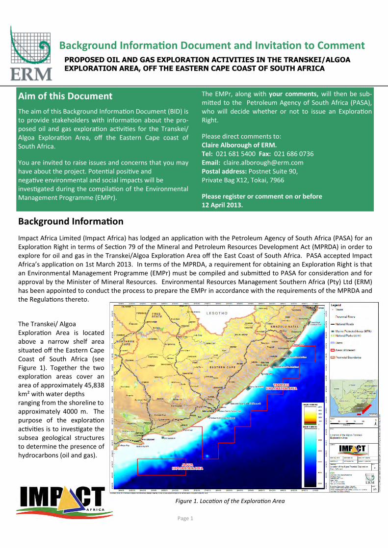
Background Informa�on Document and Invita�on to Comment
PROPOSED OIL AND GAS EXPLORATION ACTIVITIES IN THE TRANSKEI/ALGOA
EXPLORATION AREA, OFF THE EASTERN CAPE COAST OF SOUTH AFRICA
Aim of this Document
The aim of this Background Informa�on Document (BID) is
to provide stakeholders with informa�on about the pro-
posed oil and gas explora�on ac�vi�es for the Transkei/
Algoa Explora�on Area, off the Eastern Cape coast of
South Africa.
You are invited to raise issues and concerns that you may
have about the project. Poten�al posi�ve and
nega�ve environmental and social impacts will be
inves�gated during the compila�on of the Environmental
Management Programme (EMPr).
The EMPr, along with your comments, will then be sub-
mi-ed to the Petroleum Agency of South Africa (PASA),
who will decide whether or not to issue an Explora�on
Right.
Please direct comments to:
Claire Alborough of ERM.
Tel: 021 681 5400 Fax: 021 686 0736
Email: [email protected]
Postal address: Postnet Suite 90,
Private Bag X12, Tokai, 7966
Please register or comment on or before
12 April 2013.
Figure 1. Loca�on of the Explora�on Area
Page 1
Background Informa�on
Impact Africa Limited (Impact Africa) has lodged an applica�on with the Petroleum Agency of South Africa (PASA) for an
Explora�on Right in terms of Sec�on 79 of the Mineral and Petroleum Resources Development Act (MPRDA) in order to
explore for oil and gas in the Transkei/Algoa Explora�on Area off the East Coast of South Africa. PASA accepted Impact
Africa’s applica�on on 1st March 2013. In terms of the MPRDA, a requirement for obtaining an Explora�on Right is that
an Environmental Management Programme (EMPr) must be compiled and submi-ed to PASA for considera�on and for
approval by the Minister of Mineral Resources. Environmental Resources Management Southern Africa (Pty) Ltd (ERM)
has been appointed to conduct the process to prepare the EMPr in accordance with the requirements of the MPRDA and
the Regula�ons thereto.
The Transkei/ Algoa
Explora�on Area is located
above a narrow shelf area
situated off the Eastern Cape
Coast of South Africa (see
Figure 1). Together the two
explora�on areas cover an
area of approximately 45,838
km² with water depths
ranging from the shoreline to
approximately 4000 m. The
purpose of the explora�on
ac�vi�es is to inves�gate the
subsea geological structures
to determine the presence of
hydrocarbons (oil and gas).

Key Issues Iden�fied
The EMPr will iden�fy the key issues associated with the
proposed ac�vi�es and determine the controls that will be
implemented to avoid or reduce environmental and social
impacts. A preliminary assessment has indicated the
following key issues:
• Noise effects on marine fauna from mul�-beam ba-
thymetry survey, seabed sampling programme and
seismic survey;
• Effects of ac�vi�es on the fishing industry, including
effects on fish behaviour, fish catches and cessa�on
or displacement of fishing ac�vi�es, as a result of
noise effects and presence of survey vessels;
• Impact on tourism and recrea�on as a result of noise
effects and presence of survey vessels;
• Interference with marine recrea�onal facili�es and
transport routes; and
• Waste discharge to sea and emissions to the atmos-
phere.
These issues, as well as others iden�fied through the
process of developing the EMPr will be assessed. To be-er
understand the exis�ng environmental and social seEng, a
fisheries specialist study and a marine faunal specialist
study will be undertaken. To the extent possible, the
proposed seismic surveys would be scheduled to avoid
cri�cal periods for marine mammals or protected species
such as ma�ng or calving periods. A safety buffer zone will
be implemented around sensi�ve marine features such as
Marine Protected Areas. Furthermore, no explora�on
ac�vi�es will be undertaken within such protected areas.
Project Descrip�on
Impact Africa Limited is proposing a three-year explora�on
programme. The proposed explora�on programme will be
conducted in a phased approach. It should, however, be
noted that some of the phases might occur in parallel or
the final order of ac�vi�es may change. The proposed
explora�on programme would commence with airborne
geophysics acquisi�on in 2014. ThereaGer a 2D and / or 3D
seismic surveys would be acquired, followed by processing
and interpreta�on. An integrated seabed sampling pro-
gramme would be undertaken in order to iden�fy seabed
features that are indica�ve of natural hydrocarbon seepage
and to sample sediments and associated hydrocarbons at
and just below the seabed. The proposed explora�on
programme would consist of the ac�vi�es described below.
Airborne Geophysics Programme: Impact Africa proposes
to acquire airborne gravity and magne�c data covering all
or parts of the Transkei Algoa Explora�on Area with a mini-
mum of 7,500 km², which in that case would take in the
order of 60 days. If data were to be acquired over the en-
�re Transkei Algoa Explora�on Area of 45,838 km² then
this would take in the order of 180 days to complete. Acqui-
si�on of these data sets and integra�on of the airborne geo-
physical data with well data, and other geologic and geo-
physical data sets, would provide support for future seismic
acquisi�on planning programmes, as well as support inte-
grated seismic interpreta�on efforts, explora�on concepts
and explora�on strategies.
Seismic Survey Programme: Seismic surveys are carried out
during oil and gas explora�on ac�vi�es in order to
inves�gate subsea geological forma�ons. During seismic
surveys, high-level, low frequency sounds are directed
towards the seabed from near-surface sound sources towed
by a seismic vessel. Signals reflected from geological
interfaces below the seafloor are recorded by mul�ple
receivers (or hydrophones) towed in a single or mul�ple
streamer (see Figure 2). Analyses of the returned signals
allow for interpreta�on of subsea geological forma�ons.
Seismic surveys are undertaken to collect either 2D or 3D
data. 2D surveys are typically applied to obtain regional data
from widely spaced survey grids (tens of kilometres) and infill
surveys on closer grids (down to a 1 km spacing) are applied
to provide more detail over specific areas of interest. 3D sur-
veys are typically applied to promising petroleum prospects
to assist in fault interpreta�on, distribu�on of sand bodies,
es�mates of oil and gas in place and the loca�on of explora-
�on wells.
For this inves�ga�on Impact Africa is proposing to undertake
acquisi�on of a 2D seismic survey. However, if it is deter-
mined by subsequent analysis of exis�ng data, that acquisi-
�on of a seismic dataset u�lising 3D seismic techniques
might be a more advantageous approach for data collec�on,
then a 3D seismic survey might be subs�tuted for the 2D
survey or may be done in addi�on to the 2D seismic survey.
Page 2
Figure 2. Principles of Seismic Data Acquisition
Sources
Stream-Tail Buoy Seismic Vessel

The proposed 2D seismic survey would be in the order of
5,000 km in total length. Most lines will be widely spaced
over the Transkei Algoa Explora�on Area with some areas
where the lines will be closer together.
Although survey commencement would ul�mately depend
on a permit award date, availability of seismic contractors
and other factors, it is an�cipated that the survey would be
undertaken during the summer of 2014/2015 and would take
approximately 150 days to complete.
Specific details of the seismic survey would be developed
based on the results of other studies and following selec�on
of a seismic survey contractor and survey vessel. The specific
details of the survey will be submi-ed to PASA through an
Environmental No�fica�on.
Seismic Vessel and Equipment: The seismic survey vessel will
travel along transects of a prescribed course or grid that is
carefully chosen to cross known or suspected geological
structures. The vessel travels at a speed of four to six knots
(i.e. 2 to 3 metres per second).
The seismic survey will involve a towed airgun array, which
provides the seismic source energy for the profiling process,
and a seismic wave detector system, usually known as a
hydrophone streamer (see Figure 3). The sound source or
airgun array (one for 2D and two for 3D) will be situated
some 80 m to 150 m behind the vessel at a depth of 5 m to
25 m below the surface. A 2D survey typically involves a
single streamer, whereas 3D surveys use mul�ple streamers
(up to 12 streamers spaced 100 m apart). The array can be up
to 12,000 m long. The streamer/s will be towed at a depth of
between 6 m and 30 m and will not be visible, except for the
tail-buoy at the far end of the cable. A typical 3D seismic
survey configura�on and safe opera�onal limits are illustrat-
ed in Figure 4.
The airgun will be fired at approximately 10 to 20 second
intervals at an opera�ng pressure of between 2,000 to 2,500
psi and a volume of 3,000 to 5,000 cubic inches. Similar air-
gun source arrays are around 220 dB re 1 mPa2-m.
However, based on analogue sound sources, sound levels for
the seismic survey can no�onally be expected to a-enuate
below 160 dB less than 1,325 m from the source array.
The sound waves are reflected by boundaries between sedi-
ments of different densi�es and returned signals are record-
ed by hydrophones mounted inside streamer cables and
transmi-ed to the seismic vessel for electronic processing.
Seismic Survey Exclusion Zone: Under the Interna�onal Mar-
i�me Organiza�on (IMO) Conven�on on the Interna�onal
Regula�ons for Preven�ng Collisions at Sea (COLREGS, 1972,
Part A, Rule 10), a seismic survey vessel that is engaged in
surveying is defined as a ‘vessel restricted in its ability to ma-
noeuvre’ which requires that power-driven and sailing ves-
sels give way to a vessel restricted in her ability to manoeu-
vre. Vessels engaged in fishing shall, so far as possible, keep
out of the way of the seismic survey opera�on.
Under the South Africa Marine Traffic Act, 1981 (No. 2 of
1981), a seismic survey vessel and its array of airguns and
hydrophones fall under the defini�on of an “offshore instal-
la�on” and as such it is protected by a 500 m safety buffer
zone. It is an offence for an unauthorised vessel to enter the
safety zone. In addi�on to the statutory limit, the seismic
vessel will also request an addi�onal safety buffer zone dur-
ing opera�ons of typically 8 km fore and aG of the vessel and
6 km abeam during daylight; and 12 km fore and aG and
9 km abeam during the night.
Page 3
Figure 3. Seismic Vessel Conduction a Seismic Survey
Figure 4. Configuration of a typical 3D survey vessel with Safe
Operational Limits for 2D and 3D Surveys.

Surface Heat Flow Measurements, Seabed and Water Column
Sampling Programme: The heat flow measurements will be
conducted using heat flow probes, which will measure both the
temperature and thermal conduc�vity of sediments in situ up
to 12 m below the seabed. The measurement device will be
dropped from a vessel into the seabed, allowed to equilibrate
and then recovered to the surface.
No samples or other materials will be recovered with the heat
flow probe. Acquisi�on of these data will be used to deter-
mine the thermal regime and calibrate thermal models to un-
derstand hydrocarbon system poten�al. It is an�cipated that a
minimum of 50 measurements may be collected across the
Transkei Algoa Explora�on Area, which would take 60 days to
complete.
Water column samples may be taken for analysis such as hy-
drocarbon, heavy and trace metal analysis. Addi�onally a Con-
duc�vity, Temperature, Depth (CTD) profiler may be deployed
to measure addi�onal parameters such as salinity, tempera-
ture, dissolved oxygen and turbidity. For each sta�on it is ex-
pected that three water depths will be sampled; near surface
(~1 m below surface), mid-water, and near bo-om.
Mul�beam Echo Sounder and Sub-Bo7om Profile Pro-
gramme: The mul�-beam bathymetry survey would be under-
taken over the majority of the Transkei Algoa Explora�on Area.
This system produces a digital terrain model of the seafloor.
The survey vessel will be equipped with a mul�-beam echo
sounder to obtain swath bathymetry and a sub-bo-om profiler
to image the seabed and the near surface geology in the imme-
diate vicinity of each core and test loca�on (see Sediment Cor-
ing Programme below). The mul�-beam system provides depth
sounding informa�on on either side of the vessel’s track across
a swath width of approximately two �mes the water depth.
The mul�-beam echo sounder emits a fan of acous�c beams
from a transducer at frequencies ranging from 10 kHz to 200
kHz and typically produces sound levels in the order of 207 db
re 1μPa at 1m. The sub-bo-om profiler emits an acous�c pulse
from a transducer at frequencies ranging from 3 kHz to 40 kHz
and typically produces sound levels in the order of 206 db re
1μPa at 1m. It is an�cipated that data acquisi�on would take
approximately 150 days to complete at a vessel speed around
5 knots.
Sediment Coring Programme: The Sediment Coring Pro-
gramme would include piston coring in order to sample for
natural hydrocarbon seepage. A piston corer would be used to
collect seabed geochemical samples. The piston corer is low-
ered over the side of the survey vessel and allowed to free fall
from about 3 m above the seabed to allow good penetra�on.
Recovered core samples will be visually described and three
sets of sub-samples will be retained for further analysis in an
onshore laboratory. Any material having geologic or environ-
mental interest will be preserved for further study. The re-
maining sediment will be returned to the seabed. It is an�ci-
pated that in the order of 50 core samples would be collected
across the Explora�on Right area, which would take in the
order of 120 days to complete. A larger number of samples
could be taken depending of seepage or expulsion features
iden�fied but also depending of the observed geologic com-
plexity. Each individual core would have a disturbance area
and volume of 0.01 m² and 0.07 m³, respec�vely, resul�ng for
50 core samples in a total disturbance area and volume of ap-
proximately 0.39 m² and 3.53 m³, respec�vely.
Proposed EMPr Process
The following steps will be undertaken to ensure compliance
with the MPRDA and Regula�on thereto:
• A BID (this document) will be compiled and distributed
for registra�on and comment period from 22 March
2012 to 12 April 2013;
• The proposed project and I&AP registra�on/comment
period will be adver�sed in four newspapers, namely
The Times, The Daily Dispatch, The Herald and Die
Burger (Eastern Cape);
• An I&AP database will be compiled based on responses
to the BID and advert, as well as other databases of
previous studies in the area;
• Specialist studies will be commissioned and undertaken
to address those issues requiring further inves�ga�on;
• An EMPr will be compiled integra�ng all specialist stud-
ies and other relevant informa�on;
• The EMPr will be released toward mid-May for a 30-day
review and comment period;
• All comments received will be collated and responded
to in the Comments Report, which will be appended to
the EMPr; and
• The EMPr will be submi-ed to PASA for considera�on
on or before 28 June 2013.
Page 4

Name: Organisa�on:
Telephone: Posi�on:
Cell phone: Email:
Address:
Please fill in your details
ENVIRONMENTAL RESOURCES MANAGEMENT, ERM
T. 021 681 5400
F. 021 686 0736
P. Postnet Suite 90, Private Bag X12, Tokai, 7966
Contact: Claire Alborough
STAKEHOLDER COMMENT SHEET
You are invited to par�cipate in the EMPr process and raise any issues and concerns you may have
about the proposed Project. Your comments are a key part of the assessment process and it is
important that ERM and Impact Africa understand your concerns so that they can be responded to
and addressed as part of the EMPr .
To be kept informed throughout the process you must register as an Interested and Affected Party.
To register please send an email to or forward this form to the address (or fax number) given below.
If you wish to make any comments at this stage please feel free to use this form or alterna�vely,
please do not hesitate to send a separate email, fax or le-er to Claire Alborough of ERM.
Please ensure you are registered via email, post or fax by 12 April 2013 so that we can take your com-
ments into considera�on in the revised EMPr.
Please quote the following reference number on all correspondence: 0194759
Are there any Interested and Affected Par�es whom you believe should be consulted during the course
of the EMPr? If yes, please send ERM the name, organisa�on (if applicable), postal address, telephone
and fax numbers of the person(s) concerned so that they can be included on the list of stakeholders.

It would be useful if you could respond to the ques�on below, but please feel free to provide any
comments you would like to raise. Please con�nue on addi�onal paper if required.
Do you/ your organisa�on have any concerns with regards to these proposed ac�vi�es? If yes, please
clearly list your issues, concerns, views and/or ques�ons you may have regarding this project.
__________________________________________________________________________________
__________________________________________________________________________________
__________________________________________________________________________________
__________________________________________________________________________________
__________________________________________________________________________________
__________________________________________________________________________________
__________________________________________________________________________________
__________________________________________________________________________________
__________________________________________________________________________________
__________________________________________________________________________________
__________________________________________________________________________________
__________________________________________________________________________________
__________________________________________________________________________________
__________________________________________________________________________________
__________________________________________________________________________________
__________________________________________________________________________________
__________________________________________________________________________________
__________________________________________________________________________________
__________________________________________________________________________________
__________________________________________________________________________________
__________________________________________________________________________________
Thank you for your par�cipa�on

Appendix B-1
Advertisements
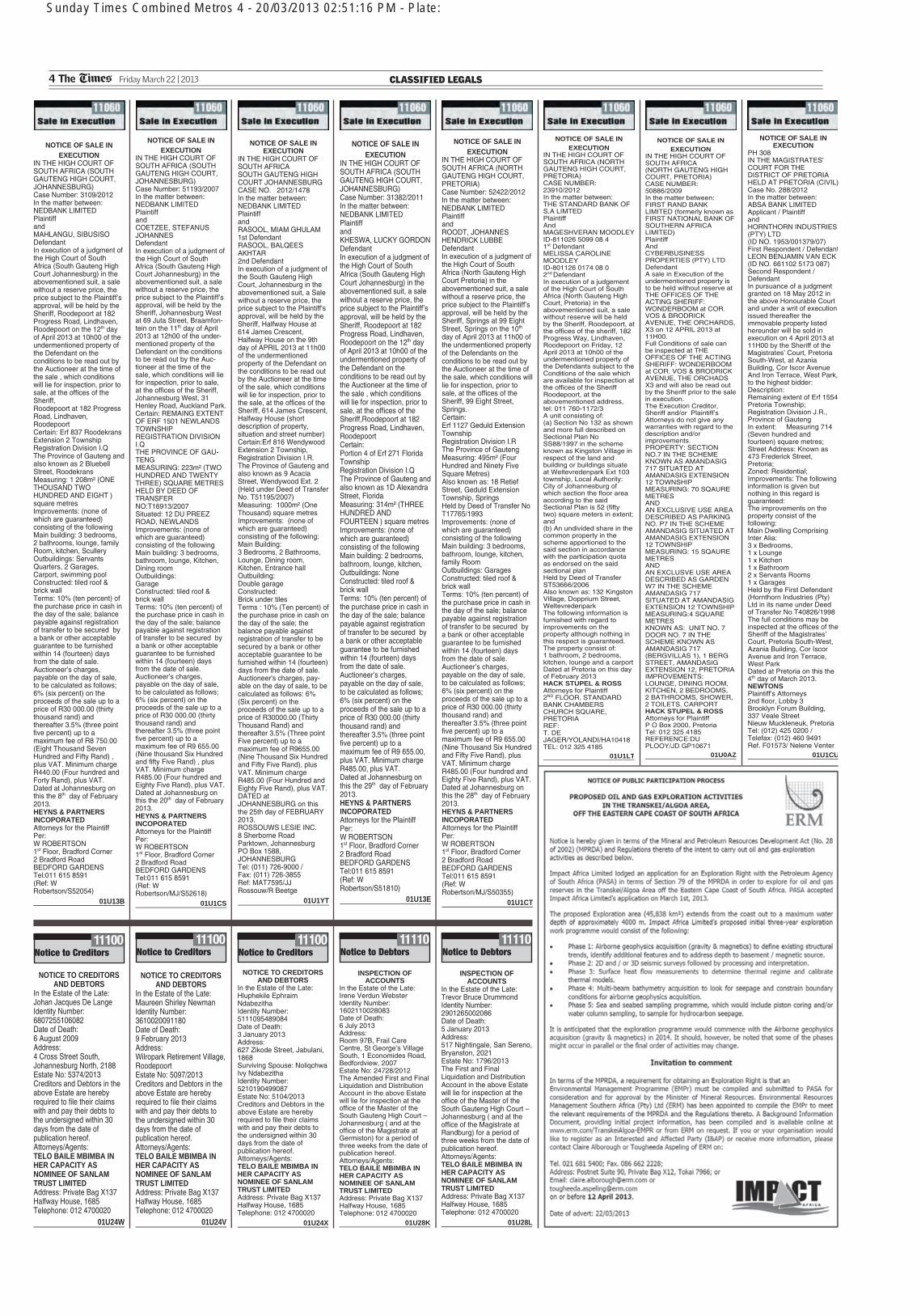
Sunday Times Combined Metros 4 - 20/03/2013 02:51:16 PM - Plate:
4 The Times Friday March 22 | 20 1 3 CLASSIFIED LEGALS
NOTICE OF SALE IN
EXECUTION
PH 308 IN THE MAGISTRATES’ COURT FOR THE DISTRICT OF PRETORIA HELD AT PRETORIA (CIVIL)Case No. 288/2012 In the matter between: ABSA BANK LIMITED Applicant / Plaintiff and HORNTHORN INDUSTRIES (PTY) LTD (ID NO. 1953/001379/07) First Respondent / DefendantLEON BENJAMIN VAN ECK (ID NO. 661102 5173 087) Second Respondent / Defendant In pursuance of a judgment granted on 18 May 2012 in the above Honourable Court and under a writ of execution issued thereafter the immovable property listed hereunder will be sold in execution on 4 April 2013 at 11H00 by the Sheriff of the Magistrates’ Court, Pretoria South-West, at Azania Building, Cor Iscor Avenue And Iron Terrace, West Park, to the highest bidder: Description: Remaining extent of Erf 1554 Pretoria Township; Registration Division J.R., Province of Gauteng In extent: Measuring 714 (Seven hundred and fourteen) square metres; Street Address: Known as 473 Frederick Street, Pretoria; Zoned: Residential; Improvements: The following information is given but nothing in this regard is guaranteed: The improvements on the property consist of the following: Main Dwelling Comprising Inter Alia: 3 x Bedrooms, 1 x Lounge 1 x Kitchen 1 x Bathroom 2 x Servants Rooms 1 x Garages Held by the First Defendant (Hornthorn Industries (Pty) Ltd in its name under Deed of Transfer No T40826/1998 The full conditions may be inspected at the offices of theSheriff of the Magistrates’ Court, Pretoria South-West, Azania Building, Cor Iscor Avenue and Iron Terrace, West Park Dated at Pretoria on this the 4th day of March 2013. NEWTONS
Plaintiff's Attorneys 2nd floor, Lobby 3 Brooklyn Forum Building, 337 Veale Street Nieuw Muckleneuk, Pretoria Tel: (012) 425 0200 / Telefax: (012) 460 9491 Ref. F01573/ Nelene Venter
01U1CU
NOTICE OF SALE IN
EXECUTION
IN THE HIGH COURT OF SOUTH AFRICA (NORTH GAUTENG HIGH COURT, PRETORIA) CASE NUMBER: 50886/2009 In the matter between: FIRST RAND BANK LIMITED (formerly known as FIRST NATIONAL BANK OF SOUTHERN AFRICA LIMITED) Plaintiff And CYBERBUSINESS PROPERTIES (PTY) LTD Defendant A sale in Execution of the undermentioned property is to be held without reserve at THE OFFICES OF THE ACTING SHERIFF: WONDERBOOM at COR. VOS & BRODRICK AVENUE, THE ORCHARDS, X3 on 12 APRIL 2013 at 11H00. Full Conditions of sale can be inspected at THE OFFICES OF THE ACTING SHERIFF: WONDERBOOM at COR. VOS & BRODRICK AVENUE, THE ORCHADS X3 and will also be read out by the Sheriff prior to the sale in execution. The Execution Creditor, Sheriff and/or Plaintiff’s Attorneys do not give any warranties with regard to the description and/or improvements. PROPERTY: SECTION NO.7 IN THE SCHEME KNOWN AS AMANDASIG 717 SITUATED AT AMANDASIG EXTENSION 12 TOWNSHIP MEASURING: 70 SQAURE METRES AND AN EXCLUSIVE USE AREA DESCRIBED AS PARKING NO. P7 IN THE SCHEME AMANDASIG SITUATED AT AMANDASIG EXTENSION 12 TOWNSHIP MEASURING: 15 SQAURE METRES AND AN EXCLUSVE USE AREA DESCRIBED AS GARDEN W7 IN THE SCHEME AMANDASIG 717 SITUATED AT AMANDASIG EXTENSION 12 TOWNSHIP MEASURING:4 SQUARE METRES KNOWN AS: UNIT NO. 7 DOOR NO. 7 IN THE SCHEME KNOWN AS AMANDASIG 717 (BERGVILLAS 1), 1 BERG STREET, AMANDASIG EXTENSION 12, PRETORIA IMPROVEMENTS: LOUNGE, DINING ROOM, KITCHEN, 2 BEDROOMS, 2 BATHROOMS, SHOWER, 2 TOILETS, CARPORT HACK STUPEL & ROSS
Attorneys for Plaintiff P O Box 2000, Pretoria Tel: 012 325 4185 REFERENCE:DU PLOOY/JD GP10671
01U0AZ
NOTICE OF SALE IN
EXECUTION
IN THE HIGH COURT OF SOUTH AFRICA (SOUTH GAUTENG HIGH COURT, JOHANNESBURG) Case Number: 31382/2011 In the matter between: NEDBANK LIMITED Plaintiff and KHESWA, LUCKY GORDONDefendant In execution of a judgment of the High Court of South Africa (South Gauteng High Court Johannesburg) in the abovementioned suit, a sale without a reserve price, the price subject to the Plaintiff’s approval, will be held by the Sheriff, Roodepoort at 182 Progress Road, Lindhaven, Roodepoort on the 12th day of April 2013 at 10h00 of the undermentioned property of the Defendant on the conditions to be read out by the Auctioneer at the time of the sale , which conditions will lie for inspection, prior to sale, at the offices of the Sheriff,Roodepoort at 182 Progress Road, Lindhaven, Roodepoort Certain: Portion 4 of Erf 271 Florida Township Registration Division I.Q The Province of Gauteng and also known as 1D Alexandra Street, Florida Measuring: 314m² (THREE HUNDRED AND FOURTEEN ) square metres Improvements: (none of which are guaranteed) consisting of the following Main building: 2 bedrooms, bathroom, lounge, kitchen, Outbuildings: None Constructed: tiled roof & brick wall Terms: 10% (ten percent) of the purchase price in cash in the day of the sale; balance payable against registration of transfer to be secured by a bank or other acceptable guarantee to be furnished within 14 (fourteen) days from the date of sale. Auctioneer’s charges, payable on the day of sale, to be calculated as follows; 6% (six percent) on the proceeds of the sale up to a price of R30 000.00 (thirty thousand rand) and thereafter 3.5% (three point five percent) up to a maximum fee of R9 655.00, plus VAT. Minimum charge R485.00, plus VAT. Dated at Johannesburg on this the 29th day of February 2013. HEYNS & PARTNERS
INCOPORATED
Attorneys for the Plaintiff Per: W ROBERTSON 1st Floor, Bradford Corner 2 Bradford Road BEDFORD GARDENS Tel:011 615 8591 (Ref: W Robertson/S51810)
01U13E
NOTICE OF SALE IN
EXECUTION
IN THE HIGH COURT OF SOUTH AFRICA (NORTH GAUTENG HIGH COURT, PRETORIA) Case Number: 52422/2012 In the matter between: NEDBANK LIMITED Plaintiff and ROODT, JOHANNES HENDRICK LUBBE Defendant In execution of a judgment of the High Court of South Africa (North Gauteng High Court Pretoria) in the abovementioned suit, a sale without a reserve price, the price subject to the Plaintiff’s approval, will be held by the Sheriff, Springs at 99 Eight Street, Springs on the 10th day of April 2013 at 11h00 of the undermentioned property of the Defendants on the conditions to be read out by the Auctioneer at the time of the sale, which conditions will lie for inspection, prior to sale, at the offices of the Sheriff, 99 Eight Street, Springs. Certain: Erf 1127 Geduld Extension Township Registration Division I.R The Province of Gauteng Measuring: 495m² (Four Hundred and Ninety Five Square Metres) Also known as: 18 Retief Street, Geduld Extension Township, Springs Held by Deed of Transfer No T17765/1993 Improvements: (none of which are guaranteed) consisting of the following Main building: 3 bedrooms, bathroom, lounge, kitchen, family Room Outbuildings: Garages Constructed: tiled roof & brick wall Terms: 10% (ten percent) of the purchase price in cash in the day of the sale; balance payable against registration of transfer to be secured by a bank or other acceptable guarantee to be furnished within 14 (fourteen) days from the date of sale. Auctioneer’s charges, payable on the day of sale, to be calculated as follows; 6% (six percent) on the proceeds of the sale up to a price of R30 000.00 (thirty thousand rand) and thereafter 3.5% (three point five percent) up to a maximum fee of R9 655.00 (Nine Thousand Six Hundred and Fifty Five Rand), plus VAT. Minimum charge R485.00 (Four hundred and Eighty Five Rand), plus VAT. Dated at Johannesburg on this the 28th day of February 2013. HEYNS & PARTNERS
INCOPORATED
Attorneys for the Plaintiff Per: W ROBERTSON 1st Floor, Bradford Corner 2 Bradford Road BEDFORD GARDENS Tel:011 615 8591 (Ref: W Robertson/MJ/S50355)
01U1CT
NOTICE OF SALE IN
EXECUTION
IN THE HIGH COURT OF SOUTH AFRICA (SOUTH GAUTENG HIGH COURT, JOHANNESBURG) Case Number: 3109/2012 In the matter between: NEDBANK LIMITED Plaintiff and MAHLANGU, SIBUSISO Defendant In execution of a judgment of the High Court of South Africa (South Gauteng High Court Johannesburg) in the abovementioned suit, a sale without a reserve price, the price subject to the Plaintiff’s approval, will be held by the Sheriff, Roodepoort at 182 Progress Road, Lindhaven, Roodepoort on the 12th day of April 2013 at 10h00 of the undermentioned property of the Defendant on the conditions to be read out by the Auctioneer at the time of the sale , which conditions will lie for inspection, prior to sale, at the offices of the Sheriff, Roodepoort at 182 Progress Road, Lindhaven, Roodepoort Certain: Erf 837 Roodekrans Extension 2 Township Registration Division I.Q The Province of Gauteng and also known as 2 Bluebell Street, Roodekrans Measuring: 1 208m² (ONE THOUSAND TWO HUNDRED AND EIGHT ) square metres Improvements: (none of which are guaranteed) consisting of the following Main building: 3 bedrooms, 2 bathrooms, lounge, family Room, kitchen, Scullery Outbuildings: Servants Quarters, 2 Garages, Carport, swimming pool Constructed: tiled roof & brick wall Terms: 10% (ten percent) of the purchase price in cash in the day of the sale; balance payable against registration of transfer to be secured by a bank or other acceptable guarantee to be furnished within 14 (fourteen) days from the date of sale. Auctioneer’s charges, payable on the day of sale, to be calculated as follows; 6% (six percent) on the proceeds of the sale up to a price of R30 000.00 (thirty thousand rand) and thereafter 3.5% (three point five percent) up to a maximum fee of R8 750.00 (Eight Thousand Seven Hundred and Fifty Rand) , plus VAT. Minimum charge R440.00 (Four hundred and Forty Rand), plus VAT. Dated at Johannesburg on this the 8th day of February 2013. HEYNS & PARTNERS
INCOPORATED
Attorneys for the Plaintiff Per: W ROBERTSON 1st Floor, Bradford Corner 2 Bradford Road BEDFORD GARDENS Tel:011 615 8591 (Ref: W Robertson/S52054)
01U13B
NOTICE OF SALE IN
EXECUTION
IN THE HIGH COURT OF SOUTH AFRICA (SOUTH GAUTENG HIGH COURT, JOHANNESBURG) Case Number: 51193/2007 In the matter between: NEDBANK LIMITED Plaintiff and COETZEE, STEFANUS JOHANNES Defendant In execution of a judgment of the High Court of South Africa (South Gauteng High Court Johannesburg) in the abovementioned suit, a sale without a reserve price, the price subject to the Plaintiff’s approval, will be held by the Sheriff, Johannesburg West at 69 Juta Street, Braamfon-tein on the 11th day of April 2013 at 12h00 of the under-mentioned property of the Defendant on the conditions to be read out by the Auc-tioneer at the time of the sale, which conditions will lie for inspection, prior to sale, at the offices of the Sheriff, Johannesburg West, 31 Henley Road, Auckland Park. Certain: REMAING EXTENT OF ERF 1501 NEWLANDS TOWNSHIP REGISTRATION DIVISION I.Q THE PROVINCE OF GAU-TENG MEASURING: 223m² (TWO HUNDRED AND TWENTY THREE) SQUARE METRES HELD BY DEED OF TRANSFER NO:T16913/2007 Situated: 12 DU PREEZ ROAD, NEWLANDS Improvements: (none of which are guaranteed) consisting of the following Main building: 3 bedrooms, bathroom, lounge, Kitchen, Dining room Outbuildings: Garage Constructed: tiled roof & brick wall Terms: 10% (ten percent) of the purchase price in cash in the day of the sale; balance payable against registration of transfer to be secured by a bank or other acceptable guarantee to be furnished within 14 (fourteen) days from the date of sale. Auctioneer’s charges, payable on the day of sale, to be calculated as follows; 6% (six percent) on the proceeds of the sale up to a price of R30 000.00 (thirty thousand rand) and thereafter 3.5% (three point five percent) up to a maximum fee of R9 655.00 (Nine thousand Six Hundred and fifty Five Rand) , plus VAT. Minimum charge R485.00 (Four hundred and Eighty Five Rand), plus VAT. Dated at Johannesburg on this the 20th day of February 2013. HEYNS & PARTNERS
INCOPORATED
Attorneys for the Plaintiff Per: W ROBERTSON 1st Floor, Bradford Corner 2 Bradford Road BEDFORD GARDENS Tel:011 615 8591 (Ref: W Robertson/MJ/S52618)
01U1CS
NOTICE OF SALE IN
EXECUTION
IN THE HIGH COURT OF SOUTH AFRICA SOUTH GAUTENG HIGH COURT JOHANNESBURG CASE NO. 2012/1478 In the matter between: NEDBANK LIMITED Plaintiff and RASOOL, MIAM GHULAM 1st Defendant RASOOL, BALQEES AKHTAR 2nd Defendant In execution of a judgment of the South Gauteng High Court, Johannesburg in the abovementioned suit, a Sale without a reserve price, the price subject to the Plaintiff's approval, will be held by the Sheriff, Halfway House at 614 James Crescent, Halfway House on the 9th day of APRIL 2013 at 11h00 of the undermentioned property of the Defendant on the conditions to be read out by the Auctioneer at the time of the sale, which conditions will lie for inspection, prior to the sale, at the offices of the Sheriff, 614 James Crescent, Halfway House (short description of property, situation and street number) Certain:Erf 816 Wendywood Extension 2 Township, Registration Division I.R. The Province of Gauteng and also known as 9 Acacia Street, Wendywood Ext. 2 (Held under Deed of Transfer No. T51195/2007) Measuring: 1000m² (One Thousand) square metres Improvements: (none of which are guaranteed) consisting of the following: Main Building: 3 Bedrooms, 2 Bathrooms, Lounge, Dining room, Kitchen, Entrance hall Outbuilding: Double garage Constructed: Brick under tiles Terms : 10% (Ten percent) of the purchase price in cash on the day of the sale; the balance payable against registration of transfer to be secured by a bank or other acceptable guarantee to be furnished within 14 (fourteen) days from the date of sale. Auctioneer's charges, pay-able on the day of sale, to be calculated as follows: 6% (Six percent) on the proceeds of the sale up to a price of R30000.00 (Thirty Thousand Rand) and thereafter 3.5% (Three point Five percent) up to a maximum fee of R9655.00 (Nine Thousand Six Hundred and Fifty Five Rand), plus VAT. Minimum charge R485.00 (Four Hundred and Eighty Five Rand), plus VAT. DATED at JOHANNESBURG on this the 25th day of FEBRUARY 2013. ROSSOUWS LESIE INC. 8 Sherborne Road Parktown, Johannesburg PO Box 1588, JOHANNESBURG Tel: (011) 726-9000 / Fax: (011) 726-3855 Ref: MAT7595/JJ Rossouw/R Beetge
01U1YT
INSPECTION OF
ACCOUNTS
In the Estate of the Late: Irene Verdun Webster Identity Number: 1602110028083 Date of Death: 6 July 2013 Address: Room 97B, Frail Care Centre, St George’s Village South, 1 Economides Road, Bedfordview, 2007 Estate No: 24728/2012 The Amended First and Final Liquidation and Distribution Account in the above Estate will lie for inspection at the office of the Master of the South Gauteng High Court — Johannesburg ( and at the office of the Magistrate at Germiston) for a period of three weeks from the date of publication hereof. Attorneys/Agents: TELO BAILE MBIMBA IN
HER CAPACITY AS
NOMINEE OF SANLAM
TRUST LIMITED
Address: Private Bag X137 Halfway House, 1685 Telephone: 012 4700020
01U28K
NOTICE TO CREDITORS
AND DEBTORS
In the Estate of the Late: Maureen Shirley Newman Identity Number: 3610020091180 Date of Death: 9 February 2013 Address: Wilropark Retirement Village, Roodepoort Estate No: 5097/2013 Creditors and Debtors in the above Estate are hereby required to file their claims with and pay their debts to the undersigned within 30 days from the date of publication hereof. Attorneys/Agents: TELO BAILE MBIMBA IN
HER CAPACITY AS
NOMINEE OF SANLAM
TRUST LIMITED
Address: Private Bag X137 Halfway House, 1685 Telephone: 012 4700020
01U24V
INSPECTION OF
ACCOUNTS
In the Estate of the Late: Trevor Bruce Drummond Identity Number: 2901265002086 Date of Death: 5 January 2013 Address: 517 Nightingale, San Sereno, Bryanston, 2021 Estate No: 1796/2013 The First and Final Liquidation and Distribution Account in the above Estate will lie for inspection at the office of the Master of the South Gauteng High Court — Johannesburg ( and at the office of the Magistrate at Randburg) for a period of three weeks from the date of publication hereof. Attorneys/Agents: TELO BAILE MBIMBA IN
HER CAPACITY AS
NOMINEE OF SANLAM
TRUST LIMITED
Address: Private Bag X137 Halfway House, 1685 Telephone: 012 4700020
01U28L
NOTICE TO CREDITORS
AND DEBTORS
In the Estate of the Late: Hluphekile Ephraim Ndabezitha Identity Number: 5111095489084 Date of Death: 3 January 2013 Address: 627 Zikode Street, Jabulani, 1868 Surviving Spouse: Noliqchwa Ivy Ndabezitha Identity Number: 5210190499087 Estate No: 5104/2013 Creditors and Debtors in the above Estate are hereby required to file their claims with and pay their debts to the undersigned within 30 days from the date of publication hereof. Attorneys/Agents: TELO BAILE MBIMBA IN
HER CAPACITY AS
NOMINEE OF SANLAM
TRUST LIMITED
Address: Private Bag X137 Halfway House, 1685 Telephone: 012 4700020
01U24X
Notice to Creditors11100
NOTICE TO CREDITORS
AND DEBTORS
In the Estate of the Late: Johan Jacques De Lange Identity Number: 6807255106082 Date of Death: 6 August 2009 Address: 4 Cross Street South, Johannesburg North, 2188 Estate No: 5374/2013 Creditors and Debtors in the above Estate are hereby required to file their claims with and pay their debts to the undersigned within 30 days from the date of publication hereof. Attorneys/Agents: TELO BAILE MBIMBA IN
HER CAPACITY AS
NOMINEE OF SANLAM
TRUST LIMITED
Address: Private Bag X137 Halfway House, 1685 Telephone: 012 4700020
01U24W
Notice to Debtors11110
Notice to Debtors11110
Notice to Creditors11100
Notice to Creditors11100
NOTICE OF SALE IN
EXECUTION
IN THE HIGH COURT OF SOUTH AFRICA (NORTH GAUTENG HIGH COURT, PRETORIA) CASE NUMBER: 23910/2012 In the matter between: THE STANDARD BANK OF S.A LIMTED Plaintiff And MAGESHVERAN MOODLEY ID-811026 5099 08 4 1st Defendant MELISSA CAROLINE MOODLEY ID-801126 0174 08 0 2nd Defendant In execution of a judgement of the High Court of South Africa (North Gauteng High Court, Pretoria) in the abovementioned suit, a sale without reserve will be held by the Sheriff, Roodepoort, atthe offices of the sheriff, 182 Progress Way, Lindhaven, Roodepoort on Friday, 12 April 2013 at 10h00 of the undermentioned property of the Defendants subject to the Conditions of the sale which are available for inspection at the offices of the Sheriff Roodepoort, at the abovementioned address, tel: 011 760-1172/3 A unit consisting of: (a) Section No 132 as shown and more full described on Sectional Plan No SS88/1997 in the scheme known as Kingston Village in respect of the land and building or buildings situate at Weltevredenpark Ext 103 township, Local Authority: City of Johannesburg of which section the floor area according to the said Sectional Plan is 52 (fifty two) square meters in extent; and (b) An undivided share in the common property in the scheme apportioned to the said section in accordance with the participation quota as endorsed on the said sectional plan Held by Deed of Transfer ST53666/2006 Also known as: 132 Kingston Village, Dopprium Street, Weltevredenpark The following information is furnished with regard to improvements on the property although nothing in this respect is guaranteed. The property consist of: 1 bathroom, 2 bedrooms, kitchen, lounge and a carportDated at Pretoria on this day of February 2013 HACK STUPEL & ROSS
Attorneys for Plaintiff 2ND FLOOR, STANDARD BANK CHAMBERS CHURCH SQUARE, PRETORIA REF: T. DE JAGER/YOLANDI/HA10418 TEL: 012 325 4185
01U1LT


8 WORLD Daily Dispatch, Fr i d a y, March 22, 2013
C M Y K
INTERCOMMUNAL clashes in Jos, central Nigeria,have left at least 35 people dead and caused extensivedamage to property.
The clashes, which took place on Wednesday, arethe latest in tit-for-tat raids between communities inJos, which has seen some of the most violent ethno-religious fighting in the country in recent years.
The Tribune reported that after hours of violencepolice forces and an elite crack squad stepped in andcalm was returned to the area. Three people werearrested and are being questioned.
Jos is predominately Christian but sits just over thefault line between the mostly Muslim north and thesouth, which is largely Christian. — S a p a - D PA
Gaza unrest asObama arrives
DISSATISFIED: Palestinians burnpictures of US President Barack Obama
and an Israeli flag during a protestagainst Obama’s visit, in Gaza City
ye st e r d a y. Two rockets fired from theGaza Strip landed yesterday in a
southern Israeli border town thatObama had mentioned in a speech on
his arrival in Israel a day earlierPicture: REUTERS
PRESIDENT Barack Obama travelled to theWest Bank yesterday to meet Palestinianleaders dismayed by his failure to meetexpectations that he could help deliver thema state.
Obama met Palestinian President MahmudAbbas and then Prime Minister SalamFayyad, on the second day of his visit toIsrael, the West Bank and Jordan, which isdominated by challenges posed by Iran andSy r i a .
Hours before Obama was to board hishelicopter to fly to Ramallah to meet thePalestinian leadership, two rockets fired bymilitants in the Hamas-run Gaza Strip hitsouthern Israel.
The rockets crashed down in Sderot, aborder town often targeted by rockets, whichObama visited as a presidential candidate in2008.
A senior Israeli official said they werewatching for Palestinian leadership’s re-sponse to the rocket fire.
“Israel will be watching very closely Ab -bas’s remarks in Ramallah to see if hecondemns the rocket attacks,” the officialsaid, adding “last year ... he refused tocondemn rocket attacks on Israeli civil-ians.”
“We will also want to see if he ceases theunity talks with Hamas,” he added of therockets fired from Hamas-controlled terri-t o r y.
The Islamist group’s spokesman Sami AbuZohri told reporters: “Hamas considers talkof rocket fire to be merely Israeli accusations
aimed at gaining sympathy from Obama...and inciting him against Palestinians.”
There was no immediate White Housecomment.
Obama, on the first foreign trip of hissecond term, says he has come to the HolyLand simply “to listen” to the parties abouthow to resume peace talks frozen for two-and-a-half years.
At a news conference with Israeli PrimeMinister Benjamin Netanyahu on Wednes-day, Obama said: “It’s been lingering for oversix decades. And the parties involved have,you know, some profound interests that youcan’t spin, you can’t smooth over.”
Obama’s new approach was a stark con-trast to early in his first term, when hedeclared Israeli settlement building to beillegitimate and promised to dedicate himselfto peace.
He admitted on Wednesday he had perhapsmade mistakes, but argued he was not theonly US leader to have come a cropper on theissue. — Sapa-AFP
By MICHELE KAMBAS and LIDIA KELLY
C YPRIOT politicians searched des-perately yesterday for a Plan B tofind billions needed to clinch an EU
bailout and avert a financial meltdown afterparliament rejected a bank deposit levy.
President Nicos Anastasiades, a month inoffice and facing his country’s worst crisissince a 1974 Turkish invasion, met partyleaders to work out how to raise à5.8-bil-lion (R70-billion) demanded by the EU un-der a à10-billion (R120.7-billion) rescue.
Cyprus has faced the prospect ofbankruptcy since Tuesday, when its tinyparliament voted unanimously against alevy on bank deposits to raise the cash.
Officials said new options discussed yes-terday could include nationalising pension
funds of parastatals, issuing an emergencybond linked to future natural gas revenueor a revised bank deposit levy hitting onlylarge investors.
Cyprus was also looking to Russia, whosecitizens have billions of euros to lose in theisland’s outsized and now-teetering bank-ing sector.
In Moscow since Tuesday, Cypriot Fi-nance Minister Michael Sarris said the twocountries were discussing cooperation inthe banking and energy sectors in additionto a new loan of à5-billion (R60.4-billion).
The EU believes at least some of theamount they demand should come from the
à68-billion (R820-billion) in Cypriot banks,à38-billion (R460-billion) of which is in theform of big deposits of more than à100 000(R1.2-million), mainly from foreigners.
Hitting small depositors causes visceraloutrage, but the government believes hit-ting large depositors too hard would de-stroy the offshore financial industry thatforms much of the country’s economy.
Banks, shut since the weekend, will stayclosed till Tuesday and the Cypriot stockexchange has suspended trade.
Cypriots still have access to cash for nowas ATMs, emptied at the weekend, havebeen restocked. — R e u t e rs
Cyprus scrambles tohead off meltdown
EU threatens cutoff without R5.8bn
INDIA’S top court upheld the death penal-ty yesterday for the mastermind of aseries of bombings which killed 257 peoplein Mumbai in 1993, the deadliest set ofattacks in the country’s history.
Yakub Memon, brother of the allegedmain plotter and fugitive Tiger Memon,was the only one of 11 convicts to see hisdeath sentence upheld by the SupremeCourt for his role in the blasts, whichwounded more than 800 people.
The judges also handed down a five-yearterm for prominent Bollywood actor San-jay Dutt for possessing illegal weaponsbought from gangsters accused of or-chestrating the bombings.
Announcing the sentences, supremecourt judge P Sathashivam said the Mem-on brothers and another suspect, DawoodIbrahim, who is said to be living in Paki-stan, “were archers, and the rest of theappellants were arrows in their hands”.
“They were the architects of the blasts,”S at h a s h iva m said.
The remaining convicts who ap p e a l e dagainst the death penalty saw their sen-tences commuted to life in jail.
The attacks on March 12 1993 werebelieved to have been staged by Mumbai’sMuslim-dominated underworld in retal-iation for anti-Muslim violence that leftmore than 1 000 dead in the city a fewmonths earlier. — Sapa-AFP
EXPERTS on infectious diseases yester-day warned people to stay away from batsworldwide after the recent death of aneight-year-old boy bitten in Australia.
The boy last month became the thirdperson in the country to die of Australianbat lyssavirus (ABLV), for which there isno effective treatment.
Doctors Joshua Francis and ClareNourse of Mater Children’s Hospital inBrisbane warned an infectious diseasesconference that human-to-human trans-mission of the virus may be possible.
Francis said the boy was bitten during afamily holiday to Queensland in Decemberbut did not tell his parents. Three weeks
later he began to suffer convulsions, ab-dominal pain and fever, followed by pro-gressive brain problems.
Doctors frantically tried to establishwhat was wrong and on day 10 of hisadmission the lyssavirus was detected.
He fell into a coma and died on Feb-ruary 22. — Sapa-AFP
Mumbai bomber gets death
Global alert over deadly bat virus
Ethnic fights kill35 in Nigeria
REAL RESOURCES – REAL BUSINESS – REAL JOBS
For more information on ECDC’s short and long-term finance, visit www.ecdc.co.za or an ECDC office near you.
TBWA\ Sondlo & Knopp Advertising
ECDC HAS ALREADY
INVESTED R 27,8mINTO THESE NEW STRATEGICINDUSTRIES IN SECTORS SUCH AS:
Green economy | Renewable energyNatural fibre | PharmaceuticalsAgro-processing
WORTH OF FULLY-RESEARCHEDPROJECTS IN THE NEW GROWTH SECTORS OF THE ECONOMYR 752m

EP Herald, 22-March-2013 Cyan Page 3 EP Herald, 22-March-2013 Magenta Page 3 EP Herald, 22-March-2013 Yellow Page 3 EP Herald, 22-March-2013 Black Page 3
The Herald N E WS 3FridayMarch 22, 2013
YOKO Ono has taken up armsagainst gun violence with a raft ofTwitter postings, including aphotograph of blood-stainedglasses apparentlyworn by JohnLennon when hewas shot and killed.
“Over 1 057 000people have beenkilled by guns in theUSA since JohnLennon was shotand killed on 8 Dec1980,” Ono, the former Beatle’swidow, tweeted.
Below the message sheincluded a photo of what appearsto be Lennon’s blood-stainedglasses. – Reuters
Yoko Ono backsUS anti-gun lobby
Ambitious teentargets R5m
IN BRIEF
Songbird Kellyis rolling againFRESH from the drama of partingways with her on--off managerSarah Setlaelo, Kelly Khumaloseems to besmiling again.
The songbirdhas beennominated foralbum of the year,female artist andbest contem-porary awards, atthe 19th SouthAfrican Music Awards (Sama).
The nominations come as aresult of her fifth studio album ThePast, The Present, The Future.
YOKO ONO
Shaanaaz de Jagerdejagers @timesmedia.co.za
THOSE in pursuit of a “hot time” shouldvisit the annual chilli festival in NelsonMandela Bay this weekend.
The 10th annual Chilli Festival, whichtakes place from tonight until Sunday atthe Morewag Primary School sports fieldsin Harrower Road, Port Elizabeth, has at-tracted 50 stall holders from Nelson Man-dela Bay, Jeffreys Bay, Bloemfontein andWo rc e s t e r.
Event organiser Cathy van der Merwesaid because of the 10th anniversary “wehave gone big with advertising” and theyhoped to attract more people to the eventthan last y e a r.
“In the past we have always receivedbetween 3 000 and 4 000 people. Hopeful-ly this time we’ll attract more people,” shesaid.
Each year the event is held at a differentvenue, which also benefits financiallyfrom the festival.
From 6pm there will be a karaoke partyand the entry fee is “a tin of food whichwill be donated to a charity”.
Tomorrow there will be a Miss Chillievent and a potjiekos competition. Ent-ertainment for the day will be provided by23 “g re a t ” singers from Nelson MandelaBay, dancers and two bands.
Chilli lovers will go head to head at thechilli competition on Sunday, with chilliesimported from the Hotazel farm in Oudt-s h o o rn .
“T h e re ’s a shortage of chillies in NelsonMandela Bay, so we have to ‘impor t’ thechillies. I don’t know what happened tothe big chilli growers,” Van der Merwesaid.
Stall holders will sell “c h i l l i - re l a t e dfood”, plants and home-made saucesamong other items.
She said party packs would be handedout to children who did not have moneyto pay the entry fee.
Van der Merwe this week also donatedparty packs to the grade 0 and Grade Rclasses at Morewag Primary School andDr Viljoen Primary School, respectively.The packs were donated by McDonald’sin Newton Park and Linton Grange.
Children are in for a treat as there willbe a playland, paintball games and minitrain rides.
The entrance fee tomorrow and on Sun-day is R10 for adults and R5 for children.
Thousands of motorcycles to descend on Mossel Bay for weekend event
Principal revs it up for rally
Bay hotsup withChilli Fest
Shaun Gillhamgillhams @timesmedia.co.za
TATTOOS, tights, denims anddonuts will be the order of theday when thousands of bikersfrom around the country de-scend on Mossel Bay today forthe annual Buffalo Rally.
The renowned rally, which ends on Sun-day, is a major annual event on South Afri-ca’s motorcycling calendar and is tradi-tionally characterised by massive parties,leather-clad riders with beards, thou-sands of badges and plenty of beer and
braais. Along for the ride will be popularBay biker Clinton “Te a c h ” Saddler, who isthe principal of Parsons Hill PrimarySchool and who is a regular participant atrallies, such as the Dolphin Rally which ishosted at Beachview outside of Port Eliz-abeth.
Speaking from Mossel Bay yesterday,Luderick Jacoby, who is the chairman ofNomads Motorcycle Club – one of thelargest bikers organisations in South Afri-ca – said more than 1 000 riders had ar-rived in the town by yesterday.
“It is going to be huge and a fantasticevent. And we expect the big parties tostart from [tonight],” Jacoby said.
He said organisers anticipated similarnumbers of participants as last yearwhich included about 3 800 bikes and be-tween 4 000 and 6 000 people.
“The rally will be held at two differentcamp sites, De Bakke and Santos in MosselBay. The Le Riche brothers, who are thetwo top trials riders in South Africa, will beperforming an amazing stunt show. T h e rewill be lots of riding and I’m sure lots ofdonuts being performed.”
Jacoby said that as is traditional at therally, the bikers would be riding t h ro u g hthe centre of the town tomorrow morning.A concours d’elegance will also be held.
Commenting on the weather outlook for
the thousands of campers, Jacoby said“so far so good”.
“Overcast weather has however beenpredicted for Saturday, but we hope that itwill not impact on the ride or the camp-ing,” he said.
Jacoby said the police and traffic de-partment would be out in full force for theevent, but that the two arms of the law hadbeen very co-operative and supportive.
“As long as people behave themselves,everything will be OK,” he said.
One of the biggest attractions at theevent, some proceeds of which are usuallydonated to a local charity, will be a luckydraw for R100 000, R20 000 and R10 000.
READY TOROLL:
Parsons HillPrimarySchool
headmasterClinton‘Te a c h ’
Saddler getsbest wishes
from pupils ashe leaves for
his 25thBuffalo Rally
in Mossel Bay.Pupils, fromleft, Zizipho
Pango, Shawnvan Wyk,
Scott Tyrer(under bike),Zoe Williams,
ChristiaanR a d e m e y e r,
CassidyCedras and
Dillon Loxton,who are all
seven and inGrade 2, were
on hand towish him a
safe tripPicture: MIKE
HOLMES
Debut album for jazz singerYoliswa Sobuwas o b u way @ t i m e s m e d i a . c o . z a
JAZZ singer Nomfundo Xaluva,28, has released her debut albumjust three years after she madeher first public appearance at theCape Town Jazz Festival.
The New Brighton-bornsinger’s album, Kusile, includes asong, Babephi na (Where werethey?) which is a tribute to herlate father, Sam Xaluva, who in-troduced her to jazz.
“I recorded this album in 2011as an individual. Last year, I ap-proached Universal Records whowere impressed and decided tosign me immediately. The albumhas 12 tracks and 10 of the tracksare all original songs that I wrotemyself. And then there are twobonus tracks Ya k h a l ’i nkomo andJer usalem,” she said.
“People will enjoy my CD as Ihave worked with very seasoned
jazz artists. It also has a freshsound and a different approachto what people think of as jazz.There are a lot of different ele-ments and I know it will changepeople’s minds about what theythink of jazz.”
Xaluva’s love for music startedwhen she was just 12. In 2003, shejoined the National Youth Choirbut it was only in 2009 that shemade her solo debut. She has al-so performed with Sibongile Khu-malo in a tribute concert to thelate Miriam Makeba.
“In 2011 I got a chance as anopening act for American jazz vo-calist Dianne Reeves at Monte-casino,” she said.
And, when the University ofCape Town Bachelor of Music inJazz Studies student is not per-forming or attending university,she is back in Port Elizabethspending time with her family inNew Brighton.
FRESH VIBES: Nomfundo Xaluvahas released a jazz album,Kusile Picture: JUDY DE VEGA
VLADIMIR Tretchikoff’s iconicpainting, Chinese Girl, said to beone of the most reproduced inthe world, is coming home toSouth Africa after morethan half a century in aprivate Chicago collec-tion, Bonhams auctionhouse said yesterdayafter a record sale.
The picture of thebeauty with a green-hued skin, ruby-red lipsand luscious black hair,which features onmugs, T-shirts, postersand wallpaper, on Wed-nesday sold for £982 050(R13.92-million) – double the ex-pected price and a record forTretchikoff or any South Africanartist, according to Giles Peppi-
att, director of South African artat Bonhams.
“This was an exceptionalprice for a work which really
does merit the word‘iconic’,” he said.
Bonhams waspacked on Wednesdaywith about 120 buyers,interest having beengenerated by puttingthe painting on display.But the winner of theauction was on thephone and only al-lowed his identity to berevealed shortly before
the sale was sealed. He is Britishdiamond jewellery magnate Lau-rence Graff, who told Bonhamsthe painting would be displayedat the Delaire Graff wine estate
outside Stellenbosch, The es-tate is decorated by other worksin his art collection.
Manchurian-born Tretchikoffescaped from Soviet Russia andemigrated to South Africa afterWorld War 2. Along the way helived in Shanghai.
His official website says theartist started the famous por-trait in Java in 1946. But biogra-pher Boris Gorelik, for his bookIncredible Tretchikoff, said theartist came from Russia to SouthAfrica in search of the inspira-tion for the painting, and foundMonika Sing-Lee in Cape Town.
She told him Tretchikoff spot-ted her while she was working ather uncle’s launderette in SeaPoint, and begged to paint her. –Sapa-AP
Tr e t c h i ’s ‘Chinese Girl’ is home
A 19-YEAR-OLD entrepreneur,who wants to educate childrenabout personal finance, hopes towin R5-million to make her dreamcome true.
Tsepiso Makhubedu ofNelspruit in Mpumalanga is one ofthe 12 recently announcedfinalists for the second season ofthe SABC2 entrepreneurshipreality show, Big Break Legacy.
Makhubedu’s vision is to“publish financial literacy andentrepreneurship books forprimary school children”. The firsttwo books have been printed, shesaid. – Dimakatso Motau
AERIALIST Nik Wallenda plans to cross the GrandCanyon in June on a tightrope 450m in the air, with-out a safety harness – a feat to be televised live.
Wallenda said he would traverse a remote sec-tion of the crimson-hued canyon owned by theNavajo Nation on June 23 in what will be his firstmajor stunt since he last year became the only per-son to walk a wire over the brink of Niagara Falls.
“This is another one of my dreams coming true,”Wallenda, 34, said. “This is one that has been on mybucket list for some time.”
Wallenda said he would use the walk to honourhis great-grandfather, Karl Wallenda, who died in1978 during a walk between two buildings in PuertoRico. – Reuters
Tightrope walk planover Grand Canyon
K E L LYKHUMALO
Top Bollywood actor faces jail
‘CHINESE GIRL’
BOLLYWOOD actor Sanjay Dutt was
sentenced to five years’ jail by India’s
Supreme Court yesterday for posses-
sion of illegal weapons in a long-run-
ning case linked to the 1993 Mumbai
bombings.
Dutt, 53, popular for his role as a
do-good gangster in the “Munnabhai”
films, was sentenced to six years in
prison in 2007 for acquiring illegalweapons from the men convicted forthe Mumbai attacks that killed 257people.
But he appealed against the sen-tence and was released on bail, pend-ing a further hearing.
The court rejected Dutt’s final ap-peal and ordered him to return to cus-tody in four weeks’ time. – Reuters
REAL RESOURCES – REAL BUSINESS – REAL JOBS
For more information on ECDC’s short and long-term finance, visit www.ecdc.co.za or an ECDC office near you.
ECDC HAS ALREADY
INVESTED R 27,8mINTO THESE NEW STRATEGICINDUSTRIES IN SECTORS SUCH AS:
Green economy | Renewable energyNatural fibre | PharmaceuticalsAgro-processing
WORTH OF FULLY-RESEARCHEDPROJECTS IN THE NEW GROWTH SECTORS OF THE ECONOMYR 752m
Appendix B-2
I&AP Correspondence

Initial Notification

Environmental Resources Management Cape Town Office 2nd Floor, The Great Westerford 240 Main Road Rondebosch 7725 Cape Town South Africa Tel: +27 (0) 21 681 5400 Fax:+27 (0) 21 686 0736 www.erm.com Postal Address: Postnet Suite 90 Private Bag X12 Tokai, 7966
Registered Company address: Environmental Resources Management Southern Africa (Pty) Ltd Building 32, 1ST Floor The Woodlands Office Park, Woodlands Drive, Woodmead, 2148 Company registration number 2003/001404/07 Directors Bruce Walker (Managing) Grant Bassingthwaighte Jeremy Soboil John Simonson (UK) Tania Swanepoel Offices worldwide A member of the Environmental Resources Management Group
22 March 2013 ERM Ref: 0194759 Dear Stakeholder Re: Proposed Oil and Gas Exploration Activities in the Transkei Algoa Exploration Area, off the Eastern Cape Coast of South Africa Notice is hereby given in terms of the Mineral and Petroleum Resources Development Act (No. 28 of 2002) (MPRDA) and Regulations thereto of the intent to carry out oil and gas exploration activities as described below and in the attached Background Information Document (BID). Impact Africa Limited lodged an application for an Exploration Right with the Petroleum Agency of South Africa (PASA) in terms of Section 79 of the MPRDA in order to explore for oil and gas reserves in the Transkei/Algoa Area off the Eastern Cape Coast of South Africa. PASA accepted Impact Africa Limited’s application on March 1st, 2013. In terms of the MPRDA, a requirement for obtaining an Exploration Right is that an Environmental Management Programme (EMPr) must be compiled and submitted to PASA for consideration and approval by the Minister of Mineral Resources. Environmental Resources Management Southern Africa (Pty) Ltd (ERM) has been appointed to compile the EMPr to meet the relevant requirements of the MPRDA and the Regulations thereto. A BID, providing initial project information, is attached and is available online at www.erm.com/TranskeiAlgoa-EMPR. If you or your organisation would like to register as an Interested and Affected Party (I&AP) or receive more information, please contact Claire Alborough or Tougheeda Aspeling on or before 12 April 2013. Please note that the draft EMPr will be released for a 30-day comment period once completed. Yours sincerely
Claire Alborough Project Manager

Draft EMPr Notification

Environmental Resources Management Cape Town Office 2nd Floor, The Great Westerford 240 Main Road Rondebosch 7725 Cape Town South Africa Tel: +27 (0) 21 681 5400 Fax:+27 (0) 21 686 0736 www.erm.com Postal Address: Postnet Suite 90 Private Bag X12 Tokai, 7966
Registered Company address: Environmental Resources Management Southern Africa (Pty) Ltd Building 32, 1ST Floor The Woodlands Office Park, Woodlands Drive, Woodmead, 2148 Company registration number 2003/001404/07 Directors Bruce Walker (Managing) Grant Bassingthwaighte Jeremy Soboil John Simonson (UK) Tania Swanepoel Offices worldwide A member of the Environmental Resources Management Group
24 May 2013 ERM Ref: 0194759 Dear Stakeholder Re: Proposed Oil and Gas Exploration Activities in the Transkei and Algoa Exploration Areas, off the Eastern Cape Coast of South Africa Impact Africa Limited lodged an application for an Exploration Right with the Petroleum Agency of South Africa (PASA) in terms of Section 79 of the Mineral and Petroleum Resources Development Act (No. 28 of 2002) (MPRDA) in order to explore for oil and gas reserves in the Transkei and Algoa Exploration Areas off the Eastern Cape Coast of South Africa. PASA accepted Impact Africa Limited’s application on March 1, 2013. In terms of the MPRDA and associated regulations, a requirement for obtaining an Exploration Right is that an Environmental Management Programme (EMPr) must be compiled and submitted to PASA for consideration and for approval by the Minister of Mineral Resources. Environmental Resources Management Southern Africa (Pty) Ltd (ERM) has been appointed to compile the EMPr to meet the relevant requirements of the MPRDA and the Regulations thereto. A Draft EMPr has been compiled and released for a 30-day public comment/review period and is available online: http://www.erm.com/TranskeiAlgoa-EMPR. A copy will also be made available at the Port Elizabeth, East London and Port St Johns libraries. Group meetings will be held in the following locations to discuss the proposed project:
Port Elizabeth (Date: 3 June 2013; Time: 4 – 6pm; Location: Nelson Mandela Bay Business Chamber, KPMG House Norvic Drive Greenacres) East London (Date: 4 June 2013; Time: 4 – 6pm; Location: Siyakhana Health Trust; 21 St Georges Road, Southernwood) Port St Johns (Date: 5 June 2013; Time: 4 – 6pm; Location: Port St Johns Community Hall, West Street Port St Johns)

Environmental Resources Management
Please RSVP to Tougheeda Aspeling of ERM on [email protected] or Tel: 021 6815400 if you will be attending. For comments to be included in the Final EMPr to be submitted to PASA they should be sent to Claire Alborough of ERM on or before 24 June 2013. Yours sincerely
Claire Alborough Project Manager

Appendix B-3
I&AP Database

Appendix B-4
Comments and Responses
Report

Table 1 Comment and Response Report (Initial Notification Period) (1)
Changes made to the below table subsequent to the release of the draft EMPr are underlined. Ref. Name Type Organisation Date
Received Category Comment Response
1.1 Rory Haschick
Email Eastern Cape Development Corporation
25/03/2013 Register Please register us as an I&AP for the Transkei oil and gas prospecting as sent out by Tougheeda.
Registered as I&AP.
1.2 25/03/2013 Consultation My only comment at this stage is: there needs to be proper public consultation undertaken. The current BID coming via high level official networks certainly does not constitute PPP.
In terms of consultation, so far we have released the BID to Interested and Affected parties on our database (which covers government, NGO’s, fisheries and other relevant stakeholders), as well as advertised in the following newspapers: The Times, The Daily Dispatch, The Herald and Die Burger (Eastern Cape). Further notification and consultation with stakeholders will be undertaken during the draft EMPr comment period. Please note that group meetings will be held in Port Elizabeth, East London and Port St Johns during the first week in June.
2 Sophie Winton
Email South Africa Heritage Resources Agency
25/03/2013 Maritime Heritage
It is noted in the BID that the exploration area extends from the Eastern Cape shoreline to a depth of 4 000m. There are several dozen historical shipwrecks that lie along that stretch of coastline and thus SAHRA would like to register as an I&AP. SAHRA recommends that during the development of the Environmental Management Programme, the terms of the National Heritage Resources Act (NHRA, Act 25 of 1999) which refer to the necessity of Heritage Impact Assessments in certain categories of developments, either as a stand-alone assessment or as part of the larger EIA process, should be noted. There are Sections of the Act which refer to the disturbance and removal of
Thank you for your comments and advice. Based on this, Jonathan Sharfman of African Centre for Heritage Activities was appointed to provide us with further information regarding sites/wrecks of importance along the Transkei coast. It is our understanding that he has obtained information from the SAHRA shipwreck database in the compilation of his report. Please see information in Chapter 3 and the impact assessment in Chapter 6. The following mitigation measures will be put in place to help reduce possible impacts to historic shipwrecks: • Avoid undertaking any coring/probing activities
within areas of the seabed where resources of
(1) Please note that additional comments/emails received from Ricky Stone and Richard Stephenson after the close of the initial comment period and prior to the start of the Draft EMPr comment period have been included in the table below.

Ref. Name Type Organisation Date Received
Category Comment Response
cultural materials and the proposed project should bear this in mind, especially in terms of the proposed drop core sampling. SAHRA maintains a shipwreck database and can advise ERM on archaeologically and culturally sensitive areas within the exploration area that should be avoided or treated with care. Furthermore, any information relating the known and unknown wreck sites is greatly appreciated and SAHRA recommends that anomalies detected during geophysical survey be reported to SAHRA so that the coordinates may be cross-checked with our database and a specialist be consulted, in order to help ascertain whether any previously unidentified cultural remains are located in those areas. Should any previously undiscovered cultural material to be discovered during a project, in, SAHRA’s maritime archaeologist must be alerted immediately. Should you have any further queries, please contact the designated official using the case number quoted above in the case header.
historic, archaeological and/or cultural interest have been identified (specifically shipwrecks).
• Where the activity sequencing allows, analysis of data of the non-interventive surveys should be done by a specialist archaeologist to confirm the presence of any shipwrecks and demarcate areas to be avoided for the piston coring of the seabed.
• The neutral observer on board should remain aware of the potential for marine coring/probing activities to disturb and even destroy potentially significant heritage resources. The neutral observer should be present during coring/ probing activities. Should any shipwrecks or sections of shipwrecks be identified in the vicinity of where such activities are being undertaken, SAHRA will be notified. SAHRA will also be notified should any heritage resources show up in removed seabed samples.
3 Luvuyo Mkontwana
Email Coega Development Corporation
25/03/2013 Registration I would like to register as an interested and affected party for the OIL AND GAS EXPLORATION ACTIVITIES?
Registered as I&AP.
4 Deon Kretschmer
Email Xhora Ski Boat Club
26/03/2013 Fish species I would like to register The Xhora Ski Boat Club as an interested and affected party. I have high concerns about the affect this exploration will have on sensitive endemic reef species of the area. Cymatoceps casutus, Petrus rupestis, Polysteganus undulosus, Chrysoblephus cristiceps, Polysteganus praeorbitalus, Epinephelus marginatus and Polyprion americanusto name but a few. All of these species are under immense pressure and do not need any further disturbance to their environment or directly. Some are found only along the East coast of Africa, within the indicated exploration areas, where their entire life cycle is played out.
Registered as I &AP. Impacts to fish are assessed in Chapter 6. It should be noted that a specialised Marine Faunal study has been undertaken for the proposed project (see specialist study in Part C).

Ref. Name Type Organisation Date Received
Category Comment Response
All of these species are already on the SASSI red list and some are already listed as Moratorium species banning them from any form of capture, trade or disturbance. All information on the proposed method of exploration would be a prerequisite to allow our organisations to obtain professional opinion with regards to the proposed exploration.
Please see Chapter 2 which provides more detail on the methods of Exploration Activities.
5 Phumeza Gxala
Email Eastern Cape Economic Development, Environmental Affairs and Tourism
27/03/2013 Registration Registration form submitted Registered as I&AP.
6 Paul Martin
Email Environmental Professional
29/03/2013 Marine Fauna
Please register me as an I&AP for the above project. I note that you will be assessing the impact of the air gun sounds on marine fauna. My main concern would be the effect of the very loud noises on cetaceans, birds including African Penguin, Cape Gannets and pelagic seabirds and the annual sardine run. What research / impacts are there relating to surveys using air guns from elsewhere in the world? What impacts have been noted from similar surveys here & elsewhere? The sound surveys should be timed to avoid the main Humpback Whale routes during migration times (mid-June - early Jan) & the Sardine Run (Easter in Algoa Bay to July off KZN). Where there are concentrations of birds / cetaceans during the surveys monitoring should be done for dead or injured animals behind the air gun array. Dead Cape Gannets in the water in Algoa Bay occurred when seismic surveys were being undertaken in the Algoa Bay area - these may or may not have been related events.
Registered as I&AP. Both a Marine Faunal and Fisheries specialist study were undertaken to assess the potential impacts of the proposed activities (including but not limited to the seismic activities) on marine fauna and fish/fisheries. This included a review of current literature/research in South Africa and elsewhere in the world. The timing of the surveys was determined to help avoid sensitive periods for marine fauna, for example during seasonal migration periods and breeding seasons. The specialist impact assessments are summarised in Chapter 6 of the EMPr report. Please see a summary of mitigation and management measures in the Implementation Plan in Part B.

Ref. Name Type Organisation Date Received
Category Comment Response
7 Alice Ford Email Interested Party 02/04/2013 Registration I would like to register as an interested & affected party in the exploration for oil & gas from Port Alfred to Port Edward.
Registered as I&AP.
8 Asanda Sontsele
Email Eastern Cape Parks and Tourism Agency
03/04/2013 Registration Please register the Eastern Cape Parks and Tourism Agency as an Interested and Affected Party for the above mentioned project.
Registered as I&AP.
9.1 John Rance
Email Border Deep Sea Angling Association
05/04/2013 Marine Protected Areas and Fishing
Registration and comment sheet attached to email, as well as EWT report and Norweigen fishermans email. The following comments were included: 1. See attached documents. 2. We (and the public) require the proponents to advise in detail what they have been advised regarding the detrimental effects of seismic surveys on marine life. 3. The Marine Protected Areas off the Amatole and Transkei coasts cannot be detrimentally affected by seismic surveys. The proponents are required to advise in detail how these surveys will be carried out without affecting the MPA's. 4. Unless detailed scientific research on environmental impacts is provided with the EMPr, a 30-day time period for comment is too little time. Six months would be the minimum time to evaluate this.
Registered as I&AP Please see a detailed assessment of potential impacts in Chapters 5 and 6. Specialist studies for both marine fauna and fisheries have been undertaken. The full reports can be found in Part C of the draft EMPr. No exploration activities will take place in the declared MPA’s. A seismic buffer zone of 10 km from the coast, and 2km around the MPAs will be implemented, within which there will be no firing of airguns. We are aware of the recent concerns raised by Norwegian fishermen regarding seismic surveys. A study has been undertaken by Det Norske Veritas (“Effects of seismic surveys on fish, fish catches and sea mammals Report for the Cooperation group - Fishery Industry and Petroleum Industry “ Report no.: 2007-0512) which concludes that seismic activities on the Norwegian continental shelf have little effect on fish. Studies show there is negligible direct physical damage, but that there may be a behavioural change in the vicinity of the seismic source. Seismic surveys will have an impact on fish behaviour, but the reported magnitude of an area covered by this impact is variable. Please see a summary of this report here: http://www.offshore-

Ref. Name Type Organisation Date Received
Category Comment Response
mag.com/articles/print/volume-68/issue-8/geology-geophysics/seismic-has-little-effect-on-fish-says-dnv-study.html.
9.2 12/04/2013 Registration Further to this, a Mr Ricky Stone will be registering to act for a number of I&AP’s and he also represents the interests of Border Deepsea Angling Association and Kei Mouth Skiboat Club in this matter. Therefore please list him as a contact person together with my name in the registration above.
Ricky Stone has also registered as an I&AP. See below Ref 25.
10 Greg Shaw
Email Interested Party 05/04/2013 Registration I would like to register as an I&AP for the oil and gas exploration activities in and around the eastern Cape and east coast of South Africa.
Registered as I&AP.
11 Mike Denison
Email African Heartland Journeys
08/04/2013 Registration Please register me as an I&AP for the Gas and Petroleum scoping process.
Registered as I&AP.
12 Angela Tuson
Email Interested Party 09/04/2013 Registration I’m an interested party.
Registered as I&AP.
13 Bruce Jones
Email South African Deep Sea Angling Association - Environment Officer
09/04/2013 Fish/Fishing Please register the South African Deep Sea Angling Association as well as myself personally as Interested and Affected parties in the Impact Africa application to carry out a seismic survey in the Eastern Cape area. COMMENTS Despite specialist studies indicating that these seismic surveys of the ocean floor having a minimal impact on sea life, there is a report from Norwegian fishermen that contradicts this. They claim that serious damage was done to their fishery and that large numbers of fish were killed.
Registered as I&AP. We are aware of the recent concerns raised by Norwegian fishermen regarding seismic surveys. A study has been undertaken by Det Norske Veritas (“Effects of seismic surveys on fish, fish catches and sea mammals Report for the Cooperation group - Fishery Industry and Petroleum Industry “ Report no.: 2007-0512) which concludes that seismic activities on the
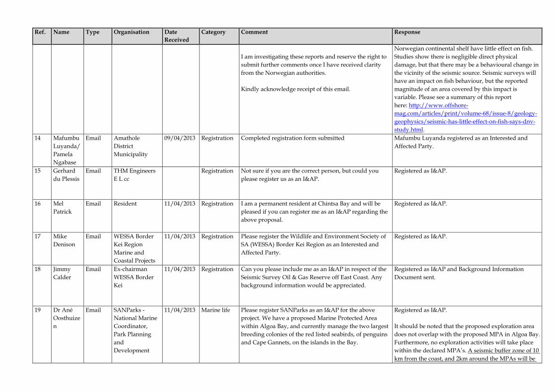
Ref. Name Type Organisation Date Received
Category Comment Response
I am investigating these reports and reserve the right to submit further comments once I have received clarity from the Norwegian authorities. Kindly acknowledge receipt of this email.
Norwegian continental shelf have little effect on fish. Studies show there is negligible direct physical damage, but that there may be a behavioural change in the vicinity of the seismic source. Seismic surveys will have an impact on fish behaviour, but the reported magnitude of an area covered by this impact is variable. Please see a summary of this report here: http://www.offshore-mag.com/articles/print/volume-68/issue-8/geology-geophysics/seismic-has-little-effect-on-fish-says-dnv-study.html.
14 Mafumbu Luyanda/ Pamela Ngabase
Email Amathole District Municipality
09/04/2013 Registration Completed registration form submitted Mafumbu Luyanda registered as an Interested and Affected Party.
15 Gerhard du Plessis
Email THM Engineers E L cc
Registration Not sure if you are the correct person, but could you please register us as an I&AP.
Registered as I&AP.
16 Mel Patrick
Email Resident 11/04/2013 Registration I am a permanent resident at Chintsa Bay and will be pleased if you can register me as an I&AP regarding the above proposal.
Registered as I&AP.
17 Mike Denison
Email WESSA Border Kei Region Marine and Coastal Projects
11/04/2013 Registration Please register the Wildlife and Environment Society of SA (WESSA) Border Kei Region as an Interested and Affected Party.
Registered as I&AP.
18 Jimmy Calder
Email Ex-chairman WESSA Border Kei
11/04/2013 Registration Can you please include me as an I&AP in respect of the Seismic Survey Oil & Gas Reserve off East Coast. Any background information would be appreciated.
Registered as I&AP and Background Information Document sent.
19 Dr Ané Oosthuizen
Email SANParks - National Marine Coordinator, Park Planning and Development
11/04/2013 Marine life Please register SANParks as an I&AP for the above project. We have a proposed Marine Protected Area within Algoa Bay, and currently manage the two largest breeding colonies of the red listed seabirds, of penguins and Cape Gannets, on the islands in the Bay.
Registered as I&AP. It should be noted that the proposed exploration area does not overlap with the proposed MPA in Algoa Bay. Furthermore, no exploration activities will take place within the declared MPA’s. A seismic buffer zone of 10 km from the coast, and 2km around the MPAs will be

Ref. Name Type Organisation Date Received
Category Comment Response
implemented, within which there will be no firing of airguns. Please note that comment has also been received from Tertius Carinus of SANParks – please see Ref. 24.
20 Claire & George Kockott
Email Driftwood Studios Self Catering Cottages
11/04/2013 Marine life Please register my husband and myself as Interested & Affected parties. We are residents and business owners concerned at the effect on marine life of the seismic surveying, let alone the effects on us all if exploration should go ahead.
Registered as I&AP. Please see Chapter 6 for the assessment of potential impacts on marine life.
21 Rick Tudhope
Email Interested Party 11/04/2013 Registration Please register me as an Interested and Affected Party in this assessment.
Registered as I&AP.
22 Dr Trudy Thomas
Email Interested Party 12/04/2013 Registration Thank you for providing this information and the opportunity to comment. The very short “comment period”-2 days – makes it impossible for me to comment usefully, except to say leave the ocean alone- but I would be very glad if I could be registered as an affected and interested person.
Registered as I&AP. Please see Chapter 4 for a summary of the public consultation undertaken to date. It should be noted that the initial public consultation period was 21 days (22 March 2013 to 12 April 2013). The draft EMPr has also been released for a 30 day public comment period (24 May – 24 June).
23 Caroline Kruger
Email Marketing Practitioner
12/04/2013 Registration I would like to register as an interested and affected party with regard to the Proposed Oil and Gas Exploration Activities in the Transkei Algoa Exploration Area, off the Eastern Cape Coast of South Africa.
Registered as I&AP.
24 Tertius Carinus
Email SANParks - Conservation Planner
12/04/2013 Here are some comments on the proposed Oil and Gas Exploration activities and can you please register me (SANParks) as an I&aP. The seismic equipment is an array of airguns that is towed behind the vessel and could typically produce sound levels in the region of 250 dB re 1 mPA@ 1M. Could you request that: (a) some 10 - 15 minutes prior to starting their survey run that the airgun array is turned
Registered as I&AP. No exploration activities will take place in the declared MPA’s A seismic buffer zone of 10 km from the coast, and 2km around the MPAs will be implemented, within which there will be no firing of airguns.

Ref. Name Type Organisation Date Received
Category Comment Response
on at a relatively low intensity to warn pelagic fish and marine mammals that seismic activity will be occurring in the area and hopefully give them time to take evasive action, and (b) no waste is discharged at sea while the ship is operating off the Agulhas National Park and other protected areas. Although most of the seismic work will be done at water depths of approximately 5m – 25m, it should be borne in mind that the Southern Rights whales frequent the inshore waters of the Agulhas & Southern Cape in late winter early spring (August – September), when the females calve in sheltered, sandy-bottom bays. The calves are suckled for about three months before the whales move off towards the Antarctic. Therefore any ‘inshore’ seismic work should preferably be done during the first seven months of the year (January and July). The map shows the interest area including all the MPAs along the Transkei coast. Please, firstly no exploration must occurs within these protected areas and a 2 km buffer zone around these reserves and along the entire coast. Secondly can you temporarily stop the seismic surveys in May, June, July and August during the annual migration of sardines along this coast to KZN (May – July), when vast numbers of sardines, large predatory fish and sharks and dolphins move through the region, while the Redlisted white steenbras move into the nearshore region off the Transkei to breed between June and August.
It should be noted that the exploration activities, and seismic acquisition in particular will be undertaken in water depths up to 4000 m. It is acknowledged that Southern Right whales will occur within and traverse through the proposed exploration areas, please note however that the Transkei and Algoa Exploration Areas are offshore of the Eastern Cape Coast and not the Southern Cape. A seismic buffer zone of 10 km from the coast, and, as suggested a 2km around the MPAs will be implemented, within which there will be no firing of airguns. No exploration activities will occur within the MPAs (i.e. Amathole, Dwesa-Cwebe, Hluleka and Pondoland MPAs). The timing of the surveys was determined to help avoid sensitive periods for marine fauna, for example during seasonal migration periods and breeding seasons. The specialist impact assessments are summarised in Chapter 6 of the EMPr report. Please see a summary of mitigation and management measures in the Implementation Plan in Part B. Please note that comment has also been received from Ane Oosthuizen of SANParks – please see Ref. 19.
25.1 Ricky Stone
Email BLC Attorneys
12/04/2013 I trust that my email finds you well. I refer to the abovementioned proposal and attach hereto as follows: -
Ricky Stone registered as I&AP. Further contact details requested for the additional stakeholders but not received. A list of the stakeholders reportedly represented by Mr Stone can be found attached to the

Ref. Name Type Organisation Date Received
Category Comment Response
1. BLC Attorneys covering letter; 2. Stakeholder Comment Sheet; 3. Annexure “A” thereto: List of I & AP’s represented by BLC Attorneys; 4. Annexure “B” thereto: Motivation and Comments; 5. Annexure “C” thereto: Endangered Wildlife Trust Report; 6. Annexure “D” thereto: Daily Dispatch Newspaper article; 7. Annexure “E” thereto: Email from Bjornar Nicolaisen dated 26/02/2013; 8. Annexure “F” thereto: Consequences of seismic surveys (a Norwegian experience). Kindly acknowledge receipt of this email. I look forward to hearing from you in due course.
stakeholder database in Appendix B3.
25.2 18/04/2013 Registration I trust that you are well. Thank you for your email below acknowledging receipt. Kindly note that the purpose of representing the 77 clients is that all correspondence is directed to myself and disseminated accordingly. Thus, should you require a postal address, email address and telephone number for these parties, then it should be as follows: - Tel – (041) 506 3760 Em ail – [email protected] Post – 4 Cape Road, Central, Port Elizabeth, 6001. Finally, I neglected to include one further I&AP on my ‘database’ but whom had requested inclusion before the closing date. In this regard please see the email annexed. I would be most grateful if you could add the Rainbow Valley Home Owners Association to the I&AP database.
This is noted and the additional organisation has been included on the list appended to the database.

Ref. Name Type Organisation Date Received
Category Comment Response
You will note that they represent some 28 home owners. As an aside, it worth mentioning that the opposition to this proposed seismic survey is significant from an Eastern Cape point of view. With the Chinese and Japanese trawlers already ‘cleaning-up’ our oceans and Marine Protected Reserves, a threat of this magnitude is most disconcerting. As a young (27) environmental attorney I am deeply concerned. I look forward to receiving the EMPr in due course. Have a lovely day Claire and thank you for your understanding.
25.3 Ricky Stone
Email BLC Attorneys 12/04/2013 MPAs To what extent do the activities impinge of the sanctity of the Amathole off-shore MPA's along the Border coastline and the Dwesa/Cwebe, Hluleka and Pondoland MPA's along the Transkei coastline?
No exploration activities will take place in the declared MPA’s. A seismic buffer zone of 10 km from the coast, and 2km around the MPAs will be implemented, within which there will be no firing of airguns.
Noise What are the effects of the low frequency infrasound generated by the sound gun? Does this low frequency sound affect a fishes swim bladder?
Impacts relating to the effects of sound on marine fauna are assessed in Chapter 6.
Advertising What advertisements of this proposal have been placed i.e. in which newspapers?
Adverts were placed on Friday, 22 March 2013 in the Times, Die Burger (Eastern Cape), The Herald and the Daily Dispatch informing the broader public about the proposed exploration activities. Copies of the adverts are provided in Appendix B-1.
Environmental Authorisation
Does Impact Africa have an Environmental Authorisation (EA) to conduct this proposal because a 'reconnaissance permit' is a listed activity under NEMA?
There appear to be two issues here which require clarification, the first relating to the nature of the proposed activities and the second relating to the application of the listing notices which trigger the need for an environmental authorisation. We deal with each issue in turn.

Ref. Name Type Organisation Date Received
Category Comment Response
Firstly, the activities that Impact Africa proposes to undertake require an “exploration right” rather than a “reconnaissance permit”. Secondly, the regulations governing the environmental authorisation process are promulgated in terms of NEMA. In this regard, GNR 544 and GNR 545 of 18 June 2010 list activities requiring environmental authorisation from the Department of Environmental Affairs (or provincial departments). Activity 21 of GNR 545 lists “any activity which requires an exploration right or renewal thereof as contemplated in sections 79 and 81 respectively of the Mineral and Petroleum Resources Development Act, 2002 (Act No. 28 of 2002)” as requiring an environmental authorisation. However, in terms of Section 14(2) of the National Environmental Management Amendment Act No. 62 of 2008, the provisions of NEMA and the listed activities made under NEMA relating to prospecting, mining, exploration and production will only commence 18 months after the commencement of the Mineral and Petroleum Resources Development Amendment Act, 2008. The MPRD Amendment Act came into force on 7 June 2013 and as such the activity listed in GNR 545 regarding the requirement for an exploration right (or renewal) will commence on 7 December 2014. As the activity has not as yet commenced, the proposed exploration activities, including the environmental aspects, are currently regulated solely by the MPRDA. Notwithstanding the above, should any additional exploration or production activities be undertaken after the initial period, Impact Africa would be required to apply for a renewal of the exploration right or a production right in terms of the MPRDA and may,

Ref. Name Type Organisation Date Received
Category Comment Response
depending on the nature of the proposed activities, also be required to apply for environmental authorisation in terms of NEMA and the Environmental Impact Assessment (EIA) Regulations. Note that the above changes are as a result of the MPRD Amendment Act coming into force on 7 June 2013, subsequent to the release of the draft EMPr for comment.
The requirement of an EA is furthermore necessary, and confirmed to be a requirement, on account of the recent (April 2012) Constitutional Court Judgment (Maccsands v City of Cape Town) regarding mining and the related interplay with other relevant law;
As far as we are aware the application, in Maccsand (Pty) Ltd v City of Cape Town (“Maccsand”), for a declaratory order that “no person may commence or continue with a mining activity listed in terms of section 24 of NEMA without an environmental authorisation” was unsuccessful. We understand that the Supreme Court of Appeal refused the declaratory order on the basis that it was “hypothetical in nature and the Constitutional Court declined to grant leave to cross-appeal against the Supreme Court of Appeal’s decision on the basis that the cross-appeal had “no prospect of success” because (as explained above) the mining related activities in the EIA listing notices have not commenced and therefore do not find application (as explained above). At paragraph 53 of the judgment, the Court held: “The declaratory order sought is based on an assumption that mining is listed in an operational notice as an activity which may not commence without an environmental authorisation. This assumption is wrong.”
NEMA Has the National Environmental Management Act (NEMA) been complied with in all respects?
This EMPr is compiled according to the principles of Integrated Environmental Management (IEM). These IEM principles are listed in terms of Section 2 of NEMA. They apply to all organs of State and alongside other considerations (including socio-

Ref. Name Type Organisation Date Received
Category Comment Response
economic considerations) and guide the administration and interpretation of environmental management legislation in South Africa. Relevant NEMA principles include the following: • Development must be socially, environmentally
and economically sustainable. • Promotion of environmental justice and equitable
access to environmental resources. • Avoidance, minimisation and remediation of
ecosystem disturbance and biodiversity loss. • Waste must be avoided or reduced, reused and
recycled. • Participation of interested and affected parties
must be promoted and their views must be taken into account.
• Specific attention must be given to sensitive,
vulnerable and highly dynamic ecosystems. • Lifecycle responsibility must be ensured.
ICMA The 'seabed' is deemed to be 'public coastal property' in terms of the Integrated Coastal Management Act and for this reason alone should be protected for the public and used ONLY for the benefit of the public. As such, how will this survey benefit the public?
Although there are potential impacts associated with the proposed exploration activities (as assessed in Chapters 5 and 6 of the EMPr), the exploration for oil and gas could have substantial potential benefits (social and economic) for South Africa should commercially viable oil or gas discoveries be made.
Impact Africa
Are all the members of Impact Africa citizens of the Republic of South African? It is arguable that the Mineral and Petrolueum Resources Development Act only allows permits to be awarded to South Africans;
We understand that local and international companies and persons may hold rights and permits under the MPRDA and we are aware of many international companies which hold such rights and permits. Petroleum exploration and production is a highly
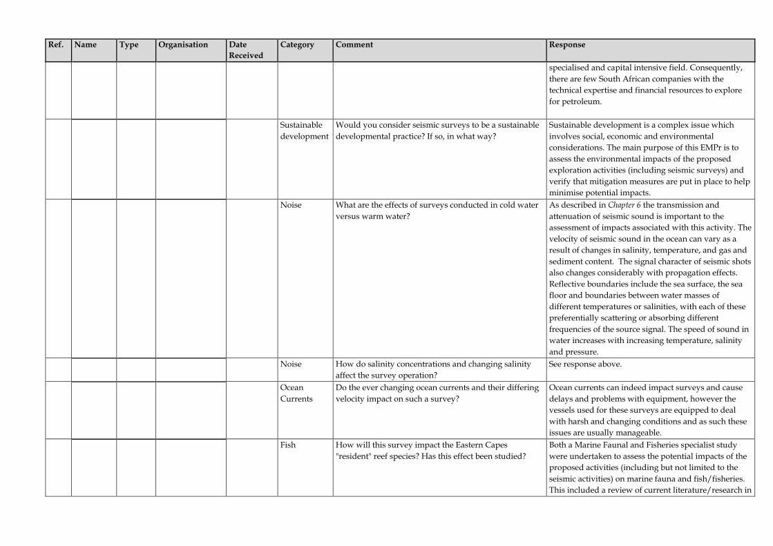
Ref. Name Type Organisation Date Received
Category Comment Response
specialised and capital intensive field. Consequently, there are few South African companies with the technical expertise and financial resources to explore for petroleum.
Sustainable development
Would you consider seismic surveys to be a sustainable developmental practice? If so, in what way?
Sustainable development is a complex issue which involves social, economic and environmental considerations. The main purpose of this EMPr is to assess the environmental impacts of the proposed exploration activities (including seismic surveys) and verify that mitigation measures are put in place to help minimise potential impacts.
Noise What are the effects of surveys conducted in cold water versus warm water?
As described in Chapter 6 the transmission and attenuation of seismic sound is important to the assessment of impacts associated with this activity. The velocity of seismic sound in the ocean can vary as a result of changes in salinity, temperature, and gas and sediment content. The signal character of seismic shots also changes considerably with propagation effects. Reflective boundaries include the sea surface, the sea floor and boundaries between water masses of different temperatures or salinities, with each of these preferentially scattering or absorbing different frequencies of the source signal. The speed of sound in water increases with increasing temperature, salinity and pressure.
Noise How do salinity concentrations and changing salinity affect the survey operation?
See response above.
Ocean Currents
Do the ever changing ocean currents and their differing velocity impact on such a survey?
Ocean currents can indeed impact surveys and cause delays and problems with equipment, however the vessels used for these surveys are equipped to deal with harsh and changing conditions and as such these issues are usually manageable.
Fish How will this survey impact the Eastern Capes "resident" reef species? Has this effect been studied?
Both a Marine Faunal and Fisheries specialist study were undertaken to assess the potential impacts of the proposed activities (including but not limited to the seismic activities) on marine fauna and fish/fisheries. This included a review of current literature/research in

Ref. Name Type Organisation Date Received
Category Comment Response
South Africa and elsewhere in the world. The timing of the surveys will as far as possible avoid sensitive periods for marine fauna, for example during seasonal migration periods and breeding seasons. The specialist impact assessments are summarised in Chapter 6 of the EMPr report. Please see a summary of mitigation and management measures in the Implementation Plan in Part B.
Research What experiments have Impact Africa performed? When were they performed? Where were they performed? What are the actual results of these experiments?
Only desk-based work has been permitted under the Technical Cooperation Permit for the Transkei and Algoa Exploration Areas held by Impact Africa from 4/09/2012 to 3/09/2013. No exploration activities have been conducted by Impact Africa within the Transkei and Algoa Exploration Areas. It should be noted that although not part of this project Impact Africa do have an Exploration Right for the Tugela South Exploration Area and have conducted seismic surveys in this area.
Research Have any such experiments been conducted locally, in our conditions, to determine what the effects are of these explosions?
As far as we are aware there have been limited/no ‘experiments’ in seismic noise undertaken in South Africa specifically. However a literature review of current international research was undertaken by the marine faunal specialist to understand the potential impacts of the exploration activities on marine fauna. The specialist study can be seen in Part C of the report. It should also be noted that extensive seismic survey activity has been undertaken along the entire South African coastline in the past (1970’s and 80’s).
Pollution How will Impact Africa prevent direct or indirect contamination (of the reserve, beach, rock shelf, shoreline and ocean) as effectively as possible?
Mitigation measures are included in Chapter 6 and the Implementation Plan which deal with potential air and water pollution by the exploration vessels. This includes compliance with MARPOL 73/78.
25.4 Ricky Stone
Email BLC Attorneys 18/04/2013 Mandate Kindly find annexed email from the Wild Coast Jikeleza Association authorising my involvement on their behalf. You will note from the email that they represent some 52 organisations/restaurants/businesses etc. It is these
The comment is in response to ERM’s request to Mr Stone for proof of his mandate/power of attorney to act on behalf of the list of stakeholders identified.

Ref. Name Type Organisation Date Received
Category Comment Response
organisations (and others), and certain of their members/directors, which form part of the 77 I&AP’s in my initial letter. Most of these organisations telephoned me or sent me an email requesting that I protect their interests by keeping them involved as far as this proposal is concerned. The members of the above organisations didn’t want to be referred to merely through the listing of Wild Coast Jikeleza Association as a single I&AP, when in fact each member is concerned and for this reason they must be listed separately. Resolutions and Powers of Attorney from each and every I&AP will necessarily form part of the papers filed in any proposed Court action down the line. This in line with the principles of agency. At this stage I merely play the role of facilitating a group of I&AP’s and do so for organisational reasons. You may appreciate that I am assisting these I&AP’s on a pro bono (no fee) basis due to my commitment to environmental law and sustainable development. Kindly confirm the date the EMPr is to be made available? This document will then be circulated to each I&AP on my database and all comments collated for submission to yourself.
Note that this correspondence and the email from Mr Stone occurred after the close of the initial comment period (22 March – 12 April).
26 Stephanie Plon
Email Nelson Mandela Metropolitan University
14/04/2013 Marine Fauna
My apologies for the late response to below e-mail- I was away from the office with limited e-mail access. Unfortunately I do not have a scanner at hand, so have to send comments and contact details here. Please register me as an I &AP for this project. My comments: Besides the obvious implications of noise produced by the airguns and its potential effects on marine mammals and fish (potentially also seabirds), I would also like to caution that no seismic exploration should be conducted
Registered as I&AP. Both a Marine Faunal and Fisheries specialist study were undertaken to assess the potential impacts of the proposed activities (including but not limited to the seismic activities) on marine fauna and fish/fisheries. This included a review of current literature/research in

Ref. Name Type Organisation Date Received
Category Comment Response
during the annual Sardine Run, which usually occurs between May and July every year. Given the potential impacts on a number of marine vertebrates I would like to see specialist studies being commissioned on these taxa and the potential impacts the seismic explorations may have.
South Africa and elsewhere in the world. The timing of the surveys will as far as possible avoid sensitive periods for marine fauna, for example during seasonal migration periods and breeding seasons. The specialist impact assessments are summarised in Chapter 6 of the EMPr report. Please see a summary of mitigation and management measures in the Implementation Plan in Part B.
27 Marius van Jaarsveldt
Email LEGACY POWER SYSTEMS
15/04/2013 Registration I would like to register the Eastern Province Deep Sea Association as an interested party. Comment: The Eastern Province Deep Sea Angling Association is concerned about the impact of the seismic exploration on the fish life and fishing.
Registered as I&AP. Please see the impact assessment in Chapter 5 and 6 and the specialist fisheries study in Part C.
28 Mieke Porter
Email Interested Party 16/04/2013 Registration Please register me as an Interested and Affected Party in this assessment.
Registered as I&AP.
29 Alan Shaw
Email Landowner 18/04/2013 Registration As a resident of East London and an owner of property at Kleinemonde/Seafield and Port Elizabeth, I would like to be registered as an Interested and Affected Party.
Registered as I&AP.
30.1 Richard Stephenson
Email Royal Representative to Pondoland and Xhosaland
22/04/2013 Registration Thank you for your prompt response. I am mandated and acting on behalf of the following communities; 1. Eastern Pondoland. I am on mandate with The Royal family whom are currently discussing succession due to the passing of King Justice Mpondombini Sigcau a few weeks ago. Once the new King or Queen is elected a Trust will be registered to protect all the natural assets on behalf of all the people of their Kingdom. 2. Western Pondoland. I am the managing Trustee for the Western Pondoland Trust on behalf of King Ndamase Mangaliso Ndamase and all the people of his Kingdom. 3. Xhosaland. I have a power of attorney from King Zwelonke Sigcau (whilst the Xhosaland Trust is being registered) to represent his Kingdom relating to matters affecting the Kingdom on behalf of the King and all the
Registered as I&AP. Requested proof of mandate/power of attorney to act on behalf of those referenced, as well as contact details for King Dalindyebo of the Tembus. Confirmed that we would be in touch regarding potential future consultation activities.
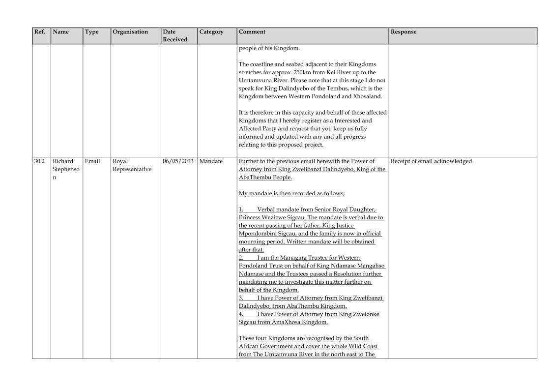
Ref. Name Type Organisation Date Received
Category Comment Response
people of his Kingdom. The coastline and seabed adjacent to their Kingdoms stretches for approx. 250km from Kei River up to the Umtamvuna River. Please note that at this stage I do not speak for King Dalindyebo of the Tembus, which is the Kingdom between Western Pondoland and Xhosaland. It is therefore in this capacity and behalf of these affected Kingdoms that I hereby register as a Interested and Affected Party and request that you keep us fully informed and updated with any and all progress relating to this proposed project.
30.2 Richard Stephenson
Email Royal Representative
06/05/2013 Mandate Further to the previous email herewith the Power of Attorney from King Zwelibanzi Dalindyebo, King of the AbaThembu People. My mandate is then recorded as follows; 1. Verbal mandate from Senior Royal Daughter, Princess Wezizwe Sigcau. The mandate is verbal due to the recent passing of her father, King Justice Mpondombini Sigcau, and the family is now in official mourning period. Written mandate will be obtained after that. 2. I am the Managing Trustee for Western Pondoland Trust on behalf of King Ndamase Mangaliso Ndamase and the Trustees passed a Resolution further mandating me to investigate this matter further on behalf of the Kingdom. 3. I have Power of Attorney from King Zwelibanzi Dalindyebo, from AbaThembu Kingdom. 4. I have Power of Attorney from King Zwelonke Sigcau from AmaXhosa Kingdom. These four Kingdoms are recognised by the South African Government and cover the whole Wild Coast from The Umtamvuna River in the north east to The
Receipt of email acknowledged.

Ref. Name Type Organisation Date Received
Category Comment Response
Great Kei River in the south west.
31 Stewart Wernberg and Richard Stephenson
Email Western Pondoland Trust
03/05/2013 (Letter dated 29/04/2013)
Mandate Please be advised that in accordance with Trustee, Mr Richard Stephenson’s mandate from Eastern and Western Pondoland and Xhosaland, we wish to make representations in terms of the Mineral and Petroleum Resources Development Act, 2002 (Act No. 28 of 2002) (“the Act”) and the Mineral and Petroleum Resources Development Regulations (“the Regulations”) regarding Impact Africa Limited’s application for an exploration right. Whilst we are cognizant of the provisions of section 3 of the Regulations as read with sections 10 and 69(2)(a) of the Act regarding consultation with interested parties, we draw your attention to the following aspects of the Act, namely: 1. The preamble which, inter alia, affirms 1.1 the State’s obligation to protect the environment for the benefit of present and future generations; 1.2 the need to promote local and rural development and the social upliftment of communities affected by mining; 1.3 the State’s commitment to reform and to bring about equitable access to South Africa’s mineral and petroleum resources and to eradicate all forms of discriminatory practices in the mineral and petroleum industries and concomitant obligation under the constitution to take legislative and other measures to redress the results of past racial discrimination. 2. Paragraphs (c), (d) and (h) of section 2 of the Act, 3. Subsection (2) of section 104 of the Act. We further draw your kind attention to the fact that the people of the various kingdoms in question are in effect historically disadvantaged persons (including women) and are entitled to substantial and meaningful expansion of opportunities to enter into and actively participate in the mineral and petroleum industries. Further they are interested parties in the sense that it is principally theses people who will be affected by the proposed exploration and, in due course, by any
Receipt of this email was acknowledged and further correspondence entered into with Richard Stephenson regarding additional consultation to be undertaken. A focussed group meeting was held with Richard Stephenson and 2 of the 4 Kings that he represents on 6 June 2013. Through Richard the Kings have indicated their support of project, along with a request for future engagement in this regard.

Ref. Name Type Organisation Date Received
Category Comment Response
production which may result therefrom. Against this background it is our view that the mere notification process referred to in the Act and Regulations to which we have made reference above are wholly insufficient to achieve the overall objectives referred to. Moreover, we are dealing with people of a rural background whose circumstances may deny them access to technological information of the level referred to in your website at http://www.erm.com/PageFiles/11332/Impact%20Africa_Transkei%20Algoa%20BID20Final.pdf. It is our view that given the enormity of the proposed exploration and the potential consequences of any subsequent exploration that might follow, it would be prudent for the applicant to arrange consultations with the kings in their respective kingdoms and in their capacity as the representatives of their people to be able to properly explain these implications and to answer questions arising. Some of the issues that we envision that would arise are pertinently listed on your website, including matters such as: “Noise effects on marine fauna from multi-beam bathymetry survey, seabed sampling programme and seismic survey; Effects of activities on the fishing industry, including effects on fish behaviour, fish catches and cessation or displacement of fishing activities, as a result of noise effects and presence of survey vessels; Impact on tourism and recreation as a result of noise effects and presence of survey vessels; Interference with marine recreational facilities and transport routes; and Waste discharge to sea and emissions to the atmosphere. You’ll readily appreciate that matters such as a ‘multi-beam bathymetry survey’ are highly technical. Further, the people would doubtless want to be assured that exploration and eventual production is not going to result in a disaster or oil spillage which could be of the most drastic consequences. The people, through their representatives, are entitled to be privy to matters such

Ref. Name Type Organisation Date Received
Category Comment Response
as these and to fully understand the correlation between them and any potential knock-on effects that may damage or limit their incomes from fishing, tourism and the like. In view of the substantial cost of such exploration it would doubtless be in everyone’s interests that the eventual exploration permit, if granted, not be the subject of challenges from communities which feel that there has been insufficient consultation, both with respect to the technical aspects referred to previously, and also apropos their right to discuss the manner, if any, in which they might stand to benefit economically or otherwise from the proposed activities. We enclose herewith copies of the mandates given by their highnesses King Zwelonke Sigcau in his capacity as King of Xhosaland and King Ndamase Mangaliso Ndamase and his Inkosis for your kind attention. With regard your request for the contact information for King Dalindyebo, we confirm that Mr Stephenson is currently in a meeting with the King and we anticipate that we will shortly be able to add a mandate from King Dalindyebo which we will forward to you directly it is to hand.
Table 2 Comment and Response Report (Draft EMPr Comment Period)
Ref. Name Type Organisation Date Received
Category Comment Response
32 Provincial Environmental Authority Meeting
Meeting Representatives from Eastern Cape Parks and Tourism and the Eastern Cape Department of Economic Development,
04/06/2013 A concern was raised regarding the potential impact of the activities (specifically the coring) on cold water corals which can be located in deeper waters and potentially relatively far offshore. In particular there are reports of corals off of the Amatole Marine Protected Area. It was suggested that perhaps Kerry Sink of South African National Biodiversity Institute (SANBI) would be able to provide some more information on this aspect.
It was indicated by the applicant that it was their intention to reduce the likelihood of coring over any cold water coral species. If possible the non-intrusive surveys would be done first and the results used to inform the locations of the coring activities. Further information will be requested from Kerry Sink if available.

Ref. Name Type Organisation Date Received
Category Comment Response
Environmental Affairs and Tourism
Participants questioned the likely the timing of the activities.
As per the recommendations in the EMPr the seismic and bathymetric activities would be scheduled to occur outside of key whale breeding and migration times as well as the Sardine Run. This is likely to be between January and May. The other activities may happen at any time of year, but are more likely to occur during the summer when the weather is more conducive.
Participants questioned the nature of night-time activities.
It was responded that seismic activities continue overnight, with Passive Acoustic Monitoring (PAM) used instead of Marine Mammal Observers (MMOs) prior to soft starts in order to identify if there are cetaceans in the vicinity. The most sensitive period is at the start-up of the seismic as most animals move away from the noise source.
Participants questioned whether the animals actually move away?
Yes it has been shown that they generally do move away from the noise source. The Marine Faunal Study provides some more description and further information.
Participants questioned whether the Bathymetric information gathered be available for scientific purposes?
The information is all provided to PASA and although uncertain it was indicated that the information was usually available within 2/3years, however this would have to be confirmed.
Participants questioned the width (on the seabed) of the bathymetry data collected?
It was responded that it is twice the water depth.
Participants questioned what the distance of impact from the seismic airgun? Particularly in relation to buffers around the Marine Protected Areas (MPAs).
It was responded that this depends largely on the propagation of the sound which differs in different water depths, temperatures and salinity. The zone in which physical damage could potentially occur is generally immediately around the firing airguns. The 500 m zone around the vessel which is monitored for cetaceans by the MMO and PAM is the most sensitive area, however the sound would likely be heard by animals in the water relatively far away. There is currently no buffer proposed around the MPAs however this aspect is still being looked into further by the project teams. SANParks requested a 2km buffer around the MPAs and this is being considered.
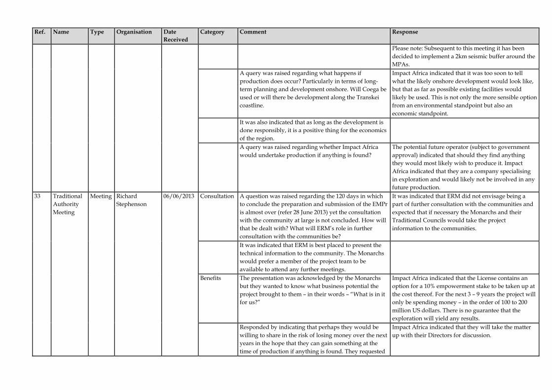
Ref. Name Type Organisation Date Received
Category Comment Response
Please note: Subsequent to this meeting it has been decided to implement a 2km seismic buffer around the MPAs.
A query was raised regarding what happens if production does occur? Particularly in terms of long-term planning and development onshore. Will Coega be used or will there be development along the Transkei coastline.
Impact Africa indicated that it was too soon to tell what the likely onshore development would look like, but that as far as possible existing facilities would likely be used. This is not only the more sensible option from an environmental standpoint but also an economic standpoint.
It was also indicated that as long as the development is done responsibly, it is a positive thing for the economics of the region.
A query was raised regarding whether Impact Africa would undertake production if anything is found?
The potential future operator (subject to government approval) indicated that should they find anything they would most likely wish to produce it. Impact Africa indicated that they are a company specialising in exploration and would likely not be involved in any future production.
33 Traditional Authority Meeting
Meeting Richard Stephenson
06/06/2013 Consultation A question was raised regarding the 120 days in which to conclude the preparation and submission of the EMPr is almost over (refer 28 June 2013) yet the consultation with the community at large is not concluded. How will that be dealt with? What will ERM’s role in further consultation with the communities be?
It was indicated that ERM did not envisage being a part of further consultation with the communities and expected that if necessary the Monarchs and their Traditional Councils would take the project information to the communities.
It was indicated that ERM is best placed to present the technical information to the community. The Monarchs would prefer a member of the project team to be available to attend any further meetings.
Benefits The presentation was acknowledged by the Monarchs but they wanted to know what business potential the project brought to them – in their words – “What is in it for us?”
Impact Africa indicated that the License contains an option for a 10% empowerment stake to be taken up at the cost thereof. For the next 3 – 9 years the project will only be spending money – in the order of 100 to 200 million US dollars. There is no guarantee that the exploration will yield any results.
Responded by indicating that perhaps they would be willing to share in the risk of losing money over the next years in the hope that they can gain something at the time of production if anything is found. They requested
Impact Africa indicated that they will take the matter up with their Directors for discussion.

Ref. Name Type Organisation Date Received
Category Comment Response
Impact Africa to further consider their offer of risk sharing.
SOEKOR data
Requested access to the SOEKOR data from the 1960’s and 1970’s.
Impact Africa explained that the data is not captured in report format but on tapes and requires highly specialised skills and equipment to understand it. No wells were drilled at that point in the Transkei Algoa area.
Jobs A query was raised regarding what on-land jobs will be created?
Impact Africa indicated that during the exploration phase the job opportunities will be of a highly skilled and specialised nature. Most of the required people will have to be sourced from overseas since the skills and equipment to conduct the studies with are not available in South Africa. There will be Marine Mammal Observers (MMO) and Fisheries Liaison Officers (FLO) that will have to be sourced possibly from nearby universities. An attempt will always be made to source employees locally before appointing people from elsewhere or overseas. In short – for the first years, the projects will yield almost no local benefits and over time may start holding some limited ancillary benefits.
The requirement of specialised resources can act as motivation to children in the area to study some of the fields of specialisation that will be required over time.
Employment It was highlighted that the sea is part of their ancestral heritage and that it is used and appreciated as such by the people in the Transkei. Further, some of the children of the area have qualified in the environmental and engineering fields of study and the Project was requested to consider these students for possible employment in future.
It was indicated that Impact Africa was committed to working with local people but if people are not available locally then others will have to be employed. The exploration industry is still very new in South Africa and people are not used to its requirements yet. It was indicated that they invest in working with “in-country people” during the production phase of a project. At which time local people are appointed to learn from their international counterparts with the ultimate aim of handing over the positions to local staff members.
It was reiterated that the Kings and their traditional councils (with Richard Stephenson mandated to communicate on their behalf in this matter) were the

Ref. Name Type Organisation Date Received
Category Comment Response
correct structures to work through as representative of the people. They want to promote the local people and their possible role in the project in the future.
The Monarchs suggested that 5 additional meetings should be held (1 per Monarchy jointly with their Traditional Councils) at which the project purpose and background is presented again. They indicated that they would prefer representatives of the Project Team there to assist with the technical discussion. These meetings will result in the confirmation of support to the project already given by the Kings present. This level of consultation is sufficient and it will not be necessary to host further community level meetings. Richard Stephenson will document the matter and submit it to ERM. There was a request that the presentation should be simplified and shortened for the meetings with the Kings and their Traditional Authorities.
Note email received from Richard Stephenson, dated 18 June 2013 (included in Appendix B-2 which indicates that in principle and based on the presentation made, the traditional leaders present at the meeting would support the EMPr on behalf of the applicant to be submitted to PASA. He went on to indicate that the RMC’s support is conditional to on-going consultation and open communication between all the role players in this project in the future.
34 Ricky Stone Email BLC Attorneys 24/06/2013 Seismic surveys
Seismic surveys have been conducted in SA since the early 1960’s and there now seems to be no-holding-back approach on the part of the oil companies. This so-called flood of seismic activity is noted to stem primarily from the fact that South African legislation in the mining arena is hopelessly inadequate insofar as aligning itself with environmental principles is concerned. In the result, South Africa has been ‘targeted’ for mass surveys due to the above;
Offshore seismic surveys are regulated by the MPRDA and require the preparation of an EMPr and review and approval by the government prior to execution. The preparation of the EMPr includes an assessment of impacts and the development of mitigations and controls to avoid or reduce effects. Other countries around the world have similar approval regimes.
Moratorium on seismic surveys
Certain civilised nations of the world have place a moratorium on all seismic activity – why is this so?
The approach to regulating offshore seismic surveys varies by country and is somewhat dependant on the specific environment. We are aware that some countries have restrictions on seismic surveys.
Cradle to grave
South African environmental legislation contains ‘cradle to the grave’ provisions relating to damage/pollution to the environment and in this regard the responsibility for any damage which may occur during or after the survey MUST necessarily be borne by Impact Africa;
As indicated in Chapter 1 of the report, the financial provision for the proposed exploration work programme is estimated to be USD 10.1 million, which is the estimated cost for management and/or rehabilitation of potential negative impacts that may be incurred during the proposed exploration work

Ref. Name Type Organisation Date Received
Category Comment Response
programme. The determination of the amount of the financial provision is set out in Part C. Discussions are being held with PASA regarding the method to put in place the financial provision.
Report similarities
Vast similarities are noted in the instant EMPr against other such EMPr’s submitted for surveys in the Western Cape and KZN area etc. These similarities relate to content, methodology and comparative studies;
As indicated in the EMPr the report is based on the PASA approved Generic EMPr. As per guidance provided by PASA, the Generic EMPr is used as the basis for describing the environmental conditions and for the best practice mitigations that should be implemented. The same specialists have been used for the fisheries and marine faunal studies, who use the same methodology for assessing impacts. The project activities are also similar in nature and as such it is acknowledged that there would indeed be similarities between the reports for these reasons.
Error in disclaimer
Strikingly, and of utmost concern, is the fact that the first page of the Executive Summary, which contains the approval of the report by Mr Henry Cramp together with the disclaimer, encloses the following entry “The report has been prepared for submission to the Petroleum Agency of South Africa (PASA) in support of Impact Africa’s application for an Exploration Right for the West Bredasdorp Exploration Area.” (My emphasis);
This is indeed an error made only on the sign-off page of the report. This error has been corrected.
Although this is may be simple typo – the oversight cannot be overlooked as it goes to the heart of the flaws in these Reports and related mining applications. The results are always similar no matter what area they are surveying or what ocean currents they find themselves in;
As per guidance provided by PASA, the Generic EMPr is used as the basis for describing the environmental conditions and for the mitigations that should be implemented.
Date Furthermore, the specialist Report concerning Marine Life and Fisheries Impact is dated 9 January 2013. I&AP’s submitted comments by 19 April 2013 and thus raised numerous concerns which aren’t addressed in the Reports, naturally. In effect then, the EMPr is technically flawed;
It should be noted that both the Fisheries and Marine Faunal Reports are dated April 2013. An error occurred on the Declaration of Independence page of the Fisheries Report only and this has been corrected.
Commission of Inquiry
Therefore, and in essence, it is requested that PASA pend all applications for exploration rights in South
Responding to this comment is outside the scope of the EMPr and should be directed to PASA.

Ref. Name Type Organisation Date Received
Category Comment Response
Africa until such time that the Minister of Mineral Resources has, TOGETHER with the Minister of Environmental Affairs & Tourism and the Minister of Agriculture, Forestry and Fisheries, conducted a Commission of Inquiry (or the like) into the effect of applications of this nature on future South African Resources;
Diversity It is noted that South Africa is the third most biologically diverse country the world over and certainly deserved of the measure referred to at (8.) above;
The comment is noted.
Science The public cannot make informed decisions when the ‘science’ they are overpowered with is misleading from the get-go;
As described in Chapter 4, the process that was followed included stakeholder engagement which involved distribution of materials describing the proposed activities as well as face-to-face meetings. This was done in consideration of the PASA’s consultation with I&APs guidelines, which provide a framework to assist applicants in undertaking public consultation.
Finally, and drawing wisdom from a Native American Proverb, it is “Only when the last tree has died and the last river has been poisoned and the last fish has been caught will we realize that we can't eat money.”
The comment is noted.
35 Claire Kockott
Email Personal 24/06/2013 General Well put Ricky. Claire. I personally totally support these comments. But it seems that the short term view is winning the day and sadly we will kill our seas in our life times for the greed of a few.
Receipt of email acknowledged.
36 Stephanie Plon
Email NNMU 24/06/2013 Marine Faunal Assessment
In my opinion the marine impact assessment, particularly the marine fauna aspect, is very poor and disappointing and does not at all reflect our current knowledge of the area and the potential impacts seismic surveys may have. The proposed exploration areas, located between Port Elizabeth in the Eastern Cape Province (33° 54 ′S, 23° 36′E) and Ramsgate in the KwaZulu-Natal Province (30°40’S, 30°20’E), belong to the least studied marine areas off the South African coastline, particularly as far as marine fauna is concerned. In this respect it is disappointing that the annual Sardine Run, which is the largest marine
The EMPr was informed by a marine study conducted by a qualified specialist. The sardine run is discussed in the report (in the baseline section, impacts to fish and impacts to seabirds); and importantly it should be noted that surveys will be avoided during the sardine run as indicated in the mitigation measures established for the potential impact to seabirds.
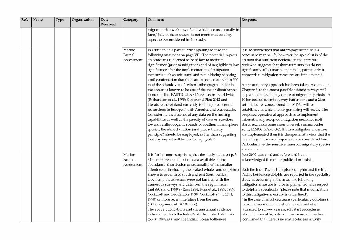
Ref. Name Type Organisation Date Received
Category Comment Response
migration that we know of and which occurs annually in June/ July in these waters, is not mentioned as a key aspect to be considered in the study.
Marine Faunal Assessment
In addition, it is particularly appalling to read the following statement on page VII: ‘The potential impacts on cetaceans is deemed to be of low to medium significance (prior to mitigation) and of negligible to low significance after the implementation of mitigation measures such as soft-starts and not initiating shooting until confirmation that there are no cetaceans within 500 m of the seismic vessel’, when anthropogenic noise in the oceans is known to be one of the major disturbances to marine life, PARTICULARLY cetaceans, worldwide (Richardson et al., 1995; Koper and Plön 2012 and literature therein)and currently is of major concern to researchers in Europe, North America and Australasia. Considering the absence of any data on the hearing capabilities as well as the paucity of data on reactions towards anthropogenic sounds of Southern Hemisphere species, the utmost caution (and precautionary principle!) should be employed, rather than suggesting that any impact will be low to negligible?!
It is acknowledged that anthropogenic noise is a concern to marine life, however the specialist is of the opinion that sufficient evidence in the literature reviewed suggests that short-term surveys do not significantly affect marine mammals, particularly if appropriate mitigation measures are implemented. A precautionary approach has been taken. As stated in Chapter 6, to the extent possible seismic surveys will be planned to avoid key cetacean migration periods. A 10 km coastal seismic survey buffer zone and a 2km seismic buffer zone around the MPAs will be established in which no air-gun firing will occur. The proposed operational approach is to implement internationally accepted mitigation measures (soft starts, exclusion zone around vessel, seismic buffer zone, MMOs, PAM, etc). If these mitigation measures are implemented then it is the specialist’s view that the overall significance of impacts can be considered low. Particularly as the sensitive times for migratory species are avoided.
Marine Faunal Assessment
It is furthermore surprising that the study states on p. 3-34 that’ there are almost no data available on the abundance, distribution or seasonality of the smaller odontocetes (including the beaked whales and dolphins) known to occur in of south and east South Africa’. Obviously the assessors were not familiar with the numerous surveys and data from the region from the1980’s and 1990’s (Ross 1984; Ross et al., 1987, 1989; Cockcroft and Peddemors 1990; Cockcroft et al., 1991, 1990) or more recent literature from the area (O’Donoghue et al., 2010a, b, c). The above publications and circumstantial evidence indicate that both the Indo-Pacific humpback dolphin (Sousa chinensis) and the Indian Ocean bottlenose
Best 2007 was used and referenced but it is acknowledged that other publications exist. Both the Indo-Pacific humpback dolphin and the Indo Pacific bottlenose dolphin are reported in the specialist study as occurring in the area. The following mitigation measure is to be implemented with respect to dolphins specifically (please note that modification to this mitigation measure is underlined): ‘In the case of small cetaceans (particularly dolphins), which are common in inshore waters and often attracted to survey vessels, soft start procedures should, if possible, only commence once it has been confirmed that there is no small cetacean activity

Ref. Name Type Organisation Date Received
Category Comment Response
dolphin (Tursiops aduncus) (migratory stock) are present in the area (Best, 2007). These species are currently listed as “vulnerable “ and “endangered”, respectively, in the South African Red Data Book (Peddemors et al., 2004; Peddemors and Oosthuizen 2004). The fact that we know so little about these small cetaceans off the Transkei coastline highlights an important data gap in our knowledge on these animals, particularly since the last studies on small cetaceans carried out in this region date back about 20 years ago. Thus we actually do not have any data outside the Sardine Run period or can assess the potential impact of the planned seismic surveys outside the whale migration (June –DEC).
within 500 m of the airguns, in particular the Indo-Pacific humpback dolphin (Sousa chinensis) or the Indo-Pacific Bottlenose Dolphin (Tursiops aduncus), listed in the South African Red Data Book as ‘vulnerable’ and ‘endangered’ respectively. If after a period of 30 minutes small cetaceans are still within 500 m of the airguns, the normal soft start procedure will be allowed to commence for at least a 20-minute duration. The MMO will monitor small cetacean behaviour during soft starts to determine if the animals display any observed negative responses to the airguns and gear or if there are any signs of injury or mortality as a direct result of seismic shooting operations.’
Although the limitation of available data is acknowledged, the mitigation measures to be implemented (including a 10km seismic buffer zone along the coast and a 2km seismic buffer zone around MPAs) support the findings of the impact assessment contained within Chapter 6.
Marine Faunal Assessment
In addition, a lot of the oceanographic references are also outdated and more recent literature should have been consulted, such as Lutjeharms 2006 and Roberts et al., 2010.
Comment noted.
Marine Faunal Assessment
In general, the document is a very poor assessment of the marine fauna in my eyes and I would suggest to contact local experts in the Eastern Cape for their input for any future assessment of this kind. In addition, it would be advisable to maintain close communication with the marine science community at both Nelson Mandela Metropolitan University (NMMU) and Rhodes University as well as the South African Institute for Aquatic Biodiversity (SAIAB) and the South African Environmental Observation Network (SAEON), since a number of research projects are currently being conducted or are planned for the proposed survey area, which may heavily be impacted by the seismic surveys.
Comment noted. A mitigation measure has been added to the Implementation Plan regarding specific notification of research organisations regarding the proposed surveys and communication with potential research projects.

Ref. Name Type Organisation Date Received
Category Comment Response

Impact Africa EMPr Transkei and Algoa Exploration Areas
PART B
Implementation Plan

CONTENTS
1 INTRODUCTION 1
1.1 OBJECTIVES 1
2 PLAN CONTENTS 2
2.1.1 Commitments 2 2.1.2 Guidelines and Standards 2 2.1.3 Management of Change 4 2.1.4 Subsidiary Plans 4 2.1.5 Monitoring 4
3 ROLES AND RESPONSIBILITIES 6
3.1.1 Exploration Area Operator 6 3.1.2 Programme Manager 7 3.1.3 Environment Control Officer (ECO) 7 3.1.4 Marine Mammal Observer (MMO) 7 3.1.5 Fisheries Liaison Officer (FLO) 8 3.1.6 Contractors 9 3.1.7 Vessel Master 10
4 MONITORING AND AUDITING 11
4.1 REPORTING 11 4.1.1 Reporting during Final Planning 11 4.1.2 Public Disclosure and Notification Prior to Start 11 4.1.3 Status Reporting During Surveys 12 4.1.4 Close-out Reporting 12
5 ENVIRONMENTAL REQUIREMENTS 13

IMPACT AFRICA PART B: IMPLEMENTATION PLAN TRANSKEI AND ALGOA EXPLORATION AREAS
ENVIRONMENTAL RESOURCES MANAGEMENT MAY 2013
DRAFT FOR PUBLIC COMMENT
1
1 INTRODUCTION
This section provides the plan for the implementation of the requirements and recommendations identified through the impact assessment process. It provides a description of the environmental management organisation (including roles and responsibilities); and monitoring and auditing requirements. It also provides a detailed description of the mitigation measures that the operator will implement to verify protection of environmental resources.
1.1 OBJECTIVES
The objectives of this plan are to: • verify compliance with applicable South African legislation and other
requirements; • demonstrate to regulators and stakeholders that environmental issues
have been addressed and that plans are in place to verify protection of environmental resources;
• provide a means for verifying that mitigations are implemented and
environmental impacts are managed; • provide a means for verifying that mitigations are being properly
implemented and that they are effective through monitoring, inspection, and auditing; and
• provide a mechanism for identifying and mitigating impacts that may be
determined in the future.

IMPACT AFRICA PART B: IMPLEMENTATION PLAN TRANSKEI AND ALGOA EXPLORATION AREAS
ENVIRONMENTAL RESOURCES MANAGEMENT MAY 2013
DRAFT FOR PUBLIC COMMENT
2
2 PLAN CONTENTS
2.1.1 Commitments
The mitigation measures that were identified in the impact assessment along with the mitigations that are ‘built in’ to the project design (in the way of technology specifications or operational controls) form the operator’s environmental management commitments. The commitments are consolidated and tabulated in this plan and provide: • comprehensive listing of the actions that the operator will implement
according to project phase and activity; • designation of responsibilities for verifying implementation of that action; • source of the mitigation measure or standard; • timing and/or frequency of the action; and • requirements for the close-out report. The Implementation Plan also serves as a set of specifications that will define the survey contractors’ environmental responsibilities at the tendering stage. Timing and immediate responsibility for implementing each commitment will be agreed between the operator and its contractors. While the operator may require contractors to execute certain actions, the operator will remain ultimately responsible for the implementation.
2.1.2 Guidelines and Standards
Environmental issues relevant to aspects of the proposed exploration activities are governed or guided by the following standards: • Applicable South African legislation; • Operator’s environmental, health and safety policy; and • Recognised industry codes of practice (e.g. International Association for
Geophysical Contractors (IAGC), International Petroleum Industry Environmental Conservation Association (IPIECA) and Joint Nature Conservation Committee (JNCC); and
• International Convention for the Protection of Pollution from Ships MARPOL 73/78.
Specific to seismic surveys, guidelines have been developed by a number of countries and organisations to protect marine mammals and / or turtles during seismic surveys. Guidelines were issued by the UK Joint Nature Conservation Committee (JNCC, 2009), and are used internationally as guidance for seismic surveys. National guidelines have also been developed by Brazil, Canada, and New Zealand (Weir et al, 2006).

IMPACT AFRICA PART B: IMPLEMENTATION PLAN TRANSKEI AND ALGOA EXPLORATION AREAS
ENVIRONMENTAL RESOURCES MANAGEMENT MAY 2013
DRAFT FOR PUBLIC COMMENT
3
All national guidelines require a safety exclusion zone and visual observation to monitor the zone before beginning the survey each time. The exclusion zone is required to be clear for 20–30 minutes before start-up of the sound source. All guidelines specify that a ‘soft-start’ be used to allow marine mammals and turtles (and other marine animals) to move away from the seismic activities. The soft-start procedure requires that the seismic sound source begins softly and increases over 20 to 40 minutes. In addition, JNCC guidelines recommend that the surveys be scheduled to avoid breeding and calving seasons. For this project, adherence to the JNCC seismic survey guidelines is specified, with two additions, namely that sea turtles be included in the visual monitoring prior to start-up and that sound source shutdown occurs if a whale or sea turtle enters the 500 m safety zone during seismic acquisition (rather than 300 m). The operator will also require that the seismic contractor be a member of the IAGC and adhere to the organisation’s code of practice. Guidelines have also been developed by the JNCC for marine sonar operations and will be implemented as mitigation measures for the multi-beam bathymetric survey component of this project. MARPOL, 1973
South Africa acceded to the International Convention for the Protection of Pollution from Ships (MARPOL) and to its 1978 Protocol by means of Resolution No. 5/2003, of 25 February 2003. MARPOL places restraints on the contamination of the sea, land and air by ships. MARPOL comprises two protocols dealing respectively with reports on incidents involving harmful substances and arbitration; and five annexes which contain regulations for the prevention of various forms of pollution: • Annex I - Prevention of Pollution by oil; • Annex II - Control of pollution by noxious substances; • Annex III - Harmful substances carried in packaged form; • Annex IV - Prevention of pollution by sewage; and • Annex V - Prevention of pollution by garbage from ships. The Southern South African waters have been designated a ‘special area’ in terms of MARPOL. Special areas are afforded higher levels of protection and therefore require additional mandatory methods for the prevention of sea pollution particularly to additional requirements within Annex I: Prevention of Pollution by Oil. All vessel operations will need to adhere to MARPOL requirements including the additional methods for prevention of sea pollution.

IMPACT AFRICA PART B: IMPLEMENTATION PLAN TRANSKEI AND ALGOA EXPLORATION AREAS
ENVIRONMENTAL RESOURCES MANAGEMENT MAY 2013
DRAFT FOR PUBLIC COMMENT
4
2.1.3 Management of Change
The plan commitments will be further refined as activity proceeds and detailed working methods are developed. Revisions to this plan are envisaged as a result of the following: • introduction of new parameter or methodology that could change the
environmental impact or require amendment to existing mitigation measures;
• changing environmental requirements or standards; or • as a result of audit or incident. Although modifications to some of the measures specified in this plan are envisaged, there will be one overriding principle: that none of these measures will be omitted or diluted without further assessment and reporting of the impact.
2.1.4 Subsidiary Plans
The operator will develop the following, which will be subsidiary to and form part of the overall Environmental Management System: • Emergency Response Plan; • Geophysical Contractor Emergency Response Plan; • Helicopter Operator Emergency Response Plan; • Stakeholder Communication Plan; and • Oil Spill Contingency Plan. These plans must contain measures designed to manage these specific aspects and include designations of persons responsible for the implementation, timeframes, resources, legal standards and monitoring and auditing requirements to be able to verify compliance. The operator will need to submit these plans to PASA for their approval prior to commencement of activities. As further planning proceeds and contractors are appointed, additional specific plans and procedures may be required to be developed for the management of issues such as shipboard waste and effluent. The operator will be required to develop these plans with the necessary specialist input, and will submit these to PASA for their approval. The operator will be responsible for implementation of these plans and any additional measures.
2.1.5 Monitoring
This plan makes provision for regular monitoring to achieve the following objectives:

IMPACT AFRICA PART B: IMPLEMENTATION PLAN TRANSKEI AND ALGOA EXPLORATION AREAS
ENVIRONMENTAL RESOURCES MANAGEMENT MAY 2013
DRAFT FOR PUBLIC COMMENT
5
• verify that the specified requirements are implemented; • assess the effectiveness of the mitigation measures with respect to the
predicted impacts; • provide on-going feedback to authorities and stakeholders; and • gather environmental performance data for close-out reporting.

IMPACT AFRICA PART B: IMPLEMENTATION PLAN TRANSKEI AND ALGOA EXPLORATION AREAS
ENVIRONMENTAL RESOURCES MANAGEMENT MAY 2013
DRAFT FOR PUBLIC COMMENT
6
3 ROLES AND RESPONSIBILITIES
This section defines the roles and responsibilities for the entities involved in the exploration activities. These include following: • Exploration Area Operator; • Programme Manager; • Environmental Control Officer (ECO); • Fisheries Liaison Officer (FLO); • Marine Mammal Observer (MMO); • PAM Operator; • Contractor; and • Vessel Master.
3.1.1 Exploration Area Operator
The Exploration Area Operator (operator) has the overall responsibility for all Safety, Health and Environmental (SHE) matters. As part of this, the operator will ultimately be responsible for carrying out all exploration activities safely and in accordance with the requirements of the EMPr. The operator will verify that the EMPr requirements and other SHE related requirements are implemented in full, both by operator staff and by contractors. During the exploration activities, the operator will be responsible for the management of medical and health issues and the provision of appropriate care. The operator will verify there are sufficient plans and resources in place for worker health care and contingency plans to respond to workplace accidents. The plans for this will be documented in Safety, Health and Environment Management Plan (to include an Emergency Response Plan). A pre-operational start-up induction on SHE requirements will be conducted by the operator with contractors prior to commencement of the activities. As part of their operating and SHE procedures, the operator will undertake regular environmental, social, safety and health inspections and provide reports that enable the operator to monitor and evaluate performance against the measures and objectives established in the EMPr. Exact details of the planned exploration activities including the details of the seismic survey (including coordinates of seismic lines, schedule and seismic vessel specifications) will be submitted in advance of the operations to PASA for approval. The operator will be ultimately responsible for all other operations permissions including relevant clearances, permits, licences and necessary

IMPACT AFRICA PART B: IMPLEMENTATION PLAN TRANSKEI AND ALGOA EXPLORATION AREAS
ENVIRONMENTAL RESOURCES MANAGEMENT MAY 2013
DRAFT FOR PUBLIC COMMENT
7
approvals from the relevant authorities prior to commencing the seismic survey.
3.1.2 Programme Manager
The operator will designate a programme manager who will have overall responsibility for the execution of all phases of the of the planned exploration activities. The programme manager will be directly responsible for the appointment and management of contractors and the ECO.
3.1.3 Environment Control Officer (ECO)
The operator will appoint an Environmental Control Officer (ECO) to verify the implementation of the requirements of the EMPr. The ECO will focus on verifying and assessing compliance with the Implementation Plan through monitoring, auditing and reporting (Section 4) and verifying that the Fisheries Liaison Officer (FLO) and Marine Mammal Observers (MMOs) carry out their required functions. This will include compilation of reports and submission of these reports to the programme manager and PASA. In particular, the ECO is responsible for the following: • Verification of the implementation of the measures contained within the
EMPr; • Regular monitoring of progress towards objectives and targets within the
EMPr; • Conducting regular inspections; and • Compilation of reports for submission to the programme manager and
PASA on the status of EMPr implementation.
3.1.4 Marine Mammal Observer (MMO)
Qualified and independent Marine Mammal Observers (MMOs) (also referred to as Independent Observers (IOs)) will be used during the seismic and multibeam seabed bathymetry surveys. The MMOs will carry out observations during daylight hours (during operations) of the survey area and record presence and responses of marine mammals, turtles and seabirds to exploration activities, including distance from the vessel, swimming speed and direction and observed changes in behaviour and displacement or attraction. It is important that the identification and the behaviour of the animals are recorded accurately along with noise levels, if PAM is required. Furthermore MMOs must: • Record incidence of feeding behaviour of predators within the
hydrophone streamers (mass disorientation and stunning of fish by seismic surveys is unlikely, although if it occurs, may result in attraction of predatory seabirds, sharks and mammals);

IMPACT AFRICA PART B: IMPLEMENTATION PLAN TRANSKEI AND ALGOA EXPLORATION AREAS
ENVIRONMENTAL RESOURCES MANAGEMENT MAY 2013
DRAFT FOR PUBLIC COMMENT
8
• Record all initiation of seismic firing activity and associated soft starts and pre-firing observation regimes; and
• Have experience in both cetacean identification, and observation techniques; in particular, the MMO will have experience in identification and differentiation of both large baleen whale and beaked whale species.
While the MMO will report to the ECO, the MMO will be required to acknowledge and act in accordance with the authority of the Vessel Master while on-board and during operations. The MMO has the authority to stop the survey activities (including seismic shooting) in response to certain circumstances related to marine mammal risk. However, due to the cost associated with terminating activities (e.g. an entire survey line may need to be repeated), it is recommended that the decision to terminate firing be made by the operator in consideration of the MMO’s advice. The MMOs must provide full reporting of all termination decisions (including behaviour and distance of marine mammals) in a daily close out report.
3.1.5 PAM Operator
If necessary, the seismic survey vessel will be fitted with PAM technology and efforts are to be made for the multibeam bathymetric vessel to also be fitted with PAM technology. A suitably qualified PAM operator will be appointed to verify that the PAM system functions correctly and results can be interpreted. The JNCC (2010) guidelines regarding the use of PAM technology, including the determination of range and delays to soft starts, will be implemented. In the absence of visual confirmation, the detection of large cetaceans by the PAM operators, within 500m of the vessel, will require a delay in the start of soft-starts. While the PAM operator will report to the ECO, the PAM operator will be required to acknowledge and act in accordance with the authority of the Vessel Master while on-board and during operations. If it is necessary for PAM to operate 24 hours a day (see details in No. 3.6) the PAM operator will liaise directly with the MMO regarding marine mammal detections during the daylight hours. The PAM operator must keep records of all detections and delays to soft starts and this input should be included in the reporting compiled by the ECO.
3.1.6 Fisheries Liaison Officer (FLO)
The operator will appoint a dedicated Fisheries Liaison Officer (FLO) to conduct pre-survey consultation with fishing operators and organisations, and to assist with fishing issues before, during and after survey activities. The FLO position is central to the process of mitigating potential impacts on

IMPACT AFRICA PART B: IMPLEMENTATION PLAN TRANSKEI AND ALGOA EXPLORATION AREAS
ENVIRONMENTAL RESOURCES MANAGEMENT MAY 2013
DRAFT FOR PUBLIC COMMENT
9
fishing activities. Appointment of the FLO will be undertaken with enough time to establish a working relationship with the fishing industry and fisheries regulators. The role of the FLO will include (see Part C for additional details): • Establishing a system of communication with local fishing enterprises (and
government fisheries agencies) in advance of surveys; • Communicating details of the surveys to fishing operators, including the
survey plan and schedule, in advance of commencing activities; • Communicating updates (including changes) to fishing operators during
the course of survey activities; • Liaising with fishing operators with regard to grievances; and • Coordinating with chase boats during surveys with regards to
communicating with fishing operators in the area. The FLO will be required to acknowledge and act according to the authority of the Vessel Master, while on-board the seismic vessel. The FLO will report directly to the ECO. As recommendation, the FLO could also be responsible for establishing communication, the dissemination of details, and coordination of queries with tourist operators in the area.
3.1.7 Contractors
The operator will appoint contractors to undertake the various exploration activities including seismic surveys on their behalf. The contractor will be selected through a process that verifies their qualifications to carry out the work and contractors will be required to comply with environmental requirements through contractual obligations. Contractor requirements with respect to environmental controls will be made available the tender stage to give contractors opportunity to budget time, resources and costs. As part of the selection process, contractors will need to demonstrate to the operator’s satisfaction how compliance with the requirements will be carried out. This will be verified through review and approval of contractor’s detailed plans for complying with environmental requirements prior to selection. Contractors will also be required to demonstrate commitment to the requirements at all levels of management and contractors will be required to identify individuals responsible for environmental during the operations. In the selection process, special attention will be paid to international reputation, qualifications, accreditations, relevant experience and past performance. All seismic survey contractors will be required to be a member of the IAGC.

IMPACT AFRICA PART B: IMPLEMENTATION PLAN TRANSKEI AND ALGOA EXPLORATION AREAS
ENVIRONMENTAL RESOURCES MANAGEMENT MAY 2013
DRAFT FOR PUBLIC COMMENT
10
Contractors will be responsible for training of their staff and for ensuring that staff are fully qualified, sufficiently experienced and certified in accordance with the operator’s requirements.
3.1.8 Vessel Master
Exploration activities will involve the operation of marine vessels. Each survey will be carried out under the management of the Vessel Master who will have overall authority and responsibility for ship’s operation and navigation, and safety of the vessel and the crew in accordance with applicable laws and regulations. The Vessel Master will train, or verify that the crew receives the necessary training with regard to on-board safety and environmental control requirements.

IMPACT AFRICA PART B: IMPLEMENTATION PLAN TRANSKEI AND ALGOA EXPLORATION AREAS
ENVIRONMENTAL RESOURCES MANAGEMENT MAY 2013
DRAFT FOR PUBLIC COMMENT
11
4 MONITORING AND AUDITING
The operator will undertake regular checks and audits in accordance with the requirements of this EMPr. The operator will be responsible for monitoring, surveillance and decision-making on all matters related to environmental protection during operations. In addition to assessing operational aspects and monitoring, checks will assess compliance with agreed objectives and targets, and the effectiveness of the EMPr and its implementation. The EMPr will therefore be subject to on-going review and development to verify that is remains appropriate to the exploration activities. Monitoring and auditing findings will be reviewed by the operator and where corrective actions are deemed necessary, specific actions will be developed, with designated responsibility and timing, and implemented. In this way, continuous improvement in performance will be achieved.
4.1 REPORTING
4.1.1 Reporting during Final Planning
The operator will submit formal notification to PASA prior to initiating major exploration activity. Notification will include details of the activity location, survey schedules, vessel specifications and contractor details. Specifically for the seismic surveys, notification will include specification of the airguns, array, and streamer lengths.
4.1.2 Public Disclosure and Notification Prior to Start
The operator will notify the public and mariners of planned exploration activities. Surveys will be disclosed by public notice at least 30 days prior to commencement of survey activities. The operator will announce the activities in newspaper local to the survey area. Notification to mariners will be made through the SAN Hydrographic office and the Port Captains of the Ports of Cape Town, Port Elizabeth and Durban. In addition, the operator will notify operators of the neighbouring exploration areas. Fishing operators will be notified through recognised fishing associations and Marine and Coastal Management Section of DEA (e.g. the RSA Deep Sea Trawling Association, Inshore Pelagics, Rock Lobster and Tuna associations). The FLO will co-ordinate this notification and will hold at least one meeting with fishing operators to discuss mitigation measures and avoidance planning during the survey.
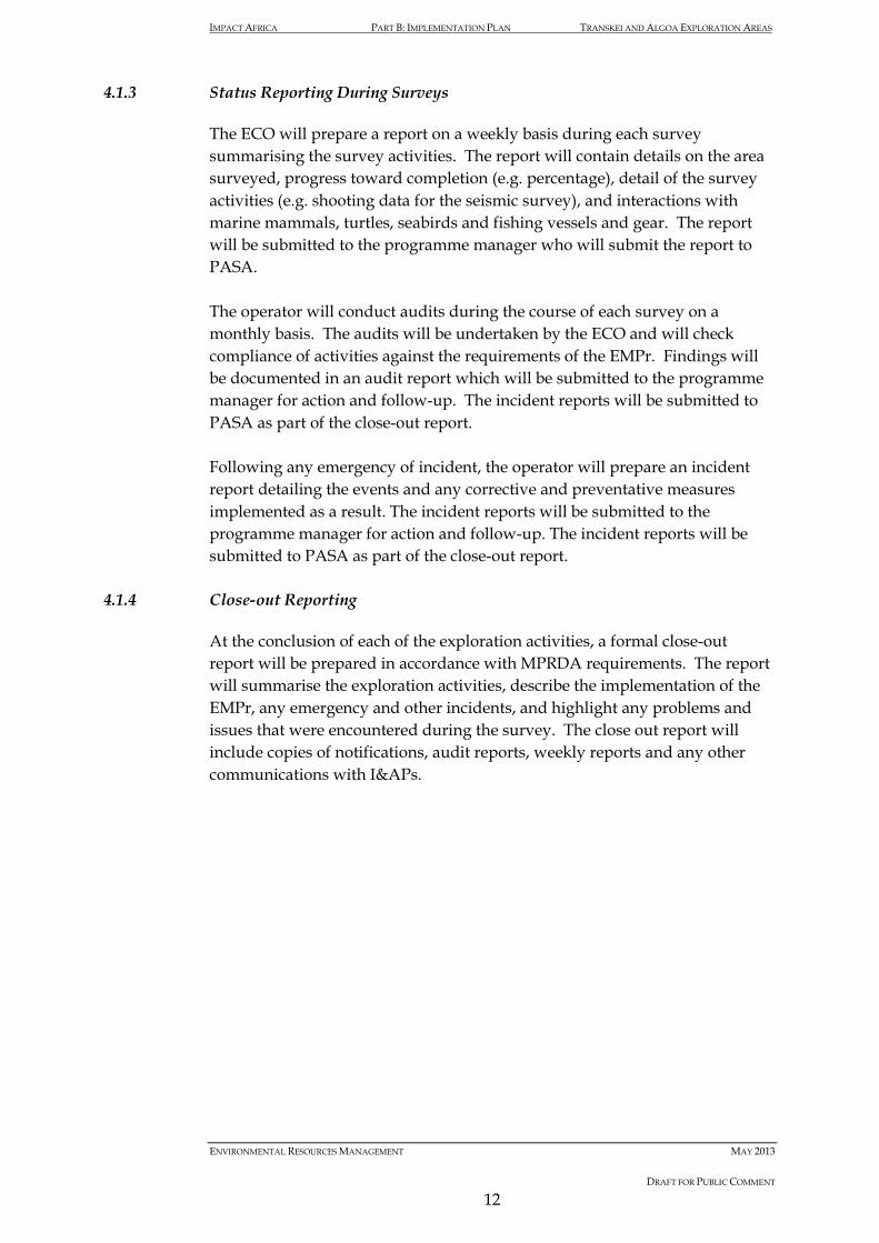
IMPACT AFRICA PART B: IMPLEMENTATION PLAN TRANSKEI AND ALGOA EXPLORATION AREAS
ENVIRONMENTAL RESOURCES MANAGEMENT MAY 2013
DRAFT FOR PUBLIC COMMENT
12
4.1.3 Status Reporting During Surveys
The ECO will prepare a report on a weekly basis during each survey summarising the survey activities. The report will contain details on the area surveyed, progress toward completion (e.g. percentage), detail of the survey activities (e.g. shooting data for the seismic survey), and interactions with marine mammals, turtles, seabirds and fishing vessels and gear. The report will be submitted to the programme manager who will submit the report to PASA. The operator will conduct audits during the course of each survey on a monthly basis. The audits will be undertaken by the ECO and will check compliance of activities against the requirements of the EMPr. Findings will be documented in an audit report which will be submitted to the programme manager for action and follow-up. The incident reports will be submitted to PASA as part of the close-out report. Following any emergency of incident, the operator will prepare an incident report detailing the events and any corrective and preventative measures implemented as a result. The incident reports will be submitted to the programme manager for action and follow-up. The incident reports will be submitted to PASA as part of the close-out report.
4.1.4 Close-out Reporting
At the conclusion of each of the exploration activities, a formal close-out report will be prepared in accordance with MPRDA requirements. The report will summarise the exploration activities, describe the implementation of the EMPr, any emergency and other incidents, and highlight any problems and issues that were encountered during the survey. The close out report will include copies of notifications, audit reports, weekly reports and any other communications with I&APs.

IMPACT AFRICA PART B: IMPLEMENTATION PLAN TRANSKEI AND ALGOA EXPLORATION AREAS
ENVIRONMENTAL RESOURCES MANAGEMENT MAY 2013
DRAFT FOR PUBLIC COMMENT
13
5 ENVIRONMENTAL REQUIREMENTS
This section details the environmental requirements and specific actions required to address issues raised by specialists, government and other marine resource managers, users and interested and affected parties. Requirements are presented in tabular form and organised to align with the phases of each exploration activity.

IMPACT AFRICA PART B: IMPLEMENTATION PLAN TRANSKEI AND ALGOA EXPLORATION AREAS
ENVIRONMENTAL RESOURCES MANAGEMENT MAY 2013
DRAFT FOR PUBLIC COMMENT
14
Box 5.1 Organisation of Environmental Requirements
1. PRE-ESTABLISHMENT PHASE 1.1 Pre-survey planning 1.2 Financial provision 1.3 Preparation for emergencies 1.4 Approval of EMPr and Environmental Notifications 1.5 Appointment of survey Contractor 1.6 Liaison with and notification of key stakeholders regarding survey details 1.7 Planning of Airborne Geophysical Surveys 2. ESTABLISHMENT PHASE 2.1 Compliance with legal requirements 2.2 – 2.4 Notification of other marine users 2.5 Safety zone determination 3. OPERATIONAL PHASE 3.1 Compliance with legal requirements 3.2 Communication with other users of the sea and stakeholders 3.3 Management of the Seismic Vessel Exclusion Zone 3.4 – 3.9 Acoustic emissions from seismic sources (Impact to Marine Biota) 3.10 Acoustic emissions from seismic sources (Impact to Underwater Users) 3.11 Multibeam Bathymetric Survey Operations 3.12 Seabed Sampling Activities 3.13 Prevention of emergencies 3.14 – 3.17 Emergency response 3.18 – 3.25 Pollution control and waste management 3.26 Equipment loss 3.27 Oil bunkering / refuelling at sea 3.28 Airborne surveys and logistical helicopter support 3.29 Monitoring during the survey 3.30 Reporting during the survey 4. DECOMMISSIONING AND CLOSURE PHASE 4.1 Survey vessel to leave area 4.2 Inform relevant stakeholders and mariners of survey completion 4.3 Final waste disposal 5. MONITORING, AUDITING AND REPORTING PHASE 5.1 Monitoring compliance auditing and the submission of information 5.2 Monitoring activities and effects 5.3 Compile Close out report for activities related to environmental management

Table 5.1 Implementation Plan
Project Phase and Activities
Environmental Objectives
No Auditable Management Actions to be taken to meet the EMPr Report Objectives
Sources of instructions
Responsibility Frequency/ Timing Close-out Report Requirements
1. Pre-establishment Phase (pre-survey) Pre-survey planning
Reduce environmental impact of surveys Planning to be able to implement mitigation measures during the operational phase
1.1 Finalise negotiations and resolve any conflict over the allocation of user fishing/ mining/ exploration rights prior to the commencement of operation. Establish whether or not a local fishing vessel should be chartered to function as a ‘sweeper’ vessel (checking ahead of the vessel for any unattended fishing gear). If such a vessel is also to perform the functions of a chase /support vessel, verify that it is appropriately licensed by the South African Marine Safety Authority (SAMSA) to perform these functions. Make provision for an adequately qualified and experienced fisheries liaison officer (FLO) to be on board the survey vessel for the duration of the survey. Make provision for an adequately trained Marine Mammal Observer (MMO) to be onboard during the seismic and multibeam bathymetric surveys. Develop a monitoring programme for monitoring of marine mammal interactions and fishing catches.
Generic Operator Prior to commencement of the survey
Environmental Control Officer’s report
Financial provision
Compliance with legislative requirements
1.2 Verify that financial provision is in place to execute the requirements of this EMPr.
Mineral and Petroleum Resources Development Act (Act 28 of 2002) (MPRDA) and MPRDA Regulations GN 527 of 2004
Operator Prior to commencement of the survey
Confirm that financial provision has been made for the Implementation Plan
Preparation for emergencies
Preparation for any emergency that
1.3 Have the following emergency plans, procedures, equipment and personnel in place to deal with all
Department of Mineral Resources (DMR),
Operator and survey contractor
Prior to commencement of the survey
Confirm compliance and justify any

Project Phase and Activities
Environmental Objectives
No Auditable Management Actions to be taken to meet the EMPr Report Objectives
Sources of instructions
Responsibility Frequency/ Timing Close-out Report Requirements
could result in an environmental impact
emergencies: • Company (or representative) Emergency Response Plan • Geophysical Contractor Emergency Response Plan • Helicopter Operator Emergency Response Plan • South African Search and Rescue (SASAR) Manual • Note that in case of a major oil spill from the vessel,
emergency responses and/or Oil Pollution Emergency Plan(s) must refer to the coastal oil spill contingency plan(s) of the South African Department of Environmental Affairs
In addition to the above, verify that: • There is adequate protection and indemnity insurance
cover for oil pollution incidents • There is a record of the vessel’s seaworthiness certificate
and/or classification stamp
Petroleum Agency and DEA Requirements
omissions
Approval of EMPr and environmental notification
Compliance with legislative requirements
1.4 Verify that the following documents have been approved by PASA: • EMPr for sub-lease area • Standard or Expanded Environmental Notification
document
MPRDA and MPRDA Regulations GN 527 of 2004
Operator Prior to commencement of the survey
Appointment of survey contractor
Compliance with the Implementation Plan
1.5 For the seismic survey, appoint a contractor who is registered with the International Association for Geophysical contractors (IAGC) and therefore familiar with international best practice and understands the commitments of the EMPr.
Operator Prior to commencement of the survey
Liaison with and notification of key stakeholders regarding survey details
Timeous notification of all relevant stakeholder to verify effective planning and minimise disturbance and interference
1.6 FLO is to identify all commercial fishing operators and recreational charter companies that frequent the seismic survey area to verify that all stakeholders are notified and kept informed of the seismic activities.
An appropriate stakeholder communication plan is to be developed to guide the consultation, communication with and notification of stakeholders. This would include the
Operator At least two weeks prior to commencement of survey
Documentation of notification

Project Phase and Activities
Environmental Objectives
No Auditable Management Actions to be taken to meet the EMPr Report Objectives
Sources of instructions
Responsibility Frequency/ Timing Close-out Report Requirements
identification of and consultation with, relevant government departments, ports authorities, maritime associations, fishing associations and other stakeholders.
Stakeholders are to be advised of planning programme in good time, checks to be made regarding the dissemination of warnings at a regional and local level and follow-up to verify that information has been received as well as feedback obtained on the adequacy.
Planning of Airborne Geophysical Surveys
Minimise disturbance to migratory cetaceans
1.7 Avoid planning airborne geophysical surveys during the movement of migratory cetaceans (particularly baleen whales) from their southern feeding grounds into low latitude waters (June to November). As no seasonal patterns of abundance are known for odontocetes occupying the proposed Exploration Area, a precautionary approach to avoiding impacts throughout the year is recommended.
Flight paths must be pre-planned to avoid flying occurs over bird and seabird colonies, coastal reserves or marine islands as far as possible. No flights within Marine Protected Areas (MPAs).
Specialist guidance Operator During survey planning
2. Establishment Phase (survey mobilisation) Compliance with legal requirements
Permit holder and contractor to commit to adherence to legal requirements
2.1 Verify that a copy of the approved EMPr is on the vessel during the survey. Train all relevant shipboard personnel on the purpose and requirements of the EMPr. Verify correct equipment, personal protective equipment (PPE) and personnel are available to meet the requirements of the EMPr. Commit to operator and contractor compliance with the EMPr. The regulations for Boat-based Whale Watching and
MPRDA and MPRDA Regulations GN 527 of 2004 Marine Living
Programme Manager, Vessel Master and ECO
Prior to commencement of the survey
Copy of EMPr signed for by vessel Master and/or operator’s representative on board

Project Phase and Activities
Environmental Objectives
No Auditable Management Actions to be taken to meet the EMPr Report Objectives
Sources of instructions
Responsibility Frequency/ Timing Close-out Report Requirements
Protection of Turtles (R 725) as part of the Marine Living Resources Act (Act No. 18 of 1998) stipulate that an aircraft or survey vessel must maintain a minimum distance of 300 m from any whale. As this may be both impractical and impossible, an exemption permit must be applied for through the Department of Environmental Affairs and Tourism.
Resources Act (Act No. 18 of 1998)
Notification of other marine users
Verify that other marine resource users are aware of the forthcoming survey
2.2 Verify that seismic vessel communication systems are in working order. In writing, request the SAN Hydrographic Office, Silvermine, to put out Radio Navigation Warnings throughout the survey. Inform the relevant Port Captains of planned operations (at minimum Ports of Cape Town and Port Elizabeth).
Safety of Life at Sea Convention and Maritime Safety Authority Act 5 of 1998 EMPr requirements
Programme Manager and Vessel Master
Notice to mariners to be issued 24 hours prior to start
Confirm that notices were sent to relevant parties Provide copy of standard notice and list of those to whom it was sent
2.3 Prior to the commencement of the survey, the fishing industry, DAFF (Branch: Fisheries) and other IAPs should be consulted and informed of the pending activity and the likely implications for the various fishing sectors in the area as well as research surveys planned to coincide with the proposed seismic operations. IAPs should include; South African Deepsea Trawling Industry Association (SADSTIA), South East Coast Inshore Fishery Association (SECIFA), Small Hake Quota Holders Association, South African Tuna Longline Association, Hake Longline Association, South Coast Rock Lobster Association, Shark Longline Association, South African Marine Linefish Management Association (SAMLMA) and Blue Continent Products. Appointment of a fisheries liaison officer (FLO) to communicate with and meet with the various fisheries stakeholders and to inform all fishery stakeholders of the seismic plan and associated timeframes. The FLO should liaise with all affected fishing vessels, particularly all lobster
Specialist guidance Programme Manager and FLO
All 30 days prior to commencement of the survey

Project Phase and Activities
Environmental Objectives
No Auditable Management Actions to be taken to meet the EMPr Report Objectives
Sources of instructions
Responsibility Frequency/ Timing Close-out Report Requirements
fishing vessels as well as those involved in midwater trawl activities in the region to plan the placing of fishing gear, if possible, or provide additional notice of the areas of exclusion. Verify that the survey area is free of fishing gear that could be physically contacted prior to the seismic vessel undertaking its operation in that area. This should be arranged through an FLO and his/her land-based communication network. Advertise the start of the seismic surveys in at least two local newspapers providing details of the confirmed seismic survey area and scheduled dates for start and completion of the survey. A communication plan with regards to the exploration activities timing and potential impacts should be implemented. The communication plan should include information on the grievance mechanism as outlined in Chapter 4 of the EMPr. Direct notification of tourism operators in the area between Jeffery’s Bay in the west, to Port Shepstone in the east should be undertaken prior to the exploration activities. If formally requested, notification of relevant individuals at local research organisations (including Nelson Mandela Metropolitan University (NMMU) and Rhodes University as well as the South African Institute for Aquatic Biodiversity (SAIAB) and the South African Environmental Observation Network (SAEON)) regarding the timing of proposed surveys.
2.4 Notify overlapping and neighbouring users with delineated boundaries in the offshore petroleum and offshore mineral prospecting/mining industries.
Generic EMPr Programme Manager
30 days prior to commencement of the survey
Copies of notification
Safety zone Confirm 500 m 2.5 Once seismic source levels are known the safety distances Programme Prior to

Project Phase and Activities
Environmental Objectives
No Auditable Management Actions to be taken to meet the EMPr Report Objectives
Sources of instructions
Responsibility Frequency/ Timing Close-out Report Requirements
determination safety zone distance for marine fauna
will be calculated using transmission loss models and verified on site. Use of the lowest practicable airgun volume shall be defined and enforced A conservative safety distance is defined by received sound pressure levels of 180dB re 1 μPa (rms) for baleen and sperm whales, and 210 dB re 1 μPa (rms) for toothed whales. Either this safety zone distance, or 500 m, whichever is larger, will be used for all seismic and multibeam bathymetric activities in the concession area
Manager in consultation with the MMO
commencement of the survey
3. Operational Phase Compliance with legal requirements
Operate in an environmentally responsible manner
3.1 All activities must comply fully with the EMPr, which includes undertaking all activities successfully and record details and include these in the close-out report
Subscribe to the principles of an internationally acceptable Environmental Management System onboard the vessels. This includes environmental awareness training, waste management and environmental monitoring, record keeping and continuous improvement. Comply with the ‘Environmental Guidelines for Worldwide Geophysical Operations’ issued by the IAGC
MPRDA and MPRDA Regulations GN 527 of 2004 PASA requirements IAGC Guidelines
Programme manager
Throughout programme
Communication with other users of the sea and stakeholders
Promote co-operation and successful multiple uses of the sea, including promotion of safe navigation
3.2 Keep the following interested and affected parties updated on the survey through normal communication channels (including progress notices via email), Radio Navigation Warnings and Notices to Mariners: • Overlapping and neighbouring users with delineated
boundaries in the marine petroleum and mineral prospecting and mining industries
• South African and foreign fishing vessels, who can be informed through the recognized fishing associations and Department of Environmental Affairs, examples include the South African Deep Sea Trawling Association
• Other relevant fisheries organisations as listed in Activity 2.3
PASA EMPr requirements Maritime Safety Authority Act (Act 5 of 1998)
Programme manager and –Vessel Master
During compilation of initial and final EMPr, as well as during operations as required
Provide copy of written notices and list of those to whom it was sent

Project Phase and Activities
Environmental Objectives
No Auditable Management Actions to be taken to meet the EMPr Report Objectives
Sources of instructions
Responsibility Frequency/ Timing Close-out Report Requirements
• Government Departments with jurisdiction over marine activities, particularly DEA, DMR, and PASA, SAN Hydrographer, South African Maritime Safety Authority (SAMSA), DAFF (Fisheries) and local Port Captains
• The FLO will liaise with fishing operators
Management of the vessel exclusion zone
Minimise disruption to other legitimate users of the sea by respecting their rights
3.3 Co-operate with other legitimate users of the sea to minimize disruption to other marine activities and marine life. Particular attention must be paid to verify good co-operation and information dissemination to fisheries operators. Keep constant watch for approaching vessels during operations. Warn by radio and chase boat (if required). Use effective communication channels (see Activity 3.2) to inform all other potential users about the survey location, timing, priority of passage safety, exclusion zones and general safety distances.
Marine Traffic Act and International Law of the Sea EMPr requirements
Programme manager and Vessel Master
Throughout Planning and Operational phase
Record any incidents outside of normal occurrence
Management of the MPA Exclusion and Buffer Zones
Minimise disruption to the Marine Protected Area and coastline
3.4 No exploration activities are to occur within the Marine Protected Areas (MPAs). No firing of seismic airguns within 10km of the coastline and within 2km of the MPAs.
Specialist guidance and EMPr
Vessel Master and ECO
Throughout Planning and Operational Phase
Record any incidents outside of normal occurence
Acoustic emissions from sound sources
Reduce disturbance of marine biota (1)
3.5 Limit, as far as possible, the energy of produced sound to those frequencies required for the survey
IAGC procedures and specialist advice EMPr requirements
Vessel Master Prior to and during the survey
Provide copies of completed activity log
3.6 Survey vessels will accommodate dedicated independent MMOs with experience in marine mammal, turtle and seabird identification and observation techniques, to carry out continuous daylight observations of the survey region
IAGC procedures and specialist advice EMPr requirements
Vessel Master and MMO
Prior to and during the survey
Provide copies of completed marine fauna observation
(1) These measures assume that every attempt has been made to carry out the seismic survey during periods in which the area concerned is not a critical habitat to marine fauna (e.g. within whale migration, turtle hatching etc)

Project Phase and Activities
Environmental Objectives
No Auditable Management Actions to be taken to meet the EMPr Report Objectives
Sources of instructions
Responsibility Frequency/ Timing Close-out Report Requirements
and record incidence of marine mammals, turtle and seabird occurrence in the area of survey activities and responses to seismic shooting. Data collected will include position, distance from the vessel, swimming speed and direction, and observed changes in behaviour (e.g. startle responses or changes in surfacing/diving frequencies, breathing patterns). Both the identification and the behaviour of the animals must be recorded accurately along with current seismic noise levels. During night-time line changes low level warning airgun discharges at regular intervals are recommended in order to keep animals away from the survey operation while the vessel is repositioned for the next survey line. This will be done at the discretion of the ECO/MMO and will not occur when the vessel is turning within the defined seismic buffer zones or exclusion zone. All data recorded by MMOs will at minimum form part of a survey close–out report. Furthermore, daily or weekly reports will be forwarded to the necessary authorities to verify compliance with the mitigation measures. Marine mammal, turtle and seabird incidence data and seismic source output data arising from surveys will be made available on request to the Marine Mammal Institute, Department of Agriculture, Fisheries and Forestry, Department of Environmental Affairs: Oceans and Coasts and the Petroleum Agency of South Africa for analyses of survey impacts in local waters. As far as possible, avoid planning seismic surveys during the movement of migratory cetaceans (particularly baleen whales) from their southern feeding grounds into low latitude waters (June to November), and verify that migration paths are not blocked by seismic operations. In addition, avoid surveying during December when humpback whales may still be moving through the area on
forms and survey activity log (including records of soft starts)

Project Phase and Activities
Environmental Objectives
No Auditable Management Actions to be taken to meet the EMPr Report Objectives
Sources of instructions
Responsibility Frequency/ Timing Close-out Report Requirements
their return migrations. If surveying during this time cannot be avoided all other mitigation measures must be stringently enforced, and PAM technology, which detects cetaceans through their vocalisations, must be implemented 24-hours a day. The seismic survey vessel will be fitted with PAM technology and efforts are to be made for the multibeam bathymetric vessel to also be fitted with PAM technology. PAM is to be used when surveying at night or during adverse weather conditions and thick fog. The JNCC (2010) guidelines regarding the use of PAM technology, including the determination of range and delays to soft starts, will be implemented. In the absence of visual confirmation, the detection of large cetaceans by the PAM operators, within 500m of the vessel, will require a delay in the start of soft-starts. Communication and implementation protocols between the ECO, MMO and PAM operators should be established prior to the start of surveys. No seismic survey shooting is to take place within declared Marine Protected Areas (MPA) and within a seismic buffer of 10km of the coastline and 2km seismic buffer around the MPAs.
3.7 Initiation of firing is only to begin after observations by MMOs have deemed the visual area around the vessel to a distance of 500 m to be clear of all large cetacean species, diving seabirds and turtles for at least 30 minutes prior to firing. In the case of small cetacean (particularly dolphins), which are common in inshore waters and often attracted to survey vessels, soft start procedures should, if possible, only commence once it has been confirmed that there is no small cetacean activity within 500 m of the airguns, particularly the Indo-Pacific humpback dolphin (Sousa
IAGC procedures and specialist advice EMPr requirements
Vessel Master and MMO
During the survey Provide copies of completed marine fauna observation forms and seismic activity log showing “soft start” commencement

Project Phase and Activities
Environmental Objectives
No Auditable Management Actions to be taken to meet the EMPr Report Objectives
Sources of instructions
Responsibility Frequency/ Timing Close-out Report Requirements
chinensis) or the Indo-Pacific Bottlenose Dolphin (Tursiops aduncus), listed as ‘vulnerable’ and ‘endangered’ respectively. If after a period of 30 minutes small cetaceans are still within 500 m of the airguns, the normal soft start procedure will be allowed to commence for at least 20-minutes duration. The MMO will monitor small cetacean behaviour during soft starts to determine if the animals display any observed negative responses to the airguns and gear or if there are any signs of injury or mortality as a direct result of seismic shooting operations. The MMO to keep accurate records of all soft starts and pre-firing observations, any feeding behaviour within the streamers, sightings (location, time) of injured or dead protected species (irrespective of if caused by the survey vessel)
3.8 All initiations of seismic surveys to be carried out as soft-
starts for a minimum of 20 minutes (JNCC 2010). This requires that the sound source be ramped from low to full power, thus allowing a flight response to outside the zone of injury or avoidance. The rationale for the 20 minute soft-start period is based on the flight speeds of cetacean species. All breaks in airgun firing of longer than 20 minutes will be followed by a soft-start procedure of at least 20 minutes prior to the survey operation continuing. Breaks shorter than 20 minutes should be followed by a soft-start of similar duration.
IAGC procedures and specialist advice EMPr requirements
Vessel Master During the survey Provide copies of completed seismic activity log showing soft start commencement
3.9 Seismic shooting will be terminated when obvious changes to turtle or cetacean behaviour are observed from the survey vessel, or turtles or cetaceans (not seals) are observed within the immediate vicinity (within 500 m) of operating airguns and appear to be approaching a firing airgun. Any observed mortality or injuries to cetaceans or turtles as a direct result of the survey will result in temporary
IAGC procedures and specialist advice EMPr requirements
Vessel Master on MMO advice
Prior to and during the survey
Provide copies of completed marine fauna observation forms and seismic activity log showing soft start commencement

Project Phase and Activities
Environmental Objectives
No Auditable Management Actions to be taken to meet the EMPr Report Objectives
Sources of instructions
Responsibility Frequency/ Timing Close-out Report Requirements
termination of operations. Verify that ‘turtle-friendly’ tail buoys are used by the survey contractor or that existing tail buoys are fitted with either exclusion or deflector 'turtle guards'.
3.10 An area with a radial length of 500 m shall be scanned by an
independent observer for the presence of diving seabirds prior to the commencement of “soft starts” and these will be delayed until such time as this area is clear of seabirds. Seabird incidence and behaviour should be recorded by an on-board Independent Observer. Any obvious mortality or injuries to seabirds as a direct result of the survey should result in temporary termination of operations. Any attraction of predatory seabirds (by mass disorientation or stunning of fish as a result of seismic survey activities) and incidents of feeding behaviour among the hydrophone streamers should be recorded by an on-board Independent Observer. The surveys should be scheduled outside of the ‘sardine run’ period (i.e. June and July).
Specialist recommendation EMPr requirements
MMO During the survey Provide copies of completed marine fauna observation forms
Acoustic Emissions from Sound Sources
Reduce possibility of impact to divers and underwater marine users
3.11 A detailed communication plan, including a grievance procedure, with regards to the survey timing and potential impacts should be developed. This plan should also list the contact details of dive operators and spearfishing organisations in the region and these groups should be contacted before the commencement of the proposed surveys. Should it be shown that diving and seismic activities may occur within 10km of each other, more detailed discussions with dive operators and spearfishing organisations will be required in order to as far as possible avoid diving within 10 km of seismic activities.
DMAC guidance EMPr requirements
Vessel Master and operator
Prior to and during the survey

Project Phase and Activities
Environmental Objectives
No Auditable Management Actions to be taken to meet the EMPr Report Objectives
Sources of instructions
Responsibility Frequency/ Timing Close-out Report Requirements
If diving within 10 km of the seismic survey is unavoidable the UK Diving Medical Advisory Committee (DMAC): Safe Distance from Seismic Surveying Operations (DMAC 12 Rev. 1 – July 2011) document guidance should be followed.
Multibeam Bathymetric Survey Operations
Minimise impacts to marine fauna
3.12 Use of the lowest practicable power levels to achieve the required result. Onboard Marine Mammal Observers will scan the area for the presence of cetaceans within 500 m of the working vessel for approximately 30 minutes before commencement of the survey. Where equipment allows, use soft starts for a period of at least 20 minutes to give adequate time for marine mammals to leave the vicinity. Care must be taken with survey line lay outs to avoid restricting the ability of cetaceans to avoid the source. Equipment will be shut down if cetaceans are within a distance of the vessel defined by the power source, directionality and propagation characteristics. Minimise impacts in known sensitive areas and Marine Protected Areas (MPA). No exploration activities will occur within the declared MPAs. Avoid planning multi-beam surveys during the movement of migratory cetaceans (particularly baleen whales) from their southern feeding grounds into low latitude waters (beginning of June to end of November), and verify that migration paths are not blocked by sonar operations.
Specialist recommendation EMPr requirements
Vessel Master, ECO and MMO
During the survey Provide copies of completed marine fauna observation forms and activity log showing soft start commencement
Seabed sampling activities
Minimise the chance of impacting heritage resources
3.13 Avoid undertaking any coring/probing activities within areas of the seabed where resources of historic, archaeological and/or cultural interest have been identified (specifically shipwrecks).
Specialist advice Independent Observer/ECO
During the survey Independent Observer records and record of coring locations and results

Project Phase and Activities
Environmental Objectives
No Auditable Management Actions to be taken to meet the EMPr Report Objectives
Sources of instructions
Responsibility Frequency/ Timing Close-out Report Requirements
Where the activity sequencing allows, analysis of data of the non-interventive surveys should be done by a specialist archaeologist to confirm the presence of any shipwrecks and demarcate areas to be avoided for the piston coring of the seabed. The neutral observer on board should remain aware of the potential for marine coring/probing activities to disturb and even destroy potentially significant heritage resources. They should be present during coring/ probing activities. Should any shipwrecks or sections of shipwrecks be identified in the vicinity of where such activities are being undertaken SAHRA should be notified. These authorities should also be notified should any heritage resources show up in removed seabed samples.
Prevention of Emergencies
Minimise the chance of emergency occurring, and subsequent damage to the environment
3.14 Verify that all work is in accordance with the Occupational Health and Safety Act (Act 85 of 1993) and any safety provisions listed in the IAGC. Implement health and safety procedures for work on the seismic vessel. Service equipment regularly, and practice regularly in accordance with the Health and Safety Act and regulations Verifying vessel displays correct signals by day and lights by night. Use chase boat to maintain exclusion zone and avoid damage to the array or their own vessels. Verify that the vessel’s navigational and communication equipment is working and adequately maintained to prevent collisions. Establish lines of communication with the following emergency response agencies/facilities: • Department of Transport SAMSA
Navigation rights, safety & licensing requirements EMPr requirements
Master of the vessel
Throughout
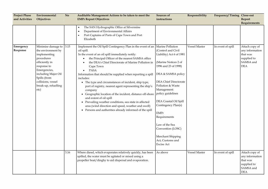
Project Phase and Activities
Environmental Objectives
No Auditable Management Actions to be taken to meet the EMPr Report Objectives
Sources of instructions
Responsibility Frequency/ Timing Close-out Report Requirements
• The SAN Hydrographic Office at Silvermine • Department of Environmental Affairs • Port Captains of Ports of Cape Town and Port
Elizabeth
Emergency Response
Minimise damage to the environment by implementing procedures efficiently in response to Emergencies, including Major Oil Spills (from collisions, vessel break-up, refuelling etc)
3.15 Implement the Oil Spill Contingency Plan in the event of an oil spill. In the event of an oil spill immediately notify:
• the Principal Officer of the nearest SAMSA office • the DEA's Chief Directorate of Marine Pollution in
Cape Town • PASA
Information that should be supplied when reporting a spill includes:
• The type and circumstances of incident, ship type, port of registry, nearest agent representing the ship’s company
• Geographic location of the incident, distance off-shore and extent of oil spill
• Prevailing weather conditions, sea state in affected area (wind direction and speed, weather and swell)
• Persons and authorities already informed of the spill
Marine Pollution (Control and Civil Liability) Act 6 of 1981 (Marine Notices 2 of 1996 and 23 of 1998) DEA & SAMSA policy DEA Chief Directorate Pollution & Waste Management: policy guidelines DEA Coastal Oil Spill Contingency Plan(s) EMPr Requirements Law of the Sea Convention (LOSC) Merchant Shipping Act, Customs and Excise Act
Vessel Master In event of spill Attach copy of any information that was supplied to SAMSA and DEA
3.16 Where diesel, which evaporates relatively quickly, has been spilled, the water must be agitated or mixed using a propeller boat/dinghy to aid dispersal and evaporation.
As above Vessel Master In event of spill Attach copy of any information that was supplied to SAMSA and DEA

Project Phase and Activities
Environmental Objectives
No Auditable Management Actions to be taken to meet the EMPr Report Objectives
Sources of instructions
Responsibility Frequency/ Timing Close-out Report Requirements
3.17 Dispersants should not be used without authorisation of DEA. Furthermore dispersants should not be used:
• on diesel or light fuel oil • heavy fuel oil • slicks > 0.5 cm thick • all oil spills within 5 nautical miles off-shore or in
depths less than 30 m • in areas far offshore where there is little likelihood of
oil reaching the shore Dispersants are most effective on fresh crude oils; under turbulent sea conditions (as effective use of dispersants requires mixing), when applied within 12 h (24 h max) or where the volume of dispersant doesn’t exceed 20-30 percent of the oil volume
As above Programme Manager and Vessel Master
In event of spill Attach copy of authorisation
3.18 Adhere to obligations regarding other vessels in distress. Notify SAMSA about wrecked vessels (safety and pollution), and the Department of Finance (salvage, customs, royalties). Give location details to SAN Hydrographic office.
As above Vessel Master In the event of a vessel in distress or wreck
Copy of notification
Pollution Control and Waste Management
Minimise pollution, verify safe waste disposal and maximise recycling
3.19 Comply with legal requirements for waste management and pollution control (for air and water quality levels at sea), and employ ‘good housekeeping’ and monitoring practices.
International Convention for the Protection of Pollution from Ships MARPOL 73/78 (in Marine Pollution Act 2 of 1986); Dumping at Sea Control Act; Montreal protocol; Water Act EMPr Requirements
Vessel Master Throughout the survey
Report occurrence of minor oils spills and destination of wastes

Project Phase and Activities
Environmental Objectives
No Auditable Management Actions to be taken to meet the EMPr Report Objectives
Sources of instructions
Responsibility Frequency/ Timing Close-out Report Requirements
3.20 Food waste may be disposed of overboard after grinding through a 25 mm screen (MARPOL standard) – prohibited if distance to land is < 12 nautical miles. Medical waste will be incinerated or sealed in aseptic containers for appropriate disposal ashore. Waste oil will be returned to a port with a registered facility for processing/disposal. Oily-water separator to only release <l5 ppm oil in water. All hazardous waste will be collected and retained onboard for disposal at suitable onshore reception facilities. Metal must be sent to shore for recycling.
ÒGP Waste Management Guidelines (No2.58/196, 1993) International Convention for the Protection of Pollution from Ships MARPOL 73/78
Vessel Master Throughout the survey
Report occurrence of minor oils spills and destination of wastes Attach copy of waste disposal receipts from waste contractor
3.21 Plastic, scrap metal and other solid waste generated on the seismic vessels will be segregated, weighed and accounted for prior to disposal at appropriate facilities. Waste will be recycled where possible. No disposal of general waste overboard.
Vessel Master Throughout the survey
Attach copy of waste disposal receipts from waste contractor
3.22 Sewage discharges will be comminuted and disinfected in an approved treatment plant on the exploration and support vessel(s) and only discharged more than 12 nautical miles (21.6 km) from land. Treated effluents will achieve a BOD < 40 ppm, suspended solids < 50 ppm and a coliform count of <200 cells per 100 ml of effluent. Sludge will be retained and disposed of in port.
ÒGP Waste Management Guidelines (No2 58/196, 1993) International Convention for the Protection of Pollution from Ships MARPOL 73/78
Vessel Master Throughout the survey
Report occurrence spills and non-compliance
3.23 Drainage from machinery spaces on deck will be treated to verify that it does not contain more than 15 mg/l of oil.
ÒGP Waste Management
Vessel Master Throughout the survey
Report occurrence of

Project Phase and Activities
Environmental Objectives
No Auditable Management Actions to be taken to meet the EMPr Report Objectives
Sources of instructions
Responsibility Frequency/ Timing Close-out Report Requirements
All other discharges will be treated to verify an average monthly oil content of no more than 40 mg/l. The instantaneous discharges will not exceed 100 mg/l.
Guidelines (No2.58/196, 1993) International Convention for the Protection of Pollution from Ships MARPOL 73/78 International Convention for the Prevention of Pollution of the Sea by Oil (OILPOL) International Finance Corporation (IFC) (2000) Offshore Oil and Gas Development HSE Guidelines
minor oils spills and destination of wastes
3.24 No CFC based fire-fighting or refrigeration equipment is to be used. Manufacturers’ instructions for the operation and maintenance of equipment will be followed to verify that equipment operation is carried out at highest possible level of efficiency to maintain minimum level of CO2 and CO emissions.
Vessel Master Throughout the survey
3.25 Record types and volumes of hazardous substances brought on board (e.g. radioactive materials, neon lights, toner cartridges, etc), and destination of wastes. Verify that waste returned to port is disposed of by a licensed waste disposal contractor using an approved landfill site
National Environmental Management Waste Act (Act 59 of 2008)
Vessel Master Throughout the survey
Attach copy of waste disposal receipts from waste contractor

Project Phase and Activities
Environmental Objectives
No Auditable Management Actions to be taken to meet the EMPr Report Objectives
Sources of instructions
Responsibility Frequency/ Timing Close-out Report Requirements
3.26 Verify that monitoring procedures are in place on board in
accordance with MARPOL requirements
International Convention for the Protection of Pollution from Ships MARPOL 73/78
ECO Throughout the survey
Monitoring data
Equipment loss Minimise hazards left on the sea bed or floating in the water column, and inform relevant parties
3.27 Keep a record of all items lost overboard and of lost equipment. When any items that constitute a seafloor or navigation hazard are lost on the sea bed, or in the sea, a standard form must be completed which records the date and cause of loss, details of equipment type, vessel Sea Control location, sea state and weather, and the nature of the sea bed. Pass information to SAMSA and to DMR to provide to mining companies, and to DEA to provide to fishermen operating in the area. Directly inform fishing/trawling associations of any equipment losses.
Dumping at Sea Control Act 73 of 1980 Mineral and Petroleum Resources Development Act (Act 28 of 2002) (MPRDA) and MPRDA Regulations GN 527 of 2004
Vessel Master Throughout survey, as required
Copy of record sheet
Oil bunkering/ refuelling at Sea
Minimise disturbance/damage to marine life
3.28 No discharge of any oil whatsoever is permitted within 50 nautical miles of the coast. If refuelling will be required while at sea the contractor must:
• submit an application form in terms of Regulation 14 to the Principal Officer at the port nearest to where the proposed transfer to obtain prior permission for transfer of oil at sea
• inform SAMSA of location, supplier and timing, five days prior to refuelling at sea
• verify that drip trays are in place to collect leakage from connection and discharge points
International Convention for the Protection of Pollution from Ships MARPOL 73/78 (Annex 1) Pacoposoa (Prevention and Combatting of Pollution of the Sea by Oil Act) Amendment Act 24 of 91 Marine Pollution (Control and Civil
Vessel Master In project description
Copy of application form and any correspondence with SAMSA

Project Phase and Activities
Environmental Objectives
No Auditable Management Actions to be taken to meet the EMPr Report Objectives
Sources of instructions
Responsibility Frequency/ Timing Close-out Report Requirements
Liability) Act 6 of 1981
Airborne surveys and logistical helicopter support
Minimise disturbance / damage to marine and coastal life
3.29 As much as possible, flight paths must be pre-planned to avoid flying over seal and seabird colonies, coastal reserves or marine islands. Extensive coastal flights (parallel to the coast within 1 nautical mile of the shore) should be avoided. Aircraft shall not approach to within 300 m of whales in terms of the Marine Living Resources Act, 1998. The operator must comply with the Seabirds and Seals Protection Act, 1973, which prohibits the wilful disturbance of seals on the coast or on offshore islands. The contractor should comply fully with aviation and authority guidelines and rules.
All pilots should be briefed on ecological risks associated with flying at a low level parallel to the coast.
Sea Birds and Seals Protection Act 46 of 73, 1963 Air Navigation Regulations) EMPr requirement International Convention for the Protection of Pollution from Ships MARPOL 73/78
Programme manager and ECO
As required Submit copies of flight paths and compliance reports
Monitoring during the survey
Monitor impacts to assist with any possible compensation negotiations
3.30 Monitor noise levels during survey at in areas within 25km of the Marine Protected Areas as well as in key fishing areas confirmed through liaison of the FLO with fishing operators. Undertake daily monitoring and recording of the following from the vessels:
• Marine mammals, seabirds and turtles sighted from the vessels (record numbers in relation to weather and surveying activities on the specific marine fauna sighting record forms - see Part C Appendix A)
• Any small fish mortality associated with airgun operation (visible by feeding predators)
• Record unusual bird sightings associated with the operation of the airgun array, particularly diving birds
• Interaction with other vessels, particularly including the use of a chase boat to verify that the survey is not
ECO, FLO, MMO Throughout the survey
Monitoring reports

Project Phase and Activities
Environmental Objectives
No Auditable Management Actions to be taken to meet the EMPr Report Objectives
Sources of instructions
Responsibility Frequency/ Timing Close-out Report Requirements
compromised • Include comprehensive details of interaction with
unattended fishing gear Monitor liquid effluent to verify compliance with MAPROL 73/78 limits:
• oil from machinery space drainage < 15 mg.l-1 • oil from other effluents < 40 mg.l-1 (monthly average) • oil from other effluents < 100 mg.l-1 (instantaneous
limit).
Reporting during the survey
Report all information gathered during monitoring
3.31 Record all initiation of seismic firing activity and associated “soft starts” and pre-firing observation regimes. Complete daily marine fauna sighting forms for marine mammal, diving birds and turtle sightings. Provide full reporting of all shooting termination decisions (including behaviour and distance of marine mammals) in the close out report.
MPRDA and MPRDA Regulations GN 527 of 2004
Vessel Master and ECO
Daily, throughout the survey
Data and records
4. Decommissioning and Closure Phase Survey vessel to leave the survey area
Minimise impact as a result of activities and notify stakeholders
4.1 Verify that all deployed equipment is retrieved.
Vessel Master On completion of survey
Inform relevant stakeholders and mariners of survey completion
Verify that relevant parties are aware that the seismic campaign is complete
4.2 Inform PASA and SAN Hydrographer of the survey completion. FLO must notify fishing operators and vessels and other Mariners through recognised fishing associations and the SAN Hydrographic office.
Programme manager
Within two weeks after completion of survey
Copies of notification documentation required.
Final Waste Disposal
Minimise pollution and verify correct
4.3 All waste retained onboard is to be disposed of by a licensed waste disposal contractor at an approved waste landfill site and waste log completed.
National Environmental Management Waste
Vessel Master When vessel is in port
Receipt required from contractor
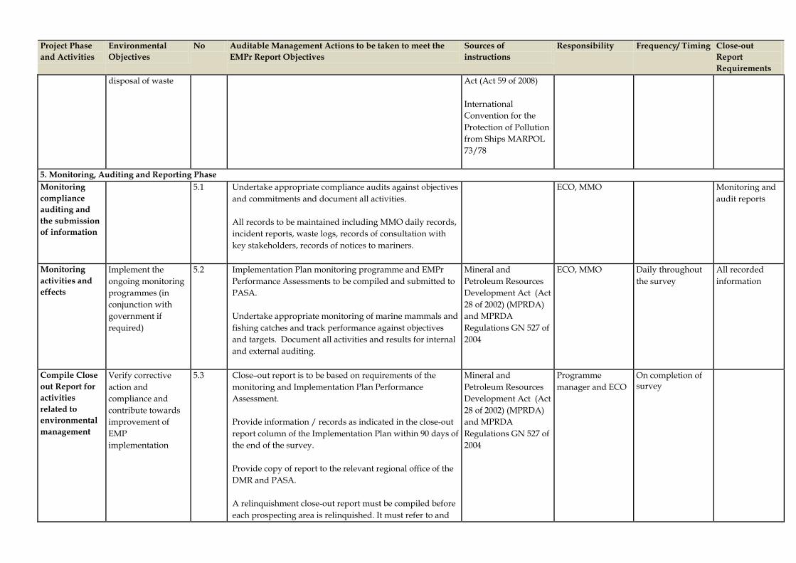
Project Phase and Activities
Environmental Objectives
No Auditable Management Actions to be taken to meet the EMPr Report Objectives
Sources of instructions
Responsibility Frequency/ Timing Close-out Report Requirements
disposal of waste
Act (Act 59 of 2008) International Convention for the Protection of Pollution from Ships MARPOL 73/78
5. Monitoring, Auditing and Reporting Phase Monitoring compliance auditing and the submission of information
5.1 Undertake appropriate compliance audits against objectives and commitments and document all activities. All records to be maintained including MMO daily records, incident reports, waste logs, records of consultation with key stakeholders, records of notices to mariners.
ECO, MMO Monitoring and audit reports
Monitoring activities and effects
Implement the ongoing monitoring programmes (in conjunction with government if required)
5.2 Implementation Plan monitoring programme and EMPr Performance Assessments to be compiled and submitted to PASA. Undertake appropriate monitoring of marine mammals and fishing catches and track performance against objectives and targets. Document all activities and results for internal and external auditing.
Mineral and Petroleum Resources Development Act (Act 28 of 2002) (MPRDA) and MPRDA Regulations GN 527 of 2004
ECO, MMO Daily throughout the survey
All recorded information
Compile Close out Report for activities related to environmental management
Verify corrective action and compliance and contribute towards improvement of EMP implementation
5.3 Close–out report is to be based on requirements of the monitoring and Implementation Plan Performance Assessment. Provide information / records as indicated in the close-out report column of the Implementation Plan within 90 days of the end of the survey. Provide copy of report to the relevant regional office of the DMR and PASA. A relinquishment close-out report must be compiled before each prospecting area is relinquished. It must refer to and
Mineral and Petroleum Resources Development Act (Act 28 of 2002) (MPRDA) and MPRDA Regulations GN 527 of 2004
Programme manager and ECO
On completion of survey

Project Phase and Activities
Environmental Objectives
No Auditable Management Actions to be taken to meet the EMPr Report Objectives
Sources of instructions
Responsibility Frequency/ Timing Close-out Report Requirements
summarize details contained in each seismic survey close-out report. The report must specifically provide evidence that all aspects of the Implementation Plan have been met. A covering letter must formally apply for the issuance of a closure certificate from DMR/ PASA.
.

Impact Africa EMPr Transkei and Algoa Exploration Areas
PART C
Supporting Documentation 1. Financial Provision
2. Assessment Methodology
3. Fisheries Specialist Study
4. Marine Fauna Specialist Study
5. Details of Coordination by Fisheries
Liaison Officer (FLO) Prior to Seismic Survey
6. Data Recording Sheets
• Marine Mammal Search Record • Marine Fauna Sighting Record
7. Undertaking by Applicant
8. Curriculum Vitae

1 FINANCIAL PROVISION

Cost Estimate – Financial Provision
Work Program
Activity
Unit Rehab
Cost (US$)Disturbed
Area
TOTAL Rehab Cost
(US$)
MobilisationPersonnel and equipment 900,000 900, 000
Clean-up of oil spillagesOil recovery equipment and absorbent material hire/ purchase. 1,800,000 1,800, 000
Waste ManagementHandling, storage and final disposal at licensed landfill site onshore. 600,000 600,000
Third Party LiabilitiesCompensation, damage claims etc. to marine, mining, fishing industry, marine transport route. 2,200,000 2,200,000
Project ManagementTravel, sundries, appointment of contractors, monitoring, etc. 600,000 600, 000
Removal of miscellaneous objects from the sea floorRetrieving of lost equipments/items through the use of divers/ appointment of specialized contractor, etc. 750,000 750,000
Monitoring and Maintenance 1,200,000 1,200,000Contingencies 800,000 800, 000
Total Rehabilitation Cost (ex VAT) 8,850,000
VAT @ 14% 1,239,000Total Rehabilitation Cost (inc. VAT) 10,089,000

2 ASSESSMENT METHODOLOGY

IMPACT ASSESSMENT METHODOLOGY The assessment of the potential impacts and benefits that will be associated with the project requires a methodology that will reduce the subjectivity involved in the assessment. A clearly defined methodology is used in order to determine the significance of the predicted impact on, or benefit to, the surrounding natural and/or social environment and to therefore be able to compare the significance ratings of the impacts identified. The types of impacts and terminology used in this assessment are shown below in Table 1. Table 2: Impact Assessment Terminology
Term Definition Impact Nature
Positive An impact that is considered to represent an improvement on the baseline or introduces a positive change.
Negative An impact that is considered to represent an adverse change from the baseline, or introduces a new undesirable factor.
Impact Type
Direct Impact Impact that results from a direct interaction between a planned project activity and the receiving environment/receptors (e.g. between occupation of a site and the pre-existing habitats or between an effluent discharge and receiving water quality).
Indirect Impact Impact that results from other activities that are enabled as a consequence of the proposed project (e.g. in-migration for employment placing a demand on natural resources).
Induced Impact Third level impact caused by a change in the proposed project environment (e.g. employment opportunities created by the increased disposable income of workers hired by the project or its suppliers).
Cumulative Impact
Impact that acts together with other impacts (including those from concurrent or planned future third party activities) to affect the same resources and/or receptors as the proposed project.
Impact Magnitude
Duration
Temporary - impacts are predicted to be of short duration and intermittent/occasional in nature. Short-term - impacts that are predicted to last only for the duration of the construction period. Long-term - impacts that will continue for the life of the project, but cease when the project stops operating. These will include impacts that may be intermittent or repeated rather than continuous if they occur over an extended time period (e.g. repeated seasonal disturbance of species as a result of, for example, blasting activities, operational employment, etc.). Permanent - impacts that occur during the development of the project and cause a permanent change in the affected receptor or resource (e.g. destruction of ecological habitat) that endures substantially beyond the project lifetime.
Scale
On-site or Local - impacts that affect an area in a radius of 20 km around the project site. Regional - impacts that affect regionally important environmental resources or are experienced at a regional scale as determined by administrative boundaries, habitat type/ecosystem. National - impacts that affect nationally important environmental resources, or affect an area that is nationally important/ protected or have macro-economic consequences. International / Trans-boundary - impacts that affect internationally important resources such as areas protected by international conventions.
Severity (for environmental receptors)
Very Low / Low – Impact affects the environment in such a way that natural functions and processes are not affected. Medium – The affected environment is altered but natural functions and processes continue albeit in a modified way. High – Natural functions or processes are altered to the extent that they will temporarily or permanently cease.

Term Definition Impact Likelihood In addition to predicted impacts, those impacts that could result in the event of an accident or unplanned event (non-routine) within the project (e.g. fuel spill, traffic accident) or in the external environment affecting the project (e.g. flooding, earthquake) are required to be taken into account. In these cases the probability of the event occurring needs to be considered. Low The impact does not occur. Medium Impact occurs infrequently. High Impact occurs frequently or regularly.
Based on the definitions provided above and the broad understanding of categories of significance, impact matrices have been prepared to guide the assessment of project impacts. Table 2 below will form the basis of determining the magnitude of the environmental impacts. The results from this table are then used in the matrix presented in Table 3 to assess the significance of environmental impacts. Table 3: Assessment of Environmental Magnitude
Magnitude Rating
Level of Criteria Required
Negligible • Low severity with a site specific extent and exploration period duration.• Very low severity with any combination of extent and duration except for regional and long-
term implications. Low • High severity with a site specific extent and exploration period duration.
• Medium severity with a site-specific extent and exploration period duration. • Low severity with any combination of extent and duration except site specific and exploration
period or regional and long term. • Very low severity with a regional extent and long term duration.
Medium • High severity with a local extent and medium term duration. • High severity with a regional extent and exploration period duration or a site specific extent
and long term duration. • High severity with either a local extent and exploration period duration or a site specific extent
and medium term duration. • Medium severity with any combination of extent and duration except site specific and
exploration period duration or regional extent and long term duration. • Low severity with a regional extent and long term duration.
High • High severity with a regional extent and long term duration. • High severity with either a regional extent and medium term duration or a local extent and long
term duration. • Medium severity with a regional extent and long term duration.
Table 4: Overall Significance Criteria for Environmental Impacts

SIGNIFICANCE
LIKELIHOOD
Unlikely Likely Definite
MA
GN
ITU
DE
Negligible Negligible Negligible Minor
Low Negligible Low Low
Medium Low Medium Medium
High Medium High High

3 FISHERIES SPECIALIST STUDY


•
•
•
•
•


10km


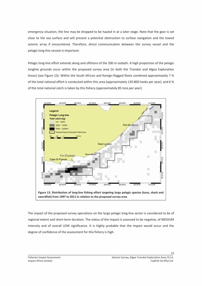


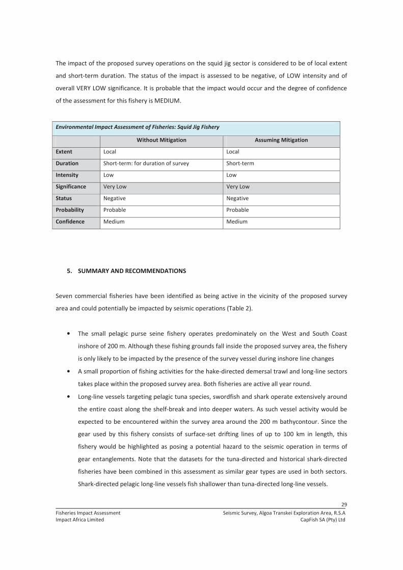
•
•
•

•


•
•
•
•
•
•
o
o
o

4 MARINE FAUNA SPECIALIST STUDY

Env ir onmen t al Serv i ces (Pt y ) L t dPISC ES

Env ir onmen t al Serv i ces (Pt y ) L t dPISC ES


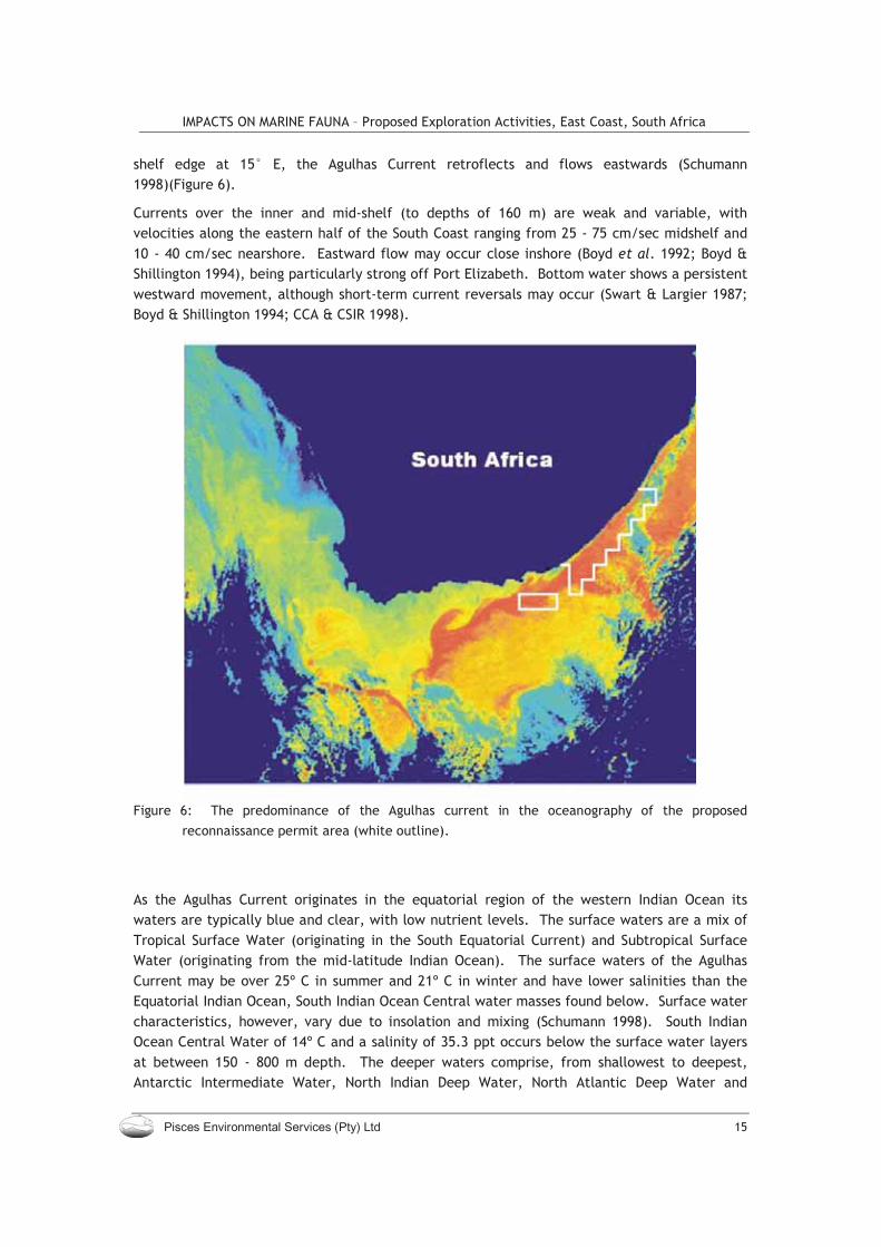


Species name Common name Global IUCN Status

Species name Common name Status


μ


•
• • •


μ
μ


• • •
•


μ

•
•


•

•
•
•


•
•
•
•

•
•


•
•
•
•
•


•
•
•
•
•
•
•

•
•
•
•
•
•
•
•
•


•
•
•
•

•
•
• •
•
• •
•
•

•
•
•


•
•
•
•
•
•

•
•
•
•
• •
•
•
•
•

•
•
•

•
•
•
•
• •
•
• •
•
•
•
•
•


5 CO-ORDINATION BY FISHERIES LIAISON OFFICER (FLO) PRIOR TO SEISMIC SURVEY
Prior to the commencement of a seismic survey operation a Fisheries Liaison Officer (FLO) (with input from a fisheries specialist, if necessary) should obtain the following information: (a) Fisheries information Well in advance of the start of the survey (before compilation of the Environmental Notification) liaise with fishing companies, shore and vessel skippers to:
establish the types of fishing and intensity of activity in the area affected by the seismic survey; establish an agreed process whereby the survey can be conducted with maximum efficiency and minimum disruption of the legitimate activities of fishers; verify that all fishers are aware of the details of the planned seismic survey and advise them on how to act to minimise conflict with the seismic survey; advise the Operator on how to plan the survey to minimise potential conflict with other users of the sea; advise the Operator on the need for (1) a chase boat and (2) a sweeper vessel; advise the Operator on the need for proper certification of the sweeper vessels and limitations placed on its operation; and arrange that the survey vessel is provided with “safe passage” routes to and from the survey area in which the vessel can deploy test and retrieve survey gear and which can also be used in the event of severe sea conditions/problems with equipment etc.
(b) Requirements for the use of a sweeper vessel A sweeper vessel is defined herein as: A vessel that has the ability to recover fishing gear in the water, particularly bottom set longlines, crayfish longlines and drifting (pelagic) longlines efficiently and without causing permanent damage to the lines and gear. The operator and skipper of the sweeper vessel should have intimate knowledge of the survey area including fishing activity, types of fishing gear deployed in the area and knowledge of the communication channels used by the fishing vessels in the area. A chase boat is defined as: A chase boat should be certified to act as a “carrier”. Its main functions are (i) to assist in the survey operation, specifically maintenance of gear and retrieval of damaged or lost gear, (ii) to intercept any other vessels that could affect the success of the seismic survey operation.

In an effort to prevent possible gear interaction between the survey vessel and fishers and fishing gear in an area the following strategy (in collaboration between the on-board FLO, the skipper of the sweeper vessel and the land-based coordination centre) is recommended: 1. Actively engage the fishing industry and other interested and affected parties in a transparent and proactive manner with a view to avoiding conflict through a process of communication and close co-operation with the fishing industry; 2. Deployment of an FLO on the survey vessel who also has intimate knowledge of the fishing activity in the area surveyed, knows the fishers and can communicate freely with them and is in immediate contact with the chase boat and the land-based co-ordinator; 3. The land-based co-ordinator to receive daily reports from the observer on vessel activity as well as reports on all interactions with merchant shipping and fishers in the area and facilitates the communication process with the fishing industry as and when required. In addition to all of the above, experience has shown that the Chase Boat (normally owned and operated by the survey vessel operators) is usually fully occupied by her gear operational duties. In normal circumstances when a survey might be conducted in remote areas, or where there is little fishing activity, this might suffice. However the South African Coast, particularly the South and East Coasts, is heavily exploited by longlines and there is a high probability of the seismic array fouling a longline and causing significant damage to the fishing gear and seismic array. In order to prevent this probability, the deployment of a “sweeper” boat is strongly advised. A sweeper boat’s main function is to establish the presence of fishers and fishing gear in the vicinity and or path of the seismic array. It must effectively “sweep” the area to identify stationary or mobile fishing gear prior to the seismic survey vessel(s) deploying their seismic array. The sweeper vessel must have a skipper with the necessary experience to correctly identify the gear and the potential for the gear to damage or inhibit the progress of the survey. The “sweeper” vessel is required, prior to the survey, to facilitate the clearing of the fishing gear identified. This is done in an interactive and co-operative manner with a priority placed on identifying the owner of the gear (mother vessel) such that time is given for the mother vessel to shift her gear (negotiated in a spirit of cooperation between parties and other users of the sea). If this is not possible, the problem must be urgently communicated to the prospecting sublease holder, who must seek alternative solutions. It is important to negotiate the removal of gear prior to start of survey and to use the “sweeper vessel” to verify that fishing vessels and gear do not move back into the survey area.

6 DATA RECORDING SHEETS

MAR
INE
MAM
MAL
SEA
RC
H R
ECO
RD
-SE
ISM
IC S
UR
VEYS
IN S
OU
TH A
FRIC
AN
WAT
ERS
DA
TEFO
RM
NU
MB
ER
VESS
ELC
LIEN
TBL
OC
KC
ON
TRAC
TOR
ACTI
VITY
TIM
EPO
SITI
ON
OBS
WIN
DSW
ELL
SEA
STAT
ER
EMAR
KS
LAT.
LO
NG
.SP
EED
DIR
EC
TIO
NS
E
SE
SE
SE
SE
SE
SE
SE
SE
SE
SE
SE
SE
SE
1.A
NEW
FO
RM
IS T
O B
E S
TAR
TED
EAC
H D
AY
2.AC
TIVI
TY :
SS
= S
earc
h S
tarte
d,SE
= S
earc
h E
nded
, SG
= M
arin
e M
amm
als
sigh
ted,
AS
= A
irgun
s st
arte
d, A
F =
Airg
uns
at fu
ll po
wer
, AE
= Ai
rgun
s st
oppe
d3.
Sigh
tings
are
to b
e nu
mbe
red
in th
e re
mar
ks c
olum
n an
d cr
oss
refe
renc
ed to
the
sigh
ting
reco
rd.

MARINE FAUNA SIGHTING RECORD - SEISMIC SURVEYS IN SOUTH AFRICAN WATERS
FORM NUMBERDATE SIGHTING NUMBERVESSEL CLIENTBLOCK CONTRACTORTIME SIGHTED POSITION CUE
LATITUDE LONGITUDES E
SPECIES NUMBER OF ANIMALSUPPER LOWER BEST
SPECIES IDENTITY NUMBER OF AINIMALS
JUVENILES PRESENT
DEFINITE DEFINITE YES (How many)PROBABLE PROBABLE NOPOSSIBLE POSSIBLE UNCERTAINDISTANCE FROM VESSEL AT SIGHTING
ANGLE FROM BOW AT SIGHTING
P / S CLOSEST DISTANCE SEEN
ESTIMATED HEADING OF ANIMALS
TIME LAST SEEN
REMARKS
GENERAL BEHAVIOUR
AIR-GUN ASSOCIATED BEHAVIOR
VESSEL ASSOCIATED BEHAVIOUR
AIR-GUNS FIRING YES % FULL VOLUME NO

MARINE FAUNA SIGHTING RECORD - SEISMIC SURVEYS IN SOUTH AFRICAN WATERS
USER NOTES
Form numberUse a separate form for each sighting. Number the forms consecutively so that the form number is consecutive for the survey and is regardless of the sighting number.
Sighting NumberThe sighting number is for the day, so that the first sighting on each day will be sighting number 001. This must be cross-referenced with the Search Record.
TimeUse local ships time.
CueProvide the cue that first brought your attention to the animals (Blow, Splash; Body; Breach/Jump;
Species Complete as fully as possible. Use the remark block to add further information.Use a separate form for each species in sightings of mixed groups.
Number of animalsProvide an upper, lower and best estimate of the number of animals present.
Confidence in estimationProvide the confidence (Definite/Probable/Possible) of the Species Identity and estimate of School Size.
Distance and angleProvide the distance (nautical miles) and angle of the animals (degrees port or starboard from the bow) from the vessel at the time of first sighting. Use the Behaviour block to describe any response to the vessel, air-gun array or sound emission.
BehaviourDescribe the General Behaviour of the animals and any behaviour that appears to be associated with the Air-Gun array or sounds and any behaviour that appears to be associated with the vessel. Use the rear of the form if necessary.
Use the Remarks Block to provide any further information. Use the rear of the form if necessary.

7 UNDERTAKING BY APPLICANT


8 CURRICULUM VITAE OF PROJECT TEAM

Henry Camp Partner
Delivering sustainable solutions in a more competitive world
Henry Camp is a Partner based in the Johannesburg, South Africa office. He is a senior leader in the Oil and Gas Practice for the Europe, Middle East and Africa region. Henry has more that 25 years of broad-ranging professional experience in the environmental field. Over the past 15 years he has focused on the environmental planning and assessment of major capital projects. For these he has been involved in the directing or managing of feasibility studies; scoping studies; environmental, social and health impact assessments (ESHIA); environmental impact statements (EIS); baseline and resource studies; mitigation and environmental management plans (EMP); stakeholder engagement; resettlement plans; and due diligence, compliance, monitoring and audit studies. Henry has worked and travelled extensively in Africa and conducted projects in more than 20 countries in the region. He has extensive experience in West Africa working in the oil and gas sector and has worked on some of the largest projects in that region. He also has experience in the power generation and transmission, transportation, mining, and manufacturing sectors. He has worked on numerous projects performed to World Bank and International Finance Corporation standards and guidelines, including the newly revised performance standards. Henry also brings a background of experience working under United States regulatory processes including extensive work on NEPA-guided projects for US public sector clients such as DOE, DOI and DOD. Henry has been with ERM for three years. Prior to joining ERM, Henry was Vice President of ICF International and before that held a senior position at Arthur D Little in the USA.
Fields of Competence • Environmental, Social, and Health Impact
Assessment (ESHIA) • Monitoring and Evaluation • Environmental Management Systems • Public Consultation and Disclosure • Capacity Building and Training
Key Industry Sectors • Oil and gas • Mining
Education • BA in Biology, University of Vermont, 1981 • Executive Program for International Business,
Johnson School of Management, Cornell University • Degree in Mass Communications, University of
Vermont
Professional Affiliations and Registrations • International Association for Impact Assessment
(IAIA) • Association for the Environmental Health and
Sciences (AEHS) • American Chemical Society (ACS) • Society of Environmental Toxicology and
Chemistry (SETAC)
Languages • English • German and French (conversational)

31.05.11 HENRY CAMP
Financial Institutions Support Environmental and Social Assessments (New Project Appraisals and Portfolio Project Supervision Support), International Finance Corporation, Africa Region, 2007 to 2011 Project Director Mr. Camp was Project Director for a program supporting IFC on environmental and social performance appraisals of potential new project as well as existing (portfolio) investments. The work involved visits to the project sites, review of environmental and social information, interviews, and evaluation of projects against IFC Performance Standards. Work under this program included assessments of:
• Oil and gas facility in East Africa • Diversified agribusiness in Mozambique • Rice facility in Uganda • Forest plantations and mills in Tanzania, Uganda,
and Mozambique • Soft drink manufacturer and distributer with
operations in six East African countries • Toll road development in Africa • Cement company with operations in six West Africa
countries • Pulp and paper mill in East Africa • Manufacturing facilities in Kenya • Hotels in Tanzania and Kenya • Aluminium smelter in Mozambique
Environmental and Social Due Diligence of a Petroleum Products Storage Terminal, Nigeria, Confidential Client, 2011 Lead Assessor Mr Camp led the assessment of a planned renovation and expansion of a petroleum products storage and distribution terminal in the Nigeria Delta. The appraisal involved interviews with representatives of local communities and review of project plans and progress with regards to conformance with IFC Performance Standards. Environmental and Social Performance Due Diligence of Onshore Oil and Gas Operations, Nigeria, Confidential Client, 2011 Lead Assessor Mr Camp led the assessment of onshore oil and gas operations in the Nigeria Delta on behalf of a financial institution. The assets evaluated included gas gathering facilities, oil processing facilities, pipelines and oil and gas wells. The appraisal involved interviews with company representatives and inspection of project
facilities. with regards to conformance with IFC Performance Standards. Environmental and Social Due Diligence of a Housing and Industrial Estate Expansion Project, Nigeria, Confidential Client, 2010 Lead Assessor Mr Camp led the assessment of a proposed expansion of an existing residential and industrial estate outside of Lagos, Nigeria. The appraisal involved interviews with the developer, review of project plans and progress, and a site visit. The assessment was carried out in consideration of local laws and regulations as well as the requirements of the IFC Performance Standards. Environmental and Social Due Diligence of a Proposed Housing Project, Nigeria, Confidential Client, 2011 Lead Assessor Mr Camp led the assessment of a proposed development of a residential housing estate to be developed outside of Ibadan, Nigeria. The assessment involved interviews with the developer, review of project plans and progress, and a site visit. The assessment was carried out in consideration of local laws and regulations as well as the requirements of the IFC Performance Standards. Environmental Due Diligence of Onshore and Offshore Oil and Gas Production Facilities, Confidential Client, Angola, 2009 to 2010 Lead Assessor Mr Camp carried out a Phase 1 environmental assessment as part of a due diligence process support asset divestiture. The assignment involved desktop based review of project documents (including impact assessments and monitoring data) and a field survey and inspection of the assets including oil wells, connecting pipelines, gathering and processing facilities and export terminal. Environmental and Social Performance Appraisal of a Cement Plant Expansion Project, Nigeria, Confidential Client, 2009 Lead Assessor Mr Camp led the appraisal of a planned expansion of a cement plant in southern Nigeria. The project involved construction of new cement works and expansion of quarry operations as well as installation of new power generation facilities. The appraisal involved interviews with representatives of local communities and review of project plans and progress with regards to conformance with IFC Performance Standards.

31.05.11 HENRY CAMP
Environmental and Social Assessment and Action Plan for Rubber Plantation and Processing Plant, Cameroon, Confidential Client, 2008 Lead Assessor ERM was commissioned to conduct an Environmental and Social (E&S) Assessment, and develop Environmental and Social Action Plans to address gaps between existing practices and applicable IFC performance guidelines, and to provide recommendations with regard to the further development of an E&S management system and community engagement systems. Environmental and Social Performance Appraisal of a Flower Growing Operation, Kenya and Ethiopia, Confidential Client, 2008 Project Director ERM carried out an appraisal of a large scale flower growing operations against international; performance standards. The project involved on-site interviews and field studies to determine the compliance with local regulatory requirements as well as with lender requirements. The operation was considering major expansion into greenfield areas and the appraisal was used to determine the applicable social and environmental requirements. Environmental and Social (E&S) Assessment and Action Plan for Wheat Farms and Flour Mills, Tanzania, Confidential Client, 2009 to 2010 Project Director ERM was commissioned to conduct an Environmental and Social (E&S) Assessment, and develop Environmental and Social Action Plans to address gaps between existing practices and applicable IFC performance guidelines, and to provide recommendations with regard to the further development of an E&S management system and community engagement systems. IFC Performance Standards Training, Banking Sector Workshop, Egypt and Nigeria, IFC, 2009 Lead Trainer Mr Camp is providing training to banking sector representatives under a responsible banking initiative of the IFC and co-sponsored by international banking institution. The training covers social and environmental requirements and is built on project-level experience working on IFC financed projects. Implementation of the Equator Principles into the Project Finance Process and Training of Staff, Standard Bank, South Africa, 2008 Lead Trainer
Mr Camp directed a project to assist Standard Bank with the implementation of the Equator Principles into the project finance process. The team was responsible for rolling out the system and training staff in using the system, as well as the application of the Equator Principles and IFC Performance Standards. IFC Performance Standards Training, Sasol Technology, South Africa, 2007 Lead Trainer Mr Camp provided training to Sasal HSE staff on the requirements of the IFC Performance Standards and HSE Guidelines. Mr Camp was responsible for presenting the environmental requirements as well as the application of standards and guidelines to oil and gas development. Environmental and Social Performance Appraisal of a Fish Processing Company, Madagascar and Cote d’Ivoire, Confidential Client, 2008 Project Director Mr Camp led the appraisal of a tuna fish processing company with operations in Africa. The evaluation included assessment of fish stocks and sustainability as well as food safety in operations.

31.05.11 HENRY CAMP
Environmental Impact Assessment Environmental Support to the Jubilee Field Development, Ghana, Tullow Oil, 2008 to present Mr Camp has been leading the assisting to Tullow Oil with a variety of support activities related to the development of the Jubilee Field, a major oil and gas discovery offshore Ghana. Project Director for EIA. Mr Camp directed the ESIA for the Jubilee Field Development, a deepwater oil production and export project offshore Ghana. The project comprises installation of production wells and reinjection wells and a FPSO. The project is the first of its find in Ghana and the ESIA is involving extensive public and stakeholder consultation including major lending institutions such as IFC. A major output of he ESIA are management plans covering waste, discharge, and oil spills. Technical Advisor for EMP Implementation. Mr Camp provided technical support to the development of specific plans and procedures for implementation of the environmental management plans and monitoring programme for FPSO operations. Project Director for Communications Strategy. Mr Camp is leading the development of a public communications strategy for the Jubilee Field Development. The assignment includes stakeholder consultation, branding, and communications strategy related to environmental and social issues. Technical Advisor for Fishing and Fisheries Study. Mr Camp is providing technical inputs and advising on a comprehensive study of fishing and fisheries in the Jubilee Field’s area of influence. The study is being carried out as a combination of desktop research (including data gathering with Ghana officials and scientists) and primary data collection including laboratory testing. Impact Assessment and Preliminary Environmental Report (PER) for Exploration in the Owo Prospect, Ghana, Tullow Ghana Limited (TGL), 2010 Technical Advisor Mr Camp provided technical oversight for the preparation of a Preliminary Environmental Report (PER) for planned exploration and appraisal drilling in the Owo prospect located in the Deepwater Tano Block west of the Jubilee Field. The PER covered six exploration and appraisal wells to further delineate the discovery. The PER was prepared to provide the Ghana Environmental Protection Agency (EPA) with sufficient information to issue authorizations for the activity and to meet Tullow corporate requirements.
Environmental, Social and Health Impact Assessment of the Sonaref Project, Angola, Sonangol, 2006 to present Project Director Mr Camp is Project Director for the environmental, social and health impact assessments of a proposed new refinery to be built near Lobito, Angola. The project is being advanced by Sonagol, the state oil company of Angola. The refinery would be situated near Lobito Harbour. Extensive new works are proposed for access to the site including a new loading dock, connecting pipelines, access road, and construction support facilities. The ESHIA is being conducted in accordance to Angolan requirements and in accordance to international best practices. To carry out the work, the project is involving the participation of local specialists and experts. Environmental and Social Baseline Survey and Impact Assessment for an Onshore Seismic Survey and Drilling Programme, Cameroon, Kosmos Energy, 2009 to present Project Director Mr Camp is directing the environmental and social baseline surveys and impact assessment for a proposed seismic survey and exploration drilling campaign of a on-shore oil and gas deposits in Cameroon. This work is involving a comprehensive ground-based study of the environmental conditions including an extensive survey of the mangrove areas. The social studies involved surveys of remote communities. The ESIA will be used to guide the seismic survey and drilling operations in terms of placement and operational controls. West Africa Gas Pipeline (WAGP) Environmental and Socioeconomic Impact Assessment, West Africa, Chevron and Partners, 2002 to 2006 WAGP, a 600 km onshore and offshore pipeline, is being constructed to connect Nigeria to new gas markets in Benin, Togo and Ghana. Mr Camp played numerous roles in the WAGP ESIA and spent extensive time in Ghana, Togo, Benin, and Nigeria over the course of the project. Chief Scientist for Baseline Studies. As Chief Scientist, Mr Camp led the development of the environmental survey plan and directed the implementation of the field work. Mr Camp actively participated in the two seasons of field work and led the marine surveys which collected data on water and sediment quality and of fish resources. Has also provided technical support and training to Nigerian scientists on matters related to field data acquisition and laboratory support. This aspect of the project involved in-country laboratory auditing, review and training. The program also included evaluation of laboratory capability needs and

31.05.11 HENRY CAMP
coordination of procurement and delivery of laboratory instrumentation. Senior Author for Impact Assessment Report. Mr Camp contributed heavily to the completion of the four country-specific ESIA reports. He was actively engaged in the impact assessment process and led the drafting of major sections of the assessment report. The reports were ultimately granted approval by the World Bank which was supporting project financing, as well as by the four countries where the project will be constructed. Mr Camp participated in extensive stakeholder and public engagement during the report disclosure. Project Manager for Environmental Management Plans. Mr Camp managed the development of detailed environmental and social management and monitoring plans (ESMP) for the project’s construction phase. The plans were developed to address the potential impacts identified in the ESIA and to conform to ISO 14001 requirements. The plans were accepted by World Bank as part of the lending process. Project Manager for the Environmental and Socioeconomic Audit. Mr Camp directed an audit of WAGP’s compliance with the project’s Environmental and Social Management Plan (ESMP) during the construction phase of the project. The audits were conducted through a combination of site visits and documentation reviews. The project also involved training of local environmental scientists in auditing skills in order to build local capacity for compliance monitoring. Field work included evaluation of construction activities at the pipeline shore crossings in Takoradi and Tema in Ghana; Lome, Togo; Contonou, Benin; and in Badagry, Nigeria; as well as the site of the compressor station construction in Nigeria. The audit reported was submitted by WAGP to World Bank as part of environmental and social performance reporting. Strategic Environmental and Social Overview and ESIAs, Uganda, Tullow Oil and Heritage Oil and Gas Limited 2006 to 2008 Technical Advisor Mr Camp provided technical input to the strategic overview study of Lake Albert that provided background information on the limnological (physical, chemical and biological) features of the lake as well as environmental and socio-economic resources (nature reserves, tourism nodes, fishing areas). The strategic overview provided a framework within which ESIAs were undertaken for the offshore drilling project. An extensive pubic participation process was undertaken as part of the ESIAs.
Environmental, Social and Health Impact Assessment of the OKLNG Project, Nigeria, OKLNG FZE, 2006 to 2008 (design currently under revision) Project Manager Mr Camp was Project Manager for the environmental, social and health impact assessments of a proposed new LNG plant to be built in coastal Nigeria. The project sponsors included Chevron, Shell, British Gas and NNPC. In the role of PM, he oversaw the work of the project management and technical teams comprised of Nigerian scientists and experts and international technical experts. The project included baseline data gathering and impact analysis for both the offshore and onshore environments. The ESHIA also interacted with the resettlement planning. To carry out the work, Henry spent significant periods of time in Nigeria working directly with OKLNG and the ESHIA team. Escravos Gas to Liquids Plant (EGTL) Environmental Impact Assessment, Nigeria, Chevron Nigeria Limited, 2000 to 2006 Program Manager Mr Camp was Program Manager for the Escravos Gas to Liquids Plant EIA, a proposed new oil and gas development project in the Delta region of Nigeria. The EIA covered the proposed plant as well as associated connecting pipelines and dredging work. The comprehensive EIA analyzed the proposed gas to liquids process by working side by side with HES and engineering specialists. Project work included working with design engineers to provide environmental impact feedback, integration of a regional baseline survey data, coordination with stakeholders and regulatory authorities, working closely with Nigerian scientific partners, impacts analysis, environmental compliance review, and mitigation and monitoring plans. Escravos Gas Plant Expansion Phase 3 (EGP-3) Environmental Impact Assessment, Nigeria, Chevron Nigeria Limited, 2000 to 2004 Program Manager Mr Camp acted as Program Manager for the Escravos Gas Plant Expansion Phase 3 EIA which analyzed gas plant expansion activities in Nigeria. The development project included the doubling of the onshore plant capacity and addition of new offshore production wells, platforms, and pipeline in sensitive nearshore, beach, mangrove and forest areas. Both offshore development and onshore plant expansions were addressed in a single EIA. The surveys included drilling ground water wells, collecting surface water, sediment, ground water, soil samples, vegetation mapping, wildlife surveys and laboratory analyses for organic, inorganic and conventional analyses. Offshore surveys included cruises using sediment profile imagery, collection of
31.05.11 HENRY CAMP
sediment samples, benthic invertebrate and fish surveys. The assessment followed a stepwise process with an initial screening based and subsequent assessment of the likelihood and significance of a potential impact, using quantitative measures (including modelling). Environmental Management and Monitoring Environmental Management Program for Exploration of the Orange Basin Deep Water License Area, South Africa, Shell South Africa Upstream BV, 2010 Project Director Mr Camp directed the preparation of a comprehensive Environmental Management Program (EMPr) for Shell’s planned exploration in the Orange Basin Deep Water License Area located offshore of the west coast of South Africa. The block is located between 150 km and 350 km offshore in water depths between 500m and 3500m and Shell intends to carry out an exploration programme over the course of five years to include 2D and 3D seismic surveys and exploration drilling. The development of the EMPr included an evaluation of the relevant legal and regulatory requirements; determination of the environmental (biological and physical) and social conditions; determination of potential impacts; and creation of a comprehensive mitigation and management plan. The EMPr was submitted as part of Shell’s application to the oversight authority Petroleum Authority South Africa (PASA). Arctic Nearshore Impacts Monitoring in the Development Area (ANIMIDA), US Department of the Interior, 1999 to 2006 Mr. Camp was involved in DOI’s MMS Arctic Nearshore Impacts Monitoring in the Development Area (ANIMIDA) program since 1999 functioning in a variety of roles including managing the project in 2004 and 2005. This program assessed and monitored development of oil leases in the Beaufort Sea. The management of this program required oversight and coordination of a diverse team of specialty scientists who participated in the design of the study and the implementation of the field programs which occurred over a three year period. During the early phases, hydrocarbon and metals chemistries, as well as acoustic measurements were performed in the open-water season adjacent to the Northstar and Liberty developments. A winter measurement program collected data under ice-covered conditions. Later phases continued the monitoring effort. Mr. Camp developed plans for the field and analytical work, conducted data analysis and interpretation, and contributed to a variety of the project’s report.
Permitting and Compliance Legal and Permitting Review for Shale Gas Development, South Africa, Shell International Exploration and Production, 2010 Project Director Mr Camp directed a detailed review of the legislative requirements and background and contextual information in support of licensing procedures for Shell’s Shale Gas Development in the Karoo area of South Africa. Shell is the third company out of five to apply for rights to investigate shale gas potential in South Africa. The review involved identification of the relevant legal and regulatory requirement, a desktop-based review and analysis, discussions with regulatory authorities and environmental law specialists, and development of a permitting strategy and timeline. ERM drew on past experience with permitting for similar complex projects. Review of Environmental and Social Studies and Legal and Permitting Requirements for Deepwater Exploration Activities, Tanzania, BG Group, 2010 Technical Advisor Mr Camp provided technical input to a review of previous environmental and social studies in order to determine gaps for further seismic survey and drilling activities planned for deepwater Blocks 1 and 4 offshore Tanzania. The review included detailed assessment of legal and regulatory requirements; determination of the suitability of previous studies (including marine surveys and impact assessment); and making recommendation to bridge gaps for proposed activities. Environmental Permitting of Oil and Gas Services Facilities, Angola, Schlumberger, 2010 to present Project Director Mr Camp is directing a project assisting Schlumberger obtain environmental permits for oil services facilities at the Sonils and Kwanda Bases in Angola. The assignment has included consultation with the regulating authority to agree on approach for environmental assessments, site visits and audits of current operations, and development of a comprehensive report to support the application. Permitting and Environmental Support for the WACS Submarine Cable Project, West Coast Africa, Alcatel, 2009 to present Project Director Mr Camp is directing the permitting and environmental support to Alcatel for the WACS, a planned submarine cable system that would run from Portugal to Republic of South Africa with landings in 12 countries along the coast including South Africa, Namibia, DR Congo,

31.05.11 HENRY CAMP
Republic of Congo, Cameroon, Nigeria, Togo, Ghana, and Cote d’Ivoire. The assignment includes responsibility for all permitting including ESIA as required by the country regulations. The project is being executed using country teams to address the legal, permitting, environmental, and social issues in each of the landing countries. The project is expected to last 18 months. Laboratory Audits, Mobil Producing Nigeria Limited, 2003 to 2004 Mr Camp led the audits of two major environmental laboratories located in Warri and Port Harcourt, Nigeria. The audits were carried out by onsite inspection by Henry Camp and a team of specialists to verify the laboratory quality systems against company standards as defined in a specially designed checklist for the work. The operations were also evaluated against international guidelines for laboratories in terms of quality, safety and worker training and development. This work was done in part to ensure the quality of environmental baseline study data generated to support development permitting, but also to assist in the development of in region capacity of laboratory services.

Claire Alborough ConsultantImpact Assessment and Planning Team (IAP)
Delivering sustainable solutions in a more competitive world
Claire Alborough joined ERM Southern Africa in 2007 as a consultant in the Impact Assessment and Planning (IAP) team based in Cape Town, South Africa. Since joining ERM Claire has worked on projects based in South Africa, Namibia, Uganda, Nigeria and Ghana. These projects include large and small scale Environmental Impact Assessments, legislative reviews and permit applications. Her field of competence includes environmental planning and management, Environmental Impact Assessments (EIAs), South African and international environmental law, and project management. Claire has an Honours degree in Environmental Management and a masters degree in Marine and Environmental Law, her dissertation focussed on the implementation of the NEM: Air Quality Act 39 of 2004.
Professional Affiliations and RegistrationsMember of the IAIA (International Association for Impact Assessment) South Africa
Fields of CompetenceEnvironmental Impact Assessments (EIAs) Environmental Law Environmental Management Plans
EducationMPhil (Marine and Environmental Law), University of Cape Town (UCT), South Africa, 2006 Postgraduate Certificate in Project Management, Continuing Professional Development Programme, UCT, 2006 BSc Honours (Environmental Management), UCT, South Africa, 2004 BSc (Environmental and Geographical Science and Oceanography), UCT, South Africa, 2003
LanguagesEnglish Afrikaans
Key Industry SectorsTelcommunications Renewable Energy Oil and Gas Local and national government Industrial development

30.03.2011 CLAIRE ALBOROUGH
Key Projects Amendment to an Environmental Management Programme (EMPr) for Exploration in the Algoa/Gamtoos Block, NewAGE, South Africa, 2012. South Africa’s Mineral and Petroleum Resources Development Act requires an Environmental Management Programme (EMPr) to be compiled and submitted to the Petroleum Agency South Africa as part of an application for an Exploration Right. NewAGE appointed ERM to develop the EMPr and the subsequent amendment required due to a change in work programme. Responsibilities included project management, public consultation, developing the EMPr including the preparation of Environmental Management Plans (EMPs) for seismic surveys and prospect well drilling. Port of Saldanha LPG Project, Environmental Impact Assessment, Sunrise Energy, 2012 - current Project Consultant for an EIA for the installation of and LPG Importation and Storage Facility within and adjacent to the Port of Saldanha, West Coast, South Africa. Responsible for report writing, public consulatation activities, management of subcontractors, as well as aspects of client liason and financial management. Angola Cable System Screening Study, Alcatel Lucent Submarine Networks (ASN), 2012 Project Manager and co-ordinator for a Screening/Feasibility Study for an offshore optical fibre cable system in Angola. Responsible for client liason, financial management, subcontractor management, report compilation and review. West Africa Cable System Project Environmental Impact Assessments, Cote d’Ivoire, Congo, DRC and Togo, 2009 - 2011 Project Co-ordinator for the EIAs for the submarine telecommunications cable landings in Cote d’Ivoire, Congo, DRC, Togo and Cameroon. Responsible for co-ordination between the ERM team based in France, the client and the overall project management team. West Africa Cable System Project Environmental Impact Assessments, South Africa and Namibia, 2009 - 2011 Project Consultant for the EIAs for the submarine telecommunications cable landings in South Africa and Namibia. Responsible for organisation of site visits, consultation meetings, public participation, conduction of primary and secondary research, liaison with authorities, as well as report compilation and
submission. Additional responsibilities included co-ordination of permits required other than the EIA and liason with the client and landing parties. Photovoltaic (PV) Solar Power Facility Impact Assessments, Solaire Direct, 2012 Project Consultant and assistant Project Manager for the EIAs for 2 Solar Power Facilities in the Northern and Eastern Cape. Responsible for aspects of public consultation, subcontractor management, liason with authorities, and report writing and submission. Also responsible for some aspects of financial management and client liason. Wind Farm Environmental Impact Assessments, G7 Renewable Energies, 2010 – 2011 Project Consultant and assistant Project Manager for the EIAs for 5 Wind Farms in the Western and Northern Cape. Responsible for aspects of public consultation, organisation of site visits, conduction of primary and secondary research, liason with authorities, and report writing and submission. Also responsible for some aspects of financial management and client liason. Solar Power Farm Environmental Impact Assessments, Intikon Energy, 2010 – 2011 Project Consultant and assistant Project Manager for the EIAs for 2 Solar Power Farms in the Northern Cape and Free State. Responsible for aspects of public consultation, organisation of site visits, conduction of primary and secondary research, liason with authorities, and report writing and submission. Also responsible for some aspects of financial management and client liason. Underground Pipeline Project, Cape Town Refinery, Chevron, 2010 - 2012 Project Manager for an EIA for the installation of an underground pipeline from the refinery, extending approximately 1.3 km along Koeberg Road. Responsible for client liaison, stakeholder engagement, organising and undertaking a site visit, and report writing. Waste Management Licence Basic Assessment, Cape Town Refinery, Chevron, 2011 - current Project Consultant for a Waste Management Licence Application and associated Basic Assessment process for the construction of a consolidated waste facility at the Chevron Refinery in Cape Town. Responsible for report writing, stakeholder engagement, site visit and client liason. Environmental Management Programme (EMPr) for Exploration in the Ultra Deepwater Orange Basin Block, Shell, South Africa, 2010.

30.03.2011 CLAIRE ALBOROUGH
South Africa’s Mineral and Petroleum Resources Development Act requires an Environmental Management Programme (EMPr) to be compiled and submitted to the Petroleum Agency South Africa as part of an application for an Exploration Right. Shell appointed ERM to develop the EMPr. Responsibilities included developing the EMPr including the preparation of Environmental Management Plans (EMPs) for seismic surveys and prospect well drilling. MaIN OnE Submarine Cable Project Phase 1 Environmental Impact Assessments, Nigeria and Ghana, Main Street Technologies, 2008 – 2009 Project Consultant for the Phase 1 Environmental Impact Assessments for a submarine cable and the associated landing sites in both Nigeria and Ghana. Responsible for conducting secondary level research and report compilation, as well as other project related activities. Environmental Performance Strategy, City of Cape Town, 2008 – 2009 The project involved the development of an environmental performance strategy for the City of Cape Town. Responsibilities included attending and taking minutes of interviews undertaken for an ‘as is’ assessment of the City, assistance with report preparation, the compilation of a case study on the eThekwini Municipality and the drafting of an EIA Manual for the City of Cape Town. Environment, Health and Safety Legal Register, Mining Sector, Johannesburg Offices, 2009 Review of legislation applicable to a Mining Industry client’s Johannesburg Offices and the development of an Environment, Health and Safety Legal Register. Environment, Health and Safety Legal Register, Ghana, Baker Hughes Oil Tools, 2008 - 2009 Review of all environmental, health and safety legislation applicable to Baker Hughes current and potential future operations in Ghana and the development of an Environment, Health and Safety Legal Register to be used by incountry EHS staff. Basic Assessment for the Installation of LPG Tanks, Simba Parow Industria, 2008 Project Consultant for the Basic Assessment of two fully-mounded LPG tanks at Simba’s Parow Industria facility. Undertook site visit and compiled the Basic Assessment Report, also responsible for public participation and assisting the project manager with client liaison.
Flare Modernisation Basic Assessment, Cape Town Refinery, Chevron, 2008 – 2009 Project Consultant for a Basic Assessment for the modernisation of Chevron’s Cape Town Refinery’s flaring system. Responsible for organising an authorities consultation meeting, submission of notice of intent, liaising with specialists and the client, assisting with stakeholder engagement, and compilation and submission of the Basic Assessment Report. Early Production System Environmental Impact Assessment (EIA), Lake Albert, Uganda, Tullow Uganda Operations Pty Ltd, 2007 – November 2008 EIA for an Early Production System (EPS). Tullow has a MoU with the Government of Uganda to develop an onshore EPS – the first oil production in Uganda. Responsible for researching and writing sections of the biophysical baseline chapter and the legal overview chapter, editing, compiling and submission of the final report, and assisting the project manager with client and sub-contractor liaison. Lake Albert Offshore Exploration Drilling EIA, Uganda, Tullow Uganda Operations Pty Ltd, 2007 – May 2008 EIA for offshore exploration drilling in Lake Albert. The EIA also includes an assessment of the onshore facilities required for the project. Responsible for researching and compiling the legal overview and biophysical baseline sections as well as editing the final report. Air Pollution Regulation Review, Zimco Group, 2008 Reviewed proposed regulations under South Africa’s National Environmental Management: Air Quality Act 39 of 2004. The objective of this review was to assess the proposed ambient and point source requirements for five metallurgical and mineral processing facilities. Atmospheric Pollution Prevention Act (APPA) Permit Amendment Application, Corning Products South Africa Pty Ltd, 2008 Researched and liaised with authorities to gather information on the current APPA permitting requirements. Compiled and submitted the amendment application form, this required a thorough understanding of the current and future air pollution legislation. Freight Line Upgrade Environmental Impact Assessment, Coega to De Aar, South Africa, Transnet Projects, 2008 Assisted with the compilation of a stakeholder database and drafting of the stakeholder engagement material for the project.

30.03.2011 CLAIRE ALBOROUGH
NEMA Rectification Applications for above and underground fuel storage tanks, Shell SA Marketing Pty Ltd, 2007 – 2008 NEMA rectification applications for above and underground fuel storage tanks throughout South Africa. Involved in the undertaking of site visits, report writing and submission of reports to the authorities in the Mpumalanga Province. Also assisted with the compilation of a synopsis of the rectification sites. Angara Spit Environmental and Social Baseline Report, Lake Albert, Uganda, Tullow Uganda Operation Pty Ltd, 2007 Environmental Impact Assessments (EIA) for exploration well drilling on the Angara sand spit near Kaiso village. Responsible for final editing and compilation of the environmental and social baseline report.

D.W. Japp: Resumé – Updated March 20121
Curriculum Vitae: D.W. JappUpdated: March 2012
1. Family Name : Japp2. First name : David William3. Date and Place of birth : Kabwe, Zambia 30th June 19564. Nationality : South African5. Civil status and dependants : Single6. Address (street) : 551 Bontebok Street, Scarborough, Cape Town
(Postal) : P.O. Box 22717, Scarborough, Cape Town 7975Telephone / Fax : +27 - 21 – 4252161 / 021-4251994Mobile : 082 – 788 6737
Businesses and Address : Fisheries & Oceanographic Support Services cc &Capricorn Fisheries Monitoring (CapFish)Unit 15 Foregate Square, Table Bay Boulevard, Cape Town, South Africa
Postal : P.O. Box 50035, Waterfront, Cape Town 8002Tel. +27 21 425 2161 Fax: +27 21 425 1994
7. Education:
Institution Chaplin High School, Gweru, ZimbabweDate: from - to January 1970 - 1974Certificate O-Levels (seven subjects) & M-Level (Four subjects and University exemption)Institution Merchant Navy Academy General Botha, Cape TownDate: from – to 1975 - 1980Certificate Second Officer (Foreign) – July 1977, Chief Officer (Foreign) – July 1980 to 1983Institution University of Cape Town (undergraduate)Date: from - to 1983 to 1985Certificate Bachelor of Science (Zoology, Marine Biology and Oceanography)Institution Rhodes UniversityDate: from - to 1986Certificate Bachelor of Science Honours Ichthyology and Fisheries Science (Cum Laude)Institution Sea Fisheries Research Institute / Rhodes UniversityDate: from - to 1987 - 1989Certificate Masters Degree in Ichthyology and Fisheries Science (Cum Laude)
8. Language skills:
Language Reading Speaking WritingEnglish 5 5 5Afrikaans 3 3 3
9. Other:
Computer Literacy: Windows 2000, Microsoft Office (Word, Excel, Access and PowerPoint); MapInfo, Word Perfect, Visio Draw , Statistica, SAS, Quick Books Accounting, Arcview (GIS)
Facilitation: Conflict resolution course completed in 1996.
Resource Economics : Introductory course completed (Rhodes University MBA)

D.W. Japp: Resumé – Updated March 20122
Business Management : Management of Company and Corporate structures – formed own companies (FOSS cc,Capricorn Fisheries Monitoring cc, CapFish (SA) Pty Ltd
10. Years of professional experience:
Dates Years Experience Nature of Employment
1997 to present 10 years +
Consulting: Fisheries, VMS and MCS, Fishing Rights, Scientific observers, economics, research surveys, oil industry surveys. Project development and appraisal.
1987 to 1997 10Sea Fisheries Research Institute – Research and Management of Demersal Resources (Hake primarily). Surveys and cruise leader for eight years on hake-directed biomass surveys.
1983 to 1989 7 Tertiary education and Marine Research1975 to 1983 9 Marine Deck Officer and Navigation – Foreign-Going
11. Relevant Commercial Experience
Country Organisation Date:From/to
Position Job Description
South Africa & Sub Cont.
South Africa & Sub Cont.
South Africa
South Africa
South Africa & world-wide
Fisheries & Oceanographic Support Services cc
CapFish (Marine Monitoring Co.)
Sea Fisheries Research Institute (SFRI)
Rhodes University and SFRI
SAFMARINE
1997 2010…
1999 2010…..
1987 – 1997
1986-1989
1975 to 1983
Director
Company with partners
Researcher and head Offshore.
Research Assistance
Officer
Marine service companies (fisheries mostly), facilitation and training, research and management
Observer deployment and training, VMS development, specialised projects (local and international)
Research, Management, Longline (hake and kingklip), Demersal (hake primarily), Pelagic, Deep-water, VMS development, observer deployment
Research Assistant and Officer – Marine and Fresh Water Fisheries.
Navigation and Deck Officer – Cadet Training Officer prior to University.
12. Other Relevant Professional Experience:
Country Organisation Date: From/to Position Job DescriptionSouth Africa
South Africa
South Africa
South Africa
CapFish cc
Demersal survey management and designSea-going research on trawlers, longline and many other vessels
Merchant Navy
1999
1990 – 1997
1989 – 1997
1975 – 1983
Director
Cruise Leader
Fisheries Research
Navigation
Fisheries, Seismic and numerous other scientific observer deployments.Research and management (2-3 surveys every year)
Research and management
Extensive sea-going experience, cadet training, salvage, safety at sea, first aid, fire fighting etc.
D.W. Japp: Resumé – Updated March 20123
Major Projects - Summary
Resource Assessment:
Submission of management advice on hake (TAC assessments from 1989 to 1997);
Biological assessment of hake species in South African waters and determination of ageing and stock structure;
Design of hake-directed biomass surveys and cruise leader on up to four demersal surveys a year from 1989 to 1997;
Demersal Working Group co-ordinator from 1991 to 1997 responsible for the management advice on hake;
Project management (Scientist responsible) of hake-directed longline experiment in SA from 1992-1996
Oil Industry Specific:
Facilitation between Oil Industry and fishing industry – meetings and interaction facilitated on behalf of Soekor, Shell International, Ranger Oil, Forest Oil International., Pioneer Oil International., Sasol Oil International., BHP Billiton (UK), Petroleum Agency (SA) and the Fishing Indust. in SA and Namibia.
Evaluation of impacts on fisheries in the immediate area of prospect drilling and seismic surveys for Soekor, MOSSGAS, Sasol International, Pioneer Exploration , Forest Oil International, Shell International (Namibia) and Ranger Oil (2000-2001).
Updating and additional input into the Lease Specific Environment Management Programme Reports (LSEMPR) and Generic Environmental Program Report (EMPR) for prospect oil exploration on RSA coast (active) for all of the above exploratory seismic surveys and well-drilling prospects.
Supply of marine environmental observers and facilitators (CapFish cc) for seismic surveys since 2000 including 3-D, 2-D and research-based seismics.
Supply and contracting of “sweeper” vessels for the above surveys. Day to day observer reporting to the fishing industry and other IAAP for the above surveys. This included facilitation and resolving issues and crisis’s as they arose.
Assessment of the impact of South Coast Gas (PetroSA) on Fishing off the South African south coast.
Fishery Economics and Governance :
Preparation of sector economic reports for RSA fisheries to assist with rights allocation procedures:
Hake Longline, Inshore Trawl (Hake and Sole), Shark longline, South Coast Rock Lobster, Patagonian Toothfish, Deepwater Fishery, Midwater Trawl & Hake Handline
Economic Assessment of the Wetfish and Freezer Trawl apportionment of Hake in Namibia
BCLME – Ecosystem Approach to Fisheries – Cost Benefit Analysis (Active project March 2006)
Review of the West Indian Ocean Tuna Fishery and Potential Opportunities and Options for the Development of the Port of Victoria (Seychelles) – Completed March 2008
Assessment of economic loss due to hydrocarbon development – numerous ongoing projects, PetroSA, Forrest Oil west coast gas, CNR well drilling and many others.
Value-Adding of Anchovy Engraulis encrasicolus in South Africa and potential for poverty relief.

D.W. Japp: Resumé – Updated March 20124
Governance of Kenya Fisheries – Consultancy and report prepared for IOC Smartfish programme (2011)
Other Projects Completed or Active :
Preparation and facilitation of “Industry Rule Books” for rights allocation procedures (2001) including:Midwater Trawling Association (Horse Mackerel),South East Coast Inshore Fishing Association (Hake and Sole Trawl)Shark Longline AssociationSouth Coast Hake Handline Industrial Association (Hake)
Coordination and advice to the following working groups and associations:Namibian Deepwater Working GroupNamibian Monk & Sole AssociationDemersal Working Group (RSA) co-ordinator including collation, assessment and submission of annual TAC recommendations on Hake, Kingklip, Sole and Horse MackerelShark Longline Assocociation (RSA)South Coast Handline Hake Industrial Association Midwater Trawling Association of South AfricaSouth Coast Inshore Trawling Association (SECIFA).
Comparative assessment (socio-economic) of trawl and Longline fisheries in Benguela Region (BCLME).
Evaluation of deepwater groundfish fishery in South West Indian Ocean 2004/2005 – FAO.
Review of Ecosystem Approach to Fisheries Management for South African Fisheries (BCLME – MCM project).
Review of South Africa’s Indian Ocean fisheries – management and policy.
Development of the South West Indian Ocean Fisheries Programme Implementation Plan – World Bank / FAO –Completed March 2007 (preparation of Project Documents for World Bank and GEF).
Ecosystem Approach to Fisheries – BCLME project LMR/EAF/03/01 – Contracted consultant including Risk Assessments and Benefit Cost estimators for EAF – Ongoing as of 5 November 2006.
Indian Ocean Tuna Tagging Programme – 2004-2007 collaborative programme with McAllister Elliot and Partners (UK) and Capricorn Fisheries Monitoring cc (RSA)
Indian Ocean Tuna Commission – 2009 Collaborative programme between MRAG (UK) and Capricorn Fisheries Monitoring cc for the provision of Observers and monitors on Indian Ocean tuna transhipment vessels.
International Commission for the Conservation of Atlantic Tunas – 2007 Collaborative programme between MRAG (UK) and Capricorn Fisheries Monitoring cc for the provision of Observers and monitors on Atlantic tuna transhipment vessels.
Domestic contract awarded (Sept. 2007) for the monitoring of national and high seas tuna longline fisheries, all trawl and small pelagic sectors and deep water rock lobster trap fisheries
FAO / World Bank – review of Tanzania MACEMP programme with WB surveillance team (2008, 2009, 2010,2011, 2012)
FAO / World Bank – initiation of the South West Indian Ocean Fisheries Project – development of Project Implementation Manual and Observer programme (Mombassa – 2007- 2009)
FAO / World Bank – Project development – Kenya Coastal Development Project (KCDP) – Ongoing 2010-2012
FAO – EAF-Nansen Programme – Mozambique Sofala Bank Shrimp fishery management plan – development of effort management recommendations.

D.W. Japp: Resumé – Updated March 20125
ICCAT Tuna Transhipment Programme Observers – CapFish project executant (2009 to 2012) - ongoing
IOTC Tuna Transhipment Programme Observers – CapFish project executant (2010-2012) – ongoing
Tuna Longline – RSA Observer deployments – 100% coverage on Deep Water Fishing Nations (RSA) – Project executant (2007-2012) - ongoing
Marine Stewardship Council :
Contracted February 2003 – March 2004 as assessor of the South African Deepsea Trawl Fishery.
Ongoing surveillance / audit of Certification (2004 – 2008)
MSC Certification – Project with Deepsea Trawling Industry Assoc. - Assessment of trawling intensity and impact on substrate type of the South African Coast (GIS-modelling)
Specialist project testing two species hake splits (on-going 2005-2007)
Active – 2009/2010 – Hake Trawl (RSA) re-certification (with Moody Marine)
Pre-Assessment (MSC) of RSA Tuna pole and bait fishery (With Mc Allister and Elliot) – May 2008-07-2
Socio-Economic evaluation of RSA hake MSC certification (Collaborative with MRAG Ltd. (UK)
Chain of Custody Certifier – CapFish (Moody) – 2008.
MSC-Africa – MSC course (Cape Town) in November 2008 on MSC and RBF
Preassessment of Patagonian toothfish longline (French Fishery – CCAMLR) with MEP.
Preassessment with Moody Marine : Mozambique Shallow and Deep-Water shrimp fisheries (August 2009)
Preassessment with Moody Marine : Kenya Lobster (Active project 2009)
Preassessment with Moody Marine : Tanzanian Octopus (Active project 2009)
Full Assessment (2011) – Tristan Lobster (P2)
Full Assessment – Sea of Okhotsk Pollock (P2) – 2011-2012 (ongoing)
Marine Compliance:Vessel Monitoring System development at Marine & Coastal Management - initiated and managed project in South Africa from 1994 to 2002.
Scientific Observer deployment (Initiated program in RSA) – Management and observer deployment of the “Offshore Resources Observer Programme “ through Capricorn Fisheries Monitoring cc (R11 million (two-year contract) awarded in June 2002 to June 2004 on behalf of Marine & Coastal Management.
Renewal of the above contract – Offshore Observer Programme 2005 – 2010
Deployment of International and High Seas Observers (ex Capfish) since 1997.
SADC study on IUU fishing in SADC region (completed June 2008)
Acoustics :

D.W. Japp: Resumé – Updated March 20126
Surveys of the Orange Roughy Fishery on Spawning aggregations off the Chatham Rise, New Zealand in July 2002 and 2003.
Lecturing and Document Preparation:Extensive lecturing and seminar presentations (20 years) as well as detailed project and document preparation experience.
Presentation of 5 x International courses in Namibia on International Agreements, UNCLOS, RFO’s etc to Inspectors, Observers and Fisheries Managers.
Publications:Publication record includes 25 publications in both local and international journals of marine science (available on request). Author FAO technical reports on Shark Fishery in RSA, By-catch in RSA and Rights Allocation procedures in the hake fishery, RSA Fisheries Profiles, Offshore Marine Protected Areas.
Communication:National and International experience with different organisations including CCAMLR (initiation of Patagonian Toothfish Fishery in South Africa) and development of the South East Atlantic Fishing Organisation (SEAFO)
Diving: CMAS Class four sport diver, CMAS club instructor and trainer
13. Fisheries & Oceanographic Support Services cc (FOSS cc) – Project Management
Fishing Industry rights allocation “Rule Book” (allocation of rights) development (SECIFA, MWTA, SCHHIA)Economic study reportsFacilitation between fishing Industry and Oil Industry (surveys and other)Facilitation of the Namibian Deep-Water Working Group;Facilitation of the Shark Longline Association;Industry, MCM and Fisher liaison for the development of the hake-directed longline fishery in South Africa;Participation in the development of the Small, Micro and Medium enterprises (SMME’s) with a view to transformation of the fishing industry;Assessment and submission of data and report on the historical and present fishing activity in the proposed SEAFO area (Dr Oelofsen and Dr Miller refers);Specialised acoustic survey of New Zealand Orange Roughy stocks (sub-contract July 2002)Development of fisheries effort plans for Sofala Bank Shrimp and RSA hake longline.
Many other projects have been undertaken including many confidential industry-specific contracts. Details of the above activities can be given and supported if requested.
14. REFEREES
Dr A. Payne : Director: Research: Sea Fisheries Research Institute (MCM), Private Bag X2, Roggebaai, 8012, Cape Town. South Africa Tel. (021) 402 3105 (w). From May 2000: Appointed to left MCM and appointed to CEFAS - Lowestoft (UK).
Dr L. Hutchings: Deputy Director: Wholes Systems: Sea Fisheries Research Institute, Private Bag X2, Roggebaai, 8012, Cape Town. South Africa Tel. (021) 402 3911
Mr R. Bross: Deepsea Trawling Association, 9th Floor Pearl House, Cape Town 8001. Tel. (021) 252727
Mr M. Kuster 29 Esme Rd, Newlands, Cape Town 7700. Tel. (021) 64 2675 (h) 613086 (w)

D.W. Japp: Resumé – Updated March 20127
15. PUBLICATIONS
1. JAPP, D.W. 1988 - The status of the South African experimental longline fishery for kingklip Genypterus capensis in Divisions 1.6, 2.1 and 2.2. Colln. Scient. Pap. int. Comm. SE Atl. Fish. 15(2). 35-39
2. JAPP, D.W. 1989 - An assessment of the South African longline fishery with emphasis on stock integrity of kingklip Genypterus capensis (Pisces: Ophidiidae). M.Sc. Thesis, Rhodes University: [iii] + 138pp
3. JAPP, D.W. and A.E. PUNT 1989 - A preliminary assessment of the status of kingklip Genypterus capensisstocks in ICSEAF Division 1.6 and Subarea 2. ICSEAF Document SAC/89/S.P.: 15 pp (mimeo).
4. JAPP, D.W. 1990 - ICSEAF otolith interpretation guide No.3 - kingklip (publication completed but not published due to dissolving of ICSEAF).
5. JAPP, D.W. 1990 - A new study on the age and growth of kingklip Genypterus capensis off the south and west coasts of South Africa, with comments on its use for stock identification. S. Afr. J. mar. Sci. 9: 223-237.
6. SHANNON, L.V., CRAWFORD, R.J.M., POLLOCK, D.E., HUTCHINGS, L., BOYD, A.J., TAUNTON-CLARK, J., BADENHORST, A., MELVILLE-SMITH, R., AUGUSTYN, C.J., COCHRANE, K.L., HAMPTON, I., NELSON, G., JAPP, D.W. AND R.J. TARR. 1992 - The 1980s - a decade of change in the Benguela ecosystem. In: Benguela Trophic Functioning. Payne, A.I.L., Brink, K.H., Mann, K.H., and R. Hilborn (Eds). S. Afr. J. mar. Sci. 12: 271-296.
7. WICKENS, P.A., JAPP, D.W., SHELTON, P.A., KRIEL, F., GOOSEN, P.C., ROSE, B., AUGUSTYN, C.J., BROSS, C.A.R., PENNEY, A.J. AND R.G. KROHN 1992 - Seals and fisheries in South Africa - competition and conflict. In: Benguela Trophic Functioning. Payne, A.I.L., Brink, K.H., Mann, K.H. and R. Hilborn (Eds). S. Afr. J. mar. Sci. 12: 773-789.
8. JAPP, D.W. 1993 - Longlining in South Africa. In: Fish fishers and fisheries L.E. Beckley and R.P. van der Elst (Eds). Proceedings of the second South African linefish symposium, Durban, 23-24 October 1992. Special Publication No 2: 134-139.
9. PUNT, A.E. and D.W. JAPP 1994 - Stock assessment of the kingklip Genypterus capensis off South Africa. S. Afr. J. mar. Sci. 14: 133-149.
10. JAPP, D.W. P. SIMS and M.J. SMALE 1994 - A Review of the fish resources of the Agulhas Bank. S. Afr. J. Sci. 70: 123-134.
11. JAPP, D.W. 1995 - The hake-directed pilot study conducted from 23 May 1994 to 31 May 1995. Mimeo 110 pp
12. JAPP, D.W. 1996 - Discarding practices and bycatches for fisheries in the Southeast Atlantic region (Area 47).FAO report 30 pp.
13. PAYNE, A.I.L. , BADENHORST, A. AND D.W. JAPP 1996 - Managing fisheries following political transition in South Africa, faced with multiple objectives and aspirations. ICES C.M. 1996/P.5
14. JAPP, D.W. 1999 - Management of elasmobranch fisheries in South Africa. In: Case studies of the management of elasmobranch fisheries Edited by R. Shotton. FAO Fisheries Technical Paper 378/1 : 199-217.
15. OSBORNE, R.F. , MELO, Y.C. , HOFMEYER, M.D. AND D.W. JAPP – Serial spawning and batch fecundity of Merluccius capensis and M. paradoxus. S. Afr. J. mar. Sci. 21: 211 - 216.
16. JAPP, D.W. 1999 - Allocation of fishing rights in the South African hake fishery. In: Case studies of Rights 17. allocations. FAO Fisheries Technical Paper 411.
18. JAPP, D.W and A. JAMES 2005 - Potential exploitable deepwater resources and exploratory fishing off the South African coast and the development of the deepwater fishery on the south Madagascar Ridge. FAO

D.W. Japp: Resumé – Updated March 20128
Fisheries Proceedings 3/2. Deep Sea 2003 : Conference on the Governance and Management of Deep-sea Fisheries. R. Shotton ed.
19. JAPP, D.W. 2006 - Country Review : South Africa (Indian Ocean). Review of the state of world marine capture fisheries management : Indian Ocean. FAO Fisheries Technical Paper 488.
20. COCHRANE, K et al. 2007 : Results and conclusions of the project “Ecosystem approach to fisheries management in the Benguela Current Large Marine Ecosystem” . FAO Fisheries Circular No. 1026.
21. JAPP, D.W. 2008. Scientific rationale and alternatives for the introduction of Fishery Management Areas for hake. Unpub report. South African Deep Sea Trawling Industry Association.
22. JAPP, D.W., M. PURVES and S. WILKINSON. 2007. Benguela Current Large Marine Ecosystem State of Stocks Review 2007. Report No. 1 (2007) BCLME.
23. JAPP, D.W., M. PURVES and D. NEL. 2008. Draft management plan for the Prince Edward Islands Marine Protected Area : in Nel, D & Omardien, A. (eds): Towards the development of a Marine Protected Area at the Prince Edward Islands. WWF South Africa Report Series – 2008/Marine/001.
24. COCHRANE, K, C.J. AUGUSTYN, T. FAIRWEATHER, D.W. JAPP, K. KILONGO, J IITEMBU, N. MOROFF, J.P. ROUX, L.SHANNON, B. VAN ZYL and F. VAZ VELHO. 2009. Benguela Current Large Marine Ecosystem – Governance and management for an Ecosystem Apporach to Fisheries in the region. Coastal management, 37:235-254.
25. JAPP, D.W. and H. CURRIE-POTGIETER. 2009. FAO case studies : Marine Protected Areas. The development and status of Marine Protected Areas in South Africa and Namibia. (In press, FAO)
26. Japp, D.W, Heinecken, C and T Lieman. - Value-Adding of Anchovy Engraulis encrasicolus in South Africa and potential for poverty relief. (active).
In addition to the above many reports related to surveys, working group documentation and projects are available.


• • • • • • • •
• • • • • • •

• • • • • • • • • • • • • • • • • • • • • • • • • • •
•
•
•
•
•
•

•
•
•
•
•
•
•
•
•
•
•
•
•
•
•
•
•
•
•
•

•
•
•
•
•
•
•
•
•
•
•
•
•
•
•
•
• •
•
•

•
•
•
•
•
•
•
•
•
•
•
•
•
•
•
•
•
•
•
•

•
•
•
•
•
•


• • • •
• • • •
