the tourism carrying capacity of underwater trails in isabel
TRANSCRIPT
1 23
Environmental Management ISSN 0364-152X Environmental ManagementDOI 10.1007/s00267-013-0047-3
The Tourism Carrying Capacity ofUnderwater Trails in Isabel IslandNational Park, Mexico
Eduardo Ríos-Jara, Cristian MoisésGalván-Villa, Fabián AlejandroRodríguez-Zaragoza, Ernesto López-Uriarte & Vicente Teófilo Muñoz-Fernández
1 23
Your article is protected by copyright and all
rights are held exclusively by Springer Science
+Business Media New York. This e-offprint is
for personal use only and shall not be self-
archived in electronic repositories. If you wish
to self-archive your article, please use the
accepted manuscript version for posting on
your own website. You may further deposit
the accepted manuscript version in any
repository, provided it is only made publicly
available 12 months after official publication
or later and provided acknowledgement is
given to the original source of publication
and a link is inserted to the published article
on Springer's website. The link must be
accompanied by the following text: "The final
publication is available at link.springer.com”.
The Tourism Carrying Capacity of Underwater Trails in IsabelIsland National Park, Mexico
Eduardo Rıos-Jara • Cristian Moises Galvan-Villa •
Fabian Alejandro Rodrıguez-Zaragoza • Ernesto Lopez-Uriarte •
Vicente Teofilo Munoz-Fernandez
Received: 4 July 2012 / Accepted: 3 March 2013
� Springer Science+Business Media New York 2013
Abstract The popularity of ecotourism in the marine
protected areas of Mexico has increased over the last
10 years; in particular there is a large development of a
SCUBA diving industry in the Mexican Pacific including
Isabel Island. Given the risks associated with human
activity in the marine environments around this island, we
propose two ecotourism management strategies: (1) the
creation and use of underwater trails, and (2) the estimation
of the specific tourism carrying capacity (TCC) for each
trail. Six underwater trails were selected in sites that pre-
sented elements of biological, geological, and scenic
interest, using information obtained during field observa-
tions. The methodology used to estimate the TCC was
based upon the physical and biological conditions of each
site, the infrastructure and equipment available, and the
characteristics of the service providers and the adminis-
trators of the park. Correction factors of the TCC included
elements of the quality of the visit and the threat and
vulnerability of the marine environment of each trail (e.g.,
divers’ expertise, size and distance between groups of
divers, accessibility, wind, coral coverage). The TCC val-
ues ranged between 1,252 and 1,642 dives/year/trail, with a
total of 8,597 dives/year for all six trails. Although these
numbers are higher than the actual number of recreational
visitors to the island (*1,000 dives per year), there is a
need for adequate preventive management if the diving
sites are to maintain their esthetic appeal and biological
characteristics. Such management might be initially
directed toward using only the sites and the TCC proposed
here.
Keywords Conservation � Diving � Management �Biodiversity � Island � Pacific
Introduction
In recent years, the extraordinary biological and ecological
biodiversity of Mexico has been well documented. Also, a
solid scientific knowledge has been generated on the
importance of the ecological services generated by the
biodiversity of the natural areas throughout the country
(CONABIO 1998; CONANP 2012). Simultaneously, dif-
ferent methodologies have been proposed in other coun-
tries that have helped to provide increasingly objective
evidence for guiding conservation and ecotourism-related
decisions, allowing recreational activities to be undertaken
within natural areas in an orderly and systematic way that
generates the least possible impact (Carr 2000; Fraschetti
and others 2002; Gossling 2002; Coccossis and Mexa
2004).
According to these methodologies, ecotourism requires
the estimation of the tourism carrying capacity (TCC) of
public use sites and the establishment of interpretive trails
(underwater trails in marine ecosystems) highlighting the
elements of the ecosystem for educational purposes to
visitors. These trails help the visitor to attain a greater
consciousness and knowledge of the environment and
provide those visitors with high-quality knowledge and
experiences. In marine environments, underwater trails
may be designed for SCUBA divers along shallow areas of
particular scenic beauty to make the local flora and fauna
E. Rıos-Jara (&) � C. M. Galvan-Villa �F. A. Rodrıguez-Zaragoza � E. Lopez-Uriarte �V. T. Munoz-Fernandez
Laboratorio de Ecosistemas Marinos y Acuicultura,
Departamento de Ecologıa, CUCBA, Universidad de
Guadalajara, Km. 15.5 Carretera Guadalajara-Nogales,
Nextipac, 45110 Zapopan, JAL, Mexico
e-mail: [email protected]
123
Environmental Management
DOI 10.1007/s00267-013-0047-3
Author's personal copy
more visible and to encourage their appreciation and
understanding for recreation and conservation purposes.
TCC is a specific type of environmental carrying capacity
and refers to the biophysical and social capacity of the
environment with respect to touristic activity and its
development (Wolters 1991; Cifuentes and others 1992;
Acevedo-Ejzman 1997); the TCC represents the maximum
level of visitor use that an area can maintain, that is, the
limit of human activity: if this level is exceeded, the
resource will deteriorate (Ceballos-Lascurain 1996).
Although the first proposals addressing the use of TCC
emerged in the 1970s and 1980s, the initial interest in the
concept as a tool or an element of a conservation strategy
disappeared; however, in recent years, the study of TCC
has garnered renewed attention, as new evidence and
arguments indicate that the TCC concept could be part of a
very effective strategy to address not only environmental
questions but also economic and social issues (Davis and
Tisdell 1995; Coccossis and Mexa 2004). From this per-
spective, TCC serves not only as a scientific measure but
also as a management tool.
In Latin America, a methodology for calculating TCC
proposed by Cifuentes and others (1990) has been applied
in various terrestrial protected natural areas (Rodrıguez
1992; Acevedo-Ejzman 1997), including island systems,
such as the Galapagos National Park in Ecuador (Cayot and
others 1996) and Fernando de Noronha National Park in
Brazil (Mitraud 1998). Recently, Gallo and others (2003)
modified this methodology to estimate the TCC in under-
water trails of the Caribbean island of San Andres.
Marine protected areas (MPAs) have a substantial appeal
to tourists; in recent years, diving has been the activity
undergoing the greatest development at MPAs around the
world, growing at a 20 % annual rate and generating millions
of dollars for the tourism industry (Cesar and others 2003;
Hawkins and others 2005). Many studies have evaluated the
consequences of this increase in the influx of visitors to
MPAs; in many cases, these studies have demonstrated a
significant deterioration in the structure of natural resident
communities (e.g., Kriwoken 1996; Buckley 1999). In
addition, different studies that have estimated carrying
capacity suggest reducing the number of divers allowed on
diving sites to minimize harmful impacts on coral reefs (e.g.,
Davis and Tisdell 1995; Hawkins and Roberts 1997;
Schleyer and Tomalin 2000; Rouphael and Inglis 2001;
Gallo and others 2003), thereby promoting the conservation
of these environments. Simultaneously, the success of trail
management in containing the effects of terrestrial recreation
has prompted calls for greater use of underwater trails in
managing the effects of visitors to marine parks (Hawkins
and Roberts 1993; Plathong and others 2000).
The popularity of ecotourism in the natural areas of
Mexico has increased over the last 10 years; in particular,
there is a large development of a SCUBA diving industry
in several coastal destinations of the Mexican Pacific
(Ramırez-Cordero 2008; Alonso-Domınguez 2009; Reyes-
Bonilla and others 2012). The Isabel Island National Park
(IINP) is one of the 19 MPAs of the Mexican Pacific.
However, only the terrestrial portion of this island is offi-
cially protected, leaving the adjacent marine area without
protection. Moreover, no management strategy currently
exists for the marine environment, and the TCCs of the
marine and terrestrial areas of public use are unknown. It is
a small island with a lodging station used by park rangers,
scientists, and frequently by tourists including SCUBA
divers. The number of recreational visitors to the island has
increased in recent years; however, it is relatively low
(*1,000 dives per year) probably because of the lack of
infrastructure. Certain tourists come to the island on their
own vessels, such as sailboats and yachts, whereas others
hire authorized tourism service providers (Rıos-Jara and
others 2003).
Given the risks associated with human activity, it is
absolutely necessary that recreational activities on Isabel
Island be conducted in accordance with an adequate set of
rules and monitoring, as the distinct areas of the island may
suffer impacts of different magnitudes from tourism. To
address this issue, the present study seeks to provide ele-
ments that contribute to the generation of an ecotourism
management strategy that is consistent with the conserva-
tion goals of the marine park. These elements include
proposals for underwater trails and estimates of the specific
TCC for each trail, considering not only the environmental
characteristics but also the economic and social aspects of
trail development. This information should help establish
mechanisms governing the participation of actors con-
nected to the island and thereby contribute to a pertinent
ecotourism proposal, which would be extremely important
for the continued welfare of IINP.
Materials and Methods
Study Area
Isabel Island is located approximately 28 km from the conti-
nental coast, in the mouth of the Gulf of California. It is rel-
atively small (surface area = 82.16 ha, maximum
length = 1.8 km, average width = 0.7 km) and it is of vol-
canic origin characterized by the presence of craters, cliffs,
plains, depressions, and ridges, with the approximate heights
of these features varying between 4 and 85 m above sea level
(Rıos-Jara and others 2003). The island has considerable
ecotourism potential because of its scenic beauty and habitat
diversity. Its terrestrial and aquatic ecosystems are well-con-
served as a result of its relative distance from the coast. Isabel
Environmental Management
123
Author's personal copy
Island also features remarkable biodiversity, which is related
to its location in the extreme southern portion of the Gulf of
California in an area that is influenced by the California cur-
rent; for this reason, the island offers extraordinary short and
long-term scientific research opportunities. The island is
noteworthy for its role as a refuge for marine birds, which, as a
consequence of their life history characteristics (low repro-
duction levels, long life period, few mechanisms against
predators, and highly specialized diet and forage techniques),
are very vulnerable to outside impact (Montes-Medina and
others 2009). These birds depend almost exclusively on the
entire regional island system, from the northern Gulf of Cal-
ifornia to its mouth, for reproduction and the completion of
their migrations; consequently, these islands are very impor-
tant to the continued welfare of these birds. At least nine
marine bird species nest in large colonies on the island and it is
considered to be one of the areas of importance for bird
conservation in Mexico (Rıos-Jara and others 2003).
Perez-Jimenez and others (2005) reported 24 species of
elasmobranchs in waters near the island and indicated that it is
one of the most diverse zones for sharks and rays in the
Mexican Pacific. In addition, there are at least 118 recorded
species of bony fish that are associated with the rocky-shallow
reefs around the island, nine species of hermatypic corals, 185
species of marine invertebrates, and 39 species of macroalgae
(Rıos-Jara and others 2008a, b; Galvan-Villa and others 2010;
Rodrıguez-Zaragoza and others 2011).
Field Work
Underwater Trails
Sites around Isabel Island were selected that presented
elements of biological, geological, and scenic interest,
using information from previous studies and observations
collected in the field between 2005 and 2010. To obtain
these observations, boat excursions and scuba dives were
conducted at 17 locations around the island, and under-
water videos were produced to identify the areas that were
most representative of the different marine ecosystems near
the island. Based on this information, six underwater trails
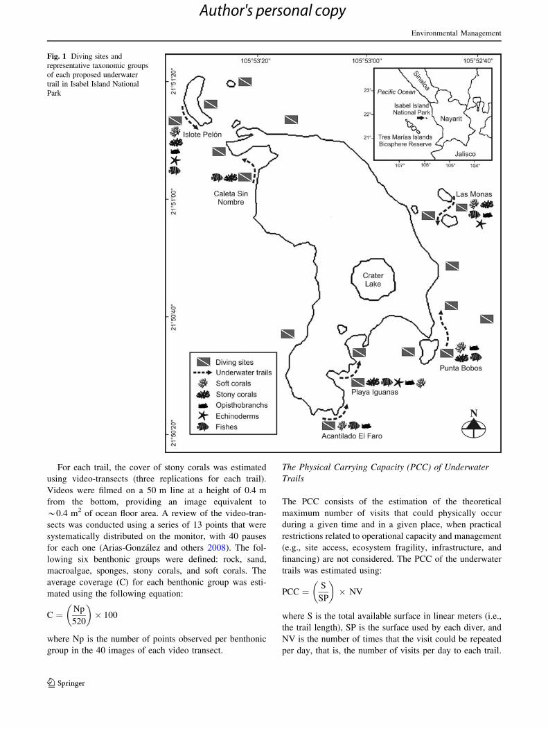
were proposed around the island (Fig. 1), each one with a
maximum depth of between 5 and 20 m. The trails had a
one-way route from a starting point where the vessel was
originally anchored during the immersion of the divers, to a
final point at the end of the trail were the vessel was moved
to pick up the divers gathered together in the surface. In the
design of these proposed trails, an attempt was made to
insure that the length of each route was similar; in partic-
ular, the trails were designed to be explored in the time that
is normally required to conduct a minimal-experience dive
that consumes 80 % of the air available in a typical scuba
tank, that is, *40 min. In addition, areas were selected that
were protected, shallow, and easy to access, with distinc-
tive flora and fauna as well as excellent topographical
features and scenic beauty. For each trail, an inventory of
natural marine resources was generated, which included
information regarding the trail’s geographical location
(georeference), depth, underwater topography, biota, state
of conservation, accessibility, security during the excur-
sion, and type(s) of seafloors.
Tourism Carrying Capacity (TCC)
The TCC of each underwater trail was determined in
accordance with the methodology proposed by Cifuentes
and others (1999) and modified by Gallo and others (2003).
Correction factors were adjusted such that they were
appropriate to the conditions of underwater activity and the
probabilistic elements of threat and vulnerability for each
trail. This methodology allows for the establishment of the
maximum number of visits that the trail can receive based
upon the physical and biological conditions of each loca-
tion, the socioeconomic conditions, and the regulations
relating to service providers and the administration of
Isabel Island. To this end, it is necessary to calculate the
physical carrying capacity (PCC), the real carrying
capacity (RCC), and finally, the TCC, which can be
expressed as the number of visitor groups per day or the
number of visitors (persons) per day. The different com-
ponents of the TCC have the following consecutive
sequence: PCC C RCC C TCC; thus, the final estimated
value of carrying capacity tends to decrease as each of
these calculations is performed.
Determination of the Carrying Capacity
Underwater Trails
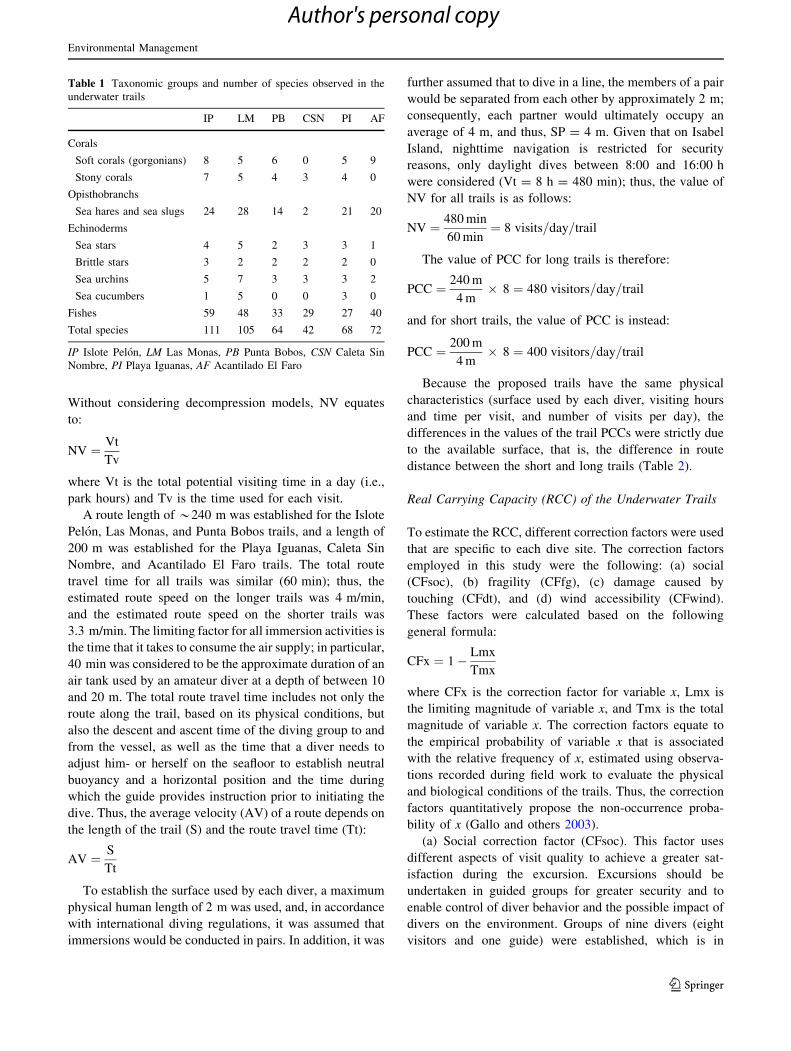
Each underwater trail selected presents representative
marine biota, including those taxonomic groups considered
to be of interest in recreational diving (Table 1). However,
the marine biota and topography of each trail are distinct;
consequently, the trail routes are different. Also the number
and type of conspicuous and charismatic species is differ-
ent. On the Acantilado El Faro trail, the abundance of
gorgonians is notable, whereas the Islote Pelon and Las
Monas trails have a greater diversity of stony corals and
gorgonians. For echinoderms, the trails with the greatest
diversity are Islote Pelon, Las Monas, and Playa Iguanas.
There is a large variety of opisthobranchs on Isabel Island,
Islote Pelon and Las Monas stand out as examples of
opisthobranch-harboring sites, where it is possible to
observe species of great color and beauty that are partic-
ularly attractive to diver-photographers. These same loca-
tions also host the greatest diversity of fish.
Environmental Management
123
Author's personal copy
For each trail, the cover of stony corals was estimated
using video-transects (three replications for each trail).
Videos were filmed on a 50 m line at a height of 0.4 m
from the bottom, providing an image equivalent to
*0.4 m2 of ocean floor area. A review of the video-tran-
sects was conducted using a series of 13 points that were
systematically distributed on the monitor, with 40 pauses
for each one (Arias-Gonzalez and others 2008). The fol-
lowing six benthonic groups were defined: rock, sand,
macroalgae, sponges, stony corals, and soft corals. The
average coverage (C) for each benthonic group was esti-
mated using the following equation:
C ¼ Np
520
� �� 100
where Np is the number of points observed per benthonic
group in the 40 images of each video transect.
The Physical Carrying Capacity (PCC) of Underwater
Trails
The PCC consists of the estimation of the theoretical
maximum number of visits that could physically occur
during a given time and in a given place, when practical
restrictions related to operational capacity and management
(e.g., site access, ecosystem fragility, infrastructure, and
financing) are not considered. The PCC of the underwater
trails was estimated using:
PCC ¼ S
SP
� �� NV
where S is the total available surface in linear meters (i.e.,
the trail length), SP is the surface used by each diver, and
NV is the number of times that the visit could be repeated
per day, that is, the number of visits per day to each trail.
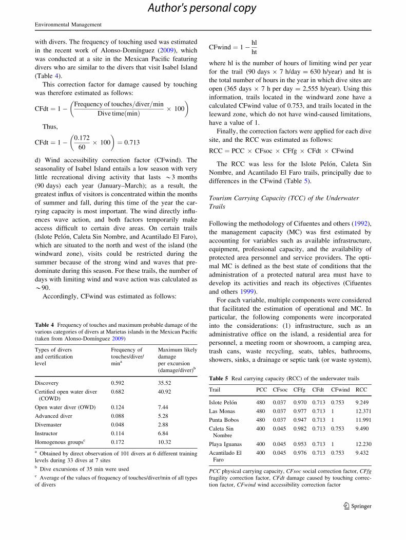
Fig. 1 Diving sites and
representative taxonomic groups
of each proposed underwater
trail in Isabel Island National
Park
Environmental Management
123
Author's personal copy
Without considering decompression models, NV equates
to:
NV ¼ Vt
Tv
where Vt is the total potential visiting time in a day (i.e.,
park hours) and Tv is the time used for each visit.
A route length of *240 m was established for the Islote
Pelon, Las Monas, and Punta Bobos trails, and a length of
200 m was established for the Playa Iguanas, Caleta Sin
Nombre, and Acantilado El Faro trails. The total route
travel time for all trails was similar (60 min); thus, the
estimated route speed on the longer trails was 4 m/min,
and the estimated route speed on the shorter trails was
3.3 m/min. The limiting factor for all immersion activities is
the time that it takes to consume the air supply; in particular,
40 min was considered to be the approximate duration of an
air tank used by an amateur diver at a depth of between 10
and 20 m. The total route travel time includes not only the
route along the trail, based on its physical conditions, but
also the descent and ascent time of the diving group to and
from the vessel, as well as the time that a diver needs to
adjust him- or herself on the seafloor to establish neutral
buoyancy and a horizontal position and the time during
which the guide provides instruction prior to initiating the
dive. Thus, the average velocity (AV) of a route depends on
the length of the trail (S) and the route travel time (Tt):
AV ¼ S
Tt
To establish the surface used by each diver, a maximum
physical human length of 2 m was used, and, in accordance
with international diving regulations, it was assumed that
immersions would be conducted in pairs. In addition, it was
further assumed that to dive in a line, the members of a pair
would be separated from each other by approximately 2 m;
consequently, each partner would ultimately occupy an
average of 4 m, and thus, SP = 4 m. Given that on Isabel
Island, nighttime navigation is restricted for security
reasons, only daylight dives between 8:00 and 16:00 h
were considered (Vt = 8 h = 480 min); thus, the value of
NV for all trails is as follows:
NV ¼ 480 min
60 min¼ 8 visits=day=trail
The value of PCC for long trails is therefore:
PCC ¼ 240 m
4 m� 8 ¼ 480 visitors=day=trail
and for short trails, the value of PCC is instead:
PCC ¼ 200 m
4 m� 8 ¼ 400 visitors=day=trail
Because the proposed trails have the same physical
characteristics (surface used by each diver, visiting hours
and time per visit, and number of visits per day), the
differences in the values of the trail PCCs were strictly due
to the available surface, that is, the difference in route
distance between the short and long trails (Table 2).
Real Carrying Capacity (RCC) of the Underwater Trails
To estimate the RCC, different correction factors were used
that are specific to each dive site. The correction factors
employed in this study were the following: (a) social
(CFsoc), (b) fragility (CFfg), (c) damage caused by
touching (CFdt), and (d) wind accessibility (CFwind).
These factors were calculated based on the following
general formula:
CFx ¼ 1� Lmx
Tmx
where CFx is the correction factor for variable x, Lmx is
the limiting magnitude of variable x, and Tmx is the total
magnitude of variable x. The correction factors equate to
the empirical probability of variable x that is associated
with the relative frequency of x, estimated using observa-
tions recorded during field work to evaluate the physical
and biological conditions of the trails. Thus, the correction
factors quantitatively propose the non-occurrence proba-
bility of x (Gallo and others 2003).
(a) Social correction factor (CFsoc). This factor uses
different aspects of visit quality to achieve a greater sat-
isfaction during the excursion. Excursions should be
undertaken in guided groups for greater security and to
enable control of diver behavior and the possible impact of
divers on the environment. Groups of nine divers (eight
visitors and one guide) were established, which is in
Table 1 Taxonomic groups and number of species observed in the
underwater trails
IP LM PB CSN PI AF
Corals
Soft corals (gorgonians) 8 5 6 0 5 9
Stony corals 7 5 4 3 4 0
Opisthobranchs
Sea hares and sea slugs 24 28 14 2 21 20
Echinoderms
Sea stars 4 5 2 3 3 1
Brittle stars 3 2 2 2 2 0
Sea urchins 5 7 3 3 3 2
Sea cucumbers 1 5 0 0 3 0
Fishes 59 48 33 29 27 40
Total species 111 105 64 42 68 72
IP Islote Pelon, LM Las Monas, PB Punta Bobos, CSN Caleta Sin
Nombre, PI Playa Iguanas, AF Acantilado El Faro
Environmental Management
123
Author's personal copy
accordance with the rules of the Recreational Scuba
Training Council (RSTC) and the Professional Association
of Diving Instructors (PADI). In addition, an interval of
60 min was established between visitor groups. This
interval is the approximate time that a single group occu-
pies the site and facilitates the prevention of accidental
encounters between vessels and divers, both on the surface
and on the seafloor. Thus, this limitation insures that a trail
should not have more than one group at a time conducting a
underwater excursion.
To calculate CFsoc, the limiting magnitude (Lm), that
is, the occupancy limits that result from the distance
between groups, must be calculated:
Lm ¼ S� ðP � NgÞ
where S is the distance between groups (240 m for long
trails and 200 m for short trails, given that there should not
be more than 1 group on the trail at a time), P is the number
of persons per trail (nine divers), and Ng is the number of
groups per trail, in this case 1. Thus, the value of Lm for
long trails is:
Lm ¼ 240� 9 � 1ð Þ ¼ 231
and for short trails, Lm is:
Lm ¼ 200� 9 � 1ð Þ ¼ 191
CFsoc is calculated as follows:
CFsoc ¼ 1� Lm
L
� �
thus, CFsoc for the long trails is:
CFsoc ¼ 1� 231
240
� �¼ 0:037
and for the short trails, CFsoc is:
CFsoc ¼ 1� 191
200
� �¼ 0:045
(b) Fragility correction factor (CFfg). To estimate CFfg,
the coverage of stony corals was considered, as these are
particularly vulnerable to contact with divers and to the
anchoring of vessels (Hawkins and Roberts 1992; Harriott
and others 1997; Nickerson-Tietze 2000; Tratalos and
Austin 2001; Lynch and others 2004; Uyarra and Cote
2007). The stony corals of Isabel Island primarily consist of
branching, massive, and nodular types. The majority of
these corals belong to seven species of the genera
Pocillopora, Porites, Pavona, and Psammocora (Rıos-Jara
and others 2008b; Rodrıguez-Zaragoza and others 2011).
Their distribution is variable, and the greatest coverage of
these corals occurs in the western and southern zones of the
island (Table 3). The main reef formation is found along the
southern face of the island, along the Punta Bobos trail. This
reef is essentially composed of Pocillopora capitata and
Pocillopora verrucosa and has a maximum length of 60 m, a
maximum width of 18 m, and a height of *1.5 m. The
coverage of live coral is 55 %. Dead coral (45 %) is
primarily located in the shallow area near the intertidal zone.
Along the edges of the reef, there are large clumps of the
massive coral Porites lobata, with colonies of between 40
and 70 cm in diameter.
The CFfg of each trail was estimated by considering
only the percentage of fragile coverage (stony corals) of
each site:
CFfg ¼ 1� Cð% fragile coverageÞ100 %
� �
c) Correction factor of damage caused by touching (CFdt).
This correction factor subtracts, as a limiting factor, the
mathematical expectation of damage caused by contact
Table 2 Physical carrying capacity (PCC) of the underwater trails
IP LM PB CSN PI AF
S is the linear surface available (trail length) (m) 240 240 240 200 200 200
SP is the surface used by each person/diver (m) 4 4 4 4 4 4
Vh is the total potential daily visiting time (min) 480 480 480 480 480 480
tv is the time used per visit (min) 60 60 60 60 60 60
NV is the number of visits per day 8 8 8 8 8 8
Physical carrying capacity (PCC) 480 480 480 400 400 400
The underwater trail codes correspond to those of Table 1
Table 3 The percentage of stony coral coverage and the fragility
correction factor of the underwater trails of Isabel Island
Trail Coverage (%) CFfg
Islote Pelon 2.93 0.970
Las Monas 2.21 0.977
Punta Bobos 5.28 0.947
Caleta Sin Nombre 1.76 0.982
Playa Iguanas 4.61 0.953
Acantilado El Faro 2.40 0.976
Environmental Management
123
Author's personal copy
with divers. The frequency of touching used was estimated
in the recent work of Alonso-Domınguez (2009), which
was conducted at a site in the Mexican Pacific featuring
divers who are similar to the divers that visit Isabel Island
(Table 4).
This correction factor for damage caused by touching
was therefore estimated as follows:
CFdt ¼ 1� Frequency of touches=diver=min
Dive time minð Þ � 100
� �
Thus,
CFdt ¼ 1� 0:172
60� 100
� �¼ 0:713
d) Wind accessibility correction factor (CFwind). The
seasonality of Isabel Island entails a low season with very
little recreational diving activity that lasts *3 months
(90 days) each year (January–March); as a result, the
greatest influx of visitors is concentrated within the months
of summer and fall, during this time of the year the car-
rying capacity is most important. The wind directly influ-
ences wave action, and both factors temporarily make
access difficult to certain dive areas. On certain trails
(Islote Pelon, Caleta Sin Nombre, and Acantilado El Faro),
which are situated to the north and west of the island (the
windward zone), visits could be restricted during the
summer because of the strong wind and waves that pre-
dominate during this season. For these trails, the number of
days with limiting wind and wave action was calculated as
*90.
Accordingly, CFwind was estimated as follows:
CFwind ¼ 1� hl
ht
where hl is the number of hours of limiting wind per year
for the trail (90 days 9 7 h/day = 630 h/year) and ht is
the total number of hours in the year in which dive sites are
open (365 days 9 7 h per day = 2,555 h/year). Using this
information, trails located in the windward zone have a
calculated CFwind value of 0.753, and trails located in the
leeward zone, which do not have wind-caused limitations,
have a value of 1.
Finally, the correction factors were applied for each dive
site, and the RCC was estimated as follows:
RCC ¼ PCC � CFsoc � CFfg � CFdt � CFwind
The RCC was less for the Islote Pelon, Caleta Sin
Nombre, and Acantilado El Faro trails, principally due to
differences in the CFwind (Table 5).
Tourism Carrying Capacity (TCC) of the Underwater
Trails
Following the methodology of Cifuentes and others (1992),
the management capacity (MC) was first estimated by
accounting for variables such as available infrastructure,
equipment, professional capacity, and the availability of
protected area personnel and service providers. The opti-
mal MC is defined as the best state of conditions that the
administration of a protected natural area must have to
develop its activities and reach its objectives (Cifuentes
and others 1999).
For each variable, multiple components were considered
that facilitated the estimation of operational and MC. In
particular, the following components were incorporated
into the considerations: (1) infrastructure, such as an
administrative office on the island, a residential area for
personnel, a meeting room or showroom, a camping area,
trash cans, waste recycling, seats, tables, bathrooms,
showers, sinks, a drainage or septic tank (or waste system),
Table 4 Frequency of touches and maximum probable damage of the
various categories of divers at Marietas islands in the Mexican Pacific
(taken from Alonso-Domınguez 2009)
Types of divers
and certification
level
Frequency of
touches/diver/
mina
Maximum likely
damage
per excursion
(damage/diver)b
Discovery 0.592 35.52
Certified open water diver
(COWD)
0.682 40.92
Open water diver (OWD) 0.124 7.44
Advanced diver 0.088 5.28
Divemaster 0.048 2.88
Instructor 0.114 6.84
Homogenous groupsc 0.172 10.32
a Obtained by direct observation of 101 divers at 6 different training
levels during 33 dives at 7 sitesb Dive excursions of 35 min were usedc Average of the values of frequency of touches/diver/min of all types
of divers
Table 5 Real carrying capacity (RCC) of the underwater trails
Trail PCC CFsoc CFfg CFdt CFwind RCC
Islote Pelon 480 0.037 0.970 0.713 0.753 9.249
Las Monas 480 0.037 0.977 0.713 1 12.371
Punta Bobos 480 0.037 0.947 0.713 1 11.991
Caleta Sin
Nombre
400 0.045 0.982 0.713 0.753 9.490
Playa Iguanas 400 0.045 0.953 0.713 1 12.230
Acantilado El
Faro
400 0.045 0.976 0.713 0.753 9.432
PCC physical carrying capacity, CFsoc social correction factor, CFfgfragility correction factor, CFdt damage caused by touching correc-
tion factor, CFwind wind accessibility correction factor
Environmental Management
123
Author's personal copy
a workshop, a cellar, viewpoints, an island approach canal,
landing dock, anchoring buoys, walking paths, signage,
explanatory signs, benches, a site sketch or model, elec-
tricity, and potable water; (2) equipment, such as a mete-
orological station, park and service provider vessels and
vehicles, dive equipment, an air compressor, communica-
tions radio, extinguishers, first-aid kits, screen and projec-
tion equipment, computers, chainsaws, wheelbarrows,
dollies, GPS, and compasses; (3) personnel, such as
administrators, park rangers, dive guides, service operators,
certified boatmen, certified divers, operational protocols,
security protocols, and park use regulations.
These components were evaluated with respect to four
criteria: quantity, state, functionality, and location. These
evaluation criteria principally take the following factors
into account: (1) quantity, which estimates the percentage
relationship between existing quantity and optimal quantity
(optimal quantity is the judgment of authors of this study);
(2) state, which refers to the conservation conditions and
usage of each component, such as its maintenance, clean-
liness and security, providing for adequate and safe use of
the installation, facility, or equipment; (3) location, which
accounts for the location and appropriate spatial distribu-
tion of area personnel, equipment, and infrastructure, as
well as the ease of access to these resources; and (4)
functionality, which is the result of the combination of the
two criteria of state and location, that is, the practical utility
that the given component has for both personnel and visi-
tors. Although these criteria do not represent the totality of
options for evaluating and determining the MC of the
island, it was concluded that they are sufficient for
achieving a good approximation.
Finally, to undertake a more objective estimation of the
MC, it was important to convert qualitative criteria into
quantitative and percentage-based criteria, from ‘‘not sat-
isfactory,’’ which was assigned a value of 0 (\35 %), to
‘‘very satisfactory,’’ which was assigned a value of 4
(C90 %). The MC of Isabel Island was estimated by cal-
culating the average of the values of the infrastructure,
equipment, and personnel variables (Table 6).
With the MC value, the TCC was estimated for each
underwater trail as follows:
TCC ¼ RCC � MC
The TCC was expressed as the number of dive groups
per day, and as the number of dives per day, assuming that
each group is composed of nine visitors (one guide and
eight divers). The TCC values ranged between 1,252 and
1,642 dives/year/trail (Table 7). These are fairly similar
among trails, and their differences are largely due to the
correction factors included in the RCC; in particular, these
distinctions are largely caused by differences in the
fragility and damage caused by touching at the various
trails, which depend on the coverage of stony corals on the
sea floor at each location. It is precisely the trails with the
lowest TCC values that present the greatest coverage of
branching corals of the genus Pocillopora, which are
particularly fragile and, consequently, susceptible to
damage caused by diver touching and vessel anchors. In
addition, wind and wave action was restrictive in the trails
located in the windward zone. The total number of dives
per year for all trails (8,597) provides an approximation of
the carrying capacity of divers visiting Isabel Island.
Discussion
The scenic beauty and biological diversity of IINP render it
a potential destination for undertaking ecotourism activities
that, if managed appropriately and from a sustainable
perspective, should not undermine the conservation area’s
goals. Nevertheless, owing to the small size of the island
and the fragility of its ecosystems, it is important to
establish an appropriate zoning scheme and to establish
criteria for the use of the ecosystem services in accordance
with its carrying capacities, keeping in mind its environ-
mental and socioeconomic characteristics, as is proposed
by current methodologies (Coccossis and Mexa 2004).
Thus, the underwater trails proposed in the present study
for Isabel Island and its TCC consider not only environ-
mental questions but also economic and social issues,
including scenic beauty and the observation of charismatic
species (e.g., opisthobranchs, stony corals, gorgonians,
echinoderms, fishes), as well as the accessibility, infra-
structure, and security conditions for a high-quality recre-
ational diving. All of these considerations correspondingly
decrease the possible impact of visitors, with positive
consequences for the conservation of the natural park
because any modification in the island environments could
have consequences on its biodiversity.
The impacts of visitors may differ qualitatively
between different geographic locations. Several studies
indicate that the development of touristic infrastructure
has the greatest impact on low-latitude islands, where
species are frequently endemic and vulnerable to change
Table 6 Management capacity of Isabel Island National Park
Variable Value
Infrastructure 0.3125
Equipment 0.3813
Personnel 0.4000
Average 0.3610
Management capacity (MC) 0.3637
Environmental Management
123
Author's personal copy
(e.g., Cronk 1997), as in Isabel Island. In addition, the
small size of the island, with its coastline of approxi-
mately 6.5 km, and its considerable richness in species of
invertebrates and marine fish make it particularly sensi-
tive to the human presence. The island’s coral and rocky
reefs are particularly important, as is reported for other
sites in the Mexican Pacific, including the Gulf of
California and the rest of the Mexican Tropical Pacific
(Solıs-Marın and others 1997; Cintra-Buenrostro and
others 2005; Zamorano and Leyte-Morales 2005; Gon-
zalez-Medina and others 2006).
Underwater trails proposed for Isabel Island are
intended as a complementary strategy to reduce potential
hazards and to direct visitors away from areas that are less
resilient to human use (e.g., areas of higher coral cover-
age). Certainly, the creation and use of trails have proved
to be useful in concentrating use within defined areas of
reefs to reduce effects on more vulnerable habitats
(Hawkins and Roberts 1993; Plathong and others 2000).
This is particularly important in MPAs containing coral
reefs and high benthic biodiversity (Ward 1990; Hawkins
and Roberts 1994; Harriott and others 1997; Rouphael and
Inglis 2001), and in regions near the limits of the range
distributions of coral species because these regions fre-
quently present naturally stressful conditions and conse-
quently the effects of colony damage caused by SCUBA
divers may be magnified (Fishelson 1995; Wielgus and
others 2004). This is the case of Isabel Island, located near
the extreme northern distribution of various stony coral
species of the American Pacific (29�N), including several
branching coral types that are very vulnerable to anthro-
pogenic activities.
However, it is not clear whether it is preferable to
concentrate divers along well defined trails or to spread use
over larger areas. Surveys of coral damage along under-
water trails indicate high levels of damage, for example
between 35 and 70 % of susceptible coral colonies were
broken by snorkelers in trails at Orpheus Island of the
Great Barrier Reef Marine Park (Plathong and others
2000). Other observations indicate that the concentration of
visitors in specific locations can increase the levels of stress
experienced by these sites (Hawkins and Roberts 1997).
Additionally, group size has an influence on the ability of
guides to supervise visitors; thus, small groups are better
for the environment in the areas of greatest fragility (Bar-
ker and Roberts 2004). Consequently, any proposal for the
creation and use of underwater trails should be comple-
mented with estimations of the corresponding carrying
capacity and other regulations related with the MC of the
diving sites. Also, many other characteristics should be
taken into consideration, among which are diver experi-
ence, the size of the group of divers, the type of activity
undertaken during dives (e.g., photography), and the
environmental conditions during excursions (e.g., currents,
visibility, and temperature). In addition, different covers
and growth forms of corals have different damage fre-
quencies and fragility, and it is not clear what proportion of
all of these factors should be considered in the estimation
of the carrying capacity of a site, given their significant
variability.
Although there is a considerable number of studies on
recreational diving activities in MPAs that focus on esti-
mating the carrying capacity of coral reefs (e.g., Dixon and
others 1993; Hawkins and Roberts 1997; Hawkins and others
Table 7 Carrying capacity for underwater trails in Isabel Island National Park
Type of carrying capacity IP LM PB CSN PI AF
FCC (dives/day) 480 480 480 400 400 400
Correction factor
FCsoc 0.037 0.037 0.037 0.045 0.045 0.045
FCfg 0.970 0.977 0.947 0.982 0.953 0.976
FCdt 0.713 0.713 0.713 0.713 0.713 0.713
FCwind 0.753 1 1 0.753 1 0.753
RCC (dives/day) 9.249 12.371 11.991 9.490 12.230 9.432
MC (%) 0.3637 0.3637 0.3637 0.3637 0.3637 0.3637
TCC (dives/day) 3.363 4.499 4.361 3.451 4.448 3.430
TCC (dives/year) 1227 1642 1592 1260 1624 1252
Average dives/year/trail 1,433
Total dives/year for all trails 8,597
Underwater trails codes correspond to those of Table 1
PCC physical carrying capacity, CFsoc social correction factor, CFfg fragility correction factor, CFdt damage caused by touching correction
factor, CFwind wind correction factor, RCC real carrying capacity, MC management capacity, TCC tourism carrying capacity
Environmental Management
123
Author's personal copy

1999; Schleyer and Tomalin 2000; Zakai and Chadwick-
Furman 2002), there are few estimations for the diving sites
of the MPAs from the Eastern Tropical Pacific, including
those of the coast of Mexico. Similarly, environmental
research on diving impacts has primarily been conducted in
other tropical regions (e.g., Medio and others 1997; Harriott
and others 1997; Rouphael and Inglis 2001; Tratalos and
Austin 2001). The main approach of these studies was to
estimate the carrying capacity of coral reefs for SCUBA
diving by comparing the damage levels to reefs subject to
known levels of diving intensities; there are few examples of
the use of holistic methodologies based on the physical,
biological characteristics and the management capacities of
the diving sites (i.e., a TCC assessment methodology; Gallo
and others 2003) as the estimates made by Ramırez-Cordero
(2008) and Reyes-Bonilla and others (2012) in MPAs of the
southern region of the Gulf of California, and Sousa-Melo
and others (2006) in the reefs of Paraıba, Brazil.
In tropical environments, estimations of the number of
divers that can be accommodated at a particular reef site
before serious damage is done range between 4,000 and 7,000
dives/site/year for coral reefs in Australia (Harriott and others
1997), the Caribbean (Dixon and others 1993; Hawkins and
others 1999), the Red Sea (Hawkins and Roberts 1997; Zakai
and Chadwick-Furman 2002), and South Africa (Schleyer and
Tomalin 2000). Our estimations of the TCC for Isabel Island
are comparable with these studies, despite the study areas and
methodologies being so different. The final value is approxi-
mately 8,600 dives per year although when underwater trails
are taken into consideration the TCC values range between
1,252 and 1,642 dives/year/trail which are still higher than the
present intensity of diving in Isabel Island (*1,000 dives/
year). Of course diving intensity in Isabel Island is much lower
than that recorded in the most popular high-use reefs of the
Caribbean ([350,000 in the Cayman Islands; Tratalos and
Austin 2001), the northern Red Sea ([30,000 in selected areas
at Eliat reefs; Zakai and Chadwick-Furman 2002) and the
northern New South Wales, Australia (43,000 dives/year at
Byron Bay; Davis and Tisdell 1995). However, if this number
continues to increase, there is a possibility that reef degrada-
tion would become a problem. Also, an increase in concen-
tration of divers would most likely reduce the amenity values
(i.e., satisfaction gained by recreational users) of the marine
park. It is evident that regardless of location, divers have a
wide range of known impacts, including direct physical
damage to habitat—either by divers or from anchoring—and
indirect impacts, such as increased sediment and nutrient
loads associated with the development of inappropriate dive-
tourism infrastructure (Hawkins and Roberts 1992; Harriott
and others 1997; Nickerson-Tietze 2000).
The estimation of carrying capacity presents a significant
intrinsic difficulty, given the problem of determining the
permissible thresholds that should be considered, as these
thresholds differ notably for each case analyzed. In accor-
dance with the methodology used in this study, the carrying
capacity depends largely on correction factors, which
decrease the final value of this capacity. However, several
of these factors are principally related to the natural char-
acteristics of the island environment (e.g., coral coverage,
wind), which are not modifiable. By contrast, the MC is a
factor added toward the end of the calculation that could,
perhaps, be manipulated to modify the carrying capacity, as
it incorporates the criteria of quantity, quality, and func-
tionality of the infrastructure and service-providing per-
sonnel. The MC could be stressed to achieve a sustainable
use of the island with respect to recreational diving.
In the present study, the application of the methodology
originally proposed by Cifuentes and others (1999) and
modified for marine environments by Gallo and others
(2003) facilitated the acquisition of important information
considered to be elements that would help make manage-
ment decisions in accordance with the season and the interest
of visitors to Isabel Island. Despite the possible damage to
the here proposed trails caused by visiting divers, it has been
suggested that it is possible to mitigate these effects by
appropriately regulating and by adequately managing the
behavior of divers (Plathong and others 2000). The initiation
of management measures concerning the use of dive areas
around Isabel Island will contribute to plan their recreation
and touristic use. The development of high-quality tourism
on the island must be compatible with the natural environ-
ment to assure resource conservation and the quality of
future visits. The determination of the TCC is one necessary
instrument, as is the establishment of criteria for the con-
tinuous monitoring of environmental conditions, supported
by environmental education practices and in situ evaluations
of diver conduct. The impact of visitors on the island must be
documented, just as the impact of natural events, such as
hurricanes, which have caused significant damage to stony
corals, has been documented. Currently, conservation efforts
that include flora and fauna inventories, estimations of coral
coverage, and a coral repopulation program are under way.
Furthermore, since the carrying capacity is also influenced
by the behavior of visitors (Leujak and Ormond 2007), the
damage on the environment may be simply because they
might not care or be aware of the impact they are causing (for
instance novice divers might have difficulties to control
buoyance or position, or be in urgent need of a rest on the
reef); they might be unable to change their behavior or they
might be unaware of existing regulations. There is a need of
campaigns promoting more environmentally friendly
behavior. In some cases, simply briefing visitors about the
vulnerability of organisms, such as corals, may mitigate
impacts (Marion and Rogers 1994; Medio and others 1997),
whereas in others more direct intervention may be necessary
(Barker and Roberts 2004).
Environmental Management
123
Author's personal copy
Conclusions
The present study provides two main elements to design
and implement management strategies which may con-
tribute to the sustainable use of the marine environments of
Isla Isabel: a proposal of six underwater trails and estimates
of the specific TCC for each trail. Field observations at the
diving sites indicate that at this time diving activities are
not causing noticeable damage to the coastal environments
of the island probably because there is a low diving
intensity. However, the number of recreational visitors to
the island has increased in recent years (*1,000 visitors in
2011). Therefore, there is a need for adequate preventive
management if the diving sites are to maintain their
esthetic appeal and biological characteristics. Such man-
agement might be directed either toward using only the
sites and the TCC proposed here, changing the behavior of
divers with environmental education, banning access for
users thought to cause most damage (e.g., novices and
photographers) (Tratalos and Austin 2001), or introducing
charges/transferable permits to reduce diver numbers at
sensitive sites (Davis and Tisdell 1996). Other recreational
activities may be more permissible in these sites. For
example, sites where fragile corals are abundant below
depths of 2 m may be able to support large numbers of
snorkelers but relatively few SCUBA divers, especially
beginners who are particularly prone to damaging corals
(Allison 1996). Also, since underwater trails have become
popular attractions in a variety of locations (Plathong and
others 2000), periodic closure and rotation of trails may
reduce the damage to corals, but their implementation
requires more detailed information on the rate of recovery
of damaged colonies. Most importantly, users of the trails
must be made aware of the damage they can inadvertently
cause. Short briefings and/or interpretative material that
explain how to use the equipment safely could consider-
ably reduce the incidence of damage. These measures have
already proved effective in reducing damaging behavior by
SCUBA divers (Medio and others 1997).
Finally, it is evident that methodological approaches for
carrying capacity assessment need to be further improved
with considerations made by planners and MPA designers,
the monitoring and experience of results in other locations.
As Lane (2010) recently stated ‘‘While some existing
carrying capacity methodologies offer significant insights
into the assessment of population carrying capacities, a
comprehensive model is yet to be developed. The carrying
capacity imperative is an environmental and ethical ini-
tiative of vital future importance. In fact, it is an imperative
on which society’s very survival may well depend.’’
Acknowledgments We thank M. Perez-Pena, A. Martınez-Zataraın,
A. Nuno-Hermosillo, and A. Santos-Crespo for their substantial help
during this project. We are grateful to National Commission of Natural
Protected Areas (CONANP) staff, particularly C. Garcıa-Chavelas, J.A.
Castrejon-Pineda, L.E. Cano-Sanchez, G. Perez-Lozano and C. Robles-
Castillo for their help during field work at Isabel Island. The National
Commission for the Knowledge and Use of the Biodiversity of Mexico
(CONABIO) and PROMEP-SEP partially funded this study. All
research activities were also supported by the Academic Group UDG-
CA-046 of the Universidad de Guadalajara, Mexico. Many thanks to
two anonymous reviewers for critically reviewing the manuscript.
References
Acevedo-Ejzman M (1997) Determinacion de la capacidad de carga
turıstica en dos sitios de visita del Refugio de Vida Silvestre La
Marta, e identificacion de su punto de equilibrio financiero.
Universidad Latinoamericana de Ciencia y Tecnologıa, San Jose
Allison WR (1996) Snorkeler damage to reef corals in the Maldive
Islands. Coral Reefs 15:215–218
Alonso-Domınguez A (2009) Comportamiento de buzos en dos areas
naturales protegidas de Bahıa de Banderas, Jalisco-Nayarit: Islas
Marietas y Los Arcos. Dissertation, University of Guadalajara
Arias-Gonzalez JE, Legendre P, Rodrıguez-Zaragoza FA (2008)
Scaling up beta diversity on Caribbean coral reefs. J Exp Mar
Biol Ecol 366:28–36
Barker NHL, Roberts CM (2004) Scuba diver behaviour and the manage-
ment of diving impacts on coral reefs. Biol Conserv 120:481–489
Buckley R (1999) An ecological perspective on carrying capacity.
Ann Tour Res 26:705–708
Carr MH (2000) Marine protected areas: challenges and opportunities
for understanding and conserving coastal marine ecosystems.
Environ Conserv 27:106–109
Cayot L, Cifuentes M, Amador E et al (1996) Determinacion de la
capacidad de carga turıstica en los sitios de visita del Parque
Nacional Galapagos. Servicio Parque Nacional Galapagos,
Instituto Ecuatoriano Forestal y de Areas Naturales y Vida
Silvestre, Puerto Ayora
Ceballos-Lascurain H (1996) Tourism, ecotourism, and protected
areas. The World Conservation Union, IUCN, Gland
Cesar H, van Beukering P, de Berdt-Romilly G (2003) Case Study-
Negril, Jamaica. Mainstreaming economic valuation in decision
making: Coral reef examples in selected CARICOM countries.
ARCADIS-Euroconsult, Arnhem
Cifuentes M, Alpizar F, Barroso F (1990) Capacidad de carga
turıstica de la Reserva Biologica Carara. Informe de consulta,
Servicio de Parques Nacionales/CATIE, Turrialba
Cifuentes M, Alpizar F, Barroso F et al (1992) Determinacion de
capacidad de carga turıstica en areas protegidas. CATIE Serie
tecnica, Turrialba
Cifuentes M, Mesquita CA, Mendez J et al (1999) Capacidad de carga
turıstica de las areas de uso publico del Monumento Nacional
Guayabo, Costa Rica. WWF Centroamerica, Turrialba
Cintra-Buenrostro CE, Reyes-Bonilla H, Herrero-Perezrul MD (2005)
Oceanographic conditions and diversity of sea stars (Echinoder-
mata: asteroidea) in the Gulf of California, Mexico. Rev Biol
Trop 53:245–261
Coccossis C, Mexa A (2004) The challenge of tourism carrying
capacity assessment. Ashgate Publishing, Ashgate
CONABIO (1998) La diversidad biologica de Mexico: estudio de
paıs. Comision Nacional para el Conocimiento y Uso de la
Biodiversidad, Mexico
CONANP (2012) Comision Nacional de Areas Naturales Protegidas.
http://www.conanp.gob.mx. Accessed 27 Feb 2012
Cronk QCB (1997) Islands: stability, diversity, conservation. Biodi-
vers Conserv 6(3):477–493
Environmental Management
123
Author's personal copy
Davis D, Tisdell C (1995) Recreational scuba-diving and carrying
capacity in marine protected areas. Ocean Coast Manage 26:
19–40
Davis D, Tisdell C (1996) Economic management of recreational
scuba diving and the environment. J Environ Manage 48:
229–248
Dixon JA, Scura FL, van’t Hof T (1993) Meeting ecological and
economic goals: marine parks in the Caribbean. Ambio 22:
117–125
Fishelson L (1995) Eilat (Gulf of Aqaba) littoral: life on the red line
of biodegradation. Isr J Zool 41:43–55
Fraschetti S, Terlizzi A, Micheli F et al (2002) Marine protected areas
in the Mediterranean Sea: effectiveness and monitoring. Mar
Ecol 23(1):190–200
Gallo F, Martınez A, Rıos JI (2003) Capacidad de carga de visitantes
en areas de buceo de San Andres Isla (Colombia). Universidad
Tecnologica de Pereira, Pereira
Galvan-Villa CM, Arreola-Robles JL, Rıos-Jara E et al (2010)
Ensamblajes de peces arrecifales y su relacion con el habitat
bentonico de la Isla Isabel, Nayarit, Mexico. Rev Biol Mar
Oceanogr 45(2):311–324
Gonzalez-Medina MJ, Holguın-Quinones O, de la Cruz-Aguero G
(2006) Variacion espacio-temporal de algunos invertebrados
(Gastropoda, Bivalvia y Echinodermata) de fondos someros del
Archipielago Espıritu Santo, B.C.S., Mexico. Cienc Mar 32:
33–44
Gossling S (2002) Global environmental consequences of tourism.
Global Environ Chang 12:283–302
Harriott VJ, Davis D, Banks SA (1997) Recreational diving and its
impact in marine protected areas in eastern Australia. Ambio
26(3):173–179
Hawkins JP, Roberts CM (1992) Effects of recreational SCUBA
diving on fore-reef slope communities of coral reefs. Biol
Conserv 62:171–178
Hawkins JP, Roberts CM (1993) Effects of recreational SCUBA
diving on coral reefs: trampling on reef-flat communities. J Appl
Ecol 30:25–30
Hawkins JP, Roberts CM (1994) The growth of coastal tourism in the
Red Sea: present and future effects on coral reefs. Ambio
23(8):503–508
Hawkins JP, Roberts CM (1997) Estimating the carrying capacity of
coral reefs for recreational scuba diving. In: Lessios HA,
Macintyre IG (eds) Proceedings of the eighth international coral
reef symposium, Smithsonian Tropical Research Institute, Bal-
boa, pp 1923-1926
Hawkins JP, Roberts CM, Van’t Hof T, De Meyer C, Tratalos J,
Aldam C (1999) Effects of recreational scuba diving on
Caribbean coral and fish communities. Conserv Biol 13(4):
888–897
Hawkins JP, Roberts CM, Kooistra D et al (2005) Sustainability of
scuba diving tourism on coral reefs of Saba. Coast Manage
33:373–387
Kriwoken LK (1996) Australian Biodiversity and Marine Protected
Areas. Ocean Coast Manage 33:113–132
Lane M (2010) The carrying capacity imperative: assesing regional
carrying capacity methodologies for sustainable land-use plan-
ning. Land Use Policy 27:1038–1045
Leujak W, Ormond RFG (2007) Visitors perceptions and the shifting
social carrying capacity of South Sinai0s Coral Reefs. Environ
Manage 39:472–489
Lynch TP, Wilkinson E, Melling L et al (2004) Conflict and impacts
of divers and anglers in a Marine park. Environ Manage 33:
196–211
Marion JL, Rogers CS (1994) The applicability of terrestrial visitor
impact management strategies to the protection of coral reefs.
Ocean Coast Manage 22:153–163
Medio D, Ormond RFG, Pearson M (1997) Effects of briefing on rates
of damage to corals by SCUBA divers. Biol Conserv 79:91–95
Mitraud S (1998) Projeto de Desenvolvimiento de Tilhas Iterpreta-
tivas do Parque Nacional Marinho de Fernando de Noronha-PE.
Actividade 3: Determinacao da Capacidade de Carga e Sistema
de Monitoramento de Impacto de Visitacao, Velatorio Tecnico 2,
Convenio IBAMA-WWF No.006.97, WWF-Brazil
Montes-Medina AC, Drummond H, Kim SY (2009) Distance from
the forest edge matters in habitat selection of the Blue-footed
Booby Sula nebouxii. J Ornithol 150(4):845–852
Nickerson-Tietze DJ (2000) Scientific characterization and monitor-
ing: its application to integrated coastal management in Malay-
sia. Ecol Appl 10(2):386–396
Perez-Jimenez JC, Sosa-Nishizaki O, Furlong-Estrada E et al (2005)
Artisanal Shark Fishery at Tres Marias Islands and Isabel Island
in the Central Mexican Pacific. J Northwest Atl Fish Sci 35:
333–343
Plathong S, Inglis GJ, Huber ME (2000) Effects of self-guided
snorkeling trails on corals in a tropical marine park. Conserv
Biol 14(6):1821–1830
Ramırez-Cordero CA (2008) Uso ecoturıstico y capacidad de carga de
buceo en las Islas Marietas y los Arcos en Bahıa de Banderas,
Jalisco-Nayarit, Mexico. Dissertation, University of Guadalajara
Reyes-Bonilla H, Cupul-Magana AL, Loreto-Viruel RM et al (2012)
Evaluacion de la capacidad de carga para buceo en areas
naturales protegidas del mar Caribe y el golfo de California,
Mexico. In: Ivanova A, Ibanez R (eds) Medio ambiente y
polıtica turıstica en Mexico, SEMARNAT, INE, UABCS,
Mexico, pp 149–162
Rıos-Jara E, Perez-Pena M, Lopez-Uriarte E et al (2003) Estudio
previo justificativo para la declaratoria bajo regimen de protec-
cion de la zona marina adyacente al Parque Nacional Isla Isabel.
WWF-Programa Golfo de California, Mexico
Rıos-Jara E, Galvan-Villa CM, Solıs-Marın FA (2008a) Equinoder-
mos del Parque Nacional Isla Isabel, Nayarit, Mexico. Rev Mex
Biodivers 79:131–141
Rıos-Jara E, Lopez-Uriarte E, Perez-Pena M et al (2008b) Listados
taxonomicos de la biota marina del Parque Nacional Isla Isabel
(invertebrados, peces, macroalgas). University of Guadalajara,
Mexico
Rodrıguez V (1992) Determinacion de Capacidad de Carga Turıstica
para el Parque Nacional Manuel Antonio. Dissertation, Centro
Agronomico Tropical de Investigacion y Ensenanza
Rodrıguez-Zaragoza FA, Cupul-Magana AL, Galvan-Villa CM et al
(2011) Additive partitioning of reef fish diversity variation: a
promising marine biodiversity management tool. Biodivers
Conserv 20:1655–1675
Rouphael AB, Inglis GJ (2001) Increased spatial and temporal
variability in coral damage caused by recreational scuba diving.
Ecol Appl 12(2):427–440
Schleyer MH, Tomalin BJ (2000) Damage on South African coral
reefs and an assessment of their sustainable diving capacity
using a fisheries approach. B Mar Sci 67:1025–1042
Solıs-Marın FA, Reyes-Bonilla H, Herrero-Perezrul MD et al (1997)
Sistematica y distribucion de los equinodermos de la Bahıa de la
Paz. Cienc Mar 23:249–263
Sousa-Melo R, Crispim MC, Rodrıguez-Viana E et al (2006)
Estimativa da capacidade de carga recreativa dos ambientes
recifais da Praia do Seixas (Paraıba-Brasil). Turismo: Visao e
Acao 8:411–422
Tratalos JA, Austin TJ (2001) Impacts of recreational SCUBA diving
on coral communities of the Caribbean island of Grand Cayman.
Biol Conserv 102:67–75
Uyarra MC, Cote IM (2007) The quest for cryptic creatures: impacts
of species-focused recreational diving on corals. Biol Conserv
136:77–84
Environmental Management
123
Author's personal copy

Ward F (1990) Florida’s coral reefs are imperiled. National
Geographic, Washington, DC, pp 115–132
Wielgus J, Chadwick-Furman NE, Dubinsky Z (2004) Coral cover
and partial mortality on anthropogenically impacted coral reefs
at Eilat, northern Red Sea. Mar Pollut Bull 48:248–253
Wolters (1991) Tourism Carrying Capacity. World Tourism Organi-
zation-United Nations Environment Program, Paris
Zakai D, Chadwick-Furman NE (2002) Impacts of intensive recre-
ational diving on the coral reefs at Eliat, northern Red Sea. Biol
Conserv 105:179–187
Zamorano P, Leyte-Morales G (2005) Cambios en la diversidad de
equinodermos asociados a arrecife coralino en La Entrega,
Oaxaca, Mexico. Cienc y Mar 9:19–28
Environmental Management
123
Author's personal copy