the dhiban excavation and development project's 2009 season: field l excavations
TRANSCRIPT
-111-
Tall Dhībān is located approximately 70km south of ‘Ammān (Fig. 1). While devoid of modern settlement, the mound is immediately adjacent to the contemporary community of Dhībān (Porter et al. 2010: fig. 1). The site is well-known, both from the discovery of the Mesha Inscription in 1868, as well as for the pioneering excavations of the American Schools of Oriental Research from 1950 to 1953 and again in 1955 and 1956. Fred Winnett, William Reed and Douglas Tushingham concentrated their soundings in the south-east corner of the site, exposing an Iron Age fortification system, Nabataean temple, Byzantine church, and Early and Middle Islamic dwellings (Winnett and Reed 1965; Tushingham 1972). William Morton con-ducted an additional three seasons in 1955, 1956 and 1965, concentrating on Dhībān’s acropolis (Field L) and north side (Field H) (Morton 1989). Archaeological excavations at Dhībān ceased for nearly 35 years until Jordan’s Department of Antiquities initiated an excavation and restora-tion program in 2002 (al-Mahameed 2003). The DEDP began their work in 2004 and have con-ducted four seasons of excavation so far (Porter et al. 2005, 2010; Fatkin et al. in press).1
This research suggests Tall Dhībān was settled intermittently from the end of the Early Bronze 1b period (ca. 3100 BC) until some point late in the Middle or Late Islamic Periods (late fifteenth or early sixteenth century AD).2 Particularly prominent in these excavations were the later Iron Age (900-600 BC), the Nabataean
period (140 BC-106AD), the Byzantine and Early Islamic periods (ca. 400-800 AD) and the Middle Islamic period (ca.1250-1600 AD). This work also showed that architectural ele-ments from these periods were well preserved and accessible by limited excavation. However, architecture visible on the surface of the site is in relatively poor condition owing both to G. Lancaster-Harding’s removal of a significant number of above ground walls and arches in 1949 (Winnett 1964: 11) and to the lack of post-excavation conservation on the part of earlier excavators.
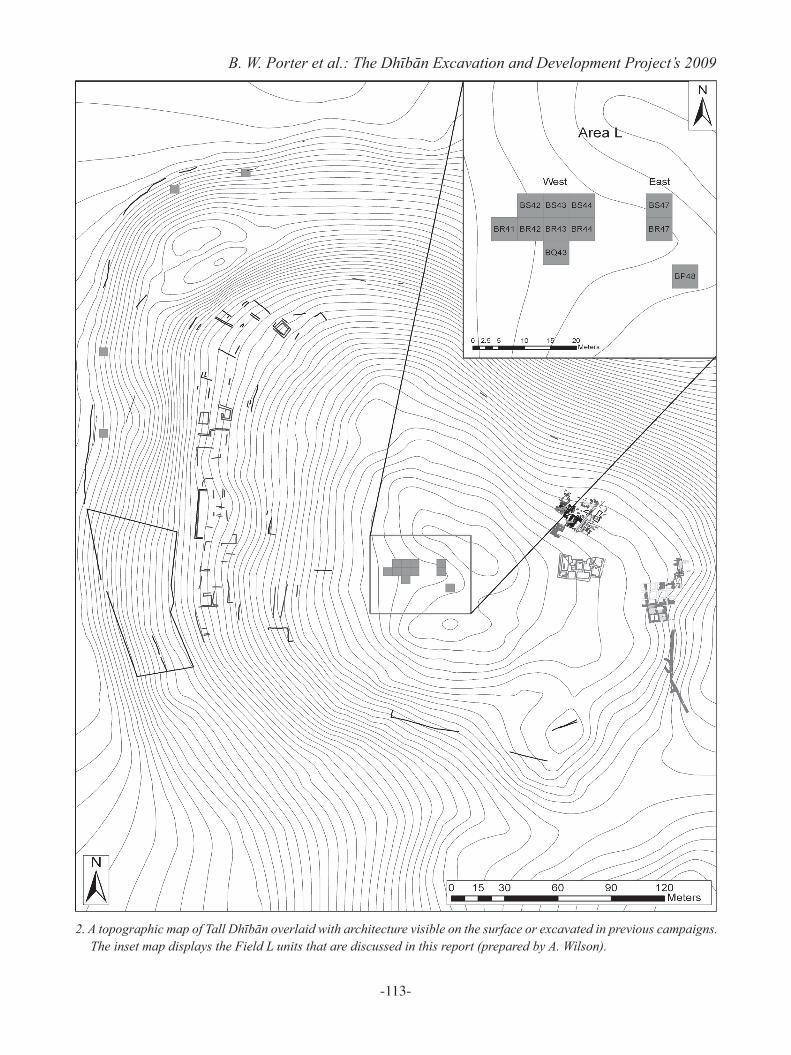
The DEDP’s primary goals for the 2009 sea-sons sought to continue the exploration and doc-umentation of the site’s ancient remains, while pursuing the research objectives developed in previous seasons (Porter et al. 2005, 2010: 10).3 Throughout the season, the project concentrated on four objectives: (1) Finalize the topographic map (Fig. 2) and ar-
chitectural survey of the site, concentrating on the western slope where several buildings are still preserved on the surface.
(2) Continue excavations in Area L, where in situ cultural levels from the Iron Age, Classical, and Islamic periods are preserved.
(3) Conduct a random unit square survey of the site to determine the size of the settlement in different time periods.
(4) Collect environmental and geological data to help determine the relationship between the settlement and the surrounding environment.
THE DHĪBĀN EXCAVATION AND DEVELOPMENT PROJECT’S 2009 SEASON: FIELD L EXCAVATIONS
Benjamin W. Porter, Bruce E. Routledge, Danielle S. Fatkin, Katherine Adelsberger, Alan Farahani, Andrew Wilson and Warren Schultz
1. For a complete project bibliography, see www.dhiban.org.2. For a recent synthesis of Dhībān’s settlement history, see
Porter et al. 2007.3. For a list of participants in the 2009 season, please visit
www.dhiban.org. In both seasons, essential assistance in Dhībān was provided by Firas al-Kawamlah (now of the Ministry of Social Development); twenty residents of the Dhībān area were hired to work at the site.
-112-
ADAJ 56 (2012)
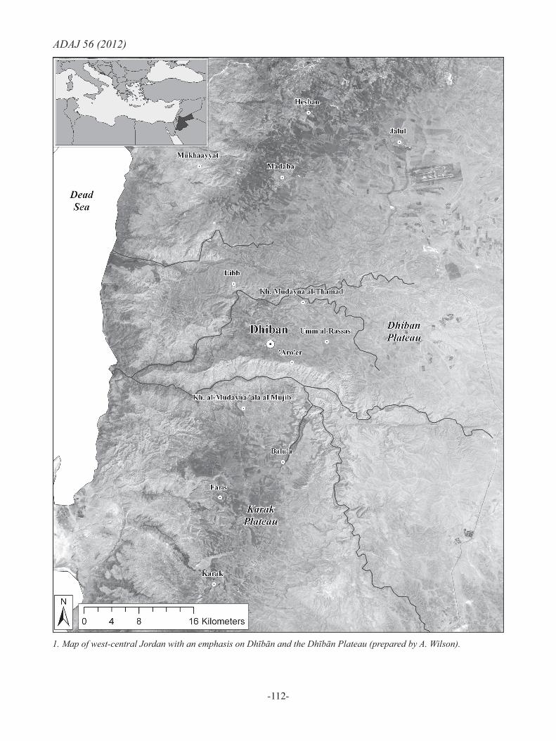
1. Map of west-central Jordan with an emphasis on Dhībān and the Dhībān Plateau (prepared by A. Wilson).
-113-
B. W. Porter et al.: The Dhībān Excavation and Development Project’s 2009
2. A topographic map of Tall Dhībān overlaid with architecture visible on the surface or excavated in previous campaigns. The inset map displays the Field L units that are discussed in this report (prepared by A. Wilson).
-114-
ADAJ 56 (2012)All objectives were achieved during this sea-son. The outcomes of objectives (1) and (4), respectively supervised by Andrew Wilson and Katherine Adelsberger, are reported in a separate ADAJ report (Fatkin et al. in press). Objective (3) will be discussed in a forthcoming publica-tion. This report describes the outcome of ob-jective (2), the excavations in Area L East and West, and presents new radiocarbon dates, nu-mismatic evidence, and site preservation and de-velopment activities. Excavations in Area L West
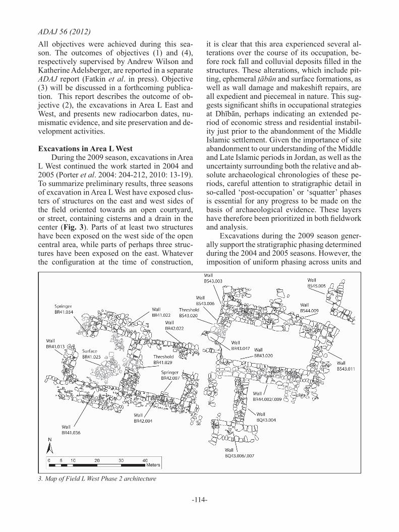
During the 2009 season, excavations in Area L West continued the work started in 2004 and 2005 (Porter et al. 2004: 204-212, 2010: 13-19). To summarize preliminary results, three seasons of excavation in Area L West have exposed clus-ters of structures on the east and west sides of the field oriented towards an open courtyard, or street, containing cisterns and a drain in the center (Fig. 3). Parts of at least two structures have been exposed on the west side of the open central area, while parts of perhaps three struc-tures have been exposed on the east. Whatever the configuration at the time of construction,
it is clear that this area experienced several al-terations over the course of its occupation, be-fore rock fall and colluvial deposits filled in the structures. These alterations, which include pit-ting, ephemeral ṭābūn and surface formations, as well as wall damage and makeshift repairs, are all expedient and piecemeal in nature. This sug-gests significant shifts in occupational strategies at Dhībān, perhaps indicating an extended pe-riod of economic stress and residential instabil-ity just prior to the abandonment of the Middle Islamic settlement. Given the importance of site abandonment to our understanding of the Middle and Late Islamic periods in Jordan, as well as the uncertainty surrounding both the relative and ab-solute archaeological chronologies of these pe-riods, careful attention to stratigraphic detail in so-called ‘post-occupation’ or ‘squatter’ phases is essential for any progress to be made on the basis of archaeological evidence. These layers have therefore been prioritized in both fieldwork and analysis.
Excavations during the 2009 season gener-ally support the stratigraphic phasing determined during the 2004 and 2005 seasons. However, the imposition of uniform phasing across units and
3. Map of Field L West Phase 2 architecture
-115-
B. W. Porter et al.: The Dhībān Excavation and Development Project’s 2009structures is an artificial convention maintained primarily for the purpose of exposition, as Field L is characterized by intensive and highly vari-able post-construction alterations. In general, rock fall, the one consistent deposit across the entire field, has been used to divide Phase 1 (rock fall and above) from Phase 2 (below rock fall to construction of visible structures). So far, Phase 2 has been divided into Sub-phases 2a and 2b, with 2b representing the first prepared sur-faces encountered below rock fall, and 2a rep-resenting ephemeral occupational deposits posi-tioned stratigraphically between Phases 2b and 1. As is detailed below, Phase 2a activity varies from unit to unit, ranging from the accumulation of debris compatible with post-occupation mid-den deposits, through active pitting and make-shift wall repair, to the construction and use of installations (e.g. ṭābūn, ephemeral surfaces, stone-lined bin or channel). Phase 2b is more substantial, a phase in which features were built on plaster or thick, beaten-earth floors.
Phase 1Much as noted in previous reports (Porter et
al. 2005: 207, 2010: 15), wherever excavation commenced, thick deposits of jumbled rock fall and fill containing artifacts of mixed date - up to the twentieth century AD ‒ were encountered. In 2009, Phase 1 materials were excavated in Units BR41.035 and .037, BR42.001 and BS43.001, .002, .004, .005, .009 and .014.
Phase 2In previous seasons, several Phase 2 walls
associated with the Middle Islamic settlement were identified, but it was unclear in sever-al places how these features might coalesce into discernable architectural units (Porter et al. 2005: 205, 2010: 15-19). The 2009 season greatly expanded the project’s understanding of the relationship between Phase 2 architectural units first identified during the 2004 and 2005 seasons. Beginning with Unit BR41, on the far western side of Area L West, further excava-tion has revealed a clear architectural unit. This building is defined by Walls BR41.022 on the north, BR41.033 (= BR41.009) and BR41.032 on the east, BR41.013 on the west and BR41.036 on the south. The building was entered from the east via a doorway with a paved Threshold
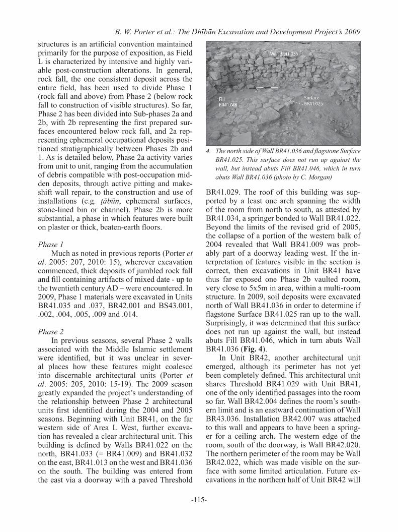
BR41.029. The roof of this building was sup-ported by a least one arch spanning the width of the room from north to south, as attested by BR41.034, a springer bonded to Wall BR41.022. Beyond the limits of the revised grid of 2005, the collapse of a portion of the western balk of 2004 revealed that Wall BR41.009 was prob-ably part of a doorway leading west. If the in-terpretation of features visible in the section is correct, then excavations in Unit BR41 have thus far exposed one Phase 2b vaulted room, very close to 5x5m in area, within a multi-room structure. In 2009, soil deposits were excavated north of Wall BR41.036 in order to determine if flagstone Surface BR41.025 ran up to the wall. Surprisingly, it was determined that this surface does not run up against the wall, but instead abuts Fill BR41.046, which in turn abuts Wall BR41.036 (Fig. 4).
In Unit BR42, another architectural unit emerged, although its perimeter has not yet been completely defined. This architectural unit shares Threshold BR41.029 with Unit BR41, one of the only identified passages into the room so far. Wall BR42.004 defines the room’s south-ern limit and is an eastward continuation of Wall BR43.036. Installation BR42.007 was attached to this wall and appears to have been a spring-er for a ceiling arch. The western edge of the room, south of the doorway, is Wall BR42.020. The northern perimeter of the room may be Wall BR42.022, which was made visible on the sur-face with some limited articulation. Future ex-cavations in the northern half of Unit BR42 will
4. The north side of Wall BR41.036 and flagstone Surface BR41.025. This surface does not run up against the wall, but instead abuts Fill BR41.046, which in turn abuts Wall BR41.036 (photo by C. Morgan)
-116-
ADAJ 56 (2012)test this hypothesis. The investigation of soil layers was limited to the southern half of the unit. Fills BR42.002, .003, .005 and .019 were excavated until arriving on probable Phase 2a or 2b Surfaces BR42.011 and .021. These surfaces appear to have been cut in the eastern part of the unit.
The thick courtyard Surface BS42.058/036 that was identified in 2005 (Porter et al. 2010: 17-18) was further exposed in the eastern half of Unit BS43. Wall BR42.022 is the courtyard’s southern boundary and Wall BS43.006 its east-ern boundary. In prior seasons, Phase 1 and 2a materials were excavated in Unit BS42 above the Phase 2b courtyard surface. In 2009, a simi-lar sequence was discovered. Phase 1 materials were assigned to Fills BS43.014 and BS43.007, while Phase 2a evidence was present in the form of two very large, adjacent, flat-lying stones that appeared at the bottom of Fill BS43.007. This structure was likely related to the ephemeral Phase 2a settlement activity found to its west in 2005 (e.g. Pit BS42.056) (Porter et al. 2010: 17). Beneath this structure, Fill BS43.019 eventual-ly gave way to the Phase 2b Surface BS43.021 that equals Surface BS42.058/036 further west. Surface BS43.021 slopes upward as it approach-es Wall BS43.006 but, 0.2m before the wall, the surface dips down to expose a lower course of the wall. This change may be due to animal bur-rowing along the west face of the wall. No exca-vations in or beneath the surface were attempted in 2009.
Embedded in Surface BS43.021 was the eastern extent of stone-lined Drain BS43.022, portions of which were identified in 2005 as BS42.062. South of the drain, 2 - 3 medium flat stones were found sitting in Surface BS43.021. These stones may be the start of a flagstone sur-face that could be investigated in future seasons. In order to understand this installation and sur-face completely, the northern half of Unit BR42 will need to be excavated. The excavation of Fill BS43.019 and Surface BS43.021 helped to partially define the relationship with Threshold BS43.020, the entrance to the barrel-vaulted building described below. It was discovered that the top of Fill BS43.019 ran up to the top of Threshold BS43.020, while Surface BS43.021 ran up to the bottom of the threshold. These re-lationships give rise to two phasing scenarios.
Either Surface BS43.021 is in phase with the 2b surface inside the barrel-vaulted room (i.e. a per-son would need to step up to enter the room), or Surface BS43.021 is in phase with a yet-to-be discovered surface beneath the present 2b surface in the same room. If the latter scenario proves to be correct, Surface BS43.021 and its associated surfaces in Unit BS42 might have been constructed during an even earlier phase (2c?) and reused in 2b. The continued excava-tion of the barrel-vaulted room and threshold in future seasons will determine which scenario is correct.
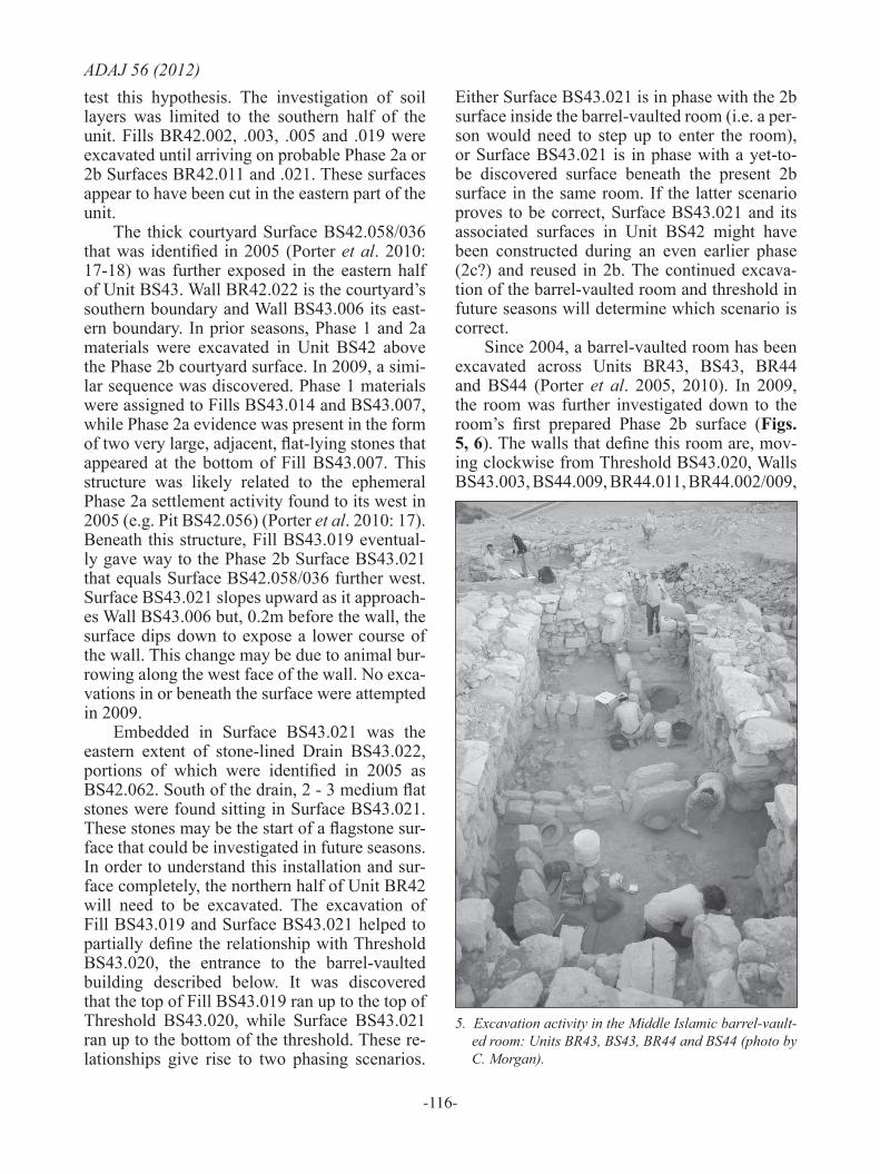
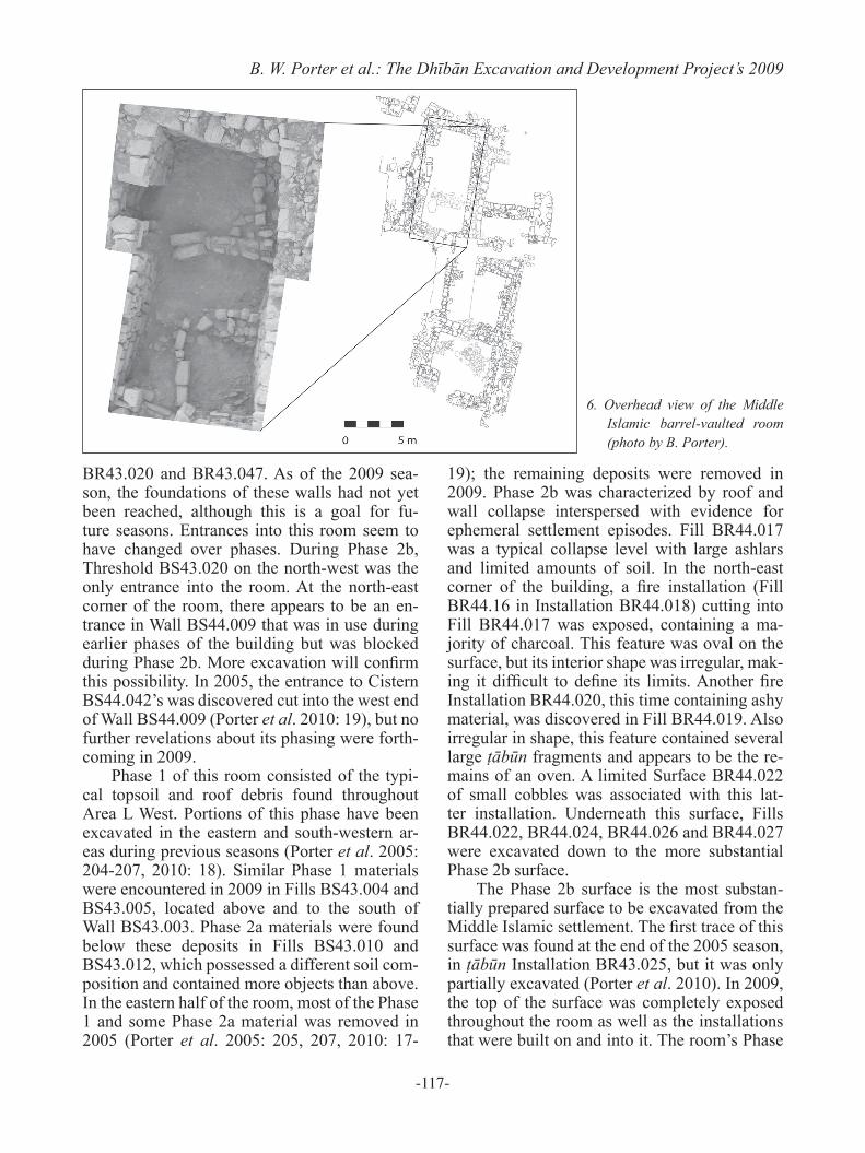
Since 2004, a barrel-vaulted room has been excavated across Units BR43, BS43, BR44 and BS44 (Porter et al. 2005, 2010). In 2009, the room was further investigated down to the room’s first prepared Phase 2b surface (Figs. 5, 6). The walls that define this room are, mov-ing clockwise from Threshold BS43.020, Walls BS43.003, BS44.009, BR44.011, BR44.002/009,
5. Excavation activity in the Middle Islamic barrel-vault-ed room: Units BR43, BS43, BR44 and BS44 (photo by C. Morgan).
-117-
B. W. Porter et al.: The Dhībān Excavation and Development Project’s 2009
BR43.020 and BR43.047. As of the 2009 sea-son, the foundations of these walls had not yet been reached, although this is a goal for fu-ture seasons. Entrances into this room seem to have changed over phases. During Phase 2b, Threshold BS43.020 on the north-west was the only entrance into the room. At the north-east corner of the room, there appears to be an en-trance in Wall BS44.009 that was in use during earlier phases of the building but was blocked during Phase 2b. More excavation will confirm this possibility. In 2005, the entrance to Cistern BS44.042’s was discovered cut into the west end of Wall BS44.009 (Porter et al. 2010: 19), but no further revelations about its phasing were forth-coming in 2009.
Phase 1 of this room consisted of the typi-cal topsoil and roof debris found throughout Area L West. Portions of this phase have been excavated in the eastern and south-western ar-eas during previous seasons (Porter et al. 2005: 204-207, 2010: 18). Similar Phase 1 materials were encountered in 2009 in Fills BS43.004 and BS43.005, located above and to the south of Wall BS43.003. Phase 2a materials were found below these deposits in Fills BS43.010 and BS43.012, which possessed a different soil com-position and contained more objects than above. In the eastern half of the room, most of the Phase 1 and some Phase 2a material was removed in 2005 (Porter et al. 2005: 205, 207, 2010: 17-
19); the remaining deposits were removed in 2009. Phase 2b was characterized by roof and wall collapse interspersed with evidence for ephemeral settlement episodes. Fill BR44.017 was a typical collapse level with large ashlars and limited amounts of soil. In the north-east corner of the building, a fire installation (Fill BR44.16 in Installation BR44.018) cutting into Fill BR44.017 was exposed, containing a ma-jority of charcoal. This feature was oval on the surface, but its interior shape was irregular, mak-ing it difficult to define its limits. Another fire Installation BR44.020, this time containing ashy material, was discovered in Fill BR44.019. Also irregular in shape, this feature contained several large ṭābūn fragments and appears to be the re-mains of an oven. A limited Surface BR44.022 of small cobbles was associated with this lat-ter installation. Underneath this surface, Fills BR44.022, BR44.024, BR44.026 and BR44.027 were excavated down to the more substantial Phase 2b surface.
The Phase 2b surface is the most substan-tially prepared surface to be excavated from the Middle Islamic settlement. The first trace of this surface was found at the end of the 2005 season, in ṭābūn Installation BR43.025, but it was only partially excavated (Porter et al. 2010). In 2009, the top of the surface was completely exposed throughout the room as well as the installations that were built on and into it. The room’s Phase
6. Overhead view of the Middle Islamic barrel-vaulted room (photo by B. Porter).
-118-
ADAJ 56 (2012)2b Surfaces included BS43.018 and BR43.048 in the western half, and BR44.035, BR44.038 and BR44.058 in the eastern half. Altogether, the surface was inconsistent across the room, with plaster preservation being best to the east. To the west, the surface consisted of beaten earth and some plaster. A high resolution data collection strategy was employed to collect macro- and micro-artifacts in order to identify activity areas. The surface was divided into a sub-grid of 10 x 10 cm squares and all objects and soil were collected for a depth of between 5 and 10 cm. The location of all objects was recorded using a total station, all floor material was collected for flotation, and phytolith, soil chemistry and mi-cromorphology samples were taken from each sub-grid square. Analyses of these materials are currently underway at UC Berkeley and Knox College.
Four installations were built on and into the Phase 2b surface:
The first, Installation BR43.050 (Fill BR43.051), was a ring of medium-sized stones containing soil that was located in the room’s south-west corner. The feature cut deeply into the surface.
The second, Installation BR43.049 (Fill BR43.040), extended out from the room’s south-ern wall. It consists of four large, upright stones on its eastern face and probably one more a small distance away to the north-east. The construction method ‒ with the uprights being propped up in part by small cobbles and chinks ‒ closely mim-ics that of other installations in the barrel-vault-ed room, especially Bin BR44.032 described below. Fill BR43.040 first consisted of many medium-sized stones, packed in such a way as to suggest a deliberate fill. These soon gave way to a loose, brown fill that contained very few arti-facts. The base of the fill corresponded both with the bottom of the large upright stones and with an apparent continuation of Surface BR43.048 underneath the installation.
The third installation, BR44.039, consisted of 13 limestone blocks on a curvilinear north-south axis. The blocks range in size from 80cm x 30cm x 50cm to 5cm x 2cm x 1cm. These blocks run from the south wall to a point 50cm away from the north wall, with no clear func-tion at either end. The channel between the two courses of blocks ranges in width from 23cm
at the southern extent to 5cm between the large ashlars at the northern extent, with a depth rang-ing from 20 to 30cm throughout the gap. There is one blocking stone before the ashlars at the northern extent, but it did not appear removable and its function is not obvious. Fill BR44.037 in the center of the drain was sealed by a lining of flat rocks. There were very few objects in the interior and the entire fill was collected for flota-tion. The function of the drain is unclear. While it has the apparent shape of a drain or channel for water, it does not terminate in a storage fea-ture like a cistern. The feature may have been used as a drain and then later used as a room divider in Phase 2b.
The fourth installation, Bin BR44.032, con-sisted of five large ashlars aligned vertically on an east-west axis. This unusual method of con-struction (vertical rather than horizontal align-ment) implies that this bin was built to maintain a certain height rather than contain materials. The ashlars also had gaps between them, with little apparent attention to chinking or sealing these gaps, also implying that the bin was not made to contain materials. The ashlars were set on top of smaller, leveling stones, similar in con-struction to the other installations in the build-ing. There were three layers of fill in the bin, the first being an ephemeral ashy Fill BR44.028 at the very top. This layer terminated with a flat stone lining. Below this was Fill BR44.036, con-sisting of mixed dirt and cobbles. This fill was a different color (5YR 4/2) and texture than the previous fill. Objects were relatively rare and there was a more concentrated matrix with daub, clay and charcoal inclusions. This fill terminated at Surface BR44.038. The bin’s entire contents were collected for analysis.
One additional feature, Pit BS43.017 (Fill BS43.016), located in the north-west corner of the room, may be a purpose-built installation as-sociated with Phase 2b, although an alternative origin as a later animal burrow could not be ruled out. The oval-shaped pit seemed carefully cut on its western and north-western sides, providing a clear section of the area’s floor matrix. Although the point at which it cut the floor around the rest of perimeter was clear, the floor matrix was un-fortunately ambiguous or absent to the south and east. This irregularity may be due to intensive burrowing activity, which seems to have been
-119-
B. W. Porter et al.: The Dhībān Excavation and Development Project’s 2009particularly destructive on the southern side. The soil in the pit was very loose and clean, with an abundance of pottery. The bottom of the pit was easily recognized when a hard clay surface curving inward toward the center was reached.
In all Phase 1 and 2 contexts, stone, bone, ceramic, glass, botanical and phytolith samples were collected and processed for future analy-sis. Generally, Phase 1 contexts associated with topsoil and roof collapse revealed a mixture of ceramic vessel evidence dating to all periods of Dhībān’s occupation, from the Early Bronze Age to the present day. Phase 2a and 2b con-texts demonstrated slightly more homogeneity with regard to ceramic dating, with the major-ity of forms dating to the Middle Islamic period, followed by the Roman, Byzantine and Early Islamic periods. The latest Middle Islamic ma-terial tended to consist of handmade geometric painted wares, and the green and yellow glazed bowls that are diagnostic of the time period.4 Although several sherds were recovered, none were completely restorable.
Within the barrel-vaulted room’s Phase 2b surface, two objects of note were excavated. The first is a large handmade geometric painted jar that was broken and embedded in different areas of the eastern half of the room’s Phase 2b sur-face. Unfortunately, not all of the pieces were recovered, but those that were indicate that the vessel was relatively substantial. The rim di-ameter is 28cm and only ca. 30 % of the rim, neck and body are preserved. The vessel’s ex-terior was decorated with an elaborate vegetal and floral design in black pigment. The vessel is currently being restored and prepared for il-lustration.
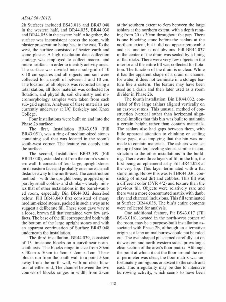
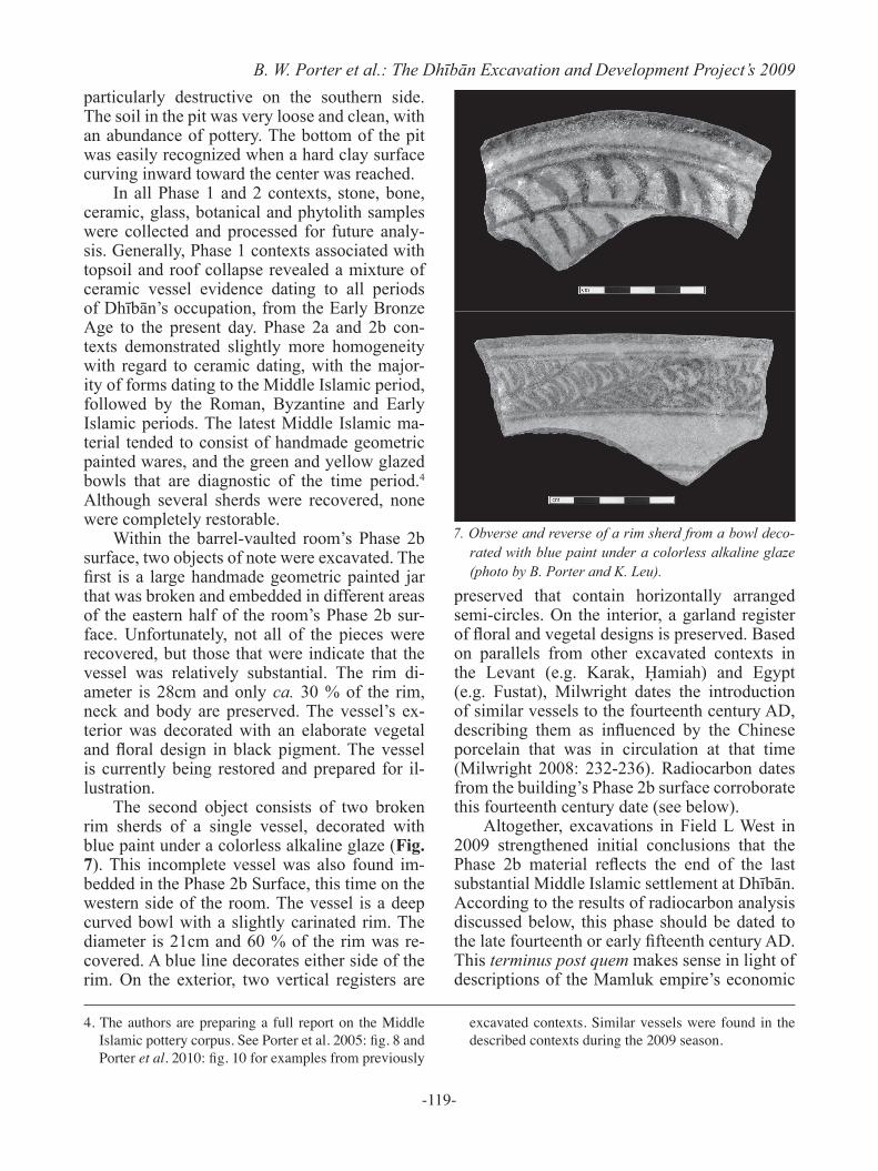
The second object consists of two broken rim sherds of a single vessel, decorated with blue paint under a colorless alkaline glaze (Fig. 7). This incomplete vessel was also found im-bedded in the Phase 2b Surface, this time on the western side of the room. The vessel is a deep curved bowl with a slightly carinated rim. The diameter is 21cm and 60 % of the rim was re-covered. A blue line decorates either side of the rim. On the exterior, two vertical registers are
preserved that contain horizontally arranged semi-circles. On the interior, a garland register of floral and vegetal designs is preserved. Based on parallels from other excavated contexts in the Levant (e.g. Karak, Ḥamiah) and Egypt (e.g. Fustat), Milwright dates the introduction of similar vessels to the fourteenth century AD, describing them as influenced by the Chinese porcelain that was in circulation at that time (Milwright 2008: 232-236). Radiocarbon dates from the building’s Phase 2b surface corroborate this fourteenth century date (see below).
Altogether, excavations in Field L West in 2009 strengthened initial conclusions that the Phase 2b material reflects the end of the last substantial Middle Islamic settlement at Dhībān. According to the results of radiocarbon analysis discussed below, this phase should be dated to the late fourteenth or early fifteenth century AD. This terminus post quem makes sense in light of descriptions of the Mamluk empire’s economic
4. The authors are preparing a full report on the Middle Islamic pottery corpus. See Porter et al. 2005: fig. 8 and Porter et al. 2010: fig. 10 for examples from previously
excavated contexts. Similar vessels were found in the described contexts during the 2009 season.
7. Obverse and reverse of a rim sherd from a bowl deco-rated with blue paint under a colorless alkaline glaze (photo by B. Porter and K. Leu).
-120-
ADAJ 56 (2012)de-intensification in Jordan that began in the late fourteenth century (Walker 2004). The ephem-eral Phase 2a surfaces that followed the Phase 2b settlement speak of possible failed attempts to reoccupy the site during the end of Mamluk empire and beginning of Ottoman imperialism ‒ a time of uneven political and economic transi-tion throughout the Levant. Radiocarbon analy-sis (see below) places these ephemeral squatter activities in the sixteenth century AD. Phase 1, while greatly disturbed owing to erosion and recent activities, contains material culture span-ning the sixteenth century to the contemporary period. These ephemeral objects (e.g. Porter et al. 2005: fig 9.3), lacking any association with architecture, are the result of occasional season-al camping activities that occurred during the Late Islamic period.
While the project is gaining a better sense of Middle Islamic Dhībān’s abandonment, there remains a lack of understanding regard-ing the Middle Islamic settlement’s foundation. Questions still in need of answering include: When did settlement intensification begin? Did imperial demand or market command motivate the settlement’s economic intensification? And what were the settlement’s major industries? The project predicts that additional phases as-sociated with the Middle Islamic settlement’s foundation will be identified below the Phase 2b surfaces that can answer these and similar questions. At the end of the 2009 season, limited sampling below the Phase 2b surface revealed additional laminations. Furthermore, the tops of features and walls became apparent once the Phase 2b installations were removed following their documentation. These features are likely related to Phase 2c and will receive careful at-tention in future seasons.
Excavations in Area L EastArea L East refers to William Morton’s
original Area L trench (Areas LI - III) that was excavated primarily in 1956 and 1957 and has been left open until the present day. In this ex-cavation area, measuring ca. 15 x 14 m, Morton uncovered a large building dating to the Iron II period, several walls from the Late Hellenistic / Early Roman period, and a substantial Middle Islamic residence. The results of Morton’s exca-vations at Dhībān are largely unpublished (but
see Morton 1989), but the field notes are in the possession of the DEDP, who are in the process of bringing Morton’s excavation to publication. One of the DEDP’s primary goals in excavating in Area L East is to clarify the sequence exca-vated by Morton in order to facilitate this pub-lication.
As a result of being exposed to the elements for more than 50 years, the edges of Area L East are heavily eroded, with thick deposits of collu-vial wash accumulated at the base of the slopes on all four sides of the trench. The primary goals here in 2009 were: (1) to clean up the bottom of Area L East in order to re-expose the Iron Age architecture that Morton left in the bottom of the trench and (2) to excavate the eroded slopes of Area L East in order locate the surviving edges of Morton’s trenches, with the aim of identifying in situ deposits immediately adjacent to those excavated by Morton. Excavating such deposits would permit a better understanding of the area’s stratigraphy in more detail than is possible from Morton’s excavation notes alone. Additionally, because erosion affected the upper portion of the trench sections more than the lower sections, excavating slopes provides access to the earlier occupation layers at Dhībān more readily than is possible elsewhere on the site, where Iron Age and Late Hellenistic/ Early Roman deposits are overlaid by substantial Byzantine, Early Islamic and Middle Islamic evidence.
In order to facilitate these goals, a large scale clearance, cleaning and remapping of the walls remaining from Morton’s excavations was initi-ated. While this was labor and time intensive, these efforts were rewarded by the re-exposure of Morton’s Walls 8, 15, 16 and 17 (Morton 1989: fig. 13; Routledge 2004: fig. 8.1). These walls are all founded on bedrock and form a central rectangular room that is clearly part of a larger building. This was particularly evident on the west side of Area L East where excava-tions have traced portions of two additional Iron Age walls associated with this same building. Re-exposing the Iron Age walls excavated by Morton has achieved two things. First, it has demonstrated the general accuracy of Morton’s architectural plans, which were integrated into a GIS base map during the 2009 season (Fatkin et al. in press). Second, it has provided the opportu-nity to consolidate a substantial Iron Age build-

-121-
B. W. Porter et al.: The Dhībān Excavation and Development Project’s 2009ing for the purposes of site presentation. While the Mesha inscription indicates that Dhībān was an important site for the Iron II period in Jordan, there are at present very few remains from this period visible to visitors to the site. Over the next several seasons, the project hopes to change this situation by continuing to expose, consolidate and interpret this important Iron IIB building.
In 2009, excavation of the eroded slopes of Area L East was conducted in three units. The first was Unit BP48, located on the south side of the trench, near the south-east corner (Fig. 8). Unit BP48 was located at the top of the slope, in-corporating level ground along its southernmost side. As this level ground was adjacent to one of the primary access routes to the excavation area, the southernmost 1.5m of the grid square were left unexcavated, resulting in an excavation area of 3.5m north-south by 5m east-west. This exca-vation area included an irregularly shaped ‘step’ along the southern section at the point where the level ground began to erode and the slope broke sharply. This ‘step’ measured 4m west - east and between 40-60cm south-north. It was 35-70cm higher than the rest of the unit and contained several loci that appear to have been removed by erosion elsewhere in the square.
The sequence of deposition is relatively straightforward in BP48. In the area of the ‘step’, Topsoil BP48.001 overlies two succes-sive layers of very fine grained, ashy deposits BP48.004 and BP48.005; these seem to repre-sent the accumulation of aeolian sediments af-ter the site’s abandonment. The end of the ‘step’ was reached beneath BP48.005. The remaining loci excavated in 2009 extend from the southern section at 1.5m north to the next break in slope
at ca. 3m north. The first of these larger loci is Fill BP48.006/007, a soil layer visible beneath BP48.005 in the ‘step’ and traceable immedi-ately below the surface to the north after vigor-ous cleaning. The exposed nature of the north-ern portion of this locus was illustrated by the fact that it was cut by Pit BP48.009/010, which contained the head of a twentieth century tureya. The excavation of BP48.006/007 exposed the primary architectural features of Unit BP48. This was a room defined by Walls BP48.008 and BP48.013 on the west and east sides of the unit respectively, as well as Wall BP48.029 to the south-which is partially visible in the section. To the north this room was truncated by erosion ca. 1.5m north of the southern section line. The western Wall BP48.008 was built as two rows of stone with rubble Fill BP48.003, a pattern al-ready familiar from Middle Islamic architecture in Area L West. Wall BP48.008 is preserved for a length of ca. 2.85m. The bottom of this wall has not yet been exposed. At present it has a maxi-mum preserved height of 1.45m. On the eastern side of the square a very poorly preserved Wall BP48.013 was uncovered. Wall BP48.013 is pre-served for a length of only 1.2m and a height of just one course. It is of an uncertain construc-tion pattern that may also be a double row with rubble fill.
Walls BP48.008 and BP48.013 define a room whose other primary feature, at least in its final phase of occupation, was a low Bench BP48.016 built against the eastern face of Wall BP48.008. This installation consisted of one course of rectangular, semi-shaped stones em-bedded in a foundation of mud and field stones. Bench BP48.016 abuts Wall BP48.008, which is
8. Phase 2 architecture in Unit BP48, looking south (photo by C. Morgan).
-122-
ADAJ 56 (2012)clearly earlier than this installation. Less clear is the relationship between Bench BP48.016, Wall BP48.008 and thick plaster Surface BP48.018, which represents the uppermost living surface in Unit BP48. This hard surface clearly seals up against Walls BP48.013 and BP48.029 and covers most of the uneroded portion of the unit. However, on the western side of the square, the relationship between this floor and both Bench BP48.016 and Wall BP48.008 is cut by a long animal burrow: BP48.011/015. The facts (1) that Surface BP48.018 was not evident beneath Bench BP48.016 when it was removed and (2) that there was no evidence for an intervening foundation trench between Surface BP48.018 and Bench BP48.016 suggests that the two were constructed together in the final construction phase of the room. This relationship, however, is not directly attested by stratigraphic evidence.
Surface BP48.018 consists of thick plaster ranging from 5 to 8cm in thickness. The top 5cm of this surface was divided into 1x1m sub-grid units. Soil chemistry, phytolith and micromor-phology samples were taken from each sub-grid with plaster flooring covering more than 50% of its area. This meant that samples were taken from four sub-grids (13, 14, 18 and 19) out of the 25 possible in this 5x5m unit. In addition, all of the plaster surface was floated by sub-grid, with objects embedded in the top 5cm of flooring being individually point-provenanced by total station. The latest material embedded in this floor was diagnostic of the Middle Islamic period, providing a terminus post quem for the use of this surface and the final use of the Unit BP48 room. Whatever plaster surface remained after the top 5cm was removed was collected for flotation under the locus number BP48.020.
The removal of Surface BP48.018/020 and Bench BP48.016 marked the end of the 2009 season. Beneath Surface BP48.018, excavation ended on what could be another surface, con-sisting of a small area paved with flagstones embedded in plaster, provisionally identified as BP48.025. How this feature relates to the remainder of the unit is unclear, although it is evident that Walls BP48.008 and BP48.013 both continue below the level at which excavation ceased in 2009. When compared to excavations in Area L West, the occupational sequence in Unit BP48 was much simpler, lacking the evi-dence for ephemeral room use between the fif-teenth and twentieth centuries. Most of the ar-chitectural collapse that is characteristic of Area L West’s Phase 1 was eroded in Unit BP48, with the resultant exposed layers being disturbed by twentieth century activities. In terms of the phas-ing developed for Area L West, plaster Surface BP48.018 would represent Phase 2b. However, Phase 2a is not clearly attested.
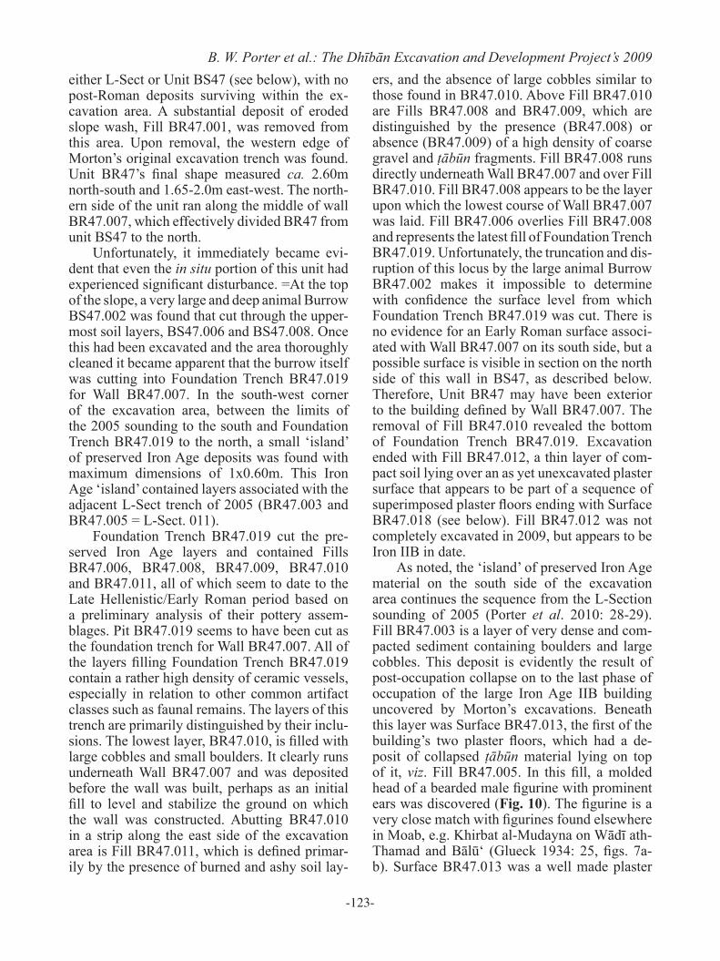
The second unit to be excavated in Area L East in 2009 was Unit BR47, a small trench lo-cated along the west section of Morton’s trench (Fig. 9). Excavations in an adjacent trench in 2005 (labeled L-Sect, or LII-III in Porter et al. 2010: 28-29, figs 15-16) revealed a sequence of pre-Middle Islamic occupation consisting main-ly of pottery-rich Early Roman fills and some 2m of well stratified remains associated with Morton’s Iron II building, including three suc-cessive plaster floors. In 2009 Unit BR47 was opened, which encompassed the area of the 2005 sounding (formerly designated as L-Section) and the slope immediately north of this area. Even before excavation, it was clear that the Unit BR47 slope was more heavily eroded than
9. Field L East section, looking west (photo by C. Morgan).
-123-
B. W. Porter et al.: The Dhībān Excavation and Development Project’s 2009either L-Sect or Unit BS47 (see below), with no post-Roman deposits surviving within the ex-cavation area. A substantial deposit of eroded slope wash, Fill BR47.001, was removed from this area. Upon removal, the western edge of Morton’s original excavation trench was found. Unit BR47’s final shape measured ca. 2.60m north-south and 1.65-2.0m east-west. The north-ern side of the unit ran along the middle of wall BR47.007, which effectively divided BR47 from unit BS47 to the north.
Unfortunately, it immediately became evi-dent that even the in situ portion of this unit had experienced significant disturbance. =At the top of the slope, a very large and deep animal Burrow BS47.002 was found that cut through the upper-most soil layers, BS47.006 and BS47.008. Once this had been excavated and the area thoroughly cleaned it became apparent that the burrow itself was cutting into Foundation Trench BR47.019 for Wall BR47.007. In the south-west corner of the excavation area, between the limits of the 2005 sounding to the south and Foundation Trench BR47.019 to the north, a small ‘island’ of preserved Iron Age deposits was found with maximum dimensions of 1x0.60m. This Iron Age ‘island’ contained layers associated with the adjacent L-Sect trench of 2005 (BR47.003 and BR47.005 = L-Sect. 011).
Foundation Trench BR47.019 cut the pre-served Iron Age layers and contained Fills BR47.006, BR47.008, BR47.009, BR47.010 and BR47.011, all of which seem to date to the Late Hellenistic/Early Roman period based on a preliminary analysis of their pottery assem-blages. Pit BR47.019 seems to have been cut as the foundation trench for Wall BR47.007. All of the layers filling Foundation Trench BR47.019 contain a rather high density of ceramic vessels, especially in relation to other common artifact classes such as faunal remains. The layers of this trench are primarily distinguished by their inclu-sions. The lowest layer, BR47.010, is filled with large cobbles and small boulders. It clearly runs underneath Wall BR47.007 and was deposited before the wall was built, perhaps as an initial fill to level and stabilize the ground on which the wall was constructed. Abutting BR47.010 in a strip along the east side of the excavation area is Fill BR47.011, which is defined primar-ily by the presence of burned and ashy soil lay-
ers, and the absence of large cobbles similar to those found in BR47.010. Above Fill BR47.010 are Fills BR47.008 and BR47.009, which are distinguished by the presence (BR47.008) or absence (BR47.009) of a high density of coarse gravel and ṭābūn fragments. Fill BR47.008 runs directly underneath Wall BR47.007 and over Fill BR47.010. Fill BR47.008 appears to be the layer upon which the lowest course of Wall BR47.007 was laid. Fill BR47.006 overlies Fill BR47.008 and represents the latest fill of Foundation Trench BR47.019. Unfortunately, the truncation and dis-ruption of this locus by the large animal Burrow BR47.002 makes it impossible to determine with confidence the surface level from which Foundation Trench BR47.019 was cut. There is no evidence for an Early Roman surface associ-ated with Wall BR47.007 on its south side, but a possible surface is visible in section on the north side of this wall in BS47, as described below. Therefore, Unit BR47 may have been exterior to the building defined by Wall BR47.007. The removal of Fill BR47.010 revealed the bottom of Foundation Trench BR47.019. Excavation ended with Fill BR47.012, a thin layer of com-pact soil lying over an as yet unexcavated plaster surface that appears to be part of a sequence of superimposed plaster floors ending with Surface BR47.018 (see below). Fill BR47.012 was not completely excavated in 2009, but appears to be Iron IIB in date.
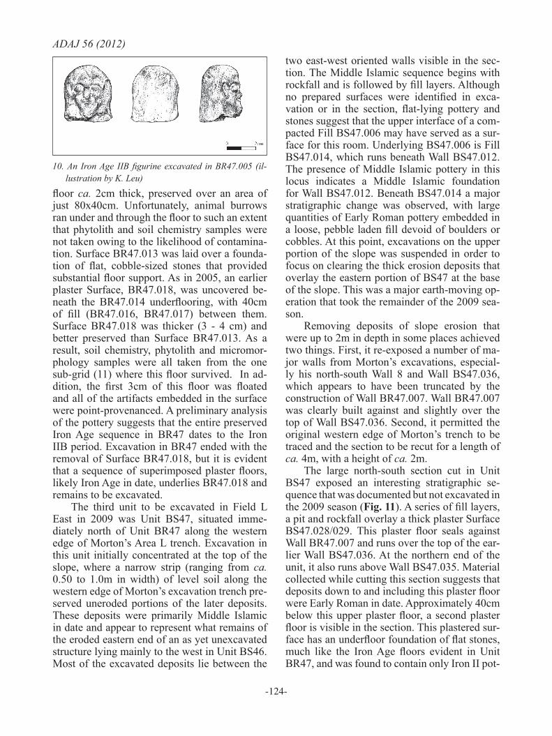
As noted, the ‘island’ of preserved Iron Age material on the south side of the excavation area continues the sequence from the L-Section sounding of 2005 (Porter et al. 2010: 28-29). Fill BR47.003 is a layer of very dense and com-pacted sediment containing boulders and large cobbles. This deposit is evidently the result of post-occupation collapse on to the last phase of occupation of the large Iron Age IIB building uncovered by Morton’s excavations. Beneath this layer was Surface BR47.013, the first of the building’s two plaster floors, which had a de-posit of collapsed ṭābūn material lying on top of it, viz. Fill BR47.005. In this fill, a molded head of a bearded male figurine with prominent ears was discovered (Fig. 10). The figurine is a very close match with figurines found elsewhere in Moab, e.g. Khirbat al-Mudayna on Wādī ath-Thamad and Bālū‘ (Glueck 1934: 25, figs. 7a-b). Surface BR47.013 was a well made plaster
-124-
ADAJ 56 (2012)
floor ca. 2cm thick, preserved over an area of just 80x40cm. Unfortunately, animal burrows ran under and through the floor to such an extent that phytolith and soil chemistry samples were not taken owing to the likelihood of contamina-tion. Surface BR47.013 was laid over a founda-tion of flat, cobble-sized stones that provided substantial floor support. As in 2005, an earlier plaster Surface, BR47.018, was uncovered be-neath the BR47.014 underflooring, with 40cm of fill (BR47.016, BR47.017) between them. Surface BR47.018 was thicker (3 - 4 cm) and better preserved than Surface BR47.013. As a result, soil chemistry, phytolith and micromor-phology samples were all taken from the one sub-grid (11) where this floor survived. In ad-dition, the first 3cm of this floor was floated and all of the artifacts embedded in the surface were point-provenanced. A preliminary analysis of the pottery suggests that the entire preserved Iron Age sequence in BR47 dates to the Iron IIB period. Excavation in BR47 ended with the removal of Surface BR47.018, but it is evident that a sequence of superimposed plaster floors, likely Iron Age in date, underlies BR47.018 and remains to be excavated.
The third unit to be excavated in Field L East in 2009 was Unit BS47, situated imme-diately north of Unit BR47 along the western edge of Morton’s Area L trench. Excavation in this unit initially concentrated at the top of the slope, where a narrow strip (ranging from ca. 0.50 to 1.0m in width) of level soil along the western edge of Morton’s excavation trench pre-served uneroded portions of the later deposits. These deposits were primarily Middle Islamic in date and appear to represent what remains of the eroded eastern end of an as yet unexcavated structure lying mainly to the west in Unit BS46. Most of the excavated deposits lie between the
two east-west oriented walls visible in the sec-tion. The Middle Islamic sequence begins with rockfall and is followed by fill layers. Although no prepared surfaces were identified in exca-vation or in the section, flat-lying pottery and stones suggest that the upper interface of a com-pacted Fill BS47.006 may have served as a sur-face for this room. Underlying BS47.006 is Fill BS47.014, which runs beneath Wall BS47.012. The presence of Middle Islamic pottery in this locus indicates a Middle Islamic foundation for Wall BS47.012. Beneath BS47.014 a major stratigraphic change was observed, with large quantities of Early Roman pottery embedded in a loose, pebble laden fill devoid of boulders or cobbles. At this point, excavations on the upper portion of the slope was suspended in order to focus on clearing the thick erosion deposits that overlay the eastern portion of BS47 at the base of the slope. This was a major earth-moving op-eration that took the remainder of the 2009 sea-son.
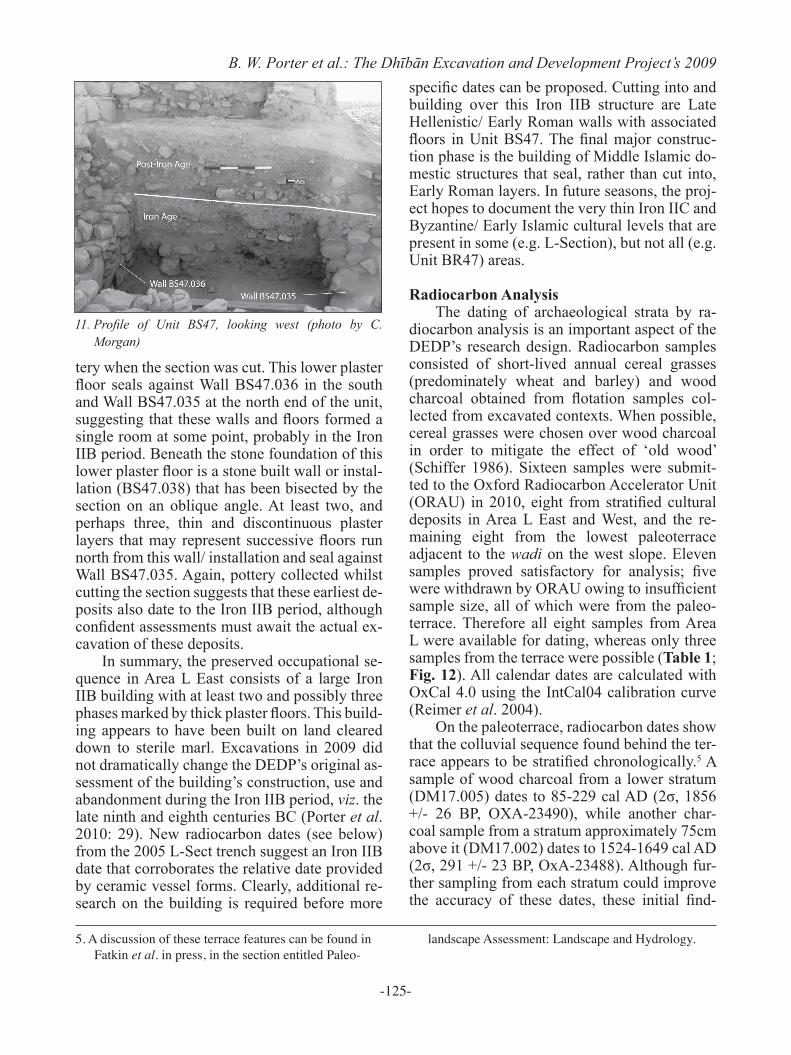
Removing deposits of slope erosion that were up to 2m in depth in some places achieved two things. First, it re-exposed a number of ma-jor walls from Morton’s excavations, especial-ly his north-south Wall 8 and Wall BS47.036, which appears to have been truncated by the construction of Wall BR47.007. Wall BR47.007 was clearly built against and slightly over the top of Wall BS47.036. Second, it permitted the original western edge of Morton’s trench to be traced and the section to be recut for a length of ca. 4m, with a height of ca. 2m.
The large north-south section cut in Unit BS47 exposed an interesting stratigraphic se-quence that was documented but not excavated in the 2009 season (Fig. 11). A series of fill layers, a pit and rockfall overlay a thick plaster Surface BS47.028/029. This plaster floor seals against Wall BR47.007 and runs over the top of the ear-lier Wall BS47.036. At the northern end of the unit, it also runs above Wall BS47.035. Material collected while cutting this section suggests that deposits down to and including this plaster floor were Early Roman in date. Approximately 40cm below this upper plaster floor, a second plaster floor is visible in the section. This plastered sur-face has an underfloor foundation of flat stones, much like the Iron Age floors evident in Unit BR47, and was found to contain only Iron II pot-
10. An Iron Age IIB figurine excavated in BR47.005 (il-lustration by K. Leu)
-125-
B. W. Porter et al.: The Dhībān Excavation and Development Project’s 2009
tery when the section was cut. This lower plaster floor seals against Wall BS47.036 in the south and Wall BS47.035 at the north end of the unit, suggesting that these walls and floors formed a single room at some point, probably in the Iron IIB period. Beneath the stone foundation of this lower plaster floor is a stone built wall or instal-lation (BS47.038) that has been bisected by the section on an oblique angle. At least two, and perhaps three, thin and discontinuous plaster layers that may represent successive floors run north from this wall/ installation and seal against Wall BS47.035. Again, pottery collected whilst cutting the section suggests that these earliest de-posits also date to the Iron IIB period, although confident assessments must await the actual ex-cavation of these deposits.
In summary, the preserved occupational se-quence in Area L East consists of a large Iron IIB building with at least two and possibly three phases marked by thick plaster floors. This build-ing appears to have been built on land cleared down to sterile marl. Excavations in 2009 did not dramatically change the DEDP’s original as-sessment of the building’s construction, use and abandonment during the Iron IIB period, viz. the late ninth and eighth centuries BC (Porter et al. 2010: 29). New radiocarbon dates (see below) from the 2005 L-Sect trench suggest an Iron IIB date that corroborates the relative date provided by ceramic vessel forms. Clearly, additional re-search on the building is required before more
specific dates can be proposed. Cutting into and building over this Iron IIB structure are Late Hellenistic/ Early Roman walls with associated floors in Unit BS47. The final major construc-tion phase is the building of Middle Islamic do-mestic structures that seal, rather than cut into, Early Roman layers. In future seasons, the proj-ect hopes to document the very thin Iron IIC and Byzantine/ Early Islamic cultural levels that are present in some (e.g. L-Section), but not all (e.g. Unit BR47) areas.
Radiocarbon AnalysisThe dating of archaeological strata by ra-
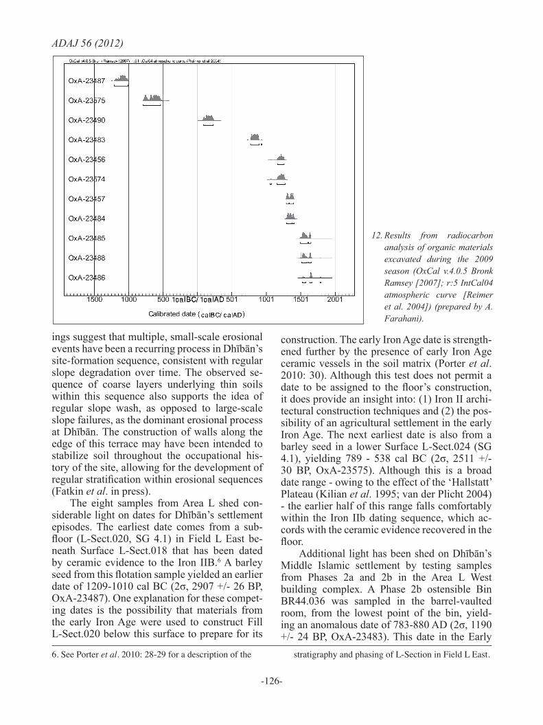
diocarbon analysis is an important aspect of the DEDP’s research design. Radiocarbon samples consisted of short-lived annual cereal grasses (predominately wheat and barley) and wood charcoal obtained from flotation samples col-lected from excavated contexts. When possible, cereal grasses were chosen over wood charcoal in order to mitigate the effect of ‘old wood’ (Schiffer 1986). Sixteen samples were submit-ted to the Oxford Radiocarbon Accelerator Unit (ORAU) in 2010, eight from stratified cultural deposits in Area L East and West, and the re-maining eight from the lowest paleoterrace adjacent to the wadi on the west slope. Eleven samples proved satisfactory for analysis; five were withdrawn by ORAU owing to insufficient sample size, all of which were from the paleo-terrace. Therefore all eight samples from Area L were available for dating, whereas only three samples from the terrace were possible (Table 1; Fig. 12). All calendar dates are calculated with OxCal 4.0 using the IntCal04 calibration curve (Reimer et al. 2004).
On the paleoterrace, radiocarbon dates show that the colluvial sequence found behind the ter-race appears to be stratified chronologically.5 A sample of wood charcoal from a lower stratum (DM17.005) dates to 85-229 cal AD (2σ, 1856 +/- 26 BP, OXA-23490), while another char-coal sample from a stratum approximately 75cm above it (DM17.002) dates to 1524-1649 cal AD (2σ, 291 +/- 23 BP, OxA-23488). Although fur-ther sampling from each stratum could improve the accuracy of these dates, these initial find-
11. Profile of Unit BS47, looking west (photo by C. Morgan)
5. A discussion of these terrace features can be found in Fatkin et al. in press, in the section entitled Paleo-
landscape Assessment: Landscape and Hydrology.
-126-
ADAJ 56 (2012)
ings suggest that multiple, small-scale erosional events have been a recurring process in Dhībān’s site-formation sequence, consistent with regular slope degradation over time. The observed se-quence of coarse layers underlying thin soils within this sequence also supports the idea of regular slope wash, as opposed to large-scale slope failures, as the dominant erosional process at Dhībān. The construction of walls along the edge of this terrace may have been intended to stabilize soil throughout the occupational his-tory of the site, allowing for the development of regular stratification within erosional sequences (Fatkin et al. in press).
The eight samples from Area L shed con-siderable light on dates for Dhībān’s settlement episodes. The earliest date comes from a sub-floor (L-Sect.020, SG 4.1) in Field L East be-neath Surface L-Sect.018 that has been dated by ceramic evidence to the Iron IIB.6 A barley seed from this flotation sample yielded an earlier date of 1209-1010 cal BC (2σ, 2907 +/- 26 BP, OxA-23487). One explanation for these compet-ing dates is the possibility that materials from the early Iron Age were used to construct Fill L-Sect.020 below this surface to prepare for its
construction. The early Iron Age date is strength-ened further by the presence of early Iron Age ceramic vessels in the soil matrix (Porter et al. 2010: 30). Although this test does not permit a date to be assigned to the floor’s construction, it does provide an insight into: (1) Iron II archi-tectural construction techniques and (2) the pos-sibility of an agricultural settlement in the early Iron Age. The next earliest date is also from a barley seed in a lower Surface L-Sect.024 (SG 4.1), yielding 789 - 538 cal BC (2σ, 2511 +/- 30 BP, OxA-23575). Although this is a broad date range - owing to the effect of the ‘Hallstatt’ Plateau (Kilian et al. 1995; van der Plicht 2004) - the earlier half of this range falls comfortably within the Iron IIb dating sequence, which ac-cords with the ceramic evidence recovered in the floor.
Additional light has been shed on Dhībān’s Middle Islamic settlement by testing samples from Phases 2a and 2b in the Area L West building complex. A Phase 2b ostensible Bin BR44.036 was sampled in the barrel-vaulted room, from the lowest point of the bin, yield-ing an anomalous date of 783-880 AD (2σ, 1190 +/- 24 BP, OxA-23483). This date in the Early
6. See Porter et al. 2010: 28-29 for a description of the stratigraphy and phasing of L-Section in Field L East.
12. Results from radiocarbon analysis of organic materials excavated during the 2009 season (OxCal v.4.0.5 Bronk Ramsey [2007]; r:5 IntCal04 atmospheric curve [Reimer et al. 2004]) (prepared by A. Farahani).
-127-
B. W. Porter et al.: The Dhībān Excavation and Development Project’s 2009
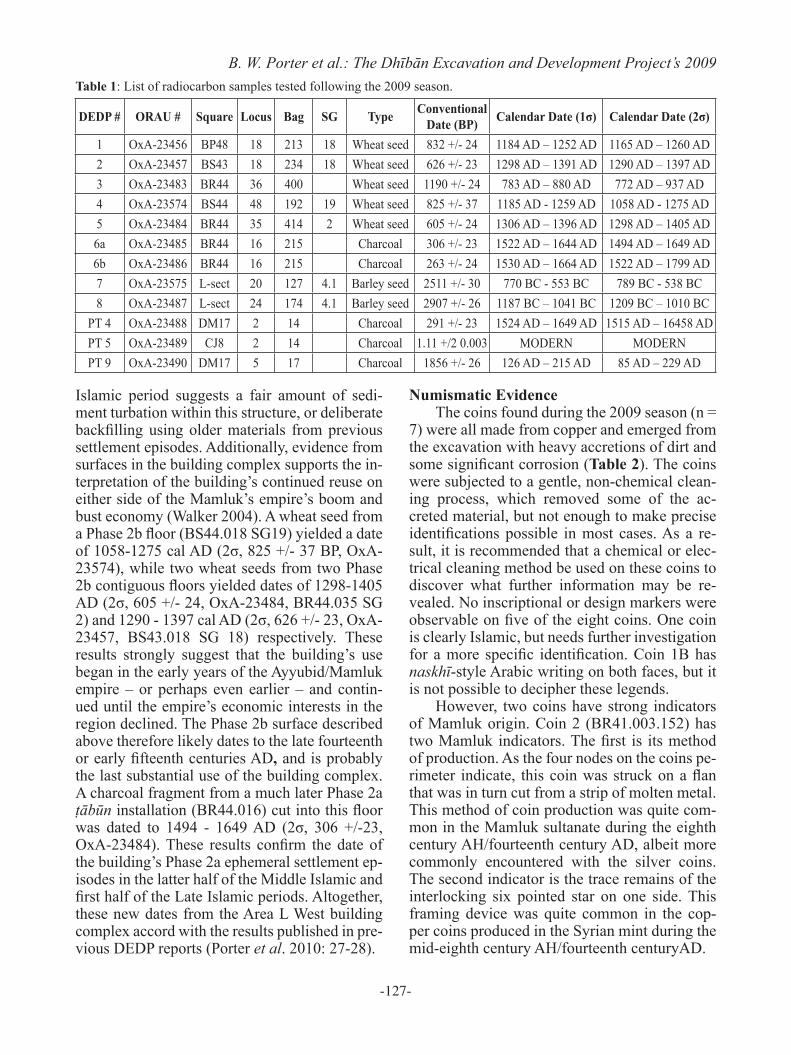
DEDP # ORAU # Square Locus Bag SG Type Conventional Date (BP) Calendar Date (1σ) Calendar Date (2σ)
1 OxA-23456 BP48 18 213 18 Wheat seed 832 +/- 24 1184 AD – 1252 AD 1165 AD – 1260 AD2 OxA-23457 BS43 18 234 18 Wheat seed 626 +/- 23 1298 AD – 1391 AD 1290 AD – 1397 AD3 OxA-23483 BR44 36 400 Wheat seed 1190 +/- 24 783 AD – 880 AD 772 AD – 937 AD4 OxA-23574 BS44 48 192 19 Wheat seed 825 +/- 37 1185 AD - 1259 AD 1058 AD - 1275 AD5 OxA-23484 BR44 35 414 2 Wheat seed 605 +/- 24 1306 AD – 1396 AD 1298 AD – 1405 AD6a OxA-23485 BR44 16 215 Charcoal 306 +/- 23 1522 AD – 1644 AD 1494 AD – 1649 AD6b OxA-23486 BR44 16 215 Charcoal 263 +/- 24 1530 AD – 1664 AD 1522 AD – 1799 AD7 OxA-23575 L-sect 20 127 4.1 Barley seed 2511 +/- 30 770 BC - 553 BC 789 BC - 538 BC8 OxA-23487 L-sect 24 174 4.1 Barley seed 2907 +/- 26 1187 BC – 1041 BC 1209 BC – 1010 BC
PT 4 OxA-23488 DM17 2 14 Charcoal 291 +/- 23 1524 AD – 1649 AD 1515 AD – 16458 ADPT 5 OxA-23489 CJ8 2 14 Charcoal 1.11 +/2 0.003 MODERN MODERNPT 9 OxA-23490 DM17 5 17 Charcoal 1856 +/- 26 126 AD – 215 AD 85 AD – 229 AD
Table 1: List of radiocarbon samples tested following the 2009 season.
Islamic period suggests a fair amount of sedi-ment turbation within this structure, or deliberate backfilling using older materials from previous settlement episodes. Additionally, evidence from surfaces in the building complex supports the in-terpretation of the building’s continued reuse on either side of the Mamluk’s empire’s boom and bust economy (Walker 2004). A wheat seed from a Phase 2b floor (BS44.018 SG19) yielded a date of 1058-1275 cal AD (2σ, 825 +/- 37 BP, OxA-23574), while two wheat seeds from two Phase 2b contiguous floors yielded dates of 1298-1405 AD (2σ, 605 +/- 24, OxA-23484, BR44.035 SG 2) and 1290 - 1397 cal AD (2σ, 626 +/- 23, OxA-23457, BS43.018 SG 18) respectively. These results strongly suggest that the building’s use began in the early years of the Ayyubid/Mamluk empire ‒ or perhaps even earlier ‒ and contin-ued until the empire’s economic interests in the region declined. The Phase 2b surface described above therefore likely dates to the late fourteenth or early fifteenth centuries AD, and is probably the last substantial use of the building complex. A charcoal fragment from a much later Phase 2a ṭābūn installation (BR44.016) cut into this floor was dated to 1494 - 1649 AD (2σ, 306 +/-23, OxA-23484). These results confirm the date of the building’s Phase 2a ephemeral settlement ep-isodes in the latter half of the Middle Islamic and first half of the Late Islamic periods. Altogether, these new dates from the Area L West building complex accord with the results published in pre-vious DEDP reports (Porter et al. 2010: 27-28).
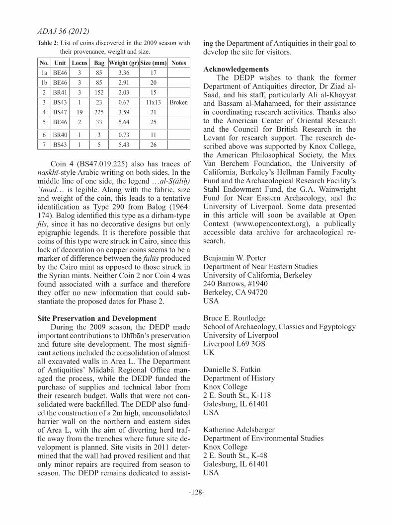
Numismatic Evidence The coins found during the 2009 season (n =
7) were all made from copper and emerged from the excavation with heavy accretions of dirt and some significant corrosion (Table 2). The coins were subjected to a gentle, non-chemical clean-ing process, which removed some of the ac-creted material, but not enough to make precise identifications possible in most cases. As a re-sult, it is recommended that a chemical or elec-trical cleaning method be used on these coins to discover what further information may be re-vealed. No inscriptional or design markers were observable on five of the eight coins. One coin is clearly Islamic, but needs further investigation for a more specific identification. Coin 1B has naskhī-style Arabic writing on both faces, but it is not possible to decipher these legends.
However, two coins have strong indicators of Mamluk origin. Coin 2 (BR41.003.152) has two Mamluk indicators. The first is its method of production. As the four nodes on the coins pe-rimeter indicate, this coin was struck on a flan that was in turn cut from a strip of molten metal. This method of coin production was quite com-mon in the Mamluk sultanate during the eighth century AH/fourteenth century AD, albeit more commonly encountered with the silver coins. The second indicator is the trace remains of the interlocking six pointed star on one side. This framing device was quite common in the cop-per coins produced in the Syrian mint during the mid-eighth century AH/fourteenth centuryAD.
-128-
ADAJ 56 (2012)
Coin 4 (BS47.019.225) also has traces of naskhī-style Arabic writing on both sides. In the middle line of one side, the legend …al-S(āliḥ) `Imad… is legible. Along with the fabric, size and weight of the coin, this leads to a tentative identification as Type 290 from Balog (1964: 174). Balog identified this type as a dirham-type fils, since it has no decorative designs but only epigraphic legends. It is therefore possible that coins of this type were struck in Cairo, since this lack of decoration on copper coins seems to be a marker of difference between the fulūs produced by the Cairo mint as opposed to those struck in the Syrian mints. Neither Coin 2 nor Coin 4 was found associated with a surface and therefore they offer no new information that could sub-stantiate the proposed dates for Phase 2.
Site Preservation and DevelopmentDuring the 2009 season, the DEDP made
important contributions to Dhībān’s preservation and future site development. The most signifi-cant actions included the consolidation of almost all excavated walls in Area L. The Department of Antiquities’ Mādabā Regional Office man-aged the process, while the DEDP funded the purchase of supplies and technical labor from their research budget. Walls that were not con-solidated were backfilled. The DEDP also fund-ed the construction of a 2m high, unconsolidated barrier wall on the northern and eastern sides of Area L, with the aim of diverting herd traf-fic away from the trenches where future site de-velopment is planned. Site visits in 2011 deter-mined that the wall had proved resilient and that only minor repairs are required from season to season. The DEDP remains dedicated to assist-
ing the Department of Antiquities in their goal to develop the site for visitors.
AcknowledgementsThe DEDP wishes to thank the former
Department of Antiquities director, Dr Ziad al-Saad, and his staff, particularly Ali al-Khayyat and Bassam al-Mahameed, for their assistance in coordinating research activities. Thanks also to the American Center of Oriental Research and the Council for British Research in the Levant for research support. The research de-scribed above was supported by Knox College, the American Philosophical Society, the Max van Berchem Foundation, the University of California, Berkeley’s Hellman Family Faculty Fund and the Archaeological Research Facility’s Stahl Endowment Fund, the G.A. Wainwright Fund for Near Eastern Archaeology, and the University of Liverpool. Some data presented in this article will soon be available at Open Context (www.opencontext.org), a publically accessible data archive for archaeological re-search. Benjamin W. PorterDepartment of Near Eastern StudiesUniversity of California, Berkeley240 Barrows, #1940Berkeley, CA 94720USA
Bruce E. RoutledgeSchool of Archaeology, Classics and EgyptologyUniversity of LiverpoolLiverpool L69 3GSUK
Danielle S. Fatkin Department of History Knox College2 E. South St., K-118Galesburg, IL 61401USA
Katherine Adelsberger Department of Environmental Studies Knox College2 E. South St., K-48Galesburg, IL 61401USA
No. Unit Locus Bag Weight (gr) Size (mm) Notes1a BE46 3 85 3.36 171b BE46 3 85 2.91 202 BR41 3 152 2.03 153 BS43 1 23 0.67 11x13 Broken4 BS47 19 225 3.59 215 BE46 2 33 5.64 25
6 BR40 1 3 0.73 117 BS43 1 5 5.43 26
Table 2: List of coins discovered in the 2009 season with their provenance, weight and size.
-129-
B. W. Porter et al.: The Dhībān Excavation and Development Project’s 2009Alan Farahani University of California, BerkeleyAncient History and Mediterranean Archaeology 7233 Dwinelle Hall University of California Berkeley, CA 94720USA
Warren SchultzHistory DepartmentSchmitt Academic Center, Suite 4202320 North Kenmore AvenueDePaul University Chicago, IL 60614USA
Andrew T. WilsonSchool of Archaeology, Classics and EgyptologyUniversity of LiverpoolLiverpool L69 3GSUK
BibliographyBalog, P.
1964 Coinage of the Mamluk Sultans of Egypt and Syria. New York: American Numismatic Society.
Fatkin, D., Adelsberger, K., Farahani, A., Fischer, A., Kansa, S.W., Lev-Tov, J., Morgan, C., Porter, B.W., Routledge, B. and Wilson, A.T.
2011 Digging Deeper: Technical Reports from the Dhiban Excavation and Development Project (2004-2009). ADAJ 55: 249-266
Glueck, N.1934 Explorations in Eastern Palestine, I. AASOR 14:
1-113 Kilian, M.R., van der Plicht, J. and van Geel, B.
1995 Dating Raised Bogs: New Aspects of AMS 14-C Wiggle Matching, A Reservoir Effect and Climatic Change. Quaternary Science Reviews 14: 959-966.
al-Mahameed, B.2003 Excavations at Tall Dhiban, 2002 Season (in
Arabic). ADAJ 48: 71-76.Milwright, M.
2008 The Fortress of the Raven: Karak in the Middle Islamic Period (1100-1650). Leiden: Brill.
Morton, W. 1989 The 1954, 55, and 65 Excavations at Dhiban
in Jordan. Pp. 239-246 in A. Dearman (ed.), Studies in the Mesha Inscription and Moab.
Atlanta: Scholars Press.van der Plicht, J.
2004 Radiocarbon, The Calibration Curve, and Scythian Chronology. Pp. 45-61 in E.M. Scott, A.Y. Alekseev and G. Zaitseva (eds.), Impact of the Environment on Human Migration in Eurasia. Kluwer Academic Publishers, Amsterdam.
Porter, B., Routledge, B., Steen, D., Parslow, C., DeJong, L. and Zimmerle, W.
2005 Tall Dhiban 2004 Pilot Season: Prospection, Preservation, and Planning. ADAJ 49: 201-216.
Porter, B., Routledge, B., Fatkin, D., Zimmerle, W., Hakes, J., Salvant, J. and Schultz, W.
2010 The Dhiban Excavation and Development Project’s 2005 Season. ADAJ 54: 9-34.
Porter, B., Routledge, B., Steen, D. and al-Kawamleh, F.2007 The Power of Place: The Dhiban Community
through the Ages. Pp. 315-322 in T. Levy, P.M. Daviau, R. Younker and M. Shaer (eds.), Crossing Jordan–North American Contributions to the Archaeology of Jordan. London: Equinox.
Reimer, P.J., Baillie, M.G., Bard, E., Bayliss, A., Beck, J.W., Bertrand, C.J., Blackwell, P.G., Buck, C.E., Burr, G.S., Cutler, K.B., Damon, P.E., Edwards, R.L., Fairbanks, R.G., Friedrich, M., Guilderson, T.P., Hogg, A.G., Hughen, K.A., Kromer, B., McCormac, G., Manning, S., Ramsey, C.B., Reimer, R.W., Remmele, S., Southon, J.R., Stuiver, M., Talamo, S., Taylor, F., van der Plicht, J. and Weyhenmeyer, C.E.
2004 IntCal04 Terrestrial Radiocarbon Age Calibration, 0-26 Cal Kyr BP. Radiocarbon 46: 1029-1058.
Routledge, B. 2004 Moab in the Iron Age: Hegemony, Polity,
Archaeology. Philadelphia: University of Pennsylvania Press.
Schiffer, M.B. 1986 Radiocarbon Dating and the “Old Wood”
Problem: The Case of the Hohokam Chronology. Journal of Archaeological Science 13: 13-30.
Tushingham, A.D.1972 The Excavations at Dibon (Dhiban) in Moab:
The Third Campaign, 1952-1953. Cambridge: American Schools of Oriental Research.
Walker, B.2004 Mamluk Investment in Transjordan: A ‘Boom
and Bust’ Economy. Mamluk Studies Review 8(2): 119-139.
Winnett, F. and Reed, W. 1964 The Excavations at Dibon (Dhiban) in Moab:
The First and Second Campaigns. Baltimore: J. H. Furst.
