excavation and rehabilitation management plan proposed
TRANSCRIPT
Excavation and Rehabilitation Management Plan
PROPOSED AGRICULTURAL
LIME QUARRY
Lot 9005 Nullaki Peninsula
City of Albany
Proponent Graeme Robertson
PO Box 114 Denmark WA 6333
February 2017
Excavation and Rehabilitation Management Plan, Proposed Agricultural Lime Quarry
Lot 9005
Nullaki Peninsula
Denmark
Prepared by Landform Research
Excavation – Rehabilitation Management Plan, Proposed Agricultural Lime Quarry, Lot 9005, Nullaki Peninsula Denmark
Landform Research i
SUMMARY Graeme Robertson proposes to open an agricultural lime quarry on 7.5 hectares of a limestone ridge on Lot 9005, Nullaki Peninsula Denmark. The limestone on Lot 9005 is highly suitable for lime for agriculture and neutralisation of acidity in addition to some road bases. Drilling has been completed and testing of the lime neutralising value carried out. The proposed excavation lies in the south eastern corner of Lot 9005, set back from the coastal cliffs and Foreshore Reserve (30883) which covers the cliffed slope. It is approximately 10 km south east from Denmark townsite on the Nullaki Peninsula. To the east lies Reserve 17464, vested in the City of Albany and associated with Lake Sadie. The Bibulmum Track runs through the reserve. Lot 9005 is covered by remnant coastal vegetation. The proposed quarry site has previously been used for a small limestone quarry to provide limestone for road construction on the subdivided part of the Nullaki Peninsula. The pit had been revegetated. Minor exploration work has been completed for the existing proposal including the preparation of access tracks and drill platforms. A predator proof fence runs across the Peninsula on the eastern side of Lot 9005. The limestone will be used to prevent soil acidification, which is a well recognised major environmental issue, highlighted in the various State of Environment Reports on Western Australia, where it is estimated that 55% of the agricultural land in Western Australia is susceptible to the problem. Soil acidification also causes stock toxicity from some metals (eg aluminium) which move into solution in acidic or low pH conditions. The only mechanism to counteract the increasing acidity is the application of calcium carbonate. The sources of calcium carbonate are limesand and Tamala Coastal Limestone. The proposal seeks to provide a continued resource of strategically located limestone, suited to a variety of end products. The majority of the lime from this pit will be used in the agricultural industry with lime being transported as far as Hyden in the east through the Great Southern Region. Currently existing supplies are running out and farmers are sourcing material from Lancelin or Redgate at a significant transport cost advantage. The Lower Great Southern Strategy in Section 2.9 Mineral Resources and Basic Raw Materials supports the identification and staged use of basic raw materials and minerals. The issues of agricultural lime are specifically mentioned the Lower Great Southern Strategy in relation to the existing limestone quarry at Albany being in an environmentally sensitive area and the need for a new resource. This proposal has the potential to supply agricultural lime for the future and in line with the Strategy. This proposal seeks Development Approval and an Extractive Industries Licence for an staged extraction area of 7.5 hectares combined with a stockpile are of 2 hectares on the eastern portion of Lot 9005. At any one time it is anticipated that only 2.0 hectares of pit will be open. Excavation is anticipated to extend to 8 metres in depth leaving an undulating land surface replicating other parts of the Nullaki Peninsula. An application for 20 years is made. End Use will be a return to Conservation in compliance with the Town Planning Scheme Zoning.
Excavation – Rehabilitation Management Plan, Proposed Agricultural Lime Quarry, Lot 9005, Nullaki Peninsula Denmark
Landform Research ii
There are no dwellings within 1 km of the site and the proposed operation has been designed to minimise or eliminate any dust, noise or visual impact. The site has an old limestone pit on the proposed disturbance footprint in addition to some drill pads and access roads. The old pit has been very successfully rehabilitated demonstrating that the proposed methods of rehabilitation are proven. It is anticipated that the life of the pit will be over 20 years. Extraction is anticipated to commence at around 20 000 tonnes per year rising to 50 000 tonnes per year and perhaps 100 000 tonnes per year in the longer term. At 50 000 tonnes that would equate to 10 laden truck movements per day on average (six days per week). Transport will be along Lees Road to Lake Saide Road to Lower Denmark Road. Discussions are to be held with the City of Albany to determine a satisfactory transport route.
The Excavation and Rehabilitation Management Plan addresses;
▪ Groundwater quality and quantity protection; ▪ Land surface stabilisation and interim rehabilitation, including erosion mitigation and
topsoil management ▪ Waste management ▪ Dust management ▪ Dieback management ▪ Contours and final ground surface levels; ▪ Fire management; ▪ Site security Environmental issues including dust, noise and traffic can be managed in such a way to minimise or eliminate any significant impact both on site and offsite. Dust and noise can be contained by the methods of extraction to be used and the control measures which will be put into place. Measures to protect the site and minimise the influence of dieback are addressed under Environmental Management.
Excavation – Rehabilitation Management Plan, Proposed Agricultural Lime Quarry, Lot 9005, Nullaki Peninsula Denmark
Landform Research iii
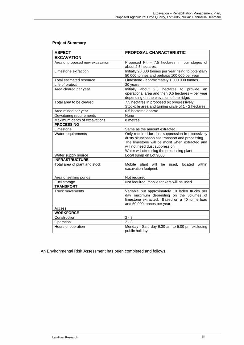
Project Summary
ASPECT PROPOSAL CHARACTERISTIC
EXCAVATION Area of proposed new excavation Proposed Pit – 7.5 hectares in four stages of
about 2.5 hectares.
Limestone extraction Initially 20 000 tonnes per year rising to potentially 50 000 tonnes and perhaps 100 000 per year
Total estimated resource Limestone - approximately 1 000 000 tonnes.
Life of project 20 years
Area cleared per year Initially about 2.5 hectares to provide an operational area and then 0.5 hectares – per year depending on the elevation of the ridge.
Total area to be cleared 7.5 hectares in proposed pit progressively Stockpile area and turning circle of 1 - 2 hectares
Area mined per year 0.5 hectares approx.
Dewatering requirements None
Maximum depth of excavations 8 metres
PROCESSING
Limestone Same as the amount extracted.
Water requirements Only required for dust suppression in excessively dusty situationson site transport and processing. The limestone will be moist when extracted and will not need dust suppression. Water will often clog the processing plant
Water supply source Local sump on Lot 9005.
INFRASTRUCTURE
Total area of plant and stock Mobile plant will be used, located within excavation footprint.
Area of settling ponds Not required
Fuel storage Not required, mobile tankers will be used
TRANSPORT
Truck movements Variable but approximately 10 laden trucks per day maximum depending on the volumes of limestone extracted. Based on a 40 tonne load and 50 000 tonnes per year.
Access
WORKFORCE
Construction 2 - 3
Operation 2 - 3
Hours of operation Monday - Saturday 6.30 am to 5.00 pm excluding public holidays.
An Environmental Risk Assessment has been completed and follows.
Excavation – Rehabilitation Management Plan, Proposed Agricultural Lime Quarry, Lot 9005, Nullaki Peninsula Denmark
Landform Research iv
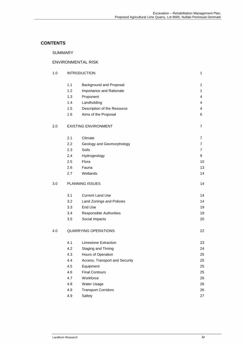
CONTENTS SUMMARY ENVIRONMENTAL RISK
1.0 INTRODUCTION 1
1.1 Background and Proposal 1
1.2 Importance and Rationale 1
1.3 Proponent 4
1.4 Landholding 4
1.5 Description of the Resource 4
1.6 Aims of the Proposal 6
2.0 EXISTING ENVIRONMENT 7
2.1 Climate 7
2.2 Geology and Geomorphology 7
2.3 Soils 7
2.4 Hydrogeology 9
2.5 Flora 10
2.6 Fauna 13
2.7 Wetlands 14
3.0 PLANNING ISSUES 14
3.1 Current Land Use 14
3.2 Land Zonings and Policies 14
3.3 End Use 19
3.4 Responsible Authorities 19
3.5 Social Impacts 20
4.0 QUARRYING OPERATIONS 22
4.1 Limestone Extraction 23
4.2 Staging and Timing 24
4.3 Hours of Operation 25
4.4 Access, Transport and Security 25
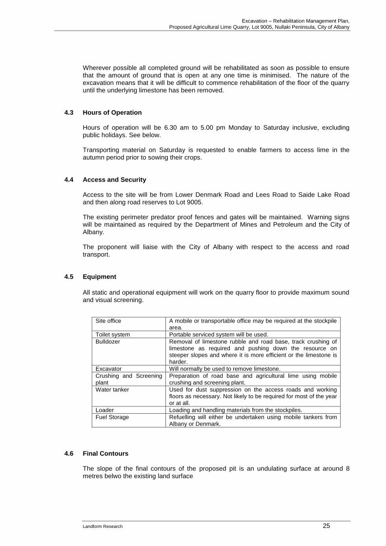
4.5 Equipment 25
4.6 Final Contours 25
4.7 Workforce 26
4.8 Water Usage 26
4.9 Transport Corridors 26
4.9 Safety 27
Excavation – Rehabilitation Management Plan, Proposed Agricultural Lime Quarry, Lot 9005, Nullaki Peninsula Denmark
Landform Research v
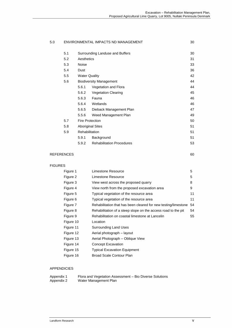
5.0 ENVIRONMENTAL IMPACTS ND MANAGEMENT 30
5.1 Surrounding Landuse and Buffers 30
5.2 Aesthetics 31
5.3 Noise 33
5.4 Dust 36
5.5 Water Quality 42
5.6 Biodiversity Management 44
5.6.1 Vegetation and Flora 44
5.6.2 Vegetation Clearing 45
5.6.3 Fauna 46
5.6.4 Wetlands 46
5.6.5 Dieback Management Plan 47
5.5.6 Weed Management Plan 49
5.7 Fire Protection 50
5.8 Aboriginal Sites 51
5.9 Rehabilitation 51
5.9.1 Background 51
5.9.2 Rehabilitation Procedures 53
REFERENCES 60
FIGURES
Figure 1 Limestone Resource 5
Figure 2 Limestone Resource 5
Figure 3 View west across the proposed quarry 8
Figure 4 View north from the proposed excavation area 9
Figure 5 Typical vegetation of the resource area 11
Figure 6 Typical vegetation of the resource area 11
Figure 7 Rehabilitation that has been cleared for new testing/limestone 54
Figure 8 Rehabilitation of a steep slope on the access road to the pit 54
Figure 9 Rehabilitation on coastal limestone at Lancelin 55
Figure 10 Location
Figure 11 Surrounding Land Uses
Figure 12 Aerial photograph – layout
Figure 13 Aerial Photograph – Oblique View
Figure 14 Concept Excavation
Figure 15 Typical Excavation Equipment
Figure 16 Broad Scale Contour Plan
APPENDICIES Appendix 1 Flora and Vegetation Assessment – Bio Diverse Solutions Appendix 2 Water Management Plan
Excavation – Rehabilitation Management Plan, Proposed Agricultural Lime Quarry, Lot 9005, Nullaki Peninsula, City of Albany
Landform Research 1
1.0 INTRODUCTION 1.1 Background and Proposal
Graeme Robertson proposes to open an agricultural lime quarry on 7.5 hectares of a limestone ridge on Lot 9005, Nullaki Peninsula Denmark. The limestone on Lot 9005 is highly suitable for lime for agriculture and neutralisation of acidity in addition to some road bases. Drilling has been completed and testing of the lime neutralising value carried out. Location The proposed excavation lies in the south eastern corner of Lot 9005, set back from the coastal cliffs and Foreshore Reserve (30883) which covers the cliffed slope. It is approximately 10 km south east from Denmark townsite on the Nullaki Peninsula. To the east lies Reserve 17464, vested in the City of Albany and associated with Lake Sadie. The Bibulmum Track runs through the reserve. Current Land Use Lot 9005 is covered by remnant coastal vegetation. The proposed quarry site has previously been used for a small limestone quarry to provide limestone for road construction on the subdivided part of the Nullaki Peninsula. The pit had revegetated. Minor exploration work has been completed for the existing proposal including the preparation of access tracks and drill platforms. A predator proof fence runs across the Peninsula on the eastern side of Lot 9005. Existing Approvals There are no current approvals. Proposal This proposal seeks Development Approval and an Extractive Industries Licence for Agricultural Lime limestone from Lot 9005. An applicaiotn for a 20 year approval is requested.
1.2 Importance and Rationale Need for Lime for Mitigating Soil Acidity The importance of the local lime is recognised in the Department of Agriculture and Food Bulletin 4660, Survey of Western Australia agricultural lime sources. Crushed limestone and limesand is an essential resource to the State, for correcting soil acidity caused during normal farming operations through the use of nitrogenous fertiliser and legume crops. The need for crushed limestone for use as agricultural lime is recognised by the Department of Agriculture and Food (Bulletin 4784).
Excavation – Rehabilitation Management Plan, Proposed Agricultural Lime Quarry, Lot 9005, Nullaki Peninsula, City of Albany
Landform Research 2
Acidification of soils is seen as one of the major impediments to continued viable farming in Western Australia. The State Of the Environment Report Western Australia 2007 shows that about two thirds of the South West agricultural soils are at risk of acidification. When the acidity builds up essential nutrients become unavailable to plants, and the crops reduce in vigour and eventually fail. In addition some other elements such as aluminium become soluble and lead to toxicity in stock and plants. The normal method of treatment of soil acidity is to add agricultural limesand and crushed limestone as explained in Department of Agriculture and Food Bulletin 4784 Soil Acidity, A guide for WA farmers and consultants. Abeysinghe, P B, 1998, Limestone and Limesand Resources of Western Australia, Geological Survey of Western Australia, Mineral Resources Bulletin 18, also summarises the uses for limestone and lime and the deposits, but does not list the limestone in this locality. The need to mitigate soil acidity is also reiterated by the EPA. Acidification of soils is cited by the Environmental Protection Authority (EPA) in Section 3.3 of its State of the Environment Report as a serious threat to the sustainability of WA soils and agriculture. The report calls for the increased use of lime sand to combat soil acidification and to arrest the menace of sub-soil acidification and its effects on crops, water quality and native vegetation (EPA 2007). The limestone is essential to the local agricultural industry, but is restricted in distribution and grade south of Perth and the South West. Whilst limestone is more common a significant part lies within the Conservation Estate. Much of the limestone and calcareous dunes are located within coastal Crown land and Reserves. Department of Agriculture and Food have conducted various studies with respect to the need for lime for agriculture and Tim Overheu has provided a letter of support form the Department. The southern agricultural areas currently source their lime from a small pit near Denmark that is located in an A Class Reserve and which is nearing extenction. Alternatively limesand has to be sourced from Lancelin. This is explained in the Lower Great Southern Strategy 2016 To be most effective limestone has to be of the highest grade and, whilst coastal calcareous dunes and limestone do contain calcium carbonate the grades are often too low for efficient and economic use. For example using limestone at half the calcium carbonate content will require double the amount to be excavated, leading to additional land clearing, excavation and transport for no greater gain. The material on site will be crushed and will form smaller particles of lime than limesand and therefore provide quicker and more efficient sources of CaCO3 than non crushed limesand. Therefore whilst the grade of the limestone and neutralising value is up to 80% it averages around 75% and with blending it offers substantial savings to the southern agricultural regions because of reduced transport costs. Lime is also required for remediation of acid sulphate conditions which occur on the coastal sands in the Albany Walpole area which have been subject to low lying coastal or estuarine processes. Lime is also required for some industrial processes. The draft State Lime Supply Strategy (2008) advocates the use of known lime resources especially from those sites which have minimal impact on the conservation values of native vegetation and are well-positioned in terms of existing infrastructure to serve the farming and rural communities (DMP 2008).
Excavation – Rehabilitation Management Plan, Proposed Agricultural Lime Quarry, Lot 9005, Nullaki Peninsula, City of Albany
Landform Research 3
The resource has been identified by the Geological Survey of Western Australia has studied the Limesand and Limestone Resources of Southern Western Australia in Record 2015/7. They did not test the limestone at this location but tested material to the east and at other locations. The general geology and deposits have been reviewed by the Western Australian Geological Survey and summarised in Abeysinghe 1998. Some consideration of the use of limestone for agricultural lime and other purposes is shown in the following documents which examine the resources in each area including the availability. The most relevant documents are listed first. See;
• Geological Survey of Western Australia, 2015, Limesand and Limestone Resources of Southern Western Australia.
• Abeysinghe P B, 1998, Limestone and Limesand Resources of Western Australia, Geological Survey of Western Australia, Mineral Resources Bulletin 18.
• Department of Agriculture and Food Bulletin 4660, Survey of Western Australia agricultural lime sources
• Department of Agriculture and Food Bulletin 4784 Soil Acidity, A guide for WA farmers and consultants.
• Geological Survey of Western Australia, 1989, 1 : 50 000 Environmental Geology Series Torbay.
• Muhling P C and A T Brakel, 1985, 1 : 250 000 Geological Series, Geological Survey of Western Australia.
• Gozzard J R, 1987, Limesand and Limestone Resources between Lancelin and Bunbury, Geol Surv WA, Record 1987/5
• Western Australia, Western Australian Planning Commission, Statement of Planning Policy 2.4, Basic Raw Materials.
• Chamber of Commerce and Industry, 1995 and 1996, Managing the Basic Raw Materials of Perth and the Outer Metropolitan Region, Parts 1 and 2.
• Chamber of Commerce and Industry, 2008, Basic Raw Materials Access and Availability.
• Fetherston J M, 2007, Dimension Stone in Western Australia, Volume 1, Department of Mines and Petroleum, Mineral Resources Bulletin 23.
• WAPC 2012, Basic Raw Materials Demand and Supply Study for the Bunbury - Busselton Region,
The community need for agricultural lime is indicated by the need for resources to be extracted. If there no community demand for limestone as a building product and for agricultural use it would be unlikely that this natural resource would ever be utilised for any other purpose and would have no economic significance. The resource is strategically located and has the potential to provide raw materials for the lime for 20 plus years. If the resource is not taken from this site it will have to be taken from another site where similar or more land clearing is required. The depth of sand on this site also minimises the area of farm land or vegetation that is likely to have to be cleared on an alternative site.
Excavation – Rehabilitation Management Plan, Proposed Agricultural Lime Quarry, Lot 9005, Nullaki Peninsula, City of Albany
Landform Research 4
1.3 Proponent The proponent is Graeme Robertson Contact is Graeme Robertson PO Box 114 Denmark WA 6333
1.4 Landholding
Lot LOT 9005 Nullaki Peninsula, City of Albany
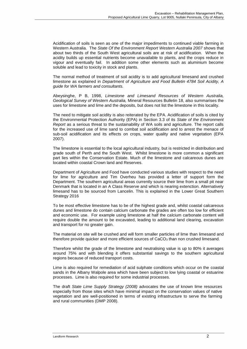
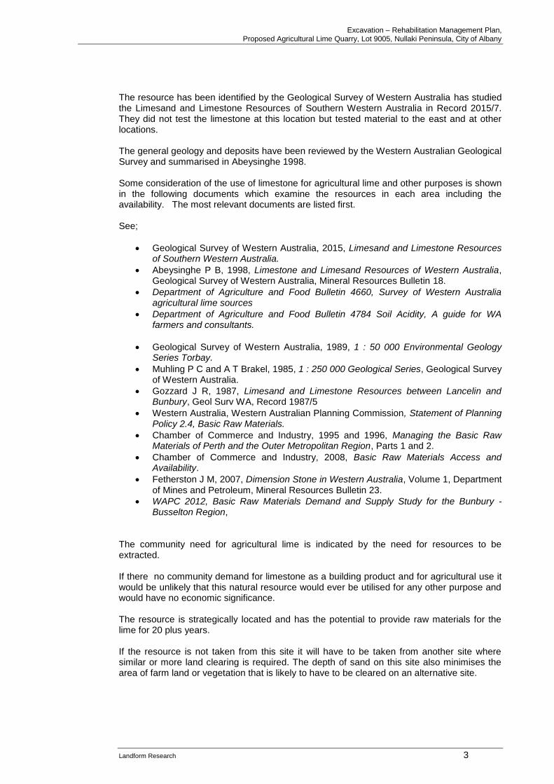
1.5 Description of the Resource The site covers part of the Nullaki Peninsula on the ocean side of Wilson’s Inlet. A ridge of limestone to 168 metres in elevation occurs on the peninsula with the ocean side eroded to a steep and cliffed coast. Figures 3 and 5 The limestone consists of interbedded limestone varying from calcarenite, a sandy limestone through to limestone. Figures 1 and 2. There is also some recalcified capstone development on the current and older buried soil horizons. The limestone ranges up to 80% CaCO3 but ranges lower in some beds and with selection and blending is capable of averaging 75% CaCO3. Due to dissolution of the calcium carbonate the CaCO3 drops inland so that some few hundred metres from the coast the grade is typically 60%, hence the resource is located so close to the coast. The limestone can be crushed for agricultural lime with the harder material being used for road base. The existing subdivisions on the Nullaki Peninsula are constructed from limestone taken from the site. The limestone on site changes rapidly laterally and vertically through changes in the original dune morphology as does the degree of lithification (hardness). These changes determine the use to which each type of limestone can be put.
Excavation – Rehabilitation Management Plan, Proposed Agricultural Lime Quarry, Lot 9005, Nullaki Peninsula, City of Albany
Landform Research 5
Figure 1 Limestone resource
Figure 2 Limestone resource Although the resource extends to depth, extraction is likely to be initially limited to 8 metres AHD metres to provide an undulating and consistent final landform and to be consistent with the lower elevations available on site.
Excavation – Rehabilitation Management Plan, Proposed Agricultural Lime Quarry, Lot 9005, Nullaki Peninsula, City of Albany
Landform Research 6
An estimated 20 plus years' limestone resources are present, although this depends on the rate of community demand.
1.6 Aims of the Proposal A major and increasing environmental issue within Western Australian agriculture is the gradual, widespread and increasing levels of acidic soils, created through the use of nitrogenous fertiliser and the growth of leguminous crops. The agricultural industry of Western Australia is one of the most important to our economy through direct value, value added and employment. Soil Acidification is a well recognised major environmental issue and is highlighted in the various State of Environment Reports on Western Australia, where it is estimated that 55% of the agricultural land in Western Australia is susceptible to the problem. Soil acidification also causes stock toxicity from some metals (eg aluminium) which move into solution in acidic or low pH conditions. The trend towards acidification of the soils is unavoidable, because legume rotations are best practise farming, and nitrogen is essential for crop growth. The only mechanism to counteract the increasing acidity is the application of calcium carbonate. The sources of calcium carbonate are limesand, Tamala Coastal Limestone, or other imported limestones, that have to be treated, or dredged lime/shell sand. Most coastal areas of coastal Limestone are covered by remnant vegetation or are in areas where they are sterilised by increasing numbers of residents. The aims of the proposal are to;
• Provide reserves of strategically located limestone, suited to a variety of end products.
• Supply lime to the agricultural industry.
• Provide additional limestone materials for a stable long term supply of limestone products in the Great Southern.
• Comply with State Planning Policy No 2.5 which requires that basic raw materials should be taken prior to sterilisation of the area by development.
• Comply with the Lower Great Southern Strategy 2016.
Excavation – Rehabilitation Management Plan, Proposed Agricultural Lime Quarry, Lot 9005, Nullaki Peninsula, City of Albany
Landform Research 7
2.0 EXISTING ENVIRONMENT 2.1 Climate
The climate of the area is classified as Mediterranean with warm summers and cool wet winters. Temperatures closest to Denmark Research Station, where the maximum temperatures in the summer months are 23.2 to 25.9 degrees Celsius. In winter the maxima are 16 to 17 degrees Celsius with the minima dropping to around 7 degrees C in July. Rainfall for the area is approximately 1000 mm with more than most rain falling during the winter months April to October inclusive. The wind direction is predominantly from the south.
2.2 Geology and Geomorphology The site is an eroded high ridge of intebeded sequences of coastal dunes, of limestone 120 to 140 metres, rising to over 160 metres AHD on the highest peaks overlying an undulating Proterozoic granitic basement that outcrops of granite hills in the Denmark - Wilson Inlet area. The limestone is a calc-arenite made from beach sand containing predominantly shell fragments with minor and variable quartz. The limestone has been lithified and recrystallised on the ridge tops to lift the percentage of calcium carbonate to over 70%. The limestone sequences also include buried soil horizons and recalcified limestone overtopped by younger dunes. The geology is summarised in;
➢ Geological Survey of Western Australia, 1989, 1 : 50 000 Environmental Geology Series Torbay.
➢ Muhling P C and A T Brakel, 1985, 1 : 250 000 Geological Series, Geological Survey of Western Australia.
➢ Smith R A 1993, 1 : 250 000 Hydrogeological Series Mt Barker – Alban, Department of Minerals and Energy.
The degree of lithification (hardness) changes over the property, and determines the use to which each type of limestone can be put. The limestone is of Quaternary Age formed during changes to sea level during the Pleistocene. Bores drilled on site and exposure in the cliffs show variable depths of limestone of over 150 metres thickness.
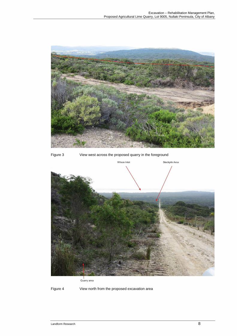
2.3 Soils Soils on the site consist predominantly of grey organic sands in the swales over limestone with white to cream limey sands on the youngest dunes and surfaces. The soils have been mapped at a very broad scale by CSIRO who categorise them with leached sands, but that is not locally correct. The soil profile can be seen in the site photographs. Figures 1 and 2.
Excavation – Rehabilitation Management Plan, Proposed Agricultural Lime Quarry, Lot 9005, Nullaki Peninsula, City of Albany
Landform Research 8
Figure 3 View west across the proposed quarry in the foreground
Figure 4 View north from the proposed excavation area
Excavation – Rehabilitation Management Plan, Proposed Agricultural Lime Quarry, Lot 9005, Nullaki Peninsula, City of Albany
Landform Research 9
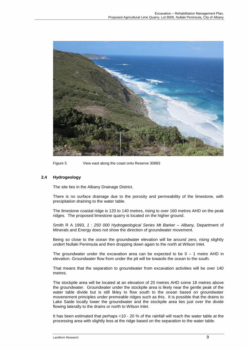
Figure 5 View east along the coast onto Reserve 30883 2.4 Hydrogeology
The site lies in the Albany Drainage District. There is no surface drainage due to the porosity and permeability of the limestone, with precipitation draining to the water table. The limestone coastal ridge is 120 to 140 metres, rising to over 160 metres AHD on the peak ridges. The proposed limestone quarry is located on the higher ground. Smith R A 1993, 1 : 250 000 Hydrogeological Series Mt Barker – Albany, Department of Minerals and Energy does not show the direction of groundwater movement. Being so close to the ocean the groundwater elevation will be around zero, rising slightly undert Nullaki Peninsula and then dropping down again to the north at Wilson Inlet. The groundwater under the excavation area can be expected to be 0 – 1 metre AHD in elevation. Groundwater flow from under the pit will be towards the ocean to the south. That means that the separation to groundwater from excavation activities will be over 140 metres. The stockpile area will be located at an elevation of 20 metres AHD some 18 metres above the groundwater. Groundwater under the stockpile area is likely near the gentle peak of the water table divide but is still likley to flow south to the ocean based on groundwater movenement principles under premeable ridges such as this. It is possible that the drains to Lake Saide locally lower the groundwater and the stockpile area lies just over the divide flowing laterally to the drains or north to Wilson Inlet. It has been estimated that perhaps <10 - 20 % of the rainfall will reach the water table at the processing area with slightly less at the ridge based on the separation to the water table.
Excavation – Rehabilitation Management Plan, Proposed Agricultural Lime Quarry, Lot 9005, Nullaki Peninsula, City of Albany
Landform Research 10
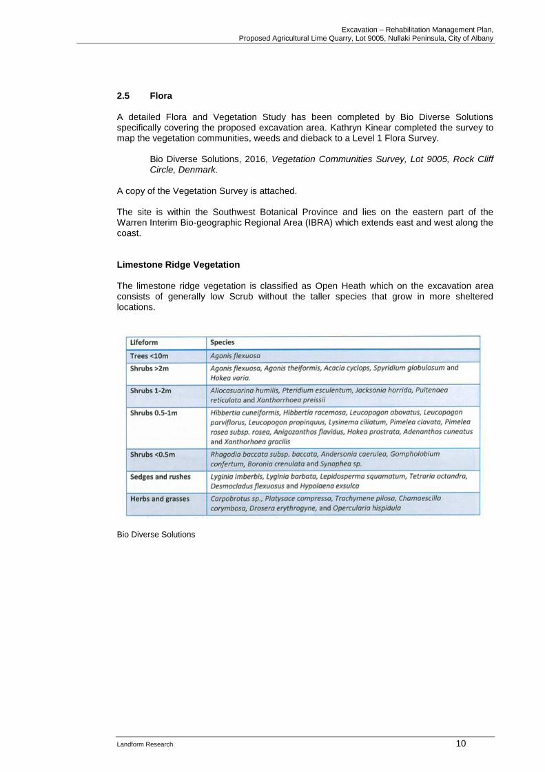
2.5 Flora A detailed Flora and Vegetation Study has been completed by Bio Diverse Solutions specifically covering the proposed excavation area. Kathryn Kinear completed the survey to map the vegetation communities, weeds and dieback to a Level 1 Flora Survey.
Bio Diverse Solutions, 2016, Vegetation Communities Survey, Lot 9005, Rock Cliff Circle, Denmark.
A copy of the Vegetation Survey is attached. The site is within the Southwest Botanical Province and lies on the eastern part of the Warren Interim Bio-geographic Regional Area (IBRA) which extends east and west along the coast. Limestone Ridge Vegetation The limestone ridge vegetation is classified as Open Heath which on the excavation area consists of generally low Scrub without the taller species that grow in more sheltered locations.
Bio Diverse Solutions
Excavation – Rehabilitation Management Plan, Proposed Agricultural Lime Quarry, Lot 9005, Nullaki Peninsula, City of Albany
Landform Research 11
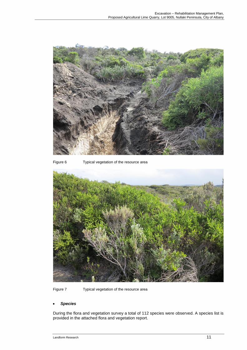
Figure 6 Typical vegetation of the resource area
Figure 7 Typical vegetation of the resource area
• Species During the flora and vegetation survey a total of 112 species were observed. A species list is provided in the attached flora and vegetation report.
Excavation – Rehabilitation Management Plan, Proposed Agricultural Lime Quarry, Lot 9005, Nullaki Peninsula, City of Albany
Landform Research 12
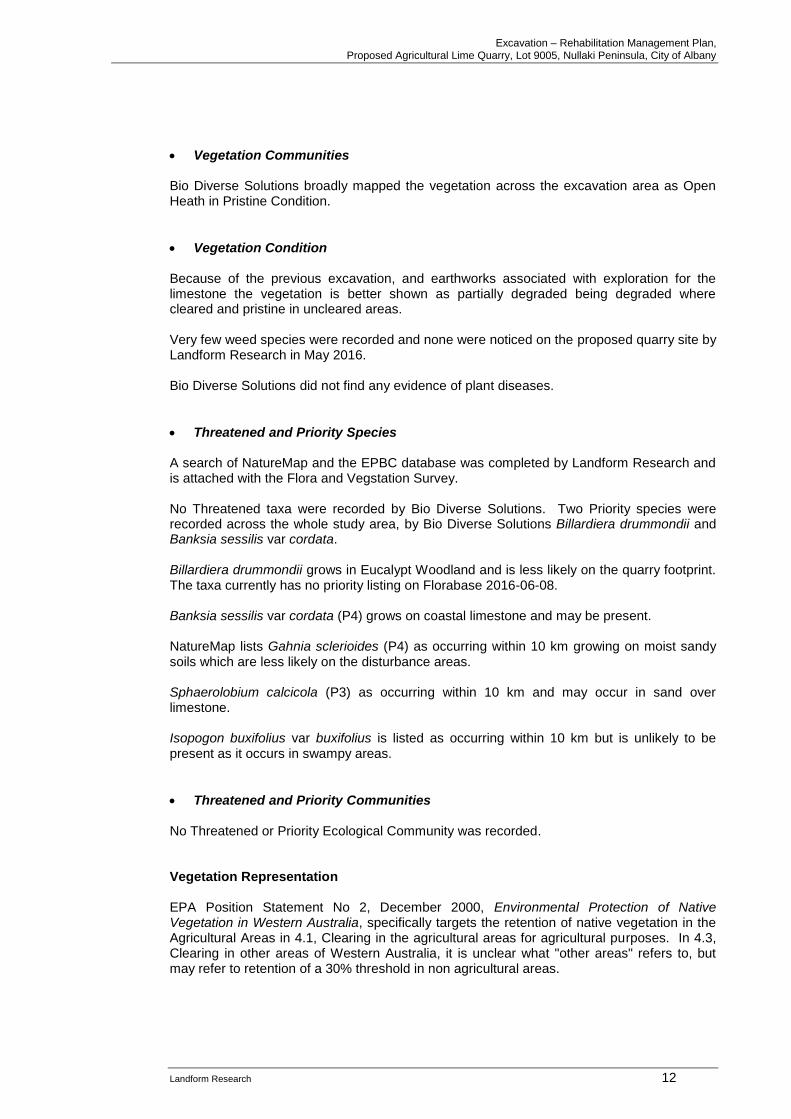
• Vegetation Communities Bio Diverse Solutions broadly mapped the vegetation across the excavation area as Open Heath in Pristine Condition.
• Vegetation Condition Because of the previous excavation, and earthworks associated with exploration for the limestone the vegetation is better shown as partially degraded being degraded where cleared and pristine in uncleared areas. Very few weed species were recorded and none were noticed on the proposed quarry site by Landform Research in May 2016. Bio Diverse Solutions did not find any evidence of plant diseases.
• Threatened and Priority Species A search of NatureMap and the EPBC database was completed by Landform Research and is attached with the Flora and Vegstation Survey. No Threatened taxa were recorded by Bio Diverse Solutions. Two Priority species were recorded across the whole study area, by Bio Diverse Solutions Billardiera drummondii and Banksia sessilis var cordata. Billardiera drummondii grows in Eucalypt Woodland and is less likely on the quarry footprint. The taxa currently has no priority listing on Florabase 2016-06-08. Banksia sessilis var cordata (P4) grows on coastal limestone and may be present. NatureMap lists Gahnia sclerioides (P4) as occurring within 10 km growing on moist sandy soils which are less likely on the disturbance areas. Sphaerolobium calcicola (P3) as occurring within 10 km and may occur in sand over limestone. Isopogon buxifolius var buxifolius is listed as occurring within 10 km but is unlikely to be present as it occurs in swampy areas.
• Threatened and Priority Communities No Threatened or Priority Ecological Community was recorded. Vegetation Representation EPA Position Statement No 2, December 2000, Environmental Protection of Native Vegetation in Western Australia, specifically targets the retention of native vegetation in the Agricultural Areas in 4.1, Clearing in the agricultural areas for agricultural purposes. In 4.3, Clearing in other areas of Western Australia, it is unclear what "other areas" refers to, but may refer to retention of a 30% threshold in non agricultural areas.

Excavation – Rehabilitation Management Plan, Proposed Agricultural Lime Quarry, Lot 9005, Nullaki Peninsula, City of Albany
Landform Research 13
Section 4.3 Clearing in other areas of Western Australia, (EPA Position Statement No 2, December 2000) expects that clearing will not take vegetation types below the 30% of the pre-clearing vegetation as recommended by ANZECC, 1999, National Framework for the Management and Monitoring of Australia's Native Vegetation. The National Objectives and Targets for Biodiversity Conservation 2001 - 2005 (Commonwealth of Australia 2001) also recognise 30% as the trigger value. The small area of ground open at any one time is very small compared to the large expanse of similar coastal along the Nullaki Peninsula and nearby coast, most of which is protected in Reserves 1764 and 26177. The nearby vegetation of similar communities in excellent condition totals over 6 500 hectares. The 4 hectares open at any one time represents just 0.06%. At the end of excavation the site will be rehabilitated as shown by rehabilitaiotn of other limestone pits including the old road base pit on site. Where rehabilitaiotn was effective with no weeds or disease.
2.6 Fauna
A fauna study was not conducted because the resource area represents a very small area within a large area of remnant vegetation with a small area only open at any one time. A search of NatureMap and the EPBC database was completed by Landform Research and includes the fauna listed within the City of Albany and recorded within 10 km and is attached with the Flora and Vegstation Survey. The small area of proposed disturbances and the large connectivity remaining in place will not cause any isolation of short range fauna. The Nullaki Peninsula is protected by a predator proof fence to keep out cats and foxes in particular. The exclusion of these predators forms a significant protection measure for fauna wich are advantaged by living within the protected zone. The protection fence is to remain in place.
Stygofauna and Troglofauna The potential presence of cavities within the limestone has been considered by Lindsay Stephens of Landform Research during the site inspection. EPA Guidance 54, concentrates on Stygofauna, which occur in caves and “are aquatic subterranean animals, found in a variety of groundwater systems”. Environmental Protection Authority, 2013, Consideration of subterranean fauna in environmental impact assessment in Western Australia relates to the level of survey. On the limestone ridge a reconnaissance survey was completed by Lindsay Stephens of Landform Research during the site inspection. The limestone ridge is not an isolated habitat, but is a very small portion of a long stretch of similar limestone based coastaling extending to the east and west. The limestone is Quaternary and therfore young in age with little to no calcrete development. The limestone is also likely to be too young to form significant cavities at the water table. “Troglofauna occur in air chambers in underground caves or smaller voids”.
Excavation – Rehabilitation Management Plan, Proposed Agricultural Lime Quarry, Lot 9005, Nullaki Peninsula, City of Albany
Landform Research 14
The issues of these organisms is best addressed on a risks basis, because the water table is not proposed to be impacted, on with the base of the pit being approximately 140 metres above the water table. The stockpile area is approximately 15 metres above the water table. Root mat communities are not known form this area and are unlikely to be present becaue the local geology, regolith and vegetation do not meet the criteria for their occurrence.
2.7 Wetlands
There are no nearby wetlands. Lake Saide lies to the north east – east surrounded by farmland. The access route will travel on local roads but not near the lake where the transport could impact on the wetland buffer.
3.0 PLANNING ISSUES 3.1 Current Land use
Lot 9005 is covered by remnant coastal vegetation. The proposed quarry site has previously been used for a small limestone quarry to provide limestone for road construction on the subdivided part of the Nullaki Peninsula. The pit had revegetated. Minor exploration work has been completed for the existing proposal including the preparation of access tracks and drill platforms. A predator proof fence runs across the Peninsula on the eastern side of Lot 9005. facilities.
3.2 Land Zonings and Policies State Planning Policies The State Planning Policy Framework provides for the implementation of a planning framework through the recognition and implementation of Regional Planning Policies above Local Planning Schemes and Policies. Within each layer of planning, there are a number of key policies and strategies to provide guidance to planning and development to enable sustainable communities to develop, expand and prosper without compromising the environment and future generations. Planning is governed under the Planning and Development Act 2005. This Act enables Government to introduce State and Regional Planning Schemes, Policies and Strategies to provide direction for future planning. The State and Regional Schemes sit above Town Planning Schemes and Strategies introduced by Local Government. Strategies and Policies provide guidance on how planning is to be undertaken and how proposed developments are to be considered. These Strategies and Policies are at the State, Regional and Local levels. Schemes are gazetted documents that provide for consideration and approval of proposed developments. These are normally at the Regional and Local Level. In addition to the documents produced under the Planning and Development Act 2005, the Local Government Act 1995 provides Local Governments with a mechanism to prepare Local Laws to manage issues of local significance.
Excavation – Rehabilitation Management Plan, Proposed Agricultural Lime Quarry, Lot 9005, Nullaki Peninsula, City of Albany
Landform Research 15
Some policies do have relevance such as the State Industrial Buffer Policy and Basic Raw Materials Policy. With respect to the supply of sand and limestone, the overarching document is the;
o State Planning Policy 1.0 State Planning Framework. Complementing this are a number of Relevant State Policies;
o State Planning Policy 2.0, Environment and Natural Resources Policy o State Planning Policy 2.4, Basic Raw Materials o State Planning Policy 4.1, State Industrial Buffer Policy
• State Planning Policy 2.0, Environment and Natural Resources Policy This policy provides for the protection of all natural resources under a number of sections;
5.1 General Measures 5.2 Water Quality including stormwater and wetlands 5.3 Air Quality 5.4 Soil and Land Quality 5.5 Biodiversity 5.6 Agricultural Land and Rangelands 5.7 Minerals Petroleum and Basic Raw Materials 5.8 Marine Resources and Aquaculture 5.9 Landscape 5.10 Greenhouse Gas Emissions and Energy Efficiency.
In addition to recognising the importance of protecting air quality, soil and land quality, water and wetlands and landscapes, the importance of Basic Raw Materials to the community is identified with reference to SPP 2.4 Basic Raw Materials, State Gravel Strategy 1998 and State Lime Strategy 2001. Section 5.7 of SPP 2.0, deals with Minerals, Petroleum and Basic Raw Materials. Part of Section 5.7 states;
Basic raw materials include sand, clay, hard rock, limestone and gravel together with other construction and road building requirements. A ready supply of basic raw materials close to development areas is required in order to keep down the cost of land development and the price of housing. Planning strategies, schemes and decision making should:
ii. Identify and protect important basic raw materials and provide for their extraction and use in accordance with State Planning Policy No 10 (2.4); Basic Raw Materials.
iii. Support sequencing of uses where appropriate to maximise options and
resultant benefits to community and the environment. The other factors of the natural environment are provided with the best protection possible, by this management plan, by selection of the site, operational staging and footprint and rehabilitation, bearing in mind the constraints of excavating and processing the resource.
Excavation – Rehabilitation Management Plan, Proposed Agricultural Lime Quarry, Lot 9005, Nullaki Peninsula, City of Albany
Landform Research 16
• State Planning Policy 2.4, Basic Raw Materials, 2000 This policy makes many statements on the intent and actions which local authorities should use to protect and manage basic raw materials. It is restricted to the Perth and Peel Region burt is the leading document with respect to guidance on the protection and staged use of basic raw materials including limestone. Section 3.4 is very specific in explaining that basic raw materials need identification and protection because of increased urban expansion and conservation measures, (3.4.1), (3.4.2) and (3.4.4). Sections 3.4.5 and 3.4.6 recognise that environmental and amenity matters need to be considered. There are specific provisions in Section 6.2 Local Planning Scheme Provisions, such as;
No support for the prohibition of extractive industries in zones that permit broad rural land uses. Providing an appropriate P, D or A use. Not precluding the extraction of basic raw materials on land which is not identified as a Priority Resource Location, Key Extraction Area or Extraction Area (6.4.2).
• SPP 2.5 – Agricultural and Rural Land Use Planning State Planning Policy No 2.5, Agricultural and Rural Land Use Planning, makes provision for the extraction of basic raw materials. This document is under revision with the draft document providing even greater protection and consideration for basic raw materials in line with SPP 2.4. SPP 2.5 in Point 9 states that "The location of rural residential and rural small holdings should avoid unacceptable impacts on, or sterilisation, of natural primary resources including prospective areas for mineralisation and basic raw materials ......". State Planning Policies are required to be considered under the Local Authority Town Planning Schemes as is the “identification and protection” for staged use, of basic raw materials.
Excavation – Rehabilitation Management Plan, Proposed Agricultural Lime Quarry, Lot 9005, Nullaki Peninsula, City of Albany
Landform Research 17
• State Planning Policy No 4.1, State Industrial Buffer Policy SPP 4.1 discusses the need to consider adjoining land uses when locating buffers but does not prescribe set buffers for operations such as this. The development and processing of the resource has been designed to maintain maximum buffer distances. In situations where the buffers are less, actions such as the provision of perimeter bunding to provide visual and noise management, tree planting and operational procedures, are used to mitigate and reduce impacts. This is discussed further in Section 2.8.1 Surrounding Landuses and 3.10 Buffers of this document.
• State Planning Strategy, 1997 The Western Australian Planning Commission (WAPC) released the State Planning Strategy in 1997. It comprises a range of strategies, actions, policies and plans to guide the planning and development of regional and local areas in Western Australia and assists in achieving a coordinated response to the planning challenges and issues of the future by State and Local Governments. The State Planning Strategy contains the following five key principles. These are:
o Environment & resources: to protect and enhance the key natural and cultural assets of the State and to deliver to all Western Australians a high quality of life which is based on sound environmentally sustainable principles.
o Community: to respond to social changes and facilitate the creation of vibrant,
accessible, safe and self-reliant communities.
o Economy: to actively assist in the creation of regional wealth, support the development of new industries and encourage economic activity in accordance with sustainable development principles.
o Infrastructure: to facilitate strategic development of regional Western Australia by
taking account of the special assets and accommodating the individual requirements of each region.
o Regional Development: to assist the development of regional Western Australia by
taking account of the special assets and accommodating the individual requirements of each region.
• Lower Great Southern Strategy 2016 The Lower Great Southern Strategy in Section 2.9 Mineral Resources and Basic Raw Materials supports the identification and staged use of basic raw materials and minerals. The issues of agricultural lime are specifically mentioned in the Strategy, in relation to the existing limestone quarry at Denmark, being in an environmentally sensitive area and the need for a new resource. This proposal has the potential to supply agricultural lime for the future.
Excavation – Rehabilitation Management Plan, Proposed Agricultural Lime Quarry, Lot 9005, Nullaki Peninsula, City of Albany
Landform Research 18
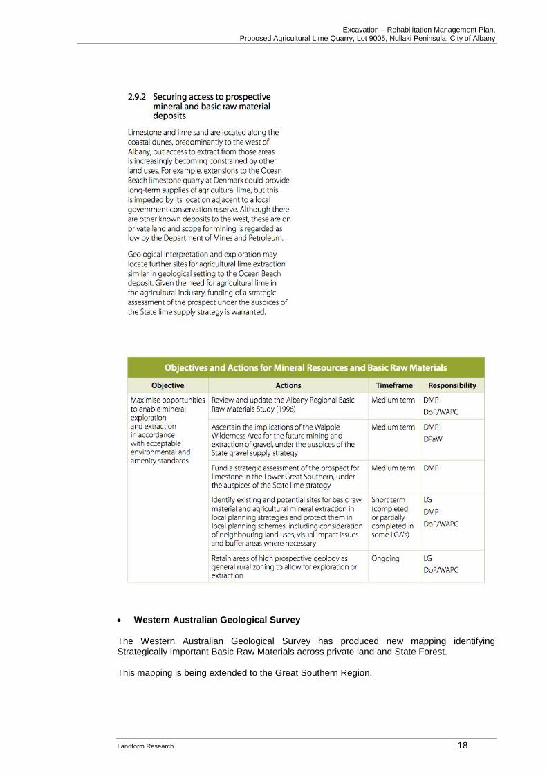
• Western Australian Geological Survey The Western Australian Geological Survey has produced new mapping identifying Strategically Important Basic Raw Materials across private land and State Forest. This mapping is being extended to the Great Southern Region.
Excavation – Rehabilitation Management Plan, Proposed Agricultural Lime Quarry, Lot 9005, Nullaki Peninsula, City of Albany
Landform Research 19
Local Government Planning Documents
• City of Albany Local Planning Scheme No 1 The site is zoned Rural Conservation under the City of Albany Local Planning Scheme. However the past excavation and success of rehabilitation has demonstrated that the limestone can be extracted and the land returned to conservation. The Objectives of the zone do not mention extraction or basic raw materials and do not prohibit development as long as it is completed in a ecological sensitive manner. The proposed quarry is selected and designed to minimise impacts with the past excavation and rehabilitation demonstrating that excavated land can be returned to high quality native vegetation that preserves the conservation values. Extractive Industries are a use “Not Listed” in the Zoning Table, thereby providing the City with potential to approve the development. Any developments are to conform with Section 5.5.14 of the Town Planning Scheme. Again Section 5.5.14 does not address Extractive Industries but does carry a number of requirements for developments. The proposed operations are consistent with the intent and provisions of Section 5.5.14.
• City of Albany Policy Extractive Industries and Mining The City of Albany Extractive Industries and Mining Policy prescribes the informaiton required for applications for extractive industries. This management plan complies with the Policy. A survey can be completed as a condition of approval when the land can be accurately surveyd and pegs installed to ensure that the approved footprints are complied with.
3.3 End Use The planned end use of the site is to restore a natural soil and return the ridge to native vegetation and conservation.
3.4 Responsible Authorities A number of state and local government authorities are responsible for overseeing the safety and management of the proposed quarry. Other authorities have an interest in the proposal but may not hold any responsibility. City of Albany
• Provides Planning Consent.
• Issues the Extractives Industries Licence for the quarry.
• Regulates land zonings in conjunction with the Western Australian Planning Commission.
• Has control over local roads. Main Roads
• Has an interest in the transport routes and controls major roads.
Excavation – Rehabilitation Management Plan, Proposed Agricultural Lime Quarry, Lot 9005, Nullaki Peninsula, City of Albany
Landform Research 20
Department of Water
• Issues guidelines for water quality management for extractive industries.
• Oversees protection of groundwater and water courses. Department of Environment Regulation
• Oversees all aspects of environmental impact and management.
• Issues licences for crushing and screening plants.
• Has an interest in the flora and fauna of the area.
• Provides Approval for clearing under the Environmental Protection (Clearing of Native Vegetation) Regulations 2004.
Western Australian Planning Commission
• Responsible for structure plans.
• Responsible for State Planning Policies.
• Responsible with the Shire for land zoning.
• Responsible for State Planning Policy No 2.5, Agriculture and Rural Land Use Planning. Environmental Protection Authority
• Oversees the potential for significant environmental impacts on environmental matters. Department of Mines and Petroleum
• Controls the safety and methods of excavation through the Mines Safety and Inspection Act 1994.
• Responsible for overseeing the health and safety of the operations and the administration of the Mines Safety and Inspection Act 1994 and Regulations 1995.
Department of Aboriginal Affairs
• Oversees the Native Title Amendment Act and the Aboriginal Heritage Act 1972 - 1980. Commonwealth of Australia
• Oversees the potential for impacts on matters listed under the EPBC Act 1999.
• No matters of significance under the EPBC Act 1999 were identified.
3.5 Social Impacts
The main protential social impacts are to perceived local recreation values and the need for
lime for agriculture.
The Bibulbum walking track runs from Albany in the east before swinging north prior to the eastern boundary of Lot 9005. The track is located some 400 metres from the limestone pit. The track lies in heathland that is often higher than a person making the excavation area difficult to see. The excavation area is designed to be excavated from the west to the east and to the north, working behind the vegetated eastern and northern faces which will assist in minimising or eliminating any visual impact of the pit from the Bibulmum Track. The Bibulmum Track moves slightly closer to the stockpile area, but this is located in flat ground set back behind vegetation to provide visual screening.

Excavation – Rehabilitation Management Plan, Proposed Agricultural Lime Quarry, Lot 9005, Nullaki Peninsula, City of Albany
Landform Research 21
The Bibulmum Track will cross the access road. Signs and warning barriers will be used at the crossing point in a similar to other road crossings. Ther is no access from the reserve land to the east, because of the private ownership of Lot 9005 and the tall separating predator proof fence.
Excavation – Rehabilitation Management Plan, Proposed Agricultural Lime Quarry, Lot 9005, Nullaki Peninsula, City of Albany
Landform Research 22
4.0 QUARRYING OPERATIONS The proposed methods of excavation will be the same as those used on the existing limestone pits used for agriculture lime. The site was previously used for limestone extraction for road base and a small rehabilitated pit is located on site. Access roads, exploration holes and drill pads are on site. Limestone will predominantly be used for agriculture, although road base and minor other products will be produced as the higher grade material becomes exhausted. The taking of road base is more likely to be a second phase of excavation by another operator after all the limestone suitable for agriculture has been taken. Quarry operations will be carried out under the Mines Safety and Inspection Act 1994 and Regulations 1995. Environmental issues including dust, noise and traffic can be managed in such a way to minimise or eliminate any significant impact both on site and offsite. Dust and noise can be contained by the methods of extraction to be used and the control measures which will be put into place. Measures to protect the site and minimise the influence of dieback are addressed under Environmental Management. Overall the proposed pit is well isolated from any sensitive premises with none within 1 km. Project Summary
ASPECT PROPOSAL CHARACTERISTIC
EXCAVATION Area of proposed new excavation Proposed Pit – 7.5 hectares in four stages of
about 2.5 hectares.
Limestone extraction Initially 20 000 tonnes per year rising to potentially 50 000 tonnes and perhaps 100 000 per year
Total estimated resource Limestone - approximately 1 000 000 tonnes.
Life of project 20 years
Area cleared per year Initially about 2.5 hectares to provide an operational area and then 0.5 hectares – per year depending on the elevation of the ridge.
Total area to be cleared 7.5 hectares in proposed pit progressively Stockpile area and turning circle of 1 - 2 hectares
Area mined per year 0.5 hectares approx.
Dewatering requirements None
Maximum depth of excavations 8 metres
PROCESSING
Limestone Same as the amount extracted.
Water requirements Only required for dust suppression in excessively dusty situations on site transport and processing. The limestone will be moist when extracted and will not need dust suppression. Water will often clog the processing plant
Water supply source Local sump on Lot 9005.
INFRASTRUCTURE
Total area of plant and stock Mobile plant will be used, located within excavation footprint.
Area of settling ponds Not required
Fuel storage Not required, mobile tankers will be used
TRANSPORT
Truck movements Variable but approximately 10 laden trucks per day maximum depending on the volumes of limestone extracted. Based on a 40 tonne load
Excavation – Rehabilitation Management Plan, Proposed Agricultural Lime Quarry, Lot 9005, Nullaki Peninsula, City of Albany
Landform Research 23
and 50 000 tonnes per year.
Access
WORKFORCE
Construction 2 - 3
Operation 2 - 3
Hours of operation Monday - Saturday 6.30 am to 5.00 pm excluding public holidays.
4.1 Limestone Extraction 1. Vegetation cleared will be utilised for rehabilitation of the completed pit. See Section 5.9
Rehabilitation. 2. An Application for Clearing will be required with this application to cover the remnant
vegetation on site. A Clearing Permit will be applied for to cover the clearing of the proposal area.
3. The excavation footprint has been determined from Landgate contour mapping, field
mapping, drilling and sampling, combined with detailed aerial photography 4. Remove the vegetation cover by pushing it into windrows for use on the batters and
rehabilitation areas, to minimise soil erosion and assist spreading on the final land surface as part of the final rehabilitation.
5. Where practicable vegetation will be directly transferred to an area being rehabilitated.
Smaller indigenous shrub material will be used in the rehabilitation process when available and suitable; for example on batter slopes of completed areas.
6. If direct transfer is not possible the vegetation will be stored in dumps, mulched or
swapped with a nearby operator to try and ensure that the material is not wasted. 7. All topsoil will be removed for spreading directly onto areas to be revegetated and
screening or perimeter bunds. If direct spreading is not possible the top soil will be stored in low dumps, for spreading at a later date. See 5.9.2 Rehabilitation Procedures.
8. Soil and overburden, as dark grey to black sand sand and low grade limestone, will then
be removed and either directly transferred to a rehabilitation area or stored in low dumps for later rehabilitation use. Where this is not used overburden will be stored in dumps for future use in rehabilitation or the creation of bunds.
9. Limestone interburden, if encountered, will be incorporated into the overburden dumps
for later use in re-contouring the land surface at the conclusion of excavation. 10. The limestone is relatively soft and can be removed with an excavator or loader without
the need for a bulldozer or blasting. On occasions it may be safer for a bulldozer to be used.
11. A bulldozer may be used to rip and push the limestone down the excavation face and
track roll the limestone in the process if the limestoen becomes hard or to increase levels of safety.
12. The preliminary crushed limestone will then be picked up by a rubber tyred loader and
fed to the mobile crusher. 13. Excavation will commence on the western ridge, working on the floor of the pit behind
the faces to prevent visual impact.
Excavation – Rehabilitation Management Plan, Proposed Agricultural Lime Quarry, Lot 9005, Nullaki Peninsula, City of Albany
Landform Research 24
14. Upon completion of each section of quarry the excavated section will be reformed and back filled, where subgrade material is available, to achieve the proposed final contours which will replicate an undulating pre-mined Landform.
15. It is not anticipated that blasting will be required. 16. At the end of excavation the floor of the quarry will be deep ripped, covered by
overburden and top soil, and rehabilitated to a constructed soil. Details of the Rehabilitation are listed under 5.9 Rehabilitation.
Processing All screening and crushing equipment is portable and brought to the site as needed. The necessary Licences for the equipment will be obtained from the Department of Environment Regulation for all plant used on site as required. A mobile crushing and screening plant will be used to break down the limestone to small fragments to increase the surface area and make the material more readily soluble when applied to agricultural land. All static and other equipment, such as crushers and screens (where used), will be located on the floor of the quarry to provide visual and acoustic screening.
4.2 Staging and Timing The excavation footprint has been determined from Landgate contour mapping and detailed aerial photography. A staging plan is attached and shows indicative staging and the direction of excavation being from the south to the north to provide visual protection from Denmark and nearby properties. At this stage it is difficult to predict the speed of excavation because the amount of material extracted depends on market conditions. 20 000 tonnes of limestone is initially anticipated to be extracted in a year rising to 50 000 and potentially 100 000 tonnes at some future time. Limestone extraction will generally only be during the summer and autumn months for agricultural lime. Actual quantities will depend on the type and size of contracts won, and sales. It may be more efficient to provide a year round operation, making road bases in the off season for agricutlural lime. This proposal seeks Development Approval and an Extractive Industries Licence for an staged extraction area of 7.5 hectares combined with a stockpile are of 2 hectares on the eastern portion of Lot 9005. At any one time it is anticipated that only 2.0 hectares of pit will be open. However it is expected that the quarry will progress by up to 0.5 hectare per year. Over twenty years of resource is anticipated to be available on site. Depth is anticipated to be 8 metres, but higher grade limestone may extend to depth in places. The active area needs to be large to enable a range of limestone products to be available at all times, and to provide sufficient area for processing/screening and for stockpiles.
Excavation – Rehabilitation Management Plan, Proposed Agricultural Lime Quarry, Lot 9005, Nullaki Peninsula, City of Albany
Landform Research 25
Wherever possible all completed ground will be rehabilitated as soon as possible to ensure that the amount of ground that is open at any one time is minimised. The nature of the excavation means that it will be difficult to commence rehabilitation of the floor of the quarry until the underlying limestone has been removed.
4.3 Hours of Operation Hours of operation will be 6.30 am to 5.00 pm Monday to Saturday inclusive, excluding public holidays. See below. Transporting material on Saturday is requested to enable farmers to access lime in the autumn period prior to sowing their crops.
4.4 Access and Security Access to the site will be from Lower Denmark Road and Lees Road to Saide Lake Road and then along road reserves to Lot 9005. The existing perimeter predator proof fences and gates will be maintained. Warning signs will be maintained as required by the Department of Mines and Petroleum and the City of Albany. The proponent will liaise with the City of Albany with respect to the access and road transport.
4.5 Equipment
All static and operational equipment will work on the quarry floor to provide maximum sound and visual screening.
Site office A mobile or transportable office may be required at the stockpile area.
Toilet system Portable serviced system will be used.
Bulldozer Removal of limestone rubble and road base, track crushing of limestone as required and pushing down the resource on steeper slopes and where it is more efficient or the limestone is harder.
Excavator Will normally be used to remove limestone.
Crushing and Screening plant
Preparation of road base and agricultural lime using mobile crushing and screening plant.
Water tanker Used for dust suppression on the access roads and working floors as necessary. Not likely to be required for most of the year or at all.
Loader Loading and handling materials from the stockpiles.
Fuel Storage Refuelling will either be undertaken using mobile tankers from Albany or Denmark.
4.6 Final Contours The slope of the final contours of the proposed pit is an undulating surface at around 8 metres belwo the existing land surface
Excavation – Rehabilitation Management Plan, Proposed Agricultural Lime Quarry, Lot 9005, Nullaki Peninsula, City of Albany
Landform Research 26
Slopes of the batters at the end of excavation will be retained at between 1 : 2 to 1 : 4 vertical to horizontal which has been demonstrated by past excavation to be stable and able to be rehabilitated.
4.7 Workforce
The workforce will vary, depending on the level of operation and market demands, but usually 2 to 3 persons can be expected to be working on site.
4.8 Water Usage
Water is unlikely to be required for dust suppression, apart from dry summer times of active areas such as the stockpile area. The limestone will stay moist when excavated and crushed and screened. It is not anticipated that water will be required for dust suppression because of the location and climate with rainfall through all months. However a contingency remains for excavation and processing which will be carried out as required during drier weather. A water tanker will be used to water the access road, stockpile area and the pit floor whenever necessary to minimise dust generation from transport and during crushing. Normally only small volumes of water will be used for a quarry of this type. A quarry could be expected to require less than 5 000 kL per year. Water will be drawn from a sump located on the Nullaki Peni9nsula A licence from Department of Water will be applied for to enable the taking of up to 5 000 kL water per year for dust suppression if required. Potable water will be brought to the site as required.
4.9 Transport Corridors
Lime products are to be transported from this site through summer and autumn (January to April). Access to the site will be from Lower Denmark Road and Road to Lake Saide Road and Lees Road and then along road reserves to Lot 9005. Lake Saide Road is sealed to Thompson Road and then unsealed. There are few dwellings and those that do occur are set well back from the road. There appear to be two dwellings near the sealed section of Lake Saide Road, with a further two to three dwellings along the gravel section of the road network with only one close to the road. Traffic volumes along the access road is anticipated to be around ten laden truck movements per day for 50 000 tonnes of material. Normally the trucks transport agricultural lime first thing in the morning with a smaller number around lunchtime depending on the transport distance. If the volumes extracted and sold increase so will the number of truck movements, but still they will normally have a peak around start time and a smaller peak at lunch time with few to none at other times.
Excavation – Rehabilitation Management Plan, Proposed Agricultural Lime Quarry, Lot 9005, Nullaki Peninsula, City of Albany
Landform Research 27
When transporting road base to local areas there may be more movements at the non peak times. That means in general there is little potential to conflict with traffic for schools. Transport from the site is likely to be via a variety of trucks depending on the contractor and the type of product carried; such as semi-trailers or rigid (8) wheeler trucks to a 5 axle dog trailer.. At times when road making materials are being transported from the site the number of truck movements may be greater. However for the most efficient long distance transport pocket road trains are used by most cartage contractors. Their use will depend on road conditions. The destination of the lime is normally in the Wheatbelt and Great Southern Regions and any truck will normally only access the site once on any day. The access and internal roads will be limestone based and watered as needed in the drier months to suppress dust. The access roads may have to be upgraded and will be maintained by the proponent. Discussions will be held the proponent and the City of Albany. This will mean that;
o The road network will be upgraded to take the required truck traffic.
o Upgraded intersection work and signage if required.
o Trimming of road vegetation to increase sightlines.
o Grading of the road/s.
o Additional signage.
o The road will become safer for all users including local residents and any visitor traffic.
In addition
o Carting will normally be in summer months.
o During transport, a water cart will be provided on site to ensure the road is treated for dust if required.
o Speed restrictions will be placed on the unsealed sections of the road, particularly
for truck traffic; 60 kp[h is suggested but is subject to negotiations. These measures will benefit all road users.
4.10 Safety Excavation will be conducted to Mines Safety and Inspection Act 1994 and Regulations 1995. Excavation practices, and operations procedures will be in compliance with the Act. Health and safety issues are overseen by the Department of Mines and Petroleum.
Excavation – Rehabilitation Management Plan, Proposed Agricultural Lime Quarry, Lot 9005, Nullaki Peninsula, City of Albany
Landform Research 28
Regular inspections and audits will be carried out by officers of the Department of Mines and Petroleum to inspect safety, operational procedures and workplace health such as dust and noise. The proponents will have procedures in place to manage safety, health, environmental impact, site completion and rehabilitation. All workers are required to wear full protective safety and high visibility gear when on site. These will include Safety Management Plans and a site specific Emergency Response Plan to cover operational procedures, which include workforce induction and training to ensure that all employees involved are made aware of the environmental and safety implications associated with all stages of the mining activities. Workers and staff on all sites are to be trained in the use of the procedures and all employees provided with site induction and training as necessary prior to commencing work on the site. All vehicles and trucks will be equiped with two way radio capability. No light vehicles will be permitted on site without registering with mobile plant on site. Full personal protection is required for all persons on site at all times. The site is to be registered under the Department of Mines and Petroleum SRS reporting system for minesites and quarries. It is anticipated that the deepest excavation will be a maximum of approximately 8 metres below natural ground level. At all times excavation will be in compliance with the Mines Safety and Inspection Act 1994 and Regulations 1995. Fencing, locked gates and warning signs will be maintained. The batter slopes of the pit will be dozed or pulled down at between 1 : 1 and 1 : 2 which will prevent any fall situations during excavation. Even though the site is remote and on private property, fence will be constructed around the top of any face, installed with warning signs. The fence will be approximately 1.2 metres high and of wire farm type construction. Emergency The site is within mobile phone contact and all vehicles will be equipped with two way radios. Safety management and operating procedures will be in place. Fire Fire risk is less than the risk from general farming. The open area of excavation will form a natural firebreak and will be used for the emergency muster area. Fire Safety is incorporated into safety management for the site. The site is within mobile telephone range which will assist in fire safety. Earth moving vehicles, and the water tanker when on site during excavation, will be available for fire fighting if required. Operators are trained in the use of fire extinguishers for all types of fire.
Excavation – Rehabilitation Management Plan, Proposed Agricultural Lime Quarry, Lot 9005, Nullaki Peninsula, City of Albany
Landform Research 29
Perimeter fire breaks will be maintained, with the existing access road along the eastern fence of Lot 9005 forming a fire access break. Final contours of the batter slopes will be 1: 2 to 1 : 4 vertical to horizontal with the floor of the excavation left as gently undulating around 8 metres below the existing land surface
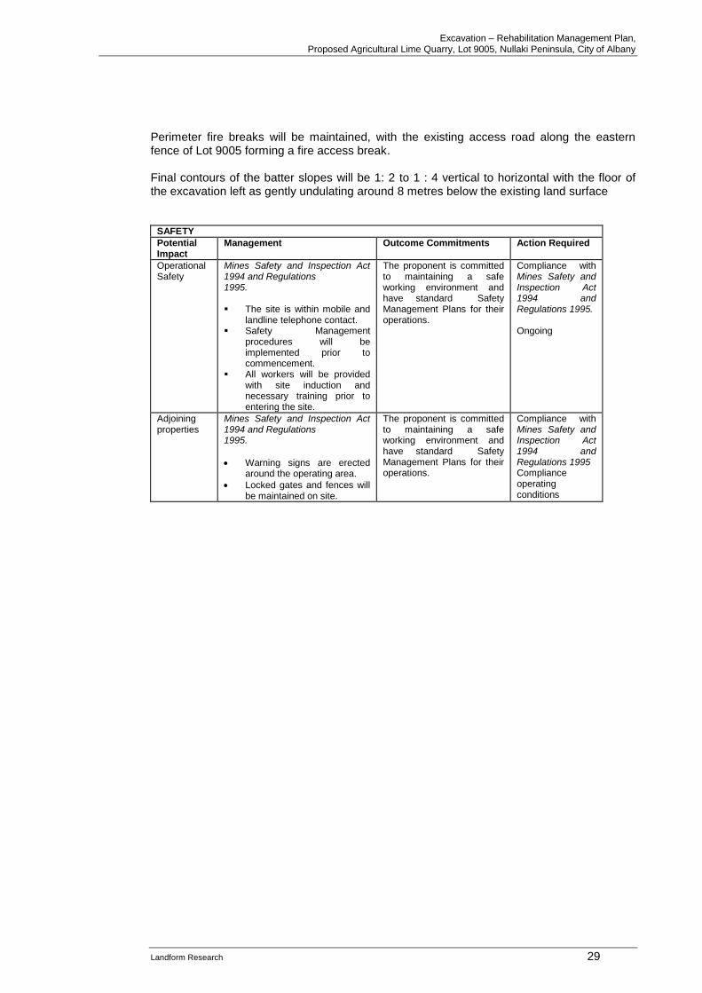
SAFETY
Potential Impact
Management Outcome Commitments Action Required
Operational Safety
Mines Safety and Inspection Act 1994 and Regulations 1995. ▪ The site is within mobile and
landline telephone contact. ▪ Safety Management
procedures will be implemented prior to commencement.
▪ All workers will be provided with site induction and necessary training prior to entering the site.
The proponent is committed to maintaining a safe working environment and have standard Safety Management Plans for their operations.
Compliance with Mines Safety and Inspection Act 1994 and Regulations 1995. Ongoing
Adjoining properties
Mines Safety and Inspection Act 1994 and Regulations 1995.
• Warning signs are erected around the operating area.
• Locked gates and fences will be maintained on site.
The proponent is committed to maintaining a safe working environment and have standard Safety Management Plans for their operations.
Compliance with Mines Safety and Inspection Act 1994 and Regulations 1995 Compliance operating conditions
Excavation – Rehabilitation Management Plan, Proposed Agricultural Lime Quarry, Lot 9005, Nullaki Peninsula, City of Albany
Landform Research 30
5.0 ENVIRONMENTAL IMPACTS AND MANAGEMENT
5.1 Surrounding Landuses and Buffers
The site is remote and protected by high predator fence along the eastern boundary of Lot 9005 which includes controlled gates. A number of Government Policies relate to buffer distances and the protection of basic raw materials. State Planning Policy No 4.1, State Industrial Buffer Policy, (draft July 2004) discusses the need to consider adjoining land uses when locating buffers but does not prescribe set buffers for operations such as this. Generic buffer requirements were developed by the Victorian Government and used by the Environmental Protection Authority as the basis for a Draft guideline on recommended buffer distances. These formed the basis of EPA Guidance Statement Number 3, Separation Distance between Industrial and Sensitive Land Uses, June 2005. The Environmental Protection Authority of South Australia recommends a 300 metre separation for a Quarry - Non Blasting. EPA guidance "Separation Distances between Industrial and Sensitive Land Uses", June 2005 lists the generic buffers for sand and limestone pits as 300 - 500 metres depending on the extent of processing. A generic buffer relates to the distance at which there are unlikely to be any problems without some further investigations and does not mean that smaller buffers are not acceptable. EPA Guidance for the Assessment of Environmental Factors 3 June 2005 provides for a case by case separation, based on the potential impacts. For limestone extraction a generic buffer is suggested of 300 to 500 metres with case by case assessment where grinding and milling are used. State Planning Policy No 4.1, State Industrial Buffer Policy recommends that all land uses within 1000 metres be considered. The design of the footprint and the operation have been designed to minimse any impacts outside the disturbance areas. These are generic buffers and can be varied on the basis of environmental and management studies. The same type of quarrying therefore has very different generic buffers developed by State Environmental Protection Authorities, illustrating the need to consider separations on on-site environmental impact and not theoretical or generic buffers. The main issues are the potential generation of dust and noise, which are addressed later. As far as is known there are no dwellings within 1000 metres of the proposed excavation and stockpile area. The excavation of limestone from the site complies with these policies.
Excavation – Rehabilitation Management Plan, Proposed Agricultural Lime Quarry, Lot 9005, Nullaki Peninsula, City of Albany
Landform Research 31
5.2 Aesthetics Visual impact can occur in a number of circumstances, by the operation being set too high in the landscape, by being too close to neighbours and by insufficient visual protection. The limestone resource of the highest grade is closest to the coast on the highest ground at an elevation of around 140 to 160 metres AHD. However excavation and all activities can be conducted in a manner that prevents the makes it most unlikely that the operations will be seen from public areas, roads or dwellings. The limestone ridge can be seen at a long distance on a clear day from the higher parts of Denmark for example. Such as dwellings being visible on the Nullaki Peninsula. The most relevant visual management guideline is WAPC 2007, Visual Landscape Planning in Western Australia which has been viewed and the project considered against that document. The relevant section is Part Three, pages 144 to 152 of the Guideline. That document recommends a visual impact assessment, which has been completed using contours and sections, in addition to site observations and aerial photography. The context of the visual impact has been reviewed to try and maintain the natural countryside and minimise visual impact. Section 5.2.5 of the Guideline provides for “extractive industries and utilities”. The main directions are;
• the location of facilities to provide maximum screening
• entry points that are not at significant view points
• signage is visible but minimal
• visual management assessment may be required. By excavating from the south the operations in the pit will not be visible. The stockpile area will be located at an elevation of around 20 metres AHD where it can be screened by the design of the access road and the intervening vegetation. The limestone will be extracted from a ridge and will result in the ends of the two dunes being reshaped down to the elevation of the intervening swale. The main ridge line will not be effectively be modified in an un-natural way with the excavated land surface being similar to other parts of the Nullaki Peninsula. There are a number of management actions that can be taken in quarries to minimise visual impact and these will be used wherever possible. The general management actions are summarised below together with the visual impact issues that relate to this site. The actions will be used where applicable and as the opportunity presents to minimise visual impact. It is felt that the operations are unlikely to be seen from any public location becaue of the way the pit and stockpile area are designed. Below is a list of ideal visual management activites with a simple compliance audit for the operations.
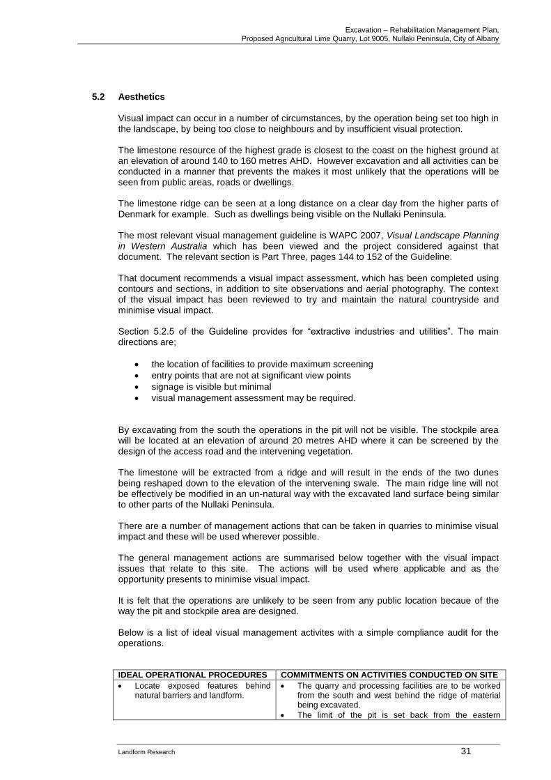
IDEAL OPERATIONAL PROCEDURES COMMITMENTS ON ACTIVITIES CONDUCTED ON SITE
• Locate exposed features behind natural barriers and landform.
• The quarry and processing facilities are to be worked from the south and west behind the ridge of material being excavated.
• The limit of the pit is set back from the eastern

Excavation – Rehabilitation Management Plan, Proposed Agricultural Lime Quarry, Lot 9005, Nullaki Peninsula, City of Albany
Landform Research 32
boundary of Lot 9005 and the coastal Reserve 30883.
• Operate from the floor of the pit below natural ground level.
• The pit is to be worked from the inside out, below natural ground level via an internal haul road to the stockpile area.
• The processing area is to be located on the floor of the pit in the most efficient, safest location that provides the best visual management.
• Over time as the pit progresses the mobile processing plant will be moved around and across the floor of the pit.
• Avoid breaks in the skyline due to workings and haul roads.
• Excavation will come from the south and west. The main ridge will not be altered and the skyline will not appear to change although it will be lowered slightly in a localised area replicating other parts of the Nullaki Peninsula.
• There are no sensitive premises or locations from which people are likely to see the pit.
• At all times the pit and stockpile area will be operated behind a face of natural vegetation.
• Push overburden and interburden dumps into positions where they will not be seen or can form screening barriers.
• Perimeter bunds of overburden and natural face are to be used when material becomes available, just ahead of excavation to increase the potential screening.
• Construct screening bunds and plant tree and shrub screens to reduce visual impact.
• Some screening bunds and natural vegetation are already in place around the perimeter.
• The bunds will be used as overburden becomes available.
• The quarry will not be able to be seen from the Bibbulum Track or from a distance within Reserve 17464 which remnant vegetation, vested in the City of Albany and associated with Lake Sadie, based on the design and operation of the activities.
• Stage workings and progressive rehabilitation to provide visual protection of later activities.
• The staging of the pit footprint is designed to minimise visual impact with special attention concentrating on the eastern sightlines.
• The pit will be excavated from south and west to east and north.
• Cover barriers and landscaping with forms, colours and textures compatible with the natural environment.
• Natural vegetation will be retained around the perimeter.
• Adopt good house cleaning practices such as orderly storage and removal of disused equipment or waste.
• The proponent will maintain a tidy work environment at all their sites. Waste is regularly removed off site to an approved waste facility.
• Where possible usable materials will be recycled which is part of normal operational procedures.
• Provide progressive rehabilitation of all completed or disturbed areas.
• This has always been used at pits and is proposed.
• Such rehabilitation is in place at the old excavations and cut slopes that demonstrate that rehabilitation can be effective with good topsoil and vegetation management.
• Areas not required will be revegetated when each part of the site has reached its final form.
• Minimise the amount of ground used at any one time.
• The amount of ground used will be minimised to that needed for current and future operations and fluctuations.
Light Overspill No night activities are proposed.
Excavation – Rehabilitation Management Plan, Proposed Agricultural Lime Quarry, Lot 9005, Nullaki Peninsula, City of Albany
Landform Research 33
Visual Management - Applicable Legislation / Policies
• None applicable
Commitments to Visual Management
• The proponent is committed to management of visual impact and will implement the measures outlined.
• Every effort will be made to minimise the visual impact using appropriate methods from those listed above.
5.3 Noise
Offsite noise is governed by the Environmental Protection (Noise) Regulations 1997. The Environmental Protection (Noise) Regulations 1997, require that sensitive premises including dwellings in non industrial and rural areas, are not subjected to general noise levels (excluding blasting), during the hours 7.00 am to 7.00 pm Monday to Saturday that exceed 45 dBA. Allowable noise to 55 dBA is permitted for up to 10% of the time and to 65 dBA for 1% of the time. Noise levels are not to exceed 65 dBA during normal working hours. Between 9.00 am and 7.00 pm on Sundays and Public Holidays and between 7.00 pm and 10.00 pm on all days the base level is 40 dBA. At night, between 10.00 pm and 7.00 am Monday to Saturday, and before 9.00 am on Sundays and Public Holidays, the permitted level drops to 35 dBA. The 10% and 1% “time above” allowances apply at night and on Sundays and Public Holidays as well. There are penalties for tonality of 5 dB, modulation 5 dB and 10 dB for impulsiveness, that are added to the permitted levels. That is, if the noise is tonal or modulated the permitted levels drop by 5 dB. Impulsiveness is not likely to be relevant for the quarry under normal circumstances. Influencing factors of external noise and nearby land uses such as busy roads, and industrial properties are not applicable to this site. At a distance greater than 15 metres from the sensitive premises (eg dwelling), and commercial premises a base level of 60 dBA applies at all times with the 10% time permitted to be up to 75 dBA and the 1% permitted to be up to 80 dBA. For Industrial premises the base level is 65 dBA at all times with the 10% time permitted to be up to 80 dBA and the 1% permitted to be up to 90 dBA. Gazetted and public roads are exempt from the Noise Regulations. Noise can originate from a number of operations and may impact on onsite workers, or travel offsite and impact on external sensitive premises. Both potential noise impacts are addressed by reducing the noise generated from the quarrying and processing operations. There are a number of management actions that can be taken in quarries to minimise noise generation or travel. These actions are routinely used in quarries where applicable and as the opportunity presents to minimise noise on site. The proponent will comply with the Environmental Protection (Noise) Regulations 1997.
Excavation – Rehabilitation Management Plan, Proposed Agricultural Lime Quarry, Lot 9005, Nullaki Peninsula, City of Albany
Landform Research 34
There are no known sensitive premises within 1 km. Occupational Noise Occupational noise associated with the quarrying processes falls under the Mines Safety and Inspection Act 1994 and Regulations 1995. The management of occupational noise is normally handled by providing all necessary hearing protection, as well as conducting worker inductions and educational programs for all staff. Regular site audits of quarry and mining operations are normally conducted by the Department of Mines and Petroleum. As part of its commitments, the proponent will be pro-active with its worker safety awareness;
• by providing all necessary safety equipment such as ear protection,
• identifying sections of the plant where hearing protection is required, as well as,
• conducting induction and educational programs for its staff. The operating noise levels around the site are regularly monitored by independent consultants in accordance with the Mines Safety and Inspection Act 1994, and the results communicated to the Department of Mines and Petroleum (DMP). All staff are provided with comprehensive ongoing training on noise protection as part of the commitment to occupational health and safety. The DMP conducts Occupational Noise Audits of the Operations, on all operations. Warning signs are to be used to identify areas of potential noise for workers.
All static and processing equipment will be located to provide maximum noise
screening, behind bunds if sufficient overburden is available. Excavation will be staged
from the west and south, behind the ridge which to provide continuous noise screening. Not all equipment operates at the same time. Similarly not all resources will be
worked at the same time. Warning signs are to be used to identify areas of potential noise.
IDEAL OPERATIONAL PROCEDURES COMMITMENTS ON ACTIVITIES CONDUCTED ON SITE
• Comply with the Environmental Protection (Noise) Regulations 1997.
• The proposed operations are so far from any dwelling, > 1 km and screened by the eastern and northern faces, that they will comply with the Regulations.
• Comply with the provisions of the Mines Safety and Inspection Act 1994 and Regulations 1995.
• Like any quarry, the operations will be regularly inspected by officers of the DMP.
• Maintain adequate buffers to sensitive premises.
• The quarry complies with the Generic EPA Buffer Guidelines.
• There are no dwellings within 1000 metres.
• Locate exposed features behind natural barriers and landform.
• The eastern and northern faces of the pit will provide hard screening of the operations which will be located on the floor of the pit.
• Operate from the floor of the pit below natural ground level.
• This will be used.
Excavation – Rehabilitation Management Plan, Proposed Agricultural Lime Quarry, Lot 9005, Nullaki Peninsula, City of Albany
Landform Research 35
• Push overburden and interburden dumps into positions where they can form screening barriers.
• Perimeter faces, overburden dumps and natural vegetation are proposed where possible.
• Design site operations to maximise the separation and protection from sensitive premises.
• The shape of the pit, setbacks and method of operation have been designed to ensure landform protection is to be maximised.
• Maintain all plant in good condition with efficient mufflers and noise shielding.
• Efficient equipment that is maintained in good condition and replaced from time to time will be used.
• Maintain haul road and hardstand surfaces in good condition (free of potholes, rills and product spillages) and with suitable grades.
• The access road will be maintained in good condition in conjunction with the landholder’s access road.
• Implement a site code outlining requirements for operators and drivers.
• A site induction and training program for all personnel is to be implemented and maintained.
• Shut down equipment when not in use. • This is normal policy.
• Scheduling activities to minimise the likelihood of noise nuisance.
• Activities are proposed to minimise impacts on the local community.
• Fit warning lights, rather than audible sirens or beepers, on mobile equipment wherever possible.
• Lights or low frequency beepers are to be used rather than beepers.
• The design and shape of the pit will maximise noise screening.
• Use transport routes that minimise community disruption.
• There is only one road to access the site, so trucks will be specifically instructed not to interrupt the local community as little as possible.
• Gazetted roads are exempt from the Noise Regulations.
• Avoid the use of engine braking on product delivery trucks in built up areas.
• The surrounding area along the transport route is generally flat with reduced gradients.
• Air brakes are unlikely to be required. Drivers are to be instructed not to use air brakes under normal situations when exiting along the access road.
• Minimise and conduct at the least disruptive times, non day to day activities such as vegetation, topsoil or overburden stripping on exposed ridgelines.
• The hours proposed are designed to minimise impact.
• Provide a complaints recording, investigation, action and reporting procedure.
• A complaints recording procedure is proposed to cover all site activities.
• Conduct training programs on noise minimisation practices.
• Site induction and training to all personnel is proposed.
• Provide all workers with efficient noise protection equipment.
• All noise protection personal equipment will be provided to staff.
• Noise Management - Applicable Legislation / Policies
• Environmental Protection (Noise) Regulations 1997.
• Mines Safety and Inspection Act 1994 and Regulations 1995.
• Australian Standard AS 2187.
Commitments to Noise Management
• The proponent is committed to minimising noise emissions and will implement the measures outlined above.
• The proponent will comply with the Environmental Protection (Noise) Regulations 1997.

Excavation – Rehabilitation Management Plan, Proposed Agricultural Lime Quarry, Lot 9005, Nullaki Peninsula, City of Albany
Landform Research 36
5.4 Dust
5.4.1 Environmental Dust Background Excessive dust has the potential to impact on both the workers and the adjoining land. However the potential generation of dust must be taken in context. There are a number of key aspects to dust impacts;
• What is the source of particles?
• What is the potential for the particles to be disturbed?
• What is the nature of the particles and how are they likely to behave?
• What types of impacts are the particles likely to have if they move?
• What management actions can be used to mitigate or reduce dust impacts? The most common form of disturbance is by mobile plant and vehicle impacts. In this local area dusty roads have the most potential to produce dust, such as the access road and depending on the substrate, traffic on the pit floor. In many situations the fine particles are stablised by vegetation, soil microbial materials and reactions and interactions between particles, particularly limestone of the access road which crusts after being wet but breaks up when trafficked producing dust. Once disturbed however dust can be generated and may continue to be a problem until the fine particles are wetted down or return to a relatively stable condition. With effective treatment of dust by water, which is proposed, the risks of onsite, and consequently offsite, dust are minimised. Excessive dust has the potential to impact on both the workers and the adjoining land. However if occupational dust is managed environmental dust will also be managed. Occupational dust associated with the quarrying processes falls under the Mines Safety and Inspection Act 1994 and Regulations 1995 overseen by the Department of Mines and Petroleum who will regularly inspect the site.
5.4.2 Assessment of Dust Risk Dust Guidelines Dust emissions fall under the Guidance for the Assessment of Environmental Factors, EPA, March 2000. Assessments of the potential dust risk are normally made using the Land development sites and impacts on air quality, Department of Environmental Protection and Conservation Guidelines, November 1996. These are still in place but are incorporated into the DEC (DER) 2011 Guideline for Managing the Impacts of Dust and Associated Contaminants from Land Development Sites, Contaminated Sites Remediation and other Related Activities. The DEC (DER) in 2008 released a draft Guideline for the Development and Implementation of a Dust Management Plan. The setbacks provide effective dust management and comply with the EPA generic buffer guidelines and Department of Health Guidelines.
Excavation – Rehabilitation Management Plan, Proposed Agricultural Lime Quarry, Lot 9005, Nullaki Peninsula, City of Albany
Landform Research 37
Onsite Risks
There are no offsite risks impacting on sensitive premises as these are too far away. There is a risk of dust generation from the access road and from dust being dragged onto Indian Ocean Drive. These risk are similar to the risks from any unsealed road. Limesand is calcium carbonate based and is not known to carry any significant health risks to workers based on other operations and recreational use of limesand dunes. Being Aeolian in origin the grainsize is greater than the particulate sizes that impact on occupational health. The key Objectives for the operations are;
• Manage the potential for the generation of dust.
• Visually monitor dust levels and take steps to reduce the potential impact of dust on occupational and environmental aspects of the operation and local area.
5.4.3 Buffers The setbacks to sensitive premises comply with the EPA generic buffer Guidelines for all operations as noted in Section 6.2 Surrounding land Use in the Mining Proposal.
EPA guidance "Separation Distances between Industrial and Sensitive Land Uses", June 2005 lists the generic buffers for sand and limestone pits as 300 - 500 metres depending on the extent of processing. As there is no processing on site the minimum generic buffer would apply; that is 300 metres. The minimum separation distances are 2 km for the northern portion of the resource and 1 km for the southern edge well in excess of the EPA generic buffer. Dust particles are readily stopped by tree belts and distance, with which the site complies. Tree belts slow the wind and allow the dust to settle. See Planning Guidelines Separating Agricultural and Residential Land Uses, Department of Natural Resources Queensland 1997( Pages 65 – 111) and Department of Health WA, 2012, Guidelines for Separation of Agricultural and Residential Land Uses which uses the same criteria (Pages 112 – 118). The Queensland Guidelines predominantly relate to agricultural spray drift, but based on particle size also relate to dust. They are based on field studies and demonstrate the effectiveness of tree belts and distance in providing screening against particulate travel. The Guidelines provide for a buffer of 300 metres for open agricultural land, dropping down to 40 metres where an effective tree belt is in place. The Western Australian Department of Health also uses the same guidelines. Whilst there are no tree belts the distances involved ensure that the operations comply with the Department of Health buffer recommendations.
5.4.4 Occupational Dust The proponent will provide induction and protective equipment for all persons on site. The DMP require personal dust monitoring to ensure dust levels comply with health risk guidelines. The dust management procedures used on site comply with these guidelines.
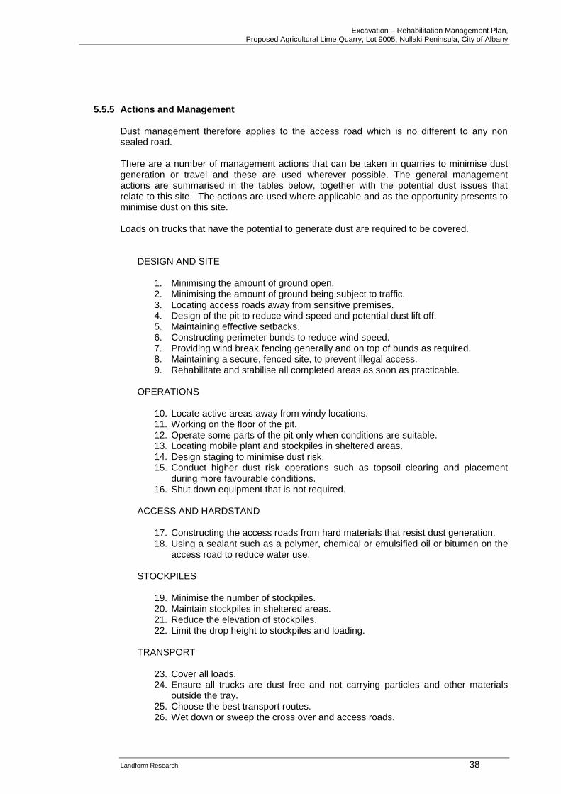
Excavation – Rehabilitation Management Plan, Proposed Agricultural Lime Quarry, Lot 9005, Nullaki Peninsula, City of Albany
Landform Research 38
5.5.5 Actions and Management
Dust management therefore applies to the access road which is no different to any non sealed road. There are a number of management actions that can be taken in quarries to minimise dust generation or travel and these are used wherever possible. The general management actions are summarised in the tables below, together with the potential dust issues that relate to this site. The actions are used where applicable and as the opportunity presents to minimise dust on this site. Loads on trucks that have the potential to generate dust are required to be covered.
DESIGN AND SITE
1. Minimising the amount of ground open. 2. Minimising the amount of ground being subject to traffic. 3. Locating access roads away from sensitive premises. 4. Design of the pit to reduce wind speed and potential dust lift off. 5. Maintaining effective setbacks. 6. Constructing perimeter bunds to reduce wind speed. 7. Providing wind break fencing generally and on top of bunds as required. 8. Maintaining a secure, fenced site, to prevent illegal access. 9. Rehabilitate and stabilise all completed areas as soon as practicable.
OPERATIONS
10. Locate active areas away from windy locations. 11. Working on the floor of the pit. 12. Operate some parts of the pit only when conditions are suitable. 13. Locating mobile plant and stockpiles in sheltered areas. 14. Design staging to minimise dust risk. 15. Conduct higher dust risk operations such as topsoil clearing and placement
during more favourable conditions. 16. Shut down equipment that is not required.
ACCESS AND HARDSTAND
17. Constructing the access roads from hard materials that resist dust generation. 18. Using a sealant such as a polymer, chemical or emulsified oil or bitumen on the
access road to reduce water use. STOCKPILES
19. Minimise the number of stockpiles. 20. Maintain stockpiles in sheltered areas. 21. Reduce the elevation of stockpiles. 22. Limit the drop height to stockpiles and loading.
TRANSPORT
23. Cover all loads. 24. Ensure all trucks are dust free and not carrying particles and other materials
outside the tray. 25. Choose the best transport routes. 26. Wet down or sweep the cross over and access roads.
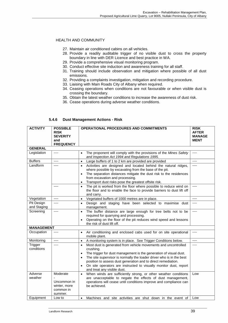
Excavation – Rehabilitation Management Plan, Proposed Agricultural Lime Quarry, Lot 9005, Nullaki Peninsula, City of Albany
Landform Research 39
HEALTH AND COMMUNITY
27. Maintain air conditioned cabins on all vehicles. 28. Provide a readily auditable trigger of no visible dust to cross the property
boundary in line with DER Licence and best practice in WA. 29. Provide a comprehensive visual monitoring program. 30. Conduct effective site induction and awareness training for all staff. 31. Training should include observation and mitigation where possible of all dust
emissions. 32. Providing a complaints investigation, mitigation and recording procedure. 33. Liaising with Main Roads City of Albany when required. 34. Ceasing operations when conditions are not favourable or when visible dust is
crossing the boundary. 35. Obtain the latest weather conditions to increase the awareness of dust risk. 36. Cease operations during adverse weather conditions.
5.4.6 Dust Management Actions - Risk
ACTIVITY POSSIBLE RISK SEVERITY and FREQUENCY
OPERATIONAL PROCEDURES AND COMMITMENTS RISK AFTER MANAGE MENT
GENERAL
Legislation ---- • The proponent will comply with the provisions of the Mines Safety and Inspection Act 1994 and Regulations 1995.
----
Buffers ---- • Large buffers of 1 to 2 km are provided are provided ----
Landform
---- • Activities are designed and located behind the natural ridges, where possible by excavating from the base of the pit.
• The separation distances mitigate the dust risk to the residences from excavation and processing.
• Transport dust risks pose the greatest offsite risk.
----
---- • The pit is worked from the floor where possible to reduce wind on the floor and to enable the face to provide barriers to dust lift off and carry.
----
Vegetation ---- • Vegetated buffers of 1000 metres are in place. ----
Pit Design and Staging
---- • Design and staging have been selected to maximise dust management.
----
Screening ---- • The buffer distance are large enough for tree belts not to be required for quarrying and processing.
• Operating on the floor of the pit reduces wind speed and lessons the risk of dust lift off.
----
MANAGEMENT
Occupation ---- • Air conditioning and enclosed cabs used for on site operational mobile plant.
----
Monitoring ---- • A monitoring system is in place. See Trigger Conditions below. ----
Trigger conditions
---- • Most dust is generated from vehicle movements and uncontrolled crushing.
• The trigger for dust management is the generation of visual dust.
• The site supervisor is normally the loader driver who is in the best position to assess dust generation and to direct remediation.
• On site operators are instructed to visually monitor dust, report and treat any visible dust.
----
Adverse weather
Moderate - Uncommon in winter, more common in summer.
• When winds are sufficiently strong, or other weather conditions are unacceptable to negate the effects of dust management, operations will cease until conditions improve and compliance can be achieved.
Low
Equipment Low to • Machines and site activities are shut down in the event of Low
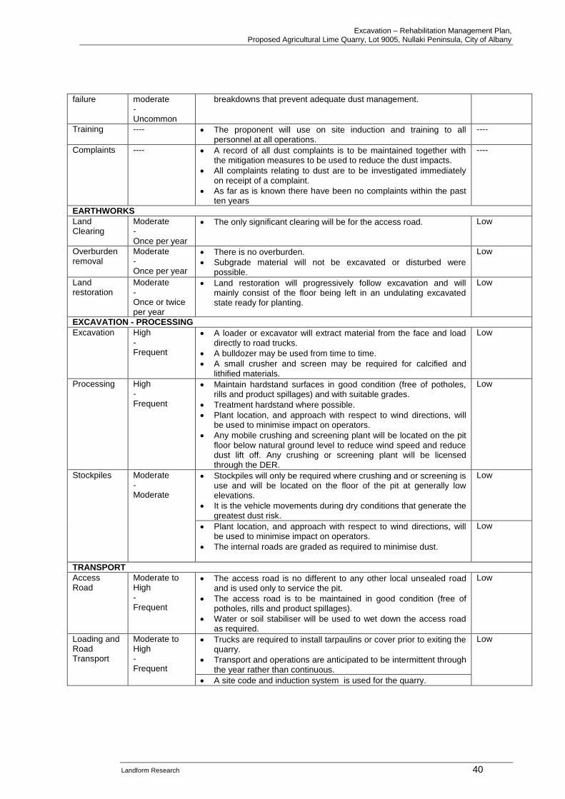
Excavation – Rehabilitation Management Plan, Proposed Agricultural Lime Quarry, Lot 9005, Nullaki Peninsula, City of Albany
Landform Research 40
failure moderate - Uncommon
breakdowns that prevent adequate dust management.
Training ---- • The proponent will use on site induction and training to all personnel at all operations.
----
Complaints ---- • A record of all dust complaints is to be maintained together with the mitigation measures to be used to reduce the dust impacts.
• All complaints relating to dust are to be investigated immediately on receipt of a complaint.
• As far as is known there have been no complaints within the past ten years
----
EARTHWORKS
Land Clearing
Moderate - Once per year
• The only significant clearing will be for the access road. Low
Overburden removal
Moderate - Once per year
• There is no overburden.
• Subgrade material will not be excavated or disturbed were possible.
Low
Land restoration
Moderate - Once or twice per year
• Land restoration will progressively follow excavation and will mainly consist of the floor being left in an undulating excavated state ready for planting.
Low
EXCAVATION - PROCESSING
Excavation High - Frequent
• A loader or excavator will extract material from the face and load directly to road trucks.
• A bulldozer may be used from time to time.
• A small crusher and screen may be required for calcified and lithified materials.
Low
Processing High - Frequent
• Maintain hardstand surfaces in good condition (free of potholes, rills and product spillages) and with suitable grades.
• Treatment hardstand where possible.
• Plant location, and approach with respect to wind directions, will be used to minimise impact on operators.
• Any mobile crushing and screening plant will be located on the pit floor below natural ground level to reduce wind speed and reduce dust lift off. Any crushing or screening plant will be licensed through the DER.
Low
Stockpiles Moderate - Moderate
• Stockpiles will only be required where crushing and or screening is use and will be located on the floor of the pit at generally low elevations.
• It is the vehicle movements during dry conditions that generate the greatest dust risk.
Low
• Plant location, and approach with respect to wind directions, will be used to minimise impact on operators.
• The internal roads are graded as required to minimise dust.
Low
TRANSPORT
Access Road
Moderate to High - Frequent
• The access road is no different to any other local unsealed road and is used only to service the pit.
• The access road is to be maintained in good condition (free of potholes, rills and product spillages).
• Water or soil stabiliser will be used to wet down the access road as required.
Low
Loading and Road Transport
Moderate to High - Frequent
• Trucks are required to install tarpaulins or cover prior to exiting the quarry.
• Transport and operations are anticipated to be intermittent through the year rather than continuous.
Low
• A site code and induction system is used for the quarry.
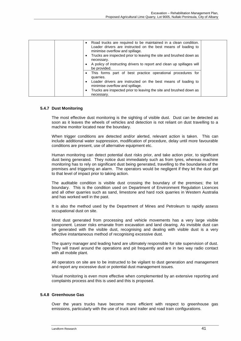
Excavation – Rehabilitation Management Plan, Proposed Agricultural Lime Quarry, Lot 9005, Nullaki Peninsula, City of Albany
Landform Research 41
• Road trucks are required to be maintained in a clean condition. Loader drivers are instructed on the best means of loading to minimise overflow and spillage.
• Trucks are inspected prior to leaving the site and brushed down as necessary.
• A policy of instructing drivers to report and clean up spillages will be provided.
• This forms part of best practice operational procedures for quarries.
• Loader drivers are instructed on the best means of loading to minimise overflow and spillage.
• Trucks are inspected prior to leaving the site and brushed down as necessary.
5.4.7 Dust Monitoring The most effective dust monitoring is the sighting of visible dust. Dust can be detected as soon as it leaves the wheels of vehicles and detection is not reliant on dust travelling to a machine monitor located near the boundary. When trigger conditions are detected and/or alerted, relevant action is taken. This can include additional water suppression, modification of procedure, delay until more favourable conditions are present, use of alternative equipment etc. Human monitoring can detect potential dust risks prior, and take action prior, to significant dust being generated. They notice dust immediately such as from tyres, whereas machine monitoring has to rely on significant dust being generated, travelling to the boundaries of the premises and triggering an alarm. The operators would be negligent if they let the dust get to that level of impact prior to taking action. The auditable condition is visible dust crossing the boundary of the premises; the lot boundary. This is the condition used on Department of Environment Regulation Licences and all other quarries such as sand, limestone and hard rock quarries in Western Australia and has worked well in the past. It is also the method used by the Department of Mines and Petroleum to rapidly assess occupational dust on site. Most dust generated from processing and vehicle movements has a very large visible component. Lesser risks emanate from excavation and land clearing. As invisible dust can be generated with the visible dust, recognising and dealing with visible dust is a very effective instantaneous method of recognising excessive dust. The quarry manager and leading hand are ultimately responsible for site supervision of dust. They will travel around the operations and pit frequently and are in two way radio contact with all mobile plant. All operators on site are to be instructed to be vigilant to dust generation and management and report any excessive dust or potential dust management issues. Visual monitoring is even more effective when complemented by an extensive reporting and complaints process and this is used and this is proposed.
5.4.8 Greenhouse Gas
Over the years trucks have become more efficient with respect to greenhouse gas emissions, particularly with the use of truck and trailer and road train configurations.
Excavation – Rehabilitation Management Plan, Proposed Agricultural Lime Quarry, Lot 9005, Nullaki Peninsula, City of Albany
Landform Research 42
The proponent will seek ways to reduce the amount of fossil fuels used, and has obtained more efficient mobile plant and equipment when this has become economically available. The internal design of the operations will minimise the haulage route to save energy use and potential impacts. The location of this pit means that it is closer to some parts of the Wheatbelt which provides for savings in fuel to get the limesand to the agricultural areas.
5.4.9 Complaints Procedure Visual monitoring is more effective when complemented by an extensive reporting and complaints process. An effective complaints mechanism is an essential part of the dust identification and management and is proposed. A complaints book that lists the items below will be used. The book will be available as requested.
• The complaint,
• Nature of the complaint, time and date,
• Source of the complaint,
• Investigations of the complaint,
• Results of the investigation,
• If the complaint is valid, any mitigation actions that result,
• Any communication with the complainant. Dust Management - Applicable Legislation / Policies
• Guidance for the Assessment of Environmental Factors, EPA, March 2000.
• Land development sites and impacts on air quality, DEP, 1996.
• Department of Environmental Protection Guidelines, November 1996 and DEC 2008, A guideline for the development and implementation of a dust management plan
Commitments to Dust Management
• The proponent will take the necessary steps to manage and contain dust by implementing and maintaining the Dust Management Plan.
5.5 Water Quality Limestone excavation is a clean operation similar to sand excavation in the nature of the risk to groundwater. No chemicals are used apart from normal lubricants, which is similar to sand excavation, and sand excavation is one of the few industries that are permitted to operate in a Priority 1 Public Drinking Water Source Area, indicating the clean nature of the activity. See Department of Water Land Use Compatibility in Public Drinking Water Source Areas. Limestone excavation does not affect the quality of water in the shallow ground water system because the only chemicals used are normal fuels and lubricants; a fact that is recognised by the Department of Environment Regulation who permit extractive industries in Priority Groundwater areas such as Lake Gnangara where sand excavation occurs within 3 metres of the water table.
Excavation – Rehabilitation Management Plan, Proposed Agricultural Lime Quarry, Lot 9005, Nullaki Peninsula, City of Albany
Landform Research 43
The protection of water, whether groundwater or surface water, is an important part of the management of quarries. The main Environmental Objective relating to water management is;
• Minimise the impact on surface and ground water quality. The limestone pit site lies on a ridge that is well elevated and set 2 km away from the edge of Lake Saide. Groundwater flow is deep and to the ocean under the pit and interpreted to be most likely also to the south to the ocean under the stockpile. A sump on Nullaki Peninsula will be used for any water requirements which are anticipated to be low. The base of the excavation will be over 140 metres to the water table. Potable water will be brought in from scheme supply. The management actions are considered in the attached Water Management Plan. The proposal is consistent with all Government Policies for extraction of limestone and sand and complies with the same requirements for extracting in Priority Drinking Water Source Protection Area. Water Management - Applicable Legislation / Policies DOW – DMP Water Quality Protection Guidelines for Mining and Mineral Processing
• Overview
• Minesite water quality monitoring
• Minesite stormwater
• Mechanical servicing and workshop facilities
• Mine dewatering
• Health Act 1911
Commitments to Water Management
• The site complies with Department of Water Guidelines for separation to groundwater.
• The nature of the operation and the depth to groundwater will minimise any risk to groundwater systems and Lake Pollard.
• Management procedures outlined above are committed to, to protect water quality.
• There will be no alteration to surface water flows or groundwater levels.
• The proponent will have in place a site code outlining requirements for operators and drivers.
• The proponent will conduct training programs on pollution minimisation practices.
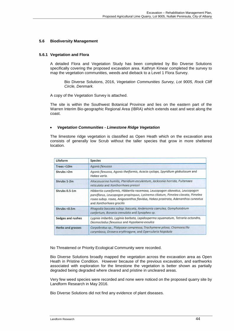
Excavation – Rehabilitation Management Plan, Proposed Agricultural Lime Quarry, Lot 9005, Nullaki Peninsula, City of Albany
Landform Research 44
5.6 Biodiversity Management 5.6.1 Vegetation and Flora
A detailed Flora and Vegetation Study has been completed by Bio Diverse Solutions specifically covering the proposed excavation area. Kathryn Kinear completed the survey to map the vegetation communities, weeds and dieback to a Level 1 Flora Survey.
Bio Diverse Solutions, 2016, Vegetation Communities Survey, Lot 9005, Rock Cliff Circle, Denmark.
A copy of the Vegetation Survey is attached. The site is within the Southwest Botanical Province and lies on the eastern part of the Warren Interim Bio-geographic Regional Area (IBRA) which extends east and west along the coast.
• Vegetation Communities - Limestone Ridge Vegetation The limestone ridge vegetation is classified as Open Heath which on the excavation area consists of generally low Scrub without the taller species that grow in more sheltered location.
No Threatened or Priority Ecological Community were recorded. Bio Diverse Solutions broadly mapped the vegetation across the excavation area as Open Heath in Pristine Condition. However because of the previous excavation, and earthworks associated with exploration for the limestone the vegetation is better shown as partially degraded being degraded where cleared and pristine in uncleared areas. Very few weed species were recorded and none were noticed on the proposed quarry site by Landform Research in May 2016. Bio Diverse Solutions did not find any evidence of plant diseases.
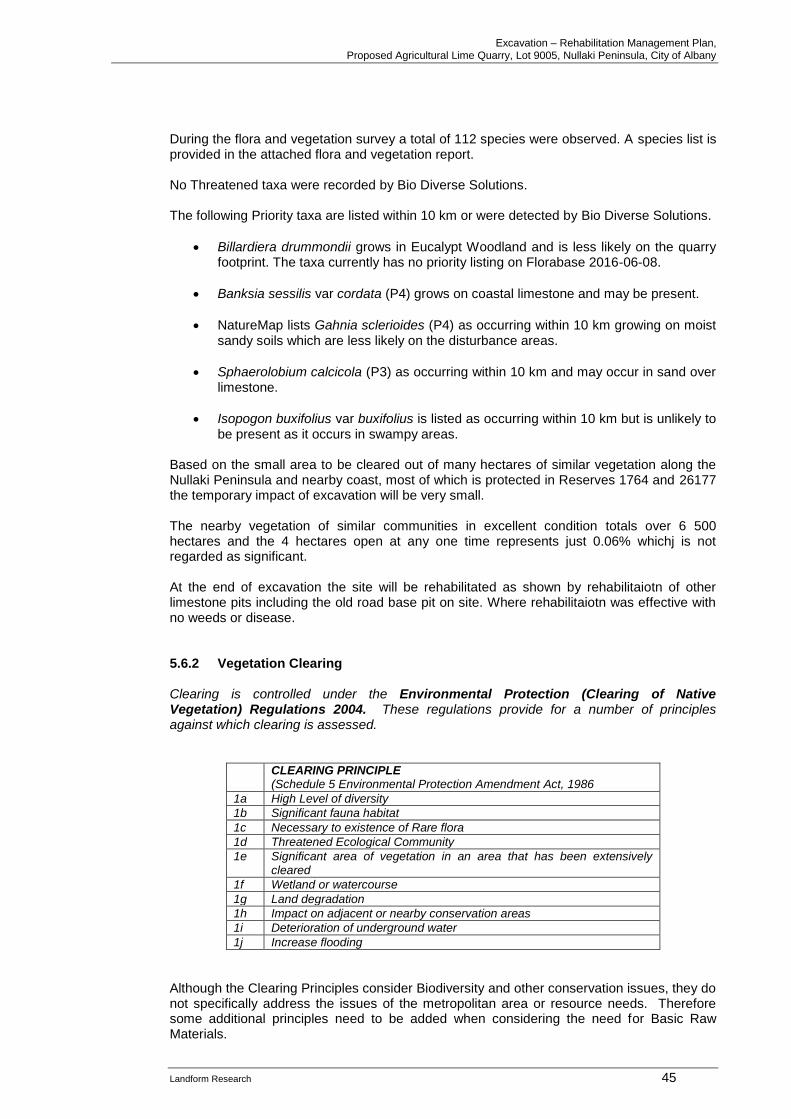
Excavation – Rehabilitation Management Plan, Proposed Agricultural Lime Quarry, Lot 9005, Nullaki Peninsula, City of Albany
Landform Research 45
During the flora and vegetation survey a total of 112 species were observed. A species list is provided in the attached flora and vegetation report. No Threatened taxa were recorded by Bio Diverse Solutions. The following Priority taxa are listed within 10 km or were detected by Bio Diverse Solutions.
• Billardiera drummondii grows in Eucalypt Woodland and is less likely on the quarry footprint. The taxa currently has no priority listing on Florabase 2016-06-08.
• Banksia sessilis var cordata (P4) grows on coastal limestone and may be present.
• NatureMap lists Gahnia sclerioides (P4) as occurring within 10 km growing on moist sandy soils which are less likely on the disturbance areas.
• Sphaerolobium calcicola (P3) as occurring within 10 km and may occur in sand over limestone.
• Isopogon buxifolius var buxifolius is listed as occurring within 10 km but is unlikely to be present as it occurs in swampy areas.
Based on the small area to be cleared out of many hectares of similar vegetation along the Nullaki Peninsula and nearby coast, most of which is protected in Reserves 1764 and 26177 the temporary impact of excavation will be very small. The nearby vegetation of similar communities in excellent condition totals over 6 500 hectares and the 4 hectares open at any one time represents just 0.06% whichj is not regarded as significant. At the end of excavation the site will be rehabilitated as shown by rehabilitaiotn of other limestone pits including the old road base pit on site. Where rehabilitaiotn was effective with no weeds or disease. 5.6.2 Vegetation Clearing
Clearing is controlled under the Environmental Protection (Clearing of Native Vegetation) Regulations 2004. These regulations provide for a number of principles against which clearing is assessed.
CLEARING PRINCIPLE (Schedule 5 Environmental Protection Amendment Act, 1986
1a High Level of diversity
1b Significant fauna habitat
1c Necessary to existence of Rare flora
1d Threatened Ecological Community
1e Significant area of vegetation in an area that has been extensively cleared
1f Wetland or watercourse
1g Land degradation
1h Impact on adjacent or nearby conservation areas
1i Deterioration of underground water
1j Increase flooding
Although the Clearing Principles consider Biodiversity and other conservation issues, they do not specifically address the issues of the metropolitan area or resource needs. Therefore some additional principles need to be added when considering the need for Basic Raw Materials.
Excavation – Rehabilitation Management Plan, Proposed Agricultural Lime Quarry, Lot 9005, Nullaki Peninsula, City of Albany
Landform Research 46
The Environmental Protection ACT 1986 Section 51O states that the “CEO may take into account other matters that the “CEO considers relevant” (EP ACT 1986 Section 51O). Therefore Section 51O of the Environmental Protection Act 1986 allows the CEO to take planning matters into account when making clearing decisions, such as a State Planning Policy and community need. A separate Flora and Vegetation Assessment and Report is prepared for the site by Bio Diverse Solutions and is attached.
The procedures used for vegetation clearing are documented in 5.9.2 Rehabilitation. These were used and are included here in case a small area of additional clearing is applied for to the immediate north of the existing permited area. Topsoil and overburden treatment is covered in 5.9 Rehabilitation. All suitable materials will be retained for rehabilitation and directly transferred where possible.
5.6.3 Fauna A fauna study was not conducted because the resource area represents a very small area within a large area of remnant vegetation with a small area only open at any one time; 0.06% of the nearby vegetaation. A search of NatureMap and the EPBC database was completed by Landform Research and includes the fauna listed within the City of Albany and recorded within 10 km and is attached with the Flora and Vegstation Survey. The Nullaki Peninsula is protected by a predator proof fence to keep out cats and foxes in particular. The exclusion of these predators forms a significant protection measure for fauna wich are advantaged by living within the protected zone. The protection fence is to remain in place. The nearby vegetation of similar communities in excellent condition totals over 6 500 hectares. The 4 hectares open at any one time represents just 0.25%. The small area of proposed disturbances and the large connectivity remianing in place will not cause any isolation of short range fauna. With the small area proposed to be open at any one time, a return to local native habitiat, the proven rehabilitaiton methods and the benefits of the predator proof fence, the impacts on fauna are not considered significant.
• No matters of significance under the EPBC Act 1999 were identified. The potential feeding habitat of Black Cockatoos impacted is small because the only food source Dryandra sessilis is limited. With the staging and small footprints the proposed activities will not trigger referral to the Commonwealth.
5.6.4 Wetlands The only nearby wetland is Lake Saide which is 2 km from the operational site. Bibulmum Walking Trail The Bibulbum walking track runs from Albany in the east before swinging north prior to the eastern boundary of Lot 9005. The track is located some 400 metres from the limestone pit.
Excavation – Rehabilitation Management Plan, Proposed Agricultural Lime Quarry, Lot 9005, Nullaki Peninsula, City of Albany
Landform Research 47
The track lies in heathland that is often higher than a person making the excavation area difficult to see. The excavation area is designed to be excavated from the west to the east and to the north, working behind the vegetated eastern and northern faces which will assist in minimising or eliminating any visual impact of the pit from the Bibulmum Track. The Bibulmum Track moves slightly closer to the stockpile area, but this is located in flat ground set back behind vegetation to provide visual screening. The Bibulmum Track will cross the access road. Signs and warning barriers will be used at the crossing point in a similar to other road crossings.
Biodiversity - Applicable Legislation / Policies
• None applicable – Likely to be conditioned
Commitments to Biodiversity Management
• The excavation areas are selected and the operations designed to minimise impacts on Biodiversity.
• Biodiversity impacts will be very small and temporary as the land excavation will be staged and rehabilitated as soon as possible.
5.6.5 Dieback Management Plan Dieback of vegetation is often attributed to Phytophthora cinamomi even though there are other Phytophthora species and other diseases such as Armillaria that can cause dieback like symptoms. Microscopic soil-borne fungi of the genus Phytophthora kill a wide range of native plants and can cause severe damage to many vegetation types, particularly those from the families Proteaceae, Epacridaceae, Xanthorrhoeaceae and Myrtaceae. In most cases dieback is caused by a pathogen which infests the plant and causes it to lose vigour, with leaves dying, and overtime may kill the plant. As such the management of Dieback is essentially related to plant hygiene when coming onto a site and within a site. Bio Diverse Solutions did not find any evidence of dieback or other plant disease infestations and neither did Landform Research during their site inspection. There are several guides to the management of Dieback.
• Department of Environment and Conservation (DPaW) Dieback Hygiene Manual 1992 is a practical guide to Dieback management.
• Department of Environment and Conservation (DPaW) Best Practice Guidelines for the Management of Phytophthora cinamomi, draft 2004.
• Dieback Working Group 2005, Management of Phytophthora Dieback in Extractive Industries.
The Department of Environment Regulation generally recognises that Dieback is less likely to impact on vegetation on limestone and Spearwood/Cottesloe Land Systems, Podger F D and K R Vear, 1998, Management of Phytophthora and disease caused by it, IN Phytophthora cinnamomi and the disease caused by it - protocol for identifying protectable areas and their priority for management, EPA 2000. The same is noted in DEC 2009. Dieback is only likely to be an issue when equipment is brought to the site from a dieback affected area either through vehicles or plant and soil materials, therefore the following general principles are applied to Dieback management.
Excavation – Rehabilitation Management Plan, Proposed Agricultural Lime Quarry, Lot 9005, Nullaki Peninsula, City of Albany
Landform Research 48
Even there is no evidence of infestations strict hygiene measures will be used. Not all potential impacts will apply to all parts of the proposed quarry operations. E
• Excavation will be undertaken using practices recommended by DEC. See CALM Dieback Hygiene Manual 1992 which is more practical and CALM Best Practice Guidelines for the Management of Phytophthora cinamomi, draft 2004. See also Dieback Working Group 2005, Management of Phytophthora Dieback in Extractive Industries.
• Dieback diseases are more likely to be transported under moist soil conditions.
• All vehicles and equipment to be used during land clearing or land reinstatement, should be clean and free from soil or plant material when arriving at site.
• The site will effectively be a spit system with road traffic restricted to the stockpile loading area.
• Washdown of vehicles and equipment should be prior to arriving on site and to the procedures in CALM Guidelines for Dieback Management.
• No soil and vegetation should be brought to the site apart from that to be used in rehabilitation.
• Plants to be used in rehabilitation should be from dieback free sources.
• Vegetated areas ahead of excavation should be quarantined to onsite access
• Unwanted access to vegetated areas is to be discouraged through a lack of tracks and external fencing.
• Excavation vehicles will be restricted to the excavation area apart from clearing land.
• Rehabilitated surfaces are to be free draining and not contain wet or waterlogged conditions.
• Illegally dumped rubbish is to be removed promptly.
• No contaminated or suspect soil or plant material is to be brought onto the site.
• When clearing land or firebreaks vehicles are to work from dieback free areas towards dieback areas; or, in situations where dieback interpretation is not possible, from areas of higher quality vegetation to areas of lower quality vegetation.
• Roads should be free draining and hard surfaced.
• A hygienic site is to be maintained by not bringing any soil or plant material onto the site except for rehabilitation purposes or from known dieback free areas.
• All plants, seeds and other materials used in rehabilitation will be sourced from dieback free areas.
• The predator proof fence and gate system will be maintained.
• Compliance with the Weed Management Policy. Dieback principles will be followed even though there is a reduced risk of spread on calcareous soils such as this. (Podger F D and K R Vear, 1998). The proposed access road will be limestone road. The aim of dieback management during excavation is to minimise the risk of entry of dieback into the site. The calcareous soils of the remnant vegetation are unlikely to allow Phytophthora to spread but there may be other pathogens such as Armillaria. In many ways the management of the site for dieback is similar to that for the management of weeds, and the two management practices should be considered together. The other management is to ensure that all excavation equipment and road transport vehicles are clean and free from soil and vegetable matter prior to entering the operations. Vehicles are to be prohibited from entering vegetation ahead of excavation, apart from normal travel along made firebreaks and roads for normal security and farm maintenance activities. Topsoil will be cleared according to 5.9.2 Rehabilitation Procedures.
Excavation – Rehabilitation Management Plan, Proposed Agricultural Lime Quarry, Lot 9005, Nullaki Peninsula, City of Albany
Landform Research 49
Dieback - Applicable Legislation / Policies
• DEC (DPaW) Dieback Hygiene Manual 1992.
• DEC (DPaW) Best Practice Guidelines for the Management of Phytophthora cinamomi, draft 2004.
• Dieback Working Group 2005, Management of Phytophthora Dieback in Extractive Industries.
Commitments to Dieback Management
• The proponent will not impact on the adjoining remnant vegetation by the proposed excavation.
• The proponent maintain the Dieback Management Policy to reduce the spread of Plant Pathogens.
5.6.6 Weed Management Plan The management of weeds is essentially similar to that for plant diseases. The impact of weeds is really the impact within the local area and the more they are controlled the better. It is desirable that the site does not become a haven for environmental weeds and therefore a management and control program is warranted at all sites. Weeds can be declared under the Agriculture and Related Resources Protection Act 1976 which requires that Declared Weeds are eradicated. Other weeds are not Declared but may be classified as Environmental Weeds because they are well known for impacting on vegetation. Generally if the actions taken for Dieback are applied they will also control weeds. Minimal weeds were observed by Bio Diverse Solutions over the whole of Lot 9005, and none were observed on the excavation area by Landform Research in May 2016. Even so weed management practices will be used.
• All vehicles and equipment to be used during land clearing or land reinstatement, will be clean and free from soil or plant material when arriving at site.
• No soil and vegetation will be brought to the site apart from that to be used in rehabilitation.
• Plants to be used in rehabilitation will be free from weeds.
• Vegetated areas ahead of excavation will be quarantined to excavation vehicles until required.
• Unwanted access to vegetated areas is to be discouraged through a lack of tracks and external fencing.
• Weed affected top soils may need to be taken offsite, used in weed affected areas, buried by 500 mm soil/overburden or taken offsite or sprayed to minimise the weed impact.
• Illegally dumped rubbish is the major source of weeds and is to be removed promptly.
• No weed contaminated or suspect soil or plant material is to be brought onto the site.
• When clearing land or firebreaks vehicles are to work in conjunction with dieback principles and push from areas of better vegetation towards areas of lower quality vegetation.
• Weeds should be sprayed with broad spectrum spray prior to planting or seeding in weed affected soils.
Excavation – Rehabilitation Management Plan, Proposed Agricultural Lime Quarry, Lot 9005, Nullaki Peninsula, City of Albany
Landform Research 50
• Unwanted grasses should be sprayed with grass selective spray prior to seeding or rehabilitation.
• Weed management should work from least affected areas to most affected.
• Declared weeds should be treated promptly by digging out or spraying.
• Weeds will be treated promptly no matter how few there are.
• The predator proof fence and gate system will be maintained.
• Ongoing monitoring of weeds should be undertaken at least annually in autumn, prior to winter rains.
The Dieback Management actions will also be used to assist weed management. Inspections should be conducted to monitor the presence and introduction of weeds on an annual or more frequent basis. On identification, introduced weeds will either be removed, buried, or sprayed with a herbicide.
Weed - Applicable Legislation / Policies
• Agriculture and Related Resources Protection Act 1976.
Commitments to Weed Management
• The proponent will use the weed policy to try and prevent the introduction of Declared, Environmental or other weeds to the site.
5.7 Fire Protection Fire risk is normally controlled through the Bush Fires Act 1954 and local authority bylaws. The excavation area will form a natural firebreak; the access road will also assist. Water available on site can be used for fire fighting. Normal eastern and other straegic firebreaks will be maintained, based on the existing track and access network. The safety of workers is managed through a Safety Management Plan developed through the Mines Safety and Inspection Act 1994 and Regulations 1995. There are a number of management actions that can be taken in quarries to minimise fire risk and these will be used wherever possible. The general management actions are summarised below, together with the potential issues that relate to this site. The actions will be used where applicable and as the opportunity presents to minimise fire risk.
• Restrict vehicles to the operational area, particularly on high fire risk days.
• Use diesel rather than petrol powered vehicles.
• Maintain perimeter fire breaks as required.
• Ensure fire risk is addressed and maintained through the site Safety Management Procedures.
• Provide an emergency muster area, communications and worker induction and training.
• Establish on site water supplies for potential use in extinguishing fire.
• Secure the site from unauthorised access.
• Maintain normal farm fire breaks and fire prevention procedures.
There is less potential fire risk from quarries than other land uses because quarries clear land, and vehicles are restricted to cleared access roads, the pit floor, processing and stockpile areas.
Excavation – Rehabilitation Management Plan, Proposed Agricultural Lime Quarry, Lot 9005, Nullaki Peninsula, City of Albany
Landform Research 51
These cleared areas form a natural firebreak. The main risk comes from an external fire in the surrounding vegetation, impacting on the quarry. As such the fire risk is no greater than a rural property. If there is a fire the site will be evacuated. If vehicles or plant are left on site, they will be parked in the centre of the pit in line with normal minsite actions and
Fire Management - Applicable Legislation / Policies
• Bush Fires Act 1954.
• City of Albany Bylaws.
Commitments to Fire Management
• The proponent will ensure the quarry operates to the standards in the Mines Safety and Inspection Act 1994 and Regulations 1995.
• The proponent will ensure the quarry complies with the local fire safety requirements and operates in compliance with normal rural fire practise and restrictions.
5.8 Aboriginal Heritage A search of the Department of Aboriginal Affairs database reveals that there are no recorded sites on the Nullaki Peninsula. An ethnographic survey of the Nullaki Peninsula has been completed.
Aboriginal Sites
• Aboriginal Heritage Act 1972-1980
Commitments to Aboriginal Heritage Management
• Should any evidence of early aboriginal occupation be uncovered during the operation of the quarry, development will be stopped pending an assessment by a recognised consultant.
• If the site is confirmed as a site under the provisions of Section 15 of the Aboriginal Heritage Act 1972-1980 and Amendments, the proponent will comply with the provisions of the Act, relating to development in areas of recognised aboriginal sites.
5.9 Rehabilitation 5.9.1 Background The area is currently remnant coastal heathland vegetation partially disturbed by tracks, a previous small excavation that has been rehabilitated, drill pads and soil test holes. The old limestone pit that has been rehabilitated demonstrate that the retention and direct spread of topsoil can provide fast and good rehabilitaiton of local native species and communities. It also demonstrates that excavation can be completed with reduce impacts as there is an absence of weeds and dieback diseases in the previoulsy excavated and disturbed areas.
Excavation – Rehabilitation Management Plan, Proposed Agricultural Lime Quarry, Lot 9005, Nullaki Peninsula, City of Albany
Landform Research 52
The best means of revegetation is to use;
• Vegetation and topsoil recovered from clearing.
• Brush cut from adjoining vegetation. The use of additional seed collection and seeding remains a contingency, but based on other rehabilitaiton is not considered necessary.
• End Use The extraction of limestone is seen as an interim use of the land prior to utilisation of the area by the current land holder. The final contours are anticipated to be undulating around 8 metres below the existing land surface replicating other portions of the limestoen ridge. The end use will be Conservation in line with the land zoning.
• Mine Closure Considerations Rehabilitation will be directed towards the final end land use of Conservation, and is to be aimed at the highest level of rehabilitation, Rehabilitation will contain Dieback and Weed Management in addition to monitoring and replanting failed areas. Appropriate vegetation clearing and reuse combined with topsoil management is seen to be an important element in achieving successful rehabilitation and plant re-establishment on the restored surface. The following procedures have been selected from observation of the existing operations and experience in the rehabilitation of the old limestone pit and other limestone quarries by worked on by Landform Research.
• Rehabilitation Objectives There are a number of management actions that can be taken in quarries to maximise rehabilitation effort and these will be used wherever possible. The general management actions are summarised below and will be used where applicable and as the opportunity presents.
• Completion criteria – Interim Final Landuse
• Stable post-mining landscape, and the minimisation of wind or water erosion.
• Provide for the protection of the local groundwater resource in terms of both quality and quantity.
• Control or eliminate weed species so that they are not likely to threaten the revegetation or local vegetaiton communities.
• Keept the local vegetation as dieback free.
Excavation – Rehabilitation Management Plan, Proposed Agricultural Lime Quarry, Lot 9005, Nullaki Peninsula, City of Albany
Landform Research 53
• Provide a self sustaining cover of local native plants at a minimum of 1200 native plant stems per hectare at 3 years
5.9.2 Rehabilitation Procedures
• Vegetation Clearing – Recovery
1. A Clearing Permit will be required for areas of native vegetation to be cleared under Section 46 of the Environmental Protection Act 1984.
2. Dieback and weed management will be undertaken as outlined in the attached
Dieback and Weed Management Plans. 3. Essentially all topsoil, vegetation fragments and any overburden will be recovered
from cleared areas and retained for use in rehabilitation. The vegetation will be stored with the topsoil in low dumps <1 metre high around the perimeter of the pit.
4. Topsoil clearing will be progressive and minimised to that required for each stage of
excavation. 5. Smaller vegetation will be track crushed and directly transferred to areas under
rehabilitation to assist soil and habitat generation. The vegetation contains a significant seed source, because of the contained seed on many species, it is also a source of microbial material for soil formation, adds to habitat and assists in managing wind erosion.
6. The vegetation will also be used on the batters to minimise soil erosion and
spreading on the final land surface as part of the final rehabilitation. 7. If direct transfer is not possible the vegetation will be stored in low dumps to 1 metre
high or swapped with a nearby operator to try and ensure that the material is not wasted.
8. Topsoil will be pushed to one side and formed into low storage dumps for later use
for rehabilitation using either a loader or bulldozer. 9. Overburden, as yellow and brown sand and low grade limestone, will then be
pushed to the perimeters, normally by bulldozer, to form bunding around the active area.
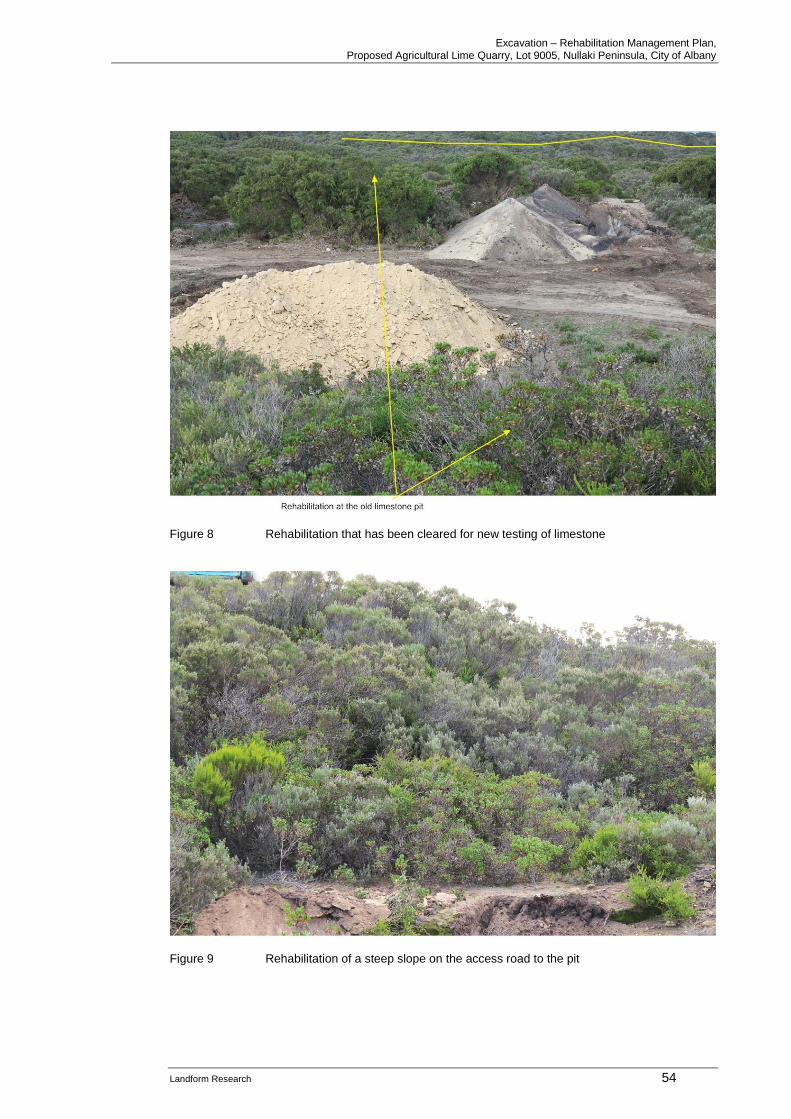
Excavation – Rehabilitation Management Plan, Proposed Agricultural Lime Quarry, Lot 9005, Nullaki Peninsula, City of Albany
Landform Research 54
Figure 8 Rehabilitation that has been cleared for new testing of limestone
Figure 9 Rehabilitation of a steep slope on the access road to the pit
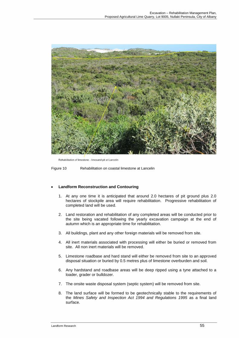
Excavation – Rehabilitation Management Plan, Proposed Agricultural Lime Quarry, Lot 9005, Nullaki Peninsula, City of Albany
Landform Research 55
Figure 10 Rehabilitation on coastal limestone at Lancelin
• Landform Reconstruction and Contouring
1. At any one time it is anticipated that around 2.0 hectares of pit ground plus 2.0 hectares of stockpile area will require rehabilitation. Progressive rehabilitation of completed land will be used.
2. Land restoration and rehabilitation of any completed areas will be conducted prior to
the site being vacated following the yearly excavation campaign at the end of autumn which is an appropriate time for rehabilitation.
3. All buildings, plant and any other foreign materials will be removed from site.
4. All inert materials associated with processing will either be buried or removed from site. All non inert materials will be removed.
5. Limestone roadbase and hard stand will either be removed from site to an approved
disposal situation or buried by 0.5 metres plus of limestone overburden and soil.
6. Any hardstand and roadbase areas will be deep ripped using a tyne attached to a loader, grader or bulldozer.
7. The onsite waste disposal system (septic system) will be removed from site.
8. The land surface will be formed to be geotechnically stable to the requirements of
the Mines Safety and Inspection Act 1994 and Regulations 1995 as a final land surface.
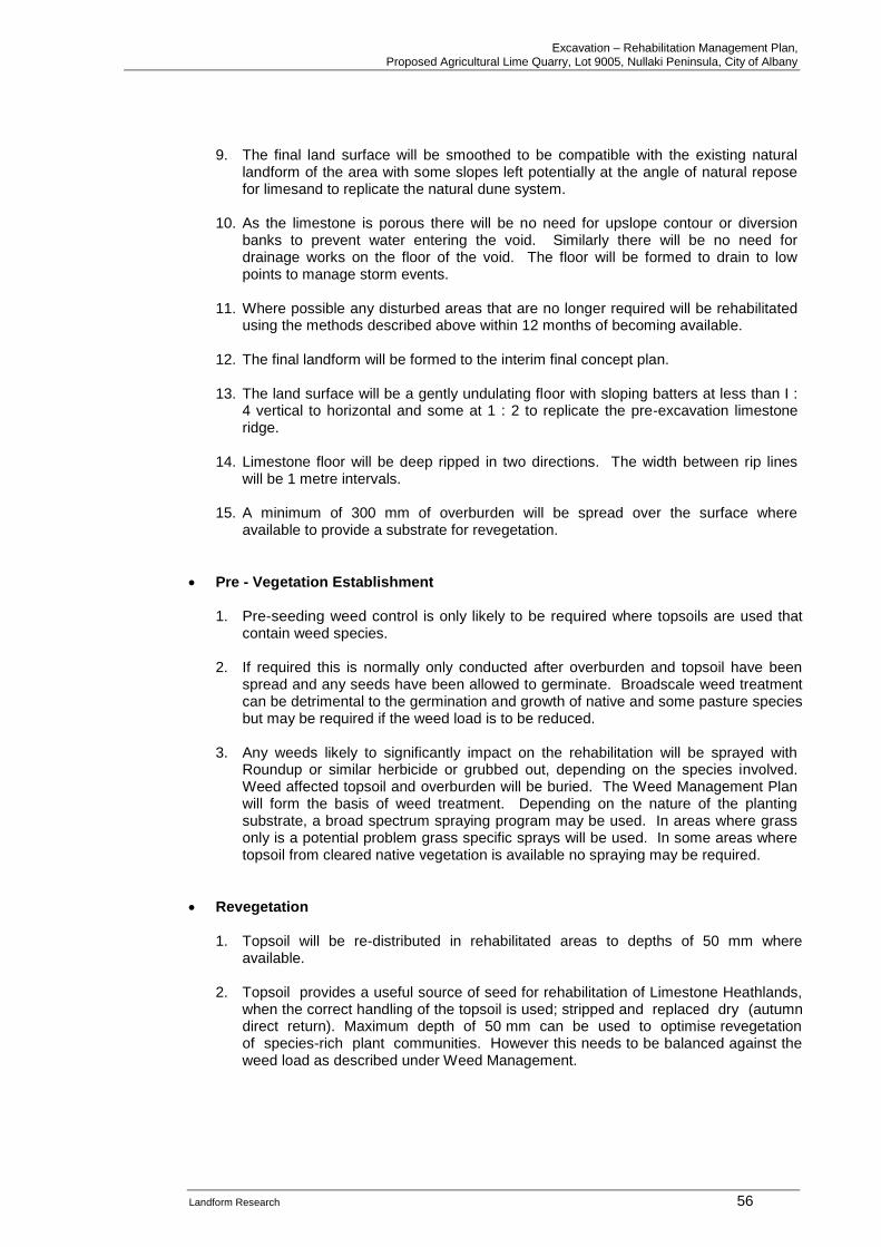
Excavation – Rehabilitation Management Plan, Proposed Agricultural Lime Quarry, Lot 9005, Nullaki Peninsula, City of Albany
Landform Research 56
9. The final land surface will be smoothed to be compatible with the existing natural landform of the area with some slopes left potentially at the angle of natural repose for limesand to replicate the natural dune system.
10. As the limestone is porous there will be no need for upslope contour or diversion
banks to prevent water entering the void. Similarly there will be no need for drainage works on the floor of the void. The floor will be formed to drain to low points to manage storm events.
11. Where possible any disturbed areas that are no longer required will be rehabilitated
using the methods described above within 12 months of becoming available.
12. The final landform will be formed to the interim final concept plan.
13. The land surface will be a gently undulating floor with sloping batters at less than I : 4 vertical to horizontal and some at 1 : 2 to replicate the pre-excavation limestone ridge.
14. Limestone floor will be deep ripped in two directions. The width between rip lines
will be 1 metre intervals.
15. A minimum of 300 mm of overburden will be spread over the surface where available to provide a substrate for revegetation.
• Pre - Vegetation Establishment
1. Pre-seeding weed control is only likely to be required where topsoils are used that contain weed species.
2. If required this is normally only conducted after overburden and topsoil have been
spread and any seeds have been allowed to germinate. Broadscale weed treatment can be detrimental to the germination and growth of native and some pasture species but may be required if the weed load is to be reduced.
3. Any weeds likely to significantly impact on the rehabilitation will be sprayed with
Roundup or similar herbicide or grubbed out, depending on the species involved. Weed affected topsoil and overburden will be buried. The Weed Management Plan will form the basis of weed treatment. Depending on the nature of the planting substrate, a broad spectrum spraying program may be used. In areas where grass only is a potential problem grass specific sprays will be used. In some areas where topsoil from cleared native vegetation is available no spraying may be required.
• Revegetation 1. Topsoil will be re-distributed in rehabilitated areas to depths of 50 mm where
available.
2. Topsoil provides a useful source of seed for rehabilitation of Limestone Heathlands, when the correct handling of the topsoil is used; stripped and replaced dry (autumn direct return). Maximum depth of 50 mm can be used to optimise revegetation of species-rich plant communities. However this needs to be balanced against the weed load as described under Weed Management.
Excavation – Rehabilitation Management Plan, Proposed Agricultural Lime Quarry, Lot 9005, Nullaki Peninsula, City of Albany
Landform Research 57
3. Native vegetation, plus leaf, root and organic matter collected from the land clearing procedures will be spread across the topsoil. This will increase the total organic carbon fraction, improving soil properties such as resistance to water and wind erosion and moisture retention. The difference in properties between existing topsoil and subsoils is not considered a major impediment to rehabilitation of native species in the area.
4. Studies have shown that topsoil stripping and placement is best undertaken in
summer for maximum germination, but this raises the potential for additional dust generation from the fine humus particles.
5. Topsoil will be spread directly from an area being cleared where possible, otherwise
reclaimed from a topsoil dump.
6. Topsoil will be spread at depths of 50 mm and should be spread during summer, preferably by the end of February.
7. Rehabilitation will take place during the first winter months following the restoration
earth works of each particular section of quarry. Leaving the completed earth works for one season will reduce the success of rehabilitation by at least 50%, due to compaction effects.
8. If insufficient revegetaiton is achieved, local provenance seed will be collected from
the site or purchased from commercial seed collectors.
9. Rehabilitaiton wil consist of
• topsoil spreading
• seed spreading (if necessary)
• tube plants (if necessary)
A species list is attached in the Bio Diverse Solutions Report.
10. A combination of the three methods is always preferred by Landform Research and has proven to be the most versatile and successful.
11. Seeding conducted in summer will use scarified leguminous seeds that have been
“dry smoked”. Seeding conducted in July to August will have the leguminous seeds heat treated and all seeds will be smoke treated by soaking in “smoke water” for 24 hours prior to seeding.
12. Seed spreading will be achieved either using mechanical seed dispersal
equipment or using manual methods. Bulking with a spreading agent such as sawdust, vermiculite or sand is desirable.
13. Rehabilitation will progressively follow mining with completed areas of the
excavation being revegetated as soon as practicable.
• Irrigation
1. Experience with the previous regeneration on site and by Landform Research in rehabilitation of quarries in limestone has shown that when completed well there is no need for irrigation of the rehabilitation.
Excavation – Rehabilitation Management Plan, Proposed Agricultural Lime Quarry, Lot 9005, Nullaki Peninsula, City of Albany
Landform Research 58
• Erosion Control
2. Soil erosion occurs when soil is exposed and disturbed by wind or water. Erosion involves soil particles being detached from areas not adequately protected by vegetation, and moved down-slope. This is not normally a significant problem in limestone, which crusts after the first winter. See Figure 9.
3. The limestone soils are very permeable but readily crust during rainfall making them
stsable. Runoffand is normally minimal unless surface materials become non-wetting. Even so experience with limestone extraction shows that there is minimal non wetting and surface particle movement under such conditions.
4. Water erosion on the batter slopes can be avoided by the permeability of the
materials and by leaving the surface soft, rough and undulating, with the undulations running along contour. The final machinery run should be along contour and not down slope.
5. Wind erosion will be controlled by rehabilitating the disturbed ground as soon as
practicable.
6. For rehabilitation areas, revegetation will take place as soon as possible following landform and soil reconstruction.
• Monitoring
1. During late summer an assessment of the success of the rehabilitation will be made to determine the rehabilitation requirements for the following winter.
2. Monitoring includes visual assessments and, where necessary, counts to determine
the success of the soil stabilisation.
3. Native vegetation cover and soil stability will be assessed and corrected if found to be non compliant.
4. As necessary steps will be taken to correct any deficiencies in the vegetation.
5. Rehabilitation of each stage will be monitored for a period of three years to ensure
that the revegetation meets the completion criteria of providing self sustaining vegetation cover.
6. In areas of rehabilitation that do not meet the completion criteria measures are to be
taken to increase the stem density to achieve the completion criteria. This could include but not be limited to additional seeding or planting.
Temporary Closure
1. If for any reason the site is closed on a temporary basis for any period of time the following will be implemented.
2. The faces will be made safe or protected by bunds and/or fencing with signs in
compliance with the Mines Safety and Inspection Act 1994.
3. All fluids, liquids and other materials that could leak over time, change or potentially impact on the environment will be removed from site, or stored in a manner that will not permit any environmental impact.
Excavation – Rehabilitation Management Plan, Proposed Agricultural Lime Quarry, Lot 9005, Nullaki Peninsula, City of Albany
Landform Research 59
4. Mobile and other plant will be made safe or removed from site in compliance with the Mines Safety and Inspection Act 1994.
5. Fencing will be maintained to make the pit safe.
6. Perimeter signage will be maintained.
7. The site will be monitored for weeds and interim rehabilitation success twice per
year.
8. Regular site inspections will be made to ensure compliance with the Mines Safety and Inspection Act 1994, and any other actions that are required to make the site compliant or environmentally sound will be made as the need arises.
Rehabilitation - Applicable Legislation / Policies
• EPA, Guidance 6, Rehabilitation of Terrestrial Ecosystems
Commitments to Rehabilitation
• The proponent will ensure the completed land surface is formed to the standards in the Mines Safety and Inspection Act 1994 and Regulations 1995.
• The proponent will rehabilitate the surface as outlined above and monitor the revegetation as described above.
Excavation – Rehabilitation Management Plan, Proposed Agricultural Lime Quarry, Lot 9005, Nullaki Peninsula, City of Albany
Landform Research 60
ADDITIONAL REFERENCES - READING Abeysinghe P B, 1998, Limestone and Limesand Resources of Western Australia, Geological Survey of Western Australia, Mineral Resources Bulletin 18. Abeysinghe P B, 2003, Silica resources of Western Australia, Geological Survey of Western Australia, Mineral resources Bulletin No 21. ANZECC, 1999, National Framework for the Management and Monitoring of Australia's Native Vegetation. Australian Geomechanics Society, 2003, Engineering Geology of Perth, Parts 1 and 2, Volume 38 No 3 and No 4. Australian Government, Department of Environment and Heritage, 2000, Interim Recovery Plan Aquatic Root Mat Community of Caves of the Swan Coastal Plain 2000-2003. Basic Raw Materials Resource Protection Working Plan, prepared for the Department of Planning and Urban Development (DPUD, 1996). Bastian L V, 1996, Residual soil mineralogy and dune subdivision, Swan Coastal Plain, Western Australia, Australian Journal of Earth Sciences 43, 31-44. Bastian L V, 2007, Karst Examination of Nowergup Property, Unpublished report to WA Limestone. Chamber of Commerce and Industry, 1995 and 1996, Managing the Basic Raw Materials of Perth and the Outer Metropolitan Region, Parts 1 and 2. Commonwealth Environment Protection and Biodiversity Conservation Act 1999.
Commonwealth of Australia, 2001, National Objectives and Targets for Biodiversity Conservation 2001 – 2005. Csaky D, 2003, Review of the Karst Hazards in the Wanneroo Area, Perth, Western Australia, Geoscience Australia. Department of Environment and Conservation 2009, (Freeman, K, Be Keighery, G Keighery, V Longman, A Black and S Molloy), Flora and Vegetation of the Dawesville to Binningup Region (Swan Coastal Plain), prepared for the DEC. Department of Environment WA, 2004, Stormwater Management Manual for Western Australia. Department of Environmental Protection (1997b). Environment Protection (Noise) Regulations 1997: Summary of the Regulations. Department of Environmental Protection, Perth. Department of Minerals and Energy (1991). Environmental Management of Quarries: Development, Operation and Rehabilitation Guidelines. DOIR, Perth. Department of Water (1999b). Water Quality Protection Note: Above Ground Chemical Storage Tanks in Public Drinking Water Source Areas. Water and Rivers Commission, Perth. Department of Water (1999a). Water Resource Protection Series WRP16: Draft Policy and Guidelines on Construction and Silica Sand Mining in Public Drinking Water Source Areas. Water and Rivers Commission, Perth.
Excavation – Rehabilitation Management Plan, Proposed Agricultural Lime Quarry, Lot 9005, Nullaki Peninsula, City of Albany
Landform Research 61
Department of Water (1999c). Water Quality Protection Note: Recharge Criteria for Public Drinking Water Source Areas. Water and Rivers Commission, Perth. Department of Water, Water Quality Protection Note: Washdown of Mechanical Equipment, Perth. Engineers Australia 2003, Australian Runoff Quality, National Committee on Water Engineering. Environmental Protection Authority (2004), Guidance Statement, Terrestrial Flora and Vegetation Surveys for Environmental Impact Assessment in Western Australia, No 51, June 2004. Environmental Protection Authority, Guidance 10, Level of assessment for proposals affecting natural areas within the System 6 Region and Swan Coastal Plain portion of the System 1 Region. Environmental Protection Authority, Position Statement No 2, December 2000, Environmental Protection of Native Vegetation in Western Australia. Environmental Protection Authority, 2013, Consideration of subterranean fauna in environmental impact assessment in Western Australia. Firman J B, 2006, Ancient weathering zones, pedocretes and palaeosols on the Australian Precambrian shield and in adjoining sedimentary basins: a review, IN Journal of the Royal Society of Western Australia, Volume 89 part 2. Geological Survey of Western Australia, 1990, Geology and Mineral Resources of Western Australia, Memoir 3. Geoscience Australia, 2005, Natural hazard risk in Perth, Western Australia. Gibson, N, Keighery, B.J., Keighery, G.J., Burbidge, A.H. and Lyons, M.N. (1994), A Floristic Survey of the Swan Coastal Plain. Unpublished Report for the Australian Heritage Commission prepared by the Department of Conservation and Land Management and the Conservation Council of Western Australia. Government of Western Australia, 2000, Bush Forever. Gozzard J R, 1987, Information on Industrial Minerals - Coastal Plain between Lancelin and Fremantle, Geological Survey of Western Australia record 1978/11. Gozzard J R, 1987, Limesand and Limestone Resources between Lancelin and Bunbury, Geol Surv WA, Record 1987/5. Grimes K G, 2006 Syngenetic karst in Australia: a review, Helictite 39 (2) 200 Guidelines for Groundwater Protection in Australia, ARMCANZ, ANZECC, September 1995. Hopkins, A.J.M. & Griffin, E.A. (1989). Fire in the Banksia Woodlands of the Swan Coastal Plain. Journal of the Royal Agricultural Society of Western Australia, No.71, pp.93-94. Jasinke E J, 1997, Fauna of aquatic root mats in caves of South Western Australia; Origin and Ecology, unpublished PhD Thesis, University of Western Australia. Kaesehagen, 1995, Bushland Condition Mapping, IN Invasive Weeds and Regenerating Ecosystems in Western Australia, Proceedings of Conference held at Murdoch University, July 1994, Institute for Science and Technology Policy, Murdoch University.
Excavation – Rehabilitation Management Plan, Proposed Agricultural Lime Quarry, Lot 9005, Nullaki Peninsula, City of Albany
Landform Research 62
Playford, P E, 1988, Guidebook to the Geology of Rottnest Island, Geological Survey of Western Australia Excursion Guidebook No 2. Playford, P E, A E Cockbain and G H Low, 1976, Geology of the Perth Basin Western Australia, Geological Survey of Western Australia Bulletin 124. Rockwater 2009, Dawesville to Binningup Technical Environmental Studies, Hydrogeology Study, prepared for the DEC. Semeniuk V and C, 2009, Quaternary geology, landforms and wetlands between Dawesville and Binningup – Description, key features and geoheritage significance prepared by the DEC. Tiller K G, 1993, Micronutrients, IN Soils and Australian Viewpoint, CSIRO Western Australian Planning Commission, 2012, Basic Raw Materials Demand and Supply Study for the Bunbury - Busselton Region Western Australia, Western Australian Planning Commission, State Planning Policy 2.4. Western Australia, Western Australian Planning Commission, State Planning Policy 2.5. Western Australian Museum, (undated) Faunal Studies of the Northern Swan Coastal Plain. Western Australian Planning Commission, Statement of Planning Policy No 4.1, State Industrial Buffer Policy, (draft July 2004). Western Australian Water Quality Guidelines for Fresh and Marine Waters, EPA Bulletin 711, 1993.
Willett, I R, 1993, Oxidation-reduction reactions IN Soils and Australian Viewpoint,