discovery and excavation in scotland
TRANSCRIPT
Discoveryand Excavation
in Scotland
1997
COUNCIL FOR SCOTTISH
ARCHAEOLOGY
Published by the Council for Scottish Archaeology
Contributions should be sent to:Hon Editor, Discouery and Excauation in ScotlandCSA, c/o Royal Museum of Scotland,Chambers Street, Edinburgh EH1 1JF
CSA is in receipt of an award from the Historic Scotland Special Grants Programme.
CSA wishes to acknowledge the following bodies for generous financial contributionsin respect of the reports relating to their particular contributions to this volume:
Historic Scotland QRoyal Commission on the Ancient and Historical Monuments of ScotlandThe Crown Office (Treasure Trove Advisory Panel)
The Council for British Archaeology has also awarded a grant for this edition.
'. . . almost from the very beginning, CSA published Discovery and Excavation in Scotland,an annual compendium of excavations and archaeological discoveries. Fifty years on, thisremains the indispensable tool of anyone interested in Scotland's archaeology. It is also theexemplar throughout the United Kingdom for such publications.'
Sir Hector MonroMinister for Agriculture and the Environmentat CSA Jubilee Reception,Edinburgh Castle, October 1994
Cover: Neolithic passage grave found beneath the Bronze Age Fordhouse Barrow, Dun, Angus.Photo: Rick Peterson/St Andrews Heritage Services
Printed by Mackenzie & Storrie LtdEdinburgh «• 0131-554-1576
ISSN 0419-41IX
© Council for Scottish Archaeology 1998
DISCOVERY AND EXCAVATIONIN SCOTLAND
1997
An annual survey of Scottish archaeologicaldiscoveries, excavation and fieldwork
Edited byRobin Turner
Published by the Council for Scottish Archaeology
Background to Editorial PolicyDiscovery and Excauation in Scotland plays a vitally important role in Scottish archaeology. Each new issue offers a simple way to
keep up to date with current fieldwork, and the back numbers provide a basic research tool for anyone seeking information about thearchaeology of Scotland, in whole or in part.
DES aims to provide a rapid, comprehensive summary of all archaeological fieldwork undertaken in Scotland each year. Thisimposes a very tight timescale on the production process, between the deadline for submissions at the end of October, andpublication the following February.
DES is not intended as a medium for final publication but should be regarded as a summary, often interim statement, of workundertaken, of which a fuller account will eventually appear in print elsewhere, and/or of which further detailed records are depositedin the National Monuments Record of Scotland (NMRS). As such, it is intended to try to keep people up to date with what ishappening in the field, and facilitate the pursuit of further information by interested parties.
CSA publishes DES as a service to its members and to archaeology generally, and its production represents the expenditure of asignificant percentage of CSA's annual income. A small publication grant is provided by CBA and financial support is received frornvarious bodies for entries relating to their work, while further contributions are received for reports on developer-funded projects. Thetask of production is undertaken on behalf of CSA by the Editor, who carries out the work on a voluntary basis largely in his sparetime.
The above considerations underlie and constrain editorial policy, which seeks to balance maximum information value with speed ofproduction and minimum cost.
AcknowledgementsI am grateful to Lyn Turner for her role in the sub-editing, desktop publishing and preparation of the volume, and to Kenneth
Aitchison for producing the Index to the Archaeological Contributions. Thanks are due to The Stationery Office Ltd CartographicCentre for the Local Authority map, and to the National Trust for Scotland for their considerable support in-kind. The essential workof Ian Fleming in verifying locational information on behalf of the NMRS is very gratefully acknowledged.
Additional thanks are offered to HS, RCAHMS and the Treasure Trove Advisory Panel for their financial contributions towardspublication, as well as to the CBA for a grant towards the costs of this volume.
Robin TurnerThe National Trust for Scotland
Notes for Contributors1. The Editor will accept appropriate accounts of all forms of archaeological discoveries undertaken in the year concerned or of
un-reported work from previous years. This includes excavation, field survey, geophysical survey, environmental studies andrecords of stray finds. Failure to submit entries in the year of discovery need not preclude submission at a later date.
2. Contributions should be BRIEF statements of work undertaken. Survey information should be summarised or tabulated.
3. Each contribution should be on a separate page following the standard format (see pro forma on the final page of thisvolume), and typed or clearly printed in double-spacing. Please note that the new (1996) Local Authority divisions should beused (see map on p. 4). Copy on PC-compatible disc (in addition to printouts) will be gratefully received.
4. TWO COPIES OF EACH CONTRIBUTION are required, one for editing and the other for deposition in unabridgedform in the NMRS.
5. The Editor reserves the right to shorten contributions. Because survey observations can be replicated, these are subject toheavier editing than excavation reports, which are records of unrepeatable work.
6. All entries will acknowledge the contributors) and appropriate sponsor(s). Anonymous contributions will not be accepted. Thecontributors' contact addresses will be listed at the back of the volume.
7. Please note that it is a condition of Historic Scotland funded projects that an entry be supplied for publication in DES.
8. Accuracy of entries must be the responsibility of the contributor, to whom all enquiries concerning content should be referred.Contributors may be asked to verify their contributions. The Editor will not enter into lengthy correspondence with contributors.
9. Poorly written, excessively lengthy, or controversial contributions may be returned to the contributor for revision.
10. No proofs will be forwarded to contributors.
11. The submission of illustrations and photographs is encouraged; they will be included where possible if they contribute usefulinformation or enhance the appearance of the volume, but the Editor cannot undertake the redrawing of poor-quality plans.Clear illustrations should be supplied in camera-ready form, at A4 or smaller size, and will be returned only if specificallyrequested.
12. Copyright for each entry as published in Discovery and Excavation in Scof/and will rest with the Council for ScottishArchaeology. Entries will normally be added to the National Monuments Record of Scotland database.
13. Final deadline for receipt of contributions is 31 October for publication in late February following, but contributions may besent at any time during the year.
14. Contributions should be sent direct to the CSA Office, c/o Royal Museum of Scotland, Chambers Street,Edinburgh EH1 1JF.
CONTENTS
Background to Editorial Policy 2
Acknowledgements 2
Notes for Contributors 2
Map of Local Authority areas 4
Archaeological Contributions 5
RCAHMS Report 87
Radiocarbon Report 112compiled by P J Ashmore, with a contribution byAlison Sheridan
Treasure Trove Report 118by Jenny Shiels and Alan Saville
Current Post-Graduate Research 121compiled by Jerry O'Sullivan
List of Contributors 123
Selective Index to the Archaeological Contributions 125
Sample pro forma for contributions 128
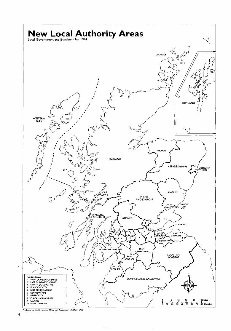
New Local Authority AreasLocal Government etc (Scotland) Act 1994
Numtwrrt Artat1 WEST DUNBARTONSHIRE2 EAST DUNBARTONSHIRE3 NORTH LANARKSHIRE4 GLASGOW CITY5 EAST RENFREWSHIRE6 RENFREWSHIRE7 INVERCLYDE8 CLACKHANNANSHIRE» FALK1RK10 WEST LOTHIAN
Produced by the Stitionerv Office LIB Cartographic Centre 9'96
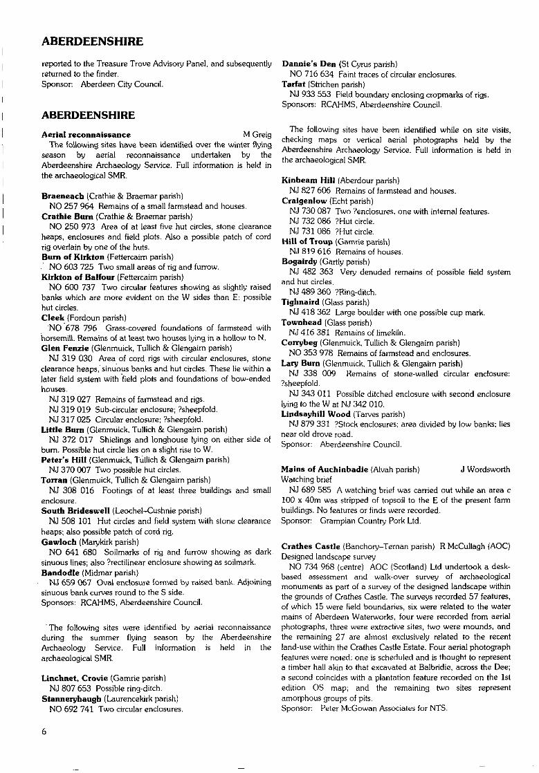
ABERDEEN CITY
ABERDEEN CITY
Aberdeen area D 1 Harding(Aberdeen; Dyce; Newhills; Peterculter parishes)Assessment
In the course of a general reconnaissance in advance of aprospective archaeological field survey of uncultivated or forestground in the Aberdeen area, the following upstanding sites areamong those which have been reported to the Aberdeen SMRfor inclusion therein. Site reports will be lodged with bothAberdeen SMR and the NMRS. Other features include variousboundary stones and milestones; railway station platforms andother railway features; clearance cairns; and air-raid shelters.
NJ 9346 0815 Powis House
NJ 80 NENJ 8541 0757NJ 8556 0535NJ 854 050NJ 855 050NJ 854 050
NJ 80 SENJ 854 049NJ 854 049NJ 8764 0309NJ 8648 0323NJ 8726 0204NJ 8977 0270
NJ 8997 0320
NJ 80 SWNJ 8409 0319NJ 8424 0333NJ 8475 0360NJ 8432 0313
NJ 81 SENJ8591 1196NJ 8921 1359NJ 8631 1378NJ 8589 1214
NJ 81 SWNJ 8464 1046NJ 8463 1050
NJ 90 NENJ 9684 0508NJ 9558 0933NJ 963 054
NJ 965 052
NJ 9642 0570NJ 9515 0693NJ 9536 0553NJ 9537 0543
NJ90NWNJ 9220 0903
Clog HillKingshillGairn ForestGairn ForestGairn Forest
Gairn ForestGairn ForestBaillieswellsHiltonMilton of Murtle
Cults
Bean's HillBean's HillBean's HillHillhead ofContlaw
by BalgosieMains of DyceHarvey's CairnBalgosie
Elrick HillElrick Hill
Bay of NiggDonmouth SouthBalnagask GolfCourseBalnagask GolfCourseGreyhope RoadQueen's LinksMearns QuayTorry Quay
Woodside
Mound.Quarry-Circular stony feature.Pits and mounds.Stony mounds.
Circular stony feature.Pits and mounds.Consumption dyke.Consumption dyke.Doocot.Engine house,waterworks.Stone, slotted, 268North Deeside Road.
Building foundations.Buildings (2), ruined.Enclosure, oval.House, ruined.
Buildings (2), ruined.Burial ground.?Caim.Steading and ruinedfarmhouse.
Hut circle.Quarry.
Building and slipway.Breakwater.Rig and furrow.
Rig and furrow.
Rocket house, lifesaving.Tramlines.Siphon house, sewage.Siphon house, sewage.
Canal bridge,
NJ 9330 0568NJ 9258 0932
NJ 9122 0978
NJ 9445 0669NJ 9391 0817
NJ 9362 0904
NJ 9361 0902
NJ 9107 0950
NJ 920 093
NJ 9408 0882NJ 9388 0650
NJ 9240 0917NJ 9376 0597NJ 9355 0578NJ 9380 0849NJ 9423 0667
Justice Mill LaneGrandhotne Mills,River DonGrandhome Mills,River Don142 King StreetOld Aberdeen
Kettocks Mills,River DonKettocks Mills,River DonWoodside Mills,River Don
Seaton ParkRobert Gordon'sCollegeDon TerraceLangstane PlaceLangstane PlaceSt Machar DriveSeamount Place
NJ 90 SENJ 9559 0354 Tullos Hill
NJ 9540 0336 Tullos Hill
Civil Defence sub-controlcentre.Electric conduit ventilator.Footbridge.
Mill lade intake.
House and offices.Insurance badge, 1 HighStreet.Mill lade intake.
Weir.
Mill lade intake.
Structures associated withformer Woodside Mills.Pillbox.The Auld Hoose'.
Steps, 'Jacob's Ladder'.Stone, 'Langstane'.Stone, 'Crabstane'.Stones, carved, reused.Stones, inscribed.
Concrete hut base, 10 x5m.Concrete hut bases (2).
NJ 90 SWNJ 9108 0271NJ 9424 0496
NJ 9424 0497
NJ 9426 0437
NJ 9070 0295
River Dee Bridge abutment.Wellington Stone, cross-marked/Suspension Bridge inscribed.Wellington Toll house remains.Suspension BridgeRiver Dee Railway Wooden pilings.BridgeDrumgarth Windmill (relocated).
A Cameron
Aberdeenshire Canal.
St Clement Street/Wellington Street,Aberdeen (Aberdeen parish)Medieval agriculture
NJ 951 062 Five trenches were excavated in advance of awarehouse development started in 1996 in the vicinity of StClement's Church (DES 1996, 6). Four of the trenches containedwindblown sand up to a depth of 3m. This sand was the remainsof sand dunes which had occupied the site since at least themedieval period. One trench consisted of a depth of 1.5m of thesame windblown sand on top of a layer of organic loam. Thiswas found to contain plough marks and medieval pottery,suggesting that an attempt had been made to reclaim some ofthe dunes for cultivation. The organic loam was a maximum of0.3m deep; this suggests that the reclamation lasted for a shortperiod, and that this area then reverted to a dune system.Sponsor: Langstane Press Ltd.
Westfield Farm (Peterculter parish) J Stones, C SudderFlints
NJ 8490 0356 A collection of 33 flints, including two barbed-and-tanged arrowheads and one lozenge-shaped arrowhead,were reported as having been found over some years on the landaround Westfield Farm, near Aberdeen. The objects were
ABERDEENSHIRE
reported to the Treasure Trove Advisory Panel, and subsequentlyreturned to the finder.Sponsor: Aberdeen City Council.
ABERDEENSHIRE
Aerial reconnaissance M GreigThe following sites have been identified over the winter flying
season by aerial reconnaissance undertaken by theAberdeenshire Archaeology Service. Full information is held inthe archaeological SMR.
Braeneach (Crathie & Braemar parish)NO 257 964 Remains of a small farmstead and houses.
Crathie Burn (Crathie & Braemar parish)NO 250 973 Area of at least five hut circles, stone clearance
heaps, enclosures and field plots. Also a possible patch of cordrig overlain by one of the huts.Burn of Kirkton (Fettercaim parish). NO 603 725 Two small areas of rig and furrow.Kirkton of Balfour (Fettercairn parish)
NO 600 737 Two circular features showing as slightly raisedbanks which are more evident on the W sides than E: possiblehut circles.Cleek (Fordoun parish)
NO 678 796 Grass-covered foundations of farmstead withhorsemill. Remains of at least two houses lying in a hollow to N.Glen Fenzie (Glenmuick, Tullich & Glengaim parish)
NJ 319 030 Area of cord rigs with circular enclosures, stoneclearance heaps, sinuous banks and hut circles. These lie within alater field system with field plots and foundations of bow-endedhouses.
NJ 319 027 Remains of farmstead and rigs.NJ 319 019 Sub-circular enclosure; ?sheepfold.NJ 317 025 Circular enclosure; ?sheepfold.
Little Burn (Glenmuick, Tullich & Glengairn parish)NJ 372 017 Shielings and longhouse lying on either side of
bum. Possible hut circle lies on a slight rise to W.Peter's Hill (Glenmuick, Tullich & Glengairn parish)
NJ 370 007 Two possible hut circles.Torran {Glenmuick, Tullich & Glengaim parish)
NJ 308 016 Footings of at least three buildings and smallenclosure.South Brideswell (Leochel-Cushnie parish)
NJ 508 101 Hut circles and field system with stone clearanceheaps; also possible patch of cord rig.Gawloch (Marykirk parish)
NO 641 680 Soilmarks of rig and furrow showing as darksinuous lines; also ?rectilinear enclosure showing as soilmark.Bandodle (Midmar parish)
NJ 659 067 Oval enclosure formed by raised bank. Adjoiningsinuous bank curves round to the S side.Sponsors: RCAHMS, Aberdeenshire Council.
"The following sites were identified by aerial reconnaissanceduring the summer flying season by the AberdeenshireArchaeology Service. Full information is held in thearchaeological SMR.
Linchnet, Croyte (Gamrie parish)NJ 807 653 Possible ring-ditch.
Stanneryhaugh (Laurencekirk parish)NO 692 741 Two circular enclosures.
Dannie's Den (St Cyrus parish)NO 716 634 Faint traces of circular enclosures.
Tarfat (Strichen parish)NJ 933 553 Field boundary enclosing cropmarks of rigs,
Sponsors: RCAHMS, Aberdeenshire Council.
The following sites have been identified while on site visits,checking maps or vertical aerial photographs held by theAberdeenshire Archaeology Service. Full information is held inthe archaeological SMR.
Kinbeam Hill (Aberdour parish)NJ 827 606 Remains of farmstead and houses.
Craigenlow (Echt parish)NJ 730 087 Two ?enclosures, one with internal features.NJ 732 086 ?Hut circle.NJ 731 086 ?Hut circle.
Hill of Troup (Gamrie parish)NJ 819 616 Remains of houses.
Bogairdy (Gartly parish)NJ 482 363 Very denuded remains of possible field system
and hut circles.NJ 489 360 ?Ring-ditch.
Tighnaird (Glass parish)NJ 418 362 Large boulder with one possible cup mark.
Townhead (Glass parish)NJ 416 381 Remains of limekiln.
Corrybeg (Glenmuick, Tullich & Glengairn parish)NO 353 978 Remains of farmstead and enclosures.
Lary Burn (Glenmuick, Tullich & Glengaim parish}NJ 338 009 Remains of stone-walled circular enclosure:
?sheepfold.NJ 343 Oil Possible ditched enclosure with second enclosure
lying to the W at NJ 342 010.Lindsayhill Wood (Tarves parish)
NJ 879 331 ?Stock enclosures; area divided by low banks; liesnear old drove road.Sponsor: Aberdeenshire Council.
Mains of Auchinbadie (Alvah parish) J WordsworthWatching brief
NJ 689 585 A watching brief was carried out while an area c100 x 40m was stripped of topsoil to the E of the present farmbuildings. No features or finds were recorded.Sponsor: Grampian Country Pork Ltd.
Crathes Castle (Banchory-Ternan parish) R McCullagh (AOC)Designed landscape survey
NO 734 968 (centre) AOC (Scotland) Ltd undertook a desk-based assessment and walk-over survey of archaeologicalmonuments as part of a survey of the designed landscape withinthe grounds of Crathes Castle. The surveys recorded 57 features,of which 15 were field boundaries, six were related to the watermains of Aberdeen Waterworks, four were recorded from aerialphotographs, three were extractive sites, two were mounds, andthe remaining 27 are almost exclusively related to the recentland-use within the Crathes Castle Estate. Four aerial photographfeatures were noted: one is scheduled and is thought to representa timber hall akin to that excavated at Balbridie, across the Dee;a second coincides with a plantation feature recorded on the 1stedition OS map; and the remaining two sites representamorphous groups of pits.Sponsor: Peter McGowan Associates for NTS.
ABERDEENSHIRE
Crathes Castle (Banchory-Ternan parish) S A Wallace,18th-19th-century bottles R Turner (NTS)
NO 7350 9680 Complete late 18th-century glass wine bottle,found some time ago in yew hedge.
NO 7291 9700, NO 7303 9679 Numerous fragments of 19thand 20th-century wine and gin bottles in mixed dump depositswere recovered from the castle grounds. More than 300 bottlesare represented.
NO 7338 9676 The removal of an old chestnut tree about40m S of the castle led to the discovery of a dump of late 18th-century wine bottles, presumed to have been redeposited from adump in another location. Other than fragments of slate, noother artefacts were present.Sponsor: NTS.
Crathes Castle Estate (Banchory-Teman parish) K SabineIce-pond and lade
NO 731 970 to NO 733 970 In 1996 the ice-pond and ladeon Crathes Castle Estate were cleaned and recorded. This wascarried out in two stages: an evaluation followed by the cleaningof the entire system by Scottish Conservation Volunteers.
The lade is 138m long above and 40m long below the pond. Itwas deliberately channelled from an existing stream and thesides lined with stones. When completely emptied, the pondmeasured 10m N-S by 8m W-E. The northern half of the baseof the pond was flat and floored with grey clay. This clay waseither in siru or, more probably, imported to the site fromelsewhere on the estate. The southern half of the pond was ofyellowish grey clay, covered with small stones. This half slopedgently upwards towards a slide, cut from natural rock, to the SEof the pond. This slide would have enabled the ice workers tohaul the blocks of ice to the track above the pond and hence tothe ice-houses. The pond walls were constructed of fine drystonewalling in good condition, with the exception of the W wall.There was no wall on the S side of the pond, the slope carryingon upwards out of the pond. The water entrance and exitfeatures were also exposed. Where the stream enters the pond atthe W side, the amount of loose stone found indicated that therewould have been a small dam, or that the wall would have beenintact, to allow the water to enter the pond at a higher level thanit does today. At the E side there is a pottery plug surrounded bythe remains of a coffer dam, which stopped the water leaving thepond by its lower drain, allowing the ice to build up to a usablethickness. The fill within the pond was very uniform, and theartefacts were fairly evenly distributed throughout the fill.
In general, the type of material found indicated that after thefunctional use of the pond ceased in the mid-19th century, thepond was used as a recreational site for the inhabitants of thecastle. A complete ice manufacturing system - the upper dam,sluice, lade, pond, slide, lower dam and ice-houses - is presentat Crathes Estate and the survival of this system in such an intactcondition appears to be rare.Sponsors: NTS, Phillips Petroleum.
Cowhill (Belhelvie parish) S McRaeBoundary stones
NJ 957 206 Seven boundary stones with letter 'M' carved onone face and an 'F on reverse. Stones situated at NJ 948 209,NJ 947 209, NJ 957 211, NJ 954 210, NJ 961 211, NJ 955 206and NJ 957 205.
Lamahip Pincwood (Birse parish) S Carter (HAL)Pre-afforestation survey
NO 55 93 (centre) A short-notice forestry survey wasundertaken by Headland Archaeology Ltd over roughly 2.6km
of land on the S side of Glen Cat between the Bum of Cattie andthe top of Lamahip. Four features or groups of features ofarchaeological interest were recorded. The results indicate a zoneof marginal agricultural activity along the lower slope ofLamahip, close to the Burn of Cattie. The sites are all assumed tobe of post-medieval date and the farmstead is probably as recentas the early 19th century. The total absence of shieling buildingsis striking, and suggests that Lamahip was grazed directly fromthe recorded settlements or from shielings that precededestablishment of permanent settlements on these sites.NO 548 934 Building, cultivation remains.NO 5508 9369 - Bank.NO 5554 9389NO 554 937 Cultivation remains,NO 559 934 _ Farmstead.Sponsor: HS Q.
North Hill and Finlets Pinewood {Birse parish)Pre-afforestation survey
NO 54 91 (centre) A short-notice forestry survey wasundertaken by Headland Archaeology Ltd over roughly 4.7km2
of land on the N side of the Water of Feugh in the Forest ofBirse. A total of 17 features or groups of features ofarchaeological interest were recorded. The three field systems areextensive cairnfields, probably prehistoric in origin. The othersites are all medieval or later in date; they include scatteredbuildings and enclosures probably related to summer shielingsand a 19th-century farmstead and mill dam.NO 5302 9094 Farmstead.NO 531 910 Field system, building (NMRS NO 59 SW 4).NO 533 909 Buildings, cairns, enclosure.NO 5322 9059 Enclosure.NO 5383 9065 Buildings.NO 5459 9124 Building.NO 5477 9132 Building.NO 5507 9117 Buildings (NMRS NO 59 SE 5.01).NO 552 912 Field system {NMRS NO 59 SE 5).NO 5517 9155 Buildings.NO 551 920 - Field system (NMRS NO 59 SE 6, part).NO 558 917NO 5539 9190 Buildings (NMRS NO 59 SE 6, part).NO 5536 9086 Enclosure, buildings {NMRS NO 59 SE 13; 20).NO 5677 9083 Quarry.NO 5694 9089 Building.NO 5703 9090 Enclosures.NO 5704 9086 Mill dam.Sponsor: HS ^.
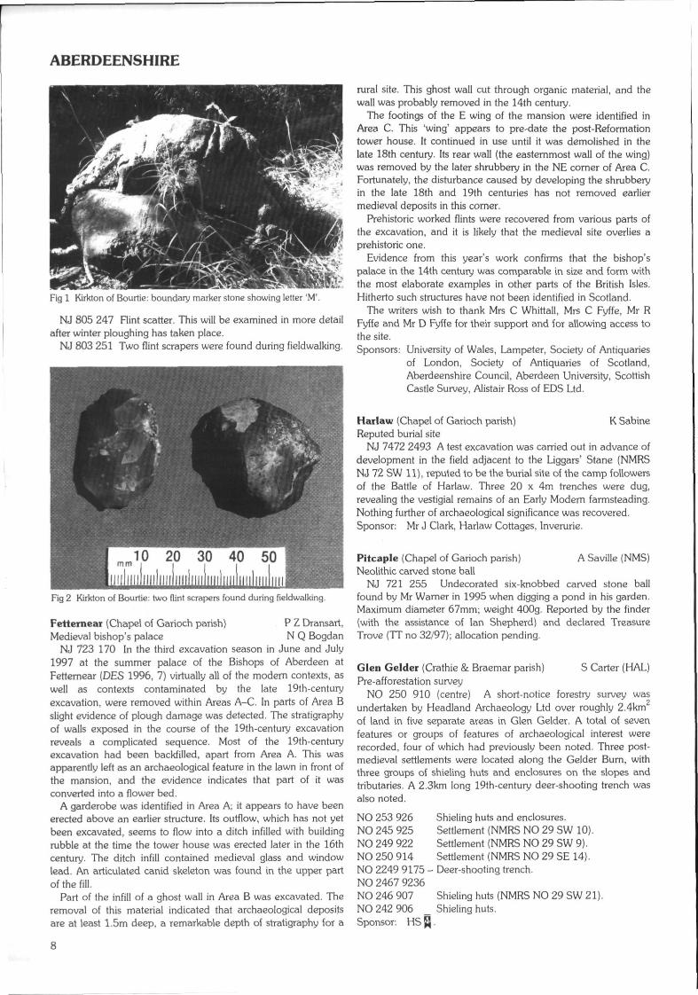
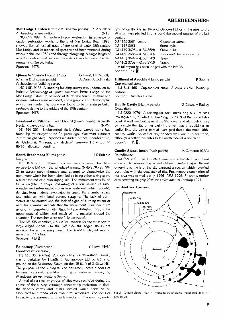
Kirkton of Bourtie (Bourtie parish) W J HowardBoundary marker; flint scatters; stone disc; flint scrapers
NJ 784 245 Boundary marker stone, 18th/19th century. Thisstone, with its well-executed letter 'M', probably delineates theproperty of Shadowside Farm which, during that period, wasfarmed by the Moir family.
NJ 802 249 A further detailed fieldwalking survey of an areapreviously reported (DES 1996, 7) has revealed more flint-working debris, a scraper and what appears to be a fragment of aflint knife. This site has now produced well over 400 flintfragments and the distribution would seem to indicate a distinctarea of activity within the search grid. The flint is mainly of abrown to reddish-brown colour and is typical of that found in theBuchan Ridge gravel deposits around 20 miles to the NE.
A small disc of fine-grained grey stone, 300mm diameter by3mm thick, was also found.
ABERDEENSHIRE
Fig 1 Kirkton of Bourtie: boundary marker stone showing letter 'M'.
NJ 805 247 Flint scatter. This will be examined in more detailafter winter ploughing has taken place.
NJ 803 251 Two flint scrapers were found during fieldwalking.
Fig 2 Kirkton of Bourtie: two flint scrapers found during fieldwalking.
Fetternear (Chapel of Garioch parish) P Z Dransart,Medieval bishop's palace N Q Bogdan
NJ 723 170 In the third excavation season in June and July1997 at the summer palace of the Bishops of Aberdeen atFettemear (DES 1996, 7) virtually all of the modern contexts, aswell as contexts contaminated by the late 19th-centuryexcavation, were removed within Areas A-C. In parts of Area Bslight evidence of plough damage was detected. The stratigraphyof walls exposed in the course of the 19th-century excavationreveals a complicated sequence. Most of the 19th-centuryexcavation had been backfilled, apart from Area A. This wasapparently left as an archaeological feature in the lawn in front ofthe mansion, and the evidence indicates that part of it wasconverted into a flower bed.
A garderobe was identified in Area A; it appears to have beenerected above an earlier structure. Its outflow, which has not yetbeen excavated, seems to flow into a ditch infilled with buildingrubble at the time the tower house was erected later in the 16thcentury. The ditch infill contained medieval glass and windowlead. An articulated canid skeleton was found in the upper partof the fill.
Part of the infill of a ghost wall in Area B was excavated. Theremoval of this material indicated that archaeological depositsare at least 1.5m deep, a remarkable depth of stratigraphy for a
rural site. This ghost wall cut through organic material, and thewall was probably removed in the 14th century.
The footings of the E wing of the mansion were identified inArea C. This 'wing' appears to pre-date the post-Reformationtower house. It continued in use until it was demolished in thelate 18th century. Its rear wall (the easternmost wall of the wing)was removed by the later shrubbery in the NE corner of Area C.Fortunately, the disturbance caused by developing the shrubberyin the late 18th and 19th centuries has not removed earliermedieval deposits in this corner.
Prehistoric worked flints were recovered from various parts ofthe excavation, and it is likely that the medieval site overlies aprehistoric one.
Evidence from this year's work confirms that the bishop'spalace in the 14th century was comparable in size and form withthe most elaborate examples in other parts of the British Isles.Hitherto such structures have not been identified in Scotland.
The writers wish to thank Mrs C Whittall, Mrs C Fyffe, Mr RFyffe and Mr D Fyffe for their support and for allowing access tothe site.Sponsors: University of Wales, Lampeter, Society of Antiquaries
of London, Society of Antiquaries of Scotland,Aberdeenshire Council, Aberdeen University, ScottishCastle Survey, Alistair Ross of EDS Ltd.
Harlaw (Chapel of Garioch parish) K SabineReputed burial site
NJ 7472 2493 A test excavation was carried out in advance ofdevelopment in the field adjacent to the Liggars' Stane (NMRSNJ 72 SW 11), reputed to be the burial site of the camp followersof the Battle of Harlaw. Three 20 x 4m trenches were dug,revealing the vestigial remains of an Early Modern farmsteading.Nothing further of archaeological significance was recovered.Sponsor: Mr J Clark, Harlaw Cottages, Inverurie.
Pitcaple (Chapel of Garioch parish) A Saville (NMS)Neolithic carved stone ball
NJ 721 255 Undecorated six-knobbed carved stone ballfound by Mr Warner in 1995 when digging a pond in his garden.Maximum diameter 67mm; weight 400g. Reported by the finder(with the assistance of Ian Shepherd) and declared TreasureTrove (TT no 32/97); allocation pending.
Glen Gelder (Crathie & Braemar parish) S Carter (HAL)Pre-afforestation survey
NO 250 910 (centre) A short-notice forestry survey wasundertaken by Headland Archaeology Ltd over roughly 2.4kmof land in five separate areas in Glen Gelder. A total of sevenfeatures or groups of features of archaeological interest wererecorded, four of which had previously been noted. Three post-medieval settlements were located along the Gelder Burn, withthree groups of shieling huts and enclosures on the slopes andtributaries. A 2.3krn long 19th-century deer-shooting trench wasalso noted.
NO 253 926NO 245 925NO 249 922NO 250 914NO 2249 9175NO 2467 9236NO 246 907NO 242 906Sponsor: HS
Shieling huts and enclosures.Settlement (NMRS NO 29 SW 10).Settlement (NMRS NO 29 SW 9).Settlement (NMRS NO 29 SE 14}.Deer-shooting trench.
Shieling huts (NMRS NO 29 SW 21).Shieling huts.
ABERDEENSHIRE
Mar Lodge Garden (Crathie & Braemar parish) S A WallaceArchaeological evaluation (NTS)
NO 097 899 An archaeological evaluation in advance ofgarden restoration works to the E of Mar Lodge (built 1898)showed that almost all trace of the original early 18th-centuryMar Lodge and its associated gardens had been removed duringworks in the late 1980s and through ploughing. A single length ofwall foundation and various spreads of mortar were the lastremnants of the old lodge.Sponsor: NTS.
G Ewart, D Connolly,A Dunn, A Hollinrake
Queen Victoria's Picnic Lodge(Crathie & Braemar parish)Archaeological building survey
NO 1151 9133 A standing building survey was undertaken byKirkdale Archaeology at Queen Victoria's Picnic Lodge on theMar Lodge Estate, in advance of its refurbishment. Internal andexternal features were recorded, and a graphic and photographicrecord was made. The lodge was found to be of a single build,probably dating to the middle of the 19th century.Sponsor: NTS.
Loanhead of Pitinnan, near Daviot (Daviot parish) A SavilleNeolithic carved stone ball (NMS)
NJ 744 301 Undecorated six-knobbed carved stone ballfound by Mr Harper some 25 years ago. Maximum diameter71mm; weight 542g. Reported via Judith Stones, Aberdeen CityArt Gallery & Museum, and declared Treasure Trove (TT no86/97); allocation pending.
South Brachmont (Durris parish) J S RideoutRing cairn
NO 814 950 Three trenches were opened by AlbaArchaeology Ltd over the scheduled mound (NMRS NO 89 NW2) to assess rabbit damage and attempt to characterise themonument which has been identified as being either a ring cairn,a burnt mound or a corn-drying kiln. The monument was foundto be irregular in shape, consisting of a low mound of smallrounded and sub-rounded stones in a peaty soil matrix, probablyderiving from material excavated to create the chamber spaceand enhanced with local surface scraping. The lack of burntstones in the mound and the lack of signs of burning within ornear the chamber indicate that the monument is neither burntmound nor corn-drying kiln. Rabbits have disturbed most of theupper material within, and much of the material around thechamber. The trenches were not fully excavated.
The NE-SW chamber, 2.6 x 2.3m, consists for the most part oflarge edged stones. On the SW side the edged stones arereplaced by a low rough wall. The NW-SE aligned moundmeasures c 11 x_8m.Sponsor: HS Q.
Beldorney (Glass parish) C Lowe (HAL)Pre-afforestation survey
NJ 415 369 (centre) A short-notice pre-afforestation surveywas undertaken by Headland Archaeology Ltd of 4.6ha ofground on the Beldorney Estate, on the NE flank of Gallows Hill.The purpose of the survey was to accurately locate a series offeatures previously identified during a walk-over survey byAberdeenshire Archaeology Service.
A total of six sites or groups of sites were recorded during thecourse of the survey. Although conceivably prehistoric in date,the various cairns and dykes located would seem to beassociated with medieval or later rural settlement. The focus ofthis activity is assumed to have lain either on the now improved
ground on the eastern flank of Gallows Hill or in the area to theW which was planted in or around the second quarter of the lastcentury.
Clearance cairns.Stone dyke.Stone dyke.Track and clearance cairns.Track.Track.
NJ 4145 3684 (centre)NJ 4147 3681NJ 4149 3695 - 4154 3688NJ 4155 3686 - 4164 3706NJ 4161 3697-4153 3703NJ 4162 3702-4157 3710
A full report has been lodged with the NMRSSponsor: HS Q.
Hillhead of Avochie (Huntly parish)Cup-marked stone
NJ 541 468 Cup-marked stone; 3bedrock.Sponsor: Avochie Estate.
K Sabine
cups visible. Probably
G Ewart, A RadleyHuntly Castle (Huntly parish)Excavation
NJ 5320 4076 A rectangular area measuring 6 x 1m wasinvestigated by Kirkdale Archaeology to the N of the castle salespoint. A wall was built against the SW tower and although it maybe possible that the upper part of the wall was a rebuild on anearlier line, the upper part at least post-dated the main 16th-century works. An earlier clay-bonded wall was also recorded,although whether this dates to the motte period is not clear.Sponsor: HS ̂ .
Candle Stane, Insch (Insch parish) K Cameron (CFA)Roundhouse
NJ 599 299 The Candle Stane is-a scheduled recumbentstone circle surrounding a well-defined central(cairn. Recentquarrying to the E of the site exposed a section which revealedpost-holes with charcoal-stained fills. Preliminary examination ofthis area was carried out in 1996 (DES 1996, 8) and a furtherarea covering roughly 70m was excavated in January 1997.
postulated lines of post holes
ring groove
—outer ring
.—middle ring
Fig 3 Candle Stane:post-holes.
plan of roundhouse showing postulated lines of
ABERDEENSHIRE
The excavation located the remains of a circular timberstructure to the SW of the recumbent stone circle. The area hadsuffered extensive damage from quarrying prior to its recognitionas an archaeological site, and therefore only 40-45% of theoriginal structure remained. The structure was defined by a ring-groove which if extrapolated would be c 15.5m in diameter. Theremains of three concentric rings of post-holes were located. Theentranceway to the structure was massively built; had thisstructure been roofed, this could have formed a porch. Internalfeatures included a single large stone-filled pit and a suite ofstake-holes located near the centre of the structure.
A report will be lodged with the NMRS.Sponsor: HS Q.
Glcnhead Farm (Kemnay parish) M Cressey, B FinlaysonArchaeological evaluation {CFA)
NJ 753 174 A desk-based survey and field evaluation inadvance of quarrying was carried out in March 1997 by the CFA.The evaluation revealed a boulder-filled land drain and the baseof a furrow. Two small pits, one of which contained a fragmentof modem brick, were of recent age.Sponsor: John Fyfe Ltd.
Old Hinder (Kennethmont parish)Medieval pottery
NJ 595 269 Sherds of medievalfieldwalking.
S Williamson
pottery; retrieved from
A Saville (NMS)Mil l tnu . i i of Byth farm, New Byth(King Edward parish)Neolithic carved stone ball
NJ 827 535 Undecorated six-knobbed carved stone ballfound by Mrs Imray in her garden in 1962. Maximum diameter71mm; weight 407g. Reported via Neil Curtis, Marischal CollegeMuseum, and declared Treasure Trove (TT no 85/97); allocationpending.
A96 Kintore Bypass J Hamilton, C McGill (CFA)(Kintore; Kinellar; Dyce parishes)Early prehistoric pits and later prehistoric features
NJ 841 119 to NJ 784 179 A watching brief was conductedduring the initial construction phase of the A96 Kintore Bypass inthe spring and early summer of 1997 (see also DES 1996, 8-9).Topsoiling activity revealed 33 archaeological features within theroad corridor, the majority of which were located in the northernhalf of the route and concentrated immediately to the S of theRoman temporary camp. Several small concentrations of pitswere located. Material retrieved from the features includespottery, flint and burnt bone. In addition, a few isolated pits wereuncovered along the length of the working swathe, none ofwhich contained any artefacts.
A detailed report will be lodged with the NMRS.Sponsor: The National Roads Directorate of The Scottish Office
Develogment Department, managed on their behalfby HS |.
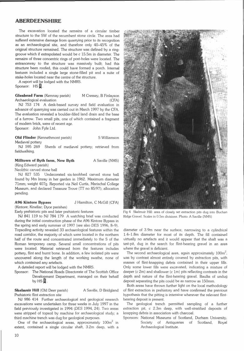
Skelmuir Hill (Old Deer parish) A Saville, D BridglandPrehistoric flint extraction site
NJ 986 414 Further archaeological and geological researchexcavations were undertaken for three weeks in July 1997 in thefield previously investigated in 1994 (DES 1994, 24). Two areaswere stripped of topsoil by machine for archaeological study; athird machine trench was dug for geological purposes.
One of the archaeological areas, approximately 100m inextent, contained a single circular shaft, 3.2m deep, with a
Fig 4 Skelmuir Hill: area of closely set extraction pits dug into BuchanRidge Gravel. Scales in 0.5m divisions. Photo: A Saville (NMS)
diameter of 3.9m near the surface, narrowing to a cylindrical1.4-1.8m diameter for most of its depth. The fill containedvirtually no artefacts and it would appear that the shaft was atest-pit, dug in the search for flint-bearing gravel in an areawhere the gravel is deficient.
The second archaeological area, again approximately 100m ,was by contrast almost entirely covered by extraction pits, withmasses of flint-knapping debris contained in their upper fills.Only some lower fills were excavated, indicating a mixture ofdeeper (c 2m) and shallower (c 1m) pits reflecting contrasts in thedepth and nature of the flint-bearing gravel. Baulks of undugdeposit separating the pits could be as narrow as 150mm.
Both areas have thrown further light on the local methodologyof flint extraction in prehistory and have confirmed the previoushypothesis that the pitting is intensive wherever the relevant flint-bearing deposit is present.
The geological trench permitted sampling of a furtherextraction pit, c 2.3m deep, with well-stratified deposits ofknapping debris in association with charcoal.Sponsors: National Museums of Scotland, Durham University,
Society of Antiquaries of Scotland, RoyalArchaeological Institute.
10
ABERDEENSHIRE
Gowanfold (Rathen parish) S Carter (HAL)Pre-afforestation survey
NK 030 640 A short-notice forestry survey was undertaken byHeadland Archaeology Ltd of 3ha of arable farmland atGowanfold, 1km SW of Inuerallochy. Part of the area overliesthe former site of part of the accommodation camp forInverallochy airfield. Nothing survived of this part of the camp,but aerial photographs taken in 1946 record 17 timberaccommodation huts, 5 anti-blast shelters and other structures.Sponsor: HS ^.
Tap o' Noth (Rhynie parish) A Dunwell, R Strachan (CFA)Enclosure; ?hut circles
NJ 484 293 A visit to Tap o' Noth vitrified fort revealed thepresence of a hitherto unidentified enclosure within the massivestone walls of the fort, formed by two concentric banks withmedial ditch, traceable around the W, S and E sides of theinterior of the fort. Within the northern interior of the fort thebanks of this enclosure could not be distinguished. The innerrampart measures c 2m wide by 0.5m high; the outer 2.5-3mwide by 0.4m high, and the medial ditch c 2m in width. To the Ethe enclosure appears to run beneath the vitrified stone wall andalso shows evidence of realignment. To the W the double banksshow signs of disturbance. To the S, the banks exist in adenuded state where they correspond to the entrance throughthe vitrified fort.
Two possible hut circles were located within the northerninterior of the vitrified fort. One, c 30m from the inner stone wall,is defined as a low mound c 8m in diameter. Its walls measure 1-1.5m wide, contain occasional stone, with a possible entrancepresent to the SE. Approximately 10m NW of this hut circle, theW half of a possible second hut circle measuring 5m in diameterand extant to c 0.3m could be defined.
Peterhcad Golf Club (St Fergus parish) A DunlopHints
NK 120 475 A number of flints were found during work on anextension to the club. Finds include flakes and cores; many showsigns of burning.
St Fergus to Peterhead R Strachan (CFA)(St Fergus; Peterhead parishes)Archaeological assessment
An archaeological desk-based assessment and rapid fieldsurvey was undertaken in March 1997 on the proposed route ofa pipeline running from St Fergus Offtake Station to theproposed pressure reducing station at Peterhead Power Station.Five sites situated within the corridor examined were listed in theNMRS. The following are amongst the sites identified in theassessment:NK 0999 5475 Structures, trackway and field boundary
(sites of), part of 'Pittenheath farmsteads'track and well.
NK 088 544 (centre) 'Northmoss1 farmstead and well (sitesof).Middle Essie
NK 0863 5426 Structures within triangular enclosure{sites of).
NK 093 534 (centre) St Fergus Gas Terminal (NK 05 SE 8);'West Blackwater' house/manor,.enclosure and trackway (sites of).Netherhill
NK 0890 5283 (centre) Farmsteads: structures and unroofedstructures, well and field enclosures (sitesof).
NK 0878 5205 (centre)
NK 0878 5170NK 087 518 (centre)NK 086 517
NK 0857 5160
NK 0888 5125 (centre)
NK 0893 5065
NK 0890 5047
NK 0885 4919
NK 0874 4932 -NK 0874 4946NK 0877 4937 -NK 0867 4963
NK 0861 4929 -NK 0852 4943NK 0872 4935 -NK 0855 4947
NK 0894 4889 -NK 0873 4928NK 0892 4894NK 0899 4894
NK 0890 4893
NK 0845 4885 (centre)
NK 089 483 (centre)
NK 0864 4825 (centre)
NK 088 480 -NK 092 472
NK 0870 4799NK 0875 4742 (centre)
NK 076 473
NK 082 469NK 083 470NK 084 472
NK 081 466 (centre)
NK 079 464 (centre)
NK 0813 4553
NK 0844 4452
KirkhillStructures, well, enclosure, fieldboundary (sites of).CorhillStructures and well (sites of).Structures (sites of).Unnamed farmstead, enclosure, well andtrack (sites of).Structure (site of).Bruxiehill'Bruriehill' farmstead, enclosures andwell (sites of); farmstead and unroofedstructure.Ednie'North Ednie' farmstead and enclosure(site of); roofless structures.Triangular enclosure (site of).River Ugie {NK 04 NE 13)St Fergus and North Ugie Water canal:track (site of).Sluice (site of).
St Fergus and North Ugie Water canal(disused).Roundhillock/River UgieLevees.
Levees.
StonemillsMill lade (site of).
Sluice (site of).Corn mill (site of).River Ugie/StonetnillsStepping stones (site of).Roundhillock CottageStructure, well (site of), track (site of).Easterton CottagesFarmstead and enclosure; structures,enclosures (sites of) (Wester Barnyards).Westerton of Barnyards (Westertonof Torterston)Farmsteads and enclosures (sites of).Great North of Scotland RailwayFormaline to Buchan section(dismantled).SmiddyhillRailway bridge.Farmstead, trackway and well (sites of)(Smithyhill); farmstead.Peterhead Airfield (NK 04 NE 12)Eastfield AirfieldStructures (miniature rifle range).Structures (miniature rifle range).Structures (miniature rifle range).EastfieldStructures, enclosure and trackways(sites of); structures (ruins).East Thunderton?Cropmarks.DenholmFarmstead and enclosure.East DenRoofless structures and enclosure.
11
ANGUS
NK 0844 4452 (centre) Farmstead and enclosure (sites of).NK 0838 4429 {centre} Farmstead and track; structure and track
(site of).NK 0816 4477 ?Platforms.NK 0808 4488 ?Platforms.
BlackhillNK 0857 4337 - Blackhill Quarries and track (site of).NK 0877 4356NK 0845 4356 Pond (site of).NK 085 433 Findspot: Hint axe {NK 04 SE 28).NK 0893 4334 (centre) Structures, tracks.NK 0880 4300 Farmstead, tracks field boundaries {sites
of).Mountpleasant/Redleas
NK 0883 4278 Circular enclosure.Redleas
NK 0905 4275 (centre) Farm and tracks (sites of).NK 0913 4276 Farm.NK 0915 4250 (centre) Farmstead and track (sites of).NK 0925 4275 Track, sluice (sites of).
GreystoneNK 0965 4250 Sluice (site of).NK 0965 4240 (centre) Farmstead (site of) and enclosures.NK 0995 4265 Well and structures (sites of).
CowhillsNK 1025 4249 Stone (site of).NK 1033 4256 Stone (site of).NK 1055 4248 (centre) Roofless farmstead, track, well (site of),
field boundaries (site of).Springhill
NK 1027 4240 Cistern.South Newfield (Newfield)
NK-1088 4267 (centre) Roofless structures, well and track (sites, of).
DenendNK 1140 4242 Structures, yard (site of).NK 1170 4245 (centre) Two structures and yard (sites of),
roofless structures, field boundaries, well.Buckle Farm
NK 1152 4274 Well and structures (sites of), track andNK 1131 4260 - field boundaries.
Several other enclosures, wells, tracks, field boundaries anddykes were also recorded. Fuller report in the NMRS.Sponsor: Penspen Ltd.
Crofts of Drummy (Tarland parish) P CraigStone setting; ?saddle quern; ?kerb cairn
NJ 4681 0387 Stone setting of four upright stones; tallest toSW is c 1m tall (?NMRS NJ 40 SE 51).
NJ 469 038 ?SaddIe quern associated with rocks, possiblyremains of a structure.
NJ 472 037 Remains of large ?kerb cairn.Sponsor: Cromar History Group.
Warrackston (Tullynessle & Forbes parish) C Christie?Gravestone
NJ 558 203 PGravestone of pink granite. There are twocircular holes about 6crn in diameter, half-way down, c 14cmapart. Between the holes is an incised triangle with a long crossrising from the top of it. Above the left hole is what appears to bean incised eye. Below the hole is a smaller hole, c 3cm indiameter from which three short lines radiate. To the right of thishole are what appear to be four large incised letters 'KERR'. Thestone is not in its original position, which is unknown.
ANGUS
77-79 High Street, Arbroath (ex YMCA site) R Cachart(Arbroath & St Vigeans parish) (SUAT)Medieval town
NO 6438 4083 In November 1996 SUAT undertook anarchaeological evaluation in advance of development on this sitetowards the southern end of the High Street in an area whichwas believed to have been settled by the 13th century.
The trial work revealed a probable earlier High Street surface,a former frontage building line of red sandstone, earlier wallfoundations and garden soil. Fragments of 18th-century glassbottles and some sherds of residual medieval pottery were alsorecovered in association with these deposits and features.
Based on the results of the trial work further excavation tookplace over a period of ten days in April and July 1997. Evidenceof the earliest occupation of the burgh was found in the form of apit and a midden deposit dating to the late 12th and 13thcenturies, which underlay cobbled surfaces of a formerly widerHigh Street. These street surfaces abutted a clay-bonded stonewall, set some 2m back from the present street frontage. Remainsof medieval metalworking was also found.Sponsor: Angus Housing Association.
Craigiemeg Hill (Cortachy & Clova pavish) M Dalland (HAL)Pre-afforestation survey
NO 307 681 (centre) A short-notice forestry survey wasundertaken by Headland Archaeology Ltd over roughly 34ha ofland on the E side of Craigiemeg Hill.
A total of five features or groups of features of archaeologicalinterest were recorded, comprising 46 individual monuments,three of which had previously been noted. The monumentscomprise groups of roundhouses and house platforms, as well assub-rectangular buildings and a number of field banks. One ofthe rectangular buildings has a definite tapered outline (NO 30456804) which is very similar to some of the Pitcarmick-typebuildings recorded by the Royal Commission in Strathardle,some 25krn to the SW. Some of the field banks may beassociated with the use of the roundhouses, while others areclearly contemporary with the Pitcarrnick-type buildings.
In addition to the above sites, a track, two possible shielinghuts, and a 19th-century line of shooting butts were recorded.NO 306 681 (centre) Settlement.NO 3032 6803 - Shooting butts.NO 3051 6830NO 3053 6830 ?House platform.NO 3069 6820 ?House platform.NO 3087 6863 - Track and ?shieling huts.NO 3095 6831_Sponsor: HS ̂ .
Dairyman's Cottage, House of Dun S A Wallace (NTS)(Dun parish)Watching brief
NO 6690 5999 A watching brief was undertaken during theexcavation of a trench and soakaways for drainage andunderpinning adjacent to the W wall of the building, which datesfrom c 1850. The remains of a stone slab path ran N-S roughlyparallel to the W wall, associated with stone and brick-builtdrainage features and underlain by a brick and stone rubblepacking. The path and associated features are likely to have beenput in place in the period 1870-90. Pottery and other finds rangein date from the 1860s to 1930s, with some later pieces. Themajority of finds came from the topsail.Sponsor: NTS.
12
ANGUS
Fordhouse Barrow (Dun parish) R Peterson, E ProudfootCairn, ring bank, passage grave
NO 665 605 The excavation of the round cairn lying on the Nedge of the NTS property of House of Dun was completed. Themonument is of multi-phase construction (DES 1996, 12), theearliest phases of which were excavated during 1997.
The earliest features, probably Early Neolithic, were twoparallel sets of shallow slots and three larger pits. Burnt hazelnutshells and blades of Arran pitchstone were recovered from one ofthe pits. This was followed by a series of discontinuous patchesof pre-barrow surface. The majority of these layers appeared torepresent preserved turf lines, except on the SW side of the sitewhere there was evidence of disturbed scrub vegetation.
Perhaps also Early Neolithic in date, a 1.5m deep pit in thecentre of the site was lined with drystone walling to form apassage grave (see front cover). The chamber was 2m in diameterwith a 2m long passage facing W. The construction of thismonument was absolutely contemporary with the first moundconstruction, which was made up of a number of differentdeposits of stone, earth and timber. The floor of the chamberproduced a large quantity of very small pieces of fragmentaryhuman bone and some flintwork, including a small scraper. Aftera period of use the passage was blocked; rim fragments from anEarly Neolithic bowl were found in the blocking material. A largeslab of rock found in the post-medieval disturbance possiblyformed the capstone to the chamber; the destroyed upper wallsof the chamber had been corbelled inwards to support this stone.
During the construction of the Early Bronze Age earthen ringbank, reported last year, the passage grave roof had been partlydestroyed and the chamber had been filled in. Following this,parts of the upper walls either collapsed as a result of thisdisturbance or were deliberately destroyed. The collapsed layerswere incorporated into the remodelled and enlarged mound toform the central area of the ring cairn. Further dumps of materialwere also added to the outside edge of the mound. These dumpsoverlay a number of pits containing Early Bronze Age ceramics,including a single pit containing two complete Collared Urns andan accessory vessel and another pit with a complete Food Vessel.
Further Bronze Age and later deposits have been reportedpreviously. The passage grave has been backfilled but has beenleft largely intact, and may in the future be consolidated forpresentation to visitors.Sponsors: HS Q, Russell Trust,. NTS, St Andrews Heritage
Services.
Millden, Glen Esk (Edzell parish) C Lowe (HAL)Pre-afforestation survey
NO 544 791 (centre) A short-notice pre-afforestation surveywas undertaken by Headland Archaeology Ltd over roughly 9haof land on the SW slopes of Whups Craig, near Millden in NGlen Esk. A total of nine sites, all previously unnoted, wererecorded. The majority relate to features associated withmedieval or later rural upland settlement.NO 5433 7925 Prehistoric settlement and field system
(area centre), including one or tworoundhouses, clearance and ?burial cairns,and rig and furrow.
NO 5425 7917 Sub-rectangular building and yard.NO 5440 7929 Enclosure.NO 5455 7904 - Track/hollow-way.NO 5442 7930 (within survey area)NO 5456 7915 Sub-rectangular building.NO 5457 7911 Sub-rectangular building.NO 5446 7915- Track.NO 5457 7908 (within survey area)
NO 5430 7910 Rectangular building.NO 5422 7914 - Stone dyke.NO 5452 7901_{within survey area)Sponsor: HS Q.
Red Castle (Inverkeilor parish) D Alexander, A Rees (CFA)Barrow cemetery and souterrain
NO 6878 5085 The cropmarks of a barrow cemetery andsettlement are visible in the field to the S of Red Castle.Excavation of the E part of this cropmark complex wasundertaken as part of Edinburgh University's Angus and SouthAberdeenshire Field School. A trench measuring 60 x 30m wastopsoiled and revealed the remains of the ditches of at least fivesquare barrows, one further possible square barrow, two roundbarrows and two unenclosed burials. In addition to these burials,other features excavated included a series of isolated pits andpart of a souterrain.
Each of the square barrows contained a central burialsurrounded by four ditches with breaks at the comers. Thesquare barrows ranged in size from 7-10m across. The degree ofpreservation of the ditches varied greatly. The largest and best-preserved barrow at the NE limit of the excavation had ditchesup to 0.3m deep. In general, however, the rest of the ditcheswere relatively shallow and poorly preserved. The upper fill ofthe ditches of the two largest square barrows containedbeach/river pebbles that had either been placed along the line ofthe ditch or had fallen in from the gradual decay of anaccompanying cairn or bank, perhaps accelerated by ploughing.The two round barrows were approximately 8.5m in diameter;one had a slightly deeper ditch. Ten burials were excavated. Allwere extended inhumations within long graves alignedapproximately SW-NE with the heads at the SW end. Themajority of the burials were set within long cists constructed fromlocally available red sandstone and were covered by capstones.The only exception was in one of the square barrow graveswhere an organic stain represented the remains of a timber orleather coffin. The preservation of human remains varied greatlybetween the graves with most containing a body stain, fragmentsof teeth, skull and long bones. The best-preserved humanremains were recovered from the largest square barrow whichalso had the deepest central grave. None of the burials containedgrave goods. In at least two of the square barrows the graveswere aligned obliquely to the barrow ditches.
The partially examined souterrain at the northern end of thesite consisted of a narrow, shallow curvilinear entrance passageleading into a deeper central passage, only part of which wasexcavated. This souterrain was cut into natural sand and gravelsubsoil and lacked stone revetting. The curvilinear entrancepassage was c 6.5m long, 0.8-0.9m wide and 0.5m deep. Its fillcontained lumps of clay, possibly daub, and fragments ofcharcoal, suggesting that the sides may have been lined withwattle and daub. About 1m from the junction of the entrancepassage with the main souterrain, two post-holes perhapsmarked the position of a timber doorway. The main souterrainpassage was 1.5m wide and 1.4m deep. A total length of 3m wasexcavated but this feature clearly continued to the E and W. Thelower fill was a deep deposit of silty sand within which numerouscarbonised cereal grains were distributed. It appears that thesouterrain was deliberately backfilled and from these depositscame a number of sherds of pottery, fragments of sheet bronze,and shards of glass.
Isolated pits were found scattered across the site and artefactswere recovered from a number of them. An elongated pit closeto the entrance to the souterrain contained numerous burnt andcracked stones and two stone lamps (one decorated). Three
13
ANGUS
50
Fig 5 Polished flint axehead from Willanyards Farm, near Farnell, Angus. Drawn by Marion O'Netl and reproduced by courtesy of the Trustees ofthe National Museums of Scotland.
other pits contained sherds of Late Neolithic Grooved Ware andone contained a sherd of Impressed Ware.
Geophysical survey and: fieldwalking in the area to the W ofthe excavation proved relatively unproductive. Trial trenching of600m in the rest of the field appeared to confirm the aerialphotographic evidence that the archaeological features werefocused in the N.Sponsors: HS ̂ , Edinburgh University.
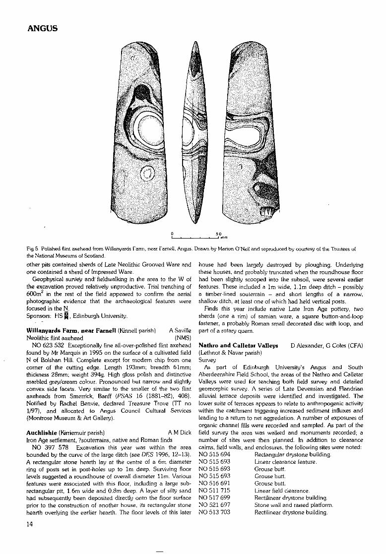
Willanyards Farm, near Farnell {Kinnell parish] A SavilleNeolithic flint axehead (NMS)
NO 623 532 Exceptionally fine all-over-polished flint axeheadfound by Mr Marquis in 1995 on the surface of a cultivated fieldN of Bolshan Hill. Complete except for modern chip from onecomer of the cutting edge. Length 193mm; breadth 61mm;thickness 28mm; weight 394g. High gloss polish and distinctivemarbled grey/cream colour. Pronounced but narrow and slightlyconvex side facets. Very similar to the smaller of the two flintaxeheads from Smerrick, Banff (PSAS 16 (1881-82), 408).Notified by Rachel Benvie, declared Treasure Trove (TT no1/97), and allocated to Angus Council Cultural Services(Montrose Museum & Art Gallery).
Auchlishie (Kirriemuir parish) A M DickIron Age settlement, ?souterrains, native and Roman finds
NO 397 578 Excavation this year was within the areabounded by the curve of the large ditch (see DES 1996, 12-13).A rectangular stone hearth lay at the centre of a 6m diameterring of posts set in post-holes up to 1m deep. Surviving floorlevels suggested a roundhouse of overall diameter Urn, Variousfeatures were associated with this floor, including a large sub-rectangular pit, 1.6m wide and 0.8m deep. A layer of silty sandhad subsequently been deposited directly onto the floor surfaceprior to the construction of another house, its rectangular stonehearth overlying the earlier hearth. The floor levels of this later
house had been largely destroyed by ploughing. Underlyingthese houses, and probably truncated when the roundhouse floorhad been slightly scooped into the subsoil, were several earlierfeatures. These included a 1m wide, l.lm deep ditch - possiblya timber-lined souterrain - and short lengths of a narrow,shallow ditch, at least one of which had held vertical posts.
Finds this year include native Late Iron Age pottery, twosherds (one a rirn) of samian ware, a square button-and-loopfastener, a probably Roman small decorated disc with loop, andpart of a rotary quern.
Nathro and Calletar Valleys D Alexander, G Coles (CFA)(Lethnot & Navar parish)Survey
As part of Edinburgh University's Angus and SouthAberdeenshire Field School, the areas of the Nathro and CalletarValleys were used for teaching both field survey and detailedgeomorphic survey. A series of Late Devensian and Flandrianalluvial terrace deposits were identified and investigated. Thelower suite of terraces appears to relate to anthropogenic activitywithin the catchment triggering increased sediment influxes andleading to a return to net aggregation. A number of exposures oforganic channel fills were recorded and sampled. As part of thefield survey the area was walked and monuments recorded; anumber of sites were then planned. In addition to clearancecairns, field walls, and enclosures, the following sites were noted:NO 515 694 Rectangular drystone building.NO 515 693 Linear clearance feature.NO 515 693 Grouse butt.NO 515 693 Grouse butt.NO 516 691 Grouse butt.NO 511 715 Linear field clearance.NO 517 699 Rectilinear drystone building.NO 521 697 Stone wall and raised platform.NO 513 703 Rectilinear drystone building.
14
ANGUS
NO 518 699 Rectilinear drvstone building.NO 519 699 Rectilinear drystone building.NO 519 699 Rectilinear drystone building.NO 521 693 Drystone house.NO 520 693 Raised platform terrace.NO 508 699 Oval mound, with central depression.NO 502 684 Enclosure and rectangular structure.NO 505 677 - Line of 15 grouse butts.NO 504 682NO 5100 6780 Square hut.NO 5110 6890 Concrete hut base.NO 502 692 Rig and furrow.NO 5011 6918 ?Quarry scoop.NO 5008 6920 ?Quarry scoop.NO 4985 6890 Two quarries.NO 496 688 Rectangular structure.NO 495 689 Rectangular structure.NO 4990 6872 - Embankments running on either side ofNO 4995 6860 track.NO 5080 7010 Two sub-rectangular structures.NO 5065 7021 Two rectangular structures.NO 5055 7015 Mounds.NO 5073 7027 Rectangular structure.NO 5064 7050 Sub-rectangular structure.NO 508 704 - Five rectangular structures and fields.NO 509 704NO 5104 7041 Two rectangular structures.NO 5101 7034 Rectangular structure.NO 5132 7034 Rectangular structure.NO 5096 7077 Rectangular structure.NO 5085 7077 Rectangular structure.NO 5078 7074 Rectangular structure.NO 5070 7067 Three rectangular structures and fields.NO 5042 7056 Rectangular structure.NO 5042 7068 Rectangular structure.NO 4992 7086 Two rectangular structures.NO 4992 7028 Two rectangular structures.NO 4996 7032 Rectangular structure.NO 5015 7041 Farmstead.NO 5021 7042 Farmstead.NO 5022 7046 Kiln.NO 5030 7047 Rectangular structure and enclosure.NO 4905 7108 Circular depression.NO 4907 6967 Mill.NO 4929 7015 Two structures, three enclosures.NO 495 702 Settlement and field system (NMRS NO 47
SE3).NO 4945 7007 Three rectilinear structures and enclosure.NO 4957 6996 Sub-rectangular structure.NO 4963 7015 Rectilinear structure.NO 4967 7020 Rectilinear structure.NO 4970 7022 Rectilinear structure.NO 4975 7010 Rectilinear structure.NO 4987 7004 Rectilinear structure and large banked
enclosure containing rig.NO 4944 7014 Rectilinear structure.NO 5010 7048_ Stone (NMRS NO 57 SW 2).Sponsors: HS Q, Edinburgh University.
Old Montrose (Maryton parish) . K Brophy, E StuartLithic scatters
NO 669 566 A small amount of fieldwalking was undertakenin the vicinity of a series of cropmarks lying above the 15mcontour on the valley floor. These include a large ditch-definedcursus, Old Montrose (NMRS NO 65 NE 36), several ring-
ditches, round and square barrows, a souterrain, settlement(enclosed and unenclosed), and agricultural traces. They alsoinclude a large kidney-shaped enclosure and represent acomplex and long-term sequence of human activity. A lithicscatter was previously known (DES 1981). Rewalking producedwaste flakes and chips of flint from NO 667 562: none hassecondary working. In a field centred on NO 669 566 -downslope of the cropmarks - two chips and an awl or borerwere found. All are of reddish flint. Other fields producedoccasional flakes or pieces. More work will be done in this area.Sponsor: HS Q.
White Caterthun (Menmuir parish) R Strachan, J HamiltonHillfort (CFA)
NO 5473 6607 Trenches were excavated in September 1997across four separate rampart systems on the eastern slopes of theWhite Caterthun hillfort (NMRS NO 56 NW 17). Theseexcavations were a component of Edinburgh University's Angusand South Aberdeenshire Field School. The work was conductedpartly in response to rabbit damage to the site and to providedata for comparison with that obtained from the BrownCaterthun (see DES 1996, 13-14).
Trench 1 was excavated across a section of rampart formingpart of the annexe on the eastern side of the hill. The rampartwas of simple dump construction, with a possible robbed-outexternal stone face, lying beside a rock-cut ditch c 3m wide by2m deep. The vestigial remains of a counterscarp bank laybeyond this ditch. The area enclosed by the rampart wascharacterised by slight scarping of the subsoil upon which arough cobble spread, which also extended up the inner slope ofthe rampart, was laid.
Trench 2 was opened across the two outermost ramparts. Bothramparts were of simple dump construction and sealed oldground surfaces. A rock-cut medial ditch separated the ramparts,and a second rock-cut ditch lay downslope from and external tothe outer rampart. The outer rampart appears to be the earlierand was constructed of redeposited subsoil from the medialditch. Both ditches showed evidence of recutting. The secondaryfill of the medial ditch comprised a thick deposit of turf whichwould appear to represent collapse from the inner rampart,which may have taken the form of a turf rampart revetted by atimber face situated in a continuous slot. Such a slot was locatedbeneath the rampart base. A palisade was located runningconcentric to and external to the outer ditch.
Trench 3 was located on the eastern side of the hill betweenthe inner stone wall and the outer ramparts. It was positionedacross the alignment of reputedly the earliest and robbed-outstone rampart of the hillfort. No evidence for this rampart waslocated. However, three levelled areas formed by rubble and turfwere identified; these appear to represent the remains ofterraces. These features were sealed by a thick deposit of brownearth and may represent the remains of former cultivationterraces.
Trench 4 was opened across the tumbled stone, ditch andcounterscarp bank immediately external to the massive stonewall on the summit of the hill. This trench revealed a rock-cutditch c 5m wide by 1.2m deep. A shallow and wide rock-cutpalisade trench was located adjacent to the inner margin of thisditch, and had subsequently been sealed by the tumbled stone.External to the ditch lay a counterscarp bank sealing an oldground surface. This counterscarp bank appears to have beenplaced on a prepared terrace which also seals an old groundsurface. Both the terrace and the counterscarp bank were cut bya secondary deep and wide palisade trench. It is possible thatthis terrace relates to the activity described in Trench 3.
15
ARGYLL AND BUTE
Finds were restricted to coarse stone tools. Samples were takenfor environmental analysis and radiocarbon dating from all trenches.
A full report will be lodged with the NMRS.Sponsors: HS Q, Edinburgh University.
Western Road, Montrose (Montrose parish) N M RobertsonMedieval burgh backlands (SUAT)
NO 713 577 In April 1997 SUAT undertook a trial excavationof part of the backlands of 208-212 High Street, on the E side ofWestern Road between Mill Road and Park Close, within thebounds of the medieval burgh of Montrose. The site hadformerly been garden ground, and its western half had recentlyhad as much as 1.5m of its topsoil stripped off, withoutarchaeological supervision, in preparation for redevelopment ashousing. Two trenches (A and B) were machine-excavated downto natural deposits, cleaned and recorded.
Trench A was aligned E-W and was situated 8.3m to the N ofthe boundary wall of the property on Western Road. Severalfeatures were observed cut into natural, including a probablemulti-phase large ditch running NE-SW, a smaller linear featureat the W end of the trench (possibly a cultivation slot}, and somesmall pits, from which medieval pottery and animal bone(including an articulated cat skeleton) were recovered. Thewaterlogged nature of deposits at the E end of the trench, in theditch feature, made the sides unstable and prevenled completeexcavation in the limited time available. The spout of a green-glazed anthropomorphic vessel, imported from northernEngland, was recovered from this area, but its exact context wasuncertain because of the collapse of part of the trench wall.
Trench B was situated on the S side of the site at the easternend, on garden ground that had not been reduced in level.Below a deposit of some 0.4m of black garden soil was a depositup to 0.75m thick of mid-brown silty sand containing medievalpottery and animal bones, and a finely made bronze lid,probably from a 16th or 17th-century pottery tankard importedfrom Germany or the Low Countries. This deposit was cut by apit containing many broken wine bottles of early 19th-centurydate, and lay over a layer of possible disturbed natural subsoil,and another of possible windblown sand, above natural at adepth of 1.5-1.84m.Sponsors: HS ̂ , John D Crawford,
Finavon Hill, near Forfar (Oathlaw parish) C Swift (CFA)Evaluation excavation
NO 5060 5567 An evaluative excavation was undertaken inadvance of the proposed erection of a telecommunications toweron Finavon Hill, immediately adjacent to the vitrified hillfort.Approximately 82m was examined and one possible stonefeature was identified: a broken stone slab surrounded byrounded stones, apparently derived from the conglomeratebedrock. Although this may have constituted an archaeologicalfeature, no associated finds or features were detected.
Detailed reports will be lodged with the NMRS.Sponsor: Orange Personal Communications Services Ltd.
ARGYLL AND BUTEThe following sites in Argyll and Bute have been identified and
recorded during fieldwork carried out by the staff of WoSAS. Fulldetails are available in the WoSAS SMR.
NM 9075 4196(centre)NM 9042 4173NM 9077 4219NM 9720 4258
NM 9889 4272
NM 9728 4255
NN 0049 2662NN 0005 2654NN 0990 2617(centre)NN 0795 2703
NN 0805 2693
NN 0808 2682
NN 1844 3930(centre)
NN 1767 3873
(Arrochar parish)NN 3268 1587
(centre)NN 3239 1578NN 3206 1856NN 3250 1766NN 3255 1709NN 3216 1757
Shian Wood
Shi an WoodSouth ShianGleann Dubh
Gleann Dubh
Gleann Dubh,BarcaldineCreag a' ChrothaCreag a' ChrothaCoille Leitire
Cruachan PowerStationCruachan PowerStationCruachan PowerStationAirigh CloicheFinneGlen Kinglass
Ardleish
ArdleishBeinglasBlarstaingeBlarstaingeGlen Falloch
Field system.
MOLRS.Well.Charcoal-burningplatforms.Deserted settlement;shieling huts.Settlement; enclosure.
Shieling hut.Shieling hut.Cultivation remains;?shieling hut.Charcoal-burningplatforms.Charcoal-burningplatforms.Charcoal-burningplatforms.Shieling huts.
Shieling huts.
Shieling huts; clearancecairn; field dyke.MOLRS.Deserted building.MOLRS.MOLRS.MOLRS.
(Campbeltown parish)NR 6495 1507 Allt Airighe Glaise
NR 6532 1479 Lecknacreive BurnNR 6528 1485 Lecknacreive BurnNR 6527 1486 Lecknacreive BurnNR 6527 1488 Lecknacreive BurnNR 7431 3074 Allt an TairbhNR 7395 3095 Allt an TairbhNR 7435 3060 Allt an TairbhNR 7460 3152 Bordadubh Water
(Dunoon & Kilmun parish)NS 1152 8162 Glen Lean
(centre)
(Glenorchy & Inishail parish)
Shieling hut; earth andstone dykes.Shieling huts.Shieling huts.Shieling huts.Shieling huts.Shieling huts.Shieling hut.Shieling huts.Shieling hut.
Inn (site).
(Ardchattan & Muckairn parish)NM 8997 4104 AchnamoineNM 9752 2668 Cam Gaibhre
(centre)
?Cairn.Shieling huts.
NN 1346 2537NN 1350 2538NN 1341 2530NN 1332 2531NN 1334 2531NN 1376 2520NN 12142619
NN 12152635
(Jura parish)NR 5270 6567NR 5261 6558
ArdteatleArdteatleArdteatleArdteatleArdteatleGlac an DuinSailean RubhaDubhairtSailean RubhaDubhairt
Loch a' chreagainLoch a' chreagain
MOLRS.MOLRS.MOLRS.MOLRS.MOLRS.Structures.Settlement; enclosure;?cultivation remains.Structure; cairn; fieldwalls.
Enclosure; ?structure.Structure; clearancecairns; trackway.
16
ARGYLL AND BUTE
(Kilbrandon & Kilchattan parish)NM 7858 1968 Clachan Bridge
(Kilfinan' parish}NR 9805 6985NR 9803 6917NR 9818 6851
(centre)
Allt na CruimeCnoc na CruimeCorachria
(Killarow & Kilmeny parish)NR 3461 5775
(centre)NR 345 15706NR 3454 57 16NR 4243 7185NR 4160 72 19
Laggan
Laggan BridgeLaggan BridgeArdnahoeCnoc Laspaic
Deserted farmstead;enclosure.
MOLRS.MOLRS.MOLRS.
MOLRS.
MOLRS.MOLRS.Enclosure; ?turf dykes.Farmstead.
NR 4196 7191 Cnoc na Caillich ?Shieling hut.
{Killean & Kilchenzie parish)NR 7285 3826 Allt na CreigeNR 7130 3316 Leknalarach
NR 7172 3192 Strathduie Water
(Kilmichael Glassary parish)NR 8479 9188 Achnashelloch
(Kilmodan parish)NS 052 878 An Socach
(Kilninian & Kilmore parish)NM 3901 4535 Port an t-
StruthainNM 4108 4566 Torloisk House
(site)NM 4699 5118 An Sgriodan
(Kilninver & Kilmelford parish)NM 7881 2085 Clachan Sound
NM 790 210NM 788 202
Clachan SoundClachan Sound
(Lismore & Appin parish)NN 031 488 Coille
(centre) MheadhonachcNN 0317 4882 Coille
Mheadhonach
(Lochgoilhead &NN 1969 0533NN 1668 0953
NN 1845 0315NN 2157 0615
NN 2162 0616
NN 2436NN 2248NN 2252NN 2392NN 2812NN 2725
050606460650050003700370
Kilmorich parish)Allt DonichBathach-banCottageMonadh BeagAllt Coire Leitir-achainAllt Coire Leitir-achainCroe WaterGleann MorGleann MorGlen CroeClach na h-EigheLarachpark
Shieling huts; head dyke.Farmstead; turf dykes;corn kiln.Farmstead; enclosure.
?Standing stone.
Bloomery.
Caim.
Mansion house.
Shieling hut/building.
Deserted farmstead;enclosure.Rig and furrow.Rig and furrow.
Charcoal-burningplatforms.Socket setting.
Shieling huts.Carved stone;enclosure.Shieling huts.Settlement; shielinghuts.Settlement; shielinghuts.Settlement.Shieling huts.Shieling huts.Settlement; shieling huts.Structures: ?stock pens.Enclosure; shieling hut.
NN 2923 0480NN 2916 0482
(Luss parish)NS 3102 9330NS 3073 9340NS 3058 9315NS 3206 9347NS 3207 9346NS 3 194 9359NS 3207 9339
NS 3199 9344
NS 3196 9345
NS 3165 9338
NS 288 950
(Rosneath parish)NS 2586 8230NS 252 18297
SuccothSuccoth
Gleann na CaorainnGleann na CaorainnGleann na CaorainnGlen LussGlen LussGlen LussGlen Luss
Glen Luss
Glen Luss
Glen Luss
Gleann na Caoruinn
Camsail BaySt Modan's Well,
Enclosure.Charcoal-burningplatform.
Structure.Structure.MOLRS.Structures.Structures.Structures.Charcoal-burningplatform.Charcoal-burningplatform.Charcoal-burningplatformCharcoal-burningplatform.Shieling huts.
?Boulder alignmei?Holy well.
Rosneath
(Saddell & Skipness parish)NR 7792 4483 Allt Breac-laraichNR 7680 4128 Allt BuidheNR 7616 4320 Allt DeucheranNR 7737 4361 Allt Fheannag
NR 7827 4341 Auchenbreck
Bloomery.Shieling.Shieling.Shieling hut/building;fragment of dyke.Bloomery.
NR 7793 4356NR 7767 4332
(centre)NR 7718 4207NR 8630 5890
(centre)
Deucheran BeagDeucheran Mor
Gleann BuidheGartavaich
Deserted farmDeserted settle
Shieling.?Field system.
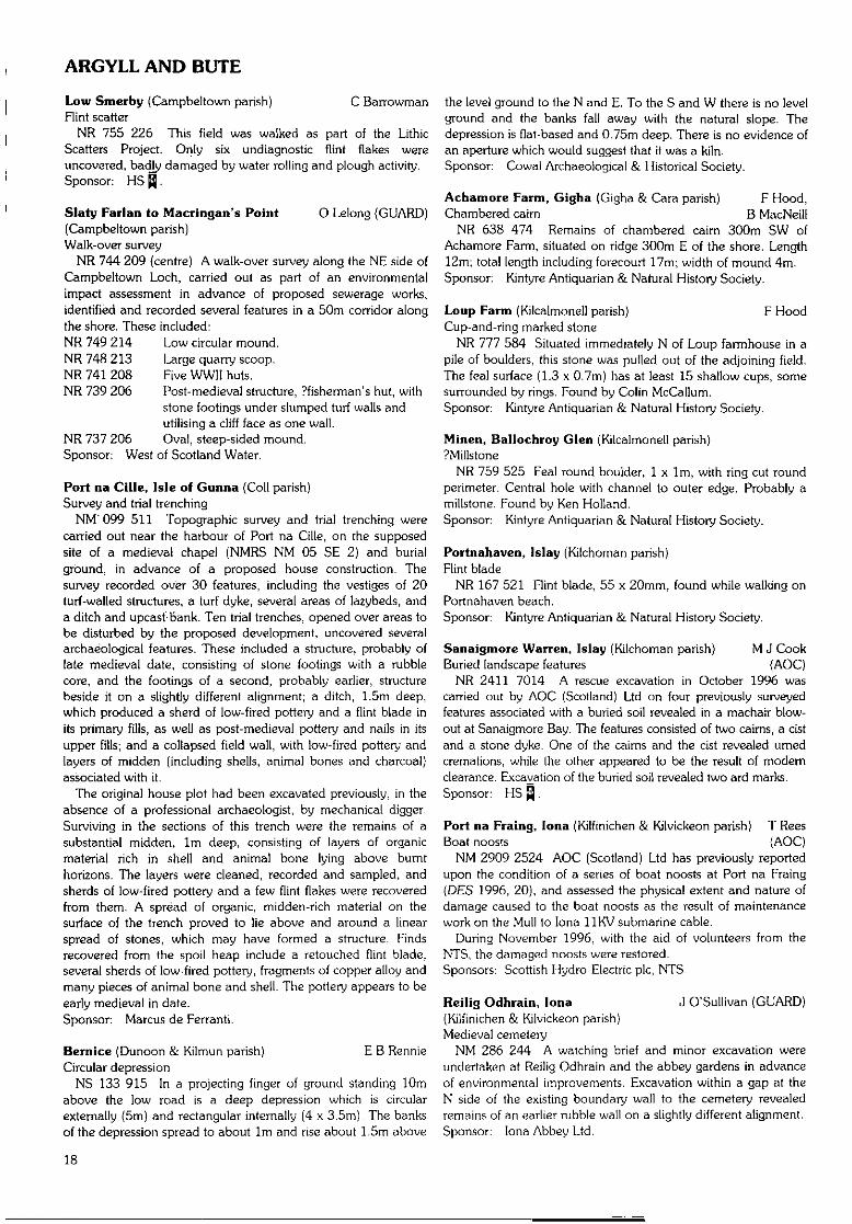
Galdrings, Machrihanish (Campbeltown parish) F HoodCarved stone
NR 625 203 Rounded stone with one feal surface (150 x90mm), with an eye (70 x 40mm) carved on it. In CampbeltownMuseum. Found by Walter Bel!.Sponsor: Kintyre Antiquarian & Natural History Society.
./
Fig 6 Galdrings, Machrihanish: stone with an eye carved on it.
17
ARGYLL AND BUTE
Low Smerby (Campbeltown parish) C BarrowmanHint scatter
NR 755 226 This field was walked as part of the LithicScatters Project. Only six undiagnostic flint flakes wereuncovered, badly damaged by water rolling and plough activity.Sponsor: HS ^.
Slaty Parian to Macringan's Point O Lelong (GUARD)(Campbeltown parish)Walk-over survey
NR 744 209 (centre) A walk-over survey along the NE side ofCampbeltown Loch, carried out as part of an environmentalimpact assessment in advance of proposed sewerage works,identified and recorded several features in a 50m corridor alongthe shore. These included:NR 749 214 Low circular mound.NR 748 213 Large quarry scoop.NR 741 208 Five WWII huts.NR 739 206 Post-medieval structure, Pfisherman's hut, with
stone footings under slumped turf walls andutilising a cliff face as one wall.
NR 737 206 Oval, sleep-sided mound.Sponsor: West of Scotland Water.
Port na Cille, Isle of Gunna (Coll parish)Survey and trial trenching
NM'099 511 Topographic survey and trial trenching werecarried out near the harbour of Port na Cille, on the supposedsite of a medieval chapel (NMRS NM 05 SE 2) and burialground, in advance of a proposed house construction. Thesurvey recorded over 30 features, including the vestiges of 20turf-walled structures, a turf dyke, several areas of lazybeds, anda ditch and upcast-bank. Ten trial trenches, opened over areas tobe disturbed by the proposed development, uncovered severalarchaeological features. These included a structure, probably oflate medieval date, consisting of stone footings with a rubblecore, and the footings of a second, probably earlier, structurebeside it on a slightly different alignment; a ditch, 1.5m deep,which produced a sherd of low-fired pottery and a flint blade inits primary fills, as well as post-medieval pottery and nails in itsupper fills; and a collapsed field wall, with low-fired pottery andlayers of midden (including shells, animal bones and charcoal)associated with it.
The original house plot had been excavated previously, in theabsence of a professional archaeologist, by mechanical digger.Surviving in the sections of this trench were the remains of asubstantial midden, 1m deep, consisting of layers of organicmaterial rich in shell and animal bone lying above burnthorizons. The layers were cleaned, recorded and sampled, andsherds of low-fired pottery and a few flint flakes were recoveredfrom them. A spread of organic, rnidden-rich material on thesurface of the trench proved to lie above and around a linearspread of stones, which may have formed a structure. Findsrecovered from the spoil heap include a retouched flint blade,several sherds of low-fired pottery, fragments of copper alloy andmany pieces of animal bone and shell. The pottery appears to beearly medieval in date.Sponsor: Marcus de Ferranti.
Bernice (Dunoon & Kilmun parish) E B RennieCircular depression
NS 133 915 In a projecting finger of ground standing 10mabove the low road is a deep depression which is circularexternally (5m) and rectangular internally (4 x 3.5m). The banksof the depression spread to about 1m and rise about 1.5m above
the level ground to the N and E. To the S and W there is no levelground and the banks fall away with the natural slope. Thedepression is flat-based and 0.75m deep. There is no evidence ofan aperture which would suggest that it was a kiln.Sponsor: Cowal Archaeological & Historical Society.
Achamore Farm, Gigha (Gigha & Cara parish) F Hood,Chambered cairn B MacNeill
NR 638 474 Remains of chambered caim 300m SW ofAchamore Farm, situated on ridge 300m E of the shore. Length12m; total length including forecourt 17rn; width of mound 4m.Sponsor: Kintyre Antiquarian & Natural History Society.
Loup Farm (Kilcalmonell parish) F HoodCup-and-ring marked stone
NR 777 584 Situated immediately N of Loup farmhouse in apile of boulders, this stone was pulled out of the adjoining field.The feal surface (1.3 x 0.7m) has at least 15 shallow cups, somesurrounded by rings. Found by Colin McCallum.Sponsor: Kintyre Antiquarian & Natural History Society.
Minen, Ballochroy Glen (Kilcalmonell parish)?Millstone
NR 759 525 Feal round boulder, 1 x 1m, with ring cut roundperimeter. Central hole with channel to outer edge. Probably amillstone. Found by Ken Holland.Sponsor: Kintyre Antiquarian & Natural History Society.
Portnahaven, Islay (Kilchoman parish)Flint blade
NR 167 521 Flint blade, 55 x 20mm, found while walking onPortnahaven beach.Sponsor: Kintyre Antiquarian & Natural History Society.
Sanaigmore Warren, Islay (Kilchoman parish) M J CookBuried landscape features (AOC)
NR 2411 7014 A rescue excavation in October 1996 wascarried out by AOC (Scotland) Ltd on four previously surveyedfeatures associated with a buried soil revealed in a machair blow-out at Sanaigmore Bay. The features consisted of two cairns, a cistand a stone dyke. One of the cairns and the cist revealed umedcremations, while the other appeared to be the result of modernclearance. Excavation of the buried soil revealed two ard marks.Sponsor: HS Q.
Port na Fraing, lona (Kilfinichen & Kilvickeon parish) T ReesBoat noosts (AOC)
NM 2909 2524 AOC (Scotland) Ltd has previously reportedupon the condition of a series of boat noosts at Port na Fraing(DES 1996, 20), and assessed the physical extent and nature ofdamage caused to the boat noosts as the result of maintenancework on the Mull to lona 11KV submarine cable.
During November 1996, with the aid of volunteers from theNTS, the damaged noosts were restored.Sponsors; Scottish Hydro-Electric pic, NTS.
Reilig Odhrain, lona J O'Sullivan (GUARD)(Kilfinichen & Kilvickeon parish)Medieval cemetery
NM 286 244 A watching brief and minor excavation wereundertaken at Reilig Odhrain and the abbey gardens in advanceof environmental improvements. Excavation within a gap at theN side of the existing boundary wall to the cemetery revealedremains of an earlier rubble wall on a slightly different alignment.Sponsor: lona Abbey Ltd.
18
ARGYLL AND BUTE
The Finlaggan Project D H Caldwell(Killarow & Kilmeny parish)Prehistoric artefacts and features; medieval structures
Cnoc SeanndaNR 3912 6848 Further to the exploratory work reported
previously (DES 1994, 53), limited excavation was undertakenon the top of this mound. It is hemispherical with a basediameter of over 50m and a height of over 5m above theadjacent ground. It consists of solid rock, metamorphic limestonewith the strata on edge.
The 'stone-lined trench' uncovered in 1994 was revealed as achamber about 4m long, 0.5-0.7m wide, and less than 1m deep,contained in a 6m long cut into the bedrock. It was lined on bothsides by large boulders and was finished at both ends with slabsof limestone prized from the mound. The two ends of the cutwere backfilled with sandy silt and fragments of limestone. Thecentral area of the chamber contained a deposit of peaty soil andrubble, apparently representing robbing of the original fill inantiquity. From it was recovered a pierced bone disc, identifiedas an Iron Age piece, possibly a toy, which may date the robbingof the chamber. A flint barbed-and-tanged arrowhead of BronzeAge type was found in sandy clay, possibly the undisturbed fil l ofthe chamber.
Adjacent to the chamber, but with no sure stratigraphicrelationship, is a small denuded kerb cairn. It is D-shaped withthe kerb of another cairn springing from its back. The kerb stonesappeared to be graded in size and height, with the largest on thesouthern segment, and the bedrock was cut back to take them.Within the kerb the surface was levelled up with clay. A darkerpatch in the centre may represent the location of a cremationburial, with an alignment of boulders on one side of it theremains of a burial chamber. It is clear, however, that the cairnhas been robbed. Small pieces of calcined bone and charcoalwere recovered from the disturbed gravelly material of the cairnsuperstructure and from the make-up deposits.
Extending over most of the area excavated, including thechamber and cairn, was a spread of gravel from which weregathered several hundred Mesolithic flints. This gravel deposit isinterpreted as robbed material from the cairn.
Eilean MorNR 3883 6811 Building C is a small rectangular structure, 7.3
x 6.4m, its N and S gable walls standing almost complete. It hasa ground-floor chamber and an upper storey contained in theroof space. The walls, of coursed random rubble in lime mortar,are obviously of more than one build. In its final form it isthought to be post-medieval in date, and to have been adwelling-house for someone of some status locally - perhapsDonald MacGillespie, crown tenant of Portaneilean (Finlaggan)in the 1540s.
There was limited excavation in 1993 in the interior inanticipation of conservation work on the walls, and in 1997 awatching brief was undertaken while rubble around the walls wasremoved so that this work could proceed.
It appeared that the earth floor(s) of the building had been dugout in previous unrecorded excavations, leaving only a make-updeposit of sandy, silty clay. This had had a trench partially sunkthrough it by the earlier diggers, and from material they haddisturbed was recovered a penny imitating one of Edward I ofEngland, class 9b, minted in London in 1299-1301. This coincan be assumed to have been lost prior to the end of the 14thcentury and can be considered, with due caution, to provide adate for the construction of the building.
In the course of cleaning the walls, horizontal beam slots werefound in the gables at the level of the wall heads, extending
inwards from the E for an unknown distance. Along with put-logholes in the lower gable walls these belong to the building'smedieval phase and may be evidence for an upper storeyprojecting out over the lower walls. Perhaps Building C wasoriginally constructed as the solar tower for the adjacent greathall, (o which it could have been connected at an upper level.
Eilean na ComhairleNR 3878 6802 In 1994 limited reconnaissance work by the
Scottish Trust for Underwater Archaeology demonstrated thepresence of medieval midden deposits on the side of the islandadjacent to Eilean Mor. In 1997 it was possible to sample these,thanks to the co-operation of the Army, particularly theEdinburgh OTC, in building a dam and pumping the water outfrom an area of about 80m . It is estimated that the midden may
o
spread over a total area of about 400rn . Refuse may havesettled here because this side of the island is sheltered. Thecauseway to Eilean Mor, and possibly a jetty, may have helpedto trap it.
The midden is sealed by gravel and iron pan. From the gravelhave been recovered medieval artefacts, perhaps mostly erodedfrom the island edge. They include two short cross pennies of thefirst half of the 13th century.
The midden was sampled in a number of small test-pits. It hadan organic, sandy, fibrous matrix, packed with considerablequantities of animal bone, hazelnut shells, and pieces of wood,including round wood, twigs and offcuts of worked timber.Sherds of pottery, leather shoes and a broken stone mortarconfirm its medieval (?12th-13th century) date.
This deposit had a maximum depth of 400mm before givingon to a layer of blocks and boulders, in which were two emptypost-settings. Excavation to deeper levels was limited but showedthat the stones sealed another organic-rich deposit, similar to theupper one, but with noticeably greater quantities of wood,especially withies, and pieces of peat. There was no apparentstructure to this but the stubs of three birch stakes wereencountered in situ. This woodwork, with the overlying stonelayer, probably represents the remains of an artificial platform,the date of which has still to be established. An earlier artificialplatform was represented by an underlying sequence of stonelayer, midden and wood-rich organic deposit, resting on thebottom of the loch.
A thorough programme of wet sieving, flotation and taking ofsamples for other environmental work was undertaken.Sponsors: National Museums of Scotland, Russell Trust,
Schroder Charity Trust, The Army, Society ofAntiquaries of Scotland.
Mulreesh Lead Mines (Killarow & Kilmeny parish) K SpellerLead mines (GUARD)
NR 402 685 Twelve pits were opened in connection with therefurbishment of overhead power lines across the remains of themine complex (see DES 1993, 66). They produced limitedevidence of archaeological remains; trackway make-up matrix;the upcast from the westernmost shaft; and garden soils relatedto nearby cottages.Sponsor: Scottish Hydro-Electric pic.
Upper Largic (Kilmartin parish) J TerryPrehistoric ritual and funerary complex
NR 832 993 A second season of excavation by ScotiaArchaeology Ltd in advance of quarrying on a gravel terrace tothe NW of the village of Kilmartin (see DES 1993, 75) revealed atimber circle, measuring 46m in diameter, and numerous otherfeatures relating to prehistoric ritual and funerary activities.
19
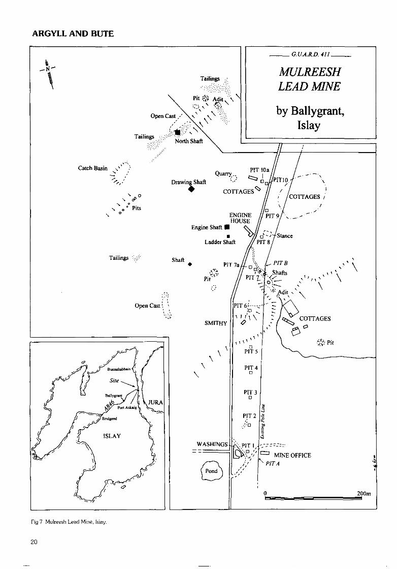
ARGYLL AND BUTE
MULREESHLEAD MNE
by Ballygrant,Islay
Open Cast / \\ \
/ /COTTAGES /\ / /
ENGINE / /PIT9/,HOUSE
Engine Shaft
Ladder Shaft
Fig 7 Mulreesh Lead Mine, [slay.
20
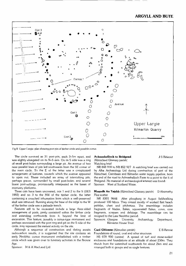
ARGYLL AND BUTE
Cist 3Qoo
Upper Largie
Kilmartin Quarry
Fig 8 Upper Largie-. plan showing post-pits of timber circle and possible cursus.
The circle survived as 31 post-pits, each 3-5m apart, andwas slightly elongated on its N-S axis. On its S side was a ringof small post-holes surrounding a large pit. An avenue of twonear-parallel lines of pits led southwards from the SE corner ofthe main circle. To the E of the latter was a complicatedarrangement of features, towards which the avenue appearedto open out. These included an array of intercutting pits,perhaps graves, surrounded by small post-holes; and severallinear post-settings, provisionally interpreted as the bases ofmortuary platforms.
Three cists have been uncovered, nos 1 and 2 to the S (DES1993) and no 3 to the NW of the timber circle, the lattercontaining a crouched inhumation from which a well-preservedskull was retrieved. Running along the base of the ridge to the Wof the timber circle was a palisade trench.
Features still to be excavated include a large three-sidedarrangement of posts, partly contained within the timber circleand extending northwards from it, beyond the limit ofexcavation. This feature, possibly a cursus-type monument andperhaps associated with the post-ring and pit on the S side of thecircle, may represent the earliest activity on the site.
Although a sequence of construction and dating awaitsradiocarbon results, it is suggested that the site contains anearly Neolithic cursus monument embellished with a timbercircle which was given over to funerary activities in the BronzeAge.Sponsor: M & K MacLeod Ltd.
Achnashelloch to Bridgend J S Rideout(Kilmichael Glassary parish)Watching brief
NR 848 918 to NR 852 927 A watching brief was carried outby Alba Archaeology Ltd during construction of part of theKilmichael, Cairnbaan and Kilmartin water supply pipeline, fromthe end of the road to Achnashelloch Farm to a point to the S ofBridgend. No material of archaeological interest was found.Sponsor: West of Scotland Water.
Monadh An Tairbh (Kilmichael Glassary parish) D AbemethyFlint scatter
NR 8301 9644 After ploughing in August fieldwalkingproduced 100 lithics. They consist mostly of worked flint beachpebbles, chert and pitchstone. The assemblage includesfragments of blades, flakes, rejuvenated flakes, cores, corefragments, scrapers and debitage. The assemblage can beassigned to the Late Neolithic period.Sponsors: Glasgow University Archaeology Department,
Kilmartin House Trust.
Caol Ghleann (Kilmodan parish) E B RennieFoundations of round, oval and other structures
NS 070 950 (centre) A spread of turf and stone-walledenclosures and foundations at an altitude of about 250m. Theystretch from the watershed southwards for about 2km and arearranged both in groups and as single features.
21
ARGYLL AND BUTE
NS 0718 9552 Round hut 9m overall; round mound 6.6 x5m; hut with cleit 5m expanding to 9m overall; boulder-enclosedrectangle 4.3 x 3.6m; pit 1.6m internally.
NS 0715 9530 Foundation, 6.3m diameter; turf walls 1.8mhigh attached to turf dyke and field enclosure, mound 3.7rn withcentral hollow 1.2m; house with cleit 4 x 5.3m expanding to7.2m to include cleit.
NS 0708 9476 Circular mound, 5m across with hollow ontop; oval found 4.3 x 3.9m; house with cleit 5m diameterextending to 8.9m to include cleit 4.9m; mound 5rn; moundedhut 6.2 x 5.6rn; foundation 5.9m diameter; pit 1.6m internally.
Additional finds include enclosures, circular foundations cllm, oval-foundations, pits, sub-rectangular turf foundations,and possibly three burnt mounds. (N of the watershed has notyet been surveyed.}Sponsor: Cowal Archaeological & Historical Society.
Bute Settlement Survey A Hannah(Kingarth; Rothesay; North Bute parishes)Deserted settlements and other structures
The survey has continued throughout the year, visiting sitesnot previously examined in detail, with special attention tocultivation remains including dykes and rig and furrow, and tothe placement of settlements within the landscape. An increasingproportion of older, possibly prehistoric sites is being observed.The following sites with structural remains have been added tothe list. For previous reports see DES 1994, 1995, 1996.NS 099 562 Glaick House; later industrial
use.Former farmstead.Round enclosures 30mdiameter.Small building withrounded ends.House, yard, fields.Three circular recessedplatforms.Small house.Oval drystone structure(?fank).Small house.Round structure belowdun; cultivationremains.Mound with sunkencentre.Small round structure.Small house, cultivationremains.
NS 094 641NS 061 605
NS'063 620
NS 063 618NS 001 691
NR 992 726NS 102 529
NS 081 600NS 035 641
RoselandBicker's Houses(near)Craw Hill S (2)
DrummorS Lenihuline Wood
Black FarlandPlan Oval
Barnauld GlenCastle Cree
NS 056 679 Edinbeg Wood
NS 052 685NS 060 611
Quarryburn KnoweKerryfearn Hill
Sponsor: Buteshire Natural History Society.
St Blanc's Chapel {Kingarth parish) G Ewart, D StewartWatching brief
NS 094 534 A watching brief was undertaken by KirkdaleArchaeology during masonry works on a small Early Christianchapel situated 25m to the SW of the main chapel of St Blane's.The walls and general area were photographed, and plans weremade. No finds were removed from the site.
A fuller report_has been lodged with the NMRS.Sponsor: HS ̂ .
South Bute (Kingarth parish) C BarrowmanLithic scatters
Fieldwalking on the S of the island uncovered lithic scatters aspart of the Lithic Scatters Project. Seven fields were walked,
lithics being found in four of them. The fields were walkedsystematically on a 20m grid. All finds were bagged andsurveyed onto the grid.Blackpark Plantation West
NS 088 557 (centre) One flint Hake, with slight retouch.Blackpark Plantation East
NS 093 555 (centre) Discrete pitchstone scatter uncovered onraised plateau at the SW corner of the field. Over 100 flakes andchunks were bagged and plotted. Concentration covered an areac 50 x 25m. Over 30 other lithics (flint and quartz) were foundacross the rest of the field. Future investigation by geophysicsand test-pitting is planned.Largizean
NS 085 552 Two waste flint flakes.Piperhall
NS 098 584 Flint core rejuvenation flake.Sponsor: HS Q.
Ardnahein (Lochgoilhead & Kilmorich parish) E B RennieEarly Christian enclosure
NS 205 931 A small enclosure which had been partiallywashed away by the Allt Reinain burn attracted the attention ofmembers of the Cowal Society. The enclosure was unlike thestructures of the adjacent deserted township of Ardnahein, andboth the enclosure and the township lay below the hill CnocReinain. The three 'Ninianic' names and the construction of theenclosure encouraged further investigation.
The damaged enclosure formed by contiguous uprightboulders is now U-shaped and measures 7 x 5m. It had twoentrances - one marked by an upright stone standing 0.8m high.It is set within a greater enclosure which is level, probablypalisaded, but bounded by natural banks and the Allt Remainburn. Within it and also surrounding the inner structure there isevidence of a further palisade.
The larger enclosure contains two diamond-shaped mounds ofsmall stones spreading to 2.5 x Irn. The larger one was kerbed.Within the smaller enclosure are two circular pavements of fist-sized stone about 2.5m in diameter. The best-preserved of thesecircles was scraped, revealing a central cavity with a flat beaten-earth floor 0.24m deep, and 2 x 1.5m. Within the cavity therewere four post-holes forming a near rectangle of 2 x 1m at the Nend and 2 x 1.2m at the S end. The post-hole in the NW cornerwas 0.4m deep. The cavity had been deliberately backfilled inmedieval times as two sherds of Throsk-type pottery wererecovered from the fill . Two more post-holes were found withinthe cobbling which overlay the floor of the inner enclosure.
The site is interpreted as belonging initially to the Ninianicperiod and as having been altered more than once in earlymedieval times, finally being abandoned as a sacred site in the16th century. The central enclosure is probably a graveenclosure; the cavity within the circle may be a reliquary grave;the spreads of stones are probably graves; the deep post-hole inthe cavity and the two in the cobbling may have held crosses ormarker stones.Sponsor: Cowal Archaeological & Historical Society.
Shieling Burn and Glen Luss (Luss parish) D Maclnnes,Pre- and post-Improvement agricultural remains A Bray (AGFA)
NS 306 928; NS 310 935 to NS 318 935 The shielings weresurveyed at 1:1000 and individual features at 1:100, as part ofan ongoing survey of Glen Luss.
Of particular interest is a series of recessed platforms atintervals on the N side of the glen. There are also the remains ofrectangular and sub-rectangular buildings and a mill lade.Sponsor: AGFA.
22
CLACKMANNANSHIRE/DUMFRIES AND GALLOWAY
St Mary's Chapel & High Street Well, Rothesay G Ewart,(Rothesay parish) D StewartExcavation
NS 0883 6454 Recording was undertaken by KirkdaleArchaeology during the removal of a capstone covering part of awell, situated on the outer bank of Rothesay Castle moat,towards the E end.
NS 0862 6367 Three trenches were excavated at St Mary'sChapel, a part-demolished 14th-century building adjacent toRothesay High Kirk. Two thresholds were uncovered relating toan original ground surface within the chapel. The materialoverlying the floor of the original chapel has been demonstratedto be later infilling, and could be removed without serious loss tothe archaeology of the site.
A fuller report_has been deposited with the NMRS.Sponsor: HS Q.
Dippen Bay (Saddell & Skipness parish) F HoodCarved stone
NR 801 364 Feal surfaced stone amongst pebble shore abovehigh tide mark. Surface has 9 shallow cups surrounded by acontinuous line. May be recent. Found by Mr and Mrs Hough.Sponsor: Kintyre Antiquarian & Natural History Society.
Guesdale Water (Saddell & Skipness parish)Shieling site
NR 758 352 Four shieling huts on either side of unnamedburn running S into Guesdale Water; in forestry.Sponsor: Kintyre Antiquarian & Natural History Society.
Saddell Abbey (Saddell & Skipness parish) J O'SullivanBuilding and topographic survey (GUARD)
NR 784 320 Surveys were made of the standing ruins andsurrounding cemetery at Saddell Abbey, Kintyre (NMRS NR 73SE 1). The ruins of this former Cistercian house are slight andwere found to be in an extremely unstable condition. Analysis ofsurvey data deduced that little primary masonry survivesamongst the upstanding remains.Sponsor: Hunter Marshall Bequest (Glasgow University).
Skipness Castle (Saddell & Skipness parish) G Ewart,Watching brief P Sharman
NR 9080 5777 A watching brief was carried out by KirkdaleArchaeology at Skipness Castle white a small hole was dug in theinternal courtyard to emplace a banister support for the stairleading up to the NE tower. No features or finds wereuncovered. _Sponsor: HS Q.
BalHemeanoch (Strachur parish) E B RennieProbable house sites
NS 103 999 Immediately E and within 200m of the motterecorded by RCAHMS (Argyll, Vol 7, item 113), there is anatural knoll with a circular platform, 10m in diameter, on theSW side facing the motte. On the NE side a rectangular platform,9 x 5m, has a flattened circular area 3m in diameter immediatelyabove it and an entrance path leading up to it from the N.Sponsor: Cowal Archaeological & Historical Society.
Creagan Darach (Strachur parish)Hillfort
NS 110 982 On a hilltop at an altitude of 115m, immediatelyN of Glenbranter and covering the narrow pass which carries theRiver Cur into Loch Eck, there is evidence of a much-denudedhillfort with annexes to the S and N. On the S end of the summit
there is also a monument to Queen Victoria which is marked onthe map.
Two outcrop ridges on the summit are enclosed within a lowearthen wall - across the S end this is an earthen mound 3.6mbroad and no higher than 0.2m; to the SW the mound fades to afaint terrace with a curvilinear line of rushes along the inneredge; the W side assumes the appearance of a slightly camberedterrace, and at the NW the mound is again evident - 3.3m wide.Across the N end and down the E side at the top of a steep slopethe rough ledge is fronted by stones although much slip hasoccurred, and at the foot of the sleep slope there is a large scatterof loose stones.
At the SE turn the edge stones continue beyond the limits ofthe enclosure. These swing to the S edge of the hill, where theylie at a maximum of 19m from the inner mound. Similarly at theN at a maximum of 18m from the inner enclosure a ridge oflarge stones and boulders form a limit. The SW and NE limits ofthe annexes appear to coincide with the sides of the innerenclosure.
The extent of the complete outer enclosure, including theannexes, is 73 x 40m. The inner enclosure measures c 46 x 40mwith the greater length running NW-SE.Sponsor: Cowal Archaeological & Historical Society.
CLACKMANNANSHIREDHall, PAshmoreBraehead, Cambus (Alloa parish)
Shell middenNS 869 937 The midden, 600m ESE of the golf clubhouse, at
the foot of a low bluff on a piece of waste ground owned by theBraehead Golf Club, was visited with Messrs J Pollock and AFinlayson of the club in September 1996. Recent soil borrowpitting had exposed a layer of oyster and other shells 0.3-0.4mthick on top of fine sand, to either side of a remaining knob ofthe slumped soil which had previously masked the layer. This soilmay have originated in run-off from the rig system visible on thegolf course, via a position further up the bluff overlooking thesite. A bulk sample of the shell layer was collected and thepossibility of further work is being considered.Sponsor: HS ̂ .
Gartarry Quarry (Clackmannan parish) M J Cook (AOC)Evaluation
NS 942 915 An archaeological evaluation was conducted in afield to the S of Gartfinnan Farm, to examine several possiblecropmarks and the village of Gateside, identified on Roy's 1750smap. Some 730m of evaluation trenches were machine-excavated. Two isolated shallow ditches were uncovered, butwere not considered to be archaeologically significant. A solitarypotsherd from one of the ditches does indicate some post-medieval activity in the area, possibly connected with Gateside.Sponsor: Miller Mining.
DUMFRIES AND GALLOWAYSolway coast M Cressey, R Toolis (CFA)Coastal erosion assessment survey
NX 160 306 to NY 327 669 A coastal erosion assessment ofthe N shore of the Solway Firth was undertaken on behalf ofHistoric Scotland. This project is one of several designed toassess the effects of coastal erosion on known and previouslyunrecorded archaeological sites lying within the intertidal zone. A50m wide inland corridor was surveyed at the same time toprovide background and context to the study.
23
DUMFRIES AND GALLOWAY
The survey, conducted in September and October 1996,examined the coast from the Mull of Galloway to the River Sarknear Gretna, a distance of just over 300km of coastline includingthe tidal reaches. The survey revealed around 50 previouslyunrecorded archaeological features, ranging from a possibleprehistoric burial cairn to WWII coastal defence works. Furtherevidence of the economic importance of the coast in the form ofabandoned fish traps and net stakes has been obtained.
The survey identified 334 sites, of which 118 were affected bycoastal erosion. Three sites, comprising the Mesolithic andmedieval sites at Redkirk Point (NY 302 650), Back Baypromontory fort (NMRS NX 33 NE 2) and Stairhaven harbour(NX 208 536), were studied in order to illustrate the range ofcoastal erosion processes affecting different sites.
A sandstone hammerstone was recovered from The Lake,Kirkcudbright Bay (NX 6812 4752), close to the findspot ofanother recorded hammerstone (NMRS NX 64 NE 32).
A full report will be lodged with the NMRS.Sponsor: HS £J.
Solway coast R ToolisForts survey
NX 216 522 to NX 996 577 A survey of the promontory fortsand cliff forts of the N shore of the Solway Firth was undertakento assess and accurately measure the extent of coastal erosion ofthis group of sites. The project was initiated during the course ofthe CFA coastal erosion assessment of the Solway coast inOctober 1996 and was completed in July 1997.
The project entailed the EDM survey of 17 sites, out of a totalof 24 situated on the Solway coast. While coastal erosionrecording formed the primary object of the survey, the extent oferosion caused by animals and visitors was also surveyed. Theresulting plans, in addition to forming a new corpus of plannedsites, will be used with the limited number of RCAHMS plans andthe 1st edition OS maps to measure the extent of erosion.
A full report of the survey will be lodged with the NMRS.Sponsors: CFA, Edinburgh University Archaeology Department.
Steven's Croft (Applegarth parish} O Lelong (GUARD)Excavation
NY 122 854 In advance of a proposed sawmill development,one trial trench was opened over a possible cropmark identifiedfrom aerial photographs, two in the vicinity of a known cropmarknear Millhousebridge (at NY 106 853; NMRS NY 18 NW 28),and two over low banks observed in a walk-over survey. Threeof the trenches were found to contain 19th-century drains, whiletwo were devoid of archaeological features.Sponsors: Dumfries and Galloway Enterprise Company,
Kronospan.
Botel Castle bailey (Buittle Castle) A Penman, E Cochrane(Buittle parish)Prehistoric site and early medieval bailey
NX 818 616 This ongoing excavation (DES 1996, 28-9), nowin its seventh season and staffed entirely by volunteers, and arunner-up in the 1996 Pitt Rivers awards, has uncoveredevidence of a permanent settlement during the Mesolithic era,temporary settlement during the Neolithic/EBA, and permanentIron Age/Romano-British occupation from the time of Agricola'sinvasion of Galloway in AD 82-84.
An assemblage of lithics has been excavated and a smaliRomano-British roundhouse has been uncovered, dated bypottery, two probe-type surgical instruments, a brooch and afaience melon bead. Some pre-medieval evidence has been
found in the excavation of several pits thought to have been usedin the processes of bleaching and tanning.
Further evidence for the existence of the medieval Royal Burghof Botel (1323/24} has been uncovered in the shape of a timberdouble concentric roundhouse, a rectangular timber building andnumerous stake-holes delineating burgage plots. The wallfootings of a stone building are currently being excavated andthe trench has yielded many artefacts including mint conditioncoins of King Edward I I I , a beehive thimble of the 13th/14thcentury, and the remains of a bronze-bound wooden box.
Excavations on the defensive perimeter of the S bailey of thesite have yielded evidence of a massive timber palisade to the Sand E, and to the N a deep fosse was constructed by quarryingthrough the local greywacke bedrock to form a U-shaped ditchwith a stone wall to the S and an abatis to the N. These weredismantled and tumbled into the fosse in antiquity, dated bypottery recovered from the rubble. Written evidence supports thedismantling of the castle in 1313 by King Robert Bruce.
Several items from this excavation have been declaredTreasure Trove (TT 45/94) and have been allocated to theStewartry Museum, Kirkcudbright.
Monreith (Glasserton parish) J PickinPolished stone axe
NX 361 409 A polished stone axe was found during buildingoperations and reported lo Stranraer Museum. The axe is a localgreywacke and measures 84 x 241mrn. It has a partially facetedburl, a broad convex blade and the sides are unfaceted withsharp edges.
The axe, which is undamaged and in a remarkably freshcondition, was discovered as topsoil was being removed. It wasresting against a bedrock outcrop and may have beendeliberately deposited.
Claimed by the Crown as Treasure Trove and allocated toStranraer Museum (Ace No 1997.22).
Ingleston Motte (Kelton parish) A Penman, E Cochrane12th-century rnotte
NX 774 579 The site is being examined due to severe rabbitburrowing erosion problems. The site was disturbed when anRAF aircraft crashed only two fields away from the excavation. In1891 the dimensions of the motte were recorded as 23 x 16m,but in 1980 this had been reduced to 21 x 13m.
A 4m square trench was opened on the NE quadrant of thesummit where no previous excavation had taken place, andploughsoil was removed to a depth of 0.5m. Sherds of yellow-green glazed pottery, iron nails and some charcoal wererecovered. A quantity of amethyst was also found, the use ofwhich is not clear at this time.
Extensive evidence of burning was present and it is deducedthat a timber tower surmounting the rnotte was burnt down inantiquity. The written sources lead us to believe that thisoccurred in 1185 when Roland of Galloway invaded andreoccupied his patrimony on the death of his uncle, Gilbert,murderer of his father.
The archive from this ongoing excavation is to be depositedwith the Stewarlry Museum, Kirkcudbright.
Threave Estate (Kelton; Crossmichael; G Ewart, A DunnBalmaghie; Buittle parishes)Archaeological survey
NX 7529 6041 An archaeological baseline survey wasundertaken by Kirkdale Archaeology on the National Trust forScotland Threave Estate in June 1997. The vast majority ofarchaeology recorded in the survey could be dated to the past
24
DUMFRIES AND GALLOWAY
two centuries, characterised by the intensive use of the area forcattle raising, and by low-level industrial archaeology andcommunications routes. The few traces of pre-industrial/pre-improvement archaeology included the possible prehistoricsettlement site on top of Meikle Wood Hill, the find of apotentially pre-Iron Age saddle quern in a water feature, the sitedescribed as a 'native' settlement enclosure on Lodge Island, andpotentially the few instances of rig and furrow recorded near tothe farms. By far the most commonly encountered sites were theremains of field boundaries, recorded where they either underlaymore modem boundaries, or where they followed a different linefrom the modern boundary- The historically documentedLeveller's Revolt of the early 18th century, after which most ofthe enclosures were erected, gives a terminus post quern for thiselement of the Threave landscape, and the very close correlationbetween the 1st edition OS map, surveyed in 1848-9, and themodern pattern of enclosure indicates the success and relativepermanence ofjhis late 18th and 19th-century landscape.Sponsors: HS Q , NTS.
Gipsy Point (Kirkcudbright parish) J G ScottBrandy hole
NX 70 44 (approx.) A brandy hole, possibly 200 years old,was found in 1995 c 2km E of Gipsy Point at DundrennanCamp. A rectangular manhole, c 2rn deep and c 35 x 55crn insize, gives access to a straight passage-like trench c 2m long, c55cm wide and c 1.5m in height. The bottom end of themanhole is a vertical rock face, but elsewhere construction is ofwell-preserved quarried drystone bonded with clay, the passageroofed with stone slabs. A flagstone, now missing, is said to havecovered the manhole. There were no diagnostic finds.Photographs in possession of Kirkcudbright Training Area.NOTE: Dundrennan Carnp is a restricted area, not open to thepublic. Permission for entry must be sought from theCommandant.Sponsor: Kirkcudbright Training Area.
Cogrie (Kirkpatrick-Juxta parish) J BrannCauseway
NY 1091 9711 Strengthening works to the railway viaductover the River Annan S of Cogrie Farm in early 1996 caused achange in river currents. Approximately 8m downstream fromthe viaduct a 3m wide causeway was exposed in the river bed.The water level at the time was relatively low and the riverconfined to its main channel, rather than its wider course. Thecauseway is built of dressed sandstone blocks, mainly red, andappears to have "grooves' or "drains' at each side. It was visiblefor a length of some 4m projecting from the northern bank. Thismay be a feature connected with the building of the viaduct. TheRoman road through Annandale is also recorded in the locality.Sponsor: Dumfries and Galloway Council.
M off at (Kirkpatrick-Juxta parish} J S RideoutRoman road
NT 074 051 Construction of a water supply pipe to the W ofMoffat necessitated excavation, by Alba Archaeology Ltd, of thescheduled Roman road on Moffat Golf Course af the point wherethe road leaves the rough and enters Chapel Plantation. Theroad survived as a thin single layer of small to medium sub-rounded to sub-angular stones in a loam and clay silt matrix upto 7cm deep. The original topsoil had been stripped before theroad was built. A trench 1450m to the NNW did not locate anyroad remains.Sponsor: West of Scotland Water.
Paddy's Rickle Bridge to Johnstonebridge J S Duncan,(Kirkpatrick-Juxta; Johnstone parishes) S Halliday (GUARD)Watching brief
From July 1997 GUARD was commissioned to undertake awatching brief of all topsoil stripping during the upgrading of theA74 to motorway status. The area under investigation comprisedtwo sections: the N section ran southwards from Paddy's RickleBridge to Beattock for 17.3krn, and the S section from Beattockto Johnstonebridge for 11.5km. A number of sites wereidentified, excavated and recorded. Although the work iscontinuing, the results to date were as follows (see also SouthLanarkshire, Crawford parish):
(Kirkpatrick-Juxta parish)Coatsgate
NT 059 058 A rough slone culvert drain was recordedperpendicular to the railway, with which it is assumed to becontemporary.Beattock medieval site
NT 083 026 The continuation of the drystone structureexcavated in 1994 was recorded and found to follow the exactline plotted by geophysics.Beattock Roman Camp
NT 084 020 A well, found to be modern, was excavated in thecentre of the camp. No other archaeological features were noted.Palaceknowe
NT 087 006 A well and rectangular building foundations thoughtto be related to a farmstead which was demolished in 1984.Comb Rig North
NY 101 980 The remains of a possible structure were notedcomprising a circular slot trench of minimal depth and a thincharcoal spread within the interior.Comb Rig South
NY 101 976 A large pit filled with a charcoal-rich matrix wasexcavated and thought to be the possible dumped remains of ahearth. No small finds were retrieved.
(Johnstone parish)Woodend Farm
NY 105 952 The majority of the internal area of an Iron Ageenclosure was excavated by GUARD in 1994. However, duringthe watching brief the remains of two circular structures wereobserved outside the enclosure. Both were severely truncated,although the remnants of a possible occupation layer was presentinside one structure.
A third circular structure was observed inside the enclosurewithin an area which was not excavated in 1994 due to flooding.Several worked stones were recovered from inside and outsidethe enclosure along with an iron object, which may be a form of'currency bar'.Cleuchbrae burnt mound
NY 1020 9332 An area of fire-cracked stones and charcoalwas discovered in a small area of low-lying ground at thejunction where two small streams converge.
Rescue excavation showed that very little of the mound wasupstanding although the trough presented excellent preservation.At the base of the trough a large oak baulk was recovered,measuring 3m long and 0.8m wide. The remains of in situ stakeswere also found. No artefacts were recovered.Sponsor: HS (Q.
Lochmaben Castle (Lochmaben parish) J BrannWatching brief
NY 081 822 In October 1996 a hole measuring 0.8m E-W by0.75m N-S was excavated in order to erect an informationboard on the N edge of the car park to the N of the castle.
25
DUMFRIES AND GALLOWAY
Excavation of topsoil and loose stone stopped at a depth of 0.8mat which point archaeological levels were encountered. Thesurface exposed comprised three level sandstone blocks alignedE-W set in a matrix of charcoal-rich orange-brown clay.Sponsor: Dumfries and Galloway Council.
Creebank, Bargrennan (Minnigaff parish) C Lowe (HAL)Pre-afforestation survey
NX 340 775 (centre) A short-notice pre-afforestation surveywas undertaken by Headland Archaeology Ltd of 2.4km of landat Creebank. The survey area comprised two adjacent lots, to theE and W of the Newton Stewart to Barrhill road. The survey wasintended to provide an enhanced record of an earlier surveyundertaken by the Biggar Museum Trust (DES 1996, 32}.
A total of 20 sites or groups of sites were recorded during thecourse of the survey, plus tracks. These principally comprisedextensive cairnfields, field banks and enclosures in the easternsurvey area. The western area was dominated by the remains ofstructures and features associated with medieval or later ruralsettlement. Two possible hut circles were identified; four burntmounds and a substantial penannular enclosure, possibly anenclosed cremation cemetery, were also located.NX 3490 7715 (centre) Rectangular structure, lynchet and bank.NX 3490 7745 (centre) Field banks and clearance cairns.NX 3468 7753 Burnt mound.NX 3515 7770 (centre) Settlement and field system: ?hut circle;
large sub-rectangular cairn; enclosure,field banks, clearance cairns, rig andfurrow; rectangular building.
NX 3470 7800 (centre) Settlement and field system: ?hutcircle; field banks, lynchets, clearancecairns, rig and furrow; groups ofclearance cairns; rectangular structure.
NX 3448 7799 Quarry.NX 3456 7768 Quarry.NX 3450 7750 (centre) Cairns and lynchet.NX 3430 7720 (centre) Clearance cairns, lynchet, rig and
furrow, field banks.NX 3425 7750 (centre) Linear clearance, enclosures, clearance
cairns and quarry; enclosures; quarry.NX 339 777 (centre) Settlement and field system; Bargrennan
farmstead; linear clearances, clearancecairns, rig and furrow; quarry; fieldbanks; rectangular building.
NX 333 780 (centre) Settlement and field system:Glengruboch farmstead; limekiln;rectangular building; field banks,clearance cairns, rig and furrow;enclosure and two rectangularstructures; ?rectangular structure.
NX 3300 7810 (centre) Rectangular buildings and enclosures.NX 3321 7822 Burnt mound.NX 3313 7805 Burnt mound.NX 3324 7813 Penannular enclosure.NX 3338 7741 Enclosures.NX 3351 7725 Burnt mound.NX 3347 7719 Standing stone.NX 3350 7717 (centre) Field bank and clearance caims.
The various cairnfields, together with the possible hut circlesand the fragmentary lengths of dykes, would appear to representthe vestigial remains of prehistoric settlement in the area. Theburnt mounds and the possible cremation cemetery probablyalso form part of Ihe prehistoric palimpsest.
A full report has been lodged with the NMRS.Sponsor: HS Q.
Dundrennan Abbey (Rerrick parish) G Ewart, J TviscottExcavation and clearance
NX 7492 4750 Following the removal of the boundary wallbetween the previously public area of the monument and theexcavations in the old stable yard to the S, Kirkdale Archaeologywas engaged in July 1997 to supervise and conduct the removalof material so as to allow visitor access between the two areas.
Although the level of excavation carried out was minimal it hasserved to show both the probable survival of archaeologicaldeposits at shallow depth in the old public access area, and thefurther complexity of the structures comprising the S range.Sponsor: HS Q.
Sorbie Old Tower (Sorbie parish} P Harrington12th-century rnotte and 16th-century tower house
NX 451 469 In May 1997 a watching brief was conducted ofa machine-excavated foundation and soakaway trench for anextension at the rear of Sorbie Tower cottage. The fill(s) andouter edge of the motte ditch along the E side of the mound ofthe motte were exposed at a truncated level in the bottom of themain trench at the SW end. The curving line of the outer E edgeof the ditch was recognised in the natural red boulder claybottom of the trench; the motte ditch on the SE side of themound is estimated to be c 7.5m wide at the top level of theouter side of the ditch.
The NW section of the trench suggested that there may havebeen clay and possibly stone used to line or construct a latephase of the E wall of the ditch. More information suggests that afilled hollow, 1.7m wide, in the outside upper edge of the ditchmay have been the back side of a counter enscarpment-likeconstruction of an earlier wider phase of the ditch. This suggeststhat there may have been a bank outside of the ditch on the Einitially. It is also thought that the traditional access across theditch to the top of the motte was from the NE side of the ditch.
Three finds were found in the fill of the motte ditch: a frilledbase sherd (two joining); abraded green glaze; ?14th century, ormore likely of early post-medieval date. A sherd; abradedgreen/brown glaze; most likely of 14th-century date. Bottle glass;short neck with string rim fragment; dark green globose bodytype wine bottle of c 1698 date.
The excavation cut into a small area of the 1996 geophysicalsurvey of the site, which has influenced the above interpretation.
A fuller report has been deposited with the NMRS.Sponsor: Sorbie Tower Conservation Project Committee of the
Clan Hannay Society.
30-32 George Street, Whithorn (Whithorn parish) J BrannMedieval burgh watching brief
NX 446 402 An inspection of foundation trenches excavatedfor an extension to the rear of 30-32 George Street did notreveal archaeological deposits. The garden to the E of theproperty is at least Irn higher than the street level at which thehouse, formerly an abattoir, is built. The owner believes thattopsoil has been imported in the past to raise the garden levels.He has not noted any pottery or other finds of interest. Thehouse itself which was gutted back to the walls shows variousstructural phases.Sponsor: Dumfries and Galloway Council.
Carsegowan (Wigtown parish) S Carter (HAL)Pre-afforestation survey
NX 428 595 (centre) A short-notice forestry survey wasundertaken by Headland Archaeology Ltd of the formerWigtown blackpowder works. The works operated from 1940until 1945, when it was closed down and all machinery removed
26
DUNDEE CITY/EAST AYRSHIRE
from the site. The site has remained more or less unaltered sincethat time and most brick, concrete and earth structures survive. Aphotographic record of these structures was compiled and a copyhas been deposited in the NMRS.Sponsor: HS Q.
26 South Main Street, Wigtown (Wigtown parish) J BrannMedieval burgh watching brief
NX 432 552 Observations were made to the rear of 26 SouthMain Street where an extension had been removed, leaving anopen trench about 18m N-S by 8m E-W, and 1-1.4m deep.
It is concluded that an outcrop of natural bedrock had beenquarried away to a depth of c 1m below current ground level toprovide both space and material for building in the post-medieval period. A fragmentary layer which had escaped thislevelling at the N end of the trench contained a sherd ofmedieval pot. The top of this layer was about 0.6m belowcurrent ground level. To the N this layer appears to have beenremoved by the construction of 26 South Main Street itself.
Full report lodged with the NMRS and Dumfries and GallowaySMR.Sponsor: Dumfries and Galloway Council.
DUNDEE CITYLand W of East Port, Cowgate (Dundee parish) R CachartMedieval frontage and backlands (SUAT)
NO 4059 3070 In November 1996 SUAT undertook anarchaeological assessment in which two trenches were excavatedand 19th/20th-century surfaces, wall foundations and depositswere encountered. A make-up deposit containing residualmedieval pottery was also found. It was concluded that acombination of quarrying and 19th-century development hadremoved any medieval archaeological deposits that may haveexisted, and that extended excavation on the site was thereforenot justified.Sponsor: Beech Property Co Ltd.
152-154 Nethergate (Dundee parish)16th-century hospital and town defensive wall
NO 400 299 Initial trial excavations in June 1996 (DES 1996,34) prior to demolition had failed to identify any remains of themedieval hospital or town wall.
In early November 1996 a watching brief on the former garagefrontage for the removal of petrol tanks revealed that much ofthe frontage had been disturbed by 19th/20th-century building.
In November 1996 five machine-dug trial trenches in thebacklands revealed a substantial raising of the ground surface inmodern times. At the rear of the site the original ground surfacewas not reached. Interestingly, the deposits used to raise theground level were imported and contained a substantial amountof human bone and some residual medieval pottery, indicatingthat the source was probably a medieval burial groundsomewhere in the city. No tangible archaeological remainsrelating to the town wall, the hospital or the almshouse wereidentified.
As a result of the watching brief and trial work it was decided'that a programme of full archaeological excavation was notrequired. However a watching brief on the contractor'sgroundworks was maintained. In January 1997 the watchingbrief on 12 contractor's trenches again confirmed the lack ofrelevant archaeological survival but did reveal the existence of adeeply buried former ground surface in part of the backlands.
The original fabric on the inner face of the W boundary wallon the site frontage (the possible town wall) was revealed and
various features were recorded (plasterwork and an aumbry).The standing wall most likely dates from the late 18th or theearly 19th century. However, large foundation stones at the basecould be from an earlier wall, possibly the original town wall.Also revealed was a deep well below a wall that abutted themain standing wall. Over the well was a lintel dated 1721. Partof a cobbled surface was also revealed, !t is hoped that thestanding wall, well and cobbled surface can be preserved andintegrated into the new development.Sponsor: Dundee City Council.
EAST AYRSHIREThe following sites in East Ayrshire have been identified and
recorded during fieldwork carried out by the staff of WoSAS. Fulldetails are available in the WoSAS SMR.
(DalmelUngton parish)NS 4968 0816 Fox Park Enclosure.NS 41751167 Polnessan Farmstead.
(New Cumnock parish)NS 6409 0547 Craig Burn Sheepfold on earlier structures.NS 6400 0556 Craig BurnNS 6380 0592 Craig BurnNS 6439 0475 Craig BurnNS 6306 0614 Slippery
Burn
(Riccarton parish)NS 4675 3444 Bo who use
(centre)
Structure.Structure.Structures; ?shieling hut.Sheepfold; enclosure;?structure.
Cropmark ?enclosures.
Chalmers ton North and Pennyvenie G MacGregor{Dalmellington parish) (GUARD)Archaeological assessment
NS 492 068 An archaeological assessment was undertaken ofthe proposed development area at Chalmerston North andPennyvenie. This established that there are several areas withsignificant archaeological remains, the majority relating to thecoal mining industry of the area. Much of the mining activity wasundertaken by the Dalmellington Iron Company Ltd to providefuel for Dunaskin Ironworks. Also within the assessment area arethe remains of several post-medieval settlements.
Full details of individual sites are within a report which will belodged at the NMRS.Sponsor: Scottish Coal Ltd.
Pennyvenie (Dalmellington parish)?Ring cairn
NS 494 072 Archaeological evaluation of a mound within theproposed opencast coal extraction site known as PennyvenieArea A proved the feature probably to represent a later Neolithicor Early Bronze Age ring caim. A scheme for furtherarchaeological work to ensure the preservation of the putativering cairn in situ and any associated archaeological features inthe immediate vicinity was therefore instigated. During awatching brief in the vicinity, the only archaeological feature tobe investigated was a field bank.
Full details are in a report which will be lodged at the NMRS.Sponsor: Scottish Coal Ltd.
Broom Hill (Dalrymple parish) C McGill (CFA)Opencast coal site
NS 4283 1390 An archaeological excavation was undertakenduring August 1997 at High Knockshinnoch, Broom Hill, in
27
EAST DUNBARTONSHIRE
combination with the recording of several monuments inadvance of opencast coal mining. The present project comprisedthe complete recording and trial excavation of HighKnockshinnoch farmstead and the recording of the disusedrailway and railway bridge (NS 425 142). Five additionalindustrial monuments were recorded by photographic survey.
The main structure at High Knockshinnoch was cleared ofvegetation and rubble and then recorded. Surviving featuresincluded a hearth, situated in a niche on the E wall of thestructure. The floor was partly cobbled, giving the appearance ofa central aisle running along the structure's E-W axis. Thecobbles were laid on the level surface within the structure,formed of built-up layers of blue/grey and brown clay. On eitherside of this there were indications that planking had overlain thelevel clay surface, with both patches of rotten wood and lines ofrusted nails occurring regularly. There was a doorway on the Nfacing side of the structure with a cobbled area outside,extending to the W. A section through the structuredemonstrated that it was founded directly on bedrock with nounderlying features. Additional trenches sectioned featuresdelimiting the two enclosures associated with the structure. Thelarger enclosure was formed from a combination of stone dykeand upcast earth bank. The small inner enclosure was delimitedby a shallow ditch and a broken band of trees.
Finds include pot and glass sherds, and many corroded metalartefacts. All finds are recent, dating from the late 19th/early 20thcentury. Detailed reports will be lodged with the NMRS.Sponsor: Coal Contractors Ltd.
Spireslack (Muirkirk parish) M Cressey, W L Finlayson (CFA)Evaluation
An archaeological desk-based assessment and field inspectionwere undertaken in February 1996 to evaluate thearchaeological remains within an area of landscape proposed foropencast coal mining. The results suggest that the area hassignificant archaeological potential even though the landscapehas been heavily modified by modern coal extraction. A complexof sites relating to 18th-century iron and coal manufacture waslocated at Glenbuck. There are also substantial remains fromlime production represented by quarries and limekilns.
In addition to areas of rig and furrow, the following sites andmonuments were recorded during the evaluation:NS 751 294 Cottages ('Rowan Bank1).NS 7508 2949 Glenbuck Ironworks Furnace.NS 7515 2915 Shafts.NS 7505 2909 Limestone quarry.NS 7475 2912 Pits.NS 74852925 Bell-pits.NS 7515 2937 Bell-pits.NS 7562 2993 Bell-pits and shaft.NS 7560 2995 Sheepfold.NS 7545 3000 Field enclosure.NS 7605 3100 Field wall.NS 7595 3115 Coalpit.NS 7585 3115 Coalpit.NS 7530 3100 Sheepfold.NS 7567 3043 Building platform.NS 7540 2950 Trackway.NS 7570 3040 Tramway.NS 7575 3050 Galawhistle Pit.NS 7579 3008 Davie Pit.NS 7580 3100 Glenbuck branch line.NS 7557 3000 Quarry pit.NS 7450 2988 Grasshill Coal Pit No 1.NS 7455 2960 Grasshill Coal Pit No 2.
NS 7430 3030 Field wall.NS 7425 3020 Limekiln.NS 7432 3020 Corn-drying kiln.NS 745 305 Field bank.NS 7420 3040 Limekiln.NS 7434 3015 Building.NS 7465 2945 Glenbuck village (part of).NS 7475 2985 Spireslack farm.NS 7450 2954 Miners cottages.NS 744 300 Coal tubs (as stream revetment).
A report has been produced, and will be deposited with theNMRS at a time to be agreed with the sponsor.Sponsor: Scottish Coal Ltd.
Hurlford, by Kilmarnock (Riccarton parish) K Speller,Armaments factory C French (GUARD)
NS 466 349 A field and desk study of the WWII munitionsfactory at Bowhouse (constructed 1939} produced a wealth ofinformation on the site and its workings.
The desk study, using both written and oral sources, allowed adetailed history of the site to be compiled. Particular emphasiswas given to the incendiary bornb production phase, asBowhouse was one of only two such production centres in theBritish Isles during WWII.
Site descriptionThe factory covers an area of c Ikrn by 400rn. The W part of
the site contains the administration buildings, incorporating an18th-century farmhouse. Skirting the N perimeter are the loadingand unloading warehouses. The bulk of the site contains heavilyfortified production buildings and packing houses, turfed over forcamouflage purposes, each with its own blast bank and air-raidshelters. The whole complex was served by an internal railwaysystem, linking to the main Kilmarnock to Carlisle railway line,which passes close by the site.
Site phasing1 The period of bomb construction, 1939-45.la The addition of buildings to the E end of the site, c 1941.2 Use of the site as a bomb dismantling site, 1950s.3 Use of the site as a depot, 1950s-1968.4 Subsequent non-military uses (horse and greyhound
stables, small workshops), 1969- present.Fuller report lodged with the NMRS.
Sponsor: Scottish Prison Services.
EAST DUNBARTONSHIREThe following sites in East Dunbartonshire have been identified
and recorded during fieldwork carried out by the staff of WoSAS.Full details are available in the WoSAS SMR.
(Campsie parish)cNS 6247 8166NS 6274 8155
Newhouse BurnNcwhouse Burn
(New Kilpatrick parish)NS 5654 7122 Tcmplehill Wood
?Enc!osure.Shieling hut.
? Enclosure.
K Speller (GUARD)Antonine Wall (New Kilpatrick parish)Evaluation
NS 535 724 An evaluation within a proposed house plot at 18Ballaig Avenue, Bearsden, revealed the N edge of the main ditchof the Antonine Wall surviving as a plough-truncated featurerunning E-W through the plot at its S frontage, at a depth of0.95m below the modern surface. No remains of archaeologicalsignificance were encountered to the N of this feature.Sponsor: Mr R Ross.
28
EAST LOTHIAN
Douglas Park Golf Course, Bcarsden S Halliday (GUARD)(New Kilpatrick parish)Roman wall
NS 5576 7241 In May 1997, GUARD were commissioned toexamine an area of ground surface damage within a scheduledarea relating to a stretch of the Antonine Wall.
A 2 x 2m trench showed that the rutting had been within anarea which had been built up over the years with dumps ofmodern debris to a depth of 0.7rn.Sponsor: HS Q.
EAST LOTHIANG EwartDirleton Castle (Dirleton parish)
Watching briefNT 5152 8386 The excavation, by Kirkdale Archaeology, of
service pipe trenches were cut through well-worked humic soil,with a distinctive brown (clay-rich) character. This deposit wasclearly introduced, and may well reflect the terraces thought tohave been created during the 16th-century formal privy gardenphase, still in evidence within the parterre and yew-tree planting.This is confirmed by the fact that the deposit underlay the 18th-century estate/garden wall (Archerfield House). The depth of theearthwork was uncertain, but it clearly projected beyond thelimits of the garden area as defined by the 18th-century wall.
Recent excavations in the N and W gardens confirmed thepresence of a complex post-medieval layout beneath thelandscaping of the 18th and 19th centuries. The landscaping hadserved to reduce the originally steeper earthworks of the earlierlayout. _Sponsor: HS ^.
Dunbar Day Centre, Westgate N M Robertson (SUAT)(Dunbar parish)Medieval burgh
NT 678 791 A watching brief in August 1997 on the diggingof foundation trenches for an extension to the rear of DunbarDay Centre, in what was previously its small walled back garden,failed to find any deposits of archaeological significance. Part ofthe site had already been disturbed by services, and the threefoundation trenches measured only 0.7m across and a maximumof 0.75m below present ground level. The trenches were cut to adepth of c 0.55m through a make-up deposit of garden soilmixed with building rubble, from which came a small number ofrecent finds. Below this was a compact dark brown garden soilcontaining very small pebbles and flecks of charcoal. The lack oflarger stones in this soil might suggest that it, too. was importedonto the site; no small finds were recovered from it.Sponsor: East Lothian Council.
Golf Course Road, Dunbar (Dunbar parish) T Rees (AOC)Archaeological evaluation
NT 685 784 Proposals for the construction of housing on asmall plot of land to the N of the Roxburgh Hotel led to anarchaeological evaluation of the ground in January 1997. Nosignificant archaeological deposits were found.Sponsor: McLay Milne Associates.
5-7 High Street, Dunbar (Dunbar parish) G RobinsUrban redevelopment (for AOC)
NT 6808 7871 A desk-based assessment and a trial trenchingprogramme were conducted in February 1997 in advance ofredevelopment. Although the site lies outwith the probabledefences on the SW aspect of the town, evidence was sought formedieval and post-medieval extra-mural settlement and land-
use. The desk-based assessment resulted in no new evidence forsuch settlement or land-use, and the trial trenches revealed onlyanthropic deposits of a recent origin overlying natural sediments.Sponsor: Developer.
Al Cement Works to A1087 (Innerwick parish) A R ReesWatching brief (CFA)
NT 7045 7610 to NT 6990 7650 A watching brief wasconducted during topsoiling operations between the cementworks and the A1087 in March 1997 (see also DES 1994, 45).No archaeological features or deposits were located.Sponsor: The National Roads Directorate of The Scottish Office
Development Department; managed on their behalfby HS |.
Loretto School, Musselburgh (Inveresk parish) R Cachart,Medieval burgh lands and chapel D Perry (SUAT}
NT 3479 7295 In April 1997 SUAT undertook a siteassessment in advance of the erection of a new library andteaching block at Loretto school. The site lies between LinkfieldRoad to the S and Millhifl to the N, within the medieval burgh'slands, close to the site of the Loretto Chapel.
Three trenches were excavated within the footprint of the newbuild. A hard black sandy clay layer which occurred in all threetrenches above natural was possibly the remains of an 18th or19th-century courtyard, probably truncated when hardcore waslaid down as a firm base for the present grassy surface. In alltrenches natural sand and beach cobbles occurred at 0.3m belowthe black sandy clay- A field drain comprising a rubble-filled cutwas also found. The assessment found nothing of archaeologicalsignificance and no further work was required.Sponsor: Lorerto School.
35-41 Market Street, Musselburgh S Carter (HAL)(Inveresk parish)Evaluation
NT 3396 7262 An archaeological evaluation was undertakenof an area of land formerly occupied by Nos 35-41 on the Nside of Market Street. This work was completed as a part of theconditions to a planning consent granted by East LothianCouncil. Analysis of maps showed that the site frontage wasoccupied by a building from at least 1788 up to c 1960. No traceof this building, or any preceding structures, remains and it isconcluded that no substantial foundations were ever used.Sponsor: Johnston & Stewart, Architects.
St Michaels, Inveresk (Inveresk parish} J Hamilton (CFA)Roman fort
NT 3430 7197 An archaeological evaluation was carried outin November 1996 within the grounds of St Michaels House inresponse to a proposal to construct a domestic dwelling acrossthe southern alignment of the rarnpart and external ditch of theRoman fort. Previous archaeological work had located the ditchsome 10-15m W of the current excavations and had suggestedthat in the evaluation area all upstanding remains of the Romanoccupation had been totally removed and that no ditch existed.
Three parallel trenches were opened within and immediatelyadjacent to the site of the proposed building. No traces of thedefences of the Roman fort were identified; the ditch must eithernot survive (unlikely given its scale), follow a different alignment,or never have been excavated in this area. Three features wereidentified, comprising a modern pit, a tree stump in a pit, and analignment of stones.
A full report has been lodged with the NMRS.Sponsor: Mrs E Raistrick. St Michaels House.
29
EAST RENFREWSHIRE
30 High Street, North Berwick C Lowe (HAL)(North Berwick parish)Watching brief
NT 5536 8535 A proposed housing development behind theHigh Street frontage lies in an archaeologically sensitive area andarchaeological monitoring was therefore incorporated into theterms of the planning consent for this site. Beneath a dark greyloamy topsoil, an earlier garden soil contained an assemblage oflate medieval pottery sherds, with occasional animal bones andoyster shells. No archaeological features or structures wereidentified in the foundation trenches. The early garden soil isinterpreted as a well-preserved late medieval backland area,associated with the High Street frontage. The early garden soiloverlay windblown sand. Evidence from earlier archaeologicalobservations nearby suggests that this windblown sand horizon,interspersed with occupation and midden deposits, may be 2mor more deep.
(R Tuer, pers comm). The boulder, roughly 530 x 350 x 280mm,has been crudely dressed to shape, with a flat base and two sub-circular lugs, 120-140mm across and protruding up to 60mmfrom the body of the stone. The basin, formed in the top of thestone, is 230-240mm across and 190mm deep. A series of tenrectangular slots, some of them broken, are located roughlyequidistantly around the upper surface of the stone. The slots are290-500mm long, 8-20mm wide and 20-30mm deep and mayhave originally been intended to hold a metal cover. It isinterpreted as a possible ballaun stone or water-stoup;alternatively, the provision of a possible metal cover may point tosome esoteric use, possibly as a relic chamber?
The findspot lies 1km to the N of the medieval pilgrimage sitecentred on St Mary's Church and the nearby Holy Well. Thediscovery of associated 'bones' and 'black earth' may indicate anassociated settlement in the area. The stone is with the finder atWhitekirk Mains.
North Berwick Abbey T Rees, J Gooder, M Eng! (AOC)(North Berwick parish)Watching brief and excavation
NT 5459 8499 A programme of archaeological works inresponse to the development of the grounds of the medievalpriory at North Berwick was undertaken in January, Februaryand March 1997. These works included a watching brief on allground-breaking works; the excavation of six burials which fellwithin the footprint of the development; and the excavation of apartial structure to the immediate SE of the priory.Sponsor: FASGA Ltd.
Markle (Prestonkirk parish) M Dalland (HAL)Survey
NT 5791 7753 (centre) An archaeological survey of theremains of the medieval village at Markle was undertaken byHeadland Archaeology Ltd. The survey area covers some 4haroughly 1.2km NW of East Linton, on the S side of the railway.The remains of the village have been severely damagedfollowing the development of a commercial fishery during the last25 years. The previously mapped archaeological remainscovered an area of almost 3ha; this has reduced to a core areaaround the upstanding ruins covering only 0.16ha.Sponsor: HS ̂ .
Traprain Law (Prestonkirk parish) T Rees (AOC)Medieval structure; Iron Age artefacts
NT 582 746 Investigations at Traprain Law (NMRS NT 57 SE1) in July 1997 recorded and partially excavated c 300m of fire-damaged ground to the immediate S of the summit. The majorityof the area excavated proved either to be outcropping bedrockor shallow sandy loam soils overlying bedrock. This soilcontained a range of artefacts which appear to be mainly lateprehistoric in origin. The remaining area contained a stretch ofstone wall, perhaps an element of a late medieval structureassociated with quantities of late medieval pottery.
Traprain Law is owned and managed by East Lothian Councilwho granted permission for these works to be undertaken.Sponsor: HS Q.
Whitekirk Hill (Whitekirk & Tyninghame parish) C LoweCarved stone; ?midden (HAL)
NT 599 825 {approx. findspot) A hollowed, lugged boulderwas recovered during the construction of the car park for thedevelopment at Whitekirk Golf Course in late 1994 or early 1995
Whitekirk tithe barn(Whitekirk & Tyninghame parish)Medieval structures and ?shrine panel fragment
NT 5960 8161 Archaeological evaluation and a watching briefin advance of groundworks at and in the vicinity of the latemedieval tithe barn at Whitekirk identified the rubble remains ofat least two small rectilinear buildings, associated with sherds ofColstoun ware and Scottish East Coast redware (D Hall, perscomm). Given the archaeological and historical background tothe site, these may represent the remains of the early 15th-century pilgrim houses which were established on the site byJames I. Further structural remains of medieval date wereidentified in the SW corner of the field, close to the churchyard.
Work inside the tithe bam revealed four fragments of greysandstone upon which were incised a series of compass-drawnmotifs, including the Cistercian rose or marigold figure and afour-armed cross. Two of the fragments join. The pieces areinterpreted as the remains of a possible gable-end stone shrine; itmay be identical to a shrine at the site which was procured fromMelrose in 1309 and destroyed at the Reformation.
Full details are lodged with the NMRS.Sponsor. Mr George Tuer, Whitekirk Mains.
Longyester Quarry (Yester parish) C Ellis (AOC)Putative earthwork
NT 527 641 An archaeological evaluation in advance ofquarrying was undertaken in June 1997. Previous archaeologicalworks on the site had identified a putative earthwork on WhinnyKnowe and an artefact findspot.
The field evaluation showed that the feature visible on the Sside of the summit of Whinny Knowe is natural in origin.Trenching of the summit has shown only one anthropic feature, adrystone wall. Trenching in the vicinity of the findspot revealedno evidence of archaeological deposits.Sponsor: John Fyfe Ltd.
EAST RENFREWSHIREProposed route of M77 Glasgow South Orbital S Halliday(Eaglesham; Mearns parishes) (GUARD)Archaeological assessment
In December 1996, GUARD was commissioned to assess aseries of routes for a proposed southern orbital road to link theM77 with the A726 leading to East Kilbride. Four possible routeswere subject to a desk-based followed by field assessment. The
30
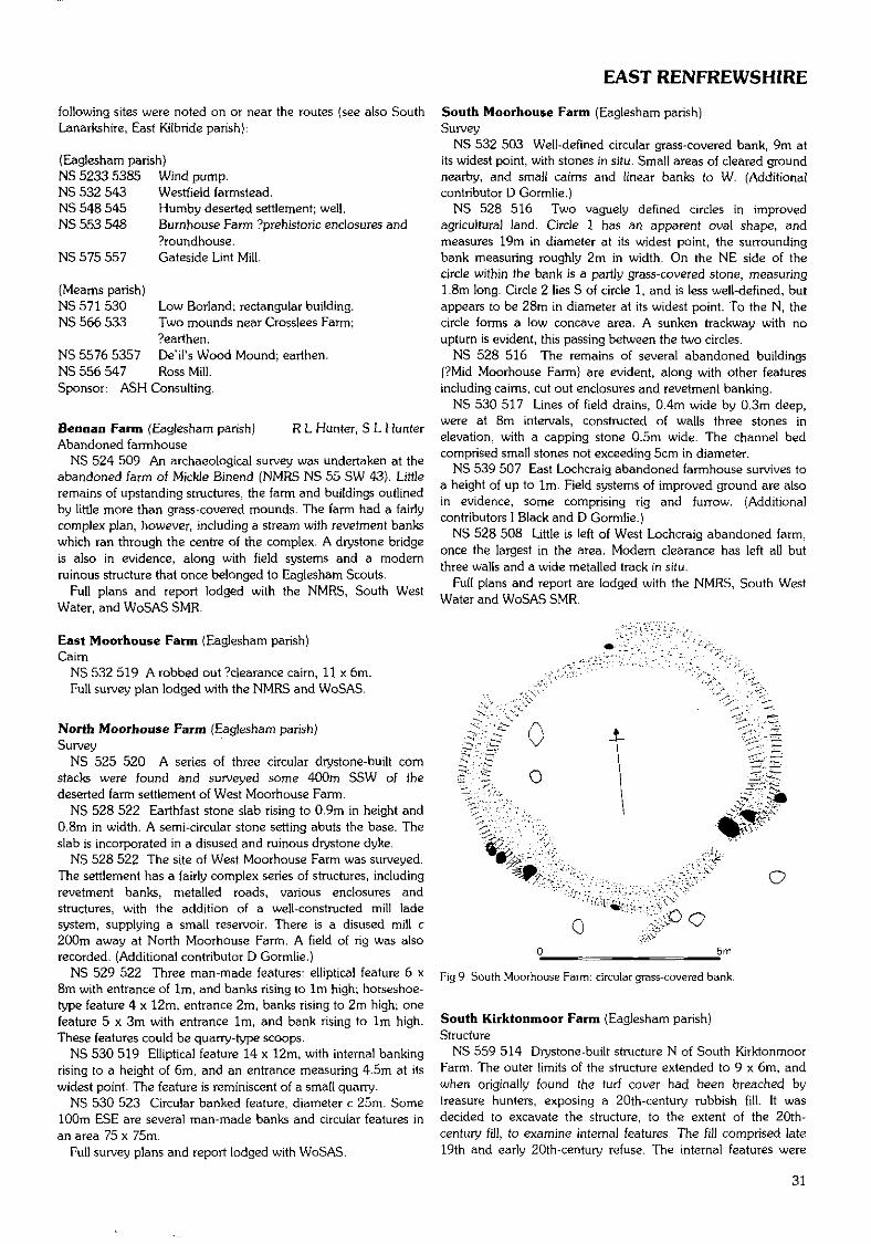
EAST RENFREWSHIRE
following sites were noted on or near the routes (see also SouthLanarkshire, East Kilbride parish}:
(Eaglesham parish)NS 5233 5385 Wind pump.NS 532 543 Westfield farmstead.NS 548 545 Humby deserted settlement; well.NS 553 548 Burnhouse Farm ?prehistoric enclosures and
?roundhouse.NS 575 557 Gateside Lint Mill.
(Meams parish)NS 571 530 Low Borland; rectangular building.NS 566 533 Two mounds near Crosslees Farm;
?earthen.NS 5576 5357 De'il's Wood Mound; earthen.NS 556 547 Ross Mill.Sponsor: ASH Consulting.
Bcnnan Farm (Eaglesham parish) R L Hunter, S L HunterAbandoned farmhouse
NS 524 509 An archaeological survey was undertaken at theabandoned farm of Mickle Binend (NMRS NS 55 SW 43). Littleremains of upstanding structures, the farm and buildings outlinedby little more than grass-covered mounds. The farm had a fairlycomplex plan, however, including a stream with revetment bankswhich ran through the centre of the complex. A drystone bridgeis also in evidence, along with field systems and a modernruinous structure that once belonged to Eaglesham Scouts,
Full plans and report lodged with the NMRS, South WestWater, and WoSAS SMR.
East Moorhouse Farm (Eaglesham parish)Cairn
NS 532 519 A robbed out ?clearance cairn, 11 x 6m.Full survey plan lodged with the NMRS and WoSAS.
North Moorhouse Farm (Eaglesham parish)Survey
NS 525 520 A series of three circular drystone-built cornstacks were found and surveyed some 400m SSW of thedeserted farm settlement of West Moorhouse Farm.
NS 528 522 Earthfast stone slab rising to 0.9m in height and0.8m in width. A semi-circular stone setting abuts the base. Theslab is incorporated in a disused and ruinous drystone dyke.
NS 528 522 The site of West Moorhouse Farm was surveyed.The settlement has a fairly complex series of structures, includingrevetment banks, metalled roads, various enclosures andstructures, with the addition of a well-constructed mill ladesystem, supplying a small reservoir. There is a disused mill c200m away at North Moorhouse Farm. A field of rig was alsorecorded. (Additional contributor D Gormlie.)
NS 529 522 Three man-made features: elliptical feature 6 x8m with entrance of 1m, and banks rising to 1m high; horseshoe-type feature 4 x 12m, entrance 2m, banks rising to 2m high; onefeature 5 x 3m with entrance 1m, and bank rising to 1m high.These features could be quarry-type scoops.
NS 530 519 Elliptical feature 14 x 12m, with internal bankingrising to a height of 6m, and an entrance measuring 4.5m at itswidest point. The feature is reminiscent of a small quarry.
NS 530 523 Circular banked feature, diameter c 25m. Some100m ESE are several man-made banks and circular features inan area 75 x 75m.
Full survey plans and report lodged with WoSAS.
South Moorhouse Farm (Eaglesham parish)Survey
NS 532 503 Well-defined circular grass-covered bank, 9m atits widest point, with stones in situ. Small areas of cleared groundnearby, and small cairns and linear banks to W. (Additionalcontributor D Gormlie.)
NS 528 516 Two vaguely defined circles in improvedagricultural land. Circle 1 has an apparent oval shape, andmeasures 19m in diameter at its widest point, the surroundingbank measuring roughly 2m in width. On the NE side of thecircle within the bank is a partly grass-covered stone, measuring1.8m long. Circle 2 lies S of circle 1, and is less well-defined, butappears to be 28m in diameter at its widest point. To the N, thecircle forms a low concave area. A sunken trackway with noupturn is evident, this passing between the two circles.
NS 528 516 The remains of several abandoned buildings(?Mid Moorhouse Farm) are evident, along with other featuresincluding caims, cut out enclosures and revetment banking.
NS 530 517 Lines of field drains, 0.4m wide by 0.3m deep,were at 8m intervals, constructed of walls three stones inelevation, with a capping stone 0.5m wide. The channel bedcomprised small stones not exceeding 5cm in diameter.
NS 539 507 East Lochcraig abandoned farmhouse survives toa height of up to 1m. Field systems of improved ground are alsoin evidence, some comprising rig and furrow. (Additionalcontributors 1 Black and D Gormlie.)
NS 528 508 Little is left of West Lochcraig abandoned farm,once the largest in the area. Modern clearance has left all butthree walls and a wide metalled track in situ.
Full plans and report are lodged with the NMRS, South WestWater and WoSAS SMR.
Fig 9 South Moorhouse Farm: circular grass-covered bank.
South Kirktonmoor Farm (Eaglesham parish)Structure
NS 559 514 Drystone-built structure N of South KirktonmoorFarm. The outer limits of the structure extended to 9 x 6m, andwhen originally found the turf cover had been breached bytreasure hunters, exposing a 20th-century rubbish fill. It wasdecided to excavate the structure, to the extent of the 20th-century fill, to examine internal features. The fill comprised late19th and early 20th-century refuse. The internal features were
31
CITY OF EDINBURGH
recorded in plan, and different phases of use were found, endingup as a convenient repository for the farm's refuse. About 50m Eare two stone settings in close proximity to two quarry scoops.
Full survey plans and excavation report are lodged with theNMRS and WoSAS.
Flenders Farm (Mearns parish)Rig and furrow
A survey was carried out in April 1997 at Flenders Farm in theClarkston area.
NS 5685 5605 Rig and furrow on the lower slope of avolcanic plug (DES 1973). There are 31 rigs in situ, measuring1m at rig, and 0.6m at the furrow.
NS 5645 5622 Rig and furrow on a downward sloping fieldsystem adjacent to the WSW of Renders Farm. The rig andfurrow measures c 26.6m long by 28.8m wide. Each rigmeasures 2.4m, the furrow 0.6m.
Fuller details have been lodged with the NMRS.
Greenbank House (Mearns parish) H F James (GUARD)Watching brief
NS 561 566 Greenbank House and gardens were constructedin the late 18th century and are set within a designed landscape.A watching brief was undertaken during the excavation of aservice trench from Flenders Road to the W side of GreenbankHouse. The service trench cut through the field immediately tothe N of the house where rig and furrow survived as slightupstanding features. In this area 12 rubble-filled drains and seventerracotta drains were noted. These represented at least threephases of drains, none of which were on the same alignment asthe rig and furrow.
A block of dressed sandstone was found in the trench in thevicinity of the house. No pottery or domestic refuse was found inthe trench.Sponsor: NTS.
Picketlaw (Neilston parish) D Alexander, B HenryHut circle
NS 4680 5220 The third and final season of excavation wasundertaken on this hut circle (DES 1996, 38). The final twoquadrants were deturfed to reveal the full plan. The hut circlewall was traceable in varying degrees of preservation and theprobable entrance, 0.6-0.7m wide, was located in the SE. Theinner stone-packed ditch was clearly visible. Finds include sherdsof pottery, pieces of quartz and a couple of fragments of fl int .Resistivity survey undertaken to the SW of the hut circle locatedno further archaeological features. Trial coring of the blanket bogto the S revealed a depth of up to 2.4m of peat.Sponsor: Renfrewshire Local History Forum Archaeology
Section.
Renfrew Castle (Renfrew parish) D Alexander (CFA)Trial trenching
NS 5086 6787 Trial trenching was undertaken at the site ofthe 13th-14th-century castle in Renfrew. Desk-based research,geophysical survey and test-pitting (DES 1996, 38) suggestedthat the site had been greatly disturbed. Following dismantling ofthe castle much of the stone had been removed from the site andused in the construction of a soap works. The site wassubsequently built over by Castlehill House and its extensivegardens. Demolition of this structure, its levelling and creation ofa playground led to further disturbance, while repeateddevelopment on the fringes of the site has gradually removedtraces of the original castle mound and ditch. Excavation of threetrenches confirmed this disturbance and located the brick-built
foundation of the large bay window (recorded on maps andphotographs) at the NW corner of Castlehill House. A trenchlocated in the southern part of the park recovered a line of stonepaving. In front of and below this stone paving were the remainsof either a rubble-filled foundation trench or the rubble core of awall, the facing stones of which had been robbed. A layer of clayto the S of the stone paving contained sherds of 12th-14th-century cooking vessels. It is possible that these remainsrepresent traces of the royal castle of Renfrew.Sponsors: Renfrewshire Council. Renfrewshire Local History
Forum Archaeology Section.
EDINBURGH, CITY OFCramond Harbour (City parish of Edinburgh) V E DeanChert blade, Roman and medieval pottery
NT 1888 7692 Recent cutting back of the river bank besideCramond Boat Club resulted in the discovery of a chert blade,part of a Roman amphora handle and several sherds of medievalpottery.Sponsors: City of Edinburgh Council Archaeology Service,
Edinburgh Archaeological Field Society.
Cramond Roman fort (City parish of Edinburgh)Building remains, roadway, drain
NT 1899 7698 Exploratory trenching has revealed a stretch ofmortar floor, similar to that noted in 1988 (DES 1988, 18), alength of mortared stone wall, and parallel to it a stone-builtdrain, partly stone-capped and partly cobble-filled. The drainmay have been cut through a cobbled roadway. Although thedownhill side of the roadway has been eroded, it appears to beon the alignment of Old Street of Cramond Village. Some 0.3mbelow this was another surface of large cobbles and pinksandstone, incorporating oyster shells.Sponsors: City of Edinburgh Council Archaeology Service,
Edinburgh Archaeological Field Society.
Johnston Terrace, Edinburgh C A-Kelly(City parish of Edinburgh)Carved stone
NT 2510 7337 Built into the wall on the S side of the road, c50m E of the bridge over Kings Stables Road and immediatelyabove the pavement, this rectangular, pale grey sandstone blockhas a broken right edge and a pair of parallel grooves 2.5cmapart and llcm below the upper edge.
Kings Stables Road, Edinburgh(City parish of Edinburgh)Carved stone
NT 2498 7343 Built into the wall on the NE side of the street,c 50m SE of the entrance to Princes Street Gardens and 0.3mabove the pavement, this pale yellow sandstone block has threebroken edges and only the right carved, apparently carved to acurve. Slightly to the left of this and parallel to the curve is a stripof possible single cord interlace,
Palace of Holyroodhouse (City parish of Edinburgh) G EwartWatching brief
NT 2691 7392 The trench required for the new servicesrevealed a wall aligned N-S, at a point c 5.8m S of the junctionbetween the SW tower and the S wall of the palace. It was of twoperiods of build, the earlier element with indications of mouldingon its W side, and perhaps, therefore, part of the formalstructures associated with either palace or abbey buildings.
32
FALKIRK/FIFE
However, the secondary wall was clearly of more rustic build,and together they appeared to reflect a form of crudeoutbuilding, nonetheless pre-dating the present 19th-centurygarden layout. _Sponsor: HS ^.
FALKIRKBlackness Castle (Bo'ness & Carriden parish) G Ewarf,Watching brief P Sharman
NT 0556 8027 A narrow trench was opened by KirkdaleArchaeology within the courtyard of the castle in advance of theinsertion of an electrical cable. The excavations showed that aconsiderable depth of deposits survived in the area between thecentral tower and the W curtain wall - the only material left inthe whole courtyard.Sponsor: HS Q.
Kinneil House (Bo'ness & Carriden parish) G Ewart,Well D Murray
NS 983 806 A watching brief was undertaken by KirkdaleArchaeology during works on a well within the 'palace' wing ofKinneil House. The well was located in a room known as the'boiler room', a small barrel-vaulted chamber in the extreme SEcorner of the building, presumably originally functioning as aservice room. The floor of the chamber comprised stone flags,and it was the subsistence of these into the softer well-fill depositswhich first led to the discovery of the sub-floor feature aroundthree years ago. Excavations were then undertaken, andapproximately 4m of the fill of the well was removed. Nothing isknown of the results of this work, but at the time of the currentwatching brief, a circular hole c 2m in diameter with a stone andmortar lining had been exposed.
The watching brief concerned the monitoring of the drilling ofthe remaining material. The remaining upper fill was a loose,coarse ashy silt, which was removed by hand, extending to 0.8mdeep, after which the fill became more stony, and drilling wascommenced. The drilling indicated that the lower fill was 0.4m indepth, beyond which the base of the well was encountered. Thusa total depth of c 5.2m from the floor level could be estimated.
Finds include large quantities of burnt and unburnt bone aswell as some diagnostic finds from the upper fill; a near-completeclay pipe, a fragment of white tile, and an iron spanner. It wouldseem likely, therefore, that the well was deliberately backfilled inVictorian times _or later.Sponsor: HS £|.
FIFEThe Historic Gardens & Designed S Govan, C Dingwall,Landscapes of Fife P O'Connor
The desk-based study of Historic Gardens and DesignedLandscapes for NE Fife (DES 1996, 43) was extended to coverthe whole of Fife. The project examined evidence from mapsdating from 1642 up to the 1st edition OS of the mid-19thcentury. Documentary research was also undertaken forsupplementary information. This second phase took the totalnumber of sites identified to 320, the vast majority of which hadnot been previously recorded.
This information has been entered on the Fife SMR and thedatabase has been modified to enable detailed analysis.Sponsors: Fife Council Planning Service Archaeology Unit,
SNH.
Maritime Fife N C DobsonDuring 1997 Maritime Fife carried out a second coastal
assessment survey covering the entire Fife coast (see DES 1996,42-3), covering Fife Ness to Newburgh. The survey identified317 sites, of which 205 are located on the coast edge orforeshore, and 49 are under threat of erosion.
Of particular interest is a series of salmon bothies and otherstructures associated with the Tay salmon fisheries industry. Theongoing decline of this industry makes it all the more urgent torecord what remains at present, and more detailed recording andsurvey of these sites, ranging from boatyards to sheds to salmoncoble wrecks is recommended. A collection of wharfs (NO 397263) and a nearby wreck (NO 398 264) were located on the Eside of the Tay Rail Bridge. Although the foreshore appears to befairly stable, it does require further investigation. An ancient landsurface has been exposed on the banks of the Tay to the W ofBalmerino (NO 326 231 to NO 312 227). To the E of StAndrews a weathered sandstone standing stone (NO 5332 1527)near Kinkell Cave and several enhanced natural harbours (egNO 6106 1141) have been identified.
A further 114 sites have been recorded on the NMRS, of which11 are scheduled ancient monuments. Other recorded sites varyfrom burials (eg Old Haiks NMRS NO 61 SW 2) and harbours (egSt Andrews NMRS NO 51 NW 63) to castles (eg RanderstonNMRS NO 61 SW 4), and from caves {eg Constantine's NMRS NO61 SW 6) to shipwrecks {NMRS NO 32 NE 33). The character ofthis archaeological record broadly reflects the settlement, industrialactivities and land-use of this coastline since antiquity.
Two sites have been described in detail under the parishes ofFerry-Port-on-Craig and Forgan.
Various M D King, A CoxFinds
The following finds have been published {A Cox and M King in'Recent Medieval Metalwork Finds from East Fife' TAFAJ 3(1997)), and have been acquired by East Fife Museum Serviceas Treasure Trove. Fuller details are lodged with the NMRS.Parkhill Farm, Newburgh (Abdie parish)
NO 2470 1850 Fitting; copper alloy.NO 2470 1805 Ring; copper alloy.
Balmerino Abbey (Balmerino parish)NO 3580 2445 Die; copper alloy; ?post-medieval.NO 3585 2460 Two spindle whorls; lead alloy.
Ceres (Ceres parish)NO 3960 1205 Belt clasp; ?post-medieval.
Cupar (Cupar parish)NO 3780 1435 Belt clasp; copper alloy. Buckle; copper alloy.
'Posy' ring; gold; 17th century. Ring; silver; 15th century.Old Higham {Dunbog parish)
NO 2720 1940 Harness pendant; copper alloy; ?12th century.Harness pendant; copper alloy; 12th-14th century.Ardross (Elie parish)
NO 5100 0120 Key; copper alloy; 13th or 14th century.NO 5120 0130 Pilgrim badge; lead alloy. Pending Treasure
Trove decision.
0 50mm
Fig 10 Ardross: pilgrim badge. Drawn by A Cox (SUAT)
33
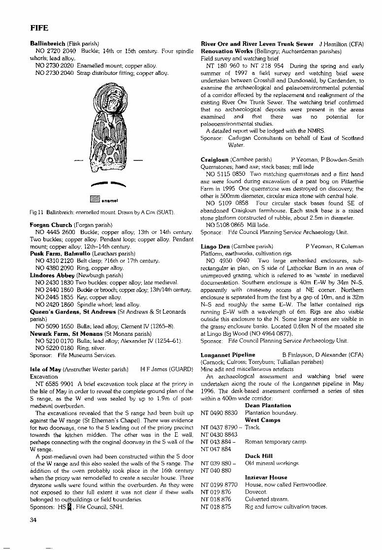
FIFE
Ballinbreich (Fiisk parish)NO 2720 2040 Buckle; 14th or 15th century. Four spindle
whorls; lead alloy,NO 2730 2020 Enamelled mount; copper alloy.NO 2730 2040 Strap distributor fitting; copper alloy.
enamel
Fig 11 Ballinbreich: enamelled mount- Drawn by A Cox (SUAT).
Forgan Church (Forgan parish)NO 4445 2600 Buckle; copper alloy; 13th or 14th century.
Two buckles; copper alloy. Pendant loop; copper alloy. Pendantmount; copper alloy; 12th-14th century.Pusk Farm, Balmullo (Leuchars parish)
NO 4310 2120 Belt clasp; ?16th or 17th century.NO 4380 2090 Ring, copper alloy.
Lindores Abbey (Newburgh parish)NO 2430 1830 Two buckles; copper alloy; late medieval.NO 2440 1860 Buckle or brooch; copper alloy; 13th/14th century.NO 2445 1855 Key; copper alloy.NO 2420 1860 Spindle whorl; lead alloy.
Queen's Gardens, St Andrews (St Andrews & St Leonardsparish)
NO 5090 1650 Bulla; lead alloy; Clement IV (1265-8).Newark Farm, St Monans (St Monans parish}
NO 5210 0170 Bulla; lead alloy; Alexander IV (1254-61),NO 5220 0180 Ring; silver.
Sponsor: Fife Museums Services.
Isle of May (Anstruther Wester parish) H F James (GUARD)Excavation
NT 6585 9901 A brief excavation took place at the priory inthe Isle of May in order to reveal the complete ground plan of theS range, as the W end was sealed by up to 1.9m of post-medieval overburden.
The excavations revealed that the S range had been built upagainst the W range (St Ethernan's Chapel). There was evidencefor two doorways, one to the S leading out of the priory precincttowards the kitchen midden. The other was in the E wall,perhaps connecting with the original doorway in the S wall of theW range.
A post-medieval oven had been constructed within the S doorof the W range and this also sealed the walls of the S range. Theaddition of the oven probably took place in the 16th centurywhen the priory was remodelled to create a secular house. Threedrystone walls were found within the overburden. As they werenot exposed to their full extent it was not clear if these wallsbelonged to outbuildings or field boundaries.Sponsors: HS 0 , Fife Council, SNH.
River Ore and River Lcven Trunk Sewer J Hamilton (CFA)Renovation Works (Ballingry; Auchterderran parishes)Field survey and watching brief
NT 180 960 to NT 218 954 During the spring and earlysummer of 1997 a field survey and watching brief wereundertaken between Crosshill and Dundonald, by Cardenden, toexamine the archaeological and palaeoenvironmental potentialof a corridor affected by the replacement and realignment of theexisting River Ore Trunk Sewer. The watching brief confirmedthat no archaeological deposits were present in the areasexamined and that there was no potential forpalaeoenvironrnental studies.
A detailed report will be lodged with the NMRS.Sponsor: Cadugan Consultants on behalf of East of Scotland
Water.
Craigloun (Carnbee parish) P Yeoman, P Bowden-SmithQuernstones; hand axe; stack bases; mill lade
NO 5115 0850 Two matching quernstones and a flint handaxe were found during excavation of a peat bog on PittarthieFarm in 1995. One quernstone was destroyed on discovery; theother is 500mm diameter, circular mica stone with central hole.
NO 5109 0858 Four circular stack bases found SE ofabandoned Craigloun farmhouse. Each stack base is a raisedstone platform constructed of rubble, about 2.5m in diameter.
NO 5108 0865 Mill lade.Sponsor: Fife Council Planning Service Archaeology Unit.
Lingo Den (Carnbee parish) P Yeoman, R ColemanPlatform, earthworks, cultivation rigs
NO 4950 0940 Two large embanked enclosures, sub-rectangular in plan, on S side of Lathockar Bum in an area ofunimproved grazing, which is referred to as 'waste' in medievaldocumentation. Southern enclosure is 40m E-W by 34m N-S,apparently with causeway access at NE corner. Northernenclosure is separated from the first by a gap of 10m, and is 32mN-S and roughly the same E-W. The latter contained rigsrunning E-W with a wavelength of 6m. Rigs are also visibleoutside this enclosure to the N. Some large stones are visible inthe grassy enclosure banks. Located 0.6km N of the moated siteat Lingo Big Wood (NO 4964 0877).Sponsor: Fife Council Planning Service Archaeology Unit.
Longannet Pipeline B Finlayson, D Alexander (CFA)(Carnock; Culross; Torryburn; Tulliallan parishes)Mine adit and miscellaneous artefacts
An archaeological assessment and watching brief wereundertaken along the route of the Longannet pipeline in May1996. The desk-based assessment confirmed a series of siteswithin a 400rn wide corridor:
Dean PlantationNT 0490 8830 Plantation boundary.
West CampsNT 0437 8790 - Track.NT 0430 8843NT 043 884 - Roman temporary camp.NT 047 884
NT 039 880 -NT 040 880
NT 0199 8770NT 019 876NT 018 876NT 018 875
Duck HillOld mineral workings.
Inzievar HouseHouse, now called Fernwoodlee.Dovecot.Culverted stream.Rig and furrow cultivation traces.
34
FIFE
NT 0153 8772NT 0154 8781NT 0114 8788NT 0125 8803
NT 0111 8772
NT 0088 8800NT 0106 8766NT 0067 8820NT 006 878
NT 0035 8780 -NT 0093 8772
NT 002 878NT 000 878
NT 0002 8788 -NS 9999 8812
NS 9967 8759
NS 9880 8700NS 9870 8688
NS 9819 8677NS 9810 8674
NS 9796 8648NS 9719 8665 -NS 9790 8646
NS 9776 8641
NS 9615 8606 -NS 9625 8627NS 961 861
NS 9591 8609
NS 9530 8600NS 952 860
LangleasWell.Trial pits.Whinstone quarry pit.Sub-circular plantation.Red RowRow of terraced cottages.PitsoulieOld shafts.Old road running to Kennies Walls.
Mine works, spoil heaps, culverted stream.Valleyfield WoodDesigned landscape.
ValleyfieldBrick and tile works.Clay pit.Shires MillMill complex, including lade.
Blairhall HouseBlairhall House (Listed Building).Blairhall MainsCropmark feature.Colliery.CulrossMonk's Well (NMRS NS 98 NE 3.3).Mine shafts.West ChurchOld Culross Parish Church (NMRS NS 98 NE 2).System of old tracks.
BlairburnFormal tree-lined avenue.CavernsMill dam and lade.
Chipped stone tools.CrookmuirhallFormer settlement.Sands FarmFarm buildings.Cropmark enclosure (NMRS NS 98 NE 20).
During the watching brief no major concentrations ofarchaeological features were recorded along the route of thepipeline. Detailed investigation was carried out at the followingthree locations:
NS 962 861 Three test-pits were hand-excavated in the fieldon the E side of the burn to the N of Caverns Farm to investigatethe possibility that a small scatter of flints on the W side of theburn continued to the E. Two small, very burnt, fragments of flintwere recovered but their condition may indicate imports duringlime spreading.
NS 951 858 Geophysical survey of four 20 x 20m grids wasundertaken along the pipeline swathe to the SW of the cropmarkof a possible Iron Age homestead (NMRS NS 98 NE 20), close toSands Farm. The geophysical survey did not indicate thepresence of any archaeological features and this observation wasconfirmed after topsoil stripping.
NT 0386 8788 A mine adit was located during the watchingbrief on the steep hill slope to the E of a small stream that flowsinto the Torry Burn. It was c 1.2m high and 0.8m wide, with aflat roof and vertical sides cut through coarse bedrock. From the
machine cut, (he adit could clearly be seen to extend at least 3-4m back into the slope to the NE.
The following isolated finds were recovered during thewatching brief:NT 0477 8828 Hint scraper.NT 0424 8811 Quartz flakes.NT 0420 8802 Quartz flakes.NS 9951 8764 Small rolled flint.NS 9905 8734 Large rolled flint.NS 9904 8734 Copper-alloy coin.NT 0015 8803 Flake of burnt flint.NS 9529 8592 Sherds of medieval/post-medieval pottery.Sponsor: Penspen Environmental.
Collessie Quarry, by Ladybank (Collessie parish) J HamiltonField survey and trial excavation (CFA)
NO 293 115 A field inspection and trial excavation wereconducted in April 1997 on the area of a proposed 27ha gravelextraction site. Although a number of cropmark and other sitesare known from the vicinity, no additional sites were identifiedwithin the zone proposed for quarrying.
Test-pits and trial trenches, placed in response to topographicconsiderations, were hand-excavated and revealed noarchaeological finds or features. Two pieces of struck flint wereretrieved from fieldwalking. All other artefacts recovered werepre-recent/modem in nature.
A detailed report will be lodged with the NMRS.Sponsor: Fife Sand & Gravel Co Ltd.
Craighead Golf Course, Balcomie, Fife Ness C Lowe(Crail parish) (HAL)Danes Dike, watching brief
NO 6323 0985 A power cable trench, approximately 1mwide, was machine-excavated across parts of the Danes Dike, alinear earthwork and scheduled ancient monument. The workwas monitored by Headland Archaeology Ltd.
In the S facing section, fragments of what are considered torepresent surviving elements of the Danes Dike were identifiedand recorded. The dike appears to have comprised a solid stonecore, roughly 3.4m wide, overlain with redeposited natural sandsand gravels. No buried soil was evident beneath the feature, thedike having been erected directly over the natural subsoil.
The tentative identification of the stone-cored feature andoverlying gravel upcast as the remains of the Danes Dike runscounter to the results of a geophysical survey which haveadvocated a course to the SW of Craighead farmhouse.
Outwith the scheduled area, a large pit was located in the Wfacing side of the cable trench at approximately NO 6332 0985.Sponsor: Crail Golfing Society.
Crail (Crail parish) M Dalland (HAL)Watching brief
NO 61 07 Headland Archaeology Ltd are undertaking awatching brief of mains drainage works to a specificationprovided by Fife Council Archaeology Service. The principalfindings to date have been deep medieval and post-medievaldeposits at the foot of King Street by the harbour; a substantialstone culvert and medieval deposits in Westgate; and asubstantial stone culvert and large ditch in Rumford.Sponsor: East of Scotland Water Authority.
Kilminning (Crail parish)Evaluation
NO 631 087 As part of the Crail Mains Drainage ascreenhouse will be built adjacent to a long cist cemetery and a
35
FIFE
stone ruin, possibly a chapel (NMRS NO 60 NW 8). Anarchaeological evaluation of the area was specified by FifeCouncil Archaeology Service and was carried out in January1997 by Headland Archaeology Ltd. Eight machine-strippedtrenches were evaluated but no features of archaeologicalinterest were noted other than the foundations of the demolished19th-century steading of Kilrninning Farm. It appears that thecemetery does not extend as far inland as the pipeline and it isprobably restricted to the headland where the chapel ruin stands.Sponsor: East of Scotland Water Authority.
Culross Palace (Culross parish) R MurdochPost-medieval buildings
NS 985 859 A new drain was installed within the innercourtyard of the palace to remove rainwater from the N end ofthe W range. The 0.35m wide trench for this drain cut through0.2-0.3m of soils and rubble deposited during the installation ofanother drain (probably earlier this century}; nothing ofarchaeological interest was uncovered.Sponsor: NTS.
Fealy Dyke, KHmaron (Cupar parish) P Yeoman, S TaylorMedieval linear earthwork
NO 3625 1665 Medieval estate boundary visible over adistance of 400m. A low grassy bank running N-S approximately4m wide by 0.5m high. Mentioned in a medieval propertycharter of the 14th century.Sponsor: Fife Council Planning Service Archaeology Unit.
Former site of St Christopher's Church, Cupar D Hall{Cupar parish) (SUAT)Field survey and assessment
NO 3666 1527 A survey and assessment of the site of thischurch was undertaken to assess plough damage. The site isvisible as a sizeable earthwork, and a contour survey was carriedout. A resistivity survey was then carried out and hand-dug trialtrenches were excavated to test large geophysical anomalies.
The trenching located the N and S wall lines and the E end ofthe structure. The remains of an internal flagged floor surfacewere located only 0.3m below modern ground level. Thegeophysical and excavated evidence suggest a building c 6mwide by c 20m long, with either a porch or side chapel at its SWcorner. Extended human burials were found to the S of thebuilding and a possible limit to the graveyard was located some22m to the S. The landowner has agreed to stop ploughing thesite of the church and graveyard, which is in the process of beingscheduled. _Sponsor: HS ̂ .
Charlestown Limekilns (Dunfermline parish) R MurdochLimekilns
NT 063 835 Three exploratory trenches were excavated byScotia Archaeology Ltd in advance of the proposed constructionof a stair and lift for visitor access between the two levels of Ihesite. The trenches were located in the angle between the E end ofthe line of kilns and the base of the retaining wall to its rear.
The fragmentary remains of masonry and brick walls near tothe retaining wall were probably associated with the buildingwhose roof raggles are still visible in its S face. Part of theconcrete floor of this building was also revealed. To theimmediate E of the kilns were two narrow brick walls, aligned N-S and barely 1m apart, with a connecting wall at their S ends,Piercing the S wall of this structure was a cast-iron pipe,anchored by a pad of concrete which extended beyond thetrench edge. All of the excavated features were probably
associated with the crushing plant built over the four easternmostkilns earlier this century.
Limited trenching at the W end of the site failed to confirmwhether there was a flight of steps connecting the upper andlower levels of the works.Sponsor: Broomhall Estate.
Colton, by Wellwood (Dunfermline parish) S FarrellEvaluation
A desk-based assessment followed by a field survey wereundertaken to evaluate the archaeological potential of the areaof a proposed opencast coal mine. Little archaeology remained,partially due to previous opencast mining. The following siteswere within the study area.NT 0915 9060 'Derby' No 2 mine.NT 0985 9060 'Elgin' No 1 pit.NT 0932 9005 'Colton' No 1 pit.NT 0972 9030 'Elgin' No 2 pit.NT 0965 9007 'Colton' No 2 pit.NT 0940 8999 Easter Colton farmstead.NT 0941 8974 Drift mine.
Report lodged with Fife SMR and the NMRS.Sponsors: Ironside Farrar Environmental Consultants, I & H
Brown Ltd.
Dunfermline to Kirkcaldy A J Dunwell, B Finlayson (CFA)(Dunfermline; Aberdour; Auchtertool; Kirkcaldy & Dysartparishes)Desk-based assessment and field inspection
The following new sites and monuments were recorded as partof a desk-based assessment and field inspection conducted inconnection with an environmental assessment for proposedworks on power lines between Dunfermline and Kirkcaldy.
A 2km wide corridor was studied for the desk-based element,with a 60m wide corridor centred on the proposed power lineswalked during the field inspection. Much of the cultural heritageof the area relates to coal mining, other industries and MOLRSsites. Nearly all the sites listed below were identified from OS andearlier map sources.
Full details of the methods and results of this exercise are in areport, a copy of which will be deposited in the NMRS.
WellwoodNT 0889 8944 Settlement (Gateside).NT 0955 8954 Coal pit.NT 0965 8912 Coal mine (Lochside Colliery).NT 0983 8908 Coal pit.
Colton MainsNT 0940 8997 Settlement (Easter Colton).
TownhillNT 1005 8968 Settlement (Lochbank).NT 103 898 Coal mine.
WaxwingNT 1118 8918 Whitefield coal pit.
Townhill WoodNT 113 898 Muircockhall Colliery.
MuircockhallNT 1175 8988 Settlement (unnamed).
PleasanceNT 1183 8897 Settlement (Easter Whitefield).
Deanpark HouseNT 119 896 Coal mine (Eliza Pit).
HalbeathNT 121 892 Coal pit.NT 126 893 Coal mines.NT 127 895 Coal mine.
36
FIFE
NT 1217 8942NT 123 896
NT 1367 8906NT 140 891NT 1437 8933
NT 150 897NT 152 897
NT 1513 8928NT 1551 8936NT 1560 8923NT 156 897NT 158 888NT 159 890NT 159 894NT 160 889
NT 166 896
NT 180 904NT 183 903
NT 190 912
NT 202 7 9059
NT 2020 9178
NT 2086 9238NT 209 921NT 2117 9159NT 218 923NT 2199 92 77
NT 2109 9133
NT 214 909NT 2190 9099
NT 215 927
NT 218 918
NT 2219 9300NT 224 929NT 228 930
NT 22419157
NT 2243 9194
NT 2317 9235
NT 246 923
NT 241 932NT 242 934
NT 2433 9405
NT 2312 9423NT 2334 9453
Buckie BurnCoal pit-Coal pit.CrossgatesCuttlehill Colliery.Coal mine.Settlement (Mineral Cottage).Cowden KnowePlatforms, earthworks, track.Enclosure (soilmark).CuttlehillSettlement (Makfend Cottage).Gasworks.Settlement (unnamed).George Pit, Fordell Colliery.Coal mine.Coal mine (Lady Anne Pit).Coal mine (William Pit).Coal mine.DonibristleDonibristle Colliery.Mossmorran'Old North Road'.Settlement (Craigton).Wester LochheadBuilding (unnamed).WaltonUnnamed buildings.Little RaithSettlement (Raith Cottown).GlennistonSettlement (Gledehills).Settlement (unnamed).Settlement (?Cavins).Limestone quarries, limekilns.Settlement (Cowford).CamillaSettlement (unnamed],AuchtertoolMill dam, mill race.Settlement (West Gentry).PowguildMill, mill race.Camilla LochSettlement (Craigtown).ShawsmillSettlement (unnamed).Corn mill, mill race.Limestone quarries; limekilns.ClentrieSettlement (unnamed).Knockbathy WoodSettlement (Coldback).Bankhead of RaithSettlement (Pitconmark).FoulfordLimekilns.TorbainSettlement (Windygates).Settlement (Backside).ChapelSettlement (unnamed).Sunnyside PlantationSettlement (Sunnyside).Coal mine (Waterless Pit).
NT 2343 9466 Coal pit.NT 2343 9479 Settlement (Wethers Brae).
Keir BraeNT 2368 9448 Settlement (Bankhead).NT 237 945 Settlement (Keir Brae).NT 2412 9459 Settlement (unnamed).NT 242 946 ' Settlement (Bowhouse).
Cluny SquareNT 2351 9509 Coalpit.
Rough ParkNT 235 953 Coal pit.NT 239 954 Coal pits.
CoaldenNT 240 950 Coalpits.
MuirtonNT 2449 9585 Mine.
DothanNT 2510 9485 Coalmine.
Chapel FarmNT 2547 9427 Settlement (unnamed).NT 2554 9449 Cottages {Tough Row}.
DunnikierNT 263 948 Coal mine; quarry; settlement (East March).
CarberryNT 2862 9437 Settlement (Dunnikier Muir).
Begg CollieryNT 260 953 Coalmine.
Begg Moss PlantationNT 261 950 Cottage; disused mine.
Sandal HallNT 2637 9544 Farmstead.
BogwellsNT 294 956 Settlement (Muirhead).
BogleysNT 2962 9527 Farmstead (Clayholes).Sponsor; Gillespies on behalf of Scottish Power pic.
Dunfermline East Trunk Sewer (Dunfermline parish) S FarrellWatching brief and excavation
NT 1145 8455 to NT 1240 8755 A watching brief and twoexcavations were undertaken in May 1997 on the line of a sewerpipeline running from Rosyth to Halbeath. Two sections weremonitored. Two sites were excavated as they were in the directline of the pipeline:
NT 1188 8485 Site A; mid- to late 19th-century greenhousecomplex: greenhouse, boiler house, cold frames, walling ofwalled garden.
NT 1183 8497 Site B: WWII structures; remains of Nissenhuts and shelters; concrete and brick construction.
Report lodged with Fife SMR and the NMRS.Sponsor; George Leslie Ltd.
Dunfermline Palace (Dunferrnline parish) C A-KellyCarved stone
NT 089 872 The surviving capstone of the E oriel window ofthe palace appears to have a carved underside, possibly similarto the celebrated depiction of the Annunciation, on the fallencapstone from the W oriel window.
East Dunfermline (Dunfermline parish) R Strachan,Archaeological evaluation B Glendinning (CFA]
NT 131 882 (centre) and NT 13 87 (centre) Two phases of anarchaeological evaluation were undertaken between March andMay 1997 over an area of c 226ha as part of the site preparationworks for a development by Wilcon Homes.
37
FIFE
Geophysical survey, test-pitting and trial trenching revealed noobviously significant features or finds.Sponsor: Meedhurst Project Management.
Pitreavie Castle (Dunfermline parish) T Neighbour (CFA)Desk-based assessment and field survey
In May 1996 an archaeological desk-based assessment andfield survey was undertaken at Pitreavie Castle and its grounds,which have been owned and occupied by the Ministry ofDefence (MoD) and antecedent bodies for the last 50 years buthas been proposed for redevelopment.
A survey of the rooms within Pitreavie Castle was alsoundertaken, paying particular attention to the changes made inthe 1890s and by the MoD in the 1940s.
A large number of sites were already recorded within the areaand listed in the NMRS. With the exception of one site, a pillbox,which was incorrectly grid referenced in the NMRS, the followinglist is of sites not previously recorded:NT 1210 8476 Pillbox, octagonal {quoted in NMRS (NT 18
SW 142) as NT 1190 8475).NT 1199 8483 WWII airbase generator house, disguised as a
church.NT 1187 8476 - Rectangular walled garden, 1890s,NT 1187 8485-c NT 1181 8485 (approx. perimeter)NT 1189 8479 Concrete bases for radio masts, WWII.NT 1189 8483 Concrete bases for radio masts. WWII.NT 1194 8478 East Lodge cottage, 1890s.NT 1183 8491 Stables, 1890s.NT 1180 8476 - Japanese water garden, 1890s.NT 1187 8476-NT 1187 8485 - c NT 1181 8485 (approx. perimeter)
Full details are contained in a report lodged with the NMRS.Sponsor: Ironside Farrar Environmental Consultants at the
request of Fife Enterprise.
Pitreavie Golf Course {Dunfermline parish) C Swift (CFA)Watching brief
NT 1150 8550 A watching brief in advance of the laying of asewer revealed two features - one small pit or post-hole, and oneshallow linear gully. 6.25m in length, which terminated within thedevelopment area. No extensive or complex archaeologicalremains were identified. No artefacts were recovered.
Detailed reports will be lodged with the NMRS.Sponsor: Raynesway Construction Services Ltd.
Dunino Churchyard (Dunino parish) D Bowler fSUAT)Watching brief
NO 541 109 Excavation and a watching brief duringconstruction of a new vestry showed that the W wall of thepresent church (James Gillespie Graham, 1826-7) reused anearlier foundation. A much earlier E-W foundation was alsofound, possibly part of a pre-Reformation church. The groundlevel has been raised, especially in 1826-7. and may sea! otherearly structures. Charnel deposits probably disturbed in 1826were found and reburied, but no articulated skeletons, except fortwo infant burials, probably 19th or early 20th century, whichwere left in place.Sponsor: Dunino Kirk Session.
Falkland, Lomond Hills (Falkland parish) C Lowe (HAL)Pre-afforestation survey
NO 226 066 (centre) A short-notice pre-afforestation surveywas undertaken by Headland Archaeology Ltd of three smallareas of ground (c 33ha). The survey areas lay on the NW facing
lower slopes of East Lomond Hill, along the side of the Falklandto Leslie B road. A second larger area lay roughly 1km to the W,adjacent to Bracks Plantation and to the E of Maiden Castlehillfort. A total of 19 sites were recorded during the course of thesurvey. Most appear to have been associated with early 19th-century improvements. The low grass-covered remains of twolarge roundhouses were also located, and a possible thirdroundhouse or platform was also identified.NO 227 066 (centre) Rig and furrow cultivation.NO 2241 0659 Roundhouse.NO 2247 0660 Cairn.NO 2254 0658 ?Platform.NO 2264 0658 - Linear clearance cairn.NO 2266 0661NO 2262 0650 Quarry.NO 2276 0643 Quarries.NO 2278 0662 Roundhouse.NO 2274 0666 Quarry.NO 2268 0668 Quarry.NO 2279 0669 Quarry.NO 2267 0683 Quarry.NO 237 068 (centre) Rig and furrow cultivation.NO 2363 0672 Platform/roundhouse.NO 2356 0677 - Stone dyke.NO 2369 0685NO 2374 0679 Enclosure/stone dyke.NO 2377 0697 Stone dyke.NO 2382 0701 Limekiln.NO 2370 0703 - Early 19th-century plantation belt.NO 2395 0705
A ful l report is_ lodged with the NMRS.Sponsor: HS Q.
Falkland Palace (Falkland parish) J TerryWatching brief
NO 253 074 Scotia Archaeology Ltd kept a watching briefduring the excavation of trenches for a new drainage systemalong the N (courtyard) side of the S range of the palace. Theexcavation revealed a complex of existing drains including astone-lined channel stretching 35m along the length of the range.This channel was 0.3m wide and varied in depth from 0.25mnear the angle with the E range to 0.45m at its W end. Thechannel, together with an overlying U-shaped open drain, isthought to be of 19th-century origin.Sponsor: NTS.
Tayport Harbour (Ferry-Port-on-Craig parish) N C Dobson20th-century wreck (Maritime Fife)
NO 4615 2902 Remains of a small wooden carvel plankedboat. It is 8.7m long, lying on her starboard side. Stone ballast,iron fittings andjemains of a marine diesel engine are visible.Sponsor: HS Q.
Drumoig (Forgan; Leuchars parishes) S Halliday, B SimpsonWatching brief and excavation (GUARD)
NO 43 25 During 1997 watching briefs and excavationsundertaken by GUARD were carried out in advance of housingdevelopment within the Forgan and Comerton housing areas inaddition to the construction of a golf academy.Forgan
Stripping two further house plots revealed a total of 65archaeological features, including post-holes, but no structureswere identified. Decorated prehistoric pottery sherds were foundwithin plough-truncated pits, as well as a fragment of possibleburnt hazelnut shell.
38
FIFE
Comerton House PlotsSeven house plots were stripped of topsoil. Three structures,
numerous plough-truncated pits, post-holes and scoops, some ofwhich contained prehistoric pottery and worked stone artefacts,were identified.
Two oval post-built structures with remnants of possibleinternal roof supports and entrances were identified. Potteryrecovered from these structures suggests a Bronze Age date. Anarcing ditch interpreted as a foundation trench for a structure wasalso seen but no artefacts were recovered from it.
GUARD conducted a watching brief and excavation on onehouse plot within this area, a continuation of the work started inlate 1996 (DES 1996, 49-50). A total of 35 archaeologicalfeatures were identified and excavated, including a large pit withnumerous fills.Scottish Golf Academy
In the spring of 1997 a palaeoenvironmental andarchaeological assessment of the boggy area in the NW of thedevelopment took place. No archaeological remains were foundsealed by or within the peat.
During the summer a watching brief was undertaken inadvance of the construction of a golf academy. The identificationof prehistoric and post-medieval archaeological features andstructures led to further excavation. The prehistoric remainsconsisted of a possible Mesolithic flint scatter, the remains of fourring-ditches of the Neolithic or Bronze Age, a burnt mound withan associated trough, a cremation within a wooden container,and the remains of a double ring-ditch enclosure.
A large, Y-shaped structure consisting of two gravel banks, wallfootings, peat turf deposits, and patchy remains of a cobbledsurface was tentatively identified as a post-medieval sheep fank.Artefacts from this structure consist of clay pipe fragments, ironfragments, a spindle whorl, a glass bead and a carved sandstonebox lid. A second post-medieval structure consisted of a cobbledsurface with three post-holes and a wall foundation cut. An ironscythe was recovered from the top of the cobbled surface.Numerous drainage ditches and plough marks indicated post-medieval agricultural activity in the surrounding area.Sponsors: Drumoig Ltd, Scottish Golfing Association.
Newport-on-Tay (Forgan parish) N C Dobson (Maritime Fife)19th-century wooden barque
NO 398 265 In 1997 Annabel Wood (Maritime Fife)completed a detailed survey of the wreck site. It is believed to bethe remains of a converted wooden barque which belonged tothe Middlesbrough Salvage Company which won the contract forthe recovery and rebuilding of the Tay Rail Bridge after itscollapse in 1879. The new bridge was completed in 1887 andthe vessel was apparently abandoned. The remains are 25m inlength and appear to be listing to starboard and facing inshore;they consist of ribs and outer planking which appear to befastened to the ribs by treenails and iron bolts. Fragments of redroofing tiles between the vessel's frames were also seen.Sponsors: HS £J, Fife Council.
Ferrytoll, Inverkeithing (Inverkeithing parish) M DallandSurvey and evaluation (HAL)
NT 124 821 An archaeological evaluation was carried out byHeadland Archaeology Ltd in connection with a proposed Parkand Ride facility at the Ferrytoll roundabout. Rare examples ofcultivation remains close to a medieval burgh were previouslyrecorded to the N.
Two banks were found to be recent structures, and no furtherarchaeological features were found.Sponsor: Fife Council Roads Service,
Kemback to Blebocraigs (Kemback parish) C Swift (CFA)Watching brief
NO 4172 1510 to NO 4320 1478 An archaeological watchingbrief was conducted in April 1997 in advance of the laying of anunderground electricity cable from Kemback sub-station to BleboHouse sub-station.
As the development trench was a maximum of 0.2m wide, itwas only possible to record features in section. Four featureswere encountered: a ditch, two potentially related mortar-bonded walls, and a field boundary. No artefacts were found.
Detailed reports will be lodged with the NMRS.Sponsor: Scottish Power pic.
Kettlebridge barrow cemetery (Kettle parish) S Carter (HAL)Evaluation
NO 304 074 The condition of the cropmark barrow cemeteryat Kettlebridge (NMRS NO 30 NW 132) was evaluated through aprogramme of air photo transcription, soil survey and sampleexcavation. Plough-truncated archaeological features wereapparent at the base of a lower ploughsoi! which provides abuffer over most of the site between the surviving archaeologicalfeatures and present-day tillage. In one limited area of the sitethe lower ploughsoil is absent and therefore archaeologicalfeatures may experience further truncation under the presentcultivation regime.Sponsor: HS ̂ .
Balmuto Bank (Kinghom parish) P Yeoman,?Cist capstone; ?folly Mr & Mrs Drysdale
NT 2238 8992 A large flat rectangular stone, with an unusualpitted surface all over, was found during ploughing. At the timefarmworkers carried out a limited dig but found nothing. Thestone measures 1.8 x 1m, and c 0.3m thick. Found on a hilltopsite with good views all round - possible cist burial. Stone now atNether Pitteadie (NT 2508 8977), c 1km to E. The findspot wasthe original location of the Balmuto standing stone, now in thegrounds of Balmuto Tower (NMRS NT 28 NW 01).
NT 2231 8993 In a small wood beside Balmuto Bank is asmall ruined building, c 6 x 3m in plan, with no windows and asingle entrance. Walls stand c 2.75m in height. Dressed freestonejambs and door check at S end. This may be a 17th/18th-centuryfolly above Balmuto Tower.Sponsor: Fife Council Planning Service Archaeology Unit.
Merchant's House, 339-343 High Street, G Ewart, A DunnKirkcaldy (Kirkcaldy & Dysart parish)16th-century merchant's house
NT 2833 9180 An archaeological excavation and survey byKirkdale Archaeology was completed on the site of theMerchant's House at 339-343 High Street, Kirkcaldy, in Apriland May of 1997. Specialist structural advice was provided bythe School of Building Science at Heriot Watt University. Thepresent house was built toward the end of the 16th century, andnow belongs to the Scottish Historic Buildings Trust, who areactively engaged in its refurbishment and restoration.
Surviving within the house are fine examples of 17th-centuryplaster ceilings, with earlier painted ceilings preserved beneaththese, and extensive 18th-century panelling along some of thewalls. The N wall of the second-floor interior also contains amural depicting a late 16th or early 17th-century galleon. Largestone fireplaces survive in the N wall, with added gable chimneysin the E and W walls. The house is presently accessed via acentral pend leading to a turnpike stair adjoining the house to theN. but there is some evidence to suggest that this had replacedan original stair in the S facade of the building.
39
FIFE
The aim of the recent fieldwork was twofold. Firstly the housewas to be textually, graphically and photographically recorded,with the second element comprising the excavation of theground-floor deposits and the archaeological investigation of thegarden and yard to the N of the house. The garden excavationsrevealed that a substantial depth of topsoil had been imported inthe 19th century, sealing the earlier 17th and 18th-centurygarden horizons. Bee-boles were recorded in the long walls ofthe garden, a fairly typical feature in coastal Fife towns of thisdate. The excavation within the interior revealed a system ofdrains and dwarf walls, alongside evidence for a series ofuprights along the S facade of the present house.
The excavation revealed eight periods of activity on the site ofthe present house:Pre-1500 Settlement at or near the present house site, with
activity on the natural slope to the (site) N of thehouse.
1500-1550 The first house, possibly single storey.1550-1600 First version of the present layout/structure.
Ground floor with two upper floors, no atticspace. Evidence of upright elements at groundfloor on the S, W and E sides. External stair on Sside. Two chambers at ground-floor level, kitchento the E and service space to the W.
1600-1660 Sub-division of the main rooms, addition of thepainted ceilings and new fireplaces in the gables.Creation of attic space. Transition from open areato more discrete chambers.
1660-1800 Extensive panelling and plaster ceilings at first andsecond floor. Remodelled S stair and extension ofthe E, W and S walls at ground-floor level.Addition of the E and W ranges. Rationalisation ofthe back-lot to form semi-formal gardens withbee-boles, etc. Further sub-division of the ground-floor rooms, and possible conversion of thekitchen to commercial/industrial use.
1800-1840 Creation of the ground-floor pend, removal of theS stair and its replacement with the N turnpikestair. Multi-occupancy of the house.
1840-1966 Continued multiple occupancy and establishmentof a sequence of shops at ground-floor level.
1966-1993 Gradual decline in the condition of the propertyprior to the programme of restoration andrecording.
Sponsor: Scottish Historic Buildings Trust.
Tentsmuir Forest S Carter (HAL)(Leuchars; Ferry-Port-on-Craig; Forgan parishes)Desk-based evaluation and partial field survey
Parts of NO 42 NE; NO 42 SE; NO 52 NE HeadlandArchaeology Ltd were commissioned to undertake anarchaeological evaluation of Tentsmuir Forest in advance of fellingproposals. The work was executed to a brief prepared by FifeCouncil Archaeological Service involving three tasks: systematicfield survey of 25 areas selected for clear felling or group felling;an assessment of archaeological sites in the forest as a whole, asrecorded in documentary sources; and a summary interpretationof the archaeology of the Tentsmuir area as a whole.
The results of the evaluation are contained in two reportsdeposited with Fife SMR and the NMRS. The following sites wererecorded as a result of documentary research and fieldworkwithin the Tentsmuir Forest:NO 464 263 WWII defensive position.NO 4648 2633 Bridge (NMRS NO 42 NE 25).NO 468 263 Recording error (NMRS NO 42 NE 41).
NO 4710 2594 Pottery scatter.NO 472 257 Medieval and post-medieval settlement.NO 4764 2554 Pottery scatter.NO 483 267 Recording error (NMRS NO 42 NE 1).NO 486 263 Post-medieval settlement.NO 488 260 Post-medieval settlement.NO 489 254 Artefact scatter (NMRS NO 42 NE 11).NO 498 275 Building.NO 4995 2734 March stone.NO 499 272 WWII defensive position.NO 4999 2673 Icehouse.NO 5036 2602 WWII pillbox (NMRS NO 52 NW 6).NO 5036 2585 WWII pillbox (NMRS NO 52 NW 5).NO 5033 2580 WWII command post {NMRS NO 52 NW 4).NO 5033 2571 WWII observation post (NMRS NO 52 NW 2).NO 490 251 Medieval and post-medieval settlement.NO 48 25 Recording error (NMRS NO 42 SE 16).NO 474 248 Post-medieval settlement.NO 473 240 Post-medieval settlement.NO 477 238 Post-medieval settlement.NO 481 239 WWII army camp.NO 480 227 Medieval and post-medieval settlement.NO 487 236 Medieval and post-medieval settlement.NO 5008 2485 WWII observation post (NMRS NO 42 SE 58).NO 4987 2402 WWII defensive position.NO 492 215 _ WWII defensive position.Sponsors: HS Q, Fife Council, Forest Enterprise.
Brunton Road, Markinch (Markinch parish} T Holden (HAL)Evaluation
NO 299 018 (centre) An archaeological evaluation wasundertaken in advance of a proposed development on the site ofthe former Co-op depot and an adjacent site. The closeproximity of the llth or 12th-century church of St Drostansuggested the possibility of an associated settlement within thisarea. However, no evidence was recorded for pre-19th-centuryactivities anywhere on the two sites.Sponsor: Walker Group (Scotland) Ltd.
116 High Street, Newburgh (Newburgh parish) R CachartMedieval urban backlands (SUAT)
NO 234 183 In October 1997 a watching brief was conductedon groundworks for a new medical facility. The site is located inbacklands off the N side of the High Street, adjacent to the site ofSt Katherine's chapel, erected in 1508.
Several sections were cleaned and recorded. These revealedthe original ground which contained animal bone and a smallamount of medieval pottery. Part of a pit was also recorded. Thewatching brief results indicated that there is a good chance offurther medieval survival on the N side of Newburgh High Street.Sponsor: Fife Healthcare NHS Trust.
33 Argyle Street, St Andrews(St Andrews & St Leonards parish)Medieval suburb
NO 504 165 The site is located on the N of Argyle Street inthe medieval suburb of Argyle outside the town's west port. Trialwork had previously been carried out by SUAT (DES 1996, 50).
The second phase was carried out in December 1996. Ashallow excavation on the Argyle Street frontage recorded arough surface of disturbed cobbles and stonework whichindicated an earlier building line and a probable joist support forthe recently demolished building. The earlier building line andsurface coincided with the findings of the first phase of work, andindicated that formerly Argyle Street was wider than it is today.
40
GLASGOW CITY
The watching brief on foundation trenches at the rear of thesite identified the extent of garden soils previously recorded butrevealed no further features or deposits relating to the medievalperiod.Sponsor: Stuart Niven & Son.
31 Market Street, St Andrews N M Robertson (SUAT)(St Andrews & St Leonards parish)Medieval burgh backlands
NO 510 167 A watching brief was carried out in May 1997 ona site being redeveloped as housing behind 29-31 Market Street.A brick building of relatively recent date previously stood on thesite.
None of the exposed trenches revealed deposits ofarchaeological significance, but one test-pit, dug just by the Wgarden wall of the property, uncovered two wider base coursesor foundations of older walls below the upstanding wall ofmortared sandstone rubble: the upper of cut sandstone blocks,possibly salvaged from a building, the lower of unshapedsandstone rubble, an indicator of the persistence of propertyboundaries over time in Scotland's older towns.Sponsor: Mr J T Docherty.
137 Market Street, St Andrews A Radley (FIRAT)(St Andrews & St Leonards parish)Watching brief
NO 507 167 Further investigation of this development sitecontinued with a watching brief over three months ofgroundworks. There was evidence of iron smithing andmetalworking towards the SW corner of the site where furnaceremains were clipped by the development's foundation trenches.Large pits cut through the natural sand and clay subsoils werealso present towards the S end of the site, perhaps used forquarrying of materials associated with the metalworking.
A number of small pits that may have been post-holes suggesta structure on the W extremity of the site, but these features weretoo truncated to be easily identifiable. Some further evidencesuggesting property boundaries was present but only oneconvincing ditch was identified.
All cut features including the smithy remains are dated to the14th century or slightly earlier. Garden soil had been imported inthe 14th century and deposited over most of the site to a depthof up to 1.2m. This indicates a change of use from habitationand small-scale industrial activity to gardens. Over 700 sherds of14th-century Scottish East Coast White Gritty pottery wererecovered from the garden soil, and also some Europeanimports. The ceramic assemblage from the site provides a usefulbody of comparative material for other sites in St Andrews.Sponsors: Northern Retail Property Fund, Carl Fisher Sibbald
Partnership.
121 North Street, St Andrews N M Robertson (SUAT)(St Andrews & St Leonards parish)Medieval burgh backland
NO 507 168 In May and June 1997 SUAT undertook awatching brief on foundation trenches being dug for an extensionto the rear of 121 North Street, a property within the bounds ofthe medieval burgh of St Andrews. The building presently on thesite is likely to be 19th ceniury in date, though a cut block ofsandstone with a chamfered arris, probably part of a door orwindow surround of 16th/17th-century date, was noted built intothe back wall of the house. The three foundation trenches, dugon the site of lean-to extensions demolished before the arrival ofthe archaeologist on site, reached natural at a maximum depthof 1m below present ground level. No medieval deposits or small
finds were encountered. A small number of sherds of 19th-century pottery and glass were recovered from the deposits ofgarden soil in the northern trench. Most of the site had beenextensively disturbed in recent times.Sponsor: Gillespie & Scott.
St Nicholas Farm, St Andrews S Stronach (SUAT)(St Andrews & St Leonards parish)Medieval hospital or settlement
NO 5175 1585 SUAT was commissioned to undertake anarchaeological site assessment in advance of a housingdevelopment. Resistivity survey, followed by a programme oftrial trenching, was carried out on the site which lies immediatelyto the E of the excavation area which located part of themedieval St Nicholas Leper Hospital in 1987. The informationrecovered, including walls and drains, has largely complementedthe results of previous archaeological work, notably a limitedassessment carried out in 1993 (DES 1993, 31). It remainsunclear whether the remains encountered represent extra-muralsettlement or part of the hospital complex. No securely stratifiedfinds were recovered from the site, which is characterised byplough disturbance, shallow stratigraphy and isolated features.Sponsor: Hall & Tawse Scotland Ltd.
St Nicholas Farm, St Andrews R Toolis (CFA)(St Andrews & St Leonards parish)
Medieval hospitalNO 518 158 An excavation was carried out prior to a housing
development at the site of the medieval leper hospital of StNicholas, in February and March 1997. Previous investigationshad established the location of the precinct of the hospital underthe car park of the East Sands leisure centre and the presence ofpossible extra-mural settlement further W in the field adjacent tothe sewage treatment centre (see DES 1994, 21).
The remains of a large structure, defined by a substantialdrystone wall, 0.87m thick, on a WSW-ENE alignment andincluding a series of stratified decomposed organic layers andcobbled surfaces, was recorded. Green-glazed pottery, dating tothe 16th century, was recovered from the foundation trench ofthis structure, immediately adjacent to the course of the StNicholas Burn. At a later stage another slightly less substantialwall was constructed. These structures may belong to theredevelopment of the leper hospital in the 16th or 17th centuries.
The partial remains of a cobbled surface, on the samealignment as the medieval Crail Road, also identified in previouswork, was also recorded. This represented the only medievalactivity apparent S of the present sewage works.
A watching brief was carried out during topsoil stripping of theentire development area. In addition to several modern pits andanimal burials, a heavily disturbed isolated long cist burial wasdiscovered and recorded. No skeletal remains survived.
No evidence of activity belonging to the earlier phase of thesite, relating to the leper hospital, was recovered.
A report has been lodged with the NMRS.Sponsor: Hall & Tawse Scotland Ltd.
GLASGOW CITYThe following sites in Glasgow have been identified and
recorded during fieldwork carried out by the staff of WoSAS. Fulldetails are available in the WoSAS SMR.
(Glasgow parish}NS 5847 6608NS 6457 6618
Garnethill WellCroftcroighn Park Well
41
GLASGOW CITY
Summerston Landfill Site (Cadder parish) F Baker (FIRAT)Cropmark site
NS 580 714 (centre) A desk-based assessment and fieldevaluation was undertaken of a proposed landfill developmentsite in order to investigate a cropmark (NMRS NS 57 SE 24).
Excavation confirmed the presence of a ditch running 19m E-W as indicated by the air photo. This ditch, 0.9m wide onaverage, had a rather V-shaped profile and had beendeliberately backfilled with a burnt fill. The ditch terminated witha post-setting at its W end and a post-pit and slot at its E end.Ditches aligned N-S in other trenches indicated that theenclosure continued to the N with ditches along its E and Wsides. It is unknown if a further ditch was present on the N side ofthe enclosure.
A curvilinear ditch running NE-NW, with a burnt fill, cut anearlier ditch/construction slot aligned N-S which terminated in apost-pit at its S end. These features, along with the majority offeatures sampled at the site, were not revealed by aerialphotography.
A rectangular enclosure measuring c 12 x 26m, identified byaerial photography, was located immediately to the E of theevaluation area. The topography of the site and distribution ofarchaeology within the evaluation trenches suggests this siterepresents an extensive and potentially complex series of remainsextending over the crest and plateau top of the low hilloverlooking Wester Balmuildy Farm.
Post-medieval rig and furrow agricultural/drainage featuresspaced 10m .apart were present on the site and produced theonly dating evidence of the excavations. The excavators suggestthese remains may by prehistoric in date but it is unclear if thesite is domestic or ritual in nature.Sponsor: Glasgow City Council Property Services Department.
Castlemilk Glen (Carmunnock parish) D Topen (AGFA)Designed landscape
NS 609 596 The survey area comprised the portion of theundeveloped grounds of the former Castlemilk House, includingthe remains of Castlemilk Tower and a possible motte. A desk-based study and field survey traced the development of thedesigned landscape, identifying and describing the survivingelements, and relating them to their historical context. Asurprising number of minor elements have survived, includingbridges, paths and drives, dams and plantations, enabling thelandscape phases to be reconstructed. The survey findings werealso placed within the context of the archaeology of theimmediate area.Sponsor: City of Glasgow Council Parks & Recreation.
Holmwood House (Cathcart parish) T Neighbour,Victorian kitchen garden B Glendinning fCFA)
NS 585 597 Holmwood House, recently acquired by theNational Trust for Scotland, was designed by Alexander 'Greek'Thompson for James Couper and built in 1857-8. As part of theprocess of restoring the building to its original design,consideration is being given to the restoration of the kitchengarden, which underlies later garden features. A design for thegarden was produced by Thompson and various garden featuresare discernible on the 1895 OS map.
The present kitchen garden, with an oval pond in the centre, isthought to have been laid out in the 1920s, and involvedsubstantially raising the ground surface over much of the formergarden. An initial programme of trial trenching, carried out inJuly 1997, demonstrated that the remains of features associatedwith the original kitchen garden were preserved beneath thissubstantial overburden. The walls of a greenhouse, a red blase
path and water pipes from the 1850s garden were found sealedbeneath the overburden. It was demonstrated that the originalground surface of the 1850s garden sloped down from the rearof the property at the SW to the frontal facade at the NE.
Full excavation of the garden is to be carried out early in 1998.Sponsor: NTS.
Waulkmill Glen (Eastwood parish) D Topen (AGFA)Historic building survey
NS 523 583 The survey of the Darnley Estate in 1996 byGUARD drew attention to an 'enigmatic' ruin lying in woodlandbeside Corselet Road at Upper Darnley. They suggested thissubstantial building had both a domestic and an industrialfunction, connected to the nearby bleachfields operated by,amongst others, the great industrial pioneer, Charles Tennant,later of St Rollox. AGFA has produced a full set of architecturaldrawings and a discussion which explores the building's date andfunction supporting this hypothesis.
A copy has been sent to the NMRS.Sponsor: City of Glasgow Council Parks & Recreation.
Alexandra Park (Glasgow parish)Survey
NS 621 658 Before a survey by AGFA, there were no knownfeatures of archaeological interest within the park area and thisresearch has not revealed any new features, but the developmentof the landscape has been analysed and these developmentshave been placed within their historical context.Sponsor: City of Glasgow Council Parks & Recreation.
Broomielaw {Glasgow parish) R McCullagh (AOC)Desk-based assessment
NS 584 650 A desk-based assessment, watching brief andsalvage excavations were undertaken in advance of and duringredevelopment works on a site which abuts, and possiblycoincides with the putative site of the Delftfield pottery works.Several large pits were revealed and carefully excavated. A largeassemblage of wasters, saggars and other kiln furniture fragmentswas recovered.Sponsor: Thorburn Colquhoun.
College Goods Yard, Glasgow (Glasgow parish) S StronachUrban evaluation (SUAT)
NS 5994 6526 SUAT was commissioned to undertake anarchaeological assessment in advance of a proposeddevelopment in an area to the E of High Street, S of Duke Street,and N of the 1983 College Goods Yard excavations, whichrecovered truncated medieval remains. Results from ten trenchesindicated that most of the site had been subject to extensiveclearance prior to railway development in the 19th century.However, a strip of ground in the SW of the site, beneath the lineof 18th-century New Vennel, may have remained at an earlierground level. Although no features or deposits of archaeologicalsignificance were found, the assessment identified a small area ofpotential concern: residual post-medieval finds dating to noearlier than the 18th century were recovered amongst EarlyModern material.Sponsor: Glasgow Development Agency.
Glasgow Cathedral (Glasgow parish) L H JohnstoneWatching brief (GUARD)
NS 602 655 A number of trenches were excavated to the Nand E of the cathedral for the installation of CCTV cables andphone lines. Due to the sensitivity of the area a watching briefwas undertaken and the following information was recorded.
42
HIGHLAND
Trench 1 was within the graveyard towards the NE corner. Thesoil was mixed and contained a number of fragments ofdisarticulated human bone. Two sandstone plot dividers werealso found.
Trench 2 was outwith the graveyard and ran parallel to the Ewall. A number of disarticulated human bones were unearthed.An articulated human skeleton (aligned W-E), an infant's skulland a fragmented adult skull were all recovered. Iron fittingswere also located, possibly the remains of coffin fittings.Sponsor: Glasgow City Council.
Springbum Park (Glasgow parish) D Topen (AGFA)Survey
NS 609 685 A programme of desk-based research and a fieldsurvey were carried out to assess the archaeological potential ofthe park area. No new features were discovered but the mainphases of the development of the landscape were analysed andplaced in their historical context.Sponsor: City of Glasgow Council Parks & Recreation.
Iron Theatre, Trongate Chisholm Street, R Cachart (SUATGlasgow (Glasgow parish}Late medieval ecclesiastical
NS 595 648 In November 1996 SUAT carried out trialexcavations in advance of redevelopment and refurbishment atthe Tron Theatre. The theatre stands on the site of the collegiatechurch of St Mary of Loretto and St Anne, founded by JamesHouston, sub-dean of Glasgow, in 1525.
Trial pits were excavated at the Trongate entrance, in acourtyard off Parnie Street, Chisholm Street, and in thecourtyard to the W of the original church building. Apart from afew sherds of residual medieval pottery, no remains ofarchaeological significance were found in any of the trial pits. Awatching brief on further below-ground disturbance to the N andW of the Tron Theatre was recommended.
In June 1997 a contractor's trial trench on the W side of thechurch at the N end revealed a cobbled paving 0.3m below thecurrent surface below which was a garden soil containingmodern and some medieval pottery. A large fragment of humanskull was found at the top of the garden soil. Residual humanbone was also found on the N side of the former church on theW side in a contractor's trench, in a mixed fill, about 0.5m belowthe present surface. The human bone no doubt originates fromthe graveyard of the collegiate church.
In September .1997 a watching brief on two contractor's trialpits on the Parnie Street side of the development revealed onlymodern deposits over natural. Development on the site isongoing and further archaeological work is expected.Sponsor: Tron Theatre Ltd.
Drumchapel West Flank Road I Cullen (GUARD)(Old Kilpatrick; New Kilpatrick parishes)Early Bron2e Age cemetery
NS 5089 7101 to NS 5097 7149 Archaeological trialtrenching in September 1997 close to the site of Knappers(NMRS NS 57 SW 22), a Neolithic and Early Bronze Agecemetery excavated in the 1930s, revealed traces of prehistoricactivity possibly related to the cemetery. A single sherd of beakerpottery was recovered from a small pit. Other pits were present,one of which was densely packed with charcoal. A few isolatedpost- and stake-holes and a curving, shallow trench, possibly theslot trench of a structure, were present. Palaeobotanical sampleswere taken from the area of Cleddans Bum for pollen analysis.Sponsor: Robert Johnstone Associates.
HIGHLAND
Inverness and Nairn Graveyard Survey S FarrellSurvey
An evaluation survey was undertaken of the cemeteries andburial grounds in the Inverness and Nairn areas, including thearchaeological, historical and environmental standing of the sitesand the monuments contained therein. A note was made of thedate, variety, condition and management of those monuments.
The study of the environmental factors involved in the surveywas developed in conjunction with the Scottish Wildlife Trust.
The following churches were recorded in detail:Ardclach Church (Ardclach parish)
NH 954 450 225 memorials recorded.Croy & Dalcross Church (Croy & Dalcross parish)
NH 7967 4990 298 memorials recorded. Survey concentratedon older part of churchyard, to S, W and E of the church.Dunlichity Church (Daviot & Dunlichity parish)
NH 6595 3297 298 memorials recorded.Moy Church (Moy & Dalarossie parish)
NH 7719 3420 159 memorials recorded.Nairn 'Riverside' Church (Nairn parish)
NH 8853 5627 198 memorials recorded.Invermoriston Cemetery (Urquhart & Glenmoriston parish)
NH 4221 1664 135 memorials recorded. Survey concentratedon oldest part of site and did not include modem extension to NE.
Reports lodged with Highland SMR and the NMRS.Sponsors: CBA Challenge Funding, Highland Council, Society
of Antiquaries of Scotland, Inverness AreaCountryside Project, Leader II.
Visual index of early medieval carved stones I G ScottA series of drawings of early medieval carved stones was
created, forming a 'visual index' for deposition in the NMRS,with supporting material, of:
NH 804 717 Old Nigg Church (Nigg parish)NH 914 840 Excavations at Tarbat (Tarbat parish)NH 736 576 Groam House (Rosemarkie parish)
Sponsor: Society of Antiquaries of Scotland.
Easter Raitts (Alvie parish) O LelongExcavation
NH 7774 0228 A three-week season of excavation at thetownship of Easter Raitts, providing training as part of AberdeenUniversity's Certificate in Field Archaeology, investigated twolonghouses. One proved to have at least three levels of earthfloor preserved around a central hearth and paved area at the Wend of the house, with a stone-packed drain at the E end. Anadditional room at the E end of the building was cobbled andpaved and contained a curving stone structure, possibly a kiln.Structural evidence consisted of two large post-holes, includingone which had supported a central post by the hearth.
A second longhouse investigated had been reused to houseanimals. It had a central hearth and a paved entrance leadingonto a cobbled apron which looked out over Strathspey. Acruck-slot, consisting of a substantial stone setting, was alsofound. The entrance had later been sealed and a rough mangerconstructed at the W end, against the wall of a later structurebuilt over that end of the longhouse. Abutting this smaller, stone-built structure was a rectangular platform, possibly used to storehay, and a large cobbled yard to the W.
Outside both longhouses was evidence that the walls had beenbuilt of turf, piled above stone footings one or two courses high.Sponsors: Highland Council, Vernacular Buildings Trust,
Aberdeen University.
43
HIGHLAND
Glenfeshie (Aivie; Kingussie & Insh parishes) J WordsworthPre-afforestation surveyNN 8275 9564 Drystone structure 6 x 4m with walls 0.5m
thick, up to 1m high.NN 8277 9569 Similar to above but less well-preserved. ?Part
of Tom Fhada township.NN 8490 9625 Stronalia. Two well-preserved longhouses 12
x 5m and 10 x 5m with walls 0.8m thick. Notshown on earlier OS maps.
NN 8495 9670 Stronalia Low stone dyke, c 100m longsurviving.
NN 848 954 Longhouse, not measured foutwith survey area).NN 8471 9233 ?Turf-walled longhouse 12 x 4m.NN 888 893 At least two rectangular 5 x 3m shieling bothies
at c 550m OD.NN 9144 8745 Two longhouses 7 x 3m and 8 x 3m. Not
shown on OS maps. ?Early 19th-century deerwatcher's/forester's house.
Sponsor: Wills Woodland Trust.
Allt Beag (Applecross parish)Shieling settlement
NG 745 440 Shieling settlement consisting of five houses, 3-4m long by 2m wide, with at least eight oval drystone storesaveraging 1.5m wide.Sponsors: Scottish Woodlands, Applecross Estate.
Druim Dubh, Kinlochdamph (Applecross; Lochcarronparishes)Pre-afforestation survey
Allt BanNG 8703 4679 Shieling stores.NG 882 467 • ' - Shieling hut 3 x 2m, and stores.
Ceann-loch-damhNG 866 470 Four roundhouses, 6m internal diameter, and
associated clearance cairns.Sponsors: Scottish Woodlands, Kinlochdamph Estate.
Fort George (Ardersier parish) G Ewart, D StewartWatching brief
NH 7618 5681 A watching brief was carried out by KirkdaleArchaeology over two days during minor excavation workswithin the fort. No significant features or deposits were found.
Work on the blacksmith's shop necessitated a further watchingbrief. The W part of the shop is partly divided by a short N-Swall protruding from the N wall, which serves to create an alcovein the NW corner, and the wall contains a chimney flue on its Eside; these features indicate the position of the furnace.
A likely sequence of events can be suggested: the building waserected c 1760 on levelled sand deposits; the floor was thenflagged throughout; after the smithy fell out of use, the flags wereremoved, where they could be reused, and the building becamea coal store, the_floor of which was eventually concreted over.Sponsor: HS Q.
Coire Nathrachain, Glen Scaddle J Wordsworth(Ardgour parish)Post-medieval settlement
NM 985 678 A rapid survey in advance of forestry plantationfound no trace of the settlement of Dauge (or Douge) recordedon Roy's Military Survey, though extensive rig cultivation didsurvive.
NM 9875 6801 Cruck-slots are visible in this drystone-walledbuilding.Sponsor: Tilhill Forestry.
Bellsgrove Lodge (Ardnamurchan parish) J E KirbyDeserted settlement; mines building; water leat and dam
NM 827 653 On a low knoll above the public road is a lowrectangular foundation in stone and turf measuring 10 x 3m, withrounded corners, and an entrance at the E end of the long Swall. A possible enclosure extends to the S, outlined in largeboulders.
NM 828 654 A small recessed platform occupied by a stoneand turf foundation, 4 x 2m.
NM 829 654 A more massive building is built into a rock faceand measures 10 x 3m with walls up to 1m thick, and is dividedinto two compartments measuring 5 x 3m and 4 x 3m. The backwall stands to a height of 1.7m and incorporates part of the rockface and spoil from the lead mines in its fabric.
NM 830 652 A wide loop in the burn to the W of BellsgroveLodge. The neck has been cut through by a water leat 45m long,and up to 2m wide and 1m deep. The dam consists of little morethan a line of rough boulders about 28m in length with a V-shaped indentation 4m long where the burn passes through. Themill pond was very shallow and could never have held muchwater. No sign of there ever having been a mill, and the functionof the structure remains obscure.
Sunart Oakwoods (Ardnamurchan parish)Survey
Reconnaissance work in connection with the Millennium-funded Sunart Oakwood Project resulted in the discovery of anumber of sites on adjoining estates.NM 781 609 Deserted settlement, ?'Rannachan Wood'.NM 777 607 Recessed platforms.NM 776 606 Felspar quarry with access road from site of
jetty, known to have been operational c 1916.NM 756 615 Wall footings of sub-rectangular structure 6.6 x
4.5m.NM 739 630 Recessed platforms.NM 737 634 Recessed platforms.NM 728 637 Deserted settlement, ?'Ledaig'.NM 685 640 Corn kiln, part of the deserted settlement of
Tarbert.NM 728 638 Recessed platforms.NM 735 628 Deserted settlement.NM 734 630 Parliamentary bridge, Curtis type 1, in poor
condition.NM 647 604 Deserted settlement.
The following sites were located on Forest Enterprise land:NM 664 615 Recessed platforms.NM 745 618 Recessed platforms.NM 731 631 House ?foundation.
Research into the history of the oakwoods is ongoing. Oaktrees derived from maiden sterns, singled coppice and multi-stemmed neglected coppice occur throughout the woodlands.Very occasional senile pollarded trees suggest an earlierwoodland management regime, possibly dating from the latemedieval period.Sponsor: Forest Enterprise Lochaber.
Glenuig (Arisaig & Moidart parish) J WordsworthCairns
A survey in advance of forestry planting examined over 50sites forming part of the post-medieval settlements at Egnaig,Smirisary, Sarnalarnan, Glenuig, Aultigil, Bad na Dobhrain andCruach na Bairness. Full details are lodged with the NMRS andHighland SMR.
44
HIGHLAND
NM 6655 7435 Two substantial cairns, 5m long by 2m wideby 1m high, are sited within a drystone enclosure. They mayonly be clearance cairns but are not paralleled by similar featuresin an area of extensive post-medieval settlement.Sponsors: Tilhill Forestry, Glenuig Estate.
Bridge of Oich (Boleskine & Abertarff parish)19th-century road
NH 337 035 In advance of refurbishment of this bridge, whichis a scheduled ancient monument, the opportunity was taken toexamine the original road surface. A single metalled surface offine gravel was found. It was not clear if this was the originalsurface or a replacement added before the road and bridge werereplaced this ce_ntury.Sponsor: HS ̂ .
Glen Brein (Boleskine & Abertarff parish) R Hanley,Post-medieval deserted settlement J Wordsworth
NH 4718 1220 The second season of excavation on thissettlement sealed by a 20 year old Sitka plantation concentratedon examining a second building, Structure B, and re-examiningStructure A (DES 1996, 59). The former was chosen as a controlbecause its interior had not been affected by ploughing. Tracesof clay flooring were found in both buildings. The conclusions ofthis work were that major damage occurred from the forestryploughing and that the Sitka roots tended to follow the zone ofdisturbance caused by ploughing.
Copies of the interim report are held in the NMRS andHighland SMRSponsor: Inverness Museum.
Old Oich suspension bridge G Ewart, A Radley(Boleskine & Abertarff parish)Archaeological assessment
NH 3376 0360 A series of small trenches were opened byKirkdale Archaeology on the Oich suspension bridge (NMRS NH30 SW 11) in advance of groundworks to strengthen the polesanchoring the bridge in place. Forty-eight of the anchors wereuncovered, alongside possible traces of an earlier surface belowthe present tarmac.Sponsor: HS Q.
Stemster (Bower parish) E StuartFieldwalking
ND 169 618 A small amount of fieldwalking was undertakenon the SW facing slopes at Stemster. On the hills behind thefields is a series of seven chamber cairns. A non-discrete lithicscatter was discovered, mostly waste flakes but there are also twocores. Most of the material is flint. Half of a red ceramic spindlewhorl was also found. There is also a scatter at ND 179 611where a core and a few waste flakes were discovered.Sponsor: HS £|.
Canna Bothy (Canna parish) G Ewart, A Dunn, D Connolly,Archaeological survey A Hollinrake
NG 2750 0549 A standing building survey was undertaken atthe Bothy, Canna harbour, in advance of repair works. All extantfeatures were recorded, and a photographic and graphic recordwas made. The Bothy represents the remains of an originallylarger 18th-century mansion, superseded by the 19th-centuryCanna House. Although much reduced from its original threestoreys, traces of the primary build and features survived.Sponsor: NTS.
Glen Marksie (Contin parish) J WordsworthPre-afforestation surveyNH 3380 5865 Two oval shielings 3 x 2m and a shieling 4 x
2.5m.NH 3265 5865 Three turf-walled shielings, a ?dairy and a
store.NH 3435 5800 Shieling settlement containing five shieling
huts, a ?dairy, an ?animal pen, a store andremnant dykes.
Sponsors: Bowlts Chartered Surveyors, Lochluichart Estate.
Ledmore and Migdale (Creich parish} S Carter (HAL)Pre-afforestation survey
NH 66 90 (centre) A short-notice forestry survey wasundertaken by Headland Archaeology Ltd over roughly 7.5kmof land to the W of Spinningdale on the northern shore of theDornoch Firth. A total of 28 features or groups of features ofarchaeological interest were recorded, 19 of which hadpreviously been noted. The majority are post-rnedievalsettlement sites (buildings, farmsteads and settlement sites)recorded first by the OS in 1874. The survey area and itsimmediate environs contain a notable concentration ofchambered cairns, and a further example was discovered. Thisnew site is heavily robbed but appears to be of a similar size andchamber type to the other examples in the area.NH 6500 9163 Farmstead. (NMRS NH 69 SE 32)NH 6546 9164 Farmstead.NH 662 911 Township. {NMRS NH 69 SE33)NH 6628 9112 Chambered cairn. (NMRS NH 69 SE 3)NH 6652 9104 Chambered cairn.NH 661 908 Farmstead. (NMRS NH 69 SE 36)NH 6567 9055 Mill; building. (NMRS NH 69 SE 35)NH 6535 9060 Farmstead, (NMRS NH 69 SE 34)
field system.NH 6642 9058 Building. (NMRS NH 69 SE 37)NH 6680 9080 Farmstead. (NMRS NH 69 SE 38)NH 6713 9114 Cairn. (NMRS NH 69 SE 1)NH 6715 9116 Chambered cairn. (NMRS NH 69 SE 7)NH 676 905 (centre) Plantation banks.NH 6730 9055 Township. (NMRS NH 69 SE 39)NH 6815 9015 Township. (NMRS NH 69 SE 31)NH 6530 8958 - Plantation bank.NH 6651 8928NH 6533 8945 ?Cairn. (NMRS NH 68 NE 39)NH 6537 8944 Chambered cairn. (NMRS NH 68 NE 2)NH 6520 8927 Building.NH 6529 8919 Building.NH 6575 8920 Platform, fields, clearance cairns.NH 659 893 Clearance cairns. (NMRS NH 68 NE 18)NH 6618 8935 Farmstead. (NMRS NH 68 NE 69)NH 6650 8930 Clearance cairns.NH 665 896 (centre) Boundary stones.NH 6663 8980 Building. (NMRS NH 68 NE 67)NH 670 896 Township. (NMRS NH 68 NE 68)NH 6626 9096_ ?Cairn. (NMRS NH 69 SE 2)Sponsor: HS ̂ .
Claggersnich Farm, Cromdale J Wordsworth(Cromdale, Inverallan & Advie parish)ESA management surveyNJ 1000 2805 Clearance cairns covering area c 300 x 100m.NJ 1026 2801 Longhouse and clearance cairn.NJ 105 278 Clearance cairns.NJ 1025 2775 Farm settlement including ?cruck-framed house
and corn-drying kiln.
45
HIGHLAND
NJ 1030 2765 Limekiln.NJ 0998 2778 Farm settlement with limekiln.NJ 0975 2750 Clearance caims covering area c 400 x 200m.NJ 091 275 Fermtoun.NJ 0871 2849 ?Limekiln.NJ 0917 2834 Enclosure.NJ 0925 2832 Longhouse and enclosure.NJ 0938 2841 _ Longhouse,Sponsor: HS Q.
Dun Davic {Daviot & Dunlichity parish) T Rees (AOC)Iron Age fort
NH 7188 3930 Works at Dun Davie, Daviot Quarry (NMRSNH 73 NW 11} comprised a preliminary survey of the southernlimit of the scheduled area including the spoil dump; theremoval, by a combination of machine and hand, of dumpedspoil within the scheduled area; and a full topographic survey ofthe site.Sponsor: Tarmac Quarry Products Ltd.
Meadows Business Park, A Cox, R Coleman (SUAT),Dornoch (Dornoch parish} C Miller (Resurgam!)Medieval occupation and post-medieval finds
NH 797 895 A watching brief was commissioned by HighlandCouncil Archaeology Service on a site to the S of the formerbishop's palace (now Bishops Hotel) on the S edge of the burghof Dornoch.The watching brief, the first archaeological project tohave been carried out in the town, involved monitoring topsoilstripping and groundworks associated with the development of anew business park and was carried out in late May. Cut into theburied sand dunes were the truncated remains of a substantialpost-medieval ditch, possibly of a defensive enclosure, numerousditches forming enclosures and at least one building, pits andseveral hearth-like features, together with a large quantity of slagand burnt clay (including a tuyere), all sealed below a deepdeposit of medieval cultivation soil.
The watching brief on this site and searches by a local metaldetectorist yielded a varied assemblage of medieval and post-medieval artefacts. Finds of medieval date include copper-alloyobjects such as a small bell, a lobate stud or boss, a strap endand numerous other fittings. A bone pin beater fragment andseveral corroded iron artefacts were also recovered. Latermaterial includes a number of buttons, an openwork brooch andseveral clay pipe fragments. Coins of James IV, James VI,Charles ! and Charles II were also found.Sponsor: Highland Council.
Balnacrute of Deishar Farm, Boat of Garten J Wordsworth(Duthil & Rothiemurchus parish}ESA management surveyNH 932 199 Farm settlement including limekiln and
?horsemill.NH 931 199 Fermtoun with at least four and possibly twelve
longhouses, also a limekiln and threeenclosures.
NH93551935_ Limekiln.Sponsor: HS £J.
Balnafoich Farm, Boat of Garten (Duthil &Rothiemurchus parish)ESA management surveyNH 9539 2135 Limekiln.NH 950 210 _ Longhouse.Sponsor: HS Q.
Kinchurdy Farm, Boat of Garten (Duthil &Rothiemurchus parish)ESA management surveyNH 935 159 Putative morte.NH 929 154 Fermtoun with five longhouses, enclosure and
corn-drying kiln.NH 925 149 Two longhouses.NH 9090 1465 Enclosure.NH 910 146 Two small cairns.NH 9362 1642 Enclosure.NH 9302 1690 ?Longhouse and enclosure.NH927 171 Longhouse.NH 933 174 Five cairns surviving as low mounds 2m in
_ diameter.Sponsor: HS ̂ .
Fasagh (Gairloch parish} J A Atkinson, M Donnelly, J Duncan,Ironworks O Lelong (GUARD), E Photos-Jones
NH Oil 654 Between August and November 1996 aprogramme of assessment, survey and excavation wasundertaken around Loch Maree, Wester Ross, and specifically onthe early 17th-century ironworks at Fasagh. The work focused onthe assessment of previously identified ironworking sites,topographic survey, geophysical survey, excavations, and test-pits in support of the geophysics.Loch Maree Assessment
In August 1996 an assessment of the Loch Maree area wasundertaken as the initial step in the fieldwork programme. In thecase of the previously identified bloomery sites no evidence ofiron production was noted. The blast furnaces on the other handremain as impressive monuments. No new bloomery localitieswere located on the burns traversed. Additional information wasrecovered for the sites of Fasagh, Letterewe and Red Smiddy,including at Letterewe the presence of haematite ore, and at RedSmiddy and Fasagh the location of settlement possibly related tothem and also further structural components of these ironworks.The new sites located are briefly described below:NH 0177 6616 Linear dyke.NH 0176 6618 Collapsed shieling/cairn 3 x 3m.NH 0178 6618 Stone setting, three low mounds 2m diameter.NH 0178 6628 Enclosure 20 x 20m, three circular structures
3m diameter, ford.NH 0180 6630 Two collapsed structures/cairns.NG 894 713 Site of Gharbaig, canalised bum, narrow
curvilinear channel 15 x 0.2m.NG 9149 7030 Rectangular stone alignment.NG 9148 7029 Two stone clearance cairns.NG 9146 7026 Small oval tuvf and stone structure 6 x 4m.NG 9130 7025 Concrete-skinned water tank.NG 9130 7020 Rectangular stone cairn 10 x 3m.NG 8695 7925 Rectangular structure 5.5 x 4m.NG 8660 7925 Massive dryslone water-powered structure 55 x
10m.NG 8640 7910 Drystone water-powered structure 25 x 5m.NG 8615 7980 Rectangular stone structure 9 x 3m, two
collapsed structures/cairns 5 x 3m.NG 8613 7977 Site of Red Smiddy including two new
collapsed drystone circular structures, 4 x 1.2mand 3 x 1m.
NG 8614 7978 Midden deposit and exposed archaeologicalhorizons in terrace.
NG 9580 7075 Site of Letterewe, furnace mound, slag heaps,walling, ore dump,
NH 0070 6695 23 graves marked with cairns 3 x 1.2rnaverage.
46
HIGHLAND
NH 0095 6665 Sheepfold incorporating earlier structure.NH 0075 6685 ?Structural remains.NH011654 SiteofFasagh.NH 0150 6538 Jetty of stone and wood 8 x 1.4m.NG 9146 7030 Field wall incorporating massive boulders.NG 895 795 Linear bank and double ditch.NG 895 795 Archaeological features exposed in section.NG 895 795 Iron steam engine stack.NG 9215 7045 Site of Talladale.
FasaghNH 010 654 Topographic survey of the ironworks included
the scheduled area as well as part of the headland N of the Alltna Fasaigh, recording over 30 features. These included the mainironworking area with slag heaps and associated furnace bowl; atleast one channel leading from the burn to the ironworks; apossible kiln; a small stone-faced leat; and two structures - alonghouse and a smaller outbuilding, on the N side of the Allt naFasaigh. No structures identifiable as ironworkers'accommodation were discovered.
Geophysical survey and trial trenching of the area to the N ofFasagh ironworks was undertaken in a bid to locate furtherbloomery activity. Excavation of one trial pit indicated aredeposited mound which had been augmented by the additionof surface slag, whilst a second trial pit revealed a complicateddeposit of slag and charcoal overlying a channel or pit whichmay be related to the water management system at the site.Fasagh ironworks
NH Oil 654 Excavation was concentrated in one main trenchwithin the central working area within the elongated horseshoethat forms the centre of the site. The different construction detailsof both the anvil block casings, together with the existence ofmultiple floor layers, suggest a complicated history ofconstruction. The site would appear to have had two phases ofactivity in the early 17th century, the first pre-1624 and thesecond post-1628. The spatial layout of structures, surroundingboth anvil block machinery mountings and counter-balances,points to some regularity of building techniques. This evidencewas further supported by the existence of parallel-walledstructures within the trench which suggests separate wheelmountings to drive each hammer and, in consequence, separatechannels to bring water down either side of the horseshoe. Onestring of these each was recovered to the NW of anvil block B.North Fasagh
NH 0108 6553 A longhouse lying on the N side of the Allt naFasaigh was excavated. It measured 12m NW-SE by 5m, andwas built with boulders placed directly on the old turf surface; itssuperstructure probably consisted of turves piled on the stonefootings. Traces of an early, trampled and eroded floor, in whicha sherd of Craggan Ware was embedded, were found in the SEpart of the building. This had been replaced with a new floor ofclean, sandy clay, only slightly trampled, which had been laidaround several standing posts. This floor also sealed earlier post-holes. In the northern part of the building was a roughly cobbledhardcore surface, with patches of clay floor and a spread ofpaving surviving above it. There were no signs of a hearth ordrain. Several sherds of 18th-19th-century pottery wererecovered from the structure's abandonment layers.Letterewe
NG 9580 7075 Topographic survey recorded the remains ofironworks along the W bank of the Furnace Burn. At the N end isa slag-rich area, while to the S the furnace consists of sandstoneslabs with a vitrified superstructure, measuring 5 x 4m. Aconcentration of slag lies immediately S of it, as well as whatmay be a stone-built channel leading to the river.
Cladh na SasunnachNH 0070 6595 A graveyard, situated 620m NW of the
ironworks, was investigated to establish the relationship betweeniron-making centres, accompanying settlement and burialpractices of the area. The cemetery is positioned on a small flatstep of land made up of glacial gravels adjacent to Lochan Cladhnan Sasunnach. Excavation was targeted on one of the 23graves identified and represented by angular boulder cairns. Verylittle of the coffin survived and there was no evidence of anyorganic/inorganic human remains. The only remnants of thecoffin encountered were iron nails and a small waterloggedfragment of wood at the northern end. Comparison between thenails discovered with the coffin and those found at the ironworksshows very few similarities especially with relation to degree ofcorrosion. However, this could be due to the completely differentpedological horizons from which they were recovered.
An interim rep_ort on this work will be lodged with the NMRS.Sponsors: HS ̂ , Letterewe Estate.
Morvich Farm (Golspie parish) J WordsworthBurnt mound
NC 7580 0095 Angular stone fragments and a charcoal-flecked soil mark a burnt mound 10 x 5m and 1.5m high.Sponsors: Finlayson Hughes, Morvich Estate,
Dale Farm (Halkirk parish)Roundhouse
ND 1395 5275 Remains of roundhouse 8m in internal diameter.Sponsors: Tilhill Forestry, Dale Farm Estates.
Falcon Square, Inverness (Inverness & Bona parish) T ReesBuilding recording (AOC)
NH 668 454 Archaeological building recording work on twostone warehouses and a smaller brick building at Falcon Square,Academy Street, Inverness, consisted of a desk-based assessmentand the provision of measured external elevations at 1:100. Aphotographic record was also undertaken to accompany theelevations, recording both the building elevations and details ofarchitecturally significant features. The chronological sequenceand the construction methods and materials of the buildings weredescribed.Sponsor: Hillier Parker.
Slackbuie Avenue, Inverness J Wordsworth(Inverness & Bona parish)Trial trenching
NH 6705 4260 Trial trenching in advance of constructionwork revealed traces of the 19th-century Balloan farm buildingsincluding a fragmentary clay floor. No earlier features wererecovered.Sponsor: Jackson Construction.
Kilcoy South (Killearnan parish} G MacGregor, H LoneyChambered cairn (GUARD)
NH 570 516 Partial re-excavation of Kilcoy South chamberedcairn was undertaken in early August 1997. The excavation hasshown that the cairn is likely to have been round with a flatfacade rather than, as previously thought, a horned cairn.
A report will be lodged at the NMRS.Sponsors: Ms A Henshall, Dr G Ritchie.
North Ballachulish (Kilrnallie parish) J WordsworthWatching brief
NN 0515 6000 (centre) A topsoil strip was carried out on theproposed site of the new sewage treatment works at North
47
HIGHLAND
Ballachulish, and for a strip 250rn long by 6m wide along thepipe route to the N. Though located close to Cam Glas (NMRSNN 06 SE 7), no archaeological features were recorded.
NN 0525 6040 In 1974, during construction of the newBallachulish Bridge, a well-made cist built of slate slabs both inits sides and cover was uncovered by a dozer driver now workingon the sewer construction works. It was chest height (?1.5mdeep) and contained a crouched inhumation and pottery. It wassealed over and not disturbed further.
NN 0535 6045 Two flint flakes and a piece of worked quartzwere found at the base of peat upcast during sewer constructionwork.Sponsor: North of Scotland Water Board.
Leanachan (Kilmonivaig parish) J E Kirby?Motte
NN 219 784 Irregular mound rising 5m above the flood plainof the Allt an Loin, surrounded by an earthen bank standing 1mhigh with a spread of 2m, except on the S side, where it virtuallydisappears in the marshy ground by the burnside. The wholestructure is about 30m in diameter. Found by Keith Muir.Sponsor: Forest Enterprise Lochaber.
Mullach an Tuir, Glencannich J Wordsworth(Kilmorack parish)Pre-felling forestry surveyNH 3414 3216 Cairn 15m diameter by up to 1.5m high,
probably structural.NH 3400 3215 ?Clearance cairns.NH 334 312 Cairnfield some 250 x 150m.NH 3346 3122 Roundhouse 10m internal diameter.NH 3353 3234 Roundhouse 7m diameter.NH 3353 3234 Roundhouse 7m in diameter within cairnfield
100 x 70m.NH 3380 3240 Caimfield 50 x 20m.NH 3362 3217 Longhouses.NH 3366 3220 Longhouse ?byre.NH 3376 3222 Longhouse.NH 3383 3225 ?Roundhouse 7-8m in diameter.NH 3385 3230 Three ?longhouses.NH 3405 3240 Two longhouses.Sponsor: Forest Enterprise (Fort Augustus District).
Wester Guisachan (Kilmorack; Kiltarlity &Convinth parishes)Pre-afforestation surveyNH 1865 2035 Drystone hut 5 x 4m, and two turf and stone
huts 5 x 3m, at 480m OD.NH 1840 2015 Turf-walled hut 4 x 2m, at 460rn OD.NH 1835 2010 . Turf-walled hut c 5 x 2.5m, at 450m OD.NH 1825 2017 Large stone-walled hut not shown on earlier
OS maps.NH 1980 2103 Three/?four round-ended huts. Best-preserved
oval 5 x 2.5m max.NH 225 212 Seven drystone-walled shielings, part-recorded
by OS.NH 2197 1902 Round-ended building 4 x 2m.NH 2095 1808 Three ?shieling stores.NH 2230 1815 Shieling stores and ?shieling.Sponsors: Tilhill Economic Forestry, Wester Guisachan Estate.
Cille Bhrea (Kiltearn parish)Medieval chapel and graveyard
NH 576 614 An archaeological assessment was carried out tomeasure the extent of continued coastal erosion of both the
chapel and graveyard. Skeletal remains, including one withassociated coffin nails, were deposited with Historic Scotland.Sponsor: HS ^.
Swordale (Kiltearn parish)Enclosure cropmark
NH 576 656 A proposed housing development threatened anenclosure identified in 1977 as a cropmark feature. Extensivetrial trenching failed to find any trace of an enclosure ditch and itmust be presumed to have been a shallow-ditched feature whichis now ploughed out. The area of the cropmark will remain as aprotected feature in the new housing development.Sponsors: Mr & Mrs Lowe.
Dun Mor, Dornie (Kintail parish) T Neighbour {CFA)Ridge with artificially enhanced platforms
NG 887 253 Survey and excavation were carried out on aseries of previously unrecorded platforms on a tree-covered ridgeto the NE of the A87. Remedial works to stabilise the hill slopefollowing a landslide necessitated the destruction of the southernedge of the site, which consists of a series of platforms atdifferent levels on a ridge. The platforms have been created byconnecting bedrock outcrops with revetting walls. Rubble andsoil dumped behind the walls serves to build up a level groundsurface. Walls delimit access from the SE, where there is anisolated platform. A well-defined pathway, enhanced in twoplaces by reverting walls, dog-legs up the S side of the ridge tothe platforms. It is probable that this path originally continued tothe edge of Loch Duich.
Excavation demonstrated the artificial nature of the platforms,but did not reveal any features on them, except for a small, low,oval stone arrangement on one of the lower platforms. Arectangular pit, 1 x 0.6m and 0.35m deep, was discoveredbeneath these stones. Worked quartz, 19th-century pottery, glassand iron objects were found in the dumped material behind thewalls. None of these artefacts were securely sealed. However,securely sealed charcoal was recovered, and is to be submittedfor dating.
An Iron Age or Early Historic date is generally assumed forfortified ridge sites. However, in general such sites include a dun.Dun Mor, despite its name, does not have a dun, and therevetting walls do not appear defensive in intent. The function ofthe site remains unknown. Possibilities include: seasonaloccupation; cultivation terraces; a folly; a landscaped garden;and a 'lookout post'. The oval stone feature does not sit easilywith any of these explanations.
A data structure report has been lodged with the NMRS.Sponsor: Highland Council.
Drumchree Farm, Kirkhill (Kirkhill parish) J WordsworthModem farmsteading
NH 5712 4477 Archaeological assessment of this 19th-centuryand later farmsteading failed to locate any evidence for theearlier medieval settlement suggested by local historical evidence.Sponsor: Mr & Mrs Young.
Wardlaw Mausoleum (Kirkhill parish)Medieval church
NH 5495 4570 An archaeological examination was carriedout in connection with restoration work at this important17th/18th-century building. A fine quatrefoil window exposed inthe W gable of the mausoleum is thought to be the remains ofthe window dedicated by Euphemia Fraser in 1341. Otherfragments of dressed masonry thought to derive from themedieval church were also found. However, apart from the W
48
HIGHLAND
gable, no walling incontrovertibly related to the earlier churchwas revealed. Further work is planned.
A full report will be lodged with the NMRS and Highland SMR.Sponsor: Wardlaw Mausoleum Trust.
Wardlaw Old Churchyard (Kirkhill parish) D AbernethyGeophysical survey " (GUARD)
NH 549 457 A programme of geophysical survey wasconducted by GUARD in Wardlaw Old Churchyard, Kirkhill, inan attempt to detect any buried structures associated with the siteof the medieval chapel or any earlier archaeological activity. Theresults proved largely uninformative due to geological conditionsand severe ground disturbance.Sponsors: Hall & Tawse, Wardlaw Mausoleum Trust.
Gaskbeg Farm (Laggan parish) J WordsworthESA management surveyNN 6122 9512 ?Slighted small fort, 35m E-W by 14m N-S.NN 6135 9496 Roundhouse llm N-S by 9m E-W in
cairnfield 100 x 80m.NN 6227 9503 Truncated roundhouse c llm in diameter.NN 6144 9477 Roundhouse 10m in diameter.NN 6225 9538 Roundhouse llm in diameter associated with
extensive calmfield and later rig cultivation. Asmall area of iron slag was uncovered.
Copies of thejull report are in the NMRS and Highland SMR.Sponsor: HS Q.
A836 Achinduich to Lairg Auction Mart G Robins(Lairg parish) (for AOC)?Neolithic structures
NC 5805 0251 The final phase of the watching brief on theA836 road improvements was undertaken in advance of theinsertion of a drainage ditch alongside the newly constructedroadline. In the spring of 1996, sub-surface features wereexposed which might pre-date the adjacent upstanding BronzeAge monuments. A substantial assemblage of probably Neolithicpottery was retrieved from one feature that was breached by theroadworks. The new drain threatened to pass within 4m of thesefeatures and consequently the relevant segment of the drain linewas hand-excavated in advance.
The 17 x 1m ditch revealed a series of features and sedimentsthat, although not open to unequivocal interpretation, wereprobably part of the same horizon as that seen in 1996. In plan,the key feature was an extensive spread of angular rubblebeneath which were numerous shallow but seemingly truncatedpits and possible gullies. The narrow confines of the trenchprecluded any precise definition of the form and pattern of thefeatures, but they probably represented some form of structure.
A chert blade tool, from the base of the topsoil, was the onlyartefact recovered. Small assemblages of charcoal suitable forradiocarbon dating were also recovered.Sponsor: HS £Q.
'Halmic' (Latheron parish) A Morrison, 1 Banks, T PollardCairn
ND 1171 3345 The clearance of the old land surfacecontinued with the removal of cairn and kerb material (DES1996. 67). Further stake-hole lines and an increasingly complexarrangement of stone-lined sockets are now known to cover mostof the site under the cairn material. Finds include further quartzflakes with a few artefacts, plus sherds of probable Late BronzeAge pots.Sponsors: Mr R S Avery (Durfee Foundation), Dunbeath
Preservation Trust, Dunbeath Estate.
Balmacara Square (Lochalsh parish) G Ewart, A DunnArchaeological survey
NG 8062 2829 A standing building survey was completed byKirkdale Archaeology at Balmacara Square, an 18th-19th-century steading complex, in January 1997, and a furthercontour survey and survey of the associated mill, cottages and?ice house was completed in September 1997.
The initial standing building survey revealed the multi-phasednature of the steading. The earliest elements were erected in thefinal quarter of the 18th century, when the estates of Balmacarahad been returned to the newly created Lord Seaforth. Therefollowed a succession of owners, each of whom added furtherelements to the steading, the most important of which was theItalianate tower added in the 1820s by Sir Hugh Innes. Thesteading complex also included a threshing mill, served by anartificially enhanced mill pond and stone-lined lades, and arange of two cottages housing a ploughman and shepherd.Sponsor: NTS.
Ullapool (Lochbroom parish) J WordsworthLimekilns and post-medieval settlement
A rapid walk-over survey recorded the following sites notrecorded on the OS map:NH 1395 9385 Rectangular drystone structure 10 x 6m and
?structure 6 x 6m.NH 1383 9398 Enclosure.NH 140 940 Rig cultivation.NH 1395 9445 Indeterminate linear mounds and coal
fragments in grassy spread.NH 1420 9388 Drystone footings c 5 x 2m.NH 141 941 Three limekilns averaging 2m in diameter, sited
on limestone outcrop with associated quarries.NH 1396 9461 Limekiln 2.5rn diameter by 0.8m high.NH 1410 9487 Two limekilns 3m diameter by 1.5m high.Sponsors: Bowlts Chartered Surveyors, Rhidorroch Estates.
Allt Coire an t-Seilich, Glen Carton (Lochcarron parish)Pre-afforestation surveyNH 0773 4943 Rectangular drystone structure 7 x 3.5m, much
altered by addition of ?twinning pens. Originallybattered, with one ?cruck-slot surviving.
NH 079 505 ?Enclosure wall 50m long beside Alltan naFeola.
NH 0845 5025 Stone-revetted platform by Alltan na Feola, c 4x 2m. ?Building.
Sponsors: Scottish Woodlands, Applecross Trust.
Inniemore (Morvern parish) J RobertsonPre-clearance settlement
NM 656 519 A watching brief was carried out at Inniemorepre-clearance settlement during the construction of a footpatharound the site. The construction method caused little grounddisturbance, though a possible new boulder wall, 4.3m long, upto 1m wide and 0.3m high, was revealed 20m to the NE ofhouse no 6.Sponsor: Forest Enterprise.
Camperdown (Nairn parish)Cropmark
NH 897 567 ?Circular cropmark enclosure.
S Farrell
73 High Street (rear of), Nairn (Nairn parish)Watching brief
NH 8848 5647 A watching brief was carried out in April 1997during contractor's groundworks. A small amount of 19th-
49
HIGHLAND
century pottery and glass was recovered from a l.lm deepgarden soil. No archaeological features were otherwise seen.
Report with Highland SMR and the NMRS.Sponsor: Mr D Elliot.
Lochloy (Nairn parish)Trial trenching
NH 894 567 Trial trenching was undertaken in late October1996 prior to development of an area of a former golf course.Eight trenches were machine-excavated, with no archaeologicalfeatures being revealed.
Report with Highland SMR and the NMRS.Sponsor: Lochloy Development Ltd.
Tornagrain Park, Dalcross (Petty parish) J WordsworthPlantation banks
NH 7690 5045; NH 768 506 In advance of the constructionof a new access road to Dalcross Airport, two trenches were cutacross plantation banks built before 1779. No bedding stoneswere evident and the height of the banks suggested these weretopped by hedges or some form of timber fence.
Churchton Bay, Raasay (Portree parish) K Cameron (CFA)Archaeological assessment
NG 54 36 An archaeological assessment was undertaken inSeptember 1997 in advance of a proposed new ferry terminal. Aseries of test-pits and trial trenches did not produce any artefactsor features of archaeological significance. A single, small firepit ofunknown age was identified to the E of the survey area. Thesample geophysical survey of the study area revealed a numberof anomalies, the majority of which were interpreted asgeological features or as associated with post-improvementagricultural practices. A number of sites were assessed during awalk-over survey.NG 5438 3645 - Wall/tidal defence.NG 5441 3647NG 542 362 -NG 543 364NG 5426 3637NG 5426 3641NG 5436 3647NG 5467 3663NG 5477 3632NG 5484 3649NG 5495 3639NG 5455 3632NG 5455 3631NG 5477 3632NG 5455 3638NG 5454 3636NG 5456 3630NG 5485 3631NS 5458 3627NS 5492 3638
Terraced paths.
Quarry scoops.Lazybeds.Quarry scoop.Terraced tennis court platform.Cistern.Ornamental pond.Souterrain.Battery.Cross-incised stone.Pier.Tidal dock/pier.Cross base, sanctuary marker.Lean-to structure.Structure.Structure.Carved stone.
A report will be lodged with the NMRS.Sponsor: Highland Council.
J Macdonald,J Scott Wood
Glame, Manish More, Brochel and DoireDomhain, Raasay {Portree parish)Township and general survey
The survey of the townships of Glame, Manish More, Brochel,and the farmsteads of Doire Domhain plus the surrounding areawas carried out by AGFA in April 1997. This formed part of a
continuing programme of recording the physical remains ofhuman activity on the island of Raasay (DES 1996, 72-3). A fullreport has been lodged with the NMRS.
GlameNG 5594 4268 Row of four shepherds' bothies 29.5 x 4m.
Manish MoreNG 5569 4575 House/byre 5.9 x 2.7m.NG 5567 4575 House/byre 7.7 x 3.3m.NG 5566 4575 House 16.8 x 4m.NG 5562 4574 House 10 x 4m.NG 5562 4571 House 8.5 x 3.5m.NG 5562 4576 Store 6.3 x 3m.NG 5561 4577 Store 6 x 4.2m.NG 5562 4579 House 8 x 3m.NG 5557 4584 Enclosure 12 x 7.5m.NG 5559 4583 House 8 x 3m.NG 5584 4589 'Shielings1 7 x 5m and 5 x 4m.NG 5590 4587 Hut circle 12m diameter.
Brochel CastleNG 5848 4627 Ruins of Brochel Castle reported in the
RCAHMS 1928 inventory.NG 5844 4627 Enclosure 12.5 x 5m.NG 5845 4623 ?Kiln-barn 8 x 3m.NG 5846 4620 Sub-rectangular structure 18 x 4m.NG 5845 4619 Sub-rectangular structure 12 x 4m.NG 5847 4618 House 13 x 4m.NG 5847 4617 House 13 x 4m.NG 5844 4618 ?House 11 x 4m.NG 5844 4617 Rectangular structure 5.6 x 3.4m.NG 5843 4617 House 17.5 x 4.2rn.NG 5838 4617 Sub-rectangular structure 2.6 x 2.1m.NG 5840 4620 House 14 x 4.5m.NG 5836 4611 ?House 14x5m.NG 5838 4618 Enclosure 13.5 x 8m.NG 5846 4629 Enclosure 3 x 3m.NG 5848 4630 Barn/byre 5 x 2.9m.NG 5842 4636 Enclosure 7.4 x 3.7m.NG 5841 4639 House/byre 7.6 x 2.2m.NG 5842 4639 House 9 x 3.5m.NG 5842 4639 Sub-rectangular structure 4.7 x 3.2m.NG 5845 4639 ?House 10 x 3.8m.NG 5845 4640 House/byre 9.9 x 3.4m.NG 5846 4638 Barn/store 5.4 x 2.6m.NG 5851 4645 House/barn 12.4 x 3m.NG 5852 4646 ?House 7 x 2.4m.NG 5858 4638 House/byre 7.3 x 3.3m.NG 5859 4639 House 12 x 4m.NG 5855 4630 ?Store 7 x 1m.NG 5853 4629 'Boat' shed 6.1 x 1.9m.NG 5852 4628 Enclosure 3 x 2.6m.NG 5850 4616 ?Store 4 x 1.4m.NG 5830 4626 House 14 x 3.8m.NG 5834 4611 House 6.2 x 2.7m.NG 5834 4608 House 8 x 3.3m.NG 5832 4606 House 12.4 x 3.5m.NG 5822 4648 ?House 9.2 x 3m.NG 5831 4640 ?House (remains of) 10.7m long.NG 5832 4643 ?House (remains of) 3.5m long.
Raasay Field Survey: Inbhire to Manish More(including the farmsteads at Doire Domhain)NG 5617 4192 ?House 6.8 x 2.4m.
.NG 5587 4187 House 8.8 x 3.3m.NG 5565 4207 Sub-rectangular structure 4.6 x 2.8m.
50
HIGHLAND
NG 5531 4420 Enclosure 16 x 12m.NG 5515 4240 Enclosure 50 x 50m.NG 5515 4240 Cairn 7.5m diameter.NG 5560 4241 Circular structure 2.2m diameter.NG 5507 4280 House 9.5 x 3.5rn.NG 5507 4270 House 6.5 x 3m.NG 5564 4291 Oval-shaped structure 5 x 2.5m.NG 5564 4288 Sub-circular structure 3.6 x 3m.NG 5560 4288 ?Kerb cairn 5m diameter.NG 5564 4283 Sub-circular structure 3 x 2.5m.NG 5564 4283 Enclosure 6.5m diameter.NG 5564 4282 ?Hut platform 4.5m diameter.NG 5593 4282 Cairn (robbed out) 6m diameter.NG 5565 4330 Cairn 8 x 5m.NG 5572 4332 Sub-rectangular structure 3 x 1.5m.NG 5572 4333 ?House 6 x 2.5m.NG 5572 4334 Sub-circular structure 3m diameter.NG 5493 4335 Small structure 6.5 x 2.5m.NG 5628 4390 Bothy 6 x 3m.NG 5590 4379 House 11 x 3.6m.NG 5546 4381 Doire Domhain farmstead: house 11 x 3.6m;
house/byre 10 x 3m; house 7 x 2.5m;enclosure 30 x 16m.
NG 5535 4383 ?Hut platform 10 x 6m.NG 5535 4378 ?Hut platform 8 x 5m.NG 5506 4411 Small structure 1.5m diameter.NG 5540 4412 Enclosure 12 x 8m.NG 5588 4410 Sub-oval structure 5 x 3.5m.NG 5545 4415 'Shieling' 5m diameter.NG 5539 4422 Enclosure 8.8 x 8.4m.NG 5584 4431 House 7 x 2.6m.NG 5635 4427 Shelter 1.5m diameter.NG 5615 4460 Sub-rectangular structure 4 x 2m.NG 5615 4462 Sub-rectangular structure 3.2 x 1.3m.NG 4491 4446 Sub-rectangular structure 4.4 x 2.3m.NG 5542 4436 Farmstead: house 11.4 x 4m; house (ruinous)
17 x 6m; house/byre (ruinous) 9 x 6m;enclosure 13 x 8m; structure (ruinous) 9 x6.5m.
NG 5548 4434 Enclosure 21 x 15m.NG 5525 4438 Farmstead: house 13 x 4m; house/byre 5 x 3m;
house/byre 5 x 3m; byre 6 x 4m; byre 3.5 x2m; store 2 x 1m; store 4 x 3m; enclosure 8rndiameter; enclosure 21 x 20m; enclosure 11 x6m; stack stand 2 x 1.5m.
NG 5504 4428 Scoop 6 x 5m.NG 5531 4460 Farmstead: house 9 x 3m; byre 5 x 2m;
enclosure 13.5 x 9m; enclosure 14 x lOrn.NG 5536 4445 ?Ring cairn 9m diameter.NG 5559 4452 ?Kerb cairn 9.6m diameter.NG 5559 4462 ?Hut circle 9m diameter.NG 5535 4425 Small structure 2 x 1m.NG 5550 4495 Hut circle 9 x 7m.NG 5625 4450 Small structures 0.7-lm diameter.NG 5615 4487 Small structure 2 x 1m.NG 5555 4512 Farmstead: house 9 x 4m; store 3 x 2m; store
2m diameter.NG 5578 4529 Enclosure 8 x 5m.NG 5569 4553 Enclosure 8 x 5m.NG 5557 4560 Bothy 3 x 2m.NG 5575 4560 Small structure 1.5m diameter.NG 5583 4567 Two-chamber structure 2 x 1.9m and 1.2 x
1.2m.Sponsors: Society of Antiquaries of Scotland, Glasgow
Archaeological Society, CBA Challenge Funding.
Torvaig, Skye (Portree parish) J WordsworthWatching brief; burnt mound
NG 493 452 A watching brief was carried out on part of thenew water pipeline to Torvaig laid to the W of the public road.No significant finds were made.
NG 4939 4521 Burnt mound, visible as a charcoal-rich spreadmeasuring 0.2 x 1.2m, being eroded by a small burn. Anextensive system of ?18th-century enclosures to the N and E ofthis is not shown on OS or earlier maps.Sponsor: North of Scotland Water Authority.
Newhall Point, Balblair (Resolis parish) C Lowe (HAL)Geophysical survey
NH 7095 6700 (centre) A geophysical survey was undertakenby Headland Archaeology Ltd of the field immediately to the Sof the medieval cemetery site, previously part-excavated in 1985.The results of the survey clearly show a concentration ofanomalies at the northern end of the field, in proximity to thearea of known archaeology. The features appear to comprisefurther graves, possibly set within an enclosure. This mayrepresent a continuation of the enclosure located further to theN. Possible structural features were also detected.
Full details of the work have been lodged with the NMRS.Sponsors: Mr G Fraser, Highland Council Archaeology Service.
Novar Windfarm (Rosskeen parish) J WordsworthBronze Age, modern settlement
NH 576 726 A previously unrecorded roundhouse settlementalready cut by the existing estate road was also clipped by thenew windfarm access road. The remains of three roundhousesand associated clearance cairns survive on the E side of Cnoc a'Leacachan covering an area of c 2ha. The best-preserved is oval,11 x 8m internally with a probable entrance to the SE. Oneroundhouse, 10m in internal diameter, was partially exposedduring the construction work. It had already been damaged bythe existing road. The exposed section was drawn and aradiocarbon sample (2400±60 BP) taken from a possible wattlefence lining the inner face of a ?turf bank 2m wide. The interiorof the house was not excavated and was sealed by terrammatting before the road metalling was laid. One worked quartzflake was found outside the structure. About half of the buildingremains undisturbed.
NH 566 689 A watching brief was carried out on the topsoilstrip for a new access road cut across the abandoned crofts andlater small farms of Balnarge and Cnocan in Strathglass. Noevidence was found for any earlier settlement under the modernfields. There was slight evidence for an earlier ?medievalsettlement just to the E of the road line at NH 564 692.Sponsor: National Power.
Tarbat, Portmahomack (Tarbat parish) M Carver, A RoeEarly medieval settlement J Garner-Lahire
NH 915 839 The Tarbat Discovery Programme is a fieldresearch programme designed to explore the society andeconomy of the northern Picts. The work is currentlyconcentrated at the site of St Colman's Church, or Tarbat OldChurch, just outside Portmahornack on Tarbat Ness, Easter Ross.
Tarbat Old Church has produced more than 20 fragments of9th-century sculpture, including the well-known Latin inscription.In 1984, an enclosure ditch encircling the church and enclosingabout 6ha was discovered from the air, and in 1991 this ditchwas tested by Jill Harden and its primary fill radiocarbon datedto the 2nd-6th century AD. A major evaluation followed from1994—6, in which the extent and character of the settlement wasestimated, primarily by means of a 'strip and map' technique in
51
INVERCLYDE
which large parts of the enclosure were stripped of topsoil,mapped and reburied without damage. The result of theevaluation was to show that the site contained buildings,including a 'bag-shaped' building and a souterrain, and evidencefor early industry. The ditch itself may have been defensive butits main function appeared to be as a water-collector. The churchof St Colman, which is 17th century and later in its elevation,had signs of preceding medieval phases.
The excavation programme began in 1997 with the excavationof St Colman's Church in advance of its development as a visitorcentre. No Pictish phase was securely contacted, but the firstchurch, a simple rectangular building, probably 12th century indate, incorporated a number of fine pieces of 9th-10th-centurysculpture, including the 'Boar' stone which was a sarcophagus lidwith panelled boar- and lion-like animals in high relief, and anumber of simple cross slabs. The church was extended andacquired a crypt, probably in the 13th century. In the late 16thcentury the crypt was refashioned with a vault and a N aisle wasbuilt. Into the vault of the crypt was built the 'Monk' stone, a fine9th-century piece which featured a row of standing clerics and arampant beast. It derived from a very much larger standing slab,which probably included the inscribed stone now in the NationalMuseum. The excavation within the church also produced aremarkable sequence of burials, beginning with cist graves,continuing with 'pillow1 graves using head-support stones, andthen burials in coffins. The state of conservation of bone andwood is good and often exceptional. Casual finds in post-medievaldebris include a carved stone ball of Neolithic/Bronze Age date.
The excavation season continued with work in the Glebe Field,where a car park is to be constructed. This sector has now beenshown to contain a stratified sequence some 400mm deep,which should cover the whole of the Early Historic period. Themedieval phases currently under excavation include rectangularbuildings, stone platforms as yet unidentified, hearths, gullies,and deep pits with good assemblages of medieval pottery andmetalworking debris. The animal bone is plentiful and in verygood condition.Sponsors: Heritage Lottery Fund, York University, Tarbat
Historic Trust, Highland Council.
Culnakirk, Glenurquhart J Wordsworth(Urquhart & Glenmoriston parish)Pre-afforestation surveyNH 5015 3350 Stone clearance heaps in area c 100 x 60m.NH 5002 3282 Oval roundhouse 12 x 9m and clearance heaps
on terrace 300 x 30m.NH 5024 3287 Oval roundhouse 10 x 9m, with associated
clearance heaps up to 40m distant.
Urquhart Castle (Urquhart & Glenmoriston parish) C MoloneyEvaluation (HAL)
NH 530 286 An archaeological evaluation comprisinggeophysical survey and trial trenching was undertaken byHeadland Archaeology Ltd between the moat and the A82 atUrquhart Castle. The evaluation was designed to investigate theimpact of a proposed new visitor centre and car park on anypreserved archaeological deposits. The geophysical surveys wereundertaken by Archaeological Services WYAS.
The resistivity survey identified a large low resistance linearanomaly running E-W for c 35m and ending abruptly 140m Wof the castle moat. A trench was cut across the anomaly and alarge medieval clay-lined ditch was identified which measured9m wide and 2.5m deep. Fragments of pottery dating frombetween the 13th and 15th centuries were found in thesecondary fil l , together with a number of medieval iron objects, a
circular sharpening stone, a crucible fragment and burnt animalbone. An Early Modern bayonet was also recovered adjacent tothe ditch although this is not believed to be associated with thefeature. With the exception of one modern ditch no furtherarchaeological features were identified in trial trenches.Sponsor: HS Q.
Castle Linglas (Wick parish) J WordsworthBroch
ND 3385 5831 Damage caused by a digger running over thisscheduled monument was repaired. No significant damage isconsidered to have occurred to the monument.Sponsor: HS Q.
INVERCLYDEJ S RideoutCampsie Glen (Campsie parish}
SurveyA survey of the glen undertaken as part of a programme of
improvements for visitor access was carried out in March 1997by Alba Archaeology Ltd. Only newly recorded sites are listedhere:NS 612 797 - NS 612 800 Trackways.NS 611 797 (centre) Trackways.NS 612 801 (centre) Rig and furrow.NS 610 797 - NS 611 801 Bank.NS 615 803 ?Stone quarry.NS 611 801 - NS 610 803 Bank.NS 610 797 Pond and platforms - part of
18th/l9th-century bleach works.NS 610 796 Platform - remains of 18th/19th-
century bleach works.Sponsor: Kelvin Valley Countryside Project.
Dcvol Moor to Spango Valley D Alexander, C McGill (CFA)(Greenock; Port Glasgow; Kilmacolm parishes)Archaeological assessment
A desk-based and field survey were undertaken as part ofScottish Power's Inverclyde overhead transmission lineproposals. The survey examined an extensive baseline studyarea, and then narrow corridors (50m or 100m wide) centredalong the proposed routes of the transmission lines. Thefollowing previously unrecorded sites were located along theroute of the pylon lines:
Crawbcrry RoadNS 281 749 Terraced areas.
Whin HillNS 2816 7485 Path.
Auchmountain GlenNS 281 745 Dam, reservoir, aqueduct.
CraigieknoweNS 2830 7429 Track.
Craigieknowe BurnNS 285 741 Enclosed field with rig and furrow.NS 2883 7412 Farmstead.
HarelawNS 311729 Mounds.
West DougliehillNS 3129 7357 Hollow, field clearance.NS 3125 7367 Quarry.NS 3115 7485 Field clearance cairn.NS 313 742 Path.
Lurg MoorNS 2932 7405 - Field banks and cultivation remains.NS 2950 7399
52
MIDLOTHIAN
During the construction process the set of field banks on LurgMoor was superficially damaged by wooden poles and machinetracks. Each of the damaged sections was excavated down tosubsoil and recorded. The sections showed banding of charcoaland pale grey silty sand, implying the banks were turf-built. Thiswas supported by the lack of associated ditches. To provide acontext for this work, the alignments of banks in the immediatearea were surveyed and the positions of the wooden polesplotted in relation to these.Sponsor: Scottish Power pic.
Oak Mall, Greenock (Greenock parish) F Baker (FIRAT)Watching brief
NS 277 763 A watching brief was undertaken observing theexcavation of pile foundation trenches excavated to an averagedepth of 2m below the modern ground surface. The site islocated within the Early Modern town of Greenock but did notreveal any pre-19th-century occupation deposits.
The archaeological deposits on the site consisted of twohorizons of 20th and 19th-century demolition debris and groundmake-up deposits. The 19th-century horizon, which containedone residual sherd of late 18th-century white earthenware,directly overlay natural coastal/riverine deposits of clays, sands,silts and gravels. A number of truncated foundation walls of later19th to early 20th-century date, associated with a tenementcomplex which stood on the site, survived the later 20th-centuryredevelopment of this area.
The natural clays and silty sands had the appearance ofnatural flood plain deposits with only one layer to the NW of thesite suggesting an exposed river bed or dredge material. Thenatural deposits appeared to have been truncated in the later19th or early 20th century when the West Harbour was filled inand this part of Greenock was extensively redeveloped.Documentary evidence confirms that prior to the construction ofthe West Harbour around 1710, a beach was present in this partof Greenock.Sponsor: Melville Dundas Construction.
Cauldron HH1 (Inverkip parish) C Flower. N Law, P RobinsStructures, dykes
NS 2309 7313 A small and unusual turf and stone structurewas surveyed and planned. The structure measured 7 x 3.5mexternally, with an entrance in one end flanked by largeboulders, and with turf and stone walls up to 0.3m high. Thestructure is located on a natural shelf, a few metres from a spring,among rough terrain sloping steeply to the WNW. Anothersimilar structure is located about 25m to the N, as well as tracesof a much-denuded enclosure and other possible buildings.
An evaluation trench was excavated across the wall of thestructure, revealing two or three courses of crude drystonewalling, substantial turf build-up, and a possible cruck-slot. Noartefacts or datable materials were recovered. A small sondagewas excavated 5m from the structure for stratigraphic control.This revealed a possible episode of peat formation prior toformation of the existing turf. The excavation archive is in theWoSAS SMR.
We would like to thank the Clyde-Muirshiel Park Authority andSir Houston Shaw-Stewart for their co-operation.
MIDLOTHIANDalhousie Castle (Cockpen parish) P Sharman, J TerryWell room
NT 323 636 The well room, measuring 4.2m square,comprises the ground floor of a circular tower added to the NE
angle of the castle's curtain wall in the late 15th century. ScotiaArchaeology Ltd removed 0.3m of 19th and 20th-century debrisfrom the interior of the well room to reveal an overflow drainleading eastwards from the well in the SW corner of the roomtowards a probable soakaway.
At some stage, the NE corner of the chamber had beenpartitioned off by an insubstantial stone and brick wall to form astore for lime, probably for making mortar.Sponsor: Dalhousie Castle Hotel & Restaurant.
Fairfield House, Dalkeith (Dalkeith parish) R Murdoch19th-century well
NT 332 670 Prior to the development of the E garden ofFairfield House, a brief investigation by Scotia Archaeology Ltdrevealed a brick-lined well, thought to have been of 19th-centurydate, some 35m SE of the building. Its shaft measured 0.7m indiameter and was 2.75m deep, the water level lying about mid-way up its depth. The fittings for what was probably a handpump (since removed) were attached to the well cap and a leadpipe had been inserted through the top of the shaft at somestage. A crudely built wall ran around three sides of the well.Sponsor: Midlothian Council.
Smeaton, near Dalkeith (Newton parish) A R Rees (CFA)Watching brief
NT 3476 6893 A watching brief was carried out in advance ofpipe rerouting work in the vicinity of Barons Park and the site ofthe Roman temporary camp excavated by CFA in 1995 (DES1995, 55). No archaeological features or deposits were located.Sponsor: a hak Ltd.
Thornybank, near Dalkeith (Newton parish)Long cist cemetery, pit alignment, ring-groove, rectilinearstructure
NT 3476 6893 Four stone-lined long cists were located atThomybank in October 1996, during a watching brief beingcarried out prior to the rerouting of a gas main. Furtherexcavation revealed a total of 115 burials of a variety of types,The majority of these were of stone-lined long cist type, whichdominated the northern area of the site. By contrast, its southernsector contained 38 unlined dug graves, which upon excavationrevealed evidence of semi-circular log or leather coffins survivingas stains in the fine sand subsoil. All the burials were alignedapproximately ENE-WSW. While the long cists were usuallyarranged in orderly rows, most of the unlined burials were laidout in a more irregular fashion, often in small groups. Largequantities of skeletal material were recovered from the 47 adultand 21 infant long cist burials, and in some cases completeskeletons survived. From most of the unlined graves, toothenamel and occasional cranial fragments were also recovered.Almost all the cists were constructed from large, flat, locallyavailable sandstone slabs. These comprised the upright edgingstones, flat bases, and the lintel covering slabs which sealed theburials. Three dressed cist slabs were recovered from graves atopposite sides of the cemetery. These slightly wedge-shapedslabs were originally used as arch slabs in a Roman bathhouseand probably originated from the nearby Roman site atElginhaugh (Lawrence Keppie, pers comm).
Two dug burials were enclosed by shallow U-shaped ditches,rectangular in plan. The ditch of the larger measured 5.6 x 4.4mexternally and 4.6 x 3.3m internally. The enclosed grave was 2.5x 0.95m by 1m deep. The smaller burial had the disturbedremains of a stone cairn spread over the general area of theburial with several large stones set into the top fills of therectilinear ditch. A further dug burial was bounded at its four
53
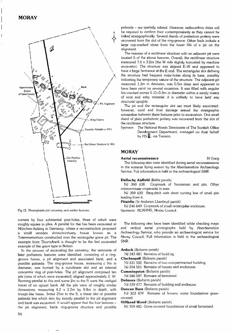
MORAY
ApproximateExtent
of Sand Quarry
_i_ Recti l inear Struciure (c. 186)
Fig 12 Thomybank cist cemetery and earlier features.
palisade - are spatially related. However, radiocarbon dates willbe required to confirm their contemporaneity as they cannot belinked stratigraphically. Several sherds of prehistoric pottery wererecovered from the slot of the ring-groove. Other finds include alarge cup-marked stone from the lower fills of a pit on thealignment.
The remains of a rectilinear structure with an adjacent pit werelocated S of the above features. Overall, the rectilinear structuremeasured 7.6 x 3.2m (the W side slightly truncated by machineexcavator). The structure was aligned E-W and appeared tohave a large ?entrance at the E end. The rectangular slot definingthe structure had frequent stake-holes along its base, possiblyindicating the temporary nature of the structure. The adjacent pitmeasured 1.3m in diameter, was 0.5m deep and appeared tohave been recut on several occasions. It was filled with angularfire-cracked stones 0.1S-0.3m in diameter within a sandy matrixof soot and ashy material: it is unlikely to have held anystructural uprights.
The pit and the rectangular slot are most likely associated:however, wind and frost damage erased the stratigraphicconnection between these features prior to excavation. One smallsherd of plain prehistoric pottery was recovered from the slot ofthe rectilinear structure.Sponsor: The National Roads Directorate of The Scottish Office
Development Department, managed on their behalfby HS Q , via Transco.
MORAYAerial reconnaissance M Greig
The following sites were identified during aerial reconnaissancein the summer flying season by the Aberdeenshire ArchaeologyService. Full information is held in the archaeological SMR.
Dallachy Airfield (Bellie parish)NJ 360 636 Cropmark of ?souterrain and pits. Other
indeterminate cropmarks in area.NJ 359 635 Ring-ditch with short curving line of small pits
leading from it.Pitairlie fSt Andrews-Lhanbryd parish)
NJ 246 649 Cropmark of small rectangular enclosure.Sponsors: RCAHMS, Moray Council.
corners by four substantial post-holes, three of which wereroughly square in plan. A parallel for this has been excavated atMunchen-Aubing in Germany, where a reconstruction proposeda small wooden shrine/mortuary house known as aTotenmemorium constructed over the rectangular grave pit. Theexample from Thornybank is thought to be the first excavatedexample of this grave type in Britain.
In the process of excavating the cemetery, the remnants oflater prehistoric features were identified, consisting of a ring-groove house, a pit alignment and associated bank, and apossible palisade. The ring-groove house, measuring c 9rn indiameter, was formed by a curvilinear slot and an internalconcentric ring of post-holes. The pit alignment comprised tenpits (nine of which were excavated) aligned approximately E-W.Running parallel to this and some 2m to the N were the vestigialtraces of an upcast bank. All the pits were of roughly similardimensions, measuring 4.2 x 2.2m by 0.8m in depth, withtrough-like bases. Some 25rn to the S, a linear slot or possiblepalisade line which also lay exactly parallel to the pit alignmentand bank was excavated. It would appear that the four features -the pit alignment, bank, ring-groove structure and possible
The following sites have been identified while checking mapsand vertical aerial photographs held by AberdeenshireArchaeology Service, who provide an archaeological service forMoray Council. Full information is held in the archaeologicalSMR.
Ardoch (Boharrn parish)NJ 343 481 Remains of building.
Clachnayell (Boharrn parish)NJ 331 502 Remains of two-compartmented building.NJ 334 501 Remains of houses and enclosures.
Cummingston (Boharm parish)NJ 340 507 Remains of farmstead.
Dalmore (Boharm parish)NJ 339 477 Remains of building and enclosure.
Duncan Burn (Boharrn parish)NJ 323 479 Remains of houses; some foundations grass-
covered.Hillhead Wood (Boharm parish)
NJ 359 485 Grass-covered foundations of small farmstead.
54
MORAY
Broadrashes (Botriphnie parish)NJ 373 478 Remains of farmstead.NJ 371 477 Remains of buildings and enclosures.
Cabbachs (Botriphnie parish)NJ 368 486 Remains of buildings, enclosures and pond.
Duffus (Duffus parish)NJ 170 684 Various cropmark features including circular and
rectilinear enclosures.NJ 171 682 ?Enclosure and other indeterminate cropmarks.
Knock Farm (Grange parish)NJ 545 532 ?Co-axial field system. Slightly raised area
bounded by very large earthfast stones. Area is divided intorough enclosures by large stones. Also ?hollow-way on SE side,again bordered by large boulders.Culantuim (Inveravon parish)
NJ 227 199 Remains of two-compartmented house.Crofts of Scalan (Inveravon parish)
NJ 246 199 Remains of small house and enclosure.NJ 244 198 Remains of two buildings.NJ 239 198 Remains of three-compartmented house.NJ 237 199 Remains of two-compartmented house.
Scalan (Inveravon parish)NJ 245 194 Remains of house and enclosure.NJ 249 191 Remains of two-compartmented house.
Wester Scalan (Inveravon parish)NJ 242 189 Remains of farmstead, with small house to SW.
Bodinfinnoch (Keith parish)NJ 378 485 Remains of small farmstead, mill and dam.
Hayston {Keith parish}NJ 389 486 Remains of farmstead.
Jock's Burn (Keith parish)NJ 394 487 Remains of farmstead and enclosure.
Jocksleys (Keith parish)NJ 395 492 Remains of rectangular building.
Moor of Auchanacie (Keith parish)NJ 387 488 Remains of two houses and small enclosure.
Rivehillock (Keith parish)NJ 398 485 Remains of small farmstead.
Rosarie Forest (Keith parish)NJ 392 499 Site of house and remains of two other structures.NJ 388 493 Remains of building.NJ 387 495 Remains of building.NJ 388 497 Remains of building.
Upper Broadfield (Keith parish)NJ 393 484 Remains of farmstead, mill, mill lade and dam.
Lynavoir (Kirkmichael parish)NJ 210 168 Remains of two-compartmented house.
Achbreck (Mortlach parish)NJ 297 339 Grass-covered foundations of houses.NJ 296 339 Remains of enclosure and house.
Achlochrach (Mortlach parish)NJ 293 342 Remains of house and enclosure.
Black Hillock (Mortlach parish)NJ 296 336 Faint trace of ?farmstead and rigs.
Lower Mains (Spynie parish)NJ 193 655 Cropmarks of ring-ditches, oval enclosures, pits
and other indeterminate cropmarks. Also two parallel curvinglines.Sponsor: Moray Council.
Moray Graveyards S FarrellPhotographic survey
A photographic survey was made of monuments of pre-1900date in various Moray graveyards. Forthcoming report andphotographs will be lodged with the NMRS.
Elgin Cathedral (Elgin parish) G Ewart, A RadleyWatching brief, excavation
NJ 221 630 A short watching brief was carried out by KirkdaleArchaeology in the area immediately S of the Bishops House.The groundworks involved two trenches being dug by machineand then cleaned by hand. The features recorded were 20thcentury in date.
The implications of excavating a soakaway to the S of the Stower of the W doorway were also investigated. After removal oftopsoil and cleaning of the exposed surface, it was clear that thewhole area represented disturbed ground with seven individualgraves being identifiable (including the fragment of a base for aprobable table tomb), and that it would not be possible toexcavate further without disturbing burials. It was decided toopen a second narrow trench against the SW angle and W faceof the tower, where it was discovered that an existing, moderndrainage channel had been cut against the base of the tower andran into a rubble-filled soakaway area against the bottom step.
No undisturbed natural horizons were identified within theexcavated areas, indicating that the whole area has beenmassively disturbed, probably entirely by graveyard activity.Sponsor: HS £J.
24 Lossie Wynd, Elgin (Elgin parish) R Coleman (SUAT)Well, medieval pottery
NJ 216 629 In advance of a development proposal for theerection of a block of flats at the junction of Lossie Wynd and StGiles Road, an archaeological evaluation was carried out in April1997. Lossie Wynd is thought to have been an eastern boundaryto the medieval town prior to expansion further E towards thechanonry. The evaluation revealed largely Victorian and modernfeatures, including a stone-lined well and hearth. One edge of apossible medieval pit was discovered, close to the St Giles Roadpavement edge, from which a sherd of late medieval pottery andfragment of animal bone were recovered. No furtherarchaeological work was recommended, other than thepreservation of the well.Sponsor: Springfield Properties Ltd.
Pansport Road, Elgin (Elgin parish) G Ewart, J TriscottWatching brief
NJ 222 630 A watching brief was undertaken by KirkdaleArchaeology in March 1997, while a deep water mains trenchwas cut down the SW side of Pansport Road, Elgin. A section ofElgin Cathedral's precinct wall ran adjacent to the trench at itsNW end. The evidence did not contradict the idea that the areahad previously been a medieval water meadow, with wetgrazing. _Sponsor: HS JJ].
Kinloss Abbey (Kinloss parish) G Ewart, A DunnWatching brief
NJ 065 615 An archaeological watching brief was completedby Kirkdale Archaeology during the opening of a new grave inthe family plot of the Dunbar-Naismith family at Kinloss Abbey inSeptember 1997.
The family burial plot lies against the S side of the S cloisterwall, believed to be a part of the original abbey, built c 1150/1,The plot is defined by three ashlar walls, forming a rectangulararea 5.8m N-S by 4.6m E-W abutting the S side of the S cloisterwall, and accessed via an original arch in the latter. Before themost recent interment, the plot held three graves against its Swall, and a further two (in the same grave) against the W wall,running E-W.
55
NORTH AYRSHIRE
The new grave was located in the NE corner, against the burialplot E wall and the S cloister wall. Excavation to a depth of1.75m revealed the brick lining of the E-W grave, constructed in1905, and the ashlar founds of the plot boundary wall, also tothe full depth of the trench. No monastic material was recovered,and the depth of the founds of the boundary wall, coupled withthe density and depth of graves within the plot, would suggestthat any monastic remains will have been removed in the 19thcentury, when the family plot was first laid out.Sponsor: HS Q.
A92 Fochabers to Mosstodloch Bypass T Rees (AOC)(Speymouth; Bellie parishes)Evaluation
NJ 316 600 to NJ 354 578 AOC (Scotland) Ltd inconjunction with Peter McGowan Associates was commissionedto prepare a Stage 3 (mitigation-orientated) archaeological andhistorical evaluation for the proposed A96 Fochabers andMosstodloch bypass.
These works comprised a desk-based assessment, a walk-oversurvey, a designed landscape survey and a series of evaluationtrenches. The fieldworkwas undertaken in March 1997.
A full report from this evaluation, with appropriate mitigationadvice, was submitted to Historic Scotland.Sponsor: The National Roads Directorate of The Scottish Office
Deve!o£ment Department, managed on their behalfby HS R.
Quarry Wood (Spynie parish) M Dalland (HAL)Survey
NJ 1858 6306 A contour survey of Quarrywood henge wasundertaken by Headland Archaeology Ltd to assist in themanagement and interpretation of the site by Forest Enterprise.The henge is- sub-oval E-W and measures 42 x 47m internallyand 54 x 59m externally. It was previously covered by trees butnow lies in a clearing in the forest.Sponsor: HS Q.
NORTH AYRSHIREThe following sites in North Ayrshire have been identified and
recorded during fieldwork carried out by the staff of WoSAS. Fulldetails are available in the WoSAS SMR.
NR 941 252 Glenree
(Dairy parish)NS 2662 5641NS 2695 5645
WhitehillLangdike
(Kilbride parish}NR 9845 3861 Glen Rosac NR 9999 4707 Allt Cam Bhain
(Kilmory parish)NR 896 363NR 9424 2646
NR 9467 2685NR 9488 2678
Creag MhorAllt Burican
Allt Cul CorriehiamAllt Cul Corriehiam
NR 9459 2679 Allt Cul Corriehiam
NR 9482 2679NR 9366 2554NR 9439 2518
Allt Cul CorriehiamAlltan DonnGlenree
?Cup-marked boulder.Buildings.
Drystone dyke.Cairn; cist; structure.
?Cist.Structures; shielinghuts (probable).4-post stone setting.Structures; shielinghuts (probable).Standing stone, cup-marked.Stone settings.Shieling huts.Lazybeds.
NR 9441 2514 GlenrecNR 9490 2505 GlenreeNR 9443 2657 Teanga BuricanNR 9066 3254 Machrie Moor
Lithic assemblagefrom ?hut circle (stDES 1995).Bridge abutments.Rig and furrow.Cairn: ?kerb.Hut circle.
A GrahamWhitehill (Dairy parish)?Chambered cairn
NS 2659 5613 The possible chambered cairn was sketched,photographed and a written record was made. An arrangementof large stones c 50m to the NW may be associated or mayrepresent a second cairn.
A fuller record has been deposited with WoSAS SMR.
Lochranza Castle, Arran (Kilmory parish) G Ewart,Watching brief P Sharman
NR 9332 5066 In April 1997 a watching brief was maintainedby Kirkdale Archaeology during the excavation of a trench on thestrip of land connecting Lochranza Castle to the S shore of theloch, providing a new water main along the coast road. Thecastle lies some 200m offshore in the loch at the end of a sandand gravel spur.
The spit comprised tidal sands and gravels, and the trench,23cm wide and 30cm deep, was excavated across c 190m of itslength- The only structural elements comprised two discrete areasof flat schist slabs buried to a depth of 20-25cm. These slabsappeared to be loosely laid, and of a single layer, buried in thebeach gravels; their function is not clear.Sponsor: HS Q .
Machrie Farm, Arran (Kilmory parish) GUARDPrehistoric ard marks
NR 908 338 Excavation of a small area in the vicinity of well-preserved hut circles and clearance cairns was undertaken inadvance of rebuilding of a power line from Carradale to Brodick.A basal peat sample was radiocarbon-dated to the mid-lstmillennium AD; ard marks were discovered at the base of themineral soil which underlay the peat.Sponsor: Scottish Hydro-Electric pic.
Monyquil, Arran (Kilmory parish) J O'Suilivan (GUARD)Post-medieval settlement
NR 939 355 Excavation of the remains of a post-medievalfarm settlement at Monyquil was undertaken in advance ofrebuilding of a power line from Carradale to Brodick. Althoughturf-clad wall butts could be defined by a preliminary survey,excavation could only define amorphous stony remnantsbeneath the turf.Sponsor: Scottish Hydro-Electric pic.
Moss Farm stone circle, Arran (Kilmory parish) G Ewart,Watching brief P Sharman
NR 908 323 A watching brief was maintained by KirkdaleArchaeology during the excavation of small trenches in the areaof the Moss Farm stone circle. These works were intended torealign the fence protecting the monument within the confines ofthe guardianship area. Two holes 25cm wide and 75mm deepwere dug into the subsoil 5m from the bank surrounding thestone circle. The same sequence of deposits was revealed in eachtrench; 15cm of peaty soil overlay 6cm of clean orange stonysand. There were no finds.Sponsor: HS Q .
56
NORTH LANARKSHIRE
Kilwinning Abbey (Kilwinning parish) I Cullen (GUARD)Human remains
NS 303 433 A watching brief was carried out during theexcavation of trenches and pits prior to the installation offloodlighting at Kilwinning Abbey in February 1997. The skulland upper chest area of a skeleton was excavated from a pit dugclose to the N entrance to the abbey grounds. The corrodedremains of a small iron plate were present over the chest area ofthe skeleton; no evidence of a coffin remained. The skeletonoverlay a compact surface of decayed yellow sandstone whichmay relate to the abbey buildings.Sponsor: T Brown & Son.
Lawhill Farm and Blackshaw Farm V Bickers(West Kilbride parish)Survey
The Lawhill Farm Discovery Project was carried out by theLargs Young Archaeologists Group in 1996/7.
A corridor of archaeology on the lands of Lawhill Farm andBlackshaw Farm was studied. Several archaeological structuresand features are known and already recorded, However, newdiscoveries were made as listed below.
NS 211 484 ?Ice house or ?well. Situated in a field to the E ofand several metres from Law Castle. Known locally but neverapparently investigated. Above ground, 'box'-like structure ofmortared red sandstone blocks, capped by a sandstone slab,angled so that the eastern section of the slab forms the E walland is embedded in the turf. N and S walls of mortaredsandstone blocks and red brick. W side open and appears at onetime to have had a door. Red brick steps lead down to an arch ofsandstone blocks and red brick. Structure flooded to level oflower steps. Preliminary investigations seem to indicate that thesteps lead to a small platform and then a steep vertical drop.Considered at present to be too dangerous for furtherinvestigation.
NS 219 476 ?Saddle quern in the fabric of a stone dyke.NS 213 484 Two lengths of banking. 0.7m high and 1.5m
wide, on the NW slope and NW summit of Law Hill. Thebanking on the summit links up sections of natural rock outcrops.The vertical section on the slope curves round to the E aboutthree-quarters of the way down the hill. One section has beeneroded by sheep and shows the construction to be of an earthcentral core with a facing of small sandstone boulders.Sponsors: Cunninghame District Council (now North Ayrshire
Council), Mr R McMillan, Lawhill Farm.
NORTH LANARKSHIREThe following sites in North Lanarkshire have been identified
and recorded during fieldwork carried out by the staff of WoSAS.Full details are available in the WoSAS SMR.
(Cumbernauld parish}NS 7762 7595 Vault Glen
(centre)NS 7726 7463 Kildrum
Plantation
(Shotts parish)NS 7890 6281NS 904 661
NS 907 656NS 9091 6572
DamheadDyke
NethertonOld Hall,Netherton
Limekilns.
Landscape water feature.
Farmstead.Deserted farmstead; well;enclosures; rig and furrow.Industrial structures.Structure.
Morningside/Watsonhead (Cambusnethan parish) J LewisSurvey
A desk-based study and field survey, carried out by ScotiaArchaeology Ltd in advance of proposed mineral extraction nearthe village of Morningside, identified several sites connected with19th-century mining and its associated railways. There were alsoremnants of a few probable earlier features although no trace ofthe medieval Chapel of Beuskiag, thought to have stood in thisgeneral area, was discerned.NS 8385 5516 - Rig and furrow, cut by line of railway.NS 8376 5535NS 8378 5537 Foundations of buildings and associated
enclosure, probably associated with nearbycoal pit.
NS 8347 5518 Field boundary comprising bank and narrowditch.
NS 8347 5518- Rig and furrow.NS 8347 5526NS 8396 5455 - Artificial water channel, probablyNS 8396 5460 associated with putative structure at its N end.NS 8367 5475 Remains of Chapel Farm.NS 8403 5507 Part of W pier of ?railway bridge over the
Auchter Water.NS 8370 5533 Small circular coal pit.NS 8349 5510 Circular coal pit.NS 8338 5471 Two coal pits adjacent to former railway.NS 8307 5455 Remains of three small buildings, probably
19th-century cottages.NS 8405 5479 Remnants of group of (mainly) brick buildings,
probably associated with mining.NS 8366 5426 - Elevated track, probably once linkingNS 8432 5469 Bogside and Watsonhead farms.NS 8329 5472 ?Remains of buildings, now very overgrown.Sponsor: H J Banks & Company Ltd.
Drumpellier Railway, Bargeddie, Glasgow K Speller(Old Monkland parish) (GUARD)Survey
A desk assessment and subsequent walk-over survey of anarea proposed for construction of a motorway services areaproduced the following sites:NS 702 631 Bridge piers, over the Calder Water.NS 701 633 Railway overbridge (complete).NS 705 632 - Single track branch.NS 701 633NS 704 631 Railway bridge abutment.NS 704 631 Road bridge; probably early 19th century.Sponsor: ASH Consulting Group.
Tarn's Loup Quarry, near Harthill (Shotts parish) C SwiftMedieval structure; watching brief (CFA)
NS 8747 6377 Previous evaluation undertaken in advance ofthe western extension of Tarn's Loup Quarry uncovered sherdsof medieval green-glazed pottery, implying that the upstandinggable wall in the vicinity of Wellslea farm could represent thevestiges of a medieval structure (DES 1996, 79-80). As NorthLanarkshire suffers from a paucity of domestic archaeologicalevidence for this period, a more extensive excavation wasrecommended.
oA single trench of 36rn revealed the foundation trench on the
W side of the gable wall which allowed the gable to be backedinto the slope. In addition to the gable wall, vestiges of the twoside walls containing opposing doorways were recovered. Acobbled floor surface, elevated on a grey silty sand foundation,survived in two discrete patches within the structure. An uneven
57
ORKNEY ISLANDS
hard standing was identified outside, and to the N and S. To theE, evidence of large-scale 19th-century disturbance suggests thatthe remainder of the structure had been destroyed.
No dating evidence was recovered from construction oroccupation contexts. However, the recovery of seven sherds offine green-glazed pottery in rubble suggests a medieval orimmediately post-medieval abandonment date for the structure.This supports the suggestion that this is the first medievaldomestic structure to be excavated in North Lanarkshire.
A watching brief was conducted in June 1997 on the 2.5haarea to be affected by a westwards extension of the existingTarn's Loup Quarry. A number of sites within the area had beeninvestigated during a prior evaluation and trial excavation.
Two percent of the development area was investigated, anarea totalling 5000m2. Drainage ditches were found in all 23trenches. Seven trenches contained additional archaeologicalremains, all of which were concentrated in the two areas of thesite where upstanding archaeological remains had previouslybeen identified. No new structures were identified. This suggeststhat, outside of the two aforementioned areas, the onlysignificant anthropogenic activity that Tarn's Loup Hill has seenis agricultural.
The majority of finds are sherds of post-medieval pot andglass. In addition, several sherds of medieval green-glazedpottery were found close to the previously excavated possiblymedieval structure at Wellslea.
Detailed reports will be lodged with the NMRS.Sponsor: Pioneer Aggregates UK.
ORKNEY ISLANDSOrkney Coastal Survey G Wilson, H Moore (EASE)
A coastal survey was conducted on the Orcadian islands ofBurray, Hunda, South Ronaldsay, Flotta, Graernsay and part ofHoy during August 1997. The survey comprised an integratedarchaeological and geomorphological evaluation of the coastalzone (a strip extending 50m inland of the HWM). In all, some200km of coastline was walked. A full report is underpreparation. The following list represents a brief summary of theprincipal sites recorded.
Hunda (South Ronaldsay parish)ND 440 967 Earthen mound, probably post-medieval farm
mound.ND 435 962 Cairn, denuded, prehistoric.ND 434 961 Cairn, denuded, prehistoric.ND 434 961 Large mound, disturbed, prehistoric cairn.ND 447 974 Mound, possibly post-medieval and industrial.ND 442 968 Earthen mound.
Burray (South Ronaldsay parish)ND 460 954 Slipway, post-medieval.ND 459 955 Slipway, post-medieval.ND 448 959 Croft, ruinous; horse burial, post-medieval.ND 446 961 Boatshed, ruinous, post-medieval.ND 445 961 Crofts, ruinous, post-medieval.ND 445 963 Croft and associated structures, ruinous, post-
medieval.ND 458 973 Croft and associated structures and enclosures,
ruinous, post-medieval.ND 462 972 Field boundary and cairn.ND 471 967 Crofts, ruinous, post-medieval.ND 474 983 WWI and II sea defences: Churchill barrier No
3 and block ships (Gartshore, Empire Seaman,Lapland, Mortis, Reginald).
ND 480 986 Structural and anthropogenic soil depositsvisible in erosion face, probably prehistoric.
ND 483 987 WWII searchlight emplacement.ND 484 987 Burray battery: WWII coastal battery built into
broch.ND 485 987 WWII searchlight emplacement.ND 386 987 WWII searchlight emplacement.ND 489 988 Broch.ND 503 963 WWI gun emplacements and magazine.ND 492 955 Hillock of Fea: cairn, denuded, prehistoric.ND 492 955 Anthropogenic deposits visible in erosion face,
probably prehistoric.ND 489 955 Slipway and track, post-medieval.ND 486 952 Anthropogenic deposits visible in erosion face,
probably part of a trackway, post-medieval.ND 478 952 WWI and II sea defences: Churchill barrier No
4 and blockships (Carron, JYa/a, Clio, Pontos,Collingdoc).
ND 472 955 Burray Village.
South Ronaldsay (South Ronaldsay parish)ND 446 935 St Margaret's Hope, village.ND 444 943 WWII ammunition lockers.ND 440 944 Pock-marked rock face, marks appear to be of
recent origin.ND 439 944 Trackway, stone land drains, post-medieval.ND 435 943 Croft and associated field system, post-
medieval.ND 430 941 Circular enclosure with external ditch,
?prehistoric.ND 430 941 Rectangular stone structure, ruinous,
?boatshed, post-medieval.ND 429 938 Croft, renovated and occupied, and associated
enclosure, post-medieval.ND 424 940 Croft, ruinous, post-medieval.ND 424 940 Little Howe: circular structure, disturbed,
?prehistoric settlement.ND 425 939 The Howe: broch, disturbed and partially
altered, also remains of settlement outwithbroch, prehistoric.
ND 420 942 Flotsam: possibly part of a WWII boom.ND 414 943 Noosts and boatshed, post-medieval.ND 413 942 Oval earthen mound.ND 409 937 WWII datum marker, ?temporary gun position.ND 408 936 Square drystone structure, ?boatshed.ND 407 935 Two WWII datum markers, ?temporary gun
positions.ND 406 933 Two boathouses, post-medieval.ND 403 933 Flotsam: metal cabling, chains, etc, may be
part of WWII defences.ND 403 931 Balfour and Hoxa Batteries, WWI and II
remains: searchlight emplacements, lighthousebase, gun batteries and associated buildingsand earthworks.
ND 417 934 Rectangular structure, ruinous, probablydomestic building associated with WWIImilitary activity.
ND 427 925 Croft, ruinous, post-medieval.ND 428 925 Croft, ruinous, post-medieval.ND 430 922 Croft, ruinous, and enclosure, post-medieval.ND 432 923 Rectangular structure and enclosure, medieval
to post-medieval.ND 420 907 Burnt mound, prehistoric.ND 423 914 Two crofts, ruinous, post-medieval.ND 422 916 Croft, ruinous, post-medieval.
58
ORKNEY ISLANDS
ND 422 916 Beached wreck, wood and metal. ND 474 918ND 421 918 Herston, village. ND 482 925ND 412 918 Amorphous mound with corrugated iron ND 484 928
protruding, probably WWII remains. ND 489 926ND 420 904 Amorphous earthen mound, cut by trackway. ND 487 931ND 421 902 Two earthen mounds, ?prehistoric.ND 428 892 Chambered caim, denuded and disturbed, ND 487 932
prehistoric. ND 487 933ND 433 888 Weems Castle: broch with associated defences, ND 488 942
prehistoric.ND 434 878 Orthostatic slab, probably a boundary marker, ND 487 943
post-medieval. ND 484 944ND 434 875 Mound with hollow, probably disturbed, ND 483 945
centre, ?prehistoric.ND 435 883 Amorphous mounds, disturbed, may be burnt ND 481 946
mounds shown by OS. ND 480 947ND 435 873 Stone scatter, may be ruinous boundary or ND 477 948
structure.ND 433 870 Promontory enclosure: earthen bank across ND 450 938
neck of promontory, ?prehistoric.ND 434 870 Rectangular stone-walled enclosure, post- Flotta (Walls
medieval. ND 341 930ND 434 866 Three or four earthen mounds, ?prehistoric. ND 346 924ND 434 864 Amorphous mound with hollow centre, may be ND 349 922 -
natural. ND 353 925ND 433 863 Boatshed, ruinous, post-medieval.ND 428 861 Promontory enclosure: earthen bank across ND 357 925
neck of promontory, ?prehistoric. ND 363 927ND 427 860 Curvilinear bank to rear of promontory,
?prehistoric. ND 362 928ND 428 857 Field system: series of earthen banks forming ND 363 929
rectangular enclosures, ?medieval.ND 434 842 Castle of Burwick promontory fort, prehistoric. ND 370 926ND 436 841 Rectangular enclosure, ?prehistoric.ND 442 833 Brough: broch rnound, prehistoric. ND 371 926ND 443 830 Two mounds, probably prehistoric. ND 372 924ND 445 829 Three mounds, disturbed, probably prehistoric ND 374 923 -
burial sites. ND 378 927ND 446 829 Four mounds, disturbed, probably prehistoric ND 375 934
burial sites. ND 375 934-ND 450 830 Sub-rectangular drystone cru. ND 375 936ND 450 831 S-shaped drystone cru. ND 364 958ND 459 833 Orthostatic slab, probably a boundary marker,
post-medieval. ND 368 958ND 460 832 Six prehistoric burial mounds, disturbed.ND 462 833 Mound, ?prehistoric. ND 369 958 -ND 463 832 Two remnant burial caims, prehistoric. ND 372 959ND 469 834 Cairn, probably prehistoric. ND 376 961ND 471 845 Isbister chambered caim, prehistoric. ND 378 962ND 471 847 Earthen bank across neck of promontory. ND 383 963ND 473 856 Mound, probably prehistoric. ND 385 961ND 457 868 Noost, post-medieval. ND 385 961ND 458 868 St Andrew's chapel, ruinous. ND 385 960ND 468 908 Croft with corn-drying kiln, ruinous, post- ND 386 958
medieval. ND 381 956ND 465 880 Cairn, ?prehistoric. ND 372 953ND 458 872 The Brough: promontory fort, prehistoric. ND 365 947ND 470 907 Rectangular house, ruinous, post-medieval. ND 358 948ND 471 907 Noosts/kelp-drying walls, post-medieval. ND 359 946ND 472 907 Windmill base, post-medieval.ND 472 907 Kelp pits, walls and amorphous mound, ND 359 943
?industrial, post-medieval. ND 361 941ND 472 908 Disturbed ground with fragments of walling, ND 361 941
?remains of industrial kelp or fishing station. ND 364 940ND 474 912 Drystone dyke boundary and cru. ND 368 940
Croft, ruinous, post-medieval.Wreck, metal.Lead mine.Mounds, probably natural.Croft and associated buildings, ruinous, post-medieval.Kelp pit, visible in erosion face.Croft, renovated, post-medieval.Stone surface, visible in erosion face, post-medieval.WWII datum marker.Drystone dyke and noost, post-medieval.Croft and associated buildings, ruinous, post-medieval; also farm mound.Croft, ruinous, post-medieval.Cara Battery: WWII searchlight emplacement.Cara Battery: WWII searchlight emplacement,altered for use as shed.Wreck: The Crop.
& Flotta parish)Concrete plinth, possibly WWII remains.WWII datum marker.Innan Neb/Neb and Gate Battery: WWI and IIbatteries, searchlight emplacements,magazines, earthworks, etc.Cairn with central cist, disturbed, prehistoric.Structural and anthropogenic deposits visible inerosion face, ?prehistoric.Rectangular stone structure, post-medieval.Harbour, noosts and boathouse, post-medieval.Occupied croft, noosts and clearway fintertidalzone).Well.WWII concrete post-base.Stanger Battery: WWII earthworks andstructural footings.WWII searchlight emplacement.Buchanan Battery: WWII battery andassociated structures.Concrete plinlh. probably WWII structuralremains.Pipeline with concrete supports, probablyassociated with WWII camp,WWII concrete bollards, also telegraph hut.
Telegraph hut.WWII structural footings and pier.Lighthouse base, metal pier and winding gear.WWII earthworks (?firing range).Amorphous rnound.Telegraph hut.Roan Head: WWI batteries and magazine.Earthworks, probably 20th-century military.WWII datum marker and earthworks.WWII datum marker.Noosts.Rectangular stone structure, ruinous, post-medieval, possibly a shed.Noosts.Structural remains seen in erosion face.Pier, post-medieval.Boatshed, wreck and noost, post-medieval.Pier, post-medieval.
59
ORKNEY ISLANDS
ND 372 941 Croft and associated buildings, ruinous, post-medieval.
ND 373 943 Croft and associated buildings, ruinous, post-medieval.
ND 377 944 Pier, post-medieval.ND 379 940 - WWII structural footings.ND 377 938
Graemsay (Hoy & Graemsay parish)HY 270 056 Rectangular structure, modern.HY 268 060 Hoy High lighthouse and associated buildings.HY 266 059 Crofts, associated structures and pier, ruinous,
post-medieval.HY 262 057 Noosts and pier.HY 261 057 Horizontal water mill, ruinous.HY 259 059 Crofts and associated structures including corn-
drying kiln, partially renovated, post-medieval.HY 258 059 Boatshed and walling, post-medieval.HY 258 061 Mound, ?prehistoric.HY 251 065 Noost, boatshed and slipway, post-medieval.HY 250 066 Hollow feature, possibly a kelp pit.HY 248 066 Noost and fish/kelp-drying wall, post-medieval.HY 246 066 Hoy Low lighthouse and associated structures.HY 246 065 Graemsay Battery: WWII battery, structures
and searchlight emplacements.HY 245 064 Trackway and noosts, post-medieval.HY 245 062 Fish or kelp-drying wall, post-medieval.HY 246 061 Anthropogenic deposits visible in erosion face,
indeterminate.HY 244 052 Blockship.HY 247 053 Concrete structure, probably WWII
ammunition locker.HY 248 051 - Rectangular enclosure and structures, post-
medieval. Four mounds, at least one of whichis a prehistoric burnt rnound.
HY 248 049 Mound, probably prehistoric burial mound.HY 251 048 - Boatshed and noosts, post-medieval.HY 256 045 Kirk and kirkyard, ruinous, post-medieval.HY 259 043 Boatshed and noosts, post-medieval.HY 262 043 Revetted walling seen in erosion face, probably
post-medieval.HY 269 047 Boatshed and jetty, post-medieval.HY 271 049 Croft, associated structures (including corn-
drying kiln) and enclosure, ruinous, post-medieval.
HY 271 051 Croft and associated structures, occupied, post-medieval.
HY 272 053 Jetty and boatsheds, post-medieval.
Hoy (Hoy & Graemsay parish)ND 287 887 Burnt mound, prehistoric.ND 291 886 Noost and boatshed, ruinous, post-medieval.ND 286 878 Indeterminate remains, ?prehistoric cairn or
house.ND 287 878 Rectangular structure, ?boatshed.ND 286 878 Rectangular hollow and adjacent rectangular
earth-banked structure.ND285 879 Cairn, denuded, prehistoric.ND 285 879 Broch mound and associated structures,
disturbed, prehistoric.ND 285 880 Burnt mound, prehistoric.ND 283 881 Chapel of Brims, ruinous.ND 284 882 Boatshed, ruinous, post-medieval.ND 2643 8868 Anthropogenic deposits seen in erosion face,
indeterminate.
ND 262 887 Flotsam: possibly part of pontoon.ND 313 947 - Lyness naval base, WWII.ND 307 939ND 310 938 Noost.ND 312 938 Amorphous ?prehistoric burnt mound.ND 312 939 WWII submarine netting, reused within modern
fence.ND 314 938 Croft and byre, ruinous, post-medieval.ND 316 937 - WWII structural remains and jetty.ND 318 937ND 320 937 Croft and associated structures, ruinous, post-
medieval.ND 321 936 Telegraph hut and boathouse.ND 324 934 Martello tower.ND 323 931 Croft, modernised and occupied, ruinous
boatsheds, post-medieval.ND 322 930 Croft and associated structures, ruinous, post-
medieval.ND 320 929 Croft and associated structures, ruinous, post-
_ medieval.Sponsors: HS ̂ , Orkney Archaeological Trust.
Westness Cemetery (Rousay parish)Viking cemetery
HY 376 293 An area of c lha adjacent to the previouslyexcavated cemetery at Westness, Rousay, was subjected togeophysical survey followed by trial trenching. The objective wasto investigate potential archaeological deposits recently revealedby coastal erosion, to investigate the presence/absence of furtherburials or features associated with the cemetery, and to definethe limits of the previous excavation trenches more closely.
Those deposits seen in the erosion face proved to besuperficial and did not extend inland. Elsewhere, with oneexception, trial trenching indicated that no substantial depositssurvived outwith the previous excavation area. One trench,which'was situated at the southern tip of the promontory uponwhich the site lies, uncovered parts of a human skullaccompanied by a fragment of bone comb. This was interpretedas a disturbed burial, probably of Viking date.Sponsors: HS ̂ , Orkney Archaeological Trust.
Bay of Skaill (Sandwick parish) P J AshrnoreWall
HY 2292 1877 The wall is 1m tall, drystone-built with morethan seven courses, and double faced. It is at an oblique angle tothe eroding cliff face so its width was difficult to assess; but itseemed less wide than tall. It was not visible in 1976. It appearsto sit just above t i l l , and it and tumble from it are containedlargely within a thick reddish brown deposit previously identifiedby Dr R Lamb as similar to the soil in the Neolithic layers atPool, Sanday, and likely to contain Neolithic structures. It seemsto be based at a similar level to the structures excavated nearSkara Brae by Dr D V Clarke in 1977 (DES 1977, 24) and thebutchery floor excavated by Dr C Richards in 1994 (DES 1994,92), although its distance from them and interveningdisturbances prevent a stratigraphic link. The reddish brown layerand the wall probably date to the 4th or 3rd millennium BC.Sponsor: HS £j.
Bay of Skaill cist fSandwick parish) H F James (GUARD)Christian burial, ?prehistoric walls
HY 2294 1876 A cist containing a skeleton had been partlyexcavated by the HS field monument warden Julie Gibson in1994 as it was being exposed by coastal erosion. The remaining
60
ORKNEY ISLANDS
cist and skeleton were again being exposed by the sea in 1996and so GUARD were asked to complete the excavation andretrieve the bones.
The cist had been constructed within a cut dug through severalhumic sand layers. It consisted of collapsed side slabs and a largecover slab. The skeleton was found lying in a prone position withits head turned to the right. A single small iron object, probably anail, was found within the grave. It was thought to be of an adultmale of less than 30 years of age. The cist was sealed by a layerof redeposited sand above which was a layer of small stones,which possibly formed a low circular cairn over the burial.
Immediately to the NW of the cist in the same eroding sectionwere other structural elements which were sealed by the humicsand noted above. These elements consisted of small sections ofupright and collapsed walls. The quality of the stonework andstratigraphy suggested that the stonework was prehistoric.Sponsor: HS Q.
Skaill House (Sandwick parish)Medieval or Early Christian cemetery
HY 2346 1860 A medieval or Early Christian cemetery wasdiscovered by Dr Raymond Lamb during drainage works atSkaill House. Six uncisted skeletons (one with its head within astone box) were salvaged from a pipe trench, and the side of acist containing human remains noted.
GUARD undertook a five day excavation in two small areas. InArea A, beneath 1.3m of windblown sand, was a well laid-outcemetery aligned E-W, consisting of 12 upright stone gravemarkers, two flat slabs and two graves with several flat coverslabs. Two graves were partially excavated in order to determinethe nature of the cemetery and to retrieve bone samples forradiocarbon dating.
In Area B, beneath 0.3m of made-up ground, were a furtherfive uncisted burials aligned E-W. Both adults and children wererepresented. Further samples were taken for radiocarbon dating.The side of the cist noted by Dr Lamb was located, but as thedrainage pipe had already been laid, it was not available forexcavation. Three of the burials in Areas A and B had their skullsenclosed by head-boxes. No grave goods were found in thecemetery.
Three sections of walling were seen just beneath the surface toa depth of 0.71m in Area B. This walling post-dated thecemetery and was interpreted as the foundations for outhousesbelonging to Skaill House which was constructed in the 17thcentury. _Sponsor: HS Q.
Skara Brae Visitor Centre (Sandwick parish)Watching brief, excavation
HY 2345 1875 Prior to the construction of a new visitorcentre for Skara Brae, an archaeological evaluation andwatching brief was undertaken of all areas likely to be affected bythe enabling works.
Five of the trenches contained evidence for collapsed stonewalls at a depth of 1-1.8m below sterile windblown sand. Threeof these walls, which showed evidence of clay bonding, wereinterpreted as field boundaries, although an associated oldground surface was not identified.
A drain leading from an upstanding circular structure (apossible 19th-century lint mill) was also identified, but samplestaken from its fill did not contain any plant microfossils whichcould have confirmed its function.Sponsor: HS Q.
Various (Westray parish) J Barrett, I Simpson, T DavisThe following sites have been investigated along the Westray
coast:
CleatViking Age midden
HY 467 466 A 1 x 2m test-pit was dug in a coastal midden atthe centre of the Bay of Cleat. The site had been located andsampled by Sarah Colley (pers comm) in 1979, but was notpreviously dated. The exposed deposit was c 60cm thick, but itshorizontal extent was unclear. Finds include a flattened sphericalweight of Viking Age type, steatite vessel fragments, a femurhead spindle whorl, and an as yet unidentified worked boneobject. An AMS radiocarbon assay on charred barley (TO-6344,980±110 bp) yielded a calibrated date of AD 870-1280.
Loch of BurnessLoch bed sediments
HY 42 48 Three sediment cores were taken from the bed ofthe Loch of Burness for palaeoecological analysis.
Quoygrew-Nether TrenabieViking Age and later middens and structures
HY 443 506 In June and July a programme of renewedreconnaissance and archaeological sampling began at the site ofQuoygrew, known as Nether Trenabie in 19th-century sources. A2 x 1m test-pit had been excavated in coastal middens by SarahColley (pers comm) in 1978. Although further eroded, thesedeposits now stretch 40m along the wave-cut bank and augeringrevealed that they continue inland for c 15m. The central 20m ofthe exposed profile (1-1.3m in thickness) was drawn. Three50cm sample columns were excavated for fine recovery of fishbone, botanical macrofossils and terrestrial molluscs. Soilmicromorphology samples were taken. A 1 x 2m test-pit was alsoexcavated to recover a sample of mammal bone and datableartefactual material. A further 2 x 5m test trench examined asmall drystone 'cellar' dug into the midden. This structure, whichhad a flagged floor and stone-lined drain, may represent a naustor a semi-subterranean byre.
The midden can be dated to the Viking Age by antler combfragments and steatite vessel sherds. Other finds include bonepins, a highly corroded possible coin, a possible bone gamingpiece, and perforated discs made from the unfused vertebralepiphyses of a small whale. Sherds of coarse pottery from theupper strata may imply that deposition continued into the LateNorse (medieval) period. The fill of the structure dug into themidden included coarse pottery and low-grade coal which maysuggest a post-medieval date.
To landward, geophysical survey by Loma Sharpe of GlasgowUniversity revealed a possible rectangular structure, c 18 x 7m.Auger survey and soil test-pits delineated additional middens ofunknown date and a relict anthropogenic topsoil over 90cm deepin places. The latter covers an area c 80 x 200m in maximumdimension and can probably be interpreted as an infield(tunmal).
TrenabieTurf and stone boundary
HY 447 511 A poorly preserved turf and stone dyke lies nearthe boundary of Trenabie farm and unenclosed hill land. A 1mtest-pit was dug to sample a thin soil horizon buried under thewall for possible radiocarbon dating.Sponsors: Social Sciences & Humanities Research Council of
Canada, Society for Medieval Archaeology, OrkneyIslands Council. Glasgow University.
61
PERTH AND KINROSS
PERTH AND KINROSS
Ardocb Roman fort (Ardoch parish) R Strachan (CFA)Erosion survey and possible palisade
NN 839 099 A survey was conducted in February 1997 at thescheduled Roman fort at Ardoch, Braco (NMRS NN 80 NW 10).The objective was to detail the visible extent of rabbit (and other)damage to the fort. The gorse cover had been removed andsome of the trees cut prior to the survey.
A variety of sources of erosion were identified, consistingmostly of rabbit burrowing, but also including moles, gorse, trees,human activity and other natural agencies. A concentration oferosion was noted on the upstanding earthwork features of thesite, which has caused significant alterations to the profiles ofthese ramparts in places. The southern faces of these ramparts,and the upper S facing slope of the ditches are also beingeroded, most likely reflecting the preferred habitat of the rabbiton the more sheltered or sunnier slopes. The softer fills presentedby the backfilled trenches of the 1896-7 excavation appear tohave encouraged substantial burrowing in some of these areas(the NE, E and SW). Burrowing has also concentrated on the NEhalf of the interior which also underwent excavation in 1896-7.This is in direct contrast to the distribution of mole burrowingwhich concentrates on the unexcavated part of the fort interior.
While conducting the survey a new part of a curvilineardepression, comparable to a palisade trench, was noticedrunning along the inside of the outer rampart from the Eentrance to the N entrance.
A copy of the_report has been lodged with the NMRS.Sponsor: HS Q.
Blackhill Wood (Ardoch parish) B Glendinning, A J DunwellRoman signal station and temporary camp (CFA)
NN 8452 1075 Excavation on the site at Blackhill Wood wascommissioned in response to substantial damage being caused tothe monument, principally by rabbit burrowing and tree roots.Surveys were undertaken to assess the level to which both ofthese agents had affected the remaining evidence. It was alsohoped to supplement the information gained from Professor J KS St Joseph's trenches at the site, from 1974.
The site was defined by two concentric, sub-rectangular, V-shaped ditches with an external diameter of 25.2-26.3m.Associated with these were outer and medial banks of upcastmaterial and an inner turf work. The inner ditch surrounded anarea of 11.2-12.3m, which contained the inner turf work and theremains of a 4-post tower structure.
The ditches differed in size with the outer being the slighter(2.5-3.4m wide by 0.3-0.5m deep), while the inner measured 2-2.5m wide and 0.5-0.8m deep. Upon excavation it wasconfirmed that the outer ditch did not continue around thesouthern side of the site where the ground slopes off to the S. Anoven, with a stone-paved base, was located cut into this slope.From the fill sequence it is difficult to say whether this wascontemporary with the signal station or the temporary camp. Theentrance to the signal station faced towards the Roman roadwhich lay 30m away to the W.
Three post-holes were located with a fourth one assumed to lieunder a large oak tree. They were fairly similar in size being over1m in diameter, and 0.95-1.Olm deep. The NE post-holeexhibited three phases of use. From this evidence the dimensionsfor the tower structure would appear to have been around 3.5m(SE-NW) by 3.7m (NE-SW).
Within the area bounded by the post-holes, ie the interior ofthe tower, paving was located on top of a levelled surface; repairto this paving was also evident.
A small amount of excavation was carried out on the defencesof the temporary camp, to confirm St Joseph's observationsabout the relationship between the sites. The temporary campwas strati graphically later than the signal station. The campdefences were a standard V-shaped ditch with an upcast innerrampart.
As with all Cask sites finds were rare. They include anunstratified sherd of coarse ware, a square-headed nail fromwithin the area of the tower, and a stone incised with lineargrooves from the sharpening of iron blades from the inner ditchof the signal station. There were no finds from the temporarycamp. _Sponsor: HS Q.
Stanley Mills (Auchtergaven parish) A Cox (SUAT)Industrial artefacts assemblage
NO 114 328 During the excavation of the waterwheel pits andother surviving features for Historic Scotland, an assemblage ofartefacts relating to the use and subsequent abandonment of thefeatures was recovered. SUAT was commissioned to sort, labeland record this material. Several fragments from the outer casingand blades of a cast-iron turbine are among this assemblage,which also includes a variety of iron bolts and miscellaneousfasteners and fittings associated with components of thewaterwheels and their mountings. Bottle glass, Early Modemceramics, and lengths of steel wire-bound hemp rope were alsorecovered. _Sponsor: HS Jj.
Herald Hill (Capulh parish) G J Barclay, G S MaxwellLong barrow
NO 1867 3961 The mound at Herald Hill {NMRS NO 13 NE62) has often been interpreted as a possible long barrow, largelybecause of its 'classic' profile, with a raised E end. It measuresabout 70-80m in length, between 15-20m across, and up to 4mhigh at its higher (E) end, falling to less than 1m at the W. In1997 a 1m square test-pit was dug about 19m W of the summitand c 3m N of the axis of the mound, to determine if the moundwas artificial. The uppermost metre of the profile appeared to beredeposited. Below that level was undisturbed subsoil. Thissuggests that the profile of the mound is substantially the productof human construction, but that the builders took advantage of apre-existing low fluvio-glacial ridge. It seems probable, therefore,that the mound is a long barrow.
Bandirran (Collace parish) G WatsonSlanding stone, recumbent stone and other stones
NO 2107 3096 A survey by the Archaeological & HistoricalSection of the Perthshire Society of Natural Science revealednine stones in the vicinity of the standing and recumbent stones(NMRS NO 23 SW 2). Five of these 'new' stones, with thestanding and recumbent stones, form an apparent circle of sevenstones, c 14.5m diameter, with a sixth stone within the circle tothe N of the standing stone. Two other stones to the S of thestanding stone do not form part of the circle (one, displaced, islying on the turf); the ninth stone is SE of the standing stone. Thestones are within a much larger, low-banked, oval enclosure.
A drawing and sketch plan by Skene of Rubislaw, dated 1834,shows the standing and other stones before the site wasafforested. This drawing has been wrongly identified as being ofthe Bandirran Stone Circle at NO 2091 3099 (NMRS NO 23 SW3). Skene depicts the standing stone as being at the centre of acircle of seven stones (including the recumbent stone), with aneighth stone within the circle to the N of the standing stone.Skene gives the diameter of the circle as 36ft (10.97m).
62
PERTH AND KINROSS
Excluding the standing and recumbent stones, five of Skene'sstones can still be found on site: to the NW, NE, E SE and thestone within the circle to the N of the standing sfone; Skene'sstones to the N and SW are no longer evident. In addition tothese stones of Skene, the present survey located another stoneto the NW and another to the NE.
The 'new' stones vary in length from 0.59-1.09m. Therecumbent stone is 2.61m long, the standing stone c 2m. As the'new' stones are dwarfed in size by the standing and recumbentstones, it is not clear whether either of the apparent stone circles(of Skene or the present survey) is genuine or the result of morerecent placement, but presumably long before Skene's visit. It isunlikely that the positions of the smaller stones are natural.
The survey and photographs will be lodged in Perth Museum.
Kynachan (Dull parish) M Dalland (HAL)Pre-afforestation survey
NN 769 586 (centre) A short-notice forestry survey wasundertaken by Headland Archaeology Ltd over c 1km of landon the NE side of Craig Kynachan, to the S of Tummel Bridge.
Three sites, comprising 18 individual structures, were recorded,located around a preserved stretch of General Wade's militaryroad at the E end of the survey area. Some may relate to theconstruction of the road, but others clearly post-date it. Abloomery found at the W end at the area could date back to thelate prehistoric or medieval period.NN 775 586 (centre) Road, quarries, dykes, buildings, mound.NN 7691 5861/ ?Shooting butts.NN 7692 5852NN76115876_ Bloomery.Sponsor: HS ̂ .
Fowl is Wester Church (Fowlis Wester parish) R StrachanExcavation (CFA)
NN 9281 2408 An archaeological excavation was undertakenin August 1997 prior to proposed remedial works at FowlisWester Church. Two trenches were excavated at its SE and NEcomers, adjacent to the E gable end of the structure. In bothtrenches the stratification was similar, showing a high density ofhuman remains within the graveyard immediately E of thechurch. The upper 0.6-0.9m of deposit consisted of mixedbackfill, presumably derived from the constant cutting andbackfilling of graves. This layer contained an abundance ofdisturbed human bone and modern artefacts, as well as a singlesherd of medieval pottery. All but one of the graves encounteredwere of modern origin, and likely date to within the last century.The date for the lowest grave exposed cannot definitely beascertained, although its location against the church wall andimmediately above bedrock may indicate an early date.
The excavation showed that the church foundations rest directlyupon bedrock. The subsidence and cracking of the N and S walls(which instigated the need for remedial work) cannot therefore becaused by the building subsiding as a result of its position on top ofgraves, at least in this area, as previously thought.
All of the finds and human remains recovered during theseexcavations were reinterred in their respective trenches.Sponsor: Balmoral Stone.
Ben Lawers Historic Landscape Project J A Atkinson,(Kenmore parish) M Donnelly, G MacGregor (GUARD)Shielings/Mesolithic occupation
A second pilot season of the Ben Lawers Historic LandscapeProject was undertaken in September 1997. This phase of workwas targeted on four structures within the high shieling group ofthe Ben Lawers Nature Trail.
NN 6146 3924 A 10 x 10m trench was excavated over amound located along the moraine bank which was partiallyexcavated in 1996 (see DES 1996, 85). This season's excavationrevealed that several turf banks ran along the top of the morainebank forming a small structure, c 3.4 x 2.5m, containing stake-holes, post-holes and a firespot. Along the southern foot of themoraine bank a platform composed of turf and stone had beenconstructed, within which was at least one large post-hole. Thepartial excavation of the turf structure has indicated that it couldbe a dwelling of some form. The presence of microliths andsnapped blades amongst the assemblage of worked quartz andflint recovered clearly indicates Mesolithic activity within the area.The recovery of charcoal from the firespot within the interior ofthe structure should provide a radiocarbon date relating to theuse of the structure.
NN 6145 3925 A 10 x 8m trench was located over the wholeof a drystone rectangular shieling hut which was partiallyexcavated in 1996 (see DES 1996). Evidence from the interiorindicated two phases of construction, with an extension added tothe original construction which was evidenced in differences infloor deposits and was also apparent in a difference in wallconstruction. The structure was originally 5.5m long by 1.6mbroad and was extended to 6.8m long. Internal features revealedincluded a series of post impressions and a sub-division of theinlerior defined in a line of stake-holes. Other features included aseries of timber slots around the firepit adjacent to the entrance.Artefacts recovered during the excavation include ironwork,bone, ceramics (late medieval redware), glass and struck quartz.
NN 6129 3928 Upon deturfing and cleaning back an enlargedarea of this structure, it became apparent that there were in facttwo structures. This was shown by the variations in alignmentand constructional technique, notably the lower northernstructure was constructed from large schist orthostats with a bankof sand and gravel and was oval in plan, and the raised southernstructure was constructed as a drystone wall with large turf bankand was rectangular in plan. The bank of the southern structure(later) overlay that of the northern (earlier), and the interior ofthe later structure was cut by numerous post-holes suggestingthat this structure was roofed. It would appear that the originalentrance continued in use during the lifetime of the laterstructure, perhaps as some form of outhouse or enclosure. Thewestern bank of the later structure was revetted at a point whereit is bypassed by a droveway suggesting contemporaneity withthis feature. Finds from this season mirror those of last year withglass, iron objects, late medieval redware pottery and some(possibly residual) quartz flakes being recovered. None of thesefinds were well-stratified.
NN 6143 3926 A 5 x 5m trench was placed over a smallcircular drystone structure of 1.4m internal diameter, which hadpreviously been identified as a possible dairy building within theshieling group. Excavation focused in the interior entrance(which faced SE) and external area including outer bank and alinear ditch structure which ran N-S to the W of the structure.Evidence of a sealed land surface to the S of the structure wasalso noted, with a fragment of possibly prehistoric pottery beingrecovered from the hillwash over this feature. The main structureappeared to be of single-phase construction and no datableartefacts were recovered from its interior.
An interim report will be lodged with the NMRS in due course.Sponsors: HS |, NTS.
Cragganester (Kenmore parish) G MacGregor (GUARD)Post-medieval fields
NN 660 385 Reconductoring work within the bounds of thescheduled Cragganester MOLRS site led to a programme of
63
PERTH AND KINROSS
archaeological work, including the demarcation of sensitive areasand the excavation of a portion of an enclosure dyke, and itssubsequent reinstatement.
Full details are in a report which will be lodged at the NMRS.Sponsor: Hydro-Electric pic.
Arnbathie Farm (Kilspindie parish) I HallyburtonHut circles
NO 170 258 Two hut circles on the SE slopes of Law Hillabove Scone were surveyed in December 1996; they may beassociated with Ihe existing hillfort and previously recordedsettlement 1km to the N. The structures were of 8.2m and 12.3mmaximum diameter.
Grounds of Ladywell House, Rait A Cox (SUAT),(Kilspindie parish) G NicholsonCarved stones and artefacts
NO 210 277 A large boulder (c 1m across), discovered nearthe front entrance to Ladywell House approximately 10 yearsago, bears shallow markings in the form of pecked circles withdesigns faintly visible within them, possibly representing Christiansymbols. In woodland behind the house, a possible milestone ormarker post of cylindrical form, marked with the number 31, wasfound earlier this year. Quernstone fragments and other carvedstone objects have also been found in the environs of the housein recent years. Reported to SUAT by the finder, Mr GNicholson, of Ladywell House.
Gleann Fearnach (Moulin parish) J HarrisSurvey
During May 1997 a survey of sites within the historic march ofGleann Feamach was completed (see DES 1996, 85). Thepresent march extends into Glen Loch and it is hoped tocomplete a similar survey in that area.NO 006 741 36 shielings, pens and enclosures.NO 0125 7123 Shieling.NO 015 733 45 shielings, pens, enclosures and
miscellaneous structures.NO 016 722 2 shielings and pen.NO 023 711 Enclosure.NO 033 714 2 shielings.NO 0333 6912 Building.NO 046 703 Enclosure.
Drummond Castle (Muthill parish) D Bowler (SUAT)Garden feature
NN 843 179 Machine and hand excavations beside thewestern boundary wall of the formal gardens show that the basewall has been partly buried by soil accumulation, and originallystood at the foot of a gentle but substantial slope, functioning ineffect as a ha-ha. The excavation also revealed two spurious wallfoundations, in faci natural glacial features, composed of iron-rich green sandstone rubble. The sandstone delaminates incurved sheets resembling prehistoric pottery, adding a furthertrap for the unwary.Sponsor: Drummond Castle Trust.
Drummond Castle (Muthill parish) N M Robertson (SUAT)Courtyard of medieval and later castle
NN 844 180 The probably mid-19th-century decorativearrangement of stone setts in the inner courtyard of DrummondCastle had to be lifted for relaying due to subsidence. Recordingof revealed features by SUAT took place in December 1996.Immediately under the setts was bedding of reddish-brown sandyclay, mixed with chips of the underlying igneous bedrock, which
was presumably flattened to form a courtyard surface as longago as the 15th century. Two culverts constructed in and on thebedrock were recorded, along with a dwarf wall of no great age,built over a hollow in the rock to support a pipe. No finds wererecovered from the culverts, which were not necessarily of greatantiquity. A hollow in the rock by the dwarf wall had beenbackfilled with a dump of animal bones and broken wine bottlesof the mid- to late 18th century.Sponsor: Drummond Castle Trust.
Greyfriars Graveyard, Perth (Perth parish) R Cachart (SUAT)Medieval monastic site and graveyard
NO 119 232 In August 1997, SUAT hand-excavated two test-pits against the E wall of Greyfriars burial ground in advance ofproposals to dismantle and rebuild much of the wall. The burialground represents the site of the monastery and grounds of theObservant Order of Greyfriars, or Franciscans, or Friars Minor, inPerth, first mentioned in records in 1496.
In one pit what were considered to be the original Greyfriarswall foundations were located, and from these the probablecontemporary ground level can be extrapolated. A succession ofwall foundations revealed a history of wall replacement andrepair with subsequent raising of the ground levels. Datingevidence in the form of medieval pottery associated with aprobable lower garden soil against the Greyfriars original wallwas also retrieved.
In the other pit, the lack of a succession of wall foundationsconfirmed that this area was within the 1795 graveyardextension and outwith the original ground of the monastery. Theremains of the 1795 wall foundations lie directly below thepresent standing wall. Again it is possible to work out theprobable ground level at the time of the extension. This pit alsorevealed a succession of infill/levelling layers probably datingfrom the infilling of a burn which ran parallel to the burial groundS wall prior to the 1795 extension.
The pits also revealed that burials extend from 1m down to c1.8m, and lie hard up against the wall, which has no doubtcontributed substantially to the instability of the present E wall.Depths of burials may vary a great deal from one lair to the next,and the tops of grave cuts appeared as high as 0.4m down.Sponsor: Perth and Kinross Council.
Kinnoull Street/North William Street, Perth D Bowler(Perth parish) (SUAT)Watching brief
NO 116 238 A watching brief on engineers' groundinvestigations directly W of the Dominican Friary revealeddisturbed medieval occupation layers, modern foundry waste,and deep geological deposits of clay, sand and gravel.Sponsor: McCarthy & Stone (Developments) Ltd.
Perth Floods Prevention Scheme S Stronach (SUAT)(Perth; Tibbermore parishes)Preliminary archaeological assessment
NO 0698 2568 to NO 1260 2140 The preliminary assessmentof the archaeological implications of the proposed Perth RoodsPrevention Scheme involved an initial site walk-over and desk-based assessment, which did not identify any new archaeologicalsites, followed by a series of field evaluations.Greater South Inch (Perth parish)
NO 1187 2305 Resistivity survey followed by test-pittingestablished the SW limits of the Cromwellian Citadel at a shallowdepth, S of Marshall Place and W of Edinburgh Road. The top ofditch deposits and revetment walling against the inner face of theditch were identified, but no features were encountered within
64
PERTH AND KINROSS
the interior. These results complement previous work concerningthe location of the citadel (DES 1994, 89} and confirm thatremains relating to the fort survive very close to the presentground surface. The finds recovered from the evaluation aremainly 18th century and relate to the infilling and disuse of thecitadel, although some heavily abraded residual medieval potsherds were recovered.North Inch (Perth parish)
NO 1190 2390 Four trenches were machine-excavated in theS part of the North Inch on the path of a proposed embankment.All deposits were modern in origin and related to landscaping.No evidence of medieval land-use was recovered from thishistorically open space.Inveralmond Industrial Estate (Tibbermore parish)
NO 093 650 A total of eight trenches were excavated in twoareas between the industrial estate and the River Almond. Nofeatures of archaeological interest were identified and the earliestfinds recovered from the cultivation soils date to no earlier thanthe 18th century.Sponsor: Perth and Kinross District Council Roads & Transport
Department.
Playhouse Cinema, Foundry Lane, Perth N M Robertson(Perth parish) (SUAT)Blackfriars lands
NO 116 238 An area between the rear wall of the PlayhouseCinema and Foundry Lane, in which an extension to the cinemawas to be built, had in the Middle Ages been part of the landspertaining to the Dominican Friary of Perth. A single trial trench,c 22m long and c 1m broad, was machine-excavated E-Wacross the site parallel to Foundry Lane. A cellar, backfilled withdemolition rubble, and several mortared rubble or brickfoundations crossed the line of the trench. These must relate tothe modern garages that stood here up to the start of 1997, andto a foundry that stood on the site in the 19th century. Below alayer of demolition rubble, 0.2m or more in thickness across thewhole site, were very hard-packed deposits of orange-brownsandy clay with patches of grey-blue clay, flecked with charcoal,and grey-brown clay, flecked with charcoal. Despite being sosolid, these deposits seemed too near the modern surface to benatural, and a sondage revealed them to be only some 0.4mthick, overlying c 0.8m of garden soil mixed with occasionalsherds of medieval pottery. No features were observed dug intothe subsoil, and it would appear that the area was undevelopedand used only for cultivation before it was taken into Perth'sstreet plan in the late 18th or early 19th century.Sponsor: Caledonian Cinemas.
Scott Street/Canal Street, Perth (Perth parish) D Perry,Medieval pits and boundaries A Cox (SUAT}
NO 117 234 A small excavation demonstrated that the largeand deep feature cut into the natural, which was found in the1989 excavation (DES 1989, 63), was not a defensive ditch, butmore probably a quarry pit. The backlands seern to have beenlargely devoid of structures until the post-medieval and modernperiods, having been used as open ground or gardens. Pits, twoproperty gullies and a stone drain were found, as well as a post-medieval stone well. No trace of the town wall or ditch wasfound along Canal Street.
A mixed assemblage of artefacts of medieval and post-medieval date was recovered. Two metallic finds of medievaldate were found in the lower of two garden soil deposits. One isan iron clench bolt, consisting of a nail and a rectangular ordiamond-shaped rove. The function of clench bolts was to securetwo or more thicknesses of timber, and they were commonly
used in the medieval period in plank-built, wooden structures.The second find from this deposit is a fragment from the frame ofa copper-alloy buckle.
Several irregularly shaped pieces of daub with numerous strawimpressions were found in the fill of a quarry pit and in smallerquantities in the overlying deposits. Finds from more recentdeposits associated with the construction or demolition of theCo-operative Society buildings, until recently occupying the site,include 19th-century bottle glass, fragments of brick, and claypipe stems.Sponsors: Perthshire Housing Association, Servile Housing
Association.
Kinnesswood to Scotlandwell to N Robertson (SUAT)Balbedie Farm (Portmoak parish)Watching brief
NO 177 027 to NT 180 990 Monitoring of the excavation oftrenches for new pipelines to the W and S of Scotlandwellrevealed that the natural sand was very badly plough-damagedand little or no archaeological material survived. The only find ofany significance was a small Neolithic axehead which was foundclose to the site of a previous similar discovery. Nothing relatingto either of the medieval hospitals of Scotlandwell or Portmoakwas recovered.Sponsor: East of Scotland Water Authority.
Milton of Rattray (Rattray parish) K Brophy?Pit-defined cursus
NO 197 447 A possible pit-defined cursus lying on the floodplain of the River Ericht 1km E of Blairgowrie was identified byaerial photography in 1990 (NMRS NO 14 SE 82). It is definedby two parallel pit alignments, visible for 75-120m, and 20mapart, running in approximately an E-W direction. The large pitsdefining the site appear from the air to be 4—6m apart.Excavation of one of these features revealed it to be a shallowelongate pit, 2.6 x 1.2m in size, with a maximum depth of0.35m. It appeared truncated, but the level of truncation wasunclear. The bottom was reasonably level, and the sides shallowsloped (although steeper on the S side). The fill was a uniformsandy clay, quite distinct from the natural river gravels the pitwas cut into. The long axis of this pit had the same orientation asthe pit alignments themselves. No artefacts or datable materialwere recovered.
A second pit feature was located, beneath what appeared tobe a spread of its own fill. Limited sectioning of this featuresuggested it to be of a similar nature to the fully excavatedexample. Small-scale investigation into the area between the pitalignments revealed no further features. Whilst no extra light wasshed on the dating of this site, the possibility that it was someform of pit-defined cursus or avenue cannot be ruled out.Sponsor: Archaeological Research Projects, William and
Margaret Kesson Award {Glasgow University)
Cowrie Quarry {Redgorton parish} M Bishop (for AOC)Cropmark, pit alignment
NO 092 315 A proposed extension to the sand and gravelquarry at Cowrie N of Luncarty occasioned an evaluatoryexcavation conducted by AOC (Scotland) Ltd. Examination ofaerial photographs had identified a pit alignment (NMRS NO 03SE 32) running across the two fields to the S of Marlehall Farmon a SE-NW alignment. Other features identified included amodem gas pipeline, the remains of the Bankfoot light railway,part of the course of the old turnpike predecessor to the A9, andtraces of rig and furrow ploughing.
65
RENFREWSHIRE/SCOTTISH BORDERS
The excavation, which examined c 300m , failed to find anyremains of the pits at their rectified aerial photograph location,with the sole exception of a modern pit next to the demolishedrailway, which appeared to be contemporary. The rig and furrowcultivation had been almost completely removed by modernploughing, as had the former embankment of the railway.Sponsor: Fife Sands & Gravel.
Cottown Old Schoolhouse (St Madoes parish) S A WallaceExcavation (NTS)
NO 2058 2102 A narrow trench was excavated around threesides of the house for drainage purposes, with a soakaway pit cutinto the lawn to the S of the 18th-century building. In the courseof the excavation the remains of two probable walls were found.one to the NW and one to the SE of the building. The wall onthe SE side appears to have been constructed in the early 19thcentury, while that on the NW probably belongs to the middle tolatter part of that century.
As well as pottery and other finds of 19th and 20th-centurydate, a single sherd of medieval pottery was found under thewall fragment to the SE of the house.Sponsor: NTS.
RENFREWSHIREThe following sites in Renfrewshire have been identified and
recorded during fieldwork carried out by the staff of WoSAS. Fulldetails are available in the WoSAS SMR.
(Erskine parish)c NS 4575 7245
(Houston parish)NS 3736 6889NS 3774 6836NS 3742 6887NS 3724 6874NS 3730 6879
Erskine Park
North BarloganNorth BarloganNorth BarloganNorth BarloganNorth Barlogan
Ice-house.
Platform.Deserted settlement.Cairn.Cairns f?clearance).Cairns (?clearance).
A G C HaleErskine (Erskine parish)Intertidal crannog
NS 4554 7288 This site was investigated in 1985 (DES 1985);it was assessed again in the summer of 1997 for an erosionsurvey. The exposed surface timbers are very badly damaged byboth insect attack and tidal erosion. The site, the surroundingsandbanks and present HWM were contour surveyed. There wasno evidence of a causeway connecting the site to the shorelinealthough this may be buried by the sediments which haveaccumulated to the S.Sponsors: Society of Antiquaries of Scotland, Wingate
Foundation.
Langbank East (Erskine parish)?Intertidal crannog
NS 4050 7328 A low mound of stones forming a substantialirregular scatter, orientated NW-SE. The highest point consists ofa roughly rectangular stone feature. Amongst the stone scatter onthe N side of the site are a number of possible features whichappear as circular or sub-rectangular stone-edged pools andeven at low tide hold water. The site is c 100m from HWM andbetween the site and the present shoreline are two distinctparallel lines of stones. These appear to delineate a possibletrackway to the site, rather than a causeway to the shoreline.Sponsors: Society of Antiquaries of Scotland, Wingate
Foundation.
Langbank West {Erskine parish)?lntertidal crannog
NS 3813 7355 A low mound of consolidated stones wasfieldwalked and surveyed during the summer of 1997. Along thewestern margin of the site three small piles were found andfurther investigation revealed them to have square sections.Contour survey of the site and the surrounding sandbanksshowed a raised linear feature, and indicated that the whole siteis situated on a raised mound. Visual survey found a smallamount of animal bones of the surface.Sponsors: Society of Antiquaries of Scotland, Wingate
Foundation.
SCOTTISH BORDERSF Baker (F1RAT)Glints Hill (Channelkirk parish)
Bronze Age cairnNT 4414 5376 A watching brief of ground located c 35m W
and 8m N of Glints Hill cairn was carried out during excavationworks for the installation of a telecommunications mast. No newarchaeological features or deposits were uncovered during theexcavations and the cairn was not disturbed.Sponsor: Mercury Personal Communications Ltd.
St Abb's Head (Coldingham parish) S Carter (HAL)Survey
NT 87 70 to NT 91 67 An archaeological survey wasundertaken by Headland Archaeology Ltd of land owned by theNational Trust for Scotland at St Abb's Head, Lumsdaine Shoreand Blackpotts.
A total of 18 features, or groups of features, of archaeologicaland historical interest were recorded, ten already documented, atleast in part, in NMRS records:NT 8717 7039 Promontory enclosure. (NT 87 SE 2)NT 8745 7005 Track.NT 8817 6978 Rig. (NT 86 NE 36)NT 9080 6907 Harbour.NT 9084 6912 Non-existent^destroyed. (NT 96 NW 42}NT 9090 6936 Rig. (?NT 96 NW 43)NT 9108 6940 Hall, defended (NT96NW6)
promontory.NT 9104 6913 Rig.NT 9125 6915 Signal stations. (NT 96 NW 44)NT 9141 6922 Lighthouse and (NT 96 NW 39; 39.01)
keeper's houses.NT 9130 6905 Walled garden.NT 9128 6885 Rig.NT 9144 6883 Rig.NT 9161 6874 Monastic settlement, (NT 96 NW 5; 9; 17)
church,NT 9142 6866 Rig.NT 914 688 - Golf course. (NT 96 NW 45; 46)NT 918 682NT 9056 6750 ?Settlcment. (NT 96 NW 19)NT90676784_ Settlement (site of).Sponsors: HSf l , NTS.
Bridge Street, Kelso (Kelso parish) C Lowe (HAL)Urban medieval/post-medieval
NT 7282 3373 Demolition of the former Croall garage led toa programme of archaeological work in advance of housebuilding. The site lies immediately to the S of the W range of theabbey and adjacent to the old ford across the River Tweed, inuse until the construction of the bridge (and Bridge Street) in theearly 19th century. Work was undertaken between November
66
SHETLAND ISLANDS
1996 and April 1997 and comprised a watching brief duringdemolition and an evaluation leading to further recording. Thework to date has revealed a complex of well-preserved medievaland post-medieval features. An earlier phase of broad wallfoundations {possibly buildings in the abbey outer court) waslargely robbed before the construction of buildings with narrowerstone walls which in turn were levelled. Contemporary surfacespartially survive between the wall footings. A pottery assemblageand considerable quantities of carbonised grain were recovered.Sponsor: M & J Ballantyne Ltd.
Garvald Burn (Linton parish) C BarrowmanChert scatter
NT 101 486 Fieldwalking was undertaken as part of the LithicScatters Project. The field was walked in lines 20m apart(extensive systematic) and several chert flakes and chunks wereuncovered across the whole field. A concentration area ofaround 100 chert flakes was rewalked completely. Somemicroliths suggest Mesolithic activity.
Future geophysics and test-pitting of the concentration isplanned. _Sponsor: HS ̂ .
Melrose Abbey (Melrose parish) G Ewart, A DunnExcavation
NT 548 341 Further excavations were undertaken at MelroseAbbey in August 1997, following on from work on the chapterhouse conducted in the summer of 1996 (DES 1996, 89). Theintention was to further investigate the area of the chapter houseand also two anomalies noted during the geophysical surveyconducted in 1996. Five trenches in total were opened. The firsttrench was opened over a sub-circular anomaly to the W of thelay brothers' range, shown on the 1st edition OS map as the siteof a tree. A deep pit, possibly a tree hole, was revealed, cutthrough 19th-century terracing deposits. A further three trencheswere opened over the bank to the S of the site of the chapterhouse, revealing a monastic roof-shed drain along the line of theformer chapter house S wall. Further evidence for the pitsrevealed in 1996, representing the robbing of the Period 1chapter house floor, was also uncovered, confirming theirrelationship to the monastic, rather than post-monastic, use ofthe site. The findings have enlarged the understanding of thefloor evidence in that a convincing relationship between thedrain, defining the S side of the chapter house before theextension of the church, and the 15th-century N transept wasrevealed. A further trench was opened over a linear anomalybeside the Lavqtorium, proving to be a 1920s planting bed.Sponsor: HS Q.
Newstead (Melrose parish) W LonieCarved stone fragments
NT 563 342 Set in the road-wall of the former Fairfax missionhall site are three fragments of carved stone of some antiquity.Fragments (i) and (ii) are set in the original site wall and areprobably dedicatory. Fragment (in) was found buried on themission hall site during housing development and is set in recentwall work.
(i) Grey sandstone fragment; rectangular face 130 x 110mmshowing a loop and two short lengths of single-strand rib formingan interlace of five crossings. The style is Northumbrian of thelater 9th century.
( i i ) Pink sandstone moulding fragment; 280 x 80rnm, setvertically; much defaced but shows the root curves of a deeplycut round, finely worked. These features suggest the EarlyEnglish style of the later 12th century.
( i i i ) Pink sandstone rectangular panel; 190mm long by110mm high over a flat border; oval array of eight leaves radiatearound a four-petalled ball-flower; receding concave mouldingextends the top border by 15mm. This moulding appears toextend along top edges of the stone hidden in the wall. Thedeeply undercut carving suggests a 14th-century date.
A fuller report has been lodged with the NMRS.
Red Rig and Bogle Burn {Melrose parish)Roman road
NT 5711 3379 to NT 5718 3340 Traces of features in thevicinity of Trimontium Roman fort are interpreted as the remainsof a Roman road. Fuller report lodged with the NMRS.
Dryburgh Abbey Hotel (Mertoun parish) T Holden (HAL)Archaeological evaluation
NT 5913 3180 An evaluation was undertaken by HeadlandArchaeology Ltd in advance of a proposed hotel extension. Fourevaluation trenches were excavated in the area which lies to theN of Dryburgh Abbey. The only archaeological featuresencountered were a spread of mortar and a buried topsoil,neither of which could be dated. Two sherds of unstratified post-medieval pottery were recovered.Sponsor: Dryburgh Abbey Hotel.
Murray Place, Peebles (Peebles parish) C Lowe (HAL)Watching brief
NT 251 407 A watching brief was undertaken by HeadlandArchaeology Ltd of a development site immediately NE of the13th-century church and later Trinitarian Friary of Cross Kirk. Noarchaeological features or deposits were identified.
Full details of the work have been lodged with the NMRS.Sponsor: John Templeton Construction Ltd.
Dreva Craig (Stobo parish) C Burgess (AOC)Watching brief
NT 126 354 AOC (Scotland) Ltd conducted an archaeologicalwatching brief related to replacing power transmission poleswithin a scheduled area at Dreva Craig, Broughton. Noarchaeological features were observed during the works.Sponsor: Scottish Power Power Systems.
SHETLAND ISLANDSShetland, various locations Shetland Museum
Various sites and finds have been reported by ShetlandMuseum:
Cullingsburgh (Bressay parish)HU 520 423 Hammerstone: red sandstone fragment of side
piece of a beach pebble. ARC 1997.82.Garth (Delting parish)
HU 411 745 ?Medieval house immediately to S of the Haa ofGarth. Gable-on to slope, with outbuilding on E side withinterconnecting doorway. House is 11.3 x 4.3m, outhouse 6.4 x3.3m. In rubble of Haa is a saddle quern formerly built into wall,Breck of Hillwell (Dunrossness parish)
HU 372 146 Pictish symbol stone: red sandstone slab,possibly broken top and bottom. On lower half of stone areremains of two symbols. Top symbol shows half of a crescent,within which is hatched decoration. Little remains of the lowersymbol which could have been a rectangle. Found while beingused as a field drain cover. A59-1997.
67
SHETLAND ISLANDS
Ireland Wick (Dunrossness parish)HU 374 213 Iron Age midden, from which several finds were
retrieved in 1970s and 80s, including loom weights, sinker, quemfragment, pumice, pottery (including sherds of pot with unusualinward-turned rim). ARC 1997.121-5. Probable contemporaryhouse site here, but not visible.West Links of Quendale (Dunrossness parish)
HU 376 132 Iron slag fragment from rabbit disturbance onsettlement mound, found with fragments of animal bone. ARC1997.106.Loch of Klrkabister (Nesting parish)
HU 495 584 ?Burnt mound - two heaps of stones, withpossible structure of masonry in centre of site.Rallsbrough (Nesting parish)
HU 459 522 Handled sandstone cleaver or club. Discoveredin rubble when demolishing an outhouse. ARC 1997.117.Skelberry (Northmavine parish)
HU 364 865 Medieval church. In 1940s site of church wasuncovered, revealing well-constructed flag floor, but no wallssurviving to any extent. Arable field to immediate N was calledthe Kirk Strings.Loch of Vaara (Sandsting parish)
HU 336 570 Three houses, E of Loch of Vaara. Around 1990a track was made, which cut through one of these, leading to thediscovery of artefacts including three polished axes. Previouslynotified Neolithic field system nearby.Moulle Loch (Sandsting parish)
HU 302 405 Settlement (?Neolithic) with house at S end ofloch, associated field system and two enclosure walls.Vementry (Sandsting parish)
HU 305 605 Two stone artefacts were found built into wall ofderelict croft: part of a sandstone ploughshare, and sandstonehandled club, which has later been reused as a hammerstone.ARC 1997.118-119.Wester Skeld (Sandsting parish)
HU 297 438 Iron Age pot sherd; 'Dorrow' type steatite fishingweight perforated both ends; perforated sherd of steatite vessel.Found in rubble around 1970s house. ARC 1997.104.Kurkigarth (Tingwall parish)
HU 410 521 Whorl of toy queen: steatite perforated flat disc.Dug up in Stromfirth. ARC 1997.103.Balta (Unst parish)
HP 6590 0849 White quartzite pebble of type known as'painted pebbles'. Four distinct faces with dots on each. Founderoding from Iron Age site. ARC 1997.95.
Fig 13 Balta: painted pebble. Scale 1:2. Drawn by Marion O'Neil,
68
Baltasound (Unst parish)HP 619 087 Iron Age sherd of steatitic clay. Found at beach.
A65-1997.Sandwick Beach (Unst parish)
HP 618 022 Various artefacts, all surface finds: Iron Agepottery, ARC 1997.150, 141; steatite fragments/whetstone, ARC1997.143; slag, ARC 1997.142; bronze awl/pin of Norse style,decorated at head end, pronounced bend in pin half-way down,ARC 1997.102.
HP 619 021 Worked bone object from leg bone of calf,flattened along one face, drilled hole in either end. Slight grooveson rounded face suggest that this was used to protect thegunwhale of a boat from the cutting action of fishing lines. Foundclose to Sandwick South excavation. ARC 1997.1.Skaw (Unst parish)
HP 660 166 Iron Age artefacts from eroding site at N end ofbeach: anvil stone (beach boulder with pecked hollow), andpottery body sherd, steatite grit. ARC 1997.113-114.Crabbabery, Papa Stour (Walls & Sandness parish)
HU 176 611 ?Neolithic or Bronze Age house, 5m diameter,with ?enclosure associated; SW of 19th-century fishing station.Melby (Walls & Sandness parish)
HU 192 575 Hone of fine schist, worked flat on three faces.Surface find near shop. ARC 1997.105.Tounafielie, Papa Stour (Walls & Sandness parish)
HU 169 590 Promontory enclosure divided by dyke withsurviving upright stones; visible entrance. Inside dyked area arethree oval structures, each 2m long, and a second division-dyke.Trolligarts (Walls & Sandness parish)
HU 245 524 Rough sandstone tool. Found at fringe ofextensive Neolithic site at Trolligarts, near the Loch of Ratpunds.ARC 1997.120.Walls & Sandness (Walls & Sandness parish)
Sandstone ploughshare, found 1970s. No precise locality. ARC1997.116.Breckon (Yell parish)
HP 530 054 Surface finds including Iron Age pottery; steatitefragments; pumice; earthenware sherds; nails; slag; baking platefragments; steatite bangle fragments. A70-1997.
Numerous worked steatite vessel fragments, from N of toftruin. ARC 1997.107.Copister (Yell parish)
HU 478 790 ?Neolithic dyke. Sub-peat field wall, running instraight line with several upright stones visible along its course.Dyke runs from the Bog to the Mussel Loch.
HU 48 78 Oval polished knife, of felsite, half only; found in1973. ARC 1997.126.Saudi Field (Yell parish)
HU 47 91 Polished felsite axe, broken in antiquity and withreworking commenced. Broken end has been reflaked, and oneside edge, so as to retain original cutting face. Polishing ofreshaped area just started. Found when cutting peats, c 8-10ftbelow surface, ARC 1997.127.Ward of Copister (Yell parish)
HU 478 797 Chambered cairn, circular, on top of Ward.Around 1.5m high, with perhaps 1m more under the moor.Windhouse (Yell parish)
HU 493 917 Small complete trough quern of mica schist.Found in 1930s when cleaning turf off surface at top of quarrynear Windhouse Lodge. ARC 1997.111.
The Landberg, Fair Isle (Dunrossness parish) J R HunterIron Age promontory fort
HZ 2230 7225 July and August 1997 saw continuedexcavations by Birmingham University Field Archaeology Unit
SHETLAND ISLANDS
against the continued threat of coastal erosion and burrowing.Work was again concentrated on the N (landward) end wherethe exploratory trench bisecting the promontory was completed.Excavation and further survey of the buildings and structuresidentified last year was also undertaken (DES 1996, 94}.
The position of the ramparts appeared to have beendetermined by rises in the bedrock planes, with the rampartsbeing accentuated by the upcast from the ditches. There was littleevidence of any recutting or of maintenance. Access across to thepromontory itself was by means of a raised pathway on whichtwo or three surfaces were discerned, the latest being cobbled.This led to the front edge of the promontory which was markedby a faced wall of large stones, reverted in at least three places.Trial trenching in 1996 had revealed a sub-rectangular buildingconstructed within the ramparts measuring c 5 x 3m. Thisappeared to have been built after the outer ditch and ramparthad collapsed, providing a base for the floor and suitableslabbing for crude walls. A narrow doorway was identified on itsW side; a central fire area pointed to three phases of occupation.
The extent of the burrowing had depleted many of the primaryfeatures on the promontory, although part of a curved length ofwalling and narrow bands of possible floor surfaces had survived.The latter occurred in a small area at the cliff edge and had beencut by a sub-circular feature some 4m wide which had been cutinto the bedrock to a depth of some 1.5m.
A roundhouse was later constructed on the eastern side of thepromontory. This was defined by a double-faced outer wall andcontained an inner zone defined by an arc of concentricorthostats. The internal diameter was approximately 4m.Surviving internal features included a stone-sided tank and wallalcoves as well as an elaborate stone hearth. Pottery evidencepoints to occupation broadly within the broch period. A numberof later hearths were also recorded of which one, built into thedemolition of the roundhouse, yielded remains of moulds forcopper-alloy working.
The site was subsequently used to house a rectangular buildinglocated directly above the roundhouse. This appeared to belongto the Middle Ages and continued in use, probably as a chapel,into the 17th or_18th century (DES 1996, 94).Sponsors: HS Q , NTS.
Old Scatness/Jarlshof Environs Project S J Dockrill,(Dunrossness parish) V E Turner, J M BondMulti-period settlement mound
HU 389 106 Excavations continued for a third season (seeDES 1996, 94-5}, the end of the first phase of the project. Thetwo main excavation areas were extended to examine thebuildings surrounding the broch.
Extension of the excavated area to the S of the broch wallrevealed a later corn drier, in a fragmentary state with only thefurnace bowl remaining. Pottery associated with this structuredated it to the 17th century and linked it to middens excavatedon the W of the rnound last year.
The Late Iron Age semi-subterranean, multi-cellular building,partially excavated in 1996, was further investigated, an area ofthe N baulk being removed to allow access to a blocked cellnoted in last year's excavation. This cell proved to have alcoveson either side of the doorway, and to lead into a corridor-likearea. It appears that this 'corridor' is part of an earlier structure,and that the rest of the multi-cellular building had been built onlater, confirming that the building had gone through severalphases of modification and use.
Excavation also continued in the late wheelhouse to the SE ofthe broch, the excavation area being extended so that the entirebuilding could be investigated. This structure also proved lo have
several phases of use, with a secondary paved floor and theconstruction of internal dividing walls. The presence of largequantities of fish and bird bone, some articulated, suggests thatthis building may have been used as a food preservation orprocessing area in its later phases. The broken fragments of arotary quern were also found in this structure, and a rotarygrindstone, possibly a reused and cut-down quernstone, wasfound just outside. The piers of this building currently stand to aheight of 1m or more; on the corner of one pier, facing S, thereis a pecked, abstract design. This wheelhouse overlies an earlierstructure.
Within the broch itself, the secondary interior structure wasmore clearly defined this year. A single-skinned wall had beenbuilt against the inner wall of the broch, against which werebutted other internal walls, forming cells and passageways. Thesouthernmost of these cells had a wall which was rebuilt at leastthree times. The entrance to this cell possessed an in situ lintel,demonstrating the height to which these structures still survive.
The broch wall itself was more clearly defined, the central wallshaving collapsed on the SW side into what is assumed to be thegallery. There was an enigmatic structure in the W of the brochwall which appears to have been an original opening from theinterior of the broch through into the middle of the wall, where itturned to run N into the baulk. From the height of this featureabove the projected contemporary ground level, it would appearto have been a first-floor gallery entrance to the first floor, or a(rather large) weight-relieving alcove, rather than a ground-floorentrance or cell.
To the W of the broch, excavation has revealed moresettlement; all, like the wheelhouse and other features to the E,buried beneath a reddish ash midden. A large circular structure c10m in diameter, was surrounded by other 'satellite' structuresbuilt onto its outer wall; one to the S had piers, wall-cupboardsand a scarcement ledge, suggesting that the walls have survivedto very nearly their original height. This building was very similarin its architectural details to the aisled roundhouse at Jarlshof.Another building, less well-preserved, was situated to the W. Tothe N of the central circular structure was another range ofbuildings, including one with a set of seven (possibly originallyeight or more) small 'cupboards' let into the interior wall. E ofthis building and closer to the broch, a circular inward-tiltingarrangement of stones appeared to be the partially collapsed topof the roof of a corbelled cell, again buried beneath the later ashmidden. The corbelled interior structure of the upper part of thiscell was visible beneath the stone capping.
To the W of the large circular structure, on the edge of theslope formed by the settlement mound, was a sub-rectangularbuilding built onto the outer wall. Unlike the other structures, thisbuilding had stalls made from orthostats, though it also haddrystone piers. Beneath the ash midden the building was filledwith loose large rubble, which has not been removed.
An unusual feature of all the buildings surrounding the centralcircular structure was the presence of patches of a very brightyellow clay on and between the stones of the walls and in thecupboards. This clay is not grouting or bonding for the walls, buta purely surface feature; it appears to have formed an innerfacing to the walls.
Amongst the many finds from this year's excavation was acache of 25 loornweights, some made from reused fragments ofsteatite vessels. Broken pieces of other vessels were also present,perhaps intended for recycling. Preliminary examination suggeststhat the vessels are Viking or Norse in form, but there is noevidence of an associated structure. A line sinker from last year'sexcavations and spindle whorls recovered this year are also ofViking/Norse type.
69
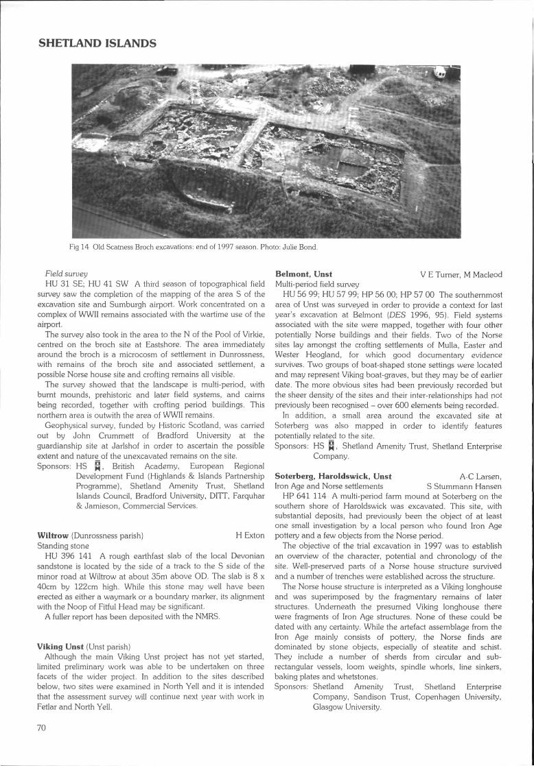
SHETLAND ISLANDS
Fig 14 Old Scatness Broch excavations: end of 1997 season. Photo: Julie Bond.
Field surueyHU 31 SE; HU 41 SW A third season of topographical field
survey saw the completion of the mapping of the area S of theexcavation site and Sumburgh airport. Work concentrated on acomplex of WWII remains associated with the wartime use of theairport.
The survey also took in the area to the N of the Pool of Virkie,centred on the broch site at Eastshore. The area immediatelyaround the broch is a microcosm of settlement in Dunrossness,with remains of the broch site and associated settlement, apossible Norse house site and crofting remains all visible.
The survey showed that the landscape is multi-period, withburnt mounds, prehistoric and later field systems, and cairnsbeing recorded, together with crofting period buildings. Thisnorthern area is outwith the area of WWII remains.
Geophysical survey, funded by Historic Scotland, was carriedout by John Crummett of Bradford University at theguardianship site at Jarlshof in order to ascertain the possibleextent and nature_of the unexcavated remains on the site.Sponsors: HS Q, British Academy, European Regional
Development Fund (Highlands & Islands PartnershipProgramme), Shetland Amenity Trust, ShetlandIslands Council, Bradford University, DITT, Farquhar& Jamieson, Commercial Services.
Wiltrow {Dunrossness parish) H ExtonStanding stone
HU 396 141 A rough earthfast slab of the local Devoniansandstone is located by the side of a track to the S side of theminor road at Wiltrow at about 35m above OD. The slab is 8 x40cm by 122cm high. While this stone may well have beenerected as either a waymark or a boundary marker, its alignmentwith the Noop of Fitful Head may be significant.
A fuller report has been deposited with the NMRS.
Viking Unst (Unst parish)Although the main Viking Unst project has not yet started,
limited preliminary work was able to be undertaken on threefacets of the wider project. In addition to the sites describedbelow, two sites were examined in North Yell and it is intendedthat the assessment survey will continue next year with work inFetlar and North Yell.
Belmont, Unst V E Turner, M MacleodMulti-period field survey
HU 56 99; HU 57 99; HP 56 00; HP 57 00 The southernmostarea of Unst was surveyed in order to provide a context for lastyear's excavation at Belmont (DES 1996, 95). Field systemsassociated with the site were mapped, together with four otherpotentially Norse buildings and their fields. Two of the Norsesites lay amongst the crofting settlements of Mulla, Easter andWester Heogland, for which good documentary evidencesurvives. Two groups of boat-shaped stone settings were locatedand may represent Viking boat-graves, but they may be of earlierdate. The more obvious sites had been previously recorded butthe sheer density of the sites and their inter-relationships had notpreviously been recognised - over 600 elements being recorded.
In addition, a small area around the excavated site atSoterberg was also mapped in order to identify featurespotentially related to the site.Sponsors: HS Q, Shetland Amenity Trust, Shetland Enterprise
Company.
Soterberg, Haroldswick, Unst A-C Larsen,Iron Age and Norse settlements S Stummann Hansen
HP 641 114 A multi-period farm mound at Soterberg on thesouthern shore of Haroldswick was excavated. This site, withsubstantial deposits, had previously been the object of at leastone small investigation by a local person who found Iron Agepottery and a few objects from the Norse period.
The objective of the trial excavation in 1997 was to establishan overview of the character, potential and chronology of thesite. Well-preserved parts of a Norse house structure survivedand a number of trenches were established across the structure.
The Norse house structure is interpreted as a Viking longhouseand was superimposed by the fragmentary remains of laterstructures. Underneath the presumed Viking longhouse therewere fragments of Iron Age structures. None of these could bedated with any certainty. While the artefact assemblage from theIron Age mainly consists of pottery, the Norse finds aredominated by stone objects, especially of steatite and schist.They include a number of sherds from circular and sub-rectangular vessels, loom weights, spindle whorls, line sinkers,baking plates and whetstones.Sponsors: Shetland Amenity Trust, Shetland Enterprise
Company, Sandison Trust, Copenhagen University,Glasgow University.
70
SOUTH AYRSHIRE
Chapels Survey, Unst C D Morris, K J BradyIn August 1996 an assessment survey was undertaken on
chapel sites on the island of Unst. Emphasis was placed upon anaudit of the existing condition of the sites in relation to previoussurvey and other work on them. Of 25 potential sites, 23 wereexamined and a full record of the work, including photographicsurvey, is in preparation.Sponsor: Hunter Archaeological Trust.
Kellister, Trolligarts, Pinhoulland KJ Edwards,(Walls & Sandness parish) G WhittingtonPre-peat field systems, prehistoric houses and burial cairnsKellister
HU 241 557 Below an abandoned croft in a field leading N tothe Loch of Kellister is a multitude of clearance cairnssuperimposed upon much older ones which had smallerconstituent stones. One cairn, much taller than all others on thesite, seems to have a kerb and may be a burial cairn. Some stonefield walls are partly peat-covered.
HU 246 561 (centre) On the NE side of the Loch of Kellister isan extensive, complex field and settlement system. An enclosuremarked by stones is emerging from the peat on the NW of thesystem and contains two modern planticrubs. Between these is aprobable house, 9.8 x 7.7m max, aligned SW-NE, opening tothe SW. A possible kerb cairn 22m to the N has a diameter of5.5m. Six clearance cairns are visible in the enclosure.
W of a further planticrub in an adjacent enclosure to the S is aboulder-filled, probable heel-shaped cairn, 12.9 x llm, alignedE-W, with an apparent chamber and possible forecourt area totheE.
HU 2425 5612 Heel-shaped cairn, much obscured byheather, but constructed of substantial boulders, 15.3 x 14.1m,aligned N-S, with chamber entrance 4.5m from kerb stones tothe N. A hill summit to the NE is topped by a 5m diameter cairn.
HU 2415 5615 Possible heel-shaped cairn located just abovethe stream course, 12.8 x 10.8m, aligned E-W, and covered withmuch bracken.
HU 2420 5603 Stone enclosure on small peninsula extendingfrom the N shore of the Loch of Kellister.
TrolligartsHU 2453 5249 Adjacent and to the N of a modem sheep pen
is a massive heap of boulders which has a strong semblance to achambered cairn measuring 15.2 x 9m, aligned N-S. Anelongate pile of boulders, 16.7 x 4.8m, aligned N-S, liesimmediately to the W.
PinhoullandHU 2605 4985 The previously recorded 'sheep pen1 is built
over a probable house site aligned N-S with an entrance to theS. The inside rear bank of the house is marked by orthostats.The bank is 2.6m thick. The nearby 'ruined sheep pen' is an ovalstructure marked by orthostats and is not an obvious pen.Sponsors: Leverhulme Trust, Shetland Amenity Trust,
Universities of Sheffield and St Andrews.
Bayanne House (Yell parish} G Wilson, H Moore (EASE)Settlement
HU 519 977 Two previous seasons of geophysical survey andexcavation at this site had indicated the presence of severalstructures immediately adjacent to the cliff edge (DES 1996, 96).From the outset it was apparent that while part of the site hadalready eroded away, the remainder was vulnerable butsufficiently well-preserved and substantial to warrant furtherinvestigation.
The final season of excavation uncovered four structural unitspresently thought to span the mid-lst millennium BC to the mid-1st millennium AD. The earliest, Structure A, was represented byan arc of post-holes associated with a series of drains and pits. Itwas not entirely excavated. Ard marks found adjacent to thisstructure indicate agricultural activity which may be ofcontemporary date.
Structure B (partially eroded) was sub-circular with thickrubble and stone walls; it measured c 8m in diameter. It wasassociated with a flagged yard and a field bank. A series of pitsand drains were cut into the floor of this structure and a stone-capped drain ran parallel to its external walls. This structure wasrefurbished on several occasions. It yielded a large quantity ofstone agricultural implements including mattock blades, ardpoints, knives and digging tools. Several steatite and ceramicvessels were found in associated refuse deposits. Followingabandonment, this structure appears to have been deliberatelybackfilled with soil. Deposits of domestic refuse, containing alarge amount of animal bone, were deposited into the yard areato a depth of 1.5m.
The next phase of occupation was centred on a substantialoval stone building (Structure C) which was constructed within alarge pit. The internal dimensions of this structure measured 7 x5m; the walls survived to c 1m high with an entrance to the Sside. It was set back slightly further from cliff edge than itspredecessor and was not, therefore, as badly affected by coastalerosion. Whilst its revetted walling and semi-subterranean settingare reminiscent of wheelhouse construction, the structure atBayanne did not have wall piers, although it was radiallydivided, in later times at least. This structure underwent severalrenovations, including the elongation and elaboration of itsentrance area. Roughly built internal divisions were added duringthe final phase of use; one pier contained a pierced stone whichmay have served as a tethering post for an animal. The floor ofthis structure was eroded through wear and the majority of thedeposits which covered the interior were related to itsabandonment. These deposits were well-stratified and includeddiscrete shell middens, domestic refuse and rubble dumps.
The interior of Structure C was finally covered with deposits ofrubble. This may have been carried out in preparation for theconstruction of a later 'figure-of-eight' house (Structure D). Thisbuilding consisted of large orthostats set into the underlyingrubble deposits and probably backed by banks of domesticmidden. It was partially paved and contained a series of fourconsecutive hearths. This structure was refurbished at least once,with floor deposits being sealed by secondary paving. Artefactsfound in association with this structure include sherds of wheel-thrown burnished ware, a decorated rotary quern and quantitiesof bone, shell and coarse pot. The remnants of a partially erodedstructure (Structure E), found immediately adjacent to the cliff,was probably of similar construction and may be contemporaryin date. _Sponsors: HS Q, Shetland Amenity Trust.
SOUTH AYRSHIREThe following sites in South Ayrshire have been identified and
recorded during fieldwork carried out by the staff of WoSAS. Fulldetails are available in the WoSAS SMR.
(Barr parish)NX 2884 9364NX 2660 9133NX 2590 9137
Loxton Farmstead.Traboyach Mid Glen Shieling huts.Traboyack Burn ?Sheep pens.
71
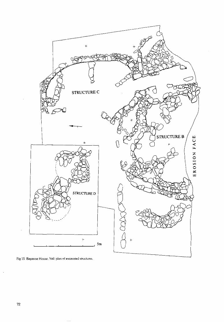
Fig 15 Bayanne House, Yell: plan of excavated structures,
72
SOUTH AYRSHIRE
NX 2600 9131 Traboyack BurnNX 3344 9369 Balloch BurnNX 3336 9354
(centre)NX 3359 9358NX 3370 9345(centre)
{Colmonell parish)NX 1679 8705NX 1977 8961NX 1983 8957NX 2001 8963NX 2005 8973
Balloch Burn
Corrn RoyCoirn Roy
Craig FarmHigh AldonsHigh AldonsHigh AldonsClunagh
(Girvan parish)NX 1846 9803 Knockcushan
Street, Girvan
Turf structures; dykes.Settlement.Deserted farmstead.
Shieling hut.Enclosure; sheepree.
Deserted settlement.Limekilns; quarries.Limekilns; quarries.Limekilns; quarries.Deserted farmstead;dyke; well.
Well.
K Speller (GUARD)Loudoun Hall, Ayr (Ayr parish)Medieval buildings, deposits and quayside
NS 336 221 Excavations in the forecourt of Loudoun Halland the nearby Boat Vennal have produced evidence for majorre-engineering of the quayside area, from a medieval 12th/13th-century riverside rubbish tip, through the construction ofLoudoun Hall in the 16th century, to a hardened and levelledurban quayside area by the 17th to 18th centuries. There is alsoevidence for a NE wing to the Hall and medieval building to theE. A large assemblage of medieval pottery was retrieved,containing examples of iocal and imported wares.Sponsor: Armour Construction Ltd.
Near Colmonell (Colmonell parish) J PickinBronze Age axe hammer
A complete axe hammer, 110 x 240mm, on a ?greywackecobble; all surfaces have been pecked and ground. The axe isoval with a slightly convex butt. The sides are also convex andboth faces are dished. The axe, which was brought to StranraerMuseum for identification, was found near Colmonell around1840 and remains in the possession of the finder's descendants.The exact findspot is unknown.
Dundonald Castle (Dundonald parish) G Ewart, D StewartWatching brief
NS 3636 3451 The site of a new visitor centre at DundonaldCastle was prepared in February 1997. It was thought thatbuildings around the base of the castle rock could be exposedduring this work, and therefore an archaeological watching briefwas maintained by Kirkdale Archaeology.
A scooped platform to the S of the new building was initiallyexamined, proving to be a small quarry hole measuring 4.3 x3m. Fractured bedrock was exposed at ground level, and a lineof presumed masonry exposed at ground level was shown to bea line of natural, weathered doleritic rock which has fractured togive the appearance of a man-made structure.
Within the area of the new visitor centre itself, turf and topsoilwere removed to reveal traces of a formerly more extensive areaof marshy deposits at the NW comer, the truncated remains oflarge salt marshes which originally extended to the NW. Theremainder of the area was drier, sloping downwards towards theformer marshland. Removal of the drier material revealednothing of archaeological significance, despite excavationbeyond the initial limits of 0.8m.
In April 1997 a watching brief was undertaken whilecontractors excavated a circular hole to form the foundation for amasonry plinth supporting a bronze view-finder outside thebarmkin wall of Dundonald Castle. The site was over anexploratory archaeological trench dug in the 1980s. The materialremoved therefore comprised backfill and topsoil. Aphotographic record was made prior to backfilling.
A cable trench was also excavated to a general depth of300mm below present ground surface, and followed a zig-zagroute from a point at the extreme NW end of the assumedbarmkin area, through to a point approximately 8.5m S of thepossible chapel site, within the inner courtyard, and immediatelyW of the wall separating inner and outer courtyards.
Nothing was revealed of the residual masonry towards thetower house end of the castle complex. However, particularlywithin the entrance pend, substantial rubble deposits wererevealed, suggested in part by the character of the debris(mortar-rich) and the shelving nature of the bedrock, which maywell be coincident with the entranceway. The ground wouldappear to slope upwards from outside to inside, and the pendmay well have exploited a natural terrace in the underlyingbedrock. Little new evidence was found of the still enigmaticroute of the barmkin wall to the NW of the tower house. It isclear, however, that the wall line remains close to the surface,which could easily be cleared if the need were to arise.
Observations of the general topography to the W of the towerhouse at or near 'Dumpling Hill' seem at present to indicate aform of forework associated with the 14th-century castle, andrevealed traces of a terrace and a probable rectangular building.The terrace appeared to be exclusively associated with the towerand tower house elements, and did not necessarily reflect arubble spread at the base of the ruined walls, being too regular incharacter. This feature is therefore best viewed as a platform,possibly deriving from elements of the Period IV complex (13thcentury), recycled as a base for the later castle. The indications ofa rectangular building were reflected by three sections of wallingextending from the terrace, forming the N, S and W walls of astraight-sided structure. The S wall was indicated by a projectionfrom the terrace noted above, and the N wall lay on analignment approximately opposite the assumed blockedentranceway within the tower house gate-house structure.Sponsor: HS Q.
Ladywell Farm, Girvan K Speller, I Banks, P Duffy,(Girvan parish) G MacGregor (GUARD)Burnt mound; prehistoric and medieval features
As part of an ongoing series of construction projects at WilliamGrant & Sons Distillers Ltd, Girvan, a series of archaeologicalmitigation measures were undertaken in 1996 and 1997.Ladywell
NS 202 007 Geophysical survey and trial excavationsrevealed medieval features, including an enclosure ditch, whileother features suggested prehistoric activity. The two periodswere separated by deep deposits of alluvial clay.Chapeldonan farm buildings
NS 195 003 A watching brief in 1996 revealed a deposit ofputative burnt mound material measuring c 8 x 4m. Subsequentexcavation showed that it had been severely affected by ploughaction and was only 0.15m in depth. No associated trough orstructural features were found. Also recorded during this timewas a deposit of preserved wood which potentially showsevidence of chop marks. Taken in conjunction with a deposit ofgrey clay which lay at the valley bottom, this may representevidence for early woodland clearance in the valley.
73
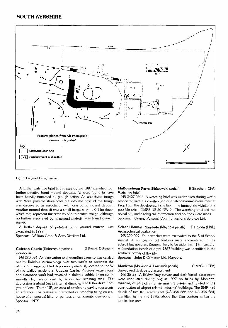
SOUTH AYRSHIRE
Features plotted from Air Photograph(area covered by spoil lip)
T 1 Geophysics Survey Grid
[7«\1 Features revealed by Excavation
50m
Fig 16 Ladywell Farm, Girvan.
A further watching brief in this area during 1997 identified fourfurther putative burnt mound deposits. All were found to havebeen heavily truncated by plough action. An associated troughwith three possible stake-holes cut into the base of the troughwas discovered in association with one burnt mound deposit.Another mound deposit was a small irregular pit, c O.llm deep,which may represent the remains of a truncated trough, althoughno further associated burnt mound material was found outwiththe pit.
A further deposit of putative burnt mound material wasexcavated in 1997.Sponsor: William Grant & Sons Distillers Ltd.
Culzean Castle (Kirkoswald parish) G Ewart, D Stewart?Ice-house
NS 230 097 An excavation and recording exercise was carriedout by Kirkdale Archaeology over two weeks to ascertain thenature of a large cobbled depression previously located to the Wof the walled gardens at Culzean Castle. Previous excavationsand clearance work had revealed a dolerite cobble lining set insmooth clay, surrounded by a circular retaining wall. Thedepression is about 5m in internal diameter and 0.8m deep fromground level. To the NE, an area of sandstone paving representsan entrance. The feature is interpreted E.S probably being an ice-house of an unusual kind, or perhaps an ornamental dew-pond.Sponsor: NTS.
Hallowshean Farm (Kirkoswald parish) RStrachan (CFA)Watching brief
NS 2407 0602 A watching brief was undertaken during worksassociated with the construction of a telecommunications mast atProp Hill. The development site lay in the immediate vicinity of apossible cairn (NMRS NS 20 NW 9). The watching brief did notreveal any archaeological information and no finds were made.Sponsor: Orange Personal Communications Services Ltd.
School Vennel, Maybole (Maybole parish) T Holden (HAL)Archaeological evaluation
NS 299 099 Four trenches were excavated to the S of SchoolVennel. A number of cut features were encountered in thesubsoil but none are thought likely to be older than 18th century.A foundation trench of a pre-1857 building was identified in thesouthern corner of the site.Sponsor: John D Cameron Ltd, Maybole.
Monkton (Monkton & Prestwick parish) C McGill (CFA)Survey and desk-based assessment
NS 35 28 A fieldwalking survey and desk-based assessmentwere conducted during August 1997 on fields by Monkton,Ayrshire, as part of an environmental assessment related to theconstruction of airport-related industrial buildings. The SMR haddetails of two Hint scatter sites (NS 354 282 and NS 356 284)identified in the mid-1970s above the 15m contour within theapplication area.
74
SOUTH LANARKSHIRE
No concentrations of flint were identified. The north-westernmost field contained the greatest number of flints, butthese were widely scattered and although the majority wereabove the 15m contour line, there were also considerablenumbers below it. This is probably the result of the annualploughing that has taken place within the application area for thelast 20 years. Alternatively, finds below the 15m contour couldrelate to a more recent site.
Detailed reports will be lodged with the NMRS.Sponsor: Dames & Moore.
SOUTH LANARKSHIREThe following sites in South Lanarkshire have been identified
and recorded during fieldwork carried out by the staff of WoSAS.Full details are available in the WoSAS SMR.
(Avondale parish)NS 6679 4156 Calder Mill
(Carluke parish)NS 8709 5356NS 8718 5325NS 8736 5428NS 8640 5414
BentyhillocksKing's LawKingshillQueenshill
(Crawford parish)NS 9704 2204 Normangill Rig
(East Kilbride parish)NS 6304 5716 Rogerton
(centre)
(Hamilton parish}NS 7055 5103 Limekilnburn
(centre)
(Lesmahagow parish)NS 8154 3972 Foxe's CastleNS 7886 3309 South Bankend
Ditch; ?mill.
Deserted farmstead.?Deserted farmstead.Longhouse (probable).?Deserted farmstead.
?Caim.
Cropmark ?enclosure.
Anti-aircraft battery.
?Platform.Shieling hut; field bank.
K Speller, A Leslie(GUARD)
MarkethUl Road or Langcausey(Carmunnock; East Kilbride parishes)Road
NS 6245 5780 to NS 6285 5690 An evaluation was designedto assess the evidence for the date and character of a stretch ofroad which once formed part of the main road from East Kilbrideto Rutherglen. The road was replaced in 1791 by a route furtherto the E, and was potentially Roman in origin.
The three sections investigated revealed clear indications ofmore than one phase of constructional activity, but this related tothe roadside drains rather than the road itself. No finds ofRoman date were recovered and the techniques utilised in theconstruction of the road were not consistent with those evident inexamples of Roman roads elsewhere in Britain.
A copy of the report will be deposited with the NMRS.Sponsor: Glasgow City Council.
Hare Hill/Climpy (Carnwath; Carstairs parishes) J S DuncanMesolithic chert scatter, later enclosure (GUARD)
NS 9229 5463 A desk assessment and walk-over survey wasconducted by GUARD prior to mining activity at Hare Hill.Mining activity was evident from at least the 18th century to thepresent day, as was 18th-19th-century agricultural activity.
A penannular turfed bank with an exterior diameter of c 14mhad a slight mound in the centre. An evaluation was carried outproducing a Mesolithic lithic scatter, pits and stake-holes whichmay relate to a stone structure, and the collapsed remains of a
circular turf bank. This site is tentatively interpreted as anenclosed cremation cemetery/domestic building which has laterbeen utilised as a sheepfold.Sponsor: Cobex Ltd.
Crooked Bank (Hill) (Crawford parish) T WardCairn, sheep buchts
NS 9127 1011 Small cairn and at least three turf sheepbuchts. Full report lodged with the NMRS.Sponsors: Biggar Museum Trust, Lanark & District
Archaeological Society.
Daer Reservoir (Crawford parish)Mesoltthic sites; burnt mounds; cairns
NS 9860 0827 This Mesolithic flint-knapping site is nowcompletely excavated, and a significant quantity of flakedebitage, cores and microliths were retrieved. No further featureswere located. Charcoal samples in 1995 have been identified asalder.
NS 9842 0802 This Mesolithic chert-knapping site has beenexcavated, producing a significant quantity of flake debitage,cores and microliths. A pit filled with charcoal-enriched soil andburnt stone was found. The two sites are intervisible across avalley at the same altitude of 340m OD, but are distinctive fromeach other by their lithic materials. They are unusually high andare rare examples of inland Mesolithic sites.
Charcoal samples from the burnt mound deposit (DES 1995,87) is identified as mixed woodland species, but mostly birch.
NS 9882 0797 A double burnt mound.NS 9831 0794 (centre) A group of six cairns measuring up to
7.5m diameter by 0.6m high. Some have apparent depressionsin their centre suggesting ring-type cairns.
Full interim report deposited in the NMRS.Sponsors: Biggar Museum Trust, Lanark & District
Archaeological Society.
Laght Hill (Crawford parish)Cairns; burnt mounds
NS 9280 0976 Three small cairns.NS 9262 0973 On the NE flank of Laght Hill, at 400m OD,
are two burnt mounds within 10m of each other.Full report lodged with the NMRS.
Sponsors: Biggar Museum Trust, Lanark & DistrictArchaeological Society.
Paddy's Rickle Bridge to Johnstonebridge J S Duncan,(Crawford parish) S Halliday (GUARD)Watching brief
From July 1997 GUARD was commissioned to undertake awatching brief of all topsoil stripping during the upgrading of theA74 to motorway status. The area under investigation comprisedtwo sections: the N section ran southwards from Paddy's RickleBridge to Beattock for 17.3km, and the S section from Beattockto Johnstonebridge for 11.5km. A number of sites wereidentified, excavated and recorded. Although the work iscontinuing, the results to date were as follows (see also Dumfries& Galloway, Kirkpatrick-Juxta and Johnstone parishes):Fall Kneesend
NS 9800 1615 Continuing from excavation carried out in1993, a total of four potential cairns were noted. One caim wasexcavated by hand and a fragment of a jet/shale bead wasretrieved. No dating evidence was recovered. All other caimswere sectioned by machine, drawn and photographed.
In addition, the Roman road was found to follow thepreviously plotted route. Numerous sections were cut by machine
75
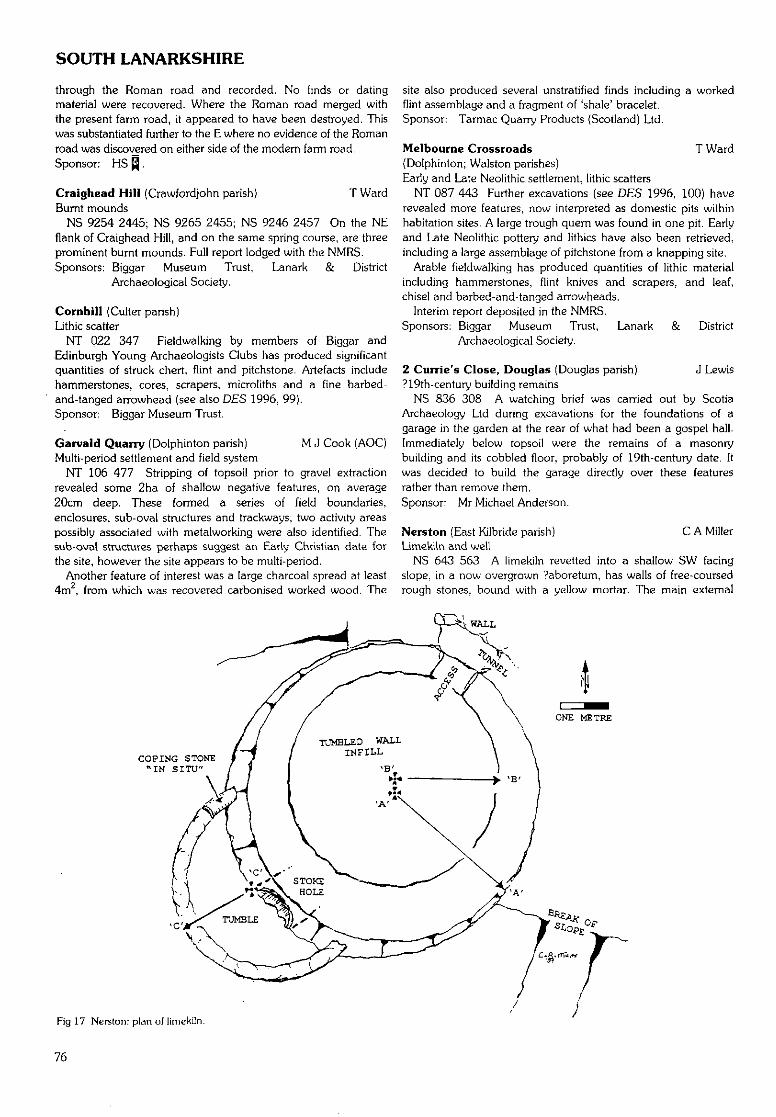
SOUTH LANARKSHIRE
through the Roman road and recorded. No finds or datingmaterial were recovered. Where the Roman road merged withthe present farm road, it appeared to have been destroyed. Thiswas substantiated further to the E where no evidence of the Romanroad was discovered on either side of the modem farm road.Sponsor: HS Q.
Craighead Hill (Crawfordjohn parish) T WardBurnt mounds
NS 9254 2445; NS 9265 2455; NS 9246 2457 On the NEflank of Craighead Hill, and on the same spring course, are threeprominent burnt mounds. Full report lodged with the NMRS.Sponsors: Biggar Museum Trust, Lanark & District
Archaeological Society.
Cornhill (Culler parish)Lithic scatter
NT 022 347 Fieldwalking by members of Biggar andEdinburgh Young Archaeologists Clubs has produced significantquantities of struck chert, flint and pitchstone. Artefacts includehammerstones, cores, scrapers, microliths and a fine barbed-and-tanged arrowhead (see alsoDES 1996, 99).Sponsor: Biggar Museum Trust.
Garvald Quarry (Dolphinton parish) M J Cook (AOC)Multi-period settlement and field system
NT 106 477 Stripping of topsoil prior to gravel extractionrevealed some 2ha of shallow negative features, on average20cm deep. These formed a series of field boundaries,enclosures, sub-oval structures and trackways, two activity areaspossibly associated with metalworking were also identified. Thesub-oval structures perhaps suggest an Early Christian date forthe site, however the site appears to be multi-period.
Another feature of interest was a large charcoal spread at least4m , from which was recovered carbonised worked wood. The
site also produced several unstratified finds including a workedflint assemblage and a fragment of 'shale' bracelet.Sponsor: Tarmac Quarry Products (Scotland) Ltd.
Melbourne Crossroads T Ward{Dolphinton; Walston parishes)Early and Late Neolithic settlement, lithic scatters
NT 087 443 Further excavations (see DES 1996, 100) haverevealed more features, now interpreted as domestic pits wilhinhabitation sites. A large trough quern was found in one pit. Earlyand Late Neolithic pottery and lithics have also been retrieved,including a large assemblage of pitchstone from a knapping site.
Arable fieldwalking has produced quantities of lithic materialincluding hammerstones, flint knives and scrapers, and leaf,chisel and barbed-and-tanged arrowheads.
Interim report deposited in the NMRS.Sponsors: Biggar Museum Trust, Lanark & District
Archaeological Society.
2 Currie's Close, Douglas (Douglas parish) J Lewis?19th-century building remains
NS 836 308 A watching brief was carried out by ScotiaArchaeology Ltd during excavations for the foundations of agarage in the garden at the rear of what had been a gospel hall.Immediately below topsoil were the remains of a masonrybuilding and its cobbled floor, probably of 19th-century date. Itwas decided to build the garage directly over these featuresrather than remove them.Sponsor: Mr Michael Anderson.
Nerston (East Kilbride parish) C A MillerLimekiln and well
NS 643 563 A limekiln revetted into a shallow SW facingslope, in a now overgrown ?aboretum, has walls of free-coursedrough stones, bound with a yellow mortar. The main external
COPING STONE"IN SITU"
Fig 17 Nerston: plan of limekiln
76
STIRLING
walls have a slight inwards batter. The chamber front wall is0.9m thick, compared to the side and rear walls at c 0.6m thick.There appears to be an upper Ploading door, represented by alintel and jamb above the stoke-hole. The rear wall appears tohave an external flue accessed from the NE. The front stokingbay is marked by a single stone thickness wall, fronting an archoffset to the S. Chamber 6.25m external diameter. 2.1m internaldiameter, height 2.4m at front, the rear and sides are now flushwith ground level.
A stone-lined well, c 0.5m square internally, lay some 25m SWof the limekiln.
Proposed route of M77 Glasgow South Orbital S Halliday(East Kilbride parish) (GUARD)Archaeological assessment
In December 1996, GUARD was commissioned to assess aseries of routes for a proposed southern orbital road to link theM77 with the A726 leading to East Kilbride. Four possible routeswere subject to a desk-based followed by field assessment. Thefollowing sites were noted on or near the routes (see also EastRenfrewshire, Eaglesham and Mearns parishes):NS 599 542 Millbrae (1816); B listed.NS 577 553 Meikle Dripps ?cairn.NS 580 556 Grass-covered building remains.Sponsor: ASH Consulting.
Hamilton Palace Grounds, Strathclyde R Cachart (SUAT)Country Park (Hamilton parish)Medieval burgh, palace
NS 725 558 During January to July 1997 SUAT undertook awatching brief on various areas of development covering the siteof Hamilton Palace and the medieval burgh.
Excavation the previous summer (DES 1996, 99-100) for therealignment of the Cadzow Burn found evidence of prehistoricactivity, the medieval burgh, Hamilton Palace and palacegardens. The watching brief on excavations for the Cadzow Burnrealignment, close by the area of initial archaeologicalexcavation, recorded walls and post-medieval deposits thoughtto relate to the palace or burgh. A late medieval kiln was foundwhich was partially excavated and recorded. Its location, on theedge of the excavated area, enabled it to be preserved in situ.
In excavations for a gas barrier several large, thick slabs werepartially exposed and recorded - thought to be flooring for thepalace or possibly the collegiate church. These were left in situ.
Massive stone walls, culverts and a well relating to the early19th-century palace stables were partially exposed and recordedclose to the site of the old tolbooth, where the Cadzow Burn hadto be widened and straightened. This last phase of the siteinvestigation is now concluded.Sponsor: Hamilton Ahead.
Lamington & Wandel (Lamington & Wandel parish) T WardCoins
A dispersed hoard of 39 Edward I and II silver pennies wasfound by metal detecting in a field. Disposed to Biggar Museumvia Treasure Trove.
101 Castlegate, Lanark (Lanark parish) WoSASWatching brief
NS 8795 4340 A watching brief was carried out by WoSASduring preparation of foundations for an extension to the 1980shouse at 101 Castlegate. No pre-modern features or structureswere identified. Charcoal fragments in the lower part of the soilprofile may indicate past cultivation of the area, perhaps as agarden. Full details in WoSAS SMR.
Townhead (Libberton parish) S Carter (HAL)Pre-afforestation survey
NS 993 422 A short-notice forestry survey was undertaken byHeadland Archaeology Ltd of 16ha of land E of Townhead,Libberton. No additional sites were recorded in the field.although a possible bank was noted on vertical air photos.NS 9923 4241 Enclosure. (NMRS NS 94 SE 36)NS 9930 4230 _ ?Bank.Sponsor: HS ^J.
King Street/Queen Street, Rutherglen T Holden (HAL)(Rutherglen parish)Archaeological evaluation
NS 6133 6178 (centre} Six evaluation trenches wereexcavated to the W of the purported site of Rutherglen Castle.The majority of features identified proved to be 19th or 20thcentury in origin, the most imposing of these being a large linearcut running N-S along the eastern perimeter of the site. A smallnumber of undated features are potentially pre-19th century inorigin. Subsequent monitoring of trenches excavated for stripfoundations recorded a similar variety of common recent featuresand occasional cuts of potentially earlier date. A few sherds ofmedieval pottery were recovered.Sponsors: Rutherglen & Carnbuslang Housing Association. Lilley
Construction Ltd.
STIRLINGAberfoyle Quarry (Aberfoyle parish) G Ewart. D MurrayWatching brief
NN 505 031 Forest Enterprise wished to attempt to stabilisean old spoil head which was inclined at a dangerous angle,threatening collapse. An archaeological watching brief wasmaintained by Kirkdale Archaeology during this work, as possibleremains of the 19th-century industrial complex could have beenrevealed. The spoil heap was c 35m high, and ran NE forapproximately 70m from the NE corner of the quarry. In theevent, no archaeological traces were observed during thestabilisation exercise, and no finds were recovered.
Despite the lack of evidence recovered during the watchingbrief, there still remains the potential for industrial archaeologicalsurvival beneath_ the spoil heaps of the quarry.Sponsor: HS Q.
Loch Katrine Survey I Cullen, G Tompsett (GUARD)(Aberfoyle; Buchanan; Callander parishes)Desktop and walk-over survey
NN 440 095 (centre) An archaeological survey was carriedout in advance of possible forest regeneration around LochKatrine in January 1997. The survey area was mainly restrictedto woodlands, including both broadleaf and coniferous, but alsoincluded areas of open hillside. The survey identified andaccurately located the presence of 84 known and previouslyunknown sites,
The majority of the features recorded were related to medievalor later settlement and field enclosures. A small-scale post-medieval iron industry was established around the loch shoresand the Glengyle Burn.
No evidence of prehistoric settlement was recorded. The onlypotentially prehistoric feature was a possible burial mound justbeyond the present W end of the !och. A stone cairn is recordedas containing the body of a Cromwellian soldier.
A gazetteer of sites from both the desk-based and walk-oversurveys (excluding dykes, culverts and banks) is listed below:
77
STIRLING
NN 3968 1002 -NN 4005 1010NN 4042 0982NN 3938 1006NN 3996 1048NN 4003 11 12NN 3791 1365NN 3658 1436NN 5046 0719NN 4078 0956NN 4075 0960 -NN 4208 0895NN 4090 0953NN 4103 0954NN 4207 0890NN 4225 0863NN 4232 0859NN 4250 0860NN 4253 0868NN 4280 0857NN 4312 0870NN 4256 0866NN 4202 0905NN 4208 0899NN 4752 0841NN 4716 0890NN 4659 0880NN 4659 0879NN 4630 0869NN 4639 0880NN 3845 1326NN 3707 1336NN 3804 1343 -NN 3683 1435NN 4095 1159 -NN 41 13 1132 "NN4121 1118NN4122 1113NN 4157 1090NN 4162 1069NN 4166 1082NN 4363 1011NN 4376 1025NN 4378 1025NN 4362 1050NN 4334 1006NN 4135 11 19NN 3934 1352NN 4065 1196NN 4058 1191NN 4138 11 12NN 4345 1011NN 4435 1030NN 4751 1038NN 4877 0929NN 4934 0896NN 4932 0856NN 4927 0832NN 4215 0905NN 4843 0719NN 4880 0679NN 4950 0647/NN 4964 0648NN 4870 0685NN 5065 0710 -
Old military road.
Building (modern).Enclosure and buildings, rig and furrow.Enclosure and buildings.Buildings.Mound.Bloomery.Limekiln.Bridge.Track.
Track and bank.Bridge.Access shaft.Quarry.Building (shieling).Building.Building (kiln).?Kiln.Building/cairn.Building.Quarry.Quarry.Cairn.Buildings.Buildings and pens.Building.Building.Rig and furrow.Bridge.Footbridge.Track.
Track.
Building.Building.Building.Building.Drystone dyke and track.Enclosure and building.19th-century schoolhouse.Bridge.Building.Cairn.Wooden bridge.Buildings (six).Stream outlet.Burial ground.Drystone bam.Enclosure and building.Track.Drystone dyke/track.Enclosures and building.Platform.Cairn/platform.Cromwellian burial cairn.Aqueduct entrance.Enclosure and building.Building and dyke.Dams and furnace.
Track.Track.
NN 5035 0708NN 4351 1028NN 4347 1020NN 488 083NN 399 104NN 413 111
Dyke and drainage.Limekiln.Island stronghold.Bloomery.Furnace.
Sponsor: West of Scotland Water.
L Main, M StewardEdinchip (Balquhidder parish)Bloomery mound
NN 5767 2267 This mound of iron slag has been cut by a hilltrack on its W side.Sponsors: Stirling Council, Forest Enterprise.
Eildreach, Lochearnhead (Balquhidder parish) D AbemethyArchaeological assessment (GUARD)
During December 1996, GUARD were commissioned toundertake the archaeological assessment of the proposed site ofa windmill farm. The fieldwork revealed:NN 5890 2535 Clearance cairns.NN 5887 2517 Denuded field wall.NN 5883 2500 Denuded field wall.NN 5870 2500 Denuded field wall.NN 5799 2604 ?Hut platform.NN 5787 2604 Quarries.NN 5805 2559 Mound.NN 5840 2525 Mound.NN 5841 2510 Building remains.NN 5843 2518 Building remains.NN 5841 2510 Enclosed mound.
The majority of sites located in this survey probably relate topost-medieval and Early Modern activity.Sponsor: Energy Unlimited.
River Balvaig (Balquhidder parish) L Main, M StewardCorn-drying kiln, limekiln
NN 561 179 (centre) A corn-drying kiln and a limekiln lie ashort distance apart in woodland on the W bank of the RiverBalvaig.Sponsors: Stirling Council, Forest Enterprise.
Auchenlaich Farm, near Callander R Strachan (CFA)(Callander parish)Archaeological assessment
NN 644 075 (centre) and NN 649 076 (centre) Anarchaeological desk-based and rapid field assessment wasundertaken in October 1996 prior to proposed extensions to theextraction workings at Auchenlaich Farm, near Callander. Apossible long cairn was recorded previously {DES 1993, 12).Research, conducted at Auchenlaich Caravan Park around thescheduled long caim (NMRS NN 60 NW 58; DES 1995, 14),indicated that prolonged ploughing in the area may haveremoved most traces of any activity associated with this caim.Desk-based assessment revealed the presence of a tree-coveredmound at NN 6692 0765 which appears to be the result ofmodern stone clearance as it is absent on the OS 1st and 2ndedition maps. No sites were identified during the rapid fieldinspection within Drumdhu Wood, but the density of theundergrowth could have hindered the identification of sites.Sponsor: John Fyfe Ltd.
Glenfinglas (Callander parish) S Carter (HAL)Field survey
NN 53 09 (centre) An archaeological survey of the 42kmGlenfinglas Estate was undertaken by Headland Archaeology Ltd
78
STIRLING
comprising a desk-based assessment of available documentarysources followed by a walk-over survey. A total of 68archaeological sites, groups of sites or areas were recorded. Thevast majority of recorded structures (198 out of 250) are singleexamples or groups of rectangular and sub-rectangular buildings,all probably of medieval or later date. Cultivation remains wererecorded, ranging from small, isolated patches of rig up to theextensive enclosed field systems of the main settlements.
Documentary sources indicate that a royal hunting forest wasestablished in the later 14th century and survived in modifiedform until at least the 18th century. Settlement patternsestablished by the 15th century persisted into the 18th centurywhen the first detailed maps were prepared. These show nineseparate farming townships with loosely clustered settlements,fields, woodland and grazing land. Agricultural change and ruraldepopulation in the 19th and 20th centuries created the present-day landscape with settlement clustered around Brig o'Turk.Comparison of the field record with documentary sourcesdemonstrates that many of the surviving archaeological sites datefrom the period of high population in the 18th century. Manyindividual mapped structures can still be identified in the field.Earlier, medieval sites survive in the upper glens away from areasof permanent settlement.Sponsors: Tilhill Economic Forestry, Woodland Trust.
Drumquhassle (Drymen parish) J S HideoutRoman fort annexe
NS 484 876 Sand and gravel extraction at Drumbeg Quarryencroached on part of the annexe on the N side of the fort.Cleaning of the exposed face revealed three areas ofarchaeological interest. Two appeared to be the annexe ditch,recut at [east once, cut obliquely by the section. An iron bootstud or nail head and a fragment of pottery or daub wererecovered from one of the cuts. The third area was a shallownatural depression, outside the annexe, filled with waterloggedwaste organic material and containing sherds of pottery and glass.
Topsoil, and material from both ditches and layers from abovethe waterlogged deposits, had been dumped on the annexebeside the quarry section. Finds from the surface of the spoil tipsinclude sherds of samian, mortaria, amphora, coarse greywareand redware. One sherd of a terra nigra platter was alsorecovered, as were shards of glass and a glass bead. Among theother finds are two small flint blades. The spoil tips wereremoved from the annexe in August 1997 under archaeologicalsupervision by Alba Archaeology Ltd.Sponsor; Tulloch Capital (Quarry Products} Ltd.
Black Hill (Dunblane & Lecropt parish) R PageWWII training area
NN 836 036 Remains of concrete bunker, used for targetpractice. Ruined reinforced concrete wall, with facing ditch,apparently damaged by gunfire.
Cathedral Hall, Dunblane D Hal! (SUAT)(Dunblane & Lecropt parish)Medieval bishop's palace
NN 781 013 SUAT carried out a watching brief on foundationand service works. Further traces of a courtyard outside thebishop's palace were located in a new service trench, and a newfragment of vault on a completely different alignment to thosepreviously excavated (DES 1995, 14) was discovered below thecathedral graveyard wall. The piling method employed by thedevelopers did not cause obvious damage to any buried remains.Sponsors: HS Q, Dunblane Kirk Session, Central Regional
Council.
Greenocks Farm R Page, C Chesterman(Dunblane & Lecropt; Kincardine parishes)WWII emergency bridge
NS 765 963 Remains of 'General Drew's Bridge'. Concreteabutments and some posts in the river remain visible. Theapproach road from the A84 at NS 765 961 is still traceable.
East Torrie (Kilmadock parish) L Main, W AndersonDitch; probable limekiln
NN 658 046 to NN 660 046 A ditch, some 150m long, almostcuts off a loop on the S side of the River Teith. It is c 7m wideand 1.5m deep. There is a stony bank on the N of the ditch (theriver side), with traces of a slight bank on its S side at the E end.
NN 6598 0459 A probable limekiln lies on the N edge of aterrace on the S side of the River Teith.Sponsors: Stirling Council, Tilhill Economic Forestry.
Dundaff Hill (St Ninians parish)Cairn
NS 7372 8429 A small circular cairn is situated on a shoulderof Dundaff Hill at a height of 325m OD. The height of the cairnitself is difficult to confirm because of the natural rise in theground but could be c 1.5m. The cairn measures 19.3m N-S by19.4m E-W. Cairn material has been exposed by animalscrapes. It is surrounded by a bank with an internal ditch; theditch is c 2m wide and the bank is spread over 1.5m. A spring islocated immediately to the S.Sponsors: Stirling Council, Tilhill Economic Forestry.
Muirpark (St Ninians parish) S Carter (HAL)Pre-afforestation survey
NS 750 870 A short-notice forestry survey was undertaken byHeadland Archaeology Ltd of 25ha on the farm of Muirpark. Anumber of sites were noted during a site visit by Lorna Main,Stirling Council Archaeologist. Six features of interest wererecorded, most relating to 18th or early 19th-century agriculture.The opportunity was taken to note a substantial 18th-centurylimeworks, Swallowhaugh Quarry, immediately to the N of thesurvey area.NS 759 868 Track.NS 7520 8665 Dyke.NS 7520 8700 Rig and furrow.NS 7485 8740 Rig and furrow.NS 7480 8750 Rectangular buildings and other structures.NS 7420 8785 - Quarry and limekilns.NS 7550 8785 _Sponsor: HS ̂ ,
Cambuskenneth Abbey (Stirling parish) D EtheridgeSurvey (GUARD)
NS 808 939 During August and September 1997topographical and resistivity surveys were undertaken in threefields and an area within the bounds of Cambuskenneth Abbey.
Upstanding earthworks W of the abbey ruins were recordedtopographically, and a resistivity survey was undertaken in thearea to test for the presence of buried remains. At least six majoranomalies were detected, each coinciding with recordedtopographical features. These are interpreted as buildingplatforms with dividing trackways, associated with rubble spreadswhich appear to have resulted from collapsed walling. Thesefeatures seern to be within the abbey precinct, and may representthe remains of buildings associated with the agricultural activitiesof the abbey, possibly including housing. At the W end of thefield exposed walling was found, at the point where the fieldslopes down to the river edge. A print published in 1693 by John
79
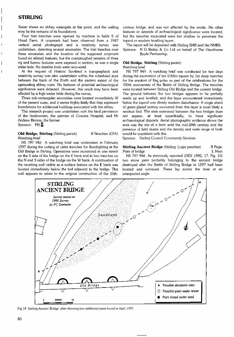
STIRLING
Slezer shows an abbey watergate at this point, and the wallingmay be the remains of its foundations.
Four trial trenches were opened by machine in fields S ofHood Farm. A cropmark had been observed from a 1947vertical aerial photograph and a resistivity survey wasundertaken, detecting several anomalies. The trial trenches overthese anomalies and the location of the supposed cropmarkfound no related features, but the overploughed remains of threerig and furrow features were exposed in section, as was a singlestake-hole. No datable finds were recovered.
At the request of Historic Scotland a topographical andresistivity survey was also undertaken within the scheduled areabetween the bank of the Forth and the eastern extent of theupstanding abbey ruins. No features of potential archaeologicalsignificance were detected. However, this result may have beenaffected by a high water table during the survey.
Three sub-rectangular anomalies were located immediately Wof the present ruins, and it seems highly likely that they representfoundations for additional buildings associated with the abbey.
This research project was undertaken with the kind permissionof the landowners, the patrons of Cowans Hospital, and MrAndrew Rennie^the farmer.Sponsor: HS £J.
Old Bridge, Stirling (Stirling parish) R Strachan (CFA)Watching brief
NS 797 945 A watching brief was undertaken in February1997 during the cutting of cable trenches for floodlighting at theOld Bridge in Stirling. Operations were monitored in one trenchon the S side of the bridge on the E bank and in two trenches onthe N and S sides of the bridge on the W bank. A continuation ofthe revetting wall visible as a surface feature on the E bank waslocated immediately below the turf adjacent to the bridge. Thiswall appears to relate to the original construction of the 15th-
century bridge, and was not affected by the works. No otherfeatures or deposits of archaeological significance were located,but the trenches excavated were too shallow to penetrate thetopsoil or modern levelling layers.
The report will be deposited with Stirling SMR and the NMRS.Sponsor: N G Bailey & Co Ltd on behalf of The Hawthorne
Boyle Partnership.
Old Bridge, Stirling (Stirling parish)Watching brief
NS 797 945 A watching brief was conducted for two daysduring the excavation of ten 0.65m square by 1m deep trenchesfor the erection of flag poles as part of the celebrations for the700th anniversary of the Battle of Stirling Bridge. The trencheswere located between Stirling Old Bridge and the current bridge.The ground between the two bridges appears to be partiallymade up and levelled, and the layer encountered immediatelybelow the topsoil was clearly modern disturbance. A single sherdof green-glazed pottery recovered from this layer is most likely aresidual find. The area examined between the two bridges doesnot appear, at least superficially, to have significantarchaeological deposits. Aerial photographic evidence shows thearea was the site of a farm until the mid-20th century and thepresence of field drains and the density and wide range of findswould be consistent with this.Sponsor; Stirling Council Community Services.
Stirling Ancient Bridge (Stirling; Logie parishes) R Page,Piers of bridge L Main
NS 797 946 As previously reported (DES 1992, 17, Fig. 10)two stone piers probably belonging to the ancient bridgedestroyed after the Battle of Stirling Bridge in 1297 had beenlocated and surveyed. These lay across the river at anunexpected angle.
STIRLINGANCIENT BRIDGE
Survey based on1990 Survey
byPCDenholm
0 mores 25
A Possible abutment sites
O Possible piers under water
• Piers found under sand
Fig 18 Stirling Ancient Bridge: plan showing two additional piers found in April 1997.
80
STIRLING
In September 1996 a sonar survey by the British GeologicalSurvey indicated another possible pier near the W bank of theriver, under a large sand bank. In April 1997 two members ofStirling University Sub-Aqua Club probed the sand bank withlong iron rods, and confirmed the pier indicated by sonar, andlocated another, previously unknown. Accurate survey revealedthat all four piers lie on the same straight line. The Common Sealof Stirling Burgh, recorded in 1296, shows eight piers. Assumingthis is correct, the search continues for the remaining piers.
Excavations on the river banks to look for abutments orapproach roads have so far been inconclusive, except that at NS7966 9456 a group of large mortared stones were found in linewith the piers in the river- These stones have no apparentconnection with building 109, now demolished, nor with earliercottages nearby indicated on a map of 1820. The stones hadbeen somewhat diminished by a drainage pipe driven throughone side, but could be part of an abutment of the bridge.Excavation on the opposite bank of the river at NS 7978 9470revealed previously unknown drystone pitching, installed toprevent bank erosion, but now 2-3m from the river's edge. Thisrevetment cannot safely be removed; deeper excavation behindit will be needed to continue investigation of approaches to theancient bridge.
Examination of Pier No 1 standing out of the river bed clear ofthe sand bank, by Dr Martin of the Scottish Institute of MaritimeStudies of St Andrews University, indicated that some of themasonry appeared to consist of dressed stones. The pier waspartly collapsed; trapped timber that was recovered wasapparently snagged driftwood, unsuitable for dating studies.Sponsors: HS 0, Stirling Ancient Bridge Trust, supported by
Stirling Council, Argyll, the Isles, Loch Lomond,Stirling & Trossachs Tourist Board, Bank of Scotland,Glasgow Archaeological Society, Gordon Fraser Trust,Society of Antiquaries of Scotland, Mr G Dixon.
Stirling Castle (Stirling parish) G Ewart, A Radley, P Sharman,Excavation J Triscott
NS 790 940 A series of excavations were undertaken atStirling Castle by Kirkdale Archaeology during 1996-7, as part ofthe-ongoing refurbishments to the buildings in the Upper andLower Squares.
IV wall of the Great HallThree 1m holes were opened against the W side of the Great
Hall, on top of the transe vault. Surviving patches of harling onthe wall of the Great Hall provided samples for analysis. The topof the transe had been revealed before in excavations.
Army kitchensTwo small rooms were investigated in the E end of the building
used as the army kitchens between the S end of the King's OldBuildings and the NW corner of the palace. The aim was toreduce the levels in these rooms by approximately 0.8m in orderto provide an access route from (he palace porch via a currentlyblocked doorway into the range. The grey stone paving slabswere removed by a Historic Scotland squad.
It would seem that'up to almost 1m of deposits survive belowthe floor of the army kitchen range, including importantinformation about the medieval castle. The presence of gravesindicates that the shell of this building may, despite its laterappearance, be that of the other chapel at the castle, possiblythat used for private worship by the monarchy, situated as it isbetween the King's Old Buildings and what is thought to be thesite of the queen's lodgings.
The TranseAn excavation was undertaken within the transe on the W side
of the Great Hall, with the intention of excavating to bedrock
and recording the structure itself. The uncovering of setts in the Spart of the transe meant that the brief was changed in order toleave the surface in si£u.
The features in the transe fell into seven basic phases, the firstone being that which encompassed the worn surface of thebedrock and the surviving patches of surfaces earlier than thetranse wall, giving some idea of what the ground surface was likewhen the Great Hall was constructed at the end of the 15thcentury. It may be that the lower doors and the window werevisible giving an added impression of height to the Hall. It ispossible that the W transe wall was built at the same time as theGreat Hall, in order to support the lean-to roof which ran alongits W side. No evidence was found for the method of access tothe main door of the Great Hall. It is assumed that a bridgeacross the unroofed transe to the door is the most likely solution,although the Chapel Royal prior to the upstanding buildingwould have blocked this access somewhat. The surface of thetranse floor yielded no evidence for a staircase against the face ofthe Hall.
The fourth phase was that of the E-W transe added to the Nside of the Great Hall, with a lean-to storey on top, presumablydone at some point in the 16th century. The uncertainty of thestructural sequence at the N end of the transe possibly reflects acomplicated sequence of construction and adaptation ofupstanding structures in order to support the range and/or thelater vestibule built to connect the Great Hall and the ChapelRoyal in the 17th century. There is evidence of a blocked door inthe return of the Great Hall and the vestibule in the UpperSquare, a feature which would probably have been reflectedstructurally in the transe. The vaulting of the transe must havehappened prior to this and almost certainly before the newChapel Royal was buiit at the end of the 16th century, becausethe chapel takes account of the raised level of ' the UpperSquare.
Many of the features in the transe belong to phase 6, theperiod of the army's occupation of the castle. The doorways intothe Hall were blocked up and turned into windows, new doorswere inserted, cobbled and flagged surfaces laid, servicesintroduced and so on, reflecting the need to turn a royal
•residence into a functioning garrison. Features belonging to the20th century reflect the patching of damage done during theprevious phase and the use of the castle as a heritage resource.
Area between the Upper and Lower SquaresHistoric Scotland wished to adjust the shape of the ramped
access between the Upper and Lower Squares to take account ofthe threshold levels of the doors into the Jranse and Great Hallbasement respectively which had previously been exposed byarchaeological excavation. Kirkdale Archaeology were engagedto reduce the existing level to provide a base for a new roadsurface. The bedrock proved to be generally too high for theproposed base level and the whole area was cleared to bedrockrather than the levels initially required.
During the excavation, it was decided to reroute the existingservices along the line of a storm drain running parallel to the Eface of the palace. The previous cut was reopened and adapted,during which several archaeological features were noted.
A narrow trench (2-3m wide) was initially opened along the Nface of the palace before being ultimately widened to meet the Sface of the Upper Square retaining wall and below the bridgebetween palace and Great Hall. The earliest featuresencountered were interpreted as an oven and a hearth, and weredaled to the 15th century. These were overlain with a crudelymetalled surface dated to the 16th century, although it wasunclear whether this deposit was earlier or later than the palacebuilding.
WEST DUNBARTONSHIRE
Monitoring of the re-excavation of a storm drain trenchThe most striking feature identified in a second trench was the
massive wall base. This had been previously recorded and its lineis preserved in the pattern of setts of the present courtyardsurface as with the lines of early chapel walls in the UpperSquare. This feature seems too solidly built to be merely adomestic structure and, if the N-S wall is the foundation platformfor the palace, is most likely to be an integral part of the FairFront or the earlier defences.
A midden deposit was of interest because it did not appear tobe specifically domestic in origin but perhaps more likely to beassociated with stable or byre waste.
The evidence clearly confirms surprisingly high archaeologicalpotential within the Lower and Upper Squares where the naturalprofile of the bedrock can preserve relatively deep deposits ofoccupation material together with structural remains.Sponsor: HS Q.
Stirling Castle (Stirling parish) C A-KellyCarved stone
NS 790 940 A fragment of carved, fine grey sandstone,possibly a capital of a pilaster is visible on the left side of the rearof the fireplace of the room called The King's Guard Chamber',in the James V palace.
WEST DUNBARTONSHIREThe following sites in West Dunbartonshire have been
identified and recorded during fieldwork carried out by the staffof WoSAS. Full details are available in the WoSAS SMR.
(Bonhill parish)NS 4248 8114NS 4241 8128NS 4222 8115
(Cardross parish)NS 3696 7858NS 3928 7781NS 3929 7782NS 3777 7926NS 3777 7935
Auchincarroch Muir Dams.Auchincarroch Muir Dams.Auchincarroch Muir Dams.
Carman MuirDalquhurn HouseDalquhurn HousePoachy GlenPoachy Glen
?Hut circle.House (site of).House (site of).Structure.Structure.
NS 3639 7854 Wallacetown Glen Quarry.
(Kilmaronock parish)NS 3993 8517 Black RoundelNS 3949 8444 Meikle Boturich
Burial cairn with ?cist.Structure; cultivationremains.
G Ewart, A DunnDumbarton Castle (Dumbarton parish)Watching brief and excavation
NS 4000 7446 A watching brief and small excavation wereconducted at Dumbarton Castle by Kirkdale Archaeology inDecember 1996. The works involved the clearance of 300mm offloor deposits in the 18th-century powder magazine, in advanceof the installation of a new floor and the opening of themagazine exhibition to the public. In addition, a small trench wasexcavated to the W of the 18th-century Governor's House, inadvance of the installation of a moveable gate-post.
Various backfilling and levelling deposits were found in thetrench; a lead pipe, some 60-80mm in diameter, was found at adepth of 450mrn. The remains of a capped drain were alsorevealed. This feature ran parallel to, and may have formerlyserved the Governor's House. No datable finds were revealed.
The drain comprised well-mortared dolerite blocks on the E sideand a single red sandstone slab on the W, with an irregularflattened dolerite slab collapsing into the channel so defined. Thesurvival of the drain indicates that such features may survivebeneath 1735 levelling material. It is of particular interest that thelevelling medium may even overlie the remains of the medievalgate-house and nether bailey.
Clearance work was undertaken in the powder magazine,situated at the second highest point of the rock, known as TheBeak', and measured 4.4 x 5.2m internally. The building waserected in 1748, replacing an earlier magazine on the site. The insitu floor deposit comprised random brick rubble and mortar-richsand. The bricks were relatively modem, being frogged anduniformly sized. The original sprung timber floor would have lainsome 200mm below the present surface, resting on slight ledgesprotruding from the bases of the interior long walls, which werefounded directly on the bedrock. The brick rubble depositrepresents a period post-dating the use of the building to storeexplosives, as it blocked the vents in the long walls necessary tomaintain a damp-free environment internally. Finds includeoccasional iron nails, and three larger iron bars. None of thefinds were removed from the siteSponsor: HS Q.
94-102 High Street, Dumbarton R Coleman (SUAT)(Dumbarton parish)Medieval urban
NS 394 752 An archaeological evaluation was carried out inlate July in advance of a proposal to refurbish and partiallyrebuild the existing standing building. The site lies on the N sideof High Street, close to the medieval market place, and occupiestwo of the original medieval burgage plots. Five test-pits werehand-excavated, all of which identified deep and well-stratifiedarchaeological deposits of medieval and post-medieval datesealed below Victorian levels in both the standing building and inthe area of a recently demolished building. Further excavationwas recommended, and this was carried out in late August andSeptember with an additional watching brief to follow. Theexcavation was designed around the engineers' formation levels,thus preserving much of the archaeological deposits in siru andwork was largely confined to an area 10-30m back from thestreet frontage.
The footings of a late medieval stone building were recovered,possibly replacing an earlier building on much the samealignment (at right angles to the street frontage), complete with asequence of scorched clay floor surfaces, and evidence forinternal room divisions. Numerous hearths were found, one witha long history of use, together with large quantities of slag. Tothe rear of the building (N), numerous small pits had been cutthrough a deep deposit of possible cultivation soil. In theadjacent burgage plot (W), the footings of a 16th or 17th-centurystair tower and an E-W aligned clay-bonded wall survivedbeneath the recently demolished 18th/19th-century building -complete with stone-built cess tank and drainage system. Thecircular, clay-bonded stair tower (which must have providedaccess to a building to the S of the excavation area) had beenbuilt directly on top of an extensive raft of clay and stonedumped to counteract marked slumping. Below the rubble, andleft in situ, was what appeared to be the remains of a demolishedand levelled (presumably timber) late medieval structure. Itsurvived as extensive floor surfaces over which lay spreads ofcharcoal and burnt clay, suggesting that this structure either burntdown or that it functioned as a semi-industrial workshop.Sponsor: Highland Improvements Ltd.
82
WEST LOTHIAN/WESTERN ISLES
170 Beeches Road, Duntocher WoSAS(Old Kilpalrick parish)Watching brief
NS 4836 7296 A watching brief was carried out by WoSASduring excavation of foundation trenches for an extension to therear of 170 Beeches Road, Duntocher, just N of the line of theAntonine Wall. No pre-modem features or structures wereidentified in trenches c 0.45m deep.
Carleith Primary School, Duntocher D Abernethy (GUARD)(Old Kilpatrick parish)Watching brief
NS 4827 7295 to NS 4832 7293 In November 1996, GUARDconducted a watching brief on the excavation of post-holes for anew perimeter fence at Carleith Primary School. Part of thisfence ran along the edge of the scheduled area containing thecourse of the Antonine Wall. There were no archaeologicalremains encountered that could definitely be associated with theAntonine Wall and the evidence from the post-holes suggests thatthe area under investigation has been substantially disturbed.Sponsor: West Dunbartonshire Council.
Dumbuck (Old Kilpatrick parish) A G C HaleIntertidal crannog
NS 4157 7392 Substantial structural remains found in the19th century were resurveyed at low tide periods during thesummer of 1997.
The survey revealed a circular wooden platform surrounded by22 piles. The internal platform consists of surface horizontaltimbers aligned both radially and circurnferentially. Around theplatform is a circular stone 'breakwater'. Other features includethe remains of a central circular feature, referred to in 1900 as a'stone-walled cavity ... with wattle or basket-work1. Previousinvestigations referred to a dock structure to the E of the site, butthis could not be found. The 19th-century spoil heap and fencepost, which held a sign during excavation open days, were found.
The site is approximately 50m from the present HWM andbecomes completely covered by high tide. It appears to be underthreat from marine erosion which has badly damaged the surfacepiles and horizontal timbers. A number of the surface and sub-surface timbers were sampled for species identification and forpotential radiocarbon dating.Sponsors: Society of Antiquaries of Scotland, Wingate
Foundation.
Old Kilpatrick (Old Kilpatrick parish)Intertidal crannog
NS 4656 7211 Investigated during the construction of ashipyard on the N bank of the Clyde in the early part of the 19thcentury, the site was excavated and a number of photographsare now held by RCAHMS. Due to the major engineering worksat the shipyard and its subsequent demolition and landfillprogramme, the site appears to have been destroyed.Fieldwalking during the summer of 1997 found the probablelocation and a timber possibly from the original structureexcavated in the early 19th century.Sponsors: Society of Antiquaries of Scotland, Wingate
Foundation.
WEST LOTHIANKettlestoun Mains (Linlithgow parish) B Glendinning (CFA)Watching brief
NS 981 768 (centre) In 1997 a watching brief was conductedduring the topsoil stripping of an area c 180 x 170m located to
the NE of areas which were subject to monitoring between1993-6 (DES 1994, 49; 1996, 103). No archaeological featureswere identified.Sponsor: Scottish Aggregates Ltd.
Linlithgow Palace (Linlithgow parish) C A-KellyBuilding and landscaping remains
NT 0029 7732 and NT 0027 7735 Approximately 60m SE ofthe palace, aligned NW-SE and against the upper edge of theslope down, is a rectangular stone foundation, 10 x 6m, partlycovered by turf. There are three possible artificial terraces, 30m Eof the entrance to the palace, in the slope down to the flatground on the S side of the loch.
WESTERN ISLESHirta, St Kilda (Harris parish) L H Johnstone (GUARD)Survey
NF 10 99 (centre) Survey work and recording continued in1997. During a cliff erosion survey within Village Bay further?prehistoric pottery was discovered eroding from the cliff.
Over 120 cleits were examined and recorded as part of thecondition survey, while the now ruinous dwellings of the StKildans (26 blackhouses and 16 mortared structures) were allrecorded through detailed measurements, photography and adescriptive narrative. Other miscellaneous features were recorded,examined and on occasions repaired throughout the season.Sponsors: HS Q. NTS, GUARD, Weston Trust, St Kilda Club.
Hirta, St Kilda (Harris parish) P G Johnson. J HuntleyScree structures
NF 098 985 (centre) Several further scree structures at thebase of Mullach Sgar (DES 1996, 104-5) were investigated.Excavation showed the constructional sequence: spaces werehollowed out within the scree; a horizontal platform was made;then the walls of the structure were built and the whole structurewas concealed in the scree.
Structure SSI was cigar-shaped, with evidence of two possibleentrances, both blocked. An area of burnt material is not thoughtto represent an in situ hearth. Very fragmentary sherds of thin-walled coarse pottery were recovered, but no floor or activitysurface was identified. The destruction levels of SSI contained asingle coarse stone implement.
The corbelled dome of structure SS4 protruded slightly aboveground level. This was a sub-circular domed structure, probablya classic 'beehive', with a readily identifiable entrancesurmounted by a substantial lintel and a small drainage apertureadjacent to, but at a lower level than the entrance. A deliberatelylaid floor of flatfish dolerite blocks was found, above a layer ofdressed stone fragments bonded in clay. Four coarse stoneimplements were discovered in the foundation layers.
Finds from structure SS11 suggest a more recent date, perhapspost-medieval. Structure SS14 survived as two sections ofcurvilinear corbelled walling at the back of a degraded platform.Sponsors: HS f],NTS, Weston Trust, Universities of Glasgow
and Durham.
Achmore, Lewis (Lochs parish) M R and G R CurtisStanding stone - Clach Bioreach
NB 3086 2995 Standing stone, 0.95m high by 0.8m wide by0.25m thick, surrounded by a level layer of packing stones. ClachBioreach means the sharp or pointed stone. The top of the stonehas been broken, so it must have been taller, and possiblypointed. The name was given to us by Mr and Mrs AlastairMacKay, Achmore.
83
WESTERN ISLES
An Calsteal, Hougharry (North Uist parish) Ian Armit (HS)Eroding Iron Age settlement and possible corbelled cists
NF 6970 7119 A site inspection was conducted on thepreviously reported eroding machair site at Hougharry (DES1996, 106). Although there has been some further slippage fromthe dune face, erosion has progressed most rapidly on thesurface of the site above the eroding beach section, wherescouring, presumably by wind, has revealed several structuresand areas of midden or formerly cultivated soil.
Three distinct circular cells are now visible on the surface. Eachis stone-built and with a diameter of approximately 2.5m. Thenorthernmost has clearly been a corbelled structure and theupper corbels are visible, tipping into the centre of the structure.The middle cell is apparently similar, if rather less well-preserved,while the southmost survives only in its basal course, which isformed of orthostatic slabs revetted into sand. This latterstructure also projects into the beach section, a small part havingbeen lost through tidal erosion. Although there are numerousother walls in the erosion section and projecting through thesurface above, the three cells do not appear from the limitedevidence available to be incorporated into any coherent buildingplan, such as a_wheelhouse or unitary cellular structure.Sponsor: HS Q.
Ceann nan Clachan (North Uist parish) I Armit, A BrabyBurnt mound and prehistoric structures (with CFA)
NF 771 739 The final season of excavation was carried out onthe burnt mound and prehistoric structures at Ceann nanClachan (see DES 1996, 106).
The site, which lay adjacent to a former stream channel, wasfound to have three principal phases of use. Phase 1 comprisedthe construction of an oval, boulder-footed building containing asubstantial lined and paved entrance passage, a covered drain, ahearth and paved area; around which formed a substantial burntmound. The full extent of the structure did not survive laterclearance of the site. This phase is presently dated broadly to thelater Bronze Age or Iron Age on the basis of a small potteryassemblage.
Phase 2 comprised the clearing out of the earlier structure(which had already been at least partially robbed of stone andcovered by the unstable burnt mound deposits which had builtup around it) and the construction of a new building. Thisbuilding was formed of three connecting cells decreasing in sizefrom E-W. The main entrance to the building (since lost toerosion) presumably originally lay to the E. The E cell containeda central hearth and evidence for a substantial timber partition.The smaller, middle cell was largely devoid of internal features,but did give access to a small, paved storage area. The smallestW cell contained two superimposed hearths. The structure hasclose comparisons with later Iron Age or Pictish period structuresin the Western Isles and Orkney, but in the absence of diagnosticfinds its chronology remains to be established by radiocarbondating.
Phase 3 comprised the later modification and limited reuse ofpart of the cellular building and is presently undated.Sponsor: HS Q.
Geirisclett (North Uist parish) A J Dunwell (CFA)Chambered tomb
NF 7684 7520 Further excavations were conducted duringMay 1997 at the Neolithic chambered tomb of Geirisclett (NMRSNF 77 NE 15). Trial excavations in 1996 (DES 1996, 106) haddemonstrated that primary tomb deposits in the burial chamberand passage areas had survived previous investigations c 1900-
10 by Erskine Beveridge, but that these were now under threat ofscouring by tidal action. The 1997 season was designed toexcavate fully any deposits surviving in the burial chamber andpassage areas in advance of their destruction. The structure ofthe cairn was not examined as it is not considered to be at risk inthe medium term.
The burial chamber is an open-ended rectangle, 2.7 x 1.4m,and is divided into two compartments by upright sill stones c0.5m high. Its walls are defined by five large orthostats, 1.15-2mhigh. The passage leading to the chamber is c 2.1m long and ofuncertain width, and the kerb of the caim was traced running ina gentle arc to the N from the passage for c 4.5m.
The inner compartment of the burial chamber contained asequence of fills which can be divided into four units - patches ofa primary floor, in situ secondary fills, disturbed secondary fills,and tertiary paving associated with hearths. It was these tertiarylevels which Beveridge had exposed in his excavation at the siteearly this century. The outer compartment contained two distinctfills, both containing patches of paving, again sealed beneath alayer of paving exposed by Beveridge. There was no definiteevidence of in situ burial deposits in this compartment. Very fewdeposits had survived tidal scouring in the passage area; only apatch of rough paving with a probable post-hole cut through itwas encountered.
The finds comprise mainly pottery, cremated bone, and quartz.The pottery derived from at least 11 vessels in a variety ofHebridean Neolithic forms as well as a sherd from a beaker.Sherds from individual vessels were found in some cases at avariety of levels across the burial compartments, suggesting somedegree of disturbance of burial deposits in antiquity. Thepresence of both cremated and inhumed bone reflects variationsin the burial rite practised. Quartz lumps and flakes, and theoccasional flint flake, were found throughout the burialcompartments, and must have been deliberately introduced. Nofinds were recovered from the passage area. Soil samples havebeen taken with a view to conducting macrofossil, pollen, andsoil micromorphplogical analyses.Sponsor: HS ^.
Vallay (North Uist parish) R Strachan, C Clarke (CFA)Structure(s) and occupation levels
NF 7657 7595 During fieldwalking for environmental samples,part of a probable cellular structure was located eroding out ofan exposed beach section on a southern headland on the islandof Vallay. At least four courses of walling were visible protrudingfrom the basal 2m of a c 4m high SE facing section. The lowerfoundation stones of this probable cell could be traced onto thepresent beach. A rapid cleaning of c 30m of this eroding sectionrevealed the presence of a hearth deposit, midden spreads andother probable structural features. The exact extent of thestructure(s) could not be ascertained due to time restrictions.Finds consist of a few sherds of plain pottery, shell and bone.
NF 7680 7600 A second midden deposit c O.lm deep waslocated a few hundred metres E of the above site, eroding out ofa S facing section in the vicinity of the wheelhouse settlement ofBac Mhic Connain. Finds consist of shell, bone and one sherd ofplain pottery. The whole southern stretch of beach W of VallayHouse is under threat from aggressive erosion and it is likely thata more thorough inspection would produce more sites.Sponsor: HS £J.
Bornish (South Uist parish) N SharpiesLate Iron Age to Norse houses and settlement
NF 729 302 Three substantial mounds dominate the machairplain of the township of Bornish. Four seasons of excavation and
84
WESTERN ISLES
field survey have revealed a chronological sequence dating fromthe Middle Iron Age to the Norse period, and geophysical surveyhas revealed the plan of an extensive Norse settlement (DES1996, 108). The 1996 fieldwork involved the excavation oftrenches on all three mounds.
The excavation of mound 1 concentrated on an area of LateIron Age occupation. The floor of a badly preserved structurediscovered last year was exposed. Despite the presence of stonepiers this building appears to be sub-rectangular in plan and nota wheelhouse. The principal feature visible in the interior was arectangular stone-kerbed hearth with one end embellished by anarc of cattle rnetapodials. Overlying this building was a series ofcharcoal-rich layers containing iarge quantities of burntwhalebone. Other finds include large fresh pot sherds, largequantities of hammerstones, and bone artefacts including bonecombs and weaving tablets. A date in the 5th-6th century AD isindicated by the ceramics.
On top of the Late Iron Age deposits were features associatedwith some form of Norse industrial activity. Two hearths and alarge pit contained very large quantities of a slag-like materialwhich must have been formed at very high temperatures. To theNE the Late Iron Age deposits were cut by a rectangularlonghouse.
The mound 2 excavations focused on a large structurediscovered in 1994. This was a well-preserved subterraneanbuilding over 10m long and 4m wide. Over 1m of infillingoccupation layers were removed down to the primary floor levelin the western half of the building. These deposits were rich inartefactual and environmental material and one of the latestlayers included a composite bone comb dating to the 13th or14th century AD.
Two trenches were excavated on mound 3. The principaltrench involved the complete excavation of a rectangularbuilding, 7.2 x 4m, with a single entrance in the northern halffacing E. Three distinct floor levels were identified in the interior,and immediately in front of the entrance was a sub-rectangularhearth defined by a stone kerb. A separate ash dump possiblyindicating a hearth was found in the southern half of thebuilding. A copper-alloy buckle dating to the 13th or 14thcentury AD was found above the final occupation layer.
The second trench was located to explore an anomalyidentified by the geophysical survey. This turned out as expectedto be a building, measuring 3.4 x 4.2m, with entrances throughthe E and W sides. There are indications that the structureexplored was the northern half of a more substantial building. Itwas infilled with blown sand which meant that it was well-preserved, but it did not produce any material which could beused to date the abandonment.
This year's excavation has again recovered large quantities ofceramics, animal bone and small finds. Some of the datablesmall finds have been mentioned above but other finds of noteinclude three small iron spearheads, a coin of Harold Hardradaor his successors, and several steatite objects including vesselfragments. Intensive environmental sampling continued with half-metre sampling_of all the house floors excavated.Sponsors; HS Q , University of Wales. Cardiff.
Aird Callanish, Lewis (Dig parish) C Flitcroft, A HealdSub-peat feature
NB 205 335 Rescue excavation of sub-peat features erodingfrom the coastal edge at Aird Callanish has revealed evidence ofbirch clearance and a possible hearth feature of some antiquity.This curvilinear stone hearth was filled by a compact, well-preserved charcoal layer that represents a clear burning episode;
the 1m depth of peat overlying this suggests that it dates toprehistory. _Sponsors: HSfJ.Edinburgh University Archaeology Department,
Uig Landscape Survey, West of Lewis LandscapeProject.
An Dunan (Uig parish) C Burgess, M Church, C Flitcroft,Utilised natural island S Gilmour
NB 044 345 The 1997 season of excavation on this tidal isletrevealed a more coherent picture of the underlying structureassociated with a major central hearth (see DES 1996, 110). Thehearth proved to be the focal point of the site incorporatingmany episodes of use. It was founded on a clay base, the fourcorners being marked by large orthostats, the two northern ofwhich flanked a possible clay or compacted ash feature accessingthe hearth. The southern orthostats flanked entry to a multi-phase area of 'niches' which may have originally held many ofthe artefacts deposited in the building. These include a range ofquartzite pebbles, some struck quartzite artefacts and a mixedassemblage of plain and decorated pottery. The building itselfconsisted of a mix of large orthostats and rough coursing aroundthe W side and a much poorer construction of smaller stoneworkto the E. A small trench across the visible causeway to the siterevealed a single period construction, possibly late in the sitesequence due to its location cut into the peat. Currentpreliminary interpretations of this site place it within the mid- toLate Bronze Age and focus on its possible ritual aspects as asuspected mortuary building. The penannular shale braceletrecovered last year originated from the building.Sponsors: HS Q .Edinburgh University Archaeology Department,
Abercromby Trust Fund, Carnegie Trust. SmallProject Grant - Edinburgh University.
31 Calanais, Lewis (Uig parish) C Swift (CFA)Evaluation
NB 2175 3310 An archaeological excavation was undertakenduring June 1997 in advance of the proposed construction of anew house and access road.
An area of 360m was topsoiled by machine. The entire areawas then cleaned by hand. Several lazybedding ditches crossedthe trenches, running both E-W and N-S. In addition, onepossible clearance cairn was uncovered beside an outcrop ofbedrock. The only finds are recent white ceramic sherds.
Detailed reports will be lodged with the NMRS.Sponsor: HS Q.
Guinnerso {Uig parish) C Burgess, M Church, A Heald,Relict landscape S Gilmour
NB 034 362 Excavations on the Guinnerso landscapeexamined the main focal point of activity identified during 1996(DES 1996, 111-12). The curvilinear building with northern'bays' was excavated to primary levels and found to incorporatea central post-hole and several phases of construction. Thisstructure was then removed. The northern satellite Cell A waspartially excavated and found to incorporate a late 19th-centuryrectangular shieling overlying a larger, more curvilinear structureof indeterminate function which may have incorporated corbelarchitecture.
A trench was cut across two relict agricultural rigs and soilmicromorphology samples were taken. During this excavationthe sub-peat remains of two roughly built walls and a possible'platform' of stones were discovered. These probably date to thelater prehistoric period and represent the earliest excavatedremains on the site to date. Further excavation in eastern satelliteCell B produced evidence for metalworking including slag,
85
WESTERN ISLES
crucible fragments and a possible piece of tuyere. Finds from thisseason's excavation include a generous pottery assemblage,mainly plain, but including some decorated pieces. Preliminaryassessments place the majority of excavated features on this sitesomewhere in the early medieval period although radiocarbondates are awaited.
Excavation of further features in the relict landscape revealedstone platforms on an enclosed promontory overlooking LochRuadh Guinnerso, and a well-built stone pavement associatedwith orthostats previously believed to mark the location ofgraves. Detailed surveys of several of the monuments in the areawere carried out, and peat monoliths were taken.Sponsors: HS[j, Edinburgh University Archaeology Department,
Abercromby Trust Fund, Carnegie Trust, SmallProject Grant - Edinburgh University.
Loch Bharavat, Callanish (Uig parish) M R and G R Curtis?Burial cairn or dun
NB 2233 3429 Sub-circular structure, about 15m across at itsbase, and about 10 x 9m at the top; about 1.3-1.9m high aboveits sloping bottom. Built of stones generally 0.25-0.6m, with aselection of larger stones up to l.lm long.
The present top of the structure may have been robbed. It isirregular, with a slight depression near the centre and with anadjacent modern small cairn built to the W of centre.
Following the damming of Loch Bharavat, the structure nowstands in water about 1.1-1.7m deep and only about 0.2rn of itis above water. The Norse name Bharavat implies a building onor surrounded by water, and pre-dates the dam. The site ismarked as an islet on the 6" OS map of 1853.
Olcote, Breasclete Park, Callanish(Uig parish)Burial cairn, stone setting
NB 2179 3473 The Callanish Cairn (DES 1996, 112-13;NMRS NB 23 SW 23), excavated by CFA in 1996, was built overan area of redeposited till. Further excavation has confirmedmore post-holes and other features in, through and under thisredeposited layer, indicating a series of structures.
At the lowest level, probably beneath an early southernchamber or entrance to the cairn, the burial of a large animalwas indicated by the detailed shadow of its vertebrae (length0.75rn), shoulder and pelvic girdles, and some limb bones.
About 9m S of the caim is an oval stone setting, about 1.5 x1m. It comprises a flat-bottomed hollow, 1.35 x 0.85m by 13cmdeep, in the natural till; a layer of stones, some of them flat; alayer, 1.1 x 0.7m by up to 7cm thick, of general burnt materialwith modern root penetration between and over the stones; anda covering of more stones up to a total depth of about 30cm.The N end of the setting was cut by a field drain about 1850.
86
ROYAL COMMISSION ON THE ANCIENT AND HISTORICAL
MONUMENTS OF SCOTLAND
(INCLUDING THE NATIONAL MONUMENTS RECORD OF SCOTLAND)
IntroductionThe format of this report continues that of previous years with
summary accounts of the major archaeological field programmesof the Royal Commission followed by lists of accessions to theNational Monuments Record of Scotland. Such lists areparticularly important as they indicate the accession of short runreports of survey or assessment for which no other publishedaccount may be envisaged. The NMRS has attempted to be asup to date as feasible with the inclusion of such reports into thedatabase. Discovery and Excauation in Scot/and plays a vital partin the chain of the provision of information: the grid referencesare checked prior to publication within RCAHMS by Ian Fleming,a former member of Ordnance Survey and RCAHMS; followingpublication the extensive archive from which the DES entries areprepared is deposited in the NMRS. The NMRS is glad to housefurther information on sites, original documentation to be kept inperpetuity in NMRS collections, or abstracts of what may be heldlocally. Visitors are now able to consult the Oracle databaseusing 'hands-on' access in NMRS. CANMORE, ComputerApplication for National MOnuments Record Enquiries,provides user-friendly access to the database of NMRS. Itcontains details of archaeological sites, maritime sites,monuments and buildings in Scotland together with an index tothe drawings, manuscripts and photographs in the Collections ofthe NMRS. Computerisation is ongoing and hundreds ofbuildings are currently being added to the database on a dailybasis as part of data capture of the catalogues to the NMRSarchitecture collections. CANMORE-Web, an application thatallows access to some of the information within the NMRSdatabase, is also being developed and this is now available onthe World Wide Web at www.rcahms.gov.uk/.
Reliance on formal publication of data is likely to decrease;thus interlinking of sources of information can only become moreimportant. NMRS can only provide up to date information if itsown database is constantly upgraded. Because the information isgathered from a variety of sources of varying reliability, thedatabase must be used with due consideration. Thus if any useror browser finds something to update or correct, suchinformation will be gratefully received. The creation of suchdatabases is both interactive and cumulative. The RoyalCommission is currently working with the Archaeological DataService (ADS), a body funded by the Joint Higher EducationInformation Systems Committee through the Arts andHumanities Data Service (AMDS), to examine methods oftransfer of data, which will help to link sites and monumentsrecords into a wider framework. Similarly in the Scottish CulturalResources Access Network (SCRAN), the Royal Commission, inpartnership with the Royal Museums of Scotland and the ScottishMuseums Council, is playing an important part in makingarchaeological and historical information available foreducational purposes. The Geographical Information System(GIS) is at the heart of several projects including the First EditionSurvey Project and the Historic Landuse Project, which arereported below. Historic Scotland has also continued to fund thecataloguing of archives resulting from excavations and surveysfunded by HS, and this has ensured that this material isincorporated into the database.
Traditional forms of publication still have a vital role to play inbringing archaeological information into the public domain. Theappearance of Eastern Dumfriesshire: an ArchaeologicalLandscape brings to fruition several years of field endeavour.The volume provides a synthesis of the landscape of an area thathas not previously been examined in detail. The use of two-colour rather than monochrome printing enhances distributionmaps and certain plans. The third in the broadsheet seriesillustrates the archaeology of the crofting landscape ofAchiltibuie, Wester Ross. The Catalogue of Aerial Photographs1993 lists the photographs and includes a wide range ofillustrations of both archaeological and architectural subjects.
The draft gazetteer for Early Medieval Sculpture in the WestHighlands was completed. It describes 155 carvings at 54 sites inan area extending from the Clyde islands, where Cumbrae andBute have important collections, to west Sutherland and theOuter Hebrides. A summary handlist of the comparable carvedstones recorded in the Inventory of Argyll has also beenprepared, and the drawings for both areas have been arrangedtypologically at uniform scale to form a complete pictorial corpusfor western Scotland. This material will be discussed in theintroduction to the volume, which is to be published in 1998.Further recording has also been carried out on carvings in north-east Scotland, particularly those which have stylistic connectionswith the West Highlands.
RCAHMS assisted Historic Scotland with the detailedrecording through drawing and photography of the St AndrewsSarcophagus prior to and during its conservation beforeexhibition in London.
Reports on Buildings and Industrial Survey programmes aregiven in Monuments on Record: Annual Review 1996-7, whichalso includes articles on CANMORE, the Air PhotographsCollection, and GIS and the Historic Landuse Assessment PilotProject. Survey of the 20th-century defences of Scapa Flow,Orkney, continued, including detailed aerial photography.
NATIONAL ARCHAEOLOGICAL SURVEY
Eastern DumfriesshireThe volume for Eastern Dum/riesshire has now been published
by The Stationery Office. Including the Gazetteer it extends to382 pages, with 283 pages of text supported by a wide range ofphotographs, plans and maps. A particularly striking componentof the volume are the photographs from the collection housed inRCAHMS, revealing the spectacular quality of some of thelandscape images that can be found in this source of information.
Aberdeenshire1997 has seen the second full year of fieldwork in centralAberdeenshire, with the winter months spent in the lower-lyingground to the east of Inverurie and Peterculter, and theremainder of the year up to the end of October spent largely onthe highland estates to the west of Kildrummy. Within the formerarea, where the landscape has been heavily cultivated andsurviving archaeological remains tend to be found in small areasof woodland and rough ground, new discoveries have mainly
87
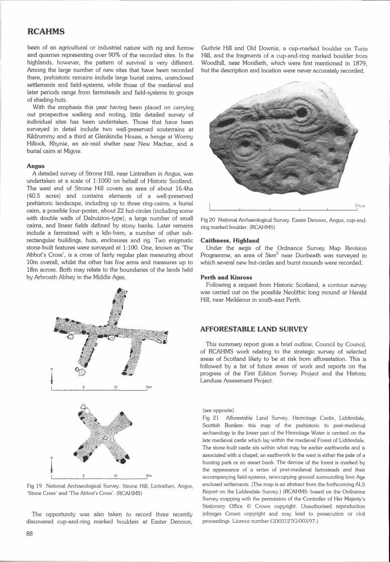
RCAHMS
been of an agricultural or industrial nature with rig and furrowand quarries representing over 90% of the recorded sites. In thehighlands, however, the pattern of survival is very different.Among the large number of new sites that have been recordedthere, prehistoric remains include large burial caims, unenclosedsettlements and field-systems, while those of the medieval andlater periods range from farmsteads and field-systems to groupsof shieling-huts.
With the emphasis this year having been placed on carryingout prospective walking and noting, little detailed survey ofindividual sites has been undertaken. Those that have beensurveyed in detail include two well-preserved souterrains atKildrummy and a third at Glenkindie House, a henge at WormyHillock, Rhynie, an air-raid shelter near New Machar, and aburial cairn at Migvie.
AngusA detailed survey of Strone Hill, near Lintrathen in Angus, was
undertaken at a scale of 1:1000 on behalf of Historic Scotland.The west end of Strone Hill covers an area of about 16.4ha(40.5 acres) and contains elements of a well-preservedprehistoric landscape, including up to three ring-caims, a burialcairn, a possible four-poster, about 22 hut-circles (including somewith double walls of Dalrulzion-type), a large number of smallcaims, and linear fields defined by stony banks. Later remainsinclude a farmstead with a kiln-barn, a number of other sub-rectangular buildings, huts, enclosures and rig. Two enigmaticstone-built features were surveyed at 1:100. One, known as 'TheAbbot's Cross', is a cross of fairly regular plan measuring about10m overall, whilst the other has five arms and measures up to18m across. Both may relate to the boundaries of the lands heldby Arbroath Abbey in the Middle Ages.
Guthrie Hill and Old Downie, a cup-marked boulder on TurinHill, and the fragments of a cup-and-ring marked boulder fromWoodhill, near Monifieth, which were first mentioned in 1879,but the description and location were never accurately recorded.
Fig 20 National Archaeological Survey. Easter Denoon, Angus, cup-and-ring marked boulder. (RCAHMS)
Caithness, HighlandUnder the aegis of the Ordnance Survey Map Revision
Programme, an area of 5km near Dunbeath was surveyed inwhich several new hut-circles and burnt mounds were recorded.
Perth and KinrossFollowing a request from Historic Scotland, a contour survey
was carried out on the possible Neolithic long mound at HeraldHill, near Meikleour in south-east Perth.
AFFORESTABLE LAND SURVEY
This summary report gives a brief outline, Council by Council,of RCAHMS work relating to the strategic survey of selectedareas of Scotland likely to be at risk from afforestation. This isfollowed by a list of future areas of work and reports on theprogress of the First Edition Survey Project and the HistoricLanduse Assessment Project.
Fig 19 National Archaeological Survey. Strone Hill, Lintrathen, Angus,'Stone Cross' and 'The Abbot's Cross'. (RCAHMS)
The opportunity was also taken to record three recentlydiscovered cup-and-ring marked boulders at Easter Denoon,
(see opposite)
Fig 21 Afforestable Land Survey. Hermitage Castle, Liddesdale,Scottish Borders: this map of the prehistoric to post-medievalarchaeology in the lower part of the Hermitage Water is centred on thelate medieval castle which lay within the medieval Forest of Liddesdale.The stone-built castle sits within what may be earlier earthworks and isassociated with a chapel; an earthwork to the west is either the pale of ahunting park or an assart bank. The demise of the forest is marked bythe appearance of a series of post-medieval farmsteads and theiraccompanying field-systems, reoccupying ground surrounding Iron Ageenclosed settlements. {The map is an abstract from the forthcoming ALSReport on the Liddesdale Survey.) (RCAHMS: based on the OrdnanceSurvey mapping with the permission of the Controller of Her Majesty'sStationery Office © Crown copyright. Unauthorised reproductioninfringes Crown copyright and may lead to prosecution or civilproceedings. Licence number GD03127G/003/97.)
88
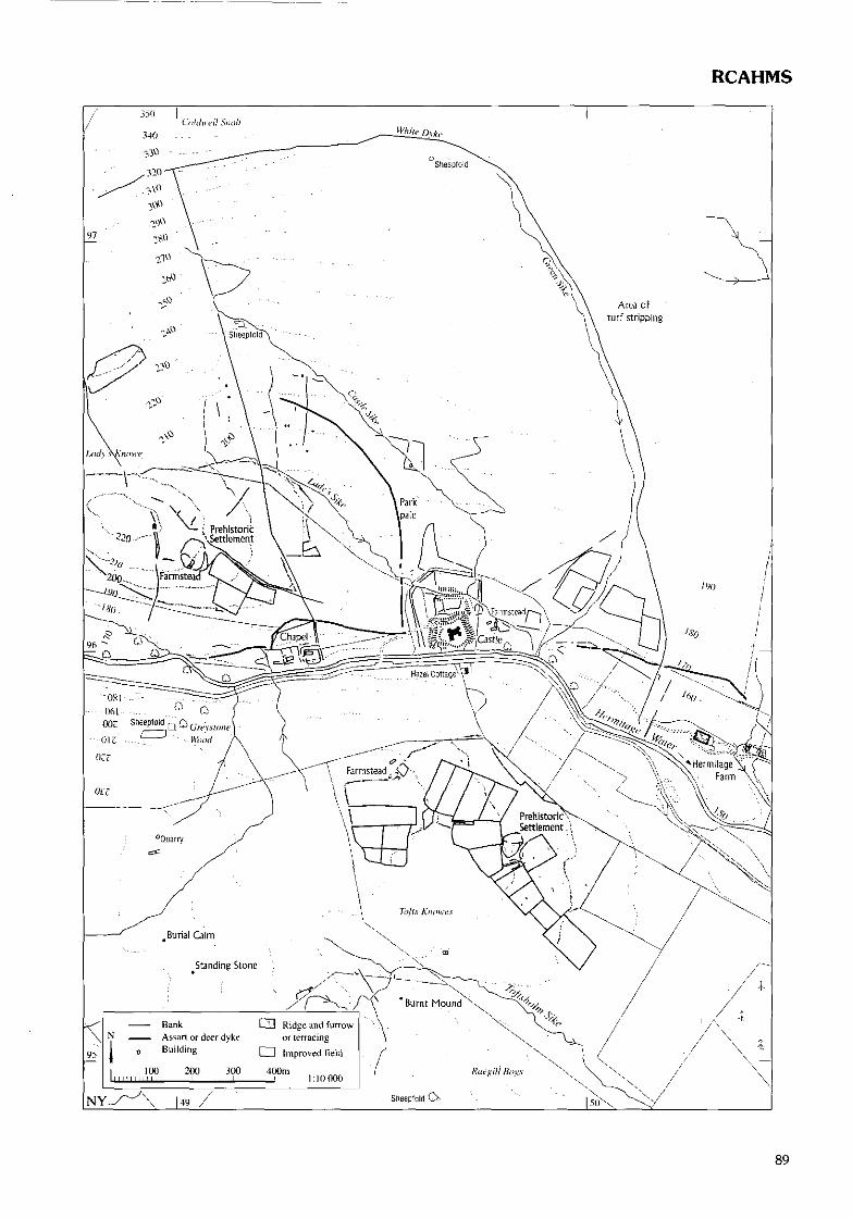
RCAHMS
89
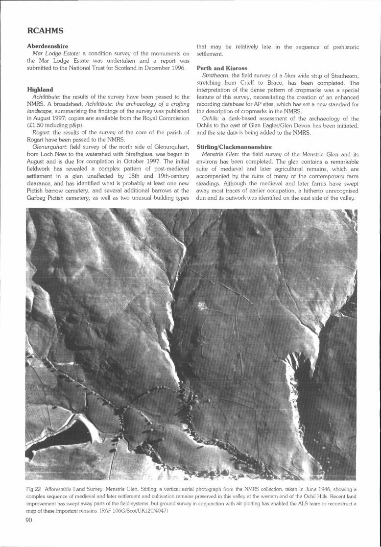
RCAHMS
AberdeenshireMar Lodge Estate: a condition survey of the monuments on
the Mar Lodge Estate was undertaken and a report wassubmitted to the National Trust for Scotland in December 1996.
HighlandAchiltibuie: the results of the survey have been passed to the
NMRS. A broadsheet, Achiltibuie: the archaeology of a croftinglandscape, summarising the findings of the survey was publishedin August 1997; copies are available from the Royal Commission(£1.50 including p&p).
Rogart: the results of the survey of the core of the parish ofRogart have been passed to the NMRS.
Glenurquhart: field survey of the north side of Glenurquhart,from Loch Ness to the watershed with Strathglass, was begun inAugust and is due for completion in October 1997. The initialfieldwork has revealed a complex pattern of post-medievalsettlement in a glen unaffected by 18th and 19th-centuryclearance, and has identified what is probably at least one newPictish barrow cemetery, and several additional barrows at theGarbeg Pictish cemetery, as well as two unusual building types
that may be relatively late in the sequence of prehistoricsettlement.
Perth and KinrossStrathearn: the field survey of a 5km wide strip of Strathearn,
stretching from Crieff to Braco, has been completed. Theinterpretation of the dense pattern of cropmarks was a specialfeature of this survey, necessitating the creation of an enhancedrecording database for AP sites, which has set a new standard forthe description of cropmarks in the NMRS.
Ochils: a desk-based assessment of the archaeology of theOchils to the east of Glen Eagles/Glen Devon has been initiated,and the site data is being added to the NMRS.
Stirling/ClackmannanshireMenstrie G/en; the field survey of the Menstrie Glen and its
environs has been completed. The glen contains a remarkablesuite of medieval and later agricultural remains, which areaccompanied by the ruins of many of the contemporary farmsteadings. Although the medieval and later farms have sweptaway most traces of earlier occupation, a hitherto unrecogniseddun and its outwork was identified on the east side of the valley.
Fig 22 Afforcstable Land Survey. Menstrie Glen, Stirling: a vertical aeria! photograph from ihe NMRS collection, taken in June 1946, showing acomplex sequence of medieval and later settlement and cultivation remains preserved in this valley at the western end of the Ochi! Hills. Recent landimprovement has swept away parts of the field-systems, but ground survey in conjunction with air plotting has enabled the ALS team to reconstruct amap of these importan! remains. (RAF 106G/Scot/UK120/4047)
90
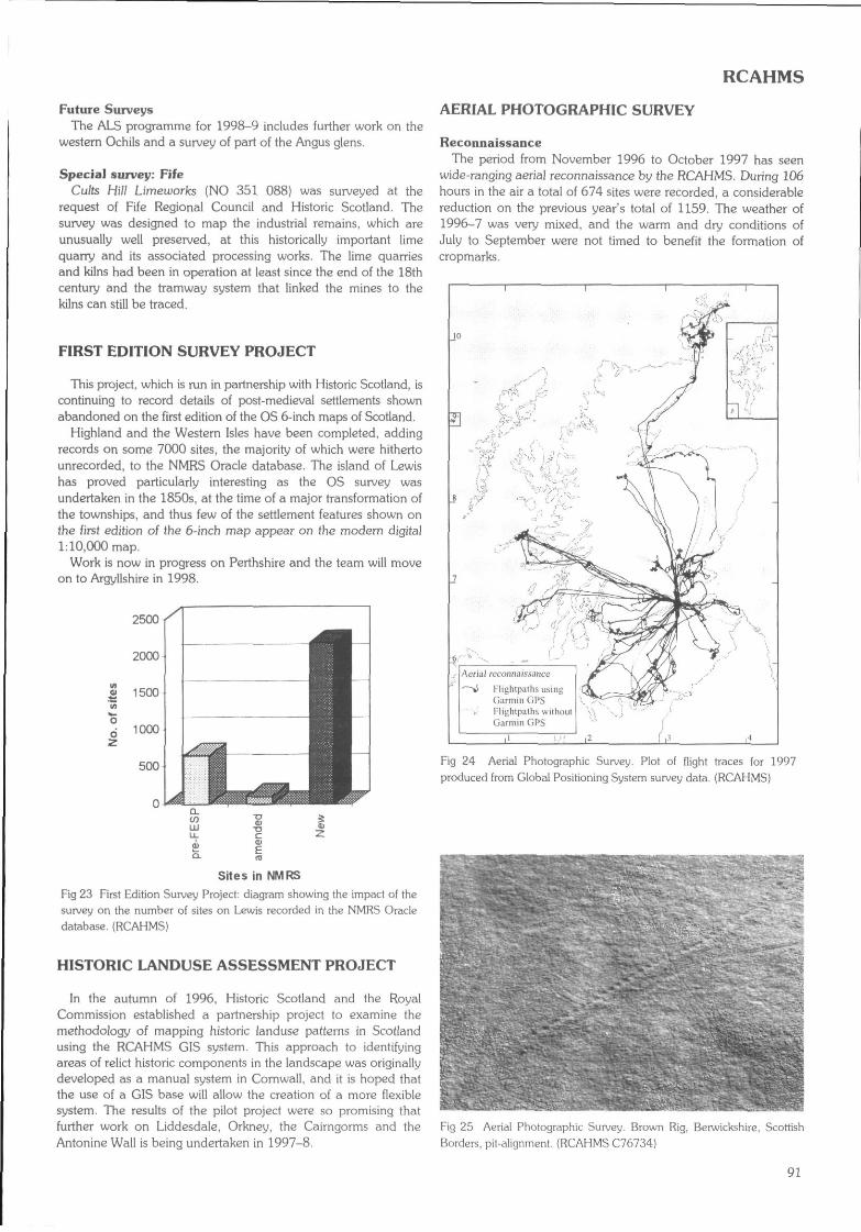
RCAHMS
Future SurveysThe ALS programme for 1998-9 includes further work on the
western Ochils and a survey of part of the Angus glens.
Special survey: FifeCults Hill Limeworks (NO 351 088) was surveyed at the
request of Fife Regional Council and Historic Scotland. Thesurvey was designed to map the industrial remains, which areunusually well preserved, at this historically important limequarry and its associated processing works. The lime quarriesand kilns had been in operation at least since the end of the 18thcentury and the tramway system that linked the mines to thekilns can still be traced.
FIRST EDITION SURVEY PROJECT
This project, which is run in partnership with Historic Scotland, iscontinuing to record details of post-medieval settlements shownabandoned on the first edition of the OS 6-inch maps of Scotland.
Highland and the Western Isles have been completed, addingrecords on some 7000 sites, the majority of which were hithertounrecorded, to the NMRS Oracle database. The island of Lewishas proved particularly interesting as the OS survey wasundertaken in the 1850s, at the time of a major transformation ofthe townships, and thus few of the settlement features shown onthe first edition of the 6-inch map appear on the modem digital1:10,000 map.
Work is now in progress on Perthshire and the team will moveon to Argyllshire in 1998.
2500
2000
1500
1000
500
Sites in NMRS
Fig 23 First Edition Survey Project: diagram showing the impact of thesurvey on the number of sites on Lewis recorded in the NMRS Oracledatabase. (RCAHMS)
HISTORIC LANDUSE ASSESSMENT PROJECT
In the autumn of 1996, Historic Scotland and the RoyalCommission established a partnership project to examine themethodology of mapping historic landuse patterns in Scotlandusing the RCAHMS GIS system. This approach to identifyingareas of relict historic components in the landscape was originallydeveloped as a manual system in Cornwall, and it is hoped thatthe use of a GIS base will allow the creation of a more flexiblesystem. The results of the pilot project were so promising thatfurther work on Liddesdale, Orkney, the Cairngorms and theAntonine Wall is being undertaken in 1997-8.
AERIAL PHOTOGRAPHIC SURVEY
ReconnaissanceThe period from November 1996 to October 1997 has seen
wide-ranging aerial reconnaissance by the RCAHMS. During 106hours in the air a total of 674 sites were recorded, a considerablereduction on the previous year's total of 1159. The weather of1996-7 was very mixed, and the warm and dry conditions ofJuly to September were not timed to benefit the formation ofcropmarks.
Aerial reconnaissance
Flightpaths usingGarmin GPSFlighiputht; withoulGartnin GPS
Fig 24 Aerial Photographic Survey. Plot of flight traces (or 1997produced from Global Positioning System survey data. (RCAHMS)
Fig 25 Aerial Photographic Survey. Brown Rig, Berwickshire, ScottishBorders, pit-alignment. (RCAHMS C76734)
91
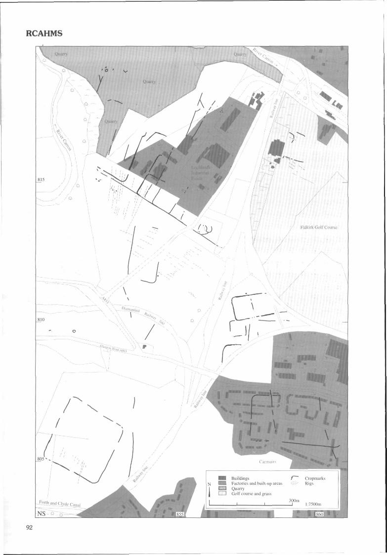
RCAHMS
92
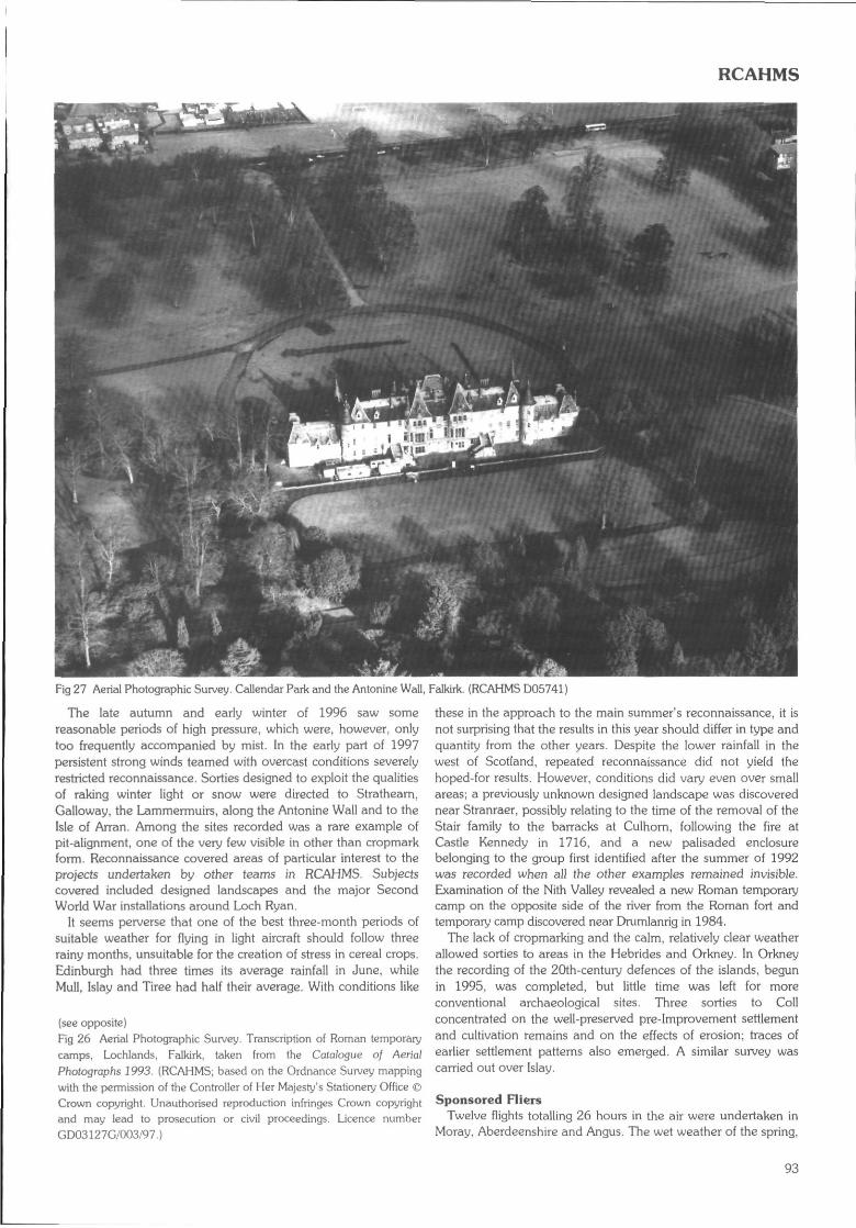
RCAHMS
Fig 27 Aerial Photographic Survey. Callcndar Park and the Antonine Wall, Falkirk. (RCAHMS D05741}
The late autumn and early winter of 1996 saw somereasonable periods of high pressure, which were, however, onlytoo frequently accompanied by mist. In the early part of 1997persistent strong winds teamed with overcast conditions severelyrestricted reconnaissance. Sorties designed to exploit the qualitiesof raking winter light or snow were directed to Strathearn,Galloway, the Lammermuirs, along the Antonine Wall and to theIsle of Arran. Among the sites recorded was a rare example ofpit-alignment, one of the very few visible in other than cropmarkform. Reconnaissance covered areas of particular interest to theprojects undertaken by other teams in RCAHMS. Subjectscovered included designed landscapes and the major SecondWorld War installations around Loch Ryan.
It seems perverse that one of the best three-month periods ofsuitable weather for flying in light aircraft should follow threerainy months, unsuitable for the creation of stress in cereal crops.Edinburgh had three times its average rainfall in June, whileMull, Islay and Tiree had half their average. With conditions like
(sec opposite)Fig 26 Aerial Photographic Survey. Transcription of Roman temporarycamps, Lochlands, Falkirk, taken from the Catalogue of AerialPhotographs 1993. (RCAHMS; based on the Ordnance Survey mappingwith the permission of the Controller of Her Majesty's Stationery Office ©Crown copyright. Unauthorised reproduction infringes Crown copyrightand rnay lead to prosecution or civil proceedings. Licence numberGD03127G/003/97.)
these in the approach to the main summer's reconnaissance, it isnot surprising that the results in this year should differ in type andquantity from (he other years. Despite the lower rainfall in thewest of Scotland, repeated reconnaissance did not yield thehoped-for results. However, conditions did vary even over smallareas; a previously unknown designed landscape was discoverednear Stranraer, possibly relating to the time of the removal of theStair family to the barracks at Culhorn, following the fire atCastle Kennedy in 1716, and a new palisaded enclosurebelonging to the group first identified after the summer of 1992was recorded when all the other examples remained invisible.Examination of the Nith Valley revealed a new Roman temporarycamp on the opposite side of the river from the Roman fort andtemporary camp discovered near Drumlanrig in 1984.
The lack of cropmarking and the calm, relatively clear weatherallowed sorties to areas in the Hebrides and Orkney. In Orkneythe recording of the 20th-century defences of the islands, begunin 1995, was completed, but little time was left for moreconventional archaeological sites. Three sorties to Collconcentrated on the well-preserved pre-Improvement settlementand cultivation remains and on the effects of erosion; traces ofearlier settlement patterns also emerged. A similar survey wascarried out over Islay.
Sponsored RiersTwelve flights totalling 26 hours in the air were undertaken in
Moray, Aberdeenshire and Angus. The wet weather of the spring,
93
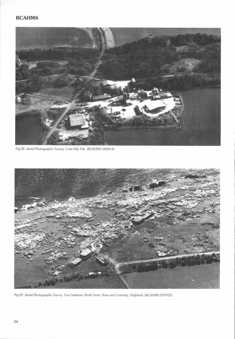
RCAHMS
Fig 28 Aerial Photographic Survey. Cults Hill, Fife. (RCAHMS D09014)
Fig 29 Aerial Photographic Survey Gun batteries, North Sutor, Ross and Cromarty, Highland. (RCAHMS D09702)
94
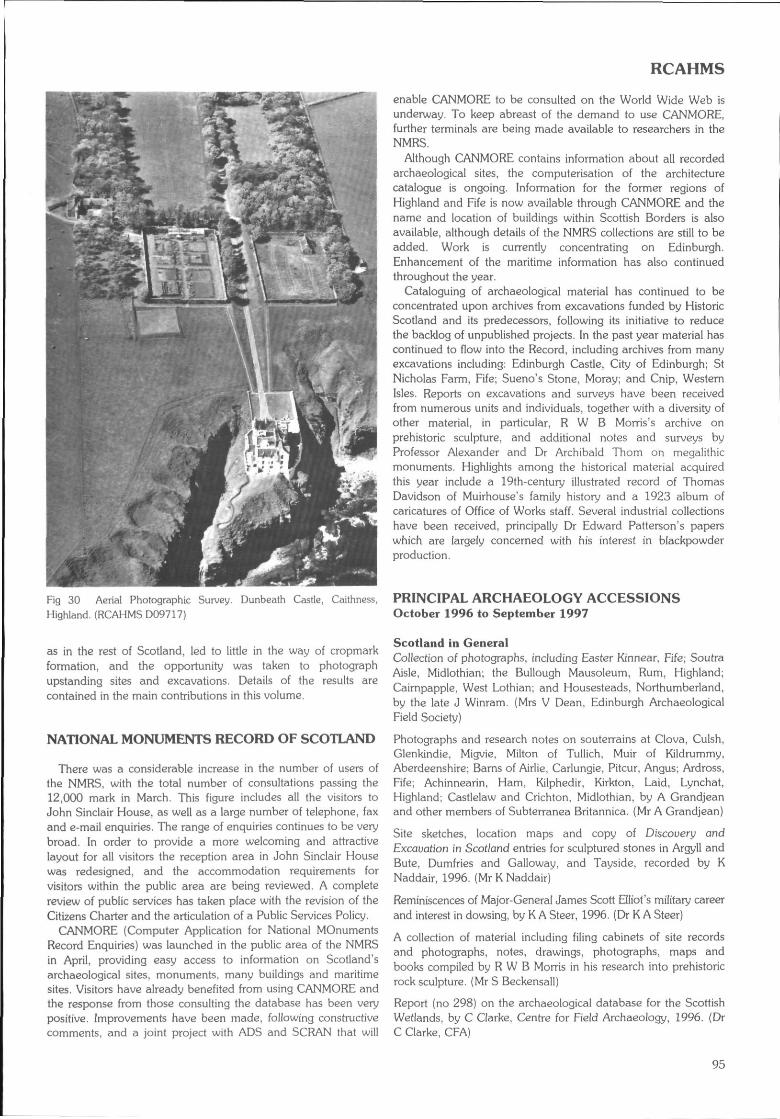
RCAHMS
Fig 30 Aerial Photographic Survey.Highland (RCAHMS D09717)
Dunbeath Castle, Caithness,
as in the rest of Scotland, led to little in the way of cropmarkformation, and the opportunity was taken to photographupstanding sites and excavations. Details of the results arecontained in the main contributions in this volume.
NATIONAL MONUMENTS RECORD OF SCOTLAND
There was a considerable increase in the number of users ofthe NMRS, with the total number of consultations passing the12,000 mark in March. This figure includes all the visitors toJohn Sinclair House, as well as a large number of telephone, faxand e-mail enquiries. The range of enquiries continues to be verybroad. In order to provide a more welcoming and attractivelayout for all visitors the reception area in John Sinclair Housewas redesigned, and the accommodation requirements forvisitors within the public area are being reviewed. A completereview of public services has taken place with the revision of theCitizens Charter and the articulation of a Public Services Policy.
CANMORE (Computer Application for National MOnumentsRecord Enquiries) was launched in the public area of the NMRSin April, providing easy access to information on Scotland'sarchaeological sites, monuments, many buildings and maritimesites. Visitors have already benefited from using CANMORE andthe response from those consulting the database has been verypositive. Improvements have been made, following constructivecomments, and a joint project with ADS and SCRAN that will
enable CANMORE to be consulted on the World Wide Web isunderway. To keep abreast of the demand to use CANMORE,further terminals are being made available to researchers in theNMRS.
Although CANMORE contains information about all recordedarchaeological sites, the computerisation of the architecturecatalogue is ongoing. Information for the former regions ofHighland and Fife is now available through CANMORE and thename and location of buildings within Scottish Borders is alsoavailable, although details of the NMRS collections are still to beadded. Work is currently concentrating on Edinburgh.Enhancement of the maritime information has also continuedthroughout the year.
Cataloguing of archaeological material has continued to beconcentrated upon archives from excavations funded by HistoricScotland and its predecessors, following its initiative to reducethe backlog of unpublished projects. In the past year material hascontinued to flow into the Record, including archives from manyexcavations including: Edinburgh Castle, City of Edinburgh; StNicholas Farm, Fife; Sueno's Stone, Moray; and Cnip, WesternIsles. Reports on excavations and surveys have been receivedfrom numerous units and individuals, together with a diversity ofother material, in particular, R W B Morris's archive onprehistoric sculpture, and additional notes and surveys byProfessor Alexander and Dr Archibald Thorn on megalithicmonuments. Highlights among the historical material acquiredthis year include a 19th-century illustrated record of ThomasDavidson of Muirhouse's family history and a 1923 album ofcaricatures of Office of Works staff. Several industrial collectionshave been received, principally Dr Edward Patterson's paperswhich are largely concerned with his interest in blackpowderproduction.
PRINCIPAL ARCHAEOLOGY ACCESSIONSOctober 1996 to September 1997
Scotland in GeneralCollection of photographs, including Easter Kinnear, Fife; SoutraAisle, Midlothian; the Bullough Mausoleum, Rum, Highland;Cairnpapple. West Lothian; and Housesteads, Northumberland,by the late J Winram. (Mrs V Dean, Edinburgh ArchaeologicalField Society)
Photographs and research notes on souterrains at Clova, Culsh,Glenkindie, Migvie, Milton of Tullich, Muir of Kildrummy,Aberdeenshire; Barns of Airlie, Carlungie, Pitcur, Angus; Ardross,Fife; Achinnearin, Ham, Kilphedir, Kirkton, Laid, Lynchat,Highland; Castlelaw and Crichton, Midlothian, by A Grandjeanand other members of Subterranea Britannica. (Mr A Grandjean)
Site sketches, location maps and copy of Discouery andExcavation in Scot/and entries for sculptured stones in Argyll andBute, Dumfries and Galloway, and Tayside, recorded by KNaddair, 1996. (Mr K Naddair)
Reminiscences of Major-General James Scott Elliot's military careerand interest in dowsing, by K A Steer, 1996. (Dr K A Steer)
A collection of material including filing cabinets of site recordsand photographs, notes, drawings, photographs, maps andbooks compiled by R W B Morris in his research into prehistoricrock sculpture. (Mr S Beckensall)
Report (no 298) on the archaeological database for the ScottishWetlands, by C Clarke, Centre for Field Archaeology, 1996. (DrC Clarke, CFA)
95
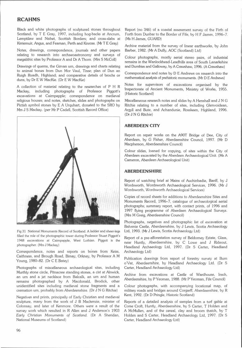
RCAHMS
Black and white photographs of sculptured stones throughoutScotland, by T E Gray, 1997, including hog-backs at Ancrum,Lemptilaw and Nisbet, Scottish Borders; and cross-slabs atKirriemuir, Angus, and Feaman, Perth and Kinross. (Mr T E Gray)
Notes, drawings, correspondence, journals and other papersrelating to research into archaeoastronomy and surveys ofmegalithic sites by Professor A and Dr A Thorn. (Mrs S McColl)
Drawings of querns, the Girvan urn, drawings and charts relatingto animal bones from Dun Mor Vaul, Tiree; plan of Dun anRuigh Ruadh, Highland; and comparative details of brochs orduns, by Dr E W MacKie. (Dr E W MacKie)
A collection of material relating to the researches of P H RMackay, including photographs of Professor Piggott'sexcavations at Caimpapple; correspondence on medievalreligious houses; and notes, sketches, slides and photographs onPictish symbol stones by E A Urquhart, donated to the SRO byMrs J S Mackay. (per Mr P Cadell, Scottish Record Office)
Fig 31 National Monuments Record of Scotland. A ladder and sheer-legsfilled the role of the photographic tower during Professor Stuart Piggott's1948 excavations at Caimpapple, West Lothian. Piggott is thephotographer. {Mrs J Mackay}
Correspondence, notes and reports on bones from Keiss,Caithness, and Brough Road, Birsay, Orkney, by Professor A MYoung, 1980-82. (Dr C E Batey)
Photographs of miscellaneous archaeological sites, includingMurthly stone circle, Pitnacree standing stones, a cist at Alnwick,an urn and a jet necklace from Balcalk, an urn and humanremains photographed by A Macdonald, Brodick, otherunidentified sites including medieval stone fragments and acremation um, probably from Aberdeenshire. (Dr J N G Ritchie)
Negatives and prints, principally of Early Christian and medievalsculpture, many from the work of J B Mackenzie, minister ofColonsay, and later of Kenmore. Others were a result of thesurvey work which resulted in R Allen and J Anderson's 1903Early Christian Monuments of Scotland. (Dr A Sheridan,National Museums of Scotland}
Report (no 346) of a coastal assessment survey of the Firth ofForth from Dunbar to the Border of Fife, by H F James, 1996-7.(Ms H James, GUARD}
Archive material from the survey of linear earthworks, by JohnBarber, 1982. (Mr A Duffy, AOC (Scotland) Ltd)
Colour photographs, mostly aerial stereo pairs, of industrialremains in the Wanlockhead-Leadhills area of South Lanarkshireand Dumfries and Galloway, by A Crawshaw, 1996. (A Crawshaw)
Correspondence and notes by D E Andrews on research into themathematical analysis of prehistoric monuments. (Mr D E Andrews)
Notes for supervisors of excavations organised by theInspectorate of Ancient Monuments, Ministry of Works, 1955.(Historic Scotland)
Miscellaneous research notes and slides by A Henshall and J N GRitchie relating to a number of sites, including Glenvoidean,Argyll and Bute, and Achandunie, Rosskeen, Highland, 1996.(Dr J N G Ritchie}
ABERDEEN CITY
Report on repair works on the A90T Bridge of Dee, City ofAberdeen, by G Fisher, Aberdeenshire Council, 1997. (Mr DMacpherson, Aberdeenshire Council}
Colour slides, loaned for copying, of sites within the City ofAberdeen excavated by the Aberdeen Archaeological Unit. (Ms ACameron, Aberdeen Archaeological Unit)
ABERDEENSHIRE
Report of watching brief at Mains of Auchinbadie, Banff, by JWordsworth, Wordsworth Archaeological Services, 1996. (Mr JWordsworth, Wordsworth Archaeological Services)
Copies of record sheets for additions to Aberdeenshire Sites andMonuments Record, 1996-7, catalogue of archaeological aerialphotographs; summary report, with contact prints, of 1996 and1997 flying programme of Aberdeen Archaeological Surveys.(Mrs M Greig, Aberdeenshire Council)
Photographs, negatives and photographic list of excavation atBalvenie Castle, Aberdeenshire, by J Lewis, Scotia ArchaeologyLtd, 1993. (Mr J Lewis, Scotia Archaeology Ltd)
Report of a pre-afforestation survey of Beldorney Estate, Glass,near Huntly, Aberdeenshire, by C Lowe and J Rideout,Headland Archaeology Ltd, 1997. (Dr S Carter, HeadlandArchaeology Ltd}
Publication drawings from report of forestry survey at Burno'Vat, Aberdeenshire, by Headland Archaeology Ltd. (Dr SCarter, Headland Archaeology Ltd}
Archive from excavations at Castle of Wardhouse, Insch,Aberdeenshire, by P Yeoman, 1988. (Mr P Yeoman, Fife Council)
Colour photographs, with accompanying locational map, ofmilitary roads and bridges around Corgarff, Aberdeenshire, by RKent, 1992. (Dr D Pringle, Historic Scotland)
Reports of a detailed analysis of samples from a turf gable atCorse Croft, Huntly, Aberdeenshire, by S Carter, T Holden andA McMullen, and of the cereal, clay and broom thatch, by THolden and S Carter, Headland Archaeology Ltd, 1997. (Dr SCarter, Headland Archaeology Ltd)
96
RCAHMS
Publication drawings from the articles 'The defences of DundargCastle', by N Fojut and P Love, and 'A wooden ard-share fromDundarg, Aberdeenshire, with a note on other wooden ploughpieces', in PSAS 113 (1983), by S Rees. (Mr N Fojut, HistoricScotland)
Report and publication drawings of a forestry survey in GlenGelder, Balmoral, Aberdeenshire, by S Carter and M Dalland,Headland Archaeology Ltd, 1996. (Dr C Lowe and Dr S Carter,Headland Archaeology Ltd)
Report and publication drawings of a forestry survey ofGowanfold, Inverallochy, Aberdeenshire, by S Carter and CRussell-White, Headland Archaeology Ltd, 1996. (HeadlandArchaeology Ltd)
Report and publication drawings of a forestry survey of LamahipPinewood, Glen Cat, Aberdeenshire, by S Carter and C Russell-White, Headland Archaeology Ltd, 1996. (HeadlandArchaeology Ltd)
Photographs and pencil plan of Longmanhill Cairn, Gamrie,Aberdeenshire, by J S Richardson, 1924, with photographs andphotocopied notes on the same by R Feachem, 1956. (Mr G JBarclay, Historic Scotland)
Report and publication drawings of a forestry survey of NorthHill and Finlets Pinewood, Forest of Birse, Aberdeenshire, by SCarter and C Russell-White, Headland Archaeology Ltd, 1996.(Headland Archaeology Ltd)
Report of the discovery of a well at the Pitmedden Gardensfarming museum, Udny, Aberdeenshire, by R Turner, 1996. (MrR Turner, National Trust for Scotland)
A copy of 'Some Antiquities of Aberdeenshire'. a collection ofJames Ritchie's published archaeological and antiquarian papers,with a letter by his grandson on his photography. (Dr A ERitchie)
Publication drawings from report on Stoneyhill, Aberdeenshire,Headland Archaeology Ltd. (Dr S Carter, Headland ArchaeologyLtd)
A copy of an unpublished article, illustrated with photographs, onthe Two Houses of Tonley, Aberdeenshire, by I B-D Bryce. (Mr IB D Bryce)
Drawings from excavations at'Wardend of Durris, Aberdeenshire,by C Russell-White, AOC (Scotland) Ltd, 1988-90. (Mr A Duffy,AOC (Scotland) Ltd)
ANGUS
Copies of plans illustrating the bounds of Guardianship land atthe Aberlernno stones, Angus, 1913 and 1956-7. (Mrs L Linge,Historic Scotland)
Copies of record sheets and contact prints of aerial photographsof sites recorded in Angus by Aberdeen Archaeological Surveys,1996-7. (Mrs M Greig, Aberdeenshire Council)
Photographic record, colour slides and third interim report(1995) of excavations at Auchlishie, near Kirriemuir, Angus, by AJDick, 1994-6. (Mr A Dick)
Drawings, site notes, photographs, negatives and colour slidesfrom excavations and a watching brief at Bishop's Close,Brechin, Angus, by Scotia Archaeology Ltd. 1995. (Mr J Lewis.Scotia Archaeology Ltd)
Report (no 300} of excavations at the Brown Caterthun, Angus,by A Dunwell and R J Strachan, Centre for Field Archaeology,1996. (Mr A Dunwell, CFA)
Reports and excavation archive of excavations at Carnoustie,Angus, by A N Smith, AOC (Scotland) Ltd, 1994. (Mr A Duffy,AOC (Scotland) Ltd)
Publication drawings from report of forestry survey atCraigiemeg, Angus, by Headland Archaeology Ltd. (Dr S Carter,Headland Archaeology Ltd)
Archive from excavations at Edzell Churchyard extension, Angus,by J O'Sullivan, AOC (Scotland) Ltd, 1994. (Mr A Duffy, AOC(Scotland) Ltd)
Third interim report of the Fordhouse Barrow excavations (NTSno 7), Angus, by R Peterson, G Brown, M Leivers and EProudfoot, 1996. (National Trust for Scotland)
Report of excavation and survey at Maryton Law, Angus, by MDalland, Headland Archaeology Ltd, 1996. (Dr C Lowe,Headland Archaeology Ltd)
Publication drawings from PSAS 113 (1983) of Bronze Ageburials at Melgund, Baldardo, and Easter Marcus, Angus, by J RSherriff. (Mr N Fojut, Historic Scotland)
Report and publication drawings of pre-afforestation survey ofMillden Estate, Glen Esk, Angus, by C Lowe and J Rideout,Headland Archaeology Ltd, 1996. (Headland Archaeology Ltd)
Archive from an excavation at the Star Garage, Montrose,Angus, by R Cachart, SUAT, 1992. (SUAT)
Archive from excavations at Nether Kelly, Arbroath, Angus, by SCarter, AOC (Scotland) Ltd, 1992. (Mr A Duffy, AOC (Scotland) Ltd)
Report (no 302) of a survey of rabbit erosion of the earthworksof the White Caterthun, Angus, by A Dunwell. Centre for FieldArchaeology, 1996. (Mr A Dunwell, CFA)
ARGYLL AND BUTE
Notebook, drawings, photographs and slides of an excavation atAn Torr, Glencoe, Argyll and Bute, by J Lewis, ScotiaArchaeology Ltd, 1994. (Mr J Lewis, Scotia Archaeology Ltd)
Notebook, project outline and drawings of excavation atArdchattan Priory, Argyll and Bute, by R Murdoch, ScotiaArchaeology Ltd, 1995. (Mr J Lewis, Scotia Archaeology Ltd)
Publication drawings from report on Ballymeanoch, Argyll andBute, by Headland Archaeology Ltd. (Dr S Carter, HeadlandArchaeology Ltd)
Report (no 412) of excavation at Benderloch, Argyll and Bute,by G MacGregor, GUARD, 1996. (GUARD)
Correspondence and slides relating to excavation at CnocEibriginn, Colonsay, Argyll and Bute, by Dr J Ruff ell, 1971. (MrA Saville. National Museums of Scotland)
Excavation archive from Dunstaffnage Castle, Argyll and Bute,by Scotia Archaeology Ltd, 1987-95. (Mr J Lewis, ScotiaArchaeology Ltd)
Definitive summary of the records of the Finlaggan excavations,Argyll and Bute, by the National Museums of Scotland, by D HCaldwell. (Dr D Caldwell, National Museums of Scotland)
Report of survey of lands to the west of Goat Fell, Arran, Argylland Bute, in advance of Millennium Forest work, by J Harden,
97
RCAHMS
Archaeological Services, 1996. (Ms J Harden, ArchaeologicalServices)
Archive from lona Small Works excavations, Argyll and Bute, byF McCormick, AOC (Scotland) Ltd, 1988. (Mr A Duffy, AOC(Scotland) Ltd)
Archive from lona Riverbank excavations, Argyll and Bute, by JO'Sullivan, AOC (Scotland) Ltd, 1994. (Mr A Duffy, AOC(Scotland) Ltd)
Negatives of 18th-century towers, a fort and cannon at IslayHouse, Argyll and Bute, by I Maclvor, 1971. (Dr D Pringle,Historic Scotland)
Report (no 442} of assessment of Kilkerran to Macringan's Point,Campbeltown, Argyll and Bute, by O Lelong, 1997. (GUARD)
Reports, excavation records, drawings, slides, photographs andnegatives from excavation at Lismore churchyard, Argyll andBute, by J O'Sullivan, AOC (Scotland) Ltd, 1994. (Mr A Duffy,AOC (Scotland) Ltd)
Report (no 411} of watching brief at Mulreesh lead mines, Islay,Argyll and Bute, by K Speller, GUARD, 1996. (GUARD)
Publication drawings from report of forestry survey at Rockside,Argyll and Bute, by Headland Archaeology Ltd. (Dr S Carter,Headland Archaeology Ltd)
Archive from excavation^.at Rossdhu Castle, Loch Lomond,Argyll and Bute, by J Lewis'and R Murdoch, Scotia ArchaeologyLtd, 1996. (Mr J Lewis, Scotia Archaeology Ltd)
Drawings from survey of Stronachullin Estate, Argyll and Bute,by Scotia Archaeology Ltd, 1995. (Mr J Lewis, ScotiaArchaeology Ltd)
CLACKMANNANSHIRE
Report, colour prints and negatives from the examination of ashell midden at Braehead Golf Course, Cambus, Clackmannan-shire, by D Hall and P J Ashmore, Historic Scotland, 1996. (Mr PAshmore, Historic Scotland)
DUMFRIES AND GALLOWAY
Report of a pre-afforestation survey of Creebank, Bargrennan,Kirkcudbrightshire, Dumfries and Galloway, by C Lowe and JRideout, Headland Archaeology Ltd, 1997. (Dr S Carter,Headland Archaeology Ltd)
Draft text of chapter on Early Historic Archaeology and Historyin Eastern Dumfriesshire, prepared for RCAHMS by D Craig,1995. (Dr D Craig)
Drawings from excavations at Halfway House, Kirkcowan,Dumfries and Galloway, by O Owen, SDD/HBM-AOC, 1989.(Mr A Duffy, AOC (Scotland) Ltd)
Colour photographs of cross-fragments from Kirkconnel,Nithsdale, in Dumfries Museum, Dumfries and Galloway, takenin the course of the Kirkpatrick-Fleming survey. (Mr R J Mercer)
Report of a pre-afforestation survey at Mitchellslacks andLocherben, Closeburn, Dumfries and Galloway, by T Ward,Biggar Museum Trust, 1996. (Mr T Ward, Biggar Museum Trust)
Report (no 348.3) of an assessment of Steven's Croft andMillhousebridge, by Nethercleugh, by O Lelong, 1997. (GUARD)
Report and photographs of forestry survey at the WigtownBlackpowder Works at Carsegown Farm, Newton Stewart,Dumfries and Galloway, by S Carter and J Rideout, HeadlandArchaeology Ltd, 1997. (Dr S Carter, Headland Archaeology Ltd)
EAST AYRSHIRE
Two colour slides of a hillfort or enclosure on south face of BeochHill, Dalmellington, East Ayrshire, by S Andrews. (Ms S Andrews)
Report (no 418) of assessment and field survey of BowhouseMunitions Factory, Kilmamock, East Ayrshire, by K Speller and CFrench, 1997. (GUARD)
Report and publication drawings of a forestry survey ofLochbrowan and Blackcraig, East Ayrshire, by S Carter and MDalland, Headland Archaeology Ltd, 1996. {Dr C Lowe,Headland Archaeology Ltd)
Report (no 357.2) of an evaluation and watching brief atPennyvenie, Area A, East Ayrshire, by G MacGregor and J SymeDuncan, GUARD, 1997. (GUARD)
Site day book of survey of Powhamal Bum, East Ayrshire, by JLewis and D Reed, Scotia Archaeology Ltd, 1992. (Mr J Lewis,Scotia Archaeology Ltd)
EAST DUNBARTONSHIRE
Report of a survey of Campsie Glen, East Dunbartonshire, forKelvin Valley Countryside Project, by J S Rideout and C JRussell-White, Alba Archaeology Ltd, 1997. (Mr J Rideout, AlbaArchaeology Ltd)
EAST LOTHIAN
Report (no 8) of a survey of the Archerfield Estate, Dirleton, EastLothian, by A F Leslie and S T Driscoll. (Mr 1 Banks, GUARD)
Colour photographs of a model reconstruction of Dunbar Castle,East Lothian, by R Weatherhead, 1996. (R Weatherhead)
Report (no 306) of evaluation at St Michaels, Inveresk, EastLothian, by J Hamilton, Centre for Field Archaeology, 1996. (MrA Dunwell, CFA)
Report and publication drawings of a marking-out survey atMarkle, East Lothian, by M Dalland, Headland Archaeology Ltd,1996. (Dr C Lowe, Headland Archaeology Ltd)
Report of evaluation at 35-41 Market Street, Musselburgh, EastLothian, by S Carter, Headland Archaeology Ltd, 1997. (Dr SCarter, Headland Archaeology Ltd)
Data structure report for an evaluation and watching brief atWhitekirk tithe bam, East Lothian, by C Lowe, HeadlandArchaeology Ltd, 1997. (Ms L Baker, Headland Archaeology Ltd)
Drawings from excavations at Winton House, East Lothian, by MDalland, AOC (Scotland) Ltd, 1989. (Mr A Duffy, AOC(Scotland) Ltd)
CITY OF EDINBURGH
Letter by Mrs L Gladstone-Millar, 1992, accompanyingphotocopy of extract from Colinton Parish Magazine, March1914, on medieval graveslabs at Colinton parish church, City ofEdinburgh. (Mrs L Gladstone-Millar)
98
RCAHMS
Copy of Edinburgh Archaeological Field Society newsletter, no111, January 1997, reporting the discovery of the CramondLioness.
Archive from excavations at Edinburgh Castle, 1988-9. (HistoricScotland)
Report (no 6.6) on archive material from excavations at EdinburghCastle, by S Bain and J Clark, GUARD, 1997. (GUARD)
Report (no 262) of cultural heritage survey of Holyrood Park,City of Edinburgh, by D Alexander, Centre for FieldArchaeology, 1997. (Mr D Alexander, CFA)
Data structure report from an archaeological excavation at OldDundas Castle, City of Edinburgh, by C E Lowe, HeadlandArchaeology Ltd, 1996. {Dr S P Carter, Headland Archaeology Ltd)
Archive from an excavation at Ratho, City of Edinburgh, by A Smith,AOC (Scotland) Ltd, 1993. (Mr A Duffy, AOC (Scotland) Ltd)
FALKIRK
Annotated drawing of section through the Antonine Wall atNether Kinneil, near Inveravon, Falkirk, by E Price, 1974. (Dr RHingley, Historic Scotland)
Archive from excavations at Kinnei! House, Falkirk, by A Barlow,Scotia Archaeology Ltd, 1993 and 1994. (Mr J Lewis, ScotiaArchaeology Ltd)
On loan for copying. Copies of three photographs of the Smithfamily c 1909-16, and a silver rose bowl inscribed To MissSmith from friends who will always have pleasant memories ofher kindness and hospitality during the excavation of the Romanfort at Mumrills. 1923-1928', believed to have been presentedby A O Curie and G Macdonald. (Miss M Nicol)
FIFE
Report of a coastal assessment survey of Fife, from Kincardine toFifeness, for Historic Scotland, by P Robertson, Maritime Fife.1996. (Ms D Groom, Maritime Fife)
Report on (he shipwreck heritage of Fife, by N C Dobson,Maritime Fife, 1997. (Ms D Groom, Maritime Fife)
Archive from an excavation at Charlestown Limekilns, Fife, by RMurdoch, Scotia Archaeology Ltd, 1996. (Mr J Lewis, ScotiaArchaeology Ltd)
Report of an archaeological evaluation at Colton OpencastRemainder Site, by Wellwood, Dunfermline. Fife, by S Farrell,1997. (Mr S Farrell)
Data structure report of excavation and watching brief atCraighead Golf Course, Balcornie. Fife Ness, by M Dalland.Headland Archaeology Ltd, 1996. (Headland Archaeology Ltd)
Report of a watching brief of trenching works across the DanesDike at Craighead, Fife, by C Lowe and T Holden, HeadlandArchaeology Ltd, 1996. (Dr C Lowe, Headland Archaeology Ltd)
Report of Crail Main Drainage Scheme; an archaeologicalevaluation of the area at and adjacent to the Kilminningscreenhouse. by M Dalland, Headland Archaeology Ltd, 1997.(Dr S Carter. Headland Archaeology Ltd)
Report on Crombie Point, by A Wood, Maritime Fife, 1997. (MsD Groom, Maritime Fife)
Drawings from watching briefs carried out at Dunferrnline Abbey,Fife, by Scotia Archaeology Ltd, 1993. (Mr J Lewis, ScotiaArchaeology Ltd)
Site day book from excavation at Old Lauder Technical School,Dunfermline, by Scotia Archaeology Ltd. 1993. (Mr J Lewis,Scotia Archaeology Ltd)
Photographs and negatives from excavations at the Abbot'sHouse, Dunfermline, 1988. (SUAT)
Report on East Wemyss Gasworks, by A Wood, Maritime Fife,1997. (Ms D Groom, Maritime Fife)
Report and publication drawings of pre-afforestation survey ofFalkland, Lomond Hills, Fife, by C Lowe and M Dalland,Headland Archaeology Ltd, 1996. (Dr S Carter, HeadlandArchaeology Ltd)
Archive from excavations at Falkland Palace, Fife, by ScotiaArchaeology Ltd, 1995-7. (Mr J Lewis, Scotia Archaeology Ltd)
Additional excavation archive from Hallow Hill, comprisingreports, computer disks, photographs and negatives, by EProudfoot. (Mrs E Proudfoot)
Archive from excavations and watching briefs at Kellie Castle, byH Smith and J Terry, Scotia Archaeology Ltd, 1995. (Mr J Lewis,Scotia Archaeology Ltd)
Report on the Kincardine Foreshore Survey, by A Wood,Maritime Fife, 1997. (Ms D Groom, Maritime Fife)
Report, drawing and slides of excavation at KinghornPromenade (KH01), by R Cachart, SUAT, 1994. (SUAT)
Photographs from a graveyard survey at Leslie, Fife, by S Farrell,1997. (Mr S Farrell)
Draft copy of paper on prehistoric flint and stone artefacts fromthe Lomond Hills. Fife, by M King. E Proudfoot, T Rees and ASaville, 1997. (Mr M D King, Fife Council)
Report (no 395) of survey and excavation of the Pictishcemetery, Lundin Links, Lower Largo, Fife, by B Will, GUARD,1996. (GUARD)
Report of site evaluation of the former Co-op and adjacent siteto the north of Brunton Road, Markinch, Fife, by T Holden,Headland Archaeology Ltd, 1996. (Dr C Lowe, HeadlandArchaeology Ltd)
Report on the Newport-on-Tay Wreck, by A Wood, MaritimeFife, 1997. (Ms D Groorn, Maritime Fife)
Report (no 330) of watching brief at Pitreavie Golf Course.Pitreavie, Dunfermline, Fife, by C Swift, Centre for FieldArchaeology. 1997. (Ms C A Swift. CFA)
Loaned for copying. A pre-1914 postcard of an artist'simpression of Rosyth Naval Dockyard, Fife. (Dr I Eraser)
Excavation archive from St Andrews Castlecliffe, Fife, by ScotiaArchaeology Ltd, 1988-90. (Mr J Lewis, Scotia Archaeology Ltd)
Drawings of the St Andrews Sarcophagus, by 1 G Scott, 1996.(Mr I G Scott)
Site day book and drawing from watching brief at St Mary'sCourtyard, St Andrews, Fife, by A Barlow, Scotia ArchaeologyLtd. 1995. (Mr J Lewis, Scotia Archaeology Ltd)
Excavation archive from St Nicholas Farm, St Andrews, Fife, byD W Hall. SUAT, 1986-7. (Mr N Robertson, SUAT)
99
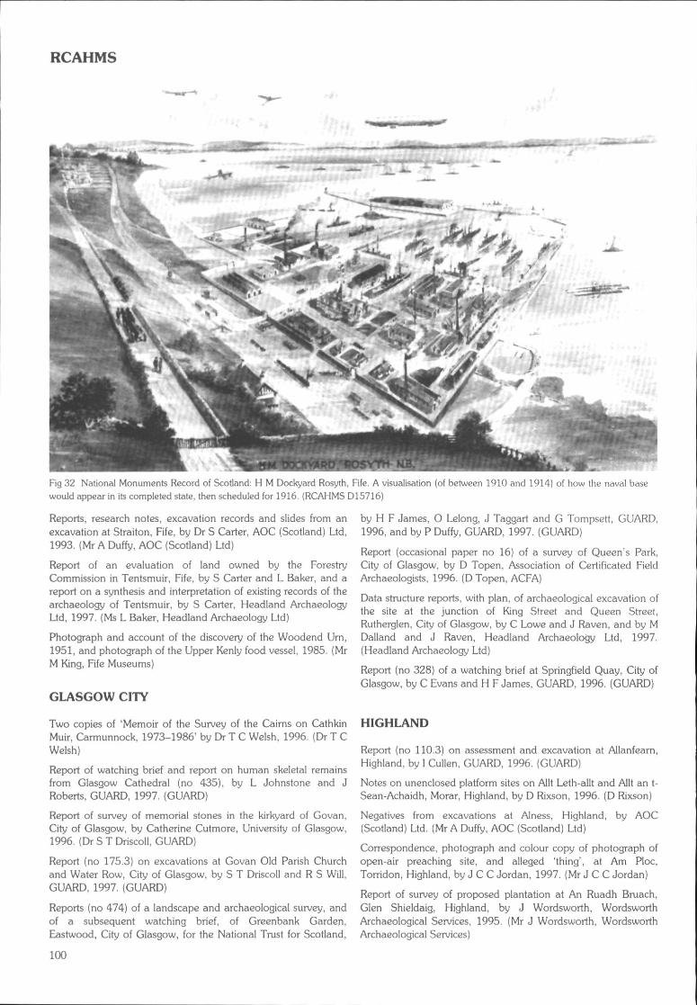
RCAHMS
Fig 32 National Monuments Record of Scotland: H M Dockyard Rosyth, Fife. A visualisation (of between 1910 and 1914) of how the naval basewould appear in its completed state, then scheduled for 1916. (RCAHMS D15716)
Reports, research notes, excavation records and slides from anexcavation at Straiton, Fife, by Dr S Carter, AOC (Scotland) Ltd,1993. (Mr A Duffy, AOC (Scotland) Ltd)
Report of an evaluation of land owned by the ForestryCommission in Tentsmuir, Fife, by S Carter and L Baker, and areport on a synthesis and interpretation of existing records of thearchaeology of Tentsmuir, by S Carter, Headland ArchaeologyLtd, 1997. {Ms L Baker, Headland Archaeology Ltd)
Photograph and account of the discovery of the Woodend Urn,1951, and photograph of the Upper Kenly food vessel, 1985. (MrM King, Fife Museums)
GLASGOW CITY
Two copies of 'Memoir of the Survey of the Cairns on CathkinMuir, Carmunnock, 1973-1986' by Dr T C Welsh, 1996. (Dr T CWelsh)
Report of watching brief and report on human skeletal remainsfrom Glasgow Cathedral (no 435), by L Johnstone and JRoberts, GUARD, 1997. (GUARD)
Report of survey of memorial stones in the kirkyard of Govan,City of Glasgow, by Catherine Cutmore, University of Glasgow,1996. (Dr S T Driscoll, GUARD)
Report (no 175.3) on excavations at Govan Old Parish Churchand Water Row, City of Glasgow, by S T Driscoll and R S Will,GUARD, 1997. (GUARD)
Reports (no 474) of a landscape and archaeological survey, andof a subsequent watching brief, of Greenbank Garden,Eastwood, City of Glasgow, for the National Trust for Scotland,
by H F James, O Lelong, J Taggart and G Tompsett, GUARD,1996, and by P Duffy, GUARD, 1997. (GUARD)
Report (occasional paper no 16) of a survey of Queen's Park,City of Glasgow, by D Topen, Association of Certificated FieldArchaeologists, 1996. (D Topen, AGFA)
Data structure reports, with plan, of archaeological excavation ofthe site at the junction of King Street and Queen Street,Rutherglen, City of Glasgow, by C Lowe and J Raven, and by MDalland and J Raven, Headland Archaeology Ltd, 1997.(Headland Archaeology Ltd)
Report (no 328) of a watching brief at Springfield Quay, City ofGlasgow, by C Evans and H F James, GUARD, 1996. (GUARD)
HIGHLAND
Report (no 110.3) on assessment and excavation at Allanfearn,Highland, by I Cullen, GUARD, 1996. (GUARD)
Notes on unenclosed platform sites on Allt Leth-allt and Allt an t-Sean-Achaidh, Morar, Highland, by D Rixson, 1996. (D Rixson)
Negatives from excavations at Alness, Highland, by AOC(Scotland) Ltd. (Mr A Duffy, AOC (Scotland) Ltd)
Correspondence, photograph and colour copy of photograph ofopen-air preaching site, and alleged 'thing', at Am Ploc,Torridon, Highland, by J C C Jordan, 1997. (Mr J C C Jordan)
Report of survey of proposed plantation at An Ruadh Bruach,Glen Shieldaig, Highland, by J Wordsworth, WordsworthArchaeological Services. 1995. (Mr J Wordsworth, WordsworthArchaeological Services)
100
RCAHMS
Copy of Arc-eolas Rois, community archaeology newsletter, by JWordsworth, vol. 1, issue 1, winter 1995. (Mr J Wordsworth,Wordsworth Archaeological Services)
Colour photographs of cruck-framed house at Balbeg, Glenurquhart,Highland, by J Wordsworth, Wordsworth Archaeological Services.{Mr J Wordsworth, Wordsworth Archaeological Services)
Report of survey of Balnacruie of Deishar Farm, Boat of Garten,Highland, by J Wordsworth, Wordsworth Archaeological Services,1996. (Mr J Wordsworth, Wordsworth Archaeological Services)
Report of survey of Balnafoich Farm, Boat of Garten, Highland,by J Wordsworth, Wordsworth Archaeological Services, 1996.(Mr J Wordsworth, Wordsworth Archaeological Services)
Report of survey of proposed plantation at Blairmore andCudrish, Glenconvinth, Highland, by J Wordsworth, WordsworthArchaeological Services, 1995. (Mr J Wordsworth, WordsworthArchaeological Services)
Publication drawings from the Caithness Survey. (Mr R Mercer)
Surveys of concentric earthworks and possible church sites inCaithness and Sutherland, Highland, by the Caithness FieldClub, 1996. (Mr G Leet)
Excavation notes, reports, photographs, negatives and drawingsfrom Camster Long Cairn, Highland, by L Masters, 1976-80.(Historic Scotland)
Report and drawings of pre-afforestation survey at Cnoc Torr anLeamhainn, Highland Region, by J O'Sullivan and C Burgess,AOC (Scotland) Ltd, 1996. (Mr C Burgess, AOC (Scotland) Ltd}
Report of survey of proposed plantation at Creag na Ceapaich,Dundonnell, Highland, by J Wordsworth, WordsworthArchaeological Services, 1995. (Mr J Wordsworth. WordsworthArchaeological Services)
Report of assessment of land at Coul-na-Kirk, Glenurquhart,Highland, by J Wordsworth, Wordsworth Archaeological Services,1995. (Mr J Wordsworth, Wordsworth Archaeological Services)
Report of survey of proposed new access road for Dalcross Airport,Highland, by J Wordsworth, Wordsworth Archaeological Services,1996. (Mr J Wordsworth, Wordsworth Archaeological Services)
Photograph of drawing of obelisk in Dingwall, with sketch ofdouble disc and Z-rod, from the Public Record Office, Kew. (Dr JN G Ritchie)
Report of watching brief at the Meadows Business Park,Dornoch, Highland, by SUAT, 1997. (SUAT)
Report of baseline survey of Dounreay Castle, Caithness,Highland, by S J Taylor, Procord Ltd, 1996. (Mr N Bridgland,Historic Scotland)
Report of survey of proposed plantation at Druim Dubh, KinlochDamph, Highland, by J Wordsworth, WordsworthArchaeological Services, 1995. (Mr J Wordsworth; WordsworthArchaeological Services)
Report of watching brief of branch sewer, Drumbuie, Highland,by M Wildgoose, 1996. (Mr M Wildgoose)
Reports (nos 320 and 335), of field evaluation at Dun Davie,Dornie, Highland, with data disk, by T Neighbour, Centre forField Archaeology, 1997. (Mr T Neighbour, CFA)
Archive from surveys of graveyards at Croy. Dunlichity,Inverness, Moy, Nairn, Croy, Kirkton of Ardersier and Breaklish,Highland, by S Farrell, 1996-7. (Mr S Farrell)
Excavation archive material including notes, prints and negativesfrom Dairy Park, Dunrobin, Highland, by J Close-Brooks, 1977.(Dr J Close-Brooks)
Report (no 299) of an excavation carried out at Durcha, Creichparish, Sutherland, Highland, by A Dunwell, Centre for FieldArchaeology, 1996. (Mr A Dunwell, CFA)
Reports and publication drawings of survey of townships atEaster Raitts, Badenoch, Highland, by M Dalland and A Smith,AOC (Scotland) Ltd, 1995. (Mr A Duffy, AOC (Scotland) Ltd)
Report of a rapid archaeological assessment of Eskadale Moor,Highland, in advance of Woodland Grant Scheme, by J Harden,Archaeological Services, 1997. (Ms J Harden, ArchaeologicalServices)
Report of survey of a proposed plantation at Allt Coire an-t-Seilich, Glen Carron, Highland, by J Wordsworth, WordsworthArchaeological Services, 1995. (Mr J Wordsworth, WordsworthArchaeological Services)
Copy of map with covering letter, of sites in the Gairloch area,Highland, prepared by R Wentworth of Gairloch Museum for EProudfoot, 1989. (R Wentworth, Gairloch Museum)
Interim report of the excavation of a township at Glen Brein,Stratherrick, Highland, by R G Hanley, Inverness Museum andArt Gallery, 1996. (Dr R G Hanley, Inverness Museum)
Report of survey of proposed plantation in Glen Marksie,Highland, by J Wordsworth, Wordsworth Archaeological Services,1996. (Mr J Wordsworth, Wordsworth Archaeological Services)
Report of survey of proposed native pinewood plantations andenclosures in Glenfeshie, Highland, by J Wordsworth,Wordsworth Archaeological Services, 1996. {Mr J Wordsworth,Wordsworth Archaeological Services)
Report of survey of Glenfinglas Estate, Highland, by S Carterand M Dalland, Headland Archaeology Ltd, 1997. (Dr S Carter,Headland Archaeology Ltd)
Photographs and drawings of sculptured stones at GroamHouse, Highland, by I G Scott. (Mr I G Scott)
Archive from excavations at Gruids, Sutherland, Highland, by SCarter, AOC (Scotland) Ltd, 1993. (Mr A Duffy, AOC (Scotland) Ltd)
Notebook of J G Callander, containing notes on coins, medievalsculpture, archaeological sites and finds in various parts ofScotland, including excavations at Inchnadamph, Highland. (MrF Hunter, Royal Museum of Scotland)
Site day book and drawing of survey of Inverasdale, Highland,by J Terry, Scotia Archaeology Lid, 1995. (Mr J Lewis, ScotiaArchaeology Ltd)
Selected list of recent Inverness Museum & Art Gallery (INVMG)archaeological accession numbers for matching with existingSMR finds entries, by R Hanley, Inverness Museum and ArtGallery, Highland, 1996.{Dr R Hanley, Inverness Museum)
Archive from excavations at Balloan Park, Inverness, Highland,by J Wordsworth, AOC (Scotland) Ltd, 1990. (Mr A Duffy, AOC(Scotland) Ltd)
Report of trial trenching at Slackbuie Avenue, Inverness, Highland,by J Wordsworth, Wordsworth Archaeological Services, 1996. (MrJ Wordsworth, Wordsworth Archaeological Services)
Report of detailed analysis of a heather thatch, daub and mortarsamples from Johan Cottage, Fort Augustus, Highland, by T
101
RCAHMS
Holden, Headland ArchaeologyHeadland Archaeology Ltd)
Ltd, 1997. (Dr S Carter,
Report of watching brief at the site of the new public toilets, JohnO'Groats, Highland, by J Wordsworth, WordsworthArchaeological Services, 1996. (Mr J Wordsworth, WordsworthArchaeological Services}
Site records and drawings from excavations at Kilearnan Hill,Sutherland, Highland. (Ms A Mclntyre)
Photographs and a slide of the Kincardine stone, and of anenclosure near Loch Dola, Lairg, Highland, by J Close-Brooks.{Dr J Close-Brooks)
Report of survey of Kinchurdy Farm, Boat of Garten, Highland,by J Wordsworth, Wordsworth Archaeological Services, 1996.(Mr J Wordsworth, Wordsworth Archaeological Services)
Report of pre-afforestation survey at Kinlochleven, Highland, byC Burgess, AOC (Scotland) Ltd, 1996. (Mr C Burgess, AOC(Scotland) Ltd)
Field record sheets and slides of sites in Knoydart, Highland,recorded by R C Callander, 1996. (Mr R C Callander)
Archive material from excavation at Langwell, Strathoykell,Highland, by H Nisbet, 1973-4. (Miss H Nisbet)
Report of forestry survey at Ledmore and Migdale, Spinningdale,Sutherland, Highland, by S Carter and J Wordsworth, HeadlandArchaeology Ltd, 1997. (Dr S Carter, Headland Archaeology Ltd)
Report of survey of proposed plantation at Loch Bad na Sgalaig,Gairloch Estate, Highland, by J Wordsworth, WordsworthArchaeological Services, 1996. (Mr J Wordsworth, WordsworthArchaeological Services)
Report of survey of proposed plantation at Lochan Leathan,Applecross, Highland, by J Wordsworth, WordsworthArchaeological Services, 1995. (Mr J Wordsworth, WordsworthArchaeological Services)
Report of survey of forestry plantation at Mullach an Tuir,Glencannich, Highland, by J Wordsworth, WordsworthArchaeological Services, 1996. (Mr J Wordsworth, WordsworthArchaeological Services)
Reports of watching brief at 73 High Street, and of trial trenching atLochloy Road, Nairn, Highland, by S Farrell, 1997. (Mr S Farrell)
Correspondence and photocopy concerning an 18th-centuryplan,' probably of Newton of Petty, Highland, 1750. (Mr PHarbison)
Report of watching brief at the site of proposed new sewagetreatment works, North Ballachulish, Highland, by JWordsworth, Wordsworth Archaeological Services, 1996. (Mr JWordsworth, Wordsworth Archaeological Services)
Report (occasional paper no 18) of a survey of four townships atBalachuirn, Balmeanach, Inbhire and Brae, on Raasay,Highland, by J Macdonald and J Scott Wood, Association ofCertificated Field Archaeologists, 1996. (Mr DTopen, AGFA)
Copy of the Inventory of Archaeological and Historical Featureson SSSIs in Skye and Lochalsh, Highland, by Scottish NaturalHeritage, 1992. (Ms D Stephenson, SNH)
Report of rapid survey of Strath Tiny, Sutherland, Highland, inadvance of afforestation, by J Harden and J Wordsworth,Archaeological Services, 1996. (Ms J Harden, ArchaeologicalServices)
Drawings of sculptured stones from Tarbat Old Parish Church,and Rosemarkie, Easter Ross, Highland; Drainie, Moray; andLethnott, Angus, by I G Scott. (Mr 1 G Scott)
Engineer's drawings of elevations and sections of structural worksat the Uchdrachan Bridge, Highland, by G Walker andAssociates, 1996. (Mr N Bridgland, Historic Scotland}
Field notes and photographic archive of a survey of coastalerosion between Ullapool and Lochinver, Highland, by A Long,1996. (Mr A Long)
Report (no 432) of resistivity survey of Wardlaw Mausoleum,Kirkhill, Inverness, by D Abernethy, GUARD, 1997. (GUARD}
Report of survey of proposed native pinewood plantations atWester Guisachan, Highland, by J Wordsworth, WordsworthArchaeological Services, 1996. (Mr J Wordsworth, WordsworthArchaeological Services)
MIDLOTHIAN
Archive from excavations at Dalhousie Castle, Midlothian, byScotia Archaeology Ltd, 1996-7. (Mr J Lewis, ScotiaArchaeology Ltd)
Archive from excavations at Fairfield House, Dalkeith,Midlothian, by Scotia Archaeology Ltd, 1997. (Mr J Lewis,Scotia Archaeology Ltd)
Reports, excavation records, negatives, photographs, and slidesfrom excavation at Melville Nurseries, Midlothian, by P Raisen,AOC (Scotland) Ltd, 1989. (Mr A Duffy, AOC (Scotland) Ltd)
Report (no 340} of watching brief near Newfarm, Dalkeith,Midlothian, by A R Rees, Centre for Field Archaeology, 1997.(Mr A R Rees, CFA}
MORAY
Photographs, with caption list, of excavations at the Bogheadmound, Fochabers, Moray, by A Burl, 1972. (Mr G Barclay,Historic Scotland)
Drawings of a fragment of a carved stone in Elgin Museum,Moray, by I G Scott, 1996. (Mr I G Scott)
Archive list, drawings, photographs and negatives of excavationat Kinloss Abbey, Moray, by J Lewis, Scotia Archaeology Ltd,1995. (Mr J Lewis, Scotia Archaeology Ltd}
Copies of record sheets and contact prints of aerial photographsof sites recorded in Moray by Aberdeen Archaeological Surveys,1996-7. (Mrs M Greig, Aberdeenshire Council)
Report of contour survey of Quarrywood henge, near Elgin,Moray, by M Dalland, Headland Archaeology Ltd, 1997. (Dr SCarter, Headland Archaeology Ltd)
Reports, excavation records, negatives, photographs, slides andpottery sherd from excavation at Sueno's Stone, Forres, Moray,by R P J McCullagh, AOC (Scotland) Ltd, 1990-91. (Mr A Duffy,AOC (Scotland) Ltd)
NORTH AYRSHIRE
Archive reports from excavations at Machrie North, Tormore,and Kilpatrick, Arran, North Ayrshire, by CEU. (HistoricScotland)
102
RCAHMS
Report (occasional paper no 20) of a field survey of a pre-clearance settlement at Gargadale, Isle of Arran, North Ayrshire,by A Johnstone and J Scott Lewis, Association of CertificatedField Archaeologists, 1996. (D Topen, AGFA)
Report {no 454) of watching brief at Kilwinning Abbey, NorthAyrshire, by I Cullen, GUARD, 1997. {GUARD)
Archive from excavation at Abbeygate, Kilwinning, NorthAyrshire, by Scotia Archaeology Ltd, 1994. (Mr J Lewis, ScotiaArchaeology Ltd)
Report on the Lawhill Farm Discovery Project, by V E Bickers,Largs Young Archaeologists' Club, 1996. {Ms V E Bickers)
Report {occasional paper no 17) of an archaeological survey ofLittle Cumbrae, North Ayrshire, by J Macdonald, Association ofCertificated Field Archaeologists, 1996. {D Topen, AGFA)
Reports (no 402.2) of mitigation excavations undertaken as partof the Carradale to Brodick, Arran, North Ayrshire, 33Kv NorthLine Reb'uild Stage II: Monyquil Farm, by R Harry, and MachrieMoor, by K J Taylor, GUARD, 1997. (GUARD)
Report on survey at Whitecraigs Farm, North Ayrshire, by V EBickers, Largs Young Archaeologists' Club, 1996. (Ms V E Bickers)
NORTH LANARKSHIRE
Drawings of watching briefs at Bothwellhaugh Roman Fort, by DReed, Scotia Archaeology Ltd, between 1992 and 1994. {Mr JLewis, Scotia Archaeology Ltd)
Report (no 289) of a trial excavation carried out at Tarns LoupQuarry, Harthill, North Lanarkshire, by K Cameron, Centre forField Archaeology, 1996. {Ms H Skinner, CFA)
ORKNEY
Drawing from excavations at Birsay Parish Church, Orkney, byAOC (Scotland) Ltd. (Mr A Duffy, AOC (Scotland) Ltd)
Archive from excavation in the Earl's Palace, Birsay, Orkney, byJ Lewis, 1978. (Mr J Lewis, Scotia Archaeology Ltd)
Archive from excavations at Grainbank, St Ola, Orkney. (Dr SCarter, Headland Archaeology Ltd and Mr N Fojut, HistoricScotland)
Excavation archive comprising notebooks, drawings,photographs and negatives from the Howe, Orkney, by D Haighand B Smith. 1981-2. (Dr S Carter, Headland Archaeology Ltd)
Excavation archive comprising drawings and photographs fromIsbister, South Ronaldsay, Orkney, by R Simison, 1980-82. {DrS Carter, Headland Archaeology Ltd)
Report, with plan, of excavations at Just About Anything earth-house, Hatston, Kirkwall, Orkney, by D Haigh and B Smith,1982. (Mr G Barclay, Historic Scotland)
Prints and slides of sites in Orkney, by D Easton. (Mr D Easton)
Report of excavation of a stalled cairn by CEU, 1984-5, at thePoint of Cott, Westray, Orkney, by J Barber. (Historic Scotland)
Drawings from excavations at Pool, Sanday, Orkney. (HistoricScotland)
Reports, excavation records, negatives, photographs and slidesof excavation at Rapness, Orkney, by J Barber, AOC (Scotland)Ltd, 1985. (Mr A Duffy, AOC (Scotland) Ltd)
Post-excavation photographs and plan of Riggan of Kami,Deerness, Orkney, by S Carter and D Haigh. (Dr S Carter,Headland Archaeology Ltd)
Finds report, and photographs, from Saevar Howe, Orkney, byC E Batey and C D Morris, VESARP, 1982. {Mr G Barclay,Historic Scotland)
Report {no 437) of an evaluation and watching brief at Voydale,Orkney, by P Duffy and S Bain, GUARD, 1997. (GUARD)
PERTH AND KINROSS
Aerial photographs, with negatives, of sites in Perth and Kinross,by W Fuller. {Dr D J Woolliscroft, University of Manchester)
Photographs of excavations at Ardoch Roman fort, Perth andKinross, in 1896, together with two later views. (Mr M Hall, PerthMuseum and Art Gallery)
Report and drawings of a pre-afforestation survey of Auchtenny,Perth and Kinross, by C Lowe and M Dalland, HeadlandArchaeology Ltd, 1996. (Dr C Lowe and Dr S Carter, HeadlandArchaeology Ltd)
Report on visits to sites on Forestry Commission land atCamserney, Dull Wood, Murray's Hill, Madderty, and Kepranich,Lochtayside, Perth and Kinross, by M Hall, Perth Museum andArt Gallery, 1997. (Mr M Hal!, Perth Museum)
Site records, reports, drawings, photographs, negatives and slidesfrom excavations at Cam Dubh, Perth and Kinross, by J Rideout,1987. (Mr J Rideout, AOC (Scotland) Ltd)
Data structure report for the excavations of the Cleaven Dykeand Littleour, Perth and Kinross, 1993-6, by G Barclay and G SMaxwell. (Mr G Barclay, Historic Scotland)
Colour slides of section of Cleaven Dyke, Perth and Kinross, byD Gallagher, 1974. (Mr D Gallagher)
Preliminary report on the Late Bronze Age hoard fromCorrymuckloch, Amulree, Perth and Kinross, by T Cowie, MHall, B O'Connor and R Tipping. (National Museums ofScotland)
Colour slides of the excavations at Coupar Angus Sawmill, Perthand Kinross. (Mr A Duffy, AOC (Scotland) Ltd)
Report {no 297) of evaluation at East Powside, Almondbank,Perth and Kinross, by J Hamilton, Centre for Field Archaeology,1996. (CFA)
Report of an archaeological and historical survey of GleannFearnach, Perth and Kinross, by J Harris, 1997. {Dr J Harris)
Notes, drafts and statistics of the Glenlednock project, Perth andKinross, by E C Bain. (Miss E C Bain)
Publication drawings from report of forestry survey at Kynachen,Perth and Kinross, by Headland Archaeology Ltd. (Dr S Carter,Headland Archaeology Ltd)
Archive from excavations at Loanleven 1 and 2, Perth andKinross, by C Lowe, AOC (Scotland) Ltd, 1988, 1990. (Mr ADuffy, AOC (Scotland) Ltd)
Transcriptions, by D J Woolliscroft, of excavation notes, withsketches, of excavations at Parkneuk Wood, Innerpeffray, Perthand Kinross, by D Lye, 1967. (Dr D J Woolliscroft, University ofManchester)
103
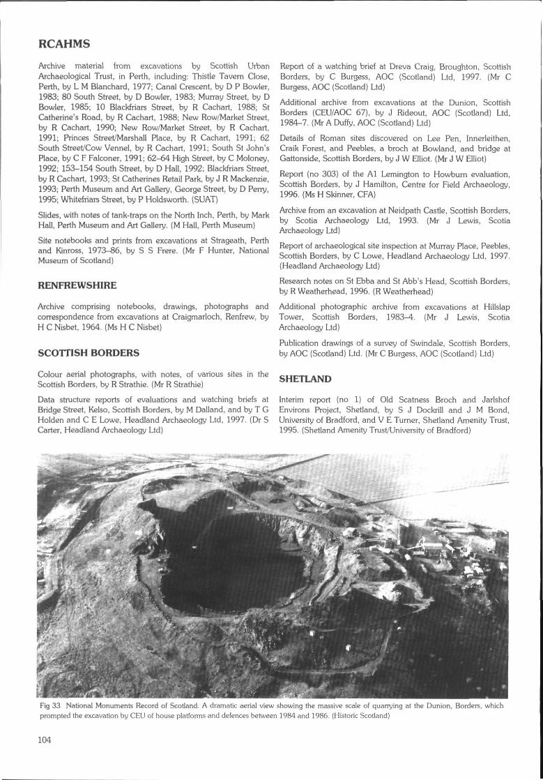
RCAHMS
Archive material from excavations by Scottish UrbanArchaeological Trust, in Perth, including: Thistle Tavern Close,Perth, by L M Blanchard, 1977; Canal Crescent, by D P Bowler,1983; 80 South Street, by D Bowler, 1983; Murray Street, by DBowler, 1985; 10 Blackfriars Street, by R Cachart, 1988; StCatherine's Road, by R Cachart, 1988; New Row/Market Street,by R Cachart, 1990; New Row/Market Street, by R Cachart,1991; Princes Street/Marshall Place, by R Cachart, 1991; 62South Street/Cow Vennel, by R Cachart, 1991; South St John'sPlace, by C F Falconer, 1991; 62-64 High Street, by C Moloney,1992; 153-154 South Street, by D Hall, 1992; Blackfriars Street,by R Cachart, 1993; St Catherines Retail Park, by J R Mackenzie,1993; Perth Museum and Art Gallery, George Street, by D Perry,1995; Whitefriars Street, by P Holdsworth. (SUAT)
Slides, with notes of tank-traps on the North Inch, Perth, by MarkHall, Perth Museum and Art Gallery. (M Hall, Perth Museum)
Site notebooks and prints from excavations at Strageath, Perthand Kinross, 1973-86, by S S Frere. (Mr F Hunter, NationalMuseum of Scotland)
RENFREWSHIRE
Archive comprising notebooks, drawings, photographs andcorrespondence from excavations at Craigmarloch, Renfrew, byH C Nisbet, 1964. (Ms H C Nisbet)
SCOTTISH BORDERS
Colour aerial photographs, with notes, of various sites in theScottish Borders, by R Strathie. (Mr R Stramie)
Data structure reports of evaluations and watching briefs atBridge Street, Kelso, Scottish Borders, by M Dalland, and by T GHolden and C E Lowe, Headland Archaeology Ltd, 1997. (Dr SCarter, Headland Archaeology Ltd)
Report of a watching brief at Dreva Craig, Broughton, ScottishBorders, by C Burgess, AOC (Scotland) Ltd, 1997. (Mr CBurgess, AOC (Scotland) Ltd)
Additional archive from excavations at the Dunion, ScottishBorders (CEU/AOC 67), by J Rideout, AOC (Scotland) Ltd,1984-7. (Mr A Duffy, AOC (Scotland) Ltd)
Details of Roman sites discovered on Lee Pen, Innerleithen,Craik Forest, and Peebles, a broch at Bowland, and bridge atGattonside, Scottish Borders, by J W Elliot. (Mr J W Elliot)
Report (no 303} of the Al Lemington to Howburn evaluation,Scottish Borders, by J Hamilton, Centre for Field Archaeology,1996. (Ms H Skinner, CFA)
Archive from an excavation at Neidpath Castle, Scottish Borders,by Scotia Archaeology Ltd, 1993. (Mr J Lewis, ScotiaArchaeology Ltd)
Report of archaeological site inspection at Murray Place, Peebles,Scottish Borders, by C Lowe, Headland Archaeology Ltd, 1997.(Headland Archaeology Ltd)
Research notes on St Ebba and St Abb's Head, Scottish Borders,by R Weatherhead, 1996. (R Weatherhead)
Additional photographic archive from excavations at HillslapTower, Scottish Borders, 1983-4. (Mr J Lewis, ScotiaArchaeology Ltd)
Publication drawings of a survey of Swindale, Scottish Borders,by AOC (Scotland) Ltd. (Mr C Burgess, AOC (Scotland) Ltd)
SHETLAND
Interim report (no 1) of Old Scatness Broch and JarlshofEnvirons Project, Shetland, by S J Dockrill and J M Bond,University of Bradford, and V E Turner, Shetland Amenity Trust,1995. {Shetland Amenity Trust/University of Bradford)
Fig 33 National Monuments Record of Scotland. A dramatic aerial view showing Ihe massive scale of quarrying at the Dunion, Borders, whichprompted the excavation by CEU of house platforms and defences between 1984 and 1986. (Historic Scotland)
104
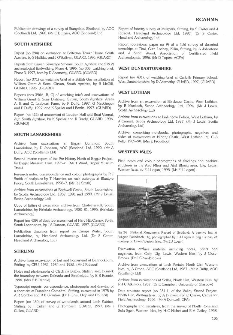
RCAHMS
Publication drawings of a survey of Stanydale, Shetland, by AOC(Scotland) Ltd, 1966. (Mr C Burgess, AOC (Scotland) Ltd)
SOUTH AYRSHIRE
Report (no 394) on evaluation at Baltersan Tower House, SouthAyrshire, by S Halliday and J O'Sullivan, GUARD, 19%. (GUARD)
Reports from Girvan Sewerage Scheme, South Ayrshire: (no 279.2)archaeological fieldwalking, Phase 4, 1996; (no 303) watching brief,Phase 3,1997, both by D Abcmethy, GUARD. (GUARD)
Report (no 371) on watching brief at a British Gas installation atWilliam Grant & Sons, Girvan, South Ayrshire, by B McGill,GUARD, 1996. (GUARD)
Reports (nos 396A, B, C) of watching briefs and excavations ofWilliam Grant & Sons Distillery, Girvan, South Ayrshire, AreasA, B and C, Ladywell Farm, by P Duffy, 1997, G MacGregorand P Duffy, 1997, and K Speller and I Banks, 1997. (GUARD)
Report (no 422) of assessment of Loudon Hall and Boat Vennal,Ayr, South Ayrshire, by K Speller and K Brady, GUARD, 1996.(GUARD)
SOUTH LANARKSHIRE
Archive from excavations at Biggar Common, SouthLanarkshire, by D Johnson, AOC (Scotland) Ltd, 1990. (Mr ADuffy, AOC (Scotland) Ltd)
Second interim report of the Pre-History North of Biggar Project,by Biggar Museum Trust, 1995-6. (Mr T Ward, Biggar MuseumTrust)
Research notes, correspondence and colour photographs by R JSmith of sculpture by T Hawkins on rock outcrops at BlantyrePriory, South Lanarkshire, 1996-7. (Mr R J Smith)
Archive from excavations at Bothwell Castle, South Lanarkshire,by Scotia Archaeology Ltd, 1987, 1991 and 1993. (Mr J Lewis,Scotia Archaeology Ltd)
Copy of listing of excavation archive from Chatelherault, SouthLanarkshire, by Kirkdale Archaeology, 1980-81, 1995. (KirkdaleArchaeology)
Report (no 439) of desk-top assessment of Hare Hill/Climpy, Forth,South Lanarkshire, by J S Duncan, GUARD, 1997. (GUARD)
Publication drawings from report on Camps Water, SouthLanarkshire, by Headland Archaeology Ltd. (Dr S Carter,Headland Archaeology Ltd)
STIRLING
Archive from excavation of fort and homestead at Bannockburn,Stirling, by CEU, 1982, 1984 and 1985. (Mr J Rideout)
Notes and photographs of Clach na Briton, Stirling, said to markthe boundary between Dalriada and Strathclyde, by E B Rennie,1996. (Mrs E B Rennie)
Typescript reports, correspondence, photographs and drawing ofa short cist at Dunblane Cathedral, Stirling, excavated in 1975 byA R Gordon and R B Gourlay. (Dr D Low, Highland Council)
Report (no 430) of survey of woodlands around Loch Katrine,Stirling, by I Cullen and G Tompsett, GUARD, 1997. (Ms ICullen, GUARD)
Report of forestry survey at Muirpark, Stirling, by S Carter and JRideout, Headland Archaeology Ltd, 1997. (Dr S Carter,Headland Archaeology Ltd)
Report (occasional paper no 9) of a field survey of desertedtownships at Tirai, Glen Lochay, Killin, Stirling, by A Johnstoneand J Scott Wood, Association of Certificated FieldArchaeologists, 1996. (Mr D Topen, AGFA)
WEST DUNBARTONSHIRE
Report (no 431), of watching brief at Carleith Primary School,West Dunbartonshire, by D Abemethy, GUARD, 1997. (GUARD)
WEST LOTHIAN
Archive from an excavation at Blackness Castle, West Lothian,by R Murdoch, Scotia Archaeology Ltd, 1994. (Mr J Lewis,Scotia Archaeology Ltd)
Archive from excavations at Linlithgow Palace, West Lothian, byJ Cannell, Scotia Archaeology Ltd, 1987. (Mr J Lewis, ScotiaArchaeology Ltd)
Archive, comprising notebooks, photographs, negatives andslides of excavations at Niddry Castle, West Lothian, by C AKelly, 1989-90. (Mrs E Proudfoot)
WESTERN ISLES
Field notes and colour photographs of shielings and beehivestructures in the Aird Mhor and Aird Bheag area, Uig, Lewis,Western Isles, by E J Logan, 1995. (Ms E J Logan)
Fig 34 National Monuments Record of Scotland: A beehive hut atFidigidh Eachdrach, Uig, photographed by E J Logan during a survey ofshielings on Lewis, Western Isles. (Ms E J Logan)
Excavation archive material including notes, prints andnegatives, from Cnip, Uig, Lewis, Western Isles, by J Close-Brooks. (Dr J Close-Brooks)
Archive from excavations at Loch Portain, North Uist, WesternIsles, by A Crone, AOC (Scotland) Ltd, 1987. (Mr A Duffy, AOC(Scotland) Ltd)
Archive from excavations at Sollas, North Uist, Western Isles, byR J C Atkinson, 1957. (Dr E Campbell, University of Glasgow)
Data structure report (no 281.1) of the Vallay Strand Project,North Uist, Western Isles, by A Dunwell and C Clarke, Centre forField Archaeology, 1996. (Mr A Dunwell, CFA)
Photographs and negatives, from the survey of North Rona andSula Sgeir, Western Isles, by H C Nisbet and R A Gailey, 1958,
105
RCAHMS
with photographs by M L Smith, 1952, and M J H Robson,1966. (Miss HCNisbet)
Interim report of St Kilda stone implements project, by A Flemingand M Edmonds, 1996. (Mr A Fleming)
Report of radiocarbon dating proposal of thin section analysis ofpeat samples from the Gap, Hirta, St Kilda, Western Isles, by SCarter, Headland Archaeology Ltd, 1996. {Or S Carter,Headland Archaeology Ltd)
General report of St Kilda Work Parties, 1995, by R Turner,National Trust for Scotland. (Mr R Turner, National Trust forScotland)
Reports of excavations and surveys by the University of Sheffieldon South Uist, Western Isles: the Late Bronze Age and Early IronAge settlement at Cladh Hallan, by S Atkinson, J Mulville and MParker Pearson, 1996; Sithean Biorach, Cille Pheadair, a Norseperiod settlement on South Uist, by M Parker Pearson, MBrennand, and H Smith, 1996; Bomish site 89, Beinn na MhicAongheis, by P Marshall, J Mulville, and M Parker Pearson,1996; report of South Uist Machair archaeological survey andmanagement project, by M Parker Pearson, 1993-6. (Mr MParker Pearson, University of Sheffield)
IRELAND
Report (no 365) of excavation of the north range of SherkinIsland Friary, Ireland, by J O'Sullivan, GUARD, 1996. (JO'Sullivan, GUARD)
a typescript of an article by Murdo MacDonald, Archivist, Argylland Bute Council, on the design and construction of the bridge.(Presented by Murdo MacDonald, Archivist, Argyll and ButeCouncil) Accession Number: 1997/47
DUMFRIES AND GALLOWAY
NMRS survey of a Private Collection of design drawings for theaddition of a studio and picture gallery to Broughton House,Kirkcudbright, by Honeyman Keppie & Mackintosh. Comprisingelevations, section and plans, the drawings are the client copiesproduced in January 1909 for the artist E A Hornel. (Lent forcopying by the National Trust for Scotland) Accession Number:1997/120
Survey of a Private Collection of James Barbour drawings, allrelating to projects in the Dumfries area: Maxwelltown FreeChurch, 1865; Closeburn Church, 1877; Moffat Baths, 1871;Thornhill Police Station, 1908; and Barbour's own house, StChristopher's, English Street, Dumfries, 1872. (Lent for copyingby John Copland, Sutherland Dickie & Copland Architects perAnthony Wolffe) Accession Number: 1997/24
EAST AYRSHIRE
A photograph album inscribed Views of Fenwick by H S PTaylor' dating from c 1870. This collection of high-qualityamateur views includes buildings in and around Fenwick andplaces particular emphasis on the survival of thatch. (Purchased)Accession Number: 1997/96
PRINCIPAL BUILDINGS ACCESSIONSOctober 1996 to September 1997
ABERDEENSHIRE
Seven 1866 Ordnance Survey maps relating to the AbergeldieEstate, Aberdeenshire. (Deposited by the National Trust forScotland) Accession Number: 1997/10
Survey of a Private Collection of late 19th and early 20th-centuryphotograph albums relating to Drum Castle. Views copiedinclude exteriors and interiors of Drum Castle; exteriors andinteriors of Barra Castle; views of the Old Kirk, Drumoak; andPrinces Street, Edinburgh c 1905. (Lent for copying by Dr JamesIrvine, c/o Drum Castle per Christopher Hartley, National Trustfor Scotland) Accession Number: 1997/33
A copy of a resurvey of Leith Hall Stables by Leslie F Hunter,Chartered Architect, Portsoy, carried out in May 1996 as part ofthe National Trust for Scotland Quinquennial Survey. (Depositedin the NTS Collection by W N Sharp) Accession Number:1997/49
ARGYLL AND BUTE
The Marchioness of Bute's original text for the Mount StuartGuide Book which was prepared for the opening of the house tothe public in 1995. {Presented by Gavin Stamp, editor of theGuide Book) Accession Number: 1997/26
Dyelines of two working drawings, one with additional colour, ofa bridge over the River Orchy, Argyll and Bute, designed byThomas S Tail for Sir J Burnet Tail & Lome Architects. Thedrawings are undated but were probably executed in 1935. Also,
EAST LOTHIAN
A photograph album compiled between 1909 and 1942 whichrecords visits to various houses, principally Luffness Mill, EastLothian. The amateur views show the exteriors and gardens ofhouses throughout Scotland including 'Dalnaskill House,Broughton, Peebleshire' and 'Houndwood, Reston'. A rare earlyview of the British Oil & Cake Mills Ltd office at Seafield isaccompanied by two 1927 views of its extension which recordthe 'Removal of Intermediate House'. Another (unrelated) albumhas several views of a cottage 'Blue House, St Boswells, June1927' and an unidentified Borders farm, probably in the vicinityof the cottage. (Purchased) Accession Number: 1997/1
Material relating to Brunton Shaw Wireworks, Musselburgh,comprising: a pamphlet on cold rolled steel strip dating from the1950s; six pamphlets on wire products; a copy of The ForthRoad Bridge, the Official Story', 1964; a copy of 'Reconstructionof the Humber Bridge', 1988; a copy of an inventory of wirerope-making equipment, 1996, with photographs and plantdescription from Brunton's Musselburgh site; six items ofstationery showing the company letter headings, address,business logo and so on; and a film dyeline plan of the roperylayout from 1990. Items lent for copying comprise four colourphotographs showing wire products of the Musselburgh site,eleven black and white photographs of the aftermath of the 1950fire and a 1926 guide to the Musselburgh site, the company andits products. (Presented by Andrew B Smith and Duncan Tait,Brunton Shaw Limited, who also lent material for copying byNMRS} Accession Number: 1997/118
A set of 23 design drawings for buildings in East Lothianincluding 'Proposed New Baths' for the Roxburgh Marine Hotel,R M Cameron, 1899; the Infectious Diseases Hospital, Belhaven,
106
RCAHMS
Sydney Mitchell & Wilson, 1901-03; Dunbar Police Station,Robert Orr, undated; a gate lodge for the Eastern DistrictHospital, Belhaven, Robert Orr, 1911; and a development onChurch Street, Dunbar, J B Swanston, 1901. (Presented byProfessor Roland Paxton) Accession Number: 1997/14
EAST RENFREWSHIRE
Further copy photographic material relating to Newton Mearnscompiled by Ken Melvin for exhibition. See also Ace. Nos:1995/41 and 1997/9. (Deposited by Ken Melvin) AccessionNumber: 1997/51
CITY OF EDINBURGH
A fragment from the roof of Holyrood Chapel labelled 'Fragmentof an oak beam from the original roof of Holyrood Chapel,Palace of Holyrood House. Taken out of the top of the southwall of the nave in which it was embedded; and given to me onthe spot by W T Oldrieve who was then in charge of the buildingand was engaged in the work of strengthening and protecting theruin under H M Board of Works'. (Presented by Miss AlexiaLindsay who had been given the fragment by Mrs Muria! Hope)Accession Number: 1997/15
'The Davidsons of Muirhouse by Thomas Davidson ofMuirhouse, LLD, FRS, FGS, FLS etc1. Thomas Davidson, apalaeontologist, who was bom in 1817 compiled thisextraordinary illustrated record of his family's history. The albumcontains watercolours, engravings, cuttings, a piece of the familytartan and drawings of buildings associated with the Davidsons,principally Muirhouse, Davidsons Mains, Edinburgh, HattonHouse and Bemersyde Tower. Old Muirhouse is sketched as isthe new house to show Thomas Davidson's additions; the latteris drawn by William J Davidson, Thomas's son, in the 1880s.Among the miscellaneous notes is a list of the pictures atMuirhouse and a sketch of the 'shields on dining-room ceiling atMuirhouse'. Among the accounts of the life of prominent familymembers is an eye-witness description by Captain WilliamDavidson of the Battle of Waterloo. In addition to the album aretwo volumes of Captain Davidson's letters to his grandsonWilliam, written between 1861 and 1862 (shortly before hisdeath) which describe his adventurous life. Volume two is titled'autobiography' and contains a photographic portrait of theauthor. Companion volumes provide an 'explanation' of theletter-books. A bound extract from Volume VIII of the'Geological Magazine', 1871, comprises a 'Sketch of theScientific Life of Thomas Davidson' and has additional cuttings,notes and illustrations pasted in. (Purchased) AccessionNumber: 1997/18
Four photograph albums compiled by Alexander Crum Brown, aProfessor of Chemistry at Edinburgh University. The albumsrecord the family home at 8 Belgrave Crescent, Edinburgh, from1900-03 with views of the interior and exterior, including viewsfrom the windows, and the garden. Crum was the first occupantof the house which was built in 1871. Other albums in the set areprincipally concerned with his travels in Switzerland. AccessionNumber: 1997/2
A copy of 'Skizzen', Otto Reich (undated), which belonged toThomas S Tait, Architect, who has signed the volume and usedthe end-paper for sketching. Between the pages is a sketchdesign for a memorial on a loose sheet of tracing paper. Tail's
papers are dispersed and this is one of the few autographpossessions known to exist.
'Fireplaces by Hoole', Falkirk, c 1960s, a fully illustrated tradecatalogue. (Purchased)
A 19th-century, boxed wooden model of a church originallythought to be related to the design of St Paul's & St George's,Broughton Street, Edinburgh. The model has been displayed inthe church for some time and, although not an architecturaldesign model as such, is of great associational interest.(Presented by St Paul's & St George's Vestry Committee)Accession Number: 1997/27
Survey of a Private Collection of designs for Fettes College,Edinburgh. The designs, not all of which were executed, relate toRobert Rowand Anderson's 1883 alterations and additions. Therear extension to the main college building is included as well asplans of the subsidiary houses of Moredun, Carrington andGlencorse; the swimming pool; lodges; Moredun Crescent; and ageneral plan of the site. (Lent for copying by Fettes College,Edinburgh) Accession Number 1997/35
A collection of photographs of Craigmillar Laundry Works, WestSavile Terrace, Edinburgh, which was built in 1881 anddemolished in 1988. Craigmillar Steam Laundry, as it wasoriginally known, was perceived as a philanthropic employerproviding respectable work for young women. The photographsdate from 1907 and record the development of the works as theykept pace with new technology. A major redevelopment wascarried out in 1933 and another in 1952 when the works stoppedgenerating their own electricity and joined the National Grid.Views include the pressing machines in use, the delivery of thenew boiler in 1933, and the machinery in operation during the1950s. Also included is a photocopy of 'A History of CraigmillarLaundry Limited: 1881-1981', John A F Gibb. (Presented by JohnGibb, Craigmillar Laundry Works) Accession Number: 1997/36
An 'Inventory and Valuation' of 6 Ainslie Place, Edinburgh,taken by Whytock & Reid on behalf of Leslie Grahame-Thomson, Architect, for insurance purposes in November 1948.The architect ran his practice from the premises and theinventory details the furnishings of his 'Drawing Office', 'PrivateOffice' and 'Main Office7 . (Presented by Murdo MacDonald,Argyll and Bute District Council) Accession Number: 1997/40
A set of panels for the Stockbridge Redevelopment Exhibition,prepared by Ian Begg in 1963 as a student project. The panelsare illustrated with black and white photographs of Stockbridgetaken by local residents, with whom he worked on the project, aswell as drawings illustrating the perceived benefits of clearingbuildings to provide landscaped areas within the townscape.(Presented by Ian Begg, Architect, to the RIAS Collection)Accession Number: 1997/5
Three photographic views of a newly repaired bridge, designedby Naysmith, over the River Almond and a view of Illieston,Kirkliston Parish, taken April 1997. (Presented by Ian Fleming, exRCAHMS) Accession Number. 1997/52
Five photocopies of drawings produced by Simpson & BrownArchitects for the adaptation of 26-31 Charlotte Square.Edinburgh, for use by the National Trust for Scotland as theirheadquarters, January 1997. (Presented by C H Cruft in June1997) Accession Number: J 997/53
Perspective sketch of the interior of Greyfriars Kirk, Edinburgh,by Henry Kerr, Architect to the Kirk, 1934. (Purchased)Accession Number: 1997/98
107
RCAHMS
FIFE
Mounted 19th-century photographic view of an unidentified Fifefarmhouse. Photographed by 'Condon Cupar' and inscribed(verso) 'Lizzie Wallace1. (Purchased) Accession Number: 1997/44
GLASGOW CITY
A photograph album which records Wallace Scott & Co LtdTailoring Institute, Cathcart, as newly constructed to the designof John Burnet Son & Dick, 1913-22. Interior views illustrate theemphasis placed on workers' welfare. Staff enjoyed the benefitsof recreation grounds for summer tennis, croquet and bowls, restrooms for 'quiet reflection', a sick room, bathrooms, a dining-halland a 'kinematograph' where 'films of an educational andhistorical character are displayed on special occasions.' Althoughthe photographs are in black and white, an accompanying leafletdescribes the use cf different colour schemes in the workrooms inorder to produce a calming effect on the workforce whoseoveralls were in 'a green colour to match the shade of the walls,so that the whole atmosphere of the rooms is pleasing.'(Purchased) Accession Number: 1997/37
HIGHLAND
Survey of a Private Collection comprising a set of client's drawingsrelating to Fairburn House, Wardrop & Reid, 1876-9. (Lent forcopying by Mr and Mrs Davidson) Accession Number: 1997/23
NORTH LANARKSHIRE
Photograph album with 73 colour views of Carluke Millcomprising a 1990 survey of the interior by The Alexander KerrPractice, Chartered Architects, Commercial Bank Chambers, 5aStewarton Street, Wishaw ML2 8AA. (Presented by theAlexander Kerr Practice) Accession Number: 1997/3
SCOTTISH BORDERS
Survey of a Private Collection of photographic prints by ThomasHannan. Many of the views were prepared for his publication'Famous Scottish houses: the Lowlands', 1928, and includeMinton House, Borders; Wemyss Castle, Fife; Winton House,East Lothian; and Inch House. Other illustrations were preparedfor To Mark the Reeling Hour', an unsourced article, and'Gruyeres and its Chateau'. {Lent for copying by Dr Nigel Malcolm-Smith, Hannan's grandson.) Accession Number: 1997/11
Prints of two watercolour strip elevations of Melrose High Streetand Market Square at 1:200 scale by W G Highet, 1996.{Presented by Bill Highet) Accession Number: 1997/97
SOUTH AYRSHIRE
A set of nine photographs relating to buildings in Ayr includingan interior view of Old County Buildings, Wellington Square, twoconstruction views of a building in Wellington Square, a view ofthe Old Fort, and two views of the demolition of the Old Prison,a photocopy of a drawing of the Esplanade and a photocopy ofa photograph of the Old Prison. (Presented by Sheena Andrew,Carnegie Library, Ayr) Accession Number: 1997/13
MISCELLANEOUS
A research file compiled by Basil Skinner inscribed: 'WilliamAdam, Sir John Clerk, The Country Seat etc.' which includespress cuttings from The Scottish Local History Congress, 1969; atranscript of a lecture he gave in 1980 to the Scottish GeorgianSociety, The Country Seat and Vitruvius Scotticus Hopetoun asthe House of State'; a transcript of a lecture by James Simpson,The Clerks and the Patronage of Architecture'; notes taken froma series of lectures given by Alistair Rowan, 'A Kind ofRevolution'; a copy of James Simpson's thesis on William Adamand a photocopy of The Country Seat'. (Purchased) AccessionNumber: 1997/100
242-252 Sauchiehall Street, Glasgow; two surveys by DavidWalker; two dyelines of a design for a proposed hotel at 197-207Ingram Street, Glasgow, Eason and Jardine, 1969; 1947 dyeline ofa survey of the spire at 147 St Vincent Street (James Salmond?);dyelines of a set of twelve designs for the SSC Library, Edinburgh,by James B Dunn, 1888; and a design for St Luke's EpiscopalChurch, Downfield, Nelson T Stewart, 1933. (Presented byProfessor D M Walker) Accession Number: 1997/101
A miscellaneous collection of architects' papers: from Alfred GLochhead, a design for Gourock Free Church, Charles Wilson,1855; a photograph album recording memorial panels producedfor Lorimer's office (some annotated with dimensions andidentifying the carvers); a series of plans for wartime requisitionof Castle Toward, Argyllshire and Ardmore House, Culross;dyeline of a fabric design by C F A Voysey; sketch design for atable (Lorimer); 'Sketch of Details of Shrine SNWM' from theLorimer office; letter from John Matthew for Sir Robert Lorimer,Architect, to A Lochhead, 28th August 1923; note to Lochheadfrom John Matthew, llth February 1926, regarding overseaswar memorial designed by Lorimer; a set of six photographs ofcarved panels by M Meredith Williams for St John's, Perth;design for the Dirleton War Memorial, Robert Lorimer, 1920; sixdesigns for unidentified memorials; design for the ClackmannanWar Memorial, Robert Lorimer, 1921; design for Melrose WarMemorial, Robert Lorimer, 1920; design for Dingwall CrossMemorial; design for Currie War Memorial, Lorimer, 1920;design for St Andrews War Memorial, 1921; design showingLoretto and 'probably Whittingham' memorials (Lorimer); designfor Pencaitland War Memorial (Lorimer}; design for Stenton WarMemorial {Lorimer); design for a metal gate (Lorimer); design forGalston War Memorial, Lorimer, 1922; 'Cancelled' design(SNWM), 1922; design for Strathblane War Memorial (Lorimer);design for a fireplace (Lochhead). Other miscellaneous materialcomprises an Office of Works file regarding the redecoration andredisplay of the State Apartments of Holyrood Palace in 1935,including five photographic reproductions of surveys by JHouston of the original decoration of Culross Palace; from theoffice of McLaren Soutar & Salrnond two drawings comprising adesign for a double villa, Brechin Road, Kirriemuir, CharlesSoutar, 1906; dyeline copy of a design for proposed additions toa warehouse. (Presented by Professor D M Walker) AccessionNumber: 1997/101
Three topographical engravings published by F Blyth, 1777:Mount Stewart (sic) by Moses Griffith, engraved by J Ellis;Dumbarton Castle by Paul Sandby, engraved by Godfrey; and aview of Edinburgh Castle with North Bridge by Moses Griffith,engraved by Godfrey. (Presented by Ronnie Robertson)Accession Number: 1999/102
Dr E M Patterson Collection. A collection of material relating tothe interests of Dr Edward Patterson, research chemist, geologist,
108
RCAHMS
transport historian and archaeologist- The bulk of the materialrelates to blackpowder production but the collection reflects hiswider interests in industrial archaeology. Extracts include one ongunpowder from Text Book of Explosives used in the service',1938; one on blackpowder hydraulic cake presses from TheManufacture of explosives1, 1895; and several on gunpowderand blackpowder from Transcript on memories of an Ardeerworker', from the 1930s. Files on various subjects includeexplosives manufacture in Scotland during WW2; incorporatingmills; Tourgill Earthworks; and a further annotated draft of thepublished Gunpowder Vocabulary. Photographic materialincludes an envelope containing photographs and negatives ofgasworks; copies of views of gunpowder manufacture atFaversham, 1798; and a box of photographs of blackpowderworks at Ardeer, Wigtown and Furnace. (Presented by Mrs AnnaSinger per Miles Oglethorpe, RCAHMS) Accession Number:19971119
Graham Law's thesis 'Alexander ('Greek') Thomson I A, a shortaccount of his life and works', 1950, an early and ground-breaking analysis of Thomson's work illustrated withphotographic copies of drawings and contemporary views ofThomson's buildings, some of which have since beendemolished. Law went on to be a partner in the Edinburghpractice Law & Dunbar-Nasrnith. (Presented by Gavin Stamp)Accession Number: 1997/12
A collection of architectural books and pamphlets from the officeof Kathleen Veitch, Architect (see also Ace. No: 1996/53),including a sketchbook from her RIBA Owen Jones TravellingScholarship trip to southern Spain in 1930. (Purchased)Accession Number: 1997/17
Four 19th-century photographs: A Moffat's painting anddecorating shop; Sycamore House, 'North Cotes'; QueenVictoria opening a reservoir, probably in Fife; and a view of 6Picardy Place, Edinburgh, decorated for a Royal visit. (Presentedby Laurance Black) Accession Number: 1997/19
A presentation volume of photographs by Bedford Lemere ofThe City Chambers, Glasgow' on completion c 1890. Also, anornate little manuscript album Views in Edinburgh' produced byJ T Mayne for 'Mrs Bartley' in the mid-19th century. Theilluminated frontispiece shows the Rectory at Stocking-Pellham,presumably in connection with the artist or recipient, while thealbum itself includes interior views of St John's, Princes Street,and St Columba's. (Purchased) Accession Number: 1997/20
Fifteen 19th-century stereoscopic views which include StirlingCastle, the interior and exterior of unidentified glasshouses andHamilton Mausoleum. (Purchased) Accession Number; 1997/21
A copy of 'A Tint Book of Historical Colours suitable forDecorative Work', Thomas Parsons & Sons Ltd, 1961. Thissample catalogue of paints considered appropriate for use onhistoric buildings is divided into periods e.g. 'WedgwoodColours'. The Scottish Georgian Society had requested adviceon Georgian colours for use in Edinburgh's New Town and acolour chart of suggestions with the firm's reply is enclosedaddressed to Eleanor Robertson, Honorary Secretary of theSociety, 1962. (Presented by Eleanor Robertson) AccessionNumber: 1997/22
Catalogue for 'Heggie & Aitchison Shop Fitters, 47 Grove Street,Edinburgh' c 1905. Illustrated with views of shops fitted out bythe firm and details of fittings supplied such as lamps, 'thereliable shop assistant's seat', wax dummies, boot stands, etc.(Purchased) Accession Number: 1997/25
Further material relating to the work of H F Clark, landscapearchitect and educator (see also MS/758}. A box of slides largelyprepared for lecturing purposes on subjects such as land use, citydevelopment, landscape architecture and architectural history. Infour formats, the slides date from the 1950s and 1960s.(Presented by John Lowrey, University of Edinburgh ArchitectureDepartment) Accession Number: 1997/28
Two negatives, taken by Edinburgh University LibraryPhotographic Department in 1963, of a linen damask napkinshowing Scottish buildings which were identified at that time byKitty Cruft. (Presented by Margaret Swain) Accession Number;1997/29
Survey of a Private Collection of 20 drawings and photographsrelating to work by Gillespie Kidd & Coia held in the ScottishCatholic Archives. Projects include Darleith House; St Peter's,Kilmahew; and the Kilmahew Estate, Cardross. (Lent for copyingby Scottish Catholic Archives per Diane Walters, NMRS)Accession Number: 1997/30
Survey of a Private Collection of photographs relating to thework of Gillespie Kidd & Coia. Projects include: St Peter'sCollege, Cardross; Cumbernauld Housing; St Bride's, EastKilbride; St Paul's, Glenrothes; St Mary's, Bo'ness; RobinsonCollege, Cambridge; St Lawrence's, Greenock; St Mary inChains, Ardrossan; Patrick's, Kilsyth; Notre Dame College,Bearsden; St Columbkille's, Rutherglen; and St Patrick's,Greenock; as well as a set of working drawings for St Peter'sCollege, Cardross. (Lent for copying by Professor Isi Metzsteinper Diane Warters, NMRS) Accession Number: 1997/31
Survey of a Private Collection of material relating to GillespieKidd & Coia. Projects photographed include St Peter's,Bearsden; St Peter's, Rome; St Peter's, Cardross, underconstruction; St Peter's, Cardross, in use; the Archbishop andBishops outside St Peter's, Cardross c 1974; and the library of StPeter's, Bearsden. Pages were copied from an album containingnewscuttings about the move of the College from St Peter's,Cardross, to Newlands. (Lent for copying by Scotus College perDiane Walters, NMRS) Accession Number: 1997/32
A copy of James K Gillon's thesis on Sir James Gowans,Architect, prepared for the RICS Diploma in BuildingConservation at The College of Estate Management, 1995-96.Included are 28 strips of colour negatives for the views ofGowan's buildings which illustrate the thesis. (Presented byJames Gillon) Accession Number: 1997/34
Papers from the office of W Schornberg Scott, Architect, whichare additional to the office drawings already deposited with theNMRS. Principally comprises photographs, negatives and slidestaken and collected by Schomberg Scott. AJso includes a roll ofdrawings, mostly miscellaneous projects for the National Trust forScotland, and full-size details for furnishings for Monteviot andFalkland Palace; wallpaper samples; bills of quantity forMonteviot. Among the manuscript material are draft guide books(including Crathes, Leith Hall and Culzean), lectures and tournotes for summer schools which illustrate the depth of hiscommitment to the activities and aims of the National Trust forScotland from the mid-1960s onwards. His writings reflect hispassion for 16th and 17th-century Scottish architecture and hisefforts to gain recognition for the involvement of Scottishcraftsmen at this period, particularly for interior decorative work,at a time when foreign craftsmen were generally thought to havebeen widely active in Scotland. A small collection of sketches andphotographs dates from the late 1940s when Schomberg Scottphotographed examples of Reginald Fairlie's work for Patrick
109
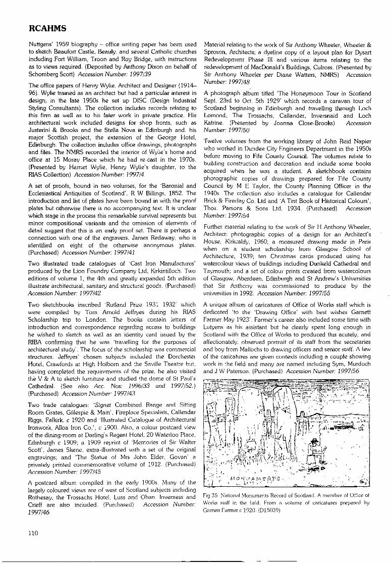
RCAHMS
Nuttgens' 1959 biography - office writing paper has been usedto sketch Beaufort Castle, Beauly, and several Catholic churchesincluding Fort William, Troon and Roy Bridge, with instructionsas to views required. (Deposited by Anthony Dixon on behalf ofSchomberg Scott) Accession Number: 1997/39
The office papers of Henry Wylie, Architect and Designer (1914-96). Wylie trained as an architect but had a particular interest indesign; in the late 1950s he set up DISC (Design IndustrialStyling Consultants). The collection includes records relating tothis firm as well as to his later work in private practice. Hisarchitectural work included designs for shop fronts, such asJusterini & Brooks and the Stella Nova in Edinburgh and, hismajor Scottish project, the extension of the George Hotel,Edinburgh. The collection includes office drawings, photographsand files. The NMRS recorded the interior of Wylie's home andoffice at 15 Moray Place which he had re-cast in the 1970s.(Presented by Harriet Wylie, Henry Wylie's daughter, to theRIAS Collection) Accession Number 7997/4
A set of proofs, bound in two volumes, for the 'Baronial andEcclesiastical Antiquities of Scotland', R W Billings, 1852. Theintroduction and tist of plates have been bound in with the proofplates but otherwise there is no accompanying text. It is unclearwhich stage in the process this remarkable survival represents butminor compositional variants and the omission of elements ofdetail suggest that this is an early proof set- There is perhaps aconnection with one of the engravers, James Redaway, who isidentified on eight of the otherwise anonymous plates.(Purchased) Accession Number: 1997/41
Two illustrated trade catalogues of 'Cast Iron Manufactures'produced by the Lion Foundry Company Ltd, Kirkintilloch. Twoeditions of volume 1, the 4th and greatly expanded 5th editionillustrate architectural, sanitary and structural goods. (Purchased)Accession Number: 7 997/42
Two sketchbooks inscribed 'Rutland Prize 1931 1932' whichwere compiled by Tom Arnold Jeffryes during his RIASScholarship trip to London. The books contain letters ofintroduction and correspondence regarding access to buildingshe wished to sketch as well as an identity card issued by theRIBA confirming that he was 'travelling for the purposes ofarchitectural study'. The focus of the scholarship was commercialstructures: Jeffryes' chosen subjects included the DorchesterHotel, Crawfords at High Holborn and the Saville Theatre but,having completed the requirements of the prize, he also visitedthe V & A to sketch furniture and studied the dome of St Paul'sCathedral. (See also Ace. Nos: 1996/33 and 1997/52.)(Purchased) Accession Number: 7997/43
Two trade catalogues: 'Signet Combined Range and SittingRoom Grates, Gillespie & Main', Fireplace Specialists, CallendarRiggs, Falkirk. c 1920 and 'Illustrated Catalogue of ArchitecturalIronwork, Alloa Iron Co.', c 1900. Also, a colour postcard viewof the dining-room at Darling's Regent Hotel, 20 Waterloo Place,Edinburgh c 1909; a 1909 reprint of 'Memories of Sir WalterScott', James Skene. extra-illustrated with a set of the originalengravings; and The Statue of Mrs John Elder, Govan' aprivately printed commemorative volume of 1912. (Purchased)Accession Number J 997/45
A postcard album compiled in the early 1900s. Many of thelargely coloured views are of west of Scotland subjects includingRothesay. the Trossachs Hotel. Luss and Oban. Inverness andCrieff are also included. (Purchased) Accession Number:7997/46
Material relating to the work of Sir Anthony Wheeler, Wheeler &Sproson, Architects; a dyeline copy of a layout plan for DysartRedevelopment Phase III and various items relating to theredevelopment of MacDonald's Buildings, Culross. {Presented bySir Anthony Wheeler per Diane Watters, NMRS) AccessionNumber 1997/48
A photograph album titled The Honeymoon Tour in ScotlandSept. 23rd to Oct. 5th 1929' which records a caravan tour ofScotland beginning in Edinburgh and travelling through LochLomond, The Trossachs. Callander, Inversnaid and LochKatrine. (Presented by Joanna Close-Brooks) AccessionNumber 1997/50
Twelve volumes from the working library of John Reid Napierwho worked in Dundee City Engineers Department in the 1950sbefore moving to Fife County Council. The volumes relate tobuilding construction and decoration and include some booksacquired when he was a student. A sketchbook containsphotographic copies of drawings prepared for Fife CountyCouncil by M E Taylor, the County Planning Officer in the1940s. The collection also includes a catalogue for CallendarBrick & Fireclay Co. Ltd and 'A Tint Book of Historical Colours',Thos. Parsons & Sons Ltd, 1934. (Purchased) AccessionNumber: 1997/54
Further material relating to the work of Sir H Anthony Wheeler,Architect: photographic copies of a design for an Architect'sHouse, Kirkcaldy, 1960; a measured drawing made in Pariswhen on a student scholarship from Glasgow School ofArchitecture, 1939; ten Christmas cards produced using hiswatercolour views of buildings including Dunkeld Cathedral andTaymouth; and a set of colour prints created from watercoloursof Glasgow, Aberdeen, Edinburgh and St Andrew's Universitiesthat Sir Anthony was commissioned to produce by theuniversities in 1992. Accession Number: 7997/55
A unique album of caricatures of Office of Works staff which isdedicated 'to the 'Drawing Office' with best wishes GarnettFarmer May 1923'. Farmer's career also included some time withLutyens as his assistant but he clearly spent long enough inScotland with the Office of Works to produced this acutely, andaffectionately, observed portrait of its staff from the secretariesand boy from Mallochs to drawing officers and senior staff. A fewof the caricatures are given contexts including a couple showingwork in the field and many are named including Sym, Murdochand J W Paterson. (Purchased) Accession Number 7997/56
Fig 35 National Monuments Record of Scotland. A member of Office ofWorks staff in Ihe field. From a volume of caricatures prepared byGarnctt Farmer c 1920. (D15039)
110
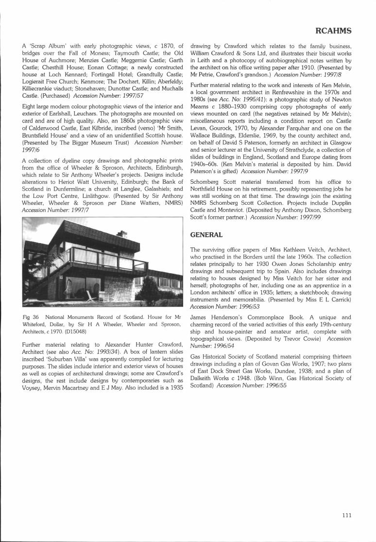
RCAHMS
A 'Scrap Album' with early photographic views, c 1870, ofbridges over the Fall of Moness; Taymouth Castle; the OldHouse of Auchmore; Menzies Castle; Meggernie Castle; GarthCastle; Chesthill House; Eonan Cottage; a newly constructedhouse at Loch Kennard; Fortingall Hotel; Grandtully Castle;Logierait Free Church; Kenmore; The Dochart, Killin; Aberfeldy;Killiecrankie viaduct; Stonehaven; Dunottar Castle; and MuchallsCastle. (Purchased) Accession Number; 1997/57
Eight large modern colour photographic views of the interior andexterior of Earlshall, Leuchars. The photographs are mounted oncard and are of high quality. Also, an 1860s photographic viewof Calderwood Castle, East Kilbride, inscribed (verso) 'Mr Smith,Bruntsfield House' and a view of an unidentified Scottish house.(Presented by The Biggar Museum Trust) Accession Number:1997/6
A collection of dyeline copy drawings and photographic printsfrom the office of Wheeler & Sproson, Architects, Edinburgh,which relate to Sir Anthony Wheeler's projects. Designs includealterations to Heriot Watt University, Edinburgh; the Bank ofScotland in Dunfermline; a church at Langlee, Galashiels; andthe Low Port Centre, Linlithgow. (Presented by Sir AnthonyWheeler, Wheeler & Sproson per Diane Watters, NMRS)Accession Number: 1997/7
Fig 36 National Monuments Record of Scotland. House for MrWhiteford, Dollar, by Sir H A Wheeler, Wheeler and Sproson,Architects, c 1970. (D15048)
Further material relating to Alexander Hunter Crawford,Architect (see also Ace. No: 1993/34). A box of lantern slidesinscribed 'Suburban Villa' was apparently compiled for lecturingpurposes. The slides include interior and exterior views of housesas well as copies of architectural drawings; some are Crawford'sdesigns, the rest include designs by contemporaries such asVoysey, Mervin Macartney and E J May. Also included is a 1935
drawing by Crawford which relates to the family business,William Crawford & Sons Ltd, and illustrates their biscuit worksin Leith and a photocopy of autobiographical notes written bythe architect on his office writing paper after 1910. (Presented byMr Petrie, Crawford's grandson.) Accession Number. 1997/8
Further material relating to the work and interests of Ken Melvin,a local government architect in Renfrewshire in the 1970s and1980s (see Ace. No: 1995/41): a photographic study of NewtonMearns c 1880-1930 comprising copy photographs of earlyviews mounted on card (the negatives retained by Mr Melvin);miscellaneous reports including a condition report on CastleLevan, Gourock, 1970, by Alexander Farquhar and one on theWallace Buildings, Elderslie, 1969, by the county architect and,on behalf of David S Paterson, formerly an architect in Glasgowand senior lecturer at the University of Strathclyde, a collection ofslides of buildings in England, Scotland and Europe dating from1940s-60s. (Ken Melvin's material is deposited by him. DavidPaterson's is gifted) Accession Number: 1997/9
Schomberg Scott material transferred from his office toNorthfield House on his retirement, possibly representing jobs hewas still working on at that time. The drawings join the existingNMRS Schomberg Scott Collection. Projects include DupplinCastle and Monteviot. (Deposited by Anthony Dixon, SchombergScott's former partner.) Accession Number 1997/99
GENERAL
The surviving office papers of Miss Kathleen Veitch, Architect,who practised in the Borders until the late 1960s. The collectionrelates principally to her 1930 Owen Jones Scholarship entrydrawings and subsequent trip to Spain. Also includes drawingsrelating to houses designed by Miss Veitch for her sister andherself; photographs of her, including one as an apprentice in aLondon architects' office in 1935; letters; a sketchbook; drawinginstruments and memorabilia. (Presented by Miss E L Carrick)Accession Number: 1996/53
James Henderson's Commonplace Book. A unique andcharming record of the varied activities of this early 19th-centuryship and house-painter and amateur artist, complete withtopographical views. (Deposited by Trevor Cowie) AccessionNumber. 1996/54
Gas Historical Society of Scotland material comprising thirteendrawings including a plan of Govan Gas Works, 1907; two plansof East Dock Street Gas Works, Dundee, 1938; and a plan ofDalkeith Works c 1948. (Bob Winn, Gas Historical Society ofScotland) Accession Number 1996/55
111
A LIST OF HISTORIC SCOTLAND ARCHAEOLOGICAL RADIOCARBON DATESCompiled by P J Ashmore
Introduction
This list of dates received by Historic Scotland mostly between 1 July 1996 and 3 June 1997 for archaeological sites and objectsrepresents the work of many individuals. Most often sites have not yet been published, and it is important, if you wish to quote thesedates, to cite the author of the information produced here. For instance, the first entry in this list should be cited as Rideout J S 1997'East Campsie, Kirriemuir' DES 1997, 112. If this convention is often flouted Historic Scotland may decide not to promulgate datesfor at least 18 months after they have been obtained.
Entries which other people or organisations wish to see included in future lists should be sent to the compiler, P J Ashrnore, 20Brighton Place, Portobello, Edinburgh EH15 1LJ before 31 October 1998.
Code ContextANGUSEast Campsie. Kirriemuir (NO 288 527}, Rideout J SAA-23258 Skeleton of a child aged about 12 years in a cist.
Mains of Melgund, Aberlemno (NO 536 563), Rideout J SAA-23259 Skeleton of a male, aged about 30 years, found with a child skeleton in a cist.AA-23260 Skeleton of a child between 7-9 years, found with the skeleton of an adult male in a cist.
West Sciyne, Cornoustie (NO 576 365) Rideout J SAA-23261 The skeleton of a male in his 20s in a cist.
ARGYLL AND BUTEBolsay Farm, Port Charlotte (NR 2253 5736), Mithen S JAA-21631 Willow from what is believed to be an undisturbed in situ occupation horizon of the Mesolithic
settlement.AA-21632 Hazel. See AA-21631.AA-21633 Alder. See AA-21631.AA-21634 Willow from an extensive context above the natural and/or an in situ occupation deposit.AA-21635 Birch. See AA-21634.AA-21636 Alder. See AA-21634.AA-21637 Oak. See AA-21634.AA-21638 Alder. See AA-21634.
Staosnaig, Scalasaig (NR 3977 9331), Mithen S JAA-21618 Cereal grains from a 4m diameter shallow pit. A considerable amount of organic material
remained in the fill which appears (o have been uncarbonised hazelnut shells.AA-21619 Hazel. See AA-21618.AA-21620 Hazel. See AA-21618.AA-21621 Hazel. See AA-21618.AA-21622 Hazel. See AA-21618.AA-21623 Hazel. See AA-21618.AA-21624 Hazel. See AA-21618.AA-21625 Hazel from a stone-lined boat-shaped pit, 2m from the large circular pit (AA-21618-24).
See also AA-21626.AA-21626 Hazel from a secondary fill of the stone-lined boat-shaped pit (AA-21625).AA-21627 Hazel from a small pit, c 0.98 x 0.7m and c 0.3m deep.AA-21628 Haze! from a shallow, sub-rounded pit c 70cm in diameter, probably a hearth.AA-21629 Hazel from an amorphous feature measuring c 2 x l.lm, purposefully partially filled with
pebbles.AA-21630 Hazel from a deposit of burnt sand, artefacts and charcoal fragments towards the base of a
large (c 0.45m } stone-lined pit.
CLACKMANNANSHIREBraehead, Alloa (NS 8693 9370), Ashmore P J and Hall DGU-4835 Scallop shells from a midden of oyster and other shells which may have slumped from a
higher position.
Material Date BP Err d!3C
bone human 3295 50 -21.3
bone human 3405 55 -21.2bone human 3500 50 -21 0
bone human 3300 50 -21.2
charcoal 4740
wood charcoal 3395
scallop
DUMFRIES AND GALLOWAYWoodend Farm, Johnstonebridge (NY 1053 9576), Banks 1AA-24949 Barley from the slot trench of a house wall from a set of house complexes in a large cereal grain
enclosure.AA-24950 Alder Pomoideae and hazel from the fill of the slot trench of a house wall on the E side of the charcoal
enclosure.AA-24951 Alder from the fill of the packing of a post-hole of a house. charcoalAA-24952 Barley from the fill of the slot trench of a house wall, the latest structure in the local sequence, charcoal
5880
1865
1740
18401935
50 -27.9
charcoalcharcoalcharcoalcharcoalcharcoalcharcoalcharcoal
cereal grain
hazelnut shellhazelnut shellhazelnut shellhazelnut shellhazelnut shellhazelnut shellhazelnut shell
hazelnut shellhazelnut shellwood charcoalhazelnut shell
7400681044604290393042004640
3455
7760704077807660766579357780
7480811017605415
55555045455555
60
55555555555555
55604060
-24.3-26.2-26.9-27.6-26.2-27.6-30.1
-27.0
-24.8-25.5-25.6-25.7-27.6-25.1-25.5
-26.6-25.1-26.4-23.4
60 -26.6
60 0.9
45 -23.1
40 -27.1
40 -27.140 -22.7
112
RADIOCARBON DATES
Woodend Farm, Johnstonebridge (NY 1053 9576), Banks I (cont.)AA-24953 Alder in the fill of the slot of the latest of the structures on site.AA-24954 Charred material from the fill of one of a pair of structures on the NE of site.AA-24955 Hazel from slot trench of a house on the N side of the enclosure.
EAST LOTHIANFisher's Road East, Port Seton (NT 4092 7540), Haselgrove CAA-25715 Barley in the fill of gully which held a fence or wind break.AA-25716 Barley in the fill of a post-hole which is part of a rectangular structure.AA-25717 Barley in the fill of a post-hole which is part of fence or wind break.AA-25718 Barley in the post-demolition fill of the N entrance post of a circular structure in the W part of
enclosure 1, with its entrance aligned exactly with the enclosure.AA-25719 Spelt glumes from the fill of a ditch, representing material containing crop-processing debris
which was tipped into the open, partly filled ditch. See also AA-25720.AA-25720 Emmer glumes. See AA-25719.AA-25721 Heather twigs (not derived from burnt peat) from the early secondary filling of an early ditch.
AA-25722 Pondweed seeds from the lower fill of a ditch.
AA-25723 Barley from the fill of a ditch, representing material indicative of barley processing which wastipped into the ditch prior to levelling of the latter.
AA-25724 Anomalous early date from charred barley grain.AA-25725 Naked barley from the uppermost fill of the inner ditch of enclosure 1 . See also AA-25726.AA-25726 Hulled barley. See AA-25725.AA-25727 Barley from crop-processing waste in the primary silting of the outer ditch of enclosure 1 .AA-25728 Cereals from the demolition fill of a ring gully forming the outer wall of a circular building at
the centre of enclosure 3.AA-25729 Barley from refuse including fresh crop-processing debris directly on top of cobbles forming
the floor of an oval sunken-floored building with a timber wall under a deposit containingmuch animal bone.
AA-25730 Water crowfoot seeds from the lower fill of a ditch.
AA-25731 Water crowfoot seeds from the lower fill of a ditch.
AA-25732 Barley from the primary fill of an early ditch.AA-25733 Seeds from the post-removal fill of a post-hole forming part of the entrance of a circular
structure .AA-25734 Heather twigs (not from peat) from the ring gully of a circular structure.
AA-25735 Cereals from the post-demolition fill of a post-hole which is part of a post ring 6m in diameterof a circular structure, concentric with a ring gully.
AA-25736 Barley from the primary fill of a ditch.AA-25737 Barley from the first of a series of dumps of occupation refuse in a partly infilled ditch. See
also AA-25738.AA-25738 Barley from the upper part of the butt end of a ditch. See also AA-25737.
Fisher's Road West, Port Seton (NT 406 752}, McCullagh R P JAA-26224 Barley from a dense concentration of cereal grain derived from on site domestic or crop-
processing activity, from a shallow oval pit near structure 1 .AA-25713 Uncarbonised seeds of henbane from the lowest fill of phase 4 of the ditch.
AA-25714 Grape pip from a truncated, irregular-shaped pit close to the entrance of the phase 3 ditch.
FIFEFife Ness (NO 6365 0950), Dalland MAA-25215 Hazel from an isolated pit which lies 3rn SW of the shelter. The pit is oval, 0.98 x 0.90m and
0.36m deep.AA-25214 As AA-25215.AA-25213 Hazel from the lower fill of the pit whose upper fill is dated by AA-25215 and M-25214.AA-25212 As AA-25213.AA-25211 Haze! from an area of dark soil, 2.5 x 3m, which covered most of the cuts associated with the
Mesolithic shelter and was interpreted as the remains of the occupation layer.AA-25210 AsAA-25211.AA-25209 Hazel from a post-hole which probably belonged to the wind break structure.AA-25208 As AA-25209.AA-25207 Hazel from one of seven post-holes in the curving line belonging to the wind break structure.
See also AA-25203 and AA-25202.AA-25206 As AA-25207.
charcoalcharcoalcharcoal
barley grainbarley grainbarley grainbarley grain
charred cereal
charred cerealcharred plantremainswaterloggedseedsbarley grain
barley grainbarley grainbarley grainbarley grainbarley grain
barley grain
waterloggedseedswaterloggedplant remainsbarley grainbarley grain
charred plantremainbarley grain
barley grainbarley grain
barley grain
cereal grain
uncarbonisedseedsuitis uini/era
hazelnut shells
hazelnut shellshazelnut shellshazelnut shellshazelnut shells
hazelnut shellshazelnut shellshazelnut shellshazelnut shells
hazelnut shells
182521751825
1960192019501810
1905
18402015
1845
1825
236801215178516101985
1875
2590
1975
2651960
1895
125
20001880
1870
1905
1985
modem
8490
8510849585458460
8410847585108420
8355
404545
45454545
45
4545
55
50
23045554545
60
45
45
5045
45
45
5545
45
55
45
60
65656585
60757065
60
-26.0-26.0-25.7
-25.5-23.6-24.9-23.1
-24.1
-25.8-25.4
-24.3
-21.8
-23.6-25-24.1-23.2-24.2
-23.2
-22-2
-25.8
-26.0-24.9
-29.4
-23.9
-23.2-23.5
-24.3
-25.6
-26.4
-22.3
-24.7
-23.2-25.2-22.9-25.7
-21.8-26.8-23.6-24.2
-23.6
113
RADIOCARBON DATES
Fife Ness (NO 6365 0950), Dalland M (cont.)AA-25205 Hazel from a post-hole outside and to the SE of the curving line of post-holes interpreted to
be part of a wind break structure.AA-25204 As AA-25205.AA-25203 Hazel from one of seven post-holes in the curving line belonging to the wind break structure.
See also AA-25207 and AA-25206.AA-25202 As AA-25203.
St Adrian's Priory, Isle of May (NT 6585 9901), James H FGU-4962 Male (young adult) skeleton within N range (church).GU-4963 Male (mature adult) skeleton within church, partially disturbed by building of a furnace.GU-4964 Male (young adult) skeleton beneath E end of N range (church) within the burial cairn.GU-4965 Skull only in the top of the burial cairn of rounded stones, disturbed and crushed by building
of S wali of an early church.GU-4966 Male (middle adult) skeleton beneath chapter house of priory within cairn of rounded stones,
uncisted.GU-4967 Male (middle adult) skeleton. The uppermost articulated burial within a long cist which
contained bones of at least five other individuals. See GU-4968 for the primary burial.GU-4968 Possible female (middle adult) skeleton. The primary (lowest) burial within a long cist which
contained bones of at least five individuals. See GU-4967 for the uppermost burial.GU-4969 Female (middle adult) skeleton within a cist and covered by a large grave marker.GU-4970 Male (middle adult) skeleton within a dug grave near to the church.GU-4971 Middle adult skeleton, upper half only remained, northernmost excavated burial in cemetery.GU-4972 Male (middle adult) skeleton.GU-4973 Male (young adult) skeleton beneath the cloister of the priory.
GLASGOW CITYGlasgow Cathedral (NS 6050 6555), Driscoll S TGU-4746 Burial (oriented E-W) cut by the W front of the earliest cathedral dedicated 1126. The burial
may be part of an early plan cemetery.GU-4747 Burial in a context which could pre-date all the cathedrals, cut by the foundation for the
second cathedral (late 12th century).
HIGHLANDBalnuaran of Clava, Inverness (NH 7575 4445), Bradley R JAA-25237 Pomoideae from a small concentration of charcoal within the lower filling of the socket for
one of the kerbstones beside the entrance of the NE passage grave.AA-25236 Hazel. See AA-25237.AA-25235 Hazel. See AA-25237.AA-25234 Hazel. The sample is one of two (S.4 and 5} taken from the surface of the old land surface
buried beneath the core caim. See also AA-25233.AA-25233 As AA-25234.AA-25232 Hazel from one of three samples taken from what are probably redeposited turves in the core
of the NE cairn inside the kerb of the cairn. See also AA-25231 and AA-25230.AA-25231 As AA-25232 and AA-25230.AA-25230 As AA-25231 and AA-25232. This date must be from material at least 2000 years earlier
than the turves.AA-25229 Hazel from the surface of the old land surface beneath the core of a previously unrecognised
ring caim on the edge of the Balnuaran of Clava cemetery. See also AA-25228.AA-25228 As AA-25229.AA-25227 Alder from the surface of the old land surface sealed beneath a secondary extension to a
previously unrecognised ring caim on the edge of the Balnuaran of Clava cemetery. See alsoAA-25226.
AA-25226 Hazel. As AA-25227.
Lalrg watching brief, Lairg (NC 5820 0107), McCullagh R P JAA-26223 Oak from a 'buried soil' underlying a soil bank enclosing a cremation cemetery.GU-7272 Oak from the fill of isolated bipartite pit with non-rnetallic waste indicating a possible
industrial use.GU-7273 Birch, hazel and alder charcoal in a dense concentration believed to represent pyre debris,
from the fill of a pit containing an umed cremation within an enclosed cremation cemetery.AA-26222 Hazel charcoal interpreted as the remains of an in situ wooden post, from the fill of a post-pit
at the entrance of an enclosed cemetery.
Loch Shurrery (ND 043 568), Barclay G JAA-24947 Alder charcoal from the surface of a hearth within a rubble-built house. See also AA-24948.AA-24948 Alder. See AA-24947.
hazelnut shells 8405 60 -24.9
hazelnut shellshazelnut shells
hazelnut shells
bone humanbone humanbone humanbone human
bone human
bone human
bone human
bone humanbone humanbone humanbone humanbone human
bone human
bone human
85058340
8275
5707109701160
1280
1260
1180
820940370770960
1250
820
7560
65
50807070
50
50
60
5070506060
60
50
-23.5-24.5
-26.4
-20.0-19.9-20.3-21.4
-21.5
-22.8
-22.0
-21.7-20.8-19.7-19.7-19.0
-22.7
-22.6
zharcoal 2945
charcoal
charcoalcharcoal
charcoal
charcoalcharcoal
charcoal
charcoal
charcoalcharcoal
2420
27702745
2680
31502780
3000
2325
20952090
50 -28.7
charcoalcharcoalcharcoal
charcoalcharcoal
charcoalcharcoal
314536003475
35303595
35355535
555045
4560
4555
-24.7-26.1-25.5
-26.3-26.9
-25.7-26.6
45 -26.5
45 -26.445 -25.0
45 -25.7
70 -25.3100 -27.2
60 -27.0
60 -24.8
45 -28.145 -28.0
114
RADIOCARBON DATES
Newton of Petty, Inverness (NH 7348 4862), Bradley R JAA-25225 Birch charcoal, probably from a pyre, from a pit sealed by the rubble matrix of the ring cairn charcoal 3755 50 -25.4
just outside the inner kerb of the monument, found together with cremated bone.AA-25224 Alder from another pit sealed by the rubble matrix of the ring caim. Charcoal was found charcoal 2620 75 -25.2
throughout Ihe filling of this feature, together with cremated bone. See also AA-25223.AA-25223 As AA-25225. charcoal 2765 45 -25.6AA-25222 Alder from a pit containing pyre debris sealed by a large flat slab underlying the burial in the charcoal 2785 45 -27.1
centre of the ring caim. Charcoal was found in the lower filling of this feature, together withcremated bone.
AA-25221 Birch from a shallow scoop occupying most of the central area of the ring caim. A large charcoal 2685 45 -27.3quantity of the cremated bone found within the same feature comes from a single adult maleburial.
AA-25220 Alder. See AA-25221. charcoal 2890 45 -25.7AA-25219 Hazel. See AA-25221. charcoal 3580 50 -24.5AA-25218 Hazel from a deep pit in the central area of the ring caim. The pit was interpreted in the field charcoal 2845 45 -25.4
as a post-hole of an alignment - possibly part of a building. However, the charcoal wasthought to be possibly from a secondary cremation deposit.
AA-25217 Hazel from a deep stone-filled pit interpreted as a post-pit for a wooden structure in the charcoal 2750 45 -27.9central area of the ring cairn. It was filled throughout with dark soil and charcoal and includedfragments of heat-affected stone.
AA-25216 Alder. See AA-25217. charcoal 2625 45 -27.7
North Bollochulish (NN 054 602), Clarke C MGU-4889 Alder which rested directly on a platform below peat.GU-4888 Alder from an upright wooden post in a platform below peat.
MORAYSueno's Stone (NJ 046 595), Rees TGU-4868 Pine from a pit with numerous wood charcoal inclusions.
ORKNEYBay of Skalll (HY 2294 1876), James H FGU-7245 Male (young adult) skeleton within a cist in the eroding face of a large multi-period mound at
Skaill Bay.
woodwooden post
charcoal
33202870
4260
bone human 1410
80 -29.350 -28.6
60 -25.6
50 -20.5
Linga Fold,GIM876GU^877
GU-4878GU-4879GIMJ880
GU-4881AA-23264AA-23265
GU-4884AA-23266GU-4886GU-4887
Lyking (HY 264 153), Downes J MHazel from a pit in mound 7 containing pyre material, charcoal and burnt bone.Willow from a burnt layer in a cist representing the remains of a pyre, presumably from asingle episode of burning. Later than mound 7 but earlier than the cist cemetery, being sealedby clay platform.Alder from a layer of burnt pyre material beneath mound 7.Hazel from a cist on the periphery of mortuary structure. The cist is sealed by turf and topsoil.Alder from a burnt deposit beneath mound 6 which runs over, around, and into a steatite umin a pit. See also GU-4881.Alder from main fill of the steatite cremation urn beneath mound 6. See also GU-4880.Alder from a cremation deposited in purpose-dug cut adjacent to mound 5.Hazel from a heap of medium compaction black carbonised material with burnt bone,beneath mound 7.Alder from pyre with burnt bone, charcoal lumps and cramp beneath mound 5.Oak from base of pit containing a burnt post beneath mound 5.Hazel from cremation material redeposiled beneath mound 5.Hazel and alder in fill of cist beneath rnound 7.
charcoalcharcoal
charcoalcharcoalcharcoal
charcoalcharcoalcharcoal
charcoalcharcoalcharcoalcharcoal
31903190
321032103380
329030953135
3460303533903030
9060
508090
604545
604560100
-26.0-26.5
-26.8-27.0-26.9
-28.6-28.1-25.4
-27.2-26.4-26.5-26.5
Skaill House (HY 2346 I860}, James H FGU-7240
GU-7241GU-7242
GU-7243
GU-7244
Female (mature adult) skeleton, thought to be part of cemetery surrounding and extendingbeneath Skaill House. The body lay with its head surrounded by a stone slab 'head box' in agrave marked by an upright stone under more than Irn of windblown sand.See also GU-7241.Female (adult) skeleton as GU-7240. Single headstone.Male (mature adult) skeleton with head surrounded by a stone 'head box' sealed by 0.3m ofsand, marked with a headstone and footstone, and three cover slabs. Grave sealed by afurther 1m of windblown sand.?Male (young adult) skeleton, with upright slab 'grave marker' at its feet. Immediately beneatha child burial.Female (adult) skeleton within cemetery, sealed by over 1m of windblown sand.
bone human
bone humanbone human
bone human
bone human
750
700820
710
790
70
5060
60
70
-23.8
-19.7-20.1
-19.5
-17.7
115
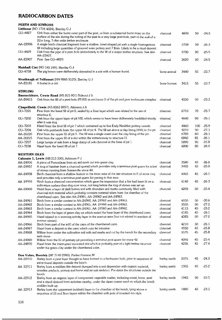
RADIOCARBON DATES
PERTH AND KINROSSLittleour (NO 1734 4024), Barclay G JGU-4827 Oak from either the burnt outer part of the post, or from a substantial burnt mass on the charcoal 4600 50 -24.5
surface of the site during the rotting of the post in a very large post-hole, part of the wall of a22m long, 7-8m wide timber enclosure.
AA-22906 A single birch charcoal fragment from a shallow, bowl-shaped pit with a single homogenous charcoal 3750 50 -26.3fill including large quantities of grooved ware pottery and 7 flints. Likely to be a ritual deposit.
GU-4829 Oak from the pipe of a post-hole immediately to the W of a major timber structure. See also charcoal 3730 90 -25.5AA-22907.
AA-22907 Pine. See GU-4829. charcoal 3620 50 -24.5
Muirhall Cist (NO 142 249), Barclay G JGU-4758 The pig bones were deliberately deposited in a cist with a human burial.
Westhaugh of Tulliemet (NN 9865 5120), Barclay G JAA-22181 A burial in a cist
bone animal 3440
bone human 3415
55 -23.7
55 -23.7
6710
4640
486042106705684058904800
35803495
70
90
1009060859080
4545
-25.7
-26.1
-25.9-27.1-26.1-26.1-25.8-26.0
-26.6-25.0
charcoalcharcoal
charcoal
charcoal
charcoal
35803495
4065
4140
4205
4545
45
45
50
-26.6-25.0
-26.1
-26.3
-25.4
STIRLINGBannockburn, Cowie Road (NS 815 901) Hideout J SAA-20415 Oak from the fill of a post-hole (PH43) in enclosure 2 of the pit and post enclosures complex, charcoal 4530 50 -25.3
Chapelfield, Cowie (NS 8363 8957), Atkinson J AGU-7201 Pine from the basal fill of pit II, sealed by a floor layer which was related to the use of charcoal
structure E.GU-7202 Oak from the upper layer of pit VIII, which seems to have been deliberately backfilled shortly charcoal
after it was dug.GU-7203 Hazel from the final fill of pit 7 which contained up to five Early Neolithic pottery vessels. charcoalGU-7204 Oak with potsherds from the upper f i l l of pit 4. The fill sat above a clay lining (446) to the pit. charcoalAA-26226 Pine from the upper fill of pit 5. The fill was a single event over the clay lining of the pit. charcoalAA-26225 Pine from the upper fill of a slot within the entranceway to structure H. charcoalGU-7207 Large lumps of oak from a large dump of oak charcoal at the base of pit 1. charcoalGU-7208 Hazel from the basal fill of pit 7. charcoal
WESTERN ISLESCalanais 1, Lewis (NB 213 330), Ashmore P JAA-24956 A piece of Pomoideae from an ard mark cut into green clay.AA-24957 A twig of heather from a charcoal spread which provides only a terminus posl quern for a line
of stones running from Somerville stone 44.AA-24958 Birch charcoal from a shallow feature in the inner area of the late structure to E of stone ring
and provides only a terminus post quern for paving in that area.AA-24959 Birch from a charcoal concentration which gave the impression that a fire had been lit on a
cultivation surface then dug over once, not long before the ring of stones was set up.AA-24960 Hazel from a layer of dark brown soil with abundant ard marks commonly filled with
charcoal-rich material which probably contains material taken from the chamber of thechambered cairn. See also AA-24961, AA-24962 and M-24963.
AA-24961 Birch from a similar context to AA-24960, AA-24962 and AA-24963. charcoal 4055 50 -30.6AA-24962 Birch from a similar context to AA-24961, AA-24960 and AA-24963. charcoal 3555 50 -27.2AA-24963 Birch from a similar context to AA-24961, AA-24960 and AA-24962. charcoal 4115 45 -25.2AA-24964 Birch from the layer of green clay on which rested the base layer of the chambered caim. charcoal 4185 45 -26.1AA-24965 Hazel related to a seeming activity layer in the avenue area (but not related to erection of charcoal 4385 50 -27.2
avenue stones).AA-24966 Birch from part of the infill of the caim of the chambered cairn. charcoal 4210 50 -26.1AA-24967 Hazel from a deposit in the caim which may be intrusive. charcoal 4050 45 -25.8AA-24968 Willow from under the cultivation soil with ard marks and cut by the trench for the secondary charcoal 3575 45 -25.8
kerb stone.AA-24969 Willow from the fill of primary pit providing a terminus post quern for stone 42. charcoal 4095 45 -25.4AA-24970 Hazel from the interrupted truncated slot which is probably part of a light timber structure charcoal 4205 45 -27.4
under the green clay under the chambered cnim.
Dun Vulan, Bornlsh (NF 7140 2980), Parker Pearson MAA-22910 Barley from a peat layer thought to have formed in a freshwater loch, prior to sequence of barley seeds 2075 45 -24.3
extra-mural deposits outside the broch.AA-22911 Barley from a midden-like deposit dumped into a wet depression with organic material, barley seeds 1905 45 -23.2
wooden artefacts, pottery and bone and an auk skeleton. Pre-dates the structures outside thebroch.
AA-22912 Barley from an organic layer of compressed vegetable matter, including wood, bone, peat barley seeds 1945 50 -23.5and a sherd derived from activities nearby, under the clean coarse sand on which the brochmidden built up.
AA-22913 Barley from the uppermost (rubbish) layer in the chamber of the broch, lying above a barley seeds 1880 45 -23.5sequence of fill and floor layers within the chamber with pots of inverted rim style.
116
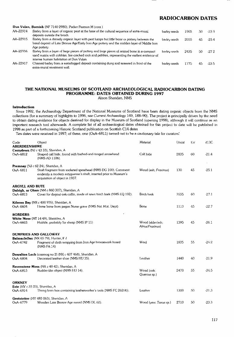
RADIOCARBON DATES
Dun Vulan, Bornish (NF 7140 2980), Parker Pearson M (cont.)AA-22914 Barley from a layer of organic peat at the base of the cultural sequence of extra-mural barley seeds 1905 50 -23.9
deposits outside the broch.AA-22915 Barley from a densely organic layer with peat lumps but little bone or pottery between the barley seeds 2055 45 -25.4
basal deposit of Late Bronze Age/Early Iron Age pottery and the midden layer of Middle IronAge pottery.
AA-22916 Barley from a layer of large pieces of pottery and large pieces of animal bone in a compact barley seeds 2435 50 -27-2sand matrix wilh cobbles, fire-cracked rock and pebbles, representing the earliest evidence ofintense human habitation at Dun Vulan.
AA-22917 Charred barley from a waterlogged deposit containing dung and seaweed in front of the barley seeds 1775 45 -23.5extra-rnural revetment wall.
THE NATIONAL MUSEUMS OF SCOTLAND ARCHAEOLOGICAL RADIOCARBON DATINGPROGRAMME: DATES OBTAINED DURING 1997
Alison Sheridan, NMS
IntroductionSince 1992, the Archaeology Department of the National Museums of Scotland have been dating organic objects from the NMS
collections (for a summary of highlights to 1996, see Current Archaeology 149, 188-90). The project is principally driven by the needto obtain dating evidence for objects destined for display in the Museum of Scotland (opening 1998), although it will continue as animportant research tool afterwards. A complete list of all archaeological dates obtained for this project to date will be published in
1998 as part of a forthcoming Historic Scotland publication on Scottish C14 dates.Ten dates were received in 1997; of these, one (OxA-6811) turned out to be a cautionary tale for curators!
Code ObjectABERDEENSHIRECorrydown (NJ c 43 33), Sheridan, AOxA-6812 Shaped calf hide, found with barbed-and-tanged arrowhead
{NMS AD 1106).
Premnay (NJ c 62 24), Sheridan, AOxA-6811 Shaft fragment from socketed spearhead (NMS DG 100). Comment:
evidently a modern antiquarian's shaft, inserted prior to Museum'sacquisition of object in 1937.
ARGYLL AND BUTEDalrlgh, nr Oban (NM c 860 307), Sheridan, AOxA-6813 Cover for dugout oak coffin, made of sewn birch bark (NMS EQ 192).
Kiloran Buy (NR c 400 976), Sheridan, AOxA-6604 Horse bone from pagan Norse grave {NMS Nat. Hist. Dept).
BORDERSWhite Moss (NT 1449), Sheridan, AOxA-6603 Hobble, probably for sheep (NMS IP 11).
DUMFRIES AND GALLOWAYBalmaclellan (NX 65 79), Hunter, F JOxA-6742 Fragment of cloth wrapping from Iron Age bronzework hoard
(NMS FA 14).
Dowalton Loch {crannog no 2) (NX c 407 468), Sheridan, AOxA-6804 Decorated leather shoe (NMS HU 35).
Ravens tone Moss (NX c 40 42), Sheridan, AOxA-6815 Rudder-like object (NMS HU 14).
ORKNEYEvie {HY c 35 23), Sheridan, AOxA-6814 Thong from box containing leatherworker's tools (NMS FC 262(4)).
Grotstetter (HY 493 063), Sheridan, AOxA-6779 Wooden Late Bronze Age sword (NMS DL 62).
Material
Calf hide
Uncal Err
2835 60
Wood (ash; Fraxinus) 130 45
Birch bark
Bone
Wood (alder/ash;Alnus/Fraxinus)
Wool
Leather
Wood (oak;Quercus sp.)
Leather
3555 60
1110 45
1395 45
1835 55
1440 40
2470 55
1300 50
d!3C
-21.4
-25.1
Wood (yew; Toxus sp.) 2710 50
-27.1
-22.7
-26.1
-24.2
-21.9
-24.5
-21.3
-23.3
117
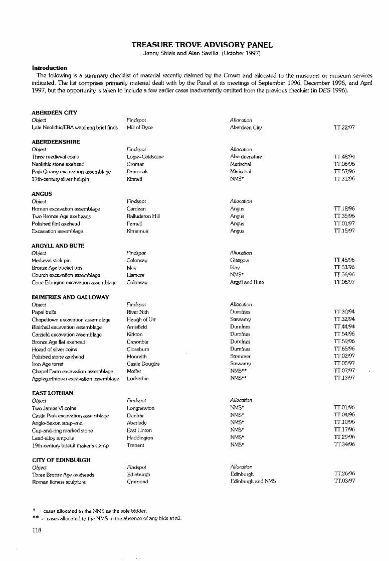
TREASURE TROVE ADVISORY PANELJenny Shiels and Alan Saville (October 1997)
IntroductionThe following is a summary checklist of material recently claimed by the Crown and allocated to the museums or museum services
indicated. The list comprises primarily material dealt with by the Panel at its meetings of September 1996, December 1996, and April1997, but the opportunity is taken to include a few earlier cases inadvertently omitted from the previous checklist (in DES 1996).
ABERDEEN CITYObject Findspot
Late Neolithic/EBA watching brief finds Mill of Dyce
ABERDEENSHIREObject Findspot
Three medieval coins Logie-Coldstone
Neolithic stone axehead Cromar
Park Quarry excavation assemblage Drumoak
17th-century silver hairpin Kinneff
ANGUSObject Findspot
Roman excavation assemblage Cardean
Two Bronze Age axeheads Balluderon Hill
Polished flint axehead Famell
Excavation assemblage Kimemuir
ARGYLL AND BUTEObject Findspot
Medieval stick pin Colonsay
Bronze Age bucket um Islay
Church excavation assemblage Lismore
Cnoc Eibriginn excavation assemblage Colonsay
DUMFRIES AND GALLOWAYObject ' Findspot
Papal bulla River Nith
Chapeltown excavation assemblage Haugh of Urr
Blairhall excavation assemblage Arnisfield
Carzield excavation assemblage Kirkton
Bronze Age flat axehead Canonbie
Hoard of silver coins Closebum
Polished stone axehead Monreith
Iron Age terret Castle Douglas
Chapel Farm excavation assemblage Moffat
Applegarthtown excavation assemblage Lockerbie
EAST LOTHIAN
Object Findspot
Two James VI coins Longnewton
Castle Park excavation assemblage Dunbar
Anglo-Saxon strap-end Aberlady
Cup-and-ring marked stone East Linton
Lead-alloy ampulla Haddington
19th-century biscuit maker's stamp Tranent
CITY OF EDINBURGHObject Findspot
Three Bronze Age axeheads Edinburgh
Roman lioness sculpture Cramond
Allocation
Aberdeen City
A//ocotionAberdeenshire
Marischal
Marischal
NMS*
Allocation
Angus
Angus
Angus
Angus
Allocation
Glasgow
Islay
NMS*
Argyll and Bute
Allocation
Dumfries
Stewarlry
Dumfries
Dumfries
Dumfries
Dumfries
Stranraer
Stewartry
NMS"NMS**
A//ocation
NMS*NMS*
NMS*
NMS*
NMS*
NMS*
Allocation
Edinburgh
Edinburgh and NMS
TT.22/97
TT.48/94
TT.06/96
TT.57/96
TT.31/96
IT. 18/96TT.35/96
TT.01/97
TT. 15/97
TT.45/96
TT.53/96
TT.56/96
TT.06/97
TT.30/94
TT.32/94
TT.44/94
TT.54/96
TT.59/96
TT.65/96
TT.02/97
TT.05/97
TT.07/97
TT. 13/97
TT.01/96
TT.04/96
TT.10/96
TT. 17/96TT.29/96
TT.34/96
TT.26/96
TT.03/97
* = cases allocated to the NMS as the sole bidder.
** = cases allocated to the NMS in the absence of any bids at all.
118
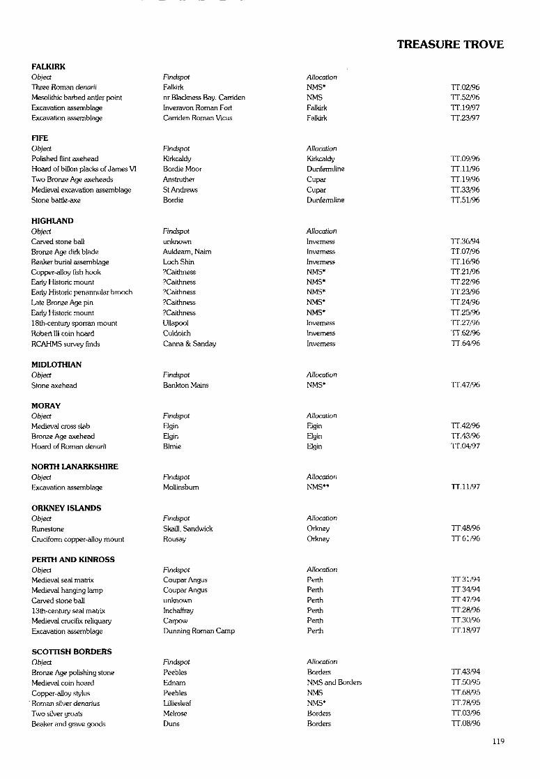
TREASURE TROVE
FALKIRKObjectThree Roman denarii
Mcsolithic barbed antler pointExcavation assemblage
Excavation assemblage
Findspot
Falkirknr Blackness Bay, CarridenInveravon Roman FortCarriden Roman Vicus
Allocation
NMS*NMS
FalkirkFalkirk
TT.02/96TT. 52/96
TT. 19/97TT.23/97
FIFEObject FindspotPolished flint axehead KirkcaldyHoard of billon placks of James VI Bordie Moor
Two Bronze Age axeheads Anstruther
Medieval excavation assemblage St Andrews
Stone battle-axe Bordie
Allocation
KirkcaldyDunfermline
CuparCuparDunfermline
TT. 09/96TT. 11/96
TT. 19/96TT.33/96
TT.51/96
HIGHLANDObjectCarved stone ballBronze Age dirk bladeBeaker burial assemblageCopper-alloy fish hookEarly Historic mountEarly Historic penannular brooch
Late Bronze Age pin
Early Historic mount18th-century sporran mount
Robert III coin hoard
RCAHMS survey finds
Findspot
unknownAuldeam, NairnLoch Shin?Caithness?Caithness?Caithness?Caithness
?Caithness
Ullapoot
Culdoich
Canna & Sanday
AllocationInverness
InvernessInverness
NMS*NMS*NMS*NMS*
NMS*Inverness
Inverness
Inverness
TT.36/94TT.07/96
TT. 16/96TT.21/96
TT.22/96TT.23/96TT.24/96
TT.25/96TT.27/96
TT.62/96TT.64/96
MIDLOTHIANObject
Stone axehead
FindspotBankton Mains
Allocation
NMS* TT.47/96
MORAYObjectMedieval cross slabBronze Age axeheadHoard of Roman denarii
Findspot
Elgin
ElginBimie
Allocation
Elgin
ElginElgin
TT.42/96TT.43/96TT.04/97
NORTH LANARKSHIREObjectExcavation assemblage
FindspotMollinsbum
Allocation
NMS** TT. 11/97
ORKNEY ISLANDSObject
RunesloneCruciform copper-alloy mount
Findspot
Skaill, SandwickRousay
Allocation
OrkneyOrkney
TT.48/96TT.61/96
PERTH AND KINROSSObject
Medieval seal matrixMedieval hanging lamp
Carved stone ball13th-century seal matrixMedieval crucifix reliquary
Excavation assemblage
FindspotCoupar AngusCoupar Angusunknown
InchaffrayCarpowDunning Roman Carnp
A//ocationPerth
PerthPerth
PerthPerthPerth
TT.31/94
TT.34/94TT.47/94TT.28/96TT.30/96TT. 18/97
SCOTTISH BORDERSObject
Bronze Age polishing stone
Medieval coin hoardCopper-alloy stylus
' Roman silver denariusTwo silver groatsBeaker and grave goods
FindspotPeeblesEdnam
PeeblesLilliesleaf
MelroseDuns
Allocation
BordersNMS and Borders
NMS
NMS*BordersBorders
TT.43/94TT.50/95
TT.68/95TT. 78/95TT. 03/96
TT.08/96
119
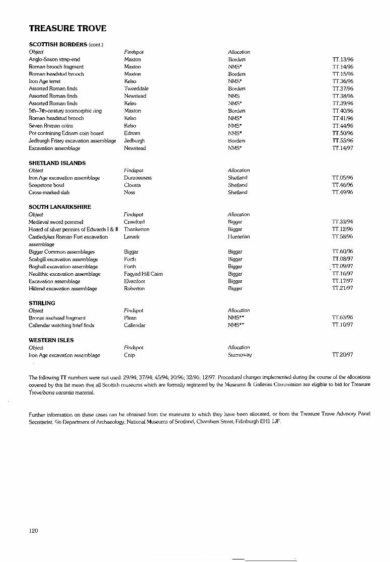
TREASURE TROVE
SCOTTISH BORDERS (cont)Object FindspotAnglo-Saxon strap-end MaxtonRoman brooch fragment MaxtonRoman headstud brooch MaxtonIron Age terret KelsoAssorted Roman finds TweeddaleAssorted Roman finds NewsteadAssorted Roman finds Kelso5th-7th-century zoomorphic ring MaxtonRoman headstud brooch Kelso
Seven Roman coins KelsoPot containing Ednam coin hoard EdnamJedburgh Friary excavation assemblage JedburghExcavation assemblage Newstead
SHETLAND ISLANDSObject FindspotIron Age excavation assemblage DunrossnessSoapstone bowl CloustaCross-marked slab Noss
SOUTH LANARKSHIREObject FindspotMedieval sword pommel CrawfordHoard of silver pennies of Edwards I & II ThankertonCastledykes Roman Fort excavation LanarkassemblageBiggar Common assemblages BiggarScabgill excavation assemblage ForthBoghall excavation assemblage ForthNeolithic excavation assemblage Fagyad Hill CaimExcavation assemblage ElvanfootHtllend excavation assemblage Roberton
STIRLINGObject FindspolBronze axehead fragment PleanCallendar watching brief finds Callendar
WESTERN ISLESObject Findspot
Iron Age excavation assemblage Cnip
AllocationBordersNMS*Borders
NMS*Borders
NMSNMS*Borders
NMS*
NMS*NMS*Borders
NMS*
AllocationShetland
ShetlandShetland
AllocationBiggarBiggarHunterian
BiggarBiggarBiggarBiggarBiggarBiggar
Allocation
NMS**NMS**
Allocation
Stomoway
TT. 13/96TT. 14/96TT. 15/96TT.36/96TT.37/96TT.38/96TT.39/96TT.40/96TT.41/96TT.44/96TT.50/96TT.55/96
TT. 14/97
TT.05/96TT.46/96TT.49/96
TT.33/94TT. 12/96TT.58/96
TT.60/96TT.08/97TT.09/97
' TT. 16/97TT.17/97TT21/97
TT.63/96TT. 10/97
TT.20/97
The following TT numbers were not used: 29/94; 37/94; 45/94; 20/96; 32/96; 12/97. Procedural changes implemented during the course of the allocationscovered by this list mean that all Scottish museums which are formally registered by the Museums & Galleries Commission are eligible to bid for Treasure
Trove/bona vacantia material.
Further information on these cases can be obtained from the museums to which they have been allocated, or from the Treasure Trove Advisory PanelSecretariat, c/o Department of Archaeology, National Museums of Scotland, Chambers Street, Edinburgh EH1 1JF.
120
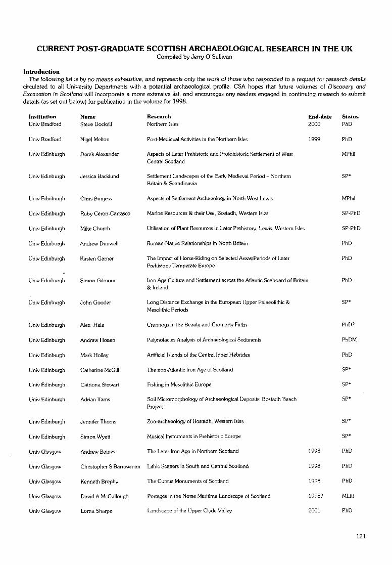
CURRENT POST-GRADUATE SCOTTISH ARCHAEOLOGICAL RESEARCH IN THE UKCompiled by Jerry O'Sullivan
IntroductionThe following list is by no means exhaustive, and represents only the work of those who responded to a request for research details
circulated to all University Departments with a potential archaeological profile. CSA hopes that future volumes of Dfscouery andExcavation in Scot/and will incorporate a more extensive list, and encourages any readers engaged in continuing research to submitdetails (as set out below) for publication in the volume for 1998.
InstitutionUniv Bradford
Univ Bradford
Univ Edinburgh
Univ Edinburgh
Univ Edinburgh
Univ Edinburgh
Univ Edinburgh
Univ Edinburgh
Univ Edinburgh
Univ Edinburgh
Univ Edinburgh
Univ Edinburgh
Univ Edinburgh
Univ Edinburgh
Univ Edinburgh
Univ Edinburgh
Univ Edinburgh
Univ Edinburgh
Univ Edinburgh
Univ Glasgow
Univ Glasgow
Univ Glasgow
Univ Glasgow
Univ Glasgow
NameSteve Dockrill
Nigel Melton
Derek Alexander
Jessica Backlund
Chris Burgess
Ruby Ceron-Carrasco
Mike Church
Andrew Dunwell
Kirsten Gamer
Simon Gilmour
John Gooder
Alex Hale
Andrew Hoaen
Mark Holley
Catherine McGill
Catriona Stewart
Adrian Tarns
Jennifer Thorns
Simon Wyatt
Andrew Baines
Christopher S Barrowman
Kenneth Brophy
David A McCullough
Loma Sharpe
Research End-dateNorthern Isles 2000
Post-Medieval Activities in the Northern Isles 1999
Aspects of Later Prehistoric and Protohistoric Settlement of WestCentral Scotland
Settlement Landscapes of the Early Medieval Period - NorthernBritain & Scandinavia
Aspects of Settlement Archaeology in North West Lewis
Marine Resources & their Use, Bostadh, Western Isles
Utilisation of Plant Resources in Later Prehistory, Lewis, Western Isles
Roman-Native Relationships in North Britain
The Impact of Horse-Riding on Selected Areas/Periods of LaterPrehistoric Temperate Europe
Iron Age Culture and Settlement across the Atlantic Seaboard of Britain& Ireland
Long Distance Exchange in the European Upper Palaeolithic &Mesolithic Periods
Crannogs in the Beauly and Cromarty Firths
Palynofacies Analysis of Archaeological Sediments
Artificial Islands of the Central Inner Hebrides
The non-Atlantic Iron Age of Scotland
Fishing in Mesolithic Europe
Soil Micromorphology of Archaeological Deposits: Bostadh Beach
Project
Zoo-archaeology of Bostadh, Western Isles
Musical Instruments in Prehistoric Europe
The Later Iron Age in Northern Scotland 1998
Lithic Scatters in South and Central Scotland 1998
The Cursus Monuments of Scotland 1998
Portages in the Norse Maritime Landscape of Scotland 1998?
Landscape of the Upper Clyde Valley 2001
StatusPhD
PhD
MPhil
SP'
MPhil
SP-PhD
SP-PhD
PhD
PhD
PhD
SP-
PhD?
PhDM
PhD
SP*
SP*
SP'
SP*
SP*
PhD
PhD
PhD
MLitt
PhD
121
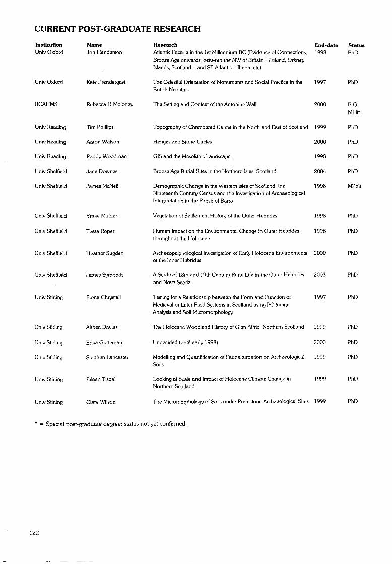
CURRENT POST-GRADUATE RESEARCH
InstitutionUniv Oxford
Univ Oxford
RCAHMS
Univ Reading
Univ Reading
Univ Reading
Univ Sheffield
Univ Sheffield
NameJon Henderson
Kate Prendergast
Rebecca H Moloney
Tim Phillips
Aaron Watson
Paddy Woodman
Jane Downes
James McNeil
Univ Sheffield Ymke Mulder
Univ Sheffield Tessa Roper
Univ Sheffield Heather Sugden
Univ Sheffield James Symonds
Univ Stirling Fiona Chrystall
Univ Stirling
Univ Stirling
Univ Stirling
Univ Stirling
Univ Stirling
Althea Davies
Erika Gutteman
Stephen Lancaster
Eileen Tisdall
Clare Wilson
Research End-date StatusAtlantic Facade in the 1st Millennium BC (Evidence of Connections, 1998 PhDBronze Age onwards, between the NW of Britain - Ireland, OrkneyIslands, Scotland - and SE Atlantic - Iberia, etc)
The Celestial Orientation of Monuments and Social Practice in the 1997 PhDBritish Neolithic
The Setting and Context of the Antonine Wall 2000 P-G
MLitt
Topography of Chambered Caims in the North and East of Scotland 1999 PhD
Henges and Stone Circles 2000 PhD
CIS and the Mesolithic Landscape 1998 PhD
Bronze Age Burial Rites in the Northern Isles, Scotland 2004 PhD
Demographic Change in the Western Isles of Scotland: the 1998 MPhilNineteenth Century Census and (he Investigation of Archaeological
Interpretation in the Parish of Barra
Vegetation of Settlement History of the Outer Hebrides 1998 PhD
Human Impact on the Environmental Change in Outer Hebrides 1998 PhD
throughout the Holocene
Archaeopalynological Investigation of Early Holocene Environments 2000 PhDof the Inner Hebrides
A Study of 18th and 19th Century Rural Life in the Outer Hebrides 2003 PhDand Nova Scotia
Testing for a Relationship between the Form and Function of 1997 PhD
Medieval or Later Field Systems in Scotland using PC ImageAnalysis and Soil Micromorphology
The Holocene Woodland History of Glen Affric, Northern Scotland 1999 PhD
Undecided (until early 1998) 2000 PhD
Modelling and Quantification of Faunalturbation on Archaeological 1999 PhD
Soils
Looking at Scale and Impac! of Holocene Climate Change in 1999 PhD
Northern Scotland
The Micromorphology of Soils under Prehistoric Archaeological Sites 1999 PhD
* = Special post-graduate degree: status not yet confirmed.
122
LIST OF CONTRIBUTORSContributors to this issue of Discovery and Excavation in Scotland are listed below.
Comments or queries should be addressed to the contributors.
ABERNETHY, D: See GUARD.AGFA: Association of Certificated Field Archaeologists, Dept Adult and
Continuing Education, 59 Oakfield Avenue, Glasgow G12 8LW.A-KELLY, C: 15 West Castle Road, Edinburgh EH10 SAT.ALBA ARCHAEOLOGY LTD: 129 Lochend Road, Edinburgh EH6 8BX.ALEXANDER, D: See CFA.ANDERSON, W: c/o L Main.AOC: AOC (Scotland) Ltd, The Schoolhouse, 4 Lochend Road, Leith,
Edinburgh EH6 8BR.ARMIT, I: See HS.ASHMORE, P; See HS.ATKINSON, J A: See GUARD.BAKER, F: See FIRAT.BANKS, I: see GUARD.BARCLAY, G J: See HS.BARRETT, J H: Dept Anthropology, Toronto University, Toronto,
Ontario M5S 3G3, Canada.BARROWMAN, C: See Glasgow University.BICKERS, V E: Top Flat, 19 Moorbum Road, Largs, Ayrshire KA30 9JA.BISHOP, M: c/o AOC.BLACK, I: c/o R L and S L Hunter.BOGDAN, N Q: Scottish Castle Survey, Barra Castle, Old Meldrum,
Inverurie, Aberdeenshire AB51 OBB.BOND, J M: See Bradford University.BOWDEN-SMITH, P: c/o P Yeoman.BOWLER, D: See SUAT.BRABY, A: c/o I Armit.BRADFORD UNIVERSITY: Dept Archaeological Sciences, Richmond
Road, Bradford BD7 1DP.BRADY, KJ: c /oVE Turner.BRANN, J: Environment & Infrastructure, Dumfries & Galloway Council,
4 Market Street, Castle Douglas DG7 1BE.BRAY, A: See AGFA.BRIDGLAND, D: c/o A Saville.BROPHY, K: See Glasgow University.BURGESS, C: See Edinburgh University.CACHART, R: See SUAT.CALDWELL, D H: See NMS.CAMERON, A: Archaeological Unit, Arts and Recreation Dept, The Art
Gallery, Schoolhill, Aberdeen AB10 1FQ.CAMERON, K: See CFA.CARTER, S: See HAL.CARVER, M; See York University.CFA: Centre for Field Archaeology, Edinburgh University, Old High
School, 12 Infirmary Street, Edinburgh EH1 1LT.CHESTERMAN, C: c/o R Page.CHRISTIE, C: 2 Meikle Ehdorrie Cottages, Alford.CHURCH, M: See Edinburgh University.CLARKE, C: See CFA.COCHRANE, E: c/o A Penman.COLEMAN, R: See SUAT.COLES, G: c/o D Alexander.CONNOLLY, D: See Kirkdale Archaeology.COOK, MJ: See AOC.COX, A: See SUAT.CRAIG, P: Cranbrook, Bumside Road, Tarland, Aberdeenshire AB34 4YL.CRESSEY, M: See CFA.CULLEN, I: See GUARD.CURTIS, M R and G R: 'Olcote', New Park, Callanish, Isle of Lewis HS2
9DZ.
DALLAND, M: See HAL.DAVIS, T: Dept Geography, Toronto University, Toronto, Ontario M5S
3G3, Canada.DEAN, V E: 50 Whitehouse Road, Edinburgh EH4 6PH.DICK, A M: 3 Grampian Crescent, Kirriemuir, Angus DD8 4TW.DINGWALL, C: See Fife Council.DOBSON, N C: Maritime Fife, Scottish Institute of Maritime Studies, St
Andrews University, St Andrews, Fife KY16 9AJ.DOCKRILL, S J: See Bradford University.DONNELLY, M: See GUARD.DRANSART, P Z: Dept Archaeology, University of Wales, Lampeter,
Dyfed SA48 7ED.DUFFY, P: See GUARD.DUNCAN, J: See GUARD.DUNLOP, A: 88 Ugie Road, Peterhead.DUNN, A: See Kirkdale Archaeology.DUNWELL, A: See CFA.EASE: Environmental and Archaeological Services, Unit 8, Abbeymount
Techbase, 2 Easter Road, Edinburgh EH7 SAN.EDINBURGH UNIVERSITY: Dept Archaeology, Old High School,
Infirmary Street, Edinburgh EH1 1LT.EDWARDS, K J: Dept Archaeology and Prehistory, Sheffield University,
Northgate House, West Street, Sheffield SI 4ET.ELLIS, C: See AOC.ENGL, M: See AOC.ETHERIDGE, D: See GUARD.EWART, G: See Kirkdale Archaeology.EXTON, H: 'Nyuggel', Lunabister, Dunrossness, Shetland ZE2 9JH.FARRELL, S: 34 Huntly Drive, Glenrothes, Fife KY6 2HS.FIFE COUNCIL: Planning Service, Fife House, North Street, Glenrothes,
Fife KY75LT.FINLAYSON, B: See CFA.FIRAT: FIRAT Archaeological Services, 50 Campbell Street, Helensburgh
G849NH.FLITCROFT, C: See Edinburgh University.FLOWER, C: See WoSAS.FRENCH, C: See GUARD.GARNER-LAHIRE, J: See York University.GILMOUR, S: See Edinburgh University.GLASGOW UNIVERSITY: Dept Archaeology, Gregory Building,
Lilybank Gardens, Glasgow G12 8QQ.GLENDINNING, B: See CFA.GOODER, J: See AOC.GORMLJE, D: c/o R L and S L Hunter.GOVAN, S: See Fife Council.GRAHAM, A: 16 Bowfield Road, West Kilbride, Ayrshire KA23 9JY.GREIG, M: Planning and Economic Development, Aberdeenshire
Council, Woodhill House, Westbum Road, Aberdeen AB16 5GB.GUARD: Glasgow University Archaeological Research Division, Dept
Archaeology, Glasgow University G12 8QQ.HAL: Headland Archaeology Ltd, Albion Business Centre, Unit B4, 78
Albion Road, Edinburgh EH7 5QZ.HALE, A G C: See Edinburgh University.HALL, D: See SUAT.HALLIDAY, S: See GUARD.HALLYBURTON, I: 63b Perth Road, Scone, Perthshire PH2 6JL.HAMILTON, J: See CFA.HANLEY, R: c/o J Wordsworth.HANNAH, A: Bute Museum, Stuart Street, Rothesay, Isle of Bute PA20
OEP.
123
LIST OF CONTRIBUTORS
HARDING, D I: 120 King Street, Aberdeen AB24HARRINGTON, P: 87 George Street, Whithorn DG8 8PZ.HARRIS, J: 78 Lillian Road, Barnes, London SW13 9JF.HEALD, A: Sec Edinburgh University.HENRY, B; c/o D Alexander.HOLDEN, T: See HAL.HOLUNRAKE, A: See Kirkdale Archaeology.HOOD, F: Craiglussa, Peninver, Campbeltown, Argyll PA28 6QP.HOWARD, W J: Old Schoolhouse, Kirkton of Bourtie, Inverurie AB51 OJS.HS: Historic Scotland, Longmore House, Salisbury Place, Edinburgh
EH9 1SH.HUNTER, J R: Dept Ancient History and Archaeology, Birmingham
University, Edgbaston, Birmingham B15 2TT.HUNTER, R L and S L: 69 Craighill Drive, Clarkston, East Renfrewshire
G76 7TD.HUNTLEY, J: c/o P G Johnson.JAMES, H F: See GUARD.JOHNSON, P G; See Gkasgow University.JOHNSTONE, L H: See GUARD.KING, M D; Fife Museums Services, County Buildings, Cupar KY15 4TA.KIRBY, J E: Dahl, Polloch, Glenfinnan, Fort William, Inverness-shire
PH37 4LX.KIRKDALE ARCHAEOLOGY: 4 Western Terrace, Murrayfield,
Edinburgh EH12 5QF.LARSEN, A-C: c/o V E Turner.LAW, R See WoSAS.LELONG, O: See GUARD.LESLIE, A: See GUARD.LEWIS, J: See Scotia Archaeology Ltd.LONEY, H: See GUARD.LONIE, W: 11 Dean Place, Newstead, Melrose TD6 9RL.LOWE, C: See HAL.McCULLAGH, R: SeeAOC.MacDONALD, J: 35 Cochran Street, Paisley PA1 1JZ.McGILL, C: See CFA.MacGREGOR, G: See GUARD.MacINNES, D: See ACFA.MacLEOD, M: c/o V E Turner.MacNEILL, B: c/o F Hood.McRAE, S: Clach-Mhuilinn, Cowhill Balmedie.MAIN, L: Environmental Services, Stirling Council, Viewforth, Stirling
FK8 2ET.MAXWELL, G S: 'Mickelgarth1, 72a High Street, Aberdour, Fife KY3 OSW.MILLER, C A: RESURGAM!, 11 Valleyfield, East Kilbride, Glasgow G75
8SB.MOLONEY, C: See HAL.MOORE, H: See EASE.
MORRIS, C D: c/o V E Turner.MORRISON, A: See Glasgow University.MURDOCH, R: See Scotia Archaeology Ltd.MURRAY, D: See Kirkdale Archaeology.NEIGHBOUR, T: See CFA.NMS: National Museums of Scotland, Chambers Street, Edinburgh EH1
1JF.NTS: National Trusl for Scotland, The Old Granary, West Mill Street,
Perth PHI 5QPO'CONNOR, P; See Fife Council.
O'SULLJVAN, J: See GUARD.PAGE, R: 'Kingarth', Airthrey Road, Stirling FK9 5PH.PENMAN, A: 'Kingston', Rhonehouse, Castle Douglas DG7 ISA.
PERRY, D: See SUAT.PETERSON, R: c/o E Proudfoot.PHOTOS-JONES, E: Scottish Analytical Services for Art and
Archaeology, c/o GUARD.PICKIN, J: Stranraer Museum, 55 George Street, Stranraer DG9 7JP.
POLLARD, T: See GUARD.PROUDFOOT, E: St Andrews Heritage Services, Westgate, 12 Wardlaw
Gardens, St Andrews KY16 9DW.RADLEY, A: See Kirkdale Archaeology.REES, A: See CFA.REES, T: See AOC.RENN1E, E B: Upper Netherby, Kim, Dunoon.RIDEOUT, J S: See Alba Archaeology Ltd.ROBERTSON, J: Garden Cottage, Ardtomish Estate, Morvem, by Oban,
Argyll PA345UZ.ROBERTSON, N: See SUAT.
ROBINS, G:c/o AOC.ROBINS, P: See WoSAS.ROE, A: See York University.
SABfNE, K A: Moss-side Croft, Wartle, Invemrie, Aberdeenshire AB51 5BA.SAVILLE, A: See NMS.
SCOTIA ARCHAEOLOGY LTD: 29 Hillside Crescent, Edinburgh EH7 5EF.SCOTT, I G: 3 Saxe-Coburg Street, Edinburgh EH3 5BN.SCOTT, J G: Kirkcudbright Training Area, Dundrennan, Kirkcudbright
DG4 4QZ.SHARMAN, P: See Kirkdale Archaeology.SHARPLES, N: Dept Archaeology, University of Wales, Cardiff, Box 909,
Cardiff CF1 3XU.SHETLAND MUSEUM: Shetland Museums Service, Lower Hill Head,
Lerwick ZE1 OEL.SIMPSON, B. See GUARD,SIMPSON, I: Dept Environmental Science, Stirling University, Stirling
FK9 4LA.SPELLER, K: See GUARD.STEWARD, M:c/oL Main.STEWART, D: See Kirkdale Archaeology.STONES, J: Archaeological Unit, Arts and Recreation Dept, The Art
Gallery, Schoolhill, Aberdeen AB10 1FQ.STRACHAN, R: See CFA.STRONACH, S: See SUAT.STUART, E: See Glasgow University.STUMMANN HANSEN, S: c/o V E Turner.SUAT: Scottish Urban Archaeological Trust, 55 South Methven Street,
Perth PHI 5NX.SUDDER, C:c/oJ Stones.
SWIFT, C: See CFA.TAYLOR, S: See Fife Council.TERRY, J: See Scotia Archaeology Ltd.TOMPSETT, G: See GUARD.TOOLIS, R: Solway Heritage, Campbell House, The Crichton, Bankend
Road, Dumfries DG1 4ZB.TOPEN, D: 10 Banavie Road, Glasgow Gil SAN.TR1SCOTT, J: See Kirkdale Archaeology.TURNER, R: See NTS.TURNER, V E: Shetland Amenity Trust, 22-24 North Road, Lerwick,
Shetland ZE1 ONQ.WALLACE, S A: See NTS.WARD, T: Biggar Museum Trust, 4 James Square, Biggar, Lanarkshire.WATSON, G: 'Caimroy', 20 Spoutwells Drive, Scone, Perth PH2 6RR.WHITTINGTON, G: School of Geography and Geosciences, St Andrews
University, St Andrews, Fife KY16 9AJ.WILLIAMSON, S: Little Flinder, Insch.
WILSON, G: See EASE.WOOD J S: c/o J Macdonald.WORDSWORTH. J: Wordsworth Archaeological Services, Balbeg,
Balnain, Glenurquhart, Invemess-shire IV3 6XQ.WoSAS: West of Scotland Archaeology Service, Charing Cross Complex,
20 India Street, Glasgow G2 4PF.YEOMAN, P: See Fife Council.
YORK UNIVERSITY: Depl Archaeology, King's Manor, York YO1 2EP.
124
SELECTIVE INDEXTO THE ARCHAEOLOGICAL CONTRIBUTIONS
Compiled by Kenneth Aitchison
Abbey, 18, 23, 26, 30, 32, 33, 34, 55-6, 57,66-7,79-80
Aerial survey, 6, 54-5Air-raid shelter, 5, 28, 37Amethyst, 24Antonine Wall, 28, 29, 83Aqueduct, 52, 78Ard: marks, 18,56,71
point, 71Arrowhead: barbed-and-tanged, 5, 19, 76
chisel-shaped, 76leaf-shaped, 76lozenge-shaped, 5
Artificial island, 19Awl, 15, 68Axe: flint, 12, 14,34
hammer, 73stone, 24, 65, 68, 73
Backlands, medieval, 16, 27, 30, 40, 41, 65Bailey, 24, 82Barmkin wall, 73Bam, 60Barrow, 62
cemetery, 13, 39round, 13, 15square, 13, 15
Bayonet, 52Bead: faience, 24
glass, 39, 79jet/shale, 75
Beaker, pottery, 43, 84Bee-boles, 39-40Bell, 46
pits, 28Bishop's Palace, 8, 46, 79Blackhouse, 83Blackpowder works, 26-7Bleachworks, 42, 52Bbomery, 17, 46,47, 63, 78Boat, 38
noost, 18, 58, 59, 60yard, 33
Boat-shaped setting, 70Boathouse, 8, 49, 50, 58, 59, 60Bone: animal, 16, 18, 19,30,33,40,41,52,
55, 58, 61, 64, 66, 68, 71, 84-5, 86bird, 69comb, 60, 84-5cremated, 84disc, 19fish, 61human: see Human remainspin, 46, 61spindle whorl, 61weaving tablet, 84-5whale, 61,84-5worked, 61, 68
Bowl, 13furnace, 47, 69
Bracelet, shale, 76, 85Brandy hole, 25Brickworks, 35Bridge, 5, 11, 17, 28, 31, 40, 42, 44, 45, 56,
57, 78,79,80-81
Broch, 52, 58, 59, 60, 69-70Bronze: awl, 68
lid, 16ornamental, 24pin, 68sheet, 13
Bronze Age: arrowhead, 19axehead, 73caim, 49, 66cemetery, 21, 43site, 13, 27, 39, 85see also Pottery; Settlement; Structure; Urn
Brooch, 34, 46Roman, 24
Buckle, 33, 34, 65, 85Building: see StructureBurgh, medieval, 16, 24, 26, 27, 29, 39, 41,
77,82Burial, 13,19, 30, 33, 36, 38, 39, 41, 52, 53-
4,60,61,64,84animal, 41, 86caim, 13, 24, 59, 71,78, 82, 86chamber, 84child, 38cremation, 39horse, 58mound, 59, 60, 79see a/so Cemetery
Burnt mound, 22, 25, 26, 39, 47, 51, 58, 59,60, 68, 70, 73^t, 75, 76, 84
Button, 46loop fastener, 14
Byre, 48, 50, 51,62
Caim, 5,16, 26, 31, 38, 44-5, 46, 48, 49, 51,56, 58, 60, 66, 70, 75, 77, 78
burial, 13, 24, 59, 71, 78, 82, 86chambered, 18, 45, 47, 56, 59, 68, 71, 84circular, 61, 79clearance, 5, 6, 9, 13,14, 16,18,26,31,
38, 44, 45-6, 48, 51, 52, 56, 66, 71, 78,85
field, 7, 26, 48, 49heel-shaped, 71kerb, 12, 19, 22, 49, 50, 51, 56, 71, 84linear, 38prehistoric, 18, 24, 58, 60ring, 9, 13, 27, 51,75round, 13
Canal, 5, 11Castle, 7, 9, 23, 32, 33, 38, 50, 52, 53, 56, 64,
73,74,81-2Cathedral, 42-3, 55Causeway, 19, 25, 34, 85Cemetery, 5, 42^, 46, 47, 48, 51, 55-6, 63,
78barrow, 13, 39Bronze Age, 2], 43cremation, 26, 75long cist, 35-6, 53-4medieval, 18, 23, 30, 36, 49, 51, 61, 64Norse, 60
Chambered tomb, 84Chapel, 18, 22, 23, 29, 34, 35-6, 37, 40, 48,
49,59,60,69,71,73,81-2
Chapter house, 67Charcoal, 9,10,13, 18, 19, 24, 25, 43, 47, 48,
49, 51, 53, 63, 65, 75, 76, 79, 82, 83Charcoal-burning platform, 16, 17Chert, 21, 67, 75, 76
blade, 32, 49Church: medieval, 30, 38, 40, 43, 48-9, 51-2,
67, 68, 77shell, disguising, 38
Cist, 18, 21, 39, 47-8, 51-2, 56, 60-61, 82corbelled, 84long, 35-6, 41,53-4
Cistern, 12, 50Cleit, 21-2, 83Clay pipe, 33, 39, 46, 65Cloister, 55-6Coffin fittings, 42-3, 47, 48Coin, 19, 24, 35, 46, 61, 77, 84-5Comb, 60, 61,85Copper alloy, artefact, 18, 33, 34, 36, 46, 65,
84-5Copper working, 69Com stack, 31Crannog, 66, 83Cropmark, 6, 11, 13, 15, 23, 24, 35, 39, 54,
55, 65-6, 79-80enclosure, 27, 35, 42, 48, 49, 54, 55, 75
Cross slab, 52Culvert, 25, 35, 64, 72Cup-and-ring mark, 18Cup marks, 6, 9, 53-4, 56Cursus, 15,21,65
Dam, 7, 35, 37, 44, 52, 55, 78, 82Deserted settlement, 16, 17, 22, 31, 35, 36, 37,
44, 45, 49, 66, 73Designed landscape, 6, 32, 33, 35, 42, 66Dock, 50, 83Doocot, 5. 34Drove way, 63Dun, 22, 86
Enclosure, banked, 15, 34circular, 6, 12, 58ditched, 6drystone, 38, 44-5oval, 5, 6, 55, 62promontory, 59, 66, 68rectangular, 6, 42, 55, 59, 60
Engine house, 5
Farm site, abandoned, 31, 34, 45-6, 51, 71,73,75
Farmstead, 6, 7, 8, 11, 12, 15,17,22,25,26,27, 28, 31, 36, 37, 45, 48, 50, 51, 52,54,55,57,71,73,75
Felsite: axe, 68knife, 68
Fermtoun, 45-6Field system, 6, 7, 13, 15,16,17, 25, 26, 31,
32, 45, 55, 58, 59, 63-4, 68, 70, 71, 76,78-9
Fish trap, 24Fishing station, 54, 68Flint, 15, 18,22,32,67
125
INDEX
Flint (cont.)assemblage, 5, 8. 10, 11. 13, 19, 63, 76awl, 15axe, 12, 14, 34blade, 18,21,63, 79core, 11,21,45, 75, 76flake, 11, 18, 21, 22, 35, 45, 47-8, 84knapping, 10, 75knife, 7-8, 76microlith, 63, 75, 76scatter, 7-8,18, 21, 35, 39, 45, 74-5, 76scraper, 7-8, 13,21,35, 76see also Arrowhead
Folly, 39, 48Food vessel: see UmFort, 11,24,44,49,64-5
Iron Age, 46promontory, 24, 59, 68-9Roman, 29, 32,62,67, 79vitrified, 11,16
Friary, 64, 65, 67Furnace, 69, 78
ironworking, 28, 41, 44, 46, 47
Garden, 8-9, 18, 29, 32, 33, 34, 37, 38, 39-40, 42, 48, 53, 64, 66, 77
Garderobe, 8Gasworks, 37Geophysical survey: see SurveyGlass, 8, 13, 28, 41, 48, 49-50, 58, 63, 79
bead, 39, 79bottle, 7, 12, 16,26, 64, 65
Grain, carbonised, 13, 61, 66-7Gravestone, 12Graveyard: see CemeteryGreenhouse, 37, 42
Hammerstone, 24, 67, 68, 76, 84-5Harbour, 24, 33, 53, 59, 66Hazelnut shells, 13, 19, 38-9Henge, 56Hillfort, 15-16,23, 64Hollow-way, 13, 31, 55Hospital site, 27, 41House: see Structure; Tower houseHuman remains, 13, 18, 21, 27, 30, 36, 38,
39, 42-3, 47-8, 51-2, 53-4, 57, 60-61,63, 64, 84
Hut: circle, 5, 6, 11, 26, 32, 50, 51, 56, 64, 72,82
platform, 12, 22, 23, 28, 37, 38, 44, 45, 49.50,51,52,66,75,78,85
see also Roundhouse
Ice: house, 7, 40, 49, 57, 66, 74pond, 7
Industrial complex, 27, 28, 77Iron: artefact, 46, 48, 52, 57, 62, 63, 65, 82,
84-5tool, 33, 39
Iron Age: artefact, 14, 19, 24, 25, 30, 68cellular building, 69-70fort, 46, 68-9midden, 68site, 68see also Pottery; Settlement; Structure
Ironworks, 27, 28, 46-7, 77
Jet, bead, 75Jetty, 19,44,46,47,60
Kelp drying wall, 59, 60
126
Kiln, 15,42,43,47, 77,78bam, 50com, 9, 17, 28, 44, 45-6, 59, 60, 69, 78lime, 6, 26, 28, 36, 37, 38, 45-6, 49, 57,
73,76-7,78,79Knife: felsite, 68
flint, 7-8, 76stone, 71
Lamp, stone, 13Lazy beds: see RigLead: pipe, 53, 82
window, 8Lead alloy: bulla, 34
Pilgrim badge, 33spindle whorl, 33, 34
Leather, 19, 53Lighthouse, 58, 59, 60, 66Lithics: assemblage, 24
scatter, 15, 21,22, 45, 75, 76Longhouse, 6, 43, 44, 45-6, 47, 48, 70, 75,
84-5Loomweight, 68, 69, 70
Mansion house, 8, 17, 45Medieval: backlands, 16, 27, 30, 40, 41, 65
bailey, 24, 82bridge, 80-81burgh, 16, 24, 26, 27, 29, 39, 41, 77, 82cemetery, 18, 23, 30, 36, 49, 51, 61, 64chapel, 22, 23, 40, 48, 49, 59, 69, 81-2coin, 19, 24gravernarker, 43midden, 12, 19,81-2thimble, 24town, 12, 27see a/so Pottery; Settlement, Structure
Mesolithic: flint, 19, 39, 67, 75site, 75tool, 63see a/so Settlement
Metalworking, 12, 40, 41, 44, 52, 69, 76, 84-6slag, 46, 47, 49, 68, 78, 82, 84-6
Midden, 12, 18, 19, 30, 34, 46, 61, 68, 69, 81-2,84
shell. 23, 71Milestone, 5, 64Mill, 15, 31, 35, 37, 45, 49, 55, 60, 75
corn, 11, 37horse, 6, 46lade, 5, 11, 22, 31, 34, 35, 49, 55lint, 31, 61wind, 5, 59
Millstone, 18Mine, 44
adit, 35coal, 28, 35, 36, 37lead, 19-20, 59
Moat, 52Monastery, 64Mortuary building, 53-4, 85Motte, 24, 26, 42,46, 48
Nail, 18, 24, 28, 39, 47, 48, 61, 62, 65, 68, 79,82
Neolithic: artefact, 21,49axehead, 14, 65carved stone ball, 8, 9, 10, 51-2chambered tomb, 13, 84earthwork, 68site, 21, 27, 39, 52, 68see a/so Pottery; Settlement; Structure
Noost: see Boat noostNorse: artefact, 70
cemetery, 60cornb, 60, 61midden, 61pin, 68site, 70spindle whorl, 69, 70weight, 61see a/so Pottery; Settlement; Structure
Oven, 34, 62, 81
Painting, ceiling, 39-40Palace, 8, 32-3, 36, 37, 38, 46, 77, 79, 81-2,
83Palisade, 15, 21, 22, 24, 53 ,̂ 62Passage grave, 13Pendant, 33, 34Pictish, stone, 51-2,67Pier, 50, 59, 60Pin: bone, 46, 61
bronze, 68Pit: alignment, 53-4, 65-6
circle, 21clay, 35coal, 28, 36, 37, 57kelp, 59, 60prehistoric, 10,13-14, 38, 39
Pitcarmick-type building, 12Pitchstone, 21,22, 76
Arran, 13Platform: charcoal-burning, 16, 17
hut. 12, 22, 23, 28, 37, 38, 44, 45, 49, 50,51,52,66,75,78,85
Ploughshare, 68Post-hole alignment, 21Post-medieval: artefact, 33, 42, 46, 52, 82, 83
fields, 63see a/so Pottery; Settlement; Structure
Pottery, 13, 18,28,32, 40, 84Beaker, 43, 84Bronze Age, 13, 39, 49, 84, 85burnished ware, 71coarse greyware, 79Colsloun ware, 30Craggan ware, 47earthenware, 53, 68East Coast Redware, 30East Coast White Gritty, 41green glaze, 16, 24, 26, 41, 57-8, 80Grooved ware, 13-14Impressed ware, 13-14Iron Age, 14, 68, 69, 70, 71, 84medieval, 5, 10,12, 16, 18, 19, 26, 27, 30,
32, 35, 40, 41, 43, 52, 55, 63, 64, 65,66, 73, 77, 85-6
Neolithic, 13, 49, 76, 84Norse, 61,69post-medieval, 18, 23, 26, 27, 35, 57-8, 61,
67prehistoric, 10, 38, 53-4, 63, 83, 84redware, 30, 63, 79Roman, 24,32,62, 79samian, 14, 79terra nigra, 79Throsk ware, 22
Potworks, 42Prehistoric: artefact, 19, 30
caim, 18.24,58,60ceremonial complex, 19, 21field system, 7. 13, 70
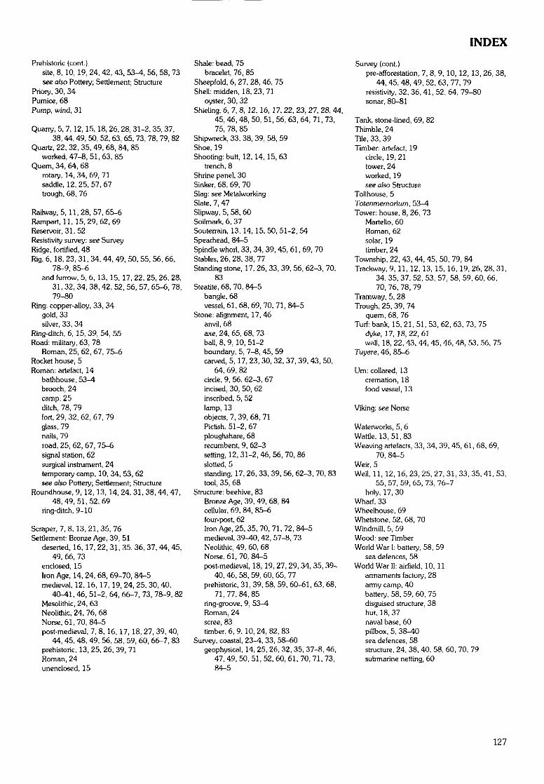
INDEX
Prehistoric {cont.}site, 8,10, 19, 24, 42, 43, 53-4, 56, 58, 73see also Pottery; Settlement; Structure
Priory, 30, 34Pumice, 68Pump, wind, 31
Quarry, 5, 7,12,15,18, 26, 28, 31-2, 35, 37,38, 44, 49, 50, 52, 63, 65, 73, 78, 79, 82
Quartz, 22, 32, 35, 49, 68, 84, 85worked, 47-8, 51,63, 85
Quem, 34, 64, 68rotary, 14,34,69,71saddle, 12, 25, 57, 67trough, 68, 76
Railway, 5,11,28, 57, 65-6Rampart, 11,15,29,62,69Reservoir, 31, 52Resistivity survey: see SurveyRidge, fortified, 48Rig, 6,18, 23, 31, 34, 44, 49, 50, 55, 56, 66,
78-9, 85-6and furrow, 5, 6, 13, 15, 17, 22, 25, 26, 28,
31, 32, 34, 38, 42, 52, 56, 57, 65-6, 78,79-80
Ring: copper-alloy, 33, 34gold, 33silver, 33, 34
Ring-ditch, 6, 15, 39, 54, 55Road: military, 63, 78
Roman, 25,62,67, 75-6Rocket house, 5Roman: artefact, 14
bathhouse, 53-4brooch, 24camp, 25ditch, 78, 79fort, 29, 32, 62, 67, 79glass, 79nails, 79road, 25, 62, 67, 75-6signal station, 62surgical instrument, 24temporary camp, 10, 34, 53, 62see also Pottery; Settlement; Structure
Roundhouse, 9, 12, 13, 14, 24, 31, 38, 44, 47,48,49,51,52,69
ring-ditch, 9-10
Scraper, 7, 8, 13,21,35, 76Settlement: Bronze Age, 39, 51
deserted, 16,17, 22, 31, 35, 36, 37, 44, 45,49, 66, 73
enclosed, 15Iron Age, 14, 24, 68, 69-70, 84-5medieval, 12,16, 17, 19, 24, 25, 30, 40,
40-41, 46, 51-2, 64, 66-7, 73, 78-9, 82Mesolithic, 24, 63Neolithic, 24, 76, 68Norse, 61, 70, 84-5post-medieval, 7, 8, 16, 17, 18, 27, 39, 40,
44, 45, 48, 49, 56, 58, 59, 60, 66-7, 83prehistoric, 13, 25, 26, 39, 71Roman, 24unenclosed, 15
Shale: bead, 75bracelet, 76, 85
Sheepfold, 6, 27, 28, 46, 75Shell: midden, 18,23,71
oyster, 30, 32Shieling, 6, 7, 8, 12,16,17, 22, 23, 27, 28, 44,
45, 46, 48, 50, 51, 56, 63, 64, 71, 73,75, 78, 85
Shipwreck, 33, 38, 39, 58, 59Shoe, 19Shooting: butt, 12,14, 15,63
trench, 8Shrine panel, 30Sinker, 68, 69, 70Slag: see MetalworkingSlate, 7, 47Slipway, 5, 58, 60Soilmark, 6, 37Souterrain, 13, 14, 15, 50, 51-2, 54Spearhead, 84-5Spindle whorl, 33, 34, 39, 45, 61, 69, 70Stables, 26, 28, 38, 77Standing stone, 17, 26, 33, 39, 56, 62-3, 70,
83Steatite, 68, 70, 84-5
bangle, 68vessel, 61, 68, 69, 70, 71, 84-5
Stone: alignment, 17, 46anvil, 68axe, 24, 65, 68, 73ball, 8, 9, 10, 51-2boundary, 5, 7-8, 45, 59carved, 5, 17, 23, 30, 32, 37, 39, 43, 50,
64, 69, 82circle, 9, 56, 62-3, 67incised, 30, 50, 62inscribed, 5, 52lamp, 13objects, 7, 39, 68, 71Pictish, 51-2,67ploughshare, 68recumbent, 9, 62-3setting, 12,31-2,46,56,70,86slotted, 5standing, 17, 26, 33, 39, 56, 62-3, 70, 83tool, 35, 68
Structure: beehive, 83Bronze Age, 39, 49, 68, 84cellular, 69, 84, 85-6four-post, 62Iron Age, 25, 35, 70, 71, 72, 84-5medieval, 39^0, 42, 57-8, 73Neolithic, 49, 60, 68Norse, 61,70, 84-5post-medieval, 18,19, 27, 29, 34, 35, 39-
40, 46, 58, 59, 60, 65, 77prehistoric, 31, 39, 58, 59, 60-61, 63, 68,
71,77,84,85ring-groove, 9, 53-4Roman, 24scree, 83timber, 6, 9,10,24,82,83
Survey, coastal, 23-4, 33, 58-60geophysical, 14, 25, 26, 32, 35, 37-8, 46,
47, 49, 50, 51, 52, 60, 61, 70, 71, 73,84-5
Survey (cont.)pre-afforestation, 7, 8, 9, 10, 12, 13, 26, 38,
44, 45, 48, 49, 52, 63, 77, 79resistivity, 32, 36, 41, 52, 64, 79-80sonar, 80-81
Tank, stone-lined, 69, 82Thimble, 24Tile, 33, 39Timber: artefact, 19
circle, 19, 21tower, 24worked, 19see also Structure
Tollhouse, 5Totenmemorium, 53-4Tower: house, 8, 26, 73
Martello, 60Roman, 62solar, 19timber, 24
Township, 22, 43, 44, 45, 50, 79, 84Trackway, 9, 11,12, 13, 15, 16, 19,26,28,31,
34, 35, 37, 52, 53, 57, 58, 59, 60, 66,70, 76, 78, 79
Tramway, 5, 28Trough, 25, 39, 74
quern, 68, 76Turf: bank, 15, 21, 51, 53, 62, 63, 73, 75
dyke, 17,18,22,61wall, 18, 22, 43, 44, 45, 46, 48, 53, 56, 75
Tuyere, 46, 85-6
Um: collared, 13cremation, 18food vessel, 13
Viking: see Norse
Waterworks, 5, 6Wattle, 13,51,83Weaving artefacts, 33, 34, 39, 45, 61, 68, 69,
70, 84-5Weir, 5Well, 11, 12, 16, 23, 25, 27, 31, 33, 35, 41, 53,
55, 57, 59, 65, 73, 76-7holy, 17, 30
Wharf, 33Wheelhouse, 69Whetstone, 52, 68, 70Windmill, 5, 59Wood: see TimberWorld War 1: battery, 58, 59
sea defences, 58World War II: airfield, 10, 11
armaments factory, 28army carnp, 40battery, 58, 59, 60, 75disguised structure, 38hut, 18, 37naval base, 60pillbox, 5, 38-40sea defences, 58structure, 24, 38, 40, 58, 60, 70, 79submarine netting, 60
127
DISCVOVERY AND EXCAVATION IN SCOTLAND
LOCAL AUTHORITY
Site Name
Parish
Name of Coiitributor(s) ..
Type of Site or Find
NGR (2 letters, 6 figures)
Report:
Sponsor(s): HS, Society, Institution, Developer, etc. (where appropriate)
Address(es) of Main Contributor(s)
Please send to: Hon. Editor, Discouery and Excauation in Scotland, CSA, c/o Royal Museum of Scotland, Chambers Street, EDINBURGH EH1 1JF
CSACOUNCILLOR SCOTTISH
ARCHAEOLOGY
THE COUNCIL FOR SCOTTISH ARCHAEOLOGY promotesinformed opinion on the study and conservation of Scotland'sarchaeological heritage, and brings together individuals, societies andorganisations in order to do so. The CSA works by:
» advancing the education and involvement of the public inScotland's archaeological heritage
» encouraging the better identification and conservation ofmaterial evidence of past human activity in Scotland
» pressing for improved policies for the preservation, managementand interpretation of Scotland's past
» facilitating liaison between statutory bodies, archaeological societies,other groups and organisations, and the general public
Supporting the Council for Scottish Archaeology will helpsecure Scotland's past for the future
The Council for Scottish Archaeologyc/o Royal Museum of Scotland
Chambers StreetEDINBURGH EH1 1JF
Tel. 0131-225-7534E.mail: [email protected]
COUNCIL FOR SCOTTISH
ARCHAEOLOGY
"The Council for Scottish Archaeology are right to keep reminding us that protectingthe environment is not just about things that live above the ground. It is also aboutpreserving the rich archaeological heritage hidden underneath the ground. We need tointerpret our past to understand our present to control our future." (Rob Edwards,Edinburgh EueningNeios)
'To think that you are the first person to hold an object since it was lost or thrownaway, many hundreds of years ago, can be quite awe-inspiring." (Jill Harden. CSA)
The Council for Scottish Archaeology exists to help people from all walks oflife to play a valuable role in increasing our knowledge of the past, and inprotecting our archaeological legacy for the benefit of future generations.
JOIN NOW AND HELP SECURE SCOTLAND'S PAST FOR THE FUTURE
As a Member of CSA you will:» receive our regular newsletter Scottish Archaeological News» be sent a free copy of Discouery and Excavation in Scotland, the only
annual round-up of new fieldwork» gain access to CSA's information service aimed at helping answer your
questions about Scotland's archaeology» add your voice to CSA's campaign for improved policies and resources to
care for the past
Membership forms are available from:
The Council for Scottish Archaeologyc/o Royal Museum of ScotlandChambers StreetEDINBURGH EH1 1JFTel. 0131-225-7534E.mail: [email protected]