the 1561 earthquake(s) in southern italy: new insights into a complex seismic sequence
TRANSCRIPT
PLEASE SCROLL DOWN FOR ARTICLE
This article was downloaded by: [EBSCOHost EJS Content Distribution]On: 2 December 2008Access details: Access Details: [subscription number 902156990]Publisher Taylor & FrancisInforma Ltd Registered in England and Wales Registered Number: 1072954 Registered office: Mortimer House,37-41 Mortimer Street, London W1T 3JH, UK
Journal of Earthquake EngineeringPublication details, including instructions for authors and subscription information:http://www.informaworld.com/smpp/title~content=t741771161
The 1561 Earthquake(s) in Southern Italy: New Insights into a Complex SeismicSequenceViviana Castelli a; Paolo Galli b; Romano Camassi a; Carlos Caracciolo c
a Istituto Nazionale di Geofisica e Vulcanologia, Bologna, Italy b Dipartimento della Protezione Civile, U.Rischio Sismico, Rome, Italy c Freelance researcher,
Online Publication Date: 01 September 2008
To cite this Article Castelli, Viviana, Galli, Paolo, Camassi, Romano and Caracciolo, Carlos(2008)'The 1561 Earthquake(s) in SouthernItaly: New Insights into a Complex Seismic Sequence',Journal of Earthquake Engineering,12:7,1054 — 1077
To link to this Article: DOI: 10.1080/13632460801890356
URL: http://dx.doi.org/10.1080/13632460801890356
Full terms and conditions of use: http://www.informaworld.com/terms-and-conditions-of-access.pdf
This article may be used for research, teaching and private study purposes. Any substantial orsystematic reproduction, re-distribution, re-selling, loan or sub-licensing, systematic supply ordistribution in any form to anyone is expressly forbidden.
The publisher does not give any warranty express or implied or make any representation that the contentswill be complete or accurate or up to date. The accuracy of any instructions, formulae and drug dosesshould be independently verified with primary sources. The publisher shall not be liable for any loss,actions, claims, proceedings, demand or costs or damages whatsoever or howsoever caused arising directlyor indirectly in connection with or arising out of the use of this material.
Journal of Earthquake Engineering, 12:1054–1077, 2008
Copyright � A.S. Elnashai & N.N. Ambraseys
ISSN: 1363-2469 print / 1559-808X online
DOI: 10.1080/13632460801890356
The 1561 Earthquake(s) in Southern Italy: NewInsights into a Complex Seismic Sequence
VIVIANA CASTELLI1, PAOLO GALLI2,ROMANO CAMASSI1, and CARLOS CARACCIOLO3
1Istituto Nazionale di Geofisica e Vulcanologia, Bologna, Italy2Dipartimento della Protezione Civile, U. Rischio Sismico, Rome, Italy3Freelance researcher
In the summer of 1561, a strong seismic sequence struck southern Italy, then the Spanish-ruledKingdom of Naples. Both the Italian seismological tradition and the latest catalogues locate it inthe Vallo di Diano (Diano Valley), a low-seismicity intermontane basin 100 km south-east ofNaples. We explore the hypothesis that current perception of the 1561 earthquake is distorted bythe nature of the historical dataset from which its parameters have been assessed, and which mostlyderive from a single—albeit very detailed—primary source. We present and discuss several pre-viously unconsidered original accounts. Our results cast doubts on the traditional interpretation ofthe earthquake, which could have been either one Vallo di Diano mainshock or several strongearthquakes within a time/space window compact enough for contemporary viewers to perceivethem as one. Unquestionably, there is much more to the 1561 earthquake(s) than previouslyappeared. We hope that this groundbreaking effort will rekindle the interest of the seismologicalcommunity in this seismic episode, our knowledge of which is still far from complete.
Keywords Historical Seismicity; 1561 Earthquakes; Active Faults; Seismotectonics; Vallo diDiano; Southern Italy
1. Introduction
Peninsular Italy is one of the most tectonically and seismically active regions of the
central-western Mediterranean area. Almost all the strongest seismic events along the
chain (7 > M > 6) are generated by NW-SE normal faults (Fig. 1), which accommodate,
on the whole, a NE-SW extension. The 1561 earthquake was located by the CPTI04
parametric catalog [CPTI Working Group, 2004] in the Tyrrhenian side of the Apennine
chain (Mw = 6.4), and more precisely, in the Vallo di Diano (‘‘Diano valley’’, from an
ancient name of the chief local town), where severe damage was reported by historical
evidence first collected by Bonito [1691], Mercalli [1891] and Baratta [1901]. This
evidence was recently reassessed for the compilation of the CFTI [Boschi et al., 1995;
1997, 2000] and the NT4.1 [Camassi and Stucchi, 1997] parametric catalogs, by two
independent research teams. Both studies of the 1561 earthquake [Boschi et al., 1995,
2000; Camassi et al., 1997, unpublished] were based on a critical revision of extant
bibliography, i.e., by and large, on the same set of sources; the CPTI04 catalog adopted
the parameters proposed by the published studies [Boschi et al., 1995, 2000].
Received 6 August 2007; accepted 2 November 2007.
Address correspondence to Paolo Galli, Dipartimento della Protezione Civile, U. Rischio Sismico, via
Vitorchiano 4, 00189 Rome, Italy; E-mail: [email protected]
1054
Downloaded By: [EBSCOHost EJS Content Distribution] At: 13:59 2 December 2008

The 1561 event is the only strong earthquake on record in the Diano valley, an
otherwise low-seismicity area. The historical evidence responsible for its location in the
Diano valley comes from a single, albeit very detailed primary source, whose depiction of
the 1561 earthquake effects could be partial or biased. To test this hypothesis, indepen-
dent historical evidence is required; accordingly we collected several primary historical
documents which had never been previously used in investigations of the 1561 earth-
quake. Taking into account the seismotectonic framework of the region, we explore the
hypothesis that the 1561 earthquake was actually a complex seismic sequence that
involved different, although conterminous, seismogenetic structures.
2. Overview of the Seismotectonics in the Area of the 1561 Earthquake
The Apennines are a fold-and-thrust belt chain that developed as a consequence of
Africa-Adria-Europe relative plate-motion. The southern sector of the Apennine chain
is basically a buried duplex system of Mesozoic-Tertiary carbonate thrust sheets overlain
by a thick pile of rootless nappes derived from platform and basin depositional realms
[Patacca and Scandone, 1989; Cinque et al., 1993]. From 0.7–0.5 My ago, the southern
Apennines have been affected by a NE-SW extension [Ward, 1994], with the largest
deformations, the strongest earthquakes and the greatest evidence of active normal
faulting concentrated mainly along the axial belt [Pantosti and Valensise, 1990; Galli
and Galadini, 2003].
FIGURE 1 Distribution of major earthquakes (M � 6; mod. after CPTI04) along south-
ern Italy (black lines, primary seismogenic faults, mainly bounding intermontane
Pleistocene basins; NAA, SAA, buried front of the northern and southern Apennine
thrust and folds Arc, respectively). The main earthquakes in the investigated area are
labeled.
The 1561 Earthquake(s) in Southern Italy 1055
Downloaded By: [EBSCOHost EJS Content Distribution] At: 13:59 2 December 2008
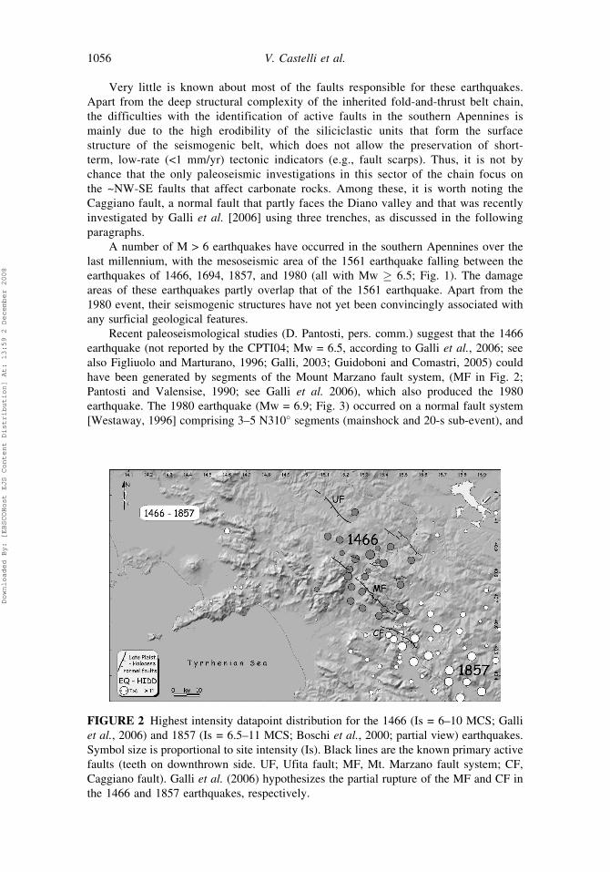
Very little is known about most of the faults responsible for these earthquakes.
Apart from the deep structural complexity of the inherited fold-and-thrust belt chain,
the difficulties with the identification of active faults in the southern Apennines is
mainly due to the high erodibility of the siliciclastic units that form the surface
structure of the seismogenic belt, which does not allow the preservation of short-
term, low-rate (<1 mm/yr) tectonic indicators (e.g., fault scarps). Thus, it is not by
chance that the only paleoseismic investigations in this sector of the chain focus on
the ~NW-SE faults that affect carbonate rocks. Among these, it is worth noting the
Caggiano fault, a normal fault that partly faces the Diano valley and that was recently
investigated by Galli et al. [2006] using three trenches, as discussed in the following
paragraphs.
A number of M > 6 earthquakes have occurred in the southern Apennines over the
last millennium, with the mesoseismic area of the 1561 earthquake falling between the
earthquakes of 1466, 1694, 1857, and 1980 (all with Mw � 6.5; Fig. 1). The damage
areas of these earthquakes partly overlap that of the 1561 earthquake. Apart from the
1980 event, their seismogenic structures have not yet been convincingly associated with
any surficial geological features.
Recent paleoseismological studies (D. Pantosti, pers. comm.) suggest that the 1466
earthquake (not reported by the CPTI04; Mw = 6.5, according to Galli et al., 2006; see
also Figliuolo and Marturano, 1996; Galli, 2003; Guidoboni and Comastri, 2005) could
have been generated by segments of the Mount Marzano fault system, (MF in Fig. 2;
Pantosti and Valensise, 1990; see Galli et al. 2006), which also produced the 1980
earthquake. The 1980 earthquake (Mw = 6.9; Fig. 3) occurred on a normal fault system
[Westaway, 1996] comprising 3–5 N310� segments (mainshock and 20-s sub-event), and
FIGURE 2 Highest intensity datapoint distribution for the 1466 (Is = 6–10 MCS; Galli
et al., 2006) and 1857 (Is = 6.5–11 MCS; Boschi et al., 2000; partial view) earthquakes.
Symbol size is proportional to site intensity (Is). Black lines are the known primary active
faults (teeth on downthrown side. UF, Ufita fault; MF, Mt. Marzano fault system; CF,
Caggiano fault). Galli et al. (2006) hypothesizes the partial rupture of the MF and CF in
the 1466 and 1857 earthquakes, respectively.
1056 V. Castelli et al.
Downloaded By: [EBSCOHost EJS Content Distribution] At: 13:59 2 December 2008
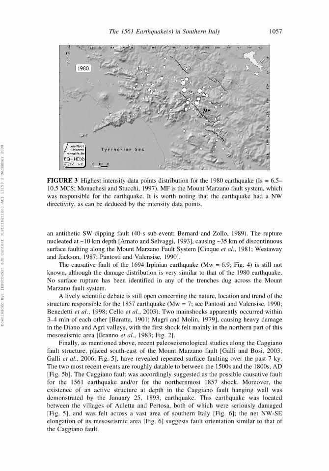
an antithetic SW-dipping fault (40-s sub-event; Bernard and Zollo, 1989). The rupture
nucleated at ~10 km depth [Amato and Selvaggi, 1993], causing ~35 km of discontinuous
surface faulting along the Mount Marzano Fault System [Cinque et al., 1981; Westaway
and Jackson, 1987; Pantosti and Valensise, 1990].
The causative fault of the 1694 Irpinian earthquake (Mw = 6.9; Fig. 4) is still not
known, although the damage distribution is very similar to that of the 1980 earthquake.
No surface rupture has been identified in any of the trenches dug across the Mount
Marzano fault system.
A lively scientific debate is still open concerning the nature, location and trend of the
structure responsible for the 1857 earthquake (Mw = 7; see Pantosti and Valensise, 1990;
Benedetti et al., 1998; Cello et al., 2003). Two mainshocks apparently occurred within
3–4 min of each other [Baratta, 1901; Magri and Molin, 1979], causing heavy damage
in the Diano and Agri valleys, with the first shock felt mainly in the northern part of this
mesoseismic area [Branno et al., 1983; Fig. 2].
Finally, as mentioned above, recent paleoseismological studies along the Caggiano
fault structure, placed south-east of the Mount Marzano fault [Galli and Bosi, 2003;
Galli et al., 2006; Fig. 5], have revealed repeated surface faulting over the past 7 ky.
The two most recent events are roughly datable to between the 1500s and the 1800s, AD
[Fig. 5b]. The Caggiano fault was accordingly suggested as the possible causative fault
for the 1561 earthquake and/or for the northernmost 1857 shock. Moreover, the
existence of an active structure at depth in the Caggiano fault hanging wall was
demonstrated by the January 25, 1893, earthquake. This earthquake was located
between the villages of Auletta and Pertosa, both of which were seriously damaged
[Fig. 5], and was felt across a vast area of southern Italy [Fig. 6]; the net NW-SE
elongation of its mesoseismic area [Fig. 6] suggests fault orientation similar to that of
the Caggiano fault.
FIGURE 3 Highest intensity data points distribution for the 1980 earthquake (Is = 6.5–
10.5 MCS; Monachesi and Stucchi, 1997). MF is the Mount Marzano fault system, which
was responsible for the earthquake. It is worth noting that the earthquake had a NW
directivity, as can be deduced by the intensity data points.
The 1561 Earthquake(s) in Southern Italy 1057
Downloaded By: [EBSCOHost EJS Content Distribution] At: 13:59 2 December 2008
3. Why Does Pacca’s Description of the 1561 Earthquake Puzzle Us?
The current view concerning the 1561 earthquake is that there were two primary shocks,
on July 31 and August 19 (see Boschi et al., 2000; the CPTI04 lists only the latter, being a
de-clustered catalog). The July 31 event has a very poorly constrained macroseismic
field, with heavy damage to the town of Buccino and no specific effects documented
elsewhere, although it is said to have affected a large area. The macroseismic field of the
August 19th event is better constrained: the highest intensity values occurred in the Diano
valley, with severe damage reported in several sites of the Basilicata region and around
(but not ‘‘in’’) Buccino (Fig. 7).
The August 19th dataset has been the basis for the assignment of the epicenter of this
earthquake to the Diano valley (near Polla). This dataset, as with most of the 1561
historical dataset, was derived from a single source or rather from two different descrip-
tions by a single author (Pacca, 1563; Pacca, 16th century). In this case ‘‘most’’ means 28
out of a total of 32 intensity data points (IDP) provided by the CFTI studies [Boschi et al.,
1995, 1997, 2000], and 28 out of a total of 30 IDP provided by Monachesi and Stucchi
[1997; i.e., the macroseismic database for the NT4.1 catalog].
Pacca (b. 1534, d. 1587) was a Neapolitan writer and academician [Morelli, 1993;
Castelli, 2003]. His first, succinct description of the 1561 earthquake is included in a
narrative of occurrences in the Kingdom of Naples over the years 1557–1562, first
published in 1563 as an addition to a multi-authored Istoria del Regno di Napoli
(Pacca, 1563). The Istoria’s original author was Pandolfo Collenuccio (d. 1504), but
the work was later extended to 1586 through successive additions by Mambrino Roseo
(d. 1584), Pacca himself, and Tommaso Costo (d. 1613). Owing to the vagaries of printers,
Pacca’s name does not appear in the main frontispiece of any of the several extant printings
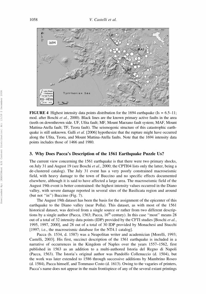
FIGURE 4 Highest intensity data points distribution for the 1694 earthquake (Is = 6.5–11;
mod. after Boschi et al., 2000). Black lines are the known primary active faults in the area
(teeth on downthrown side. UF, Ufita fault; MF, Mount Marzano fault system; MAF, Mount
Mattina-Atella fault; TF, Teora fault). The seismogenic structure of this catastrophic earth-
quake is still unknown. Galli et al. [2006] hypothesize that the rupture might have occurred
along the Ufita, Teora, and Mount Mattina-Atella faults. Note that the 1694 intensity data
points includes those of 1466 and 1980.
1058 V. Castelli et al.
Downloaded By: [EBSCOHost EJS Content Distribution] At: 13:59 2 December 2008

of the Istoria, but only in an easy-to-miss internal ‘‘sub-frontispiece.’’ However, Pacca’s
part-authorship of the Istoria is reliably attested by later bibliographers [Soria, 1781;
Minieri Riccio, 1844]. Pacca also left a longer description of the 1561 earthquake in his
Discorso del terremoto (Pacca, 16th century), an unpublished treatise on which he worked
probably to the end of his life. Giuseppe Mercalli brought it to light in 1891 when he
published a selection of its descriptions of 16th century earthquakes [Mercalli, 1891].
Pacca’s ‘‘short’’ description of the 1561 earthquake was written no later than 1563
(the year it was published), and possibly earlier, perhaps as early as late 1561. The
‘‘long’’ description is more detailed than the ‘‘short’’ one; this could mean that it relied on
more extensive research and/or that it was written later, but no more precise dating is
possible. What really matters, however, is that the ‘‘short’’ and ‘‘long’’ descriptions give
rather different versions of the July 31 and August 19 events (Fig. 8), and we cannot
know why Pacca altered his first version, and whether or not the latter should be
considered more reliable than the former. The above-mentioned previous studies, which
were both of a preliminary nature and part of a large-scale reviewing project, exploited as
best they could the richest source readily available; considering these circumstances, a
reasonable approach. Here, however, we focus on an in-depth investigation of the 1561
FIGURE 5 Shaded relief image of the northern Maddalena mountains, facing the Vallo
di Diano. MSGF is the post-last-glacial-maximum Mount San Giacomo fault (arrows
indicate bedrock fault scarp in inset A), which continues SW with the Timpe fault (TF).
According to paleoseismological analyses (i.e., inset B; from Galli et al., 2006), the
last ruptures of this fault system (E4 and E5) occurred during/ after the Little Ice Age
(1200–1800 AD), being consistent with both the 1561 and 1857 fault ruptures.
The 1561 Earthquake(s) in Southern Italy 1059
Downloaded By: [EBSCOHost EJS Content Distribution] At: 13:59 2 December 2008
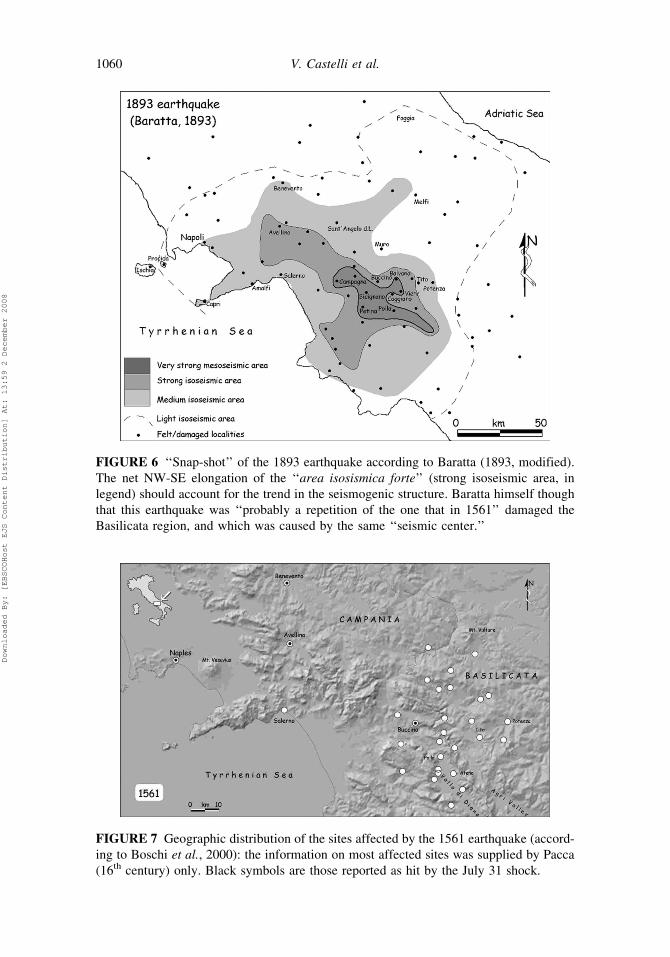
FIGURE 6 ‘‘Snap-shot’’ of the 1893 earthquake according to Baratta (1893, modified).
The net NW-SE elongation of the ‘‘area isosismica forte’’ (strong isoseismic area, in
legend) should account for the trend in the seismogenic structure. Baratta himself though
that this earthquake was ‘‘probably a repetition of the one that in 1561’’ damaged the
Basilicata region, and which was caused by the same ‘‘seismic center.’’
FIGURE 7 Geographic distribution of the sites affected by the 1561 earthquake (accord-
ing to Boschi et al., 2000): the information on most affected sites was supplied by Pacca
(16th century) only. Black symbols are those reported as hit by the July 31 shock.
1060 V. Castelli et al.
Downloaded By: [EBSCOHost EJS Content Distribution] At: 13:59 2 December 2008
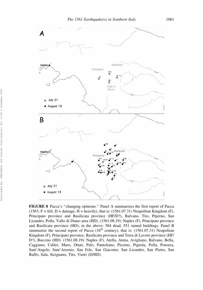
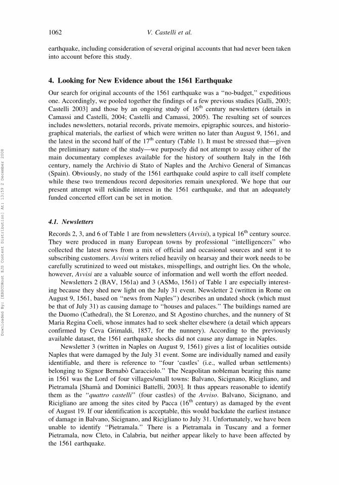
FIGURE 8 Pacca’s ‘‘changing opinions.’’ Panel A summarizes the first report of Pacca
(1563; F = felt, D = damage, H = heavily), that is: (1561.07.31) Neapolitan Kingdom (F),
Principato province and Basilicata province (HF/D?), Balvano, Tito, Piperno, San
Licandro, Polla, Vallo di Diano area (HD). (1561.08.19): Naples (F), Principato province
and Basilicata province (HD); in the above: 584 dead, 551 ruined buildings. Panel B
summarize the second report of Pacca (16th century), that is: (1561.07.31) Neapolitan
Kingdom (F), Principato province, Basilicata province and Terra di Lavoro province (HF/
D?), Buccino (HD). (1561.08.19): Naples (F), Atella, Atena, Avigliano, Balvano, Bella,
Caggiano, Calitri, Muro, Ottati, Palo, Pantoliano, Picerno, Pignola, Polla, Potenza,
Sant’Angelo, Sant’Arsenio, San Fele, San Giacomo, San Licandro, San Pietro, San
Ruffo, Sala, Sicignano, Tito, Vietri (D/HD).
The 1561 Earthquake(s) in Southern Italy 1061
Downloaded By: [EBSCOHost EJS Content Distribution] At: 13:59 2 December 2008
earthquake, including consideration of several original accounts that had never been taken
into account before this study.
4. Looking for New Evidence about the 1561 Earthquake
Our search for original accounts of the 1561 earthquake was a ‘‘no-budget,’’ expeditious
one. Accordingly, we pooled together the findings of a few previous studies [Galli, 2003;
Castelli 2003] and those by an ongoing study of 16th century newsletters (details in
Camassi and Castelli, 2004; Castelli and Camassi, 2005). The resulting set of sources
includes newsletters, notarial records, private memoirs, epigraphic sources, and historio-
graphical materials, the earliest of which were written no later than August 9, 1561, and
the latest in the second half of the 17th century (Table 1). It must be stressed that—given
the preliminary nature of the study—we purposely did not attempt to assay either of the
main documentary complexes available for the history of southern Italy in the 16th
century, namely the Archivio di Stato of Naples and the Archivo General of Simancas
(Spain). Obviously, no study of the 1561 earthquake could aspire to call itself complete
while these two tremendous record depositories remain unexplored. We hope that our
present attempt will rekindle interest in the 1561 earthquake, and that an adequately
funded concerted effort can be set in motion.
4.1. Newsletters
Records 2, 3, and 6 of Table 1 are from newsletters (Avvisi), a typical 16th century source.
They were produced in many European towns by professional ‘‘intelligencers’’ who
collected the latest news from a mix of official and occasional sources and sent it to
subscribing customers. Avvisi writers relied heavily on hearsay and their work needs to be
carefully scrutinized to weed out mistakes, misspellings, and outright lies. On the whole,
however, Avvisi are a valuable source of information and well worth the effort needed.
Newsletters 2 (BAV, 1561a) and 3 (ASMo, 1561) of Table 1 are especially interest-
ing because they shed new light on the July 31 event. Newsletter 2 (written in Rome on
August 9, 1561, based on ‘‘news from Naples’’) describes an undated shock (which must
be that of July 31) as causing damage to ‘‘houses and palaces.’’ The buildings named are
the Duomo (Cathedral), the St Lorenzo, and St Agostino churches, and the nunnery of St
Maria Regina Coeli, whose inmates had to seek shelter elsewhere (a detail which appears
confirmed by Ceva Grimaldi, 1857, for the nunnery). According to the previously
available dataset, the 1561 earthquake shocks did not cause any damage in Naples.
Newsletter 3 (written in Naples on August 9, 1561) gives a list of localities outside
Naples that were damaged by the July 31 event. Some are individually named and easily
identifiable, and there is reference to ‘‘four ‘castles’ (i.e., walled urban settlements)
belonging to Signor Bernabo Caracciolo.’’ The Neapolitan nobleman bearing this name
in 1561 was the Lord of four villages/small towns: Balvano, Sicignano, Ricigliano, and
Pietramala [Shama and Dominici Battelli, 2003]. It thus appears reasonable to identify
them as the ‘‘quattro castelli’’ (four castles) of the Avviso. Balvano, Sicignano, and
Ricigliano are among the sites cited by Pacca (16th century) as damaged by the event
of August 19. If our identification is acceptable, this would backdate the earliest instance
of damage in Balvano, Sicignano, and Ricigliano to July 31. Unfortunately, we have been
unable to identify ‘‘Pietramala.’’ There is a Pietramala in Tuscany and a former
Pietramala, now Cleto, in Calabria, but neither appear likely to have been affected by
the 1561 earthquake.
1062 V. Castelli et al.
Downloaded By: [EBSCOHost EJS Content Distribution] At: 13:59 2 December 2008
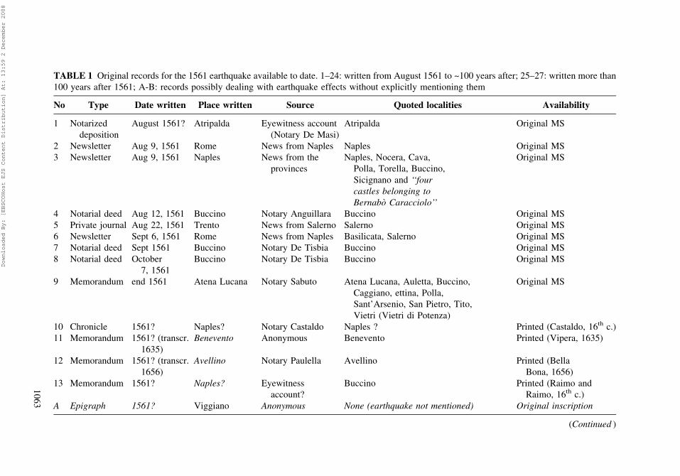
TABLE 1 Original records for the 1561 earthquake available to date. 1–24: written from August 1561 to ~100 years after; 25–27: written more than
100 years after 1561; A-B: records possibly dealing with earthquake effects without explicitly mentioning them
No Type Date written Place written Source Quoted localities Availability
1 Notarized
deposition
August 1561? Atripalda Eyewitness account
(Notary De Masi)
Atripalda Original MS
2 Newsletter Aug 9, 1561 Rome News from Naples Naples Original MS
3 Newsletter Aug 9, 1561 Naples News from the
provinces
Naples, Nocera, Cava,
Polla, Torella, Buccino,
Sicignano and ‘‘four
castles belonging to
Bernabo Caracciolo’’
Original MS
4 Notarial deed Aug 12, 1561 Buccino Notary Anguillara Buccino Original MS
5 Private journal Aug 22, 1561 Trento News from Salerno Salerno Original MS
6 Newsletter Sept 6, 1561 Rome News from Naples Basilicata, Salerno Original MS
7 Notarial deed Sept 1561 Buccino Notary De Tisbia Buccino Original MS
8 Notarial deed October
7, 1561
Buccino Notary De Tisbia Buccino Original MS
9 Memorandum end 1561 Atena Lucana Notary Sabuto Atena Lucana, Auletta, Buccino,
Caggiano, ettina, Polla,
Sant’Arsenio, San Pietro, Tito,
Vietri (Vietri di Potenza)
Original MS
10 Chronicle 1561? Naples? Notary Castaldo Naples ? Printed (Castaldo, 16th c.)
11 Memorandum 1561? (transcr.
1635)
Benevento Anonymous Benevento Printed (Vipera, 1635)
12 Memorandum 1561? (transcr.
1656)
Avellino Notary Paulella Avellino Printed (Bella
Bona, 1656)
13 Memorandum 1561? Naples? Eyewitness
account?
Buccino Printed (Raimo and
Raimo, 16th c.)
A Epigraph 1561? Viggiano Anonymous None (earthquake not mentioned) Original inscription
(Continued )
10
63
Downloaded By: [EBSCOHost EJS Content Distribution] At: 13:59 2 December 2008
TABLE 1 (Continued)
No Type Date written Place written Source Quoted localities Availability
14 Chronicle before 1563 Naples Pacca Balvano, Picerno, Polla,
San Licandro, Tito
Printed (Pacca, 1563)
15 Treatise before 1564 Solofra Maffei Solofra Printed (Maffei, 1564)
16 Treatise before 1574 Naples Pacca Atella, Atena Lucana, Avigliano,
Balvano, Bella, Caggiano,Calitri, Muro,
Naples, Ottati, Palo, Pantoliano, Picerno,
Pignola, Polla, Potenza, Sant’Angelo
de la Fratta, Sant’Arsenio, San Fele,
San Giacomo, San Licandro, San Pietro,
San Ruffo, Sala,Sicignano, Tito,
Vietri (Vietri sul Mare)
Original MS
Pacca (16th cent.)
17 Epigraph 1568 Tito Anonymous Tito Original
18 Epigraph
(fragm.)
before 1580 Sant’Angelo
dei Lombardi
Anonymous Sant’Angelo dei Lombardi Original
19 Chronicle ~1586 Atena Lucana Anonymous Atena Lucana Original MS
20 Chronicle ~1586 Auletta Anonymous Auletta Original MS
21 Chronicle ~1586 Buccino Bardario Buccino Original MS
22 Chronicle ~1586 Polla Anonymous Polla Original MS
23 Epigraph 1590 Polla Anonymous Polla Original
B Epigraph before 1599 Torrella dei
Lombardi
Anonymous None (earthquake not mentioned) Original
24 Epigraph before 1601 Sant’Angelo dei
Lombardi
Anonymous Sant’Angelo dei Lombardi Original
25 Chronicle before 1691 Conza Castellano Buccino, Santomenna Original MS
26 Epigraph 1779 Sant’Angelo dei
Lombardi
Anonymous Sant’Angelo dei Lombardi Original
27 Epigraph 1867 Buccino Anonymous Buccino Original
10
64
Downloaded By: [EBSCOHost EJS Content Distribution] At: 13:59 2 December 2008
Newsletter 6 (BAV, 1561b) was written in Rome on September 9, 1561, and
was based on ‘‘news from Naples.’’ This account simply states that ‘‘the earthquake
does not cease to cause ruins in Basilicata’’ (a probable reference to the August 19
event, that according to Pacca (16th century) damaged several localities in
Basilicata) and that ‘‘many houses collapsed in Salerno,’’ which is midway between
Naples and the Diano valley. Judging from the private journal of the Bishop of
Salerno, who in 1561 was away from his Diocese but did keep in regular touch, this
last piece of news could be exaggerated. The Bishop’s journal is discussed at more
length below.
4.2. Notarial Records
Italian notaries are officers who are authorized to perform legal formalities, such as
drawing up contracts and deeds, and certifying their correctness and conformity to law.
There are many situations in which notarial records can double up as accounts of
earthquakes: for instance, if a notary was called to prepare a contract concerning
business related to an earthquake, such as the restoration of a damaged building, or if
the notary used an earthquake as a chronological reference. Notaries also sometimes
chose to fill a blank space in their notebook with the account of an earthquake they had
personally witnessed or heard about. Table 1 includes examples of all of these
instances. Record 1 of Table 1 is an eyewitness notarized deposition that gave a
description of the July 31 event as it was felt by a group of people in the village square
in Atripalda (ASAv, 1561); records 4, 7, and 8 mention single damaged buildings in
Buccino (ASSa, 1561a-b); record 9 (ASSa, 1561c) is a memorandum that was probably
written towards the end of 1561, by a notary of Atena Lucana (Diano valley) who
described the earthquake sequence from its start on July 31, 1561, continuing to August
19, 1561 and on to the end of that year; this notary listed the localities damaged by the
July 31 event, adding that the August 19 event increased the damage to all of the
previously mentioned sites.
4.3. Private Memoirs and Historical Chronicles
The earliest available private account of the 1561 earthquake is an entry in the journal of
the Archbishop of Salerno (Seripando, 16th century). The Prelate was then in Trento
(northern Italy), attending the ongoing ecumenical Council, but he kept in regular touch
with the Salerno Diocese by post. On August 22, 1561, Archbishop Seripando recorded
having just received news of an earthquake that had been felt recently in Salerno (on an
unspecified day) and the collapse of a palace that occurred eight days later. The inland
distance between Trento and Salerno is about 1,000 km; so assuming a daily cover of
~100 km for a fast courier on horseback, it would have taken at least a dozen days for this
news to reach Trento. Therefore, the earthquake recorded in Seripando’s journal must be
either the July 31 event or another shock that occurred before August 19. A couple of
shocks were recorded as felt in Avellino at the beginning of August 1561 by Bella Bona
(1656), a local historian that extracted this detail from a notarial memorandum for which
the original is now lost. A few more felt accounts of the 1561 earthquake were almost
certainly written down by direct witnesses in Naples, Solofra, Benevento, and Avellino,
although their precise dates of compilation cannot be ascertained; these accounts were
included in books that were printed from a few years to a century after 1561 (Castaldo,
16th century, Maffei, 1564; Vipera, 1635).
The 1561 Earthquake(s) in Southern Italy 1065
Downloaded By: [EBSCOHost EJS Content Distribution] At: 13:59 2 December 2008
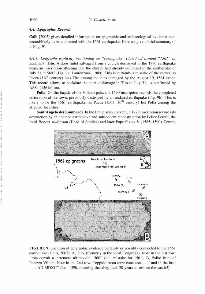
4.4. Epigraphic Records
Galli [2003] gives detailed information on epigraphic and archaeological evidence con-
nected/likely to be connected with the 1561 earthquake. Here we give a brief summary of
it (Fig. 9).
4.4.1. Epigraphs explicitly mentioning an ‘‘earthquake’’ (dated in/ around ‘‘1561’’ or
undated). Tito. A door lintel salvaged from a church destroyed in the 1980 earthquake
bears an inscription attesting that the church had already collapsed in the earthquake of
July 31 ‘‘1560’’ (Fig. 9a; Laurenzana, 1989). This is certainly a mistake of the carver, as
Pacca (16th century) lists Tito among the sites damaged by the August 19, 1561 event.
This record allows to backdate the start of damage in Tito to July 31, as confirmed by
ASSa (1561c) too.
Polla. On the facade of the Villano palace, a 1590 inscription records the completed
restoration of the town, previously destroyed by an undated earthquake (Fig. 9b). This is
likely to be the 1561 earthquake, as Pacca (1563; 16th century) list Polla among the
affected localities.
Sant’Angelo dei Lombardi. In the Franciscan convent, a 1779 inscription records its
destruction by an undated earthquake and subsequent reconstruction by Felice Peretti, the
local Regens studiorum (Head of Studies) and later Pope Sixtus V (1585–1590). Peretti,
FIGURE 9 Location of epigraphic evidence certainly or possibly connected to the 1561
earthquake (Galli, 2003). A, Tito, (formerly in the local Congrega). Note in the last row:
‘‘tota corruit a terremotu ultimo die 1560’’ (i.e., mistake for 1561). B, Polla; front of
Palazzo Villani. Note in the 2nd row: ‘‘oppido motu terre concusso . . .,’’ and in the last:
‘‘. . . AD MDXC’’ (i.e., 1590, meaning that they took 30 years to restore the castle!).
1066 V. Castelli et al.
Downloaded By: [EBSCOHost EJS Content Distribution] At: 13:59 2 December 2008
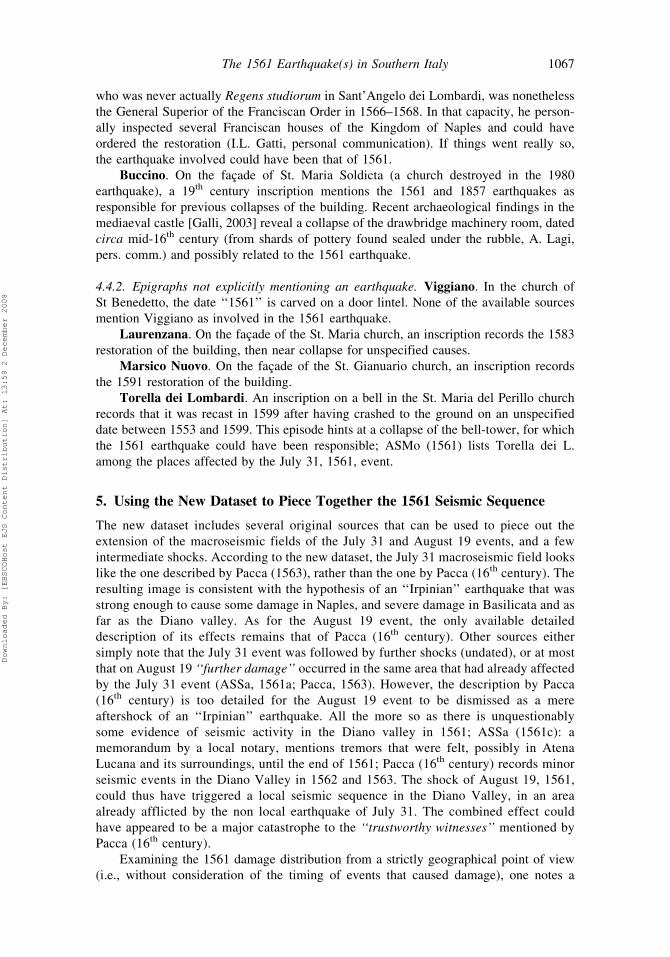
who was never actually Regens studiorum in Sant’Angelo dei Lombardi, was nonetheless
the General Superior of the Franciscan Order in 1566–1568. In that capacity, he person-
ally inspected several Franciscan houses of the Kingdom of Naples and could have
ordered the restoration (I.L. Gatti, personal communication). If things went really so,
the earthquake involved could have been that of 1561.
Buccino. On the facade of St. Maria Soldicta (a church destroyed in the 1980
earthquake), a 19th century inscription mentions the 1561 and 1857 earthquakes as
responsible for previous collapses of the building. Recent archaeological findings in the
mediaeval castle [Galli, 2003] reveal a collapse of the drawbridge machinery room, dated
circa mid-16th century (from shards of pottery found sealed under the rubble, A. Lagi,
pers. comm.) and possibly related to the 1561 earthquake.
4.4.2. Epigraphs not explicitly mentioning an earthquake. Viggiano. In the church of
St Benedetto, the date ‘‘1561’’ is carved on a door lintel. None of the available sources
mention Viggiano as involved in the 1561 earthquake.
Laurenzana. On the facade of the St. Maria church, an inscription records the 1583
restoration of the building, then near collapse for unspecified causes.
Marsico Nuovo. On the facade of the St. Gianuario church, an inscription records
the 1591 restoration of the building.
Torella dei Lombardi. An inscription on a bell in the St. Maria del Perillo church
records that it was recast in 1599 after having crashed to the ground on an unspecified
date between 1553 and 1599. This episode hints at a collapse of the bell-tower, for which
the 1561 earthquake could have been responsible; ASMo (1561) lists Torella dei L.
among the places affected by the July 31, 1561, event.
5. Using the New Dataset to Piece Together the 1561 Seismic Sequence
The new dataset includes several original sources that can be used to piece out the
extension of the macroseismic fields of the July 31 and August 19 events, and a few
intermediate shocks. According to the new dataset, the July 31 macroseismic field looks
like the one described by Pacca (1563), rather than the one by Pacca (16th century). The
resulting image is consistent with the hypothesis of an ‘‘Irpinian’’ earthquake that was
strong enough to cause some damage in Naples, and severe damage in Basilicata and as
far as the Diano valley. As for the August 19 event, the only available detailed
description of its effects remains that of Pacca (16th century). Other sources either
simply note that the July 31 event was followed by further shocks (undated), or at most
that on August 19 ‘‘further damage’’ occurred in the same area that had already affected
by the July 31 event (ASSa, 1561a; Pacca, 1563). However, the description by Pacca
(16th century) is too detailed for the August 19 event to be dismissed as a mere
aftershock of an ‘‘Irpinian’’ earthquake. All the more so as there is unquestionably
some evidence of seismic activity in the Diano valley in 1561; ASSa (1561c): a
memorandum by a local notary, mentions tremors that were felt, possibly in Atena
Lucana and its surroundings, until the end of 1561; Pacca (16th century) records minor
seismic events in the Diano Valley in 1562 and 1563. The shock of August 19, 1561,
could thus have triggered a local seismic sequence in the Diano Valley, in an area
already afflicted by the non local earthquake of July 31. The combined effect could
have appeared to be a major catastrophe to the ‘‘trustworthy witnesses’’ mentioned by
Pacca (16th century).
Examining the 1561 damage distribution from a strictly geographical point of view
(i.e., without consideration of the timing of events that caused damage), one notes a
The 1561 Earthquake(s) in Southern Italy 1067
Downloaded By: [EBSCOHost EJS Content Distribution] At: 13:59 2 December 2008
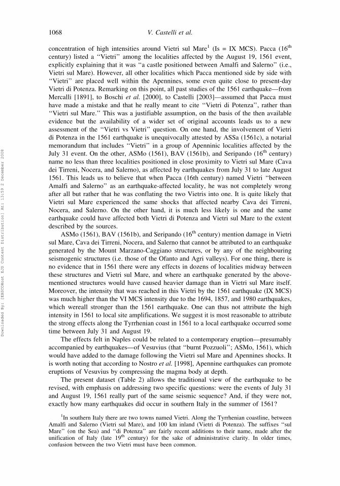
concentration of high intensities around Vietri sul Mare1 (Is = IX MCS). Pacca (16th
century) listed a ‘‘Vietri’’ among the localities affected by the August 19, 1561 event,
explicitly explaining that it was ‘‘a castle positioned between Amalfi and Salerno’’ (i.e.,
Vietri sul Mare). However, all other localities which Pacca mentioned side by side with
‘‘Vietri’’ are placed well within the Apennines, some even quite close to present-day
Vietri di Potenza. Remarking on this point, all past studies of the 1561 earthquake—from
Mercalli [1891], to Boschi et al. [2000], to Castelli [2003]—assumed that Pacca must
have made a mistake and that he really meant to cite ‘‘Vietri di Potenza’’, rather than
‘‘Vietri sul Mare.’’ This was a justifiable assumption, on the basis of the then available
evidence but the availability of a wider set of original accounts leads us to a new
assessment of the ‘‘Vietri vs Vietri’’ question. On one hand, the involvement of Vietri
di Potenza in the 1561 earthquake is unequivocally attested by ASSa (1561c), a notarial
memorandum that includes ‘‘Vietri’’ in a group of Apenninic localities affected by the
July 31 event. On the other, ASMo (1561), BAV (1561b), and Seripando (16th century)
name no less than three localities positioned in close proximity to Vietri sul Mare (Cava
dei Tirreni, Nocera, and Salerno), as affected by earthquakes from July 31 to late August
1561. This leads us to believe that when Pacca (16th century) named Vietri ‘‘between
Amalfi and Salerno’’ as an earthquake-affected locality, he was not completely wrong
after all but rather that he was conflating the two Vietris into one. It is quite likely that
Vietri sul Mare experienced the same shocks that affected nearby Cava dei Tirreni,
Nocera, and Salerno. On the other hand, it is much less likely is one and the same
earthquake could have affected both Vietri di Potenza and Vietri sul Mare to the extent
described by the sources.
ASMo (1561), BAV (1561b), and Seripando (16th century) mention damage in Vietri
sul Mare, Cava dei Tirreni, Nocera, and Salerno that cannot be attributed to an earthquake
generated by the Mount Marzano-Caggiano structures, or by any of the neighbouring
seismogenic structures (i.e. those of the Ofanto and Agri valleys). For one thing, there is
no evidence that in 1561 there were any effects in dozens of localities midway between
these structures and Vietri sul Mare, and where an earthquake generated by the above-
mentioned structures would have caused heavier damage than in Vietri sul Mare itself.
Moreover, the intensity that was reached in this Vietri by the 1561 earthquake (IX MCS)
was much higher than the VI MCS intensity due to the 1694, 1857, and 1980 earthquakes,
which wereall stronger than the 1561 earthquake. One can thus not attribute the high
intensity in 1561 to local site amplifications. We suggest it is most reasonable to attribute
the strong effects along the Tyrrhenian coast in 1561 to a local earthquake occurred some
time between July 31 and August 19.
The effects felt in Naples could be related to a contemporary eruption—presumably
accompanied by earthquakes—of Vesuvius (that ‘‘burnt Pozzuoli’’; ASMo, 1561), which
would have added to the damage following the Vietri sul Mare and Apennines shocks. It
is worth noting that according to Nostro et al. [1998], Apennine earthquakes can promote
eruptions of Vesuvius by compressing the magma body at depth.
The present dataset (Table 2) allows the traditional view of the earthquake to be
revised, with emphasis on addressing two specific questions: were the events of July 31
and August 19, 1561 really part of the same seismic sequence? And, if they were not,
exactly how many earthquakes did occur in southern Italy in the summer of 1561?
1In southern Italy there are two towns named Vietri. Along the Tyrrhenian coastline, betweenAmalfi and Salerno (Vietri sul Mare), and 100 km inland (Vietri di Potenza). The suffixes ‘‘sulMare’’ (on the Sea) and ‘‘di Potenza’’ are fairly recent additions to their name, made after theunification of Italy (late 19th century) for the sake of administrative clarity. In older times,confusion between the two Vietri must have been common.
1068 V. Castelli et al.
Downloaded By: [EBSCOHost EJS Content Distribution] At: 13:59 2 December 2008
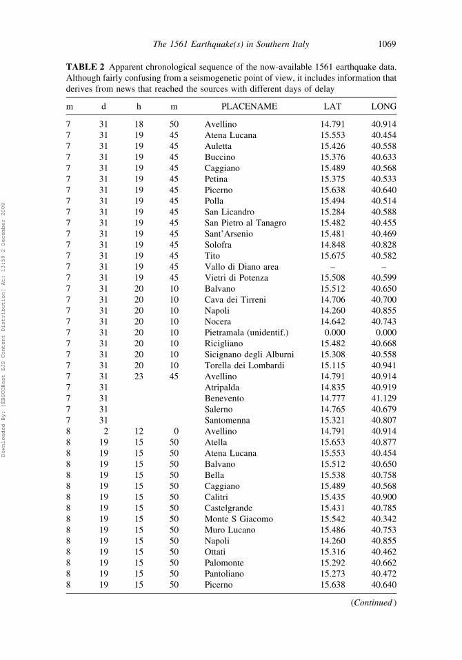
TABLE 2 Apparent chronological sequence of the now-available 1561 earthquake data.
Although fairly confusing from a seismogenetic point of view, it includes information that
derives from news that reached the sources with different days of delay
m d h m PLACENAME LAT LONG
7 31 18 50 Avellino 14.791 40.914
7 31 19 45 Atena Lucana 15.553 40.454
7 31 19 45 Auletta 15.426 40.558
7 31 19 45 Buccino 15.376 40.633
7 31 19 45 Caggiano 15.489 40.568
7 31 19 45 Petina 15.375 40.533
7 31 19 45 Picerno 15.638 40.640
7 31 19 45 Polla 15.494 40.514
7 31 19 45 San Licandro 15.284 40.588
7 31 19 45 San Pietro al Tanagro 15.482 40.455
7 31 19 45 Sant’Arsenio 15.481 40.469
7 31 19 45 Solofra 14.848 40.828
7 31 19 45 Tito 15.675 40.582
7 31 19 45 Vallo di Diano area – –
7 31 19 45 Vietri di Potenza 15.508 40.599
7 31 20 10 Balvano 15.512 40.650
7 31 20 10 Cava dei Tirreni 14.706 40.700
7 31 20 10 Napoli 14.260 40.855
7 31 20 10 Nocera 14.642 40.743
7 31 20 10 Pietramala (unidentif.) 0.000 0.000
7 31 20 10 Ricigliano 15.482 40.668
7 31 20 10 Sicignano degli Alburni 15.308 40.558
7 31 20 10 Torella dei Lombardi 15.115 40.941
7 31 23 45 Avellino 14.791 40.914
7 31 Atripalda 14.835 40.919
7 31 Benevento 14.777 41.129
7 31 Salerno 14.765 40.679
7 31 Santomenna 15.321 40.807
8 2 12 0 Avellino 14.791 40.914
8 19 15 50 Atella 15.653 40.877
8 19 15 50 Atena Lucana 15.553 40.454
8 19 15 50 Balvano 15.512 40.650
8 19 15 50 Bella 15.538 40.758
8 19 15 50 Caggiano 15.489 40.568
8 19 15 50 Calitri 15.435 40.900
8 19 15 50 Castelgrande 15.431 40.785
8 19 15 50 Monte S Giacomo 15.542 40.342
8 19 15 50 Muro Lucano 15.486 40.753
8 19 15 50 Napoli 14.260 40.855
8 19 15 50 Ottati 15.316 40.462
8 19 15 50 Palomonte 15.292 40.662
8 19 15 50 Pantoliano 15.273 40.472
8 19 15 50 Picerno 15.638 40.640
(Continued )
The 1561 Earthquake(s) in Southern Italy 1069
Downloaded By: [EBSCOHost EJS Content Distribution] At: 13:59 2 December 2008
6. Seismotectonic Hypothesis and Conclusions
If we accept that the anomalous far-field accounts of the 1561 earthquakes were caused
by independent events, we can focus on interpreting the remaining intensity values to
better understand the mainshocks of July 31 and August 19, 1561.
The combined damage distribution in 1561 is consistent with expectations for a
rupture of the Caggiano fault, with a rupture length of approximately 17 km and an Mw
of approximately 6.3 (Fig. 10.) The earliest Modern Age rupture on this fault identified
through paleoseismological studies by Galli et al. [2006; E4 in Fig. 5b] would correspond
to this event.
Rupture on the Caggiano fault would not, however, easily explain the heavy damage
observed at relatively large distances on the footwall (i.e., the Ofanto valley; see Torella
dei Lombardi, Sant’Angelo dei Lombardi, Santomenna) and in Muro Lucano and Atella
(Fig. 10). Conversely, although characterized by lower and sparse intensities, the cover-
age of effects in the Ofanto-Basilicata area roughly matches the mesoseismic region of
the 1466, 1694, and 1980 earthquakes (Figs. 2–4; northern ellipse in Fig. 10). Strong
damage in this area suggests a local mainshock, the seismogenic source of which would
be between the Marzano and Ufita faults. Indeed, the Irpinian seismogenic structures are
characterized by complex, still not completely understood fault systems, segments of
which may rupture either simultaneously or individually. For example, the 1980 sequence
included distinct sub-events occurring 20 and 40 s after the initial mainshock [Bernard
and Zollo, 1989; Galli et al., 2006].
Considering that for normal faults the Coulomb stress rises lateral to the fault tips
(see Nostro et al., 1997), and that dynamic shaking effects can also potentially cause
triggering (e.g., Gomberg and Bodin, 1994) the fault rupture on July 31 could have
‘‘loaded one of the nearby Ofanto structures, producing a complex sequence of events on
TABLE 2 (Continued)
m d h m PLACENAME LAT LONG
8 19 15 50 Pignola 15.786 40.573
8 19 15 50 Polla 15.494 40.514
8 19 15 50 Potenza 15.805 40.638
8 19 15 50 Ruoti 15.679 40.717
8 19 15 50 Sala Consilina 15.596 40.398
8 19 15 50 San Fele 15.541 40.819
8 19 15 50 San Licandro 15.284 40.588
8 19 15 50 San Pietro al Tanagro 15.482 40.455
8 19 15 50 San Rufo 15.464 40.434
8 19 15 50 Sant’Angelo Le Fratte 15.558 40.545
8 19 15 50 Sant’Arsenio 15.481 40.469
8 19 15 50 Sicignano degli Alburni 15.308 40.558
8 19 15 50 Tito 15.675 40.582
8 19 15 50 Vietri sul Mare 14.729 40.670
8 19 Auletta 15.426 40.558
8 19 Buccino 15.376 40.633
8 19 Petina 15.375 40.533
8 19 Vietri di Potenza 15.508 40.599
1070 V. Castelli et al.
Downloaded By: [EBSCOHost EJS Content Distribution] At: 13:59 2 December 2008
adjacent fault structures.’’ Many such sequences have occurred in the Apennines, from
Calabria to the Umbria-Marches, including the 1703, central Italy sequence [Galli et al.,
2005] and the 1783 Calabrian sequence [Jacques et al., 2001; Galli and Bosi, 2002].
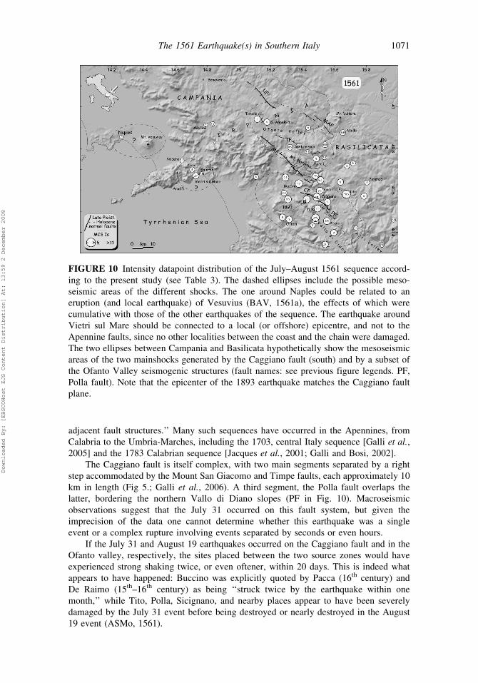
The Caggiano fault is itself complex, with two main segments separated by a right
step accommodated by the Mount San Giacomo and Timpe faults, each approximately 10
km in length (Fig 5.; Galli et al., 2006). A third segment, the Polla fault overlaps the
latter, bordering the northern Vallo di Diano slopes (PF in Fig. 10). Macroseismic
observations suggest that the July 31 occurred on this fault system, but given the
imprecision of the data one cannot determine whether this earthquake was a single
event or a complex rupture involving events separated by seconds or even hours.
If the July 31 and August 19 earthquakes occurred on the Caggiano fault and in the
Ofanto valley, respectively, the sites placed between the two source zones would have
experienced strong shaking twice, or even oftener, within 20 days. This is indeed what
appears to have happened: Buccino was explicitly quoted by Pacca (16th century) and
De Raimo (15th–16th century) as being ‘‘struck twice by the earthquake within one
month,’’ while Tito, Polla, Sicignano, and nearby places appear to have been severely
damaged by the July 31 event before being destroyed or nearly destroyed in the August
19 event (ASMo, 1561).
FIGURE 10 Intensity datapoint distribution of the July–August 1561 sequence accord-
ing to the present study (see Table 3). The dashed ellipses include the possible meso-
seismic areas of the different shocks. The one around Naples could be related to an
eruption (and local earthquake) of Vesuvius (BAV, 1561a), the effects of which were
cumulative with those of the other earthquakes of the sequence. The earthquake around
Vietri sul Mare should be connected to a local (or offshore) epicentre, and not to the
Apennine faults, since no other localities between the coast and the chain were damaged.
The two ellipses between Campania and Basilicata hypothetically show the mesoseismic
areas of the two mainshocks generated by the Caggiano fault (south) and by a subset of
the Ofanto Valley seismogenic structures (fault names: see previous figure legends. PF,
Polla fault). Note that the epicenter of the 1893 earthquake matches the Caggiano fault
plane.
The 1561 Earthquake(s) in Southern Italy 1071
Downloaded By: [EBSCOHost EJS Content Distribution] At: 13:59 2 December 2008
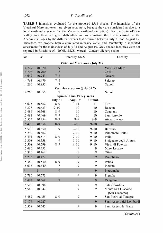
TABLE 3 Intensities evaluated for the proposed 1561 shocks. The intensities of the
Vietri sul Mare sub-event are given separately, because they are considered as due to a
local earthquake (same for the Vesuvius earthquake/eruption). For the Irpinia-Diano
Valley area there are great difficulties in discriminating the effects caused on the
Apennine villages by the different events that occurred between July 31 and August 19.
Therefore, we propose both a cumulated intensity value, and, tentatively, a separated
assessment for the mainshocks of July 31 and August 19. Grey-shaded localities were not
reported in Boschi et al. [2000]. (MCS, Mercalli-Cancani-Sieberg scale)
lon lat Intensity MCS Locality
Vietri sul Mare area (July 31)
14.729 40.670 9 Vietri sul Mare
14.706 40.700 8 Cava
14.642 40.743 7–8 Nocera
14.765 40.679 7–8 Salerno
14.260 40.855 7 Napoli
Vesuvius eruption (July 31 ?)14.260 40.855 7 Napoli
Irpinia-Diano Valley areas
July 31 Aug. 19 Cumul.
15.675 40.582 8–9 10–11 11 Tito
15.376 40.633 9–10 10 10 Buccino
15.489 40.568 8–9 10 10 Caggiano
15.481 40.469 8–9 10 10 Sant’Arsenio
15.553 40.454 8–9 8–9 8–9 Atena Lucana
15.426 40.558 8–9 9–10 9–10 Auletta
15.512 40.650 9 9–10 9–10 Balvano
15.292 40.662 9–10 9–10 Palomonte [Palo]
15.494 40.514 8–9 9–10 9–10 Polla
15.308 40.558 9 9–10 9–10 Sicignano degli Alburni
15.508 40.599 8–9 9–10 9–10 Vietri di Potenza
15.486 40.752 9 9 Muro Lucano
15.316 40.462 9 9 Ottati
15.273 40.472 9 9 Pantoliano
15.380 40.530 8–9 9 9 Petina
15.638 40.640 7 9 9 Picerno
? ? 9 9 Pietramala
15.786 40.573 9 9 Pignola
15.482 40.668 9 9 Ricigliano
15.596 40.398 9 9 Sala Consilina
15.542 40.342 9 9 Monte San Giacomo
[San Giacomo]
15.482 40.455 8–9 9 9 San Pietro al Tanagro
15.176 40.927 9 Sant’Angelo dei Lombardi
15.558 40.545 9 9 Sant’Angelo le Fratte
(Continued )
1072 V. Castelli et al.
Downloaded By: [EBSCOHost EJS Content Distribution] At: 13:59 2 December 2008
Considering all the remaining questions regarding this complex sequence, and with
the exception of a local triggered Vietri sul Mare event, one cannot identify detailed
source zones for all of the principal events of the 1561 sequence, or even be sure how
many distinct ruptures occurred. The newly considered historical sources do, however,
further elucidate the seismotectonics and earthquake history of this part of the Apennines.
The combined synthesis of archival and field data is, we suggests, the most powerful tool
to understand past and potential future earthquake sources.
Acknowledgments
The staff of Archivio Segreto Vaticano, Archivio di Stato of Modena, Archivio di Stato of
Salerno (particularly Franco Manzione) and Biblioteca Apostolica Vaticana, and Fr
Fernando Rojo, OSA, of the Augustinian General Archives in Rome were very helpful
to us. Fr Isidoro L. Gatti, OFMConv, and Franco Emidi (Centro di Studi Sistini, Montalto
delle Marche, Italy) reconstructed a minor episode in the early career of Sixtus V on our
behalf. Adele Lagi (Superintendent of Salerno) kindly explained her archaeological
excavation in Buccino to us. Russell Robinson (Institute of Geology and Nuclear
Sciences of New Zealand) provided us with the GNStress2.16 program. Finally, we
thank all reviewers of this work for their thoughtful comments.
TABLE 3 (Continued )
lon lat Intensity MCS Locality
15.115 40.941 9 9 Torella dei Lombardi
15.653 40.877 8–9 8–9 Atella
15.541 40.819 8–9 8–9 San Fele
15.284 40.588 7–8 8–9 8–9 San Licandro
15.321 40.807 8–9 8–9 Santomenna
15.717 40.730 8 8 Avigliano
15.435 40.900 8 8 Calitri
15.107 40.665 8 Campagna
15.805 40.638 8 8 Potenza
15.679 40.717 8 8 Ruoti
15.464 40.434 8 8 San Rufo
14.835 40.919 7–8 7–8 Atripalda
15.538 40.758 7–8 7–8 Bella
15.431 40.785 7–8 7–8 Castelgrande
15.971 40.459 7–8 Laurenzana
15.735 40.421 7–8 Marsico Nuovo
15.899 40.339 7–8 Viggiano
14.791 40.914 7 7 Avellino
14.260 40.855 5 5 Napoli
14.848 40.828 5–6 5–6 Solofra
14.777 41.129 5 5 Benevento
The 1561 Earthquake(s) in Southern Italy 1073
Downloaded By: [EBSCOHost EJS Content Distribution] At: 13:59 2 December 2008
References
Primary Sources
1561 a) ASAv [Archivio di Stato, Avellino], Notai, Atripalda, Notary Pietro
Antonio De Masi, B 296, folios not numbered.
b) ASMo [Archivio di Stato, Modena], 1561, Archivio segreto Estense,
Cancelleria, Estero, Avvisi e notizie dall’estero, Rome, August 9, 1561.
c) ASSa [Archivio di Stato, Salerno], 1561a, Protocolli notarili Salerno,
Notary Tommaso Anguillara, B 588, f. 254.
d) ASSa, Protocolli notarili Salerno, Notary Antonio de Tisbia, B 580, f.
66–69.
e) ASSa,Protocolli notarili Salerno, Notary Donato Sabuco, B 7/1, folios not
numbered.
f) BAV [Biblioteca Apostolica Vaticana], 1561a, MS Urb. Lat 1039,
Naples, August 9, 1561, f. 294r.
g) BAV, 1561b, MS Urb. Lat 1039, Naples, 6 September 1561, folios not
numbered.
Seripando, G., 16th century, Giornale dal 1513 al 1562, MS IX.C.42: Biblio-
teca Nazionale ‘‘Vittorio Emanuele III’’, Napoli, Italy.
1563 Pacca, C. [1563] Della seconda parte del compendio dell’istoria del Regno
di Napoli, il Settimo libro del Dottor Colanello Pacca Napoletano. In: P.
Collenuccio et al., Compendio dell’historia del regno di Napoli di m[esser]
Pandolfo Collenucio da Pesaro con la giunta delle cose notabili successe per
tutto l’anno MDLXII: Napoli, Gio[vanni] Maria Scotto.
1564 Maffei, G. C. [1564] Scala naturale overo Fantasia dolcissima di Gio[van]
Camillo Maffei da Solofra, intorno alle cose occulte, e desiderate nella
filosofia: Venetia, Gio[vanni] Varisco e Compagni.
16thcent. Castaldo, A., 16th century, Dell’istoria di notar Antonino Castaldo, in
Gravier, G., ed., Raccolta di tutti i piu rinomati scrittori dell’istoria gen-
erale del Regno di Napoli, v. 6: Napoli, Gravier, 1769–1777.
Pacca, N. A., 16th century, Discorso del terremoto, MS 7/A3: Societa
Napoletana di Storia Patria, Fondo sismico, Napoli, Italy.
Raimo, L.Sr., and Raimo, L. Jr., Annales de Raimo sive Brevis historia
rerum in regno Neapolitano gestarum (1197–1486), in L.A. Muratori,
ed., Rerum Italicarum Scriptores, v. 23: Milano, Societas Palatina,
1733.
1635 Vipera, M. [1635]. Chronologia Episcoporum, et Archiepiscoporum Metro-
politanae Ecclesiae Beneventanae quorum extat memoriae: Napoli, D.
Montanari.
1656 Bella Bona, S. [1656] Raguagli della citta d’Avellino: Trani, Lorenzo
Valerij.
General
Amato, A. and Selvaggi, G. [1993] ‘‘Aftershock location and P-velocity structure in the epicentral
region of the 1980 Irpinia earthquake’’, Annali di Geofisica 36, 3–15.
Baratta, M. [1893] ‘‘Sul terremoto Lucano del 25 gennaio 1893’’ Annali dell’Ufficio Centrale di
Meteorologia e Geodinamica, 14(1), 47–56.
1074 V. Castelli et al.
Downloaded By: [EBSCOHost EJS Content Distribution] At: 13:59 2 December 2008
Baratta, M. [1901] I terremoti d’Italia, Saggio di storia, geografia e bibliografia sismica italiana,
Torino, Fratelli Bocca Ed., 950 pp.
Benedetti, L., Tapponier, P., King, G., and Piccardi, L. [1998] ‘‘Surface rupture of the 1857
southern Italian earthquake,’’ Terra Nova 10, 206–210.
Bernard, P. and Zollo, A. [1989] ‘‘The Irpinia, Italy, 1980 earthquake, detailed analysis of a
complex normal faulting,’’ Journal of Geophysical Research 94, 1631–1647.
Boschi, E., Pantosti, D., Slejko, D., Stucchi, M., and Valensise, G., Eds. [1993] ‘‘Irpinia dieci anni
dopo.’’ Special Issue Annali di Geofisica 36, 1–351.
Boschi, E., Ferrari, G., Gasperini, P., Guidoboni, E., Smriglio, G., and Valensise, G., Eds. [1995]
Catalogo dei forti terremoti in Italia dal 461 a.C. al 1980, Bologna, ING-SGA, 970 pp.
Boschi, E., Guidoboni, E., Ferrari, G., Valensise, G., and Gasperini, P., Eds. [1997] Catalogo dei
forti terremoti in Italia dal 461 a.C. al 1990, Bologna, ING-SGA, 644 pp.
Boschi, E., Guidoboni, E., Ferrari, G., Mariotti, D., Valensise, G., and Gasperini, P., Eds. [2000]
‘‘Catalogue of Strong Italian Earthquakes from 461 B.C. to 1997. Version 3 of the Catalogo dei
forti terremoti in Italia,’’ Annals of Geophysics 43, 609–868.
Branno, A., Esposito, E., Marturano, A., Porfido, S., and Rinaldis, [1983] ‘‘Studio su base
macrosismica del terremoto della Basilicata del 16 dicembre 1857,’’ Bollettino della Societa
Naturalistica di Napoli 92, 249–338.
Camassi, R., and Castelli, V. [2004] ‘‘Looking for ‘‘new’’ earthquake data in the 17th-18th c.
European ‘‘newssellers’’ network,’’ Journal of Earthquake Engineering 8, 335–359.
Camassi, R. and Stucchi, M., Eds. [1997] NT4.1- a parametric catalogue of damaging earthquakes
in the Italian area (release NT4.1.1), GNDT-CNR open file report, Milano, 93 pp. available also
on internet at http://emidius.mi.ingv.it/NT/CONSNT.html.
Castelli, V. [2003] ‘‘Strong earthquakes included ‘‘by chance’’ in Italian catalogues, single cases or
a hint of more?’’ Annals of Geophysics 46, 1247–1263.
Castelli, V. and Camassi, R. [2005] ‘‘The shadow-zone of major Italian seismicity. Notes on the
perception of lesser damaging earthquakes by 17th-18th c. journalistic sources,’’ Journal of
Earthquake Engineering 9, 333–348.
Cello, G., Tondi, E., Micarelli, L., and Mattioni, L. [2003] ‘‘Active tectonics and earthquake
sources in the epicentral area of the 1857 Basilicata earthquake, (southern Italy),’’ Journal of
Geodynamics 36, 37–50.
Ceva Grimaldi, F. [1857] Della fondazione della citta di Napoli dal tempo della sua fondazione sino
al presente,memorie storiche, Napoli, stamperia e calcografia Vico Freddo a Pignasecca 15,
lxviii+806 pp.
Cinque, A., Lambiase, S., and Sgrosso, I. [1981] ‘‘Su due faglie nell’alta valle del Sele legate al
terremoto del 23.11.1981,’’ Rendiconti della Societa Geologica 4, 127–129.
Cinque A., Patacca E., Scandone P., and Tozzi M. [1993] ‘‘Quaternary kinematic evolution of the
Southern Apennenes. Relationships between surface geological features and deep lithospheric
structures,’’ Annali di Geofisica 36, 249–260.
CPTI Working Group [1999] Catalogo Parametrico dei Terremoti Italiani, Bologna, ING - GNDT -
SGA - SSN, 92 pp.
CPTI Working Group [2004] Catalogo Parametrico dei Terremoti Italiani (versione 2004, CPTI04),
Internet website INGV Sezione di Milano, http://emidius.mi.ingv.it/CPTI/ (last revision 27 May 2004)
Ferrari, G., Ed. [2004] Viaggio nelle aree del terremoto del 16 dicembre 1857, SGA, Bologna, vol.
I, 500 pp; vol. II 516 pp.
Figliuolo, B. and Marturano, A. [1996] ‘‘Il terremoto del 1466,’’ Rassegna Storica Salernitana 25, 93–109.
Galli, P. [2003] ‘‘Two poorly known earthquakes of southern Campania,’’ Dipartimento della
Protezione Civile-Servizio Sismico Italiano, RT/SSN/03/01, 1–22.
Galli, P. and Bosi, V. [2002] ‘‘Paleoseismology along the Cittanova fault. Implications for
seismotectonics and earthquake recurrence in Calabria (southern Italy),’’ Journal of
Geophysies Research 107, B3, 10.1029/2001JB000234, 1/1–19.
Galli, P. and Bosi, V. [2003] ‘‘Analisi paleosismologiche lungo la faglia di Caggiano, Monti della
Maddalena, Sa,’’ Riassunti estesi delle comunicazioni, Convegno Nazionale Gruppo Nazionale
di Geofisica della Terra Solida, 22, 106–108.
The 1561 Earthquake(s) in Southern Italy 1075
Downloaded By: [EBSCOHost EJS Content Distribution] At: 13:59 2 December 2008
Galli, P., Bosi, V, Piscitelli, S., Giocoli A., and Scionti V. [2006] ‘‘Late Holocene earthquakes in
southern Apennines: paleoseismology of the Caggiano fault,’’ International Journal of Earth
Science (Geol. Rundsch.), DOI 10.1007/s00531–005–0066–2, 95, 855–870.
Galli, P. and Galadini, F. [2003] ‘‘Disruptive earthquakes revealed by faulted archaeological relics in
Samnium, Molise (southern Italy),’’ Geophysical Research Letters 30, 10.1029/2002GL016456,
70/1–4.
Galli, P., Galadini F., and Calzoni F. [2005] ‘‘Surface faulting in Norcia (central Italy): a
‘‘paleoseismological perspective,’’ Tectonophysics 403, 117–130.
Gasperini, P. [2002] ‘‘The Boxer program,’’ Release 3.02 available at: http://ibogfs.df.unibo.it/
user2/paolo/www/boxer/boxer.html.
Bodin, P. and Gomberg, J. [2004] ‘‘Triggered Seismicity and Deformation between the Landers,
California, and Little Skull Mountain, Nevada, Earthquakes,’’ Bulletino of the Seismological
Society of America 84, 835–843.
Guidoboni, E. and Comastri, A. [2005] ‘‘Catalogue of earthquake and tsunamis in the
Mediterranean area from the 11th to the 15th century,’’ Istituto Nazionale di Geofisica e
Vulcanologia, Rome-Bologna, 1037 pp.
Jacques, E., Monaco, C., Tapponnier, P., Tortorici, T., and Winter, T. [2001] ‘‘Faulting and
earthquake triggering during the 1783 Calabria seismic sequence,’’ Geophysical Journal
International 147, 499–516.
Laurenzana, N. [1989] Tito. Storia, vicende, personaggi, usi e costumi, fede, Cassola, Editore Moro, 286 pp.
Magri, G., and Molin, D. [1979] ‘‘Attivita macrosismica in Basilicata, Campania e Puglia dal 1847
al 1861’’ CNEN, RT/AMB, 79, 5.
Mercalli, G. [1891] ‘‘I terremoti napoletani del XVI secolo ed un manoscritto inedito di Cola
Aniello Pacca,’’ Bollettino della Societa Geografica Italiana 10(2), 349–372.
Minieri Riccio, C. [1844] Memorie storiche degli scrittori nati nel regno di Napoli, Napoli, 414 pp.
Monachesi, G., and Stucchi, M. [1997] DOM4.1, an intensity database of damaging earthquakes in
the Italian area, http://emidius.mi.ingv.it/DOM/.
Morelli, S. [1993] ‘‘Una fonte inedita per lo studio della sismologia storica, il Discorso del
Terremoto di Cola Anello Pacca (1563),’’ Rassegna Storica Salernitana 10, 247–259.
Nostro, C., Cocco, M., and Belardinelli, M. [1997] ‘‘Static stress changes in extensional regimes: an
application to Southern Apennines (Italy), Bulletion of the Seismological Society of America, 87,
234–248.
Nostro, C., Stein, R., Cocco, M., Belardinelli, M., and Marzocchi, W. [1998] ‘‘Two-way coupling
between Vesuvius eruptions and southern Apennine earthquakes, Italy, by elastic stress transfer,’’
Journal of Geophysical Research, 103, 24487–24504.
Pantosti, D. and Valensise, G. [1990] ‘‘Faulting mechanism and complexity of the November 23,
1980 Campania-Basilicata earthquake,’’ Journal of Geophysical Research 95, 15319–15342.
Patacca, E. and Scandone P. [1989] ‘‘Post-Tortonian mountain building in the Apennines: the role
of the passive sinking of a relic lithospheric slab,’’ In: Boriani A., Bonafede M., Piccardo, G. B.
e Vai G. B. eds., The Lithosphere in Italy: Advance in Earth Science Research, Accademia
Nazionale dei Lincei, Rome, 157–176.
Postpischl, D., Ed. [1985] ‘‘Catalogo dei terremoti italiani dall’anno 1000 al 1980,’’ Quaderni della
Ricerca Scientifica, 114 (2B), 239 pp.
Priestley, M. N. J and Calvi, G. M. [1991] ‘‘Towards a capacity — Design assessment procedure for
reinforced concrete frames,’’ Earthquake Spectra 7(3), 413–437.
Shama, D. and Dominici Battelli, A. [2005] ‘‘Caracciolo Pisquizi, Duchi di Sicignano’’ Internet
website ‘‘Genealogie delle dinastie nobili italiane,’’ http://www.sardimpex.com (version 10
January 2005; consulted 17 March 2005).
Soria, F. [1781] Memorie storico critiche degli scrittori napoletani, Napoli, 684 pp.
Spina, V., Galli, P., Tondi, E., Mazzoli, S., and Cello, G. [2007] ‘‘Quaternary fault segmentation
and interaction in the epicentral area of the 1561 earthquake (Mw = 6.4), Vallo di Diano,
southern Apennines, Italy,’’ Tectonopysics In press.
Ward, S. [1994] ‘‘Constraints on the seismotectonics of the central Mediterranean from very long
baseline interferometry,’’ Geophysics Journal International 117, 441–452.
1076 V. Castelli et al.
Downloaded By: [EBSCOHost EJS Content Distribution] At: 13:59 2 December 2008
Westaway, R. [1996] ‘‘Fault rupture geometry for the 1980 Irpinia earthquake, a working
hypothesis,’’ Annali di Geofisica 36, 51–69.
Westaway, R. and Jackson, J. A. [1987] ‘‘The earthquake of 1980 November 23 in Campania-
Basilicata (southern Italy),’’ Geophysics Journal Astronomy Society, 90, 375–443.
The 1561 Earthquake(s) in Southern Italy 1077
Downloaded By: [EBSCOHost EJS Content Distribution] At: 13:59 2 December 2008