seismic ecquisition
TRANSCRIPT

Getting started Introduction to seismic
exploration
XiangYang Li
Getting started – Introduction to seismic
exploration
Yang Li

Introduction
Geophysical exploration
Seismic exploration
Essential processes of seismic exploration Seismic data acquisition
Seismic data processing
Seismic data interpretation
Modern seismic methods
Milestones and historical developments
Notes
2
Geophysical exploration
Essential processes of seismic exploration
Seismic data interpretation
Modern seismic methods
Milestones and historical developments

Methods to explore the Earth’s subsurface
Geological exploration
Geophysical exploration
Geochemical exploration
Drilling
3
Methods to explore the Earth’s subsurface
Geological exploration
Geophysical exploration
Geochemical exploration

Utilizing the differences in the rock’s physical properties to understand the subsurface structure and rock formation
Geophysical exploration
4
Utilizing the differences in the rock’s physical properties to understand the subsurface structure and rock formation
Geophysical exploration
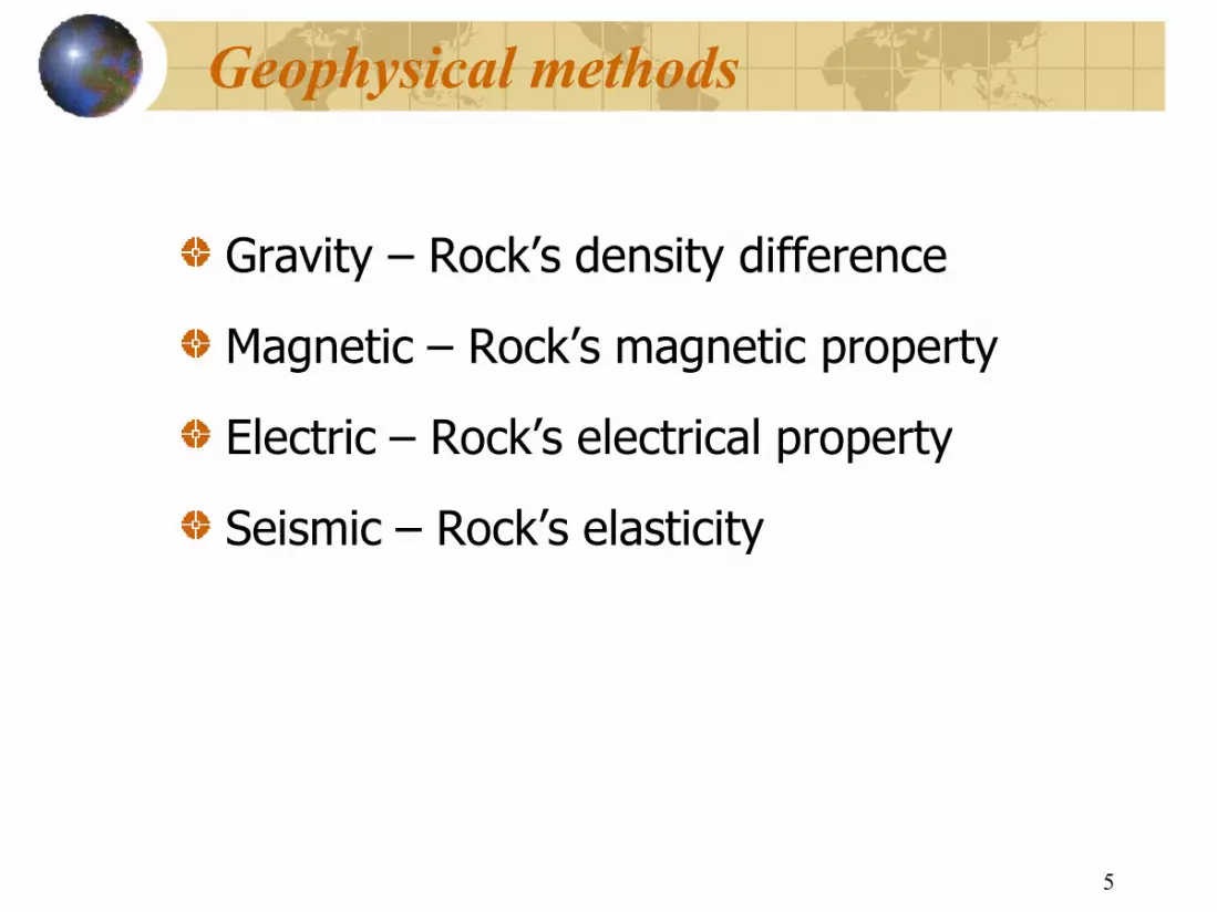
Geophysical methods
Gravity – Rock’s density difference
Magnetic – Rock’s magnetic property
Electric – Rock’s electrical property
Seismic – Rock’s elasticity
5
Geophysical methods
Rock’s density difference
Rock’s magnetic property
Rock’s electrical property
Rock’s elasticity

(1) Originated from physics Magnetic field, electrical field, gravity, wave theory, radiation, etc…
To study the earth’s variation in physical property and physical phenomenon
Unlike geological methods, it is an indirect method to study the rock and rock formation
Can provide information on both the near surface and the deep surface
Basic characteristics of Geophysical methods
6
Magnetic field, electrical field, gravity, wave theory,
To study the earth’s variation in physical property and physical
Unlike geological methods, it is an indirect method to study the rock
Can provide information on both the near surface and the deep surface
Basic characteristics of Geophysical methods

(2) There exist two transformations for the use of geophysical methods to study the subsurface geology: 1) transform the geological problem into a geophysical problem, and establish the links between the geological features and the geophysical anomalies;
2) transform the observed geophysical anomalies into geological features based on the established links, and expressed the anomalies in terms of geological maps.
Basic characteristics of Geophysical methods
7
(2) There exist two transformations for the use of geophysical methods to study the subsurface geology: 1) transform the geological problem into a geophysical problem, and establish the links between the geological features and the
forward modelling
2) transform the observed geophysical anomalies into geological features based on the established links, and expressed the anomalies in terms of geological maps. inverse solution
Basic characteristics of Geophysical methods

(3) The geophysical solution or interpretation is non
1) different geological bodies may have the same physical properties
2) the combination of different size, shapes, fluid type and geometry among the geological bodies may produce the same physical phenomenon
Basic characteristics of Geophysical methods
8
(3) The geophysical solution or interpretation is nonunique
1) different geological bodies may have the same physical properties
2) the combination of different size, shapes, fluid type and geometry among the geological bodies may produce the same physical
Basic characteristics of Geophysical methods
(4) Applicability of the geophysical methods
Every geophysical method has its limitations and applicability
Basic characteristics of Geophysical methods
9
(4) Applicability of the geophysical methods
Every geophysical method has its limitations and applicability
Basic characteristics of Geophysical methods
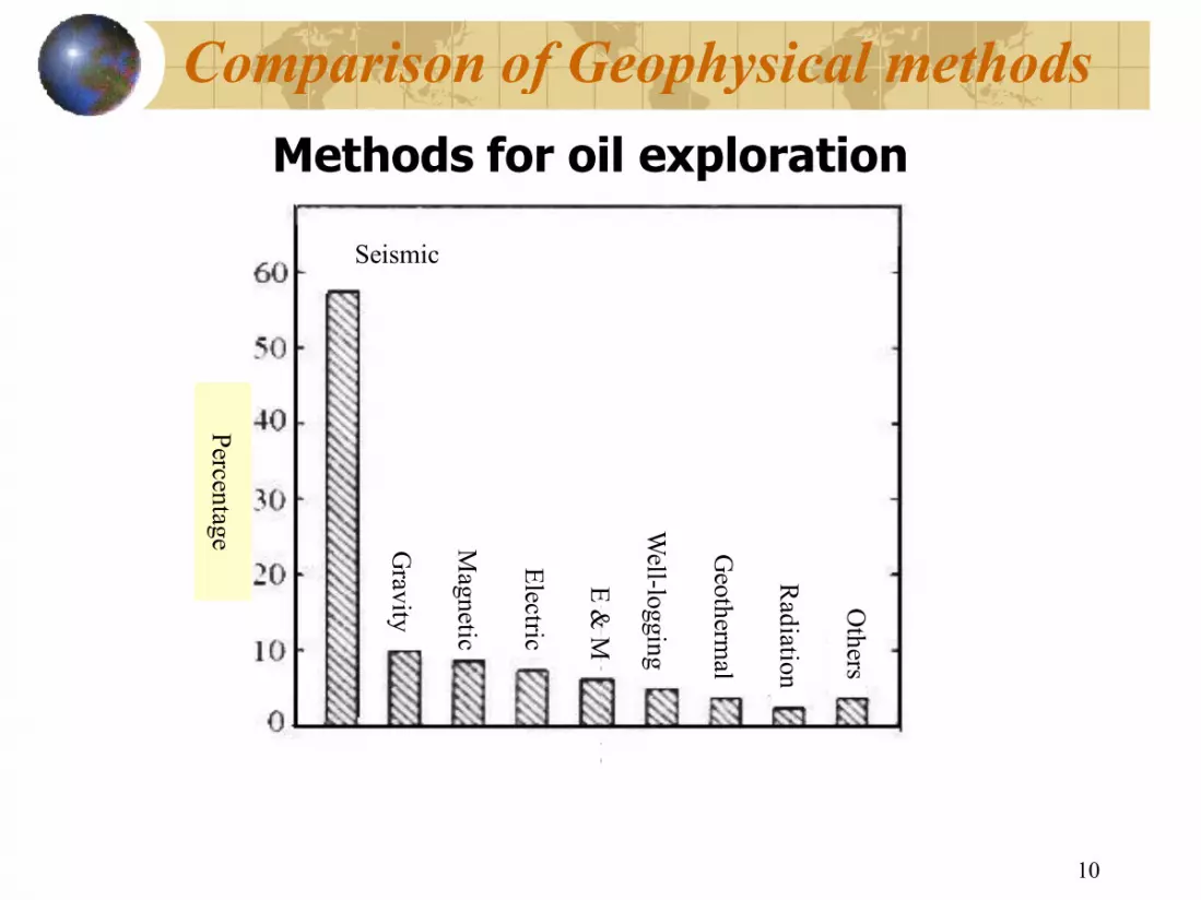
Comparison of Geophysical methods Methods for oil exploration
Percentage
Seismic
Gravity
Magnetic
Electric
E & M
10
Comparison of Geophysical methods Methods for oil exploration
E & M
Welllogging
Geotherm
al
Radiation
Others

S01: Introduction
Geophysical exploration
Seismic exploration
Essential processes of seismic exploration Seismic data acquisition
Seismic data processing
Seismic data interpretation
Modern seismic methods
Milestones and historical developments
Notes
11
S01: Introduction
Geophysical exploration
Essential processes of seismic exploration
Seismic data interpretation
Modern seismic methods
Milestones and historical developments

Seismic exploration
Seismic provides the main source of data about the
subsurface at, or approaching, reservoir scale
The main principle of seismics is to send a vibration
(elastic wave) down to our target, and allow this
energy to interact with that target
Some of this energy propagates back to the surface
and is recorded. Unfortunately we also record many
other interactions.
12
Seismic exploration
Seismic provides the main source of data about the
subsurface at, or approaching, reservoir scale
The main principle of seismics is to send a vibration
(elastic wave) down to our target, and allow this
energy to interact with that target
Some of this energy propagates back to the surface
and is recorded. Unfortunately we also record many
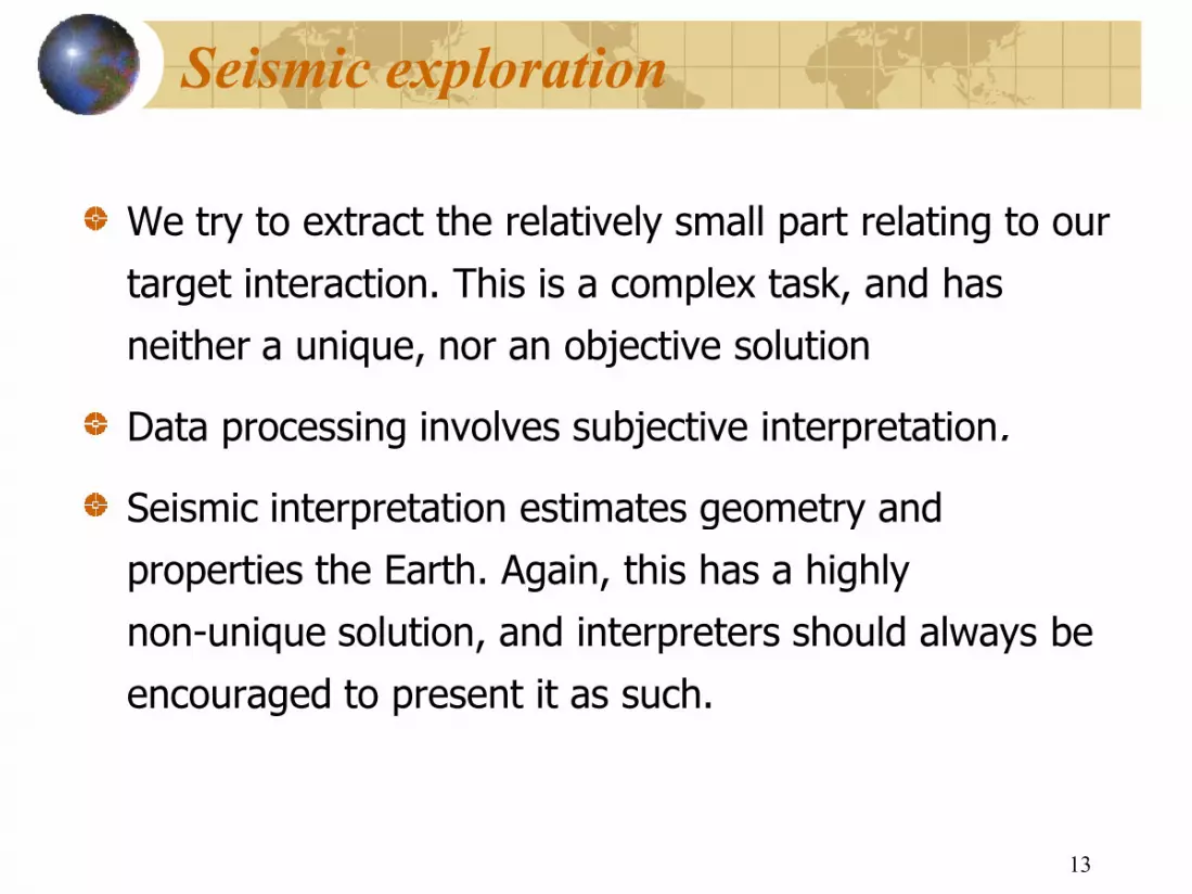
Seismic exploration
We try to extract the relatively small part relating to our
target interaction. This is a complex task, and has
neither a unique, nor an objective solution
Data processing involves subjective interpretation
Seismic interpretation estimates geometry and
properties the Earth. Again, this has a highly
nonunique solution, and interpreters should always be
encouraged to present it as such.
13
Seismic exploration
We try to extract the relatively small part relating to our
target interaction. This is a complex task, and has
neither a unique, nor an objective solution
Data processing involves subjective interpretation.
Seismic interpretation estimates geometry and
properties the Earth. Again, this has a highly
nonunique solution, and interpreters should always be
encouraged to present it as such.

Seismic reflection survey
14
Seismic reflection survey

Seismic reflection survey
15
Seismic reflection survey

The basic process of seismic exploration
Excite a seismic wave
Producing a vibration on the surface
Record of seismic wave
Recording the waves reflected back from the subsurface
Reconstruct the process of the wave propagation
From the recorded waves, reconstructing the process of the
wave propgation, including its reflection point and ray pathes,
and the geological information can then infered from the
reconstructed images
16
The basic process of seismic exploration
Producing a vibration on the surface
Recording the waves reflected back from the subsurface
Reconstruct the process of the wave propagation
From the recorded waves, reconstructing the process of the
wave propgation, including its reflection point and ray pathes,
and the geological information can then infered from the
Basic principles
Ways to infer subsurface geological structure
1. using head waves, or refracted waves
2. using reflected waves
Early seismic exploration is based on refracted waves
(1919—1921)
From the 1930’s, reflected waves started to use for oil exploration. Modern seismic exploration are
primarily based on the reflected waves
17
Ways to infer subsurface geological structure
1. using head waves, or refracted waves;
Early seismic exploration is based on refracted waves
s, reflected waves started to use for
oil exploration. Modern seismic exploration are
primarily based on the reflected waves
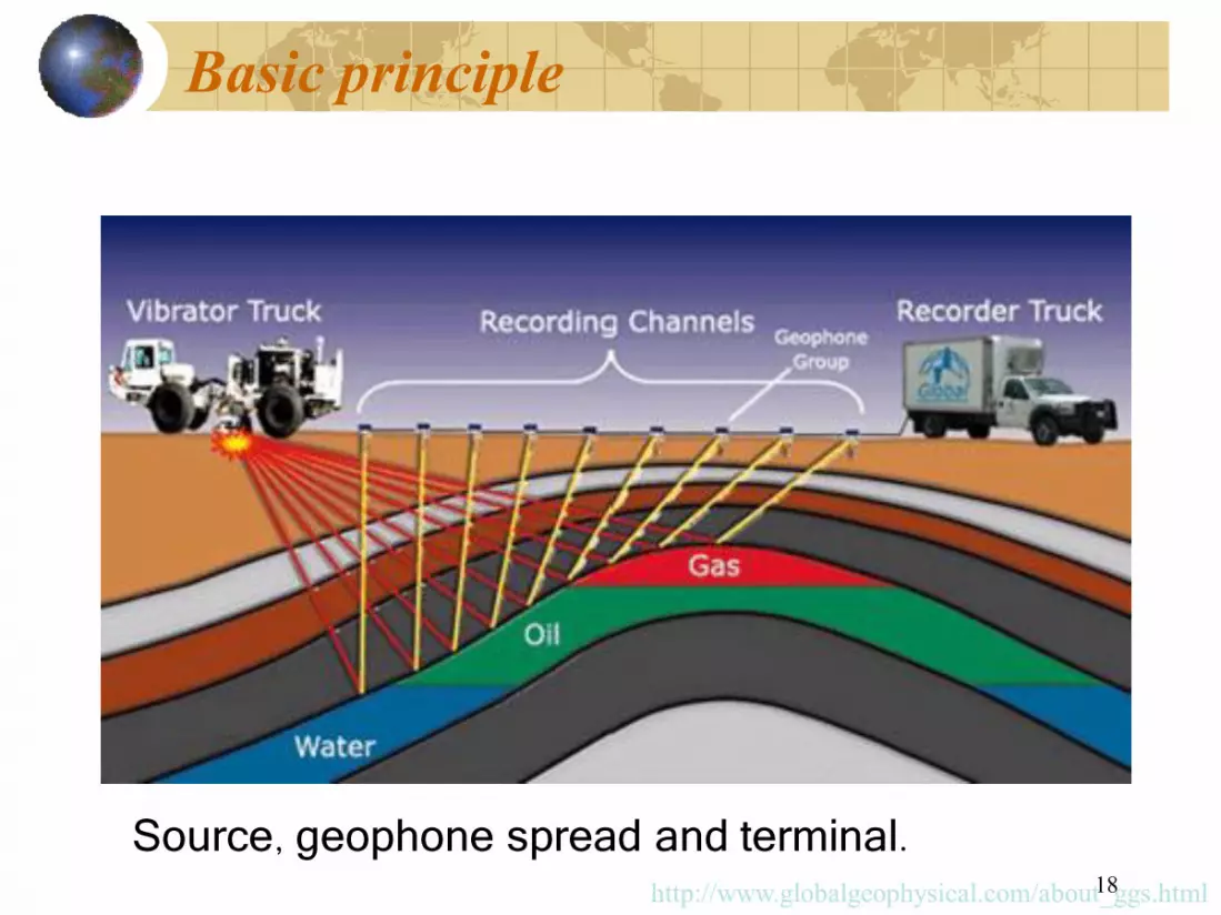
Basic principle
Source geophone spread , 18
spread and terminal. http://www.globalgeophysical.com/about_ggs.html

Basic principle –
19
Marine

Common midpoint
The number of times the same point on a reflector is sampled as the fold of coverage.
For example: 12 different shot geophone locations
20
Common midpoint
The number of times the same point on a reflector is sampled as the fold of coverage.
For example: 12 different shot geophone locations

Basic principles Waves excited on the surface propagate downwards and reflect
back to the surface
Sand
Shale
Limestone
21
Waves excited on the surface propagate downwards and reflect
Surface
Interface 1
Interface 2

An example
Example of the reflection seismic section. The x yaxis denotes the twoway running time of the seismic waves. If the seismic propagation velocity is known, the running time can be converted into depth values.
http://www.bgr.bund.de/cln_101/nn_335676/EN/Themen/GG__Geophysik/Mari ne__Geophysik/Seismik/Bilder/seism__verfahren__2__reflexionsseism__sektio n__p__en,templateId=neuesFenster.html 22
Example of the reflection seismic section. The xaxis denotes the horizontal distance, the way running time of the seismic waves. If the seismic propagation
velocity is known, the running time can be converted into depth values. http://www.bgr.bund.de/cln_101/nn_335676/EN/Themen/GG__Geophysik/Mari ne__Geophysik/Seismik/Bilder/seism__verfahren__2__reflexionsseism__sektio n__p__en,templateId=neuesFenster.html

An example
Uninterpretated section
23
Interpreted sections
Water sand
Gas sand

S01: Introduction
Geophysical exploration
Seismic exploration
Essential processes of seismic exploration Seismic data acquisition
Seismic data processing
Seismic data interpretation
Modern seismic methods
Milestones and historical developments
Notes
24
S01: Introduction
Geophysical exploration
Essential processes of seismic exploration
Seismic data interpretation
Modern seismic methods
Milestones and historical developments

Essential processes
Seismic data acquisition Seismic data processing Seismic data interpretation
25
Essential processes
Seismic data acquisition Seismic data processing Seismic data interpretation

Essential processes 1 st stage:seismic data acquisition field work logistics: survey layout, source, recording equipment
26
Essential processes seismic data acquisition
field work logistics: survey layout, source,

Seismic Data acquisition
27
Data acquisition
Seismic data acquisition systems
The fundamental purpose of seismic surveys is to accurately record ground motion caused by known sources in a known location. The record of ground motion with time constitutes a seismogram. The essential instrumental requirements are to 1. generate a seismic pulse with a suitable source 2. detect the seismic waves in the ground with a suitable
transducer. 3. record and display seismic wave forms on a suitable
seismograph.
28
Seismic data acquisition systems
The fundamental purpose of seismic surveys is to accurately record ground motion caused by known sources in a known location. The record of ground motion with time constitutes a
The essential instrumental requirements are to generate a seismic pulse with a suitable source detect the seismic waves in the ground with a suitable
record and display seismic wave forms on a suitable

Detectors Vibrator truck
Seismic field work
29
Vibrator truck Recording truck
Seismic field work

Offshore reflection seismic data acquisition using airguns and streamer
http://www.bgr.bund.de/cln_101/nn_335676/EN/Themen/GG__Geophysik/Marine__G eophysik/Seismik/Erfassung/erfassung__inhalt__en.html 30
Offshore reflection seismic data acquisition using airguns and streamer
Source: BGR http://www.bgr.bund.de/cln_101/nn_335676/EN/Themen/GG__Geophysik/Marine__G eophysik/Seismik/Erfassung/erfassung__inhalt__en.html

Essential processes
Seismic data acquisition Seismic data processing Seismic data interpretation
31
Seismic data acquisition Seismic data processing Seismic data interpretation

Essential processes 2 nd stage :indoor data processing
based wave propagation theory, using computer to reconstruct the process of wave propagation from the recorded data。
32
Essential processes indoor data processing
based wave propagation theory, using computer to construct the process of wave propagation from

Seismic data processing
33
Seismic data processing

Processing Flows
Demultiplexing Trace header generation < data Spherical divergence correction Noise attenuation Deconvolution before stack Band pass filter Trace normalization Static correction
Processing Flows
Trace header generation <…observers’
Spherical divergence correction
Deconvolution before stack

Processing flows (contd)
Velocity Analysis Normal Move Out Correction Trace mute AVO analysis CMP Stack Residual statics estimation & application Dip Move Out Correction Velocity analysis
Processing flows (contd)
Normal Move Out Correction
Residual statics estimation & application Dip Move Out Correction

Processing flows (contd)
DMO stack Signal enhancement Decon after stack Time Variant Filter Migration Data display
Processing flows (contd)

Processing Flows
Demultiplexing Trace header generation < data Spherical divergence correction Noise attenuation Deconvolution before stack Band pass filter Trace normalization Static correction
Processing Flows
Trace header generation <…observers’
Spherical divergence correction
Deconvolution before stack

SEISMIC DATA PROCESSING
Software from various contractors
SEISMIC DATA PROCESSING
Software from various contractors

Essential processes
Seismic data acquisition Seismic data processing Seismic data interpretation
39
Seismic data acquisition Seismic data processing Seismic data interpretation

Essential processes 3 rd stage: Seismic data interpretation
based on the established linkes between wave anomalies and geological features, interpret the reconstruct wavefields in terms of subsurface structures and rock formation properties
40
Essential processes stage: Seismic data interpretation
based on the established linkes between wave anomalies and geological features, interpret the reconstruct wavefields in terms of subsurface structures and rock formation properties
Interpretation of seismic data
41
Interpretation of seismic data

As for interpretation, from the processed seismic data the geological structure and the development of the earth's crust are deduced. On the basis of the seismic reflection horizons a geological layer model is developed. The results of other marine geoscientific exploration methods are also considered.
Seismic reflection profile and interpretation from the Mentawai forearc basin
http://www.bgr.bund.de/cln_101/nn_335676/EN/Themen/GG__Geophysik/Marine__Geophysik/Seis mik/Bilder/interpretation1__p__en,templateId=neuesFenster.html
Interpretation of seismic data
42
As for interpretation, from the processed seismic data the geological structure and the development of the earth's crust are deduced. On the basis of the seismic reflection horizons a geological layer model is developed. The results of other marine geoscientific exploration
Seismic reflection profile and interpretation from the Mentawai forearc basin
http://www.bgr.bund.de/cln_101/nn_335676/EN/Themen/GG__Geophysik/Marine__Geophysik/Seis mik/Bilder/interpretation1__p__en,templateId=neuesFenster.html
Interpretation of seismic data

Structural interpretation
43
Structural interpretation

S01: Introduction
Geophysical exploration
Seismic exploration
Essential processes of seismic exploration Seismic data acquisition
Seismic data processing
Seismic data interpretation
Modern seismic methods
Milestones and historical developments
Notes
44
S01: Introduction
Geophysical exploration
Essential processes of seismic exploration
Seismic data interpretation
Modern seismic methods
Milestones and historical developments

Modern seismic methods
3D seismic exploration Vertical Seismic profiles Crosswell seismic Multicomponent seismic 4D seismic Other methods
45
Modern seismic methods
3D seismic exploration Vertical Seismic profiles
well seismic Multicomponent seismic

3D Layout
46

One Day of Operation
47
One Day of Operation

3D Layout in marine operations
48
3D Layout in marine operations

Differences between 2D and 3D seismic
49
Differences between 2D and 3D seismic

50

Comparison of 2D with 3D
2D results
51
Comparison of 2D with 3D
3D results

Modern seismic methods
3D seismic exploration Vertical Seismic profiles Crosswell seismic Multicomponent seismic 4D seismic Other methods
52
Modern seismic methods
3D seismic exploration Vertical Seismic profiles
well seismic Multicomponent seismic
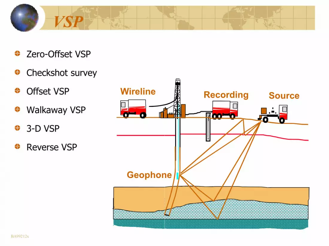
VSP
ZeroOffset VSP
Checkshot survey
Offset VSP
Walkaway VSP
3D VSP
Reverse VSP
Geophone
WESTERN ATLAS
Wireline
BA99212x
Geophone
WESTERN ATLAS
Source Recording

ZeroOffset VSP
Geophones WESTERN
ATLAS
Source Wireline
spacing 50 ft. spacing 50 ft.
BA99212y 54
WESTERN ATLAS
Source Recording

Checkshot survey
Geophones WESTERN
ATLAS
Source Wireline
spacing 500 ft. spacing 500 ft.
Zero offset
BA99212z 55
Checkshot survey
WESTERN ATLAS
Source Recording

Offset VSP
Geophone
WESTERN ATLAS
Wireline
56
WESTERN ATLAS
Source Recording
offset

Crosswell & Single well geometries
BA99212ff
Crosswell & Single well geometries

Frac monitoring
Minifrac monitoring Hydraulic fracturing monitoring
Fluid flow
Seismic receiver
Packer BA99212ii 58
frac monitoring single well Hydraulic fracturing monitoring multi well
Fluid flow
Mini Mini frac frac survey survey

Crosswell seismic survey geometry
59
Crosswell seismic survey geometry

Wave modes
present in a shot gather 60 present in a shot gather
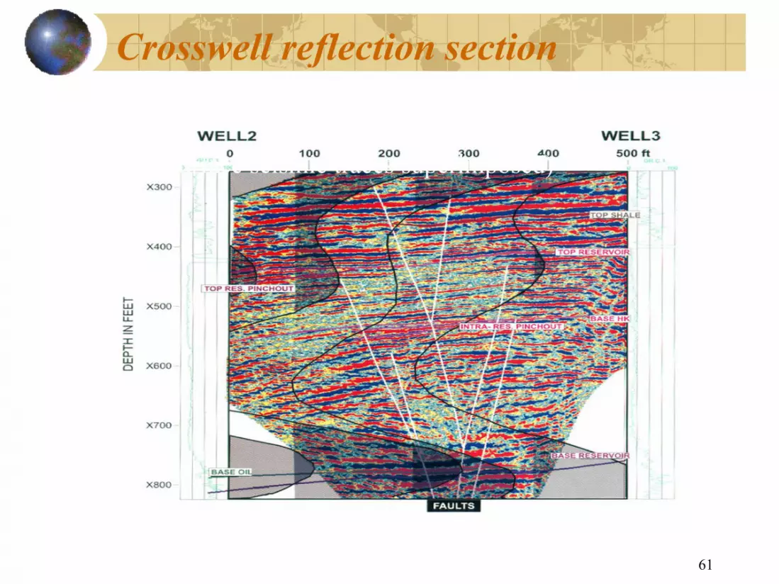
Crosswell reflection section
(with 3D surface seismic traces superimposed)
61
Crosswell reflection section
D surface seismic traces superimposed)

Modern seismic methods
3D seismic exploration Vertical Seismic profiles Crosswell seismic Multicomponent seismic 4D seismic Other methods
62
Modern seismic methods
3D seismic exploration Vertical Seismic profiles
well seismic Multicomponent seismic

Multicomponent seismic
http://www.crewes.org/ResearchLinks/ConvertedWaves/page2.php 63
Multicomponent seismic
http://www.crewes.org/ResearchLinks/ConvertedWaves/page2.php

Detectors (Geophones)
Three component geophones
http://www.crewes.org/ResearchLinks/ConvertedWaves/page2.php 64
Detectors (Geophones)
Three component geophones
http://www.crewes.org/ResearchLinks/ConvertedWaves/page2.php

Outline of marine multicomponent acquisition
http://www.westerngeco.com/content/services/marine/multicomponent/index.asp? 65
Outline of marine multicomponent acquisition
http://www.westerngeco.com/content/services/marine/multicomponent/index.asp?

Multicomponent records
Xcomponent
66
Multicomponent records
Ycomponent Zcomponent
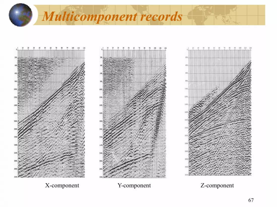
Multicomponent records
Xcomponent Ycomponent
67
Multicomponent records
component Zcomponent
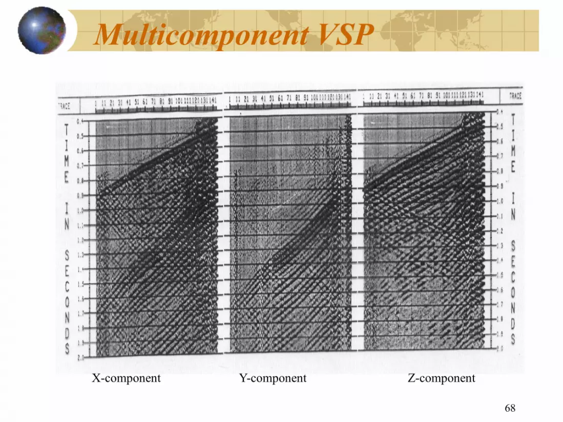
Multicomponent VSP
Xcomponent Ycomponent
68
Multicomponent VSP
component Zcomponent

Multicomponent images
69
Multicomponent images

Modern seismic methods
3D seismic exploration Vertical Seismic profiles Crosswell seismic Multicomponent seismic 4D seismic Other methods
70
Modern seismic methods
3D seismic exploration Vertical Seismic profiles
well seismic Multicomponent seismic

Repeated 3D Seismic
Differencing
Time 2 Time1
4D Seismic Technology
71
Analysis of 4D differences
Time 2
Residual oils
4D Seismic Technology

An example of 4D seismic from the Gulf of Mexico
72
An example of 4D seismic from the Gulf of Mexico

An example of 4D seismic from the Gulf of Mexico
73
An example of 4D seismic from the Gulf of Mexico

An example from the Gulf of Mexico
Left: oil (green), water (blue) and borehole logging data Right: residual oil (green) and gas (red)
74
An example from the Gulf of Mexico
and gas (red) distribution interpreted from
(red) distribution interpreted from 4D seismic

Seismicwhiledrilling (SWD)
Drill bit
Recording Rig sensor
Onshore & offshore TOMEX surveys : reverse VSP processing
crosscorrelation
BA99212ee
drilling (SWD)
Recording
Receivers
TOMEX surveys : reverse VSP processing correlation

Spatial Computation of Microseismic Events
FRACMAP Model
Treatment Well
Display Courtesy
ESG Canada Ltd. and
Acoustic Mapping Consultants
76
Spatial Computation of Microseismic Events
ESG Analysis Observation
Well
Treatment Well
S01: Introduction
Geophysical exploration
Seismic exploration
Essential processes of seismic exploration Seismic data acquisition
Seismic data processing
Seismic data interpretation
Modern seismic methods
Milestones and historical developments
Notes
77
S01: Introduction
Geophysical exploration
Essential processes of seismic exploration
Seismic data interpretation
Modern seismic methods
Milestones and historical developments
Milestones
Seismic recording has gone through three stages:
1、Photorecords –recording the surface vibration using photo graphic equipment, and processed completely by a human brain
2、Analogue tape recording—tape recording the subsurface vibration, similar to voice tape recording, and processed by analogue computers
3、Digital recording – digitally recording the subsurface vibration and processed by a mainframe digital computers
78
Seismic recording has gone through three
recording the surface vibration using photo graphic equipment, and processed completely by a human brain
tape recording the subsurface vibration, similar to voice tape recording, and processed by
digitally recording the subsurface vibration frame digital computers

Started in the 1960’s…
Three key technologies
1) field digital recording systems
2) Vibroseis – controlled sources
3) multiple coverage and stacking
The digital revolution…
79
Started in the 1960’s…
Three key technologies:
1) field digital recording systems
controlled sources,
3) multiple coverage and stacking
The digital revolution…

The 1980’s… Rapid development of processing and interpretation technologies in the 1980’s:
1.Seismic attributes analysis (1)Amplitude attributes (e.g. AVO
(2)Velocityrelated attributes
(3)Instantaneous attributes
2.Borehole seismic technology (1)Vertical seismic profile (VSP
(2)crosswell seismic
3.3D seismic
4.Multicomponent seismic
80
Rapid development of processing and interpretation technologies in the 1980’s: Seismic attributes analysis Amplitude attributes (e.g. AVO);
related attributes
Instantaneous attributes
Borehole seismic technology Vertical seismic profile (VSP)
Multicomponent seismic

3D seismic
A leap forward from 2D to 3D
Started in the 1980’s
More accurate seismic imaging
81
A leap forward from 2D to 3D
Started in the 1980’s
More accurate seismic imaging

The 1990’s
1. High resolution seismic 2. 4D seismic – time lapse seismic 3. Seismic 3D depth imaging
82
1. High resolution seismic time lapse seismic
3. Seismic 3D depth imaging

The 21st century…
1.Integration
Geophysical integration: Seismic, logging, gravity, magnetic…
Exploration and production integration: geophysics with petroleum engineering
2. The era of reservoir geophysics…
83
The 21st century…
Geophysical integration: Seismic, logging,
Exploration and production integration: geophysics with petroleum engineering
2. The era of reservoir geophysics…
Introduction
Geophysical exploration
Seismic exploration
Essential processes of seismic exploration Seismic data acquisition
Seismic data processing
Seismic data interpretation
Modern seismic methods
Milestones and historical developments
Notes
84
Geophysical exploration
Essential processes of seismic exploration
Seismic data interpretation
Modern seismic methods
Milestones and historical developments
Notes
1. Exploration methods 2. Geophysical exploration 3. Essential processes of seismic
exploration 4. Milestone; 5. Major breakthroughs
85
Exploration methods; Geophysical exploration; Essential processes of seismic
Major breakthroughs