sanakham hydropower project - mekong river
TRANSCRIPT
SANAKHAM HYDROPOWER PROJECT
Social Impact Assessment
Social Impact Assessment
1
Table of Contents
1. PREAMBLE .......................................................................................................................................1
1.1
1.2
1.2.1
1.2.2
1.3
1.4
1.5
1.6
1.6.1
1.6.2
1.6.3
1.6.4
1.6.5
1.6.6
1.6.7
1.6.8
1.6.9
BACKGROUND ....................................................................................................................................... 1
OBJECTIVE OF SIA ................................................................................................................................ 4
Main Objectives ............................................................................................................................... 4
Specific Objectives ........................................................................................................................... 4
SCOPE OF THE SIA................................................................................................................................. 5
RATIONALE FOR THE SIA ...................................................................................................................... 6
TERMINOLOGY USED IN THIS REPORT.................................................................................................... 6
METHODOLOGY..................................................................................................................................... 7
Approach .......................................................................................................................................... 7
Desk Work ........................................................................................................................................ 8
Consultations, Meetings and Interviews .......................................................................................... 8
Socio-economic and Socio-cultural Field Surveys ........................................................................... 9
Census .............................................................................................................................................. 9
Sampling Survey............................................................................................................................... 9
Overlays ........................................................................................................................................... 9
Linking EIA and the SIA................................................................................................................... 9
Specific Methods of Some Aspects.................................................................................................... 10
2. PROJECT DESCRIPTION ................................................................................................................13
2.1
2.2
2.3
2.4
2.4.1
2.4.2
2.4.3
2.5
PROJECT LOCATION............................................................................................................................... 13
PROJECT FEATURES ............................................................................................................................... 13
PROJECT COMPONENTS ......................................................................................................................... 14
PROJECTED AFFECTED AREAS............................................................................................................... 15
Inundated Area................................................................................................................................. 15
Construction Area ............................................................................................................................ 15
Road Access ..................................................................................................................................... 15
PROJECT IMPLEMENTATION SCHEDULE ................................................................................................. 15
3. SOCIAL POLICY AND LEGAL FRAMEWORK .............................................................................16
3.1
3.2
3.3
3.4
3.5
3.6
3.7
3.8
3.9
3.10
COMPENSATION & RESETTLEMENT ....................................................................................................... 16
ENVIRONMENTAL & SOCIAL IMPACT ASSESSMENT............................................................................... 17
HYDROPOWER ENVIRONMENTAL AND SOCIAL SUSTAINABILITY .......................................................... 19
ETHNIC GROUPS .................................................................................................................................... 20
CULTURAL AND ARCHAEOLOGY ........................................................................................................... 22
TOURISM ............................................................................................................................................... 23
OTHER LAO LAWS RELEVANT TO SIA .................................................................................................. 24
LAO PARTY CONGRESS SOCIAL POLICY ................................................................................................ 24
SAFEGUARD POLICY OF THE WORLD BANK .......................................................................................... 25
INTERNATIONAL PRINCIPLE AND BEST PRACTICE ................................................................................. 26
3.10.1
3.10.2
Equator Principle ........................................................................................................................ 26
World Commission on Dams – Criteria and Guidelines.............................................................. 27
3.11 REGIONAL AGREEMENT ........................................................................................................................ 27
4. SOCIAL BASELINE STUDY 1: OVERVIEW OF THE SOCIO-ECONOMIC CONDITIONS IN LAO
PDR AND THE STUDY AREA ....................................................................................................................28
4.1
4.1.1
COUNTRY SOCIO-ECONOMIC SETTING .................................................................................................. 28
Socio-cultural................................................................................................................................... 28
Social Impact Assessment
2
4.1.2
4.1.3
4.1.4
4.1.5
4.1.6
4.2
4.2.1
4.2.2
4.2.3
4.3
4.4
4.5
4.6
4.6.1
4.6.2
4.7
4.7.1
4.7.2
4.7.3
Macroeconomics .............................................................................................................................. 29
Foreign Direct Investment ............................................................................................................... 29
Inflation & Wage.............................................................................................................................. 30
Banking & Currency Exchange........................................................................................................ 30
Fiscal Situation ................................................................................................................................ 31
PROVINCIAL & DISTRICT SOCIO-ECONOMIC SETTING ........................................................................... 31
Administrative Area &Population.................................................................................................... 31
Infrastructure & Social Facilities .................................................................................................... 33
Socio-economic Development & Poverty Setting ............................................................................. 36
LAND USE & AGRICULTURE IN THE STUDY AREA................................................................................. 38
GENERAL LIVELIHOOD RESOURCES .........................................................................................................41
EDUCATION ..............................................................................................................................................42
PUBLIC HEALTH ASSESSMENT ..................................................................................................................43
NATIONAL HEALTH SITUATION.............................................................................................................43
Provincial & District Health Condition ..............................................................................................50
TOURISM ..................................................................................................................................................54
Tourism Development .........................................................................................................................54
Tourism Network and Linkage ......................................................................................................... 55
General Existing Condition of Tourism in the Project Area ............................................................ 57
5. SOCIAL BASELINE STUDY 2: DETAILED SOCIO-ECONOMIC CONDITION OF
UPSTREAM/DOWNSTREAM/PROJECT-LAND COMMUNITIES ........................................................59
5.1
5.2
5.2.1
5.2.2
5.2.3
5.2.4
5.2.5
5.2.6
5.2.7
5.2.8
5.2.9
IDENTIFICATION OF AFFECTED SOCIAL GROUPS ................................................................................... 59
UPSTREAM DIRECTLY AFFECTED VILLAGES ......................................................................................... 61
Demography, Ethnicity & Religious Beliefs.......................................................................................61
Housing ............................................................................................................................................ 63
Land Holding & Ownership ............................................................................................................. 64
Occupation & Workforce ................................................................................................................. 65
Livelihoods ....................................................................................................................................... 67
Family Income & Expenditure ......................................................................................................... 71
Education ......................................................................................................................................... 74
Health............................................................................................................................................... 75
Gender & Vulnerable Groups .......................................................................................................... 78
5.2.10
5.2.11
5.2.12
Cultural Resources & Archaeology ............................................................................................. 80
Village Administration ................................................................................................................. 85
Attitude towards the Sanakham HPP........................................................................................... 85
5.3
5.3.1
UPSTREAM INDIRECTLY AFFECTED VILLAGES ...................................................................................... 89
Population ........................................................................................................................................ 89
5.3.2 Housing.................... .... ................................... .................... ....................... ....................................89
5.3.3
5.3.4
5.3.5
5.3.6
5.3.7
5.3.8
5.3.9
5.3.10
Land Holding ................................................................................................................................... 89
Occupation & Workforce ................................................................................................................. 89
Livelihoods ....................................................................................................................................... 91
Income and Expenditure................................................................................................................... 92
Education and Health ........................................................................................................................93
Cultural Resources & Archaeology ...................................................................................................93
Village Administration ............................................................................................................... .93
Attitude towards Sanakham HPP............................................................................................... .93
5.4.
5.4.1
COMMUNITIES LOCATED NEAR TO CONSTRUCTION/QUARRY SITES ................................................... 93
Demography, Ethnicity and Culture .............................................................................................. 94
Social Impact Assessment
3
5.4.2
5.4.3
5.4.4
5.4.5
5.4.6
5.5
5.5.1
5.5.2
5.6
5.6.1
5.6.2
5.7
5.7.1
5.7.2
5.8
5.8.1
5.8.2
Basic Infrastructure ....................................................................................................................... 95
Household Economy and Livelihood.............................................................................................. 96
Education Facility .......................................................................................................................... 97
Public Health and Sanitation ......................................................................................................... 98
Attitude towards Sanakham Project ............................................................................................... 99
DOWNSTREAM COMMUNITIES .............................................................................................................99
Objective, Scope & Methodology ................................................................................................... 99
Downstream Riparian Villages (Thailand) .................................................................................... 101
RESETTLEMENT HOST COMMUNITIES.................................................................................................. 120
Resettlement Site Information ........................................................................................................ 120
Socio-economic Condition of Host Communities ........................................................................... 122
COUNTRY AND REGION ....................................................................................................................... 124
Power Development, Rural Electrification, and Country Income.................................................. 124
Economic Development.................................................................................................................. 125
GLOBAL SOCIAL ISSUES ...................................................................................................................... 125
Greenhouse Gas .............................................................................................................................. 125
Depletion of Fossil Fuel .................................................................................................................. 126
6. IDENTIFICATION OF SOCIAL CHANGES AND RISKS .............................................................128
6.1
6.2
6.2.1
6.2.2
6.2.3
6.2.4
6.2.5
IDENTIFICATION OF ALTERNATIVES & IMPACT AVOIDANCE ............................................................... 128
BIO-PHYSICAL CHANGES CREATE SOCIAL CHANGES.......................................................................... 128
Upstream and Quarry Areas .......................................................................................................... 129
Downstream Areas ......................................................................................................................... 129
Relocation and Resettlement Areas ................................................................................................ 130
Country/Region .............................................................................................................................. 130
Global............................................................................................................................................. 130
7. ASSESSMENT OF SOCIAL IMPACTS ..........................................................................................131
7.1
7.1.1
7.1.2
7.1.3
7.2
7.2.1
7.2.2
7.2.3
7.3
7.3.1
7.3.2
7.3.3
7.4
7.5
OBJECTIVE/CRITERIA/METHODOLOGY IN ASSESSING THE IMPACTS.................................................................... 131
Key Objectives ................................................................................................................................ 131
Criteria for Identification of Social Impacts .................................................................................. 131
Methodology................................................................................................................................... 132
Upstream, Construction/Quarry Areas .......................................................................................... 133
Pre-construction Phase .................................................................................................................. 133
Construction Phase ........................................................................................................................ 135
Operational Phase ......................................................................................................................... 145
DOWNSTREAM AREA........................................................................................................................... 147
Analysis of Downstream Impacts ................................................................................................... 147
Construction Phase ........................................................................................................................ 148
Operation Phase............................................................................................................................. 150
IMPACT TO COUNTRY/REGION ............................................................................................................ 152
GLOBAL IMPACTS................................................................................................................................ 154
8. PUBLIC PARTICIPATION .............................................................................................................156
8.1
8.2
8.2.1
8.2.2
8.2.3
8.2.4
OBJECTIVE & SCOPE ........................................................................................................................... 156
IDENTIFICATION OF KEY STAKEHOLDERS ........................................................................................... 157
MRCS & Lower Mekong Riparian Countries ................................................................................ 157
Central GOL Bodies....................................................................................................................... 157
Provincial/District GOL................................................................................................................. 157
Village Leaders and APs ................................................................................................................ 158

Social Impact Assessment
4
8.2.5
8.3
8.4
8.4.1
8.4.2
8.4.3
8.5
8.6
8.7
8.8
Non-Governmental Organizations ................................................................................................. 158
CONSULTATION WITH GOL PROVINCIAL & DISTRICT AUTHORITIES................................................... 158
CONSULTATION WITH VILLAGES & LOCAL COMMUNITIES ................................................................. 158
Purpose ......................................................................................................................................... 158
Work Accomplished........................................................................................................................ 159
Key Feedbacks from Consultation ................................................................................................. 163
CONSULTATION WITH OTHER STAKEHOLDERS.................................................................................... 165
PUBLIC CONSULTATIONS AT VILLAGE AND DISTRICT 12-13 JULY 2012 ............................................. 166
TECHNICAL WORKSHOP AND SITE VISIT 25-28 MARCH 2013 .............................................................. 177
PROVINCIAL CONSULTATION 6DEC2013............................................................................................. 183
9. CONCLUSIONS & RECOMMENDATIONS ..................................................................................191
9.1
9.2
9.3
9.3.1
9.3.2
9.4
9.4.1
9.4.2
9.4.3
9.4.4
9.4.5
9.4.6
9.5
9.6
9.7
9.8
9.9
9.10
NATIONAL ECONOMIC AND POWER DEVELOPMENT ............................................................................ 191
COMPENSATION................................................................................................................................... 191
RELOCATION AND RESETTLEMENTS .................................................................................................... 192
Proposed Criteria for Relocation and Resettlement....................................................................... 192
Proposed Criteria for Resettlement Site Selection ......................................................................... 192
LIVELIHOOD AND INCOME RESTORATION ........................................................................................... 193
Proposed Criteria for Livelihood Restoration ............................................................................... 193
Methods to Improve Livestock Rearing.......................................................................................... 194
Methods to Improve the Contribution of Livestock ........................................................................ 194
Methods to Improve the Contribution of Staple Food Crop ............................................................. 194
Methods to Improve the Contribution of Gardens and Fruit Trees................................................ 194
Suggested Steps in Income Restoration Program .......................................................................... 194
IMPACT EQUITY................................................................................................................................... 195
HEALTH IMPACT ASSESSMENT ............................................................................................................ 196
EDUCATION ......................................................................................................................................... 196
CULTURE AND ARCHAEOLOGY............................................................................................................ 197
CUMULATIVE/TRANS-BOUNDARY IMPACTS ........................................................................................ 197
BENEFIT SHARING ............................................................................................................................... 197
APPENDICES...........................................................................................................................................198
APPENDIX 1: RELOCATION AND RESETTLEMENT STUDY ..............................................................................198
APPENDIX 2: LIST OF NON‐GOVERNMENTAL ORGANIZATIONS IN PROJECT DISTRICTS .................................242
ANIMALS .......................................................................................................................................................... 247
ANTI-DRUG CAMPAIGNS .................................................................................................................................. 248
COMMUNITY DEVELOPMENT............................................................................................................................ 248
EDUCATION AND CHILDREN ............................................................................................................................. 250
ELDERLY .......................................................................................................................................................... 255
ENVIRONMENT ................................................................................................................................................. 256
HILLTRIBES ...................................................................................................................................................... 257
HIV/AIDS........................................................................................................................................................ 257
HUMAN RIGHTS................................................................................................................................................ 258
MEDIA .............................................................................................................................................................. 258
INFORMATION TECHNOLOGY............................................................................................................................ 259
MEDICAL HELP................................................................................................................................................. 259
THE DISABLED ................................................................................................................................................. 260
WOMEN ............................................................................................................................................................ 261
WORKERS......................................................................................................................................................... 262
Social Impact Assessment
5
APPENDIX 3: DOCUMENTS/WEB SITES USED FOR THE PREPARATION OF THE SIA ........................................263
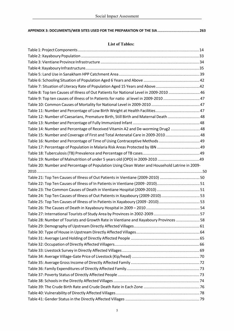
List of Tables:
Table 1: Project Components ................................................................................................................. 14
Table 2: Xayaboury Population .............................................................................................................. 33
Table 3: Vientiane Province Infrastructure ............................................................................................ 34
Table 4: Xayaboury Infrastructure.......................................................................................................... 35
Table 5: Land Use in Sanakham HPP Catchment Area ........................................................................... 39
Table 6: Schooling Situation of Population Aged 6 Years and Above .................................................... 42
Table 7: Situation of Literacy Rate of Population Aged 15 Years and Above.........................................42
Table 8: Top ten Causes of Illness of Out Patients for National Level in 2009‐2010 ............................. 46
Table 9: Top ten causes of illness of In Patients for natio al level in 2009‐2010 .................................. 47
Table 10: Common Causes of Mortality for National Level in 2009‐2010 ............................................. 47
Table 11: Number and Percentage of Low Birth Weight at Health Facilities......................................... 47
Table 12: Number of Caesarians, Premature Birth, Still Birth and Maternal Death .............................. 48
Table 13: Number and Percentage of Fully Immunized Infant .............................................................. 48
Table 14: Number and Percentage of Received Vitamin A2 and De‐worming Drug2 ........................... 48
Table 15: Number and Coverage of First and Total Antenatal Care in 2009‐2010 ................................ 48
Table 16: Number and Percentage of Time of Using Contraceptive Methods ...................................... 49
Table 17: Percentage of Population in Malaria Risk Areas Protected by IBN ........................................ 49
Table 18: Tuberculosis (TB) Prevalence and Percentage of TB cases..................................................... 49
Table 19: Number of Malnutrition of under 5 years old (OPD) in 2009‐2010 .......................................49
Table 20: Number and Percentage of Population Using Clean Water and Household Latrine in 2009‐
2010...................................................................................................................................................................50
Table 21: Top Ten Causes of Illness of Out Patients in Vientiane (2009‐2010) ..................................... 50
Table 22: Top Ten Causes of Illness of In Patients in Vientiane (2009 ‐2010)........................................ 51
Table 23: The Common Causes of Death in Vientiane Hospital (2009‐2010) ........................................ 51
Table 24: Top Ten Causes of Illness of Out Patients in Xayaboury (2009‐2010).................................... 53
Table 25: Top Ten Causes of Illness of In Patients in Xayaboury (2009 ‐2010)...................................... 53
Table 26: The Causes of Death in Xayaboury Hospital in 2009 – 2010 .................................................. 54
Table 27: International Tourists of Study Area by Provinces in 2002‐2009 ........................................... 57
Table 28: Number of Tourists and Growth Rate in Vientiane and Xayaboury Provinces ...................... 58
Table 29: Demography of Upstream Directly Affected Villages............................................................. 61
Table 30: Type of House in Upstream Directly Affected Villages........................................................... 64
Table 31: Average Land Holding of Directly Affected People ................................................................ 65
Table 32: Occupation of Directly Affected Villagers............................................................................... 66
Table 33: Livestock Survey in Directly Affected Villages ........................................................................ 69
Table 34: Average Village‐Gate Price of Livestock (Kip/head) ............................................................... 70
Table 35: Average Gross Income of Directly Affected Family ................................................................ 72
Table 36: Family Expenditures of Directly Affected Family.................................................................... 73
Table 37: Poverty Status of Directly Affected People ............................................................................ 73
Table 38: Schools in the Directly Affected Villages ................................................................................ 74
Table 39: The Crude Birth Rate and Crude Death Rate in Each Zone .................................................... 76
Table 40: Vulnerability of Directly Affected Villages .............................................................................. 78
Table 41: Gender Status in the Directly Affected Villages ..................................................................... 79

Social Impact Assessment
6
Table 42: Types of Cultural and Archaeology Found.............................................................................. 82
Table 43: Knowing about the Project ..................................................................................................... 86
Table 44: Attitude of Directly Affected People towards the Project ..................................................... 87
Table 46: Type of House in Upstream Indirectly Affected Villages ........................................................ 89
Table 45: Demography of Upstream Indirectly Affected Villages .......................................................... 90
Table 47: Average Gross Income of Indirectly Affected Family ............................................................. 91
Table 48: Poverty Condition of Indirectly Affected People.................................................................... 92
Table 49: Family Expenses of Indirectly Affected Family ....................................................................... 92
Table 50: Communities Located Near To Construction/Quarry Sites .................................................. ....95
Table 51: Basic Infrastructure at Veunkham, Pak Sao and Pakmee Villages ......................................... 95
Table 52: Estimated Average (Gross) Household Income of Pak Sao and Pakmee Villages, Meun
District, Vientiane Province .................................................................................................................... 97
Table 53: Estimated Average (Gross) Household Income ofBan Veunkham, Kenthao District,
Xayaboury Province...................................................................................................................................97
Table 54: Education Facilities in Veunkham, Pak Sao and Pakmee Villages ........................................ 98
Table 55: Public Health Facility in Veunkham, Pak Sao and Pakmee Villages...................................... 98
Table 56: Basic Infrastructure in Downstream Villages (Thailand) ...................................................... 103
Table 57: Educational Facilities in Downstream Villages (Thailand) .................................................... 103
Table 58: Public Health Facilities in Downstream Villages (Thailand).................................................. 104
Table 59: Location and Population of Riparian Villages Surveyed ....................................................... 105
Table 60: Estimated Riparian Average Household Net Income in Chiang Khan .................................. 107
Table 61: Estimated Riparian Average Household Net Income in Pak Chom ...................................... 108
Table 62: Guest Arrivals at Accommodation Establishments in Loei Province .................................... 113
Table 63: Guest Arrivals at Accommodation Establishments in Loei Province .................................... 115
Table 64: Location and Population of Downstream Communities (Lao PDR)...................................... 117
Table 65: Basic Infrastructures of Lao Downstream Villages ............................................................... 118
Table 66: Educational Service in Lao Downstream Villages ................................................................. 119
Table 67: Estimated Average HH Income of Downstream Villages (Meun)......................................... 119
Table 68: Host Population at Resettlement Site KD 3 .......................................................................... 123
Table 69: Land Use Changes in the Upstream Area ............................................................................. 128
Table 70: Summary of Attitude towards Sanakham HPP ..................................................................... 134
Table 71: SIA in Upstream and Construction/Quarry Areas during the Pre‐construction Phase........ 134
Table 72: Quantitative Social Impacts of Sanakham HPP .................................................................... 136
Table 73: Matrix ‐ SIA in Upstream Area during the Construction Phase ............................................ 139
Table 74: Anticipated Health Impacts of Mekong Sanakham HPP during construction period ......... 140
Table 75: Health Risk Impact Mitigation During Construction Phase .................................................. 140
Table 76: Anticipated Social Impact on Gender and Vulnerable Groups............................................. 143
Table 77: SIA in Upstream and Construction/Quarry Areas in the Operation Phase .......................... 146
Table 78: Social Impact Assessment in Downstream Areas ................................................................. 148
Table 79: Social Impact Assessment in Country/Region ..................................................................... 153
Table 80: Matrix ‐ Social Impact Assessment in Global Level .............................................................. 154
Table 81: Information Disclosure and Consultation Performed Date.................................................. 161
Table 82: Affected Villages and Families of Mekong Sanakham HPP (FSL at 220 masl) ...................... 199

Social Impact Assessment
7
List of Figures:
Figure 1: Mainstream Dams on the Mekong River ................................................................................ 2
Figure 2: Location of SanakhamMain Dam ............................................................................................ 3
Figure 3: SIA/SMMP Approach for Mekong Sanakham HPP .................................................................. 8
Figure 4: Mekong Sanakham Hydroelectric Power Project.................................................................... 13
Figure 5: Schematic of Dam &Associated Structures ............................................................................. 13
Figure 6: Map of Lao PDR ........................................................................................................................ 29
Figure 7: Foreign Direct Investment for Lao PDR ....................................................................................30
Figure 8: Map showing Xayaboury and Vientiane provinces ................................................................. 32
Figure 9: Road Network in Lao PDR......................................................................................................... 36
Figure 10: World Map of poverty living <1.25 US$/person/day ............................................................ 38
Figure 11: Land Use in the Project Catchment Area .............................................................................. 40
Figure 12: Left‐river‐bank Gardening by Woman at Ban Donsok ..........................................................41
Figure 13: Tourism Network of Surrounding Area ................................................................................. 56
Figure 14: Location of Tourist Attracts and the Schematic Network in Study Area............................... 58
Figure 15: Identification of Affected Social Groups ............................................................................... 59
Figure 16: ESIA Study Area ..................................................................................................................... 60
Figure 17: Upstream Catchment and Location of Upstream Villages ....................................................62
Figure 18: Type 1 ‐ Good Quality House................................................................................................. 63
Figure 19: Type 2: Medium Quality House............................................................................................. 63
Figure 20: Type 3 – Low Quality House .................................................................................................. 64
Figure 21: Upstream Community ........................................................................................................... 66
Figure 22: Degraded forest near Ban Houay Lah ................................................................................... 67
Figure 23: Maize Plantation at Ban Houay Lah ........................................................................................ 68
Figure 24: Buffalo ................................................................................................................................... 70
Figure 25: Common Tractor ................................................................................................................... 71
Figure 26: Primary School at Donsok ..................................................................................................... 74
Figure 27: Primary School at Donsang ................................................................................................... 74
Figure 28: Primary School at Donmen.................................................................................................... 74
Figure 29: Donsok Health Center ........................................................................................................... 76
Figure 30: Gravity‐Fed ............................................................................................................................ 77
Figure 31: Household Latrine ................................................................................................................. 77
Figure 32: Woman Bagging Corn............................................................................................................ 79
Figure 33: Phoxay Monastery Building................................................................................................... 84
Figure 34: Participation of Vulnerable Groups in ESIA at Ban Khae....................................................... 88
Figure 35: Participation of Gender/Vulnerable Groups in ESIA at Ban Donmen ................................... 88
Figure 36: ESIA Survey Team at Veunkham.......................................................................................... .....94
Figure 37: ESIA Survey at Quarry Site.................................................................................................. ...94
Figure 38: Map from Vuenkham to Pakmee Villages .............................................................................. 96
Figure 39: Job’s tear product at Ban Pak Sao ....................................................................................... ......96
Figure 40: Focus Group Discussion....................................................................................................... .......99
Figure 41: Population in the 100km Downstream of Mekong Mainstream Dams .............................. .100
Figure 42: Map of Chiang Khan Area.................................................................................................... ..102
Figure 43: Downstream Communities Surveyed.................................................................................. .106
Figure 44: River‐bank Banana Plantation in Pak Chom District ........................................................... .109

Social Impact Assessment
8
Figure 45: Riverbank Farming............................................................................................................... 109
Figure 46: Banana Products Delivering to Markets.............................................................................. 109
Figure 47: Fish Culturing at Ban Khok Ngiu in Chiang Khan District of Thailand.................................. 109
Figure 48: Boat Taxi at Chiang Khan and Sanakham ............................................................................ 110
Figure 49: Old Town Area of Chiang Khan............................................................................................ 111
Figure 50: Chiang Khan Market in the Evening of October 2010 Festival............................................ 112
Figure 51: Kaeng Kut Khu (October 2010)............................................................................................ 112
Figure 52: Kaeng Kut Khu (Summer 2005) ........................................................................................... 112
Figure 53: In‐land Tourist Service......................................................................................................... 112
Figure 54: On‐sand Food Shops (March 2011)..................................................................................... 112
Figure 55: Example of Small Scale Enterprise Souvenirs/Handicrafts of Chiang Khan ........................ 116
Figure 56: Access Road at Ban Phalat................................................................................................... 118
Figure 57: River‐bank Gardening at Ban Pak Phang ............................................................................. 120
Figure 58: Resettlement Site KD3 ( Part 1)........................................................................................... 121
Figure 59: Resettlement Site KD3 (Part2)............................................................................................. 122
Figure 60: Resettlement Site Houay Lod Village .................................................................................. 123
Figure 61: Resettlement Site Donsangoun Village ............................................................................... 123
Figure 62: Forecasted Revenue from Hydropower in Lao PDR ............................................................ 125
Figure 63: Graph of Natural Gas and Lignite Use ................................................................................. 127
Figure 64: Affected Villages and Roads in the Upstream Area ............................................................ 138
Figure 65: Focus Group at Ban Houay Lah ........................................................................................... 159
Figure 66: Consultation Meeting at Ban Houay Lah, Kenthao District, Xayaboury Province.a Severely
Upstream Impacted Village Requiring Resettlement........................................................................... 160
Figure 67: Map of Done Kouad Area – Focal Development Zone of Sanakham District...................... 205
Figure 68: Done Kouad Field Survey Team........................................................................................... 205
Figure 69: Done Kouad Area, Northwest direction .............................................................................. 205
Figure 70: Done Kouad Area, north director........................................................................................ 206
Figure 71: Done Kouad Area, northeast direction ............................................................................... 206
Figure 72: Resettlement Site No. SD1 – Done Kouad Area .................................................................. 206
Figure 73: View of Existing Ban Donphoung ........................................................................................ 209
Figure 74: Ban Maipakthoun .............................................................................................................. 210
Figure 75: Relocation Site SD3 ............................................................................................................. 212
Figure 76: Relocation Site..................................................................................................................... 214
Figure 77: NGOs in Sanakham District, Vientiane Province ................................................................. 242
Figure 78: NGOs in Kenthao District, Xayaboury Province................................................................... 244
Figure 79: NGOs in Paklay District, Xayaboury Province...................................................................... 246
Social Impact Assessment
9
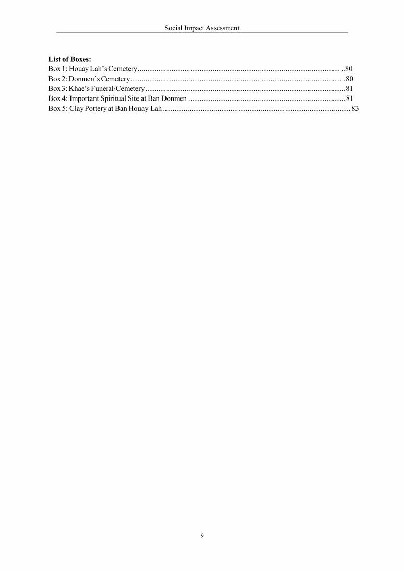
List of Boxes:
Box 1: Houay Lah’s Cemetery ............................................................................................................ ..80
Box 2: Donmen’s Cemetery ................................................................................................................. . 80
Box 3: Khae’s Funeral/Cemetery ........................................................................................................... 81
Box 4: Important Spiritual Site at Ban Donmen .................................................................................... 81
Box 5: Clay Pottery at Ban Houay Lah .................................................................................................... 83
Social Impact Assessment
10
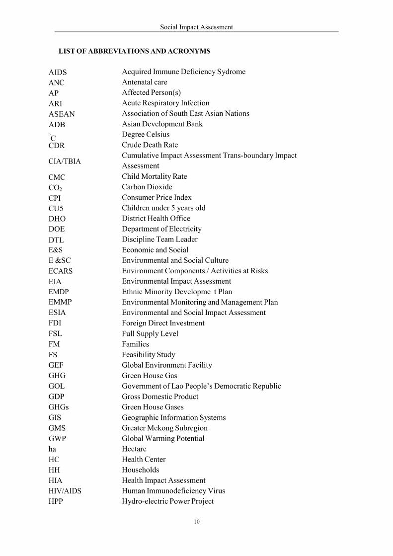
LIST OF ABBREVIATIONS AND ACRONYMS
Acquired Immune Deficiency Sydrome
Antenatal care
Affected Person(s)
Acute Respiratory Infection
Association of South East Asian Nations
Asian Development Bank
Degree Celsius
Crude Death Rate
Cumulative Impact Assessment Trans-boundary Impact
Assessment
Child Mortality Rate
Carbon Dioxide
Consumer Price Index
Children under 5 years old
District Health Office
Department of Electricity
Discipline Team Leader
Economic and Social
Environmental and Social Culture
Environment Components / Activities at Risks
Environmental Impact Assessment
Ethnic Minority Developme t Plan
Environmental Monitoring and Management Plan
Environmental and Social Impact Assessment
Foreign Direct Investment
Full Supply Level
Families
Feasibility Study
Global Environment Facility
Green House Gas
Government of Lao People’s Democratic Republic
Gross Domestic Product
Green House Gases
Geographic Information Systems
Greater Mekong Subregion
Global Warming Potential
Hectare
Health Center
Households
Health Impact Assessment
Human Immunodeficiency Virus
Hydro-electric Power Project
AIDS
ANC
AP
ARI
ASEAN
ADB
°C
CDR
CIA/TBIA
CMC
CO2
CPI
CU5
DHO
DOE
DTL E&S
E &SC
ECARS
EIA
EMDP
EMMP
ESIA
FDI
FSL
FM
FS
GEF
GHG
GOL
GDP
GHGs
GIS
GMS
GWP
ha
HC
HH
HIA
HIV/AIDS
HPP
Social Impact Assessment
11
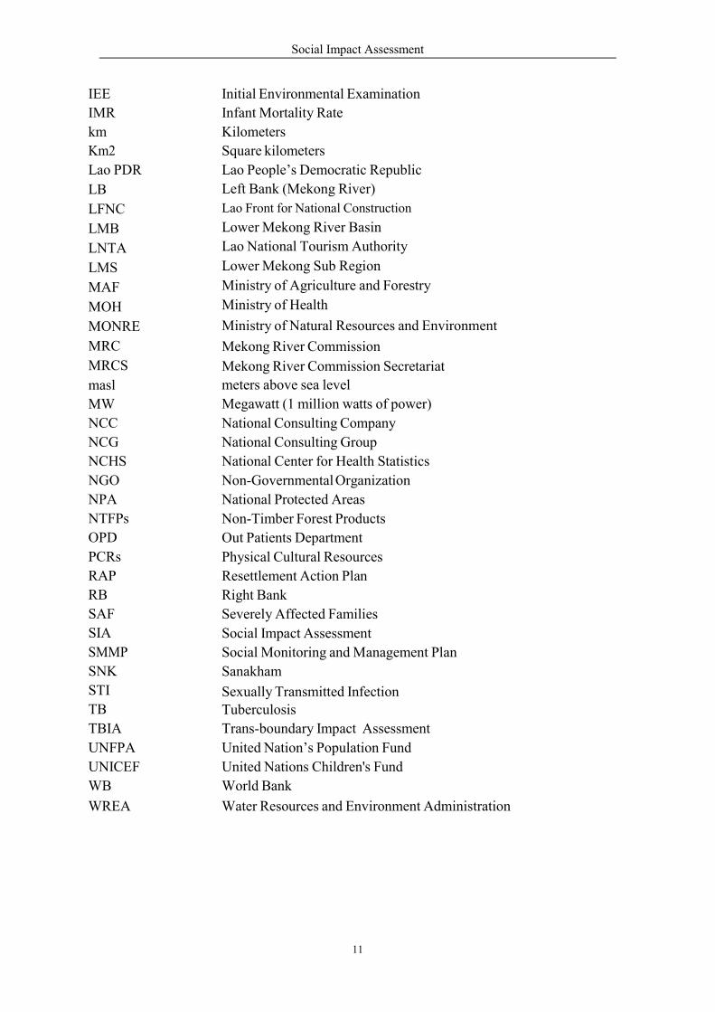
IEE
IMR
km
Km2
Lao PDR
LB
LFNC
LMB
LNTA
LMS
MAF
MOH
MONRE
MRC
MRCS
masl
MW
NCC
NCG
NCHS
NGO
NPA
NTFPs
OPD
PCRs
RAP
RB
SAF
SIA
SMMP
SNK
STI
TB
TBIA
UNFPA
UNICEF
WB
WREA
Initial Environmental Examination
Infant Mortality Rate
Kilometers
Square kilometers
Lao People’s Democratic Republic
Left Bank (Mekong River)
Lao Front for National Construction
Lower Mekong River Basin
Lao National Tourism Authority
Lower Mekong Sub Region
Ministry of Agriculture and Forestry
Ministry of Health
Ministry of Natural Resources and Environment
Mekong River Commission
Mekong River Commission Secretariat
meters above sea level
Megawatt (1 million watts of power)
National Consulting Company
National Consulting Group
National Center for Health Statistics
Non-Governmental Organization
National Protected Areas
Non-Timber Forest Products
Out Patients Department
Physical Cultural Resources
Resettlement Action Plan
Right Bank
Severely Affected Families
Social Impact Assessment
Social Monitoring and Management Plan
Sanakham
Sexually Transmitted Infection Tuberculosis
Trans-boundary Impact Assessment
United Nation’s Population Fund
United Nations Children's Fund
World Bank
Water Resources and Environment Administration
Social Impact Assessment
1
1 PREAMBLE
1.1 Background
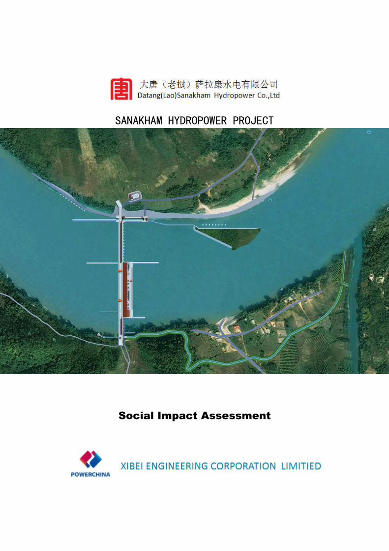
The Lower Mekong Basin (LMB) has four countries, Cambodia, Lao PDR, Thailand, and Vietnam.
The LMB is home to approximately 60 million people. However, the region is faced with high growth
in demand for electricity from the population and economic expansion including regional investments
and cross border trade activities.
The Mekong River in this part of Asia has a high hydropower development potential of about 14,000
MW from 12 mainstream hydropower projects, which are currently under study including 7 in Lao
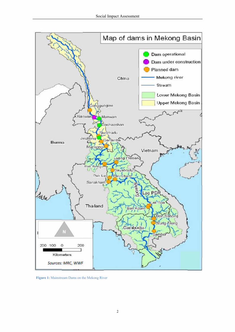
PDR, 2 in Cambodia and 3 on the Thai-Lao Border (Figure 1).
To support the expanded role of electricity in economic development of the region, the Mekong
Sanakham Hydroelectric Power Project (Mekong Sanakham HPP) is one of 7 planned on the
mainstream of the Mekong River within the Lao PDR. Datang Overseas Investment Company Ltd
(Datang) is conducting an Environmental and Social Impact Assessment (ESIA) as part of a project
feasibility study. From 2010 to 2011 the Hydro China Northwest Engineering Corporation has carried
out the engineering pre-feasibility studies of the project with an Initial Environmental Examination
(IEE) by Norconsult.
The Sanakham HPP damsite is located 1.4 km upstream of Pakheuang Village, Kenthao District,
Xayaboury Province, Lao PDR. The planned location is 1,737 km upstream of the Mekong estuary in
Vietnam, 155 km upstream of Vientiane, Lao PDR, 25 km downstream of Sanakham township, Lao
PDR, and 81 km downstream from the proposed Pak Lay HPP. Less than 100km downstream from the
Sanakham HPP, there are Thai riparian villages on the opposite bank of the Mekong from the Lao
PDR.
The project is to be a low head run-of-river project with an installed capacity of 684 MW. The
electricity produced by the project will be transmitted to Thailand through 500 kV transmission lines
and to the Lao grid and Vientiane through one circuit of 230 kV. The reservoir above the dam will be
some 81 km long and have a full supply level of 220 meters above sea level (masl). Most of the
reservoir, over 80%, will be contained within the present river channel which floods every year.
The project’s general layout from left to right bank includes a concrete auxiliary dam, navigation lock,
14 sluice gates, powerhouse with 12 generating units, a flushing sluice with 4 outlets, a fishpass and
concrete auxiliary dam at the right bank. Overall the dam is 893m long and 57.2 m high.
Social Impact Assessment
2
Figure 1: Mainstream Dams on the Mekong River
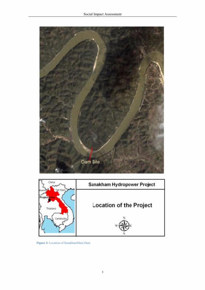
Figure 2: Location of Sanakha
Social Impact Assessment
3
amMain Dam
Social Impact Assessment
4
1.2 Objective of SIA
1.2.1 Main Objectives
The six main aims of the Social Impact Assessment (SIA) for the Sanakham HPP include:
1. Examination of the existing conditions of the human environment and the socio-economic and
cultural status of the potentially affected people especially with regards to ethnicity, gender
and vulnerable groups in the project area.
2. Identification of the biophysical changes that are the major cause of social and livelihood
changes.
3. identification of the potentially affected area of the proposed project and communities that
may be directly or indirectly affected by the project construction and operation.
4. Identification and analysis of potentially significant socio-economic and cultural impacts in
relation to project design, construction and operation/decommission.
5. Assessment of the socio-economic and cultural impacts of the proposed project in terms of the
magnitude and importance, including recommendation of cost effective mitigation measures
for all significant negative impacts.
6. Participatory consultation with key stakeholders, in particular Affected People (AP) of the
poject, through public meetings and focus groups to provide information on project specifics
and obtain community feedbacks that will be taken into account in the project design,
Resettlement Action Plan (RAP) and Social Monitoring and Management Plan (SMMP).
7. Identify, describe and provide an estimated cost for required mitigation.
1.2.2 Specific Objectives
In the course of SIA, there are some aspects that need to be studied in parallel, such as gender and
vulnerable groups, the health impact assessment (HIA), culture and archaeology, tourism and
downstream social issues.
Discussed below are specific objectives of these aspects.
Gender and Vulnerable Groups:
Collect existing and field data related to vulnerable people and gender aspects, particularly
women, in the project area.
Identify and assess the potential positive and negative impacts of the project on vulnerability
and gender issues.
Develop measures to prevent and/or minimize any potential negative impacts on vulnerable
people, particularly women in the project area.
Health Impact Assessment:
Collection of the overall health status of the population within and surrounding the project
areas especially upstream and downstream villages.
Determine the area’s status compared to provincial and national data.
Assess possible health impacts that could be attributed to the hydropower project.
Social Impact Assessment
5
Develop management measures to prevent and / or minimize any negative health impacts and
maximize any potential health benefits arising from the project development.
Cultural & Archaeology Assessment
The objective of this cultural heritage investigation and study is to identify and assess the presence of
archaeological and cultural heritage sites of significance located within the vicinity of the proposed
Sanakham HPP. The significant cultural heritage sites include:
Cultural sites (e.g. tangible and intangible).
Historical site (e.g. ruins of stupas, temple and other structure).
Religious sites(e.g. monasteries, temple and stupas).
Spiritual sites (e.g. sacred forest, cemeteries, Ban and Muang spirits).
Significant buildings / structures.
Unique natural features.
Any other sites of physical cultural property.
Tourism Assessment:
To study the existing tourism conditions in the project site and relating areas.
To assess the tourism impact caused by the project.
To propose mitigation measures.
1.3 Scope of the SIA
The scope of the SIA consists of identification and assessment of significant positive and negative
impacts on the human environment, which includes the following.
1. Identification and analysis of national social policy framework including regional best practice
on social impact assessment of hydropower project development.
2. Analysis of existing key socio-economic conditions of communities and the people in the
project area, focusing on:
o
o
o
o
o
o
Demographics and workforces.
Socio- Economics and livelihood/lifestyle.
Land and natural resource uses.
River and water characteristics and uses.
Institutional and Governance issues.
Specific studies and assessment on the issues of:
Gender and vulnerable group to reflect the social equity condition.
Health Impact Assessment.
Cultural and archaeological assessment.
Tourism assessment.
3. Prediction of the magnitude of anticipated effects and their socio-economic and cultural
importance. Assessment of the significance of impacts potentially created by the project on
issues such as livelihood, social networks, socio-cultural issues, health, community risk and
exposure, employment and tourism.
Social Impact Assessment
6
4. Proposal of design changes, mitigation, and ancillary compensation development required to
ensure that APs are better off after the project development than they were before it.
1.4 Rationale for the SIA
Since the project has an installed capacity of more than 50 MW, the SIA must and will be conducted in
accordance with the National Policy on Environmental and Social Sustainability of Hydro Power
Sector in Lao PDR. This requires that the following be included by the project proponent in the project
development process.
1. Identification of APs whose assets, resource use and livelihoods, and/or social or cultural
structures are involuntarily altered by the project. In addition all involuntary resettlement and
social development plans will be prepared and implemented based on the Government of Lao
PDR’s (GOL) Resettlement Decree No. 192/PM.
2. Continuous proactive and effective participatory consultations with affected communities are
required and will include comprehensive environmental education as well as awareness raising
activities.
3. Public disclosure of information (in Lao and English) related to the consultation process, the
rights of the population to be fully informed, project design construction and operation,
potential impacts, mitigation plans, and monitoring is required and public information centers
will be established in the project area and in Vientiane.
4. Verification of compliance with all relevant obligations including the concession agreement,
GOL laws, policies, strategies, action plans, and international conventions through regular
effective monitoring and reporting.
5. The developer will cover the cost of implementing all GOL and other environmental and social
safeguards under the user pay principle.
6. Organizing third-party monitoring and assessment with respect to environmental and social
guidelines and safeguards.
7. Periodic review and documentation of the environmental and social lessons learned during
project implementation.
8. Preparation and publication of a Status of the Environment and Social Compliance Report.
1.5 Terminology used in this Report
1) Affected Persons (APs): any person who, as a result of the implementation of a project, loses
the right to own, use, or otherwise benefit from a built structure, agricultural land or both. This
includes both Indirectly and Directly Affected Persons; in other words the total number of
Affected Persons = Directly Affected Persons + Indirectly Affected Persons.
2) Directly Affected Persons: people who totally lose their residential and agricultural land
including industrial and fruit trees and are required to move to a resettlement area.
Social Impact Assessment
7
d
3) Indirectly Affected Persons: people whose agricultural land or other assets may be damaged
or lost due to flood or erosion; indirectly affected people have to be compensated but not
resettled.
4) Directly Affected Villages: villages that are submerged and are required to move to a
resettlement area.
5) Indirectly Affected Villages: villages that are damaged or lost due to flood or erosion;
Indirectly Affected Villages have to be compensated but not resettled.
6) Compensation: payment in cash or in kind for an asset or a resource that is acquired or
affected by a project at the time the asset needs to be replace .
7) Cut-Off Date (COD): the date established by the GOL procedures that establishes the
eligibility for receiving compensation and resettlement assistance by the project displaced
persons. The COD normally is normally determined after the project has been approved and
the Concession Agreement has been signed.
8) Displaced People: those who are physically displaced (relocation, loss of residential land, or
loss of shelter) and/or economically displaced (loss of land, assets, access to assets, income
sources, or means of livelihood) as a result of (i) involuntary acquisition of land, or (ii)
involuntary restrictions on land use or on access to legally designated parks and protected
areas.
9) Entitlement: the sum total of compensation and other forms of assistance provided to the
displaced people in the respective eligibility category.
10) Host: refers to people living in, or around areas where people displaced by the project will be
resettled or relocated.
11) Livelihood Restoration and Development (LRAD): development activities that can re-
establish productive livelihood of the displaced persons to enable income generation better
than that earned by the displaced people before the relocation and resettlement.
12) Resettlement: moving a whole village to new place with the re-establishment of basic
infrastructures and facilities including livelihood development for the settlers.
1.6 Methodology
1.6.1 Approach
Development of the project may cause changes in the bio-physical environment such as the fluctuation
of flow, changes of fish habitats, change of land use from agricultural land/forests to water, etc.
Since all riparian communities are dependent on the biophysical environment, biophysical changes will
have impacts on the socio-economic and cultural context of the project area.
Social Impact Assessment
8
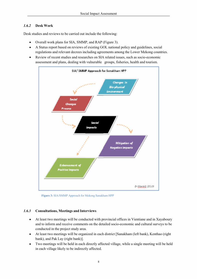
1.6.2 Desk Work
Desk studies and reviews to be carried out include the following:
Overall work plans for SIA, SMMP, and RAP (Figure 3).
A Status report based on reviews of existing GOL national policy and guidelines, social
regulations and relevant decrees including agreements among the Lower Mekong countries.
Review of recent studies and researches on SIA related issues, such as socio-economic
assessment and plans, dealing with vulnerable groups, fisheries, health and tourism.
Figure 3: SIA/SMMP Approach for Mekong Sanakham HPP
1.6.3 Consultations, Meetings and Interviews
At least two meetings will be conducted with provincial offices in Vientiane and in Xayaboury
and to inform and receive comments on the detailed socio-economic and cultural surveys to be
conducted in the project study area.
At least two meetings will be organized in each district [Sanakham (left bank), Kenthao (right
bank), and Pak Lay (right bank)].
Two meetings will be held in each directly affected village, while a single meeting will be held
in each village likely to be indirectly affected.
Social Impact Assessment
9
Official district consultations will be made in each affected district
o Sanakham District
o Kenthao District
o Paklay District
1.6.4 Socio-economic and Socio-cultural Field Surveys
Besides the identification of existing land uses, specific surveys based on 1:50,000, 1:10,000, and
1:5,000 scale maps (both downstream and upstream areas), interviews/discussions and health checks of
local villagers/leaders, will focus on:
Resettlement and Compensation for the RAP formulation.
the HIA dealing with health and nutrition status and communicable diseases.
Assessment of Gender and Vulnerable groups.
Assessment of Ethnic minorities and their culture for the Ethnic Minority Development Plan
(EMDP), if required.
Tourism Assessment such as tourist attraction sites, waterway routes used by tourists or other
areas popular with cross-border tourists from Greater Mekong Subregion (GMS) countries.
Integration of project social development and enhancement for the SMMP.
1.6.5 Census
Based on a 1:5,000-scale map, 100% of all directly affected families will be surveyed. A detailed
inventory of assets based on a survey form and interviewing a representative of each family will be
performed. In addition to individual socio-economic data, each family head or representative and their
assets will be identified photographically. This census will be performed in collaboration with the
district administrators and/or representatives of the district authorities.
1.6.6 Sampling Survey
Similar surveys will be conducted on approximately 20% of the indirectly affected communities in Lao
PDR territory 30 km downstream from the dam. Likewise the communities in the vicinity of the
proposed host/resettlement sites will also be surveyed. The indirectly affected communities in Thai
territory will be the subject of a separate contract and separate reports, namely, the Cumulative Impact
Assessment (CIA) and Trans-boundary Impact Assessment (TBIA).
1.6.7 Overlays
GIS will be used to illustrate socio-economic and cultural resources and context of the study area
before and after project implementation.
1.6.8 Linking EIA and the SIA
Because biophysical changes will have socio-economic and cultural impacts, information exchange
between the biophysical and socio-cultural discipline teams will be important. Addressing the
following key specific issues will require particular cooperation.
Minimum water requirements downstream from the Mekong Sanakham HPP main dam.
Navigation and overland tourism activities from Pak Beng and/Luang Prabang to the
project area and from Chiang Khan / Tha Li (Thailand) to Sanakham and Kenthao.
Fishing and fish culture in upstream and downstream areas of the Sanakham Dam.
Social Impact Assessment
10
Input on the assessment of the significance of socio-economic and cultural impacts to the
EIA.
1.6.9 Specific Methods of Some Aspects
According to the specific objectives that addressed in Section 1.2.2, the SIA also has specific methods
for the study of gender and vulnerable groups; the HIA; cultural and archaeology; tourism assessment;
and downstream social issues.
Gender and Vulnerable Groups:
Data Collection
The following are the types of data collection including separate household surveys :
o Secondary data - Interim, Yearly and 5 years reports of Lao’ Women Union at district and provincial level.
o Primary data - Interviews using two types of questionnaires, a closed form which includes
choice, checklist, ranking and rating and an “open ended” form, will be used in order to collect
data and information from Lao Women’s Union at provincial, district, village and Lao Women
at household level. The “open ended” questionnaire will include the following:
Observations (including participant observation).
Field Notes.
Photographs.
Assessment Technique
Key methods in assessment include content analysis (based on quantitative and qualitative data) and
descriptive/narrative.
Health Impact Assessment (HIA):
Data Collection Method - Most villages within he project could be reached by car, but some
villages were reached by boat. The survey team met and interviewed health personnel and
heads of villages, 15 villages downstream and 24 villages upstream, in order to get relevant
data on people’s health at the village level. The team also met the chief of the District Health
Office (DHO), head of the Health Center (HC), Statistic unit of Provincial Health Office
(PHO) and Public health statistic center in order to review and collect data on the current
health situation.
Survey Questionnaires - There are two sets of survey questionnaires designed for the field
study process. The first one is for the village health volunteer and head of village, and the
second is for the HC.
The village health volunteer and head of village were interviewed in order to obtain the
contextual information of the villages, and the questionnaire focused on the existing health
situation of the people in the village and also health risk factors which can cause negative
impacts to people’s health. The following information was gathered:
o Village Statistics concerning the health situation.

Social Impact Assessment
11
o Access to health care facilities. o Existing health care services. o The most common reasons people seek medical treatment. o The birth and mortality situation in the village. o The indicators of important health risk factors in the village. o The existing sources and quality of drinking water. o The number of household with toilet facilities. o Current Plans of health development program in the village.
o The most common disease in the village (2009 -2010)
For the HC, there was some information on health services and key health issues gathered. The HIA
team also interviewed the provincial head of the statistics division and head of DHO and collected
secondary data on the following issues.
National Health Situation:
Geo-demography and reproductive health status.
Other proximate determinants of fertility.
Mortality and life expectancy.
Maternal and child health.
Nutrition.
Hygiene and Sanitation.
Health Care Facilities and Existing Health Situation in Provincial, District and HC levels:
Availability of health infrastructure.
Availability of health staff.
The causes of illness and Death ( top-ten common diseases ).
Mother and Child health including maternal mortality rate, infantandchildren < 5 years
of age mortality.
Vaccination.
Birth and death rate.
Hygiene and Sanitation.
Health Education.
Health Development Plan.
Cultural Assets & Archaeology
In addition to literature reviews of international, regional and local researchers, there were community
consultations and knowledge surveys, field work in the inundation areas, focus group discussions, and
observations of potential cultural and archaeological sites.
The community consultations and knowledge surveys were performed at the villages that are most
likely to be flooded and resettled. This approach recognizes that local people in Lao PDR are not only
able to identify Physical Cultural Resources (PCRs) currently in use but often have a remarkable
knowledge of archaeology and historical remains in a region. This methodology has been shown to
provide excellent results in other PCRs surveys within the Lao PDR.
Social Impact Assessment
12
Specific field work was undertaken in a total of four villages of Kenthao District, Xayaboury Province,
and four villages in Sanakham District, Vientiane Province. In the field, the cultural heritage
investigation team identified sites that have value due to historical, religious, spiritual or other cultural
reasons.
Village level focus group discussions with the involvement of village leaders, village elders, ritual
experts, representative of Lao mass organizations (National Front, Youth Union, Women’s Union),
village security officers, and monks was organized. The cultural value of the landscape and the link
between cultural identity and various locations was discussed. Representatives for the focus group
discussions were selected by the village because of their knowledge of culture and history. The focus
group discussions identified and involved other heads of households who had a good knowledge of a
particular geographic area or culture issue.
Observation of the following sites was conducted:
Spiritual sites (e.g. Ho Phi Ban/Ho Phi Muang).
Historical sites (e.g. temple, altars personal house).
Cemeteries sites (geography, describing physical and cultural).
Other sites useful for the study.
Tourism Assessment:
The study was based on a literature review and field surveys. Relevant existing data available from
authorities both at the national capital and at provinces/districts in the project area was gather d.
In addition, intensive field surveys in the study area were carried out to gather information on the
present status of tourism in the study area and the potential positive and negative impacts that may
result from the project development.
Some tourism-related people were interviewed including:
Waterway/overland tourists
Tour operators
Hotel and guesthouse operators
Restaurant businessmen
Souvenir operators
Rental van drivers
Boat drivers.
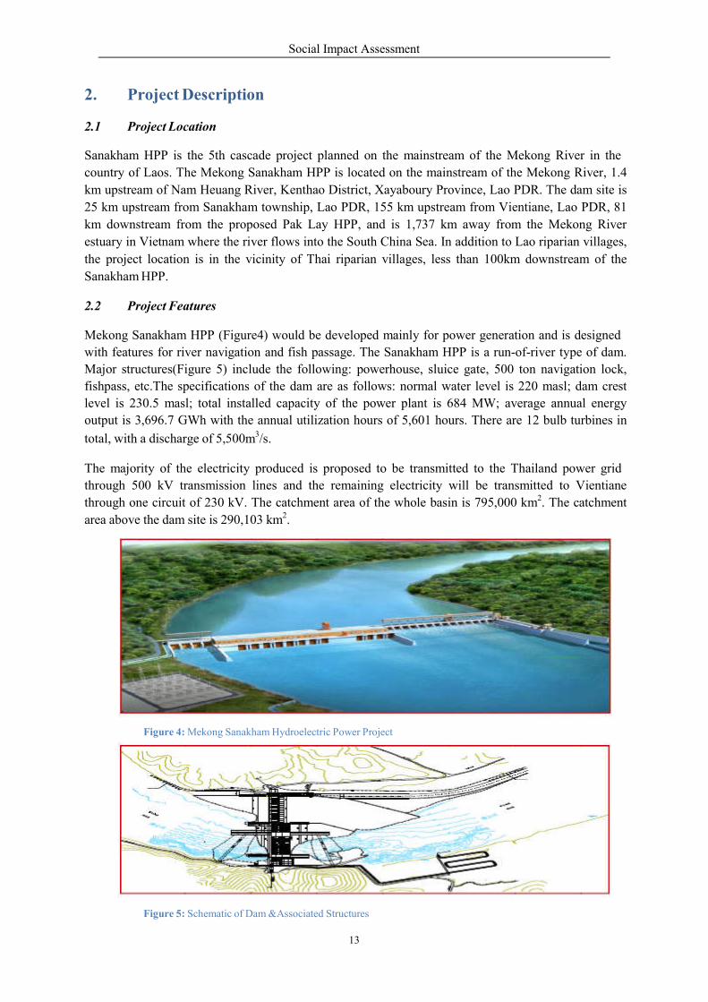
Social Impact Assessment
13
2. 2.1
Project Description Project Location
Sanakham HPP is the 5th cascade project planned on the mainstream of the Mekong River in the
country of Laos. The Mekong Sanakham HPP is located on the mainstream of the Mekong River, 1.4
km upstream of Nam Heuang River, Kenthao District, Xayaboury Province, Lao PDR. The dam site is
25 km upstream from Sanakham township, Lao PDR, 155 km upstream from Vientiane, Lao PDR, 81
km downstream from the proposed Pak Lay HPP, and is 1,737 km away from the Mekong River
estuary in Vietnam where the river flows into the South China Sea. In addition to Lao riparian villages,
the project location is in the vicinity of Thai riparian villages, less than 100km downstream of the
Sanakham HPP.
2.2 Project Features
Mekong Sanakham HPP (Figure4) would be developed mainly for power generation and is designed
with features for river navigation and fish passage. The Sanakham HPP is a run-of-river type of dam.
Major structures(Figure 5) include the following: powerhouse, sluice gate, 500 ton navigation lock,
fishpass, etc.The specifications of the dam are as follows: normal water level is 220 masl; dam crest
level is 230.5 masl; total installed capacity of the power plant is 684 MW; average annual energy
output is 3,696.7 GWh with the annual utilization hours of 5,601 hours. There are 12 bulb turbines in
total, with a discharge of 5,500m3/s.
The majority of the electricity produced is proposed to be transmitted to the Thailand power grid
through 500 kV transmission lines and the remaining electricity will be transmitted to Vientiane
through one circuit of 230 kV. The catchment area of the whole basin is 795,000 km2. The catchment
area above the dam site is 290,103 km2.
Figure 4: Mekong Sanakham Hydroelectric Power Project
Figure 5: Schematic of Dam &Associated Structures
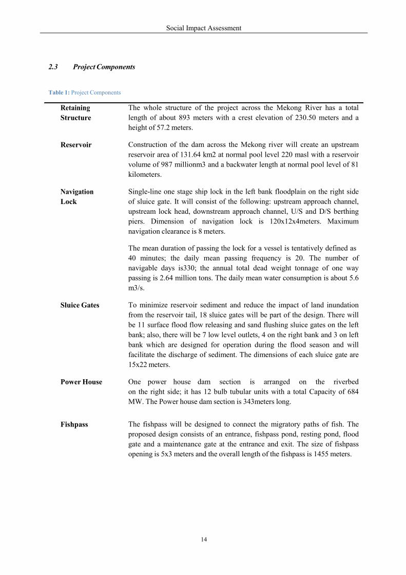
Social Impact Assessment
14
2.3 Project Components
Table 1: Project Components
Retaining
Structure
The whole structure of the project across the Mekong River has a total
length of about 893 meters with a crest elevation of 230.50 meters and a
height of 57.2 meters.
Reservoir
Construction of the dam across the Mekong river will create an upstream
reservoir area of 131.64 km2 at normal pool level 220 masl with a reservoir
volume of 987 millionm3 and a backwater length at normal pool level of 81
kilometers.
Navigation
Lock
Single-line one stage ship lock in the left bank floodplain on the right side
of sluice gate. It will consist of the following: upstream approach channel,
upstream lock head, downstream approach channel, U/S and D/S berthing
piers. Dimension of navigation lock is 120x12x4meters. Maximum
navigation clearance is 8 meters.
The mean duration of passing the lock for a vessel is tentatively defined as
40 minutes; the daily mean passing frequency is 20. The number of
navigable days is330; the annual total dead weight tonnage of one way
passing is 2.64 million tons. The daily mean water consumption is about 5.6
m3/s.
Sluice Gates
To minimize reservoir sediment and reduce the impact of land inundation
from the reservoir tail, 18 sluice gates will be part of the design. There will
be 11 surface flood flow releasing and sand flushing sluice gates on the left
bank; also, there will be 7 low level outlets, 4 on the right bank and 3 on left
bank which are designed for operation during the flood season and will
facilitate the discharge of sediment. The dimensions of each sluice gate are
15x22 meters.
Power House
One power house dam section is arranged on the riverbed
on the right side; it has 12 bulb tubular units with a total Capacity of 684
MW. The Power house dam section is 343meters long.
Fishpass
The fishpass will be designed to connect the migratory paths of fish. The
proposed design consists of an entrance, fishpass pond, resting pond, flood
gate and a maintenance gate at the entrance and exit. The size of fishpass
opening is 5x3 meters and the overall length of the fishpass is 1455 meters.
Social Impact Assessment
15
2.4 Projected Affected Areas
2.4.1 Inundated Area
The project will create a reservoir with a capacity of 987 million m3 (below PMF level 222.15 masl)
and 8.27 million m3 (below normal water level 220 masl). The inundated land includes arable land
(565.14 ha), orchards (59 ha), woodlands (1,750.74 ha) and homesteads (28.1 ha). A total of 3 villages
will be directly affected or inundated, requiring resettlement, and 10 villages will be indirectly or
partially affected, not totally inundated, from which families require relocation to higher ground.
2.4.2 Construction Area
The land area in the vicinity of dam site will be used for office and living facilities, warehouses,
electrical and mechanical equipments assembly yard, auto repair workshop, materials make up area,
machinery depot, concrete batching plant, quarry sites, disposal areas and road, etc
2.4.3 Road Access
A road from Sanakham Township to the dam site and a road from Kenthao Township to the dam site
on the right bank will be reconstructed. In addition to constructing new bridges, any access roads must
be reinforced or rebuilt to meet transportation requirements.
An access road from Pakmee Village to the head work area totalling 24.2 km will be constructed. This
includes 6.35 km around the seat of the village of Sanakham.The access road is a highway grade III
(asphaltic surfaced with two-lane of 8m wide) with a design speed of 30 km/hour. Similar design will
also be used for the access to quarry site with the total length of 1.88 km connected to the main access
road will also be constructed.
2.5 Project Implementation Schedule
The project implementation time will divide into 2 periods, preparation and construction
Preparation
Construction
First unit generation
Total construction duration
15
75
43
75
months
months
months
months

Social Impact Assessment
16
3. 3.1
Social Policy and Legal Framework Compensation & Resettlement
Key Issues of the “Prime Minister Decree No. 192/PM on the Compensation and Resettlement of the
Development Project (2005)” include:
Project owners shall compensate APs for their lost rights to use land and for their lost assets
(structures, crops, trees, and other fixed assets), affected in full or part, at replacement cost.
Where significantly large or entire land holding are affected by a project, namely, agriculture,
residential or commercial land, compensation shall be through provision of “land for land”
arrangements of equivalent size and productivity and be acceptable to APs and project owners.
If the house or structure is unviable for continued use or the remaining area is less than the
minimum house size, the AP shall be entitled to be compensated for the entire structure at
replacement cost without depreciation or deduction for salvage materials. In case the
remaining structure is viable for continued use, project owners shall provide compensation for
the lost portion and assistance in cash or material for restoration of the remaining structure.
APs whose land or assets are temporary taken due to work under the project shall be fully
compensated for their net loss of income, damage assets, crops, trees, as the case may be. The
project owners shall also ensure that the land or assets are returned in its pre-project state.
Tenants or leasees of a house affected by the project shall be compensated for lost assets in the
amount equivalent to three months rental allowance and shall be assisted in finding alternative
rental accommodation.
APs who are living in rural or remote areas and don’t have any legal Land Use Certificate or
any other acceptable proof indicating land use right to the affected land and assets th y occupy
shall be compensated for their loss of assets at replacement cost and provided additional
assistance to ensure they are not worse off due to the project.
All APs, regardless of land use right, will be entitled to compensation for lost assets
(structures, crops, trees) at replacement cost, and provided with other assistance during the
transition period, and economic rehabilitation assistance to ensure that they are not worse off
due to the project.
All previous claims and unresolved issues related to tenure status and ownership of land and
other assets affected by the sub-project or components shall be resolved prior to initiating any
new land acquisition measures in order to to assess the loss to the AP.
Prior to the commencement of project construction, APs shall be fully compensated and
resettled and rehabilitation measures shall be in lace, although may not necessarily completed
yet.
APs displaced and/or affected due to the loss of income and livelihood shall be provided with the
following assistance until their income levels and living conditions can be stabilized:
Social Impact Assessment
17
(a) Transport allowance or assistance in kind to transfer to the resettlement site or their choice
of relocation.
(b) Food allowance, in cash or in kind and cash to compensate for income lost, during the
transition period
(c) Suitable development assistance after displacement during the transition period until they
are able to restore their incomes or improve their living standards.
(d) All APs directly affected by the project due to loss of 20% or more of productive income
generating assets (loss of agricultural, industrial or commercial resources) shall be entitled
to sustainable income restoration measures in addition to their entitlement for
compensation and other allowances enabling them to attain pre-project livelihood levels.
(e) For displaced persons whose land based livelihood are affected due to the project,
preference shall be given to land-based resettlement strategies, or where land is not
available, options built around opportunities for employment or self-employment.
(f) For displaced persons whose businesses are affected due to the project, in addition to
compensation for lost land, structures, and income, assistance shall be given to finding
replacement sites for business as appropriate.
(g) Rehabilitation measures shall specifically focus on vulnerable groups. Adequate
assistance, in addition to compensation for affected assets and other allowances, shall be
provided to enable such APs to achieve household income targets set above the national
poverty line.
(h) The project owner shall restore or repair community facilities and infrastructure that are
damaged due to the project, at no cost to the community.
(i) Any impact or restriction on access to resources managed by the affected community as a
common property shall be mitigated by arrangements ensuring access to improved or at
least equivalent resources on a continuing basis. Attention shall also be paid to directly
affected APs if their quality of life is reduced due to the loss of access to common property
resources.
3.2 Environmental & Social Impact Assessment
Decree on Environmental Impact Assessment 2010 – The latest decree of Lao PDR that addresses 2
types of investment project requiring environmental and social assessment:
Category 1: Investment projects which are small or create less impacts on environment and
society, but require initial environmental examination;
Category 2: Large - sized investment projects which are complicated or create substantial
impacts on environment and society but require environmental impact assessment.
The E&S assessment principles can be summarized as below.
(1) In relation to investment projects classified in Category 1 and Category 2, including
projects provided in Article 6 (2) of this Decree, the project developer must, first, obtain an
environmental compliance certificate, before any contract of mining and extracting of
Social Impact Assessment
18
mineral substances or constructing can be concluded, or before any business license can be
issued; and before they can start to clear the area, construct or implement the project.
(2) An IEE or an EIA must be conducted only by a Consultant Firm or by a Consultant who is
registered at the Water Resources and Environment Administration. The IEE or the EIA
must study several options, so that the best option can be selected. The scope should cover
impacts on antiquities, culture, and customs/traditions; plans to solve the negative impacts
on the environment and society; participation of the people who are (or will be) affected
by the investment project; participation of other stakeholders in discussion at all levels,
and in drawing up the budget for these activities.
(3) Ensuring the participation of the public and discussion with local administrations at all
levels, with those who are (or will be) affected by an investment project and other persons
involved in preparation and examination of a report on IEE or a report on the EIA.
(4) An individual, legal entity or organization who wishes to render environmental impact
assessment services in Lao PDR must comply with the following procedures:
o A domestic Consultant Firm must be licensed and registered at the Water Resources and Environment Administration.
o A domestic Consultant must be registered as an Environmental Consultant at the Water Resources and Environment Administration.
o A foreign Consultant Firm or foreign Consultant who has already got a license to
render environmental services in a foreign country must register its business with
the Water Resources and Environment Administration.
(5) A project developer must be liable for:
The accuracy of the data and information contained in the IEE or the EIA report.
Every expense incurred in the process of preparing and examining the IEE,
including measures to prevent and minimize impacts on the environment and
society or an EIA report or an Environmental Monitoring and Mamagement Plan
(EMMP) or a SMMP that monitors the implementation of measures to prevent and
minimize the impacts on the environment and society.
In relation to a new investment project which is likely to affect other investment
projects, there must be a CIA/TBIA.
For an investment project which is likely to create impacts beyond the border, a
CIA/TBIA must be conducted.
o o
o
o
(6) Any organizations involved in examination (or deliberation) of an IEE or an EIA report is
obliged to monitor the outcomes of the implementation of measures on prevention and
minimization of impacts on the environment and society or of an EMMP, whereas local
administrations have duties to monitor the implementation of the SMMP.
There are key roles of Lao Governmental agencies, MONRE and the local administrations in the ESIA
process as per the following.
MONRE
o To issue environmental compliance certificates to approve the IEE report proposed by the
sector bodies in charge of investment.
Social Impact Assessment
19
To participate in field inspections and participate in consultation meetings at district level.
The Water Resources and Environment Administration may nominate Provincial or
Prefectural Water Resources and Environment Divisions to participate on its behalf.
To coordinate with the concerned sector bodies and issue guidelines on practical
implementation.
Liaise with local administrations
To issue environmental compliance certificates to certify an IEE report based on the
verification of the Water Resources and Environment Administration.
To cooperate with and facilitate project developers in surveying and collecting information
to prepare reports and in organizing consultations with the people who are (likely to be)
affected by the investment project and other stakeholders.
To cooperate in the information dissemination process, and encourage people who are (likely
to be) affected by an investment project to access the objectives of the project, expected
benefits and the environmental and social impacts which might occur from the project.
o
o
o o
o
o
3.3 Hydropower Environmental and Social Sustainability
An important GOL environmental policy improvement can be found in the new national policy on
Environment and Social Sustainability of the Hydropower Sector in Lao PDR adopted in June 2005.
This policy employed the development principle based on Nam Theun 2 Hydropower Project which is
an integrated approach to the river basin that assesses cumulative impacts and proposes mitigation
inclusive of institutional and financing mechanisms. It applies to all large hydropower dams (with an
installed capacity of more than 50 MW or inundated area more than 10,000 hectares) constructed or
proposed after 1990. Accordingly, the Sanakham HPP should address the following:
Completion of a comprehensive EIA including cultural and archeological resources.
Identification of APs whose assets, resource use and livelihoods, and/or social or cultural
structures are involuntarily altered by the project. In addition cases of involuntary resettlement
and the SMMP are to be based on the decree no. 192/PM on the Compensation and
Resettlement of the Development Project (July 2005).
Watershed Management and Conservation should be effectively implemented through
offsetting any loss of natural terrestrial habitat based on NT2 Watershed Decree 39 of 2005.
This includes compensation measures to people residing within protected areas.
Continuous consultation with affected communities is required with comprehensive
environmental education and awareness activities.
Disclosure of information (Lao and English) related to project consultation reports, impact
assessment, mitigation plans and monitoring report are required with provision of information
centers in project area and in Vientiane.
Compliance with all relevant obligations including concession agreement under Lao national
laws, policies, strategies, action plans and international conventions through regular
monitoring and reporting.
The cost to the developer of implementing all environmental and social safeguards under the
user pay principle.
Organization of third-party monitoring and assessment with respect to the environmental and
social guidelines set.
Periodic review of the lessons learned from the implementation of this policy.
Annual preparation and disclosure of the Environment and Social Compliance Report.
Social Impact Assessment
20
3.4 Ethnic Groups
The 1991 Constitution defined Lao PDR as a Multi-Ethnic State with "Equality among all ethnic
groups” as described under Article 8 of the Constitution below:
The State pursues the policy of promoting Unity and Equality among all ethnic groups. All ethnic
groups have the rights to protect, preserve and promote the fine customs and cultures of their own
tribes and the nation. All Acts of creating Division and Discrimination among ethnic groups are
forbidden. The State implements every measure to gradually develop and upgrade the economic and
social level of all ethnic groups".
The 1992 ethnic policy, in the Resolution of the Central Politic Bureau of the Party concerning Ethnic
Affairs in the new era, focuses on gradually improving the living conditions of the ethnic groups, while
promoting their ethnic identity and cultural heritage. This general policy of the Party can be
summarized as follows:
Build national sentiment (national identity).
Realize equality among ethnic groups.
Increase the solidarity level among ethnic groups as members of the Lao family.
Resolve problems of Inflexible and Vengeful Thinking, as well as economic and cultural
inequality.
Improve the living conditions of the ethnic groups step by step.
Expand, to the greatest extent possible, the good and beautiful heritage and ethnic identity of
each group as well as their Capacity to participate in the affairs of the nation.
Various organizations responsible to implement the above policies are as follows:
The "Ethnic Committee" under the National Assembly, is in charge of drafting and evaluating
all legislations concerning ethnic groups, lobbying for its implementation and the
implementation of its socio-economic development plans.
The "Institute for Cultural Research" under the Ministry of Information and Culture, is
responsible for carrying out all ethnic research activities.
The "Lao Front for National Construction (LFNC)" as the mass (political) Organization, is the
lead institution for ethnic affairs.
The Constitution of Lao PDR was passed in 1991 as a consolidation of the rights and responsibilities of
the State and the people. Throughout the Constitution the term "citizens of all ethnicity" is used. The
Constitution states that all citizens have rights in education, health, land use and ownership, domicile
of choice, and economic development regardless of sex, religion, social status, education, or
ethnicity; as well as freedom of religion, freedom of speech; freedom to peacefully assemble and to
protest. All citizens have the right to work and carry out their chosen livelihoods. Articles 8 and 22,
guarantee that there will be no discrimination on the basis of ethnicity or gender, as specifically
mentioned as follows:
Article 8 - The State will carry out a policy of unity and equality among the various ethnic
groups. All ethnic groups have the right to preserve and improve their own traditions and
culture and those of the nation. Discrimination between ethnic groups is forbidden. The state
will carry out every means in order to continue to improve and raise the economic and social
conditions of all ethnic groups.

Social Impact Assessment
21
Article 22 - All Lao citizens, regardless of their sex, social position, education, beliefs or
ethnicity, are equal in front of the law.
One key management of ethnic groups in Lao PDR is the LFNC. The LFNC is the institution
that manages affairs related to indigenous people. It was established in 1996. The LFNC is
designated as an advisor to the central committee of the Party and the State and at the local
level, including the district level. The Party assists the LFNC in carrying out its duties. The
LFNC is responsible for the following:
o To promote the human development of ethnic minority officials; o To ensure that educational opportunities are made available to ethnic Minorities; o To promote and preserve cultural traditions; o To improve and expand healthcare, knowledge of reproductive health traditional
medicine and detoxification of opium addicted persons;
o To enhance the administrative mechanism for ethnic minorities including their
promotion in rural development activities by ensuring that other agencies are aware of
the requirements for the participation of ethnic minorities.
Other GOL’s policies and legislations relevant to ethnic groups are as follows:
According to The Land Laws, 1997, the GOL consider Land as the National Community
Property that is administered by the State for use and as a mean for all Socio-Economic
Development. All the lands must be used effectively and be based on the macro-level and
micro-level development planning. There is no personal ownership of land, but the citizens are
allowed to use it and have a customary right to its resources.
The Land Law also stipulates that, in the case that the public infrastructure development
projects cause damages to trees, crops or buildings of the private owners, the land owners have
the rights to be compensated for the damages.
Ethnic groups maintain land tenure rights equal to all Lao citizens with certain specifications
(see Section 3.1.5.1) and even preferential access and customary user rights to certain forest
products (Forestry Law,Article 30; MAF Regulation 535; MAF Orders 54 and 377).
Customary rights on land use among the ethnic groups are passed down from generation to generation.
Traditionally, no land titles were involved and no boundaries were officially demarcated. In remote rural
areas, these customary rights are still practiced to the acceptance of the local authorities widely. Many
ethnic groups have traditionally recognized certain areas of forest as sacred forests. In addition, among
the ethnic groups, individuals or households were considered to be the owners of specific trees, such as
those used for resin-tapping or that may have ancestral spiritual significance. These are important
aspects of village cultural and economic life that need to be investigated and strictly respected.
The GOL has developed a "Land and Forest Allocation" program with the aim to allocate the
land to individuals and to demarcate the village forest and land boundaries for proper land use
planning and forest management in a sustainable way. The main objectives of the land and
forest allocation program are:
o To promote crop production to replace shifting cultivation through allocation and titling of production land
o To protect forest through forest classification
o To utilize the allocated forests on sustainable basis.
The Prime Minister Decree No. 117 elaborated in 3 articles aiming:

Social Impact Assessment
22
o To allocate 2-5 ha of forest and forest land to each household and 100-500 ha to each village
o To allow villagers to manage and use allocated forest as long as wood volume Increases
o To allow villagers to inherit or transfer allocated forest to others o To recognize ownership of individuals and groups to degraded land which they plant
trees, regenerate, grow crops or raise livestock by themselves.
The Ministry of Agriculture and Forestry’s (MAF) Regulation on Village Forest Management
was issued in June 2001. Mostly to consolidate existing provisions concerning village forests,
e.g. classification of village forest, harvest of logs for housing and social welfare construction
activities. However, collection of Non Timber Forest Products (NTFPs) for sale is also
recognized, with the condition that management plans are formed and approved. NTFPs have
been recognized as one of the few income sour es available to rural villagers for a long time
without legal recognition, which, for the first time, this regulation provides.
The exploitation of forest resources must be in a sustainable way and be under the close
supervision of the local authorities as per adopted Forestry Law and in accordance to the land
use planning.
There are also other related policies and laws/regulations, such as the GOL’s Resettlement and
Compensation policies, the Asian Development Bank’s (ADB) and World Bank’s (WB) Safeguard
Policies on the same issues. These aim at ensuring that the losses of APs are compensated, that they
share project benefits and that their social and economic potential are developed in order to
improve or at least restore their incomes and living standards to pre-project levels.
Despite the efforts made by the above institutions to improve the situation of ethnic people, many ethnic
groups still lag behind the Lao ethnic group in terms of the poverty rate, literacy and health. Many
ethnic groups still cannot speak and read the Lao language and thus are unable to effectively make
use of schools and health clinics which have only Lao speaking staff. Also, many ethnic people live
in remote areas of the country and have difficulty reaching a larger settlement where access to
employment opportunities, healthcare and education is available.
3.5 Cultural and Archaeology
Cultural and Natural Heritage in the Lao PDR is controlled by the following laws and regulations:
The national Heritage Laws of Lao PDR on the preservation of culture, historical and natural
heritage. Complete set of regulations concerning the management of culture, historical and
natural heritage was agreed by theNational Assembly Number 08/NA on dated 09 November
2005.
The Decree of the President of the Lao PDR on the preservation of culture, historical
and natural heritage. Complete set of regulations concerning the management of cultural,
historical and natural heritage.
Constitution. Article 19: The management of national heritage is a State study.
Penal Code. Article 103: Sanction to law offenders in particular in the cases of damage
and destruction of cultural sites, export and trade of antiquities.

Social Impact Assessment
23
Law on the protection of environment. Article 16: Developers must abide by laws and
regulations concerning the material culture sites that might be affected by their
development projects.
The Ministry of Information and Culture, on behalf of the council of Ministers implements the
National policy on culture and cultural heritag . It is represented at provincial and district
level by the Office of Information and Culture of province and district, respectively. Laws and
regulations on cultural heritage are enforced under the guidance and control of Ministry of
Information and Culture. Lawsuits are filed by Ministry of Information and Culture and
transmitted to courts for trials and sanctions against offenders.
In other contractual arrangements, PCRs are to be handled in accordance with the GOL’s regulations
and the WB’s Operational Policy Note (OPN) 11.03 and Operational Policy (OP) 4.11.
3.6 Tourism
Key issues of the 2005 Law on Tourism related to Sanakham tourism are as follows:
Article 1: Purposes - The Law on tourism sets the principles, procedures and measur s on the
establishment, activity and administration of tourism aiming to promote and develop the cultural,
historical and eco-tourisms in extending, sustainable ways, transforming to modern tourism industry
and contributing the national protection and development, to promotion of mutual understanding,
peace, friendship and to cooperate in international development.
Article 2: Tourism - Tourism is traveling to other locations or countries for the purpose of sightseeing,
relaxation, entertainment, cultural exchange, sport, health promotion, research study, exhibition,
meeting, and other activities without the intention of finding employment, or it’s the movement of
professional carriers in any form of profit making.
Article 4: State Policy towards Tourism - The State centrally and uniformly administers throughout the
country on the conservation, protection and development of cultural and historical, eco-tourism in
sustainable and participatory manner.
The State considers tourism as a component of the national economy to promote the production,
services, increasing of the standing export, creation of works’ places, income’s generation and
improvement of livelihood of Lao ethnical people.
The State and society promote advertising campaigns, festivals, fairs on culture, fine national traditions
and the heroic inheritances of Lao ethnic people to attrac domestic and foreign tourists.
The State respects and protects legitimate interests including securing the safety of the tourists.
The State pays attention to create the conditions and protect rights and interests of individuals,
organizations within the country and abroad that invest in the development and promotion of tourism.
Article 5: The Obligation of Individuals and Organizations - To promote tourism, individuals and
domestic organizations shall have obligations to contribute in conservation, protection, development
and promotion of culture, fine traditions, arts, literature, handicraft that have unique character, tourism
resources, the wealthy and beauty of national natural resources.
Individuals and foreign organization entering the Lao PDR shall have the same obligations to
contribute to the protection of the tourism sites, culture and fine Lao traditions.
Social Impact Assessment
24
Article 6: International Cooperation - The State promotes international cooperation in tourism to
exchange lessons, information, building and training of authorities, attract assistance, promote
investment, advertise Lao tourism, promote tourism development and develop international standards
of tourist services.
3.7 Other Lao Laws Relevant to SIA
Land Law (1997)
Land within Lao PDR is the property of the national community, and individuals are assigned to
effectively use the land, but not treat it as a tradable commodity. The law sets out the rights of those
who have been allocated land, including the right to transfer that land.
Road Law (1999)
Environmental protection is required during road activities. National and provincial authorities of the
Ministry of Communications, Transport, Post and Construction are responsible for environmental
protection on road projects. Reasonable compensation must be paid to individuals whose land is
expropriated for road rights-of-way, relocation of replacement structures, and loss of trees and crops.
The Amended Forestry Law, No 06/NA (Dec. 2007)
Determines basic principles, regulations and measures on sustainable management, preservation,
development, utilization and inspection of forest resources and forest land, promotion of regeneration
and tree planting, and increase of forest resources in the Lao People’s Democratic Republic aiming for
maintaining the balance of nature, making forest and Forestland a stable source of living and use of
people, ensuring sustainable preservation of water sources, prevention of soil erosion and maintenance
of soil quality, conserving plant and tree species, wildlife species as well as environment and
contributing to the national socio-economic development.
3.8 Lao Party Congress Social Policy
The eighth Party Congress of Lao People’s Revolutionary Party in of 2006 issued seven main policies:
1) Determine targets related to national development aiming at central economic development;
continue to deal with the poverty of people particularly families; strongly strive to achieve the
target basically eliminating poverty by 2010; achieve an annual economic growth rate of 7.5
percent.
2) Enhance the effectiveness of state macro management of the market economy ensure the
expansion of economy and society in line with socialist principles.
3) Bolster human resource development in every area to fulfill the needs of socio-economic
development modern times; attend to implementation of suitable social policy, harmonizing with
the conditions and reality of the economic and financial situation in Laos.
4) Enhance state power in line with the principle building a state that is of people, by the people and
for the benefit of the people; build Laos in such ay that becomes a state governed the rule of
law.
5) Increase unity among entire population on the basis of workers-farmers alliance, revolutionary
intellectuals and students under the leadership of the Party.
Social Impact Assessment
25
6) Implement the national defense and security policy among the entire population to defend the
independence, sovereignty and territorial integrity, to guarantee stability and peace for socio-
economic development and the livelihood of the people.
7) Continue implementing creative foreign policy for the purpose of actively integrating Laos with
the international community, implement multi-direction and multi-forms on the basis of mutual
respect for each other’s independence, sovereignty and territorial integrity and noninterference in
each other’s internal affairs on an equal footing and with mutual interest.
3.9 Safeguard Policy of the World Bank
The international lending agencies, in particular, the WB requires that the dams be designed and its
construction supervised by experienced and competent professionals.
It also requires that the borrower adopt and implement certain dam safety measures for the design, bid
tendering, construction, operation, and maintenance of the dam and associated works.
A number of operational directives have been on boarded as basis for the borrowers to follow.
Tabulated below summarizes the WB’s operational policies (OP).
Operational Policy Actions and/or Responses
Environmental Assessment (OP
4.01)
Phase 1 Report analyzing project alternatives through
environmental and social screening.
This EIA which covers environmental impacts, mitigation and
management in the design, construction and operation phases of
the project. Parallel SIA which covers social impacts,
mitigation and management in the design, construction and
operation phases of the project.
Natural Habitats (OP 4.04) Flora and fauna species arrays and habitats are examined in
Sections 4.4.1 and 4.4.4 respectively. Conservation status of all
species is noted and forest protection areas are identified in
Section 4.4.3 and analyzed in Section 5.1.3.
Fish species and habitats are examined in Section 4.4.5.
Riverine habitats are mapped and described. Habitat
preferences are assigned to all species. The absence of endemic
species is noted.
Impacts on natural habitats and mitigation management are
included.
Pest Management (OP 4.09) Reservoir biomass clearance will be by mechanical means. No
chemicals will be used. Similarly, use of pesticides will be
minimized in resettlement site preparation.
Livelihood programs in the resettlement plan and Watershed
Management Plan will teach biological and environmental pest
Social Impact Assessment
26
Operational Policy Actions and/or Responses
control measures.
Involuntary Resettlement (OP
4.12)
A Resettlement Action Plan complying with World Bank
guidelines and Lao legislative requirements has been prepared
and submitted to rounds of AP and other stakeholder
participation and AP approval.
Indigenous Peoples (OP 4.10) All APs are from the same ethnic minority group. Therefore an
Ethnic Minorities People’s Plan (which complies w th World
Bank and Lao PDR guidelines) has been incorporated into the
resettlement plan to produce a Resettlement and Ethnic
minorities People’s Plan,
Forests (OP 4.36) The Watershed Management Plan will protect the catchment
forests as a priority.
The project will impact on a minimal area of natural forest.
The project includes management measures to minimize
exploitation of NTFPs by the construction work force.
The REMPP includes the retention of NTFP collection rights
for resettlers.
Safety of Dams (OP 4.37) Dam safety, including an assessment of seismic potential, has
been fully covered in the technical and economic component.
3.10 International Principle and Best Practice
3.10.1 Equator Principle
The “equator principle” is one of the various international E&S standards primarily based on
International Financial Corporation’s Performance that contains 9 principles which are:
its
Principle 1: Review and Categorization
Principle 2: Social and Environmental Assessment
Principle 3: Applicable Social and Environmental Standards
Principle 4: Action Plan and Management System
Principle 5: Consultation and Disclosure
Principle 6: Grievance Mechani m
Principle 7: Independent Review
Principle 8: Covenants
Social Impact Assessment
27
Principle 9: Independent Monitoring and Reporting
Principle10: Reporting
The above 2006 Principles adopt stronger social and environmental standards. They place a greater
emphasis on the social risks and impacts associated with a project. These changes are reflected in both
the language (e.g. the shift to “social and environmental assessment”) and substance (e.g. the clear
separation of social and environmental impacts in the revised project categories) of the 2006
Principles. The 2006 Principles also include a commitment to periodic reporting. This change seeks to
address a common criticism of the original principles: a lack of transparency. However, the 2006
Principles also expressly recognize that confidentiality must be taken into account in reporting. At a
minimum, the Equator financial institutions commit to report annually on the number of transactions
screened and the categorization accorded to them, and on their experience in implementing the 2006
Principles. It is expected that reporting will exceed this benchmark. To the extent that the Equator
financial institutions are able to balance periodic reporting on the kinds of items described in Bank
Track’s working document, Transparency and the Equator Principles, with their confidentiality
obligations, the 2006 Principles may avoid some of the c iticism leveled at its original principles.
3.10.2 World Commission on Dams – Criteria and Guidelines
The World Commission on Dams, having considered the multiple and diverse impacts and interests in
dams, concluded in their report to have identified five critical decision points within dam planning to
have the strongest influence on the performance of projects. These points are strategic in nature, and
not directly applicable to the current status of the Mekong Sanakham Hydroelectric Power Project.
However, the WCD suggests that projects should be reviewed for social aspects such as:
Stakeholder analysis based on risks and rights resulting in the formation of a stakeholder
forum.
Supporting vulnerable and disadvantaged stakeholders to participate in an informed
manner.
Understand the distribution of costs and benefits across stakeholders
Agree measures to promote development of, and ensure benefits to project affected and
displaced people.
Include recourse and compliance mechanisms.
3.11 Regional Agreement
The regional agreement is founded on "The Agreement on the Cooperation for the
Sustainable Development of the Mekong River Basin (1995)" This agreement was signed
on 5 April 2005 by four Mekong riparian countries, namely, the Kingdom of Cambodia,
the Lao People's Democratic Republic, the Kingdom of Thailand and the Socialist
Republic of Viet Nam.
The agreement has set a new mandate for organization to cooperate in all fields of
sustainable development, utilization, management and conservation of the water and
related resources of the Mekong River Basin. Signatories to this treaty agree that transfer
of the Mekong River and tributary water outside the Mekong River Basin can occur only
by consensus among the four country members. The member countries therefore agree to
coordinate in water project planning and monitoring of the basin waters.

Social Impact Assessment
28
Also important is to start a process of reasonable and equitable use of the Mekong River
system in each country to develop procedures for water utilization. The Mekong River
Commission (MRC) is supporting a joint basin-wide planning process with the four
countries called The Basin Development Plan, which is the basis of its Integrated Water
Resources Development Program. The MRC has included the following topics: fishery
management, the promotion of safe navigation, irrigated agriculture, watershed
management, environmental monitoring, flood management and exploring hydropower
alternatives.
The agreement outlines three sets of procedures:
1) Procedures for Notification, prior to Consultation and Agreement, requires
member countries to alert each other on planned river development that
could significantly affect their neighbors, and to provide information
regarding the developments, including technical specifications and
environmental assessments.
Procedures for Water Use Monitoring which can provide a legal basis for a
water use monitoring system to be established in the lower Mekong Basin.
Procedures for the Maintenance of Flows on the Mainstream.
2)
3)
These agreed procedures provide a definition of water use, covering uses of the Mekong
that may have a significant impact on water quality and hydrological regimes on the
mainstream of the Mekong.
4. SOCIAL BASELINE STUDY 1: OVERVIEW OF THE SOCIO-
ECONOMIC CONDITIONS IN LAO PDR AND THE STUDY AREA
4.1 Country Socio-Economic Setting
4.1.1 Socio-cultural
Lao PDR is a nation in Southeast Asia located within the Lower Mekong sub-region. It has 17
provinces covering an area of 236,800 km2. The Lao PDR has the population of 6.8 million (about
100,000 households). There are three main ethnicities, Lao, Hmong and Kmou but there are a total of
49 ethnic groups. The main
summarized as below:
re
236
6.8
25
2.5%
3.1
3
Buddhism
Land Area:
Population:
Population Density:
Population Growth:
Labor Force:
Ethnicity:
Religion:
4.1.2 Macroeconomics
The GOL has opened the countr
years (2005-2009) the Lao econo
at an average rate of 7.4%, a ra
China. Data on economy showe
agriculture and forestry (42.8%
exported to are Thailand, Vietna
exported are gold, copper, timber,
GDP Growth (2005-09):
GDP Growth (2010):
Agriculture contribution:
Industrial contribution:
Service contribution:
GDP capita (2001-05):
GDP capita (2006-07):
GDP capita (2007-08):
GDP capita (2008-09):
Inflation of currency:
Exchange rate:
In 2010, the GDP growth of the Lao
of growth mainly reflects substantial
2010 and contributed most to the grow
hydropower plant, the biggest in
output is exported to Thailand. Mining
metal prices.
4.1.3 Foreign Direct Investme
Since 2005, foreign direct inve
$/year) (Figure 7), mainly com
Thailand investing in hydro-powe
Social Impact Assessment
29
eligion is Buddhism. The general socio-cultural
236,800 km2
6.8 Million (2010)
25 persons/km2
2.5%
3.1 Millions
3 ethnicity with 49 groups
Buddhism
Figure
ry's doors to globalization and favors free markets.
economy is based on gross domestic product (GDP)
ate similar to surrounding countries, such as Thailand,
wed that the top three industries that contributed
%), industries (32.0%), and services (25.3%).
Vietnam, China, South Korea and the United Kingdom
ber, garments, and electricity.
09):
ion:
n:
05):
07):
08):
09):
7.4%
7.5%
42.8%
32.0%
25.3%
491 US$/per person/year
678 US$/ per person/year
728 US$/per person/year
925 US$/per person/year
9.6%
8,000 kip/1 US$ (2012)
Lao PDR showed an increase in GDP of 7.5%. This
ntial investment in mining and hydropower. Indus
the growth. Output of electricity more than doubled
the country at 1,070 MW, reached full capacity in
Mining production rose by 19.0% last year, spu
ment
estments have sharply flowed into the Lao PDR
ming from China and Vietnam investing in the
wer projects. Therefore, to facilitate the investments
l information can be
e 6: Map of Lao PDR
ets. For the past five
and has bee growing
hailand, Vietnam and
d to the growth were
The main countries
m. The main products
This prolonged period
stry grew by 18.0% in
ed as the Nam Theun 2
in April. Most of their
urred by higher global
R (>180 million US
e mining sector and
ments and make the
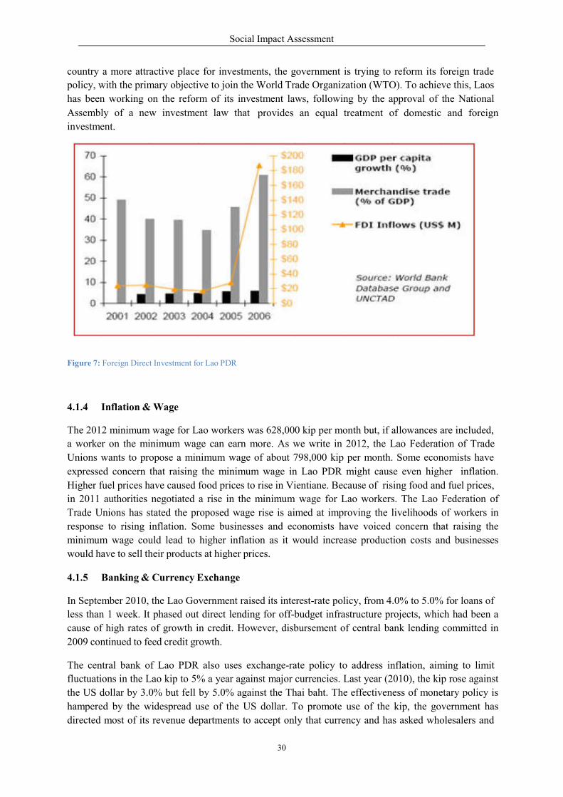
Social Impact Assessment
30
country a more attractive place for investments, the government is trying to reform its foreign trade
policy, with the primary objective to join the World Trade Organization (WTO). To achieve this, Laos
has been working on the reform of its investment laws, following by the approval of the National
Assembly of a new investment law that
investment.
provides an equal treatment of domestic and foreign
Figure 7: Foreign Direct Investment for Lao PDR
4.1.4 Inflation & Wage
The 2012 minimum wage for Lao workers was 628,000 kip per month but, if allowances are included,
a worker on the minimum wage can earn more. As we write in 2012, the Lao Federation of Trade
Unions wants to propose a minimum wage of about 798,000 kip per month. Some economists have
expressed concern that raising the minimum wage in Lao PDR might cause even higher inflation.
Higher fuel prices have caused food prices to rise in Vientiane. Because of rising food and fuel prices,
in 2011 authorities negotiated a rise in the minimum wage for Lao workers. The Lao Federation of
Trade Unions has stated the proposed wage rise is aimed at improving the livelihoods of workers in
response to rising inflation. Some businesses and economists have voiced concern that raising the
minimum wage could lead to higher inflation as it would increase production costs and businesses
would have to sell their products at higher prices.
4.1.5 Banking & Currency Exchange
In September 2010, the Lao Government raised its interest-rate policy, from 4.0% to 5.0% for loans of
less than 1 week. It phased out direct lending for off-budget infrastructure projects, which had been a
cause of high rates of growth in credit. However, disbursement of central bank lending committed in
2009 continued to feed credit growth.
The central bank of Lao PDR also uses exchange-rate policy to address inflation, aiming to limit
fluctuations in the Lao kip to 5% a year against major currencies. Last year (2010), the kip rose against
the US dollar by 3.0% but fell by 5.0% against the Thai baht. The effectiveness of monetary policy is
hampered by the widespread use of the US dollar. To promote use of the kip, the government has
directed most of its revenue departments to accept only that currency and has asked wholesalers and
Social Impact Assessment
31
retailers to use it for quoting prices. Such measures have helped to lower the level of dollarization to
below 50% in 2010, from a peak of 79.0% in 1999.
4.1.6 Fiscal Situation
Strong growth in government revenue, in part a result of high global prices for copper and gold, helped
to rein in the budget deficit in fiscal year 2010. Growth in spending moderated relative to 2009, when
the government had lifted outlays to cushion the impact of the global recession. The budget deficit,
including grants but excluding off-budget spending, narrowed to an estimated 3% of GDP from 5.1%
in 2009. Including off-budget spending, it was close to 5%.Mineral exports exceeded US$1 billion for
the first time and electricity exports rose to $375 million. Shipments of clothing increased in value by
about 14% to $184 million, mainly on better demand from Japan and the Republic of
Korea.Merchandise imports rose by an estimated 13.5% to $2.8 billion.
4.2 Provincial & District Socio-economic Setting
4.2.1 Administrative Area &Population
The Sanakham HPP is within the boundary of 2 provinces, Vientiane and Xayaboury. Xayaboury is
located on the right bank, while Vientiane is on the left bank. Some villages in Kenthao and Paklay of
Xayaboury will be affected by the Full Supply Level (FSL) of 220 masl and some villages in
Sanakham will also be affected. The general socio-economic information of the area is outlined below
(Figure 8).
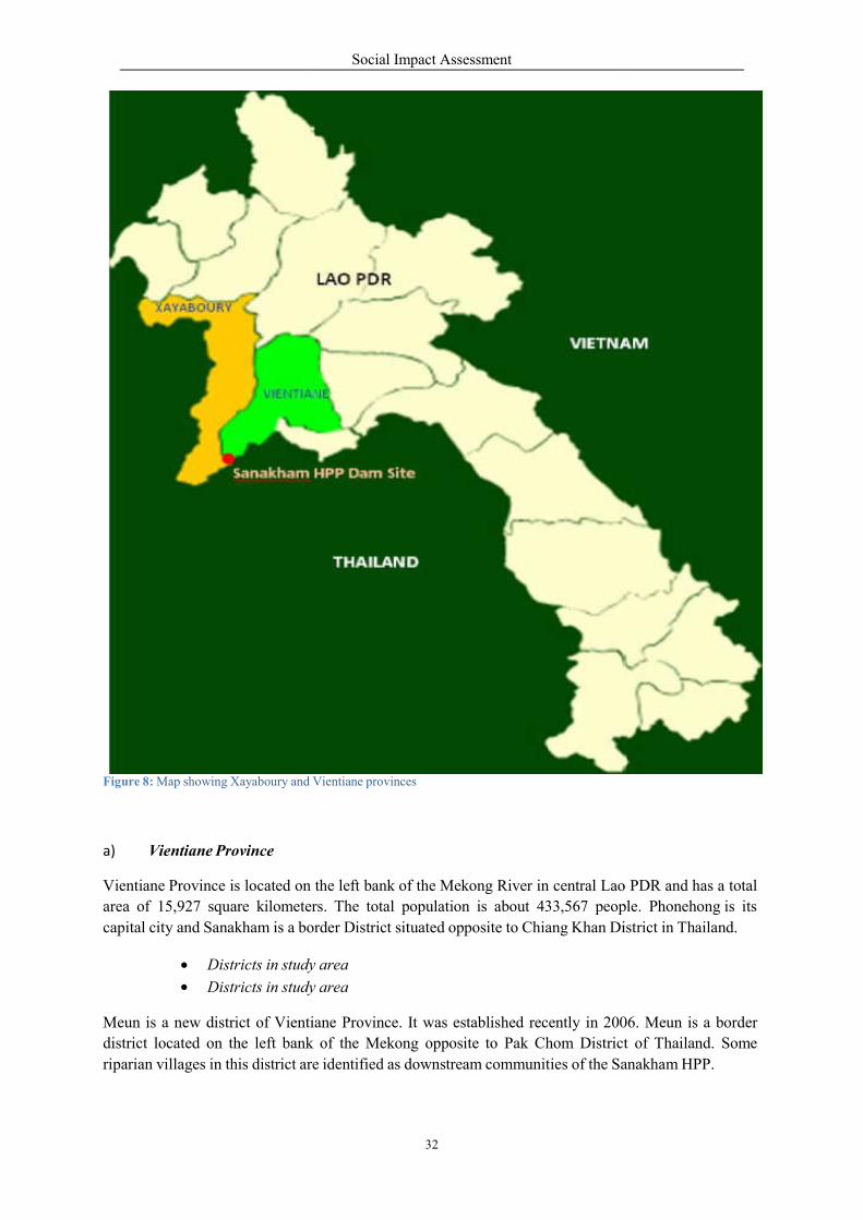
Figure 8: Map showing Xayaboury and
a) Vientiane Province
Vientiane Province is located on
area of 15,927 square kilometers.
capital city and Sanakham is a border
Districts in study
Districts in study
Meun is a new district of Vientiane
district located on the left bank
riparian villages in this district are
Social Impact Assessment
32
Vientiane provinces
the left bank of the Mekong River in central Lao
rs. The total population is about 433,567 people.
border District situated opposite to Chiang Khan District
study area
study area
Vientiane Province. It was established recently in 2006.
bank of the Mekong opposite to Pak Chom District
re identified as downstream communities of the Sanakh
o PDR and has a total
ple. Phonehong is its
istrict in Thailand.
06. Meun is a border
t of Thailand. Some
anakham HPP.
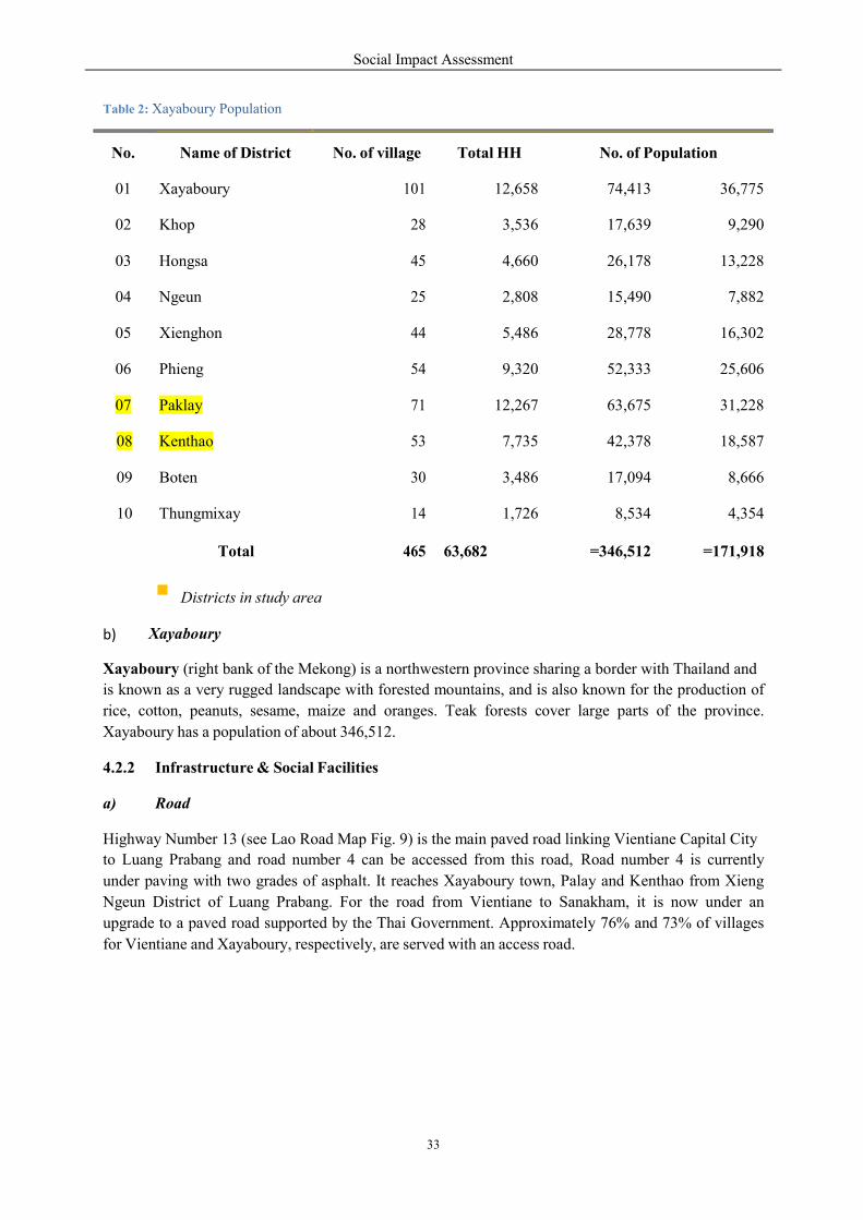
Social Impact Assessment
33
Table 2: Xayaboury Population
Districts in study area
Xayaboury b)
Xayaboury (right bank of the Mekong) is a northwestern province sharing a border with Thailand and
is known as a very rugged landscape with forested mountains, and is also known for the production of
rice, cotton, peanuts, sesame, maize and oranges. Teak forests cover large parts of the province.
Xayaboury has a population of about 346,512.
4.2.2 Infrastructure & Social Facilities
a) Road
Highway Number 13 (see Lao Road Map Fig. 9) is the main paved road linking Vientiane Capital City
to Luang Prabang and road number 4 can be accessed from this road, Road number 4 is currently
under paving with two grades of asphalt. It reaches Xayaboury town, Palay and Kenthao from Xieng
Ngeun District of Luang Prabang. For the road from Vientiane to Sanakham, it is now under an
upgrade to a paved road supported by the Thai Government. Approximately 76% and 73% of villages
for Vientiane and Xayaboury, respectively, are served with an access road.
No.
Name of District
No. of village
Total HH
No. of Population
01
Xayaboury
101
12,658
74,413
36,775
02
Khop
28
3,536
17,639
9,290
03
Hongsa
45
4,660
26,178
13,228
04
Ngeun
25
2,808
15,490
7,882
05
Xienghon
44
5,486
28,778
16,302
06
Phieng
54
9,320
52,333
25,606
07
Paklay
71
12,267
63,675
31,228
08
Kenthao
53
7,735
42,378
18,587
09
Boten
30
3,486
17,094
8,666
10
Thungmixay
14
1,726
8,534
4,354
Total
465
63,682
=346,512
=171,918
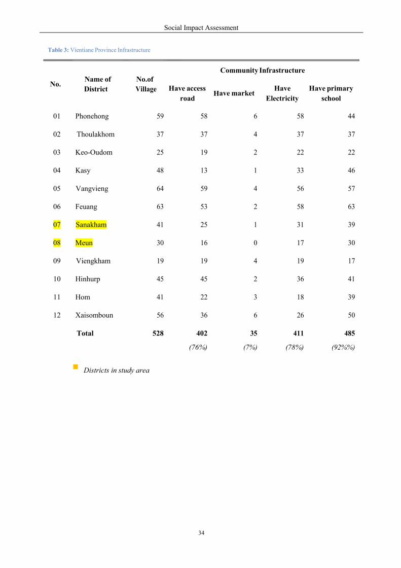
Social Impact Assessment
34
H
7
c
Table 3: Vientiane Province Infrastructure
Districts in study area
No.
Name of
District
No.of
Village
Community Infrastructure
Have access
road
ave market
Have
Electricity
Have primary
s hool
01
Phonehong
59
58
6
58
44
02
Thoulakhom
37
37
4
37
37
03
Keo-Oudom
25
19
2
22
22
04
Kasy
48
13
1
33
46
05
Vangvieng
64
59
4
56
57
06
Feuang
63
53
2
58
63
07
Sanakham
41
25
1
31
39
08
Meun
30
16
0
17
30
09
Viengkham
19
19
4
19
17
10
Hinhurp
45
45
2
36
41
11
Hom
41
22
3
18
39
12
Xaisomboun
56
36
6
26
50
Total
528
402
(76%)
35
(7%)
411
( 8%)
485
(92%%)
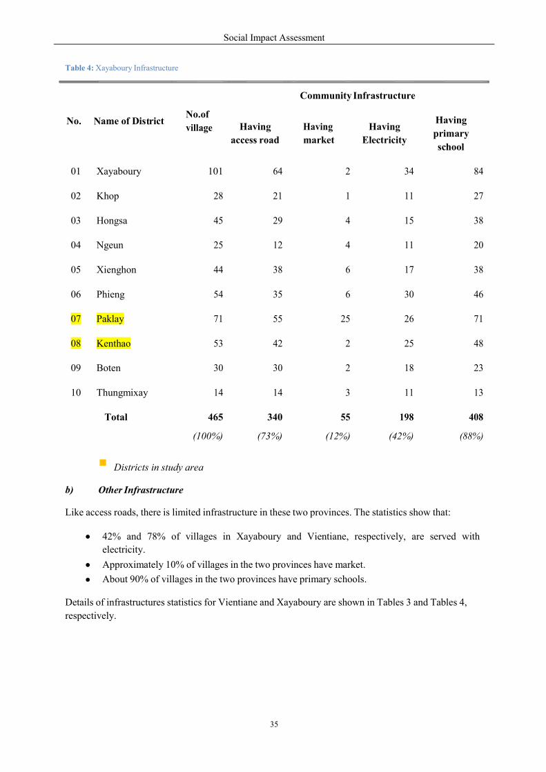
Social Impact Assessment
35
N
t
%
4
c
Table 4: Xayaboury Infrastructure
primary
Districts in study area
Other Infrastructure b)
Like access roads, there is limited infrastructure in these two provinces. The statistics show that:
42% and 78% of villages in Xayaboury and Vientiane, respectively, are served with
electricity.
Approximately 10% of villages in the two provinces have market.
About 90% of villages in the two provinces have primary schools.
Details of infrastructures statistics for Vientiane and Xayaboury are shown in Tables 3 and Tables 4,
respectively.
No.
ame of Dis rict
No.of
village
Community Infrastructure
Having
access road
Having
market
Having
Electricity
Having
s hool
01
Xayaboury
101
64
2
34
84
02
Khop
28
21
1
11
27
03
Hongsa
45
29
4
15
38
04
Ngeun
25
12
4
11
20
05
Xienghon
44
38
6
17
38
06
Phieng
54
35
6
30
46
07
Paklay
71
55
25
26
71
08
Kenthao
53
42
2
25
48
09
Boten
30
30
2
18
23
10
Thungmixay
14
14
3
11
13
Total
465
(100%)
340
(73%)
55
(12 )
198
( 2%)
408
(88%)

Social Impact Assessment
36
Figure 9: Road Network in Lao PDR
Social Impact Assessment
37
There are now 5,968 poor families in 88 villages in Vientiane Province, accounting for 7.2 percent of
the total provincial population. It should be noted that a target has been set to achieve an average
annual per capita income of US$1,400, with an average growth rate of 9 percent for the next five years.
Xayaboury Province
The Xayaboury Province comprises 10 districts, of which Xayaboury and Xienghon a e on the
government's list of 47 poorest districts nationwide. Locals have been farming for many centuries and
district officials believe combining local knowledge with modern farming techniques is the key for
poverty reduction. Although the number of poor families is steadily declining year by year the district
cannot achieve basic poverty alleviation this year because some people still live in poor conditions and
are waiting for assistance. However, district officials are confident they will be able to declare basic
poverty reduction by 2012.
The district has more 3,000 hectares of rice fields and 2,600 hectares of Job's tears which are expected
to increase in the future as villagers boost production for sale. Villagers compete to grow Job's tears to
sell to a Chinese-owned factory in the district. A Chinese company also has a concession of about
4,500 hectares to grow rubber trees, which provides local people with employment. It is believed that
infrastructure development and teaching new farming methods to poor families helped them to expand
their farming and animal husbandry activities, and are important factors in improving their living
standards.
But the provincial government has difficulty getting farmers to move away from using old fashioned
techniques that result in low yields, though they continue to educate locals about improved agricultural
practices. The district has only two markets so the provincial government has set up eight groups who
go directly to villages to buy surplus crops so villagers can be sure to sell all of their produce.
It is found that some 6,036 families living in the district, 1,328 are still living below the poverty line,
he added. All villages in the district can be accessed by road but only 30 percent can be accessed all
year round. District officials are hoping eight remote villages will be connected to the electricity grid
this year. So far 27 villages in the district are connected and all villages are slated to have electricity by
2013.
The average annual income in the province now stands at more than 5 million kip, and is expected to
rise in the near future. The government's Poverty Reduction Fund has so far invested 500 million kip in
improvements to basic infrastructure.
b) Poverty Setting
Poverty here means the lack of basic requirement in daily livelihood, such as lack of food {less than
2,100 kilocalories/person/day}, clothing, permanent shelter, inability to afford medical treatments,
inability to afford one’s education and the education of other member in the fa}mily.
According to Decree 285/PM dated 13 October 2009 on Poverty Elimination and Development
Measures, the rural poverty line was then set at 180,000 kip/person/month or 0.75 US$/day. The
2009 United Nations Human Development Report included the following world map of poor people
earning below 1.25 US$/person/day (Figure10).

Social Impact Assessment
38
Figure 10: World Map of poverty living <1.25 US$/person/day
The UN report defined poverty as an economic condition of lacking both money and basic necessities
needed to successfully live, such as food, water, education, healthcare, and shelter.
4.3 Land Use & Agriculture in the Study Area
Based on the GIS and ground surveys of the study teams, the project catchment area of approximately
1.6 million ha is located within Paklay and Kenthao districts of Xayaboury Province, and Sanakham
District of Vientiane Province. Nearly half of the total area is un-stocked forest that has been
encroached for utilization of timber and NTFPs. Another half is a better quality forest area; 6% of
which is bamboo.
The survey indicates that approximately 80% of the total population is engaged in farming. The
average land holding is 1.79 ha with 20 % of households having 1 hectare or more and 40 % having
less than 1 hectare. About 60% of the area devoted to rice production is for the production of sticky
rice, a subsistence crop used primarily for home consumption. Some fruit trees grown are mango,
coconut, banana, jackfruit and tamarind. Livestock raised include cattle, buffaloes, goats, turkeys, pigs
and chickens.
For agricultural production, the key cash crops are rice, vegetables, beans and maize/sweet corn. On
the average, the production of sticky rice is approximately 2 to 3tons per ha.
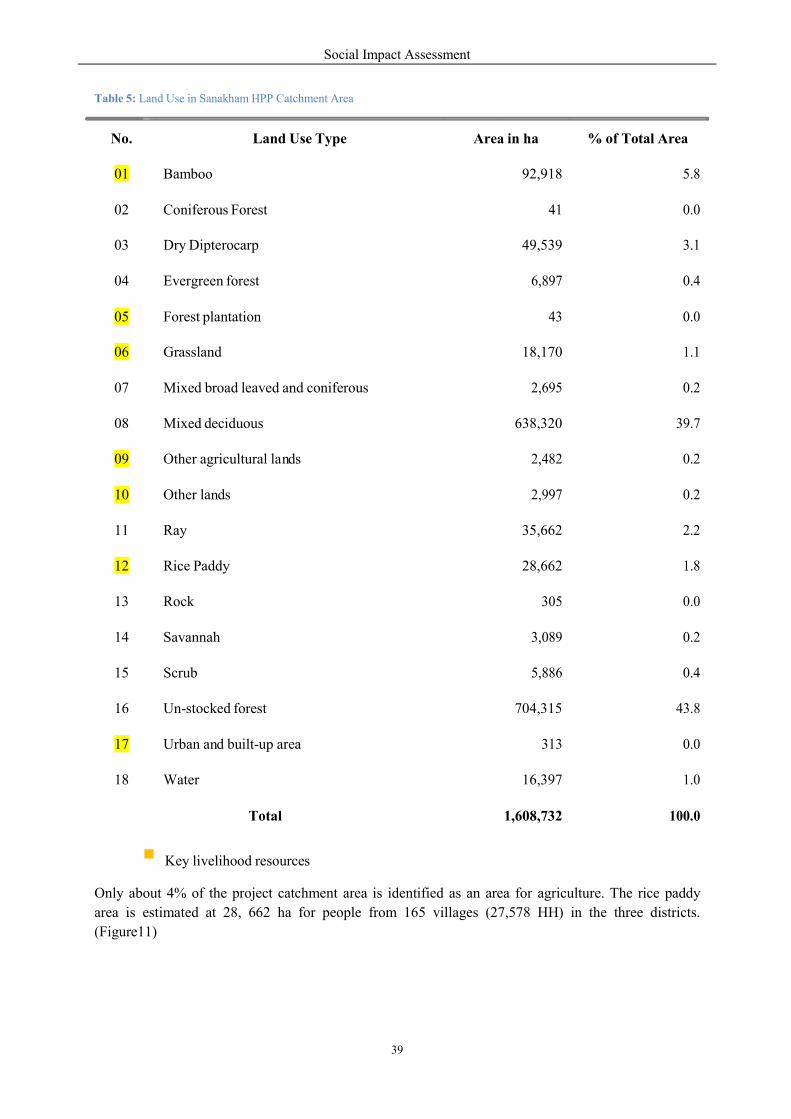
Social Impact Assessment
39
n
n
n
a
Table 5: Land Use in Sanakham HPP Catchment Area
Key livelihood resources
Only about 4% of the project catchment area is identified as an area for agriculture. The rice paddy
area is estimated at 28, 662 ha for people from 165 villages (27,578 HH) in the three districts.
(Figure11)
No.
Land Use Type
Are in ha
% of Total Area
01
Bamboo
92,918
5.8
02
Coniferous Forest
41
0.0
03
Dry Dipterocarp
49,539
3.1
04
Evergreen forest
6,897
0.4
05
Forest plantation
43
0.0
06
Grassland
18,170
1.1
07
Mixed broad leaved and coniferous
2,695
0.2
08
Mixed deciduous
638,320
39.7
09
Other agricultural la ds
2,482
0.2
10
Other la ds
2,997
0.2
11
Ray
35,662
2.2
12
Rice Paddy
28,662
1.8
13
Rock
305
0.0
14
Savannah
3,089
0.2
15
Scrub
5,886
0.4
16
Un-stocked forest
704,315
43.8
17
Urban a d built-up area
313
0.0
18
Water
16,397
1.0
Total
1,608,732
100.0

Figure 11: Land Use in the Project Catch
Social Impact Assessment
40
chment Area
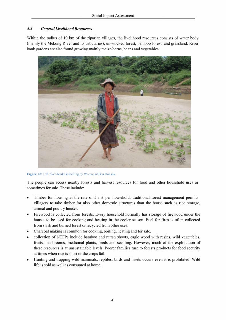
4.4 General Livelihood Reso
Within the radius of 10 km of the
(mainly the Mekong River and its
bank gardens are also found grow
Figure 12: Left-river-bank Gardening by
The people can access nearby forests
sometimes for sale. These include:
Timber for housing at the rate
villagers to take timber for
animal and poultry houses.
Firewood is collected from forests.
house, to be used for cooking
from slash and burned forest
Charcoal making is common
collection of NTFPs include
fruits, mushrooms, medicina
these resources is at unsustainable
at times when rice is short or
Hunting and trapping wild m
life is sold as well as consum
Social Impact Assessment
41
ources
the riparian villages, the livelihood resources consists
its tributaries), un-stocked forest, bamboo forest,
wing mainly maize/corns, beans and vegetables.
y Woman at Ban Donsok
forests and harvest resources for food and other
e:
rate of 5 m3 per household; traditional forest manage
also other domestic structures than the house
forests. Every household normally has storage of
cooking and heating in the cooler season. Fuel for fires
or recycled from other uses.
for cooking, boiling, heating and for sale.
include bamboo and rattan shoots, eagle wood with resins,
al plants, seeds and seedling. However, much of
unsustainable levels. Poorer families turn to forests prod
the crops fail.
mammals, reptiles, birds and insets occurs even
med at home.
onsists of water body
and grassland. River
her household uses or
management permits
such as rice storage,
of firewood under the
ires is often collected
resins, wild vegetables,
of the exploitation of
ducts for food security
it is prohibited. Wild

Social Impact Assessment
42
4.5 Education
As shown earlier in Tables 4-3 and 4-4 that nearly all villages in the study area has a primary school
for the young people. However, secondary schools are limited butareavailable mostly in the main
towns, such as Sanakham, Meun, Kenthao and Paklay.
The recent statistics (NSC, 2006) indicated that 13.7% and 14.5% of people of age 6 or above had no
schooling(for Vientiane and Xayaboury, respectively). In general, percentage of female attended
school was higher than male(Table 6).
The statistics also indicated that there was very high percentage of people leaving school after finished
their primary education. The reason for the low attendance in secondary school was partly explained
by the distant location of the schools. Most secondary schools are located in town. If parents could not
afford dormitory and other required expenditures, youth have few options but to leave school and work
in the rice fields or find employment elsewhere.
The literacy rate of people 15 years and above in Vientiane and Xayaboury provinces was higher than
the whole country average (72.7%). The Xayaboury showed the highest rate at 80.4%(Table 7).
Table 6: Schooling Situation of Population Aged 6 Years and Above
Source: NSC (2006)
Table 7: Situation of Literacy Rate of Population Aged 15 Years and Above
No.
Province
Female
Male
Total
01
Vientiane
70.8
88.3
79.7
02
Xayaboury
73.9
86.9
80.4
03
Whole Country
63.2
82.5
72.7
No.
Province
No.
schooling
Attending primary school
Left school
No answer
Total
01 Vientiane 13.7% 31.1% 51.6% 3.6% 100.0%
- Male 19.1% 28.9% 47.4% 4.6% 100.0%
- Female 8.5% 33.2% 55.6% 2.7% 100.0%
02 Xayaboury 14.5% 27.8% 55.9% 1.8% 100.0%
Male 19.0% 25.3% 53.5% 2.2% 100.0%
Female 10.2% 30.2% 58.2% 1.4% 100.0%
03 Whole Country 22.8 28.4 46.7 2.1 100.0%
Male 29.5 25.6 42.4 2.6 100.0%
Female 16.1 31.3 51.1 1.6 100.0%
Social Impact Assessment
43
Source: NSC (2006)
4.6 Public Health Assessment
4.6.1 National Health Situation
a) Geo-demography and reproductive health status
Lao PDR is a landlocked country with 49 ethnic groups located in the heart of the Indochinese
peninsula in South-East Asia. It shares borders with China, Cambodia, Vietnam, Thailand and
Myanmar. Lao PDR has a land area of 236,800 square kilometers, three quarters of which is covered
by mountains and plateaus. It has a tropical climate with a monsoon season from May to October.
The population of Lao PDR reached 5,621,000 (five million six hundred and twenty-one thousand) and
had a natural growth rate of 2.5 percent according to the 2005 Census on Population and Housing. The
Census recorded a very young population structure with about half of the total population under the
age of 20 years old. The average household size was 5.9 persons and about 1 in 10 households were
headed by a woman. Three out of four people lived in rural areas and engaged in subsistence farming.
There had been a substantial migration from rural to urban areas in all provinces and the number of
people employed in the government and the private sector increased slightly. Compared to t e Census
in 1995, the total fertility rate declined from 5.6 children per woman in 1995 to 4.5 children per woman
in 2005 and in the same period, life expectancy increased from 52 years to 63 years for women and
from 50 years to 59 years for men (National Statistics Centre/Committee for Planning and Investment,
2005).
Despite significant progress, the reproductive health sta us of women and girls, particularly members
of ethnic groups and those living in rural and remote areas remains poor. Lao PDR has among the
highest maternal mortality ratios and infant mortality rates in the region. In rural areas, women and
adolescent girls have shorter intervals between births, marry younger, bear children younger and have
a higher fertility rate compared to those living in urban areas. While the HIV prevalence rate remains
low, the more serious epidemics in several neighboring countries and the increasing population
mobility both within and across Lao borders make the country vulnerable.
While the economy has gradually improved, the Lao PDR is still among the poorest countries in South
East Asia. The Fifth National Socio-Economic Development Plan for the period of 2001 – 2005 was
developed to accelerate economic growth and improve access to social services with a long term
objectives to remove Lao PDR from the status of a least developed country. As a follow up to the Fifth
Plan, the government adopted the 6thNational Social and Economic Development Plan (2006-2010) in
2006. The Sixth Plan revealed the progress made in the previous period and outlines clear targets and
strategies to reach mid-term and long-term goals. The 2010 targets for education are to increase the
enrolment rate to 90.6% for primary school and attendance rate to 68.4% for lower secondary school
and to 40% for upper secondary school. In terms of health improvement, the 6th national plan aimed to
increase life expectancy at birth to 63.5 years by 2010, reduce the maternal mortality rate to 300 deaths
per 100,000 live births and reduce the infant mortality and under-five years of age mortality rate to
below 55 deaths and 75 deaths per 1,000 live births respectively.
b) Other proximate determinants of fertility
Social Impact Assessment
44
Age at first marriage is an important determinant of fertility as most births occur in marriage. By exact
age 18 years, 44.5 per cent of women aged between 25-49 years old were married and by the exact age
of 25 years, 86.6 per cent of women were married. The median age at first marriage for ever-married
women aged 25-49 years old is 19 years. There is a positive association between women’s education
levels and median age at first marriage. Median age at first marriage increases gradually from 18 years
for women who have not completed primary education to 22 years for women with upper secondary
education. The median age for women living in urban area is 2 years higher compared to women living
in rural area.
c) Mortality and life expectancy
The mortality indicators (crude death rate - CDR), infant and child mortality rate (IMR, CMR) and
under five mortality rate are most likely underestimated. The CDR is estimated to be 5.4/1000
population. Direct estimates shows that the neonatal mortality rate (probability of dying in the first
month of life) is 26/1000 births and postnatal mortality rate (probability of dying between the 2nd and
the 11th month of life) is 30/1000 births. This means that almost half (46 %) of infant deaths are in the
neonatal period. Infant deaths during the first month of life are often associated with complications
during child birth and the finding could indicate that killed delivery, emergency obstetric care and post
natal care are limited.
The IMR is estimated at 63 infant deaths per 1000 live births and the CMR at 25 per 1000 children
aged between 1-4 years old. The under 5 mortality rate was estimated to be 88 per 1000 live births. The
differentials of infant and child mortality by background characteristics of women is consistent with
expectations, that is, women who live in urban areas and in the central region, and those who have
higher education reported lower levels of IMR. IMR recorded by mother’s background characteristics
shows that the IMR is over twice as high in rural areas with roads compared to urban areas. For women
living in rural areas without roads, the IMR is almost three times higher than that recorded for women
living in urban areas. Based on the result of the indirect method estimate of IMR, life expectancy of
Lao people is 62.7 years which represents an increase from 59 years recorded in the Lao Productive
Health Surveys 2000 and 2005.
d) Maternal and child heath
About three in ten births (28.5%) during the last 5 years are to women who received antenatal care
(ANC) suggesting that access to and use of ANC is low. About 15.7% obtained ANC from a doctor,
8.7% from a nurse, 4.3% from a midwife and 1.6% from a health worker. Traditional birth attendants
and others provided ANC for 0.8% of births. ANC is more available in urban areas than in the rural
areas, indicated by higher percentage of women who lives in urban areas obtaining ANC (84.3%)
compared to 29.2% of women who in rural areas with road and 9.3% without road. ANC also increases
sharply with women’s education.
Although, the overall coverage of ANC is low, there is an inclination of younger women to have ANC.
About 32% women aged 20-34 years obtained ANC compared to only 18.6% of births of women aged
1st 2nd /3rd 35 years or older. 43.5% and 32.9% of women with and birth orders obtained ANC
compared to 20.1% or less of women with higher birth orders. Among births from mothers who went
for ANC, most mothers went for the first time during 3rd/5th months of the pregnancy.
e) Nutrition situation
Social Impact Assessment
45
Nutritional status is a good reflection of a country’s health status in Lao PDR, over the last decades -
despite robust economic growth- malnutrition levels in children below five years (CU5) have not
improved.
The results of the 2006 Multiple Indicators Cluster Survey by Ministry of Health (MOH), National
Statistical Centre (NSC) and UNICEF show high levels of protein- energy malnutrition. By applying
the National Center for Health Statistics (NCHS) reference standards, 40% of CU5 are moderately
stunted and 16% are severely stunted. This form of chronic malnutrition can be associated with long-
term inadequate food intake and low health status. 37% of CU5 are moderately underweight, and 9%
are severely underweight. 6.4% are wasted, which can be caused by short-term inadequate food intake
and construction of infectious diseases, in particular diarrhea. All forms of under nutrition gradually
increase after 6 months and peak at the age of 24 months.
The World Food Program’s Comprehensive Food security and Vulnerability assessment – with data
from rural areas as of 2006 – applied the World Health Organization’s reference standards and
disaggregated the nutritional data for ethnic groups. It was found that the non-Lao Tai groups in remote
upland areas have significantly higher stunting levels, some above 60%.
The results of the 2006 Multiple Indicators Cluster Survey (MICS III) by MOH, NSC and
UNICEF show high levels of protein-energy malnutrition which is accompanied by high
levels of micronutrient deficiencies such as Vitamin A. iodine and iron. The MICS III survey
also indicated 37% of women of reproductive age a d 41% of CU5 are suffering from moderate
anemia. 13% of women reproductive age are found to have low urinary iodine levels (below 10
mcg/dl) and are at risk of developing goiter or other iodine deficiency disorders. According to the
survey only 26% of the children in Lao are exclusively breastfed from 0-5 months. In addition, the
quality of breast milk is often compromised due to stark food avoidance behavior. After delivery 81%
of mothers follow cultural specific food taboos (restricting the consumption of meat, egg, fat, etc).
Abut 25% of women take four months to revert to their normal diets, with other reverting even later.
f) Hygiene and sanitation situation
Toilet facilities are important for the health and hygiene of members of the household as well as for
maintaining a sanitary environment. The total population using clean water (drinking and domestic
used) were 4,673,664 (76.3%) and total household using latrines were 522,678 or 50.2% in 2009
(MOH, 2008-2009).
g) HIV/AIDS and STIs situation in Lao
Laos is surrounded by countries with higher infection rates, but the nation enjoys low prevalence,
estimated by the government’s center for HIV/AIDS/STIs at less than 0.1 percent of the adult
population. Between the first reported case of HIV in 1990 till June 2009, 3,659 cases of HIV infection
were officially recorded, with 2,376 cases of AIDS and 1,038 cases of related death. Almost 87 percent
of infections occurred through heterosexual transmission, 5 percent from mother to child, 1 percent in
men who have sex with men, 0.1 percent from blood products and unsterilized needles and 6.8 percent
under reported. While the number of cases among the general population remains low-although
unofficial estimates assume a much higher figure-the same studies indicate that there is little room for
complacency. In 2009, prevalence rate among commercial sex workers has increased because the
knowledge of HIV/AIDS among certain high-risk groups remained low. The main population of HIV
in Laos is the so called mobile populations, comprising sex workers, their clients and migran laborers,
many of whom travel outside the country or make regular trips between rural and urban areas.
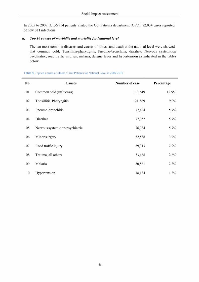
Social Impact Assessment
46
e
In 2005 to 2009, 3,136,954 patients visited the Out Patients department (OPD), 82,034 cases reported
of new STI infections.
h) Top 10 causes of morbidity and mortality for National level
The ten most common diseases and causes of illness and death at the national level were showed
that common cold, Tonsillitis-pharyngitis, Pneumo-bronchitis, diarrhea, Nervous system-non
psychiatric, road traffic injuries, malaria, dengue fever and hypertension as indicated in the tables
below.
Table 8: Top ten Causes of Illness of Out Patients for National Level in 2009-2010
No.
Causes
Number of case
Perc ntage
01
Common cold (Influenza)
173,549
12.9%
02
Tonsillitis, Pharyngitis
121,569
9.0%
03
Pneumo-bronchitis
77,424
5.7%
04
Diarrhea
77,052
5.7%
05
Nervous system-non-psychiatric
76,784
5.7%
06
Minor surgery
52,538
3.9%
07
Road traffic injury
39,313
2.9%
08
Trauma, all others
33,468
2.6%
09
Malaria
30,581
2.3%
10
Hypertension
18,184
1.3%
Social Impact Assessment
47
e
Table 9: Top ten causes of illness of In Patients for national level in 2009-2010
Table 10: Common Causes of Mortality for National Level in 2009-2010
Table 11: Number and Percentage of Low Birth Weight at Health Facilities
No.
Name of
Province
No. of birth by
Health staff
% of birth By
Health staff
No. of low birth
weight
% of low birth
weight
01 Whole country 60,100 35.0 3,378 5.6
02
Vientiane
Province
3,807
31.9
252
6.6
03
Xayaboury
Province
3,324
43.8
170
5.1
No.
Causes
Number of case
Percentage
< 5 years
No. %
01 Diarrhea 99 1.6 25 3.3%
02 Acute Respiratory Infection 219 3.6 138 18.0%
03 Dengue Fever 15 0.2 1 0.1%
04 Malaria 19 0.3 6 0.8%
05 Other Causes 1,482 24.2 314 41.0%
No.
Causes
Number of case
Perc ntage
01 Diarrhea 26,622 11%
02 Pneumo-bronchitis 15,190 6,3%
03 Tonsillitis, Pharyngitis 14,659 6,1%
04 Road traffic injury 10,469 4,3%
05 Common cold 10,104 4,2%
06 Trauma-all others 6,310 2,6%
07 Nervous system-non-psychiatric 6,039 2,5%
08 Malaria 5,737 2,4%
09 Dengue Fever 5,524 2,3%
10 Hypertension 4,169 1,7%

Social Impact Assessment
48
m
%
o
Table 12: Number of Caesarians, Premature Birth, Still Birth and Maternal Death
Table 13: Number and Percentage of Fully Immunized Infant
Table 14: Number and Percentage of Received Vitamin A2 and De-worming Drug2
Table 15: Number and Coverage of First and Total Antenatal Care in 2009-2010
No.
Name of Province
No of ANC
No. of First
CAN
% ANC
coverage
No f ANC
visits visits
01 Whole country 284,056 85,636 49.9 284,056
02 Luang Prabang 14,969 4,362 37.0 14,969
03 Vientiane 22,601 6,969 58.3 22,601
No.
Name of Province
Received Vit. A2 Received MDZ2
No. % No. %
01 Whole country 239,251 39.7 210,123 44.9
02 Vientiane Province 2,173 5.0 1,215 2.8
03 Xayaboury Province 9,399 29.2 5,564 17.3
No.
Name of Province
<1 year get fully i munized infants
Number
01 Whole country 51,951 32.0
02 Vientiane Province 4,886 48.5
03 Xayaboury Province 3,468 46.0
No.
Name of
Province
No. of birth by
Health staff
% of birth By
Health staff
No. of low birth
weight
% of low birth
weight
01 Whole country 3,520 1,299 589 47
02
Vientiane
Province
150
114
42
6
03
Xayaboury
Province
58
84
23
0

Social Impact Assessment
49
T
o
B N
m
C
T
U
B
Table 16: Number and Percentage of Time of Using Contraceptive Methods
Table 17: Percentage of Population in Malaria Risk Areas Protected by IBN
Table 18: Tuberculosis (TB) Prevalence and Percentage of TB cases
Table 19: Number of Malnutrition of under 5 years old (OPD) in 2009-2010
No.
Name of Province
Total nder 5 years old
No. % No. %
01 Whole country 9,109 1,5 1,791 2,3
02 Vientiane 1,699 3,7 439 7,9
03 Xayaboury 554 1,5 115 2,9
No.
Name of Province
% of T
Prevalence
Per 100,000
o. of
Esti ated TB
ases
No. of
Detected B
cases
% of detected
T cases
01 Whole country 53.7 3,863 3,079 79.7
02 Vientiane 38.9 294 166 56.5
03 Xayaboury 36.6 233 118 50.6
No.
Name of Province
No. f target
population
Average of
Population Per 1 IBN
% of population
Protected by IBN
01 Whole country 4,101,386 2.9 85.6
02 Phongsaly 151,627 3.6 71.7
03 Oudomxay 229,004 3.3 89.2
No.
Name of
Province
Time of using contraceptive method
otal
% of using contraceptive method
Condom Pills INJs IUUs
01 Whole country 518,253 7.2 47.6 43.1 2.2
02 Vientiane 23,608 6.2 47.2 41.9 4.8
03 Xayaboury 46,278 1.7 51.4 46.7 0.3
Social Impact Assessment
50
n
U
Table 20: Number and Percentage of Population Using Clean Water and Household Latrine in 2009-2010
4.6.2 Provincial & District Health Condition
a) Vientiane Province
Vientiane PHO is comprised of six health services sections, one provincial hospital (90 beds), 12
DHOs and 12 district hospitals with a total of 145 beds, 50 HCs with a total of 105 beds, 1,779
village health volunteers and 165 village drug revolving funds which cover 70% of the villages in the
province. There are 798 health staff in the province, 169 (21%) are working in different sectors at the
provincial level, 458 staff (57.3%) are working in the district level, 171 (21.4%) work at the HCs and
a large proportion of village health volunteer s (1,779) are working in the village level. The
categorization of staff can be classified such as 19 specialists/postgraduate, 136 medical doctors, 355
assistant doctors, and 297 nurses and 13 others. The recent statistics indicated ten most common
diseases and causes of illness and death in the province as shown in the following tables.
Table 21: Top Ten Causes of Illness of Out Patients in Vientiane (2009-2010)
No.
Causes of illness
Numbers
Percentage
01
Tonsillitis, pharyngitis
17,373
10.7
02
Common cold (Influenza )
13,764
8.5
03
Nervous system-non- psychiatric
12,849
7.9
04
Pneumo-Bronchitis
10,384
6.4
05
Watery Diarrhea
8,490
5.2
06
Road accident with injury
4,604
2.8
07
Trauma, all other
4,203
2.6
08
Hypertension
3,872
2.4
09
Helminthes parasites
2,571
1.6
10
Others
77,061
47.4
No.
Name of Province
Using clean water
sing HH latrines
No. of
populatio
%
No. of HH
%
01 Whole country 4,673,664 76,3 522,678 50,2
02 Vientiane 344,736 75,3 42,879 53,2
03 Xayaboury 285,182 79.0 55,689 84

Social Impact Assessment
51
Table 22: Top Ten Causes of Illness of In Patients in Vientiane (2009 -2010)
Table 23: The Common Causes of Death in Vientiane Hospital (2009-2010)
b) Sanakham District:
Sanakham health sector is comprised of a DHO and district hospital . The DHO consists of 3 sectors
such as Administration, Health Promotion and Health Care sectors. The district hospital is located in
the town of Sanakham with 15 beds available. There are also 3 HCs with 9 beds. Within the project
area there are2 HCs, one located at Vang village that serves 7 villages and another one is located at
Khokkhaodor village that serves 6 villages. The total district health staff consists of 83 persons that
are working in different sectors in the Sanakham health sector- 1 medical doctor, 8 assistant doctors,
40 nurses, 14 other staffs. 21 staff are working at the DHO, 50 at the district hospital and 12 at the
HC. There are 86 village health volunteers and 19 villages have a revolving drug funded.
Based on data collected from Sanakham DHO, the common causes of morbidity and mortality of the
population included Respiratory Infection, Malaria, Influenza, Nervous system-non psychiatric,
No.
Causes of illness
Numbers
Percentage
< 5 years old
No.
%
01
Acute Respiratory Infection ( ARI )
8
1,7
7
12.7
02
Severe watery Diarrhea
2
0,4
1
1.8
03
Other causes
87
19
17
30.8
No.
Causes of illness
Numbers
Percentage
01
Diarrhea
2,311
12.4
02
Pneumo-Bronchitis
1,274
6.8
03
Tonsillitis, pharyngitits
1,100
5.9
04
Road accident with injury
663
3.6
05
Hypertension
559
3.0
06
Nervous system-non-psychiatric
452
2.4
07
Trauma, all others
430
2.3
08
Common cold ( Influenza)
233
1.7
09
Dengue Fever
292
1.6
10
Anemia
154
0.8
Social Impact Assessment
52
Tonsillitits- pharyngitis, Gastro-enteritis Diarrhea, eyes diseases, skin diseases, road accidents and
dental diseases, Dengue fever, Tuberculosis (TB). The main leading causes of death reported by the
health services throughout the district in 2009-2010 for children below five years of age were
Malaria, Acute respiratory infection (ARI), Hepatitis B and Tuberculosis.
c) Meun District:
The Meun health sector is comprised of the DHO and district hospital . The DHO consists of 3
sections such as Administration, Health Promotion and Health Care. The district hospital is located in
the Meun District town with 10 beds. There are also 2 HCs with 9 beds. The total district health staff
is 43 persons- 8 medical doctors, 15 assistant doctors, 7 nurses, 13 other staff. 7 members of staff are
working at the DHO, 30 working at the DH and 4 working at the HC. There are 23 village health
volunteers, 17 birth attendants and 13 villages have a revolving drug funded.
Based on data collected from Meun DHO, the common causes of morbidity and mortality of the
population included: Respiratory Infection, Malaria, Influenza, Nervous system-non psychiatric,
Tonsillitis- pharyngitis, Gastro-enteritis, Diarrhea, Eyes disease, Skin disease, Road accident and
Dental disease, Dengue fever, and Tuberculosis .
The main leading causes of death reported by the health services throughout the district in 2009-2010
for children below five years of age are Malaria, Acute respiratory infection (ARI), Hepatitis B,
Tuberculosis and Cardio-vascular disease, other accidents with adults.
d) Xayaboury Province
The Xayaboury PHO is comprised of 6 health service components, 1 provincial hospital (120 beds)
located in the provincial capital of Xayaboury, 10 DHOs and 10 district hospitals (a total of 278
beds), 70 HCs (with a total of 179 beds), 622 Village Health Volunteers and 245 village drug
revolving funds which cover 100% of the villages in the Province. There are 682 health staff in the
province, 179 ( 26% ) are working in different areas at the provincial level, 328 ( 48%) in the district
level and 175 ( 26%) work at HCs. Most of the village health volunteer (622) are working at the
village level. The categorization of staff can be classified such as specialists/postgraduate, 101
medical doctors, 238 medical assistants, 314 nurses and 2 other staff members.
According to statistics collected from the Xayaboury PHO in 2009- 2010 the existing health situation
includes a fertility rate of 3.3% with a life expectancy of 60 for male and 63 for women. Children less
than 1 year old have a mortality rate of 38.6/1000 and children less than five years have a mortality
rate of 53.4/1000. The maternal mortality rate is 405/100.000 and the ten ( 10 ) most common diseases
and causes of illness or death in Xayaboury Province are summarized in table 20-22.
Social Impact Assessment
53
Table 24: Top Ten Causes of Illness of Out Patients in Xayaboury (2009-2010)
Table 25: Top Ten Causes of Illness of In Patients in Xayaboury (2009 -2010)
No.
Causes of illness
Numbers
Percentage
01 Tonsillitits, pharyngitis 1,220 7.7
02 Severe watery Diarrhea 1,015 6.4
03 Pneumo- bronchitis 975 6.1
04 Road accident 648 4.1
05 Nervous system non-psychiatric 611 3.8
06 Hypertension 443 2.8
07 Trauma, All other 371 2.3
08 Common cold 306 1.9
09 Malaria 170 1.1
10 Severe Malnutrition 133 0.8
No.
Causes of illness
Numbers
Percentage
01 Common cold ( Influenza ) 7,603 10.3
02 Tonsillitits, pharyngitis 6,285 8.5
03 Neuvous system non-psychiatric 5,305 7.2
04 Minor surgery 4,481 6.1
05 Diarrhea 3,396 4.6
06 Pneumo- bronchitis 3,340 4.5
07 Trauma, all others of body 2,005 2.7
08 Hypertension 1,312 1.8
09 Road accident 1,275 1.7
10 Malaria 918 0.8
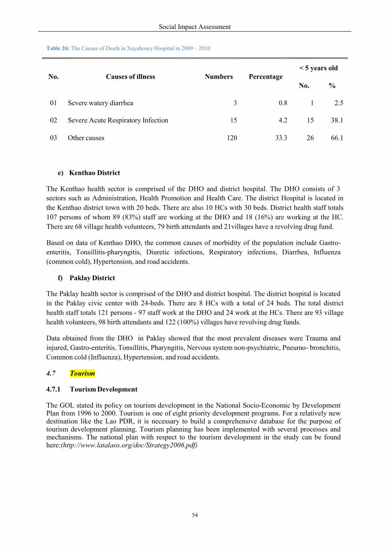
Social Impact Assessment
54
Table 26: The Causes of Death in Xayaboury Hospital in 2009 – 2010
e) Kenthao District
The Kenthao health sector is comprised of the DHO and district hospital. The DHO consists of 3
sectors such as Administration, Health Promotion and Health Care. The district Hospital is located in
the Kenthao district town with 20 beds. There are also 10 HCs with 30 beds. District health staff totals
107 persons of whom 89 (83%) staff are working at the DHO and 18 (16%) are working at the HC.
There are 68 village health volunteers, 79 birth attendants and 21villages have a revolving drug fund.
Based on data of Kenthao DHO, the common causes of morbidity of the population include Gastro-
enteritis, Tonsillitis-pharyngitis, Diuretic infections, Respiratory infections, Diarrhea, Influenza
(common cold), Hypertension, and road accidents.
f) Paklay District
The Paklay health sector is comprised of the DHO and district hospital. The district hospital is located
in the Paklay civic center with 24-beds. There are 8 HCs with a total of 24 beds. The total district
health staff totals 121 persons - 97 staff work at the DHO and 24 work at the HCs. There are 93 village
health volunteers, 98 birth attendants and 122 (100%) villages have revolving drug funds.
Data obtained from the DHO in Paklay showed that the most prevalent diseases were Trauma and
injured, Gastro-enteritis, Tonsillitis, Pharyngitis, Nervous system non-psychiatric, Pneumo- bronchitis,
Common cold (Influenza), Hypertension, and road accidents.
4.7 Tourism
4.7.1 Tourism Development
The GOL stated its policy on tourism development in the National Socio-Economic by Development Plan from 1996 to 2000. Tourism is one of eight priority development programs. For a relatively new destination like the Lao PDR, it is necessary to build a comprehensive database for the purpose of tourism development planning. Tourism planning has been implemented with several processes and mechanisms. The national plan with respect to the tourism development in the study can be found here:(http://www.latalaos.org/doc/Strategy2006.pdf)
No.
Causes of illness
Numbers
Percentage
< 5 years old
No.
%
01
Severe watery diarrhea
3
0.8
1
2.5
02
Severe Acute Respiratory Infection
15
4.2
15
38.1
03
Other causes
120
33.3
26
66.1
Social Impact Assessment
55
4.7.2 Tourism Network and Linkage
The Mekong River near Sanakham project area has boating experiences where tourists enjoy the
scenery and meet local people. Because it does not continue for further to other regions. The boating
route passing through Sanakham is not significant, which implies that the tourism network and
linkage in this area is not much related to the project area.
4.7.3 General Existing Condition of Tourism in the Project Area
Sanakham Dam is located in the administrative boundary of Sanakham district and Kenthao District.
At present, Sanakham is not considered interesting places among tourists due to their location
being outside of the main tourism routes. Kenthao is important as a border crossing with Thailand
by the Thai-Lao Friendship Bridge over the Hueang River. According to the Statistical Report on
Tourism in Laos, in 2009 the number of tourists traveling to Kenthao was about 20,153 persons.
The number of tourists visiting Vientiane and Xayaboury in 2009 was 290,015 and 23,061 persons
respectively. The past statistical record shows the numbers of international tourists visiting
Vientiane Province is relatively high and increasing: between 2002 and 2009 the growth rate was
35.81% per year.

Social Baseline Study
Upstream/Downstream/P
Identification of Affected
5.
5.1
The SIA is a process that identifies
have on the social and huma
incorporated in order to eli
identify what groups of people
HPP and how these impacts differ
due to inundation and land
construction activities including
water level fluctuations.
In this regard, we can divide APs
(Fig. 5-1):
Group 1 – Upstre
Group 2 – Dow
Group 3 – Resettlement
Figure 15: Identification of Affected Social
Social Impact Assessment
56
Study 2: Detailed Socio-Economic Condition
nstream/Project-Land Communities
d Social Groups
ntifies and evaluates the potential impacts that a proposed
an health environment and develops mitigation
liminate, minimize or reduce these impacts. It
ople will be affected from the development of th
differ between these groups. For example, the mo
nd loss while marginal impacts may be due
ding those living in downstream areas that may
APs into three groups based on geographical impa
Upstream and communities residing near construction
Downstream communities.
Resettlement host communities.
ocial Groups
dition of
proposed project may
measures that will be
seems reasonable to
he Mekong Sanakham
ost severe impacts are
to disturbance from
also be affected from
act zones as follows
construction/quarry sites.

Social Impact Assessment
57
Figure 16: ESIA study area
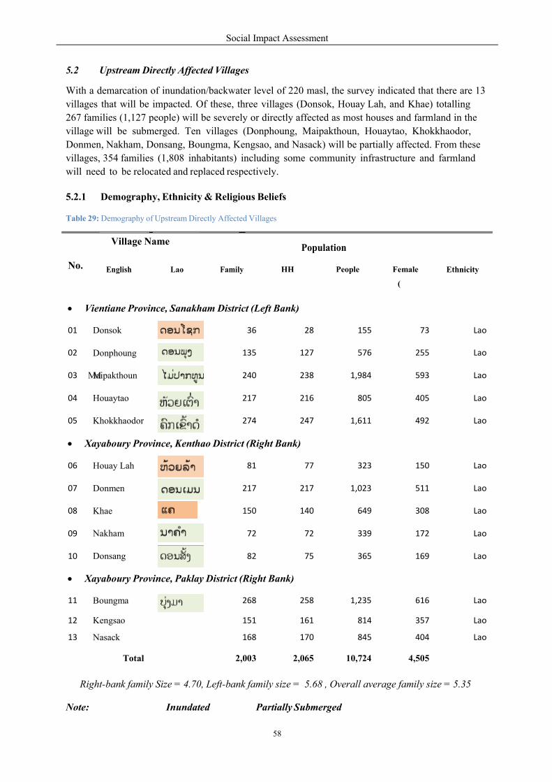
Social Impact Assessment
58
M
(
5.2 Upstream Directly Affected Villages
With a demarcation of inundation/backwater level of 220 masl, the survey indicated that there are 13
villages that will be impacted. Of these, three villages (Donsok, Houay Lah, and Khae) totalling
267 families (1,127 people) will be severely or directly affected as most houses and farmland in the
village will be submerged. Ten villages (Donphoung, Maipakthoun, Houaytao, Khokkhaodor,
Donmen, Nakham, Donsang, Boungma, Kengsao, and Nasack) will be partially affected. From these
villages, 354 families (1,808 inhabitants) including some community infrastructure and farmland
will need to be relocated and replaced respectively.
5.2.1 Demography, Ethnicity & Religious Beliefs
Table 29: Demography of Upstream Directly Affected Villages
Note: Inundated Partially Submerged
No.
Village Name Population
English Lao Family HH People Female Ethnicity
Vientiane Province, Sanakham District (Left Bank)
01 Donsok 36 28 155 73 Lao
02 Donphoung 135 127 576 255 Lao
03 Maipakthoun 240 238 1,984 593 Lao
04 Houaytao 217 216 805 405 Lao
05 Khokkhaodor 274 247 1,611 492 Lao
Xayaboury Province, Kenthao District (Right Bank)
06 Houay Lah 81 77 323 150 Lao
07 Donmen 217 217 1,023 511 Lao
08 Khae 150 140 649 308 Lao
09 Nakham 72 72 339 172 Lao
10 Donsang 82 75 365 169 Lao
Xayaboury Province, Paklay District (Right Bank)
11 Boungma 268 258 1,235 616 Lao
12 Kengsao 151 161 814 357 Lao
13 Nasack 168 170 845 404 Lao
Total 2,003 2,065 10,724 4,505
Right-bank family Size = 4.70, Left-bank family size = 5.68 , Overall average family size = 5.35
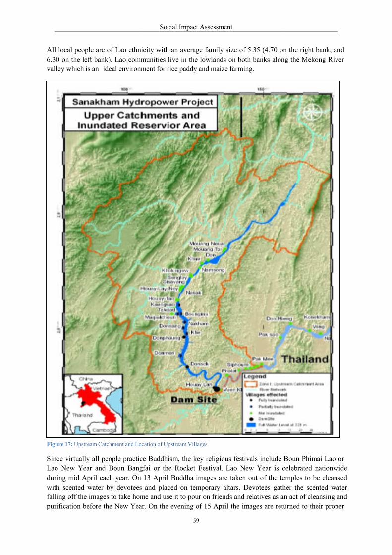
All local people are of Lao ethnici
6.30 on the left bank). Lao comm
valley which is an ideal environm
Figure 17: Upstream Catchment and Loc
Since virtually all people practic
Lao New Year and Boun Bangfai
during mid April each year. On
with scented water by devotees
falling off the images to take hom
purification before the New Yea
Social Impact Assessment
59
ethnicity with an average family size of 5.35 (4.70 on
munities live in the lowlands on both banks along
ment for rice paddy and maize farming.
cation of Upstream Villages
ce Buddhism, the key religious festivals include Boun
Bangfai or the Rocket Festival. Lao New Year is celebrated
13 April Buddha images are taken out of the te
devotees and placed on temporary altars. Devotees gather
me and use it to pour on friends and relatives as an
ar. On the evening of 15 April the images are returned
on the right bank, and
ng the Mekong River
Boun Phimai Lao or
celebrated nationwide
emples to be cleansed
her the scented water
an act of cleansing and
returned to their proper
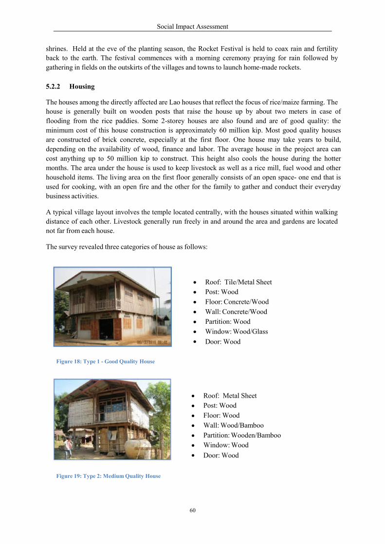
Social Impact Assessment
60
shrines. Held at the eve of the planting season, the Rocket Festival is held to coax rain and fertility
back to the earth. The festival commences with a morning ceremony praying for rain followed by
gathering in fields on the outskirts of the villages and towns to launch home-made rockets.
5.2.2 Housing
The houses among the directly affected are Lao houses that reflect the focus of rice/maize farming. The
house is generally built on wooden posts that raise the house up by about two meters in case of
flooding from the rice paddies. Some 2-storey houses are also found and are of good quality: the
minimum cost of this house construction is approximately 60 million kip. Most good quality houses
are constructed of brick concrete, especially at the first floor. One house may take years to build,
depending on the availability of wood, finance and labor. The average house in the project area can
cost anything up to 50 million kip to construct. This height also cools the house during the hotter
months. The area under the house is used to keep livestock as well as a rice mill, fuel wood and other
household items. The living area on the first floor generally consists of an open space- one end that is
used for cooking, with an open fire and the other for the family to gather and conduct their everyday
business activities.
A typical village layout involves the temple located centrally, with the houses situated within walking
distance of each other. Livestock generally run freely in and around the area and gardens are located
not far from each house.
The survey revealed three categories of house as follows:
Roof: Tile/Metal Sheet
Post: Wood
Floor: Concrete/Wood
Wall: Concrete/Wood
Partition: Wood
Window: Wood/Glass
Door: Wood
Figure 18: Type 1 - Good Quality House
Roof: Metal Sheet
Post: Wood
Floor: Wood
Wall: Wood/Bamboo
Partition: Wooden/Bamboo
Window: Wood
Door: Wood
Figure 19: Type 2: Medium Quality House

Social Impact Assessment
61
Roof: Thatch/Metal
Post: Wood
Floor: Wood
Wall: Wood/Bamboo
Window: Wood/Bamboo
Door: Wood
Figure 20: Type 3 – Low Quality House
Table 30: Type of House in Upstream Directly Affected Villages
More than 60% of 2-storey houses are medium to good quality ones while about 40% are low-quality
houses.
5.2.3 Land Holding & Ownership
Interviews with APs showed that the average land holding per family consisted of 0.1 ha for home plot,
1.2 ha for rice paddy, 1.6 ha for swidden upland field crop, 1.3 ha for gardens (include river-bank
plantation); and 0.5 ha for other purposes. Some encroachments for practicing swidden upland farming
were generally observed in the mountainous areas near to the villages.
Type
Category of House
Total Number Surveyed
Percentage
01
Good Quality House
178
10.6%
02
Medium Quality House
893
53.2%
03
Low Quality House
607
36.2%
TOTAL
1,678
100.0%
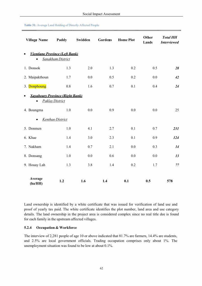
Social Impact Assessment
62
e n
Table 31: Average Land Holding of Directly Affected People
Land ownership is identified by a white certificate that was issued for verification of land use and
proof of yearly tax paid. The white certificate identifies the plot number, land area and use category
details. The land ownership in the project area is considered complex since no real title dee is found
for each family in the upstream affected villages.
5.2.4 Occupation & Workforce
The interview of 2,281 people of age 10 or above indicated that 81.7% are farmers, 14.4% are students,
and 2.5% are local government officials. Trading occupation comprises only about 1%. The
unemployment situation was found to be low at about 0.1%.
Village Name Paddy Swidden Gardens Home Plot Other
Lands
Total HH
Interviewed
Vientiane Province (Left Bank)
Sanakham District
1. Donsok 1.3 2.0 1.3 0.2 0.5 28
2. Maipakthoun 1.7 0.0 0.5 0.2 0.0 42
3. Donphoung 0.8 1.6 0.7 0.1 0.4 24
Xayaboury Province (Right Bank)
Paklay District
1.0 0.0 0.9 0.0 0.0 25
1.0 4.1 2.7 0.1 0.7 231
1.4 3.0 2.3 0.1 0.9 124
1.4 0.7 2.1 0.0 0.3 14
1.0 0.0 0.6 0.0 0.0 13
4. Boungma
• Kenthao District
5. Donmen
6. Khae
7. Nakham
8. Donsang
9. Houay Lah 1.3 3.8 1.4 0.2 1.7 77
Average
(ha/HH) 1.2 1.6 1.4 0.1 0.5 578
Table 32: Occupation of Directly Affecte
The upstream communities population density. Most (approxipercent) of this population productive working age betweeyears. The overall sex ratio of 1,000 males is 704 indicating anThe female gender is in smaller nu
Figure 21: Upstream Community
Village
Name Farmer Trader
1. Vientiane Province (Left Bank)
1.1. Sanakham District
Donsok/
Khokkhaodor 126 2
Maipakthoun 104 -
Donphoung 90 -
2. Vientiane Province (Left Bank)
2.1. Sanakham District
Donmen 684 14
Khae 459 1
Nakham 38 -
Donsang 45 -
Houay Lah 221 2
Total 1,860 19
Percentage 81.7% 0.8%
Total
(Exclude
students)
1860 19
Percentage 95.2% 1.0%
Social Impact Assessment
63
2
ted Villagers
ities have low oximately 60
are within between 18 to 60
females per n imbalance. numbers.
Gov’t
official Employment Unemployment Student
nk)
1 - - 14
- - - 1
1 - -
nk)
34 9 1 14
5 2 8
- - -
1 - - 1
8 - 3
56 11 1 3
2.5% 0.5% 0.01% 14.4%
56 11 1
2.8% 0.6% 0.05%
2
inter- nt Others
Total
viewed
14 1 144
17 - 121
9 - 100
40 2 884
89 556
3 1 42
14 - 60
33 1 265
8 6 2,281
14.4% 0.1% 100.0%
- 6 1,953
- 0.3% 100.0%
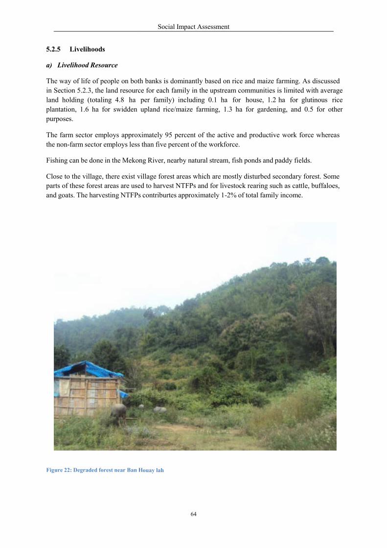
5.2.5 Livelihoods
a) Livelihood Resource
The way of life of people on both
in Section 5.2.3, the land resourc
land holding (totaling 4.8 ha per
plantation, 1.6 ha for swidden
purposes.
The farm sector employs approxi
the non-farm sector employs less
Fishing can be done in the Mekong
Close to the village, there exist village
parts of these forest areas are use
and goats. The harvesting NTFPs
Figure 22: Degraded forest near Ban H
Social Impact Assessment
64
both banks is dominantly based on rice and maize far
rce for each family in the upstream communities is
8 ha per family) including 0.1 ha for house, 1.2 ha for
upland rice/maize farming, 1.3 ha for gardening,
approximately 95 percent of the active and productive
than five percent of the workforce.
Mekong River, nearby natural stream, fish ponds and paddy
village forest areas which are mostly disturbed secondary
used to harvest NTFPs and for livestock rearing such as cattle,
NTFPs contriburtes approximately 1-2% of total family
Houay lah
arming. As discussed
s limited with average
ha for glutinous rice
ng, and 0.5 for other
work force whereas
addy fields.
econdary forest. Some
h as cattle, buffaloes,
income.
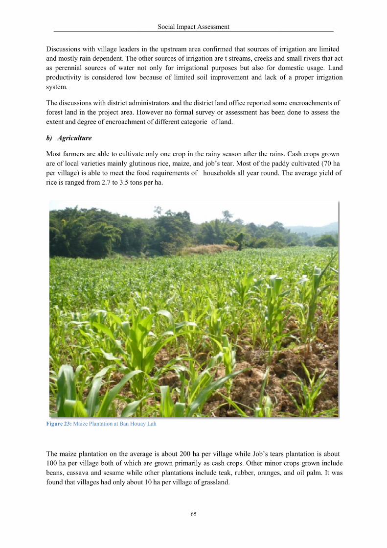
Discussions with village leaders
and mostly rain dependent. The other
as perennial sources of water not
productivity is considered low because
system.
The discussions with district adm
forest land in the project area. H
extent and degree of encroachment
b) Agriculture
Most farmers are able to cultivate
are of local varieties mainly glut
per village) is able to meet the food
rice is ranged from 2.7 to 3.5 tons
Figure 23: Maize Plantation at Ban Hou
The maize plantation on the average
100 ha per village both of which
beans, cassava and sesame while
found that villages had only about
Social Impact Assessment
65
in the upstream area confirmed that sources of irrigation
other sources of irrigation are t streams, creeks an
not only for irrigational purposes but also for d
because of limited soil improvement and lack of
ministrators and the district land office reported some
However no formal survey or assessment has been
nt of different categorie of land.
te only one crop in the rainy season after the rains.
glutinous rice, maize, and job’s tear. Most of the paddy
food requirements of
tons per ha.
households all year round.
Houay Lah
rage is about 200 ha per village while Job’s tears
h are grown primarily as cash crops. Other minor
e other plantations include teak, rubber, oranges,
about 10 ha per village of grassland.
irrigation are limited
nd small rivers that act
domestic usage. Land
of a proper irrigation
me encroachments of
been done to assess the
ns. Cash crops grown
addy cultivated (70 ha
The average yield of
ars plantation is about
inor crops grown include
oranges, and oil palm. It was
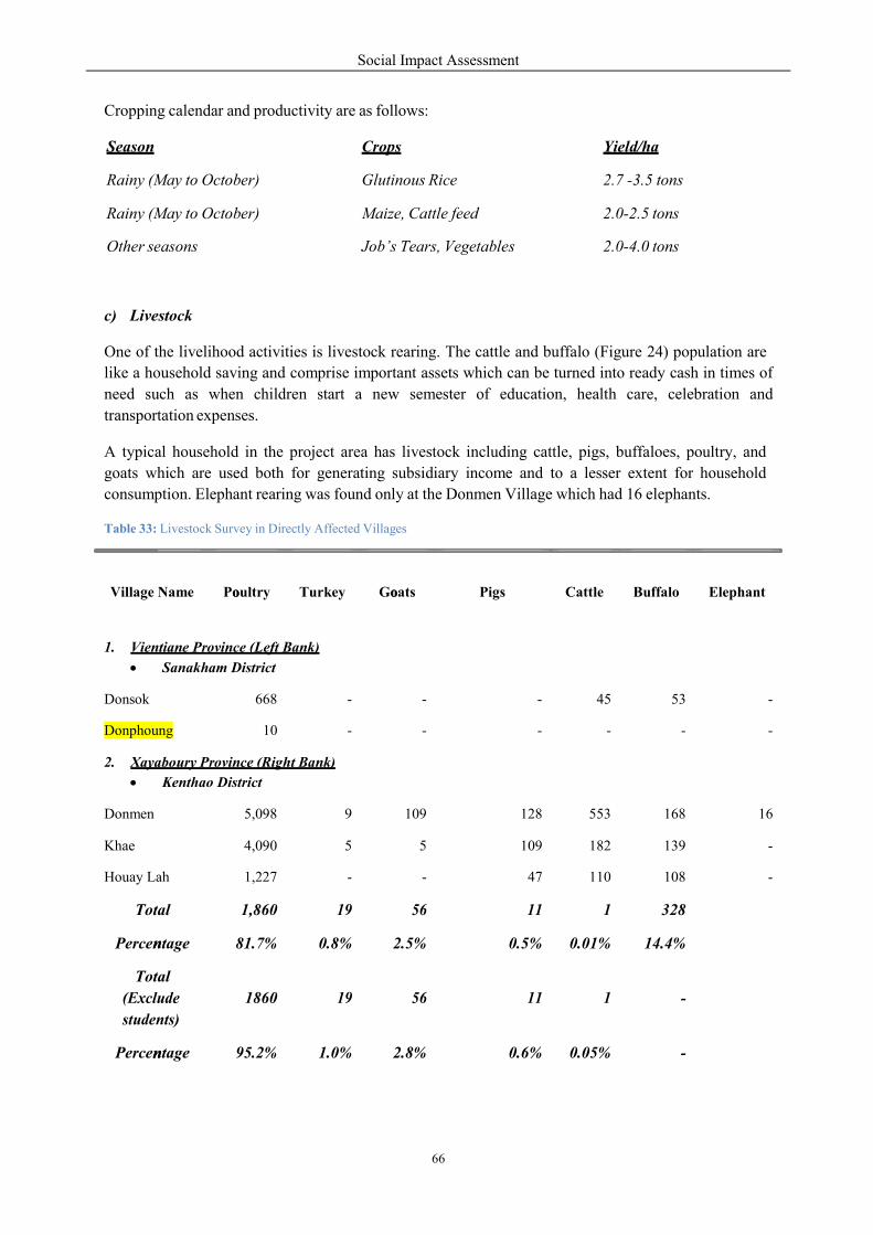
Social Impact Assessment
66
n
n
o o
Cropping calendar and productivity are as follows:
Season Crops Yield/ha
Rainy (May to October)
Rainy (May to October)
Glutinous Rice
Maize, Cattle feed
2.7 -3.5 tons
2.0-2.5 tons
Other seasons Job’s Tears, Vegetables 2.0-4.0 tons
c) Livestock
One of the livelihood activities is livestock rearing. The cattle and buffalo (Figure 24) population are
like a household saving and comprise important assets which can be turned into ready cash in times of
need such as when children start a new semester of education, health care, celebration and
transportation expenses.
A typical household in the project area has livestock including cattle, pigs, buffaloes, poultry, and
goats which are used both for generating subsidiary income and to a lesser extent for household
consumption. Elephant rearing was found only at the Donmen Village which had 16 elephants.
Table 33: Livestock Survey in Directly Affected Villages
Village Name Poultry Turkey Goats Pigs Cattle Buffalo Elephant
1. Vientiane Province (Left Bank)
Sanakham District
Donsok 668 - - - 45 53 -
Donphoung 10 - - - - - -
2. Xayaboury Province (Right Bank)
Kenthao District
Donmen 5,098 9 109 128 553 168 16
Khae 4,090 5 5 109 182 139 -
Houay Lah 1,227 - - 47 110 108 -
Total 1,860 19 56 11 1 328
Percentage 81.7% 0.8% 2.5% 0.5% 0.01% 14.4%
Total
(Exclude
students)
1860 19 56 11 1 -
Percentage 95.2% 1.0% 2.8% 0.6% 0.05% -
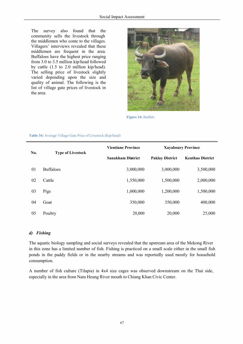
The survey also found community sells the livestock the middlemen who come to theVillagers’ interviews revealed middlemen are frequent in Buffaloes have the highest pricfrom 3.0 to 3.5 million kip/headby cattle (1.5 to 2.0 million kip/head).The selling price of livestockvaried depending upon the quality of animal. The followinglist of village gate prices of livestockthe area.
Table 34: Average Village-Gate Price of
d) Fishing
The aquatic biology sampling and
in this zone has a limited numbe
ponds in the paddy fields or in
consumption.
A number of fish culture (Tilapia)
especially in the area from Nam H
No.
Type of Livestock
01
Buffaloes
02
Cattle
03
Pigs
04
Goat
05
Poultry
Social Impact Assessment
67
s
that the k through
o the villages. that these
the area. ce ranging d followed kip/head). k slightly
size and following is the
livestock in
Figure 24: Buffalo
of Livestock (Kip/head)
and social surveys revealed that the upstream area of
er of fish. Fishing is practiced on a small scale e
n the nearby streams and was reportedly used m
pia) in 4x4 size cages was observed downstream
Heung River mouth to Chiang Khan Civic Center.
Vientiane Province
Xayabou
Sanakham District
Paklay District
3,000,000
3,000,00
1,550,000
1,500,00
1,000,000
1,200,00
350,000
350,000
20,000
20,000
of the Mekong River
either in the small fish
mostly for household
downstream on the Thai side,
r.
boury Province
t
Kenthao District
00
3,500,000
00
2,000,000
00
1,500,000
00
400,000
20,000
25,000
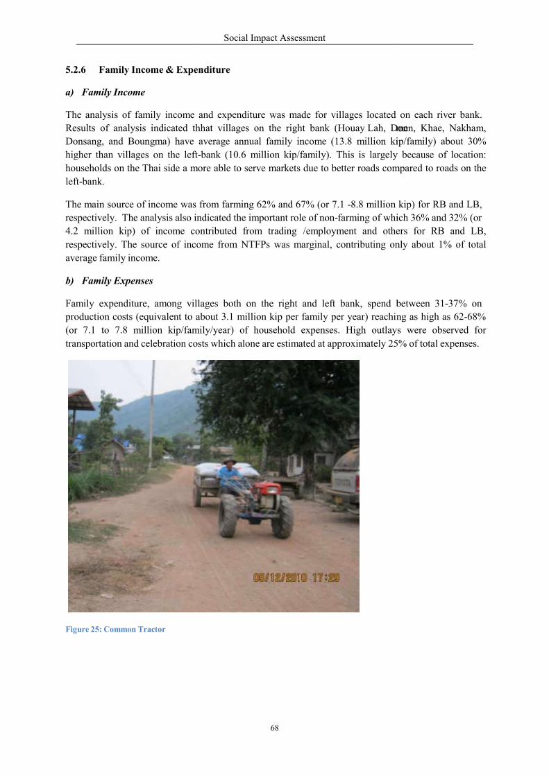
5.2.6 Family Income & Expen
a) Family Income
The analysis of family income
Results of analysis indicated t
Donsang, and Boungma) have
higher than villages on the left-
households on the Thai side a more
left-bank.
The main source of income was
respectively. The analysis also indicated
4.2 million kip) of income contributed
respectively. The source of inco
average family income.
b) Family Expenses
Family expenditure, among villages
production costs (equivalent to a
(or 7.1 to 7.8 million kip/fam
transportation and celebration cos
Figure 25: Common Tractor
Social Impact Assessment
68
nditure
and expenditure was made for villages located
hhat villages on the right bank (Houay Lah, Donm
average annual family income (13.8 million ki
-bank (10.6 million kip/family). This is largely
ore able to serve markets due to better roads com
from farming 62% and 67% (or 7.1 -8.8 million
indicated the important role of non-farming of which
ontributed from trading /employment and others
income from NTFPs was marginal, contributing on
villages both on the right and left bank, spend between
about 3.1 million kip per family per year) reaching
mily/year) of household expenses. High outlays
sts which alone are estimated at approximately 25%
on each river bank.
men, Khae, Nakham,
ip/family) about 30%
y because of location:
mpared to roads on the
kip) for RB and LB,
ich 36% and 32% (or
hers for RB and LB,
only about 1% of total
between 31-37% on
ng as high as 62-68%
s were observed for
25% of total expenses.
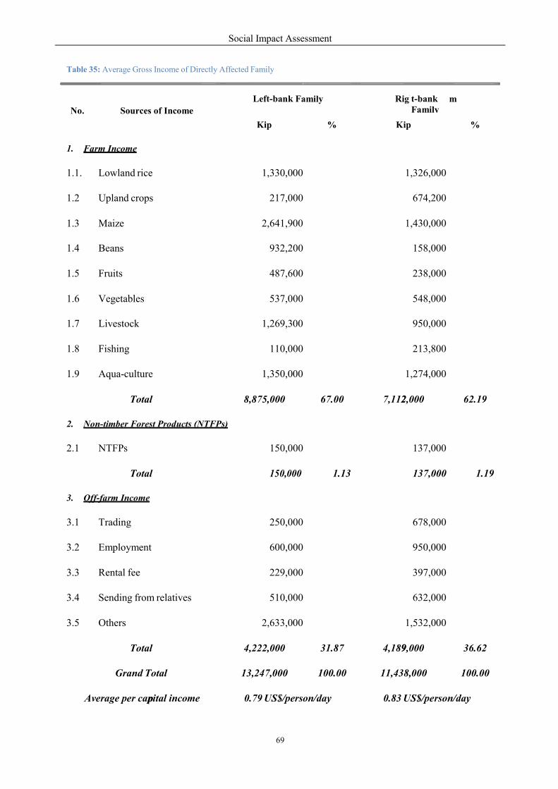
Social Impact Assessment
69
p
2
9
m
Table 35: Average Gross Income of Directly Affected Family
amily
No.
Sources of Income
Left-bank F
Righ
t-bank Family
Kip
%
K
ip
%
1. Farm Income
1.1.
Lowland rice
1,330,000
1,326,000
1.2
Upland crops
217,000
674,200
1.3
Maize
2,641,900
1,430,000
1.4
Beans
932,200
158,000
1.5
Fruits
487,600
238,000
1.6
Vegetables
537,000
548,000
1.7
Livestock
1,269,300
950,000
1.8
Fishing
110,000
213,800
1.9
Aqua-culture
1,350,000
1,274,000
Total
8,875,000
67.00
7,112,000
62.19
2. Non-timber Forest Products (NTFPs)
2.1
NTFPs
150,000
137,000
Total
150,000
1.13
137,000
1.19
3. Off-farm Income
3.1
Trading
250,000
678,000
3.2
Employment
600,000
950,000
3.3
Rental fee
229,000
397,000
3.4
Sending from relatives
510,000
632,000
3.5
Others
2,633,000
1,532,000
Total
4,222,000
31.87
4,189,000
36.62
Grand Total
13,247,000
100.00
11,438,000
100.00
Average per capital income
0.79 US$/person/day
0.83 US$/person/day
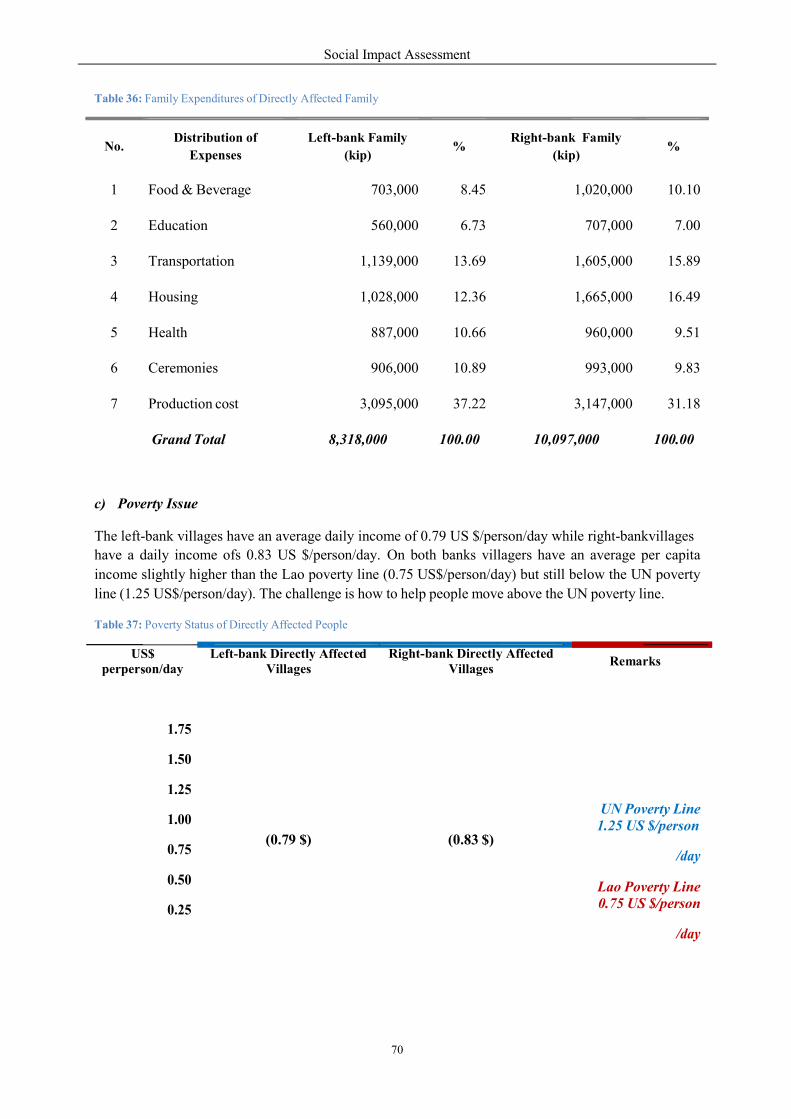
Social Impact Assessment
70
s
7
e b y
Table 36: Family Expenditures of Directly Affected Family
c) Poverty Issue
The left-bank villages have an average daily income of 0.79 US $/person/day while right-bankvillages
have a daily income ofs 0.83 US $/person/day. On both banks villagers have an average per capita
income slightly higher than the Lao poverty line (0.75 US$/person/day) but still below the UN poverty
line (1.25 US$/person/day). The challenge is how to help people move above the UN poverty line.
Table 37: Poverty Status of Directly Affected People
1.25 US $/person
US$ perper on/day
Left-bank Directly Affect d Villages
Right- ank Directl Affected
Remarks
Villages
1.75
1.50
1.25
1.00
0.75
0.50
0.25
UN Poverty Line
/day
(0. 9 $)
(0.83 $)
Lao Poverty Line 0.75 US $/person
/day
No.
Distribution of
Expenses
Left-bank Family
(kip)
%
Right-bank Family
(kip)
%
1
Food & Beverage
703,000
8.45
1,020,000
10.10
2
Education
560,000
6.73
707,000
7.00
3
Transportation
1,139,000
13.69
1,605,000
15.89
4
Housing
1,028,000
12.36
1,665,000
16.49
5
Health
887,000
10.66
960,000
9.51
6
Ceremonies
906,000
10.89
993,000
9.83
7
Production cost
3,095,000
37.22
3,147,000
31.18
Grand Total
8,318,000
100.00
10,097,000
100.00
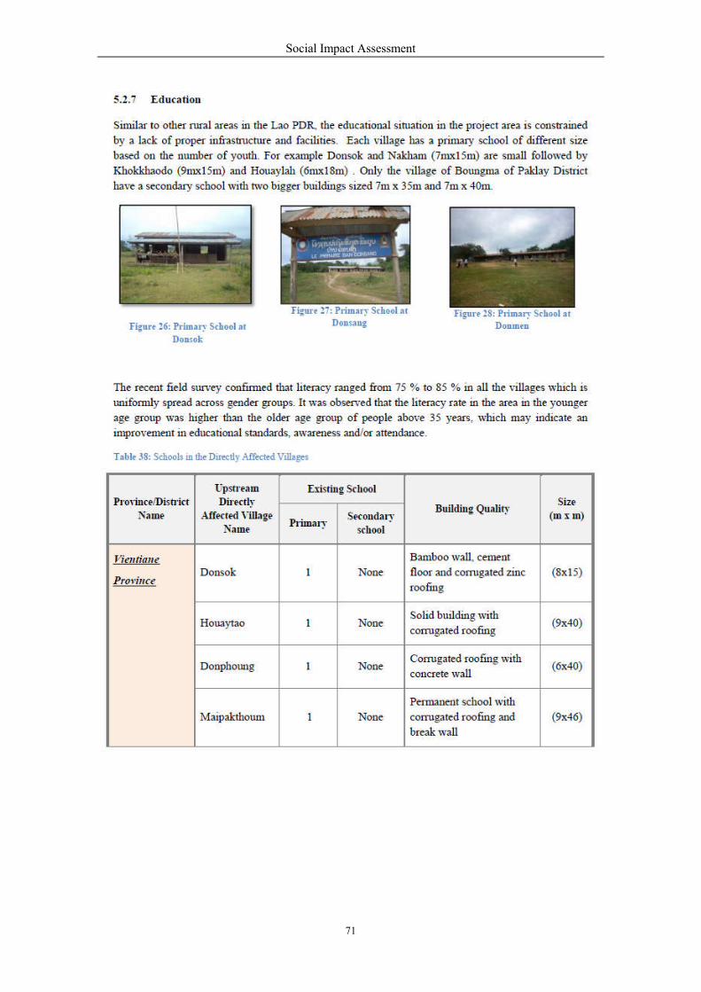
Social Impact Assessment
71

Social Impact Assessment
72
o
am
5.2.8 Health
a) Accessibility to Health Care Facilities
In addition to ascertaining health care facilities and infrastructure utilized by people in the survey area
the team also sought to gain an understanding of the accessibility of the facilities inclusive of the
obstacles. The most prevalent problem cited for limiting accessibility was the distance between the
villages and district town and available transport whether car, motorbike or boat in some villages.
The variable distances from households in the surveyed villages to the district hospital ranged from 31
km to 75 km in Meun District, from 1 km to 70 km in Sanakham, and about 7 to 35 km in Kenthao and
0.5 km to 27 km in Paklay District. .
Sanakh
Khokkhaodor 1 None Wooden wall, corrugated
roofing (9x15)
Xayaboury
Province
Kentha
Houay Lah 1 None Corrugated roofing, break
wall (6x18)
Khae 1 None Corrugated roofing,
cement wall, (35x7)
Donmen 1 None Shingle roofing, concrete
wall, solid building (38 x21)
Nakham 1 None Break wall (7x15)
Donsang 1 None Concrete wall with
corrugated roofing (7x20)
Paklay Boungma 1
1 secondary
school with
2 buildings
Solid, permanent school
buildings with Wooden
walls & corrugated roofing
(7x40) +
(7x35) +
(7x25)

Social Impact Assessment
73
D
Figure 29: Donsok Health Center
b) Behavior of People in Medical Treatment Services
Health-seeking behavior is an important factor to understand when analyzing the health of a given
population. Understanding the patterns in seeking medical care can assist to understand the healthcare
gaps or the cultural barriers for improving health condition. According to data obtained from the
surveyed villages on both river banks, when people are ill people like to go to the district hospital
(50%); followed by the pharmacy (20%), the village drug box (12%), the HC (10%), provincial
hospital (5%), central hospital (2%) and clinics in Thailand (1%). It is important to note that people go
for medical treatment at provincial and central hospitals when they have severe illness.
c) The Crude Birth Rate (CBR) and Crude Death Rate (CDR)
The field survey revealed that over a period of one year (2009 – 2010) there were differences in CDRs.
Within the Sanakham HPP area for example a 4.4 per 1000 CDR was recorded in downstream villages
while a 3.2 per 1000 CDR was observed in upstream communities. However, both CDRs were lower
than the whole-country status (5.4 per 1000).
Table 39: The Crude Birth Rate and Crude Death Rate in Each Zone
d) Clean Water, Hygiene and Sanitation
Locations
Number of Live births
Number of eaths
CBR (per 1000)
CDR (per 1000)
Whole country 3,470 651 28.8 5.4
Vientiane Province 566 43 28.5 4.4
Xayaboury Province 337 32 24.0 4.8
Downstream Villages
4.4
Upstream Villages
3.2

The main source of water for drink
system (from nearby mountains)
and organizations such as UNICEF,
villages 35 villages have access
families in district town use bottled
water during the dry season use
usually boil water for drinking
drink boiled water.
Hygiene and sanitation is an important
related to a range of diseases such
obtained from the village head
households have latrines in dow
have no latrines in downstream
hopuseholds that have latrines
according to theNational Health Surv
Figure 30: Gravity-Fed
e) The Common Causes of
Based on data obtained from the
morbidity in the villages within
accidents (33%), Malaria and se
diarrhea (12%), Tuberculosis Pul
f) Indicators of Health Ris
Information obtained from 39 surv
the highest health risks in the project
deficiency and poor sanitation (5
care facilities, UXOs, poor drinking
risk factors of approximately 10%
Social Impact Assessment
74
drinking and domestic use were natural stream
) and bore-wells which in some cases are support
CEF, Lao Lux. It is interesting to note that out of a
to safe drinking water (i.e. gravity-fed system a
bottled drinking water. However, some villages f
natural streams/rivers for taking a bath and wash
if bottled water is not eadily accessible. Abou
portant health indicator. Inadequate disposal of hu
such as diarrhea, cholera and parasitic diseases. The
and village health volunteer of 39 villages. Approxi
wnstream villages, 79% in upstream villages hav
villages (compared to 21% in upstream villages).
in the project area is higher than the national
Survey (2005).
Figure 31: Household Latrine
of Morbidity in the Village
the village health volunteer and head of villages, the
within Sanakham HPP area were Acute watery d
seasonal flues (28%), followed by respiratory inf
Pulmonary (10%), Hepatitis (7%) and Drowning (5%
isk Factors in the Villages
urveyed villages revealed that smoking and alcohol
roject area, These were followed by the medium
(50%-60%). The remaining health risk factors in
drinking water and poor living conditions. These altog
10% to 20%.
ms/rivers, gravity-fed
ted by various donors
a total of 39 surveyed
and bore-wells). Most
faced with inadequate
hing clothes. Villagers
ut 80% of households
uman faucal waste is
The hygiene data was
Approximately 66% of
ve latrines while 34%
s). The percentage of
the national situation - 50,2%
he common causes of
diarrhea (50%), Road
fection (18%), bloody
%).
alcohol consumption posed
m factors of rice/food
ncluded limited health
gether were low health
Social Impact Assessment
75
F
g) Current Preventative Health Care Programs
There are preventative health care programs in place in the project area which are ongoing programs.
The mobile vaccination team supported by the GAVI Alliance and UNICEF and run by the HC and
DHO provide the following vaccinations children and pregnant women: BCG, DPT, Polio, Measles
and Hepatitis B and Tetanus. The vaccinations are provided approximately four times per year in the
survey villages. In addition, Mother and Child Health at the HC and District Hospital also provide
antenatal- postnatal care. The anti-malaria program is a national program which implements
preventative measures on a national basis. Between 2005–2010 villagers were provided with long-
lasting mosquito bed nets at a nominal price supported by Global fund.
The Family Planning project is also an ongoing project in this area. It is based on the national program
and is supported by the United Nations Population Fund (UNFPA). The program provides family
planning services and contraceptives. Supported by range of local and foreign NGOs, such as the
DHO, PHO, Lao Red Cross, SIDA and UNFPA, other preventative programs include TB control,
HIV/AIDS control, food security, water supply and sanitation. In all of the above programs, the major
constraint is limited financial and human resources level. Each program requires ongoing access to
scarce health care funds in order to make a long - term impact on the health status of local villages.
5.2.9 Gender & Vulnerable Groups
a) Identification of Vulnerability
The sampling of three directly affected villages (Donsok, Houay Lah and Khae) and an
indirectly affected village (Donmen) were conducted. Disabled, mentally ill and landless are normally
identified as vulnerable groups. In the above villages, there are 11 disabled people (5 of them are
female), 5 mentally ill people (all of them are female) and 3 landless families (11 people).
Table 40: Vulnerability of Directly Affected Villages
Province District Village Disability Mental illness Landless
Total Female Total Female HH Pop.
Vientiane Sanakham Donsok 1 1 0 0 0 0
Xayaboury Kenthao
Houay Lah 1 0 1 1 0 0
Donmen 4 1 2 2 0 0
Khae 5 3 2 2 3 11
TOTAL 11 5 5 5 3 11
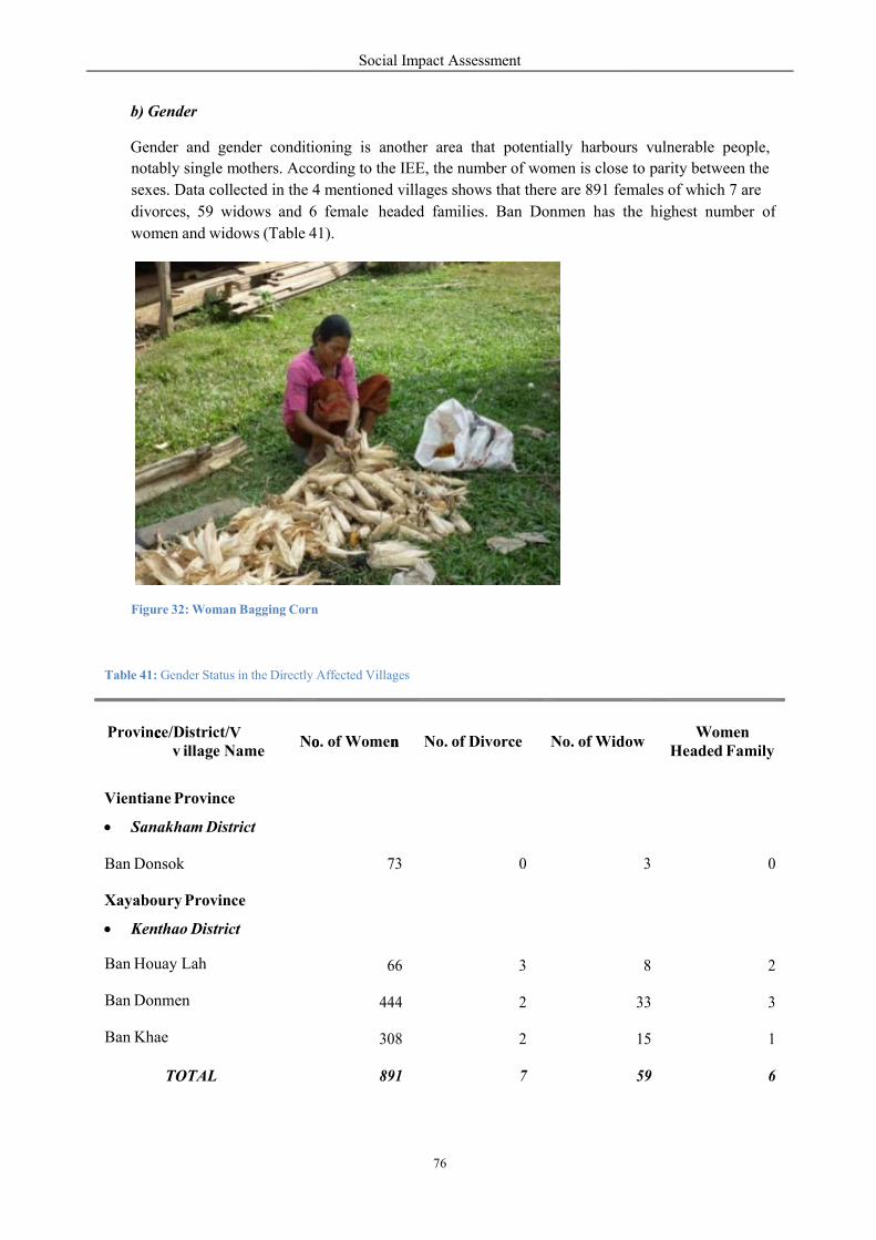
c V o
b) Gender
Gender and gender conditioni
notably single mothers. According
sexes. Data collected in the 4
divorces, 59 widows and 6
women and widows (Table 41).
Figure 32: Woman Bagging Corn
Table 41: Gender Status in the Directly Affected
Province/District/ v illage Name
No
Vientiane Province
Sanakham District
Ban Donsok
Xayaboury Province
Kenthao District
Ban Houay Lah
Ban Donmen
Ban Khae
TOTAL
Social Impact Assessment
76
o n
tioning is another area that potentially harbours
ording to the IEE, the number of women is close to
4 mentioned villages shows that there are 891 female
6 female
41).
headed families. Ban Donmen has th
n
Affected Villages
o. of Women No. of Divorce No. of Widow
73 0
66 3
444 2
308 2
891 7
rs vulnerable people,
to parity between the
males of which 7 are
he highest number of
WidowWomen
Headed Family
3 0
8 2
33 3
15 1
59 6
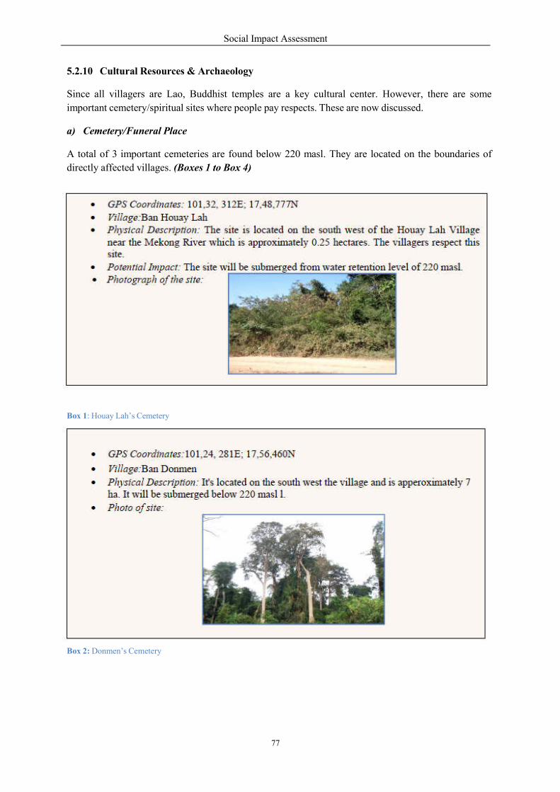
Social Impact Assessment
77
5.2.10 Cultural Resources & Archaeology
Since all villagers are Lao, Buddhist temples are a key cultural center. However, there are some
important cemetery/spiritual sites where people pay respects. These are now discussed.
a) Cemetery/Funeral Place
A total of 3 important cemeteries are found below 220 masl. They are located on the boundaries of
directly affected villages. (Boxes 1 to Box 4)
Box 1: Houay Lah’s Cemetery
Box 2: Donmen’s Cemetery
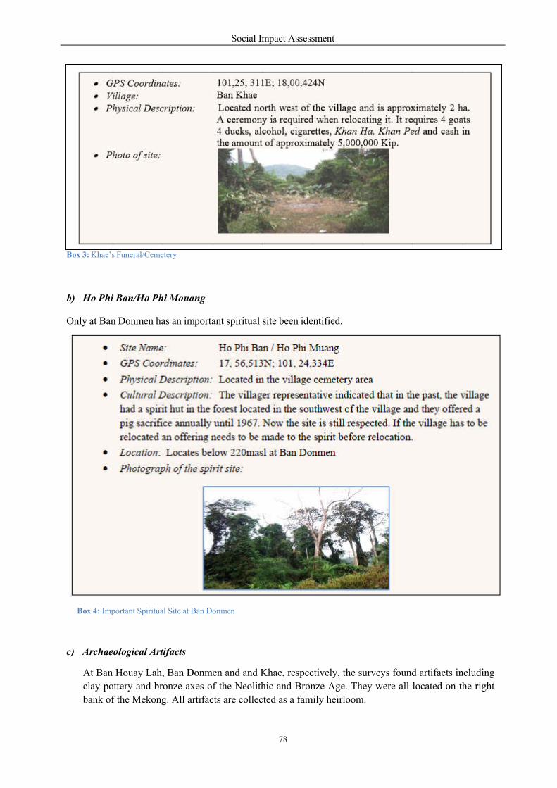
Social Impact Assessment
78
Box 3: Khae’s Funeral/Cemetery
b) Ho Phi Ban/Ho Phi Mouang
Only at Ban Donmen has an important spiritual site been identified.
Box 4: Important Spiritual Site at Ban Donmen
c) Archaeological Artifacts
At Ban Houay Lah, Ban Donmen and and Khae, respectively, the surveys found artifacts including clay pottery and bronze axes of the Neolithic and Bronze Age. They were all located on the right bank of the Mekong. All artifacts are collected as a family heirloom.
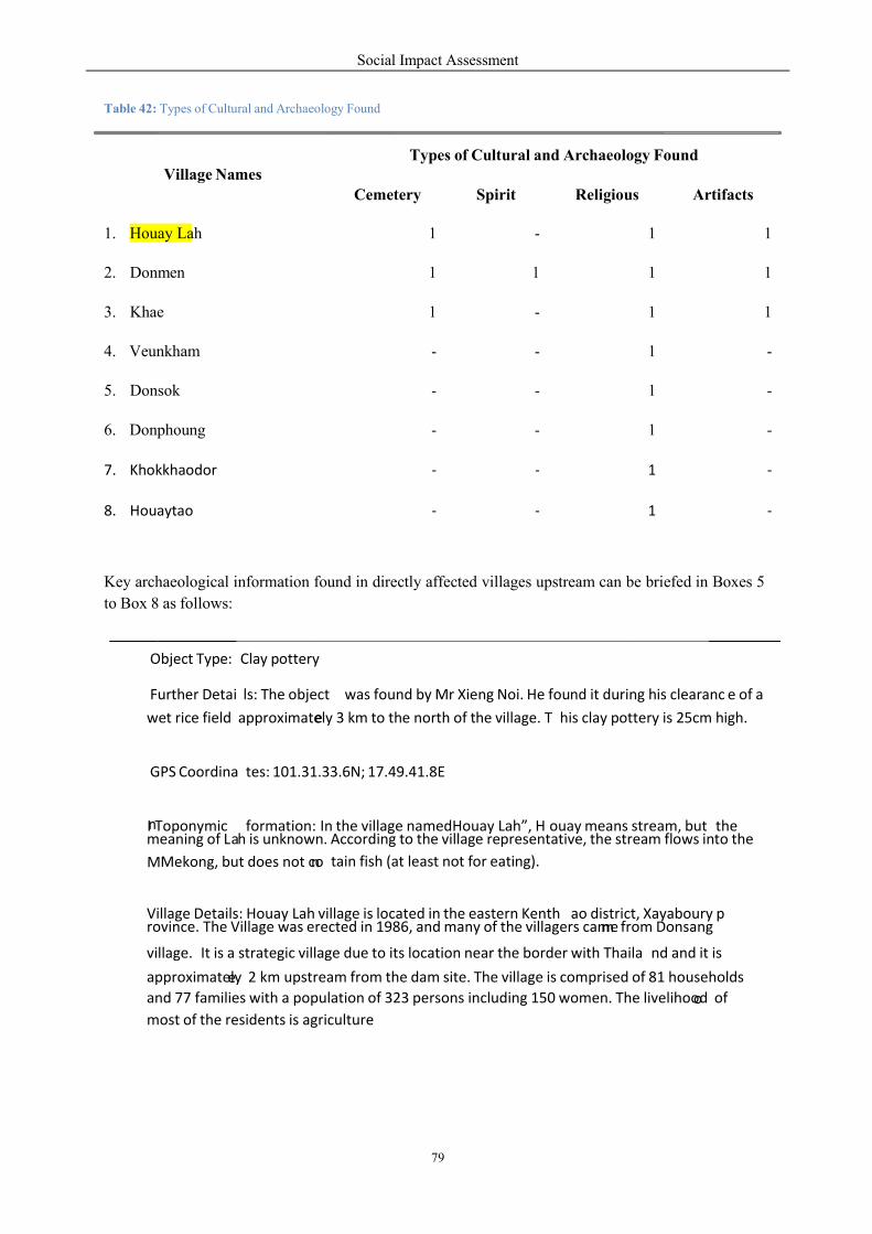
Social Impact Assessment
79
a
Table 42: Types of Cultural and Archaeology Found
Key archaeological information found in directly affected villages upstream can be briefed in Boxes 5
to Box 8 as follows:
Object Type:
Clay pottery
Further Detai
ls: The object
was found by Mr Xieng Noi. He fou nd it during his clearanc
e of a
wet rice field approximatee ly 3 km to the north of the village. T his clay pottery is 25cm high.
GPS Coordina
tes: 101.31. 33.6N; 17.49.41.8E
I n Toponymic formation: In the village namedHouay Lah”, H
ouay means stream, but the
meaning of L h is unknown. According to the village representative, the stream flows into the
tain fish (at least not for eating). M Mekong, but does not cno
Village Details: Houay Lah village is located in the eastern Kenth ao district, Xayaboury p
rovince. The Village was erected in 1986, and many of the villagers camme from Donsang
village. It is a strategic village due to its location near the border with Thaila
nd and it is
approximateely 2 km upstream from the dam site. The village is comprised of 81 ho useholds
and 77 families with a population of 323 persons including 150 women. The livelihoood of
most of the residents is agriculture
Village Names Types of Cultural and Archaeology Found
Cemetery Spirit Religious Artifacts
1. Houay Lah 1 - 1 1
2. Donmen 1 1 1 1
3. Khae 1 - 1 1
4. Veunkham - - 1 -
5. Donsok - - 1 -
6. Donphoung - - 1 -
7. Khokkhaodor ‐ ‐ 1 ‐
8. Houaytao ‐ ‐ 1 ‐
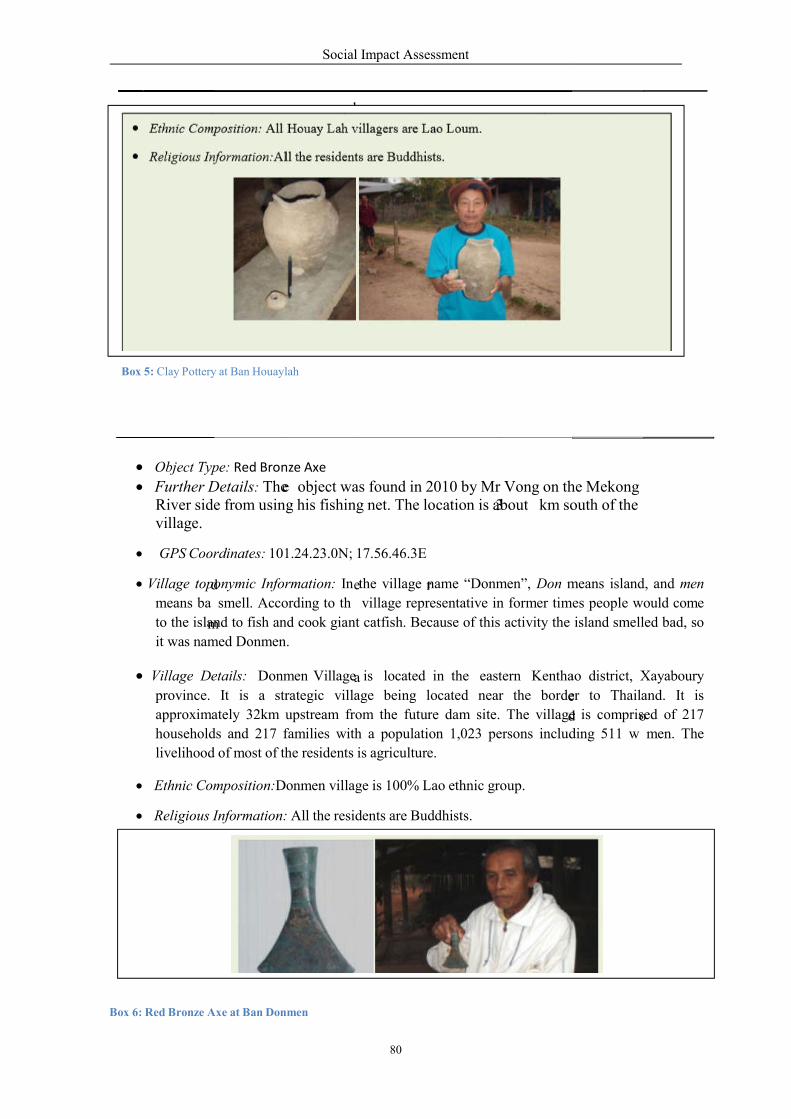
d
m
m
e
Box 5: Clay Pottery at Ban Houayl
Box 6: Red Bronze Axe at Ban Donmen
Object Type: Red Bronz
Further Details: TheRiver side from usingvillage.
GPS Coordinates: 101
Village toponymic Information:
means ba smell. According
to the island to fish an
it was named Donmen.
Village Details: Donm
province. It is a strategic
approximately 32km upstream
households and 217 f
livelihood of most of the
Ethnic Composition:Don
Religious Information:
Social Impact Assessment
80
e
e
a
h
e
r
3
e
d
lah
nmen
nze Axe
e object was found in 2010 by Mr Vong on thing his fishing net. The location is about km south
101.24.23.0N; 17.56.46.3E
Information: In the village name “Donmen”, Don m
ording to th village representative in former times
nd cook giant catfish. Because of this activity the
n.
men Village is located in the eastern Kenthao
trategic village being located near the border
upstream from the future dam site. The village
families with a population 1,023 persons includ
the residents is agriculture.
onmen village is 100% Lao ethnic group.
ormation: All the residents are Buddhists.
e
d
o
he Mekong south of the
means island, and men
times people would come
island smelled bad, so
tern Kenthao district, Xayaboury
er to Thailand. It is
e is comprised of 217
ding 511 w men. The
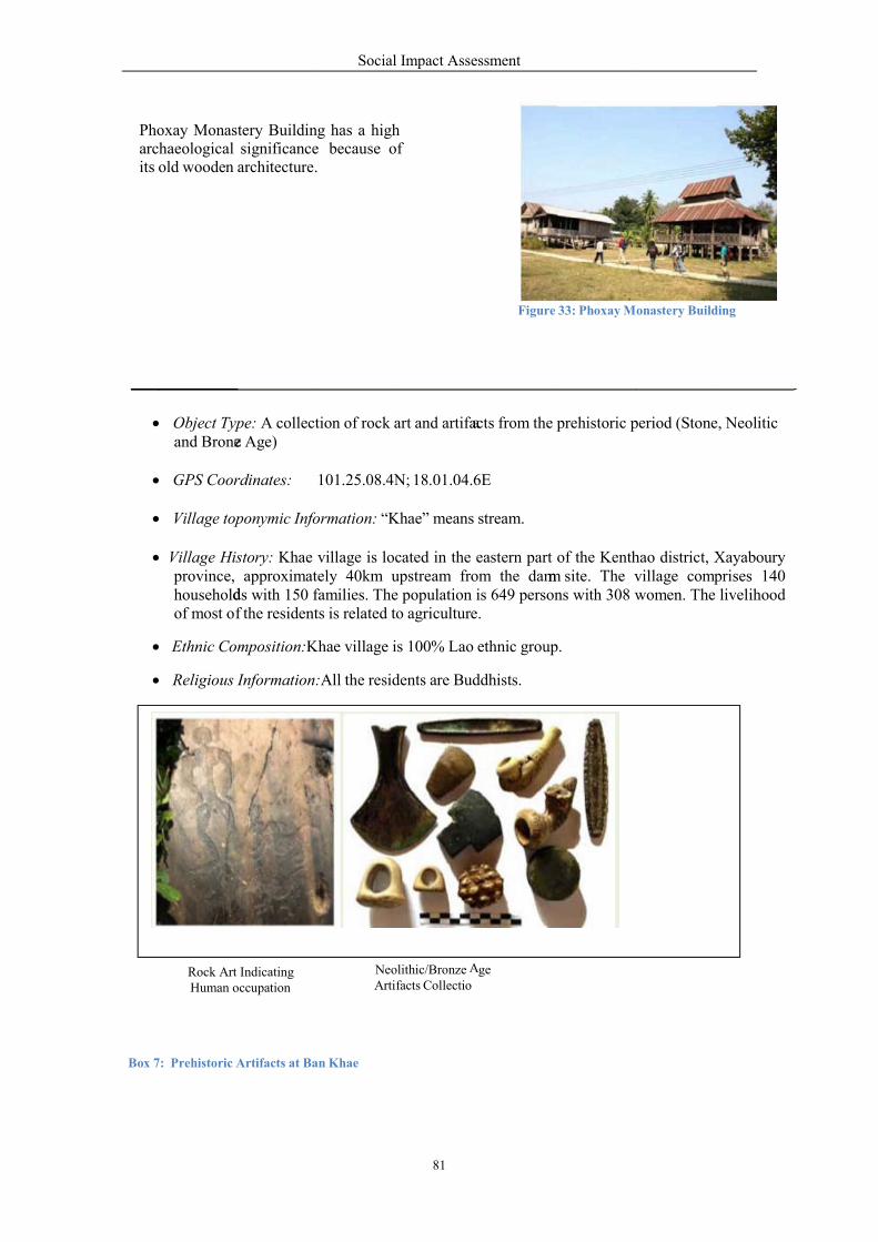
z d f
Phoxay Monastery Buildingarchaeological significanceits old wooden architecture.
Box 7: Prehistoric Artifacts at Ban
Object Type: A collection
and Brone Age)
GPS Coordinates: 1
Village toponymic Inform
Village History: Khae villageprovince, approximatelyhouseholds with 150 faof most o the residents
Ethnic Composition:K
Religious Information:
Rock Art Indicating Human occupation
Social Impact Assessment
81
a
A
m
Building has a high e
architecture. because of
Figure 33: Phoxay M
an Khae
collection of rock art and artifacts from the prehistoric period
101.25.08.4N; 18.01.04.6E
Information: “Khae” means stream.
village is located in the eastern part of the Kenthaoately 40km upstream from the dam site. The villagefamilies. The population is 649 persons with 308 w
residents is related to agriculture.
Khae village is 100% Lao ethnic group.
ormation:All the residents are Buddhists.
Neolithic/Bronze ge
Artifacts Collectio
Monastery Building
period (Stone, Neolitic
hao district, Xayaboury village comprises 140 women. The livelihood
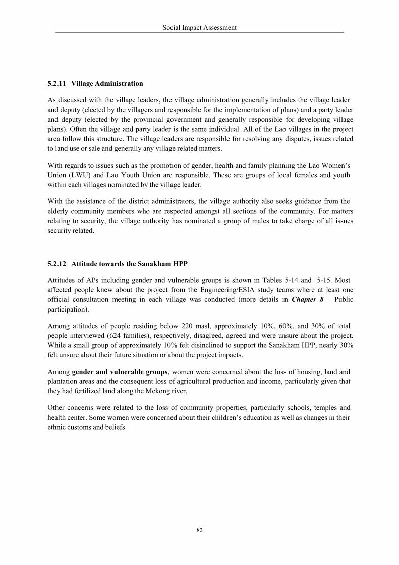
Social Impact Assessment
82
5.2.11 Village Administration
As discussed with the village leaders, the village administration generally includes the village leader
and deputy (elected by the villagers and responsible for the implementation of plans) and a party leader
and deputy (elected by the provincial government and generally responsible for developing village
plans). Often the village and party leader is the same individual. All of the Lao villages in the project
area follow this structure. The village leaders are responsible for resolving any disputes, issues related
to land use or sale and generally any village related matters.
With regards to issues such as the promotion of gender, health and family planning the Lao Women’s
Union (LWU) and Lao Youth Union are responsible. These are groups of local females and youth
within each villages nominated by the village leader.
With the assistance of the district administrators, the village authority also seeks guidance from the
elderly community members who are respected amongst all sections of the community. For matters
relating to security, the village authority has nominated a group of males to take charge of all issues
security related.
5.2.12 Attitude towards the Sanakham HPP
Attitudes of APs including gender and vulnerable groups is shown in Tables 5-14 and 5-15. Most
affected people knew about the project from the Engineering/ESIA study teams where at least one
official consultation meeting in each village was conducted (more details in Chapter 8 – Public
participation).
Among attitudes of people residing below 220 masl, approximately 10%, 60%, and 30% of total
people interviewed (624 families), respectively, disagreed, agreed and were unsure about the project.
While a small group of approximately 10% felt disinclined to support the Sanakham HPP, nearly 30%
felt unsure about their future situation or about the project impacts.
Among gender and vulnerable groups, women were concerned about the loss of housing, land and
plantation areas and the consequent loss of agricultural production and income, particularly given that
they had fertilized land along the Mekong river.
Other concerns were related to the loss of community properties, particularly schools, temples and
health center. Some women were concerned about their children’s education as well as changes in their
ethnic customs and beliefs.
Social Impact Assessment
83
m
O
Table 43: Knowing about the Project
Village Name
Sources of Information
Village committee Study teams others Total Interviewed
HH % HH % HH % HH %
1. Vientiane Province (Left Bank)
Sanakham District
01 Donsok 22 31.4 46 65.7 2 2.9 70 100.0
02 Maipakthoun - - 28 66.7 14 33.3 42 100.0
03 Donphoung 2 8.3 1 4.2 21 87.5 24 100.0
2. Xayaboury Province (Right Bank)
Paklay District
04 Boungma - - 24 96.0 1 4.0 25 100.0
Kenthao District
05 Donmen 182 78.8 48 20.8 1 0.4 231 100.0
06 Khae 106 82.8 22 17.2 - 128 100.0
07 Nakham - - - - 14 100.0 14 100.0
08 Donsang - - 13 100.0 - - 13 100.0
09 Houay Lah 64 83.1 13 16.9 - - 77 100.0
Total 376 60.2 195 31.3 53 8.5 624 100.0
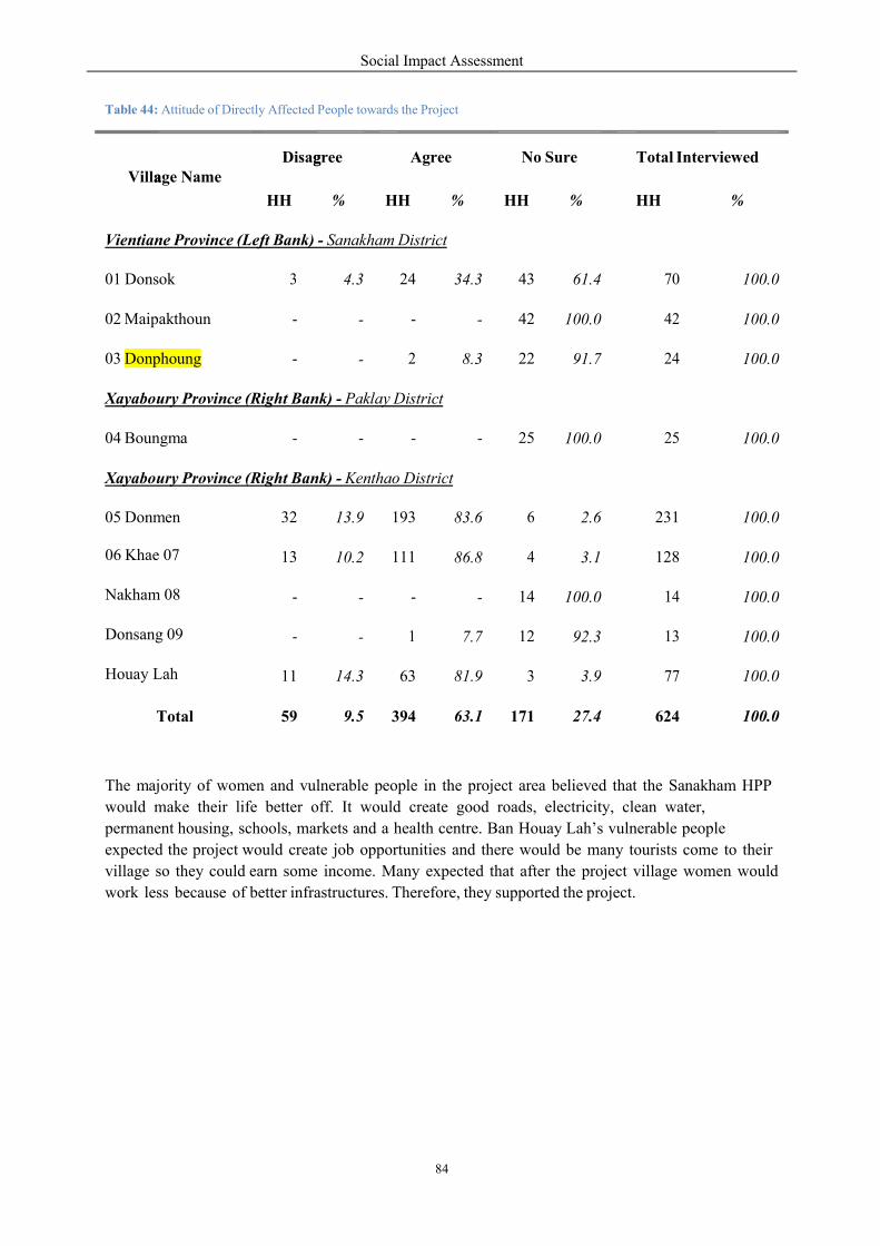
Social Impact Assessment
84
a g
Table 44: Attitude of Directly Affected People towards the Project
The majority of women and vulnerable people in the project area believed that the Sanakham HPP
would make their life better off. It would create good roads, electricity, clean water,
permanent housing, schools, markets and a health centre. Ban Houay Lah’s vulnerable people
expected the project would create job opportunities and there would be many tourists come to their
village so they could earn some income. Many expected that after the project village women would
work less because of better infrastructures. Therefore, they supported the project.
Village Name Disagree Agree No Sure Total Interviewed
HH % HH % HH % HH %
Vientiane Province (Left Bank) - Sanakham District
01 Donsok 3 4.3 24 34.3 43 61.4 70 100.0
02 Maipakthoun - - - - 42 100.0 42 100.0
03 Donphoung - - 2 8.3 22 91.7 24 100.0
Xayaboury Province (Right Bank) - Paklay District
04 Boungma - - - - 25 100.0 25 100.0
Xayaboury Province (Right Bank) - Kenthao District
05 Donmen 32 13.9 193 83.6 6 2.6 231 100.0
13 10.2 111 86.8 4 3.1 128 100.0
- - - - 14 100.0 14 100.0
- - 1 7.7 12 92.3 13 100.0
06 Khae 07
Nakham 08
Donsang 09
Houay Lah 11 14.3 63 81.9 3 3.9 77 100.0
Total 59 9.5 394 63.1 171 27.4 624 100.0
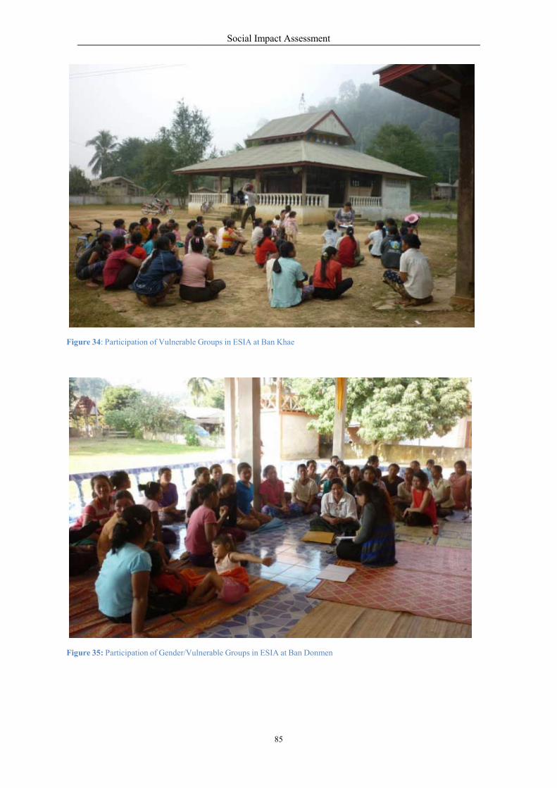
Figure 34: Participation of Vulnerable G
Figure 35: Participation of Gender/Vulne
Social Impact Assessment
85
Groups in ESIA at Ban Khae
er/Vulnerable Groups in ESIA at Ban Donmen

Social Impact Assessment
86
d
5.3 Upstream Indirectly Affected Villages
5.3.1 Population
The social survey (Table 45) indicated that 17 villages with a population of 3,929 families (19,282
people) will be indirectly affected by the project due to the changes in the morphology of the Mekong
River from high water level in the wet season and low water level in the dry season to an average of
218 masl to 220 masl all year round (see Table 45). Howev er, families from ten villages only (namely,
Donphoung, Maipakthoun, Houaytao, Khokkhaodor, Donmen, Nakham, Donsang, Boungma, Kengsao,
and Nasack), totaling 354 families (1,808 people) will actually need to be relocated due to partial
flooding.
The upstream indirectly affected communities are Lao. They have an average family size of 4.91 and
the ratio of female and male of 49:51 which is considered balanced.
5.3.2 Housing
The housing status of Group 2 in upstream indirectly affected communities (36.9%) is lower compared
to upstream directly affected communities (53.2%) while ownership of Group 1 houses is significantly
higher (35.8% compared to 10.6%). To some extent, this indicates that the economic status of
indirectly affected upstream communities is more comfortable than directly affected upstream
communities.
Table 45: Type of House in Upstream Indirectly Affected Villages
5.3.3 Land Holding
Like an upstream directly affected family, the indirectly affected family has small house plot of 0.1 ha.
For agricultural lands, the average land holding per family is 1.4 ha, 1.7 ha, and 0.9 ha for lowland
farming, upland cropping, and gardening, respectively.
5.3.4 Occupation & Workforce
Most people are farmers. Only about 4% are traders, 5% are government employees, and 13% are
students (non-labor age). On average, a family of 5 people consists of husband, wife and 3 children. It
follows about 60%-80% of the total population is of working age. Approximately 95% of the total
workforce work in agricultural related activities.
Type Category of House Total Number
Survey Percentage
1 Good Quality Houses 1,356 35.8%
2 Medium Quality Houses 1,398 36.9%
3 Low Quality Houses 1,034 27.3%
Total 3,788 100.0%
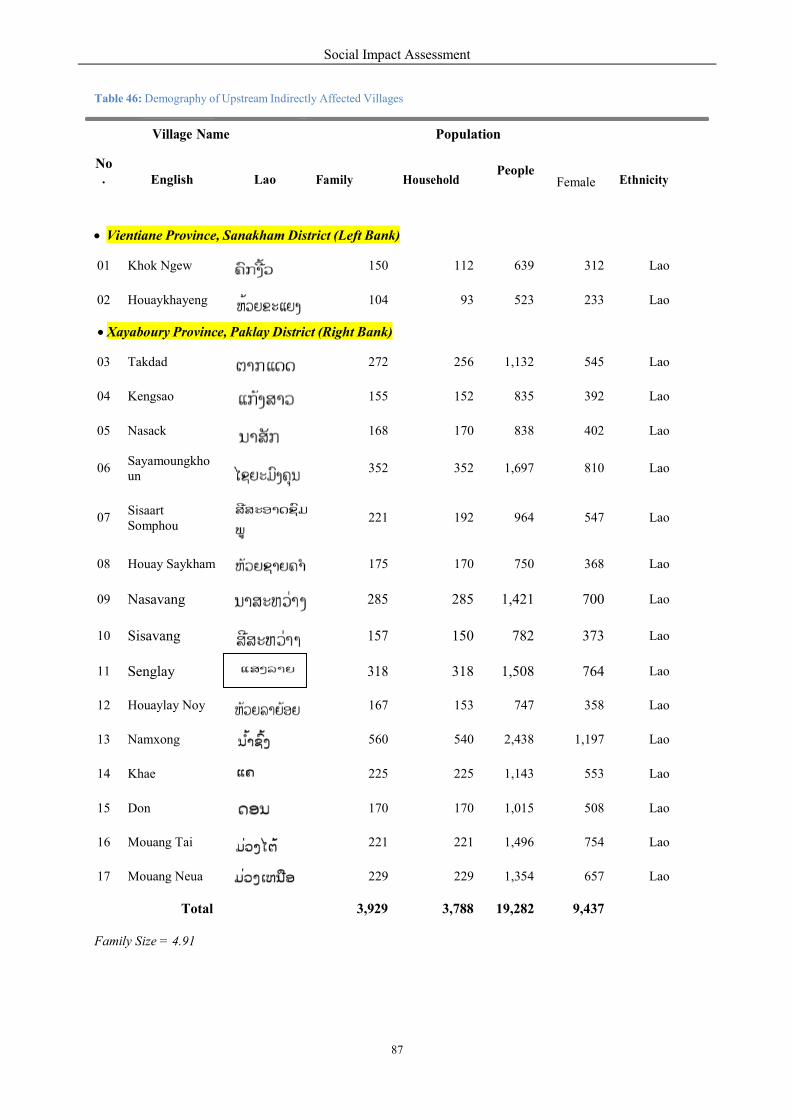
Social Impact Assessment
87
¨
1
Table 46: Demography of Upstream Indirectly Affected Villages
No .
Village Name Population
English Lao Family HouseholdPeople
Female Ethnicity
Vientiane Province, Sanakham District (Left Bank)
01 Khok Ngew 150 112 639 312 Lao
02 Houaykhayeng 104 93 523 233 Lao
Xayaboury Province, Paklay District (Right Bank)
03 Takdad 272 256 1,132 545 Lao
04 Kengsao 155 152 835 392 Lao
05 Nasack 168 170 838 402 Lao
06 Sayamoungkho un
352 352 1,697 810 Lao
07 Sisaart Somphou
221 192 964 547 Lao
08 Houay Saykham 175 170 750 368 Lao
09 Nasavang 285 285 1,421 700 Lao
10 Sisavang 157 150 782 373 Lao
11 Senglay 318 318 1,508 764 Lao
12 Houaylay Noy 167 153 747 358 Lao
13 Namxong 560 540 2,438 1,197 Lao
14 Khae 225 225 1,143 553 Lao
15 Don 170 170 1,015 508 Lao
16 Mouang Tai 221 221 1,496 754 Lao
17 Mouang Neua 229 229 1,354 657 Lao
Total 3,929 3,788 9,282 9,437
Family Size = 4.91

Social Impact Assessment
88
v
d
o
o
8
3
5
%
7
5.3.5 Livelihoods
Rice and maize farming are way of life of the indirectly affected villages. Livestock including poultry,
pigs, cattle and buffaloes can be observed in most villages. Employment is a minor income generator
in these communities. The harvest of NTFPs can be observed here but their contribution to the total
family income.in limited income.
Table 47: Average Gross Income of Indirectly Affected Family
No.
Sources of Income
Left-bank Family (kip)
Right-bank Family (kip)
%
1. Farm Income
1.1. Lowland rice 1,814,200
1,672,000
1.2 Upland crops 653,800
884,000
1.3 Maize/corns 867,000
760,000
1.4 Beans 947,000
930,000
1.5 Fruits 798,000
612,000
1.6 Vegetables 647,000
930,000
1.7 Livestock 775,000
704,000
1.8 Fishing 500,000
400,000
1.9 Aqua-culture 316,000
298,000
Total 7,31 ,000 70.40 7,190,000 69.56
2. Non-timber Forest Products (NTFPs)
2.1 NTFPs 73,000
56,000
Total 7 ,000 0.70 56,000 0.54
3. Non-farm Income
3.1 Trading 874,000
933,000
3.2 Employment 425,000
561,000
3.3 Rental fee 537,000
611,000
3.4 Sending from relatives 325,000
313,000
3.5 Others 843,000
672,000
Total 3,004,000 28.90 3,090.000 29.90
Gran Total 10,39 ,000 100.00 10,336,000 100.00
Average income (kip/month) 174,296 173,307
Average income per person 5,809 Kip/day 5,7 6 kip/day
Average income per person 0.73 US$/day 0.72 US $/day
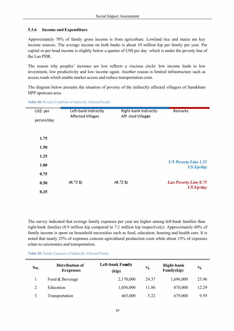
Social Impact Assessment
89
E
m
e
%
5.3.6 Income and Expenditure
Approximately 70% of family gross income is from agriculture. Lowland rice and maize are key
income sources. The average income on both banks is about 10 million kip per family per year. Per
capital or per head income is slightly below a quarter of US$ per day which is under the poverty line of
the Lao PDR. .
The reason why peoples’ incomes are low reflects a viscious circle: low income leads to low
investment, low productivity and low income again. Another reason is limited infrastructure such as
access roads which enable market access and reduce transportation costs.
The diagram below presents the situation of poverty of the indirectly affected villagers of Sanakham
HPP upstream area.
Table 48: Poverty Condition of Indirectly Affected People
US $/p/day
The survey indicated that average family expenses per year are higher among left-bank families than
right-bank families (8.9 million kip compared to 7.1 million kip respectively). Approximately 60% of
family income is spent on household necessities such as food, education, housing and health care. It is
noted that nearly 25% of expenses concern agricultural production costs while about 15% of expenses
relate to ceremonies and transportation.
Table 49: Family Expenses of Indirectly Affected Family
No.
Dist
ribution of expenses
Left-bank Family
(kip)
Right-bank Family(kip)
%
1 Food & Beverage 2,170,000 24.37 1,696,000 23.96
2 Education 1,056,000 11.86 870,000 12.29
3 Transportation 465,000 5.22 679,000 9.59
US$ per
person/day
Left‐bank Indirectly Affected Villages
Rig Affe
ht‐bank Indi cted Villages
rectly
Remarks
1.75
1.50
1.25
1.00
0.75
0.50
0.25
UN Poverty Line 1.25
(0.73 $)
(0.72 $)
Lao Poverty Line 0.75 US $/p/day
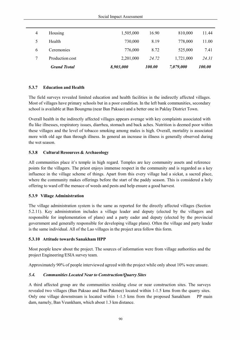
Social Impact Assessment
90
T
5.3.7 Education and Health
The field surveys revealed limited education and health facilities in the indirectly affected villages.
Most of villages have primary schools but in a poor condition. In the left bank communities, secondary
school is available at Ban Boungma (near Ban Paksao) and a better one in Paklay District Town.
Overall health in the indirectly affected villages appears average with key complaints associated with
flu like illnesses, respiratory issues, diarrhea, stomach and back aches. Nutrition is deemed poor within
these villages and the level of tobacco smoking among males is high. Overall, mortality is associated
more with old age than through illness. In general an increase in illness is generally observed during
the wet season.
5.3.8 Cultural Resources & Archaeology
All communities place it’s temple in high regard. Temples are key community assets and reference
points for the villagers. The priest enjoys immense respect in the community and is regarded as a key
influence in the village scheme of things. Apart from this every village had a sickat, a sacred place,
where the community makes offerings before the start of the paddy season. This is considered a holy
offering to ward off the menace of weeds and pests and help ensure a good harvest.
5.3.9 Village Administration
The village administration system is the same as reported for the directly affected villages (Section
5.2.11). Key administration includes a village leader and deputy (elected by the villagers and
responsible for implementation of plans) and a party eader and deputy (elected by the provincial
government and generally responsible for developing village plans). Often the village and party leader
is the same individual. All of the Lao villages in the project area follow this form.
5.3.10 Attitude towards Sanakham HPP
Most people knew about the project. The sources of information were from village authorities and the
project Engineering/ESIA survey team.
Approximately 90% of people interviewed agreed with the project while only about 10% were unsure.
5.4. Communities Located Near to Construction/Quarry Sites
A third affected group are the communities residing close or near construction sites. The surveys
revealed two villages (Ban Paksao and Ban Pakmee) located within 1-1.5 kms from the quarry sites.
Only one village downstream is located within 1-1.5 kms from the proposed Sanakham
dam, namely, Ban Veunkham, which about 1.3 km distance.
PP main
4 Housing 1,505,000 16.90 810,000 11.44
5 Health 730,000 8.19 778,000 11.00
6 Ceremonies 776,000 8.72 525,000 7.41
7 Production cost 2,201,000 24.72 1,721,000 24.31
Grand total
8,903,000
100.00
7,079,000
100.00

5.4.1 Demography, Ethnicity
Social characteristic of Ban Veunkham
Ban Veunkham
GPS Coordinates: 101.32.4
Toponymic Information: In
means gold.
Village Details: Veunkham village
Nam Heuang and Mekong rivers
is a border village with Tha
site. The village is compris
including, 75 women. The livelihood
Ethnic Composition: Veunkham
Religious Information: All the
Figure 36: ESIA Survey Team at Veunk
All three villages located near the
valley; the ideal environment for
project area practice Buddhism. Key
Boun Bangfai or the Rocket Festival.
During construction and quarryi
dust, noise and vibration. Ban V
river water quality change.
Social Impact Assessment
91
y and Culture
Veunkham are outlined below.
47.7N; 17.48.52.0E
In the village name “Vuenkham”, Vuen means
Veunkham village is located on eastern side of the Nam Heuang
rivers meet. The village is in Kenthao district, X
ailand and is located approximately 1.3 km downstream
sed of 33 households with 33 families. The pop
livelihood of most of the residents is agriculture.
kham village is 100% Lao ethnic group.
the residents are Buddhists.
kham Figure 37: ESIA Survey at Quarry S
the damsite are Lao. They live in the lowlands along
for rice paddy, maize and job’s tear farming. The Lao
Key religious festivals include Boun Pimai Lao or
Festival. Lao New Year is celebrated nationwide in m
ng, these communities will be potentially at risk
Veunkham being located downstream from the project
whirlpool and kham
euang River where the
Xayaboury Province. It
downstream from the dam
pulation is 155 people
Site
ng the Mekong River
Lao community in the
or Lao New Year and
mid April each year.
sk from annoyance of
roject will experience
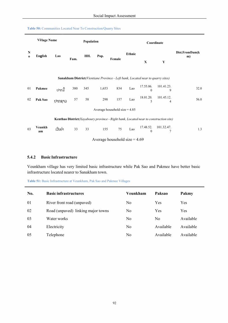
Social Impact Assessment
92
g
Table 50: Communities Located Near To Construction/Quarry Sites
7
5.4.2 Basic Infrastructure
Veunkham village has very limited basic infrastructure while Pak Sao and Pakmee have better basic
infrastructure located nearer to Sanakham town.
Table 51: Basic Infrastructure at Veunkham, Pak Sao and Pakmee Villages
No.
Basic infrastructures
Veunkham
Paksao
Pakmy
01 River front road (unpaved) No Yes Yes
02 Road (unpaved) linking major towns No Yes Yes
03 Water works No No Available
04 Electricity No Available Available
05 Telephone No Available Available
N o
Vil
lage Name
Population
Coordinate
Dist.FromDam(k m)
Eng
lish
Lao
Fam.
HH.
Pop.
Female
Ethnic
X
Y
Sanakham District(Vientiane Province - Left bank, Located near to quarry sites)
01
Pakmee
380
345
1,653
834
Lao
17.55.06. 0
101.41.23. 9
32.0
02
Pak Sao
57
58
298
157
Lao
18.01.20. 5
101.45.12. 4
56.0
Average household size = 4.85
Kenthao District(Xayaboury province - Right bank, Located near to construction site)
03
Veunkh am
33
33
155
75
Lao
17.48.52. 0
101.32.47.
1.3
Average household size = 4.69

Figure 38: Map from Vuenkham to Pa
5.4.3 Household Economy and
The way of life of people in th
rearing. The farm sector employ
whereas the non-farm sector emplo
Typically a family usually growpaddy during the rainy season arange of forest produce during seasons.
Ban Pak Sao also plant Jobirrigation system for low-land riceis observed in these villages.
The NTFPs collected within the
proportions for sale. To supplem
usually buffaloes, cattle, goats, pigs
cultivation except for small scale
The average family income of Pa
the poverty line of Lao PDR. A
month. The main sources of inc
cropping (include gardening) and
Social Impact Assessment
93
Pakmee Villages
and Livelihood
these three villages is dominantly based on agriculture
ys approximately 95 percent of the active and productive
ploys less than five percent of the workforce.
ws one crop of and collects a wet and dry
b’s tear. No rice plantation
Figure 39: Job’s tear product at Ban
the project area are primarily for household consu
ment their income, most of the households own a
pigs and poultry products. During the dry season
growing of some vegetables.
Pak Sao and Pakmee is estimated at US$ 499 per m
Average family income at Ban Veunkham is h
ome (approximately 75% of the total family inc
and livestock.
culture and livestock
roductive work force
Ban Pak Sao
sumption with small
a number of livestock,
on there is generally no
month which is above
higher at US$582 per
income) is derived from
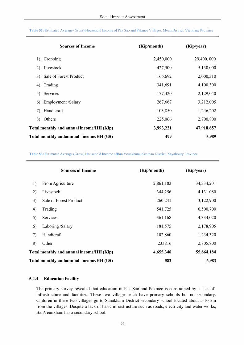
Social Impact Assessment
94
u
a
a
S
S
4
Table 52: Estimated Average (Gross) Household Income of Pak Sao and Pakmee Villages, Meun District, Vientiane Province
Table 53: Estimated Average (Gross) Household Income ofBan Veunkham, Kenthao District, Xayaboury Province
5.4.4 Education Facility
The primary survey revealed that education in Pak Sao and Pakmee is constrained by a lack of
infrastructure and facilities. These two villages each have primary schools but no secondary.
Children in these two villages go to Sanakham District secondary school located about 5-10 km
from the villages. Despite a lack of basic infrastructure such as roads, electricity and water works,
BanVeunkham has a secondary school.
Sources of Income
(Kip/month)
(Kip/year)
1) From Agriculture 2,861,183 34,334,201
2) Livestock 344,256 4,131,080
3) Sale of Forest Product 260,241 3,122,900
4) Trading 541,725 6,500,700
5) Services 361,168 4,334,020
6) Laboring /Salary 181,575 2,178,905
7) Handicraft 102,860 1,234,320
8) Other 233816 2,805,800
Total monthly and annual income/HH (Kip) ,655,348
55,864,184
Total monthly and annual income/HH (U$) 582
6,983
So rces of Income
(Kip/month)
(Kip/year)
1) Cropping 2,450,000 29,400, 000
2) Livestock 427,500 5,130,000
3) Sale of Forest Product 166,692 2,000,310
4) Trading 341,691 4,100,300
5) Services 177,420 2,129,040
6) Employment /Salary 267,667 3,212,005
7) Handicraft 103,850 1,246,202
8) Others 225,066 2,700,800
Total monthly and annual income/HH (Kip) 3,993,221
47,918,657
Total monthly and annual income/HH (U$) 499
5,989
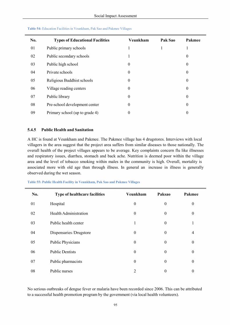
Social Impact Assessment
95
e
Table 54: Education Facilities in Veunkham, Pak Sao and Pakmee Villages
5.4.5 Public Health and Sanitation
A HC is found at Veunkham and Pakmee. The Pakmee village has 4 drugstores. Interviews with local
villagers in the area suggest that the project area suffers from similar diseases to those nationally. The
overall health of the project villages appears to be average. Key complaints concern flu like illnesses
and respiratory issues, diarrhea, stomach and back ache. Nutrition is deemed poor within the village
area and the level of tobacco smoking within males in the community is high. Overall, mortality is
associated more with old age than through illness. In general an
observed during the wet season.
increase in illness is generally
Table 55: Public Health Facility in Veunkham, Pak Sao and Pakmee Villages
No serious outbreaks of dengue fever or malaria have been recorded since 2006. This can be attributed
to a successful health promotion program by the government (via local health volunteers).
No.
Type of healthcare facilities
Veunkham
Paksao
Pakmee
01
Hospital
0
0
0
02
Health Administration
0
0
0
03
Public health center
1
0
1
04
Dispensaries /Drugstore
0
0
4
05
Public Physicians
0
0
0
06
Public Dentists
0
0
0
07
Public pharmacists
0
0
0
08
Public nurses
2
0
0
No.
Types of Educational Facilities
Veunkham
Pak Sao
Pakmee
01 Public primary schools 1 1 1
02 Public secondary schools 1
0
03 Public high school 0
0
04 Private schools 0
0
05 Religious Buddhist schools 0
0
06 Village reading centers 0
0
07 Public library 0
0
08 Pre-school development center 0
0
09 Primary school (up to grade 4) 0
0
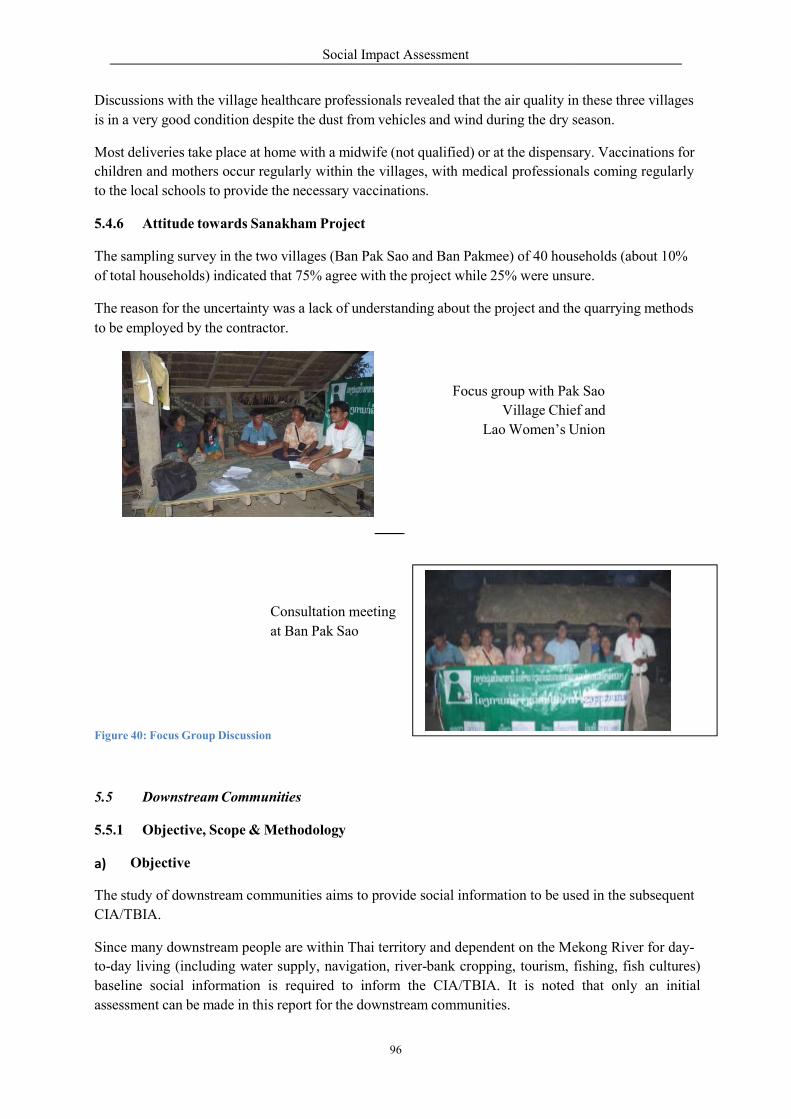
Discussions with the village healthcare
is in a very good condition despite
Most deliveries take place at hom
children and mothers occur regularly
to the local schools to provide the
5.4.6 Attitude towards Sanak
The sampling survey in the two villages
of total households) indicated tha
The reason for the uncertainty wa
to be employed by the contractor.
Consultation
at Ban
Figure 40: Focus Group Discussion
5.5 Downstream Communities
5.5.1 Objective, Scope & Methodolo
a) Objective
The study of downstream communities
CIA/TBIA.
Since many downstream people are
to-day living (including water supp
baseline social information is required
assessment can be made in this re
Social Impact Assessment
96
m
lthcare professionals revealed that the air quality in
despite the dust from vehicles and wind during the dry season.
me with a midwife (not qualified) or at the dispensar
gularly within the villages, with medical professionals
the necessary vaccinations.
Sanakham Project
villages (Ban Pak Sao and Ban Pakmee) of 40 households
at 75% agree with the project while 25% were unsure.
was a lack of understanding about the project and the
or.
Focus group with Pak
Village Chie
Lao Women’s U
Consultation eeting
Ban Pak Sao
ties
thodology
unities aims to provide social information to be used
are within Thai territory and dependent on the Mekong
upply, navigation, river-bank cropping, tourism,
required to inform the CIA/TBIA. It is noted
eport for the downstream communities.
in these three villages
season.
sary. Vaccinations for
nals coming regularly
households (about 10%
unsure.
he quarrying methods
Pak Sao
ef and
Union
sed in the subsequent
ekong River for day-
fishing, fish cultures)
noted that only an initial
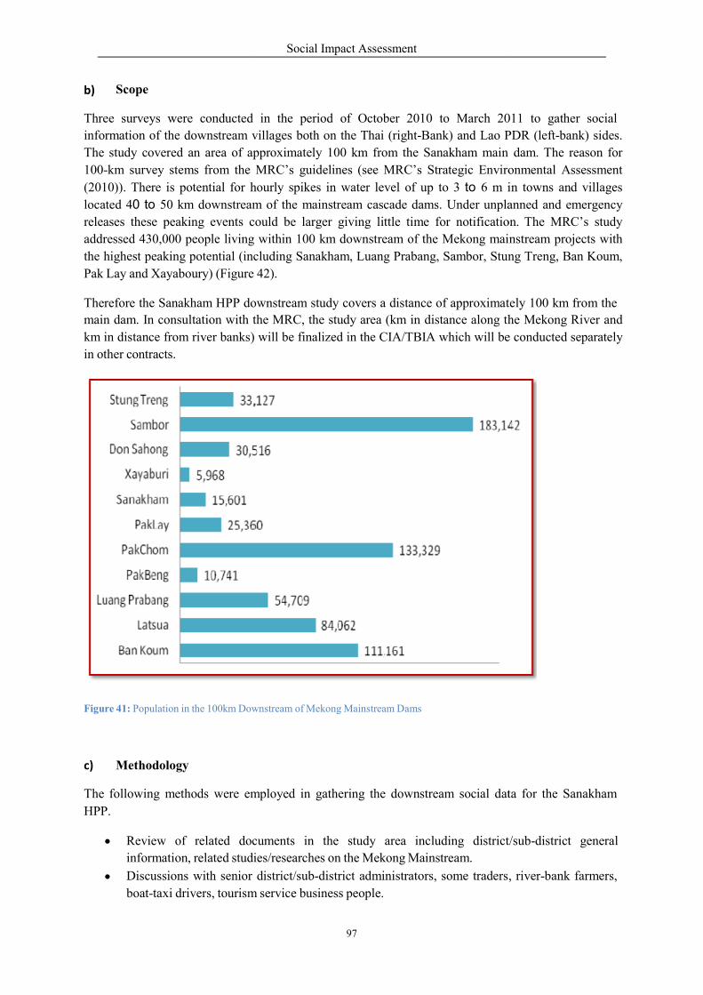
b) Scope
Three surveys were conducted
information of the downstream villages
The study covered an area of app
100-km survey stems from the
(2010)). There is potential for h
located 40 to 50 km downstream
releases these peaking events c
addressed 430,000 people living
the highest peaking potential (inc
Pak Lay and Xayaboury) (Figure
Therefore the Sanakham HPP downstream
main dam. In consultation with the
km in distance from river banks)
in other contracts.
Figure 41: Population in the 100km Dow
c) Methodology
The following methods were em
HPP.
Review of related doc
information, related studie
Discussions with senior
boat-taxi drivers, tourism
Social Impact Assessment
97
d in the period of October 2010 to March 2011
villages both on the Thai (right-Bank) and Lao P
pproximately 100 km from the Sanakham main
MRC’s guidelines (see MRC’s Strategic Environ
hourly spikes in water level of up to 3 to 6 m in
m of the mainstream cascade dams. Under unpla
could be larger giving little time for notificatio
within 100 km downstream of the Mekong mai
cluding Sanakham, Luang Prabang, Sambor, Stung Treng,
42).
downstream study covers a distance of approximately
the MRC, the study area (km in distance along the
banks) will be finalized in the CIA/TBIA which will be
Downstream of Mekong Mainstream Dams
mployed in gathering the downstream social data
ocuments in the study area including district/sub
ies/researches on the Mekong Mainstream.
district/sub-district administrators, some traders,
tourism service business people.
011 to gather social
PDR (left-bank) sides.
dam. The reason for
onmental Assessment
in towns and villages
anned and emergency
ion. The MRC’s study
instream projects with
ng Treng, Ban Koum,
tely 100 km from the
he Mekong River and
be conducted separately
ta for the Sanakham
district/sub-district general
, river-bank farmers,

Social Impact Assessment
98
Interview with public utility people such as local water works administrators and electricity
authority people;
Selected interviews with villagers and former fishermen residing on the right bank of the
Mekong River.
Survey by boats along the Mekong River on the Thai side.
Ground surveys checking the location and other social and livelihood issues.
5.5.2 Downstream Riparian Villages (Thailand)
a) Riparian Districts
There are two riparian districts located on the right bank of the Mekong mainstream, Chiang Khan and
Pak Chom. Location information of these two districts is as follows:
Chiang Khan District
Location: 17°53′54″N, 101°39′54″E
Chiang Khan (Loei Province) is a border district connecting with Sanakham District of Lao
PDR to the north and connecting with Kenthao District of Lao PDR on the west (Heung River
is the Thai-Lao border line with a distance of 12 km).
The district area of 940.5 km2 is covered with 60% of medium flood plain/hill terrace, and
with 40% of mountains.
There are 5 main rivers in Chiang Khan which include Loei River, Heung River, Houy River,
Mi River, and Souay River. All of these drain into the Mekong River.
As of March 2010, the Chiang Khan has 9 sub-districts, 82 villages with the total population of
59,732 people (29,600 female). The average den ity is 63 persons per km2.
16 villages are identified as Mekong riparian villages that may be indirectly affected by the
Mekong mainstream hydropower projects. (see next sections)
o o
o
o
o
o
Pak Chom District
Location: 18°1′18″N, 101°53′18″E
The district area of 945 km2 is covered with 60% of medium flood plain/hill terrace, and with
40% of mountains.
Pak Chom has 3 rivers namely Chom River, Mang River, and Sa Ngao River which all drain
into the Mekong River.
The statistic in June 2010 showed that Pak Chom has 6 sub-districts, 50 villages with the
population of 38,845 people (19,065 female). The average density is 41persons/km2.
14 villages are found to be the Mekong riparian villages. (see also next sections)
o o
o
o
o
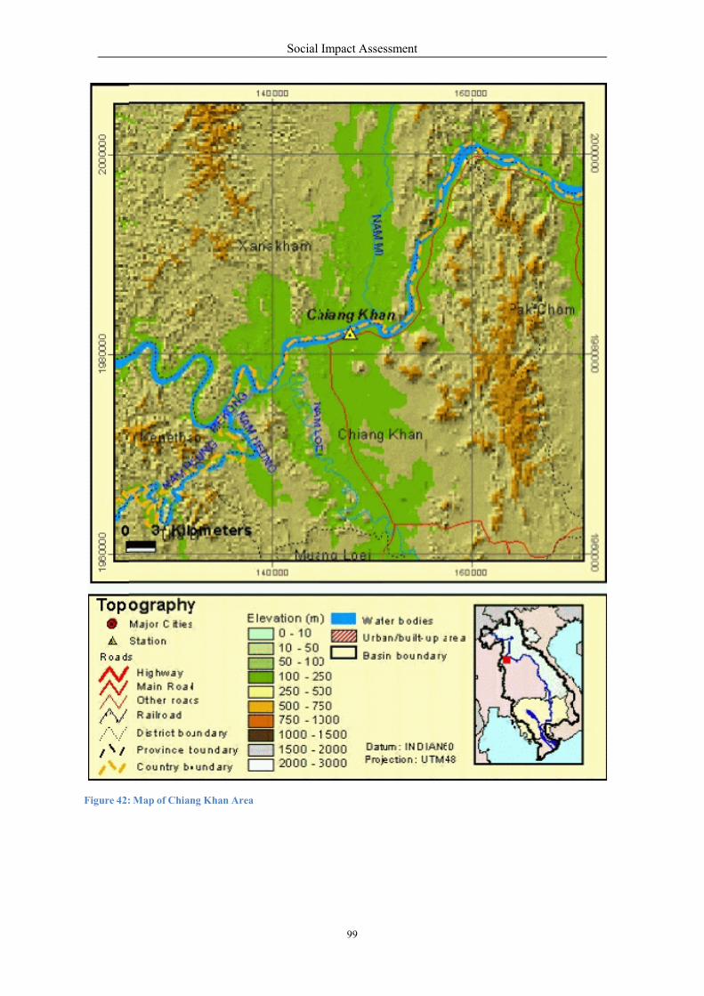
Figure 42: Map of Chiang Khan Area
Social Impact Assessment
99
Social Impact Assessment
100
C
b) Key Social Facilities & Services
Basic Infrastructure
The two districts are served with paved roads, waterworks, electricity, and telecommunications. The
main road linking Chiang Khan and Pak Chom is called River-front Highway Number 211 while other
links to major towns include highways 201, 2108, 2249, 2194, 2186, and 2108.
Table 56: Basic Infrastructure in Downstream Villages (Thailand)
1) Education
Thai standard primary/secondary/high schools and other educational services are available in these two
districts including Buddhist religious schools and a number of pre-school development centers. In
terms of tertiary education, there are Rajaphat University and Buddhist University both located in the
Loei provincial town. Higher vocational schools are also available in Loei.
Table 57: Educational Facilities in Downstream Villages (Thailand)
No.
Type of Educational Facilities
Chiang Khan
Pak Chom
01
Public primary schools
41
36
02
Public secondary schools
4
3
03
Private schools
1
-
04
Religious Buddhist schools
2
8
05
Village Reading Centers
82
36
06
District Library
1
1
07
Pre-school development centers
35
12
Total
166
96
No.
Basic Infrastructures
Chiang Khan
Pak Chom
01
River-front highway
HW 211
HW 211
02
Highway linking major towns
HWs 201, 2108,
2249, 2194, 2195
HWs 2186, 2108
03
Waterworks
68 Stations
32 Stations
04
Electricity
Available
Available
05
Telephone
Available
Available

Social Impact Assessment
101
2) Public Health & Sanitation
Like other remote provinces in Thailand, health care is available at a cost of only 30 baht for any
health treatment cases. There are also private clinics
number of private clinics can be found in Chiang Khan.
available but at higher cost per case. A
Table 58: Public Health Facilities in Downstream Villages (Thailand)
Every village has solid waste management system operated by the Municipality Office and by Sub-
district Administration Office. All houses have a bathroom/ toilets: 3% are flush latrine; 94% are
mould latrine; and 3% mixed flush and mould latrines.
3) Demography of Riparian Villages
The surveys revealed 28 villages residing along the Mekong River on the Thai side (Table 52) - 15
villages within the Chiang Khan District and 14 villages in the Pak Chom District. The general
demography of these villages is as follows:
Total households: 6,109
Total population: 20,847
Female population: 10,532 (50.57% of total population)
Average household size: 3.41
No.
Type of Health Care Facilities
Chiang Khan
Pak Chom
01
District hospital (30 beds)
1
1
02
Health administration
1
1
03
Public health clinic
14
10
04
Private health clinic
18
3
05
Dispensaries/drug store
7
4
06
Public Physicians
3
3
07
Public Dentists
1
1
08
Public Pharmacists
3
2
09
Public Nurses
51
29
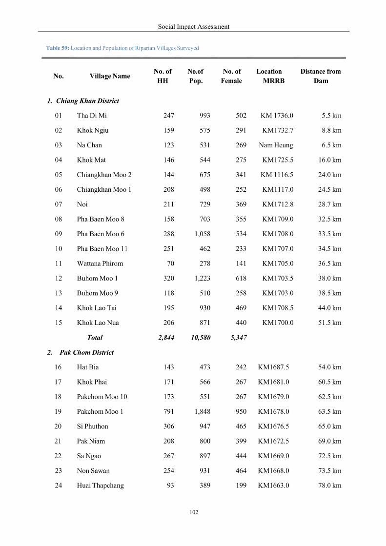
Social Impact Assessment
102
0
Table 59: Location and Population of Riparian Villages Surveyed
No.
Village Name
No. of
HH
No.of
Pop.
No. of
Female
Location
MRRB
Distance from
Dam
1. Chiang Khan District
01 Tha Di Mi 247 993 502 KM 1736.0 5.5 km
02 Khok Ngiu 159 575 291 KM1732.7 8.8 km
03 Na Chan 123 531 269 Nam Heung 6.5 km
04 Khok Mat 146 544 275 KM1725.5 16.0 km
05 Chiangkhan Moo 2 144 675 341 KM 1116.5 24.0 km
06 Chiangkhan Moo 1 208 498 252 KM1117.0 24.5 km
07 Noi 211 729 369 KM1712.8 28.7 km
08 Pha Baen Moo 8 158 703 355 KM1709.0 32.5 km
09 Pha Baen Moo 6 288 1,058 534 KM1708.0 33.5 km
10 Pha Baen Moo 11 251 462 233 KM1707.0 34.5 km
11 Wattana Phirom 70 278 141 KM1705.0 36.5 km
12 Buhom Moo 1 320 1,223 618 KM1703.5 38.0 km
13 Buhom Moo 9 118 510 258 KM1703.0 38.5 km
14 Khok Lao Tai 195 930 469 KM1708.5 44.0 km
15 Khok Lao Nua 206 871 440 KM1700.0 51.5 km
Total 2,844 10,58
5,347
2. Pak Chom District
16 Hat Bia 143 473 242 KM1687.5 54.0 km
17 Khok Phai 171 566 267 KM1681.0 60.5 km
18 Pakchom Moo 10 173 551 267 KM1679.0 62.5 km
19 Pakchom Moo 1 791 1,848 950 KM1678.0 63.5 km
20 Si Phuthon 306 947 465 KM1676.5 65.0 km
21 Pak Niam 208 800 399 KM1672.5 69.0 km
22 Sa Ngao 267 897 444 KM1669.0 72.5 km
23 Non Sawan 254 931 464 KM1668.0 73.5 km
24 Huai Thapchang 93 389 199 KM1663.0 78.0 km
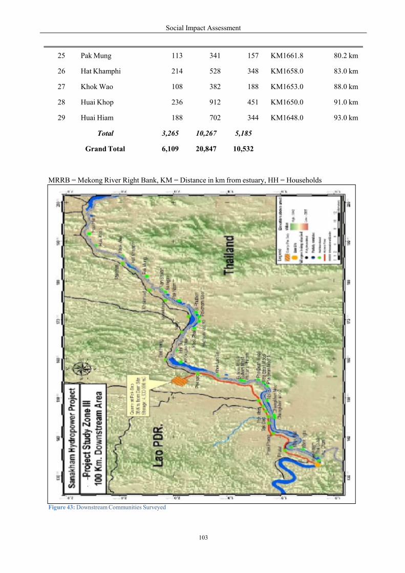
Social Impact Assessment
103
a
a k na S
ng k e
MRRB = Mekong River Right Bank, KM = Distance in km from estuary, HH = Households
Figure 43: Downstream Communities Surveyed
o
a
25 Pak Mung 113 341 157 KM1661.8 80.2 km
26 Hat Khamphi 214 528 348 KM1658.0 83.0 km
27 Khok Wao 108 382 188 KM1653.0 88.0 km
28 Huai Khop 236 912 451 KM1650.0 91.0 km
29 Huai Hiam 188 702 344 KM1648.0 93.0 km
Tot l 3,265 10,267
5,185
Grand Total 6,109 20,847
10,532
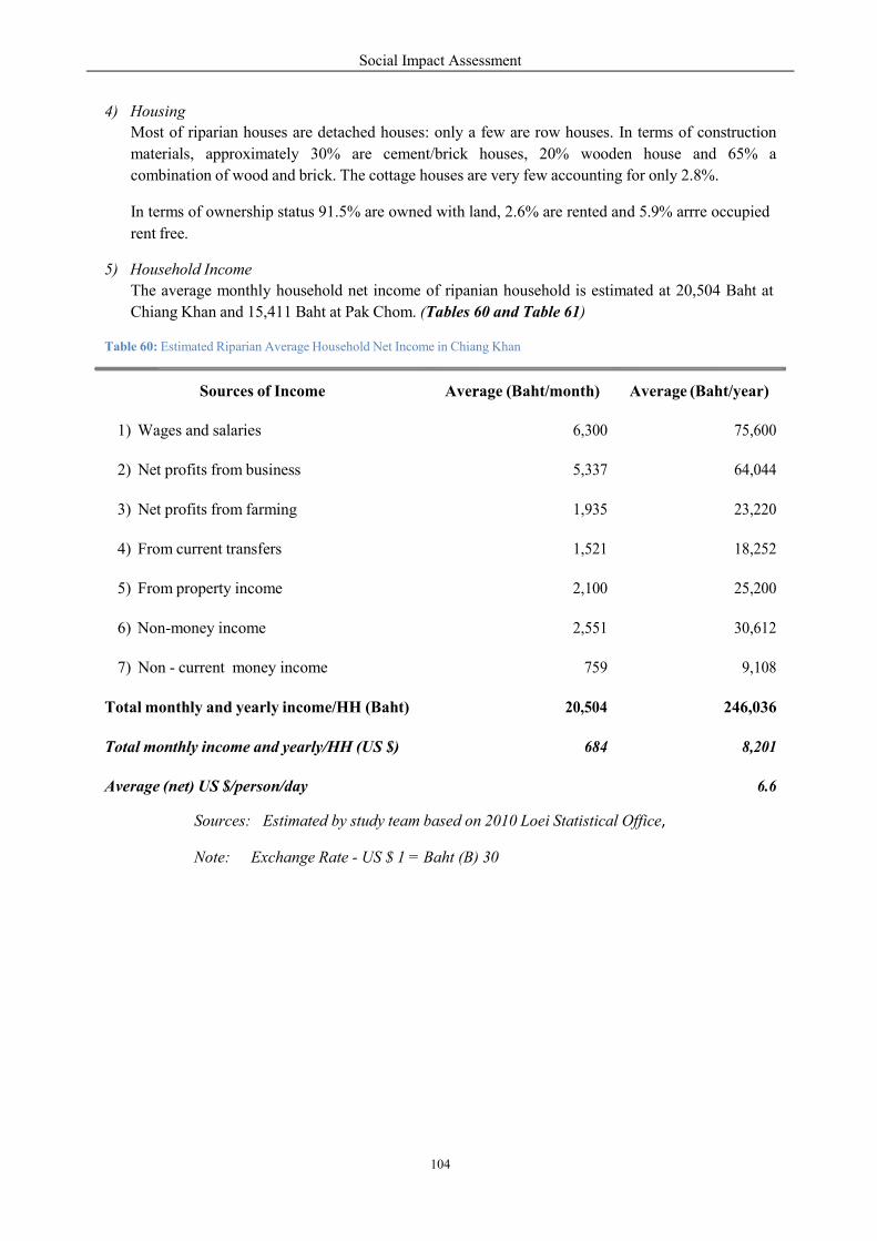
Social Impact Assessment
104
r
4) Housing
Most of riparian houses are detached houses: only a few are row houses. In terms of construction
materials, approximately 30% are cement/brick houses, 20% wooden house and 65% a
combination of wood and brick. The cottage houses are very few accounting for only 2.8%.
In terms of ownership status 91.5% are owned with land, 2.6% are rented and 5.9% arrre occupied
rent free.
5) Household Income
The average monthly household net income of ripanian household is estimated at 20,504 Baht at
Chiang Khan and 15,411 Baht at Pak Chom. (Tables 60 and Table 61)
Table 60: Estimated Riparian Average Household Net Income in Chiang Khan
Sources: Estimated by study team based on 2010 Loei Statistical Office,
Note: Exchange Rate - US $ 1 = Baht (B) 30
Sources of Income
Average (Baht/month)
Average (Baht/year)
1) Wages and salaries
6,300
75,600
2) Net profits from business
5,337
64,044
3) Net profits from farming
1,935
23,220
4) From current transfers
1,521
18,252
5) From property income
2,100
25,200
6) Non-money income
2,551
30,612
7) Non - current money income
759
9,108
Total monthly and yearly income/HH (Baht)
20,504
246,036
Total monthly income and yearly/HH (US $)
684
8,201
Average (net) US $/person/day
6.6
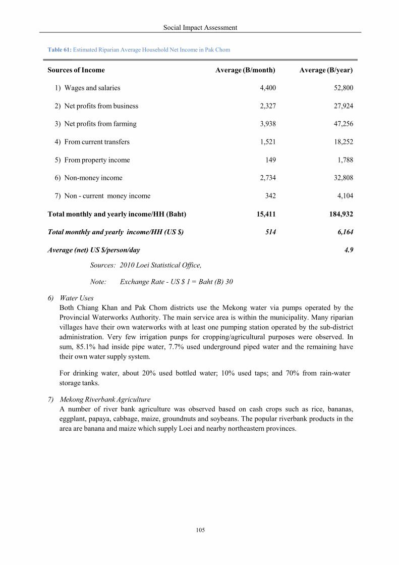
Social Impact Assessment
105
Table 61: Estimated Riparian Average Household Net Income in Pak Chom
Sources: 2010 Loei Statistical Office,
Note: Exchange Rate - US $ 1 = Baht (B) 30
6) Water Uses
Both Chiang Khan and Pak Chom districts use the Mekong water via pumps operated by the
Provincial Waterworks Authority. The main service area is within the municipality. Many riparian
villages have their own waterworks with at least one pumping station operated by the sub-district
administration. Very few irrigation punps for cropping/agricultural purposes were observed. In
sum, 85.1% had inside pipe water, 7.7% used underground piped water and the remaining have
their own water supply system.
For drinking water, about 20% used bottled water; 10% used taps; and 70% from rain-water
storage tanks.
7) Mekong Riverbank Agriculture
A number of river bank agriculture was observed based on cash crops such as rice, bananas,
eggplant, papaya, cabbage, maize, groundnuts and soybeans. The popular riverbank products in the
area are banana and maize which supply Loei and nearby northeastern provinces.
Sources of Income
Average (B/month)
Average (B/year)
1) Wages and salaries
4,400
52,800
2) Net profits from business
2,327
27,924
3) Net profits from farming
3,938
47,256
4) From current transfers
1,521
18,252
5) From property income
149
1,788
6) Non-money income
2,734
32,808
7) Non - current money income
342
4,104
Total monthly and yearly income/HH (Baht)
15,411
184,932
Total monthly and yearly income/HH (US $)
514
6,164
Average (net) US $/person/day
4.9
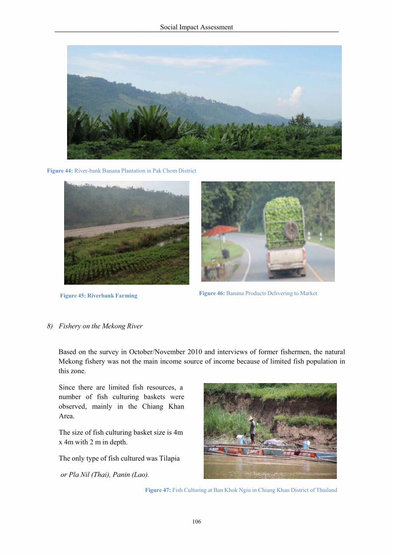
Figure 44: River-bank Banana Plantation
Figure 45: Riverbank Farming
8) Fishery on the Mekong River
Based on the survey in October/Nove
Mekong fishery was not the
this zone.
Since there are limited fish
number of fish culturing
observed, mainly in the
Area.
The size of fish culturing bas
x 4m with 2 m in depth.
The only type of fish cultured
or Pla Nil (Thai), Panin (Lao).
Social Impact Assessment
106
ation in Pak Chom District
Figure 46: Banana Products Delivering
r
tober/November 2010 and interviews of former fisher
main income source of income because of limited
h resources, a
baskets were
Chiang Khan
basket size is 4m
cultured was Tilapia
Lao).
Figure 47: Fish Culturing at Ban Khok Ngiu in Chiang Khan
ring to Market
ishermen, the natural
ted fish population in
an District of Thailand
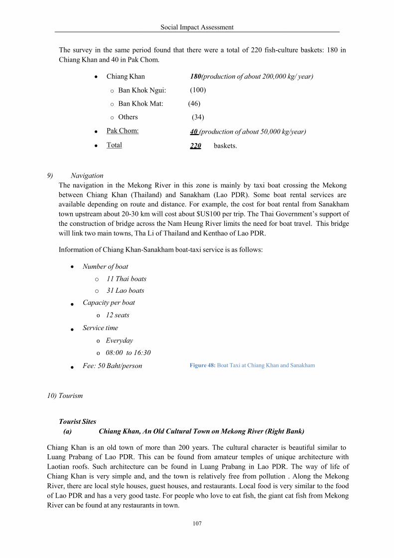
The survey in the same period
Chiang Khan and 40 in Pak Cho
Chiang Khan
o Ban Khok
o Ban Khok
o Others
Pak Chom:
Total
9) Navigation
The navigation in the Mekong
between Chiang Khan (Tha
available depending on route
town upstream about 20-30 km
the construction of bridge across the
will link two main towns, Tha
Information of Chiang Khan-
Number of boat
o 11 Thai boats
o 31 Lao boats
Capacity per boat
o 12 seats
Service time
o Everyday
o 08:00 to 16:
Fee: 50 Baht/person
10) Tourism
Tourist Sites
(a) Chiang Khan, An
Chiang Khan is an old town of
Luang Prabang of Lao PDR. This
Laotian roofs. Such architecture
Chiang Khan is very simple and,
River, there are local style house
of Lao PDR and has a very good taste.
River can be found at any restaurants
Social Impact Assessment
107
riod found that there were a total of 220 fish-cultu
Chom.
n
Khok Ngui:
Khok Mat:
180(production of about 200,000
(100)
(46)
(34)
40 (production of about 50,000 kg/year)
220 baskets.
Mekong River in this zone is mainly by taxi boat c
ailand) and Sanakham (Lao PDR). Some boat
ute and distance. For example, the cost for boat r
km will cost about $US100 per trip. The Thai Govern
bridge across the Nam Heung River limits the need for bo
Tha Li of Thailand and Kenthao of Lao PDR.
-Sanakham boat-taxi service is as follows:
ats
ats
:30
Figure 48: Boat Taxi at Chiang Khan and
An Old Cultural Town on Mekong River (Right
of more than 200 years. The cultural character is
This can be found from amateur temples of unique
e can be found in Luang Prabang in Lao PDR
nd, and the town is relatively free from pollution
ses, guest houses, and restaurants. Local food is ve
good taste. For people who love to eat fish, the giant cat f
rants in town.
culture baskets: 180 in
0 kg/ year)
kg/year)
crossing the Mekong
boat rental services are
rental from Sanakham
vernment’s support of
oat travel. This bridge
nd Sanakham
Bank)
s beautiful similar to
que architecture with
R. The way of life of
pollution . Along the Mekong
ery similar to the food
cat fish from Mekong
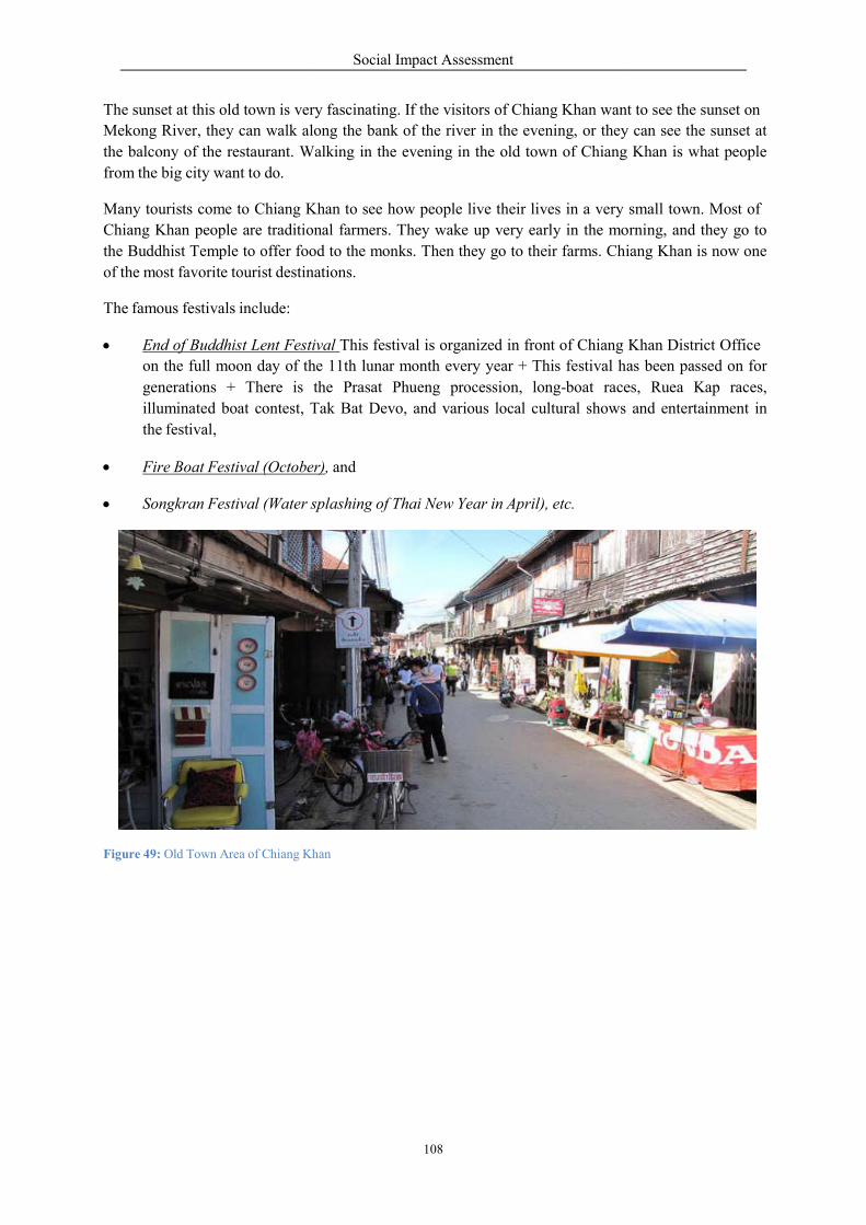
The sunset at this old town is very
Mekong River, they can walk along
the balcony of the restaurant. Walking
from the big city want to do.
Many tourists come to Chiang Kha
Chiang Khan people are traditional
the Buddhist Temple to offer food
of the most favorite tourist destinations.
The famous festivals include:
End of Buddhist Lent Festival
on the full moon day of th
generations + There is
illuminated boat contest, Tak
the festival,
Fire Boat Festival (October
Songkran Festival (Water s
Figure 49: Old Town Area of Chiang Khan
Social Impact Assessment
108
ry fascinating. If the visitors of Chiang Khan want to see the sunset
long the bank of the river in the evening, or they
Walking in the evening in the old town of Chiang
Khan to see how people live their lives in a very
traditional farmers. They wake up very early in the mo
food to the monks. Then they go to their farms. Chiang
destinations.
ival This festival is organized in front of Chiang
he 11th lunar month every year + This festival has
the Prasat Phueng procession, long-boat races
Tak Bat Devo, and various local cultural shows
ber), and
splashing of Thai New Year in April), etc.
han
Khan want to see the sunset on
y can see the sunset at
Chiang Khan is what people
small town. Most of
orning, and they go to
iang Khan is now one
Khan District Office
as been passed on for
es, Ruea Kap races,
and entertainment in
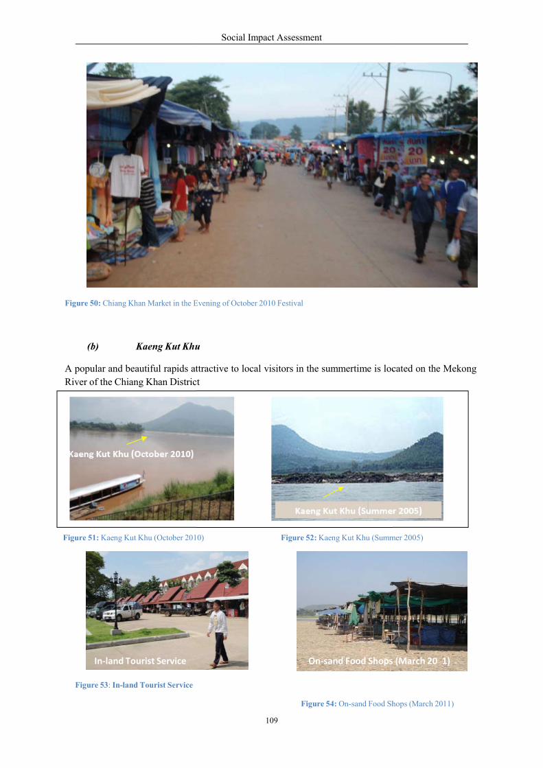
Figure 50: Chiang Khan Market in the E
(b) Kaeng Kut Khu
A popular and beautiful rapids attractive
River of the Chiang Khan Distric
Kaeng Kut Khu (October 2
Figure 51: Kaeng Kut Khu (October 2010)
In‐land Tourist Service
Figure 53: In-land Tourist Service
Social Impact Assessment
109
Evening of October 2010 Festival
Khu
ttractive to local visitors in the summertime is located
ict
2010)
10) Figure 52: Kaeng Kut Khu (Summ
On‐sand Food Shops
Figure 54: On-sand Food Shops
Kaeng Kut Khu (Su
5
1
cated on the Mekong
mmer 2005)
s (March 20 1)
Shops (March 2011)
ummer 200 )

Social Impact Assessment
110
0
Tourism business can be summarized as follows:
The interview with Senior Public Administrator at Chiang Khan revealed that Kaeng Khut Khu is one
of the main income sources of local villagers.There are about 50-60 households or 150-200 people
involved in the tourism business at this tourism spot.
Lodging: There are some small hotels and guesthouses and linked with the hotels and
guesthouses in Chiang Khan Town.
Souvenir shops: Mostly operated by both private and village housewife organizations
Food service: Thai, Lao and Western food are available.
There is concern that changes in hydrology may affect the beauty of Kaeng Khut Khu and therefore
tourism.
Number of Visitors
Information collected from the Provincial Tourism Authority indicated that in the first half of 2010
there were 90,933 visitors to Loei. About 95% are Thai and 5% are foreigners (Table 62). This
indicates domestic tourism is very important.
Table 62: Guest Arrivals at Accommodation Establishments in Loei Province
Nationality
January - June
2 10
2009
Changes (%)
Thai 86,092 108,008 - 20.29
Indonesia 3 0 -
Laos 400 346 + 15.50
Malaysia 20 77 - 73.69
Myanmar 3 1 + 246.07
Philippines 8 9 - 9.32
Singapore 76 54 + 40.47
Vietnam 10 13 - 20.14
China 209 199 + 4.88
Hong Kong 7 1 + 637.60
Japan 242 232 + 4.57
Korea 20 67 - 70.39
Taiwan 0 33 -
Austria 53 50 + 5.75
Belgium 12 34 - 64.86
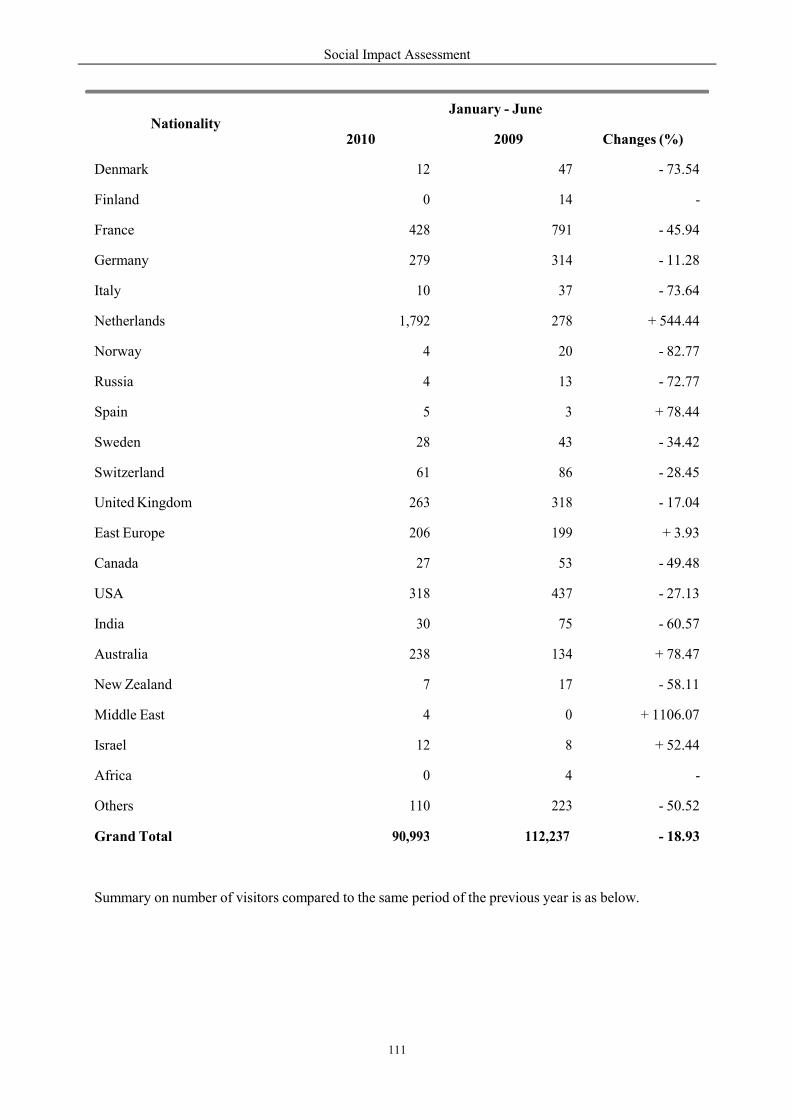
Social Impact Assessment
111
0
Summary on number of visitors compared to the same period of the previous year is as below.
Nationality
January - June
2 10
2009
Changes (%)
Denmark 12 47 - 73.54
Finland 0 14 -
France 428 791 - 45.94
Germany 279 314 - 11.28
Italy 10 37 - 73.64
Netherlands 1,792 278 + 544.44
Norway 4 20 - 82.77
Russia 4 13 - 72.77
Spain 5 3 + 78.44
Sweden 28 43 - 34.42
Switzerland 61 86 - 28.45
United Kingdom 263 318 - 17.04
East Europe 206 199 + 3.93
Canada 27 53 - 49.48
USA 318 437 - 27.13
India 30 75 - 60.57
Australia 238 134 + 78.47
New Zealand 7 17 - 58.11
Middle East 4 0 + 1106.07
Israel 12 8 + 52.44
Africa 0 4 -
Others 110 223 - 50.52
Grand Total 90,993
112,237
- 18.93
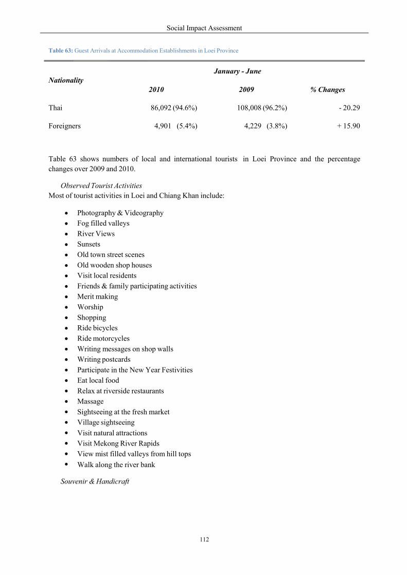
Social Impact Assessment
112
Table 63: Guest Arrivals at Accommodation Establishments in Loei Province
Table 63 shows numbers of local and international tourists
changes over 2009 and 2010.
in Loei Province and the percentage
Observed Tourist Activities
Most of tourist activities in Loei and Chiang Khan include:
Photography & Videography
Fog filled valleys
River Views
Sunsets
Old town street scenes
Old wooden shop houses
Visit local residents
Friends & family participating activities
Merit making
Worship
Shopping
Ride bicycles
Ride motorcycles
Writing messages on shop walls
Writing postcards
Participate in the New Year Festivities
Eat local food
Relax at riverside restaurants
Massage
Sightseeing at the fresh market
Village sightseeing
Visit natural attractions
Visit Mekong River Rapids
View mist filled valleys from hill tops
Walk along the river bank
Souvenir & Handicraft
Nationality
January - June
2010
2009
% Changes
Thai
86,092 (94.6%)
108,008 (96.2%)
- 20.29
Foreigners
4,901 (5.4%)
4,229 (3.8%)
+ 15.90
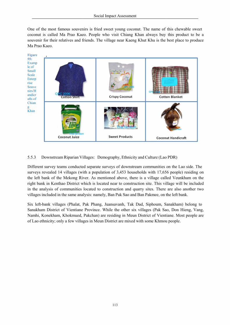
One of the most famous souvenirs
coconut is called Ma Prao Kae
souvenir for their relatives and friends.
Ma Prao Kaeo.
Figure 55: Examp le of Small Scale Enterp rise Souve nirs/H andicr afts of Chian g Khan
5.5.3 Downstream Riparian Villages:
Different survey teams conducte
surveys revealed 14 villages (with
the left bank of the Mekong Riv
right bank in Kenthao District w
in the analysis of communities
villages included in the same anal
Six left-bank villages (Phalat, Pak
Sanakham District of Vientiane
Namhi, Konekham, Khokmued,
of Lao ethnicity; only a few villages
Social Impact Assessment
113
nirs is fried sweet young coconut. The name of
eo. People who visit Chiang Khan always buy
friends. The village near Kaeng Khut Khu is the
illages: Demography, Ethnicity and Culture (Lao
ed separate surveys of downstream communities on
ith a population of 3,453 households with 17,65
River. As mentioned above, there is a village call
which is located near to construction site. This village
located to construction and quarry sites. There
lysis: namely, Ban Pak Sao and Ban Pakmee, on the
Pak Phang, Juansavanh, Tak Dad, Siphoum, Sanakh
Province. While the other six villages (Pak Sao,
Pakchan) are residing in Meun District of Vientiane.
ges in Meun District are mixed with some Khmou
this chewable sweet
this product to be a
best place to produce
o PDR)
on the Lao side. The
56 people) residing on
led Veunkham on the
village will be included
are also another two
the left bank.
Sanakham) belong to
Sao, Don Hieng, Vang,
iane. Most people are
u people.
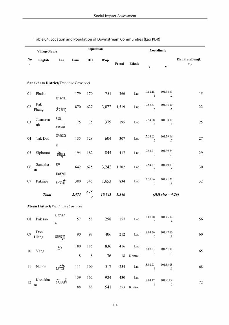
Social Impact Assessment
114
P
0
Table 64: Location and Population of Downstream Communities (Lao PDR)
No
.
Village Name
Population
Coordinate
Dist.FromDam(k
m)
English
Lao
Fam.
HH.
Pop.
Femal
Ethnic
X
Y
Sanakham District(Vientiane Province)
01
Phalat
179
170
751
366
Lao
17.52.18.
1
101.34.13
.2
15
02
Pak
Phang
870
627
3,072
1,519
Lao
17.53.33.
5
101.36.40
.5
22
03
Juansava
nh
75
75
379
195
Lao
17.54.00.
7
101.38.09
.9
25
04
Tak Dad
135
128
604
307
Lao
17.54.03.
7
101.39.06
.7
27
05
Siphoum
194
182
844
417
Lao
17.54.21.
0
101.39.54
.1
29
06
Sanakha
m
642
625
3,242
1,702
Lao
17.54.37.
5
101.40.33
.5
30
07
Pakmee
380
345
1,653
834
Lao
17.55.06.
0
101.41.23
.9
32
Total
2,475
2,15
2
10,545
5,34
(HH size = 4.26)
Meun District(Vientiane Province)
08
Pak sao
57
58
298
157
Lao
18.01.20.
5
101.45.12
.4
56
09
Don
Hieng
90
98
406
212
Lao
18.04.36.
0
101.47.10
.8
60
10
Vang
180
185
836
416
Lao
18.03.03.
9
101.51.11
.7
65
8
8
36
18
Khmou
11
Namhi
111
109
517
254
Lao
18.02.23.
3
101.53.28
.3
68
12
Konekha
m
159
162
924
430
Lao
18.04.47.
8
10155.45.
3
72
88
88
541
253
Khmou
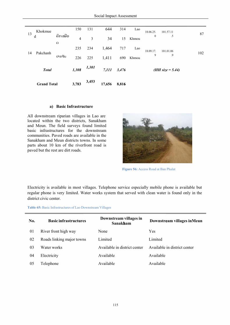
a) Basic Infrastru
All downstream riparian villagelocated within the two districts,and Meun. The field surveys fobasic infrastructures for the communities. Paved roads are availableSanakham and Meun districts towns.parts about 10 km of the riverfrontpaved but the rest are dirt roads.
Electricity is available in most villages.
regular phone is very limited. Water
district civic center.
Table 65: Basic Infrastructures of Lao Downstrea
No.
Basic infrastructures
01 River front high way
02 Roads linking major town
03 Water works
04 Electricity
05 Telephone
13
Khokmue
d
150
4
14
Pakchanh
235
226
Total
1,308
Grand Total
3,783
Social Impact Assessment
115
6
6
h
e
ucture
es in Lao are ts, Sanakham found limited downstream
are available in the towns. In some
rfront road is
Figure 56: Access Road at Ban
villages. Telephone service especially mobile phone
Water works system that served with clean water
Downstream Villages
es
Downstream villages in Sanakham
Downstre
None Yes
ns Limited Limited
Available in district center Available in
Available Available
Available Available
131
644
314
Lao
18.06.25.
0
101.57
3
34
15
Khmou
234
1,464
717
Lao
18.09.17.
9
101.01
225
1,411
690
Khmou
1,301
7,111
3,47
(HH size =
3,453
17,656
8,816
e
Phalat
hone is available but
is found only in the
eam villages inMeun
in district center
101.57.11
.5
87
101.01.06
.9
102
e = 5.44)
Social Impact Assessment
116
r
p
p
3
4
b) Education Facilities
Educational services are also limited: primary schools are not available in all villages. Furthermore,
secondary/high schools are only available in the main district towns.
Table 66: Educational Service in Lao Downstream Villages
Table 67: Estimated Average HH Income of Downstream Villages (Meun)
Dist ict
Sources of Income
(Kip/month)
(Kip/year)
Sanakham
1) From Agriculture 2,600,000 31,200, 010
2) Livestock 410,000 4,930,000
3) Sale of Forest Product 425,000 5,100,100
4) Trading 516,666 6,200,000
5) Services 351,670 4,220,040
6) Laboring /Salary 181,500 2,178,005
7) Handicraft 96,300 1,156,402
8) Other 92,000 1,100,800
Total monthly and yearly income/HH (Kip ) 4,673,779 56,085,357
Total monthly and yearly income/HH (US $) 585 7,010
No.
Types of Educational Facilities
Sanakham
Meun
01
Public primary schools
23
18
02
Public secondary schools
3
3
03
Public high school
2
1
04
Private schools
-
-
05
Religious Buddhist schools
-
-
06
Village reading centers
-
-
07
District library
-
-
08
Pre-school development center
-
-
09
Primary school (up to grade 4)
9
-
Total
7
2
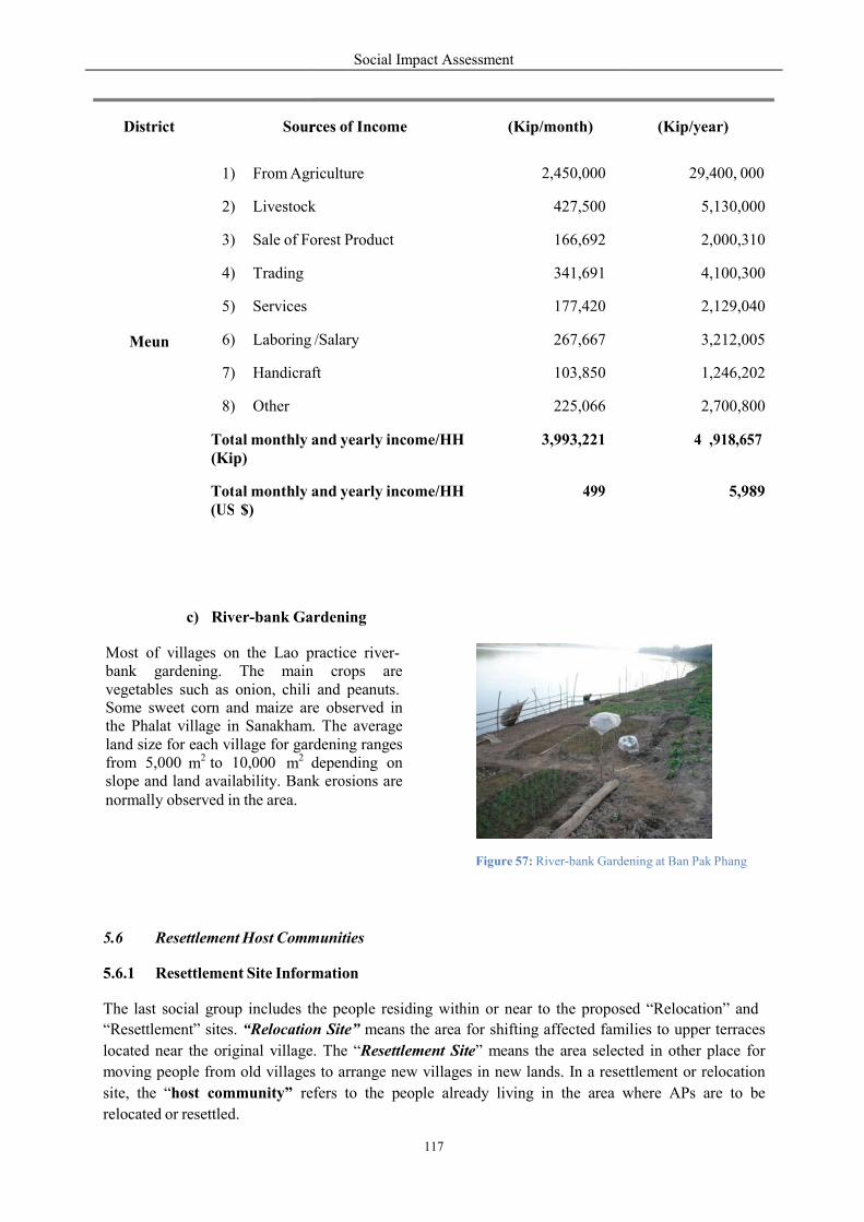
r
c) River-bank Gardening
Most of villages on the Lao practicebank gardening. The mainvegetables such as onion, chili Some sweet corn and maize arethe Phalat village in Sanakham.land size for each village for gardenifrom 5,000 to 10,000 dependingslope and land availability. Banknormally observed in the area.
m2 m2
5.6 Resettlement Host Comm
5.6.1 Resettlement Site Information
The last social group includes the
“Resettlement” sites. “Relocation
located near the original village
moving people from old villages
site, the “host community” re
relocated or resettled.
District
Sour
Meun
1) From Agr
2) Livestock
3) Sale of Forest
4) Trading
5) Services
6) Laboring
7) Handicraft
8) Other Tot(Ki
al monthly andp)
Tot(US
al monthly and$)
Social Impact Assessment
117
r
3
ardening
practice river- n crops are and peanuts. re observed in . The average rdening ranges depending on
Bank erosions are
Figure 57: River-bank Gardening
munities
mation
the people residing within or near to the proposed
on Site” means the area for shifting affected families
e. The “Resettlement Site” means the area selected
s to arrange new villages in new lands. In a rese
efers to the people already living in the area w
rces of Income
(Kip/month)
Agriculture 2,450,000
k 427,500
orest Product 166,692
341,691
177,420
/Salary 267,667
ft 103,850
225,066
and yearly income/HH ,993,221
and yearly income/HH 499
Gardening at Ban Pak Phang
sed “Relocation” and
families to upper terraces
cted in other place for
ettlement or relocation
where APs are to be
(Kip/year)
29,400, 000
5,130,000
2,000,310
4,100,300
2,129,040
3,212,005
1,246,202
2,700,800
47
,918,657
5,989
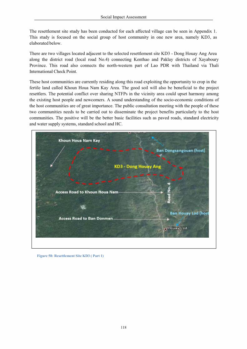
c
The resettlement site study has been
This study is focused on the social
elaborated below.
There are two villages located adjacent
along the district road (local road
Province. This road also connects
International Check Point.
These host communities are currently
fertile land called Khoun Houa
resettlers. The potential conflict
the existing host people and newc
the host communities are of grea
two communities needs to be ca
communities. The positive will
and water supply systems, standa
Khoun Houa Na
Access Road to K
Ac ess Road to
Figure 58: Resettlement Site KD3
Social Impact Assessment
118
n
been conducted for each affected village can be
ocial group of host community in one new area,
djacent to the selected resettlement site KD3 - Dong
road No.4) connecting Kenthao and Paklay di
connects the north-western part of Lao PDR with
rrently residing along this road exploiting the opportuni
Nam Kay Area. The good soil will also be beneficial
over sharing NTFPs in the vicinity area could u
ewcomers. A sound understanding of the socio-ec
at importance. The public consultation meeting with
arried out to disseminate the project benefits pa
be the better basic facilities such as paved road
ard school and HC.
am Kay
Ban Dongs
KD3 ‐ Dong Houay Ang
Khoun Houa Nam
Ba Ban Donmen
3 ( Part 1)
Ro
ad N
o.
4
n
seen in Appendix 1.
rea, namely KD3, as
ong Houay Ang Area
istricts of Xayaboury
h Thailand via Thali
ortunity to crop in the
beneficial to the project
upset harmony among
conomic conditions of
ith the people of these
articularly to the host
ds, standard electricity
sangouan (host)
Ba Houay Lod (host)
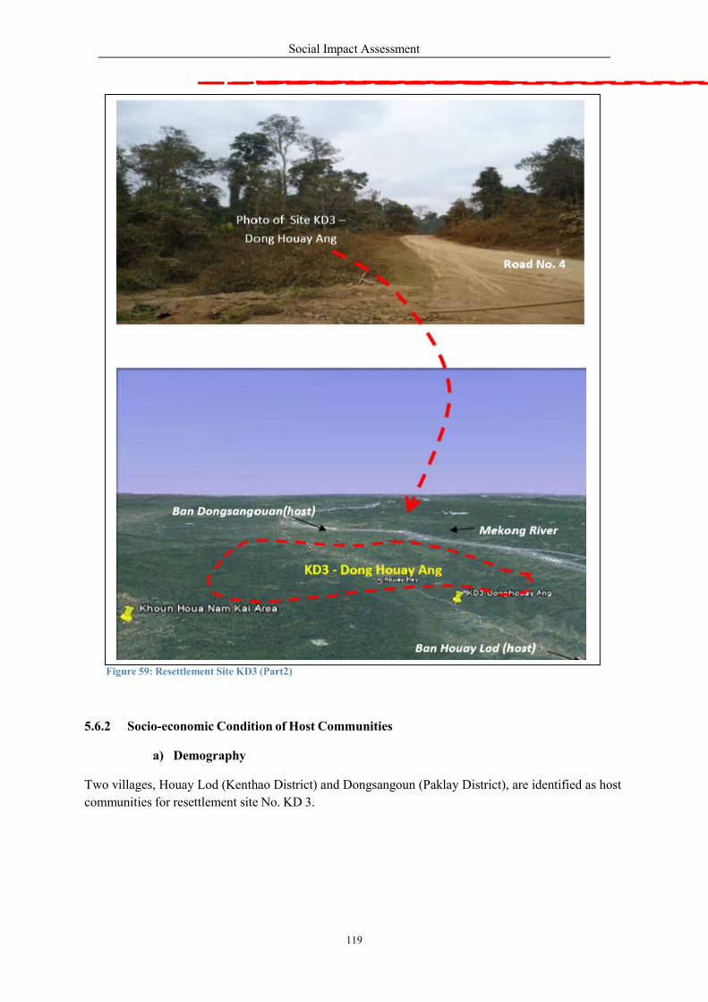
Photo
Dong
Ban Dongsangouan
Figure 59: Resettlement Site KD3
5.6.2 Socio-economic Condition
a) Demography
Two villages, Houay Lod (Kenthao
communities for resettlement site
Social Impact Assessment
119
of Site KD3 –
g Houay Ang
Road
gouan(host)
Mekong R
Ban Houay Lod (host)
3 (Part2)
Condition of Host Communities
enthao District) and Dongsangoun (Paklay District),
e No. KD 3.
No. 4
River
are identified as host
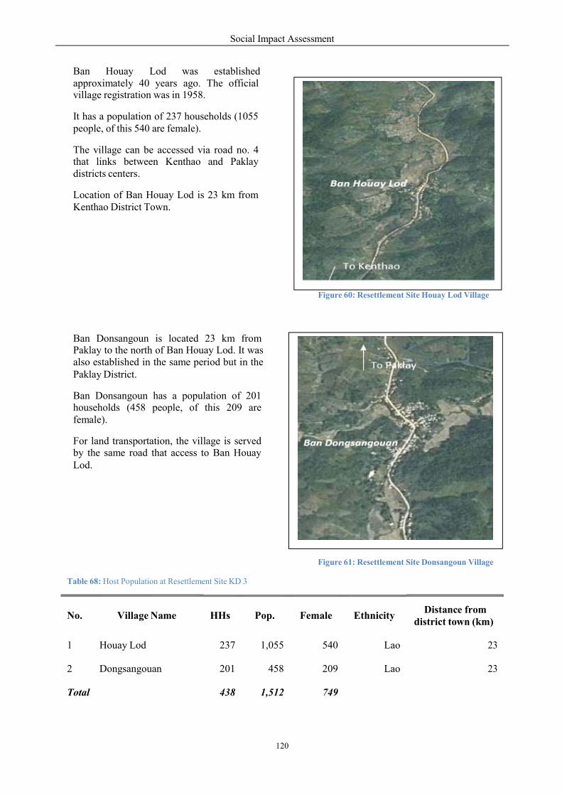
Ban Houay Lod was approximately 40 years ago. village registration was in 1958.
It has a population of 237 houspeople, of this 540 are female).
The village can be accessed viathat links between Kenthao districts centers.
Location of Ban Houay Lod isKenthao District Town.
Ban Donsangoun is located Paklay to the north of Ban Houalso established in the same pePaklay District.
Ban Donsangoun has a populathouseholds (458 people, of female).
For land transportation, the villageby the same road that access toLod.
Table 68: Host Population at Resettlemen
No.
Village Name
1
Houay Lod
2
Dongsangouan
Total
Social Impact Assessment
120
o
o
o
established The official
1958.
seholds (1055
via road no. 4 and Paklay
is 23 km from
Ban Houay L
To Kentha
Figure 60: Resettlement Sit
23 km from uay Lod. It was riod but in the To Paklay
population of 201 this 209 are
Ban D ngsangouanvillage is served to Ban Houay
Figure 61: Resettlement Sit
ment Site KD 3
HHs
Pop.
Female
Ethnicity
237
1,055
540
Lao
201
458
209
Lao
438
1,512
749
o
o
d
Site Houay Lod Village
aklay
n
Site Donsangoun Village
Distance from district town (km)
23
23
Social Impact Assessment
121
b) Ethnicity and Culture
The villagers at Ban Houay Lod and Ban Dongsangoun are Lao. The monastery and Buddhist temples
are the centers for their cultural life. Since they believe in Budhism, the most active festivals are
Boun PhimaiLao or Lao New Year and Boun Bangfai or the Rocket Festival. Lao New Year is
celebrated nationwide in mid April every year.
c) Infrastructure
These two villages are residing on both sides of the road number 4. This local unpaved road is difficult
for traveling during the rainy season. The two villages have all year round water supply both from
nearby natural streams and ground water. Electricity service in these two villages is available.
d) Education and Health
Each village has a primary school but with limited teaching personnel and related facilities such as
library, computers, and other supporting learning materials. No HC is found in these two villages.
When people are severely ill they go to hospitals in Kenthao and in Paklay.
e) Land Resources Livelihood
Similar to the Sanakham upstream affected villages, the way of life of people at Ban Houay Lod and
Ban Dongsangoun is based on rice and maize farming. Livestock rearing (such as cattle, goats and
poultry) is also an important livelihood source in these two villages. Animal husbandry is a source of
family cash income. When people need cash they will sell one or two of their cattle and goats.
Available NTFPs resources are observed at Khoun Houa Nam Kay forest reserve located on north-west
and south-west of Houay Lod and Ban Dongsangoun, respectively.
Labour is mostly employed in the farm. Some families do their trading business at Kenthao markets.
5.7 Country and Region
5.7.1 Power Development, Rural Electrification, and Country Income
In 2010, the Lao PDR has the installed capacity of 1,838 MW, mostly from hydropower generation.
The GOL has a policy to export electricity to neighboring countries. By the year 2020 Lao has an
agreement to export to Thailand 7,000 MW, Vietnam 3,000 MW and Cambodia 1,500 MW. By 2015,
1,145 MW will be exported to Thailand and Vietnam and 227 MW for domestic supply. The
Government’s goal for electrification is to reach 70 percent of households by the year 2010 (already
achieved), 80 percent by 2015, and 90 percent by 2020.
The revenue from hydropower development will greatly contribute to national income through tax,
dividends, and royalties. By 2025, the foreign exchange earned is predicted to reach US$ 900 million
per year.
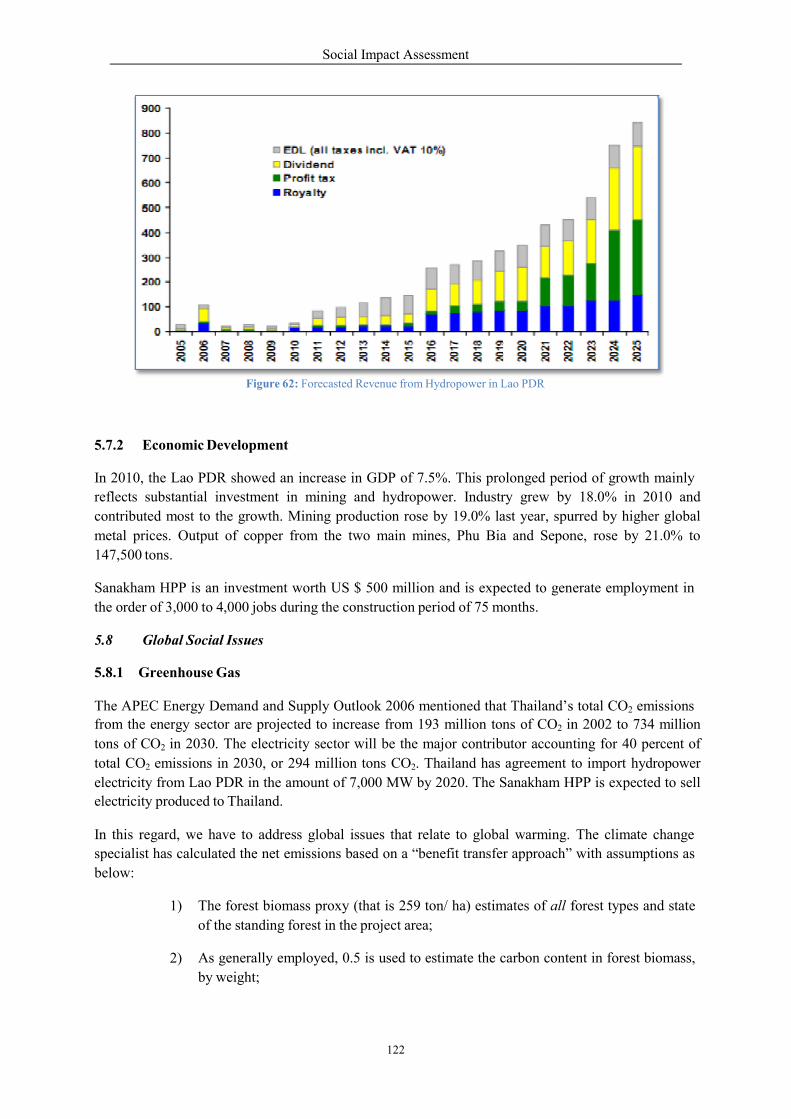
Figure 62:
5.7.2 Economic Development
In 2010, the Lao PDR showed a
reflects substantial investment
contributed most to the growth.
metal prices. Output of copper
147,500 tons.
Sanakham HPP is an investment
the order of 3,000 to 4,000 jobs dur
5.8 Global Social Issues
5.8.1 Greenhouse Gas
The APEC Energy Demand and from the energy sector are proje
tons of CO2 in 2030. The electricity
total CO2 emissions in 2030, or
electricity from Lao PDR in the a
electricity produced to Thailand.
In this regard, we have to address
specialist has calculated the net e
below:
1) The forest biom
of the standing
2) As generally em
by weight;
Social Impact Assessment
122
62: Forecasted Revenue from Hydropower in Lao PDR
evelopment
an increase in GDP of 7.5%. This prolonged period
in mining and hydropower. Industry grew by
Mining production rose by 19.0% last year, spu
from the two main mines, Phu Bia and Sepone,
nt worth US $ 500 million and is expected to generate
during the construction period of 75 months.
Supply Outlook 2006 mentioned that Thailand’sected to increase from 193 million tons of CO2 in
electricity sector will be the major contributor accounting
294 million tons CO2. Thailand has agreement t
amount of 7,000 MW by 2020. The Sanakham H
address global issues that relate to global warming.
emissions based on a “benefit transfer approach”
mass proxy (that is 259 ton/ ha) estimates of all forest
forest in the project area;
mployed, 0.5 is used to estimate the carbon content
iod of growth mainly
18.0% in 2010 and
urred by higher global
ne, rose by 21.0% to
nerate employment in
s total CO2 emissions in 2002 to 734 million
accounting for 40 percent of
to import hydropower
HPP is expected to sell
The climate change
with assumptions as
forest types and state
ent in forest biomass,
Social Impact Assessment
123
3) We assume that 40% of the forest biomass is harvested for the dam construction,
hence 60% remains un-harvested to decay;
4) Assume zero under-ground biomass, invariably justified by the remaining 60%
above-ground above—thus no methane emissions;
5) Estimated biomass for this type of forest according to source is 259 tons/ ha;
6) Estimated inundated land for hydropower project is 4,298.79 ha;
7) Only 10% of the standing forest is lost to flooding.
For methane emissions, it is estimated at approximately 10% of the forest to be affected by dam
construction and 40% harvested in Sanakham HPP that:
Forest biomass being cleared = 0.4 x 0.1 x 259 tons/ ha x 4,298.79 ha
= 44,535.46 tons biomass
With an estimated 50% of the biomass being carbon, the total carbon emissions are 22,267.73 tons
carbon dioxide emitted. This is a rather small amount to be released compared to the amount of
avoided emissions calculated above.
The above figure is small compared to the nearly 52 million tons of carbon dioxide avoided. In sum,
the avoided emissions coming from hydro-generated electricity of the Sanakham HPP modestly
estimated far out-weigh the emissions considered from biomass clearing activity alone. The more
efficient biomass harvesting, will be the less methane emission that will subsequently follow. In light
of this project, nonetheless, it is not clear what the extent of methane emissions will be produced by the
dam flooding, hence, the real total net emissions could be under-estimated.
These positive results obtained from the current calculation can also be enhanced with careful and
efficient biomass clearing, already called for by the Lao PDR government in its guideline. Such timber
benefit from biomass clearing could be cash benefits used to finance local projects, including for
instance, reforestation in the dam areas. The Sanakham HPP will not generate significant negative
impacts contributing to climate change. A carefully designed, managed and operational project will,
and could, contribute positively to enhancing the climate change in the long run. The well managed
Sanakham dam could enhance the local microclimate by creating a larger body of water to enhance
moisture, and thus cooler environment.
5.8.2 Depletion of Fossil Fuel
The Sanakham HPP planned to export electricity to Thailand where Thailand’s power generation is
mostly based on fossil fuels with natural gas and lignite that contributes more than 50%% of total
electricity generation. The economy’s electricity generation is projected to increase annually at 5.5
percent, from 111 TWh in 2002 to 504 TWh in 2030, which less than half the growth rate of 14.1
percent observed before the financial crisis in 1997.
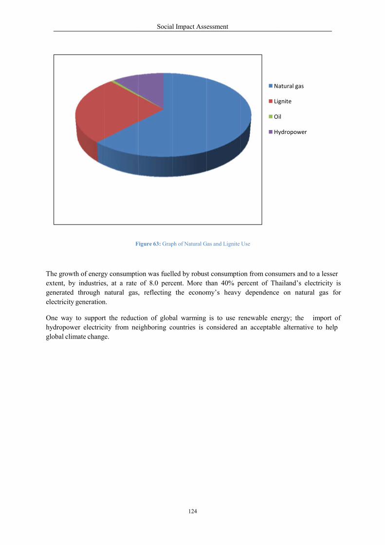
Figure
The growth of energy consumption was
extent, by industries, at a rate
generated through natural gas,
electricity generation.
One way to support the reduction
hydropower electricity from neighboring
global climate change.
Social Impact Assessment
124
Natural
Lignite
Oil
Hy
Figure 63: Graph of Natural Gas and Lignite Use
ion was fuelled by robust consumption from consu
of 8.0 percent. More than 40% percent of Th
, reflecting the economy’s heavy dependence
tion of global warming is to use renewable energ
ighboring countries is considered an acceptable
atural gas
ignite
il
ydropower
umers and to a lesser
hailand’s electricity is
e on natural gas for
ergy; the import of
le alternative to help
Social Impact Assessment
125
6. Identification of Social Changes and Risks
Chapters 4 and 5 have addressed comprehensive baseline information and environmental and social
concerns of the Sanakham HPP.
This chapter will start to identify social changes and risks that may arise from the project development
of which their social impact will be addressed (in detail) in the next chapter (Chapter 7).
6.1 Identification of Alternatives & Impact Avoidance
In 1994, in a study on the Mekong Mainstream Hydropower Dams, the MRC Secretariat mentioned
about the Sanakham HPP that it would operate at a normal water level of 230masl. Under this scheme,
the damsite was located at 0+1772km from the estuary.
Until 2009/2010, careful engineering, social/environment and economics related to: topographical and
geological conditions of the damsite; rational use of hydropower resources; improvement of navigation
conditions; reservoir inundation loss; requirements for environmental protection; project’s regulating
performance; hydropower energy; and economic parameters, the selected normal water level for
Sanakham Hydropower Project is now optimized at 220 masl. This has included social and economic
impact avoidance since the water retention level in the upstream was reduced from 230 m to 220masl.
6.2 Bio-Physical Changes Create Social Changes
The Sanakham HPP is not a conventional storage reservoir. It is a run-off-river type that will make use
of the river flow for power generation and other associated purposes. Even though the run-off-river
dam provides less environmental and social impacts compared to the conventional storage dam, the
environmental changes from the creation of main dam and upstream pond will result. The bio-physical
studies revealed some key changes as discussed in Sections 6.2.1 to 6.2.3.
Table 69: Land Use Changes in the Upstream Area
No.
Land Use Type
Area in ha
% of Total Loss
01
Bamboo
2,631
41.5
02
Mixed deciduous forest
16
0.2
03
Residential and other lands
676
10.7
04
Ray
51
0.8
05
Rice Paddy
308
4.9
06
Un-stocked forest
770
12.2
07
Water
1,880
29.7
Total
6,332
100.0

Social Impact Assessment
126
6.2.1 Upstream and Quarry Areas
At the water retention level of 220 masl, the project main dam will alter 4,425 has of land that
currently is utilized as villages, rice paddy, forest and others into water area. When 1,880 ha of existing
Mekong water body is included, the upstream project pond will have an area of 6,332 hsa. As a result,
the following biophysical changes include:
Higher water level in the upstream area where 4,425 ha of land will be lost. This land loss
includes residential, agricultural production area, and other livelihood resources.
Increase sedimentation and slower water velocity.
Disconnection from downstream river due to the creation of dam across the Mekong River
Mainstream, which may affect fish migration.
The above will create social changes. As has been mentioned, three villages are directly affected
requiring resettlement while ten will be partially submerged requiring relocation.
Anticipated social issues/risks resulting from above bio-physical changes can be listed among project
development phases as follows:
Pre-construction Phase
o Psychological o Social conflict o Household investment
o Economic benefits
Construction Phase
In-migration
Disturbance
Health risks
Employment and income
Displacement
Livelihoods
Fishing
Cultural heritage
Navigation
Tourism
Gender/vulnerable group issues
o
o
o
o
o
o
Operation Phase
o Livelihood restoration o Health/education o Fishing o Navigation o Tourism o Land transportation
6.2.2 Downstream Areas
The Sankham main dam will disconnect the downstream river while the discharge of 5,500 cubic
meters per second may change seasonal variation of water level. During the dam construction, the
water quality will be changed from construction activities especially in the dry season.
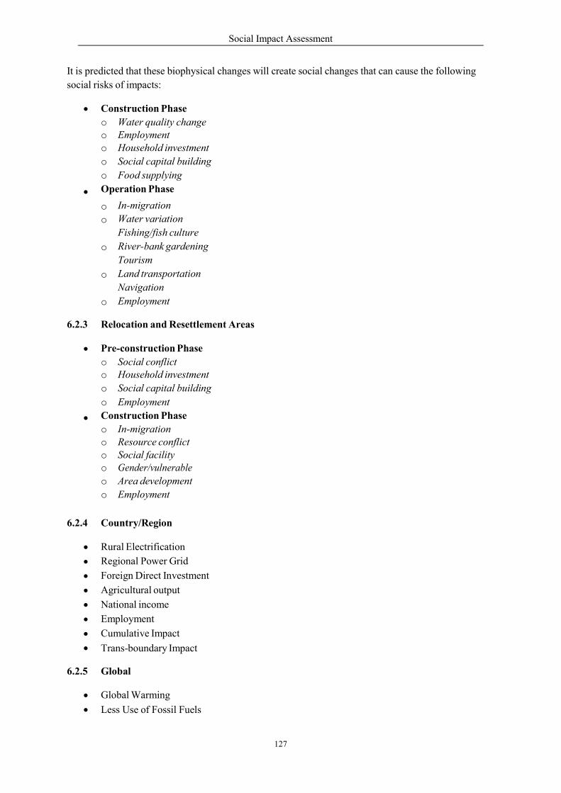
Social Impact Assessment
127
It is predicted that these biophysical changes will create social changes that can cause the following
social risks of impacts:
Construction Phase
o Water quality change o Employment o Household investment
o Social capital building
o Food supplying
Operation Phase
In-migration
Water variation
Fishing/fish culture
River-bank gardening
Tourism
Land transportation
Navigation
Employment
o
o
o
o
o
6.2.3 Relocation and Resettlement Areas
Pre-construction Phase
o Social conflict o Household investment
o Social capital building
o Employment
Construction Phase
o In-migration o Resource conflict o Social facility o Gender/vulnerable
o Area development
o Employment
6.2.4 Country/Region
Rural Electrification
Regional Power Grid
Foreign Direct Investment
Agricultural output
National income
Employment
Cumulative Impact
Trans-boundary Impact
6.2.5 Global
Global Warming
Less Use of Fossil Fuels
Social Impact Assessment
128
7. Assessment of Social Impacts
7.1 Objective/Criteria/Methodology in Assessing the Impacts
7.1.1 Key Objectives This chapter presents potential socio-cultural and health impacts from the construction of
the Mekong Sanakham HPP and its different components in the project impact areas:
upstream, downstream; relocation and resettlement; construction and quarry. When
identifying impacts, this chapter discusses the type, range, extent and severity of impacts
that are likely to result from the different project activities.
The specific purposes of this section are to:
Identify and assess the range of impacts and extent of their severity.
Explain the ways in which the project might affect socio-economic resources,
demographics, livelihoods, health, cultural patterns, infrastructure and access issues.
Inform the project proponents and other key stakeholders about how identified issues
could affect the project.
The impacts have been identified through consultation/meetings/interviews with the
village community/district authority officials, village representatives and opinion leaders,
as well as other civil society groups in the potential impact area. Experience and
understanding of how these project activities affect the socio-economic environment,
culture, livelihood, education, infrastructure and health form the basis for the prediction
and assessment of the potential impacts of the project. The identified impacts have also
been the source for the development of mitigation and enhancement measures used in the
formulation of the SMMP and the RAP framework.
7.1.2 Criteria for Identification of Social Impacts
The social field survey identified key impact areas as follows:
Upstream and construction/quarry.
Downstream.
Resettlement and relocation.
Country/region and global.
For the purpose of reporting the impacts, identification has been categorized on the basis
of four phases of the project including the following:
Pre- construction Phase.
Construction Phase.
Operational Phase.
Decommissioning Phase.
Since the Mekong Sanakham HPP Dam can be utilized for at least 50 years, the
decommissioning phase is too far into the future to predict. There are a number of

Social Impact Assessment
129
unknown socio-economic and environmental variables involved. The anticipated impacts
and their assessment will only focus therefore on the pre-construction, construction and
operation phases.
7.1.3 Methodology
Potential impacts have been assessed in context of stage wise project activities and the
social components within and surrounding the project area. The impact assessment
considers whether the identified social impact of the project is a negative type of impact
or a positive one. The severity and duration of the impact is analyzed as well as the
peoples’ ability to adapt to the impact. Finally the overall significance of the impact is
rated. The Significance of a given impact is a function of the other impacts and can be a
negative type impact or a positive type impact. The impacts are explained with a
comprehensive Matrix which can be used as a source of discussion. After the Matrix more
details are given as required.
The impact significance suggested in the sections below is based on consideration of
appropriate mitigation and enhancement measures being taken by the project proponents.
It needs to be pointed out that without the mitigation measures, as evident in the SMMP
and the RAP, most of the project impacts are likely to be negative and significant.
Impacts are measured using the following parameters:
Type: relates to the positive or negative nature of impacts
Severity: the extent of an impact is assessed by considering the proportion of the
area within which the impact is likely to occur and whether positive benefits or
negative impacts will impact many people or relatively few (i.e. only a small number
of individuals or households). Using this basis these impacts are categorized as Low -
meaning the influence area extends to individuals/ household, Medium - meaning the
influence area extends to a small number of households and High - meaning that the
influence area extends to large area or a full village.
Duration: is assessed by whether positive benefits or negative impacts will be
short term (less than one year), medium term (2-6 years) or long term (more than 6
years);
Ability to Adapt: this is the extent to which resources or affected people are able to
adapt to the change and maintain pre-impact levels. Based on this, impacts can be
categorized as Low when those affected will not be able to adapt to changes and
continue to maintain pre-impact livelihood. Medium when those affected will be able
to adapt to change, with some difficulty, and maintain pre-impact livelihoods,
culture, quality of life and health but only with a degree of support and High when
those affected are likely to adapt to the changes with relative ease, and maintain pre-
impact livelihoods, culture, quality of life and health.
Social Impact Assessment
130
Significance: significance is the overall measurement of an impact and is
determined using the factors above. More specifically Significance is determined by
the levels of Severity, Duration, the Ability to Adapt prediction. In addition, the
Significance is considered either Negative (adverse) or Positive (beneficial). The
level of Significance can be low, medium or high.
Using the methodology of this study, the most negative or adverse impact poss ble could
be described like this, ‘Overall this is a negative type impact of high Significance’; the
most positive or beneficial impact possible could be described in this way, ‘Overall this is
a positive type impact of high Significance’.
7.2 Upstream, Construction/Quarry Areas
The social impact assessment for the upstream construction/quarry areas is assessed according to the
project phase.
7.2.1 Pre-construction Phase
a) Concern
During the pre-construction period, many parties came to the potentially impacted villages for
information collection, reservoir demarcation, interviewing, census of affected people and assets,
including engineering surveys such as hydrological/geological investigations. These activities have
created some worries to the potential impacted villagers such as:
Feeling of loss of control over land.
Social conflict among people because of agreement or disagreement about the
potential dam project.
Reluctance for households to invest.
Employment and income related to the feasibility study activities.
b) Context
The Mekong Sanakham HPP will occupy an area for upstream tailwater of 6,332 ha. Of this 4,452 ha
is a land area (including 308 ha of paddy land) that people are currently enjoying and living in. Parts
of their community area will also be affected. The construction and quarry sites cover an area of about
2 km2.
Results of the project tailwater demarcation and census indicated that severe inundation below 220
masl will occur in three villages: Houay Lah, Khae and Donsok. Meanwhile other villages will
be partially submerged: Donmen (120 families), Nakham (19 families), Donsang (17 families),
Boungma (10 families), Kengsao (29 families), Nasack (3 families), Houaytao (56 families),
Donphoung (10 families), Maipakthoun (54 families) and Ban Khokkhaodor (6 families).
The 3 severely impacted villagers would need to be resettled while the partially submerged villages
will be required to relocate above 220 masl within the home village.
Approximately 50 people or more went to the above upstream villages for Engineering/ESIA survey
activities. Attitude surveys (Table 7-1) were taken to determine whether APs residing below the 220
masl inundated area “disagreed” with the Mekong Sanakham HPP. APs were also asked whether they
“agreed” with or were “not sure” about the project.
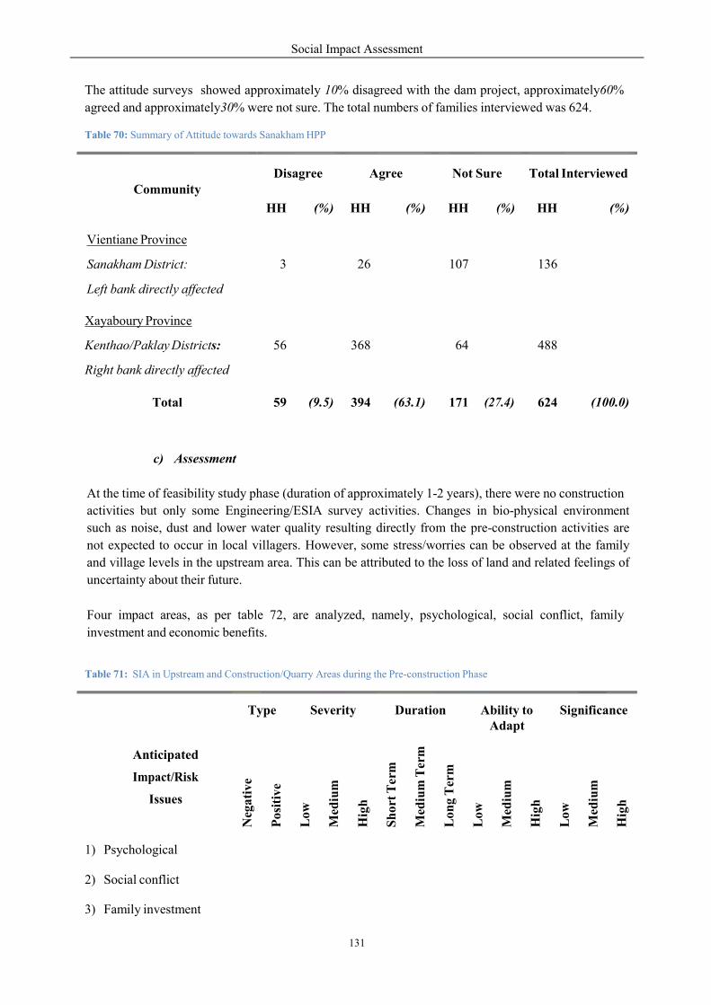
Social Impact Assessment
131
The attitude surveys showed approximately 10% disagreed with the dam project, approximately60%
agreed and approximately30% were not sure. The total numbers of families interviewed was 624.
Table 70: Summary of Attitude towards Sanakham HPP
c) Assessment
At the time of feasibility study phase (duration of approximately 1-2 years), there were no construction
activities but only some Engineering/ESIA survey activities. Changes in bio-physical environment
such as noise, dust and lower water quality resulting directly from the pre-construction activities are
not expected to occur in local villagers. However, some stress/worries can be observed at the family
and village levels in the upstream area. This can be attributed to the loss of land and related feelings of
uncertainty about their future.
Four impact areas, as per table 72, are analyzed, namely, psychological, social conflict, family
investment and economic benefits.
Table 71: SIA in Upstream and Construction/Quarry Areas during the Pre-construction Phase
Anticipated
Impact/Risk
Issues
Type
Severity
Duration
Ability to Adapt
Significance
Neg
ativ
e
Pos
itiv
e
Low
Med
ium
Hig
h
Sh
ort
Ter
m
Med
ium
Ter
m
Lon
g T
erm
Low
Med
ium
Hig
h
Low
Med
ium
Hig
h
1) Psychological
2) Social conflict
3) Family investment
Community
Disagree
Agree
Not Sure
Total Interviewed
HH
(%)
HH
(%)
HH
(%)
HH
(%)
Vientiane Province
Sanakham District:
Left bank directly affected
3
26
107
136
Xayaboury Province
Kenthao/Paklay Districts:
Right bank directly affected
56
368
64
488
Total
59
(9.5)
394
(63.1)
171
(27.4)
624
(100.0)
Social Impact Assessment
132
1. Psychological - this impact refers to stress and worries which are negative impacts. They are
expected to be high as their influence extends to 11 villages and more than 800 families in the
upstream project area. The duration is short term because the feasibility study
(engineering/ESIA surveys) occurs within 2 year period. Overall this impact is negative and
of high Significance.
2. Social conflict - because 10% of total population disagreed with the project there is potential
for social conflict within the community. Although a negative impact, it can be adapted to by
affected residents through the community participatory process. Overall this impact is
negative and of medium Significance.
3. Family investment - the severity of this impact should be low to medium as little large
investment is expected by local families. The duration of impact is short to medium term.
Overall this impact is negative and of medium Significance.
4. Economic benefits - during pre-construction economic benefits relate to the market demand
of the 50 survey people for transportation (land and waterway), lodging, food and beverage,
and a small number of extra workers to be employed. The amount of approximately US
$200,000 (or more) is expected to be circulating in Sanakham, Kenthao and Pak Lay districts
due to pre-construction activity. The duration is low to medium term because the impact will
be limited to a certain period. Overall this impact is positive and from low to medium
Significance.
d) Recommendation
The project proponent must provide comprehensive information disclosure about the project
(particularly of construction/quarry sites) to the communities in the upstream area with full
participation of APs (including gender/vulnerable groups) and the district authorities.
The process of consultation and grievance handling should be done in a fair and transparent manner. A
grievance mechanism needs to be set up in all levels: village, district, and province.
This participation and grievance mechanism should be well in place prior to the construction phase.
This will help to reduce the stress and worries of the potentially affected people.
All information gathered including the results of the ESIA analysis will be used for the
engineering/social/environmental mitigation/enhancement designs for the project.
In addition to the SMMP, a RAP is required to help resettle three villages and relocate families from
ten villages. The three villages to be resettled are Houay Lah (81 families), Khae (150 families),
Donsok (36 families), which in all totals 267 families or 1,127 persons. The ten villages from which
families need to be relocated are Donmen (120 families), Nakham (19 families), Donsang (17
families), Boungma (10 families), Kengsao (29 families), Nasack (3 families), Houaytao (56
families), Donphoung (10 families), Maipakthoun (54 families) and Ban Khokkhaodor (6 families.
7.2.2 Construction Phase
a) Concern
4) Economic benefits
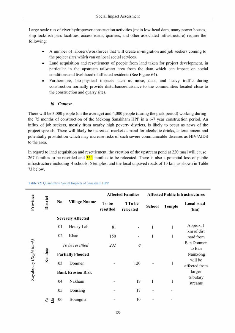
Social Impact Assessment
133
N
e
a
T c
Large-scale run-of-river hydropower construction activities (main low-head dam, many power houses,
ship lock/fish pass facilities, access roads, quarries, and other associated infrastructure) require the
following:
A number of laborers/workforces that will create in-migration and job seekers coming to
the project sites which can on local social services.
Land acquisition and resettlement of people from land taken for project development, in
particular in the upstream tailwater area from the dam which can impact on social
conditions and livelihood of affected residents (See Figure 64).
Furthermore, bio-physical impacts such as noise, dust, and heavy traffic during
construction normally provide disturbance/nuisance to the communities located close to
the construction and quarry sites.
b) Context
There will be 3,000 people (on the average) and 4,000 people (during the peak period) working during
the 75 months of construction of the Mekong Sanakham HPP in a 6-7 year construction period. An
influx of job seekers, mostly from nearby high poverty districts, is likely to occur as news of the
project spreads. There will likely be increased market demand for alcoholic drinks, entertainment and
potentially prostitution which may increase risks of such severe communicable diseases as HIV/AIDS
to the area.
In regard to land acquisition and resettlement, the creation of the upstream pond at 220 masl will cause
267 families to be resettled and 354 families to be relocated. There is also a potential loss of public
infrastructure including 4 schools, 5 temples, and the local unpaved roads of 13 km, as shown in Table
73 below.
Table 72: Quantitative Social Impacts of Sanakham HPP
Pro
vin
ce
Dis
tric
t
No. Village name
Affected Families Affected Public Infrastructures
To be
resettled
To be
relocated School
Temple
Local road
(km)
Xay
abou
ry (
Rig
ht B
ank)
Ken
thao
Severely Affected
Approx. 1
km of dirt
road from
Ban Donmen
to Ban
Namxong
will be
affected from
larger
tributary
streams
81 - 1 1 01 Houay Lah
02 Khae 150 - 1 1
To be resettled 231 0
Partially Flooded
03 Donmen - 120 - 1
Bank Erosion Risk
04 Nakham - 19 1 1
05 Donsang - 17 - -
Pa
kla
06 Boungma - 10 - -
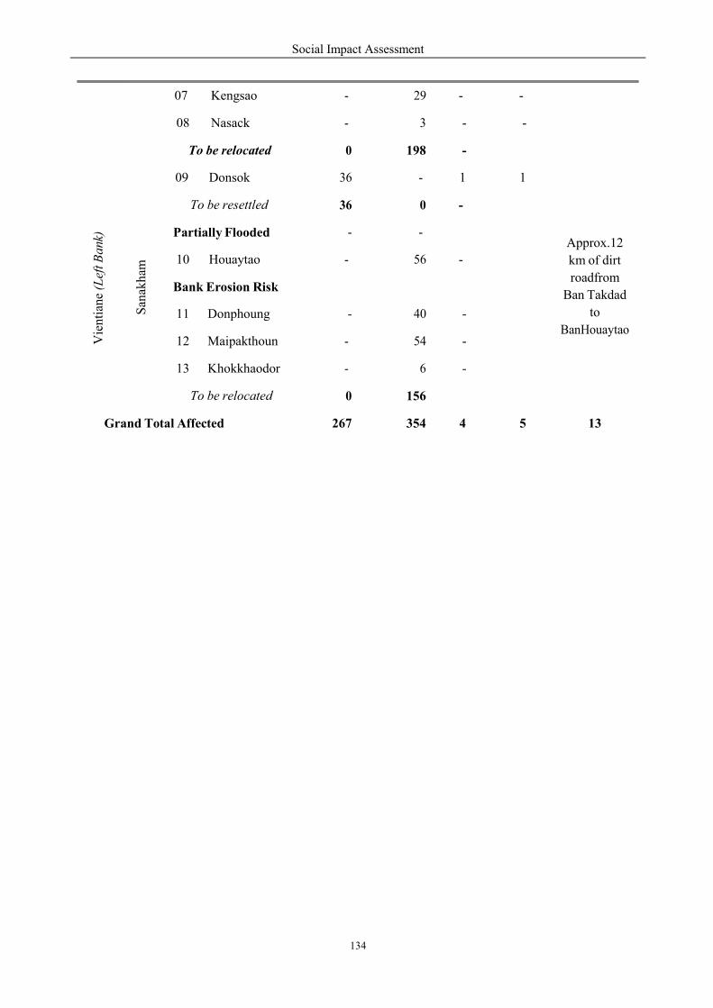
Social Impact Assessment
134
07 Kengsao - 29 - -
08 Nasack - 3 - -
To be relocated 0 198 -
Vie
nti
ane
(Lef
t Ba
nk)
San
akh
am
09 Donsok 36 - 1 1
Approx.12
km of dirt
roadfrom
Ban Takdad
to
BanHouaytao
To be resettled 36 0 -
Partially Flooded - -
10 Houaytao - 56 -
Bank Erosion Risk
11 Donphoung - 40 -
12 Maipakthoun - 54 -
13 Khokkhaodor - 6 -
To be relocated 0 156
Grand Total Affected 267 354 4 5 13
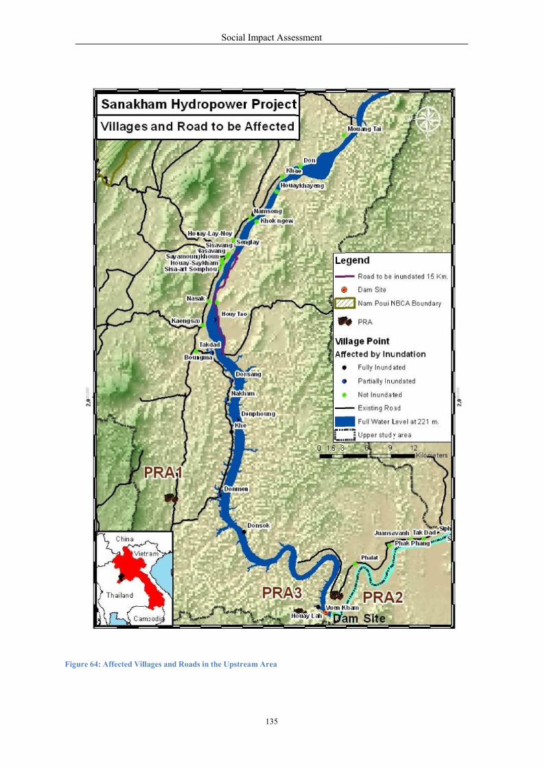
Figure 64: Affected Villages and Road
Social Impact Assessment
135
ds in the Upstream Area

c) Assessment
The construction phase impacts
construction/quarry sites. The construction
have socio-cultural and health im
interaction between the host community
disturbance, health risks, displ
cultural heritage, navigation, tourism
impacts is displayed in the follow
Table 73: Matrix - SIA in Upstream Area
These construction phase impacts
1) In-migration –
deal of change.
Significance.
2) Disturbance – The
and vibration to
approximately 1
Anticipated
Impact/Risk
Issues
Type
Neg
ati
ve
1) In-migration
2) Disturbance
3) Health risks
4) Employment/income
5) Displacement
6) Livelihoods
7) Fishing
8) Cultural heritage
9) Navigation
10) Tourism
11) Gender/vulnerable gr.
Social Impact Assessment
136
ts mostly affect the villages and settlements
onstruction phase of the project’s different com
mpacts on the community of which the extent are linked
community and external agents. These impacts
displacement and effects on employment/income,
ourism and gender/vulnerable groups. The compl
wing table (Table 74). .
rea during the Construction Phase
ts are very interdependent and are explained according
the in-migration of job seekers/construction work
Overall this is a negative impact and is expect
The construction activities will also create disturb
to villages residing near the construction site (Veunkham
1 km downstream of the main dam) and to the qu
Type
Severity
Duration
AbilitAda
Neg
ati
ve
P
osit
ive
Low
Med
ium
Hig
h
Sh
ort
Ter
m
Med
ium
Ter
m
Lon
g T
erm
Low
Med
ium
s in and around the
omponents are likely to
linked to the nature of
include in-migration,
livelihoods, fishing,
lete estimate of these
rdingly.
kers can cause a great
ted to be of medium
bance from dust/noise
Veunkham is located
uarry site (Paksao and
ty to apt
Significance
Med
ium
Hig
h
Low
Med
ium
Hig
h
Social Impact Assessment
137
Pakmee villages are located close to the quarry areas). Overall this is a negative
impact and is expected to be of medium Significance
3) Health risks – The interactions of the migrant workforce with the local community
may create health risks particularly on the vulnerable, such as alcoholism, STIs, and
HIV/AIDS. These risks are relevant to a large area and many people, which deems
that the severity is high. The duration is medium term because the impact will be
limited to a certain period and the project proponents will take steps to mitigate these
health impacts. Table 75 below addresses the potential health impacts of the Mekong
Sanakham HPP during the construction period. Overall this is a negative impact
and is expected to be of medium Significance.
Table 74: Anticipated Health Impacts of Mekong Sanakham HPP during construction period
areas
The following table (Table 76) summarizes health risk impact mitigation measures and expected
results after mitigation.
Table 75: Health Risk Impact Mitigation During Construction Phase
Potential impact Descriptions of Impact
Villages nearby
construction/
quarry sites
Communities in the vicinity of the construction sites include three villages, one near to dam site and two near quarry sites. During the construction activities of the project there may be adverse effect on health from temporary disturbance of dust, noise and vibration and also an increased risk of accidents.
Affected upstream villages
Families from 3 upstream and 10 partially inundated villages will be relocated and their health may be affected from bio-physical changes and increased worry and stress.
Construction camps
Construction camps with an average of 3,000 and a peak of 4,000 workers including technicians, staff/experts, and laborers may create work-related accidents, infectious disease epidemics or other environmental- occupational health problems.
Gender and vulnerable groups
Within the villages potentially impacted by the project, a subsector of the population is likely to be particularly vulnerable to health impacts, especially vulnerable groups including children <5 years of age, elderly people and poor and handicapped people.
Camp followers
There is a likelihood that large numbers of the worker’s families will co-locate in the same geographical area as the working spouses. Experience from other infrastructure projects in Lao PDR suggests that large numbers of vendors selling food and entertainment services will attempt to locate in the vicinity of construction camps. This may create health risk of communicable diseases such as Malaria and STIs.
Other issues for local residents
During construction phase the health of local residents may potentially be affected due to many changes, such as accidents, outbreak of diseases, increasing number of HIV and STIs cases and environmental health conditions.
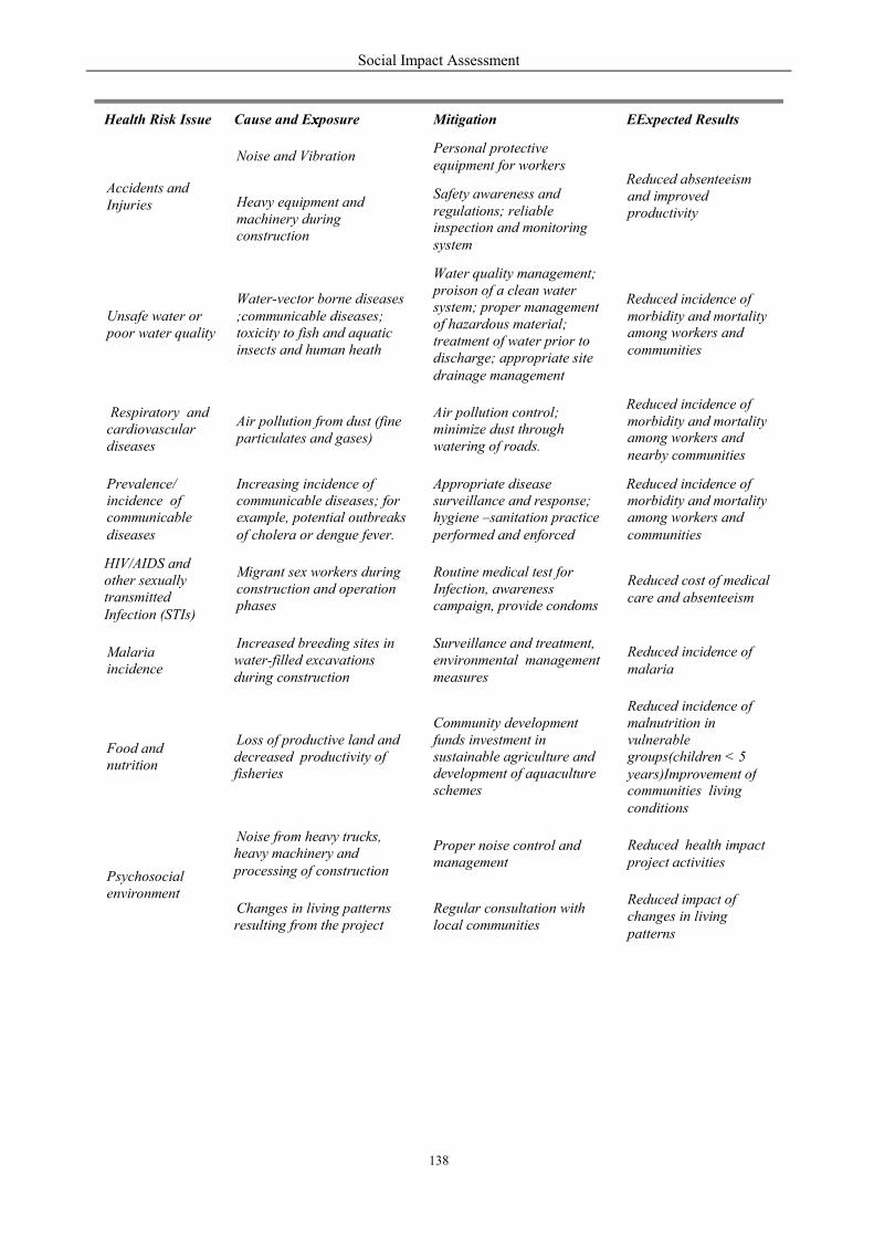
Social Impact Assessment
138
x E
regulations; reliable
system
morbidity and mortality
communities
morbidity and mortality
nearby communities
care and absenteeism
malaria
years)Improvement of
project activities
Health Risk Issue
Cause and Exposure
Mitigation
Expected Results
Accidents and Injuries
Noise and Vibration
Personal protective equipment for workers
Reduced absenteeism and improved productivity
Heavy equipment and machinery during construction
Safety awareness and
inspection and monitoring
Unsafe water or poor water quality
Water-vector borne diseases ;communicable diseases; toxicity to fish and aquatic insects and human heath
Water quality management; proison of a clean water system; proper management of hazardous material; treatment of water prior to discharge; appropriate site drainage management
Reduced incidence of
among workers and
Respiratory and
cardiovascular diseases
Air pollution from dust (fine particulates and gases)
Air pollution control; minimize dust through watering of roads.
Reduced incidence of
among workers and
Prevalence/ incidence of communicable diseases
Increasing incidence of communicable diseases; for example, potential outbreaks of cholera or dengue fever.
Appropriate disease surveillance and response; hygiene –sanitation practice performed and enforced
Reduced incidence of morbidity and mortality among workers and communities
HIV/AIDS and other sexually transmitted Infection (STIs)
Migrant sex workers during construction and operation phases
Routine medical test for Infection, awareness campaign, provide condoms
Reduced cost of medical
Malaria incidence
Increased breeding sites in water-filled excavations during construction
Surveillance and treatment, environmental management measures
Reduced incidence of
Food and nutrition
Loss of productive land and decreased productivity of fisheries
Community development funds investment in sustainable agriculture and development of aquaculture schemes
Reduced incidence of malnutrition in vulnerable groups(children < 5
communities living conditions
Psychosocial environment
Noise from heavy trucks, heavy machinery and processing of construction
Proper noise control and management
Reduced health impact
Changes in living patterns resulting from the project
Regular consultation with local communities
Reduced impact of changes in living patterns

Social Impact Assessment
139
4) Employment/income - If job seekers secure jobs, there is a positive impact of
employment and increased income. The severity has been predicted as medium as the
benefit may extend to many villages and people. The duration is low because the impact
will be limited to a period of time. The impact may be negative particularly among those
who are unsuccessful in securing jobs which may lead to crime, lower safety and less
harmony in community affairs. Overall this impact is positive and of medium
Significance.
5) Displacement and livelihood - it is logical to explain these two impacts together. These
are negative impacts with a high severity since the project impact extends to 13 villages
and the displacement of more than 500 families. The duration and ability to adjust is
medium as the community (both resettled and host) will take some time to adjust with
some degree of inconvenience. Overall these impacts are negative and of high
Significance.
We can elaborate these impacts as below:
The land in and around the project area is covered with forest and grazing areas
which are used by the community to support livestock and meet household needs of
timber, fuel wood, nutrition (like wild vegetables, berries, herbs, etc). Apart from
this, the forest and its NTFPs such as herbs, and wild vegetables are also used as an
additional income source by household (NTFPs can be sold or used for making
handicrafts such as basketry from bamboo).
The displacement of people will lead to changes livelihood and occupational patterns
of the community. Income and livelihood impacts are also likely to result from the
loss of productive land to the project.
Occupational impacts are envisioned due to a high dependence of the community on
agriculture and livestock and the lack of alternative employment skills in the
community, especially among gender/vulnerable groups.
6) Fishing - The creation of an upstream pond will disrupt/hinder the flow of stream/rivers
in the area and have a negative impact on the fishing activities resulting in impacts on
household income levels. However, the field surveys indicated limited fish population in
the upstream area. The duration is predicted as low to medium term with a medium ability
to adjust. Overall this impact is negative and of medium Significance.
7) Cultural Heritage - the field surveys indicated limited archaeological resources in the
upstream area. The duration predicted low to medium term with a medium ability to
adjust. Overall this impact is negative and of medium Significance.
8) Navigation and Tourism – these impacts are explained together in this section. These
activities are mainly cross border navigation/tourism by taxi boat between Chiang Khan
(Thailand) and Sanakham (Lao PDR) including land transport from Tha Li (in Loei
Povince of Thailand) to Kenthao (Lao right-bank border district of Lao PDR). There is
also a ferry service across the Mekong from Ban Houay Kouad to Kenthao. There are
both positive and negative impacts of the the project on navigation and tourism. Even
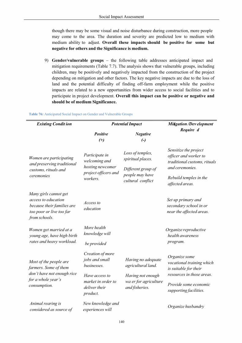
Social Impact Assessment
140
though there may be some visual and noise disturbance during construction, more people
may come to the area. The duration and severity are predicted low to medium with
medium ability to adjust. Overall these impacts should be positive for some but
negative for others and the Significance is medium.
9) Gender/vulnerable groups – the following table addresses anticipated impact and
mitigation requirements (Table 7.7). The analysis shows that vulnerable groups, including
children, may be positively and negatively impacted from the construction of the project
depending on mitigation and other factors. The key negative impacts are due to the loss of
land and the potential difficulty of finding off-farm employment while the positive
impacts are related to a new opportunities from wider access to social facilities and to
participate in project development. Overall this impact can be positive or negative and
should be of medium Significance.
Table 76: Anticipated Social Impact on Gender and Vulnerable Groups
affected areas.
vocational training which
Exis
ting Condit
ion
Potential Impact
Miti
igation /Dev
Require
elopment
d
Positive
(+)
Negative
(-)
Women are participating
and preserving traditional
customs, rituals and
ceremonies
Participate in
welcoming and
hosting newcomer
project officers and
workers.
Loss of temples,
spiritual places. Different group of
people may have
cultural conflict
Sensitize the project
officer and worker to
traditional customs, rituals
and ceremonies. Rebuild temples in the
Many girls cannot get
access to education
because their families are
too poor or live too far
from schools.
Access to
education
Set up primary and
secondary school in or
near the affected areas.
Women get married at a
young age, have high birth
rates and heavy workload.
More health
knowledge will
be provided
Organize reproductive
health awareness
program.
Most of the people are
farmers. Some of them
don’t have not enough rice
for a whole year’s
consumption.
Creation of more
jobs and small
businesses.
Have access to
market in order to
deliver their
product.
Having no adequate
agricultural land.
Having not enough
wa er for agriculture
and fisheries.
Organize some
is suitable for their
resources in those areas. Provide some economic
supporting facilities.
Animal rearing is
considered as source of
New knowledge and
experiences will
Organize husbandry
Social Impact Assessment
141
d) Recommendation
APs will have a heightened awareness of potential dangers through the participation and grievance
channels to be set up by the project with the assistance of local provincial/district authorities.The
representative of Lao Women’s Union in the provincial, district and village levels must be actively
involved in every step of the project. It will be essential to have strict regulations to control worker
behavior in the community and this must be implemented and enforced.
Directly affected people should be given priority in project employment. If possible a member of each
directly affected family should be hired in order to have a 6-7 year income support for livelihood
restoration, especially those of vulnerable groups or who have less productive land. Vocational training
and technical assistance should be provided to them as well.
To mitigate the impact on culture, the project staff should consult and work closely with the
representative of Lao Women’s Union and should be trained and sensitized to traditional customs,
rituals and ceremonies.
The recommended criteria used to select a proposed resettlement areas should include:
Suitability of land for agricultural development, uch as soil, topography, slope, drainage. The area be easily accessible and be connected with a district center and adjacent district. Availability of year-round water supply for irrigation. Access to forest and other legally exploitable natural resources (including the reservoir and drawdown zone where feasible) should be as convenient as possible. The location/resettlement sites should be located close to their existing village area and primarily based on villagers’ preferences. The site should be in a focal development area and/or subject the Master Plan of Socio- Economic Development of the districts/provinces of Vientiane and Xayaboury.
Other recommendations are relevant with mitigation and enhancement measures and strongly require
organizing. These are explained in detail in the SMMP/RAP.
Basic infrastructure such as schools, temples and other health/training centers should be rebuilt
and developed in the relocation/resettlement sites.
Different kind of awareness programs should be organized regularly.
Health care system should be developed and continually supported.
Village saving funds or micro credit projects should be established and supported.
Adequate land for housing and agriculture should be provided.
urgent cash. provide more
rearing skills.
Have access to
amarket
(particularly at
construction site).
skills training.
Provide some breeds of
animal.
Establish and support the
village saving fund or
micro credit project and
provide some loans.
Social Impact Assessment
142
7.2.3 Operational Phase
a) Concern
During the operational phase, project impacts are mostly linked to the after effects of the project and its
activities. These impacts (Table 78) are attached to settlements in and around the upstream pond, main
dam and power house, transmission line, access roads and other utilities. These apply to the 13 villages
in the upstream relocation and resettlement areas where directly affected people are adjusting to new
land. The key issues related to relocatees/resettlers are concerned with how to restore livelihood and
how to adapt to the host site without depression and anxiety.
b) Context
Development of two resettlement sites needs to be established. They include one on right bank for two
villages [Houay Lah (81 families), Khae (150 families)] and one on the left bank for Donsok village
(36 families). In addition, 10 relocation sites within the ter itory of the original villages also need
to be established for the following families: Donmen (120 families), Nakham (19 families),
Donsang (17 families), Boungma (10 families), Kengsao (29 families), Nasack (3 families), Houaytao
(56 families), Donphoung (10 families), Maipakthoun (54 families), and Khokkhaodor (6
families).These resettlement/relocation villagers will be in the process of livelihood restoration.
After the commissioning date, the dam/power house and associated structures will operate water
between 220 masl in the wet season and 119 masl in the dry season with ship locks and fish pass
facilities on the left-bank and right-bank of the main dam respectively. The detailed design of the
fishpass is underway. For the navigation pass, the single-line one stage ship-lock on the left bank flood
plain right side of sluice gate will be in service. They consist of upstream approach channel, upstream
lock head, downstream approach channel, upstream and downstream berthing piers. The dimension of
navigation lock is 120x12x4 m and the maximum navigation clearance is 8m. The mean duration of
passing the lock in one time is tentatively defined as 40 minutes; the daily mean passing frequency is
20; the number of navigable days is 330; and the annual total dead weight tonnage of one way passing
is 2.64 million tons. The daily mean water consumption is about 5.6 m3 per second.
The 24.2 km access road from Ban Pakmee to the head work area will be in service. This includes 6.35
km around the seat of Sanakham Town. The access road is a highway grade III (asphaltic surfaced with
two-lane 8m wide) with design speed of 30 km/hour. A similar design will also be used for access to
the quarry site with a total length of 1.88 km connection to the main access road.
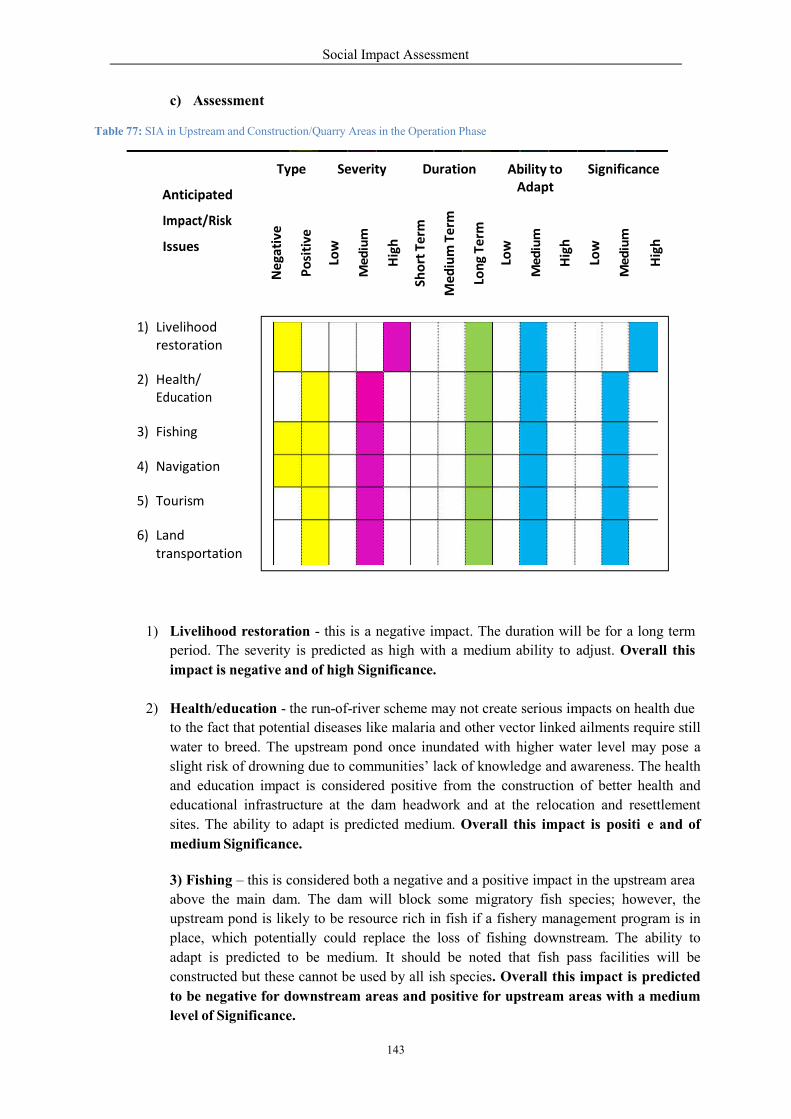
c) Assessment
Table 77: SIA in Upstream and Construction/Q
1) Livelihood restoration
period. The severity
impact is negative and
2) Health/education -
to the fact that potential
water to breed. The
slight risk of drowning
and education impa
educational infrastructure
sites. The ability to
medium Significance.
3) Fishing – this is considered
above the main dam
upstream pond is like
place, which poten
adapt is predicted
constructed but thes
to be negative for downstream
level of Significance.
Anticipated
Impact/Risk
Issues
Ty
Ne
gati
ve
1) Livelihood restoration
2) Health/ Education
3) Fishing
4) Navigation
5) Tourism
6) Land transportation
Social Impact Assessment
143
ruction/Quarry Areas in the Operation Phase
estoration - this is a negative impact. The duration will
verity is predicted as high with a medium ability to
and of high Significance.
the run-of-river scheme may not create serious im
ntial diseases like malaria and other vector linked
The upstream pond once inundated with higher wa
drowning due to communities’ lack of knowledge and a
pact is considered positive from the construction
infrastructure at the dam headwork and at the relocation
to adapt is predicted medium. Overall this impa
ce.
considered both a negative and a positive impact
m. The dam will block some migratory fish species;
likely to be resource rich in fish if a fishery mana
ntially could replace the loss of fishing downst
to be medium. It should be noted that fish p
ese cannot be used by all ish species. Overall this impact is p
downstream areas and positive for upstream areas
e.
Type
Severity
Duration
Ability to Adapt
Po
siti
ve
Low
Me
diu
m
Hig
h
Sho
rt T
erm
Med
ium
Te
rm
Lon
g Te
rm
Low
Me
diu
m
Hig
h
ill be for a long term
adjust. Overall this
mpacts on health due
linked ailments require still
ater level may pose a
awareness. The health
construction of better health and
relocation and resettlement
act is positi e and of
in the upstream area
species; however, the
agement program is in
tream. The ability to
pass facilities will be
s impact is predicted
areas with a medium
Significance
Hig
h
Low
Me
diu
m
Hig
h
Social Impact Assessment
144
4) Navigation and tourism – the presence of the dam and reservoir and improvement in
road access may lead to an increase in tourism and navigation in the local area. Since the
damsite is located in close proximity to Chiang Khan Old Town (Thailand) it may benefit
Veunkham village and the Sanakham township because more tourists and boat taxies will
come to the project area. The duration would be long term. Overall this impact is of
medium Significance.
5) Land transportation - the project will undertake construction/strengthening of roads
and access paths to facilitate movement of goods, equipments and vehicles. These roads,
later maintained by the project, will be used by the local community and enable improved
access markets and other opportunities. The duration is long term. Overall this impact is
positive and of medium Significance.
1) Recommendation
The project will make efforts to ensure that livelihood impacts linked to fisheries are mitigated to
whatever extent possible. The fish stocking in the upstream area above the main dam is likely to be
resource rich in fishing if a fishery management program is planned and implemented.
Options like exclusivity of fishing rights to the nearby communities will be considered. The project
will also take adequate measures to address health issues linked to the accumulation of water.
Tourism opportunities will be explored to enhance and promote the project dam area as a potential
tourist site link with Chiang Khan and Tha Li (Thai side) and with Kenthao and Sanakham on the Lao
side.
The livelihood restoration program will available to substitute dependence on land with alternative
income sources such as building and fisheries. Livelihood restoration is a challenge due to the lack of
fertile/cultivable paddy land, low skill levels of the community and limited linkages with the market
due to inaccessibility. Impacts on livelihood are also linked to the loss of sustenance resources that the
community is currently able to access due to the presence of forests, pasture land and garden areas
These resources satisfy fuel, fodder and nutritional needs apart from generating some additional
income for the affected families.
7.3 Downstream Area
7.3.1 Analysis of Downstream Impacts
Based on
However,
the contract, the analysis of downstream impacts will be performed in the CIA/TBIA.
to at least have some available information for the decision making process, this section
presents potential impacts that may occur in the downstream area within 100 km (on both banks of the
Mekong River) from the Mekong Sanakham HPP maindam.
During the pre-construction phase, the main project activities are related to project planning which
include engineering studies, ESIA studies and other feasibility research/studies to formulate run-of-
river schemes. Therefore, there are no direct downstream impacts because construction activities are
not expected to be performed in this period. Only some surveys for data collection to the downstream
communities were made that may create some business to local villagers from hiring boats,
accommodation and food demand. However, some anxieties among the community in the downstream
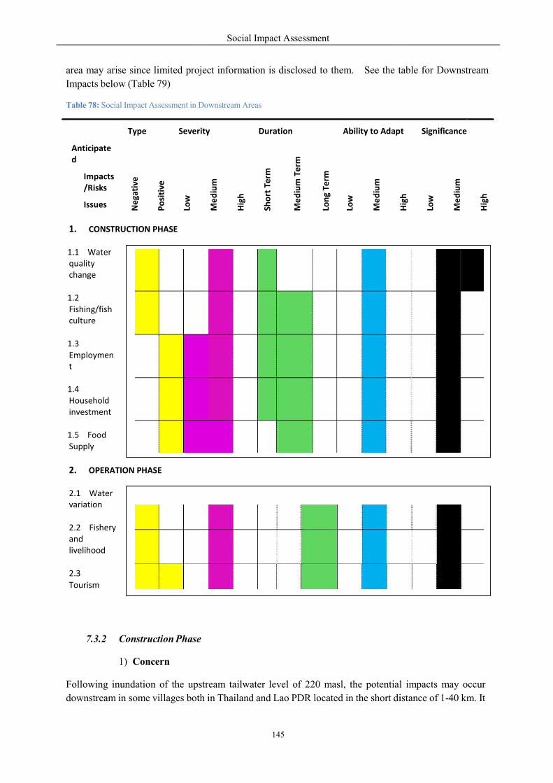
area may arise since limited projec
Impacts below (Table 79)
Table 78: Social Impact Assessment in Downstrea
7.3.2 Construction Phase
1) Concern
Following inundation of the upstream
downstream in some villages both
Anticipate d
Impacts /Risks
Issues
Type
Sever
Ne
gati
ve
P
osi
tive
Low
1. CONSTRUCTION PHASE
1.1 Water quality change
1.2 Fishing/fish culture
1.3 Employmen t
1.4 Household investment
1.5 Food Supply
2. OPERATION PHASE
2.1 Water variation
2.2 Fishery and livelihood
2.3
Tourism
Social Impact Assessment
145
ject information is disclosed to them. See the table
Downstream Areas
e
upstream tailwater level of 220 masl, the potential
both in Thailand and Lao PDR located in the short distance
ity
Duration
Ability to Adap
Me
diu
m
Hig
h
Sh
ort
Ter
m
Me
diu
m T
erm
Lon
g Te
rm
Low
Me
diu
m
Hig
h
table for Downstream
l impacts may occur
istance of 1-40 km. It
pt
Significance
Hig
h
Low
Me
diu
m
Hig
h
Social Impact Assessment
146
is noted that the ESIA surveys of downstream information have been conducted within a distance of
approximately 100 km from the Mekong Sanakham HPP maindam.
Physical impacts during construction on soil could result from (i) loss of topsoil, (ii) failure to
rehabilitate borrow areas and temporarily acquired land, (iii) soil erosion and siltation, (iv) soil
contamination by fuel and lubricants, and (v) disposal of excess earthworks. Loss of topsoil can be
avoided by stripping and storing topsoil (where present) prior to construction and reusing it for
rehabilitation works. These may impact on water quality and affect downstream use of water.
The downstream surveys indicated the main uses of the Mekong River were for water works,
fishing/fish culture and tourism (mostly on the Thai side). The changes of water quality may affect
these activities especially on the right bank which have more economic activities than on the left bank
of Lao PDR.
Some economic benefits (such as employment, household investment) may result from increased
demand (for food, lodging and boat transportation) from more people in the project area during
construction.
2) Context
The construction of the Mekong Sanakham HPP will involve the construction of worker camps, the
coffer dam, diversion structures, powerhouse on the river bed, switchyard, sluice gate, navigation lock,
fish pass and access road and other structures. Approximately 3,000 to 4,000 workers are expected to
come to the construction and quarry areas. The demand for food, lodging, boat transportation and other
entertainment are expected to rise in the downstream area such as Veunkham and Chiang Khan (right
bank), and Sanakham (left bank).
The construction of these structures will involve the clearance of forest and topsoil, ground leveling,
waterbed digging, excavation and removal of overburden layers over the river bed which is mainly
composed of fine sand. Construction of the navigation lock and other components. can affect the water
quality by increasing total solids and sediment that will drain into the Mekong River. Any spills of oil
and chemical may also create negative impacts on fish and water use in downstream areas.
3) Assessment
The EIA assessment identified changes in the water quality as follows:
Change in pH, primary due to contamination with concrete.
Increase in Biological Oxygen Demand concentration from construction camp sites and
temporary construction offices. This will occur from untreated wastewater and
insufficiently treated sewage water. Therefore, mitigation measure must be strictly
implemented during the construction period.
Oil contamination from maintenance and equipment / machine use; accidents including oil
spills and other similar products contamination.
The rock fill quarry will be within the reservoir boundary, thus restricting physical change
to an area.
1) Water quality – *********** Overall this impact a negative impact of medium to
high Significance.
Social Impact Assessment
147
2) Fish and fish culturing – this will be of short term duration during the construction
phase. The severity and the ability to adapt are predicted at medium. Overall this impact is
considered to be negative and of medium Significance since it’s concerned with the
livelihood of the downstream people.
3) Employment, household investment and food supply - these are positive impacts on
some downstream villages. The duration and severity are predicted low to medium while
the ability to adapt is medium. Overall these are considered to be positive impacts of
medium Significance Recommendation
Good practice in the management of biophysical impact protection/mitigation is required for the
construction contractors and sub-contractors. Information disclosure and community consultation with
the participation of downstream villagers is recommended.
7.3.3 Operation Phase
1) Concern
The flow regulation will have a change in water release to the downstream area. The potential impacts
from changes of downstream water levels may include downstream fishing and livelihood activities
including some natural-rapids tourism in the Thai side.
2) Context
In the operation phase, the Mekong Sanakham HPP dam/power house and associated structures will
operate at a water level between 220 masl in the wet season and 119 masl in the dry season with ship
locks and fish pass facilities on the left-bank and right-bank of the main dam respectively. The detailed
design of fish pass is underway and is utilizing the result of ESIA aquatic biology and fishery surveys.
For the navigation pass, the single-line one stage ship lock on the left bank flood plain and right side of
sluice gate will be constructed. The water release of 5,500 cubic meters per second downstream will
operate 12 bulb turbines.
The interviews of former fishermen revealed that the fishing activities were not the main livelihood
income except the fish culture of more than 100 baskets on the Thai side. However, the native fishing
by using hook and gill net are still a way of life of some people for household consumption.
The survey found a popular domestic tourism at Kaeng Khut Khu (some 25 km from the main dam). It
is utilizing the beauty of large rapids as a place for local recreation, especially in the dry season. No
less than 50,000 tourists per year visit this place. Approximately 50-60 households (150-200 people)
are involved in the tourism business at this tourism spot.
3) Assessment
The change in flow regime and ecology will impact on fish availability, variety and catches
downstream and upstream. This decline will impact on the villagers in terms of nutrition and also in
terms of the way-of-live of local villagers.

Social Impact Assessment
148
I. Water variation, fishing and livelihood – These negative impacts are of a long term
duration. The severity is predicted at medium with a medium ability to adapt. Overall
the Significance is predicted at medium.
II. Tourism - it is not clear about the water level at Kaeng Khut Khu in the summer time.
If the rapids can be observed the impact will not be a major one but the impact is
highly significanct if the water level is 2m higher (compared to pre-project levels) in
the months of March to May. In general the impact of tourism has positive and
negative aspects in the long term bot which are medium in severity and ability to
adapt. The positive aspect is that there will be more people visiting Chiang Khan and
Sanakham because of the project. But the negative aspect would be if the higher water
level in the dry season would overcome the rapids at Kaeng Khut Khu. Overall this
impact would be negative or positive and of medium Significance.
4) Recommendation
The CIA/TBIA needs to consult with the MRC and include the participation of representatives of Lao
PDR, Thailand, Cambodia and Vietnam.
The changes in water quality during construction need to be mitigated and protected to avoid impact on
downstream uses along the Mekong mainstream. The main downstream way-of-life activities that may
be impacted include fish culturing and tourism in the Chiang Khan District of Thailand.
Consultation of the above potentially affected people is required prior to the approval of the project.
In regard to fisheries, the upstream area above the main dam is likely to be resource rich in fishing if a
fishery management program is in place, which could replace the loss of fishing downstream.
However, access to this site for the local villages as well as training in appropriate fishing techniques
with provision of adequate equipment would be necessary for this to be successful.
Social Impact Assessment
149
7.4 Impact to Country/Region
a) Concern
On the macro perspective, the creation of Mekong Sanakham HPP may support the country and
regional development. These positive impacts include rural electrification, a sub regional inter-
connected grid and increased employment and income from the economic activities generated.
The negative impacts are the loss of agricultural production from the fertile lowland rice farming area,
which is to be inundated. There are potentially cumulative and trans-boundary impacts from a series of
proposed hydropower projects on the Mekong mainstream, which is likely cause bio-physical changes
of the Mekong River.
One important issue is the sharing of project benefits, particularly higher economic growth and poverty
reduction if related support systems are well organized and focused.
b) Context
Rural electrification and development of regional power grid requires more supply of power for sub-
regional development in the GMS. For rural electrification, in the next few years, approximately 1,150
MW will be exported to Thailand and Vietnam and 227 MW for domestic supply. In 2010, the GOL
achieved electrification of approximately 70 percent of households and has targeted to reach 80
percent by 2015, and 90 percent by 2020.
For country and regional economy, the inflow of FDI during the construction stage including foreign
exchange earnings from hydropower during the operation phase will support economic development in
Lao PDR and neighboring countries. Direct investment in the Sanakham HPP in the Lao PDR is
expected to be about US $500 million
A probable side impact from high demand for labour and construction materials may be rising wages
and higher inflation, particularly of construction materials.
c) Assessment
The impact of rural electrification and a sub-regional inter-connected power grid are positive with
medium severity and ability to adapt. The duration is predicted medium to long term.
The impact of foreign direct investment (FDI), including employment and income, are positive. The
intensity is predicted medium in a medium to long term duration. The ability to adapt is predicted
medium. The Significance is predicted high particularly since Lao PDR is still depending on foreign
assistance. Foreign exchange earnings will give the country better prospects for autonomous
development.
A potential negative impact is the loss of agricultural production. Without the project, the
riverbank/valley rice paddy area of approximately 300 ha can produce glutinous rice of some 1,100
tons per year. With the project, this amount of rice is expected to be lost. The Significance is predicted
as major.
Cumulative and trans-boundary impacts are subject to a long term perspective of intensity and ability
to adapt. The issue of benefit sharing is affected by external factors such as GOL policy and also
internal factors such as the limit of low land fertile area.
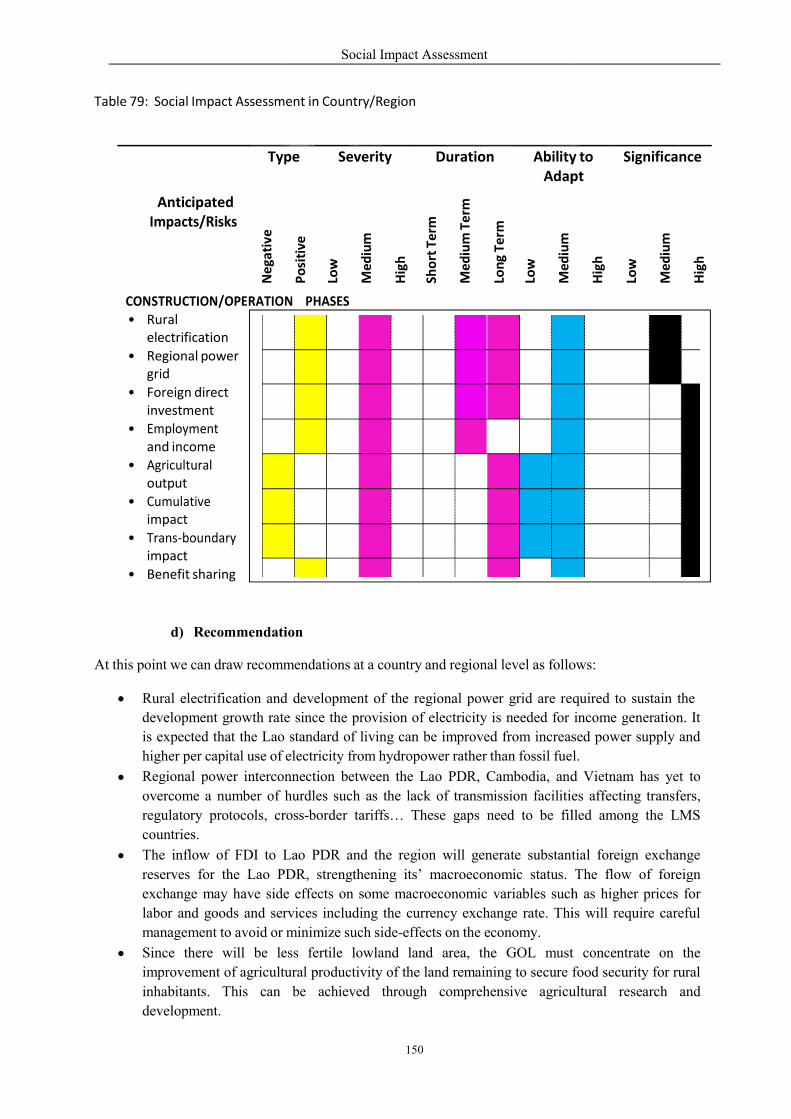
Table 79: Social Impact Assessmen
d) Recommendation
At this point we can draw recomm
Rural electrification and
development growth rate
is expected that the Lao
higher per capital use of e
Regional power intercon
overcome a number of hurdles
regulatory protocols, cro
countries.
The inflow of FDI to L
reserves for the Lao PD
exchange may have side
labor and goods and services
management to avoid or mini
Since there will be le
improvement of agricultural
inhabitants. This can
development.
Anticipated
Impacts/Risks
Typ
Ne
gati
ve
CONSTRUCTION/OPERATION • Rural
electrification
• Regional power grid
• Foreign direct investment
• Employment and income
• Agricultural output
• Cumulative impact
• Trans‐boundary impact
• Benefit sharing
Social Impact Assessment
150
ment in Country/Region
ation
mmendations at a country and regional level as follows:
and development of the regional power grid are required
rate since the provision of electricity is needed for
standard of living can be improved from increas
electricity from hydropower rather than fossil fuel.
nnection between the Lao PDR, Cambodia, and
hurdles such as the lack of transmission facilitie
ross-border tariffs… These gaps need to be fil
Lao PDR and the region will generate substantial
DR, strengthening its’ macroeconomic status.
e effects on some macroeconomic variables such
rvices including the currency exchange rate. This
minimize such side-effects on the economy.
ess fertile lowland land area, the GOL must
agricultural productivity of the land remaining to secure food
be achieved through comprehensive agricultural
pe Severity
Duration
AbilityAdap
P
osi
tive
Low
Med
ium
Hig
h
Sho
rt T
erm
Med
ium
Te
rm
Lon
g Te
rm
Low
Med
ium
CONSTRUCTION/OPERATION PHASES
ows:
quired to sustain the
income generation. It
sed power supply and
fuel.
d Vietnam has yet to
es affecting transfers,
lled among the LMS
tial foreign exchange
The flow of foreign
such as higher prices for
is will require careful
t concentrate on the
food security for rural
agricultural research and
ty to pt
Significance
Med
ium
Hig
h
Low
Med
ium
Hig
h

In the construction phase,
this is a good chance for
as labourers (especially
sub-contractors.
There will be a need to
down to the Mekong delta
by addressing the regiona
The benefits of the project
especially upstream fishe
7.5 Global Impacts
a) Concern
There are a number of research
warming. These include:
High quality forest managthe growth of its forests
warming will be slowed d
Next one is energy effic
bigger chance.
Alternative sources of e
global warming. Hydro-
burning gas, or coal for e
The Mekong Sanakham HPP is a
the relocation/resettlement of so
replacing dependence on fossil fuel
plants.
Table 80: Matrix - Social Impact Assess
Anticipa
ted
Impacts/ Risks
Type
Severity
Neg
ativ
e
Pos
itiv
e
Low
CONSTRUCTION/OPERATION
• Less global warming
Social Impact Assessment
151
e, as the labor force requirement is considered large
for the Mekong Sanakham HPP to give priority to Lao
those who are directly affected from inundation)
conduct a CIA/TBIA in a separate report, cover
delta in Vietnam. The study will be a regional consultation
al perspectives of Mekong mainstream development.
project may include electricity, irrigation, navigation,
ery management. The benefit sharing mechanism should
h studies that have indicated alternative ways to
management to enable the reduction of CO2 by treests and does not allow them to be cut down indiscriminat
down.
ciency: with less energy used, the reduction of global
energy omit little or no greenhouse gases. Using
-power, solar energy, and windmills can be used
electricity.
a run-off-river project that will inundate some forest
ome riparian villages. It seems to support less global
fuel in Thailand, which heavily relies on natural g
ssment in Global Level
Severity
Duration
Ability to Adapt
Med
ium
Hig
h
Sh
ort
Ter
m
Med
ium
Ter
m
Lon
g T
erm
Low
Med
ium
Hig
h
TION PHASES
large at 3,000 people,
Lao people to be hired
inundation) including the local
ring areas from China
consultation for the project
lopment.
igation, tourism and
should be set up.
o help reduce global
s. If a country fosters discriminately, global
global warming has a
ng them will help curb
used to take the place of
rests area and require
global warming from
gas/lignite fired power
Significance
Hig
h
Low
Med
ium
Hig
h
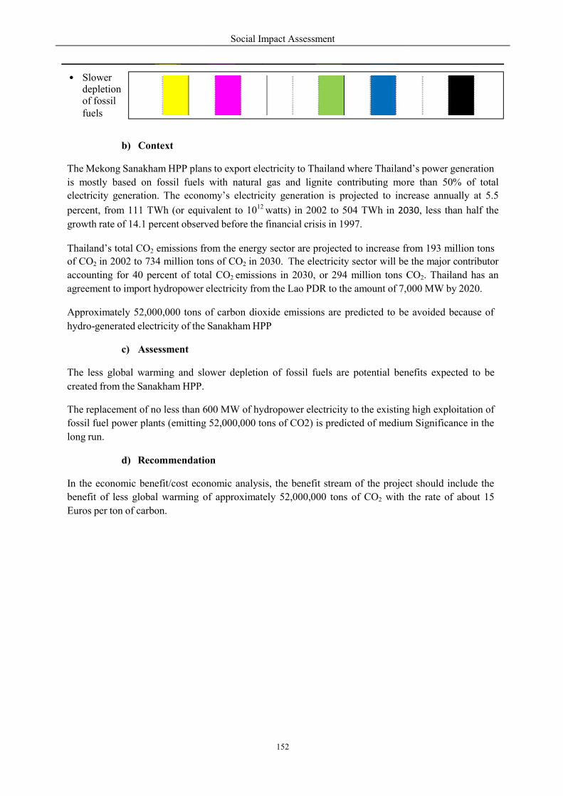
b) Context
The Mekong Sanakham HPP plans
is mostly based on fossil fuels
electricity generation. The econ
percent, from 111 TWh (or equivalent
growth rate of 14.1 percent observed
Thailand’s total CO2 emissions fromof CO2 in 2002 to 734 million tons
accounting for 40 percent of tot
agreement to import hydropower
Approximately 52,000,000 tons
hydro-generated electricity of the
c) Assessment
The less global warming and slower
created from the Sanakham HPP.
The replacement of no less than 600
fossil fuel power plants (emitting
long run.
d) Recommendation
In the economic benefit/cost econo
benefit of less global warming of
Euros per ton of carbon.
• Slower depletion of fossil fuels
Social Impact Assessment
152
ns to export electricity to Thailand where Thailand’s
s with natural gas and lignite contributing more
economy’s electricity generation is projected to increa
equivalent to 1012 watts) in 2002 to 504 TWh in 20
rved before the financial crisis in 1997.
from the energy sector are projected to increase fromtons of CO2 in 2030. The electricity sector will be the
total CO2 emissions in 2030, or 294 million tons C
electricity from the Lao PDR to the amount of 7,000
of carbon dioxide emissions are predicted to be
the Sanakham HPP
lower depletion of fossil fuels are potential benefits
HPP.
replacement of no less than 600 MW of hydropower electricity to the existing hi
(emitting 52,000,000 tons of CO2) is predicted of medium
ation
onomic analysis, the benefit stream of the project
of approximately 52,000,000 tons of CO2 with
Thailand’s power generation
re than 50% of total
ncrease annually at 5.5
030, less than half the
from 193 million tons be the major contributor
CO2. Thailand has an
,000 MW by 2020.
e avoided because of
benefits expected to be
g high exploitation of
m Significance in the
project should include the
the rate of about 15
Social Impact Assessment
153
8. 8.1
Public Participation Objective & Scope
The consultation aims to introduce the proposed project to stakeholders, inform them as it develops,
and identify their views and concerns. The objective is to incorporate stakeholder concerns and local
knowledge in the design and execution of the project, and avoid/reduce potential conflicts to the
possible extent. This approach fosters stakeholders’ engagement and contribution to the project,
enhances its acceptability and encourages realistic expectations as to what the project will deliver to
them.
The key objectives of the consultation program are to:
Identify problems, concerns and needs.
Inform stakeholders about the project.
Obtain feedback.
Learn from local knowledge and understanding.
Evaluate alternatives.
Promote ownership and enhance social acceptability.
Avoid or resolve conflicts.
Demonstrate commitment of the project proponent in addressing issues raised during
consultations.
Scope of consultation will focus on four main components:
Information Collection - involving collecting information on the environmental and social
baseline conditions of the study area to determine key sensitive receptors.
Information Dissemination - involving disclosure of information about the intended activity,
project objectives and their outcomes in order to enable meaningful consultation.
Consultation - involving an interactive, two-way flow of information, views and ideas
between stakeholders and the project proponent, China Datang Overseas Investment
Company.
Participation - defined as a voluntary process in which stakeholders and project proponents
come together to share, negotiate and control the decision-making process in project design
and management. It builds on the consultation component.
The consultation process will involve, but will not be limited to:
1) Formal meetings with government authorities, institutions, individuals, specialists and any
NGOs identified.
Meetings with opinion leaders, community representatives (village committees or councils).
Household survey questionnaires, aimed at the local population within the project area. The
survey questionnaires are a fundamental component of both the RAP and the SIA as they
provide the basis for identifying impacts and developing management and mitigation measures
that are specific to the local conditions.
2)
3)
Social Impact Assessment
154
8.2 Identification of Key Stakeholders
8.2.1 MRCS & Lower Mekong Riparian Countries
As discussed earlier in Section 3.11 of Chapter 3, the regional agreement on ‘Cooperation for the
Sustainable Development of the Mekong River Basin (1995)’ requires that in addition to Mekong
River Commission Secretariat (MRCS), four countries need to be consulted on the E&S issues of
Mekong Sanakham HPP. These are:
1)
2)
3)
4)
Cambodia
Lao PDR
Thailand
Vietnam
The road map/agenda for inter-country consultations requires suggestion and guidance
MRCS.
from the
8.2.2 Central GOL Bodies
The central government concerning hydropower development can be listed as follows:
Lao’s National Mekong River Commission
Water Resources and Environment Administration
Ministry of Energy and Mines
Ministry of Agriculture and Forestry
Ministry of Planning and Investment
Ministry of Finances
Ministry of Health
Ministry of Labor and Social Welfare
Ministry of Information and Culture
National Land Management Administration
Any other relevant departments identified in consultation with Datang/NCG
8.2.3 Provincial/District GOL
Similar to those at the national level, the provincial and district administration and related
authorities include:
key
Provincial/District Cabinet Offices
Provincial/District Energy and Mines Offices
Provincial Water Resources and Environment Office
District Environment and Land Offices
Provincial/District Agriculture and Forestry Offices
Provincial/District Planning and Investment Offices
Provincial/District Health Offices
Provincial/District Labor and Social Welfare Offices
Provincial/District Information and Culture Offices
Social Impact Assessment
155
8.2.4 Village Leaders and APs
Since the main impacts of the project is on villages, priority groups are at the village level, particularly
APs, village leaders and gender and vulnerable groups. The following must be consulted:
Village heads in each of the project affected villages.
Key village informants, including village teachers, village elders, spiritual leaders and
health-care workers.
Directly and indirectly affected families in the project area.
Gender and vulnerable groups (including ethnic minority group).
Key village interest groups including landowners, land users, identified vulnerable groups,
guardians of cultural and spiritual sites.
8.2.5 Non-Governmental Organizations
Lao Women’s Union
Lao National Front
Lao Front for National Construction
Lao Youth Association
Other NGOs as listed in Appendix 2 of which will be finally selected by Datang/ NCG and
Provincial/District Government
8.3 Consultation with GOL Provincial & District Authorities
Consultation with GOL stakeholders will involve a series of formal meetings and discussions. The
purpose of the interviews at national, provincial and district levels will be to inform the stakeholders of
the proposed project, to discuss the associated environmental, social and resettlement issues as well as
to gather any relevant secondary data. The consultations with district and provincial stakeholders will
also discuss the most practical and feasible mitigation measures in the opinion of these stakeholders. It
is expected the majority of these interviews will be undertaken by NCG and the local consultant team.
Consultation at these levels is an important step in the protocol of working in the local area. It is a
courtesy to inform the relevant government bodies and leaders of the intention to conduct surveys and
interviews in the Sanakham, Kenthao, and Paklay districts.
The consultations/meetings will take the form of s mi-structured interviews in which a short
presentation about Datang and the purpose of the EIA, SIA and RAP tasks. This will be followed by
discussions about the role and responsibilities of the government office in general; it’s specific role in
relation to the Sanakham HPP; any requirements in relation to construction and operation of the
project; opinions about the positive and negative impacts of project and suggestions for Datang and
NCG. A series of such meetings are envisaged with the central and provincial line departments such as
MONRE. During these meetings, the key issues and concerns raised by the stakeholders will be
recorded for inclusion in the RAP, SMMP and EMMP.
8.4 Consultation with Villages & Local Communities
8.4.1 Purposes
Consultation with members of the communities in the vicinity of the project area are undertaken
through village meetings, interviews with representatives of the local villages and as part of the
household surveys. The survey is used to develop a baseline socio-economic profile of the local
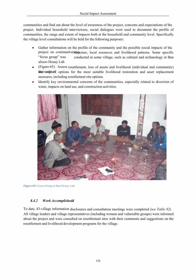
communities and find out about the
project. Individual household interviewees,
communities, the range and extent
the village level consultations will
Gather information on
re
and explore options
measures, including resettle
Identify key environm
water, impacts on land
ah
d
All village leaders and village repr
about the project and were consulted
resettlement and livelihood develop
Social Impact Assessment
156
the level of awareness of the project, concerns and
nterviewees, social dialogues were used to document
nt of impacts both at the household and commun
ill be held for the following purposes:
on the profile of the community and the possible soc
comm structure, local resources and livelihood patterns.
al conducted in some village, such as cultural an
project on communitunityy
“focus group” was
alssoo Houay Lah
(Figure 65). Assess
the scale of resettlement, loss of assets and livelihood (individual
for the most suitable livelihood restoration and
settlement site options.
mental concerns of the communities, especially related
use, and construction activities.
Figure 65: Focus Group at Ban Houay Lah
8.4.2 Work Accomplishedd
To date, 43-village information disclosures and consultation meetings were completed
presentatives (including women and vulnerable g
ulted on resettlement sites with their comments and
lopment programs for the village.
and expectations of the
cument the profile of
nity level. Specifically
social impacts of the
tterns. Some specific
nd archaeology at Ban
dual and community)
and asset replacement
elated to diversion of
mpleted (see Table 82).
groups) were informed
and suggestions on the
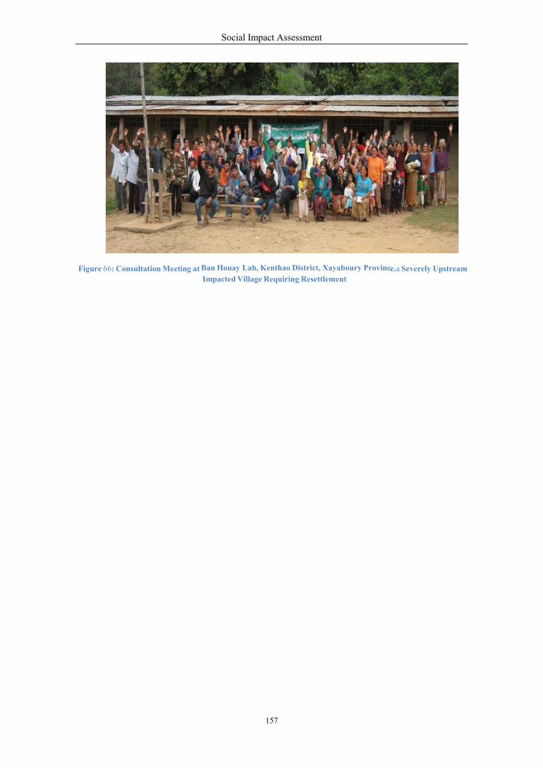
Figure 66: Consultation Meeting at
Social Impact Assessment
157
at e Ban Houay Lah, Kenthao District, Xayaboury Provinc Impacted Village Requiring Resettlement
e.a Severely Upstream

Social Impact Assessment
158
1
1
1
1
1
1
1
1
1
1
1
1
Table 81: Information Disclosure and Consultation Performed Date
No. Village Name District Location
Consultation
Date u/p d/s c/q LB RB
Vientiane Province
1) Donsok Sanakham X X 14/ 2/2010
2) Donphoung Sanakham X X 14/ 2/2010
3) Maipakthoun Sanakham X X 22/ 2/2010
4) Houaytao Sanakham X X 21/ 2/2010
5) Khokkhaodor Sanakham X X 21/ 2/2010
6) Kokngeaw Sanakham X X 20/ 2/2010
7) Huaykhayaeng Sanakham X X 23/ 2/2010
8) Pakmee Sanakham X X 12/3/2010
9) Sanakham Sanakham X X 12/3/2010
10) Takdad Sanakham X X 12/3/2010
11) Juansavanh Sanakham X X 12/4/2010
12) Siphoum Sanakham X X 12/5/2010
13) Pakpang Sanakham X X 12/5/2010
14) Phalath Sanakham X X 12/2/2010
15) Paksao Meun X X 12/6/2010
16) Donhieng Meun X X 12/6/2010
17) Kokmeud Meun X X 27/ 2/2010
18) Namhee Meun X X 27/ 2/2010
19) Konkham Meun X X 27/ 2/2010
20) Vang Meun X X 27/ 2/2010
21) Pakchanh Meun X X 28/ 2/2010
Xayaboury Province
Social Impact Assessment
159
1
1
1
1
1
1
1
1
1
1
1
1
1
1
1
1
1
1
1
1
Note: c/q – construction/quarry areas, d/s – downstream area, u/p – upstream area, LB – Left Bank,
RB–Right Bank
Kenthao X X 30/ 1/2010
Kenthao X X 12/6/2010
22) Veunkham
23) Houay Lah
24) Donmen Kenthao X X 12/8/2010
25) Khae Kenthao X X 12/ 1/2010
26) Nakham Kenthao X X 14/ 2/2010
27) Donsang Kenthao X X 14/ 2/2010
28) Boungma Pak Lay X X 14/ 2/2010
29) Takdad Pak Lay X X 16/ 2/2010
30) Kengsao Pak Lay X X 17/ 2/2010
31) Nasack Pak Lay X X 16/ 2/2010
32) Nasavang Pak Lay X X 19/ 2/2010
33) Senglay Pak Lay X X 18/ 2/2010
34) Houayxaykham Pak Lay X X 20/ 2/2010
35) Khae Pak Lay X X 21/ 2/2010
36) Sisavang Pak Lay X X 18/ 2/2010
37) Don Pak Lay X X 21/ 2/2010
38) Sisa-at Somphou Pak Lay X X 19/ 2/2010
39) Xaiyamoungkhoun Pak Lay X X 18/ 2/2010
40) Houaylay-Noy Pak Lay X X 20/ 2/2010
41) Namxong Pak Lay X X 19/ 2/2010
42) Mouang-Tai Pak Lay X X 22/ 2/2010
43) Mouang-Nua Pak Lay X X 22/ 2/2010
Social Impact Assessment
160
B
S
B
e e
n
y
y
y
e
g
v
h
o
d
p
m
h
e
8.4.3 Key Feedbacks from Consultation
Four villages that will be directly impacted and required to relocate/resettle have expressed their
comments, suggestions and expectations on relocation and resettlement as feedbacks for the RAP and
SMMP as follows:
Box 8: Ban Donsok
Box 9: Ban Houay Lah
an Houay Lah
Houay Lah’ s villagers (especially village hea man and other leaders ) wished
tod
develop t he land on two mountains to locate the village temple and the primary
school. R ight now the
se mountains
are part of the village protected forest situated
in northe rn part conne cting Pao L oua Yai creek.
When relocating the village, there is no need to hold a ceremony. When the
resettlement time arries, they will accept the move.
Key requirements are concerned with fair compensation in accordance with
property lost and the improvement of livelihood.
an Donsok
If the project is approved to go ahead, Donsok villagers and their leaders will
have to r ly on the government or the project developer to find a suitable place
for resettlement because they cannot think of a good place to move to.
They would like to make a request though stating that compensation should go to
all villagers including outsiders (people who do not live in Ban Donsok) who
have property that is affected by the project.
When moving to a new place, to the village requested that the project as to build
houses for the resettlers and at least including 1 hectares of farming land for each
family. The village requested that they would also need a new school, market,
road, healthcare center, clean water and a tem le.
After being resettled, people stated that they would like to be looked after for at
least 3-5 ears.
ome additional recommendations/suggestions for resettlement ceremonies
Relocation of a temple requires nothing since there are no monks in our current
temple
Ceremony required to be arranged for moving village’s cemetery.
Ceremony is required due to moving the respected village spiritual for st
that may include a buffalo, 28 bottles f traditional Lao-Lao whiskey, etc.
Social Impact Assessment
161
s
c
T h
m
w
d
o
o
o
d
s o
w o
m
T
B
o o
c
o
Box 10: Ban Donmen
Box 11: Ban Khae
Khae Village:
Villagers of Khae Village and their leaders agreed that if they had to be
resettled, they wish to select Donghouayang & Koumnamkay, whi h is a well-
known place and suitable for resettlement. he place is on the west side of Khae
village about 18-20 kilometers away. The place is connected to Houaylod,
Nong, and Kongdeng village which are close to the border of Pak Lay District,
along the road number 04.
The village shall follow the resettlement plan but requested that cmpensation
be in a cordance to the loss of property. New land must be able to support their
lives. he ability to produce rice and keep livestock is the key for them,
otherwise, why move? At least they wish to produce no less than the current
level or more would be better.
Ban Khae does not need to hold any traditional resettlement ceremonies. The
most important thing is to improve their livelihoods.
Ban Donmen:
Villagers of Ban Donmen and their leaders agreed that if they had to be
relocated/resettled, they wish to be put in the place called Dong H uay Ang &
Koum Nam Kay, hich is a well-known place and suitable for settlement. The
place i on the west side of Khae village about 15 km away from Donmen. The
place is connected to Houaylod, Nong, and Kongdeng villages which are
located close to the border of Pak Lay District along the road number 04.
The village shall follow the resettlement plan but requested that compensation
should be in accordance to the loss of property. Being resettled may be
acceptable as long as they have agricultural land and other facilities which will
support their lives. The ability to produce rice and keep livestock is the key for
them, otherwise, why relocate? In the resettlement, at least they have to
produce, at the minimum, to the current level or if they can produce more it
will even be better (similar comments and request to Khae village).
Traditional cerem nies have t be arranged before moving which may at least
include 2 buffalos and other necessary ite s.
Social Impact Assessment
162
8.5 Consultation with Other Stakeholders
In addition to the GOL and local communities mentioned, it is anticipated that other stakeholders
including the construction contractors, NGOs and other civil society organizations will be consulted
over the course of the EIA, SIA and RAP consultation program.
Consultation with these stakeholders will take the form of ad hoc meetings similar to those described
for the GOL. These consultations will assess the issues and concerns of these stakeholders on the
project and its different activities. Construction contractors and NGOs may also be invited to
participate in an impact assessment workshop as part of the EIA/SIA.
The Mekong Sanakham HPP is a Mekong Mainstream development project, so it requires regional
consultation in 3 countries, Cambodia, Thailand and Vietnam. The key issues will be assessed in the
CIA/TBIA.
At the minimum, the following key aspects that need to be included in the regional consultation:
Impact area
o Upstream/catchment o Downstream o Construction/quarry sites o Country o GMS
o Global
Issues
Water resource development
Socio-economic development
Fishery
Hydrology
Sediments
Resettlement
Navigation
Tourism
Climate Change/Global warming
o
o
o
o
o
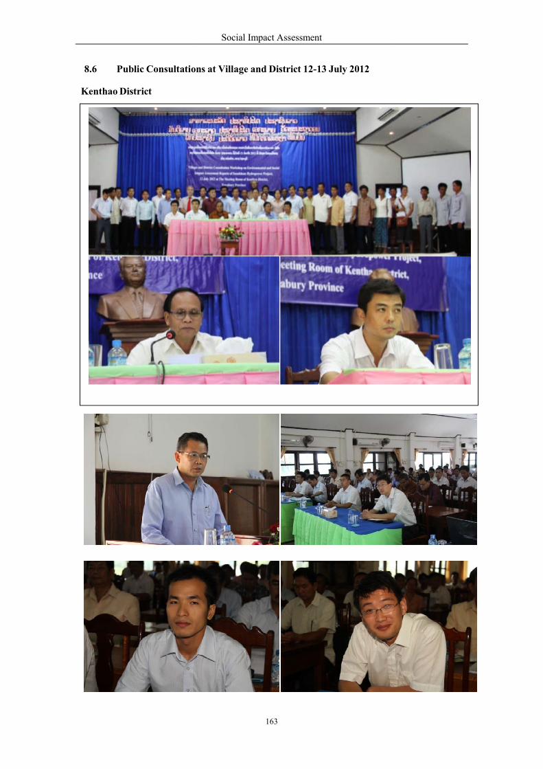
8.6 Public Consultations
Kenthao District
Social Impact Assessment
163
onsultations at Village and District 12-13 July 2012
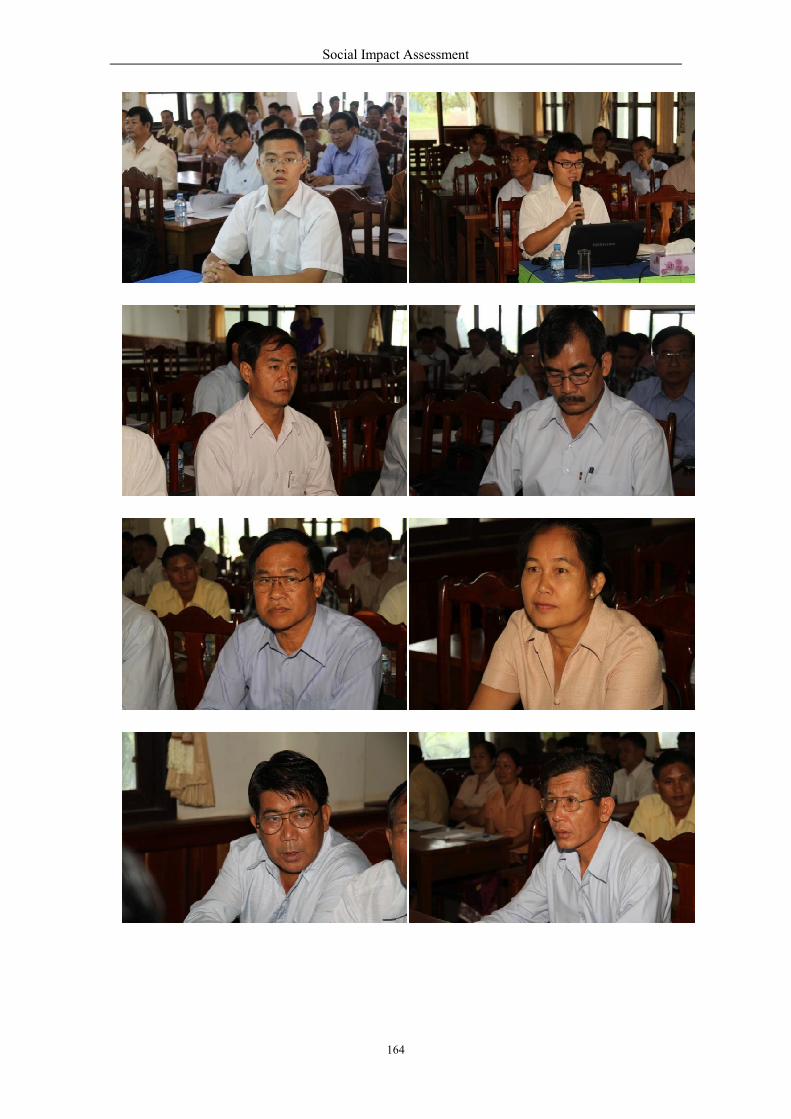
Social Impact Assessment
164
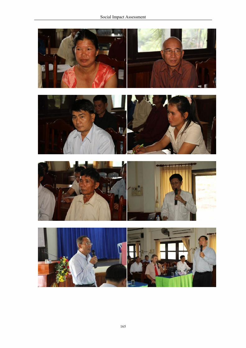
Social Impact Assessment
165
Social Impact Assessment
166
Social Impact Assessment
167
Social Impact Assessment
168
Social Impact Assessment
169
Sanakham District
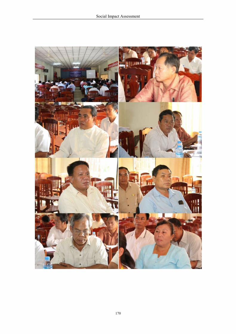
Social Impact Assessment
170
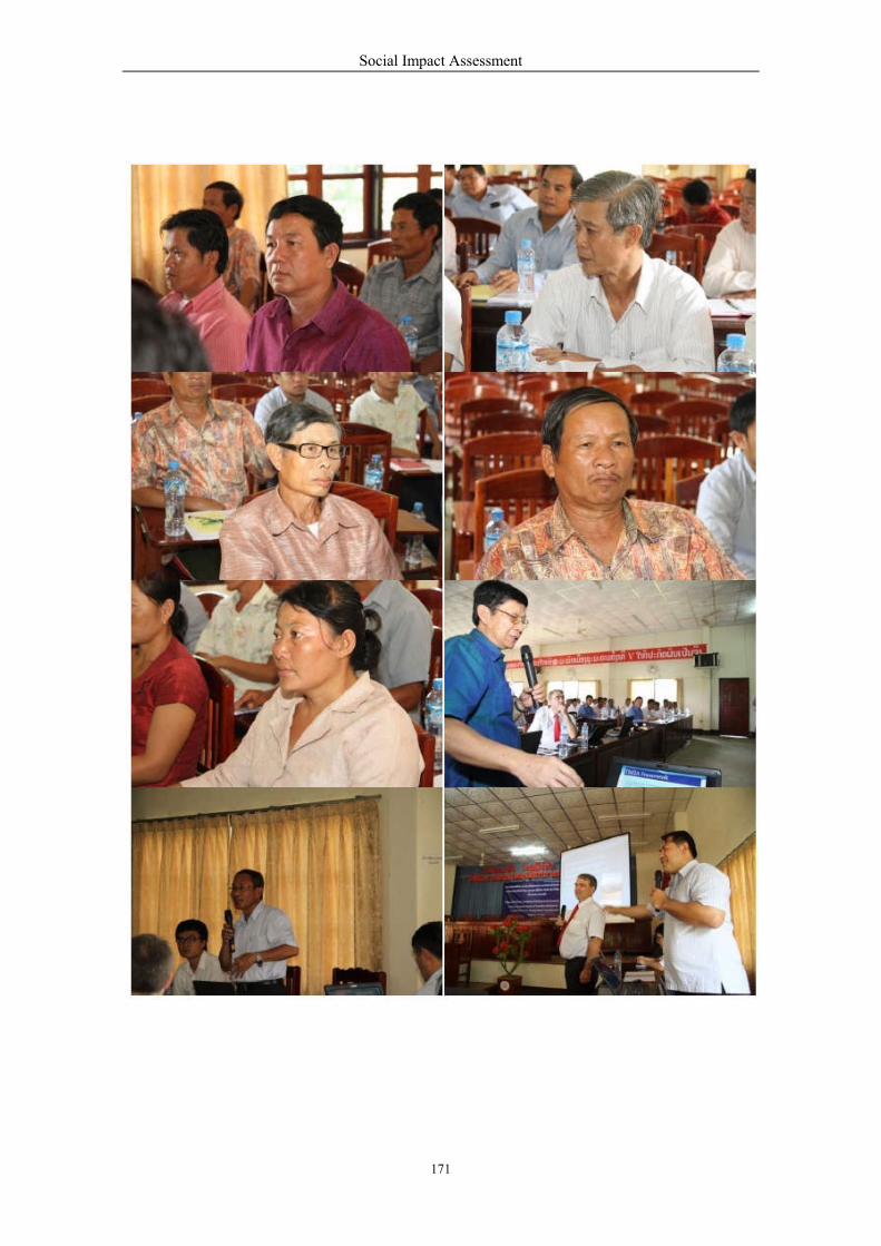
Social Impact Assessment
171
Social Impact Assessment
172
‘
Social Impact Assessment
173

Social Impact Assessment
174
8.7 Technical workshop and Site visit 25-28 March 2013

Social Impact Assessment
175

Social Impact Assessment
176
Social Impact Assessment
177
Social Impact Assessment
178
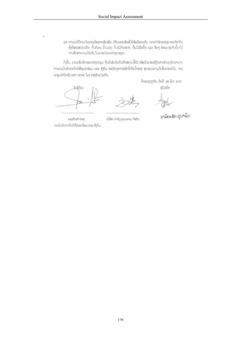
Social Impact Assessment
179

Social Impact Assessment
180
8.8 Provincial Consultation 6Dec2013
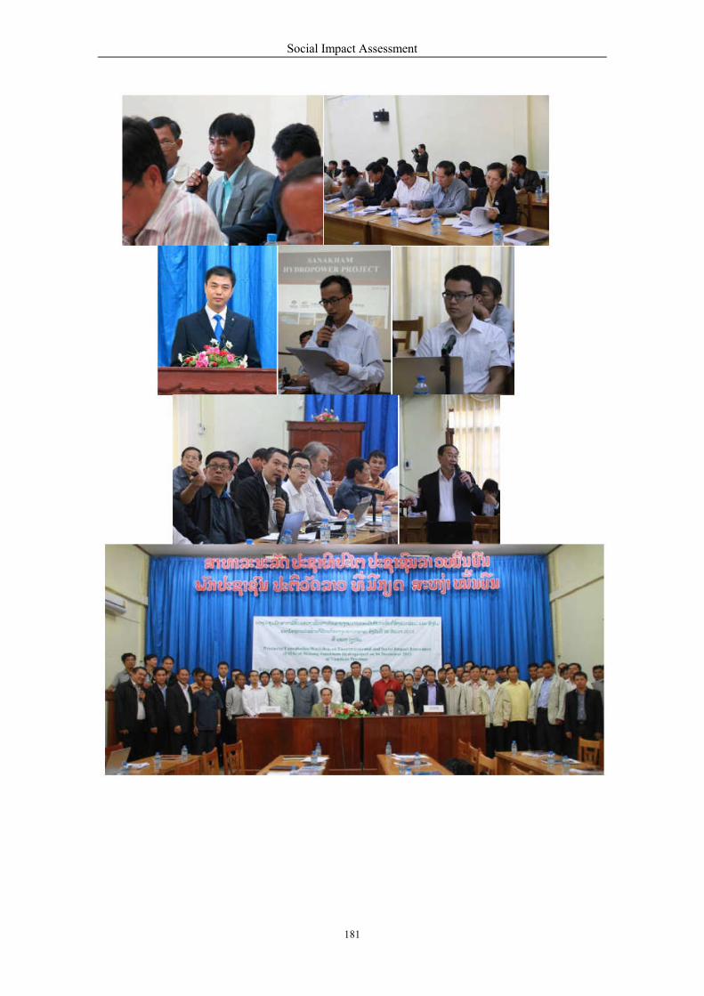
Social Impact Assessment
181
Social Impact Assessment
182
Social Impact Assessment
183
Social Impact Assessment
184

Social Impact Assessment
185
Social Impact Assessment
186
Social Impact Assessment
187

Social Impact Assessment
188
9. 9.1
Conclusions & Recommendations National Economic and Power Development
The economic development in Lao PDR is progressing. It is expected that the Lao PDR’s economy
will grow by 7.5 percent in 2011, compared to 7.4 percent in 2010. The economy will be on a strong
growth path during the period of 2011 to 2012. The economic growth is largely driven by exports from
hydropower projects and increased production by the mining industry. Domestic demand has remained
strong owing to higher private expenditures on consumer goods and residential construction.
The power sector in Lao PDR continues to play three important roles for the country’s economy. These
include:
Promotion of economic and social advancement by providing a reliable and affordable
domestic power supply.
Earning foreign exchange from electricity exports.
Supporting the reduction of poverty.
The US$ 500million Mekong Sanakham HPP is one of the large-scale hydropower development
projects that will positively support the above roles for the Lao PDR’s national economic and power
development including support for the development of rural electrification and regional power
interconnection with Thailand. Also important is the creation of 3,000 to 4,000 jobs in the project area.
It is recommended that project development should follow international engineering, envi onmental
and social best practice and policy for sustainable hydropower in the Lao PDR. The reduction of
poverty can be of substantial progress through giving priority to hire local labor and sub-contractors.
9.2 Compensation
The Mekong Sanakham HPP will acquire land of 4,452 ha. Of this, 676 ha are community and non-
forest area and 308 ha production lands (rice paddy) which require compensation either land for land
or cash compensation and/or combination approach.
Housing structures of 621 units with associated structures such as rice storage and animal cages will be
affected and also require compensation or replacement. Four primary schools and five temples are
public structures that also require reconstruction in relocation/resettlement sites. The earth road totaling
13 km must be replaced afterinundation. There are also other assets such as trees that require
compensation.
The compensation for affected individuals and households for all losses associated with land loss
should be done in a timely, fair and equitable manner through the direction of official GOL committees
and grievance mechanisms. The RAP needs to be formulated with the participation of the APs and with
the involvement of women and vulnerable groups of people.
It is recommended that the implementation of compensation for Mekong Sanakham HPP has to
comply with Decree 192 on Compensation and Resettlement, issued on 7 July 2005.
Normally the Lao PDR prefers land-for-land compensation; however, there will be many cases that
may require cash compensation. The policy requires that compensation for land must be at replacement
cost based on current market values. There is difficulty in reaching agreement on what constitutes fair
market value. The determination of market value for land should be based on transactions that have
taken place for the same type of land in the same geographic area.
Social Impact Assessment
189
Normally compensation for a house will include reconstruction of a quality house at the resettlement
site in an appropriate size (10-14 m2 per person). In cases some families do not want to join the project
resettlement scheme, cash compensation for housing structure will include classifying affected
structures into three main categories; for example, permanent, semi-permanent, and temporary.
Compensation will be paid on a market price basis or based on the judgment of GOL Committee.
In regard to tree-crop compensation, trees and plants are generally established based on the age and
productivity of fruit and perennial trees. The rates for different types of trees will be established by
Ministry of Agriculture and Forestry or by the specific committee to be set up by the GOL.
9.3 Relocation and Resettlements
9.3.1 Proposed Criteria for Relocation and Resettlement
As presented earlier in Chapter 7, development of the Mekong Sanakham HPP requires the
resettlement of three villages, including Houay Lah (81 families); Khae (150 families); Donsok
(36 families). In addition, the project requires the relocation of families from ten villages to an area
above 20 masl within the original village area These villages include Donmen (120 families);
Nakham (19 families); Donsang (17 families); Boungma (10 families); Kengsao (29 families);
Nasack (3 families); Houaytao (56 families); Donphoung (10 families); Maipakthoun(54 families);
and Khokkhaodor (6 families).
Relocation and resettlement of this scale needs a comprehensive RAP that at least addresses the
following issues:
Procure adequate land at new resettlement/relocation sites to accommodate all houses, and
amenities and other improvements that existed at the previous location.
Provide improved housing and community basic infrastructures.
Assist with the physical move and provide support to resettled individuals and households
during the transition period.
Ensure that every resettled household or individuals can effectively restore its household
food and livelihood income.
Monitor all aspects of the resettlement program after the relocation relative to the pre-
relocation period that complies with the GOL Policy.
9.3.2 Proposed Criteria for Resettlement Site Selection
In selecting the resettlement sites, it is recommended that:
The land should be suitable for agricultural development, suitable biophysical attributes,
such as soil, topography, slope, drainage, and so on.
The area should be easily accessible.
Availability of year-round water supply.
The area should be in a focal development area of a District Socio-Economic Development
Master Plan on the basis of market access and agricultural production criteria.
Enough area fto unify 2-3 small adjacent villages into one big village in accordance with
the Directives No. 09/PBP of the Political Bureau of the Lao People Revolutionary Party
dated on 08/01/2004, and the Directives No. 09/PM of the Prime Minister dated on
07/05/2007, on the establishment of Villages and Village Focal Development Groups.

Social Impact Assessment
190
9.4 Livelihood and Income Restoration
9.4.1 Proposed Criteria for Livelihood Restoration
There are 267 families to be included in the RAP and 354 families in the relocation plan. A key aim of
livelihood restoration is to help people shift from a subsistence economy to a market oriented
economy. The following is part of this quest.
Rain fed lowland/upland rice growing to secure family food.
a) Irrigated dry season rice growing in paddy fields.
b) Maize and other crops production for consumption and for cash.
c) Vegetable gardening either around the house or as planting on in fixed beds on river
banks with residual humidity and highly soil fertility or in paddy fields during the dry
season with water and organic matter supply to the parcels.
d) Fruit trees, either around the house or orchards.
e) Forest-related resources:
Possibly timber for housing.
Firewood collection for family consumption and for cash.
Charcoal mainly for cash.
NTFPs collection: bamboo, rattan, and other resins, edible tree leaves, i.e.,
vegetables, fruits, mushrooms, medicinal plants.
f) Aquatic resource use and sale:
Seasonal fishing for consumption making fermented sauce and sale.
Opportunistic fishing and trapping when releasing water from paddy fields at the of
end of rainy season.
Regular fishing, especially by women for small fish and shrimp as supplementary
family food.
Collection of seasonal bigger shrimps, frogs, shellfish.
Collection of aquatic plants, especially, spirogyra (algae) to make dry sheets, and
other water-green plants like cruciferous specie consuming as salad.
g) Livestock Raising:
Large animals including buffalo, cattle, pigs, and goats
Poultry such as chickens, ducks, and turkeys
h) Money earning activities:
Providing paid labor for rice planting, rice harvesting contraction work,
transportation.
Small shops, and agro forestry products.
Handicraft production such asweaving, tailoring, basketry, roofing materials, jewel
ring, art and sculpture works
Paid employment (government, hotels and guesthouses)
Social Impact Assessment
191
9.4.2 Methods to Improve Livestock Rearing
Livestock ownership represents family savings. Sale of livestock is used for many things, such as to
pay fees for health care, survive crop failures, or to pay for bicycles for children to get to school. Some
families with a large number of animals can afford a motorcycle or hand tractor. The latter can be used
to transport agricultural products from the fields to the house and from the house to the district
markets. In turn, the acquisition of productive capital through livestock sales raises productivity and
food security.
The benefits from livestock can even extend to those who do not own livestock, often the poorest
members of the community. A non-owner is sometimes able to obtain manure for fertilizer, or will
help to develop new paddy fields in exchange for livestock or animal hides or to get a reduced price for
such things. The role of livestock in rural Lao communities extends significantly beyond their
economic value; it plays an important role in social and cultural relationships - loans and gifts of
livestock contribute to family and community ties and often play a central role in cultural tradition
such as weeding, funerals, rituals, and receptions.
9.4.3 Methods to Improve the Contribution of Livestock
The resettled communities will be able to take their livestock with them. They will lose access to their
previous grazing land and water supplies, unless the new village site is close to the former village. Any
structures related to livestock rearing will be constructed. In any case, the most important thing to
consider is the improvement of grazing land and water supplies, since these two factors are the keys to
animal health and local development. Improved genetic materials of grasses and legumes should also
be promoted.
9.4.4 Methods to Improve the Contribution of Staple Food Crop
In regard relocating a village, it is desirable that the villages should not lose a harvest. The timing of
resettlement should therefore be after the harvest period in the dry season. All sites selected as
potential locations for resettlement should have land suitable for irrigated paddy, and in some cases for
rice terraces and other staple food crops. The project will ensure that rice terraces and growing areas
are cleared, prepared and provided with irrigation before people move.
It should be noted that use of the hybrid high yielding flint corn varieties already adopted in some
northern Lao provinces as cash crops requires training of farmers.
9.4.5 Methods to Improve the Contribution of Gardens and Fruit Trees
Resettlement sites have secure water supplies which deems the land suitable for gardens and orchards.
The project proponent will provide funds to recreate orchards and compensate for the number of years
of lost tree production. The project will support the introduction and expansion of integrated cropping.
For example, long term producing fruit trees can be under planted with short term producing
vegetables. Cash cropping will be supported where land is available. The whole agricultural process
from land preparation, seeds and planting through to harvest, storage, processing and marketing will be
financially and technically supported.
9.4.6 Suggested Steps in Income Restoration Program
In planning income restoration, the following processes may be considered:
Social Impact Assessment
192
Analyze economic activities of all APs by gender, age group, education, skills, income,
family size, preference options to assess their needs.
Identity multiple income restoration programs (both individual and group specific) through
beneficiary consultation and through market and financial feasibility and analysis.
Test training and income generating programs with selected resettled families on a trial
basis.
Develop a framework for institutional supervision and budgets.
Allow for product marketing within and outside the relocation/resettlement sites.
Evaluate programs and provide additional technical assistance.
Income restoration programs may require support and services for 5 to 8 years before they
become viable. The project management may need to implement both short and long term
strategies for restoring their income. Short term income restoration strategies are for
immediate assistance during relocation and may include:
Compensation for land, structure, and all other lost assets paid in full before
relocation.
House construction grants and relocation subsistence allowances are paid to cover
the full duration of the period of disruption and reestablishment.
Free transport or costs of removal and reestablishment for relocation.
Subsidize inputs for agriculture, li estock rearing, fisheries and forestry/NTFPs
production for the first two or three years or until income levels are restored.
Temporary or short term employment in civil construction activities at the
resettlement or project construction sites.
Special assistance, as appropriate, to vulnerable groups such as women,
indigenous people, the aged and the disabled.
o
o
o o
o
o
Long term income restoration strategies involve land and non-land based economic activities that will
provide a sustained source of income over a longer period of time, which will enable restoration, or
better still - improvement in the standard of living of resettlers/relocatees. These strategies may consist
of both project sponsored programs (for example, purchase of replacement land, employment, tree
planting and various inputs for income generation) and establishing linkages to local or national
economic development and employment programs in the project area.
9.5 Impact Equity
As there are a number of gender and vulnerable people in the three villages to be moved to the
resettlement sites, and among the families of ten villages to be relocated above 220 masl within the
territory of the original villages, the following recommendations are to be considered in the
formulation of the livelihood restoration plan.
Establish effective communication with affected individuals, households and stakeholder
groups throughout the resettlement process, particularly those identified vulnerable.
Develop special measures for resettlers/relocatees who are disadvantaged in terms of
income generation and employment.
Consult women and women’s groups and establish women-centered income generation
activities.
Involve gender and vulnerable groups and other organization in income restoration
planning and mutation.
Social Impact Assessment
193
9.6 Health Impact Assessment
Conclusion and recommendation from the HIA are as follows:
Three villages in the vicinity of the construction/quarry sites during the construction and
quarrying may have disturbance from dust, noise and vibration including an increase risk
of accidents.
Villages are located in the proposed upstream pond area face increase risks to their
physical safety.
The creation of the upstream pond will change the environment and catch locals unaware;
for example, water will be deeper in certain areas, or have different currents.
The project will result in a significant increase in the amount of traffic and dust on project
roads. Project roads will be used for transport of construction equipment and workers to
the construction site during construction phase and operation phase.
Three villages (totalling 267 families) and families from ten villages (totaling 354
families) require resettlement and relocation respectively. APs may be subject to potential
health risks including nervous disorders and outbreaks of communicable diseases
Construction camps (for 2,000-3,000 workers) will be required for construction during the
construction phasen which may generate work-related accidents, infectious disease
epidemics and environmental- occupational health problems compared to the case before
the project.
Health of vulnerable groups, in particular, <5 years of age children, elderly people, single
mothers, poor people and handicapped people may require special health care due to the
social and environmental impacts of the project.
It is likely that large numbers of the workers’ families will be co-located in the same
geographical area as village residents. Experience from other infrastructure projects in the
Lao PDR also suggests that large numbers of vendors selling food and entertainment
services will attempt to locate in the vicinity of construction camps.
During construction/operation phases, villagers both upstream and downstream may
potentially face health risks due to the project such as accidents, outbreak of diseases,
increasing of HIV and STIs risks including environmental health conditions.
9.7 Education
Four primary schools at Bans Houay Lah, Khae, Nakham, and Donsok will be inundated and required
to be rebuilt to a higer standard in the resettlement /relocation sites.
In Xayaboury Province (Kenthao and Paklay districts) and Vientiane Province (Sanakham District)
education is developing within a changing cultural/social and economic environment. The education
system remains subject to constraints of inadequately prepared and poorly paid teachers, insufficient
funding, shortages of facilities, and often ineffective allocation of the limited resources available.
The way how to help education in the project area should start with educational facilities and resources
in the Mekong Sanakham HPP resettlement and relocation sites. The SMMP budget should support the
above facilities.
A scholarship for each affected village should be made available for project affected students for
further education in the vocational/university levels. Scholarships could be made conditional that
recipients return home to help develop their dream villages.
Social Impact Assessment
194
9.8 Culture and Archaeology
Five temples in five villages (Houay Lah, Khae, Nakham, Donmen and Donsok) will be submerged
and required to be reconstructed on new lands. Beside temples, an important culture among
directly affected villages in the Mekong Sanakham HPP includes territorial spirits (Phi Muang)
that govern large areas and are an important considerations when relocating villages. These
territorial spirits receive annual offerings such as buffalo, pigs or chickens, along with alcohol and
other items prior to the commencement of the agricultural season which is usually in February. The
origin of these spirits is often a legendary person or founder of the village. Mediums and politically
powerful people have correspondingly powerful spirits and become associated with particular
territory and people residing in that territory. A relationship develops between the living and the
spirit consisting of offerings and respect for the spirit in exchange for protection and intervention in
times of need or disaster. The ritual offerings consist of animal sacrifice, alcohol and various
decorations. The date for the ceremony is agreed upon by the ritual specialists and approved by
village authorities.
9.9 Cumulative/Trans-boundary Impacts
Based on the environmental flow approach, the CIA/TBIA is to be conducted in a separate report
covering areas from China down to the Mekong estuary in Vietnam. The study will be
conducted through regional consultation and will address the regional perspective of Mekong
mainstream development. The environmental flow is the term for the amount of water needed in a
watercourse to maintain s healthy and natural ecosystems. It is used in the context of rivers which
have been dammed, with most or all of the flow trapped by the dam.
9.10 Benefit Sharing
One of the keys of sustainable hydropower is to distribute project benefits to the affected communities.
The benefits sharing principle should be formulated for Mekong Sanakham HPP to ensure that:
Directly affected APs will be among the primary beneficiaries.
Communities hosting hydropower projects in their locality become long-term partners in
the sustainable management of hydropower assets.
Local communities have access to financial support to take advantage of the new
entrepreneurial opportunities created by the project.
Investments supported by revenue-sharing funds raise income levels of affected
communities.
Policies to consider additional entitlements for affected communities to enhance their
natural resource access and take advantage of development opportunities created by the
project.
Existence of mechanisms for revenue sharing for the project development.
Social Impact Assessment
195
APPENDICES
APPENDIX 1: Relocation and Resettlement Study
1. Criteria For Resettlement/Relocation Sites Selection
General criteria used for selecting the proposed resettlement areas include:
The land should be suitable for agricultural development with suitable biophysical
attributes, such as soil, topography, slope, drainage.
The area should be easily accessible and connected with a district center
Availability of year-round water supply for irrigation.
Convenient access to forest and other legally exploitable natural resources (including the
reservoir and drawdown zone where feasible).
A location relatively close to their existing village area, if possible, due to villagers’
preferences.
The site is the focal development area in the Master Plan of Socio-Economic Development
of the three districts and the two provincial authorities that are in the project area.
1.1. Availability for Resettlement and Relocation
Most of the affected villages in the project area (see Table below) in the 3 districts have no reserve
community land or land large enough to satisfy the land area required for resettlement or relocation of
the anticipated number of people to be affected by flood or by bank erosion. Most of the lands have
been used for agricultural purposes including exports (maize, Jobs’ tears). For this reason, most of the
land area investigated is privately owned. Village heads had to ask the land occupants if they are
interested in providing parts of their land for development of housing plots for the APs. Most of them
agreed to provide part of their land. Some requested compensation in cash to get money for running
home business. Some requested the project developer to help develop their remaining land area and to
be entitled to participate in any livelihood development programmes the project will provide to the new
community.
Depending on the actual land location, the relocation site for different APs’ houses may not be on one
entire piece of land. The house plot with 20 x 25 = 500 square meters costs between 5,400,000 and
10,800,000 Kip or between 650 and 1350 US Dollars. The final compensation rate will be subject to
negotiation between the Resettlement Committee, the Land owners and the developer before the
implementation of the RAP.

H
7
2
5
Table 82: Affected Villages and Families of Mekong Sanakham P
rov
ince
Dis
tric
t
No. Village Name FMs H
Totally Flooded
Xay
abo
ury
Ken
thao
1 Houay Lah 81 7
2 Khae 150 140
No. to be resettled: 231 217
Partially flooded
3 Donmen 217 217
Bank Erosion Risk
4 Nakham 72 7
5 Donsang 82 7
Pa
kla
y
6 Boungma 268 258
7 Kengsao 151 161
8 Nasack 168 170
Subtotally Affected: 1189 117
No. to be relocated:
[MEKONG SANAKHAM HYDROELECTRIC POWER PROJECT Social Impact Assessment
196
H
7
2
5
F
HPP (FSL at 220 masl)
Population Affected FMs
s People emale Ethnicity To be
resettled
To be
relocated
323 150
Lao
81
0 649 308 150
7 972 458 231 0
7 1023 511 120
339 172 19
365 169 17
8 1235 616 10
1 814 357 29
0 845 404 3
70 5593 2687
0 198
T – SIA – FINAL REPORT – FEB 2014] 206
Affected Assets Upstream
fom dam
(Km) Schools Temples
1 1 2
1 1 40
1 32
1 1 44
47
52
55
57
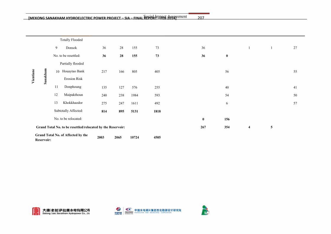
1
1
2
2
Vie
nti
an
e
San
akh
am
Totally Flooded
9 Donsok 36 2
No. to be resettled: 36 2
Partially flooded
10 217 Houaytao Bank
135
240
275
814 8
Erosion Risk
11 Donphoung
12 Maipakthoun
13 Khokkhaodor
Subtotally Affected:
No. to be relocated:
Grand Total No. to be resettled/relocated by the Reservoir:
Grand Total No. of Affected by the
Reservoir: 2003 206
[MEKONG SANAKHAM HYDROELECTRIC POWER PROJECT Social Impact Assessment
197
1
1
2
2
28 155 73 36
28 155 73 36 0
66 805 405 56
27 576 255 40
38 1984 593 54
47 1611 492 6
895 5131 1818
0 156
oir: 267 354
65 10724 4505
T – SIA – FINAL REPORT – FEB 2014] 207
1 1 27
55
41
50
57
4 5
Social Impact Assessment
198
2. Potential Relocation/Resettlement Sites in Sanakham District (SD)
Relocation Site refers to the land area for affected families that have been shifted to upper terraces
located near to the original village.
Resettlement Site refers to the land area selected for affected people from villages that have to be
moved enitirely and upon which a new village will be established.
There is a proposed resettlement site that has been investigated for the feasibility of resettling Ban
Donesok APs and 4 relocation sites for the potentially affected households from river bank erosion.
Resettlement Site No. SD 1 – Done Kouad Area, 6 km from Ban Phalad on the way to the new
ferryboat station to Ban Veunkham for 28 affected households with 36 families from Ban Donsok.
Relocation Site No. SD 1 – Ban Donphoung Upper Terrace for Relocation of 40 FMs from the
Donphoung Village.
Relocation Site No. SD 2 – Ban Maipakthoun Upslope Area, for Relocation of 54 FMs in the
Maipakthoun Village.
Relocation Site No. SD 3 – Ban Houaytao Upper Terrace, for Relocation of 56 FMs along
Houaytao River on the hill opposite to the bridge on the eastern part of current village location.
Relocation Site No. SD 4 – Ban Khokkhaodor Upper Terrace, for Relocation of 6 FMs in the spare
site of the Village.
2.1. Resettlement Site No. SD 1 – Done Kouad Area/Houay Kaleuang Area:
The consultation was started by the meeting with Sanakham District Governor on the 8th of January
2011 led by the Deputy Head of Sanakham District Cabinet to discuss and consult on resettlement
issues in the district area.
During the period of 8th and of January 2011, the field examination was carried out to study the
feasibility of proposed sites for compensating the loss of agricultural land and for resettlement of
potentially inundated villages of Sanakham District. The Donkouad site investigation team was
composed of 13 participants: 7 officials from Sanakham District and Phalad village administration, 3
specialists from China Datang Overseas Investment Co. Ltd and 3 specialists from NCG Company.
9th
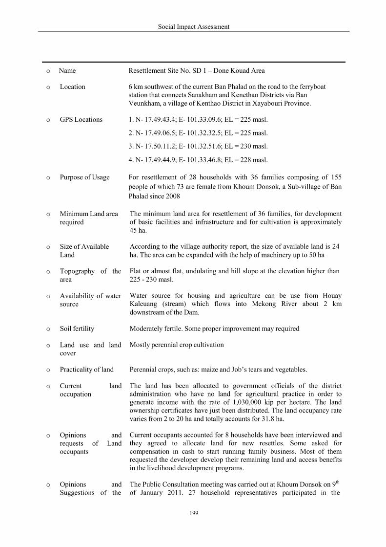
Social Impact Assessment
199
o Name
Resettlement Site No. SD 1 – Done Kouad Area
o Location
6 km southwest of the current Ban Phalad on the road to the ferryboat station that connects Sanakham and Kenethao Districts via Ban Veunkham, a village of Kenthao District in Xayabouri Province.
o GPS Locations
1. N- 17.49.43.4; E- 101.33.09.6; EL = 225 masl.
2. N- 17.49.06.5; E- 101.32.32.5; EL = 225 masl.
3. N- 17.50.11.2; E- 101.32.51.6; EL = 230 masl.
4. N- 17.49.44.9; E- 101.33.46.8; EL = 228 masl.
o Purpose of Usage
For resettlement of 28 households with 36 families composing of 155
people of which 73 are female from Khoum Donsok, a Sub-village of Ban
Phalad since 2008
o Minimum Land area required
The minimum land area for resettlement of 36 families, for development of basic facilities and infrastructure and for cultivation is approximately 45 ha.
o Size of Available Land
According to the village authority report, the size of available land is 24 ha. The area can be expanded with the help of machinery up to 50 ha
o Topography of the area
Flat or almost flat, undulating and hill slope at the elevation higher than 225 - 230 masl.
o Availability of water source
Water source for housing and agriculture can be use from Houay Kaleuang (stream) which flows into Mekong River about 2 km downstream of the Dam.
o Soil fertility
Moderately fertile. Some proper improvement may required
o Land use and land cover
Mostly perennial crop cultivation
o Practicality of land
Perennial crops, such as: maize and Job’s tears and vegetables.
o Current land occupation
The land has been allocated to government officials of the district administration who have no land for agricultural practice in order to generate income with the rate of 1,030,000 kip per hectare. The land ownership certificates have just been distributed. The land occupancy rate varies from 2 to 20 ha and totally accounts for 31.8 ha.
o Opinions and requests of Land occupants
Current occupants accounted for 8 households have been interviewed and they agreed to allocate land for new resettles. Some asked for compensation in cash to start running family business. Most of them requested the developer develop their remaining land and access benefits in the livelihood development programs.
o Opinions and Suggestions of the
The Public Consultation meeting was carried out at Khoum Donsok on 9th
of January 2011. 27 household representatives participated in the
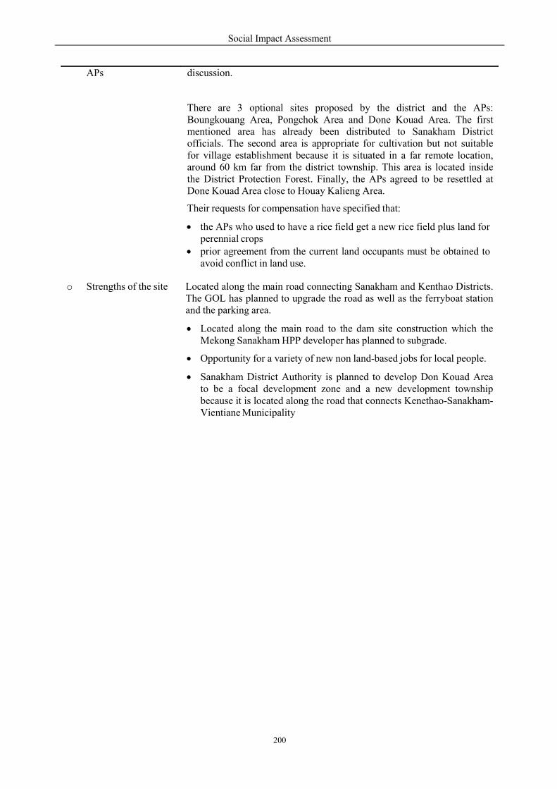
Social Impact Assessment
200
APs
discussion.
There are 3 optional sites proposed by the district and the APs: Boungkouang Area, Pongchok Area and Done Kouad Area. The first mentioned area has already been distributed to Sanakham District officials. The second area is appropriate for cultivation but not suitable for village establishment because it is situated in a far remote location, around 60 km far from the district township. This area is located inside the District Protection Forest. Finally, the APs agreed to be resettled at Done Kouad Area close to Houay Kalieng Area.
Their requests for compensation have specified that:
the APs who used to have a rice field get a new rice field plus land for perennial crops
prior agreement from the current land occupants must be obtained to avoid conflict in land use.
o Strengths of the site
Located along the main road connecting Sanakham and Kenthao Districts. The GOL has planned to upgrade the road as well as the ferryboat station and the parking area.
Located along the main road to the dam site construction which the Mekong Sanakham HPP developer has planned to subgrade.
Opportunity for a variety of new non land-based jobs for local people.
Sanakham District Authority is planned to develop Don Kouad Area to be a focal development zone and a new development township because it is located along the road that connects Kenethao-Sanakham- Vientiane Municipality
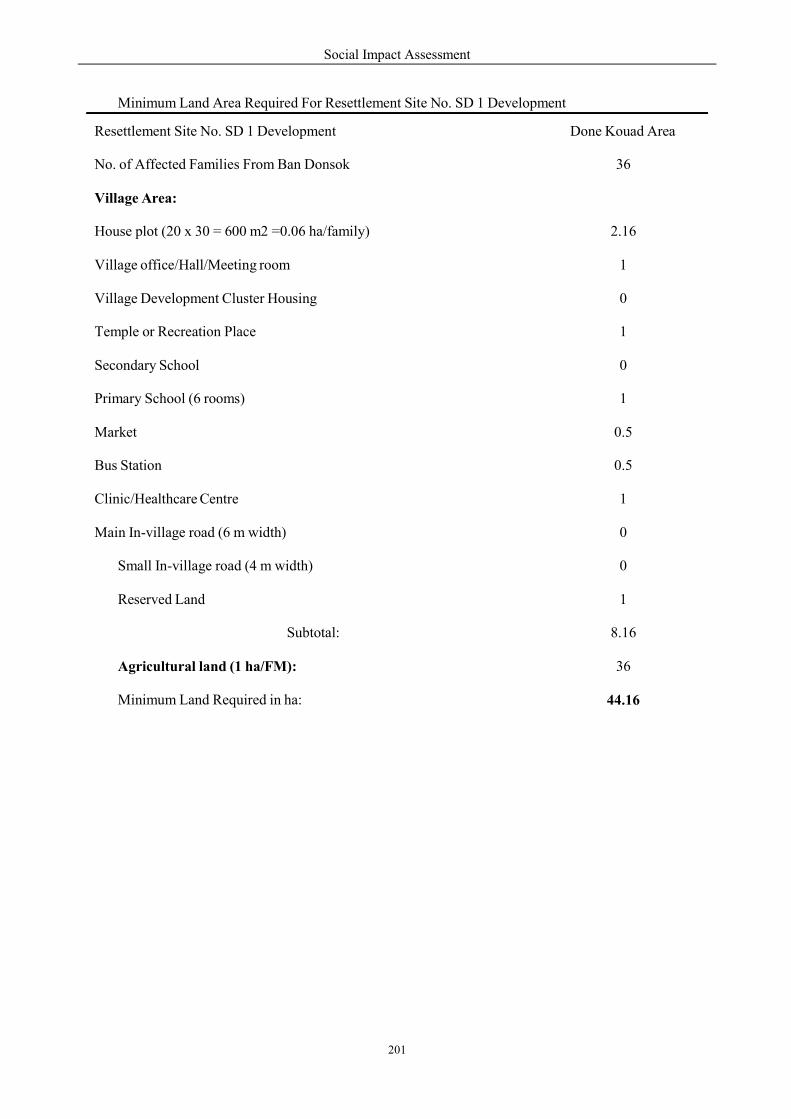
Social Impact Assessment
201
Minimum Land Area Required For Resettlement Site No. SD 1 Development
Resettlement Site No. SD 1 Development
Done Kouad Area
No. of Affected Families From Ban Donsok
36
Village Area:
House plot (20 x 30 = 600 m2 =0.06 ha/family)
2.16
Village office/Hall/Meeting room
1
Village Development Cluster Housing
0
Temple or Recreation Place
1
Secondary School
0
Primary School (6 rooms)
1
Market
0.5
Bus Station
0.5
Clinic/Healthcare Centre
1
Main In-village road (6 m width)
0
Small In-village road (4 m width)
0
Reserved Land
1
Subtotal:
8.16
Agricultural land (1 ha/FM):
36
Minimum Land Required in ha:
44.16
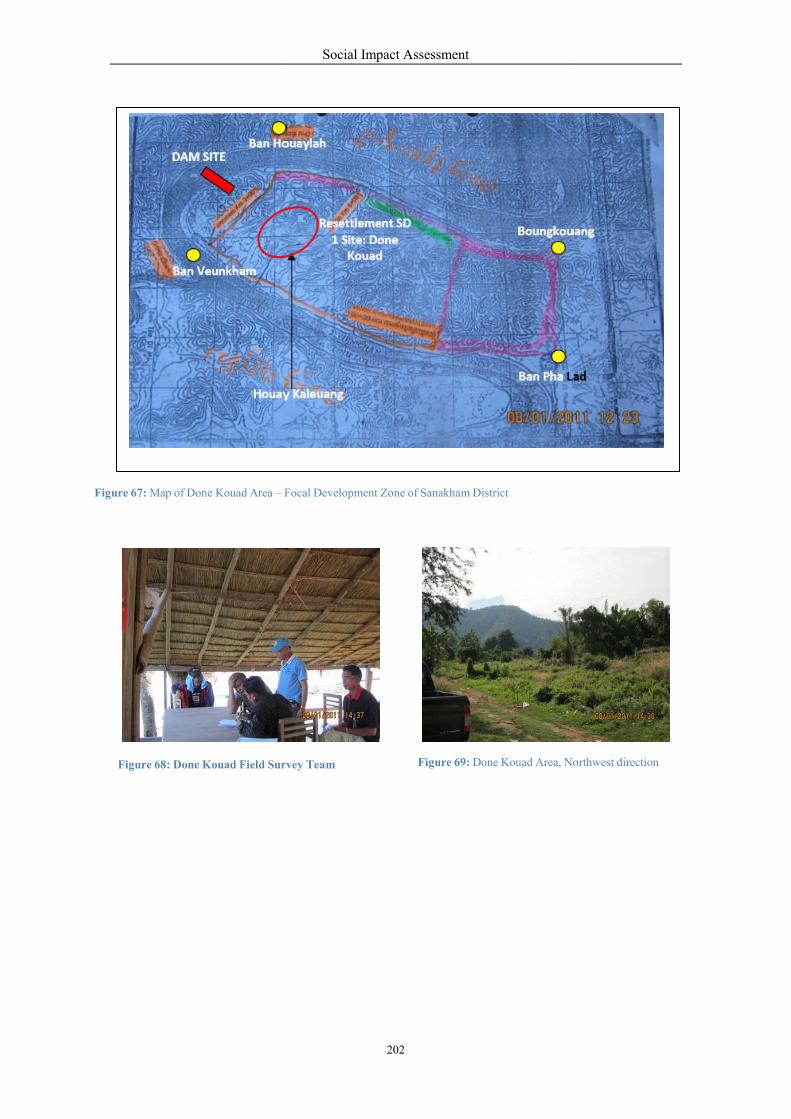
V
Figure 67: Map of Done Kouad Area – F
Figure 68: Done Kouad Field Survey
Ban DAM SITE
Ban eunkham
Hou
Social Impact Assessment
202
1 Site: Done
Focal Development Zone of Sanakham District
Figure 69: Done Kouad Area, Nrvey Team
Ban Houay Lah
Resettlement SD Boungk
Kouad
Ban Pha
ouay Kaleuang
Northwest direction
gkouang
a Lad
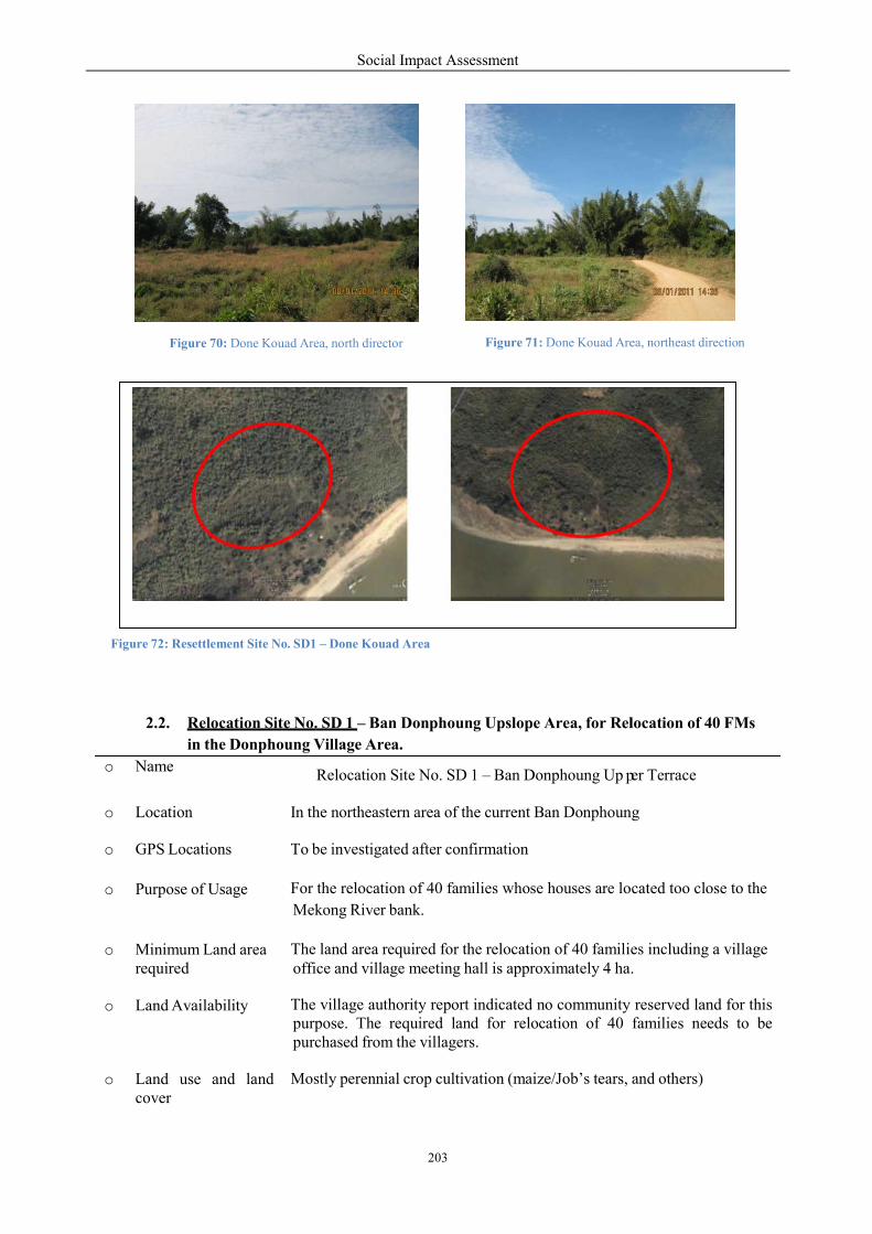
Figure 70: Done Kouad Area,
Figure 72: Resettlement Site No. SD1
2.2. Relocation Site No.
in the Donphoung V
meo Na
o Location In the
o GPS Locations To be
o Purpose of Usage For
Mekong
o Minimum Land arearequired
Theoffice
o Land Availability Thepurpose.purc
o Land use and landcover
Mos
Social Impact Assessment
203
p
Figure 71: Done Kouad AreArea, north director
1 – Done Kouad Area
No. SD 1 – Ban Donphoung Upslope Area, for Relocation
Village Area.
Relocation Site No. SD 1 – Ban Donphoung Up er
the northeastern area of the current Ban Donphoun
be investigated after confirmation
the relocation of 40 families whose houses are located too
kong River bank.
The land area required for the relocation of 40 familiesoffice and village meeting hall is approximately 4 ha.
The village authority report indicated no community purpose. The required land for relocation of 40
chased from the villagers.
stly perennial crop cultivation (maize/Job’s tears,
p
ea, northeast direction
elocation of 40 FMs
er Terrace
ng
ocated too close to the
ilies including a village a.
reserved land for this families needs to be
and others)
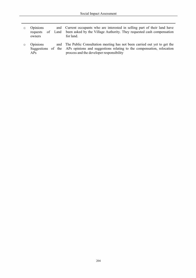
Social Impact Assessment
204
o Opinions requests of owners
and Land
Current occupants who are interested in selling part of their land have been asked by the Village Authority. They requested cash compensation for land.
o Opinions Suggestions APs
of
and the
The Public Consultation meeting has not been carried out yet to get the APs opinions and suggestions relating to the compensation, relocation process and the developer responsibility
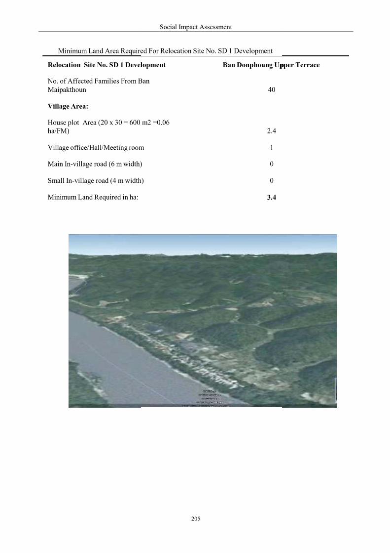
Minimum Land Area Required
Relocation Site No. SD 1 Development
No. of Affected Families From BMaipakthoun
Village Area:
House plot Area (20 x 30 = 600 ha/FM)
Village office/Hall/Meeting room
Main In-village road (6 m width)
Small In-village road (4 m width)
Minimum Land Required in ha:
Social Impact Assessment
205
p
Required For Relocation Site No. SD 1 Development
lopment
Ban Donphoung Up
Ban
40
m2 =0.06
2.4
room
1
width)
0
h)
0
3.4
p pper Terrace
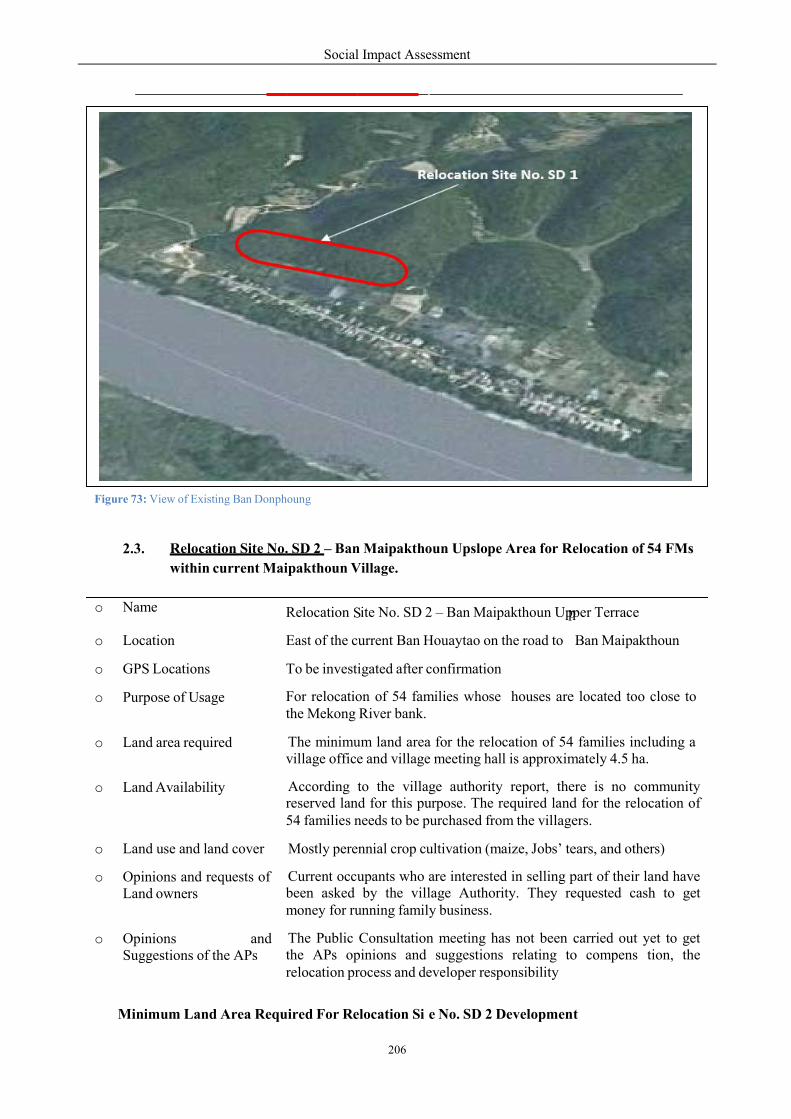
Figure 73: View of Existing Ban Donphoung
2.3. Relocation Site No.
within current Maipakt
me
Minimum Land Area Required
o Na Relocation
o Location East
o GPS Locations To
o Purpose of Usage Forthe
o Land area requiredvillage
o Land Availabilityreserved54
o Land use and land cover
o Opinions and requests ofLand owners been
m
o Opinions and Suggestions of the APs the
relocation
Social Impact Assessment
206
S
S
p
1Relocation ite No. SD
Donphoung
No. SD 2 – Ban Maipakthoun Upslope Area for Relocation
Maipakthoun Village.
uired For Relocation Si e No. SD 2 Developmen
Relocation ite No. SD 2 – Ban Maipakthoun Upper
East of the current Ban Houaytao on the road to
To be investigated after confirmation
For relocation of 54 families whose houses arethe Mekong River bank.
The minimum land area for the relocation of 54village office and village meeting hall is approxim
According to the village authority report, therereserved land for this purpose. The required land54 families needs to be purchased from the villagers.
Mostly perennial crop cultivation (maize, Jobs’ tears,
Current occupants who are interested in selling partbeen asked by the village Authority. They requestedmoney for running family business.
The Public Consultation meeting has not been the APs opinions and suggestions relating torelocation process and developer responsibility
p
1
Relocation of 54 FMs
ent
Upper Terrace
Ban Maipakthoun
e located too close to
4 families including a mately 4.5 ha.
there is no community d for the relocation of ers.
ears, and others)
part of their land have requested cash to get
carried out yet to get to compens tion, the
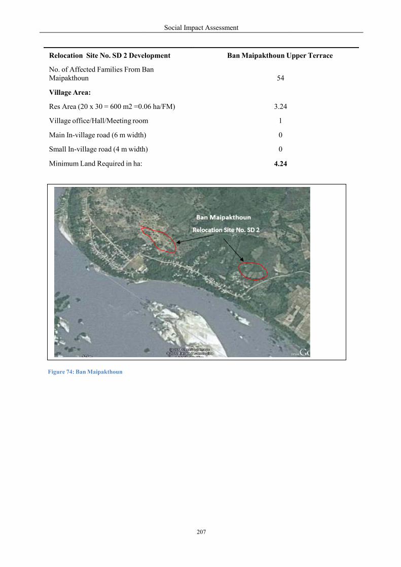
Figure 74: Ban Maipakthoun
Relocation Site No. SD 2 Development
No. of Affected Families From BMaipakthoun
Village Area:
Res Area (20 x 30 = 600 m2 =0.06
Village office/Hall/Meeting room
Main In-village road (6 m width)
Small In-village road (4 m width)
Minimum Land Required in ha:
Social Impact Assessment
207
Ban Maipakthoun
Relocation Site No. SD 2
lopment Ban Maipakthoun U
Ban 54
=0.06 ha/FM) 3.24
room 1
width) 0
h) 0
4.24
Upper Terrace
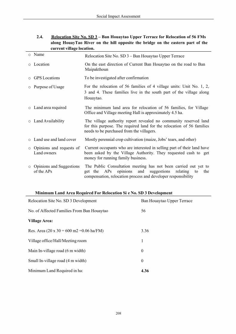
Social Impact Assessment
208
2.4. Relocation Site No. SD 3 – Ban Houaytao Upper Terrace for Relocation of 56 FMs
along HouayTao River on the hill opposite the bridge on the eastern part of the
current village location.
Minimum Land Area Required For Relocation Si e No. SD 3 Development
Relocation Site No. SD 3 Development
No. of Affected Families From Ban Houaytao
Village Area:
Res. Area (20 x 30 = 600 m2 =0.06 ha/FM)
Village office/Hall/Meeting room
Main In-village road (6 m width)
Small In-village road (4 m width)
Minimum Land Required in ha:
Ban Houaytao Upper Terrace
56
3.36
1
0
0
4.36
o Name
o Location
o GPS Locations
o Purpose of Usage
o Land area required
o Land Availability
o Land use and land cover
o Opinions and requests ofLand owners
o Opinions and Suggestionsof the APs
Relocation Site No. SD 3 – Ban Houaytao Upper Terrace
On the east direction of Current Ban Houaytao on the road to Ban Maipakthoun
To be investigated after confirmation
For the relocation of 56 families of 4 village units: Unit No. 1, 2,
3 and 4. These families live in the south part of the village along
Houaytao.
The minimum land area for relocation of 56 families, for Village Office and Village meeting Hall is approximately 4.5 ha.
The village authority report revealed no community reserved land for this purpose. The required land for the relocation of 56 families needs to be purchased from the villagers.
Mostly perennial crop cultivation (maize, Jobs’ tears, and other)
Current occupants who are interested in selling part of their land have been asked by the Village Authority. They requested cash to get money for running family business.
The Public Consultation meeting has not been carried out yet to get the APs opinions and suggestions relating to the compensation, relocation process and developer responsibility
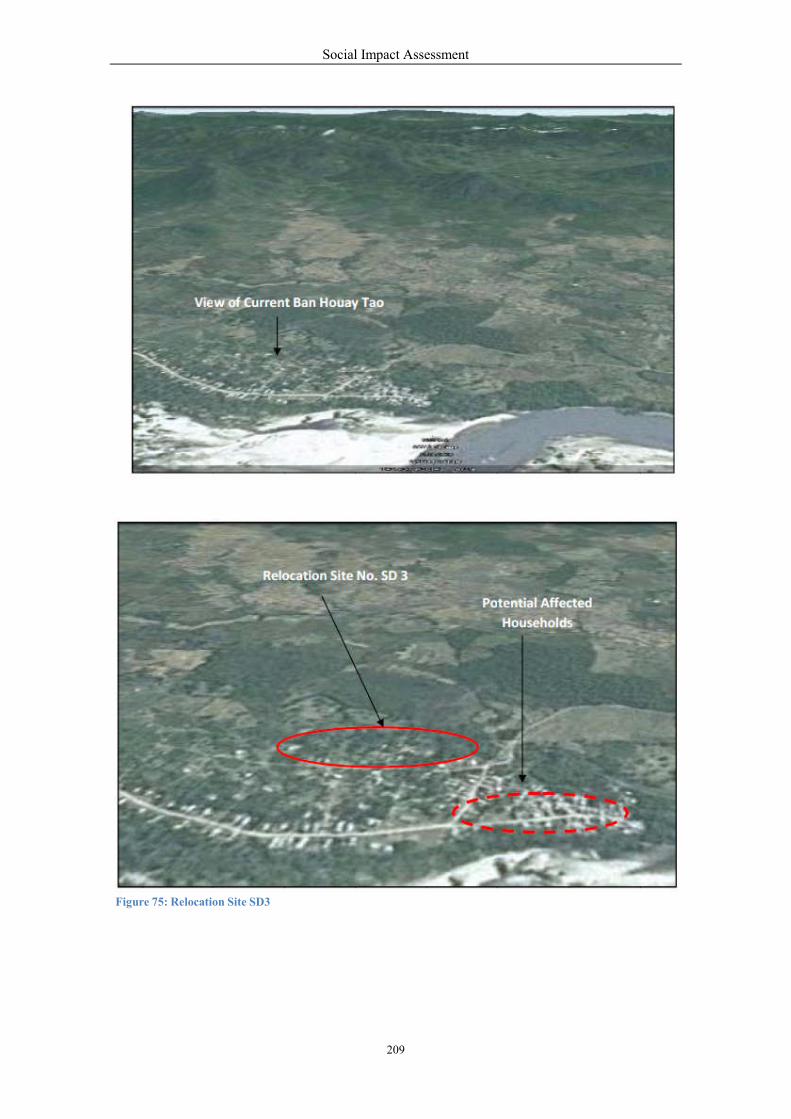
Social Impact Assessment
209
cted
s
Figure 75: Relocation Site SD3
Social Impact Assessment
210
2.5. Relocation Site No. SD 4 – Ban Khokkhaodor Area for Relocation of 6 FMs within
the Village Area. There will not be any problem for relocation of only 6 households.
The actual location depends on the land availability.
Minimum Land Area Required For Relocation Si e No. SD 4 Development
Relocation Site No. SD 4 Development
Ban Khokkhaodor Area
No. of Affected Families From Ban Khokkhao dor
6
Village Area:
Res. Area (20 x 30 = 600 m2 = 0.06 ha/FM)
0.36
Minimum Land Required in ha:
0.36
o Name Relocation Site No. SD 3 – Within Ban Khokkhaodor Area
o Location Within the current Ban Khokkhaodor Area
o GPS Locations To be investigated
o Purpose of Usage
For relocation of 6 families whose houses are anticipated to be affected by bank erosion in the future.
o Land area required
The minimum land area required for relocation of 6 families is approximately 0.5 ha.
o Land Availability
According to the village authority report, there is no community reserved land for this purpose. The required land for relocation of 6 families needs to be purchased from the villagers.
o Land use and land cover
Mostly perennial crop cultivation (maize, Jobs’ tears, and other)
o Opinions and requests of Land owners
Current occupants who are interested in selling part of their land ave been asked by the Village Authority. They requested cash to get money for running family business.
o Opinions and Suggestions of the APs
The public consultation meeting has not been carried out yet to get the APs opinions and suggestions relating to the compensation, relocation process and the developer responsibility

Figure 76: Relocation Site
3. Potential Relocation
10th During the period of and
feasibility of proposed sites for
resettlement of potentially inundated
which is the first upstream village
There are 3 resettlement sites and
investigation:
Resettlement Site No. KD 1 – H
Lah for resettlement of 77 households
Resettlement Site No. KD 2 –
Dongsangouan along road No.
Residential Area for 140 househo
Resettlement Site No. KD 3 – K
Dongsangouan around 5 km east
150 families of Ban Khae and 120
Relocation Site No. KD 1 – Donm
the relocation of 120 of 217 hous
Relocation Site No. KD 2 – Nakh
households of the village and a sc
Relocation Site No. KD 3 – Donsang
relocation of approximately 17 of
Social Impact Assessment
211
on and Resettlement Sites in Kenthao District (KD)
12th of January 2011, the field examination w
for compensating the potential loss of agricultural
inundated villages of Kenthao District. The study started
ge located around 2 km from the dam site.
nd 3 relocation sites which have been proposed for
Houay Mouang Area, located about 1 km far from
holds comprising 81 families.
Dong Houay Ang Area located between Ban Houay
4 that connects Kenthao and Paklay Districts
ouseholds comprising 150 families of Ban Khae.
Khoun Houa Namkay Area, located between Ban
t of main road No. 4 that connects Kenthao and
120 families of Ban Donmen who will lose their rice
men Area, located upslope of the current Donmen
eholds about 500 m west from current residential
Nakham Area, located upslope of current village for relocation
school on the west from current residential area.
onsang Area, located upslope of the current village
of 82 households west from current residential area.
KD)
was out to study the
ultural land and for
started at Ban Houay Lah
for further feasibility
m current Ban Houay
Houay Lod and Ban
for development of
Houay Lod and Ban
Paklay Districts for
rice field.
n village location for
area.
relocation of 19 of 72
llage location for the
a.
Social Impact Assessment
212
3.1. Resettlement Site No. KD 1 – Houay Mouang Area
The Public Consultation Meeting on a feasible resettlement site for Ban Houay Lah APs was
launched on the 10thof January 2011. 66 people attended the meeting of which 20 were female.
There were 3 proposed sites: 1. Upper area of current location of the village – 6 ha; 2. Houay Lah
originating area – 10 ha; and 3. Houay Mouang Area – 6 ha. The site investigation team was
composed of 9 participants: 6 representatives of Ban Houay Lah, a representative of Kenthao
District Authority and 2 specialists from NCG.
o Name
o Location
Resettlement Site No. KD 1 – Houay Mouang Area
Located around 1 km far from the current Ban Houay Lah along the earth road that goes to Ban Donmen around 23 km on the north
o GPS Locations 1. N- 17.49.25.6; E- 101.30.56.8; EL = 230 masl.
2. N- 17.49.31.3; E- 101.30.38.4; EL = 228 masl.
3. N- 17.49.31.7; E- 101.30.43.8; EL = 229 masl.
4. N- 17.49.37.1; E- 101.31.02.4; EL = 231 masl.
o Purpose of Usage For resettlement of 77 households with 81 families comprising 323 people
of which 150 are female from the current residential area. The site
development will compose of residential plots and infrastructure and
community facilities.
o Land area required The minimum land area required for resettlement of 81 families is approximately 11.5 ha.
o Size of AvailableLand
The size of available land at Houay Mouang Area is approximately 6 ha. The area can be expanded with the help of machinery up to 12 has.
o AlternativePossibility
The Option No. 1 - Upper part of current location of the village – 6 ha can be used for building community facilities: Village Office and Meeting Hall, Village Development Cluster Housing, Health Center, School and Temple; and
Resettlement Site No. KD1 can be used only for residential area for the APs
o Topography of thearea
Undulating and hill slope at the elevation higher than 228 - 231 masl.
o Availability of watersource
o Land use and landcover
o Current land
Water sources for housing and agriculture can be from Houay Lah (stream) which flows into Mekong River around 2 km upstream of the Dam. The weir can be built to use water for irrigation. The shallow bore holes with hand pumps can be made for household use.
Mostly perennial crop cultivation
Current occupants accounted for 3 households who participated in the

Social Impact Assessment
213
Minimum Land Area Required For Resettlement Site No. SD 1 Development
Houay Mouang Area
81
4.86
1
0.5
1
0
1
0.5
0.5
1
0
0
Resettlement Site No. SD 1 Development
No. of Affected Families From Ban Houay
Lah Village Area:
Res Area (20 x 30 = 600 m2 =0.06 ha/FM)
Village office/Hall/Meeting room
Village Development Cluster Housing
Temple or Recreation Place
Secondary School
Primary School (6 rooms)
Market
Bus Station
Clinic/Healthcare Centre
Main In-village road (6 m width)
Small In-village road (4 m width)
Reserved Land 1
Minimum Land Required in ha: 11.36
occupation
o Practicality of land
o strength of the site
site investigation. They agreed to allocate land for new resettlers. They asked for compensation in cash to start running family business and requested the developer develop their remaining land and access benefits in all the livelihood development programs.
Suitable for Residential Area
The Xayaboury Provincial Administration has approved the plan to build strategic standard road to connect Kenthao Township – Nam Heuang Area – Ban Houay Lah and Ban Donmen, with 74 km in length.
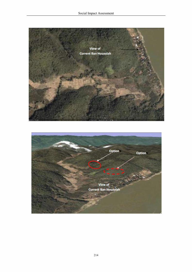
Social Impact Assessment
214
Option

Social Impact Assessment
215
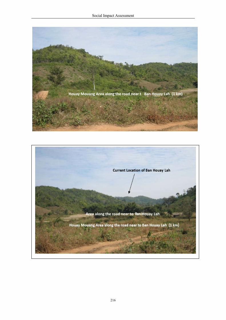
Houay Moua
Houay Mouang
Social Impact Assessment
216
Mouang Area along the road near t Ban Houay
Current Location of Ban Houay
Mouang
Lah (1 km)
Lah
Area along the road near to Ba n Houay Lah
Social Impact Assessment
217
3.2. Resettlement Site No. KD 2 – Dong Houay Ang Area
The consultation was started by a short meeting with the Kenthao District Deputy Governor and Head
of Kenthao District Authority on the 11th of January 201 led by the Deputy Head of WREA to discuss
and consult on resettlement issues within the district area, particularly given the location of the
Provincial Conservation Forest Dong Houay Ang in the resettlement area.
The public consultation meeting on feasible resettlement site for Ban Khae APs was launched on the
12th of January 2011. 87 people attended the meeting of which 32 were female. The meeting took
around 3 hours to find out the solution because most of the APs do not want to move away. The
compensation mode for lost assets was also an important topic at the meeting. There were 3 proposed
sites: 1. Houay Gnoddkhonkhen Area; 2. Pak Houay Hia Area on the border with Ban Nakham; and 3.
Dong Hoauy Ang Area. No place was considered totally suitable for resettlement but the APs agreed
to be resettled at Dong Houay Ang Area although not unanimously. The site investigation team was
composed of 10 participants: 4 representatives of Ban Khae, a representative of Kenthao District
Authority, 3 representatives of the developer and 2 specialists from NCG Company. The Ban Houay
Lod Village Authority was interviewed for the actual condition of the area. Ban Houay Lod of Kenthao
District located south of the site and Ban Dongsangouan of Paklay District located north of the site will
be the host communities. Their opinions and their willingness to share the natural resources are of great
importance for the harmony of the new community.
Social Impact Assessment
218
Minimum Land Area Required For Resettlement Site No. KD 2 Development
o Name Resettlement Site No. KD 2 – Dong Houay Ang Area
o Location
Located between Ban Houay Lod and Ban Dongsangouan along the road No. 4 that connects Kenthao and Paklay Districts. The location is 23 km far from Kenthao Township and 33 km far from Paklay Township
o GPS Locations 1. N- 17.56.36.8; E- 101.21.14.5; EL = 277 masl.
o Purpose of Usage
For development of a residential area for 140 households with 150 families of Ban Khae.
The site development will compose of residential plots and required
infrastructure and community facilities.
o Land area required
The minimum land area required for resettlement of 150 families is approximately 17 ha.
o Size of Available Land
The size of available land at Dongsangouan Area is enough for the resettlement of more than 150 families. The area can be expanded with the help of machinery to more than 17 ha
o Topography of the area
Flat and slightly undulating at the elevation around 277 - 330 masl.
o Availability of water source
Water source for housing can be used from Houay Tad (stream) which runs along Ban Dongsangouan border. Water for drinking can be from the bore holes within the area
o Land use and land cover
The area is still covered by natural forest
o Current land occupation
There is no land occupants in the area
o Practicality of Suitable for residential and for gardening lands
o Opinions of the APs
This is the most suitable site and AP wish to be resettled in this area given there is not enough land to be located in the upper terrace of the current Ban Khae. They expressed their concerns about the compensation, the resettlement process and the responsibility of the developer to help improve their livelihoods ‘better-off’ than pre-project levels
They requested the developer compensate for the Water Pumping Project into the rice field land funded by the villagers that cost 575,000,000 kips or 71,875 US Dollars.
o Opinions of Kenthao Administration
Dongsangouan Area and Khoun Houa Nam Kay Area that the APs of Ban Khae want to be resettled has been registered as Provincial Conservation Forest of Xayaboury. The total area is approximately 7,500 ha. This is subject to consideration by the Provincial Authority.
o strength of the site
Located along the main road No. 4 that connects Kenthao and Paklay Districts will give opportunity for non-land based jobs

Resettlement Site No. SD 2 Development:
No. of Affected Families From B
Village Area
- House plot (20 x 30 = 600 m2
- Village office/Hall/Meeting room
- Village Development Cluster
- Temple or Recreation Place
- Secondary School
- Primary School (6 rooms)
- Market
- Bus Station
- Clinic/Healthcare Centre - Main In-village road (6 m width)
- Small In-village road (4 m width) - Reserved Land
- Minimum Land Required in h
Social Impact Assessment
219
Re
ide
consu
distri
authoriti
velopment: Dong Houay
Ban Khae:
2 = 0.06 ha/family):
room
Housing
width)
idth)
ha:
esettlement
KD2site
entification
and
consultation
with
istrict and
village
authorities
Houay Ang Area
150
9
1
0.5
1
1
1
1
0.5
1
0
0
1
17
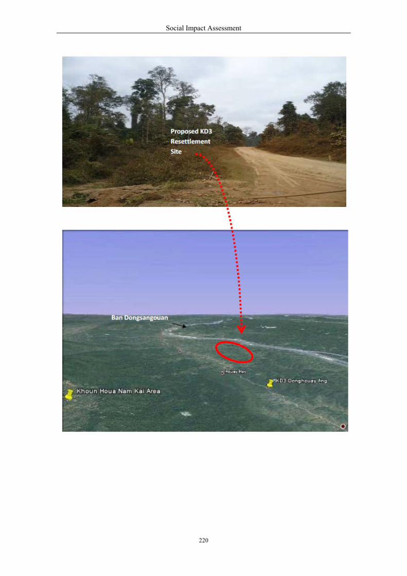
Social Impact Assessment
220

Social Impact Assessment
221
Donmen
3.3. Resettlement Site No. KD3 – Khoun Houa Namkay Area
This site is proposed for developing the agricultural land for the affected households of Ban Donmen
and Ban Khae who will both lose their agricultural land especially the rice fields to the reservoir. All
the residents of Ban Khae will also lose their houses . The area is located inside the Xayaboury
Reservation Forest which has a total area of 7,500 ha. The Xayaboury Provincial Administration is
directly responsible for consideration on the APs and the 2 affected village administrations. According
to local villagers, a part of the Conservation Forest has been disturbed and most of the valuable
industrial wood trees have already been cut out. The villagers from adjacent villages have used the area
for NTFPs gathering and livestock raising but for not cultivation yet. They had submitted official letter
to the Provincial Authority to get official permission to make use of part of the land for cultivation
extension since the arable land in the villages has become limited day by day.
Social Impact Assessment
222
o Name Resettlement Site No. KD 3 – Khoun Houa Namkay Area
o Location
Located between Ban Houay Lod and Ban Dongsangouan about 5 km east of the main road No. 4 connecting Kenthao and Paklay Districts.
To the North: Houay Tad, Ban Dongsangouan; To the South: Chain of Phou Phanga; To the East: Road No. 4; and To the west: Poungdeng and Koumsio Areas.
It is about 28 km far from Kenthao District Township and around 38 km far from Paklay District Township.
o GPS Locations
1. N- 17°57’0.56”; E- 101°17’41.32”; EL = 621 masl. 2. Starting point of Access Road at Road No. 4 to Khoun Houa Nam Kay Area: N- 17°55’54.52”; E- 101°21’01.40”; EL = 301 masl.
o Purpose of Usage
For development of agricultural land for 150 families of Ban Khae and 100 families of Ban Donmen who will lose their rice field.
o Land area required
The minimum land area required for 150 families of Ban Khae is 150 ha plus 100 has of land to compensate the lost rice fields of the Ban Donmen APs. In total, the land area required is 250 ha.
o Size of Available Land
According to Ban Houay Lod Authority and the APs, the size of available land is approximately 6 x 8 = 48 square km equivalent to 4,800 ha.
o Topography of the area
Moderate flat, undulating and hilly slope at an elevation of around 600 masl.
o Availability of water source
There are several sources - Houay Makkieng, Houay Namkay and Houay Tom - which water the area for the whole year and suitable for irrigation system
o Land use and land cover
The area is still covered by natural forest. Part of the Conservation Forest has already been disturbed. At Khoun Houa Namkay Area, there is no valuable hardwood trees such as May Dou, May Taekha, May Khen, May Champi and other. There are mostly May Peuay Forest and wood for house building materials.
o Current land occupation
There is no land occupants in the area
o Land Fertility Very Fertile
o Practicality of land Suitable for rice cultivation, fruit tree plantation and livestock raising
o Opinions of the APs
The APs asked the Xayaboury Provincial Authority and Kenthao District Administration to take their requests into consideration because there is not enough suitable land in the area to replace their rice fields and other arable land anticipated to be lost by the flood from the reservoir. They expressed their concerns about the compensation, the resettlement process and the responsibility of the developer to help improve their livelihoods to be better- off than pre-project levels.
They requested the developer to compensate for all losses. For the lost rice
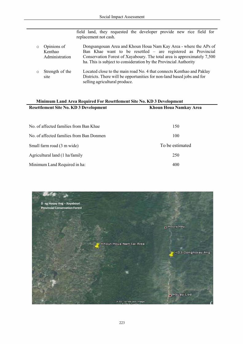
o
Minimum Land Area Required
D ng Houay Ang – Xayabouri
Provincial Conservation Forest
Resettlement Site No. KD 3 Development
No. of affected families from Ban No. of affected families from Ban
Small farm road (3 m wide)
Agricultural land (1 ha/family
Minimum Land Required in ha:
field land, replacement
o Opinions of Kenthao Administration
DongsangouBaConservationha.
o Strength of the site
LoDisselling
Social Impact Assessment
223
uired For Resettlement Site No. KD 3 Developm
Development Khoun Houa N
n Khae 150
n Donmen 100
To be esti
250
400
land, they requested the developer provide replacement not cash.
ongsangouan Area and Khoun Houa Nam Kay Aran Khae want to be resettled – are regis
Conservation Forest of Xayaboury. The total area is. This is subject to consideration by the Provincial
Located close to the main road No. 4 that connects Kstricts. There will be opportunities for non-land basedlling agricultural produce.
ment
Namkay Area
50
00
stimated
50
00
new rice field for
rea - where the APs of stered as Provincial s approximately 7,500
Provincial Authority
Kenthao and Paklay ased jobs and for
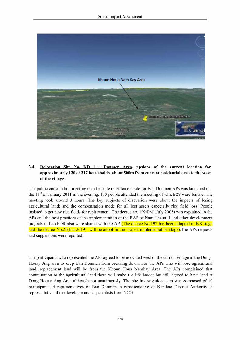
Social Impact Assessment
224
3.4. Relocation Site No. KD 1 – Donmen Area, upslope of the current location for
approximately 120 of 217 households, about 500m from current residential area to the west
of the village
The public consultation meeting on a feasible resettlement site for Ban Donmen APs was launched on
the 11th of January 2011 in the evening. 130 people attended the meeting of which 29 were female. The
meeting took around 3 hours. The key subjects of discussion were about the impacts of losing
agricultural land; and the compensation mode for all lost assets especially rice field loss. People
insisted to get new rice fields for replacement. The decree no. 192/PM (July 2005) was explained to the
APs and the best practices of the implementation of the RAP of Nam Theun II and other development
projects in Lao PDR also were shared with the APs(The decree No.192 has been adopted in F/S stage
and the decree No.21(Jan 2019) will be adopt in the project implementation stage).The APs requests
and suggestions were reported.
The participants who represented the APs agreed to be relocated west of the current village in the Dong
Houay Ang area to keep Ban Donmen from breaking down. For the APs who will lose agricultural
land, replacement land will be from the Khoun Houa Namkay Area. The APs complained that
commutation to the agricultural land there will make t e life harder but still agreed to have land at
Dong Houay Ang Area although not unanimously. The site investigation team was composed of 10
participants: 4 representatives of Ban Donmen, a representative of Kenthao District Authority, a
representative of the developer and 2 specialists from NCG.
Social Impact Assessment
225
o Name
o Location
Resettlement Site No. KD 1 – Donmen Area
To the west of the current Ban Donmen between the road from Ban Houay Lah and the road from Ban Donmen.
• To the North: It borders with Houay Na Noi and the road to Ban Houay Lod and Kenthao District
• To the East: - the current Ban Donmen and the Mekong River• To the West: - Phou Houay Fene and Houay Fene• To the South – Village sacred forest and the earth road to Ban
Houay Lah
o GPS 1. N- 17.56.43.4; E- 101.24.06.4; EL = 230 masl.Locations
2. N- 17.56.34.8; E- 101.24.08.9; EL = 228 masl.
3. N- 17.56.38.4; E- 101.24.18.7; EL = 231 masl.
4. N- 17.56.47.5; E- 101.24.20.4; EL = 230 masl.
5. N- 17.56.50.1; E- 101.24.14.2; EL = 229 masl.
6. N- 17.56.33.5; E- 101.24.05.1; EL = 228 masl.
7. N- 17.56.41.6; E- 101.24.01.5; EL = 234 masl.
o Purpose ofUsage
For the relocation of 120 households with 120 families composing 600
people of which xx are female. Because of their living location close to
the Mekong River Bank, the APs are concerned about the risk from bank
erosion in the future so they requested to be relocated at the safe place
o Size ofAvailableLand
From the site survey, there are 3 land plots that can be used for relocation. The total size of available land is approximately 19 ha. The first plot is located between the elementary and the junior secondary schools – an area of about 6 has. This place is proposed for community facilities such as a village office and a village meeting hall. The second plot is located to the north up the hill at the village entrance point which has about 3 has. This place is proposed for as a future temple location. The third plot is an area which extends from the northwest to the south west of the current village location.
o Topographyof the area
Flat or almost flat at the elevation around 228 - 231 masl.
o Availability ofwater source
Water sources for household use can be got from the bore holes only. The houay Na Noi and Houay Fene will irrigate only the agricultural land.
o Soil fertility Moderately fertile. Some proper improvement may required
o Land use andland cover
Mostly perennial crop cultivation and a plot of teak plantation.
o Current landoccupation
The investigated land belongs to Ban Donmen villagers.
The land owners agreed to allocate land for developing a residential area to co-villagers but asked for compensation in cash to start running family
Social Impact Assessment
226
Minimum Land Area Required For Resettlement Site No. SD 1 Development
Relocation Site No. KD 1 Development
Donmen Area
No. of Affected Families From Ban Donmen
120
Village Area:
Res Area (20 x 30 = 600 m2 =0.06 ha/FM)
7.2
Village office/Hall/Meeting room
1
Village Development Cluster Housing
0
Temple or Recreation Place
1
Secondary School
0
Primary School (6 rooms)
0
Market
0.5
Bus Station
0.5
Clinic/Healthcare Centre
0
Main In-village road (6 m width)
0
Small In-village road (4 m width)
0
Reserved Land
0
Minimum Land Required in ha:
10.2
business. Most of them requested the developer develop their remaining land and access to benefits from the livelihood development programmes.
o Practicality of land
Perennial crops, such as: maize and Job’s tears and vegetables.
o Opinions of the APs about the site
The APs agreed to be relocated in the proposed area to keep Ban Donmen as one. They requested the developer to take responsibility to improve their living conditions to be better off than pre-project levels and to develop the infrastructure of the village such as roads, electricity, tap water supply, schools, and a health center.
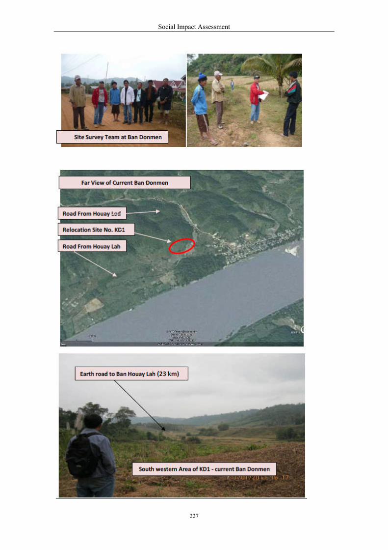
Social Impact Assessment
227
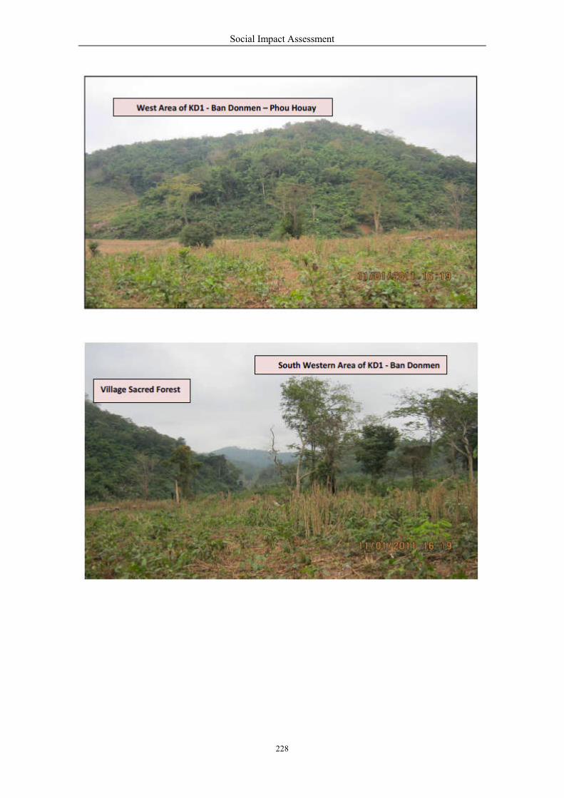
Social Impact Assessment
228

Social Impact Assessment
229
n o
3.5. Relocation Site No. KD 2 – Ban Donsang Upslope Area for thr relocation of 17 families of
the APs living too close to the Mekong River Bank (Bank Erosion).
o Name Relocatio Site No. KD2 – Ban D nsang Upslope Area
o Location Within the current Ban Donsang Area
o GPS Locations
To be investigated
o Purpose of Usage
For the relocation of 17 families whom houses are anticipated to be
affected by the bank erosion in the future.
o Land area required
The minimum land area required for relocation of 17 families is approximately 1.02 ha per family.
o Land Availability
According to the village authority report, there is no community reserved land for this purpose. The required land for relocation of 17 families needs to be purchased from the villagers.
o Land use and land cover
Mostly perennial crop cultivation (maize, Job’s tears, and other)
o Opinions and requests of Land owners
Current occupants who are interested in selling part of their land have been asked by the Village Authority. They have asked for compensation in cash to get money for running family business.
o Opinions and Suggestions of the APs
The public consultation meeting has not been carried out yet to get the APs opinions and suggestions relating to the compensation and relocation process and developer responsibility.

r
Minimum Land Area Required
View of Cu
Relocation Site No. KD2 Development
No. of Affected Families From B
Village Area:
Res Area (20 x 30 = 600 m2 =0.06 Minimum Land Required in ha:
Social Impact Assessment
230
r
o
uired For Relocation Si e No. KD 2 Development
Relocation Site No. KD2
rent Ban Donsang
lopment Ban Donsang Upslope
Ban Donsang 17
=0.06 ha/FM) 1.02
1.02
nt
D2
ope Area
17
.02
.02
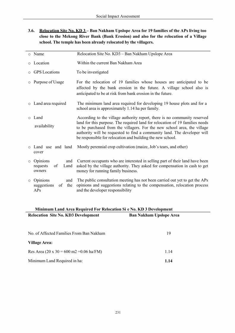
Social Impact Assessment
231
3.6. Relocation Site No. KD 3 – Ban Nakham Upslope Area for 19 families of the APs living too
close to the Mekong River Bank (Bank Erosion) and also for the relocation of a Village
school. The temple has been already relocated by the villagers.
Minimum Land Area Required For Relocation Si e No. KD 3 Development
Relocation Site No. KD3 Development Ban Nakham Upslope Area
No. of Affected Families From Ban Nakham 19
Village Area:
Res Area (20 x 30 = 600 m2 =0.06 ha/FM) 1.14
Minimum Land Required in ha: 1.14
o Name Relocation Site No. KD3 – Ban Nakham Upslope Area
o Location Within the current Ban Nakham Area
o GPS Locations To be investigated
o Purpose of Usage For the relocation of 19 families whose houses are anticipated to be
affected by the bank erosion in the future. A village school also is
anticipated to be at risk from bank erosion in the future.
o Land area required The minimum land area required for developing 19 house plots and for a school area is approximately 1.14 ha per family.
o Land
availability
According to the village authority report, there is no community reserved land for this purpose. The required land for relocation of 19 families needs to be purchased from the villagers. For the new school area, the village authority will be requested to find a community land. The developer will be responsible for relocation and building the new school.
o Land use and landcover
Mostly perennial crop cultivation (maize, Job’s tears, and other)
o Opinions and requests of Land owners
Current occupants who are interested in selling part of their land have been asked by the village authority. They asked for compensation in cash to get money for running family business.
o Opinions andsuggestions of theAPs
The public consultation meeting has not been carried out yet to get the APs opinions and suggestions relating to the compensation, relocation process and the developer responsibility
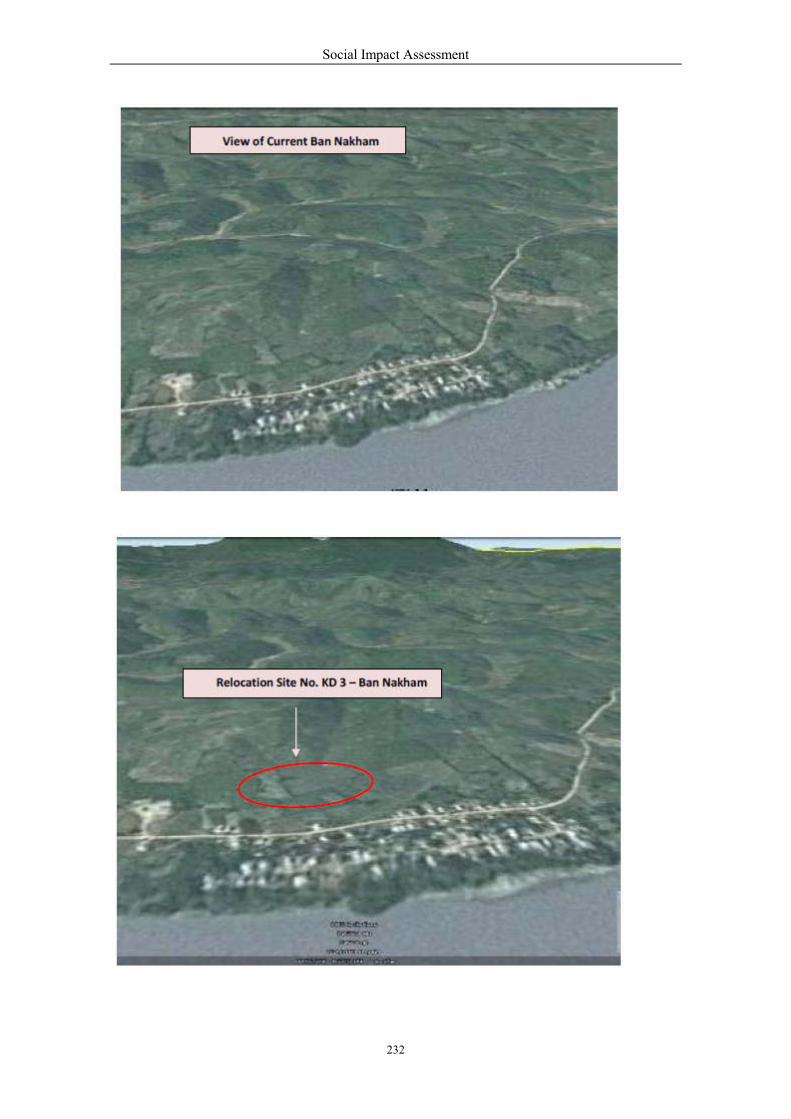
Social Impact Assessment
232
Social Impact Assessment
233
4 Potential Relocation Sites at Paklay District (Pd)
In Paklay District, there are no potentially inundated villages due to the reservoir at FSL of water at
220 masl.. 42 households in 3 villages expressed their concern from the risk of bank erosion because
their houses are located too close to the Mekong river bank. They requested to be relocated to upper
and safer terraces. The relocation is needed to be planned for the 42 households from 3 villages in
Paklay District.
Relocation Site No. PD 1 – Ban Boungma Upslope Area for 10 families of the APs living too close to
the Mekong River Bank (Bank Erosion).
Relocation Site No. PD 2 – Ban Kengsao Upslope Area for 29 families of the APs living too close to
the Mekong River Bank (Bank Erosion).
Relocation Site No. PD 3 – Ban Nasack Upslope Area for 3 families of the APs living too close to the
Mekong River Bank (Bank Erosion).
4.1 Relocation Site No. PD 1 – Ban Boungma Upslope Area for 10 families of the APs
living just close to the Mekong River Bank (Bank Erosion).
o Name Relocation Site No. PD 1 – Ban Boungma Upslope Area
o Location Within the current Ban Boungma Area
o GPS Locations To be investigated
o Purpose of Usage For the relocation of 10 families whose houses are anticipated to be
affected by bank erosion in the future.
o Land area required The minimum land area required for developing 10 house plots is approximately 0.6 ha per family.
o Land Availability According to the village authority report, there is no community reserved land for this purpose. The required land for the relocation of 10 families needs to be purchased from the villagers.
o Land use and landcover
Mostly perennial crop cultivation (maize, Job’s tears, and other)
o Opinions and requests of Land owners
Current occupants who are interested in selling part of their and have been asked by the village authority. They asked for compensation in cash to get money for running family business.
o Opinions andSuggestions of theAPs
The public consultation meeting has not been carried out yet to get the APs opinions and suggestions relating to the compensation and relocation process and developer responsibility.

V
B
Minimum Land Area Required
iew of Current
an Boungma
Relocation Site No. PD 1 Development
No. of Affected Families From B
Village Area:
Res Area (20 x 30 = 600 m2 =0.06
Minimum Land Required in ha:
Social Impact Assessment
234
S
uired For Relocation Si e No. PD1 Development
Relocation ent
a
lopment Ban Boungma Up
Ban Nakham
=0.06 ha/FM)
S 1
t
ite No. PD
pslope Area
10
0.6
0.6
Social Impact Assessment
235
4.2 Relocation Site No. PD 2 – Ban Kengsao Upslope Area for 29 families of the APs living
just close to the Mekong River Bank (Bank Erosion).
Minimum Land Area Required For Relocation Si e No. PD2 Development
Relocation Site No. PD 2 Development
Ban Kengsao Upslope Area
No. of Affected Families From Ban Kengsao
29
Village Area:
Res Area (20 x 30 = 600 m2 =0.06 ha/FM)
1.74
Minimum Land Required in ha:
1.74
o Name Relocation Site No. PD2 – Ban Kengsao Upslope Area
o Location Within the current Ban Kengsao Area
o GPS Locations
To be investigated
o Purpose of Usage
For the relocation of 29 families whos houses are anticipated to be affected by
the bank erosion in the future.
o Land area required
The minimum land area required for developing 29 house plots is approximately 1.74 ha per family.
o Land Availability
According to the village authority report, there is no community reserved land for this purpose. The required land for relocation of 29 families needs to be purchased from the villagers.
o Land use and land cover
Mostly perennial crop cultivation (maize, Job’s tears, and others)
o Opinions and requests of Land owners
Current occupants who are interested in selling part of their land have been asked by the Village Authority. They asked for compensation in cash to get money for running family business.
o Opinions and Suggestions of the APs
The public consultation meeting has not been carried out yet to get the APs opinions and suggestions relating to the compensation and relocation process and developer responsibility
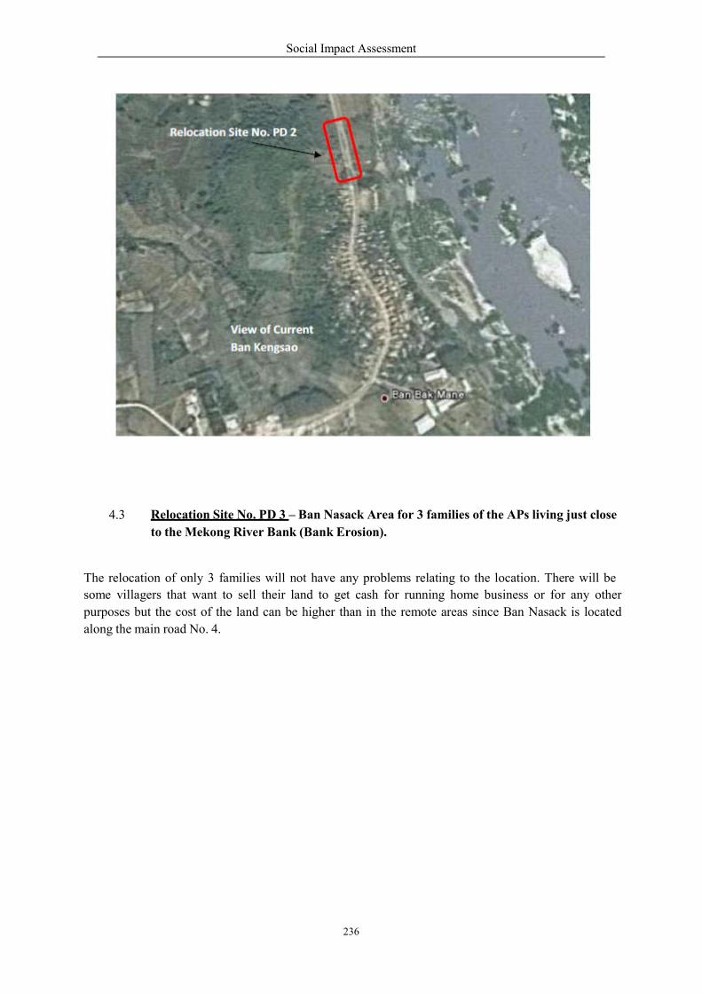
Social Impact Assessment
236
4.3 Relocation Site No. PD 3 – Ban Nasack Area for 3 families of the APs living just close
to the Mekong River Bank (Bank Erosion).
The relocation of only 3 families will not have any problems relating to the location. There will be
some villagers that want to sell their land to get cash for running home business or for any other
purposes but the cost of the land can be higher than in the remote areas since Ban Nasack is located
along the main road No. 4.

Social Impact Assessment
237
Minimum Land Area Required For Relocation Si e No. PD 3 Development
5.0 Host Communities To The Resettled Villages At Kenthao District (KD)
There are 2 villages located adjacent to Dong Houay Ang Area along the Road No. 4 that connects
Kenthao and Paklay District of Xayaboury Province. Additionally, the road No. 4 also connects the
North western part of Lao PDR with Thailand via Nam Heuang International Check Point. These 2
villages will be the host communities for the new resettlers. Living along the road and having
opportunity to cultivate fertile land in the Khoun Houa Nam Kay Area will bring advantages to the
new resettlers. There is potential conflict over sharing NTFPs in the area which could disturb the
harmony of the old and new communities. Toward successful resettle, an indepth understanding of the
Relocation Site No. PD3 Development Ban Nasack Upslope Area
No. of Affected Families From Ban Nasack 3
Village Area:
Res. Area (20 x 30 = 600 m2 =0.06 ha/FM) 0.18
Minimum Land Required in ha: 0.18
o Name Relocation Site No. PD3 – Ban Nasack Area
o Location Within the current Ban Nasack Area
o GPS Locations To be investigated
o Purpose of Usage For the relocation of 3 families whose houses are anticipated to be
affected by bank erosion in the future.
o Land area required The minimum land area required for developing 3 house plots is approximately 0.2 ha per family.
o Land Availability According to the village authority report, there is no community reserved land for this purpose. The required land for the relocation of 3 families needs to be purchased from the villagers.
o Land use and landcover
Mostly perennial crop cultivation (maize, Job’s tears, and other)
o Opinions and requests of Land owners
Current owners who are interested in selling part of their land have been asked by the village authority. They asked for compensation in cash to get money for running family business.
o Opinions andSuggestions of theAPs
The public consultation meeting has not been carried out yet to get the APs opinions and suggestions relating to the compensation and relocation process and developer responsibility
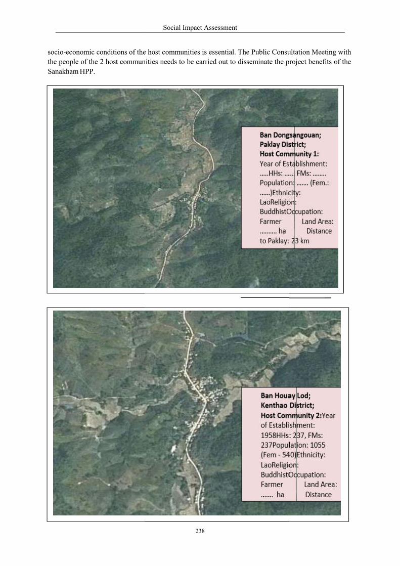
socio-economic conditions of the
the people of the 2 host communities
Sanakham HPP.
Social Impact Assessment
238
a
m
m
the host communities is essential. The Public Consultation
unities needs to be carried out to disseminate the project
Ban Houay Kenthao Di Host Com of Establish 1958HHs: 2
237Populat (Fem ‐ 540) LaoReligion BuddhistOc Farmer ……. ha
sunitment:3
ionEthnicity:
Ban Dongs Paklay Dist Host Com Year of Esta
…..HHs: ……Population: ……)Ethnicit LaoReligion BuddhistOc Farmer ………. ha to Paklay: 2
runitblF
a
m
m
Consultation Meeting with
project benefits of the
Lod; strict; unity 2:Year ment: 37, FMs:
ion: 1055 Ethnicity: : cupation:
Land Area: Distance
ngouan; rict; unity 1: blishment: FMs: ……..
……. (Fem.: y:
: cupation:
Land Area: Distance
3 km
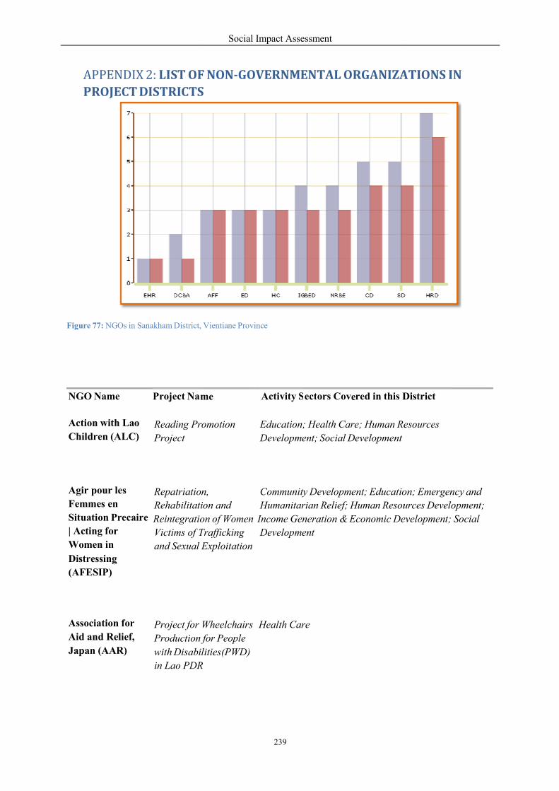
APPENDIX 2: LIST OF
PROJECT DISTRICTS
Figure 77: NGOs in Sanakham District,
meNGO Name
Project Na
Action with Lao Reading ProChildren (ALC) Project
Agir pour les Repatriation,Femmes en RehabilitatiSituation Precaire Reintegration| Acting for Victims of TraffickingWomen in and Sexual ExploitatiDistressing
(AFESIP)
Association for Project for WheelchaiAid and Relief, Production fJapan (AAR) with Disabili
in Lao PDR
Social Impact Assessment
239
e
OF NON‐GOVERNMENTAL ORGANIZATIONS
S
Vientiane Province
me Activity S
ectors Cov red in this D
romotion Education; Health Care; Human Resources
Development; Social Development
Repatriation, Community Development; Educatio
ion and Humanitarian Relief; Human Resource
on of Women Income Generation & Economic Devel
Trafficking Development
Exploitation
Wheelchairs Health Care
for People
lities(PWD)
PDR
ATIONS IN
District
esources
on; Emergency and
urces Development;
evelopment; Social
Social Impact Assessment
240
CUSO-VSO Lao 2004-2009 Cooperant Agriculture, Forestry & Fisheries; Community (CUSO-VSO) (Development Development; Health Care; Human Resources
Volunteer) Sending Development; Income Generation & Economic
Programme Dev.t; Natural Resources & Ecology; Social Dev.
Japan Natural Agriculture in Agriculture, Forestry & Fisheries; Human Resources International Development Development; Natural Resources & Ecology Volunteer Centre
(JVC)
Pestalozzi Empowerment of the Education Children's Ethnic Minorities Foundation (PCF) through Education
project.
SNV Netherlands Capacity Development Agriculture, Forestry & Fisheries; Community Development for Non-Timber Forest Development; Data Collection & Analysis; Human Organisation Products Resources Development; Income Generation & (SNV) Economic Development; Natural Resources &
Ecology;Social Development
Capacity Development Community Development; Data Collection &
for Pro-poor Analysis;Human Resources Development; Income
Sustainable Tourism Generation & Economic Development; Natural
Resources & Ecology;Social Development
WWF (WWF) PADETC & WWF Laos
- Water and Wetlands
Awareness in Schools
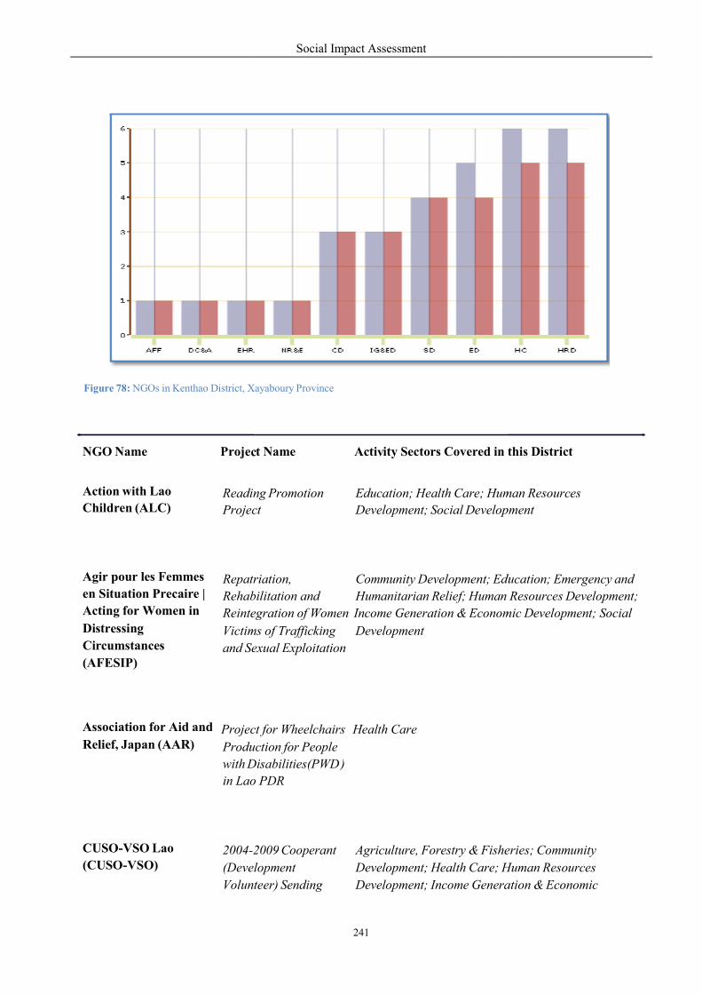
c
Figure 78: NGOs in Kenthao District, X
NGO Name
Proje
Action with Lao
ReadingChildren (ALC)
Projec
Agir pour les Femmes Repatren Situation Precaire | RehabilitatActing for Women in ReinteDistressing VictimCircumstances and Se(AFESIP)
Association for Aid and ProjecRelief, Japan (AAR) Production with D in Lao
CUSO-VSO Lao 2004-20(CUSO-VSO) (Development Volunteer)
Social Impact Assessment
241
c v
Xayaboury Province
t Name Acti ity Sectors Covered in this
ng Promotion
Education; Health Care; Hum
ect Development; Social Develop
triation, Community Development; Educati
Rehabilitation and Humanitarian Relief; Human
tegration of Women Income Generation & Economi
ms of Trafficking Development
exual Exploitation
ect for Wheelchairs Health Care
Production for People
Disabilities(PWD )
Lao PDR
2009 Cooperant Agriculture, Forestry & Fishe
lopment Development; Health Care; H
Volunteer) Sending Development; Income Generation
this District
man Resources
pment
ducation; Emergency and
Resources Development;
mic Development; Social
eries; Community
Human Resources
ation & Economic
Social Impact Assessment
242
Programme
Development; Natural Resources & Ecology;Social
Dev.
Macfarlane Burnet
Institute for Medical
Research and Public
Health (Burnet
Institute)
HIV prevention among
MSM under the
program of Scaling up
HIV and AIDS
prevention, care and
treatment in Lao PDR
Lao Youth Data Collection & Analysis; Education; Health
HIV/AIDS/STI Response Care;Human Resources Development; Social
Project Development
Xayabouri Youth HIV & Education; Health Care; Human Resources
STI Response Project Development; Income Generation & Economic
Development
Room to Read Laos
(RtR)
Enhancing the
Education of Lao
Children
Education
Save the Children
Australia (SCA)
Xayabouri Primary Health Care
Health Care Project
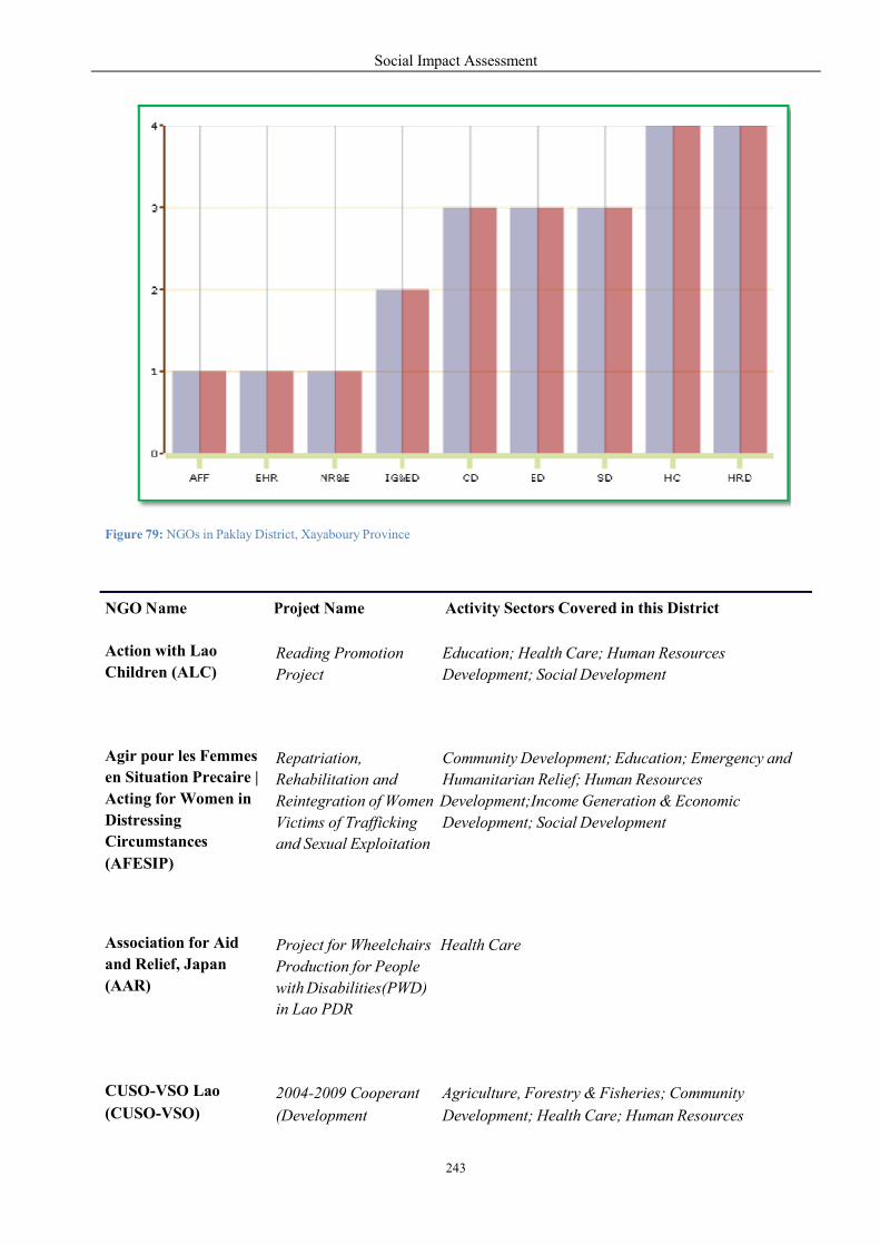
Figure 79: NGOs in Paklay District, Xay
NGO N
ame
Projec
t
Action with Lao ReadingChildren (ALC) Projec
Agir pour les Femmes Repatren Situation Precaire | RehabilitatActing for Women in ReintegrationDistressing VictimCircumstances and Se(AFESIP)
Association for Aid Projecand Relief, Japan Produc(AAR) with Disabili
in Lao
CUSO-VSO Lao 2004-20(CUSO-VSO) (Development
Social Impact Assessment
243
yaboury Province
vity Sectors Covered in t Name
Acti
ng Promotion Education; Health Care; Hum
ect Development; Social Development
triation, Community Development; Education;
Rehabilitation and Humanitarian Relief; Human Resources
gration of Women Development;Income Generation
s of Trafficking Development; Social Development
exual Exploitation
ect for Wheelchairs Health Care
ction for People
isabilities(PWD)
PDR
2009 Cooperant Agriculture, Forestry & Fisher
lopment Development; Health Care; H
this District
man Resources
ment
ucation; Emergency and
Resources
tion & Economic
ment
ries; Community
Human Resources
Social Impact Assessment
244
Animals
1) Pic - A - Pet 4 Home
2) Hua Hin Dog Rescue Centre
3) Wild Animal Rescue Foundation of Thailand
4) Atigaro Project
5) Aquatic Animal Disease Division u
6) Animal Shelter at Thung Seekan
7) Elephant Hospital in Lampang
8) Animal Husbandry Foundation
9) Hornbill Research Foundation
10) Sueb Nakhasathien Foundation
11) Bird Conservation Society of Thailand
12) The Society for the Promotion of Animal Welfare Under Royal Patronage (Animal
Shelter, Kanchanaburi)
13) Cat and Dog Fund
14) Save Thai Birds for Kids Project.
15) Wildlife Friends Foundation - Thailand (WFFT)
Volunteer) Sending Development; Income Generation & Economic
Programme Development; Natural Resources & Ecology; Social Development
Room to Read Laos Enhancing the Education (RtR) Education of Lao
Children
Save the Children Xayaboury Primary Health Care Australia (SCA)
Health Care Project
Social Impact Assessment
245
16) Love Wildlife Foundation - Thailand (LWL)
Anti-Drug Campaigns
17) Ruam Mit Centre in Chiang Mai
18) Anti-Drug Volunteer Association
19) Baan Poolsri Detoxification Centre (Soon Bambad Baan Poonsri)
20) Krong Karn Puea Dek Lae Yaowachon reabilitation center in Yasothorn province
21) Rebirth Therapeutic Community Centre (Soon Kerd Mai)
22) Hand in Hand Ministries
Community Development
23) Asia Foundation
24) ActionAid
25) Adventist Development and Relief Agency (ADRA)
26) Amaranth Greenpeace Funds International (AGF International)
27) American Refugee Committee
28) Asian Disaster Preparedness Center (ADPC)
29) Burma Border Consortium
30) Canadian Alliance for Development Initiatives and Projects
31) CARE International Thailand
32) Caritas International Thailand
33) Catholic Office for Emergency Relief and Refugees (COERR)
34) Common Interest Foundation
35) Compasio Relief & Development
36) Cooperazione e Sviluppo
37) Department for International Development (DFID)
Social Impact Assessment
246
38) Development and Education Programme for Daughters and Communities
Center (DEPDC)
39) Eaglesrest, help for pastors
40) European Commission Humanitarian Office (ECHO)
41) Food and Agriculture Organization (FAO)
42) Phu Fa shops
43) Sustainable Community Development Foundation
44) Swiss Agency for Development and Cooperation (SDC)
45) Family Network Foundation
23) Fernthai Volunteer Foundation
46) Foundation for Child Development
47) Friends of the Samaritans
48) Heifer Project International (HPI)
49) Jesuit Refugee Service (JRS) Thailand
50) Peace Corps Thailand
51) Plan International
24) Rotary club of Pattaya
25) Rejoice Urban Development Project
26) The Development Cooperation Foundation
27) International Christelijk Steundfonds (ICS)
28) Graduate Volunteer Programme
29) Saleng Fund project
30) Catholic Mission in Human Development Centre
31) Phud Hong Leper Foundation
32) Spirit in Education Movement (SEM)
33) Wat Worachanyawas Fund
34) Fountain of Life
35) Forest Conservation Community Fund

Social Impact Assessment
247
36) Cold Water Relief for Children in Remote Areas Project, by The Thai Red Cross
Society
37) Duang Prateep Foundation
38) Foundation for Lanna Artists
39) ThaiTogether Network
40) The Ngao Community Art Centre
41) The Foundation For Slum Child Care (The Milk and Supplementary Food Fund)
42) Foundation for Children, Baan Tantawan shelter
43) The New Light Foundation
44) The Love Line Family Centre
45) The Post Library Project
46) The Khru Thim Bun-ing Foundation
47) The Phet Khlong Jan Community
48) Mu Koh Surin National Park
49) Ban Na Muean Sri Weaving Group
50) Fund for Research and Development Networks (FRDN)
51) The Club of Human Rightists of Isan region
52) Wat Klang Community's Recycling Bank Fund
53) The Phuen Ban Oon Jai Project
54) United Nations Development Program (UNDP)
55) United Nations Office for the Coordination of Humanitarian Affairs (OCHA)
56) USAID
57) World Food Program (WFP)
58) National Catholic Commission on Migration (NCC)
Education and Children
88) Abundant Life Foundation, Christian project
89) ActionAid Thailand
Social Impact Assessment
248
90) Adventist Development and Relief Agency (ADRA)
91) Adventist Southeast Asia Projects
92) Amaranth Greenpeace Funds International (AGF International)
93) Anglo-Thai Foundation
94) Asia Foundation
95) Baan Gerda home for AIDS orphans in Lopburi
96) Baan Unurak
97) Bangkok Post Scholarships
98) Better Thailand Foundation
99) Bright Dawn Foundation
100) Camillian social center in Rayong, operated by Saint Camillus Foundation
101) Camillian Home for Children Living with Disabilities Saint Camillus Foundation
102) Caritas International Thailand
103) Catholic Office for Emergency Relief and Refugees (COERR)
104) Child Watch Phuket
105) Child Workers in Asia
106) Child's Dream
107) Children's Shelter Foundation Chiang Mai Home and education for underpriviledged
and deaf children from the hilltribes
108) For Life, with support of Christian Care Foundation for Children with Disabilities
109) Compassion International
110) CWEFT (Concordia Welfare and Education Foundation Thailand)
111) Development and Education Programme for Daughters and Communities
Center (DEPDC)
112) End Child Prostitution, Child Pornography and Trafficking of Children for Sexual
Purposes (ECPAT) International
113) FACE (Fight Against Child Exploitation)
114) Foster Home
115) Foster Home for orphans
Social Impact Assessment
249
116) Foster sisters and brothers
117) Foundation For Children (FFC)
118) Hand in Hand Ministries
119) Healing for the Abused
120) Isara Foundation
121) Jesters Care for Kids, in Chonburi and Rayong
122) Mercy International Foundation, Christian
123) Mercy Ministries Foundation (MMF)
124) Mimi Vang Foundation (MVF)
125) Orphanage.org
126) Plan International Thailand Foundation
127) Saint Theresa's Boarding Centre, run by Redemptorists
128) Sarnelli House, for children affected or infected by HIV in Nongkhai
129) Sister Joan Evans
130) SOS Children's Village Thailand
131) The Human Development Foundation
132) Occupational training, by UNICEF
133) United Nations Children's Fund (UNICEF)
134) Volunteers in Asia
135) World Vision Foundation of Thailand
136) Youth Action Fund Thailand
137) Youth With A Mission (YWAM)
138) YWCA Pak Kret
139) Baan Had Thaeng village school
140) Baan Huay Moh Orphanage
141) Baan Ke Ra Kee Child Development Centre
142) Bangkok Metropolitan Administration's Toy Banks
Social Impact Assessment
250
143) Bangkok Refugee Center
144) Bicycle Donations
145) Chaiwat Un-kaew
146) Chaiyapruk Foundation
147) Chang Kham Church's Street Children Project
148) Child Institute, Foundation for Children
149) Children and Youth for Development Centre
150) Clean Drinking Water for Kids
151) Dek Rak Pah Fund
152) Duang Prateep Foundation
153) Ecumenical Coalition on Tourism ECOT (www.ecotonline.org)
154) Education for Children Project
155) Foundation for Education and Development of Rural Areas (FEDRA)
156) Foundation for Rural Children Development (Moonnithi Pua Dek Thai Nai
Chonnabot)
157) Foundation for Rural Youth
158) Foundation for the Welfare of the Crippled
159) Holt Sahathai Foundation
160) Holy Mercy Home
161) Holy Mercy Home (Ban Phra Metta)
162) Home for Quality of Life Development Project.
163) Khom Loy Development Foundation
164) Last Wishes
165) Legal Aid Clinic
166) Life Skills Development Foundation
167) Malnourished children, run by the Foundation for Children
168) McKean Rehabilitation Centre, formerly a leper's colony
169) Mercy Center (Pattaya)
Social Impact Assessment
251
170) Mettapracharak Hospital's Eyeglasses Bank, Nakhon Prathom province
171) Nature Conservancy Club
172) Neo Humanist Foundation
173) Our School Projects
174) Pak Kret Dental Project
175) Pattaya Charity Network
176) Pattaya Orphanage
177) Pattaya Street Kids Support Project
178) Phibulsongkroh Foundation, Children's Fund.
179) Phyathai Babies' Home for boys
180) Powdered Milk Fund
181) Programme for Supporting Children's Education
182) Project for Ecological Recovery/Foundation for Ecological Recovery
183) Pure Heart Project
184) Recycled Bicycle Project, by Thailand Cycling Club
185) Saeng Thien Group Foundation
186) Safe Haven Orphanage
187) Santisuk Foundation
188) Save Thai Birds for Kids Project
189) School for Life (Chiang Rai)
190) Second Home for Child Labour, the Foundation for children's development
191) SET Foundation
192) Sparrow Home for babies of prisoners
193) Registered Charitable Foundation in Chiang Mai running Stratton House Childrens
Home
194) Starfish Country Home School Foundation
195) Suan Kaew Foundation
196) Support the Children Foundation

Social Impact Assessment
252
197) Thai Children's Rights
198) The Alliance for Safe Children
199) The Bangkok Post Newspaper Foundation
200) The Daughter's Education Programme (DEPDC), saving girls from the sex trade
201) The Centre for Urban Tribal Youth, a unit of the Inter Mountain Peoples Education
and Culture in Thailand Association (IMPECT)
202) The Child Labour Project
203) The Development of Older People Grou
204) The Duang Prateep Foundation
205) The Foundation For Slum Child Care
206) The Fund for Khru Noi's Home
207) The Fund for the Development of Children Living Under Bridges
208) The Health Project for Tribal People
209) The Jintana-Eaksakdi Daengdej Library Foundation
210) The Karen Culture Education Fund
211) The Khru Thim Bun - ing Foundation.
212) The Mae Moon Man Yuen School
213) The Volunteers Group for Children's Development
214) The Youth Centre for the Promotion of Life Services and Environmental Awareness
(YPLE)
215) Worldwide Faith Missions (Humanitarian programs)
216) Women Against Aids
217) World Education
Elderly
218) Adventist Development and Relief Agency (ADRA)
219) Help Age International
220) Thai Volunteer Service Foundation
Social Impact Assessment
253
221) Thanyaburi Welfare Home for Destitute Women in Pathum Thani province
222) The Diocese Social Action Centre of Bangkok (DISAC)
223) Memorial Camillian Sisters Foundation
224) Thammaprakorn Home for the Aged.
225) The Group for the Development of Older People.
226) Queen Sawangwattana Memorial
227) The Fund for Senior Performing Artists Welfare.
228) Foundation for Older Persons' Development
Environment
229) Plant A Tree Today Foundation
230) Tacomepai Organic Farm
231) The Project for Ecological Recovery/Foundation for Ecological Recovery
232) Khao Yai Conservation
233) Save Whale Shark for the Thai Sea Conservation Club (WSTC)
234) The Thai Fund Foundation
235) Khrong Karn Moo Bann Anurak Sud Pa (Wildlife Conservation Village Project)
236) Wildlife Fund Thailand
237) Yadfon Association
238) Ping Watershed Conservation Fund.
239) The Northern Farmers' Network, protect 100 community forests
240) Recycle Paper for Trees Programme
241) Kanchanaburi Environmental Group
242) Mangrove Ecology Study and Preservation Centre, Bang Taboon Witaya School
243) The Forest Conservation Community Fund
244) Ban Wat Chand Rice Fund
245) Phu Wua Wildlife Sanctuary

Social Impact Assessment
254
246) Technology for Rural and Ecological Enrichment (TREE), or The Kao-Kwan
Foundation
247) Committee for Natural and Environmental Conservation of 16 Institutes (CNEC)
248) The Forest Conservation Community Funds
249) World Wildlife Fund Thailand
250) The Panya Project
Hilltribes
251) Foundation for Karen Hilltribes in Thailand
252) Day-care centres for Karen children by Ralph Oberg
253) Karen Culture Education Fund
254) Chang Kham Church's Street Children Project
255) The Lower Klity village
256) Fund For the Innocents
257) Centre for the Coordination of Non-governmental Tribal Development Organisation
(CONTO)
NGO Coordinating Committee on Rural Development (NGO-CORD NORTH)
Ethnic Studies Network (Ethnet), Regional Centre for Social Science and Sustainable
Development (RCSD), Chiang Mai University
Friends Without Borders
Karen Studies and Development Centre
The Karen Hilltribes Trust
258)
259)
260)
261)
262)
HIV/AIDS
263) Baan Gerda home for AIDS orphans in Lopburi
264) Camillian social center in Rayong
265) Rejoice Charity
266) Suthasinee Noiin for Children and Youth Foundation
267) Sarnelli House
268) Siam-Care Thailand
Social Impact Assessment
255
269) Camillian Home for Children Living with Disabilities
270) Thai Red Cross Society, the AIDS Project
271) The Human Development Foundation
272) The Sem Pringpuangkeo Foundation
273) People with HIV/Aids Coordinating Centre
274) Agape Home in Chiang Mai
275) Life and Hope Club
276) Welcome House, by Catholic Mission AIDS
277) Mercy International, Christian
278) New Life Friends Centre
279) A.B.C - Aids Babies Centre in Chiang Mai
280) Community Aids Care Project, NorthNet Foundation
281) Sem Pringpuangkeo Foundation's Children Fund, Foster Parents Project
282) Health Hotline Fund
283) Pearl S. Buck International (Thailand)
284) Thammapakorn Home for the Aged
285) Thai Concern Foundation
286) Duang Prateep Foundation
287) Population and Community Development Association
Human Rights
288) Amnesty International Thailand
289) The Cross-Cultural Foundation (CrCF)
290) The Working Group on Justice for Peace (WGJP)
Media
291) Foundation for Community Educational Media, the organization who responsible for
Prachatai online independent newspaper

Social Impact Assessment
256
Information Technology
292) The Center for World Information Technology Education (CWITE)
Medical Help
293) Adventist Development and Relief Agency (ADRA)
294) ANESVAD Foundation
295) Saint Camillus Foundation, runs Camillian Hospital
296) Catholic Office for Emergency Relief and Refugees (COERR)
297) Saint Louis Foundation, of Saint Louis Hospital
298) Bone Marrow Transplant, Ramathibodi Hospital
299) Karen Studies and Development Centre
300) Aksorn Vechakarn Songkrohclinic, free clinic
301) Camillian social center in Rayong
302) Caritas International Thailand
303) Central Correctional Hospital, medical treatment for inmates
304) Jesuit Refugee Service (JRS) Thailand
305) Médecins Sans Frontières (MSF)
306) Thai Red Cross Eye Bank
307) People's Eye Care Foundation, at Bangkok Hospital
308) McKean Rehabilitatin Centre in Chiang Mai, for victims of leprosy
309) The Duangkaew Foundation, Institute of Medical Research at Somdej Phra Pin Klao
Royal Thai Naval Hospital, surgery for the poor
310) Compassion of Christ Mission (CCM), mobile clinics
311) Thai Red Cross Society
312) The "five-baht doctor" clinic
313) The Kalayanavisut Foundation at Wat Don Clinic, free treatment
Social Impact Assessment
257
314) We Care, a group of Thai-born USA citizens
315) Thai Red Cross Society's Organ Donation Centre
316) Tour de Thailand Charity Bicycle Rides
317) Tsunami Volunteer Center
318) Paediatric Cardiac Surgery Foundation
319) Pan Nam Jai Hai Nong
320) The Educational Programme for Chronically-ill Children at Chulalongkorn Hospital
321) Bone Marrow Transplant Club (BMC)
322) The Thai Industrialist Development Forum, gives artificial legs to needy patients free
of charge
323) Thai Relief Project, in East Timor
324) Kong Tun Nuai Baht Diaw, "one baht heart"
325) Smile Thai Operation Project
The Disabled
326) Adventist Development and Relief Agency (ADRA)
327) The Foundation for the Mentally Retarded of Thailand ( Special Olympics )
328) Arunyik Mushroom Research and Development Centre
329) Caritas International Thailand
330) Samakhom Dontree Puer Khon Tah Bod ( Music Association for the Blind )
331) Foundation to Encourage the Potential of Disabled Persons
332) Digital books for the blind, by NECTEC
333) Reconstructive surgery, by Red Cross
334) Kidney Foundation of Thailand, kidney transplantant
335) Foundation for Children with Disabilities (FCD)
336) Kasetsart University Demonstration School's Educational Research Centre fo
Children with Special Needs
337) Handicapped People's Fund of Na Pho District
Social Impact Assessment
258
338) Training for the mentally handicapped, Punyawuthikorn School
339) The Redemptorist Vocational School in Pattaya
340) The National Association of the Deaf in Thailand
341) The Christian Foundation for the Blind in Thailand
342) Fund for the Vocational Training Centre for the Blind in Chiang Mai
343) Nakhon Prathom Disabled Club
344) The Prosthesis Foundation
345) YWCA Pakkred
346) The Foundation for Handicapped Children
347) Christian Care Foundation for Children with Disabilities
348) The Nature Conservancy Club.
349) Thai Industrialist Development Forum
350) Thailand Association of the Blind
351) Alternative Energy Project for Sustainability
352) International Support Group to the Department of Public Welfare
353) Disabled Peoples' International (DPI) Asia-Pacific Region
Women
354) Asia Foundation
355) Baan Unrak
356) Burmese Women Union
357) Fight Against Child Exploitation, protect Thai children from pedophiles
358) Foundation for Women
359) Goodwill Group Foundation, providing education, vocational training and career
services for underprivileged Thai women
360) Hand in Hand Ministries
361) International Rescue Committee
362) Phibulsongkroh Foundation, Children's Fund.
Social Impact Assessment
259
363) Soon Puea Nong Ying, a club for teenage girls
364) The Emergency Home and Relief Fund for Women and Children in Distress, a unit of
the Association for the Promotion of the Status of Women
365) The Friends of Women Foundation
366) The Kanitnaree Centre, help for rape victims
367) The Rahab Beauty Shop, emotional support and vocational training opportunities for
bar girls to get out of prostitution
368) Refuge Ministries Thailand, Serving Disadvantaged Women and Children in Thailan.
369) We women foundation, empowering unrecognized refugee women from Burma
Workers
370) Worker's CO-OP
371) Network of Health Service Complainants
372) Housing Security for Slum Dwellers
373) The Foundation for Children's Development
374) IDCCC, Christ Church, support for illegal workers
375) Lydia House for migrant workers
376) The Council of Work- and Environment-Related Patients' Network of Thailand
(WEPT)
377) The Good Samaritan, help for hilltribe orphans
Social Impact Assessment
260
APPENDIX 3: DOCUMENTS/WEB SITES USED FOR THE
PREPARATION OF THE SIA
1)
2)
3)
4)
APEC.2006. APEC Energy Demand and Supply Outlook 2006
Bellwood. P. 1979. Man's Conquest of the Pacific, Oxford University Press, New York
Boisselier. J. 1989. Trends in Khmer art, Cornell University, New York.
Bounsouk. 1970. The Museum of Religious Arts of the Wat Phra Keo, Lao-American
Association, Vientiane, Laos
Bounmy. T. 2006. The History of Lao ethni , Volume I, first published (Lao version).
Chiang Khan District Administration Office.2010. District Development Plan 2010-2013.
Colani. M. 1935. Megalithes du Haut-Laos, PEFEO.
Chazee. L. 1999. The Peoples of Laos: Rural and Ethnic Diversities, White Lotus Press,
Bangkok, Thailand
Earth Systems Lao & Department of Musuems and Archaeology (DMA). 2004. Phu Bia
Gold Project: Report on Archaeology Investigation, Earth Systems Lao, Vientiane, Lao
PDR
Grant. E. 2002. A Short History of Laos. Chiang Mai: Silkworm Books.
Grant. E. 1998. The Politics of Ritual and Remembrance. Laos since 1975, Chiang Mai:
Silkworm Books.
http://www.adb.org.
http://www.china-cdto.com.
http://www.dam.org.
http://www.directoryofngos.org.
http://www.egat.co.th
http://www.eppo.go.th
http://www.equator-principles.com.
http://www.globalwarmingarticle.com
http://www.hydropower.org
http://www.invest.laopdr.org.
http://www.mrcmekong.org.
http://www.poweringprogress.com.
http://www.worldbank.org.
Higham. C., 1989, The archaeology of mainland Southeast Asia from 10,000 B.C. to the
fall of Angkor, Cambridge University Press
Higham. C. 2002. Early cultures of mainland Southeast Asia, River Books, Thailand.
http://en.wikipedia.org.2011.List of Non-governmental Organizations in Thailand.
Kumpeera, K. 2009. Desk Review of Policy and Legislation” Asian Development Bank
RETA No. 6440.
Kumpeera, K. 2009. Status of Environmental Impact Assessment Tools in Environmental
Policies and Legislation, Asian Development Bank RETA No. 6440.
Khampheng.T & Khammanh.S. 2009. To know for ethnic group in Laos, Sibounhueng
Publishing house, Vietiane Lao PDR. (Lao version).
Khamphao. P. 2010. Muangkhong history on the past and the present, Sisavat Publishing
house, Vientiane Capital, Lao PDR. (Lao version).
Lao National Tourism Administration.2009. 2009 Statistical Report on Tourism in Laos.
Loei Provincial Tourism Authority.2010. Statistic of Tourist in Loei January to June 2010.
5)
6)
7)
8)
9)
10)
11)
12)
13)
14)
15)
16)
17)
18)
19)
20)
21)
22)
23)
24)
25)
26)
27)
28)
29)
30)
31)
32)
33)
Social Impact Assessment
261
34) MRC.2010.Strategic Environmental Assessment (SEA) of Hydropower on the Mekong
Mainstream, Final Report.
Nam Theun Power Company (NTPC). 2005. Nam Theun 2 Physical Cultural Resource
Survey: Final Report, Earth Systems Lao, Vientiane, Lao PDR.
National Statistics Centre/Committee for Planning and Investment.2009, The Household
of Lao PDR, Social and Economic Indicators.
NCG. 2010. ESIA Inception Report of Sanakham Hydropower Project.
NCG. 2011. ESIA Interim Report of Sanakham Hydropower Project.
Pak Chom District.2010. District Development Plan 2010-2013.
Pham Huy Thong. 1990. Dong Son Drums in Vietnam, Vietnam Social Science
Publishing House, Vietnam.
Royal Thai Survey Department.1996. Hydrology Atlas Mekong River in the Thai-Lao.
Schepartz. L. A., Miller-Antonio. S., & Bakken, D. A. 2000 Upland resources and the
early Palaeolithic occupation of Southern C ina, Vietnam, Laos, Thailand and Burma”,
World Archaeology, Vol. 32(1).
Schliesinger. J. 2003. Ethnic Groups of Laos- Volume 3: Profile of Austro-Thai Speaking
Peoples, White Lotus Press, Bangkok, Thailand.
Schliesinger. J. 2003. Ethnic Groups of Laos- Volume 2: Profile of Austro-Asiatic
Speaking Peoples, White Lotus Press, Bangkok, Thailand.
Sengpaseuth. B., Bounheng. 1997. Art History of Laos, Vol. 2, Vientiane, Lao PDR.
Steering Committee for Census of Population and Housing.2005.Results from the
Population and Housing Census.
Suwanmontri, M. 1996. Assessment of Rural Resettlement Program in Thailand, NIDA.
35)
36)
37)
38)
39)
40)
41)
42)
43)
44)
45)
46)
47)
48) Suwanmontri, M Dr. 2010. SIA/SDP in the Context of Sustainable Development,
International EIA/SIA and SEA Expert for ADB’s RETA No 6440"Facilitating Regional
Power Trading and Environmentally Sustainable Development in the Greater Mekong
Sub Region"
Tarling. N. 1992. The Cambridge History of Southeast Asia from early times to c.1800,
vol.1, Cambridge University Press.
Tourism Authority of Thailand. 2010. Statistic of Tourist in Loei.
49)
50)