project data sheet
TRANSCRIPT
(121)
PROJECT DATA SHEET
Project Name: The Saudi Program for Drilling of Wells and Rural Development in Africa, (Phase5). Name of the Client: Water Sector Trust Fund (WSTF) –Republic of Kenya Financer: Saudi Fund for Development The Consultant SCET-TUNISIE Duration 24 months
Objectives and components of the project: The Project include The Construction of about 42 Drilled Wells Equipped with Solar and / or diesel pumping generator and pipelines connections to supply several Villages in Marsabit, Isiolo, Samburu, Mandera, Garissa and Wajir Counties in the Republic of Kenya. The Project components fall within borehole drilling, procurement, installation of solar/diesel driven pumps with reticulation systems and RC water tanks as well as animation, sensitization, and training. The primary objective of the project is to increase access to safe drinking water to about 130 555 persons in the Republic of Kenya. The work at each site comprises of:
1. Conducting Environmental and Social Impact Assessment
2. Drilling of wells
3. Supply and installation of Pumps and ancillaries
4. Supply and installation of solar system and / or diesel generators
5. Supply and installation 42 steel water tanks
6. Supply and installation of 42 pipe distribution systems
7. Training of maintenance team and providing spare parts
Submission of Offers: All Saudi contractors who are interested in participating to implement the project should submit their offer by submitting the envelopes including the technical and financial offers (hard and soft copies) before 14/10/2021 to the following: - The Saudi Fund for Development (SFD)
P.O. Box 50483
Riyadh, 11523
Kingdom of Saudi Arabia 1) Eng. Azzam Albarrak,
Operation Sector, Africa Dep. Saudi Fund for Development
Phone: +966 11 2794022 2) Eng. Amar Albelaihees,
Operation Sector, Africa Dep. Saudi Fund for Development
Phone: +966 11 2794276
Eligibility: Only Saudi Bidders.
2, Rue Sahab Ibn Abbad, Cité Jardins 1002 Tunis Bélvédère TUNISIA Phone : +216 71 800 033 - Fax. +216 71 785 066 E-mail : [email protected]
A Grant from the Government of the Kingdom of Saudi Arabia
to
The Republic of Kenya
The Saudi Program for Drilling of Wells and Rural Development in
Africa – Phase V
The Republic of Kenya
Project No.: P5/2019/Kenya
Tender No.: P5/2019/Kenya/Contractor
Invitation to Tender
For
The Construction of 42 Drilled Wells Equipped with Solar pumping generator and
pipelines connections to supply several villages in Marsabit, Isiolo, Samburu,
Mandera, Wajir and Garissa Counties
Ref. : A20-27
Date: July 2021
Republic of Kenya
Section 0
Table of Contents
Page 1 of 131
TABLE OF CONTENTS
SECTION 1 .......................................................................................................................................................... 6
INVITATION TO BIDDERS ............................................................................................................................... 6
SECTION 2 .......................................................................................................................................................... 8
GENERAL INFORMATION ON THE REPUBLIC OF KENYA...................................................................... 8
GENERAL INFORMATION ABOUT THE REPUBLIC OF KENYA ................................................................................................. 9
Introduction ................................................................................................................................................... 9
Geography ................................................................................................................................................... 10
Climate ........................................................................................................................................................ 10
Geology ....................................................................................................................................................... 11
Economy ...................................................................................................................................................... 11
Industry and Manufacturing ......................................................................................................................... 11
Transport ..................................................................................................................................................... 12
Energy ......................................................................................................................................................... 12
Demographics .............................................................................................................................................. 12
Languages ................................................................................................................................................... 12
Government and Politics .............................................................................................................................. 13
SECTION 3 ........................................................................................................................................................ 15
INSTRUCTIONS TO BIDDERS ....................................................................................................................... 15
SECTION 3: INSTRUCTIONS TO BIDDERS ...................................................................................................................... 16
A. GENERAL ........................................................................................................................................................ 16
1. SCOPE OF BID ................................................................................................................................................... 16
2. SOURCE OF FUNDS ............................................................................................................................................ 16
3. ELIGIBLE BIDDERS .............................................................................................................................................. 16
4. QUALIFICATION OF THE BIDDER............................................................................................................................. 17
5. ONE BID PER BIDDER ......................................................................................................................................... 19
6. COST OF BIDDING .............................................................................................................................................. 19
7. SITE VISIT ........................................................................................................................................................ 19
B. BIDDING DOCUMENT .................................................................................................................................... 20
8. CONTENT OF BIDDING DOCUMENTS ....................................................................................................................... 20
9. CLARIFICATION OF BIDDING DOCUMENTS ................................................................................................................ 20
10. AMENDMENT OF BIDDING DOCUMENTS ................................................................................................................ 20
C. PREPARATION OF BIDS ................................................................................................................................... 22
11. LANGUAGE OF BID ........................................................................................................................................... 22
12. DOCUMENTS COMPRISING THE BID ...................................................................................................................... 22
13. BID PRICES .................................................................................................................................................... 22
14. CURRENCIES OF BID AND PAYMENT...................................................................................................................... 22
15. BID VALIDITY .................................................................................................................................................. 22
16. BID SECURITY ................................................................................................................................................. 22
17. ALTERNATIVE PROPOSALS BY THE BIDDERS ............................................................................................................. 23
Republic of Kenya
Section 0
Table of Contents
Page 2 of 131
18. FORMAT AND SIGNING OF BID ............................................................................................................................ 23
D. SUBMISSION OF BIDS ..................................................................................................................................... 25
19. SEALING AND MARKING OF BIDS .......................................................................................................................... 25
20. DEADLINE FOR SUBMISSION OF BIDS ..................................................................................................................... 25
21. LATE BIDS...................................................................................................................................................... 25
22. MODIFICATION AND WITHDRAWAL OF BIDS ........................................................................................................... 25
E. BID OPENING AND EVALUATION ....................................................................................................................... 27
23. BID OPENING ................................................................................................................................................. 27
24. PROCESS TO BE CONFIDENTIAL ............................................................................................................................ 27
25. CLARIFICATION OF BIDS AND CONTACTING THE EMPLOYER ......................................................................................... 27
26. EXAMINATION OF BIDS AND DETERMINATION OF RESPONSIVENESS .............................................................................. 28
27. CORRECTION OF ERRORS ................................................................................................................................... 28
28. CURRENCY FOR BID EVALUATION......................................................................................................................... 29
29. EVALUATION AND COMPARISON OF BIDS ............................................................................................................... 29
F. AWARD OF CONTRACT ................................................................................................................................... 30
30. AWARD CRITERIA ............................................................................................................................................ 30
31. EMPLOYER’S RIGHT TO ACCEPT ANY BID AND TO REJECT ANY OR ALL BIDS ..................................................................... 30
32. NOTIFICATION OF AWARD AND SIGNING OF AGREEMENT .......................................................................................... 30
33. PERFORMANCE SECURITY .................................................................................................................................. 31
34.ADVANCE PAYMENT ......................................................................................................................................... 31
35. CORRUPT OR FRAUDULENT PRACTICES .................................................................................................................. 31
G. BIDDING DATA............................................................................................................................................. 33
SECTION 4 ........................................................................................................................................................ 36
CONDITIONS OF CONTRACT ....................................................................................................................... 36
CONDITIONS OF CONTRACT ................................................................................................................................. 37
A. GENERAL ......................................................................................................................................................... 37
1. DEFINITIONS .................................................................................................................................................... 37
2. INTERPRETATION ............................................................................................................................................... 39
3. LANGUAGE AND LAW.......................................................................................................................................... 39
4. CONSULTING ENGINEER’S DECISIONS ..................................................................................................................... 40
5. DELEGATION .................................................................................................................................................... 40
6. COMMUNICATIONS ............................................................................................................................................ 40
7. SUBCONTRACTING ............................................................................................................................................. 40
8. PERSONNEL ..................................................................................................................................................... 40
9. EMPLOYER’S AND CONTRACTOR’S RISKS.................................................................................................................. 40
10. EMPLOYER’S RISKS........................................................................................................................................... 40
11. CONTRACTOR’S RISKS ....................................................................................................................................... 40
12. INSURANCE .................................................................................................................................................... 41
13. QUERIES ABOUT THE CONTRACT DATA .................................................................................................................. 41
14. CONTRACTOR TO CONSTRUCT THE WORKS ............................................................................................................ 42
15. THE WORKS TO BE COMPLETED BY THE INTENDED COMPLETION DATE ......................................................................... 42
16. APPROVAL BY THE CONSULTING ENGINEER (CE) ...................................................................................................... 42
Republic of Kenya
Section 0
Table of Contents
Page 3 of 131
14. SAFETY ......................................................................................................................................................... 43
18. DISCOVERIES .................................................................................................................................................. 43
19. POSSESSION OF THE SITE ................................................................................................................................... 43
20. ACCESS TO THE SITE ......................................................................................................................................... 43
21. INSTRUCTIONS, INSPECTIONS AND AUDITS ............................................................................................................. 43
22. DISPUTES ...................................................................................................................................................... 43
B. TIME CONTROL .......................................................................................................................................... 44
23. PROGRAM ..................................................................................................................................................... 44
24. EXTENSION OF THE INTENDED COMPLETION DATE ................................................................................................... 45
25. ACCELERATION ............................................................................................................................................... 45
26. DELAYS ORDERED BY THE CONSULTING ENGINEER ................................................................................................... 46
27. MANAGEMENT MEETINGS ................................................................................................................................. 46
28. EARLY WARNING ............................................................................................................................................. 46
C. QUALITY CONTROL .................................................................................................................................. 47
29. IDENTIFYING DEFECTS ....................................................................................................................................... 47
30. TESTS ........................................................................................................................................................... 47
31. CORRECTION OF DEFECTS .................................................................................................................................. 47
32. UNCORRECTED DEFECTS.................................................................................................................................... 47
D. COST CONTROL ......................................................................................................................................... 47
33. BILL OF QUANTITIES ......................................................................................................................................... 47
34. CHANGES IN THE QUANTITIES ............................................................................................................................. 48
35. VARIATIONS ................................................................................................................................................... 48
36. PAYMENTS..................................................................................................................................................... 48
37. CASH FLOW FORECASTS .................................................................................................................................... 49
38. PAYMENT CERTIFICATES .................................................................................................................................... 49
39. PAYMENTS..................................................................................................................................................... 50
40. COMPENSATION EVENTS ................................................................................................................................... 50
41. TAX ............................................................................................................................................................. 52
42. RETENTION .................................................................................................................................................... 52
43.LIQUIDATED DAMAGES ...................................................................................................................................... 52
44. ADVANCE PAYMENT ......................................................................................................................................... 53
45. SECURITIES .................................................................................................................................................... 54
46. DAY WORKS .................................................................................................................................................. 54
47. COST OF REPAIR .............................................................................................................................................. 55
E. FINISHING THE CONTRACT .................................................................................................................... 55
48. COMPLETION ................................................................................................................................................. 55
49. TAKING OVER ................................................................................................................................................. 55
50. FINAL ACCOUNT .............................................................................................................................................. 55
51. OPERATING AND MAINTENANCE MANUALS ........................................................................................................... 55
52. TERMINATION ................................................................................................................................................ 56
53. PAYMENT UPON TERMINATION .......................................................................................................................... 58
Republic of Kenya
Section 0
Table of Contents
Page 4 of 131
54. PROPERTY ..................................................................................................................................................... 58
55. RELEASE FROM PERFORMANCE ........................................................................................................................... 58
56. SUSPENSION OF PROJECT FINANCING ................................................................................................................... 59
57. FIDIC ........................................................................................................................................................... 59
SECTION 5 ............................................................................................................................................................ 60
CONTRACT DATA ................................................................................................................................................. 60
SECTION 6 ........................................................................................................................................................ 65
FORM OF BID, QUALIFICATIONS INFORMATION, TECHNICAL EVALUATION SHEET FOR
BIDDERS, LETTER OF CCEPTANCE, AGREEMENT, BID SECURITY, TAKING-OVER
CERTIFICATE AND DEFECTS LIABILITY CERTIFICATE ...................................................................... 65
QUALIFICATIONS INFORMATION ................................................................................................................................ 68
LETTER OF ACCEPTANCE .......................................................................................................................................... 75
AGREEMENT ........................................................................................................................................................ 76
ADVANCE PAYMENT GUARANTEE.............................................................................................................................. 78
PERFORMANCE GUARANTEE .................................................................................................................................... 80
DEFECTS LIABILITY GUARANTEE ................................................................................................................................ 82
TAKING-OVER CERTIFICATE ..................................................................................................................................... 84
DEFECTS LIABILITY CERTIFICATE ................................................................................................................................ 85
TIME SCHEDULE ................................................................................................................................................... 86
SECTION 7 ........................................................................................................................................................ 87
TECHNICAL SPECIFICATIONS .................................................................................................................... 87
1. INTRODUCTION ............................................................................................................................................ 88
2. ORGANIZATION OF WORKS ............................................................................................................................. 88
3. DESCRIPTION OF WORKS ................................................................................................................................ 90
4. WELL DRILLING AND CONSTRUCTION................................................................................................................. 92
4.1 General .................................................................................................................................................. 92
4.2 Drilling Method ...................................................................................................................................... 93
4.3 Supply and Install Surface/ Temporary Casing ......................................................................................... 93
4.4 Sample Collection, Storage and Record Keeping ...................................................................................... 94
4.5 Supply and Install Permanent Casing and Screens ................................................................................... 95
4.6 Supply and Installation of Gravel Pack .................................................................................................... 95
4.7 Supply and Install Grout.......................................................................................................................... 96
4.8 Insert inert backfill .................................................................................................................................. 97
4.9 Testing of Verticality, Alignment and Camera review .............................................................................. 97
4.10 Development ........................................................................................................................................ 97
4.11 Test Pumping ....................................................................................................................................... 99
5. CONTRACTOR WATER SAMPLING AND ANALYSIS ................................................................................................ 101
5.1 Well Head: ........................................................................................................................................... 102
5.2 Material for Drilled Wells ...................................................................................................................... 103
5.3 Reporting, Logs, Records and Well Files .......................................................................................... 103
6. WATER TANK ......................................................................................................................................... 105
Republic of Kenya
Section 0
Table of Contents
Page 5 of 131
7. SUBMERSIBLE SOLAR PUMPS ................................................................................................................. 107
8. WATER DISTRIBUTION SYSTEM ............................................................................................................... 111
9. TAP POSTAND WATERING TROUGH ........................................................................................................ 112
10. CONCRETE WORK .............................................................................................................................. 112
SECTION 8 ...................................................................................................................................................... 114
BILL OF QUANTITIES .................................................................................................................................. 114
APPENDIX A: PRIORITY VILLAGES (WITH NETWORK SYSTEMS) ................................................... 123
APPENDIX B: DRAWINGS ............................................................................................................................ 127
FIGURE 1: SCHEMATIC DRAWING OF DRILLED WELLS....................................................................................... 127
FIGURE 2: LAYOUT OF WELL HEAD, MANIFOLD FOR WATER DISTRIBUTION SYSTEMS ....................................... 128
FIGURE 3: 100 M3 WATER TANK ...................................................................................................................... 129
FIGURE 4: TYPICAL TROUGH ............................................................................................................................ 130
FIGURE 5: FENCE DETAIL ................................................................................................................................. 131

SECTION 1
INVITATION TO BIDDERS
Republic of Kenya
Section 1
Invitation to Bidders Page 7 of 131
Date: 18 August 2021
The Saudi Program for Drilling of Wells and Rural Development in Africa – Phase V
Tender Documents for Construction – Republic of Kenya
Project No. P5/2019/Kenya Tender No.: P5/2019/Kenya/Contractor
Dear Sir,
We are pleased to herewith forward to you the Tender Documents for the Construction of about
42 Drilled Wells equipped with Solar and/or diesel pumping generator, water tanks and pipelines
connections to supply several villages in Marsabit, Isiolo, Samburu, Mandera, Wajir and Garissa
Counties of the Saudi Program for Drilling of Wells and Rural Development in Africa, Phase V in
the Republic of Kenya.
The offers must be submitted no later than 18 October 2021 at 14:30 KSA time.
Please be aware that the evaluation of your offer will follow the selection criteria laid out in Section
6, each tenderer must submit a separate offer.
For further details on the actual situation in the different project regions such as access, location
and hydrogeological situation of the well sites as well as for the standard design of wells and water
supply systems; you have to visit the project area and contact the Water Sector Trust Fund in
Kenya as indicated in the tender document sub clause 7.1 in the instruction to bidders.
We are looking forward to receiving your Tender.
Yours sincerely,
SECTION 2
GENERAL INFORMATION ON THE REPUBLIC OF KENYA

Republic of Kenya
Section 2
General Information on the Republic of Kenya
Page 9 of 131
General Information about the Republic of Kenya
National Flag
Introduction
Kenya, officially the Republic of Kenya (Swahili: Jamhuri ya Kenya), is a country in Eastern
Africa and a founding member of the East African Community (EAC). The Country’s capital and
largest city is Nairobi while its oldest city and first capital is the coastal city of Mombasa. Kisumu
City is the third largest city and also an inland port on Lake Victoria. Other important urban centres
include Nakuru and Eldoret. Kenya's territory lies on the equator and overlies the East African Rift
covering a diverse and expansive terrain that extends roughly from Lake Victoria to Lake Turkana
(formerly called Lake Rudolf) and further south-east to the Indian Ocean. It is bordered by
Tanzania to the south and southwest, Uganda to the west, South Sudan to the north-west, and
Ethiopia to the north and Somalia to the north-east. Kenya covers 580,367 sq. km (224,081 sq mi),
and had a population of approximately 47,6 million people as at August 2019 making her the 29th
most populous country.
Kenya has a warm and humid tropical climate on its Indian Ocean coastline. The climate is cooler
in the savannah grasslands around the capital city, Nairobi, and especially closer to Mount Kenya,
which has snow permanently on its peaks. Further inland are highlands in Central and Rift Valley
regions where tea and coffee are grown as cash crops which are major foreign revenue earners. In
the West are Nyanza and Western regions, there is an equatorial, hot and dry climate which
becomes humid around Lake Victoria, the largest tropical fresh-water lake in the world. This gives
way to temperate and forested hilly areas in the neighboring western region. The north-eastern
regions along the border with Somalia and Ethiopia are arid and semi-arid areas with near-desert
landscapes. Kenya is known for its world class athletes in track and field and rugby. Thanks to its
diverse climate and geography, expansive wildlife reserves and national parks such as the East and
West Tsavo National Park, Amboseli National Park, Maasai Mara, Lake Nakuru National Park,
Aberdares National Park and white sand beaches at the Coastal region, Kenya is home to the
modern safari and has several world heritage sites such as Lamu and a number of beaches,
including in Watamu, Diani, Bamburi and Kilifi.
The African Great Lakes region, which Kenya is a part of, has been inhabited by humans since the
Lower Paleolithic period. By the first millennium AD, the Bantu expansion had reached the area
from West-Central Africa. The borders of the modern state consequently comprise the crossroads
of the Niger-Congo, Nilo-Saharan and Afro-asiatic areas of the continent, representing most major
ethno linguistic groups found in Africa. Bantu and Nilotic populations together constitute around
97% of the nation's residents. European and Arab presence in coastal Mombasa dates to the Early
Modern period; European exploration of the interior began in the 19th century. The British Empire
established the East Africa Protectorate in 1895, which starting in 1920 gave way to the Kenya
Colony. Kenya obtained independence in December 1963. Following a referendum in August 2010
Republic of Kenya
Section 2
General Information on the Republic of Kenya
Page 10 of 131
and adoption of a new constitution, Kenya is now divided into 47 semi-autonomous counties,
governed by elected governors.
Geography
The geography of Kenya is diverse, varying amongst Kenya's 47 Counties. Kenya has a coastline
on the Indian Ocean, which contains swamps of East African mangroves. Inland are broad plains
and numerous hills. Kenya borders South Sudan to the northwest, Uganda to the west,
the Jubaland province of Somalia to the east, Tanzania to the south, and Ethiopia to the north.
Central and Western Kenya is characterised by the Kenyan Rift Valley and central province home
to the highest mountain, Mount Kenya and Mount Elgon on the border between Kenya and
Uganda. The Kakamega Forest in western Kenya is a relic of an East African rainforest. Much
bigger is Mau Forest, the largest forest complex in East Africa.
Climate
Kenya’s climate varies by location; from mostly cool every day, to always warm/hot. The climate
along the coast is tropical. This means rainfall and temperatures are higher throughout the year. At
the coastal cities, Mombasa, Lamu and Malindi, the air changes from cool to hot, almost every
day. The further inside Kenya, the more arid the climate becomes. An arid climate is nearly devoid
of rainfall, and temperature swings widely according to the general time of the day/night. For many
areas of Kenya, the daytime temperature rises about 12 °C almost every day. Elevation is the major
factor in temperature levels, with the higher areas, on average, as 11 °C cooler, day or night. The
many cities over a kilometre in elevation have temperature swings from roughly 10–26 °C.
Nairobi, at 1,798 m (5,899 ft), ranges from 9–27 °C, and Kitale, at 1,825 m (5,988 ft), ranges from
11–28 °C. At night, heavy clothes or blankets are needed, in the highlands, when the temperature
drops to about 10–12 °C every night.
At lower altitudes, the increased temperature is like day and night, literally: like starting the
morning at the highland daytime high, and then adding the heat of the day, again. Hence, the
overnight low temperatures near sea level are nearly the same as the high temperatures of the
elevated Kenyan highlands. However, locations along the Indian Ocean have more moderate
temperatures, as a few degrees cooler in the daytime, such as at Mombasa.
There are slight seasonal variations in temperature, of 4 °C cooler in the winter months. Although
Kenya is centred at the equator, it shares the seasons of the southern hemisphere: with the warmest
summer months in December–March and the coolest winter months in June–August, again with
differences in temperature varying by location within the country. On the high mountains, such
as Mount Kenya, Mount Elgon and Kilimanjaro, the weather can become bitterly cold for most of
the year. Some snowfall occurs on the highest mountains.
Republic of Kenya
Section 2
General Information on the Republic of Kenya
Page 11 of 131
The "long rains" season occurs from March/April to May/June. The "short rains" season occurs
from October to November/December. The rainfall is sometimes heavy and often falls in the
afternoons and evenings. The temperature remains high throughout these months of tropical rain.
The hottest period is February and March, leading into the season of the long rains, and the coldest
is in July, until mid-August.
Geology
Much of the western two-thirds of the country consist of the Pliocene–Pleistocene volcanics
deposited on Precambrian basement rocks. The southeast corner of the country is underlain by
sediments of the Karoo System of Permian to Late Triassic age and a strip of Jurassic age
sediments along the coast in the Mombasa area. The Anza trough is a NW–SE trending Jurassic
rift extending from the Indian Ocean coast to the Sudan northwest of Lake Turkana. The Anza Rift
resulted from the break–up of Gondwana.
Economy
Kenya’s Economy is a market-based economy with a liberalised external trade system and a few
state enterprises. Major industries include agriculture, forestry, fishing, mining, manufacturing,
energy, tourism and financial services. As of 2020, Kenya had the third largest economy in Sub-
Saharan Africa, coming behind Nigeria and South Africa. The government of Kenya is generally
investment-friendly and has enacted several regulatory reforms to simplify both foreign and local
investment, including the creation of an export processing zone. An increasingly significant
portion of Kenya's foreign financial inflows are remittances by non-resident Kenyans who work
in the US, Middle East, Europe and Asia.
In 2020, Kenya ranked 56th in the World Bank ease of doing business rating, up from 61st in 2019
(out of 190 countries). Compared to its neighbours, Kenya has a well-developed social and
physical infrastructure.
Industry and Manufacturing
Manufacturing is one of the country’s key economic sectors, contributing 10.7% to the GDP in
2019 with industrial activity concentrated around the three largest urban centres
of Nairobi, Mombasa, and Kisumu, and is dominated by food-processing industries such as grain
milling, beer production, sugarcane crushing, and the fabrication of consumer goods, e.g., vehicles
from kits.
Kenya also has a cement production industry. In addition, a substantial and expanding informal
sector commonly referred to as jua kali engages in small-scale manufacturing of household goods,
auto parts, and farm implements. Kenya's inclusion among the beneficiaries of the US
Government's African Growth and Opportunity Act (AGOA) gave a boost to manufacturing in
recent years. Since AGOA took effect in 2000, Kenya's clothing sales to the United States
increased from US$44 million to US$270 million (2006). Other initiatives to strengthen
Republic of Kenya
Section 2
General Information on the Republic of Kenya
Page 12 of 131
manufacturing have been the new government's favourable tax measures, including the removal
of duty on capital equipment and other raw materials.
Transport
Kenya has an extensive network of paved and unpaved roads. Kenya's standard gauge railway
system links the Mombasa to Nairobi City. Kenya has 18 airports and airstrips under direct
management of Kenya Airports Authority (KAA).
Energy
Energy is a critical enabler and component of a country’s economy, with a country’s level of
economic growth and development being closely linked to its level and intensity of energy use.
Kenya is energy poor both in terms of its overall energy consumption levels and access to modern
energy services. The largest share of Kenya's electricity supply comes from geothermal
energy, followed by hydroelectric stations at dams along the upper Tana River, as well as
the Turkwel Gorge Dam in the west. A petroleum-fired plant on the coast, geothermal
facilities at Olkaria, and electricity imported from Uganda make up the rest of the supply.
Kenya's installed capacity increased from 1,142 megawatts between 2001 and 2003 to 2,341 in
2016. The state-owned Kenya Electricity Generating Company (KenGen), established in 1997
under the name of Kenya Power Company, handles the generation of electricity, while Kenya
Power handles the electricity transmission and distribution system in the country. Shortfalls of
electricity occur periodically, when drought reduces water flow. To become energy sufficient,
Kenya has installed wind power and solar power (over 300 MW each), and aims to build a nuclear
power plant by 2027.
Kenya has proven deposits of oil in Turkana. Tullow Oil estimates the country's oil reserves to be
around one billion barrels. Exploration is still continuing to determine if there are more reserves.
Demographics
The demography of Kenya is monitored by the Kenyan National Bureau of Statistics. Kenya is
a multi-ethnic state in the Great Lakes region of East Africa. It is inhabited primarily
by Bantu and Nilotic populations, with some Cushitic-speaking ethnic minorities in the north. Its
total population was at 47,564,296 as of the 2019 census.
Kenya's population was reported as 47.6 million during the 2019 census compared to 38.6 million
inhabitants 2009, 28.7 million in 1999, 21.4 million in 1989, and 15.3 million in 1979. This was
an increase of a factor of 2.5 over 30 years, or an average growth rate of more than 3 percent per
year. The population growth rate has been reported as reduced during the 2000s, and was estimated
at 2.7 percent (as of 2010), resulting in an estimate of 46.5 million in 2016.
Languages

Republic of Kenya
Section 2
General Information on the Republic of Kenya
Page 13 of 131
Kenya is a multilingual country. Kiswahili and English are the recognized official languages.
According to Ethnologue, there are a total of 69 languages spoken in Kenya. This variety is a
reflection of the country's diverse population that includes most major ethnoracial and linguistic
groups found in Africa. Most languages spoken locally belong to two broad language
families: Niger-Congo (Bantu branch) and Nilo-Saharan (Nilotic branch), spoken by the
country's Bantu and Nilotic populations, respectively. The Cushitic and Arab ethnic minorities
speak languages belonging to the separate Afro-asiatic family, with the Hindustani and European
residents speaking languages from the Indo-European family.
Kenya's various ethnic groups typically speak their mother tongues within their own communities.
The two official languages, English and Kiswahili, are used in varying degrees of fluency for
communication with other populations. English is widely spoken in commerce, schooling and
government. Peri-urban and rural dwellers are less multilingual, with many in rural areas speaking
only their native languages. British English is primarily used in Kenya. Additionally, a distinct
local dialect, Kenyan English, is used by some communities and individuals in the country and
contains features unique to it that were derived from local Bantu languages, such as Kiswahili and
Kikuyu. It has been developing since colonization and contains certain elements of American
English. Sheng is a Kiswahili-based and is spoken in some urban areas. Primarily consisting of a
mixture of Kiswahili and English, it is an example of linguistic code-switching.
Government and Politics
The politics of Kenya take place in a framework of a presidential representative
democratic republic, whereby the President of Kenya is both head of state and head of
government, and of a multi-party system in accordance with a new constitution passed in 2010.
The executive power is exercised by the executive branch of government, headed by the President,
who chairs the cabinet that is composed of people chosen from outside parliament. Legislative
power is vested exclusively in a bicameral Parliament (The National Assembly and the Senate).
The judiciary is independent of the executive and the legislature. The Economist Intelligence
Unit rated Kenya a "hybrid regime" in 2019.
The president is elected for a five-year term by the people. As of the 2013 March general election,
the Constitution of Kenya had two requirements for any candidate to be declared winner:
to win at least 25% of the vote in a majority of Kenya's forty seven counties
to garner 50% + 1 vote of the total valid votes.
If none of the candidates fulfils these requirements there is to be a runoff between the two leading
contenders. The Deputy President is the running mate of the candidate that wins the presidential
election whilst other cabinet members will be appointed, with the approval from the National
Assembly, from outside Parliament.
Republic of Kenya
Section 2
General Information on the Republic of Kenya
Page 14 of 131
Between 2008 and 2013 Kenya was governed by a Grand coalition, established by a power sharing
agreement, signed by then President Mwai Kibaki and Prime Minister Raila Odinga of the Orange
Democratic Movement. That government was semi-presidential in form, with the executive
headed by a President and a Prime Minister, and ministers were appointed to reflect political
parties' relative strength in Kenya's 10th Parliament in which Raila Odinga's party, the Orange
Democratic Movement was the largest party. Under the power-sharing agreement, each of the two
major parties also nominated a deputy prime minister. The post of the Prime Minister was
abolished after 2013, returning Kenya to a presidential system of government.
The Bicameral Parliament consists of a National Assembly and Senate. The National Assembly,
or Bunge, has 349 members, 290 members elected for a five-year term in single-
seat constituencies, 47 women elected from each county, 12 members nominated by political
parties in proportion to their share of seats won in the single-member constituencies, and an ex
officio member: the speaker. There is also a senate with 67 members. 47 elected from counties
acting as single member constituencies, 16 women nominated by political parties, a man and a
woman representing youths and a man and woman representing people with disabilities. The
speaker is an ex-officio member.
The judiciary is divided into Superior Courts and Subordinate Courts. Superior Courts consist of:
a chief justice, deputy chief justice (who are members of the Supreme Court), Supreme Court
judges, High Court judges, and judges of Kenya's Court of Appeal (no associate judges) appointed
by an independent Judicial Service Commission. The Chief Justice and his or her deputy are
nominated by the President from names selected by the Judicial Service Commission and voted by
the National Assembly. Subordinates Courts are Magistrates Courts, Kadhi Courts and Courts
Martial.
Under the 2010 Constitution, Kenya is divided into 47 counties (including the Cities
of Nairobi and Mombasa), each comprising a whole number of Parliamentary constituencies. Each
county has an elected Assembly, whose members are elected from single-member wards. There
are provisions for additional Assembly members to be appointed to improve the gender balance
and to represent special groups such as persons with disabilities and youth. Each county is
administered by an elected County Governor and Deputy Governor, backed by a County
Executive Committee appointed by the Governor with approval from the County Assembly.

SECTION 3
INSTRUCTIONS TO BIDDERS
Republic of Kenya
Section 3
Instructions to Bidders
Page 16 of 131
Section 3: Instructions to Bidders
A. General
1. Scope of Bid 1.1
1.2
Employer as defined in the Contract Data, invites bids for the
construction of Works, as described in the Contract Data. The
name and identification number of the Contract is provided in the
Bidding Data and Contract Data.
The successful Bidder will be expected to complete the Works by
the Intended Completion Date in the Contract Data.
2. Source of Funds 2.1
2.2
The Beneficiary, as defined in the Bidding and the Contract Data,
intends to apply the funds of the Employer financing, as defined
in the Bidding Data, towards the cost of the Project, as defined in
the Bidding Data, to cover eligible payments under the Contract
for the Works. Payments by the Employer will be made only at
the request of the Consulting Engineer as defined in the Bidding
Data and Contract Data and upon approval by the Employer in
accordance with the Financing Agreement, and will be subject in
all respects to the terms and conditions of that Agreement. Except
as the Employer may specifically otherwise agree, no party other
than the Beneficiary shall derive any rights from Financing
agreement or have any rights to the financing proceeds.
The Financing Agreement prohibits a withdrawal from the funds
of the Employer financing for the purpose of any payment to
persons or entities, or for any import of goods, if such payment or
import, to the knowledge of the Employer, is prohibited by an
Employer’s eligibility rules.
3. Eligible Bidders 3.1
3.2
This Invitation for Bids is open exclusively for Saudi Companies.
A Saudi Company may choose to enter into a joint venture (JV)
with any international company, which has relevant experience in
water well drilling in Sub Saharan Africa. However, the lead firm
shall be the Saudi Company. Besides, the key personnel shall be
from the lead Company. It is preferable that the Company or the
JV has relevance experience in undertaking SFD supported
programs for water wells drilling in rural Africa and specifically
to the region (please refer to the evaluation criteria). Any
materials to be used in the performance of the Contract shall be
of the Kingdom of Saudi Arabian origin unless it is unavailable
then it shall be from any other eligible source country.
All bidders shall provide their bid in the form in section 6.
Republic of Kenya
Section 3
Instructions to Bidders
Page 17 of 131
3.3 Bidders shall not be under a declaration of ineligibility for
corruption and fraudulent practices issued by the SFD in
accordance with sub-clause 35.1.
4. Qualification of
the Bidder
4.1
4.2
4.3
All bidders shall provide as in Section 6, Qualification
Information, a preliminary description of the proposed work
method and schedule, including drawings and charts, as necessary
as stipulated in form in Section 6.
In the event that prequalification of potential bidders has been
undertaken, only bids from prequalified bidders will be
considered for award of contract. These qualified bidders should
submit with their bids any information updating their originally
submitted prequalification information remains essentially
correct as of the date of bid submission.
If the Employer has not undertaken prequalification of potential
bidders, all bidders shall include the following information and
documents with their bids in Section 6, unless otherwise stated in
the Bidding Data:
(a) Copies of original documents defining the constitution or
legal status, place of registration, and principal place of
business, written power of attorney of the signatory of the
Bid to commit the Bidder;
(b) Total monetary value of construction work performed for
each of the last five years;
(c) Experience in works of a similar nature and size for each
of the last five years, and details of work underway or
contractually committed and clients who may be
contacted for further information on those contracts;
(d) Major items of construction equipment proposed to carry
out the Contract;
(e) Qualifications and experience of key site management
technical personnel proposed for the Contract;
(f) Reports on the financial standing of the Bidder, such as
profit and loss statements and auditor’s reports for the past
five years;
Republic of Kenya
Section 3
Instructions to Bidders
Page 18 of 131
4.4
4.5
(g) Evidence of adequacy of working capital for this Contract
(access to line (s) of credit and availability of other
financial resources);
(h) Authority to seek references from the Bidder’s bankers;
(i) Information regarding any litigation, current or during the
last five years, in which the Bidder is involved, the parties
concerned, and disputed amount;
(j) Proposals for subcontracting components of the Works
amounting to more than 10 percent of the Contract Price.
Bids submitted by a joint venture of two or more firms as partners
shall comply with the following requirements, unless otherwise
stated in the Contract Data:
(a) the Bid shall include all the information listed in Sub-
Clause 4.3 above for each joint venture partner;
(b) the Bid shall be signed so as to be legally binding on all
partners.
(c) all partners shall be jointly and severally liable for the
execution of the Contract in accordance with the Contract
terms.
(d) one of the partners will be nominated as being in charge,
authorized to incur liabilities, and receive instructions for
and on behalf of any and all partners of the joint venture;
and
(e) the execution of the entire Contract, including payment,
shall be done exclusively with the partner in charge.
To qualify for award of the Contract, bidders shall meet the
following minimum qualifying criteria:
(a) annual volume of construction work of at least $2,000,000
(b) experience as prime Contractor in the construction of at
least two works of a nature and complexity equivalent to
the Works over the last 10 years (to comply with this
requirement, works cited should be at least 70 percent
complete);
Republic of Kenya
Section 3
Instructions to Bidders
Page 19 of 131
4.6
(c) proposals for the timely acquisition (own, lease, hire, etc.)
of the essential equipment listed in Bidding Data;
(d) a Project Manager with five years’ experience in works of
an equivalent nature and volume, including no less than
three years as Manager;
A consistent history of litigation or arbitration awards against the
Applicant or any partner of a Joint Venture may result in
disqualification.
The figures for each of the partners of a joint venture shall be
added together to determine the Bidder’s compliance with the
minimum qualifying criteria of Sub-Clause 4.5 (a); however, for
a Joint venture to qualify, each of its partners must meet at least
25 percent of minimum criteria set forth in Sub-Clause 4.5 (a) and
(b) for an individual Bidder, and the partner in charge at least 40
percent of those minimum criteria. Failure to comply with this
requirement will result in rejection of the joint venture’s Bid.
Subcontractors’ experience and resources will not be taken into
account in determining the Bidder’s compliance with qualifying
criteria.
5. One Bid per
Bidder
5.1 Each Bidder shall submit only one Bid, either individually or a
partner in a joint venture. A Bidder who submits or participates
in more than one Bid (other than as a subcontractor or in cases of
alternatives that have been permitted or requested) will cause all
the proposals with the Bidder’s participation to be disqualified.
6. Cost of Bidding 6.1 The Bidder shall bear al costs associated with the preparation and
submission of his Bid, and the Employer will in no case be
responsible or liable for those costs.
7. Site Visit 7.1 The Bidder, at the Bidder’s own responsibility and risk, is
expected to visit and examine the Site of Works and its
Surroundings in at least three counties and obtain all information
that may be necessary for preparing the Bid and entering into a
contract for construction of the Works. The site visits will require
that the contractor liaise with the coordinator Mr. Hassan Kassim,
WSTF Project Coordinator on email:
[email protected]. Mr. Hassan Kassim will coordinate
with the WSTF Resident Engineers in Mandera, Wajir, Garissa,
Samburu and Marasabit & Isiolo. The costs of visiting the Site
shall be at the Bidder’s own expense.
Proof of the site visits must be provided in the tender document.
Republic of Kenya
Section 3
Instructions to Bidders
Page 20 of 131
B. Bidding Document
8. Content of
Bidding Documents
8.1
8.2
8.3
The set of bidding documents comprises the documents listed in
the table below and addenda issued in accordance with
Clause 10:
Section 3 Instructions to Bidders
Section 4 Conditions of Contract
Section 5 Contract Data
Section 6 Forms of Bid and Contract
Section 7 Specifications
Section 8 Bill of Quantities
Appendix – A List of boreholes, Villages and coordinates
Appendix – B Drawings
Appraisal report
Google map
Three copies of sections 4, 6, 7 and 8 are supplied to the
prospective Bidder. 3 copies to be completed as appropriate and
signed by the bidder and returned with the Bid.
The Appraisal report and Google map containing the details of
the sites form part of the RFP tender document provided to the
bidders. Bidders may request these documents if not provided
through the email: [email protected]
9. Clarification of
Bidding Documents
9.1 A prospective Bidder requiring any clarification of the bidding
documents may notify the Employer by Email to the followings
Email addresses:
[email protected]; [email protected];
The Employer will respond to any request for clarification
received earlier than 15 days prior to the deadline for submission
of bids. Copied of the Employer’s response will be forwarded to
all bidders including a description of the inquiry, but without
identifying its source.
10. Amendment of
Bidding documents
10.1
10.2
Before the deadline for submission of bids, the Employer may
modify the bidding documents by issuing addenda.
Republic of Kenya
Section 3
Instructions to Bidders
Page 21 of 131
10.3
Any addendum thus issued shall be part of the bidding documents
and shall be communicated in writing or by cable to all bidders.
Prospective bidders shall acknowledge receipt of each addendum
by cable to the Employer.
To give prospective bidders reasonable time in which to take an
addendum into account in preparing their bids, the Employer shall
extend, as necessary, the deadline for submission of bids, in
accordance with Sub-Clause 20.2 below.
Republic of Kenya
Section 3
Instructions to Bidders
Page 22 of 131
C. Preparation of Bids
11. Language of
Bid
11.1 All documents relating to the bid shall be in the English
language
12. Documents
Comprising the Bid
12.1 The Bid submitted by the Bidder shall comprise the following:
(a) The Bid (in the form in Section 6)
(b) Bid Security in the forms in Section 6
(c) Priced Bill of Quantities (Appendix C)
(d) Qualification Information Form and Documents (form in
Section 6)
(e) Alternative offers if any
13. Bid Prices 13.1
13.2
The Bidders shall apply for the whole Works as described in the
Sub - Clause 1.1, based on the priced Bill of Quantities submitted
by the Bidder.
The Bidder shall fill in the rates and prices for all items of the
works described in the bill of Quantities. Items for which no rate
or price entered by the Bidder will not be paid for by the Employer
when executed and shall be deemed covered by the other rates and
prices in the Bill of Quantities.
14. Currencies of
Bid and Payment
14.1 The unit rates and prices shall be quoted by the Bidder entirely in
the American dollars. Payment will be in American dollars.
15. Bid Validity 15.1
15.2
Bids shall remain valid for a period of 120 days after the deadline
for the bid submission specified in the tender document.
In exceptional circumstances, the Employer may request that the
bidders extend the period of validity for a specified additional
period. The request and the bidders’ responses shall be made in
writing or by cable. A Bidder agreeing to the request will not be
required or permitted to otherwise modify the Bid, but will be
required to extend the validity of Bid Security for the period of
the extension, and in compliance with Clause 16 in all aspects.
16. Bid Security 16.1
16.2
The Bidder shall furnish, as part of the Bid, a Bid Security in
American dollars equivalent to 2% of the contract price.
The Bid Security shall, at the Bidders’ option, be in the form of a
certified check, letter of credit, bank guarantee from a banking
institution, or a bond issued by insurance or bonding institution
from a reputable institution selected by the Bidder and located in
Republic of Kenya
Section 3
Instructions to Bidders
Page 23 of 131
16.3
16.4
16.5
16.6
any eligible country. Bid security shall be valid for 28 days
beyond the validity of the Bid.
Any bid not accompanied by an acceptable Bid Security shall be
rejected by the Employer. The Bid Security of a joint venture must
define as “bidder” all joint venture partners and list them in the
following manner: a joint venture consisting of “------------” And
“------------”
The Bid Security of unsuccessful bidders will be returned within
28 days of the end of the Bid validity period specified in Sub –
Clause 15.1.
The Bid Security of the successful Bidder will be discharged
when the Bidder has signed the Agreement and furnished the
required Performance Security.
The Bid Security may be forfeited:
(a) if the Bidder withdraws the Bid after Bid opening during
the period of Bid validity.
(b) if the Bidder does not accept the correction of Bid price,
pursuant to Clause 27: or
(c) in case of a successful Bidder, if the Bidder fails within
the specified time limit to:
(i). sign the Agreement or
(ii). Furnish the required Performance Security.
17. Alternative
Proposals by the
Bidders
17.1 Bidders shall submit offers that comply with the requirements of
the bidding documents, including the basic technical design as
indicated in the drawings and specifications. Alternatives will not
be considered.
18. Format and
Signing of Bid
18.1
The Bidders shall prepare one original of the documents
comprising the Bid as described in Clause 12 of these Instructions
to Bidders, bound with the volume containing the Form of Bid
and clearly marked “ORIGINAL” in addition, the Bidder shall
submit 2 copies of the Bid and clearly marked as “COPIES” In
the event of discrepancy between them, the original shall prevail.
The Bidder shall also provide a soft copy of the bidding document
in a pdf format in a USB.
Republic of Kenya
Section 3
Instructions to Bidders
Page 24 of 131
18.2
18.3
The original and all copies of the Bid shall be typed or written in
indelible ink and shall be signed by a person or persons duly
authorized to sign on behalf of the Bidder, pursuant to Sub-
Clauses 4.3(a) or 4.4(b), as the case may be. All pages of the Bid
where entries or amendments have been made shall be initiated
by the person or persons signing the Bid.
The Bid shall contain no alterations or additions, except those to
comply with instructions issued by the Employer, or as necessary
to correct errors made by the Bidder, in which case corrections
shall be initiated by the person or persons signing the Bid.
Republic of Kenya
Section 3
Instructions to Bidders
Page 25 of 131
D. Submission of Bids
19. Sealing and
marking of Bids
19.1
19.2
19.3
19.4
The Bidder shall seal the original and all copies of the Bid in two inner
envelopes and one outer envelope, duly marking the inner envelopes
as “ORIGINAL” and “COPIES”.
The inner and outer envelopes shall:
(a) be addressed to the Employer at the address provided in the
Bidding Data.
(b) Bear the same name and identification number of the Contract
as defined in the Bidding and Contract Data; and
(c) Provide a warning not to open the specified time and date for
Bid opening as defined in the Bidding Data.
In addition to the identification required in Sub-Clause 19.2, the inner
envelopes shall indicate the name and address of the Bidder to enable
the Bid to be returned unopened in case it is declared late, pursuant to
Clause 21.
If the outer envelope is not sealed and marked as above, the Employer
will assume no responsibility for the misplacement or premature
opening of the Bid.
20. Deadline for
submission of Bids
20.1
20.2
Bids shall be delivered to the Employer at the address specified in the
Bidding Data not later than the time and date specified in the Bidding
Data.
The Employer may extend the deadline for submission of bids by
issuing an amendment in accordance with Clause 10, in which case all
rights and obligations of the Employer and the bidders previously
subject to the original deadline will then be subject to the new
deadline.
21. Late Bids 21.1 Any Bid received by the Employer after the deadline prescribed in
Clause 20 will be returned unopened to the Bidder.
22. Modification
and withdrawal of
Bids
22.1
22.2
Bidders may modify or withdraw their bids by giving notice in writing
before the deadline prescribed in Clause 20.
Each Bidder’s modification or withdrawal notice shall be prepared,
sealed, marked, and delivered in accordance with Clauses 18 and 19,

Republic of Kenya
Section 3
Instructions to Bidders
Page 26 of 131
22.3
22.4
22.5
with the outer and inner envelopes additionally marked
“MODIFICATION” or “WITHDRWAL” as appropriate.
No Bid may be modified after the deadline for submission of Bids.
Withdrawal of a Bid between the deadline for submission of bids and
the expiration of the period of Bid validity specified in the Bidding
Data or as extended pursuant to Sub-Clause 15.2 may result in the
forfeiture of the Bid Security pursuant to Clause 16.
Bidders may only offer discounts to, or otherwise modify the prices of
their bids by submitting Bid modifications in accordance with this
clause, or included in the original Bid submission.
Republic of Kenya
Section 3
Instructions to Bidders
Page 27 of 131
E. Bid Opening and Evaluation
23. Bid Opening 23.1
23.2
23.3
23.4
The Employer will open the bids, including modifications made
pursuant to Clause 22, in the presence of the bidders’ representatives
who choose to attend at the time and in the place specified in the
Bidding Data.
Bids for which an acceptable notice of withdrawal has been submitted
pursuant to Clause 22 shall not be opened.
The bidders’ names, the Bid prices, the total amount of each Bid and
of any alternative Bid (if alternatives have been requested or
permitted), any discounts, Bid modifications and withdrawals, the
presence or absence of Bid Security, and such other details as the
Employer may consider appropriate, will be announced by the
Employer at the opening.
The Employer will prepare minutes of the Bid opening, including the
information disclosed to those present in accordance with Sub-Clause
23.3.
24. Process to be
Confidential
24.1 Information relating to the examination, clarification, evaluation, and
comparison of bids and recommendations for the persons not officially
concerned with such process until the award to the successful Bidder
has been announced. Any effort by a Bidder to influence the
Employer’s processing of bids or award decisions may result in the
rejection of his Bid.
25. Clarification of
Bids and
Contacting the
Employer
25.1
25.2
25.3
From the time of the bid opening to the time of contract award, if any
bidder wishes to contact the Employer on any matter related to the bid,
it should do so in writing.
To assist in the examination, evaluation, and comparison of bids, the
Employer may, at the Employer’s discretion, ask any Bidder for
clarification of the Bidder’s Bid, including breakdowns of unit rates.
The request for clarification and the response shall be in writing or by
cable but no change in the price or substance of the Bid shall be
sought, offered, or permitted except as required to confirm the
correction of arithmetic errors discovered by the Employer in the
evaluation of the bids in accordance with Clause 27.
Any effort by the Bidder to influence the Employer in the Employer’s
bid evaluation, bid comparison or contract award decisions may result
in the rejection of the Bidder’s bid.
Republic of Kenya
Section 3
Instructions to Bidders
Page 28 of 131
26. Examination of
Bids and
Determination of
Responsiveness
26.1
26.2
26.3
26.4
Prior to the detailed evaluation of bids, the Employer will determine
whether each Bid (a) meets the eligibility criteria defined in Clause 3;
(b) has been properly signed; (c) is accompanied by the required
securities; and (d) is substantively responsive to the requirements of
the bidding documents.
A substantially responsive Bid is one which conforms to all the terms,
conditions, and specifications of the bidding documents, without
material deviation or reservation. A material deviation or reservation
is one (a) which affects in any substantial way the scope, quality, or
performance of the Works; (b) which limits in any substantial way,
inconsistent with bidding documents, the Employer’s rights or the
Bidder’s obligations under the Contract; or (c) whose rectification
would affect unfairly the competitive position of other bidders
presenting substantially responsive bids.
All bids will be subject to a technical evaluation according to technical
evaluation sheet in form in section 6. Only bids attaining ≥ 70% will
be accepted to enter the competition and will be considered to be
responsive.
If a Bid is not substantially responsive, it will be rejected by the
Employer, and may not subsequently be responsive by correction or
withdrawal of the non-conforming deviation or reservation.
27. Correction of
Errors
27.1
27.2
Bids determined to be substantially responsive will be checked by the
Employer for any arithmetic errors. Errors will be corrected by the
Employer as follows:
(a) Where there is a discrepancy between the amounts in figures
and in words, the amount in words will govern; and
(b) Where there is a discrepancy between the unit rate and the line-
item total resulting from multiplying the unit rate by the
quantity, the unit rate as quoted will govern, unless in the
opinion of the Employer there is an obviously gross
misplacement of the decimal point in the unit rate, in which
case the line item total as quoted will govern, and the unit rate
will be corrected.
The amount stated in the Bid will be adjusted by the Employer in
accordance with the above procedure for the correction of errors and,
Republic of Kenya
Section 3
Instructions to Bidders
Page 29 of 131
with the concurrence of the Bidder, shall be considered as binding
upon the Bidder. If the Bidder does not accept the corrected amount,
the Bid will be rejected, and the Bid Security may be forfeited in
accordance with Sub-Clause 16.6(b).
28. Currency for
Bid Evaluation
28.1 Currency for Bid Evaluation as specified in Clause 14.1
29. Evaluation and
Comparison of
Bids
29.1
29.2
29.3
29.4
The Employer will evaluate and compare only the bids determined to
be substantially responsive in accordance with Clause 26.
In evaluating the bids, the Employer will determine for each Bid, the
evaluated Bid price by adjusting the Bid price as follows:
(a) Making any correction for errors pursuant to Clause 27;
(b) Excluding provisional sums and the provision, if any, for
contingencies in the Bill of Quantities, but including Day
work, where priced competitively;
(c) Making an appropriate adjustment for any other acceptable
variations, deviations, or alternative offers submitted in
accordance with Clause 17; and
(d) Making appropriate adjustments to reflect discounts or other
price modifications offered in accordance with Sub-Clause
22.5.
The Employer reserves the right to accept or reject any variation,
deviation, or alternative offer. Variations, deviations, and alternative
offers and other factors which are in excess of the requirements of the
bidding documents or otherwise result in unsolicited benefits for the
Employer will not be taken into account in Bid evaluation.
The estimated effect of any price adjustment conditions under Clause
47 of the Conditions of Contract, during the period of implementation
of the Contract, will not be taken into account in Bid evaluation.
Republic of Kenya
Section 3
Instructions to Bidders
Page 30 of 131
F. Award of Contract
30. Award Criteria 30.1 Subject to Clause 31, the Employer will award the Contract to the
Bidder whose Bid has been determined to be substantially responsive
to the bidding documents and who has offered the lowest evaluated
Bid price, provided that such Bidder has been determined to be:
(a) Eligible in accordance with provisions of Clause 3, and
(b) Qualified in accordance with the provisions of Clause 4.
31. Employer’s
Right to Accept any
Bid and to Reject
any or all Bids
31.1 Notwithstanding Clause 30, the Employer reserves the right to accept
or reject any Bid, and to cancel the bidding process and reject all bids,
at any time prior to the award of Contract, without thereby incurring
any liability to the affected Bidder or bidders or any obligation to
inform the affected Bidder or bidders of the grounds for the
Employer’s action.
32. Notification of
Award and Signing
of Agreement
32.1
32.2
32.3
32.4
The Bidder whose Bid has been accepted will be notified of the award
by the Employer prior to expiration of the Bid validity period by cable
confirmed by registered letter. This letter (hereinafter and in the
Conditions of Contract called the “Letter of Acceptance”) form shown
in Section 6 will state the sum that the Employer will pay the
Contractor in consideration of the execution, completion, and
maintenance of the Works by the Contractor as prescribed by the
Contract (hereinafter and in the Contract called the “Contract Price”).
The notification of award will constitute the formation of the Contract,
subject to the Bidder furnishing the Performance Security in
accordance with Clause 33 and signing the Agreement in accordance
with Sub-Clause 32.3.
The Agreement as shown in form in Section 6 will incorporate all
agreements between the Employer and the successful Bidder. It will
be signed by the Beneficiary and approved by the Employer and sent
to the successful Bidder, within 28 days following the notification of
award along with the Letter of Acceptance. Within 21 days of receipt,
the successful Bidder will sign the Agreement and deliver it to the
Employer.
Upon the furnishing by the successful Bidder of the Performance
Security, the Employer will promptly notify the other bidders that their
bids have been unsuccessful.
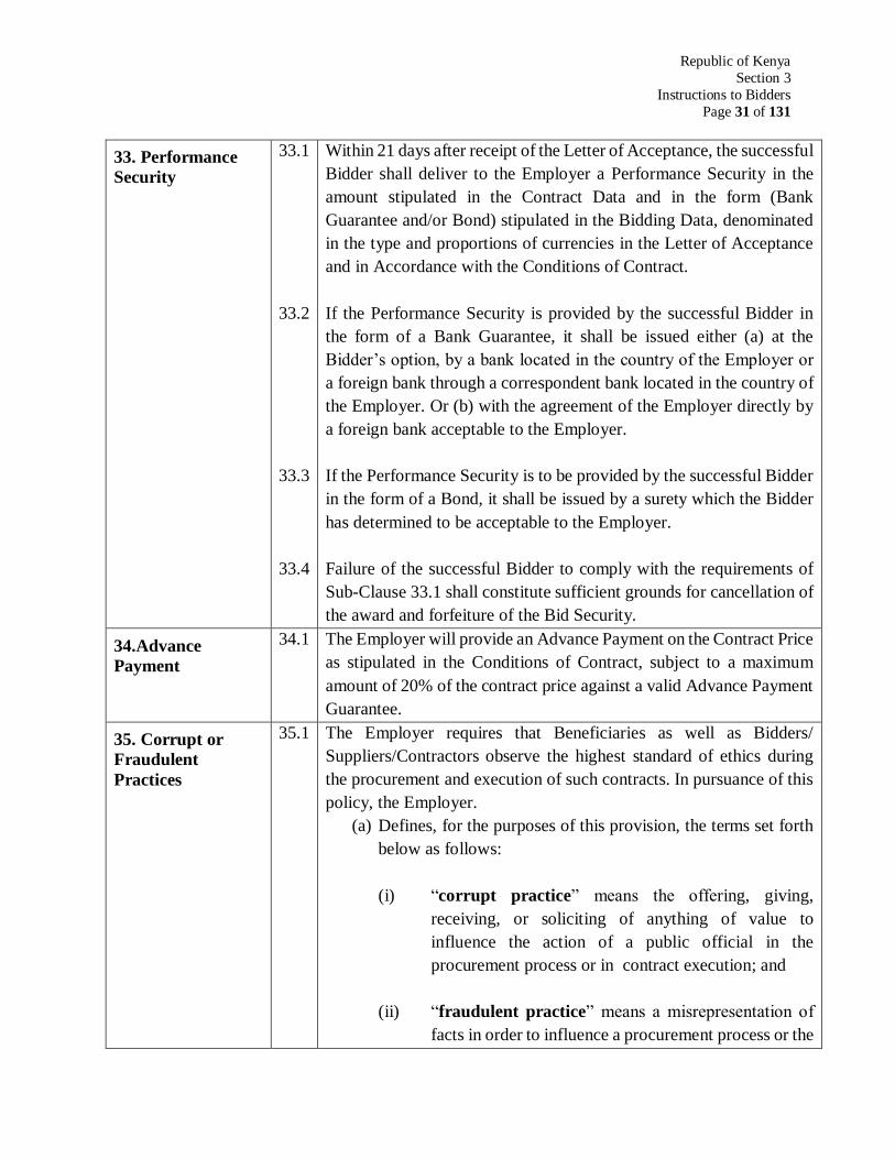
Republic of Kenya
Section 3
Instructions to Bidders
Page 31 of 131
33. Performance
Security
33.1
33.2
33.3
33.4
Within 21 days after receipt of the Letter of Acceptance, the successful
Bidder shall deliver to the Employer a Performance Security in the
amount stipulated in the Contract Data and in the form (Bank
Guarantee and/or Bond) stipulated in the Bidding Data, denominated
in the type and proportions of currencies in the Letter of Acceptance
and in Accordance with the Conditions of Contract.
If the Performance Security is provided by the successful Bidder in
the form of a Bank Guarantee, it shall be issued either (a) at the
Bidder’s option, by a bank located in the country of the Employer or
a foreign bank through a correspondent bank located in the country of
the Employer. Or (b) with the agreement of the Employer directly by
a foreign bank acceptable to the Employer.
If the Performance Security is to be provided by the successful Bidder
in the form of a Bond, it shall be issued by a surety which the Bidder
has determined to be acceptable to the Employer.
Failure of the successful Bidder to comply with the requirements of
Sub-Clause 33.1 shall constitute sufficient grounds for cancellation of
the award and forfeiture of the Bid Security.
34.Advance
Payment
34.1 The Employer will provide an Advance Payment on the Contract Price
as stipulated in the Conditions of Contract, subject to a maximum
amount of 20% of the contract price against a valid Advance Payment
Guarantee.
35. Corrupt or
Fraudulent
Practices
35.1 The Employer requires that Beneficiaries as well as Bidders/
Suppliers/Contractors observe the highest standard of ethics during
the procurement and execution of such contracts. In pursuance of this
policy, the Employer.
(a) Defines, for the purposes of this provision, the terms set forth
below as follows:
(i) “corrupt practice” means the offering, giving,
receiving, or soliciting of anything of value to
influence the action of a public official in the
procurement process or in contract execution; and
(ii) “fraudulent practice” means a misrepresentation of
facts in order to influence a procurement process or the
Republic of Kenya
Section 3
Instructions to Bidders
Page 32 of 131
execution of a contract to the detriment of the
Beneficiary, and includes collusive practice among
Bidders (prior to or after bid submission) designed to
establish bid prices at artificial non-competitive levels
and to deprive the Beneficiary of the benefits of free
and open competition;
(b) Will reject a proposal for award if it determines that the Bidder
recommended for award has engaged in corrupt or fraudulent
practices in competing for the contract in question.
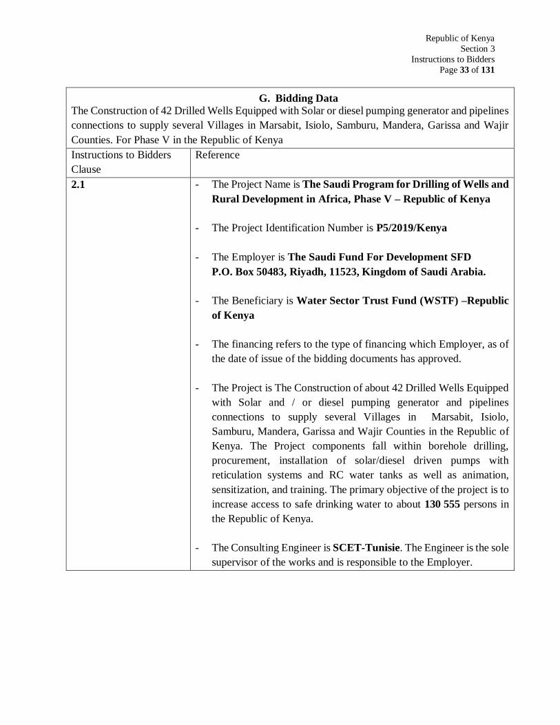
Republic of Kenya
Section 3
Instructions to Bidders
Page 33 of 131
G. Bidding Data
The Construction of 42 Drilled Wells Equipped with Solar or diesel pumping generator and pipelines
connections to supply several Villages in Marsabit, Isiolo, Samburu, Mandera, Garissa and Wajir
Counties. For Phase V in the Republic of Kenya
Instructions to Bidders
Clause
Reference
2.1
- The Project Name is The Saudi Program for Drilling of Wells and
Rural Development in Africa, Phase V – Republic of Kenya
- The Project Identification Number is P5/2019/Kenya
- The Employer is The Saudi Fund For Development SFD
P.O. Box 50483, Riyadh, 11523, Kingdom of Saudi Arabia.
- The Beneficiary is Water Sector Trust Fund (WSTF) –Republic
of Kenya
- The financing refers to the type of financing which Employer, as of
the date of issue of the bidding documents has approved.
- The Project is The Construction of about 42 Drilled Wells Equipped
with Solar and / or diesel pumping generator and pipelines
connections to supply several Villages in Marsabit, Isiolo,
Samburu, Mandera, Garissa and Wajir Counties in the Republic of
Kenya. The Project components fall within borehole drilling,
procurement, installation of solar/diesel driven pumps with
reticulation systems and RC water tanks as well as animation,
sensitization, and training. The primary objective of the project is to
increase access to safe drinking water to about 130 555 persons in
the Republic of Kenya.
- The Consulting Engineer is SCET-Tunisie. The Engineer is the sole
supervisor of the works and is responsible to the Employer.
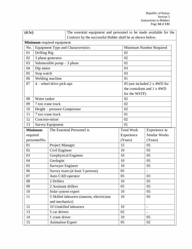
Republic of Kenya
Section 3
Instructions to Bidders
Page 34 of 131
(4.5c) The essential equipment and personnel to be made available for the
Contract by the successful Bidder shall be as shown below.
Minimum required equipment
No. Equipment Type and Characteristics Minimum Number Required
01 Drilling Rig 02
02 3 phase generator 02
03 Submersible pump – 3 phase 02
04 Dip meter 03
05 Stop watch 03
06 Welding machine 01
07 4 – wheel drive pick-ups 05 (are included 2 x 4WD for
the consultant and 1 x 4WD
for the WSTF)
08 Water tanker 02
09 7 ton crane truck 02
10 Height – pressure Compressor 02
11 7 ton crane truck 01
12 Concrete-mixer 02
13 Survey Equipment 01
Minimum
required
personnelNo.
The Essential Personnel is Total Work
Experience
(Years)
Experience in
Similar Works
(Years)
01 Project Manager 15 05
02 Civil Engineer 10 05
03 Geophysical Engineer 10 05
04 Geologist 10 05
05 Surveyor Engineer 10 05
06 Survey team (at least 3 persons) 05 -
07 Auto CAD operator 05 03
08 2 Drillers 10 05
09 2 Assistant drillers 05 05
10 Solar system expert 10 05
11 5 Skilled labourers (masons, electricians
and mechanics)
10 05
12 10 Unskilled labourers 10 -
13 5 car drivers 02 -
14 1 crane driver 10 05
15 Animation Expert 05 02
Republic of Kenya
Section 3
Instructions to Bidders
Page 35 of 131
(16.1) The format of the Bid security shall be in accordance with the forms included in the
bidding documents and shall be issued by a reputable bank or financial selected by
the bidder.
(19.2) The Employer’s address for the purpose of Bid submission is:
The Saudi Fund for Development (SFD)
P.O. Box 50483
Riyadh, 11523
Kingdom of Saudi Arabia
(20.1) The deadline for submission of bids shall be on 18th October 2021 at: 14:30 KSA
time.
(23.1) The bids will be opened in SFD office in Riyadh, Kingdom of Saudi Arabia
(34.1) The Standard Form of Performance Security acceptable to the Employer shall be
Bank Guarantee. The format of the performance security shall be in accordance with
the form included in the bidding documents and shall be issued by a reputable bank
or financial institution selected by the bidder.
SECTION 4
CONDITIONS OF CONTRACT
Republic of Kenya
Section 4
Conditions of Contract
Page 37 of 131
Conditions of Contract A. General
1. Definitions 1.1 Boldface type is used to identify terms.
Bill of Quantities means the priced and completed Bill
of Quantities forming part of the Bid.
Compensation Events are those defined in Clause 40
hereunder.
The Completion Dateis the date of completion of the
Works as certified by the Consulting Engineer (CE), in
accordance with Sub-Clause 48.1.
The Contract is the Contract between the Employer and the
Contractor to execute, complete, and maintain the Works. It
consists of the documents listed in Clause 2.2 below.
The Contractor is a person or corporate body whose Bid to
carry out the Works has been accepted by the Employer.
The Contractor’s Bid is the completed bidding document
submitted by the Contractor to the Employer.
The Contract Price is the price stated in the Letter of
Acceptance and thereafter as adjusted in accordance with
the provisions of the Contract.
Days are calendar days: months are calendar months.
Day works are varied work inputs subject to payment on a
time basis for the Contractor’s employees and Equipment,
in addition to payments for associated Materials and Plant.
A Defect is any part of the Works not completed in
accordance with the Contract.
The Defects Liability Certificate is the certificate issued by
the Consulting Engineer (CE) upon correction of defects by
the Contractor.
Republic of Kenya
Section 4
Conditions of Contract
Page 38 of 131
The Defects Liability Period is the period named in the
Contract Data and calculated from the Completion Date.
Drawings include calculations and other information
provided or approved by the Consulting Engineer (CE) for
the execution of the Contract.
The Employer is the party who employs the Contractor to
carry out the Works.
Equipment is the Contractor’s machinery and vehicles
brought temporarily to the Site to construct the Works.
The Initial Contract Price is the Contract Price listed in the
Employer’s Letter of Acceptance.
The Intended Completion Date is the date on which it is
intended that the Contractor shall complete the Works. The
Intended Completion Date is specified in the Contract Data.
The Intended Completion Date maybe revised only by the
Consulting Engineer (CE) by issuing an extension of time or
an acceleration order.
Materials are all supplies, including consumables, used by
the Contractor for incorporation in the Works.
Plant is any integral part of the Works that shall have a
mechanical, electrical, Chemical, or biological function.
The Consulting Engineer (CE) is the person named in the
Contract Data who is responsible for supervising the
execution of the Works and administering the Contract.
The Site is the area defined as such in the Contract Data.
Specification means the Specification of the Works
included in the Contract and any modification or addition
made by the Consulting Engineer and approved by the
Employer.
The Start Date is given in the Contract Data. It is the latest
date when the Contractor shall commence execution of the
Republic of Kenya
Section 4
Conditions of Contract
Page 39 of 131
Works. It does not necessarily coincide with any of the Site
Possession Dates.
A subcontractor is a person or corporate body who has a
Contract with the Contractor to carry out a part of the work
in the Contract which includes work on the Site.
Temporary Works are works designed, constructed,
installed, and removed by the Contractor that are needed for
construction or installation of the Works. No payment for
temporary work.
A Variation is an instruction given by the Consulting
Engineer (CE) which varies the Works.
The Works are what the Contract requires the Contractor to
construct, install, and turn over to the Employer, as defined
in the Contract Data.
2. Interpretation 2.1
2.2
In interpreting these Conditions of Contract, singular also
means plural, male also means female and the other way
around. Headings have no significance. Words have their
normal meaning under the language of the contract unless
specifically defined. The Consulting Engineer (CE) will
provide instructions clarifying queries about these
Conditions of Contract.
The documents forming the Contract shall be interpreted in
the following order of priority:
(1) Agreement
(2) Letter of Acceptance,
(3) Contractor’s Bid
(4) Contract Data,
(5) Conditions of Contract,
(6) Specifications,
(7) Drawings,
(8) Bill of Quantities and
(9) Any other document listed in the Contract Data as
forming part of the Contract.
3. Language and law 3.1 The language of the Contract and the law governing the
Contract are stated in the Contract Data.

Republic of Kenya
Section 4
Conditions of Contract
Page 40 of 131
4. Consulting
Engineer’s Decisions
4.1 Except where otherwise specifically stated, the Consulting
Engineer (CE) will decide contractual matters between the
Employer and the Contractor in the role representing the
Employer.
5. Delegation 5.1 The Consulting Engineer (CE) may delegate any of his
duties and responsibilities to other people after notifying the
Contractor, and may cancel any delegation after notifying
the Contractor.
6. Communications 6.1 Communication between parties that are referred to in the
Conditions shall be effective only when in writing. A notice
shall be effective only when it is delivered.
7. Subcontracting 7.1 The Contractor may subcontract with the approval of the
Consulting Engineer (EC), but may not assign the Contract
without the approval of the Employer in writing.
Subcontracting shall not alter the Contractors’ obligations.
8. Personnel 8.1
8.2
The Contractor shall employ the key personnel named in the
Schedule of Key Personnel to carry out the functions stated
in the Schedule or other personnel approved by the
Consulting Engineer (CE). The Consulting Engineer (CE)
will approve any proposed replacement of key personnel
only if their relevant qualifications and abilities are
substantially equal to or better than those of the personnel
listed in the Schedule.
If the Consulting Engineer (CE) asks the Contractor to
remove a person who is a member of the Contractor’s staff
or work force, stating the reasons, the Contractor shall
ensure that the person leaves the Site within seven days and
has no further connection with the work in the Contract
9. Employer’s and
Contractor’s Risks
9.1 The Employer carries the risks which Contract states
are Employer’s risks, and the Contractor carries the
risks which this Contract states are Contractor’s risks.
10. Employer’s Risks 10.1 By this contract the Employer does not carry any risk.
The Contractor shall notify the Consultant Engineer
(CE) and/or the Employer to any probable risk to be
agreed on the consequence.
11. Contractor’s
Risks
11.1 From the Starting Date until the Defects Correction
Certificate has been issued, the risks of personal injury,
death, and loss of or damage to property (including,
without limitation, the Works, plant, materials, and
Equipment) shall be borne by the Contractor.
Republic of Kenya
Section 4
Conditions of Contract
Page 41 of 131
12. Insurance 12.1
12.2
12.3
12.4
12.5
The Contractor shall provide, in the joint names of the
Employer and the Contractor, insurance cover from the
Start Date to the end of the Defects Liability Period, in
the amounts and deductibles stated in the Contract
Data for the following events which are due to the
Contractor’s risks:
(a) Loss of or damage to the Works, Plant, and
Materials;
(b) Loss of or damage to property (except the
Works, Plant, Materials, and Equipment) in
connection with the Contract; and
(c) Personal injury or death.
Policies and certificate for insurance shall be delivered
by the Contractor to the Employer for the Employer’s
approval before the Start Date. All such insurance shall
provide for compensation to be payable in the types
and proportions of currencies required to rectify the
loss or damage incurred.
If the Contractor does not provide any of the policies
and certificates required, the Employer may effect the
insurance which the Contractor should have provided
and recover the premiums the Employer has paid from
payments otherwise due to the Contractor or, if no
payment is due, the payment of the premiums shall be
a debt due.
Alterations to the terms of insurance shall not be made
without the approval of the Employer.
Both parties shall comply with any conditions of the
insurance policies.
13. Queries about the
Contract Data
13.1 The Consulting Engineer (CE) will clarify queries on
the Contract Data.
Republic of Kenya
Section 4
Conditions of Contract
Page 42 of 131
14. Contractor to
Construct the Works
14.1 The Contractor shall construct and install the Works in
accordance with the Specifications and Drawings,
beside he shall:
(a) Provide an office at his base camp for the
Consultant Engineer (EC) with all facilities;
furniture, laptops, printing, facsimile, digital
cameras, refrigerator, etc…
(b) Two four wheel drive vehicles for the sole use
of the Supervisor and the Animation Expert
(c) One four wheel drive vehicle to the RE of the
WSTF
All the operation costs of the Consultant premises as
well as the three 4WD (including driver cost) are to be
provided by the Contractor.
15. The Works to Be
Completed by the
Intended Completion
Date
15.1 The Contractor may commence execution of the Works
on the Start Date and shall carry out the Works in
accordance with the Program submitted by the
Contractor, as updated with the approval of the
Consulting Engineer (CE), and complete then by the
Intended Completion Date.
16. Approval by the
Consulting Engineer
(CE)
16.1
16.2
16.3
16.4
The Contractor shall submit Specifications and
Drawings showing the proposed Temporary Works to
the Consulting Engineer (CE), who is to approve them
if they comply with the Specifications and Drawings.
The Contractor shall be responsible for design of
Temporary Works.
The Consulting Engineer (CE) approval shall not alter
the Contractor’s responsibility for design of the
Temporary works.
All Drawings prepared by the Contractor for the
execution of the temporary or permanent works, are
subject to prior approval by the Consulting Engineer
(CE) before this use.
Republic of Kenya
Section 4
Conditions of Contract
Page 43 of 131
14. Safety 17.1 The Contractor shall be responsible for the safety of all
activities.
18. Discoveries 18.1 Anything of historical or other interest or of significant
value unexpectedly discovered on the Site shall be the
property of the Employer. The Contractor shall notify
the Consulting Engineer (CE) of such discoveries and
carry out the Consulting Engineer’s (CE) instructions
for dealing with them.
19. Possession of the
Site
19.1 The Employer shall give possession of all parts of the
Site to the Contractor. If possession of a part is not
given by the date stated in the Contract Data, the
Employer will be deemed to have delayed the start of
the relevant activities, and this will be a Compensation
Event.
20. Access to the Site 20.1 The Contractor shall allow the Consulting Engineer
(CE) and any person authorized by the Consulting
Engineer (CE) access to the Site and to any place
where work in connection with the Contract is being
carried out or is intended to be carried out.
21. Instructions,
Inspections and
Audits
21.2 The Contractor shall permit the Employer to inspect
the Contractor’s accounts and records relating to the
performance of the Contractor and to have them
audited by auditors appointed by him, if so required.
22. Disputes 22.1
22.2
If the Contractor believes that a decision taken by the
Consulting Engineer (CE) was either outside the
authority given to the Consulting Engineer (CE) by the
Contract or that the decision was wrongly taken, the
decision shall be referred to the Employer within 14
days of the notification of the Consulting Engineer’s
(CE) decision.
Dispute arising out or in connection to this Contract
shall first be resolved by:
(a) Amicable means: Each party shall assign an
authorized representative of its executive level
personnel. The representatives shall hold
meeting in any place agreed upon by the two
parties. The representatives shall in good faith
negotiate the dispute and reach a solution.
Republic of Kenya
Section 4
Conditions of Contract
Page 44 of 131
Should the two parties fail to reach a resolution
acceptable to both parties within a period not
exceeding 30 days, then the parties shall seek a
resolution.
(b) Mediation: The two parties shall assign a
mutually agreed upon mediator well known for
experience and integrity. The mediator shall
carry out the mediation process guided by
nationally recognized mediation codes and
practice. Should the mediator not reach a
resolution acceptable by both parties within a
period not exceeding 30 days then the parties or
anyone of them proceed for arbitration in
accordance of the arbitration rules of the Saudi
Fund for Development. The arbitration award
shall be final and binding on both parties. All
costs of disputes shall be divided between the
Employer and the Contractor.
B. Time Control
23. Program 23.1
23.2
23.3
Within the time stated in the Contract Data, the
Contractor shall submit to the Consulting Engineer
(CE) for approval a Program showing the general
methods, arrangements, order, and timing for all the
activities in the works.
An update of the Program shall be a program showing
the actual progress achieved on each activity and the
effect of the progress achieved on the timing of the
remaining work, including any changes to the sequence
of the activities.
The Contractor shall submit to the Consulting Engineer
(CE) for approval an updated program at intervals no
longer than the period stated in the Contract Data. If
the Contractor does not submit an updated Program
within this period, the Consulting Engineer (CE) may
withhold the amount stated in the Contract Data from
the next payment certificate and continue to withhold
Republic of Kenya
Section 4
Conditions of Contract
Page 45 of 131
23.4
this amount until the next payment after the date on
which the overdue program has been submitted.
The Consulting Engineer’s (CE) approval of the
Program shall not alter the Contractor’s obligations.
The Contractor may revise the Program and submit it
to the Consulting Engineer (CE) again at any time. A
revised program shall show the effect of variations and
Compensation Events.
24. Extension of the
Intended Completion
Date
24.1
24.2
The Consulting Engineer (CE) shall extend with the
approval of the employer the Intended Completion
Date if a Compensation Event occurs or a Variation is
issued which makes it impossible for Completion to be
achieved by the Intended Completion Date without the
Contractor taking steps to accelerate the remaining
work, which would cause the Contractor to incur
additional cost.
The Consulting Engineer (CE) shall decide whether
and by how much to extend the Intended Completion
Date within 21 days of the Contractor asking the
Consulting Engineer (CE) for a decision upon the
effect of a Compensation Event or Variation and
submitting full supporting information. If the
Contractor has failed to give early warning of a delay
or has failed to cooperate in dealing with a delay, the
delay by this failure shall not be considered in
assessing the new Intended Completion Date.
25. Acceleration 25.1
When the Employer wants the Contractor to finish
before the Intended Completion Date, the Consulting
Engineer (CE) will obtain priced proposals for
achieving the necessary acceleration from the
Contractor. If the Employer accepts these proposals,
the Intended Completion Date will be adjusted
accordingly and confirmed by both the Employer and
the Contractor.
Republic of Kenya
Section 4
Conditions of Contract
Page 46 of 131
25.2 If the Contractor’s priced proposals for acceleration are
accepted by the Employer, they are incorporated in the
Contract Price and treated as a variation.
26. Delays Ordered
by the Consulting
Engineer
26.1 The Consulting Engineer (CE) may instruct the
Contractor to delay the start or progress of any activity
within the Works.
27. Management
Meetings
27.1
27.2
Either the Consulting Engineer (CE) or the Contractor
may require the other to attend a management meeting.
The business of a management meeting shall be to
review the plans for remaining work and to deal with
matters raised in accordance with the early warning
procedure.
The Consulting Engineer (CE) shall record the
business of management meetings and provide copies
of the record to those attending the meeting and to the
Employer. The responsibility of the parties for actions
to be taken shall be decided by the Consulting
Engineer (CE) either at the management meeting or
after the management meeting and stated in writing to
all who attended the meeting.
28. Early warning 28.1
28.2
The Contractor shall warn the Consulting Engineer
(CE) at the earliest opportunity of specific likely future
events or circumstances that may adversely affect the
quality of the work increase the Contract Price or delay
the execution of the Works. The Consulting Engineer
(CE) may require the Contractor to provide an estimate
of the expected effect of the future event or
circumstance on the Contract Price and Completion
Date. The estimate shall be provided by the Contractor
as soon as reasonably possible.
The Contractor shall cooperate with the Consulting
Engineer (CE) in making and considering proposals for
how the effect of such an event or circumstance can be
avoided or reduced by anyone involved in the work
and in carrying out any resulting instruction of the
Consulting Engineer (CE).
Republic of Kenya
Section 4
Conditions of Contract
Page 47 of 131
C. Quality Control
29. Identifying
Defects
29.1 The Consulting Engineer (CE) shall check the
Contractor’s work and notify the Contractor of any
Defects that are found, Such checking shall not affect
the Contractor’s responsibilities. The Consulting
Engineer (CE) may instruct the Contractor to search
for a Defect and to uncover and test any work that the
Consulting Engineer (CE) considers may have a
Defect.
30. Tests 30.1 If the Consulting Engineer (CE) instructs the
Contractor to carry out a test not specified in the
Specification to check whether any work has a Defect
and the test shows that it does, the Contractor shall pay
for the test and any samples. If there is no Defect, the
test shall be a Compensation Event.
31. Correction of
Defects
31.1
31.2
The Consulting Engineer (CE) shall give notice to the
Contractor of any Defects before the end of the Defects
Liability Period, which begins at Completion, and is
defined in the contract Data. The Defects Liability
Period shall be extended for as long as Defects remain
to be corrected.
Every time of Defect is given, the Contractor shall
correct the notified Defect within the length of time
specified by the Consulting Engineer’s (EC) notice.
32. Uncorrected
Defects
32.1 If the Contractor has not corrected a Defect within the
time specified in the Consulting Engineer’s (EC)
notice, the Consulting Engineer will assess the cost of
having the Defect corrected, and the Contractor will
pay this amount.
D. Cost Control
33. Bill of Quantities 33.1
33.2
The Bill of Quantities shall contain items for the
construction, installation, testing, and commissioning
work to be done by the Contractor.
The Bill of Quantities is used to calculate the Contract
Price. The Contractor is paid for the quantity of the
work done at the rate in the Bill of Quantities for each
item
Republic of Kenya
Section 4
Conditions of Contract
Page 48 of 131
34. Changes in the
Quantities
34.1
34.2
34.3
If the final quantity of the work done differs from the
quantity in the Bill of Quantities for the particular item
by more than 25 per cent, provided the change exceeds
1 per cent of the Initial Contract Price, the Consulting
Engineer (CE) shall adjust the rate to allow for the
change.
The Consulting Engineer (CE) shall not adjust rates
from changes in quantities if thereby the Initial
Contract Price is exceeded by more than 15 per cent,
except with the prior approval of the Employer.
If requested by the Consulting Engineer (CE), the
Contractor shall provide the Consulting Engineer (CE)
with a detailed cost breakdown of any rate in the Bill
of Quantities.
35. Variations 35.1 All Variations shall be included in updated Programs
produced by the Contractor.
36. Payments 36.1
36.2
The Contractor shall provide the Consulting Engineer
(CE) with a quotation for carrying out the Variation
when requested to do so by the Consulting Engineer
(CE). The Consulting Engineer (CE) shall assess the
quotation, which shall be given within seven days of
the request or within any longer period stated by the
Consulting Engineer (CE) and before the Variation is
ordered.
If the work in the Variation corresponds with an item
description in the Bill of Quantities and if, in the
opinion of the Consulting Engineer (CE), the quantity
of work above the limit stated in Sub-Clause 34.1 or
the timing of its execution do not cause the cost per
unit of quantity to change, the rate in the Bill of
Quantities shall be used to calculate the value of the
Variation. If the cost per unit of quantity changes, or if
the nature or timing of the work in the Variation does
not correspond with items in the Bill of Quantities, the
quotation by the Contractor shall be in the form of new
rates for the relevant items of work.
Republic of Kenya
Section 4
Conditions of Contract
Page 49 of 131
36.3
36.4
36.5
If the Contractor’s quotation is unreasonable, the
Consulting Engineer (CE) may order the Variation and
make a change to the Contract Price, which shall be
based on the Consulting Engineer’s (CE) own forecast
of the effects of the Variation on the Contractor’s
costs.
If the Consulting Engineer (CE) decides that the
urgency of varying the work would prevent a quotation
being given and considered without delaying the work,
no quotation shall be given and the Variation shall be
treated as a Compensation Event.
The Contractor shall not be entitled to additional
payment for cost that could have been avoided by
giving early warning.
37. Cash Flow
Forecasts
37.1 When the Program is updated, the Contractor shall
provide Consulting Engineer (CE) with an updated
cash flow forecast.
38. Payment
Certificates
38.1
38.2
38.3
38.4
38.5
The Contractor shall submit to the Consulting Engineer
(CE) 3 months statements of the estimated value of the
work executed less than the cumulative amount
certified previously.
The Consulting Engineer (CE) shall check the
Contractor’s statement and certify the amount to be
paid to the Contractor
The value of work executed shall be determined by the
Consulting Engineer (CE)
The value of work executed shall comprise the value of
the quantities of the items in the Bill of quantities
completed.
The value of work executed shall include the valuation
of Variations and Compensation Events.
Republic of Kenya
Section 4
Conditions of Contract
Page 50 of 131
38.6
The Consulting Engineer (EC) may exclude any item
certified in a previous certificate or reduce the
proportion of the item previously certified in any
certificate in the light of later information.
39. Payments 39.1
39.2
39.3
Payments shall be adjusted for deductions for advance
payments and retention. The Employer shall pay the
Contractor the amount certified by the Consulting
Engineer (CE) within 45 days of the date of each
certificate.
Unless otherwise stated, all payments and deductions
will be paid or charged in the proportions of currencies
comprising the Contract Price.
Items of the Works for which no rate or price has been
entered in will not be paid for by the Employer and
shall be deemed covered by other rates and prices in
the Contract.
40. Compensation
Events
40.1
The following shall be Compensation Events:
(a) The Employer does not give access to a part of
the Site by the Site Possession Date stated in
the Contract Data
(b) The Employer modifies the Schedule of Other
Contractors in a way that affects the work of
the Contractor under the Contract
(c) The Consulting Engineer (CE) orders a delay or
does not issue Drawings, Specifications, or
instructions required or execution of the Works
on time.
(d) The Consulting Engineer (CE) instructs the
Contractor to uncover or to carry out additional
tests upon work, which is then found to have no
defects.
(e) The Consulting Engineer (CE) unreasonably
does not approve a subcontract to be let.
(f) Ground conditions are substantially more
adverse than could reasonably have been
assumed before issuance of the Letter of
Acceptance from the information issued to
Republic of Kenya
Section 4
Conditions of Contract
Page 51 of 131
40.2
40.3
bidders (including the Site Investigation
Reports), from information available publicly
and from a visual inspection of the Site.
(g) The Consulting Engineer (CE) gives an
instruction for dealing with an unforeseen
condition, caused by the Employer, or
additional work required for safety or other
reasons.
(h) Other Contractors, public authorities, Utilities,
or the Employer does not work within the dates
and other constraints stated in the Contract, and
they cause delay or extra cost to the Contractor.
(i) The advance payment is delayed.
(j) The effects on the Contractor of any of the
Employer’s Risks.
(k) The Consulting Engineer (CE) unreasonably
delays issuing a Certificate of Completion.
(l) Other Compensation Events described in the
Contract or determined by the Consulting
Engineer (CE) shall apply.
If a Compensation Event would cause additional cost
or would prevent the work being completed before the
Intended Completion Date, the Contract Price shall be
increased and/or the Intended Completion Date shall be
extended. The Consulting Engineer (CE) shall decide
whether and by how much the Contract Price shall be
increased and whether and by how much the Intended
Completion Date shall be extended.
As soon as information demonstrating the effect of
each Compensation Event upon the Contractor, it shall
be assessed by the Consulting Engineer (CE), and the
Contract Price shall be adjusted accordingly. If the
Contractor’s forecast is deemed unreasonable, the
Consulting Engineer (CE) shall adjust the Contract
Price based on the Consulting Engineer (CE) own
forecast. The Consulting Engineer (CE) will assume
Republic of Kenya
Section 4
Conditions of Contract
Page 52 of 131
40.4
that the Contractor will react competently and
promptly to the event.
The Contractor shall not be entitled to compensation to
the extent that the Employer’s interests are adversely
affected by the Contractor’s not having given early
warning or not having cooperated with the Consulting
Engineer (CE).
41. Tax 41.1 The project is taxes, duties and other levies exempted
and this is all equipment, tools and personnel of the
Contractor.
42. Retention 42.1
42.2
42.3
The Employer shall retain from each payment due to
the Contractor the proportion stated in the Contract
Data until Completion of the whole of the Works.
On completion of the whole of the Works, half of the
total amount retained shall be repaid to the Contractor
and half when the Defects Liability Period has passed
and the Consulting Engineer (CE) has certified that all
Defects notified by the Consulting Engineer (CE) to
the Contractor before the end of this period have been
corrected.
On completion of the whole Works, the Contractor
may substitute retention money with an “on demand”
Bank guarantee.
43.Liquidated
Damages
43.1
43.2
The Contractor shall pay liquidated damages to the
Employer at the rate per day stated in the Contract
Data for each day that the Completion Date is later
than the Intended Completion Date. The total amount
of liquidated damages shall not exceed that amount
defined in the Contract Data. The Employer may
deduct liquidated damages shall not affect the
Contractor’s liabilities.
If the Contractor fails to comply with the Time for
Completion in accordance with Clause 48 for the
whole of the Works or, if applicable, any Section
within the relevant time prescribed by Clause 43.1,
Republic of Kenya
Section 4
Conditions of Contract
Page 53 of 131
43.3
then the Contractor shall pay to the Employer all extra
Consultant fees due because of that failure and a
penalty as subsequently mentioned for the time which
shall elapse between the relevant Time for Completion
and the date stated in the Taking-Over Certificate of
the whole of the Works or the relevant Section.
For each of the first four of such weeks of delay the
sum of 0.25% per week of the Contract Price.
For each of the second four such weeks of delay
the sum of 0.75% per week of the Contract Price.
For each subsequent week of delay thereafter the
sum of 1% per week of the Contract Price
The Employer may, without prejudice to any other
method of recovery, deduct the amount of such penalty
from any monies due to or to become due to the
Contractor, the Payment or deduction of such penalty
shall not relieve the Contractor from his obligations to
complete the works, or from any other of his
obligations and liabilities under this Contract, namely
for damages caused by delay.
If the Intended Completion Date is extended after
liquidated damages have been paid, the Consulting
Engineer shall correct any overpayment of liquidated
damages by the Contractor by adjusting the next
payment certificate.
44. Advance Payment 44.1
The Employer shall make advance payment to the
Contractor of the amounts stated in the Contract Data
by the date stated in the Contract Data, against
provision by the Contractor of an Unconditional Bank
Guarantee in a form and by a bank acceptable to the
Employer in amounts and currencies equal to the
advance payment. The Guarantee shall remain
effective until the advance payment has been repaid,
but the amount of the Guarantee shall be progressively
reduced by the amounts repaid by the Contractor.
Interest will not be charged on the advance payment
Republic of Kenya
Section 4
Conditions of Contract
Page 54 of 131
44.2
44.3
The Contractor is to use the advance payment only to
pay for Equipment, Plant, Materials, and mobilization
expenses required specifically for execution of the
Contract. The Contractor shall demonstrate that
advance payment has been used in this way by
supplying copies of invoices or other documents to the
Consulting Engineer (CE).
The advance payment shall be repaid by deducting
proportionate amounts from payments otherwise due to
the Contractor, following the schedule of completed
percentages of the Works on a payment basis. No
account shall be taken of the advance payment or its
repayment in assessing valuations of work done,
Variations, price adjustments, Compensation Events,
or Liquidated Damages.
45. Securities 45.1 The Performance Security as specified in the Contract
Data shall be provided to the Employer no later than
the date specified in the Letter of Acceptance and shall
be issued in an amount and form and by a bank or
surety acceptable to the Employer, and denominated in
the types and proportions of the currencies in which the
Contract Price is payable. The Performance Security
shall be valid until a date 28 days from the date of
issue of the Certificate of Completion in the case of a
Bank
Guarantee, and until one year from the date of issue of
the Completion Certificate in the case of a
Performance Bond.
46. Day Works 46.1
46.2
If applicable, the Day works rates in the Contractor’s
Bid shall be used for small additional amounts of work
only when the Consulting Engineer (CE) has given
written instructions in advance for additional work to
be paid for in that way.
All work to be paid for as Day works shall be recorded
by the Contractor on forms approved by the Consulting
Engineer (CE). Each completed form shall be verified
Republic of Kenya
Section 4
Conditions of Contract
Page 55 of 131
46.3
and signed by the Consulting Engineer (CE) within
two days of the work being done.
The Contractor shall be paid for Day works subject to
obtaining signed Day works forms.
47. Cost of Repair 47.1 Loss or damage to the Works or Materials to be
incorporated in the Works between the Start Date and
the end of the Defects Correction periods shall be
remedied by the Contractor at the Contractor’s cost if
the loss or damage arises from the Contractor’s acts or
commissions.
E. Finishing the Contract
48. Completion 48.1 The Contractor shall request the Consulting Engineer
(CE) to issue a certificate of Completion of the Works,
and the Consulting Engineer (CE) will do so upon
deciding that the work is completed.
49. Taking Over 49.1 The Employer shall take over the Site and the Works
with in seven days of the Consulting Engineers (CE)
issuing a certificate of Completion.
50. Final Account 50.1 The Contractor shall supply the Consulting Engineer
(CE) with a detailed account of the total amount that
the Contractor considers payable under the Contract
before the end of the Defects Liability Period. The
Consulting Engineer’s (CE) shall issue a Defects
Liability Certificate and certify any final payment that
is due to the Contractor within 56 days of receiving the
Contractor’s account if it is correct and complete. If
not, the Consulting Engineer (CE) shall issue within 56
days a schedule that states the scope of the corrections
or additions that are necessary. If the Final Account is
still unsatisfactory after it has been resubmitted, the
Consulting Engineer’s (CE) shall decide on the amount
payable to the Contractor and issue a payment
certificate.
51. Operating and
Maintenance
Manuals
51.1
If “as built” Drawings and/or operating and
maintenance manuals are required, the Contractor shall
supply them by the dates stated in the Contract Data.
Republic of Kenya
Section 4
Conditions of Contract
Page 56 of 131
51.2 If the Contractor does not supply the Drawings and/or
manuals by the dates stated in the Contract Data, or
they do not receive the Consulting Engineer’s (CE)
approval, the Consulting Engineer (CE) shall
withhold the amount stated in the Contract Data from
payments due to the Contractor.
52. Termination 52.1
52.2
The Employer or the Contractor may terminate the
Contract if the other party causes a fundamental breach
of the Contract. Either party must write a notice of
termination to the other party before termination. A
warning letter will be sent to the contractor for the first
breach of the contract. Only if the breach is not corrected
within a stipulated period indicated in the warning letter
or the breach is repeated again shall the Employer notify
the contractor of the contract termination.
Fundamental breaches of Contract shall include, but
shall not be limited to, the following.
a) The Contractor stops work for 28 days when no
stoppage of work is shown on the current
Program and the stoppage has not been
authorized by the Consulting Engineer (CE).
b) The Consulting Engineer (CE) instructs the
Contractor to delay the progress of the Works,
and the instruction is not withdrawn within 28
days.
c) The Employer or the Contractor is made
bankrupt or goes into liquidation other than for
a reconstruction or amalgamation;
d) A payment certified by the Consulting Engineer
(CE) is not paid by the Employer to the
Contractor within 84 days of the date of the
Consulting Engineer’s (CE) certificate;
Republic of Kenya
Section 4
Conditions of Contract
Page 57 of 131
52.3
e) The Consulting Engineer (CE) gives Notice
that failure to correct a particular Defect is a
fundamental breach of Contract and the
Contractor fails to correct it within a reasonable
period of time determined by the Consulting
Engineer (CE);
f) The Contractor does not maintain a Security,
which is required; and
g) The Contractor has delayed the completion of
the Works by the number of days which the
maximum amount of liquidated damages can be
aid, as defined in the Contract Data.
h) The Contractor, in the judgment of the
Employer has engaged in corrupt of fraudulent
practices in competing for or in executing the
Contract.
For the purpose of this paragraph:
“Corrupt practice” means the offering, giving,
receiving, or soliciting of anything of value to
influence the action of a public official in the
procurement process or in contract execution.
“fraudulent practice” means a misrepresentation of
facts in order to influence a procurement process or the
execution of a contract to the detriment of the
Beneficiary, and includes collusive practice among
Bidders (prior to or after bid submission) designed to
establish bid prices at artificial non-competitive levels
and to deprive the Beneficiary of the benefits of free
and open competition.
When either party of the Contract gives notice of a
breach of Contract to the Consulting Engineer (CE) for
Republic of Kenya
Section 4
Conditions of Contract
Page 58 of 131
52.4
52.5
a cause other than those listed under Sub-Clause 52.2
above, the Consulting Engineer (CE) shall decide
whether the breach is fundamental or not.
Notwithstanding the above, the Employer may
terminate the Contract for convenience.
If the Contract is terminated, the Contractor shall stop
work immediately, make the Site safe and secure, and
leave the Site as soon as reasonably possible.
53. Payment Upon
Termination
53.1
53.2
If the Contract is terminated because of a fundamental
breach of Contract by the Contractor, the Consulting
Engineer shall issue a certificate for the value of the
work done and Materials ordered less advance
payments received up to the date of the issue of the
certificate and less the percentage to apply to the value
of the work not completed, as indicated in the Contract
Data. Additional Liquidated Damages shall not apply.
If the total amount due to the Employer exceeds any
payment due to the Contractor, the difference shall be a
debt payable to the Employer.
If the Contract is terminated for the Employer’s
convenience or because of a fundamental breach of
Contract by the Employer, the Consulting Engineer
shall issue a certificate for the value of the work done,
Materials ordered, the reasonable cost of removal of
Equipment, repatriation of the Contractor’s personnel
employed solely on the Works, and the Contractor’s
costs of protecting and securing the Works, and less
advance payments received up to the date of the
certificate.
54. Property 54.1 All Materials on the Site, Plant, Equipment, Temporary
Works’, and Works shall be deemed to be the property
of the Employer if the Contract is terminated because
of the Contractor’s fault.
55. Release from
Performance
55.1 If the Contract is frustrated by the outbreak of war or
by any other event entirely outside the control of either
the Employer or the Contractor, the Consulting
Republic of Kenya
Section 4
Conditions of Contract
Page 59 of 131
Engineer shall certify that the Contract has been
frustrated. The Contractor shall make the Site safe and
stop work as quickly as possible after receiving this
certificate and shall be paid for all work carried out
before receiving it and for any work carried out
afterwards to which a commitment was made.
56. Suspension of
Project Financing
56.1 In the event that the financing of the Project is stopped.
(a) The Employer is obligated to notify the Contractor
of such suspension within 7 days of having
received the suspension notice.
(b) If the Contractor has not received sums due within
84 days for payment provided for in Sub-Clause
52.2, the Contractor may immediately issue a 14-
day termination notice.
57. FIDIC 57.1
57.2
FIDIC conditions of Contract for work of Civil
Engineering Construction also apply beside the above
conditions.
If a condition stipulated here is different of the FIDIC
Condition, this contract conditions prevail.
SECTION 5
CONTRACT DATA
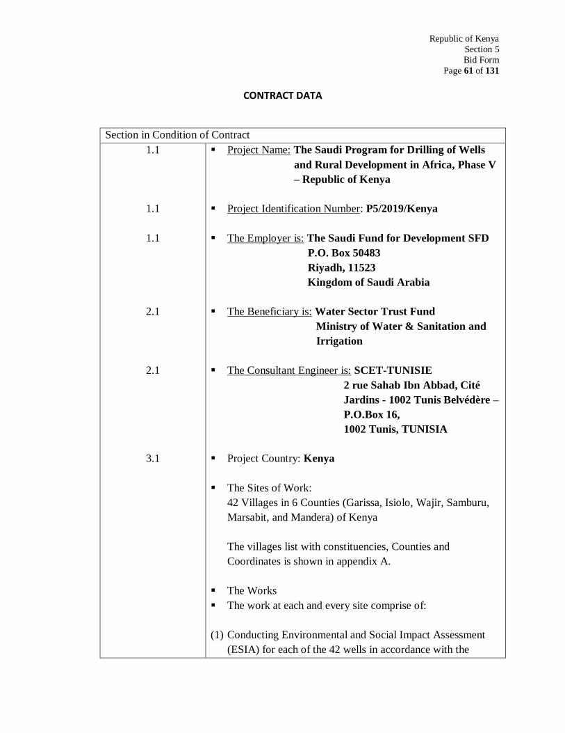
Republic of Kenya
Section 5
Bid Form
Page 61 of 131
CONTRACT DATA
Section in Condition of Contract
1.1
1.1
1.1
2.1
2.1
3.1
Project Name: The Saudi Program for Drilling of Wells
and Rural Development in Africa, Phase V
– Republic of Kenya
Project Identification Number: P5/2019/Kenya
The Employer is: The Saudi Fund for Development SFD
P.O. Box 50483
Riyadh, 11523
Kingdom of Saudi Arabia
The Beneficiary is: Water Sector Trust Fund
Ministry of Water & Sanitation and
Irrigation
The Consultant Engineer is: SCET-TUNISIE
2 rue Sahab Ibn Abbad, Cité
Jardins - 1002 Tunis Belvédère –
P.O.Box 16,
1002 Tunis, TUNISIA
Project Country: Kenya
The Sites of Work:
42 Villages in 6 Counties (Garissa, Isiolo, Wajir, Samburu,
Marsabit, and Mandera) of Kenya
The villages list with constituencies, Counties and
Coordinates is shown in appendix A.
The Works
The work at each and every site comprise of:
(1) Conducting Environmental and Social Impact Assessment
(ESIA) for each of the 42 wells in accordance with the
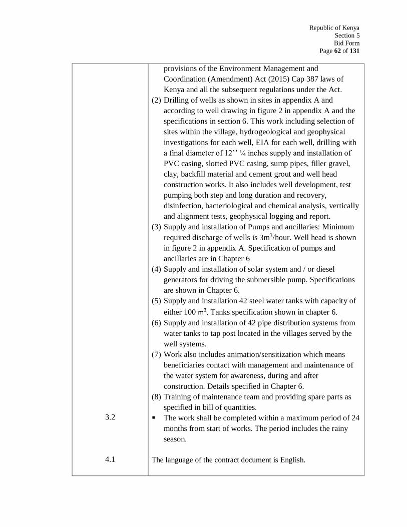
Republic of Kenya
Section 5
Bid Form
Page 62 of 131
3.2
4.1
provisions of the Environment Management and
Coordination (Amendment) Act (2015) Cap 387 laws of
Kenya and all the subsequent regulations under the Act.
(2) Drilling of wells as shown in sites in appendix A and
according to well drawing in figure 2 in appendix A and the
specifications in section 6. This work including selection of
sites within the village, hydrogeological and geophysical
investigations for each well, EIA for each well, drilling with
a final diameter of 12’’ ¼ inches supply and installation of
PVC casing, slotted PVC casing, sump pipes, filler gravel,
clay, backfill material and cement grout and well head
construction works. It also includes well development, test
pumping both step and long duration and recovery,
disinfection, bacteriological and chemical analysis, vertically
and alignment tests, geophysical logging and report.
(3) Supply and installation of Pumps and ancillaries: Minimum
required discharge of wells is 3m3/hour. Well head is shown
in figure 2 in appendix A. Specification of pumps and
ancillaries are in Chapter 6
(4) Supply and installation of solar system and / or diesel
generators for driving the submersible pump. Specifications
are shown in Chapter 6.
(5) Supply and installation 42 steel water tanks with capacity of
either 100 m3. Tanks specification shown in chapter 6.
(6) Supply and installation of 42 pipe distribution systems from
water tanks to tap post located in the villages served by the
well systems.
(7) Work also includes animation/sensitization which means
beneficiaries contact with management and maintenance of
the water system for awareness, during and after
construction. Details specified in Chapter 6.
(8) Training of maintenance team and providing spare parts as
specified in bill of quantities.
The work shall be completed within a maximum period of 24
months from start of works. The period includes the rainy
season.
The language of the contract document is English.
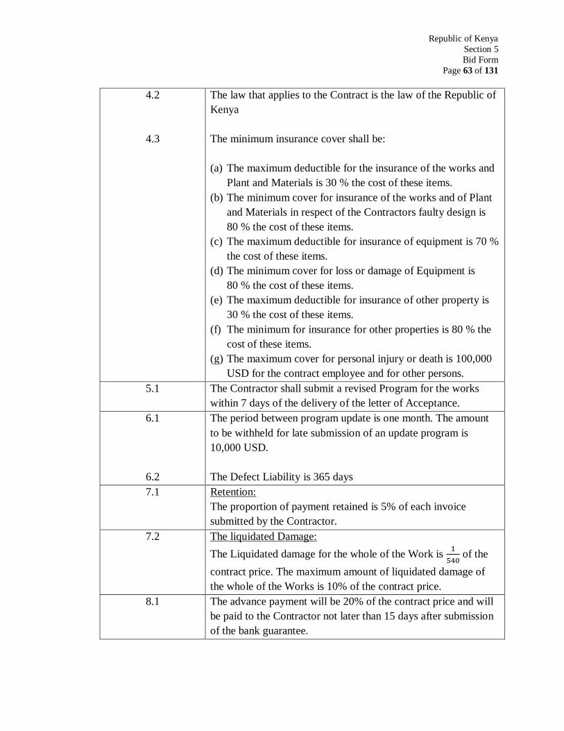
Republic of Kenya
Section 5
Bid Form
Page 63 of 131
4.2
4.3
The law that applies to the Contract is the law of the Republic of
Kenya
The minimum insurance cover shall be:
(a) The maximum deductible for the insurance of the works and
Plant and Materials is 30 % the cost of these items.
(b) The minimum cover for insurance of the works and of Plant
and Materials in respect of the Contractors faulty design is
80 % the cost of these items.
(c) The maximum deductible for insurance of equipment is 70 %
the cost of these items.
(d) The minimum cover for loss or damage of Equipment is
80 % the cost of these items.
(e) The maximum deductible for insurance of other property is
30 % the cost of these items.
(f) The minimum for insurance for other properties is 80 % the
cost of these items.
(g) The maximum cover for personal injury or death is 100,000
USD for the contract employee and for other persons.
5.1 The Contractor shall submit a revised Program for the works
within 7 days of the delivery of the letter of Acceptance.
6.1
6.2
The period between program update is one month. The amount
to be withheld for late submission of an update program is
10,000 USD.
The Defect Liability is 365 days
7.1 Retention:
The proportion of payment retained is 5% of each invoice
submitted by the Contractor.
7.2 The liquidated Damage:
The Liquidated damage for the whole of the Work is 1
540 of the
contract price. The maximum amount of liquidated damage of
the whole of the Works is 10% of the contract price.
8.1 The advance payment will be 20% of the contract price and will
be paid to the Contractor not later than 15 days after submission
of the bank guarantee.
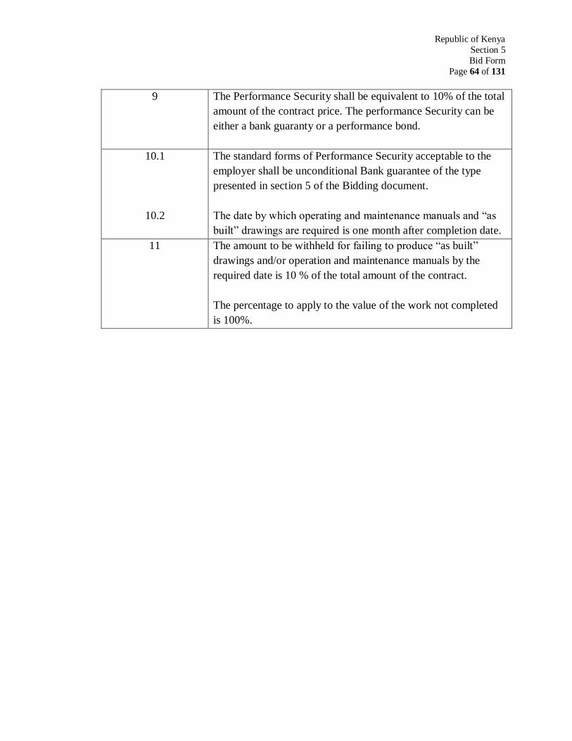
Republic of Kenya
Section 5
Bid Form
Page 64 of 131
9 The Performance Security shall be equivalent to 10% of the total
amount of the contract price. The performance Security can be
either a bank guaranty or a performance bond.
10.1
10.2
The standard forms of Performance Security acceptable to the
employer shall be unconditional Bank guarantee of the type
presented in section 5 of the Bidding document.
The date by which operating and maintenance manuals and “as
built” drawings are required is one month after completion date.
11 The amount to be withheld for failing to produce “as built”
drawings and/or operation and maintenance manuals by the
required date is 10 % of the total amount of the contract.
The percentage to apply to the value of the work not completed
is 100%.
SECTION 6
FORM OF BID, QUALIFICATIONS INFORMATION, TECHNICAL
EVALUATION SHEET FOR BIDDERS, LETTER OF CCEPTANCE,
AGREEMENT, BID SECURITY, TAKING-OVER CERTIFICATE
AND DEFECTS LIABILITY CERTIFICATE
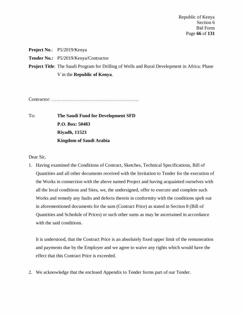
Republic of Kenya
Section 6
Bid Form
Page 66 of 131
Project No.: P5/2019/Kenya
Tender No.: P5/2019/Kenya/Contractor
Project Title: The Saudi Program for Drilling of Wells and Rural Development in Africa: Phase
V in the Republic of Kenya.
Contractor: ……………………………………………….
To: The Saudi Fund for Development SFD
P.O. Box: 50483
Riyadh, 11523
Kingdom of Saudi Arabia
Dear Sir,
1. Having examined the Conditions of Contract, Sketches, Technical Specifications, Bill of
Quantities and all other documents received with the Invitation to Tender for the execution of
the Works in connection with the above named Project and having acquainted ourselves with
all the local conditions and Sites, we, the undersigned, offer to execute and complete such
Works and remedy any faults and defects therein in conformity with the conditions spelt out
in aforementioned documents for the sum (Contract Price) as stated in Section 8 (Bill of
Quantities and Schedule of Prices) or such other sums as may be ascertained in accordance
with the said conditions.
It is understood, that the Contract Price is an absolutely fixed upper limit of the remuneration
and payments due by the Employer and we agree to waive any rights which would have the
effect that this Contract Price is exceeded.
2. We acknowledge that the enclosed Appendix to Tender forms part of our Tender.

Republic of Kenya
Section 6
Bid Form
Page 67 of 131
3. We undertake, if our Tender is accepted, to commence the Works within the time required in
the Contract Conditions, and to complete the whole of Works comprised in the contract
within the time stated in the Contract Conditions.
4. We agree to be bound by this Tender for the period of 180 days from the submission date
stated in the Invitation to Tender and it shall remain binding upon us and may be accepted at
any time before the expiration of that period.
5. Unless and until a Contract Agreement is signed, this Tender, together with your written
acceptance thereof, shall constitute a binding contract between us.
6. We understand that you are not bound to accept the lowest or any tender you may receive.
Dated this: ………………………………Day of ………………………………..
Signature: …………………………….. In the capacity of ………………………………
Duly authorized to sign Tenders for and on behalf of ……………………………………..
………………………………………………………………………………………………
……………………………………………………………………………………………….
(Contractor’s name and address in block capitals, Official Stamp)
Encl.: APPENDIX TO TENDER
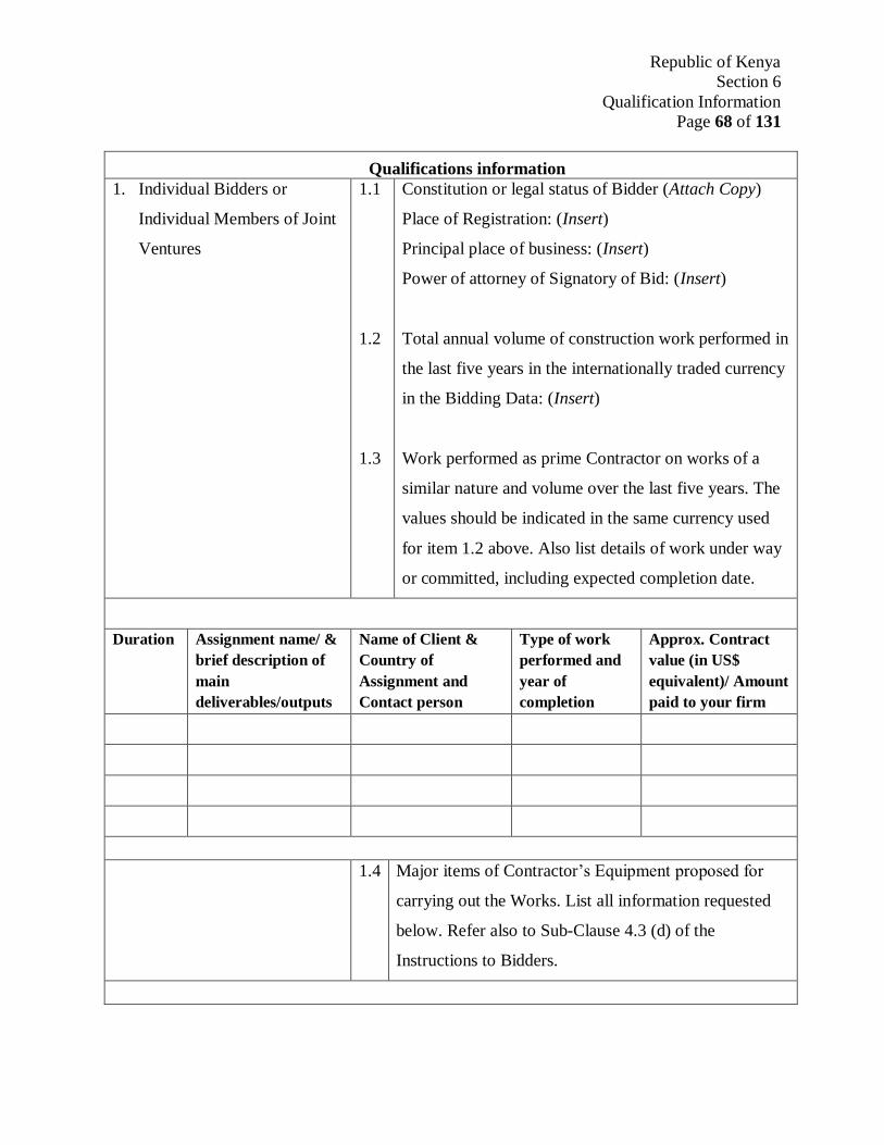
Republic of Kenya
Section 6
Qualification Information
Page 68 of 131
Qualifications information
1. Individual Bidders or
Individual Members of Joint
Ventures
1.1
1.2
1.3
Constitution or legal status of Bidder (Attach Copy)
Place of Registration: (Insert)
Principal place of business: (Insert)
Power of attorney of Signatory of Bid: (Insert)
Total annual volume of construction work performed in
the last five years in the internationally traded currency
in the Bidding Data: (Insert)
Work performed as prime Contractor on works of a
similar nature and volume over the last five years. The
values should be indicated in the same currency used
for item 1.2 above. Also list details of work under way
or committed, including expected completion date.
Duration Assignment name/ &
brief description of
main
deliverables/outputs
Name of Client &
Country of
Assignment and
Contact person
Type of work
performed and
year of
completion
Approx. Contract
value (in US$
equivalent)/ Amount
paid to your firm
1.4 Major items of Contractor’s Equipment proposed for
carrying out the Works. List all information requested
below. Refer also to Sub-Clause 4.3 (d) of the
Instructions to Bidders.

Republic of Kenya
Section 6
Qualification Information
Page 69 of 131
Item of equipment Description, make,
and age (years)
Condition (new, good,
poor, and number
available)
Owned, leased (from
whom?), or to be
purchased (from
whom?)
1.5 Qualification and experience of key personnel proposed
for administration and execution of the Contract. Attach
biographical data. Refer also to Sub-Clause 4.5 of the
instructions to bidders and Clause 4.1 of section 3
(instructions to bidders).
Position Name Years of experience
(general)
Years of experience in
proposed position
1.6 Proposed subcontracts and firms involved, Refer to
Clause 7 of Condition of Contract
Sections of the
Works
Value of
subcontract
Subcontractor (name
and address)
Experience in similar work
1.7
Financial reports for the last five years: Audited
accounts for the last five years. List below and attach
copies.
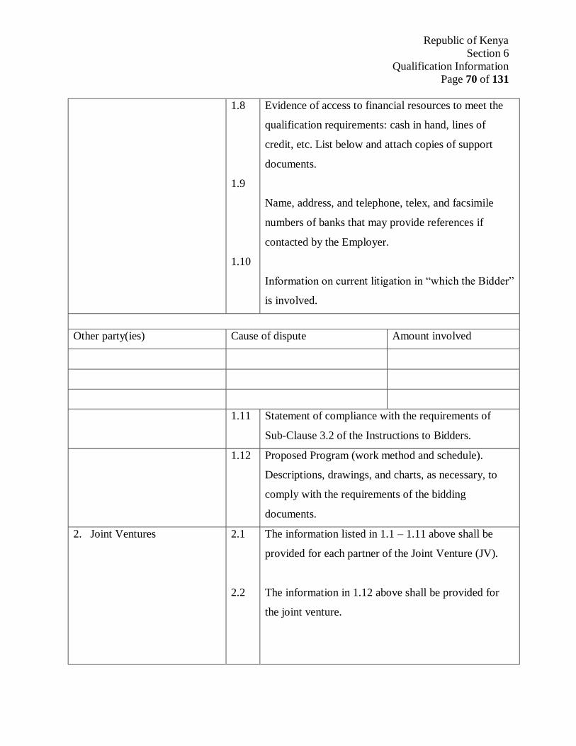
Republic of Kenya
Section 6
Qualification Information
Page 70 of 131
1.8
1.9
1.10
Evidence of access to financial resources to meet the
qualification requirements: cash in hand, lines of
credit, etc. List below and attach copies of support
documents.
Name, address, and telephone, telex, and facsimile
numbers of banks that may provide references if
contacted by the Employer.
Information on current litigation in “which the Bidder”
is involved.
Other party(ies) Cause of dispute Amount involved
1.11 Statement of compliance with the requirements of
Sub-Clause 3.2 of the Instructions to Bidders.
1.12 Proposed Program (work method and schedule).
Descriptions, drawings, and charts, as necessary, to
comply with the requirements of the bidding
documents.
2. Joint Ventures 2.1
2.2
The information listed in 1.1 – 1.11 above shall be
provided for each partner of the Joint Venture (JV).
The information in 1.12 above shall be provided for
the joint venture.
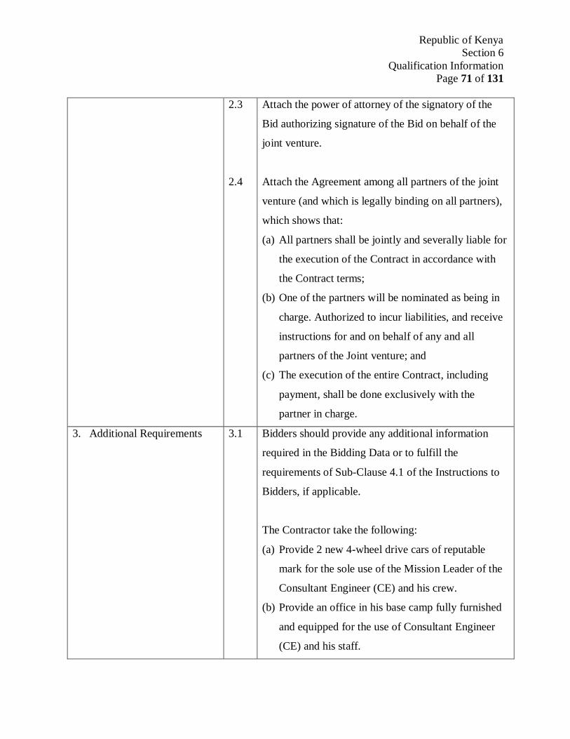
Republic of Kenya
Section 6
Qualification Information
Page 71 of 131
2.3
2.4
Attach the power of attorney of the signatory of the
Bid authorizing signature of the Bid on behalf of the
joint venture.
Attach the Agreement among all partners of the joint
venture (and which is legally binding on all partners),
which shows that:
(a) All partners shall be jointly and severally liable for
the execution of the Contract in accordance with
the Contract terms;
(b) One of the partners will be nominated as being in
charge. Authorized to incur liabilities, and receive
instructions for and on behalf of any and all
partners of the Joint venture; and
(c) The execution of the entire Contract, including
payment, shall be done exclusively with the
partner in charge.
3. Additional Requirements 3.1 Bidders should provide any additional information
required in the Bidding Data or to fulfill the
requirements of Sub-Clause 4.1 of the Instructions to
Bidders, if applicable.
The Contractor take the following:
(a) Provide 2 new 4-wheel drive cars of reputable
mark for the sole use of the Mission Leader of the
Consultant Engineer (CE) and his crew.
(b) Provide an office in his base camp fully furnished
and equipped for the use of Consultant Engineer
(CE) and his staff.

Republic of Kenya
Section 6
Qualification Information
Page 72 of 131
(c) Provide accommodation, subsistence, and
transportation at all sites camps for the Consultant
Engineer (CE) and technicians.
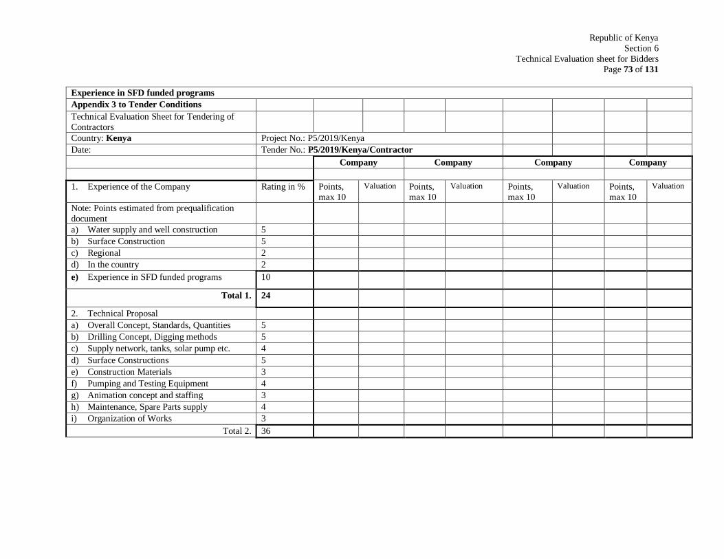
Republic of Kenya
Section 6
Technical Evaluation sheet for Bidders
Page 73 of 131
Experience in SFD funded programs
Appendix 3 to Tender Conditions
Technical Evaluation Sheet for Tendering of
Contractors
Country: Kenya Project No.: P5/2019/Kenya
Date: Tender No.: P5/2019/Kenya/Contractor
Company Company Company Company
1. Experience of the Company Rating in % Points,
max 10
Valuation Points,
max 10
Valuation Points,
max 10
Valuation Points,
max 10
Valuation
Note: Points estimated from prequalification
document
a) Water supply and well construction 5
b) Surface Construction 5
c) Regional 2
d) In the country 2
e) Experience in SFD funded programs 10
Total 1. 24
2. Technical Proposal
a) Overall Concept, Standards, Quantities 5
b) Drilling Concept, Digging methods 5
c) Supply network, tanks, solar pump etc. 4
d) Surface Constructions 5
e) Construction Materials 3
f) Pumping and Testing Equipment 4
g) Animation concept and staffing 3
h) Maintenance, Spare Parts supply 4
i) Organization of Works 3
Total 2. 36
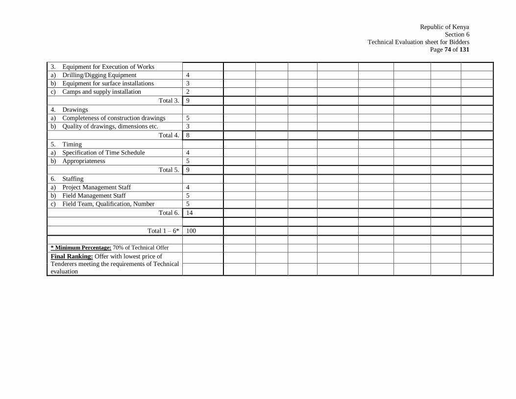
Republic of Kenya
Section 6
Technical Evaluation sheet for Bidders
Page 74 of 131
3. Equipment for Execution of Works
a) Drilling/Digging Equipment 4
b) Equipment for surface installations 3
c) Camps and supply installation 2
Total 3. 9
4. Drawings
a) Completeness of construction drawings 5
b) Quality of drawings, dimensions etc. 3
Total 4. 8
5. Timing
a) Specification of Time Schedule 4
b) Appropriateness 5
Total 5. 9
6. Staffing
a) Project Management Staff 4
b) Field Management Staff 5
c) Field Team, Qualification, Number 5
Total 6. 14
Total 1 – 6* 100
* Minimum Percentage: 70% of Technical Offer
Final Ranking: Offer with lowest price of
Tenderers meeting the requirements of Technical
evaluation

Republic of Kenya
Section 6
Letter of Acceptance
Page 75 of 131
Letter of acceptance (Date ……………………)
To: (name and address of the Contractor)
This is to notify you that your Bid dated [date] for execution of the [name of the Contract and
identification number, as given in the Contract Data] for the contract Price [amount in numbers
and words] [name of currency] is hereby accepted by our Agency.
You are hereby instructed to proceed with the execution of the said Works in accordance with
the Contract documents.
Authorized Signature: …………………………………………………………………….
Name and Title of Signatory: …………………………………………………………….
Name of Agency: …………………………………………………………………………
Attachment: Agreement

Republic of Kenya
Section 6
Agreement
Page 76 of 131
Agreement This Agreement, made the [day] day of [month, [year] between (hereinafter called “the
Employer”) and [name and address of Contractor] (hereinafter called “the Contractor”) of the
other part.
Whereas the Employer is desirous that the Contractor executes / name and identification number
of Contract (hereinafter called the Works) and the Employer has accepted the Bid by the
Contractor for the execution and completion of such Works and the remedying of any defects
therein.
Now this Agreement witness as follows:
1. In this Agreement, words and expressions shall have the same meanings as are respectively
assigned to them in the Conditions of Contract hereinafter referred to, and they shall be
deemed to form and be read and construed as part of this Agreement.
2. In consideration of the payments to be made by the Employer to the Contractor as hereinafter
mentioned, the Contractor hereby covenants with the Employer to execute and complete the
Works and remedy any defects therein in conformity in all respects with the provisions of the
Contract.
3. The Employer hereby covenants to pay the Contractor in consideration of the execution and
completion of the works and the remedying of defects wherein the Contract Price or such
other sum as may become payable under the provisions of the Contract at the times and in the
manner prescribed by the Contract.
In Witness whereof the parties thereto have caused this Agreement to be executed the day and
year first before written.
The Common Seal of ……………………………………………………………………………
was hereunto affixed in the presence of…………………………………………………….

Republic of Kenya
Section 6
Agreement
Page 77 of 131
Signed, Sealed, and Delivered by the said ………………………………………………………
in the presence of ……………………………………………………………………………
Binding Signature of Employer ………………………………………………………………
Binding Signature of Contractor …………………………………………………………….
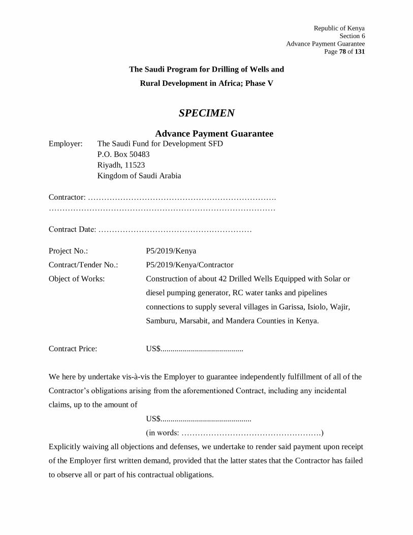
Republic of Kenya
Section 6
Advance Payment Guarantee
Page 78 of 131
The Saudi Program for Drilling of Wells and
Rural Development in Africa; Phase V
SPECIMEN
Advance Payment Guarantee Employer: The Saudi Fund for Development SFD
P.O. Box 50483
Riyadh, 11523
Kingdom of Saudi Arabia
Contractor: …………………………………………………………….
…………………………………………………………………………
Contract Date: …………………………………………………
Project No.: P5/2019/Kenya
Contract/Tender No.: P5/2019/Kenya/Contractor
Object of Works: Construction of about 42 Drilled Wells Equipped with Solar or
diesel pumping generator, RC water tanks and pipelines
connections to supply several villages in Garissa, Isiolo, Wajir,
Samburu, Marsabit, and Mandera Counties in Kenya.
Contract Price: US$.........................................
We here by undertake vis-à-vis the Employer to guarantee independently fulfillment of all of the
Contractor’s obligations arising from the aforementioned Contract, including any incidental
claims, up to the amount of
US$.............................................
(in words: …………………………………………….)
Explicitly waiving all objections and defenses, we undertake to render said payment upon receipt
of the Employer first written demand, provided that the latter states that the Contractor has failed
to observe all or part of his contractual obligations.

Republic of Kenya
Section 6
Advance Payment Guarantee
Page 79 of 131
In case of any claim under this guarantee payments by the Guarantor shall be made to the
account of the Saudi Fund for Development.
This guarantee shall become effective with the first advance payment made by the Employer and
shall expire when the advance payment has been set off in full.
The Employer shall return this guarantee to us as soon as its validity expires.
.........................................................
(Signature of the Guarantor, stamp)
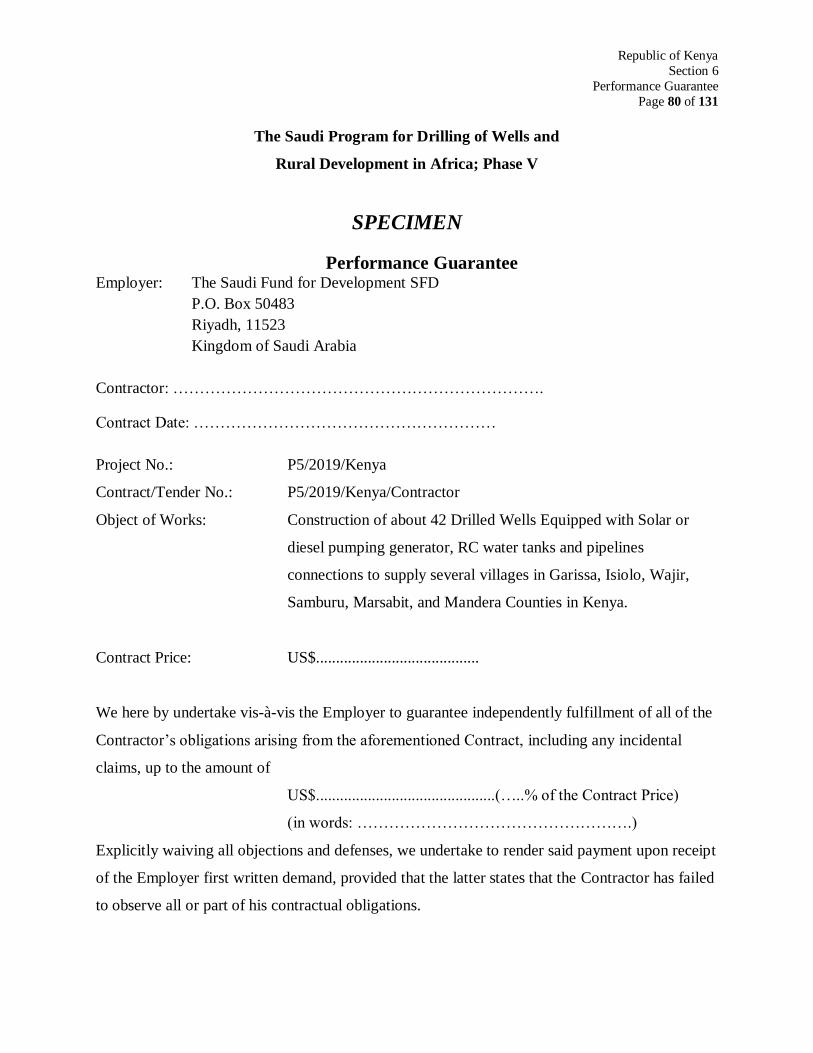
Republic of Kenya
Section 6
Performance Guarantee
Page 80 of 131
The Saudi Program for Drilling of Wells and
Rural Development in Africa; Phase V
SPECIMEN
Performance Guarantee Employer: The Saudi Fund for Development SFD
P.O. Box 50483
Riyadh, 11523
Kingdom of Saudi Arabia
Contractor: …………………………………………………………….
Contract Date: …………………………………………………
Project No.: P5/2019/Kenya
Contract/Tender No.: P5/2019/Kenya/Contractor
Object of Works: Construction of about 42 Drilled Wells Equipped with Solar or
diesel pumping generator, RC water tanks and pipelines
connections to supply several villages in Garissa, Isiolo, Wajir,
Samburu, Marsabit, and Mandera Counties in Kenya.
Contract Price: US$.........................................
We here by undertake vis-à-vis the Employer to guarantee independently fulfillment of all of the
Contractor’s obligations arising from the aforementioned Contract, including any incidental
claims, up to the amount of
US$.............................................(…..% of the Contract Price)
(in words: …………………………………………….)
Explicitly waiving all objections and defenses, we undertake to render said payment upon receipt
of the Employer first written demand, provided that the latter states that the Contractor has failed
to observe all or part of his contractual obligations.
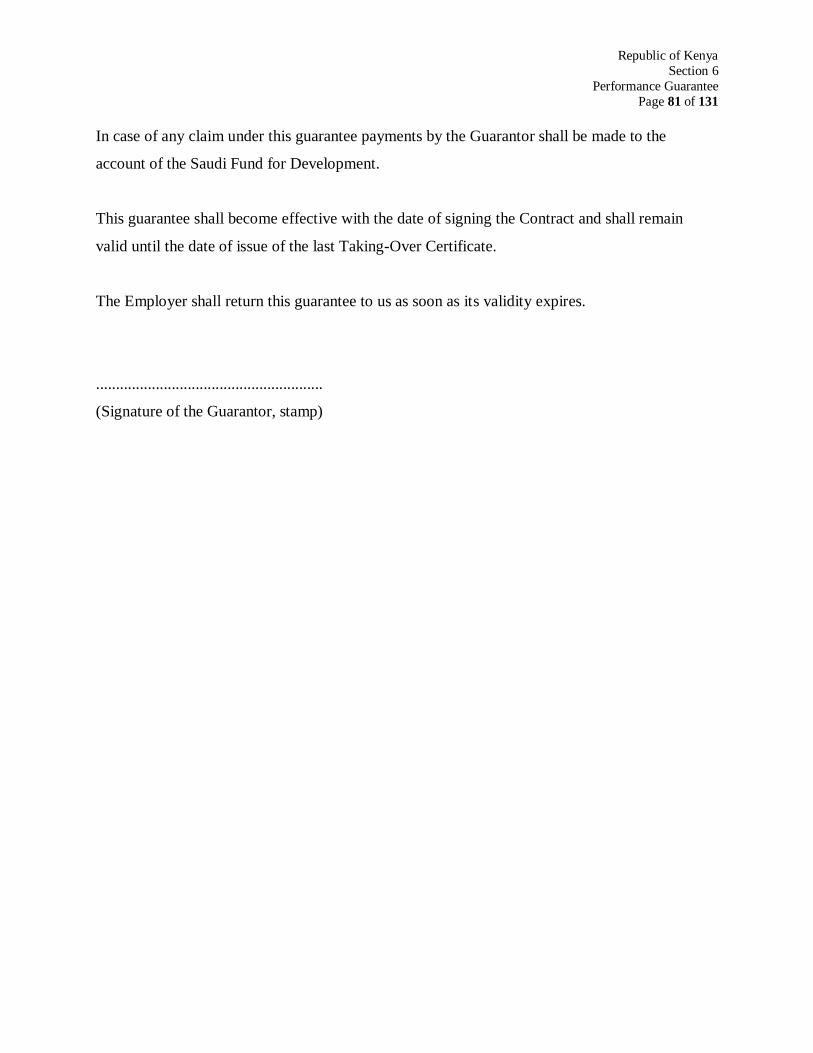
Republic of Kenya
Section 6
Performance Guarantee
Page 81 of 131
In case of any claim under this guarantee payments by the Guarantor shall be made to the
account of the Saudi Fund for Development.
This guarantee shall become effective with the date of signing the Contract and shall remain
valid until the date of issue of the last Taking-Over Certificate.
The Employer shall return this guarantee to us as soon as its validity expires.
.........................................................
(Signature of the Guarantor, stamp)
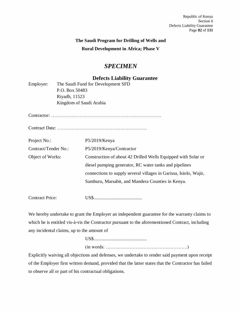
Republic of Kenya
Section 6
Defects Liability Guarantee
Page 82 of 131
The Saudi Program for Drilling of Wells and
Rural Development in Africa; Phase V
SPECIMEN
Defects Liability Guarantee Employer: The Saudi Fund for Development SFD
P.O. Box 50483
Riyadh, 11523
Kingdom of Saudi Arabia
Contractor: …………………………………………………………….
Contract Date: …………………………………………………
Project No.: P5/2019/Kenya
Contract/Tender No.: P5/2019/Kenya/Contractor
Object of Works: Construction of about 42 Drilled Wells Equipped with Solar or
diesel pumping generator, RC water tanks and pipelines
connections to supply several villages in Garissa, Isiolo, Wajir,
Samburu, Marsabit, and Mandera Counties in Kenya.
Contract Price: US$.........................................
We hereby undertake to grant the Employer an independent guarantee for the warranty claims to
which he is entitled vis-à-vis the Contractor pursuant to the aforementioned Contract, including
any incidental claims, up to the amount of
US$.............................................
(in words: …………………………………………….)
Explicitly waiving all objections and defenses, we undertake to render said payment upon receipt
of the Employer first written demand, provided that the latter states that the Contractor has failed
to observe all or part of his contractual obligations.
Republic of Kenya
Section 6
Defects Liability Guarantee
Page 83 of 131
In case of any claim under this guarantee payments by the Guarantor shall be made to the
Account of the Saudi Fund for Development.
This guarantee shall become effective upon the date of payment of the retention money on the
Contractor’s account and shall expire upon the end of the Defects Liability Period, but only after
receipt of the Defects Liability Certificate..
The Employer shall return this guarantee to us as soon as its validity expires.
.........................................................
(Signature of the Guarantor, stamp)
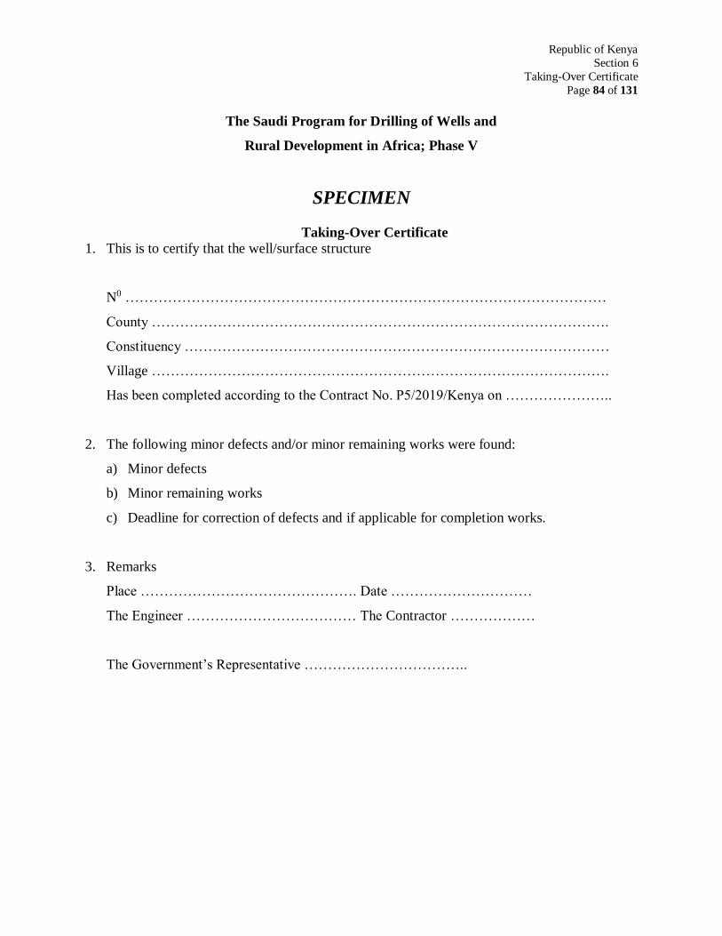
Republic of Kenya
Section 6
Taking-Over Certificate
Page 84 of 131
The Saudi Program for Drilling of Wells and
Rural Development in Africa; Phase V
SPECIMEN
Taking-Over Certificate
1. This is to certify that the well/surface structure
N0 …………………………………………………………………………………………
County …………………………………………………………………………………….
Constituency ………………………………………………………………………………
Village …………………………………………………………………………………….
Has been completed according to the Contract No. P5/2019/Kenya on …………………..
2. The following minor defects and/or minor remaining works were found:
a) Minor defects
b) Minor remaining works
c) Deadline for correction of defects and if applicable for completion works.
3. Remarks
Place ………………………………………. Date …………………………
The Engineer ……………………………… The Contractor ………………
The Government’s Representative ……………………………..
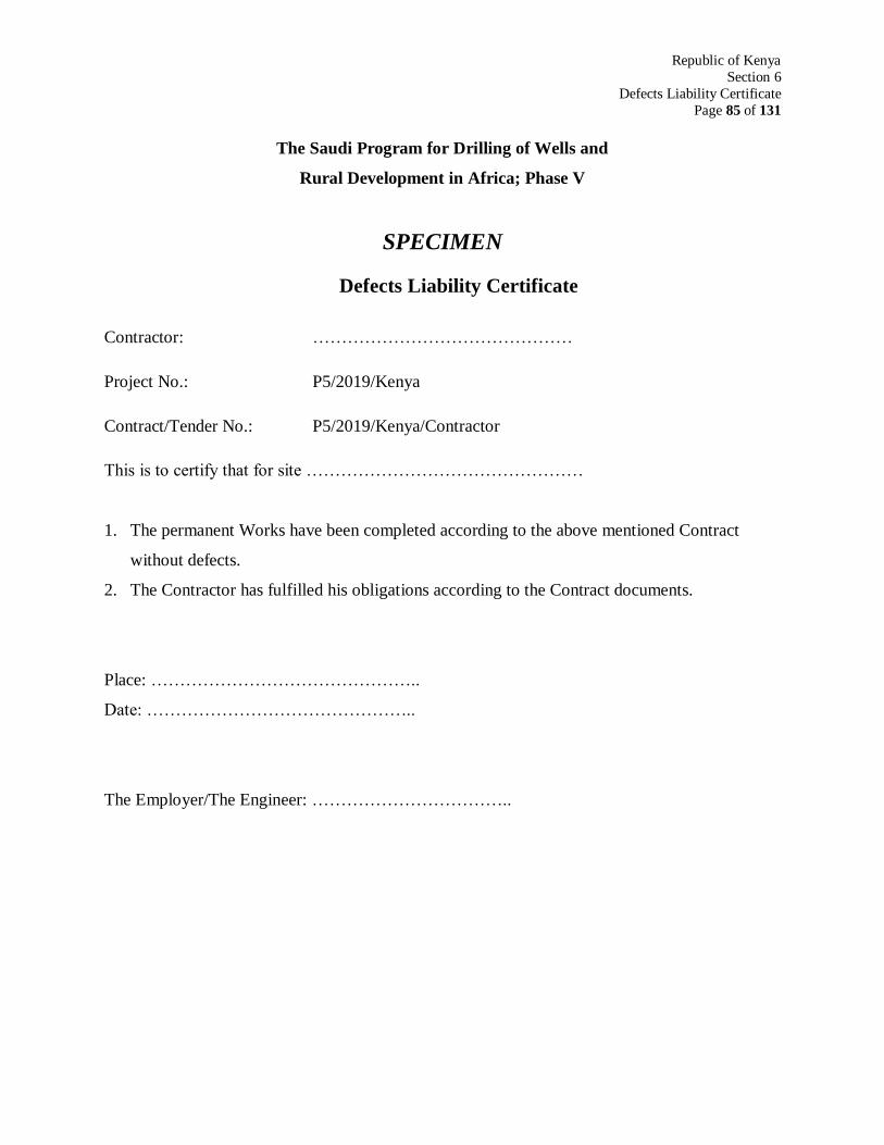
Republic of Kenya
Section 6
Defects Liability Certificate
Page 85 of 131
The Saudi Program for Drilling of Wells and
Rural Development in Africa; Phase V
SPECIMEN
Defects Liability Certificate
Contractor: ………………………………………
Project No.: P5/2019/Kenya
Contract/Tender No.: P5/2019/Kenya/Contractor
This is to certify that for site …………………………………………
1. The permanent Works have been completed according to the above mentioned Contract
without defects.
2. The Contractor has fulfilled his obligations according to the Contract documents.
Place: ………………………………………..
Date: ………………………………………..
The Employer/The Engineer: ……………………………..
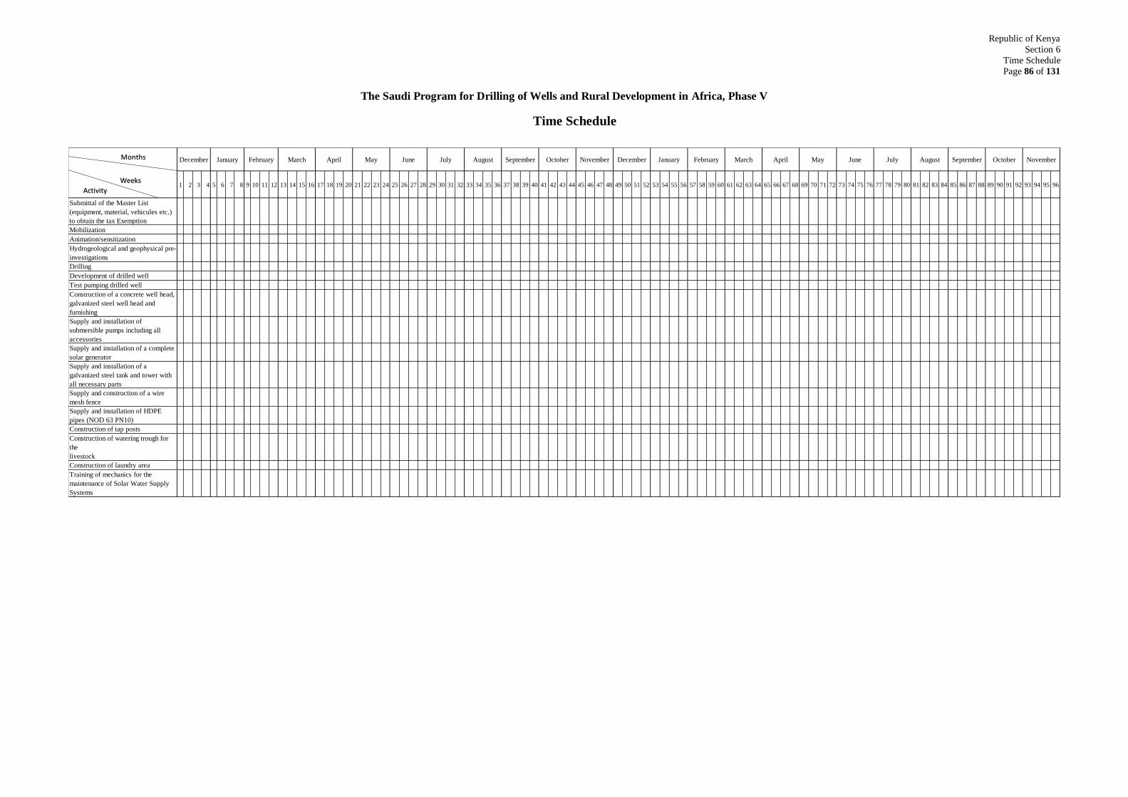
Republic of Kenya
Section 6
Time Schedule
Page 86 of 131
The Saudi Program for Drilling of Wells and Rural Development in Africa, Phase V
Time Schedule
1 2 3 4 5 6 7 8 9 10 11 12 13 14 15 16 17 18 19 20 21 22 23 24 25 26 27 28 29 30 31 32 33 34 35 36 37 38 39 40 41 42 43 44 45 46 47 48 49 50 51 52 53 54 55 56 57 58 59 60 61 62 63 64 65 66 67 68 69 70 71 72 73 74 75 76 77 78 79 80 81 82 83 84 85 86 87 88 89 90 91 92 93 94 95 96
Submittal of the Master List
(equipment, material, vehicules etc.)
to obtain the tax Exemption
Mobilization
Animation/sensitization
Hydrogeological and geophysical pre-
investigations
Drilling
Development of drilled well
Test pumping drilled well
Construction of a concrete well head,
galvanized steel well head and
furnishing
Supply and installation of
submersible pumps including all
accessories
Supply and installation of a complete
solar generator
Supply and installation of a
galvanized steel tank and tower with
all necessary parts
Supply and construction of a wire
mesh fence
Supply and installation of HDPE
pipes (NOD 63 PN10)
Construction of tap posts
Construction of watering trough for
the
livestock
Construction of laundry area
Training of mechanics for the
maintenance of Solar Water Supply
Systems
June July August SeptemberJune July August September October NovemberDecember January February March April May October NovemberDecember January February March April May Months
Weeks
Activity
SECTION 7
TECHNICAL SPECIFICATIONS
Republic of Kenya
Section 7
Technical specifications
Page 88 of 131
1. Introduction
The Contractor is required to closely observe this technical specification to execute the works
in this project and to follow the instruction of the Consultant Engineer during the course of
the project. However, the Contractor is required to put to the work equipment and tools in
good working condition and in sufficient number to guarantee continuous work without
stoppage besides providing qualified and experienced staff to perform the work to the state-
of-the art and to the highest standard. The tenderer is supposed to have acquainted himself
with the situation in Kenya and the sites of the work. He shall always put the goals of the
Saudi Fund for Development of sponsoring the project. The execution of the work, the
materials, and procedure shall depend on the known International Regulation and standard.
Drawings and measurements are to be in SI - units.
This technical specification shall have precedence over any standards.
2. Organization of Works
Immediately following the signing of the contract and for a period not more than 2 months,
the Contractor has to mobilize his equipment, materials, and personnel to his base camp. He
has to prepare all construction methods, drawings, and final schedule of the work.
The Contractor has to collect all relevant information about the hydrogeology of sites to be
executed. This will include:
Interpretation of aerial photos
Geophysical data
The hydrogeological study shall be conducted for every site in an area bounded by a
circle of 5 km. the study shall consist of:
1. Desk Study
o Collection of existing data from relevant departments
o Collection of available maps i.e. topographic, geological and meteorological
2. Field Survey
o Field reconnaissance survey to locate vegetation, depression, houses, farms etc.
o Well inventory within and around the village.
3. Assessment of data and information.
o Based on the desktop study and field reconnaissance survey assessment, locations shall
be chosen for detailed geophysical survey
4. Conducting three geophysical survey soundings in each location and setting priority
of drilling according to the result of the survey.

Republic of Kenya
Section 7
Technical specifications
Page 89 of 131
All these works shall be under the direct supervision of the Consultant Engineer and the report
of the study to be handed to him. A meeting shall follow this between the Contractor, the
Consultant Engineer, and the representatives of the Water Sector Trust Fund.
The list of villages proposed is shown in Appendix A.
Based on the results of the geophysical survey, the consultation of the local beneficiaries and
the water department, the location of each well will be marked on the ground in the presence
of the Engineer. An Environmental and Social Impact Assessment (ESIA) shall be conducted
for every site in accordance with the provisions of Environment Management and
Coordination (Amendment) Act, 2015 (Cap 387 laws of Kenya)
In case the first hole does not produce the required quantity of water, 3m3/hr, the Contractor
will drill other location in the site up to 3 trials. The cost of the negative drilling shall be
included in the unit rates of the individual items of work in the Bill of Quantities and will not
be paid to the Contractor.
The Contractor shall furnish his base camp, workshops, parking area, office building, stores,
laboratories, etc. needed for the proper execution of the works. This will include but not
limited to preparation of the space including grading, removal of shrubs, garbish, access
roads, etc. the Contractor can use a government owned land close to the Centre of the area
but if use private land he/she has to arrange with the owner on his own expense. To effectively
and conveniently perform the project tasks, the Contractor may consider moving the base
camp from one county to another for ease of access to the sites as applicable.
The base camp shall be in a central location to the project with consultation and agreement of
the Consultant Engineer. Site camps shall be at drilling site locations. The main camp has to
include a furnished office for the sole use of the Consultant Engineer staff. The office shall
be provided with electricity, printing, and faxing machines and desktops computers.
The Contractor shall provide the Consultant Engineer technicians with accommodation, meals
at the base camp and transport and accommodation at the sites.
The Contractor shall ensure security at the base camp, site camp and during the transport
between base and site camp.
Republic of Kenya
Section 7
Technical specifications
Page 90 of 131
The Contractor has to provide 2 four wheel drive pick-ups (4WD) to the Consultant and one
4WD pick-up to the RE of the WSTF. The 4WD pick-ups have to be of a reputable brand.
These cars will be handed at the end of the project to the Kenya Water Trust Fund.
A signpost with Project symbol shall be erected at the commencement of the work at each
site and also a well identification plate shall be put at the site at completion of the working
giving details of the well characteristics.
The Contractor has to select people from the village to form a committee for looking after the
well management, maintenance, and operation. The committee is to be selected by the
villagers under supervision of the Consultant Engineer.
3. Description of Works
This is the works under the Saudi Program of Drilling of Wells and Rural Development in
Africa, Phase V in the Republic of Kenya. The program’s goals are:
To raise the standard of living of the rural population by long-term provision of a safe
drinking water supply.
To improve the water supply situation in rural areas to benefit as many people as possible
and provide a basis for gradual development.
To provide hygienically safe drinking water.
To train local communities to operate and maintain the water points for a long term
benefit.
To help alleviate unemployment by giving job opportunities to local people.
To spread the goodwill of the Kingdom of Saudi Arabia towards the poor Muslim
communities in Africa.
The work in this project is to supply 42 villages or/and group of village with hygienically
safe drinking water from drilled wells equipped with submersible pumps driven by solar
system or /and diesel generator, a water tank, a water pipe distribution system with tap
post as close as possible to the beneficiary at each community.
The drilled wells shall be drilled as boreholes of diameter 10” (254mm) cased with
casings and screens with diameter of 8” (203mm) as appropriate with filter packs in the
annular space and sealing with clay and cement. The casing is to bear 8 bar pressure and
Republic of Kenya
Section 7
Technical specifications
Page 91 of 131
screen opens 0.7 - 1 mm and total x section of opens is 7% of casing. Each drilled well
shall be sealed by a concrete slab which bear the pumping equipment and protect the well
from pollution. A well head shall be constructed to protect the well.
Fig. 1 in Appendix B give schematic drawing for the suggested well drilling.
The water tanks shall be elevated steel tanks of capacities as specified in chapter 5 of this
section and to be supported on steel structure and concrete foundation designed properly
by the Contractor. The tanks shall be at the highest spot near to the well and raised to a
maximum of 12m from the ground.
Photovoltaic generator comprising the photovoltaic array, inventor combiner, cables
steel structure on a concrete foundation. The panels can be Hyundai, JinkoSolar, Shuco,
Amerisolar, SunPower, LG, Panasonic, Silfab, Q CELLS, Canadian Solar, Trina Solar,
REC Solar, Bosch, BP, Lorentz, Mitsubishi, Sanyo, Sharp, or any approved known type.
Submersible pump with ability to discharge the required yield for the given water head
provided by the solar. Type Grundfos or equivalent.
Reticulation system which takes water in HDPE pipes to public water taps in selected
locations. The pipe diameter shall be (125, 110, 90, 75, 63and 50 mm) Length at each
location is estimated as from the design. Wherever possible, technically and financially,
the tap post shall be located in conformity with the needs of the beneficiaries. The tap
posts supported by masonry wall on a concrete slab. A drawing of suggested tap post and
number are shown in fig. (4) in Appendix B.
Animation and sanitization: this activity involves enlightening end users with the water
points; its maintenance and management. This activity shall start before all other
activities and all during the project life.
The main objective of animation sensitization is to ensure a long time drinking water at
the target villages.
In the bill of quantity there are no items for preparing access to sites for his equipment
and personnel and he is supposed to include this in the priced items.

Republic of Kenya
Section 7
Technical specifications
Page 92 of 131
4. Well Drilling and Construction
4.1 General
The sites for drilling are in varied rock types ranging from crystalline (volcanic or
metamorphic) and sedimentary rocks. The depth of drilling is estimated to be 200 meters. A
successful well is the well giving a sustainable yield of ≥ 3m3/hr. Wells giving a yield less
than this is considered a failure and will not be paid for.
In the selected counties of Marsabit, Samburu, Isiolo, Mandera, Wajir and Garissa,
groundwater potential is low to medium. However, the amount of drilling meters for
unsuccessful drilling shall be included in the price of the Bill of Quantities. No payment will
be made for unsuccessful wells. In case of mistakes in drilling operation which lead to change
of drilling locations the Contractor shall bear the cost of this relocation. It is therefore the
responsibility of the contractor to ensure that an ideal location is chosen based on the
geophysical investigations carried out.
A successful well is the well:
1. giving a sustainable yield of ≥ 3m3/hr,
2. whose water is compliant to the health and quality standards in Kenya for
Groundwater KS 05-459 (1996),
However only the yield criteria will be applied to pay for successful boreholes.
As per the expert opinion, the success rate of boreholes in the six counties is as follows:
County Number %
Wajir 12 95%
Garissa 10 80%
Mandera 8 95%
Marsabit 7 80%
Samburu 3 80%
Isiolo 2 60%
In order to increase the success rate of the productive boreholes, the Contractor will carry out
borehole site investigations for both priority and standby selected sites. Drilling will only be
carried out for sites with high prospects. It is proposed that at least 3 measurements be
carried out at each site.
Republic of Kenya
Section 7
Technical specifications
Page 93 of 131
4.2 Drilling Method
The method used for drilling shall be Rotary Drilling Technique or Down the Hole Hammer.
The contractor shall be responsible for the drilling method or methods selected; neither the
Client nor the Supervising Engineer shall be held responsible should the method or methods
adopted fail in the objective of drilling to the depth required.
If down- the- hole hammer methods are to be deployed, the Contractor shall not use excessive
pulldown on the bit. Should the borehole be skewed as a result of excessive pulldown, and
the borehole not fit for purpose in consequence, the hole shall be deemed a Lost Bore. The
Contractor shall therefore employ a stabilizer or stabilizers of appropriate diameter and mass
when drilling.
Drilling fluid additives must be suited to environmental applications. Additives must be able
to be denatured by exposure to soluble chlorine, and must not be prone to biodegradation or
fermentation. Bidders shall provide details of the type(s) and manufacturer of additive(s) to
be used, and will describe the means by which the additive(s) will be mixed. If fluid rotary
flush methods are to be adopted, either artificial powder or liquid anionic polymeric additives
must be used for viscosity enhancement; additives comprising bentonite or cellulose will not
be acceptable as viscosity builders for use in these works. The judicious application of
bentonite or cellulose or similar material will be acceptable as a means of preventing loss of
circulation in those parts of the borehole located above or between aquifer zones provided
their use is authorized in advance by the Engineer.
Bidders shall provide: –
a) A meter rate for drilling at 10”/254 mm from surface to depths of not more than 100
meters; Bidders should allow for 4,200 meters
b) A meter rate for drilling at 10”/254 mm from depths of 100 to 200 meters; Bidders
should allow for 3,500 meters
c) A meter rate for drilling at 10”/254 mm from depths of 200 to 300 meters; Bidders
should allow for 200 meters
4.3 Supply and Install Surface/ Temporary Casing
The borehole will be provided with up to six (6) meters of surface casing of diameter no
larger than 12”/304 mm. This will form two purposes: 1) it will protect the top of the borehole
from erosion from returning drilling fluids or artesian flow or both and 2) will form the
sanitary seal casing in the borehole headworks.. Casing used as surface casing shall be mild
steel of a specification suited to water well applications for installation to depths not
exceeding 50 m depth; the specifications shall be given by Bidders in their proposals.

Republic of Kenya
Section 7
Technical specifications
Page 94 of 131
Site conditions may require temporary casing to be installed to depths greater than six (6)
meters. The Contractor must ensure that sufficient temporary casing is deployed to site to
allow installation to greater depths should this be necessary. Casing used as temporary casing
shall be mild steel of a specification suited to water well applications for installation; the
specification shall be given by bidders in their proposals.
Bidders shall provide: –
a) A meter rate for drilling at 12”/304 mm from surface to depths of not more than 6
meters; Bidders should allow for 252 meters
b) A meter rate for supply and installation of 12”/304 mm temporary surface casing
from surface to depths of not more than 6 meters; Bidders should allow for 252
meters.
4.4 Sample Collection, Storage and Record Keeping
The Water Act (GoK 2002) requires that samples of strata drilled through be collected. For
the purposes of these works, samples shall be collected at two (2) meter intervals and at
prominent lithological boundaries. Samples shall be collected wet from the wellhead, after
appropriate correction to account for rise time, and stored in sample boxes such that not less
than 500 grammes of sample remain after drying. Samples will be sun-dried and sample
logging will be conducted by the Engineer. After sample logging, the Contractor will bag
each sample in a polythene bag of appropriate strength and size. Samples will be clearly
marked with tie-on labels indicating date of collection, the depth interval and the borehole
name and number. At the completion of the works bagged samples, collected by Contractor
in sacks marked with the borehole number, will be delivered to Contractor’s camp.
The Contractor shall record the depth of any zone of lost circulation for which no sample was
taken. A log of the rate of penetration, in minutes per meter drilled, shall be kept. The depth
of any voids, or of particularly rapid penetration, or significant changes in rig noise indicating
changes in geological conditions, shall also be noted; such information will be recorded on a
Daily Drilling Report (DDR) form. Bidders should submit a sample DDR with their
proposals; if this does not meet the needs of this borehole construction program, a suitable
DDR will be provided to the successful Contractor to use.
Water levels shall be measured and recorded at the start and end of every shift, after
significant breaks in activity (such as meal breaks), and during periods of plant downtime (as
appropriate), and as required by the Water Act 2002 (Fourth Schedule). Water levels shall be
measured using a sounding and/or lighting dipper approved in advance by the Engineer. It is
acknowledged that if direct rotary fluid methods are used, it will rarely be possible to measure
true water levels during the course of drilling. However, water level measurements will be
Republic of Kenya
Section 7
Technical specifications
Page 95 of 131
required during development operations, and the Contractor will ensure that a dipper is
included with the drilling plant deployed for these works.
Bidders shall provide: –
A unit rate for collecting, drying, bagging, sacking and labelling samples collected at two
(2) meter intervals; a total of 3950 samples should be provided for. The unit rate is deemed
to include the collection of rate of penetration and other drilling information; and the
collection of water levels as and when this is possible.
4.5 Supply and Install Permanent Casing and Screens
On completion of drilling and sample logging, and after showing the borehole clean to total
depth, the Contractor shall install casing and screen according to the design provided by the
Engineer. If the borehole is not clean to total depth it will be flushed again immediately prior
to casing string installation.
Plain casing shall comprise new mild steel casings and screens. Mild steel casing and screen
shall be suitable for installation in water wells deeper than 250 m depth. It shall have an
internal diameter of not less than 8"/203 mm. Bidders shall present the specification of the
casing and screen proposed for installation in borehole.
The screen shall comprise horizontal slots of open area not less than 6% and of slot size
0.5 mm.
Casing and screen lengths of mild steel are to be connected by butt-welding or ring-welding.
The top of mild steel casing string at completion of construction shall terminate not less than
15”/0.4 m above original ground level.
Bidders shall provide: –
a) A meter rate for the supply and installation of a total of 6,198metres of plain mild
steel casing, including jointing;
b) A meter rate for the supply and installation of 1,702metres of slotted mild steel
screen, including jointing.
4.6 Supply and Installation of Gravel Pack
A gravel pack shall be installed in screened portions of the borehole.
The gravel must be clean well-rounded siliceous gravel with no more than 5% non-siliceous
Republic of Kenya
Section 7
Technical specifications
Page 96 of 131
material and of diameter 1 to 2 mm. Bidders will provide in their bids a particle size
distribution curve from a reputable laboratory describing the gravel pack proposed for use in
this program, as well as the bulk density of the pack material expressed as kg per m3.
The pack shall be inspected by the Engineer on site, and if excessively dirty, he will require
that it be washed, to his satisfaction, before approving its installation into the borehole annular
space; the costs associated with such washing shall be met by the Contractor, and the time
spent doing so will be accounted as down-time.
Installation of gravel pack shall use water wash down via a tremie pipe. 65% chlorine
granular calcium hypochlorite will be introduced into the annular space along with the pack
material at a nominal concentration of 500 grammes per cubic meter of pack. This will break
down any residual additive(s) (if used), and will partly disinfect the wellbore.
Gravel pack will be detailed in the borehole design prepared by the Engineer, together with
the vertical intervals in the borehole it must extend through. Bidders shall describe in their
proposals how they propose to measure the level of gravel pack during its installation.
Bidders shall provide: –
a) A unit volume rate for the supply and installation of clean 1 to 2 mm diameter gravel
pack assuming a maximum volume of 126 m3
The technical score of bidders who insist on providing a unit mass rate will be marked down
by 10% of the final technical score, and will score no points for the supply and installation of
gravel pack. In such cases the Engineer will calculate the approximate volume that the bidder
has provided for as mass, and recalculate the price per unit volume.
4.7 Supply and Install Grout
Grout seals will be required in the borehole to provide a sanitary seal near ground level. This
is essential to prevent vertical drainage of shallow aquifer waters into deeper aquifers. The
vertical thickness of grout in the borehole shall not exceed 10 meters.
5% by volume bentonite clay/ordinary Portland cement/sand grout of bulk density 1.6 to 1.8
kgs/liter will be placed under positive pressure via a tremie pipe from the top of the highest
gravel pack or inert material installed in the annular space. The annular space will be filled
with grout to the design depth, after which the next gravel pack layer shall be installed (or
inert material inserted). After the borehole has been gravel packed and grouted, the remaining
Republic of Kenya
Section 7
Technical specifications
Page 97 of 131
annular space shall be filled with inert material to a depth of 3 m bgl, and the balance grouted
to surface + 0.4 m.
Bidders will describe the proposed grout installation and level measuring methods in their
Method Statement.
a) A unit volume rate for the supply and installation of 5% by volume
bentonite/OPC/sand grout. For the purpose of bids, bidders should assume a
maximum of 21m3 of grout.
4.8 Insert inert backfill
Inert backfill (drill cuttings) will be inserted in the annular space of boreholes in vertical
intervals in which neither grout nor gravel pack are required.
Bidders shall provide: –
a) A unit volume rate for the insertion of inert backfill, including measurement of depth
to the top of inert backfill, where necessary. Bidders should allow for 42 m3.
4.9 Testing of Verticality, Alignment and Camera review
The Contractor shall do verticality and alignment test during the performance of work by any
reasonable method for his own convincing to ensure lowering screens to the required depth.
Only case instructed by the Consultant Engineer test for plumbness and alignment shall be
made after the complete construction of the well and before its acceptance. The required test
shall be by using plumb.
The Contractor is also required to undertake a camera review of the borehole to confirm the
casings alignment and depth of the borehole. A camera review report shall be submitted
before acceptance of the borehole
4.10 Development
After completion of drilling and placement of casing and screens, gravel and backfill etc. the
borehole shall be developed in accordance with modern borehole construction practices,
including airlift surging and possibly chemical development using a polyphosphate. It is
expected that a total of 12 hours will be required.
Chemical development. This Specification allows for the possibility that chemical
development will be required. The Contractor will include equipment and chemicals for
chemical development, though there is no certainty that chemical development will be
required. If clays are encountered and their removal is required, the Engineer will instruct
the Contractor to commence development using chemical methods. If required, chemical
Republic of Kenya
Section 7
Technical specifications
Page 98 of 131
development will use an approved polyphosphate as a disaggregant that shall break down
clays, silts, or other fine material adjacent to the wellbore where these occur within the
productive part of the aquifer. The decision as to whether chemical development shall be
adopted, and at what dosage rates, shall be made by the Engineer on the basis of observations
made during drilling and sample logging.
Physical development. Physical development shall comprise airlift rawhiding. The use of
an educator pipe effectively focuses the development energy to specific parts of the screen,
allowing development in detail. Fines are flushed to the surface by airlift pumping. The
Contractor shall provide a Method Statement describing the proposed methodology, including
compressor characteristics and airline (if proposed). The Method Statement will explicitly
explain how the materials selected for casing and screen shall take the stresses of airlift
surging.
During development the following measurement shall be taken:
1. Static water level flowing the cleaning of the drilled well.
2. Discharge rates and sand content in g/m3 during airlift at 15 minutes interval.
3. Total duration of the development.
4. Measurement in the period between completion of development and commencement of
test pumping at suitable interval until static water reached.
Development will be considered complete only when less than 5 ppm of suspended solids
remain in the water. The decision to declare development complete shall be the Engineer’s.
Water levels in the borehole shall be monitored both before and after development, and at
any appropriate interval during development.
After the development of the well and prior to test pumping the well shall be disinfected by
introducing into the well a chlorine solution, so that the water in the well has a concentration
of chlorine 200mg/L. The chlorine solution shall remain in the well for a period of at least
three hours after being agitated to assure a proper mixing.
Bidders shall provide the following rate: –
a) A unit time rate for airlift rawhiding, for a total of 12 hours per borehole.
Republic of Kenya
Section 7
Technical specifications
Page 99 of 131
4.11 Test Pumping
The Contractor shall perform test pumping to establish well performance and yield of the
borehole. A test-pumping unit shall be provided for the testing of the drilled borehole, which
should include a submersible pump with a minimum capacity of 15 m3/hr at a head of 180
meters, a suitable control panel, rising main, electrical connections, and all other ancillary
equipment required to carry out the specified tests.
Standard test pumping will consist of a 4-hour step-drawdown test, followed by a constant
discharge test for a period of 24 hours. The latter may be extended at the discretion of the
Supervising Engineer, e.g. if the water level has not stabilized after the 24 hours. The
Contractor shall provide a suitable means of achieving and maintaining the rate of flows
specified.
Step drawdown test
At the discretion of the Supervising Engineer, the bidder will conduct a step drawdown test
of not less than four-hour duration. The well shall be pumped at a minimum of four separate
discharge rates specified by the Supervising Engineer. Each step shall have a duration of at
least one hour.
The change from one pumping rate to the next shall be effected without stopping the pump
by means of a gate valve in the discharge pipe, or by any other means to be approved by the
Supervising Engineer. The change from one step to the next shall take place in the shortest
time possible. Water discharge measurements shall be taken at appropriate time intervals as
instructed by the Supervising Engineer, while at the same time EC readings are to be taken.
Constant discharge test
At the discretion of the Supervising Engineer, a constant discharge test will be carried out for
a maximum pumping stage of 24 hours, followed by a maximum of 12 hours of recovery
observations. The discharge rate shall be specified prior to the test. During the test, water
level and discharge measurements shall be made at time intervals specified by the Supervising
Engineer.
Pumping test data shall be supplied to the Supervising Engineer from all pumping tests
conducted at the borehole. These will show dates, water levels, discharge rates, electrical
conductivity values, times of starting and stopping the pump, changes in discharge, weather,
and other conditions that could affect the test data.
Water level observations
The bidder shall supply appropriate electric contact water level gauges for measuring water
Republic of Kenya
Section 7
Technical specifications
Page 100 of 131
levels in the borehole to the nearest 10 mm at pre-determined intervals. The minimum length
of the electrical dipper shall be 250 meters. Wellhead arrangements shall permit these gauges
to be inserted and passed freely. Hereto the bidder shall be required to install a dipping tube,
minimum 3/4" inner diameter, lowered to approximately 2 meters above the pump intake or
the anticipated maximum drawdown level.
Other methods for measuring water levels are subject to approval by the Supervising Engineer.
Electrical conductivity measurements
The bidder shall have an operational EC-meter on site to take electrical conductivity readings
whenever required during drilling, development and test pumping.
Before testing, the borehole will be subject to a short-term test (calibration) to establish the
approximate yield/drawdown properties and to decide upon pumping rates for step-drawdown
or continuous yield tests. Sufficient time shall be allowed for the recovery of water level in
the borehole between each type of test. This shall be at the discretion of the Supervising
Engineer.
Discharge measurements shall be made by using a flow meter or otherwise approved
calibrated measuring device. During test pumping, the discharge water will be diverted in an
appropriate manner over a distance of at least 50 m downslope from the wellhead. This
condition may not be required when the pumped aquifer is confined.
During all testing operations, once the flow rate has been determined and preliminary
adjustments made, the measured discharge rate shall be maintained within 15% of the
required rate for the duration of the test. Persistent fluctuations beyond this tolerance will
require abortion of the test, for which payment shall not be made.
When continuous pumping at a uniform rate is specified, failure of the operation for a period
greater than one percent of the elapsed pumping time shall also require abortion of the test.
Any test, which is aborted due to the reasons above, shall be repeated after recovery of the
water level. No payment shall be made for aborted tests or for standing time during water
level recovery after aborted tests.
Bidders shall provide the following rates: –
a) A unite time rate calibration, step drawdown and constant discharge test (assume 29
hours).
b) A unit time rate for recovery measurements for a total of 12 hours.
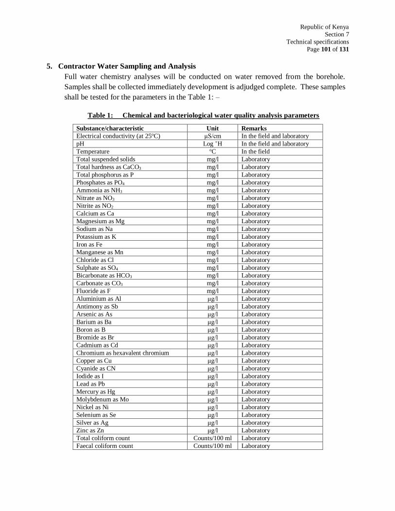
Republic of Kenya
Section 7
Technical specifications
Page 101 of 131
5. Contractor Water Sampling and Analysis
Full water chemistry analyses will be conducted on water removed from the borehole.
Samples shall be collected immediately development is adjudged complete. These samples
shall be tested for the parameters in the Table 1: –
Table 1: Chemical and bacteriological water quality analysis parameters
Substance/characteristic Unit Remarks
Electrical conductivity (at 25oC) μS/cm In the field and laboratory
pH Log +H In the field and laboratory
Temperature oC In the field
Total suspended solids mg/l Laboratory
Total hardness as CaCO3 mg/l Laboratory
Total phosphorus as P mg/l Laboratory
Phosphates as PO4 mg/l Laboratory
Ammonia as NH3 mg/l Laboratory
Nitrate as NO3 mg/l Laboratory
Nitrite as NO2 mg/l Laboratory
Calcium as Ca mg/l Laboratory
Magnesium as Mg mg/l Laboratory
Sodium as Na mg/l Laboratory
Potassium as K mg/l Laboratory
Iron as Fe mg/l Laboratory
Manganese as Mn mg/l Laboratory
Chloride as Cl mg/l Laboratory
Sulphate as SO4 mg/l Laboratory
Bicarbonate as HCO3 mg/l Laboratory
Carbonate as CO3 mg/l Laboratory
Fluoride as F mg/l Laboratory
Aluminium as Al μg/l Laboratory
Antimony as Sb μg/l Laboratory
Arsenic as As μg/l Laboratory
Barium as Ba μg/l Laboratory
Boron as B μg/l Laboratory
Bromide as Br μg/l Laboratory
Cadmium as Cd μg/l Laboratory
Chromium as hexavalent chromium μg/l Laboratory
Copper as Cu μg/l Laboratory
Cyanide as CN μg/l Laboratory
Iodide as I μg/l Laboratory
Lead as Pb μg/l Laboratory
Mercury as Hg μg/l Laboratory
Molybdenum as Mo μg/l Laboratory
Nickel as Ni μg/l Laboratory
Selenium as Se μg/l Laboratory
Silver as Ag μg/l Laboratory
Zinc as Zn μg/l Laboratory
Total coliform count Counts/100 ml Laboratory
Faecal coliform count Counts/100 ml Laboratory
Republic of Kenya
Section 7
Technical specifications
Page 102 of 131
Water samples for bacteriological analysis will be collected from borehole at the end of
development; these will be collected and immediately shipped to an approved laboratory to
comply with KS 05-459 (1996), which requires that samples are stored and transported at
4oC and that analysis starts within six (6) hours of sampling.
Bidders shall provide the following rates: –
a) A unit rate for the collection of water samples for chemical analysis, transport to the
laboratory and the analysis itself. This must include the collection of electrical
conductivity and temperature data at wellhead (one [42 No.] number);
b) A unit rate for the collection of water samples for bacteriological analysis, transport
to the laboratory and the analysis itself (one [42 No.] number).
Contractor shall provide the name and address of the laboratory or laboratories that shall
undertake chemical analyses and confirm that all of the above laboratory parameters can be
determined by the laboratory or laboratories they have selected. Failure to provide both the
names of the laboratories and their official statement that they are able to perform the
analyses to the Specification given in the Table above will render a Bid non-responsive.
5.1 Well Head:
The well head will consist of a galvanized steel pipe DN 200 of 1m length flanged to the
one side and to the other cemented in the annular space of the casing in a rectangular block
100 X 100 cm of reinforced steel. The block will have a total height of 80 cm. A sealing
plate will be bolted to the flanged pipe and will be provided with lifting eye bolts and a
flanged connection pipe to rising column (Rp2”) and to a 90 E flanged bend (DN 50, mobile
flange). Holes shall be provided in the sealing plate to introduce an air vent pipe, motor and
control caudles, water dip tubing with screwed plug. A 90 E bend (DN 50) with an orfice
for pressure gauge (manometer) will be bolted on the flange connection pipe. Following a
pipe DN 50 will permit the connection of the well head to the water tank rising pipes. Sketch
in fig.2 in Appendix B shows a suggested well head.
The cap shall be secured with a welded hasp that can be locked. The lock shall be of
stainless steel and brass, so as to minimize the effects of corrosion; four (4) keys shall be
provided for each lock.
Should the borehole be artesian, provision shall be made in the construction of the well cap
to allow for the safe discharge of artesian flow away from the wellhead.
Bidders shall provide the following rates: –
A unit rate of borehole headworks complete.
Republic of Kenya
Section 7
Technical specifications
Page 103 of 131
5.2 Material for Drilled Wells
Additional to the materials mentioned before, the following materials shall be used.
5.2.1 Bottom Seal
The lower end of the casing/screen string shall be a sump pipe of 2m length of the same
material and dimensions as the screens and casings. The bottom is closed by a wooden plug.
A rubber seal assures the tightness of the bottom, which is fastened to the lower end of the
sump pipe by metal screws.
5.2.2 Centralizers
The casing string shall be fitted with centralizers at specified intervals, the screen section with
centralizers at 3-4 m intervals. The centralizers shall be of rigid PVC or of stainless steel.
5.3 Reporting, Logs, Records and Well Files
5.3.1 Logging, Records and Reporting
Daily logs and records are to be kept for each well site, which include the following information:
(a) Date, working hours,
(b) Stoppage, breakdowns,
(c) Shifting,
(d) Drilling/construction progress,
(e) Consumption of materials,
(f) Water inlets and yields, water levels, conductivity, pH, temperature,
(g) Drilling methods, equipment in use,
(h) Drilling string and assembly report, bit record report, drilling log, lithology log,
and penetration rate log,
(i) Cross sections of the dug wells and the equipped drilled wells with all details on
casing, screens gravel pack, sealing, grouting, positioning of pumps, provided
with all dimensions,
(j) Casing tally report,
(k) Length, diameter and depth of installation of screens,
(l) Length, diameter and installation depths of casing,
(m) Verticality test(s) and alignment report,
(n) Well development,
(o) Pumping test and recovery test report,
(p) Water quality tests,
(q) All specific data and information requested in the relevant chapter, e.g. chapter. 9
and 10,
(r) Completed works, wells etc.

Republic of Kenya
Section 7
Technical specifications
Page 104 of 131
The logs have to be attached to the monthly reports and shall become part of the “Well File” to
be set up for each well.
The Engineer shall have full access to all data and information as well as the right to witness all
operations at any time. In the course of the execution of the works the Engineer may ask for
additional data, information, and records that are of importance for the conditions encountered.
The Contractor shall submit to the Engineer monthly reports, in bound form, not later than the
5th working day of the following month. All reports have to be submitted in two (2) copies in
English as hardcopy and on DVD as electronic version.
5.3.1“Well Files”
The Contractor has to establish and to submit with the application for the Taking-Over Certificate
for each drilled well completed a separate “Well File” two (2) copies in English as hard copies and
six (6) copies of the electronic versions (English) on CD/DVD.
The file has to contain, at least,
Serial number of the well and village name
Exact location with GPS co-ordinates
Description of the well with location sketch
Photo of the well
As Built Drawing” (cross section and layout of the drilled wells and surface
works with all dimensions)
Borehole log
Geophysical logs
Development report, pumping test report
Reports of all analysis executed
Verticality test
Record of testing and commissioning of hand pumps and equipment of drilled
wells
Operation/maintenance handbook(s)
List of equipment, spare parts and tools
Schedule for replacement of wearing parts, nomination of spare parts source.
Each “Well File” has to be approved by the Engineer.
Republic of Kenya
Section 7
Technical specifications
Page 105 of 131
6. WATER TANK
Contractor shall design the water tank with all structural drawings and provide to Consultant
Engineer for approval.
Elevated steel water tanks
The elevated water tanks are all rectangular reservoirs built of steel with a liner, roof and
distribution tap stands. As stipulated, the height of the tanks is 12m from ground level to the
bottom of the tanks. The volume of the vessels is 100 m3. The dimensions of 100 m3 tank are
base 8 meters by 5 meters and a height of 2.5 meters. The water tank itself is supported by 9
pillars interconnected with steel structure. The contractor to provide the final drawings for
approval before construction
At very site a geotechnical investigation shall be carried to estimate the bearing capacity of the
soil and allowable settlement and the chemical properties of the soil (sulphate & chloride
contents) from this investigation the depth & type of footing of the water tank shall be decided.
The different stages of the water reservoir construction are then following:
Excavation of the foundation
Construction of foundation as one monolithic reinforced concrete slab (square
form) on lean concrete layer
Columns and Struts: The column base, whether riveted or welded, shall have
sufficient area to distribute the column load over the concrete foundations
without exceeding the specified bearing stress on the foundation and the
connection of the column to the base plate shall provide for the maximum uplift,
if the anchors are connected to the base plates and not to the column shaft.
Column Splices: Column splices shall be designed to withstand the maximum
possible uplift, or at least 25 per cent of the maximum compression whichever
is greater. If column splices are riveted, the flanges only of rolled column
sections need be spliced. Rolled channels, if used in columns, shall have both
the flanges and webs spliced. For welded column splices the joints may either
be butt welded or splice plates may be welded to both sections being joined.
Bottom Struts: Bottom struts of steel or reinforced concrete shall be provided
where necessary to distribute the horizontal reactions at the bases of the
columns. These shall consist of struts connecting the foundation piers, or of
structural members connecting the lower ends of the columns.
Tension Members Carrying Wind and/or Earthquake Loads: Such members
shall be designed to resist the wind load and the earthquake load if the latter is
specified. It is not necessary to combine wind and earthquake loads but to
Republic of Kenya
Section 7
Technical specifications
Page 106 of 131
design for the maximum stress produced by either force. If the projected centers
of gravity of tension members do not meet the projected center of gravity of
structural members at the center of gravity of the columns, proper allowance
shall be made for the eccentricity.
Diagonal tension members shall be pre-stressed sufficiently to be taut when the
tank is full. Such pre-stressing shall not be given consideration in the design of
the members.
Horizontal Girders: For elevated tanks with inclined or battered columns
connecting to the tank shell a horizontal girder shall be provided to resist the
horizontal component of the column loads. This girder shall be proportioned to
withstand safely as a ring girder the horizontal inward component of the load
on the top columns. If the centers of gravity of the horizontal girder, the top
section columns and the tank shell do not meet in a point, provision shall be
made in the design of each of them for stresses resulting from any eccentricity.
Balcony Railing: If the horizontal girder is used as a balcony it shall be at least
24 in. in width and shall be provided with a railing at least 36 in. in height.
Tank Plates: Plates for elevated tank bottoms, shells and roofs may be any
desired shape. Tank plates shall be designed on the basis of the following
maximum fiber stresses which shall be reduced for the joint efficiencies as
specified elsewhere in these specifications. Plate surfaces susceptible to
complete stress analysis shall be designed on the basis of a maximum fiber
stress of 15,000 psi. Such plate surfaces include those not stressed by the
concentrated reactions of supporting members or riser pipes. Plate surfaces not
susceptible to complete stress analysis shall also be designed on the basis of the
maximum fiber stress of 15,000 psi. after making reasonable allowances for
such loads determined. The maximum fiber stress shall in no case exceed
11,000 psi. when calculated assuming that the concentrated reactions of
supporting members are uniformly distributed between such reactions.
The works sequence for the construction of the different steel structures is here always: laying
of reinforcement, construction of the tower and installing the steel tank.
Reinforcement of foundations has to first be inspected and accepted by the engineer.
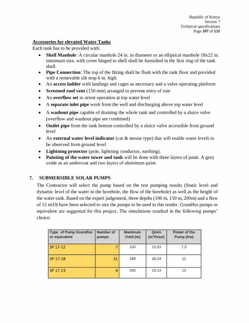
Republic of Kenya
Section 7
Technical specifications
Page 107 of 131
Accessories for elevated Water Tanks
Each tank has to be provided with:
Shell Manhole: A circular manhole 24 in. in diameter or an elliptical manhole 18x22 in.
minimum size, with cover hinged to shell shall be furnished in the first ring of the tank
shell.
Pipe Connection: The top of the fitting shall be flush with the tank floor and provided
with a removable silt stop 6 in. high.
An access ladder with landings and cages as necessary and a valve operating platform
Screened roof vent (150 mm) arranged to prevent entry of rain
An overflow set to arrest operation at top water level
A separate inlet pipe work from the well and discharging above top water level
A washout pipe capable of draining the whole tank and controlled by a sluice valve
(overflow and washout pipe are combined)
Outlet pipe from the tank bottom controlled by a sluice valve accessible from ground
level
An external water level indicator (cat & mouse type) that will enable water levels to
be observed from ground level
Lightning protector (pole, lightning conductor, earthing).
Painting of the water tower and tank will be done with three layers of paint. A grey
oxide as an undercoat and two layers of aluminum paint.
7. SUBMERSIBLE SOLAR PUMPS
The Contractor will select the pump based on the test pumping results (Static level and
dynamic level of the water in the borehole, the flow of the borehole) as well as the height of
the water tank. Based on the expert judgement, three depths (100 m, 150 m, 200m) and a flow
of 15 m3/h have been selected to size the pumps to be used in this tender. Grundfos pumps or
equivalent are suggested for this project. The simulations resulted in the following pumps’
choice:
Type of Pump Grundfos
or equivalent
Number of
pumps
Maximum
Yield (m)
Qmin
(m3/hour)
Power of the
Pump (Kw)
SP 17-12 7 100 15,93 7,5
SP 17-18 31 150 16,14 11
SP 17-23 4 200 15,14 13
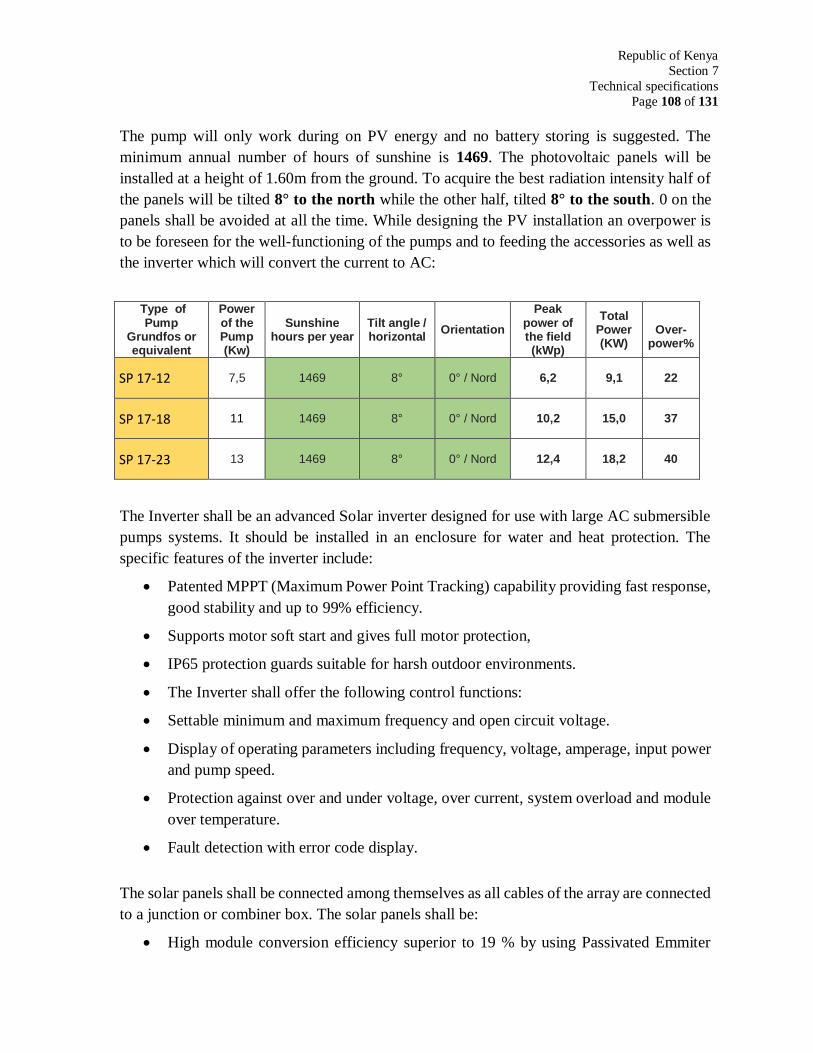
Republic of Kenya
Section 7
Technical specifications
Page 108 of 131
The pump will only work during on PV energy and no battery storing is suggested. The
minimum annual number of hours of sunshine is 1469. The photovoltaic panels will be
installed at a height of 1.60m from the ground. To acquire the best radiation intensity half of
the panels will be tilted 8° to the north while the other half, tilted 8° to the south. 0 on the
panels shall be avoided at all the time. While designing the PV installation an overpower is
to be foreseen for the well-functioning of the pumps and to feeding the accessories as well as
the inverter which will convert the current to AC:
Type of Pump
Grundfos or equivalent
Power of the Pump (Kw)
Sunshine hours per year
Tilt angle / horizontal
Orientation
Peak power of the field (kWp)
Total Power (KW)
Over-
power%
SP 17-12 7,5 1469 8° 0° / Nord 6,2 9,1 22
SP 17-18 11 1469 8° 0° / Nord 10,2 15,0 37
SP 17-23 13 1469 8° 0° / Nord 12,4 18,2 40
The Inverter shall be an advanced Solar inverter designed for use with large AC submersible
pumps systems. It should be installed in an enclosure for water and heat protection. The
specific features of the inverter include:
Patented MPPT (Maximum Power Point Tracking) capability providing fast response,
good stability and up to 99% efficiency.
Supports motor soft start and gives full motor protection,
IP65 protection guards suitable for harsh outdoor environments.
The Inverter shall offer the following control functions:
Settable minimum and maximum frequency and open circuit voltage.
Display of operating parameters including frequency, voltage, amperage, input power
and pump speed.
Protection against over and under voltage, over current, system overload and module
over temperature.
Fault detection with error code display.
The solar panels shall be connected among themselves as all cables of the array are connected
to a junction or combiner box. The solar panels shall be:
High module conversion efficiency superior to 19 % by using Passivated Emmiter
Republic of Kenya
Section 7
Technical specifications
Page 109 of 131
Rear Contact (PERC) technology,
The modules should be monocrystalline,
Low degradation and excellent performance under high temperature and low light
conditions,
Robust aluminum frame ensures the modules to withstand wind loads up to 2400Pa.
the frame will supported by a reinforced concrete ground beam. A particular attention
will be provided to the alignment of the support (horizontality) and to the tilt of the
panel.
High reliability against extreme environmental conditions (passing salt mist, ammonia
and hail tests).
Potential induced degradation (PID) resistance.
Positive power tolerance of 0 ~ +3 %.
All drawings and calculations and computer input and output shall be presented to the
Consultant Engineer for approval. A set of spare parts including the followings shall be
provided at each site:
a) DC Breakers
b) AC Breakers
c) Fuses
The Bidders shall provide the following rates: –
a) A unit rate for supply seven (7 No.) submersible pump (3 Phase). Quote for Grundfos
SP 17-12 (HMT 100m, 7.5Kw, 3 x380v, Qmin 15m3/h)- subject to change by the
Engineer);
b) A lump sum rate for delivery, transport, insurance and installation one submersible
pump (SP 17-12).
c) A unit rate for supply of seven (31 No.) submersible pump (3 Phase). Quote for
Grundfos SP17-18 (HMT 150m, 11Kw, 3 x380v, Qmin 15m3/h) -subject to change
by the Engineer);
d) A lump sum rate for delivery, transport, insurance and installation one submersible
pump (SP 17-18).
e) A unit rate for supply of four (4 No.) submersible pump (3 Phase). Quote for
Grundfos SP17-23 (MT 200m, 13Kw, 3 x380v, Qmin 15m3/h) - subject to change by
the Engineer;
Republic of Kenya
Section 7
Technical specifications
Page 110 of 131
f) A lump sum rate for delivery, transport, insurance and installation one submersible
pump (SP 17-23).
g) A lump sum rate for Supply and installation of 7 solar power system to drive 7.5 kw
motor (SP17-12). The minimum annual number of hours of sunshine is 1469. The tilt
is 8°, The overpower is 22%. The Inverter shall be should be an advanced Solar
inverter designed for use with large AC submersible pumps systems. The solar panels
shall be monocrystalline with a module conversion efficiency superior to 19 %
including robust aluminum frame including control panel. The system shall comply
to the technical specifications item 5 of the tender document.
h) A lump sum rate for Supply and installation of 31 solar power system to drive 11kw
motor (SP17-18). The minimum annual number of hours of sunshine is 1469. The tilt
is 8°, The overpower is 37%. The Inverter shall be should be an advanced Solar
inverter designed for use with large AC submersible pumps systems. The solar panels
shall be monocrystalline with a module conversion efficiency superior to 19 %
including robust aluminum frame including control panel. The system shall comply
to the technical specifications item 5 of the tender document.
i) A lump sum rate for Supply and installation of 4 solar power system to drive 13 kw
motor (SP17-23). The minimum annual number of hours of sunshine is 1469. The tilt
is 8°, The overpower is 40%. The Inverter shall be should be an advanced Solar
inverter designed for use with large AC submersible pumps systems. The solar panels
shall be monocrystalline with a module conversion efficiency superior to 19 %
including robust aluminum frame including control panel. The system shall comply
to the technical specifications item 5 of the tender document.
Rising mains
The installation will include a 2" (50 mm) galvanized steel rising main, submersible cable,
electrode pencils, electrode cable, a non-return valve just above the pump, a 25-32 mm dipper
line, and all other items necessary for proper functioning of the pump. As an alternative to the
control panel and coupled start/stop electrodes, a CU3 control unit or similar may be installed.
All the Items to be installed shall be subject to confirmation and approval by the Supervising
Engineer.
All items will be of high quality, and suitable to function properly in tropical conditions. Spare
parts of the equipment to be supplied and installed shall as much as possible be available in
Kenya. The bidder shall furnish the Engineer of the addresses of the Suppliers of such spare
parts.
Republic of Kenya
Section 7
Technical specifications
Page 111 of 131
Additional ancillary equipment will be supplied to the system to supply the above-mentioned
submersible pump with the required electricity to pump 15 m3/hour with a head of about 200
metres. The system will be installed including all necessary items, such that the pump can
function properly. This includes (starting from the end of the rising main): a union to be able
to disconnect the delivery pipe and the rising main, a pressure gauge, a control gate valve, a
control panel (with low/high level cut-outs, phase failure and indicator lights, switch-over
gear etc.), non-return valve, a level cut out, a kit for repair and maintenance of the whole
pumping unit, including 2 splicing kits and all other items necessary for proper functioning
of the system.
Bidders shall provide the following rates: –
a) A meter rate for supply and installation of 50mm diameter galvanized steel pipes,
heavy duty class C as rising main (including fittings); a total length of 7,144 meters.
b) A meter rate for supply and installation of 25 mm diameter uPVC airline; a total
length of 7,144 metres.
c) A meter rate for supply and installation of electrical submersible cable 3 phase 8mm
for submersible pump SP 17- 12 to the surface; a total length of 602 meters.
d) A meter rate for supply and installation of electrical submersible cable 3 phase 12mm
for submersible pump SP 17- 18 to the surface; a total length of 5,890 meters.
e) A meter rate for supply and installation of electrical submersible cable 3 phase 16mm
for submersible pump SP 17- 23 to the surface; a total length of 960 meters.
f) A lump sum rate for electrical connection to control panel, over a distance of
approximately 20 meters including two splicing kits, underground armored cable,
25mm uPVC pipe and additional items required for proper operation.
g) A unit rate for Grundfos CU3 control unit for pump protection
8. WATER DISTRIBUTION SYSTEM
The water from the water tanks shall be transferred by gravity to the water taps post near to the
beneficiaries. High density polyethylene pipe (HDPE) is suggested. The pipes are to be buried in
trenches of depth 50 - 100cm as shown in sketch in fig. 5 in Appendix B.
The Contractor has to conduct a detailed topographical survey. The survey shall include an area
of 5km circle around the center of the concerned village. According to this survey, the position
of the water tank which shall be in the highest point and the tap posts locations shall be decided.
The tap post has to be located with reasonable slopes and an end of dense population avoiding
very low spots. According to the slopes and distance and required discharge to the tap post, the
Republic of Kenya
Section 7
Technical specifications
Page 112 of 131
pipes layout, diameter, thickness and pressure is to be decided. Standards used drawings,
calculation and computer input and output shall be forwarded to the Consultant Engineer for
approval. The service pressure of a tap post shall not be less than 1 bar.
The Contractor is required to give detailed method statement and shop drawings for every road
crossing to be approved by the consultant engineer. Expected methods is either by cutting the
existing road at the route of the pipes and lying the pipes and compacting and reinstate the road
and making a temporary path for the traffic or make a tunnel under the road.
9. TAP POSTAND WATERING TROUGH
The Contractor will have to implement for each village:
a) A kiosk at a distance of at least 100 m from the borehole location,
b) Kiosk at the primary school within the village,
c) A watering trough for livestock located at a distance of at least 400 m from the borehole.
Upon the instruction of the Consultant, the distribution network might be extended to the mosque
and to the dispensary
10. CONCRETE WORK
Transport and placing of concrete shall be done by means which will prevent segregation or loss
of the ingredients.
The placing of concrete in hot weather requires the following steps to be taken:
Watering of the sub grade, form work and steel reinforcement before placing concrete.
Care should, however, be taken to ensure that there is no free-standing water.
Stacking the aggregates under shade or spraying the aggregates with water, but there
shall be adequate drainage of the sprinkled water.
Covering the freshly laid concrete with burlap, polyethylene or similar material.
Sprinkling the freshly laid concrete with water after one hour or so.
Speedily placing and finishing the concrete.
Republic of Kenya
Section 7
Technical specifications
Page 113 of 131
Concrete Tests
Suitable equipment for testing by the Consultant Engineer the concrete strength shall be
made available by the Contractor. (Concrete test hammer e.g. “Schmidt”)
Required strengths
All reinforced concrete shall have the strength 30 MPa.
Concrete without reinforcing and lean concrete shall have the strength 15 MPa.
Masonry
The scope of work covered by this section shall be deemed to comprise the furnishing and
installing of all brick work and concrete blocks. It shall also include the supply of the
appertaining materials and structural parts, scaffolding, offloading on site and all
operations in connection with masonry works.
Materials
The materials shall be protected from rain and inclement weather all to the satisfaction of
the Engineer.
The cost of covering materials shall be deemed to be included in the offer for the brick
work and masonry. The masonry works shall be of local materials e.g. concrete blocks,
plastered bricks, rocks. The quality of each material shall conform to the requirements of
the respective standards.
The binding agents shall be stored dry. The aggregates shall be free of impurities and
protected from being contaminated.
Republic of Kenya
Section 8
Bill of Quantities - Daily Charges
Page 114 of 131
SECTION 8
BILL OF QUANTITIES
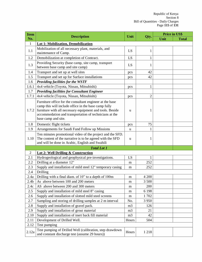
Republic of Kenya
Section 8
Bill of Quantities - Daily Charges
Page 115 of 131
Item
No. Description Unit Qty.
Price in US$
Unit Total
1 Lot 1: Mobilization, Demobilization
1.1 Mobilization of all necessary plant, materials, and
maintenance of Camp. LS 1
1.2 Demobilization at completion of Contract. LS 1
1.3 Providing Security (base camp, site camp, transport
between base camp and site camp) LS 1
1.4 Transport and set up at well sites pcs 42
1.5 Transport and set up for Surface installations pcs 42
1.6 Providing facilities for the WSTF
1.6.1 4x4 vehicle (Toyota, Nissan, Mitsubishi) pcs 1
1.7 Providing facilities for Consultant Engineer
1.7.1 4x4 vehicle (Toyota, Nissan, Mitsubishi) pcs 2
1.7.2
Furniture office for the consultant engineer at the base
camp this will include office in the base camp fully
furniture with all necessary equipment and tools. Beside accommodation and transportation of technicians at the
base camp and site.
u 1
1.8 Domestic flight tickets pcs 75
1.9 Arrangements for Saudi Fund Follow up Missions u 1
1.10
Ten minutes promotional video of the project and the SFD.
The content of the narrative is to be agreed with the SFD and will be done in Arabic, English and Swahili
u 1
Total Lot 1
2 Lot 2: Well Drilling & Construction
2.1 Hydrogeological and geophysical pre-investigations. LS 1
2.2 Drilling at a diameter 12" m 252
2.3 Supply and installation of mild steel 12" temporary casing m 252
2.4 Drilling
2.4a Drilling with a final diam. of 10” to a depth of 100m m 4 200
2.4b As above between 100 and 200 meters m 3 500
2.4c AS above between 200 and 300 meters m 200
2.5 Supply and installation of mild steel 8" casing m 6 198
2.6 Supply and installation of slotted mild steel screens m 1 702
2.7 Sampling and storing of drilling samples at 2 m interval No. 3 950
2.8 Supply and installation of gravel pack. m3 126
2.9 Supply and installation of grout material m3 21
2.10 Supply and installation of inert back fill material m3 42
2.11 Development of Drilled Well. Hours 504
2.12 Test pumping
2.12a Test pumping of Drilled Well (calibration, step drawdown and constant discharge test (assume 29 hours))
Hours 1 218
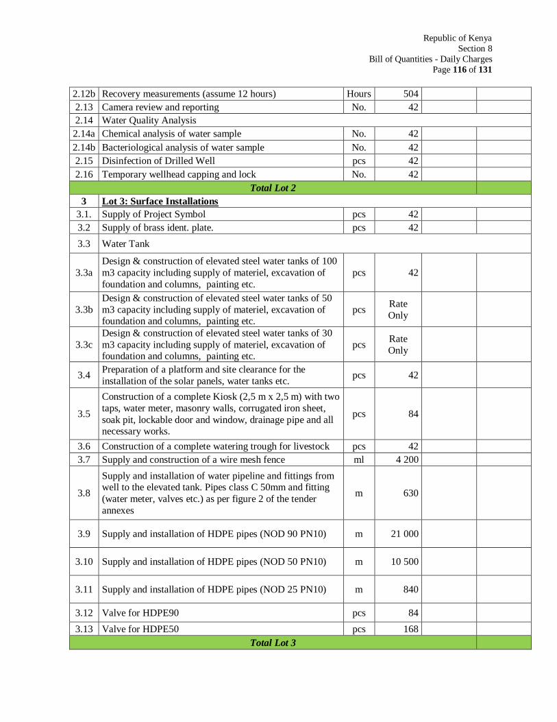
Republic of Kenya
Section 8
Bill of Quantities - Daily Charges
Page 116 of 131
2.12b Recovery measurements (assume 12 hours) Hours 504
2.13 Camera review and reporting No. 42
2.14 Water Quality Analysis
2.14a Chemical analysis of water sample No. 42
2.14b Bacteriological analysis of water sample No. 42
2.15 Disinfection of Drilled Well pcs 42
2.16 Temporary wellhead capping and lock No. 42
Total Lot 2
3 Lot 3: Surface Installations
3.1. Supply of Project Symbol pcs 42
3.2 Supply of brass ident. plate. pcs 42
3.3 Water Tank
3.3a
Design & construction of elevated steel water tanks of 100
m3 capacity including supply of materiel, excavation of
foundation and columns, painting etc.
pcs 42
3.3b
Design & construction of elevated steel water tanks of 50
m3 capacity including supply of materiel, excavation of foundation and columns, painting etc.
pcs Rate
Only
3.3c
Design & construction of elevated steel water tanks of 30
m3 capacity including supply of materiel, excavation of foundation and columns, painting etc.
pcs Rate
Only
3.4 Preparation of a platform and site clearance for the
installation of the solar panels, water tanks etc. pcs 42
3.5
Construction of a complete Kiosk (2,5 m x 2,5 m) with two
taps, water meter, masonry walls, corrugated iron sheet,
soak pit, lockable door and window, drainage pipe and all necessary works.
pcs 84
3.6 Construction of a complete watering trough for livestock pcs 42
3.7 Supply and construction of a wire mesh fence ml 4 200
3.8
Supply and installation of water pipeline and fittings from well to the elevated tank. Pipes class C 50mm and fitting
(water meter, valves etc.) as per figure 2 of the tender
annexes
m 630
3.9 Supply and installation of HDPE pipes (NOD 90 PN10) m 21 000
3.10 Supply and installation of HDPE pipes (NOD 50 PN10) m 10 500
3.11 Supply and installation of HDPE pipes (NOD 25 PN10) m 840
3.12 Valve for HDPE90 pcs 84
3.13 Valve for HDPE50 pcs 168
Total Lot 3
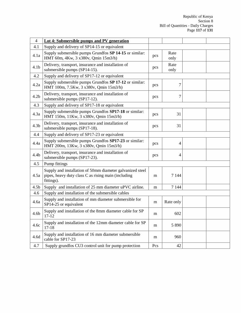
Republic of Kenya
Section 8
Bill of Quantities - Daily Charges
Page 117 of 131
4 Lot 4: Submersible pumps and PV generation
4.1 Supply and delivery of SP14-15 or equivalent
4.1a Supply submersible pumps Grundfos SP 14-15 or similar:
HMT 60m, 4Kw, 3 x380v, Qmin 15m3/h) pcs
Rate
only
4.1b Delivery, transport, insurance and installation of
submersible pumps (SP14-15). pcs
Rate
only
4.2 Supply and delivery of SP17-12 or equivalent
4.2a Supply submersible pumps Grundfos SP 17-12 or similar:
HMT 100m, 7.5Kw, 3 x380v, Qmin 15m3/h) pcs 7
4.2b Delivery, transport, insurance and installation of
submersible pumps (SP17-12). pcs 7
4.3 Supply and delivery of SP17-18 or equivalent
4.3a Supply submersible pumps Grundfos SP17-18 or similar: HMT 150m, 11Kw, 3 x380v, Qmin 15m3/h)
pcs 31
4.3b Delivery, transport, insurance and installation of submersible pumps (SP17-18).
pcs 31
4.4 Supply and delivery of SP17-23 or equivalent
4.4a Supply submersible pumps Grundfos SP17-23 or similar:
HMT 200m, 13Kw, 3 x380v, Qmin 15m3/h) pcs 4
4.4b Delivery, transport, insurance and installation of
submersible pumps (SP17-23). pcs 4
4.5 Pump fittings
4.5a
Supply and installation of 50mm diameter galvanized steel
pipes, heavy duty class C as rising main (including
fittings).
m 7 144
4.5b Supply and installation of 25 mm diameter uPVC airline. m 7 144
4.6 Supply and installation of the submersible cables
4.6a Supply and installation of mm diameter submersible for SP14-25 or equivalent
m Rate only
4.6b Supply and installation of the 8mm diameter cable for SP 17-12
m 602
4.6c Supply and installation of the 12mm diameter cable for SP 17-18
m 5 890
4.6d Supply and installation of 16 mm diameter submersible cable for SP17-23
m 960
4.7 Supply grundfos CU3 control unit for pump protection Pcs 42
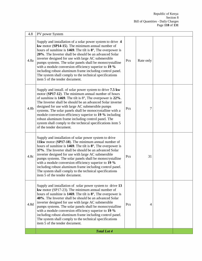
Republic of Kenya
Section 8
Bill of Quantities - Daily Charges
Page 118 of 131
4.8 PV power System
4.8a
Supply and installation of a solar power system to drive 4
kw motor (SP14-15). The minimum annual number of
hours of sunshine is 1469. The tilt is 8°, The overpower is
20%. The Inverter shall be should be an advanced Solar inverter designed for use with large AC submersible
pumps systems. The solar panels shall be monocrystalline
with a module conversion efficiency superior to 19 % including robust aluminum frame including control panel.
The system shall comply to the technical specifications
item 5 of the tender document.
Pcs Rate only
4.8b
Supply and install. of solar power system to drive 7.5 kw motor (SP17-12). The minimum annual number of hours
of sunshine is 1469. The tilt is 8°, The overpower is 22%.
The Inverter shall be should be an advanced Solar inverter
designed for use with large AC submersible pumps systems. The solar panels shall be monocrystalline with a
module conversion efficiency superior to 19 % including
robust aluminum frame including control panel. The system shall comply to the technical specifications item 5
of the tender document.
Pcs 7
4.8c
Supply and installation of solar power system to drive
11kw motor (SP17-18). The minimum annual number of hours of sunshine is 1469. The tilt is 8°, The overpower is
37%. The Inverter shall be should be an advanced Solar
inverter designed for use with large AC submersible pumps systems. The solar panels shall be monocrystalline
with a module conversion efficiency superior to 19 %
including robust aluminum frame including control panel.
The system shall comply to the technical specifications item 5 of the tender document.
Pcs 31
4.8d
Supply and installation of solar power system to drive 13
kw motor (SP17-23). The minimum annual number of
hours of sunshine is 1469. The tilt is 8°, The overpower is 40%. The Inverter shall be should be an advanced Solar
inverter designed for use with large AC submersible
pumps systems. The solar panels shall be monocrystalline with a module conversion efficiency superior to 19 %
including robust aluminum frame including control panel.
The system shall comply to the technical specifications
item 5 of the tender document.
Pcs 4
Total Lot 4
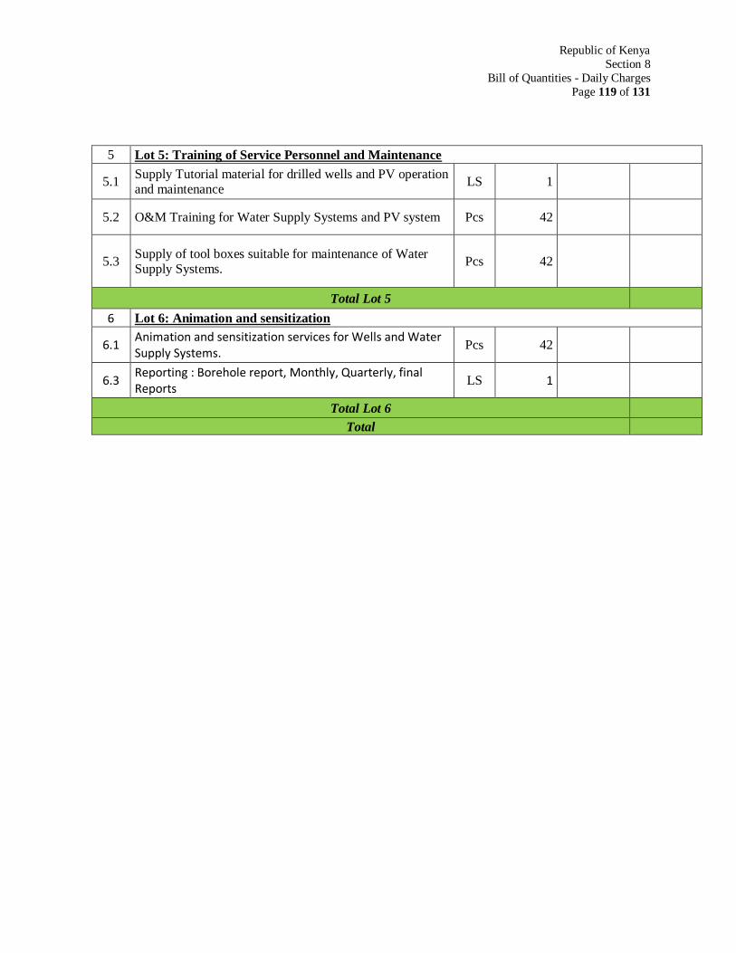
Republic of Kenya
Section 8
Bill of Quantities - Daily Charges
Page 119 of 131
5 Lot 5: Training of Service Personnel and Maintenance
5.1 Supply Tutorial material for drilled wells and PV operation and maintenance
LS 1
5.2 O&M Training for Water Supply Systems and PV system Pcs 42
5.3 Supply of tool boxes suitable for maintenance of Water Supply Systems.
Pcs 42
Total Lot 5
6 Lot 6: Animation and sensitization
6.1 Animation and sensitization services for Wells and Water Supply Systems.
Pcs 42
6.3 Reporting : Borehole report, Monthly, Quarterly, final Reports
LS 1
Total Lot 6
Total
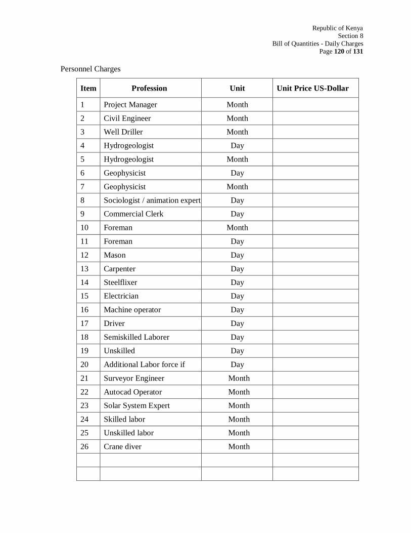
Republic of Kenya
Section 8
Bill of Quantities - Daily Charges
Page 120 of 131
Personnel Charges
Item Profession Unit Unit Price US-Dollar
1 Project Manager Month
2 Civil Engineer Month
3 Well Driller Month
4 Hydrogeologist Day
5 Hydrogeologist Month
6 Geophysicist Day
7 Geophysicist Month
8 Sociologist / animation expert Day
9 Commercial Clerk Day
10 Foreman Month
11 Foreman Day
12 Mason Day
13 Carpenter Day
14 Steelflixer Day
15 Electrician Day
16 Machine operator Day
17 Driver Day
18 Semiskilled Laborer Day
19 Unskilled Day
20 Additional Labor force if Day
21 Surveyor Engineer Month
22 Autocad Operator Month
23 Solar System Expert Month
24 Skilled labor Month
25 Unskilled labor Month
26 Crane diver Month
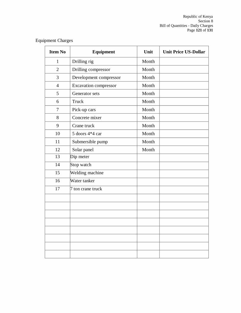
Republic of Kenya
Section 8
Bill of Quantities - Daily Charges
Page 121 of 131
Equipment Charges
Item No Equipment Unit Unit Price US-Dollar
1 Drilling rig Month
2 Drilling compressor Month
3 Development compressor Month
4 Excavation compressor Month
5 Generator sets Month
6 Truck Month
7 Pick-up cars Month
8 Concrete mixer Month
9 Crane truck Month
10 5 doors 4*4 car Month
11 Submersible pump Month
12 Solar panel Month
13 Dip meter
14 Stop watch
15 Welding machine
16 Water tanker
17 7 ton crane truck
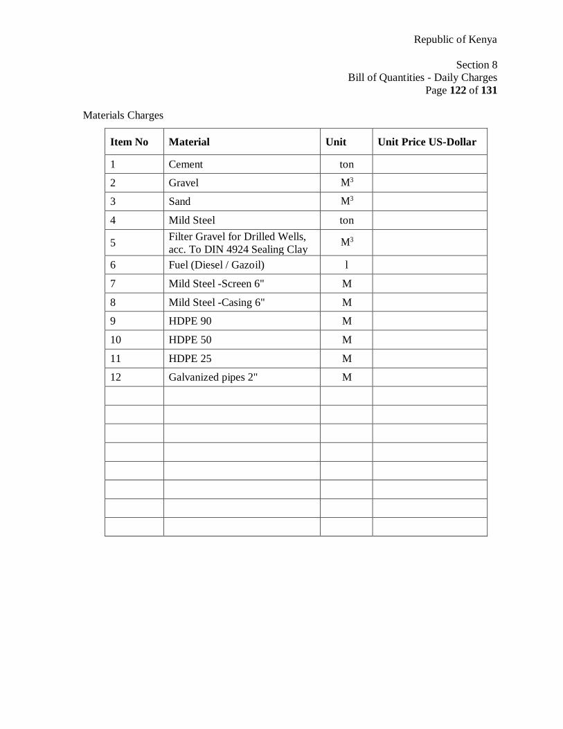
Republic of Kenya
Section 8
Bill of Quantities - Daily Charges
Page 122 of 131
Materials Charges
Item No Material Unit Unit Price US-Dollar
1 Cement ton
2 Gravel M3
3 Sand M3
4 Mild Steel ton
5 Filter Gravel for Drilled Wells,
acc. To DIN 4924 Sealing Clay M3
6 Fuel (Diesel / Gazoil) l
7 Mild Steel -Screen 6" M
8 Mild Steel -Casing 6" M
9 HDPE 90 M
10 HDPE 50 M
11 HDPE 25 M
12 Galvanized pipes 2" M
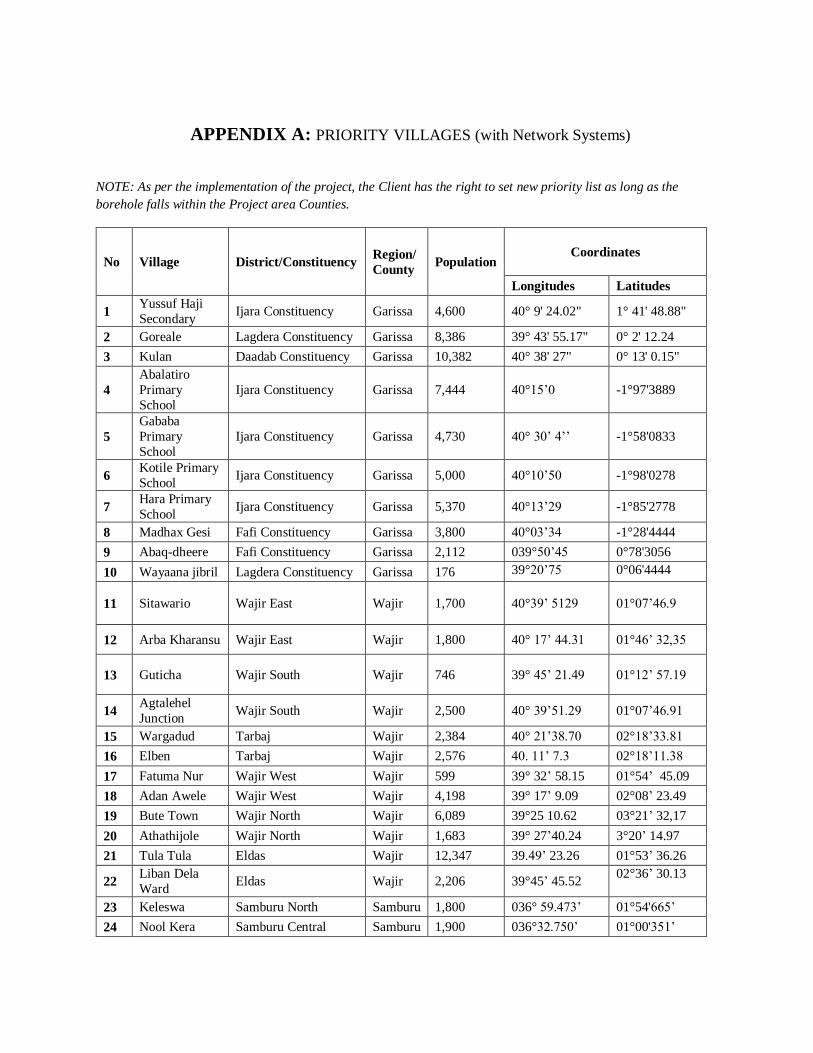
APPENDIX A: PRIORITY VILLAGES (with Network Systems)
NOTE: As per the implementation of the project, the Client has the right to set new priority list as long as the
borehole falls within the Project area Counties.
No Village District/Constituency Region/
County Population
Coordinates
Longitudes Latitudes
1 Yussuf Haji
Secondary Ijara Constituency Garissa 4,600 40° 9' 24.02" 1° 41' 48.88"
2 Goreale Lagdera Constituency Garissa 8,386 39° 43' 55.17" 0° 2' 12.24
3 Kulan Daadab Constituency Garissa 10,382 40° 38' 27" 0° 13' 0.15"
4
Abalatiro
Primary
School
Ijara Constituency Garissa 7,444 40°15’0 -1°97'3889
5
Gababa
Primary
School
Ijara Constituency Garissa 4,730 40° 30’ 4’’ -1°58'0833
6 Kotile Primary
School Ijara Constituency Garissa 5,000 40°10’50 -1°98'0278
7 Hara Primary
School Ijara Constituency Garissa 5,370 40°13’29 -1°85'2778
8 Madhax Gesi Fafi Constituency Garissa 3,800 40°03’34 -1°28'4444
9 Abaq-dheere Fafi Constituency Garissa 2,112 039°50’45 0°78'3056
10 Wayaana jibril Lagdera Constituency Garissa 176 39°20’75 0°06'4444
11 Sitawario Wajir East Wajir 1,700 40°39’ 5129 01°07’46.9
12 Arba Kharansu Wajir East Wajir 1,800 40° 17’ 44.31 01°46’ 32,35
13 Guticha Wajir South Wajir 746 39° 45’ 21.49 01°12’ 57.19
14 Agtalehel
Junction Wajir South Wajir 2,500 40° 39’51.29 01°07’46.91
15 Wargadud Tarbaj Wajir 2,384 40° 21’38.70 02°18’33.81
16 Elben Tarbaj Wajir 2,576 40. 11’ 7.3 02°18’11.38
17 Fatuma Nur Wajir West Wajir 599 39° 32’ 58.15 01°54’ 45.09
18 Adan Awele Wajir West Wajir 4,198 39° 17’ 9.09 02°08’ 23.49
19 Bute Town Wajir North Wajir 6,089 39°25 10.62 03°21’ 32,17
20 Athathijole Wajir North Wajir 1,683 39° 27’40.24 3°20’ 14.97
21 Tula Tula Eldas Wajir 12,347 39.49’ 23.26 01°53’ 36.26
22 Liban Dela
Ward Eldas Wajir 2,206 39°45’ 45.52
02°36’ 30.13
23 Keleswa Samburu North Samburu 1,800 036° 59.473’ 01°54'665’
24 Nool Kera Samburu Central Samburu 1,900 036°32.750’ 01°00'351’
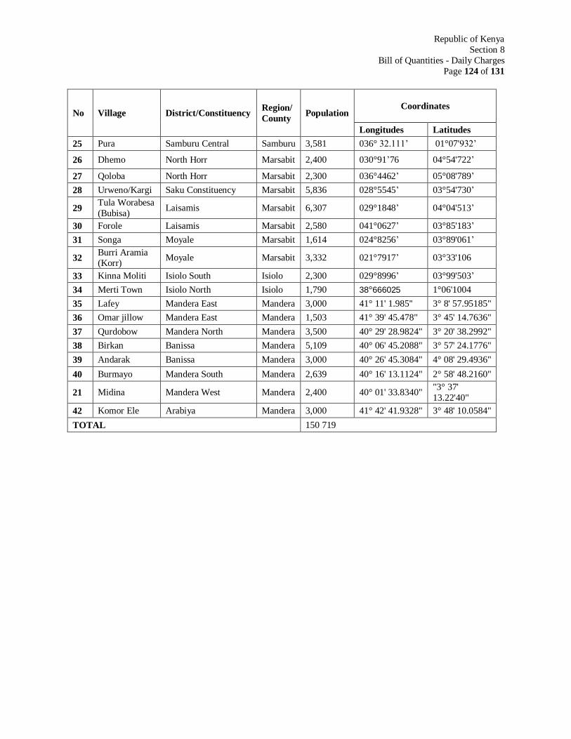
Republic of Kenya
Section 8
Bill of Quantities - Daily Charges
Page 124 of 131
No Village District/Constituency Region/
County Population
Coordinates
Longitudes Latitudes
25 Pura Samburu Central Samburu 3,581 036° 32.111’ 01°07'932’
26 Dhemo North Horr Marsabit 2,400 030°91’76 04°54'722’
27 Qoloba North Horr Marsabit 2,300 036°4462’ 05°08'789’
28 Urweno/Kargi Saku Constituency Marsabit 5,836 028°5545’ 03°54'730’
29 Tula Worabesa
(Bubisa) Laisamis Marsabit 6,307 029°1848’ 04°04'513’
30 Forole Laisamis Marsabit 2,580 041°0627’ 03°85'183’
31 Songa Moyale Marsabit 1,614 024°8256’ 03°89'061’
32 Burri Aramia (Korr)
Moyale Marsabit 3,332 021°7917’ 03°33'106
33 Kinna Moliti Isiolo South Isiolo 2,300 029°8996’ 03°99'503’
34 Merti Town Isiolo North Isiolo 1,790 38°666025 1°06'1004
35 Lafey Mandera East Mandera 3,000 41° 11' 1.985'' 3° 8' 57.95185"
36 Omar jillow Mandera East Mandera 1,503 41° 39' 45.478" 3° 45' 14.7636"
37 Qurdobow Mandera North Mandera 3,500 40° 29' 28.9824" 3° 20' 38.2992"
38 Birkan Banissa Mandera 5,109 40° 06' 45.2088" 3° 57' 24.1776"
39 Andarak Banissa Mandera 3,000 40° 26' 45.3084" 4° 08' 29.4936"
40 Burmayo Mandera South Mandera 2,639 40° 16' 13.1124" 2° 58' 48.2160"
21 Midina Mandera West Mandera 2,400 40° 01' 33.8340" "3° 37'
13.22'40"
42 Komor Ele Arabiya Mandera 3,000 41° 42' 41.9328" 3° 48' 10.0584"
TOTAL 150 719
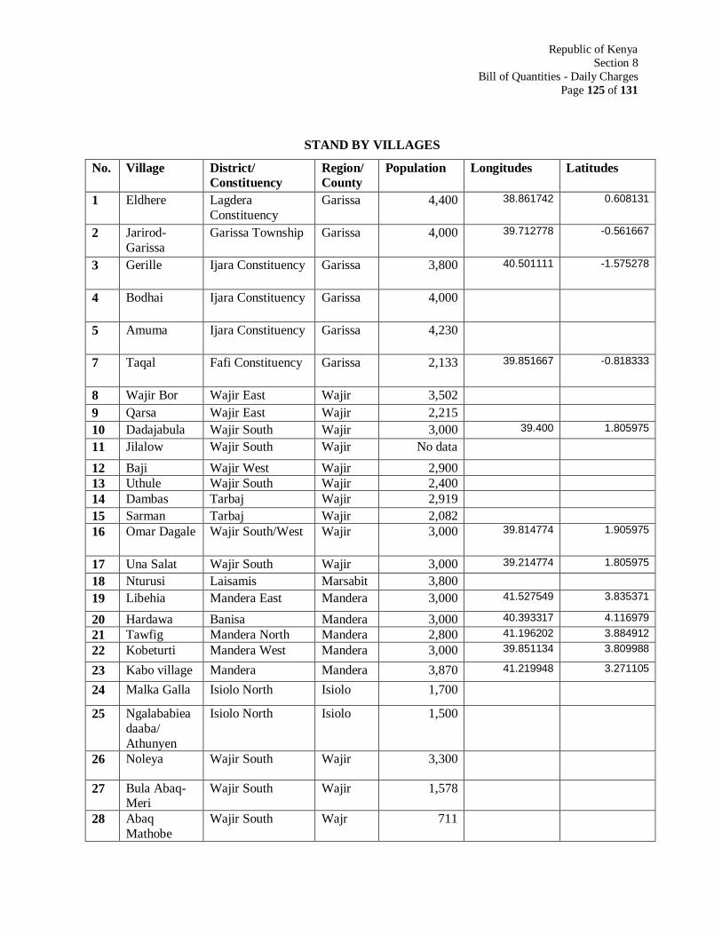
Republic of Kenya
Section 8
Bill of Quantities - Daily Charges
Page 125 of 131
STAND BY VILLAGES
No. Village District/
Constituency
Region/
County
Population Longitudes Latitudes
1 Eldhere Lagdera
Constituency
Garissa 4,400 38.861742 0.608131
2 Jarirod-
Garissa
Garissa Township Garissa 4,000 39.712778 -0.561667
3 Gerille Ijara Constituency Garissa 3,800 40.501111 -1.575278
4 Bodhai Ijara Constituency Garissa 4,000
5 Amuma Ijara Constituency Garissa 4,230
7 Taqal Fafi Constituency Garissa 2,133 39.851667 -0.818333
8 Wajir Bor Wajir East Wajir 3,502
9 Qarsa Wajir East Wajir 2,215
10 Dadajabula Wajir South Wajir 3,000 39.400 1.805975
11 Jilalow Wajir South Wajir No data
12 Baji Wajir West Wajir 2,900
13 Uthule Wajir South Wajir 2,400
14 Dambas Tarbaj Wajir 2,919
15 Sarman Tarbaj Wajir 2,082
16 Omar Dagale Wajir South/West Wajir 3,000 39.814774 1.905975
17 Una Salat Wajir South Wajir 3,000 39.214774 1.805975
18 Nturusi Laisamis Marsabit 3,800
19 Libehia Mandera East Mandera 3,000 41.527549 3.835371
20 Hardawa Banisa Mandera 3,000 40.393317 4.116979
21 Tawfig Mandera North Mandera 2,800 41.196202 3.884912
22 Kobeturti Mandera West Mandera 3,000 39.851134 3.809988
23 Kabo village Mandera Mandera 3,870 41.219948 3.271105
24 Malka Galla Isiolo North Isiolo 1,700
25 Ngalababiea
daaba/
Athunyen
Isiolo North Isiolo 1,500
26 Noleya Wajir South Wajir 3,300
27 Bula Abaq-Meri
Wajir South Wajir 1,578
28 Abaq
Mathobe
Wajir South Wajr 711
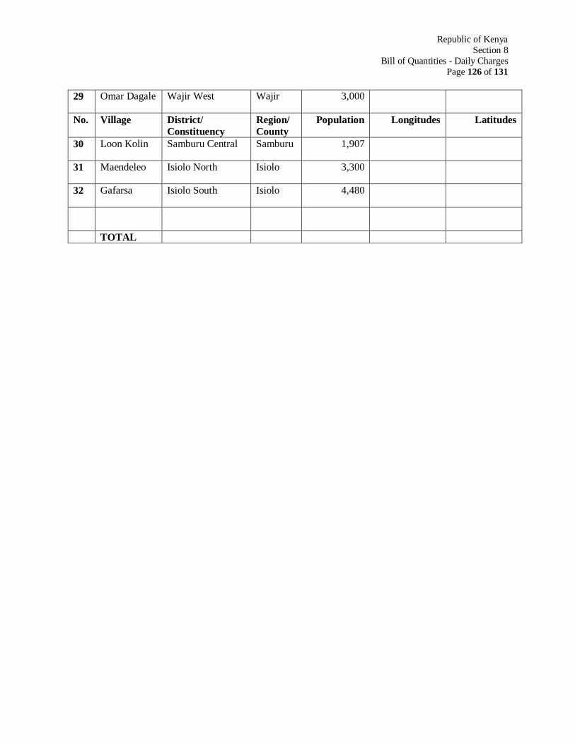
Republic of Kenya
Section 8
Bill of Quantities - Daily Charges
Page 126 of 131
29 Omar Dagale Wajir West Wajir 3,000
No. Village District/
Constituency Region/
County Population Longitudes Latitudes
30 Loon Kolin Samburu Central Samburu 1,907
31 Maendeleo Isiolo North Isiolo 3,300
32 Gafarsa Isiolo South Isiolo 4,480
TOTAL

APPENDIX B: DRAWINGS
FIGURE 1: SCHEMATIC DRAWING OF DRILLED WELLS
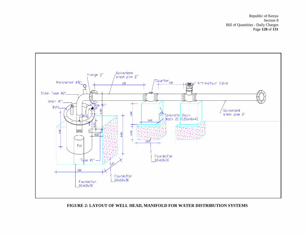
Republic of Kenya
Section 8
Bill of Quantities - Daily Charges
Page 128 of 131
FIGURE 2: LAYOUT OF WELL HEAD, MANIFOLD FOR WATER DISTRIBUTION SYSTEMS
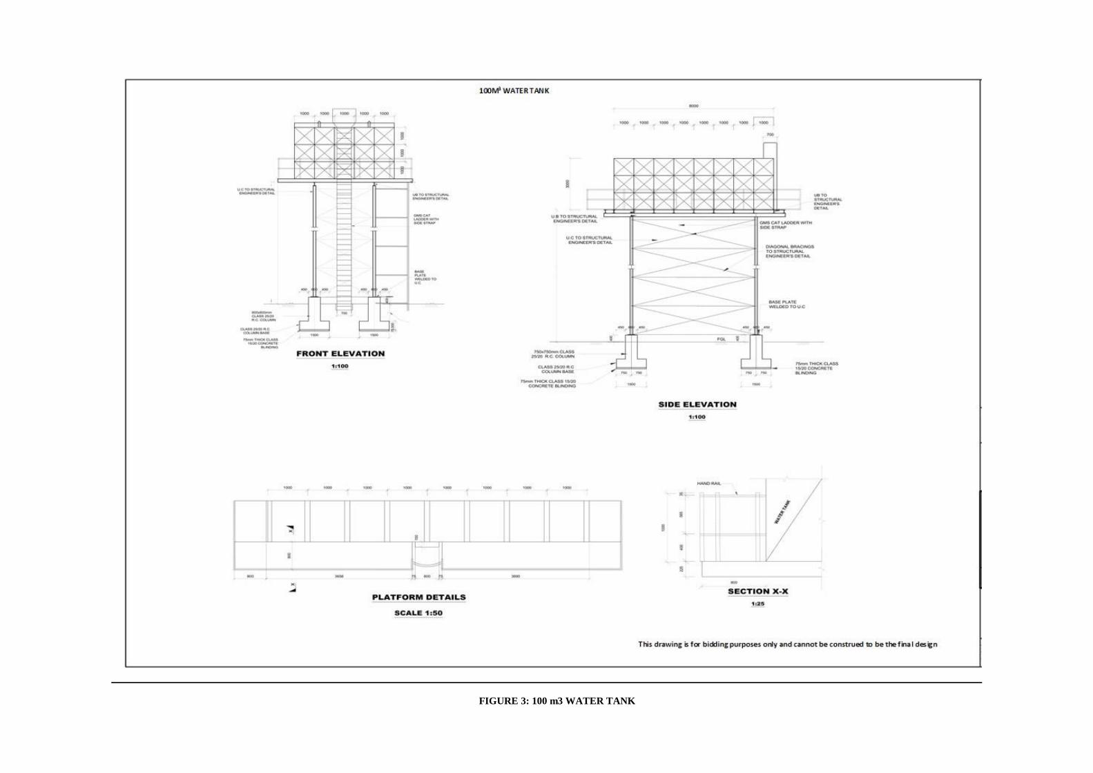
FIGURE 3: 100 m3 WATER TANK
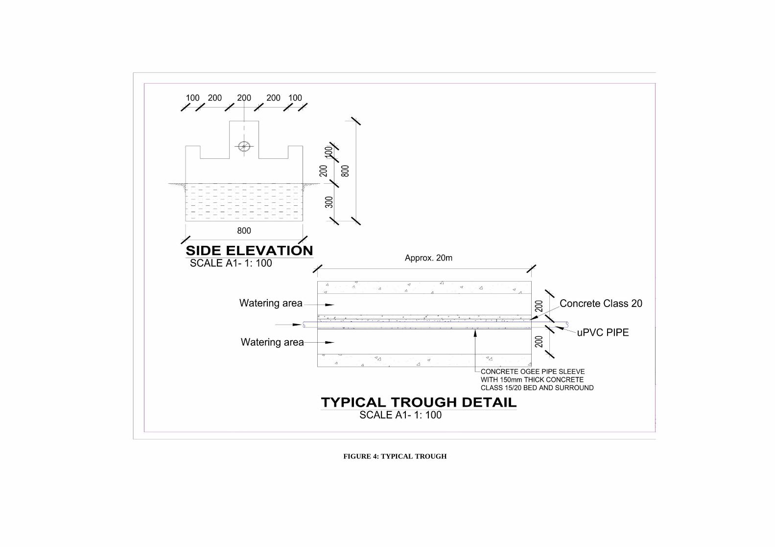
FIGURE 4: TYPICAL TROUGH
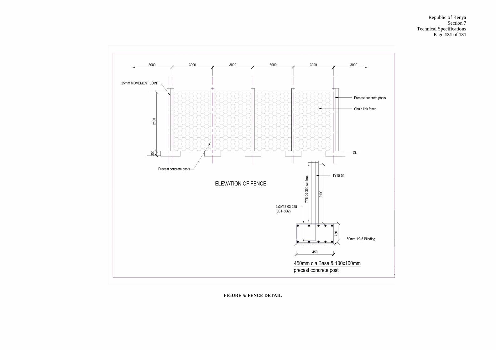
Republic of Kenya
Section 7
Technical Specifications
Page 131 of 131
FIGURE 5: FENCE DETAIL
2, Rue Sahab Ibn Abbad, Cité Jardins 1002 Tunis Belvédère TUNISIA Phone : +216 71 800 033 Fax. +216 71 785 066 E-mail : [email protected]
The Saudi Program for Drilling of Wells and Rural Development in Africa,
Phase V
Republic of Kenya
The Construction of 42 Drilled Wells Equipped with Solar pumping
generator and pipelines connections to supply several Villages in
Mandera, Wajir Garissa, Marsabit, Isiolo, and Samburu regions
PROJECT NO.: P5/2019/Kenya
Appraisal Report
Ref. : A20-27
Date: July 2021
The Saudi Program for Drilling of Wells and Rural Development in Africa, Phase V Republic of Kenya Page 1 of 119
TABLE OF CONTENTS
EXECUTIVE SUMMARY ..................................................................................................... 6
CHAPTER I: INTRODUCTION........................................................................................... 10
1.1 INTRODUCTION ................................................................................................. 10
1.2 AGREEMENT SIGNATURE ................................................................................ 10
1.3 SCOPE OF THE PROJECT: ................................................................................. 10
CHAPTER II: BACKGROUND INFORMATION ON THE PROJECT AREA....................... 11
2.1 MANDERA COUNTY ........................................................................................... 11
2.1.1 Location and demography .............................................................................. 11
2.1.2 Topography .................................................................................................... 18
2.1.3 Geology .......................................................................................................... 20
2.1.4 Hydrogeology ................................................................................................. 21
2.2 WAJIR COUNTY .................................................................................................. 22
2.2.1 Location and demography .............................................................................. 22
2.2.2 Physical and Topographic features ................................................................ 34
2.2.3 Geological setting ........................................................................................... 34
2.2.4 Hydrogeological setting .................................................................................. 35
2.3 GARISSA COUNTY .............................................................................................. 39
2.3.1 Location and demography .............................................................................. 39
2.3.2 Administrative boundaries .............................................................................. 48
2.3.3 Topography .................................................................................................... 51
2.3.4 Geological setting ........................................................................................... 51
2.3.5 Hydrogeological setting .................................................................................. 52
2.4 MARSABIT COUNTY .......................................................................................... 57
2.4.1 Location .......................................................................................................... 57
2.4.2 Demography ................................................................................................... 60
2.4.3 Geology .......................................................................................................... 66
2.4.4 Topography .................................................................................................... 68
2.4.5 Hydrology ....................................................................................................... 68
2.4.6 Hydrogeology ................................................................................................. 69
2.5 SAMBURU COUNTY ........................................................................................... 70
2.5.1 Location .......................................................................................................... 70
2.5.2 Demography ................................................................................................... 71
The Saudi Program for Drilling of Wells and Rural Development in Africa, Phase V Republic of Kenya Page 2 of 119
2.5.3 Administrative boundaries .............................................................................. 76
2.5.4 Geology .......................................................................................................... 77
2.5.5 Topography .................................................................................................... 79
2.5.6 Hydrology ....................................................................................................... 79
2.5.7 Hydrogeology ................................................................................................. 79
2.6 ISIOLO COUNTY ................................................................................................. 81
2.6.1 Location .......................................................................................................... 81
2.6.2 Demography ................................................................................................... 81
2.6.3 Geology .......................................................................................................... 87
2.6.4 Topography .................................................................................................... 88
2.6.5 Hydrology ....................................................................................................... 89
CHAPTER III: PROJECT APPRAISAL .............................................................................. 91
3.1 MANDERA COUNTY ........................................................................................... 91
3.1.1 Existing boreholes .......................................................................................... 91
3.1.2 Proposed boreholes ....................................................................................... 94
3.2 WAJIR COUNTY .................................................................................................. 97
3.2.1 Existing boreholes .......................................................................................... 97
3.2.2 Proposed boreholes ......................................................................................100
3.3 GARISSA COUNTY .............................................................................................103
3.3.1 Existing boreholes .........................................................................................103
3.3.2 Proposed boreholes ......................................................................................104
3.4 MARSABIT COUNTY .........................................................................................106
3.4.1 Existing boreholes .........................................................................................106
3.4.2 Proposed boreholes ......................................................................................109
3.5 SAMBURU COUNTY ..........................................................................................111
3.5.1 Existing boreholes .........................................................................................111
3.5.2 Proposed boreholes ......................................................................................111
3.6 ISIOLO COUNTY ................................................................................................112
3.6.1 Existing boreholes .........................................................................................112
3.6.2 Proposed boreholes ......................................................................................114
CHAPTER IV: DESIGN CRITERIA & FINDINGS ..............................................................115
4.1 BOREHOLES ......................................................................................................115
4.1.1 Study Area .....................................................................................................115
4.1.2 Successful boreholes ....................................................................................115
The Saudi Program for Drilling of Wells and Rural Development in Africa, Phase V Republic of Kenya Page 3 of 119
4.1.3 Borehole depths ............................................................................................116
4.1.4 Borehole diameter, borehole casings and screens ........................................116
4.1.5 Borehole development and test pumping ......................................................116
4.1.6 Water sampling and analysis .........................................................................117
4.1.7 Submersible Solar Pumps .............................................................................117
4.2 SOLAR PANELS ..................................................................................................117
4.3 WATER TANK ....................................................................................................119
4.4 WATER DISTRIBUTION SYSTEM.....................................................................119
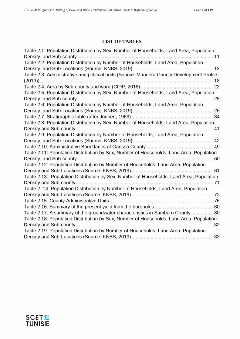
The Saudi Program for Drilling of Wells and Rural Development in Africa, Phase V Republic of Kenya Page 4 of 119
LIST OF TABLES
Table 2.1: Population Distribution by Sex, Number of Households, Land Area, Population
Density, and Sub-county .................................................................................................... 11
Table 2.2: Population Distribution by Number of Households, Land Area, Population
Density, and Sub-Locations (Source: KNBS, 2019) ........................................................... 13
Table 2.3: Administrative and political units (Source: Mandera County Development Profile
(2013)) ............................................................................................................................... 18
Table 2.4: Area by Sub-county and ward (CIDP, 2018) ..................................................... 22
Table 2.5: Population Distribution by Sex, Number of Households, Land Area, Population
Density, and Sub-county .................................................................................................... 25
Table 2.6: Population Distribution by Number of Households, Land Area, Population
Density, and Sub-Locations (Source: KNBS, 2019) ........................................................... 26
Table 2.7: Stratigraphic table (after Joubert, 1963) ............................................................ 34
Table 2.8: Population Distribution by Sex, Number of Households, Land Area, Population
Density and Sub-county ..................................................................................................... 41
Table 2.9: Population Distribution by Number of Households, Land Area, Population
Density, and Sub-Locations (Source: KNBS, 2019) ........................................................... 42
Table 2.10: Administrative Boundaries of Garissa County ................................................. 49
Table 2.11: Population Distribution by Sex, Number of Households, Land Area, Population
Density, and Sub-county .................................................................................................... 60
Table 2.12: Population Distribution by Number of Households, Land Area, Population
Density and Sub-Locations (Source: KNBS, 2019) ............................................................ 61
Table 2.13: Population Distribution by Sex, Number of Households, Land Area, Population
Density and Sub-county ..................................................................................................... 71
Table 2. 14: Population Distribution by Number of Households, Land Area, Population
Density and Sub-Locations (Source: KNBS, 2019) ............................................................ 72
Table 2.15: County Administrative Units ............................................................................ 76
Table 2.16: Summary of the present yield from the boreholes ........................................... 80
Table 2.17: A summary of the groundwater characteristics in Samburu County ................ 80
Table 2.18: Population Distribution by Sex, Number of Households, Land Area, Population
Density and Sub-county ..................................................................................................... 82
Table 2.19: Population Distribution by Number of Households, Land Area, Population
Density and Sub-Locations (Source: KNBS, 2019) ............................................................ 83
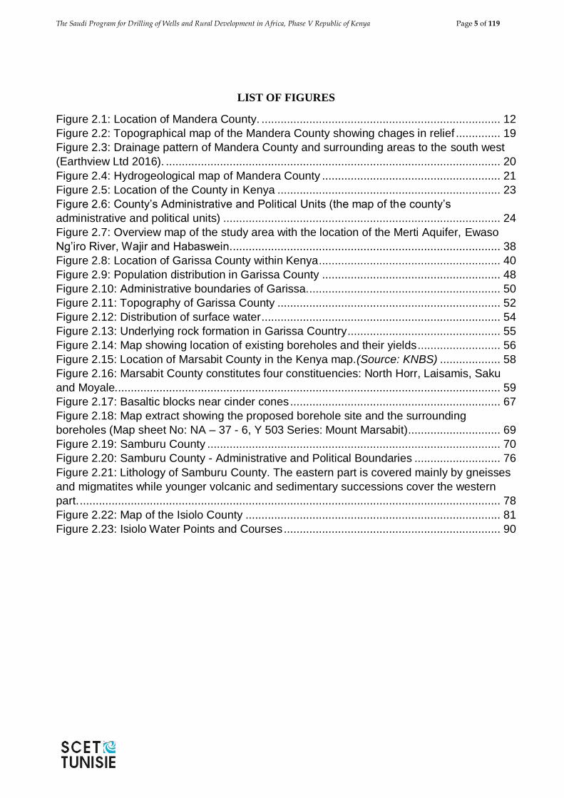
The Saudi Program for Drilling of Wells and Rural Development in Africa, Phase V Republic of Kenya Page 5 of 119
LIST OF FIGURES
Figure 2.1: Location of Mandera County. ........................................................................... 12
Figure 2.2: Topographical map of the Mandera County showing chages in relief .............. 19
Figure 2.3: Drainage pattern of Mandera County and surrounding areas to the south west
(Earthview Ltd 2016). ......................................................................................................... 20
Figure 2.4: Hydrogeological map of Mandera County ........................................................ 21
Figure 2.5: Location of the County in Kenya ...................................................................... 23
Figure 2.6: County’s Administrative and Political Units (the map of the county’s
administrative and political units) ....................................................................................... 24
Figure 2.7: Overview map of the study area with the location of the Merti Aquifer, Ewaso
Ng’iro River, Wajir and Habaswein. .................................................................................... 38
Figure 2.8: Location of Garissa County within Kenya ......................................................... 40
Figure 2.9: Population distribution in Garissa County ........................................................ 48
Figure 2.10: Administrative boundaries of Garissa............................................................. 50
Figure 2.11: Topography of Garissa County ...................................................................... 52
Figure 2.12: Distribution of surface water ........................................................................... 54
Figure 2.13: Underlying rock formation in Garissa Country ................................................ 55
Figure 2.14: Map showing location of existing boreholes and their yields .......................... 56
Figure 2.15: Location of Marsabit County in the Kenya map.(Source: KNBS) ................... 58
Figure 2.16: Marsabit County constitutes four constituencies: North Horr, Laisamis, Saku
and Moyale......................................................................................................................... 59
Figure 2.17: Basaltic blocks near cinder cones .................................................................. 67
Figure 2.18: Map extract showing the proposed borehole site and the surrounding
boreholes (Map sheet No: NA – 37 - 6, Y 503 Series: Mount Marsabit) ............................. 69
Figure 2.19: Samburu County ............................................................................................ 70
Figure 2.20: Samburu County - Administrative and Political Boundaries ........................... 76
Figure 2.21: Lithology of Samburu County. The eastern part is covered mainly by gneisses
and migmatites while younger volcanic and sedimentary successions cover the western
part. .................................................................................................................................... 78
Figure 2.22: Map of the Isiolo County ................................................................................ 81
Figure 2.23: Isiolo Water Points and Courses .................................................................... 90
The Saudi Program for Drilling of Wells and Rural Development in Africa, Phase V Republic of Kenya Page 6 of 119
EXECUTIVE SUMMARY
The Government of the Kingdom of Saudi Arabia has grant geared towards implementation of the
Fifth Phase of the Saudi Program for Drilling of Wells and Rural Development in Africa, which will
focus on improving quality and quantity of heathy drinking water in Kenya. The fifth phase of the
program will be implemented under the supervision of the Saudi Fund for Development (SFD) through
Water Sector Trust fund (WSTF) in Kenya.
For this project groundwater exploration and development is targeted in six counties namely Wajir
(12 boreholes), Garissa (10 boreholes), Mandera (8 boreholes), Marsabit (7 boreholes), Samburu (3
boreholes) and Isiolo (2 boreholes). Geologically, the areas targeted for borehole drilling are in
crystalline (volcanic or metamorphic) and sedimentary rocks.
The Location of the boreholes is provided in the Google Map with the following annotations:
Green for priority boreholes,
Yellow for standby boreholes and,
Blue for existing boreholes.
The boreholes will be constructed at different depths depending on groundwater occurrence and
distribution in each of the targeted areas. The borehole drill depths will be determined at the
hydrogeological survey stage. The contractor is expected to hire services of a hydrogeological expert
who is to carrying borehole site investigations at each of the pre-selected village and ascertain the
exact location for borehole drilling as well as borehole depth.
For the purpose of the tendering process existing borehole data near a pre-selected site was evaluated
from which the following tentative borehole depths have been adopted namely:- 100 metres, 200
meters and 250 meters.
All the 42 boreholes will be drilled at a diameter of 12”/304 mm to a depth of the six (6) metres. This
section of the borehole will be installed with 12”/304 mm diameter surface casing, which will serve
two purposes namely to protect the top of the borehole from erosion from returning drilling fluids or
artesian flow or both and to provide the sanitary seal casing in the borehole headworks. Casing used
as surface casing shall be mild steel of a specification suited to water well applications.
As from a depth of the 6 metres, all the boreholes will be drilled at a diameter of 10” (254mm) to
completion depth as will be determined during the hydrogeological survey. The borehole will be
installed with 8” 203 mm plain casings and screens. The annular space between the borehole and
casing/screens will be filled with gravel pack only for sections that are aquiferous. Above the upper
most of gravel pack the borehole will be filled with inert backfill. In order to avert any surface
pollution, a grout seal will be installed up to the top of the highest level of inert material to surface +
0.4 m.
After completion of drilling and placement of casing and screens, gravel and backfill etc the borehole
shall be developed in accordance with modern borehole construction practices, including airlift
surging and possibly chemical development using a polyphosphate. It is expected that a total of 12
hours will be required. Subsequently, test pumping comprised of calibration test, 4-hour step-
drawdown test followed by a constant discharge test for a period of 24 hours.

The Saudi Program for Drilling of Wells and Rural Development in Africa, Phase V Republic of Kenya Page 7 of 119
Full water chemistry analyses will be conducted on water removed from the borehole. Samples shall
be collected immediately development is adjudged complete. In addition, water samples for
bacteriological analysis will be collected from borehole at the end of development; these will be
collected and immediately shipped to an approved laboratory to comply with KS 05-459 (1996).
The Contractor will select the pump based on the test pumping results (Static level and dynamic level
of the water in the borehole, the flow of the borehole) as well as the height of the water tank. Based
on the expert judgement, three depths (100 m, 150 m, 200m) and a flow of 15 m3/h have been selected
to size the pumps to be used in this tender. Grundfos pumps or equivalent are suggested for this project.
The simulations resulted in the following pumps’ choice:
Type of Pump Grundfos
or equivalent
Number
of pumps
Maximum
Yield (m)
Qmin
(m3/hour)
Power of the
Pump (Kw)
SP 17-12 7 100 15,93 7,5
SP 17-18 31 150 16,14 11
SP 17-23 4 200 15,14 13
The other installations done together with the submersible include a 2" (50 mm) galvanized steel rising
main, submersible cable, electrode pencils, electrode cable, a non-return valve just above the pump, a
25-32 mm dipper line, and all other items necessary for proper functioning of the pump. As an
alternative to the control panel and coupled start/stop electrodes, a CU3 control unit or similar may be
installed. All the Items to be installed shall be subject to confirmation and approval by the Supervising
Engineer. All items will be of high quality, and suitable to function properly in tropical conditions.
Spare parts of the equipment to be supplied and installed shall as much as possible be available in
Kenya.
A successful well is the well:
1. giving a sustainable yield of ≥ 3m3/hr,
2. whose water is compliant to the health and quality standards in Kenya for Groundwater KS
05-459 (1996),
However only the yield criteria will be applied to pay for successful boreholes.
As per the expert opinion, the success rate of boreholes in the six counties is as follows:
County Number %
Wajir 12 95%
Garissa 10 80%
Mandera 8 95%
Marsabit 7 80%
Samburu 3 80%
Isiolo 2 60%
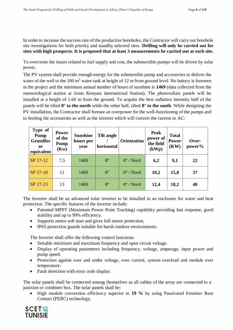
The Saudi Program for Drilling of Wells and Rural Development in Africa, Phase V Republic of Kenya Page 8 of 119
In order to increase the success rate of the productive boreholes, the Contractor will carry out borehole
site investigations for both priority and standby selected sites. Drilling will only be carried out for
sites with high prospects. It is proposed that at least 3 measurements be carried out at each site.
To overcome the issues related to fuel supply and cost, the submersible pumps will be driven by solar
power.
The PV system shall provide enough energy for the submersible pump and accessories to deliver the
water of the well to the 100 m3 water tank at height of 12 m from ground level. No battery is foreseen
in the project and the minimum annual number of hours of sunshine is 1469 (data collected from the
meteorological station at Jomo Kenyata international Station). The photovoltaic panels will be
installed at a height of 1.60 m from the ground. To acquire the best radiation intensity half of the
panels will be tilted 8° to the north while the other half, tilted 8° to the south. While designing the
PV installation, the Contractor shall foresee an overpower for the well-functioning of the pumps and
to feeding the accessories as well as the inverter which will convert the current to AC:
Type of
Pump
Grundfos
or
equivalent
Power
of the
Pump
(Kw)
Sunshine
hours per
year
Tilt angle
/
horizontal
Orientation
Peak
power of
the field
(kWp)
Total
Power
(KW)
Over-
power%
SP 17-12 7,5 1469 8° 0° / Nord 6,2 9,1 22
SP 17-18 11 1469 8° 0° / Nord 10,2 15,0 37
SP 17-23 13 1469 8° 0° / Nord 12,4 18,2 40
The Inverter shall be an advanced solar inverter to be installed in an enclosure for water and heat
protection. The specific features of the inverter include:
Patented MPPT (Maximum Power Point Tracking) capability providing fast response, good
stability and up to 99% efficiency.
Supports motor soft start and gives full motor protection,
IP65 protection guards suitable for harsh outdoor environments.
The Inverter shall offer the following control functions:
Settable minimum and maximum frequency and open circuit voltage.
Display of operating parameters including frequency, voltage, amperage, input power and
pump speed.
Protection against over and under voltage, over current, system overload and module over
temperature.
Fault detection with error code display.
The solar panels shall be connected among themselves as all cables of the array are connected to a
junction or combiner box. The solar panels shall be:
High module conversion efficiency superior to 19 % by using Passivated Emmiter Rear
Contact (PERC) technology,
The Saudi Program for Drilling of Wells and Rural Development in Africa, Phase V Republic of Kenya Page 9 of 119
The modules should be monocrystalline,
Low degradation and excellent performance under high temperature and low light conditions,
Robust aluminum frame ensures the modules to withstand wind loads up to 2400Pa. The frame
will be supported by a reinforced concrete ground beam. A particular attention will be provided
to the alignment of the support (horizontality) and to the tilt of the panel.
High reliability against extreme environmental conditions (passing salt mist, ammonia and hail
tests).
Potential induced degradation (PID) resistance.
Positive power tolerance of 0 ~ +3 %.
It is designed that water from each borehole will pumped into an elevated rectangular steel tank.
Therefore, the project has designed for 42 elevated steel tanks with a capacity of 100 m3 each. As
stipulated, the height of the tanks is 12 m from ground level to the bottom of the tanks. At every site,
a geotechnical investigation shall be carried to estimate the bearing capacity of the soil and allowable
settlement and the chemical properties of the soil (sulphate & chloride contents) from this investigation
the depth & type of footing of the water tank shall be decided.
The water from the water tanks shall be transferred by gravity to the water taps post near to the
beneficiaries. High density polyethylene pipes (HDPE) are suggested. It is designed that for each
village water supply system will comprise of a main water primary truck extending over a distance of
500 metres. The secondary system will comprise of supply to the school within a distance of 250
metres, as well as Kiosk for public water supply. At the end of the primary truck a cattle trough will
be installed 400 metres away. Upon the instruction of the Consultant, the distribution network might
be extended to the mosque and to the dispensary. The construction of a complete Kiosk with lockable
door and window will include two taps and water meter, soak pit, drainage pipe and all necessary
works, furnishing of all necessary parts, masonry walls and corrugated sheet as a roof.
The Saudi Program for Drilling of Wells and Rural Development in Africa, Phase V Republic of Kenya Page 10 of 119
CHAPTER I: INTRODUCTION
1.1 INTRODUCTION
The Government of the Kingdom of Saudi Arabia is desirous to assist and to strengthen the
relations with the Countries of Africa to cope with the needs of the healthy drinkable water by
means of implementing the Fifth Phase of the Saudi Program for Drilling of Wells and Rural
Development in Africa. The Fifth phase of the program will be implemented under the
supervision of the Saudi Fund for Development (SFD).
The objectives of the entire program are as follows:
1. To raise the living standard of the rural population by long-term provision of a safe
drinking water supply
2. To improve the water supply situation in rural areas to benefit as many people as possible,
and provide a basis for gradual development
3. To provide hygienically safe drinking water
4. To give preference to cost-effective solutions and installations easy to operate and
maintain by the target groups
5. To use high-quality, durable materials requiring a minimum of maintenance and repair,
for all constructions
6. To help alleviate unemployment by giving preference to labor-intensive construction
work
7. To spread the goodwill of the Kingdom of Saudi Arabia through the generous donation
to the peoples of Africa in their time of need.
1.2 AGREEMENT SIGNATURE
Further to the evaluation of the SFD, the Consulting Engineer Contract has been awarded to
SCET-Tunisie on October 5, 2020. The Water Sector Trust Fund (WSTF), representative of the
Republic of Kenya, signed with SCET-Tunisie the consultancy Service Agreement on November
18, 2020.
1.3 SCOPE OF THE PROJECT:
The assignment covers the Design and Supervision of the Construction of 42 Drilled Wells to
Supply several villages in the counties of Mandera, Wajir, Garissa, Marsabit, Isiolo and Samburu
in Kenya. This project aims to provide drinking water, a "source of life" to more than 150,000
people. The facilities to be provided must be easy to operate and maintain by the local
populations. Considering that the location of the boreholes may not necessarily be close to
transmission lines and because of fuel supply issues, the option of equipping the wells with solar
pumping generators would be the first option to consider since it is the most cost-effective
solution.
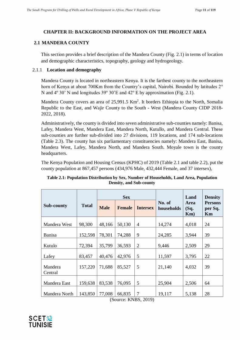
The Saudi Program for Drilling of Wells and Rural Development in Africa, Phase V Republic of Kenya Page 11 of 119
CHAPTER II: BACKGROUND INFORMATION ON THE PROJECT AREA
2.1 MANDERA COUNTY
This section provides a brief description of the Mandera County (Fig. 2.1) in terms of location
and demographic characteristics, topography, geology and hydrogeology.
2.1.1 Location and demography
Mandera County is located in northeastern Kenya. It is the farthest county to the northeastern
horn of Kenya at about 700Km from the Country’s capital, Nairobi. Bounded by latitudes 2o
N and 4o 30’ N and longitudes 39o 30’E and 42o E by approximation (Fig. 2.1).
Mandera County covers an area of 25,991.5 Km2. It borders Ethiopia to the North, Somalia
Republic to the East, and Wajir County to the South - West (Mandera County CIDP 2018-
2022, 2018).
Administratively, the county is divided into seven administrative sub-counties namely: Banisa,
Lafey, Mandera West, Mandera East, Mandera North, Kutullo, and Mandera Central. These
sub-counties are further sub-divided into 27 divisions, 119 locations, and 174 sub-locations
(Table 2.3). The county has six parliamentary constituencies namely: Mandera East, Banisa,
Mandera West, Lafey, Mandera North, and Mandera South. Moyale town is the county
headquarters.
The Kenya Population and Housing Census (KPHC) of 2019 (Table 2.1 and table 2.2), put the
county population at 867,457 persons (434,976 Male, 432,444 Female, and 37 intersex),
Table 2.1: Population Distribution by Sex, Number of Households, Land Area, Population
Density, and Sub-county
Sub-county Total
Sex
No. of
households
Land
Area
(Sq.
Km)
Density
Persons
per Sq.
Km
Male Female Intersex
Mandera West 98,300 48,166 50,130 4 14,274 4,018 24
Banisa 152,598 78,301 74,288 9 24,285 3,944 39
Kutulo 72,394 35,799 36,593 2 9,446 2,509 29
Lafey 83,457 40,476 42,976 5 11,597 3,795 22
Mandera
Central
157,220 71,688 85,527 5 21,140 4,032 39
Mandera East 159,638 83,538 76,095 5 25,904 2,506 64
Mandera North 143,850 77,008 66,835 7 19,117 5,138 28
(Source: KNBS, 2019)
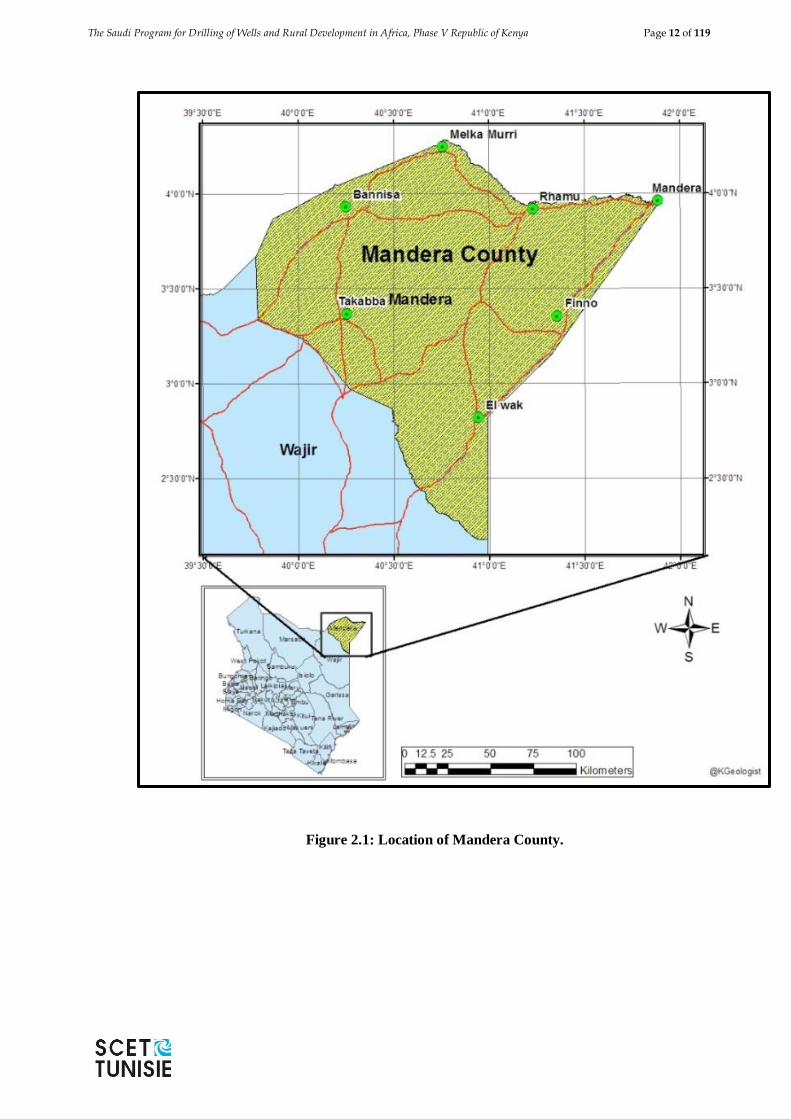
The Saudi Program for Drilling of Wells and Rural Development in Africa, Phase V Republic of Kenya Page 12 of 119
Figure 2.1: Location of Mandera County.
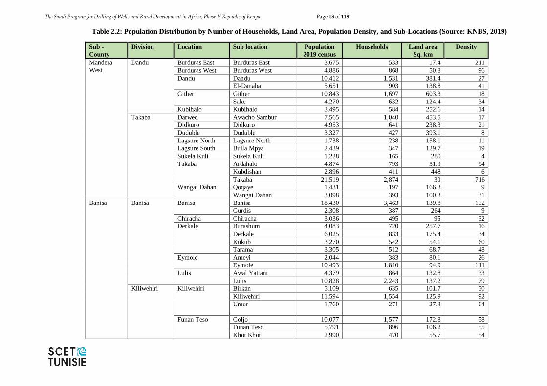
The Saudi Program for Drilling of Wells and Rural Development in Africa, Phase V Republic of Kenya Page 13 of 119
Table 2.2: Population Distribution by Number of Households, Land Area, Population Density, and Sub-Locations (Source: KNBS, 2019)
Sub -
County
Division Location Sub location Population
2019 census
Households Land area
Sq. km
Density
Mandera
West
Dandu
Burduras East Burduras East 3,675 533 17.4 211
Burduras West Burduras West 4,886 868 50.8 96
Dandu Dandu 10,412 1,531 381.4 27
El-Danaba 5,651 903 138.8 41
Gither Gither 10,843 1,697 603.3 18
Sake 4,270 632 124.4 34
Kubihalo Kubihalo 3,495 584 252.6 14
Takaba Darwed Awacho Sambur 7,565 1,040 453.5 17
Didkuro Didkuro 4,953 641 238.3 21
Duduble Duduble 3,327 427 393.1 8
Lagsure North Lagsure North 1,738 238 158.1 11
Lagsure South Bulla Mpya 2,439 347 129.7 19
Sukela Kuli Sukela Kuli 1,228 165 280 4
Takaba Ardahalo 4,874 793 51.9 94
Kubdishan 2,896 411 448 6
Takaba 21,519 2,874 30 716
Wangai Dahan Qoqaye 1,431 197 166.3 9
Wangai Dahan 3,098 393 100.3 31
Banisa Banisa Banisa Banisa 18,430 3,463 139.8 132
Gurdis 2,308 387 264 9
Chiracha Chiracha 3,036 495 95 32
Derkale Burashum 4,083 720 257.7 16
Derkale 6,025 833 175.4 34
Kukub 3,270 542 54.1 60
Tarama 3,305 512 68.7 48
Eymole Ameyi 2,044 383 80.1 26
Eymole 10,493 1,810 94.9 111
Lulis Awal Yattani 4,379 864 132.8 33
Lulis 10,828 2,243 137.2 79
Kiliwehiri Kiliwehiri Birkan 5,109 635 101.7 50
Kiliwehiri 11,594 1,554 125.9 92
Umur 1,760 271 27.3 64
Funan Teso Goljo 10,077 1,577 172.8 58
Funan Teso 5,791 896 106.2 55
Khot Khot 2,990 470 55.7 54
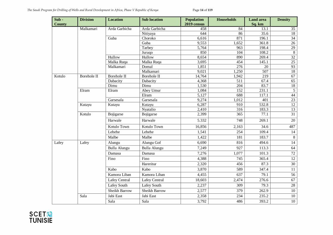
The Saudi Program for Drilling of Wells and Rural Development in Africa, Phase V Republic of Kenya Page 14 of 119
Sub -
County
Division Location Sub location Population
2019 census
Households Land area
Sq. km
Density
Malkamari Arda Garbicha Arda Garbicha 458 84 13.1 35
Nitiyaya 644 86 35.6 18
Guba Choroko 6,616 871 196.1 34
Guba 9,553 1,652 361.8 26
Tarbey 5,764 963 198.4 29
Juruqo 850 104 108.2 8
Hullow Hullow 8,654 890 269.4 32
Malka Ruqa Malka Ruqa 3,695 454 145.1 25
Malkamari Domal 1,851 276 20 93
Malkamari 9,021 1,250 507 18
Kotulo Borehole II Borehole II Borehole II 14,764 1,942 219 67
Dabacity Dabacity 4,368 511 67.4 65
Dimu Dimu 1,530 204 83.7 18
Elram Elram Abey Umur 1,084 152 231.1 5
Elram 5,127 688 117.1 44
Garsesala Garsesala 9,274 1,012 401 23
Kutayu Kutayu Kutayu 6,287 910 532.8 12
Nyatalio 2,410 316 183.3 13
Kotulo Bojigarse Bojigarse 2,399 365 77.1 31
Harwale Harwale 5.332 748 269.1 20
Kotulo Town Kotulo Town 16,856 2,163 34.6 487
Lehehe Lehehe 1,541 254 109.4 14
Malbe Malbe 1,422 181 183.7 8
Lafey Lafey Alungu Alungu Gof 6,690 816 494.6 14
Bulla Alungu Bulla Alungu 7,249 927 113.3 64
Damasa Damasa 7,276 1,077 101.3 72
Fino Fino 4,388 745 365.4 12
Hareritur 2,320 456 87.3 30
Kabo Kabo 3,870 589 347.4 11
Kamora Liban Kamora Liban 4,455 637 79.1 56
Lafey Central Lafey Central 18,603 2,474 276.6 67
Lafey South Lafey South 2,237 309 79.3 28
Sheikh Barrow Sheikh Barrow 2,577 379 262.9 10
Sala Jabi East Jabi East 2,358 234 235.2 10
Sala Sala 3,792 486 393.2 10

The Saudi Program for Drilling of Wells and Rural Development in Africa, Phase V Republic of Kenya Page 15 of 119
Sub -
County
Division Location Sub location Population
2019 census
Households Land area
Sq. km
Density
Warankara Bamboo Bamboo 2,084 305 19.8 105
Barmilla 1,891 273 131.1 14
Gari Gari 5,651 732 146.2 39
Warankara Safo 1,998 260 225 9
Warankara 5,718 898 437.7 13
Mandera
Central
Elwak Bulla Afya Bulla Afya 9,419 1,113 14.4 653
Elwak South Elwak South 36,188 4,621 161.3 224
Elwak Town Dawder 2,557 359 181 14
El-Adi 7,958 1,283 117.2 68
Elwak Town 16,166 2,330 304.7 53
Udole Udole 4,616 809 185.1 25
Wante Elgolicha 2,970 448 84.1 35
Wante 4,241 525 117.9 36
Qalanqalesa Fincharo Dololo 1,792 276 1.8 995
Fincharo 6,109 1,000 309.7 20
Qalaqalesa Qalaqalesa 4,764 773 119.6 40
Qarsadamu Qarsadamu 4,419 567 135.7 33
Shimbir
Fatuma
Burmayo North Burmayo North 1,569 267 241.8 6
Burmayo South Burmayo South 1,070 173 5 214
Garsedam 523 88 3.6 146
Chachabole Chachabole 4,609 548 169.7 27
Kob-Adadi 2,801 350 336.6 8
Shimbir Fatuma Shimbir Fatuma 15,784 2,103 341.9 46
Wargadud Wargadud Buqe 1,834 250 128.7 14
Elele 2,923 421 140.4 21
Ireskinto 2,707 248 80.5 34
Wargadud 13,461 1,460 325.6 41
Sukela Tinfa Sukela Tinfa Sukela Tinfa 1,137 164 88 13
Wargadud East Wargadud East 4,508 596 232.7 19
Qurahmahdow Qurahmahdow 3,095 368 204.6 15
Mandera
East
Arabia Arabia Arabia 6,153 1,064 670.9 9
Omar Jillow Omar Jillow 1,503 403 89.4 17
Libehiya Farey Farey 528 81 45.3 12
Libehiya Libehiya 2,432 386 244.8 10
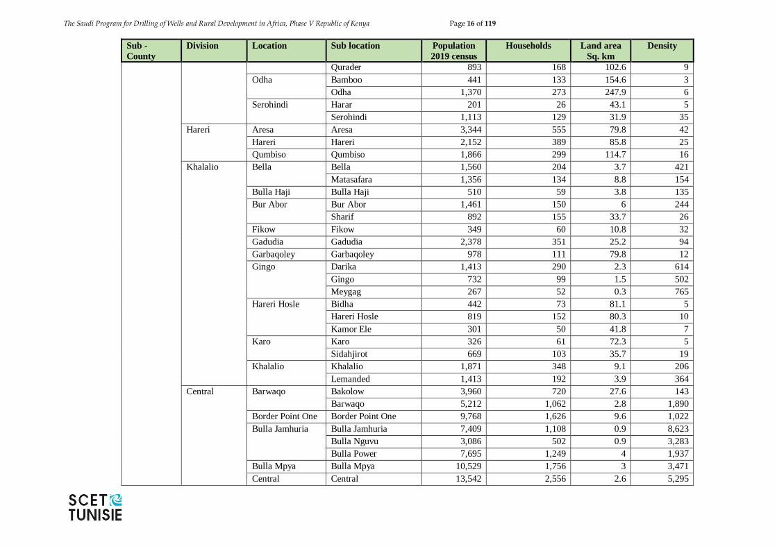
The Saudi Program for Drilling of Wells and Rural Development in Africa, Phase V Republic of Kenya Page 16 of 119
Sub -
County
Division Location Sub location Population
2019 census
Households Land area
Sq. km
Density
Qurader 893 168 102.6 9
Odha Bamboo 441 133 154.6 3
Odha 1,370 273 247.9 6
Serohindi Harar 201 26 43.1 5
Serohindi 1,113 129 31.9 35
Hareri Aresa Aresa 3,344 555 79.8 42
Hareri Hareri 2,152 389 85.8 25
Qumbiso Qumbiso 1,866 299 114.7 16
Khalalio Bella Bella 1,560 204 3.7 421
Matasafara 1,356 134 8.8 154
Bulla Haji Bulla Haji 510 59 3.8 135
Bur Abor Bur Abor 1,461 150 6 244
Sharif 892 155 33.7 26
Fikow Fikow 349 60 10.8 32
Gadudia Gadudia 2,378 351 25.2 94
Garbaqoley Garbaqoley 978 111 79.8 12
Gingo Darika 1,413 290 2.3 614
Gingo 732 99 1.5 502
Meygag 267 52 0.3 765
Hareri Hosle Bidha 442 73 81.1 5
Hareri Hosle 819 152 80.3 10
Kamor Ele 301 50 41.8 7
Karo Karo 326 61 72.3 5
Sidahjirot 669 103 35.7 19
Khalalio Khalalio 1,871 348 9.1 206
Lemanded 1,413 192 3.9 364
Central Barwaqo Bakolow 3,960 720 27.6 143
Barwaqo 5,212 1,062 2.8 1,890
Border Point One Border Point One 9,768 1,626 9.6 1,022
Bulla Jamhuria Bulla Jamhuria 7,409 1,108 0.9 8,623
Bulla Nguvu 3,086 502 0.9 3,283
Bulla Power 7,695 1,249 4 1,937
Bulla Mpya Bulla Mpya 10,529 1,756 3 3,471
Central Central 13,542 2,556 2.6 5,295
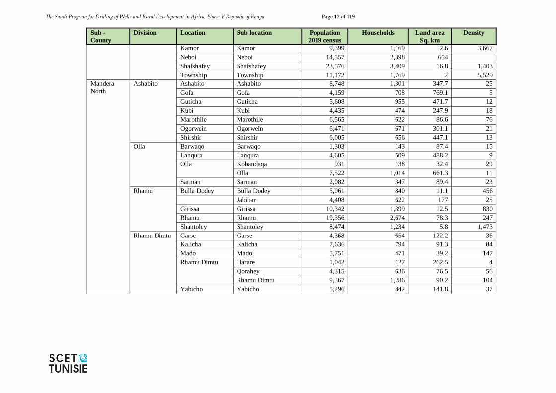
The Saudi Program for Drilling of Wells and Rural Development in Africa, Phase V Republic of Kenya Page 17 of 119
Sub -
County
Division Location Sub location Population
2019 census
Households Land area
Sq. km
Density
Kamor Kamor 9,399 1,169 2.6 3,667
Neboi Neboi 14,557 2,398 654
Shafshafey Shafshafey 23,576 3,409 16.8 1,403
Township Township 11,172 1,769 2 5,529
Mandera
North
Ashabito Ashabito Ashabito 8,748 1,301 347.7 25
Gofa Gofa 4,159 708 769.1 5
Guticha Guticha 5,608 955 471.7 12
Kubi Kubi 4,435 474 247.9 18
Marothile Marothile 6,565 622 86.6 76
Ogorwein Ogorwein 6,471 671 301.1 21
Shirshir Shirshir 6,005 656 447.1 13
Olla Barwaqo Barwaqo 1,303 143 87.4 15
Lanqura Lanqura 4,605 509 488.2 9
Olla Kobandaqa 931 138 32.4 29
Olla 7,522 1,014 661.3 11
Sarman Sarman 2,082 347 89.4 23
Rhamu Bulla Dodey Bulla Dodey 5,061 840 11.1 456
Jabibar 4,408 622 177 25
Girissa Girissa 10,342 1,399 12.5 830
Rhamu Rhamu 19,356 2,674 78.3 247
Shantoley Shantoley 8,474 1,234 5.8 1,473
Rhamu Dimtu Garse Garse 4,368 654 122.2 36
Kalicha Kalicha 7,636 794 91.3 84
Mado Mado 5,751 471 39.2 147
Rhamu Dimtu Harare 1,042 127 262.5 4
Qorahey 4,315 636 76.5 56
Rhamu Dimtu 9,367 1,286 90.2 104
Yabicho Yabicho 5,296 842 141.8 37
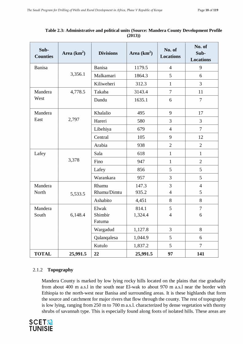
The Saudi Program for Drilling of Wells and Rural Development in Africa, Phase V Republic of Kenya Page 18 of 119
Table 2.3: Administrative and political units (Source: Mandera County Development Profile
(2013))
Sub-
Counties Area (km2) Divisions Area (km2)
No. of
Locations
No. of
Sub-
Locations
Banisa
3,356.1
Banisa 1179.5 4 9
Malkamari 1864.3 5 6
Kiliweheri 312.3 1 3
Mandera
West
4,778.5
Takaba 3143.4 7 11
Dandu 1635.1 6 7
Mandera
East
2,797
Khalalio 495 9 17
Hareri 580 3 3
Libehiya 679 4 7
Central 105 9 12
Arabia 938 2 2
Lafey
3,378
Sala 618 1 1
Fino 947 1 2
Lafey 856 5 5
Warankara 957 3 5
Mandera
North
5,533.5
Rhamu
Rhamu/Dimtu
147.3
935.2
3
4
4
5
Ashabito 4,451 8 8
Mandera
South
6,148.4
Elwak
Shimbir
Fatuma
814.1
1,324.4
5
4
7
6
Wargadud 1,127.8 3 8
Qalanqalesa 1,044.9 5 6
Kutulo 1,837.2 5 7
TOTAL 25,991.5 22 25,991.5 97 141
2.1.2 Topography
Mandera County is marked by low lying rocky hills located on the plains that rise gradually
from about 400 m a.s.l in the south near El-wak to about 970 m a.s.l near the border with
Ethiopia to the north-west near Banisa and surrounding areas. It is these highlands that form
the source and catchment for major rivers that flow through the county. The rest of topography
is low lying, ranging from 250 m to 700 m a.s.l. characterized by dense vegetation with thorny
shrubs of savannah type. This is especially found along foots of isolated hills. These areas are
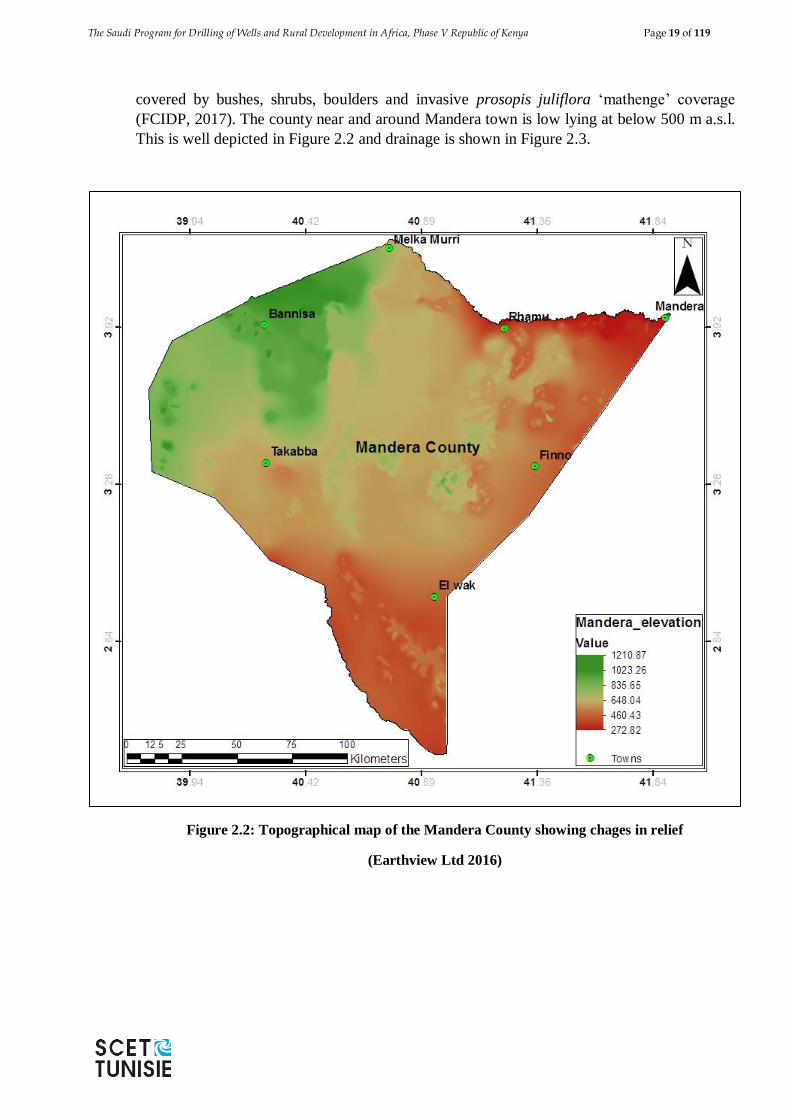
The Saudi Program for Drilling of Wells and Rural Development in Africa, Phase V Republic of Kenya Page 19 of 119
covered by bushes, shrubs, boulders and invasive prosopis juliflora ‘mathenge’ coverage
(FCIDP, 2017). The county near and around Mandera town is low lying at below 500 m a.s.l.
This is well depicted in Figure 2.2 and drainage is shown in Figure 2.3.
Figure 2.2: Topographical map of the Mandera County showing chages in relief
(Earthview Ltd 2016)
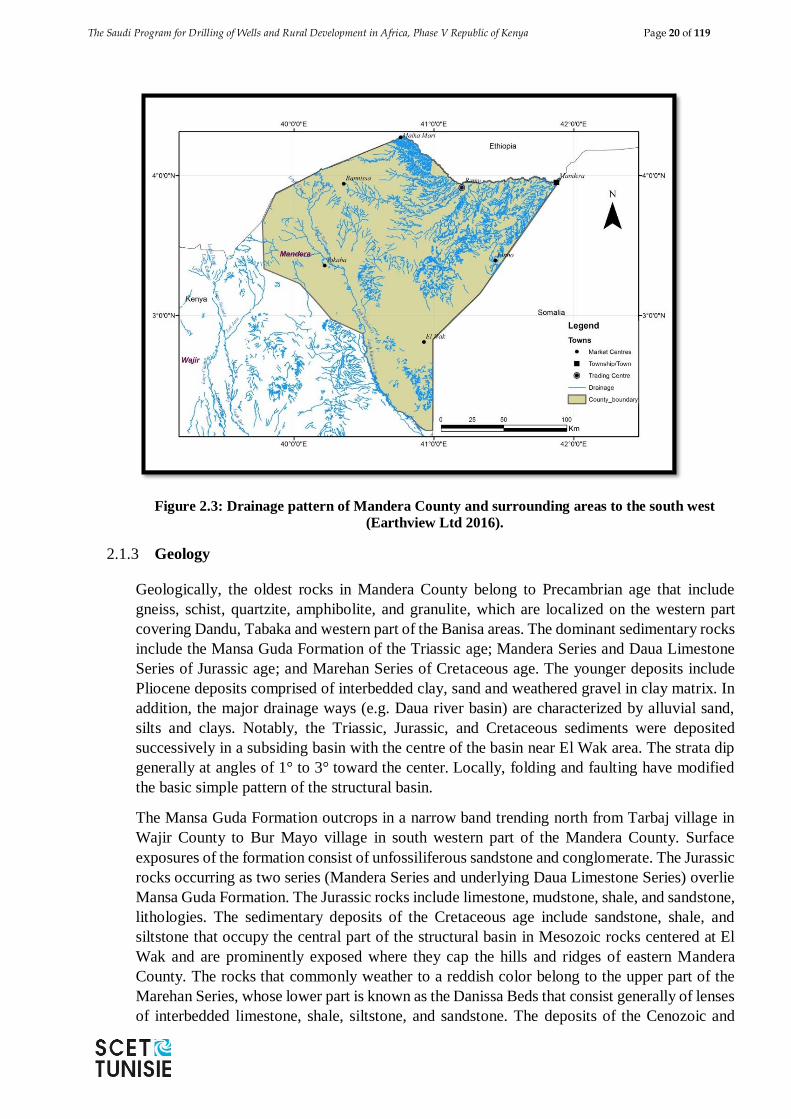
The Saudi Program for Drilling of Wells and Rural Development in Africa, Phase V Republic of Kenya Page 20 of 119
Figure 2.3: Drainage pattern of Mandera County and surrounding areas to the south west
(Earthview Ltd 2016).
2.1.3 Geology
Geologically, the oldest rocks in Mandera County belong to Precambrian age that include
gneiss, schist, quartzite, amphibolite, and granulite, which are localized on the western part
covering Dandu, Tabaka and western part of the Banisa areas. The dominant sedimentary rocks
include the Mansa Guda Formation of the Triassic age; Mandera Series and Daua Limestone
Series of Jurassic age; and Marehan Series of Cretaceous age. The younger deposits include
Pliocene deposits comprised of interbedded clay, sand and weathered gravel in clay matrix. In
addition, the major drainage ways (e.g. Daua river basin) are characterized by alluvial sand,
silts and clays. Notably, the Triassic, Jurassic, and Cretaceous sediments were deposited
successively in a subsiding basin with the centre of the basin near El Wak area. The strata dip
generally at angles of 1° to 3° toward the center. Locally, folding and faulting have modified
the basic simple pattern of the structural basin.
The Mansa Guda Formation outcrops in a narrow band trending north from Tarbaj village in
Wajir County to Bur Mayo village in south western part of the Mandera County. Surface
exposures of the formation consist of unfossiliferous sandstone and conglomerate. The Jurassic
rocks occurring as two series (Mandera Series and underlying Daua Limestone Series) overlie
Mansa Guda Formation. The Jurassic rocks include limestone, mudstone, shale, and sandstone,
lithologies. The sedimentary deposits of the Cretaceous age include sandstone, shale, and
siltstone that occupy the central part of the structural basin in Mesozoic rocks centered at El
Wak and are prominently exposed where they cap the hills and ridges of eastern Mandera
County. The rocks that commonly weather to a reddish color belong to the upper part of the
Marehan Series, whose lower part is known as the Danissa Beds that consist generally of lenses
of interbedded limestone, shale, siltstone, and sandstone. The deposits of the Cenozoic and
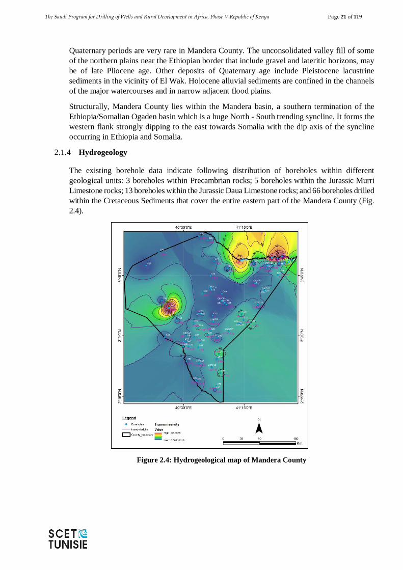
The Saudi Program for Drilling of Wells and Rural Development in Africa, Phase V Republic of Kenya Page 21 of 119
Quaternary periods are very rare in Mandera County. The unconsolidated valley fill of some
of the northern plains near the Ethiopian border that include gravel and lateritic horizons, may
be of late Pliocene age. Other deposits of Quaternary age include Pleistocene lacustrine
sediments in the vicinity of El Wak. Holocene alluvial sediments are confined in the channels
of the major watercourses and in narrow adjacent flood plains.
Structurally, Mandera County lies within the Mandera basin, a southern termination of the
Ethiopia/Somalian Ogaden basin which is a huge North - South trending syncline. It forms the
western flank strongly dipping to the east towards Somalia with the dip axis of the syncline
occurring in Ethiopia and Somalia.
2.1.4 Hydrogeology
The existing borehole data indicate following distribution of boreholes within different
geological units: 3 boreholes within Precambrian rocks; 5 boreholes within the Jurassic Murri
Limestone rocks; 13 boreholes within the Jurassic Daua Limestone rocks; and 66 boreholes drilled
within the Cretaceous Sediments that cover the entire eastern part of the Mandera County (Fig.
2.4).
Figure 2.4: Hydrogeological map of Mandera County
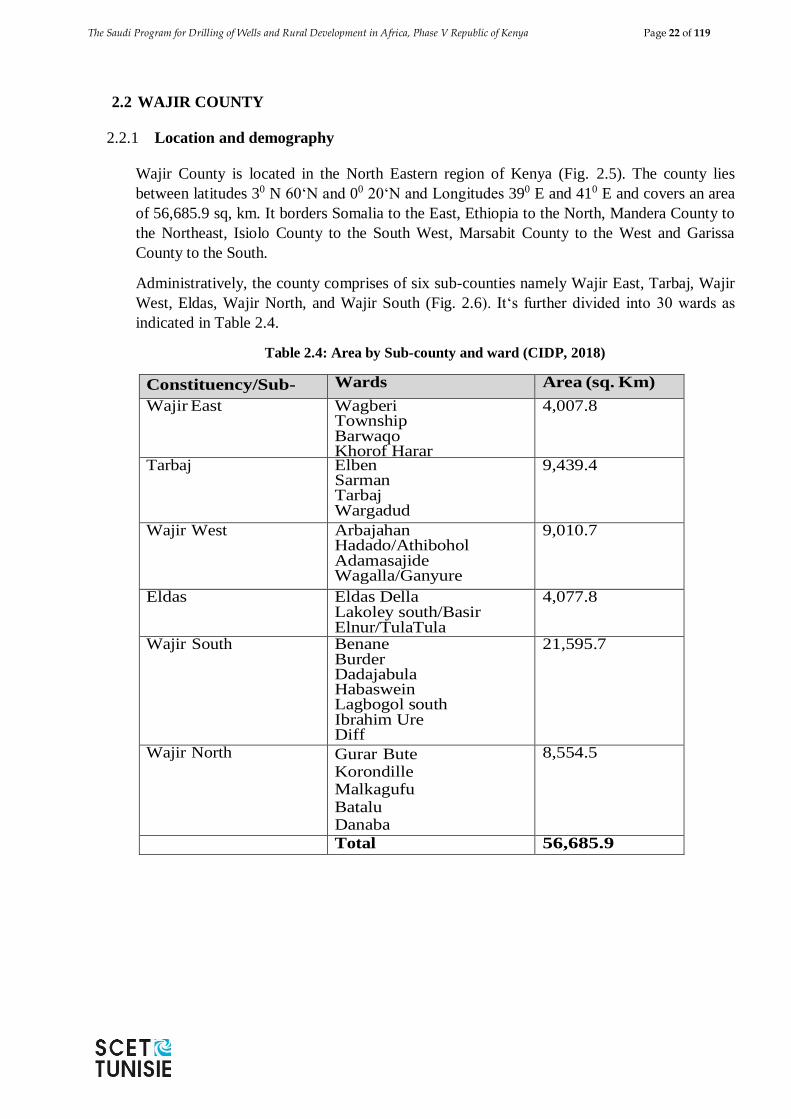
The Saudi Program for Drilling of Wells and Rural Development in Africa, Phase V Republic of Kenya Page 22 of 119
2.2 WAJIR COUNTY
2.2.1 Location and demography
Wajir County is located in the North Eastern region of Kenya (Fig. 2.5). The county lies
between latitudes 30 N 60‘N and 00 20‘N and Longitudes 390 E and 410 E and covers an area
of 56,685.9 sq, km. It borders Somalia to the East, Ethiopia to the North, Mandera County to
the Northeast, Isiolo County to the South West, Marsabit County to the West and Garissa
County to the South.
Administratively, the county comprises of six sub-counties namely Wajir East, Tarbaj, Wajir
West, Eldas, Wajir North, and Wajir South (Fig. 2.6). It‘s further divided into 30 wards as
indicated in Table 2.4.
Table 2.4: Area by Sub-county and ward (CIDP, 2018)
Constituency/Sub-
county
Wards Area (sq. Km)
Wajir East Wagberi Township Barwaqo Khorof Harar
4,007.8
Tarbaj Elben Sarman Tarbaj Wargadud
9,439.4
Wajir West Arbajahan Hadado/Athibohol Adamasajide Wagalla/Ganyure
9,010.7
Eldas Eldas Della Lakoley south/Basir Elnur/TulaTula
4,077.8
Wajir South Benane Burder Dadajabula Habaswein Lagbogol south Ibrahim Ure Diff
21,595.7
Wajir North Gurar Bute Korondille Malkagufu Batalu Danaba Godoma
8,554.5
Total 56,685.9
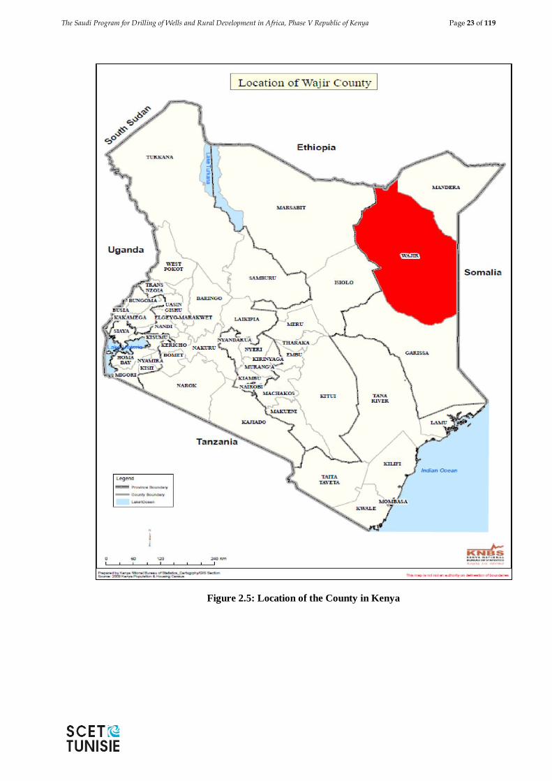
The Saudi Program for Drilling of Wells and Rural Development in Africa, Phase V Republic of Kenya Page 23 of 119
Figure 2.5: Location of the County in Kenya
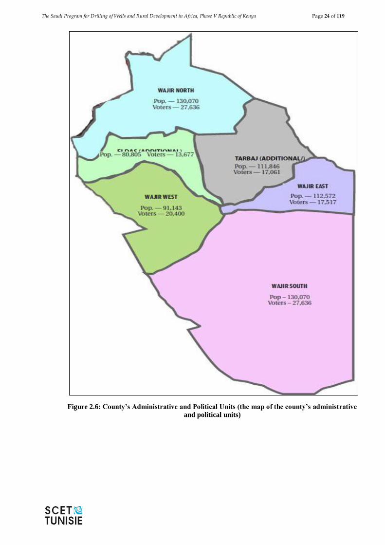
The Saudi Program for Drilling of Wells and Rural Development in Africa, Phase V Republic of Kenya Page 24 of 119
Figure 2.6: County’s Administrative and Political Units (the map of the county’s administrative
and political units)
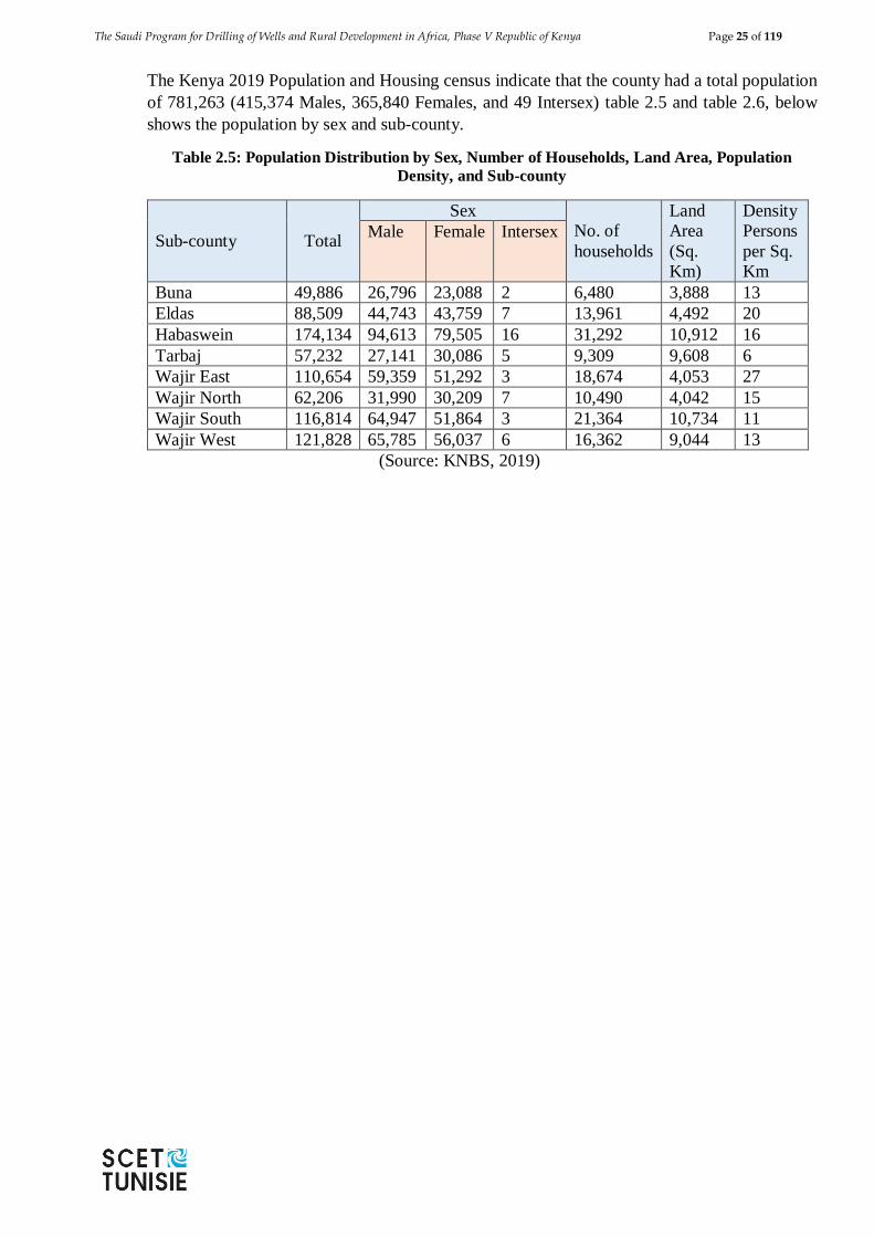
The Saudi Program for Drilling of Wells and Rural Development in Africa, Phase V Republic of Kenya Page 25 of 119
The Kenya 2019 Population and Housing census indicate that the county had a total population
of 781,263 (415,374 Males, 365,840 Females, and 49 Intersex) table 2.5 and table 2.6, below
shows the population by sex and sub-county.
Table 2.5: Population Distribution by Sex, Number of Households, Land Area, Population
Density, and Sub-county
Sub-county Total
Sex
No. of
households
Land
Area
(Sq.
Km)
Density
Persons
per Sq.
Km
Male Female Intersex
Buna 49,886 26,796 23,088 2 6,480 3,888 13
Eldas 88,509 44,743 43,759 7 13,961 4,492 20
Habaswein 174,134 94,613 79,505 16 31,292 10,912 16
Tarbaj 57,232 27,141 30,086 5 9,309 9,608 6
Wajir East 110,654 59,359 51,292 3 18,674 4,053 27
Wajir North 62,206 31,990 30,209 7 10,490 4,042 15
Wajir South 116,814 64,947 51,864 3 21,364 10,734 11
Wajir West 121,828 65,785 56,037 6 16,362 9,044 13
(Source: KNBS, 2019)
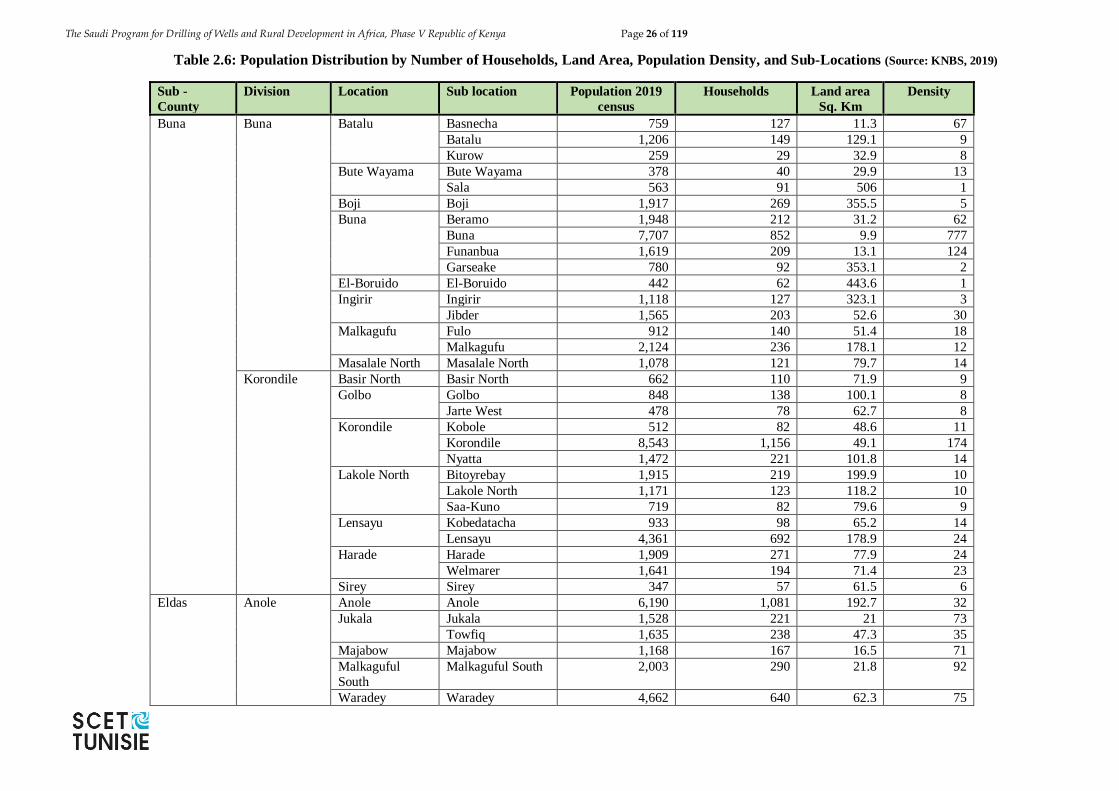
The Saudi Program for Drilling of Wells and Rural Development in Africa, Phase V Republic of Kenya Page 26 of 119
Table 2.6: Population Distribution by Number of Households, Land Area, Population Density, and Sub-Locations (Source: KNBS, 2019)
Sub -
County
Division Location Sub location Population 2019
census
Households Land area
Sq. Km
Density
Buna Buna Batalu Basnecha 759 127 11.3 67
Batalu 1,206 149 129.1 9
Kurow 259 29 32.9 8
Bute Wayama Bute Wayama 378 40 29.9 13
Sala 563 91 506 1
Boji Boji 1,917 269 355.5 5
Buna Beramo 1,948 212 31.2 62
Buna 7,707 852 9.9 777
Funanbua 1,619 209 13.1 124
Garseake 780 92 353.1 2
El-Boruido El-Boruido 442 62 443.6 1
Ingirir Ingirir 1,118 127 323.1 3
Jibder 1,565 203 52.6 30
Malkagufu Fulo 912 140 51.4 18
Malkagufu 2,124 236 178.1 12
Masalale North Masalale North 1,078 121 79.7 14
Korondile Basir North Basir North 662 110 71.9 9
Golbo Golbo 848 138 100.1 8
Jarte West 478 78 62.7 8
Korondile Kobole 512 82 48.6 11
Korondile 8,543 1,156 49.1 174
Nyatta 1,472 221 101.8 14
Lakole North Bitoyrebay 1,915 219 199.9 10
Lakole North 1,171 123 118.2 10
Saa-Kuno 719 82 79.6 9
Lensayu Kobedatacha 933 98 65.2 14
Lensayu 4,361 692 178.9 24
Harade Harade 1,909 271 77.9 24
Welmarer 1,641 194 71.4 23
Sirey Sirey 347 57 61.5 6
Eldas
Anole Anole Anole 6,190 1,081 192.7 32
Jukala Jukala 1,528 221 21 73
Towfiq 1,635 238 47.3 35
Majabow Majabow 1,168 167 16.5 71
Malkaguful
South
Malkaguful South 2,003 290 21.8 92
Waradey Waradey 4,662 640 62.3 75
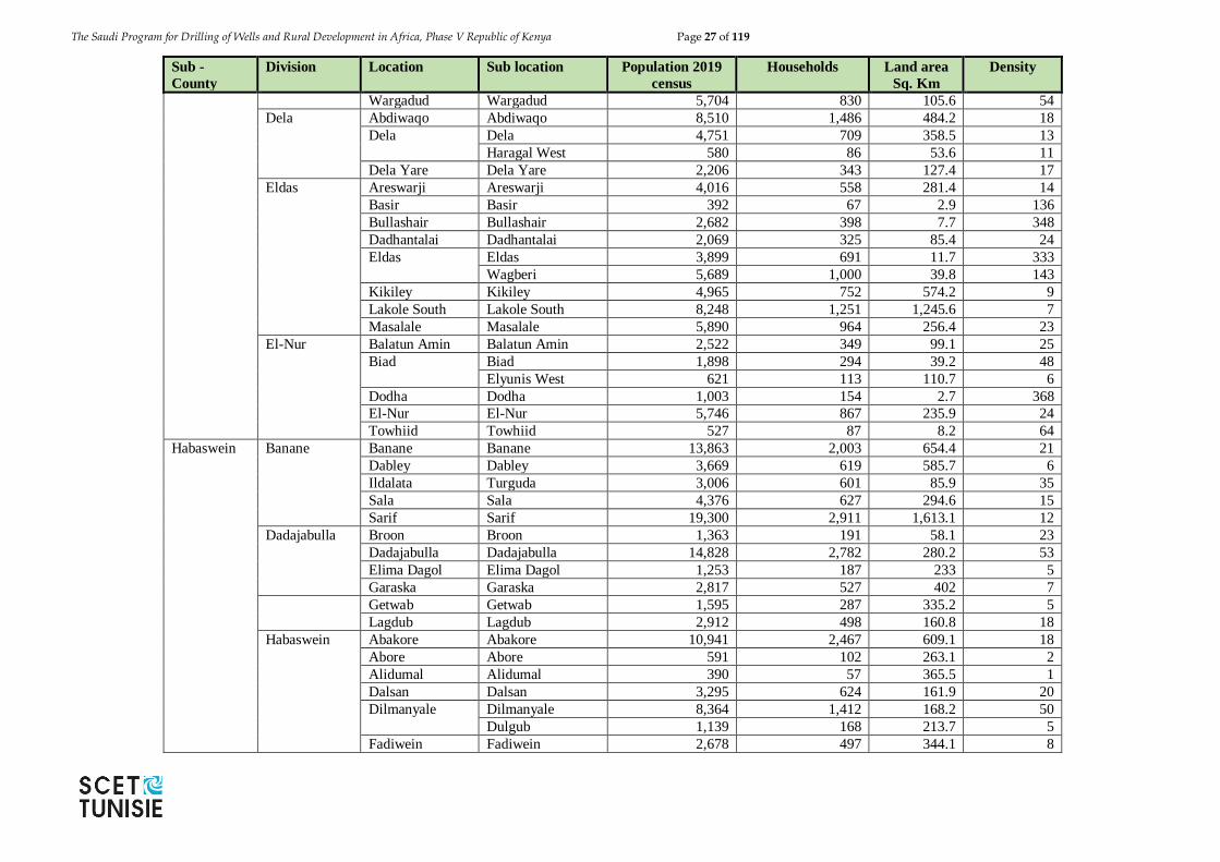
The Saudi Program for Drilling of Wells and Rural Development in Africa, Phase V Republic of Kenya Page 27 of 119
Sub -
County
Division Location Sub location Population 2019
census
Households Land area
Sq. Km
Density
Wargadud Wargadud 5,704 830 105.6 54
Dela Abdiwaqo Abdiwaqo 8,510 1,486 484.2 18
Dela Dela 4,751 709 358.5 13
Haragal West 580 86 53.6 11
Dela Yare Dela Yare 2,206 343 127.4 17
Eldas Areswarji Areswarji 4,016 558 281.4 14
Basir Basir 392 67 2.9 136
Bullashair Bullashair 2,682 398 7.7 348
Dadhantalai Dadhantalai 2,069 325 85.4 24
Eldas Eldas 3,899 691 11.7 333
Wagberi 5,689 1,000 39.8 143
Kikiley Kikiley 4,965 752 574.2 9
Lakole South Lakole South 8,248 1,251 1,245.6 7
Masalale Masalale 5,890 964 256.4 23
El-Nur Balatun Amin Balatun Amin 2,522 349 99.1 25
Biad Biad 1,898 294 39.2 48
Elyunis West 621 113 110.7 6
Dodha Dodha 1,003 154 2.7 368
El-Nur El-Nur 5,746 867 235.9 24
Towhiid Towhiid 527 87 8.2 64
Habaswein Banane
Banane Banane 13,863 2,003 654.4 21
Dabley Dabley 3,669 619 585.7 6
Ildalata Turguda 3,006 601 85.9 35
Sala Sala 4,376 627 294.6 15
Sarif Sarif 19,300 2,911 1,613.1 12
Dadajabulla Broon Broon 1,363 191 58.1 23
Dadajabulla Dadajabulla 14,828 2,782 280.2 53
Elima Dagol Elima Dagol 1,253 187 233 5
Garaska Garaska 2,817 527 402 7
Getwab Getwab 1,595 287 335.2 5
Lagdub Lagdub 2,912 498 160.8 18
Habaswein Abakore Abakore 10,941 2,467 609.1 18
Abore Abore 591 102 263.1 2
Alidumal Alidumal 390 57 365.5 1
Dalsan Dalsan 3,295 624 161.9 20
Dilmanyale Dilmanyale 8,364 1,412 168.2 50
Dulgub 1,139 168 213.7 5
Fadiwein Fadiwein 2,678 497 344.1 8
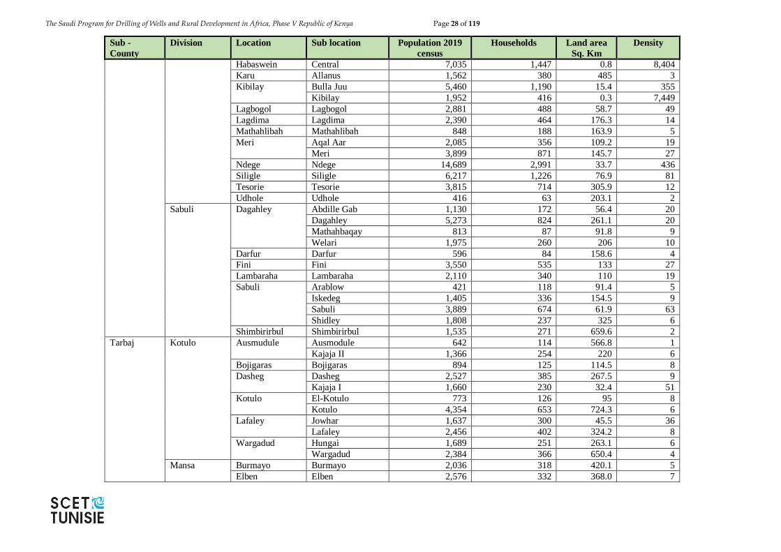
The Saudi Program for Drilling of Wells and Rural Development in Africa, Phase V Republic of Kenya Page 28 of 119
Sub -
County
Division Location Sub location Population 2019
census
Households Land area
Sq. Km
Density
Habaswein Central 7,035 1,447 0.8 8,404
Karu Allanus 1,562 380 485 3
Kibilay Bulla Juu 5,460 1,190 15.4 355
Kibilay 1,952 416 0.3 7,449
Lagbogol Lagbogol 2,881 488 58.7 49
Lagdima Lagdima 2,390 464 176.3 14
Mathahlibah Mathahlibah 848 188 163.9 5
Meri Aqal Aar 2,085 356 109.2 19
Meri 3,899 871 145.7 27
Ndege Ndege 14,689 2,991 33.7 436
Siligle Siligle 6,217 1,226 76.9 81
Tesorie Tesorie 3,815 714 305.9 12
Udhole Udhole 416 63 203.1 2
Sabuli Dagahley Abdille Gab 1,130 172 56.4 20
Dagahley 5,273 824 261.1 20
Mathahbaqay 813 87 91.8 9
Welari 1,975 260 206 10
Darfur Darfur 596 84 158.6 4
Fini Fini 3,550 535 133 27
Lambaraha Lambaraha 2,110 340 110 19
Sabuli Arablow 421 118 91.4 5
Iskedeg 1,405 336 154.5 9
Sabuli 3,889 674 61.9 63
Shidley 1,808 237 325 6
Shimbirirbul Shimbirirbul 1,535 271 659.6 2
Tarbaj Kotulo Ausmudule Ausmodule 642 114 566.8 1
Kajaja II 1,366 254 220 6
Bojigaras Bojigaras 894 125 114.5 8
Dasheg Dasheg 2,527 385 267.5 9
Kajaja I 1,660 230 32.4 51
Kotulo El-Kotulo 773 126 95 8
Kotulo 4,354 653 724.3 6
Lafaley Jowhar 1,637 300 45.5 36
Lafaley 2,456 402 324.2 8
Wargadud Hungai 1,689 251 263.1 6
Wargadud 2,384 366 650.4 4
Mansa Burmayo Burmayo 2,036 318 420.1 5
Elben Elben 2,576 332 368.0 7
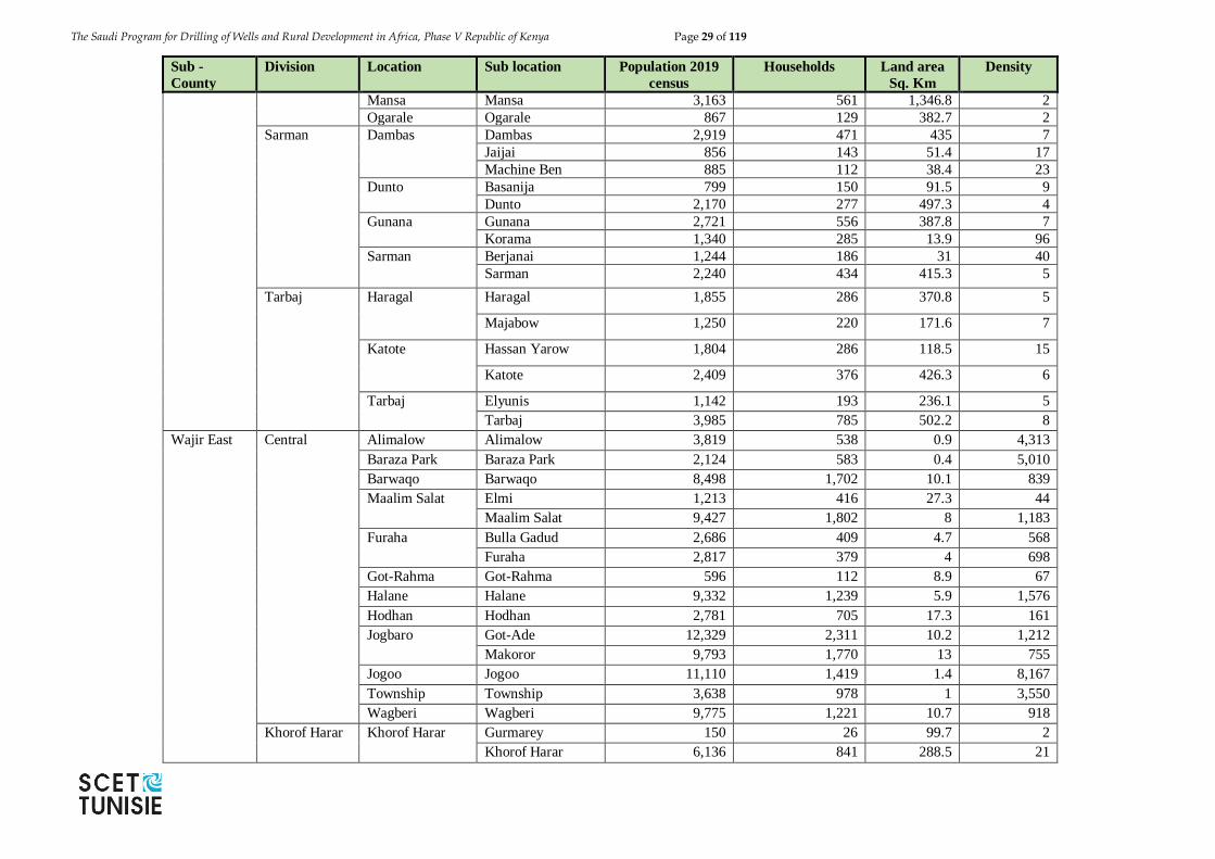
The Saudi Program for Drilling of Wells and Rural Development in Africa, Phase V Republic of Kenya Page 29 of 119
Sub -
County
Division Location Sub location Population 2019
census
Households Land area
Sq. Km
Density
Mansa Mansa 3,163 561 1,346.8 2
Ogarale Ogarale 867 129 382.7 2
Sarman Dambas Dambas 2,919 471 435 7
Jaijai 856 143 51.4 17
Machine Ben 885 112 38.4 23
Dunto Basanija 799 150 91.5 9
Dunto 2,170 277 497.3 4
Gunana Gunana 2,721 556 387.8 7
Korama 1,340 285 13.9 96
Sarman Berjanai 1,244 186 31 40
Sarman 2,240 434 415.3 5
Tarbaj Haragal Haragal 1,855 286 370.8 5
Majabow 1,250 220 171.6 7
Katote Hassan Yarow 1,804 286 118.5 15
Katote 2,409 376 426.3 6
Tarbaj Elyunis 1,142 193 236.1 5
Tarbaj 3,985 785 502.2 8
Wajir East Central Alimalow Alimalow 3,819 538 0.9 4,313
Baraza Park Baraza Park 2,124 583 0.4 5,010
Barwaqo Barwaqo 8,498 1,702 10.1 839
Maalim Salat Elmi 1,213 416 27.3 44
Maalim Salat 9,427 1,802 8 1,183
Furaha Bulla Gadud 2,686 409 4.7 568
Furaha 2,817 379 4 698
Got-Rahma Got-Rahma 596 112 8.9 67
Halane Halane 9,332 1,239 5.9 1,576
Hodhan Hodhan 2,781 705 17.3 161
Jogbaro Got-Ade 12,329 2,311 10.2 1,212
Makoror 9,793 1,770 13 755
Jogoo Jogoo 11,110 1,419 1.4 8,167
Township Township 3,638 978 1 3,550
Wagberi Wagberi 9,775 1,221 10.7 918
Khorof Harar Khorof Harar Gurmarey 150 26 99.7 2
Khorof Harar 6,136 841 288.5 21
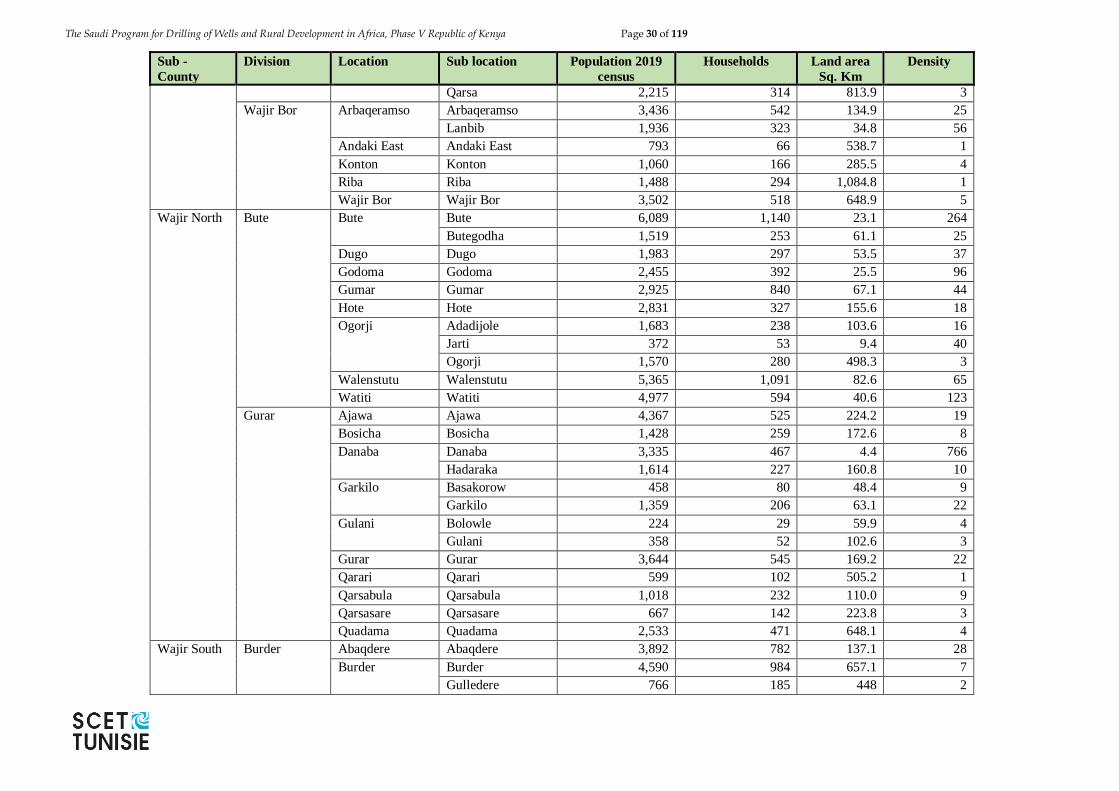
The Saudi Program for Drilling of Wells and Rural Development in Africa, Phase V Republic of Kenya Page 30 of 119
Sub -
County
Division Location Sub location Population 2019
census
Households Land area
Sq. Km
Density
Qarsa 2,215 314 813.9 3
Wajir Bor Arbaqeramso Arbaqeramso 3,436 542 134.9 25
Lanbib 1,936 323 34.8 56
Andaki East Andaki East 793 66 538.7 1
Konton Konton 1,060 166 285.5 4
Riba Riba 1,488 294 1,084.8 1
Wajir Bor Wajir Bor 3,502 518 648.9 5
Wajir North Bute Bute Bute 6,089 1,140 23.1 264
Butegodha 1,519 253 61.1 25
Dugo Dugo 1,983 297 53.5 37
Godoma Godoma 2,455 392 25.5 96
Gumar Gumar 2,925 840 67.1 44
Hote Hote 2,831 327 155.6 18
Ogorji Adadijole 1,683 238 103.6 16
Jarti 372 53 9.4 40
Ogorji 1,570 280 498.3 3
Walenstutu Walenstutu 5,365 1,091 82.6 65
Watiti Watiti 4,977 594 40.6 123
Gurar Ajawa Ajawa 4,367 525 224.2 19
Bosicha Bosicha 1,428 259 172.6 8
Danaba Danaba 3,335 467 4.4 766
Hadaraka 1,614 227 160.8 10
Garkilo Basakorow 458 80 48.4 9
Garkilo 1,359 206 63.1 22
Gulani Bolowle 224 29 59.9 4
Gulani 358 52 102.6 3
Gurar Gurar 3,644 545 169.2 22
Qarari Qarari 599 102 505.2 1
Qarsabula Qarsabula 1,018 232 110.0 9
Qarsasare Qarsasare 667 142 223.8 3
Quadama Quadama 2,533 471 648.1 4
Wajir South Burder Abaqdere Abaqdere 3,892 782 137.1 28
Burder Burder 4,590 984 657.1 7
Gulledere 766 185 448 2
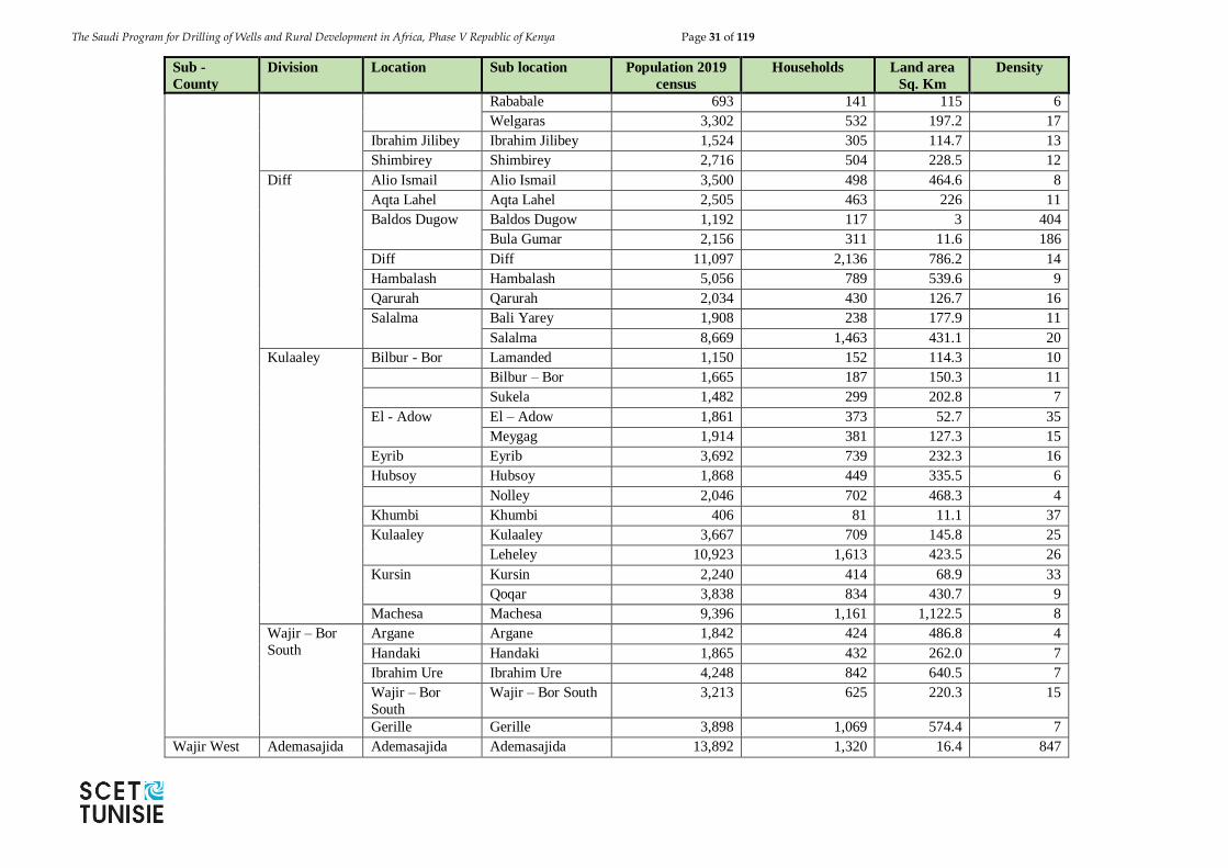
The Saudi Program for Drilling of Wells and Rural Development in Africa, Phase V Republic of Kenya Page 31 of 119
Sub -
County
Division Location Sub location Population 2019
census
Households Land area
Sq. Km
Density
Rababale 693 141 115 6
Welgaras 3,302 532 197.2 17
Ibrahim Jilibey Ibrahim Jilibey 1,524 305 114.7 13
Shimbirey Shimbirey 2,716 504 228.5 12
Diff Alio Ismail Alio Ismail 3,500 498 464.6 8
Aqta Lahel Aqta Lahel 2,505 463 226 11
Baldos Dugow Baldos Dugow 1,192 117 3 404
Bula Gumar 2,156 311 11.6 186
Diff Diff 11,097 2,136 786.2 14
Hambalash Hambalash 5,056 789 539.6 9
Qarurah Qarurah 2,034 430 126.7 16
Salalma Bali Yarey 1,908 238 177.9 11
Salalma 8,669 1,463 431.1 20
Kulaaley Bilbur - Bor Lamanded 1,150 152 114.3 10
Bilbur – Bor 1,665 187 150.3 11
Sukela 1,482 299 202.8 7
El - Adow El – Adow 1,861 373 52.7 35
Meygag 1,914 381 127.3 15
Eyrib Eyrib 3,692 739 232.3 16
Hubsoy Hubsoy 1,868 449 335.5 6
Nolley 2,046 702 468.3 4
Khumbi Khumbi 406 81 11.1 37
Kulaaley Kulaaley 3,667 709 145.8 25
Leheley 10,923 1,613 423.5 26
Kursin Kursin 2,240 414 68.9 33
Qoqar 3,838 834 430.7 9
Machesa Machesa 9,396 1,161 1,122.5 8
Wajir – Bor
South
Argane Argane 1,842 424 486.8 4
Handaki Handaki 1,865 432 262.0 7
Ibrahim Ure Ibrahim Ure 4,248 842 640.5 7
Wajir – Bor
South
Wajir – Bor South 3,213 625 220.3 15
Gerille Gerille 3,898 1,069 574.4 7
Wajir West Ademasajida Ademasajida Ademasajida 13,892 1,320 16.4 847
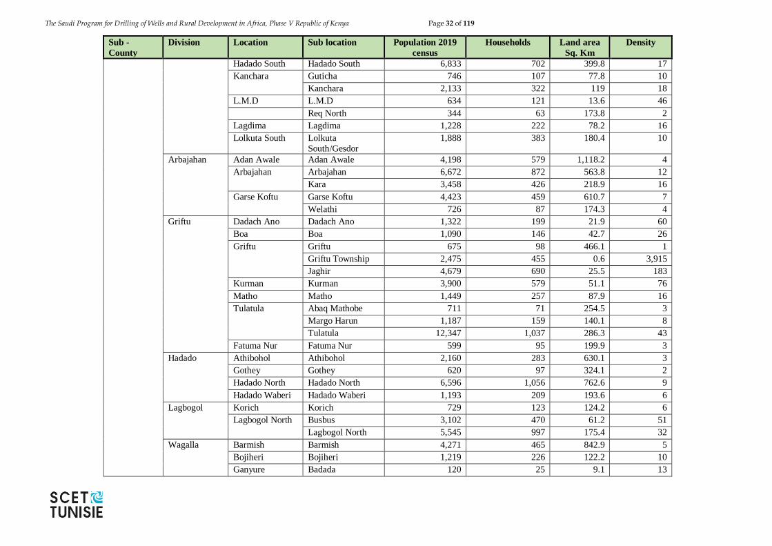
The Saudi Program for Drilling of Wells and Rural Development in Africa, Phase V Republic of Kenya Page 32 of 119
Sub -
County
Division Location Sub location Population 2019
census
Households Land area
Sq. Km
Density
Hadado South Hadado South 6,833 702 399.8 17
Kanchara Guticha 746 107 77.8 10
Kanchara 2,133 322 119 18
L.M.D L.M.D 634 121 13.6 46
Req North 344 63 173.8 2
Lagdima Lagdima 1,228 222 78.2 16
Lolkuta South Lolkuta
South/Gesdor
1,888 383 180.4 10
Arbajahan Adan Awale Adan Awale 4,198 579 1,118.2 4
Arbajahan Arbajahan 6,672 872 563.8 12
Kara 3,458 426 218.9 16
Garse Koftu Garse Koftu 4,423 459 610.7 7
Welathi 726 87 174.3 4
Griftu Dadach Ano Dadach Ano 1,322 199 21.9 60
Boa Boa 1,090 146 42.7 26
Griftu Griftu 675 98 466.1 1
Griftu Township 2,475 455 0.6 3,915
Jaghir 4,679 690 25.5 183
Kurman Kurman 3,900 579 51.1 76
Matho Matho 1,449 257 87.9 16
Tulatula Abaq Mathobe 711 71 254.5 3
Margo Harun 1,187 159 140.1 8
Tulatula 12,347 1,037 286.3 43
Fatuma Nur Fatuma Nur 599 95 199.9 3
Hadado Athibohol Athibohol 2,160 283 630.1 3
Gothey Gothey 620 97 324.1 2
Hadado North Hadado North 6,596 1,056 762.6 9
Hadado Waberi Hadado Waberi 1,193 209 193.6 6
Lagbogol Korich Korich 729 123 124.2 6
Lagbogol North Busbus 3,102 470 61.2 51
Lagbogol North 5,545 997 175.4 32
Wagalla Barmish Barmish 4,271 465 842.9 5
Bojiheri Bojiheri 1,219 226 122.2 10
Ganyure Badada 120 25 9.1 13
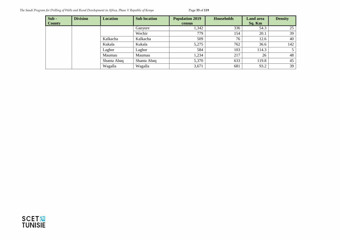
The Saudi Program for Drilling of Wells and Rural Development in Africa, Phase V Republic of Kenya Page 33 of 119
Sub -
County
Division Location Sub location Population 2019
census
Households Land area
Sq. Km
Density
Ganyure 1,342 336 54.3 25
Wechir 779 154 20.1 39
Kalkacha Kalkacha 509 76 12.6 40
Kukala Kukala 5,275 762 36.6 142
Lagbor Lagbor 584 103 114.3 5
Maumau Maumau 1,234 217 26 48
Shanta Abaq Shanta Abaq 5,370 633 119.8 45
Wagalla Wagalla 3,671 681 93.2 39
The Saudi Program for Drilling of Wells and Rural Development in Africa, Phase V Republic of Kenya Page 34 of 119
2.2.2 Physical and Topographic features
Wajir County is a featureless plain and lies between 150 metres and 460 metres above sea
level and along latitude 1°45'N and longitude 40°4'E.
Its Altitude is 244 m (801 ft.). The plain rises gently from the south and east towards the
north rising to 200 metres at Buna and 460 metres at Bute and Gurar at the foothills of
Ethiopian highlands.
The county is prone to seasonal flooding during the rainy seasons which make roads
impassable affecting accessibility to vital services. It has seasonal swamps which together
with drainage lines serve as grazing zones during dry season and for cultivation during the
rainy seasons. The seasonal swamps are in Lagboghol area and in the western and southern
part of Habaswein area. The county is generally covered with young sedimentary rocks with
loamy soils in the north bordering the Ethiopian highlands. The county has considerable
deposits of Limestone and sand which are used in the local building industry
2.2.3 Geological setting
The general and detailed geology of the Wajir County was carried out extensively by Joubert
(1963). In his report he indicated that the general geology of the area is composed of
sedimentary rocks of Triassic to Recent. These rocks are divided into three divisions that is,
(1) Mansa Guda Formation composed of quartzitic boulders and pebbles derived from its
conglomerates (2) The Daua Limestone Series in this area consists of a lower fossiliferous
limestone succession of Toarcian age which is an extension of the Didimtu (Table 2.7). Beds
of the area further north, overlain conformably by a series of brown and grey fragmental
argillaceous or finely recrystallized limestones and (3) The Pleistocene valley formation
formed by the extensive continental erosion during the Tertiary era. This erosion gave rise
to deep wide valley west and south of the area occupied by the Mesozoic sediments, but the
valley was filled up during the Pleistocene by limestones and gypsum of lacustrine origin
and by clay-bound sands and sandstone of fluviatile origin. These Pleistocene deposits are
representatives of the pluvial phases of the period while the widespread red sandy soil of
Wajir has been derived from red ferruginous sandstones indicative of an interpluvial stage.
Table 2.7: Stratigraphic table (after Joubert, 1963)
Period Formation Lithology
Recent Sandy soils
Pleistocene Wajir Beds Gritty soils
Laminated limestones
Impure limestones
Sandstones
Jurassic Merti Beds Sandstones
Clays and sandy clays
Triassic Bur Mayo Formation Grey and brown limestones
Precambrian Mansa Guda Formation Conglomerates
Sandstones
The Saudi Program for Drilling of Wells and Rural Development in Africa, Phase V Republic of Kenya Page 35 of 119
As far as is known, Paleozoic rocks are absent in the area, which cause Basement rocks to
be overlain directly by Mesozoic or even younger rocks. Down warping of the coastal area
at the end of the Paleozoic resulted in a transgression of the sea, in which the Triassic Mansa
Guda Formation was deposited as a delta. Recurrence of down warping in the Lower Jurassic
caused another transgression and the deposition of the Jurassic Limestone Series.
After regression from Middle Jurassic times, the Cretaceous continental Marehan Series was
deposited. During the Tertiary, erosion of Mesozoic and Precambrian rocks took place;
Miocene sediments were deposited, but probably largely removed again as a result of
Pliocene uplift.
The Pliocene Merti Beds were laid down in at least some parts of the Northeastern
Province. Alternating pluvial and interpluvial periods during the Pleistocene explain the
variation in lithology observed in the Wajir Beds and younger formations (Joubert, 1963;
Swarzenski and Mundorff, 1977).
The occurrence and extent of the different geological units is rather well known at the
surface, but uncertainties exist in many zones regarding the geological units at some
depth. Bestow (1953) and Joubert (1963) suggest, for example, that under Wajir town,
Basement rocks are directly overlain by (Tertiary and?) Quaternary rocks, whereas more
recent reports (Swarzenski and Mundorff, 1977) and recent boreholes make plausible that
the Mansa Guda Formation extends more southwestwards than previously thought and
might occur under Wajir at a depth of 120 metres.
Furthermore, equivalents of the Merti Beds, found in a wide belt from NW of Habaswein to
Liboi at the Somalian border (and beyond), are not mentioned by Joubert (1963), but
Swarzenski and Mundorff (1977) suggest that they are present in the Wajir area as clays,
sands and grits underlying a 20-25 m thick succession of Wajir Beds.
Finally, the sequence of Quaternary deposits varies considerably over short distances, which
makes it difficult to recognize and correlate the different stratigraphic units in wells and
boreholes. This fact has given rise to inconsistencies in this respect between various reports
(Bestow, 1953; Joubert, 1963; Balasha Jalon, 1976; Swarzenski and Mundorff, 1977;
Alexander Gibb & Partners, 1979).
2.2.4 Hydrogeological setting
The aquifers in this region are mainly shallow and unconfined consisting of more or less
permeable horizons in Wajir Beds (Kuria, 2013). These aquifers consist mainly of the
arenaceous impure limestones underlain by sands and silts. The groundwater occurs at
depths of 6 m below the ground surface level and the assumed thickness of the water bearing
zones is about 2-15 m. The shallow dug wells in Wajir area exceed some 5 m3 /hr and 2 m3
/hr in roughly 40 % and 60% of the cases respectively (Kuria, 2013) with apparent
transmissivitiesof 80 to 300 m2/day. The watertable follows the generally flat topographic
surface, which is sloping with a general dip of 1.6 m per km from NNW to SSE.
There is a hypothesis put forward that the shallow groundwater in this region circulates
partly in small local flows, recharged and drained by boreholes and the deep rooted
vegetation. This is supported by local recharge and drainage from rainfall and the
heterogeneous porous and permeable limestone, the presence of numerous cones of
depression and randomly scattered pattern of water quality variation (Kuria, 2013, Osman
2011).
The Saudi Program for Drilling of Wells and Rural Development in Africa, Phase V Republic of Kenya Page 36 of 119
Other hydrogeological research works done in the region, include the study of Merti aquifer
by Luedeling et.al, (2015). Their work titled “water for Wajir,” involved decision modelling
for the Habaswein-Wajir Water Supply Project in Northern Kenya. In the modelling they
carried out the study of hydrogeology of the Merti aquifer. The county government of Wajir
had proposed a piped water supply project to Wajir town from the Merti aquifer. The purpose
of their study was to apply hydrogeology knowledge to predict the effect of the pipeline
project on the groundwater system, and also stating the possible uncertainty in the
predictions. Their prediction was based on drawdown of groundwater levels that would
eventually lead to the drying up of the borehole as well as the deteriorating water quality as
a result of displacement of fresh water by saline water in the aquifer in a 30 year time period.
Using the stochastic-deterministic modelling, they found out that there is a higher annual
probability to the risk of saline water upconing (1.0-2.5% per year) than to wells running
dry (0.5-1.2%). While this may seem low, it corresponds to risks 25-55% and 15-30% over
the 30 year time frame considered by the model.
Kuria & Kamunge (2012) determined the recharge zone of the Merti Aquifer using
geospartial technologies. This was integrated with geochemistry. Based on the available
data, they found that the recharge mainly occurs along the Ewaso Ng’iro River. This
supports previous works done by (Krhoda, 1989, Swarzenski & Mundorff, 1977) who had
also indicated that recharge is mainly by river Ewaso Ng’iro. Mwango et.al. (2002) indicated
that recharge of the Merti aquifer is mainly from Yamicha-Marsabit area as well as Ewaso
Ng’iro. (GIBBS Africa Ltd., 2004) summarized ways in which Merti aquifer is recharged.
They identified three ways, which are, (1) Recharge via the bed of the Ewaso Ng’iro river:
the Ewaso Ng’iro is partly situated above the Merti Aquifer. (0.9 mm3/yr). (2) Local recharge
through volcanic rock plateau: (2.4 mm3/yr). (3) Recharge via the bed of the Lagh Dera:
(1.2 mm3/yr).
The International Atomic Energy Agency (IAEA, 2001) applied integrated isotope and
conventional hydrogeological techniques for managing groundwater Resources in the Merti
Aquifer. Their main goal was to determine the long-term sustainability and water quality
needs for human or livestock consumption and irrigation. They collected and analysed 63
samples for their preliminary work and the results are as shown in figure 2.7 below. These
results show most Merti groundwater samples clustering close to the river water
composition, with minimal evaporative effects. They recommend more research to be
carried out so as to define the local meteoric water line and the composition of rainfall and
runoff that could contribute to recharge.
The hydrogeological setting is defined by aquifer zones whose parameters that define the
aquifer characteristics of Wajir are presented below.
Lithology and geometry
The widely exploited shallow aquifer in the Wajir Area consists of more or less permeable
horizons in the Wajir Beds. It is commonly found at depths of around 6 metres below ground
level and is assumed to be 2 -15 metres thick (Bestow, 1953; Joubert, 1963; Swarzenski and
Mundorff, 1977). It is thought to consist of the arenaceous lower part of the "impure
limestone" and the sands or silts immediately underneath. The shallow aquifer is underlain
by clay layers several tens of metres thick, with intercalated silty or sandy lenses.
Tentatively, a northern limit of the aquifer could be assumed at approximately 7 to 8 km
north of Wajir town. The absence of shallow wells west of Waghalla suggests that also a
The Saudi Program for Drilling of Wells and Rural Development in Africa, Phase V Republic of Kenya Page 37 of 119
lateral limit at some 20 km west of Wajir might exist. In eastern and southern direction, the
shallow aquifer probably extends over a larger (but still unknown) distance.
Within its lateral limits the aquifer is assumed to be continuous. The preferential occurrence
of livestock well fields in topographic depressions may be associated rather with history and
convenience of well digging than with variations in the aquifer properties.
Well yield
Pumping tests suggest that the sustained yield of shallow dug wells in the Wajir area may
exceed some 5 m3/hr in roughly 40% and 2 m3/hr in 60% of the cases, provided that well
depth and pump allow for 2 metres of drawdown. About one-third of the tested wells have
specific capacities higher than 1 l/s per metre of drawdown (after 24 hrs of pumping). Local
variation is pronounced, which means that highly productive wells can be found close to
almost unproductive ones.
Hydraulic aquifer properties
Pumping tests results show local "apparent' transmissivities from less than 80 to 300 m2/day,
or more. The effect of the relatively impervious saturated limestones on top of the sandy
beds of the aquifer cannot easily be assessed quantitatively. It will, more or less, act as a
confining layer during transient flow stages (during intermittent abstraction and
recovery). On the other hand, it is assumed to be sufficiently pervious to allow direct
recharge to take place.
Groundwater levels, groundwater flow and recharge
Groundwater levels are shallow: roughly between 1 and 11 metres below surface in the
wells. The water table follows closely the topographic surface and is sloping with the same
dip of approximately 1.6 m per km from NNW to SSE.
The piezometric map and the estimated average transmissivity indicate that a net flux of
some 75,000 m3 of groundwater annually moves SSE through each 1 km wide section
perpendicular to the flow direction. The hypothesis is put forward that groundwater in this
shallow aquifer does not follow one regional flow system, but circulates partly in small local
flow systems, fed by local recharge and drained by wells and by deeply-rooted trees and
shrubs. Supporting evidence for this hypothesis is provided by: the demonstrated occurrence
of local recharge from rainfall; the assumed heterogeneity of the shallow limestone beds
permeability; the presence of numerous 'cones of depression' around wells; and the, more
or less, randomly scattered pattern of water quality variations, e.g., EC and NO3- content.
Groundwater level hydrographs measured shows that direct recharge of groundwater by
local rainfall occurs. On the other hand, tested yields of all deeper boreholes are
disappointing at very large drawdowns. It is questionable, however, whether this was always
due to poor aquifer characteristics or to poor well construction.
Water quality
Water quality issues in the proposed study area have been mentioned in several research
works. These include (Osman 2011, Mwango et.al. 2002, Luedeling et.al. 2015). Osman
et.al. (2014) carried extensive research on the deteriorating water quality and the
vulnerability of the aquifers. He then related the effects of poor water quality to the overall
health of the dwellers in Wajir town. In his research he found that the groundwater in the
area has greatly been polluted by pit latrines which have consequently led to the increased
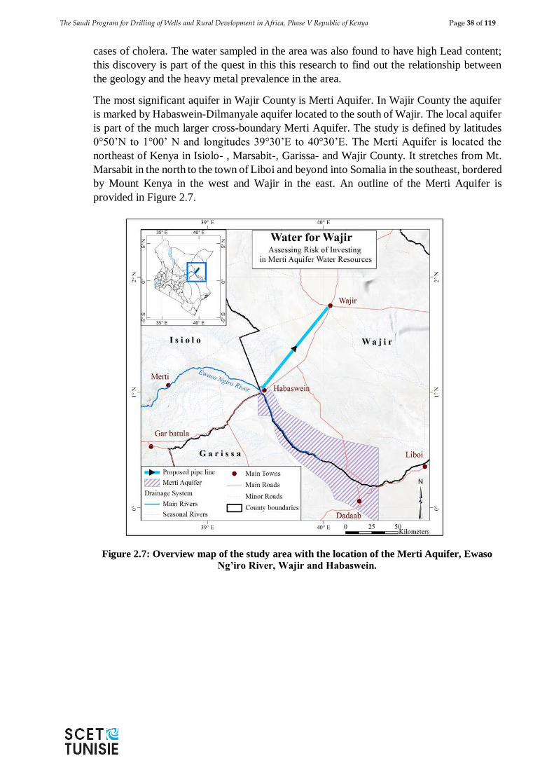
The Saudi Program for Drilling of Wells and Rural Development in Africa, Phase V Republic of Kenya Page 38 of 119
cases of cholera. The water sampled in the area was also found to have high Lead content;
this discovery is part of the quest in this this research to find out the relationship between
the geology and the heavy metal prevalence in the area.
The most significant aquifer in Wajir County is Merti Aquifer. In Wajir County the aquifer
is marked by Habaswein-Dilmanyale aquifer located to the south of Wajir. The local aquifer
is part of the much larger cross-boundary Merti Aquifer. The study is defined by latitudes
0°50’N to 1°00’ N and longitudes 39°30’E to 40°30’E. The Merti Aquifer is located the
northeast of Kenya in Isiolo- , Marsabit-, Garissa- and Wajir County. It stretches from Mt.
Marsabit in the north to the town of Liboi and beyond into Somalia in the southeast, bordered
by Mount Kenya in the west and Wajir in the east. An outline of the Merti Aquifer is
provided in Figure 2.7.
Figure 2.7: Overview map of the study area with the location of the Merti Aquifer, Ewaso
Ng’iro River, Wajir and Habaswein.
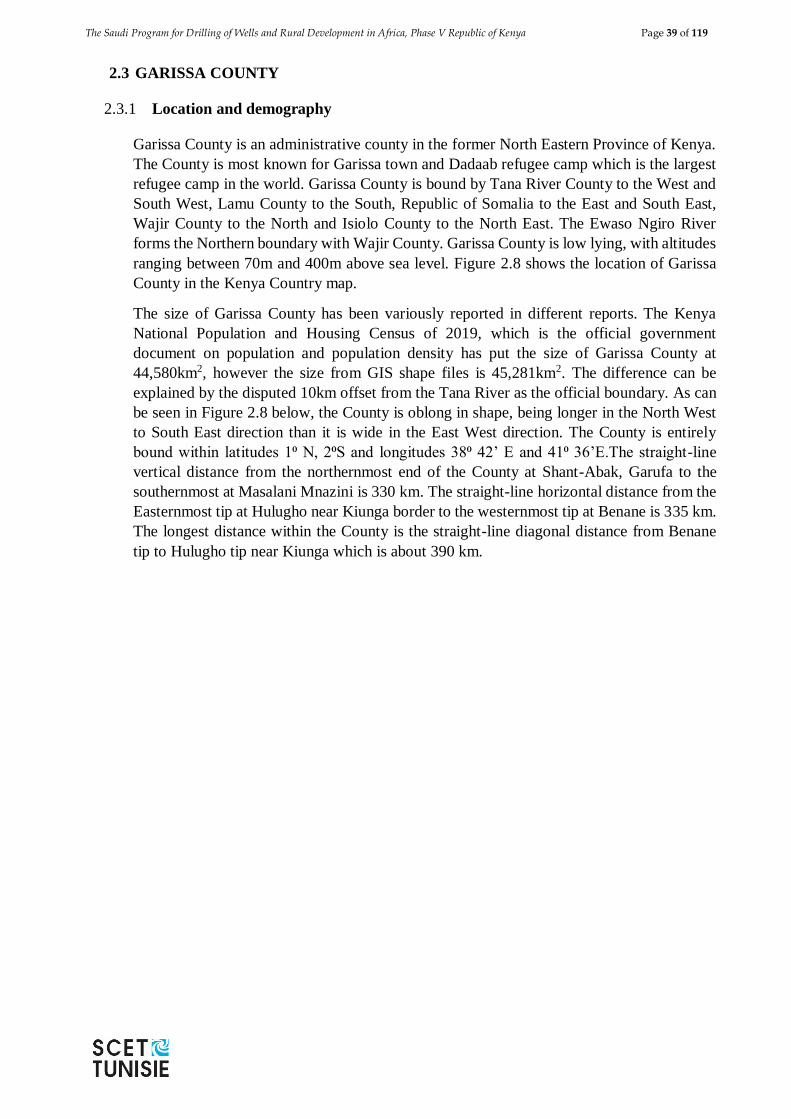
The Saudi Program for Drilling of Wells and Rural Development in Africa, Phase V Republic of Kenya Page 39 of 119
2.3 GARISSA COUNTY
2.3.1 Location and demography
Garissa County is an administrative county in the former North Eastern Province of Kenya.
The County is most known for Garissa town and Dadaab refugee camp which is the largest
refugee camp in the world. Garissa County is bound by Tana River County to the West and
South West, Lamu County to the South, Republic of Somalia to the East and South East,
Wajir County to the North and Isiolo County to the North East. The Ewaso Ngiro River
forms the Northern boundary with Wajir County. Garissa County is low lying, with altitudes
ranging between 70m and 400m above sea level. Figure 2.8 shows the location of Garissa
County in the Kenya Country map.
The size of Garissa County has been variously reported in different reports. The Kenya
National Population and Housing Census of 2019, which is the official government
document on population and population density has put the size of Garissa County at
44,580km2, however the size from GIS shape files is 45,281km2. The difference can be
explained by the disputed 10km offset from the Tana River as the official boundary. As can
be seen in Figure 2.8 below, the County is oblong in shape, being longer in the North West
to South East direction than it is wide in the East West direction. The County is entirely
bound within latitudes 1⁰ N, 2⁰S and longitudes 38⁰ 42’ E and 41⁰ 36’E.The straight-line
vertical distance from the northernmost end of the County at Shant-Abak, Garufa to the
southernmost at Masalani Mnazini is 330 km. The straight-line horizontal distance from the
Easternmost tip at Hulugho near Kiunga border to the westernmost tip at Benane is 335 km.
The longest distance within the County is the straight-line diagonal distance from Benane
tip to Hulugho tip near Kiunga which is about 390 km.
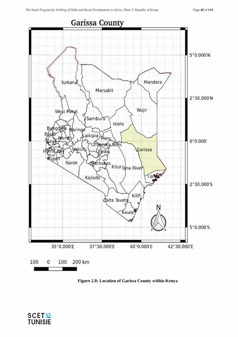
The Saudi Program for Drilling of Wells and Rural Development in Africa, Phase V Republic of Kenya Page 40 of 119
Figure 2.8: Location of Garissa County within Kenya
The Saudi Program for Drilling of Wells and Rural Development in Africa, Phase V Republic of Kenya Page 41 of 119
According to the 2019 Kenya Population and Housing Census Garissa County has a population of
841,353 people (458,975 Males, 382,344 Females, and 34 Intersex).
The population presented in Table 2.8 and 2.9 is as given by the National Population and
Housing Census and Figure 2.9 below show the population distribution in Garissa County.
Table 2.8: Population Distribution by Sex, Number of Households, Land Area, Population
Density and Sub-county
Sub-county Total
Sex
No. of
households
Land
Area
(Sq.
Km)
Density
Persons
per Sq.
Km
Male Female Intersex
Balambala 32,257 20,277 11,979 1 4,337 3,684 9
Dadaab 185,252 99,059 86,185 8 35,793 6,415 29
Fafi 134,040 72,617 61,413 10 23,671 15,050 9
Garissa 163,914 83,460 80,449 5 30,518 3,318 49
Hulugho 133,984 78,460 55,898 5 20,254 7,737 17
Ijara 141,591 80,458 61,129 4 18,481 2,453 58
Lagdera 50,315 25,023 25,291 1 8,340 6,096 8
(Source: KNBS, 2019)
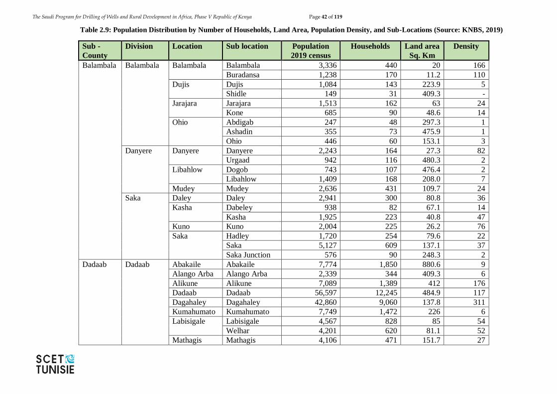
The Saudi Program for Drilling of Wells and Rural Development in Africa, Phase V Republic of Kenya Page 42 of 119
Table 2.9: Population Distribution by Number of Households, Land Area, Population Density, and Sub-Locations (Source: KNBS, 2019)
Sub -
County
Division Location Sub location Population
2019 census
Households Land area
Sq. Km
Density
Balambala Balambala Balambala Balambala 3,336 440 20 166
Buradansa 1,238 170 11.2 110
Dujis Dujis 1,084 143 223.9 5
Shidle 149 31 409.3 -
Jarajara Jarajara 1,513 162 63 24
Kone 685 90 48.6 14
Ohio Abdigab 247 48 297.3 1
Ashadin 355 73 475.9 1
Ohio 446 60 153.1 3
Danyere Danyere Danyere 2,243 164 27.3 82
Urgaad 942 116 480.3 2
Libahlow Dogob 743 107 476.4 2
Libahlow 1,409 168 208.0 7
Mudey Mudey 2,636 431 109.7 24
Saka Daley Daley 2,941 300 80.8 36
Kasha Dabeley 938 82 67.1 14
Kasha 1,925 223 40.8 47
Kuno Kuno 2,004 225 26.2 76
Saka Hadley 1,720 254 79.6 22
Saka 5,127 609 137.1 37
Saka Junction 576 90 248.3 2
Dadaab Dadaab Abakaile Abakaile 7,774 1,850 880.6 9
Alango Arba Alango Arba 2,339 344 409.3 6
Alikune Alikune 7,089 1,389 412 176
Dadaab Dadaab 56,597 12,245 484.9 117
Dagahaley Dagahaley 42,860 9,060 137.8 311
Kumahumato Kumahumato 7,749 1,472 226 6
Labisigale Labisigale 4,567 828 85 54
Welhar 4,201 620 81.1 52
Mathagis Mathagis 4,106 471 151.7 27
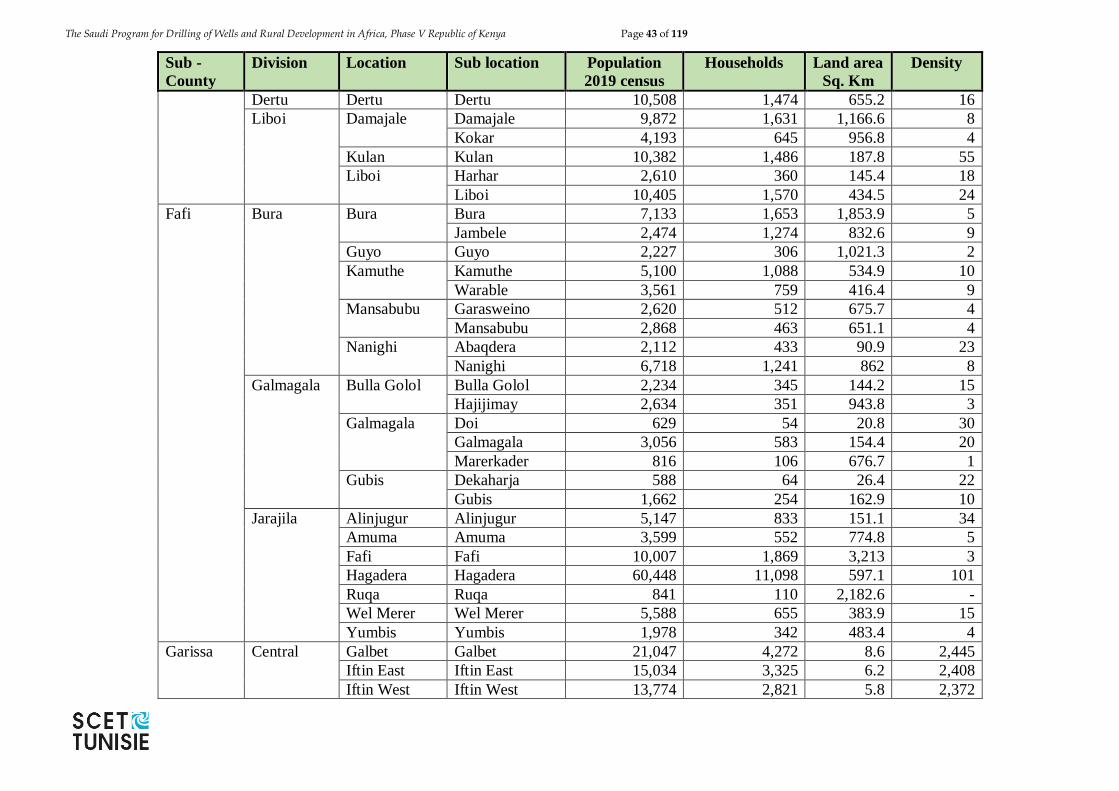
The Saudi Program for Drilling of Wells and Rural Development in Africa, Phase V Republic of Kenya Page 43 of 119
Sub -
County
Division Location Sub location Population
2019 census
Households Land area
Sq. Km
Density
Dertu Dertu Dertu 10,508 1,474 655.2 16
Liboi Damajale Damajale 9,872 1,631 1,166.6 8
Kokar 4,193 645 956.8 4
Kulan Kulan 10,382 1,486 187.8 55
Liboi Harhar 2,610 360 145.4 18
Liboi 10,405 1,570 434.5 24
Fafi Bura Bura Bura 7,133 1,653 1,853.9 5
Jambele 2,474 1,274 832.6 9
Guyo Guyo 2,227 306 1,021.3 2
Kamuthe Kamuthe 5,100 1,088 534.9 10
Warable 3,561 759 416.4 9
Mansabubu Garasweino 2,620 512 675.7 4
Mansabubu 2,868 463 651.1 4
Nanighi Abaqdera 2,112 433 90.9 23
Nanighi 6,718 1,241 862 8
Galmagala Bulla Golol Bulla Golol 2,234 345 144.2 15
Hajijimay 2,634 351 943.8 3
Galmagala Doi 629 54 20.8 30
Galmagala 3,056 583 154.4 20
Marerkader 816 106 676.7 1
Gubis Dekaharja 588 64 26.4 22
Gubis 1,662 254 162.9 10
Jarajila Alinjugur Alinjugur 5,147 833 151.1 34
Amuma Amuma 3,599 552 774.8 5
Fafi Fafi 10,007 1,869 3,213 3
Hagadera Hagadera 60,448 11,098 597.1 101
Ruqa Ruqa 841 110 2,182.6 -
Wel Merer Wel Merer 5,588 655 383.9 15
Yumbis Yumbis 1,978 342 483.4 4
Garissa Central Galbet Galbet 21,047 4,272 8.6 2,445
Iftin East Iftin East 15,034 3,325 6.2 2,408
Iftin West Iftin West 13,774 2,821 5.8 2,372
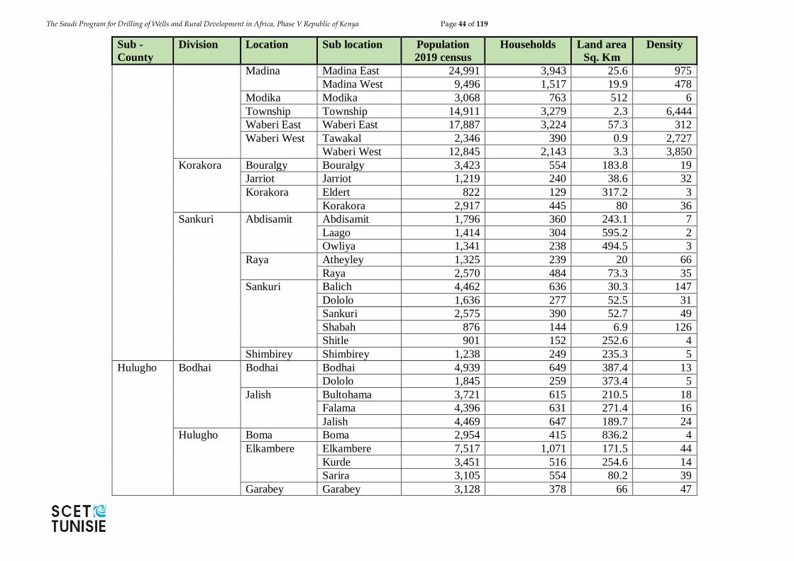
The Saudi Program for Drilling of Wells and Rural Development in Africa, Phase V Republic of Kenya Page 44 of 119
Sub -
County
Division Location Sub location Population
2019 census
Households Land area
Sq. Km
Density
Madina Madina East 24,991 3,943 25.6 975
Madina West 9,496 1,517 19.9 478
Modika Modika 3,068 763 512 6
Township Township 14,911 3,279 2.3 6,444
Waberi East Waberi East 17,887 3,224 57.3 312
Waberi West Tawakal 2,346 390 0.9 2,727
Waberi West 12,845 2,143 3.3 3,850
Korakora Bouralgy Bouralgy 3,423 554 183.8 19
Jarriot Jarriot 1,219 240 38.6 32
Korakora Eldert 822 129 317.2 3
Korakora 2,917 445 80 36
Sankuri Abdisamit Abdisamit 1,796 360 243.1 7
Laago 1,414 304 595.2 2
Owliya 1,341 238 494.5 3
Raya Atheyley 1,325 239 20 66
Raya 2,570 484 73.3 35
Sankuri Balich 4,462 636 30.3 147
Dololo 1,636 277 52.5 31
Sankuri 2,575 390 52.7 49
Shabah 876 144 6.9 126
Shitle 901 152 252.6 4
Shimbirey Shimbirey 1,238 249 235.3 5
Hulugho Bodhai Bodhai Bodhai 4,939 649 387.4 13
Dololo 1,845 259 373.4 5
Jalish Bultohama 3,721 615 210.5 18
Falama 4,396 631 271.4 16
Jalish 4,469 647 189.7 24
Hulugho Boma Boma 2,954 415 836.2 4
Elkambere Elkambere 7,517 1,071 171.5 44
Kurde 3,451 516 254.6 14
Sarira 3,105 554 80.2 39
Garabey Garabey 3,128 378 66 47
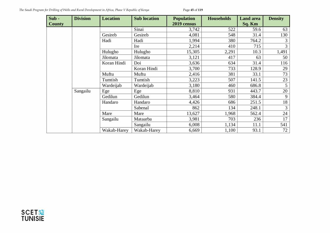
The Saudi Program for Drilling of Wells and Rural Development in Africa, Phase V Republic of Kenya Page 45 of 119
Sub -
County
Division Location Sub location Population
2019 census
Households Land area
Sq. Km
Density
Sinai 3,742 522 59.6 63
Gesireb Gesireb 4,081 548 31.4 130
Hadi Hadi 1,994 380 764.2 3
Ire 2,214 410 715 3
Hulugho Hulugho 15,305 2,291 10.3 1,491
Jilomata Jilomata 3,121 417 63 50
Koran Hindi Doi 3,636 634 31.4 116
Koran Hindi 3,700 733 128.9 29
Muftu Muftu 2,416 381 33.1 73
Tumtish Tumtish 3,223 507 141.5 23
Wardeijab Wardeijab 3,180 460 686.8 5
Sangailu Ege Ege 8,810 931 443.7 20
Gedilun Gedilun 3,464 580 384.4 9
Handaro Handaro 4,426 686 251.5 18
Sabenal 862 134 248.1 3
Mare Mare 13,627 1,968 562.4 24
Sangailu Mataarba 3,981 703 236 17
Sangailu 6,008 1,134 11.1 541
Wakab-Harey Wakab-Harey 6,669 1,100 93.1 72
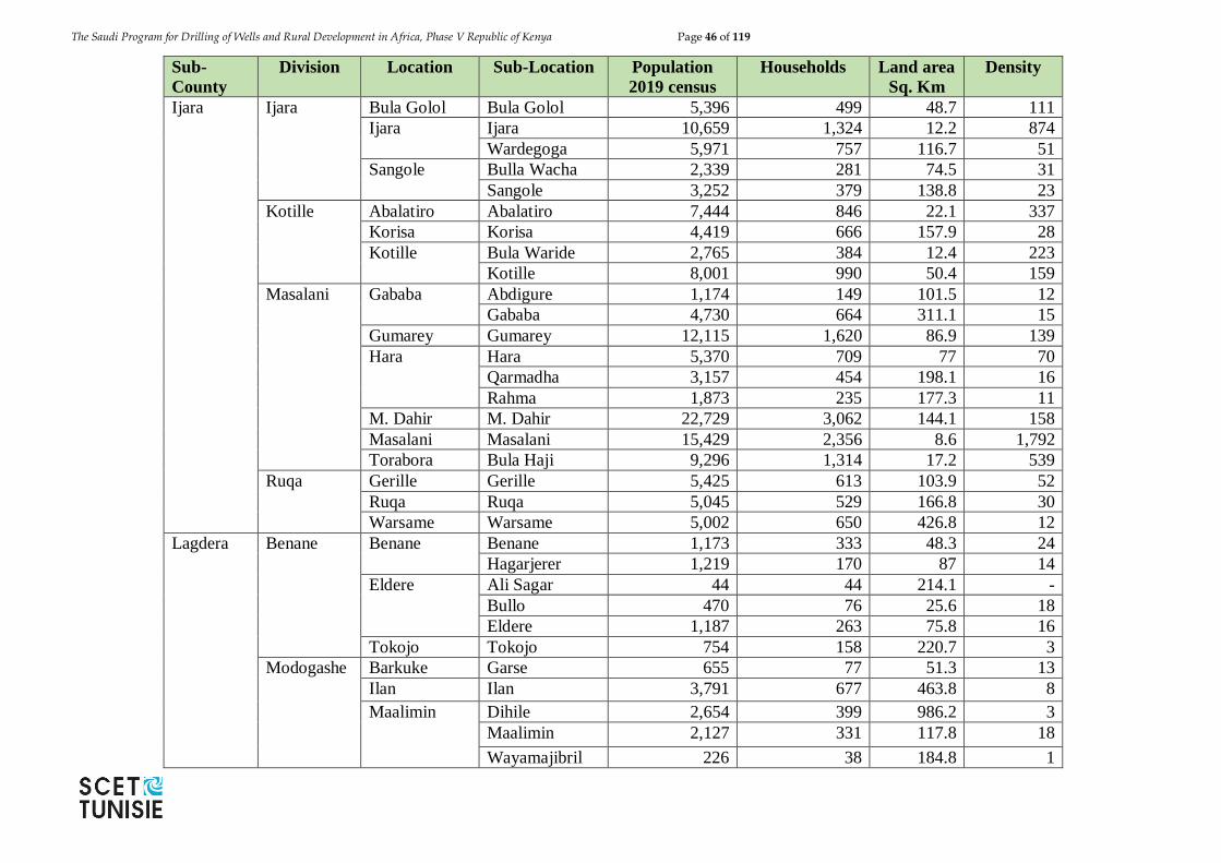
The Saudi Program for Drilling of Wells and Rural Development in Africa, Phase V Republic of Kenya Page 46 of 119
Sub-
County
Division Location Sub-Location Population
2019 census
Households Land area
Sq. Km
Density
Ijara Ijara Bula Golol Bula Golol 5,396 499 48.7 111
Ijara Ijara 10,659 1,324 12.2 874
Wardegoga 5,971 757 116.7 51
Sangole Bulla Wacha 2,339 281 74.5 31
Sangole 3,252 379 138.8 23
Kotille Abalatiro Abalatiro 7,444 846 22.1 337
Korisa Korisa 4,419 666 157.9 28
Kotille Bula Waride 2,765 384 12.4 223
Kotille 8,001 990 50.4 159
Masalani Gababa Abdigure 1,174 149 101.5 12
Gababa 4,730 664 311.1 15
Gumarey Gumarey 12,115 1,620 86.9 139
Hara Hara 5,370 709 77 70
Qarmadha 3,157 454 198.1 16
Rahma 1,873 235 177.3 11
M. Dahir M. Dahir 22,729 3,062 144.1 158
Masalani Masalani 15,429 2,356 8.6 1,792
Torabora Bula Haji 9,296 1,314 17.2 539
Ruqa Gerille Gerille 5,425 613 103.9 52
Ruqa Ruqa 5,045 529 166.8 30
Warsame Warsame 5,002 650 426.8 12
Lagdera Benane Benane Benane 1,173 333 48.3 24
Hagarjerer 1,219 170 87 14
Eldere Ali Sagar 44 44 214.1 -
Bullo 470 76 25.6 18
Eldere 1,187 263 75.8 16
Tokojo Tokojo 754 158 220.7 3
Modogashe Barkuke Garse 655 77 51.3 13
Ilan Ilan 3,791 677 463.8 8
Maalimin Dihile 2,654 399 986.2 3
Maalimin 2,127 331 117.8 18
Wayamajibril 226 38 184.8 1
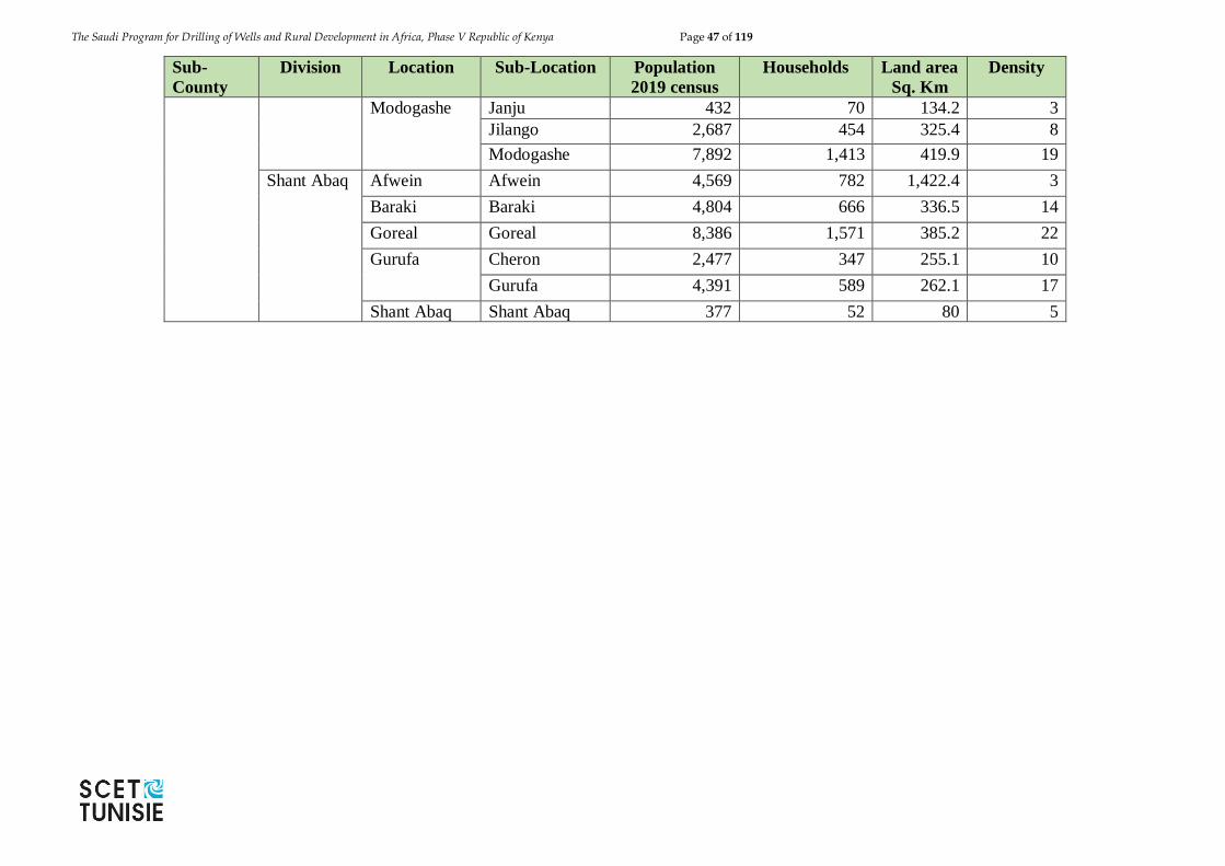
The Saudi Program for Drilling of Wells and Rural Development in Africa, Phase V Republic of Kenya Page 47 of 119
Sub-
County
Division Location Sub-Location Population
2019 census
Households Land area
Sq. Km
Density
Modogashe Janju 432 70 134.2 3
Jilango 2,687 454 325.4 8
Modogashe 7,892 1,413 419.9 19
Shant Abaq Afwein Afwein 4,569 782 1,422.4 3
Baraki Baraki 4,804 666 336.5 14
Goreal Goreal 8,386 1,571 385.2 22
Gurufa Cheron 2,477 347 255.1 10
Gurufa 4,391 589 262.1 17
Shant Abaq Shant Abaq 377 52 80 5
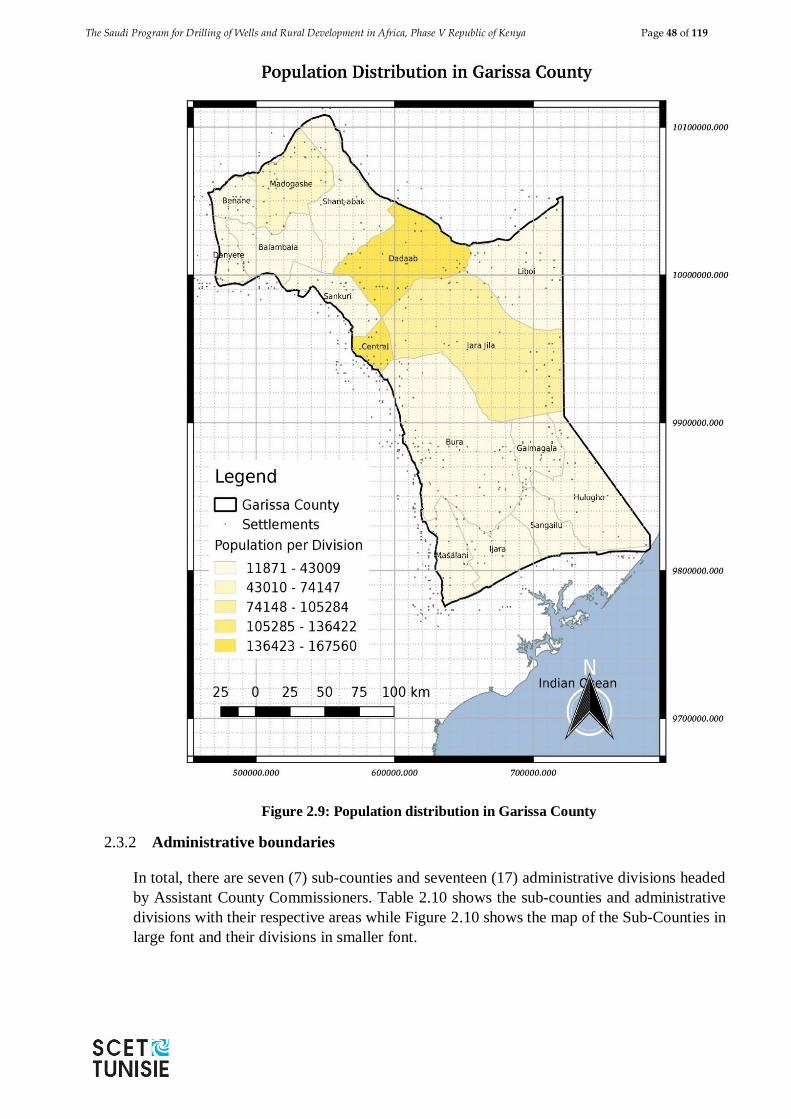
The Saudi Program for Drilling of Wells and Rural Development in Africa, Phase V Republic of Kenya Page 48 of 119
Figure 2.9: Population distribution in Garissa County
2.3.2 Administrative boundaries
In total, there are seven (7) sub-counties and seventeen (17) administrative divisions headed
by Assistant County Commissioners. Table 2.10 shows the sub-counties and administrative
divisions with their respective areas while Figure 2.10 shows the map of the Sub-Counties in
large font and their divisions in smaller font.
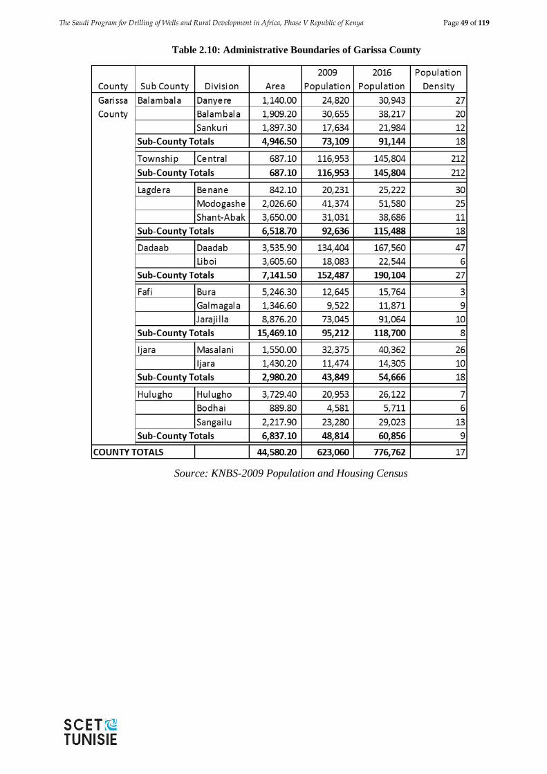
The Saudi Program for Drilling of Wells and Rural Development in Africa, Phase V Republic of Kenya Page 49 of 119
Table 2.10: Administrative Boundaries of Garissa County
Source: KNBS-2009 Population and Housing Census
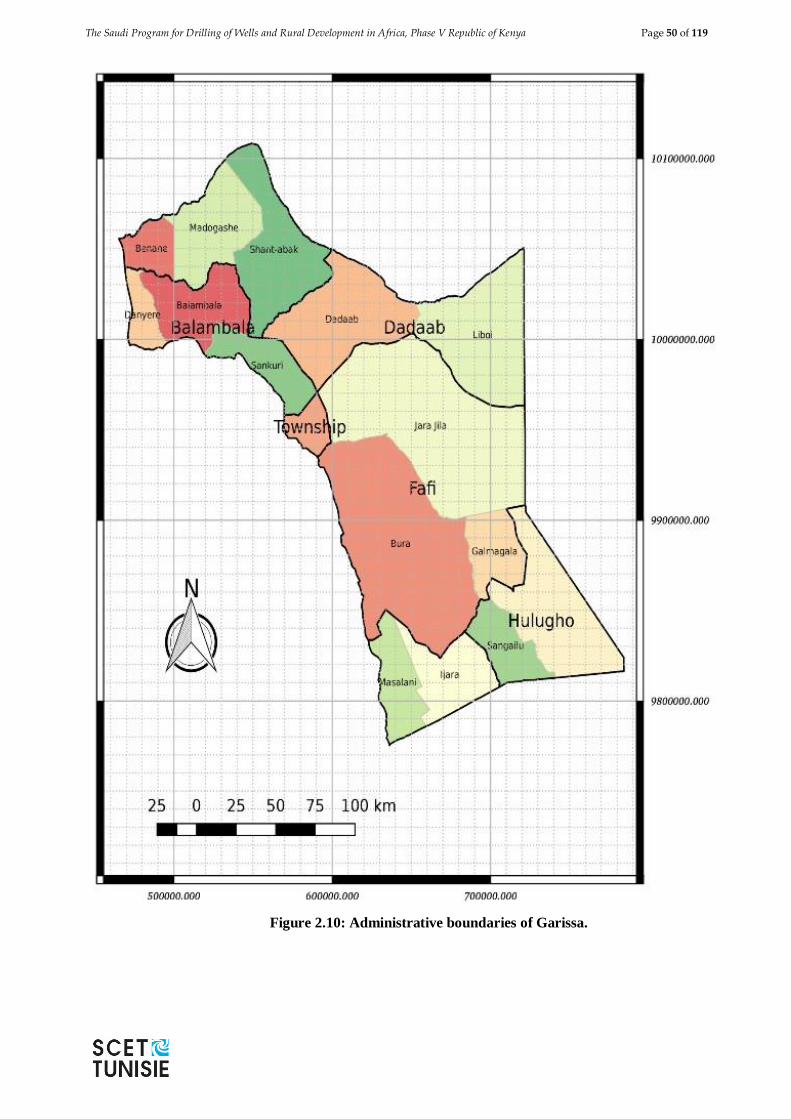
The Saudi Program for Drilling of Wells and Rural Development in Africa, Phase V Republic of Kenya Page 50 of 119
Figure 2.10: Administrative boundaries of Garissa.
The Saudi Program for Drilling of Wells and Rural Development in Africa, Phase V Republic of Kenya Page 51 of 119
2.3.3 Topography
Garissa County is generally flat and low lying. Figure 2.11 shows that the topography varies
from 50 m amsl at Boni forest reserve to about 450 amsl at Benane. The upper Garissa is
steeper than the lower Garissa and generally drains towards the Ewaso Ngiro River. The
general slope south eastwards towards the ocean is 0.09%.
2.3.4 Geological setting
Garissa County is geologically part of the Anza rift basin with accumulation of up to 4000 m
of Maastrichtian-Paleogene continental clastics. The basin runs inland from the coast in north-
western direction, and links the Lamu embayment of southern Kenya with the South Sudan
rifts. Within Garissa, it constitutes the rift termination zone of the Central African Rift System
in north east part of Kenya.
Faulting in this basin was initiated in the Mesozoic period and has intermittently been
activated through to Tertiary period with creation of deposit centres filled primarily with
fluvial-lacustrine, deltaic and marine sediments. This geological and structural setting has
shaped the hydro geological setup of Garissa County significantly.
Stratigraphic sequence for Garissa County can be summarised as follows:
1. Recent Superficial Deposits
a. Alluvial sands, silt and clay
b. Colluvium
2. Sedimentary rocks
a. Quaternary deposits
b. Undifferentiated Quaternary and Tertiary Beds
c. Tertiary deposits
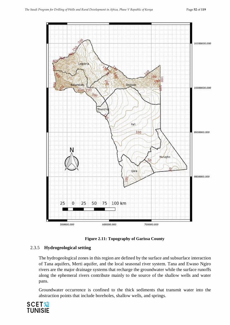
The Saudi Program for Drilling of Wells and Rural Development in Africa, Phase V Republic of Kenya Page 52 of 119
Figure 2.11: Topography of Garissa County
2.3.5 Hydrogeological setting
The hydrogeological zones in this region are defined by the surface and subsurface interaction
of Tana aquifers, Merti aquifer, and the local seasonal river system. Tana and Ewaso Ngiro
rivers are the major drainage systems that recharge the groundwater while the surface runoffs
along the ephemeral rivers contribute mainly to the source of the shallow wells and water
pans.
Groundwater occurrence is confined to the thick sediments that transmit water into the
abstraction points that include boreholes, shallow wells, and springs.
The Saudi Program for Drilling of Wells and Rural Development in Africa, Phase V Republic of Kenya Page 53 of 119
Groundwater flow and quality (salinity) is influenced by the geology, structural orientation of
the rock formation and the time taken by the water within the rocks.
Water Quality
Garissa County is an ASAL area where groundwater is the main water resource. Whereas
surface water is more prone to bacteriological pollution since it is more easily accessible by
pathogens, groundwater is more prone to chemical pollutants which are normally leached
from the rocks through which the ground water percolates or in which it is stored. Garissa
County being dependent on groundwater for the most part, and salinity being a major problem,
an attempt was made to show the distribution of the various common chemical parameters
with health implications.
The various sources of water for all uses include the River Tana, laghas, boreholes, dams,
pans and springs. Representative samples were collected according to internationally
approved methods of sample collection, transportation, and testing and data analysis. Over 96
boreholes, 45 water pans, several points of the River Tana, numerous shallow wells, and
springs were sampled across the county and physical, chemical and biological parameters
ascertained. From the results obtained the major findings were high total water hardness, total
alkalinity, fluoride, chloride, and turbidity. Other aesthetic parameters included the taste,
odour, and colour.
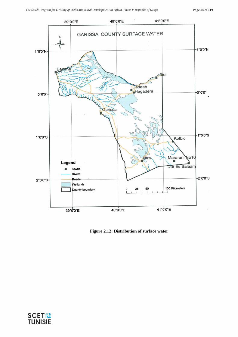
The Saudi Program for Drilling of Wells and Rural Development in Africa, Phase V Republic of Kenya Page 54 of 119
Figure 2.12: Distribution of surface water
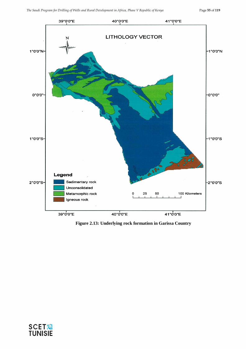
The Saudi Program for Drilling of Wells and Rural Development in Africa, Phase V Republic of Kenya Page 55 of 119
Figure 2.13: Underlying rock formation in Garissa Country
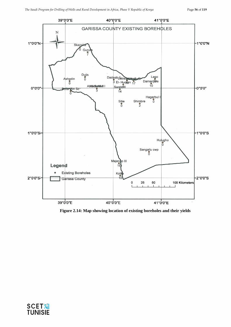
The Saudi Program for Drilling of Wells and Rural Development in Africa, Phase V Republic of Kenya Page 56 of 119
Figure 2.14: Map showing location of existing boreholes and their yields
The Saudi Program for Drilling of Wells and Rural Development in Africa, Phase V Republic of Kenya Page 57 of 119
2.4 MARSABIT COUNTY
2.4.1 Location
Marsabit County set in the former Eastern Province and some 550 km north of Nairobi is one
of the existing 47 Counties set after propagation of the new Constitution in year 2010. It is
the largest county in Kenya covering 70, 961 km2. Marsabit borders three counties; Wajir to
the east, Turkana to the west and Isiolo to the south. It also borders the country of Ethiopia to
the north (Fig. 2.15).
It can be located on SK Sheet No. NA-37-6 scale 1:250,000 at coordinates 380 East of
Greenish and 2020’ North. It is situated within Mount Marsabit Forest Reserve in the Northern
Region of Marsabit County.
The county is said to have been named after a Burji farmer called Marsa who was brought to
Marsabit (from Ethiopia) by colonialists to teach the locals how to grow crops.When his name
was called out by his masters, Marsa used to answer "Abet"(Yes in Amharic) and this led to
the creation of the name Marsa-Abeit-which later became Marsabit.
Marsabit Town is located in Central Division, Marsabit Central Sub-County, Marsabit
County.
It consists of 3 Locations and 6 sub locations as detailed below:
Nagayo location consisting of 2 sub-locations of Nyayo Road and Majengo
Dakabaricha Location consisting of 2 sub-locations of Mataarba and Dakabaricha and
Mountain Location consisting of 2 sub locations of Township and Wabera.
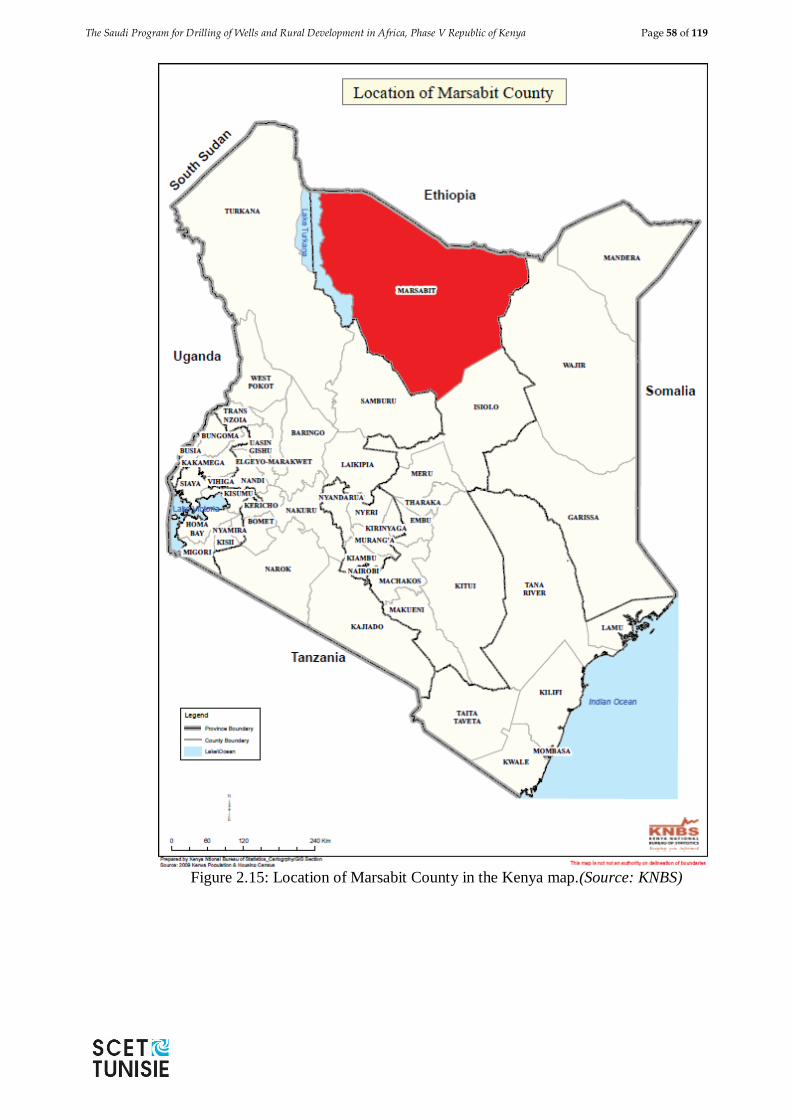
The Saudi Program for Drilling of Wells and Rural Development in Africa, Phase V Republic of Kenya Page 58 of 119
Figure 2.15: Location of Marsabit County in the Kenya map.(Source: KNBS)
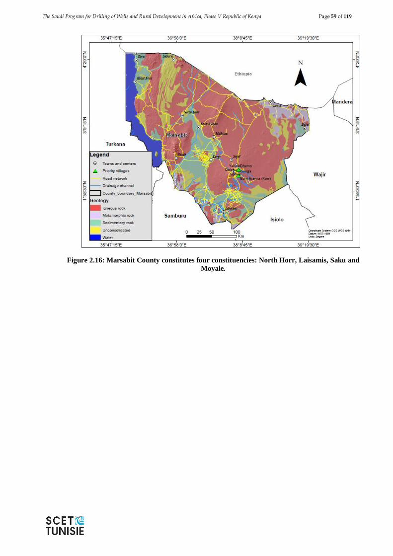
The Saudi Program for Drilling of Wells and Rural Development in Africa, Phase V Republic of Kenya Page 59 of 119
Figure 2.16: Marsabit County constitutes four constituencies: North Horr, Laisamis, Saku and
Moyale.
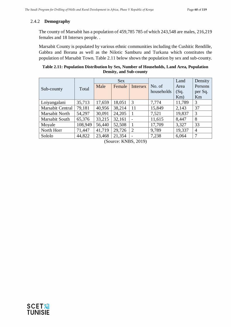
The Saudi Program for Drilling of Wells and Rural Development in Africa, Phase V Republic of Kenya Page 60 of 119
2.4.2 Demography
The county of Marsabit has a population of 459,785 785 of which 243,548 are males, 216,219
females and 18 Intersex people. .
Marsabit County is populated by various ethnic communities including the Cushitic Rendille,
Gabbra and Borana as well as the Nilotic Samburu and Turkana which constitutes the
population of Marsabit Town. Table 2.11 below shows the population by sex and sub-county.
Table 2.11: Population Distribution by Sex, Number of Households, Land Area, Population
Density, and Sub-county
Sub-county Total
Sex
No. of
households
Land
Area
(Sq.
Km)
Density
Persons
per Sq.
Km
Male Female Intersex
Loiyangalani 35,713 17,659 18,051 3 7,774 11,789 3
Marsabit Central 79,181 40,956 38,214 11 15,849 2,143 37
Marsabit North 54,297 30,091 24,205 1 7,521 19,837 3
Marsabit South 65,376 33,215 32,161 - 11,615 8,447 8
Moyale 108,949 56,440 52,508 1 17,709 3,327 33
North Horr 71,447 41,719 29,726 2 9,789 19,337 4
Sololo 44,822 23,468 21,354 - 7,238 6,064 7
(Source: KNBS, 2019)
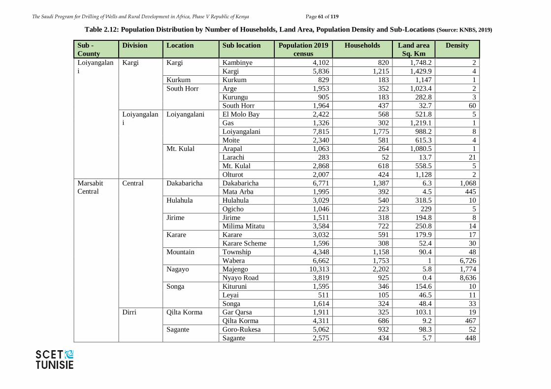
The Saudi Program for Drilling of Wells and Rural Development in Africa, Phase V Republic of Kenya Page 61 of 119
Table 2.12: Population Distribution by Number of Households, Land Area, Population Density and Sub-Locations (Source: KNBS, 2019)
Sub -
County
Division Location Sub location Population 2019
census
Households Land area
Sq. Km
Density
Loiyangalan
i
Kargi
Kargi Kambinye 4,102 820 1,748.2 2
Kargi 5,836 1,215 1,429.9 4
Kurkum Kurkum 829 183 1,147 1
South Horr Arge 1,953 352 1,023.4 2
Kurungu 905 183 282.8 3
South Horr 1,964 437 32.7 60
Loiyangalan
i
Loiyangalani El Molo Bay 2,422 568 521.8 5
Gas 1,326 302 1,219.1 1
Loiyangalani 7,815 1,775 988.2 8
Moite 2,340 581 615.3 4
Mt. Kulal Arapal 1,063 264 1,080.5 1
Larachi 283 52 13.7 21
Mt. Kulal 2,868 618 558.5 5
Olturot 2,007 424 1,128 2
Marsabit Central
Central Dakabaricha Dakabaricha 6,771 1,387 6.3 1,068
Mata Arba 1,995 392 4.5 445
Hulahula Hulahula 3,029 540 318.5 10
Ogicho 1,046 223 229 5
Jirime Jirime 1,511 318 194.8 8
Milima Mitatu 3,584 722 250.8 14
Karare Karare 3,032 591 179.9 17
Karare Scheme 1,596 308 52.4 30
Mountain Township 4,348 1,158 90.4 48
Wabera 6,662 1,753 1 6,726
Nagayo Majengo 10,313 2,202 5.8 1,774
Nyayo Road 3,819 925 0.4 8,636
Songa Kituruni 1,595 346 154.6 10
Leyai 511 105 46.5 11
Songa 1,614 324 48.4 33
Dirri Qilta Korma Gar Qarsa 1,911 325 103.1 19
Qilta Korma 4,311 686 9.2 467
Sagante Goro-Rukesa 5,062 932 98.3 52
Sagante 2,575 434 5.7 448
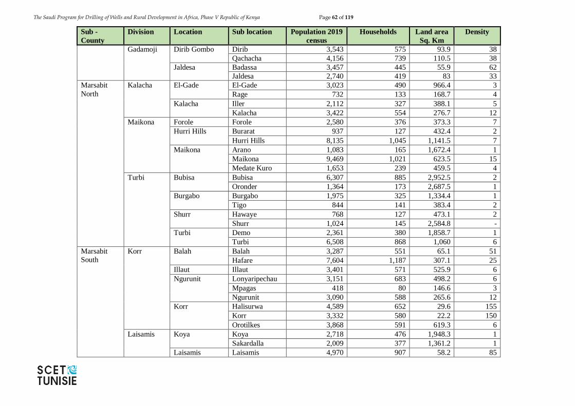
The Saudi Program for Drilling of Wells and Rural Development in Africa, Phase V Republic of Kenya Page 62 of 119
Sub -
County
Division Location Sub location Population 2019
census
Households Land area
Sq. Km
Density
Gadamoji Dirib Gombo Dirib 3,543 575 93.9 38
Qachacha 4,156 739 110.5 38
Jaldesa Badassa 3,457 445 55.9 62
Jaldesa 2,740 419 83 33
Marsabit
North
Kalacha El-Gade El-Gade 3,023 490 966.4 3
Rage 732 133 168.7 4
Kalacha Iller 2,112 327 388.1 5
Kalacha 3,422 554 276.7 12
Maikona Forole Forole 2,580 376 373.3 7
Hurri Hills Burarat 937 127 432.4 2
Hurri Hills 8,135 1,045 1,141.5 7
Maikona Arano 1,083 165 1,672.4 1
Maikona 9,469 1,021 623.5 15
Medate Kuro 1,653 239 459.5 4
Turbi Bubisa Bubisa 6,307 885 2,952.5 2
Oronder 1,364 173 2,687.5 1
Burgabo Burgabo 1,975 325 1,334.4 1
Tigo 844 141 383.4 2
Shurr Hawaye 768 127 473.1 2
Shurr 1,024 145 2,584.8 -
Turbi Demo 2,361 380 1,858.7 1
Turbi 6,508 868 1,060 6
Marsabit South
Korr Balah Balah 3,287 551 65.1 51
Hafare 7,604 1,187 307.1 25
Illaut Illaut 3,401 571 525.9 6
Ngurunit Lonyaripechau 3,151 683 498.2 6
Mpagas 418 80 146.6 3
Ngurunit 3,090 588 265.6 12
Korr Halisurwa 4,589 652 29.6 155
Korr 3,332 580 22.2 150
Orotilkes 3,868 591 619.3 6
Laisamis Koya Koya 2,718 476 1,948.3 1
Sakardalla 2,009 377 1,361.2 1
Laisamis Laisamis 4,970 907 58.2 85
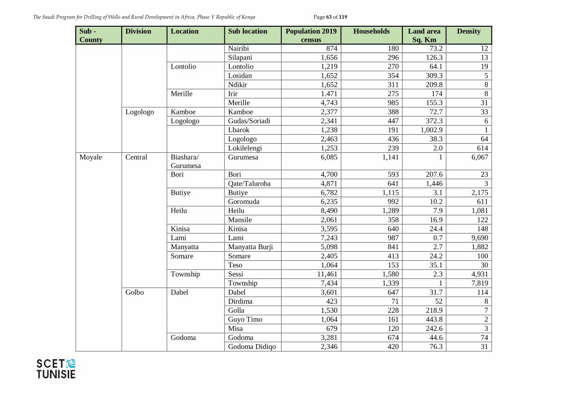
The Saudi Program for Drilling of Wells and Rural Development in Africa, Phase V Republic of Kenya Page 63 of 119
Sub -
County
Division Location Sub location Population 2019
census
Households Land area
Sq. Km
Density
Nairibi 874 180 73.2 12
Silapani 1,656 296 126.3 13
Lontolio Lontolio 1,219 270 64.1 19
Losidan 1,652 354 309.3 5
Ndikir 1,652 311 209.8 8
Merille Irir 1.471 275 174 8
Merille 4,743 985 155.3 31
Logologo Kamboe Kamboe 2,377 388 72.7 33
Logologo Gudas/Soriadi 2,341 447 372.3 6
Lbarok 1,238 191 1,002.9 1
Logologo 2,463 436 38.3 64
Lokilelengi 1,253 239 2.0 614
Moyale Central Biashara/
Gurumesa
Gurumesa 6,085 1,141 1 6,067
Bori Bori 4,700 593 207.6 23
Qate/Taluroba 4,871 641 1,446 3
Butiye Butiye 6,782 1,115 3.1 2,175
Goromuda 6,235 992 10.2 611
Heilu Heilu 8,490 1,289 7.9 1,081
Mansile 2,061 358 16.9 122
Kinisa Kinisa 3,595 640 24.4 148
Lami Lami 7,243 987 0.7 9,690
Manyatta Manyatta Burji 5,098 841 2.7 1,882
Somare Somare 2,405 413 24.2 100
Teso 1,064 153 35.1 30
Township Sessi 11,461 1,580 2.3 4,931
Township 7,434 1,339 1 7,819
Golbo Dabel Dabel 3,601 647 31.7 114
Dirdima 423 71 52 8
Golla 1,530 228 218.9 7
Guyo Timo 1,064 161 443.8 2
Misa 679 120 242.6 3
Godoma Godoma 3,281 674 44.6 74
Godoma Didiqo 2,346 420 76.3 31
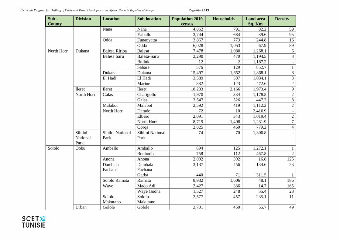
The Saudi Program for Drilling of Wells and Rural Development in Africa, Phase V Republic of Kenya Page 64 of 119
Sub -
County
Division Location Sub location Population 2019
census
Households Land area
Sq. Km
Density
Nana Nana 4,862 791 82.2 59
Yaballo 3,744 684 39.6 95
Odda Funanyatta 3,867 773 244.8 16
Odda 6,028 1,053 67.9 89
North Horr Dukana Balesa Ririba Balesa 7,478 1,080 1,268.1 6
Balesa Saru Balesa-Saru 3,290 470 1,194.5 3
Bulluk 12 2 1,187.2 -
Sabare 576 129 852.7 1
Dukana Dukana 15,497 1,652 1,868.1 8
El Hadi El Hadi 3,589 507 1,034.1 3
Marine 882 123 472.6 2
Ileret Ileret Ileret 18,233 2,166 1,973.4 9
North Horr Galas Charigollo 1,970 334 1,178.5 2
Galas 3,547 526 447.3 8
Malabot Malabot 2,592 419 1,112.2 2
North Horr Darade 72 10 2,416.9 -
Elbeso 2,091 343 1,019.4 2
North Horr 8,719 1,498 1,231.9 7
Qorqa 2,825 460 779.2 4
Sibiloi National
Park
Sibiloi National Park
Sibiloi National Park
74 70 1,300.8 -
Sololo Obbu Amballo Amballo 894 125 1,272.1 1
Bodhodha 758 112 467.8 2
Anona Anona 2,092 392 16.8 125
Dambala Fachana
Dambala Fachana
3,137 456 134.6 23
Garba 440 71 311.5 1
Sololo Ramata Ramata 8,932 1,606 48.1 186
Waye Mado Adi 2,427 386 14.7 165
Waye Godha 1,527 248 55.4 28
Sololo-
Makutano
Sololo-
Makutano
2,577 457 235.1 11
Urban Golole Golole 2,701 450 55.7 49

The Saudi Program for Drilling of Wells and Rural Development in Africa, Phase V Republic of Kenya Page 65 of 119
Sub -
County
Division Location Sub location Population 2019
census
Households Land area
Sq. Km
Density
Karbururi 1,818 346 27.7 66
Rawana Banale 3,897 491 608.8 6
Rawana/Tito 5,470 887 2,417.6 2
Uran Lataka 2,259 330 63.6 35
Uran 2,876 418 16.1 178
Walda Walda 3,017 463 318.5 9
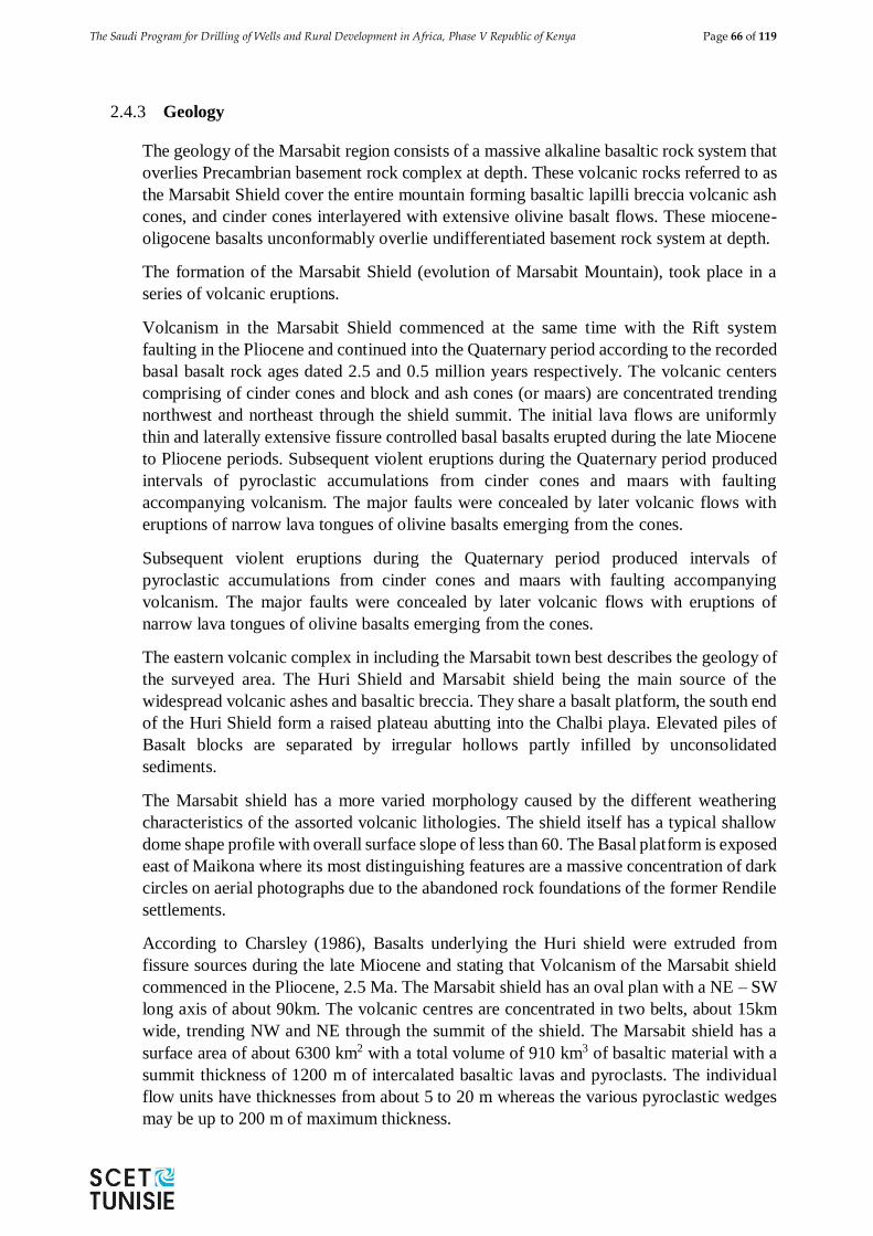
The Saudi Program for Drilling of Wells and Rural Development in Africa, Phase V Republic of Kenya Page 66 of 119
2.4.3 Geology
The geology of the Marsabit region consists of a massive alkaline basaltic rock system that
overlies Precambrian basement rock complex at depth. These volcanic rocks referred to as
the Marsabit Shield cover the entire mountain forming basaltic lapilli breccia volcanic ash
cones, and cinder cones interlayered with extensive olivine basalt flows. These miocene-
oligocene basalts unconformably overlie undifferentiated basement rock system at depth.
The formation of the Marsabit Shield (evolution of Marsabit Mountain), took place in a
series of volcanic eruptions.
Volcanism in the Marsabit Shield commenced at the same time with the Rift system
faulting in the Pliocene and continued into the Quaternary period according to the recorded
basal basalt rock ages dated 2.5 and 0.5 million years respectively. The volcanic centers
comprising of cinder cones and block and ash cones (or maars) are concentrated trending
northwest and northeast through the shield summit. The initial lava flows are uniformly
thin and laterally extensive fissure controlled basal basalts erupted during the late Miocene
to Pliocene periods. Subsequent violent eruptions during the Quaternary period produced
intervals of pyroclastic accumulations from cinder cones and maars with faulting
accompanying volcanism. The major faults were concealed by later volcanic flows with
eruptions of narrow lava tongues of olivine basalts emerging from the cones.
Subsequent violent eruptions during the Quaternary period produced intervals of
pyroclastic accumulations from cinder cones and maars with faulting accompanying
volcanism. The major faults were concealed by later volcanic flows with eruptions of
narrow lava tongues of olivine basalts emerging from the cones.
The eastern volcanic complex in including the Marsabit town best describes the geology of
the surveyed area. The Huri Shield and Marsabit shield being the main source of the
widespread volcanic ashes and basaltic breccia. They share a basalt platform, the south end
of the Huri Shield form a raised plateau abutting into the Chalbi playa. Elevated piles of
Basalt blocks are separated by irregular hollows partly infilled by unconsolidated
sediments.
The Marsabit shield has a more varied morphology caused by the different weathering
characteristics of the assorted volcanic lithologies. The shield itself has a typical shallow
dome shape profile with overall surface slope of less than 60. The Basal platform is exposed
east of Maikona where its most distinguishing features are a massive concentration of dark
circles on aerial photographs due to the abandoned rock foundations of the former Rendile
settlements.
According to Charsley (1986), Basalts underlying the Huri shield were extruded from
fissure sources during the late Miocene and stating that Volcanism of the Marsabit shield
commenced in the Pliocene, 2.5 Ma. The Marsabit shield has an oval plan with a NE – SW
long axis of about 90km. The volcanic centres are concentrated in two belts, about 15km
wide, trending NW and NE through the summit of the shield. The Marsabit shield has a
surface area of about 6300 km2 with a total volume of 910 km3 of basaltic material with a
summit thickness of 1200 m of intercalated basaltic lavas and pyroclasts. The individual
flow units have thicknesses from about 5 to 20 m whereas the various pyroclastic wedges
may be up to 200 m of maximum thickness.
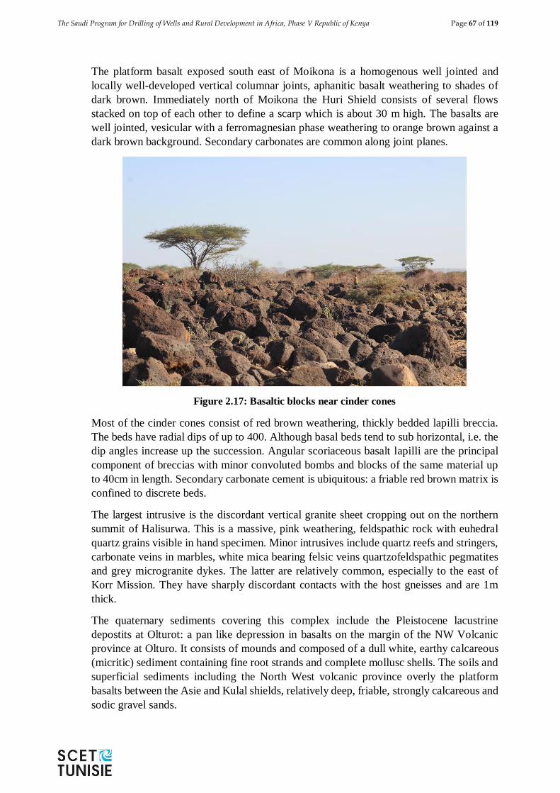
The Saudi Program for Drilling of Wells and Rural Development in Africa, Phase V Republic of Kenya Page 67 of 119
The platform basalt exposed south east of Moikona is a homogenous well jointed and
locally well-developed vertical columnar joints, aphanitic basalt weathering to shades of
dark brown. Immediately north of Moikona the Huri Shield consists of several flows
stacked on top of each other to define a scarp which is about 30 m high. The basalts are
well jointed, vesicular with a ferromagnesian phase weathering to orange brown against a
dark brown background. Secondary carbonates are common along joint planes.
Figure 2.17: Basaltic blocks near cinder cones
Most of the cinder cones consist of red brown weathering, thickly bedded lapilli breccia.
The beds have radial dips of up to 400. Although basal beds tend to sub horizontal, i.e. the
dip angles increase up the succession. Angular scoriaceous basalt lapilli are the principal
component of breccias with minor convoluted bombs and blocks of the same material up
to 40cm in length. Secondary carbonate cement is ubiquitous: a friable red brown matrix is
confined to discrete beds.
The largest intrusive is the discordant vertical granite sheet cropping out on the northern
summit of Halisurwa. This is a massive, pink weathering, feldspathic rock with euhedral
quartz grains visible in hand specimen. Minor intrusives include quartz reefs and stringers,
carbonate veins in marbles, white mica bearing felsic veins quartzofeldspathic pegmatites
and grey microgranite dykes. The latter are relatively common, especially to the east of
Korr Mission. They have sharply discordant contacts with the host gneisses and are 1m
thick.
The quaternary sediments covering this complex include the Pleistocene lacustrine
depostits at Olturot: a pan like depression in basalts on the margin of the NW Volcanic
province at Olturo. It consists of mounds and composed of a dull white, earthy calcareous
(micritic) sediment containing fine root strands and complete mollusc shells. The soils and
superficial sediments including the North West volcanic province overly the platform
basalts between the Asie and Kulal shields, relatively deep, friable, strongly calcareous and
sodic gravel sands.
The Saudi Program for Drilling of Wells and Rural Development in Africa, Phase V Republic of Kenya Page 68 of 119
Soils
The higher parts of Mts. Marsabit have rich volcanic soils which are well developed and
have high water retention capacity. On the lower slopes of the mountains, the soils are
basically cambisols. In some areas they are moderately deep clay loams; in others, the
soils are stony or rocky. These soils are generally suitable for agriculture and dairy
farming in those places with sufficient rainfall.
2.4.4 Topography
The Marsabit area can be divided into three physiographic units: The lava-capped plateaus
which rise from 50 to 200 feet above the plain, the dissected plain surface, which slopes
downwards in a north-easterly direction and the residual hills standing well above the level
of the plain, with summit heights ranging from 2,645 feet to 5,746 feet.
Mount Marsabit is an extinct volcano surrounded by expansive low lying arid plains formed
of weathered lava flows ranging in altitude from 300 to 900 m above sea level that slopes
gently towards South East. The highest point of the mountain is 1920 m above sea level.
Although Marsabit is the second largest and driest district in Kenya, the mountain area
benefits from its high elevation and receives a biannual distribution of rainfall ranging from
600 mm to 1000 mm annually. The combined effect of high altitude and fairly good rainfall
enables a tropical rainforest to thrive on nearly 80% of the entire mountain area. Over the
past four decade, 60 %( 40,000 Ha) of the riparian forest has been opened up for farming
and settlement development (including the District Headquarters). The remaining 40% (15,
280 Ha) is the gazetted forest area, which is also the Marsabit National Park, which was
home to legendary elephant Ahmed
Marsabit Town is founded on Mount Marsabit and it is embedded between three other hills.
It generally slopes from North East to South West Marsabit Town and has three distinct
drainages as follows:-
1. Jaldesa lagga passing below the District headquarter. It drains most of
Mountain Location which forms most of the Central Business District of
Marsabit Town.
2. Hari Henry Drainage –It drains Nagoya and Part of Dakabaricha locations.
3. Halbota Pan-Slaughter House/Senegai Airstrip drainages the remaining part
of Marsabit Town constituting 25%.
2.4.5 Hydrology
There are three principal water horizons in the district; the upper horizon of mountains and
hills, over 1500 m to the summits of mount Marsabit and Kulai where there are a number
of springs; the second horizon 1,200 m to 1,500 m still on the mountains, on mount
Marsabit springs like Badassa, Songa and Balesa Bongole are at these levels. The rest of
the district which generally lies between 400 m – 460 m depends mostly on underground
water. In these areas, the ground water table varies greatly.
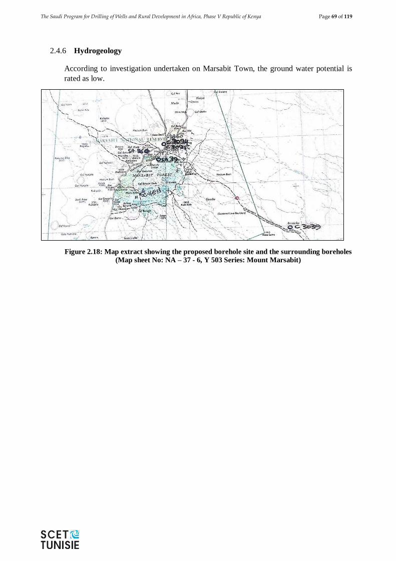
The Saudi Program for Drilling of Wells and Rural Development in Africa, Phase V Republic of Kenya Page 69 of 119
2.4.6 Hydrogeology
According to investigation undertaken on Marsabit Town, the ground water potential is
rated as low.
Figure 2.18: Map extract showing the proposed borehole site and the surrounding boreholes
(Map sheet No: NA – 37 - 6, Y 503 Series: Mount Marsabit)
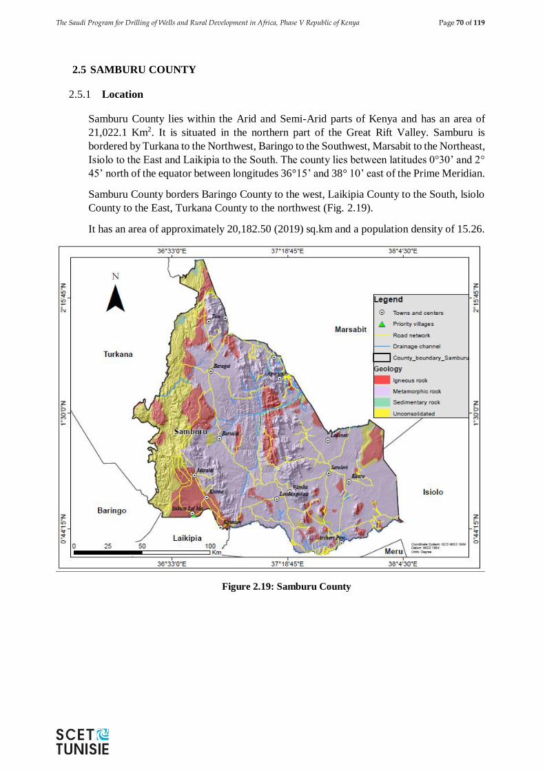
The Saudi Program for Drilling of Wells and Rural Development in Africa, Phase V Republic of Kenya Page 70 of 119
2.5 SAMBURU COUNTY
2.5.1 Location
Samburu County lies within the Arid and Semi-Arid parts of Kenya and has an area of
21,022.1 Km2. It is situated in the northern part of the Great Rift Valley. Samburu is
bordered by Turkana to the Northwest, Baringo to the Southwest, Marsabit to the Northeast,
Isiolo to the East and Laikipia to the South. The county lies between latitudes 0°30’ and 2°
45’ north of the equator between longitudes 36°15’ and 38° 10’ east of the Prime Meridian.
Samburu County borders Baringo County to the west, Laikipia County to the South, lsiolo
County to the East, Turkana County to the northwest (Fig. 2.19).
It has an area of approximately 20,182.50 (2019) sq.km and a population density of 15.26.
Figure 2.19: Samburu County
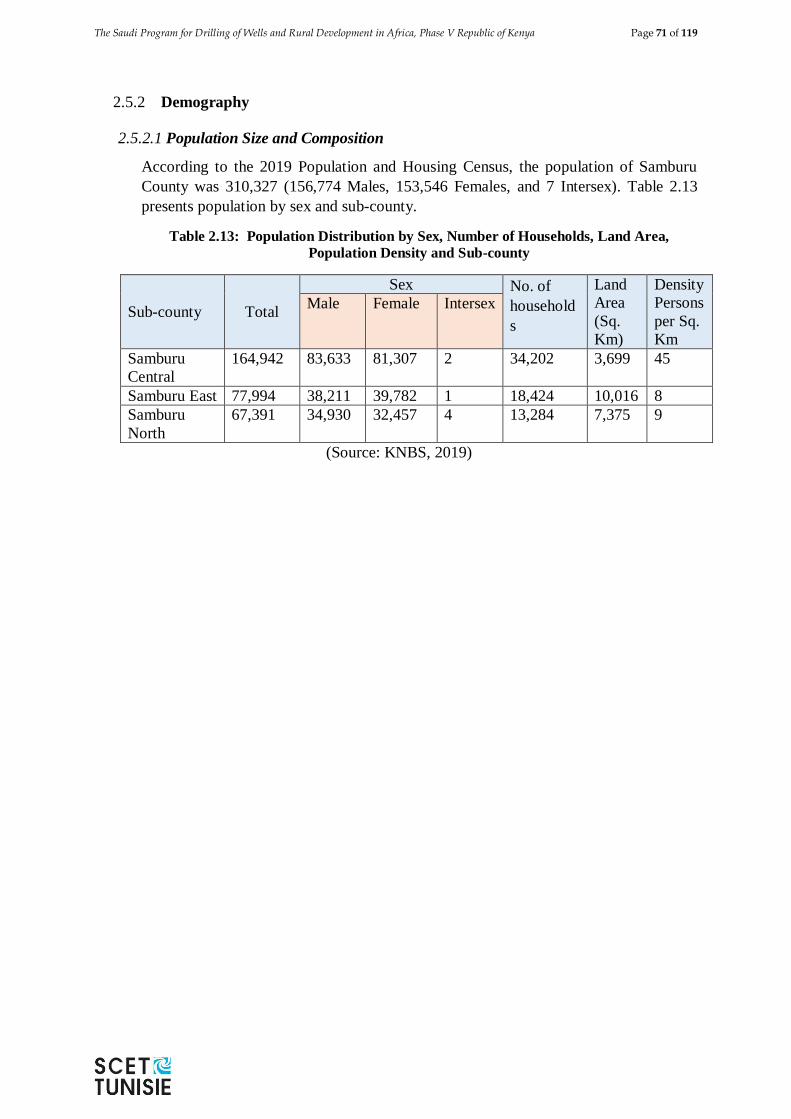
The Saudi Program for Drilling of Wells and Rural Development in Africa, Phase V Republic of Kenya Page 71 of 119
2.5.2 Demography
2.5.2.1 Population Size and Composition
According to the 2019 Population and Housing Census, the population of Samburu
County was 310,327 (156,774 Males, 153,546 Females, and 7 Intersex). Table 2.13
presents population by sex and sub-county.
Table 2.13: Population Distribution by Sex, Number of Households, Land Area,
Population Density and Sub-county
Sub-county Total
Sex No. of
household
s
Land
Area
(Sq.
Km)
Density
Persons
per Sq.
Km
Male Female Intersex
Samburu
Central
164,942 83,633 81,307 2 34,202 3,699 45
Samburu East 77,994 38,211 39,782 1 18,424 10,016 8
Samburu
North
67,391 34,930 32,457 4 13,284 7,375 9
(Source: KNBS, 2019)
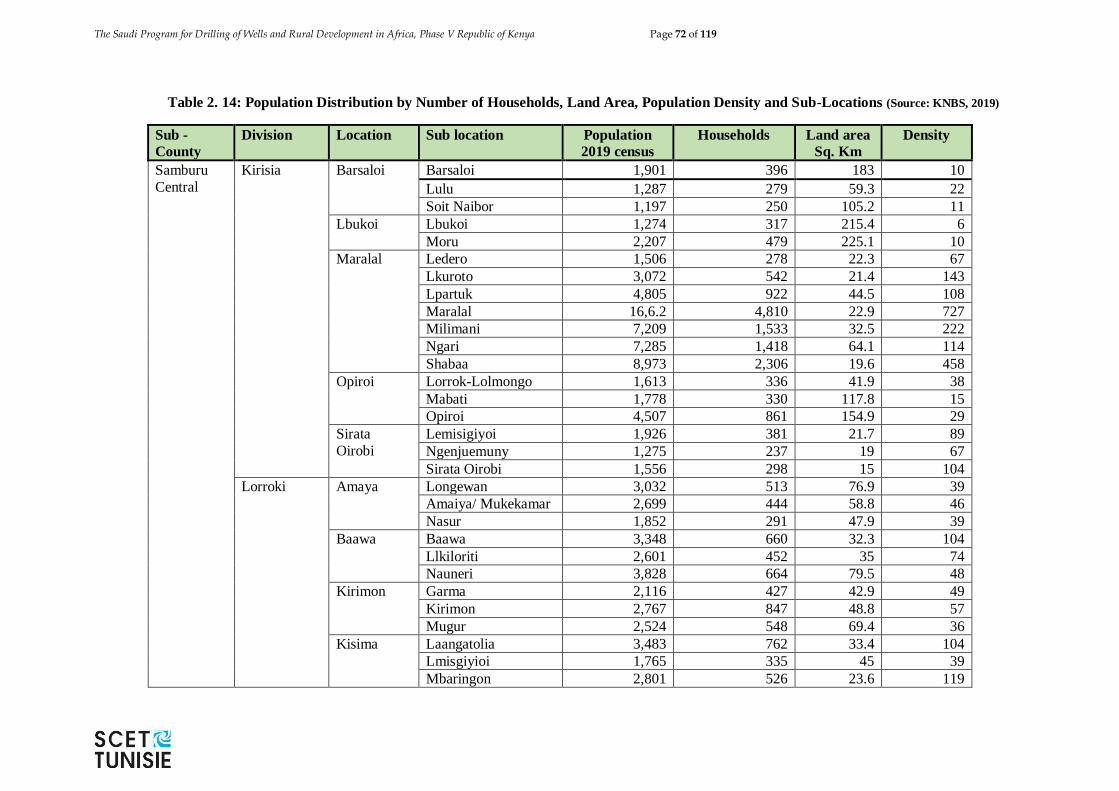
The Saudi Program for Drilling of Wells and Rural Development in Africa, Phase V Republic of Kenya Page 72 of 119
Table 2. 14: Population Distribution by Number of Households, Land Area, Population Density and Sub-Locations (Source: KNBS, 2019)
Sub -
County
Division Location Sub location Population
2019 census
Households Land area
Sq. Km
Density
Samburu
Central
Kirisia Barsaloi Barsaloi 1,901 396 183 10
Lulu 1,287 279 59.3 22
Soit Naibor 1,197 250 105.2 11
Lbukoi Lbukoi 1,274 317 215.4 6
Moru 2,207 479 225.1 10
Maralal Ledero 1,506 278 22.3 67
Lkuroto 3,072 542 21.4 143
Lpartuk 4,805 922 44.5 108
Maralal 16,6.2 4,810 22.9 727
Milimani 7,209 1,533 32.5 222
Ngari 7,285 1,418 64.1 114
Shabaa 8,973 2,306 19.6 458
Opiroi Lorrok-Lolmongo 1,613 336 41.9 38
Mabati 1,778 330 117.8 15
Opiroi 4,507 861 154.9 29
Sirata
Oirobi
Lemisigiyoi 1,926 381 21.7 89
Ngenjuemuny 1,275 237 19 67
Sirata Oirobi 1,556 298 15 104
Lorroki Amaya Longewan 3,032 513 76.9 39
Amaiya/ Mukekamar 2,699 444 58.8 46
Nasur 1,852 291 47.9 39
Baawa Baawa 3,348 660 32.3 104
Llkiloriti 2,601 452 35 74
Nauneri 3,828 664 79.5 48
Kirimon Garma 2,116 427 42.9 49
Kirimon 2,767 847 48.8 57
Mugur 2,524 548 69.4 36
Kisima Laangatolia 3,483 762 33.4 104
Lmisgiyioi 1,765 335 45 39
Mbaringon 2,801 526 23.6 119
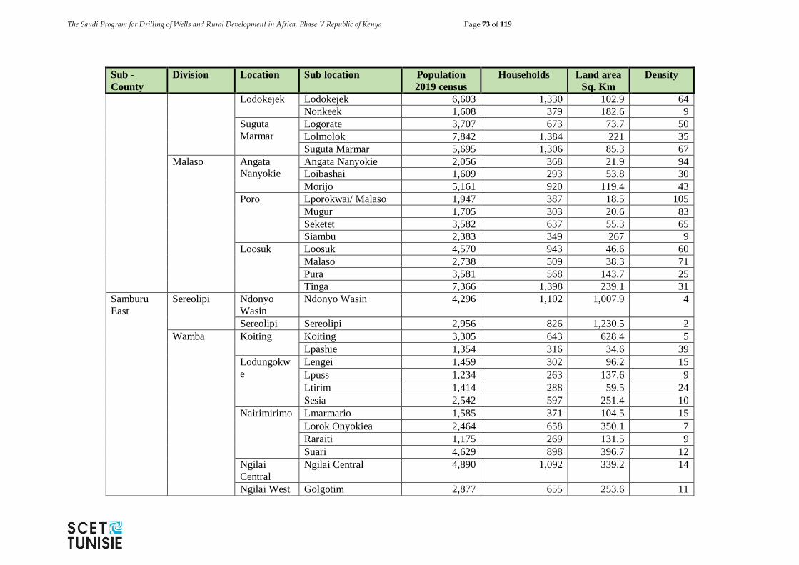
The Saudi Program for Drilling of Wells and Rural Development in Africa, Phase V Republic of Kenya Page 73 of 119
Sub -
County
Division Location Sub location Population
2019 census
Households Land area
Sq. Km
Density
Lodokejek Lodokejek 6,603 1,330 102.9 64
Nonkeek 1,608 379 182.6 9
Suguta
Marmar
Logorate 3,707 673 73.7 50
Lolmolok 7,842 1,384 221 35
Suguta Marmar 5,695 1,306 85.3 67
Malaso Angata Nanyokie
Angata Nanyokie 2,056 368 21.9 94
Loibashai 1,609 293 53.8 30
Morijo 5,161 920 119.4 43
Poro Lporokwai/ Malaso 1,947 387 18.5 105
Mugur 1,705 303 20.6 83
Seketet 3,582 637 55.3 65
Siambu 2,383 349 267 9
Loosuk Loosuk 4,570 943 46.6 60
Malaso 2,738 509 38.3 71
Pura 3,581 568 143.7 25
Tinga 7,366 1,398 239.1 31
Samburu
East
Sereolipi Ndonyo
Wasin
Ndonyo Wasin 4,296 1,102 1,007.9 4
Sereolipi Sereolipi 2,956 826 1,230.5 2
Wamba Koiting Koiting 3,305 643 628.4 5
Lpashie 1,354 316 34.6 39
Lodungokw
e
Lengei 1,459 302 96.2 15
Lpuss 1,234 263 137.6 9
Ltirim 1,414 288 59.5 24
Sesia 2,542 597 251.4 10
Nairimirimo Lmarmario 1,585 371 104.5 15
Lorok Onyokiea 2,464 658 350.1 7
Raraiti 1,175 269 131.5 9
Suari 4,629 898 396.7 12
Ngilai
Central
Ngilai Central 4,890 1,092 339.2 14
Ngilai West Golgotim 2,877 655 253.6 11
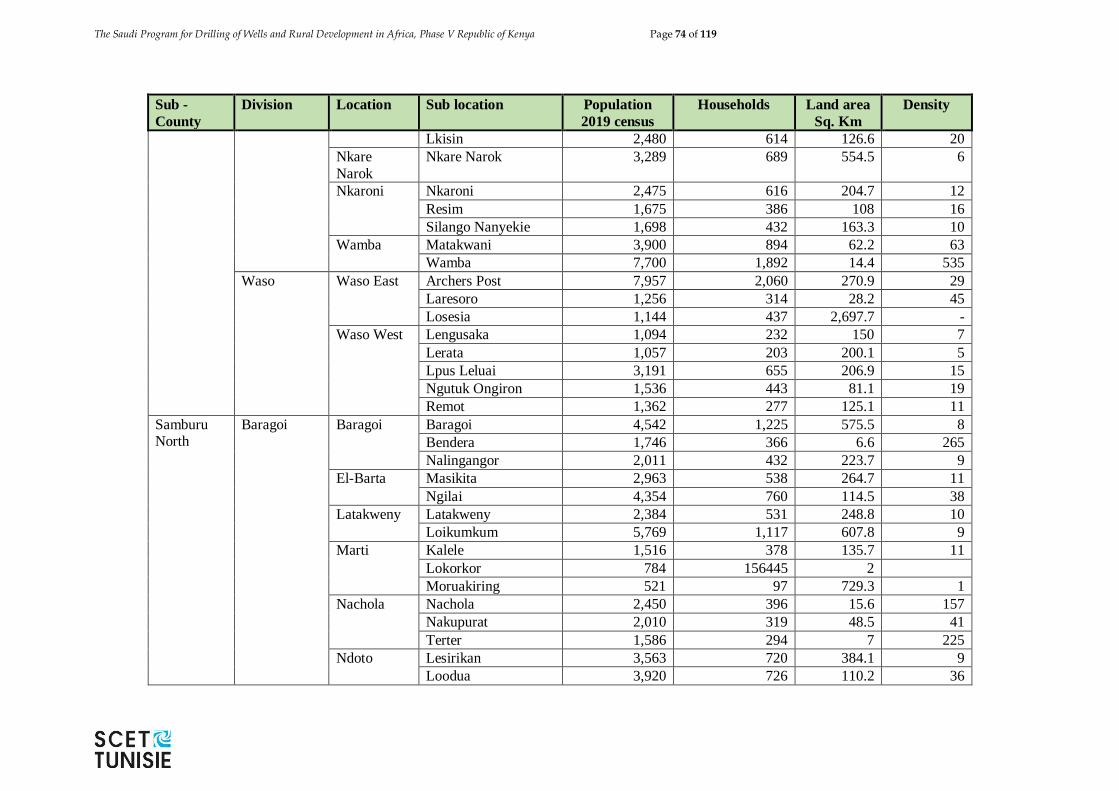
The Saudi Program for Drilling of Wells and Rural Development in Africa, Phase V Republic of Kenya Page 74 of 119
Sub -
County
Division Location Sub location Population
2019 census
Households Land area
Sq. Km
Density
Lkisin 2,480 614 126.6 20
Nkare
Narok
Nkare Narok 3,289 689 554.5 6
Nkaroni Nkaroni 2,475 616 204.7 12
Resim 1,675 386 108 16
Silango Nanyekie 1,698 432 163.3 10
Wamba Matakwani 3,900 894 62.2 63
Wamba 7,700 1,892 14.4 535
Waso Waso East Archers Post 7,957 2,060 270.9 29
Laresoro 1,256 314 28.2 45
Losesia 1,144 437 2,697.7 -
Waso West Lengusaka 1,094 232 150 7
Lerata 1,057 203 200.1 5
Lpus Leluai 3,191 655 206.9 15
Ngutuk Ongiron 1,536 443 81.1 19
Remot 1,362 277 125.1 11
Samburu North
Baragoi Baragoi Baragoi 4,542 1,225 575.5 8
Bendera 1,746 366 6.6 265
Nalingangor 2,011 432 223.7 9
El-Barta Masikita 2,963 538 264.7 11
Ngilai 4,354 760 114.5 38
Latakweny Latakweny 2,384 531 248.8 10
Loikumkum 5,769 1,117 607.8 9
Marti Kalele 1,516 378 135.7 11
Lokorkor 784 156445 2
Moruakiring 521 97 729.3 1
Nachola Nachola 2,450 396 15.6 157
Nakupurat 2,010 319 48.5 41
Terter 1,586 294 7 225
Ndoto Lesirikan 3,563 720 384.1 9
Loodua 3,920 726 110.2 36
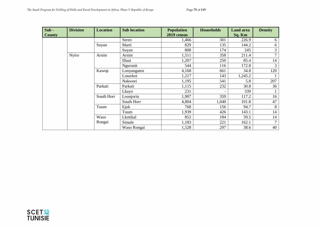
The Saudi Program for Drilling of Wells and Rural Development in Africa, Phase V Republic of Kenya Page 75 of 119
Sub -
County
Division Location Sub location Population
2019 census
Households Land area
Sq. Km
Density
Seren 1,466 301 226.9 6
Suyan Marti 829 135 144.2 6
Suyan 808 174 245 3
Nyiro Arsim Arsim 1,511 358 211.4 7
Illaut 1,207 250 85.4 14
Ngurunit 544 116 172.8 3
Kawop Lonyangaten 4,168 661 34.8 120
Losurkoi 1,217 143 1,245.2 1
Nakweei 1,195 541 5.8 207
Parkati Parkati 1,115 232 30.8 36
Lkayo 231 - 339 1
South Horr Loonjorin 1,907 359 117.2 16
South Horr 4,804 1,040 101.8 47
Tuum Ejuk 768 156 94.7 8
Tuum 1,939 426 143.1 14
Waso
Rongai
Lkotikal 852 184 59.5 14
Simale 1,183 221 162.1 7
Waso Rongai 1,528 297 38.6 40
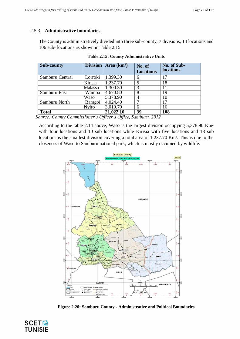
The Saudi Program for Drilling of Wells and Rural Development in Africa, Phase V Republic of Kenya Page 76 of 119
2.5.3 Administrative boundaries
The County is administratively divided into three sub-county, 7 divisions, 14 locations and
106 sub- locations as shown in Table 2.15.
Table 2.15: County Administrative Units
Sub-county Division Area (km²) No. of
Locations
No. of Sub-locations
Samburu Central Lorroki 1,399.30 6 17
Kirisia 1,237.70 5 18 Malasso 1,300.30 3 11
Samburu East Wamba 4,670.80 8 19 Waso 5,378.90 4 10
Samburu North Baragoi 4,024.40 7 17 Nyiro 3,010.70 6 16
Total 21,022.10 39 108 Source: County Commissioner‘s Officer‘s Office, Samburu, 2012
According to the table 2.14 above, Waso is the largest division occupying 5,378.90 Km²
with four locations and 10 sub locations while Kirisia with five locations and 18 sub
locations is the smallest division covering a total area of 1,237.70 Km². This is due to the
closeness of Waso to Samburu national park, which is mostly occupied by wildlife.
Figure 2.20: Samburu County - Administrative and Political Boundaries
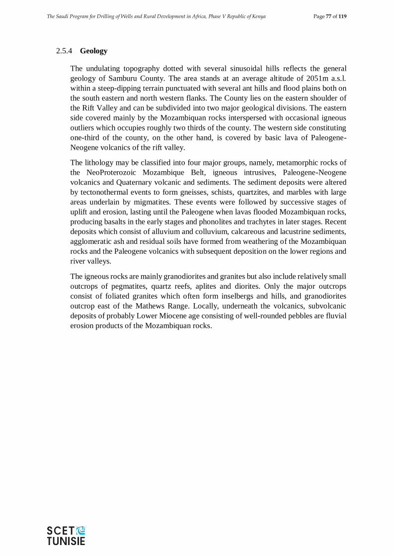
The Saudi Program for Drilling of Wells and Rural Development in Africa, Phase V Republic of Kenya Page 77 of 119
2.5.4 Geology
The undulating topography dotted with several sinusoidal hills reflects the general
geology of Samburu County. The area stands at an average altitude of 2051m a.s.l.
within a steep-dipping terrain punctuated with several ant hills and flood plains both on
the south eastern and north western flanks. The County lies on the eastern shoulder of
the Rift Valley and can be subdivided into two major geological divisions. The eastern
side covered mainly by the Mozambiquan rocks interspersed with occasional igneous
outliers which occupies roughly two thirds of the county. The western side constituting
one-third of the county, on the other hand, is covered by basic lava of Paleogene-
Neogene volcanics of the rift valley.
The lithology may be classified into four major groups, namely, metamorphic rocks of
the NeoProterozoic Mozambique Belt, igneous intrusives, Paleogene-Neogene
volcanics and Quaternary volcanic and sediments. The sediment deposits were altered
by tectonothermal events to form gneisses, schists, quartzites, and marbles with large
areas underlain by migmatites. These events were followed by successive stages of
uplift and erosion, lasting until the Paleogene when lavas flooded Mozambiquan rocks,
producing basalts in the early stages and phonolites and trachytes in later stages. Recent
deposits which consist of alluvium and colluvium, calcareous and lacustrine sediments,
agglomeratic ash and residual soils have formed from weathering of the Mozambiquan
rocks and the Paleogene volcanics with subsequent deposition on the lower regions and
river valleys.
The igneous rocks are mainly granodiorites and granites but also include relatively small
outcrops of pegmatites, quartz reefs, aplites and diorites. Only the major outcrops
consist of foliated granites which often form inselbergs and hills, and granodiorites
outcrop east of the Mathews Range. Locally, underneath the volcanics, subvolcanic
deposits of probably Lower Miocene age consisting of well-rounded pebbles are fluvial
erosion products of the Mozambiquan rocks.
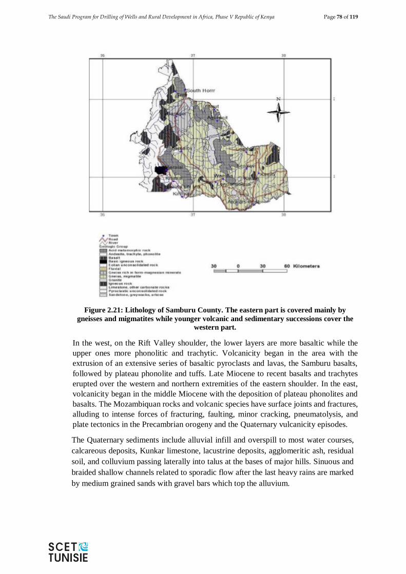
The Saudi Program for Drilling of Wells and Rural Development in Africa, Phase V Republic of Kenya Page 78 of 119
Figure 2.21: Lithology of Samburu County. The eastern part is covered mainly by
gneisses and migmatites while younger volcanic and sedimentary successions cover the
western part.
In the west, on the Rift Valley shoulder, the lower layers are more basaltic while the
upper ones more phonolitic and trachytic. Volcanicity began in the area with the
extrusion of an extensive series of basaltic pyroclasts and lavas, the Samburu basalts,
followed by plateau phonolite and tuffs. Late Miocene to recent basalts and trachytes
erupted over the western and northern extremities of the eastern shoulder. In the east,
volcanicity began in the middle Miocene with the deposition of plateau phonolites and
basalts. The Mozambiquan rocks and volcanic species have surface joints and fractures,
alluding to intense forces of fracturing, faulting, minor cracking, pneumatolysis, and
plate tectonics in the Precambrian orogeny and the Quaternary vulcanicity episodes.
The Quaternary sediments include alluvial infill and overspill to most water courses,
calcareous deposits, Kunkar limestone, lacustrine deposits, agglomeritic ash, residual
soil, and colluvium passing laterally into talus at the bases of major hills. Sinuous and
braided shallow channels related to sporadic flow after the last heavy rains are marked
by medium grained sands with gravel bars which top the alluvium.
The Saudi Program for Drilling of Wells and Rural Development in Africa, Phase V Republic of Kenya Page 79 of 119
2.5.5 Topography
The County of Samburu falls on the northern interface between highlands and lowlands.
To extreme west is Suguta Valley which is bounded on both sides by fault escarpments
and floored by red clays, boulders and gravel fans. In the East of Suguta Valley, the
County is characterized by repeated extensive high-level plateaus which have been built
by repeated floods of lava from the Rift valley. The highest parts of these plateaus are
the Kirisia Hill, rising to 2000 m above sea level.
In the North of Baragoi - Tuum and South –Horr axis, the area rises to Mount Nyiro
tapers northwards and falls steeply southwards. South and west of Mount Nyiro are
peneplains which have been eroded to plains of lower levels ranging from 1000-1,350
m above sea level. These are noticeable at Kawap and the area between Lodungokwe
and Wamba continuing eastwards and southwards. These plains are covered by red soils
and sands derived from the adjacent slopes by sheet erosion. East of the central plains
are the Mathew Ranges and the Ndoto mountains forming discontinuous ranges tending
towards north-south of the eastern side of the county. Apart from the Lorroki plateau
and the mountain ranges of Nyiro and Mathews, the rest of the County is a continuous
basin which slopes northwards to Lake Turkana and east of Mathew Ranges. The high
altitude of the plateau and the mountain ranges has resulted in indigenous forests which
are all gazetted and preserved for rain catchments.
2.5.6 Hydrology
In Samburu, surface water is available in small quantities from River Ewaso Ngiro, the
only major perennial river, at the southern border. High rainfall of about 700-1000
mm/year in the mountain ranges recharges springs in the lowlands. Most rivers in
Samburu flow for short periods after rain. Dams and pans are common but their storage
capacities have been reduced by siltation. The chemical quality of the surface water is
generally good; however, bacterial contamination is common.
The river channel that would discharge into the Suyien dam has been colonized by
vegetation while the forested arm of the river blocks flow into the dam. The river
channels and laggas (dry river valleys) are fracture-controlled as is manifested by
sudden angular changes in the channel courses. Major lineaments trending roughly
north-south were observed from both the aerial photographs and LandSat imageries. A
large Quaternary alluvial patch has formed south of Maralal town along the convergence
of major laggas. These alluvial sediments are generally shallow and of limited extent to
allow groundwater occurrence in significant quantities. Additionally, groundwater
fluctuates due to short recharge periods and prolonged droughts. Although groundwater
quality in laggas sediments is usually good, it is perceptible to bacteriological
contamination especially in unprotected dug wells with some indication of salinity.
2.5.7 Hydrogeology
The Mozambiquan rocks and the young volcanics found in Samburu west of the study
area are fairly fractured and hold groundwater in fractures, faults, as well as the contact
zones between the volcanics and the metamorphic rocks or in the weathered zones.
However, fractures and faults are of limited extent and therefore groundwater quantities
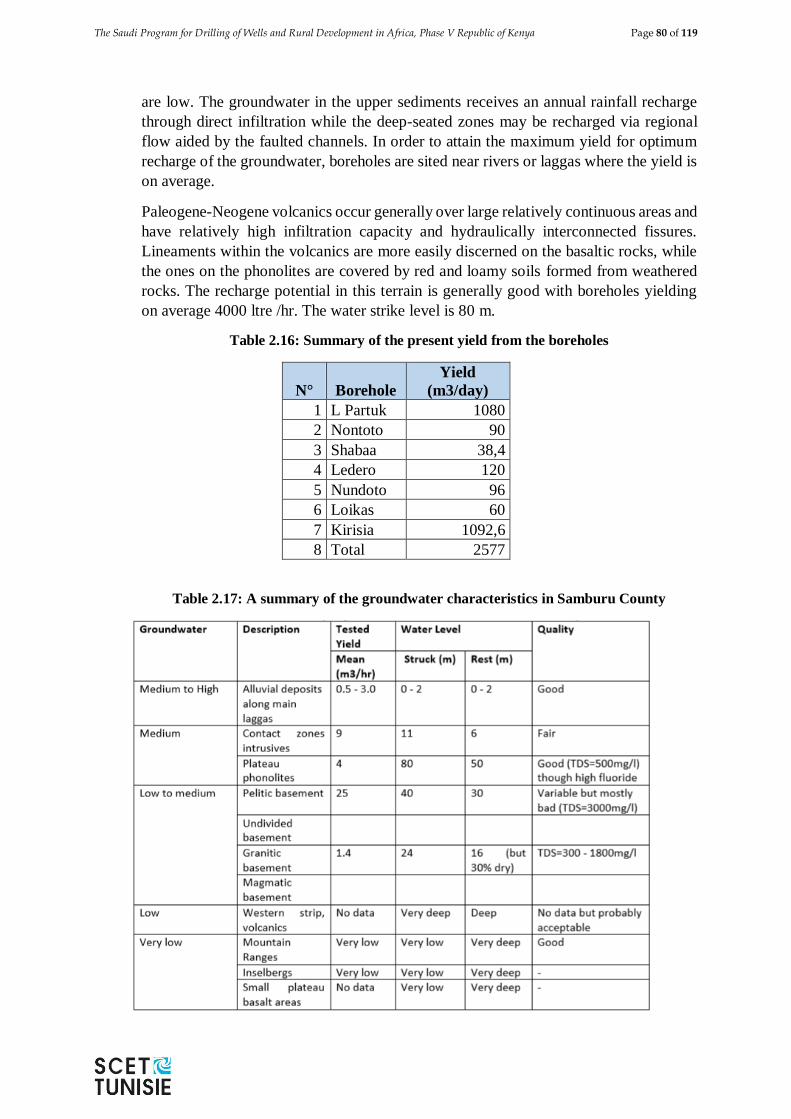
The Saudi Program for Drilling of Wells and Rural Development in Africa, Phase V Republic of Kenya Page 80 of 119
are low. The groundwater in the upper sediments receives an annual rainfall recharge
through direct infiltration while the deep-seated zones may be recharged via regional
flow aided by the faulted channels. In order to attain the maximum yield for optimum
recharge of the groundwater, boreholes are sited near rivers or laggas where the yield is
on average.
Paleogene-Neogene volcanics occur generally over large relatively continuous areas and
have relatively high infiltration capacity and hydraulically interconnected fissures.
Lineaments within the volcanics are more easily discerned on the basaltic rocks, while
the ones on the phonolites are covered by red and loamy soils formed from weathered
rocks. The recharge potential in this terrain is generally good with boreholes yielding
on average 4000 ltre /hr. The water strike level is 80 m.
Table 2.16: Summary of the present yield from the boreholes
N° Borehole
Yield
(m3/day)
1 L Partuk 1080
2 Nontoto 90
3 Shabaa 38,4
4 Ledero 120
5 Nundoto 96
6 Loikas 60
7 Kirisia 1092,6
8 Total 2577
Table 2.17: A summary of the groundwater characteristics in Samburu County
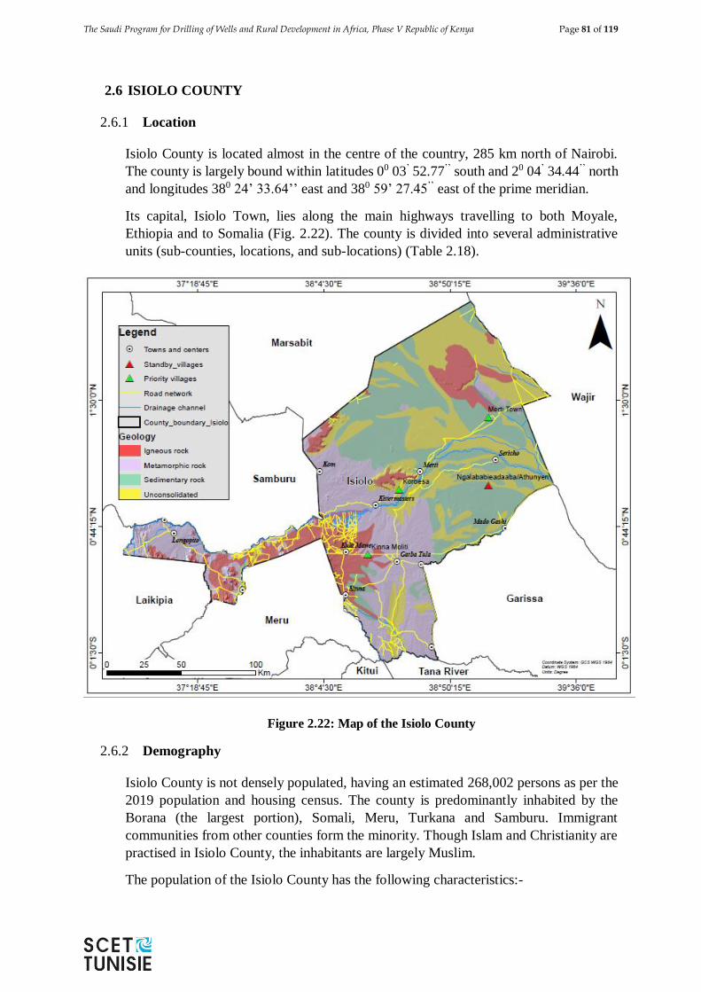
The Saudi Program for Drilling of Wells and Rural Development in Africa, Phase V Republic of Kenya Page 81 of 119
2.6 ISIOLO COUNTY
2.6.1 Location
Isiolo County is located almost in the centre of the country, 285 km north of Nairobi.
The county is largely bound within latitudes 00 03’ 52.77’’ south and 20 04’ 34.44’’ north
and longitudes 380 24’ 33.64’’ east and 380 59’ 27.45’’ east of the prime meridian.
Its capital, Isiolo Town, lies along the main highways travelling to both Moyale,
Ethiopia and to Somalia (Fig. 2.22). The county is divided into several administrative
units (sub-counties, locations, and sub-locations) (Table 2.18).
Figure 2.22: Map of the Isiolo County
2.6.2 Demography
Isiolo County is not densely populated, having an estimated 268,002 persons as per the
2019 population and housing census. The county is predominantly inhabited by the
Borana (the largest portion), Somali, Meru, Turkana and Samburu. Immigrant
communities from other counties form the minority. Though Islam and Christianity are
practised in Isiolo County, the inhabitants are largely Muslim.
The population of the Isiolo County has the following characteristics:-
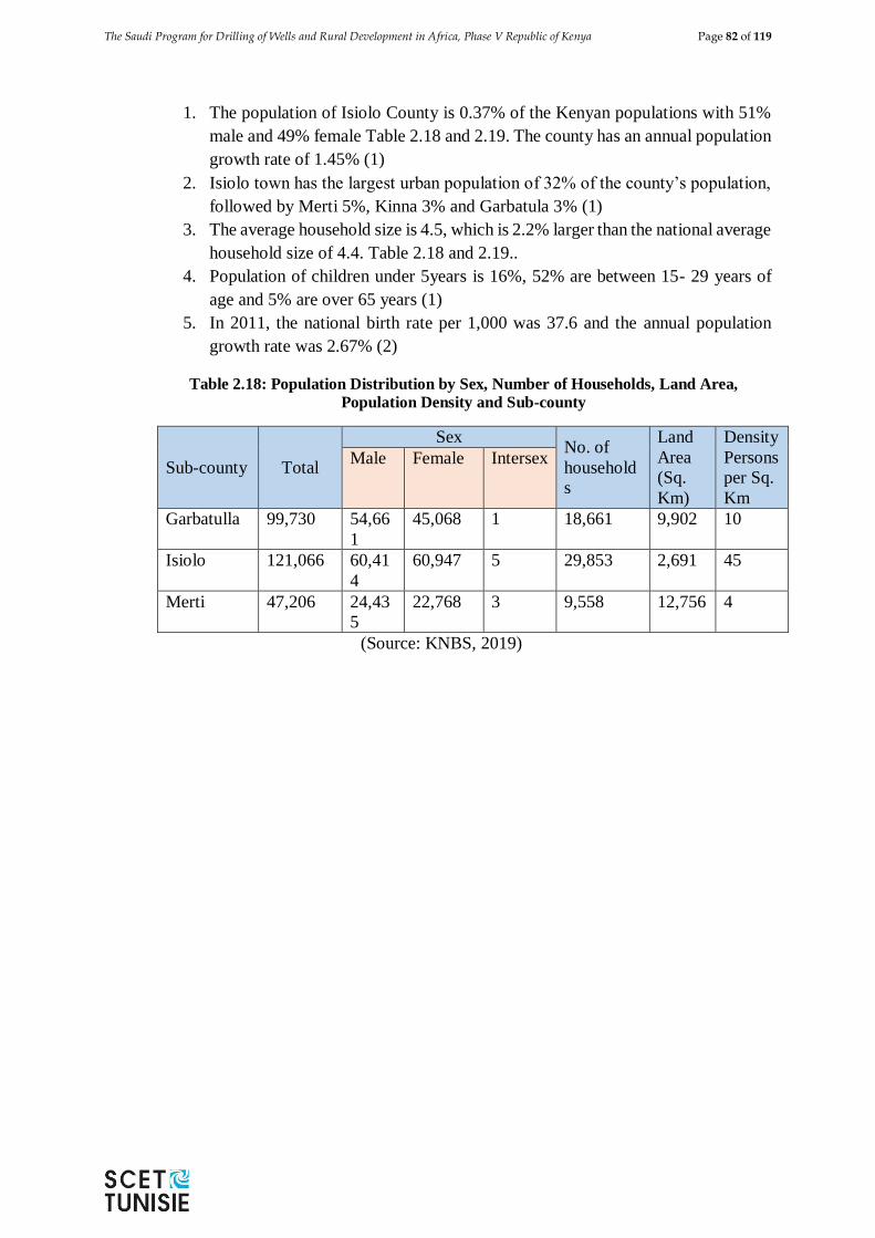
The Saudi Program for Drilling of Wells and Rural Development in Africa, Phase V Republic of Kenya Page 82 of 119
1. The population of Isiolo County is 0.37% of the Kenyan populations with 51%
male and 49% female Table 2.18 and 2.19. The county has an annual population
growth rate of 1.45% (1)
2. Isiolo town has the largest urban population of 32% of the county’s population,
followed by Merti 5%, Kinna 3% and Garbatula 3% (1)
3. The average household size is 4.5, which is 2.2% larger than the national average
household size of 4.4. Table 2.18 and 2.19..
4. Population of children under 5years is 16%, 52% are between 15- 29 years of
age and 5% are over 65 years (1)
5. In 2011, the national birth rate per 1,000 was 37.6 and the annual population
growth rate was 2.67% (2)
Table 2.18: Population Distribution by Sex, Number of Households, Land Area,
Population Density and Sub-county
Sub-county Total
Sex No. of
household
s
Land
Area
(Sq.
Km)
Density
Persons
per Sq.
Km
Male Female Intersex
Garbatulla 99,730 54,66
1
45,068 1 18,661 9,902 10
Isiolo 121,066 60,41
4
60,947 5 29,853 2,691 45
Merti 47,206 24,43
5
22,768 3 9,558 12,756 4
(Source: KNBS, 2019)
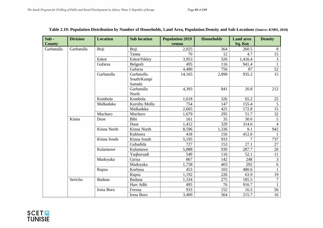
The Saudi Program for Drilling of Wells and Rural Development in Africa, Phase V Republic of Kenya Page 83 of 119
Table 2.19: Population Distribution by Number of Households, Land Area, Population Density and Sub-Locations (Source: KNBS, 2019)
Sub -
County
Division Location Sub location Population 2019
census
Households Land area
Sq. Km
Density
Garbatulla Garbatulla
Boji Boji 2,025 364 260.5 8
Tanna 70 12 4.7 15
Eskot Eskot/Sikley 3,953 326 1,416.4 3
Gafarsa Belgesh 495 116 941.4 1
Gafarsa 4,480 756 87 52
Garbatulla
Garbatulla
South/Kampi
Samaki
14,165 2,890 935.2 15
Garbatulla
North
4,393 841 20.8 212
Kombola Kombola 1,618 326 65.2 25
Malkadaka Kuroftu Mollu 754 147 155.4 5
Malkadaka 2,665 425 172.8 15
Muchuro Muchuro 1,679 295 51.7 32
Kinna Duse Bibi 161 35 30.6 5
Duse 1,412 329 314.6 4
Kinna North Kinna North 8,596 1,336 9.1 942
Kubisera 418 156 412.6 1
Kinna South Kinna South 5,195 933 7 737
Gubadida 727 153 27.1 27
Kulamawe Kulamawe 5,888 930 287.7 20
Yaqbarsadi 549 116 52.1 11
Madoyaka Girisa 867 142 248 3
Madoyaka 1,758 403 292 6
Rapsu Korbesa 453 103 480.6 1
Rapsu 1,192 226 63.9 19
Sericho Badana Badana 1,334 275 185.5 7
Harr Adhi 495 76 916.7 1
Iresa Boru Forosa 933 152 16.5 56
Iresa Boru 3,400 564 215.7 16
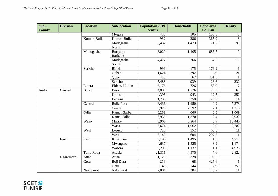
The Saudi Program for Drilling of Wells and Rural Development in Africa, Phase V Republic of Kenya Page 84 of 119
Sub -
County
Division Location Sub location Population 2019
census
Households Land area
Sq. Km
Density
Mogore 485 105 158.5 3
Komor_Bulla Komor_Bulla 932 286 365.9 3
Modogashe
North
6,437 1,473 71.7 90
Modogashe Burquqe/ Barkuke
6,020 1,105 685.7 9
Modogashe
South
4,477 766 37.5 119
Sericho Biliki 996 175 176.9 6
Gubatu 1,624 292 76 21
Qone 416 67 451.5 1
Sericho 5,488 939 23.6 232
Eldera Eldera/ Hudun 3,176 726 183.9 17
Isiolo Central Burat Burat 4,835 1,726 70.3 69
Kilimani 4,395 943 12.5 352
Leparua 1,739 358 125.6 14
Central Bulla Pesa 6,436 1,450 0.9 7,373
Central 8,923 2,392 2.1 4,215
Odha Kambi Garba 3,281 666 3.3 1,009
Kambi Odha 6,935 1,370 2.4 2,932
Waso Marire 8,962 3,264 0.9 10,446
Waso 6,674 1,962 2.9 2,282
West Loruko 736 152 65.8 11
West 3,149 604 297.7 11
East East Kiwanjani 6,196 1,495 1.3 4,717
Mwangaza 4,637 1,525 3.9 1,174
Wabera 5,295 1,137 1.1 4,923
Tullu Roba Acacia 21,311 4,575 7.6 2,822
Ngaremara Attan Attan 1,129 328 193.5 6
Gotu Boji Dera 216 68 425.6 1
Gotu 740 144 2.9 255
Nakupurat Nakupurat 2,004 384 178.7 11
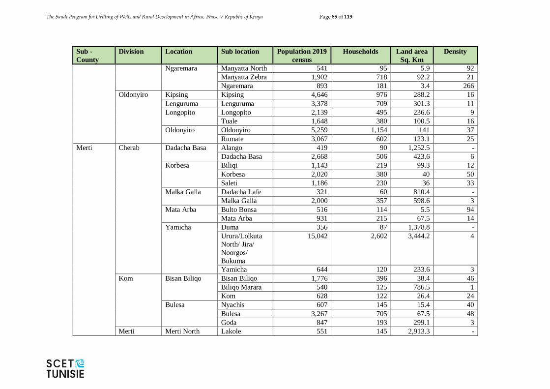
The Saudi Program for Drilling of Wells and Rural Development in Africa, Phase V Republic of Kenya Page 85 of 119
Sub -
County
Division Location Sub location Population 2019
census
Households Land area
Sq. Km
Density
Ngaremara Manyatta North 541 95 5.9 92
Manyatta Zebra 1,902 718 92.2 21
Ngaremara 893 181 3.4 266
Oldonyiro Kipsing Kipsing 4,646 976 288.2 16
Lenguruma Lenguruma 3,378 709 301.3 11
Longopito Longopito 2,139 495 236.6 9
Tuale 1,648 380 100.5 16
Oldonyiro Oldonyiro 5,259 1,154 141 37
Rumate 3,067 602 123.1 25
Merti Cherab Dadacha Basa Alango 419 90 1,252.5 -
Dadacha Basa 2,668 506 423.6 6
Korbesa Biliqi 1,143 219 99.3 12
Korbesa 2,020 380 40 50
Saleti 1,186 230 36 33
Malka Galla Dadacha Lafe 321 60 810.4 -
Malka Galla 2,000 357 598.6 3
Mata Arba Bulto Bonsa 516 114 5.5 94
Mata Arba 931 215 67.5 14
Yamicha Duma 356 87 1,378.8 -
Urura/Lolkuta
North/ Jira/
Noorgos/
Bukuma
15,042 2,602 3,444.2 4
Yamicha 644 120 233.6 3
Kom Bisan Biliqo Bisan Biliqo 1,776 396 38.4 46
Biliqo Marara 540 125 786.5 1
Kom 628 122 26.4 24
Bulesa Nyachis 607 145 15.4 40
Bulesa 3,267 705 67.5 48
Goda 847 193 299.1 3
Merti Merti North Lakole 551 145 2,913.3 -
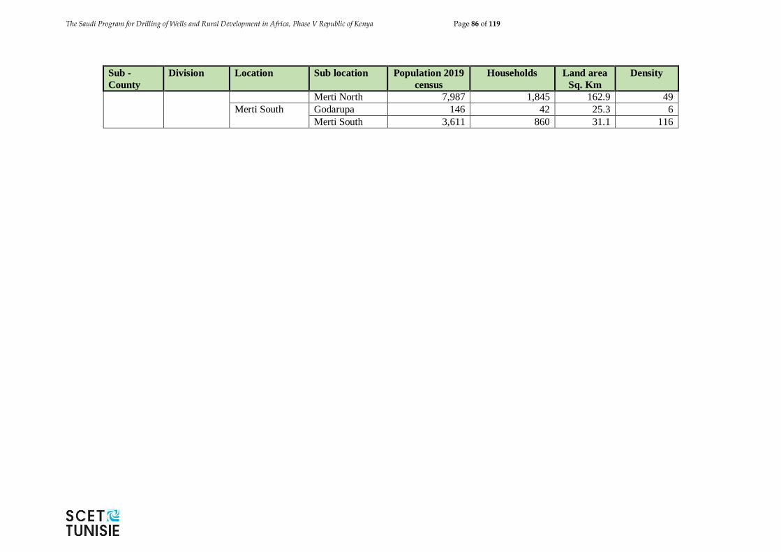
The Saudi Program for Drilling of Wells and Rural Development in Africa, Phase V Republic of Kenya Page 86 of 119
Sub -
County
Division Location Sub location Population 2019
census
Households Land area
Sq. Km
Density
Merti North 7,987 1,845 162.9 49
Merti South Godarupa 146 42 25.3 6
Merti South 3,611 860 31.1 116
The Saudi Program for Drilling of Wells and Rural Development in Africa, Phase V Republic of Kenya Page 87 of 119
2.6.3 Geology
The geology of the Isiolo County has been described in the "Geology of the Isiolo area"
(Hackman et al., 1989) and earlier by J.E. Mason in 1955 Geology of the Meru-Isiolo area".
In general, the geology is characterised by two major geological and lithological systems,
the Pre-Cambrian Basement System and the younger Tertiary basaltic lavas.
The Basement System rocks are the oldest in the area being of Precambrian age, and underlie
the entire Isiolo area. They comprise migmatites, several groups of paragneisses, and a
variety of intrusives. The paragneisses have been interpreted as meta-sediments ranging
from arkoses and sandstones through muddy sandstones to carbonaceous mudstones and
limestones. These rocks were affected by a complex sequence of six tectonothermal
episodes, which have been dated as late Proterozoic to Cambrian on the basis of radiometric
ages from intrusives, which range in composition from granite and trondhjemite through
syenitic orthogneiss to amphibolite and ultra-mafics.
The younger volcanic rocks found in the Isiolo area, are all associated with Mt. Kenya
volcanic activity. The oldest of these rocks are the Miocene phonolites. The volcanics
especially those in the south are dominated by the contemporary suites of lava and
pyroclastics making up the Mt. Kenya shield and Nyambene Hills. In the Mt. Kenya area,
the Ndare Forest Mugearites and Basalts form a major unit at least 200 m thick with local
centres of a more trachytic composition, overlying the phonolitic rocks. Following is a
succession of over 100 m of Pleistocene basalts, the Osirua Basalts, which are the most
relevant volcanic rocks as far as the study area, is concerned.
The county has a combination of metamorphic rocks and other superficial rock deposits.
Tertiary rocks (Olive Basalt) are found in the northern parts of the county, where oil
exploration has been going on. The areas covered with tertiary marine sediments have a high
potential for ground water harvesting.
The rocks of Isiolo county which covers the central part of the study area fall into two natural
and distinct sub-divisions: (a) the Archaean or Basement System rocks and (b) the
comparatively young Tertiary, Pleistocene and Recent extrusive rocks and subordinate
sediments
The basement system
The basement system forms the floor upon which all the remaining rocks of the area rest,
and consists of schists, granulites and heterogeneous gneisses of varying composition, such
as are widely distributed throughout East Africa.
Although the ancient Archaean rocks of Kenya have been metamorphosed to varying
degrees by regional metamorphism and granitization, so that in many cases their original
identity is difficult to decipher, it is generally accepted that they were originally laid down
as sedimentary deposits.
Tertiary to Recent Volcanic Activity, Erosion and Deposition.
The Saudi Program for Drilling of Wells and Rural Development in Africa, Phase V Republic of Kenya Page 88 of 119
North nearer Meru the partial succession reads: —
1. Basalts, tuffs and ashes of parasitic vents.
2. Upper olivine basalts.
3. Lower basalts, with kenyte and tuff.
The lower most plains are basalt and olivine basalt and rest on the sub-Miocene bevel.
Intercalated in this lower division near Mporiene, south-east of Meru, is a thin band of
highly weathered and densely porphyritic kenyte, which indicates a minor alkaline phase.
The entire division is thin, being not more than 500 ft. in thickness. The upper olivine basalts
overlie the lower basalts west of the meridian passing through Kienduri, and extend to the
western boundary of the area. They appear to, be much thicker than the lower basalts, but
owing to the fact that they probably overlie kenytes and phonolites, which reach a thickness
of 3,000 ft., further south, it would be unwise to estimate their thickness.
2.6.4 Topography
The Landforms and Soil types within Isiolo County is comprised twenty seven different
types of land, each with its own typical set of environmental characteristics and rangeland
qualities. They are grouped here as follows:
a. Landforms developed on Precambrian Basement System rocks.
b. Basalt plateaus of Plio - Pleistocene age (Merti's).
c. Basalt flows of Pleistocene - Recent age.
d. Sedimentary plains of marine origin (Plio - Pleistocene Bay sediments).
e. Piedmont plains, built up of sediments derived from Basement System rocks.
f. Older riverine sedimentary plains, to be separated in moderately well drained
sands, loams, clays; and imperfectly drained clay plains.
g. Younger riverine plains and present day Ewaso Ngiro floodplains.
The southern half of the Isiolo County is largely occupied by landforms developed on
gneisses of Precambrian age. They are mainly erosional plains (End - Tertiairy Peneplains)
of gently undulating relief. Part of these plains (the Garba Tula area dividing Tana River
and Ewaso Ngiro catchment) shows deep, strongly weathered and leached reddish sandy
clay loam soils. These are known as Wayama soils in local language. In broad zones along
the Ewaso Ngiro valley, and towards the Tana River, the plains are increasingly dissected,
and soils become more shallow and stony, and also richer in primary weatherable minerals
(Chari - soils in Boran). They are strongly calcareous over some large areas.
All Hills and Footslopes formed in Precambrian gneisses are rather limited in extent in
Isiolo, and occur mainly west of Isiolo Town.
In the Central and Northern part of the Isiolo County, as well as along the northwestern
border with Marsabit County, large table lands stand out in the otherwise almost flat
surrounding plains ("Merti's" in Samburu language). They originate from basalt (lava) flows
of Plio - Pleistocene age, deposited on the land-surface that existed by that time. The hard
basalt forms a protective "cap" over the softer underlying rock. Thus it has preserved the
The Saudi Program for Drilling of Wells and Rural Development in Africa, Phase V Republic of Kenya Page 89 of 119
original surface level from being eroded to the present day level of the surrounding plains.
The extensive, flat "table" surface is covered by very deep calcareous reddish brown clays,
often with scattered stones. These soils are called Malbe or Malbe-bule in Borani language.
The volcanic hill-mass of the Nyambeni's in Meru County has a series of basalt flows at its
base. These stretch North and North-West into Southern part of Isiolo County, covering the
Basement System erosional plains. The basalt flows are of various ages, ranging from
Pleistocene to Recent, consequently showing various degrees of stoniness and rockiness.
The topography is mainly almost flat, but "terraced" in small, level steps. Towards the
Nyambeni Hills, the topography is more sloping.
An extensive slightly undulating sedimentary area is formed by marine sediments (Bay-
sediments) of Plio-Pleistocene age. These constitute part of the so called "sealing loam"
plains of NE Kenya, which have a larger extent in Garissa and Wajir Counties on both sides
of the Ewaso Ngiro valley. Soils are characterized by a thin, structureless topsoil that
abruptly overlies a hard and massive, sodic subsoil. In upslope position soils have a thick
coarse sandy surface layer; downslope soils are more clayey. In spite of unfavourable
physical properties (from agricultural point of view) these Omara soils, as they are called
in Borani, reportedly are regarded as "the best" areas for goats and cattle.
Piedmont plains dominate the Central-Western part of the County. These extensive very
low-angle slopes are built of sediments deposited by numerous parallel ephemeral rivers.
These come from the erosional plains on Basement System rocks in the West. The land
almost imperceptibly slopes down towards the NE, with a very gently undulating
mesorelief. Higher parts have well drained, deep and compact sandy loam and clay loam
soils, partly with a sealed surface (Omara-dima in Borani). The lower parts have mostly
imperfectly to poorly drained clay soils (Halbe, Omara-bor).
The higher level area exists of fine sandy loams with numerous wide, round and shallow
depressions of more clayey soils. These depressions are ponded during the rains. This
probably causes the area to be densely frequented during this season, judging also by the
degraded aspect that the higher sandy soils offer. Sealing and wind erosion are prominent
features. Most of the Northern half of the County is covered by older riverine sedimentary
plains. They are the in-filled wide valley systems of both lagh Bogul and the joint
Milgis/Ewaso Ngiro. Higher level, moderately well drained areas of sandy soils can be
separated from lower lying, extensive flat clay plains of poorer drainage.
2.6.5 Hydrology
There are six perennial rivers in the county namely; Ewaso Ngiro North, Isiolo, Bisan-
gurach, Bisanadi, Likiundu and Liliaba rivers. Ewaso Ngiro North River has its catchments
area in the Aberdare ranges and Mount Kenya. It also serves as a boundary mark between
Isiolo North and Isiolo South constituencies. Isiolo River originates from Mount Kenya and
drains into Ewaso Ngiro River. Bisan- gurach and Bisanadi Rivers are found in the southern
part of the county and drains into the Tana River. Likiundu and Liliaba originate from
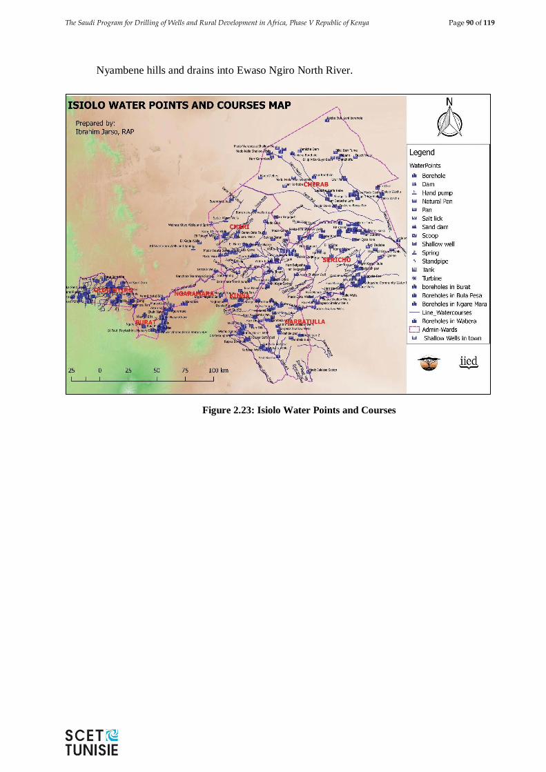
The Saudi Program for Drilling of Wells and Rural Development in Africa, Phase V Republic of Kenya Page 90 of 119
Nyambene hills and drains into Ewaso Ngiro North River.
Figure 2.23: Isiolo Water Points and Courses
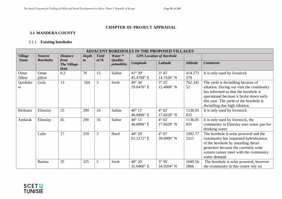
The Saudi Program for Drilling of Wells and Rural Development in Africa, Phase V Republic of Kenya Page 91 of 119
CHAPTER III: PROJECT APPRAISAL
3.1 MANDERA COUNTY
3.1.1 Existing boreholes
ADJACENT BOREHOLES IN THE PROPOSED VILLAGES
Village
Name
Nearest
Boreholes
Distance
from
The Village
(km)
Depth
m
Yield
m3/h
Water *
Quality: palatability
GPS Location of Borehole
Longitude Latitude Altitude Comments
Omar
Jillow
Omar
jillow
0.2 70 15 Saline 41° 39'
45.4788" E
3° 45'
14.7636" N
414.273
376
It is only used by livestock
Qurdobo
w
Gofa 13 264 3 fresh 40° 36'
19.0476" E
3° 25'
12.4968" N
762.345
52
The yield is dwindling because of
siltation. During our visit the community
has informed us that the borehole is
operational because it broke down early
this year. The yield of the borehole is
dwindling due high siltation.
Birikaan Elmolay 25 290 16 Saline 40° 11'
46.0896" E
4° 02'
17.6028" N
1136.05
835
It is only used by livestock
Andarak Elmolay 45 290 16 Saline 40° 11'
46.0896" E
4° 02'
17.6028" N
1136.05
835
It is only used by livestock, the
community in Elmolay uses water pan for
drinking water.
Lulis 17 310 3 Hard 40° 20'
02.3172" E
4° 01'
39.0000" N
1092.77
3315
The borehole is solar powered and the
community has requested hybridization
of the borehole by installing diesel
generator because the currently solar
system cannot meet with the community
water demand.
Banisa 35 325 5 fresh 40° 20'
35.6460" E
3° 56'
54.9204" N
1049.56
2866
The borehole is solar powered, however
the community in this centre rely on
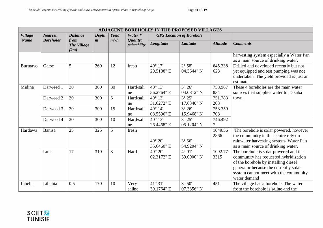
The Saudi Program for Drilling of Wells and Rural Development in Africa, Phase V Republic of Kenya Page 92 of 119
ADJACENT BOREHOLES IN THE PROPOSED VILLAGES
Village
Name
Nearest
Boreholes
Distance
from
The Village
(km)
Depth
m
Yield
m3/h
Water *
Quality: palatability
GPS Location of Borehole
Longitude Latitude Altitude Comments
harvesting system especially a Water Pan
as a main source of drinking water.
Burmayo Garse 5 260 12 fresh 40° 17'
20.5188" E
2° 58'
04.3644" N
645.338
623
Drilled and developed recently but not
yet equipped and test pumping was not
undertaken. The yield provided is just an
estimate.
Midina Darweed 1 30 300 30 Hard/sali
ne
40° 13'
56.2764" E
3° 26'
04.0812" N
758.967
834
These 4 boreholes are the main water
sources that supplies water to Takaba
town.
Darweed 2 30 300 5 Hard/sali
ne
40° 13'
31.6272" E
3° 25'
17.6340" N
751.783
203
Darweed 3 30 300 15 Hard/sali
ne
40° 14'
08.5596" E
3° 26'
15.9468" N
753.350
708
Darweed 4 30 300 10 Hard/sali
ne
40° 13'
26.4468" E
3° 25'
05.1204" N
746.492
7
Hardawa Banisa 25 325 5 fresh
40° 20'
35.6460" E
3° 56'
54.9204" N
1049.56
2866
The borehole is solar powered, however
the community in this centre rely on
rainwater harvesting system- Water Pan
as a main source of drinking water.
Lulis 17 310 3 Hard 40° 20'
02.3172" E
4° 01'
39.0000" N
1092.77
3315
The borehole is solar powered and the
community has requested hybridization
of the borehole by installing diesel
generator because the currently solar
system cannot meet with the community
water demand
Libehia Libehia 0.5 170 10 Very
saline
41° 31'
39.1764" E
3° 50'
07.3356" N
451 The village has a borehole. The water
from the borehole is saline and the
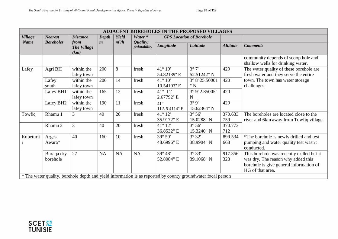
The Saudi Program for Drilling of Wells and Rural Development in Africa, Phase V Republic of Kenya Page 93 of 119
ADJACENT BOREHOLES IN THE PROPOSED VILLAGES
Village
Name
Nearest
Boreholes
Distance
from
The Village
(km)
Depth
m
Yield
m3/h
Water *
Quality: palatability
GPS Location of Borehole
Longitude Latitude Altitude Comments
community depends of scoop hole and
shallow wells for drinking water.
Lafey Agri BH within the
lafey town
200 8 fresh 41° 10'
54.82139'' E
3° 7'
52.51242" N
420 The water quality of these borehole are
fresh water and they serve the entire
town. The town has water storage
challenges. Lafey
south
within the
lafey town
200 14 fresh 41° 10'
10.54193'' E
3° 8' 25.50001
" N
420
Lafey BH1 within the
lafey town
165 12 fresh 41° 11'
2.67792'' E
3° 9' 2.85005"
N
420
Lafey BH2 within the
lafey town
190 11 fresh 41°
11'5.5.4114'' E
3° 9'
15.62364" N
420
Towfiq Rhamu 1 3 40 20 fresh 41° 12'
35.9172" E
3° 56'
15.0288" N
370.633
759
The boreholes are located close to the
river and 6km away from Towfiq village.
Rhamu 2 3 40 20 fresh 41° 12'
36.8532" E
3° 56'
15.3240" N
370.773
712
Kobeturit
i
Arges
Awara*
40 160 10 fresh 39° 50'
48.6996" E
3° 32'
38.9904" N
899.534
668
*The borehole is newly drilled and test
pumping and water quality test wasn't
conducted.
Buraqa dry
borehole
27 NA NA NA 39° 48'
52.8084" E
3° 33'
39.1068" N
917.356
323
This borehole was recently drilled but it
was dry. The reason why added this
borehole is give general information of
HG of that area.
* The water quality, borehole depth and yield information is as reported by county groundwater focal person
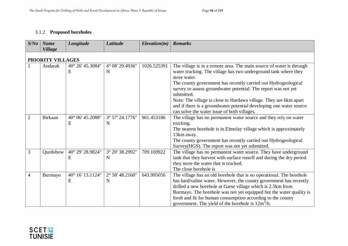
The Saudi Program for Drilling of Wells and Rural Development in Africa, Phase V Republic of Kenya Page 94 of 119
3.1.2 Proposed boreholes
S/No Name
Village
Longitude Latitude Elevation(m) Remarks
PRIORITY VILLAGES
1 Andarak 40° 26' 45.3084"
E
4° 08' 29.4936"
N
1026.525391 The village is in a remote area. The main source of water is through
water trucking. The village has two underground tank where they
store water.
The county government has recently carried out Hydrogeological
survey to assess groundwater potential. The report was not yet
submitted.
Note: The village is close to Hardawa village. They are 6km apart
and if there is a groundwater potential developing one water source
can solve the water issue of both villages.
2 Birkaan 40° 06' 45.2088"
E
3° 57' 24.1776"
N
961.453186 The village has no permanent water source and they rely on water
trucking.
The nearest borehole is in Elmolay village which is approximately
13km away.
The county government has recently carried out Hydrogeological
Survey(HGS). The report was not yet submitted.
3 Qurdobow 40° 29' 28.9824"
E
3° 20' 38.2992"
N
709.169922 The village has no permanent water source. They have underground
tank that they harvest with surface runoff and during the dry period
they store the water that is trucked.
The close borehole is
4 Burmayo 40° 16' 13.1124"
E
2° 58' 48.2160"
N
643.995056 The village has an old borehole that is no operational. The borehole
has hard/saline water. However, the county government has recently
drilled a new borehole at Garse village which is 2.5km from
Burmayo. The borehole was not yet equipped but the water quality is
fresh and fit for human consumption according to the county
government. The yield of the borehole is 12m3/h.
The Saudi Program for Drilling of Wells and Rural Development in Africa, Phase V Republic of Kenya Page 95 of 119
S/No Name
Village
Longitude Latitude Elevation(m) Remarks
Possible solution: Equipping the borehole and extending the water
supply to the Burmayo village. The elevation difference between the
two village is just 1m and the water can be gravitated using elevated
steel tank or pumped to a storage tank at the village.
5 Midina 40° 01' 33.8340"
E
"3° 37'
13.2240"" N
777.750488
The village is located 30km north of Takaba town along Takaba
Gether road.
The main source of water for this town is a small water pan (see the
attached photo in Madina photo folder) in the north-east of the
village. The village has high potential growth as it is strategically
located along a main road that connect Kenya and Ethiopia.
Drilling a borehole or construction of rainwater harvesting system is
an ideal solution for this village.
6 Omar
Jillow
41° 39' 45.4788"
E
3° 45' 14.7636"
N
414.273376 The village is located along Lafey Mandera road along Kenya –
Somalia boarder. The village has a borehole that is mainly used by
livestock. The borehole has hard water and people uses water that is
trucked from Mandera. It seems the aquifer along that stretch up to
Arabiya, the water quality is poor (very hard) and thorough HGS
should be conducted to establish groundwater potential with good
quality.
7 Komor
Elle
41° 42' 41.9328"
E
3° 48' 10.0584"
N
412.397919 The main source of water for this village is water trucking from
Mandera town and scoop hole in water ways. The village has several
water storage tank.
The Saudi Program for Drilling of Wells and Rural Development in Africa, Phase V Republic of Kenya Page 96 of 119
S/No Name
Village
Longitude Latitude Elevation(m) Remarks
STANDBY VILLAGES
1 Libehia 41° 31' 39.1764"
E
3° 50' 07.3356"
N
451.428192 The village has a borehole. The water from the borehole is saline and the
community depends on scoop hole and shallow wells for drinking water.
2 Lafey 41° 11' 1.98571''
E
3° 8' 57.95185"
N
420 The centre has 5 boreholes and all have fresh water. The boreholes can only
meet 50% of ultimate design of the water supply system. The town is also
facing water storage challenges.
3 Towfiq 41° 11' 46.3272"
E
3° 53' 05.6832"
N
445.95108 The village is located 4km from Rhamu town and 6km from Rhamu
Boreholes (high yield boreholes adjacent to the river). The County
government has recently drilled a borehole in the village but it was dry.
Possible solution for this village is to connect the village to the Rhamu water
supply if there is poor potential of groundwater after the HGS.
4 Hardawa 40° 23' 35.9412"
E
4° 07' 01.1244"
N
1031.573364 The village is close to Andarak village. They also survive with water
trucking. However, the village has a small water pan and the community
informed us that the pan can’t retain water due high poor soil that high
infiltration rate.
The nearest borehole to this village is 11km in a village called Lulis which
has a low yielding borehole.
5 Kobeturiti 39° 51' 04.0824"
E
3° 48' 35.9568"
N
947.111877 The village has no permanent water source and they rely on water trucking.
The nearest borehole is in Argesa Awara village which was drilled a month
ago but no yet equipped. However, there is a closer borehole that is under
development at Gether village.
6 Kabo
village
41.219948 3.271105
447 The village has one bore at the center town which is operational. The
boreholes that were shared by Sub county water officer is as follows: yield
9.3 cubic metres and a depth of 200m. The borehole water is slightly hard
The Saudi Program for Drilling of Wells and Rural Development in Africa, Phase V Republic of Kenya Page 97 of 119
3.2 WAJIR COUNTY
3.2.1 Existing boreholes
ADJACENT BOREHOLES IN THE PROPOSED VILLAGES
Village
Name
Nearest
Borehole(s)
Distance
from
The
Village(km)
Depth
m
Yield
m3/h
Water *
Quality
(palatability)
GPS Location of
Borehole
Longitude Latitude Altitude Comments
Guticha Samatar
Borehole
15 250 18
239.4
Agtalahel None
Sita
Wario
None
Arba
Kharansu
None
Wargadu
d
None
El Ben None
Liban
center
None
Tula tula None
Adadijole Bute
borehole
10
Bute
town
Bute
borehole
200 7
6.77.1 Could be the same borehole described
above
Fatuma
Nur
None
Adan
Awale
None
* The water quality, borehole depth and yield information is as reported by county groundwater focal person
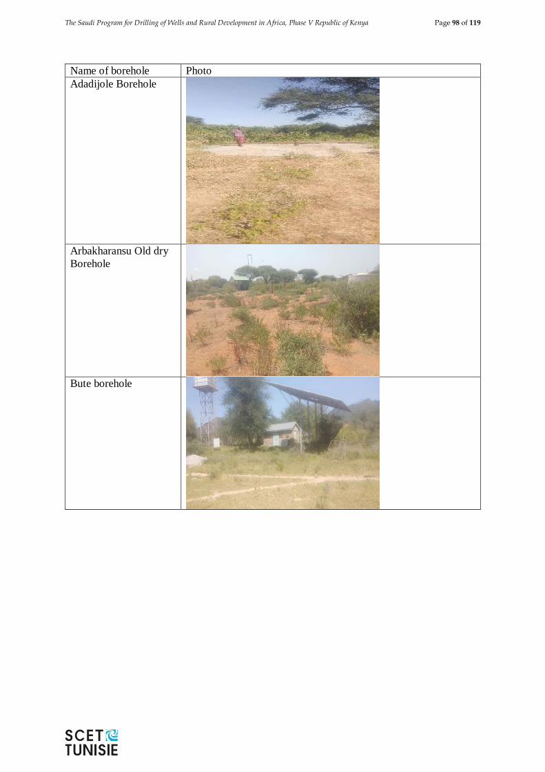
The Saudi Program for Drilling of Wells and Rural Development in Africa, Phase V Republic of Kenya Page 98 of 119
Name of borehole Photo
Adadijole Borehole
Arbakharansu Old dry
Borehole
Bute borehole
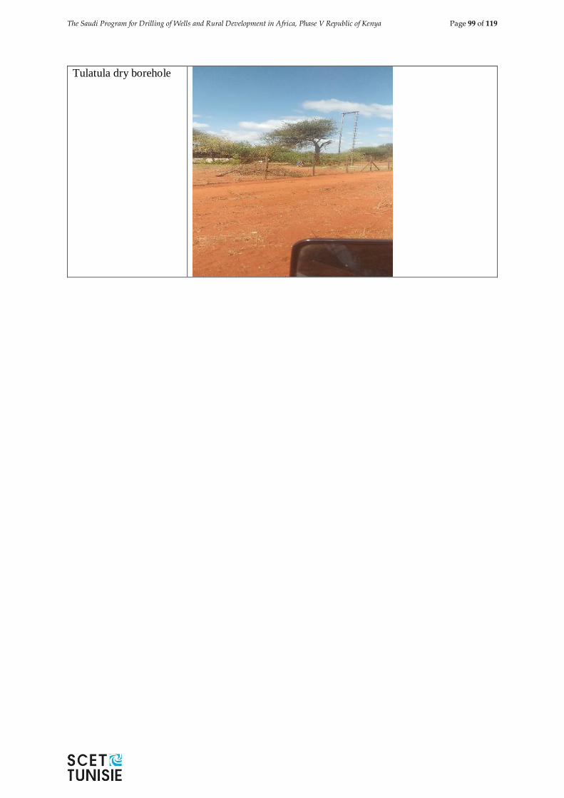
The Saudi Program for Drilling of Wells and Rural Development in Africa, Phase V Republic of Kenya Page 99 of 119
Tulatula dry borehole
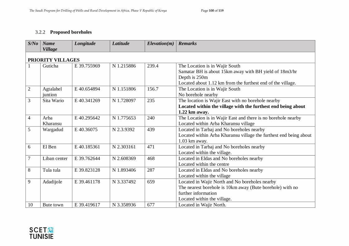
The Saudi Program for Drilling of Wells and Rural Development in Africa, Phase V Republic of Kenya Page 100 of 119
3.2.2 Proposed boreholes
S/No Name
Village
Longitude Latitude Elevation(m) Remarks
PRIORITY VILLAGES
1 Guticha E 39.755969 N 1.215886
239.4 The Location is in Wajir South
Samatar BH is about 15km away with BH yield of 18m3/hr
Depth is 250m
Located about 1.12 km from the furthest end of the village.
2 Agtalahel
juntion
E 40.654894 N 1.151806 156.7 The Location is in Wajir South
No borehole nearby
3 Sita Wario E 40.341269 N 1.728097 235 The location is Wajir East with no borehole nearby
Located within the village with the furthest end being about
1.22 km away.
4 Arba
Kharansu
E 40.295642 N 1.775653 240 The Location is in Wajir East and there is no borehole nearby
Located within Arba Kharansu village
5 Wargadud E 40.36075 N 2.3.9392 439 Located in Tarbaj and No boreholes nearby
Located within Arba Kharansu village the furthest end being about
1.03 km away.
6 El Ben E 40.185361 N 2.303161 471 Located in Tarbaj and No boreholes nearby
Located within the village.
7 Liban center E 39.762644 N 2.608369 468 Located in Eldas and No boreholes nearby
Located within the centre
8 Tula tula E 39.823128 N 1.893406 287 Located in Eldas and No boreholes nearby
Located within the village
9 Adadijole E 39.461178 N 3.337492 659 Located in Wajir North and No boreholes nearby
The nearest borehole is 10km away (Bute borehole) with no
further information
Located within the village.
10 Bute town E 39.419617 N 3.358936 677 Located in Wajir North.
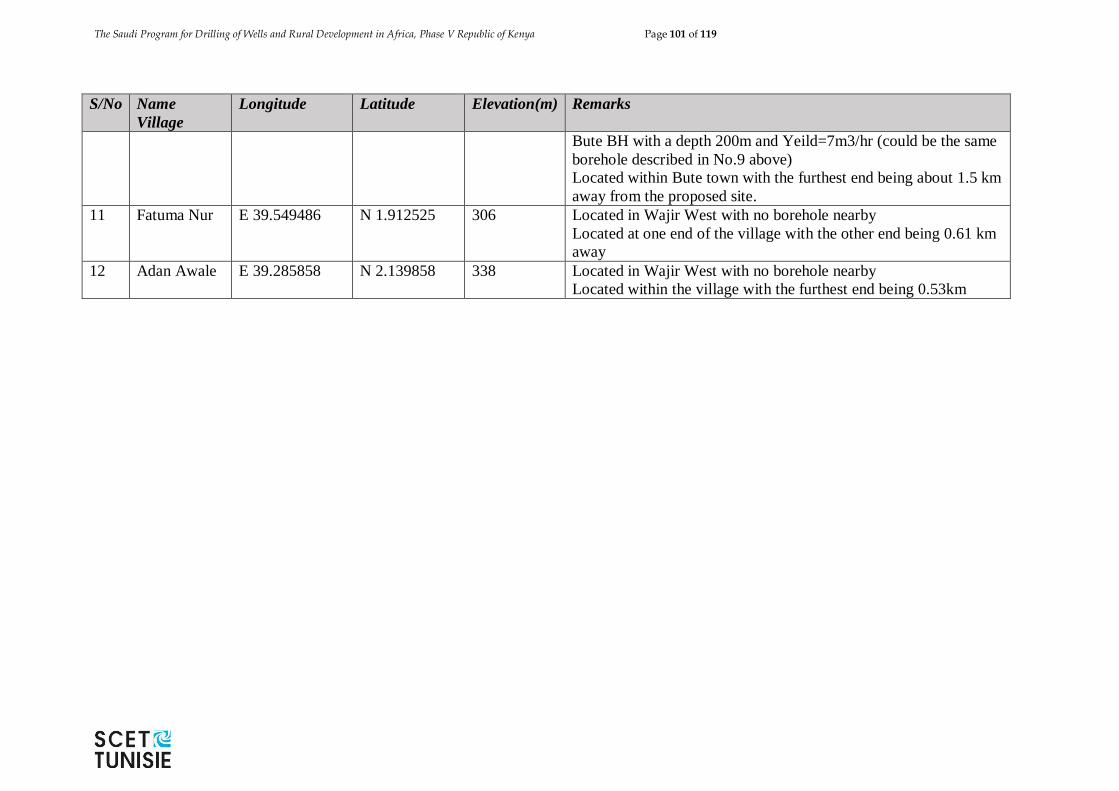
The Saudi Program for Drilling of Wells and Rural Development in Africa, Phase V Republic of Kenya Page 101 of 119
S/No Name
Village
Longitude Latitude Elevation(m) Remarks
Bute BH with a depth 200m and Yeild=7m3/hr (could be the same
borehole described in No.9 above)
Located within Bute town with the furthest end being about 1.5 km
away from the proposed site.
11 Fatuma Nur E 39.549486 N 1.912525 306 Located in Wajir West with no borehole nearby
Located at one end of the village with the other end being 0.61 km
away
12 Adan Awale E 39.285858 N 2.139858 338 Located in Wajir West with no borehole nearby
Located within the village with the furthest end being 0.53km
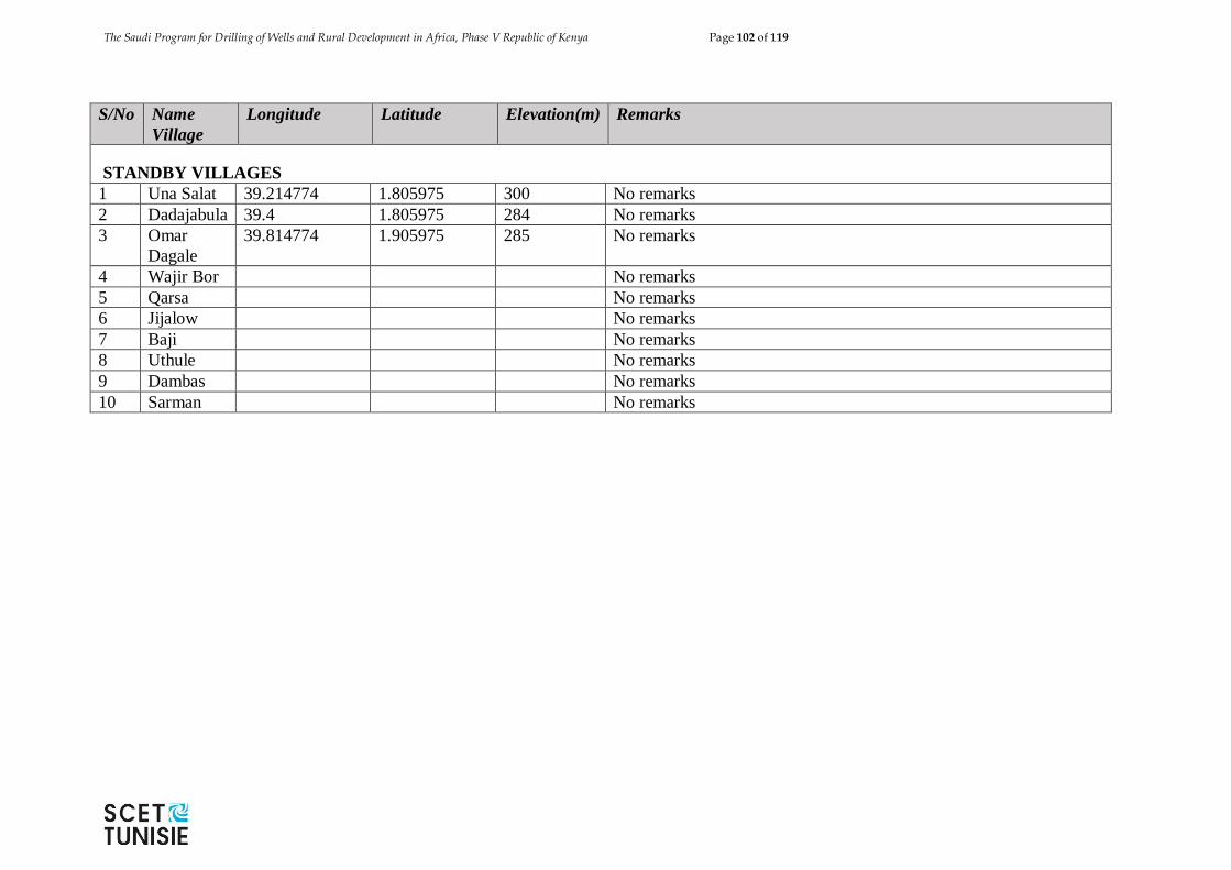
The Saudi Program for Drilling of Wells and Rural Development in Africa, Phase V Republic of Kenya Page 102 of 119
S/No Name
Village
Longitude Latitude Elevation(m) Remarks
STANDBY VILLAGES
1 Una Salat 39.214774 1.805975 300 No remarks
2 Dadajabula 39.4 1.805975 284 No remarks
3 Omar
Dagale
39.814774 1.905975 285 No remarks
4 Wajir Bor No remarks
5 Qarsa No remarks
6 Jijalow No remarks
7 Baji No remarks
8 Uthule No remarks
9 Dambas No remarks
10 Sarman No remarks
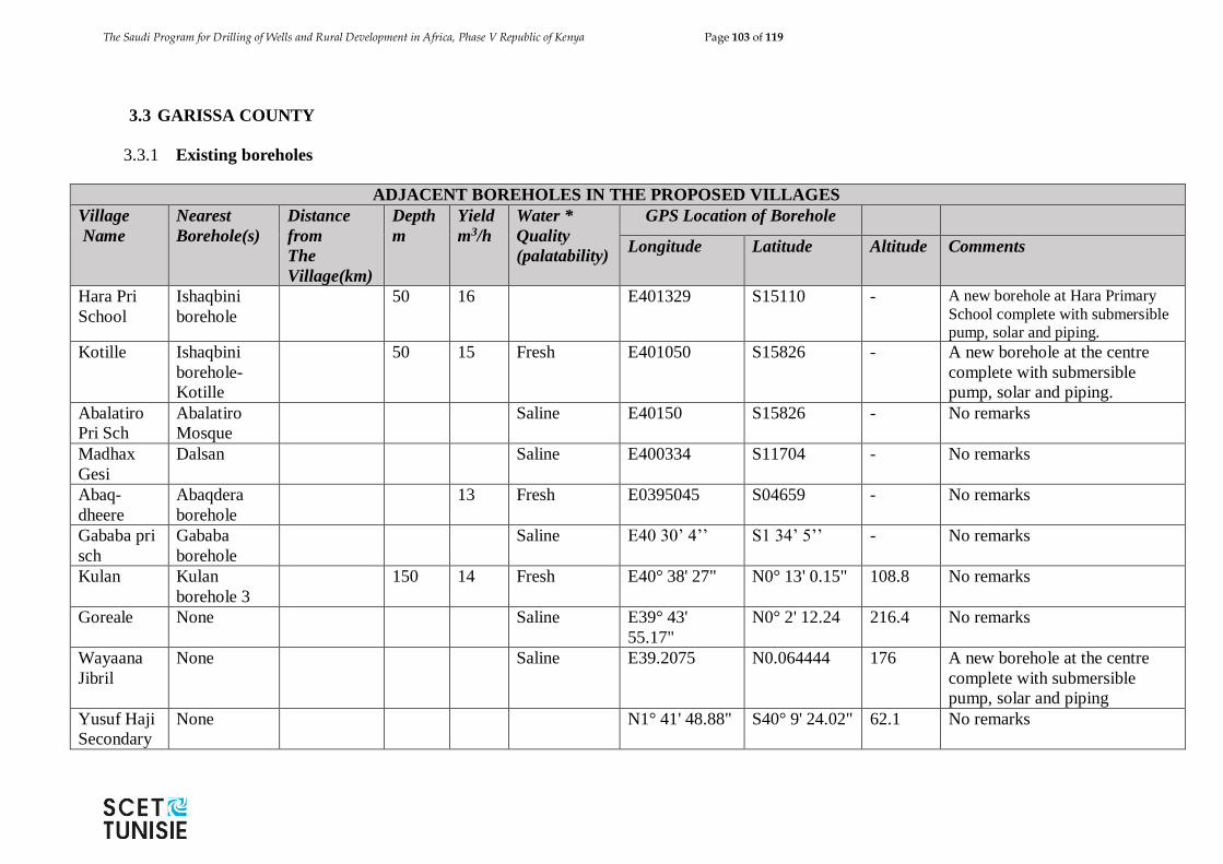
The Saudi Program for Drilling of Wells and Rural Development in Africa, Phase V Republic of Kenya Page 103 of 119
3.3 GARISSA COUNTY
3.3.1 Existing boreholes
ADJACENT BOREHOLES IN THE PROPOSED VILLAGES
Village
Name
Nearest
Borehole(s)
Distance
from
The
Village(km)
Depth
m
Yield
m3/h
Water *
Quality
(palatability)
GPS Location of Borehole
Longitude Latitude Altitude Comments
Hara Pri
School
Ishaqbini
borehole
50 16 E401329 S15110 - A new borehole at Hara Primary
School complete with submersible pump, solar and piping.
Kotille Ishaqbini
borehole-
Kotille
50 15 Fresh E401050 S15826 - A new borehole at the centre
complete with submersible
pump, solar and piping.
Abalatiro
Pri Sch
Abalatiro
Mosque
Saline E40150 S15826 - No remarks
Madhax
Gesi
Dalsan Saline E400334 S11704 - No remarks
Abaq-
dheere
Abaqdera
borehole
13 Fresh E0395045 S04659 - No remarks
Gababa pri
sch
Gababa
borehole
Saline E40 30’ 4’’ S1 34’ 5’’ - No remarks
Kulan Kulan
borehole 3
150 14 Fresh E40° 38' 27" N0° 13' 0.15" 108.8 No remarks
Goreale None Saline E39° 43'
55.17"
N0° 2' 12.24 216.4 No remarks
Wayaana
Jibril
None Saline E39.2075 N0.064444 176 A new borehole at the centre
complete with submersible
pump, solar and piping
Yusuf Haji
Secondary
None N1° 41' 48.88" S40° 9' 24.02" 62.1 No remarks
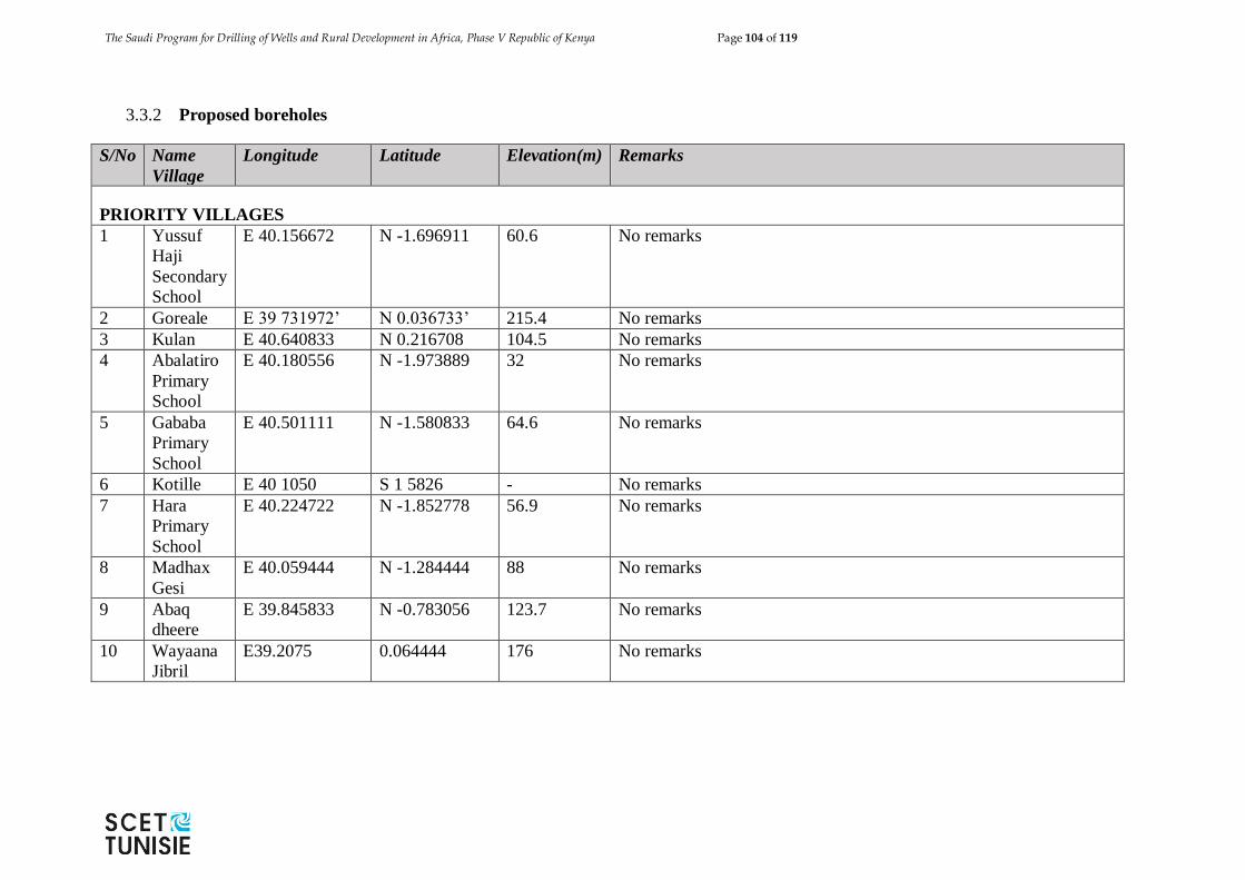
The Saudi Program for Drilling of Wells and Rural Development in Africa, Phase V Republic of Kenya Page 104 of 119
3.3.2 Proposed boreholes
S/No Name
Village
Longitude Latitude Elevation(m) Remarks
PRIORITY VILLAGES
1 Yussuf
Haji
Secondary
School
E 40.156672 N -1.696911 60.6 No remarks
2 Goreale E 39 731972’ N 0.036733’ 215.4 No remarks
3 Kulan E 40.640833 N 0.216708 104.5 No remarks
4 Abalatiro
Primary
School
E 40.180556 N -1.973889 32 No remarks
5 Gababa
Primary
School
E 40.501111 N -1.580833 64.6 No remarks
6 Kotille E 40 1050 S 1 5826 - No remarks
7 Hara
Primary
School
E 40.224722 N -1.852778 56.9 No remarks
8 Madhax
Gesi
E 40.059444 N -1.284444 88 No remarks
9 Abaq
dheere
E 39.845833 N -0.783056 123.7 No remarks
10 Wayaana
Jibril
E39.2075 0.064444 176 No remarks
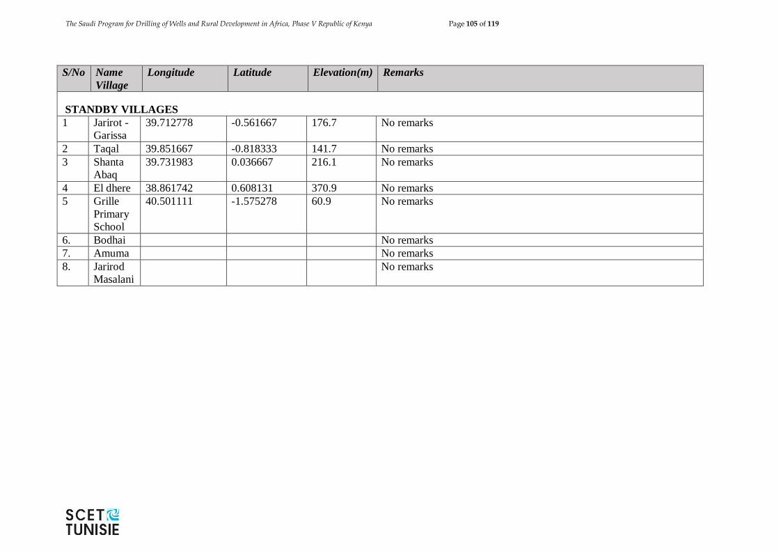
The Saudi Program for Drilling of Wells and Rural Development in Africa, Phase V Republic of Kenya Page 105 of 119
S/No Name
Village
Longitude Latitude Elevation(m) Remarks
STANDBY VILLAGES
1 Jarirot -
Garissa
39.712778 -0.561667 176.7 No remarks
2 Taqal 39.851667 -0.818333 141.7 No remarks
3 Shanta
Abaq
39.731983 0.036667 216.1 No remarks
4 El dhere 38.861742 0.608131 370.9 No remarks
5 Grille
Primary
School
40.501111 -1.575278 60.9 No remarks
6. Bodhai No remarks
7. Amuma No remarks
8. Jarirod
Masalani
No remarks
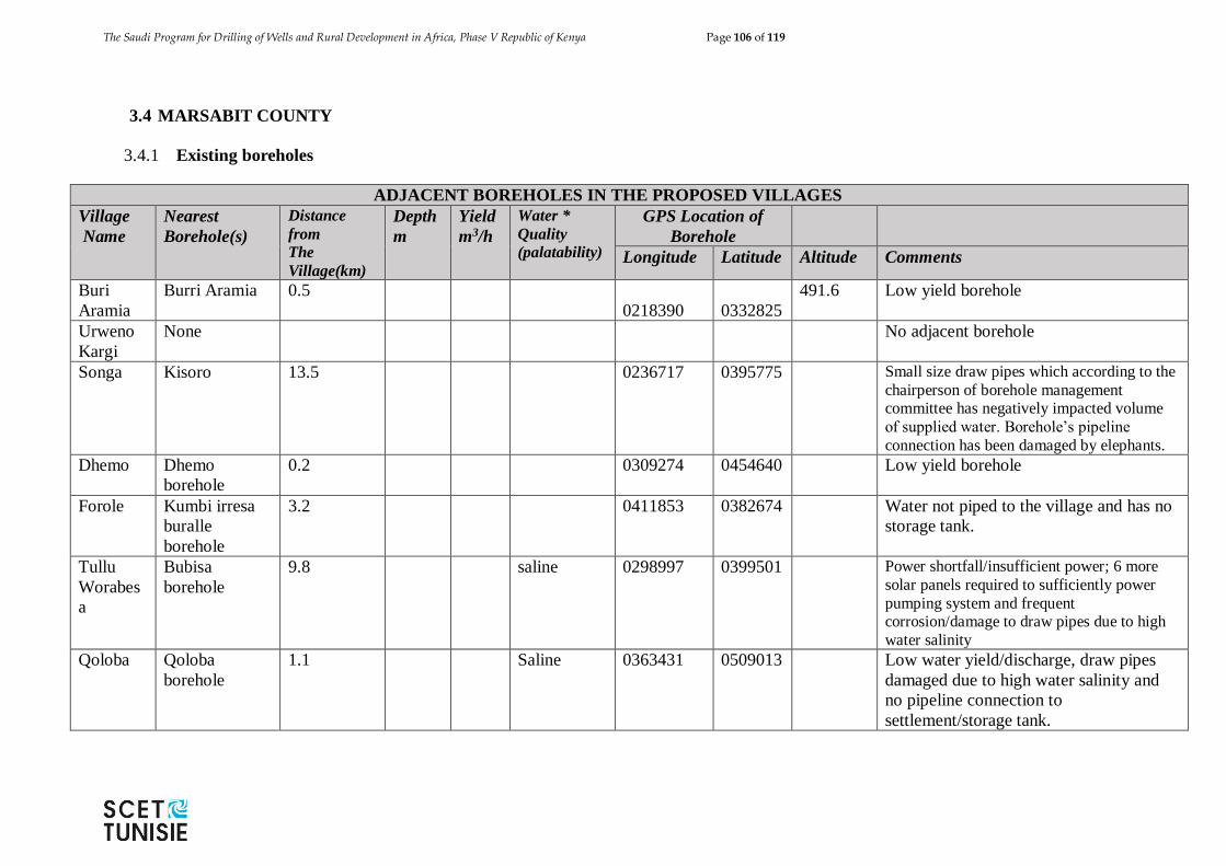
The Saudi Program for Drilling of Wells and Rural Development in Africa, Phase V Republic of Kenya Page 106 of 119
3.4 MARSABIT COUNTY
3.4.1 Existing boreholes
ADJACENT BOREHOLES IN THE PROPOSED VILLAGES
Village
Name
Nearest
Borehole(s)
Distance
from
The
Village(km)
Depth
m
Yield
m3/h
Water *
Quality
(palatability)
GPS Location of
Borehole
Longitude Latitude Altitude Comments
Buri
Aramia
Burri Aramia 0.5
0218390 0332825
491.6 Low yield borehole
Urweno
Kargi
None No adjacent borehole
Songa Kisoro 13.5 0236717 0395775 Small size draw pipes which according to the
chairperson of borehole management committee has negatively impacted volume
of supplied water. Borehole’s pipeline
connection has been damaged by elephants.
Dhemo Dhemo
borehole
0.2 0309274 0454640 Low yield borehole
Forole Kumbi irresa
buralle
borehole
3.2 0411853 0382674 Water not piped to the village and has no
storage tank.
Tullu
Worabes
a
Bubisa
borehole
9.8 saline 0298997 0399501 Power shortfall/insufficient power; 6 more
solar panels required to sufficiently power
pumping system and frequent corrosion/damage to draw pipes due to high
water salinity
Qoloba Qoloba
borehole
1.1 Saline 0363431 0509013 Low water yield/discharge, draw pipes
damaged due to high water salinity and
no pipeline connection to
settlement/storage tank.
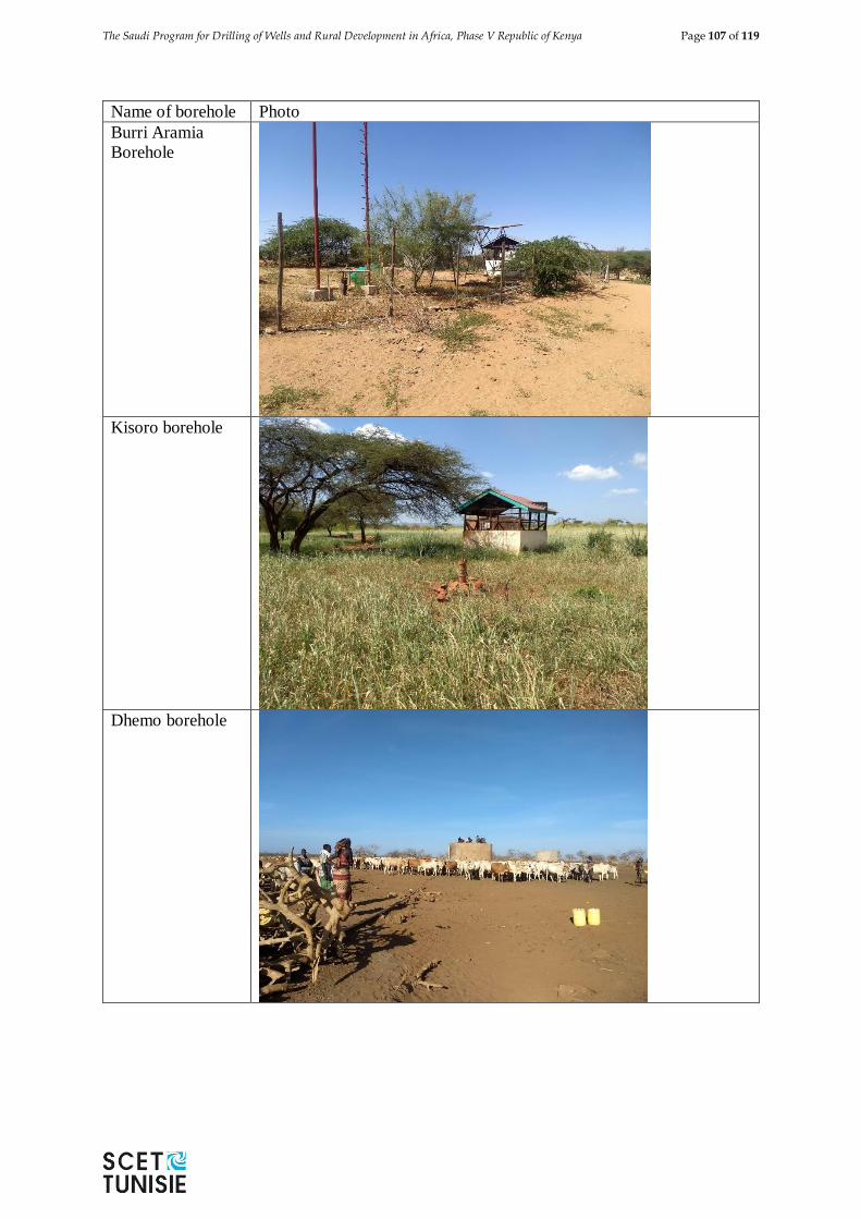
The Saudi Program for Drilling of Wells and Rural Development in Africa, Phase V Republic of Kenya Page 107 of 119
Name of borehole Photo
Burri Aramia
Borehole
Kisoro borehole
Dhemo borehole
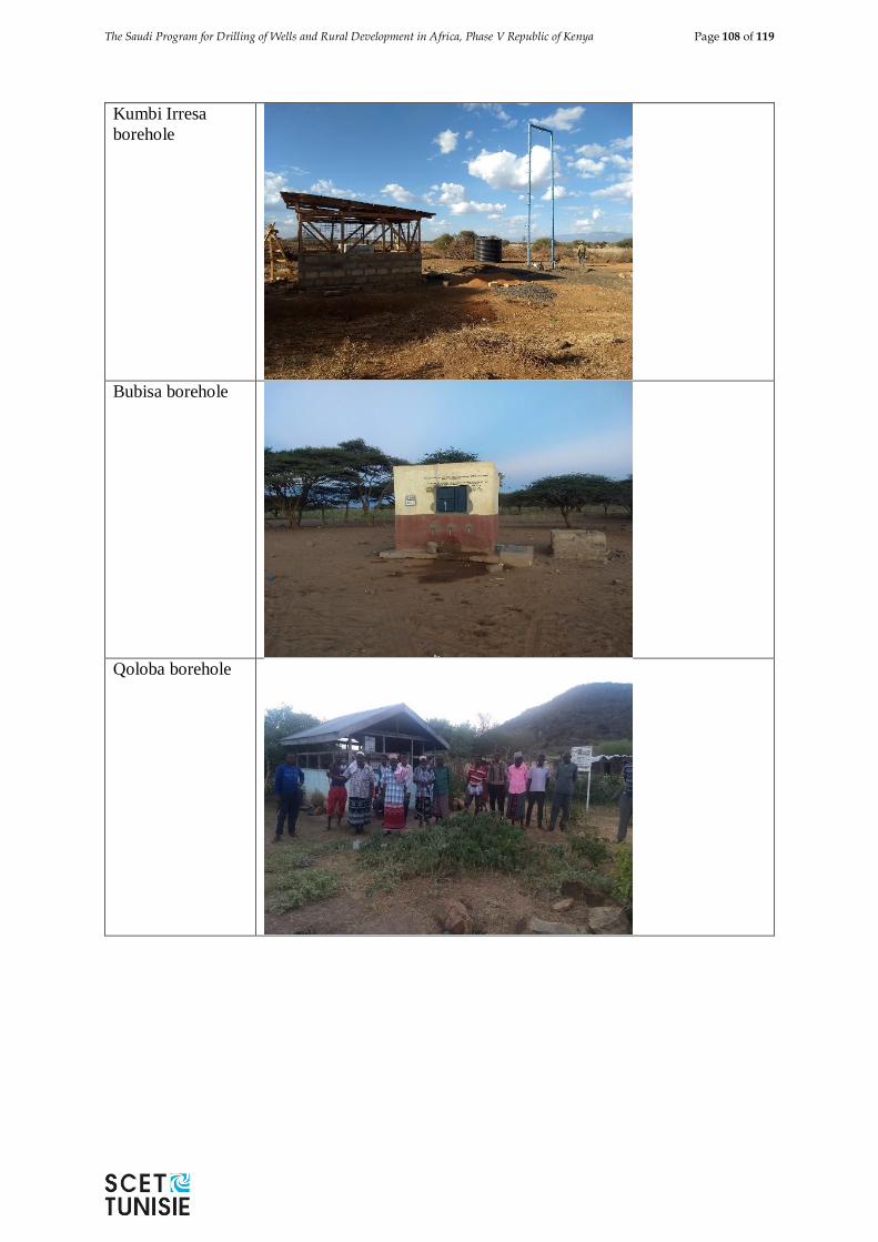
The Saudi Program for Drilling of Wells and Rural Development in Africa, Phase V Republic of Kenya Page 108 of 119
Kumbi Irresa
borehole
Bubisa borehole
Qoloba borehole
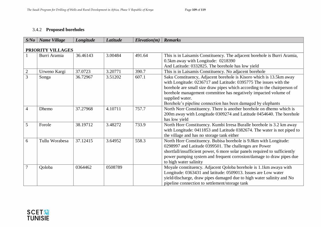
The Saudi Program for Drilling of Wells and Rural Development in Africa, Phase V Republic of Kenya Page 109 of 119
3.4.2 Proposed boreholes
S/No Name Village Longitude Latitude Elevation(m) Remarks
PRIORITY VILLAGES
1 Burri Aramia 36.46143 3.00484 491.64 This is in Laisamis Constituency. The adjacent borehole is Burri Aramia,
0.5km away with Longitude: 0218390
And Latitude: 0332825. The borehole has low yield
2 Urweno Kargi 37.0723 3.20771 390.7 This is in Laisamis Constituency. No adjacent borehole
3 Songa 36.72967 3.51202 607.1 Saku Constituency, Adjacent borehole is Kisoro which is 13.5km away
with Longitude: 0236717 and Latitude: 0395775 The issues with the
borehole are small size draw pipes which according to the chairperson of
borehole management committee has negatively impacted volume of
supplied water.
Borehole’s pipeline connection has been damaged by elephants
4 Dhemo 37.27968 4.10711 757.7 North Norr Constituency. There is another borehole on dhemo which is
200m away with Longitude 0309274 and Latitude 0454640. The borehole
has low yield
5 Forole 38.19712 3.48272 733.9 North Horr Constituency. Kumbi Irresa Buralle borehole is 3.2 km away
with Longitude: 0411853 and Latitude 0382674. The water is not piped to
the village and has no storage tank either
6 Tullu Worabesa 37.12415 3.64952 558.3 North Horr Constituency. Bubisa borehole is 9.8km with Longitude:
0298997 and Latitude 0399501. The challenges are Power
shortfall/insufficient power, 6 more solar panels required to sufficiently
power pumping system and frequent corrosion/damage to draw pipes due
to high water salinity
7 Qoloba 0364462 0508789 Moyale constituency. Adjacent Qoloba borehole is 1.1km awaya with
Longitude: 0363431 and latitude: 0509013. Issues are Low water
yield/discharge, draw pipes damaged due to high water salinity and No
pipeline connection to settlement/storage tank
The Saudi Program for Drilling of Wells and Rural Development in Africa, Phase V Republic of Kenya Page 110 of 119
S/No Name
Village
Longitude Latitude Elevation(m) Remarks
STANDBY VILLAGES
1 Nturusi No remarks
The Saudi Program for Drilling of Wells and Rural Development in Africa, Phase V Republic of Kenya Page 111 of 119
3.5 SAMBURU COUNTY
3.5.1 Existing boreholes
ADJACENT BOREHOLES IN THE PROPOSED VILLAGES
Village
Name
Nearest
Boreholes
Distance
from
The
Village(km)
Depth
m
Yield
m3/h
Water *
Quality palatability
GPS Location of Borehole
Longitude Latitude Altitude Comments
Lorian Lorian 0.2 missi
ng
4 Good
N. 01 01.631’ E. 036 33.758’
1924 Not functional
Pura Pura 0.4 68.6 3.6 Good N: 01 07.932’ E: 036 32.111’ 2123 No remarks
Loonkoliin Lookkolii
n
- 184 10 Good N: 01.00907’ E: 036.61428’ 1148.7 No remarks
3.5.2 Proposed boreholes
S/No Name
Village
Longitude Latitude Elevation(m) Remarks
PRIORITY VILLAGES
1 Keleswa E. 036 59.473’ N. 01 54.665’ 1296 No remarks
2 Nool kera E: 036 32.75’ N. 01 00.351’ 1888 No remarks
3 Pura E.036⁰30.902' N.0.1⁰06.283' 2123 No remarks
The Saudi Program for Drilling of Wells and Rural Development in Africa, Phase V Republic of Kenya Page 112 of 119
3.6 ISIOLO COUNTY
3.6.1 Existing boreholes
ADJACENT BOREHOLES IN THE PROPOSED VILLAGES
Village
Name
Nearest
Boreholes
Distance
from
The
Village(km)
Depth
m
Yield
m3/h
Water *
Quality: palatability
GPS Location of Borehole
Longitude Latitude Altitude Comments
Kinna
Moliti
Bibi
Mabati
borehole
5.1 0039771 0414835 Borehole has dilapidated 17km pipeline
Merti
Town
Merti
Quran
Centre
borehole
1 11 39.70308 15.98844 No pipeline connection to Merti Quran
centre orphaned children centre, no
storage tank and high cost of running
borehole’s generator power unit/system
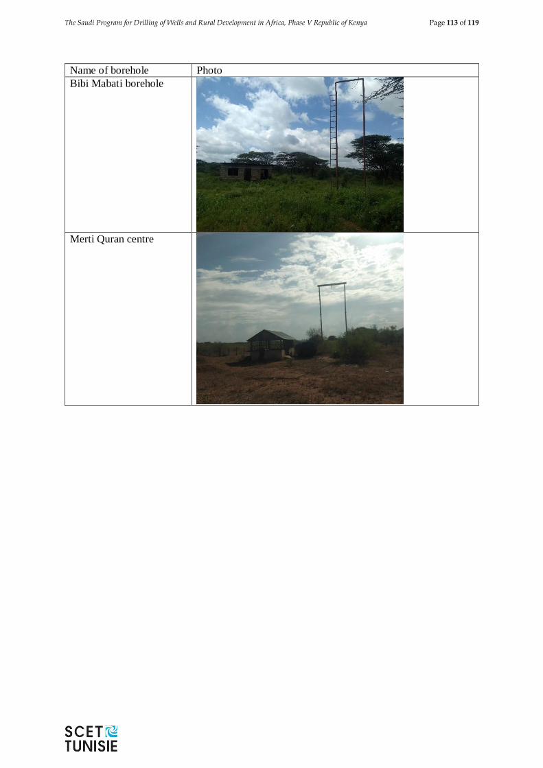
The Saudi Program for Drilling of Wells and Rural Development in Africa, Phase V Republic of Kenya Page 113 of 119
Name of borehole Photo
Bibi Mabati borehole
Merti Quran centre
The Saudi Program for Drilling of Wells and Rural Development in Africa, Phase V Republic of Kenya Page 114 of 119
3.6.2 Proposed boreholes
S/No Name Village Longitude Latitude Elevation(m) Remarks
PRIORITY VILLAGES
1 Kinna Moliti 0298996 0399503 Isiolo South Constituency. Bibi Mabati borehole is the adjacent
borehole 5.1km away with Longitude :0039771 and Latitude
0414835, The borehole has dilapidated 17km pipeline
2 Merti Town
Borehole
E 13.28016 N 19.629 Isiolo North Constituency. Merti Quran Centre borehole is the
adjacent borehole 1km away with Longitude: 39.70308 and
Latitude: 15.98844 with a yield of 11cm3. The issues are No
pipeline connection to Merti Quran centre orphaned children
centre, No storage tank and high cost of running borehole’s
generator power unit/system
S/No Name Village Longitude Latitude Elevation(m) Remarks
STANDBY VILLAGES
1 Malka galla No remarks
2 Ngalababieadaaba/
Athunyen
No remarks
The Saudi Program for Drilling of Wells and Rural Development in Africa, Phase V Republic of Kenya Page 115 of 119
CHAPTER IV: DESIGN CRITERIA & FINDINGS
4.1 BOREHOLES
4.1.1 Study Area
Groundwater exploration and development is targeted in six counties namely Marsabit,
Samburu, Isiolo, Mandera, Wajir and Garissa. The pre-selected borehole site locations
per county are as shown in Table 5.1
County No. of boreholes
Marsabit 7
Samburu 3
Isiolo 2
Mandera 8
Wajir 12
Garissa 10
Table 5.1: Boreholes per County
The Location of the boreholes is provided in the Google Map with the following
annotations:
Green for priority boreholes,
Yellow for standby boreholes and,
Blue for existing boreholes.
Geologically, the areas targeted for borehole drilling are in crystalline (volcanic or
metamorphic) and sedimentary rocks.
4.1.2 Successful boreholes
A successful well is the well:
giving a sustainable yield of ≥ 3m3/hr,
whose water is compliant to the health and quality standards in Kenya for
Groundwater KS 05-459 (1996),
However only the yield criteria will be applied to pay for successful boreholes.
As per the expert opinion, the success rate of boreholes in the six counties is as follows:
County Number %
Wajir 12 95%
Garissa 10 80%
Mandera 8 95%
Marsabit 7 80%
Samburu 3 80%
Isiolo 2 60%
The Saudi Program for Drilling of Wells and Rural Development in Africa, Phase V Republic of Kenya Page 116 of 119
In order to increase the success rate of the productive boreholes, the Contractor will
carry out borehole site investigations for both priority and standby selected sites.
Drilling will only be carried out for sites with high prospects. It is proposed that
at least three measurements be carried out at each site.
4.1.3 Borehole depths
The boreholes will be constructed at different depths depending on groundwater
occurrence and distribution in each of the targeted areas. The borehole drill depths will
be determined at the hydrogeological survey stage. The contractor is expected to hire
services of a hydrogeological expert who is to carrying borehole site investigations at
each of the pre-selected village and ascertain the exact location for borehole drilling as
well as borehole depth.
For the purpose of the tendering process existing borehole data near a pre-selected site
was evaluated from which the following tentative borehole depths have been adopted.
Table 4.2 : Borehole drill depths
Borehole depth No. of boreholes
100 7
200 31
250 4
4.1.4 Borehole diameter, borehole casings and screens
All the 42 boreholes will be drilled at a diameter of 12”/304 mm to a depth of the six
(6) metres. This section of the borehole will be installed with 12”/304 mm diameter
surface casing, which will serve two purposes namely to protect the top of the borehole
from erosion from returning drilling fluids or artesian flow or both and to provide the
sanitary seal casing in the borehole headworks. Casing used as surface casing shall be
mild steel of a specification suited to water well applications.
As from a depth of the 6 metres, all the boreholes will be drilled at a diameter of 10”
(254 mm) to completion depth as will be determined during the hydrogeological
survey. The borehole will be installed with 8” 203 mm plain casings and screens. The
annular space between the borehole and casing/screens will be filled with gravel pack
only for sections that are aquiferous. Above the upper most of gravel pack the borehole
will be filled with inert backfill. In order to avert any surface pollution, a grout seal will
be installed up to the top of the highest level of inert material to surface + 0.4m.
4.1.5 Borehole development and test pumping
After completion of drilling and placement of casing and screens, gravel and backfill
etc the borehole shall be developed in accordance with modern borehole construction
The Saudi Program for Drilling of Wells and Rural Development in Africa, Phase V Republic of Kenya Page 117 of 119
practices, including airlift surging and possibly chemical development using a
polyphosphate. It is expected that a total of 12 hours will be required. Subsequently,
test pumping comprised of calibration test, 4-hour step-drawdown test followed by a
constant discharge test for a period of 24 hours.
4.1.6 Water sampling and analysis
Full water chemistry analyses will be conducted on water removed from the borehole.
Samples shall be collected immediately development is adjudged complete. In
addition, water samples for bacteriological analysis will be collected from borehole at
the end of development; these will be collected and immediately shipped to an
approved laboratory to comply with KS 05-459 (1996).
4.1.7 Submersible Solar Pumps
The Contractor will select the pump based on the test pumping results (Static level and
dynamic level of the water in the borehole, the flow of the borehole) as well as the
height of the water tank. Based on the expert judgement, three depths (100 m, 150 m,
200m) and a flow of 15 m3/h have been selected to size the pumps to be used in this
tender. Grundfos pumps or equivalent are suggested for this project. The simulations
resulted in the following pumps’ choice:
Type of Pump
Grundfos or equivalent
Number of
pumps
Maximum
Yield (m)
Qmin
(m3/hour)
Power of the
Pump (Kw)
SP 17-12 7 100 15,93 7,5
SP 17-18 31 150 16,14 11
SP 17-23 4 200 15,14 13
The other installations done together with the submersible include include a 2" (50 mm)
galvanized steel rising main, submersible cable, electrode pencils, electrode cable, a
non-return valve just above the pump, a 25-32 mm dipper line, and all other items
necessary for proper functioning of the pump. As an alternative to the control panel and
coupled start/stop electrodes, a CU3 control unit or similar may be installed. All the
Items to be installed shall be subject to confirmation and approval by the Supervising
Engineer.
All items will be of high quality, and suitable to function properly in tropical
conditions. Spare parts of the equipment to be supplied and installed shall as much as
possible be available in Kenya.
4.2 SOLAR PANELS
The pump will only work during on PV energy and no battery storing is suggested. The
minimum annual number of hours of sunshine is 1469. The photovoltaic panels will be
installed at a height of 1.60m from the ground. To acquire the best radiation intensity
half of the panels will be tilted 8° to the north while the other half, tilted 8° to the
south. 0 on the panels shall be avoided at all the time. While designing the PV
The Saudi Program for Drilling of Wells and Rural Development in Africa, Phase V Republic of Kenya Page 118 of 119
installation and overpower is to be foreseen for the well-functioning of the pumps and
to feeding the accessories as well as the inverter which will convert the current to AC:
Type of
Pump
Grundfos or
equivalent
Power of
the Pump
(Kw)
Sunshine
hours per
year
Tilt angle /
horizontal Orientation
Peak power
of the field
(kWp)
Total Power
(KW)
Over-
power%
SP 17-12 7,5 1469 8° 0° / Nord 6,2 9,1 22
SP 17-18 11 1469 8° 0° / Nord 10,2 15,0 37
SP 17-23 13 1469 8° 0° / Nord 12,4 18,2 40
The Inverter shall be an advanced Solar inverter designed for use with large AC
submersible pumps systems. It should be installed in an enclosure for water and heat
protection. The specific features of the inverter include:
Patented MPPT (Maximum Power Point Tracking) capability providing fast
response, good stability and up to 99% efficiency.
Supports motor soft start and gives full motor protection,
IP65 protection guards suitable for harsh outdoor environments.
The Inverter shall offer the following control functions:
Settable minimum and maximum frequency and open circuit voltage.
Display of operating parameters including frequency, voltage, amperage, input
power and pump speed.
Protection against over and under voltage, over current, system overload and
module over temperature.
Fault detection with error code display.
The solar panels shall be connected among themselves as all cables of the array are
connected to a junction or combiner box. The solar panels shall be:
High module conversion efficiency superior to 19 % by using Passivated Emmiter
Rear Contact (PERC) technology,
The modules should be monocrystalline,
Low degradation and excellent performance under high temperature and low light
conditions,
o Robust aluminium frame ensures the modules to withstand wind loads up to 2400Pa
and snow loads up to 5400Pa. the frame will supported by a reinforced concrete
ground beam. A particular attention will be provided to the alignment of the support
(horizontality) and to the tilt of the panel.
o High reliability against extreme environmental conditions (passing salt mist,
ammonia and hail tests).
o Potential induced degradation (PID) resistance.
o Positive power tolerance of 0 ~ +3 %.
The Saudi Program for Drilling of Wells and Rural Development in Africa, Phase V Republic of Kenya Page 119 of 119
All drawings and calculations and computer input and output shall be presented to the
Consultant Engineer for approval. A set of spare parts including the followings shall
be provided at each site:
a) DC Breakers
b) AC Breakers
c) Fuses
4.3 WATER TANK
It is designed that water from each borehole will pumped into an elevated rectangular
steel tank. Therefore, the project has designed for 42 elevated steel tanks. The reservoir
will be constructed with steel profiles. Additionally, the tank will have a liner, roof and
distribution tap stands. The tank capacity will be 100m3. As stipulated, the height of
the tanks is 12 m from ground level to the bottom of the tanks.
At very site a geotechnical investigation shall be carried to estimate the bearing
capacity of the soil and allowable settlement and the chemical properties of the soil
(sulphate & chloride contents) from this investigation the depth & type of footing of
the water tank shall be decided.
4.4 WATER DISTRIBUTION SYSTEM
The water from the water tanks shall be transferred by gravity to the water taps post
near to the beneficiaries. High density polyethylene pipes (HDPE) are suggested. It is
designed that for each village water supply system will comprise of a main water
primary truck extending over a distance of 500 metres. The secondary system will
comprise of supply to the school within a distance of 250 metres as well as Kiosk for
public water supply. At the end of the primary truck a cattle trough will be installed
400 metres away. Upon the instruction of the Consultant, the distribution network
might be extended to the mosque and to the dispensary.
The construction of a complete Kiosk with lockable door and window will include two
taps and water meter; soak pit, drainage pipe and all necessary works, furnishing of all
necessary parts, masonry walls, and corrugated sheet as a roof.
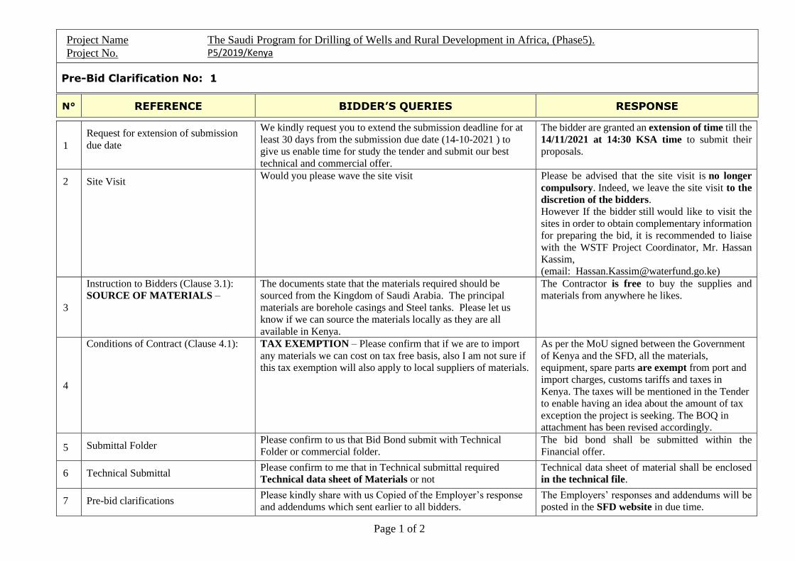
Project Name The Saudi Program for Drilling of Wells and Rural Development in Africa, (Phase5).
Project No. P5/2019/Kenya
Pre-Bid Clarification No: 1
N° REFERENCE BIDDER’S QUERIES RESPONSE
Page 1 of 2
1
Request for extension of submission
due date
We kindly request you to extend the submission deadline for at
least 30 days from the submission due date (14-10-2021 ) to
give us enable time for study the tender and submit our best
technical and commercial offer.
The bidder are granted an extension of time till the
14/11/2021 at 14:30 KSA time to submit their
proposals.
2 Site Visit Would you please wave the site visit Please be advised that the site visit is no longer
compulsory. Indeed, we leave the site visit to the
discretion of the bidders.
However If the bidder still would like to visit the
sites in order to obtain complementary information
for preparing the bid, it is recommended to liaise
with the WSTF Project Coordinator, Mr. Hassan
Kassim,
(email: [email protected])
3
Instruction to Bidders (Clause 3.1):
SOURCE OF MATERIALS –
The documents state that the materials required should be
sourced from the Kingdom of Saudi Arabia. The principal
materials are borehole casings and Steel tanks. Please let us
know if we can source the materials locally as they are all
available in Kenya.
The Contractor is free to buy the supplies and
materials from anywhere he likes.
4
Conditions of Contract (Clause 4.1):
TAX EXEMPTION – Please confirm that if we are to import
any materials we can cost on tax free basis, also I am not sure if
this tax exemption will also apply to local suppliers of materials.
As per the MoU signed between the Government
of Kenya and the SFD, all the materials,
equipment, spare parts are exempt from port and
import charges, customs tariffs and taxes in
Kenya. The taxes will be mentioned in the Tender
to enable having an idea about the amount of tax
exception the project is seeking. The BOQ in
attachment has been revised accordingly.
5 Submittal Folder Please confirm to us that Bid Bond submit with Technical
Folder or commercial folder.
The bid bond shall be submitted within the
Financial offer.
6 Technical Submittal Please confirm to me that in Technical submittal required
Technical data sheet of Materials or not
Technical data sheet of material shall be enclosed
in the technical file.
7 Pre-bid clarifications Please kindly share with us Copied of the Employer’s response
and addendums which sent earlier to all bidders.
The Employers’ responses and addendums will be
posted in the SFD website in due time.

Project Name The Saudi Program for Drilling of Wells and Rural Development in Africa, (Phase5).
Project No. P5/2019/Kenya
Pre-Bid Clarification No: 1
N° REFERENCE BIDDER’S QUERIES RESPONSE
Page 2 of 2
8
Conditions of Contract (Clause 14.1a):
BASE CAMP
The project covers a very large area in Northern Kenya and
realistically we will be required to prepare at least 2-3 Base
camps in the lift of the project. It will not be sensible to serve
the project from a single Base camp. We would have to cost for
the multiple base camps setup/teardown and movement, Please
advice.
It is up to the Contractor to decide how he would
organize the works that should be detailed in his
technical proposal.
9
Conditions of Contract There is a condition that only boreholes with greater than
3m3/hr. capacity and suitable water quality will be considered
for payment. My knowledge of the project area suggests that
this may be difficult in some areas. The quantity is not a serious
issue, however, the quality may be a problem. We will have to
consider failed drilling in our unit rates based on probability of
success. Please advice.
As stated in article 4 - Well Drilling and
Construction of the Technical specifications (page
94) as well as in the the appraisal report, only the
yield criteria will be applied to pay for
successful boreholes (greater than 3m3/hr).
10
Scope of Work we would like to seek clarification on the type of casing to be
used
The bill of quantities casing is indicated to be mild steel casing
➢ Under contract data sheet its indicated as PVC
➢ Under technical specification its indicated mild steel
casing
Please kindly advice.
The casings and screens shall comprise of mild
steel as per technical specifications and the bill of
quantities.
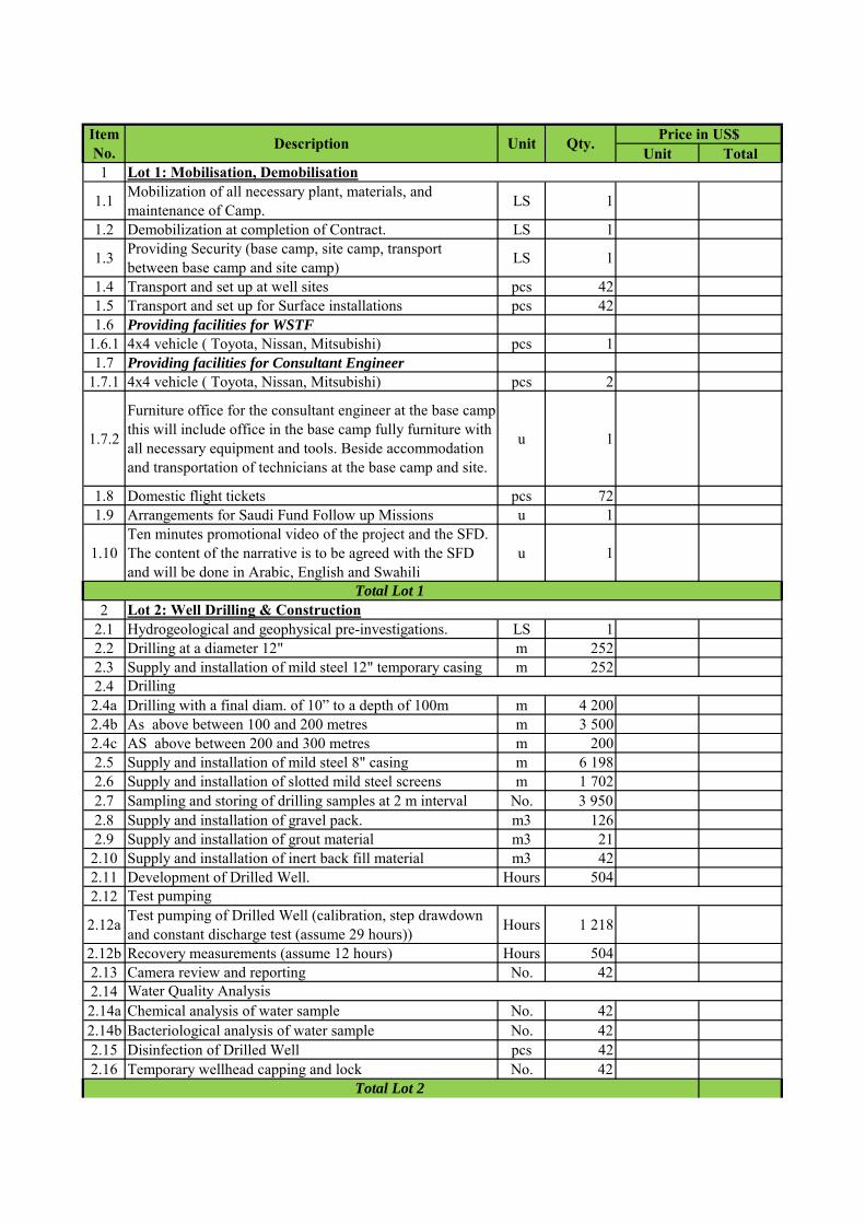
Unit Total1
1.1Mobilization of all necessary plant, materials, and maintenance of Camp.
LS 1
1.2 Demobilization at completion of Contract. LS 1
1.3Providing Security (base camp, site camp, transport between base camp and site camp)
LS 1
1.4 Transport and set up at well sites pcs 421.5 Transport and set up for Surface installations pcs 421.6 Providing facilities for WSTF
1.6.1 4x4 vehicle ( Toyota, Nissan, Mitsubishi) pcs 11.7 Providing facilities for Consultant Engineer
1.7.1 4x4 vehicle ( Toyota, Nissan, Mitsubishi) pcs 2
1.7.2
Furniture office for the consultant engineer at the base camp this will include office in the base camp fully furniture with all necessary equipment and tools. Beside accommodation and transportation of technicians at the base camp and site.
u 1
1.8 Domestic flight tickets pcs 721.9 Arrangements for Saudi Fund Follow up Missions u 1
1.10Ten minutes promotional video of the project and the SFD. The content of the narrative is to be agreed with the SFD and will be done in Arabic, English and Swahili
u 1
22.1 Hydrogeological and geophysical pre-investigations. LS 12.2 Drilling at a diameter 12" m 2522.3 Supply and installation of mild steel 12" temporary casing m 2522.4 2.4a Drilling with a final diam. of 10” to a depth of 100m m 4 2002.4b As above between 100 and 200 metres m 3 5002.4c AS above between 200 and 300 metres m 2002.5 Supply and installation of mild steel 8" casing m 6 1982.6 Supply and installation of slotted mild steel screens m 1 7022.7 Sampling and storing of drilling samples at 2 m interval No. 3 9502.8 Supply and installation of gravel pack. m3 1262.9 Supply and installation of grout material m3 21
2.10 Supply and installation of inert back fill material m3 422.11 Development of Drilled Well. Hours 5042.12
2.12aTest pumping of Drilled Well (calibration, step drawdown and constant discharge test (assume 29 hours))
Hours 1 218
2.12b Recovery measurements (assume 12 hours) Hours 5042.13 Camera review and reporting No. 422.142.14a Chemical analysis of water sample No. 422.14b Bacteriological analysis of water sample No. 422.15 Disinfection of Drilled Well pcs 422.16 Temporary wellhead capping and lock No. 42
Lot 1: Mobilisation, Demobilisation
Item No.
Description Unit Qty.Price in US$
Total Lot 1Lot 2: Well Drilling & Construction
Drilling
Test pumping
Water Quality Analysis
Total Lot 2
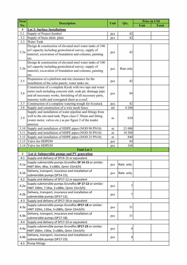
Unit TotalItem No.
Description Unit Qty.Price in US$
33.1. Supply of Project Symbol pcs 423.2 Supply of brass ident. plate. pcs 423.3
3.3a
Design & construction of elevated steel water tanks of 100 m3 capacity including geotechnical survey, supply of materiel, excavation of foundation and columns, painting etc.
pcs 42
3.3b
Design & construction of elevated steel water tanks of 100 m3 capacity including geotechnical survey, supply of materiel, excavation of foundation and columns, painting etc.
pcs Rate only
3.5Preparation of a platform and site clearance for the installation of the solar panels, water tanks etc.
pcs 42
3.6
Construction of a complete Kiosk with two taps and water meter each including concrete slab, soak pit, drainage pipe and all necessary works, furnishing of all necessary parts, masonry walls and corrogated sheet as a roof.
pcs 84
3.7 Construction of a complete watering trough for livestock pcs 423.8 Supply and construction of a wire mesh fence ml 4 200
3.9
Supply and installation of water pipeline and fittings from well to the elevated tank. Pipes class C 50mm and fitting (water meter, valves etc.) as per figure 2 of the tender annexes
m 630
3.10 Supply and installation of HDPE pipes (NOD 90 PN10) m 21 0003.11 Supply and installation of HDPE pipes (NOD 50 PN10) m 10 5003.12 Supply and installation of HDPE pipes (NOD 25 PN10) m 8403.13 Valve for HDPE90 pcs 843.14 Valve for HDPE50 pcs 168
44.1 Supply and delivery of SP14‐15 or equivalent
4.1aSupply submersible pumps Grundfos SP 14‐15 or similar:
HMT 60m, 4Kw, 3 x380v, Qmin 15m3/h)pcs Rate only
4.1bDelivery, transport, insurance and installation of
submersible pumps (SP14‐15). pcs Rate only
4.2 Supply and delivery of SP17‐12 or equivalent
4.2aSupply submersible pumps Grundfos SP 17‐12 or similar:
HMT 100m, 7.5Kw, 3 x380v, Qmin 15m3/h)pcs 7
4.2bDelivery, transport, insurance and installation of
submersible pumps (SP17‐12). pcs 7
4.3 Supply and delivery of SP17‐18 or equivalent
4.3aSupply submersible pumps Grundfos SP17‐18 or similar:
HMT 150m, 11Kw, 3 x380v, Qmin 15m3/h)pcs 31
4.3bDelivery, transport, insurance and installation of
submersible pumps (SP17‐18). pcs 31
4.4 Supply and delivery of SP17‐23 or equivalent
4.4aSupply submersible pumps Grundfos SP17‐23 or similar:
HMT 200m, 13Kw, 3 x380v, Qmin 15m3/h)pcs 4
4.4bDelivery, transport, insurance and installation of
submersible pumps (SP17‐23). pcs 4
4.5
Lot 3: Surface Installations
Total Lot 3 Lot 4: Submersible pumps and PV generation
Water Tank
Pump fittings
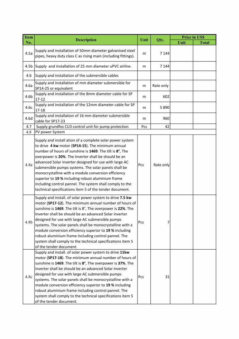
Unit TotalItem No.
Description Unit Qty.Price in US$
4.5aSupply and installation of 50mm diameter galvanised steel
pipes, heavy duty class C as rising main (including fittings). m 7 144
4.5b Supply and installation of 25 mm diameter uPVC airline. m 7 144
4.6 Supply and installation of the submersible cables
4.6aSupply and installation of mm diameter submersible for
SP14‐25 or equivalentm Rate only
4.6bSupply and installation of the 8mm diameter cable for SP
17‐12m 602
4.6cSupply and installation of the 12mm diameter cable for SP
17‐18m 5 890
4.6dSupply and installation of 16 mm diameter submersible
cable for SP17‐23m 960
4.7 Supply grundfos CU3 control unit for pump protection Pcs 42
4.8
4.8a
Supply and install ation of a complete solar power system
to drive 4 kw motor (SP14‐15). The minimum annual
number of hours of sunshine is 1469. The tilt is 8°, The
overpower is 20%. The Inverter shall be should be an
advanced Solar inverter designed for use with large AC
submersible pumps systems. The solar panels shall be
monocrystalline with a module conversion efficiency
superior to 19 % including robust aluminium frame
including control pannel. The system shall comply to the
technical specifications item 5 of the tender document.
Pcs Rate only
4.8b
Supply and install. of solar power system to drive 7.5 kw
motor (SP17‐12). The minimum annual number of hours of
sunshine is 1469. The tilt is 8°, The overpower is 22%. The
Inverter shall be should be an advanced Solar inverter
designed for use with large AC submersible pumps
systems. The solar panels shall be monocrystalline with a
module conversion efficiency superior to 19 % including
robust aluminium frame including control pannel. The
system shall comply to the technical specifications item 5
of the tender document.
Pcs 7
4.8c
Supply and install. of solar power system to drive 11kw
motor (SP17‐18). The minimum annual number of hours of
sunshine is 1469. The tilt is 8°, The overpower is 37%. The
Inverter shall be should be an advanced Solar inverter
designed for use with large AC submersible pumps
systems. The solar panels shall be monocrystalline with a
module conversion efficiency superior to 19 % including
robust aluminium frame including control pannel. The
system shall comply to the technical specifications item 5
of the tender document.
Pcs 31
PV power System
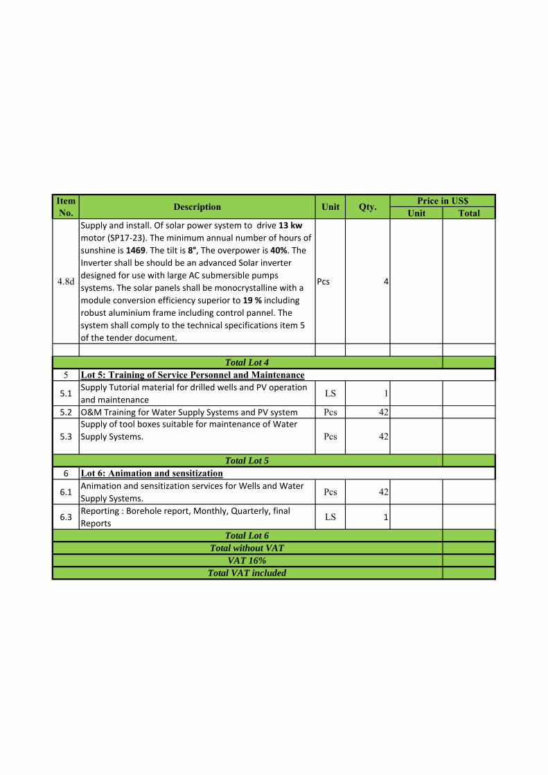
Unit TotalItem No.
Description Unit Qty.Price in US$
4.8d
Supply and install. Of solar power system to drive 13 kw
motor (SP17‐23). The minimum annual number of hours of
sunshine is 1469. The tilt is 8°, The overpower is 40%. The
Inverter shall be should be an advanced Solar inverter
designed for use with large AC submersible pumps
systems. The solar panels shall be monocrystalline with a
module conversion efficiency superior to 19 % including
robust aluminium frame including control pannel. The
system shall comply to the technical specifications item 5
of the tender document.
Pcs 4
5
5.1Supply Tutorial material for drilled wells and PV operation
and maintenance LS 1
5.2 O&M Training for Water Supply Systems and PV system Pcs 42
5.3
Supply of tool boxes suitable for maintenance of Water
Supply Systems. Pcs 42
6
6.1Animation and sensitization services for Wells and Water
Supply Systems.Pcs 42
6.3Reporting : Borehole report, Monthly, Quarterly, final
ReportsLS 1
Total Lot 4Lot 5: Training of Service Personnel and Maintenance
Total Lot 5Lot 6: Animation and sensitization
Total Lot 6Total without VAT
VAT 16%Total VAT included
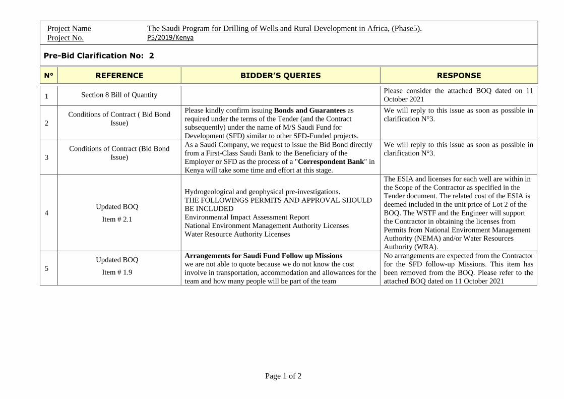
Project Name The Saudi Program for Drilling of Wells and Rural Development in Africa, (Phase5).
Project No. P5/2019/Kenya
Pre-Bid Clarification No: 2
N° REFERENCE BIDDER’S QUERIES RESPONSE
Page 1 of 2
1 Section 8 Bill of Quantity Please consider the attached BOQ dated on 11
October 2021
2
Conditions of Contract ( Bid Bond
Issue)
Please kindly confirm issuing Bonds and Guarantees as
required under the terms of the Tender (and the Contract
subsequently) under the name of M/S Saudi Fund for
Development (SFD) similar to other SFD-Funded projects.
We will reply to this issue as soon as possible in
clarification N°3.
3
Conditions of Contract (Bid Bond
Issue)
As a Saudi Company, we request to issue the Bid Bond directly
from a First-Class Saudi Bank to the Beneficiary of the
Employer or SFD as the process of a "Correspondent Bank" in
Kenya will take some time and effort at this stage.
We will reply to this issue as soon as possible in
clarification N°3.
4 Updated BOQ
Item # 2.1
Hydrogeological and geophysical pre-investigations.
THE FOLLOWINGS PERMITS AND APPROVAL SHOULD
BE INCLUDED
Environmental Impact Assessment Report
National Environment Management Authority Licenses
Water Resource Authority Licenses
The ESIA and licenses for each well are within in
the Scope of the Contractor as specified in the
Tender document. The related cost of the ESIA is
deemed included in the unit price of Lot 2 of the
BOQ. The WSTF and the Engineer will support
the Contractor in obtaining the licenses from
Permits from National Environment Management
Authority (NEMA) and/or Water Resources
Authority (WRA).
5
Updated BOQ
Item # 1.9
Arrangements for Saudi Fund Follow up Missions
we are not able to quote because we do not know the cost
involve in transportation, accommodation and allowances for the
team and how many people will be part of the team
No arrangements are expected from the Contractor
for the SFD follow-up Missions. This item has
been removed from the BOQ. Please refer to the
attached BOQ dated on 11 October 2021
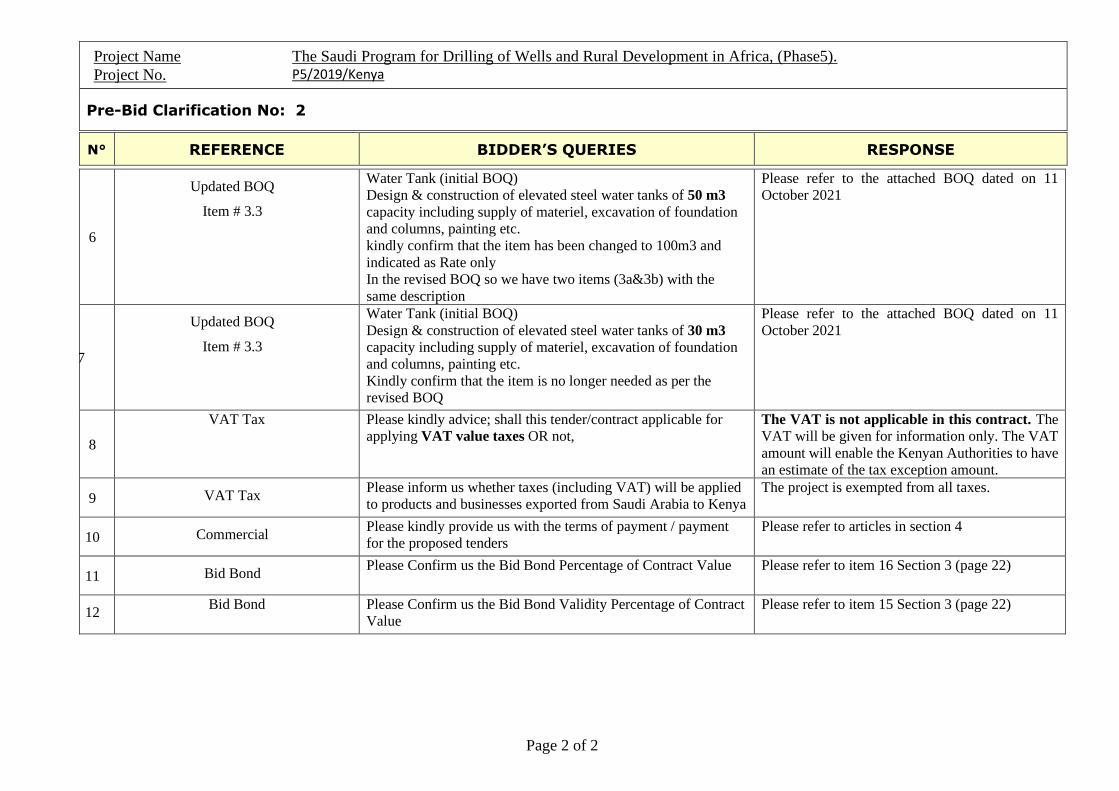
Project Name The Saudi Program for Drilling of Wells and Rural Development in Africa, (Phase5).
Project No. P5/2019/Kenya
Pre-Bid Clarification No: 2
N° REFERENCE BIDDER’S QUERIES RESPONSE
Page 2 of 2
6
Updated BOQ
Item # 3.3
Water Tank (initial BOQ)
Design & construction of elevated steel water tanks of 50 m3
capacity including supply of materiel, excavation of foundation
and columns, painting etc.
kindly confirm that the item has been changed to 100m3 and
indicated as Rate only
In the revised BOQ so we have two items (3a&3b) with the
same description
Please refer to the attached BOQ dated on 11
October 2021
7
Updated BOQ
Item # 3.3
Water Tank (initial BOQ)
Design & construction of elevated steel water tanks of 30 m3
capacity including supply of materiel, excavation of foundation
and columns, painting etc.
Kindly confirm that the item is no longer needed as per the
revised BOQ
Please refer to the attached BOQ dated on 11
October 2021
8
VAT Tax Please kindly advice; shall this tender/contract applicable for
applying VAT value taxes OR not,
The VAT is not applicable in this contract. The
VAT will be given for information only. The VAT
amount will enable the Kenyan Authorities to have
an estimate of the tax exception amount.
9 VAT Tax Please inform us whether taxes (including VAT) will be applied
to products and businesses exported from Saudi Arabia to Kenya
The project is exempted from all taxes.
10 Commercial Please kindly provide us with the terms of payment / payment
for the proposed tenders
Please refer to articles in section 4
11 Bid Bond Please Confirm us the Bid Bond Percentage of Contract Value Please refer to item 16 Section 3 (page 22)
12 Bid Bond Please Confirm us the Bid Bond Validity Percentage of Contract
Value
Please refer to item 15 Section 3 (page 22)
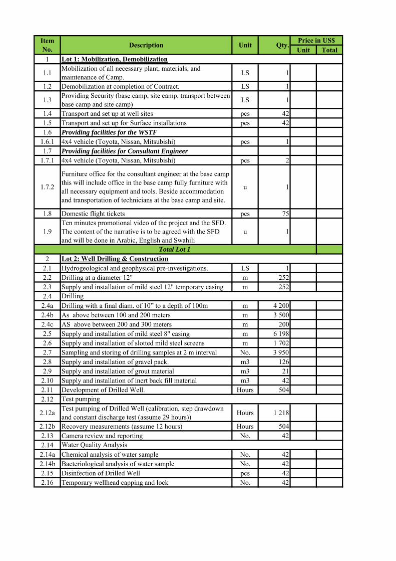
Unit Total1
1.1Mobilization of all necessary plant, materials, and maintenance of Camp.
LS 1
1.2 Demobilization at completion of Contract. LS 1
1.3Providing Security (base camp, site camp, transport between base camp and site camp)
LS 1
1.4 Transport and set up at well sites pcs 421.5 Transport and set up for Surface installations pcs 421.6 Providing facilities for the WSTF
1.6.1 4x4 vehicle (Toyota, Nissan, Mitsubishi) pcs 11.7 Providing facilities for Consultant Engineer
1.7.1 4x4 vehicle (Toyota, Nissan, Mitsubishi) pcs 2
1.7.2
Furniture office for the consultant engineer at the base camp this will include office in the base camp fully furniture with all necessary equipment and tools. Beside accommodation and transportation of technicians at the base camp and site.
u 1
1.8 Domestic flight tickets pcs 75
1.9Ten minutes promotional video of the project and the SFD. The content of the narrative is to be agreed with the SFD and will be done in Arabic, English and Swahili
u 1
22.1 Hydrogeological and geophysical pre-investigations. LS 12.2 Drilling at a diameter 12" m 2522.3 Supply and installation of mild steel 12" temporary casing m 2522.4 2.4a Drilling with a final diam. of 10” to a depth of 100m m 4 2002.4b As above between 100 and 200 meters m 3 5002.4c AS above between 200 and 300 meters m 2002.5 Supply and installation of mild steel 8" casing m 6 1982.6 Supply and installation of slotted mild steel screens m 1 7022.7 Sampling and storing of drilling samples at 2 m interval No. 3 9502.8 Supply and installation of gravel pack. m3 1262.9 Supply and installation of grout material m3 21
2.10 Supply and installation of inert back fill material m3 422.11 Development of Drilled Well. Hours 5042.12
2.12aTest pumping of Drilled Well (calibration, step drawdown and constant discharge test (assume 29 hours))
Hours 1 218
2.12b Recovery measurements (assume 12 hours) Hours 5042.13 Camera review and reporting No. 422.142.14a Chemical analysis of water sample No. 422.14b Bacteriological analysis of water sample No. 422.15 Disinfection of Drilled Well pcs 422.16 Temporary wellhead capping and lock No. 42
Lot 1: Mobilization, Demobilization
Item No.
Description Unit Qty.Price in US$
Total Lot 1Lot 2: Well Drilling & Construction
Drilling
Test pumping
Water Quality Analysis
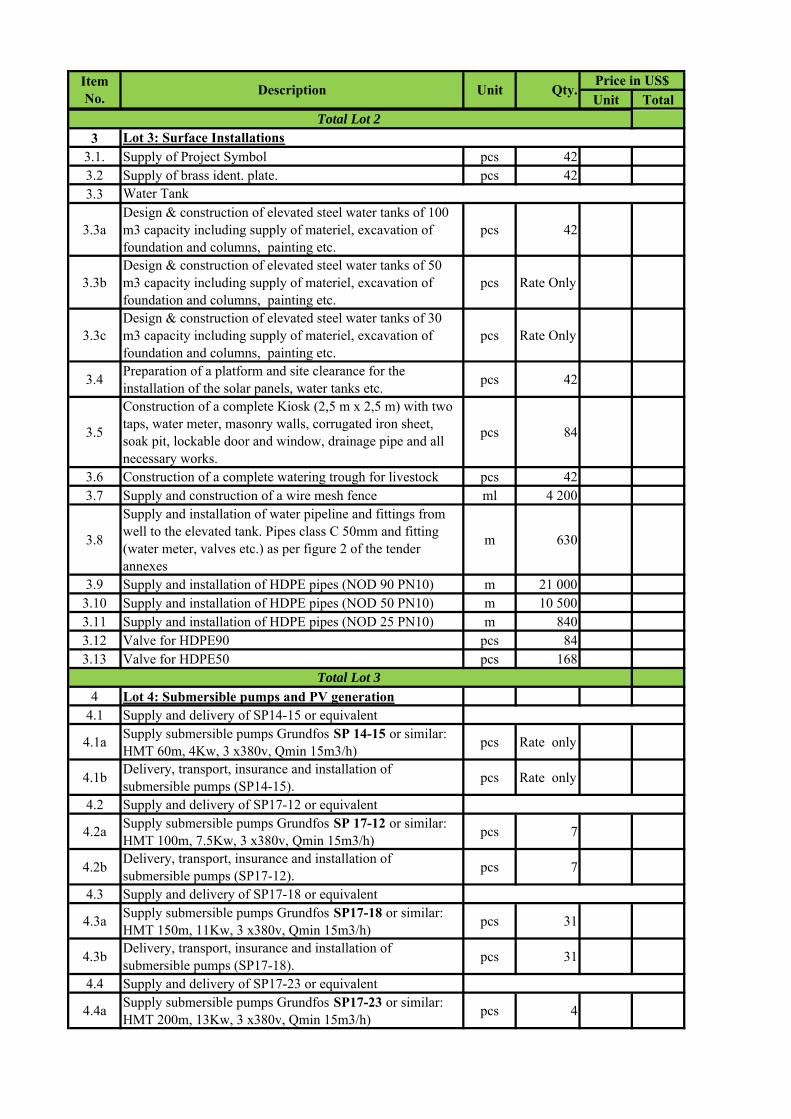
Unit TotalItem No.
Description Unit Qty.Price in US$
33.1. Supply of Project Symbol pcs 423.2 Supply of brass ident. plate. pcs 423.3
3.3aDesign & construction of elevated steel water tanks of 100 m3 capacity including supply of materiel, excavation of foundation and columns, painting etc.
pcs 42
3.3bDesign & construction of elevated steel water tanks of 50 m3 capacity including supply of materiel, excavation of foundation and columns, painting etc.
pcs Rate Only
3.3cDesign & construction of elevated steel water tanks of 30 m3 capacity including supply of materiel, excavation of foundation and columns, painting etc.
pcs Rate Only
3.4Preparation of a platform and site clearance for the installation of the solar panels, water tanks etc.
pcs 42
3.5
Construction of a complete Kiosk (2,5 m x 2,5 m) with two taps, water meter, masonry walls, corrugated iron sheet, soak pit, lockable door and window, drainage pipe and all necessary works.
pcs 84
3.6 Construction of a complete watering trough for livestock pcs 423.7 Supply and construction of a wire mesh fence ml 4 200
3.8
Supply and installation of water pipeline and fittings from well to the elevated tank. Pipes class C 50mm and fitting (water meter, valves etc.) as per figure 2 of the tender annexes
m 630
3.9 Supply and installation of HDPE pipes (NOD 90 PN10) m 21 0003.10 Supply and installation of HDPE pipes (NOD 50 PN10) m 10 5003.11 Supply and installation of HDPE pipes (NOD 25 PN10) m 8403.12 Valve for HDPE90 pcs 843.13 Valve for HDPE50 pcs 168
4 Lot 4: Submersible pumps and PV generation4.1 Supply and delivery of SP14-15 or equivalent
4.1aSupply submersible pumps Grundfos SP 14-15 or similar: HMT 60m, 4Kw, 3 x380v, Qmin 15m3/h)
pcs Rate only
4.1bDelivery, transport, insurance and installation of submersible pumps (SP14-15).
pcs Rate only
4.2 Supply and delivery of SP17-12 or equivalent
4.2aSupply submersible pumps Grundfos SP 17-12 or similar: HMT 100m, 7.5Kw, 3 x380v, Qmin 15m3/h)
pcs 7
4.2bDelivery, transport, insurance and installation of submersible pumps (SP17-12).
pcs 7
4.3 Supply and delivery of SP17-18 or equivalent
4.3aSupply submersible pumps Grundfos SP17-18 or similar: HMT 150m, 11Kw, 3 x380v, Qmin 15m3/h)
pcs 31
4.3bDelivery, transport, insurance and installation of submersible pumps (SP17-18).
pcs 31
4.4 Supply and delivery of SP17-23 or equivalent
4.4aSupply submersible pumps Grundfos SP17-23 or similar: HMT 200m, 13Kw, 3 x380v, Qmin 15m3/h)
pcs 4
Total Lot 2Lot 3: Surface Installations
Water Tank
Total Lot 3
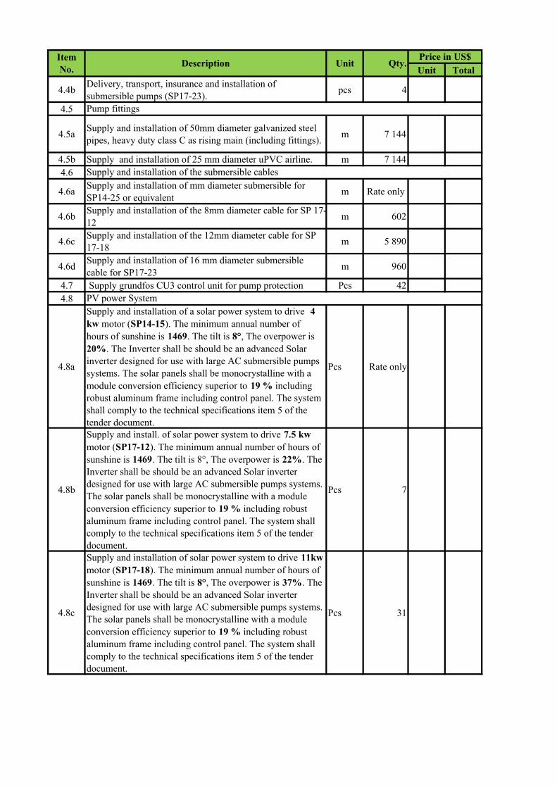
Unit TotalItem No.
Description Unit Qty.Price in US$
4.4bDelivery, transport, insurance and installation of submersible pumps (SP17-23).
pcs 4
4.5
4.5aSupply and installation of 50mm diameter galvanized steel pipes, heavy duty class C as rising main (including fittings).
m 7 144
4.5b Supply and installation of 25 mm diameter uPVC airline. m 7 1444.6
4.6aSupply and installation of mm diameter submersible for SP14-25 or equivalent
m Rate only
4.6bSupply and installation of the 8mm diameter cable for SP 17-12
m 602
4.6cSupply and installation of the 12mm diameter cable for SP 17-18
m 5 890
4.6dSupply and installation of 16 mm diameter submersible cable for SP17-23
m 960
4.7 Supply grundfos CU3 control unit for pump protection Pcs 424.8
4.8a
Supply and installation of a solar power system to drive 4 kw motor (SP14-15). The minimum annual number of hours of sunshine is 1469. The tilt is 8°, The overpower is 20%. The Inverter shall be should be an advanced Solar inverter designed for use with large AC submersible pumps systems. The solar panels shall be monocrystalline with a module conversion efficiency superior to 19 % including robust aluminum frame including control panel. The system shall comply to the technical specifications item 5 of the tender document.
Pcs Rate only
4.8b
Supply and install. of solar power system to drive 7.5 kw motor (SP17-12). The minimum annual number of hours of sunshine is 1469. The tilt is 8°, The overpower is 22%. The Inverter shall be should be an advanced Solar inverter designed for use with large AC submersible pumps systems. The solar panels shall be monocrystalline with a module conversion efficiency superior to 19 % including robust aluminum frame including control panel. The system shall comply to the technical specifications item 5 of the tender document.
Pcs 7
4.8c
Supply and installation of solar power system to drive 11kw motor (SP17-18). The minimum annual number of hours of sunshine is 1469. The tilt is 8°, The overpower is 37%. The Inverter shall be should be an advanced Solar inverter designed for use with large AC submersible pumps systems. The solar panels shall be monocrystalline with a module conversion efficiency superior to 19 % including robust aluminum frame including control panel. The system shall comply to the technical specifications item 5 of the tender document.
Pcs 31
Pump fittings
Supply and installation of the submersible cables
PV power System
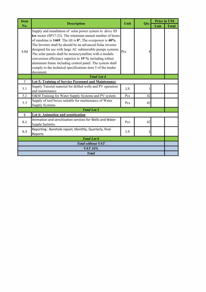
Unit TotalItem No.
Description Unit Qty.Price in US$
4.8d
Supply and installation of solar power system to drive 13 kw motor (SP17-23). The minimum annual number of hours of sunshine is 1469. The tilt is 8°, The overpower is 40%. The Inverter shall be should be an advanced Solar inverter designed for use with large AC submersible pumps systems. The solar panels shall be monocrystalline with a module conversion efficiency superior to 19 % including robust aluminum frame including control panel. The system shall comply to the technical specifications item 5 of the tender document.
Pcs 4
5
5.1Supply Tutorial material for drilled wells and PV operation and maintenance
LS 1
5.2 O&M Training for Water Supply Systems and PV system Pcs 42
5.3Supply of tool boxes suitable for maintenance of Water Supply Systems.
Pcs 42
6
6.1Animation and sensitization services for Wells and Water
Supply Systems.Pcs 42
6.3Reporting : Borehole report, Monthly, Quarterly, final
ReportsLS 1
Total
Total Lot 4 Lot 5: Training of Service Personnel and Maintenance
Total Lot 5Lot 6: Animation and sensitization
Total Lot 6Total without VAT
VAT 16%