new city streets: the role of urban rail trails in the social
TRANSCRIPT
New City Streets:The Role of Urban Rail Trails in the
Social and Economic Vitality of Cities
by
Lee Stephen Roberts
Architecture and Design | School of Technology, Environments and Design
Submitted in fulfilment of the requirements for the degree of
Doctor of Philosophy
University of Tasmania, November 2019
i
Declaration Of Originality This thesis contains no material which has been accepted for a degree or diploma by
the University or any other institution, except by way of background information and duly acknowledged in the thesis, and to the best of my knowledge and belief no material previously published or written by another person except where due acknowledgement is made in the text of the thesis, nor does the thesis contain any material that infringes copyright.
_______________________________________
Lee Roberts, November 2019

ii
iii
Authority Of Access This thesis may be made available for loan and limited copying and communication in
accordance with the Copyright Act 1968.
_______________________________________
Lee Roberts, November 2019

iv
v
Statement Of Ethical Conduct Ethics Reference No. H0014704
The research associated with this thesis abides by the international and Australian codes on human and animal experimentation, the guidelines by the Australian Government’s Office of the Gene Technology Regulator and the rulings of the Safety, Ethics and Institutional Biosafety Committees of the University.
_______________________________________
Lee Roberts, November 2019

vi
vii
AcknowledgementsIt is a luxury to be able to spend time reading and learning and thinking. I am grateful
to have had the opportunity to return to university, and I am thankful to the many people and organisations that helped me along the way. Firstly, I am grateful to Dr. Steven Fleming, who encouraged me to pursue this research and offered valuable early guidance and advice. I am also thankful for the steadfast and positive support from my supervisors, Dr. Ceridwen Owen and Dr. Emma Pharo, who saw me through a long process and the many bumps in the road along the way. I would also like to thank the two anonymous external examiners who provided useful and insightful comments on this thesis. The final document is better for their careful attention.
This research was supported by an Australian Government Research Training Program Scholarship, for which I am grateful. I received financial support for fieldwork and a symposium presentation from the University of Tasmania Discipline of Architecture and Design Research Committee, which allowed me the opportunity to present preliminary findings and ideas at the 2nd International Bicycle Urbanism Symposium in 2015. I was also able to participate in a writing retreat that was partially funded by the Postgraduate Council of the University of Tasmania Discipline of Geography and Spatial Sciences. I thank Chloe Lucas and Russell Warman for organising the retreat and welcoming me to the group, and I greatly appreciate the opportunity to work in the company of a group of passionate and engaged colleagues.
My fieldwork was extremely useful and enjoyable, and for that I thank the many people I met, talked to, and bicycled with along the way. Much of what is presented in this thesis is built upon their years of experience and hard work. Their generous sharing of their time, materials, and knowledge was invaluable. I would particularly like to thank Barb Chamberlain in Seattle, Michael Wilson in Minneapolis, and Kari Watkins in Atlanta, who were especially helpful in making connections with many informants who shaped my understanding of the rail trails in these cities. I would also like to thank Shawn DeAngelo for his perspective and insights. In each city, I was fortunate to be able to borrow or rent a bicycle for a reduced rate. I would like to thank G & O Family Cyclery in Seattle, Washington; Perennial Cycle in Minneapolis, Minnesota; and Bicycle South in Decatur, Georgia for supporting my research in this way.
Finally, I would like to thank my family for their patient and enthusiastic support throughout this long process. My parents, sisters, and brothers-in-law were always ready to help wherever possible, reading draft chapters, giving me a place to stay during fieldwork, and helping with long-service childcare. Most importantly, I thank my wife and son. This thesis is dedicated to Jayde, who has everlasting faith in my abilities and knowledge even when my own faith falters, and to Owen, who is a constant reminder of why I am doing this work and why I need to finish it. I offer them my deepest thanks and love.

viii
ix
Table of ContentsList of Figures and Tables ............................................................................................................................................. xiiiPrologue ...................................................................................................................................................................................1
1 Introduction: Urban Rail Trails as New City Streets .....................................................................3
1.1 Streets and City Life ............................................................................................................................................41.2 Rail Trails and Urban Bicycling......................................................................................................................51.3 The Importance of an Urban Design Approach to Transportation Issues ..................................71.4 Thesis Organisation ............................................................................................................................................9
2 Urban Vitality—The Concept and its Evolution ........................................................................... 11
2.1 From Liveability to Vitality ........................................................................................................................... 112.2 Three Aspects of Urban Vitality ................................................................................................................ 12
2.2.1 Physical consonance ............................................................................................................................ 122.2.2 Space for social and economic interaction ................................................................................. 132.2.3 Urbanity and the right to the city ................................................................................................... 14
2.3 A Framework for Urban Vitality ................................................................................................................. 16
2.3.1 Territoriality: Tracing power over public space ...................................................................... 172.3.2 Friction: The fostering of social and economic interaction ................................................. 172.3.3 Looseness: Consonance for a diverse population ................................................................... 18
2.4 Conclusion ........................................................................................................................................................... 18
3 Territoriality ........................................................................................................................................... 19
3.1 Streets as Territories ....................................................................................................................................... 213.2 Rail Trails as Territories ................................................................................................................................ 233.3 Bicycle Space as Territory ............................................................................................................................. 243.4 Rail Trails as Shifting Territories ............................................................................................................... 263.5 Territorialising Actors in Rail Trail Projects ......................................................................................... 273.6 Conclusion ........................................................................................................................................................... 29
4 Friction ..................................................................................................................................................... 30
4.1 Social Friction: “Rubbing Along” in Everyday Public Space ........................................................... 334.2 Cities as Frictionless Machines ................................................................................................................... 344.3 Urban Bicycling and Friction ....................................................................................................................... 36
4.3.1 Vehicular cycling .................................................................................................................................... 364.3.2 Sharing space .......................................................................................................................................... 384.3.3 Complete streets .................................................................................................................................... 394.3.4 Car-free space ......................................................................................................................................... 40
4.4 Friction and Morphology of Urban Rail Trails ..................................................................................... 41
4.4.1 Trail access ............................................................................................................................................... 424.4.2 Perceived proximity to trails ............................................................................................................ 43
4.5 Conclusion: Trail Design and Expectations of Friction..................................................................... 44
x
5 Looseness ................................................................................................................................................ 45
5.1 Loose Space and Heterotopias .................................................................................................................... 465.2 Three Categories of Loosening and Tightening ................................................................................... 48
5.2.1 Design ........................................................................................................................................................ 485.2.2 Use ............................................................................................................................................................... 495.2.3 Management ............................................................................................................................................ 525.2.4 Tightened spaces ................................................................................................................................... 53
5.3 Looseness in Bicycling and Rail Corridors ............................................................................................ 545.4 Combinations of Territorialisation, Friction, And Looseness ........................................................ 575.5 Conclusion ........................................................................................................................................................... 62
6 Methodology ........................................................................................................................................... 63
6.1 Introduction ........................................................................................................................................................ 636.2 A City as a Problem of Organised Complexity ...................................................................................... 636.3 Tracing Power in Public Processes ........................................................................................................... 646.4 Case Study Methodology ............................................................................................................................... 666.5 Selection of cases .............................................................................................................................................. 666.6 Research Methods ............................................................................................................................................ 68
6.6.1 Fieldwork .................................................................................................................................................. 696.6.2 Analysis methods .................................................................................................................................. 71
6.7 Conclusion ........................................................................................................................................................... 72
7 The Burke-Gilman Trail: Terrritorialised Space ........................................................................ 73
7.1 Introduction ........................................................................................................................................................ 737.2 The Burke-Gilman Trail as Park Territory ............................................................................................. 75
7.2.1 Territoriality and fragmentation as management practice ................................................. 777.2.2 Territorial rigidity and Seattle Parks and Recreation ............................................................ 797.2.3 Complete territorialisation within an evolving University of Washington campus
plan .............................................................................................................................................................. 807.2.4 Community territorialisations ......................................................................................................... 827.2.5 Business territorialisations............................................................................................................... 83
7.3 The Burke-Gilman Trail as Tight Space ................................................................................................... 847.4 The Burke-Gilman Trail as a Space of Friction and Flow................................................................. 89
7.4.1 Designing the trail around flow ...................................................................................................... 897.4.2 Ongoing negative friction ................................................................................................................... 917.4.3 Positive friction ...................................................................................................................................... 927.4.4 Ongoing scepticism of friction along the trail ........................................................................... 95
7.5 Conclusion ........................................................................................................................................................... 99
8 TheMinneapolisMidtownGreenway:Fromflowtofriction ................................................102
8.1 Introduction ..................................................................................................................................................... 1028.2 History of the Trail ........................................................................................................................................ 104
8.2.1 Greenway as a bicycle highway, not as a city street ............................................................. 106
xi
8.3 Friction Arising From Territoriality: The Midtown Greenway Coalition ............................... 109
8.3.1 Coalition of neighbourhoods ......................................................................................................... 1098.3.2 Midtown Greenway Coalition as manager and advocate .................................................. 110
8.4 Loosening Occupations and Tightening Management .................................................................. 113
8.4.1 Loose spaces along the corridor—gardens and leftover spaces .................................... 1138.4.2 Loosening uses within the corridor—the Midtown Bike Center ................................... 1208.4.3 Tightening management ................................................................................................................. 123
8.5 Friction From Networks and Connections .......................................................................................... 125
8.5.1 Active transport and transit networks ...................................................................................... 1258.5.2 Friction as an economic development tool ............................................................................. 1288.5.3 New frictions from development and connections ............................................................ 1308.5.4 Gentrification and racial frictions .............................................................................................. 132
8.6 Conclusion ........................................................................................................................................................ 134
9 The Atlanta BeltLine: Looseness by Design ................................................................................136
9.1 Introduction ..................................................................................................................................................... 1369.2 Loose Beginnings and Grassroots Assemblage................................................................................. 1369.3 The BeltLine as an Expanding and Overlapping Territory .......................................................... 142
9.3.1 Historic economic and cultural territories .............................................................................. 1449.3.2 Organisational and commercial territorialisations ............................................................. 1479.3.3 The BeltLine as a loose assemblage ........................................................................................... 150
9.4 Friction as a Loosening Agent .................................................................................................................. 155
9.4.1 Trail connections ............................................................................................................................... 1569.4.2 Planning tools for a new city street ............................................................................................ 159
9.5 A Tightened Future? The Replacement of the Ad Hoc With the Formal ............................... 1649.6 Conclusion ........................................................................................................................................................ 166
10 Discussion and conclusion ...............................................................................................................168
10.1 Introduction ..................................................................................................................................................... 16810.2 Case Study Findings and Observations ................................................................................................ 169
10.2.1 Monolithic territories are often invisible ................................................................................. 17010.2.2 Friction increases in the absence of territorial controls ................................................... 17110.2.3 Territorialising land uses and urban forces have mixed impacts .................................. 17210.2.4 Looseness is difficult to maintain in public space ................................................................ 17310.2.5 Looseness must be designed into physical space ................................................................. 17410.2.6 Interactions between the agents of urban vitality in the case study trails ............... 175
10.3 Implications of This Research for Urban Design Theory and Practice ................................... 178
10.3.1 Urban vitality and the repositioning of friction as an analytical tool .......................... 17810.3.2 Territoriality and the expression of power in physical space ......................................... 18010.3.3 Rail trails and bicycle infrastructure design must cross disciplinary boundaries . 181
10.4 Limitations of This Study and Recommendations for Future Research ................................ 18210.5 Conclusion ........................................................................................................................................................ 183
Appendix 1: Interview Questions ........................................................................................................................... 185Bibliography ..................................................................................................................................................................... 187
xii
List of Figures and Tables3.1 Wanhua Night Market in Taipei, Taiwan.....................................................................................................223.2 “Bike City Copenhagen.” ....................................................................................................................................263.3 Trees along an abandoned railway corridor.............................................................................................274.1 Skyway in downtown Minneapolis, Minnesota .......................................................................................314.2 Pavement colours and curb edges in Amsterdam ..................................................................................324.3 A rendering of the proposed Skycycle in London. ..................................................................................324.4 A Ciclovía in Bogota, Colombia .......................................................................................................................405.1 A wide footpath in Mumbai, India provides space for trade and casual social activity .........495.2 A loose space adjacent to a footpath. ...........................................................................................................495.3 Pedestrians overflow into traffic lanes at a bus stop in Yangon, Myanmar .................................505.4 A scramble crossing in Shinjuku, Tokyo .....................................................................................................515.5 A tightly controlled pedestrian crossing in Moonah, Tasmania .......................................................535.6 Bicycle use restrictions in Berkeley, California .......................................................................................555.7 Circle Wye area of Atlanta Georgia ...............................................................................................................565.8 Zuccotti Park in New York City, during the Occupy Wall Street protest .......................................585.9 A poster for the 7th Annual Busker Fair at Pike Place Market ...........................................................596.1 Table of formal semi-structured interviews as part of fieldwork ...................................................707.1 Map of the Burke-Gilman Trail and connected trails ............................................................................747.2 The Burke-Gilman Trail in the University District neighbourhood ................................................777.3 Ownership and management of the Burke-Gilman Trail ....................................................................787.4 Student housing at the University of Washington ..................................................................................817.5 Rendering of the Life Sciences Building at the University of Washington ...................................827.6 Rendering of proposed campus entry point at Burke-Gilman Trail ...............................................827.7 Bicycle-oriented business with signage and entry directly facing the trail ................................847.8 Direct access to a trail-adjacent building ...................................................................................................857.9 A direct connection to the trail from a single-family house ...............................................................857.10 Signs along the trail .............................................................................................................................................867.11 Typical trail section .............................................................................................................................................867.12 Map of Burke-Gilman Trail showing nearby public amenities .........................................................877.13 Art installation that blocks skateboarder use of a ramp at the Wall of Death ...........................887.14 Map of street grid, showing how the grid was modified to follow the rail corridor ...............897.15 Map showing constrained north-south routes for bicyclists .............................................................907.16 Fencing along the trail ........................................................................................................................................917.17 Park amenities along trail at Burke-Gilman Playground Park ..........................................................937.18 Connection to Matthews Beach Park from the Burke-Gilman Trail ...............................................937.19 Entry to 192 Brewing Company from the Burke-Gilman Trail .........................................................947.20 Land use plan of area around proposed Sher Partners project........................................................957.21 Aerial view of proposed Sher Partners building, ....................................................................................967.22 Plan of proposed plaza and modifications to the Burke-Gilman Trail ..........................................977.23 The completed Sher Partners building .......................................................................................................998.1 Map of Minneapolis bicycle trails ............................................................................................................... 1028.2 A view of the Midtown Greenway from above ...................................................................................... 103
xiii
8.3 Map of the Grand Rounds Scenic Byway and waterfront parks .................................................... 1068.4 Map of access points to the Midtown Greenway .................................................................................. 1078.5 Typical access ramp ......................................................................................................................................... 1078.6 Neighbourhoods that hold board positions in the Midtown Greenway Coalition ................ 1098.7 Small leftover space along the Midtown Greenway ............................................................................ 1148.8 Kix Field ................................................................................................................................................................. 1148.9 Visitors to Vera’s Garden ................................................................................................................................ 1158.10 Cepro Greenspace ............................................................................................................................................. 1168.11 Cepro Greenspace edge adjacent to the Midtown Greenway ......................................................... 1178.12 Diagram of Soo Line Community Garden and leftover spaces ....................................................... 1188.13 Soo Line Community Garden, as viewed from the Midtown Greenway .................................... 1208.14 Midtown Global Exchange and the Midtown Bike Center ............................................................... 1218.15 Freewheel Bike main entry ........................................................................................................................... 1228.16 Winter Bike Expo at Freewheel Bike ........................................................................................................ 1238.17 Police car in the corridor as part of a regular patrol .......................................................................... 1248.18 Diagram from the Lake Street-Midtown Greenway Corridor Framework Plan ..................... 1268.19 Preliminary design for a streetcar station in the Midtown Greenway corridor ..................... 1278.20 Pedestrian promenade between Midtown Lofts and the Midtown Greenway ....................... 1318.21 Direct connection from Elan parking garage to the Midtown Greenway .................................. 1318.22 Elan Deux from the Midtown Greenway ................................................................................................. 1329.1 Entire proposed BeltLine route, showing open sections of rail trail .......................................... 1379.2 Rendering of proposed redevelopment along the BeltLine in Southwest Atlanta ................ 1389.3 Seal of the City of Atlanta ............................................................................................................................... 1409.4 Historic Fourth Ward Park ............................................................................................................................ 1419.5 Developed and undeveloped sides of the corridor ............................................................................. 1419.6 Map of BeltLine with Tax Allocation District ......................................................................................... 1439.7 New construction along a future section of the BeltLine ................................................................. 1459.8 Rendering of future Westside Park at Bellwood Quarry .................................................................. 1479.9 Bicycles used in signage at Irwin Street Market .................................................................................. 1499.10 Signage, picnic tables, and bicycle parking along the BeltLine...................................................... 1499.11 BeltLine used as a wedding parade site .................................................................................................. 1509.12 Image of Brown Middle School, showing direct connections to the BeltLine ......................... 1539.13 Informal trail connection and new formal trail access stair ........................................................... 1569.14 Wheelchair-accessible ramp from BeltLine to supermarket and shops ................................... 1569.15 Formal and informal connection points to the Eastside Trai ......................................................... 1579.16 Socialising around a connecting path from the BeltLine ................................................................. 1589.17 Portion of the BeltLine Overlay District .................................................................................................. 1629.18 Informal staircase connecting Atlanta BeltLine Bicycle to the BeltLine.................................... 16510.1 A street end plaza in Copenhagen .............................................................................................................. 176
xiv
AbstractRail trails—abandoned rail corridors that are repurposed as trails for walking and
biking—are increasingly common in the United States and Australia. In cities, rail trails are designed as linear parks, as bicycle superhighways, and as neighbourhood connectors. They function as both active transportation corridors and public space. In this way, they can reproduce aspects of historic urban streets, which were transportation corridors but also spaces for promenade, socialising, and shopping.
This thesis examines urban rail trails through this potential as a new kind of city street. This potential is significant, as American and Australian cities struggle to integrate active transportation and to create public spaces that are lively and safe and that contribute to the social and economic life of the city. To analyse rail trails as both transportation and public space, this thesis develops a framework of urban vitality. Urban vitality is defined as a character of a space that encourages economic and social interaction between people.
This framework of urban vitality is explored theoretically and practically through the development of three agents: First, territorialisation is the control over a physical space by a government, business, organization, or group; and the imposition of particular set of rules, meanings, and order to the space. Second, friction describes the physical, visual, and social interaction of people and places. These interactions are key to the creation and maintenance of a vibrant public sphere where individuals can come together to form communities. Third, looseness describes spaces where physical design, uses, and management contribute to a sense of freedom and possibility. Loose spaces are marked by a physical environment that can be modified and appropriated; a flexible (or non-existent, or vague) set of guidelines or regulations for the use of the space; and a resultant awareness or tolerance for overlapping and conflicting views. These three agents are independently increased or decreased in urban space through physical design, management practices, and everyday use. They interact with each other, reinforcing or conflicting with each other in different circumstances.
This framework of urban vitality and the agents of territory, friction, and looseness are used in the analysis of three case study rail trails in the United States: The Burke-Gilman Trail in Seattle, Washington; the Midtown Greenway in Minneapolis, Minnesota; and the BeltLine in Atlanta, Georgia. The case study trails represent a diverse cross section of urban rail trails, varying by age, by design, and by their relationships to the surrounding urban fabric. The case study analysis leads to a generalised set of observations and findings on creating urban vitality in urban rail trails and other urban public spaces.
1
PrologueDuring my fieldwork for this thesis, I had an experience which altered my perspective on
my research and drove home an important lesson about cities and how they change over time. I was walking with my bike along an abandoned railroad track in southwest Atlanta; a part of an attempt to walk around the entire circuit of the Atlanta BeltLine, which was still a long way from complete. I was alone for most of my walk, looking at the back of houses, abandoned industrial yards, empty warehouses and old buildings. I felt moments of fear of the unknown—I had never been to Atlanta and did not know what to expect from this walk. I passed a campsite and felt like I was intruding on someone’s fragile personal space. I walked through a tunnel under a road—it was an evocative ruin of old stone abutments overlaid with successive levels of graffiti, moss, and vines. The tunnel was we, so I balanced on one rail and rolled my bike through the dark water.
Further on I saw two young men, in their late teens or early twenties, coming in the opposite way along the tracks. I am a tall, middle-aged white man and I don’t often feel in danger in public, but I felt obviously out of place here. In my time in Atlanta I was struck by how often people greeted me on the street—when I passed another man on a footpath, he almost always said hello. Coming from Seattle and Hobart this was unusual and pleasant. As we passed on the tracks, one of the men said to me, “You write?” which I misunderstood as “You right?” as in, “Are you all right?” Assuming that this was just a version of “hello” that I was unfamiliar with, I answered yes. He then asked me, “What do you write?” which confused me. So, he asked again, “you write?” while gesturing as if writing on a vertical surface. I realised that he was asking me if I was a graffiti artist, and what my tag was. I laughed and said no, surprised and thrilled to think that anyone could mistake me for a graffiti artist. My image of myself is that I look safe, not threatening in any way, but not particularly interesting and certainly not edgy enough to be out spray-painting art on the sides of old railway cars. I liked the idea that anyone could think that of me, with my V-neck sweater, suede shoes, and rented hybrid bike.
This experience has stayed with me throughout my research process, and I have thought a lot about what it tells me about abandoned rail lines and their conversion to rail trails. Rail trails are exciting places to be. They slip through the forgotten places of the city, through old and overgrown bits of infrastructure from the last millennium, cutting in and out of the contemporary city at strange angles and in sometimes discordant places. I think most people who use urban rail trails experience this sensation of being in the city but sometimes apart from it, away from the order of a regular grid of property lines and roads for cars. I enjoy the process of thinking about how these trails can play an important role in helping more people walk and bicycle more, both for recreation and for everyday transportation. Free from car traffic and off the grid, a rail trail is a great place to learn to ride and a great way to get through the city. With some additional design and planning work they can also be a great way to get around the city, connected to citywide bicycle and walking networks, and to the parks, schools, shopping areas, and business districts that are the destinations of most of our daily trips.
2
But that experience of walking along the abandoned tracks where the trail had not yet been built caused me to rethink or reframe my research. The experience of being outside the rational order of the city, in a place where wilder and less-defined forces operate, was thrilling. There was a sublime quality to being alone in a place shaped by the now-absent power of a railway, where the old infrastructure and land forms of the movement of a train still dominated, still echoed through the city of today. But it was the ongoing life of the corridor—its defined and contested edges, the colonisation of its spaces by transgressors and pioneers of every species, its changing relationships with its context—that were the most exciting to observe and experience. Walking along an abandoned rail line was, for me, an experience of an othered and othering place. It was often not an emotionally comfortable space. I felt a clear frisson from being in a place where the rules of behaviour are unclear, or where I felt like I was intruding on the small places where people had painstakingly created a sense of ownership. However, it was a richer experience for that discomfort.
Most striking was the experience of being in a place with a very different set of environmental indicators of identity. Where someone is has an important impact on our images of who that someone is, whether that someone is me, or someone else. The in-betweenness of the abandoned rail corridor and the real and implied transgressions of being on the tracks broke through social barriers between me and my two fellow travellers. There was a moment in which we could have been co-transgressors, part of an ad hoc community. I regret not stopping to talk to them, not learning what they wrote, how they experienced the corridor, and how it fit into their Atlanta.
Design is a creative process, but it is also a destructive one. We cannot build without dismantling or destroying something else, whether it is through the harvesting of trees or clay or iron ore, or through the removal of one set of places and meanings in favour of a new set. As designers we try to pick up on the energies and existing meanings of our design sites—the genius loci of the place—and then highlight, enhance, or contrast that spirit in our work. Particularly in urban design, imposing a new vision on a place—no matter how sensitively or collaboratively we create that vision—inevitably covers, alters, or destroys significant portions of the life of that place, even in the very attempt to celebrate its life.
This is a painful process. No matter how successful or valuable the end result is, the creation of public space involves pain. This learning was brought home to me again in my walk along the tracks. In the service of creating new ways to experience the city, new routes, new connections and new abilities to move without a car, urban rail trails also close off and pave over other valid, vigorous, and important ways of being in the city. It is not just that a particular group or community loses their space, but also that by integrating the rail corridor into the fabric of the city, making it safe, eliminating the weeds and the trash and the undesirable uses, we also minimise its impact as a space of difference. My time on the tracks in Atlanta, and throughout my case study research, teaches me to be mindful and respectful of the pain I cause in the course of my work, especially that pain I do not experience firsthand.

3
1 Introduction: Urban Rail Trails as New City StreetsThis thesis examines the contested sites of urban rail trails and their potential as a new
kind of city street, both transportation corridor and social space. While rail trails can be found in every type of environment, from wilderness to rural countryside to small towns and suburbs, this thesis is focusing on their role in urban spaces. Urban is used here to describe places with relatively high population density, diverse transportation needs, and where walking, bicycling, and transit are viable for everyday travel. This potential use of rail trails for everyday travel distinguishes urban rail trails from rural or wilderness rail trails that are primarily recreational.
The world’s cities and rural areas are criss-crossed with inactive rail lines. In the United States alone, more than 155,000 miles (250,000 km) of rail line are abandoned (Fabos, 2004). These abandoned rail corridors are an increasingly prized commodity. They represent long strips of developable space in crowded cities and are usually located in areas well served by city services. They allow local governments to cheaply reclaim land to create desirable urban amenities and add value to existing inner-city land, encouraging urban revitalisation. They also represent opportunities for development without the associated infrastructure investment and environmental costs of greenfield development on the urban fringe. In addition, many abandoned rail lines connected former industrial centres with rural hinterlands that have been redeveloped as residential suburbs or new commercial centres. There is often considerable potential for rail corridors to become an integral part of the urban transportation network again as rail trails, providing alternate commuter networks as walking, bicycling, or transit routes.
However, conversion of rail corridors into trails has usually been contested. As an abandoned rail line is converted into a trail, there is very often resistance from neighbours who believe the trail will bring additional nuisances—noise and rubbish problems, crime, or invasions of privacy (Hawthorne et al., 2008). In some projects where the rail corridor was created as an easement over privately owned land, rail trails are challenged by neighbours in the hope that the land will revert to private ownership (Montange, 1987, p. 110).
In the face of this opposition, rail trail projects can require considerable public support and political will. A critical element in creating this support is the acceptance of walking and bicycling as more than just recreation. Active transportation must also be embraced as a valuable contributor to the social and economic life of cities, and rail trails reimagined as a new kind of city street. As such, this thesis focuses on the ideation, negotiation, and decision-making processes around rail trails—how they are imagined, planned, and used—as much as on the specific physical design of rail trails. This thesis also focuses on urban rail trails from a bicycling perspective, despite the equally important role of urban rail trails for pedestrians. This limitation of scope is in recognition of the historical and cultural differences between urban walking and bicycling, as well as the significant differences in physical design needs, rather than an opinion of their relative value.
4
1.1 Streets and City Life
Until the start of the 20th Century, urban streets were the undisputed centres of the social and economic life of a city. They were flexible spaces that served multiple functions. The pre-modern street “was the place of work, the place of buying and selling, the place of meeting and negotiating, and the scene of the important religious and civic ceremonies and processions” (Jackson, 1984, p. 64). Buildings were typically cramped and dark, so the street was used as an extension of workshops and kitchens. Socialising and leisure also took place in the street, mixing private and public space. More than any other public space in the city, the street was the “matrix of a community…an essential spatial element in a community” (Jackson, 1984, pp. 64-65).
But the history of city streets over the last hundred years has been marked by growing restrictions on how the street can be used and by whom. Even before the automobile became dominant in cities, streets were increasingly positioned as spaces of circulation, in which obstructions to movement were punishable through municipal ordinances. For instance, in the late 19th Century, the City of Los Angeles required footpath improvements be built by adjacent property owners. This was generally accepted by business owners who saw the benefit of safe and clean pedestrian spaces outside their display windows, but the city government also placed limits on what types of activities, signage, vending, and public speaking could take place on those new footpaths (Ehrenfeucht & Loukaitou-Sideris, 2007).
The introduction of automobiles into cities accelerated this effort to separate and control use, further defining the street as a space for movement. After a brief period when the car was seen as a dangerous interloper into the mixed-use space of the street, it quickly came to dominate. Streetcars, bicycles, and pedestrians were forced out of the street, or constrained to narrow zones beside it. Public campaigns and new terms like “jaywalking” were employed to scare or shame non-driving users into compliance with a street logic that prioritised fast movement for motor vehicles (Norton, 2008).
The social role of the city street has been rediscovered in the last fifty years, and once again streets are being recognised for their potential as places for protests, displays, café tables, and buskers. Protecting and promoting the city street as a site of social and economic interaction is becoming mainstream planning policy. As the social life of city streets becomes important again, there has been a new focus on designing for the different uses of the street. Since the pioneering work of Jane Jacobs (1961), Jan Gehl (1987), Donald Appleyard (1981), and others in the 1960s through the 1980s, there has been an effort to think about movement in the city as complex and dynamic social interactions, as opposed to simple flows from origins to destinations. Over the last fifty years, pedestrian planning in particular has taken a central role in urban design thinking. Planners and designers are increasingly aware of the role that pedestrians play in creating a vibrant social life of the city, enhancing public safety, and contributing to the economy of the city (Demerath & Levinger, 2003).
Studies of urban pedestrian environments emphasise connectivity and continuity of routes and networks (Anne Vernez Moudon & Stewart, 2013), but they also recognise that pedestrian spaces are better used and better liked when they include amenities such as regular
5
seating areas, weather protection, visual stimulation and interaction with building uses (B. B. Brown et al., 2007). There is a recognition that streets attract walkers when they provide visual interest, places to see and be seen, and easily-accessible activities (Mehta, 2008). Walking environments need to provide safety, activity, and engagement in order to succeed. In return, good walking environments create levels of social and economic vitality that benefit nearby businesses (Montgomery, 1998), and make parks, streets, and other public spaces feel safe and enjoyable (Jacobs, 1961; Marcus & Francis, 1998). Cities throughout the US and Australia have developed new pedestrian-centred environments, and a body of strategies have been theorised, tested, and accepted into design practice.
But the belief in high-speed movement as the highest and best use of street space remains deeply entrenched in public perception and sometimes in planning and urban decision-making, as well. Projects that shift priorities toward walking, bicycling, or staying activities are increasingly common, and after this type of re-design is completed, the streets are often seen as strong contributors to city life (Litman, 1999, p. 16). But the vast majority of these projects still entail a difficult fight over street space, and assertions that driving and parking remain the proper use of public street space (Sadik-Khan & Solomonow, 2016). Urban rail trails offer an opportunity to create new kinds of city streets that prioritise urban life while avoiding perceptions of a “war on cars” because the space is reclaimed from a different transport corridor.
1.2 Rail Trails and Urban Bicycling
Unlike streets, rail trails are a relatively new type of infrastructure—the first official examples in the United States were created in the mid-1960s, and the first rail trail in an urban setting was built in the early 1970s. The creation of rail trails has accelerated in the subsequent five decades—there are now at least 2000 in the United States (Rails-to-Trails Conservancy, 2019a). This growth has been enabled by the general decline in railway use, but also by federal enabling legislation. The Railroad Revitalisation and Regulatory Reform act of 1976 gave public agencies the first opportunity to buy abandoned rail corridors for public use (Montange, 1987). This act, along with a small federal grant program, helped start an initial wave of trail conversion. These early efforts were subsequently supported by a national rail trail advocacy organisation, the Rails-to-Trails Conservancy, established in 1986. This organisation has been an important voice in championing and publicising trails, advocating at both state and federal governments, and providing design, planning, and fundraising guidance (Rails-to-Trails Conservancy, 2019b).
Public opinion and professional practice regarding what an urban rail trail can be is still in flux, and can be context dependent. This creates an opportunity to rethink how active transportation fits into the social and economic fabric of the city.
However, rail corridors are often difficult to stitch into the urban fabric. For rail to be efficient, trains must run along relatively straight, flat routes. They cannot easily make sharp turns or negotiate steep slopes, and so often run below or above surface level. These physical constraints often mean that rail corridors and street grids are not aligned with each other, as they follow different sets of logic. The long acceleration and deceleration time of a train means
6
that rail corridors must also be as uninterrupted as possible. As a result, rail corridors are often physically separated from streets, and where intersections are absolutely necessary rail lines typically have priority.
When rail lines are abandoned in cities, this inherent separation from street grids gives the corridors an otherworldly quality. Despite their physical proximity to the city that surrounds them, they can be hard to access and feel removed from the flow of the surrounding city (Little, 1990; Franck & Stevens, 2007; Kullman, 2013). Rail corridors often create barriers and leftover spaces that have had negative impacts on property values and quality of life (Chen et al., 1998), and these negative effects can multiply when the corridor is abandoned.
However, the distinct characteristics of a rail corridor—the continuity, gradual slopes and separation from surrounding streets—also make rail corridors very attractive as bicycling trails and alternate commuter routes. A rail trail can feel like a bicycle highway, with long stretches of uninterrupted riding and little need to stop or negotiate cross traffic. The separation from car traffic on streets eliminates many of the stresses of urban bicycling. For everyday bicycling, however, this highway-like character can be inconvenient, since the connections to destinations can be infrequent or indirect.
Overcoming this inconvenience requires rethinking the role of bicycling in cities. While the bicycle is positioned as a positive alternative to the car, unlike pedestrian planning, bicycle planning has yet to conceive of bicycles as more than a mode of transportation. Studies from bicycle-friendly cities and best practice guidelines focus almost exclusively on infrastructure design and end-of-trip facilities (D. Taylor & Davis, 1999; de Groot, 2007; AASHTO, 2012). There are a few studies on the emotional experience of bicycling (Spinney, 2007; Fleming, 2013), but research on trip experience has generally focused on design strategies to increase perceptions of safety and improve route connections and options (Pucher et al., 2011).
Despite considerable evidence that higher bicycling rates address a variety of environmental, economic, social, and public health issues (Krizec, 2007; Garrard et al., 2012), cities face significant barriers to the implementation of bicycle infrastructure. A great deal of academic and practical effort has been made to identify ideal bicycling infrastructure, but overcoming social and cultural resistance to bicycling is a larger issue in both Australia and the United States.
This resistance has roots in concepts of modernity and progress (L. Roberts & Fleming, 2014), mainstream culture, and the image of the contemporary bicyclist (Furness, 2010). It manifests as seemingly intractable budget and space limitations and political opposition, largely based on the difficulty in seeing beyond our current automobile-dominated lifestyles and sprawling urban development patterns. In Australian and American cities, automobile-centred lifestyles and urban development patterns have limited the financial and political viability of other modes of transportation. European cities have prioritised bicycle transportation and have made significant progress in shifting people out of cars and onto bikes over the past several decades. But even in these cities, there are concerns that progress has slowed (Harms et al., 2014).
7
Very little research has been undertaken to examine how the built environment (building design and uses, open space, visual and spatial information) engages and supports bicyclists (Forsyth & Krizek, 2011). Transportation and urban planning practices still tend to see bicycling solely as a transportation mode, designing for how bicyclists move through environments, rather than addressing how they interact with space. This is consistent with transportation planning in general, which historically has been concerned with efficiency and safety in how vehicles move from place to place (R. A. Johnston, 2004). Transportation models, which are used by local and regional governments to predict traffic and to aid the design of streets, are designed solely around travel. While contemporary transportation models increasingly include transit, bicycles, and pedestrians as means of travel, the inherent bias of transportation planning and transportation models towards pure measures of efficiency in connecting origins and destinations means that riding a bike is treated in the same way as driving a car—a means to an end, but little more. This oversimplification of how transportation and city life interact strongly colours how we plan for bicycling. However, in the same way that pedestrian activity is seen as critical to the creation of socially and economically vibrant environments, bicycling can contribute to urban vitality.
The concept of urban vitality has been used over the last 60 years to try to understand what makes for economically and socially vibrant cities and then to design for vibrancy. There is a sense of agreement that urban vitality, however loose and slippery as a concept, is what draws people into cities. But there is also the recognition that it is the people in those vibrant places that makes them compelling, and that physical design does not automatically generate vitality. Urban vitality is both the producer and product of vibrant urban spaces, but we must interrogate the relationship between physical space and human activity.
This thesis begins to fill these important research and practice gaps. First, it considers bicycling as more than a transportation mode and seeks to understand bicyclists as full participants in the social and economic life of the city. Second, it investigates the cultural and political milieu in which urban rail trails are developed, as a way of understanding attitudes toward urban bicycling. Third, this thesis identifies where the built environment around rail trails changes to accommodate bicyclists and pedestrians to understand how these changes impact walking and bicycling experiences. Finally, this thesis develops and applies a working definition of urban vitality as a framework for analysis of urban rail trails and other public spaces.
1.3 The Importance of an Urban Design Approach to Transportation Issues
Underlying this research is a recognition of the critical importance of cities and city shapers in our present and future world. As we seek to address anthropogenic climate change, overconsumption and waste, and social and economic inequalities, cities (and networks of cities) are at the crux of both the sources and solutions to these problems (Gordon, 2013). Our current global patterns of population growth and urbanisation pose an unprecedented challenge to human societies and to the earth. The United Nations estimates that 55% of the world’s population lives in urban areas, and this is expected to increase to 68% by 2050. Global urban
8
population has grown by 3.5 billion people since 1950 and by 2050 another 2.5 billion people will live in urban areas (UN Department of Economic and Social Affairs, 2018). Cities today are beset by mistrust and perceived dangers between people, by traffic, space, and mobility issues, and by policies that favour the already powerful and disadvantage everyone else. The United Nations New Urban Agenda (NUA), as passed at Habitat III in Quito in 2016, clearly emphasises the critical need to approach urbanisation as a complex, multi-disciplinary problem, requiring attention on the interconnections between politics, economics, social networks, and environmental and personal health (UN Habitat, 2017). But the NUA also affirms the promise of cities as sites of unprecedented economic and social opportunity, as vibrant political and cultural centres, and as potential key contributors to environmental sustainability, mobility, and egalitarian access to resources. The city is the nexus in which global forces come into contact with the intimate physical spaces that form and are formed by communities (Castells, 1983; Friedmann, 1986; Coward, 2012). This makes the city a critical point of study and intervention in any attempt to create a more just, equitable, and sustainable world.
These interventions require diverse and sensitive skill sets. Historically, architecture has tried to create beautiful, efficient cities without sufficient and sustained consideration of the underlying social and political dynamics that drive city-making and city life. Urban planning, on the other hand, projects comprehensive, large-scale plans and universally-applicable policies onto cities but often lacks the fine-grained tools to manage the actual form of built spaces or the variable ways that people inhabit urban places. Urban design has the potential to bridge this divide. It can draw from the critical scholarship of urban planning and studies and integrate that larger societal perspective with the spatial analysis and design tools of architecture (Carmona, 2003, pp. 14-16). In order to do so, urban designers must take to heart the message of the NUA—cities must make space for differences between denizens across racial, economic, and social boundaries, and build equity and social justice into the built environment. These differences often manifest through the temporal and ephemeral uses of spaces, which are often neglected. When urban design is focused on static physical space it often fails to accommodate the real and changing needs of users in the service of narrow design criteria (Lang, 1994, p. 360). This is particularly evident when parts of a city are treated as pure infrastructure, such as a freeway or a hardened river channel (Carmona, 2003, p. 88). By simplifying an urban space to serve a single function, planners and engineers may achieve a narrow efficiency but lose the ability to adapt to the changing needs of society or create synergies with its surrounding uses. By thinking and designing urban spaces based on a broad set of goals and values, more resilient solutions can be found (Ahern, 2013).
Just as urban design requires a multi-disciplinary approach to create space that serves the diverse and evolving needs of a community or a city, analysis of urban place also requires a broader perspective. This thesis draws on urban theory, sociology, and built environment research, and grounds itself in the political, economic, and social context of urban rail trail projects.
9
1.4 Thesis Organisation
This thesis examines rail trails in three US cities—the BeltLine in Atlanta, Georgia, the Midtown Greenway in Minneapolis, Minnesota, and the Burke-Gilman Trail in Seattle, Washington. The thesis explores the potential of these trails to be more than single-use transportation corridors, but instead to be new city streets. The three rail trails are located in different parts of the United States, in cities with very different histories, demographics and attitudes toward walking and bicycling. They differ significantly in original design intent—what, and who, they were built for—and in how they are integrated into the surrounding urban fabric. They also reflect different and changing attitudes towards public space, transportation and urban democracy, and these attitudes have influenced the forms and functions of these trails. By considering how these rail trails were designed, used and relate to their context, this thesis argues that urban vitality, defined as the interactions between three key agents: friction, looseness and territoriality, is essential for fostering liveable and sustainable cities.
Chapter 2 will review previous uses of the term urban vitality and make explicit the mutual, recursive and non-linear interactions between place and people. It will draw on scholarship from outside architecture and urban planning in order to more fully capture the complex lived experience of urban places. Urban vitality is defined as the product of three key interacting agents: territoriality, friction, and looseness.
Chapter 3 discusses the application of Deleuze and Guattari’s concept of territoriality in urban spaces. The chapter highlights how urban power dynamics constantly build up and tear down physical, economic, and social territories in cities. Territorialisation of urban spaces, and the constant deterritorialising subversions of control, are a critical aspect of the form and function of a city. Urban rail trails represent an example of how urban spaces can shift in and out of various territories over time.
Chapter 4 investigates friction as a productive force, broadening and rehabilitating its definition from a transportation planning evil into an urbanity-building agent. This chapter will highlight the important role that friction and interaction plays in the creation of a public sphere in which casual, everyday interactions are key contributors to a coherent society.
Chapter 5 considers looseness of space in terms of physical design and in the operation and management of public space. Loose space is often viewed fearfully as a place of chaos, disorder, and danger, and in our current global state public spaces are often tightened as a defensive measure. However, city spaces that are socially and economically vital are both producer and product of looseness, and so looseness must be carefully integrated into design and management systems.
Chapter 6 introduces the methodology of the thesis research, focusing on the value of case study research as a tool for analysing the complex, flowing, and individual nature of cities, where the forces that bear on urban space and its uses cannot easily be teased apart or measured in isolation. Case studies are used to develop rich descriptions of rail trails to highlight these complexities.
10
Chapters 7, 8, and 9 discuss three urban rail trails through the theoretical framework of urban vitality. Chapter 6 focuses on the Burke-Gilman Trail in Seattle, Chapter 7 on the Minneapolis Midtown Greenway, and Chapter 8 the Atlanta BeltLine.
This thesis concludes in Chapter 10 with a discussion of the value of the analytical framework in urban design projects where mobility and vitality intersect. The agents of territoriality, friction, and looseness are proposed as both an analytical tool through which existing rail trails and similar projects can be evaluated, and also as a framework through which to consider design and planning questions to help these projects contribute to urban vitality.
11
2 Urban Vitality—The Concept and its EvolutionThis thesis argues that an economically and socially vibrant city needs vital streets; and
that urban rail trails, if designed to be vital public spaces, can be new city streets. Urbanists such as Louis Mumford have long praised cities as “a theatre of social action” but those poetic descriptions have left significant vagueness as to how that theatre actually comes to life and sustains itself (Mumford, 2015, p. 94; Wirth, 2015). To examine that life, we need to venture beyond architecture and urban planning to consider the insights and analysis provided by geographers and sociologists. By explicitly considering politics and social dynamics in addition to the design of urban space, we can more accurately understand how the complex processes that create city spaces can enhance or hinder social and economic conditions.
2.1 From Liveability to Vitality
A city offers opportunities for its denizens to rub shoulders with each other, providing the space, opportunity, and incentive for interaction between people. These everyday interactions help us create and maintain social bonds and systems of mutual support. They provide opportunities to express and relieve minor tensions (avoiding their accumulation into major conflicts); and they can help us see our similarities and lessen our fears of difference (Watson, 2006). But in order for everyday interactions to create these larger effects, cities must provide more than just basic living requirements. Social interaction requires a minimum degree of liveability.
Liveability must include the basics of human survival—safe and adequate housing, available supplies of food and water, access to jobs, education, and healthcare, and an adequate transportation network. This basic definition has grown from the historic focus on whether urban environments were healthful for human life, and how cities can lessen stresses or foster health (Vitruvius, 1960, pp. 17-32), but these fundamental elements only help make a city tolerable. Some organisations such as the Economist Intelligence Unit or the United Nations have used liveability to define the set of conditions that contributes towards a city in which life is fulfilling or pleasant. These definitions tend to be based on top-down, external evaluations, and so fail to capture the full measure of urban life or the built environment.
Identifying a universal definition of liveability is problematic. Liveability measurements are often inherently linked to globalised economic development norms and are presented as a way for international companies and potential expatriates to compare cities internationally. A popular measure like the Economist Intelligence Unit’s Liveability Ranking includes such factors as “humidity/temperature rating” and “discomfort of climate to travellers” as equal in importance with factors such as “quality of public healthcare” or “level of censorship”, which are more relevant to the everyday lives of local residents (The Economist Intelligence Unit, 2016). Other popular measures of liveability show a similar bias (Mercer Global, 2017, for example).
12
Other measures are more closely tuned toward interactions between everyday citizens. For example, the UN definition of liveability1 recognises the importance of public space and social capital (UN Habitat, 2013). Social capital is the collective value of social networks, interactions, and reciprocal trust within a community (Putnam, 2001). The creation and enhancement of social capital depends on the space in which these interactions can take place—both public space in streets, public markets, and plazas; and semi-public third places of cafés, pubs, bookstores, and barbershops (Rogers, 1996; Oldenburg, 1999). This recognition of the close relationship between built space and social wellness raises the critical question of how to improve the quality of urban environments in order to make them more liveable. If “urban public space is the single most important element in establishing a city’s liveability” (Crowhurst Lennard & Lennard, 1987, in Mehta, 2013, p. 21), then this offers the opportunity for architects, urban designers, and planners to contribute to a socially, economically, and environmentally sustainable human future.
However, the targets and indicators that the UN proposes for liveability are relatively blunt tools. For example, “universal access to safe, inclusive, and accessible” public spaces is measured only as a citywide average: the gross area of public space per capita and the proportion of the population that have suffered harassment (UN Habitat, 2012). This definition of liveability remains one-directional. There is little acknowledgement that sociality and public spaces are co-created, and that while vibrant spaces help make a liveable city, those spaces require constant contributions from their users in return.
2.2 Three Aspects of Urban Vitality
In place of these top-down views of cities, judged as either liveable or not, based on universal criteria measurable from afar, this thesis proposes urban vitality as a more productive framework for evaluating city spaces that is more intimately tied into the everyday lives and everyday spaces of the city. However, while this term is increasingly common, it has no consistent definition. Uses of the term fall into three general themes: Physical consonance, space for interactions, and urbanity.
2.2.1 Physical consonance
Some definitions of vitality focus less on collective or shared city life, but on how well a city supports individual human lives. Lynch (1984) identifies three elements that contribute to the healthy life of an urban dweller: sustenance, safety, and consonance, or the appropriateness of the physical environment to human life. In this definition, a city is only measured by whether or not its denizens are physically healthy. This use seems to be a direct descendent of Vitruvius’ guidelines for a healthy city. However, this definition largely ignores social elements in favour of the simple physical requirements for life. Lynch identifies two additional components of
1 The UN uses the term quality of life as well as liveability. These terms are interchangeable in most literature. VanZerr and Seskin (2011) differentiate them thus: “liveability refers to a community’s services and amenities, whereas quality of life refers to how those amenities shape and benefit the human experience.” For the purposes of this study, liveability will be used to reflect the focus on the design and planning process.
13
good city form that go beyond his limited definition of vitality. He recognises access to goods and services and fit, or the degree to which a physical place matches the behaviour of people. These two components help reinforce the idea that the physical form of a city must not simply accommodate the needs of a human body but provide for the collective life of its inhabitants.2 A critical factor in this accommodation of a collective life is that the built environment must be able to adapt to the changing needs of its users. In his influential study of public life in New York City plazas, William H. Whyte (1980) notes that the ability to personalise space (in this case, through moveable furniture) to fit individual or group needs is important to making people feel a sense of autonomy and civility towards other users. This flexibility and room for personalisation of public space is a key aspect of urban vitality.
2.2.2 Space for social and economic interaction
Other definitions reverse the notion of vitality from a question of how the city can support healthy life to a question of how people can support a healthy city. Many urbanists have identified a collective and social component of urban vitality. They came to the conclusion that “what attracts people most, it would appear, is other people,” (Whyte, 1980, p. 19) and realised that relatively dense and frequently used spaces are both enjoyable and financially viable (Gruen, 1964). This definition can suffer from a lopsided focus on vitality as an economic tool, focusing on people more for their potential to contribute financially than for their wellbeing.
The emphasis on an economic base for urban vitality has historic validity. The places we identify as vibrant public spaces have predominantly arisen as marketplaces, mixed-use neighbourhoods with shops and services as well as houses, or urban plazas with restaurants, cafés, and food carts. The places we hold up as the centres of democratic and social urban life—whether it is the agora, the street, or the public park—owe a portion of their success to economic transactions in or around them. John Montgomery, who has contributed to revitalisation plans for Temple Bar in Dublin and “evening economy” projects in the UK and Australia, identifies two interconnected contributors to this vital city. It must be diverse in terms of spaces, uses, and people, and it must have ample space, time, and allowance for transactions (Montgomery, 1995, 1998). While many of these transactions may be social or cultural, Montgomery argues that a “transaction base of economic activity at many different levels and layers” is the fundamental requirement for urban vitality (Montgomery, 1998, p. 99). This indicates a central role for retail, dining, or other “staying activities” to attract people to public spaces. Good urban design enhances those staying activities and gives them a visible presence in the public space, and this persistent presence of people in public space is what gives rise to sociability, passive surveillance, and the chance for new and stimulating experiences. The use of private or semi-public economic and social activity to activate public space is also a key factor in the placemaking work of Project for Public Spaces (Madden & Project for Public Spaces, 2000).
2 Lynch (p. 208) also identifies “user congruence,” which is user control or ownership of space, which includes “community control of neighborhood facilities.” This idea of user control over space will be discussed further below.
14
This emphasis placed on economic vitality as the basis for successful public space is problematic for several reasons. We are societally conditioned to privilege bottom-line business values over less easily measured social use values, even when we see the value of both. People without the wherewithal to participate in economic transactions may be explicitly or indirectly excluded from the space. This is most visible in semi-public spaces, such as shopping malls, where non-consumers are made to feel unwelcome, or in privately owned public spaces, in which private organisations control access and have the power to exclude users they deem detrimental. However, it also happens in more ambiguous settings, such as outdoor cafés along a footpath or the spaces outside the display windows of a shop or restaurant, where public rights are slowly eroded in the interests of economic success (Kohn, 2004, p. 5). Even in publicly owned space, the emphasis on driving urban vitality through economic activity can exclude users (Low, 2006).
This erosion of public rights often happens as part of neighbourhood revitalisation projects. At Bryant Park in New York City, a management company was established to improve the dangerous and drug-infested conditions of the public park. This company is funded and directed by nearby companies and organisations, and while the revitalisation project has successfully improved safety and cleanliness in the park, it has introduced “the implication of controlling diversity while re-creating a consumable vision of civility” (Zukin, 1996, p. 31). In the Temple Bar area of Dublin, a successful revitalisation of an historic urban district was driven by economic development and public investment (Montgomery, 1995), but its financial success has undercut the diversity of the district (Mullally, 2017). This kind of management structure which focuses on financial viability can be blind to the needs of those who do not fit into this model of consumption as community building and risks losing practical and democratic control over a public good.
2.2.3 Urbanity and the right to the city
A counterpoint to the model of vitality driven by economic growth is one that includes the element of urbanity. Henri Lefebvre defines urbanity as the characteristic that allows us to fully inhabit the city, rather than merely living in the city. Lefebvre stresses that the goal is to become truly urban: to be deeply and richly connected to each other, be confronted by and comforted by “an ensemble of differences,” and be both tied to but separate from place (Lefebvre et al., 1996, p. 131). There are three important elements to urbanity. First is the privileging of use value over exchange value. This requires assessing space based on its capacity for “encounter, connection, play, learning, difference, surprise, and novelty” (Purcell, 2014, p. 149), rather than reducing the measure of space down to an simple economic value (Borden, 2001, p. 237). Second is supporting the appropriation of space. A true urban place allows inhabitants to claim full and creative use of the space as part of their routines of work and play (for an example, see Low, 2000). The third element is to enable autogestion, or the social practice of self-management of space. This “grassroots democracy” is what allows pubic space to be made (and remade) in accordance with the needs of those who depend on it (Brenner et al., 2009, p. 180).
15
For Lefebvre, these are the conditions in which a fulfilling urban life can be created and maintained, what he and others (Lefebvre et al., 1996; Mitchell, 2003; Purcell, 2014) have termed the right to the city. Critically, the right to the city is never complete because it is “the oeuvre of its citizens, a work of art constantly being remade” (Butler, 2012, p. 143). It is not the product of permanent consensus or a controlled plan, but built through the constant conflicts and negotiations of groups and individuals (Schmid, 2012).
The economic element of the right to the city has been widely explored, most notably by David Harvey. Harvey (2008) focuses on the role of capital and exchange value as the dominant forces in our contemporary world, and the limitations these systems place on our ability to fully inhabit cities. Use value, appropriation, and autogestion are often seen as a hindrance to profitability, and so are excised from urban management systems. In the example of New York’s Bryant Park discussed above, the emphasis on economic management led to a decline in the right to the city. Contemporary economic protest movements such as the Occupy movement have highlighted the connections between economic and spatial control in cities. Occupy has staged demonstrations and occupations in privately-owned public spaces and other public spaces where the borders between public and private, and rights and exclusions are hazy (Kohn, 2013). By highlighting the connections between economic and public space management, the Occupy movement draws our attention to the interconnected processes through which urban space is conceived, built, managed and used.
Appropriation and autogestion are equally difficult to achieve or maintain over time. There are many examples of self-management in intentional communities, informal settlements, and appropriation of public or leftover spaces, but in these places, self-management systems often lose their flexibility or responsiveness over time. Self-managed communities, such as Christiania in Copenhagen for example, find it hard to maintain openness and autogestion. Christiania started in the 1970s as a self-organised squatter settlement on government-owned land. Through the years, the residents have negotiated agreements with the government to secure their right to the land. But as the Christiania population has aged and changed, there has been conflict over whether new conditions, such as increasing tourism, violate the spirit of the community (Coppola & Vanolo, 2015, p. 1161). Over time, the local government has put constant pressure on Christiania to “normalise” and allow government oversight of the community management organisation and adopt local housing and planning laws in exchange for ownership or control of the land (Coppola & Vanolo, 2015, p. 1160). As another example, People’s Park in Berkeley, California, which started out as a site of protest and retained some nominal freedom from government intervention for decades, has been slowly re-integrated into the city’s physical and governance structure, and the spirit of constructive self-management has largely been lost (Mitchell, 1995).
It is also possible for collective governance to decay into individualism. The term the tragedy of the commons is used to highlight the dangers of self-interested decision-making. Even when those decisions are rational, goods and resources will eventually be depleted unless
16
concerned individuals create systems of collective governance (Hardin, 1968). For the common good of urbanity to be sustained, a delicate balance must be found and steadfastly maintained in which collective management does not build into top-down governance or slide into anarchy.
2.3 A Framework for Urban Vitality
Jane Jacobs, in The Death and Life of Great American Cities, describes the diverse, everyday activities on public streets in an urban neighbourhood as contributing to its “social and economic vitality,” its mutual self-support, its safety, and its viable local businesses (1961, pp. 4-14). Given the inescapable influence of capitalism in our world, vital places must provide economic opportunities for businesses and entrepreneurs as an attractor of people to encourage use and occupation of urban spaces. However, vital spaces must also provide opportunities for people to interact with each other, both socially and economically, and make it possible for users to influence those spaces. While Jacobs only uses the term in passing, she does make clear that urban vitality depends on a built environment that supports interaction.
The empirical research and theorisation presented above each capture an important component of a fully vital urban environment. By combining them, a rich working definition of urban vitality can be created. This definition has three principal components. First, it must reflect Lefebre’s idea of urbanity, in particular autogestion, or the ability to self-manage space. This thesis will use the term territoriality for this component because that captures not only the control of space by users, but also the many influences and controls on space applied by outside forces. Second, it must include Montgomery’s conceptualisation of vitality as including both diversity and space for transactions. This thesis will describe this component as friction, to include both the effects of closeness and interaction between both physical and human elements. Third, it must include the ideas of fit and consonance from Lynch, which require the flexibility and personalisation described by Whyte. This thesis will refer to this component as looseness, or the ability of physical space to accommodate the changing needs of individuals and groups.
To analyse urban vitality as a located and physical phenomenon while recognising the centrality of less tangible agents such as social capital, The three components discussed above must be linked to phenomena in the built environment that can be observed and traced. These phenomena can then be used as analytical tools in real-world public spaces. Drawing from theorists such as Deleuze and Guattari and Bruno Latour, these are described in this thesis as agents, combinations of human and nonhuman elements, acting on the world and on us (Ashmore et al., 1994; Latour, 2014; Bowden, 2015). They can also influence each other in multiple ways. Therefore, this thesis not only examines these agents in the three rail trails but also emphasises their mutual interactions over time. This section identifies and briefly describes the three agents—territoriality, friction and looseness—that will be used in the analysis of urban rail trails. These agents are more fully explored in Chapters 3, 4, and 5.
17
2.3.1 Territoriality: Tracing power over public space
The right to the city is the ability of all users, not just a privileged few, to influence the spaces of the city. Tracing this ability requires the examination of political, economic, and social expressions of power over space. Territoriality describes the establishment and maintenance of spatial identities, projection of power over space, and the hardening of boundaries of control (Deleuze & Guattari, 1987).
Urban vitality requires that all users of a space exercise some level of self-governance over that space, but urban spaces are subject to many sets of controls and influences. Local governments, organisations, businesses, and individuals all vie for influence over space, and these territories are contested. Even when borders are established, people consciously or unconsciously bend or break the rules or challenge territorial authority. In cities, the boundaries between public and private, active and passive spaces, and freedom and restriction are rendered fuzzy by many competing actors, and territorial boundaries are often transgressed. These transgressions act to deterritorialise space, opening it to different meanings or uses. This deterritorialisation is, in turn, countered by political, social, and physical acts of reterritorialisation—the re-establishment of old boundaries and rules, or the creation of new ones. We saw above how the strong territorialisation of Bryant Park by the management company established a new set of expectations for park behaviour, which pushed out the old territories of former park users. Rail corridors start as highly territorialised space, with a single controlling force, strong boundaries, and explicit rules and expectations regarding the use of space. Territorialisation sets the parameters within which friction and looseness—the other agents of spatial analysis—can operate.
2.3.2 Friction: The fostering of social and economic interaction
Social and economic interaction requires adequate space, number of users, and reasons to interact. Friction is the “rubbing along” (Watson, 2006) between people in public places—the interactions between us that create meaning. It is also the interaction between people and the built environment that can engender social and economic transactions and produce a sense of place.
Friction has typically been seen as a barrier to action or movement. But rather than simply an impediment, friction is created by connecting things to each other, physically, visually, or through other senses such as sounds or smells. Friction between buildings and footpaths is what encourages pedestrians to stop at shop windows, step into a bakery, or linger to listen to a street musician. Friction is a necessary ingredient of change and growth, the impetus to see beyond ourselves toward a shared reality. Friction forces us to interact in public space, whether that interaction is a struggle or a pleasure. A city street is naturally a space of friction, where travel and social and economic interactions are thrust together, often with beneficial results. A rail trail is created within the low-friction space of a rail corridor with few meanings in the space beyond efficient movement. Friction can introduce new uses and interactions to produce a vital urban space.
18
2.3.3 Looseness: Consonance for a diverse population
Consonance describes the suitability of city spaces for human life, but cities are the sites of a stunning and unpredictable diversity of uses. No city can be designed perfectly for its present and future citizens and the many ways those citizens dwell in city places. Flexibility and adaptability are key to long-term consonance and fit. Looseness is the openness of space to different occupations, alternate uses, and self-determination (Franck & Stevens, 2007).
Loose space allows for uses that are not specifically prescribed or sanctioned and permits users to self-determine what is acceptable. Looseness exists in the leftover spaces that lack programming or defined uses and occurs in spaces that are ignored or forgotten by powerful territorialising actors such as the government or large corporations. The absence of defined uses or rules allows for a variety of alternatives to lay claim to space, some fleeting and some that endure. Without an overarching order, conflicts must be settled ad hoc, through direct negotiation rather than by transferring the conflict to an arbitrating body or common law. In some cases, these ad hoc grassroots systems can grow to make territorial claims themselves. However, looseness is often resisted because of its uncomfortable unpredictability or appearance of chaos. Loose space is often tightened out of a desire for cleanliness and order. But we often seek out loose spaces because of their potential to give us new experiences or uncommon interactions and allow us the chance to participate in the creation of meaningful experiences. Rail corridors start as a tight space, but loosen when abandoned, allowing for a variety of new uses. The creation of a trail then tightens the space again, in form, use and management, but the different territorialisations and frictions of a rail trail may recreate some of its former looseness.
2.4 Conclusion
This chapter has argued that the contribution of public spaces to a city must be evaluated by more than physical space design. An evaluation must also social and political factors. Further, it has argued that common measures of liveability are insufficient because they are too general or fail to consider public space as a co-creation of physical space design and the actions of a multitude of diverse actors. Instead, this chapter suggests urban vitality, as a product of both human and nonhuman agents, as a more appropriate framework for analysis.
The triad of agents introduced here—territoriality, friction, and looseness—enables us to pay sufficient attention to both dynamic social and economic forces as well as the static conditions of the built environment. When considered together, we can use these agents to evaluate the relative vitality of an urban space. The following three chapters will explore these agents in more detail and discuss their influence in cities before moving on to the specific case of urban rail trails.
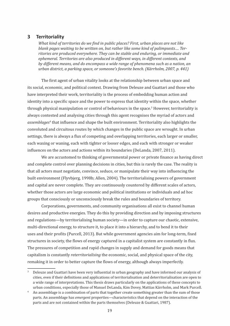
19
3 TerritorialityWhat kind of territories do we find in public places? First, urban places are not like blank pages waiting to be written on, but rather like some kind of palimpsests…. Ter-ritories are produced everywhere. They can be stable and enduring, or immediate and ephemeral. Territories are also produced in different ways, in different contexts, and by different means, and do encompass a wide range of phenomena such as a nation, an urban district, a parking space, or someone’s favorite bench. (Kärrholm, 2007, p. 441)
The first agent of urban vitality looks at the relationship between urban space and its social, economic, and political context. Drawing from Deleuze and Guattari and those who have interpreted their work, territoriality is the process of embedding human action and identity into a specific space and the power to express that identity within the space, whether through physical manipulation or control of behaviours in the space.3 However, territoriality is always contested and analysing cities through this agent recognises the myriad of actors and assemblages4 that influence and shape the built environment. Territoriality also highlights the convoluted and circuitous routes by which changes in the public space are wrought. In urban settings, there is always a flux of competing and overlapping territories, each larger or smaller, each waxing or waning, each with tighter or looser edges, and each with stronger or weaker influences on the actors and actions within its boundaries (DeLanda, 2007, 2011).
We are accustomed to thinking of governmental power or private finance as having direct and complete control over planning decisions in cities, but this is rarely the case. The reality is that all actors must negotiate, convince, seduce, or manipulate their way into influencing the built environment (Flyvbjerg, 1998b; Allen, 2004). The territorialising powers of government and capital are never complete. They are continuously countered by different scales of actors, whether those actors are large economic and political institutions or individuals and ad hoc groups that consciously or unconsciously break the rules and boundaries of territory.
Corporations, governments, and community organisations all exist to channel human desires and productive energies. They do this by providing direction and by imposing structures and regulations—by territorialising human society—in order to capture our chaotic, extensive, multi-directional energy, to structure it, to place it into a hierarchy, and to bend it to their uses and their profits (Purcell, 2013). But while government agencies aim for long-term, fixed structures in society, the flows of energy captured in a capitalist system are constantly in flux. The pressures of competition and rapid changes in supply and demand for goods means that capitalism is constantly reterritorialising the economic, social, and physical space of the city, remaking it in order to better capture the flows of energy, although always imperfectly.
3 Deleuze and Guattari have been very influential in urban geography and have informed our analysis of cities, even if their definitions and applications of territorialisation and deterritorialisation are open to a wide range of interpretations. This thesis draws particularly on the applications of these concepts to urban conditions, especially those of Manuel DeLanda, Kim Dovey, Mattias Kärrholm, and Mark Purcell.
4 An assemblage is a combination of parts that together create something greater than the sum of those parts. An assemblage has emergent properties—characteristics that depend on the interaction of the parts and are not contained within the parts themselves (Deleuze & Guattari, 1987).
20
The territorialising forces of government and private enterprise often conflict. For example, the Melbourne Docklands, a large redevelopment project that began in the early 1990s, is marked by significant differences and conflicts between the territorialising efforts of a government agency and the developers. This urban renewal project was brought about by changes in transportation technology and re-conceptions about the role and function of city centres. The state and local governments followed the normative public planning practice and pursued a comprehensive plan to deliver a “stable and ordered landscape” (Wood, 2009, p. 195). In opposition, the development authority and a business interest group sidestepped the established planning process by presenting evocative images of aesthetic and seemingly complete development without actually proposing a binding framework for development. This veneer of completeness, combined with an underlying absence of development controls, was intended to attract corporate interest, quicken the pace of development, and maximise profit (Dovey & Sandercock, 2002). These conflicting territorialisations by powerful and well-financed institutions continue to hinder the development of the Docklands. Today, the criticism of the Docklands is that it is a collection of high rise towers without a sense of place or urban vitality (J. Dowling & Lahey, 2009). Conflict tends to harden the boundaries between territories (DeLanda, 2011) and these hardened borders can exclude other actors, particularly everyday people who could reshape the space for their own uses, even if that reshaping is only temporary.
Territorialisation also happens within the large power structures of governance and capital. Government reform is often an attempt to apply commercial practices and values to public sector institutions. These attempts to govern based “on the basis of economic rationality” (Cohn, 1997, p. 585) are the result of territorialisation of government processes by the logic of private enterprise. In the opposite direction, government policy and funding practices often modify or create whole industries. For example, in the United States and Australia, the requirement that certain development projects prepare an Environmental Impact Statement as part of council approval has spawned a significant industry for specialised consultants (Morrison-Saunders & Bailey, 2009). This industry is the product of a government creation and territorialisation of a particular element of the development process.
Against these large-scale territorialisation and reterritorialising strategies, the everyday actions and tactics5 of individuals and groups can work to break down or redefine urban territories (Kärrholm, 2007). Deleuze and Guattari define deterritorialisation as a “line of flight,” or an escape from a hierarchical system of control towards a new set of connections within a rhizomatic6 decentralised network (Deleuze & Guattari, 1987, pp. 7-25). These deterritorialising
5 Michel de Certeau has defined a strategy as the action of an organising power (“a proprietor, an enterprise, a city, a scientific institution”) upon “a place that can be circumscribed…as the basis for generating relations with an exterior.” This is analogous to territorialisation as used here. A tactic, on the other hand, “insinuates itself into the other’s place, fragmentarily, without taking it over in its entirety...it is always on the watch for opportunities that must be seized ‘on the wing.’ It must constantly manipulate events in order to turn them into ‘opportunities’” (de Certeau, 1988, p. xix) These are deterritorialising actions by those without direct power over the built environment.
6 Deleuze and Guattari contrast a rhizome structure, characterised by “connection and heterogeneity: “any point of a rhizome can be connected to anything other, and must be,” against a tree or root structure “which plots a point, fixes an order” (Deleuze & Guattari, 1987, p. 7).
21
actions, which can take the form of protest, escape, or creation of alternate systems of meaning or value, can weaken the dominance of territorial order, can make borders and edges fuzzy and indistinct, and can encourage (or force) a reimagination and recreation of our relationships to each other and the city. When deterritorialisation creates a temporary separation of space and meaning, new ideas of urban life can arise.
In concert with the attempt to claim physical territory in the city, groups and communities often attempt to territorialise the social and cultural spaces of the city. This can manifest as rule setting, promotion of a particular position, active efforts to create change, or as resistance to the unknown or uncomfortable (Dent & Goldberg, 1999). Often this takes the form of excluding those who do not fit social or cultural norms. The alternative cultures that arise through this exclusion can become robust territories in their own right (Foucault & Miskowiec, 1984; hooks, 1990; Topinka, 2010). Chinatowns, gay bars, and skateboard parks are examples of marginalised or persecuted groups creating social or cultural territories that grow out of or eventually include physical spaces (Borden, 2001; Rushbrook, 2002; J. L. Roberts, 2016). More subtly, communities of interest (groups that come together out of shared interest, rather than because of geographical proximity) can create social or cultural territories that include behavioural norms and patterns of self-identification (Newman, 1980).
Analysed through the agent of territorialisation, human society is defined by an unending struggle between the creative, productive, and irregular energies that motivate and animate us on the one hand, and the forces that seek to capture, order, and feed off of those energies. There is constant pressure to reterritorialise systems and spaces into formal structures, and there will always be elements within territorialised systems that seek to break free. Territories are the overarching structures that shape our urban experiences.
3.1 Streets as Territories
Importantly, urban territorialisations are generally not isolated islands of control, but are extensions of the spheres of influence of governments, communities, organisations, and individuals. A street, for example, is certainly a territory but is not isolated in and of itself. The space of the urban street is territorialised by its users and the land uses that surround it. It is also territorialised by local governments that create and maintain the regulations of the street, enforce those regulations through signage and policing, and control its design, construction and maintenance. Adjacent building owners and occupants can claim portions of the right of way for displays, storage, trade, and advertising. Individuals take parts of the footpaths and streets as places to sit, to busk, to do business, to play, or to socialise.7 While these claims are occasionally subversions of official rules, they are tolerated because they are the results of implicit or explicit negotiation with other users.
Activities such as street markets or festivals often extend beyond their formal boundaries (which may be a street, a plaza, or a park) to temporarily de- and re-territorialise surrounding areas. Shop owners near night markets in Taiwan, for instance, bring their wares out into the
7 This interaction of territorialisation and public or semi-public space is discussed at length in the influential work of Oscar Newman (1973) on defensible space design in residential areas.
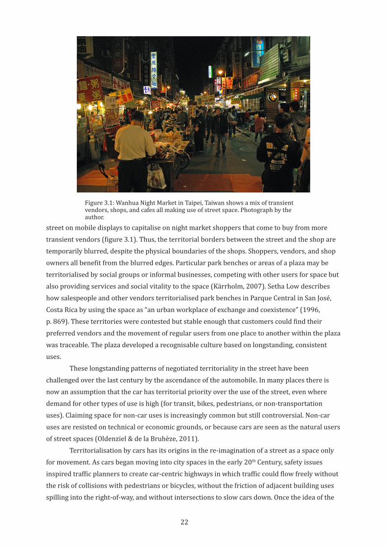
22
street on mobile displays to capitalise on night market shoppers that come to buy from more transient vendors (figure 3.1). Thus, the territorial borders between the street and the shop are temporarily blurred, despite the physical boundaries of the shops. Shoppers, vendors, and shop owners all benefit from the blurred edges. Particular park benches or areas of a plaza may be territorialised by social groups or informal businesses, competing with other users for space but also providing services and social vitality to the space (Kärrholm, 2007). Setha Low describes how salespeople and other vendors territorialised park benches in Parque Central in San José, Costa Rica by using the space as “an urban workplace of exchange and coexistence” (1996, p. 869). These territories were contested but stable enough that customers could find their preferred vendors and the movement of regular users from one place to another within the plaza was traceable. The plaza developed a recognisable culture based on longstanding, consistent uses.
These longstanding patterns of negotiated territoriality in the street have been challenged over the last century by the ascendance of the automobile. In many places there is now an assumption that the car has territorial priority over the use of the street, even where demand for other types of use is high (for transit, bikes, pedestrians, or non-transportation uses). Claiming space for non-car uses is increasingly common but still controversial. Non-car uses are resisted on technical or economic grounds, or because cars are seen as the natural users of street spaces (Oldenziel & de la Bruhèze, 2011).
Territorialisation by cars has its origins in the re-imagination of a street as a space only for movement. As cars began moving into city spaces in the early 20th Century, safety issues inspired traffic planners to create car-centric highways in which traffic could flow freely without the risk of collisions with pedestrians or bicycles, without the friction of adjacent building uses spilling into the right-of-way, and without intersections to slow cars down. Once the idea of the
Figure 3.1: Wanhua Night Market in Taipei, Taiwan shows a mix of transient vendors, shops, and cafes all making use of street space. Photograph by the author.
23
limited-access highway caught on, traffic engineers were tasked with applying the same tight, frictionless logic to city streets (Norton, 2008, p. 254). The goal was to eliminate safety risks while also increasing the throughput of city streets. This was done through clearly delineating separate vehicle and pedestrian zones, establishing pedestrian management strategies, and developing traffic control and signalling systems. In essence, the strategy was to redevelop cities around vehicle movement, and to reinforce the new city form with “social engineering” of urban street users—training them to fit into the new physical car-based reality of the city (Norton, 2008, p. 107).
The territory of the automobile does not end at the edges of the street. Vast swaths of the city are dominated by vehicles. In addition to the space of the right of way itself, the territory of the automobile extends into parking lots, drive-through businesses, petrol stations, garages, and driveways. In many cities, car traffic takes highest priority, often despite laws to the contrary (Turner et al., 2006). The territorialisation of the city by the automobile is not merely physical. It extends into the economic and social realms of the city, and it is the view from a car that defines many of the images of the city and city life (Lynch, 1960; Appleyard et al., 1964; Gehl, 2010; Fleming, 2013). This reterritorialisation of the space of the street by car-based uses, rules, and behaviours has had obvious negative effects on urban vitality. In recognition of these effects, there are increasing efforts to reclaim the space of the street from automobile territory for other users, but they often require a struggle. Car uses continue to be seen as the natural function of streets.
3.2 Rail Trails as Territories
The deeply ingrained relationship between automobiles and urban public space means that while urban rail trails are free of the pressure to accommodate car traffic, there is no consistent role for urban trails. Like any element of a complex urban environment, urban rail trails can be seen from a wide range of perspectives. A rail trail can be imagined or understood as a walking path, a high-speed bicycle commuting route, as a neighbourhood connector, or as a green respite from the pressures of the city. How these different perspectives compete for primacy or coexist within a particular trail can be analysed through territorialisation. By looking at the actors who seek to territorialise rail trails according to their own attitudes and desires, we can understand how a particular trail is positioned relative to friction and looseness, the two other agents in the urban vitality triad that will be discussed in chapters four and five.
In some trails, physical separation of the corridor from its context create a mental image of the trail as being disconnected from the surrounding city fabric. This image of the trail as an unintegrated object in the city can be a barrier to any engagement of the trail by neighbouring uses. Sometimes, fears of crime or lack of privacy drive surrounding property owners to create territorial boundaries between themselves and the trail. These intentional or unintentional separations can create hardened barriers that can persist for decades.
In other cases, the trail is promoted as an integrated part of the city. If this integrated image of the trail gains acceptance, neighbouring businesses and organisations may claim the trail as a part of their territory, whether that claim is physical, economic, social, or emotional.
24
An adjacent business owner may erect advertising or a new building entry along the trail. Shops may rename, rebrand, or relocate themselves to associate with the trail. A local organisation may take on an advocacy or management role of the trail by promoting the trail and disseminating guidelines for proper trail behaviour. Groups of users (bicyclists, dog walkers, graffiti artists) may informally claim a part of the trail as their own space to be used, rearranged, or protected as the group sees fit.
In each of these cases, the trail is territorialised, brought within the sphere of influence of the business, economic system, organisation, or group. With each territorialisation comes a particular set of rules, meanings, and order. This can become the set of meanings by which the trail is evaluated, and through which its design and use evolve (McFarlane, 2011). For instance, the Otago Central Rail Trail in New Zealand has primarily been territorialised as a tourist attraction and driver of regional development, and its success or failure is usually evaluated by its impact on local businesses and number of visitors. This territorialisation has largely excluded its other potential functions and benefits—for instance, as local transportation or for social connections (Rosin et al., 2013). In any public place, territorialisation includes the imposition of place-meanings intended to reinforce the territorial order. These meanings then reverberate through future actions and uses of the place (Carter et al., 2007).
3.3 Bicycle Space as Territory
In the United States, Australia, and other countries, urban bicycling is gaining acceptance with planners and with the general public.8 The question of how to accommodate bicycles, and also bicycling culture, into urban plans is therefore becoming increasingly important (Forsyth & Krizek, 2011). Notably, many academics and practitioners call for an integration of bicyclists into the social fabric of the city and advocate for bicycling citizenship. Drawing equally on Jürgen Habermas’s concept of a public sphere animated by dialogue (1991) and Lefebvre’s concept of agonistic struggle in the service of empowerment of all (1996), they seek recognition of bicyclists as rights-bearing citizens who have a different experience of cities compared to pedestrians and car drivers, and who should be included in the process of shaping urban spaces.
In the United States and Australia, we live in cities that are dominated by the car, cities in which being a bicyclist remains a disadvantage despite any current cachet of urban bicycling. Even with the growing acceptance of bicycling, bicyclists have yet to consistently claim territory in urban streets. Instead, they are often forced to deterritorialise car or pedestrian space. The speed, size, and materiality of a bicycle can make it simultaneously seem a dangerous menace to pedestrians on footpaths and a flimsy, annoying barrier to vehicular flow in streets. In addition, the physical characteristics of bicycling make pedestrian or car infrastructure difficult to use (Fajans & Curry, 2001; Krizek et al., 2005; van Wee et al., 2006; Davies, 2016). This means that dedicated bicycle infrastructure is critically needed, but investment in bicycle infrastructure is still very low per capita compared with investments in automobile infrastructure. Furthermore, a social stigma of bicycling remains in many cities. Riding a bike is still a sign of outsider-ness, of a
8 Many other countries have long-established urban bicycling cultures, but this thesis is focused on Australian and American cities, where urban bicycling is still emerging.
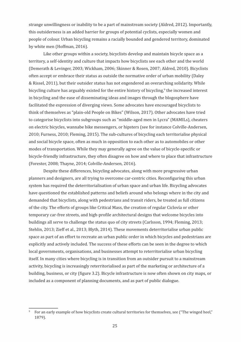
25
strange unwillingness or inability to be a part of mainstream society (Aldred, 2012). Importantly, this outsiderness is an added barrier for groups of potential cyclists, especially women and people of colour. Urban bicycling remains a racially bounded and gendered territory, dominated by white men (Hoffman, 2016).
Like other groups within a society, bicyclists develop and maintain bicycle space as a territory, a self-identity and culture that impacts how bicyclists see each other and the world (Demerath & Levinger, 2003; Wickham, 2006; Skinner & Rosen, 2007; Aldred, 2010). Bicyclists often accept or embrace their status as outside the normative order of urban mobility (Daley & Rissel, 2011), but their outsider status has not engendered an overarching solidarity. While bicycling culture has arguably existed for the entire history of bicycling,9 the increased interest in bicycling and the ease of disseminating ideas and images through the blogosphere have facilitated the expression of diverging views. Some advocates have encouraged bicyclists to think of themselves as “plain-old People on Bikes” (Wilson, 2017). Other advocates have tried to categorise bicyclists into subgroups such as “middle-aged men in Lycra” (MAMILs), cheaters on electric bicycles, wannabe bike messengers, or hipsters (see for instance Colville-Andersen, 2010; Furness, 2010; Fleming, 2015). The sub-cultures of bicycling each territorialise physical and social bicycle space, often as much in opposition to each other as to automobiles or other modes of transportation. While they may generally agree on the value of bicycle-specific or bicycle-friendly infrastructure, they often disagree on how and where to place that infrastructure (Forester, 2008; Thayne, 2014; Colville-Andersen, 2016).
Despite these differences, bicycling advocates, along with more progressive urban planners and designers, are all trying to overcome car-centric cities. Reconfiguring this urban system has required the deterritorialisation of urban space and urban life. Bicycling advocates have questioned the established patterns and beliefs around who belongs where in the city and demanded that bicyclists, along with pedestrians and transit riders, be treated as full citizens of the city. The efforts of groups like Critical Mass, the creation of regular Ciclovía or other temporary car-free streets, and high-profile architectural designs that welcome bicycles into buildings all serve to challenge the status quo of city streets (Carlsson, 1994; Fleming, 2013; Stehlin, 2013; Zieff et al., 2013; Blyth, 2014). These movements deterritorialise urban public space as part of an effort to recreate an urban public order in which bicycles and pedestrians are explicitly and actively included. The success of these efforts can be seen in the degree to which local governments, organisations, and businesses attempt to reterritorialise urban bicycling itself. In many cities where bicycling is in transition from an outsider pursuit to a mainstream activity, bicycling is increasingly reterritorialised as part of the marketing or architecture of a building, business, or city (figure 3.2). Bicycle infrastructure is now often shown on city maps, or included as a component of planning documents, and as part of public dialogue.
9 For an early example of how bicyclists create cultural territories for themselves, see (“The winged heel,” 1879).
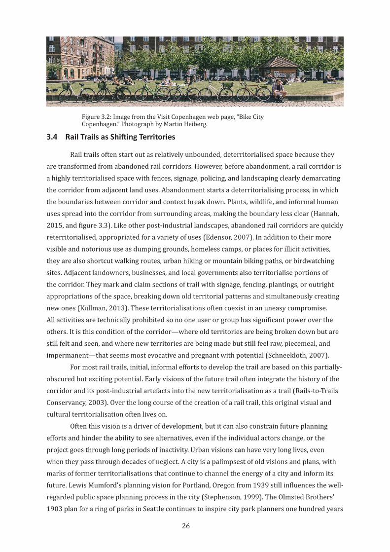
26
3.4 Rail Trails as Shifting Territories
Rail trails often start out as relatively unbounded, deterritorialised space because they are transformed from abandoned rail corridors. However, before abandonment, a rail corridor is a highly territorialised space with fences, signage, policing, and landscaping clearly demarcating the corridor from adjacent land uses. Abandonment starts a deterritorialising process, in which the boundaries between corridor and context break down. Plants, wildlife, and informal human uses spread into the corridor from surrounding areas, making the boundary less clear (Hannah, 2015, and figure 3.3). Like other post-industrial landscapes, abandoned rail corridors are quickly reterritorialised, appropriated for a variety of uses (Edensor, 2007). In addition to their more visible and notorious use as dumping grounds, homeless camps, or places for illicit activities, they are also shortcut walking routes, urban hiking or mountain biking paths, or birdwatching sites. Adjacent landowners, businesses, and local governments also territorialise portions of the corridor. They mark and claim sections of trail with signage, fencing, plantings, or outright appropriations of the space, breaking down old territorial patterns and simultaneously creating new ones (Kullman, 2013). These territorialisations often coexist in an uneasy compromise. All activities are technically prohibited so no one user or group has significant power over the others. It is this condition of the corridor—where old territories are being broken down but are still felt and seen, and where new territories are being made but still feel raw, piecemeal, and impermanent—that seems most evocative and pregnant with potential (Schneekloth, 2007).
For most rail trails, initial, informal efforts to develop the trail are based on this partially-obscured but exciting potential. Early visions of the future trail often integrate the history of the corridor and its post-industrial artefacts into the new territorialisation as a trail (Rails-to-Trails Conservancy, 2003). Over the long course of the creation of a rail trail, this original visual and cultural territorialisation often lives on.
Often this vision is a driver of development, but it can also constrain future planning efforts and hinder the ability to see alternatives, even if the individual actors change, or the project goes through long periods of inactivity. Urban visions can have very long lives, even when they pass through decades of neglect. A city is a palimpsest of old visions and plans, with marks of former territorialisations that continue to channel the energy of a city and inform its future. Lewis Mumford’s planning vision for Portland, Oregon from 1939 still influences the well-regarded public space planning process in the city (Stephenson, 1999). The Olmsted Brothers’ 1903 plan for a ring of parks in Seattle continues to inspire city park planners one hundred years
Figure 3.2: Image from the Visit Copenhagen web page, “Bike City Copenhagen.” Photograph by Martin Heiberg.
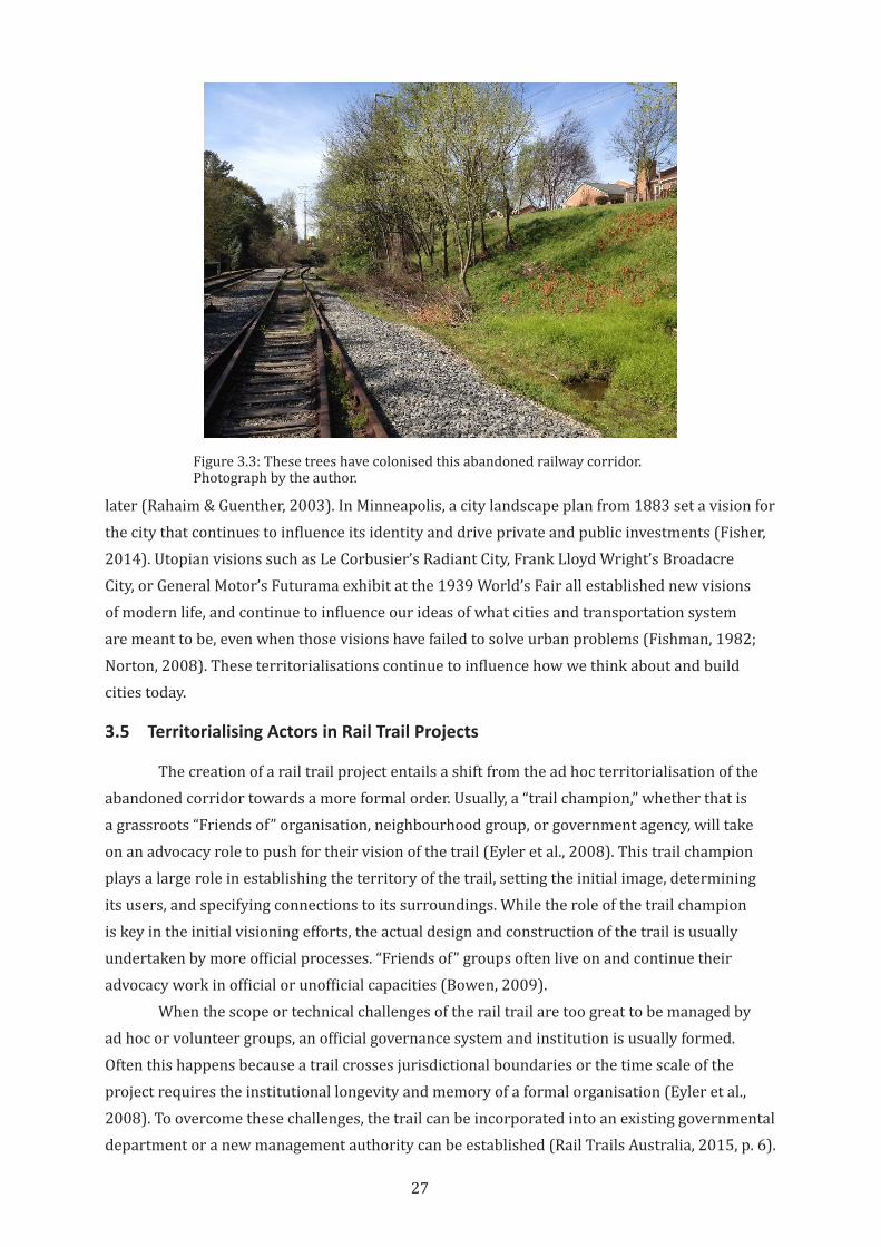
27
later (Rahaim & Guenther, 2003). In Minneapolis, a city landscape plan from 1883 set a vision for the city that continues to influence its identity and drive private and public investments (Fisher, 2014). Utopian visions such as Le Corbusier’s Radiant City, Frank Lloyd Wright’s Broadacre City, or General Motor’s Futurama exhibit at the 1939 World’s Fair all established new visions of modern life, and continue to influence our ideas of what cities and transportation system are meant to be, even when those visions have failed to solve urban problems (Fishman, 1982; Norton, 2008). These territorialisations continue to influence how we think about and build cities today.
3.5 Territorialising Actors in Rail Trail Projects
The creation of a rail trail project entails a shift from the ad hoc territorialisation of the abandoned corridor towards a more formal order. Usually, a “trail champion,” whether that is a grassroots “Friends of” organisation, neighbourhood group, or government agency, will take on an advocacy role to push for their vision of the trail (Eyler et al., 2008). This trail champion plays a large role in establishing the territory of the trail, setting the initial image, determining its users, and specifying connections to its surroundings. While the role of the trail champion is key in the initial visioning efforts, the actual design and construction of the trail is usually undertaken by more official processes. “Friends of” groups often live on and continue their advocacy work in official or unofficial capacities (Bowen, 2009).
When the scope or technical challenges of the rail trail are too great to be managed by ad hoc or volunteer groups, an official governance system and institution is usually formed. Often this happens because a trail crosses jurisdictional boundaries or the time scale of the project requires the institutional longevity and memory of a formal organisation (Eyler et al., 2008). To overcome these challenges, the trail can be incorporated into an existing governmental department or a new management authority can be established (Rail Trails Australia, 2015, p. 6).
Figure 3.3: These trees have colonised this abandoned railway corridor. Photograph by the author.
28
In the early stages of rail trail establishment, corridor neighbours, both business and residential, usually seek to clarify or extend their own territorial boundaries. There is a well-documented history of fears regarding the creation of rail trails from corridor neighbours, whether they be of increased crime and reduced privacy, or increased traffic and impacts on parking (Hawthorne et al., 2008). While there is consistent evidence that these concerns are rarely warranted, rail trail projects are often delayed or modified because of these fears (Doherty, 1998). The tactics used by rail trail opponents are territorial. Neighbours may attempt to claim legal right to the portion of the corridor adjacent to their properties, or to influence the design of the trail to satisfy their own interests. Opposing neighbours will often organise themselves to increase their leverage over the rail trail project, sometimes with significant results (Jaffe, 2013).
Territorialising actions by neighbours do not always seek to frustrate the development of the trail. They may also seek to leverage the trail for their own benefit. Neighbouring corporations or businesses may seek to territorialise the corridor to positively impact their interests, adding advertising visible from the trail, associating themselves with the trail, or providing easy access to their properties. Neighbouring residents may also seek to ease their access to the trail, or to use its development to spur other neighbourhood improvements. Neighbour territorialisations of public space can also be based on the desire to control how that space is used. Neighbourhood groups can advocate for fencing or lighting along the trail, or for the setting rules for acceptable uses of the trail or its open hours, as a way to territorialise the trail to protect their interests (see for example Mike Halliburton Associates & Transplan Pty Ltd, 2018, pp. 18-21). These actions can be driven by security concerns, but they can also result in private influence on who is considered a legitimate user and what are the appropriate uses (Blomley, 2004; Reynald, 2011).
The variety of overlapping territorial claims on a rail corridor means that rail trail projects do not follow a consistent, linear process from conception to construction. While some rail corridors are converted into trails, some revert back to private ownership. Others remain in a state of abandoned limbo, waiting for territorial claims to loosen and solutions to be found, or for the restoration of rail service. The territorial processes of rail trail creation are dynamic and involve many urban actors, but they can also reinforce pre-existing structures of power. Active participants can be excluded, formal processes can suffocate creative action, and official rules can replace a flat organisation of interconnected individuals with a hierarchical management territory. At some point, the project can become something done for the community, rather than something done by the community. The establishment of order over the trail, which starts as an aid to the realisation of the dreams of a community, can eventually reduce the ability of the community to influence its future. As discussed in the context of Christiania in Chapter 2, this replacement of autogestion with integrated management weakens one of the key elements of Lefebvre’s urbanity—the loss of self-management of the urban realm (Coppola & Vanolo, 2015). The same risk exists in the public space of a rail trail.
29
3.6 Conclusion
This replacement of autogestion by governmental territorialisation has largely been inescapable in the history of cities but it marks the point at which territorialisation can begin to hinder urban vitality. Territorialised urban spaces can be vital, but when a particular territorialising force becomes too strong or too expansive it can overpower and constrain the energies that make places feel alive. Large-scale territoriality is thus a double-edged sword for urban spaces. When a space like a rail trail is territorialised by a government agency or another powerful organisation, there are significant benefits to the space. Governmental territorialisation brings political cover, inclusion in public budgets, the enforcement of rules, and integration into official policies and plans. Territorialisation by an organisation or a corporation can bring with it funding and public exposure. But territorialisation also brings with it an inevitable loss of local influence, especially for the casual users of the space. Adaptability and unscripted potential are also reduced by territorial forces that seek predictability and protection from risk. In the case studies that follow these introductory chapters, both the positives and negatives of territoriality will be discussed.
The physical, social, and cultural territorialisation discussed in this chapter represent fundamental expressions of power over the spaces of a city. Whether exercised by governments, corporations, organisations, communities, or individuals, territorialisations profoundly affect how urban spaces are planned, built, and used. While territoriality, friction, and looseness are in constant interrelationship with each other, territoriality tends to override the others, and is thus the most influential. The next two chapters will discuss friction and looseness in turn, and further explore the interactions of the three as agents of urban vitality.
30
4 FrictionUrban life in the dynamic cities that we know arises almost spontaneously when a crit-ical mixture and density of urban elements have been reached, and disappears when one of those essential elements is removed, isolated or concentrated. Even if we have the requisite variety of elements, they must be allowed to interact; therefore, segregat-ing urban functions stops the connective process (Salingaros, 2000, p. 301).
Social and economic interactions are the lifeblood of a city. They are the reason cities exist. These interactions, whether pleasant, agonistic or somewhere in between, create the liveliness of the city. Cities are vibrant to the degree that they can host this multitude of diverse interactions. This thesis uses a framework of urban vitality to describe these social and economic interactions, the physical design and societal practices that support them, and the character of the city that arises from them. Three agents—territoriality, friction, and looseness—contribute to this urban vitality. Within this triad of agents, friction encourages interactions and intensifies experiences. Friction has both physical and social components, through which people are brought together to create a community or a society. The physical spaces of the city can be designed to encourage or discourage interactions between users. When people meet in space, there is a higher or lower degree of exchange between them, whether that is casual eye contact, a greeting, a conversation, an embrace, or a fight. This transfer of information is how our knowledge of ourselves and the world is expanded, how a public realm is created (Watson, 2006, p. 8).
These interactions take place within urban territories, and as discussed in the previous chapter, these territories can impose constraints on the nature and quality of the interactions. A territorialised urban space can create physical or social friction. For example, a busy urban bus stop can constrict the movement of people on a footpath, can inspire pedestrians to cross the street illegally, or can be an acceptable place to loiter. This busy space of subtle frictions gives permission for people to overcome personal boundaries and engage with strangers, what Whyte calls triangulation (Whyte, 1988, p. 154). However, territorialised urban space can also remove friction by controlling physical space or prohibiting certain activities (for example, removing benches or shelters at a bus stop to discourage loitering), thus removing the impetus or opportunity for interactions. This chapter will explore these conditions of physical and social friction in cities and rail trails as an agent of urban vitality.
The definition of friction in this thesis is built upon the use of the term in physics to describe the effects of two objects in contact moving against each other. Objects can be shaped and surfaced to minimise interactions, allowing them to slide smoothly past each other, or conversely, they can be designed to maximise contact and friction. This basic concept is used by the mathematician and urban theorist Nikos Salingaros (2000) to describe urban space interactions. In this conception of urban space, adjacent components such as a wall, a footpath, or column can couple with each other if designed and positioned to do so, and thus form an emergent whole. This coupling is mutually beneficial, strengthening each component, but also
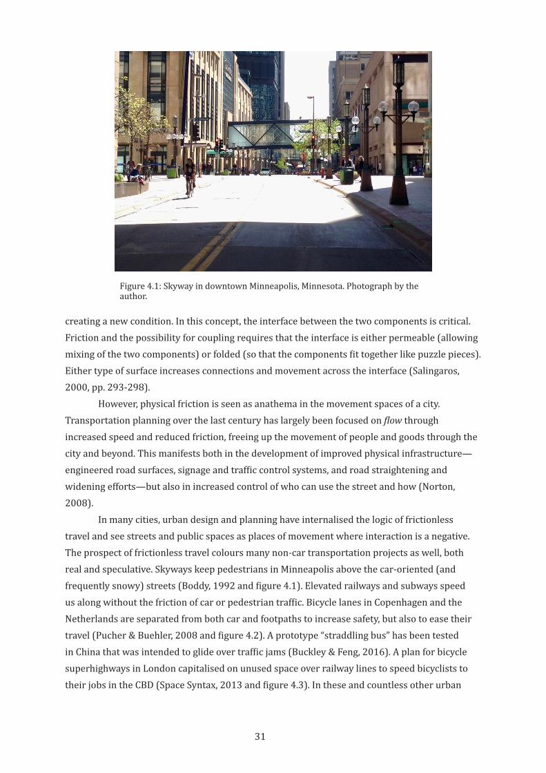
31
creating a new condition. In this concept, the interface between the two components is critical. Friction and the possibility for coupling requires that the interface is either permeable (allowing mixing of the two components) or folded (so that the components fit together like puzzle pieces). Either type of surface increases connections and movement across the interface (Salingaros, 2000, pp. 293-298).
However, physical friction is seen as anathema in the movement spaces of a city. Transportation planning over the last century has largely been focused on flow through increased speed and reduced friction, freeing up the movement of people and goods through the city and beyond. This manifests both in the development of improved physical infrastructure—engineered road surfaces, signage and traffic control systems, and road straightening and widening efforts—but also in increased control of who can use the street and how (Norton, 2008).
In many cities, urban design and planning have internalised the logic of frictionless travel and see streets and public spaces as places of movement where interaction is a negative. The prospect of frictionless travel colours many non-car transportation projects as well, both real and speculative. Skyways keep pedestrians in Minneapolis above the car-oriented (and frequently snowy) streets (Boddy, 1992 and figure 4.1). Elevated railways and subways speed us along without the friction of car or pedestrian traffic. Bicycle lanes in Copenhagen and the Netherlands are separated from both car and footpaths to increase safety, but also to ease their travel (Pucher & Buehler, 2008 and figure 4.2). A prototype “straddling bus” has been tested in China that was intended to glide over traffic jams (Buckley & Feng, 2016). A plan for bicycle superhighways in London capitalised on unused space over railway lines to speed bicyclists to their jobs in the CBD (Space Syntax, 2013 and figure 4.3). In these and countless other urban
Figure 4.1: Skyway in downtown Minneapolis, Minnesota. Photograph by the author.
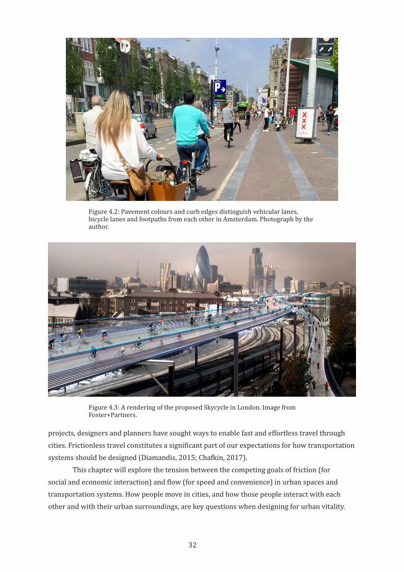
32
projects, designers and planners have sought ways to enable fast and effortless travel through cities. Frictionless travel constitutes a significant part of our expectations for how transportation systems should be designed (Diamandis, 2015; Chafkin, 2017).
This chapter will explore the tension between the competing goals of friction (for social and economic interaction) and flow (for speed and convenience) in urban spaces and transportation systems. How people move in cities, and how those people interact with each other and with their urban surroundings, are key questions when designing for urban vitality.
Figure 4.2: Pavement colours and curb edges distinguish vehicular lanes, bicycle lanes and footpaths from each other in Amsterdam. Photograph by the author.
Figure 4.3: A rendering of the proposed Skycycle in London. Image from Foster+Partners.
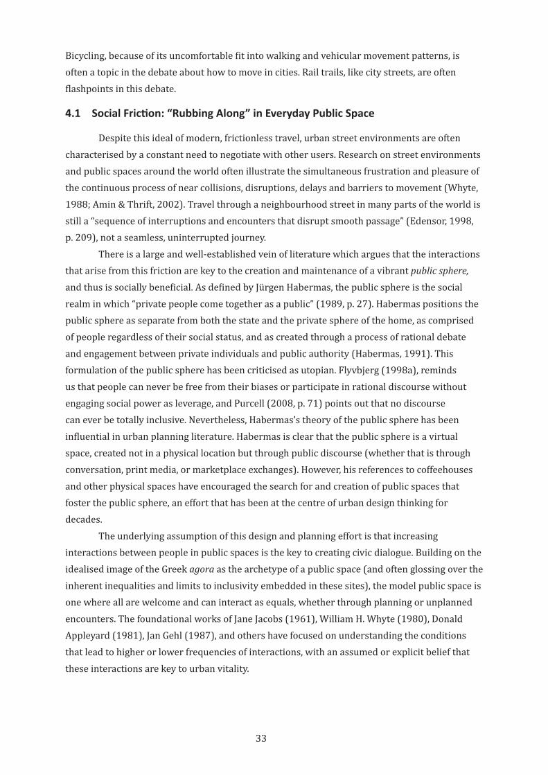
33
Bicycling, because of its uncomfortable fit into walking and vehicular movement patterns, is often a topic in the debate about how to move in cities. Rail trails, like city streets, are often flashpoints in this debate.
4.1 Social Friction: “Rubbing Along” in Everyday Public Space
Despite this ideal of modern, frictionless travel, urban street environments are often characterised by a constant need to negotiate with other users. Research on street environments and public spaces around the world often illustrate the simultaneous frustration and pleasure of the continuous process of near collisions, disruptions, delays and barriers to movement (Whyte, 1988; Amin & Thrift, 2002). Travel through a neighbourhood street in many parts of the world is still a “sequence of interruptions and encounters that disrupt smooth passage” (Edensor, 1998, p. 209), not a seamless, uninterrupted journey.
There is a large and well-established vein of literature which argues that the interactions that arise from this friction are key to the creation and maintenance of a vibrant public sphere, and thus is socially beneficial. As defined by Jürgen Habermas, the public sphere is the social realm in which “private people come together as a public” (1989, p. 27). Habermas positions the public sphere as separate from both the state and the private sphere of the home, as comprised of people regardless of their social status, and as created through a process of rational debate and engagement between private individuals and public authority (Habermas, 1991). This formulation of the public sphere has been criticised as utopian. Flyvbjerg (1998a), reminds us that people can never be free from their biases or participate in rational discourse without engaging social power as leverage, and Purcell (2008, p. 71) points out that no discourse can ever be totally inclusive. Nevertheless, Habermas’s theory of the public sphere has been influential in urban planning literature. Habermas is clear that the public sphere is a virtual space, created not in a physical location but through public discourse (whether that is through conversation, print media, or marketplace exchanges). However, his references to coffeehouses and other physical spaces have encouraged the search for and creation of public spaces that foster the public sphere, an effort that has been at the centre of urban design thinking for decades.
The underlying assumption of this design and planning effort is that increasing interactions between people in public spaces is the key to creating civic dialogue. Building on the idealised image of the Greek agora as the archetype of a public space (and often glossing over the inherent inequalities and limits to inclusivity embedded in these sites), the model public space is one where all are welcome and can interact as equals, whether through planning or unplanned encounters. The foundational works of Jane Jacobs (1961), William H. Whyte (1980), Donald Appleyard (1981), Jan Gehl (1987), and others have focused on understanding the conditions that lead to higher or lower frequencies of interactions, with an assumed or explicit belief that these interactions are key to urban vitality.
34
This large body of theoretical and practical work has considered design, programming, and management practices that increase interactions and thus contribute to vibrant, active space. This approach is based on a largely unspoken assumption: if people are pressed into situations in which they “rub along,” or come into contact as part of their everyday lives (Watson, 2006, p. 2), then the stage is set for genuine interaction.
These observers of urban life saw that when spaces for interaction were created, then occasional spontaneous interactions occurred, and this was seen as the fundamental building block of urban vitality. But many of the spaces that have been designed in accordance to this approach are tightly controlled, with social and regulatory constraints placed on who has access to the space and how they can interact. This will be discussed further in the next chapter on loose and tight space. In the interest of creating pleasant environments free from grime and conflict, many elements of social friction are removed, and the spaces that result are perceived as theme park-like, devoid of real life and free of confronting differences.
4.2 Cities as Frictionless Machines
For many years, the goal of designing public space for interaction was buried under modernist ideas of a city where flow, efficiency and freedom from physical and social ills were paramount. The many horrors and injustices of the early 20th Century industrial city were the result of unplanned and unregulated private development. Narrow winding streets, seemingly random building layouts, and persistently overcrowded conditions from a dense mix of industrial use and housing resulted in polluted and dangerous environments (Fishman, 2008, pp. 22-23). To overcome these urban ills, the educated elite created idealised visions of modern cities and suburban developments that were highly ordered with broad clear vistas, clear separation of uses, and minimal or no friction between different uses and zones (Corburn, 2007). These new, rational cities became the model for “modern” urban planning.
Ebenezer Howard’s Garden City concept, introduced at the start of the 20th Century, provided an early vision of an ideal new town—rationally planned to provide work, housing, and recreation in an environment free of overcrowding, pollution, and unsafe conditions. Industrial uses and steam trains were located at the outer rings of each circular town, with housing, schools, shopping, and parks laid out in concentric rings within (Howard, 1946). In the 1920s, Le Corbusier proposed the Radiant City in which different uses were clearly segregated and the high-rise towers and housing blocks were separated by wide open spaces. All of these were serviced by high-speed transportation corridors and the entirety was supposed to celebrate the power of industrial progress in “machines for living.” These corridors were designed around isolated travel modes—pedestrians, trains, and automobiles were physically separated from each other to minimise interaction and ensure maximum speed and throughput. The car was given a place of prominence along the centre axes of the plan (Fishman, 1982).
While these utopian visions were very rarely implemented completely, they strongly influenced the direction of urban planning. Property developers created new Garden City-inspired satellite towns and suburbs which were explicitly located away from the congestion and pollution of dense city cores and were serviced by new roads or trains. Within existing cities,
35
regulations were enacted to reduce density and excise crowded neighbourhoods. Zoning and land use policies were introduced to segregate uses, bring light and air into apartments, and widen streets to allow fire truck access (Corburn, 2007, p. 694).
The efforts to re-engineer cities to spread out and separate types of uses was not limited to land use planning. Streets were also reimagined and rebuilt to be straighter, safer, and wider in order to make space for the growing numbers of cars (Norton, 2008, p. 238). General Motors’ Futurama exhibit at the 1939 New York Worlds’ Fair helped romanticise the notion of the highway of the future, one in which car drivers could safely travel at 100 miles an hour, with no need to stop for cross traffic and other types of users who could impede their movement (Norton, 2015). This vision of the future led to contemporary freeway systems, which are expressly built around the ideas of minimising friction between drivers and the surrounding context. This prioritising of flow over the potential benefits of friction soon spread to surface streets as well. By the 1920s, increasing numbers of cars on city streets had made street space dangerous. In 1925, two thirds of all deaths in United States cities were due to automobile crashes (C. Thompson, 2014). Many of those were pedestrians, and a third were children (Norton, 2008, p. 24). While some early responses to this crisis focused on car drivers as the problem and efforts were made to control car speeds and educate drivers to be safe, the discourse soon turned toward minimisation of interactions. This was achieved through the development of traffic signals, the creation of dedicated travel lanes, and the blaming of pedestrians for crashes (Norton, 2008). As discussed in the previous chapter, footpaths were also reimagined as spaces of pedestrian movement with legal consequences for intruding uses. Bicyclists were relegated to the narrow edges of the street or excluded altogether, and often had to resort to legal action to protect their right to use public rights-of-way (Petty, 1998).
The parallel efforts to segregate land uses and street uses reinforced each other to the point where freeways sometimes provide the only viable transportation links between far-flung job or shopping districts and bedroom suburbs. In addition, city streets are often designed to maximise car throughput in order to combat ever-growing congestion (Frost, 2001). This has resulted in the dedication of a huge portion of urban land to travel and parking uses, estimated at 10-25% of all urban land, and up to 60% of land in commercial centres (Arnold Jr & Gibbons, 1996; Litman, 2011). Despite this, car traffic has continued to grow due to induced or generated demand. New road capacity induces more car trips or encourages people to drive rather than walk, bicycle or take transit. This additional traffic quickly fills the new capacity, producing yet more demand, thereby re-initiating the cycle for more roads or highways. Within this repeating cycle of road infrastructure development, it is not possible to maintain permanent friction-free driving (Litman, 2017) as efforts to remove friction for car driving comes at an increasingly prohibitive cost.
The city as a frictionless machine, fed by free flows of cars from the suburbs and goods from the hinterlands, is slowly losing its lustre as a compelling vision of the future. The segregated business districts and bedroom communities that were intended as healthy and efficient places to live and work have decreased our sense of well-being by isolating us from
36
one another and decreasing opportunities for social interaction (Leyden, 2003). The rational housing estates that replaced dense and irregular tenements have largely failed to foster a sense of ownership, agency, or community (Coley et al., 1997). The freeways and arterials designed to whisk us effortlessly around the sprawling city are now so clogged with traffic that commuting negatively affects our feelings of well-being (Choi et al., 2013).
In response to these failings, contemporary transportation and land use planners can prioritise accessibility over mobility. Accessibility is the ability to access goods, services, and destinations, and is measured by the time, money, discomfort or risk to reach those things and places. Mobility is the ability to move and is usually measured by speed and distance travelled. Prioritising mobility often led to a focus on increasing the capacity of roadways for vehicles, while designing for accessibility can involve land use decisions that reduce the need to travel long distances (Litman, 2003).
At the same time, urban planning has rediscovered the value of friction in urban places. Today, mixed use developments and new housing in business districts seek to create 24-hour cities. Walkable districts and car-free zones seek to recreate the everyday interactions of the pre-automobile street. Open air markets and footpath vending are allowed, or even encouraged. These planning and design approaches increase physical and social friction, and thus increase urban vitality.
4.3 Urban Bicycling and Friction
While increasing interactions in urban spaces has become increasingly important to urban designers, this change has not yet been embraced by transportation planners or many bicycle advocates. Bicycle transportation has historically been planned according to the values of automobile transportation in regard to friction, and this attitude persists. Bicycling is seen from the outside as a cause of negative friction in streets by slowing down car traffic and causing problems for pedestrians (Cassidy, 2011; Freedman, 2014). Even from a bicyclist perspective, friction-free travel is often seen as the ideal (Wells, 2006). Rail trails are compelling as bicycle infrastructure for this reason. But in order for bicyclists to contribute to the vitality of cities, efficient bicycle travel and productive friction must coexist. This section discusses a range of design strategies for bicycling in cities. Each strategy carries underlying beliefs about the place of bicycling in the physical and social realms of the city and the value of social and physical friction in cities. Each also has ramifications for how bicyclists contribute to the vitality of the city.
4.3.1 Vehicular cycling
Vehicular cycling promotes treating the bicycle as a vehicle with the same rights and responsibilities as cars and has been a dominant force in bicycle advocacy in the US, Canada, Australia, and New Zealand. According to this concept, bicyclists can only enjoy safe and pleasant travel if they accept and assert their full right as a vehicle equal to cars and motorcycles on a shared street system (Forester, 2008).
37
The vehicular cycling argument hinges on two primary assumptions. The first is pragmatic. In the US, bikeways and other dedicated bicycling infrastructure are assumed to be incomplete and permanently disconnected, therefore all bicyclists will eventually have to ride in the street and need to be educated on traffic laws and become accustomed to riding in street lanes with cars. This is a reasonable assumption, and certainly holds true in many cities and countries (Mekuria et al., 2012). The second assumption is that dedicated bicycle infrastructure is inherently unsafe for both bicyclists and drivers. The complexity of interactions in a street network that includes both car-only streets and dedicated bicycle infrastructure makes conflict inevitable. While there is research that supports this belief (Petritsch et al., 2006), there is also research that contradicts this when additional design measures are taken (Pucher & Dijkstra, 2003). The low crash rates in cities and countries that have prioritised safe bicycling infrastructure suggests that dedicated bicycle infrastructure does not inevitably cause crashes (Pucher & Buehler, 2008). There is also consistent evidence that perceptions of safety are important to people’s interest in bicycling. There is a large segment of bicyclists or prospective bicyclists who are not confident enough to ride in car traffic (Dill & Voros, 2007), and thus are not well served by vehicular cycling approaches.
While vehicular cycling literature takes pains to express that bicyclists are as important as any other road user, vehicular cycling requires that bicyclists fit into the territory of the car. Vehicular cycling does not challenge the logic that streets are intentionally designed for automobile speeds and car driver priorities. Only “strong and fearless” riders will feel at home with fast-moving cars (Geller, 2009). In essence, vehicular cycling only works to the degree that a bicyclist can to fit into a car-oriented street, with its emphasis on fast, frictionless travel. In cities where even minor residential streets allow 50 kilometres per hour travel, this is not viable for most bicyclists.
Even if all bicyclists were physically able and psychologically prepared to intermix with car traffic, vehicular cycling cannot contribute to urban vitality for the same reason that car drivers fail to add life to cities. Given the fundamental expectation of high-speed flow in the travel lanes of a street, no vehicle, whether car, bus, tram, or bicycle, can contribute to productive friction. A vehicular cyclist, like any other urban street user, must process large amounts of visual and auditory information in order to avoid crashes. When traveling at higher speeds, interaction with other street users or activities outside the travel lane is risky (Dewar & Olson, 2007, pp. 33-46). The best a street can offer in this situation is to deliver people to sites of urban vitality, at which point they can leave their vehicles and contribute to the life of a city on foot. But when these points of interest are connected only by travel-oriented spaces with little other street activity, vital locations cannot reinforce each other or contribute to coherent wholes.
Despite research that vehicular cycling is not suitable to the majority of potential bicyclists (Geller, 2009), some knowledge of vehicular cycling is necessary. The network of bicycle infrastructure in most US and Australian cities is far from complete, therefore bicyclists must spend at least a portion of their trip riding in the street or on footpaths. In response to growing understanding of this situation, cities across the United States and Australia now plan

38
for bicycling. This planning can take three forms: 1. Slowing or restricting car traffic to allow bicycles (and sometimes pedestrians) to share space in the street; 2. Providing dedicated bicycle infrastructure on streets; and 3. Creating car-free spaces. Most cities use a mix of approaches. These three are discussed briefly below, highlighting how they do or do not create productive friction in cities.
4.3.2 Sharing space
When automobiles first entered cities in the early 1900s, they shared space with pedestrians, bicyclists, streetcars, and horse-drawn carriages. For a short period of time, this worked because cars were relatively rare visitors into space that was designed and intended for other non-car uses (Miles Brothers, 1906). This quickly changed as cars became dominant (Norton, 2008) changing the territoriality of streets into car-centred space. However, the older perception and use of streets as a shared space has not been completely eliminated. In European street design, the shared character of streets is enforced by requiring cars to slow down and negotiate with other users. However, the approaches discussed below are not yet widespread in the United States and Australia. While these methods are generally focused on modifying automobile movements to improve safety and mobility to bicyclists or pedestrians, the same techniques described here are used in areas where bicyclists and pedestrians share space in rail trails. It is therefore useful to understand he range of strategies and their strengths and weaknesses.
The first approach is traffic calming where cars are slowed down through a variety of physical designs and signage. The intent is to slow car traffic to the degree that bicyclists and pedestrians feel comfortable using the street. This is often accompanied by narrowing travel lanes on the street and adding landscaping or other features to make the street more attractive. Traffic calming is normally used in residential areas or near schools, where children are likely to be playing outdoors.
The second, shared space is another version of traffic calming that was developed in the Netherlands and is now frequently used in Europe, Australia, and New Zealand. Shared space blurs or completely removes distinctions between zones for cars and zones for pedestrians, and signage or other traffic controls are kept to a minimum. The intent is to introduce an element of uncertainty and therefore heightened awareness for all users, thus forcing everyone to slow down, interact and negotiate with each other to safely move through the space. The concept of shared space draws on the observation that people are very sophisticated in their ability to avoid crashes, even in the absence of clear directions about how to move (Whyte, 1988, p. 56). Shared spaces are designed with minimal barriers and restrictions on use with the goal of allowing for more natural interactions, and thereby creating a more vibrant environment (Hamilton-Baillie, 2008). While shared spaces are sometimes unsuccessful in forcing car drivers to cede their power over the street, there is some evidence that shared spaces, when combined with careful design of both the street and surrounding buildings, can contribute to social vitality (Ruiz-Apilánez et al., 2017).
39
Finally, a woonerf (“residential area” in Dutch, also known by different names in different countries, including a shared zone, a living street, or a home zone) is a shared area where all traffic must move at walking speed and the edges are blurred between the street and footpaths and other pedestrian spaces. In a woonerf, road surfaces, signage and other visual clues tell car drivers that the car is a guest in a space designed for other users, and this is usually reinforced by legal regulations on how car drivers may use the space (Ben-Joseph, 1995). Where woonerfs are designed into residential areas, neighbouring residents often have input on design features. The goal is that woonerfs act as the social space of the neighbourhood, fostering social interaction (Francis, 2016).
Shared spaces are created to improve safety in the areas where cars mix with pedestrians and bicyclists. They require cars to move more slowly to allow time for users to communicate and negotiate with each other. In this way, shared spaces recreate the pre-car conditions of the city street before the 20th Century. The mix of users, the need to negotiate use of the space, and the reduced territorial claim of cars suggests the potential for shared spaces to contribute to urban vitality.
4.3.3 Complete streets
While shared space strategies look for ways to mix car, bicycle, and pedestrian traffic in the same street zones, an opposite approach has become more common in the designs of streets in city centres. Complete streets provide space for each type of road user but keep them clearly separated from each other. A complete street has distinct zones for pedestrians, bicyclists, transit, and cars. Often the footpath is further divided into zones for building-related uses (displays, café seating, etc.), walking, and landscaping (National Association of City Transportation Officials, 2013). The logic of the complete street strategy is that while every type of road user has the right to the street, mixing uses is confusing and dangerous. A complete street is engineered to remove as much friction as possible between modes of transportation. For many urban and transportation planners, complete streets represent current best practice. Not only do complete streets fit well into the normative logic of traffic management as traffic control, they have also been shown to improve safety for all road users and boost economic development by concentrating investment and flows of customers into shared corridors (National Association of City Transportation Officials, 2013). In this way, they represent an extension of the rational engineering mindset that governs contemporary transportation planning—reduce friction between types of road use, formalise the rules and rights-of-way where routes interact, and provide clear communication and control over the use of street space.
Complete streets represent a significant improvement over older street design. Non-car transportation modes are given full rights to the street, which should encourage more people to walk and bicycle because they can do so safely. Starting from Scandinavian road engineering practices that assumed that all crashes could be designed out of a transportation system, many cities have adopted “Vision Zero” policies that strive to eliminate all causes of traffic fatalities. Complete streets represent an important move toward those goals.
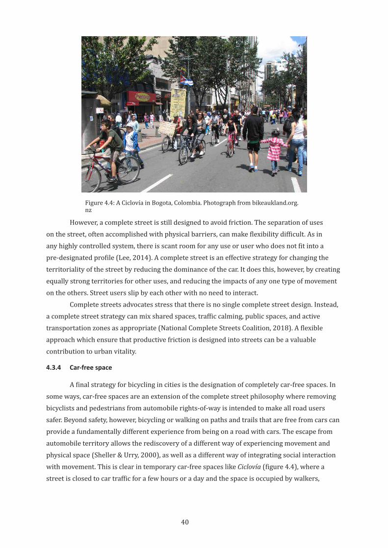
40
However, a complete street is still designed to avoid friction. The separation of uses on the street, often accomplished with physical barriers, can make flexibility difficult. As in any highly controlled system, there is scant room for any use or user who does not fit into a pre-designated profile (Lee, 2014). A complete street is an effective strategy for changing the territoriality of the street by reducing the dominance of the car. It does this, however, by creating equally strong territories for other uses, and reducing the impacts of any one type of movement on the others. Street users slip by each other with no need to interact.
Complete streets advocates stress that there is no single complete street design. Instead, a complete street strategy can mix shared spaces, traffic calming, public spaces, and active transportation zones as appropriate (National Complete Streets Coalition, 2018). A flexible approach which ensure that productive friction is designed into streets can be a valuable contribution to urban vitality.
4.3.4 Car-free space
A final strategy for bicycling in cities is the designation of completely car-free spaces. In some ways, car-free spaces are an extension of the complete street philosophy where removing bicyclists and pedestrians from automobile rights-of-way is intended to make all road users safer. Beyond safety, however, bicycling or walking on paths and trails that are free from cars can provide a fundamentally different experience from being on a road with cars. The escape from automobile territory allows the rediscovery of a different way of experiencing movement and physical space (Sheller & Urry, 2000), as well as a different way of integrating social interaction with movement. This is clear in temporary car-free spaces like Ciclovía (figure 4.4), where a street is closed to car traffic for a few hours or a day and the space is occupied by walkers,
Figure 4.4: A Ciclovía in Bogota, Colombia. Photograph from bikeaukland.org.nz
41
bicyclists, food vendors and activities.10 Ciclovía provide a safe space for physical activity, but also a space of physical and social friction. The resulting social interaction and community participation in these activities is just as valuable as the physical activity in and of itself (Zieff et al., 2014). The experience of car-free movement and high-friction interactions between users, and between users and the built environment, drives interest in active transportation (Torres et al., 2013).
Car-free spaces are sometimes imagined as bicycle superhighways. The proposal for the SkyCycle in London, for instance, imagines a network of elevated, multi-lane bike-only routes in the space over the city’s rail lines (Lavrinc, 2014). In other examples, rail trails or custom-designed bicycle highways are envisioned as high-speed routes between neighbourhoods or cities (Hembrow, 2016). In these cases, the emphasis is on bicycle infrastructure as friction-free routes for commuters, in which physical separation from other modes of transportation and lack of intersections allow bicyclists to cover long distances at high speed.
Unfortunately, these visions simply replace low-friction car or train travel with low-friction bicycle travel, missing out on the opportunity to create an alternative infrastructure that serves more than one purpose. Car-free spaces can also be envisioned as an alternative organising structure for our urban fabric that not only facilitates travel but also contributes to urban vitality. Rather than being separated from the city, this bicycle urbanism uses the physical and psychological characteristics of bicycling as the foundation of new city spaces (Fleming, 2013). In these visions, streets, public spaces, and buildings are designed with bicyclists as the primary users, in the same way that cities today are designed and built around cars. Rather than thinking about bicycle infrastructure as merely a corridor for transportation, bicycle urbanism posits the bicycle at the centre of urban design and placemaking efforts (Fleming, 2017).
These real and aspirational notions of how bicycling fits into and helps shape cities have implications for the design and use of urban rail trails. Urban bicycling is seen as integrated into the urban fabric of the city, existing with other forms of mobility; or bicycling is seen as the active transportation equivalent of a superhighway; or bicycling is seen as the structuring element of city spaces. These notions of urban bicycling are part of the discourse and expectations around urban trails.
4.4 Friction and Morphology of Urban Rail Trails
Urban rail trails arise from low-friction rail corridors, and their history and morphology can make it more difficult to integrate these spaces into the fabric of the city in order to increase urban vitality. The efficiency of rail transportation is largely based on the many ways in which interaction between the corridor and the surrounding city is minimised. This can take several forms. Because a train cannot efficiently negotiate steep slopes, a rail corridor must be as flat as possible. To overcome the height changes in the natural topography, the corridor is lowered into trenches or tunnels, or alternatively raised on berms or bridges. This means that a rail corridor 10 Ciclovía is a popular term for these events, although they exist under a variety of names around the
world. In the United States, the Open Streets Project supports Ciclovía-type events. Ciclovía-type events have been held in Melbourne and Gold Coast in Australia, New Zealand, India, and several countries in North and South America.

42
is often above or below the natural surrounding grades, vertically separated from adjacent roads and land uses. This vertical separation also helps minimise crossings, which makes train travel more efficient because the mass of a train makes starting and stopping difficult. Even where the corridor is at grade with its surroundings, street crossings are avoided as much as possible. Rail lines are often also horizontally separated from surrounding land uses. A corridor is at least 24 feet (7.5 metres) wide for a single track but is typically at least 130 feet (40 metres) wide to provide space for multiple tracks, service space, and buffer areas. Finally, rail corridors are often separated from adjacent uses by landscaped buffers or noise walls to reduce the impact of noise and air pollution from rail activities on nearby uses. These physical separations persist beyond the abandonment of the corridor. As a consequence, urban rail trails usually start as low-friction spaces.
This low-friction and separated character of rail corridors make rail trails unique and compelling urban environments. Abandoned corridors are incompletely preserved relics of different eras, partially manmade but also partially returned to nature, and they sit within the overall fabric of cities but are also removed from them. Therefore, in addition to the above discussion about attitudes toward physical and social friction that underlie rail trail planning and design decisions, there are also attitudes toward what might be called historical friction, or how a rail trail should interact with its own urban history—preserving, erasing, or altering that history as the trail develops. Cities around the world have legacies of urban industrial space, and are increasingly adapting these spaces for new uses, rather than simply erasing their histories (Way, 2013).
4.4.1 Trail access
The morphology of a rail corridor and its relationship to the city makes it ideal as a trail for certain types of bicycling. When riding efficiently, a bicyclist will typically maintain a steady speed. When riding on the street, the frequent need to stop at intersections or slow down because of potential conflicts with other users can frustrate long-distance riders. Getting back up to speed requires more physical work than maintaining a constant pace (Fajans & Curry, 2001; Heinen et al., 2010). A rail trail with limited crossings and little friction with other land uses is an energy efficient way to travel by bike, just as a freeway is a fuel- and time-efficient way to travel long distances by motor vehicle.
Like a freeway, however, a rail trail that is largely separated from its surroundings can be an inefficient way to travel short distances and can negatively impact its use. The body of research on relationships between built environment factors and urban bicycling rates is not consistent (see for instance Heinen et al., 2010), but there is general agreement that proximity to a trail or bike lane has a positive impact on the likelihood of bicycling (see for instance A. V. Moudon et al., 2005; Krizek & Johnson, 2006; Panter et al., 2016). However, it seems likely that separated rail trails are not accurately accounted for in these studies. Most research measures the airline distance (“as the crow flies”) or network distance (along the actual route on streets or paths) to the nearest bike lane or trail, but these studies generally do not account for the travel distance to an access point of that trail or lane. For on-street facilities, this is not critical since
43
bike lanes are continuously accessible, or at least at every intersection. For rail trails and other off-street facilities, however, distance and road conditions to an access point are likely more important than simple proximity to the trail because access points are generally less frequent.
More useful are the conceptually similar analyses of walk and bike sheds11 for rail or bus-based transit systems. For transit analysis, proximity to the transit corridor alone is not an indicator of transit accessibility. The proximity to a stop or station is the more reliable indicator. Based on work by Shafizadeh and Niemeier on bicyclists’ travel times, Krizek, et al. included distance to access point as a component of their study of how far bicyclists will go out of their way to use a highly attractive off-street trail (Shafizadeh & Niemeier, 1997; Krizek et al., 2007). This study indicated that bicyclists were willing to increase their trip distance in order to use a trail if the trail access point was within a bike shed of two kilometres. Krizek, et al. recommended using this bike shed distance as a tool for locating bicycle facilities and it could also be used to establish maximum distances between access points of a trail system. This research underscores the potential risks of reduced friction along a trail, in that it can deter potential users due to longer travel distances to reach the trail. More generally, street connectivity has been identified as a key factor contributing to higher rates of walking and bicycling (Cervero et al., 2009; Ewing & Cervero, 2010; Litman, 2016) in that a more connected transportation grid allows for more direct and shorter trips. These findings would also apply to rail trails as a component of that grid.
4.4.2 Perceived proximity to trails
Another potential risk of a low-friction urban rail trail is that long-term disconnection from its urban context can limit awareness of the trail. Along many urban rail corridors, only rail-related operations such as businesses with rail loading facilities are oriented toward the corridor. Other properties typically face away from the rail line or are separated from the corridor by large setbacks or fences. The noise, smell, and dangers associated with moving trains and active rail lines encourage this separation, which reduces friction between rail corridors and the surrounding urban fabric. Even among rail-oriented businesses, the rail-adjacent side of properties are usually dedicated to ‘back of house’ functions such as storage yards, loading, or freight handling facilities.
When rail lines are abandoned, these property uses often also change. However, there are usually ongoing negative impacts from the abandoned rail corridor such as litter, graffiti, or illicit activities. The ongoing disamenity of the rail corridor means that the rail-facing sides of buildings and properties are often underutilised or fenced off. When abandoned corridors are converted to trails, the threshold between properties and corridors often remains visually and physically blocked, at least in the short term. This decreases the visual access to and from the trail, further disconnecting the trail from its urban context. This lack of visual interaction between trail and context increases the perceived distance of the trail from surrounding uses.
11 A walk shed or bike shed is the area around any destination, service or amenity that is within a comfortable walking or biking distance for most people. Around a transit stop or station, the walk shed is considered to be between ¼ and ½ mile, or 400 and 800 meters (see Kim 2015 for more analysis on this rule of thumb.) Bike shed distances are not as well established—see Cervero, et al (2013) for bike sheds around transit.
44
Moudon et al. (2005) identified the importance of user perception of proximity of a trail or other bicycle facility. If perceived proximity is necessary to increase use of the trail, this lack of visual friction can have a negative impact.
This lack of visual friction also affects the user’s experience of the trail. Missing visual and physical connections to adjacent streets and neighbourhood centres may decrease the usefulness of the trail for everyday transportation. Not only can the rail trail be hard to find, but once on the trail, there are often scant clues to the location of destinations on surrounding streets. Rail trail management groups can attempt to overcome this perceived disconnection with wayfinding techniques and signage, in the same way that signage helps orient and direct street users. Often, however, signage along trails is discouraged or forbidden in an attempt to preserve the distinct character of the trail as a space free from the visual clutter of the surrounding city (Salomon, 2009; Byron, 2011).
4.5 Conclusion: Trail Design and Expectations of Friction
Overcoming real and perceived frictionlessness between rail trails and their urban context can be a relatively straightforward design task; studies indicate that improving physical and visual connections to the trail will increase awareness and use of trails. The more fundamental issue is whether a physically and visually integrated trail is consistent with the expectations for the trail. As discussed in this chapter, there are a range of opinions about how active transportation uses should be integrated into the fabric of the city. On a rail trail, as on a city street, users can be held apart or mixed together. Some trails create separate lanes, complete with signage, for different types of users, or even physically separate them. Other trails have no clear sets of rules on how users move, instead they rely on friction to force users to negotiate their way through the space. Rail trails, like streets, can be designed as frictionless corridors for movement, or as spaces where people rub along each other. Some trails keep the paved sections narrow, discouraging stopping or weaving, directing users to keep moving in orderly lines. Other trails include spaces to stop along the trail or paths to nearby amenities. They may be wide enough for users to walk or ride side-by-side. Like streets, rail trails can be integrated with their context or maintain their separation. Some trails encourage adjacent buildings and land uses to engage the space of the trail, spilling out to the corridor or inviting trail users in. Others use fences or landscaping to maintain strong edges and avoid encroachments or trespassing. These different approaches represent different attitudes toward friction, and toward the place of urban rail trails in the urban context. The following chapter will explore these ideas further through the final agent of urban vitality, looseness.
45
5 Looseness[The Campo Santa Margherita] is a public space which is irregular, haphazard, and ordinary. Its ten entrances/exits invite random paths to be taken, its benches, scattered across the square, lure the old and young to pause for a while, its lack of cars entices kids to play and chase the pigeons, its market stalls bring locals to shop, its calm and bustle, light and shade, mark it as a place to gaze, chat and rub along with others with ease. (Watson, 2006, p. 3)
In their book Loose Space, Karen Franck and Quentin Stevens (2007) explore the issue of use and control over public space, using the term looseness to describe spaces where design, uses, and management contribute to a sense of freedom and possibility. Loose spaces are marked by a physical environment that can be modified and appropriated; a flexible (or non-existent) set of guidelines or regulations for the use of the space; and an acceptance or tolerance for the frictions that arise from overlapping and conflicting uses of space. In contrast, a tight space is one where behaviours and activities are constrained; where expectations are clearly communicated through design or management; where infringement of the rules is criticised or punished; or where the design of the space proscribes any but the specified use (Sommer, 1974). Looseness is the third and final agent within the framework of urban vitality as described in Chapter 2.
The concept of loose space is closely tied to particular physical spaces, such as a street, a plaza, a leftover or abandoned piece of land, but it is the way they are used through the everyday actions of people that creates looseness. In many urban settings, people will appropriate space and utilise it to serve their own needs. Looseness is caused by these everyday small occupations, adaptations, and transgressions in space, and the acceptance of these transgressions as an unavoidable part of everyday urban life. “In cities people are, mostly, politely inattentive to each other’s activities in public spaces: encounters are risky, and so in principle, strangers require a reason to engage with each other” (Franck & Stevens, 2007, p. 6). Instead of engagement, a more typical set of interactions follow what Goffman termed civil inattention, or “co-presence without co-mingling, awareness without engrossment, courtesy without conversation” (Lofland, 1989; Goffman, 2008, p. 83).
But as these small occupations and transgressions overlap in space and time, friction increases as people increasingly “rub along” others engaged in their own occupations and transgressions (Watson, 2006). Conflicts may arise, but so can interwoven and reciprocating sets of actions. Shoppers and passers-by stop to listen to a busker’s music and start conversations amongst each other, and the sight of this gathering draws in even more people (Whyte, 1988, p. 154). Around night markets, illegal vendors must compete for informal selling spaces but they also develop cooperative networks and watch each other’s stalls and alert each other to police sweeps (Dovey & Polakit, 2007; Hou, 2010, p. 11). The frictions and social interactions that arise from loosened space are fundamental to creating urban vitality. This chapter will describe the role of looseness in diverse urban environments, discuss the ways looseness and tightness
46
are introduced in cities, and then consider urban bicycling and rail trails through the agent of looseness. The chapter will conclude by highlighting at how the three agents of urban vitality—territorialisation, friction, and looseness—interact in various types of urban space.
5.1 Loose Space and Heterotopias
The concept of loose space is valuable in analysing and designing public space because it brings difference and flux to the foreground of our considerations. In the governance of cities and professional design practice, clear programming, tight budgets and risk management have tended to exclude looseness. The public and semi-public spaces of the city (the streets, shopping malls, parks, plazas) are often shaped by a narrow vision of a good city (Mitchell, 2003, p. 137). This vision comes from property owners or corporations focused on profitability or creating pleasant environments for tenants and shoppers, or from local governments keen to promote business interests (and tax income) and convey an image of public safety.
The idea of loose space draws on the rich philosophical veins of Michel Foucault’s concept of heterotopias and Henri Lefebvre’s concept of the right to the city to describe public space in which different users have the right to presence, to the assertion of their own agendas, and to a voice in decision-making processes (Foucault & Miskowiec, 1984; Lefebvre et al., 1996). Foucault’s brief but evocative discussion of heterotopias has been fertile ground for urban scholars, architects, and human geographers. A heterotopia is usually defined as a space governed by an alternative logic that differs from mainstream normative order. A heterotopia is physically, socially, or culturally separate from other places, but connected to them and embedded in them. Robert Topinka notes that heterotopias do not replace mainstream understandings of space, instead they overlay new meaning upon them. This creates a tension which renders both sets of meaning more legible (Topinka, 2010, pp. 55-56). In an urban environment, space is loosened by the overlap of multiple sets of uses, meanings, and rules, and these zones of overlap enable us to see the differences. In contrast, in an area where there are no heterotopic uses, the dominant order is so pervasive that it subsumes difference. Therefore, in loose spaces, we not only see difference but also how the dominant order shapes and controls space.
The actions that work to loosen space are often transient and individually trivial. They might be the product of explicit resistance to the dominant order, or simply the residue from the tactics of everyday life. As such, they are usually ignored or quickly subsumed within the tight order of mainstream or governed space. Lefebvre (1996) suggests, however, that these individual acts of claiming ownership and control of public space are a vital component of urbanity and the right to the city. Being urban requires a change of focus from our current atomistic and profit-oriented mindsets toward one in which we recognise and claim the benefits of sharing space.
Richard Sennett (1971) argues that this change in mindset will not arise out of noble intentions to care for our fellow man, but from being forced to engage with our co-inhabitants of the city. For Sennett, the human desire for easy, stress-free existence led us to design conflict
47
and difference out of city spaces, while it is actually this conflict that leads to satisfying social engagement (1971, pp. 129-134). This engagement is social friction, the planned or incidental rubbing up against each other in public space, as discussed in Chapter 4.
For this friction to arise, space must be loose enough to allow room for different users and uses to occupy and appropriate space. The repetition of these appropriations, and the conflicts that arise in the overlaps between various occupations in a space, can give rise to various forms of autogestion. Daniel Campo’s long-running research on informal spaces along post-industrial waterfront spaces in Brooklyn, New York highlights the opportunities in loose spaces for groups to self-organise and self-manage, even in the face of ongoing tightening and territorialisation by local governments (Campo, 2002). In these leftover spaces, groups have staked out long-term appropriations for skateboard parks, art exhibits, gardening, and band rehearsals. These more established uses share the space with the everyday uses of walking, picnicking, and sunbathing. People are attracted by the opportunities offered by loose spaces, bringing a diverse mix of individuals and groups into spaces where they must interact to create, defend, or negotiate their overlapping and heterotopic territories.
The autogestion enabled by looseness not only makes space for differing uses in a particular locality, or spatial self-organisation, it also enables temporal self-management by allowing users to change locations based on the assemblage of uses and users (Hou, 2016). For example, a food truck that parks on a downtown street during the lunch rush could relocate to a park in the evening to capture a different group of customers (Brindley, 2015). In these loose occupations of public spaces, itinerant food vendors benefit because of the low barrier to entry and operational overhead. The local government benefits because it does not have to predict exact locations and quantities of retail demand and risk business failure if zoning proves incorrect.
However, looseness in publicly-accessible space is a point of tension in contemporary cities, inciting debates about how spaces can or should be used by individuals and groups. Loose spaces are sites of the novel and strange where street performers, vendors, office workers, tourists and the homeless can coexist. The porosity of loose spaces creates openings for unexpected interactions and outward expressions of difference that make city life appealing (Benjamin & Lacis, 1979). Flexible spaces can create opportunities for the everyday interactions that engender constructive social friction and promote urban vitality. However, loose space can also feel uncomfortable or unsafe because it appears ill-defined or chaotic (C. W. Thompson, 2002). Just as with friction and flow, some urban spaces are tightly managed for reasons of safety or efficiency, but often spaces are tightened because we wish to avoid mess and confrontation (Nevárez, 2007). There are spaces in a city that are tight and controlled but allow for some social interaction: libraries, office lobbies, restaurants, and theatres. These places are important attractors to city life, but they need to be connected to spaces in which everyday users have the opportunity and agency to act. Urban vitality requires looseness to provide breathing room for interaction. But the creation and maintenance of loose space is fraught and subject to the structural social, political, and economic forces that influence urban life.
48
5.2 Three Categories of Loosening and Tightening
Different types of spaces (home, school, park, street, footpath, etc.) are associated with culturally and historically specific sets of features—forms, meanings, and uses—that communicate how people should behave within the space. A school generally has a set of behavioural controls that is more rigid than the set of controls in a park, for instance. Beyond this culturally imposed spatial looseness or tightness, the way people use space can further loosen or tighten the space. A school administration may decide to open school grounds to an occasional public fair or allow local sports teams to use the soccer pitch, thereby loosening controls on the use of the normally tightly managed school space. Conversely, a local government may impose new regulations on loitering on footpaths, permit or restrict the use of the public way for café seating or for the sale of goods, or re-design a space to indicate preferred use. An individual or group may decide to make use of these spaces for their own ends such as skateboarding in the school playground after hours, selling food outside a movie theatre or stadium, or sleeping in a park despite the potential risks. The public spaces of a city are always undergoing simultaneous loosening and tightening actions, following different time and spatial scales, sometimes in concert with but often contradicting other actions or restrictions.
We can analyse the looseness and tightness of a space according to the following three categories: design, use and management.
5.2.1 Design
The physical design of city spaces is a fundamental contributor to the looseness or tightness of a place. While urban spaces are always subject to unintended uses, the original design or programming of space can constrain the types of uses that it can accommodate. Often this constraint is intentional. A travel lane or narrow footpath along a street, a staircase, or the cordons that define a queue in a bank or an airport are intended to provide for a particular use and to discourage others. But these same spaces can be loosened by providing a few extra centimetres of space. A widened footpath can be a place to trade or loiter in addition to a place to walk; a staircase can be a setting for impromptu meetings; an airport queue can be a place for extended farewells or jostling for position (figure 5.1).
While design can explicitly tighten or loosen a space, loosening is often unintentional or incidental. Threshold spaces between public and private zones are often loose spaces. There is often a “no man’s land” where ownership and control are unclear, and these spaces can be temporarily occupied. A busker can take over the doorway of a closed shopfront, and a shop can use the footpath as display space.
Loose space can be created physically by providing furniture that is moveable or flexible enough for users to adjust or configure for sitting, standing or lying down. Café tables along a footpath are an example that shows how private and public zones intermix, and different uses wax and wane over the course of a day. William H. Whyte, in his analysis of urban environments, argues that the ability to physically manipulate one’s environment, even in a small way, contributes to a sense of belonging and comfort in what is otherwise an undifferentiated or
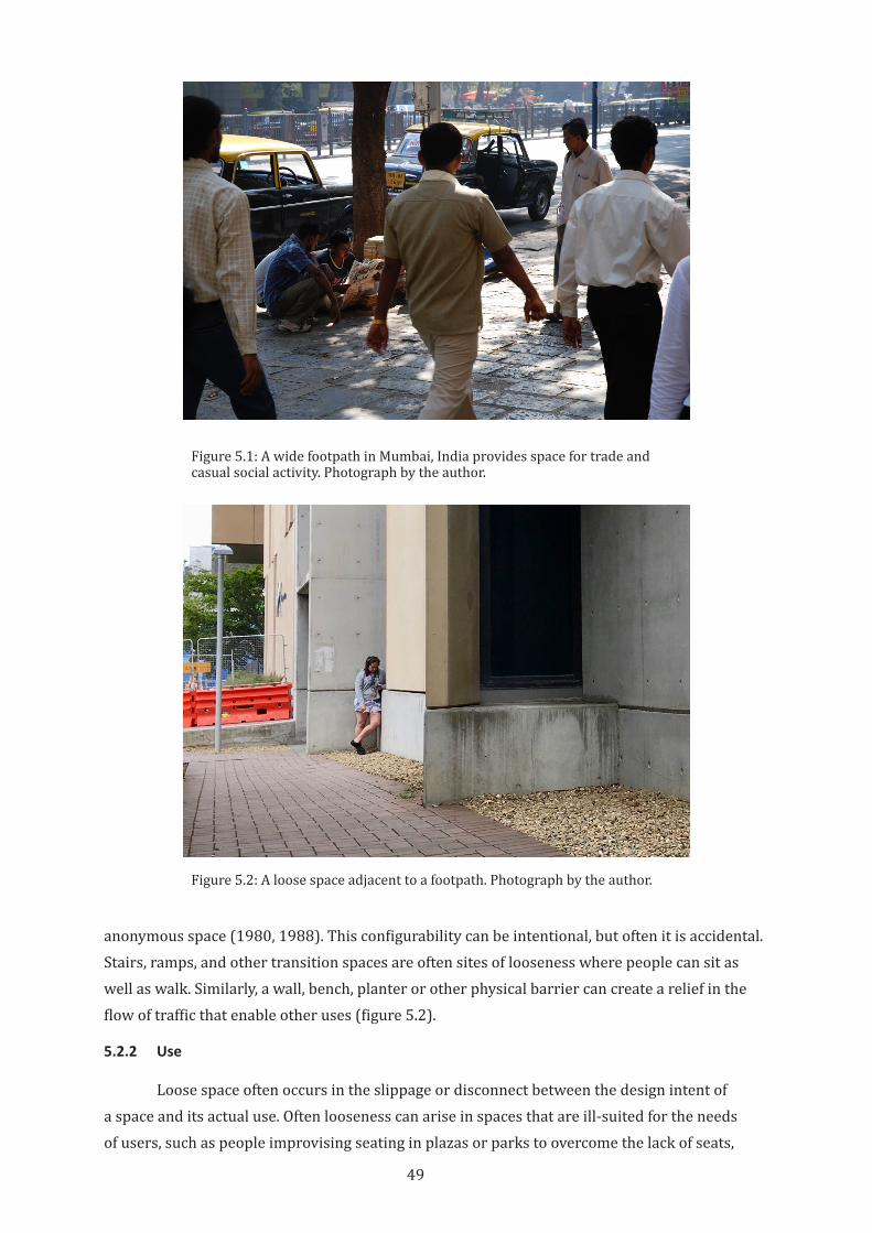
49
anonymous space (1980, 1988). This configurability can be intentional, but often it is accidental. Stairs, ramps, and other transition spaces are often sites of looseness where people can sit as well as walk. Similarly, a wall, bench, planter or other physical barrier can create a relief in the flow of traffic that enable other uses (figure 5.2).
5.2.2 Use
Loose space often occurs in the slippage or disconnect between the design intent of a space and its actual use. Often looseness can arise in spaces that are ill-suited for the needs of users, such as people improvising seating in plazas or parks to overcome the lack of seats,
Figure 5.2: A loose space adjacent to a footpath. Photograph by the author.
Figure 5.1: A wide footpath in Mumbai, India provides space for trade and casual social activity. Photograph by the author.
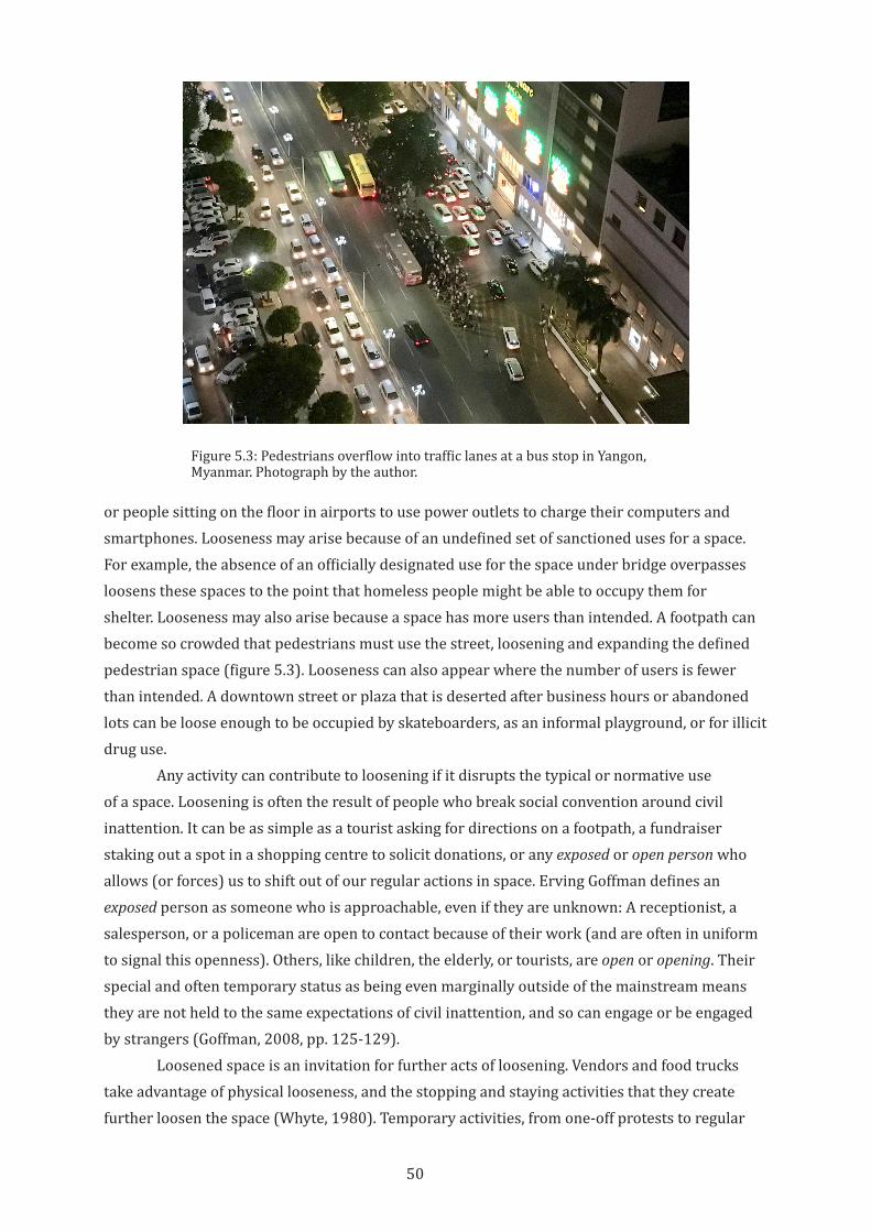
50
or people sitting on the floor in airports to use power outlets to charge their computers and smartphones. Looseness may arise because of an undefined set of sanctioned uses for a space. For example, the absence of an officially designated use for the space under bridge overpasses loosens these spaces to the point that homeless people might be able to occupy them for shelter. Looseness may also arise because a space has more users than intended. A footpath can become so crowded that pedestrians must use the street, loosening and expanding the defined pedestrian space (figure 5.3). Looseness can also appear where the number of users is fewer than intended. A downtown street or plaza that is deserted after business hours or abandoned lots can be loose enough to be occupied by skateboarders, as an informal playground, or for illicit drug use.
Any activity can contribute to loosening if it disrupts the typical or normative use of a space. Loosening is often the result of people who break social convention around civil inattention. It can be as simple as a tourist asking for directions on a footpath, a fundraiser staking out a spot in a shopping centre to solicit donations, or any exposed or open person who allows (or forces) us to shift out of our regular actions in space. Erving Goffman defines an exposed person as someone who is approachable, even if they are unknown: A receptionist, a salesperson, or a policeman are open to contact because of their work (and are often in uniform to signal this openness). Others, like children, the elderly, or tourists, are open or opening. Their special and often temporary status as being even marginally outside of the mainstream means they are not held to the same expectations of civil inattention, and so can engage or be engaged by strangers (Goffman, 2008, pp. 125-129).
Loosened space is an invitation for further acts of loosening. Vendors and food trucks take advantage of physical looseness, and the stopping and staying activities that they create further loosen the space (Whyte, 1980). Temporary activities, from one-off protests to regular
Figure 5.3: Pedestrians overflow into traffic lanes at a bus stop in Yangon, Myanmar. Photograph by the author.
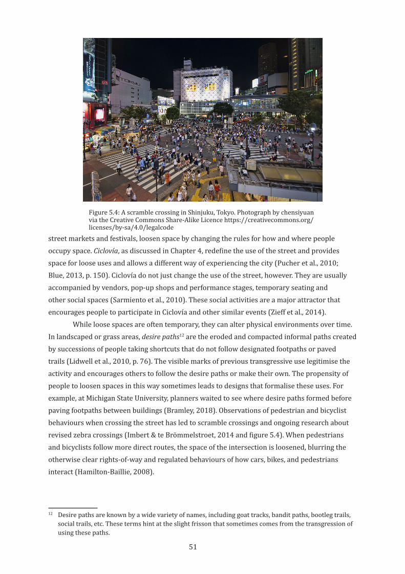
51
street markets and festivals, loosen space by changing the rules for how and where people occupy space. Ciclovía, as discussed in Chapter 4, redefine the use of the street and provides space for loose uses and allows a different way of experiencing the city (Pucher et al., 2010; Blue, 2013, p. 150). Ciclovía do not just change the use of the street, however. They are usually accompanied by vendors, pop-up shops and performance stages, temporary seating and other social spaces (Sarmiento et al., 2010). These social activities are a major attractor that encourages people to participate in Ciclovía and other similar events (Zieff et al., 2014).
While loose spaces are often temporary, they can alter physical environments over time. In landscaped or grass areas, desire paths12 are the eroded and compacted informal paths created by successions of people taking shortcuts that do not follow designated footpaths or paved trails (Lidwell et al., 2010, p. 76). The visible marks of previous transgressive use legitimise the activity and encourages others to follow the desire paths or make their own. The propensity of people to loosen spaces in this way sometimes leads to designs that formalise these uses. For example, at Michigan State University, planners waited to see where desire paths formed before paving footpaths between buildings (Bramley, 2018). Observations of pedestrian and bicyclist behaviours when crossing the street has led to scramble crossings and ongoing research about revised zebra crossings (Imbert & te Brömmelstroet, 2014 and figure 5.4). When pedestrians and bicyclists follow more direct routes, the space of the intersection is loosened, blurring the otherwise clear rights-of-way and regulated behaviours of how cars, bikes, and pedestrians interact (Hamilton-Baillie, 2008).
12 Desire paths are known by a wide variety of names, including goat tracks, bandit paths, bootleg trails, social trails, etc. These terms hint at the slight frisson that sometimes comes from the transgression of using these paths.
Figure 5.4: A scramble crossing in Shinjuku, Tokyo. Photograph by chensiyuan via the Creative Commons Share-Alike Licence https://creativecommons.org/licenses/by-sa/4.0/legalcode
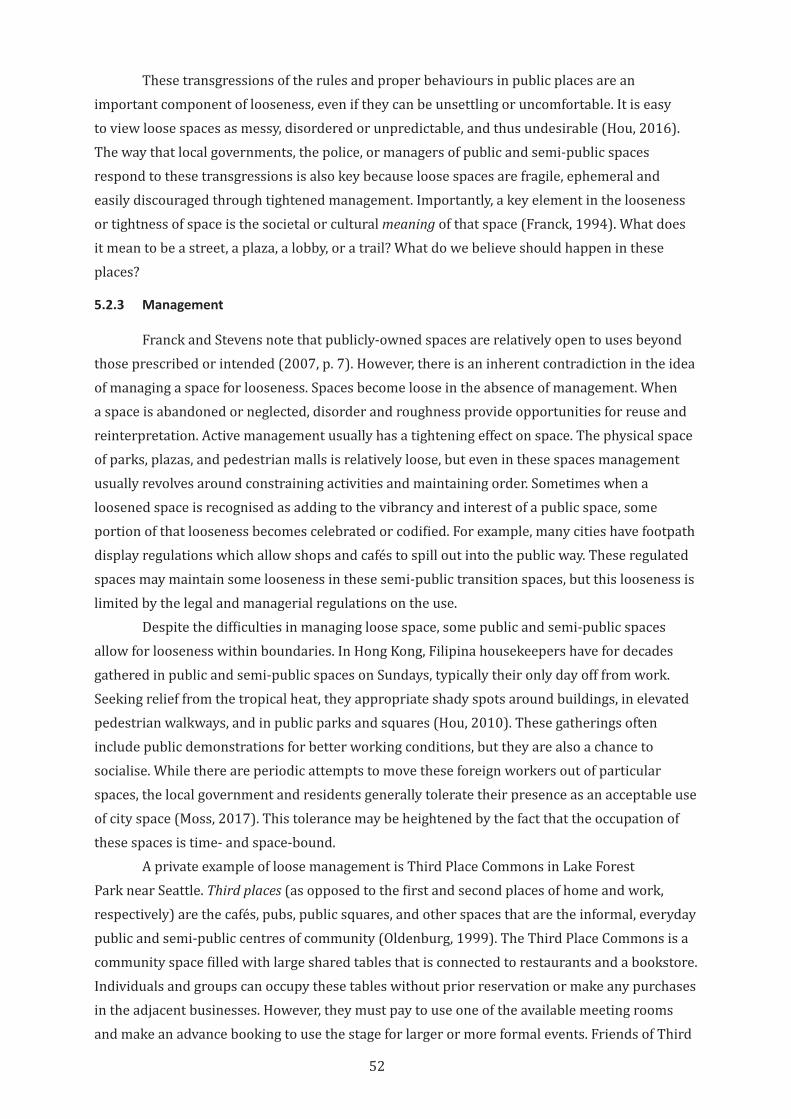
52
These transgressions of the rules and proper behaviours in public places are an important component of looseness, even if they can be unsettling or uncomfortable. It is easy to view loose spaces as messy, disordered or unpredictable, and thus undesirable (Hou, 2016). The way that local governments, the police, or managers of public and semi-public spaces respond to these transgressions is also key because loose spaces are fragile, ephemeral and easily discouraged through tightened management. Importantly, a key element in the looseness or tightness of space is the societal or cultural meaning of that space (Franck, 1994). What does it mean to be a street, a plaza, a lobby, or a trail? What do we believe should happen in these places?
5.2.3 Management
Franck and Stevens note that publicly-owned spaces are relatively open to uses beyond those prescribed or intended (2007, p. 7). However, there is an inherent contradiction in the idea of managing a space for looseness. Spaces become loose in the absence of management. When a space is abandoned or neglected, disorder and roughness provide opportunities for reuse and reinterpretation. Active management usually has a tightening effect on space. The physical space of parks, plazas, and pedestrian malls is relatively loose, but even in these spaces management usually revolves around constraining activities and maintaining order. Sometimes when a loosened space is recognised as adding to the vibrancy and interest of a public space, some portion of that looseness becomes celebrated or codified. For example, many cities have footpath display regulations which allow shops and cafés to spill out into the public way. These regulated spaces may maintain some looseness in these semi-public transition spaces, but this looseness is limited by the legal and managerial regulations on the use.
Despite the difficulties in managing loose space, some public and semi-public spaces allow for looseness within boundaries. In Hong Kong, Filipina housekeepers have for decades gathered in public and semi-public spaces on Sundays, typically their only day off from work. Seeking relief from the tropical heat, they appropriate shady spots around buildings, in elevated pedestrian walkways, and in public parks and squares (Hou, 2010). These gatherings often include public demonstrations for better working conditions, but they are also a chance to socialise. While there are periodic attempts to move these foreign workers out of particular spaces, the local government and residents generally tolerate their presence as an acceptable use of city space (Moss, 2017). This tolerance may be heightened by the fact that the occupation of these spaces is time- and space-bound.
A private example of loose management is Third Place Commons in Lake Forest Park near Seattle. Third places (as opposed to the first and second places of home and work, respectively) are the cafés, pubs, public squares, and other spaces that are the informal, everyday public and semi-public centres of community (Oldenburg, 1999). The Third Place Commons is a community space filled with large shared tables that is connected to restaurants and a bookstore. Individuals and groups can occupy these tables without prior reservation or make any purchases in the adjacent businesses. However, they must pay to use one of the available meeting rooms and make an advance booking to use the stage for larger or more formal events. Friends of Third
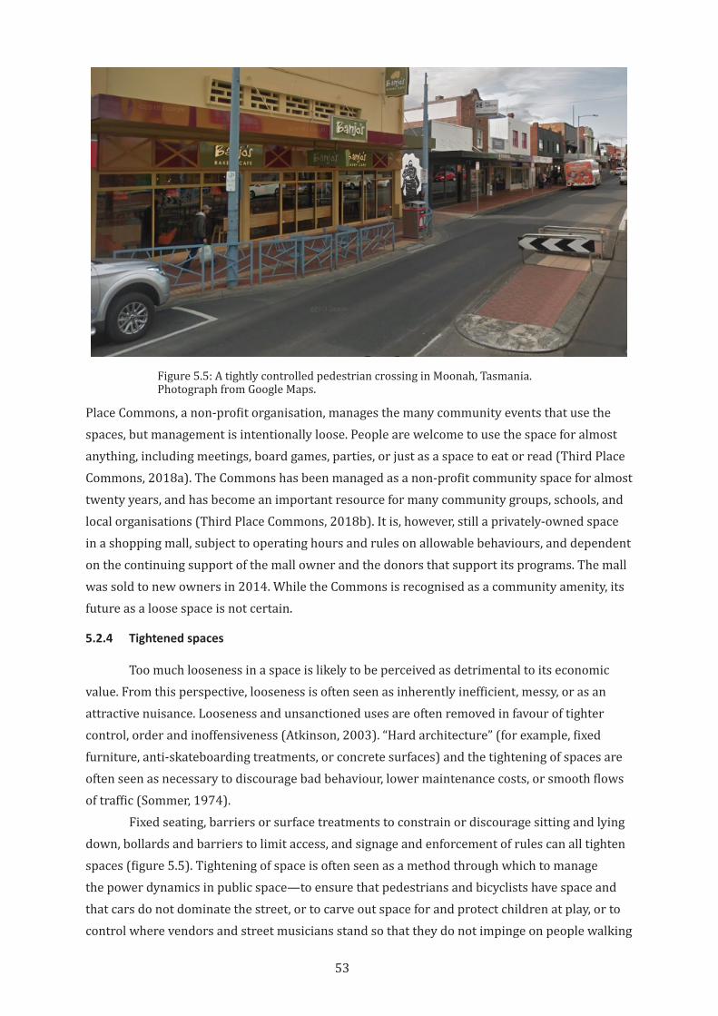
53
Place Commons, a non-profit organisation, manages the many community events that use the spaces, but management is intentionally loose. People are welcome to use the space for almost anything, including meetings, board games, parties, or just as a space to eat or read (Third Place Commons, 2018a). The Commons has been managed as a non-profit community space for almost twenty years, and has become an important resource for many community groups, schools, and local organisations (Third Place Commons, 2018b). It is, however, still a privately-owned space in a shopping mall, subject to operating hours and rules on allowable behaviours, and dependent on the continuing support of the mall owner and the donors that support its programs. The mall was sold to new owners in 2014. While the Commons is recognised as a community amenity, its future as a loose space is not certain.
5.2.4 Tightened spaces
Too much looseness in a space is likely to be perceived as detrimental to its economic value. From this perspective, looseness is often seen as inherently inefficient, messy, or as an attractive nuisance. Looseness and unsanctioned uses are often removed in favour of tighter control, order and inoffensiveness (Atkinson, 2003). “Hard architecture” (for example, fixed furniture, anti-skateboarding treatments, or concrete surfaces) and the tightening of spaces are often seen as necessary to discourage bad behaviour, lower maintenance costs, or smooth flows of traffic (Sommer, 1974).
Fixed seating, barriers or surface treatments to constrain or discourage sitting and lying down, bollards and barriers to limit access, and signage and enforcement of rules can all tighten spaces (figure 5.5). Tightening of space is often seen as a method through which to manage the power dynamics in public space—to ensure that pedestrians and bicyclists have space and that cars do not dominate the street, or to carve out space for and protect children at play, or to control where vendors and street musicians stand so that they do not impinge on people walking
Figure 5.5: A tightly controlled pedestrian crossing in Moonah, Tasmania. Photograph from Google Maps.
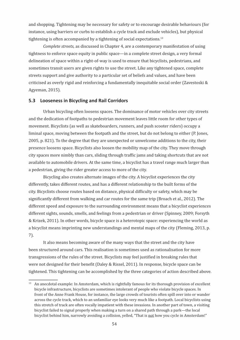
54
and shopping. Tightening may be necessary for safety or to encourage desirable behaviours (for instance, using barriers or curbs to establish a cycle track and exclude vehicles), but physical tightening is often accompanied by a tightening of social expectations.13
Complete streets, as discussed in Chapter 4, are a contemporary manifestation of using tightness to enforce space equity in public space—in a complete street design, a very formal delineation of space within a right-of-way is used to ensure that bicyclists, pedestrians, and sometimes transit users are given rights to use the street. Like any tightened space, complete streets support and give authority to a particular set of beliefs and values, and have been criticised as overly rigid and reinforcing a fundamentally inequitable social order (Zavestoski & Agyeman, 2015).
5.3 Looseness in Bicycling and Rail Corridors
Urban bicycling often loosens spaces. The dominance of motor vehicles over city streets and the dedication of footpaths to pedestrian movement leaves little room for other types of movement. Bicyclists (as well as skateboarders, runners, and push scooter riders) occupy a liminal space, moving between the footpath and the street, but do not belong to either (P. Jones, 2005, p. 821). To the degree that they are unexpected or unwelcome additions to the city, their presence loosens space. Bicyclists also loosen the mobility map of the city. They move through city spaces more nimbly than cars, sliding through traffic jams and taking shortcuts that are not available to automobile drivers. At the same time, a bicyclist has a travel range much larger than a pedestrian, giving the rider greater access to more of the city.
Bicycling also creates alternate images of the city. A bicyclist experiences the city differently, takes different routes, and has a different relationship to the built forms of the city. Bicyclists choose routes based on distance, physical difficulty or safety, which may be significantly different from walking and car routes for the same trip (Broach et al., 2012). The different speed and exposure to the surrounding environment means that a bicyclist experiences different sights, sounds, smells, and feelings from a pedestrian or driver (Spinney, 2009; Forsyth & Krizek, 2011). In other words, bicycle space is a heterotopic space: experiencing the world as a bicyclist means imprinting new understandings and mental maps of the city (Fleming, 2013, p. 7).
It also means becoming aware of the many ways that the street and the city have been structured around cars. This realisation is sometimes used as rationalisation for more transgressions of the rules of the street. Bicyclists may feel justified in breaking rules that were not designed for their benefit (Daley & Rissel, 2011). In response, bicycle space can be tightened. This tightening can be accomplished by the three categories of action described above.
13 An anecdotal example: In Amsterdam, which is rightfully famous for its thorough provision of excellent bicycle infrastructure, bicyclists are sometimes intolerant of people who violate bicycle spaces. In front of the Anne Frank House, for instance, the large crowds of tourists often spill over into or wander across the cycle track, which to an unfamiliar eye looks very much like a footpath. Local bicyclists using this stretch of track are often vocally impatient with these invasions. In another part of town, a visiting bicyclist failed to signal properly when making a turn on a shared path through a park—the local bicyclist behind him, narrowly avoiding a collision, yelled, “That is not how you cycle in Amsterdam!”
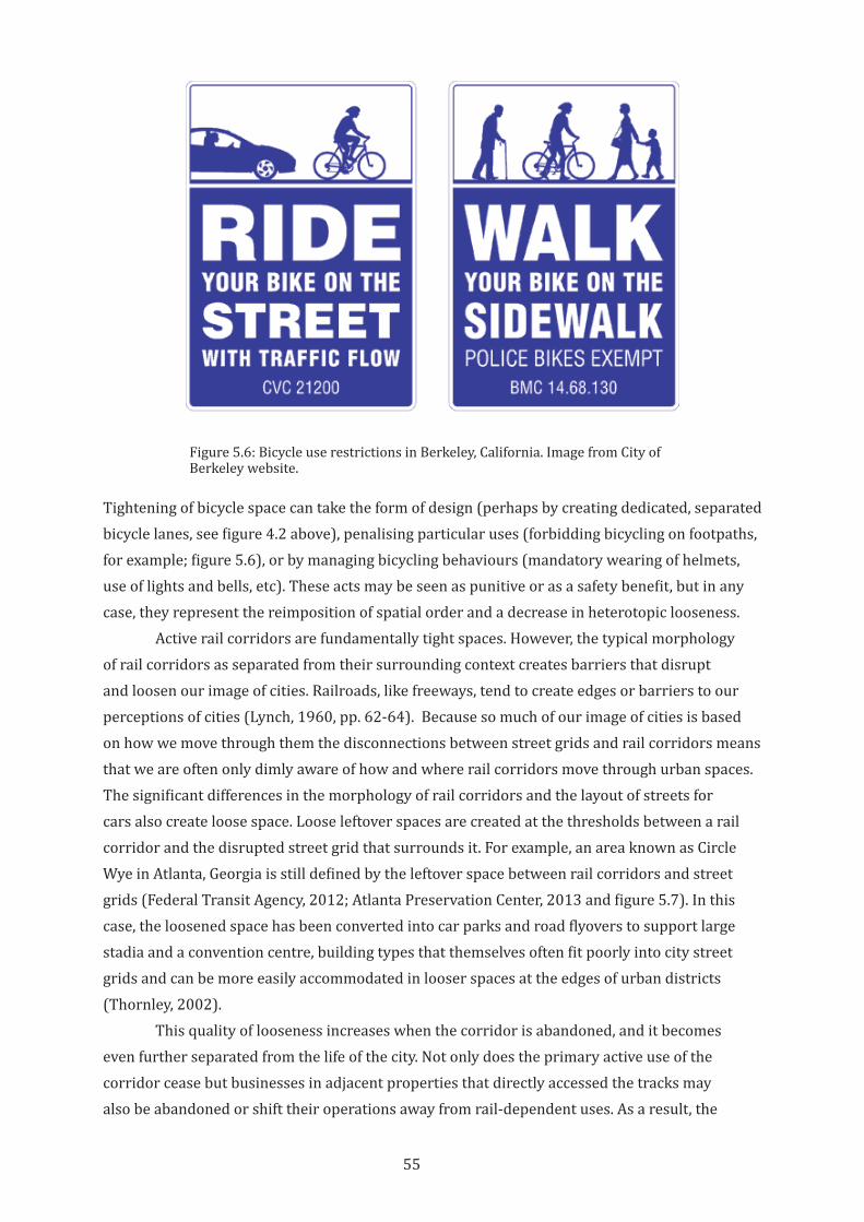
55
Tightening of bicycle space can take the form of design (perhaps by creating dedicated, separated bicycle lanes, see figure 4.2 above), penalising particular uses (forbidding bicycling on footpaths, for example; figure 5.6), or by managing bicycling behaviours (mandatory wearing of helmets, use of lights and bells, etc). These acts may be seen as punitive or as a safety benefit, but in any case, they represent the reimposition of spatial order and a decrease in heterotopic looseness.
Active rail corridors are fundamentally tight spaces. However, the typical morphology of rail corridors as separated from their surrounding context creates barriers that disrupt and loosen our image of cities. Railroads, like freeways, tend to create edges or barriers to our perceptions of cities (Lynch, 1960, pp. 62-64). Because so much of our image of cities is based on how we move through them the disconnections between street grids and rail corridors means that we are often only dimly aware of how and where rail corridors move through urban spaces. The significant differences in the morphology of rail corridors and the layout of streets for cars also create loose space. Loose leftover spaces are created at the thresholds between a rail corridor and the disrupted street grid that surrounds it. For example, an area known as Circle Wye in Atlanta, Georgia is still defined by the leftover space between rail corridors and street grids (Federal Transit Agency, 2012; Atlanta Preservation Center, 2013 and figure 5.7). In this case, the loosened space has been converted into car parks and road flyovers to support large stadia and a convention centre, building types that themselves often fit poorly into city street grids and can be more easily accommodated in looser spaces at the edges of urban districts (Thornley, 2002).
This quality of looseness increases when the corridor is abandoned, and it becomes even further separated from the life of the city. Not only does the primary active use of the corridor cease but businesses in adjacent properties that directly accessed the tracks may also be abandoned or shift their operations away from rail-dependent uses. As a result, the
Figure 5.6: Bicycle use restrictions in Berkeley, California. Image from City of Berkeley website.
56
rail corridor can be severed from the everyday life of the city, not only abandoned but also forgotten. This loosened space is then open to a range of users and uses that occupy and colonise the space. Plants colonise the land and animals use the space for travel or for shelter (Searns, 1995; Hannah, 2015). Illicit and informal human uses from hiking and bicycling, to everyday play, to drug use, to homeless encampments make use of the looseness of the abandoned land. Abandoned railway-oriented buildings can be used for informal housing, graffiti, or other uses. For instance, along the abandoned rail line that circles Paris called the Petite Ceinture, informal uses of rail buildings and space for housing, art, gardening, beekeeping and other uses have persisted despite regular threats of government expulsion. (Foster, 2014).
However, these ephemeral and informal uses are sometimes formalised into more permanent uses. In Berlin, wild plants and animals have colonised an abandoned rail yard, including species that were rare in the city. In response to these occupations, the rail yard was converted into a public park and art space that showcases the re-establishment of natural ecosystems within the long-abandoned space (Kowarik & Langer, 2005). However, with this permanence comes some loss of the wildness or looseness of the space.
Likewise, development of a rail trail inevitably involves some spatial tightening of the corridor through the establishment of a legal and management framework for the trail, the delineation and paving of the trail surface, and the setting of rules for trail use. But beyond these basic actions, the degree to which a trail is tightened seems open to local interpretation and local territorialities. Urban rail trails sit on the spectrum between public space and transportation infrastructure. Each rail trail is created under a unique combination of existing conditions, community needs and values, and organisational or governmental priorities that pushes each trail in one direction or the other (Kullman, 2013). The planning, design, and management strategies that create and control trails influence the looseness or tightness of the trail and its potential to enhance urban vitality.
Figure 5.7: Circle Wye area of Atlanta Georgia. On left, map from 1864, from Library of Congress, Geography and Map Division. On right, satellite image from Apple Maps.
57
5.4 Combinations of Territorialisation, Friction, And Looseness
The first chapters of this thesis have explored three agents of urban vitality, and how they affect the character of public space in cities. These agents occur in any public space and are not limited to rail trails or infrastructure. To clarify general relationships between them, this section will briefly explore some common combinations and interactions between them in public spaces.
The constant changes in the physical form and patterns of use in cities means that there is a constant flux through urban space. Territorialisations grow and shrink, and spaces exhibit constantly changing states of tightness and looseness, and of friction and flow. As the city changes, social and physical remnants of former territories (abandoned rail corridors, for instance) can become the space in which new territories can form (Kärrholm, 2007). The borders and centres of local communities of power are constantly being created, shifted, and dissolved, and the assemblages of actors, places, and physical constructions that make up those communities shift as well. These changes tighten or loosen spaces and remove old frictions or add new ones. But within this constant flux of territory, friction, and looseness, there are patterns that often occur:
Highfriction,tightspaces include transportation hubs, museums, amusement parks, and schools. These are spaces where people are encouraged or forced into interactions (with each other or with elements in the space) but where experiences and behaviours are tightly managed. In an airport terminal, for instance, the movement of people through the space is very tightly controlled, with several points of intentional constriction (at ticket counters, at security or immigration points, at boarding gates). These are separated by areas of relatively open movement, but within very tightly controlled boundaries and with a limited set of allowable activities and behaviours. In these areas, the provided staying activities are often designed to minimise interpersonal friction (focusing on shopping, eating, sitting in inflexible seating arrangements, and watching TV), so interaction with other travellers and staff is transient, brief, and impersonal.
Museums and amusement parks are relatively looser, but these spaces are still clearly bounded, and are designed around highly managed experiences. Signage and maps are designed to direct movement and activities, lighting and other visual cues provide controls on visitors’ expectations and behaviours (Carmona, 2014). Similarly, access to a school is relatively tightly controlled (at least during school hours), and behaviours and activities are tightly managed by rules, schedules, bells, and near-continuous supervision from teachers and administrators.
These spaces are all highly territorialised by a strong central authority that exercises almost complete control over the users and uses of the space. These spaces may have nested territories within them—curator-controlled or security-patrolled spaces in a museum, for instance—but there are usually well-defined relationships of control between territorialising actors. Even where other territorial actors occupy space (for example, passengers in an airport claiming seats or using electrical outlets) they generally do so with an implicit understanding that airport management can override these territorialisations. When high friction, tight spaces

58
are deterritorialised (such as the abandonment of a rail corridor), the nature of the space will also change. Loose uses will colonise the space quickly, and these uses can, eventually create friction between them.
Highfriction,loosespaces include farmers’ markets and festivals, demonstrations, and traditional streets where the boundaries between private space, public space, and movement space are flexible or fuzzy. These spaces are often temporary and are often accepted by local governments or other territorial authorities where the novelty of the activity is valued, or where the effort needed to regulate and stratify spaces is high relative to any efficiency benefits. (See figure 3.1 above). They are also spaces where interaction between people is seen as the most important activity, or where power relationships are unclear or contested (figure 5.8). High friction, loose spaces also occur where conditions are changing—around construction sites or rapidly changing neighbourhoods, where patterns of use and travel have not been established or reasserted. A public plaza or park may also be high friction and loose, depending on the level of use and management strategy. Over time these spaces may become tighter: more regulated, and more clearly demarked. An example of this might be where a farmers’ market starts as a relatively loose, informal arrangement of vendors that, over time, develops standardised stall sizes and locations, reserved space for particular vendors, and permanent structures (figure 5.9).
These spaces may have a primary territorialising actor, but they tend to be relatively open to other territorialisations. In the case of public parks and plazas, there is often a longstanding or legal right of temporary and limited territorialisation by individuals and groups. Farmers’ markets include internal territorialisations by vendors as their primary feature, and often attract other territorialisations. Where a central authority has limited territorial
Figure 5.8: Zuccotti Park in New York City, during the Occupy Wall Street protest. Photograph by David Shankbone, accessed via the Creative Commons Share-Alike Licence https://creativecommons.org/licenses/by/3.0/legalcode
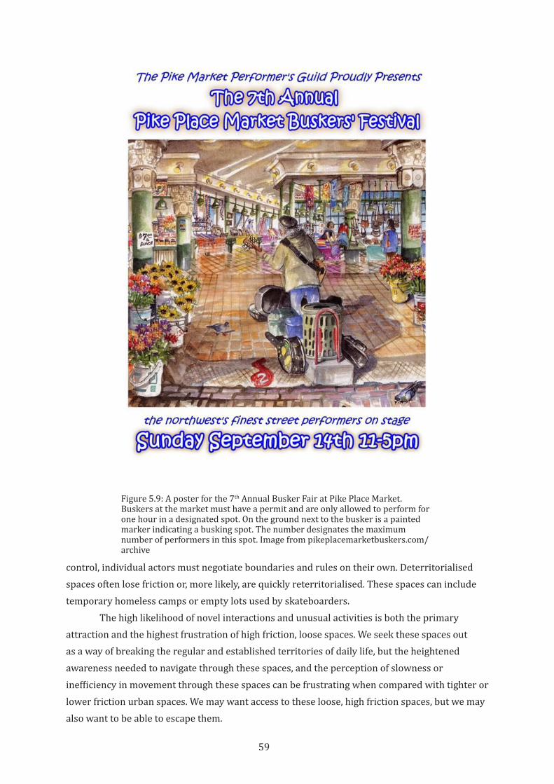
59
control, individual actors must negotiate boundaries and rules on their own. Deterritorialised spaces often lose friction or, more likely, are quickly reterritorialised. These spaces can include temporary homeless camps or empty lots used by skateboarders.
The high likelihood of novel interactions and unusual activities is both the primary attraction and the highest frustration of high friction, loose spaces. We seek these spaces out as a way of breaking the regular and established territories of daily life, but the heightened awareness needed to navigate through these spaces, and the perception of slowness or inefficiency in movement through these spaces can be frustrating when compared with tighter or lower friction urban spaces. We may want access to these loose, high friction spaces, but we may also want to be able to escape them.
Figure 5.9: A poster for the 7th Annual Busker Fair at Pike Place Market. Buskers at the market must have a permit and are only allowed to perform for one hour in a designated spot. On the ground next to the busker is a painted marker indicating a busking spot. The number designates the maximum number of performers in this spot. Image from pikeplacemarketbuskers.com/archive
60
Lowfriction,tightspaces include many transportation spaces, perhaps best represented by limited access freeways. In these exclusively motor vehicle spaces, a very limited set of actions are permissible, access is very tightly managed, and most non-transportation stimuli are excluded (Forsyth & Krizek, 2011). A freeway is almost completely territorialised as an automobile space, to the point that any other use seems foreign and dangerous. Freeways (and similar transportation systems such as rail corridors) are designed to prioritise speed and vehicle throughput, and so any need to reduce speed or stop is minimised. This is done by designing for the vehicle at speed. Curves, gradients, and sightlines are designed to fit the freeway user, and unnecessary elements or friction from surrounding context are eliminated. Existing conditions—landforms, bodies of water, topography, and natural or man-made environments—are ignored or overcome as much as possible in the service of maintaining the flow in the corridor. By simplifying the experience of driving, externalising all barriers or impediments to flow, and using vehicle throughput as the primary measure of success, a freeway can seem like a very efficient system.
Beyond transportation, tight, frictionless systems appear efficient for the same reasons—they exclude other territorialisations and place the burden on users to understand and adapt to the system. An online shopping website or self-service gas station or checkout lane at a supermarket is generally single-purpose and externalises the labour from the business to the user, and thus appears efficient. As users we may accept (or even prefer) these self-serve systems since they allow us a lower-friction experience by minimising our contact with other people (Augé, 1995). The perception of efficiency helped spread of the idea (and the terminology) of the freeway being applied to a large variety of other systems. We talk about information superhighways that bring the world to our fingertips without barriers or slowdowns, and career onramps that move us from entry-level jobs into smooth-flowing, high-paying professional life. In significant ways, the metaphor and the physical reality of the freeway are connected into our ideas of modernisation and human progress, and the values of highway engineering have influenced contemporary life in a myriad of ways (Nye, 1994). But tight, frictionless spaces and experiences also exclude all but the intended user. Whether through intentional exclusion or unconscious bias, people who do not fit within the narrow constraints of a tight system (people with disabilities, from different cultural backgrounds, children or the elderly) are poorly served by these spaces and systems.
As discussed above, deterritorialisation tends to loosen space, but a physically tight space that is removed from frictions with surrounding uses may maintain these characteristics even in the absence of a continuing territorial presence. While relatively rare in cities, abandoned freeways and bridges can remain relatively uncolonised and un-reterritorialised for long periods of time. Here, the echoes of the formal strong territorialisation outlive the actual use of the space.
Finally, lowfriction,loosespaces are perhaps best represented by the Internet. In the infinitely extensible and flexible space of the online world, diverse and numerous sets of spaces and experiences unfold in front of the user, ready to be used, redefined (or literally rewritten) to fit our needs and desires. While there are definitely conflicts around how the space of the
61
Internet is used, and large organisations have considerable territorial power over various parts of the Web, very little interpersonal interaction is forced upon the user. Although social media dominates the way we spend our time online, we are free to determine our own relationships with online content and other users (Hellenga, 2002). Barriers to entry to the Internet are low, and are in general getting lower, allowing a larger number of people to get online. There are few barriers to new territorialisations of online space, and even large social media platforms can be territorialised by other actors (Timberg & Dwoskin, 2017). Here, territorialisation is highly fractured and limited. The boundaries to territorial control tend to be weakened by the ease of hyperlinking and browsing between territories. There are, of course, efforts to increase territorialisation of sections of the web, especially by large corporations like Google and Facebook, and by attempts to regulate or censor internet content and access.
A secluded public beach or wilderness may feel frictionless and loose in terms of human interaction, but these places are compelling partially because they allow us to experience friction with non-human environments and creatures. And while a wilderness may seem free of territorialisation, it is usually bounded by territorial control by a government or an organisation and at least partially territorialised by hikers, park rangers, or other users. A wilderness is also, of course, territorialised in myriad, complex ways by non-human organisms.
Physical spaces, especially in cities, usually have some degree of friction or tightness. A private property can be internally low friction and loose for those with territorial rights to the space but is likely experienced as a comparatively tight space by visitors. But low friction loose spaces can also exist within the larger structures of a city. The Brooklyn waterfront described above in this chapter is an example of a space where abandonment by a large territorialising actor has resulted in a low friction loose space. Other abandoned or leftover spaces are also locally loose and low friction. These areas of “terrain vague” can be compelling, exciting environments in which all things seem possible but also somewhat illicit (de Sola-Morales, 1995). Abandoned rail corridors can fit into this category of space, and their in-betweenness and otherness is part of their appeal.
These combinations of friction, looseness, and territorialisation all have clear links to urban design and to the planning, implementation, and management of public spaces like urban rail trails. Parks and greenways are often envisioned as places where human frictions fade away and people can reconnect with natural environments. High streets and pedestrian malls are often designed to maximise interactions but within a constrained set of acceptable behaviours. Other streets and trails are intended to move large numbers of people, attempting to compete with or fit within transportation networks dominated by highways. Plazas and public spaces can be designed for friction and looseness around festivals or other transient events, even if those activations are not everyday events.
In any particular public space, the unique territorialisations of that place act to reinforce or work against the intended patterns of use. Strong, weak, or overlapping territorialisations of public spaces strongly determine how a public space evolves, even when that evolution conflicts
62
with the original design intent of the space. The case study rail trails highlight this interplay between territorialisations, frictions or flows, and looseness or tightness of public space, and are discussed in the following section.
5.5 Conclusion
As this chapter has shown, looseness can exist in any publicly accessible space, but even in fully public places, looseness is not guaranteed. Promoting loose space requires attention to the built environment and the types of uses and the management system of a place. Looseness, like any attribute of space, waxes and wanes over time, but maintaining looseness is especially difficult in spaces that include transportation uses and where public safety is a concern. In strongly territorialised spaces, and in spaces that lack natural sources of physical and social friction, many aspects of looseness can be curtailed or eliminated. The following chapter will lay out the methodological approaches used in observing and analysing how each of the three agents influences the character of a rail trail. The case studies that follow will show how differences in attitudes and outcomes around looseness of space, as well as around the agents of friction and territoriality, create very different types of space, and different degrees of urban vitality.
63
6 Methodology
6.1 Introduction
Urban rail trails can bring together complex assemblages of people and resources, and are subject to economic power and political will that overlap and interact in both prescribed and unexpected ways. They need to be understood through multiple dimensions—the physical, social, economic, political and temporal—in order to best guide future designs.
This research investigates the processes through which rail trails are imagined, promoted, created, utilised, and managed. In keeping with the complex nature of urban spaces, this research focuses as much attention on the policies, negotiations, power dynamics, and tactics around rail trails as on the design or use of the trail itself. Specifically, this research focuses on how urban rail trails are integrated into the surrounding urban fabric to simultaneously investigate multiple interacting factors: 1) the design process; 2) the sets of values and priorities that underlie investments in public infrastructure; 3) the role that outside organisations and individuals play in public decision-making; and 4) the impact of private decisions on public space.
This thesis is based on case studies that look beneath the surface conditions of rail trails and their apparent similarities and differences and to address the depth, development factors, and context. Case study methodology recognises that “in the study of human affairs, there appears to exist only context-dependent knowledge,” and thus case studies are a key learning tool when studying human systems” (Flyvbjerg, 2011, pp. 302-303).
This chapter expands on the idea, raised in Chapter 1, that analysis of urban built environments require a broad range of skills and must consider a broad range of sources; discusses the importance of considering power structures when researching cities; and then discusses the particular case studies chosen for this thesis and the research methods used to explore them.
6.2 A City as a Problem of Organised Complexity
The complexity of a city requires a different design process from the idealised linear narrative of architecture. The city is a problem of organised complexity: one with a “sizeable number of factors which are interrelated into an organic whole” (Weaver, 1958, pp. 13-15). These problems of organised complexity occupy a large middle zone between problems of simplicity, the two-variable cause-and-effect problems that characterise basic science; and problems of disorganised complexity, in which statistical analysis of populations allow large-scale systems to be created and analysed without needing to understand or predict the actions of any individual. The key feature of problems of organised complexity is that the factors involved are not independent, but related to each other in significant but complex ways.
64
In “The Kind of Problem a City Is,” the final chapter of Death and Life of Great American Cities, Jane Jacobs builds upon Weaver’s observations and recognises that city spaces must be considered as interconnected wholes in which specific circumstances, context, and catalysts act on the physical and social character of the space. In her examples, the success or failure of a park or a city street as social space depends as much on its relationship to context as on the design of the space itself. She asserts that this type of analysis is the only way to understand city spaces, despite the increased difficulty:
…there is no use wishing it were a simpler problem or trying to make it a simpler problem, because in real life it is not a simpler problem. No matter what you try to do to it, a city park behaves like a problem in organized complexity, and that is what it is. The same is true of all other parts or features of cities. Although the interrelations of their many factors are complex, there is nothing accidental or irrational about the ways in which these factors affect each other” (Jacobs, 1961, p. 434).
An urban rail trail is a problem of organised complexity, like most urban features. The function of a trail and its contribution to urban vitality must be studied as an interconnected whole. Attempting to analyse or design a rail trail as a problem of simplicity will not yield a complete picture.
Urban analysis must look beyond the project envelope to include the physical, social, political and economic context. It must include the design of the space, the territories that created the space and condition its use, and the frictions that arise around it. To capture this information, this research integrates tools and techniques of architecture, urban design, and urban planning. Architects are trained to understand how particular configurations of physical space affect how people use space, as well as the symbolic and cultural meanings of build forms (Rapoport, 1990). Urban design analysis looks at how public and semi-public space knits together the disparate elements of complex urban environments (Gehl, 1987). And urban planning focuses on the long time-scale changes in cities, on interdisciplinary perspectives and negotiation, and on the recognition of the political, economic, and social territories that create cities (Yiftachel, 2012). A city is a patchwork of contesting and overlapping territories, with frictions, flows, and loose and tight spaces arising between them. Finding and analysing these sometimes-hidden territories, and the power structures behind them, is critical to understanding why we build what we build. Understanding a rail trail as a product of power is key to understanding its role in a city.
6.3 Tracing Power in Public Processes
Bent Flyvbjerg’s excellent case study of the planning process around active transportation in Aalborg, Denmark (1998b) is a model of how to analyse and understand power within an apparently rational environment. His study is focused on the small, everyday decisions of planners, government officials, businessmen, and members of the media, how those decisions are influenced, and how those decisions build upon each other to influence the
65
actions of the government, often in opposition to stated public policy. Drawing extensively from Michel Foucault, Flyvbjerg shows how power and knowledge are mutually self-creating and self-reinforcing.
Power is dynamic and is everywhere, states Foucault, not because it is capable of uniting everything under its insurmountable unity, but because power is produced from one moment to the next in all points and all relations. The micropractices of power and of day-to-day activities – hour to hour and minute to minute sometimes – are what is significant…In fact, continues Foucault, “power produces, it produces reality; it produces domains of objects and rituals of truth.” (Flyvbjerg, 2001, pp. 120-121)
By creating knowledge, power more fully embeds itself into the social fabric of a society, and “becomes part of the natural order of things” (Clegg et al., 2014). While rational decision-making is thus partly a of product of power structures, it is also at risk in the face of that power. In Aalborg, rationality is subsumed within the larger system of territorial forces. Flyvbjerg states that power creates its own rationality (1998b, p. 227). This understanding of the relationship between power and planning is relevant to the study of any urban space, where territorial power can overwhelm planning decisions. In the public discourse about the built environment and public space, narratives are often clad with a veneer of rationality that masks a set of unexamined assumptions and norms that are kept in place through structures of power (Dovey, 1999, pp. 9-16).
Urban rail trails and other bicycle infrastructure are generally championed as rational, appropriate solutions to several pervasive urban problems. However, evidence of the physical, social, and economic benefits of bicycling are usually not enough to spur implementation without the support of powerful actors. Furthermore, powerful actors are often able to derail projects despite the rational benefits those projects might bring. Attention focused on the relationships between power and rational planning will help us understand the persistent barriers to the provision of active transportation infrastructure, as well as the cases in which those barriers are overcome.
The sociologist Bruno Latour posits a different view of how power acts in the world: Power is translated. Power is not held but is instead produced through one’s actions in convincing others to follow one’s orders and align themselves with one’s claims. This transfer of power is not due to power’s “inertia,” but due to the alignment of personal interests:
According to the [model of translation], the spread in time and space of anything – claims, orders, artefacts, goods – is in the hands of people; each of these people may act in many different ways, letting [the claim, the order, the artefact, or the good] drop, or modifying it, or deflecting it, or betraying it, or adding to it, or appropriating it…there is no inertia to account for the spread of a token. When no one is there to take up the statement or the token then it simply stops.
The obedience to an order given by someone would require the alignment of all the people concerned by it, who would all assent to it faithfully, without adding or subtracting anything. Such a situation is highly improbable. The chances are that the
66
order has been modified and composed by many different people who slowly turned it into something completely different as they sought to achieve their own goals. (Latour, 1984, pp. 267-268)
This observation that power is translated—both moved and changed—through a process of negotiation is critical to understanding urban processes. We identify ourselves with particular “claims, orders, artefacts, goods” because we become convinced that these claims or goods are to our benefit. We thus give power to both the ideas and those who convinced us that the ideas were good. But as we in turn become champions of the ideas, we transform them to better fit with our own goals and beliefs. An urban project, especially on the scale of a rail trail, can only be realised through a combination of political, economic, and social power. However, through the process of creating and aligning that power, the project is inevitably shifted as each actor subtly redirects it.
These two understandings of power informed the research approach and methods of this thesis. While urban places are products of, and reinforce, existing power structures, they also show change over time as those power structures are translated between the various actors involved. These structures and their translations are an important part of the story of a rail trail and must be observed and documented to gain a more robust understanding of that story.
6.4 Case Study Methodology
Case studies often contain a substantial element of narrative. Good narratives typically approach the complexities and contradictions of real life…a particularly ‘thick’ and hard–to-summarize narrative is not necessarily a problem. Nietzsche is clear…“Above all,” he says about doing science, “one should not wish to divest existence of its rich ambiguity”(Flyvbjerg, 2001, p. 84).
Because each trail is the product of diverse conditions, the research uses case study methodology to achieve an in-depth understanding of each particular case. Rather than removing context and subtlety in order to allow generalised analysis, the case study method can maintain the complexity of each case and better represent urban conditions. Urban spaces are the products of design, politics, and human geography, and none of these are easily quantified or summarised. Case studies offer the intellectual space and attention to detail that are necessary to uncover what is elided, hidden, or ignored.
Especially in the public realm, understanding the process of negotiation that is central to the realisation of projects – from the initial problem identification, conception, garnering of support, and construction – is often difficult to translate from one project to the next, or from one place to another. Therefore, this research focuses on illuminating this process, comparing what we say we do with what we actually do, as a way to document successful strategies.
6.5 Selection of cases
This research started from a desire to understand how bicycle infrastructure influences the social and economic life of cities. Rail trails were chosen as an infrastructure type for three main reasons. First, because they are car-free, rail trails offer a way to isolate the effects of
67
bicycling and other active transportation from the effects of automobile infrastructure. Most improvements to active transportation infrastructure (including bicycle lanes and footpaths) are built along existing streets, and usually also include improvements or changes to automobile or transit infrastructure. It was believed that focusing on rail trails eliminated much of the ambiguity that comes from analysing streets with multiple transportation types. Second, the creation of rail trails involves a significant change of use from active or abandoned rail to active transportation trail. It was believed that changes in the built environment that happened in response to the creation of a rail trail would be distinct from the typical ongoing changes to the built environment that occur throughout a city. Finally, rail trails are a relatively new type of infrastructure, with just more than fifty years of history in the United States, and even less in other countries (Reis & Jellum, 2014). This suggested that the creation of rail trails, and the changes around them, would show a variety of strategies and solutions.
Three rail trails were selected in the United States for this study. The United States was chosen as a target country because of the relatively long history of rail trails compared to other countries. There is also a larger body of literature, both academic and grey, that focuses on American trails. Finally, the United States was chosen because of the researcher’s familiarity with the design and planning context of American cities. It was also hoped that these cases would be of use and interest to Australian planners and trail advocates, since there are parallels between many aspects of Australian and American land use, urban development, and history.
The three trails chosen—the Burke-Gilman Trail in Seattle, Washington; the Midtown Greenway in Minneapolis, Minnesota; and the BeltLine in Atlanta, Georgia—represent a broad spectrum of age, trail morphology, and city history. The Burke-Gilman Trail was one of the first rail trails built in the United States, opening in 1976. The Midtown Greenway opened in 2000. The first sections of the Atlanta BeltLine, which is still under construction, opened in 2008. It is believed that the difference in age between the trails will illustrate changes in ideas, expectations, and practices around rail trails.
The trails also differ morphologically. The Burke-Gilman Trail corridor generally runs near grade of its surroundings, due to its original route along a lakeshore. The BeltLine corridor has a more variable relationship to its surroundings, with the level of the trail sometimes located several meters above or below adjacent land. The Midtown Greenway is relatively unique, with the corridor in a trench six meters below grade on average, with sides that slope up to street level. It was believed that these morphological differences would impact connections and relationships between the trail and its surroundings.
Finally, the cities of Seattle, Minneapolis, and Atlanta differ in terms of demographics, economics, climate and in terms of bicycle use. Atlanta, the largest city in the southeast United States, has a high Black population, and many of the neighbourhoods that the BeltLine will pass through are comparatively poor. Minneapolis and Seattle are whiter, and Seattle is one of the most expensive cities in the United States in terms of property value. Atlanta is hot and humid in the summer with frequent thunderstorms, and cool in the winter. In comparison, Minneapolis is very cold in the winter, with considerable snowfall, and hot and humid in the summer. Seattle has
68
cool, wet winters and mild summers. Minneapolis has one of the highest numbers of bicyclists among American cities, while Atlanta has a longstanding reputation as a car-oriented city with few options for bicycling. Seattle has prioritised urban bicycling in the last 20 years, and ridership is increasing.
This diversity between the case study cities and rail trails was intentionally chosen with the belief that both commonalities and differences between the trails would help illustrate valuable information about how and why rail trails are created and could inform the design and management of future urban rail trails.
6.6 Research Methods
To delve into the social and political structures that bring rail trails into existence, and to be mindful of the conflicting and overlapping realities that surround each trail, each of the three case studies analyses the history and contemporary conditions of the trail through discourse analysis, semi-structured interviews, and direct observation and documentation of trail design and use. Data was gathered during a fieldwork phase and during a discourse analysis phase that took place before, during, and after the fieldwork. In particular, the research started with several initial organising questions:
Territoriality What territorialisations exist in and around each trail? Who owns the trail, and who manages it? How is the trail described in the media? What rules apply to use of the trail, and who benefits from those rules? How is the trail publicised? Who uses it in their advertising or marketing? How do adjacent uses capture value from the trail and its users?
Friction What are the physical, visual, aural, or olfactory connections between the trail and its surroundings? Where are the access points to the trail, both formal and informal? What do you see of the trail from the outside? What do you see from the trail? What kinds of users and uses are present in and around the trail? How do they interact, clash, or cooperate? Is there intentionally designed friction, or does it just arise through natural use? How are frictions reduced or eliminated, and why?
Looseness How has the space of the rail trail transitioned from the tightness of active rail or the looseness of an abandoned corridor? Are there loose spaces in or around the corridor? Were they designed that way, or are they a result of leftover or underprogrammed space? What kinds of loosening uses exist on or around the trail? Are these encouraged, tolerated, regulated, or forbidden? Why, and by whom? Are spaces used as designed, or are they appropriated or repurposed?
Finally, how do these three agents contribute to economic and social vitality in the urban space of the trail and its surroundings? Is the impact of the rail trail limited to just the corridor, or does the trail influence the areas around it? How much area does it influence, and what limits or extends its influence?
69
6.6.1 Fieldwork
Fieldwork was conducted for three weeks in each city in the spring of 2015.14 During each period of fieldwork, the researcher walked or bicycled the trail every day, directly observing its design, use, and context. During the fieldwork period, the researcher did not use a car, instead travelling by bike, by foot, or by transit, in order to understand how the rail trails were integrated into the surrounding urban fabric and how that integration was experienced by bicyclists and pedestrians. Observations focused on the uses of each trail, the areas of greater or lesser public use, sites where building or landscape design integrated with the trail or otherwise attempted to attract trail users; or conversely created physical or visual barriers from the trail. Documentation of these direct observations consisted of note taking, sketching, use diagrams, and photography. These observations included analysis of how people used these spaces and the traces they left behind.
As discussed in Chapter 5, human use often leaves traces such as desire paths that reveal more convenient or direct routes. These signs of use can include trash or cigarette butts, for instance that show where people tend to congregate. More generally, traces are the physical evidence left in the built environment through both conscious and unconscious behaviour. Other types of traces include personalisation of spaces (through painting or decorations, for example), or adaptation for use (making changes to spaces to make them more usable), or public messages (such as signs, advertising, or graffiti, etc). These kinds of traces in public space are valuable indicators of how people use, and feel about, the spaces of a city (Zeisel, 1984). On a rail trail, they can indicate whether the official design of the trail is meeting the needs of users; can show territorialisations of the trail; and can suggest whether adjacent land uses are creating productive friction with the trail. In this research, traces are primarily documented through photography and mapping, and are used to identify important points along the trails for further observation and analysis, inform interview questions, and identify additional informants. These traces were recorded on maps and plans of the trails, documented in photographs that were geocoded for location (using GPS features of a smartphone), and through notes and sketches in sketchbooks and recorded digitally. This collected data was used to drive further research and influenced interview questions as discussed below.
The researcher attended public meetings and events related to the rail trail or urban bicycling in each city. In Atlanta, the researcher took part in bicycle and bus tours of the BeltLine, which are a popular aspect of the BeltLine community outreach program. The researcher also attended two large public events in public spaces along the trail, each sponsored by Atlanta BeltLine Partnership, an organisation that manages events and activities on or near the rail trail. In Minneapolis, the researcher attended a meeting of the Hennepin County Council, the regional government for the Minneapolis area, on a proposed rail trail that would connect to the Midtown Greenway. The researcher also attended meetings of the Midtown Greenway Coalition, the management organisation of the trail, on property development and trail improvements. The 14 Fieldwork was conducted consecutively from the end of March to the end of May. Research was
conducted first in Atlanta, then Seattle, then Minneapolis in order to roughly follow the seasonal progression in each city. Weather in each city was a mix of late spring conditions.
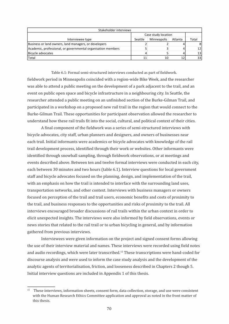
70
fieldwork period in Minneapolis coincided with a region-wide Bike Week, and the researcher was able to attend a public meeting on the development of a park adjacent to the trail, and an event on public open space and bicycle infrastructure in a neighbouring city. In Seattle, the researcher attended a public meeting on an unfinished section of the Burke-Gilman Trail, and participated in a workshop on a proposed new rail trail in the region that would connect to the Burke-Gilman Trail. These opportunities for participant observation allowed the researcher to understand how these rail trails fit into the social, cultural, and political context of their cities.
A final component of the fieldwork was a series of semi-structured interviews with bicycle advocates, city staff, urban planners and designers, and owners of businesses near each trail. Initial informants were academics or bicycle advocates with knowledge of the rail trail development process, identified through their work or websites. Other informants were identified through snowball sampling, through fieldwork observations, or at meetings and events described above. Between ten and twelve formal interviews were conducted in each city, each between 30 minutes and two hours (table 6.1). Interview questions for local government staff and bicycle advocates focused on the planning, design, and implementation of the trail, with an emphasis on how the trail is intended to interface with the surrounding land uses, transportation networks, and other context. Interviews with business managers or owners focused on perception of the trail and trail users, economic benefits and costs of proximity to the trail, and business responses to the opportunities and risks of proximity to the trail. All interviews encouraged broader discussions of rail trails within the urban context in order to elicit unexpected insights. The interviews were also informed by field observations, events or news stories that related to the rail trail or to urban bicycling in general, and by information gathered from previous interviews.
Interviewees were given information on the project and signed consent forms allowing the use of their interview material and names. These interviews were recorded using field notes and audio recordings, which were later transcribed.15 These transcriptions were hand-coded for discourse analysis and were used to inform the case study analysis and the development of the analytic agents of territorialisation, friction, and looseness described in Chapters 2 though 5. Initial interview questions are included in Appendix 1 of this thesis.
15 These interviews, information sheets, consent form, data collection, storage, and use were consistent with the Human Research Ethics Committee application and approval as noted in the front matter of this thesis.
Interviewee type Seattle Minneapolis Atlanta TotalBusiness or land owners, land managers, or developers 2 2 4 8Academic, professional, or governmental organisation members 5 3 4 12Bicycle advocates 4 5 4 13Total 11 10 12 33
Case study locationStakeholder interviews
Table 6.1: Formal semi-structured interviews conducted as part of fieldwork.
71
6.6.2 Analysis methods
Analysis was conducted before, during, and after the fieldwork periods. Sources for this analysis consisted of both archival and contemporary sources, including historical records, newspaper and magazine archives and contemporary issues, public presentations and slideshows, planning studies for the rail trails and for nearby projects and neighbourhoods, minutes from public meetings, maps and plans created by organisations related to the trails and others, and web pages and blogs. These documents were used to identify key themes in each rail trail case, gauge public opinions around the trails, and analyse the agency of different actors and what populations or groups are represented or absent from the public dialogue.
Preliminary research on theoretical relationships between public space and the social and economic life of cities led to some initial assumptions about key issues in urban rail trails as public space. Theory helped develop the “story about why acts, events, structure and thoughts occur” (Sutton & Staw, 1995, p. 378). In particular, it was predicted that the creation of friction between a trail and its context was the critical factor in creating urban vitality, and that trail managers would be attempting to create these frictions in the service of creating more vibrant public spaces. The initial design for on-site analysis was intended to test this prediction.
The actual situation was more complicated, and required explanation building as a primary analytical task (Yin, 2012, p. 151). This analysis led to the identification and exploration of the agents of territorialisation, friction, and looseness, both as both key elements in the creation and evolution of urban vitality in public space, and also as important factors in how trails changed over time. This expanded theoretical framework for analysis was then explored through pattern matching in the case studies: did the patterns observed in one case correspond across the cases (Yin, 2012, p. 151)?
Within each case, analysis identified how various narratives around the trails were created, maintained, or altered over time. Different actors, such as cycling advocates, city staff, and local business owners told different stories about each trail. A primary aim of this research is to observe how various groups exercised power through their specific representations of urban rail trails, how those narratives change over time, and how they interact with each other. To address these narratives and how they change, documents were assembled to create a chronology of the conception, implementation, and evolution of each trail.
In the case of the three selected trails, these narratives were textual and graphic, so this analysis includes studies of urban planning documents, maps and meeting minutes, and also newspaper articles and blog posts to identify the dominant narrative of the planning, development, and use of each trail. These stories and representations usually included a vision of the intended character of the trail, and how it fit into the larger structures and budgets of the city or region. In each case, a dominant narrative established the “local beliefs and understandings” within which the rail trail was locally measured (Miles, 2010, p. 369). However, a key element of the analysis included a recognition of alternative voices that counter or challenge official representations. Including these narratives helped identify the “multiple constructed realities” that are present in complex urban environments (Miles, 2010, p. 368). These alternative voices
72
are sometimes ignored or minimised in the process of creating trails, but they can reveal how everyday people see, use and judge the success of the trails. Triangulation between these disparate narratives allowed a more complete and nuanced understanding of the role of each trail in the social and economic life of their cities.
Fieldwork data collected in graphic form was analysed to find relationships between textual and media sources described above and the physical form and use characteristics of each trail. In particular, this analysis sought to understand the relationships between what we say about trails, how we build them, and how those actions influence how the trails are used.
6.7 Conclusion
“The conduct of social research necessarily has an influence on society and the people in it. By asking questions or participating in an activity, we alter people’s day-to-day lives. And communicating the results of research can potentially change social situations.” (R. Dowling, 2000, pp. 26-27)
To understand a rail trail as an integral element of a city’s physical, social, and economic fabric and as more than a piece of transportation infrastructure, it is necessary to approach the trail through research methods that are sensitive to detail, are flexible enough to incorporate data from a variety of sources, and remain open to new information and new ideas.
The goal of this thesis is the production of useful knowledge about the messy reality of creating urban rail trails—how they are conceived, championed, implemented, and used. As a result, methods and research philosophy outlined here were chosen to allow each trail to tell its own story and to let the stories of the trails inform each other. This thesis aims to contribute to “problem solving capacity on the move,” where “a particular solution can become the cognitive site from which further advances can be made” (Gibbons et al., 1994, p. 13).
The identification of territorialisation, friction, and looseness as key agents of urban vitality arose out of the stories that each trail had to tell. These agents are useful as tools for organising and understanding the diverse conditions and actions that were uncovered during this research. In the following chapters, each case will focus on one of the three agents as a way to highlight how that agent acts in public space. All three agents operate in each case, however, and so each case will also explore how the agents interact.
73
7 The Burke-Gilman Trail: Terrritorialised Space
7.1 Introduction
This case study looks at one of the first rail trails in the United States. The Burke-Gilman Trail, now more than 40 years old, has inspired rail trail conversions around the country and has been a signature feature of the urban bicycling environment of Seattle and King County. But while the trail today is extremely popular, the Burke-Gilman Trail has not been a catalyst for urban vitality. Throughout the country, and even within the Seattle region, other trails have galvanised more action to create multi-faceted, integrated active transport corridors. This is due in part to changes in how urban walking and bicycling is perceived today. The forty years since the creation of the Burke-Gilman Trail have witnessed significant changes in how planners think about mobility and the role of active transportation in vibrant cities. But it is also due to the particular set of conditions that were established when the trail was created and that persist today. These include the particular territorialisations, the tightness of the physical space of the trail, and the lack of friction in and around the trail.
The rail corridor that became the Burke-Gilman trail is only a few decades younger than the city itself. Originally called the Seattle, Lake Shore, and Eastern Railroad, it was first planned in 1885 as a way to connect Seattle to trans-continental railway lines heading east. Built at a time of feverish railroad speculation and competition throughout the United States, by 1891 it was connected to the trans-continental Canadian Pacific Railway and helped establish Seattle as an economic centre (Northwest Railway Museum, 2018). In 1896 the railroad went bankrupt and was sold, but the line continued to be an important transport route into the 1960s. A primary role for the line had been carrying resources to and from the small factory and logging towns that were growing up east of Seattle, but as resource industries shifted further into Seattle’s hinterland, and as rail transport declined in favour of trucks, use of the corridor declined. The line was legally abandoned in 1971, but discussions about converting it into a bicycle and hiking trail had already begun (Sherwood, 1975; City of Seattle, 2016).
In 1968, as the use of the rail line was winding down, a bicycling advocate with the League of American Wheelmen met with city engineering staff and the railroad to discuss conversion of the rail line to a bicycle trail. Concerned about insurance liability, the railroad company was uninterested. A few years later, a local newspaper published a story about the possibilities of the right of way for bicyclists and walkers, which started conversations in a local neighbourhood group in Wedgewood, a residential neighbourhood of Seattle (Sherwood, 1975). An advocacy group was started up in 1970 to promote a trail, naming themselves the Burke-Gilman Trail Committee, after Thomas Burke and Daniel Gilman, two of the original backers of the rail line. This name stuck for the eventual trail (Bunn, 2013).
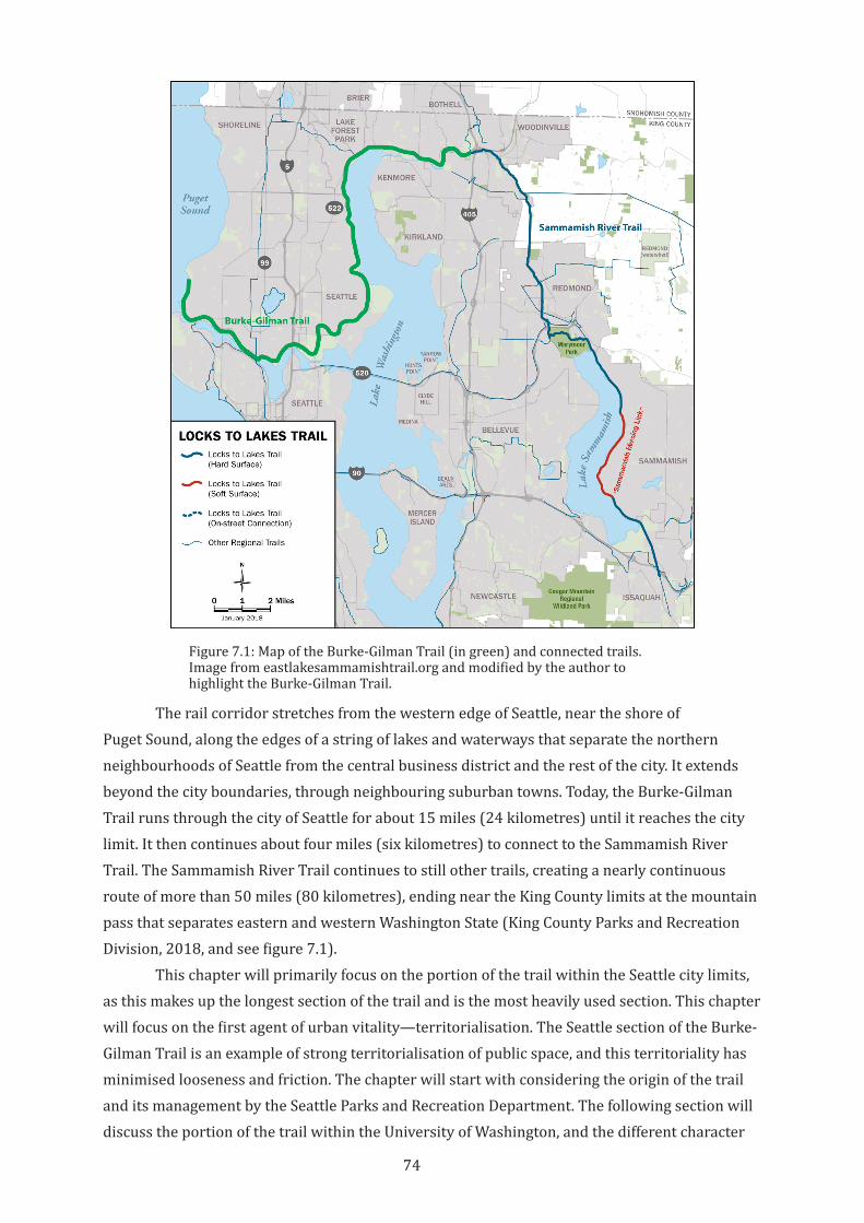
74
The rail corridor stretches from the western edge of Seattle, near the shore of Puget Sound, along the edges of a string of lakes and waterways that separate the northern neighbourhoods of Seattle from the central business district and the rest of the city. It extends beyond the city boundaries, through neighbouring suburban towns. Today, the Burke-Gilman Trail runs through the city of Seattle for about 15 miles (24 kilometres) until it reaches the city limit. It then continues about four miles (six kilometres) to connect to the Sammamish River Trail. The Sammamish River Trail continues to still other trails, creating a nearly continuous route of more than 50 miles (80 kilometres), ending near the King County limits at the mountain pass that separates eastern and western Washington State (King County Parks and Recreation Division, 2018, and see figure 7.1).
This chapter will primarily focus on the portion of the trail within the Seattle city limits, as this makes up the longest section of the trail and is the most heavily used section. This chapter will focus on the first agent of urban vitality—territorialisation. The Seattle section of the Burke-Gilman Trail is an example of strong territorialisation of public space, and this territoriality has minimised looseness and friction. The chapter will start with considering the origin of the trail and its management by the Seattle Parks and Recreation Department. The following section will discuss the portion of the trail within the University of Washington, and the different character
Figure 7.1: Map of the Burke-Gilman Trail (in green) and connected trails. Image from eastlakesammamishtrail.org and modified by the author to highlight the Burke-Gilman Trail.
75
of the trail in this section. Territorialisations by other actors follow this, and the chapter will end with a discussion of how these various territorialisations affect attitudes toward friction and looseness along the trail.
7.2 The Burke-Gilman Trail as Park Territory
The Burke-Gilman Trail was intentionally defined as a narrow linear park, a definition that remains intact today. From the beginning, concerns about the effect of the trail on its surroundings were critical barriers to its development. In 1973, when the Seattle portion of the corridor was transferred to the City government, there were very few examples of rail trails in the United States. Residents living in the neighbourhoods along the corridor worried about trespassing, vandalism, and crime. They feared that the trail might give criminals easy access to their homes and would be an easy hiding place from police (see, for instance Corsaletti, 1971; Reiner, 1978; Lagerwey & Puncochar, 1988). Since the Burke-Gilman Trail was the first urban rail trail in the United States, there were no examples to disprove the fears of trails enabling crime and negatively affecting property values. There were also no examples of using a trail to reshape urban space or drive economic development. A strategy for assuaging these concerns was to pitch the trail as a linear park. This vision of the trail as a narrow park that was easy to patrol and manage was easily understood and appreciated (Amstutz & Robson, 1973). Recreation and bicycle commuting for work and to the University of Washington were to be the primary use. The trail would provide green space, cut down on automobile traffic, and provide a peaceful amenity to the community (Searns, 1995, p. 70). This positioning of the trail as a linear park has carried over, with some exceptions discussed below, to the extensions of the trail outside Seattle limits.
In 1976, when the first section of the trail opened, the rail trail movement was in its infancy. The first section of the Burke-Gilman Trail was opened less than a decade after the first rail trail in the United States (the largely rural Elroy-Sparta State Trail in Wisconsin was opened in 1967) and just two years after the Railroad Revitalization and Regulatory Reform Act, which provided some legal support for the conversion of abandoned lines to trails (Montange, 1987). The Burke-Gilman Trail was created almost a decade before the establishment of the national Rails-to-Trails Conservancy, which was formed to advocate for and support rail trail creation, and which has been influential in advancing conceptions of how rail trails can be more than simple greenways or transportation corridors.
In support of the project in 1973, Roger Amstutz, the vice president of the Cascade Bicycle Club, wrote in a newspaper editorial:
The Burke-Gilman as a pedestrian-bicycle trail would be a recreational lineal park link between [Gasworks] Park on Lake Union, the proposed Sand Point Park and the Marymoor Park on Lake Sammamish.…All communities along the route would have excellent access to these parks.…The Burke-Gilman as a pedestrian-bicycle trail would fill a definite need for a commuter bicycle route serving the University District.…The trail would make an excellent bike route for many students and university [employees] living along the route.…There are several residential areas quite opposed to the use of the route as a pedestrian-bicycle trail. Their fears seem to be based on the intrusion by undesirable people and the invasion of their privacy.
76
The proposed trail would be a park, maintained and policed as a park. Evidence indicates a lineal park is the most trouble-free because all areas are close to people activity (Amstutz & Robson, 1973).
Framing the creation of the trail as a park and linear recreation and commute bicycle path was a reflection of community concern, but it meant a lack of focus on the trail becoming an integrated part of the urban fabric. Calling the Burke-Gilman Trail a park and putting the city’s Department of Parks and Recreation in control of its management addressed the concerns of those who worried about the loss of a relatively underdeveloped strip of the city. Defining the trail as a park suggested that the trail would be a quiet and peaceful space along the backyards of single-family houses in the adjoining neighbourhoods, and promised public recreation space and links to other green spaces. This framing of the trail as a greenway rather than a transportation corridor or urban space was consistent with contemporaneous imagery and promotion of trails as places to observe and enjoy nature (Johnson, 1965; Little, 1990, pp. 99-104; Searns, 1995, p. 70). Creating a narrow, clearly bordered space in the corridor also meant fewer places to hide and more concentrated passive surveillance from neighbours and trail users. Pitching the trail as a route for commuting university students and staff suggests that the trail would be used by respectable members of society.
There was also no real incentive to encourage development along the trail. Much of the trail corridor runs through established tracts of high-income private housing and already-viable retail and industrial areas, and there has been and continues to be resistance to change in these areas. Instead, the Burke-Gilman Trail was proposed and designed as an amenity for existing residents and visitors, providing green space and an active transportation corridor but not intended to address economic or land use issues.
In the 40 years since the trail opened, the original idea of the trail as a linear park has remained a powerful determinant of the character of the trail, even as the city has grown and changed dramatically. In many respects, Amstutz was correct in his analysis of the potentials of the Burke-Gilman Trail (Amstutz & Robson, 1973). Today, the trail functions as an excellent bicycle commute route popular with Seattle residents and visitors alike. It is also one of Seattle’s best used parks, a neighbourhood amenity and a positive contributor to private property values. The trail was recognised in 2008 by the Rails-to-Trails Conservancy, the national rail trail advocacy organisation, as one of the best rail trails in the nation (Rails-to-Trails Conservancy, 2008). Today, the trail carries thousands of users every day, with busy sections of the trail within the University carrying as many as 500 bicyclists and 300 pedestrians per hour during peak times (University of Washington, 2011, p. 24). User counts over last several years show more than half a million users per year, and this number is increasing (Seattle Department of Transportation, 2018b).
But over that time, this framework of the trail as a linear park and bicycle through-route has not transformed along with the changing understanding of how trails and active transport can have a larger impact on a city. Management by the Department of Parks and Recreation has been effective at preserving the original character of the trail, but they have no expertise
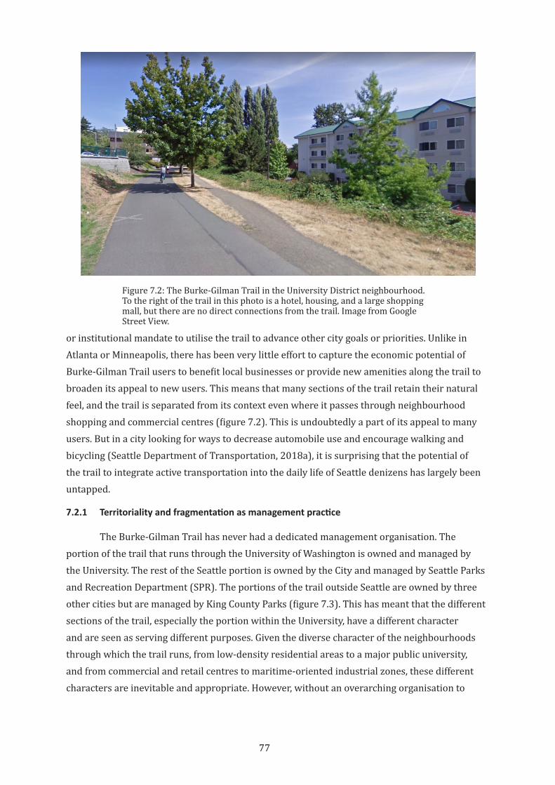
77
or institutional mandate to utilise the trail to advance other city goals or priorities. Unlike in Atlanta or Minneapolis, there has been very little effort to capture the economic potential of Burke-Gilman Trail users to benefit local businesses or provide new amenities along the trail to broaden its appeal to new users. This means that many sections of the trail retain their natural feel, and the trail is separated from its context even where it passes through neighbourhood shopping and commercial centres (figure 7.2). This is undoubtedly a part of its appeal to many users. But in a city looking for ways to decrease automobile use and encourage walking and bicycling (Seattle Department of Transportation, 2018a), it is surprising that the potential of the trail to integrate active transportation into the daily life of Seattle denizens has largely been untapped.
7.2.1 Territoriality and fragmentation as management practice
The Burke-Gilman Trail has never had a dedicated management organisation. The portion of the trail that runs through the University of Washington is owned and managed by the University. The rest of the Seattle portion is owned by the City and managed by Seattle Parks and Recreation Department (SPR). The portions of the trail outside Seattle are owned by three other cities but are managed by King County Parks (figure 7.3). This has meant that the different sections of the trail, especially the portion within the University, have a different character and are seen as serving different purposes. Given the diverse character of the neighbourhoods through which the trail runs, from low-density residential areas to a major public university, and from commercial and retail centres to maritime-oriented industrial zones, these different characters are inevitable and appropriate. However, without an overarching organisation to
Figure 7.2: The Burke-Gilman Trail in the University District neighbourhood. To the right of the trail in this photo is a hotel, housing, and a large shopping mall, but there are no direct connections from the trail. Image from Google Street View.
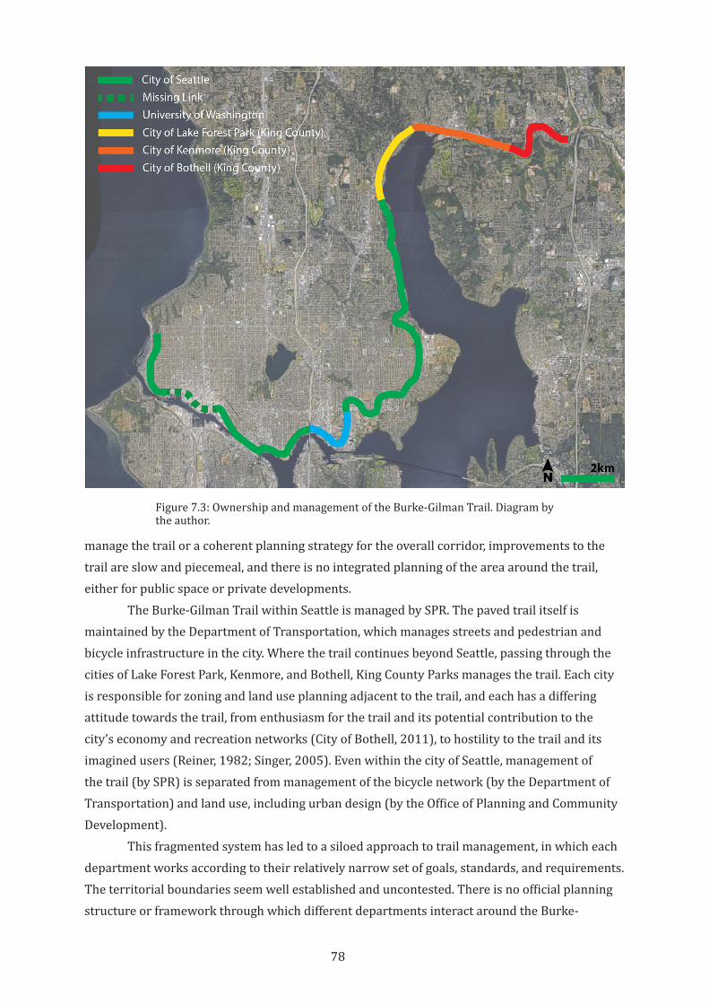
78
manage the trail or a coherent planning strategy for the overall corridor, improvements to the trail are slow and piecemeal, and there is no integrated planning of the area around the trail, either for public space or private developments.
The Burke-Gilman Trail within Seattle is managed by SPR. The paved trail itself is maintained by the Department of Transportation, which manages streets and pedestrian and bicycle infrastructure in the city. Where the trail continues beyond Seattle, passing through the cities of Lake Forest Park, Kenmore, and Bothell, King County Parks manages the trail. Each city is responsible for zoning and land use planning adjacent to the trail, and each has a differing attitude towards the trail, from enthusiasm for the trail and its potential contribution to the city’s economy and recreation networks (City of Bothell, 2011), to hostility to the trail and its imagined users (Reiner, 1982; Singer, 2005). Even within the city of Seattle, management of the trail (by SPR) is separated from management of the bicycle network (by the Department of Transportation) and land use, including urban design (by the Office of Planning and Community Development).
This fragmented system has led to a siloed approach to trail management, in which each department works according to their relatively narrow set of goals, standards, and requirements. The territorial boundaries seem well established and uncontested. There is no official planning structure or framework through which different departments interact around the Burke-
Figure 7.3: Ownership and management of the Burke-Gilman Trail. Diagram by the author.
79
Gilman Trail. With the exception of the University of Washington, none of the agencies that have jurisdiction over the trail have a vision for how it could be more than just a linear park or transportation corridor, or a plan for adapting to a changing city. And the non-governmental organisations that champion the Trail (two community groups, both named Friends of the Burke-Gilman Trail) have very narrow missions, largely focusing on single issues in very limited areas of the trail. While this management system has been successful at maintaining the trail, the potential for the trail contribute to urban vitality through productive friction with trail-oriented urban fabric, looseness of uses, and flexible territoriality has been limited.
7.2.2 Territorial rigidity and Seattle Parks and Recreation
The historical positioning of the Burke-Gilman Trail within the territory of SPR was perhaps necessary to implement the trail, as noted above. But the territorial meanings and expectations for parks tend to be very strongly defined and bounded, making flexibility and alternative territorialisations difficult. Seattle has a proud history of parks, boulevards, and greenways planned by the Olmstead Brothers in the early 1900s, and has worked to maintain this legacy (Williams, 1999).
This emphasis on protecting the legacy of Seattle parks and preserving green space as the attractive “lungs of the city” has meant that the establishment of a park tends to definitively set its identity. While the policy of SPR is to evolve the city’s parks and recreational activities to fit ever-changing needs and demographics, this often conflicts with policy that prioritises input from Seattle residents in park planning. In 1968, Seattle voters passed a series of laws that encourage public participation in all aspects of local government. As part of these laws, SPR established a series of 24 neighbourhood advisory councils to help increase public participation in park planning. This effort deterritorialised the previous park planning model: “[SPR] no longer provided, and citizens no longer desired nor expected, the top-down, expert driven model of park development” (Dooling et al., 2006, p. 314). Under the new regimen, citizen groups and “Friends of” park groups have worked to stop sales of alcohol at park concessions, stop the sales of park land for non-park uses, and prevent the lease of reserve land for privately-operated recreational facilities (“Citizens gain bigger role in direction of parks,” 1985; Bagshaw, 2012; Record, 2012). But while the enfranchisement of citizen groups was laudable, this reterritorialisation of parks land from local government “expert” development to neighbourhood-scale citizen bodies (what Purcell (2006) calls the “local trap”) may lead to inequality, NIMBYism (“Not In My Back Yard” rejection of perceived change), and a decrease in city-wide collaboration (Barnett, 2017). The long time-scales of landscape establishment in parks favour conservative management approaches in general. But this conservatism also gives legitimacy to neighbourhood groups working against efforts to integrate greenway trails into the urban context, which is more fluid and quickly changing.
80
While SPR recognises that urban parks must respond to the needs of a growing city with quickly changing demographics, the department’s planning efforts seem limited to meeting the recreational needs of the city, rather than considering the city’s open spaces as contributors to other aspects of liveability and vitality. For instance, in its 2017 Parks and Open Space Plan, SPR notes:
People in Seattle love to walk and bicycle, and SPR provides more than 25 miles of boulevards and 120 miles of trails…A goal in the Seattle 2035 Comprehensive Plan is to consider access to our parks by transit, bicycle, and on foot when acquiring, siting and designing new park facilities or improving existing ones (Seattle Parks and Recreation, 2017, p. 60).
While SPR is rightfully proud of the extensive trail network within parks, they seem to be considered destinations, ends unto themselves, rather than a part of the city’s transportation system. The Parks and Open Space plan notes that the City’s boulevards, green streets and greenways “[continue] to serve as a right-of-way in addition to being park land….Boulevards and green streets often provide safe pedestrian routes as well as recreation opportunities for jogging and bicycling” (Appendix B: Park Classification Policy, p. 121). But the mapping and analysis in the plan—and in the complementary Greenways Initiative implementation strategy—is almost completely focused on access to parks, rather than on how park boulevards and green streets provide transportation linkages to other origins and destinations in the city (Section 7: Gap Analysis, Walkability Guidelines, and Mapping, pp. 57-67; Seattle Parks and Recreation, 2018). This is again a continuation of the Olmstead Plan, which envisioned a distributed set of parks throughout the city with green boulevards connecting them to each other, rather than to population or employment centres (Williams, 1999).
Locating active transportation infrastructure within SPR territory, therefore, seems counterproductive. If a pedestrian and bicycling system is intended to reduce the need for cars, to provide interest and reasons to walk or bicycle, trail management must provide pleasant trail environments but must also be responsive to the evolving patterns in those surrounding uses. This is even more critical if, as this thesis contends, active transportation should contribute to urban vitality through increased friction with surrounding uses.
7.2.3 Complete territorialisation within an evolving University of Washington campus plan
In contrast, the section of the trail that runs through the University of Washington has become an important element in planning for the campus. While the trail runs along the outside edge of the campus, and in many areas is separated from it by a steep hillside, the university has planned the trail as a main connector. The trail links the university’s recreational gymnasium, football and basketball stadia, light rail station, and hospital to the central campus and a major new student housing area. It provides an active transportation link to nearby communities where many students and staff live, and thus is an important component of university attempts to reduce automobile trips to campus (University of Washington, 2009, pp. 41-44).
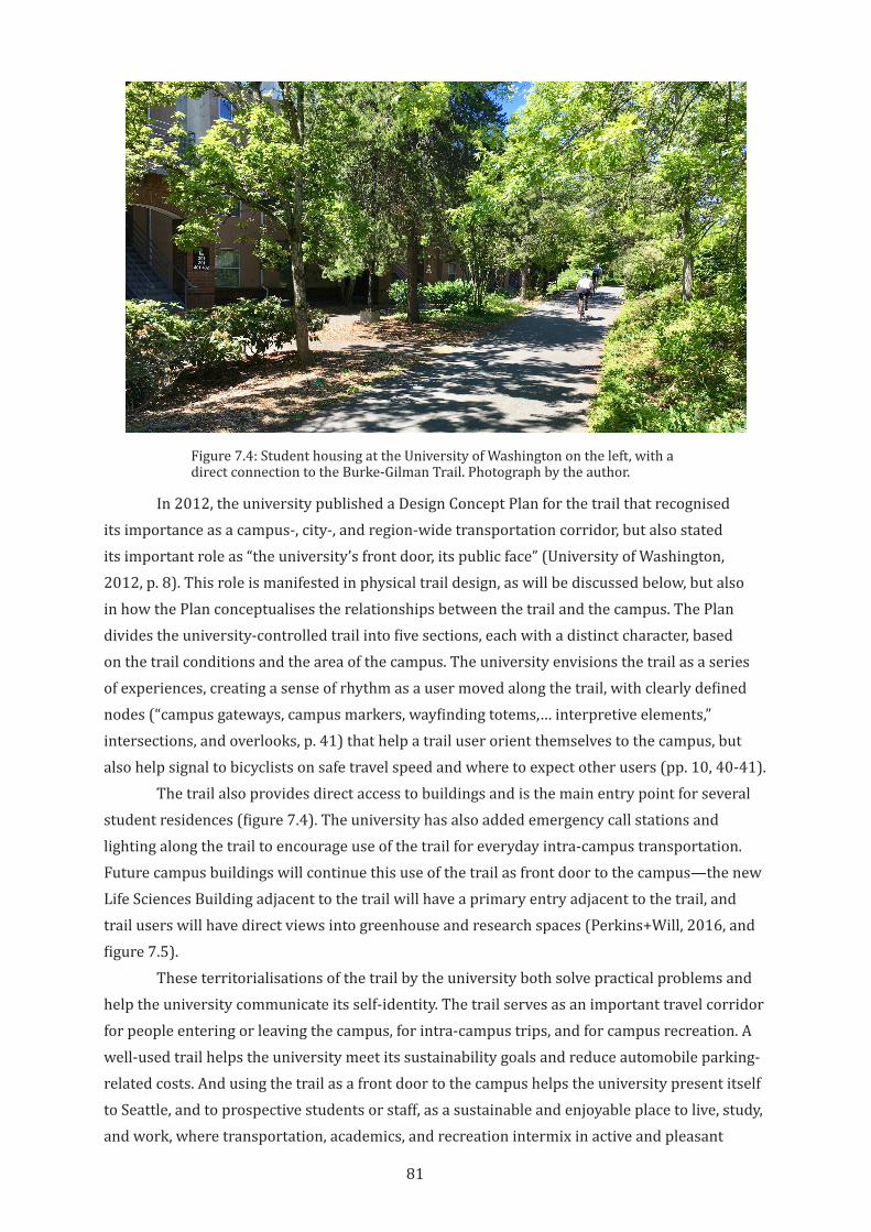
81
In 2012, the university published a Design Concept Plan for the trail that recognised its importance as a campus-, city-, and region-wide transportation corridor, but also stated its important role as “the university’s front door, its public face” (University of Washington, 2012, p. 8). This role is manifested in physical trail design, as will be discussed below, but also in how the Plan conceptualises the relationships between the trail and the campus. The Plan divides the university-controlled trail into five sections, each with a distinct character, based on the trail conditions and the area of the campus. The university envisions the trail as a series of experiences, creating a sense of rhythm as a user moved along the trail, with clearly defined nodes (“campus gateways, campus markers, wayfinding totems,… interpretive elements,” intersections, and overlooks, p. 41) that help a trail user orient themselves to the campus, but also help signal to bicyclists on safe travel speed and where to expect other users (pp. 10, 40-41).
The trail also provides direct access to buildings and is the main entry point for several student residences (figure 7.4). The university has also added emergency call stations and lighting along the trail to encourage use of the trail for everyday intra-campus transportation. Future campus buildings will continue this use of the trail as front door to the campus—the new Life Sciences Building adjacent to the trail will have a primary entry adjacent to the trail, and trail users will have direct views into greenhouse and research spaces (Perkins+Will, 2016, and figure 7.5).
These territorialisations of the trail by the university both solve practical problems and help the university communicate its self-identity. The trail serves as an important travel corridor for people entering or leaving the campus, for intra-campus trips, and for campus recreation. A well-used trail helps the university meet its sustainability goals and reduce automobile parking-related costs. And using the trail as a front door to the campus helps the university present itself to Seattle, and to prospective students or staff, as a sustainable and enjoyable place to live, study, and work, where transportation, academics, and recreation intermix in active and pleasant
Figure 7.4: Student housing at the University of Washington on the left, with a direct connection to the Burke-Gilman Trail. Photograph by the author.
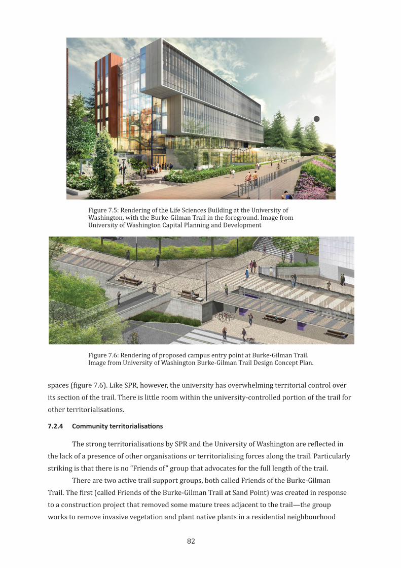
82
spaces (figure 7.6). Like SPR, however, the university has overwhelming territorial control over its section of the trail. There is little room within the university-controlled portion of the trail for other territorialisations.
7.2.4 Community territorialisations
The strong territorialisations by SPR and the University of Washington are reflected in the lack of a presence of other organisations or territorialising forces along the trail. Particularly striking is that there is no “Friends of” group that advocates for the full length of the trail.
There are two active trail support groups, both called Friends of the Burke-Gilman Trail. The first (called Friends of the Burke-Gilman Trail at Sand Point) was created in response to a construction project that removed some mature trees adjacent to the trail—the group works to remove invasive vegetation and plant native plants in a residential neighbourhood
Figure 7.5: Rendering of the Life Sciences Building at the University of Washington, with the Burke-Gilman Trail in the foreground. Image from University of Washington Capital Planning and Development
Figure 7.6: Rendering of proposed campus entry point at Burke-Gilman Trail. Image from University of Washington Burke-Gilman Trail Design Concept Plan.
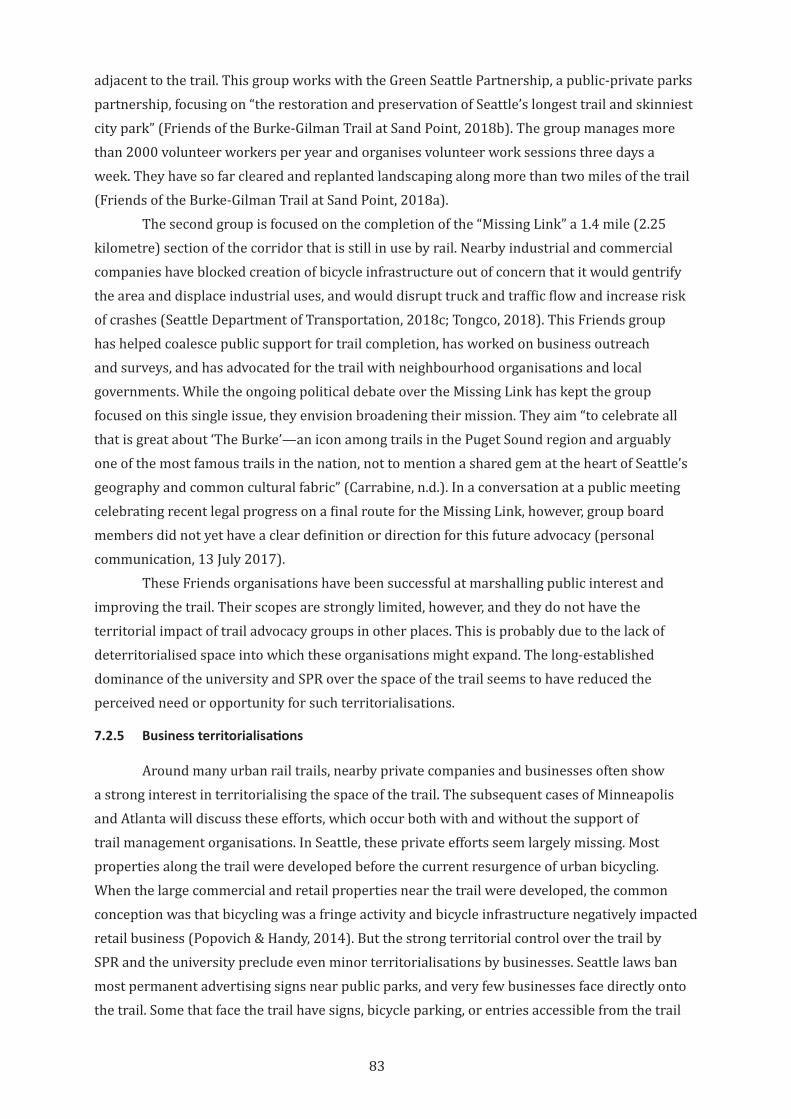
83
adjacent to the trail. This group works with the Green Seattle Partnership, a public-private parks partnership, focusing on “the restoration and preservation of Seattle’s longest trail and skinniest city park” (Friends of the Burke-Gilman Trail at Sand Point, 2018b). The group manages more than 2000 volunteer workers per year and organises volunteer work sessions three days a week. They have so far cleared and replanted landscaping along more than two miles of the trail (Friends of the Burke-Gilman Trail at Sand Point, 2018a).
The second group is focused on the completion of the “Missing Link” a 1.4 mile (2.25 kilometre) section of the corridor that is still in use by rail. Nearby industrial and commercial companies have blocked creation of bicycle infrastructure out of concern that it would gentrify the area and displace industrial uses, and would disrupt truck and traffic flow and increase risk of crashes (Seattle Department of Transportation, 2018c; Tongco, 2018). This Friends group has helped coalesce public support for trail completion, has worked on business outreach and surveys, and has advocated for the trail with neighbourhood organisations and local governments. While the ongoing political debate over the Missing Link has kept the group focused on this single issue, they envision broadening their mission. They aim “to celebrate all that is great about ‘The Burke’—an icon among trails in the Puget Sound region and arguably one of the most famous trails in the nation, not to mention a shared gem at the heart of Seattle’s geography and common cultural fabric” (Carrabine, n.d.). In a conversation at a public meeting celebrating recent legal progress on a final route for the Missing Link, however, group board members did not yet have a clear definition or direction for this future advocacy (personal communication, 13 July 2017).
These Friends organisations have been successful at marshalling public interest and improving the trail. Their scopes are strongly limited, however, and they do not have the territorial impact of trail advocacy groups in other places. This is probably due to the lack of deterritorialised space into which these organisations might expand. The long-established dominance of the university and SPR over the space of the trail seems to have reduced the perceived need or opportunity for such territorialisations.
7.2.5 Business territorialisations
Around many urban rail trails, nearby private companies and businesses often show a strong interest in territorialising the space of the trail. The subsequent cases of Minneapolis and Atlanta will discuss these efforts, which occur both with and without the support of trail management organisations. In Seattle, these private efforts seem largely missing. Most properties along the trail were developed before the current resurgence of urban bicycling. When the large commercial and retail properties near the trail were developed, the common conception was that bicycling was a fringe activity and bicycle infrastructure negatively impacted retail business (Popovich & Handy, 2014). But the strong territorial control over the trail by SPR and the university preclude even minor territorialisations by businesses. Seattle laws ban most permanent advertising signs near public parks, and very few businesses face directly onto the trail. Some that face the trail have signs, bicycle parking, or entries accessible from the trail
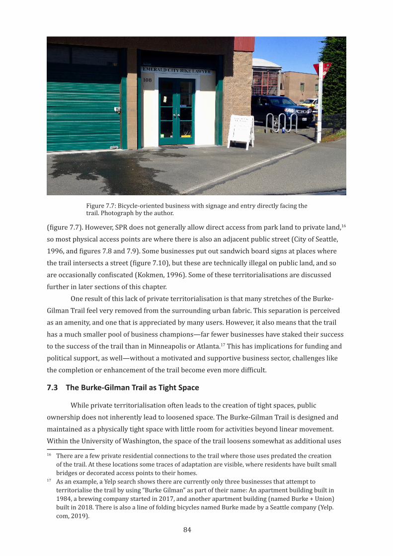
84
(figure 7.7). However, SPR does not generally allow direct access from park land to private land,16 so most physical access points are where there is also an adjacent public street (City of Seattle, 1996, and figures 7.8 and 7.9). Some businesses put out sandwich board signs at places where the trail intersects a street (figure 7.10), but these are technically illegal on public land, and so are occasionally confiscated (Kokmen, 1996). Some of these territorialisations are discussed further in later sections of this chapter.
One result of this lack of private territorialisation is that many stretches of the Burke-Gilman Trail feel very removed from the surrounding urban fabric. This separation is perceived as an amenity, and one that is appreciated by many users. However, it also means that the trail has a much smaller pool of business champions—far fewer businesses have staked their success to the success of the trail than in Minneapolis or Atlanta.17 This has implications for funding and political support, as well—without a motivated and supportive business sector, challenges like the completion or enhancement of the trail become even more difficult.
7.3 The Burke-Gilman Trail as Tight Space
While private territorialisation often leads to the creation of tight spaces, public ownership does not inherently lead to loosened space. The Burke-Gilman Trail is designed and maintained as a physically tight space with little room for activities beyond linear movement. Within the University of Washington, the space of the trail loosens somewhat as additional uses
16 There are a few private residential connections to the trail where those uses predated the creation of the trail. At these locations some traces of adaptation are visible, where residents have built small bridges or decorated access points to their homes.
17 As an example, a Yelp search shows there are currently only three businesses that attempt to territorialise the trail by using “Burke Gilman” as part of their name: An apartment building built in 1984, a brewing company started in 2017, and another apartment building (named Burke + Union) built in 2018. There is also a line of folding bicycles named Burke made by a Seattle company (Yelp.com, 2019).
Figure 7.7: Bicycle-oriented business with signage and entry directly facing the trail. Photograph by the author.
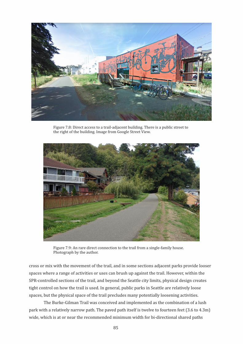
85
cross or mix with the movement of the trail, and in some sections adjacent parks provide looser spaces where a range of activities or uses can brush up against the trail. However, within the SPR-controlled sections of the trail, and beyond the Seattle city limits, physical design creates tight control on how the trail is used. In general, public parks in Seattle are relatively loose spaces, but the physical space of the trail precludes many potentially loosening activities.
The Burke-Gilman Trail was conceived and implemented as the combination of a lush park with a relatively narrow path. The paved path itself is twelve to fourteen feet (3.6 to 4.3m) wide, which is at or near the recommended minimum width for bi-directional shared paths
Figure 7.8: Direct access to a trail-adjacent building. There is a public street to the right of the building. Image from Google Street View.
Figure 7.9: An rare direct connection to the trail from a single-family house. Photograph by the author.
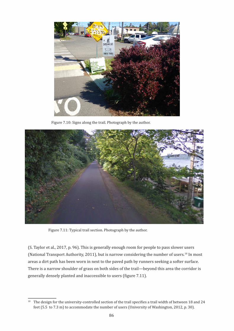
86
(S. Taylor et al., 2017, p. 96). This is generally enough room for people to pass slower users (National Transport Authority, 2011), but is narrow considering the number of users.18 In most areas a dirt path has been worn in next to the paved path by runners seeking a softer surface. There is a narrow shoulder of grass on both sides of the trail—beyond this area the corridor is generally densely planted and inaccessible to users (figure 7.11).
18 The design for the university-controlled section of the trail specifies a trail width of between 18 and 24 feet (5.5 to 7.3 m) to accommodate the number of users (University of Washington, 2012, p. 30).
Figure 7.10: Signs along the trail. Photograph by the author.
Figure 7.11: Typical trail section. Photograph by the author.
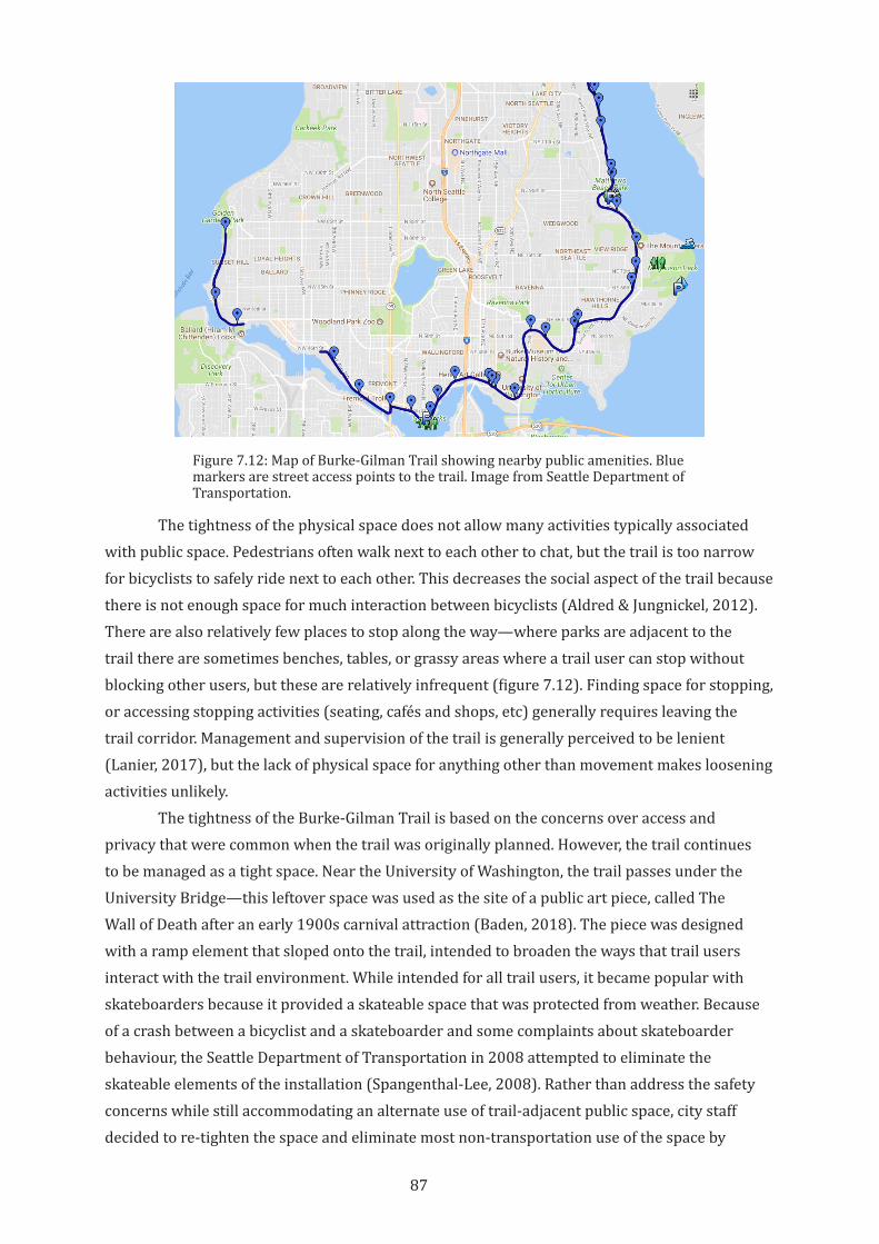
87
The tightness of the physical space does not allow many activities typically associated with public space. Pedestrians often walk next to each other to chat, but the trail is too narrow for bicyclists to safely ride next to each other. This decreases the social aspect of the trail because there is not enough space for much interaction between bicyclists (Aldred & Jungnickel, 2012). There are also relatively few places to stop along the way—where parks are adjacent to the trail there are sometimes benches, tables, or grassy areas where a trail user can stop without blocking other users, but these are relatively infrequent (figure 7.12). Finding space for stopping, or accessing stopping activities (seating, cafés and shops, etc) generally requires leaving the trail corridor. Management and supervision of the trail is generally perceived to be lenient (Lanier, 2017), but the lack of physical space for anything other than movement makes loosening activities unlikely.
The tightness of the Burke-Gilman Trail is based on the concerns over access and privacy that were common when the trail was originally planned. However, the trail continues to be managed as a tight space. Near the University of Washington, the trail passes under the University Bridge—this leftover space was used as the site of a public art piece, called The Wall of Death after an early 1900s carnival attraction (Baden, 2018). The piece was designed with a ramp element that sloped onto the trail, intended to broaden the ways that trail users interact with the trail environment. While intended for all trail users, it became popular with skateboarders because it provided a skateable space that was protected from weather. Because of a crash between a bicyclist and a skateboarder and some complaints about skateboarder behaviour, the Seattle Department of Transportation in 2008 attempted to eliminate the skateable elements of the installation (Spangenthal-Lee, 2008). Rather than address the safety concerns while still accommodating an alternate use of trail-adjacent public space, city staff decided to re-tighten the space and eliminate most non-transportation use of the space by
Figure 7.12: Map of Burke-Gilman Trail showing nearby public amenities. Blue markers are street access points to the trail. Image from Seattle Department of Transportation.
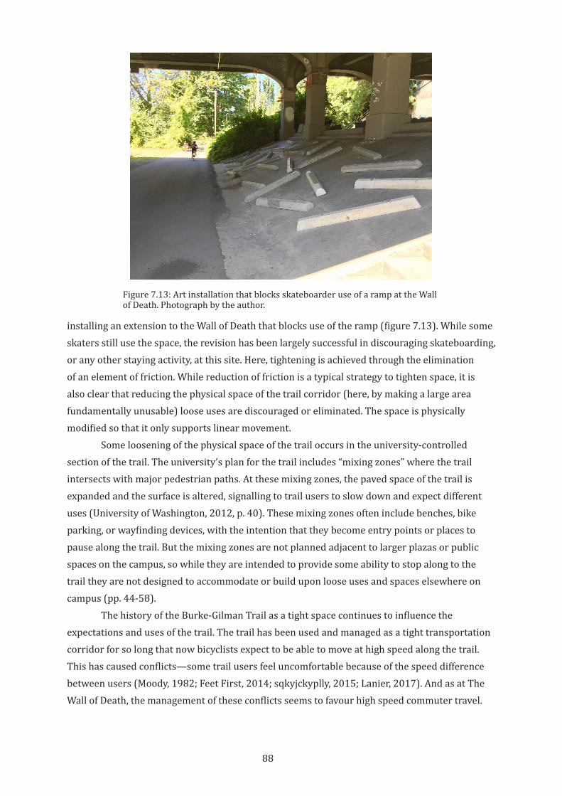
88
installing an extension to the Wall of Death that blocks use of the ramp (figure 7.13). While some skaters still use the space, the revision has been largely successful in discouraging skateboarding, or any other staying activity, at this site. Here, tightening is achieved through the elimination of an element of friction. While reduction of friction is a typical strategy to tighten space, it is also clear that reducing the physical space of the trail corridor (here, by making a large area fundamentally unusable) loose uses are discouraged or eliminated. The space is physically modified so that it only supports linear movement.
Some loosening of the physical space of the trail occurs in the university-controlled section of the trail. The university’s plan for the trail includes “mixing zones” where the trail intersects with major pedestrian paths. At these mixing zones, the paved space of the trail is expanded and the surface is altered, signalling to trail users to slow down and expect different uses (University of Washington, 2012, p. 40). These mixing zones often include benches, bike parking, or wayfinding devices, with the intention that they become entry points or places to pause along the trail. But the mixing zones are not planned adjacent to larger plazas or public spaces on the campus, so while they are intended to provide some ability to stop along to the trail they are not designed to accommodate or build upon loose uses and spaces elsewhere on campus (pp. 44-58).
The history of the Burke-Gilman Trail as a tight space continues to influence the expectations and uses of the trail. The trail has been used and managed as a tight transportation corridor for so long that now bicyclists expect to be able to move at high speed along the trail. This has caused conflicts—some trail users feel uncomfortable because of the speed difference between users (Moody, 1982; Feet First, 2014; sqkyjckyplly, 2015; Lanier, 2017). And as at The Wall of Death, the management of these conflicts seems to favour high speed commuter travel.
Figure 7.13: Art installation that blocks skateboarder use of a ramp at the Wall of Death. Photograph by the author.
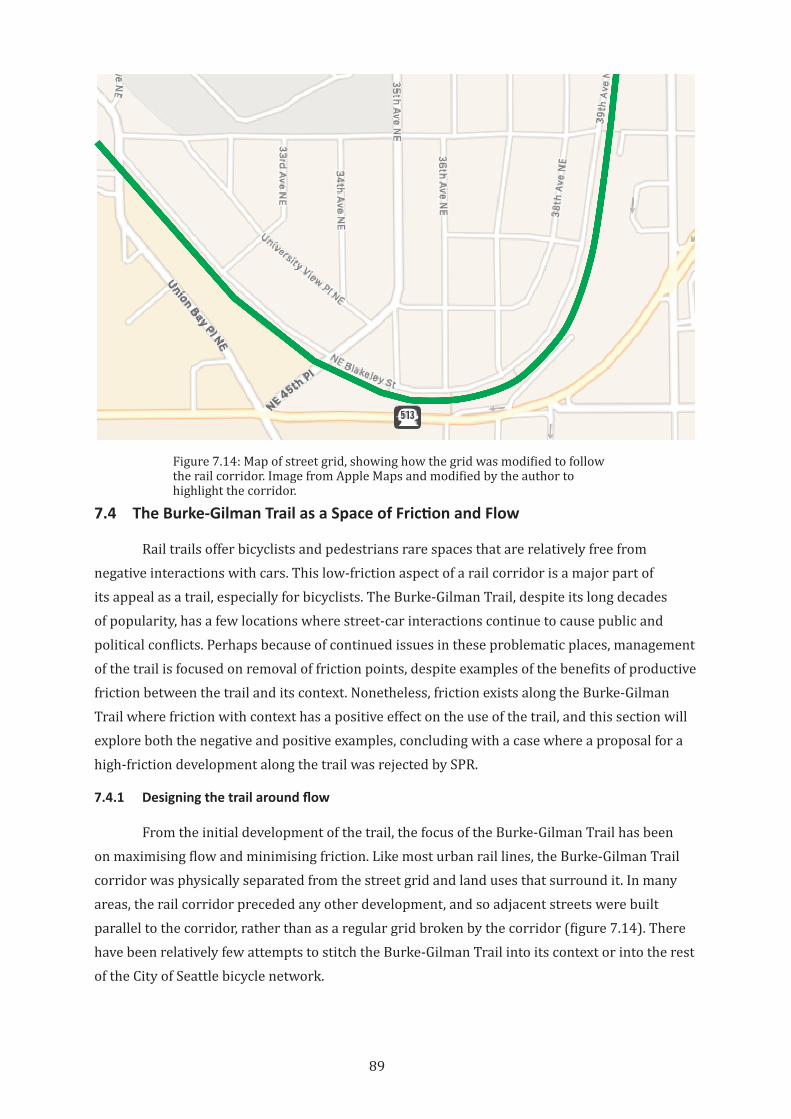
89
7.4 The Burke-Gilman Trail as a Space of Friction and Flow
Rail trails offer bicyclists and pedestrians rare spaces that are relatively free from negative interactions with cars. This low-friction aspect of a rail corridor is a major part of its appeal as a trail, especially for bicyclists. The Burke-Gilman Trail, despite its long decades of popularity, has a few locations where street-car interactions continue to cause public and political conflicts. Perhaps because of continued issues in these problematic places, management of the trail is focused on removal of friction points, despite examples of the benefits of productive friction between the trail and its context. Nonetheless, friction exists along the Burke-Gilman Trail where friction with context has a positive effect on the use of the trail, and this section will explore both the negative and positive examples, concluding with a case where a proposal for a high-friction development along the trail was rejected by SPR.
7.4.1 Designing the trail around flow
From the initial development of the trail, the focus of the Burke-Gilman Trail has been on maximising flow and minimising friction. Like most urban rail lines, the Burke-Gilman Trail corridor was physically separated from the street grid and land uses that surround it. In many areas, the rail corridor preceded any other development, and so adjacent streets were built parallel to the corridor, rather than as a regular grid broken by the corridor (figure 7.14). There have been relatively few attempts to stitch the Burke-Gilman Trail into its context or into the rest of the City of Seattle bicycle network.
Figure 7.14: Map of street grid, showing how the grid was modified to follow the rail corridor. Image from Apple Maps and modified by the author to highlight the corridor.
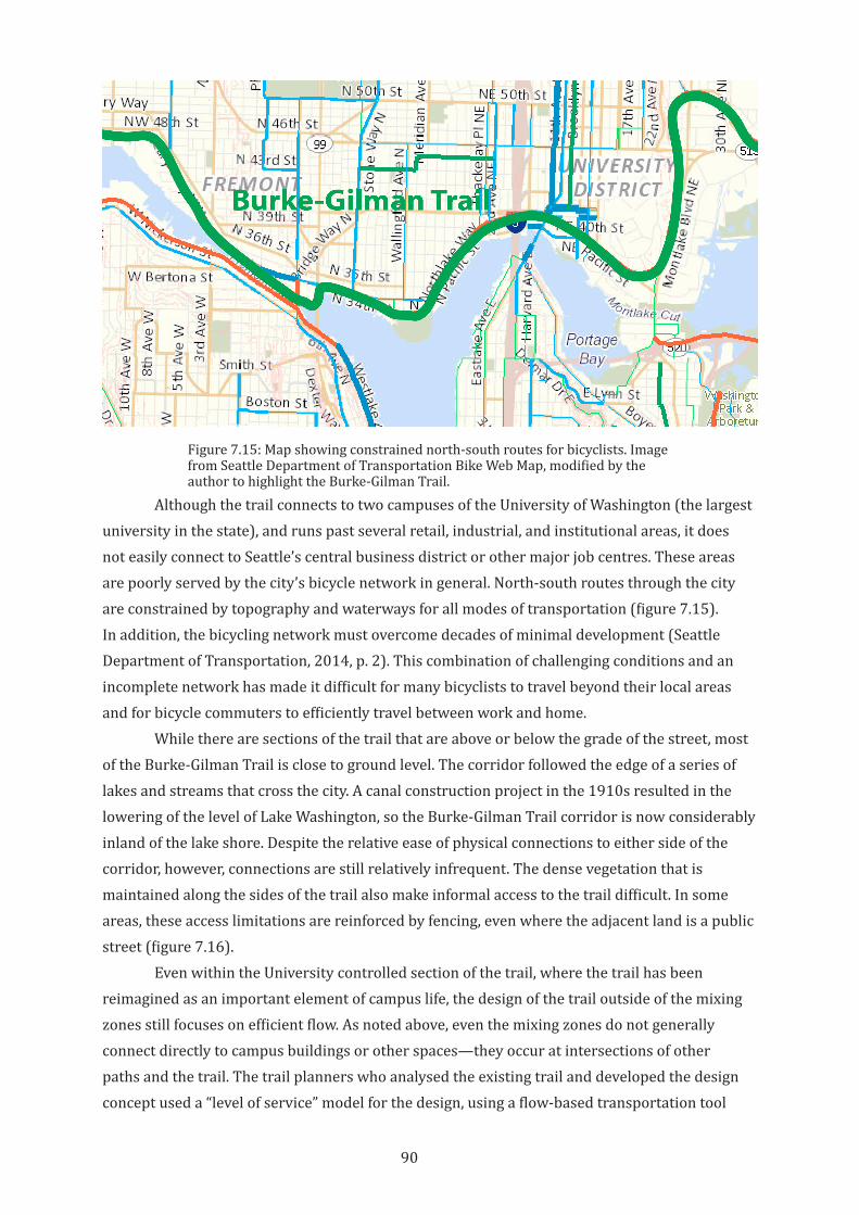
90
Although the trail connects to two campuses of the University of Washington (the largest university in the state), and runs past several retail, industrial, and institutional areas, it does not easily connect to Seattle’s central business district or other major job centres. These areas are poorly served by the city’s bicycle network in general. North-south routes through the city are constrained by topography and waterways for all modes of transportation (figure 7.15). In addition, the bicycling network must overcome decades of minimal development (Seattle Department of Transportation, 2014, p. 2). This combination of challenging conditions and an incomplete network has made it difficult for many bicyclists to travel beyond their local areas and for bicycle commuters to efficiently travel between work and home.
While there are sections of the trail that are above or below the grade of the street, most of the Burke-Gilman Trail is close to ground level. The corridor followed the edge of a series of lakes and streams that cross the city. A canal construction project in the 1910s resulted in the lowering of the level of Lake Washington, so the Burke-Gilman Trail corridor is now considerably inland of the lake shore. Despite the relative ease of physical connections to either side of the corridor, however, connections are still relatively infrequent. The dense vegetation that is maintained along the sides of the trail also make informal access to the trail difficult. In some areas, these access limitations are reinforced by fencing, even where the adjacent land is a public street (figure 7.16).
Even within the University controlled section of the trail, where the trail has been reimagined as an important element of campus life, the design of the trail outside of the mixing zones still focuses on efficient flow. As noted above, even the mixing zones do not generally connect directly to campus buildings or other spaces—they occur at intersections of other paths and the trail. The trail planners who analysed the existing trail and developed the design concept used a “level of service” model for the design, using a flow-based transportation tool
Figure 7.15: Map showing constrained north-south routes for bicyclists. Image from Seattle Department of Transportation Bike Web Map, modified by the author to highlight the Burke-Gilman Trail.
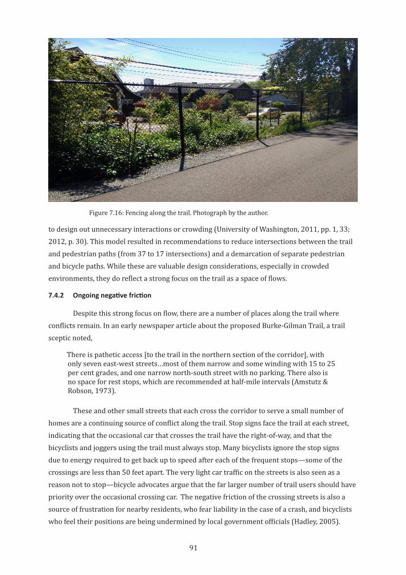
91
to design out unnecessary interactions or crowding (University of Washington, 2011, pp. 1, 33; 2012, p. 30). This model resulted in recommendations to reduce intersections between the trail and pedestrian paths (from 37 to 17 intersections) and a demarcation of separate pedestrian and bicycle paths. While these are valuable design considerations, especially in crowded environments, they do reflect a strong focus on the trail as a space of flows.
7.4.2 Ongoing negative friction
Despite this strong focus on flow, there are a number of places along the trail where conflicts remain. In an early newspaper article about the proposed Burke-Gilman Trail, a trail sceptic noted,
There is pathetic access [to the trail in the northern section of the corridor], with only seven east-west streets…most of them narrow and some winding with 15 to 25 per cent grades, and one narrow north-south street with no parking. There also is no space for rest stops, which are recommended at half-mile intervals (Amstutz & Robson, 1973).
These and other small streets that each cross the corridor to serve a small number of homes are a continuing source of conflict along the trail. Stop signs face the trail at each street, indicating that the occasional car that crosses the trail have the right-of-way, and that the bicyclists and joggers using the trail must always stop. Many bicyclists ignore the stop signs due to energy required to get back up to speed after each of the frequent stops—some of the crossings are less than 50 feet apart. The very light car traffic on the streets is also seen as a reason not to stop—bicycle advocates argue that the far larger number of trail users should have priority over the occasional crossing car. The negative friction of the crossing streets is also a source of frustration for nearby residents, who fear liability in the case of a crash, and bicyclists who feel their positions are being undermined by local government officials (Hadley, 2005).
Figure 7.16: Fencing along the trail. Photograph by the author.
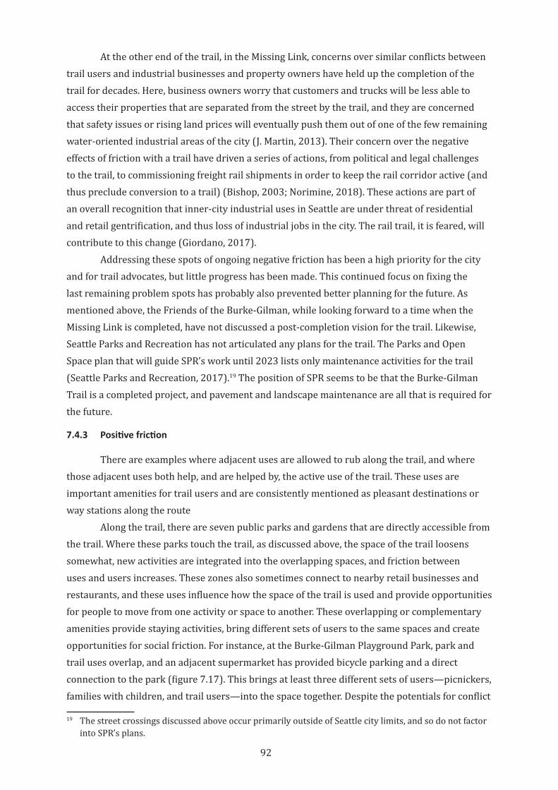
92
At the other end of the trail, in the Missing Link, concerns over similar conflicts between trail users and industrial businesses and property owners have held up the completion of the trail for decades. Here, business owners worry that customers and trucks will be less able to access their properties that are separated from the street by the trail, and they are concerned that safety issues or rising land prices will eventually push them out of one of the few remaining water-oriented industrial areas of the city (J. Martin, 2013). Their concern over the negative effects of friction with a trail have driven a series of actions, from political and legal challenges to the trail, to commissioning freight rail shipments in order to keep the rail corridor active (and thus preclude conversion to a trail) (Bishop, 2003; Norimine, 2018). These actions are part of an overall recognition that inner-city industrial uses in Seattle are under threat of residential and retail gentrification, and thus loss of industrial jobs in the city. The rail trail, it is feared, will contribute to this change (Giordano, 2017).
Addressing these spots of ongoing negative friction has been a high priority for the city and for trail advocates, but little progress has been made. This continued focus on fixing the last remaining problem spots has probably also prevented better planning for the future. As mentioned above, the Friends of the Burke-Gilman, while looking forward to a time when the Missing Link is completed, have not discussed a post-completion vision for the trail. Likewise, Seattle Parks and Recreation has not articulated any plans for the trail. The Parks and Open Space plan that will guide SPR’s work until 2023 lists only maintenance activities for the trail (Seattle Parks and Recreation, 2017).19 The position of SPR seems to be that the Burke-Gilman Trail is a completed project, and pavement and landscape maintenance are all that is required for the future.
7.4.3 Positive friction
There are examples where adjacent uses are allowed to rub along the trail, and where those adjacent uses both help, and are helped by, the active use of the trail. These uses are important amenities for trail users and are consistently mentioned as pleasant destinations or way stations along the route
Along the trail, there are seven public parks and gardens that are directly accessible from the trail. Where these parks touch the trail, as discussed above, the space of the trail loosens somewhat, new activities are integrated into the overlapping spaces, and friction between uses and users increases. These zones also sometimes connect to nearby retail businesses and restaurants, and these uses influence how the space of the trail is used and provide opportunities for people to move from one activity or space to another. These overlapping or complementary amenities provide staying activities, bring different sets of users to the same spaces and create opportunities for social friction. For instance, at the Burke-Gilman Playground Park, park and trail uses overlap, and an adjacent supermarket has provided bicycle parking and a direct connection to the park (figure 7.17). This brings at least three different sets of users—picnickers, families with children, and trail users—into the space together. Despite the potentials for conflict
19 The street crossings discussed above occur primarily outside of Seattle city limits, and so do not factor into SPR’s plans.
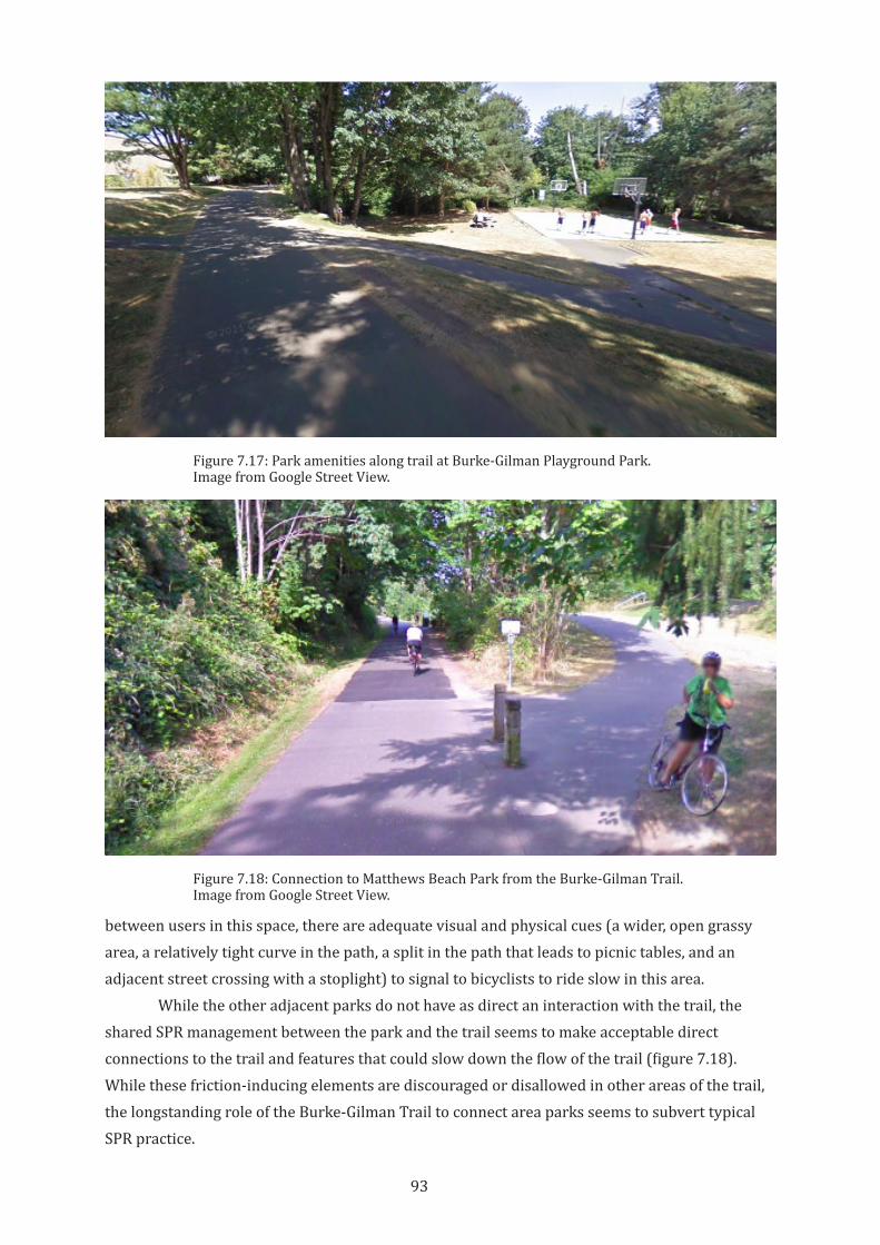
93
between users in this space, there are adequate visual and physical cues (a wider, open grassy area, a relatively tight curve in the path, a split in the path that leads to picnic tables, and an adjacent street crossing with a stoplight) to signal to bicyclists to ride slow in this area.
While the other adjacent parks do not have as direct an interaction with the trail, the shared SPR management between the park and the trail seems to make acceptable direct connections to the trail and features that could slow down the flow of the trail (figure 7.18). While these friction-inducing elements are discouraged or disallowed in other areas of the trail, the longstanding role of the Burke-Gilman Trail to connect area parks seems to subvert typical SPR practice.
Figure 7.17: Park amenities along trail at Burke-Gilman Playground Park. Image from Google Street View.
Figure 7.18: Connection to Matthews Beach Park from the Burke-Gilman Trail. Image from Google Street View.
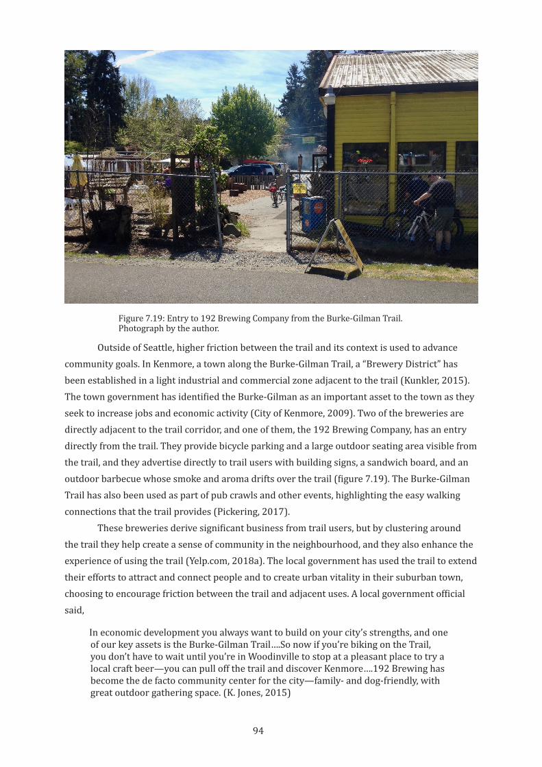
94
Outside of Seattle, higher friction between the trail and its context is used to advance community goals. In Kenmore, a town along the Burke-Gilman Trail, a “Brewery District” has been established in a light industrial and commercial zone adjacent to the trail (Kunkler, 2015). The town government has identified the Burke-Gilman as an important asset to the town as they seek to increase jobs and economic activity (City of Kenmore, 2009). Two of the breweries are directly adjacent to the trail corridor, and one of them, the 192 Brewing Company, has an entry directly from the trail. They provide bicycle parking and a large outdoor seating area visible from the trail, and they advertise directly to trail users with building signs, a sandwich board, and an outdoor barbecue whose smoke and aroma drifts over the trail (figure 7.19). The Burke-Gilman Trail has also been used as part of pub crawls and other events, highlighting the easy walking connections that the trail provides (Pickering, 2017).
These breweries derive significant business from trail users, but by clustering around the trail they help create a sense of community in the neighbourhood, and they also enhance the experience of using the trail (Yelp.com, 2018a). The local government has used the trail to extend their efforts to attract and connect people and to create urban vitality in their suburban town, choosing to encourage friction between the trail and adjacent uses. A local government official said,
In economic development you always want to build on your city’s strengths, and one of our key assets is the Burke-Gilman Trail….So now if you’re biking on the Trail, you don’t have to wait until you’re in Woodinville to stop at a pleasant place to try a local craft beer—you can pull off the trail and discover Kenmore….192 Brewing has become the de facto community center for the city—family- and dog-friendly, with great outdoor gathering space. (K. Jones, 2015)
Figure 7.19: Entry to 192 Brewing Company from the Burke-Gilman Trail. Photograph by the author.
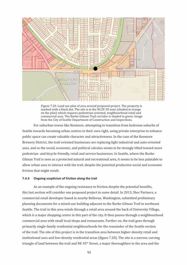
95
For suburban towns like Kenmore, attempting to transition from bedroom suburbs of Seattle towards becoming urban centres in their own right, using private enterprise to enhance public space can create valuable character and attractiveness. In the case of the Kenmore Brewery District, the trail-oriented businesses are replacing light industrial and auto-oriented uses, and so the social, economic, and political calculus seems to be strongly tilted toward more pedestrian- and bicycle-friendly, retail and service businesses. In Seattle, where the Burke-Gilman Trail is seen as a protected natural and recreational area, it seems to be less palatable to allow urban uses to interact with the trail, despite the potential productive social and economic friction that might result.
7.4.4 Ongoing scepticism of friction along the trail
As an example of the ongoing resistance to friction despite the potential benefits, this last section will consider one proposed project in some detail. In 2013, Sher Partners, a commercial retail developer based in nearby Bellevue, Washington, submitted preliminary planning documents for a mixed-use building adjacent to the Burke-Gilman Trail in northeast Seattle. The trail in this area winds through a retail area around the back of University Village, which is a major shopping centre in this part of the city. It then passes through a neighbourhood commercial area with small local shops and restaurants. Further on, the trail goes through primarily single-family residential neighbourhoods for the remainder of the Seattle section of the trail. The site of this project is in the transition area between higher-density retail and institutional uses and low-density residential areas (figure 7.20). The site is a narrow, curving triangle of land between the trail and NE 45th Street, a major thoroughfare in the area and the
Figure 7.20: Land use plan of area around proposed project. The property is marked with a black dot. The site is in the NC2P-30 zone (shaded in orange on the plan) which requires pedestrian-oriented, neigbhourhood retail and commercial uses. The Burke-Gilman Trail corridor is shaded in green. Image from the City of Seattle Department of Construction and Inspections.
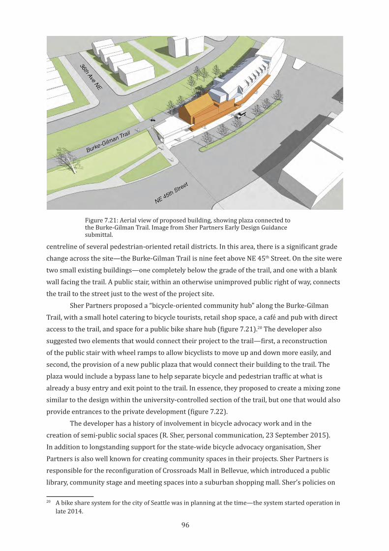
96
centreline of several pedestrian-oriented retail districts. In this area, there is a significant grade change across the site—the Burke-Gilman Trail is nine feet above NE 45th Street. On the site were two small existing buildings—one completely below the grade of the trail, and one with a blank wall facing the trail. A public stair, within an otherwise unimproved public right of way, connects the trail to the street just to the west of the project site.
Sher Partners proposed a “bicycle-oriented community hub” along the Burke-Gilman Trail, with a small hotel catering to bicycle tourists, retail shop space, a café and pub with direct access to the trail, and space for a public bike share hub (figure 7.21).20 The developer also suggested two elements that would connect their project to the trail—first, a reconstruction of the public stair with wheel ramps to allow bicyclists to move up and down more easily, and second, the provision of a new public plaza that would connect their building to the trail. The plaza would include a bypass lane to help separate bicycle and pedestrian traffic at what is already a busy entry and exit point to the trail. In essence, they proposed to create a mixing zone similar to the design within the university-controlled section of the trail, but one that would also provide entrances to the private development (figure 7.22).
The developer has a history of involvement in bicycle advocacy work and in the creation of semi-public social spaces (R. Sher, personal communication, 23 September 2015). In addition to longstanding support for the state-wide bicycle advocacy organisation, Sher Partners is also well known for creating community spaces in their projects. Sher Partners is responsible for the reconfiguration of Crossroads Mall in Bellevue, which introduced a public library, community stage and meeting spaces into a suburban shopping mall. Sher’s policies on
20 A bike share system for the city of Seattle was in planning at the time—the system started operation in late 2014.
Figure 7.21: Aerial view of proposed building, showing plaza connected to the Burke-Gilman Trail. Image from Sher Partners Early Design Guidance submittal.
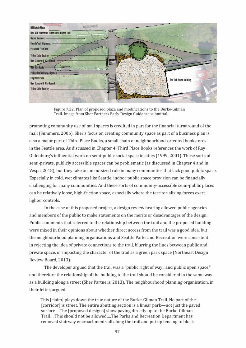
97
promoting community use of mall spaces is credited in part for the financial turnaround of the mall (Summers, 2006). Sher’s focus on creating community space as part of a business plan is also a major part of Third Place Books, a small chain of neighbourhood-oriented bookstores in the Seattle area. As discussed in Chapter 4, Third Place Books references the work of Ray Oldenburg’s influential work on semi-public social space in cities (1999, 2001). These sorts of semi-private, publicly accessible spaces can be problematic (as discussed in Chapter 4 and in Vespa, 2018), but they take on an outsized role in many communities that lack good public space. Especially in cold, wet climates like Seattle, indoor public space provision can be financially challenging for many communities. And these sorts of community-accessible semi-public places can be relatively loose, high-friction space, especially where the territorialising forces exert lighter controls.
In the case of this proposed project, a design review hearing allowed public agencies and members of the public to make statements on the merits or disadvantages of the design. Public comments that referred to the relationship between the trail and the proposed building were mixed in their opinions about whether direct access from the trail was a good idea, but the neighbourhood planning organisations and Seattle Parks and Recreation were consistent in rejecting the idea of private connections to the trail, blurring the lines between public and private space, or impacting the character of the trail as a green park space (Northeast Design Review Board, 2013).
The developer argued that the trail was a “public right of way…and public open space,” and therefore the relationship of the building to the trail should be considered in the same way as a building along a street (Sher Partners, 2013). The neighbourhood planning organisation, in their letter, argued:
This [claim] plays down the true nature of the Burke-Gilman Trail. No part of the [corridor] is street. The entire abutting section is a linear park—not just the paved surface….The [proposed designs] show paving directly up to the Burke-Gilman Trail….This should not be allowed….The Parks and Recreation Department has removed stairway encroachments all along the trail and put up fencing to block
22 PROJECT DATE:September 6, 2013 EARLY DESIGN GUIDANCELOCATION:
3600 NE 45th StreetSeattle, WA
DPD PROJECT #:3014432
POTENTIAL IMPROVEMENTS TO THE ADJACENT BURKE GILMAN TRAIL
The applicant has been in discussion with the Seattle Parks Department about potential improvements to the Burke Gilman Trail adjacent to the site. The purpose of these improvements would be:- provide a separation between pedestrian and cycle traffic in the areas on either side of the 36th Avenue pedestrian way crossing.- provide improved ADA access to the Burke Gilman Trail.- provide new stairs within the 36th Avenue right-of-way, with bike runnels.- provide a new public open space at the east edge of the 36th Ave right-of-way, connecting to a new outdoor terrace space (deck) on the applicant’s property.- provide new outdoor seating opportunities.- provide new bike racks.
Figure 7.22: Plan of proposed plaza and modifications to the Burke-Gilman Trail. Image from Sher Partners Early Design Guidance submittal.
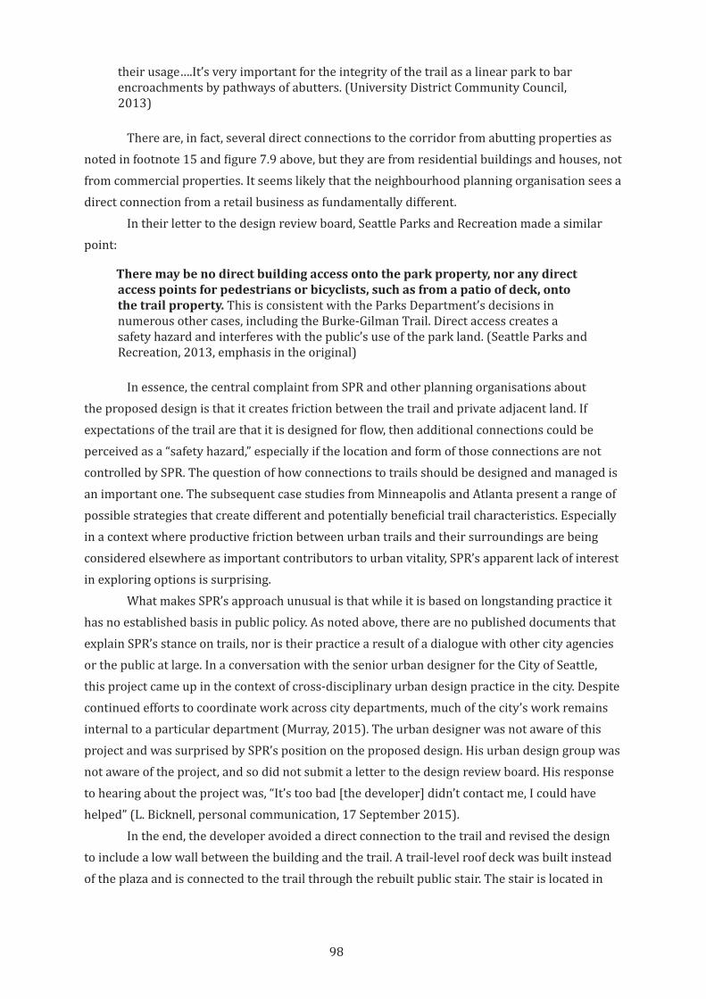
98
their usage….It’s very important for the integrity of the trail as a linear park to bar encroachments by pathways of abutters. (University District Community Council, 2013)
There are, in fact, several direct connections to the corridor from abutting properties as noted in footnote 15 and figure 7.9 above, but they are from residential buildings and houses, not from commercial properties. It seems likely that the neighbourhood planning organisation sees a direct connection from a retail business as fundamentally different.
In their letter to the design review board, Seattle Parks and Recreation made a similar point:
Theremaybenodirectbuildingaccessontotheparkproperty,noranydirectaccesspointsforpedestriansorbicyclists,suchasfromapatioofdeck,ontothe trail property. This is consistent with the Parks Department’s decisions in numerous other cases, including the Burke-Gilman Trail. Direct access creates a safety hazard and interferes with the public’s use of the park land. (Seattle Parks and Recreation, 2013, emphasis in the original)
In essence, the central complaint from SPR and other planning organisations about the proposed design is that it creates friction between the trail and private adjacent land. If expectations of the trail are that it is designed for flow, then additional connections could be perceived as a “safety hazard,” especially if the location and form of those connections are not controlled by SPR. The question of how connections to trails should be designed and managed is an important one. The subsequent case studies from Minneapolis and Atlanta present a range of possible strategies that create different and potentially beneficial trail characteristics. Especially in a context where productive friction between urban trails and their surroundings are being considered elsewhere as important contributors to urban vitality, SPR’s apparent lack of interest in exploring options is surprising.
What makes SPR’s approach unusual is that while it is based on longstanding practice it has no established basis in public policy. As noted above, there are no published documents that explain SPR’s stance on trails, nor is their practice a result of a dialogue with other city agencies or the public at large. In a conversation with the senior urban designer for the City of Seattle, this project came up in the context of cross-disciplinary urban design practice in the city. Despite continued efforts to coordinate work across city departments, much of the city’s work remains internal to a particular department (Murray, 2015). The urban designer was not aware of this project and was surprised by SPR’s position on the proposed design. His urban design group was not aware of the project, and so did not submit a letter to the design review board. His response to hearing about the project was, “It’s too bad [the developer] didn’t contact me, I could have helped” (L. Bicknell, personal communication, 17 September 2015).
In the end, the developer avoided a direct connection to the trail and revised the design to include a low wall between the building and the trail. A trail-level roof deck was built instead of the plaza and is connected to the trail through the rebuilt public stair. The stair is located in
99
the Department of Transportation-controlled right-of-way that crosses the trail, not on park land (figure 7.23). This simpler design still delivers benefits for all users but avoids challenging SPR policy.
The outcome of this project can be seen as a successful example of a balanced set of territorial claims on urban space. However, it would not have happened this way without the strong volition of the developer to support urban bicycling. The developer made clear that the design costs of the project were far out of scale with the value of the final design (R. Sher, personal communication, 23 September 2015).21 If urban rail trails are to contribute to the urban vitality of their surroundings through productive friction with their public and private urban contexts, it is important that this friction not depend only on developer largesse. Instead, real urban vitality will come from small scale urban friction across a range of properties, both public and private. Where these small interventions to integrate the trail into the city are hindered by government practice, most of them will fail to materialise.
7.5 Conclusion
The creation of the Burke-Gilman Trail forty years ago was a pioneering rail trail conversion in the United States. It has helped establish the aesthetics, policies, and successful reputation for urban rail trails throughout the United States. However, a leading researcher on active transportation in the Seattle area notes that the Burke-Gilman Trail is now more of an afterthought rather than a central piece of the vibrant conversation around bicycling and walking in and around Seattle (A. Moudon, personal communication, 8 May 2015). These conversations have moved to focus on new projects such as light rail lines and stations, residential street route
21 The developer estimated that the planning and site work (including the stair) incurred costs similar to that of a project site 100 times the size of this project.
Figure 7.23: The completed building. The roof deck is technically connected to the public stair, not to the trail, but this difference is not obvious. Photograph by Instagram user britta.mouse.
100
projects and new rail trails. Meanwhile, the final 1.4 mile (2.3 kilometre) Missing Link has now cleared a major legal hurdle, but the route and design remain contested (City of Seattle, 2018; Gutman, 2018).
Unlike the Minneapolis Midtown Greenway and the Atlanta BeltLine, discussed in the following chapters, the Burke-Gilman Trail has never been promoted as a tool for urban development. This has meant that the Burke-Gilman Trail has not had a significant role in organising the city’s transportation or development patterns. For many of the residents who live in established single-family neighbourhoods near the trail, this has likely been a preferable outcome to neighbourhood change and densification.22 But this has also meant that there have been fewer opportunities to integrate the trail, and the active transportation space it provides, into the social and economic life of the city, resulting in a trail with a very different character than the other case study trails.
How can pieces of urban infrastructure continue to be living, evolving parts of the city after the planning and implementation work is done? The Burke-Gilman Trail, which helped establish the contemporary rails to trails movement in the United States, is a rightly-celebrated recreation and transportation space. When compared to other trails around the region or around the country, however, the Burke-Gilman Trail seems to underperform on its potential as a generator of urban vitality. Is that because it is largely complete, and its role as a catalyst for urban life has run its course? This chapter argues that the particular history of the trail and its territorialisation by Seattle Parks and Recreation and the University of Washington have established strong and conservative management strategies that preclude looseness and discourage friction. While other examples of trail-oriented development and the social and economic benefits of friction seem to be driving new attempts to engage with the Burke-Gilman Trail, these efforts have been largely stymied by the lasting identity of the trail as a linear park. This identity is strongly maintained by SPR and resonates with trail neighbours. And the University of Washington, while it has a different set of attitudes and strategies about how the trail integrates into the campus, has established such clear territorial control over the campus section of the trail that its innovative physical design vocabulary has not been replicated elsewhere.
What we can see in the Burke-Gilman Trail is the effect of strong, unitary territorialisations on the evolution of the trail, and on the ability for new frictions to arise. The rail trail began as a low-friction, tight space, and strong territorial control over the trail has largely maintained that character. There is very little physical or legal space for other actors to territorialise the trail and change its character. Even where opportunities arise for looser uses or higher friction adjacent to the trail, these are either stymied or limited to park uses. There are new frictions and new loose spaces within the University of Washington section of the trail, but these are still highly limited by University policy. As noted in Chapters 2 and 3, strong territorialisation can overwhelm the natural inclination for friction and looseness to increase in 22 Seattle home owners have been resistant to increased density in single-family zones. This position is
reflected in city zoning and planning law (Feit, 2015). While this can be interpreted as protection from gentrification, in general this preserves the largely white, middle- and upper-middle class portions of the city, rather than preserving affordable housing.
101
dense urban settings. The case of the Burke-Gilman Trail is an example of this phenomenon. It is important to note that this is not simply the result of the particular governance structures of the Seattle region—other trails in the area are developed and managed with different attitudes toward friction and looseness.
In short, the advocacy and urgency for active transportation corridors that also serve vitality-generating public space is focused on other trails and other places. The complex question of the role of the Burke-Gilman Trail in Seattle—as a park, a piece of transportation infrastructure, or a public place—remains contested at the smaller scale of individual projects or segments, and largely unexamined at the larger scale of the city. The Seattle region, like many through the United States and the world, faces increasing political, economic, and social pressures around urban issues. In such an environment, neglecting to address this complex question as part of a robust planning or policy framework seems like a mistake.
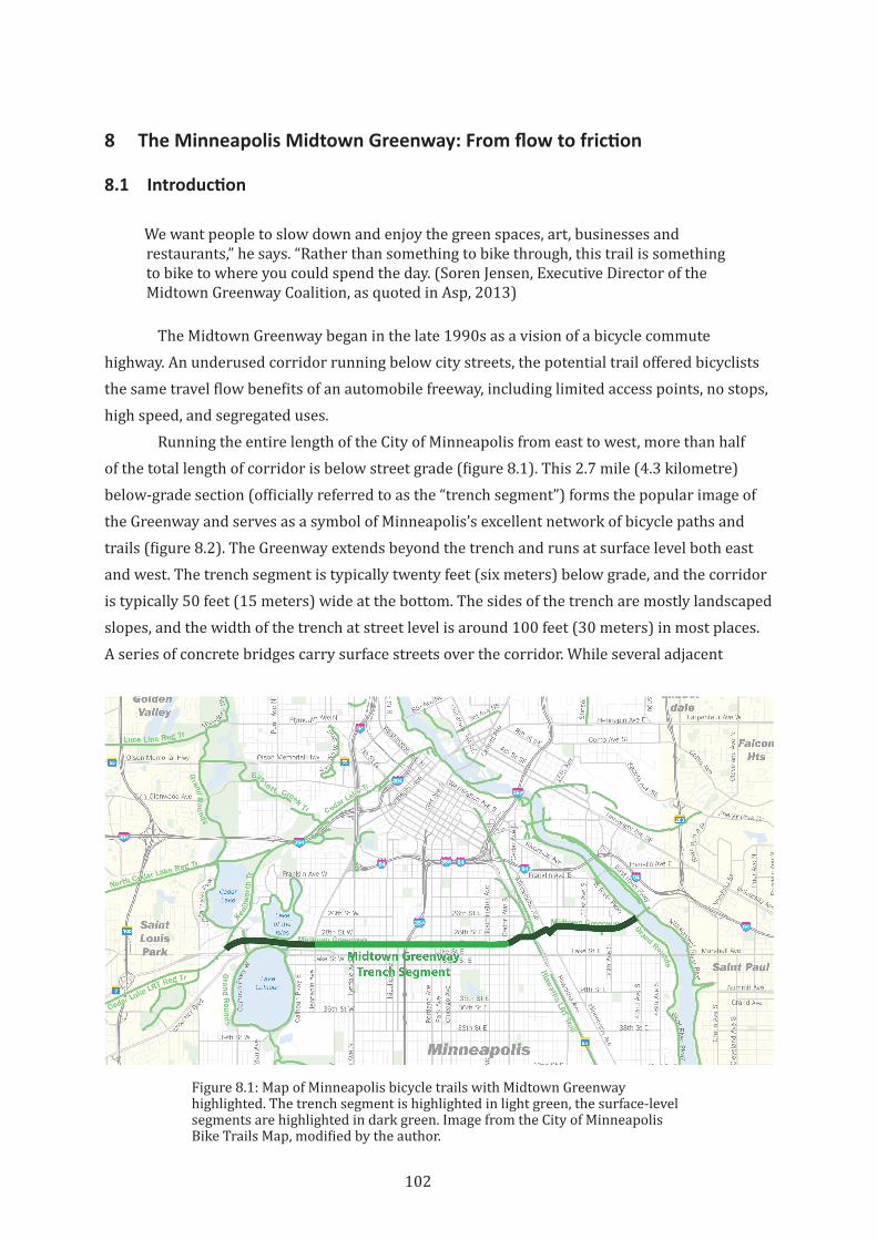
102
8 The Minneapolis Midtown Greenway: From flow to friction
8.1 Introduction
We want people to slow down and enjoy the green spaces, art, businesses and restaurants,” he says. “Rather than something to bike through, this trail is something to bike to where you could spend the day. (Soren Jensen, Executive Director of the Midtown Greenway Coalition, as quoted in Asp, 2013)
The Midtown Greenway began in the late 1990s as a vision of a bicycle commute highway. An underused corridor running below city streets, the potential trail offered bicyclists the same travel flow benefits of an automobile freeway, including limited access points, no stops, high speed, and segregated uses.
Running the entire length of the City of Minneapolis from east to west, more than half of the total length of corridor is below street grade (figure 8.1). This 2.7 mile (4.3 kilometre) below-grade section (officially referred to as the “trench segment”) forms the popular image of the Greenway and serves as a symbol of Minneapolis’s excellent network of bicycle paths and trails (figure 8.2). The Greenway extends beyond the trench and runs at surface level both east and west. The trench segment is typically twenty feet (six meters) below grade, and the corridor is typically 50 feet (15 meters) wide at the bottom. The sides of the trench are mostly landscaped slopes, and the width of the trench at street level is around 100 feet (30 meters) in most places. A series of concrete bridges carry surface streets over the corridor. While several adjacent
Figure 8.1: Map of Minneapolis bicycle trails with Midtown Greenway highlighted. The trench segment is highlighted in light green, the surface-level segments are highlighted in dark green. Image from the City of Minneapolis Bike Trails Map, modified by the author.
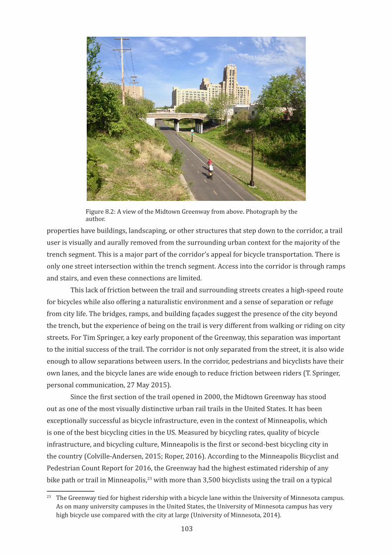
103
properties have buildings, landscaping, or other structures that step down to the corridor, a trail user is visually and aurally removed from the surrounding urban context for the majority of the trench segment. This is a major part of the corridor’s appeal for bicycle transportation. There is only one street intersection within the trench segment. Access into the corridor is through ramps and stairs, and even these connections are limited.
This lack of friction between the trail and surrounding streets creates a high-speed route for bicycles while also offering a naturalistic environment and a sense of separation or refuge from city life. The bridges, ramps, and building façades suggest the presence of the city beyond the trench, but the experience of being on the trail is very different from walking or riding on city streets. For Tim Springer, a key early proponent of the Greenway, this separation was important to the initial success of the trail. The corridor is not only separated from the street, it is also wide enough to allow separations between users. In the corridor, pedestrians and bicyclists have their own lanes, and the bicycle lanes are wide enough to reduce friction between riders (T. Springer, personal communication, 27 May 2015).
Since the first section of the trail opened in 2000, the Midtown Greenway has stood out as one of the most visually distinctive urban rail trails in the United States. It has been exceptionally successful as bicycle infrastructure, even in the context of Minneapolis, which is one of the best bicycling cities in the US. Measured by bicycling rates, quality of bicycle infrastructure, and bicycling culture, Minneapolis is the first or second-best bicycling city in the country (Colville-Andersen, 2015; Roper, 2016). According to the Minneapolis Bicyclist and Pedestrian Count Report for 2016, the Greenway had the highest estimated ridership of any bike path or trail in Minneapolis,23 with more than 3,500 bicyclists using the trail on a typical
23 The Greenway tied for highest ridership with a bicycle lane within the University of Minnesota campus. As on many university campuses in the United States, the University of Minnesota campus has very high bicycle use compared with the city at large (University of Minnesota, 2014).
Figure 8.2: A view of the Midtown Greenway from above. Photograph by the author.
104
September day (Minneapolis Public Works Department, 2016). However, the separation of the trail from its surrounding context is also its greatest challenge in terms of its potential to enhance urban vitality. While the trail is very popular for bicyclists, its separation and relatively infrequent access points make it less valuable to pedestrians as a travel route and limits its ability to contribute to activity on nearby streets.
In response to these issues, the vision of the Greenway had already begun to shift by 2002. Instead of a bicycle highway, planners sought to “foster visual and physical connection between the Greenway and adjacent sites to promote safety and social interaction” (Shallcross & Rhees, 2002). In 2007, a principle of the Midtown Greenway Land Use Development Plan was to “[u]se new development, the pedestrian environment, and open space to promote an integrated relationship between the Greenway floor and the Greenway edge/rim, fostering a sense of place and community.” (City of Minneapolis, 2007, p. 26). Planning around the Greenway had evolved, such that rather than keeping the trail separated from the street to protect it as a high-speed transportation corridor, the trail was envisioned as an engine of city life for adjacent neighbourhoods.
In these plans, extending the success of the trail into the surrounding urban fabric required overcoming the morphological boundaries of the trench, as well as changing the vision for the trail. This new vision focuses on productive friction, as defined in this thesis, rather than prioritizing flow. It suggests that high-speed bicycle corridors, despite their transportation value, are not strong contributors to city life. In the same way that freeways fall short of their promised role as agents of community revitalization (DiMento et al., 1996), the Midtown Greenway shows that a commuter bicycle highway alone is not enough to bring economic and social vitality to a neighbourhood.
The attempts to overcome the challenges of morphology and to create social and economic friction are an important part of this case study. This chapter will explore how the evolving and overlapping territories that created and continue to shape the trail and the various actions that loosen or tighten the space of the trail are influencing its evolution from a space of flow to one of friction. While there are many parallels between the Midtown Greenway and the Burke-Gilman Trail, there are also significant differences in trail morphology, stage of development, and mechanisms for planning, implementation and management. Exploring these can give us different insights into the larger context of urban rail trail development and their potential for increasing urban vitality. This chapter will start with the history off the trail and its origin story as a bicycle highway; then will discuss the frictions that arise from a number of overlapping territorialisations of the trail; then will examine actions that are loosening and tightening the space of the trail; and finally will consider at the various networks and adjacent uses that connect to the trail and the frictions that result.
8.2 History of the Trail
The railway corridor was originally developed as the Benton Cutoff by the Chicago, Milwaukee, St. Paul and Pacific Railroad in the 1880s to transport grain to the flour mills along the Mississippi River (City of Minneapolis, 2006). The corridor was built at grade along what
105
was then the southern edge of Minneapolis. The rail line spurred commercial and industrial growth along the corridor, so conflicts between rail traffic and street traffic increased in the following years. In 1912 the city government forced the railway to depress the corridor and build bridges above for crossing streets to improve safety (Caniglia, 2016). Just as with other rail lines throughout the US, rail traffic on the Benton Cutoff decreased in the second half of the 20th Century. By 1992 rail traffic had fallen to the point that Hennepin County bought the corridor to hold for a future light rail, but by that time there was already a grassroots effort underway to convert the corridor into a bicycle and pedestrian trail.
In the early 1990s, George Puzak, a bicyclist and Minneapolis Park and Recreation Board member, recognised the underused rail trench as a potential green connection across South Minneapolis. He began to advocate for the project by meeting with public officials and presenting at neighbourhood meetings. He soon partnered with Tim Springer, a bicycle advocate and commissioner on the Minneapolis Environmental Council, who had been looking to create a cross-town bicycle route in the same area. Together with a group of fellow advocates, they created the Midtown Greenway Coalition in 1992 to push the idea of bicycle and pedestrian trails in the corridor (Lohn, 1998).
The Coalition’s effort to create a “bicycle commuter highway” in the corridor dovetailed with two other transportation-focused projects, a bicycle network and a light rail system (Anderson, 1994, p. 4). The City of Minneapolis was beginning to plan a bicycle network across the city, and Hennepin County was planning for light rail transit in and around Minneapolis. After Hennepin purchased the rail corridor for transit, the County worked with the City and the Coalition to integrate bicycling into plans for the corridor.
The corridor in the early 1990s was a dumping ground for trash, a hotspot for crime, and was surrounded by abandoned industrial properties. There were community concerns about how safe and usable any trail would be (Lohn, 1998). In response, the County established Hennepin Community Works, an organization that brought together local and regional governments, neighbourhood organizations, and businesses to address urban blight, economic stagnation, crime, and housing inequality in the greater Minneapolis region. They stated that “carefully designed and integrated parks and public works projects sustain and enhance the long-term tax base and financial viability of neighbourhoods while enhancing their quality of life” (Parks and Public Works Commission, 1994, p. 1.1). With their focus on parks and public works, Hennepin County Works adopted the Midtown Greenway as one of their first projects (Bryant, 1998). The collaboration between different levels of government and advocates in envisioning and implementing the trail established a unique management structure, which will be discussed below.
The first section of the Midtown Greenway opened in 2000, and the trail now stretches 5.5 miles (8.9 kilometres) from the Mississippi River to the Southwest LRT Trail, which continues into suburban Minneapolis. The trail passes a light rail station and is part of a growing network of pedestrian and bicycle infrastructure through Minneapolis that connects to the CBD and the University of Minnesota. While the trail was originally conceived of as a commuting route,

106
it is now also highly valued as a recreation corridor. The trail connects to the extensive set of greenways and parks that border many of the lakes and rivers that define the city’s landscape (figure 8.3). The landscaped slopes that border the Greenway help it blend seamlessly into the naturalistic setting of Minneapolis’s green network.
8.2.1 Greenway as a bicycle highway, not as a city street
The early planning for the trail recognised the unique benefits of the trench to bicycle commuters and minimised friction in the design of the infrastructure. George Puzak stated that planning initially focus on bicycling: “Fast, safe, and pleasant was our mantra” (Brandt, 2014). The original framework plan for the corridor emphasised the importance of connecting the trail to surrounding neighbourhoods, but envisioned only one access point for each neighbourhood (Hennepin County, 1999). Even today, there are only eight places for a bicycle to enter the trench portion of the trail, with as much as one kilometre between access points24 (figures 8.4 and 8.5).
In its current state, the Greenway is an excellent piece of infrastructure for bicycle transportation, especially for high-speed, long distance trips. The infrequent connections to street level, the separation of users, and the relative lack of visual distractions from adjacent properties helped it deliver on the promise of a bicycle commute highway. The Greenway is far less successful for shorter trips and for pedestrians, however. Being located in a trench and separated from the street grid of the city adds considerable distance and inefficiency to shorter
24 Within the trench section there are an additional five stair entries and two informal path connections.
Figure 8.3: Map of the Grand Rounds Scenic Byway and waterfront parks in and around Minneapolis. Midtown Greenway shown in blue. Map from the United States Department of Transportation, and modified by the author to highlight the Midtown Greenway.
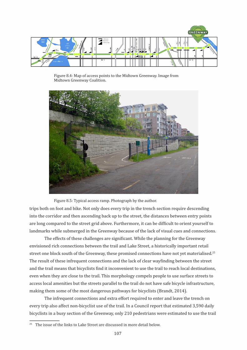
107
trips both on foot and bike. Not only does every trip in the trench section require descending into the corridor and then ascending back up to the street, the distances between entry points are long compared to the street grid above. Furthermore, it can be difficult to orient yourself to landmarks while submerged in the Greenway because of the lack of visual cues and connections.
The effects of these challenges are significant. While the planning for the Greenway envisioned rich connections between the trail and Lake Street, a historically important retail street one block south of the Greenway, these promised connections have not yet materialised.25 The result of these infrequent connections and the lack of clear wayfinding between the street and the trail means that bicyclists find it inconvenient to use the trail to reach local destinations, even when they are close to the trail. This morphology compels people to use surface streets to access local amenities but the streets parallel to the trail do not have safe bicycle infrastructure, making them some of the most dangerous pathways for bicyclists (Brandt, 2014).
The infrequent connections and extra effort required to enter and leave the trench on every trip also affect non-bicyclist use of the trail. In a Council report that estimated 3,590 daily bicyclists in a busy section of the Greenway, only 210 pedestrians were estimated to use the trail
25 The issue of the links to Lake Street are discussed in more detail below.
Figure 8.4: Map of access points to the Midtown Greenway. Image from Midtown Greenway Coalition.
Figure 8.5: Typical access ramp. Photograph by the author.
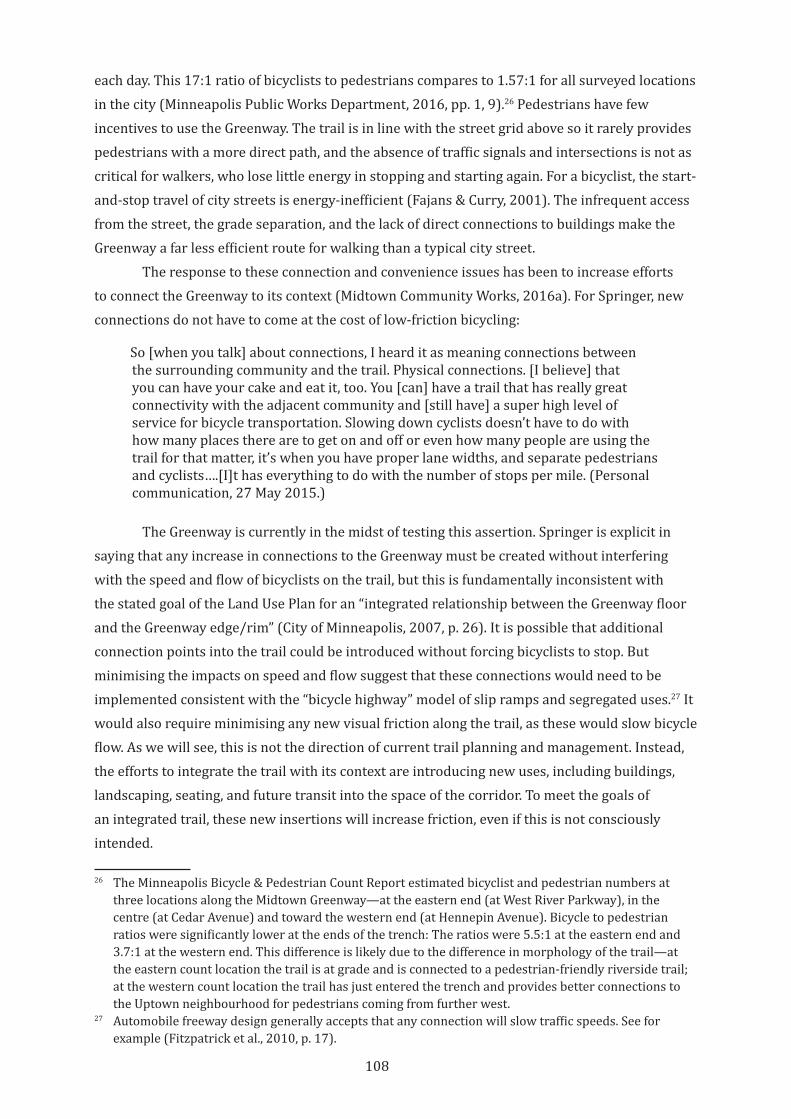
108
each day. This 17:1 ratio of bicyclists to pedestrians compares to 1.57:1 for all surveyed locations in the city (Minneapolis Public Works Department, 2016, pp. 1, 9).26 Pedestrians have few incentives to use the Greenway. The trail is in line with the street grid above so it rarely provides pedestrians with a more direct path, and the absence of traffic signals and intersections is not as critical for walkers, who lose little energy in stopping and starting again. For a bicyclist, the start-and-stop travel of city streets is energy-inefficient (Fajans & Curry, 2001). The infrequent access from the street, the grade separation, and the lack of direct connections to buildings make the Greenway a far less efficient route for walking than a typical city street.
The response to these connection and convenience issues has been to increase efforts to connect the Greenway to its context (Midtown Community Works, 2016a). For Springer, new connections do not have to come at the cost of low-friction bicycling:
So [when you talk] about connections, I heard it as meaning connections between the surrounding community and the trail. Physical connections. [I believe] that you can have your cake and eat it, too. You [can] have a trail that has really great connectivity with the adjacent community and [still have] a super high level of service for bicycle transportation. Slowing down cyclists doesn’t have to do with how many places there are to get on and off or even how many people are using the trail for that matter, it’s when you have proper lane widths, and separate pedestrians and cyclists….[I]t has everything to do with the number of stops per mile. (Personal communication, 27 May 2015.)
The Greenway is currently in the midst of testing this assertion. Springer is explicit in saying that any increase in connections to the Greenway must be created without interfering with the speed and flow of bicyclists on the trail, but this is fundamentally inconsistent with the stated goal of the Land Use Plan for an “integrated relationship between the Greenway floor and the Greenway edge/rim” (City of Minneapolis, 2007, p. 26). It is possible that additional connection points into the trail could be introduced without forcing bicyclists to stop. But minimising the impacts on speed and flow suggest that these connections would need to be implemented consistent with the “bicycle highway” model of slip ramps and segregated uses.27 It would also require minimising any new visual friction along the trail, as these would slow bicycle flow. As we will see, this is not the direction of current trail planning and management. Instead, the efforts to integrate the trail with its context are introducing new uses, including buildings, landscaping, seating, and future transit into the space of the corridor. To meet the goals of an integrated trail, these new insertions will increase friction, even if this is not consciously intended.
26 The Minneapolis Bicycle & Pedestrian Count Report estimated bicyclist and pedestrian numbers at three locations along the Midtown Greenway—at the eastern end (at West River Parkway), in the centre (at Cedar Avenue) and toward the western end (at Hennepin Avenue). Bicycle to pedestrian ratios were significantly lower at the ends of the trench: The ratios were 5.5:1 at the eastern end and 3.7:1 at the western end. This difference is likely due to the difference in morphology of the trail—at the eastern count location the trail is at grade and is connected to a pedestrian-friendly riverside trail; at the western count location the trail has just entered the trench and provides better connections to the Uptown neighbourhood for pedestrians coming from further west.
27 Automobile freeway design generally accepts that any connection will slow traffic speeds. See for example (Fitzpatrick et al., 2010, p. 17).
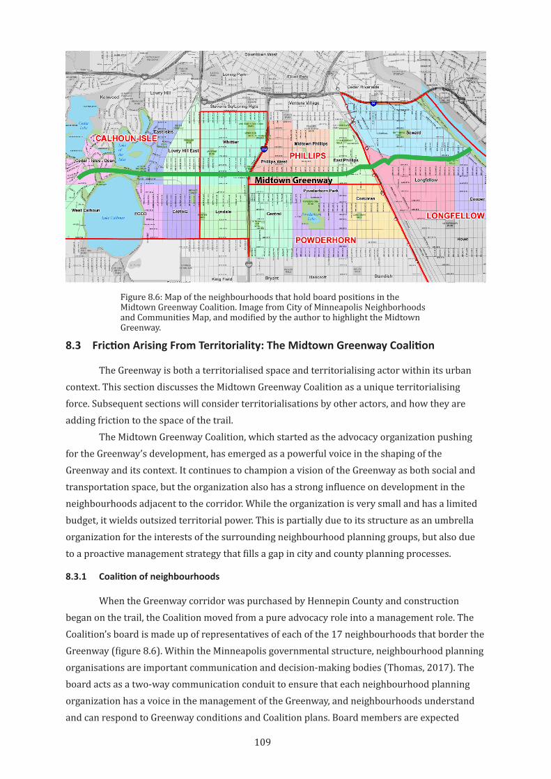
109
8.3 Friction Arising From Territoriality: The Midtown Greenway Coalition
The Greenway is both a territorialised space and territorialising actor within its urban context. This section discusses the Midtown Greenway Coalition as a unique territorialising force. Subsequent sections will consider territorialisations by other actors, and how they are adding friction to the space of the trail.
The Midtown Greenway Coalition, which started as the advocacy organization pushing for the Greenway’s development, has emerged as a powerful voice in the shaping of the Greenway and its context. It continues to champion a vision of the Greenway as both social and transportation space, but the organization also has a strong influence on development in the neighbourhoods adjacent to the corridor. While the organization is very small and has a limited budget, it wields outsized territorial power. This is partially due to its structure as an umbrella organization for the interests of the surrounding neighbourhood planning groups, but also due to a proactive management strategy that fills a gap in city and county planning processes.
8.3.1 Coalition of neighbourhoods
When the Greenway corridor was purchased by Hennepin County and construction began on the trail, the Coalition moved from a pure advocacy role into a management role. The Coalition’s board is made up of representatives of each of the 17 neighbourhoods that border the Greenway (figure 8.6). Within the Minneapolis governmental structure, neighbourhood planning organisations are important communication and decision-making bodies (Thomas, 2017). The board acts as a two-way communication conduit to ensure that each neighbourhood planning organization has a voice in the management of the Greenway, and neighbourhoods understand and can respond to Greenway conditions and Coalition plans. Board members are expected
Figure 8.6: Map of the neighbourhoods that hold board positions in the Midtown Greenway Coalition. Image from City of Minneapolis Neighborhoods and Communities Map, and modified by the author to highlight the Midtown Greenway.
110
to advocate for Coalition priorities within their own neighbourhood organizations (Midtown Greenway Coalition, 2008). When the Coalition and neighbourhood organizations coordinate their actions and their plans, each strengthens its own territorial position: neighbourhood organizations can advocate for their priorities beyond their territorial boundaries and derive benefits from a city-wide asset, and the Coalition can affect planning decisions and budgets far beyond its own scope and financial capacity. In this way, the Coalition acts as a political bridge across neighbourhood boundaries, providing a peer-based communication channel that does not rely on larger city or county government structures. While the Greenway is just one of the physical and political spaces in which these neighbourhoods collaborate (and compete), the high profile of the Greenway, and its ability to draw investment and political attention, increase the value of participation on the Coalition board.
8.3.2 Midtown Greenway Coalition as manager and advocate
Today, the Coalition remains a single purpose organization, with a mission “to empower communities to develop, improve, protect, and enjoy the Midtown Greenway as a green urban corridor to improve people’s lives” (Midtown Greenway Coalition, 2018a). The staff is small, with only a paid executive director and a few part time employees (Graphiq, 2018). Most work is volunteer-based.
A significant portion of the Coalition’s work is in supervising and managing the physical space of the Greenway, from the Trail Watch program, to organizing events, to ensuring that the trail is clean and safe (Midtown Greenway Coalition, 2018a). The maintenance work for the Greenway is performed by the City and County. The Coalition is supported through local government partnerships, donations from organizations and Coalition members, fundraising through Greenway events, and the “Adopt a Greenway” program (Midtown Greenway Coalition, 2018d).
Beyond this management function, the primary role for the Coalition continues to be advocating for the trail and advancing a particular vision of how it fits into the surrounding neighbourhoods. The Board weighs in on a variety of land use, transit, and bicycle infrastructure issues that touch on the Greenway. In recent years they have worked to keep high-power electricity transmission lines out of the corridor, advocated for an extension of the Greenway across the Mississippi River, conducted a study of transit options for the corridor, and participated in public space planning work between the Greenway and Lake Street (Midtown Community Works, 2016a; Midtown Greenway Coalition, 2018a).
Perhaps the Coalition’s most striking advocacy work is its role in the design review process for new development adjacent to the Greenway. The close relationship between neighbourhood planning organizations and the Coalition has enabled the Coalition to play a significant role in guiding development along to the trail. Through a largely informal process, the Coalition now regularly reviews designs for proposed projects adjacent to the trail. These reviews focus on the relationships between the project and the Greenway—physical and visual
111
connections, opportunities for passive surveillance, and avoiding casting shadows on the trail.28 Developers present preliminary designs to the Coalition’s Improvements Committee, and the committee makes recommendations on how designs could be made more “Greenway friendly.” Based on developer responses to these recommendations, the committee will draft a letter (or a more formal resolution for larger projects) to the neighbourhood planning organization stating their positions on the proposed design (Midtown Greenway Coalition, 2018f). A favourable letter is seen as helpful in obtaining approval through the City’s formal design review process, so many developers choose to work with the Coalition (S. Jensen, personal communication, 12 May, 2015).
In the early 2000s, the Coalition worked with the City of Minneapolis to draft a zoning overlay for the Greenway and properties within 200 feet (60 meters) of the Greenway corridor. This overlay was designed to ensure that developments around the Greenway contributed to the Greenway as a space that is safe; transit, bike, and pedestrian friendly; mixed use; and supportive of a balance between economic vitality and quality of life (Shallcross & Rhees, 2002). It included requirements for entrances and fenestration facing the Greenway, prohibited some undesirable uses and required screening for others, and required building heights and setbacks that minimised shading of the Greenway during winter months. In most respects the proposed zoning ordinance followed typical standards for pedestrian or active-transportation-oriented developments. The zoning ordinance also required that significant developments29 be reviewed by the Coalition, and its comments submitted as part of Council review. This required review was unprecedented in Minneapolis—in fact, the city government itself, in the Midtown Greenway Land Use Development Plan, suggested that this requirement was, “unlikely to be supported” (City of Minneapolis, 2007, p. 67).
While this zoning ordinance was, in the end, not passed by the city council, many of its requirements were implemented as part of the Minneapolis zoning code or through subsequent adopted plans. The requirement for Coalition review of developments was not formally implemented. However, it has been informally integrated into the neighbourhood design review process. There is general (although not universal) agreement among all actors that the Coalition review is a positive contribution to the development process. This may be due to the relatively light touch that the Coalition brings to its review. The committee limits their scope of review to Greenway-related aspects of the building, and does not venture into aesthetics, surface traffic, or other design issues. The Coalition is generally pro-development and pro-density, and so the process is seen by developers as helpful, not as a barrier to progress (S. Jensen, private communication, 12 May 2015). The general acceptance of the Coalition review process is also undoubtedly due to the benefits of Coalition approval on the planning approval process.
28 Shading on the trail can be a safety problem, since Minneapolis weather is often below freezing. While the trail is plowed to remove snow and ice during the winter, shadows on the trail can create icy patches dangerous to bicyclists and pedestrians (Roper, 2015).
29 Defined as “subject to review and comment by the neighborhood organization in whose territory the site is located” (Shallcross & Rhees, 2002, p. 5).
112
The Improvements Committee has now reviewed dozens of development proposals, and counts this process as one of the central achievements of the Coalition (Midtown Greenway Coalition, 2018a). This informal process has taken the place of formal planning regulations along the Greenway but has also offered the Coalition and developers a flexible environment in which to find mutually beneficial design solutions. This has resulted in a range of strategies through which developments interface with the Greenway, from direct access ramps and stairs to buildings, to privately funded furniture within the Greenway corridor, to increased glazing, lookout points, and landscaping along the private/public threshold. In some ways, the Improvement Committee operates in a similar way to neighbourhood design review, in which the review body has limited actual power over designs but has an official advisory role within the planning approval process. The Midtown Greenway review process is loose in comparison, however. While Committee approval is respected, it is not necessary, and the Committee appears to seek mutually agreeable solutions rather than block undesirable solutions. As such it operates within a loosely bound set of guidelines, rather than following a more rigid, fixed process.
This territorialisation of the realm of private development by a non-governmental organization (albeit one with deep connections to local government at every level) is unusual and could be considered as inspiring or troubling. On the one hand, it allows a relatively representative body with a dedication to active transportation and public space to push private developers into design solutions that contribute to a public good. While the Coalition has no real direct power over development, the group has managed to marshal the political will of diffuse neighbourhood organizations in order to shepherd the development of a beloved place. They seem to have also avoided negative press or political controversy.
On the other hand, the territorialising power that the Coalition has amassed could at some point become a liability for the city. Because the review power and advocacy bullhorn of the Coalition is not directly accountable to a public process, the Coalition’s influence is not always transparent. The lack of public reporting or direct citizen oversight also means that there is no clear avenue for marginalised or dissenting voices to be a part of Coalition decision-making. And while it does not control a significant budget, or even have legal control of the Greenway itself, it does operate with the backing of large organizations and developers, whose interests may not always align with the public good. It is possible to imagine a future where the Greenway is managed by a quasi-private organization, despite the public ownership of the corridor.
While the City of Minneapolis, Hennepin County, and each neighbourhood planning organisation act on their own to territorialise the Greenway, none has a controlling influence. The 2007 Land Use Development Plan identifies at least six entities that could have territorial influence over elements of the trail—the City, the County, the Minneapolis Park and Recreation Board, the Regional Rail Authority, non-profit entities, and private landowners (City of Minneapolis, 2007, Executive Summary). This distributed management strategy has brought a range of actors into the planning and implementation process of the Greenway, but it has also fragmented control and made actions difficult.30 In the absence of other overarching territorial actors, the Coalition remains an effective, if limited, umbrella organisation through 30 See the sections below on the Cepro Greenspace and on transit in the corridor.
113
which to work collaboratively. The Coalition stands as a unique organization that builds upon Minneapolis’s strong neighbourhood organizations and love of outdoor recreation to make a place for itself as a Greenway champion. But the Coalition itself has no direct power—it maintains its territorialising agency through good relationships with other actors. This limits the Coalition to positions that are politically and economically palatable—the Coalition would likely find it difficult to pursue more controversial positions or limit economic development since its influence and identity is so closely tied to mainstream powers.
8.4 Loosening Occupations and Tightening Management
Most rail trails start as relatively loose space and are tightened through actions to integrate the space of the trail into the context of the city. While this is also the case for the Midtown Greenway, the hard boundaries of the trench and the minimal development within the corridor have preserved and extended looseness in the space. The corridor is relatively wide, and despite the development of the trail, a large portion of the corridor remains unprogrammed and lightly used. The sloping sides of the trench also preclude most intensive development, so the sides of the trench remain relatively loose. While the slope makes these spaces difficult to occupy, there are places where casual uses take place. The landscaped sides are often overgrown as well, lending a wild, loose feeling to the space. These loosening factors have been compounded by official and community-driven efforts to blur the edges of the Greenway and adjacent public, semi-public, and private spaces. These loosening actions contrast with—but do not directly conflict with—the efforts of the Midtown Greenway Coalition and the City of Minneapolis to tightening movement patterns and increasing supervision and maintenance of the corridor. This section will consider some of these actors and actions, and how they affect the character of the trail.
8.4.1 Loose spaces along the corridor—gardens and leftover spaces
The rail line that ran through the Midtown Greenway corridor was primarily used to transport grain from farms to the east of Minneapolis to processing and shipping facilities along the Mississippi River. Over the decades of decline of these industries in the area, many of the warehouses, grain elevators, and rail switching yards were abandoned (Hennepin County Regional Railroad Authority, 2008). While most of these buildings and structures have been replaced by new buildings, several of these properties were officially or unofficially converted into open space and gardens. These spaces range from private yards to a community vegetable garden, and from ill-defined spaces that are occasionally occupied by passers-by to clearly demarcated ballfields (figures 8.7 and 8.8). The southern half of the corridor is also undeveloped. This side of the trench floor is being held in reserve for a future streetcar line and is currently undeveloped but is largely accessible. This grassy space is occasionally mowed, but otherwise lacks regular programming. While it is mostly unused, the space under the many bridges is informally used to rest and to escape the heat or wet of Minneapolis weather.
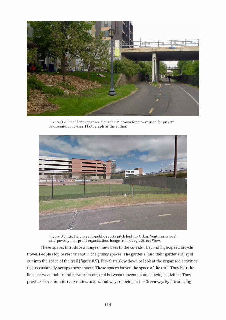
114
These spaces introduce a range of new uses to the corridor beyond high-speed bicycle travel. People stop to rest or chat in the grassy spaces. The gardens (and their gardeners) spill out into the space of the trail (figure 8.9). Bicyclists slow down to look at the organised activities that occasionally occupy these spaces. These spaces loosen the space of the trail. They blur the lines between public and private spaces, and between movement and staying activities. They provide space for alternate routes, actors, and ways of being in the Greenway. By introducing
Figure 8.7: Small leftover space along the Midtown Greenway used for private and semi-public uses. Photograph by the author.
Figure 8.8: Kix Field, a semi-public sports pitch built by Urban Ventures, a local anti-poverty non-profit organisation. Image from Google Street View.
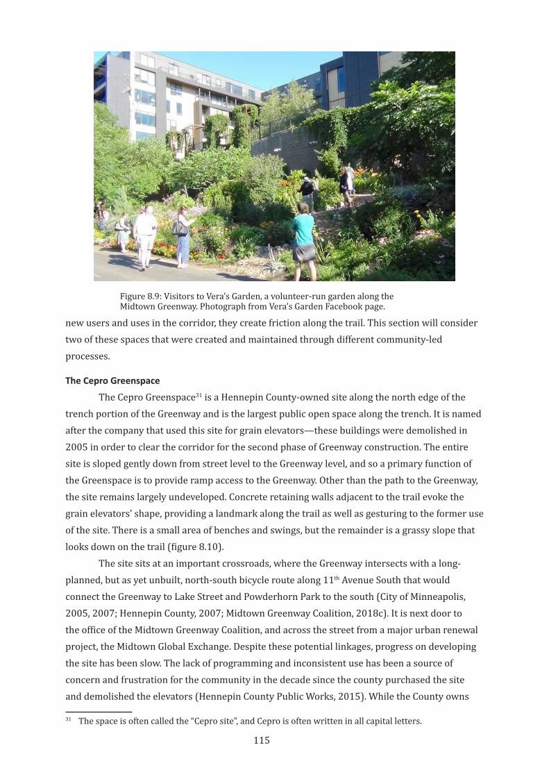
115
new users and uses in the corridor, they create friction along the trail. This section will consider two of these spaces that were created and maintained through different community-led processes.
The Cepro Greenspace
The Cepro Greenspace31 is a Hennepin County-owned site along the north edge of the trench portion of the Greenway and is the largest public open space along the trench. It is named after the company that used this site for grain elevators—these buildings were demolished in 2005 in order to clear the corridor for the second phase of Greenway construction. The entire site is sloped gently down from street level to the Greenway level, and so a primary function of the Greenspace is to provide ramp access to the Greenway. Other than the path to the Greenway, the site remains largely undeveloped. Concrete retaining walls adjacent to the trail evoke the grain elevators’ shape, providing a landmark along the trail as well as gesturing to the former use of the site. There is a small area of benches and swings, but the remainder is a grassy slope that looks down on the trail (figure 8.10).
The site sits at an important crossroads, where the Greenway intersects with a long-planned, but as yet unbuilt, north-south bicycle route along 11th Avenue South that would connect the Greenway to Lake Street and Powderhorn Park to the south (City of Minneapolis, 2005, 2007; Hennepin County, 2007; Midtown Greenway Coalition, 2018c). It is next door to the office of the Midtown Greenway Coalition, and across the street from a major urban renewal project, the Midtown Global Exchange. Despite these potential linkages, progress on developing the site has been slow. The lack of programming and inconsistent use has been a source of concern and frustration for the community in the decade since the county purchased the site and demolished the elevators (Hennepin County Public Works, 2015). While the County owns
31 The space is often called the “Cepro site”, and Cepro is often written in all capital letters.
Figure 8.9: Visitors to Vera’s Garden, a volunteer-run garden along the Midtown Greenway. Photograph from Vera’s Garden Facebook page.
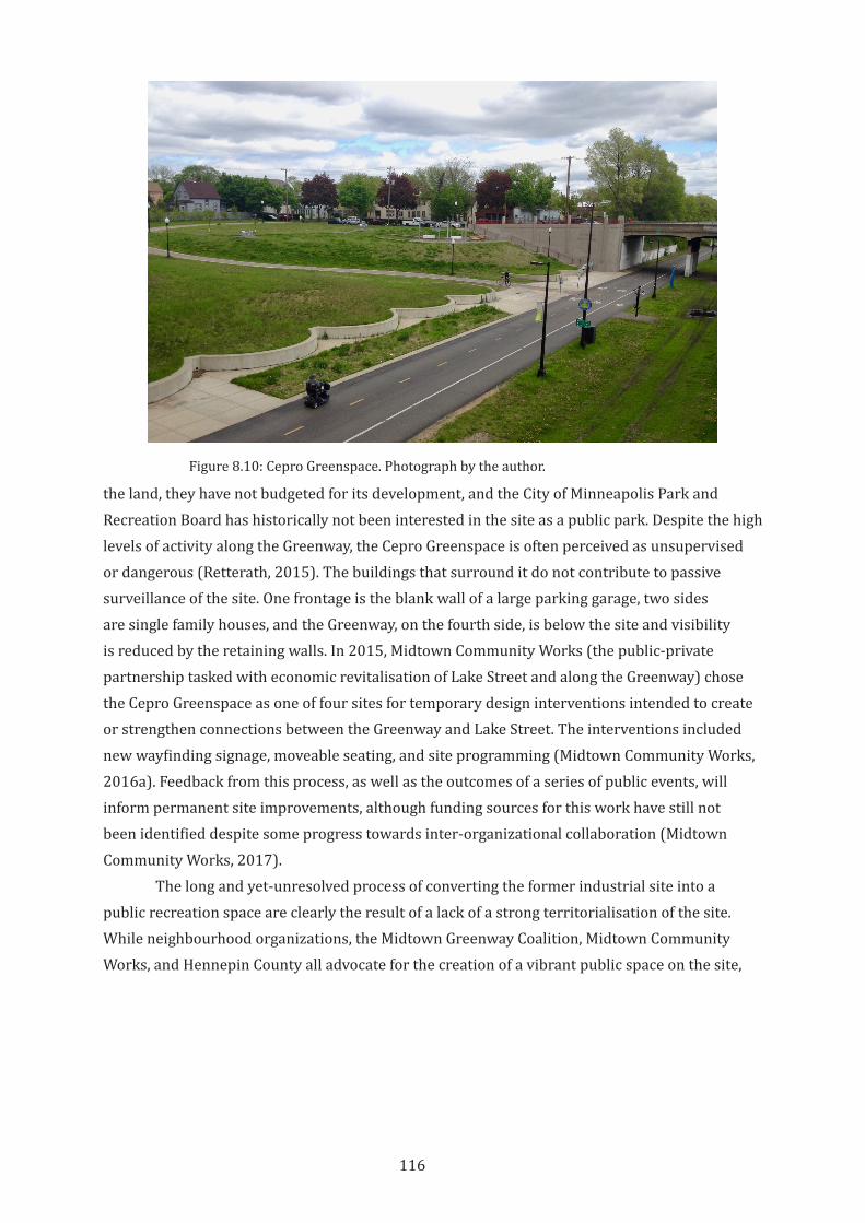
116
the land, they have not budgeted for its development, and the City of Minneapolis Park and Recreation Board has historically not been interested in the site as a public park. Despite the high levels of activity along the Greenway, the Cepro Greenspace is often perceived as unsupervised or dangerous (Retterath, 2015). The buildings that surround it do not contribute to passive surveillance of the site. One frontage is the blank wall of a large parking garage, two sides are single family houses, and the Greenway, on the fourth side, is below the site and visibility is reduced by the retaining walls. In 2015, Midtown Community Works (the public-private partnership tasked with economic revitalisation of Lake Street and along the Greenway) chose the Cepro Greenspace as one of four sites for temporary design interventions intended to create or strengthen connections between the Greenway and Lake Street. The interventions included new wayfinding signage, moveable seating, and site programming (Midtown Community Works, 2016a). Feedback from this process, as well as the outcomes of a series of public events, will inform permanent site improvements, although funding sources for this work have still not been identified despite some progress towards inter-organizational collaboration (Midtown Community Works, 2017).
The long and yet-unresolved process of converting the former industrial site into a public recreation space are clearly the result of a lack of a strong territorialisation of the site. While neighbourhood organizations, the Midtown Greenway Coalition, Midtown Community Works, and Hennepin County all advocate for the creation of a vibrant public space on the site,
Figure 8.10: Cepro Greenspace. Photograph by the author.
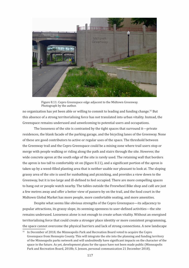
117
no organization has yet been able or willing to commit to leading and funding change.32 But this absence of a strong territorialising force has not translated into urban vitality. Instead, the Greenspace remains underused and unwelcoming to potential users and occupations.
The looseness of the site is contrasted by the tight spaces that surround it—private residences, the blank facade of the parking garage, and the bicycling lanes of the Greenway. None of these are good contributors to active or regular uses of the space. The threshold between the Greenway trail and the Cepro Greenspace could be a mixing zone where trail users stop or merge with people walking or riding along the path and stairs through the site. However, the wide concrete apron at the south edge of the site is rarely used. The retaining wall that borders the apron is too tall to comfortably sit on (figure 8.11), and a significant portion of the apron is taken up by a weed-filled planting area that is neither usable nor pleasant to look at. The sloping grassy area of the site is used for sunbathing and picnicking, and provides a view down to the Greenway, but it is too large and ill-defined to feel occupied. There are more compelling spaces to hang out or people watch nearby. The tables outside the Freewheel Bike shop and café are just a few metres away and offer a better view of passers-by on the trail, and the food court in the Midtown Global Market has more people, more comfortable seating, and more amenities.
Despite what seems like obvious strengths of the Cepro Greenspace—its adjacency to popular attractions, its grassy slope, its seeming openness to user-defined activities—the site remains underused. Looseness alone is not enough to create urban vitality. Without an energised territorialising force that could create a stronger place identity or more consistent programming, the space cannot overcome the physical barriers and lack of strong connections. A new landscape 32 In December of 2018, the Minneapolis Park and Recreation Board voted to acquire the Cepro
Greenspace from Hennepin County. This will integrate the site into the planning and funding territory of the Minneapolis parks network and will undoubtedly have significant impacts on the character of the space in the future. As yet, development plans for the space have not been made public (Minneapolis Park and Recreation Board, 2018b; S. Jensen, personal communication 21 December 2018).
Figure 8.11: Cepro Greenspace edge adjacent to the Midtown Greenway. Photograph by the author.
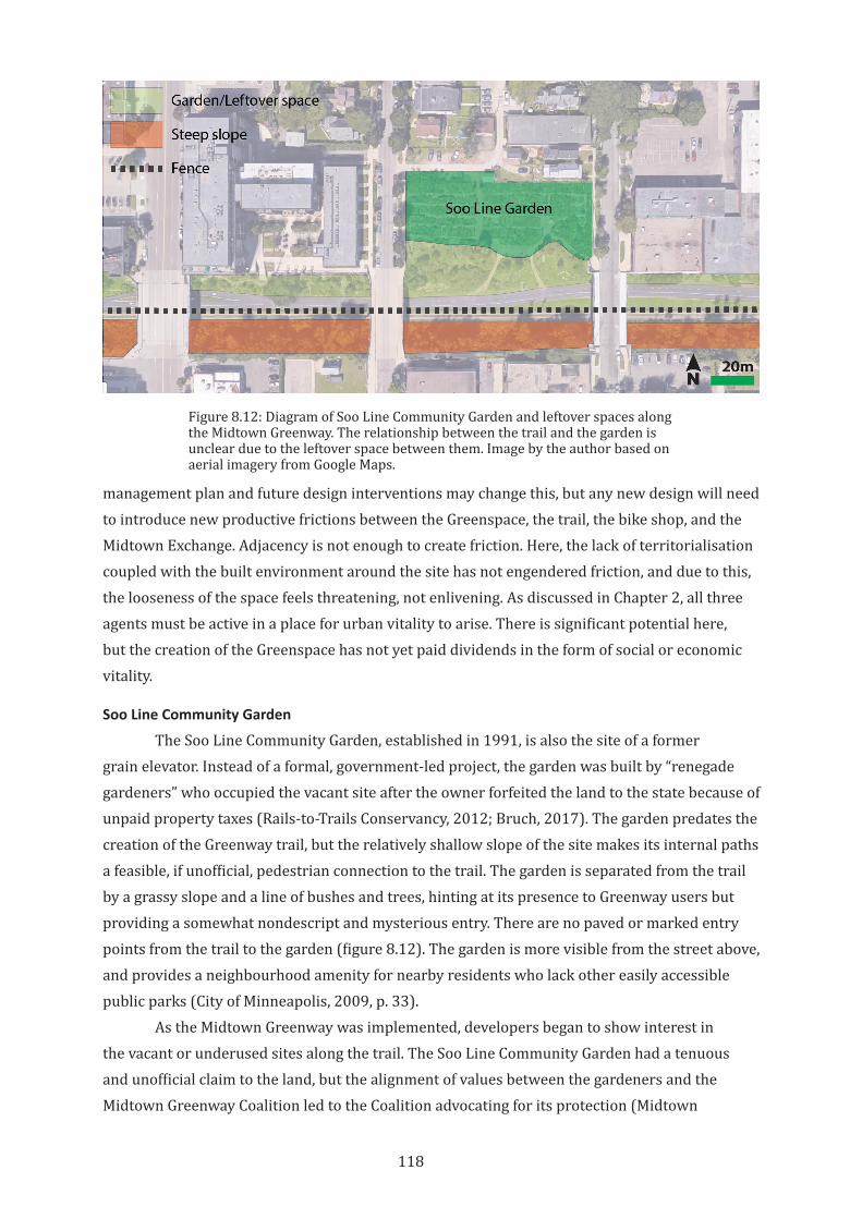
118
management plan and future design interventions may change this, but any new design will need to introduce new productive frictions between the Greenspace, the trail, the bike shop, and the Midtown Exchange. Adjacency is not enough to create friction. Here, the lack of territorialisation coupled with the built environment around the site has not engendered friction, and due to this, the looseness of the space feels threatening, not enlivening. As discussed in Chapter 2, all three agents must be active in a place for urban vitality to arise. There is significant potential here, but the creation of the Greenspace has not yet paid dividends in the form of social or economic vitality.
Soo Line Community Garden
The Soo Line Community Garden, established in 1991, is also the site of a former grain elevator. Instead of a formal, government-led project, the garden was built by “renegade gardeners” who occupied the vacant site after the owner forfeited the land to the state because of unpaid property taxes (Rails-to-Trails Conservancy, 2012; Bruch, 2017). The garden predates the creation of the Greenway trail, but the relatively shallow slope of the site makes its internal paths a feasible, if unofficial, pedestrian connection to the trail. The garden is separated from the trail by a grassy slope and a line of bushes and trees, hinting at its presence to Greenway users but providing a somewhat nondescript and mysterious entry. There are no paved or marked entry points from the trail to the garden (figure 8.12). The garden is more visible from the street above, and provides a neighbourhood amenity for nearby residents who lack other easily accessible public parks (City of Minneapolis, 2009, p. 33).
As the Midtown Greenway was implemented, developers began to show interest in the vacant or underused sites along the trail. The Soo Line Community Garden had a tenuous and unofficial claim to the land, but the alignment of values between the gardeners and the Midtown Greenway Coalition led to the Coalition advocating for its protection (Midtown
Figure 8.12: Diagram of Soo Line Community Garden and leftover spaces along the Midtown Greenway. The relationship between the trail and the garden is unclear due to the leftover space between them. Image by the author based on aerial imagery from Google Maps.
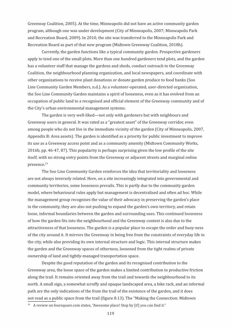
119
Greenway Coalition, 2005). At the time, Minneapolis did not have an active community garden program, although one was under development (City of Minneapolis, 2007; Minneapolis Park and Recreation Board, 2009). In 2010, the site was transferred to the Minneapolis Park and Recreation Board as part of that new program (Midtown Greenway Coalition, 2018h).
Currently, the garden functions like a typical community garden. Prospective gardeners apply to tend one of the small plots. More than one hundred gardeners tend plots, and the garden has a volunteer staff that manage the gardens and sheds, conduct outreach to the Greenway Coalition, the neighbourhood planning organization, and local newspapers, and coordinate with other organizations to receive plant donations or donate garden produce to food banks (Soo Line Community Garden Members, n.d.). As a volunteer-operated, user-directed organization, the Soo Line Community Garden maintains a spirit of looseness, even as it has evolved from an occupation of public land to a recognised and official element of the Greenway community and of the City’s urban environmental management systems.
The garden is very well-liked—not only with gardeners but with neighbours and Greenway users in general. It was rated as a “greatest asset” of the Greenway corridor, even among people who do not live in the immediate vicinity of the garden (City of Minneapolis, 2007, Appendix B: Area assets). The garden is identified as a priority for public investment to improve its use as a Greenway access point and as a community amenity (Midtown Community Works, 2016b, pp. 46-47, 87). This popularity is perhaps surprising given the low profile of the site itself, with no strong entry points from the Greenway or adjacent streets and marginal online presence.33
The Soo Line Community Garden reinforces the idea that territoriality and looseness are not always inversely related. Here, on a site increasingly integrated into governmental and community territories, some looseness prevails. This is partly due to the community garden model, where behavioural rules apply but management is decentralised and often ad hoc. While the management group recognises the value of their advocacy in preserving the garden’s place in the community, they are also not pushing to expand the garden’s own territory, and retain loose, informal boundaries between the garden and surrounding uses. This continued looseness of how the garden fits into the neighbourhood and the Greenway context is also due to the attractiveness of that looseness. The garden is a popular place to escape the order and busy-ness of the city around it. It mirrors the Greenway in being free from the constraints of everyday life in the city, while also providing its own internal structure and logic. This internal structure makes the garden and the Greenway spaces of otherness, loosened from the tight realms of private ownership of land and tightly-managed transportation space.
Despite the good reputation of the garden and its recognised contribution to the Greenway area, the loose space of the garden makes a limited contribution to productive friction along the trail. It remains oriented away from the trail and towards the neighbourhood to its north. A small sign, a somewhat scruffy and opaque landscaped area, a bike rack, and an informal path are the only indications of the from the trail of the existence of the garden, and it does not read as a public space from the trail (figure 8.13). The “Making the Connection: Midtown 33 A review on foursquare.com states, “Awesome place! Stop by [if] you can find it.”
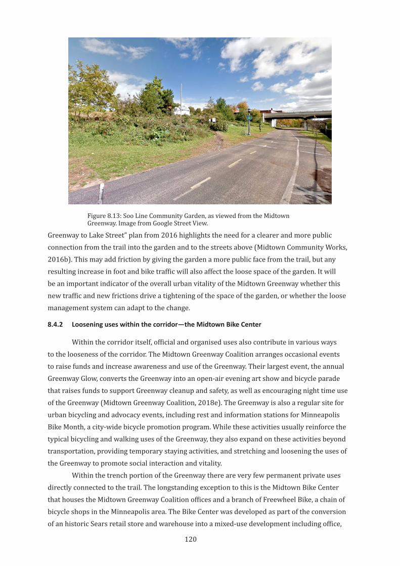
120
Greenway to Lake Street” plan from 2016 highlights the need for a clearer and more public connection from the trail into the garden and to the streets above (Midtown Community Works, 2016b). This may add friction by giving the garden a more public face from the trail, but any resulting increase in foot and bike traffic will also affect the loose space of the garden. It will be an important indicator of the overall urban vitality of the Midtown Greenway whether this new traffic and new frictions drive a tightening of the space of the garden, or whether the loose management system can adapt to the change.
8.4.2 Loosening uses within the corridor—the Midtown Bike Center
Within the corridor itself, official and organised uses also contribute in various ways to the looseness of the corridor. The Midtown Greenway Coalition arranges occasional events to raise funds and increase awareness and use of the Greenway. Their largest event, the annual Greenway Glow, converts the Greenway into an open-air evening art show and bicycle parade that raises funds to support Greenway cleanup and safety, as well as encouraging night time use of the Greenway (Midtown Greenway Coalition, 2018e). The Greenway is also a regular site for urban bicycling and advocacy events, including rest and information stations for Minneapolis Bike Month, a city-wide bicycle promotion program. While these activities usually reinforce the typical bicycling and walking uses of the Greenway, they also expand on these activities beyond transportation, providing temporary staying activities, and stretching and loosening the uses of the Greenway to promote social interaction and vitality.
Within the trench portion of the Greenway there are very few permanent private uses directly connected to the trail. The longstanding exception to this is the Midtown Bike Center that houses the Midtown Greenway Coalition offices and a branch of Freewheel Bike, a chain of bicycle shops in the Minneapolis area. The Bike Center was developed as part of the conversion of an historic Sears retail store and warehouse into a mixed-use development including office,
Figure 8.13: Soo Line Community Garden, as viewed from the Midtown Greenway. Image from Google Street View.
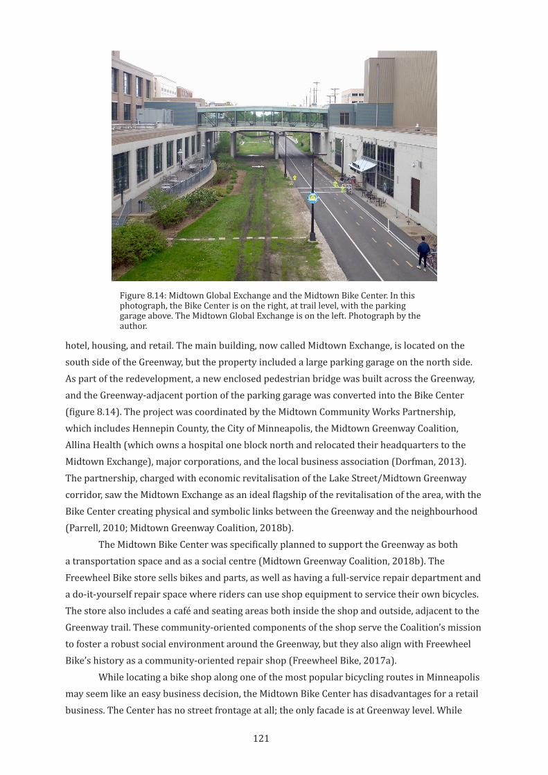
121
hotel, housing, and retail. The main building, now called Midtown Exchange, is located on the south side of the Greenway, but the property included a large parking garage on the north side. As part of the redevelopment, a new enclosed pedestrian bridge was built across the Greenway, and the Greenway-adjacent portion of the parking garage was converted into the Bike Center (figure 8.14). The project was coordinated by the Midtown Community Works Partnership, which includes Hennepin County, the City of Minneapolis, the Midtown Greenway Coalition, Allina Health (which owns a hospital one block north and relocated their headquarters to the Midtown Exchange), major corporations, and the local business association (Dorfman, 2013). The partnership, charged with economic revitalisation of the Lake Street/Midtown Greenway corridor, saw the Midtown Exchange as an ideal flagship of the revitalisation of the area, with the Bike Center creating physical and symbolic links between the Greenway and the neighbourhood (Parrell, 2010; Midtown Greenway Coalition, 2018b).
The Midtown Bike Center was specifically planned to support the Greenway as both a transportation space and as a social centre (Midtown Greenway Coalition, 2018b). The Freewheel Bike store sells bikes and parts, as well as having a full-service repair department and a do-it-yourself repair space where riders can use shop equipment to service their own bicycles. The store also includes a café and seating areas both inside the shop and outside, adjacent to the Greenway trail. These community-oriented components of the shop serve the Coalition’s mission to foster a robust social environment around the Greenway, but they also align with Freewheel Bike’s history as a community-oriented repair shop (Freewheel Bike, 2017a).
While locating a bike shop along one of the most popular bicycling routes in Minneapolis may seem like an easy business decision, the Midtown Bike Center has disadvantages for a retail business. The Center has no street frontage at all; the only facade is at Greenway level. While
Figure 8.14: Midtown Global Exchange and the Midtown Bike Center. In this photograph, the Bike Center is on the right, at trail level, with the parking garage above. The Midtown Global Exchange is on the left. Photograph by the author.
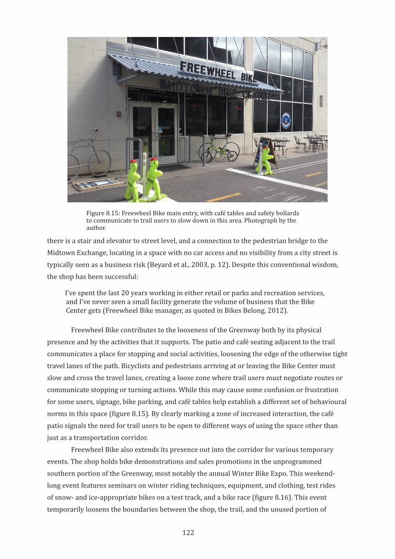
122
there is a stair and elevator to street level, and a connection to the pedestrian bridge to the Midtown Exchange, locating in a space with no car access and no visibility from a city street is typically seen as a business risk (Beyard et al., 2003, p. 12). Despite this conventional wisdom, the shop has been successful:
I’ve spent the last 20 years working in either retail or parks and recreation services, and I’ve never seen a small facility generate the volume of business that the Bike Center gets (Freewheel Bike manager, as quoted in Bikes Belong, 2012).
Freewheel Bike contributes to the looseness of the Greenway both by its physical presence and by the activities that it supports. The patio and café seating adjacent to the trail communicates a place for stopping and social activities, loosening the edge of the otherwise tight travel lanes of the path. Bicyclists and pedestrians arriving at or leaving the Bike Center must slow and cross the travel lanes, creating a loose zone where trail users must negotiate routes or communicate stopping or turning actions. While this may cause some confusion or frustration for some users, signage, bike parking, and café tables help establish a different set of behavioural norms in this space (figure 8.15). By clearly marking a zone of increased interaction, the café patio signals the need for trail users to be open to different ways of using the space other than just as a transportation corridor.
Freewheel Bike also extends its presence out into the corridor for various temporary events. The shop holds bike demonstrations and sales promotions in the unprogrammed southern portion of the Greenway, most notably the annual Winter Bike Expo. This weekend-long event features seminars on winter riding techniques, equipment, and clothing, test rides of snow- and ice-appropriate bikes on a test track, and a bike race (figure 8.16). This event temporarily loosens the boundaries between the shop, the trail, and the unused portion of
Figure 8.15: Freewheel Bike main entry, with café tables and safety bollards to communicate to trail users to slow down in this area. Photograph by the author.
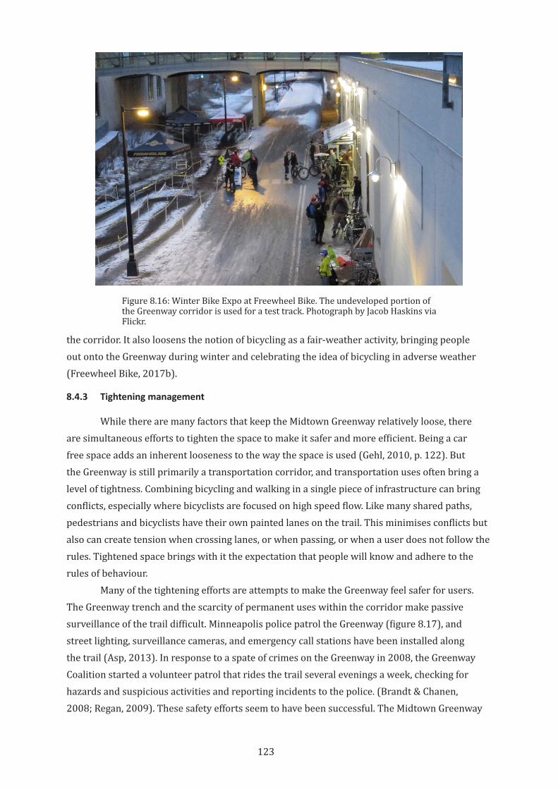
123
the corridor. It also loosens the notion of bicycling as a fair-weather activity, bringing people out onto the Greenway during winter and celebrating the idea of bicycling in adverse weather (Freewheel Bike, 2017b).
8.4.3 Tightening management
While there are many factors that keep the Midtown Greenway relatively loose, there are simultaneous efforts to tighten the space to make it safer and more efficient. Being a car free space adds an inherent looseness to the way the space is used (Gehl, 2010, p. 122). But the Greenway is still primarily a transportation corridor, and transportation uses often bring a level of tightness. Combining bicycling and walking in a single piece of infrastructure can bring conflicts, especially where bicyclists are focused on high speed flow. Like many shared paths, pedestrians and bicyclists have their own painted lanes on the trail. This minimises conflicts but also can create tension when crossing lanes, or when passing, or when a user does not follow the rules. Tightened space brings with it the expectation that people will know and adhere to the rules of behaviour.
Many of the tightening efforts are attempts to make the Greenway feel safer for users. The Greenway trench and the scarcity of permanent uses within the corridor make passive surveillance of the trail difficult. Minneapolis police patrol the Greenway (figure 8.17), and street lighting, surveillance cameras, and emergency call stations have been installed along the trail (Asp, 2013). In response to a spate of crimes on the Greenway in 2008, the Greenway Coalition started a volunteer patrol that rides the trail several evenings a week, checking for hazards and suspicious activities and reporting incidents to the police. (Brandt & Chanen, 2008; Regan, 2009). These safety efforts seem to have been successful. The Midtown Greenway
Figure 8.16: Winter Bike Expo at Freewheel Bike. The undeveloped portion of the Greenway corridor is used for a test track. Photograph by Jacob Haskins via Flickr.
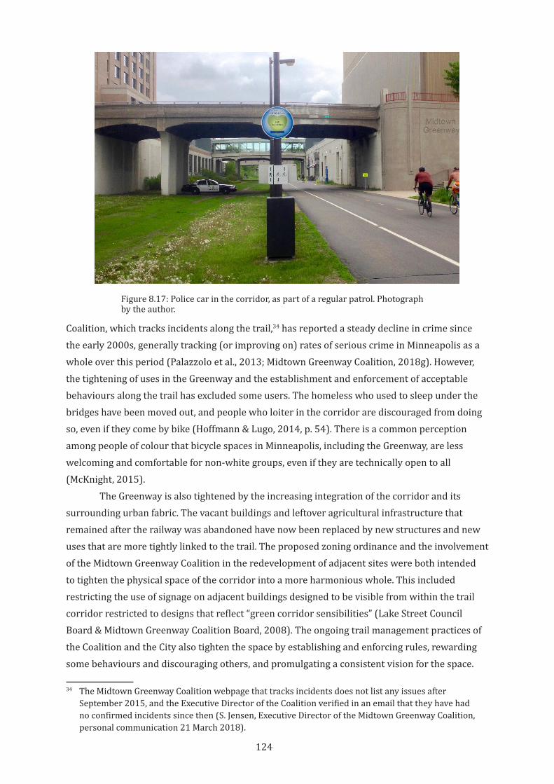
124
Coalition, which tracks incidents along the trail,34 has reported a steady decline in crime since the early 2000s, generally tracking (or improving on) rates of serious crime in Minneapolis as a whole over this period (Palazzolo et al., 2013; Midtown Greenway Coalition, 2018g). However, the tightening of uses in the Greenway and the establishment and enforcement of acceptable behaviours along the trail has excluded some users. The homeless who used to sleep under the bridges have been moved out, and people who loiter in the corridor are discouraged from doing so, even if they come by bike (Hoffmann & Lugo, 2014, p. 54). There is a common perception among people of colour that bicycle spaces in Minneapolis, including the Greenway, are less welcoming and comfortable for non-white groups, even if they are technically open to all (McKnight, 2015).
The Greenway is also tightened by the increasing integration of the corridor and its surrounding urban fabric. The vacant buildings and leftover agricultural infrastructure that remained after the railway was abandoned have now been replaced by new structures and new uses that are more tightly linked to the trail. The proposed zoning ordinance and the involvement of the Midtown Greenway Coalition in the redevelopment of adjacent sites were both intended to tighten the physical space of the corridor into a more harmonious whole. This included restricting the use of signage on adjacent buildings designed to be visible from within the trail corridor restricted to designs that reflect “green corridor sensibilities” (Lake Street Council Board & Midtown Greenway Coalition Board, 2008). The ongoing trail management practices of the Coalition and the City also tighten the space by establishing and enforcing rules, rewarding some behaviours and discouraging others, and promulgating a consistent vision for the space.
34 The Midtown Greenway Coalition webpage that tracks incidents does not list any issues after September 2015, and the Executive Director of the Coalition verified in an email that they have had no confirmed incidents since then (S. Jensen, Executive Director of the Midtown Greenway Coalition, personal communication 21 March 2018).
Figure 8.17: Police car in the corridor, as part of a regular patrol. Photograph by the author.
125
Tightening public space in the name of safety or to establish rules of behaviour is common practice. Public space in general needs a level of organization and management in order to be usable or be considered safe for most users. However, how that organization and management is established, by whom and with what purpose, has an impact on whether an urban space is vital—connected, self-sustaining, and open.
The loosening and tightening activities and actions around the Midtown Greenway described in this section seem to be generally successful in making the Greenway more usable to a broader cross section of people, even if some groups continue to be excluded (Hoffmann & Lugo, 2014, p. 54). By working to reduce real and perceived dangers, introducing new users and new uses into the corridor, and encouraging the creation of places to stop or linger (and gently discouraging high speed bicycling through traffic) the management of the Greenway seems to be changing the character of the trail, and in so doing creating new productive frictions in the space. As discussed in Chapter 5, however, the balance between looseness and tightness in public space can be difficult to maintain. Tightening a space is an act of exclusion. Even when there is a level of mainstream agreement on what kinds of users or behaviours are appropriate in a space, excluding other ways of being in public creates serious risks to equity and urban vitality.
8.5 Friction From Networks and Connections
The Midtown Greenway enjoyed early political support and was an immediate success as a bicycle route. While part of the success of the trail is due to its unique morphology, the trail also benefits from its integration into significant existing political, economic, and active transportation networks. Described as “another jewel in the bracelet of parks,” as “fulfilling a century-old vision of the “Grand Rounds,” and as a “bicycle commuter highway,” the Greenway could thus draw on multiple established territories in the city (Anderson, 1994; Lohn, 1998). The trail was able to build upon existing strengths in the city but was also marketed as addressing some longstanding weaknesses and needs. By integrating into existing territories of the city, the Greenway could draw on an important early group of champions that helped accelerate implementation. This integration continues to drive further friction between the trail and the city around it, although these efforts have had uneven results, and have exacerbated some issues. This section investigates these political, economic, and social frictions.
8.5.1 Active transport and transit networks
Minneapolis is rightly celebrated for its robust support and enthusiasm for outdoor recreation and active transportation, especially bicycling. Despite a climate that presents challenges to casual bicyclists,35 Minneapolis has high levels of bicycling and a strong municipal intent to continue reasonable, sustainable growth in bicycling infrastructure (City of Minneapolis, 2011). One reason for the success of the Midtown Greenway is its integration within the large and growing network of bicycle infrastructure in the city—from its beginning the Greenway was designed to link to other trails and routes. Minneapolis has a long history of
35 Minneapolis has the coldest average temperature of any major American city, with average high temperatures remaining below freezing in winter (data from National Weather Service, 2018).
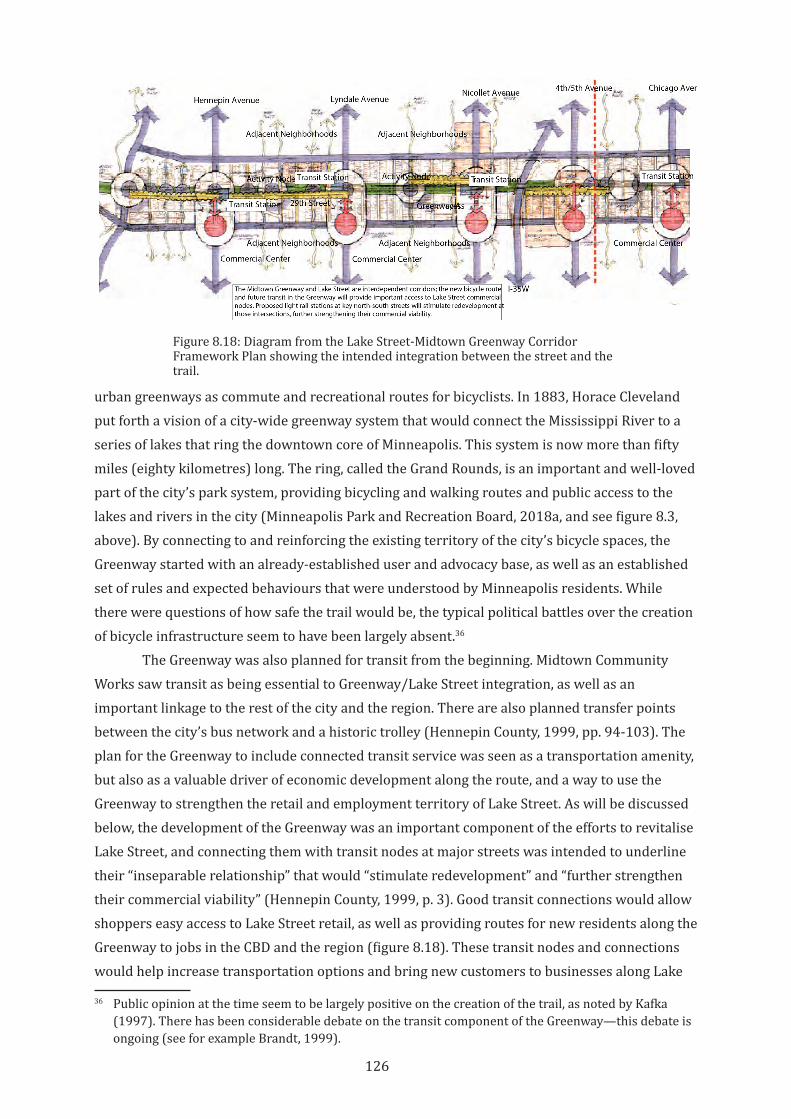
126
urban greenways as commute and recreational routes for bicyclists. In 1883, Horace Cleveland put forth a vision of a city-wide greenway system that would connect the Mississippi River to a series of lakes that ring the downtown core of Minneapolis. This system is now more than fifty miles (eighty kilometres) long. The ring, called the Grand Rounds, is an important and well-loved part of the city’s park system, providing bicycling and walking routes and public access to the lakes and rivers in the city (Minneapolis Park and Recreation Board, 2018a, and see figure 8.3, above). By connecting to and reinforcing the existing territory of the city’s bicycle spaces, the Greenway started with an already-established user and advocacy base, as well as an established set of rules and expected behaviours that were understood by Minneapolis residents. While there were questions of how safe the trail would be, the typical political battles over the creation of bicycle infrastructure seem to have been largely absent.36
The Greenway was also planned for transit from the beginning. Midtown Community Works saw transit as being essential to Greenway/Lake Street integration, as well as an important linkage to the rest of the city and the region. There are also planned transfer points between the city’s bus network and a historic trolley (Hennepin County, 1999, pp. 94-103). The plan for the Greenway to include connected transit service was seen as a transportation amenity, but also as a valuable driver of economic development along the route, and a way to use the Greenway to strengthen the retail and employment territory of Lake Street. As will be discussed below, the development of the Greenway was an important component of the efforts to revitalise Lake Street, and connecting them with transit nodes at major streets was intended to underline their “inseparable relationship” that would “stimulate redevelopment” and “further strengthen their commercial viability” (Hennepin County, 1999, p. 3). Good transit connections would allow shoppers easy access to Lake Street retail, as well as providing routes for new residents along the Greenway to jobs in the CBD and the region (figure 8.18). These transit nodes and connections would help increase transportation options and bring new customers to businesses along Lake
36 Public opinion at the time seem to be largely positive on the creation of the trail, as noted by Kafka (1997). There has been considerable debate on the transit component of the Greenway—this debate is ongoing (see for example Brandt, 1999).
Figure 8.18: Diagram from the Lake Street-Midtown Greenway Corridor Framework Plan showing the intended integration between the street and the trail.
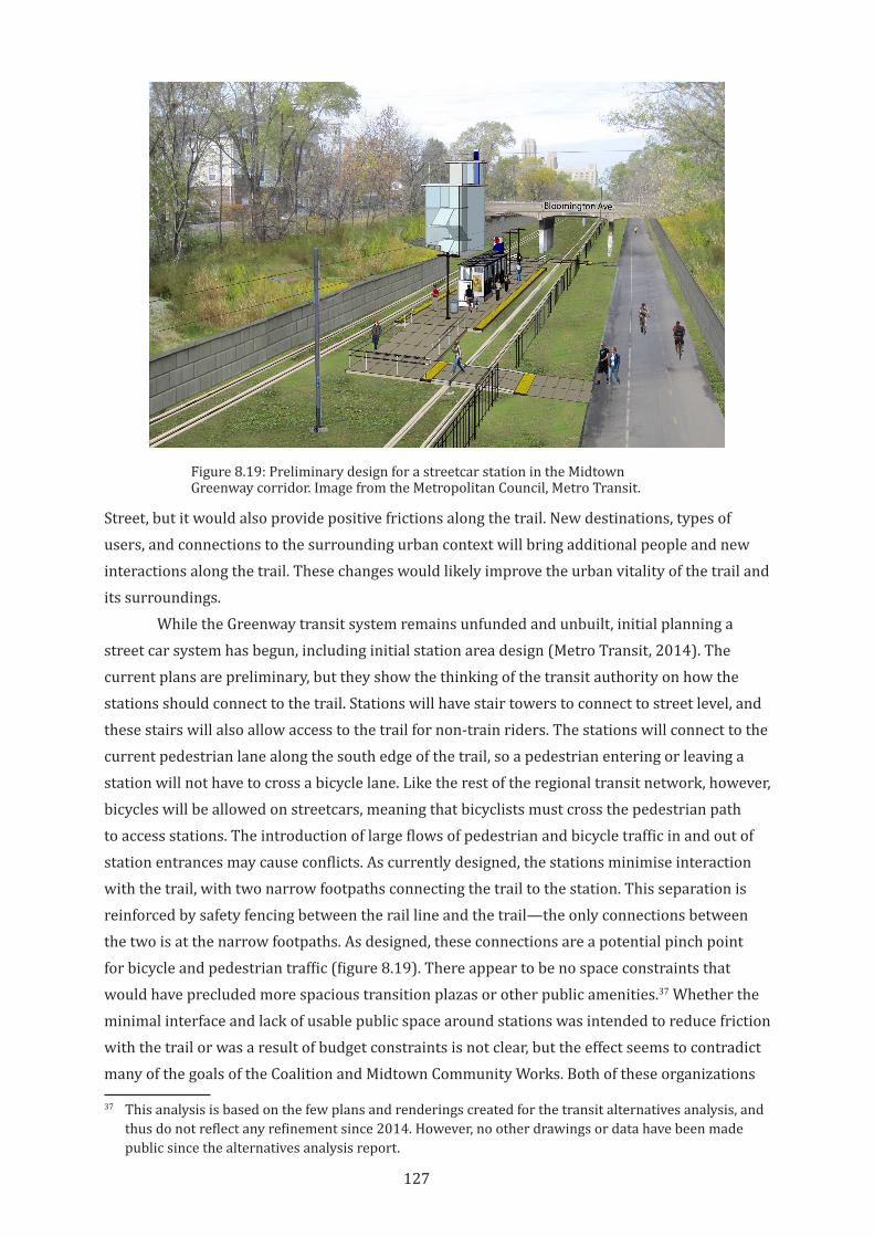
127
Street, but it would also provide positive frictions along the trail. New destinations, types of users, and connections to the surrounding urban context will bring additional people and new interactions along the trail. These changes would likely improve the urban vitality of the trail and its surroundings.
While the Greenway transit system remains unfunded and unbuilt, initial planning a street car system has begun, including initial station area design (Metro Transit, 2014). The current plans are preliminary, but they show the thinking of the transit authority on how the stations should connect to the trail. Stations will have stair towers to connect to street level, and these stairs will also allow access to the trail for non-train riders. The stations will connect to the current pedestrian lane along the south edge of the trail, so a pedestrian entering or leaving a station will not have to cross a bicycle lane. Like the rest of the regional transit network, however, bicycles will be allowed on streetcars, meaning that bicyclists must cross the pedestrian path to access stations. The introduction of large flows of pedestrian and bicycle traffic in and out of station entrances may cause conflicts. As currently designed, the stations minimise interaction with the trail, with two narrow footpaths connecting the trail to the station. This separation is reinforced by safety fencing between the rail line and the trail—the only connections between the two is at the narrow footpaths. As designed, these connections are a potential pinch point for bicycle and pedestrian traffic (figure 8.19). There appear to be no space constraints that would have precluded more spacious transition plazas or other public amenities.37 Whether the minimal interface and lack of usable public space around stations was intended to reduce friction with the trail or was a result of budget constraints is not clear, but the effect seems to contradict many of the goals of the Coalition and Midtown Community Works. Both of these organizations
37 This analysis is based on the few plans and renderings created for the transit alternatives analysis, and thus do not reflect any refinement since 2014. However, no other drawings or data have been made public since the alternatives analysis report.
Figure 8.19: Preliminary design for a streetcar station in the Midtown Greenway corridor. Image from the Metropolitan Council, Metro Transit.
128
seem to favour transit solutions that provide more robust contribution to the public space of the Greenway. As work on the streetcar continues (and alternatives are tested, see Du, 2018), refinements of the station and track designs may change the existing configuration of connections. The current design, however, suggests a poor understanding of the impact of physical space design on productive friction.
8.5.2 Friction as an economic development tool
When the Greenway was first being planned, its value as a driver of economic development was considered as nearly equal to its value as bicycle infrastructure, and as an important part of marketing the trail to local governments and the public. In 1994, the Inter-neighborhood Visioning Conference brought together residents, city staff, and elected officials from the neighbourhoods along the proposed Greenway route (T. Springer, personal communication, 27 May 2015). The purpose of the conference was to flesh out the basic outline of the Greenway. Until that point, the small group that was championing the Greenway idea had focused on bicycle transportation and green space. As a result of discussions at this conference, economic development and connections to Lake Street were identified as an important component. A local newspaper described it as:
There’s more to the story than trees and bike paths. Greenway backers are selling the whole idea as an economic development tool, a way to attract business and badly-needed jobs into the…neighborhoods along the corridor. The basic pitch is this: the popular chain of lakes, the system of linked parks and greenspace that winds through neighborhoods in the city’s southwest quadrant, has helped that corner become the most prosperous in the city, a desirable location for job-producing neighborhood businesses, where property values are among the highest in the metro area. It’s a pattern that holds throughout the city: linked greenspaces and healthy neighborhoods go together. (Anderson, 1994)
Economic development was a selling point for the Greenway, because economic development was a key priority for neighbourhood groups along the corridor. Ever since Cleveland proposed the Grand Rounds, urban parks had been linked to improved property values and economic activity (Bryant, 1998). City and county governments sought to leverage investment in Greenway infrastructure to drive private investment and economic development. Mark Andrew, the Hennepin County Board member who first proposed the creation of Midtown Community Works, said, ’[i]f we create the environment within which good urban development can occur, it will occur” (Brandt, 1998). Creating the trail as an integrated amenity for surrounding communities meant that the Greenway and adjacent properties could build off the strengths and successes of each other.
Growth has occurred without large-scale public funding. A few specific sites have received public money for transit, trail development, land acquisition and demolition, but there has not been wholesale public redevelopment (Midtown Community Works, 2001). Instead, public planning efforts have been aimed at driving private investment. The Midtown Exchange is an example of a public/private partnership that co-territorialised the space of the trail and
129
the retail heart of Lake Street, but most new developments have clustered in the Uptown neighbourhood at the western end of the trench. These have been predominantly residential and mixed-used developments.
As the Greenway was being planned, Midtown Community Works wanted to create a “demonstration project” that would showcase an “integrated relationship between new development and the Greenway edge,” and also increase jobs, improve the business climate on Lake Street and bring more tax income to the community (Brandt, 1998; Hennepin County, 1999, p. 43). This demonstration project was the “Urban Village,” three blocks along the northern edge of the Greenway. In the 1990s, the properties were owned by industrial businesses. Using a variety of financing mechanisms, including Minneapolis redevelopment funds, a tax increment financing scheme, and a public/private capital investment fund, these businesses were bought out by the City and prepared for sale to developers (Midtown Community Works, 2001, p. 2; Repya, 2002). Through these financial and political actions, the various public and private actors interested in the overlapping territories of bicycle transportation, urban parks, land development, urban housing, and retail business improvement collaborated to bring about change in the neighbourhood. These new frictions have contributed to urban vitality in the area, although there have been setbacks, as well.
Today, the three blocks of the Urban Village site have been fully developed as residential properties and include many of the public amenities that were proposed in the Framework Plan in 1999. A public promenade at the top edge of the Greenway trench allows views to the trail and connects to a trail access ramp. Direct access from the developments to the trail is provided at two of the blocks.38 Many of the housing units of the Urban Village properties have views onto the Greenway, providing passive surveillance of the trail.
Whether the Urban Village project was needed to spur growth is not clear, as the neighbourhood was already in the midst of a significant private development boom and increased demand (Fisher, 2015). From 2005 to 2015, more than 1,200 new apartments have been built near the Greenway, with private developer investment of more than $200 million. Despite this rapid pace of redevelopment, increased demand has driven a reduction in apartment vacancy rates and rising rents (Bruch, 2015). As a model of physical integration between the Greenway and adjacent properties, the Urban Village suggests ways for public space and private development to reinforce each other. Whether this integration would have been possible without the marshalling of considerable attention from Midtown Community Works is unclear, however.
Looking beyond the Urban Village and its Uptown neighbourhood, however, territorial integration between the Greenway and its context is still weak. Many of the neighbourhoods that were struggling with lack of investment, poverty, and crime are still facing these issues. They have seen limited benefits from being near the Greenway. Although Greenway users do contribute financially to the neighbourhoods, the benefits are flowing mostly to the already successful retail areas. The lower income areas are seeing a minimal financial effect (G. Lindsey, personal communication, 22 May 2015). Major portions of Lake Street continue to struggle, despite almost two decades of public and private attention. The physical form of the Greenway 38 These accessways will be discussed in the next section of this chapter.
130
trench undoubtedly plays a role in limiting its reach. Territorialising actions, from advertising to physical connections to outright occupation of space, are largely blocked by physical and visual separations.
Many public infrastructure projects (the Cepro Greenspace, permanent Lake Street connections, and a long-planned street reopening at Nicollet Avenue, for example) remain unrealised and unbudgeted (City of Minneapolis, 2015). Nearby neighbourhoods saw the Greenway as a revitalizing force, but the high use and attractive amenity of the Greenway has yet to drive improvements very far into surrounding areas. With exceptions like the Midtown Exchange, the growth along the Greenway has been limited to areas that were already relatively prosperous, despite the intentions of local governments and planners. Greenway-driven development has in many cases exacerbated imbalances rather than removed them. This will be discussed further below.
8.5.3 New frictions from development and connections
The Urban Village project resulted from considerable public investment and planning support, but they were undertaken by private developers. Encouraged by the Coalition and Midtown Community Works (and perhaps the positive public response to projects like the Midtown Exchange and the Bike Center), the developers of these three sites have shown an increasing interest in designs that engage the Greenway. The evolving attitude toward the integration of the Greenway can be seen in how each project took a different approach at its interface with the Greenway, with a significantly higher degree of connectedness for each successive project.
The first project, the Midtown Lofts, implemented a pedestrian promenade at street level between the building and the Greenway corridor—private entrances and an entrance to the building’s central courtyard connect to the promenade, which is publicly accessible. Many windows and decks look out over the promenade and down to the Greenway below (figure 8.20). The promenade connects to a ramp down to the Greenway, allowing easy, if indirect, access to the trail from the development. Completed in 2004, Midtown Lofts is an example of the passive surveillance values of Greenway-adjacent development proposed in the Corridor Framework Plan of 1999 and the draft zoning ordinance of 2002.
The second project, called Elan, created the first direct residential connection to the Greenway. Built above a section of the trench with a vertical retaining wall instead of a slope, the developers received approval to cut a door through the wall at Greenway level, providing residents a direct connection from the parking garage to the trail (figure 8.21). In addition, the publicly-accessible pedestrian promenade continues from Midtown Lofts next door. Elan has a pool deck and a gym adjacent to the pedestrian promenade, providing additional sources of passive surveillance. Completed in 2013, Elan was a first private version of a “Greenway Building” envisioned in the 2007 Midtown Greenway Land Use Development Plan (City of Minneapolis, 2007, Chapter IX: Implementation/finance plans), where doors or windows face directly onto the trail.
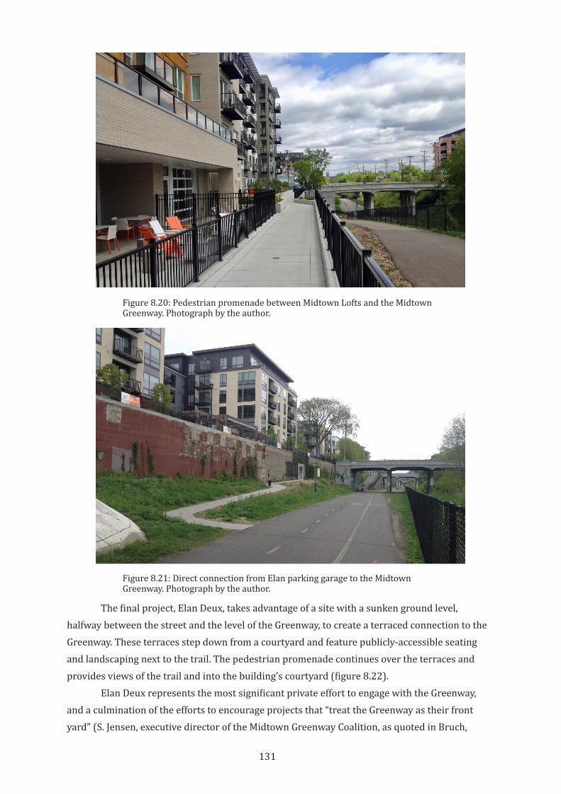
131
The final project, Elan Deux, takes advantage of a site with a sunken ground level, halfway between the street and the level of the Greenway, to create a terraced connection to the Greenway. These terraces step down from a courtyard and feature publicly-accessible seating and landscaping next to the trail. The pedestrian promenade continues over the terraces and provides views of the trail and into the building’s courtyard (figure 8.22).
Elan Deux represents the most significant private effort to engage with the Greenway, and a culmination of the efforts to encourage projects that “treat the Greenway as their front yard” (S. Jensen, executive director of the Midtown Greenway Coalition, as quoted in Bruch,
Figure 8.20: Pedestrian promenade between Midtown Lofts and the Midtown Greenway. Photograph by the author.
Figure 8.21: Direct connection from Elan parking garage to the Midtown Greenway. Photograph by the author.
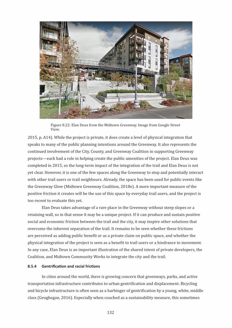
132
2015, p. A14). While the project is private, it does create a level of physical integration that speaks to many of the public planning intentions around the Greenway. It also represents the continued involvement of the City, County, and Greenway Coalition in supporting Greenway projects—each had a role in helping create the public amenities of the project. Elan Deux was completed in 2015, so the long-term impact of the integration of the trail and Elan Deux is not yet clear. However, it is one of the few spaces along the Greenway to stop and potentially interact with other trail users or trail neighbours. Already, the space has been used for public events like the Greenway Glow (Midtown Greenway Coalition, 2018e). A more important measure of the positive friction it creates will be the use of this space by everyday trail users, and the project is too recent to evaluate this yet.
Elan Deux takes advantage of a rare place in the Greenway without steep slopes or a retaining wall, so in that sense it may be a unique project. If it can produce and sustain positive social and economic friction between the trail and the city, it may inspire other solutions that overcome the inherent separation of the trail. It remains to be seen whether these frictions are perceived as adding public benefit or as a private claim on public space, and whether the physical integration of the project is seen as a benefit to trail users or a hindrance to movement. In any case, Elan Deux is an important illustration of the shared intent of private developers, the Coalition, and Midtown Community Works to integrate the city and the trail.
8.5.4 Gentrification and racial frictions
In cities around the world, there is growing concern that greenways, parks, and active transportation infrastructure contributes to urban gentrification and displacement. Bicycling and bicycle infrastructure is often seen as a harbinger of gentrification by a young, white, middle class (Geoghegan, 2016). Especially when couched as a sustainability measure, this sometimes
Figure 8.22: Elan Deux from the Midtown Greenway. Image from Google Street View.
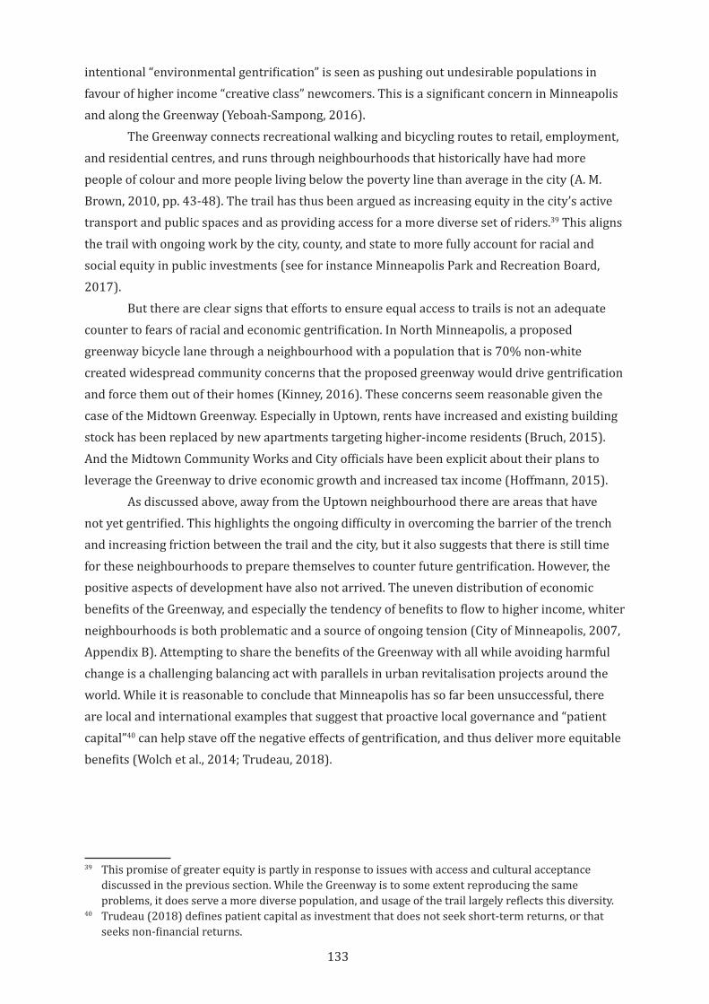
133
intentional “environmental gentrification” is seen as pushing out undesirable populations in favour of higher income “creative class” newcomers. This is a significant concern in Minneapolis and along the Greenway (Yeboah-Sampong, 2016).
The Greenway connects recreational walking and bicycling routes to retail, employment, and residential centres, and runs through neighbourhoods that historically have had more people of colour and more people living below the poverty line than average in the city (A. M. Brown, 2010, pp. 43-48). The trail has thus been argued as increasing equity in the city’s active transport and public spaces and as providing access for a more diverse set of riders.39 This aligns the trail with ongoing work by the city, county, and state to more fully account for racial and social equity in public investments (see for instance Minneapolis Park and Recreation Board, 2017).
But there are clear signs that efforts to ensure equal access to trails is not an adequate counter to fears of racial and economic gentrification. In North Minneapolis, a proposed greenway bicycle lane through a neighbourhood with a population that is 70% non-white created widespread community concerns that the proposed greenway would drive gentrification and force them out of their homes (Kinney, 2016). These concerns seem reasonable given the case of the Midtown Greenway. Especially in Uptown, rents have increased and existing building stock has been replaced by new apartments targeting higher-income residents (Bruch, 2015). And the Midtown Community Works and City officials have been explicit about their plans to leverage the Greenway to drive economic growth and increased tax income (Hoffmann, 2015).
As discussed above, away from the Uptown neighbourhood there are areas that have not yet gentrified. This highlights the ongoing difficulty in overcoming the barrier of the trench and increasing friction between the trail and the city, but it also suggests that there is still time for these neighbourhoods to prepare themselves to counter future gentrification. However, the positive aspects of development have also not arrived. The uneven distribution of economic benefits of the Greenway, and especially the tendency of benefits to flow to higher income, whiter neighbourhoods is both problematic and a source of ongoing tension (City of Minneapolis, 2007, Appendix B). Attempting to share the benefits of the Greenway with all while avoiding harmful change is a challenging balancing act with parallels in urban revitalisation projects around the world. While it is reasonable to conclude that Minneapolis has so far been unsuccessful, there are local and international examples that suggest that proactive local governance and “patient capital”40 can help stave off the negative effects of gentrification, and thus deliver more equitable benefits (Wolch et al., 2014; Trudeau, 2018).
39 This promise of greater equity is partly in response to issues with access and cultural acceptance discussed in the previous section. While the Greenway is to some extent reproducing the same problems, it does serve a more diverse population, and usage of the trail largely reflects this diversity.
40 Trudeau (2018) defines patient capital as investment that does not seek short-term returns, or that seeks non-financial returns.
134
8.6 Conclusion
In 2014, the Minneapolis Midtown Greenway won a “Great Places” award from the Sensible Land Use Coalition, which recognised that the Greenway had “transformed [many] people’s ways of being in the city” (Sensible Land Use Coalition, 2014). The Greenway exemplifies many of the elements that make urban rail trails compelling: It runs through a densely developed part of the city and yet is almost completely separated from the automobile-dominated street grid. The trail is a visual and experiential reminder of the city’s unique industrial history, but its urban form has been adapted to suit modern realities and needs. Finally, it serves as a valuable green amenity for businesses and residents in the neighbourhoods that surround it. The Greenway has helped expand and transform the bicycling culture of Minneapolis and has provided new opportunities for people to live in transit and active-transport-oriented neighbourhoods. And as this chapter has shown, the Midtown Greenway Coalition has leveraged the strong and overlapping territoriality of Minneapolis’s neighbourhood governance tradition to create and enhance the Greenway as a unique public amenity, and to overcome the inherent frictionless of the corridor.
While the Greenway has helped catalyse significant changes in the city, these changes have not always been in line with the intent of Greenway planners, advocates, or the local government. The Greenway is an unqualified success as bicycle infrastructure and has been an important symbol of a development boom at the western end of the trench. Working to link the Greenway with commute and recreational routes within Minneapolis and its surroundings has made the Greenway a critical link in the regional bicycling network. The overlapping efforts of the various actors at play in the Greenway have balanced the preservation of the trench with new frictions between buildings and land uses along the trail. This has created a visually and experientially rich environment with loose spaces and loose uses providing a counterbalance to the dominance of tight, flow-oriented, and high-speed bicycle uses.
But the benefits and territorial reach of the Greenway continue to be limited by its morphology. The trench section remains both the greatest asset as a transportation corridor and the greatest barrier to the trail as vital public space. The challenge of adding productive friction to the corridor highlights the importance of physical design: The best efforts at programming and planning have not yet been able to make significant strides at overcoming its form. The Greenway remains far less useful as a pedestrian route than a bicycling route, and so it lacks the everyday activity and fine-grained territoriality that arise in good pedestrian environments. Perhaps relatedly, despite decades of work to increase productive friction between the Greenway and Lake Street, the anticipated benefits to the businesses along Lake Street have yet to materialise, and the street largely remains economically depressed. Even where economic development has been successful, there are ongoing concerns that inadequate protections for existing residents is causing dislocation of historically disadvantaged groups.
The jury comments for the Great Places award also recognised that the Greenway “…is still a place that is becoming.” The first section of the Greenway opened to the public almost twenty years ago, but it continues to change. The introduction of light rail into the corridor and
135
the continued efforts of the Coalition to induce frictions along the trail may solve some ongoing weaknesses but create new issues. Ongoing revitalisation of nearby buildings and spaces will continue, but the increased awareness of the damage caused by gentrification may redirect some of this effort toward equity and community cohesion. The ongoing reciprocal dialogue between the Greenway and its surrounding neighbourhoods through the medium of the Coalition is a compelling model for balancing the potentials and pitfalls of the Greenway as it continues its shift from a frictionless transportation corridor into an integrated part of the city. It is clear from the effort of advocates and planners that there is broad recognition that good public spaces need productive friction, As discussed in Chapter 2, territoriality has a strong influence on both friction and looseness of public space. The case of the Midtown Greenway may be an example where territoriality is not enough to overcome established physical form. It does provide an important example that, even in the face of territorial actors working together to increase urban vitality, friction created through physical design is still critical to the success of urban public space.
136
9 The Atlanta BeltLine: Looseness by Design
9.1 Introduction
The case of the BeltLine is one where the territory of the trail has been expanded and conflated with the city itself, and where neighbours and businesses seeking to exploit new economic and social opportunities around the trail are bolstered or hindered by an increasingly assertive management system. The vision for the BeltLine is the creation of a new functional heart for its many neighbourhoods, making space both for transportation and for interaction. The vision of the trail is, in essence, to create a new kind of city street. This new city street has created conditions that echo pre-automobile urban streets of the past, permitting loose uses. At the same time, the trail embraces the potential of parks and open space to spur economic development and healthy lifestyles. Unlike the Burke-Gilman Trail in Seattle and the Midtown Greenway in Minneapolis, the BeltLine has been planned from the beginning for a range of ways of using and experiencing the trail.
It is not a bicycle highway. While providing safe and pleasant infrastructure for bicycling is recognised as important, the trail does not have space dedicated to bicycle flow. Instead, programming and urban design strategies for the BeltLine are intended to fill the trail with diverse uses, with territorialisations and frictions that reinforce this diversity. These various efforts and actors, along with the lack of dedicated bicycle lanes, have made the space of the BeltLine distinctively loose when compared with the Burke-Gilman Trail and the Midtown Greenway, with the positive and negative effects that come with that looseness.
This chapter will consider the BeltLine as a space where territorial actions and frictions have, until now, acted to increase the looseness of the trail. First, this looseness begins with the early advocacy for the trail and is reinforced through the origin story that continues to influence the evolution of the trail. Second, loose spaces are created through the urban design strategies that frame the project as a high-friction, integrated part of the city fabric. Third, looseness is renewed through the unique organisations that are implementing and promoting the trail, and the many overlapping and shifting territorialisations of the trail and its surrounding areas. Finally, the chapter considers how, despite these loosening actions and policies, there has been a contrasting movement from looseness to tightness of the trail and its relationship to context as the project has progressed.
9.2 Loose Beginnings and Grassroots Assemblage
The Atlanta BeltLine is more than just a conversion of a rail corridor into a trail. It is the centrepiece of a citywide transportation and economic development plan that ranks as one of the largest urban renewal projects in the United States. This makes the Atlanta BeltLine a unique case among rail corridor conversions. While rail trail projects usually include an explicit or implicit expectation that some development will follow the trail project, in Atlanta,
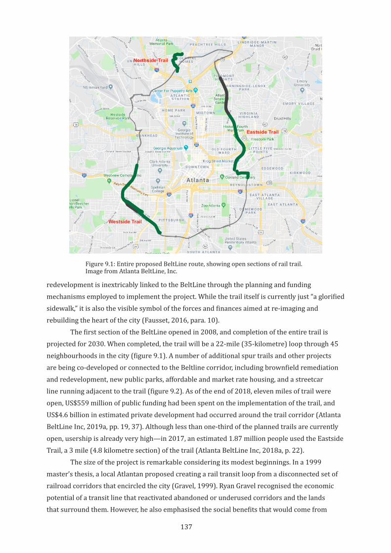
137
redevelopment is inextricably linked to the BeltLine through the planning and funding mechanisms employed to implement the project. While the trail itself is currently just “a glorified sidewalk,” it is also the visible symbol of the forces and finances aimed at re-imaging and rebuilding the heart of the city (Fausset, 2016, para. 10).
The first section of the BeltLine opened in 2008, and completion of the entire trail is projected for 2030. When completed, the trail will be a 22-mile (35-kilometre) loop through 45 neighbourhoods in the city (figure 9.1). A number of additional spur trails and other projects are being co-developed or connected to the Beltline corridor, including brownfield remediation and redevelopment, new public parks, affordable and market rate housing, and a streetcar line running adjacent to the trail (figure 9.2). As of the end of 2018, eleven miles of trail were open, US$559 million of public funding had been spent on the implementation of the trail, and US$4.6 billion in estimated private development had occurred around the trail corridor (Atlanta BeltLine Inc, 2019a, pp. 19, 37). Although less than one-third of the planned trails are currently open, usership is already very high—in 2017, an estimated 1.87 million people used the Eastside Trail, a 3 mile (4.8 kilometre section) of the trail (Atlanta BeltLine Inc, 2018a, p. 22).
The size of the project is remarkable considering its modest beginnings. In a 1999 master’s thesis, a local Atlantan proposed creating a rail transit loop from a disconnected set of railroad corridors that encircled the city (Gravel, 1999). Ryan Gravel recognised the economic potential of a transit line that reactivated abandoned or underused corridors and the lands that surround them. However, he also emphasised the social benefits that would come from
Figure 9.1: Entire proposed BeltLine route, showing open sections of rail trail. Image from Atlanta BeltLine, Inc.
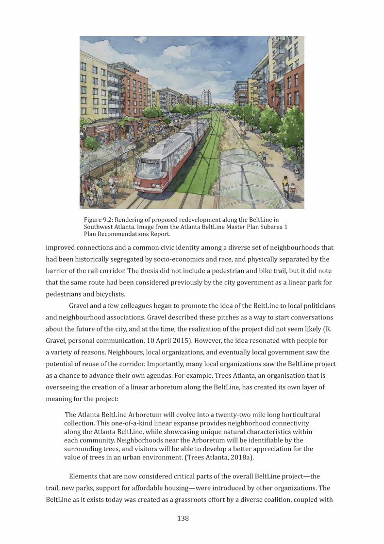
138
improved connections and a common civic identity among a diverse set of neighbourhoods that had been historically segregated by socio-economics and race, and physically separated by the barrier of the rail corridor. The thesis did not include a pedestrian and bike trail, but it did note that the same route had been considered previously by the city government as a linear park for pedestrians and bicyclists.
Gravel and a few colleagues began to promote the idea of the BeltLine to local politicians and neighbourhood associations. Gravel described these pitches as a way to start conversations about the future of the city, and at the time, the realization of the project did not seem likely (R. Gravel, personal communication, 10 April 2015). However, the idea resonated with people for a variety of reasons. Neighbours, local organizations, and eventually local government saw the potential of reuse of the corridor. Importantly, many local organizations saw the BeltLine project as a chance to advance their own agendas. For example, Trees Atlanta, an organisation that is overseeing the creation of a linear arboretum along the BeltLine, has created its own layer of meaning for the project:
The Atlanta BeltLine Arboretum will evolve into a twenty-two mile long horticultural collection. This one-of-a-kind linear expanse provides neighborhood connectivity along the Atlanta BeltLine, while showcasing unique natural characteristics within each community. Neighborhoods near the Arboretum will be identifiable by the surrounding trees, and visitors will be able to develop a better appreciation for the value of trees in an urban environment. (Trees Atlanta, 2018a).
Elements that are now considered critical parts of the overall BeltLine project—the trail, new parks, support for affordable housing—were introduced by other organizations. The BeltLine as it exists today was created as a grassroots effort by a diverse coalition, coupled with
Figure 9.2: Rendering of proposed redevelopment along the BeltLine in Southwest Atlanta. Image from the Atlanta BeltLine Master Plan Subarea 1 Plan Recommendations Report.
139
some early and ongoing local government support. This grassroots effort has been a source of resilience for the project as it moved from idea to reality. The overlapping territorialisations of the concept of the BeltLine, long before it was built, were already loosening the idea of the trail.
Everybody’s got their own story about the moment they saw that this was real. For me, it was about a year and a half into it. I thought we were just having an interesting conversation. We attended a meeting of the Atlanta Regional Commission to advocate for the project, to get it on the priority list of transportation projects. I was nervously preparing to make my public comment for the record, and standing behind these two women who were saying, “Our project is this loop that connects 45 neighborhoods,” “Our loop project does this and that.” They were claiming it as “our project,” but I had no idea who they were. I could see that that sense of ownership creates a lot of political power and would almost obligate the city to put together the nuts and bolts to make it happen. (Ryan Gravel, quoted in A. Johnston, 2015)
The BeltLine is the focus and backdrop of a broad range of projects and programs ranging from Safe Routes to School (PEDS, 2008), adaptive reuse of a large warehouse and department store into a mixed use project (R. Brown, 2011), a skateboard park (Historic Fourth Ward Park Conservancy, 2017), exercise programs (Atlanta BeltLine Inc, 2018e), and urban forestry for children (Trees Atlanta, 2018b). A diverse assemblage of actors, missions, priorities, and projects have aligned to enable the creation of the BeltLine, but this group is loose enough that there is no one overriding identity to the trail. Instead, it is a framework into which different people and organisations can fit.
The bottom line, I think, why we’ve had so much success with the community…it is not a planning strategy from the top down, or a decree by the city. It was really an interesting idea that the community latched onto…. It was really the community’s imagination that broadened the scope to include the multi-use trail, to include green space, to include housing. It’s really the community’s acceptance not of one of these items all by itself, but they really saw this as a way to turn the tide in many of these neighborhoods. They saw it more as a collective economic development project rather than a standalone transit project or a standalone trail project. (H. Hussey-Coker, ABI Special Projects Manager, personal communication 2 April 2015.)
This origin story is an important and cultivated part of the image of the BeltLine. The story is repeated in almost every article about the trail, and is mentioned in bus tours of the Beltline, in conference sessions, and in conversations with planning staff and board members. For instance, “The Beltline in 5” webpage describes the origin:
First conceived as a 1999 master’s thesis by Georgia Tech student Ryan Gravel, the Atlanta BeltLine evolved from an idea, to a grassroots campaign of local citizens and civic leaders, into a robust new vision of an Atlanta dedicated to an integrated approach to transportation, land use, greenspace, and sustainable growth. (Atlanta BeltLine Inc, 2019b)
140
The BeltLine as a symbol of grassroots revitalisation fits well with the narrative of rebirth that has been central to Atlanta’s self-image since its near-total destruction at the end of the Civil War (Link, 2013, and see figure 9.3). The origin story is also important because it helps reinforce the idea that the BeltLine is a project of and for the people, helping deflect or mute criticism of problematic aspects of the project.
This idea that the BeltLine is a place for everyone to gather, recreate, and interact is reflected in the physical design of the trail. Rather than focusing on the potential of the corridor as a tight, frictionless, high-speed transportation route, the design prioritises connections to adjacent streets and properties, and creation of new adjacent public spaces (figure 9.4). Activities are programmed in and around the trail to bring more people to the BeltLine and give them a broad range of reasons to stay.
The many intentional interactions created by the planning and design of the BeltLine have fostered a spirit of loose space and loose management. The early years of the BeltLine were notable for the degree of grassroots self-organization, do-it-yourself connections and self-promotion by trail neighbours, and of informal occupation and territorialisation of the trail. These have been enabled by the morphology of the rail corridor, that runs at or near grade in many sections of the route, but also by relatively loose trail management practices that have encouraged visual and physical integration of the trail and its surroundings.
This looseness is changing, however. The plan for BeltLine corridor has always included a streetcar line that would occupy half of the corridor. The implementation of the streetcar has been delayed, and so one half of the corridor remains unimproved as a loose and evocative edge to the trail (figure 9.5). However, this looseness is contrasted by increasingly formal physical connections to the trail from surrounding streets, public spaces, and private properties. Beyond the physical space of the corridor, the planning for the streetcar and a formalisation of trail edges is increasingly tightening the administrative space of the corridor. The management organisation
Figure 9.3: Seal of the City of Atlanta.
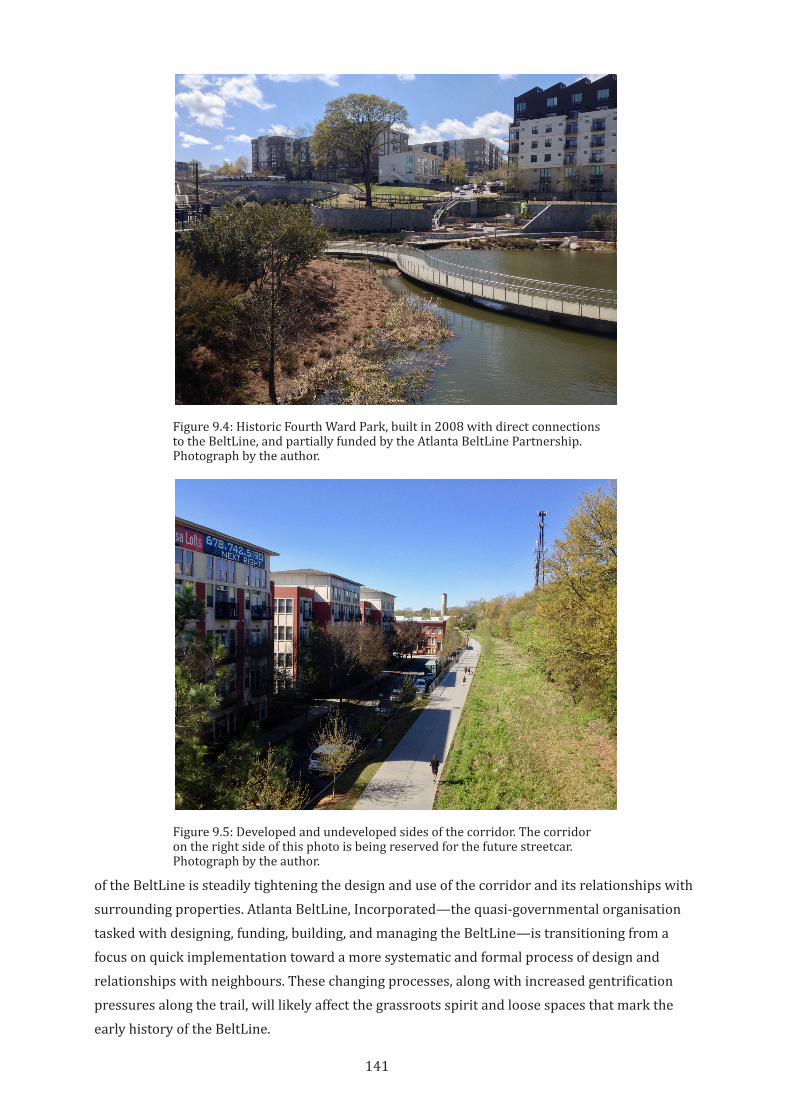
141
of the BeltLine is steadily tightening the design and use of the corridor and its relationships with surrounding properties. Atlanta BeltLine, Incorporated—the quasi-governmental organisation tasked with designing, funding, building, and managing the BeltLine—is transitioning from a focus on quick implementation toward a more systematic and formal process of design and relationships with neighbours. These changing processes, along with increased gentrification pressures along the trail, will likely affect the grassroots spirit and loose spaces that mark the early history of the BeltLine.
Figure 9.4: Historic Fourth Ward Park, built in 2008 with direct connections to the BeltLine, and partially funded by the Atlanta BeltLine Partnership. Photograph by the author.
Figure 9.5: Developed and undeveloped sides of the corridor. The corridor on the right side of this photo is being reserved for the future streetcar. Photograph by the author.
142
9.3 The BeltLine as an Expanding and Overlapping Territory
The BeltLine project is an urban renewal project that is organised around a trail and future streetcar line. It is not a trail project that hopes to inspire economic development. This important distinction makes for unique patterns of territorialisation around the trail. While there are numerous attempts by neighbours to capture or appropriate the space and energy of the corridor, the BeltLine project itself is a strong, sometimes overwhelming, territorialising force of its own.
By the time the city government committed to the idea of building the BeltLine, the project had grown to the point that no single city government department could adequately manage it, and the city budget could not finance it. In 2005, the city set in motion three critical pieces to the BeltLine implementation: the creation of Atlanta BeltLine, Inc to manage the project, the establishment of a tax increment financing scheme, called the Tax Allocation District, and the formation of the Atlanta BeltLine Partnership to raise private donations and program public activities along the trail.
Atlanta BeltLine, Inc (ABI) is a quasi-governmental organization established to design, implement, and manage the trail on behalf of the City of Atlanta. ABI oversees all aspects of the BeltLine, including the design of the trail and the future streetcar line; real estate acquisition, brownfield remediation, and construction; and managing the public art and landscaping along the trail. Because the BeltLine project crosses so many departmental and jurisdictional boundaries, ABI was created as an external agency of the City to allow for coordination and flexibility that would be difficult within the formal City bureaucracy. ABI is staffed by a small management group that oversees the many components of the BeltLine project, including legal issues; community engagement; government affairs; real estate and economic development; transportation, land use, and landscape planning; housing policy; and arts and culture (Atlanta BeltLine Inc, 2019a, pp. 10-11). This team coordinates with City of Atlanta staff and other agencies to conduct the work of designing and implementing the BeltLine.
The Tax Allocation District is intended to provide the majority of project funding for the BeltLine implementation. This funding comes through a tax increment financing agreement that dedicates any increases in tax revenue within the district to ABI to design and implement BeltLine components. The Tax Allocation District includes non-residential land along the corridor, but stretches as much as a kilometre away from the corridor itself, capturing 8% of the total land area of the city of Atlanta (Atlanta Development Authority, 2005, and see figure 9.6). By the completion of the BeltLine in 2030, the Tax Allocation District is projected to have contributed 60 percent of the funding—US$1.7 billion out of a total projected budget of US$2.8 billion. As of 2014, the Tax Allocation District had generated US$124 million in project funding (Atlanta BeltLine Inc, 2018c).
The Atlanta BeltLine Partnership manages fundraising from individuals and private companies to support the project. They also fund the Art on the Atlanta BeltLine program and manage public events and activities on the BeltLine or in nearby spaces. In the 2014-2015 biennium, the Partnership raised US$12.5 million in donations. In 2016, more than 20,000
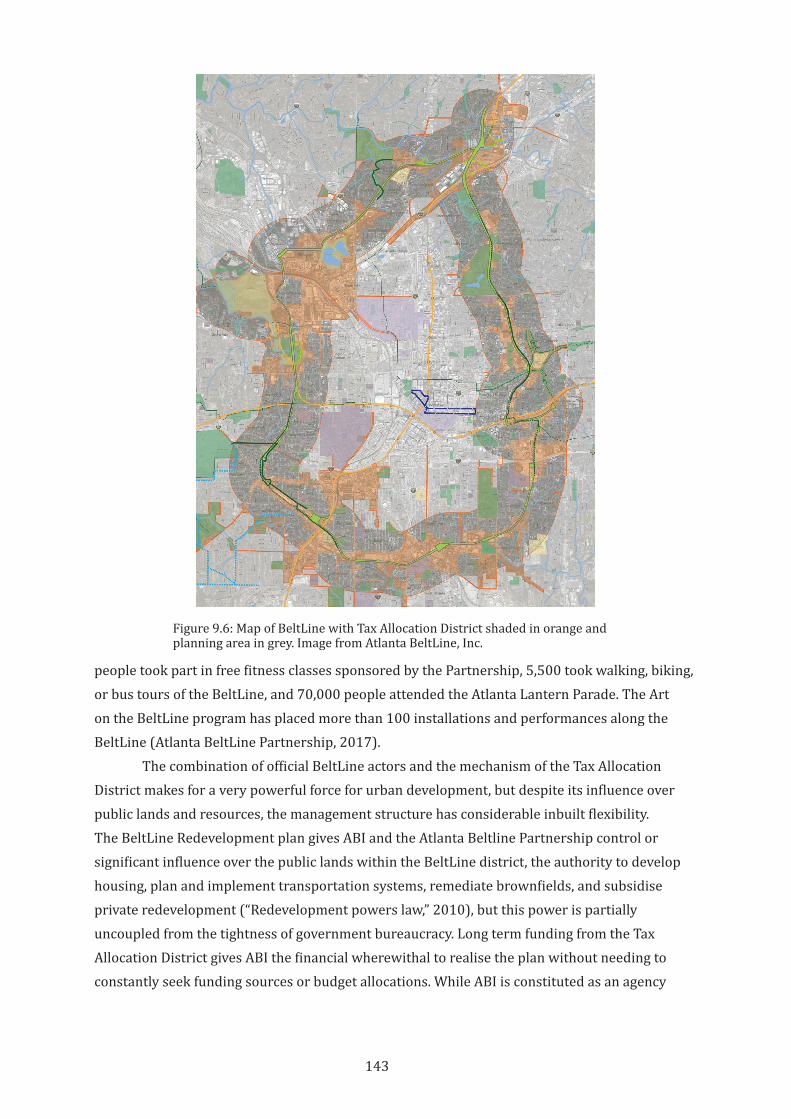
143
people took part in free fitness classes sponsored by the Partnership, 5,500 took walking, biking, or bus tours of the BeltLine, and 70,000 people attended the Atlanta Lantern Parade. The Art on the BeltLine program has placed more than 100 installations and performances along the BeltLine (Atlanta BeltLine Partnership, 2017).
The combination of official BeltLine actors and the mechanism of the Tax Allocation District makes for a very powerful force for urban development, but despite its influence over public lands and resources, the management structure has considerable inbuilt flexibility. The BeltLine Redevelopment plan gives ABI and the Atlanta Beltline Partnership control or significant influence over the public lands within the BeltLine district, the authority to develop housing, plan and implement transportation systems, remediate brownfields, and subsidise private redevelopment (“Redevelopment powers law,” 2010), but this power is partially uncoupled from the tightness of government bureaucracy. Long term funding from the Tax Allocation District gives ABI the financial wherewithal to realise the plan without needing to constantly seek funding sources or budget allocations. While ABI is constituted as an agency
Figure 9.6: Map of BeltLine with Tax Allocation District shaded in orange and planning area in grey. Image from Atlanta BeltLine, Inc.
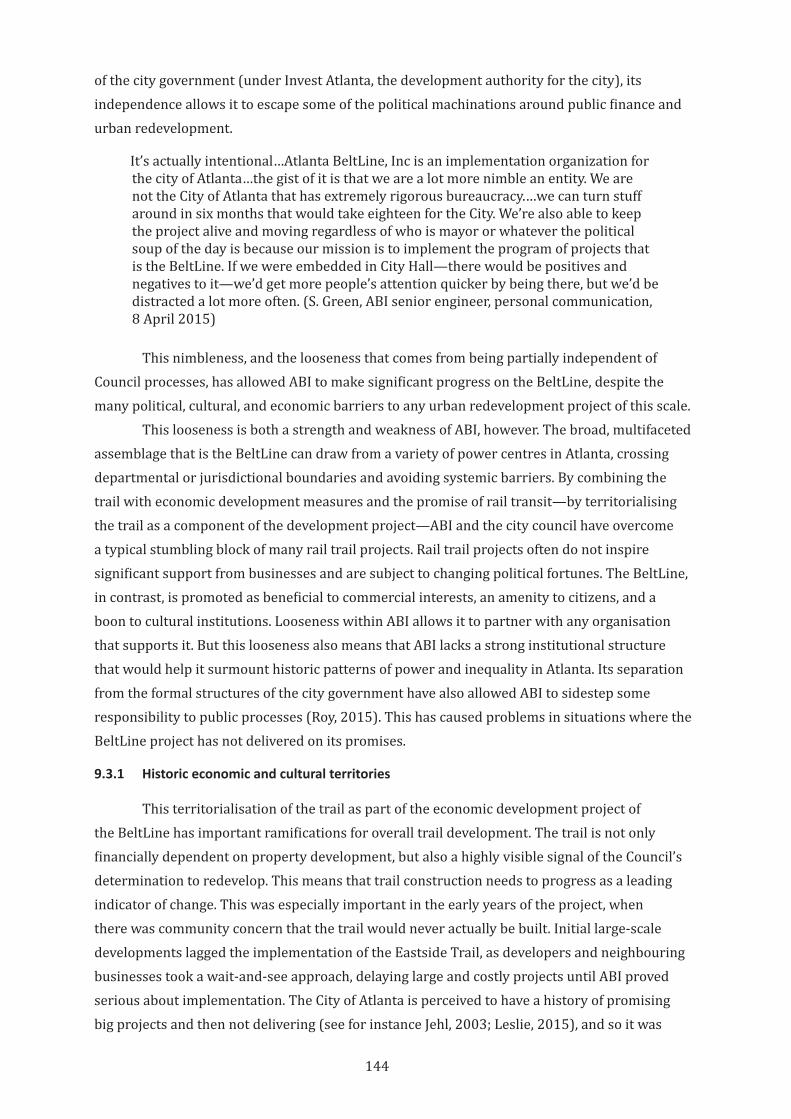
144
of the city government (under Invest Atlanta, the development authority for the city), its independence allows it to escape some of the political machinations around public finance and urban redevelopment.
It’s actually intentional…Atlanta BeltLine, Inc is an implementation organization for the city of Atlanta…the gist of it is that we are a lot more nimble an entity. We are not the City of Atlanta that has extremely rigorous bureaucracy.…we can turn stuff around in six months that would take eighteen for the City. We’re also able to keep the project alive and moving regardless of who is mayor or whatever the political soup of the day is because our mission is to implement the program of projects that is the BeltLine. If we were embedded in City Hall—there would be positives and negatives to it—we’d get more people’s attention quicker by being there, but we’d be distracted a lot more often. (S. Green, ABI senior engineer, personal communication, 8 April 2015)
This nimbleness, and the looseness that comes from being partially independent of Council processes, has allowed ABI to make significant progress on the BeltLine, despite the many political, cultural, and economic barriers to any urban redevelopment project of this scale.
This looseness is both a strength and weakness of ABI, however. The broad, multifaceted assemblage that is the BeltLine can draw from a variety of power centres in Atlanta, crossing departmental or jurisdictional boundaries and avoiding systemic barriers. By combining the trail with economic development measures and the promise of rail transit—by territorialising the trail as a component of the development project—ABI and the city council have overcome a typical stumbling block of many rail trail projects. Rail trail projects often do not inspire significant support from businesses and are subject to changing political fortunes. The BeltLine, in contrast, is promoted as beneficial to commercial interests, an amenity to citizens, and a boon to cultural institutions. Looseness within ABI allows it to partner with any organisation that supports it. But this looseness also means that ABI lacks a strong institutional structure that would help it surmount historic patterns of power and inequality in Atlanta. Its separation from the formal structures of the city government have also allowed ABI to sidestep some responsibility to public processes (Roy, 2015). This has caused problems in situations where the BeltLine project has not delivered on its promises.
9.3.1 Historic economic and cultural territories
This territorialisation of the trail as part of the economic development project of the BeltLine has important ramifications for overall trail development. The trail is not only financially dependent on property development, but also a highly visible signal of the Council’s determination to redevelop. This means that trail construction needs to progress as a leading indicator of change. This was especially important in the early years of the project, when there was community concern that the trail would never actually be built. Initial large-scale developments lagged the implementation of the Eastside Trail, as developers and neighbouring businesses took a wait-and-see approach, delaying large and costly projects until ABI proved serious about implementation. The City of Atlanta is perceived to have a history of promising big projects and then not delivering (see for instance Jehl, 2003; Leslie, 2015), and so it was
145
considered politically important to start the construction of the trail even though many technical issues remained unsettled (S. Green, personal communication, 8 April 2015). Today, the clear success of the Eastside Trail as both an amenity and as an attractor for new tenants and customers has convinced developers of its value. Developers are now leapfrogging past the open sections of the trail and starting work on trail-oriented projects south of the open sections (figure 9.7).
In other parts of the trail, however, new development continues to lag trail construction (Wenk, 2015). This has slowed Tax Allocation District income for ABI, which has also delayed project timelines and pushed back the implementation of elements such as streetscape improvements and the streetcar (Atlanta BeltLine Inc, 2015a).
More importantly, by subsuming the trail as a component of the larger economic development project, ABI is predisposed toward planning for growth and high-value developments over other project goals, since development is both consistent with the organisation’s mission and also its funding mechanism (Roy, 2015). As a result, support for low-income residents and businesses and construction of low-income housing has lagged other indicators of progress for the project (Atlanta BeltLine Inc, 2015a). ABI and the Atlanta Beltline Partnership depend on large corporate donations and high-value developments for their funding, and so must align with the practices and values of a capitalist economy. Despite what appears to be the earnest intent to use the BeltLine to address economic inequality and seek a more equitable and integrated Atlanta, the BeltLine remains inextricably linked to existing power inequalities in the economic, political, and social systems of the city (Immergluck & Balan, 2017).
There are currently three open sections of the trail: One in the southeast portion of the overall trail corridor, called the Eastside Trail; one in the southwest portion, called the Westside Trail; and one in the northwest portion, called the Northside Trail (see figure 9.1
Figure 9.7: New construction along a future section of the BeltLine, showing willingness of developers to leapfrog BeltLine construction. Photograph by the author.
146
above). The Eastside Trail runs through an area that was already growing, and so it was a logical demonstration area for initial trail-oriented development. It could also showcase the potential for interactions between the trail and nearby properties. However, the neighbourhoods around the Eastside Trail are also whiter and richer than many other BeltLine neighbourhoods. The early public investment in the Eastside trail therefore appeared to reinforce historic patterns of public and private disinvestment in black neighbourhoods. While this may not be an accurate assessment of the intentions of ABI or the city, some residents of western Atlanta, known as the poorer side of the city and with a majority African-American population, feel that the BeltLine does not serve them (Dobbins, 2016). A bicycling and community activist in the West End neighbourhood who leads regular bike tours of the area, reported than many Westside residents were hearing about the BeltLine for the first time when they took a tour (S. Watson, founder and CEO of WeCycle Atlanta, personal communication, 11 April 2015). Among western Atlanta politicians and economic equity advocates, there are concerns that the economic opportunities and community benefits promised by the BeltLine have not yet arrived in their neighbourhoods (Pendered, 2017).
The organisations and mechanisms that were assembled to create the BeltLine have proven innovative and productive as a force for economic development. However, these organisations were also tasked with overcoming historic barriers and inequities but are now seen by some as reinforcing those same barriers and inequities. The powerful territorialisation of the trail by a development-focused organization has hampered the mission of overcoming systemic economic and social patterns. The looseness of the management system has allowed the intentional pairing of development and equity to slip away from each other. The slippage between intent and action is significant enough that two members of the Atlanta Beltline Partnership board, including Ryan Gravel, resigned in 2016 because they believed the Partnership was not doing enough to maintain affordability and economic opportunity for historically underserved communities in south and west Atlanta (Saporta, 2016). This is a significant problem in a city like Atlanta, where problems of racial disparity and social and economic inequality are large and long standing. Gentrification around bicycle infrastructure and rail trail projects is increasingly recognised as a serious issue (Hoffman, 2016). Development activity around the BeltLine has already been significant, and these pressures will likely extend throughout other areas of the city, especially the Westside, that have historically been lower-income areas. There is already evidence of increasing rents in these areas, and this will likely worsen over time (Immergluck & Balan, 2017). The inability of Atlanta BeltLine Partnership and Atlanta as a whole to provide for adequate affordable housing near the active transportation and future transit resource of the BeltLine is a major failure. It is especially disappointing given the attention to this issue that was built into the planning of the trail.
The large scale, numerous actors, and diverse goals of the overarching BeltLine project has created an internal looseness. There is room within the BeltLine project for different facets of the project to take priority or receive increased attention over others. While they may have an overall clarity of purpose, ABI and the Atlanta Beltline Partnership must juggle a large set
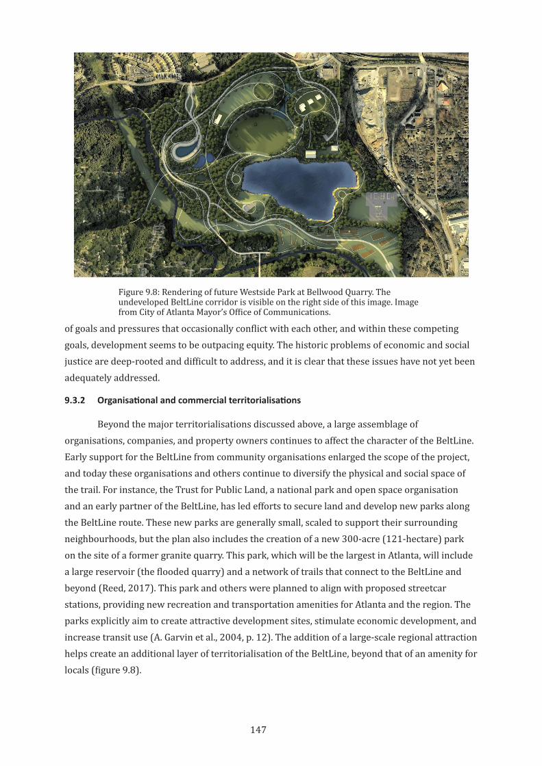
147
Figure 9.8: Rendering of future Westside Park at Bellwood Quarry. The undeveloped BeltLine corridor is visible on the right side of this image. Image from City of Atlanta Mayor’s Office of Communications.
of goals and pressures that occasionally conflict with each other, and within these competing goals, development seems to be outpacing equity. The historic problems of economic and social justice are deep-rooted and difficult to address, and it is clear that these issues have not yet been adequately addressed.
9.3.2 Organisational and commercial territorialisations
Beyond the major territorialisations discussed above, a large assemblage of organisations, companies, and property owners continues to affect the character of the BeltLine. Early support for the BeltLine from community organisations enlarged the scope of the project, and today these organisations and others continue to diversify the physical and social space of the trail. For instance, the Trust for Public Land, a national park and open space organisation and an early partner of the BeltLine, has led efforts to secure land and develop new parks along the BeltLine route. These new parks are generally small, scaled to support their surrounding neighbourhoods, but the plan also includes the creation of a new 300-acre (121-hectare) park on the site of a former granite quarry. This park, which will be the largest in Atlanta, will include a large reservoir (the flooded quarry) and a network of trails that connect to the BeltLine and beyond (Reed, 2017). This park and others were planned to align with proposed streetcar stations, providing new recreation and transportation amenities for Atlanta and the region. The parks explicitly aim to create attractive development sites, stimulate economic development, and increase transit use (A. Garvin et al., 2004, p. 12). The addition of a large-scale regional attraction helps create an additional layer of territorialisation of the BeltLine, beyond that of an amenity for locals (figure 9.8).
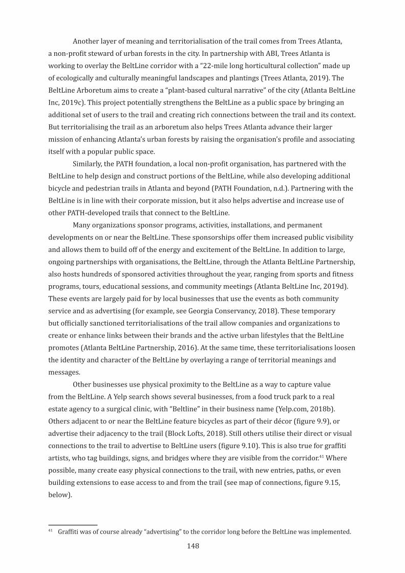
148
Another layer of meaning and territorialisation of the trail comes from Trees Atlanta, a non-profit steward of urban forests in the city. In partnership with ABI, Trees Atlanta is working to overlay the BeltLine corridor with a “22-mile long horticultural collection” made up of ecologically and culturally meaningful landscapes and plantings (Trees Atlanta, 2019). The BeltLine Arboretum aims to create a “plant-based cultural narrative” of the city (Atlanta BeltLine Inc, 2019c). This project potentially strengthens the BeltLine as a public space by bringing an additional set of users to the trail and creating rich connections between the trail and its context. But territorialising the trail as an arboretum also helps Trees Atlanta advance their larger mission of enhancing Atlanta’s urban forests by raising the organisation’s profile and associating itself with a popular public space.
Similarly, the PATH foundation, a local non-profit organisation, has partnered with the BeltLine to help design and construct portions of the BeltLine, while also developing additional bicycle and pedestrian trails in Atlanta and beyond (PATH Foundation, n.d.). Partnering with the BeltLine is in line with their corporate mission, but it also helps advertise and increase use of other PATH-developed trails that connect to the BeltLine.
Many organizations sponsor programs, activities, installations, and permanent developments on or near the BeltLine. These sponsorships offer them increased public visibility and allows them to build off of the energy and excitement of the BeltLine. In addition to large, ongoing partnerships with organisations, the BeltLine, through the Atlanta BeltLine Partnership, also hosts hundreds of sponsored activities throughout the year, ranging from sports and fitness programs, tours, educational sessions, and community meetings (Atlanta BeltLine Inc, 2019d). These events are largely paid for by local businesses that use the events as both community service and as advertising (for example, see Georgia Conservancy, 2018). These temporary but officially sanctioned territorialisations of the trail allow companies and organizations to create or enhance links between their brands and the active urban lifestyles that the BeltLine promotes (Atlanta BeltLine Partnership, 2016). At the same time, these territorialisations loosen the identity and character of the BeltLine by overlaying a range of territorial meanings and messages.
Other businesses use physical proximity to the BeltLine as a way to capture value from the BeltLine. A Yelp search shows several businesses, from a food truck park to a real estate agency to a surgical clinic, with “Beltline” in their business name (Yelp.com, 2018b). Others adjacent to or near the BeltLine feature bicycles as part of their décor (figure 9.9), or advertise their adjacency to the trail (Block Lofts, 2018). Still others utilise their direct or visual connections to the trail to advertise to BeltLine users (figure 9.10). This is also true for graffiti artists, who tag buildings, signs, and bridges where they are visible from the corridor.41 Where possible, many create easy physical connections to the trail, with new entries, paths, or even building extensions to ease access to and from the trail (see map of connections, figure 9.15, below).
41 Graffiti was of course already “advertising” to the corridor long before the BeltLine was implemented.
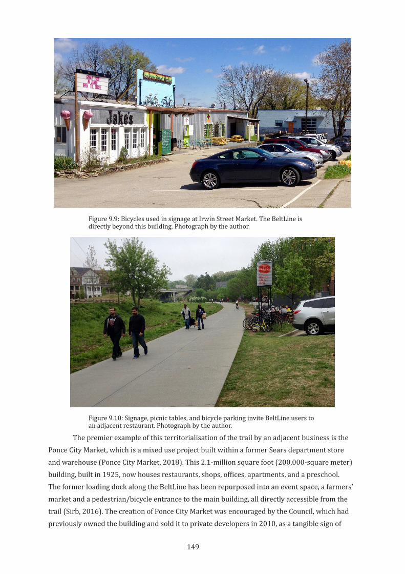
149
Figure 9.9: Bicycles used in signage at Irwin Street Market. The BeltLine is directly beyond this building. Photograph by the author.
The premier example of this territorialisation of the trail by an adjacent business is the Ponce City Market, which is a mixed use project built within a former Sears department store and warehouse (Ponce City Market, 2018). This 2.1-million square foot (200,000-square meter) building, built in 1925, now houses restaurants, shops, offices, apartments, and a preschool. The former loading dock along the BeltLine has been repurposed into an event space, a farmers’ market and a pedestrian/bicycle entrance to the main building, all directly accessible from the trail (Sirb, 2016). The creation of Ponce City Market was encouraged by the Council, which had previously owned the building and sold it to private developers in 2010, as a tangible sign of
Figure 9.10: Signage, picnic tables, and bicycle parking invite BeltLine users to an adjacent restaurant. Photograph by the author.
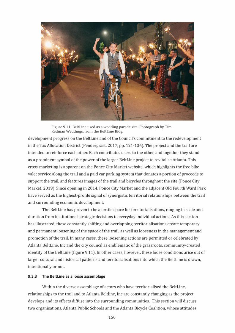
150
development progress on the BeltLine and of the Council’s commitment to the redevelopment in the Tax Allocation District (Pendergrast, 2017, pp. 121-136). The project and the trail are intended to reinforce each other. Each contributes users to the other, and together they stand as a prominent symbol of the power of the larger BeltLine project to revitalise Atlanta. This cross-marketing is apparent on the Ponce City Market website, which highlights the free bike valet service along the trail and a paid car parking system that donates a portion of proceeds to support the trail, and features images of the trail and bicycles throughout the site (Ponce City Market, 2019). Since opening in 2014, Ponce City Market and the adjacent Old Fourth Ward Park have served as the highest-profile signal of synergistic territorial relationships between the trail and surrounding economic development.
The BeltLine has proven to be a fertile space for territorialisations, ranging in scale and duration from institutional strategic decisions to everyday individual actions. As this section has illustrated, these constantly shifting and overlapping territorialisations create temporary and permanent loosening of the space of the trail, as well as looseness in the management and promotion of the trail. In many cases, these loosening actions are permitted or celebrated by Atlanta BeltLine, Inc and the city council as emblematic of the grassroots, community-created identity of the BeltLine (figure 9.11). In other cases, however, these loose conditions arise out of larger cultural and historical patterns and territorialisations into which the BeltLine is drawn, intentionally or not.
9.3.3 The BeltLine as a loose assemblage
Within the diverse assemblage of actors who have territorialised the BeltLine, relationships to the trail and to Atlanta Beltline, Inc are constantly changing as the project develops and its effects diffuse into the surrounding communities. This section will discuss two organisations, Atlanta Public Schools and the Atlanta Bicycle Coalition, whose attitudes
Figure 9.11: BeltLine used as a wedding parade site. Photograph by Tim Redman Weddings, from the BeltLine Blog.
151
toward the BeltLine appear to have evolved over time. These examples highlight the value of a loose and diverse set of overlapping territorialisations in any public space or infrastructure project, because they allow flexibility and resilience in the overall project in the face of changing conditions.
Atlanta Public Schools
A primary aim of the BeltLine is to provide a safe walking and bicycling route to everyday destinations (Atlanta BeltLine Inc, 2019b). There are 19 schools within a half mile (800 meters) of the corridor (Ross, 2007, p. 56) and three public schools adjacent to currently open sections of the trail (Atlanta BeltLine Inc, 2019e). Thirteen schools in Atlanta participate in Safe Routes to School, a national program to improve pedestrian and bicycling infrastructure in and around schools (National Center for Safe Routes to School, 2019). Despite this apparent alignment of mission, only one of the BeltLine-adjacent schools has created a Safe Routes to School plan, and only five of the nineteen nearby schools have such a plan.42 As of early 2019, only one adjacent school discusses the BeltLine on their website as a student and teaching amenity (J. E. Brown Middle School, 2017). This seems to be a relatively poor level of territorialisation of the BeltLine as a transportation resource, but it reflects an improvement over previous school attitudes toward the trail. In early planning meetings with the same school that now views the BeltLine as an amenity, formal connections from the trail to a school were actively discouraged. The transcript from a 2010 Sub-area Planning Committee meeting records:
An Atlanta Public Schools representative on the Planning Committee then explained that there are no plans for the parking lot south of Brown Middle School. [This parking lot is directly adjacent to a proposed BeltLine park.] The PATH Foundation [the trail development non-profit that helped develop the adjacent portion of the BeltLine] has an easement, but there are no plans to do anything with the property…. The school board wants to reduce foot traffic by not having any trails near the school. (Tunnell-Spangler-Walsh & Associates, 2010, p. 266)(image: Brown Middle School before)
At this early stage in BeltLine development, the school board saw a negative value in cross-territorialisation of walking or biking infrastructure near their campus. Within the context of this report, the BeltLine planning committee responsible for integrating the BeltLine into the community did not question this attitude (Tunnell-Spangler-Walsh & Associates, 2010, p. 26).
Atlanta Public Schools has long had an uncomfortable relationship with the BeltLine. The Tax Allocation District that funds the BeltLine reduces all tax income for the City, and this means that the school system loses out on income growth during the Tax Allocation District period. This flattening of tax income occurs despite the rising costs faced by the school district due to inflation, rising salaries and new staff hires to accommodate new students as families move into the Tax Allocation District. In response, Atlanta-area taxpayers sued the City in 2008 to restore school funding levels. The legislature of the State of Georgia had to specifically legalise the BeltLine Tax Allocation District and its redistribution of tax funds to the BeltLine (George,
42 Based on partner school data from Safe Routes to School Georgia (n.d.) and distances from Google Maps.
152
2013). While the Tax Allocation District agreement includes payments from ABI to Atlanta Public Schools to cover their lost income, the slow start up of Tax Allocation District funding (caused by the global financial crisis) meant that payments to the school district were delayed and the agreement had to be renegotiated three times, which was a source of significant conflict (Bloom, 2015; City of Atlanta, 2016).
At least in the early years of the BeltLine, there were concerns that the development of the trail was coming at the cost of public schools. Atlanta Public Schools serve predominantly Black, lower income students,43 and the reallocation of tax money from schools to the BeltLine was perceived as perpetuating existing economic and racial power imbalances rather than overcoming them (B. Seok, Atlanta Bicycle Coalition volunteer, personal communication, 2 March 2015). As discussed above, the territorialisation by ABI over the physical and economic context of the BeltLine was a significant concern, and this may have contributed to the lack of enthusiasm of Atlanta Public Schools to the trail.
It also seems likely that this local school board policy on foot traffic was partially derived from attitudes about walking and biking to and around schools in general. The overall increase in motor vehicle traffic in United States cities, as well as school funding and siting policies and other systemic land use patterns, have made it more difficult for students to walk or bike to school (Chriqui et al., 2012). The decline in active transportation to school is self-reinforcing, because as walkers and bicyclists decline and car traffic around schools increases, concerns about student safety increase (Highway Safety Research Center, 2018). In response, parents and school boards make decisions and enact policies that further discourage walking and biking (Centers for Disease Control, 2005). In part, the BeltLine was created to challenge these patterns and assumptions and provide safe and enjoyable ways to get to school. However, the particular territorialisations of the BeltLine and ABI seemed to create new social and political barriers rather than overcoming them.
There are signs that school attitudes are changing and relationships with the BeltLine are improving. At least in the case of Brown Middle School, the situation seems to have changed significantly in subsequent years. The school now has a direct pedestrian and bicycle connection to the BeltLine and has reconfigured its car park to make space for a new ballfield that is directly connected to the trail and to an adjacent, BeltLine-funded public park (figure 9.12). And as noted above, the school now sees the BeltLine as a positive contributor to pedagogy and general student wellbeing. This change may be due to the differences between the negative expectations of the BeltLine before it was built and the actual conditions after implementation. As discussed in previous chapters, this is a typical phenomenon around rail trails. It may also reflect improvements in Tax Allocation District payments to schools or improving relationships between school staff and ABI. The case of Brown Middle School holds a valuable lesson as an example of the BeltLine delivering on its promised positive impacts to local communities, and the school responding by embracing the trail.
43 As of October 2018, Atlanta Public School students are 73% Black, and 74% of all students receive free or reduced-cost school lunches, meaning they are at or near federal poverty levels (Atlanta Public Schools, 2019).
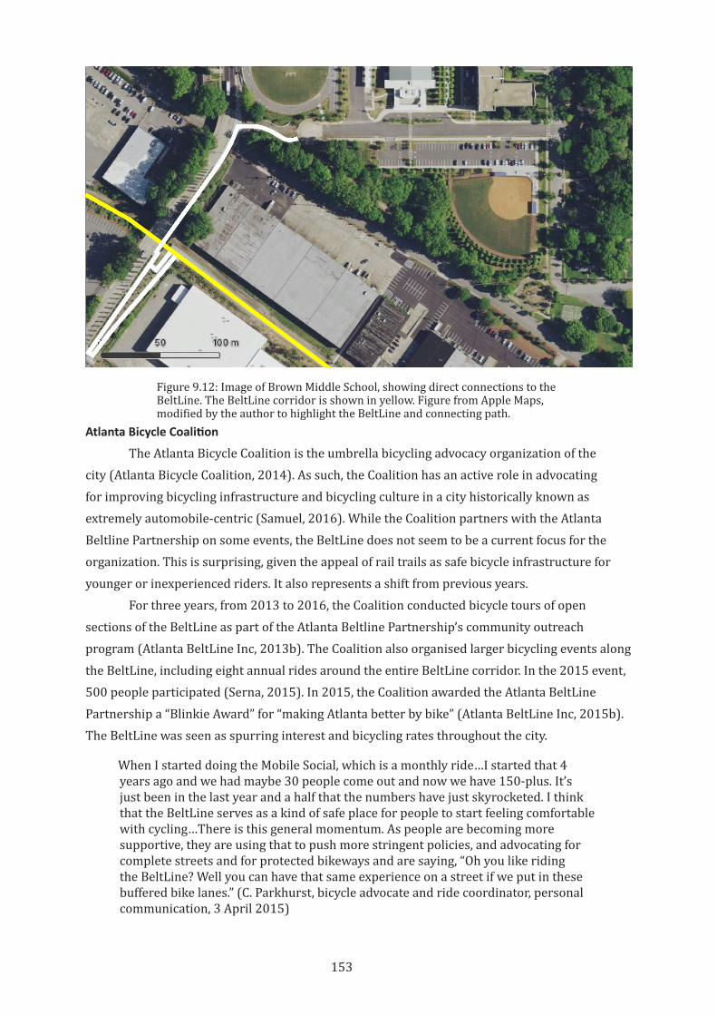
153
Figure 9.12: Image of Brown Middle School, showing direct connections to the BeltLine. The BeltLine corridor is shown in yellow. Figure from Apple Maps, modified by the author to highlight the BeltLine and connecting path.
Atlanta Bicycle Coalition
The Atlanta Bicycle Coalition is the umbrella bicycling advocacy organization of the city (Atlanta Bicycle Coalition, 2014). As such, the Coalition has an active role in advocating for improving bicycling infrastructure and bicycling culture in a city historically known as extremely automobile-centric (Samuel, 2016). While the Coalition partners with the Atlanta Beltline Partnership on some events, the BeltLine does not seem to be a current focus for the organization. This is surprising, given the appeal of rail trails as safe bicycle infrastructure for younger or inexperienced riders. It also represents a shift from previous years.
For three years, from 2013 to 2016, the Coalition conducted bicycle tours of open sections of the BeltLine as part of the Atlanta Beltline Partnership’s community outreach program (Atlanta BeltLine Inc, 2013b). The Coalition also organised larger bicycling events along the BeltLine, including eight annual rides around the entire BeltLine corridor. In the 2015 event, 500 people participated (Serna, 2015). In 2015, the Coalition awarded the Atlanta BeltLine Partnership a “Blinkie Award” for “making Atlanta better by bike” (Atlanta BeltLine Inc, 2015b). The BeltLine was seen as spurring interest and bicycling rates throughout the city.
When I started doing the Mobile Social, which is a monthly ride…I started that 4 years ago and we had maybe 30 people come out and now we have 150-plus. It’s just been in the last year and a half that the numbers have just skyrocketed. I think that the BeltLine serves as a kind of safe place for people to start feeling comfortable with cycling…There is this general momentum. As people are becoming more supportive, they are using that to push more stringent policies, and advocating for complete streets and for protected bikeways and are saying, “Oh you like riding the BeltLine? Well you can have that same experience on a street if we put in these buffered bike lanes.” (C. Parkhurst, bicycle advocate and ride coordinator, personal communication, 3 April 2015)
154
By 2016, however, this close relationship seems to have ended. The Coalition no longer conducts BeltLine tours or longer rides, instead focusing on events and infrastructure improvements elsewhere in the city. While the organization’s 2012-2016 Strategic Plan recognised the value of the BeltLine for new riders and identified “bike infrastructure improvements along, around and connecting to the Beltline” as a strategic priority, the 2017-2020 Strategic Plan makes no mention of the BeltLine at all (Atlanta Bicycle Coalition, 2012, 2017).
This change may be partially due to the broad-based support for the BeltLine. While the BeltLine is important for bicycle mobility in Atlanta, bicycle advocacy organizations like the Coalition can focus their efforts elsewhere, knowing that the BeltLine will progress without their attention. Instead, the Coalition focuses its efforts on political advocacy, bicyclist training, and facilitating bicycle access to businesses and special events. They also work with Council to host ciclovía, the temporary closing of streets to cars to create pedestrian and bike-friendly social events around Atlanta (Atlanta Bicycle Coalition, 2018).
Another factor may be the reality that the BeltLine is not a very convenient route for most bicyclists. The current sections do not connect directly with job centres in the city, and so are less useful as commute routes than other streets. While the BeltLine itself is a comfortable bicycling route, the overall lack of a connected bicycling network throughout the city make it hard for the BeltLine to drive bicycling as a viable transportation mode.
The BeltLine was also not planned with bicycling as a primary use. Bicycling is mentioned briefly in Gravel’s original thesis, and the original Redevelopment Plan states that, “sidewalks, streetscapes, pedestrian crossings, bike lanes, and ADA compliant design will be critical infrastructure elements” (Atlanta Development Authority, 2005, p. 41). However, there is no specific bicycling component to the BeltLine plan, and ABI does not have any staff focused on bicycle planning. While the trail is wide enough to comfortably accommodate large groups of people, it is not separated by use. Bicyclists and pedestrians must share the lane. Bicyclists often prioritise high speed and unimpeded flow, which very often causes conflicts with pedestrians who move in very different ways.
This issue is significant enough that ABI has created a public etiquette campaign to minimise conflict between users (Atlanta BeltLine Inc, 2018b). Conflict between bicyclists and pedestrians on shared paths is common in many countries, and contributes both to anti-bicycling attitudes and also to bicyclists seeking different routes (for an Australian example, see Queensland Transport, 2006). Because the overarching goal of the BeltLine design is to create a public space (as much or more so than to create a transportation corridor) the space that was created is a loose, highly territorialised space. This has created a sociable, vital space, but at the same time it detracts from the usefulness of the trail for bicycling. Given this, it is reasonable that the Coalition puts a higher priority on other infrastructure opportunities in the city, and that their relationship with the BeltLine has apparently weakened. However, given the continuing focus of the BeltLine on sustainable urban mobility (including transit, walking, and bicycling), the loss of the Coalition as an active partner is surprising and concerning.
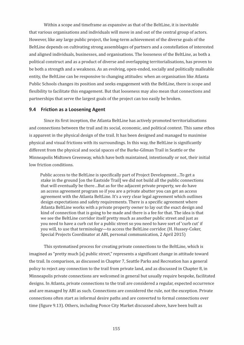
155
Within a scope and timeframe as expansive as that of the BeltLine, it is inevitable that various organisations and individuals will move in and out of the central group of actors. However, like any large public project, the long-term achievement of the diverse goals of the BeltLine depends on cultivating strong assemblages of partners and a constellation of interested and aligned individuals, businesses, and organisations. The looseness of the BeltLine, as both a political construct and as a product of diverse and overlapping territorialisations, has proven to be both a strength and a weakness. As an evolving, open-ended, socially and politically malleable entity, the BeltLine can be responsive to changing attitudes: when an organisation like Atlanta Public Schools changes its position and seeks engagement with the BeltLine, there is scope and flexibility to facilitate this engagement. But that looseness may also mean that connections and partnerships that serve the largest goals of the project can too easily be broken.
9.4 Friction as a Loosening Agent
Since its first inception, the Atlanta BeltLine has actively promoted territorialisations and connections between the trail and its social, economic, and political context. This same ethos is apparent in the physical design of the trail. It has been designed and managed to maximise physical and visual frictions with its surroundings. In this way, the BeltLine is significantly different from the physical and social spaces of the Burke-Gilman Trail in Seattle or the Minneapolis Midtown Greenway, which have both maintained, intentionally or not, their initial low friction conditions.
Public access to the BeltLine is specifically part of Project Development…To get a stake in the ground [on the Eastside Trail] we did not build all the public connections that will eventually be there…But as for the adjacent private property, we do have an access agreement program so if you are a private abutter you can get an access agreement with the Atlanta BeltLine. It’s a very clear legal agreement which outlines design expectations and safety requirements. There is a specific agreement where Atlanta BeltLine works with a private property owner to lay out the exact design and kind of connection that is going to be made and there is a fee for that. The idea is that we see the BeltLine corridor itself pretty much as another public street and just as you need to have a curb cut for a public street so you need to have sort of ‘curb cut’ if you will, to use that terminology—to access the BeltLine corridor. (H. Hussey-Coker, Special Projects Coordinator at ABI, personal communication, 2 April 2015)
This systematised process for creating private connections to the BeltLine, which is imagined as “pretty much [a] public street,” represents a significant change in attitude toward the trail. In comparison, as discussed in Chapter 7, Seattle Parks and Recreation has a general policy to reject any connection to the trail from private land, and as discussed in Chapter 8, in Minneapolis private connections are welcomed in general but usually require bespoke, facilitated designs. In Atlanta, private connections to the trail are considered a regular, expected occurrence and are managed by ABI as such. Connections are considered the rule, not the exception. Private connections often start as informal desire paths and are converted to formal connections over time (figure 9.13). Others, including Ponce City Market discussed above, have been built as
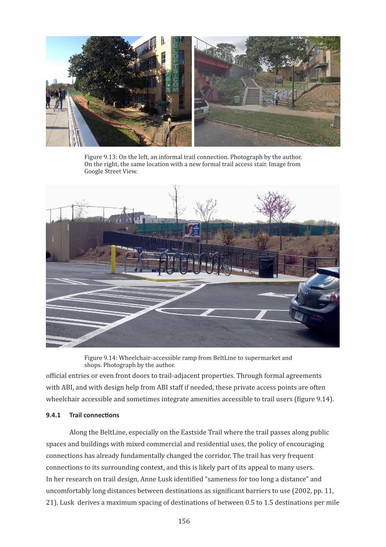
156
official entries or even front doors to trail-adjacent properties. Through formal agreements with ABI, and with design help from ABI staff if needed, these private access points are often wheelchair accessible and sometimes integrate amenities accessible to trail users (figure 9.14).
9.4.1 Trail connections
Along the BeltLine, especially on the Eastside Trail where the trail passes along public spaces and buildings with mixed commercial and residential uses, the policy of encouraging connections has already fundamentally changed the corridor. The trail has very frequent connections to its surrounding context, and this is likely part of its appeal to many users. In her research on trail design, Anne Lusk identified “sameness for too long a distance” and uncomfortably long distances between destinations as significant barriers to use (2002, pp. 11, 21). Lusk derives a maximum spacing of destinations of between 0.5 to 1.5 destinations per mile
Figure 9.13: On the left, an informal trail connection. Photograph by the author. On the right, the same location with a new formal trail access stair. Image from Google Street View.
Figure 9.14: Wheelchair-accessible ramp from BeltLine to supermarket and shops. Photograph by the author.
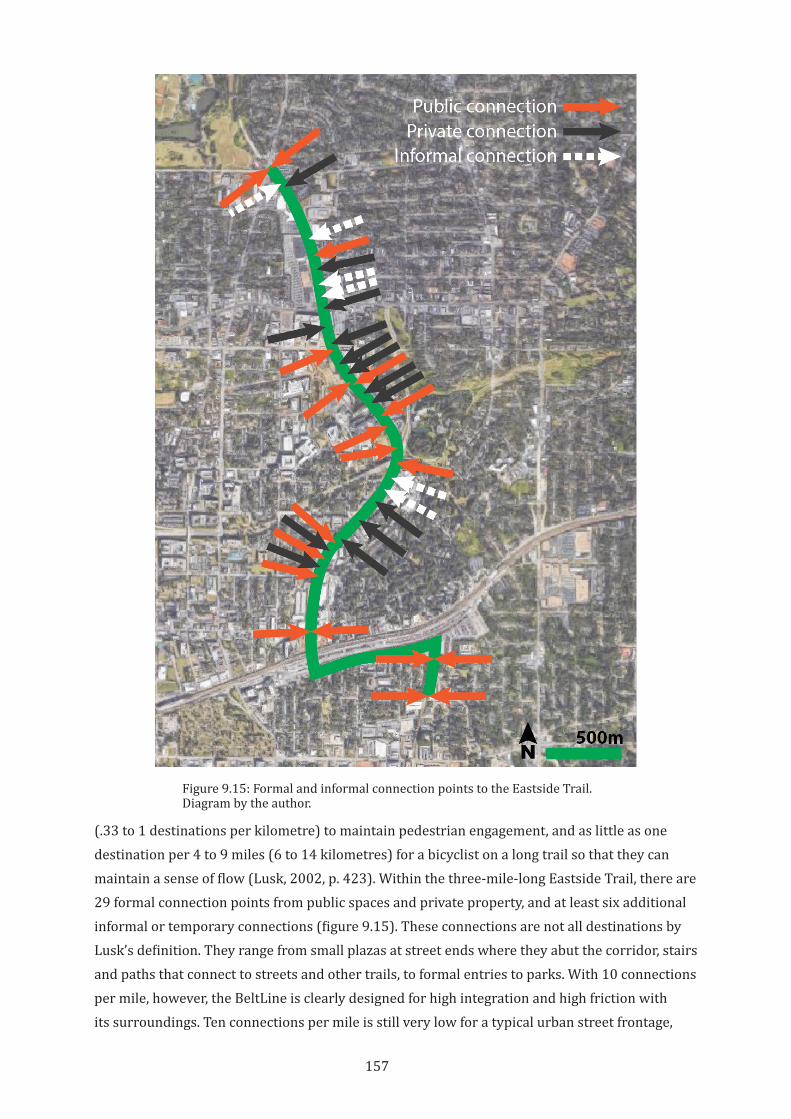
157
(.33 to 1 destinations per kilometre) to maintain pedestrian engagement, and as little as one destination per 4 to 9 miles (6 to 14 kilometres) for a bicyclist on a long trail so that they can maintain a sense of flow (Lusk, 2002, p. 423). Within the three-mile-long Eastside Trail, there are 29 formal connection points from public spaces and private property, and at least six additional informal or temporary connections (figure 9.15). These connections are not all destinations by Lusk’s definition. They range from small plazas at street ends where they abut the corridor, stairs and paths that connect to streets and other trails, to formal entries to parks. With 10 connections per mile, however, the BeltLine is clearly designed for high integration and high friction with its surroundings. Ten connections per mile is still very low for a typical urban street frontage,
Figure 9.15: Formal and informal connection points to the Eastside Trail. Diagram by the author.
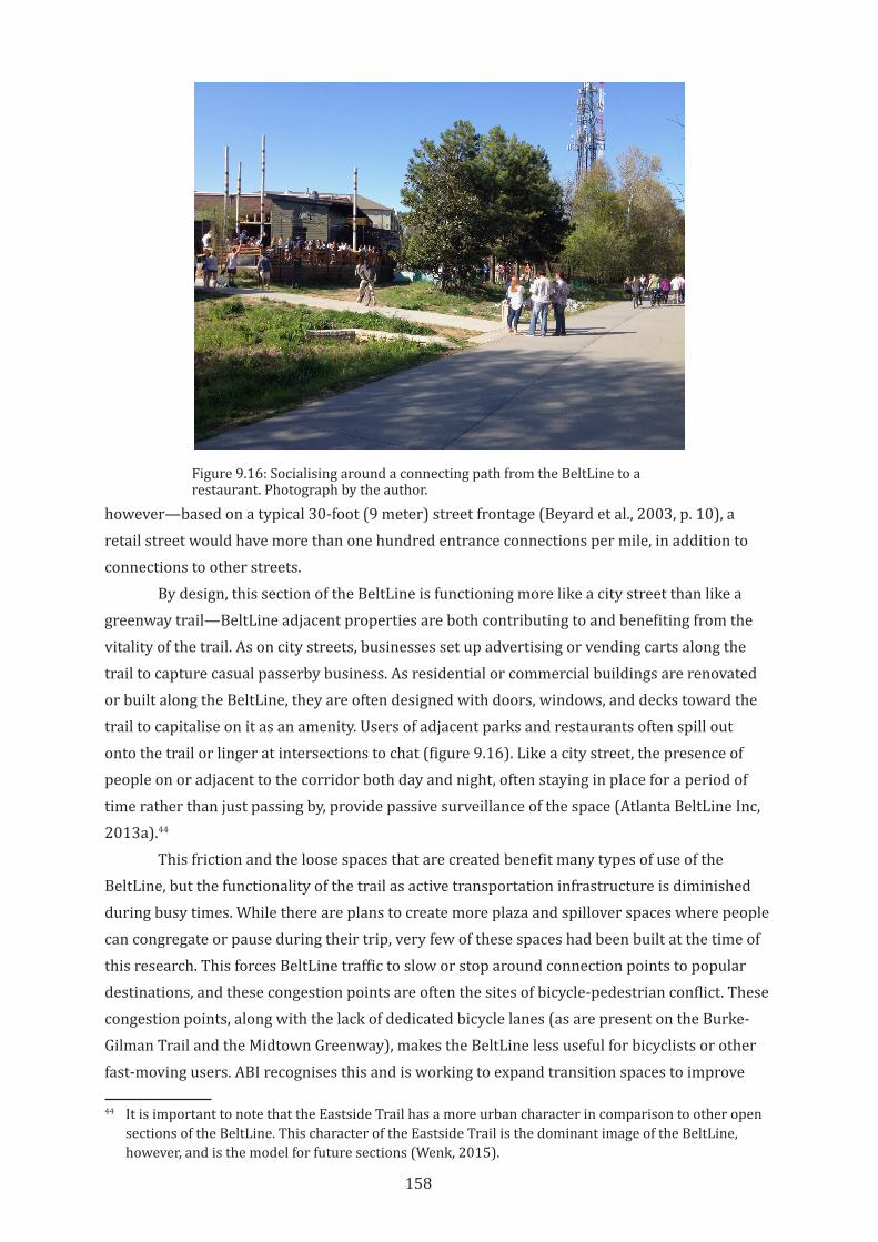
158
however—based on a typical 30-foot (9 meter) street frontage (Beyard et al., 2003, p. 10), a retail street would have more than one hundred entrance connections per mile, in addition to connections to other streets.
By design, this section of the BeltLine is functioning more like a city street than like a greenway trail—BeltLine adjacent properties are both contributing to and benefiting from the vitality of the trail. As on city streets, businesses set up advertising or vending carts along the trail to capture casual passerby business. As residential or commercial buildings are renovated or built along the BeltLine, they are often designed with doors, windows, and decks toward the trail to capitalise on it as an amenity. Users of adjacent parks and restaurants often spill out onto the trail or linger at intersections to chat (figure 9.16). Like a city street, the presence of people on or adjacent to the corridor both day and night, often staying in place for a period of time rather than just passing by, provide passive surveillance of the space (Atlanta BeltLine Inc, 2013a).44
This friction and the loose spaces that are created benefit many types of use of the BeltLine, but the functionality of the trail as active transportation infrastructure is diminished during busy times. While there are plans to create more plaza and spillover spaces where people can congregate or pause during their trip, very few of these spaces had been built at the time of this research. This forces BeltLine traffic to slow or stop around connection points to popular destinations, and these congestion points are often the sites of bicycle-pedestrian conflict. These congestion points, along with the lack of dedicated bicycle lanes (as are present on the Burke-Gilman Trail and the Midtown Greenway), makes the BeltLine less useful for bicyclists or other fast-moving users. ABI recognises this and is working to expand transition spaces to improve
44 It is important to note that the Eastside Trail has a more urban character in comparison to other open sections of the BeltLine. This character of the Eastside Trail is the dominant image of the BeltLine, however, and is the model for future sections (Wenk, 2015).
Figure 9.16: Socialising around a connecting path from the BeltLine to a restaurant. Photograph by the author.
159
these conditions (H. Alhadeff, Director of Special Projects & Initiatives, Atlanta Department of City Planning, personal communication, 9 April 2015). At the same time, however, increased friction affects how bicyclists, skaters, or runners use the trail. By slowing these users and discouraging potential users intent on maximum, uninterrupted flow, the trail remains firmly oriented toward slower-moving users. By prioritizing friction over flow, and looseness over tight controls on how the space of the trail is used, the BeltLine creates a significant public space, even if that comes at the cost of its efficiency as transportation infrastructure.
9.4.2 Planning tools for a new city street
The current form of the BeltLine is a loose, high-friction public space. However, this is not always the result of loose process or loose management. The goal of increased connection and integration of the trail with its urban context is also being addressed through tight, formal processes. The systematisation of private connections to the BeltLine is a part of a set of planning moves that prioritise a particular urban form and particular mobilities around the BeltLine.
ABI has considerable power to shape the public land in and adjacent to the BeltLine corridor. However, the corridor represents a small fraction of land in the neighbourhoods that surround the trail. To create the BeltLine as a new city street that is integrated into a revitalised, walkable, connected urban fabric, the city council is also utilizing typical planning tools to govern development around the corridor, albeit ones that are rarely applied to rail trail projects. First, the Council is modifying its long-term land use plans and zoning code to change densities and allowable land uses in properties around the corridor, enable the creation of open spaces, and orient neighbourhoods toward the BeltLine. Second, the City created a BeltLine Overlay District to more specifically guide the way new commercial and multi-family residential projects interface with the BeltLine and other nearby public spaces and streets. These changes are intended to extend the social and economic effects of the BeltLine into the surrounding city, and to deeply integrate the trail into Atlanta’s street grid and urban fabric. They also have the effect of formalising and tightening the context of the trail. While this has not yet led to tightening of the space of the trail, this seems to be a potential outcome.
Zoning changes
Zoning controls the types of land uses, densities, building heights, massing and design that are allowed in a particular area of a jurisdiction. Zoning changes around the BeltLine were intended to encourage landowners around the corridor to transition their properties from railroad-oriented industrial and commercial uses toward pedestrian- and bicyclist-friendly mixed-use residential, retail, and commercial uses. As part of the initial planning work for the BeltLine, a group was created to consider land use, community resources, environmental remediation, and transportation issues near the corridor (Atlanta Development Authority, 2005). A walkable area around the corridor, roughly based on a half-mile (0.8 kilometre) buffer on each side of the corridor, was used to identify early issues and opportunities. By including this buffer area as an integral part of the BeltLine, the formal reach of the BeltLine territory covers
160
approximately 35% of the total area of Atlanta45 (see figure 9.6 above). This study area was formalised and divided into 10 subareas, each with its own master plan. Each of these plans was developed by a committee of local residents, school representatives, local politicians, City and ABI staff, and a consultancy team—a process that took more than a year and included a set of formal public meetings. Each plan includes land use, transportation, and open space elements, as well as a set of recommended land use and zoning changes, designed to drive economic development, improve connections, improve housing supply, and create enjoyable, sustainable, and safe places for BeltLine users and neighbours (see for example Tunnell-Spangler-Walsh & Associates, 2010, pp. 3-5).
The zoning changes effected around the BeltLine generally consist of increased density, a change of industrial land uses to commercial, residential, retail or institutional uses, conversion of single-use zones to mixed uses, and the creation of new open spaces (see for instance Tunnell-Spangler-Walsh & Associates, 2009, Appendices 1-2). They reflect the general BeltLine goal to create walkable neighbourhoods around the trail and the eventual streetcar line. Increased density reflects both the intent to encourage active transportation and transit use, but also the anticipated demand and economic development potential around the public amenity of the trail, transit, and open space along the BeltLine corridor.
Zoning changes are often controversial. Nearby residents and business owners often raise concerns about the effects of change on their property values and quality of life. This can lead to a slow process of change, or no changes at all, in the land uses even around major public investments, such as infrastructure projects like the BeltLine. As discussed above, community concerns around gentrification, racial and economic inequality, and compatibility between existing and new development are significant issues around the BeltLine (Roy, 2015). But again, the alignment of public and economic support for the overall BeltLine project helped generate the political will needed to follow through on zoning changes. Many individuals and organizations that have a stake in the success of the BeltLine help push forward project elements that are otherwise politically fraught. This public and private support is magnified by internal pressure within ABI to support development, even in the face of community opposition.
The master planning and zoning update process effectively integrated the BeltLine into the planning framework of Atlanta. However, the tightness and formality of these processes have also been used as a tool by other organisations to constrain ABI. For instance, both ABI and the City of Atlanta Zoning Review Board supported a BeltLine-adjacent project that neighbours and the local Neighborhood Planning Unit feared was too large for the area. (Wheatley, 2015). Neighbours of the project used social media to build grassroots opposition to the project, and argued that the project violated the BeltLine Master Plan for the area (Green, 2016). Despite support from ABI staff, this project was eventually halted by a vote of the City Council (Atlanta City Council, 2016). Other projects have similarly been opposed by neighbourhood groups where development plans conflicted with subarea master plans (see for instance Saporta, 2018a,
45 This figure is based on an independent report, not on Atlanta BeltLine Inc sources (Ross, 2007). The methodology of generating this planning area is the same as that used by ABI, so the figure is roughly accurate.
161
2018b), which suggests that the master planning process and formal zoning regulations have played a role in tightening the physical context of the BeltLine, even in the face of the loose power of ABI.
The BeltLine Overlay District
In addition to the general use and mass controls that zoning provides, Atlanta has established an overlay district46 to provide finer-grained control over development around the BeltLine. An overlay district is a focused tool for applying a set of regulations to a specific area, regardless of underlying zoning or other governing rules (E. Garvin, 2001). A historic overlay district, for instance, could include requirements for new building façades that complement existing historic structures in the area. An erosion control overlay district can be used to establish landscaping or site coverage requirements to minimise site runoff into a sensitive environment. Many cities use overlay districts to create pedestrian zones with particular requirements, such as ground-level uses, requirements for weather protection, fenestration, or building entrances, that are intended to enhance pedestrian environments. As such, they are often considered form-based or hybrid codes that focus primarily on the façades, thresholds, and interaction between buildings and adjacent public space (Talen, 2009).
The [City Council] finds that taking special consideration to ensure that the redevelopment of properties adjacent to and within walking distance of the BeltLine Corridor entails a compatible mixture of residential, commercial, cultural and recreational uses, and design standards conceptualized in the BeltLine Redevelopment Plan is crucial to promote and ensure the public health, safety and welfare of its citizens. [Council] recognizes that as the BeltLine attracts new development, the orientation and character of that growth should encourage pedestrian and transit-oriented uses and activities designed to support an urban character to foster the most positive impact on affected communities. (“BeltLine Overlay District regulations,” 2007)
The BeltLine Overlay District establishes a set of detailed regulations that control how buildings face and interact with the BeltLine, nearby streets, and other trails. This zoning overlay controls entrance locations and configurations; the locations, quantities, and qualities of glazing; landscaping, walkways, and walls and fences between buildings and adjacent public spaces. It applies to all buildings in the district with the exception of single-family homes and areas already in a different overlay district. Importantly, the overlay does two things: first, it treats the BeltLine as a pedestrian street, requiring new adjacent buildings to create welcoming façades oriented toward the trail, and second, it applies these same pedestrian-oriented requirements to buildings along all streets and public spaces in the district (figure 9.17).
In general, building owners are required or incentivised to build pedestrian-friendly buildings. The overlay seeks developments that create connections to the BeltLine or to other public spaces and streets, provide publicly-accessible open space, and facilitate passive surveillance of public spaces. These regulations are generally consistent with pedestrian overlay
46 Overlay districts have a variety of names, including “zoning overlay,” “design overlay,” “urban design overlay,” “overlay zone,” or simply “overlay.” “Overlay district” is used here to be consistent with City of Atlanta terminology.
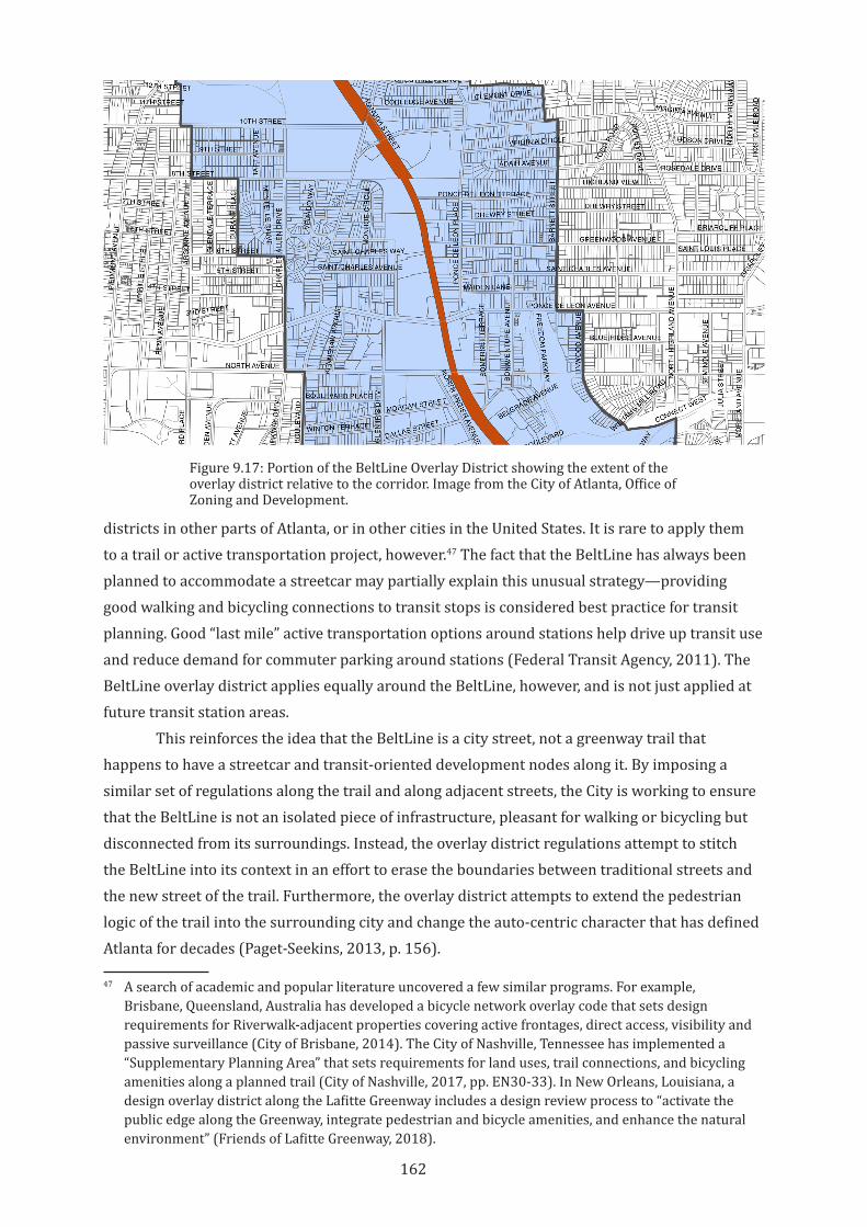
162
districts in other parts of Atlanta, or in other cities in the United States. It is rare to apply them to a trail or active transportation project, however.47 The fact that the BeltLine has always been planned to accommodate a streetcar may partially explain this unusual strategy—providing good walking and bicycling connections to transit stops is considered best practice for transit planning. Good “last mile” active transportation options around stations help drive up transit use and reduce demand for commuter parking around stations (Federal Transit Agency, 2011). The BeltLine overlay district applies equally around the BeltLine, however, and is not just applied at future transit station areas.
This reinforces the idea that the BeltLine is a city street, not a greenway trail that happens to have a streetcar and transit-oriented development nodes along it. By imposing a similar set of regulations along the trail and along adjacent streets, the City is working to ensure that the BeltLine is not an isolated piece of infrastructure, pleasant for walking or bicycling but disconnected from its surroundings. Instead, the overlay district regulations attempt to stitch the BeltLine into its context in an effort to erase the boundaries between traditional streets and the new street of the trail. Furthermore, the overlay district attempts to extend the pedestrian logic of the trail into the surrounding city and change the auto-centric character that has defined Atlanta for decades (Paget-Seekins, 2013, p. 156).
47 A search of academic and popular literature uncovered a few similar programs. For example, Brisbane, Queensland, Australia has developed a bicycle network overlay code that sets design requirements for Riverwalk-adjacent properties covering active frontages, direct access, visibility and passive surveillance (City of Brisbane, 2014). The City of Nashville, Tennessee has implemented a “Supplementary Planning Area” that sets requirements for land uses, trail connections, and bicycling amenities along a planned trail (City of Nashville, 2017, pp. EN30-33). In New Orleans, Louisiana, a design overlay district along the Lafitte Greenway includes a design review process to “activate the public edge along the Greenway, integrate pedestrian and bicycle amenities, and enhance the natural environment” (Friends of Lafitte Greenway, 2018).
Figure 9.17: Portion of the BeltLine Overlay District showing the extent of the overlay district relative to the corridor. Image from the City of Atlanta, Office of Zoning and Development.
163
Parking requirements
Perhaps in reflection of the longstanding car-oriented character, the overlay district is very conservative when it comes to vehicle and bicycle parking requirements. Rather than aggressively promoting car-free living by eliminating minimum requirements for off-street parking or requiring significant bicycle parking, the Council appears to be hedging its bets, reducing but not eliminating parking requirements in the overlay district. Within the district, a residential project must still provide one space per unit minimum, the same as most parts of the city. For non-residential uses in the overlay district, the parking requirement is one space per 300 square feet. Bicycle parking is required in the district, but developers must supply just one bicycle parking space for five residential units or 4000 square feet of non-residential space. While automobile and bicycle parking requirements vary considerably in different parts of the city, the BeltLine overlay district does not provide a meaningful shift away from automobiles.48
These requirements suggest two elements of the planning mindset that existed when the BeltLine project was being developed. First, it acknowledges that long-standing patterns of automobile use in Atlanta will be difficult to overcome, and having a trail or streetcar nearby is often not enough to eliminate the need for a car. In car-oriented cities around the world, sprawling urban development patterns make many trips difficult without a car. There is evidence that built environment factors such as density influence car ownership rates, but the relationships are complex and often dwarfed by personal travel decisions (Schimek, 1996; Bhat & Guo, 2007). It is unreasonable to assume that the creation of pedestrian- and transit-oriented BeltLine environments will significantly change travel behaviours in the short term. Even after extending the territory of the BeltLine to cover a large portion of the city, parking needs or desires around the BeltLine remain complex and multi-dimensional. Parking requirements in the design overlay may reflect this. In addition, reductions in parking requirements are often controversial when existing residents and businesses fear an influx of new residents using on-street spaces as residential parking (Godwin, 2017). This is compounded by the number of people who drive to the BeltLine from elsewhere in the city or region. The BeltLine attracts thousands of visitors each week, and major events can have tens of thousands of attendees (Atlanta BeltLine Inc, 2018a; Atlanta Convention and Visitors Bureau, 2019, p. 37). In light of this history and evidence, there may have been little incentive to reduce car parking requirements.
Second, as discussed above, the BeltLine was not developed with bicycle transportation as a primary consideration. In the context of a city with little history of urban bicycling and an underdeveloped bicycling network, this may have been a reasonable position when the BeltLine was conceived. However, the BeltLine has helped raise the visibility of bicycling in Atlanta and bicycling now has a symbolic value along the BeltLine. Bicycling rates have increased in the decade since BeltLine planning began in earnest (Atlanta Regional Commission, 2016, p. 22).
48 For example, the Midtown Special Public Interest District, a mixed-use district of Atlanta where transit and pedestrian friendly streets are prioritised, has much more aggressive regulations: Minimum parking requirements for retail and restaurant uses in transit station areas are completely eliminated (Midtown Alliance, 2013, p. 62).
164
It is clear that the pedestrian focus of BeltLine planning has resulted in a high friction, relatively loose public space. This has been realised both through direct design of the corridor and also through planning tools. The loose physical space of the trail, coupled with the direct adjacencies and strong connections to a range of public spaces and retail businesses, has resulted in a public space that is celebrated for its urban vitality. Friction is a major contributor to this character. However, this friction has decreased some of the potential mobility value of the BeltLine, especially for bicycling. The lack of a formal bicycling strategy for the trail or more robust bicycle planning for the developments around the BeltLine has likely blunted the growth in bicycling rates. The conditions in which the BeltLine was planned and this history of bicycling in Atlanta can explain these omissions. These conditions have changed, however. Future phases of BeltLine implementation will focus on integrating the streetcar into the corridor, and the increased attention on the transportation aspects of the BeltLine may also be an opportunity to rethink bicycling strategies in the corridor and beyond.
9.5 A Tightened Future? The Replacement of the Ad Hoc With the Formal
The BeltLine is now completely integrated into the societal, political, and economic territories of Atlanta. From its start as an unfunded, grassroots vision to its current form as a major influence on the future of public space, transportation, and economic development in Atlanta, the history of the BeltLine is one of increasing cross-territorialisations with urban life and the urban fabric. With this integration, the BeltLine has been formalised within the zoning code, the political and financial systems, and in the social fabric of Atlanta. This formalization and integration have brought with them a tightening of the rules and physical spaces of the BeltLine. While this transition has been gradual, for some individuals and organisations near the trail the changes have been jarring or unpleasant. An example of the effects of this transition is the story of the former Atlanta BeltLine Bicycle Shop.
The initial loose space and loose management of the BeltLine corridor inspired many adjacent businesses to create ad hoc physical and economic relationships to the trail. The owner of the bicycle shop moved his business from an Atlanta suburb to an old warehouse directly adjacent to the Eastside Trail in 2013 (Ellis, 2013). He chose the location because of the BeltLine and changed the name of the shop to take advantage of the name recognition.49 The shop rents out bicycles (most of which are used by people riding the BeltLine) and also sells new and used bicycles. The main entrance to the shop is on the BeltLine side of the building, and shop signage is larger and more visible on the BeltLine side than on its street frontage. The owner built a very basic set of stairs from the BeltLine trail to the shop to overcome the approximately four-foot (1.2 meter) grade difference between the trail and the patio of the shop (figure 9.18).
Initially the shop had a good relationship with ABI. The shop was the starting point for bicycle tours of the BeltLine, and the owner had regular contact with ABI about development plans for the BeltLine. In 2015, however, the ABI legal department notified the shop owner that the stairs encroached on the corridor and had to be removed, with just eight days’ notice before ABI would “forcibly compel their removal.” The owner felt this letter was heavy-handed and out 49 The shop was formerly named Avondale Cycles, after its location in the City of Avondale Estates.
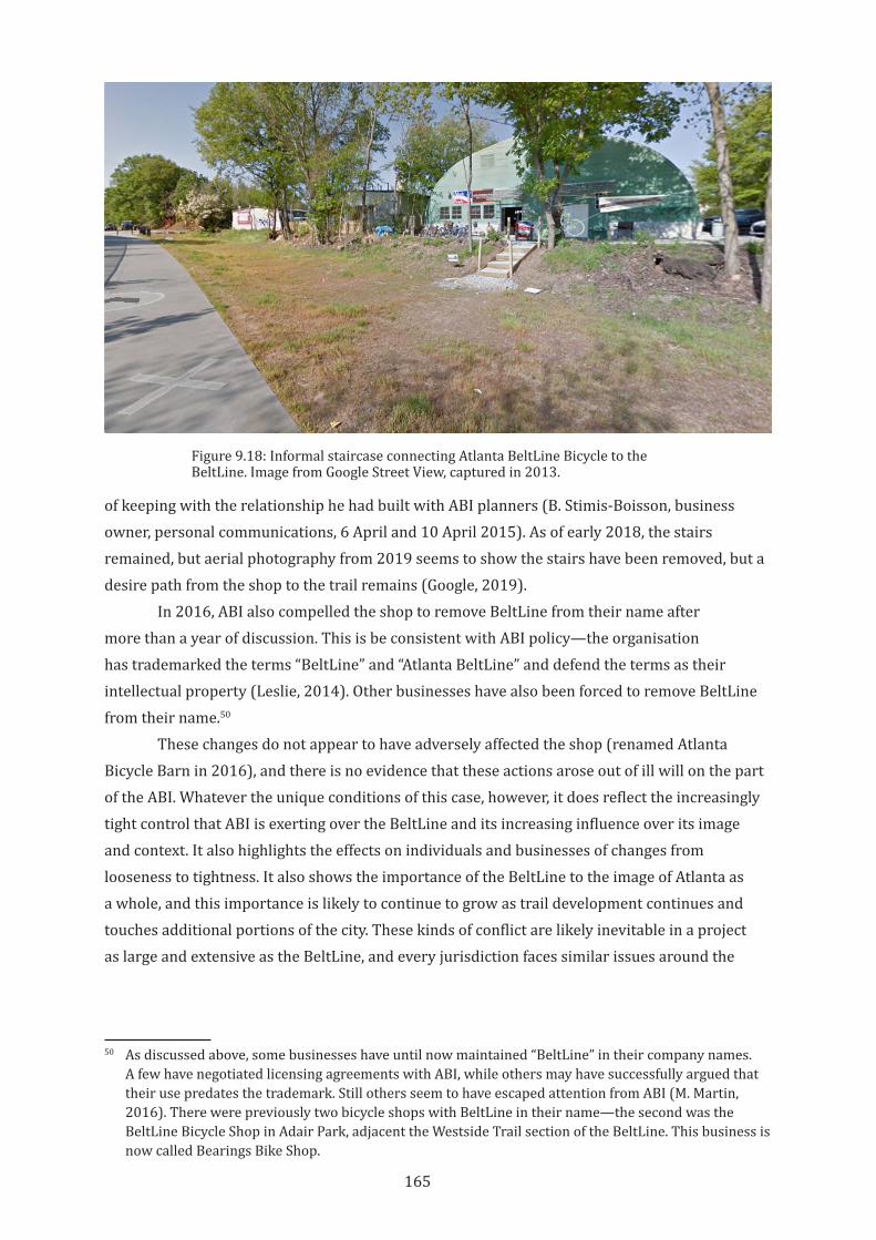
165
of keeping with the relationship he had built with ABI planners (B. Stimis-Boisson, business owner, personal communications, 6 April and 10 April 2015). As of early 2018, the stairs remained, but aerial photography from 2019 seems to show the stairs have been removed, but a desire path from the shop to the trail remains (Google, 2019).
In 2016, ABI also compelled the shop to remove BeltLine from their name after more than a year of discussion. This is be consistent with ABI policy—the organisation has trademarked the terms “BeltLine” and “Atlanta BeltLine” and defend the terms as their intellectual property (Leslie, 2014). Other businesses have also been forced to remove BeltLine from their name.50
These changes do not appear to have adversely affected the shop (renamed Atlanta Bicycle Barn in 2016), and there is no evidence that these actions arose out of ill will on the part of the ABI. Whatever the unique conditions of this case, however, it does reflect the increasingly tight control that ABI is exerting over the BeltLine and its increasing influence over its image and context. It also highlights the effects on individuals and businesses of changes from looseness to tightness. It also shows the importance of the BeltLine to the image of Atlanta as a whole, and this importance is likely to continue to grow as trail development continues and touches additional portions of the city. These kinds of conflict are likely inevitable in a project as large and extensive as the BeltLine, and every jurisdiction faces similar issues around the
50 As discussed above, some businesses have until now maintained “BeltLine” in their company names. A few have negotiated licensing agreements with ABI, while others may have successfully argued that their use predates the trademark. Still others seem to have escaped attention from ABI (M. Martin, 2016). There were previously two bicycle shops with BeltLine in their name—the second was the BeltLine Bicycle Shop in Adair Park, adjacent the Westside Trail section of the BeltLine. This business is now called Bearings Bike Shop.
Figure 9.18: Informal staircase connecting Atlanta BeltLine Bicycle to the BeltLine. Image from Google Street View, captured in 2013.
166
balance between regulation and freedom; between creating a consistent and pleasant physical environment and sterilizing the vibrancy of city spaces; and between the risks and benefits of looseness and tightness in city places.
It seems likely that this tightening will continue as the trail develops, and especially as the streetcar is implemented. Renderings of the streetcar show a grassy trackbed with very little separation from pedestrian and bicycle traffic (see figure 9.2, above). This is probably idealistic. Transit lines tend to be evaluated on their throughput and timeliness, and these both decrease where the trains or buses are not separated from other uses (Litman, 2007). Given that transit generally performs better in tight, low-friction spaces, the introduction of transit into the corridor will likely have a tightening effect on the current uses of the BeltLine. These current loose patterns, however, are largely responsible for the BeltLine as it exists today. Both the physical space of the BeltLine and its accommodation of diverse activities arose from the looseness of the trail. If the space and management of the BeltLine continue to tighten, some territorialisations, some uses, or some users will eventually be excluded.
9.6 Conclusion
The early years of the BeltLine were marked by grassroots community efforts, changing and overlapping territorialisations of the trail by neighbours, businesses and organizations; looseness of borders and uses and an ad hoc implementation process; and by increasing friction between the trail and its context. The BeltLine thus embodies the characteristics that contribute to urban vitality—looseness, friction, and flexible, overlapping territoriality. As the BeltLine moves through its second decade as an urban development and transportation project, however, will these characteristics be lost? Will the continued power of ABI and corporate contributions to the Atlanta Beltline Partnership overwhelm other territorialisations of the trail? Will the space and the rules for its use continue to tighten? And will the introduction of streetcar force the elimination of friction in the corridor? It seems likely that the BeltLine will continue to be successful at reshaping the city of Atlanta, but the long-term urban vitality of the trail is less clear. As this chapter has made clear, the story of the BeltLine so far has been one in which initial overlapping territories and an inherent looseness made for a rich, high-friction, vital environment. As the trail has developed, however, the loose space and loose management of the trail has been eroded by increasingly strong territorialisation by ABI. At the same time, conscious design decisions have introduced new frictions while removing others. The impact on the urban vitality of the BeltLine and the surrounding city is therefore mixed, and the future is far from clear.
The BeltLine has intentionally unleashed powerful economic forces on the city, forces that are already impacting existing communities. This thesis has highlighted places, from Atlanta’s Westside neighbourhoods to New York’s Bryant Park, where gentrifying forces have damaged urban vitality through overly strong territorialisations and tightened regulations. The various individuals and organisations that have guided the BeltLine, from its early champions to its current planners, have attempted to learn from those examples and avoid the destructive
167
effects of economic development and rapid community change. Despite this self-awareness, development along the BeltLine has often reinforced longstanding inequalities and harmful patterns.
As a broad assemblage of diverse actors, the BeltLine has also shown itself to be resilient and capable of evolution. From its inception as an open, community-driven idea, to the current diverse partnerships, the BeltLine has been able to maintain and extend its image as a place of physical and cultural potential. In comparison with the Burke-Gilman Trail and the Midtown Greenway, this resilience and openness has helped create a vital space, one in which territoriality, friction, and looseness are all comparatively strong. The BeltLine is far from finished, and the major addition of the streetcar will bring major changes in the use and character of the corridor. This may be an opportunity to re-establish a stronger transportation role for the trail, but it also holds risks for the loose space that exists today. The slogan of the BeltLine is, “Where Atlanta comes together.” The full realisation of this promise will require continued attention to that factors that make it a vital urban place.
168
10 Discussion and conclusion
10.1 Introduction
Urban rail trails are a unique kind of city space. Built upon rail corridors and industrial infrastructure no longer suitable or welcome in contemporary cities, urban rail trails are simultaneously palimpsests of the past, escapes from car-dominated streets, and visions of sustainable transportation and urban life. The manifestations of these visions are divergent: the trails explored in this thesis have different origin stories, utilise different processes of implementation, and create different systems that maintain them. In each case, however, these rail trails are intended to be more than simple transportation corridors, whether the added meaning be a linear park, a spur for economic development, or a space for a diverse city to come together. Each of the trails aspires to be a public space as well as an active transportation route. This thesis has explored these dual and sometimes contradictory goals through a framework of urban vitality and through territoriality, friction, and looseness, three interacting agents that can create vital places.
Urban vitality is defined for this thesis as having both social, economic, and physical ramifications. A vital urban space provides space for transactions but prioritises use over exchange value. A vital space is socially, culturally, and economically open and diverse but also allows claims, occupations, and self-management of space. A vital space is constantly charged by the uses that surround it but is not defined by any single use or territorialisation.
Using urban vitality as an analytical tool for rail trails is timely. Cities throughout Australia and the United States are recycling abandoned railroad corridors and other post-industrial infrastructure as active transportation space. As these cities strive to address growing health, economic, environmental, and spatial problems, walking and especially bicycling are seen as important transportation modes. However, while bicycling as an urban transportation mode is increasingly accepted and internalised into planning processes, the potential role of urban bicycling as a component of a city’s social and economic life has not been adequately investigated. This thesis has thus considered rail trails as a new kind of city street—a street without the pressures of automobile use, a street where relationships to adjacent properties and land uses can be reimagined, and where transportation infrastructure and public space can strengthen each other rather than conflict with each other.
By evaluating the design and management of rail trails through the agents of territory, friction, and looseness, this thesis has identified the underlying attitudes, management structures, and often hidden power dynamics that help determine the character of trails and their potential contribution to the social and economic wellbeing of neighbourhoods and cities. The framework of urban vitality was developed to help make explicit the often-unconscious ways
169
we think about active transport infrastructure and its place in a city. By making these implicit attitudes visible, they can be better integrated into the processes of planning, public discourse, implementation, management, and evaluation of trails.
The purpose of this thesis has been to understand some of the forces and actions that underpin the observed differences between urban rail trails. The goal has been to identify ways that rail trails, and bicycle infrastructure in general, can better contribute to the social and economic vitality of cities. As such, this research focused on introducing new frames of analysis, integrating bicycle planning with the body of research on urban vitality and public space design, and making explicit the role of power and territoriality in urban public space and transportation infrastructure. This chapter will discuss key findings and observations from the case studies; explore the larger implications of this research for urban design theory and practice; and finally highlight some limitations of this work and identify future research topics.
10.2 Case Study Findings and Observations
While the rail trails presented in the case studies are all well-used and well-loved, they each show markedly different attitudes and configurations of friction, looseness, and territory. They make clear that there is no one model of an urban rail trail. They do suggest that there is general change in attitudes toward the potential role of rail trails in cities. It is instructive to compare the Burke-Gilman Trail, the first urban rail trail in the United States, with trails that came later, especially the BeltLine, which is still in its early stages of implementation. There is a clear difference in what these two trails were intended to do in their cities. While both trails were imagined as providing pleasant and safe active transportation infrastructure and green, park-like environments in dense urban environments, the Burke-Gilman Trail was not imagined as having a larger role—it was designed quite similarly to a street for cars, as a tight, low-friction space with a very clear set of territorial regulations guiding its use. The planning for the BeltLine has clearly benefited by the decades of evidence that suggests that people want to use trails for socialising as much as moving, and that an urban rail trail is a community amenity that can strengthen and be strengthened by other developments and land use changes around it. The impressively broad range of associated uses and stakeholders that have been included as part of the BeltLine project show definitively that an urban rail trail is much more than just a path or a “glorified sidewalk” (Fausset, 2016, para. 10). These additional territorialisations have helped introduce new frictions and looser meanings and uses along the trail. The Midtown Greenway represents a still-moving midpoint between the other two. It was initially envisioned as a low-friction, tight bicycle superhighway that benefited from its morphology that limited overlapping territories. This has changed in the last decade, and the Greenway is now envisioned as a major complement to social spaces and economic development around it. New territorialisations and frictions are invited, and loosened spaces and uses have moved into the thresholds between these still evolving overlaps.
170
But their differences illustrate some general relationships and effects that arise from the interactions between the three agents. This section will discuss five observations from the case studies that highlight how these agents act and interact within urban planning and management structures to influence urban vitality.
10.2.1 Monolithic territories are often invisible
Territorial control of rail trails is often exercised by a single government department. These kinds of monolithic territories can be hard to perceive. They become invisible, seen as the inevitable or natural order of things. Territoriality is easier to perceive when it is contested, fragmented, or overlapping.
The case of the Burke-Gilman Trail in Seattle shows that strongly maintained territorial control over a trail has long term effects on its contribution to urban vitality. The portion of the trail managed by Seattle Parks and Recreation is maintained as a friction-free park space, largely separated from the everyday life of the city around it. While the small territorial incursions into the trail space and the proposed trail-oriented development discussed in Chapter 7 suggest that some trail neighbours see value in connecting to the trail, they are largely prevented from doing so by public policy and the strong influence of Seattle Parks and Recreation. Even within the section of the trail controlled by the University of Washington, where the university is planning for high-friction interfaces between the trail and the campus, this is done through strict control over the territory of the trail. In both the Seattle Parks and Recreation and university sections of the trail, the effect of these very strong territorial actors is twofold.
First, they preclude significant territorial actions by other individuals and groups. The small advertisements of nearby businesses and the few semi-direct access points to the trail are minor and disconnected. There is no critical mass of trail neighbours who can deterritorialise the trail enough to change (or subvert) policy. Likewise, the advocacy groups that have a stake in the trail (both of the Friends of the Burke-Gilman Trail groups, the Cascade Bike Club, nearby neighbourhood planning groups, and business groups) are all silent on alternative visions for the role of the trail in the city. This strong territorial control over the trail reinforces itself—by crowding out other voices or actors, the visions of the university and Seattle Parks and Recreation become the only legitimate options. This contrasts with the fuzzier territorialisations of the Atlanta BeltLine, where both history and an intentional management strategy by Atlanta BeltLine, Inc give trail neighbours (businesses, property owners, artists, neighbourhood planning groups and organisations) a more significant role in visioning the trail. In Atlanta, the multiple and sometimes conflicting territorialisations can help illuminate where those territories exist. Where territories are visible, it is possible to challenge them, as in the example of gentrification and the lack of affordable housing construction along the BeltLine.
Second, strong and long-term territorialisation acts to formalise rules and expected behaviours along the trail, to the point where alternative uses of the trail space are rejected by both the territorialising actor and by other users of the trail. Longstanding rules, as well as ongoing maintenance of the Burke-Gilman Trail, preclude uses of the trail outside of linear movement along the trail. When alternative patterns of use arise (skateboarding in trail adjacent
171
spaces or proposals for trail-accessible businesses, for example), these uses are not only officially discouraged but are also the source of user complaints. The territory of the trail has been formalised to the point where the officially sanctioned users feel entitled to sole use of the space. The lack of territorial challenges to this formal order excludes other users and uses. The territorialisation of the rail trail has become so monolithic as to become internalised for trail users and neighbours.
In contrast, the multiple voices within the Midtown Greenway Coalition has so far precluded a monolithic, unchanging territoriality. Also, the goal to improve safety and increase use of the Greenway by allowing community-programmed open space and private developments to create direct connections has the secondary effect of deterritorialising the Greenway along its edges and provides opportunities for conversations about the evolving role of the trail in the city.
When territoriality becomes deeply entrenched and unbroken, it can take on an aura of immutability, even to the point of becoming invisible to a casual user. Strong territorial control would appear to be difficult to maintain in the contested spaces of the city. However, the case of the Burke-Gilman Trail suggests that strong territorialisations are possible, especially in spaces that are transportation-focused, tightly managed, and relatively friction-free.
10.2.2 Friction increases in the absence of territorial controls
In the absence of strong territorial control over trail corridors, the trails studied for this thesis showed increasing friction with adjacent uses. Active rail corridors are typically not seen as amenities by neighbouring uses (Armstrong Jr, 1994), and thus friction is initially limited when trails are developed. But these case studies show there is a tendency for increasing friction between the trail and neighbouring uses, even where that friction is not officially sanctioned. It is perhaps an unsurprising observation that people want access to urban places that they view as amenities, as they create benefits and increase value for residents, businesses, and property owners alike. Along trails, as in other public spaces in a city, territorialisations such as signage, direct access paths or gates, and temporary or permanent claims on space grow as the trail develops. Friction grows in the borders between these territorialisations. But as in any public space that also includes transportation uses, there are potential conflicts between friction and flow, and the case studies show differing attitudes toward managing these conflicts.
Along the Atlanta BeltLine, friction between the trail and its context grew first because Atlanta BeltLine Inc lacked a consistent design approach for managing the friction (and so neighbours were relatively free to create connections or other frictions as they saw fit), and second because friction was consistent with several policy goals. High speed flow for bicyclists was never a high priority for planners—accessibility was prioritised over mobility.51 As a result, bicyclists (and other users) who seek high-speed, low-friction travel tend to use different routes.
In contrast, the Burke-Gilman Trail was initially imagined as a high-speed, long distance travel corridor, and so friction has always been highly constrained. This has been possible because of the strong territorial control that Seattle Parks and Recreation and the University of Washington exert over the trail. Where the boundaries between the trail and other spaces are 51 See Chapter 4 for an explanation of the difference between mobility and accessibility.
172
less clear (especially at street intersections, but also at park edges), friction is more common. Where space is deterritorialised, even just slightly, friction is increased by the actions of neighbours and everyday uses. Conflicts arise around these insertions of friction into a space that is perceived to be intended for flow. This has been an issue in the Seattle and Minneapolis cases, and is equally true for most transportation infrastructure. Because of societal expectations around flow in transportation infrastructure, managing expectations around friction and flow is a key planning issue for urban rail trails where urban vitality is a design goal.
In Minneapolis, the morphology of the trail created a significant barrier to both territorialisation and friction in the trench section of the Midtown Greenway. Here, however, there have been previous attempts to reduce friction through territorial controls—the inverse of the Atlanta example. Building signage along adjacent buildings has been restricted, and regular citizen patrols discourage loitering. But even here, loose uses in the undeveloped portions of the corridor and surrounding properties has created new, if limited, frictions between uses.
The finding that friction in urban rail trails increases where territorialisation is limited or contested echoes Sennett’s (1971) observation that people must interact and negotiate uses of public space in the absence of government control, and are equally applicable to any urban public space. To encourage urban vitality in urban rail trail projects, some degree of Sennett’s “‘decentralized’ power”(1971, p. 164) may be helpful.
10.2.3 Territorialising land uses and urban forces have mixed impacts
Where neighbouring uses can territorialise the edges of the trail corridor, there are significant differences in which types of uses create change more quickly. In the cases of Atlanta and Seattle, retail uses territorialised the space of the trail first, with new residential development and public open space uses following after. Commercial and institutional uses were generally slow to engage with the trails, although when they did, they had a large impact on the character of the trails. Existing residential uses did not in general territorialise the trails.
In Minneapolis, most of the territorialisations of the trail are new residential projects and public or semi-public open space. There are notable retail and commercial territorialisations, but these are strongly limited by the morphology of the corridor. With the exceptions of large-scale developments (the Midtown Exchange building) and demonstration projects (the Freewheel Bicycle/Greenway Coalition space), commercial and retail territorialisations are hindered by signage and slope preservation regulations and the high cost of developing trail-facing frontages. Thus, Greenway territorialisation by adjacent uses remains low, despite the desires and efforts of the Coalition and local government planners.
Planners in Atlanta and Minneapolis support trail territorialisations in general because they believe a more integrated, high-friction trail environment will drive economic benefits for nearby businesses and property owners and improve the experience of being on the trail. Trail territorialisations can create amenities for trail users. They can make goods and services available to trail users, provide seating or resting spaces along the trail, and provide visual interest and attractive destinations. They are also believed to increase activity and passive
173
surveillance along the trail, making the trail feel safer and more comfortable. This same logic drives planning efforts to increase territorialisation in pedestrian environments and is consistent with the large body of planning theory on economic vitality and activity in cities.
The risks of encouraging economic territorialisation of a rail trail parallel those of pedestrian environments, as well. The logic of economic territorialisation works against territorialisation by others. Territorialisation of trail space, especially by high end retail or residential development, can act to tighten the space of the trail, exclude “undesirable” users and uses, and thus decrease the urban vitality of the trail. This economic territorialisation also manifests in the gentrification and redevelopment of residential and industrial lands around rail trails, as has been discussed in the case study chapters. The significant land use changes and redevelopment that often occurs around rail trails (and that can be seen most strongly in the Minneapolis and Atlanta case study chapters of this thesis) increases the influence of economically powerful actors. Even in cases where government agencies or other organisations attempt to avoid this outcome, capital is an overwhelming territorial force, especially in nations like the United States where private development is prioritised over public efforts. Anti-gentrification strategies have been discussed in each case study, including land use controls, encouraging “patient capital,” and public policies to encourage affordable housing development or to increase resident resilience to increasing rents. Urban gentrification is a problem that extends far beyond the development of rail trails, but the need to provide equitable access to active transportation and transit infrastructure makes addressing this issue more effectively around trails a critical task for planners and government agencies.
10.2.4 Looseness is difficult to maintain in public space
Like friction, looseness tends to increase in the absence of strong territorial forces through the everyday actions of users. Inattention and neglect of space also contributes to looseness, since it is easier to occupy or appropriate spaces that are not actively maintained or supervised. However, looseness in public space is often seen as a negative attribute, and space is often actively tightened in the name of order, cleanliness, or safety. Of the three aspects of urban vitality analysed in this thesis, looseness is the most ambiguous and problematic. In loose spaces, people generally modify space to fit their needs, often making small changes, perhaps as acts of territorialisation (Whyte, 1980, pp. 34-36). Despite this, we are often uncomfortable with the changes and loosenings that others make to public space (Borden, 1996).
In Minneapolis, criminal incidents along the Midtown Greenway corridor continue to influence public impressions of the trail. This has led to concerns about “loitering” in the corridor. While there has been only one reported crime in the greenway since 2015, The Greenway Coalition continues to recommend users call the police if they see groups of people near stairs and ramps in the corridor (Midtown Greenway Coalition, 2018g). While limiting crime is of course a reasonable goal, it is easy to see how fears about safety and increased police calls could lead to a reduction in the use of the space of the trail by people or for activities that do not fit narrow societal norms.
174
The Atlanta BeltLine has maintained a spirit of looseness despite the inevitable tightening that has accompanied the developing trail. This seems to be due to conscious planning, design, and programming decisions. By allowing a variety of actors to de- and reterritorialise the trail, by designing the physical space to allow for connections to the trail from private and public properties and open space, and by inviting a diverse set of programmed uses (and avoiding dominance of the space by any particular use) the BeltLine fosters multiple meanings and reinterpretation of the rules, even if temporarily. In both Atlanta and Minneapolis, the eventual development of planned rail transit in the trail corridor will undoubtedly change the looseness of these spaces.
In contrast, the case of the Burke-Gilman Trail highlights the difficulty of introducing new looseness into tight spaces. As discussed in Chapter 7, users of this trail, accustomed to decades of tight, flowing space, have complained about loosened uses. The places where new looseness has been introduced are limited to fairly constrained points within the University of Washington campus, and even these small areas of new looseness have required a new urban design vocabulary to overcome established patterns of use.
With this minor exception, all three trails have not become looser over time. While this is largely due to the increasing formality of the space of the trail that follows rail trail development. But with urban thinkers as diverse as William H. Whyte and Henri Lefebvre arguing for the kind of user control over urban spaces that comes from loosening use and management, this tendency is problematic for urban vitality in urban rail trail spaces.
10.2.5 Looseness must be designed into physical space
Territorialisations and frictions will ebb and flow naturally over the life of a rail trail. As noted above, however, looseness can very easily be designed out of a physical space. While urban public spaces will always be loosened by the everyday actions of users, a physical design that tightly controls the way space is used can preclude many forms of looseness. Tightness is often designed into space intentionally for safety or flow reasons, for example the separated travel lanes on the Midtown Greenway or Burke-Gilman Trail. However, tightness can also unintentionally result from budget or time constraints. For instance, the width of the trail surface has a significant impact on the cost of trail development, and so trails are often narrowed as a cost savings measure. Along the BeltLine, the trail was opened before many of the planned benches and small plazas adjacent to the trail were designed or installed, meaning that loosening uses must take place on the grass shoulders, on public or semi-public spaces adjacent to the trail, or in the few areas of the trail that are wider or have connecting paths. This has affected the ability for people to stop or congregate along the trail without blocking passers-by. Here, budgetary or time constraints (rather than design intentions) are responsible for the tightening, but the effect is an impact on the use of the trail as social space and thus on the urban vitality of the trail.
As discussed in Chapter 7, while a narrow trail may be adequate for trail movement it may be unable to support social riding or walking, stopping along the trail, or any other high-friction uses. This can contribute to expectations of high-flow movement on the trail where no
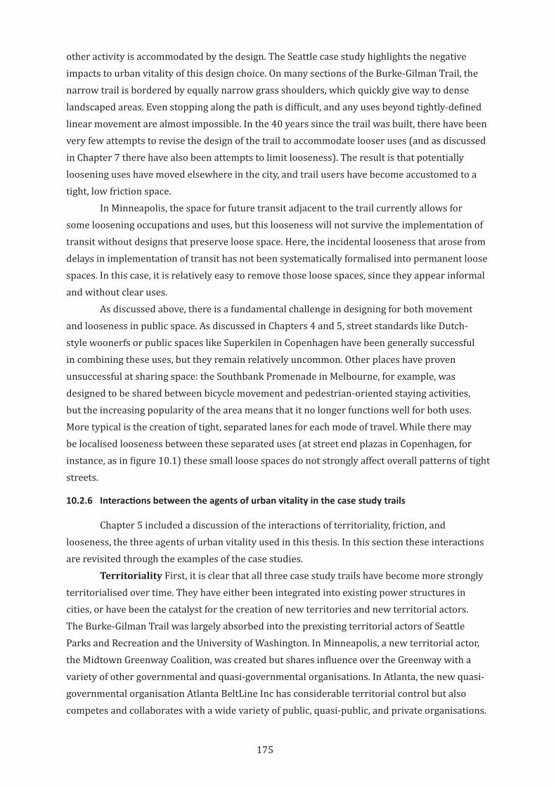
175
other activity is accommodated by the design. The Seattle case study highlights the negative impacts to urban vitality of this design choice. On many sections of the Burke-Gilman Trail, the narrow trail is bordered by equally narrow grass shoulders, which quickly give way to dense landscaped areas. Even stopping along the path is difficult, and any uses beyond tightly-defined linear movement are almost impossible. In the 40 years since the trail was built, there have been very few attempts to revise the design of the trail to accommodate looser uses (and as discussed in Chapter 7 there have also been attempts to limit looseness). The result is that potentially loosening uses have moved elsewhere in the city, and trail users have become accustomed to a tight, low friction space.
In Minneapolis, the space for future transit adjacent to the trail currently allows for some loosening occupations and uses, but this looseness will not survive the implementation of transit without designs that preserve loose space. Here, the incidental looseness that arose from delays in implementation of transit has not been systematically formalised into permanent loose spaces. In this case, it is relatively easy to remove those loose spaces, since they appear informal and without clear uses.
As discussed above, there is a fundamental challenge in designing for both movement and looseness in public space. As discussed in Chapters 4 and 5, street standards like Dutch-style woonerfs or public spaces like Superkilen in Copenhagen have been generally successful in combining these uses, but they remain relatively uncommon. Other places have proven unsuccessful at sharing space: the Southbank Promenade in Melbourne, for example, was designed to be shared between bicycle movement and pedestrian-oriented staying activities, but the increasing popularity of the area means that it no longer functions well for both uses. More typical is the creation of tight, separated lanes for each mode of travel. While there may be localised looseness between these separated uses (at street end plazas in Copenhagen, for instance, as in figure 10.1) these small loose spaces do not strongly affect overall patterns of tight streets.
10.2.6 Interactions between the agents of urban vitality in the case study trails
Chapter 5 included a discussion of the interactions of territoriality, friction, and looseness, the three agents of urban vitality used in this thesis. In this section these interactions are revisited through the examples of the case studies.
Territoriality First, it is clear that all three case study trails have become more strongly territorialised over time. They have either been integrated into existing power structures in cities, or have been the catalyst for the creation of new territories and new territorial actors. The Burke-Gilman Trail was largely absorbed into the prexisting territorial actors of Seattle Parks and Recreation and the University of Washington. In Minneapolis, a new territorial actor, the Midtown Greenway Coalition, was created but shares influence over the Greenway with a variety of other governmental and quasi-governmental organisations. In Atlanta, the new quasi-governmental organisation Atlanta BeltLine Inc has considerable territorial control but also competes and collaborates with a wide variety of public, quasi-public, and private organisations.
176
These different configurations of territorial power establish many of the physical, social, and economic conditions of the rail trails. In Seattle, decades of strong territorial control has also resulted in relatively static conditions of friction and looseness, and any changes in those agents are largely driven by territorial decisions by the two controlling organisations. In Minneapolis, the Greenway Coalition has to constantly renegotiate its place as a unifying territorial actor. This lack of enduring territorial power and the disparate goals and priorities of the surrounding actors has meant that creating new productive frictions has been difficult and the Coalition has had to depend largely on private actors. In Atlanta, the diversity of territorial actors has created loose management of the BeltLine and a wealth of frictions created by organisations who share an interest in the BeltLine but not always a common vision or common priorities.
As discussed in Chapter 2, the agent of territoriality underlies and enables the agents of friction and looseness. We can see in the case studies that a strongly territorialised space restricts the evolution or change in friction or looseness, but that deterritorialised spaces tend to also lack enough friction to feel safe and usable by many people. Spaces where territorialisation is fluid or fuzzy seem to have the greatest potential for positive frictions and looseness to arise and be in balance.
Friction The attitudes towards friction are quite different in the three trails, and this seems to have tracked along with changing bicycle demographics in the United States over the last few decades, as well as a renewed interest in active transportation as an everyday form of travel. The Burke-Gilman Trail has always focused largely on friction-free commuting and high-speed recreation bicycling, and the Midtown Greenway was initially planned for this as well. An increased awareness of the value of bicycling for local everyday trips (for shopping, taking children to school, etc) seems to have influenced attitudes toward friction on the BeltLine, and in the changes in planning strategies on the Midtown Greenway and (to a more limited extent) in
Figure 10.1: A street end plaza. In Copenhagen, many side streets are narrowed or blocked altogether where they meet larger streets. The small plazas that are created are used for bicycle storage and other public uses. Photograph by the author.
177
the University of Washington section of the Burke-Gilman Trail. But if rail trail is overwhelmed with friction, it will not function well as a transportation space. The example of the BeltLine on busy weekends highlights the risks to the usability of bicycle infrastructure that has too much friction. A nodal strategy, like the one in the University section of the Burke-Gilman Trail or the planned transit and access nodes along the Midtown Greenway, seems to be a reasonable compromise between friction and flow. In these strategies, friction can be encouraged where it contributes to the vitality of local shopping or social spaces, and between these nodes, higher priority can be given to flow. This makes sense in the mixed environments that most urban rail trails pass through—areas with predominantly single-family residential or industrial uses may not benefit much from increased friction from the trail. What seems clear from the case studies, however, is that a more nuanced and urban vitality-oriented attitude toward friction (as a potentially positive attribute, as opposed to a universally negative one) is important. Friction can be created in highly territorialised environments (like the University of Washington) and will naturally arise in areas with weak, fuzzy, or overlapping territories, but can equally be discouraged or eliminated in highly territorialised spaces where the territorial actor does not have urban vitality as a priority.
Looseness As described throughout this thesis, looseness is a critical element of urban vitality but is also the most difficult to create and encourage, since the natural inclination of most managers of built environments is to reduce looseness in city spaces. In rail trails as well, especially those territorialised as high speed commute or recreational corridors, looseness is seen as confusing and potentially dangerous. Where the expectations of a trail are different—where they are conceived as public space first—looseness can help foster the satisfaction that comes from real social interactions. As described in chapter 5, looseness will naturally arise almost anywhere there are leftover spaces, and so rail trails start as loose spaces. This looseness is often designed out in the face of strongly territorialised space, and loose spaces tend to feel uncomfortable where frictions with other spaces and other activities are low. As such, looseness is the most fragile of the three agents of urban vitality. While looseness does arise independently of the other two agents, looseness that doesn’t become threatening depends on either fragmented or fuzzy territorialisations (or a territorialisation that values looseness) but also on frictions from nearby uses. The looseness of the BeltLine is a product of the many overlapping territorialisations of the trail and the invitation of frictions along its edges. The loose spaces of the Cepro Greenspace or the undeveloped edges of the Midtown Greenway lack enough friction to feel safe. The looser spaces in park lands along the Burke-Gilman Trail are still strongly territorialised by Seattle Parks and Recreation, so the potential frictions and loosenesses there are not very strong. While loose space as a positive attribute of cities is increasingly recognised, it remains difficult to design for, especially in spaces with transportation uses.
178
Each of the three agents can contribute to urban environments that are more satisfying to users, more economically vibrant, and more open and flexible. When measured and designed for together, the three agents can help foster socially and economically sustainable environments that have real urban vitality, but this will not arise without attentive urban design and management.
10.3 Implications of This Research for Urban Design Theory and Practice
This research started from an assumption that an urban rail trail could function as more than active transportation infrastructure, but that it could be integrated into the life of the city in a more fundamental way. There are practical and theoretical implications for evaluating rail trails from this urban design perspective.
10.3.1 Urban vitality and the repositioning of friction as an analytical tool
First, this thesis proposes an urban vitality framework as a useful analytical tool for rail trails and similar urban spaces. While different urban rail trails arise out of similar physical and economic conditions and are formed from similar development processes, the trails that result have fundamental differences in terms of how the trails are used, who uses them, and how they contribute to the social and economic life of the cities around them. These differences are only partially explained by the morphology of the corridor or the project budget. Instead, they are more closely linked to fundamental attitudes over relationships to context, expectations and beliefs about the nature of public space, and the systems of control over urban environments. Despite these large and important differences, academic writing on urban rail trails has largely focused on single trails as ad hoc community creations, or has focused only on large scale economic development, tourism, transportation, or the landscape values of trails. The potential role of rail trails as vital public space is lacking.
This narrow focus is mirrored by urban bicycling literature, which is generally focused on physical infrastructure design, transportation, or the experience of being a bicyclist. While there is a growing body of research on the economic benefits of providing bicycle infrastructure, the majority treats bicycling as a transportation mode only—a way to get around the city, not a way to be in the city.
This research starts to address this missing analysis by proposing urban vitality, and the agents of friction, looseness, and territoriality, as a tool for analysing trails as more than simple transportation infrastructure. Importantly, this research can help understand why trails have their particular character and relationship to the fabric of their cities. Rather than considering trails merely as transportation routes or as recreational destinations, this research focuses on trails as valuable components of the everyday social and economic life of cities.
A critical piece of this new framework is the repositioning of friction as a positive attribute of social and economic vitality, rather than simply as a barrier to mobility. In analyses of rail trails as spaces for both transportation and public life, friction is a useful conceptual tool to understand the inherent trade-offs between speed, safety, convenience, and attractiveness. By making these relationships clear, and by introducing the positive aspects of friction into
179
discourse around urban transportation spaces, the analysis of streets, trails, transit stations, and other multi-use public spaces can more accurately observe, analyse, or measure the effects of planning and design decisions.
This thesis has proposed an urban vitality framework for urban rail trails and other urban bicycle infrastructure as a parallel to the efforts over the last few decades to re-imagine pedestrian spaces in cities (Gehl & Gemzøe, 1996). Contemporary urban design embraces the idea that successful pedestrian environments must go beyond simple provision of footpaths, zebra crossings, and refuge islands. Pedestrian planning now includes a range of elements including weather protection, passive surveillance, visual interest, and opportunities for social and economic interaction. Bicycle planning, however, has only just begun this shift. Bicycle infrastructure is, for the most part, designed and evaluated around transportation measures—maximising safety, throughput, and levels of service. While these are extremely important, it is also becoming clear that even the best infrastructure networks are not enough to entice many drivers out of their cars.
It is laudable to continue the work to make bicycling competitive with driving—as fast, as safe, and as accepted a way to travel around the city. However, bicycling will always face difficulties competing in places designed around car travel. It may be more valuable to envision bicycling as fundamentally different from driving—as a different way to inhabit the city, as scholars such as Anne Forsyth, Zachary Furness, Kevin Krizek, and Justin Spinney have highlighted. Recognising this difference means that truly bicycle-friendly cities require more than just the provision of good infrastructure, but also require altering or infilling urban development patterns to better fit the way that bicyclists inhabit cities. As shown in the cases of Minneapolis and Atlanta, it is possible to create trail-oriented development that allows for a different model of urban life. Rail trails are a unique and valuable infrastructure type in that they provide cases through which to explore different ways of inhabitation, in the spirit (if perhaps not the scale) of bicycle urbanism theorists such as Fleming (2017).
A policy framework that recognises the value of rail trails as public space as well as transportation corridors could help reframe the conversation around active transportation. Rather than focusing on maximising bicycle flow, an urban vitality-oriented policy would consider the broader range of planning and design issues that contribute to how trails are used. This would allow trail planners to serve all potential trail users, rather than a single, narrow demographic. The case study rail trails highlight the challenges that remain, even after cars are removed, in the creation of integrated spaces in which pedestrian and bicyclist movements can coexist with loose staying activities. Each trail reflects different attitudes or levels of awareness of the value of productive friction: The Seattle and Minneapolis cases both highlighted early positioning of the rail trails as high-speed, low friction commute routes. The effects of this positioning are long lasting and hard to overcome. A framework that explicitly recognises the benefits of both friction and flow would help create rail trails that serve multiple roles and multiple user groups. This would also avoid the establishment of expectations of low friction that are counterproductive for urban vitality.
180
10.3.2 Territoriality and the expression of power in physical space
This thesis has argued that the study of territoriality is critical to making explicit the expression of power in transportation infrastructure and urban space. While analysis of territoriality is an important part of urban studies and urban planning, it is rare that territoriality is made an explicit part of the urban design process. Architects and urban designers are often wilfully ignorant of the role they play in reinforcing and extending power structures in cities, preferring to see themselves as independent champions of the public good. The reality is of course much more problematic. An appraisal of urban design processes and the management of public space that includes territorial analysis would allow planners and designers to be more intellectually honest and more effective in the pursuit of an equitable and open public realm. This is all the more important in contemporary cities where rail trails, and bicycle infrastructure in general, are believed to drive economic development, but where they are also believed to be contributing to gentrification and economic inequalities. As discussed above, this issue threatens to overwhelm the positive aspects of providing active transport and transit infrastructure in historically under-served areas of cities. Urban design policy or practice that explicitly recognises power dynamics could allow a more balanced conversation around integrating or constraining power networks in public projects (Hester, 2017).
Territoriality offers a tool for exploring urban power through its links with physical space. Territoriality can be expressed through design of spaces, through rules and behavioural controls over space, or though societal expectations of users and uses of space. As such, it can help bridge between urban design, public policy, and urban culture. In the case studies presented in this thesis, territoriality has very significant and lasting effects on the character and use of each rail trail, and these effects are hard to understand without analysis of territory. Scholars like Kim Dovey, Mattias Kärrholm, Setha Low, and Sophie Watson have made territoriality more or less explicit in their work on the interrelationships between physical space and social networks. This thesis seeks to apply this important work to new setting, and to continue its application in urban design theory and practice.
While this thesis has argued that friction, looseness, and deterritorialisation are all critical agents of urban vitality, they each come into play at different stages in the planning, development, and active use of urban rail trails. While these agents should be considered at every stage in the development of a trail, there are critical moments for each. Decisions on trail ownership, management, and involvement of community groups and organisations will greatly influence the level of territorialisation and deterritorialisation of the space of the trail. Planners and designers should establish a clear position on these decisions early in the process—the case studies presented here make clear that it can be difficult to overcome strong territorial control. As discussed above, loose space should be designed into the physical design of the trail, and thus should be part of the initial planning and design of the trail. Looseness and fuzzy or overlapping territoriality should be designed in to both the physical space of the trail and its ongoing management. The case study trails highlight that this looseness and territorial overlap is a benefit for the long-term vitality of trails.
181
10.3.3 Rail trails and bicycle infrastructure design must cross disciplinary boundaries
The reconsideration of rail trails and bicycle infrastructure as potential contributors to urban vitality requires that they be planned and analysed from a cross-disciplinary position. This thesis has argued that single-purpose urban spaces, where monolithic territorial control, tight space, and low friction are employed to serve a single set of design criteria, are rarely if ever the vibrant and lively spaces of a city. Tightly designed and managed transportation corridors may successfully serve as high-throughput movement spaces, but they are almost never vital social spaces. Residential, commercial, or recreation zones that turn away from transportation networks may be peaceful oases, but they are rarely active or diverse enough to sustain economic or social interactions. Instead, the spaces that work best as everyday centres of urban life, as well as those that are celebrated as the attractive heart of a vital city, are those that carefully design for both movement and public activity. Movement of people and goods is critical to animate public spaces, but that movement must not overwhelm loosening uses. Careful attention to speed and friction are essential. Physical space design must also be flexible enough to evolve with changing users and uses over the course of a day, a year, and over the lifetime of the space. A balance of uses must be created that allows for a variety of interactions and claims on spaces without letting any territorialisation become overwhelming.
To plan, implement, and manage this mix of uses within a public space requires more than a single set of skills. It requires more than a transportation planner, architect, politician, or advocate could do alone. Academic research into complex urban projects must also strive to see beyond the confines of any one particular discipline; analysis also requires a cross-disciplinary skill set.
One purpose of this thesis is to position urban rail trails in between the disciplines of transportation planning, urban design, architecture, and public policy so that trails benefit from expertise from all. We can see the benefits of this kind of diverse expertise in ad hoc station area plans that integrate transit, land use, active transportation, economic development, and open space, using expertise from across council staff departments, private landowners and businesspeople, and community input (City of Seattle, 2017), or in organisations like Atlanta BeltLine, Inc, which include affordable housing, equity and inclusion, engineering, public art, transportation, landscape design, economic development, and community engagement teams (Atlanta Beltline Inc, 2018d). These projects are richer and more vital for the crossing of practice boundaries and the integration of different spheres of expertise as part of planning, design, and management processes, and rail trail advocates and planners should explicitly include these different voices in projects. Where academic research into urban design and urban conditions also reflects the overlapping and interacting roles and actors in a city, it can tell a more complete story, even if that means giving up the satisfactions of tidy endings and universalising statements.
182
10.4 Limitations of This Study and Recommendations for Future Research
This thesis has attempted to make explicit some of the important but often unexamined forces, attitudes, and beliefs that influence the design and management of public urban environments. It was limited by the time and resource constraints of a single researcher and a limited period of fieldwork. While this research makes use of well-regarded and well-established urban design theory and practice on urbanity and public space design, it combines and extends this prior work in new ways and applies it to urban rail trails, a relatively new and unexamined type of public space. Future research should continue the process of observation, evaluation, and theory building around rail trails and similar urban spaces. Future research should also capture other voices and perspectives. While this study has attempted to include critical voices, they were generally pro-bicycle infrastructure and pro-rail trail. Broader research that includes trail opponents could shed additional light on weaknesses or risks of urban rail trails as public space.
Most importantly, this study has focused on the ideation, planning, and development of rail trails, and does not include substantial interviews or surveys with everyday trail users. This perspective is critical to understanding the degree to which different trails, with their different combinations of territory, friction, and looseness, create public spaces that are safe, well-used, and loved. Future research should include this additional data as a way to understand perceptions of and preferences for the different characteristics of urban rail trails as discussed in this study. This scope of this study was necessarily limited, and data collection was primarily from actors involved in the planning and development of trails and their surrounding areas. The effect of the development of trails on nearby residents and the public at large is an important next step. In general, future data gathering should focus on testing the observations and theories presented here through follow up interviews and new data collection.
As noted in Chapter 6, case study methodology yields a more in-depth understanding of complex urban environments. A public urban design project like a rail trail is subject to a broad and shifting range of processes and forces, from public opinion to local politics, local advocacy to national trends, physical constraints and budget priorities—and these various forces can shift significantly over the long planning and implementation timelines of the project. Case study methodology allows the flexibility to analyse each case based on its own conditions, rather than attempting to shoehorn each project into a universal and predetermined set of objective evaluation criteria. Future research should include additional case studies and could also develop complementary quantitative measures to further explore the observations and findings discussed here (Flyvbjerg, 2011). For instance, are there quantifiable economic benefits to higher-vitality rail trails? Several studies have identified economic benefits to bicycle infrastructure; are these magnified in areas of high vitality? Are high-friction or high-looseness sections of rail trails more or less safe than low-friction, tight sections?
The urban vitality framework developed here should also be evaluated in other cases. For example, does the framework of urban vitality hold true in other cultures? Are territorialisations in countries with different governance and public funding systems similar to those found in this research? And do the relationships between friction, looseness, and
183
territoriality that were observed in these case study trails hold for other trails and public spaces as well? In addition, longitudinal research would allow a fuller picture of how the continuing development of these trails affects their character, use, and urban vitality.
Finally, this thesis is based on urban patterns, prior research, bicycling culture, and case studies that are US- and Western-centric and cannot claim to be valid outside of that limited scope. Bicycle use and bicycle culture is of course not a Western phenomenon: cities in China and Japan, and elsewhere around the world, have long histories of urban bicycling and rich contemporary bicycle cultures (Kidd, 2014; Smethurst, 2015). Extending this research to include these non-Western places would provide valuable comparisons and contrasts.
10.5 Conclusion
There is increasing recognition of the role that cities play in addressing social, economic, and environmental issues. For issues such as climate change, consumption and waste, and social and economic inequalities, cities (and networks of cities) are at the crux of both the sources and solutions to many global crises. The city is also the site in which global forces come into contact with the intimate physical spaces that form and are formed by communities. This makes the city a critical point of study and intervention in any attempt to create a more just, equitable, and sustainable world.
Despite this, specialisation and siloisation among the designers, planners, activists, and politicians who guide city form and development often obscures the complexities, overlaps, and contradictions that are inherent to the function of cities. Without a sensitivity to this complexity, it is difficult to create vital urban places. Public space is always a co-creation between physical space design and regular, prosaic inhabitation by people. Urban vitality arises out of this everyday interaction of space and use, and depends on design decisions; management practices; and the constant, overlapping, conflicting or consonant pressures of diverse uses. Urban vitality is restricted when these diverse uses are excluded or overly constrained.
Transportation spaces are a microcosm of this larger urban design issue: when streets, trails, rail lines, and highways are designed as efficient, single-purpose spaces, they can, ironically, hinder or even block interaction and exchange between city denizens. This thesis has focused on urban rail trails, based on their potential to both improve urban mobility and create space for social and economic vitality. An active transportation network that is integrated into the daily fabric of urban life, and where that urban fabric offers a range of services within convenient walking and riding distances, can help make active transportation a preferable way to move around our neighbourhoods and cities. At the same time, where bicyclists and pedestrians can move through looser environments, rather than being shoehorned into tight, high speed, car-oriented corridors, they can better contribute to the social and economic activity of public urban spaces and cities as a whole. As a relatively new urban form, rail trails provide an opportunity to experiment with a built environment that blends private property, public space, and active transportation corridors in a new kind of city street. The long-term goal of this research is to give planners and designers a more robust set of tools to understand, evaluate, design, and communicate about active transportation and its place in the fabric of the city. Urban
184
infrastructure that encourages additional active transportation and enhances the social and economic vitality of urban spaces will help cities reach their potential as centres of economic, social, and environmental sustainability.
185
Appendix 1: Interview Questions
These interview sheets were developed prior to conducting fieldwork, and represent a starting point for the semi-structured interviews described in Chapter 6. These interview sheets were submitted as part of the Human Research Ethics Committee application noted in the front matter of this thesis.
Interview Questions NGOv1 30 Jan 2015 Cycling Life: The Influence of Urban Rail Trails on the Economic and Social Vitality of Cities
Interview questions for organizations and advocates (Text in red replaced based on case study location) Preamble As part of research on the effects of bicycle infrastructure on economic performance, we are conducting interviews about the Burke-Gilman Trail. The purpose of the research is to understand how the trail is planned, implemented, and managed, and the role of non-governmental organizations in those processes.
1. Can you tell me about your organization – its mission, membership, ways of working, etc?
2. How do the needs of cyclists compare with the needs of pedestrians or drivers?
3. How do cyclists contribute to a strong community? 4. What is your organization’s position on the Burke-Gilman Trail?
a. Vision b. Strategies for realizing the vision c. What’s good? What’s bad?
5. How do you interact/communicate with trail users, neighbors, and planners? 6. How do you see the context for the trail as impacting the use, feeling, success
of the trail? a. Land uses/buildings? b. Transportation links? c. Amenities? d. Other users?
186
Interview Questions BusV1 30 Jan 2015 Cycling Life: The Influence of Urban Rail Trails on the Economic and Social Vitality of Cities
Interview questions for businesses (Text in red replaced based on case study location) Preamble As part of research on the effects of bicycle infrastructure on economic performance, we are conducting interviews business managers and owners near the Burke-Gilman Trail. The purpose of the research is to understand how proximity to the trail benefits or hinders building or business operations, and how owners and managers respond to those benefits or difficulties. Businesses and buildings were selected for interviews based on proximity to the trail and public records of recent building permits issued by the City of Seattle. Basic info for businesses:
1. What kind of business do you run? 2. How many people work at this location? 3. Are you a franchisee? Or part of a cooperative, or any other group?
The Burke-Gilman Trail 1. Are you aware of the pedestrian and bike path near your business? 2. What do you think of it? 3. Did you open business at this location before or after the trail was opened?
a. If you opened here before the trail, what changes have you seen since the trail opened?
b. If you opened here after the trail opened, was the trail part of your decision to move here?
4. How do most of your customers come here? 5. Do people come here from the trail? How can you tell? 6. Do you get a lot of cyclists as customers? 7. Where do they park their bikes when they come here?
187
Bibliography
AASHTO. (2012). Guide for the development of bicycle facilities (4th ed.). Washington, DC: American Association of State Highway and Transportation Officials.
Ahern, J. (2013). Urban landscape sustainability and resilience: The promise and challenges of integrating ecology with urban planning and design. Landscape Ecology, 28(6), 1203-1212. doi:10.1007/s10980-012-9799-z
Aldred, R. (2010). ‘On the outside’: constructing cycling citizenship. Social & Cultural Geography, 11(1), 35-52. doi:10.1080/14649360903414593
Aldred, R. (2012). Incompetent or Too Competent? Negotiating Everyday Cycling Identities in a Motor Dominated Society. Mobilities, 8(2), 252-271. doi:10.1080/17450101.2012.696342
Aldred, R., & Jungnickel, K. (2012). Constructing Mobile Places between ‘Leisure’ and ‘Transport’: A Case Study of Two Group Cycle Rides. Sociology, 46(3), 523-539. doi:10.1177/0038038511428752
Allen, J. (2004). The Whereabouts of Power: Politics, Government and Space. Geografiska Annaler: Series B, Human Geography, 86(1), 19-32. doi:10.1111/j.0435-3684.2004.00151.x
Amin, A., & Thrift, N. (2002). Cities: reimagining the urban. Cambridge: Polity.
Amstutz, R., & Robson, L. (1973, May 2). Pro and con forum: Bikes, hikers and trains. Seattle Times, p. A13.
Anderson, M. (1994, July). Plans for Greenway will help revitalize all of Lake Street, planners say. The Alley, pp. 4-5.
Appleyard, D., Gerson, M. S., & Lintell, M. (1981). Livable streets. Berkeley: University of California Press.
Appleyard, D., Lynch, K., & Myer, J. R. (1964). The view from the road.
Armstrong Jr, R. J. (1994). Impacts of commuter rail service as reflected in single-family residential property values. Transportation Research Record(1466).
Arnold Jr, C. L., & Gibbons, C. J. (1996). Impervious surface coverage: the emergence of a key environmental indicator. Journal of the American Planning Association, 62(2), 243-258.
Ashmore, M., Wooffitt, R., & Harding, S. (1994). Humans and others, agents and things. American Behavioral Scientist, 37(6), 733-740.
Asp, K. (2013, Winter). The Midtown Greenway: Minneapolis’ superhighway. Rails to Trails, 8-13.
Atkinson, R. (2003). Domestication by cappuccino or a revenge on urban space? Control and empowerment in the management of public spaces. Urban Studies, 40(9), 1829-1843.
Atlanta BeltLine Inc. (2013a). APD Path Force patrolling Atlanta BeltLine, adjoining parks. Retrieved from https://beltline.org/2013/07/26/apd-path-force-patrolling-atlanta-beltline-adjoining-parks/
Atlanta BeltLine Inc. (2013b). “Gear up” for Atlanta BeltLine bike tours! Retrieved from https://beltline.org/2013/11/25/atlanta-beltline-bike-tours/
Atlanta BeltLine Inc. (2015a). Annual Report 2015: 10 years and growing. Retrieved from https://beltlineorg-wpengine.netdna-ssl.com/wp-content/uploads/2016/03/ABL-2015-Annual-Report-FINAL-website.pdf
Atlanta BeltLine Inc. (2015b). Atlanta BeltLine Partnership receives “Blinkie Award”. Retrieved from https://beltline.org/2015/02/18/atlanta-beltline-partnership-receives-blinkie-award/
188
Atlanta BeltLine Inc. (2018a). Annual Report 2017: Coming together as one Retrieved from https://beltlineorg-wpengine.netdna-ssl.com/wp-content/uploads/2018/03/2017-Atlanta-BeltLine-Annual-Report.pdf
Atlanta BeltLine Inc. (2018b). Etiquette on the Atlanta BeltLine is a team effort! Retrieved from https://beltline.org/visit/etiquette/
Atlanta BeltLine Inc. (2018c). Funding. Retrieved from https://beltline.org/about/the-atlanta-beltline-project/funding/
Atlanta Beltline Inc. (2018d). Our team. Retrieved from https://beltline.org/about/atlanta-beltline-inc/#our-team
Atlanta BeltLine Inc. (2018e). Outdoor yoga at the Atlanta BeltLine. Retrieved from https://beltline.org/event/outdoor-yoga-at-the-atlanta-beltline-23/
Atlanta BeltLine Inc. (2019a). Annual Report 2018: Strengthening foundations with our core values. Retrieved from https://beltlineorg-wpengine.netdna-ssl.com/wp-content/uploads/2019/03/ABL-2018-Annual-Report-Web-March.pdf
Atlanta BeltLine Inc. (2019b). The Atlanta BeltLine in 5. Retrieved from https://beltline.org/about/the-atlanta-beltline-project/atlanta-beltline-overview/
Atlanta BeltLine Inc. (2019c). Atlanta’s tree-mendous arboretum. Retrieved from https://beltline.org/programs/atlanta-beltline-arboretum/
Atlanta BeltLine Inc. (2019d). Events. Retrieved from https://beltline.org/events/
Atlanta BeltLine Inc. (2019e). Interactive map. Retrieved from https://beltline.org/map/
Atlanta BeltLine Partnership. (2016). Atlanta BeltLine Run.Walk.Go! series sponsorship packet. Retrieved from http://beltline.org/wp-content/uploads/2016/03/RunWalkGo-SponsorshipPkt-2016-v6.pdf
Atlanta BeltLine Partnership. (2017). Partners’ Report 2016. Retrieved from https://beltlineorg-wpengine.netdna-ssl.com/wp-content/uploads/2017/05/ABP-partners-Report-2016.pdf
Atlanta Bicycle Coalition. (2012). Strategic plan: Executive summary. Retrieved from https://d3n8a8pro7vhmx.cloudfront.net/atlbike/pages/326/attachments/original/1418161971/ABC_StrategicPlan_2012_updated_021012_(2).pdf?1418161971
Atlanta Bicycle Coalition. (2014). Mission. Retrieved from http://www.atlantabike.org/mission2
Atlanta Bicycle Coalition. (2017). 2017-2020 Strategic Plan. Retrieved from https://d3n8a8pro7vhmx.cloudfront.net/atlbike/pages/3327/attachments/original/1496246423/ABC_2017_2020_Strategic_Plan_v6B_%281%29.pdf?1496246423
Atlanta Bicycle Coalition. (2018). Programs. Retrieved from https://www.atlantabike.org/programs
Atlanta City Council. (2016). Ordinance Z-15-22. Retrieved from http://atlantacityga.iqm2.com/Citizens/Detail_LegiFile.aspx?Frame=&MeetingID=1696&MediaPosition=&ID=6948&CssClass=
Atlanta Convention and Visitors Bureau. (2019). Bike, walk, run or dine on the Atlanta BeltLine. Retrieved from https://www.atlanta.net/things-to-do/outdoors/beltline/
Atlanta Development Authority. (2005). Atlanta BeltLine redevelopment plan. Retrieved from http://beltlineorg.wpengine.netdna-cdn.com/wp-content/uploads/2012/05/Atlanta-BeltLine-Redevelopment-Plan.pdf
Atlanta Preservation Center. (2013). Atlanta’s historic rail assets: The shape that is the heart of Atlanta. Retrieved from http://atlantapreservationcenter.com/place_detail?id=92&pt=1&year=all
189
Atlanta Public Schools. (2019). APS demographics and enrollment. Retrieved from https://www.atlantapublicschools.us/Page/48363
Atlanta Regional Commission. (2016). Part 2 - Assessment of regional travel patterns and existing conditions. In Walk. Bike, Thrive! . Retrieved from https://atlantaregional.org/wp-content/uploads/2016/05/walkbike-thrive-part-2-final-web-.pdf.
Augé, M. (1995). Prologue. In Non-places: Introduction to an anthropology of supermodernity (pp. 1-6). London; New York: Verso.
Baden, M. (2018). The Wall of Death. Retrieved from https://mowrybaden.com/works/the-wall-of-death/
Bagshaw, S. (2012). Queen Anne Bowl Playfields parking and Initiative 42. Retrieved from https://bagshaw.seattle.gov/2012/12/11/initiative-42-a-1996-community-effort-that-preserves-park-land-today/
Barnett, E. (2017, 3 April). How Seattle is dismantling a NIMBY power structure. Retrieved from https://nextcity.org/features/view/seattle-nimbys-neighborhood-planning-decisions
BeltLine Overlay District regulations, Part 16: Zoning, City of Atlanta § 16.36 (2007).
Ben-Joseph, E. (1995). Changing the residential street scene: Adapting the shared street (woonerf) concept to the suburban environment. Journal of the American Planning Association, 61(4), 504-515.
Benjamin, W., & Lacis, A. (1979). Naples. In W. Benjamin (Ed.), One-way street, and other writings (pp. 167-176). London: NLB.
Beyard, M. D., Pawlukiewicz, M., & Bond, A. (2003). Ten principles for rebuilding neighborhood retail. Retrieved from Washington, DC: http://uli.org/wp-content/uploads/2012/07/TP_NeighborhoodRetail.ashx_1.pdf
Bhat, C. R., & Guo, J. Y. (2007). A comprehensive analysis of built environment characteristics on household residential choice and auto ownership levels. Transportation Research Part B: Methodological, 41(5), 506-526.
Bikes Belong. (2012). The federal investment in bicycling: 10 success stories. Retrieved from https://www.aarp.org/content/dam/aarp/livable-communities/learn/transportation/federal-investment-in-bicycling-10-success-stories.pdf
Bishop, T. (2003). Burke-Gilman extension as seen by business. Seattle Post-Intelligencer. Retrieved from https://www.seattlepi.com/news/article/Burke-Gilman-extension-as-seen-by-business-1112162.php
Block Lofts. (2018). About our neighborhood: Apartments near Atlanta BeltLine. Retrieved from https://www.blockloftsapartments.com/apartments/ga/atlanta/neighborhood
Blomley, N. (2004). Un-real Estate: Proprietary Space and Public Gardening. Antipode, 36(4), 614-641. doi:doi:10.1111/j.1467-8330.2004.00440.x
Bloom, M. (2015). City misses another Beltline payment to Atlanta schools. Atlanta Journal-Constituion. Retrieved from https://www.ajc.com/news/local-education/city-misses-another-beltline-payment-atlanta-schools/G1kZzpkgXIiKE90Cv7cptK/
Blue, E. (2013). Bikenomics: How bicycling can save the economy. Portland, OR: Microcosm.
Blyth, G. (2014). Velo City: Architecture for Bikes: Prestel.
Boddy, T. (1992). Underground and overhead: building the analogous city. In M. Sorkin (Ed.), Variations on a theme park (pp. 123-153). New York: Hill and Wang.
Borden, I. (1996). Beneath the pavement, the beach: Skateboarding, architecture and the urban realm. In I. Borden, J. Kerr, A. Pivaro, & J. Rendell (Eds.), Strangely familiar: Narratives of architecture in the city (pp. 82-86). London; New York: Routledge.
190
Borden, I. (2001). Skateboarding, space and the city: Architecture and the body. Oxford; New York: Berg.
Bowden, S. (2015). Human and nonhuman agency in Deleuze. In J. Roffe & H. Stark (Eds.), Deleuze and the non/human (pp. 60-80): Springer.
Bowen, D. S. (2009). Building a trail and connecting a community The establishment of the Dahlgren Railroad Heritage Trail. Southeastern Geographer, 49(3), 291-307.
Bramley, E. V. (2018). Desire paths: The illicit trails that defy the urban planners. The Guardian. Retrieved from https://www.theguardian.com/cities/2018/oct/05/desire-paths-the-illicit-trails-that-defy-the-urban-planners
Brandt, S. (1998). A path to renewal? Star Tribune. Retrieved from http://www.startribune.com/july-24-1998-a-path-to-renewal/210444951/
Brandt, S. (1999). Busway on greenway? No way, some say, 26 October. Star Tribune, pp. B1, B3.
Brandt, S. (2014). Midtown Greenway draws bikers; parallel streets draw crashes. Star Tribune. Retrieved from http://www.startribune.com/midtown-greenway-draws-bikers-parallel-streets-draw-crashes/246634161/
Brandt, S., & Chanen, D. (2008). Minneapolis Midtown Greenway robbery spree: Bikers beware. Star Tribune. Retrieved from http://www.startribune.com/greenway-robbery-spree-bikers-beware/35900674/
Brenner, N., Marcuse, P., & Mayer, M. (2009). Cities for people, not for profit. City, 13(2-3), 176-184.
Brindley, D. (2015). Food truck revolution. National Geographic. Retrieved from https://www.nationalgeographic.com/magazine/2015/07/food-trucks-urban-trends-cuisine/
Broach, J., Dill, J., & Gliebe, J. (2012). Where do cyclists ride? A route choice model developed with revealed preference GPS data. Transportation Research Part A: Policy and Practice, 46(10), 1730-1740. doi:https://doi.org/10.1016/j.tra.2012.07.005
Brown, A. M. (2010). A greenway runs through it: The Midtown Greenway and the social landscape of Minneapolis, Minnesota. Macalester College, St Paul. Retrieved from http://digitalcommons.macalester.edu/geography_honors/21 (Paper 21)
Brown, B. B., Werner, C. M., Amburgey, J. W., & Szalay, C. (2007). Walkable Route Perceptions and Physical Features. Environment and Behavior, 39(1), 34-61. doi:10.1177/0013916506295569
Brown, R. (2011, 17 August). Ambitious plans for a building where Sears served Atlanta. New York Times, p. B7. Retrieved from http://www.nytimes.com/2011/08/17/realestate/commercial/in-atlanta-big-plans-for-a-big-former-sears-center.html
Bruch, M. (2015, 4-17 June). Apartments transform neighborhoods along Midtown Greenway Corridor. Southwest Journal, pp. A1, A14.
Bruch, M. (2017). Soo Line Children’s Rainbow Garden opens to kids on Sundays. Southwest Journal. Retrieved from http://www.southwestjournal.com/news/neighborhoods/2017/08/soo-line-childrens-garden-opens-to-kids-on-sundays/
Bryant, R. (1998). Bigger is better. Urban land, (July). Retrieved from https://www.hennepin.us/-/media/hennepinus/your-government/projects-initiatives/documents/1998-bryant-article.pdf?la=en
Buckley, C., & Feng, E. (2016, 4 August). China’s straddling bus, on a test run, floats above the streets. New York Times. Retrieved from https://www.nytimes.com/2016/08/05/world/asia/china-elevated-bus-teb.html
191
Bunn, V. (2013). Wedgwood’s trailmakers: The Burke-Gilman Trail. Retrieved from http://wedgwoodinseattlehistory.com/2013/01/01/wedgwoods-trailmakers-the-burke-gilman-trail/
Butler, C. (2012). Henri Lefebvre: Spatial Politics, Everyday Life and the Right to the City: Taylor & Francis.
Byron, K. (2011, 27 March). Advertising on Southington Rail Trail Debated. Hartford Courant. Retrieved from http://articles.courant.com/2011-03-27/community/hc-southington-trail-0328-20110327_1_rail-trail-committee-rail-trail-trail-intersections
Campo, D. (2002). Brooklyn’s vernacular waterfront. Journal of Urban Design, 7(2), 171-199.
Caniglia, J. (2016). A crown jewel of bikeways. Public Roads, 80(3), 34-39.
Carlsson, C. (1994). Critical Massifesto. Critical Mass essays, flyers, images from San Francisco 1992-1998. Retrieved from http://www.scorcher.org/cmhistory/cmassifesto.html
Carmona, M. (2003). Public places, urban spaces : the dimensions of urban design. Oxford ; Boston: Architectural Press.
Carmona, M. (2014). The place-shaping continuum: A theory of urban design process. Journal of Urban Design, 19(1), 2-36.
Carrabine, K. (n.d.). About us. Friends of the Burke-Gilman Trail. Retrieved from http://www.burkegilmantrail.org/about-us/
Carter, J., Dyer, P., & Sharma, B. (2007). Dis-placed voices: sense of place and place-identity on the Sunshine Coast. Social & Cultural Geography, 8(5), 755-773. doi:10.1080/14649360701633345
Cassidy, J. (2011). Battle of the bike lanes. Retrieved from https://www.newyorker.com/news/john-cassidy/battle-of-the-bike-lanes
Castells, M. (1983). The city and the grassroots: A cross-cultural theory of urban social movements. Berkeley: University of California Press.
Centers for Disease Control. (2005). Barriers to children walking to or from school--United States, 2004. MMWR: Morbidity and mortality weekly report, 54(38), 949-952.
Cervero, R., Caldwell, B., & Cuellar, J. (2013). Bike-and-ride: build it and they will come. Journal of Public Transportation, 16(4), 5.
Cervero, R., Sarmiento, O. L., Jacoby, E., Gomez, L. F., & Neiman, A. (2009). Influences of Built Environments on Walking and Cycling: Lessons from Bogotá. International Journal of Sustainable Transportation, 3(4), 203-226. doi:10.1080/15568310802178314
Chafkin, M. (2017). Elon Musk is really boring. Retrieved from https://www.bloomberg.com/news/features/2017-02-16/elon-musk-is-really-boring
Chen, H., Rufolo, A., & Dueker, K. (1998). Measuring the impact of light rail systems on single-family home values: a hedonic approach with geographic information system application. Transportation Research Record: Journal of the Transportation Research Board(1617), 38-43.
Choi, J., Coughlin, J. F., & D’Ambrosio, L. (2013). Travel time and subjective well-being. Transportation Research Record, 2357(1), 100-108.
Chriqui, J. F., Taber, D. R., Slater, S. J., Turner, L., Lowrey, K. M., & Chaloupka, F. J. (2012). The impact of state safe routes to school-related laws on active travel to school policies and practices in US elementary schools. Health & place, 18(1), 8-15.
Citizens gain bigger role in direction of parks. (1985, 24 February). Seattle Times, pp. B1, B4.
192
City of Atlanta. (2016). Third amendment to intergovernmental agreement among the City of Atlanta, the Atlanta Development Authority, D/B/A Invest Atlanta and the Atlanta Indepedent School System. Retrieved from https://beltlineorg-wpengine.netdna-ssl.com/wp-content/uploads/2012/03/Third-Amendment-to-BeltLine-IGA-FINAL-Fully-executed-2-8-2016.pdf
City of Bothell. (2011). Downtown subarea plan and regulations.
City of Brisbane. (2014). Brisbane City Plan §8.2.3 Bicycle network overlay code. Retrieved from http://eplan.brisbane.qld.gov.au/CP/BicycleNetworkOC.
City of Kenmore. (2009). Capitalizing on Kenmore’s Potential: An economic development strategy. Retrieved from http://www.kenmorewa.gov/sites/default/files/Economic%20Development%20Strategy%202009.pdf
City of Minneapolis. (2005). Midtown Minneapolis land use and development plan. Retrieved from http://www.ci.minneapolis.mn.us/www/groups/public/@cped/documents/webcontent/wcms1p-085287.pdf
City of Minneapolis. (2006). Environmental assessment worksheet: Bennett Lumber Parcels 1 and 2 Redevelopment. Retrieved from http://www.minneapolismn.gov/www/groups/public/@council/documents/webcontent/convert_253777.pdf
City of Minneapolis. (2007). Midtown Greenway land use development plan. Retrieved from http://www.ci.minneapolis.mn.us/www/groups/public/@cped/documents/webcontent/convert_266361.pdf
City of Minneapolis. (2009). Lyn-Lake Small Area Plan. Retrieved from http://www.ci.minneapolis.mn.us/cped/projects/cped_docs_lyn_lake_small_area_plan_final_draft
City of Minneapolis. (2011). Minneapolis Bicycle Master Plan. Retrieved from http://www.minneapolismn.gov/www/groups/public/@publicworks/documents/webcontent/convert_275983.pdf
City of Minneapolis. (2015, 3 November). Reopening Nicollet Avenue at Lake Street. Retrieved from http://www.minneapolismn.gov/news/special/NicolletandLake
City of Nashville. (2017). East Nashville Community Plan. Retrieved from https://www.nashville.gov/Portals/0/SiteContent/Planning/docs/CommPlans2017/next-vol3-East%20Nashville_Amended2017.pdf
City of Seattle. (1996). Non-park uses of park lands - Policy. Retrieved from https://www.seattle.gov/Documents/Departments/ParksAndRecreation/PoliciesPlanning/PolicyNonParkUse.pdf
City of Seattle. (2016). Burke-Gilman history. Retrieved from http://www4.seattle.gov/transportation/burkegilmantrailhistory.htm
City of Seattle. (2017). Mount Baker station area action team: Project charter. Retrieved from http://www.seattle.gov/Documents/Departments/OPCD/OngoingInitiatives/MtBakerStationArea/OPCDMtBakerProjectCharter.pdf
City of Seattle. (2018). Burke-Gilman Trail Missing Link Project. Retrieved from https://www.seattle.gov/transportation/projects-and-programs/programs/bike-program/burke-gilman-trail-missing-link-project#projecthistory
Clegg, S., Flyvbjerg, B., & Haugaard, M. (2014). Reflections on phronetic social science: a dialogue between Stewart Clegg, Bent Flyvbjerg and Mark Haugaard. Journal of Political Power, 7(2), 275-306. doi:10.1080/2158379X.2014.929259
Cohn, D. (1997). Creating crises and avoiding blame: The politics of public service reform and the new public management in Great Britain and the United States. Administration & Society, 29(5), 584-616.
193
Coley, R. L., Sullivan, W. C., & Kuo, F. E. (1997). Where does community grow? The social context created by nature in urban public housing. Environment and Behavior, 29(4), 468-494.
Colville-Andersen, M. (2015). The 20 most bike-friendly cities on the planet. wired.com. Retrieved from https://www.wired.com/2015/06/copenhagenize-worlds-most-bike-friendly-cities/
Colville-Andersen, M. (2016). Bicycle infrastructure fail(s). Retrieved from http://www.copenhagenize.com/2016/03/bicycle-infrastructure-fails.html
Colville-Anderson, M. (2010). Bicycle commuting or bicycle culture? Retrieved from http://www.copenhagenize.com/2010/12/bicycle-commuting-or-bicycle-culture.html
Coppola, A., & Vanolo, A. (2015). Normalising autonomous spaces: Ongoing transformations in Christiania, Copenhagen. Urban Studies, 52(6), 1152-1168.
Corburn, J. (2007). Reconnecting with our roots: American urban planning and public health in the twenty-first century. Urban affairs review, 42(5), 688-713.
Corsaletti, L. (1971, November 4). Citizens speak out at park hearing. Seattle Times, p. A11.
Coward, M. (2012). Between us in the city: materiality, subjectivity, and community in the era of global urbanization. Environment and Planning D: Society and Space, 30(3), 468-481.
Crowhurst Lennard, S., & Lennard, H. (1987). Livable cities: People and places : Social and design principles for the future of the city: Gondolier Press.
Daley, M., & Rissel, C. (2011). Perspectives and images of cycling as a barrier or facilitator of cycling. Transport policy, 18(1), 211-216.
Davies, A. (2016). Can cyclists travel happily with pedestrians? Retrieved from https://blogs.crikey.com.au/theurbanist/2016/07/13/53499/
de Certeau, M. (1988). The Practice of Everyday Life. Berkeley: University of California Press.
de Groot, R. (Ed.) (2007). Design Manual for Bicycle Traffic: CROW.
de Sola-Morales, I. (1995). Terrain Vague. In C. Davidson (Ed.), Anyplace. Cambridge: MIT Press.
DeLanda, M. (2007). The philosopy of Gilles Deleuze. In E. G. School (Ed.), European Graduate School Video Lectures.
DeLanda, M. (2011). Assemblage theory, society, and Deleuze. In E. G. School (Ed.), European Graduate School Video Lectures.
Deleuze, G., & Guattari, F. l. (1987). A thousand plateaus : capitalism and schizophrenia. Minneapolis: University of Minnesota Press.
Demerath, L., & Levinger, D. (2003). The social qualities of being on foot: A theoretical analysis of pedestrian activity, community, and culture. City & Community, 2(3), 217-237.
Dent, E. B., & Goldberg, S. G. (1999). Challenging “resistance to change”. The Journal of applied behavioral science, 35(1), 25-41.
Dewar, R. E., & Olson, P. L. (2007). Human factors in traffic safety. Tuscon: Lawyers & Judges Publishing Company.
Diamandis, P. H. (2015). The future of transportation: Flying cars, Hyperloop, and virtual worlds. Retrieved from https://singularityhub.com/2015/06/28/the-future-of-transportation-flying-cars-hyperloop-and-virtual-worlds/#sm.00knrqfq18oidnp10aw2ia4ncilk3
Dill, J., & Voros, K. (2007). Factors affecting bicycling demand: initial survey findings from the Portland, Oregon, region. Transportation Research Record: Journal of the Transportation Research Board(2031), 9-17.
DiMento, J., Van Hengel, D., & Ryan, S. (1996). The Century Freeway: Design by court decree. Access(9), 7-12.
194
Dobbins, M. (2016). Left behind in Atlanta. New York Times. Retrieved from https://www.nytimes.com/2016/09/21/opinion/left-behind-in-atlanta.html
Doherty, S. (1998). Rail-trails and community sentiment: A study of opposition to rail trails and strategies for success. Washington, DC: Rails-to-Trails Conservancy,.
Dooling, S., Simon, G., & Yocom, K. (2006). Place-based urban ecology: a century of park planning in Seattle. Urban Ecosystems, 9(4), 299-321.
Dorfman, G. (2013). The Midtown Community Works Partnership. Paper presented at the Rail-Volution Conference, Seattle. http://www.midtowncommunityworks.org/s/rrailvolution-zkas.pdf
Dovey, K. (1999). Framing Places : Mediating Power in Built Form: Taylor & Francis Group.
Dovey, K., & Polakit, K. (2007). Urban slippage: smooth and striated streetscapes in Bangkok. In K. A. Franck & Q. Stevens (Eds.), Loose space: Possibility and diversity in urban life (pp. 168-193). London; New York: Routledge.
Dovey, K., & Sandercock, L. (2002). Hype and hope. City, 6(1), 83-101.
Dowling, J., & Lahey, K. (2009). Doyle call for council to take on Docklands. Sydney Morning Herald. Retrieved from https://www.smh.com.au/national/doyle-call-for-council-to-take-on-docklands-20090315-8yyr.html
Dowling, R. (2000). Power, subjectivity and ethics in qualitative research. In I. Hay (Ed.), Qualitative Research Methods in Human Geography (pp. 23--36): Oxford University Press.
Du, S. (2018). Hennepin County to demo a driverless shuttle on the Midtown Greenway. City Pages. Retrieved from http://www.citypages.com/news/hennepin-county-to-demo-a-driverless-shuttle-on-the-midtown-greenway/474620533
Edensor, T. (1998). The culture of the Indian street. In N. R. Fyfe (Ed.), Images of the street : planning, identity, and control in public space. London ; New York: Routledge.
Edensor, T. (2007). Social Practices, Sensual Excess and Aesthetic Transgression in Industrial Ruins. In K. A. Franck & Q. Stevens (Eds.), Loose space: Possibility and diversity in urban life (pp. 339-364). London; New York: Routledge.
Ehrenfeucht, R., & Loukaitou-Sideris, A. (2007). Constructing the sidewalks: Municipal government and the production of public space in Los Angeles, California, 1880–1920. Journal of Historical Geography, 33(1), 104-124.
Ellis, R. (2013). Avondale Cycles to peddle bikes in Old Fourth Ward. Retrieved from https://patch.com/georgia/eastatlanta/avondale-cycles-to-peddle-bikes-in-old-fourth-ward
Ewing, R., & Cervero, R. (2010). Travel and the Built Environment. Journal of the American Planning Association, 76(3), 265-294. doi:Pii 922131982
10.1080/01944361003766766
Eyler, A. A., Brownson, R. C., Evenson, K. R., Levinger, D., Maddock, J. E., Pluto, D., . . . Richards, K. L. (2008). Policy influences on community trail development. Journal of Health Politics, Policy and Law, 33(3), 407-427.
Fabos, J. G. (2004). Greenway planning in the United States: its origins and recent case studies. Landscape and Urban Planning, 68(2-3), 321-342.
Fajans, J., & Curry, M. (2001). Why bicyclists hate stop signs. Access(18), 21-22.
Fausset, R. (2016). A glorified sidewalk, and the path to transform Atlanta. New York Times. Retrieved from https://www.nytimes.com/2016/09/12/us/atlanta-beltline.html?_r=1
Federal Transit Agency. (2011). Final policy statement on the eligibility of pedestrian and bicycle improvements under federal transit law. Washington DC: Federal Register Retrieved from http://www.gpo.gov/fdsys/pkg/FR-2011-08-19/pdf/2011-21273.pdf.
195
Federal Transit Agency. (2012). MultiModal Passenger Terminal historic resource survey. Retrieved from http://www.loc.gov/item/2006459234#about-this-item
Feet First. (2014). Bicycle pedestrian coexistence. Retrieved from http://www.feetfirst.org/wp-content/uploads/2013/02/Bicycle-Pedestrian-Coexistence1.pdf
Feit, J. (2015). Murray folds on single family zoning changes, undermines own credibility as consummate deal maker. Seattle Met. Retrieved from https://www.seattlemet.com/articles/2015/7/29/murray-backs-of-sfz-changes
Fisher, T. (2014). Public Value and the Integrative Mind: How Multiple Sectors Can Collaborate in City Building. Public Administration Review, 74(4), 457-464. doi:10.1111/puar.12133
Fisher, T. (2015). Streetscapes: Midtown Greenway spurs urban development, especially in Uptown. Star Tribune. Retrieved from http://www.startribune.com/midtown-greenway-spurs-urban-development-especially-in-uptown/303081591/
Fishman, R. (1982). Urban Utopias in the Twentieth Century: Ebenezer Howard, Frank Lloyd Wright, and Le Corbusier: MIT Press.
Fishman, R. (2008). Bourgeois Utopias: The Rise And Fall Of Suburbia: Basic Books.
Fitzpatrick, K., Porter, R. J., Pesti, G., Chu, C.-L., Park, E. S., & Le, T. (2010). Guidelines for Spacing Between Freeway Ramps. Retrieved from https://static.tti.tamu.edu/tti.tamu.edu/documents/0-5860-1.pdf
Fleming, S. (2013). Cycle Space: Architecture and Urban Design in the Age of the Bicycle. Rotterdam: nai010 Publishers.
Fleming, S. (2015). 4 things to hate about e-bikes. Retrieved from http://cycle-space.com/4-things-to-hate-about-e-bikes/
Fleming, S. (2017). Velotopia. Rotterdam, Netherlands: NAI010.
Flyvbjerg, B. (1998a). Habermas and Foucault: Thinkers for Civil Society? The British Journal of Sociology, 49(2), 210-233.
Flyvbjerg, B. (1998b). Rationality and power: Democracy in practice. Chicago: University of Chicago Press.
Flyvbjerg, B. (2001). Making social science matter: Why social inquiry fails and how it can succeed again. Oxford, UK; New York: Cambridge University Press.
Flyvbjerg, B. (2011). Case Study. In N. K. Denzin & Y. S. Lincoln (Eds.), The Sage Handbook of Qualitative Research (4th ed., pp. 301-316). Thousand Oaks, CA: Sage.
Forester, J. (2008). Effective cycling instructor’s manual. In. Retrieved from http://www.johnforester.com/BTEO/ECIM6.pdf
Forsyth, A., & Krizek, K. J. (2011). Urban Design: Is there a Distinctive View from the Bicycle? Journal of Urban Design, 16(4), 531-549.
Foster, J. (2014). Hiding in plain view: Vacancy and prospect in Paris’ Petite Ceinture. Cities, 40, 124-132.
Foucault, M., & Miskowiec, J. (1984). Of other spaces. diacritics, 16(1), 22-27.
Francis, M. (2016). The making of democratic streets. Contesti. Città, territori, progetti(1-2), 192-213.
Franck, K. A. (1994). Types are us. In K. A. Franck & L. H. Schneekloth (Eds.), Ordering Space: Types in Architecture and Design.
Franck, K. A., & Stevens, Q. (2007). Tying down loose space. In K. A. Franck & Q. Stevens (Eds.), Loose space: Possibility and diversity in urban life (pp. xi, 303 p.). London; New York: Routledge.
196
Franck, K. A., & Stevens, Q. (Eds.). (2007). Loose space: Possibility and diversity in urban life. London; New York: Routledge.
Freedman, S. G. (2014). A bicycle crash kills another pedestrian in Central Park. The New Yorker. Retrieved from https://www.newyorker.com/news/news-desk/bicycle-crash-kills-another-pedestrian-central-park
Freewheel Bike. (2017a). The Freewheel story. Retrieved from https://freewheelbike.com/about/our-story-pg597.htm
Freewheel Bike. (2017b). Freewheel Winter Bike Expo. Retrieved from http://winterbikeexpo.com/#home
Friedmann, J. (1986). The world city hypothesis. Development and change, 17(1), 69-83.
Friends of Lafitte Greenway. (2018). Guide to trail-oriented development. Retrieved from https://d3n8a8pro7vhmx.cloudfront.net/folc/pages/695/attachments/original/1525898309/Greenway_Guide_Trail-Oriented-Development-2018.pdf?1525898309
Friends of the Burke-Gilman Trail at Sand Point. (2018a). FAQ. Retrieved from http://www.burkegilmanvolunteers.org/faq.html
Friends of the Burke-Gilman Trail at Sand Point. (2018b). Welcome. Retrieved from http://www.burkegilmanvolunteers.org
Frost, L. (2001). The history of American cities and suburbs: an outsider’s view. Journal of Urban History, 27(3), 362-376.
Furness, Z. M. (2010). One less car: Bicycling and the politics of automobility. Philadelphia: Temple University Press.
Garrard, J., Rissel, C., & Bauman, A. (2012). Health benefits of cycling. City cycling, 31.
Garvin, A., Schroder, J., Ball, S., Gravel, R., Rader, J., & Haskell, D. (2004). The Beltline emerald necklace: Atlanta’s new public realm: Trust for Public Land [Georgia Office].
Garvin, E. (2001). Making use of overlay zones. Planning Commissioners Journal(43), 16-17.
Gehl, J. (1987). Life between buildings: Using public space (J. Koch, Trans.). New York: Van Nostrand Reinhold.
Gehl, J. (2010). Cities for people. Washington, DC: Island Press.
Gehl, J., & Gemzøe, L. (1996). Public spaces, public life. Copenhagen: Danish Architectural Press and the Royal Danish Academy of Fine Arts, School of Architecture.
Geller, R. (2009). Four Types of Cyclists. Retrieved from https://www.portlandoregon.gov/transportation/44597?a=237507
Geoghegan, P. (2016). Blame it on the bike: Does cycling contribute to a city’s gentrification? The Guardian. Retrieved from https://www.theguardian.com/cities/2016/oct/05/blame-bike-cycling-contribute-city-gentrification
George, L. (2013). Georgia Supreme Court tax ruling an Atlanta BeltLine victory. Retrieved from https://www.wabe.org/georgia-supreme-court-tax-ruling-atlanta-beltline-victory/
Georgia Conservancy. (2018). Experience the Westside Beltline Trail with REI. Retrieved from https://www.georgiaconservancy.org/beltline/rei
Gibbons, M., Limoges, C., Nowotny, H., Schwartzman, S., Scott, P., & Trow, M. (1994). The New Production of Knowledge : The Dynamics of Science and Research in Contemporary Societies. London, UNITED KINGDOM: SAGE Publications.
Giordano, L. (2017). As Ballard changes, bike controversy heats up. Crosscut. Retrieved from https://crosscut.com/2017/11/as-ballard-changes-bike-controversy-heats-up
197
Godwin, B. J. G. (2017). Kasim Reed signs executive order to pause new Buckhead development. Retrieved from ajc.com website: https://www.ajc.com/news/local/kasim-reed-signs-executive-order-pause-new-buckhead-development/wAH2W9Y3QaZtAfCsjiwp8M/
Goffman, E. (2008). Behavior in public places: Simon and Schuster.
Google. (2019). Atlanta Bike Barn - Google Maps. Retrieved from https://goo.gl/maps/wtBnJH4enNR2
Gordon, D. J. (2013). Between local innovation and global impact: cities, networks, and the governance of climate change. Canadian Foreign Policy Journal, 19(3), 288-307. doi:10.1080/11926422.2013.844186
Graphiq. (2018). Midtown Greenway Coalition: Community and neighborhood development organization. FindTheCompany Nonprofits. Retrieved from http://nonprofits.findthecompany.com/l/591458/Midtown-Greenway-Coalition#References&s=ref
Gravel, R. (1999). Belt Line - Atlanta: Design of infrastructure as a reflection of public policy. (Master of Architecture, Master of City Planning), Georgia Institute of Technology, Retrieved from http://beltline.org/wp-content/uploads/2012/04/Ryan-Gravel-Thesis-1999.pdf
Green, J. (2016). Reynoldstown neighbors fight Beltline apartment proposal with petition. Curbed Atlanta. Retrieved from https://atlanta.curbed.com/2016/11/28/13765480/reynoldstown-fight-beltline-apartment-proposal-petition
Gruen, V. (1964). The heart of our cities: The urban crisis: Diagnosis and cure: Simon and Schuster.
Gutman, D. (2018). Judge’s order halts long-delayed Burke-Gilman Trail missing link — once again. Seattle Times. Retrieved from https://www.seattletimes.com/seattle-news/transportation/judges-order-halts-long-delayed-burke-gilman-trail-missing-link-once-again/
Habermas, J. (1989). The structural transformation of the public sphere: an inquiry into a category of bourgeois society (T. Burger, Trans.). Cambridge, Mass.: MIT Press.
Habermas, J. (1991). The public sphere. In C. Mukerji & M. Schudson (Eds.), Rethinking popular culture: Contemporary perspectives in cultural studies. Berkeley: University of California Press.
Hadley, J. (2005). Bicyclists vs. homeowners: Facing off on a trail of fears. Seattle Post-Intelligencer. Retrieved from https://www.seattlepi.com/local/article/Bicyclists-vs-homeowners-Facing-off-on-a-trail-1174416.php
Hamilton-Baillie, B. (2008). Shared space: Reconciling people, places and traffic. Built environment, 34(2), 161-181.
Hannah, D. (2015). Constructing barricades and creating borderline events. Theatre and Performance Design, 1(1-2), 126-143. doi:10.1080/23322551.2015.1032501
Hardin, G. (1968). The tragedy of the commons. Science, 162(3859), 1243-1248. doi:10.1126/science.162.3859.1243
Harms, L., Bertolini, L., & Te Brömmelstroet, M. (2014). Spatial and social variations in cycling patterns in a mature cycling country exploring differences and trends. Journal of Transport & Health, 1(4), 232-242.
Harvey, D. (2008). The right to the city. New Left Review(53), 23-40.
Hawthorne, T., Krygier, J., & Kwan, M. P. (2008). Mapping ambivalence: Exploring the geographies of community change and rails-to-trails development using photo-based Q method and PPGIS. Geoforum, 39(2), 1058-1078. doi:10.1016/j.geoforum.2007.11.006
Heinen, E., van Wee, B., & Maat, K. (2010). Commuting by Bicycle: An Overview of the Literature. Transport Reviews, 30(1), 59-96. doi:10.1080/01441640903187001
198
Hellenga, K. (2002). Social space, the final frontier: Adolescents on the Internet. The changing adolescent experience: Societal trends and the transition to adulthood, 208-249.
Hembrow, D. (2016). The F59 fast cycle route officially opened. Retrieved from https://bicycledutch.wordpress.com/2016/09/20/the-f59-fast-cycle-route-officially-opened/
Hennepin County. (1999). Lake Street Midtown Greenway corridor framework plan. Retrieved from http://www.hennepin.us/-/media/hennepinus/residents/transportation/midtown-community-works/midtown-greenway-framework-1999.pdf?la=en
Hennepin County. (2007). Midtown Minneapolis neighborhood green connections: Visioning study summary report. Retrieved from https://www.hennepin.us/-/media/hennepinus/residents/transportation/midtown-community-works/neighborhood-green-connections-2007.pdf?la=en
Hennepin County Public Works. (2015). Cepro Greenspace perennial garden landscape restoration. Retrieved from http://www.midtownphillips.info/cepro-site-design-proposal/
Hennepin County Regional Railroad Authority. (2008). Cultural landscape managment and treatment guidelines for the Chicago Milwaukee and St Paul grade separation. Retrieved from https://www.hennepin.us/-/media/hennepinus/residents/transportation/midtown-community-works/cultural-landscape-guidelines-2008.pdf?la=en
Hester, R. T., Jr. (2017). Power mapping. In D. De la Peña, D. J. Allen, R. T. Hester Jr, J. Hou, & M. J. McNally (Eds.), Design as democracy: Techniques for collective creativity (pp. 274-282). Washington, DC: Island Press.
Highway Safety Research Center. (2018). The decline of walking and bicycling. Safe routes to school guide. Retrieved from http://guide.saferoutesinfo.org/introduction/the_decline_of_walking_and_bicycling.cfm
Historic Fourth Ward Park Conservancy. (2017). Skate park. Retrieved from http://www.h4wpc.org/skate-park/
Hoffmann, M. (2015). Recruiting people like you: Socioeconomic sustainability in Minneapolis’s bicycle culture. In S. Zavestoski & J. Agyeman (Eds.), Incomplete streets: processes, practices and possibilities (pp. 139-153). London; New York: Routledge, Taylor & Francis Group.
Hoffmann, M. (2016). Bike lanes are white lanes: Bicycle advocacy and urban planning. U of Nebraska Press.
Hoffmann, M., & Lugo, A. (2014). Who is ‘world class’? Transportation justice and bicycle policy. Urbanities, 4(1), 45-61.
hooks, b. (1990). Yearning. Race, Gender and Cultural Politics, Boston.
Hou, J. (2010). (Not) your everyday public space. In J. Hou (Ed.), Insurgent public space: Guerrilla urbanism and the remaking of contemporary cities. New York: Routledge.
Hou, J. (2016). Everyday urban flux. In M. Chalana & J. Hou (Eds.), Messy urbanism: understanding the “other” cities of Asia (pp. 193-214). Hong Kong: Hong Kong University Press.
Howard, E. (1946). Garden cities of to-morrow. London: Faber and Faber.
Imbert, C., & te Brömmelstroet, M. (2014). The desire lines of bicycle users in Amsterdam. Retrieved from Amsterdam: http://copenhagenize.eu/portfolio/project43.html
Immergluck, D., & Balan, T. (2017). Sustainable for whom? Green urban development, environmental gentrification, and the Atlanta Beltline. Urban Geography, 1-17. doi:10.1080/02723638.2017.1360041
J. E. Brown Middle School. (2017). About us…. Retrieved from https://www.atlantapublicschools.us/site/handlers/filedownload.ashx?moduleinstanceid=67001&dataid=62306&FileName=School%20Info%20for%20Partners%20SAMPLE.pdf
199
Jackson, J. B. (1984). The American Public Space. Public Interest(74), 52-65.
Jacobs, J. (1961). The death and life of great American cities. New York: Random House.
Jaffe, E. (2013). People love (to sue) rails-to-trails projects. CityLab. Retrieved from https://www.citylab.com/equity/2013/11/people-love-sue-rails-trails-projects/7500/
Jehl, D. (2003, 10 Feb). As cities move to privatize water, Atlanta steps back. New York Times, p. A14. Retrieved from https://www.nytimes.com/2003/02/10/us/as-cities-move-to-privatize-water-atlanta-steps-back.html
Johnson, L. B. (1965, February 8). Special message to the Congress on conservation and restoration of natural beauty. The American presidency project. Retrieved from http://www.presidency.ucsb.edu/ws/index.php?pid=27285
Johnston, A. (2015). Building the BeltLine. In C. Holman (Ed.), Living intown: The Atlanta BeltLine: Atlanta Journal-Constitution. Retrieved from http://specials.myajc.com/living-intown-atlanta-beltline/.
Johnston, R. A. (2004). The Urban Transportation Planning Process. In S. Hanson & G. Giuliano (Eds.), The geography of urban transportation: Guilford Press.
Jones, K. (2015). Is Kenmore about to become the new Ballard? Retrieved from http://www.washingtonbeerblog.com/kenmore-about-become-new-ballard/
Jones, P. (2005). Performing the city: a body and a bicycle take on Birmingham, UK. Social & Cultural Geography, 6(6), 813-830.
Kafka, P. (1997, 23 July). Trainspotting. City Pages, p. 12.
Kärrholm, M. (2007). The materiality of territorial production: a conceptual discussion of territoriality, materiality, and the everyday life of public space. Space and Culture, 10(4), 437-453.
Kidd, B. (2014). The success of everyday cycling in Japan defies logic. Retrieved from http://www.tokyobybike.com/2014/05/the-success-of-everyday-cycling-in.html
Kim, H. (2015). Walking distance, route choice, and activities while walking: A record of following pedestrians from transit stations in the San Francisco Bay area. Urban Design International, 20(2), 144-157.
King County Parks and Recreation Division (Cartographer). (2018). Regional trails in King County. Retrieved from https://www.kingcounty.gov/services/gis/Maps/vmc/Recreation.aspx
Kinney, J. (2016). 37-block Minneapolis greenway proposal stirs debate. Retrieved from https://nextcity.org/daily/entry/north-minneapolis-greenway-proposal-stirs-debate
Kohn, M. (2004). Brave New Neighborhoods: The Privatization of Public Space: Routledge.
Kohn, M. (2013). Privatization and Protest: Occupy Wall Street, Occupy Toronto, and the Occupation of Public Space in a Democracy. Perspectives on Politics, 11(1), 99-110. doi:10.1017/S1537592712003623
Kokmen, L. (1996, 17 November). City takes bite out of sandwich boards. Seatlte Times. Retrieved from http://community.seattletimes.nwsource.com/archive/?date=19961117&slug=2360211
Kowarik, I., & Langer, A. (2005). Natur-Park Südgelände: Linking conservation and recreation in an abandoned railyard in Berlin. In Wild urban woodlands (pp. 287-299): Springer.
Krizec, K. (2007). Estimating the economic benefits of bicycling and bicycle facilities: An interpretive review and proposed methods. In Essays on transport economics (pp. 219-248): Springer.
200
Krizek, K. J., El-Geneidy, A., & Thompson, K. (2007). A detailed analysis of how an urban trail system affects cyclists’ travel. Transportation, 34(5), 611-624.
Krizek, K. J., & Johnson, P. J. (2006). Proximity to trails and retail: effects on urban cycling and walking. Journal of the American Planning Association, 72(1), 33-42.
Krizek, K. J., Johnson, P. J., & Tilahun, N. (2005). Gender differences in bicycling behavior and facility preferences. Paper presented at the Research on Women’s Issues in Transportation.
Kullman, K. (2013). Green-Networks: Integrating Alternative Circulation Systems into Post-industrial Cities. Journal of Urban Design, 18(1), 36-58.
Kunkler, A. (2015). Kenmore, Burke-Gilman Trail becoming destination for craft beer lovers. Bothell-Kenmore Reporter. Retrieved from https://www.bothell-reporter.com/news/kenmore-burke-gilman-trail-becoming-destination-for-craft-beer-lovers/
Lagerwey, P., & Puncochar, B. (1988). Evaluation of the Burke-Gilman Trail’s effect on property values and crime (Executive Summary) (0309047048). Retrieved from
Lang, J. (1994). Urban design: The American experience: Wiley.
Lanier, A. (2017). Bad behavior caught along the Burke-Gilman Trail. My Northwest. Retrieved from http://mynorthwest.com/713622/bad-behavior-caught-along-the-burke-gilman-trail/
Latour, B. (1984). The Powers of Association. The Sociological Review, 32, 264-280. doi:10.1111/j.1467-954X.1984.tb00115.x
Latour, B. (2014). Agency at the Time of the Anthropocene. New literary history, 45(1), 1-18.
Lavrinc, D. (2014). A 137-mile ‘cycling utopia’ floating above London’s rail lines. Retrieved from http://www.wired.com/2014/01/skycycle/
Lee, D. J. (2014). The unbearable weight of irresponsibility and the lightness of tumbleweeds. In S. Zavestoski & J. Agyeman (Eds.), Incomplete Streets: Processes, Practices, and Possibilities (pp. 77-93). New York: Routledge.
Lefebvre, H., Kofman, E., & Lebas, E. (1996). Writings on cities. Cambridge, Mass, USA: Blackwell Publishers.
Leslie, K. (2014). Battle brews over beltline trademark. Atlanta Journal-Constitution. Retrieved from https://www.ajc.com/news/battle-brews-over-beltline-trademark/Ay8lhVenKJJUEAWhKXB40I/
Leslie, K. (2015). Cling clang clunk? Inside the Atlanta Streetcar’s first year. Atlanta Journal-Constitution. Retrieved from https://www.ajc.com/news/transportation/cling-clang-clunk-inside-the-atlanta-streetcar-first-year/b0sXDeLbsFvXp5YIhjm5gO/
Leyden, K. M. (2003). Social capital and the built environment: the importance of walkable neighborhoods. American Journal of Public Health, 93(9), 1546-1551.
Lidwell, W., Holden, K., & Butler, J. (2010). Universal principles of design: 125 ways to enhance usability, influence perception, increase appeal, make better design decisions, and teach through design ([2nd ed]. ed.): Beverly, Mass. : Rockport Publishers.
Link, W. A. (2013). Atlanta, Cradle of the New South: Race and remembering in the Civil War’s aftermath: University of North Carolina Press.
Litman, T. (1999). Traffic calming: benefits, costs and equity impacts. Retrieved from
Litman, T. (2003). Measuring transportation: traffic, mobility and accessibility. ITE journal, 73(10), 28-52.
Litman, T. (2007). Evaluating rail transit benefits: A comment. Transport policy, 14(1), 94-97.
Litman, T. (2011). Why and how to reduce amount of land paved for roads and parking facilities. Environmental Practice, 13(1), 38-46.
201
Litman, T. (2016). Land use imacts on tranport: How land use factors affect travel behavior. Retrieved from
Litman, T. (2017). Generated traffic and induced travel. Retrieved from
Little, C. E. (1990). Greenways for America. Baltimore: Johns Hopkins University Press.
Lofland, L. H. (1989). Social life in the public realm: A review. Journal of Contemporary Ethnography, 17(4), 453-482.
Lohn, M. (1998, 22 July). Miracle on 29th Street? Southwest Journal.
Low, S. M. (1996). Spatializing culture: the social production and social construction of public space in Costa Rica. American ethnologist, 23(4), 861-879.
Low, S. M. (2000). On the plaza : the politics of public space and culture (1st ed.). Austin: University of Texas Press.
Low, S. M. (2006). The erosion of public space and the public realm: paranoia, surveillance and privatization in New York City. City & Society, 18(1), 43-49.
Lusk, A. (2002). Guidelines for greenways: Determining the distance to, features of, and human needs met by destinations on multi-use corridors. (Doctoral dissertation), University of Michigan, Ann Arbor. (UMI 3042121)
Lynch, K. (1960). The image of the city. Cambridge Mass.: Technology Press.
Lynch, K. (1984). Good City Form: MIT Press.
Madden, K., & Project for Public Spaces. (2000). Public parks, private partners: How partnerships are revitalizing urban parks: Project for Public Spaces.
Marcus, C. C., & Francis, C. (Eds.). (1998). People places: design guidelines for urban open space (2nd ed.). New York: John Wiley & Sons.
Martin, J. (2013, 15 May). A Plan B for the Burke Gilman’s ‘missing link’. Seattle Times. Retrieved from https://www.seattletimes.com/opinion/a-plan-b-for-the-burke-gilmanrsquos-lsquomissing-linkrsquo/
Martin, M. (2016). Records show Atlanta BeltLine Inc. is inconsistent about enforcing Beltline trademark. Atlanta Loop. Retrieved from http://www.atlantaloop.com/596-2/
McFarlane, C. (2011). The City as Assemblage: Dwelling and Urban Space. Environment and Planning D: Society and Space, 29(4), 649-671. doi:10.1068/d4710
McKnight, K. (2015). Midtown Greenway investment evaluation: Community conversations. Retrieved from https://www.hennepin.us/stories/-/media/hennepinus/residents/transportation/midtown-community-works/midtown-investment-evaluation-2015.pdf?la=en
Mehta, V. (2008). Walkable streets: pedestrian behavior, perceptions and attitudes. Journal of Urbanism, 1(3), 217-245.
Mehta, V. (2013). The Street: A Quintessential Social Public Space: Taylor & Francis.
Mekuria, M. C., Furth, P. G., & Nixon, H. (2012). Low-stress bicycling and network connectivity.
Mercer Global. (2017). Vienna tops Mercer’s 19th quality of living ranking. Newsroom. Retrieved from https://www.mercer.com/newsroom/2017-quality-of-living-survey.html
Metro Transit. (2014). Midtown Corridor alternatives analysis: Final report. Retrieved from https://www.metrotransit.org/Data/Sites/1/media/midtown-corridor/midtown-corridor-final-report-low-res.pdf
Midtown Alliance. (2013). Midtown Atlanta SPI-16 Zoning District development design guidelines. Retrieved from https://www.midtownatl.com/_files/docs/spi-16-regulations-&-design-guidelines_rdcd.pdf
202
Midtown Community Works. (2001, May). The evolution of the Midtown Greenway. Midtown Community Works, 1.
Midtown Community Works. (2016a). Making the connection: Midtown Greenway to Lake Street. Retrieved from https://www.hennepin.us/-/media/hennepinus/residents/transportation/midtown-community-works/midtown-connections.pdf?la=en
Midtown Community Works. (2016b). Making the connection: Midtown Greenway to Lake Street: Diving deep on community feedback, recommendations, research, and data. Retrieved from https://www.hennepin.us/-/media/hennepinus/residents/transportation/midtown-community-works/midtown-cw-supplemental-materials.pdf
Midtown Community Works. (2017). Funding the connections plan: Partners adopt shared strategy. January 2017 program update. Retrieved from https://content.govdelivery.com/accounts/MNHENNE/bulletins/1831dff?reqfrom=share#link_1432142759052
Midtown Greenway Coalition. (2005). Resolution encouraging Hennepin County to explore options for making the Soo Line Community Garden site a permanent community garden. Retrieved from http://midtowngreenway.org/files/mgc/ckfinder/files/sooline.pdf
Midtown Greenway Coalition. (2008). A summary of Midtown Greenway Coalition board members’ roles and responsibilities. Retrieved from http://midtowngreenway.org/files/mgc/ckfinder/files/MGCBoardMemberRoles.pdf
Midtown Greenway Coalition. (2018a). About the coalition. Retrieved from http://midtowngreenway.org/about-the-coalition/
Midtown Greenway Coalition. (2018b). Bike center. About the Greenway. Retrieved from http://midtowngreenway.org/about-the-greenway/bike-center/
Midtown Greenway Coalition. (2018c). Current and future parks: Cepro site. Retrieved from http://midtowngreenway.org/about-the-greenway/parks-and-plazas/current-and-future-parks/cepro-site/
Midtown Greenway Coalition. (2018d). Funders. Retrieved from http://midtowngreenway.org/about-the-coalition/funders/
Midtown Greenway Coalition. (2018e). Greenway glow. Projects and programs. Retrieved from http://midtowngreenway.org/projects-and-programs/greenway-glow/
Midtown Greenway Coalition. (2018f). Greenway improvements and economic development. Retrieved from http://midtowngreenway.org/projects-and-programs/greenway-improvements/
Midtown Greenway Coalition. (2018g). Incidents. Safety. Retrieved from http://midtowngreenway.org/about-the-greenway/safety/incidents/
Midtown Greenway Coalition. (2018h). Soo Line Garden. Current and future parks. Retrieved from http://midtowngreenway.org/about-the-greenway/parks-and-plazas/current-and-future-parks/soo-line-garden/
Mike Halliburton Associates, & Transplan Pty Ltd. (2018). Gundagai Rail Trail trail development plan: Draft report. Retrieved from https://www.cgrc.nsw.gov.au/wp-content/uploads/2018/03/Gundagai-Rail-Trail-Draft-Report-Mar-2018-email.pdf
Miles, B. (2010). Discourse analysis. In N. J. Salkind (Ed.), Encyclopedia of research design (pp. 368-370). Thousand Oaks: Sage Publications.
Miles Brothers (Writer). (1906). A trip down Market Street before the fire. In Hale’s tours of the world.
Minneapolis Park and Recreation Board. (2009). Gardening opportunities. Retrieved from http://www.minneapolismn.gov/www/groups/public/@health/documents/webcontent/convert_271418.pdf
203
Minneapolis Park and Recreation Board. (2017). Criteria based system for MPRB regional park and trail capital project scheduling. Retrieved from https://www.minneapolisparks.org/wp-content/uploads/2018/10/Equity-Based-Criteria-for-Regional-CIP-2017.pdf
Minneapolis Park and Recreation Board. (2018a). Grand Rounds Scenic Byway System. Trails and parkways. Retrieved from https://www.minneapolisparks.org/parks__destinations/trails__parkways/grand_rounds_scenic_byway_system/#group_3_239852
Minneapolis Park and Recreation Board. (2018b). Public hearing scheduled December 19 for proposal to add Cepro site concept plan to South Service Area Master Plan. Retrieved from https://www.minneapolisparks.org/news/2018/12/10/public_hearing_scheduled_december_19_for_proposal_to_add_cepro_site_concept_plan_to_south_service_area_master_plan/
Minneapolis Public Works Department. (2016). Minneapolis Bicycle & Pedestrian Count Report 2016. Retrieved from http://www.minneapolismn.gov/www/groups/public/@publicworks/documents/webcontent/wcmsp-197773.pdf
Mitchell, D. (1995). The end of public space? People’s Park, definitions of the public, and democracy. Annals of the association of american geographers, 85(1), 108-133.
Mitchell, D. (2003). The right to the city: social justice and the fight for public space. New York: Guilford Press.
Montange, C. H. (1987). Rail to trail conversions in railroad abandonment proceedings. Columbia Journal of Environmental Law, 12(1), 91-130.
Montgomery, J. (1995). Urban Vitality and the Culture of Cities. Planning Practice & Research, 10(2), 101-110.
Montgomery, J. (1998). Making a city: Urbanity, vitality and urban design. Journal of Urban Design, 3(1), 93-116. doi:10.1080/13574809808724418
Moody, R. (1982, 16 February). Walker finds bikers dangerous. Seattle Times, p. F7.
Morrison-Saunders, A., & Bailey, M. (2009). Appraising the role of relationships between regulators and consultants for effective EIA. Environmental Impact Assessment Review, 29(5), 284-294.
Moss, E.-L. (2017). ‘That one day is all you have’: how Hong Kong’s domestic workers seized Sunday. The Guardian. Retrieved from https://www.theguardian.com/cities/2017/mar/10/sunday-sit-in-inside-hong-kong-weekly-domestic-worker-resistance
Moudon, A. V., Lee, C., Cheadle, A. D., Collier, C. W., Johnson, D., Schmid, T. L., & Weather, R. D. (2005). Cycling and the built environment, a US perspective. Transportation Research Part D-Transport and Environment, 10(3), 245-261. doi:10.1016/j.trd.2005.04.001
Moudon, A. V., & Stewart, O. (2013). Tools for Estimating VMT Reductions from Built Environment Changes. Olympia, Washington: Washington State Department of Transportation.
Mullally, U. (2017, 2 June). With the Dublin pub boom also comes the blandness, Opinion. The Irish Times. Retrieved from http://www.irishtimes.com/opinion/una-mullally-with-the-dublin-pub-boom-also-comes-the-blandness-1.3105669
Mumford, L. (2015). What is a city? In R. T. LeGates & F. Stout (Eds.), The city reader (pp. 110-114): Routledge.
Murray, E. (2015). FAQ for New Office of Planning and Community Development. Retrieved from http://murray.seattle.gov/faq-for-new-office-of-planning-and-community-development/
National Association of City Transportation Officials. (2013). Urban Street Design Guide: Island Press.
204
National Center for Safe Routes to School. (2019). What we do. Retrieved from http://www.saferoutesinfo.org
National Complete Streets Coalition. (2018). What are complete streets? Retrieved from https://smartgrowthamerica.org/program/national-complete-streets-coalition/publications/what-are-complete-streets/
National Transport Authority. (2011). Width calculator. National cycle manual. Retrieved from https://www.cyclemanual.ie/manual/thebasics/width/
Nevárez, J. (2007). Central Park, the aestheics of order and the appearance of looseness. In K. A. Franck & Q. Stevens (Eds.), Loose Space: Possibility and diversity in urban life (pp. 154-169). London; New York: Routledge.
Newman, O. (1973). Defensible space: People and design in the violent city. London: Architectural Press.
Newman, O. (1980). Community of Interest: Anchor Press/Doubleday.
Norimine, H. (2018). Understanding the Burke-Gilman Trail’s Legal Battle. Retrieved from https://www.seattlemet.com/articles/2018/2/7/what-to-know-about-the-burke-gilman-trail-s-legal-battle
Northeast Design Review Board. (2013). Early design guidance of the Northwest Design Review Board. Retrieved from http://www.seattle.gov/dpd/AppDocs/GroupMeetings/DRReport3014432AgendaID4637.pdf
Northwest Railway Museum. (2018). The Seattle, Lake Shore and Eastern Railway. Railroad history exhibit. Retrieved from https://www.trainmuseum.org/index.php/the-seattle-lake-shore-and-eastern-railway
Norton, P. D. (2008). Fighting traffic: the dawn of the motor age in the American city. Cambridge, Mass.: MIT Press.
Norton, P. D. (2015). Of love affairs and other stories. In S. Zavestoski & J. Agyeman (Eds.), Incomplete streets: processes, practices and possibilities (pp. 17-35). London; New York: Routledge, Taylor & Francis Group.
Nye, D. E. (1994). American technological sublime. Cambridge, Mass.: MIT Press.
Oldenburg, R. (1999). The great good place: Cafes, coffee shops, bookstores, bars, hair salons, and other hangouts at the heart of a community. New York: Marlowe.
Oldenburg, R. (2001). Celebrating the third place : inspiring stories about the “great good places” at the heart of our communities. New York: Marlowe & Co.
Oldenziel, R., & de la Bruhèze, A. A. (2011). Contested spaces: Bicycle lanes in urban Europe, 1900-1995. Transfers, 1(2), 31-49.
Paget-Seekins, L. (2013). Atlanta: Scarcity and Abundance. In Institute for Mobility Research (Ed.), Megacity mobility culture: How cities move on in a diverse world (pp. 149-160). Berlin, Heidelberg: Springer.
Palazzolo, A., Hinck, K., & Nehil, T. (2013). Crime in Minneapolis. MinnPost, 2018(21 March). Retrieved from https://www.minnpost.com/crime#city/minneapolis/total
Panter, J., Heinen, E., Mackett, R., & Ogilvie, D. (2016). Impact of New Transport Infrastructure on Walking, Cycling, and Physical Activity. American Journal of Preventive Medicine, 50(2), E45-E53. doi:10.1016/j.amepre.2015.09.021
Parks and Public Works Commission. (1994). Hennepin community works. Retrieved from https://www.hennepin.us/-/media/hennepinus/your-government/projects-initiatives/documents/parks-public-works-comm-report-1994.pdf?la=en
Parrell, R. (2010, 25 January). Midtown exchange. Retrieved from http://www.minneapolismn.gov/cped/projects/cped_midtown_exchange
205
PATH Foundation. (n.d.). Path’s Mission. Retrieved from https://pathfoundation.org/about/
PEDS. (2008). Capitol View Elementary safe routes to school plan. Retrieved from http://www.atlantaga.gov/Home/ShowDocument?id=1214
Pendered, D. (2017). Atlanta BeltLine called to explain what it’s doing to help existing residents, shopkeepers. SaportaReport. Retrieved from http://saportareport.com/atlanta-beltline-called-explain-help-existing-residents-shopkeepers/
Pendergrast, M. (2017). City on the verge: Atlanta and the fight for America’s urban future. In. Retrieved from https://itunes.apple.com/us/book/city-on-the-verge/id1161357755?mt=11
Perkins+Will. (2016). University of Washington, Life Sciences Building. Retrieved from https://perkinswill.com/work/university-washington-life-sciences-building
Petritsch, T., Landis, B., Huang, H., & Challa, S. (2006). Sidepath safety model: Bicycle sidepath design factors affecting crash rates. Transportation Research Record(1982), 194-201.
Petty, R. D. (1998). The impact of the sport of bicycle riding on safety law. American Business Law Journal, 35(2), 185-224.
Pickering, H. (2017). Kenmore Ball Crawl to fund scholarship for siblings of kids with cancer. Bothell-Kenmore Reporter. Retrieved from http://www.bothell-reporter.com/life/kenmore-ball-crawl-to-fund-scholarship-for-siblings-of-kids-with-cancer/
Ponce City Market. (2018). Ponce City Market. Retrieved from http://www.poncecitymarket.com
Ponce City Market. (2019). Getting here. Retrieved from https://poncecitymarket.com/parking/
Popovich, N., & Handy, S. (2014). Bicyclists as Consumers: Mode Choice and Spending Behavior in Downtown Davis, CA. Paper presented at the Transportation Research Board 93rd Annual Meeting, Washington DC.
Pucher, J., & Buehler, R. (2008). Making cycling irresistable: Lessons from The Netherlands, Denmark, and Germany. Transport Reviews, 28(4), 495-528.
Pucher, J., Buehler, R., & Seinen, M. (2011). Bicycling Renaissance in North America? An Update and Re-Assessment of Cycling Trends and Policies. Transportation Research A, 45(6), 451-475.
Pucher, J., & Dijkstra, L. (2003). Promoting safe walking and cycling to improve public health: lessons from the Netherlands and Germany. American Journal of Public Health, 93(9), 1509-1516.
Pucher, J., Dill, J., & Handy, S. (2010). Infrastructure, programs, and policies to increase bicycling: an international review. Preventive medicine, 50, S106-S125.
Purcell, M. (2006). Urban democracy and the local trap. Urban Studies, 43(11), 1921-1941.
Purcell, M. (2008). Recapturing democracy: neoliberalization and the struggle for alternative urban futures. New York: Routledge.
Purcell, M. (2013). A new land: Deleuze and Guattari and planning. Planning Theory & Practice, 14(1), 20-38.
Purcell, M. (2014). Possible worlds: Henri Lefebvre and the right to the city. Journal of Urban Affairs, 36(1), 141-154. doi:10.1111/juaf.12034
Putnam, R. (2001). Bowling Alone: The Collapse and Revival of American Community: Simon & Schuster.
Queensland Transport. (2006). Reducing conflict between bicycle riders and pedestrians. Retrieved from https://www.tmr.qld.gov.au/-/media/Travelandtransport/Cycling/Bike-user-guide/Technical-information/C2_Reducing_conflict_between_bicycle_riders_and_pedestrians.pdf?la=en
206
Rahaim, J., & Guenther, D. (2003). Seattle calls on ‘Blue Ring’ plan for open space. Daily Journal of Commerce. Retrieved from https://www.djc.com/news/co/11149491.html
Rail Trails Australia. (2015). Rail trail establishment guidelines. Retrieved from https://www.railtrails.org.au/management-resources/rail-trail-establishment-guidelines
Rails-to-Trails Conservancy. (2019a). Rails-to-Trails Conservancy. Retrieved from https://www.railstotrails.org
Rails-to-Trails Conservancy. (2019b). About Rails-to-Trails Conservancy. Retrieved from https://www.railstotrails.org/about/
Rails-to-Trails Conservancy. (2003). Historic preservation and community identity. Retrieved from https://www.railstotrails.org/resourcehandler.ashx?id=3074
Rails-to-Trails Conservancy. (2008). Seattle-area trail receives national recognition: Rails-to-Trails Conservancy names Burke-Gilman Trail to Hall of Fame [Press release]. Retrieved from http://web.archive.org/web/20090116230755/http://www.railstotrails.org/newsandpubs/news/press/pressreleases/20080201_DC_BurkeGilman.html
Rails-to-Trails Conservancy. (2012). Gardens. Retrieved from https://www.railstotrails.org/resourcehandler.ashx?name=urban-pathways-to-healthy-neighborhoods-gardens&id=5034&fileName=Urban%20Pathways%20to%20Healthy%20Neighborhoods_Gardens_letter.pdf
Rapoport, A. (1990). The importance of meaning. In The meaning of the built environment: A nonverbal communication approach (pp. 11-34): University of Arizona Press.
Record, T. (2012, 11 July). BULLETIN: Lincoln Park zipline proposal scrapped, says Parks. Retrieved from http://westseattleblog.com/2012/07/bulletin-lincoln-park-zipline-proposal-scrapped-says-parks/
Redevelopment powers law, Official Code of Georgia Annotated § 36-44-1 (2010).
Reed, K. (2017). Mayor Kasim Reed unveils plans for the future Westside Park at Bellwood Quarry [Press release]. Retrieved from https://www.atlantaga.gov/Home/Components/News/News/11373/
Regan, S. (2009). Patrolling the Midtown Greenway. Twin Cities Daily Planet. Retrieved from https://www.tcdailyplanet.net/patrolling-midtown-greenway/
Reiner, C. (1978, 6 August). City’s bikeways are becoming advantages to nearby homes. Seattle Times, p. M5.
Reiner, C. (1982, 6 January). New bike-trail plan draws fire. Seattle Times, p. D2.
Reis, A. C., & Jellum, C. (2014). New Zealand rail trails: Heritage tourism attractions and rural communities. In M. V. Conlin & G. R. Bird (Eds.), Railway heritage and tourism: Global perspectives (pp. 90-104). Bristol: Channel View Publications.
Repya, R. (2002). Crane company move lifts Urban Village obstacle. Southwest Journal. Retrieved from http://www.southwestjournal.com/news/2002/11/crane-company-move-lifts-urban-village-obstacle/
Retterath, R. (2015). We need fitness at the CEPRO site. Twin Cities Daily Planet. Retrieved from https://www.tcdailyplanet.net/we-need-fitness-at-the-cepro-site/
Reynald, D. M. (2011). Translating CPTED into crime preventive action: A critical examination of CPTED as a tool for active guardianship. European Journal on Criminal Policy and Research, 17(1), 69-81.
Roberts, J. L. (2016). Mapping Chinese Rangoon: Place and Nation among the Sino-Burmese: University of Washington Press.
Roberts, L., & Fleming, S. (2014). Foster + Partners’ SkyCycle and the technological sublime. Paper presented at the 7th International Urban Design Conference, Adelaide, South Australia.
207
Rogers, R. (1996). Cities for a small planet. World Heritage Review(3), 68-77.
Roper, E. (2015). Mall expansion revisits Greenway shading issue. Star Tribune. Retrieved from http://www.startribune.com/mall-expansion-revisits-greenway-shading-issue/322514271/
Roper, E. (2016). Bicycle commuting rising in Minneapolis and St. Paul. Star Tribune. Retrieved from http://www.startribune.com/bicycle-commuting-at-highest-rate-ever-in-minneapolis-and-st-paul/393618991/
Rosin, C., Dwiartama, A., Grant, D., & Hopkins, D. (2013). Using provenance to create stability: State-led territorialisation of Central Otago as assemblage. New Zealand Geographer, 69(3), 235-248. doi:10.1111/nzg.12024
Ross, C. L. (2007). Atlanta BeltLine Health Impact Assessment. Retrieved from https://www.pewtrusts.org/-/media/assets/2007/06/01/atlantabeltline.pdf
Roy, P. (2015). Collaborative planning–A neoliberal strategy? A study of the Atlanta BeltLine. Cities, 43, 59-68.
Ruiz-Apilánez, B., Karimi, K., García-Camacha, I., & Martín, R. (2017). Shared space streets: design, user perception and performance. Urban Design International. doi:10.1057/s41289-016-0036-2
Rushbrook, D. (2002). Cities, queer space, and the cosmopolitan tourist. GLQ: A journal of lesbian and gay studies, 8(1), 183-206.
Sadik-Khan, J., & Solomonow, S. (2016). Streetfight: Handbook for an urban revolution. New York: Penguin.
Safe Routes to School Georgia. (n.d.). Metro Atlanta Partners. Retrieved from http://www.saferoutesga.org/soc-region/1015
Salingaros, N. A. (2000). Complexity and urban coherence. Journal of Urban Design, 5(3), 291-316.
Salomon, W. (2009). A guide to signing cycle networks. Retrieved from Brisbane: https://www.tmr.qld.gov.au/-/media/Travelandtransport/Cycling/Bike-user-guide/Technical-information/Pdf_guide_to_signing_cycle_networks.pdf?la=en
Samuel, M. (2016). Car-centric Atlanta remakes roads for bikes, pedestrians. Retrieved from https://www.wabe.org/car-centric-atlanta-remakes-roads-bikes-pedestrians/
Saporta, M. (2016). Ryan Gravel and Nathaniel Smith resign from BeltLine Partnership board over equity concerns. SaportaReport. Retrieved from https://saportareport.com/ryan-gravel-nathaniel-smith-resign-beltline-partnership-board-equity-concerns/
Saporta, M. (2018a). City won’t sell BeltLine land for 10th and Monroe mixed-use project. SaportaReport. Retrieved from https://saportareport.com/city-wont-sell-beltline-land-for-10th-and-monroe-mixed-use-project/
Saporta, M. (2018b). Proposed project on fragile BeltLine site at Monroe and 10th raises concerns. SaportaReport. Retrieved from https://saportareport.com/proposed-project-fragile-beltline-site-monroe-10th-streets-raises-concerns/
Sarmiento, O., Torres, A., Jacoby, E., Pratt, M., Schmid, T. L., & Stierling, G. (2010). The Ciclovia-Recreativa: A mass-recreational program with public health potential. J Phys Act Health, 7 Suppl 2, S163-180.
Schimek, P. (1996). Household motor vehicle ownership and use: How much does residential density matter? Transportation Research Record: Journal of the Transportation Research Board(1552), 120-125.
Schmid, C. (2012). Henri Lefebvre, the right to the city, and the new metropolitan mainstream. Cities for people, not for profit: Critical urban theory and the right to the city, 42-62.
208
Schneekloth, L. H. (2007). Unruly and robust: An abandoned industrial river. In K. A. Franck & Q. Stevens (Eds.), Loose space: Possibility and diversity in urban life (pp. 365-389). London; New York: Routledge.
Searns, R. M. (1995). The evolution of greenways as an adaptive urban landscape form. Landscape and Urban Planning, 33(1-3), 65-80.
Seattle Department of Transportation. (2014). Seattle bicycle master plan. Retrieved from http://www.seattle.gov/Documents/Departments/SDOT/About/DocumentLibrary/BicycleMasterPlan/SBMP_21March_FINAL_full%20doc.pdf
Seattle Department of Transportation. (2018a). Bicycle Master Plan. Modal plans. Retrieved from https://www.seattle.gov/transportation/document-library/modal-plans/bicycle-master-plan
Seattle Department of Transportation. (2018b). Burke Gilman Trail north of NE 70th St Bike and Ped Counter. Retrieved from: https://data.seattle.gov/Transportation/Burke-Gilman-Trail-north-of-NE-70th-St-Bike-and-Pe/2z5v-ecg8
Seattle Department of Transportation. (2018c). Burke-Gilman Trail Missing Link Project. Retrieved from https://www.seattle.gov/transportation/projects-and-programs/programs/bike-program/burke-gilman-trail-missing-link-project#projecthistory
Seattle Parks and Recreation. (2013). RE: DPD #3014432 - 3600 NE 45th Street: Early Design Guidance Retrieved from http://web6.seattle.gov/dpd/edms/GetDocument.aspx?src=WorkingDocs&id=140365
Seattle Parks and Recreation. (2017). 2017 Parks and Open Space Plan. Retrieved from http://www.seattle.gov/Documents/Departments/ParksAndRecreation/PoliciesPlanning/2017Plan/2017ParksandOpenSpacePlanFinal.pdf
Seattle Parks and Recreation. (2018). Greenways initiative. Current projects. Retrieved from https://www.seattle.gov/parks/about-us/current-projects/greenways-initiative
Sennett, R. (1971). The uses of disorder: Personal identity and city life. Harmondsworth: Penguin.
Sensible Land Use Coalition. (2014). Great Places 2014 winners: Juror comments. Retrieved from http://sensibleland.site-ym.com/resource/resmgr/Docs/GPI_Juror_comments.docx
Serna, R. (2015). Tour de BeltLine 2015. Retrieved from https://www.atlantabike.org/tourdebeltline
Shafizadeh, K., & Niemeier, D. (1997). Bicycle journey-to-work: travel behavior characteristics and spatial attributes. Transportation Research Record: Journal of the Transportation Research Board(1578), 84-90.
Shallcross, G., & Rhees, S. (2002). Midtown Greenway Zoning Overlay District: Annotated version - April 19, 2002 draft. Retrieved from http://www.cura.umn.edu/sites/cura.advantagelabs.com/files/publications/NPCR-1194.pdf
Sheller, M., & Urry, J. (2000). The city and the car. International Journal of Urban and Regional Research, 24(4), 737-757.
Sher Partners. (2013). Early design guidance: 3600 NE 45th Street. Retrieved from http://www.seattle.gov/dpd/AppDocs/GroupMeetings/DRProposal3014432AgendaID4637.pdf
Sherwood, D. N. (1975). History: Burke-Gilman Trail. Sherwood Park History Files. Seattle Parks and Recreation.
Singer, N. (2005, 11 May). East Lake Sammamsh disputed trail is a go. Seattle Times. Retrieved from http://old.seattletimes.com/html/eastsidenews/2002270517_trail11e.html
Sirb, J. (2016). Ponce City Market’s ‘The Shed’ to debut May 3. Retrieved from https://whatnowatlanta.com/ponce-city-market-beltline-shed-to-debut-may-3/
209
Skinner, D., & Rosen, P. (2007). Hell is other cyclists: Rethinking transport and identity. In D. Horton, P. Rosen, & P. Cox (Eds.), Cycling and society. Aldershot, England; Burlington, VT: Ashgate.
Smethurst, P. (2015). The Bicycle — Towards a Global History. London: Palgrave Macmillan UK.
Sommer, R. (1974). Tight spaces: Hard architecture and how to humanize it. Englewood Cliffs, NJ: Prentice-Hall.
Soo Line Community Garden Members. (n.d.). Garden jobs. Retrieved from http://soolinemembers.blogspot.com/p/garden-jobs.html
Space Syntax. (2013). SkyCycle: A revolutionary cycling infrastructure to transform London’s transport network. Retrieved from http://www.spacesyntax.com/project/skycycle/
Spangenthal-Lee, J. (2008, 22 October). Who killed The Wall of Death? Retrieved from https://slog.thestranger.com/2008/10/who_killed_the_wall_of_death
Spinney, J. (2007). Cycling the city: Non-place and the sensory construction of meaning in a mobile practice. In D. Horton, P. Rosen, & P. Cox (Eds.), Cycling and Society (pp. 25-46). Aldershot: Ashgate Publishing Limited.
Spinney, J. (2009). Cycling the city: Movement, meaning and method. Geography Compass, 3(2), 817-835.
sqkyjckyplly. (2015). Cyclists of the Burke-Gilman - don’t be a dick. Retrieved from https://www.reddit.com/r/Seattle/comments/28u7ra/cyclists_of_the_burkegilman_dont_be_a_dick/
Stehlin, J. (2013). Regulating Inclusion: Spatial Form, Social Process, and the Normalization of Cycling Practice in the USA. Mobilities, 9(1), 21-41. doi:10.1080/17450101.2013.784527
Stephenson, R. B. (1999). A Vision of Green. Journal of the American Planning Association, 65(3), 259-269. doi:10.1080/01944369908976056
Summers, D. (2006, 11 June). Embracing values other than the bottom line. Puget Sound Business Journal. Retrieved from http://www.bizjournals.com/seattle/stories/2006/06/12/editorial3.html
Sutton, R. I., & Staw, B. M. (1995). What theory is not. Administrative science quarterly, 371-384.
Talen, E. (2009). Design by the Rules: The Historical Underpinnings of Form-Based Codes. Journal of the American Planning Association, 75(2), 144-160. doi:10.1080/01944360802686662
Taylor, D., & Davis, W. (1999). Review of basic research in bicycle traffic science, traffic operations, and facility design. Transportation Research Record: Journal of the Transportation Research Board(1674), 102-110.
Taylor, S., Giang, C., Chau, P., & Aumann, P. (2017). Cycling aspects of Austroads guides (1925037592). Retrieved from https://www.onlinepublications.austroads.com.au/items/AP-G88-17
Thayne, J. (2014). Why the SkyCycle would never work. Retrieved from http://www.archdaily.com/469780/why-the-skycycle-would-never-work/
The Economist Intelligence Unit. (2016). A Summary of the Liveability Ranking and Overview. Retrieved from
Third Place Commons. (2018a). About Third Place Commons. Retrieved from http://thirdplacecommons.org/about/
Third Place Commons. (2018b). FAQ. Retrieved from http://thirdplacecommons.org/about/faq/
Thomas, D. (2017). Neighborhoods plan for what’s next. The Journal. Retrieved from http://www.journalmpls.com/news/2017/05/neighborhoods-plan-for-whats-next/
210
Thompson, C. (2014). When pedestrians ruled the streets. Smithsonian Magazine. Retrieved from https://www.smithsonianmag.com/innovation/when-pedestrians-ruled-streets-180953396/?all
Thompson, C. W. (2002). Urban open space in the 21st century. Landscape and Urban Planning, 60(2), 59-72.
Thornley, A. (2002). Urban regeneration and sports stadia. European Planning Studies, 10(7), 813-818.
Timberg, C., & Dwoskin, E. (2017). Russian content on Facebook, Google and Twitter reached far more users than companies first disclosed, congressional testimony says. Washington Post. Retrieved from https://www.washingtonpost.com/business/technology/2017/10/30/4509587e-bd84-11e7-97d9-bdab5a0ab381_story.html?noredirect=on&utm_term=.b21285adf270
Tongco, B. (2018). Seattle Hearing Examiner affirms adequacy of the Missing Link EIS, clearing the way for construction [Press release]. Retrieved from https://cascade.org/blog/2018/01/press-release-seattle-hearing-examiner-affirms-adequacy-missing-link-eis-clearing-way
Topinka, R. J. (2010). Foucault, Borges, heterotopia: producing knowledge in other spaces. Foucault Studies(9), 54-70.
Torres, A., Sarmiento, O. L., Stauber, C., & Zarama, R. (2013). The Ciclovia and Cicloruta programs: promising interventions to promote physical activity and social capital in Bogotá, Colombia. American Journal of Public Health, 103(2), e23-e30. doi:10.2105/AJPH.2012.301142
Trees Atlanta. (2018a). Atlanta BeltLine Arboretum. Retrieved from https://treesatlanta.org/our-programs/atlanta-beltline-arboretum-and-tours/
Trees Atlanta. (2018b). Junior TreeKeeper Camp. Retrieved from https://treesatlanta.org/learn/camps/
Trees Atlanta. (2019). Take a unique natural journey through Atlanta’s living past, present, and future. Retrieved from https://treesatlanta.org/our-programs/atlanta-beltline-arboretum-and-tours/
Trudeau, D. (2018). Integrating social equity in sustainable development practice: Institutional commitments and patient capital. Sustainable Cities and Society, 41, 601-610. doi:https://doi.org/10.1016/j.scs.2018.05.007
Tunnell-Spangler-Walsh & Associates. (2009). Atlanta BeltLine Master Plan: Subarea 2 plan recommendations report appendices. Retrieved from https://beltlineorg-wpengine.netdna-ssl.com/wp-content/uploads/2012/05/ABI-Subarea-2-Master-Plan-Appendices.pdf
Tunnell-Spangler-Walsh & Associates. (2010). Atlanta BeltLine Master Plan: Subarea 1 plan recommendations report. Retrieved from https://beltlineorg-wpengine.netdna-ssl.com/wp-content/uploads/2012/05/Atlanta-BeltLine-Subarea-1-Master-Plan-All.pdf
Turner, S., Fitzpatrick, K., Brewer, M., & Park, E. (2006). Motorist yielding to pedestrians at unsignalized intersections: Findings from a national study on improving pedestrian safety. Transportation Research Record: Journal of the Transportation Research Board(1982), 1-12.
UN Department of Economic and Social Affairs. (2018). World urbanization prospects 2018: Key facts. Retrieved from https://population.un.org/wup/Publications/Files/WUP2018-KeyFacts.pdf
UN Habitat. (2012). 11.7 Public space. UN-Habitat for the Sustainable Development Goals. Retrieved from https://unhabitat.org/un-habitat-for-the-sustainable-development-goals/11-7-public-space/
UN Habitat. (2013). State of the world’s cities 2012/2013: Prosperity of cities: Routledge.
211
UN Habitat. (2017). Action framework for implementation of the New Urban Agenda. Retrieved from http://nua.unhabitat.org/AFINUA19thApr.pdf
University District Community Council. (2013). RE: Country Inn, 3600 N.E. 45th St., Project No. 3014432.
University of Minnesota. (2014). Mode share and origin/destination study Fall 2014. Retrieved from https://conservancy.umn.edu/bitstream/handle/11299/171518/Campus%20Traveler%20Mode%20Share%20and%20Origin%20Destination%20Study%20Report%20Fall%202014%20FINAL%20with%20Appendix.pdf;sequence=1
University of Washington. (2009). Climate action plan. Retrieved from https://green.uw.edu/sites/default/files/cap/uw_climate_action_plan.pdf
University of Washington. (2011). University of Washington Burke-Gilman Trail corridor study. Retrieved from http://cpd.uw.edu/sites/default/files/file/UW_BGT_Final_Report_Rev2_2011-07-26.pdf
University of Washington. (2012). Burke Gilman Trail design concept plan. Retrieved from http://f2.washington.edu/cpo/sites/default/files/projects/burke-gilman/burke-gilman-trail-concept-plan-current-2012-11.pdf
van Wee, B., Rietveld, P., & Meurs, H. (2006). Is average daily travel time expenditure constant? In search of explanations for an increase in average travel time. Journal of Transport Geography, 14(2), 109-122.
VanZerr, M., & Seskin, S. (2011). Recommendations Memo #2 Livability and Quality of Life Indicators. Retrieved from http://www.oregon.gov/ODOT/TD/TP/docs/LCP/Livability.pdf
Vespa, M. (2018). What does Starbucks’ new ‘no purchase’ policy mean for the homeless? Retrieved from https://www.kgw.com/article/news/local/homeless/what-does-starbucks-new-no-purchase-policy-mean-for-the-homeless/283-561107876
Vitruvius. (1960). The Ten Books on Architecture (M. H. Morgan, Trans.): Dover Publications.
Watson, S. (2006). City publics: the (dis)enchantments of urban encounters. Abingdon, UK; New York, NY: Routledge.
Way, T. (2013). Landscapes of industrial excess: A thick sections approach to Gas Works Park. Journal of Landscape Architecture, 8(1), 28-39. doi:10.1080/18626033.2013.798920
Weaver, W. (1958). A quarter century in the natural sciences. In D. Rusk (Ed.), The Rockefeller Foundation annual report (pp. 1-122).
Wells, J. (2006). Hot wheels, high up. Toronto Star. Retrieved from https://web.archive.org/web/20101213031135/http://www.velo-city.ca/files/06-04-16_Velo-city_Toronto%20Star_Jennifer%20Wells.pdf
Wenk, A. (2015). Beltline looks to Westside Trail to duplicate its success. Atlanta Business Chronicle. Retrieved from https://www.bizjournals.com/atlanta/print-edition/2015/09/25/beltline-looks-to-westside-trail-to-duplicate-its.html
Wheatley, T. (2015). Reynoldstown residents push back against proposed BeltLine development. Creative Loafing. Retrieved from https://www.creativeloafing.com/article/13085906/reynoldstown-residents-push-back-against-proposed-beltline-development
Whyte, W. H. (1980). The social life of small urban spaces. Washington, D.C.: Conservation Foundation.
Whyte, W. H. (1988). City: Rediscovering the center (1st ed.). New York: Doubleday.
Wickham, J. (2006). Public transport systems: The sinews of European urban citizenship? European Societies, 8(1), 3-26. doi:Doi 10.1080/14616690500491464
Williams, D. B. (1999). Olmstead parks in Seattle. Retrieved from http://www.historylink.org/File/1124
212
Wilson, K. (2017). How to think like a person on a bike (and not like a cyclist). Retrieved from https://www.strongtowns.org/journal/2017/2/8/how-to-think-like-a-person-on-a-bike-and-not-like-a-cyclist
The winged heel: Some interesting facts and reflections relating to bicycle navigation. (1879, 1 February). Sacramento Daily Union, p. 3. Retrieved from http://cdnc.ucr.edu/cgi-bin/cdnc?a=d&d=SDU18790201.2.20#
Wirth, L. (2015). Urbanism as a way of life. In R. T. LeGates & F. Stout (Eds.), The city reader (pp. 115-123): Routledge.
Wolch, J. R., Byrne, J., & Newell, J. P. (2014). Urban green space, public health, and environmental justice: The challenge of making cities ‘just green enough’. Landscape and Urban Planning, 125, 234-244. doi:https://doi.org/10.1016/j.landurbplan.2014.01.017
Wood, S. (2009). Desiring Docklands: Deleuze and urban planning discourse. Planning Theory, 8(2), 191-216. doi:10.1177/1473095209102234
Yeboah-Sampong, S. (2016). Are bike lanes for white people? Greenroom Magazine. Retrieved from https://www.greenroommagazine.com/blog/2016/10/25/are-bike-lanes-really-white-lanes
Yin, R. K. (2012). Case study methods. In H. Cooper, P. M. Camic, D. L. Long, A. T. Panter, D. Rindskopf, & K. J. Sher (Eds.), APA handbook of research methods in psychology (Vol. 2, pp. 141-155). Washington, DC: American Psychological Association.
Yelp.com. (2018a). 192 Brewing Company, The Lake Trail Taproom. Retrieved from https://www.yelp.com/biz/192-brewing-company-the-lake-trail-taproom-kenmore?q=trail
Yelp.com. (2018b). BeltLine. Retrieved from https://www.yelp.com/search?find_desc=beltline&find_loc=Atlanta%2C%20GA&ns=1&start=0
Yelp.com. (2019). Burke-Gilman. Retrieved from https://www.yelp.com/search?find_desc=burke-gilman&find_loc=seattle&start=0
Yiftachel, O. (2012). Introduction: Outlining the power of planning. In O. Yiftachel, J. Little, D. Hedgcock, & I. Alexander (Eds.), The power of planning: Spaces of control and transformation: Springer Netherlands.
Zavestoski, S., & Agyeman, J. (Eds.). (2015). Incomplete streets: Processes, practices and possibilities. London; New York: Routledge, Taylor & Francis Group.
Zeisel, J. (1984). Inquiry by design: Tools for environment-behavior research. Cambridge: Cambridge University Press.
Zieff, S. G., Hipp, A., Eyler, A. A., & Kim, M.-S. (2013). Ciclovía initiatives: engaging communities, partners and policymakers along the route to success. Journal of public health management and practice, 19(3 0 1), S74-S82. doi:10.1097/PHH.0b013e3182841982
Zieff, S. G., Kim, M.-S., Wilson, J., & Tierney, P. (2014). A “Ciclovia” in San Francisco: characteristics and physical activity behavior of Sunday Streets participants. Journal of Physical Activity and Health, 11(2), 249-255.
Zukin, S. (1996). The Cultures of Cities: Wiley.