mr. kevin dana monday, october 15, 2018 oregon
TRANSCRIPT

CLOSURE MEMORANDUM FORMER ESCO ROOSEVELT NORTH TL 2800 AND TL 2900
Mr. Kevin Dana Monday, October 15, 2018 Oregon Department of Environmental Quality 700 NE Multnomah Street, Suite 600 Portland, OR 97232
Re: Former ESCO Property ECSI Listing #6285 “Roosevelt North” Parcels Tax Lots 1N1E28CB02800 and 1N1E28CB02900 Portland, OR 97210
Dear Mr. Dana,
Point Source Solutions LLC (Point Source) is submitting the following documents to support separation and closure of this parcel from the larger Former ESCO Plant 1 & 2 ECSI listing #6285 (including LUST #26-18-0570 on Tax Lot 1N1E28CB02800)
1N1E28CB02800
• Phase I Environmental Site Assessment, NW Roosevelt Street and NW 24th Avenue, Portland, Multnomah County, Oregon dated June 14, 2017 prepared by Hahn & Associates, Inc. Project #9168.
• Phase II Memorandum, ESCO Parking Lot at NW Roosevelt and NW 24th Avenue, Portland, Oregon dated February 7, 2018 prepared by Tuppan Consultants LLC. Project #ESC-003-001/044.
• Underground Storage Tank #18 Decommissioning and Closure Report, Former ESCO Corporation-NW Roosevelt Site, 2335 NW Roosevelt Street, Portland, Oregon dated September 28, 2018 prepared by Point Source Solutions LLC. Project #OR180913-3A.
1N1E28CB02900
• Phase I Environmental Site Assessment, ESCO Laydown Yard North, NW Corner of NW Roosevelt Street and NW 23rd Avenue, Portland, Multnomah County, Oregon dated June 15, 2017 prepared by Hahn & Associates, Inc. Project #9169.
• Phase II Memorandum, ESCO Laydown Yards at NW Roosevelt and NW 23rd Avenue, Portland, Oregon dated February 14, 2018 prepared by Tuppan Consultants LLC. Project #ESC-003-001/044.
SUMMARY OF FINDINGS
Hahn conducted PH I ESAs of the property on behalf of Bridgewater Group Inc. serving as a consultant to ESCO Corporation. ESCO Corporation has contractually obligated 1535-A1 LLC to include these two tax lots in ECSI listing #6285 which covers the Former ESCO Plants 1 & 2.
At the time the assessment was conducted the property (Tax Lots 1N1E28CB02800 and 1N1E28CB02900) were improved with the current asphalt-paved parking lot to the west and a portion of an ESCO laydown yard to the east. The remainder of the laydown yard will be addressed in a separate memorandum. Through a review of standard historical sources, Hahn determined that the property was improved with multiple dwellings from at least 1901 through 1964 and had been used by ESCO for the current uses from 1965 through 2017.
The following concerns were identified by Hahn.
• At least twelve residential structures were historically located on the property. It was possible that the

CLOSURE MEMORANDUM FORMER ESCO ROOSEVELT NORTH TL 2800 AND TL 2900
residences historically used oil heat which could have been stored in underground storage tanks. Two heating oil tank permits (2327 NW Roosevelt Street issued in 1948 and 2357 NW Roosevelt Street issued in 1948) were noted in the PH I report. Hahn recommended that a geophysical survey should be performed on the property in order to identify the potential for historical underground storage tanks in connection with the former residences.
• A steel foundry (ESCO) with a history of chlorinated solvent use was located approximately 60 feet upgradient of TL 1N1E28CB02800. Contaminated soil vapor and/or groundwater, if present, may have migrated onto this property. Hahn recommended an environmental investigation to evaluate impacts from off-site sources. Hahn indicated that information from surrounding site investigation may be sufficient to address contaminant migration concerns. A Baseline Environmental Investigation of the ESCO Main Plant prepared by Bridgewater Group in May 2018 indicated that concentrations of VOCs in soil and groundwater were so low as to not be a threat to off-site properties.
As a result of these findings, Tuppan Consultants completed a Phase II assessment of the property in February 2018.
On TL 1N1E28CB02800 Phase II activities included a surface geophysical survey to assess the potential presence of underground storage tanks (USTs) associated with former dwellings on the property; advancement of two soil boring to a depth of 25 feet below to assess soil quality at a underground storage tank identified by the geophysical survey and to assess the general soil quality of the property; and collection of soil samples from the borings with analysis by comprehensive suite of organic chemicals and trace metals.
On TL 1N1E28CB02900 Phase II activities included a surface geophysical survey to assess the potential presence of underground storage tanks (USTs) associated with former dwellings on the property; advancement of two soil borings to a depth of 25 feet below to assess general soil quality of the property; and collection of soil samples from the boring with analysis by comprehensive suite of organic chemicals and trace metals.
The geophysical survey was performed by GeoPotential in April 2017 (TL 1N1E28CB02800) and October 2017 (TL 1N1E28CB02900). A single UST was identified on TL 1N1E28CB02800. No magnetic anomalies which may have represented the presence of abandoned heating oil tanks were detected on TL 1N1E28CB02900.
Push probe borings were drilled by Cascade Drilling using a track-mounted Geoprobe rig. For all borings, soil samples were collected at: 1 feet, 5 feet, 10 feet, 15 feet, 20 feet and 25 feet. The top (shallow) 3 samples were analyzed unless visual or olfactory evidence of contamination was apparent during sampling, or analytical contamination was suspected to extend deeper based on initial analysis of the top 3 samples.
Testing for soil was conducted at Apex Labs in Tigard, Oregon. The suite of analytes included total petroleum hydrocarbons (TPH) as diesel and gasoline, polychlorinated biphenyls (PCBs), polycyclic aromatic hydrocarbons (PAHs), volatile organic compounds (VOCs) and a suite of 14 metals.
Soil - The soil concentrations were either non-detect or at trace concentrations for organics and were significantly below any potential RBCs. In the case of metals in soil, the results were comparable to or below background concentrations with none exceeding RBCs. As a note, the RBC for arsenic in soil is not applicable since the natural background concentration in the Portland area is above the RBC.
Underground Storage Tank Decommissioning - In May 2018 Clearwater Environmental Services under

CLOSURE MEMORANDUM FORMER ESCO ROOSEVELT NORTH TL 2800 AND TL 2900
supervision of Hahn and Associates removed asphalt and excavated an approximately 15.0 foot by 15.0 foot area to locate and expose the UST, previously identified during a geophysical survey. The UST was oriented north to south, with the top located approximately 1.0 feet below ground surface. The UST was 8.0 feet in length and 4.0 feet in diameter for a rated volume of 675 gallons. The UST contained approximately 10.0 gallons of residual sludge and water.
The UST was cleaned, and the contents were disposed at Oil Re-refining Company’s (ORRCO) Portland facility. The UST was removed from the ground and inspected. No severe pitting, holes, or other signs of tank failure were observed on the UST. The UST was transported to Rivergate Scrap Metals in Portland for recycling. The UST cavity was backfilled with gravel, and the asphalt was restored.
Two soil samples were collected from native soils at either end of the UST cavity. Soil samples were submitted to Specialty Analytical for analysis by NWTPH-HCID/Dx/Gx for diesel and gasoline range hydrocarbons, EPA Method 8260 for VOCs, and EPA Method 8270 for PAHs.
The results indicate that a release of petroleum hydrocarbons to the environment has occurred (maximum Dx at 301 mg/kg), however the concentrations detected are below the ODEQ’s most stringent cleanup level of 500 mg/kg Total Petroleum Hydrocarbons. Follow up analyses for PAHs and VOCs were non-detect.
A release was reported by Clearwater to Mr. Gerald Gamolo of ODEQ on May 15, 2018 and the site was assigned LUST #26-18-0570. Clearwater also submitted an Initial (20 day) Cleanup form to ODEQ personnel.
Point Source submitted a UST Decommissioning Checklist to Mr. Ash Desmond of ODEQ on September 25, 2018 following review of project materials generated by Clearwater and Hahn.
CONCLUSIONS
Point Source believes that environmental assessment work completed to date on the “Roosevelt North” Parcels (Tax Lots 1N1E28CB02800 and 1N1E28CB02900) supports separation and closure of this property from the Former ESCO ECSI listing #6285.
Redevelopment of this property requires no further work based on the findings of these investigations and tank closure. 1535-A1 LLC request that a NFA determination be made for Tax Lots 1N1E28CB02800 and 1N1E28CB02900.
If you have any questions regarding this report, please do not hesitate to contact the undersigned.
Prepared by:
Gil Cobb, Registered Geologist (Oregon #G1440) Point Source Solutions, LLC 10445 SW Canyon Road, Suite 115 Beaverton, Oregon 97005 Phone: 503.236.5885 Fax: 503.224.0449
Expires 12/31/2018

CLOSURE MEMORANDUM FORMER ESCO ROOSEVELT NORTH TL 2800 AND TL 2900
FIGURES APPENDICES Figure 1 Site Location Map Figure 2 Topographic Map
Appendix A Reports

CLOSURE MEMORANDUM FORMER ESCO ROOSEVELT NORTH TL 2800 AND TL 2900
FIGURES

SITE LOCATION Map from MapQuest N
Site Name: Roosevelt North Tax Lots 1N1E28CB02800 & 02900
Portland, Oregon 97210
PROPERTY

TOPOGRAPHIC MAP Source: USGS 7.5 Minute Topographic Map Portland, OR Quadrangle 1990 N
Site Name: Roosevelt North Tax Lots 1N1E28CB02800 & 02900
Portland, Oregon 97210
PROPERTY

CLOSURE MEMORANDUM FORMER ESCO ROOSEVELT NORTH TL 2800 AND TL 2900
APPENDICES

CLOSURE MEMORANDUM FORMER ESCO ROOSEVELT NORTH TL 2800 AND TL 2900
APPENDIX A
REPORTS
1N1E28CB02800
• Phase I Environmental Site Assessment, NW Roosevelt Street and NW 24th Avenue, Portland, Multnomah County, Oregon dated June 14, 2017 prepared by
Hahn & Associates, Inc. Project #9168.
• Phase II Memorandum, ESCO Parking Lot at NW Roosevelt and NW 24th Avenue, Portland, Oregon dated February 7, 2018 prepared by Tuppan Consultants LLC.
Project #ESC-003-001/044.
• Underground Storage Tank #18 Decommissioning and Closure Report, Former ESCO Corporation-NW Roosevelt Site, 2335 NW Roosevelt Street, Portland, Oregon dated September 28, 2018 prepared by Point Source Solutions LLC.
Project #OR180913-3A.
1N1E28CB02900
• Phase I Environmental Site Assessment, ESCO Laydown Yard North, NW Corner of NW Roosevelt Street and NW 23rd Avenue, Portland, Multnomah County,
Oregon dated June 15, 2017 prepared by Hahn & Associates, Inc. Project #9169.
• Phase II Memorandum, ESCO Laydown Yards at NW Roosevelt and NW 23rd Avenue, Portland, Oregon dated February 14, 2018 prepared by Tuppan
Consultants LLC. Project #ESC-003-001/044.

HAI HAHN AND ASSOCIATES, INC. ENVIRONMENTAL CONSULTANTS 434 NW 6TH AVENUE, SUITE 203 ASSESSMENT PORTLAND, OREGON 97209-3651 INVESTIGATION TEL 503.796.0717 • FAX 503.227.2209 REMEDIATION www.hahnenv.com
A PHASE I ENVIRONMENTAL SITE ASSESSMENT Roosevelt Parking Lot Property NW Roosevelt Street and NW 24th Avenue Portland, Multnomah County, Oregon June 14, 2017 HAI Project No. 9168


Phase I Environmental Site Assessment Page i of iii Roosevelt Parking Lot Property June 14, 2017 NW Roosevelt Street and NW 24th Avenue, Portland, Oregon Hahn and Associates, Inc. 9168 Phase I ESA ASTM-13.docx v0316
TABLE OF CONTENTS
1.0 EXECUTIVE SUMMARY .......................................................................................... 1
2.0 INTRODUCTION ...................................................................................................... 42.1 Purpose ........................................................................................................... 42.2 Detailed Scope-of-Services ............................................................................. 42.3 Significant Assumptions .................................................................................. 62.4 User Reliance .................................................................................................. 7
3.0 SITE BACKGROUND ............................................................................................... 83.1 Location and Legal Description ....................................................................... 83.2 Site and Vicinity General Characteristics ........................................................ 83.3 Current Use of the Property ............................................................................ 83.4 Current Uses of the Adjoining Properties ........................................................ 83.5 Physical Setting Sources ................................................................................ 9
3.5.1 Topography ...................................................................................... 93.5.2 Geology ........................................................................................... 93.5.3 Hydrogeology ................................................................................... 9
4.0 SITE RECONNAISSANCE ....................................................................................... 94.1 Methodologies and Limiting Conditions ........................................................ 104.2 General Site Observations ............................................................................ 104.3 Storage Tanks ............................................................................................... 11
4.3.1 Underground Storage Tanks ......................................................... 114.3.2 Aboveground Storage Tanks ......................................................... 12
4.4 Polychlorinated Biphenyls ............................................................................. 134.5 Hazardous Substances, Petroleum Products, and Hazardous Wastes ........ 144.6 Water, Wastewater and Stormwater ............................................................. 14
4.6.1 Wastewater Discharge Sources .................................................... 144.6.2 Subsurface Discharge Features .................................................... 144.6.3 Sanitary Systems and Water Supply ............................................. 144.6.4 Stormwater Discharge ................................................................... 15
4.7 Solid Waste Disposal / Fill Materials ............................................................. 154.8 Wells .............................................................................................................. 154.9 Table 1 – Summary of Site Features ............................................................ 164.10Additional Services ........................................................................................ 17
4.10.1 Asbestos ........................................................................................ 17

Phase I Environmental Site Assessment Page ii of iii Roosevelt Parking Lot Property June 14, 2017 NW Roosevelt Street and NW 24th Avenue, Portland, Oregon Hahn and Associates, Inc. 9168 Phase I ESA ASTM-13.docx v0316
5.0 INTERVIEWS ......................................................................................................... 185.1 Interviews with Owner, Site Manager, Occupant .......................................... 185.2 Interviews with Past Owners, Operators, Occupants .................................... 205.3 Interviews with Government Officials / Others .............................................. 20
6.0 USER PROVIDED INFORMATION ........................................................................ 216.1 Title Records ................................................................................................. 216.2 Environmental Liens or Activity and Use Limitations .................................... 216.3 Specialized Knowledge and Commonly Known or Reasonably Ascertainable
Information .................................................................................................... 216.4 Valuation Reduction for Environmental Issues ............................................. 226.5 Reason for Performing Phase I ESA ............................................................. 22
7.0 SITE HISTORY ....................................................................................................... 227.1 Historical Use Resources .............................................................................. 227.2 Previous Environmental Site Assessments ................................................... 237.3 Summary of Historical Use ............................................................................ 23
8.0 RECORDS REVIEW ............................................................................................... 25
9.0 DEVIATIONS .......................................................................................................... 319.1 Data Gaps ..................................................................................................... 31
10.0ADDITIONAL SERVICES ....................................................................................... 32
11.0LIMITATIONS ......................................................................................................... 33
12.0REFERENCES ....................................................................................................... 34
13.0GLOSSARY OF ABBREVIATIONS ........................................................................ 35
14.0DESCRIPTION OF ENVIRONMENTAL DATABASES ........................................... 36
15.0DEFINITIONS OF TERMS ..................................................................................... 38
16.0QUALIFICATIONS OF ENVIRONMENTAL PROFESSIONALS ............................ 45Professional Titles and Registrations .......................................... 45Selected Professional Training .................................................... 45

Phase I Environmental Site Assessment Page iii of iii Roosevelt Parking Lot Property June 14, 2017 NW Roosevelt Street and NW 24th Avenue, Portland, Oregon Hahn and Associates, Inc. 9168 Phase I ESA ASTM-13.docx v0316
TABLE OF CONTENTS (Cont.) FIGURES / PHOTOGRAPHS
1 Location Map
2 A. Site and Surrounding Land Use Map
2 B. Historical Structures
Site Photographs
Aerial Photographs
APPENDICES
A Contract
B Oregon Water Resources Department Water Well Log Report
C User/Owner Information: User Questionnaire and Owner Interview Forms
D First American Title Company of Oregon, Preliminary Title Report, March 6, 2017
E Environmental Data Resources, Inc., Summary Radius Map™ Report, April 14, 2017
F City of Portland, Subject Property Heating Oil Tank Records
G Oregon Department of Environmental Quality Leaking Underground Storage Tank Program, Hampel Site
H ESCO Site Regulatory Records
I Portland Harbor Superfund Site Information

Phase I Environmental Site Assessment Page 1 of 46 Roosevelt Parking Lot Property June 14, 2017 NW Roosevelt Street and NW 24th Avenue, Portland, Oregon Hahn and Associates, Inc. 9168 Phase I ESA ASTM-13.docx v0316
1.0 EXECUTIVE SUMMARY
Hahn and Associates, Inc. has performed this Phase I Environmental Site Assessment in conformance with the scope and limitations of the American Society for Testing and Materials Practice E1527-13 at the request of Bridgewater Group, Inc. The Phase I Environmental Site Assessment consisted of a site reconnaissance, an historical and physical features evaluation of the subject property, an examination of the surrounding land uses, and an environmental database review of the property and of the surrounding land uses. Any exceptions to, or deletions from, this practice are described in Section 11.0 of this report.
Viability of Report
For the purposes of Landowner Liability Protections under the federal Comprehensive Environmental Response, Compensation, and Liability Act, a Phase I Environmental Site Assessment conducted in conformance with the American Society for Testing and Materials Practice E1527 is valid for a period of 180 days. For extended viability beyond 180 days, the report may be updated within one year of the initial assessment and will be valid for an additional 180 days. If more than one year passes from the date of the initial assessment, a new Phase I Environmental Site Assessment would need to be conducted in order to qualify for the federal protections.
Subject Property Property Name – Roosevelt Parking Lot • NW Roosevelt Street and NW 24th Avenue, Portland, Multnomah
County, Oregon
Site Description
• Size: 0.66 acre • Current Use: Paved parking lot • Significant Features: None • Vicinity Characteristics: Mixed residential and commercial-light
industrial usage, NW District, Portland, Oregon.
Site History
• At least 1908 - 1965: Residential use • 1965 - present: Paved parking lot
Phase I Environmental Site Assessment Page 2 of 46 Roosevelt Parking Lot Property June 14, 2017 NW Roosevelt Street and NW 24th Avenue, Portland, Oregon Hahn and Associates, Inc. 9168 Phase I ESA ASTM-13.docx v0316
Site Reconnaissance
The site reconnaissance identified: • Two Recognized Environmental Conditions
The site reconnaissance did not identify evidence of: • Significant quantities of hazardous substances, petroleum products or
hazardous waste • De minimis conditions • Controlled Recognized Environmental Conditions • Historical Recognized Environmental Conditions
Recognized Environmental Conditions
Underground Storage Tanks • At least two residential heating oil underground storage tanks • Possible additional residential heating oil tanks
Historical Industrial Usage of Surrounding Sites • ESCO: adjacent, upgradient, long history of foundry operations,
including use of chlorinated solvents • Possibility of contaminant migration (groundwater and/or soil vapor)
onto subject property
Records Review
The review of state and federal environmental records disclosed a number of sites located within a 1.0-mile radius of the subject property that are currently or have previously been under review for environmental issues. However, these sites do not appear to represent a Recognized Environmental Condition for the property at this time.
Conclusions and Recommendations
This Phase I Environmental Site Assessment revealed evidence of Recognized Environmental Conditions in connection with the property. From the data that was assembled during the course of this investigation, it is the professional opinion of Hahn and Associates, Inc. that further investigatory work in the form of a Phase II Environmental Site Assessment appears to be necessary for the subject property.

Phase I Environmental Site Assessment Page 3 of 46 Roosevelt Parking Lot Property June 14, 2017 NW Roosevelt Street and NW 24th Avenue, Portland, Oregon Hahn and Associates, Inc. 9168 Phase I ESA ASTM-13.docx v0316
The Recognized Environmental Conditions identified at the property, along with Phase II recommendations, are:
1. Eight residences were historically present at the subject property during the time period from approximately 1908 through 1965. Records indicated that heating oil underground storage tanks were installed at two of these former residences. Additional heating oil tanks may have been present at the other residences. Recommendation: A geophysical survey should be performed on the property in order to identify the potential for historical underground storage tanks in connection with the former residences.
2. A steel foundry with a history of chlorinated solvent use was located 60 feet upgradient relative to the subject property. Contaminated soil vapor and/or groundwater, if present, may have migrated onto the subject property. Recommendation: An investigation to assess environmental impacts at the subject property should be designed in such a way as to evaluate impacts from potential offsite sources as well as onsite sources of contamination. Information from surrounding site investigations, if available and relevant to the subject property, may provide sufficient information to address contaminant migration concerns.

Phase I Environmental Site Assessment Page 4 of 46 Roosevelt Parking Lot Property June 14, 2017 NW Roosevelt Street and NW 24th Avenue, Portland, Oregon Hahn and Associates, Inc. 9168 Phase I ESA ASTM-13.docx v0316
2.0 INTRODUCTION
2.1 Purpose
On behalf of ESCO Corporation (ESCO) (a User of this Phase I ESA), Bridgewater Group, Inc. (the Client/User) retained the environmental consulting firm of Hahn and Associates, Inc. (HAI) to perform a Phase I Environmental Site Assessment (ESA) of the Roosevelt parking lot property located in the vicinity of NW Roosevelt Street and NW 24th Avenue, Portland, Multnomah County, Oregon.
In addition to Bridgewater Group, Inc., intended Users of this Phase I ESA report also include the following:
• ESCO Corporation (ESCO)
This Phase I ESA was undertaken by the Client/User for the purpose of identifying Recognized Environmental Conditions (RECs) at the property, that is, the presence or likely presence of any hazardous substances or petroleum products in, on, or at a property: (1) due to any release to the environment; (2) under conditions indicative of a release to the environment; or (3) under conditions that pose a material threat of a future release to the environment. This report is intended to constitute All Appropriate Inquiries (AAI) for purposes of the Comprehensive Environmental Response, Compensation and Liability Act (CERCLA).
2.2 Detailed Scope-of-Services
The scope of work for this project followed the American Society for Testing and Materials (ASTM) guideline (E1527-13) entitled Standard Practice for Environmental Site Assessments: Phase I Environmental Site Assessment Process. This scope of work is strictly limited to the scope set forth in ASTM E1527-13 unless specifically noted herein and detailed in the services agreement for this project. The U.S. Environmental Protection Agency (EPA) has stated that the ASTM E1527-13 standard may be used to comply with meeting the objectives and performance factors of 40 Code of Federal Regulations (CFR) Part 312 Standards for All Appropriate Inquiries, Final Rule (40 CFR 312.11). All appropriate inquiries must be conducted in compliance with E1527-13 to obtain protection from potential liability under CERCLA as an innocent landowner, a contiguous property owner, or a bona fide prospective purchaser. Any deviations to or from ASTM E1527-13 are described in Section 9.0 Deviations.

Phase I Environmental Site Assessment Page 5 of 46 Roosevelt Parking Lot Property June 14, 2017 NW Roosevelt Street and NW 24th Avenue, Portland, Oregon Hahn and Associates, Inc. 9168 Phase I ESA ASTM-13.docx v0316
In accordance with E1527-13, information on the property under consideration was gathered through the following activities:
• Physical inspection (site visit) • Observation of the physical features of the property • Survey of the surrounding land uses • Interviews of knowledgeable persons, when available and as pertinent,
including • Current and past owners • Current and past operators • Current and past occupants • Others
• Review of the available historical documents • Review of recorded environmental cleanup liens and Activity and Use
Limitations (AULs), as provided to HAI by the Client/User, for the purpose of CERCLA Landowner Liability Protections
• Reviews of federal, tribal, state, and local government records • Examination of other pertinent documents, such as, but not limited to,
photographs and maps
In accordance with the services agreement for this project (Appendix A) and unless specifically noted herein, the Phase I ESA review and inspection activities did not include items that were outside the scope of ASTM E1527-13 (also known as non-scope considerations) that may exist on a property that are beyond the scope of E1527-13, but may warrant consideration by parties to a commercial real estate transaction. Non-scope considerations include certain environmental conditions such as, but not limited to, the following:
• Asbestos • Lead-Based Paint (LBP) • Lead in Drinking Water (LIW) • Electromagnetic Radiation • Cultural and/or Historical Resources • Indoor Air Quality (e.g. Vapor Intrusion, Radon, Etc.) • Fungi (e.g. Mold) • Wetlands And Other Ecological Resources • Endangered Species • Health and Safety • Regulatory Compliance • Determination of the Suitability of a Property or its Structures for any
Purpose
Phase I Environmental Site Assessment Page 6 of 46 Roosevelt Parking Lot Property June 14, 2017 NW Roosevelt Street and NW 24th Avenue, Portland, Oregon Hahn and Associates, Inc. 9168 Phase I ESA ASTM-13.docx v0316
NOTE: this list is not intended to be an all-inclusive list of all possible environmental conditions that may exist on a property that are outside the scope of ASTM E1527-13 and this report. Further, no implication is intended as to the relative importance of inquiry into such non-scope considerations.
While issues pertaining to asbestos are not within the scope of ASTM E1527-13, this report does comment on the possible presence of suspect asbestos-containing materials (ACMs), based upon 1) the age(s) of the property structure(s) and 2) physical observations during the site visit of visually accessible materials. However, a formal asbestos survey was not performed for the subject property,
Additionally, while indoor air quality is not within the scope of ASTM E1527-13, the Phase I ESA review and inspection activities have included an assessment of the likelihood of an impact to the subject property and its structures from migrating hazardous substances and petroleum products in any form, including solid and liquid at the surface or subsurface, and vapor in the subsurface, in accordance with ASTM E1527-13 and All Appropriate Inquiries. However, a formal Vapor Intrusion Assessment was not within the scope of this Phase I ESA and was not performed for the subject property.
2.3 Significant Assumptions
User’s Responsibilities Unless specifically noted herein, it is the obligation of the Client/User of this Phase I ESA to provide HAI with certain information as specified in ASTM E1527-13 as the User’s Responsibilities, including:
• A Title Report that includes the required search for recorded environmental liens and activity and use limitations (AULs), as well as any actual knowledge thereof
• Information regarding any specialized knowledge or experience, or commonly known information that may be material to identifying RECs at the subject property
• Information regarding the reason for a significantly reduced property purchase price (lower than fair market value)
Inferred Groundwater Flow Direction For the purpose of evaluating the potential for groundwater contamination from offsite sources to impact the subject property, or from onsite sources to impact surrounding areas, the uppermost groundwater flow has been inferred to generally follow surface topography, and to flow toward surface water bodies, unless specific information is available regarding groundwater

Phase I Environmental Site Assessment Page 7 of 46 Roosevelt Parking Lot Property June 14, 2017 NW Roosevelt Street and NW 24th Avenue, Portland, Oregon Hahn and Associates, Inc. 9168 Phase I ESA ASTM-13.docx v0316
flow direction. HAI has not field-checked any of the site hydrogeological information for accuracy, nor did HAI conduct an independent evaluation of the local geology.
Accuracy/Completeness The accuracy and completeness of “readily available” recorded information and historical documentation varies among and within information sources, including governmental sources. Historical records and documentation are often inaccurate or incomplete, or may provide conflicting information. Similarly, the accessibility to or the ease of retrieval of such records may vary or be inconsistent.
Under ASTM E1527-13, the Client/User or Environmental Professional (EP) is not obligated to identify mistakes or insufficiencies in the information provided or obtained. HAI has made a reasonable effort to take into consideration the possible significance of any such mistakes or insufficiencies that are obvious in light of the available information of which HAI has actual knowledge.
Limitations and Exceptions This report is not intended to be an exhaustive investigation of environmental conditions or a characterization of any contamination discovered. In performing an environmental site assessment, a balance must be struck between the desire to conduct a complete inquiry into environmental matters and the limits of time, cost and technology.
This report sets forth HAI’s evaluation of the possibility of RECs based on the scope of work agreed to by the Client and within the Client’s schedule and budget. HAI’s limitations and exceptions are described in Section 11.0 Limitations.
Special Terms and Conditions None.
2.4 User Reliance
Unless otherwise specified in writing, this report has been prepared solely for use by the Client and User(s), as identified in Section 2.1 Purpose, for use only in connection with the described property, subject to the limitations and conditions in the services agreement for this project and those presented in Section 11.0 Limitations. Any other use by the Client/User(s) or any use by any other person shall be at the user’s sole risk, and HAI shall have neither liability nor responsibility with respect to such use.

Phase I Environmental Site Assessment Page 8 of 46 Roosevelt Parking Lot Property June 14, 2017 NW Roosevelt Street and NW 24th Avenue, Portland, Oregon Hahn and Associates, Inc. 9168 Phase I ESA ASTM-13.docx v0316
3.0 SITE BACKGROUND
3.1 Location and Legal Description
The subject property consisted of Tax Lot 2800, located in the NW 1/4 of the SW 1/4 of Section 28, Township 1 North, Range 1 East, Willamette Meridian (W.M.). The subject property comprised 0.66 acre and was developed with a paved parking lot. According to Multnomah County Department of Assessment and Taxation records, the current Owner of the property was ESCO Corporation Corporate Tax Department.
3.2 Site and Vicinity General Characteristics
The subject property was located approximately 1.5 miles to the northwest of the downtown core of the City of Portland, in an area of residential, commercial and industrial usage. NW Roosevelt Street bounded the property to the south, and NW 24th Avenue bounded it to the west (Figure 1).
3.3 Current Use of the Property
The subject property was used as a paved parking lot (Figure 2a).
3.4 Current Uses of the Adjoining Properties
The surrounding properties consisted of residences and commercial/industrial development, as tabulated below and shown in Figure 2a.
Surrounding Properties
Direction Description
North EC Company, Trial Guides
East Storage yard
Southeast Storage yard
South Residences South-Southwest Vacant commercial building (previously CR Press)
West ESCO Facility*
Northwest Tile Supply Warehouse, Parking Lot * See Section 7.0 Site History and Section 8.0 Records Review

Phase I Environmental Site Assessment Page 9 of 46 Roosevelt Parking Lot Property June 14, 2017 NW Roosevelt Street and NW 24th Avenue, Portland, Oregon Hahn and Associates, Inc. 9168 Phase I ESA ASTM-13.docx v0316
3.5 Physical Setting Sources
3.5.1 Topography
The subject property was located on the U.S. Geological Survey 7.5-Minute Quadrangle, Portland, Oregon, 1995 (Figure 1). It was situated on relatively flat terrain at an elevation of approximately 65 feet above mean sea level (msl). The vicinity of the property slopes to the northeast and towards the Willamette River.
3.5.2 Geology
According to the Oregon Department of Geology and Mineral Industries Earthquake-Hazard Geology Map of the Portland, Oregon Quadrangle, 1990, the soils in the vicinity of the subject property are underlain by Pleistocene fluvial sediments deposited during catastrophic flood events and described as coarse sand to silt complexly interlayered with variable silts, sands, and gravels. These materials may be overlain by artificial fill nearing the heavily industrial zone to the northeast.
3.5.3 Hydrogeology
Water wells or monitoring wells were not observed on the subject property or indicated by Oregon Water Resources Department (OWRD) records to be located on the property. An OWRD well log report for all registered wells in Sections 28 and 29 of Township 1 North, Range 1 East, W.M. indicated the depth to first groundwater in the vicinity of the property ranged from approximately 25 to 65 feet below ground surface (bgs) (Appendix B). HAI did not field-check any of the site geological or hydrogeological information for accuracy as a part of this environmental site assessment.
4.0 SITE RECONNAISSANCE
A site reconnaissance of the subject property was conducted on April 18, 2017 by Ms. Eleanore Ramsey, G.I.T., E.P., a representative of HAI. Access to the property was granted by Mr. Travis Quarles of ESCO, the property Owner, who accompanied Ms. Ramsey on the site visit. Ms. Ramsey was also accompanied by Mr. Jeff Dresser, P.E., of Bridgewater Group, Inc., the Client.

Phase I Environmental Site Assessment Page 10 of 46 Roosevelt Parking Lot Property June 14, 2017 NW Roosevelt Street and NW 24th Avenue, Portland, Oregon Hahn and Associates, Inc. 9168 Phase I ESA ASTM-13.docx v0316
4.1 Methodologies and Limiting Conditions
The methodologies for conducting the site reconnaissance included:
• Visual inspection of the property perimeter
• Visual inspection of the remainder of the property
• Visual inspection of the adjoining properties from the subject property boundary, public rights-of-way, or other vantage points (e.g., aerial photography).
The visual inspection of the subject and adjoining properties endeavored to identify areas where hazardous substances and petroleum products may be or may have been stored, treated, handled or disposed.
4.2 General Site Observations
The subject property was developed with an asphalt-paved parking lot (Photographs 1 and 2).
Interior Areas
As the subject property was undeveloped at the time of the site visit, interior areas were not identified at the property.
Exterior Areas
The subject property was covered with an asphalt-paved parking lot. Landscaped vegetation, including trees and shrubs, was present in two islands. A fence was present on the eastern, western, and southern property boundaries.
Evidence of releases of hazardous substances or petroleum products, such as stains, soil discoloration, odors, distressed vegetation, or other visible indications of impairment, was not noted on the subject property.
Utilities
As the subject property was undeveloped, utility connections were not observed at the property.

Phase I Environmental Site Assessment Page 11 of 46 Roosevelt Parking Lot Property June 14, 2017 NW Roosevelt Street and NW 24th Avenue, Portland, Oregon Hahn and Associates, Inc. 9168 Phase I ESA ASTM-13.docx v0316
Surrounding Properties
Evidence of the usage, storage, or disposal of hazardous substances, petroleum products or RECs on the adjoining parcels and right-of-way areas was not observed from the property boundary or from the public right-of-way.
4.3 Storage Tanks
4.3.1 Underground Storage Tanks
During the assessment activities, the subject property was inspected for visual evidence of underground storage tanks (USTs). Visual evidence of USTs would include fill caps, vent pipes, and pump islands.
In addition, the following resources were queried / reviewed regarding UST records pertaining to the subject property:
• Portland Fire and Rescue
• City of Portland on-line UST records
• The City of Portland Auditor’s List of Fuel Oil and Gasoline Storage Tanks, Filling Stations, and Curb Pumps, included in the 1927 Mayor’s Message and Annual Reports, which covers the period from 1890 to 1927
• The Oregon Department of Environmental Quality’s (DEQ) Registered UST Facility and Leaking Underground Storage Tank (LUST) lists
• Mr. Travis Quarles, the Environmental Engineering Manager for ESCO, the property Owner and also a User of this Phase I ESA Resource and Economic Development Specialist for the City of Portland (the property Owner)
Visual evidence of USTs was not observed at the property.
Eight residences were historically located at the subject property. The locations, approximate time periods, and historical addresses of these residences are shown on Figure 2b.
City of Portland online records indicated that oil heat was used at several of the historical residences (Appendix F). Two of these records indicated that USTs were installed at the subject property.

Phase I Environmental Site Assessment Page 12 of 46 Roosevelt Parking Lot Property June 14, 2017 NW Roosevelt Street and NW 24th Avenue, Portland, Oregon Hahn and Associates, Inc. 9168 Phase I ESA ASTM-13.docx v0316
2327 NW Roosevelt Street November 10, 1947: Oil burner permit application, 675-gallon UST in yard
2357 NW Roosevelt Street July 13, 1948: Oil burner permit application, 675-gallon UST in yard
Summary of Historical Heat Sources Used at Subject Property
Address Description
2327 NW Roosevelt Street Heating oil UST installed in yard, 1948 Approx. 2331 NW Roosevelt Street
Residence demolished prior to 1930s, likely used wood heat
2335 NW Roosevelt Street Residence demolished in 1932, likely used wood heat
2341 NW Roosevelt Street Heating oil stored in basement tank, 1956 and 1961
2349 NW Roosevelt Street Residence demolished in 1965, heat source unknown. May have used oil heat.
2357 NW Roosevelt Street Heating oil UST installed in yard, 1948.
Heating oil stored in basement tank, 1961.
2365 NW Roosevelt Street Residence demolished in 1963, heat source unknown. May have used oil heat.
2369 NW Roosevelt Street Residence demolished in 1961, heat source unknown. May have used oil heat.
The records reviewed for this assessment did not provide any indication that the USTs installed at the property were decommissioned, and therefore they may still be present at the subject property. Contaminated soil due to leakage or overfilling of tanks may also be present.
The historical installation of USTs at the property, along with the possibility of additional USTs given the prevalence of heating oil use in the vicinity in the 1940s through the 1960s, represents a REC for the subject property.
4.3.2 Aboveground Storage Tanks
The subject property was visually inspected for evidence of aboveground storage tanks (ASTs). Visual evidence of ASTs would include tanks, concrete foundations or saddles, pedestals or steel support structures.
Evidence of current ASTs was not observed on the subject property.

Phase I Environmental Site Assessment Page 13 of 46 Roosevelt Parking Lot Property June 14, 2017 NW Roosevelt Street and NW 24th Avenue, Portland, Oregon Hahn and Associates, Inc. 9168 Phase I ESA ASTM-13.docx v0316
City of Portland online records indicated that oil heat was used at several of the former residences that were historically located on the subject property (Appendix F). Three of these records indicated that heating oil ASTs were historically present at the subject property.
2341 NW Roosevelt Street December 14, 1956: Oil burner permit application, “Pot”-type oil burner September 12, 1961: Oil burner permit application, “Owner’s existing” exposed tank in basement.
2357 NW Roosevelt Street September 12, 1961: Oil burner permit application, “Owner’s existing” exposed tank in basement. Note: A heating oil UST was also installed at this residence in 1948 (see Section 4.3.1 USTs).
4.4 Polychlorinated Biphenyls
Polychlorinated biphenyls (PCBs), EPA-regulated hazardous substances, are commonly found in electrical equipment manufactured prior to 1980, the year PCBs above 50 parts per million (ppm) were banned from commerce for most applications. Pole and pad-mounted fluid-filled electrical transformers, ballasts associated with fluorescent light fixtures and some hydraulic fluids are typical of electrical equipment that would be suspected to contain PCBs.
Electrical Transformers
Electrical transformers were not observed on or adjacent to the subject property.
Hydraulic Equipment
Evidence of hydraulic equipment (e.g. hydraulic hoists or elevators that have hydraulic fluid containing reservoirs or jacks) was not observed on the subject property.
Fluorescent Light Ballasts
Fluorescent light ballasts (used in light fixtures) manufactured prior to 1979 typically contained PCBs. The subject property was not developed with buildings or structures, thus fluorescent light ballasts were not observed. Further, discarded fluorescent light ballasts were not noted on the property.

Phase I Environmental Site Assessment Page 14 of 46 Roosevelt Parking Lot Property June 14, 2017 NW Roosevelt Street and NW 24th Avenue, Portland, Oregon Hahn and Associates, Inc. 9168 Phase I ESA ASTM-13.docx v0316
Water Well Pumps
PCBs may also be associated with submersible water well pumps manufactured prior to 1979. Water supply wells were not observed on the subject property, or indicated by OWRD records or through interviews to be located on the property.
4.5 Hazardous Substances, Petroleum Products, and Hazardous Wastes
The subject property was visually inspected for signs of the storage, use or disposal of hazardous substances, petroleum products, and hazardous wastes (e.g. containers, drums, staining, leakage, etc.).
Evidence of the usage, storage, or disposal of hazardous substances, petroleum, including 55-gallon drums, was not observed on the property.
4.6 Water, Wastewater and Stormwater
4.6.1 Wastewater Discharge Sources
Evidence of industrial, process or other discharge sources was not observed at the subject property.
4.6.2 Subsurface Discharge Features
The subject property was inspected for evidence of subsurface discharge features (e.g. floor drains, oil/water separators, sumps and trenches).
Evidence of subsurface discharge features was not observed at the subject property.
4.6.3 Sanitary Systems and Water Supply
The subject property was visually inspected for evidence of current or former onsite sanitary systems (e.g. septic tanks, cesspools).
As the subject property was undeveloped, evidence of sanitary systems was not observed at the subject property, or indicated to be present from interviews or the resources reviewed for this assessment.
According to information posted on the City of Portland website, the municipal combined sewer system was installed in the subject property areas in 1900. The former residences that were historically located on the

Phase I Environmental Site Assessment Page 15 of 46 Roosevelt Parking Lot Property June 14, 2017 NW Roosevelt Street and NW 24th Avenue, Portland, Oregon Hahn and Associates, Inc. 9168 Phase I ESA ASTM-13.docx v0316
subject property from the early 1900s through the 1960s were likely served by the municipal sanitary sewer system.
4.6.4 Stormwater Discharge
Stormwater
Stormwater features, such as catch basins or bioswales, were not observed at the subject property, which was developed with an asphalt-paved parking lot. Accordingly, stormwater at the property would flow as sheet runoff downslope to the south.
Drywells
Drywells were not observed or indicated by permits or plans to be present at the subject property.
Surface Water
Evidence of surface water (e.g. ponds, lagoons or standing surface water indicative of industrial or wastewater disposal) was not observed at the subject property. Surface water in this context does not include naturally occurring bodies of water such as rivers, lakes, streams, or wetlands (annual or perennial).
4.7 Solid Waste Disposal / Fill Materials
Uncontrolled or improper solid waste disposal practices were not observed at the property.
The presence of undocumented fill at a property could present environmental concerns. Although the possibility exists that undocumented fill could be located on the subject property, evidence of imported fill was not observed on the property (e.g. stockpiles, mounds, hummocks, depressions, etc.) or identified by interviews or the historical records review performed for the property.
4.8 Wells
The subject property was inspected for evidence of wells (e.g. potable supply, irrigation, monitoring, extraction, dry injection).

Phase I Environmental Site Assessment Page 16 of 46 Roosevelt Parking Lot Property June 14, 2017 NW Roosevelt Street and NW 24th Avenue, Portland, Oregon Hahn and Associates, Inc. 9168 Phase I ESA ASTM-13.docx v0316
Evidence of wells was not observed at the subject property during the site reconnaissance. Further, wells were not indicated by OWRD records, interviews or the historical records review to be located on the property.
4.9 Table 1 – Summary of Site Features
The results of the site reconnaissance, interview(s), and/or the records review with respect to specific site features are summarized in Table 1. Where indicated, a reference where additional information can be found in this report with regard to a specific item has been included.
Table 1
Feature/Condition
Observed/Present (Yes/No/Unknown)
Reference Section for Additional
Information Potable Water Supply No Water Supply Well No Monitoring Well No Municipal Sanitary Sewer No Septic Tank No Stormwater Catch Basins No Connected to Municipal Stormwater Collection System No
Stormwater Swale or Retention Pond No Drywells No Hazardous Substances/Petroleum Products No Drums/Totes (55-gallon or larger) No Petroleum or Potentially Hazardous Substance Containers (less than 55-gallons)
No
Unidentified Substance Containers No USTs/ASTs Yes 4.3 Odors No Ponds, Lagoons, Standing Surface Water No Pits/Sumps No Floor Drains No Spillage (other than water) No Staining (other than water staining) No

Phase I Environmental Site Assessment Page 17 of 46 Roosevelt Parking Lot Property June 14, 2017 NW Roosevelt Street and NW 24th Avenue, Portland, Oregon Hahn and Associates, Inc. 9168 Phase I ESA ASTM-13.docx v0316
Table 1
Feature/Condition
Observed/Present (Yes/No/Unknown)
Reference Section for Additional
Information Fluid-filled Electrical Transformers Yes 4.4 Hydraulic Equipment No Stressed Vegetation No Obvious Areas of Fill (stockpiles, mounds, hummocks, depressions, etc.) No
Evidence of On-Site Solid Waste Disposal (other than litter) No
4.10 Additional Services
Unless specifically noted herein, the Phase I ESA review and inspection activities did not include items that are outside the scope of ASTM E1527-13 such as issues related to lead-based paint, lead in drinking water, electromagnetic radiation, cultural and/or historical resources, indoor air quality (e.g. vapor intrusion, radon, etc.), fungi (e.g. mold), wetlands and other ecological resources, and endangered species. Similarly, the review and inspection activities did not include surveys for asbestos, health and safety, regulatory compliance, or a determination of the suitability of a property or its structures for any purpose.
An asbestos survey was not within the scope of this Phase I ESA and was not performed for the subject property. However, HAI conducted a limited visual assessment for suspect asbestos-containing materials (ACMs) at the time of the site visit. This visual assessment did not constitute an asbestos survey and was not intended to identify every suspect ACM at the property.
4.10.1 Asbestos
Asbestos is a U. S. Environmental Protection Agency (EPA)-regulated toxic substance and a human carcinogen. By EPA standards, asbestos-containing material (ACM) is any material that contain more than one percent asbestos. ACMs were typically used in insulation materials, ceiling tiles, and linoleum manufactured prior to the mid-1970s. However, certain types of ACMs, including roofing felt and coatings, among others, may continue to legally be imported or produced, sold, and installed in structures today.

Phase I Environmental Site Assessment Page 18 of 46 Roosevelt Parking Lot Property June 14, 2017 NW Roosevelt Street and NW 24th Avenue, Portland, Oregon Hahn and Associates, Inc. 9168 Phase I ESA ASTM-13.docx v0316
EPA requires that all Regulated ACM (RACM) be removed from a site prior to demolition, dismantling or renovation of structures to prevent the release of asbestos fibers to the air. RACM would include friable ACM or nonfriable ACM that will be or has been subjected to sanding, grinding, cutting or abrading, or has crumbled, or has been pulverized or reduced to powder in the course of demolition or renovation operations. Friable ACM is defined as any material with more than one percent asbestos by weight that hand pressure can crumble, pulverize or reduce to powder when dry.
State regulations further require that all ACMs be removed from a site prior to demolition, dismantling or renovation of structures, regardless if the material is friable. Additionally, DEQ also requires that an asbestos survey be conducted prior to the renovation or demolition of all non-residential buildings, regardless of date of construction, and also of residential buildings constructed prior to January 1, 2004. A copy of the asbestos report must be kept onsite and provided to the agency upon request.
Note that a waiver of DEQ’s requirement for an asbestos survey can be granted if requested in writing and documentation proves to agency satisfaction that no asbestos-containing material is present. Alternatively, an asbestos survey is not required if all of the material will be handled and disposed of as ACM.
In addition, federal and state Occupational Safety and Health Administrations (OSHA) require that commercial and industrial building and facility owners communicate asbestos hazards and provide asbestos awareness training to tenants, employees, and maintenance personnel.
The subject property was not developed with buildings or structures. Further, construction debris was not observed on the property. Therefore suspect ACMs were not observed.
5.0 INTERVIEWS
5.1 Interviews with Owner, Site Manager, Occupant
Attempts were made to interview current Owner(s), the key site manager, occupants and/or major occupants, and occupants likely to use, store, treat, handle or dispose of hazardous substances or petroleum products at the subject property. In addition, to the extent that they have been identified, past owners, operators, and occupants likely to have information regarding the potential for contamination at the property were also interviewed.

Phase I Environmental Site Assessment Page 19 of 46 Roosevelt Parking Lot Property June 14, 2017 NW Roosevelt Street and NW 24th Avenue, Portland, Oregon Hahn and Associates, Inc. 9168 Phase I ESA ASTM-13.docx v0316
Further, a reasonable attempt has been made to interview a state and/or local government agency. Additional personnel may also be interviewed as deemed necessary. Data Gaps with regard to the referenced interviews are discussed below and in Section 9.1 Data Gaps.
Current Property Owner, Key Site Manager, and Occupant
Information obtained from Multnomah County tax records and the City of Portland identified the following current Owner of the subject property:
• ESCO Corporation (ESCO), Owner since 1960s Note: Building Department records indicated that ESCO obtained demolition permits for the former subject property residences in 1963 and 1965. ESCO transferred ownership to Newesco Corporation in 1989, and ownership was returned to ESCO Corporation in 2002. The Oregon Business Registry indicated that Newesco Corporation and ESCO Corporation refer to the same business entity.
Mr. Travis Quarles, the Environmental Engineering Manager for ESCO, the property Owner and also a User of this Phase I ESA, completed a property owner interview questionnaire on May 1, 2017. Mr. Quarles indicated the following:
• Mr. Quarles was not aware of the date of acquisition by ESCO. He has been familiar with the property in his professional capacity for ESCO since approximately 2011.
• The subject property has been used as a parking lot for ESCO employees since at least 2011.
• Historical uses may have included residential or commercial usage.
• Mr. Quarles indicated that subject property was involved in ESCO’s response to the Portland Harbor Superfund site.
Mr. Quarles indicated that he was not aware of:
• Other historical uses of the property or of any former property structures
• Any existing or former USTs, ASTs, water supply wells, septic tanks, drywells, pits, sumps, fill material, or hazardous substances and/or petroleum product usage on the property
• Environmental permits, notices, significantly lower property purchase price (lower than comparable), environmental liens or activity and use limitations, or RECs in association with the property
• Any pending, threatened or past litigation or administrative proceedings relevant to hazardous substances or petroleum products in, on, or from the property except for Portland Harbor issues

Phase I Environmental Site Assessment Page 20 of 46 Roosevelt Parking Lot Property June 14, 2017 NW Roosevelt Street and NW 24th Avenue, Portland, Oregon Hahn and Associates, Inc. 9168 Phase I ESA ASTM-13.docx v0316
• Any notices from any government entity regarding possible violation of environmental laws or possible liability relating to hazardous substances or petroleum products except for Portland Harbor issues
• Environmental conditions that have affected or may affect the purchase or lease price of the property.
• Any specialized knowledge of the property or surrounding sites, and knew of no commonly known information about the property that would help in identifying conditions indicative of releases or threatened releases, including RECs at the property
• Any obvious indicators that point to the presence or likely presence of contamination at the property.
5.2 Interviews with Past Owners, Operators, Occupants
Past Property Owner(s), Operator(s) and Occupant(s)
Information obtained from Multnomah County Tax records and the City of Portland identified the following former Owners of the subject property:
• Numerous residential occupants, at least 1915 – early 1960s
Based on the duration of ownership by the current Owners (1960s through present), interviews with previous Owners or Occupants of the subject property were not attempted (Data Gap). Based on the information obtained from interviews, historical records and historical aerial photographs, this Data Gap was not considered to be significant.
5.3 Interviews with Government Officials / Others
State and/or Local Government Agency
State and County government agency records and information were readily available through Internet database searches and queries. Local agency representatives for the building and fire departments did not have additional information beyond publicly available records and plans (Section 7.1 Historical Use Resources). Accordingly, interviews with state or local government agency representatives were not conducted during this assessment.

Phase I Environmental Site Assessment Page 21 of 46 Roosevelt Parking Lot Property June 14, 2017 NW Roosevelt Street and NW 24th Avenue, Portland, Oregon Hahn and Associates, Inc. 9168 Phase I ESA ASTM-13.docx v0316
6.0 USER PROVIDED INFORMATION
Persons (e.g. the Client/User) seeking to qualify for the innocent landowner defense, prospective purchaser or contiguous property owner liability protection under CERCLA must provide any specialized knowledge of the subject property or surrounding sites, commonly known or reasonably ascertainable information within the community regarding the subject property, and any other experience relevant to this inquiry, for the purpose of identifying conditions indicative of releases or threatened releases at the subject property. The Client/User must also consider the degree of obviousness of the presence or likely presence of contamination on the property.
Mr. Jeff Dresser, P.E., of Bridgewater Group, Inc. (the Client/User) completed a Phase I Environmental Site Assessment User Questionnaire (Appendix C).
6.1 Title Records
On behalf of Bridgewater Group, Inc. (the Client/User) and ESCO (a User of this Phase I ESA, and also the property Owner), Mr. Dresser provided HAI with a Preliminary Title Report for the subject property, prepared by First American Title Company of Oregon and dated March 6, 2017 (Appendix D).
6.2 Environmental Liens or Activity and Use Limitations
Mr. Dresser indicated that he was not aware of federal, tribal, state, or local environmental liens or activity and use limitations (AULs, such as engineering or institutional controls) in association with the subject property, as borne out by the preliminary title report provided by Bridgewater Group, Inc.
6.3 Specialized Knowledge and Commonly Known or Reasonably Ascertainable Information
Mr. Dresser indicated that he had knew of no commonly known information about the property that would help in identifying conditions indicative of releases or threatened releases, including RECs at the property.
Mr. Dresser indicated that ESCO has used the subject property as an employee parking lot, and has not used the property for industrial purposes. He stated that residences historically occupied the property.

Phase I Environmental Site Assessment Page 22 of 46 Roosevelt Parking Lot Property June 14, 2017 NW Roosevelt Street and NW 24th Avenue, Portland, Oregon Hahn and Associates, Inc. 9168 Phase I ESA ASTM-13.docx v0316
6.4 Valuation Reduction for Environmental Issues
Mr. Dresser indicated that he was not aware of:
• Environmental permits, notices, or significantly lower property purchase price (lower than fair market value)
• Any pending, threatened, or past litigation or administrative proceedings concerning hazardous substances or petroleum products in relation to the property
• Any notices from any government entity regarding possible violation of environmental laws or possible liability relating to hazardous substances or petroleum products
• Environmental conditions that have affected or may affect the purchase or lease price of the property
• Knowledge of RECs at the property or of any obvious indicators that point to the presence or likely presence of contamination at the property.
6.5 Reason for Performing Phase I ESA
Mr. Dresser indicated that Bridgewater Group, Inc. was conducting the Phase I ESA on behalf of ESCO, for due diligence purposes in support of Landowner Liability Protections under CERCLA, prior to the sale of the property.
7.0 SITE HISTORY
7.1 Historical Use Resources
A combination of practically reviewable information (available within reasonable cost and time constraints), obtained from publicly available records and resources, was used to determine the prior uses of the subject property and of the surrounding properties. A complete listing of all references, including sources and dates of review, is included in Section 12.0 References. The following resources were reviewed in an effort to establish the history of the subject property and surrounding land use:
• Multnomah County Department of Assessment and Taxation, tax assessment records and historical ownership information for Tax Lot 2800, the subject property

Phase I Environmental Site Assessment Page 23 of 46 Roosevelt Parking Lot Property June 14, 2017 NW Roosevelt Street and NW 24th Avenue, Portland, Oregon Hahn and Associates, Inc. 9168 Phase I ESA ASTM-13.docx v0316
• City of Portland Records Center, available permits and plans (hard copies and microfilm for building, plumbing, and mechanical) for 2327-2369 NW Roosevelt Street (odd addresses), were reviewed for addresses deemed to currently or historically correspond to the property
• First American Title Company of Oregon, Preliminary Title Report, March 6, 2017 (Appendix D)
• Reverse City Directories (Cole and Polk’s) for Portland, Oregon, for the years 1924, 1930, 1935, 1940, 1946, 1950, 1955, 1960, 1965, 1967, 1970, 1975, 1977, 1980, 1985, 1981, 1990, 1995, 2000, 2005, 2010, and 2014 obtained from Environmental Data Resources (EDR)
• Reverse City Directories (Cole) for Greater Portland, Oregon, 1994, 1997, 2002, 2007, 2012, 2017
• Sanborn Fire Insurance Maps (SFIMs) for Portland, Oregon, 1901, 1908, 1950, and 1969, obtained from Environmental Data Resources (EDR) Note: The 1901 SFIM covered the areas to the east and southeast of the subject property, but did not cover the subject property itself.
• Aerial photographs for 1936, 1943, 1955, 1963, 1972, 1980, and 1995, obtained from U.S. Army Corps of Engineers Central Map Files, Portland, Oregon. Aerial photographs for 2003, 2006, 2011, and 2016 obtained from Google Earth Imagery. Aerial photographs for the years 1936, 1963, 1972 and 2016 are included in the Appendix of this report.
7.2 Previous Environmental Site Assessments
Previous ESAs for the subject property were not provided to HAI for review. Mr. Jeff Dresser of Bridgewater Group, Inc. (the Client/User) and Mr. Travis Quarles, the Environmental Engineering Manager for ESCO, the property Owner and also a User of this Phase I ESA, were not aware of previous ESAs having been performed for the property.
7.3 Summary of Historical Use
Based upon the interviews and the resources that were reviewed, the history of the subject property and of the surrounding land use was determined.

Phase I Environmental Site Assessment Page 24 of 46 Roosevelt Parking Lot Property June 14, 2017 NW Roosevelt Street and NW 24th Avenue, Portland, Oregon Hahn and Associates, Inc. 9168 Phase I ESA ASTM-13.docx v0316
Subject Property
According to historical information, the subject property was developed with as many as eight residences, along with several small outbuildings such as sheds and garages, from at least 1908 through 1965. The historical addresses associated with these residences ranged from 2327 through 2369 NW Roosevelt Street (odd addresses), as shown on Figure 2b, which also provides a range of years that each structure was determined to exist, based on historical maps, aerial photographs, and building department records.
The western portion of the subject property, located nearest to NW 25th Avenue, was undeveloped from at least 1908 through the 1940s. Aerial photographs indicated that this portion of the property was used as a parking lot, perhaps in 1955, and definitely by 1963.
Building department records indicated that the subject property was cleared of structures in 1965. In 1966, ESCO obtained a permit for the construction of a paved storage yard at 2339 NW Roosevelt Street, an address which appears to correspond with the subject property. Historical resources indicated that the property was used as a parking lot from at least 1969 through the present.
Surrounding Properties
The adjacent and nearby surrounding properties were undeveloped or used for residential purposes in the early 1900s. Commercial and industrial development of the surrounding area began in approximately the 1930s, and mixed residential, commercial, and industrial usage has continued through the present.
Commercial uses of surrounding properties have included offices, engineering services, warehouses of groceries, tiles, and other merchandise, moving and delivery companies, a printing press, and an art gallery.
Industrial uses of surrounding properties have included manufacturers of tools and store displays. Notably, the northwest-adjacent property was occupied by the Upholstery Felt Company from approximately 1950 through 2000. SFIMs indicated that this facility included a cotton batting warehouse, carding, and picking. Historically, mercury was used in the manufacture of felt, but its use was banned in 1941. Therefore, it is unlikely that mercury was used at this adjacent felt manufacturer.

Phase I Environmental Site Assessment Page 25 of 46 Roosevelt Parking Lot Property June 14, 2017 NW Roosevelt Street and NW 24th Avenue, Portland, Oregon Hahn and Associates, Inc. 9168 Phase I ESA ASTM-13.docx v0316
The east and southeast-adjacent properties have been used as storage yards from approximately the 1990s through the present.
ESCO Corporation, a steel product manufacturing facility, was founded in 1913 and has expanded its footprint throughout its history. It comprised approximately 16 acres at the time of this Phase I ESA, including the area located across NW 25th Avenue to the west of the subject property. This west-adjacent area has included a pattern shop and loft, warehouses, a blacksmith, and an oil house.
Foundries have been found to be potentially associated with soil and/or groundwater contamination, including lead and other metals, petroleum hydrocarbons, chlorinated solvents, polychlorinated biphenyls, and polynuclear aromatic hydrocarbons. Air-deposited dusts containing hazardous materials may also be associated with foundries. A discussion of regulatory records for the adjacent ESCO Main Plant foundry is included in Section 8.0 Records Review.
8.0 RECORDS REVIEW
As a part of this Phase I ESA of the subject property and as deemed necessary, inquiries were made to governmental agencies with jurisdiction over current and prior activities conducted at the subject property that could have affected the environment. When available and as necessary, files on nearby properties were also reviewed and agency personnel knowledgeable about activities conducted in the area of the subject property were interviewed.
Environmental Data Resources (EDR) was contracted by HAI to provide a regulatory site radius search which has been analyzed and interpreted by HAI. The EDR Radius Map™ Report, dated May 15, 2017, is included in Appendix E.
The following lists satisfy the requirements of ASTM E1527-13 for the review of records. As indicated by EDR, the lists reviewed for the Radius Map™ Report are obtained on a quarterly basis from the source agencies, and represent the most recent data available at the time of the quarterly update. When available and as necessary, information furnished by EDR was cross-referenced by HAI to DEQ’s Facility Profiler and other readily available online database lists. The lists cross-referenced by HAI were the most recent lists available online as of April 25, 2017.

Phase I Environmental Site Assessment Page 26 of 46 Roosevelt Parking Lot Property June 14, 2017 NW Roosevelt Street and NW 24th Avenue, Portland, Oregon Hahn and Associates, Inc. 9168 Phase I ESA ASTM-13.docx v0316
STANDARD ENVIRONMENTAL RECORD SOURCES
U.S. Environmental Protection Agency (EPA) Lists Search Distance
No. of Sites
National Priorities List (NPL) and Proposed NPL Sites 1.0 mile 1 De-listed NPL Sites 0.5 mile 0 Comprehensive Environmental Response, Compensation and Liability Information System (CERCLIS) List 0.5 mile 0
CERCLIS No Further Remedial Action Planned (NFRAP) List 0.5 mile 5 Resource Conservation Recovery Act (RCRA) Corrective Action Report (CORRACTS) List 1.0 mile 0
RCRA Treatment, Storage, and Disposal (TSD) Facilities 0.5 mile 0 RCRA Handlers List Subject and Adjoining Sites 0
Federal Engineering and Institutional Controls List Subject Property 0
Emergency Response Notification System (ERNS) List Subject Property 0
Oregon Department of Environmental Quality (DEQ) Lists Search Distance
No. of Sites
Environmental Cleanup Site information (ECSI) System: Includes Confirmed Release (CRL), Voluntary Cleanup Program (VCP), State Brownfield, and State-registered Engineering and/or Institutional Controls Sites
1.0 mile 52
Solid Waste Facilities/Landfill (SWF/LF) List 0.5 mile 3 Leaking Underground Storage Tank (LUST) Sites 0.5 mile 140
Underground Storage Tank (UST) Facilities List Subject and
Adjoining Sites
1
Tribal Lists Search Distance No. of Sites
Indian LUST Sites 0.5 mile 0 Indian UST List Subject and Adjoining Sites 0
The following tribal lists are not known to exist and could not be reviewed Tribal-Equivalent NPL List Tribal SWF/LF Sites Tribal-Equivalent CERCLIS Tribal Institutional /Engineering Control Registries Tribal-Equivalent CERCLIS Tribal Brownfield Sites / Voluntary Cleanup Sites
ADDITIONAL ENVIRONMENTAL RECORD SOURCES

Phase I Environmental Site Assessment Page 27 of 46 Roosevelt Parking Lot Property June 14, 2017 NW Roosevelt Street and NW 24th Avenue, Portland, Oregon Hahn and Associates, Inc. 9168 Phase I ESA ASTM-13.docx v0316
Federal and State Records Search Distance No. of Sites
Federal Brownfields Program Sites List 0.5 mile 0 Oregon ERIS Spills List Subject Property 1 Oregon State Fire Marshal’s Office HSIS List Subject Property 0 Oregon Building Codes Division Drug Lab Cleanup Program List Subject Property 0
DEQ Underground Injection Control (UIC) Database Subject Property 0 METRO Landfill Report 0.5 mile 0
Subject Property
The subject property did not appear on any of the environmental records sources reviewed for this Phase I ESA.
Surrounding Sites
The review of environmental records sources disclosed a number of sites located within an approximately 1.0-mile radius of the subject property. The majority of the identified sites do not appear to represent a REC for the property based upon their distance from the property (greater than 200 feet), combined with their downgradient or cross-gradient position relative to the property, the fact that groundwater was not reported to have been impacted, and/or the fact that the sites have been conferred DEQ No Further Action (NFA) status.
Three of the identified sites are discussed due to their proximity to the property.
Hampel Enterprises 2233 NW 23rd Avenue, Portland, Oregon
LUST Log Nos. 26-88-0135, 26-16-0267 UST Facility ID 6318
Location / Topographic Position relative to subject property: • Approximately 20 feet northeast • Downgradient
The following resources were reviewed for this site (referred to herein as the Hampel site): DEQ LUST Site Incident Reports, a DEQ memo dated November 1992, subsurface investigation reports dated March 20161 and
1 Point Source Solutions (PSS 2016a). Limited Subsurface Investigation Report, 2233 NW 23rd Avenue,
Portland, Oregon. March 15, 2016.
2 Point Source Solutions (PSS 2016b). Limited Subsurface Investigation and Soil Cleanup Report, 2233 NW

Phase I Environmental Site Assessment Page 28 of 46 Roosevelt Parking Lot Property June 14, 2017 NW Roosevelt Street and NW 24th Avenue, Portland, Oregon Hahn and Associates, Inc. 9168 Phase I ESA ASTM-13.docx v0316
April 20162, and a No Further Action (NFA) Determination letter dated May 2016.
According to the resources reviewed for this report, two 1,000-gallon fuel USTs and two fuel dispensers were installed at this site in 1966, and were decommissioned by removal in 1988. A release of gasoline and diesel fuel to site soils was reported to DEQ on March 28, 1988 (LUST Log No. 26-88-0135). This file was closed administratively on November 16, 1992 (Appendix G).
According to the Limited Subsurface Investigation Report prepared by Point Source Solutions (PSS 2016a), a Phase I ESA was conducted for the Hampel site in January 2016 by Evren NW (report not available for review by HAI). As summarized by PSS, the Phase I ESA noted the lack of evidence of remediation, and recommended further investigation in the vicinity of the former USTs. A geophysical survey conducted in February 2016 identified the former tank pit area, and also indicated the presence of piping left in-place. A concrete pad located on the southern boundary of the Hampel site was determined to be the location of the former fuel dispensers.
Approximately 57 tons of petroleum-contaminated soil (PCS) were removed from the vicinity of the former USTs, piping, and fuel dispensers in March 2016. Confirmation soil samples collected after the removal of the PCS found up to 45 parts per million (ppm) gasoline and up to 195 ppm diesel fuel. Heavy oil-range petroleum contamination was not detected in any of the confirmation soil samples. The residual contamination is located approximately 100 feet to the east-northeast (cross- or downgradient) relative to the subject property.
PSS determined that the Hampel site was subject to Level II Soil Matrix Cleanup Levels. The residual contamination identified by the final confirmation soil samples did not exceed the Level II Soil Matrix Cleanup Levels. DEQ conferred NFA status to the Hampel LUST site on May 5, 2016 (Appendix G).
Based on the distance of the affected area from the subject property, combined with its NFA status, the Hampel LUST site does not appear to represent a REC for the subject property.
2 Point Source Solutions (PSS 2016b). Limited Subsurface Investigation and Soil Cleanup Report, 2233 NW
23rd Avenue, Portland, Oregon. April 11, 2016.
Phase I Environmental Site Assessment Page 29 of 46 Roosevelt Parking Lot Property June 14, 2017 NW Roosevelt Street and NW 24th Avenue, Portland, Oregon Hahn and Associates, Inc. 9168 Phase I ESA ASTM-13.docx v0316
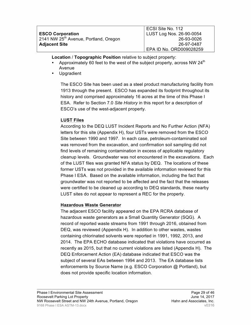
ESCO Corporation 2141 NW 25th Avenue, Portland, Oregon Adjacent Site
ECSI Site No. 112 LUST Log Nos. 26-90-0054
26-93-0026 26-97-0487
EPA ID No. ORD009028259
Location / Topographic Position relative to subject property: • Approximately 60 feet to the west of the subject property, across NW 24th
Avenue • Upgradient
The ESCO Site has been used as a steel product manufacturing facility from 1913 through the present. ESCO has expanded its footprint throughout its history and comprised approximately 16 acres at the time of this Phase I ESA. Refer to Section 7.0 Site History in this report for a description of ESCO’s use of the west-adjacent property.
LUST Files According to the DEQ LUST Incident Reports and No Further Action (NFA) letters for this site (Appendix H), four USTs were removed from the ESCO Site between 1990 and 1997. In each case, petroleum-contaminated soil was removed from the excavation, and confirmation soil sampling did not find levels of remaining contamination in excess of applicable regulatory cleanup levels. Groundwater was not encountered in the excavations. Each of the LUST files was granted NFA status by DEQ. The locations of these former USTs was not provided in the available information reviewed for this Phase I ESA. Based on the available information, including the fact that groundwater was not reported to be affected and the fact that the releases were certified to be cleaned up according to DEQ standards, these nearby LUST sites do not appear to represent a REC for the property.
Hazardous Waste Generator The adjacent ESCO facility appeared on the EPA RCRA database of hazardous waste generators as a Small Quantity Generator (SQG). A record of reported waste streams from 1991 through 2016, obtained from DEQ, was reviewed (Appendix H). In addition to other wastes, wastes containing chlorinated solvents were reported in 1991, 1992, 2013, and 2014. The EPA ECHO database indicated that violations have occurred as recently as 2015, but that no current violations are listed (Appendix H). The DEQ Enforcement Action (EA) database indicated that ESCO was the subject of several EAs between 1994 and 2013. The EA database lists enforcements by Source Name (e.g. ESCO Corporation @ Portland), but does not provide specific location information.

Phase I Environmental Site Assessment Page 30 of 46 Roosevelt Parking Lot Property June 14, 2017 NW Roosevelt Street and NW 24th Avenue, Portland, Oregon Hahn and Associates, Inc. 9168 Phase I ESA ASTM-13.docx v0316
ECSI Site No. 112 According to the DEQ Site Summary Report for ECSI Site No. 112 (Appendix H), ESCO Plant #3 was listed as an ECSI suspect site requiring further investigation. Although the address information for the ESCI site corresponds to the west-adjacent property, Mr. Jeff Dresser of Bridgewater, Inc. (the Client/User of this report) confirmed that this ECSI Site is located at ESCO Plant #3, which is located approximately 0.25-mile to the north (downgradient) of the subject property. In 1980, a DEQ representative observed runoff from ESCO property located near railroad tracks. Soil was indicated to be contaminated with phenols at a concentration of 2.8 parts per million (ppm). The discharge problem was indicated to have been corrected, and soil contamination was indicated to be possible. No remedial action was noted. Based on its distance and downgradient position relative to the subject property, the listing of ESCO Plant #3 on the ECSI database does not appear to represent a REC for the subject property.
Conclusion The information obtained from regulatory agency records for this site was not sufficient to exclude the possibility of contamination at the ESCO site. Based on its long history of heavy industrial usage (see Section 7 Site History) and its history of chlorinated solvent use, combined with its upgradient position relative to the subject property, the possibility of the migration of groundwater and/or soil vapor contamination onto the subject property from the ESCO site represents a REC for the subject property.
Portland Harbor Superfund Site Willamette River Mile 1.9 through Mile 11.8
NPL Site ID No. ORSFN1002155 ECSI Site No. 2068
Location / Topographic Position relative to subject property: • Approximately 0.5-mile northeast • Hydraulically downgradient
A Record of Decision (ROD) for the Portland Harbor Superfund Site was released on January 6, 2017. EPA, DEQ and other agencies, tribal governments, community groups and companies have been working to investigate and clean up contamination in Portland Harbor. EPA is the lead agency responsible for investigating and cleaning up contaminated sediments in the river itself. The subject property is not directly adjacent to the Willamette River.
EPA has sent requests for information (known as 104(e) requests) to hundreds of current and former property owners in the general vicinity of the Portland Harbor Superfund Site in order to gather information to assist in identification of Potentially-Responsible Parties (PRPs) with regard to the

Phase I Environmental Site Assessment Page 31 of 46 Roosevelt Parking Lot Property June 14, 2017 NW Roosevelt Street and NW 24th Avenue, Portland, Oregon Hahn and Associates, Inc. 9168 Phase I ESA ASTM-13.docx v0316
investigation and cleanup of the Portland Harbor. According to a list of 104(e) recipients dated January 2013 and available from EPA, ESCO Corporation (the current Owner) received a request for information from EPA. Superfund "General Notice Letters" (GNLs) inform recipients that they are identified as a PRP and may be liable for cleanup costs at the site. A list of Portland Harbor PRPs, available from EPA and dated September 2014, indicated that ESCO received a GNL (Appendix I). However, the subject property for this assessment was not specified as one of ESCO’s facilities on the GNL list.
DEQ is the lead agency for identifying and controlling upland sources of pollution adjacent to or near the river that may be contaminating river water or sediments. In 2016, DEQ released the Portland Harbor Upland Source Control Summary Report. The 2016 DEQ summary report does not identify the subject property either as a site having a pending source control decision or as a site that may potentially need investigation.
Based on the documents reviewed at the time of this assessment, the subject property was not specifically identified by the EPA as a potential contributor to the contamination of Willamette River sediments, nor has the subject property been identified by the DEQ as a potential ongoing source of contamination to river sediments. It is recommended that the status of the Portland Harbor site be monitored for any future developments that may affect the property.
9.0 DEVIATIONS
This Phase I ESA deviates from ASTM E1527-13 as follows:
• See Data Gaps below
9.1 Data Gaps
A Data Gap is defined in ASTM E1527-13 as a lack of or inability to obtain information required by the standards and practices listed in the regulation despite good faith efforts by the environmental professional or prospective landowner to gather such information. Such Data Gaps may affect the environmental professional’s ability to identify RECs at the property.
A Data Failure is defined as the failure to achieve the historical research objectives contained in ASTM E1527-13, including identifying obvious uses of the property from the present, back to the property’s first developed use,

Phase I Environmental Site Assessment Page 32 of 46 Roosevelt Parking Lot Property June 14, 2017 NW Roosevelt Street and NW 24th Avenue, Portland, Oregon Hahn and Associates, Inc. 9168 Phase I ESA ASTM-13.docx v0316
or back to 1940, whichever is earlier. A Data Failure is one type of Data Gap.
The following Data Gaps were identified in association with this Phase I ESA, along with their significance and the attempts made to fill the Data Gaps:
• Based on the duration of ownership by the current Owners (1960s through present), interviews with previous Owners or Occupants of the subject property were not attempted (Data Gap). Based on the information obtained from interviews, historical records and historical aerial photographs, this Data Gap was not considered to be significant.
• Historical resources for the subject property (i.e. aerial photographs) extended only to 1908 (Data Failure), as opposed to the first developed use of the property, or 1940, whichever is earlier, as prescribed by the ASTM E-1527-13. Based on the fact that the property was developed with residences from 1908 through the 1960s, this Data Gap was not considered to be significant.
10.0 ADDITIONAL SERVICES
In addition to the basic elements of ASTM E1527-13, this report includes the following:
• A visual assessment for suspect asbestos-containing materials was conducted during the course of the site reconnaissance (Section 4.10.1). This visual assessment did not constitute an asbestos survey and was not intended to identify every suspect asbestos-containing material at the subject property.

Phase I Environmental Site Assessment Page 33 of 46 Roosevelt Parking Lot Property June 14, 2017 NW Roosevelt Street and NW 24th Avenue, Portland, Oregon Hahn and Associates, Inc. 9168 Phase I ESA ASTM-13.docx v0316
11.0 LIMITATIONS The purpose of this environmental assessment is to evaluate the possibility that the specified real property contains a Recognized Environmental Condition (REC), as defined by the American Society for Testing and Materials (ASTM) guideline (E1527-13). In performing an environmental assessment, a balance must be struck between the desire to conduct a complete inquiry into environmental matters and the limits of time, cost and technology. This report sets forth HAI’s evaluation of the possibility of RECs based on the scope of work agreed to by the Client and within the Client’s schedule and budget.
No investigation is thorough enough to ensure that hazardous substances are not present on a particular property. Even if RECs have not been identified in this report, there is no guarantee that contamination or other environmental conditions are not present. If samples have been collected in connection with this assessment, our assessment is based in part on our interpretation of data from discrete sample locations that may not represent actual conditions at unsampled locations. In evaluating the potential risks associated with the subject property, we have focused on possible sources on the property and on property in the immediate vicinity. We have not attempted to assess the risk that the property may be affected by regional contamination problems, such as the possibility of widespread contamination of the groundwater from sources not associated with this property.
All conclusions, opinions, and recommendations presented in this report are based on conditions existing at the time the services were performed and the laws, practices and technology in effect and commonly used as of that time. HAI is not able to predict future events that may affect the condition of the property or that may affect the risks attendant to such conditions.
Unless otherwise specified in this report, HAI has not investigated either the conditions inside any buildings on the property or the possible presence of hazardous substances incorporated into buildings, equipment, or other improvements on the property. HAI has not investigated conditions in any area of the property not readily accessible. Except as specifically described in this report, HAI also has not investigated the presence of hazardous substances that may be naturally occurring on the property. HAI has relied on information provided by the Client and other individuals and documents and has not verified the accuracy of such information.
Unless otherwise specified in writing, this report has been prepared solely for the use by the Client and Users, as identified in this report, and for use only in connection with the described property, subject to the limitations and conditions in HAI’s services agreement with its Client. Any other use by the Client/Users or any use by any other person shall be at the user’s sole risk, and HAI shall have neither liability nor responsibility with respect to such use. (02/13)

Phase I Environmental Site Assessment Page 34 of 46 Roosevelt Parking Lot Property June 14, 2017 NW Roosevelt Street and NW 24th Avenue, Portland, Oregon Hahn and Associates, Inc. 9168 Phase I ESA ASTM-13.docx v0316
12.0 REFERENCES
City of Portland Building Department, building permits/plans, May 8, 2017
City of Portland, Mayor’s Message and Annual Reports, the City Auditor’s List of Fuel Oil and Gasoline Storage Tanks, Filling Stations, and Curb Pumps, 1927
Cole City Directories for Greater Portland, Oregon, 1994, 1997, 2002, 2007, 2012, 2017, reviewed at the HAI office, May 15, 2017
Environmental Data Resources, Certified Sanborn Map® Reports, previously obtained May 5, 2010 and May 17, 2012
Environmental Data Resources, The EDR City Directory Abstract, April 14, 2017
Environmental Data Resources, The Radius Map™ Report, April 14, 2017
Google Map Imagery, aerial photographs for 2001, 2006, and 2016, obtained April 2017
Google search engine (http://www.google.com), keyword searches, various dates, April and May 2017
Multnomah County Department of Assessment and Taxation, property ownership and tax lot information, May 16, 2017
MyTopo Map Pass Subscription Service, topographic base map for Figure 1, (map-pass.mytopo.com), May 24, 2017
Oregon Department of Environmental Quality, state regulatory lists, reviewed May 15, 2017
Oregon Department of Geology and Mineral Industries, Earthquake-Hazard Geology Map of the Portland, Oregon Quadrangle, 1990, area geology
Oregon Water Resources Department, water well logs review, May 2, 2017 (www.wrd.state.or.us)
Portland Fire and Rescue, underground storage tank records request (no records on file), May 23, 2017
U.S. Army Corps of Engineers Central Map Files, Portland, Oregon, aerial photographs for 1936, 1943, 1955, 1963, 1972, 1980, and 1995, obtained April 13, 2017
U.S. Environmental Protection Agency, federal regulatory lists, reviewed May 9, 2017
U.S. Geological Survey 7.5-Minute Quadrangle, Portland, Oregon, 1995, area topography

Phase I Environmental Site Assessment Page 35 of 46 Roosevelt Parking Lot Property June 14, 2017 NW Roosevelt Street and NW 24th Avenue, Portland, Oregon Hahn and Associates, Inc. 9168 Phase I ESA ASTM-13.docx v0316
13.0 GLOSSARY OF ABBREVIATIONS ACM Asbestos-Containing Materials AST Aboveground Storage Tank ASTM American Society for Testing and Materials AUL activity and use limitations bgs below ground surface CCDs Cole City Directories CEG Conditionally Exempt Generator CERCLA Comprehensive Environmental Response Compensation and
Liability Act CERCLIS Comprehensive Environmental Response Compensation and
Liability Information System CFR Code of Federal Regulations CORRACTS RCRA Corrective Action Report DEQ Oregon Department of Environmental Quality ECSI Environmental Cleanup Site Information EPA U.S. Environmental Protection Agency HAI Hahn and Associates, Inc. LQG Large Quantity Generator LUST Leaking Underground Storage Tank MSL Mean Sea Level NFA No Further Action NFRAP No Further Remedial Action Planned NPL National Priority List OAR Oregon Administrative Rule OSHA Occupational Safety and Health Administration OWRD Oregon Water Resources Department PCB Polychlorinated Biphenyls ppm parts per million RCRA Resource Conservation and Recovery Act RECs Recognized Environmental Conditions SEMS Superfund Enterprise Management System SFIM Sanborn Fire Insurance Map SQG Small Quantity Generator of Hazardous Waste SWDF Solid Waste Disposal Facility SWDS Solid Waste Disposal Site TSD Treatment, Storage and Disposal USGS U.S. Geological Survey UST Underground Storage Tank W.M. Willamette Meridian

Phase I Environmental Site Assessment Page 36 of 46 Roosevelt Parking Lot Property June 14, 2017 NW Roosevelt Street and NW 24th Avenue, Portland, Oregon Hahn and Associates, Inc. 9168 Phase I ESA ASTM-13.docx v0316
14.0 DESCRIPTION OF ENVIRONMENTAL DATABASES
Federal NPL Sites List: The EPA National Priority List (NPL) details the locations of hazardous substance sites that present a potential for imminent and substantial harm to the environment.
Federal De-listed NPL Sites List: The Federal De-listed NPL Site (NPL) List details the locations of hazardous substance sites where either environmentally significant quantities of hazardous waste were never confirmed at the site, or an environmentally insignificant amount of hazardous waste is all that remains at the site as a result of remediation.
Federal CERCLIS List: The Comprehensive Environmental Response, Compensation and Liability Information System (CERCLIS) lists hazardous substance sites that require preliminary investigation or are undergoing EPA investigations.
Federal CERCLIS NFRAP List: This report lists all CERCLIS No Further Remedial Action Planned (NFRAP) sites, which are CERCLIS sites that have been removed from the CERCLIS List. Archived status indicates that contamination was not found at the CERCLIS NFRAP sites, the contamination has been remediated, or the contamination has been deemed to not be significant enough to require consideration under CERCLIS or NPL. The listing of a site on the CERCLIS NFRAP does not necessarily imply that contamination has been deemed insignificant or remediated based upon applicable state or local standards.
Federal Superfund Enterprise Management System: The Federal Superfund Enterprise Management System (SEMS) was developed to replace the Federal CERCLIS Public Access Database, and was made operational in 2016. SEMS includes the same data fields and content as CERCLIS. The Federal CERCLIS Public Access Database, which contained a selected set of publicly releasable Superfund program data, was retired in 2013.
Federal CORRACTS List: The Corrective Action Report (CORRACTS) List identifies hazardous waste handlers with RCRA corrective action activity.
Federal RCRA TSD Facilities List: The EPA Resource Conservation and Recovery Act (RCRA) Treatment, Storage and Disposal (TSD) Facilities List identifies sites which manage hazardous waste for the purpose of on-site treatment, interim storage, or on-site disposal.
Federal RCRA Handlers List: The EPA RCRA Handlers List identifies facilities which have given notification as current hazardous waste generators, including Large Quantity Generators (LQG), Small Quantity Generators (SQG), or Conditionally Exempt Generators (CEGs), and facilities that do not presently generate hazardous waste (Non-Generators).
Federal Engineering and Institutional Controls Lists: The EPA Federal Engineering Controls List identifies sites with engineering controls in place. Engineering controls include various forms of caps, building foundations, liners, and treatment methods to create pathway elimination for regulated substances to enter environmental media or affect human health. The EPA Federal Institutional Controls

Phase I Environmental Site Assessment Page 37 of 46 Roosevelt Parking Lot Property June 14, 2017 NW Roosevelt Street and NW 24th Avenue, Portland, Oregon Hahn and Associates, Inc. 9168 Phase I ESA ASTM-13.docx v0316
List identifies sites with institutional controls in place. Institutional controls include administrative measures, such as groundwater use restrictions, construction restrictions, property use restrictions, and post remediation care requirements intended to prevent exposure to contaminants remaining on site. Deed restrictions are generally required as part of the institutional controls.
Federal ERNS List: The Emergency Response Notification System (ERNS) List records and stores information on reported releases of oil and hazardous substances.
DEQ ECSI List: The Oregon Department of Environmental Quality (DEQ) Environmental Cleanup Site Information (ECSI) List includes hazardous substance sites undergoing DEQ investigations, along with DEQ Voluntary Cleanup Program (VCP) sites, State Brownfield sites, and sites with State-registered engineering and/or institutional controls.
DEQ SWF/LF List: The DEQ SWF/LF list is an inventory of active permitted facilities (including landfills, waste tire storage sites and carriers) in Oregon. The types of permitted facilities include compost, municipal solid waste (disposal) landfills, material recovery, transfer stations, tire and household hazardous waste.
DEQ LUST List: The DEQ Leaking Underground Storage Tank (LUST) Database List contains an inventory of reported LUST incidents.
DEQ UST List: The UST Facilities by Zip List is compiled of all underground storage tank facilities in Oregon. The list contains the following information: Facility ID, Name, Location, City, Zip, Phone Number, Permittee, Total Number of Tanks, Number of Active Tanks, Number of Decommissioned Tanks, and Number of Permitted Tanks.
Indian LUST List: The Indian LUST List identified leaking USTs on Indian land in Alaska, Idaho, Oregon and Washington.
Indian UST List: The Indian UST List identified USTs on Indian land in Alaska, Idaho, Oregon and Washington.
Federal Brownfields Program Sites List: EPA's Brownfields Program empowers states, communities, and other stakeholders in economic development to work together to prevent, assess, safely clean up, and sustainably reuse brownfields. A Brownfield Site is real property, the expansion, redevelopment, or reuse of which may be complicated by the presence or potential presence of a hazardous substance, pollutant, or contaminant.
Oregon State Fire Marshal’s Office HSIS List: The Oregon State Fire Marshal’s Office Hazardous Substance Information Survey (HSIS) identifies companies in Oregon submitting the HSIS and either reporting or not reporting hazardous substances.
Oregon ERIS Spills List: The Oregon Emergency Response Information System (ERIS) List identifies reported releases of petroleum and/or hazardous substances to land or water since 1995. DEQ discontinued usage and maintenance of this database in July 2013.
Oregon Building Codes Division Drug Lab Cleanup Program List: The Building Codes Division of the Oregon Department of Consumer & Business Services

Phase I Environmental Site Assessment Page 38 of 46 Roosevelt Parking Lot Property June 14, 2017 NW Roosevelt Street and NW 24th Avenue, Portland, Oregon Hahn and Associates, Inc. 9168 Phase I ESA ASTM-13.docx v0316
maintains a list of properties declared by law enforcement agencies to be unfit for use due to methamphetamine manufacturing and/or storage activities. The properties are considered unfit for habitation until they are certified clean in accordance with the Oregon Department of Human Services’ Clandestine Drug Lab Cleanup Program, at which time they are removed from the list.
15.0 DEFINITIONS OF TERMS
Abandoned Property — property that can be presumed to be deserted, or an intent to relinquish possession or control can be inferred from the general disrepair or lack of activity thereon such that a reasonable person could believe that there was an intent on the part of the current owner to surrender rights to the property.
Activity and Use Limitation (AUL) — legal or physical restrictions or limitations on the use of, or access to, a site or facility: (1) to reduce or eliminate potential exposure to hazardous substances or petroleum products in the soil, soil vapor, groundwater, and/or surface water on the property, or (2) to prevent activities that could interfere with the effectiveness of a response action, in order to ensure maintenance of a condition of no significant risk to public health or the environment. These legal or physical restrictions, which may include institutional and/or engineering controls, are intended to prevent adverse impacts to individuals or populations that may be exposed to hazardous substances and petroleum products in the soil or groundwater on the property.
Actual Knowledge — the knowledge actually possessed by an individual who is a real person, rather than an entity. Actual knowledge is to be distinguished from constructive knowledge, that is knowledge imputed to an individual or entity.
Adjoining Properties — any real property or properties the border of which is contiguous or partially contiguous with that of the property, or that would be contiguous or partially contiguous with that of the property but for a street, road, or other public thoroughfare separating them.
Aerial Photographs — photographs taken from an aerial platform with sufficient resolution to allow identification of development and activities of areas encompassing the property.
All Appropriate Inquiries — that inquiry constituting “all appropriate inquiries into the previous ownership and uses of the property consistent with good commercial or customary practice” as defined in CERCLA, 42 U.S.C §9601(35)(B), that will qualify a party to a commercial real estate transaction for one of threshold criteria for satisfying the landowner liability protections to CERCLA liability (42 U.S.C §9601(35)(A) & (B), §9607(b)(3), §9607(q); and §9607(r)), assuming compliance with other elements of the defense.
Approximate Minimum Search Distance — the area for which records must be obtained and reviewed under ASTM E1527-13, subject to limitations as provided in ASTM E1527-13. This distance is to be measured from the nearest subject property boundary. This term is used in lieu of radius to include irregularly shaped properties.
Business Environmental Risk — a risk which can have a material environmental or environmentally-driven impact on a business associated with the current or future use of a parcel of commercial real estate. Consideration of business environmental
Phase I Environmental Site Assessment Page 39 of 46 Roosevelt Parking Lot Property June 14, 2017 NW Roosevelt Street and NW 24th Avenue, Portland, Oregon Hahn and Associates, Inc. 9168 Phase I ESA ASTM-13.docx v0316
risk is not necessarily limited to those environmental issues required to be investigated under ASTM E1527-13, and may involve addressing considerations outside the scope of this practice (non-scope considerations).
Continuing Obligations — Continuing Obligations that the Client/User must achieve and maintain in order to qualify for one of the Landowner Liability Protections (LLPs) to CERCLA liability under the 2002 Brownfields Amendments, assuming compliance with other elements of the defense. Continuing Obligations include: (1) complying with land use restrictions and institutional controls; (2) taking reasonable steps with respect to hazardous substance releases; (3) providing full cooperation, assistance, and access to persons that are authorized to conduct response actions or natural resource restoration; (4) complying with requests for information and with administrative subpoenas; and (5) providing legally required notices.
Controlled Recognized Environmental Condition (CREC) — a REC resulting from a past release of hazardous substances or petroleum products that has been addressed to the satisfaction of the applicable regulatory authority (e.g., as evidenced by the issuance of a NFA letter or equivalent, or meeting risk-based criteria established by regulatory authority), with hazardous substances or petroleum products allowed to remain in place subject to the implementation of required controls (e.g., property use restrictions, AULs, or institutional/engineering controls).
Data Failure — a failure to achieve the historical research objectives contained in ASTM E1527-13 (includes identifying obvious uses of the property from the present, back to the property’s first developed use, or back to 1940, whichever is earlier), even after reviewing the standard historical sources that are reasonably ascertainable and likely to be useful. Data Failure is one type of Data Gap.
Data Gap — a lack of or inability to obtain information required by this practice despite good faith efforts by the environmental professional to gather such information. Data gaps may result from incompleteness in any of the activities required by this practice, including, but not limited to site reconnaissance (for example, an inability to conduct the site visit), and interviews (for example, an inability to interview the key site manager, regulatory officials, etc.).
De Minimis Condition — a condition that generally does not present a material risk of harm to human health or the environment and that generally would not be the subject of an enforcement action if brought to the attention of appropriate governmental agencies. Conditions determined to be de minimis are not recognized environmental conditions or controlled recognized environmental conditions.
Drywells — underground areas where soil has been removed and replaced with pea gravel, coarse sand, or large rocks. Dry wells are used for drainage, to control storm runoff, for the collection of spilled liquids (intentional and non-intentional) and wastewater disposal (often illegal).
Environment — The term “environment” includes (A) the navigable waters, the waters of the contiguous zone, and the ocean waters of which the natural resources are under the exclusive management authority of the United States under the Magnuson-Stevens Fishery Conservation and Management Act: and (B) any other surface water, groundwater, drinking water supply, land surface or subsurface strata, or ambient air within the United States or under the jurisdiction of the United States, as defined in CERCLA 42 U.S.C. § 9601(8)).

Phase I Environmental Site Assessment Page 40 of 46 Roosevelt Parking Lot Property June 14, 2017 NW Roosevelt Street and NW 24th Avenue, Portland, Oregon Hahn and Associates, Inc. 9168 Phase I ESA ASTM-13.docx v0316
Environmental Compliance Audit — the investigative process to determine if the operations of an existing facility are in compliance with applicable environmental laws and regulations. This term should not be used to describe this practice, although an environmental compliance audit may include an environmental site assessment or, if prior audits are available, may be part of an environmental site assessment.
Environmental Lien — a charge, security, or encumbrance upon title to a property to secure the payment of a cost, damage, debt, obligation, or duty arising out of response actions, cleanup, or other remediation of hazardous substances or petroleum products upon a property, including (but not limited to) liens imposed pursuant to CERCLA 42 U.S.C. §9607(1) & 9607(r) and similar state or local laws.
Environmental Professional — (1) a person who possesses sufficient specific education, training, and experience necessary to exercise professional judgment to develop opinions and conclusions regarding conditions indicative of releases or threatened releases on, at, in, or to a property, sufficient to meet the objectives and performance factors in §312.20(e) and (f). (2) Such a person must: (i) hold a current Professional Engineer’s or Professional Geologist’s license or registration from a state, tribe, or U.S. territory (or the Commonwealth of Puerto Rico) and have the equivalent of three (3) years of full-time relevant experience; or (ii) be licensed or certified by the federal government, a state, tribe, or U.S. territory (or the Commonwealth of Puerto Rico) to perform environmental inquiries as defined in §312.21 and have the equivalent of three (3) years of full-time relevant experience; or (iii) have a Baccalaureate or higher degree from an accredited institution of higher education in a discipline of engineering or science and the equivalent of five (5) years of full-time relevant experience; or (iv) have the equivalent of ten (10) years of full-time relevant experience. (3) An environmental professional should remain current in his or her field through participation in continuing education or other activities. (4) The definition of environmental professional provided above does not preempt state professional licensing or registration requirements such as those for a professional geologist, engineer, or site remediation professional. Before commencing work, a person should determine the applicability of state professional licensing or registration laws to the activities to be undertaken as part of the inquiry identified in §312.21(b). (5) A person who does not qualify as an environmental professional under the foregoing definition may assist in the conduct of all appropriate inquiries in accordance with this part if such person is under the supervision or responsible charge of a person meeting the definition of an environmental professional provided above when conducting such activities.
Environmental Site Assessment (ESA) — the process by which a person or entity seeks to determine if a particular parcel of real property (including improvements) is subject to recognized environmental conditions. At the option of the user, an environmental site assessment may include more inquiry than that constituting all appropriate inquiries or, if the user is not concerned about qualifying for the landowner liability protections (LLPs), less inquiry than that constituting all appropriate inquiries. An environmental site assessment is both different from and often less rigorous than an environmental compliance audit.
Fill Dirt — dirt, soil, sand, or other earth, that is obtained off-site, that is used to fill holes or depressions, create mounds, or otherwise artificially change the grade or

Phase I Environmental Site Assessment Page 41 of 46 Roosevelt Parking Lot Property June 14, 2017 NW Roosevelt Street and NW 24th Avenue, Portland, Oregon Hahn and Associates, Inc. 9168 Phase I ESA ASTM-13.docx v0316
elevation of real property. It does not include material that is used in limited quantities for normal landscaping activities.
Good Faith — the absence of any intention to seek an unfair advantage or to defraud another party; an honest and sincere intention to fulfill one’s obligations in the conduct or transaction concerned.
Hazardous Substance — Per ASTM 1527-13, a substance defined as a hazardous substance pursuant to CERCLA 42 U.S.C.§9601(14), as interpreted by EPA regulations and the courts:“ (A) any substance designated pursuant to section 1321(b)(2)(A) of Title 33, (B) any element, compound, mixture, solution, or substance designated pursuant to section 9602 of this title, (C) any hazardous waste having the characteristics identified under or listed pursuant to section 3001 of the Resource Conservation and Recovery Act of 1976 (RCRA), as amended, (42 U.S.C. §6921) (but not including any waste the regulation of which under RCRA (42 U.S.C.§6901 et seq.) has been suspended by Act of Congress), (D) any toxic pollutant listed under section 1317(a) of Title 33, (E) any hazardous air pollutant listed under section 112 of the Clean Air Act (42 U.S.C. §7412), and (F) any imminently hazardous chemical substance or mixture with respect to which the Administrator (of EPA) has taken action pursuant to section 2606 of Title 15. The term does not include petroleum, including crude oil or any fraction thereof which is not otherwise specifically listed or designated as a hazardous substance under subparagraphs (A) through (F) of this paragraph, and the term does not include natural gas, natural gas liquids, liquefied natural gas, or synthetic gas usable for fuel (or mixtures of natural gas and such synthetic gas).
Hazardous Waste — any hazardous waste having the characteristics identified under or listed pursuant to section 3001 of RCRA, as amended, (42 U.S.C. §6921) (but not including any waste the regulation of which under RCRA (42 U.S.C. §6901-6992k) has been suspended by Act of Congress). RCRA is sometimes also identified as the Solid Waste Disposal Act. RCRA defines a hazardous waste, at 42 U.S.C. §6903, as: “a solid waste, or combination of solid wastes, which because of its quantity, concentration, or physical, chemical, or infectious characteristics may—(A) cause, or significantly contribute to an increase in mortality or an increase in serious irreversible, or incapacitating reversible, illness; or (B) pose a substantial present or potential hazard to human health or the environment when improperly treated, stored, transported, or disposed of, or otherwise managed.”
Historical Recognized Environmental Condition (HREC) —a past release of any hazardous substances or petroleum products that has occurred in connection with the property and has been addressed to the satisfaction of the applicable regulatory authority or meeting unrestricted residential use criteria established by a regulatory authority, without subjecting the property to any required controls (e.g., property use restrictions, AULs, institutional controls, or engineering controls). Before calling the past release an HREC, the EP must determine whether the past release is a REC at the time the Phase I ESA is conducted (e.g., if there has been a change in the regulatory criteria). If the EP considers this past release to be a REC at the time the Phase I ESA is conducted, the condition shall be included in the conclusions section of the report as a REC
IC/EC registries — databases of institutional controls or engineering controls that may be maintained by a federal, state or local environmental agency for purposes of tracking sites that may contain residual contamination and AULs. The names for

Phase I Environmental Site Assessment Page 42 of 46 Roosevelt Parking Lot Property June 14, 2017 NW Roosevelt Street and NW 24th Avenue, Portland, Oregon Hahn and Associates, Inc. 9168 Phase I ESA ASTM-13.docx v0316
these may vary from program to program and state to state, and include terms such as Declaration of Environmental Use Restriction database (Arizona), list of “deed restrictions” (California), environmental real covenants list (Colorado), brownfields site list (Indiana, Missouri) and the Pennsylvania Activity and Use Limitation (PA AUL) Registry.
Innocent Landowner Defense — (42 U.S.C. §9601(35) & 9607(b)(3)) — a person may qualify as one of three types of innocent landowners: (i) a person who “did not know and had no reason to know” that contamination existed on the property at the time the purchaser acquired the property; (ii) a government entity which acquired the property by escheat, or through any other involuntary transfer or acquisition, or through the exercise of eminent domain authority by purchase or condemnation; and (iii) a person who “acquired the facility by inheritance or bequest.” To qualify for the first type of innocent landowner LLP, such person must have made all appropriate inquiries on or before the date of purchase. Furthermore, the all appropriate inquiries must not have resulted in knowledge of the contamination. If it does, then such person did “know” or “had reason to know” of contamination and would not be eligible for the innocent landowner defense.
Institutional Controls — a legal or administrative restriction (for example, “deed restrictions,” restrictive covenants, easements, or zoning) on the use of, or access to, a site or facility to (1) reduce or eliminate potential exposure to hazardous substances or petroleum products in the soil or groundwater on the property, or (2) to prevent activities that could interfere with the effectiveness of a response action, in order to ensure maintenance of a condition of no significant risk to public health or the environment. An institutional control is a type of Activity and Use Limitation (AUL).
Key Site Manager — the person identified by the owner or operator of a property as having good knowledge of the uses and physical characteristics of the property.
Landowner Liability Protections — landowner liability protections (LLPs) include the bona fide prospective purchaser liability protection, contiguous property owner liability protection, and innocent landowner defense from CERCLA liability (42 U.S.C. §§9601(35)(A), 9601(40), 9607(b), 9607(q), 9607(r)).
Major Occupants — those tenants, subtenants, or other persons or entities each of which uses at least 40 % of the leasable area of the property or any anchor tenant when the property is a shopping center.
Material Threat — a physically observable or obvious threat which is reasonably likely to lead to a release that, in the opinion of the environmental professional, is threatening and might result in impact to public health or the environment. An example might include an aboveground storage tank system that contains a hazardous substance and which shows evidence of damage. The damage would represent a material threat if it is deemed serious enough that it may cause or contribute to tank integrity failure with a release of contents to the environment.
Migrate/Migration — the movement of hazardous substances or petroleum products in any form, including, for example, solid and liquid at the surface or subsurface, and vapor in the subsurface.
Petroleum Products — those substances included within the meaning of the petroleum exclusion to CERCLA, 42 U.S.C. §9601(14), as interpreted by the courts

Phase I Environmental Site Assessment Page 43 of 46 Roosevelt Parking Lot Property June 14, 2017 NW Roosevelt Street and NW 24th Avenue, Portland, Oregon Hahn and Associates, Inc. 9168 Phase I ESA ASTM-13.docx v0316
and EPA, that is: petroleum, including crude oil or any fraction thereof which is not otherwise specifically listed or designated as a hazardous substance under Subparagraphs (A) through (F) of 42 U.S.C. §9601(14), natural gas, natural gas liquids, liquefied natural gas, and synthetic gas usable for fuel (or mixtures of natural gas and such synthetic gas).
Pits, Ponds, or Lagoons — man-made or natural depressions in a ground surface that are likely to hold liquids or sludge containing hazardous substances or petroleum products.
Practicably Reviewable — information that is practically reviewable means that the information is provided by the source in a manner and in a form that, upon examination, yields information relevant to the property without the need for extraordinary analysis of irrelevant data. The form of the information shall be such that the user can review the records for a limited geographic area. Records that cannot be feasibly retrieved by reference to the location of the property or a geographic area in which the property is located are not generally practically reviewable. Further, when so much data is generated that it cannot be feasibly reviewed for its impact on the property, it is not practically reviewable.
Publicly Available — information that is publicly available means that the source of the information allows access to the information by anyone upon request.
Reasonably Ascertainable — for purposes of both the ASTM Phase I ESA (Practice E 1527) and the TSA (Practice E 1528) standards, information that is (1) publicly available, (2) obtainable from its source within reasonable time and cost constraints, and (3) practicably reviewable.
Recognized Environmental Condition (REC) — the presence or likely presence of any hazardous substances or petroleum products in, on, or at a property: (1) due to any release to the environment; (2) under conditions indicative of a release to the environment; or (3) under conditions that pose a material threat of a future release to the environment. The term is not intended to include de minimis conditions that generally do not present a threat to human health or the environment and that generally would not be the subject of an enforcement action if brought to the attention of appropriate governmental agencies. Conditions determined to be de minimis are not recognized environmental conditions.
Release — any spilling, leaking, pumping, pouring, emitting, emptying, discharging, injecting, escaping, leaching, dumping, or disposing into the environment (including the abandonment or discharging of barrels, containers, and other closed receptacles containing any hazardous substances or pollutant or contaminant).
Relevant Experience — as used in the definition of environmental professional, means: participation in the performance of environmental site assessments that may include environmental analyses, investigations, and remediation which involve the understanding of surface and subsurface environmental conditions and the processes used to evaluate these conditions and for which professional judgment was used to develop opinions regarding conditions indicative of releases or threatened releases (per §312.1(c)) to the subject property.
Site Reconnaissance — that part that is contained in ASTM Practice E1527 and addresses what should be done in connection with the site visit. The site

Phase I Environmental Site Assessment Page 44 of 46 Roosevelt Parking Lot Property June 14, 2017 NW Roosevelt Street and NW 24th Avenue, Portland, Oregon Hahn and Associates, Inc. 9168 Phase I ESA ASTM-13.docx v0316
reconnaissance includes, but is not limited to, the site visit done in connection with a Phase I Environmental Site Assessment.
Site Visit — the visit to the property during which observations are made as part of the site reconnaissance.
Subject Property — the real property that is the subject of this Phase I ESA. Real property includes buildings and other fixtures and improvements located on the property and affixed to the land.
Sump — a pit, cistern, cesspool, or similar receptacle where liquids drain, collect, or are stored.
Underground Storage Tank (UST) — any tank, including underground piping connected to the tank, that is or has been used to contain hazardous substances or petroleum products and the volume of which is 10% or more beneath the surface of the ground.
User — the party seeking to use ASTM E1527-13 to complete a Phase I ESA of the subject property. A User may include, without limitation, a potential purchaser of property, a potential tenant of property, an owner of property, a lender, or a property manager.
User’s Responsibilities — ASTM E1527-13 describes specific tasks to be performed by the Client/User that will help identify the possibility of RECs in connection with the subject property and which a) do not require the technical expertise of an environmental professional (EP) and b) are generally not performed by EPs performing a Phase I ESA. These tasks include communicating to the EP any specialized or actual knowledge or experience the Client/User may have with respect to the property, the relationship of the purchase price to the fair market value of the property, and the reason for conducting the Phase I ESA. Additionally, under ASTM E1527-13, it is the Client/User’s responsibility to either: 1) engage a title company or title professional to undertake a review of reasonably ascertainable recorded land title records and lien records for environmental liens or AULs currently recorded against or relating to the property, or 2) negotiate such an engagement of a title company or title professional as an addition to the scope of the Phase I ESA activities.
Vapor Encroachment Condition (VEC) — the presence or likely presence of COC vapors in the subsurface of the subject property caused by the release of vapors from contaminated soil or groundwater or both either on or near the property.
Wastewater — water that (1) is or has been used in an industrial or manufacturing process, (2) conveys or has conveyed sewage, or (3) is directly related to manufacturing, processing, or raw materials storage areas at an industrial plant. Wastewater does not include water originating on or passing through or adjacent to a site, such as stormwater flows, that has not been used in industrial or manufacturing processes, has not been combined with sewage, or is not directly related to manufacturing, processing, or raw materials storage areas at an industrial plant.
(12/13)

Phase I Environmental Site Assessment Page 45 of 46 Roosevelt Parking Lot Property June 14, 2017 NW Roosevelt Street and NW 24th Avenue, Portland, Oregon Hahn and Associates, Inc. 9168 Phase I ESA ASTM-13.docx v0316
16.0 QUALIFICATIONS OF ENVIRONMENTAL PROFESSIONALS ELEANORE J. RAMSEY, G.I.T. Sr. Project Manager
Technical Expertise Ms. Ramsey is a registered Geologist-In-Training (G.I.T.) with over 12 years of progressive experience conducting Phase I Environmental Site Assessments (ESAs). She excels in all aspects of Phase I ESA research activities and report preparation, including data mining from diverse sources, aerial photograph analysis, historical research, interviews, and regulatory agency file review, and is proficient in identifying potential environmental concerns. Her expertise also includes a thorough understanding of regulatory compliance issues associated with underground injection control (UIC) systems as well as with the usage, storage and disposal of hazardous materials.
Experience Summary Since 2002, Ms. Ramsey has conducted Phase I ESAs, and also Phase II ESAs, for a wide variety of properties, including undeveloped land, watersheds, developed urban properties, residential properties, commercial developments and industrial properties in the western U.S. She is very knowledgeable of the federal All Appropriate Inquiries (AAI) rule and the latest American Society of Testing and Materials (ASTM) Standard E1527 for Phase I ESAs. Since joining HAI in 2007, she has completed over 150 Phase I ESAs in conformance with ASTM E1527, including numerous ESAs for complex sites with long-term histories of industrial use. In addition, Ms. Ramsey has assisted numerous clients with regulatory compliance, including UIC (drywell) registration and stormwater regulations. Ms. Ramsey participated in field research in Antarctica with duties including multi-stream aerogeophysical (airplane-based) data collection and field research in remote and harsh conditions.
Credentials B.S. Geology, Bowling Green State University, Bowling Green, Ohio Graduate Work in Geophysics, University of California, Santa Barbara, California
Professional Titles and Registrations • Oregon Geologist in Training (G.I.T.)
Selected Professional Training • OSHA 40-Hour HAZMAT Training and Annual 8-Hour Updates • Environmental Data Resources, Inc. Due Diligence at Dawn Seminars
Employment History Hahn and Associates, Inc. Project Manager 2007 to present PIERS Environmental Services, Inc. Project Manager 2002 to 2005 Cotton, Shires & Associates Staff Geologist 2001 to 2002 (05/16)

Phase I Environmental Site Assessment Page 46 of 46 Roosevelt Parking Lot Property June 14, 2017 NW Roosevelt Street and NW 24th Avenue, Portland, Oregon Hahn and Associates, Inc. 9168 Phase I ESA ASTM-13.docx v0316
GARY W. HAHN, E.P. President, Principal
Technical Expertise Mr. Hahn is a qualified Environmental Professional (E.P.), with technical expertise in managing the day-to-day operations of a regionally-based environmental consulting firm that specializes in site assessment, investigation, and remediation.
Experience Summary Mr. Hahn has owned and managed Hahn and Associates, Inc. since it inception in 1987, and has provided environmental regulatory assistance and site assessment activities for industry and government, as well as overseeing the design and implementation of environmental compliance programs and the management of environmental cleanup projects for over 30 years.
Credentials B.S. Chemistry, Case Western Reserve University
Professional Titles and Affiliations • Member, Board of Directors, The Wetlands Conservancy • Past Member, Board of Directors, Oregon Association of Environmental Professionals
Selected Professional Training • OSHA 40-Hour Health and Safety Training for Hazardous Waste Workers • OSHA 8-Hour Health and Safety Supervisor Training for Hazardous Waste Workers
Employment History Hahn and Associates, Inc. President 1987 to present SRH Associates, Inc. Environmental Scientist 1986 to 1987 McCall Oil and Chemical Corp. Environmental Compliance Manager 1983 to 1986 Waste Management, Inc. Remedial Action/Cleanup Manager 1981 to 1983 Oregon DEQ Hazardous Waste Specialist 1980 to 1981 Ohio EPA Hazardous Spill Response Manager 1976 to 1979 (01/12)

HAHN AND ASSOCIATES, INC.
FIGURES

HAHN AND ASSOCIATES, INC.Project No. 9168 May 2017Scale in Feet1"=2000'
0 1000 2000 4000
0.5-Mile Radius
1.0-Mile Radius
NORTH
SubjectProperty
FIGURE 1Location MapPhase I Environmental Site AssessmentRoosevelt Parking Lot PropertyNW Roosevelt Street and NW 24th AvenuePortland, Oregon
Note:Base Map from the Portland, Oregon (1995)USGS 7.5-Minute QuadrangleContour Interval: 10 Feet

HAHN AND ASSOCIATES, INC.
SITE PHOTOGRAPHS

Asphalt-Paved Parking Lot
Parking Lot
Tile SupplyWarehouse EC
CompanyTrial Guides
Parking Lot
ESCO LaydownYard SouthResidences Residences
Vacant Commercial Building(Former CR Press)
NW Roosevelt Street
Phase I Environmental Site AssessmentRoosevelt Parking Lot PropertyNW Roosevelt Street and NW 24th AvePortland, Oregon
HAHN AND ASSOCIATES, INC.Project No. 9168 May 2017
LEGEND
Figure Not to Scale -Locations Approximate
Subject Property Boundary
FIGURE 2aSite and Surrounding Land Use Map

Residence(1908-1965)
Garage(1936-1950)
Garage(1936-1965)
Garage(1923-1965)
Garage(1932-1950)
Shed(1936-1950)
Shed(1908)
Shed(1908)
NW Roosevelt Street
Phase I Environmental Site AssessmentRoosevelt Parking Lot PropertyNW Roosevelt Street and NW 24th AvePortland, Oregon
HAHN AND ASSOCIATES, INC.Project No. 9168 May 2017
LEGEND
Figure Not to Scale -Locations Approximate
Subject Property Boundary
FIGURE 2bHistorical Structures
Known Historical Addresses (Allon NW Roosevelt Street)
Historical Structures
HAHN AND ASSOCIATES, INC.
AERIAL PHOTOGRAPHS

NORTH
May 2017HAHN AND ASSOCIATES, INC.Project No. 9168
Phase I Environmental Site AssessmentRoosevelt Parking Lot PropertyNW Roosevelt Street and NW 24th AvenuePortland, Oregon
1936 Aerial Photograph

NORTH
May 2017HAHN AND ASSOCIATES, INC.Project No. 9168
Phase I Environmental Site AssessmentRoosevelt Parking Lot PropertyNW Roosevelt Street and NW 24th AvenuePortland, Oregon
1963 Aerial Photograph

NORTH
May 2017HAHN AND ASSOCIATES, INC.Project No. 9168
Phase I Environmental Site AssessmentRoosevelt Parking Lot PropertyNW Roosevelt Street and NW 24th AvenuePortland, Oregon
1972 Aerial Photograph
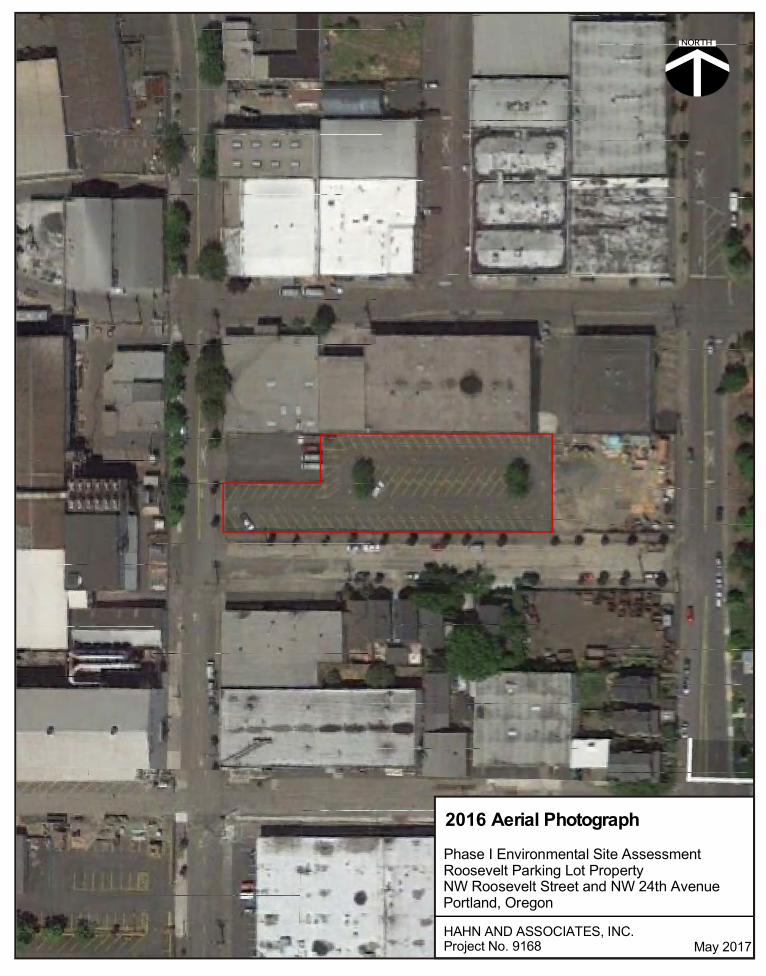
NORTH
May 2017HAHN AND ASSOCIATES, INC.Project No. 9168
Phase I Environmental Site AssessmentRoosevelt Parking Lot PropertyNW Roosevelt Street and NW 24th AvenuePortland, Oregon
2016 Aerial Photograph

HAHN AND ASSOCIATES, INC.
Appendix A
Contract

WORK ORDER
No. 9176-1
HAI Project No. 9176
April 5, 2017 CONTRACTOR: SUBCONTRACTOR: BRIDGEWATER GROUP, INC. HAHN AND ASSOCIATES, INC. 5100 SW Hampton St. #235 434 NW 6th Avenue, Suite 203 Tigard, Oregon 97223 Portland OR 97209-3651 Phone: 503.675.5252 Phone: 503.796.0717 The above-named SUBCONTRACTOR agrees to provide Services and BRIDGEWATER GROUP, INC. agrees to purchase Services on the terms and conditions set out in this Work Order and the Master Services Agreement between BRIDGEWATER GROUP, INC. and the SUBCONTRACTOR, as executed April 3, 2017. 1. SERVICES Services to be provided by SUBCONTRACTOR:
Phase I Environmental Site Assessment (ESA) according to ASTM E1527-13: Nine individual Phase I ESAs
2. LOCATION
The location of the Services shall be provided at or with respect to the following location or locations (Site) in Portland, Oregon:
1. Auto Body Shop, 2404 NW Nicolai Street 2. Reed Electric Shop, 2539 NW Vaughn Street 3. ESCO World Headquarters, 2141 NW 25th Avenue 4. ESCO Executive Offices (A2) (“H” Building), 2141 NW 25th
Avenue 5. ESCO Innovation Center (A3) (Rectangular Building), 2141 NW
25th Avenue 6. Roosevelt Parking Lot, North Side, NW Roosevelt Street, between
NW 23rd Avenue and NW 24th Avenue 7. Roosevelt Laydown Yard North, NW Corner, NW 23rd Avenue and
NW Roosevelt Street 8. Roosevelt Laydown Yard South, SW Corner, NW 23rd Avenue and
NW Roosevelt Street 9. Schiller Parking Lot, 1925 NW 24th Place

Work Order No. 9176-1 Page 2 of 2 HAI Project No. 9176 April 5, 2017
Hahn and Associates, Inc.
3. SITE CONDITIONS BRIDGEWATER GROUP, INC. and SUBCONTRACTOR understand the conditions at the Site to be:
Automotive repair shop, office buildings, laydown yards, and parking areas
4. CLIENT BRIDGEWATER GROUP, INC.’s client is: ESCO Corporation 5. SCHEDULE SUBCONTRACTOR shall commence performance of field services: Upon execution of this Work Order SUBCONTRACTOR shall complete performance of its services:
To be scheduled for each individual location in coordination with Bridgewater Group and ESCO
6. COMPENSATION
BRIDGEWATER GROUP, INC. shall compensate SUBCONTRACTOR for Services performed as follows according to the terms of the Master Services Agreement on a Time and Materials basis, not to exceed the individual estimated project budgets without prior authorization:
$4,500 Auto Body Shop, 2404 NW Nicolai Street $4,250 Reed Electric Shop, 2539 NW Vaughn Street $4,250 ESCO World Headquarters, 2141 NW 25th Avenue $4,000 ESCO Executive Offices (A2), 2141 NW 25th Avenue $4,000 ESCO Innovation Center (A3), 2141 NW 25th Avenue $4,000 Roosevelt Parking Lot, North Side, NW Roosevelt Street,
between NW 23rd Avenue and NW 24th Avenue $4,000 Roosevelt Laydown Yard North, NW Corner, NW 23rd
Avenue and NW Roosevelt Street $4,000 Roosevelt Laydown Yard South, SW Corner, NW 23rd
Avenue and NW Roosevelt Street $4,000 Schiller Parking Lot, 1925 NW 24th Place
7. ADDITIONAL TERMS AND CONDITIONS None.


HAHN AND ASSOCIATES, INC. ENVIRONMENTAL CONSULTANTS Assessment Investigation Remediation
434 NW 6th AVENUE, SUITE 203 • PORTLAND, OREGON 97209-3651 TEL 503.796.0717 • FAX 503.227.2209 • OR CCB #71414 • www.hahnenv.com
March 28, 2017 Mr. Jeff Dresser, P.E. Bridgewater Group, Inc. 7100 SW Hampton Street, Suite 235 Tigard, Oregon 97223 SUBJECT: Proposal for Phase I Environmental Site Assessments,
Nine Properties, NW Industrial District, Portland, Oregon • ESCO Auto Body Shop, 2404 NW Nicolai Street • ESCO Reed Electric Shop, 2539 NW Vaughn Street • ESCO World Headquarters, 2141 NW 25th Avenue • ESCO Executive Offices (A2) (“H” Building), 2141 NW 25th Avenue • ESCO Innovation Center (A3) (Rectangular Building), 2141 NW 25th
Avenue • ESCO Roosevelt Parking Lot, North Side, NW Roosevelt Street, between
NW 23rd Avenue and NW 24th Avenue • ESCO Roosevelt Laydown Yard North, NW Corner, NW 23rd Avenue and
NW Roosevelt Street • ESCO Roosevelt Laydown Yard South, SW Corner, NW 23rd Avenue and
NW Roosevelt Street • ESCO Schiller Parking Lot, 1925 NW 24th Place
Dear Mr. Dresser: At your request, Hahn and Associates, Inc. (HAI) has prepared a proposal and cost estimate for Phase I Environmental Site Assessment (ESA) activities at the nine (9) above-referenced properties. The purpose of a Phase I ESA is to identify environmental concerns that may present a potential liability to the current owner or to a prospective purchaser of the property. Environmental concerns identified in association with the property will be presented in the report as Recognized Environmental Conditions (RECs), that is the presence or likely presence of contamination resulting from hazardous materials, including petroleum products at the property. Scope of Work It is proposed that the nine (9) subject properties be evaluated for environmental hazards and that nine (9) Phase I ESA reports be prepared for the properties in accordance with the ASTM standard (E1527-13) entitled Standard Practice for Environmental Site Assessments: Phase I Environmental Site Assessment Process. The U.S. Environmental Protection Agency (EPA) has stated that ASTM E1527-13 may be used to comply with meeting the objectives and performance factors of 40 CFR Part 312 Standards for All Appropriate Inquiries, Final Rule (40 CRF 312.11) which became effective November 1, 2006. For more detail, refer to the attached Scope of Work for Phase I Environmental Site Assessments (SOW).

Mr. Jeff Dresser, P.E., Bridgewater Group, Inc. Page 2 of 3 Proposal and Cost Estimate, Phase I Environmental Site Assessment March 28, 2017 Nine Properties: NW Industrial District, Portland, Oregon
ESCO ESA prop ltr 9 Ppties.docx HAHN AND ASSOCIATES, INC.
Additional Environmental Concerns / Non-Scope Considerations Beyond the Phase I ESA work, there may be additional environmental concerns that are associated with a property which may contribute to environmental risk but which are outside of the scope of the Phase I ESA (“non-scope considerations”). Non-scope considerations may include, but are not limited to, surveys for asbestos, lead-based paint, drinking water quality, indoor air quality (e.g. vapor intrusion) (including radon and urea formaldehyde), fungi (e.g. mold), occupational health and safety, wetlands and other ecological resources, electromagnetic radiation, cultural and/or historic resources, and environmental regulatory compliance generally. The Phase I ESA work activities also do not include surface or subsurface investigations, including sampling and analyses, which would be necessary to determine the actual presence of contamination on or beneath a property. However, these environmental risk issues can be addressed separately and in addition to the Phase I ESA, at the request of the Client.
NOTE that no implication is intended as to the relative importance of inquiry into such non-scope considerations, and that the preceding list of non-scope considerations is not intended to be all-inclusive.
Fees The estimated costs for the indicated Phase I ESA work, to be invoiced on a time and materials (T&M) basis, are as follows:
Property Name Fee • ESCO Auto Body Shop, 2404 NW Nicolai Street $4,500 • ESCO Reed Electric Shop, 2539 NW Vaughn Street $4,250 • ESCO World Headquarters, 2141 NW 25th Avenue $4,250 • ESCO Executive Offices (A2) (“H” Building), 2141 NW 25th Avenue $4,000 • ESCO Innovation Center (A3) (Rectangular Building), 2141 NW 25th
Avenue $4,000
• ESCO Roosevelt Parking Lot, North Side, NW Roosevelt Street, between NW 23rd Avenue and NW 24th Avenue $4,000
• ESCO Roosevelt Laydown Yard North, NW Corner, NW 23rd Avenue and NW Roosevelt Street $4,000
• ESCO Roosevelt Laydown Yard South, SW Corner, NW 23rd Avenue and NW Roosevelt Street $4,000
• ESCO Schiller Parking Lot, 1925 NW 24th Place $4,000 $37,000
NOTE: Due to the proximity of the properties, HAI is offering discounted fees to reflect cost savings for those elements that overlap between the reports (e.g. historical aerial photographs, nearby regulatory sites with suspected or confirmed contamination, underlying geology, etc.). However, it should also be noted that since the historical usages are unique for each property, substantial areas of research will not overlap from one property to another.

Mr. Jeff Dresser, P.E., Bridgewater Group, Inc. Page 3 of 3 Proposal and Cost Estimate, Phase I Environmental Site Assessment March 28, 2017 Nine Properties: NW Industrial District, Portland, Oregon
ESCO ESA prop ltr 9 Ppties.docx HAHN AND ASSOCIATES, INC.
These fees include lender Reliance Letters, if requested, and assume the following:
• Title Reports (current within the past six months) will be provided to HAI that will include the required search for recorded environmental liens and activity and use limitations (AULs). Upon request, HAI can obtain this information at a cost in addition to the estimated fee(s)
• Report Revisions or Amendments after the reports are submitted, and as a result of information not available to HAI during the project, will be charged on a time and materials (T&M) basis in addition to the estimated fee(s)
• Surrounding Regulatory Sites, if any, may be noted in the reports as a Recognized Environmental Condition, which may require additional research beyond the scope of the Phase I ESA
Schedule The Phase I ESA reports can be completed within approximately 4 to 5 weeks of the authorization to proceed, depending upon HAI’s workload at the time of assignment. One (1) electronic copy (PDF) of each report will be provided. They can be prioritized, if needed, and earlier completion dates scheduled. If one of the subject properties is authorized and subsequently cancelled before the submission of the final report, there will be a minimum charge of $500, and up to the full fee amount, depending on the accrued fees and expenses. This proposal is valid for thirty (30) days from the date of this letter. At your direction, HAI is ready to proceed with the indicated work activity. If there are any comments or questions, please contact either the undersigned or Mr. Rob Ede, R.G., Principal ([email protected]), of our staff. Thank you for the opportunity to present this information. Sincerely, Nora Eskes Sr. Associate [email protected]

HAHN AND ASSOCIATES, INC.
Phase I ESA Scope of Work Page 2 of 2 (10/15)
Regulatory Database Review — Federal, state and tribal environmental databases will be reviewed for facilities listed within the ASTM-prescribed radius (1.0 mile or less) of the subject property: • Federal National Priority List (NPL) and Delisted NPL sites lists • Federal Comprehensive Environmental Response, Compensation and Liability Information System
(CERCLIS) lists • Federal Resource Conservation Recovery Act (RCRA) list of Treatment, Storage, and Disposal (TSD)
Facilities subject to corrective action under RCRA (CORRACTS) • Federal RCRA non-CORRACTS TSD facilities and RCRA generators lists • Federal Emergency Response Notification System (ERNS) list • State/Tribal-equivalent NPL and CERCLIS lists; landfill/solid waste disposal sites list;
Leaking Underground Storage Tank (LUST) list; registered UST list
TASK 2 SITE RECONNAISSANCE A site reconnaissance will be conducted to identify visual indications of past or present activities which could pose a risk of contamination. The site reconnaissance will include the following: • A physical site visit (walk-through) to identify potential on-site sources of contamination • Visual observations of evidence of USTs, suspected PCB-contaminated equipment, waste disposal
areas, surface water drainages, and potential Hazardous Substance contamination • Review of appropriate land use maps to identify known contaminated areas and USTs in the
surrounding area • Identification of potential off-site sources of contamination from surrounding land uses • Photography of environmental features of the property, for inclusion in the report • Visual observations of potential Underground Injection Controls (UICs) • Visual observations of suspect asbestos-containing materials (ACMs) at the property
TASK 3 INTERVIEWS As available, individuals likely to have knowledge of the current and/or historical operational practices at the property will be interviewed. Such knowledgeable individuals may include some or all of the following: • Client or “User” of the Phase I ESA • Government Agency Personnel • Current / Historical Owners, Tenant(s), Neighbors
TASK 4 REPORT PREPARATION A comprehensive report will be prepared upon completion of the Site Reconnaissance, Records Review, and Interview task items. The report will serve as a consolidated gathering of the data that was obtained, and will detail the resultant findings and conclusions.
EXCLUSIONS Unless otherwise specified or requested by the Client, the Phase I ESA activities will not include additional environmental concerns that are outside of the scope of the Phase I ESA (“non-scope considerations”), No implication is intended as to the relative importance of inquiry into such non-scope considerations, and the following list of non-scope considerations is not intended to be all-inclusive: • Interpretation of geological or hydrogeological information • Asbestos or lead-based paint surveys, lead in drinking water, indoor air quality, fungi (e.g. mold),
industrial hygiene, health and safety issues, electromagnetic radiation, radon, geotechnical or wetland surveys
• Identification of non-native materials or imported fill on a property, unless identified via interviews, the records review, or site visit
• Regulatory compliance assessment with respect to subject property activities • Cultural and/or Historical resources, endangered species, or National Environmental Policy Act (NEPA)
issues • Chain of Title or Title Report, nor a determination of the suitability of a property or its structures for any
purpose

HAHN AND ASSOCIATES, INC. PHASE I ESA SCOPE OF WORK ENVIRONMENTAL CONSULTANTS ASSESSMENT INVESTIGATION REMEDIATION
434 NW 6th AVENUE, SUITE 203 • PORTLAND, OREGON 97209-3651
TEL 503-796-0717 • FAX 503-227-2209 • www.hahnenv.com
SCOPE OF WORK FOR PHASE I ENVIRONMENTAL SITE ASSESSMENTS
(10/15)
Purpose The purpose of a Phase I Environmental Site Assessment (ESA) is to identify potential Recognized Environmental Conditions (RECs) that could present a liability to a property owner or to a prospective purchaser of the property. The historical and current uses of a property are researched to evaluate the need for further work.
Potential RECs that may be identified during the Phase I ESA include: • Known or suspect areas of Hazardous Substances usage • Hazardous and non-Hazardous Waste disposal • Evidence of Underground Storage Tanks (USTs) (current or historical) • Evidence of Polychlorinated Biphenyls (PCBs) • Historical practices that could result in Environmental Liability • Areas of Potential Contamination
National Standard
The task items noted below have been designed to follow the American Society for Testing and Materials (ASTM) guideline (E1527-13) entitled Standard Practice for Environmental Site Assessments: Phase I Environmental Site Assessment Process, and to meet the requirements of the federal All Appropriate Inquiries (AAI) rule. NOTE: for the purposes of Landowner Liability Protections under federal law, the Phase I ESA report is valid for a period of 180 days. For extended viability beyond 180 days, the report may be updated within one year of the initial assessment.
Report The product of the Phase I ESA will be a written report containing maps, diagrams, photographs and descriptions of environmental conditions encountered during the Phase I ESA, along with any RECs.
TASK 1 RECORDS REVIEW Internal File Review – Pertinent Client and/or tenant records, if any and as made available, will be reviewed. In particular, the following types of records will be requested for review: • Construction Plans • Environmental Regulatory Permits • Material Safety Data Sheets (MSDSs) • Waste Characterization / Disposal Records • Asbestos Surveys • Geotechnical Studies • Hazardous Substance Usage, Release and Remediation Reports
Physical Setting / Environmental Condition Sources — Documentation pertaining to the physical or environmental conditions on the property will be reviewed, as available from the U.S. Geological Survey (USGS), the Army Corps of Engineers, and/or city and county agencies.
Historical Review — A historical background search will be conducted, including a review of the readily available data on historical land use practices at the property and the surrounding area. Common sources that may be used, if readily available, include but are not limited to: • Facility construction plans • Land ownership maps/land use records/building permits and plans/tax record files • Historical aerial photographs/historical topographic maps • Records regarding UST installation or decommissioning, in particular Fire department records
Agency File Review — Readily available records at local municipal agencies and/or the local office of the state environmental agency will be reviewed, as needed, to identify inspections, permits, notifications, orders or penalties for the property.

HAHN AND ASSOCIATES, INC.
Appendix B
Oregon Water Resources Department Water Well Log Report

HAI Project No. 9168Oregon Water Resources Department Well Log Report
Township 1 North, Range 1 EastSections 28 and 29, Selected Nearby Wells
May 2017Page 1 of 5
Section Q QQ Tax Lot Address Company
Type of Log
Depth to First Water
Depth Drilled
Completed Depth
Static Water Level
Completed Date
New Well
Abandonment
Domestic Use
Industrial Use
Dewatering Use
Piezometer Use
MULT 113222 28 SW NW ROW 2366 NW NEW YORK AVE., PORTLAND, OR CITY OF PORTLAND G 15 15 4/17/13 X XMULT 113223 28 SW NW ROW 2350 NW NEW YORK AVE, PORTLAND, OR CITY OF PORTLAND G 15 15 4/17/13 X XMULT 113227 28 SW NW ROW 2336 NW ROOSEVELT, PORTLAND, OR CITY OF PORTLAND G 10 10 4/17/13 X X
MULT 122294 28 SW NW 2300 2233 NW 23RD AVEDAVENPORT LLC C/O WYSE INVESTMENT SVLS G 14 0 2/29/16 X X
MULT 122295 28 SW NW 2300 2233 NW 23RD AVEDAVENPORT LLC C/O WYSE INVESTMENT SVLS G 8 0 2/29/16 X X
MULT 122296 28 SW NW 2300 2233 NW 23RD AVEDAVENPORT LLC C/O WYSE INVESTMENT SVLS G 14 0 2/29/16 X X
MULT 122297 28 SW NW 2300 2233 NW 23RD AVEDAVENPORT LLC C/O WYSE INVESTMENT SVLS G 15 0 2/29/16 X X
MULT 122298 28 SW NW 2300 2233 NW 23RD AVEDAVENPORT LLC C/O WYSE INVESTMENT SVLS G 15 0 2/29/16 X X
MULT 125553 28 SW NW 100 2141 NW 25TH AVE, PORTLAND OR ESCO CORPORATION ENV M 58.5 58.5 42 3/21/17 XMULT 125539 28 SW NW 100 2141 NW 25TH AVE, PORTLAND OR 97210 ESCO CORPORATION G 60 60 48 3/16/17 X XMULT 125538 28 SW NW 100 2141 NW 25TH AVE, PORTLAND OR 97210 ESCO CORPORATION G 60 60 50 3/15/17 X XMULT 125554 28 SW NW 100 2141 NW 25TH AVE, PORTLAND OR ESCO CORPORATION ENV M 65 65 50 3/22/17 XMULT 125546 28 SW NW 100 2141 NW 25TH AVE, PORTLAND OR 97210 ESCO CORPORATION G 75 75 54 3/21/17 X XMULT 125548 28 SW NW 100 2141 NW 25TH AVE, PORTLAND OR 97210 ESCO CORPORATION G 80 80 60 3/17/17 X XMULT 125551 28 SW NW 100 2141 NW 25TH AVE, PORTLAND OR ESCO CORPORATION ENV M 85 85 62 3/23/17 XMULT 125552 29 SW NE 1700 2141 NW 25TH AVE, PORTLAND OR ESCO CORPORATION ENV M 80 80 65 3/24/17 XMULT 125535 28 SW NW 100 2141 NW 25TH AVE, PORTLAND OR 97210 ESCO CORPORATION G 25 25 3/22/17 X XMULT 125536 28 SW NW 100 2141 NW 25TH AVE, PORTLAND OR 97210 ESCO CORPORATION G 25 25 3/22/17 X XMULT 125537 28 SW NW 100 2141 NW 25TH AVE, PORTLAND OR 97210 ESCO CORPORATION G 25 25 3/22/17 X XMULT 125540 28 SW NW 100 2141 NW 25TH AVE, PORTLAND OR 97210 ESCO CORPORATION G 25 25 3/13/17 X XMULT 125541 28 SW NW 100 2141 NW 25TH AVE, PORTLAND OR 97210 ESCO CORPORATION G 25 25 3/13/17 X XMULT 125542 28 SW NW 100 2141 NW 25TH AVE, PORTLAND OR 97210 ESCO CORPORATION G 25 25 3/17/17 X XMULT 125543 28 SW NW 100 2141 NW 25TH AVE, PORTLAND OR 97210 ESCO CORPORATION G 25 25 3/20/17 X XMULT 125544 28 SW NW 100 2141 NW 25TH AVE, PORTLAND OR 97210 ESCO CORPORATION G 25 25 3/20/17 X XMULT 125545 28 SW NW 100 2141 NW 25TH AVE, PORTLAND OR 97210 ESCO CORPORATION G 25 25 3/21/17 X XMULT 125547 28 SW NW 100 2141 NW 25TH AVE, PORTLAND OR 97210 ESCO CORPORATION G 25 25 3/22/17 X XMULT 125549 29 SE NE 1700 2141 NW 25TH AVE, PORTLAND OR 97210 ESCO CORPORATION G 25 25 3/23/17 X XMULT 125550 28 SW NW 100 2141 NW 25TH AVE, PORTLAND OR ESCO CORPORATION ENV M 85 85 3/24/17 XMULT 125555 28 SW NW 100 2141 NW 25TH AVE, PORTLAND OR ESCO CORPORATION ENV M 70 70 3/27/17 XMULT 113602 28 SW NW 4500 2110 NW 23RD AVE, PORTLAND, OR LUPU IUDITA G 27 30 30 27 7/26/13 X XMULT 113603 28 SW NW 4500 2110 NW 23RD AVE, PORTLAND, OR LUPU IUDITA G 27 30 30 27 7/26/13 X XMULT 113604 28 SW NW 4500 2110 NW 23RD AVE, PORTLAND, OR LUPU IUDITA G 27 30 30 27 7/26/13 X XMULT 113605 28 SW NW 4500 2110 NW 23RD AVE, PORTLAND, OR LUPU IUDITA G 27 35 35 27 7/26/13 X XMULT 85842 28 SW NW 4400 2107 NW 23RD AVE JAN BOZICH G 8.1 0 4/13/06 X XMULT 85843 28 SW NW 4400 2107 NW 23RD AVE JAN BOZICH G 11 0 5/8/06 X XMULT 85844 28 SW NE 4400 2107 NW 23RD AVE JAN BOZICH G 11 0 5/8/06 X XMULT 113221 28 SW NW ROW 2310 NW 24TH AVE, PORTLAND, OR CITY OF PORTLAND G 15 15 4/17/13 X X
MULT 113224 28 SW NW ROWNW 23RD PL. & NW NEW YORK AVE., PORTLAND, OR CITY OF PORTLAND G 15 15 4/17/13 X X
MULT 113225 28 SW NW ROW 2303 NW 23RD PL., PORTLAND, OR CITY OF PORTLAND G 15 15 4/17/13 X XMULT 113226 28 SW NW ROW NW ROOSEVELT & NW 23RD, PORTLAND, OR CITY OF PORTLAND G 15 15 4/17/13 X XMULT 113228 28 SW NW ROW 2389 NW WILSON, PORTLAND, OR CITY OF PORTLAND G 10 10 4/17/13 X XMULT 113229 28 SW NW ROW 2323 NW WILSON, PORTLAND, OR CITY OF PORTLAND G 15 15 4/17/13 X XMULT 113230 28 SW NW ROW NW WILSON ST & NW 24TH AVE, PORTLAND, OR CITY OF PORTLAND G 15 15 4/17/13 X XMULT 113252 28 SW NW ROW NW WILSON & NW 24TH AVE, PORTLAND, OR CITY OF PORTLAND G 15 15 4/23/13 X XMULT 121091 28 SW SW 101 2260 NW WILSON ST, PORTLAND, OR N & NRES LLC G 10 10 10/15/15 X XMULT 121092 28 SW SW 101 2260 NW WILSON ST, PORTLAND, OR N & NRES LLC G 20 20 10/15/15 X XMULT 121093 28 SW SW 101 2260 NW WILSON ST, PORTLAND, OR N & NRES LLC G 20 20 10/15/15 X XMULT 121094 28 SW SW 101 2260 NW WILSON ST, PORTLAND, OR N & NRES LLC G 20 20 10/15/15 X XMULT 121095 28 SW SW 101 2260 NW WILSON ST, PORTLAND, OR N & NRES LLC G 20 20 10/15/15 X XMULT 121096 28 SW SW 101 2260 NW WILSON ST, PORTLAND, OR N & NRES LLC G 20 20 10/15/15 X XMULT 4037 28 SW NW 39 2345 NW NICOLAI SID WOODBURY M 36.7 45 45 36.7 3/1/94 XMULT 4037 28 SW NW 2345 NW NICOLAI SID WOODBURY M 36.7 45 45 36.7 3/1/94 XMULT 4038 28 SW NW 39 2825 NW YEON SID WOODBURY M 40 45 45 37 2/24/94 XMULT 97728 28 SW NW 1600 2500 NW NICOALI JEFFREY WOLFSTONE SHAKER SQUARE M 47 55 55 47 11/1/08 XMULT 97737 28 SW NW 1600 2500 NW NICOLAI JEFFREY WOLFSTONE SHAKER SQUARE G 8 0 0 11/1/08 X XMULT 97738 28 SW NW 1600 2500 NW NICOLAI JEFFREY WOLFSTONE SHAKER SQUARE G 16 0 0 10/30/08 X XMULT 97739 28 SW NW 1600 2500 NW NICOLAI JEFFREY WOLFSTONE SHAKER SQUARE G 8 0 0 11/1/08 X XMULT 57315 28 SW NW 2439 NW 22ND GRIFFITH RUBBER G 24 24 12 12/23/98 X XMULT 53756 28 SW NW 2401 NW 22ND AVE MACHINE WORKS HELSER HELSER MACHINE WORKS G 32 32 22 4/28/97 XMULT 53757 28 SW NW 2401 NW 22ND AVE MACHINE WORKS HELSER HELSER MACHINE WORKS G 32 32 22 4/28/97 XMULT 53759 28 SW NW 2401 NW 22ND AVE MACHINE WORKS HELSER HELSER MACHINE WORKS G 32 32 22 4/28/97 XMULT 53761 28 SW NW 2401 NW 22ND AVE MACHINE WORKS HELSER HELSER MACHINE WORKS G 32 32 22 4/28/97 XMULT 52910 28 SW NW 39 2345 NW NICOLI ST SID WOODBURY M 38 38 28 1/15/97 X
Well Log No Owner Name
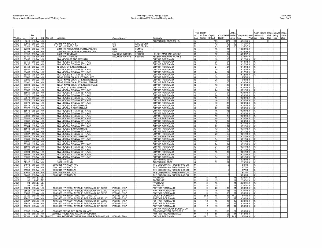
HAI Project No. 9168Oregon Water Resources Department Well Log Report
Township 1 North, Range 1 EastSections 28 and 29, Selected Nearby Wells
May 2017Page 2 of 5
Section Q QQ Tax Lot Address Company
Type of Log
Depth to First Water
Depth Drilled
Completed Depth
Static Water Level
Completed Date
New Well
Abandonment
Domestic Use
Industrial Use
Dewatering Use
Piezometer UseWell Log No Owner Name
MULT 1013 28 SW NW GRIFFITH RUBBER MILLS W 395 395 32 8/31/46 X XMULT 52912 28 SW NW 39 2345 NW NICOLI ST SID WOODBURY M 42 42 32 1/16/97 XMULT 52911 28 SW NW 39 2345 NW NICOLI ST SID WOODBURY M 45 45 35 1/16/97 XMULT 52393 28 SW NW 2211 NW NICOLAI ST, PORTLAND, OR KEN HUMKE G 15 15 10/28/96 XMULT 52394 28 SW NW 2211 NW NICOLAI ST, PORTLAND, OR KEN HUMKE G 15 15 10/28/96 XMULT 53758 28 SW NW 2401 NW 22ND AVE MACHINE WORKS HELSER HELSER MACHINE WORKS G 12 12 4/28/97 XMULT 53760 28 SW NW 2401 NW 22ND AVE MACHINE WORKS HELSER HELSER MACHINE WORKS G 12 12 4/28/97 XMULT 56455 28 SW NW NW NICOLI ST AND NW 26TH CITY OF PORTLAND G 10 10 9/12/98 X XMULT 56456 28 SW NW NW NICOLAI ST & NW 26TH AVE CITY OF PORTLAND G 26 24 9/12/98 X XMULT 56457 28 SW NW NW NICOLAI ST & NW 26TH AVE CITY OF PORTLAND G 24 24 9/12/98 X XMULT 56458 28 SW NW NICOLAI ST & NW 26TH AVE CITY OF PORTLAND G 24 24 9/12/98 X XMULT 56459 28 SW NW NW NICOLAI ST & NW 26TH AVE CITY OF PORTLAND G 10 10 9/12/98 X XMULT 56460 28 SW NW NW NICOLAI ST & NW 26TH AVE CITY OF PORTLAND G 24 24 9/12/98 X XMULT 56461 28 SW NW NW NICOLAI ST & NW 26TH AVE CITY OF PORTLAND G 24 24 9/12/98 X XMULT 56505 28 SW NW NEAR NW NICOLAI & NW 26TH AVE CITY OF PORTLAND G 19 19 9/9/98 XMULT 56506 28 SW NW NEAR NW NICOLAI ST & NW 26TH AVE CITY OF PORTLAND G 26 26 9/9/98 XMULT 56507 28 SW NW NEAR NW NICOLAI ST & NW 26TH AVE CITY OF PORTLAND G 13 13 9/10/98 XMULT 56508 28 SW NW NEAR NW NICOLAI ST & NW 26HT AVE CITY OF PORTLAND G 13 13 9/10/98 XMULT 56567 28 SW NW NICOLAI ST & NW 26TH AVE CITY OF PORTLAND G 24 24 9/20/98 X XMULT 56568 28 SW NW NW NICOLAI ST & NW 26TH AVE CITY OF PORTLAND G 24 24 9/21/98 X XMULT 56569 28 SW NW NW NICOLAI ST & NW 26TH AVE CITY OF PORTLAND G 24 24 9/20/98 X XMULT 56570 28 SW NW NW NICOLAI ST & NW 26TH AVE CITY OF PORTLAND G 24 24 9/20/98 X XMULT 56571 28 SW NW NW NICOLAI ST & NW 26TH AVE CITY OF PORTLAND G 16 16 9/20/98 X XMULT 56572 28 SW NW NW NICOLAI ST & NW 26TH AVE CITY OF PORTLAND G 16 16 9/20/98 X XMULT 56573 28 SW NW NW NICOLAI ST & NW 26TH AVE CITY OF PORTLAND G 40 40 9/20/98 X XMULT 56574 28 SW NW NW NICOLAI & NW 26TH AVE CITY OF PORTLAND G 36 36 9/20/98 X XMULT 56575 28 SW NW NW NICOLAI & NW 26TH AVE CITY OF PORTLAND G 22 22 9/20/98 X XMULT 56576 28 SW NW NW NICOLAI ST & NW 26TH AVE CITY OF PORTLAND G 16 16 9/20/98 X XMULT 56579 28 SW NW NW NICOLAI ST & NW 26TH AVE CITY OF PORTLAND G 20 20 9/20/98 X XMULT 56580 28 SW NW NW NICOLAI ST & NW 26TH AVE CITY OF PORTLAND G 16 16 9/20/98 X XMULT 56581 28 SW NW NW NICOLAI ST & NW 26TH AVE CITY OF PORTLAND G 40 40 9/20/98 X XMULT 56582 28 SW NW NW NICOLAI ST & NW 28TH AVE CITY OF PORTLAND G 12 12 9/20/98 X XMULT 56583 28 SW NW NW NICOLAI ST & NW 26TH AVE CITY OF PORTLAND G 26 26 9/21/98 X XMULT 56584 28 SW NW NW NICOLAI ST & NW 26TH AVE CITY OF PORTLAND G 22 22 9/21/98 X XMULT 56585 28 SW NW NW NICOLAI & NW 26TH AVE CITY OF PORTLAND G 12 12 9/21/98 X XMULT 56586 28 SW NW NW NICOLAI ST & NW 26TH AVE CITY OF PORTLAND G 16 16 9/21/98 X XMULT 56587 28 SW NW NW NICOLAI ST & NW 26TH AVE CITY OF PORTLAND G 20 20 9/21/98 X XMULT 56588 28 SW NW NW NICOLAI & NW 26TH AVE CITY OF PORTLAND G 12 12 9/21/98 X XMULT 56589 28 SW NW NW NICOLAI ST & NW 26TH AVE CITY OF PORTLAND G 14 14 9/21/98 X XMULT 56590 28 SW NW NW NICOLAI & NW 26TH CITY OF PORTLAND G 14 14 9/21/98 X XMULT 56591 28 SW NW NW NICOLAI ST & NW 26TH AVE CITY OF PORTLAND G 24 24 9/21/98 X XMULT 56592 28 SW NW NW NICOLAI ST & NW 26TH AVE CITY OF PORTLAND G 24 24 9/21/98 X XMULT 56593 28 SW NW NW NICOLAI ST & NW 26TH AVE CITY OF PORTLAND G 23 23 9/21/98 X XMULT 56594 28 SW NW NW NICOLAI ST & NW 26TH AVE CITY OF PORTLAND G 15 15 9/21/98 X XMULT 56595 28 SW NW NW NICOLAI ST & NW 26TH AVE CITY OF PORTLAND G 12 12 9/21/98 X XMULT 56596 28 SW NW NW NICOLAI ST & NW 26TH AVE CITY OF PORTLAND G 14 14 9/21/98 X XMULT 57316 28 SW NW 2439 NW 22ND GRIFFITH RUBBER G 27 27 12/23/98 X XMULT 57317 28 SW NW 2439 NW 22ND GRIFFITH RUBBER G 32 32 12/23/98 X XMULT 61978 28 SW NW 300 2825 NW YEON AVE THE OREGONIAN PUBLISHING CO. M 0 8/4/00 XMULT 61979 28 SW NW 300 2345 NW NICOLAI THE OREGONIAN PUBLISHING CO. M 0 8/7/00 XMULT 61980 28 SW NW 300 2345 NW NICOLAI THE OREGONIAN PUBLISHING CO. M 0 8/7/00 XMULT 61981 28 SW NW 300 2345 NW NICOLAI THE OREGONIAN PUBLISHING CO. M 0 8/7/00 XMULT 62400 28 SW NW 300 2345 NW NICOLAI THE OREGONIAN PUBLISHING CO. M 0 9/25/00 XMULT 91 29 NE SE PACTRUST M 11 15 11 2/20/91 X XMULT 92 29 NE SE PACTRUST M 11 15 11 2/20/91 X XMULT 93 29 NE SE PACTRUST M 11 15 11 2/20/91 X XMULT 94 29 NE SE PACTRUST M 11 15 11 2/20/91 X XMULT 98624 28 NW NW 100 3500 NW YEON AVENUE, PORTLAND, OR 97210 P09089 - 3157 PORT OF PORTLAND G 11 20 20 11 3/30/09 X XMULT 98626 28 NW NW 100 3500 NW YEON AVENUE, PORTLAND, OR 97210 P09089 - 3157 PORT OF PORTLAND G 11 15 15 11 3/30/09 X XMULT 98630 28 NW NW 100 3500 NW YEON AVENUE, PORTLAND, OR 97210 P09089 - 3157 PORT OF PORTLAND G 11 15 15 11 3/30/09 X XMULT 98726 28 NW NW 800 2700 NW FRONT AVE, PORTLAND, OR P09123 - 3242 DOLAN & COMPANY G 11.2 15 15 11.2 4/7/09 X XMULT 98625 28 NW NW 100 3500 NW YEON AVENUE, PORTLAND, OR 97210 P09089 - 3157 PORT OF PORTLAND G 12 15 15 12 3/30/09 X XMULT 98627 28 NW NW 100 3500 NW YEON AVENUE, PORTLAND, OR 97210 P09089 - 3157 PORT OF PORTLAND G 12 15 15 12 3/30/09 X XMULT 98628 28 NW NW 100 3500 NW YEON AVENUE, PORTLAND, OR 97210 P09089 - 3157 PORT OF PORTLAND G 12 15 15 12 3/30/09 X XMULT 98629 28 NW NW 100 3500 NW YEON AVENUE, PORTLAND, OR 97210 P09089 - 3157 PORT OF PORTLAND G 12 15 15 12 3/30/09 X X
MULT 83200 28 SW NE 900 2400 FRONT AVE; NICOLI SHAFTCITY OF PORTLAND; BUREAU OF ENVIRONMENTAL SERVICES M 12 89 89 21 3/28/06 X
MULT 59488 28 NW NW 2600 NW FRONT AVE; VACANT PROPERTY HOYT ST PROPERTIES LLC M 14 55 55 14 10/12/99 XMULT 98163 29 SE SE R-O-W NW ROOSEVELT NEAR NW 30TH, PORTLAND, OR P09037 - 3000 CITY OF PORTLAND G 14.7 20 20 14.7 2/2/09 X X

HAI Project No. 9168Oregon Water Resources Department Well Log Report
Township 1 North, Range 1 EastSections 28 and 29, Selected Nearby Wells
May 2017Page 3 of 5
Section Q QQ Tax Lot Address Company
Type of Log
Depth to First Water
Depth Drilled
Completed Depth
Static Water Level
Completed Date
New Well
Abandonment
Domestic Use
Industrial Use
Dewatering Use
Piezometer UseWell Log No Owner Name
MULT 114758 28 SW SE 100 2030 NW 17TH AVE PORTLAND, OR 97209 HARLEY JOHNSON G 15 20 20 15 1/25/13 X XMULT 114759 28 SW SE 100 2030 NW 17TH AVE PORTLAND, OR 97209 HARLEY JOHNSON G 15 20 20 15 1/25/13 X XMULT 114760 28 SW SE 100 2030 NW 17TH AVE PORTLAND, OR 97209 HARLEY JOHNSON G 15 20 20 15 1/25/13 X XMULT 114761 28 SW SE 100 2030 NW 17TH AVE PORTLAND, OR 97209 HARLEY JOHNSON G 15 20 20 15 1/25/13 X X
MULT 83201 28 SW NE 900 2400 FRONT AVE; NICOLI SHAFTCITY OF PORTLAND; BUREAU OF ENVIRONMENTAL SERVICES W 15 89 89 22 3/24/06 X X
MULT 111604 28 SW SE 1900 1900 NW 18TH AVENUE, PORTLAND, OREGON JIM MURRAY MVP GROUP, LLC G 15 22 22 11/27/12 X XMULT 118962 28 NW NW 1100 3245 NW FRONT AVE. PORTLAND, OREGON 97210 VIKING FIRE G 15 37 37 4/9/15 X XMULT 59490 28 NW NW 2600 NW FRONT AVE; VACANT PROPERTY HOYT ST PROPERTIES LLC M 16 55 55 16 10/14/99 XMULT 65068 28 NW NW 900 2100 NW FRONT AVE PORT OF PORTLAND M 17 32 32 17 8/29/01 XMULT 65069 28 NW NW 900 2100 NW FRONT AVE PORT OF PORTLAND M 17 32 32 17 8/29/01 XMULT 65070 28 NW NW 900 2100 NW FRONT AVE PORT OF PORTLAND M 17 32 32 17 8/29/01 XMULT 65071 28 NW NW 900 2100 NW FRONT AVE PORT OF PORTLAND M 17 32 32 17 8/29/01 XMULT 65072 28 NW NW 900 2100 NW FRONT AVE PORT OF PORTLAND M 17 32 32 17 8/29/01 XMULT 65073 28 NW NW 900 2100 NW FRONT AVE PORT OF PORTLAND M 17 32 32 17 8/29/01 XMULT 65074 28 NW NW 900 2100 NW FRONT AVE PORT OF PORTLAND M 17 34 34 17 8/29/01 XMULT 105237 28 NW NW 600 2800 NW FRONT AVE PORTLAND,OR SULZER PUMPS G 18 25 25 2/24/11 X XMULT 105238 28 NW NW 600 2800 NW FRONT AVE PORTLAND,OR SULZER PUMPS G 18 28 28 2/24/11 X XMULT 105239 28 NW NW 600 2800 NW FRONT AVE PORTLAND,OR SULZER PUMPS G 18 68 68 2/24/11 X X
MULT 69535 28 NW SE 100 2500 NW FRONT AVECITY OF PORTLAND; BUREAU OF ENVIRONMENTAL SERVICES M 20 147 147 18.5 6/6/03 X
MULT 114757 28 SW SE 100 2030 NW 17TH AVE PORTLAND, OR 97209 HARLEY JOHNSON G 20 25 25 20 1/25/13 X XMULT 58127 28 SW SE 293 21ST TO 20TH; THURMAN TO SAVIER; BLOCK 293 C N F M 21 50 50 21 5/4/99 X XMULT 389 28 NW NE SULZER BINGHAM M 22 42 42 22 8/12/91 XMULT 62290 28 NW NE 100 NW 9TH AND 10TH HOYT STREET PROPERTIES LLC M 22 30 30 22 9/6/00 X
MULT 83202 28 SW NE 900 2400 FRONT AVE; NICOLI SHAFTCITY OF PORTLAND; BUREAU OF ENVIRONMENTAL SERVICES W 22 89 89 22 3/30/06 X X
MULT 116999 28 NW NE 600 2800 NW FRONT RD - PORTLAND, OR 97210 SULZER PUMPS INC M 22.3 35 35 22.3 9/29/14 XMULT 116998 28 NW NE 600 2800 NW FRONT RD - PORTLAND, OR 97210 SULZER PUMPS INC M 22.4 28 28 22.4 9/30/14 XMULT 308 28 NW NE 2800 NW FRONT SULZER BINGHAM M 23 35 35 23 6/26/91 XMULT 309 28 NW NE 2800 NW FRONT SULZER BINGHAM M 23 35 23 6/26/91 XMULT 310 28 NW NE 2800 NW FRONT SULZER BINGHAM M 23 35 35 23 6/26/91 XMULT 311 28 NW NE 2800 NW FRONT SULZER BINGHAM M 23 35 23 6/27/91 X
MULT 63963 28 NW SE NW FRONT AVE AND NICOLI STCITY OF PORTLAND; BUREAU OF ENVIRONMENTAL SERVICES M 23 191 136 23 4/19/01 X
MULT 116997 28 NW NE 600 2800 NW FRONT RD - PORTLAND, OR 97210 SULZER PUMPS INC M 23.6 35 35 23.6 9/30/14 XMULT 116995 28 NW NE 600 2800 NW FRONT RD - PORTLAND, OR 97210 SULZER PUMPS INC M 24.3 35 35 24.3 9/29/14 XMULT 116996 28 NW NE 600 2800 NW FRONT RD - PORTLAND, OR 97210 SULZER PUMPS INC M 24.95 35 35 25 9/29/14 X
MULT 63598 28 NW SE NW FRONT AND 26TH AVECITY OF PORTLAND; BUREAU OF ENVIRONMENTAL SERVICES M 25 137 0 23 2/26/01 X X
MULT 59726 28 NW NE 100 OLD BURLINGTON NORTHERN RAILROAD YARD HOYT STREET PROPERTIES LLC M 25 30 30 25 11/16/99 XMULT 59727 28 NW NE 100 OLD BURLINGTON NORTHERN RAILROAD YARD HOYT STREET PROPERTIES LLC M 25 30 30 25 11/17/99 XMULT 104873 28 NW NW 600 2800 NW FRONT AVE PORTLAND,OR SULZER PUMPS [US]INC G 25 80 80 1/29/11 X XMULT 104874 28 NW NW 600 2800 NW FRONT AVE PORTLAND,OR SULZER PUMPS [US]INC G 25 80 80 1/29/11 X XMULT 121567 28 SW NE 4600 2211 NW YORK ST. PORTLAND,OR GETSPACE, LLC G 25 40 40 12/23/15 X XMULT 121568 28 SW NE 4600 2211 NW YORK ST. PORTLAND,OR GETSPACE, LLC G 25 25 25 12/23/15 X XMULT 63656 28 NW NE FRONT AVE CITY OF PORTLAND M 26 125 125 26 4/6/01 XMULT 63657 28 NW NE TERMINAL 2 PORT OF PORTLAND M 26 145 145 26 4/6/01 X
MULT 63602 28 NW SE NW FRONT AVE AND 26TH AVECITY OF PORTLAND; BUREAU OF ENVIRONMENTAL SERVICES M 28 166 141 21 4/5/01 X
MULT 88925 29 NE SE 700 2615 NW INDUSTRIAL CITY OF PORTLAND M 29 68 68 29 4/17/07 XMULT 102551 29 NE SE 100 3033 NW YEON AVE, PORTLAND MONTGOMERY R. SCOTT MONTGOMERY R SCOTT ET AL W 29 89 89 29 6/11/10 X XMULT 102552 29 NE SE 100 3033 NW YEON AVE, PORTLAND MONTGOMERY R. SCOTT FOWLER, JAMES W W 29 88.5 88.5 29 6/11/10 X XMULT 109660 28 NW NE R316 311 2700 NW FRONT, PORTLAND, OREGON 97209 DOLAN AND COMPANY LLC G 30 60 60 4/20/12 X XMULT 70259 28 NW SW 900 2526 NW YEON AVE DON REARDEN REARDEN, LILLIAN M 32 38 38 32 7/25/03 XMULT 121089 28 NW NW 100 2800 NW FRONT AVE. PORTLAND,OR 97210 SULZER PUMP G 32 60 60 11/5/15 X XMULT 121090 28 NW NW 100 2800 NW FRONT AVE. PORTLAND,OR 97210 SULZER PUMP G 32 60 60 11/5/15 X XMULT 70260 28 NW SW 900 2526 NW YEON AVE DON REARDEN REARDEN, LILLIAN M 33 37 37 33 7/25/03 XMULT 70261 28 NW SW 900 2526 NW YEON AVE DON REARDEN REARDEN, LILLIAN M 33 38 38 33 7/25/03 XMULT 70258 28 NW SW 900 2526 NW YEON AVE DON REARDEN REARDEN, LILLIAN M 34 40 40 34 7/25/03 XMULT 88926 29 NE SE 100 3033 NW YEON AVE R SCOTT MONTGOMERY M 35 79 79 35 4/18/07 XMULT 4037 28 NW SW 2345 NW NICOLAI SID WOODBURY M 36.7 45 45 36.7 3/1/94 XMULT 4036 28 NW SW 2825 NW YEON SID WOODBURY M 37.3 45 45 37.3 2/28/94 XMULT 103342 28 SW NE 3900 2439 NW 22ND AVE CITY OF PORTLAND W 40 96 95.83 36 8/26/10 X XMULT 103343 28 SW NE 3900 2439 NW 22ND AVE CITY OF PORTLAND W 40 96 95.83 36 8/30/10 X XMULT 4038 28 NW SW 2825 NW YEON SID WOODBURY M 40 45 45 37 2/24/94 XMULT 95999 29 NE SE 700 2615 NW INDUSTRIAL ST CITY OF PORTLAND G 40 50 50 40 8/4/08 X XMULT 97729 29 NE SE 100 2495 NICOLAI JEFFREY WOLFSTONE SHAKER SQUARE M 42 50 50 42 11/1/08 XMULT 94934 28 SW SE 5500 1828 NW RALEIGH ST PEYTON PLACE LLC G 44 50 50 44 6/4/08 X

HAI Project No. 9168Oregon Water Resources Department Well Log Report
Township 1 North, Range 1 EastSections 28 and 29, Selected Nearby Wells
May 2017Page 4 of 5
Section Q QQ Tax Lot Address Company
Type of Log
Depth to First Water
Depth Drilled
Completed Depth
Static Water Level
Completed Date
New Well
Abandonment
Domestic Use
Industrial Use
Dewatering Use
Piezometer UseWell Log No Owner Name
MULT 94935 28 SW SE 5500 1828 NW RALEIGH ST PEYTON PLACE LLC G 44 50 28 44 6/4/08 XMULT 94936 28 SW SE 5500 1828 NW RALEIGH ST PEYTON PLACE LLC G 44 49 49 44 6/5/08 XMULT 97730 29 NE SE 100 2495 NICOLAI JEFFREY WOLFSTONE SHAKER SQUARE LLC M 44 50 50 44 10/31/08 XMULT 98532 29 NE SE 1600 2500 NW NICOLAI ST SHAKER SQUARE LLC M 45 57 50 45 1/31/09 X XMULT 97731 29 NE SE 100 2495 NW NICOLAI JEFFREY WOLFSTONE SHAKER SQUARE M 47 55 55 47 11/1/08 XMULT 3537 29 SE NE CHASE PACKAGING CO. M 48 56 56 48 6/3/93 XMULT 98533 29 NE SE 1600 2500 NW NICOLAI ST SHAKER SQUARE LLC M 49 56 55 49 1/31/09 X X
MULT 88927 29 SE NE NW 26TH AVE; JUST S OF NICOLAI AVECITY OF PORTLAND; DEPARTMENT OF TRANSPORTATION M 59 105 105 59 4/23/07 X
MULT 67547 28 NW SE 2200 NW FRONT AVE PORT OF PORTLAND M 70 216 160 69 8/7/01 XMULT 3536 29 SE NE CHASE PACKING CO. M 84 70 70 54 6/3/93 XMULT 1012 28 SW NE ZERUNG CHEMICAL W 124 126 126 25 6/12/57 X XMULT 74419 28 NW NW 800 2800 FRONT AVE SULZER PUMPS G 80 0 0 10/14/04 X XMULT 74420 28 NW NW 800 2800 FRONT AVE SULZER PUMPS G 121 0 0 10/14/04 X XMULT 74421 28 NW NW 800 2800 FRONT AVE SULZER PUMPS G 125 0 0 10/14/04 X XMULT 74422 28 NW NW 800 2800 FRONT AVE SULZER PUMPS G 123 0 0 10/14/04 X XMULT 97732 29 NE SE 100 2495 NW NICOLAI JEFFREY WOLFSTONE SHAKER SQUARE G 8 0 0 10/30/08 X XMULT 97733 29 NE SE 100 2495 NW NICOLAI JEFFREY WOLFSTONE SHAKER SQUARE G 8 0 0 11/1/08 X XMULT 97734 29 NE SE 100 2495 NW NICOLAI JEFFREY WOLFSTONE SHAKER SQUARE G 8 0 0 11/1/08 X XMULT 97735 29 NE SE 100 2495 NW NICOLAI JEFFREY WOLFSTONE SHAKER SQUARE G 12 0 0 10/30/08 X XMULT 97736 29 NE SE 100 2495 NW NICOLAI JEFFREY WOLFSTONE SHAKER SQUARE G 12 0 0 10/30/08 X XMULT 50115 28 SW NE PORT OF PORTLAND G 11 12/5/95 X XMULT 109564 29 NE SE 1200 2625 NW INDUSTRIAL ST JAMES FROMER G 14.5 0 13.8 3/28/12 X XMULT 70777 28 NW SE 900 2500 NW FRONT AVE CITY OF PORTLAND G 98 98 14 6/18/03 XMULT 70778 28 NW SE 900 2500 NW FRONT AVE CITY OF PORTLAND G 98 98 14 6/19/03 XMULT 70781 28 NW SE 900 2500 NW FRONT AVE CITY OF PORTLAND G 98 98 14 6/19/03 XMULT 109557 29 NE SE 2625 NW INDUSTRIAL ST JAMES FROMER G 14.5 0 14 3/29/12 X XMULT 109559 29 NE SE 1200 2625 NW INDUSTRIAL ST JAMES FROMER G 15.5 0 14 3/29/12 X XMULT 109560 29 NE SE 1200 2625 NW INDUSTRIAL ST JAMES FROMER G 15.5 0 14 3/29/12 X XMULT 109562 29 NE SE 1200 2625 NW INDUSTRIAL ST JAMES FROMER G 16.5 0 14 3/28/12 X XMULT 109563 29 NE SE 1200 2625 NW INDUSTRIAL ST JAMES FROMER G 22 0 14 3/29/12 X XMULT 109558 29 NE SE 1200 2625 NW INDUSTRIAL ST JAMES FROMER G 16 0 14.1 3/29/12 X XMULT 109561 29 NE SE 1200 2625 NW INDUSTRIAL ST JAMES FROMER G 19.75 0 14.7 3/29/12 X XMULT 109598 29 NE SE 1200 2625 NW INDUSTRIAL ST JAMES FROMER G 15.5 0 14.8 4/12/12 X XMULT 50114 28 SW NE PORT OF PORTLAND G 15 12/5/95 X XMULT 50119 28 SW NE 1 1700 NW THURMAN ALAN COLE PREMIER GEAR MACHINE (C/O) G 16 11/8/95 X XMULT 62008 28 NW NE 3221 NW YEON AVE; BUILDING B ICG COMMUNICATIONS INC. G 42 42 17 8/8/00 XMULT 62010 28 NW NE 3221 NW YEON AVE; BUILDING B ICG COMMUNICATIONS INC. G 42 42 17 8/8/00 XMULT 62012 28 NW NE 3221 NW YEON AVE ICG COMMUNICATIONS INC. G 42 42 17 8/8/00 X
MULT 71805 28 NW SE 9002500 NW FRONT AVE; NICOLAI SHAFT CSO PROJECT
CITY OF PORTLAND; BUREAU OF ENVIRONMENTAL SERVICES G 100 0 17 9/23/03 X X
MULT 102361 28 SW SW 8800 1723 NW 24TH AVE PORTLAND, OR 97210 KIM SCHREINER MXR CORP G 30 30 18 5/21/10 X X
MULT 69536 28 NW SE 900 2500 NW FRONT AVECITY OF PORTLAND; BUREAU OF ENVIRONMENTAL SERVICES G 158 158 18.5 6/4/03 X
MULT 56541 28 NW SW 1900 2825 NW YEON; OLD STEEL MILLWOODBURY FAMILY LTD; WOODBURY, SYDNEY (C/O) G 35 0 20 10/5/98 X X
MULT 56600 28 NW SW 2100 2345 NICOLAI NW; OLD STEEL MILLWOODBURY FAMILY LTD PROP; WOODBURY, SYDNEY (C/O) G 50 0 20 10/2/98 X X
MULT 56601 28 NW SW 2100 2805 NW YEON; OLD STEEL MILLWOODBURY FAMILY LTD PROP; WOODBURY, SYDNEY (C/O) G 35 0 20 10/5/98 X X
MULT 56602 28 NW SW 1900 2825 NW YEON; OLD STEEL MILLWOODBURY FAMILY LTD PROP; WOODBURY, SYDNEY (C/O) G 33 0 20 10/5/98 X X
MULT 56603 28 NW SW 2100 2345 NICOLAI NW; OLD STEEL MILLWOODBURY FAMILY LTD PROP; WOODBURY, SYDNEY (C/O) G 40 0 20 10/2/98 X X
MULT 56604 28 NW SW 2100 2805 NW YEON; OLD STEEL MILLWOODBURY FAMILY LTD PROP; WOODBURY, SYDNEY (C/O) G 35 0 20 10/5/98 X X
MULT 70429 28 NW SE 900 2500 NW FRONT AVECITY OF PORTLAND; BUREAU OF ENVIRONMENTAL SERVICES G 163 163 20 5/16/03 X
MULT 70430 28 NW SE 900 2500 NW FRONT AVECITY OF PORTLAND; BUREAU OF ENVIRONMENTAL SERVICES G 163 163 20 5/15/03 X
MULT 72390 28 NW SE 400 INTERSECTION OF FRONT AND 21ST; SUBSTATION PORTLAND GENERAL ELECTRIC G 25 0 20 1/27/04 X XMULT 72391 28 NW SE 400 INTERSECTION OF FRONT AND 21ST; SUBSTATION PORTLAND GENERAL ELECTRIC G 25 0 20 1/27/04 X XMULT 72392 28 NW SE 400 INTERSECTION OF FRONT AND 21ST; SUBSTATION PORTLAND GENERAL ELECTRIC G 25 0 20 1/27/04 X XMULT 88842 28 NW SW R-O-W NICHOLIE ST, PORTLAND, OR P D O T G 80 80 22.5 5/8/07 X XMULT 50122 28 SW NE 1 1700 NW THURMAN ALAN COLE PREMIER GEAR MACHINE (C/O) G 23 11/9/95 X XMULT 102867 28 SW NE 700 2700 NW FRONT AVE CITY OF PORTLAND M 57.5 57.5 23 7/6/10 X
MULT 69388 28 NW SE 900 2500 NW FRONT AVECITY OF PORTLAND; BUREAU OF ENVIRONMENTAL SERVICES G 157 0 23.4 12/27/02 X X
MULT 70813 28 NW NE 800 2800 NW FRONT AVE SULZER PUMPS G 60 0 25 6/9/03 X X

HAI Project No. 9168Oregon Water Resources Department Well Log Report
Township 1 North, Range 1 EastSections 28 and 29, Selected Nearby Wells
May 2017Page 5 of 5
Section Q QQ Tax Lot Address Company
Type of Log
Depth to First Water
Depth Drilled
Completed Depth
Static Water Level
Completed Date
New Well
Abandonment
Domestic Use
Industrial Use
Dewatering Use
Piezometer UseWell Log No Owner Name
MULT 70814 28 NW NE 800 2800 NW FRONT AVE SULZER PUMPS G 40 0 25 6/9/03 X XMULT 70815 28 NW NE 800 2800 NW FRONT AVE SULZER PUMPS G 40 0 25 6/9/03 X XMULT 64082 28 NW SW E OF NAITO PARKWAY AND N OF NICOLAI ST PORT OF PORTLAND G 171 0 26 5/20/01 X XMULT 52909 29 SE NE 300 2345 NW NICOLI ST SID WOODBURY M 38 38 28 1/15/97 XMULT 53693 28 SW NE 2100 NW 22ND AVE, PORTLAND DEVOE ICI ICI; DEVOE M 50 50 30 5/12/97 XMULT 53694 28 SW NE 2100 NW 22ND AVE, PORTLAND DEVOE ICI ICI; DEVOE M 50 50 30 5/12/97 XMULT 53695 28 SW NE 2100 NW 22ND AVE, PORTLAND DEVOE ICI ICI; DEVOE M 50 50 30 5/12/97 XMULT 53696 28 SW NE 2100 NW 22ND AVE, PORTLAND DEVOE ICI ICI; DEVOE M 50 50 30 5/12/97 XMULT 53697 28 SW NE 2100 NW 22ND AVE, PORTLAND DEVOE ICI ICI; DEVOE M 50 50 30 5/12/97 XMULT 74416 28 NW NW 800 2800 FRONT AVE SULZER PUMPS G 95 0 30 10/14/04 X XMULT 74417 28 NW NW 800 2800 FRONT AVE SULZER PUMPS G 75 0 30 10/15/04 X XMULT 74418 28 NW NW 800 2800 FRONT AVE SULZER PUMPS G 75 0 30 10/15/04 X XMULT 78358 28 SW NE 2500 2130 NW YORK ST B C G CONSULTING G 45 0 30 7/14/05 X XMULT 78359 28 SW NE 2500 2130 NW YORK ST B C G CONSULTING G 45 0 30 7/14/05 X XMULT 78360 28 SW NE 2500 2130 NW YORK ST B C G CONSULTING G 45 0 30 7/14/05 X XMULT 103172 28 NW NW 600 2800 NW FRONT AVE SULZER PUMP INC. G 82 0 30 8/10/10 X XMULT 103173 28 NW NW 600 2800 NW FRONT AVE SULZER PUMP INC. G 82 0 30 8/10/10 X XMULT 61245 28 SW SW 2900 2121 NW YORK ST STUART SOREN G 35 35 31 5/8/00 XMULT 61246 28 SW SW 2900 2121 NW YORK STREET STUART SOREN G 37 37 31 5/8/00 XMULT 61247 28 SW SW 2900 2121 NW YORK ST STUART SOREN G 34 34 31 5/8/00 XMULT 61248 28 SW SW 2800 2121 NW YORK ST STUART SOREN G 37 37 31 5/8/00 XMULT 107673 29 NE SE 100 3033 NW YEON AVE, PORTLAND, OR 97210 SCOTT MONTGOMERY M 79 79 33 9/23/11 XMULT 64544 28 NW NE 3710 NW FRONT U.S. ARMY CORPS OF ENGINEERS G 95.5 0 45 7/17/01 X XMULT 84193 29 SE SE 1300 2575 NW VAUGHN ST, PORTLAND FREEMAN LAND AND CATTLE G 50 0 50 6/7/06 X XMULT 102868 28 NW SW 2455 NW NICOLAI CITY OF PORTLAND M 95 0 50 7/9/10 XMULT 88839 28 NW SW 2100 2829 NW YEON OREGONIAN PUBLISHING M 95 95 58 5/2/07 X

HAHN AND ASSOCIATES, INC.
Appendix C
User Questionnaire


HAHN AND ASSOCIATES, INC.
Appendix D
Preliminary Title Report

This report is for the exclusive use of the parties herein shown and is preliminary to the issuance of a title insurance policy and shall become void unless a policy is issued, and the full premium paid.
First American Title Company of Oregon
National Commercial Services 200 SW Market Street, Suite 250
Portland, Oregon 97201
Title Officer: Steve Manome Phone: (503)219-8742 Fax: (866)678-0591 E-mail [email protected] File No: NCS-840106-OR1
PRELIMINARY TITLE REPORT
ALTA Owners Standard Coverage Liability $ TBD Premium $ TBDALTA Owners Extended Coverage Liability $ Premium $ ALTA Lenders Standard Coverage Liability $ Premium $ ALTA Lenders Extended Coverage Liability $ Premium $ ALTA Leasehold Standard Coverage Liability $ Premium $ ALTA Leasehold Extended Coverage Liability $ Premium $ Endorsements Liability $ Premium $ Govt Service Charge Cost $ Other $
We are prepared to issue Title Insurance Policy or Policies in the form and amount shown above, insuring title to the following described land:
The land referred to in this report is described in Exhibit "A" attached hereto.
and as of 03/06/2017 at 8:00 a.m., title to an easement estate as to Parcel VII and the fee simple estate as to the remainder is vested in:
Esco Corporation, an Oregon corporation, formerly known as Newesco Corporation, an Oregon corporation
Subject to the exceptions, exclusions, and stipulations which are ordinarily part of such Policy form and the following:
1. Taxes or assessments which are not shown as existing liens by the records of any taxing authority that levies taxes or assessments on real property or by the public records; proceedings by a public agency which may result in taxes or assessments, or notices of such proceedings, whether or not shown by the records of such agency or by the public records.
2. Facts, rights, interests or claims which are not shown by the public records but which could be ascertained by an inspection of the land or by making inquiry of persons in possession thereof.

Preliminary Report Order Number: NCS-840106-OR1
Page Number: 2
First American Title
3. Easements, or claims of easement, not shown by the public records; reservations or exceptions in patents or in Acts authorizing the issuance thereof; water rights, claims or title to water.
4. Any encroachment (of existing improvements located on the subject land onto adjoining land or of existing improvements located on adjoining land onto the subject land), encumbrance, violation, variation, or adverse circumstance affecting the title that would be disclosed by an accurate and complete land survey of the subject land.
5. Any lien, or right to a lien, for services, labor, material, equipment rental or workers compensation heretofore or hereafter furnished, imposed by law and not shown by the public records.
The exceptions to coverage 1-5 inclusive as set forth above will remain on any subsequently issued Standard Coverage Title Insurance Policy. In order to remove these exceptions to coverage in the issuance of an Extended Coverage Policy the following items are required to be furnished to the Company; additional exceptions to coverage may be added upon review of such information:
A. Survey or alternative acceptable to the company B. Affidavit regarding possession C. Proof that there is no new construction or remodeling of any improvement located on the
premises. In the event of new construction or remodeling the following is required: i. Satisfactory evidence that no construction liens will be filed; or ii. Adequate security to protect against actual or potential construction liens; iii. Payment of additional premiums as required by the Industry Rate Filing approved
by the Insurance Division of the State of Oregon
6. City liens, if any, for the city of Portland. Note: An inquiry has NOT been made concerning the actual status of such liens. A fee of $25.00 will be charged per tax account each time an inquiry request is made.
7. Unrecorded leases or periodic tenancies, if any.
The Following Matters Affect Parcel I:
8. Reservations and exceptions, including the terms and conditions thereof: Reserving: Mineral rights Reserved By: The United States of America Recorded: September 13, 1948 Recording Information: Book 1291, page 83
9. Conditions and restrictions contained in Ordinance No. 144383, a copy of which was recorded November 15, 1977 in Book 1212, page 1545.

Preliminary Report Order Number: NCS-840106-OR1
Page Number: 3
First American Title
10. Easement, including terms and provisions contained therein: Recording Information: October 9, 1986 in Book 1945, page 1392 In Favor of: Portland General Electric Company, an Oregon corporation For: Anchor
The Following Matters Affect Parcel II:
NONE
The Following Matters Affect Parcel III:
NONE
The Following Matters Affect Parcel IV:
11. Easement, including terms and provisions contained therein: Recording Information: October 9, 1986 in Book 1945, page 1388 In Favor of: Portland General Electric Company, an Oregon corporation For: Anchor
12. Covenants, conditions, restrictions and/or easements: Recorded: June 2, 2005 Recording No.: Recording No. 2005-100090
The Following Matters Affect Parcel V:
13. Easements for utilities over and across the premises formerly included within the boundaries of NW 25th Avenue now vacated pursuant to Ordinance No. 16089, dated January 11, 1907, if any such exists.
The Following Matters Affect Parcel VI:
14. Easement, including terms and provisions contained therein: Recording Information: April 6, 1920 in Book 798, page 409 In Favor of: Northern Pacific Terminal Co. of Oregon For: Railroad tracks
15. Covenants, conditions, restrictions and/or easements: Recorded: February 5, 1927 Recording No.: Book 1082, page 340
16. Covenants, conditions, restrictions and/or easements: Recorded: July 9, 1937 Recording No.: Book 406, page 525
17. Covenants, conditions, restrictions and/or easements: Recorded: December 6, 1937 Recording No.: Book 428, page 11

Preliminary Report Order Number: NCS-840106-OR1
Page Number: 4
First American Title
18. Reservation of utilities in vacated NW York Street and the right to maintain the same as set forth in Ordinance No. 76884 a copy of which was recorded March 30, 1942 as Book 672, page 118
19. Covenants, conditions, restrictions and/or easements: Recorded: June 9, 1944 Recording No.: Book 842, page 409
20. Covenants, conditions, restrictions and/or easements: Recorded: June 18, 1945 Recording No.: Book 950, page 365
21. Easement, including terms and provisions contained therein: Recording Information: December 17, 1947 in Book 1229, page 383 In Favor of: The Northern Pacific Terminal Company of Oregon For: Railroad spur track
22. Conditions and restrictions contained in Ordinance No. 95120, a copy of which was recorded October 16, 1951 as Book 1503, page 193.
23. Conditions and restrictions contained in Ordinance No. 112172, a copy of which was recorded July 14, 1960 as Book 2018, page 416.
24. Covenants, conditions, restrictions and/or easements: Recorded: January 19, 1962 Recording No.: Book 2099, page 53
25. Reservation of utilities in vacated NW 25th Avenue and the right to maintain the same as set forth in Ordinance No. 118015 a copy of which was recorded May 6, 1964 as Book 36, page 84
26. Reservation of utilities in vacated NW Wilson Street and the right to maintain the same as set forth in Ordinance No. 118764 a copy of which was recorded August 18, 1964 as Book 109, page 205
27. Easement, including terms and provisions contained therein: Recording Information: March 31, 1965 in Book 262, page 140 In Favor of: The Northern Pacific Terminal Company of Oregon, Great
Northern Railway Company and Spokane, Portland & Seattle Railway Company
For: Railroad "lead" track
28. Conditions and restrictions contained in Ordinance No. 123121, a copy of which was recorded September 9, 1966 as Book 525, page 520.
29. Reservation of utilities in vacated NW 25th Avenue and the right to maintain the same as set forth in Ordinance No. 127031 a copy of which was recorded July 30, 1968 as Book 632, page 972

Preliminary Report Order Number: NCS-840106-OR1
Page Number: 5
First American Title
30. Easement, including terms and provisions contained therein: Recording Information: September 13, 1968 in Book 640, page 455 In Favor of: Adjacent property owners For: Ingress and egress Affects: Vacated NW 25th Avenue in Tract C
31. Easement, including terms and provisions contained therein, as disclosed in Assignment of Easements:
Recording Information: December 6, 1973 in Book 962, page 26 In Favor of: Portland General Electric Company, a Maine corporation For: Electric utility lines
32. Conditions and restrictions contained in Ordinance No. 139815, a copy of which was recorded July 22, 1975 as Book 1052, page 718.
33. Reservation of utilities in vacated NW 24th Place and the right to maintain the same as set forth in Ordinance No. 151541 a copy of which was recorded October 25, 1982 as Book 1624, page 2014
34. Easement, including terms and provisions contained therein: Recording Information: May 9, 1989 in Book 2201, page 1233 In Favor of: Pacific Northwest Bell Telephone Company, a Washington
corporation For: Telephone cables, steel pipes and above-ground cabinet Affects: The North 5 feet of the South 10 feet of the East 5 feet of Lot
17, Block 8 in Parcel V
35. Covenants, conditions, restrictions and/or easements: Recorded: October 3, 2002 Recording No.: 2002-177321
36. Covenants, conditions, restrictions and/or easements: Recorded: October 3, 2002 Recording No.: 2002-177322
The Following Matters Affect Parcel VII:
37. Easement, including terms and provisions contained therein: Recording Information: April 6, 1920 in Book 798, page 409 In Favor of: Northern Pacific Terminal Company of Oregon For: Railroad tracks
A document recorded October 3, 2002 as Recording Nos. 2002177321 and 2002177322 of Official Records provides that the interest of the easement holder was transferred to Esco Corporation, an Oregon corporation.

Preliminary Report Order Number: NCS-840106-OR1
Page Number: 6
First American Title
38. Covenants, conditions, restrictions and/or easements: Recorded: October 3, 2002 Recording No.: 2002177321
39. Covenants, conditions, restrictions and/or easements: Recorded: October 3, 2002 Recording No.: 2002177322
The Following Matters Affect Parcel VIII:
40. An unrecorded easement dated May 9, 1916, including terms and provisions contained therein, as disclosed by Assignment of Easements:
Recording Information: June 6, 1973 in Book 962, page 26 In Favor of: Pacific Power & Light Company, a Maine corporation For: Electric utility lines
A document recorded June 6, 1973 as Book 962, page 26 of Official Records provides that the interest of the easement holder was transferred to Portland General Electric Company.
41. Reservation of utilities in vacated street area and the right to maintain the same as set forth in Ordinance No. 149287 a copy of which was recorded October 25, 1982 as Book 1624, page 2014
(Affects Lot 12)
The Following Matters Affect Parcel IX:
NONE
The Following Matters Affect Parcel X:
NONE
The Following Matters Affect Parcel XI:
NONE
The Following Matters Affect Parcel XII:
42. The terms and provisions contained in the document entitled "Revocable Permit to Maintain Backflow Assembly in Right of Way" recorded February 10, 2010 as Recording No. 2010-019954 of Official Records.
-END OF EXCEPTIONS-
=

Preliminary Report Order Number: NCS-840106-OR1
Page Number: 7
First American Title
=
INFORMATIONAL NOTES
NOTE: This report does not include a search for Financing Statements filed in the office of the Secretary of State, or in a county other than the county wherein the premises are situated, and no liability is assumed if a Financing Statement is filed in the office of the County Clerk (Recorder) covering fixtures on the premises wherein the lands are described other than by metes and bounds or under the rectangular survey system or by recorded lot and book.
NOTE: Taxes for the year 2016-2017, paid in full. Tax Amount: $50,822.22 Code No.: 001 Map & Tax Lot No. 1N1E28BC-01600 Property ID/Key No. R316331
(Affects Parcel I)
NOTE: Taxes for the year 2016-2017, paid in full. Tax Amount: $84,172.15 Code No.: 001 Map & Tax Lot No. 1N1E28BC-01600-A Property ID/Key No. R646139
(Affects Parcel I - Machinery and equipment)
NOTE: Taxes for the year 2016-2017, paid in full. Tax Amount: $284.05 Code No.: 001 Map & Tax Lot No. 1N1E28BC-01601 Property ID/Key No. R493040
(Affects Parcel II)
NOTE: Taxes for the year 2016-2017, paid in full. Tax Amount: $10,927.37 Code No.: 001 Map & Tax Lot No. 1N1E28BC-01500 Property ID/Key No. R316299
(Affects Parcel III)
NOTE: Taxes for the year 2016-2017, paid in full. Tax Amount: $41,950.30 Code No.: 001 Map & Tax Lot No. 1N1E28BC-01400 Property ID/Key No. R316323
(Affects Parcel IV)

Preliminary Report Order Number: NCS-840106-OR1
Page Number: 8
First American Title
NOTE: Taxes for the year 2016-2017, paid in full. Tax Amount: $7,787.15 Code No.: 001 Map & Tax Lot No. 1N1E28CC-00800 Property ID/Key No. R309863
(Affects Parcel V)
NOTE: Taxes for the year 2016-2017, paid in full. Tax Amount: $194,666.39 Code No.: 001 Map & Tax Lot No. 1N1E28C-00100 Property ID/Key No. R316317
(Affects a portion of Parcel VI)
NOTE: Taxes for the year 2016-2017, paid in full. Tax Amount: $85,875.33 Code No.: 001 Map & Tax Lot No. 1N1E28C-00100-A1 Property ID/Key No. R646138
(Affects a portion of Parcel VI - Machinery and equipment)
NOTE: Taxes for the year 2016-2017, paid in full. Tax Amount: $2,712.29 Code No.: 001 Map & Tax Lot No. 1N1E28C-00300 Property ID/Key No. R316374
(Affects a portion of Parcel VI)
NOTE: Taxes for the year 2016-2017, paid in full. Tax Amount: $1,827.16 Code No.: 001 Map & Tax Lot No. 1N1E28C-00201 Property ID/Key No. R532631
(Affects a portion of Parcel VII)
NOTE: Taxes for the year 2016-2017, paid in full. Tax Amount: $2,700.49 Code No.: 001 Map & Tax Lot No. 1N1E28C-00202 Property ID/Key No. R532634
(Affects a portion of Parcel VII)

Preliminary Report Order Number: NCS-840106-OR1
Page Number: 9
First American Title
NOTE: Taxes for the year 2016-2017, paid in full. Tax Amount: $3,316.42 Code No.: 001 Map & Tax Lot No. 1N1E28CB-00700 Property ID/Key No. R295992
(Affects Parcel VIII, Lots 1 and 2)
NOTE: Taxes for the year 2016-2017, paid in full. Tax Amount: $1,169.79 Code No.: 001 Map & Tax Lot No. 1N1E28CB-00800 Property ID/Key No. R295993
(Affects Parcel VIII, Lot 12 - Land and improvements)
NOTE: Taxes for the year 2016-2017, paid in full. Tax Amount: $7,723.52 Code No.: 001 Map & Tax Lot No. 1N1E28CB-00800-A1 Property ID/Key No. R646137
(Affects Parcel VIII, Lot 12 - Machinery and equipment)
NOTE: Taxes for the year 2016-2017, paid in full. Tax Amount: $9,185.01 Code No.: 001 Map & Tax Lot No. 1N1E28CB-02800 Property ID/Key No. R148113
(Affects a portion of Parcel IX)
NOTE: Taxes for the year 2016-2017, paid in full. Tax Amount: $2,040.64 Code No.: 001 Map & Tax Lot No. 1N1E28CB-02900 Property ID/Key No. R148112
(Affects a portion of Parcel IX)
NOTE: Taxes for the year 2016-2017, paid in full. Tax Amount: $3,698.90 Code No.: 001 Map & Tax Lot No. 1N1E28CB-03000 Property ID/Key No. R148111
(Affects a portion of Parcel IX)

Preliminary Report Order Number: NCS-840106-OR1
Page Number: 10
First American Title
NOTE: Taxes for the year 2016-2017, paid in full. Tax Amount: $6,903.26 Code No.: 001 Map & Tax Lot No. 1N1E28CB-03100 Property ID/Key No. R148103
(Affects Parcel X)
NOTE: Taxes for the year 2016-2017, paid in full. Tax Amount: $37,677.31 Code No.: 001 Map & Tax Lot No. 1N1E29DA-01700 Property ID/Key No. R316380
(Affects Parcel XI - Land and improvements)
NOTE: Taxes for the year 2016-2017, paid in full. Tax Amount: $3,066.38 Code No.: 001 Map & Tax Lot No. 1N1E29DA-01700-A1 Property ID/Key No. R646136
(Affects Parcel XI-Machinery and equipment)
NOTE: Taxes for the year 2016-2017, paid in full. Tax Amount: $15,440.54 Code No.: 001 Map & Tax Lot No. 1N1E28DD-00200 Property ID/Key No. R227129
(Affects a portion of Parcel XII)
NOTE: Taxes for the year 2016-2017, paid in full. Tax Amount: $1,840.37 Code No.: 001 Map & Tax Lot No. 1N1E28DD-00100 Property ID/Key No. R227136
(Affects a portion of Parcel XII)
NOTE: Taxes for the year 2016-2017, paid in full. Tax Amount: $38,773.84 Code No.: 001 Map & Tax Lot No. 1N1E28DD-01600 Property ID/Key No. R227128
(Affects a portion of Parcel XII)
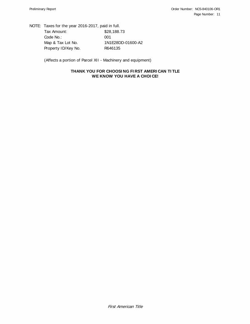
Preliminary Report Order Number: NCS-840106-OR1
Page Number: 11
First American Title
NOTE: Taxes for the year 2016-2017, paid in full. Tax Amount: $28,188.73 Code No.: 001 Map & Tax Lot No. 1N1E28DD-01600-A2 Property ID/Key No. R646135
(Affects a portion of Parcel XII - Machinery and equipment)
THANK YOU FOR CHOOSING FIRST AMERICAN TITLE WE KNOW YOU HAVE A CHOICE!

Preliminary Report Order Number: NCS-840106-OR1
Page Number: 12
First American Title
First American Title Insurance Company of Oregon
SCHEDULE OF EXCLUSIONS FROM COVERAGE 1. AMERICAN LAND TITLE ASSOCIATION LOAN POLICY - 2006
EXCLUSIONS FROM COVERAGE The following matters are expressly excluded from the coverage of this policy, and the Company will not pay loss or damage, costs, attorneys' fees, or expenses that arise by reason of: 1. (a) Any law, ordinance, permit, or governmental regulation (including those relating to building and zoning) restricting, regulating, prohibiting, or relating to (i) the occupancy, use, or enjoyment of the Land; (ii) the character, dimensions, or location of any improvement erected on the Land; (iii) the subdivision of land; or (iv) environmental protection; or the effect of any violation of these laws, ordinances, or governmental regulations. This Exclusion 1(a) does not modify or limit the coverage provided under Covered Risk 5. (b) Any governmental police power. This Exclusion 1(b) does not modify or limit the coverage provided under Covered Risk 6. 2. Rights of eminent domain. This Exclusion does not modify or limit the coverage provided under Covered Risk 7 or 8. 3. Defects, liens, encumbrances, adverse claims, or other matters (a) created, suffered, assumed, or agreed to by the Insured Claimant; (b) not Known to the Company, not recorded in the Public Records at Date of Policy, but Known to the Insured Claimant and not disclosed in writing to the Company by the Insured Claimant prior to the date the Insured Claimant became an Insured under this policy; (c) resulting in no loss or damage to the Insured Claimant; (d) attaching or created subsequent to Date of Policy (however, this does not modify or limit the coverage provided under Covered Risk 11, 13, or 14); or (e) resulting in loss or damage that would not have been sustained if the Insured Claimant had paid value for the Insured Mortgage. 4. Unenforceability of the lien of the Insured Mortgage because of the inability or failure of an Insured to comply with applicable doing-business laws of the state where the Land is situated. 5. Invalidity or unenforceability in whole or in part of the lien of the Insured Mortgage that arises out of the transaction evidenced by the Insured Mortgage and is based upon usury or any consumer credit protection or truth-in-lending law. 6. Any claim, by reason of the operation of federal bankruptcy, state insolvency, or similar creditors? rights laws, that the transaction creating the lien of the Insured Mortgage, is (a) a fraudulent conveyance or fraudulent transfer, or (b) a preferential transfer for any reason not stated in Covered Risk 13(b) of this policy. 7. Any lien on the Title for real estate taxes or assessments imposed by governmental authority and created or attaching between Date of Policy and the date of recording of the Insured Mortgage in the Public Records. This Exclusion does not modify or limit the coverage provided under Covered Risk 11(b).
2. American Land Title Association OWNER POLICY - 2006 EXCLUSIONS FROM COVERAGE
The following matters are expressly excluded from the coverage of this policy, and the Company will not pay loss or damage, costs, attorneys’ fees, or expenses that arise by reason of: 1. (a) Any law, ordinance, permit, or governmental regulation (including those relating to building and zoning) restricting, regulating, prohibiting, or relating to (i) the occupancy, use, or enjoyment of the Land; (ii) the character, dimensions, or location of any improvement erected on the Land; (iii) the subdivision of land; or (iv) environmental protection; or the effect of any violation of these laws, ordinances, or governmental regulations. This Exclusion 1(a) does not modify or limit the coverage provided under Covered Risk 5. (b) Any governmental police power. This Exclusion 1(b) does not modify or limit the coverage provided under Covered Risk 6. 2. Rights of eminent domain. This Exclusion does not modify or limit the coverage provided under Covered Risk 7 or 8. 3. Defects, liens, encumbrances, adverse claims, or other matters (a) created, suffered, assumed, or agreed to by the Insured Claimant; (b) not Known to the Company, not recorded in the Public Records at Date of Policy, but Known to the Insured Claimant and not disclosed in writing to the Company by the Insured Claimant prior to the date the Insured Claimant became an Insured under this policy; (c) resulting in no loss or damage to the Insured Claimant; (d) attaching or created subsequent to Date of Policy (however, this does not modify or limit the coverage provided under Covered Risks 9 and 10); or (e) resulting in loss or damage that would not have been sustained if the Insured Claimant had paid value for the Title. 4. Any claim, by reason of the operation of federal bankruptcy, state insolvency, or similar creditors. rights laws, that the transaction vesting the Title as shown in Schedule A, is (a) a fraudulent conveyance or fraudulent transfer; or (b) a preferential transfer for any reason not stated in Covered Risk 9 of this policy. 5. Any lien on the Title for real estate taxes or assessments imposed by governmental authority and created or attaching between Date of Policy and the date of recording of the deed or other instrument of transfer in the Public Records that vests Title as shown in Schedule A.

Preliminary Report Order Number: NCS-840106-OR1
Page Number: 13
First American Title
Exhibit "A"
Real property in the County of Multnomah , State of Oregon, described as follows:
PARCEL I: A tract of land situated in the Northwest quarter of Section 28, Township 1 North, Range 1 East of the Willamette Meridian, in the City of Portland, County of Multnomah, and State of Oregon, being more particularly described as follows: Beginning at the point of intersection of the Northeasterly line of N.W. Yeon Avenue with the division line between Tracts C and D as shown upon the Map of the Estate of Peter Guild, deceased, as divided among the heirs, pursuant to decree of partition entered February 28, 1873, Journal 8, page 640, J.R. 4508, and recorded in Deed Book X, page 56; thence North 47°90' West along the said Northeasterly line of N.W. Yeon Avenue, 208.56 feet to the Northwesterly line of that certain tract of land conveyed to Ferdinand Grass by Deed recorded July 11, 1892 in Deed Book 182, page 15; thence continuing North 47°00' West along the said Northeasterly line of N.W. Yeon Avenue, 80 feet to a point; thence North 40°51' East along a line drawn parallel to the said Northwesterly line of the Ferdinand Grass Tract to a point in the Southerly right of way line of the N.P.R.R.; thence Southeasterly along the said Southerly right of way line of N.P.R.R. 559.83 feet, more or less, to the Northwesterly line of that certain tract of land conveyed to Portland Linseed Oil Company by Deed recorded July 7, 1888 in Deed Book 103, page 450; thence Southwesterly along the said Northwesterly line of the Portland Linseed Oil Company Tract, 106.24 feet to the Northeasterly line of that certain 30 foot easement conveyed to The United States of America by Deed recorded March 5, 1 937 in P.S. Deed Book 380, page 437; thence Northwesterly along the said Northeasterly line of said easement 37.6 feet, more or less, to the Northwesterly corner thereof; thence South 40°51' West along the Northwesterly line of said easement and along the Northwesterly line of that certain tract of land conveyed to The United States of America by said Deed recorded in P.S. Deed Book 380, page 437, 295.87 feet to the said Northeasterly line of N.W. Yeon Avenue; thence North 47°00' West along the said Northeasterly line of N.W. Yeon Avenue, 235.24 feet to the place of beginning. EXCEPTING THEREFROM a tract of land in the Northwest one-quarter of Section 28, Township 1 North, Range 1 East of the Willamette Meridian, in the City of Portland, County of Multnomah and State of Oregon, described as follows: Beginning at a point in the Northeasterly line of N.W. Yeon Avenue, North 47°00' West 100.0 feet from the intersection of said Northeasterly line of N.W. Yeon Avenue with the line between Tracts "C" and "D" of the subdivision of the Estate of Peter Guild as recorded at page 56 of Book X of the Deed Records of Multnomah County, Oregon; thence North 47°00' West along the Northeasterly line of N.W. Yeon Avenue, 188.56 feet; thence North 40°51' East parallel with the line between said Tracts "C and "D", 379.16 feet to the Southwesterly line of the Northern Pacific Railroad Company's right of way; thence South 48°43" East along said right of way, 188.43 feet; thence South 40°51' West 384.75 feet to the place of beginning. PARCEL II: A tract of land situated in the Northwest quarter of Section 28, Township 1 North, Range 1 East of the Willamette Meridian, in the City of Portland, County of Multnomah, and State of Oregon, being more particularly described as follows: Beginning at the point of intersection of the Southeasterly line of Tract C of the subdivision of the Peter Guild Donation Land Claim, in Section 28, Township 1 North, Range 1 East of the Willamette Meridian, in the City of Portland, County of Multnomah and State of Oregon, with the Northeasterly line of that certain

Preliminary Report Order Number: NCS-840106-OR1
Page Number: 14
First American Title
tract of land conveyed to The United States of America by Deed from C. F. Adams, et al, dated June 15, 1934 and recorded June 15 , 1934 in P.S. Deed Book 254, page 206; thence Northeasterly along said Southeasterly line of Tract C, 30 feet to the Southwesterly line of that certain tract of land conveyed to the Portland Linseed Oil Company by Deed recorded July 7, 1888 in Deed Book 103, page 450; thence Northwesterly along the said Southwesterly line of the Portland Linseed Oil Company Tract and said line extended, 242.60 feet to a point; thence South 50°51' West 30 feet to the Northwesterly corner of that certain tract of land conveyed to The United States of America by Deed recorded March 5, 1937 in P.S. Deed Book 380, page 437; thence South 47° East along the Northeasterly line of the said United States of America Tract, 242,60 feet to the point of beginning. EXCEPTING THEREFROM that portion lying Northeasterly of the Southwesterly line of that tract of land described in that deed recorded June 30, 1964 in Book 74, page 262. PARCEL III: Beginning in the South line of the tract of land marked Parcel "C" and set apart to one Frances L. Inman (then Frances L. Guild) in and by the partition deed between the heirs of Peter Guild, deceased, recorded at page 59, Book "X" of Records of Deeds of Multnomah County, Oregon, at a point 30 feet West of the center of the main tract of the Northern Pacific Railroad Company, running thence Northerly and parallel with and 30 feet distant from the center line of said railroad tract 205 feet; thence Westerly parallel with the South line of said Tract "C" 106.24 feet; thence Southerly and parallel with the center line of said railroad tract 205 feet to the South line of said Tract "C", and thence Easterly along said South line 106.24 feet to the place of beginning. PARCEL IV: TRACT A: Part of Tract C of the subdivision of the Peter Guild Donation Land Claim, being in Section 28, Township 1 North, Range 1 East of the Willamette Meridian, in the City of Portland, County of Multnomah and State of Oregon, being more particularly described as follows: Beginning at a point which is 163.96 feet North 47°00' West of the intersection of the Southeasterly line of said Tract C with the Northeasterly line of Yeon Avenue, which point is the Southwest corner of that certain tract of land conveyed to the United State of America by deed recorded June 15, 1935 in Book 254, page 206, Deed Records; thence North 47°00' West, along said line of Yeon Avenue, 78.64 feet; thence North 40°51' East, parallel to the Southeasterly line of said Tract C, 265.87 feet; thence South 47°00' East, parallel to the Northeasterly line of Yeon Avenue, 78.64 feet to a point which is the Northwest corner of said Book 254, page 206; thence South 40°51' West 265.87 feet to the point of beginning. TRACT B: Part of Tract C of the subdivision of the Peter Guild Donation Land Claim, being in Section 28, Township 1 North, Range 1 East of the Willamette Meridian, in the City of Portland, County of Multnomah and State of Oregon, being more particularly described as follows: Beginning at the intersection of the Southeasterly line of said Tract C with the Northeasterly line of Yeon Avenue; thence North 47°00' West, along said line of Yeon Avenue 163.96 feet; thence North 40°51' East, parallel to the Southeasterly line of said Tract C, 265.87 feet; thence South 47°00' East, parallel to the Northeasterly line of Yeon Avenue, 163.96 feet to a point in the Southeasterly line of said Tract C; thence South 40°51' West 265.87 feet to the point of beginning. PARCEL V:

Preliminary Report Order Number: NCS-840106-OR1
Page Number: 15
First American Title
Lots 11, 12, 13, 14 and the South one-half of lot 16, Block 6, WILSON'S ADDITION TO THE CITY OF PORTLAND, in the City of Portland, County of Multnomah and State of Oregon. TOGETHER WITH that portion of NW 25th Street (now NW 25th Avenue) West of and adjoining said Lots 11 and 14, which inured thereto by Vacation Ordinance No. 16089, dated January 11, 1907. PARCEL VI: TRACT A: A tract of land situated in the Southwest one-quarter of Section 28, Township 1 North, Range 1 East of the Willamette Meridian, in the City of Portland, County of Multnomah and State of Oregon, described as follows: Beginning at the intersection of the center line of 25th Street with the North line of NORTH PORTLAND; thence North 1°27' West 539.28 feet along the centerline of 25th Street extended in a Northerly direction to the North line of a tract of land conveyed by deed recorded April 16, 1884 in Book 73, page 221, Multnomah County Deed Records; thence North 80°3'45" East, along the North boundary of said tract, 352.41 feet to the Northeast corner of said tract, said Northeast corner being the Northwest corner of Block 13 of DOSCHER'S SECOND ADDITION TO THE CITY OF PORTLAND; thence South 0°34'15" West 604.28 feet to the Southeast corner of said tract, said Southeast corner being the Southwest corner of Block 5 of said DOSCHER'S SECOND ADDITION TO PORTLAND; thence North 85°15' West 327.49 feet to the point of beginning. EXCEPTING THEREFROM that portion lying within the boundaries of the Portland Terminal Railway Company's right of way. TRACT B: A tract of land situated in the Southeast one-quarter of Section 29, Township 1 North, Range 1 East of the Willamette Meridian, in the City of Portland, County of Multnomah and State of Oregon, described as follows: Beginning at the intersection of the center line of 25th Street with the North line of NORTH PORTLAND; thence North 1°27' West 348.88 feet along the centerline of 25th Street extended in a Northerly direction; thence Southwesterly 189.15 feet on the arc of a curve to the left having a radius of 349.26 feet and a chord bearing South 48°6' West; thence South 32°35' West 261.33 feet to said Northerly line of NORTH PORTLAND; thence South 89°15' East, along said Northerly line of NORTH PORTLAND, 288.65 feet to the point of beginning. TRACT C: Lots 3 through 11, inclusive, Block 1 and Lots 1 through 12, inclusive, Block 2, VERSTEEG'S ADDITION, in the City of Portland, County of Multnomah and State of Oregon. TOGETHER WITH that portion of vacated NW 24th Place which inured thereto by Ordinance No. 149287, recorded October 25, 1982 in Book 1624, page 2014. ALSO TOGETHER WITH that portion of vacated NW 25th Street which inured thereto by Ordinance No. 127031, recorded July 30, 1968 in Book 632, page 972. TRACT D: Lots 1 through 9, inclusive, Block 13, Lots 1 through 6, inclusive, Block 6, and Lots 1 and 2, Block 5, DOSCHER'S SECOND ADDITION, in the City of Portland, County of Multnomah and State of Oregon.

Preliminary Report Order Number: NCS-840106-OR1
Page Number: 16
First American Title
TOGETHER WITH that portion of vacated NW York Street which inured thereto by Ordinance No. 76884, recorded March 30, 1942 in Book 672, page 118. ALSO TOGETHER WITH that portion of vacated NW Roosevelt Street which inured thereto by Ordinance No. 52489. TRACT E: Lots 1 through 18, inclusive, Block 8, Lots 1 through 16, inclusive, Block 9 and Lots 1 through 8 and Lots 13 through 18, Block 10, NORTH PORTLAND, in the City of Portland, County of Multnomah and State of Oregon. EXCEPTING THEREFROM those portions of Lots 7 and 13 lying Northwesterly of the Southeasterly line of the Portland Terminal Railway Company's right of way. TOGETHER WITH that portion of vacated 25th Street which inured thereto by Ordinance No. 118015, recorded May 6, 1964 in Book 36, page 84. ALSO TOGETHER WITH that portion of vacated NW Wilson Street which inured thereto by Ordinance No. 118764, recorded August 18, 1964 in Book 109, page 205. PARCEL VII: TRACT A: A tract of land in the William Blackistone Donation Land Claim No. 53 situated in Sections 28 and 29, Township 1 North, Range 1 East of the Willamette Meridian, in the City of Portland, County of Multnomah and State of Oregon, more particularly described as follows: An easement and right-of-way, 20 feet in width, being 10 feet on each side of the centerline of the railroad track as located and staked out upon the ground, said centerline being more particularly described as follows: Beginning at the intersection of the terminus of York Street with the centerline of said existing railroad track and running thence Westerly on a curve alone the existing railroad track and springing therefrom on a curve to the left and South, to the North line of Lot 13, Block 10, NORTH PORTLAND, in the City of Portland, County of Multnomah and State of Oregon and the termination of said easement. EXCEPT THEREFROM that portion thereof lying within the following described tract: A tract of land situated in the William Blackistone Donation Land Claim No. 53 situated in Sections 28 and 29, Township 1 North, Range 1 East of the Willamette Meridian, in the City of Portland, County of Multnomah and State of Oregon, more particularly described as follows: Beginning at the intersection of the centerline of 25th Street with the North line of North Portland in said City of Portland and running thence North 1°27' West 539.28 feet along the centerline of said 25th Street extended in a Northerly direction to the North line of a tract of land described in Deed to William S. Ladd et al recorded in Book 73, page 221, Records of Multnomah County, and running thence North 80°3'45" East along the North boundary of said tract 352.41 feet to the Northeast corner thereof (said Northeast corner being the Northwest corner of Block 13 of DOSCHER'S SECOND ADDITION TO THE CITY OF PORTLAND) and running thence South 0°34'15" West 504.28 feet to the Southeast corner of said tract (said Southeast corner being the Southwest corner of Block 5 of said DOSCHER'S SECOND ADDITION), and running thence North 89° 15' West 327.49 feet to the point of beginning.

Preliminary Report Order Number: NCS-840106-OR1
Page Number: 17
First American Title
TRACT B: A tract of land situated in the William Blackistone Donation Land Claim No. 53 situated in Sections 28 and 29, Township 1 North, Range 1 East of the Willamette Meridian, in the City of Portland, County of Multnomah and State of Oregon, more particularly described as follows: An easement and right-of-way, 20 feet in width, being 10 feet on each side of the centerline of the railroad track as located and staked out upon the ground, said centerline being more particularly described as follows: Beginning at the intersection of the terminus of York Street with the centerline of said existing railroad track and running thence on a curve to the North to a point that is approximately opposite of and 30 feet distant from the Southwest corner of Lot 6, Block 3, VERSTEEG'S ADDITION, in the City of Portland, County of Multnomah and State of Oregon; thence continuing in a Westerly direction along the existing railroad centerline to the East boundary line of 26th Street and the termination of said easement. EXCEPT THEREFROM that portion thereof lying within the following described tract: A tract of land situated in the William Blackistone Donation Land Claim No. 53 situated in Sections 28 and 29, Township 1 North, Range 1 East of the Willamette Meridian, in the City of Portland, County of Multnomah and State of Oregon, more particularly described as follows: Beginning at the intersection of the centerline of 25th Street with the North line of North Portland in said City of Portland and running thence North 1°27' West 539.28 feet along the centerline of said 25th Street extended in a Northerly direction to the North line of a tract of land described in Deed to William S. Ladd et al recorded in Book 73, page 221, Records of Multnomah County, and running thence North 80°3'45" East along the North boundary of said tract 352.41 feet to the Northeast corner thereof (said Northeast corner being the Northwest corner of Block 13 of DOSCHER'S SECOND ADDITION TO THE CITY OF PORTLAND) and running thence South 0°34'15" West 504.28 feet to the Southeast corner of said tract (said Southeast corner being the Southwest corner of Block 5 of said DOSCHER'S SECOND ADDITION), and running thence North 89° 15' West 327.49 feet to the point of beginning. TRACT C: A tract of land in the William Blackistone Donation Land Claim No. 53 situated in Sections 28 and 29. Township 1 North, Range 1 East of the Willamette Meridian, in the City of Portland, County of Multnomah and State of Oregon, more particularly described as follows: An easement and right-of-way more particularly described as follows: Beginning at a point 100 feet Easterly at right angles from the East boundary of NW 26th Street and 20 feet Southerly at right angles from the Southerly boundary of said VERSTEEG'S ADDITION, in the City of Portland, County of Multnomah and State of Oregon; thence South 76°42' West 55.00 feet; thence South 70°32' West 16.0 feet; thence on a curve to the left of 221.5 feet radius 52.4 feet, more or less, to a point in the Easterly boundary of NW 26th Street; thence North 1°27' West along the Easterly boundary of said street 6.4 feet; thence continuing along the Easterly boundary of said NW 26lh Street North 9°56' West 7.16 feet to a point 20 feet distant at right angles from the Southerly boundary of said VERSTEEG'S ADDITION; thence North 80°04: East 100.0 feet to point of beginning. TRACT D: A tract of land in the William Blackistone Donation Land Claim No. 53 situated in Sections 28 and 29, Township 1 North, Range 1 East of the Willamette Meridian, in the City of Portland, County of Multnomah and State of Oregon, more particularly described as follows:

Preliminary Report Order Number: NCS-840106-OR1
Page Number: 18
First American Title
An easement and right-of-way, 20 feet in width, Rung 10 feet on each side of the railroad track as now located and staked out upon the ground extending from a point in the North boundary line of Lot 13, Block 10, NORTH PORTLAND, in the City of Portland, County of Multnomah and State of Oregon; thence on a curve through said Lot 13 and Lots 12, 7, 8 and 9 in said Block 10 and the termination of said easement. TRACT E: A tract of land in the William Blackistone Donation Land Claim No. 53 situated in Sections 28 and 29, Township 1 North, Range 1 East, Willamette Meridian, City of Portland, County of Multnomah, State of Oregon, more particularly described as follows: An easement and right-of-way more particularly described as follows: Beginning at a point in the West line of Block 10, NORTH PORTLAND, North 1°27' West 26.72 feet from the Southwest comer thereof; running thence Northeasterly 69.66 feet on a curve to the left having a radius of 230.49 feet, an initial tangent bearing North 73°50' East; thence North 56°31' East 14.95 feet; thence Northeasterly 65.26 feet on a curve to the left having a radius of 208.31 feet to a point in the Northerly line of that tract of land 20.00 feet wide described in Book 805, Page 190; thence Southwesterly following said Northerly line to a point in the West line of said Block 10; thence North 1°27' West to the point of beginning. PARCEL VIII: Lots 1, 2 and 12, Block 1, VERSTEEG'S ADDITION TO EAST PORTLAND, in the City of Portland, County of Multnomah and State of Oregon. TOGETHER WITH that portion of vacated NW 24th Place which inured to said Lot 12 by Ordinance No. 149287, a copy of which was recorded October 25, 1982 in Book 1624, page 2014. PARCEL IX: Lots 3, 4, 5, 8, 9, 12, 13 and 18, Block 7, DOSCHER'S SECOND ADDITION, in the City of Portland, County of Multnomah and State of Oregon. PARCEL X: A portion of that tract of land described in Book 2204, Page 2471, being Lots 1, 2, 6, and a portion of Lot 7, Block 4, DOSCHER'S SECOND ADDITION situated in the Northwest quarter of the Southwest quarter of Section 28, Township 1 North, Range 1 East of the Willamette Meridian, in the City of Portland, County of Multnomah and State of Oregon, and being more particularly described as follows: Beginning at a 1.17" copper disk stamped "Summit 59999LS" on the North line of said Lot 7, which bears South 89°55'02" East 38.67 feet from a 5/8" iron rod with yellow plastic cap inscribed "Summit 59999LS" marking the northwest corner of said Lot 7; thence along the North line of said Lot 7, and continuing along the North line of said Lots 6 and 1, South 89°55'02" East, 161.33 feet to a 5/8" iron rod with yellow plastic cap inscribed "Summit 59999LS" at the Northeast corner of said Lot 1; thence along the East line of said Lot 1 and continuing along the East line of said Lot 2, South 00°02'48" West, 87.80 feet to a 5/8" iron rod with yellow plastic cap inscribed "Summit 59999LS" at the Southeast corner of said Lot 2; thence along the South line of said Lot 2, and continuing along the South line of said Lots 6 and 7, North 87°30'55" West, 163.09 feet to a 5/8" iron rod with yellow plastic cap inscribed "Summit 59999LS" which bears South 87°30'55" East, 37.09 feet from a 5/8" iron rod with yellow plastic cap inscribed "Summit 59999LS" marking the Southwest corner of said Lot 7; thence leaving said South line of Lot 7, North 01°11'18" East, 80.98 feet to the point of beginning.

Preliminary Report Order Number: NCS-840106-OR1
Page Number: 19
First American Title
PARCEL XI: TRACT A: A tract of land in Wm. Blackistone Donation Land Claim and in Section 29, Township 1 North, Range 1 East of the Willamette Meridian, in the City of Portland, County of Multnomah and State of Oregon, described as follows: Beginning at the Northwest corner of Block 10, NORTH PORTLAND; thence North 1°27' West along the East line of N.W. 26th Avenue, 221.38 feet to the Northwest corner of the tract conveyed to Frank A. Bitar and Robert A. Bitar by deed recorded July 29, 1953 in Ps Deed Book 1613, page 409 and the true point of beginning of the tract to be described; thence along the Northerly line of said Bitar tract, North 88°033' East 322 feet to the Westerly right of way line of the Northern Pacific Terminal Company; thence along said Westerly right of way line on an arc of a curve to the right, having a radius of 369.26 feet, 201.80 feet, more or less, to the center line of N.W. 25th Avenue in NORTH PORTLAND, extended Northerly; thence North 1°27' West along said center line of N.W. 25th Avenue extended, 132.30 feet, more or less, to the Southerly right of way line of the Northern Pacific Terminal company; thence along the Southerly line of said right of way, Westerly 113.29 feet on the arc of a curve to the left having a radius of 400.28 feet and chord bearing South 88°07' West; thence South 88°01' West 272.2 feet; thence South 76°42' West 55 feet; thence South 70°32' West 16 feet; and thence Westerly on the arc of a curve to the left having a radius of 221.5 feet and tangent to the last mentioned course 32.4 feet, more or less, to the Easterly line of N.W. 26th Avenue; thence South 1°27' East along said Easterly line of N.W. 26th Avenue, 193.82 feet-to the true point of beginning. TRACT B: A tract of land in Wm. Blackistone Donation Land Claim and in Section 29, Township 1 North, Range 1 East of the Willamette Meridian, in the City of Portland, County of Multnomah and State of Oregon, described as follows: That portion lying Southerly of Lot 6, Block 3, VERSTEEG'S ADDITION, Westerly of the center line of NW 25th Street, extended, and Northerly of the North line of the Northern Pacific Terminal Company railroad tract. PARCEL XII: Lots 1, 2, 3, 4, 5, 15, 16, 17 and 18, Block 11, NORTH PORTLAND, in the City of Portland, County of Multnomah and State of Oregon.

HAHN AND ASSOCIATES, INC.
Appendix E
Environmental Data Resources, Inc. Summary Radius Map™ Report
FORM-NULL-PVC
tropeR paM suidaR yrammuS RDE
6 Armstrong Road, 4th floorShelton, CT 06484Toll Free: 800.352.0050www.edrnet.com
NW Industrial AreaNW Vaughn Street and NW 25th AvenuePortland, OR 97210
Inquiry Number: 4907883.2sApril 14, 2017

SECTION PAGE
Executive Summary ES1
Overview Map 2
Detail Map 3
Map Findings Summary 4
Map Findings 8
Orphan Summary 1513
Government Records Searched/Data Currency Tracking GR-1
GEOCHECK ADDENDUM
GeoCheck - Not Requested
TC4907883.2s Page 1
Thank you for your business.Please contact EDR at 1-800-352-0050
with any questions or comments.
Disclaimer - Copyright and Trademark Notice
This Report contains certain information obtained from a variety of public and other sources reasonably available to Environmental DataResources, Inc. It cannot be concluded from this Report that coverage information for the target and surrounding properties does not exist fromother sources. NO WARRANTY EXPRESSED OR IMPLIED, IS MADE WHATSOEVER IN CONNECTION WITH THIS REPORT. ENVIRONMENTALDATA RESOURCES, INC. SPECIFICALLY DISCLAIMS THE MAKING OF ANY SUCH WARRANTIES, INCLUDING WITHOUT LIMITATION,MERCHANTABILITY OR FITNESS FOR A PARTICULAR USE OR PURPOSE. ALL RISK IS ASSUMED BY THE USER. IN NO EVENT SHALLENVIRONMENTAL DATA RESOURCES, INC. BE LIABLE TO ANYONE, WHETHER ARISING OUT OF ERRORS OR OMISSIONS, NEGLIGENCE,ACCIDENT OR ANY OTHER CAUSE, FOR ANY LOSS OF DAMAGE, INCLUDING, WITHOUT LIMITATION, SPECIAL, INCIDENTAL,CONSEQUENTIAL, OR EXEMPLARY DAMAGES. ANY LIABILITY ON THE PART OF ENVIRONMENTAL DATA RESOURCES, INC. IS STRICTLYLIMITED TO A REFUND OF THE AMOUNT PAID FOR THIS REPORT. Purchaser accepts this Report "AS IS". Any analyses, estimates, ratings,environmental risk levels or risk codes provided in this Report are provided for illustrative purposes only, and are not intended to provide, norshould they be interpreted as providing any facts regarding, or prediction or forecast of, any environmental risk for any property. Only a Phase IEnvironmental Site Assessment performed by an environmental professional can provide information regarding the environmental risk for anyproperty. Additionally, the information provided in this Report is not to be construed as legal advice.
Copyright 2017 by Environmental Data Resources, Inc. All rights reserved. Reproduction in any media or format, in wholeor in part, of any report or map of Environmental Data Resources, Inc., or its affiliates, is prohibited without prior written permission.
EDR and its logos (including Sanborn and Sanborn Map) are trademarks of Environmental Data Resources, Inc. or its affiliates. All othertrademarks used herein are the property of their respective owners.
TABLE OF CONTENTS

EXECUTIVE SUMMARY
TC4907883.2s EXECUTIVE SUMMARY 1
A search of available environmental records was conducted by Environmental Data Resources, Inc (EDR).The report was designed to assist parties seeking to meet the search requirements of EPA’s Standardsand Practices for All Appropriate Inquiries (40 CFR Part 312), the ASTM Standard Practice forEnvironmental Site Assessments (E 1527-13) or custom requirements developed for the evaluation ofenvironmental risk associated with a parcel of real estate.
TARGET PROPERTY INFORMATION
ADDRESS
NW VAUGHN STREET AND NW 25TH AVENUEPORTLAND, OR 97210
COORDINATES
45.5385650 - 45˚ 32’ 18.83’’Latitude (North): 122.7022580 - 122˚ 42’ 8.12’’Longitude (West): Zone 10Universal Tranverse Mercator: 523246.4UTM X (Meters): 5042606.5UTM Y (Meters): 69 ft. above sea levelElevation:
USGS TOPOGRAPHIC MAP ASSOCIATED WITH TARGET PROPERTY
TP Target Property:U.S. Geological SurveySource:
AERIAL PHOTOGRAPHY IN THIS REPORT
20140630Portions of Photo from:USDASource:

4907883.2s Page 2
I39 LAURA PLISKA 2335 NW 23RD PLACE OR LUST Lower 218, 0.041, NE
F38 PACIFICA HOME DBA CV 2337 NORTHWEST YORK RCRA NonGen / NLR, FINDS, ECHO Lower 184, 0.035, ENE
37 EVERGREEN HYDRAULICS 2515 NW NICOLAI RCRA NonGen / NLR, FINDS, ECHO Lower 168, 0.032, NNW
G36 OIL CAN HENRYS 2016 NW 26TH AVE OR AST, OR HSIS Higher 162, 0.031, SW
G35 FREEMAN SERVICE STAT 2575 NW VAUGHN STREE OR LUST Higher 105, 0.020, SW
G34 CENTENNIAL CASH AND 2575 NW VAUGHN EDR Hist Auto Higher 105, 0.020, SW
33 HEATING OIL TANK 1914 NW 24TH PL OR LUST Higher 93, 0.018, SSE
A32 SPECIALTY FINISHES L 2444 NW 24TH AVE RCRA NonGen / NLR Lower 91, 0.017, NNE
I31 STAR OIL CO 2344 NW 24TH AVE OR LUST, OR UST Lower 89, 0.017, NE
H30 HEATING OIL TANK 2107 NW 23RD AVE OR LUST Lower 89, 0.017, ESE
E29 HEATING OIL TANK 2426 NW VAUGHN ST OR LUST Higher 77, 0.015, SSE
G28 PARMAN & ELLIS INC 2546 NW WILSON ST RCRA NonGen / NLR, FINDS, ECHO Higher 67, 0.013, SW
F27 UNITOR SHIP SERVICE 2233 NW 23RD AVE RCRA NonGen / NLR, FINDS, ECHO Lower 49, 0.009, East
F26 HAMPEL ENTERPRISES 2233 NW 23RD AVE OR LUST Lower 49, 0.009, East
F25 HAMPEL ENTERPRISES 2233 NW 23RD AVE OR UST Lower 49, 0.009, East
F24 2233 NW 23RD AVE EDR Hist Auto Lower 49, 0.009, East
E23 DAILY JOURNAL OF COM 2014 NW 24TH AVE RCRA NonGen / NLR, FINDS, ECHO Higher 46, 0.009, SSE
D22 CALBAG - 2500 NW NIC 2500 NW NICOLAI ST. OR ECSI, OR VCP, OR SPILLS, OR HSIS Lower 32, 0.006, North
D21 WARREN ROSENFELD CAL 8703 SE 82ND AVE SEMS-ARCHIVE, RCRA-CESQG, FTTS, HIST FTTS, FINDS Lower 32, 0.006, North
D20 CALBAG METALS (OR) 2495 NW NICOLAI ST WA SWF/LF Lower 32, 0.006, North
D19 CALBAG METALS COMPAN 2495 NW NICOLAI OR ECSI, OR AST, OR VCP, OR HAZMAT, OR HSIS, OR... Lower 32, 0.006, North
D18 CALBAG METALS CO - N 2495 NORTHWEST NICOL RCRA-CESQG, FINDS, ECHO Lower 32, 0.006, North
C17 ELECTRO STATIC REFIN 1938 NW 25TH AVE STE RCRA NonGen / NLR Higher 8, 0.002, South
B16 ESCO CORP/PLT 1, FIL 2141 NW 25TH AVE OR RGA LUST Higher 1 ft.
B15 REED ELECTRIC CO 2539 NW VAUGHN ST RCRA-CESQG, FINDS, OR MANIFEST, ECHO Higher 1 ft.
B14 ESCO PLANT #3 2141 NW 25TH AVE. OR RGA HWS Higher 1 ft.
B13 REED ELECTRIC CO 2539 NW VAUGHN EDR Hist Auto Higher 1 ft.
B12 REED ELECTRIC COMPAN 2539 NW VAUGHN OR AST, OR HSIS Higher 1 ft.
C11 SCHILLER & VROMAN IN 2480 NW VAUGHN RCRA-SQG, FINDS, OR MANIFEST, ECHO Higher 1 ft.
B10 ESCO CORPORATION 2141 NW 25TH AVE RCRA-SQG, OR ECSI, OR LUST, OR UST, OR AST, OR... Higher 1 ft.
B9 ESCO PLANT #3 2141 NW 25TH AVE OR RGA HWS Higher 1 ft.
B8 PACIFIC AUTO PARTS C 2509 NW VAUGHN EDR Hist Auto Higher 1 ft.
7 ESCO CORP 2141 N.W. 25TH AVE. TSCA Higher 1 ft.
B6 ESCO CORP 2141 NW 25TH AVE TRIS, HIST FTTS Higher 1 ft.
C5 SCHILLER & VROMAN, I 2480 NW VAUGHN CA HAZNET Higher 1 ft.
B4 ESCO CORP. 2141 NW 25TH AVE OR RGA LUST Higher 1 ft.
A3 REJUVENATION INC 2550 NW NICOLAI ST RCRA-LQG, OR UST, FINDS, CA HAZNET, OR MANIFEST,... Lower 1 ft.
A2 BUSINESS MEN S BODY 2404 NW NICOLAI ST EDR Hist Auto Lower 1 ft.
A1 BUSINESS MENS BODY S 2404 NW NICOLAI RCRA NonGen / NLR, FINDS, ECHO Lower 1 ft.
MAPPED SITES SUMMARY
Target Property Address:NW VAUGHN STREET AND NW 25TH AVENUEPORTLAND, OR 97210
Click on Map ID to see full detail.
MAP RELATIVE DIST (ft. & mi.)ID DATABASE ACRONYMS ELEVATION DIRECTIONSITE NAME ADDRESS

4907883.2s Page 3
P78 2346 NW THURMAN ST EDR Hist Cleaner Higher 584, 0.111, SSE
S77 BRADFORD MERRICK E 2684 NW VAUGHN EDR Hist Auto Higher 577, 0.109, WSW
S76 JC PROPERTIES 2684 NW VAUGHN ST OR LUST, OR UST Higher 577, 0.109, WSW
T75 GROUNDWATER - NW 22N 2100 BLOCK NW 22ND A OR ECSI, FINDS Lower 573, 0.109, East
74 WOLFORD MOTOR CO 2285 NW VAUGHN EDR Hist Auto Lower 538, 0.102, ESE
S73 WARDWAY GARAGE 2662 NW VAUGHN EDR Hist Auto Higher 537, 0.102, SW
Q72 FORESTRY AUTO REPAIR 2024 NW 27TH AVE EDR Hist Auto Higher 523, 0.099, WSW
Q71 CLERIN GUS P 2685 NW VAUGHN EDR Hist Auto Higher 507, 0.096, WSW
M70 DWYER, PROPERTY 2401 NW 23RD AVE OR LUST Lower 502, 0.095, NE
R69 2573 NW THURMAN ST EDR Hist Cleaner Higher 502, 0.095, SSW
Q68 J A FREEMAN & SON 2034 NW 27TH AVE OR LUST, RCRA NonGen / NLR, FINDS, OR MANIFEST,... Higher 501, 0.095, WSW
P67 NORTHWEST CLEANERS 2390 NW THURMAN ST EDR Hist Cleaner Higher 488, 0.092, SSE
L66 HEATING OIL TANK 2631 NW UPSHUR ST OR LUST Higher 484, 0.092, SW
P65 FOOD FRONT 2375 NE THURMAN OR LUST Higher 468, 0.089, SSE
J64 ODEQ NICOLAI & YEON NW NICOLAI AT YEON RCRA NonGen / NLR Lower 457, 0.087, NE
O63 DEALERS SUPPLY COMPA 2345 NW NICOLAI ST OR AST, OR HSIS Lower 456, 0.086, NNE
O62 NORTHWEST SHINGLE RE 2345 NW NICOLAI ST OR SWF/LF, OR SWRCY Lower 456, 0.086, NNE
J61 UNITED ELECTRIC INC 2300 NW NICOLAI RCRA NonGen / NLR, FINDS, ECHO Lower 443, 0.084, NE
K60 MERRY XRAY 1723 NW 24TH AVE RCRA-CESQG, FINDS, ECHO Higher 439, 0.083, SSE
N59 GILES FUEL 2314 NW 23RD OR UST Lower 433, 0.082, ENE
58 COLOR TECHNOLOGY INC 2455 NW NICOLAI ST RCRA-CESQG, FINDS, NY MANIFEST, ECHO Lower 432, 0.082, North
M57 FREEMAN GROUP THE FO 2328 NW REED ST RCRA NonGen / NLR, FINDS, ECHO Lower 419, 0.079, NE
K56 LARRY S CLEANERS 2400 NW THURMAN EDR Hist Cleaner Higher 419, 0.079, SSE
K55 HEATING OIL TANK 2466 NW THURMAN OR LUST Higher 370, 0.070, South
K54 HEATING OIL TANK 1818 NW 24TH AVENUE OR LUST Higher 368, 0.070, SSE
L53 INDEPENDENT DRY CLEA 1911 NW 26TH AVE EDR Hist Cleaner Higher 362, 0.069, SW
L52 VAUGHN STREET LAUNDE 2608 NW VAUGHN ST EDR Hist Cleaner Higher 352, 0.067, SW
L51 COPEL CHAS 1915 NW 26TH AVE EDR Hist Auto Higher 352, 0.067, SW
J50 BOB S ASSOCIATED SER 2330 NW NICOLAI EDR Hist Auto Lower 344, 0.065, NE
49 RICE C A FINA SERVIC 2315 NW VAUGHN ST EDR Hist Auto Lower 336, 0.064, SE
K48 2436 NW THURMAN ST EDR Hist Cleaner Higher 326, 0.062, South
47 REJUVENATION INC 2550 NW NICOLAI ST OR AST, OR HSIS Higher 309, 0.059, NW
K46 PIAZZA PROPERTY 2417 NW THURMAN ST OR LUST Higher 308, 0.058, SSE
K45 COMPACTING TECHNOLOG 2417 NW THURMAN ST RCRA NonGen / NLR, FINDS, ECHO Higher 308, 0.058, SSE
K44 LAMPE A D 2429 NW THURMAN EDR Hist Auto Higher 277, 0.052, South
H43 PHIL’S AUTO BODY 2333 NW VAUGHN RCRA NonGen / NLR, FINDS, ECHO Lower 263, 0.050, SE
J42 POWER SUBSTATIONS 2425 NW 23RD PL OR UST, OR HSIS Lower 251, 0.048, NE
J41 POWER SUBSTATIONS (G 2425 NW 23RD PL OR LUST Lower 251, 0.048, NE
40 RUSS HUBBARD 2535 NW UPSHUR STREE OR UST Higher 235, 0.045, SSW
MAPPED SITES SUMMARY
Target Property Address:NW VAUGHN STREET AND NW 25TH AVENUEPORTLAND, OR 97210
Click on Map ID to see full detail.
MAP RELATIVE DIST (ft. & mi.)ID DATABASE ACRONYMS ELEVATION DIRECTIONSITE NAME ADDRESS

4907883.2s Page 4
AB117KAISER MONTGOMERY PA 2701 NW VAUGHN ST ST RCRA-CESQG, OR MANIFEST Higher 766, 0.145, WSW
AB116GAZLEY PLOWMAN ARCHI 2701 NORTHWEST VAUGH RCRA NonGen / NLR, FINDS, ECHO Higher 766, 0.145, WSW
V115 HEATING OIL TANK 2475 NW RALEIGH STRE OR LUST Higher 762, 0.144, South
Y114 MERCER INDUSTRIES - 2636 NW 26TH AVE. OR ECSI Lower 761, 0.144, NW
Y113 MERCER INDUSTRIES - 2636 NORTHWEST 26TH RCRA NonGen / NLR, FINDS, ECHO Lower 761, 0.144, NW
V112 HEATING OIL TANK 2455 NW RALEIGH ST OR LUST Higher 757, 0.143, South
AA111MONARCH MACHINE CO 2130 NW YORK RCRA NonGen / NLR, FINDS Lower 754, 0.143, East
AA110IRC ALUMINUM & STAIN 2130 NW YORK RCRA NonGen / NLR Lower 754, 0.143, East
AA109HEATING OIL TANK 2130 NW YORK STREET OR LUST, OR NPDES Lower 754, 0.143, East
W108 HEATING OIL TANK 2564 NW SAVIER STREE OR LUST Higher 743, 0.141, SSW
Y107 KELLY CABINET CO 2624 NW 26TH AVE RCRA-CESQG, FINDS, OR MANIFEST, ECHO Lower 740, 0.140, NW
106 HEATING OIL TANK 2661 NW THURMAN ST OR LUST Higher 736, 0.139, SW
105 VAUX PROPERTY 2350 NW SAVIER ST OR LUST Higher 734, 0.139, SSE
104 JONES OREGON STEVEDO 2323 NW SUFFOLK ST OR LUST, OR UST Lower 731, 0.138, NNE
Z103 ARATEX SERVICES INC 1848 NW 23RD AVE OR LUST, OR UST, OR SPILLS Higher 689, 0.130, SE
Z102 ARAMARK UNIFORM SERV 1848 NW 23RD AVE RCRA NonGen / NLR Higher 689, 0.130, SE
Z101 ARAMARK UNIFORM SERV 1848 NW 23RD AVE OR AST, OR SPILLS, OR HSIS Higher 689, 0.130, SE
Y100 FOAM SPECIALITIES IN 2601 NW NICOLAI ST RCRA NonGen / NLR, FINDS, ECHO Lower 680, 0.129, NW
W99 HEATING OIL TANK 2524 NW SAVIER ST OR LUST Higher 663, 0.126, SSW
O98 OREGONIAN PUBLISHING 2825 NW YEON RCRA-CESQG, FINDS, ECHO Lower 661, 0.125, NNE
O97 ABF FREIGHT SYSTEM 2825 NW YEON AVE OR LUST, OR UST, OR UIC Lower 661, 0.125, NNE
R96 LINDLEY TIME SERVICE 2600 NW THURMAN EDR Hist Auto Higher 657, 0.124, SSW
Q95 POWELL HUGH CHEVRON 2714 NW VAUGHN EDR Hist Auto Higher 656, 0.124, WSW
X94 KING-RIES PROPERTY 2550 NW 25TH PL. OR CRL, OR ECSI, OR ENG CONTROLS, OR INST CONTROL,...Lower 653, 0.124, NW
X93 STEAM SUPPLY & RUBBE 2550 NW 25TH PL RCRA NonGen / NLR, FINDS, ECHO Lower 653, 0.124, NW
W92 HEATING OIL TANK 2518 NW SAVIER OR LUST Higher 652, 0.123, South
V91 HEATING OIL TANK 2424 NW SAVIER OR LUST Higher 639, 0.121, South
V90 HEATING OIL TANK 2436 NW SAVIER ST OR LUST Higher 632, 0.120, South
T89 AMERITONE PAINT CORP 2100 NW 22ND AVE OR LUST, OR UST, RCRA NonGen / NLR, OR HSIS, ECHO Lower 615, 0.116, East
P88 WEST OREGON GARAGE 2325 NW THURMAN EDR Hist Auto Higher 613, 0.116, SSE
P87 ROSE CITY MUSTANG 2325 NW THURMAN ST OR LUST, OR UST Higher 613, 0.116, SSE
S86 CRUM PAUL L 2704 NW VAUGHN EDR Hist Auto Higher 612, 0.116, WSW
U85 NMHG OREGON INC 2120 NW 27TH AVE RCRA NonGen / NLR Higher 609, 0.115, West
U84 NACCO MATERIALS HAND 2120 NW 27TH AVE OR UST Higher 609, 0.115, West
N83 A T & T CORP 2355 NW 22ND AVE RCRA NonGen / NLR, FINDS, ECHO Lower 602, 0.114, ENE
N82 ZINDA MECHANICAL 2355 NW 22ND AVE OR UST Lower 602, 0.114, ENE
P81 CLASSIC MOTORWORKS 2335 NW THURMAN ST EDR Hist Auto Higher 599, 0.113, SSE
P80 HEATING OIL TANK 1706 NW 24TH AVE OR LUST Higher 594, 0.112, SSE
P79 T.S. CLEANERS 2346 NW THURMAN ST OR DRYCLEANERS Higher 584, 0.111, SSE
MAPPED SITES SUMMARY
Target Property Address:NW VAUGHN STREET AND NW 25TH AVENUEPORTLAND, OR 97210
Click on Map ID to see full detail.
MAP RELATIVE DIST (ft. & mi.)ID DATABASE ACRONYMS ELEVATION DIRECTIONSITE NAME ADDRESS

4907883.2s Page 5
AF156 HEATING OIL TANK 2455 NW QUIMBY ST OR LUST Higher 1017, 0.193, South
AH155MALLORY SAFETY & SUP 2135 NW 21ST AVE OR LUST, OR HSIS Lower 1003, 0.190, East
AH154ARMSTRONG MFG 2135 NW 21ST AVE RCRA-CESQG, FINDS, ECHO Lower 1003, 0.190, East
AN153STATES BATTERY CO. 2258 NW SUFFOLK ST OR ECSI, OR VCP, FINDS Lower 1001, 0.190, NNE
AN152STATES BATTERY CO IN 2258 NW SUFFOLK ST SEMS-ARCHIVE Lower 1001, 0.190, NNE
AM151ARCHITECTURAL SIGNIN 2121 NW YORK ST RCRA NonGen / NLR, OR MANIFEST Lower 1001, 0.190, East
AL150 FAIRMOUNT MINERALS L 2710 NW INDUSTRIAL S RCRA NonGen / NLR, OR HSIS, OR MANIFEST Lower 994, 0.188, NW
AK149MARATHON U.S. REALTI 2615-2619 N.W. INDUS SEMS-ARCHIVE Lower 990, 0.188, NNW
AK148GUILDS LAKE 2615-2619 NW INDUSTR OR CRL, OR ECSI, OR ENG CONTROLS Lower 990, 0.188, NNW
AF147 HEATING OIL TANK 1516 NW 25TH AVE OR LUST Higher 977, 0.185, South
146 ESCO CORPORATION 2770 NW YEON OR LUST, OR UST Lower 973, 0.184, North
AJ145 WHITE GMC TRUCKS OF 2705 NW NICOLAI ST OR LUST, OR UST Lower 958, 0.181, WNW
AJ144 GENERAL TOOL & SUPPL 2705 NW NICOLAI ST RCRA-CESQG Lower 958, 0.181, WNW
AI143 KEVETY INC 2245 NW NICOLAI STRE OR UST Lower 947, 0.179, NE
AH142POPE RIGGING LOFT, I 2126 NW WILSON OR LUST Lower 936, 0.177, ESE
AF141 HEATING OIL TANK 2486 NW RALEIGH OR LUST Higher 911, 0.173, South
AB140NACCO MATERIALS HAND 2701 NW VAUGHN STE 9 RCRA NonGen / NLR Higher 906, 0.172, West
AG139DAVID CASCADDEN 1533 NW 24TH AVE OR LUST, OR UST Higher 904, 0.171, South
AF138 HEATING OIL TANK 2434 NW RALEIGH STRE OR LUST Higher 892, 0.169, South
AF137 HEATING OIL TANK 2462 NW RALEIGH OR LUST Higher 890, 0.169, South
AD136GAC/FLEXOPREP 2187 NW REED ST RCRA NonGen / NLR, FINDS, ECHO Lower 877, 0.166, ENE
AD135CET ENTERPRISES 2187 NW REED ST OR LUST, OR UST Lower 877, 0.166, ENE
AD134GRIFFITH RUBBER MILL 2249 NW 22ND OR LUST, OR UST Lower 850, 0.161, ENE
AA133RELIANCE ELECTRIC 2315 NW 21ST PL OR UST Lower 837, 0.159, East
AA132RELIANCE ELECTRIC IN 2315 NW 21ST PL RCRA-LQG, OR ECSI, OR VCP, FINDS, OR HSIS, OR... Lower 837, 0.159, East
131 HEATING OIL TANK 1715 NW 23RD AVE OR LUST Higher 831, 0.157, SE
AE130FEDERAL WAREHOUSE 2760 NW YEON AVE OR UST Lower 802, 0.152, NNE
AE129USDOJ DRUG ENFORCEME 2760 NW YEON AVE RCRA NonGen / NLR, FINDS, ECHO Lower 802, 0.152, NNE
AC128HEATING OIL TANK 2584 NW SAVIER ST OR LUST Higher 800, 0.152, SSW
W127 HEATING OIL TANK 2503 NW RALEIGH ST OR LUST Higher 797, 0.151, South
W126 HEATING OIL TANK 2525 NW RALEIGH ST OR LUST Higher 789, 0.149, South
V125 HEATING OIL TANK 2409 NW RALEIGH ST OR LUST Higher 787, 0.149, South
AD124HEATING OIL TANK 2401 NW 22ND AVE OR LUST Lower 785, 0.149, ENE
AD123EBONY IRON WORKS INC 2401 NW 22ND AVE RCRA-CESQG, FINDS, ECHO Lower 785, 0.149, ENE
V122 HEATING OIL TANK 2417 NW RALEIGH ST OR LUST Higher 773, 0.146, South
AC121HEATING OIL TANK 2576 NW SAVIER ST OR LUST Higher 770, 0.146, SSW
120 IMPERIAL PAINT CO IN 2526 NW YEON AVE RCRA-CESQG, OR LUST, OR UST, TRIS, OR HSIS Lower 769, 0.146, NE
AB119VERIZON WIRELESS 2701 NW VAUGHN ST OR DRYCLEANERS, OR HSIS Higher 766, 0.145, WSW
AB118H NAITO PROPERTIES 2701 NW VAUGHN ST ST RCRA NonGen / NLR, FINDS, ECHO Higher 766, 0.145, WSW
MAPPED SITES SUMMARY
Target Property Address:NW VAUGHN STREET AND NW 25TH AVENUEPORTLAND, OR 97210
Click on Map ID to see full detail.
MAP RELATIVE DIST (ft. & mi.)ID DATABASE ACRONYMS ELEVATION DIRECTIONSITE NAME ADDRESS

4907883.2s Page 6
AQ195CON-WAY INDUSTRIES 1717 NW 21ST AVE RCRA NonGen / NLR, FINDS, ECHO Lower 1247, 0.236, SE
AQ194CNF SERVICE CO 1717 NW 21ST ST RCRA-CESQG Lower 1247, 0.236, SE
AQ193CONSOLIDATED FREIGHT 1717 NW 21ST AVE. OR ECSI Lower 1247, 0.236, SE
AS192PPG INDUSTRIES INC 2360 NW QUIMBY RCRA NonGen / NLR, FINDS, ECHO Higher 1240, 0.235, SSE
AY191EC POWER SYSTEMS 1835 NW 21ST AVE RCRA NonGen / NLR, FINDS, ECHO Lower 1239, 0.235, ESE
AX190ALLIED WORKS ARCHITE 2768 NW THURMAN ST RCRA NonGen / NLR, FINDS, ECHO Higher 1225, 0.232, SW
AW189HEATING OIL TANK 1625 NW 27TH OR LUST Higher 1217, 0.230, SW
AU188CARSON OIL CO INC 2191 NW SAVIER ST OR UST Higher 1211, 0.229, SE
187 THOMSON MACHINERY CO 2236 NW 21ST AVE. OR ECSI, OR LUST Lower 1193, 0.226, East
AT186 SAVIER STREET LOFTS 2244 NW SAVIER ST OR LUST Higher 1186, 0.225, SE
AW185HEATING OIL TANK 2700 NW SAVIER ST OR LUST Higher 1182, 0.224, SW
AP184SCHMITT FORGE INC 2765 NW NICOLAI ST OR ECSI, OR UST, OR VCP, RCRA NonGen / NLR, FINDS,... Lower 1173, 0.222, West
AM183AMERICAN PACIFIC COR 2320 NW 21ST AVE OR LUST, OR UST Lower 1169, 0.221, ENE
AT182 DREW PAINTS INC 1525 NW 23RD AVE RCRA-CESQG, OR ECSI, OR LUST, OR UST, OR HSIS Higher 1163, 0.220, SSE
AS181HEATING OIL TANK 2355 NW QUIMBY OR LUST Higher 1159, 0.220, SSE
AV180HEATING OIL TANK 2434 NW QUIMBY ST OR LUST Higher 1151, 0.218, South
AV179HEATING OIL TANK 2456 NW QUIMBY ST OR LUST Higher 1149, 0.218, South
AU178MEDICA, ROSE, JOYCE, 2206 NW THURMAN OR UST Higher 1148, 0.217, SE
AI177 SCHOOLHOUSE ELECTRIC 2181 NW NICOLAI ST RCRA-SQG, ECHO Lower 1147, 0.217, NE
AT176 HEATING OIL TANK 1616 SE 23RD AVE OR LUST Higher 1142, 0.216, SSE
AO175HEATING OIL TANK 2653-2657 NW RALEIGH OR LUST Higher 1135, 0.215, SSW
AS174HEATING OIL TANK 2367 NW QUIMBY STREE OR LUST Higher 1132, 0.214, SSE
AO173HEATING OIL TANK 2686 NW SAVIER OR LUST Higher 1108, 0.210, SW
AR172ESCO CORPORATION 2211 NW BREWER OR AST, OR HSIS, OR MANIFEST, OR NPDES Lower 1106, 0.209, NNE
AR171ESCO CORP 2211 NW BREWER ST RCRA-CESQG, TRIS, ECHO Lower 1106, 0.209, NNE
AM170SOUTHWEST INDUSTRIAL 2353 NW 21ST AVE OR LUST, OR UST Lower 1074, 0.203, ENE
AQ169CARSON OIL CO INC 2169 NW THURMAN OR LUST, OR UST Lower 1072, 0.203, SE
AL168 GRIFFITH RUBBER MILL 2625 NW INDUSTRIAL OR LUST, OR HSIS Lower 1063, 0.201, NW
AL167 GRIFFITH RUBBER MILL 2625 NW INDUSTRIAL A RCRA-CESQG, FINDS, OR MANIFEST, ECHO Lower 1063, 0.201, NW
AP166KAISER PERMANENTE 2850 NW NICOLAY ST S OR AST, OR HSIS Lower 1053, 0.199, West
AL165 UNITED BEER DISTRIBU 2619 NW INDUSTRIAL OR UST Lower 1031, 0.195, NW
AL164 CITY OF PORTLAND - G 2615 THRU 2619 NW IN RCRA-CESQG Lower 1031, 0.195, NW
AL163 CITY OF PORTLAND - G 2615 THRU 2619 NW IN OR MANIFEST Lower 1031, 0.195, NW
AG162COLLIER & COMPANY CO 1507 NW 24TH AVE STE OR MANIFEST Higher 1027, 0.195, South
AG161HEATING OIL TANK 1507 NW 24TH AVE OR LUST Higher 1027, 0.195, South
AG160COLLIER & COMPANY CO 1507 NW 24TH AVE STE RCRA NonGen / NLR, FINDS, ECHO Higher 1027, 0.195, South
AF159 HEATING OIL TANK 2479 NW QUIMBY ST OR LUST Higher 1023, 0.194, South
AO158HEATING OIL TANK 2656 NW SAVIER OR LUST Higher 1022, 0.194, SSW
AI157 KEVETY INC 2211 NW NICOLAI STRE OR LUST Lower 1022, 0.194, NE
MAPPED SITES SUMMARY
Target Property Address:NW VAUGHN STREET AND NW 25TH AVENUEPORTLAND, OR 97210
Click on Map ID to see full detail.
MAP RELATIVE DIST (ft. & mi.)ID DATABASE ACRONYMS ELEVATION DIRECTIONSITE NAME ADDRESS

4907883.2s Page 7
BI234 HEATING OIL TANK 2020 NW 29TH OR LUST Lower 1501, 0.284, WSW
233 PGE - STATION E 2635 NW FRONT AVE. OR ECSI, OR VCP Lower 1494, 0.283, NE
BC232HEATING OIL TANK 1937 NW 28TH PL OR LUST Higher 1485, 0.281, WSW
AY231E C COMPANY 2121 NW THURMAN OR LUST, OR UST, OR MANIFEST Lower 1476, 0.280, ESE
BH230HEATING OIL TANK 1311 NW 25TH AVE OR LUST Higher 1471, 0.279, South
229 CONSOLIDATED FREIGHT 2222 NW RALEIGH ST OR LUST, OR UST Higher 1466, 0.278, SE
BA228HEATING OIL TANK 1333 NW 24TH AVE OR LUST Higher 1440, 0.273, South
BH227HEATING OIL TANK 1331 NW 25TH AVENUE OR LUST Higher 1436, 0.272, South
BG226HEATING OIL TANK 1430 NW 23 AVE OR LUST Higher 1435, 0.272, SSE
BB225HEATING OIL TANK 2825 NW THURMAN ST OR LUST Higher 1430, 0.271, WSW
BF224 HEATING OIL TANK 2440 NW PETTYGROVE S OR LUST Higher 1411, 0.267, South
BD223HEATING OIL TANK 2766 NW SAVIER ST OR LUST Higher 1403, 0.266, SW
222 AMERICAN MACHINE & G 2770 NW INDUSTRIAL OR ECSI, OR VCP, OR HSIS Lower 1388, 0.263, WNW
BE221BOISE CASCADE CORPOR 2017 NW VAUGHN ST OR LUST, OR UST Lower 1374, 0.260, ESE
BD220HEATING OIL TANK 2756 NW SAVIOR ST OR LUST Higher 1373, 0.260, SW
AX219ROSENFELD, JOHN 2761 NW SAVIER ST OR LUST, OR UST Higher 1362, 0.258, SW
218 HEATING OIL TANK 2901 NW FRONT AVENUE OR LUST Lower 1353, 0.256, NNE
AW217HEATING OIL TANK 2750 NW SAVIER ST OR LUST Higher 1345, 0.255, SW
BA216HEATING OIL TANK 1404 NW 24TH AVE OR LUST Higher 1343, 0.254, SSE
BB215HEATING OIL TANK 2829 NW UPSHUR OR LUST Higher 1341, 0.254, WSW
214 CENVEO GRAPHIC ARTS 2000 NW WILSON ST RCRA-SQG, OR ECSI, OR LUST, OR UST, ICIS, FINDS,... Lower 1330, 0.252, East
BC213HEATING OIL TANK 1934 NW 28TH PL OR LUST Higher 1328, 0.252, WSW
BB212ROMAINE ELECTRIC - O 9331 NE COLFAX ST ST OR BROWNFIELDS, OR HSIS Higher 1322, 0.250, WSW
BB211ROMAINE ELECTRIC 1831 NW 28TH AVE. OR ECSI, OR VCP Higher 1322, 0.250, WSW
BA210HEATING OIL TANK 1410 NW 24TH AVE OR LUST Higher 1310, 0.248, SSE
209 SFI PROPERTY 2407 NW 28TH AVE. OR CRL, OR ECSI, OR ENG CONTROLS, OR UIC Lower 1309, 0.248, West
AW208HEATING OIL TANK 2715 NW RALEIGH ST OR LUST Higher 1309, 0.248, SW
AW207HEATING OIL TANK 2665-2667 NW RALEIGH OR LUST Higher 1295, 0.245, SW
AS206HEATING OIL TANK 2336 NW QUIMBY OR LUST Higher 1292, 0.245, SSE
AV205HEATING OIL TANK 2485 NW PETTYGROVE S OR LUST Higher 1285, 0.243, South
AV204HEATING OIL TANK 2463 NW PETTYGROVE S OR LUST Higher 1283, 0.243, South
AZ203 STUDIO CONCEPTS INC 2448 NW 28TH AVE RCRA NonGen / NLR, FINDS, ECHO Lower 1282, 0.243, WNW
AZ202 COLUMBIA DISTRIBUTIN 2448 NW 28TH AVE OR LUST, OR UST Lower 1282, 0.243, WNW
AV201HEATING OIL TANK 2441 NW PETTYGROVE S OR LUST Higher 1280, 0.242, South
AW200HEATING OIL TANK 2703 NW RALEIGH ST OR LUST Higher 1277, 0.242, SW
AX199HEATING OIL TANK 2751 NW SAVIER ST OR LUST Higher 1272, 0.241, SW
AT198 HEATING OIL TANK 1524 NW 23RD AVE OR LUST Higher 1269, 0.240, SSE
AX197DRAGONTREE SPA 2768 NW THURMAN ST OR LUST Higher 1267, 0.240, SW
AW196HEATING OIL TANK 2724 NW SAVIER ST OR LUST Higher 1252, 0.237, SW
MAPPED SITES SUMMARY
Target Property Address:NW VAUGHN STREET AND NW 25TH AVENUEPORTLAND, OR 97210
Click on Map ID to see full detail.
MAP RELATIVE DIST (ft. & mi.)ID DATABASE ACRONYMS ELEVATION DIRECTIONSITE NAME ADDRESS

4907883.2s Page 8
BU273HEATING OIL TANK 2434 NW OVERTON OR LUST Higher 1669, 0.316, South
BR272HEATING OIL TANK 1931 NW 29TH AVE OR LUST Higher 1669, 0.316, WSW
BP271HEATING OIL TANK 1530 NW 28TH AVE OR LUST Higher 1658, 0.314, SW
BT270 MCCRACKEN MOTOR FREI 3147 NW FRONT AVE OR LUST, OR UST Lower 1658, 0.314, North
BM269IRON MOUNTAIN 2116 NW 20TH AVE WA SWF/LF Lower 1654, 0.313, East
BO268HEATING OIL TANK 2824 NW SAVIER ST OR LUST Higher 1647, 0.312, SW
267 HEATING OIL TANK 2535 NW 28TH AVENUE OR LUST Lower 1642, 0.311, WNW
BS266CONWAY INC. 1621 NW 21ST AVE OR LUST, OR UST Lower 1640, 0.311, SE
BS265HEATING OIL TANK 1621 NW 21ST AVE OR LUST, OR SPILLS, OR NPDES Lower 1640, 0.311, SE
BG264HEATING OIL TANK NW PETTIGROVE BETWEE OR LUST Higher 1629, 0.309, SSE
BP263HEATING OIL TANK 2745 NW QUIMBY ST OR LUST Higher 1626, 0.308, SW
BN262HEATING OIL TANK 2646 NW PETTYGROVE S OR LUST Higher 1624, 0.308, SSW
BR261HEATING OIL TANK 1916 NW 29TH AVE OR LUST Higher 1624, 0.308, WSW
BO260HEATING OIL TANK 2788 NW RALEIGH ST OR LUST Higher 1620, 0.307, SW
BL259 HEATING OIL TANK 2865 NW THURMAN ST OR LUST Higher 1612, 0.305, WSW
BQ258HEATING OIL TANK 1425-1429 NW 27TH AV OR LUST Higher 1610, 0.305, SSW
BQ257HEATING OIL TANK 1425 NW 27TH AVE OR LUST Higher 1610, 0.305, SSW
BP256HEATING OIL TANK 2774 NW RALEIGH OR LUST Higher 1608, 0.305, SW
255 PORT OF PORTLAND - T 2500 NW FRONT AVE. OR ECSI, OR VCP, OR NPDES Lower 1608, 0.305, ENE
BO254HEATING OIL TANK 1623 NW 28TH AVE OR LUST Higher 1603, 0.304, SW
BL253 HEATING OIL TANK 2844 NW THURMAN OR LUST Higher 1584, 0.300, WSW
BN252HEATING OIL TANK 2624 NW PETTYGROVE OR LUST Higher 1577, 0.299, SSW
BI251 HEATING OIL TANK 1944 NW 29TH AVE OR LUST Higher 1577, 0.299, WSW
BM250ZEHRUNG CORP 2201 NW 20TH SEMS-ARCHIVE, RCRA NonGen / NLR Lower 1570, 0.297, East
BF249 HEATING OIL TANK 1303 NW 24TH AVE OR LUST Higher 1569, 0.297, South
BI248 HEATING OIL TANK 2000 NW 29TH AVE OR LUST Higher 1568, 0.297, WSW
BL247 HEATING OIL TANK 2855 NW THURMAN STRE OR LUST Higher 1560, 0.295, WSW
BD246HEATING OIL TANK 2804 NW SAVIER OR LUST Higher 1558, 0.295, SW
BG245HEATING OIL TANK 2287 NW PETTYGROVE OR LUST Higher 1556, 0.295, SSE
BE244BUILDERS APPLIANCE S 2012 NW VAUGHN OR LUST, OR UST Lower 1555, 0.295, ESE
BF243 HEATING OIL TANK 2463 NW OVERTON ST OR LUST Higher 1538, 0.291, South
BF242 HEATING OIL TANK 2455 NW OVERTON ST OR LUST Higher 1536, 0.291, South
241 FRED N BAY NEWS CO 3155 NW YEON AVE OR LUST, OR UST, OR HSIS Lower 1525, 0.289, NNW
BK240DASIC INTERNATIONAL 3125 NW FRONT AVE OR LUST, OR UST Lower 1524, 0.289, NNE
BK239DASIC INTERNATIONAL 3125 NW FRONT AVE OR ECSI, FINDS Lower 1524, 0.289, NNE
BD238HEATING OIL TANK 2775 NW RALEIGH ST OR LUST Higher 1519, 0.288, SW
237 ILWU LOCAL 8 2435 NW FRONT AVE OR ECSI, OR LUST, OR VCP Lower 1505, 0.285, ENE
BJ236 NUDELMAN AND SON INC 2707 NW NELA ST SEMS-ARCHIVE Lower 1504, 0.285, NW
BJ235 NUDELMAN & SON, INC. 2707 NW NELA ST. OR ECSI, OR UIC Lower 1504, 0.285, NW
MAPPED SITES SUMMARY
Target Property Address:NW VAUGHN STREET AND NW 25TH AVENUEPORTLAND, OR 97210
Click on Map ID to see full detail.
MAP RELATIVE DIST (ft. & mi.)ID DATABASE ACRONYMS ELEVATION DIRECTIONSITE NAME ADDRESS

4907883.2s Page 9
312 HEATING OIL TANK 2455 NW 29TH OR LUST, OR HSIS Lower 1908, 0.361, WNW
BT311 HEATING OIL TANK 3060 NW FRONT AVENUE OR LUST Lower 1885, 0.357, North
CF310HEATING OIL TANK 2844 NW RALEIGH ST OR LUST Higher 1879, 0.356, SW
309 HEATING OIL TANK 3208 NW YEON AVE OR LUST, OR SPILLS Lower 1874, 0.355, NNW
CE308HEATING OIL TANK 2730 NW PETTYGROVE OR LUST Higher 1871, 0.354, SSW
BX307HEATING OIL TANK 2567 NW NORTHRUP ST OR LUST Higher 1867, 0.354, South
CC306HEATING OIL TANK 2646 NW OVERTON ST OR LUST Higher 1856, 0.352, SSW
CD305HEATING OIL TANK 1400 NW 22 OR LUST Higher 1841, 0.349, SE
BX304HEATING OIL TANK 2555 NW NORTHRUP ST OR LUST Higher 1837, 0.348, South
BY303HEATING OIL TANK 2685 NW OVERTON ST OR LUST Higher 1836, 0.348, SSW
BV302CAMERON GREAT LAKES 2335 NW 29TH AVE OR LUST, OR HSIS Lower 1836, 0.348, West
CC301HEATING OIL TANK 2624 NW OVERTON STRE OR LUST Higher 1834, 0.347, SSW
BO300HEATING OIL TANK 2832 NW RALEIGH ST OR LUST Higher 1824, 0.345, SW
BX299HEATING OIL TANK 2537 NW NORTHRUP OR LUST Higher 1821, 0.345, South
CC298HEATING OIL TANK 1225 NW 26TH AVE OR LUST Higher 1821, 0.345, SSW
BX297HEATING OIL TANK 2529 NW NORTHRUP OR LUST Higher 1817, 0.344, South
CA296HEATING OIL TANK 1724-28 NW 29TH AVE OR LUST Higher 1813, 0.343, WSW
BL295 HEATING OIL TANK 2894 NW THURMAN ST OR LUST Higher 1798, 0.341, WSW
BU294HEATING OIL TANK 2465 NW NORTHRUP ST OR LUST Higher 1798, 0.341, South
293 HEATING OIL TANK 1995 NW UPSHUR OR LUST Lower 1792, 0.339, ESE
CB292HEATING OIL TANK NW OVERTON, BETWEEN OR LUST Higher 1791, 0.339, SSE
BY291HEATING OIL TANK 2710 NW PETTYGROVE S OR LUST Higher 1790, 0.339, SSW
CA290HEATING OIL TANK 2873-79 NW SAVIER OR LUST Higher 1780, 0.337, SW
289 TRANSCON LINES 3182 NW 26TH AVE OR LUST, OR UST, OR SPILLS Lower 1749, 0.331, NNW
BX288HEATING OIL TANK 2584 NW OVERTON ST OR LUST Higher 1745, 0.330, SSW
BZ287 HEATING OIL TANK 1234 NW 24TH AVE OR LUST Higher 1743, 0.330, South
BX286HEATING OIL TANK 2574 NW OVERTON OR LUST Higher 1732, 0.328, SSW
BJ285 LONGVIEW CITY LAUNDR 2737 NW NELA ST OR ECSI, RCRA NonGen / NLR, FINDS, ECHO Lower 1728, 0.327, NW
BZ284 HEATING OIL TANK 2376 NW OVERTON STRE OR LUST Higher 1714, 0.325, SSE
BQ283HEATING OIL TANK 2705 NE PETTYGROVE OR LUST Higher 1710, 0.324, SSW
BX282HEATING OIL TANK 1225 NW 25TH AVE OR LUST Higher 1707, 0.323, South
BY281HEATING OIL TANK 2680 NW PETTYGROVE OR LUST Higher 1701, 0.322, SSW
BX280HEATING OIL TANK 2544 NW OVERTON OR LUST Higher 1701, 0.322, South
BW279DOLAN PROPERTY 2700 NW FRONT AVE. OR ECSI, OR LUST, OR VCP, OR NPDES Lower 1689, 0.320, NE
BW278QUANTUM RESOURCE REC 2700 NW FRONT AVE WA SWRCY Lower 1689, 0.320, NE
BV277HEATING OIL TANK 2310 NW 29TH OR LUST Lower 1678, 0.318, West
BN276HEATING OIL TANK 2666 NW PETTYGROVE S OR LUST Higher 1674, 0.317, SSW
BU275HEATING OIL TANK 2424 NW OVERTON ST OR LUST Higher 1673, 0.317, South
BU274HEATING OIL TANK 2474 NW OVERTON ST OR LUST Higher 1672, 0.317, South
MAPPED SITES SUMMARY
Target Property Address:NW VAUGHN STREET AND NW 25TH AVENUEPORTLAND, OR 97210
Click on Map ID to see full detail.
MAP RELATIVE DIST (ft. & mi.)ID DATABASE ACRONYMS ELEVATION DIRECTIONSITE NAME ADDRESS

4907883.2s Page 10
CO351HEATING OIL TANK 2001 NW 19TH OR LUST Lower 2122, 0.402, East
CN350HEATING OIL TANK 2858 NW CORNELL RD OR LUST Higher 2108, 0.399, SW
CH349HEATING OIL TANK 2533 NW MARSHALL OR LUST Higher 2092, 0.396, South
CH348HEATING OIL TANK 2549 NW MARSHALL ST OR LUST Higher 2089, 0.396, South
CF347HEATING OIL TANK 1532 NW 29TH OR LUST Higher 2084, 0.395, SW
CE346HEATING OIL TANK 1240 NW SUMMIT AVE OR LUST Higher 2080, 0.394, SSW
345 HEATING OIL TANK 2200 NW FRONT OR LUST, OR SPILLS Lower 2069, 0.392, East
CM344HEATING OIL TANK 2406 NW 30TH OR LUST Lower 2065, 0.391, West
CM343GALVANIZERS CO. 2406 NW 30TH AVE. OR CRL Lower 2065, 0.391, West
CM342GALVANIZERS CO. 2406 NW 30TH AVE. OR ECSI, OR VCP Lower 2065, 0.391, West
CL341 HEATING OIL TANK 2840 NW CORNELL RD OR LUST Higher 2047, 0.388, SW
CL340 HEATING OIL TANK 1268 NW SUMMIT AVE OR LUST Higher 2044, 0.387, SW
CL339 HEATING OIL TANK 1270 NW SUMMIT AVE OR LUST Higher 2042, 0.387, SW
CI338 HEATING OIL TANK 1115 NW 24TH AVE OR LUST Higher 2030, 0.384, South
CK337HEATING OIL TANK 2720 NW 29TH AVE OR LUST, OR UIC Lower 2016, 0.382, WNW
CJ336 HEATING OIL TANK 2895 NW RALEIGH OR LUST Higher 2015, 0.382, SW
CI335 HEATING OIL TANK 2346 NW NORTHRUP OR LUST Higher 2002, 0.379, SSE
334 MAGID PROPERTY 2300 NW 30TH AVE OR LUST Lower 2001, 0.379, West
333 CONSOLIDATED FREIGHT 2050 NW QUIMBY ST OR LUST, OR UST, RCRA NonGen / NLR Higher 2001, 0.379, SE
CF332HEATING OIL TANK 2874 NW RALEIGH ST OR LUST Higher 2000, 0.379, SW
331 SULZER PUMPS US INC 2800 NW FRONT AVE RCRA-SQG, OR CRL, OR ECSI, OR LUST, OR UST, OR... Lower 1992, 0.377, NNE
CA330HEATING OIL TANK 2924 & 2928 NW SAVIE OR LUST Higher 1991, 0.377, WSW
CF329HEATING OIL TANK 2855 NW CORNELL RD OR LUST Higher 1988, 0.377, SW
CH328HEATING OIL TANK 2572 NW NORTHRUP ST OR LUST Higher 1984, 0.376, South
CI327 HEATING OIL TANK 1127 NW 24TH AVE OR LUST Higher 1980, 0.375, South
CG326HEATING OIL TANK 1121 NW 25TH AVE OR LUST Higher 1980, 0.375, South
325 HEATING OIL TANK 2922 NW THURMAN ST OR LUST Higher 1980, 0.375, WSW
324 HEATING OIL TANK 2244 NW OVERTON ST OR LUST Higher 1974, 0.374, SSE
CI323 HEATING OIL TANK 2374 NW NORTHRUP ST OR LUST Higher 1967, 0.373, South
CH322HEATING OIL TANK 2556 NW NORTHRUP ST OR LUST Higher 1965, 0.372, South
CC321HEATING OIL TANK 2637 NW NORTHRUP OR LUST Higher 1962, 0.372, SSW
CF320HEATING OIL TANK 2864 NW RALEIGH ST OR LUST Higher 1960, 0.371, SW
CB319HEATING OIL TANK 2256 NW OVERTON ST OR LUST Higher 1946, 0.369, SSE
CA318HEATING OIL TANK 2896 NW SAVIER ST OR LUST Higher 1937, 0.367, SW
CE317HEATING OIL TANK 2701 NW CORNELL ROAD OR LUST Higher 1936, 0.367, SSW
CG316HEATING OIL TANK 1134 NW 25TH AVE OR LUST Higher 1925, 0.365, South
CE315HEATING OIL TANK 2747 NW CORNELL RD OR LUST Higher 1925, 0.365, SSW
CF314HEATING OIL TANK 2854 NW RALEIGH ST OR LUST Higher 1919, 0.363, SW
CD313ROSAN PROPERTY 2140 NW QUIMBY ST OR LUST Higher 1918, 0.363, SE
MAPPED SITES SUMMARY
Target Property Address:NW VAUGHN STREET AND NW 25TH AVENUEPORTLAND, OR 97210
Click on Map ID to see full detail.
MAP RELATIVE DIST (ft. & mi.)ID DATABASE ACRONYMS ELEVATION DIRECTIONSITE NAME ADDRESS

4907883.2s Page 11
CT390HEATING OIL TANK 1935 NW RALEIGH ST OR LUST Lower 2345, 0.444, ESE
CV389HEATING OIL TANK 2445 NW LOVEJOY ST OR LUST Higher 2340, 0.443, South
CY388HEATING OIL TANK 2878 NW WESTOVER RD OR LUST Higher 2329, 0.441, SW
CR387HEATING OIL TANK 3060 NW WILSON STREE OR LUST Higher 2328, 0.441, West
DA386HEATING OIL TANK 2415 NW LOVEJOY ST OR LUST Higher 2324, 0.440, South
DA385HEATING OIL TANK 2425 NW LOVEJOY ST OR LUST Higher 2319, 0.439, South
CQ384HEATING OIL TANK 2140-2142 NW OVERTON OR LUST Higher 2317, 0.439, SE
CZ383HEATING OIL TANK 3045 NW THURMAN OR LUST Higher 2316, 0.439, WSW
CY382HEATING OIL TANK 2846 NW WESTOVER RD OR LUST Higher 2315, 0.438, SW
CY381HEATING OIL TANK 2850 NW WESTOVER RD OR LUST Higher 2309, 0.437, SW
CY380HEATING OIL TANK 2862 NW WESTOVER RD OR LUST Higher 2307, 0.437, SW
CR379HEATING OIL TANK 3055 NW VAUGHN ST OR LUST Higher 2301, 0.436, WSW
CU378OREGON STATE HWY PRO NW 19TH & THURMAN OR LUST Lower 2299, 0.435, ESE
377 HEATING OIL TANK 3049 NW WILSON ST OR LUST Lower 2277, 0.431, West
376 HEATING OIL TANK 2251 NW MARSHALL ST OR LUST Higher 2270, 0.430, SSE
CX375HEATING OIL TANK 2901 NW QUIMBY ST OR LUST Higher 2270, 0.430, SW
CS374HEATING OIL TANK 2334 NW MARSHALL ST OR LUST Higher 2266, 0.429, SSE
CT373HEATING OIL TANK 1955 NW RALEIGH OR LUST Lower 2259, 0.428, ESE
CS372HEATING OIL TANK 2342 NW MARSHALL STR OR LUST Higher 2253, 0.427, SSE
CW371HEATING OIL TANK 2646 NW CORNELL RD OR LUST Higher 2231, 0.423, SSW
CT370HEATING OIL TANK 1965 NW RALEIGH ST OR LUST Lower 2219, 0.420, ESE
369 HEATING OIL TANK 2544 NW MARSHALL OR LUST Higher 2215, 0.420, South
CP368HEATING OIL TANK 2658 NW CORNELL ROAD OR LUST Higher 2207, 0.418, SSW
CJ367 HEATING OIL TANK 1529 NW 29TH AVE OR LUST Higher 2194, 0.416, SW
CV366HEATING OIL TANK 2474 NW MARSHALL ST OR LUST Higher 2191, 0.415, South
CU3651825 NW 19TH AVENUE 1825 NW 19TH AVE OR LUST Lower 2185, 0.414, ESE
CP364HEATING OIL TANK 2662 NW CORNELL RD OR LUST Higher 2182, 0.413, SSW
CR363HEATING OIL TANK 3026 NW VAUGHN OR LUST Higher 2178, 0.412, WSW
CL362 HEATING OIL TANK 2857 NW WESTOVER OR LUST Higher 2178, 0.412, SW
CL361 HEATING OIL TANK 2861 NW WESTOVER RD OR LUST Higher 2177, 0.412, SW
CO360A-BOY ELECTRIC 1919 NW 19TH AVE OR LUST, OR UST Lower 2170, 0.411, ESE
CN359HEATING OIL TANK 2870 NW CORNELL RD OR LUST Higher 2168, 0.411, SW
CT358CONSOLIDATED FREIGHT 1947 NW SAVIER ST OR LUST, OR UST Lower 2167, 0.410, ESE
CS357QUALITY PIE 1111 NW 23RD AVE OR LUST Higher 2166, 0.410, SSE
CR356HEATING OIL TANK 3025 NW VAUGHN ST OR LUST Higher 2152, 0.408, WSW
CK355GENERAL ELECTRIC INT 2727 NW 29TH AVE RCRA-CESQG, OR ECSI, OR UST, OR VCP, OR MANIFEST Lower 2143, 0.406, WNW
CQ354HEATING OIL TANK 2165 NW OVERTON ST OR LUST Higher 2128, 0.403, SE
CP353HEATING OIL TANK 2668 NW CORNELL RD OR LUST Higher 2126, 0.403, SSW
CJ352 HEATING OIL TANK 2911 NW RALEIGH OR LUST Higher 2123, 0.402, SW
MAPPED SITES SUMMARY
Target Property Address:NW VAUGHN STREET AND NW 25TH AVENUEPORTLAND, OR 97210
Click on Map ID to see full detail.
MAP RELATIVE DIST (ft. & mi.)ID DATABASE ACRONYMS ELEVATION DIRECTIONSITE NAME ADDRESS

4907883.2s Page 12
DH429HEATING OIL TANK 2056 NW OVERTON STRE OR LUST Higher 2613, 0.495, SE
428 HEATING OIL TANK 1133 NW 21ST AVE OR LUST Higher 2610, 0.494, SE
427 HEATING OIL TANK 2539 NW WESTOVER RD OR LUST Higher 2603, 0.493, South
DD426HEATING OIL TANK 2921 NW FAIRFAX TERR OR LUST Higher 2598, 0.492, SW
425 HEATING OIL TANK 1700 NW THURMAN OR LUST, OR CDL, OR HAZMAT, OR HSIS Lower 2592, 0.491, ESE
DF424HEATING OIL TANK 1820 NW 32ND AVE OR LUST Higher 2586, 0.490, WSW
423 HEATING OIL TANK 2806 NW FAIRFAX TERR OR LUST Higher 2572, 0.487, SSW
DH422HEATING OIL TANK 2025 NW OVERTON ST OR LUST Higher 2569, 0.487, SE
421 HEATING OIL TANK 908 NW 25TH AVE OR LUST Higher 2569, 0.487, South
DD420HEATING OIL TANK 2883 NW FAIRFAX TERR OR LUST Higher 2560, 0.485, SW
DC419HEATING OIL TANK 2808 NW CUMBERLAND R OR LUST Higher 2556, 0.484, SSW
418 HYDRAULIC & AIR EQUI 1925 NW QUIMBY ST OR LUST, OR UST Lower 2555, 0.484, ESE
DH417HEATING OIL TANK 2049 NW OVERTON OR LUST Higher 2551, 0.483, SE
DB416HEATING OIL TANK 916 NW 24TH AVE OR LUST Higher 2549, 0.483, South
DF415HEATING OIL TANK 1725 NW 31ST AVE OR LUST Higher 2546, 0.482, WSW
414 HEATING OIL TANK 2960 NW QUIMBY ST OR LUST Higher 2538, 0.481, SW
DB413HEATING OIL TANK 2358 NW LOVEJOY ST OR LUST Higher 2531, 0.479, South
DG412HEATING OIL TANK 1936 NW 32ND AVE OR LUST Higher 2525, 0.478, WSW
411 HEATING OIL TANK 2661 NW LOVEJOY ST OR LUST Higher 2524, 0.478, SSW
410 HEATING OIL TANK 1900 NW 18TH AVE OR LUST Lower 2505, 0.474, ESE
DG409HEATING OIL TANK 3133 NW VAUGHN OR LUST Higher 2502, 0.474, WSW
DF408HEATING OIL TANK 1749 NW 31ST OR LUST Higher 2496, 0.473, WSW
DB407HEATING OIL TANK 2368 NW LOVEJOY ST OR LUST Higher 2485, 0.471, South
CX406HEATING OIL TANK 2951 NW QUIMBY ST OR LUST Higher 2446, 0.463, SW
CZ405HEATING OIL TANK 3115 NW THURMAN ST OR LUST Higher 2446, 0.463, WSW
CX404HEATING OIL TANK 2930 NW QUIMBY ST OR LUST Higher 2445, 0.463, SW
403 HEATING OIL TANK 2825 NW FAIRFAX TER OR LUST Higher 2430, 0.460, SSW
DE402GRAY’S CRANE 3445 NW FRONT AVE OR ECSI, OR LUST, OR UST, OR VCP Lower 2423, 0.459, North
401 29TH STREET CARDLOCK 3037 NW 29TH AVE OR LUST, OR UST, OR SPILLS, OR HSIS Lower 2417, 0.458, NW
CY400HEATING OIL TANK 2853 NW FAIRFAX TERR OR LUST Higher 2411, 0.457, SW
399 HEATING OIL TANK 2323 NW LOVEJOY ST OR LUST Higher 2404, 0.455, SSE
DD398HEATING OIL TANK 2896 NW WESTOVER RD OR LUST Higher 2396, 0.454, SW
DC397HEATING OIL TANK 2751 NW WESTOVER RD OR LUST Higher 2383, 0.451, SSW
CW396HEATING OIL TANK 2626 NW CORNELL ROAD OR LUST Higher 2382, 0.451, SSW
DB395HEATING OIL TANK 2343 NW LOVEJOY ST OR LUST Higher 2379, 0.451, SSE
394 WADE MANUFACTURING 2420 NW 31ST OR LUST, OR UST Lower 2375, 0.450, West
DB393HEATING OIL TANK 2355 NW LOVEJOY STRE OR LUST Higher 2368, 0.448, SSE
392 SULZER PUMPS HOUSTON 2551 NW 30TH AVE OR ECSI, OR VCP, RCRA NonGen / NLR, FINDS, OR... Lower 2365, 0.448, WNW
DB391HEATING OIL TANK 2373 LOVEJOY ST OR LUST Higher 2349, 0.445, South
MAPPED SITES SUMMARY
Target Property Address:NW VAUGHN STREET AND NW 25TH AVENUEPORTLAND, OR 97210
Click on Map ID to see full detail.
MAP RELATIVE DIST (ft. & mi.)ID DATABASE ACRONYMS ELEVATION DIRECTIONSITE NAME ADDRESS

4907883.2s Page 13
465 STATION PLACE REDEVE 1100 TO 1300 NW 9TH OR CRL, OR ECSI, OR ENG CONTROLS, OR INST CONTROL,...Lower 5242, 0.993, ESE
464 UPRR - ALBINA YARD 1135 N KNOTT ST. OR CRL, OR ECSI, OR VCP, OR SPILLS, OR NPDES Lower 5201, 0.985, ENE
463 TRUMBULL ASPHALT PLA 3750 NW YEON AVE. OR CRL, OR ECSI, OR SPILLS Lower 5164, 0.978, NW
462 RIVER ST. CEMENT TER 1050 N RIVER ST OR ECSI, OR AST, OR VCP, OR SPILLS, OR HSIS, OR... Lower 5158, 0.977, East
461 WILHELM TRUCKING CO 3250 NW ST HELENS RD OR ECSI, OR LUST, OR UST, OR AST, OR VCP, RCRA... Lower 5158, 0.977, WNW
460 WIRFS PROPERTY 3720 NW YEON AVE. OR CRL, OR ECSI, OR VCP, OR MANIFEST Lower 5130, 0.972, NW
459 CENTENNIAL MILLS DIV 1362 NW NAITO PKWY OR ECSI, OR LUST, OR UST, OR VCP Lower 5110, 0.968, ESE
458 RIVERTEC PROPERTY 1233 NW KEARNEY ST. OR ECSI Lower 5010, 0.949, SE
DK457PACIFICORP ALBINA RI LOTS NEAR BASE OF TH OR ECSI, OR VCP Lower 4903, 0.929, East
DK456ROSS ISLAND SAND & G 1208 N RIVER ST. OR ECSI Lower 4852, 0.919, East
455 HOYT ST. RAIL YARD - EAST OF NW 11TH AVE. OR CRL, OR ECSI, OR ENG CONTROLS, OR VCP, OR... Lower 4843, 0.917, ESE
454 HOYT STREET RAILYARD 1075 NW NORTHRUP ST. OR ECSI, OR ENG CONTROLS, OR INST CONTROL, OR VCPLower 4824, 0.914, ESE
453 HEATING OIL TANK 1220 NW MARSHALL ST OR ECSI, OR LUST, OR VCP, OR UIC Lower 4697, 0.890, ESE
452 ANRFS HOLDINGS INC. 3333 NW 35TH AVE. OR CRL, OR ECSI, OR NPDES Lower 4693, 0.889, WNW
DJ451 HOYT STREET RAILYARD 1315 NW 11TH AVE. OR ECSI, OR ENG CONTROLS, OR INST CONTROL, OR VCPLower 4635, 0.878, ESE
450 PACIFIC STATES GALVA 820 NW 15TH AVE. OR CRL, OR ECSI, OR VCP Lower 4618, 0.875, SE
449 CONTAINER MANAGEMENT 3000 NW ST HELENS RD RCRA-LQG, OR ECSI, OR LUST, OR UST, OR VCP, OR... Lower 4587, 0.869, WNW
DJ448 HOYT STREET RAILYARD NW 11TH AVE. BTWN PE OR ECSI, OR ENG CONTROLS, OR INST CONTROL, OR VCPLower 4574, 0.866, ESE
447 GOLDENDALE ALUMINUM 2600 N RIVER ST. OR ECSI, OR VCP, OR UIC Lower 4441, 0.841, NNE
446 CARSON OIL - NW 35TH 3125 NW 35TH AVE. OR ECSI, OR VCP Lower 4405, 0.834, WNW
445 HILL INVESTMENT 3322 NW 35TH AVE OR CRL, OR ECSI, OR LUST, OR UST Lower 4360, 0.826, NW
444 COLUMBIA AMERICAN PL 3003 NW 35TH AVE SEMS-ARCHIVE, OR ECSI, OR VCP, OR BROWNFIELDS, OR...Lower 4310, 0.816, WNW
443 LEVEL 3 COMMUNICATIO 1335 NW NORTHRUP OR CRL, OR ECSI, OR AST, OR ENG CONTROLS, OR INST... Lower 4188, 0.793, ESE
442 UNOCAL 0738 930 NW 18TH OR ECSI, OR LUST, OR UST, OR VCP Lower 3907, 0.740, SE
DI441 HOYT STREET RAILYARD 1620 NW 14TH AVE. OR ECSI, OR ENG CONTROLS, OR INST CONTROL, OR VCPLower 3703, 0.701, ESE
DI440 HOYT STREET RAILYARD NORTHEAST OF NW SAVI OR ECSI, OR VCP Lower 3688, 0.698, ESE
439 BURLINGTON NORTHERN 3500/3930 NW YEON OR CRL, OR ECSI, OR VCP Lower 3680, 0.697, NW
438 NW 16TH STORAGE, LLC 1323 NW 16TH AVE. OR ECSI, OR VCP Lower 3564, 0.675, ESE
437 SOLENIS LLC 3366 NW YEON AVE OR ECSI, OR AST, OR CDL, OR SPILLS, OR HAZMAT, OR... Lower 2950, 0.559, NNW
436 MOGUL CORP NW 31ST A 2852 NW 31ST AVE SEMS-ARCHIVE, OR ECSI, OR VCP, RCRA NonGen / NLR,... Lower 2809, 0.532, WNW
435 RAPID TRANSFER CO. ( 2030 NW 17TH AVE. OR ECSI, OR VCP Lower 2682, 0.508, East
434 PORT OF PORTLAND - T 2100 NW FRONT AVE. OR CRL, OR ECSI, OR INST CONTROL, OR VCP, OR... Lower 2655, 0.503, East
DE433PORT OF PORTLAND - T 3556 NW FRONT AVE OR ECSI, OR VCP, OR SPILLS, OR NPDES Lower 2647, 0.501, North
432 HEATING OIL TANK 2353 NW KEARNEY STRE OR LUST Higher 2622, 0.497, South
431 UNOCAL 5452 926 NW 23RD OR LUST, OR UST Higher 2621, 0.496, SSE
DF430HEATING OIL TANK 1744 NW 32ND OR LUST Higher 2617, 0.496, WSW
MAPPED SITES SUMMARY
Target Property Address:NW VAUGHN STREET AND NW 25TH AVENUEPORTLAND, OR 97210
Click on Map ID to see full detail.
MAP RELATIVE DIST (ft. & mi.)ID DATABASE ACRONYMS ELEVATION DIRECTIONSITE NAME ADDRESS

EXECUTIVE SUMMARY
TC4907883.2s EXECUTIVE SUMMARY 14
TARGET PROPERTY SEARCH RESULTS
The target property was not listed in any of the databases searched by EDR.
SURROUNDING SITES: SEARCH RESULTS
Surrounding sites were identified in the following databases.
Elevations have been determined from the USGS Digital Elevation Model and should be evaluated ona relative (not an absolute) basis. Relative elevation information between sites of close proximityshould be field verified. Sites with an elevation equal to or higher than the target property have beendifferentiated below from sites with an elevation lower than the target property.Page numbers and map identification numbers refer to the EDR Radius Map report where detaileddata on individual sites can be reviewed.
Sites listed in bold italics are in multiple databases.
Unmappable (orphan) sites are not considered in the foregoing analysis.
STANDARD ENVIRONMENTAL RECORDS
Federal CERCLIS NFRAP site list
SEMS-ARCHIVE: A review of the SEMS-ARCHIVE list, as provided by EDR, and dated 10/10/2016 hasrevealed that there are 5 SEMS-ARCHIVE sites within approximately 0.5 miles of the targetproperty.
PageMap IDDirection / Distance Address Lower Elevation ____________________ ________ ___________________ _____ _____
WARREN ROSENFELD CAL 8703 SE 82ND AVE N 0 - 1/8 (0.006 mi.) D21 14 MARATHON U.S. REALTI 2615-2619 N.W. INDUS NNW 1/8 - 1/4 (0.188 mi.) AK149 44 STATES BATTERY CO IN 2258 NW SUFFOLK ST NNE 1/8 - 1/4 (0.190 mi.) AN152 45 NUDELMAN AND SON INC 2707 NW NELA ST NW 1/4 - 1/2 (0.285 mi.) BJ236 66 ZEHRUNG CORP 2201 NW 20TH E 1/4 - 1/2 (0.297 mi.) BM250 70
Federal RCRA generators list
RCRA-LQG: A review of the RCRA-LQG list, as provided by EDR, and dated 12/12/2016 has revealed thatthere are 2 RCRA-LQG sites within approximately 0.25 miles of the target property.
PageMap IDDirection / Distance Address Lower Elevation ____________________ ________ ___________________ _____ _____
REJUVENATION INC 2550 NW NICOLAI ST 0 - 1/8 (0.000 mi.) A3 8 RELIANCE ELECTRIC IN 2315 NW 21ST PL E 1/8 - 1/4 (0.159 mi.) AA132 40

EXECUTIVE SUMMARY
TC4907883.2s EXECUTIVE SUMMARY 15
RCRA-SQG: A review of the RCRA-SQG list, as provided by EDR, and dated 12/12/2016 has revealed thatthere are 3 RCRA-SQG sites within approximately 0.25 miles of the target property.
PageMap IDDirection / Distance Address Equal/Higher Elevation ____________________ ________ ___________________ _____ _____
ESCO CORPORATION 2141 NW 25TH AVE 0 - 1/8 (0.000 mi.) B10 10 SCHILLER & VROMAN IN 2480 NW VAUGHN 0 - 1/8 (0.000 mi.) C11 11
PageMap IDDirection / Distance Address Lower Elevation ____________________ ________ ___________________ _____ _____
SCHOOLHOUSE ELECTRIC 2181 NW NICOLAI ST NE 1/8 - 1/4 (0.217 mi.) AI177 51
RCRA-CESQG: A review of the RCRA-CESQG list, as provided by EDR, and dated 12/12/2016 has revealedthat there are 17 RCRA-CESQG sites within approximately 0.25 miles of the target property.
PageMap IDDirection / Distance Address Equal/Higher Elevation ____________________ ________ ___________________ _____ _____
REED ELECTRIC CO 2539 NW VAUGHN ST 0 - 1/8 (0.000 mi.) B15 12 MERRY XRAY 1723 NW 24TH AVE SSE 0 - 1/8 (0.083 mi.) K60 23 KAISER MONTGOMERY PA 2701 NW VAUGHN ST ST WSW 1/8 - 1/4 (0.145 mi.) AB117 36 DREW PAINTS INC 1525 NW 23RD AVE SSE 1/8 - 1/4 (0.220 mi.) AT182 52
PageMap IDDirection / Distance Address Lower Elevation ____________________ ________ ___________________ _____ _____
CALBAG METALS CO - N 2495 NORTHWEST NICOL N 0 - 1/8 (0.006 mi.) D18 13 WARREN ROSENFELD CAL 8703 SE 82ND AVE N 0 - 1/8 (0.006 mi.) D21 14 COLOR TECHNOLOGY INC 2455 NW NICOLAI ST N 0 - 1/8 (0.082 mi.) 58 22 OREGONIAN PUBLISHING 2825 NW YEON NNE 1/8 - 1/4 (0.125 mi.) O98 32 KELLY CABINET CO 2624 NW 26TH AVE NW 1/8 - 1/4 (0.140 mi.) Y107 34 IMPERIAL PAINT CO IN 2526 NW YEON AVE NE 1/8 - 1/4 (0.146 mi.) 120 37 EBONY IRON WORKS INC 2401 NW 22ND AVE ENE 1/8 - 1/4 (0.149 mi.) AD123 38 GENERAL TOOL & SUPPL 2705 NW NICOLAI ST WNW 1/8 - 1/4 (0.181 mi.) AJ144 43 ARMSTRONG MFG 2135 NW 21ST AVE E 1/8 - 1/4 (0.190 mi.) AH154 46 CITY OF PORTLAND - G 2615 THRU 2619 NW IN NW 1/8 - 1/4 (0.195 mi.) AL164 48 GRIFFITH RUBBER MILL 2625 NW INDUSTRIAL A NW 1/8 - 1/4 (0.201 mi.) AL167 49 ESCO CORP 2211 NW BREWER ST NNE 1/8 - 1/4 (0.209 mi.) AR171 50 CNF SERVICE CO 1717 NW 21ST ST SE 1/8 - 1/4 (0.236 mi.) AQ194 56
State- and tribal - equivalent CERCLIS
OR CRL: A review of the OR CRL list, as provided by EDR, and dated 11/01/2016 has revealed that thereare 16 OR CRL sites within approximately 1 mile of the target property.
PageMap IDDirection / Distance Address Lower Elevation ____________________ ________ ___________________ _____ _____
KING-RIES PROPERTY 2550 NW 25TH PL. NW 0 - 1/8 (0.124 mi.) X94 30Facility Status: No Further Action (Conditional)Facility Id: 4560
GUILDS LAKE 2615-2619 NW INDUSTR NNW 1/8 - 1/4 (0.188 mi.) AK148 44Facility Status: OPERATION & MAINTENANCEFacility Id: 404
SFI PROPERTY 2407 NW 28TH AVE. W 1/8 - 1/4 (0.248 mi.) 209 59

EXECUTIVE SUMMARY
TC4907883.2s EXECUTIVE SUMMARY 16
Facility Status: No Further Action (Conditional)Facility Id: 5103
SULZER PUMPS US INC 2800 NW FRONT AVE NNE 1/4 - 1/2 (0.377 mi.) 331 88Facility Status: EXPANDED PRELIMINARY ASSESSMENTFacility Id: 1235
GALVANIZERS CO. 2406 NW 30TH AVE. W 1/4 - 1/2 (0.391 mi.) CM343 91Facility Status: Source Control DecisionFacility Id: 1196
PORT OF PORTLAND - T 2100 NW FRONT AVE. E 1/2 - 1 (0.503 mi.) 434 112Facility Status: Partial No Further ActionFacility Id: 2642
BURLINGTON NORTHERN 3500/3930 NW YEON NW 1/2 - 1 (0.697 mi.) 439 115Facility Status: Source Control DecisionFacility Id: 100
LEVEL 3 COMMUNICATIO 1335 NW NORTHRUP ESE 1/2 - 1 (0.793 mi.) 443 116Facility Status: No Further Action (Conditional)Facility Id: 2313
HILL INVESTMENT 3322 NW 35TH AVE NW 1/2 - 1 (0.826 mi.) 445 118Facility Status: State Expanded Preliminary Assessment recommended (XPA)Facility Id: 1076
PACIFIC STATES GALVA 820 NW 15TH AVE. SE 1/2 - 1 (0.875 mi.) 450 121Facility Status: SITE INVESTIGATIONFacility Id: 1024
ANRFS HOLDINGS INC. 3333 NW 35TH AVE. WNW 1/2 - 1 (0.889 mi.) 452 121Facility Status: Remedial Investigation recommended (RI)Facility Id: 1820
HOYT ST. RAIL YARD - EAST OF NW 11TH AVE. ESE 1/2 - 1 (0.917 mi.) 455 123Facility Status: No Further Action (Conditional)Facility Id: 5443
WIRFS PROPERTY 3720 NW YEON AVE. NW 1/2 - 1 (0.972 mi.) 460 124Facility Status: FEASIBILITY STUDYFacility Id: 2424
TRUMBULL ASPHALT PLA 3750 NW YEON AVE. NW 1/2 - 1 (0.978 mi.) 463 126Facility Status: Remedial Investigation recommended (RI)Facility Id: 1160
UPRR - ALBINA YARD 1135 N KNOTT ST. ENE 1/2 - 1 (0.985 mi.) 464 127Facility Status: REMEDIAL DESIGNFacility Id: 178
STATION PLACE REDEVE 1100 TO 1300 NW 9TH ESE 1/2 - 1 (0.993 mi.) 465 127Facility Status: Partial No Further ActionFacility Id: 2407
OR ECSI: A review of the OR ECSI list, as provided by EDR, and dated 01/01/2017 has revealed thatthere are 62 OR ECSI sites within approximately 1 mile of the target property.
PageMap IDDirection / Distance Address Equal/Higher Elevation ____________________ ________ ___________________ _____ _____
ESCO CORPORATION 2141 NW 25TH AVE 0 - 1/8 (0.000 mi.) B10 10

EXECUTIVE SUMMARY
TC4907883.2s EXECUTIVE SUMMARY 17
Investigation: SuspectState ID Number: 112
DREW PAINTS INC 1525 NW 23RD AVE SSE 1/8 - 1/4 (0.220 mi.) AT182 52Investigation: SuspectState ID Number: 4465
ROMAINE ELECTRIC 1831 NW 28TH AVE. WSW 1/4 - 1/2 (0.250 mi.) BB211 60Investigation: SuspectState ID Number: 6049
PageMap IDDirection / Distance Address Lower Elevation ____________________ ________ ___________________ _____ _____
CALBAG METALS COMPAN 2495 NW NICOLAI N 0 - 1/8 (0.006 mi.) D19 13Investigation: SuspectState ID Number: 5059
CALBAG - 2500 NW NIC 2500 NW NICOLAI ST. N 0 - 1/8 (0.006 mi.) D22 14Investigation: No Further ActionState ID Number: 5238
GROUNDWATER - NW 22N 2100 BLOCK NW 22ND A E 0 - 1/8 (0.109 mi.) T75 26Investigation: SuspectState ID Number: 2015
KING-RIES PROPERTY 2550 NW 25TH PL. NW 0 - 1/8 (0.124 mi.) X94 30Investigation: Listed on the CRL/InventoryState ID Number: 4560
MERCER INDUSTRIES - 2636 NW 26TH AVE. NW 1/8 - 1/4 (0.144 mi.) Y114 35Investigation: No Further ActionState ID Number: 144
RELIANCE ELECTRIC IN 2315 NW 21ST PL E 1/8 - 1/4 (0.159 mi.) AA132 40Investigation: No Further ActionState ID Number: 4851
GUILDS LAKE 2615-2619 NW INDUSTR NNW 1/8 - 1/4 (0.188 mi.) AK148 44Investigation: Listed on the CRL/InventoryState ID Number: 404
STATES BATTERY CO. 2258 NW SUFFOLK ST NNE 1/8 - 1/4 (0.190 mi.) AN153 45Investigation: SuspectState ID Number: 1007
SCHMITT FORGE INC 2765 NW NICOLAI ST W 1/8 - 1/4 (0.222 mi.) AP184 53Investigation: No Further ActionState ID Number: 1347
THOMSON MACHINERY CO 2236 NW 21ST AVE. E 1/8 - 1/4 (0.226 mi.) 187 54Investigation: SuspectState ID Number: 5256
CONSOLIDATED FREIGHT 1717 NW 21ST AVE. SE 1/8 - 1/4 (0.236 mi.) AQ193 56Investigation: SuspectState ID Number: 32
SFI PROPERTY 2407 NW 28TH AVE. W 1/8 - 1/4 (0.248 mi.) 209 59Investigation: Listed on the CRL/InventoryState ID Number: 5103
CENVEO GRAPHIC ARTS 2000 NW WILSON ST E 1/4 - 1/2 (0.252 mi.) 214 60Investigation: No Further ActionState ID Number: 187
AMERICAN MACHINE & G 2770 NW INDUSTRIAL WNW 1/4 - 1/2 (0.263 mi.) 222 63

EXECUTIVE SUMMARY
TC4907883.2s EXECUTIVE SUMMARY 18
Investigation: No Further ActionState ID Number: 2261
PGE - STATION E 2635 NW FRONT AVE. NE 1/4 - 1/2 (0.283 mi.) 233 66Investigation: No Further ActionState ID Number: 3976
NUDELMAN & SON, INC. 2707 NW NELA ST. NW 1/4 - 1/2 (0.285 mi.) BJ235 66Investigation: SuspectState ID Number: 966
ILWU LOCAL 8 2435 NW FRONT AVE ENE 1/4 - 1/2 (0.285 mi.) 237 67Investigation: No Further ActionState ID Number: 5173
DASIC INTERNATIONAL 3125 NW FRONT AVE NNE 1/4 - 1/2 (0.289 mi.) BK239 67Investigation: SuspectState ID Number: 110
PORT OF PORTLAND - T 2500 NW FRONT AVE. ENE 1/4 - 1/2 (0.305 mi.) 255 71Investigation: No Further ActionState ID Number: 3377
DOLAN PROPERTY 2700 NW FRONT AVE. NE 1/4 - 1/2 (0.320 mi.) BW279 76Investigation: SuspectState ID Number: 6147
LONGVIEW CITY LAUNDR 2737 NW NELA ST NW 1/4 - 1/2 (0.327 mi.) BJ285 78Investigation: SuspectState ID Number: 1395
SULZER PUMPS US INC 2800 NW FRONT AVE NNE 1/4 - 1/2 (0.377 mi.) 331 88Investigation: Listed on the CRL/InventoryState ID Number: 1235
GALVANIZERS CO. 2406 NW 30TH AVE. W 1/4 - 1/2 (0.391 mi.) CM342 91Investigation: Listed on the CRL/InventoryState ID Number: 1196
GENERAL ELECTRIC INT 2727 NW 29TH AVE WNW 1/4 - 1/2 (0.406 mi.) CK355 94Investigation: SuspectState ID Number: 4003
SULZER PUMPS HOUSTON 2551 NW 30TH AVE WNW 1/4 - 1/2 (0.448 mi.) 392 102Investigation: No Further ActionState ID Number: 146
GRAY’S CRANE 3445 NW FRONT AVE N 1/4 - 1/2 (0.459 mi.) DE402 105Investigation: No Further ActionState ID Number: 4008
PORT OF PORTLAND - T 3556 NW FRONT AVE N 1/2 - 1 (0.501 mi.) DE433 112Investigation: No Further ActionState ID Number: 2769
PORT OF PORTLAND - T 2100 NW FRONT AVE. E 1/2 - 1 (0.503 mi.) 434 112Investigation: Listed on the CRL/InventoryState ID Number: 2642
RAPID TRANSFER CO. ( 2030 NW 17TH AVE. E 1/2 - 1 (0.508 mi.) 435 113Investigation: SuspectState ID Number: 5870
MOGUL CORP NW 31ST A 2852 NW 31ST AVE WNW 1/2 - 1 (0.532 mi.) 436 113Investigation: No Further Action

EXECUTIVE SUMMARY
TC4907883.2s EXECUTIVE SUMMARY 19
State ID Number: 1307
SOLENIS LLC 3366 NW YEON AVE NNW 1/2 - 1 (0.559 mi.) 437 114Investigation: SuspectState ID Number: 988
NW 16TH STORAGE, LLC 1323 NW 16TH AVE. ESE 1/2 - 1 (0.675 mi.) 438 114Investigation: No Further ActionState ID Number: 5120
BURLINGTON NORTHERN 3500/3930 NW YEON NW 1/2 - 1 (0.697 mi.) 439 115Investigation: Listed on the CRL/InventoryState ID Number: 100
HOYT STREET RAILYARD NORTHEAST OF NW SAVI ESE 1/2 - 1 (0.698 mi.) DI440 115Investigation: SuspectState ID Number: 6162
HOYT STREET RAILYARD 1620 NW 14TH AVE. ESE 1/2 - 1 (0.701 mi.) DI441 115Investigation: SuspectState ID Number: 6103
UNOCAL 0738 930 NW 18TH SE 1/2 - 1 (0.740 mi.) 442 116Investigation: No Further ActionState ID Number: 1396
LEVEL 3 COMMUNICATIO 1335 NW NORTHRUP ESE 1/2 - 1 (0.793 mi.) 443 116Investigation: Listed on the CRL/InventoryState ID Number: 2313
COLUMBIA AMERICAN PL 3003 NW 35TH AVE WNW 1/2 - 1 (0.816 mi.) 444 117Investigation: No Further ActionState ID Number: 29
HILL INVESTMENT 3322 NW 35TH AVE NW 1/2 - 1 (0.826 mi.) 445 118Investigation: Listed on the CRL/InventoryState ID Number: 1076
CARSON OIL - NW 35TH 3125 NW 35TH AVE. WNW 1/2 - 1 (0.834 mi.) 446 119Investigation: SuspectState ID Number: 1405
GOLDENDALE ALUMINUM 2600 N RIVER ST. NNE 1/2 - 1 (0.841 mi.) 447 119Investigation: No Further ActionState ID Number: 2440
HOYT STREET RAILYARD NW 11TH AVE. BTWN PE ESE 1/2 - 1 (0.866 mi.) DJ448 119Investigation: SuspectState ID Number: 6116
CONTAINER MANAGEMENT 3000 NW ST HELENS RD WNW 1/2 - 1 (0.869 mi.) 449 120Investigation: SuspectState ID Number: 4784
PACIFIC STATES GALVA 820 NW 15TH AVE. SE 1/2 - 1 (0.875 mi.) 450 121Investigation: Listed on the CRL/InventoryState ID Number: 1024
HOYT STREET RAILYARD 1315 NW 11TH AVE. ESE 1/2 - 1 (0.878 mi.) DJ451 121Investigation: No Further ActionState ID Number: 5867
ANRFS HOLDINGS INC. 3333 NW 35TH AVE. WNW 1/2 - 1 (0.889 mi.) 452 121Investigation: Listed on the CRL/InventoryState ID Number: 1820
HEATING OIL TANK 1220 NW MARSHALL ST ESE 1/2 - 1 (0.890 mi.) 453 122

EXECUTIVE SUMMARY
TC4907883.2s EXECUTIVE SUMMARY 20
Investigation: No Further ActionState ID Number: 1331
HOYT STREET RAILYARD 1075 NW NORTHRUP ST. ESE 1/2 - 1 (0.914 mi.) 454 122Investigation: SuspectState ID Number: 5894
HOYT ST. RAIL YARD - EAST OF NW 11TH AVE. ESE 1/2 - 1 (0.917 mi.) 455 123Investigation: Listed on the CRL/InventoryState ID Number: 5443
ROSS ISLAND SAND & G 1208 N RIVER ST. E 1/2 - 1 (0.919 mi.) DK456 123Investigation: SuspectState ID Number: 5577
PACIFICORP ALBINA RI LOTS NEAR BASE OF TH E 1/2 - 1 (0.929 mi.) DK457 123Investigation: SuspectState ID Number: 5117
RIVERTEC PROPERTY 1233 NW KEARNEY ST. SE 1/2 - 1 (0.949 mi.) 458 124Investigation: SuspectState ID Number: 3067
CENTENNIAL MILLS DIV 1362 NW NAITO PKWY ESE 1/2 - 1 (0.968 mi.) 459 124Investigation: SuspectState ID Number: 5136
WIRFS PROPERTY 3720 NW YEON AVE. NW 1/2 - 1 (0.972 mi.) 460 124Investigation: Listed on the CRL/InventoryState ID Number: 2424
WILHELM TRUCKING CO 3250 NW ST HELENS RD WNW 1/2 - 1 (0.977 mi.) 461 125Investigation: SuspectState ID Number: 69
RIVER ST. CEMENT TER 1050 N RIVER ST E 1/2 - 1 (0.977 mi.) 462 126Investigation: SuspectState ID Number: 5449
TRUMBULL ASPHALT PLA 3750 NW YEON AVE. NW 1/2 - 1 (0.978 mi.) 463 126Investigation: Listed on the CRL/InventoryState ID Number: 1160
UPRR - ALBINA YARD 1135 N KNOTT ST. ENE 1/2 - 1 (0.985 mi.) 464 127Investigation: Listed on the CRL/InventoryState ID Number: 178
STATION PLACE REDEVE 1100 TO 1300 NW 9TH ESE 1/2 - 1 (0.993 mi.) 465 127Investigation: Listed on the CRL/InventoryState ID Number: 2407
State and tribal landfill and/or solid waste disposal site lists
OR SWF/LF: A review of the OR SWF/LF list, as provided by EDR, and dated 01/21/2017 has revealed thatthere is 1 OR SWF/LF site within approximately 0.5 miles of the target property.
PageMap IDDirection / Distance Address Lower Elevation ____________________ ________ ___________________ _____ _____
NORTHWEST SHINGLE RE 2345 NW NICOLAI ST NNE 0 - 1/8 (0.086 mi.) O62 23

EXECUTIVE SUMMARY
TC4907883.2s EXECUTIVE SUMMARY 21
Permit Status: ActiveFacility Id: 112203
WA SWF/LF: A review of the WA SWF/LF list, as provided by EDR, has revealed that there are 2 WASWF/LF sites within approximately 0.5 miles of the target property.
PageMap IDDirection / Distance Address Lower Elevation ____________________ ________ ___________________ _____ _____
CALBAG METALS (OR) 2495 NW NICOLAI ST N 0 - 1/8 (0.006 mi.) D20 14Database: SWF/LF, Date of Government Version: 12/07/2016Facility ID: 902
IRON MOUNTAIN 2116 NW 20TH AVE E 1/4 - 1/2 (0.313 mi.) BM269 74Database: SWF/LF, Date of Government Version: 12/07/2016Facility ID: 1704
State and tribal leaking storage tank lists
OR LUST: A review of the OR LUST list, as provided by EDR, and dated 10/04/2016 has revealed thatthere are 293 OR LUST sites within approximately 0.5 miles of the target property.
PageMap IDDirection / Distance Address Equal/Higher Elevation ____________________ ________ ___________________ _____ _____
ESCO CORPORATION 2141 NW 25TH AVE 0 - 1/8 (0.000 mi.) B10 10Facility ID: 26-90-0054Facility ID: 26-93-0026Facility ID: 26-97-0487Cleanup Complete: 02/24/1990Cleanup Complete: 05/15/1996Cleanup Complete: 07/13/2000
HEATING OIL TANK 2426 NW VAUGHN ST SSE 0 - 1/8 (0.015 mi.) E29 16Facility ID: 26-92-0225Cleanup Complete: 03/12/2013
HEATING OIL TANK 1914 NW 24TH PL SSE 0 - 1/8 (0.018 mi.) 33 17Facility ID: 26-08-0220Cleanup Complete: 05/27/2008
FREEMAN SERVICE STAT 2575 NW VAUGHN STREE SW 0 - 1/8 (0.020 mi.) G35 17Facility ID: 26-06-1078Cleanup Complete: 02/28/2007
PIAZZA PROPERTY 2417 NW THURMAN ST SSE 0 - 1/8 (0.058 mi.) K46 20Facility ID: 26-01-0010Cleanup Complete: 11/15/2001
HEATING OIL TANK 1818 NW 24TH AVENUE SSE 0 - 1/8 (0.070 mi.) K54 21Facility ID: 26-04-0201Cleanup Complete: 06/24/2004
HEATING OIL TANK 2466 NW THURMAN S 0 - 1/8 (0.070 mi.) K55 22Facility ID: 26-96-0417Cleanup Complete: 08/19/1996
FOOD FRONT 2375 NE THURMAN SSE 0 - 1/8 (0.089 mi.) P65 24

EXECUTIVE SUMMARY
TC4907883.2s EXECUTIVE SUMMARY 22
Facility ID: 26-92-0289Cleanup Complete: 01/06/1993
HEATING OIL TANK 2631 NW UPSHUR ST SW 0 - 1/8 (0.092 mi.) L66 24Facility ID: 26-07-0133Cleanup Complete: 02/13/2009
J A FREEMAN & SON 2034 NW 27TH AVE WSW 0 - 1/8 (0.095 mi.) Q68 25Facility ID: 26-15-1490
JC PROPERTIES 2684 NW VAUGHN ST WSW 0 - 1/8 (0.109 mi.) S76 26Facility ID: 26-07-1491Cleanup Complete: 12/06/2007
HEATING OIL TANK 1706 NW 24TH AVE SSE 0 - 1/8 (0.112 mi.) P80 27Facility ID: 26-92-6020Cleanup Complete: 09/11/2013
ROSE CITY MUSTANG 2325 NW THURMAN ST SSE 0 - 1/8 (0.116 mi.) P87 29Facility ID: 26-01-0058Cleanup Complete: 06/24/2002
HEATING OIL TANK 2436 NW SAVIER ST S 0 - 1/8 (0.120 mi.) V90 30Facility ID: 26-05-0304Cleanup Complete: 02/16/2006
HEATING OIL TANK 2424 NW SAVIER S 0 - 1/8 (0.121 mi.) V91 30Facility ID: 26-00-5629
HEATING OIL TANK 2518 NW SAVIER S 0 - 1/8 (0.123 mi.) W92 30Facility ID: 26-00-0316Cleanup Complete: 07/18/2000
HEATING OIL TANK 2524 NW SAVIER ST SSW 1/8 - 1/4 (0.126 mi.) W99 32Facility ID: 26-99-0940Cleanup Complete: 03/15/2000
ARATEX SERVICES INC 1848 NW 23RD AVE SE 1/8 - 1/4 (0.130 mi.) Z103 33Facility ID: 26-08-0232Cleanup Complete: 08/18/2008
VAUX PROPERTY 2350 NW SAVIER ST SSE 1/8 - 1/4 (0.139 mi.) 105 33Facility ID: 26-05-0180Cleanup Complete: 04/08/2005
HEATING OIL TANK 2661 NW THURMAN ST SW 1/8 - 1/4 (0.139 mi.) 106 34Facility ID: 26-11-0418
HEATING OIL TANK 2564 NW SAVIER STREE SSW 1/8 - 1/4 (0.141 mi.) W108 34Facility ID: 26-03-0230Cleanup Complete: 04/21/2003
HEATING OIL TANK 2455 NW RALEIGH ST S 1/8 - 1/4 (0.143 mi.) V112 35Facility ID: 26-15-0269Cleanup Complete: 07/09/2015
HEATING OIL TANK 2475 NW RALEIGH STRE S 1/8 - 1/4 (0.144 mi.) V115 36Facility ID: 26-03-2084Cleanup Complete: 12/03/2003
HEATING OIL TANK 2576 NW SAVIER ST SSW 1/8 - 1/4 (0.146 mi.) AC121 37Facility ID: 26-00-6325
HEATING OIL TANK 2417 NW RALEIGH ST S 1/8 - 1/4 (0.146 mi.) V122 38Facility ID: 26-08-1340Cleanup Complete: 03/10/2009
HEATING OIL TANK 2409 NW RALEIGH ST S 1/8 - 1/4 (0.149 mi.) V125 38

EXECUTIVE SUMMARY
TC4907883.2s EXECUTIVE SUMMARY 23
Facility ID: 26-09-0687Cleanup Complete: 10/05/2009
HEATING OIL TANK 2525 NW RALEIGH ST S 1/8 - 1/4 (0.149 mi.) W126 38Facility ID: 26-02-0836Cleanup Complete: 11/26/2002
HEATING OIL TANK 2503 NW RALEIGH ST S 1/8 - 1/4 (0.151 mi.) W127 39Facility ID: 26-12-0506Cleanup Complete: 07/02/2012
HEATING OIL TANK 2584 NW SAVIER ST SSW 1/8 - 1/4 (0.152 mi.) AC128 39Facility ID: 26-01-8568Cleanup Complete: 03/19/2002
HEATING OIL TANK 1715 NW 23RD AVE SE 1/8 - 1/4 (0.157 mi.) 131 39Facility ID: 26-11-0052Cleanup Complete: 05/23/2011
HEATING OIL TANK 2462 NW RALEIGH S 1/8 - 1/4 (0.169 mi.) AF137 41Facility ID: 26-98-0065
HEATING OIL TANK 2434 NW RALEIGH STRE S 1/8 - 1/4 (0.169 mi.) AF138 41Facility ID: 26-97-0948Cleanup Complete: 01/16/1998
DAVID CASCADDEN 1533 NW 24TH AVE S 1/8 - 1/4 (0.171 mi.) AG139 42Facility ID: 26-96-0164Cleanup Complete: 08/07/2000
HEATING OIL TANK 2486 NW RALEIGH S 1/8 - 1/4 (0.173 mi.) AF141 42Facility ID: 26-01-5567Cleanup Complete: 12/13/2001
HEATING OIL TANK 1516 NW 25TH AVE S 1/8 - 1/4 (0.185 mi.) AF147 44Facility ID: 26-15-0491Cleanup Complete: 10/28/2015
HEATING OIL TANK 2455 NW QUIMBY ST S 1/8 - 1/4 (0.193 mi.) AF156 46Facility ID: 26-12-1420Cleanup Complete: 03/18/2013
HEATING OIL TANK 2656 NW SAVIER SSW 1/8 - 1/4 (0.194 mi.) AO158 47Facility ID: 26-05-1244Cleanup Complete: 07/11/2005
HEATING OIL TANK 2479 NW QUIMBY ST S 1/8 - 1/4 (0.194 mi.) AF159 47Facility ID: 26-07-0308Cleanup Complete: 06/14/2007
HEATING OIL TANK 1507 NW 24TH AVE S 1/8 - 1/4 (0.195 mi.) AG161 47Facility ID: 26-15-0354Cleanup Complete: 10/20/2015
HEATING OIL TANK 2686 NW SAVIER SW 1/8 - 1/4 (0.210 mi.) AO173 51Facility ID: 26-97-0657Cleanup Complete: 02/02/1999
HEATING OIL TANK 2367 NW QUIMBY STREE SSE 1/8 - 1/4 (0.214 mi.) AS174 51Facility ID: 26-00-0658Cleanup Complete: 05/31/2000
HEATING OIL TANK 2653-2657 NW RALEIGH SSW 1/8 - 1/4 (0.215 mi.) AO175 51Facility ID: 26-14-0348Cleanup Complete: 12/01/2014
HEATING OIL TANK 1616 SE 23RD AVE SSE 1/8 - 1/4 (0.216 mi.) AT176 51

EXECUTIVE SUMMARY
TC4907883.2s EXECUTIVE SUMMARY 24
Facility ID: 26-10-0731Cleanup Complete: 01/13/2011
HEATING OIL TANK 2456 NW QUIMBY ST S 1/8 - 1/4 (0.218 mi.) AV179 52Facility ID: 26-05-1940
HEATING OIL TANK 2434 NW QUIMBY ST S 1/8 - 1/4 (0.218 mi.) AV180 52Facility ID: 26-13-1002Cleanup Complete: 03/12/2014
HEATING OIL TANK 2355 NW QUIMBY SSE 1/8 - 1/4 (0.220 mi.) AS181 52Facility ID: 26-97-0328Cleanup Complete: 06/25/1997
DREW PAINTS INC 1525 NW 23RD AVE SSE 1/8 - 1/4 (0.220 mi.) AT182 52Facility ID: 26-96-0448Facility ID: 26-10-0246Cleanup Complete: 10/17/1996Cleanup Complete: 02/03/2011
HEATING OIL TANK 2700 NW SAVIER ST SW 1/8 - 1/4 (0.224 mi.) AW185 54Facility ID: 26-10-0503Cleanup Complete: 01/13/2011
SAVIER STREET LOFTS 2244 NW SAVIER ST SE 1/8 - 1/4 (0.225 mi.) AT186 54Facility ID: 26-12-0833Cleanup Complete: 06/18/2013
HEATING OIL TANK 1625 NW 27TH SW 1/8 - 1/4 (0.230 mi.) AW189 55Facility ID: 26-02-0807Cleanup Complete: 03/10/2003
HEATING OIL TANK 2724 NW SAVIER ST SW 1/8 - 1/4 (0.237 mi.) AW196 56Facility ID: 26-06-2026Cleanup Complete: 04/05/2007
DRAGONTREE SPA 2768 NW THURMAN ST SW 1/8 - 1/4 (0.240 mi.) AX197 56Facility ID: 26-13-0741
HEATING OIL TANK 1524 NW 23RD AVE SSE 1/8 - 1/4 (0.240 mi.) AT198 57Facility ID: 26-99-1138Cleanup Complete: 11/03/2006
HEATING OIL TANK 2751 NW SAVIER ST SW 1/8 - 1/4 (0.241 mi.) AX199 57Facility ID: 26-04-1059Cleanup Complete: 11/15/2004
HEATING OIL TANK 2703 NW RALEIGH ST SW 1/8 - 1/4 (0.242 mi.) AW200 57Facility ID: 26-12-0188Cleanup Complete: 02/22/2013
HEATING OIL TANK 2441 NW PETTYGROVE S S 1/8 - 1/4 (0.242 mi.) AV201 57Facility ID: 26-04-2431Cleanup Complete: 01/12/2007
HEATING OIL TANK 2463 NW PETTYGROVE S S 1/8 - 1/4 (0.243 mi.) AV204 58Facility ID: 26-09-0679
HEATING OIL TANK 2485 NW PETTYGROVE S S 1/8 - 1/4 (0.243 mi.) AV205 58Facility ID: 26-14-0486
HEATING OIL TANK 2336 NW QUIMBY SSE 1/8 - 1/4 (0.245 mi.) AS206 58Facility ID: 26-95-5044
HEATING OIL TANK 2665-2667 NW RALEIGH SW 1/8 - 1/4 (0.245 mi.) AW207 59Facility ID: 26-09-0306
HEATING OIL TANK 2715 NW RALEIGH ST SW 1/8 - 1/4 (0.248 mi.) AW208 59

EXECUTIVE SUMMARY
TC4907883.2s EXECUTIVE SUMMARY 25
Facility ID: 26-11-1154Cleanup Complete: 03/26/2012
HEATING OIL TANK 1410 NW 24TH AVE SSE 1/8 - 1/4 (0.248 mi.) BA210 59Facility ID: 26-03-2382Cleanup Complete: 09/12/2006
HEATING OIL TANK 1934 NW 28TH PL WSW 1/4 - 1/2 (0.252 mi.) BC213 60Facility ID: 26-07-1854Cleanup Complete: 09/10/2008
HEATING OIL TANK 2829 NW UPSHUR WSW 1/4 - 1/2 (0.254 mi.) BB215 61Facility ID: 26-03-1488Cleanup Complete: 10/18/2003
HEATING OIL TANK 1404 NW 24TH AVE SSE 1/4 - 1/2 (0.254 mi.) BA216 61Facility ID: 26-13-1049Cleanup Complete: 04/10/2014
HEATING OIL TANK 2750 NW SAVIER ST SW 1/4 - 1/2 (0.255 mi.) AW217 62Facility ID: 26-07-0176
ROSENFELD, JOHN 2761 NW SAVIER ST SW 1/4 - 1/2 (0.258 mi.) AX219 62Facility ID: 26-95-0032Cleanup Complete: 01/05/1996
HEATING OIL TANK 2756 NW SAVIOR ST SW 1/4 - 1/2 (0.260 mi.) BD220 62Facility ID: 26-02-5194Cleanup Complete: 04/25/2002
HEATING OIL TANK 2766 NW SAVIER ST SW 1/4 - 1/2 (0.266 mi.) BD223 63Facility ID: 26-02-0701Cleanup Complete: 07/20/2015
HEATING OIL TANK 2440 NW PETTYGROVE S S 1/4 - 1/2 (0.267 mi.) BF224 63Facility ID: 26-02-1136
HEATING OIL TANK 2825 NW THURMAN ST WSW 1/4 - 1/2 (0.271 mi.) BB225 64Facility ID: 26-05-1797Cleanup Complete: 02/21/2006
HEATING OIL TANK 1430 NW 23 AVE SSE 1/4 - 1/2 (0.272 mi.) BG226 64Facility ID: 26-05-2445Cleanup Complete: 03/14/2006
HEATING OIL TANK 1331 NW 25TH AVENUE S 1/4 - 1/2 (0.272 mi.) BH227 64Facility ID: 26-04-0194
HEATING OIL TANK 1333 NW 24TH AVE S 1/4 - 1/2 (0.273 mi.) BA228 64Facility ID: 26-12-0923Cleanup Complete: 09/27/2012
CONSOLIDATED FREIGHT 2222 NW RALEIGH ST SE 1/4 - 1/2 (0.278 mi.) 229 64Facility ID: 26-92-0025Cleanup Complete: 12/03/1996
HEATING OIL TANK 1311 NW 25TH AVE S 1/4 - 1/2 (0.279 mi.) BH230 65Facility ID: 26-02-5611Cleanup Complete: 06/26/2002
HEATING OIL TANK 1937 NW 28TH PL WSW 1/4 - 1/2 (0.281 mi.) BC232 65Facility ID: 26-05-1139Cleanup Complete: 08/25/2005
HEATING OIL TANK 2775 NW RALEIGH ST SW 1/4 - 1/2 (0.288 mi.) BD238 67Facility ID: 26-04-2251

EXECUTIVE SUMMARY
TC4907883.2s EXECUTIVE SUMMARY 26
Cleanup Complete: 02/23/2005
HEATING OIL TANK 2455 NW OVERTON ST S 1/4 - 1/2 (0.291 mi.) BF242 68Facility ID: 26-09-0995Cleanup Complete: 01/27/2010
HEATING OIL TANK 2463 NW OVERTON ST S 1/4 - 1/2 (0.291 mi.) BF243 68Facility ID: 26-16-0926
HEATING OIL TANK 2287 NW PETTYGROVE SSE 1/4 - 1/2 (0.295 mi.) BG245 69Facility ID: 26-91-0364Cleanup Complete: 12/23/1991
HEATING OIL TANK 2804 NW SAVIER SW 1/4 - 1/2 (0.295 mi.) BD246 69Facility ID: 26-04-2410Cleanup Complete: 02/23/2005
HEATING OIL TANK 2855 NW THURMAN STRE WSW 1/4 - 1/2 (0.295 mi.) BL247 69Facility ID: 26-00-5065Cleanup Complete: 11/09/2000
HEATING OIL TANK 2000 NW 29TH AVE WSW 1/4 - 1/2 (0.297 mi.) BI248 69Facility ID: 26-13-0949Cleanup Complete: 01/22/2014
HEATING OIL TANK 1303 NW 24TH AVE S 1/4 - 1/2 (0.297 mi.) BF249 70Facility ID: 26-11-0347Cleanup Complete: 12/09/2011
HEATING OIL TANK 1944 NW 29TH AVE WSW 1/4 - 1/2 (0.299 mi.) BI251 70Facility ID: 26-14-1597Cleanup Complete: 08/26/2015
HEATING OIL TANK 2624 NW PETTYGROVE SSW 1/4 - 1/2 (0.299 mi.) BN252 70Facility ID: 26-97-0004Cleanup Complete: 04/22/1997
HEATING OIL TANK 2844 NW THURMAN WSW 1/4 - 1/2 (0.300 mi.) BL253 71Facility ID: 26-00-5587Cleanup Complete: 03/07/2006
HEATING OIL TANK 1623 NW 28TH AVE SW 1/4 - 1/2 (0.304 mi.) BO254 71Facility ID: 26-11-0240Cleanup Complete: 06/10/2011
HEATING OIL TANK 2774 NW RALEIGH SW 1/4 - 1/2 (0.305 mi.) BP256 71Facility ID: 26-02-1300Cleanup Complete: 01/07/2003
HEATING OIL TANK 1425 NW 27TH AVE SSW 1/4 - 1/2 (0.305 mi.) BQ257 72Facility ID: 26-01-5733Cleanup Complete: 05/24/2001
HEATING OIL TANK 1425-1429 NW 27TH AV SSW 1/4 - 1/2 (0.305 mi.) BQ258 72Facility ID: 26-15-1712Cleanup Complete: 05/31/2016
HEATING OIL TANK 2865 NW THURMAN ST WSW 1/4 - 1/2 (0.305 mi.) BL259 72Facility ID: 26-15-0032
HEATING OIL TANK 2788 NW RALEIGH ST SW 1/4 - 1/2 (0.307 mi.) BO260 72Facility ID: 26-00-5366Cleanup Complete: 01/16/2001
HEATING OIL TANK 1916 NW 29TH AVE WSW 1/4 - 1/2 (0.308 mi.) BR261 72Facility ID: 26-02-0559

EXECUTIVE SUMMARY
TC4907883.2s EXECUTIVE SUMMARY 27
Cleanup Complete: 10/17/2002
HEATING OIL TANK 2646 NW PETTYGROVE S SSW 1/4 - 1/2 (0.308 mi.) BN262 73Facility ID: 26-03-0713Cleanup Complete: 06/24/2003
HEATING OIL TANK 2745 NW QUIMBY ST SW 1/4 - 1/2 (0.308 mi.) BP263 73Facility ID: 26-08-0745Cleanup Complete: 07/14/2008
HEATING OIL TANK NW PETTIGROVE BETWEE SSE 1/4 - 1/2 (0.309 mi.) BG264 73Facility ID: 26-90-0036Cleanup Complete: 04/18/1990
HEATING OIL TANK 2824 NW SAVIER ST SW 1/4 - 1/2 (0.312 mi.) BO268 74Facility ID: 26-06-1780Cleanup Complete: 02/25/2008
HEATING OIL TANK 1530 NW 28TH AVE SW 1/4 - 1/2 (0.314 mi.) BP271 75Facility ID: 26-00-5365Cleanup Complete: 02/14/2001
HEATING OIL TANK 1931 NW 29TH AVE WSW 1/4 - 1/2 (0.316 mi.) BR272 75Facility ID: 26-08-1252Cleanup Complete: 10/01/2008
HEATING OIL TANK 2434 NW OVERTON S 1/4 - 1/2 (0.316 mi.) BU273 75Facility ID: 26-00-5009Cleanup Complete: 07/25/2000
HEATING OIL TANK 2474 NW OVERTON ST S 1/4 - 1/2 (0.317 mi.) BU274 75Facility ID: 26-06-1931Cleanup Complete: 01/31/2007
HEATING OIL TANK 2424 NW OVERTON ST S 1/4 - 1/2 (0.317 mi.) BU275 76Facility ID: 26-15-0290Cleanup Complete: 09/04/2015
HEATING OIL TANK 2666 NW PETTYGROVE S SSW 1/4 - 1/2 (0.317 mi.) BN276 76Facility ID: 26-09-1227Cleanup Complete: 02/09/2010
HEATING OIL TANK 2544 NW OVERTON S 1/4 - 1/2 (0.322 mi.) BX280 77Facility ID: 26-97-0150Cleanup Complete: 09/29/2000
HEATING OIL TANK 2680 NW PETTYGROVE SSW 1/4 - 1/2 (0.322 mi.) BY281 77Facility ID: 26-92-5073Cleanup Complete: 04/23/1993
HEATING OIL TANK 1225 NW 25TH AVE S 1/4 - 1/2 (0.323 mi.) BX282 77Facility ID: 26-08-1086Facility ID: 26-09-0504Cleanup Complete: 11/05/2008Cleanup Complete: 12/04/2009
HEATING OIL TANK 2705 NE PETTYGROVE SSW 1/4 - 1/2 (0.324 mi.) BQ283 77Facility ID: 26-96-0405Cleanup Complete: 03/25/1997
HEATING OIL TANK 2376 NW OVERTON STRE SSE 1/4 - 1/2 (0.325 mi.) BZ284 78Facility ID: 26-04-0996Cleanup Complete: 07/12/2004
HEATING OIL TANK 2574 NW OVERTON SSW 1/4 - 1/2 (0.328 mi.) BX286 78

EXECUTIVE SUMMARY
TC4907883.2s EXECUTIVE SUMMARY 28
Facility ID: 26-97-0075Cleanup Complete: 02/06/1998
HEATING OIL TANK 1234 NW 24TH AVE S 1/4 - 1/2 (0.330 mi.) BZ287 78Facility ID: 26-11-0202Cleanup Complete: 05/24/2011
HEATING OIL TANK 2584 NW OVERTON ST SSW 1/4 - 1/2 (0.330 mi.) BX288 79Facility ID: 26-12-0280Cleanup Complete: 07/23/2012
HEATING OIL TANK 2873-79 NW SAVIER SW 1/4 - 1/2 (0.337 mi.) CA290 79Facility ID: 26-12-1113Cleanup Complete: 11/13/2012
HEATING OIL TANK 2710 NW PETTYGROVE S SSW 1/4 - 1/2 (0.339 mi.) BY291 79Facility ID: 26-01-6074Cleanup Complete: 09/19/2001
HEATING OIL TANK NW OVERTON, BETWEEN SSE 1/4 - 1/2 (0.339 mi.) CB292 80Facility ID: 26-90-0037Cleanup Complete: 01/25/1990
HEATING OIL TANK 2465 NW NORTHRUP ST S 1/4 - 1/2 (0.341 mi.) BU294 80Facility ID: 26-08-0397Cleanup Complete: 09/12/2008
HEATING OIL TANK 2894 NW THURMAN ST WSW 1/4 - 1/2 (0.341 mi.) BL295 80Facility ID: 26-01-5778Cleanup Complete: 08/23/2001
HEATING OIL TANK 1724-28 NW 29TH AVE WSW 1/4 - 1/2 (0.343 mi.) CA296 80Facility ID: 26-11-0409Cleanup Complete: 08/01/2011
HEATING OIL TANK 2529 NW NORTHRUP S 1/4 - 1/2 (0.344 mi.) BX297 81Facility ID: 26-99-0567Cleanup Complete: 08/12/1999
HEATING OIL TANK 1225 NW 26TH AVE SSW 1/4 - 1/2 (0.345 mi.) CC298 81Facility ID: 26-16-0906Cleanup Complete: 09/23/2016
HEATING OIL TANK 2537 NW NORTHRUP S 1/4 - 1/2 (0.345 mi.) BX299 81Facility ID: 26-12-1150Cleanup Complete: 01/16/2013
HEATING OIL TANK 2832 NW RALEIGH ST SW 1/4 - 1/2 (0.345 mi.) BO300 81Facility ID: 26-07-1887
HEATING OIL TANK 2624 NW OVERTON STRE SSW 1/4 - 1/2 (0.347 mi.) CC301 81Facility ID: 26-98-0639Cleanup Complete: 08/21/1998
HEATING OIL TANK 2685 NW OVERTON ST SSW 1/4 - 1/2 (0.348 mi.) BY303 82Facility ID: 26-01-8297Cleanup Complete: 12/07/2001
HEATING OIL TANK 2555 NW NORTHRUP ST S 1/4 - 1/2 (0.348 mi.) BX304 82Facility ID: 26-13-1316Cleanup Complete: 03/17/2014
HEATING OIL TANK 1400 NW 22 SE 1/4 - 1/2 (0.349 mi.) CD305 82Facility ID: 26-94-0207Cleanup Complete: 02/14/1995
HEATING OIL TANK 2646 NW OVERTON ST SSW 1/4 - 1/2 (0.352 mi.) CC306 83

EXECUTIVE SUMMARY
TC4907883.2s EXECUTIVE SUMMARY 29
Facility ID: 26-08-0774Cleanup Complete: 09/03/2008
HEATING OIL TANK 2567 NW NORTHRUP ST S 1/4 - 1/2 (0.354 mi.) BX307 83Facility ID: 26-01-6960
HEATING OIL TANK 2730 NW PETTYGROVE SSW 1/4 - 1/2 (0.354 mi.) CE308 83Facility ID: 26-04-2099Cleanup Complete: 05/20/2005
HEATING OIL TANK 2844 NW RALEIGH ST SW 1/4 - 1/2 (0.356 mi.) CF310 83Facility ID: 26-06-2021Cleanup Complete: 04/25/2007
ROSAN PROPERTY 2140 NW QUIMBY ST SE 1/4 - 1/2 (0.363 mi.) CD313 84Facility ID: 26-15-1371
HEATING OIL TANK 2854 NW RALEIGH ST SW 1/4 - 1/2 (0.363 mi.) CF314 84Facility ID: 26-07-0537Cleanup Complete: 11/13/2007
HEATING OIL TANK 2747 NW CORNELL RD SSW 1/4 - 1/2 (0.365 mi.) CE315 85Facility ID: 26-10-1264Cleanup Complete: 07/19/2011
HEATING OIL TANK 1134 NW 25TH AVE S 1/4 - 1/2 (0.365 mi.) CG316 85Facility ID: 26-07-1228Cleanup Complete: 12/11/2007
HEATING OIL TANK 2701 NW CORNELL ROAD SSW 1/4 - 1/2 (0.367 mi.) CE317 85Facility ID: 26-96-0009Cleanup Complete: 03/19/1996
HEATING OIL TANK 2896 NW SAVIER ST SW 1/4 - 1/2 (0.367 mi.) CA318 85Facility ID: 26-14-0420
HEATING OIL TANK 2256 NW OVERTON ST SSE 1/4 - 1/2 (0.369 mi.) CB319 85Facility ID: 26-01-8159Cleanup Complete: 11/14/2001
HEATING OIL TANK 2864 NW RALEIGH ST SW 1/4 - 1/2 (0.371 mi.) CF320 86Facility ID: 26-11-0489Cleanup Complete: 09/19/2011
HEATING OIL TANK 2637 NW NORTHRUP SSW 1/4 - 1/2 (0.372 mi.) CC321 86Facility ID: 26-03-2010Cleanup Complete: 05/21/2010
HEATING OIL TANK 2556 NW NORTHRUP ST S 1/4 - 1/2 (0.372 mi.) CH322 86Facility ID: 26-16-1048
HEATING OIL TANK 2374 NW NORTHRUP ST S 1/4 - 1/2 (0.373 mi.) CI323 86Facility ID: 26-11-0174
HEATING OIL TANK 2244 NW OVERTON ST SSE 1/4 - 1/2 (0.374 mi.) 324 86Facility ID: 26-14-1275Cleanup Complete: 03/18/2015
HEATING OIL TANK 2922 NW THURMAN ST WSW 1/4 - 1/2 (0.375 mi.) 325 87Facility ID: 26-10-0117Cleanup Complete: 05/11/2010
HEATING OIL TANK 1121 NW 25TH AVE S 1/4 - 1/2 (0.375 mi.) CG326 87Facility ID: 26-99-0234Cleanup Complete: 10/18/2012
HEATING OIL TANK 1127 NW 24TH AVE S 1/4 - 1/2 (0.375 mi.) CI327 87

EXECUTIVE SUMMARY
TC4907883.2s EXECUTIVE SUMMARY 30
Facility ID: 26-03-1569Cleanup Complete: 02/02/2004
HEATING OIL TANK 2572 NW NORTHRUP ST S 1/4 - 1/2 (0.376 mi.) CH328 87Facility ID: 26-05-2432Cleanup Complete: 02/21/2006
HEATING OIL TANK 2855 NW CORNELL RD SW 1/4 - 1/2 (0.377 mi.) CF329 87Facility ID: 26-01-5588Cleanup Complete: 08/16/2001
HEATING OIL TANK 2924 & 2928 NW SAVIE WSW 1/4 - 1/2 (0.377 mi.) CA330 88Facility ID: 26-08-0476Cleanup Complete: 08/12/2008
HEATING OIL TANK 2874 NW RALEIGH ST SW 1/4 - 1/2 (0.379 mi.) CF332 89Facility ID: 26-01-6396Cleanup Complete: 08/17/2009
CONSOLIDATED FREIGHT 2050 NW QUIMBY ST SE 1/4 - 1/2 (0.379 mi.) 333 89Facility ID: 26-89-0305Facility ID: 26-95-0308Cleanup Complete: 06/19/2012Cleanup Complete: 09/26/1997
HEATING OIL TANK 2346 NW NORTHRUP SSE 1/4 - 1/2 (0.379 mi.) CI335 90Facility ID: 26-05-1448Cleanup Complete: 11/04/2005
HEATING OIL TANK 2895 NW RALEIGH SW 1/4 - 1/2 (0.382 mi.) CJ336 90Facility ID: 26-94-6004Cleanup Complete: 03/04/1994
HEATING OIL TANK 1115 NW 24TH AVE S 1/4 - 1/2 (0.384 mi.) CI338 90Facility ID: 26-13-1238Cleanup Complete: 11/04/2013
HEATING OIL TANK 1270 NW SUMMIT AVE SW 1/4 - 1/2 (0.387 mi.) CL339 90Facility ID: 26-07-0934Cleanup Complete: 08/29/2007
HEATING OIL TANK 1268 NW SUMMIT AVE SW 1/4 - 1/2 (0.387 mi.) CL340 91Facility ID: 26-08-0069Cleanup Complete: 09/17/2008
HEATING OIL TANK 2840 NW CORNELL RD SW 1/4 - 1/2 (0.388 mi.) CL341 91Facility ID: 26-15-1591Cleanup Complete: 05/25/2016
HEATING OIL TANK 1240 NW SUMMIT AVE SSW 1/4 - 1/2 (0.394 mi.) CE346 92Facility ID: 26-14-0292Cleanup Complete: 07/21/2014
HEATING OIL TANK 1532 NW 29TH SW 1/4 - 1/2 (0.395 mi.) CF347 92Facility ID: 26-98-0057
HEATING OIL TANK 2549 NW MARSHALL ST S 1/4 - 1/2 (0.396 mi.) CH348 92Facility ID: 26-04-2455Cleanup Complete: 03/24/2005
HEATING OIL TANK 2533 NW MARSHALL S 1/4 - 1/2 (0.396 mi.) CH349 93Facility ID: 26-00-0118Cleanup Complete: 10/17/2001
HEATING OIL TANK 2858 NW CORNELL RD SW 1/4 - 1/2 (0.399 mi.) CN350 93

EXECUTIVE SUMMARY
TC4907883.2s EXECUTIVE SUMMARY 31
Facility ID: 26-01-8430Cleanup Complete: 03/18/2002
HEATING OIL TANK 2911 NW RALEIGH SW 1/4 - 1/2 (0.402 mi.) CJ352 93Facility ID: 26-00-0434Facility ID: 26-07-0858Cleanup Complete: 07/25/2000Cleanup Complete: 09/11/2007
HEATING OIL TANK 2668 NW CORNELL RD SSW 1/4 - 1/2 (0.403 mi.) CP353 94Facility ID: 26-01-8175Cleanup Complete: 11/27/2001
HEATING OIL TANK 2165 NW OVERTON ST SE 1/4 - 1/2 (0.403 mi.) CQ354 94Facility ID: 26-06-0103Cleanup Complete: 07/05/2006
HEATING OIL TANK 3025 NW VAUGHN ST WSW 1/4 - 1/2 (0.408 mi.) CR356 95Facility ID: 26-04-1842Cleanup Complete: 10/21/2004
QUALITY PIE 1111 NW 23RD AVE SSE 1/4 - 1/2 (0.410 mi.) CS357 95Facility ID: 26-96-0433Cleanup Complete: 10/21/1996
HEATING OIL TANK 2870 NW CORNELL RD SW 1/4 - 1/2 (0.411 mi.) CN359 95Facility ID: 26-00-5825
HEATING OIL TANK 2861 NW WESTOVER RD SW 1/4 - 1/2 (0.412 mi.) CL361 96Facility ID: 26-16-0613
HEATING OIL TANK 2857 NW WESTOVER SW 1/4 - 1/2 (0.412 mi.) CL362 96Facility ID: 26-99-0718Cleanup Complete: 10/12/1999
HEATING OIL TANK 3026 NW VAUGHN WSW 1/4 - 1/2 (0.412 mi.) CR363 96Facility ID: 26-00-0501Cleanup Complete: 05/31/2000
HEATING OIL TANK 2662 NW CORNELL RD SSW 1/4 - 1/2 (0.413 mi.) CP364 96Facility ID: 26-07-0042Cleanup Complete: 08/22/2007
HEATING OIL TANK 2474 NW MARSHALL ST S 1/4 - 1/2 (0.415 mi.) CV366 97Facility ID: 26-11-0778Cleanup Complete: 12/07/2011
HEATING OIL TANK 1529 NW 29TH AVE SW 1/4 - 1/2 (0.416 mi.) CJ367 97Facility ID: 26-11-0367Cleanup Complete: 03/18/2014
HEATING OIL TANK 2658 NW CORNELL ROAD SSW 1/4 - 1/2 (0.418 mi.) CP368 97Facility ID: 26-00-0764Cleanup Complete: 09/26/2000
HEATING OIL TANK 2544 NW MARSHALL S 1/4 - 1/2 (0.420 mi.) 369 98Facility ID: 26-96-0609
HEATING OIL TANK 2646 NW CORNELL RD SSW 1/4 - 1/2 (0.423 mi.) CW371 98Facility ID: 26-06-1014Cleanup Complete: 08/17/2006
HEATING OIL TANK 2342 NW MARSHALL STR SSE 1/4 - 1/2 (0.427 mi.) CS372 98Facility ID: 26-03-0667Cleanup Complete: 10/24/2003
HEATING OIL TANK 2334 NW MARSHALL ST SSE 1/4 - 1/2 (0.429 mi.) CS374 99

EXECUTIVE SUMMARY
TC4907883.2s EXECUTIVE SUMMARY 32
Facility ID: 26-14-1653Cleanup Complete: 03/03/2015
HEATING OIL TANK 2901 NW QUIMBY ST SW 1/4 - 1/2 (0.430 mi.) CX375 99Facility ID: 26-07-0593Cleanup Complete: 08/01/2007
HEATING OIL TANK 2251 NW MARSHALL ST SSE 1/4 - 1/2 (0.430 mi.) 376 99Facility ID: 26-15-1449Cleanup Complete: 04/04/2016
HEATING OIL TANK 3055 NW VAUGHN ST WSW 1/4 - 1/2 (0.436 mi.) CR379 100Facility ID: 26-99-1027
HEATING OIL TANK 2862 NW WESTOVER RD SW 1/4 - 1/2 (0.437 mi.) CY380 100Facility ID: 26-07-1584Cleanup Complete: 12/11/2007
HEATING OIL TANK 2850 NW WESTOVER RD SW 1/4 - 1/2 (0.437 mi.) CY381 100Facility ID: 26-11-0256Cleanup Complete: 09/28/2011
HEATING OIL TANK 2846 NW WESTOVER RD SW 1/4 - 1/2 (0.438 mi.) CY382 100Facility ID: 26-14-0387Cleanup Complete: 12/03/2014
HEATING OIL TANK 3045 NW THURMAN WSW 1/4 - 1/2 (0.439 mi.) CZ383 100Facility ID: 26-01-5813Cleanup Complete: 07/16/2001
HEATING OIL TANK 2140-2142 NW OVERTON SE 1/4 - 1/2 (0.439 mi.) CQ384 101Facility ID: 26-00-0386Cleanup Complete: 04/11/2000
HEATING OIL TANK 2425 NW LOVEJOY ST S 1/4 - 1/2 (0.439 mi.) DA385 101Facility ID: 26-07-0371Cleanup Complete: 06/06/2007
HEATING OIL TANK 2415 NW LOVEJOY ST S 1/4 - 1/2 (0.440 mi.) DA386 101Facility ID: 26-11-0733Cleanup Complete: 11/18/2011
HEATING OIL TANK 3060 NW WILSON STREE W 1/4 - 1/2 (0.441 mi.) CR387 101Facility ID: 26-00-0601Facility ID: 26-08-0409Cleanup Complete: 07/28/2000Cleanup Complete: 11/07/2008
HEATING OIL TANK 2878 NW WESTOVER RD SW 1/4 - 1/2 (0.441 mi.) CY388 101Facility ID: 26-13-0783Cleanup Complete: 01/06/2014
HEATING OIL TANK 2445 NW LOVEJOY ST S 1/4 - 1/2 (0.443 mi.) CV389 102Facility ID: 26-05-2335Cleanup Complete: 02/21/2006
HEATING OIL TANK 2373 LOVEJOY ST S 1/4 - 1/2 (0.445 mi.) DB391 102Facility ID: 26-01-6620Cleanup Complete: 09/11/2001
HEATING OIL TANK 2355 NW LOVEJOY STRE SSE 1/4 - 1/2 (0.448 mi.) DB393 103Facility ID: 26-97-0803
HEATING OIL TANK 2343 NW LOVEJOY ST SSE 1/4 - 1/2 (0.451 mi.) DB395 103Facility ID: 26-01-6814

EXECUTIVE SUMMARY
TC4907883.2s EXECUTIVE SUMMARY 33
Cleanup Complete: 11/27/2001
HEATING OIL TANK 2626 NW CORNELL ROAD SSW 1/4 - 1/2 (0.451 mi.) CW396 103Facility ID: 26-03-0655Cleanup Complete: 06/08/2004
HEATING OIL TANK 2751 NW WESTOVER RD SSW 1/4 - 1/2 (0.451 mi.) DC397 104Facility ID: 26-14-1457Cleanup Complete: 06/08/2015
HEATING OIL TANK 2896 NW WESTOVER RD SW 1/4 - 1/2 (0.454 mi.) DD398 104Facility ID: 26-03-0635Cleanup Complete: 05/21/2003
HEATING OIL TANK 2323 NW LOVEJOY ST SSE 1/4 - 1/2 (0.455 mi.) 399 104Facility ID: 26-04-0616Cleanup Complete: 08/31/2004
HEATING OIL TANK 2853 NW FAIRFAX TERR SW 1/4 - 1/2 (0.457 mi.) CY400 104Facility ID: 26-06-1855Cleanup Complete: 06/01/2007
HEATING OIL TANK 2825 NW FAIRFAX TER SSW 1/4 - 1/2 (0.460 mi.) 403 105Facility ID: 26-15-0030Cleanup Complete: 03/13/2015
HEATING OIL TANK 2930 NW QUIMBY ST SW 1/4 - 1/2 (0.463 mi.) CX404 106Facility ID: 26-16-0141Cleanup Complete: 07/22/2016
HEATING OIL TANK 3115 NW THURMAN ST WSW 1/4 - 1/2 (0.463 mi.) CZ405 106Facility ID: 26-08-0156Cleanup Complete: 07/07/2008
HEATING OIL TANK 2951 NW QUIMBY ST SW 1/4 - 1/2 (0.463 mi.) CX406 106Facility ID: 26-13-0402Cleanup Complete: 08/16/2013
HEATING OIL TANK 2368 NW LOVEJOY ST S 1/4 - 1/2 (0.471 mi.) DB407 106Facility ID: 26-11-1303Cleanup Complete: 04/02/2012
HEATING OIL TANK 1749 NW 31ST WSW 1/4 - 1/2 (0.473 mi.) DF408 106Facility ID: 26-98-0026Cleanup Complete: 03/19/1998
HEATING OIL TANK 3133 NW VAUGHN WSW 1/4 - 1/2 (0.474 mi.) DG409 107Facility ID: 26-00-0767Cleanup Complete: 11/06/2000
HEATING OIL TANK 2661 NW LOVEJOY ST SSW 1/4 - 1/2 (0.478 mi.) 411 107Facility ID: 26-12-0425Cleanup Complete: 09/16/2014
HEATING OIL TANK 1936 NW 32ND AVE WSW 1/4 - 1/2 (0.478 mi.) DG412 107Facility ID: 26-02-0152Cleanup Complete: 04/03/2015
HEATING OIL TANK 2358 NW LOVEJOY ST S 1/4 - 1/2 (0.479 mi.) DB413 107Facility ID: 26-05-0579Cleanup Complete: 08/03/2006
HEATING OIL TANK 2960 NW QUIMBY ST SW 1/4 - 1/2 (0.481 mi.) 414 108Facility ID: 26-07-0330Cleanup Complete: 06/06/2007
HEATING OIL TANK 1725 NW 31ST AVE WSW 1/4 - 1/2 (0.482 mi.) DF415 108

EXECUTIVE SUMMARY
TC4907883.2s EXECUTIVE SUMMARY 34
Facility ID: 26-09-0029Cleanup Complete: 05/22/2009
HEATING OIL TANK 916 NW 24TH AVE S 1/4 - 1/2 (0.483 mi.) DB416 108Facility ID: 26-15-1364Cleanup Complete: 05/03/2016
HEATING OIL TANK 2049 NW OVERTON SE 1/4 - 1/2 (0.483 mi.) DH417 108Facility ID: 26-08-0327Cleanup Complete: 07/11/2008
HEATING OIL TANK 2808 NW CUMBERLAND R SSW 1/4 - 1/2 (0.484 mi.) DC419 109Facility ID: 26-12-1388Cleanup Complete: 05/13/2013
HEATING OIL TANK 2883 NW FAIRFAX TERR SW 1/4 - 1/2 (0.485 mi.) DD420 109Facility ID: 26-04-0380Cleanup Complete: 07/02/2004
HEATING OIL TANK 908 NW 25TH AVE S 1/4 - 1/2 (0.487 mi.) 421 109Facility ID: 26-99-0539Cleanup Complete: 07/27/1999
HEATING OIL TANK 2025 NW OVERTON ST SE 1/4 - 1/2 (0.487 mi.) DH422 109Facility ID: 26-02-5706Cleanup Complete: 05/20/2002
HEATING OIL TANK 2806 NW FAIRFAX TERR SSW 1/4 - 1/2 (0.487 mi.) 423 110Facility ID: 26-01-5206Cleanup Complete: 04/05/2001
HEATING OIL TANK 1820 NW 32ND AVE WSW 1/4 - 1/2 (0.490 mi.) DF424 110Facility ID: 26-15-1477Cleanup Complete: 12/04/2015
HEATING OIL TANK 2921 NW FAIRFAX TERR SW 1/4 - 1/2 (0.492 mi.) DD426 110Facility ID: 26-00-0576Cleanup Complete: 06/22/2000
HEATING OIL TANK 2539 NW WESTOVER RD S 1/4 - 1/2 (0.493 mi.) 427 111Facility ID: 26-13-0102Cleanup Complete: 11/19/2013
HEATING OIL TANK 1133 NW 21ST AVE SE 1/4 - 1/2 (0.494 mi.) 428 111Facility ID: 26-14-0563Cleanup Complete: 01/07/2015
HEATING OIL TANK 2056 NW OVERTON STRE SE 1/4 - 1/2 (0.495 mi.) DH429 111Facility ID: 26-97-0978
HEATING OIL TANK 1744 NW 32ND WSW 1/4 - 1/2 (0.496 mi.) DF430 111Facility ID: 26-97-0655Cleanup Complete: 11/05/2009
UNOCAL 5452 926 NW 23RD SSE 1/4 - 1/2 (0.496 mi.) 431 111Facility ID: 26-89-0050Facility ID: 26-90-0280Cleanup Complete: 07/12/1989Cleanup Complete: 11/21/1990
HEATING OIL TANK 2353 NW KEARNEY STRE S 1/4 - 1/2 (0.497 mi.) 432 112Facility ID: 26-03-1465Cleanup Complete: 10/30/2003
PageMap IDDirection / Distance Address Lower Elevation ____________________ ________ ___________________ _____ _____
HAMPEL ENTERPRISES 2233 NW 23RD AVE E 0 - 1/8 (0.009 mi.) F26 15

EXECUTIVE SUMMARY
TC4907883.2s EXECUTIVE SUMMARY 35
Facility ID: 26-16-0267Cleanup Complete: 04/28/2016
HEATING OIL TANK 2107 NW 23RD AVE ESE 0 - 1/8 (0.017 mi.) H30 16Facility ID: 26-06-0651Cleanup Complete: 08/01/2006
STAR OIL CO 2344 NW 24TH AVE NE 0 - 1/8 (0.017 mi.) I31 16Facility ID: 26-89-0099Cleanup Complete: 08/01/1989
LAURA PLISKA 2335 NW 23RD PLACE NE 0 - 1/8 (0.041 mi.) I39 18Facility ID: 26-13-1384Cleanup Complete: 01/07/2014
POWER SUBSTATIONS (G 2425 NW 23RD PL NE 0 - 1/8 (0.048 mi.) J41 19Facility ID: 26-89-0178Cleanup Complete: 09/07/1989
DWYER, PROPERTY 2401 NW 23RD AVE NE 0 - 1/8 (0.095 mi.) M70 25Facility ID: 26-01-0012Facility ID: 26-01-5037Cleanup Complete: 04/22/2003Cleanup Complete: 02/08/2001
AMERITONE PAINT CORP 2100 NW 22ND AVE E 0 - 1/8 (0.116 mi.) T89 29Facility ID: 26-90-0027Facility ID: 26-97-0611Cleanup Complete: 03/31/1997Cleanup Complete: 10/31/1997
ABF FREIGHT SYSTEM 2825 NW YEON AVE NNE 1/8 - 1/4 (0.125 mi.) O97 31Facility ID: 26-90-0314Facility ID: 26-00-0453Cleanup Complete: 01/26/1994Cleanup Complete: 03/29/2001
JONES OREGON STEVEDO 2323 NW SUFFOLK ST NNE 1/8 - 1/4 (0.138 mi.) 104 33Facility ID: 26-90-0005Facility ID: 26-91-0070Cleanup Complete: 02/21/1990Cleanup Complete: 08/25/1997
HEATING OIL TANK 2130 NW YORK STREET E 1/8 - 1/4 (0.143 mi.) AA109 34Facility ID: 26-98-0349Cleanup Complete: 01/05/2006
IMPERIAL PAINT CO IN 2526 NW YEON AVE NE 1/8 - 1/4 (0.146 mi.) 120 37Facility ID: 26-98-0561Cleanup Complete: 02/08/2005
HEATING OIL TANK 2401 NW 22ND AVE ENE 1/8 - 1/4 (0.149 mi.) AD124 38Facility ID: 26-92-0053
GRIFFITH RUBBER MILL 2249 NW 22ND ENE 1/8 - 1/4 (0.161 mi.) AD134 40Facility ID: 26-89-0022Cleanup Complete: 05/06/1989
CET ENTERPRISES 2187 NW REED ST ENE 1/8 - 1/4 (0.166 mi.) AD135 41Facility ID: 26-01-0015Cleanup Complete: 03/15/2002
POPE RIGGING LOFT, I 2126 NW WILSON ESE 1/8 - 1/4 (0.177 mi.) AH142 42Facility ID: 26-89-0077

EXECUTIVE SUMMARY
TC4907883.2s EXECUTIVE SUMMARY 36
Cleanup Complete: 08/16/1989
WHITE GMC TRUCKS OF 2705 NW NICOLAI ST WNW 1/8 - 1/4 (0.181 mi.) AJ145 43Facility ID: 26-90-0045Cleanup Complete: 05/10/1990
ESCO CORPORATION 2770 NW YEON N 1/8 - 1/4 (0.184 mi.) 146 43Facility ID: 26-93-0168Cleanup Complete: 10/21/1996
MALLORY SAFETY & SUP 2135 NW 21ST AVE E 1/8 - 1/4 (0.190 mi.) AH155 46Facility ID: 26-12-0164Cleanup Complete: 03/12/2012
KEVETY INC 2211 NW NICOLAI STRE NE 1/8 - 1/4 (0.194 mi.) AI157 46Facility ID: 26-96-0515Cleanup Complete: 03/10/1998
GRIFFITH RUBBER MILL 2625 NW INDUSTRIAL NW 1/8 - 1/4 (0.201 mi.) AL168 49Facility ID: 26-12-0311Cleanup Complete: 04/25/2012
CARSON OIL CO INC 2169 NW THURMAN SE 1/8 - 1/4 (0.203 mi.) AQ169 49Facility ID: 26-93-0048Cleanup Complete: 08/17/1993
SOUTHWEST INDUSTRIAL 2353 NW 21ST AVE ENE 1/8 - 1/4 (0.203 mi.) AM170 50Facility ID: 26-90-0068Cleanup Complete: 10/25/1990
AMERICAN PACIFIC COR 2320 NW 21ST AVE ENE 1/8 - 1/4 (0.221 mi.) AM183 53Facility ID: 26-91-0153Cleanup Complete: 07/02/1996
THOMSON MACHINERY CO 2236 NW 21ST AVE. E 1/8 - 1/4 (0.226 mi.) 187 54Facility ID: 26-15-0559Cleanup Complete: 07/28/2015
COLUMBIA DISTRIBUTIN 2448 NW 28TH AVE WNW 1/8 - 1/4 (0.243 mi.) AZ202 57Facility ID: 26-90-0158Cleanup Complete: 10/18/1990
CENVEO GRAPHIC ARTS 2000 NW WILSON ST E 1/4 - 1/2 (0.252 mi.) 214 60Facility ID: 26-89-0091Cleanup Complete: 06/19/1989
HEATING OIL TANK 2901 NW FRONT AVENUE NNE 1/4 - 1/2 (0.256 mi.) 218 62Facility ID: 26-93-6006Cleanup Complete: 03/18/1993
BOISE CASCADE CORPOR 2017 NW VAUGHN ST ESE 1/4 - 1/2 (0.260 mi.) BE221 62Facility ID: 26-89-0163Facility ID: 26-06-1332Cleanup Complete: 08/07/1989Cleanup Complete: 01/10/2007
E C COMPANY 2121 NW THURMAN ESE 1/4 - 1/2 (0.280 mi.) AY231 65Facility ID: 26-91-0480Cleanup Complete: 11/25/1996
HEATING OIL TANK 2020 NW 29TH WSW 1/4 - 1/2 (0.284 mi.) BI234 66Facility ID: 26-91-0259Cleanup Complete: 02/14/2008
ILWU LOCAL 8 2435 NW FRONT AVE ENE 1/4 - 1/2 (0.285 mi.) 237 67

EXECUTIVE SUMMARY
TC4907883.2s EXECUTIVE SUMMARY 37
Facility ID: 26-04-0272Cleanup Complete: 08/30/2006
DASIC INTERNATIONAL 3125 NW FRONT AVE NNE 1/4 - 1/2 (0.289 mi.) BK240 67Facility ID: 26-90-0220Cleanup Complete: 02/11/1991
FRED N BAY NEWS CO 3155 NW YEON AVE NNW 1/4 - 1/2 (0.289 mi.) 241 68Facility ID: 26-90-0160Cleanup Complete: 11/23/1990
BUILDERS APPLIANCE S 2012 NW VAUGHN ESE 1/4 - 1/2 (0.295 mi.) BE244 68Facility ID: 26-92-0342Cleanup Complete: 02/05/1993
HEATING OIL TANK 1621 NW 21ST AVE SE 1/4 - 1/2 (0.311 mi.) BS265 73Facility ID: 26-16-0854Facility ID: 26-16-1025Cleanup Complete: 07/22/2016
CONWAY INC. 1621 NW 21ST AVE SE 1/4 - 1/2 (0.311 mi.) BS266 74Facility ID: 26-87-0037Cleanup Complete: 06/27/1988
HEATING OIL TANK 2535 NW 28TH AVENUE WNW 1/4 - 1/2 (0.311 mi.) 267 74Facility ID: 26-97-0282Cleanup Complete: 09/27/2011
MCCRACKEN MOTOR FREI 3147 NW FRONT AVE N 1/4 - 1/2 (0.314 mi.) BT270 74Facility ID: 26-91-0048Cleanup Complete: 09/01/2008
HEATING OIL TANK 2310 NW 29TH W 1/4 - 1/2 (0.318 mi.) BV277 76Facility ID: 26-97-0974
DOLAN PROPERTY 2700 NW FRONT AVE. NE 1/4 - 1/2 (0.320 mi.) BW279 76Facility ID: 26-10-1102Cleanup Complete: 04/01/2011
TRANSCON LINES 3182 NW 26TH AVE NNW 1/4 - 1/2 (0.331 mi.) 289 79Facility ID: 26-91-0113Cleanup Complete: 09/03/1992
HEATING OIL TANK 1995 NW UPSHUR ESE 1/4 - 1/2 (0.339 mi.) 293 80Facility ID: 26-94-0073Cleanup Complete: 11/28/1994
CAMERON GREAT LAKES 2335 NW 29TH AVE W 1/4 - 1/2 (0.348 mi.) BV302 82Facility ID: 26-15-1488Cleanup Complete: 01/06/2016
HEATING OIL TANK 3208 NW YEON AVE NNW 1/4 - 1/2 (0.355 mi.) 309 83Facility ID: 26-08-1490Cleanup Complete: 03/03/2009
HEATING OIL TANK 3060 NW FRONT AVENUE N 1/4 - 1/2 (0.357 mi.) BT311 84Facility ID: 26-98-0081Cleanup Complete: 10/17/2001
HEATING OIL TANK 2455 NW 29TH WNW 1/4 - 1/2 (0.361 mi.) 312 84Facility ID: 26-00-0814Cleanup Complete: 12/14/2000
SULZER PUMPS US INC 2800 NW FRONT AVE NNE 1/4 - 1/2 (0.377 mi.) 331 88Facility ID: 26-04-2299
MAGID PROPERTY 2300 NW 30TH AVE W 1/4 - 1/2 (0.379 mi.) 334 89

EXECUTIVE SUMMARY
TC4907883.2s EXECUTIVE SUMMARY 38
Facility ID: 26-88-0055Cleanup Complete: 09/16/1988
HEATING OIL TANK 2720 NW 29TH AVE WNW 1/4 - 1/2 (0.382 mi.) CK337 90Facility ID: 26-01-8143Cleanup Complete: 06/19/2002
HEATING OIL TANK 2406 NW 30TH W 1/4 - 1/2 (0.391 mi.) CM344 92Facility ID: 26-98-0955Cleanup Complete: 04/24/2001
HEATING OIL TANK 2200 NW FRONT E 1/4 - 1/2 (0.392 mi.) 345 92Facility ID: 26-97-0931Cleanup Complete: 03/19/1998
HEATING OIL TANK 2001 NW 19TH E 1/4 - 1/2 (0.402 mi.) CO351 93Facility ID: 26-87-0012Facility ID: 26-97-0676Cleanup Complete: 08/17/1987Cleanup Complete: 02/16/2006
CONSOLIDATED FREIGHT 1947 NW SAVIER ST ESE 1/4 - 1/2 (0.410 mi.) CT358 95Facility ID: 26-92-0329Facility ID: 26-00-5364Cleanup Complete: 06/24/1996Cleanup Complete: 11/13/2003
A-BOY ELECTRIC 1919 NW 19TH AVE ESE 1/4 - 1/2 (0.411 mi.) CO360 96Facility ID: 26-96-0640Cleanup Complete: 05/03/2002
1825 NW 19TH AVENUE 1825 NW 19TH AVE ESE 1/4 - 1/2 (0.414 mi.) CU365 97Facility ID: 26-14-0255Cleanup Complete: 08/20/2014
HEATING OIL TANK 1965 NW RALEIGH ST ESE 1/4 - 1/2 (0.420 mi.) CT370 98Facility ID: 26-01-8036Cleanup Complete: 04/01/2002
HEATING OIL TANK 1955 NW RALEIGH ESE 1/4 - 1/2 (0.428 mi.) CT373 98Facility ID: 26-01-8034Cleanup Complete: 12/18/2001
HEATING OIL TANK 3049 NW WILSON ST W 1/4 - 1/2 (0.431 mi.) 377 99Facility ID: 26-12-1412Cleanup Complete: 01/07/2013
OREGON STATE HWY PRO NW 19TH & THURMAN ESE 1/4 - 1/2 (0.435 mi.) CU378 99Facility ID: 26-88-0066Cleanup Complete: 12/12/1988
HEATING OIL TANK 1935 NW RALEIGH ST ESE 1/4 - 1/2 (0.444 mi.) CT390 102Facility ID: 26-01-8035Cleanup Complete: 12/18/2001
WADE MANUFACTURING 2420 NW 31ST W 1/4 - 1/2 (0.450 mi.) 394 103Facility ID: 26-92-0161Cleanup Complete: 04/16/1997
29TH STREET CARDLOCK 3037 NW 29TH AVE NW 1/4 - 1/2 (0.458 mi.) 401 104Facility ID: 26-06-0760Facility ID: 26-07-0772Cleanup Complete: 02/07/2007Cleanup Complete: 08/29/2007
GRAY’S CRANE 3445 NW FRONT AVE N 1/4 - 1/2 (0.459 mi.) DE402 105
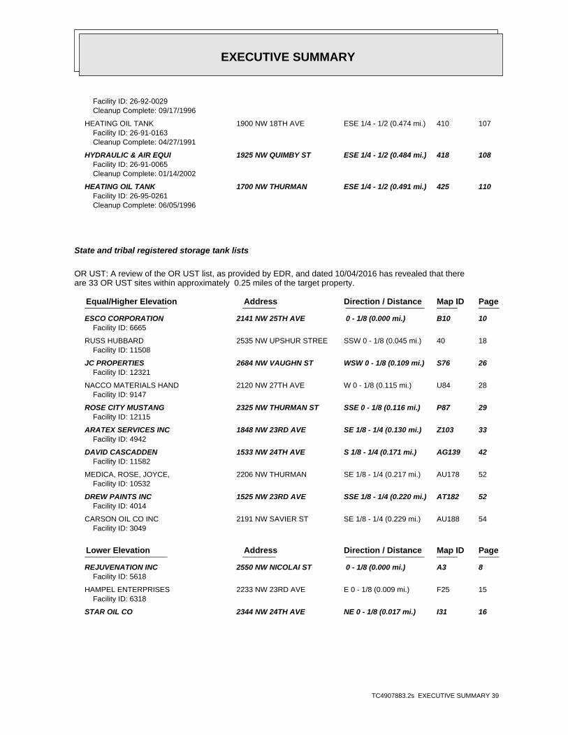
EXECUTIVE SUMMARY
TC4907883.2s EXECUTIVE SUMMARY 39
Facility ID: 26-92-0029Cleanup Complete: 09/17/1996
HEATING OIL TANK 1900 NW 18TH AVE ESE 1/4 - 1/2 (0.474 mi.) 410 107Facility ID: 26-91-0163Cleanup Complete: 04/27/1991
HYDRAULIC & AIR EQUI 1925 NW QUIMBY ST ESE 1/4 - 1/2 (0.484 mi.) 418 108Facility ID: 26-91-0065Cleanup Complete: 01/14/2002
HEATING OIL TANK 1700 NW THURMAN ESE 1/4 - 1/2 (0.491 mi.) 425 110Facility ID: 26-95-0261Cleanup Complete: 06/05/1996
State and tribal registered storage tank lists
OR UST: A review of the OR UST list, as provided by EDR, and dated 10/04/2016 has revealed that thereare 33 OR UST sites within approximately 0.25 miles of the target property.
PageMap IDDirection / Distance Address Equal/Higher Elevation ____________________ ________ ___________________ _____ _____
ESCO CORPORATION 2141 NW 25TH AVE 0 - 1/8 (0.000 mi.) B10 10Facility ID: 6665
RUSS HUBBARD 2535 NW UPSHUR STREE SSW 0 - 1/8 (0.045 mi.) 40 18Facility ID: 11508
JC PROPERTIES 2684 NW VAUGHN ST WSW 0 - 1/8 (0.109 mi.) S76 26Facility ID: 12321
NACCO MATERIALS HAND 2120 NW 27TH AVE W 0 - 1/8 (0.115 mi.) U84 28Facility ID: 9147
ROSE CITY MUSTANG 2325 NW THURMAN ST SSE 0 - 1/8 (0.116 mi.) P87 29Facility ID: 12115
ARATEX SERVICES INC 1848 NW 23RD AVE SE 1/8 - 1/4 (0.130 mi.) Z103 33Facility ID: 4942
DAVID CASCADDEN 1533 NW 24TH AVE S 1/8 - 1/4 (0.171 mi.) AG139 42Facility ID: 11582
MEDICA, ROSE, JOYCE, 2206 NW THURMAN SE 1/8 - 1/4 (0.217 mi.) AU178 52Facility ID: 10532
DREW PAINTS INC 1525 NW 23RD AVE SSE 1/8 - 1/4 (0.220 mi.) AT182 52Facility ID: 4014
CARSON OIL CO INC 2191 NW SAVIER ST SE 1/8 - 1/4 (0.229 mi.) AU188 54Facility ID: 3049
PageMap IDDirection / Distance Address Lower Elevation ____________________ ________ ___________________ _____ _____
REJUVENATION INC 2550 NW NICOLAI ST 0 - 1/8 (0.000 mi.) A3 8Facility ID: 5618
HAMPEL ENTERPRISES 2233 NW 23RD AVE E 0 - 1/8 (0.009 mi.) F25 15Facility ID: 6318
STAR OIL CO 2344 NW 24TH AVE NE 0 - 1/8 (0.017 mi.) I31 16

EXECUTIVE SUMMARY
TC4907883.2s EXECUTIVE SUMMARY 40
Facility ID: 4135
POWER SUBSTATIONS 2425 NW 23RD PL NE 0 - 1/8 (0.048 mi.) J42 19Facility ID: 9495
GILES FUEL 2314 NW 23RD ENE 0 - 1/8 (0.082 mi.) N59 23Facility ID: 6058
ZINDA MECHANICAL 2355 NW 22ND AVE ENE 0 - 1/8 (0.114 mi.) N82 28Facility ID: 9631
AMERITONE PAINT CORP 2100 NW 22ND AVE E 0 - 1/8 (0.116 mi.) T89 29Facility ID: 4052
ABF FREIGHT SYSTEM 2825 NW YEON AVE NNE 1/8 - 1/4 (0.125 mi.) O97 31Facility ID: 5748
JONES OREGON STEVEDO 2323 NW SUFFOLK ST NNE 1/8 - 1/4 (0.138 mi.) 104 33Facility ID: 3709
IMPERIAL PAINT CO IN 2526 NW YEON AVE NE 1/8 - 1/4 (0.146 mi.) 120 37Facility ID: 6549
FEDERAL WAREHOUSE 2760 NW YEON AVE NNE 1/8 - 1/4 (0.152 mi.) AE130 39Facility ID: 3914
RELIANCE ELECTRIC 2315 NW 21ST PL E 1/8 - 1/4 (0.159 mi.) AA133 40Facility ID: 10114
GRIFFITH RUBBER MILL 2249 NW 22ND ENE 1/8 - 1/4 (0.161 mi.) AD134 40Facility ID: 2884
CET ENTERPRISES 2187 NW REED ST ENE 1/8 - 1/4 (0.166 mi.) AD135 41Facility ID: 12127
KEVETY INC 2245 NW NICOLAI STRE NE 1/8 - 1/4 (0.179 mi.) AI143 43Facility ID: 11622
WHITE GMC TRUCKS OF 2705 NW NICOLAI ST WNW 1/8 - 1/4 (0.181 mi.) AJ145 43Facility ID: 7927
ESCO CORPORATION 2770 NW YEON N 1/8 - 1/4 (0.184 mi.) 146 43Facility ID: 6966
UNITED BEER DISTRIBU 2619 NW INDUSTRIAL NW 1/8 - 1/4 (0.195 mi.) AL165 48Facility ID: 8939
CARSON OIL CO INC 2169 NW THURMAN SE 1/8 - 1/4 (0.203 mi.) AQ169 49Facility ID: 5103
SOUTHWEST INDUSTRIAL 2353 NW 21ST AVE ENE 1/8 - 1/4 (0.203 mi.) AM170 50Facility ID: 10263
AMERICAN PACIFIC COR 2320 NW 21ST AVE ENE 1/8 - 1/4 (0.221 mi.) AM183 53Facility ID: 4185
SCHMITT FORGE INC 2765 NW NICOLAI ST W 1/8 - 1/4 (0.222 mi.) AP184 53Facility ID: 10968
COLUMBIA DISTRIBUTIN 2448 NW 28TH AVE WNW 1/8 - 1/4 (0.243 mi.) AZ202 57Facility ID: 5366

EXECUTIVE SUMMARY
TC4907883.2s EXECUTIVE SUMMARY 41
OR AST: A review of the OR AST list, as provided by EDR, and dated 09/01/2016 has revealed that thereare 9 OR AST sites within approximately 0.25 miles of the target property.
PageMap IDDirection / Distance Address Equal/Higher Elevation ____________________ ________ ___________________ _____ _____
ESCO CORPORATION 2141 NW 25TH AVE 0 - 1/8 (0.000 mi.) B10 10Facility Id: 003102
REED ELECTRIC COMPAN 2539 NW VAUGHN 0 - 1/8 (0.000 mi.) B12 11Facility Id: 006476
OIL CAN HENRYS 2016 NW 26TH AVE SW 0 - 1/8 (0.031 mi.) G36 17Facility Id: 117743
REJUVENATION INC 2550 NW NICOLAI ST NW 0 - 1/8 (0.059 mi.) 47 20Facility Id: 068652
ARAMARK UNIFORM SERV 1848 NW 23RD AVE SE 1/8 - 1/4 (0.130 mi.) Z101 32Facility Id: 018967
PageMap IDDirection / Distance Address Lower Elevation ____________________ ________ ___________________ _____ _____
CALBAG METALS COMPAN 2495 NW NICOLAI N 0 - 1/8 (0.006 mi.) D19 13Facility Id: 014174
DEALERS SUPPLY COMPA 2345 NW NICOLAI ST NNE 0 - 1/8 (0.086 mi.) O63 24Facility Id: 014307
KAISER PERMANENTE 2850 NW NICOLAY ST S W 1/8 - 1/4 (0.199 mi.) AP166 48Facility Id: 072461
ESCO CORPORATION 2211 NW BREWER NNE 1/8 - 1/4 (0.209 mi.) AR172 50Facility Id: 003222
State and tribal institutional control / engineering control registries
OR ENG CONTROLS: A review of the OR ENG CONTROLS list, as provided by EDR, and dated 01/01/2017 hasrevealed that there are 3 OR ENG CONTROLS sites within approximately 0.5 miles of the targetproperty.
PageMap IDDirection / Distance Address Lower Elevation ____________________ ________ ___________________ _____ _____
KING-RIES PROPERTY 2550 NW 25TH PL. NW 0 - 1/8 (0.124 mi.) X94 30Site Id: 4560
GUILDS LAKE 2615-2619 NW INDUSTR NNW 1/8 - 1/4 (0.188 mi.) AK148 44Site Id: 404
SFI PROPERTY 2407 NW 28TH AVE. W 1/8 - 1/4 (0.248 mi.) 209 59Site Id: 5103

EXECUTIVE SUMMARY
TC4907883.2s EXECUTIVE SUMMARY 42
OR INST CONTROL: A review of the OR INST CONTROL list, as provided by EDR, and dated 01/01/2017 hasrevealed that there is 1 OR INST CONTROL site within approximately 0.5 miles of the targetproperty.
PageMap IDDirection / Distance Address Lower Elevation ____________________ ________ ___________________ _____ _____
KING-RIES PROPERTY 2550 NW 25TH PL. NW 0 - 1/8 (0.124 mi.) X94 30Site Id: 4560
State and tribal voluntary cleanup sites
OR VCP: A review of the OR VCP list, as provided by EDR, and dated 01/03/2017 has revealed that thereare 17 OR VCP sites within approximately 0.5 miles of the target property.
PageMap IDDirection / Distance Address Equal/Higher Elevation ____________________ ________ ___________________ _____ _____
ROMAINE ELECTRIC 1831 NW 28TH AVE. WSW 1/4 - 1/2 (0.250 mi.) BB211 60ECS Site ID: 6049
PageMap IDDirection / Distance Address Lower Elevation ____________________ ________ ___________________ _____ _____
CALBAG METALS COMPAN 2495 NW NICOLAI N 0 - 1/8 (0.006 mi.) D19 13ECS Site ID: 5059
CALBAG - 2500 NW NIC 2500 NW NICOLAI ST. N 0 - 1/8 (0.006 mi.) D22 14ECS Site ID: 5238
KING-RIES PROPERTY 2550 NW 25TH PL. NW 0 - 1/8 (0.124 mi.) X94 30ECS Site ID: 4560
RELIANCE ELECTRIC IN 2315 NW 21ST PL E 1/8 - 1/4 (0.159 mi.) AA132 40ECS Site ID: 4851
STATES BATTERY CO. 2258 NW SUFFOLK ST NNE 1/8 - 1/4 (0.190 mi.) AN153 45ECS Site ID: 1007
SCHMITT FORGE INC 2765 NW NICOLAI ST W 1/8 - 1/4 (0.222 mi.) AP184 53ECS Site ID: 1347
AMERICAN MACHINE & G 2770 NW INDUSTRIAL WNW 1/4 - 1/2 (0.263 mi.) 222 63ECS Site ID: 2261
PGE - STATION E 2635 NW FRONT AVE. NE 1/4 - 1/2 (0.283 mi.) 233 66ECS Site ID: 3976
ILWU LOCAL 8 2435 NW FRONT AVE ENE 1/4 - 1/2 (0.285 mi.) 237 67ECS Site ID: 5173
PORT OF PORTLAND - T 2500 NW FRONT AVE. ENE 1/4 - 1/2 (0.305 mi.) 255 71ECS Site ID: 3377
DOLAN PROPERTY 2700 NW FRONT AVE. NE 1/4 - 1/2 (0.320 mi.) BW279 76ECS Site ID: 6147
SULZER PUMPS US INC 2800 NW FRONT AVE NNE 1/4 - 1/2 (0.377 mi.) 331 88ECS Site ID: 1235
GALVANIZERS CO. 2406 NW 30TH AVE. W 1/4 - 1/2 (0.391 mi.) CM342 91ECS Site ID: 1196
GENERAL ELECTRIC INT 2727 NW 29TH AVE WNW 1/4 - 1/2 (0.406 mi.) CK355 94

EXECUTIVE SUMMARY
TC4907883.2s EXECUTIVE SUMMARY 43
ECS Site ID: 4003
SULZER PUMPS HOUSTON 2551 NW 30TH AVE WNW 1/4 - 1/2 (0.448 mi.) 392 102ECS Site ID: 146
GRAY’S CRANE 3445 NW FRONT AVE N 1/4 - 1/2 (0.459 mi.) DE402 105ECS Site ID: 4008
State and tribal Brownfields sites
OR BROWNFIELDS: A review of the OR BROWNFIELDS list, as provided by EDR, and dated 11/01/2016 hasrevealed that there is 1 OR BROWNFIELDS site within approximately 0.5 miles of the targetproperty.
PageMap IDDirection / Distance Address Equal/Higher Elevation ____________________ ________ ___________________ _____ _____
ROMAINE ELECTRIC - O 9331 NE COLFAX ST ST WSW 1/4 - 1/2 (0.250 mi.) BB212 60Status: Prospective Purchaser Agreementenvid: 6049
ADDITIONAL ENVIRONMENTAL RECORDS
Local Lists of Landfill / Solid Waste Disposal Sites
OR SWRCY: A review of the OR SWRCY list, as provided by EDR, and dated 11/29/2016 has revealed thatthere is 1 OR SWRCY site within approximately 0.5 miles of the target property.
PageMap IDDirection / Distance Address Lower Elevation ____________________ ________ ___________________ _____ _____
NORTHWEST SHINGLE RE 2345 NW NICOLAI ST NNE 0 - 1/8 (0.086 mi.) O62 23Permit Number: 1525
WA SWRCY: A review of the WA SWRCY list, as provided by EDR, and dated 01/24/2017 has revealed thatthere is 1 WA SWRCY site within approximately 0.5 miles of the target property.
PageMap IDDirection / Distance Address Lower Elevation ____________________ ________ ___________________ _____ _____
QUANTUM RESOURCE REC 2700 NW FRONT AVE NE 1/4 - 1/2 (0.320 mi.) BW278 76
Records of Emergency Release Reports
OR SPILLS: A review of the OR SPILLS list, as provided by EDR, and dated 01/03/2017 has revealed thatthere is 1 OR SPILLS site within approximately 0.001 miles of the target property.

EXECUTIVE SUMMARY
TC4907883.2s EXECUTIVE SUMMARY 44
PageMap IDDirection / Distance Address Equal/Higher Elevation ____________________ ________ ___________________ _____ _____
ESCO CORPORATION 2141 NW 25TH AVE 0 - 1/8 (0.000 mi.) B10 10Facility ID: 2013-1927
Other Ascertainable Records
RCRA NonGen / NLR: A review of the RCRA NonGen / NLR list, as provided by EDR, and dated 12/12/2016has revealed that there are 37 RCRA NonGen / NLR sites within approximately 0.25 miles of the targetproperty.
PageMap IDDirection / Distance Address Equal/Higher Elevation ____________________ ________ ___________________ _____ _____
ELECTRO STATIC REFIN 1938 NW 25TH AVE STE S 0 - 1/8 (0.002 mi.) C17 13 DAILY JOURNAL OF COM 2014 NW 24TH AVE SSE 0 - 1/8 (0.009 mi.) E23 14 PARMAN & ELLIS INC 2546 NW WILSON ST SW 0 - 1/8 (0.013 mi.) G28 16 COMPACTING TECHNOLOG 2417 NW THURMAN ST SSE 0 - 1/8 (0.058 mi.) K45 20 J A FREEMAN & SON 2034 NW 27TH AVE WSW 0 - 1/8 (0.095 mi.) Q68 25 NMHG OREGON INC 2120 NW 27TH AVE W 0 - 1/8 (0.115 mi.) U85 28 ARAMARK UNIFORM SERV 1848 NW 23RD AVE SE 1/8 - 1/4 (0.130 mi.) Z102 33 GAZLEY PLOWMAN ARCHI 2701 NORTHWEST VAUGH WSW 1/8 - 1/4 (0.145 mi.) AB116 36 H NAITO PROPERTIES 2701 NW VAUGHN ST ST WSW 1/8 - 1/4 (0.145 mi.) AB118 36 NACCO MATERIALS HAND 2701 NW VAUGHN STE 9 W 1/8 - 1/4 (0.172 mi.) AB140 42 COLLIER & COMPANY CO 1507 NW 24TH AVE STE S 1/8 - 1/4 (0.195 mi.) AG160 47 ALLIED WORKS ARCHITE 2768 NW THURMAN ST SW 1/8 - 1/4 (0.232 mi.) AX190 55 PPG INDUSTRIES INC 2360 NW QUIMBY SSE 1/8 - 1/4 (0.235 mi.) AS192 55
PageMap IDDirection / Distance Address Lower Elevation ____________________ ________ ___________________ _____ _____
BUSINESS MENS BODY S 2404 NW NICOLAI 0 - 1/8 (0.000 mi.) A1 8 UNITOR SHIP SERVICE 2233 NW 23RD AVE E 0 - 1/8 (0.009 mi.) F27 15 SPECIALTY FINISHES L 2444 NW 24TH AVE NNE 0 - 1/8 (0.017 mi.) A32 17 EVERGREEN HYDRAULICS 2515 NW NICOLAI NNW 0 - 1/8 (0.032 mi.) 37 18 PACIFICA HOME DBA CV 2337 NORTHWEST YORK ENE 0 - 1/8 (0.035 mi.) F38 18 PHIL’S AUTO BODY 2333 NW VAUGHN SE 0 - 1/8 (0.050 mi.) H43 19 FREEMAN GROUP THE FO 2328 NW REED ST NE 0 - 1/8 (0.079 mi.) M57 22 UNITED ELECTRIC INC 2300 NW NICOLAI NE 0 - 1/8 (0.084 mi.) J61 23 ODEQ NICOLAI & YEON NW NICOLAI AT YEON NE 0 - 1/8 (0.087 mi.) J64 24 A T & T CORP 2355 NW 22ND AVE ENE 0 - 1/8 (0.114 mi.) N83 28 AMERITONE PAINT CORP 2100 NW 22ND AVE E 0 - 1/8 (0.116 mi.) T89 29 STEAM SUPPLY & RUBBE 2550 NW 25TH PL NW 0 - 1/8 (0.124 mi.) X93 30 FOAM SPECIALITIES IN 2601 NW NICOLAI ST NW 1/8 - 1/4 (0.129 mi.) Y100 32 IRC ALUMINUM & STAIN 2130 NW YORK E 1/8 - 1/4 (0.143 mi.) AA110 35 MONARCH MACHINE CO 2130 NW YORK E 1/8 - 1/4 (0.143 mi.) AA111 35 MERCER INDUSTRIES - 2636 NORTHWEST 26TH NW 1/8 - 1/4 (0.144 mi.) Y113 35 USDOJ DRUG ENFORCEME 2760 NW YEON AVE NNE 1/8 - 1/4 (0.152 mi.) AE129 39 GAC/FLEXOPREP 2187 NW REED ST ENE 1/8 - 1/4 (0.166 mi.) AD136 41 FAIRMOUNT MINERALS L 2710 NW INDUSTRIAL S NW 1/8 - 1/4 (0.188 mi.) AL150 44 ARCHITECTURAL SIGNIN 2121 NW YORK ST E 1/8 - 1/4 (0.190 mi.) AM151 45 SCHMITT FORGE INC 2765 NW NICOLAI ST W 1/8 - 1/4 (0.222 mi.) AP184 53 EC POWER SYSTEMS 1835 NW 21ST AVE ESE 1/8 - 1/4 (0.235 mi.) AY191 55 CON-WAY INDUSTRIES 1717 NW 21ST AVE SE 1/8 - 1/4 (0.236 mi.) AQ195 56 STUDIO CONCEPTS INC 2448 NW 28TH AVE WNW 1/8 - 1/4 (0.243 mi.) AZ203 58

EXECUTIVE SUMMARY
TC4907883.2s EXECUTIVE SUMMARY 45
TSCA: A review of the TSCA list, as provided by EDR, and dated 12/31/2012 has revealed that there is1 TSCA site within approximately 0.001 miles of the target property.
PageMap IDDirection / Distance Address Equal/Higher Elevation ____________________ ________ ___________________ _____ _____
ESCO CORP 2141 N.W. 25TH AVE. 0 - 1/8 (0.000 mi.) 7 9
TRIS: A review of the TRIS list, as provided by EDR, and dated 12/31/2014 has revealed that there is1 TRIS site within approximately 0.001 miles of the target property.
PageMap IDDirection / Distance Address Equal/Higher Elevation ____________________ ________ ___________________ _____ _____
ESCO CORP 2141 NW 25TH AVE 0 - 1/8 (0.000 mi.) B6 9
ICIS: A review of the ICIS list, as provided by EDR, and dated 11/18/2016 has revealed that there is1 ICIS site within approximately 0.001 miles of the target property.
PageMap IDDirection / Distance Address Equal/Higher Elevation ____________________ ________ ___________________ _____ _____
ESCO CORPORATION 2141 NW 25TH AVE 0 - 1/8 (0.000 mi.) B10 10
FTTS: A review of the FTTS list, as provided by EDR, has revealed that there is 1 FTTS site withinapproximately 0.001 miles of the target property.
PageMap IDDirection / Distance Address Equal/Higher Elevation ____________________ ________ ___________________ _____ _____
ESCO CORPORATION 2141 NW 25TH AVE 0 - 1/8 (0.000 mi.) B10 10Database: FTTS, Date of Government Version: 04/09/2009Database: FTTS INSP, Date of Government Version: 04/09/2009
HIST FTTS: A review of the HIST FTTS list, as provided by EDR, has revealed that there is 1 HIST FTTSsite within approximately 0.001 miles of the target property.
PageMap IDDirection / Distance Address Equal/Higher Elevation ____________________ ________ ___________________ _____ _____
ESCO CORP 2141 NW 25TH AVE 0 - 1/8 (0.000 mi.) B6 9Database: HIST FTTS INSP, Date of Government Version: 10/19/2006Database: HIST FTTS, Date of Government Version: 10/19/2006
US AIRS: A review of the US AIRS list, as provided by EDR, has revealed that there is 1 US AIRS site within approximately 0.001 miles of the target property.
PageMap IDDirection / Distance Address Equal/Higher Elevation ____________________ ________ ___________________ _____ _____
ESCO CORPORATION 2141 NW 25TH AVE 0 - 1/8 (0.000 mi.) B10 10Database: US AIRS (AFS), Date of Government Version: 10/12/2016

EXECUTIVE SUMMARY
TC4907883.2s EXECUTIVE SUMMARY 46
FINDS: A review of the FINDS list, as provided by EDR, and dated 07/15/2016 has revealed that thereare 5 FINDS sites within approximately 0.001 miles of the target property.
PageMap IDDirection / Distance Address Equal/Higher Elevation ____________________ ________ ___________________ _____ _____
ESCO CORPORATION 2141 NW 25TH AVE 0 - 1/8 (0.000 mi.) B10 10 SCHILLER & VROMAN IN 2480 NW VAUGHN 0 - 1/8 (0.000 mi.) C11 11 REED ELECTRIC CO 2539 NW VAUGHN ST 0 - 1/8 (0.000 mi.) B15 12
PageMap IDDirection / Distance Address Lower Elevation ____________________ ________ ___________________ _____ _____
BUSINESS MENS BODY S 2404 NW NICOLAI 0 - 1/8 (0.000 mi.) A1 8 REJUVENATION INC 2550 NW NICOLAI ST 0 - 1/8 (0.000 mi.) A3 8
OR AIRS: A review of the OR AIRS list, as provided by EDR, and dated 12/31/2014 has revealed thatthere is 1 OR AIRS site within approximately 0.001 miles of the target property.
PageMap IDDirection / Distance Address Equal/Higher Elevation ____________________ ________ ___________________ _____ _____
ESCO CORPORATION 2141 NW 25TH AVE 0 - 1/8 (0.000 mi.) B10 10Source ID: 262068Source ID: 26-2068
OR DRYCLEANERS: A review of the OR DRYCLEANERS list, as provided by EDR, and dated 05/02/2016 hasrevealed that there are 2 OR DRYCLEANERS sites within approximately 0.25 miles of the targetproperty.
PageMap IDDirection / Distance Address Equal/Higher Elevation ____________________ ________ ___________________ _____ _____
T.S. CLEANERS 2346 NW THURMAN ST SSE 0 - 1/8 (0.111 mi.) P79 27Current Status: DCDry Cleaner ID: 324
VERIZON WIRELESS 2701 NW VAUGHN ST WSW 1/8 - 1/4 (0.145 mi.) AB119 37Current Status: CLDry Cleaner ID: 670
CA HAZNET: A review of the CA HAZNET list, as provided by EDR, and dated 12/31/2015 has revealed thatthere are 2 CA HAZNET sites within approximately 0.001 miles of the target property.
PageMap IDDirection / Distance Address Equal/Higher Elevation ____________________ ________ ___________________ _____ _____
SCHILLER & VROMAN, I 2480 NW VAUGHN 0 - 1/8 (0.000 mi.) C5 9GEPAID: ORD987196995
PageMap IDDirection / Distance Address Lower Elevation ____________________ ________ ___________________ _____ _____
REJUVENATION INC 2550 NW NICOLAI ST 0 - 1/8 (0.000 mi.) A3 8

EXECUTIVE SUMMARY
TC4907883.2s EXECUTIVE SUMMARY 47
OR HSIS: A review of the OR HSIS list, as provided by EDR, and dated 09/01/2016 has revealed thatthere are 2 OR HSIS sites within approximately 0.001 miles of the target property.
PageMap IDDirection / Distance Address Equal/Higher Elevation ____________________ ________ ___________________ _____ _____
ESCO CORPORATION 2141 NW 25TH AVE 0 - 1/8 (0.000 mi.) B10 10Facility Id: 003102
REED ELECTRIC COMPAN 2539 NW VAUGHN 0 - 1/8 (0.000 mi.) B12 11Facility Id: 006476
OR MANIFEST: A review of the OR MANIFEST list, as provided by EDR, and dated 12/31/2015 has revealedthat there are 14 OR MANIFEST sites within approximately 0.25 miles of the target property.
PageMap IDDirection / Distance Address Equal/Higher Elevation ____________________ ________ ___________________ _____ _____
ESCO CORPORATION 2141 NW 25TH AVE 0 - 1/8 (0.000 mi.) B10 10Status: SQGStatus: Small quantity generatorEPA Id: ORD009028259
SCHILLER & VROMAN IN 2480 NW VAUGHN 0 - 1/8 (0.000 mi.) C11 11Status: SQGStatus: Small quantity generatorEPA Id: ORD987196995
REED ELECTRIC CO 2539 NW VAUGHN ST 0 - 1/8 (0.000 mi.) B15 12Status: CEGEPA Id: ORD009419235
J A FREEMAN & SON 2034 NW 27TH AVE WSW 0 - 1/8 (0.095 mi.) Q68 25Status: CEGEPA Id: ORD009033671
KAISER MONTGOMERY PA 2701 NW VAUGHN ST ST WSW 1/8 - 1/4 (0.145 mi.) AB117 36Status: CEGStatus: Conditionally exempt generatorEPA Id: ORQ000002576
COLLIER & COMPANY CO 1507 NW 24TH AVE STE S 1/8 - 1/4 (0.195 mi.) AG162 47Status: CEGEPA Id: ORQ000017921
PageMap IDDirection / Distance Address Lower Elevation ____________________ ________ ___________________ _____ _____
REJUVENATION INC 2550 NW NICOLAI ST 0 - 1/8 (0.000 mi.) A3 8Status: LQGStatus: SQGStatus: Large quantity generatorStatus: Small quantity generatorEPA Id: ORD982659500
KELLY CABINET CO 2624 NW 26TH AVE NW 1/8 - 1/4 (0.140 mi.) Y107 34Status: SQGStatus: Small quantity generatorEPA Id: ORQ000015578
RELIANCE ELECTRIC IN 2315 NW 21ST PL E 1/8 - 1/4 (0.159 mi.) AA132 40

EXECUTIVE SUMMARY
TC4907883.2s EXECUTIVE SUMMARY 48
Status: LQGStatus: CEGStatus: SQGStatus: Small quantity generatorStatus: Large quantity generatorStatus: Conditionally exempt generatorEPA Id: ORD096989827
FAIRMOUNT MINERALS L 2710 NW INDUSTRIAL S NW 1/8 - 1/4 (0.188 mi.) AL150 44Status: LQGStatus: Large quantity generatorEPA Id: ORQ000024004
ARCHITECTURAL SIGNIN 2121 NW YORK ST E 1/8 - 1/4 (0.190 mi.) AM151 45Status: SQGStatus: CEGStatus: Small quantity generatorStatus: Conditionally exempt generatorEPA Id: ORQ000024856
CITY OF PORTLAND - G 2615 THRU 2619 NW IN NW 1/8 - 1/4 (0.195 mi.) AL163 48Status: LQGStatus: Large quantity generatorEPA Id: ORQ000029740
GRIFFITH RUBBER MILL 2625 NW INDUSTRIAL A NW 1/8 - 1/4 (0.201 mi.) AL167 49Status: CEGEPA Id: ORD009027491
ESCO CORPORATION 2211 NW BREWER NNE 1/8 - 1/4 (0.209 mi.) AR172 50Status: CEGStatus: SQGStatus: Conditionally exempt generatorStatus: Small quantity generatorEPA Id: ORD987173184
NY MANIFEST: A review of the NY MANIFEST list, as provided by EDR, and dated 01/30/2017 has revealedthat there is 1 NY MANIFEST site within approximately 0.25 miles of the target property.
PageMap IDDirection / Distance Address Lower Elevation ____________________ ________ ___________________ _____ _____
COLOR TECHNOLOGY INC 2455 NW NICOLAI ST N 0 - 1/8 (0.082 mi.) 58 22EPA ID: ORQ000000968
OR UIC: A review of the OR UIC list, as provided by EDR, and dated 12/28/2016 has revealed that thereis 1 OR UIC site within approximately 0.001 miles of the target property.
PageMap IDDirection / Distance Address Equal/Higher Elevation ____________________ ________ ___________________ _____ _____
ESCO CORPORATION 2141 NW 25TH AVE 0 - 1/8 (0.000 mi.) B10 10

EXECUTIVE SUMMARY
TC4907883.2s EXECUTIVE SUMMARY 49
ECHO: A review of the ECHO list, as provided by EDR, and dated 12/11/2016 has revealed that there are5 ECHO sites within approximately 0.001 miles of the target property.
PageMap IDDirection / Distance Address Equal/Higher Elevation ____________________ ________ ___________________ _____ _____
ESCO CORPORATION 2141 NW 25TH AVE 0 - 1/8 (0.000 mi.) B10 10 SCHILLER & VROMAN IN 2480 NW VAUGHN 0 - 1/8 (0.000 mi.) C11 11 REED ELECTRIC CO 2539 NW VAUGHN ST 0 - 1/8 (0.000 mi.) B15 12
PageMap IDDirection / Distance Address Lower Elevation ____________________ ________ ___________________ _____ _____
BUSINESS MENS BODY S 2404 NW NICOLAI 0 - 1/8 (0.000 mi.) A1 8 REJUVENATION INC 2550 NW NICOLAI ST 0 - 1/8 (0.000 mi.) A3 8
EDR HIGH RISK HISTORICAL RECORDS
EDR Exclusive Records
EDR Hist Auto: A review of the EDR Hist Auto list, as provided by EDR, has revealed that there are 19EDR Hist Auto sites within approximately 0.125 miles of the target property.
PageMap IDDirection / Distance Address Equal/Higher Elevation ____________________ ________ ___________________ _____ _____
PACIFIC AUTO PARTS C 2509 NW VAUGHN 0 - 1/8 (0.000 mi.) B8 9Database: EDR Hist Auto, Date of Government Version: 02/20/2007
REED ELECTRIC CO 2539 NW VAUGHN 0 - 1/8 (0.000 mi.) B13 12Database: EDR Hist Auto, Date of Government Version: 02/20/2007
CENTENNIAL CASH AND 2575 NW VAUGHN SW 0 - 1/8 (0.020 mi.) G34 17Database: EDR Hist Auto, Date of Government Version: 02/20/2007
LAMPE A D 2429 NW THURMAN S 0 - 1/8 (0.052 mi.) K44 19Database: EDR Hist Auto, Date of Government Version: 02/20/2007
COPEL CHAS 1915 NW 26TH AVE SW 0 - 1/8 (0.067 mi.) L51 21Database: EDR Hist Auto, Date of Government Version: 02/20/2007
CLERIN GUS P 2685 NW VAUGHN WSW 0 - 1/8 (0.096 mi.) Q71 25Database: EDR Hist Auto, Date of Government Version: 02/20/2007
FORESTRY AUTO REPAIR 2024 NW 27TH AVE WSW 0 - 1/8 (0.099 mi.) Q72 26Database: EDR Hist Auto, Date of Government Version: 02/20/2007
WARDWAY GARAGE 2662 NW VAUGHN SW 0 - 1/8 (0.102 mi.) S73 26Database: EDR Hist Auto, Date of Government Version: 02/20/2007
BRADFORD MERRICK E 2684 NW VAUGHN WSW 0 - 1/8 (0.109 mi.) S77 27Database: EDR Hist Auto, Date of Government Version: 02/20/2007
CLASSIC MOTORWORKS 2335 NW THURMAN ST SSE 0 - 1/8 (0.113 mi.) P81 27Database: EDR Hist Auto, Date of Government Version: 02/20/2007
CRUM PAUL L 2704 NW VAUGHN WSW 0 - 1/8 (0.116 mi.) S86 28Database: EDR Hist Auto, Date of Government Version: 02/20/2007
WEST OREGON GARAGE 2325 NW THURMAN SSE 0 - 1/8 (0.116 mi.) P88 29Database: EDR Hist Auto, Date of Government Version: 02/20/2007
POWELL HUGH CHEVRON 2714 NW VAUGHN WSW 0 - 1/8 (0.124 mi.) Q95 31Database: EDR Hist Auto, Date of Government Version: 02/20/2007

EXECUTIVE SUMMARY
TC4907883.2s EXECUTIVE SUMMARY 50
PageMap IDDirection / Distance Address Equal/Higher Elevation ____________________ ________ ___________________ _____ _____
LINDLEY TIME SERVICE 2600 NW THURMAN SSW 0 - 1/8 (0.124 mi.) R96 31Database: EDR Hist Auto, Date of Government Version: 02/20/2007
PageMap IDDirection / Distance Address Lower Elevation ____________________ ________ ___________________ _____ _____
BUSINESS MEN S BODY 2404 NW NICOLAI ST 0 - 1/8 (0.000 mi.) A2 8Database: EDR Hist Auto, Date of Government Version: 02/20/2007
Not reported 2233 NW 23RD AVE E 0 - 1/8 (0.009 mi.) F24 15 RICE C A FINA SERVIC 2315 NW VAUGHN ST SE 0 - 1/8 (0.064 mi.) 49 21
Database: EDR Hist Auto, Date of Government Version: 02/20/2007
BOB S ASSOCIATED SER 2330 NW NICOLAI NE 0 - 1/8 (0.065 mi.) J50 21Database: EDR Hist Auto, Date of Government Version: 02/20/2007
WOLFORD MOTOR CO 2285 NW VAUGHN ESE 0 - 1/8 (0.102 mi.) 74 26Database: EDR Hist Auto, Date of Government Version: 02/20/2007
EDR Hist Cleaner: A review of the EDR Hist Cleaner list, as provided by EDR, has revealed that thereare 7 EDR Hist Cleaner sites within approximately 0.125 miles of the target property.
PageMap IDDirection / Distance Address Equal/Higher Elevation ____________________ ________ ___________________ _____ _____
Not reported 2436 NW THURMAN ST S 0 - 1/8 (0.062 mi.) K48 20 VAUGHN STREET LAUNDE 2608 NW VAUGHN ST SW 0 - 1/8 (0.067 mi.) L52 21
Database: EDR Hist Cleaner, Date of Government Version: 02/20/2007
INDEPENDENT DRY CLEA 1911 NW 26TH AVE SW 0 - 1/8 (0.069 mi.) L53 21Database: EDR Hist Cleaner, Date of Government Version: 02/20/2007
LARRY S CLEANERS 2400 NW THURMAN SSE 0 - 1/8 (0.079 mi.) K56 22Database: EDR Hist Cleaner, Date of Government Version: 02/20/2007
NORTHWEST CLEANERS 2390 NW THURMAN ST SSE 0 - 1/8 (0.092 mi.) P67 24Database: EDR Hist Cleaner, Date of Government Version: 02/20/2007
Not reported 2573 NW THURMAN ST SSW 0 - 1/8 (0.095 mi.) R69 25 Not reported 2346 NW THURMAN ST SSE 0 - 1/8 (0.111 mi.) P78 27
EDR RECOVERED GOVERNMENT ARCHIVES
Exclusive Recovered Govt. Archives
OR RGA HWS: A review of the OR RGA HWS list, as provided by EDR, has revealed that there are 2 OR RGAHWS sites within approximately 0.001 miles of the target property.
PageMap IDDirection / Distance Address Equal/Higher Elevation ____________________ ________ ___________________ _____ _____
ESCO PLANT #3 2141 NW 25TH AVE 0 - 1/8 (0.000 mi.) B9 10 ESCO PLANT #3 2141 NW 25TH AVE. 0 - 1/8 (0.000 mi.) B14 12
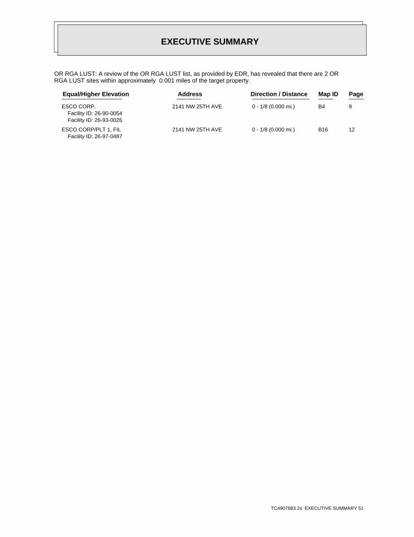
EXECUTIVE SUMMARY
TC4907883.2s EXECUTIVE SUMMARY 51
OR RGA LUST: A review of the OR RGA LUST list, as provided by EDR, has revealed that there are 2 ORRGA LUST sites within approximately 0.001 miles of the target property.
PageMap IDDirection / Distance Address Equal/Higher Elevation ____________________ ________ ___________________ _____ _____
ESCO CORP. 2141 NW 25TH AVE 0 - 1/8 (0.000 mi.) B4 9Facility ID: 26-90-0054Facility ID: 26-93-0026
ESCO CORP/PLT 1, FIL 2141 NW 25TH AVE 0 - 1/8 (0.000 mi.) B16 12Facility ID: 26-97-0487

ED
R Inc.
ED
R Inc.
ED
R Inc.
ED
R Inc.
ED
R Inc.
ED
R Inc.
ED
R Inc.
ED
R Inc.
ED
R Inc.
ED
R Inc.
ED
R Inc.
ED
R Inc.
ED
R Inc.
ED
R Inc.
ED
R Inc.
ED
R Inc.
ED
R Inc.
ED
R Inc.
ED
R Inc.
ED
R Inc.
ED
R Inc.
ED
R Inc.
ED
R Inc.
ED
R Inc.
ED
R Inc.
ED
R Inc.
ED
R Inc.
ED
R Inc.
ED
R Inc.
ED
R Inc.
ED
R Inc.
ED
R Inc.
ED
R Inc.
ED
R Inc.
ED
R Inc.
ED
R Inc.
ED
R Inc.
ED
R Inc.
ED
R Inc.
ED
R Inc.
ORPHAN SUMMARY
City EDR ID Site Name Site Address Zip Database(s)
Count: 11 records.
PORTLAND 1006854291 ODOT - SURPLUS PROPERTY NW 22ND AVE AT YORK 97210 OR CRL, OR ECSI, OR INSTCONTROL, OR VCP, FINDS
PORTLAND S102520938 HEATING OIL TANK 1223 NW 24TH 97210 OR LUSTPORTLAND U000432417 USWEST - 24TH RALEIGH SOC - 010591 1600 NW 24TH 97210 OR LUST, OR USTPORTLAND S105075929 HEATING OIL TANK 912 NW 24TH 97210 OR LUSTPORTLAND S110072106 TRI-MET SOUTH CORRIDOR EXTENSION ADJACENT TO I-205, BETWEEN NE OR ECSI, OR VCPPORTLAND S106497099 COLUMBIA SLOUGH 31.5 MILES OF WATERWAY OVER AN OR CRL, OR ECSI, OR ENG CONTROPORTLAND S107421141 EAST SIDE CSO NEAR SE 18TH & MCLOUGHLIN TO N OR ECSI, OR VCPPORTLAND S106497104 V.A.- COLUMBIA SOUTH SHORE WELLFIE N OF COLUMBIA/SANDY BLVDS. BET OR ECSIPORTLAND S111429244 HOYT STREET RAILYARD (FORMER) NORTH OF LOVEJOY BTWN NW 9TH & 97209 OR CRL, OR ECSI, OR ENG
CONTROLS, OR INST CONTROL, ORBROWNFIELDS
PORTLAND S102959622 WILLIAMS, HOMER TAX LOT #4, BLOCK 2&5 OF CORNE 97229 OR LUSTPORTLAND S106778143 WILLAMETTE RIVER WESTSIDE CSO CONS TAYLORS FERRY RD. N ALONG NW F OR ECSI, OR VCP
TC4907883.2s Page 1513

EDR Inc.EDR Inc.EDR Inc.EDR Inc.EDR Inc.EDR Inc.EDR Inc.EDR Inc.EDR Inc.EDR Inc.EDR Inc.EDR Inc.EDR Inc.EDR Inc.EDR Inc.EDR Inc.EDR Inc.EDR Inc.EDR Inc.EDR Inc.EDR Inc.EDR Inc.EDR Inc.EDR Inc.EDR Inc.EDR Inc.EDR Inc.EDR Inc.EDR Inc.EDR Inc.EDR Inc.EDR Inc.EDR Inc.EDR Inc.EDR Inc.EDR Inc.EDR Inc.EDR Inc.EDR Inc.EDR Inc.
57 kV
115 kV
1 60
00
1 20
3 60
1 6 0
1 6 0
10
00
9 6 09 60
9 2 0
9 2 0
80
8 8 08 8 0
8 4 0
8 4 0
8 0 0
8 0 0
7 6 0
76 0
7 6 0
7 2 0
72 0
7 2 0
0
7 2 0
6 8 0
6 80
6 8 0
68
0
6 4 0
6 4 0
6 4 0
6 40
6
0 0
6 0 0
6 0 06 0 0
6 0 0
5 6 0
5 6 0
5 6 0
5 6 0
5 6 0
5 2 0
5 20
52
0
5 2 0
52
0
4 8 0
4 8 0
4 8 0
0
4 8 0
48
0
44
0
4 4 0
44
0
4 4 04 4 0
44
0
44
0
40
0
4 0 0
4 0 0
00
4
00
40
0
3
3 6 0
3 6 0
3 6 0
36
0
3 60
3 2 0
3 20
3 2 03 2 0
32
0
3 20
0
2 8 0
2 80
2 8 0
28
0
24
0
2 4 0
2 4 0
2 40
24
0
20
0
2 0 0
2
0 0
2 00
1 6 0
16
0
16
0
1 6 0
12
0
1 2 0
12
0
80
80
8 0
8 0
40
40
40
4 0
4 0
40
40
4 0
80
8 01
20
1 2 0

EDR Inc.EDR Inc.EDR Inc.EDR Inc.EDR Inc.EDR Inc.EDR Inc.EDR Inc.EDR Inc.EDR Inc.EDR Inc.EDR Inc.EDR Inc.EDR Inc.EDR Inc.EDR Inc.EDR Inc.EDR Inc.EDR Inc.EDR Inc.EDR Inc.EDR Inc.EDR Inc.EDR Inc.EDR Inc.EDR Inc.EDR Inc.EDR Inc.EDR Inc.EDR Inc.EDR Inc.EDR Inc.EDR Inc.EDR Inc.EDR Inc.EDR Inc.EDR Inc.EDR Inc.EDR Inc.EDR Inc.
115 kV
120
200
120
80
40

EDR Inc.EDR Inc.EDR Inc.EDR Inc.EDR Inc.EDR Inc.EDR Inc.EDR Inc.EDR Inc.EDR Inc.EDR Inc.EDR Inc.EDR Inc.EDR Inc.EDR Inc.EDR Inc.EDR Inc.EDR Inc.EDR Inc.EDR Inc.EDR Inc.EDR Inc.EDR Inc.EDR Inc.EDR Inc.EDR Inc.EDR Inc.EDR Inc.EDR Inc.EDR Inc.EDR Inc.EDR Inc.EDR Inc.EDR Inc.EDR Inc.EDR Inc.EDR Inc.EDR Inc.EDR Inc.EDR Inc.
MAP FINDINGS SUMMARY
SearchTargetDistance Total
Database Property(Miles) < 1/8 1/8 - 1/4 1/4 - 1/2 1/2 - 1 > 1 Plotted
STANDARD ENVIRONMENTAL RECORDS
Federal NPL site list
0 NR 0 0 0 0 1.000NPL 0 NR 0 0 0 0 1.000Proposed NPL 0 NR NR NR NR 0 0.001NPL LIENS
Federal Delisted NPL site list
0 NR 0 0 0 0 1.000Delisted NPL
Federal CERCLIS list
0 NR NR 0 0 0 0.500FEDERAL FACILITY 0 NR NR 0 0 0 0.500SEMS
Federal CERCLIS NFRAP site list
5 NR NR 2 2 1 0.500SEMS-ARCHIVE
Federal RCRA CORRACTS facilities list
0 NR 0 0 0 0 1.000CORRACTS
Federal RCRA non-CORRACTS TSD facilities list
0 NR NR 0 0 0 0.500RCRA-TSDF
Federal RCRA generators list
2 NR NR NR 1 1 0.250RCRA-LQG 3 NR NR NR 1 2 0.250RCRA-SQG 17 NR NR NR 12 5 0.250RCRA-CESQG
Federal institutional controls /engineering controls registries
0 NR NR 0 0 0 0.500LUCIS 0 NR NR 0 0 0 0.500US ENG CONTROLS 0 NR NR 0 0 0 0.500US INST CONTROL
Federal ERNS list
0 NR NR NR NR 0 0.001ERNS
State- and tribal - equivalent CERCLIS
16 NR 11 2 2 1 1.000OR CRL 62 NR 33 15 9 5 1.000OR ECSI
State and tribal landfill and/orsolid waste disposal site lists
1 NR NR 0 0 1 0.500OR SWF/LF 2 NR NR 1 0 1 0.500WA SWF/LF
State and tribal leaking storage tank lists
293 NR NR 206 64 23 0.500OR LUST 0 NR NR 0 0 0 0.500INDIAN LUST
TC4907883.2s Page 4

MAP FINDINGS SUMMARY
SearchTargetDistance Total
Database Property(Miles) < 1/8 1/8 - 1/4 1/4 - 1/2 1/2 - 1 > 1 Plotted
State and tribal registered storage tank lists
0 NR NR NR 0 0 0.250FEMA UST 33 NR NR NR 21 12 0.250OR UST 9 NR NR NR 3 6 0.250OR AST 0 NR NR NR 0 0 0.250INDIAN UST
State and tribal institutionalcontrol / engineering control registries
3 NR NR 0 2 1 0.500OR ENG CONTROLS 1 NR NR 0 0 1 0.500OR INST CONTROL
State and tribal voluntary cleanup sites
17 NR NR 11 3 3 0.500OR VCP 0 NR NR 0 0 0 0.500INDIAN VCP
State and tribal Brownfields sites
1 NR NR 1 0 0 0.500OR BROWNFIELDS
ADDITIONAL ENVIRONMENTAL RECORDS
Local Brownfield lists
0 NR NR 0 0 0 0.500US BROWNFIELDS
Local Lists of Landfill / SolidWaste Disposal Sites
1 NR NR 0 0 1 0.500OR SWRCY 0 NR NR 0 0 0 0.500OR HIST LF 1 NR NR 1 0 0 0.500WA SWRCY 0 NR NR 0 0 0 0.500INDIAN ODI 0 NR NR 0 0 0 0.500ODI 0 NR NR 0 0 0 0.500DEBRIS REGION 9 0 NR NR 0 0 0 0.500IHS OPEN DUMPS
Local Lists of Hazardous waste /Contaminated Sites
0 NR 0 0 0 0 1.000OR AOCONCERN 0 NR NR NR NR 0 0.001US HIST CDL 0 NR NR NR NR 0 0.001OR CDL 0 NR NR NR NR 0 0.001US CDL
Local Land Records
0 NR NR NR NR 0 0.001LIENS 2
Records of Emergency Release Reports
0 NR NR NR NR 0 0.001HMIRS 1 NR NR NR NR 1 0.001OR SPILLS 0 NR NR NR NR 0 0.001OR HAZMAT 0 NR NR NR NR 0 0.001OR SPILLS 90
Other Ascertainable Records
37 NR NR NR 19 18 0.250RCRA NonGen / NLR
TC4907883.2s Page 5

MAP FINDINGS SUMMARY
SearchTargetDistance Total
Database Property(Miles) < 1/8 1/8 - 1/4 1/4 - 1/2 1/2 - 1 > 1 Plotted
0 NR 0 0 0 0 1.000FUDS 0 NR 0 0 0 0 1.000DOD 0 NR NR 0 0 0 0.500SCRD DRYCLEANERS 0 NR NR NR NR 0 0.001US FIN ASSUR 0 NR NR NR NR 0 0.001EPA WATCH LIST 0 NR NR NR 0 0 0.2502020 COR ACTION 1 NR NR NR NR 1 0.001TSCA 1 NR NR NR NR 1 0.001TRIS 0 NR NR NR NR 0 0.001SSTS 0 NR 0 0 0 0 1.000ROD 0 NR NR NR NR 0 0.001RMP 0 NR NR NR NR 0 0.001RAATS 0 NR NR NR NR 0 0.001PRP 0 NR NR NR NR 0 0.001PADS 1 NR NR NR NR 1 0.001ICIS 1 NR NR NR NR 1 0.001FTTS 0 NR NR NR NR 0 0.001MLTS 0 NR NR NR NR 0 0.001COAL ASH DOE 0 NR NR 0 0 0 0.500COAL ASH EPA 0 NR NR NR NR 0 0.001PCB TRANSFORMER 0 NR NR NR NR 0 0.001RADINFO 1 NR NR NR NR 1 0.001HIST FTTS 0 NR NR NR NR 0 0.001DOT OPS 0 NR 0 0 0 0 1.000CONSENT 0 NR NR NR NR 0 0.001INDIAN RESERV 0 NR 0 0 0 0 1.000FUSRAP 0 NR NR 0 0 0 0.500UMTRA 0 NR NR NR NR 0 0.001LEAD SMELTERS 1 NR NR NR NR 1 0.001US AIRS 0 NR NR NR 0 0 0.250US MINES 5 NR NR NR NR 5 0.001FINDS 0 NR 0 0 0 0 1.000UXO 0 NR NR NR NR 0 0.001DOCKET HWC 1 NR NR NR NR 1 0.001OR AIRS 0 NR NR 0 0 0 0.500OR COAL ASH 2 NR NR NR 1 1 0.250OR DRYCLEANERS 0 NR NR NR NR 0 0.001OR Financial Assurance 2 NR NR NR NR 2 0.001CA HAZNET 2 NR NR NR NR 2 0.001OR HSIS 14 NR NR NR 9 5 0.250OR MANIFEST 1 NR NR NR 0 1 0.250NY MANIFEST 0 NR NR NR NR 0 0.001OR NPDES 1 NR NR NR NR 1 0.001OR UIC 5 NR NR NR NR 5 0.001ECHO 0 NR NR NR NR 0 0.001ABANDONED MINES 0 NR NR NR 0 0 0.250FUELS PROGRAM
EDR HIGH RISK HISTORICAL RECORDS
EDR Exclusive Records
0 NR 0 0 0 0 1.000EDR MGP
TC4907883.2s Page 6

MAP FINDINGS SUMMARY
SearchTargetDistance Total
Database Property(Miles) < 1/8 1/8 - 1/4 1/4 - 1/2 1/2 - 1 > 1 Plotted
19 NR NR NR NR 19 0.125EDR Hist Auto 7 NR NR NR NR 7 0.125EDR Hist Cleaner
EDR RECOVERED GOVERNMENT ARCHIVES
Exclusive Recovered Govt. Archives
2 NR NR NR NR 2 0.001OR RGA HWS 0 NR NR NR NR 0 0.001OR RGA LF 2 NR NR NR NR 2 0.001OR RGA LUST
574 0 44 239 149 142 0- Totals --
NOTES:
TP = Target Property
NR = Not Requested at this Search Distance
Sites may be listed in more than one database
TC4907883.2s Page 7

TC4907883.2s Page 8
A3 RCRA-LQGREJUVENATION INC 1000379188OR UST2550 NW NICOLAI ST ORD982659500
< 1/8 FINDSPORTLAND, OR 97210
Relative:Lower
Click here for full text details
1 ft. CA HAZNETOR MANIFEST
ECHO
RCRA-LQG EPA Id: ORD982659500
OR UST Facility ID: 5618
FINDS Registry ID:: 110001659562
CA HAZNET GEPAID: ORD982659500
OR MANIFEST Status: Small quantity generator Status: Large quantity generator EPA Id: ORD982659500 Status: LQG Status: SQG
A2 EDR Hist AutoBUSINESS MEN S BODY SHOP 10094899702404 NW NICOLAI ST N/A
< 1/8 PORTLAND, OR
Relative:Lower
Click here for full text details
1 ft.
A1 RCRA NonGen / NLRBUSINESS MENS BODY SHOP 1000256669FINDS2404 NW NICOLAI ORD177076197
< 1/8 ECHOPORTLAND, OR 97210
Relative:Lower
Click here for full text details
1 ft.
RCRA NonGen / NLR EPA Id: ORD177076197
FINDS Registry ID:: 110004789453
MAP FINDINGSMap IDDirection
EDR ID NumberDistanceEPA ID NumberDatabase(s)SiteElevation

TC4907883.2s Page 9
B8 EDR Hist AutoPACIFIC AUTO PARTS CO 10094901192509 NW VAUGHN N/A
< 1/8 PORTLAND, OR
Relative:Higher
Click here for full text details
1 ft.
7 TSCAESCO CORP 10169492052141 N.W. 25TH AVE. N/A
< 1/8 PORTLAND, OR 97210
Relative:Higher
Click here for full text details
1 ft.
B6 TRISESCO CORP 1009514181HIST FTTS2141 NW 25TH AVE 97210SCCRP2141N
< 1/8 PORTLAND, OR 97210
Relative:Higher
Click here for full text details
1 ft.
TRIS TRIS ID: 97210SCCRP2141N
HIST FTTS Close Date:: / / Docket Number:: 1089-04-09-325 Docket Number:: 1090-03-03-2615
C5 CA HAZNETSCHILLER & VROMAN, INC S1131854502480 NW VAUGHN N/A
< 1/8 PORTLAND, OR 97210
Relative:Higher
Click here for full text details
1 ft.
CA HAZNET GEPAID: ORD987196995
B4 OR RGA LUSTESCO CORP. S1153646142141 NW 25TH AVE N/A
< 1/8 PORTLAND, OR
Relative:Higher
Click here for full text details
1 ft.
OR RGA LUST Facility ID: 26-90-0054 Facility ID: 26-93-0026
MAP FINDINGSMap IDDirection
EDR ID NumberDistanceEPA ID NumberDatabase(s)SiteElevation

TC4907883.2s Page 10
B10 RCRA-SQGESCO CORPORATION 1000324911OR ECSI2141 NW 25TH AVE ORD009028259
< 1/8 OR LUSTPORTLAND, OR 97210
Relative:Higher
Click here for full text details
1 ft. OR USTOR AST
OR SPILLSICIS
FTTSUS AIRS
FINDSOR AIRSOR HSIS
OR MANIFESTOR UIC
ECHO
RCRA-SQG EPA Id: ORD009028259
OR ECSI State ID Number: 112 Investigation: Suspect
OR LUST Facility ID: 26-90-0054 Facility ID: 26-93-0026 Facility ID: 26-97-0487 Cleanup Complete: 02/24/1990 Cleanup Complete: 05/15/1996 Cleanup Complete: 07/13/2000
OR UST Facility ID: 6665
OR AST Facility Id: 003102
OR SPILLS Facility ID: 2013-1927
ICIS FRS ID:: 110000487394
FTTS
B9 OR RGA HWSESCO PLANT #3 S1153332682141 NW 25TH AVE N/A
< 1/8 PORTLAND, OR
Relative:Higher
Click here for full text details
1 ft.
MAP FINDINGSMap IDDirection
EDR ID NumberDistanceEPA ID NumberDatabase(s)SiteElevation

TC4907883.2s Page 11
B12 OR ASTREED ELECTRIC COMPANY S104333851OR HSIS2539 NW VAUGHN N/A
< 1/8 PORTLAND, OR 97210
Relative:Higher
Click here for full text details
1 ft.
OR AST Facility Id: 006476
C11 RCRA-SQGSCHILLER & VROMAN INC 1000695029FINDS2480 NW VAUGHN ORD987196995
< 1/8 OR MANIFESTPORTLAND, OR 97210
Relative:Higher
Click here for full text details
1 ft. ECHO
RCRA-SQG EPA Id: ORD987196995
FINDS Registry ID:: 110004805408
OR MANIFEST Status: Small quantity generator EPA Id: ORD987196995 Status: SQG
ESCO CORPORATION (Continued) 1000324911
Docket Number:: 1089-04-09-325 Docket Number:: 1090-03-03-2615 Close Date:: / /
US AIRS EPA plant ID:: 110000487394
FINDS Registry ID:: 110000487394
OR AIRS Source ID: 262068 Source ID: 26-2068
OR HSIS Facility Id: 003102
OR MANIFEST Status: Small quantity generator EPA Id: ORD009028259 Status: SQG
MAP FINDINGSMap IDDirection
EDR ID NumberDistanceEPA ID NumberDatabase(s)SiteElevation

TC4907883.2s Page 12
B16 OR RGA LUSTESCO CORP/PLT 1, FILE 2 S1153646152141 NW 25TH AVE N/A
< 1/8 PORTLAND, OR
Relative:Higher
Click here for full text details
1 ft.
OR RGA LUST Facility ID: 26-97-0487
B15 RCRA-CESQGREED ELECTRIC CO 1004769833FINDS2539 NW VAUGHN ST ORD009419235
< 1/8 OR MANIFESTPORTLAND, OR 97210
Relative:Higher
Click here for full text details
1 ft. ECHO
RCRA-CESQG EPA Id: ORD009419235
FINDS Registry ID:: 110004779785
OR MANIFEST EPA Id: ORD009419235 Status: CEG
B14 OR RGA HWSESCO PLANT #3 S1153332672141 NW 25TH AVE. N/A
< 1/8 PORTLAND, OR
Relative:Higher
Click here for full text details
1 ft.
B13 EDR Hist AutoREED ELECTRIC CO 10094901632539 NW VAUGHN N/A
< 1/8 PORTLAND, OR
Relative:Higher
Click here for full text details
1 ft.
REED ELECTRIC COMPANY (Continued) S104333851
OR HSIS Facility Id: 006476
MAP FINDINGSMap IDDirection
EDR ID NumberDistanceEPA ID NumberDatabase(s)SiteElevation

TC4907883.2s Page 13
D19 OR ECSICALBAG METALS COMPANY 1000796235North OR AST2495 NW NICOLAI N/A< 1/8 OR VCPPORTLAND, OR 97210
Relative:Lower
Click here for full text details
0.006 mi. OR HAZMAT32 ft. OR HSIS
OR NPDES
OR ECSI State ID Number: 5059 Investigation: Suspect
OR AST Facility Id: 014174
OR VCP ECS Site ID: 5059
OR HAZMAT Facility Id: 890058
OR HSIS Facility Id: 014174
OR NPDES WQ File Nbr: 107179
D18 RCRA-CESQGCALBAG METALS CO - NICOLAI 1004770991North FINDS2495 NORTHWEST NICOLAI STREET ORD987201415< 1/8 ECHOPORTLAND, OR 97210
Relative:Lower
Click here for full text details
0.006 mi.32 ft.
RCRA-CESQG EPA Id: ORD987201415
FINDS Registry ID:: 110014260147
C17 RCRA NonGen / NLRELECTRO STATIC REFINISHERS INC 1008374847South 1938 NW 25TH AVE STE 200 ORQ000022871< 1/8 PORTLAND, OR 97210
Relative:Higher
Click here for full text details
0.002 mi.8 ft.
RCRA NonGen / NLR EPA Id: ORQ000022871
MAP FINDINGSMap IDDirection
EDR ID NumberDistanceEPA ID NumberDatabase(s)SiteElevation

TC4907883.2s Page 14
E23 RCRA NonGen / NLRDAILY JOURNAL OF COMMERCE 1000293396SSE FINDS2014 NW 24TH AVE ORD009026105< 1/8 ECHOPORTLAND, OR 97210
Relative:Higher
Click here for full text details
0.009 mi.46 ft.
RCRA NonGen / NLR EPA Id: ORD009026105
D22 OR ECSICALBAG - 2500 NW NICOLAI S110042314North OR VCP2500 NW NICOLAI ST. N/A< 1/8 OR SPILLSPORTLAND, OR 97210
Relative:Lower
Click here for full text details
0.006 mi. OR HSIS32 ft.
OR ECSI State ID Number: 5238 Investigation: No Further Action
OR VCP ECS Site ID: 5238
OR SPILLS Facility ID: 2011-2674
OR HSIS Facility Id: 121515
D21 SEMS-ARCHIVEWARREN ROSENFELD CALBAG METALS CO 1002999713North RCRA-CESQG8703 SE 82ND AVE ORD987189172< 1/8 FTTSPORTLAND, OR 97266
Relative:Lower
Click here for full text details
0.006 mi. HIST FTTS32 ft. FINDS
SEMS-ARCHIVE Site ID: 1001524 EPA Id: ORD987189172
RCRA-CESQG EPA Id: ORD987189172
D20 WA SWF/LFCALBAG METALS (OR) S118401551North 2495 NW NICOLAI ST N/A< 1/8 PORTLAND, OR 97210
Relative:Lower
Click here for full text details
0.006 mi.32 ft.
WA SWF/LF Facility ID: 902
MAP FINDINGSMap IDDirection
EDR ID NumberDistanceEPA ID NumberDatabase(s)SiteElevation

TC4907883.2s Page 15
F27 RCRA NonGen / NLRUNITOR SHIP SERVICE INC 1001120129East FINDS2233 NW 23RD AVE ORQ000002865< 1/8 ECHOPORTLAND, OR 97210
Relative:Lower
Click here for full text details
0.009 mi.49 ft.
RCRA NonGen / NLR EPA Id: ORQ000002865
FINDS Registry ID:: 110004810795
F26 OR LUSTHAMPEL ENTERPRISES S118673303East 2233 NW 23RD AVE N/A< 1/8 PORTLAND, OR 97210
Relative:Lower
Click here for full text details
0.009 mi.49 ft.
OR LUST Facility ID: 26-16-0267 Cleanup Complete: 04/28/2016
F25 OR USTHAMPEL ENTERPRISES U000432456East 2233 NW 23RD AVE N/A< 1/8 PORTLAND, OR 97210
Relative:Lower
Click here for full text details
0.009 mi.49 ft.
OR UST Facility ID: 6318
F24 EDR Hist Auto 1015338144East 2233 NW 23RD AVE N/A< 1/8 PORTLAND, OR 97210
Relative:Lower
Click here for full text details
0.009 mi.49 ft.
DAILY JOURNAL OF COMMERCE (Continued) 1000293396
FINDS Registry ID:: 110004778642
MAP FINDINGSMap IDDirection
EDR ID NumberDistanceEPA ID NumberDatabase(s)SiteElevation

TC4907883.2s Page 16
I31 OR LUSTSTAR OIL CO U000432568NE OR UST2344 NW 24TH AVE N/A< 1/8 PORTLAND, OR 97210
Relative:Lower
Click here for full text details
0.017 mi.89 ft.
OR LUST Facility ID: 26-89-0099 Cleanup Complete: 08/01/1989
OR UST Facility ID: 4135
H30 OR LUSTHEATING OIL TANK S108060222ESE 2107 NW 23RD AVE N/A< 1/8 PORTLAND, OR 97210
Relative:Lower
Click here for full text details
0.017 mi.89 ft.
OR LUST Facility ID: 26-06-0651 Cleanup Complete: 08/01/2006
E29 OR LUSTHEATING OIL TANK S113668987SSE 2426 NW VAUGHN ST N/A< 1/8 PORTLAND, OR 97210
Relative:Higher
Click here for full text details
0.015 mi.77 ft.
OR LUST Facility ID: 26-92-0225 Cleanup Complete: 03/12/2013
G28 RCRA NonGen / NLRPARMAN & ELLIS INC 1000295566SW FINDS2546 NW WILSON ST ORD009056011< 1/8 ECHOPORTLAND, OR 97210
Relative:Higher
Click here for full text details
0.013 mi.67 ft.
RCRA NonGen / NLR EPA Id: ORD009056011
FINDS Registry ID:: 110004779507
MAP FINDINGSMap IDDirection
EDR ID NumberDistanceEPA ID NumberDatabase(s)SiteElevation

TC4907883.2s Page 17
G36 OR ASTOIL CAN HENRYS S110638781SW OR HSIS2016 NW 26TH AVE N/A< 1/8 PORTLAND, OR 97210
Relative:Higher
Click here for full text details
0.031 mi.162 ft.
OR AST Facility Id: 117743
OR HSIS Facility Id: 117743
G35 OR LUSTFREEMAN SERVICE STATION (FORMER) S108060578SW 2575 NW VAUGHN STREET N/A< 1/8 PORTLAND, OR 97210
Relative:Higher
Click here for full text details
0.020 mi.105 ft.
OR LUST Facility ID: 26-06-1078 Cleanup Complete: 02/28/2007
G34 EDR Hist AutoCENTENNIAL CASH AND SAVE 1009490188SW 2575 NW VAUGHN N/A< 1/8 PORTLAND, OR
Relative:Higher
Click here for full text details
0.020 mi.105 ft.
33 OR LUSTHEATING OIL TANK S109051989SSE 1914 NW 24TH PL N/A< 1/8 PORTLAND, OR 97210
Relative:Higher
Click here for full text details
0.018 mi.93 ft.
OR LUST Facility ID: 26-08-0220 Cleanup Complete: 05/27/2008
A32 RCRA NonGen / NLRSPECIALTY FINISHES LLC 1008196121NNE 2444 NW 24TH AVE ORQ000023218< 1/8 PORTLAND, OR 97210
Relative:Lower
Click here for full text details
0.017 mi.91 ft.
RCRA NonGen / NLR EPA Id: ORQ000023218
MAP FINDINGSMap IDDirection
EDR ID NumberDistanceEPA ID NumberDatabase(s)SiteElevation

TC4907883.2s Page 18
40 OR USTRUSS HUBBARD U003115444SSW 2535 NW UPSHUR STREET N/A< 1/8 PORTLAND, OR 97210
Relative:Higher
Click here for full text details
0.045 mi.235 ft.
OR UST Facility ID: 11508
I39 OR LUSTLAURA PLISKA S115330548NE 2335 NW 23RD PLACE N/A< 1/8 PORTLAND, OR 97210
Relative:Lower
Click here for full text details
0.041 mi.218 ft.
OR LUST Facility ID: 26-13-1384 Cleanup Complete: 01/07/2014
F38 RCRA NonGen / NLRPACIFICA HOME DBA CV2 INCORPORATED 1000136410ENE FINDS2337 NORTHWEST YORK STREET ORD085260420< 1/8 ECHOPORTLAND, OR 97210
Relative:Lower
Click here for full text details
0.035 mi.184 ft.
RCRA NonGen / NLR EPA Id: ORD085260420
FINDS Registry ID:: 110014225613
37 RCRA NonGen / NLREVERGREEN HYDRAULICS 1000357886NNW FINDS2515 NW NICOLAI ORD981771231< 1/8 ECHOPORTLAND, OR 97210
Relative:Lower
Click here for full text details
0.032 mi.168 ft.
RCRA NonGen / NLR EPA Id: ORD981771231
FINDS Registry ID:: 110004793527
MAP FINDINGSMap IDDirection
EDR ID NumberDistanceEPA ID NumberDatabase(s)SiteElevation

TC4907883.2s Page 19
K44 EDR Hist AutoLAMPE A D 1009490004South 2429 NW THURMAN N/A< 1/8 PORTLAND, OR
Relative:Higher
Click here for full text details
0.052 mi.277 ft.
H43 RCRA NonGen / NLRPHIL’S AUTO BODY 1000291667SE FINDS2333 NW VAUGHN ORD980979785< 1/8 ECHOPORTLAND, OR 97210
Relative:Lower
Click here for full text details
0.050 mi.263 ft.
RCRA NonGen / NLR EPA Id: ORD980979785
FINDS Registry ID:: 110004791002
J42 OR USTPOWER SUBSTATIONS U000432480NE OR HSIS2425 NW 23RD PL N/A< 1/8 PORTLAND, OR 97210
Relative:Lower
Click here for full text details
0.048 mi.251 ft.
OR UST Facility ID: 9495
OR HSIS Facility Id: 055618
J41 OR LUSTPOWER SUBSTATIONS (GREEN TRANS. & STOR.) S119015573NE 2425 NW 23RD PL N/A< 1/8 PORTLAND, OR 97210
Relative:Lower
Click here for full text details
0.048 mi.251 ft.
OR LUST Facility ID: 26-89-0178 Cleanup Complete: 09/07/1989
MAP FINDINGSMap IDDirection
EDR ID NumberDistanceEPA ID NumberDatabase(s)SiteElevation

TC4907883.2s Page 20
K48 EDR Hist Cleaner 1015026633South 2436 NW THURMAN ST N/A< 1/8 PORTLAND, OR 97210
Relative:Higher
Click here for full text details
0.062 mi.326 ft.
47 OR ASTREJUVENATION INC S114559478NW OR HSIS2550 NW NICOLAI ST N/A< 1/8 PORTLAND, OR 97210
Relative:Higher
Click here for full text details
0.059 mi.309 ft.
OR AST Facility Id: 068652
OR HSIS Facility Id: 068652
K46 OR LUSTPIAZZA PROPERTY S104907858SSE 2417 NW THURMAN ST N/A< 1/8 PORTLAND, OR 97210
Relative:Higher
Click here for full text details
0.058 mi.308 ft.
OR LUST Facility ID: 26-01-0010 Cleanup Complete: 11/15/2001
K45 RCRA NonGen / NLRCOMPACTING TECHNOLOGIES INC 1000644107SSE FINDS2417 NW THURMAN ST ORD987189305< 1/8 ECHOPORTLAND, OR 97210
Relative:Higher
Click here for full text details
0.058 mi.308 ft.
RCRA NonGen / NLR EPA Id: ORD987189305
FINDS Registry ID:: 110004801242
MAP FINDINGSMap IDDirection
EDR ID NumberDistanceEPA ID NumberDatabase(s)SiteElevation

TC4907883.2s Page 21
K54 OR LUSTHEATING OIL TANK S106475268SSE 1818 NW 24TH AVENUE N/A< 1/8 PORTLAND, OR 97210
Relative:Higher
Click here for full text details
0.070 mi.368 ft.
OR LUST Facility ID: 26-04-0201 Cleanup Complete: 06/24/2004
L53 EDR Hist CleanerINDEPENDENT DRY CLEANERS 1009478198SW 1911 NW 26TH AVE N/A< 1/8 PORTLAND, OR
Relative:Higher
Click here for full text details
0.069 mi.362 ft.
L52 EDR Hist CleanerVAUGHN STREET LAUNDERETTE 1009479231SW 2608 NW VAUGHN ST N/A< 1/8 PORTLAND, OR
Relative:Higher
Click here for full text details
0.067 mi.352 ft.
L51 EDR Hist AutoCOPEL CHAS 1009488795SW 1915 NW 26TH AVE N/A< 1/8 PORTLAND, OR
Relative:Higher
Click here for full text details
0.067 mi.352 ft.
J50 EDR Hist AutoBOB S ASSOCIATED SERVICE 1009489836NE 2330 NW NICOLAI N/A< 1/8 PORTLAND, OR
Relative:Lower
Click here for full text details
0.065 mi.344 ft.
49 EDR Hist AutoRICE C A FINA SERVICE 1009489811SE 2315 NW VAUGHN ST N/A< 1/8 PORTLAND, OR
Relative:Lower
Click here for full text details
0.064 mi.336 ft.
MAP FINDINGSMap IDDirection
EDR ID NumberDistanceEPA ID NumberDatabase(s)SiteElevation

TC4907883.2s Page 22
58 RCRA-CESQGCOLOR TECHNOLOGY INC 1004771074North FINDS2455 NW NICOLAI ST ORQ000000968< 1/8 NY MANIFESTPORTLAND, OR 97210
Relative:Lower
Click here for full text details
0.082 mi. ECHO432 ft.
RCRA-CESQG EPA Id: ORQ000000968
FINDS Registry ID:: 110000817251
NY MANIFEST EPA ID: ORQ000000968
M57 RCRA NonGen / NLRFREEMAN GROUP THE FORMER HITECH NOW FAC 1006811050NE FINDS2328 NW REED ST ORQ000021402< 1/8 ECHOPORTLAND, OR 97210
Relative:Lower
Click here for full text details
0.079 mi.419 ft.
RCRA NonGen / NLR EPA Id: ORQ000021402
FINDS Registry ID:: 110013361496
K56 EDR Hist CleanerLARRY S CLEANERS 1009478995SSE 2400 NW THURMAN N/A< 1/8 PORTLAND, OR
Relative:Higher
Click here for full text details
0.079 mi.419 ft.
K55 OR LUSTHEATING OIL TANK S102417408South 2466 NW THURMAN N/A< 1/8 PORTLAND, OR 97210
Relative:Higher
Click here for full text details
0.070 mi.370 ft.
OR LUST Facility ID: 26-96-0417 Cleanup Complete: 08/19/1996
MAP FINDINGSMap IDDirection
EDR ID NumberDistanceEPA ID NumberDatabase(s)SiteElevation

TC4907883.2s Page 23
O62 OR SWF/LFNORTHWEST SHINGLE RECYCLERS NSR-NW S113231066NNE OR SWRCY2345 NW NICOLAI ST N/A< 1/8 PORTLAND, OR 97210
Relative:Lower
Click here for full text details
0.086 mi.456 ft.
OR SWF/LF Permit Status: Active Facility Id: 112203
OR SWRCY Permit Number: 1525
J61 RCRA NonGen / NLRUNITED ELECTRIC INC 1000834802NE FINDS2300 NW NICOLAI ORD987198710< 1/8 ECHOPORTLAND, OR 97210
Relative:Lower
Click here for full text details
0.084 mi.443 ft.
RCRA NonGen / NLR EPA Id: ORD987198710
FINDS Registry ID:: 110004805952
K60 RCRA-CESQGMERRY XRAY 1001233513SSE FINDS1723 NW 24TH AVE ORQ000009449< 1/8 ECHOPORTLAND, OR 97210
Relative:Higher
Click here for full text details
0.083 mi.439 ft.
RCRA-CESQG EPA Id: ORQ000009449
FINDS Registry ID:: 110004815861
N59 OR USTGILES FUEL U000432388ENE 2314 NW 23RD N/A< 1/8 PORTLAND, OR 97209
Relative:Lower
Click here for full text details
0.082 mi.433 ft.
OR UST Facility ID: 6058
MAP FINDINGSMap IDDirection
EDR ID NumberDistanceEPA ID NumberDatabase(s)SiteElevation

TC4907883.2s Page 24
P67 EDR Hist CleanerNORTHWEST CLEANERS 1009478983SSE 2390 NW THURMAN ST N/A< 1/8 PORTLAND, OR
Relative:Higher
Click here for full text details
0.092 mi.488 ft.
L66 OR LUSTHEATING OIL TANK S108572648SW 2631 NW UPSHUR ST N/A< 1/8 PORTLAND, OR 97210
Relative:Higher
Click here for full text details
0.092 mi.484 ft.
OR LUST Facility ID: 26-07-0133 Cleanup Complete: 02/13/2009
P65 OR LUSTFOOD FRONT S100500666SSE 2375 NE THURMAN N/A< 1/8 PORTLAND, OR 97023
Relative:Higher
Click here for full text details
0.089 mi.468 ft.
OR LUST Facility ID: 26-92-0289 Cleanup Complete: 01/06/1993
J64 RCRA NonGen / NLRODEQ NICOLAI & YEON SITE 1000350463NE NW NICOLAI AT YEON ORD981770886< 1/8 PORTLAND, OR 97210
Relative:Lower
Click here for full text details
0.087 mi.457 ft.
RCRA NonGen / NLR EPA Id: ORD981770886
O63 OR ASTDEALERS SUPPLY COMPANY INC S114559442NNE OR HSIS2345 NW NICOLAI ST N/A< 1/8 PORTLAND, OR 97210
Relative:Lower
Click here for full text details
0.086 mi.456 ft.
OR AST Facility Id: 014307
OR HSIS Facility Id: 014307
MAP FINDINGSMap IDDirection
EDR ID NumberDistanceEPA ID NumberDatabase(s)SiteElevation

TC4907883.2s Page 25
Q71 EDR Hist AutoCLERIN GUS P 1009490318WSW 2685 NW VAUGHN N/A< 1/8 PORTLAND, OR
Relative:Higher
Click here for full text details
0.096 mi.507 ft.
M70 OR LUSTDWYER, PROPERTY S104819987NE 2401 NW 23RD AVE N/A< 1/8 PORTLAND, OR 97210
Relative:Lower
Click here for full text details
0.095 mi.502 ft.
OR LUST Facility ID: 26-01-0012 Facility ID: 26-01-5037 Cleanup Complete: 04/22/2003 Cleanup Complete: 02/08/2001
R69 EDR Hist Cleaner 1015029456SSW 2573 NW THURMAN ST N/A< 1/8 PORTLAND, OR 97210
Relative:Higher
Click here for full text details
0.095 mi.502 ft.
Q68 OR LUSTJ A FREEMAN & SON 1000114622WSW RCRA NonGen / NLR2034 NW 27TH AVE ORD009033671< 1/8 FINDSPORTLAND, OR 97210
Relative:Higher
Click here for full text details
0.095 mi. OR MANIFEST501 ft. ECHO
OR LUST Facility ID: 26-15-1490
RCRA NonGen / NLR EPA Id: ORD009033671
FINDS Registry ID:: 110004779053
OR MANIFEST EPA Id: ORD009033671 Status: CEG
MAP FINDINGSMap IDDirection
EDR ID NumberDistanceEPA ID NumberDatabase(s)SiteElevation

TC4907883.2s Page 26
S76 OR LUSTJC PROPERTIES U004116548WSW OR UST2684 NW VAUGHN ST N/A< 1/8 PORTLAND, OR 97210
Relative:Higher
Click here for full text details
0.109 mi.577 ft.
OR LUST Facility ID: 26-07-1491 Cleanup Complete: 12/06/2007
OR UST Facility ID: 12321
T75 OR ECSIGROUNDWATER - NW 22ND AVE 1006853870East FINDS2100 BLOCK NW 22ND AVE N/A< 1/8 PORTLAND, OR 97210
Relative:Lower
Click here for full text details
0.109 mi.573 ft.
OR ECSI State ID Number: 2015 Investigation: Suspect
FINDS Registry ID:: 110014160549
74 EDR Hist AutoWOLFORD MOTOR CO 1009489770ESE 2285 NW VAUGHN N/A< 1/8 PORTLAND, OR
Relative:Lower
Click here for full text details
0.102 mi.538 ft.
S73 EDR Hist AutoWARDWAY GARAGE 1009490303SW 2662 NW VAUGHN N/A< 1/8 PORTLAND, OR
Relative:Higher
Click here for full text details
0.102 mi.537 ft.
Q72 EDR Hist AutoFORESTRY AUTO REPAIR 1009489137WSW 2024 NW 27TH AVE N/A< 1/8 PORTLAND, OR
Relative:Higher
Click here for full text details
0.099 mi.523 ft.
MAP FINDINGSMap IDDirection
EDR ID NumberDistanceEPA ID NumberDatabase(s)SiteElevation
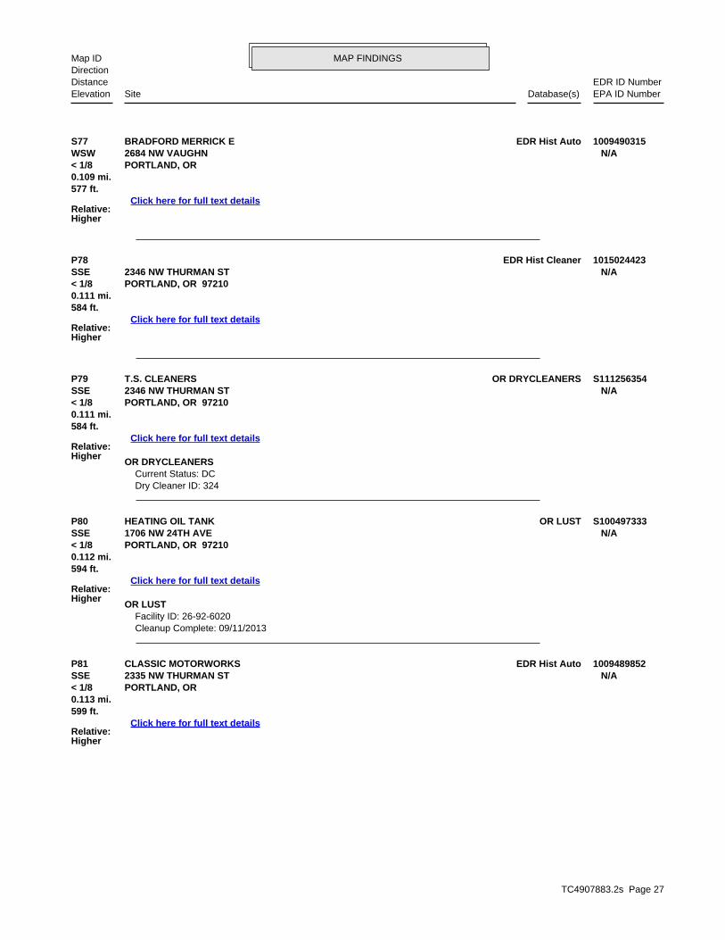
TC4907883.2s Page 27
P81 EDR Hist AutoCLASSIC MOTORWORKS 1009489852SSE 2335 NW THURMAN ST N/A< 1/8 PORTLAND, OR
Relative:Higher
Click here for full text details
0.113 mi.599 ft.
P80 OR LUSTHEATING OIL TANK S100497333SSE 1706 NW 24TH AVE N/A< 1/8 PORTLAND, OR 97210
Relative:Higher
Click here for full text details
0.112 mi.594 ft.
OR LUST Facility ID: 26-92-6020 Cleanup Complete: 09/11/2013
P79 OR DRYCLEANERST.S. CLEANERS S111256354SSE 2346 NW THURMAN ST N/A< 1/8 PORTLAND, OR 97210
Relative:Higher
Click here for full text details
0.111 mi.584 ft.
OR DRYCLEANERS Current Status: DC Dry Cleaner ID: 324
P78 EDR Hist Cleaner 1015024423SSE 2346 NW THURMAN ST N/A< 1/8 PORTLAND, OR 97210
Relative:Higher
Click here for full text details
0.111 mi.584 ft.
S77 EDR Hist AutoBRADFORD MERRICK E 1009490315WSW 2684 NW VAUGHN N/A< 1/8 PORTLAND, OR
Relative:Higher
Click here for full text details
0.109 mi.577 ft.
MAP FINDINGSMap IDDirection
EDR ID NumberDistanceEPA ID NumberDatabase(s)SiteElevation

TC4907883.2s Page 28
S86 EDR Hist AutoCRUM PAUL L 1009490350WSW 2704 NW VAUGHN N/A< 1/8 PORTLAND, OR
Relative:Higher
Click here for full text details
0.116 mi.612 ft.
U85 RCRA NonGen / NLRNMHG OREGON INC 1004770574West 2120 NW 27TH AVE ORD987187333< 1/8 PORTLAND, OR 97210
Relative:Higher
Click here for full text details
0.115 mi.609 ft.
RCRA NonGen / NLR EPA Id: ORD987187333
U84 OR USTNACCO MATERIALS HANDLING GROUP INC 1000473733West 2120 NW 27TH AVE N/A< 1/8 PORTLAND, OR 97210
Relative:Higher
Click here for full text details
0.115 mi.609 ft.
OR UST Facility ID: 9147
N83 RCRA NonGen / NLRA T & T CORP 1001233551ENE FINDS2355 NW 22ND AVE ORQ000010157< 1/8 ECHOPORTLAND, OR 97210
Relative:Lower
Click here for full text details
0.114 mi.602 ft.
RCRA NonGen / NLR EPA Id: ORQ000010157
FINDS Registry ID:: 110004816469
N82 OR USTZINDA MECHANICAL U000432501ENE 2355 NW 22ND AVE N/A< 1/8 PORTLAND, OR 97210
Relative:Lower
Click here for full text details
0.114 mi.602 ft.
OR UST Facility ID: 9631
MAP FINDINGSMap IDDirection
EDR ID NumberDistanceEPA ID NumberDatabase(s)SiteElevation

TC4907883.2s Page 29
T89 OR LUSTAMERITONE PAINT CORP 1000363061East OR UST2100 NW 22ND AVE ORD009025214< 1/8 RCRA NonGen / NLRPORTLAND, OR 97210
Relative:Lower
Click here for full text details
0.116 mi. OR HSIS615 ft. ECHO
OR LUST Facility ID: 26-90-0027 Facility ID: 26-97-0611 Cleanup Complete: 03/31/1997 Cleanup Complete: 10/31/1997
OR UST Facility ID: 4052
RCRA NonGen / NLR EPA Id: ORD009025214
OR HSIS Facility Id: 006873
P88 EDR Hist AutoWEST OREGON GARAGE 1009489826SSE 2325 NW THURMAN N/A< 1/8 PORTLAND, OR
Relative:Higher
Click here for full text details
0.116 mi.613 ft.
P87 OR LUSTROSE CITY MUSTANG U003839010SSE OR UST2325 NW THURMAN ST N/A< 1/8 PORTLAND, OR 97210
Relative:Higher
Click here for full text details
0.116 mi.613 ft.
OR LUST Facility ID: 26-01-0058 Cleanup Complete: 06/24/2002
OR UST Facility ID: 12115
MAP FINDINGSMap IDDirection
EDR ID NumberDistanceEPA ID NumberDatabase(s)SiteElevation

TC4907883.2s Page 30
X94 OR CRLKING-RIES PROPERTY S111251844NW OR ECSI2550 NW 25TH PL. N/A< 1/8 OR ENG CONTROLSPORTLAND, OR 97210
Relative:Lower
Click here for full text details
0.124 mi. OR INST CONTROL653 ft. OR VCP
OR CRL Facility Id: 4560 Facility Status: No Further Action (Conditional)
X93 RCRA NonGen / NLRSTEAM SUPPLY & RUBBER COMPANY INCORPORATED 1001029705NW FINDS2550 NW 25TH PL ORQ000000455< 1/8 ECHOPORTLAND, OR 97210
Relative:Lower
Click here for full text details
0.124 mi.653 ft.
RCRA NonGen / NLR EPA Id: ORQ000000455
FINDS Registry ID:: 110000841199
W92 OR LUSTHEATING OIL TANK S104304349South 2518 NW SAVIER N/A< 1/8 PORTLAND, OR 97210
Relative:Higher
Click here for full text details
0.123 mi.652 ft.
OR LUST Facility ID: 26-00-0316 Cleanup Complete: 07/18/2000
V91 OR LUSTHEATING OIL TANK S104658690South 2424 NW SAVIER N/A< 1/8 PORTLAND, OR 97210
Relative:Higher
Click here for full text details
0.121 mi.639 ft.
OR LUST Facility ID: 26-00-5629
V90 OR LUSTHEATING OIL TANK S106856765South 2436 NW SAVIER ST N/A< 1/8 PORTLAND, OR 97210
Relative:Higher
Click here for full text details
0.120 mi.632 ft.
OR LUST Facility ID: 26-05-0304 Cleanup Complete: 02/16/2006
MAP FINDINGSMap IDDirection
EDR ID NumberDistanceEPA ID NumberDatabase(s)SiteElevation

TC4907883.2s Page 31
O97 OR LUSTABF FREIGHT SYSTEM 1000114623NNE OR UST2825 NW YEON AVE N/A1/8-1/4 OR UICPORTLAND, OR 97210
Relative:Lower
Click here for full text details
0.125 mi.661 ft.
OR LUST Facility ID: 26-90-0314 Facility ID: 26-00-0453 Cleanup Complete: 01/26/1994 Cleanup Complete: 03/29/2001
OR UST Facility ID: 5748
R96 EDR Hist AutoLINDLEY TIME SERVICE 1009490205SSW 2600 NW THURMAN N/A< 1/8 PORTLAND, OR
Relative:Higher
Click here for full text details
0.124 mi.657 ft.
Q95 EDR Hist AutoPOWELL HUGH CHEVRON SERVICE 1009490360WSW 2714 NW VAUGHN N/A< 1/8 PORTLAND, OR
Relative:Higher
Click here for full text details
0.124 mi.656 ft.
KING-RIES PROPERTY (Continued) S111251844
OR ECSI State ID Number: 4560 Investigation: Listed on the CRL/Inventory
OR ENG CONTROLS Site Id: 4560
OR INST CONTROL Site Id: 4560
OR VCP ECS Site ID: 4560
MAP FINDINGSMap IDDirection
EDR ID NumberDistanceEPA ID NumberDatabase(s)SiteElevation

TC4907883.2s Page 32
Z101 OR ASTARAMARK UNIFORM SERVICES INC S103696424SE OR SPILLS1848 NW 23RD AVE N/A1/8-1/4 OR HSISPORTLAND, OR 97210
Relative:Higher
Click here for full text details
0.130 mi.689 ft.
OR AST Facility Id: 018967
OR SPILLS Facility ID: 1999-0530
OR HSIS Facility Id: 018967
Y100 RCRA NonGen / NLRFOAM SPECIALITIES INC 1000294454NW FINDS2601 NW NICOLAI ST ORD0090248111/8-1/4 ECHOPORTLAND, OR 97210
Relative:Lower
Click here for full text details
0.129 mi.680 ft.
RCRA NonGen / NLR EPA Id: ORD009024811
FINDS Registry ID:: 110004778580
W99 OR LUSTHEATING OIL TANK S104024140SSW 2524 NW SAVIER ST N/A1/8-1/4 PORTLAND, OR 97210
Relative:Higher
Click here for full text details
0.126 mi.663 ft.
OR LUST Facility ID: 26-99-0940 Cleanup Complete: 03/15/2000
O98 RCRA-CESQGOREGONIAN PUBLISHING PROPERTIES LLC 1005417711NNE FINDS2825 NW YEON ORD9871799181/8-1/4 ECHOPORTLAND, OR 97210
Relative:Lower
Click here for full text details
0.125 mi.661 ft.
RCRA-CESQG EPA Id: ORD987179918
FINDS Registry ID:: 110012278105
MAP FINDINGSMap IDDirection
EDR ID NumberDistanceEPA ID NumberDatabase(s)SiteElevation

TC4907883.2s Page 33
105 OR LUSTVAUX PROPERTY S106856686SSE 2350 NW SAVIER ST N/A1/8-1/4 PORTLAND, OR 97210
Relative:Higher
Click here for full text details
0.139 mi.734 ft.
OR LUST Facility ID: 26-05-0180 Cleanup Complete: 04/08/2005
104 OR LUSTJONES OREGON STEVEDORING COMPANY U000432462NNE OR UST2323 NW SUFFOLK ST N/A1/8-1/4 PORTLAND, OR 97210
Relative:Lower
Click here for full text details
0.138 mi.731 ft.
OR LUST Facility ID: 26-90-0005 Facility ID: 26-91-0070 Cleanup Complete: 02/21/1990 Cleanup Complete: 08/25/1997
OR UST Facility ID: 3709
Z103 OR LUSTARATEX SERVICES INC U000432421SE OR UST1848 NW 23RD AVE N/A1/8-1/4 OR SPILLSPORTLAND, OR 97210
Relative:Higher
Click here for full text details
0.130 mi.689 ft.
OR LUST Facility ID: 26-08-0232 Cleanup Complete: 08/18/2008
OR UST Facility ID: 4942
OR SPILLS Facility ID: 2016-0797
Z102 RCRA NonGen / NLRARAMARK UNIFORM SERVICES 1008196003SE 1848 NW 23RD AVE ORQ0000219491/8-1/4 PORTLAND, OR 97296
Relative:Higher
Click here for full text details
0.130 mi.689 ft.
RCRA NonGen / NLR EPA Id: ORQ000021949
MAP FINDINGSMap IDDirection
EDR ID NumberDistanceEPA ID NumberDatabase(s)SiteElevation

TC4907883.2s Page 34
AA109 OR LUSTHEATING OIL TANK S108663723East OR NPDES2130 NW YORK STREET N/A1/8-1/4 PORTLAND, OR 97210
Relative:Lower
Click here for full text details
0.143 mi.754 ft.
OR LUST Facility ID: 26-98-0349 Cleanup Complete: 01/05/2006
OR NPDES WQ File Nbr: 114957
W108 OR LUSTHEATING OIL TANK S105856309SSW 2564 NW SAVIER STREET N/A1/8-1/4 PORTLAND, OR 97210
Relative:Higher
Click here for full text details
0.141 mi.743 ft.
OR LUST Facility ID: 26-03-0230 Cleanup Complete: 04/21/2003
Y107 RCRA-CESQGKELLY CABINET CO 1005417751NW FINDS2624 NW 26TH AVE ORQ0000155781/8-1/4 OR MANIFESTPORTLAND, OR 97210
Relative:Lower
Click here for full text details
0.140 mi. ECHO740 ft.
RCRA-CESQG EPA Id: ORQ000015578
FINDS Registry ID:: 110012276688
OR MANIFEST Status: Small quantity generator EPA Id: ORQ000015578 Status: SQG
106 OR LUSTHEATING OIL TANK S111210579SW 2661 NW THURMAN ST N/A1/8-1/4 PORTLAND, OR 97210
Relative:Higher
Click here for full text details
0.139 mi.736 ft.
OR LUST Facility ID: 26-11-0418
MAP FINDINGSMap IDDirection
EDR ID NumberDistanceEPA ID NumberDatabase(s)SiteElevation

TC4907883.2s Page 35
Y114 OR ECSIMERCER INDUSTRIES - PORTLAND S103841483NW 2636 NW 26TH AVE. N/A1/8-1/4 PORTLAND, OR 97210
Relative:Lower
Click here for full text details
0.144 mi.761 ft.
OR ECSI State ID Number: 144 Investigation: No Further Action
Y113 RCRA NonGen / NLRMERCER INDUSTRIES - PORTLAND 1000168998NW FINDS2636 NORTHWEST 26TH AVENUE ORD0079087911/8-1/4 ECHOPORTLAND, OR 97210
Relative:Lower
Click here for full text details
0.144 mi.761 ft.
RCRA NonGen / NLR EPA Id: ORD007908791
FINDS Registry ID:: 110007737618
V112 OR LUSTHEATING OIL TANK S117881080South 2455 NW RALEIGH ST N/A1/8-1/4 PORTLAND, OR 97210
Relative:Higher
Click here for full text details
0.143 mi.757 ft.
OR LUST Facility ID: 26-15-0269 Cleanup Complete: 07/09/2015
AA111 RCRA NonGen / NLRMONARCH MACHINE CO 1000154683East FINDS2130 NW YORK ORD0090208501/8-1/4 PORTLAND, OR 97210
Relative:Lower
Click here for full text details
0.143 mi.754 ft.
RCRA NonGen / NLR EPA Id: ORD009020850
AA110 RCRA NonGen / NLRIRC ALUMINUM & STAINLESS INC 1004580384East 2130 NW YORK ORD0028356841/8-1/4 PORTLAND, OR 97210
Relative:Lower
Click here for full text details
0.143 mi.754 ft.
RCRA NonGen / NLR EPA Id: ORD002835684
MAP FINDINGSMap IDDirection
EDR ID NumberDistanceEPA ID NumberDatabase(s)SiteElevation

TC4907883.2s Page 36
AB118 RCRA NonGen / NLRH NAITO PROPERTIES 1004769741WSW FINDS2701 NW VAUGHN ST STE 175 OR00010148441/8-1/4 ECHOPORTLAND, OR 97210
Relative:Higher
Click here for full text details
0.145 mi.766 ft.
RCRA NonGen / NLR EPA Id: OR0001014844
FINDS Registry ID:: 110004775565
AB117 RCRA-CESQGKAISER MONTGOMERY PARK BLDG STE 160 1004771157WSW OR MANIFEST2701 NW VAUGHN ST STE 160 ORQ0000025761/8-1/4 PORTLAND, OR 97210
Relative:Higher
Click here for full text details
0.145 mi.766 ft.
RCRA-CESQG EPA Id: ORQ000002576
OR MANIFEST Status: Conditionally exempt generator EPA Id: ORQ000002576 Status: CEG
AB116 RCRA NonGen / NLRGAZLEY PLOWMAN ARCHITECTS 1004771369WSW FINDS2701 NORTHWEST VAUGHN STREET SUITE 764 ORQ0000069241/8-1/4 ECHOPORTLAND, OR 97210
Relative:Higher
Click here for full text details
0.145 mi.766 ft.
RCRA NonGen / NLR EPA Id: ORQ000006924
FINDS Registry ID:: 110006854127
V115 OR LUSTHEATING OIL TANK S105981758South 2475 NW RALEIGH STREET N/A1/8-1/4 PORTLAND, OR 97210
Relative:Higher
Click here for full text details
0.144 mi.762 ft.
OR LUST Facility ID: 26-03-2084 Cleanup Complete: 12/03/2003
MAP FINDINGSMap IDDirection
EDR ID NumberDistanceEPA ID NumberDatabase(s)SiteElevation

TC4907883.2s Page 37
AC121 OR LUSTHEATING OIL TANK S104819985SSW 2576 NW SAVIER ST N/A1/8-1/4 PORTLAND, OR 97210
Relative:Higher
Click here for full text details
0.146 mi.770 ft.
OR LUST Facility ID: 26-00-6325
120 RCRA-CESQGIMPERIAL PAINT CO INC 1000215300NE OR LUST2526 NW YEON AVE 97210MPRLP2526N1/8-1/4 OR USTPORTLAND, OR 97210
Relative:Lower
Click here for full text details
0.146 mi. TRIS769 ft. OR HSIS
RCRA-CESQG EPA Id: ORD009029224
OR LUST Facility ID: 26-98-0561 Cleanup Complete: 02/08/2005
OR UST Facility ID: 6549
TRIS TRIS ID: 97210MPRLP2526N
OR HSIS Facility Id: 005714
AB119 OR DRYCLEANERSVERIZON WIRELESS S110281670WSW OR HSIS2701 NW VAUGHN ST N/A1/8-1/4 PORTLAND, OR 97210
Relative:Higher
Click here for full text details
0.145 mi.766 ft.
OR DRYCLEANERS Current Status: CL Dry Cleaner ID: 670
OR HSIS Facility Id: 072578 Facility Id: 072891 Facility Id: 090615
MAP FINDINGSMap IDDirection
EDR ID NumberDistanceEPA ID NumberDatabase(s)SiteElevation

TC4907883.2s Page 38
W126 OR LUSTHEATING OIL TANK S105556608South 2525 NW RALEIGH ST N/A1/8-1/4 PORTLAND, OR 97210
Relative:Higher
Click here for full text details
0.149 mi.789 ft.
OR LUST Facility ID: 26-02-0836 Cleanup Complete: 11/26/2002
V125 OR LUSTHEATING OIL TANK S110048056South 2409 NW RALEIGH ST N/A1/8-1/4 PORTLAND, OR 97210
Relative:Higher
Click here for full text details
0.149 mi.787 ft.
OR LUST Facility ID: 26-09-0687 Cleanup Complete: 10/05/2009
AD124 OR LUSTHEATING OIL TANK S100497024ENE 2401 NW 22ND AVE N/A1/8-1/4 PORTLAND, OR 97210
Relative:Lower
Click here for full text details
0.149 mi.785 ft.
OR LUST Facility ID: 26-92-0053
AD123 RCRA-CESQGEBONY IRON WORKS INC 1001233544ENE FINDS2401 NW 22ND AVE ORQ0000099931/8-1/4 ECHOPORTLAND, OR 97210
Relative:Lower
Click here for full text details
0.149 mi.785 ft.
RCRA-CESQG EPA Id: ORQ000009993
FINDS Registry ID:: 110004816334
V122 OR LUSTHEATING OIL TANK S109494144South 2417 NW RALEIGH ST N/A1/8-1/4 PORTLAND, OR 97210
Relative:Higher
Click here for full text details
0.146 mi.773 ft.
OR LUST Facility ID: 26-08-1340 Cleanup Complete: 03/10/2009
MAP FINDINGSMap IDDirection
EDR ID NumberDistanceEPA ID NumberDatabase(s)SiteElevation
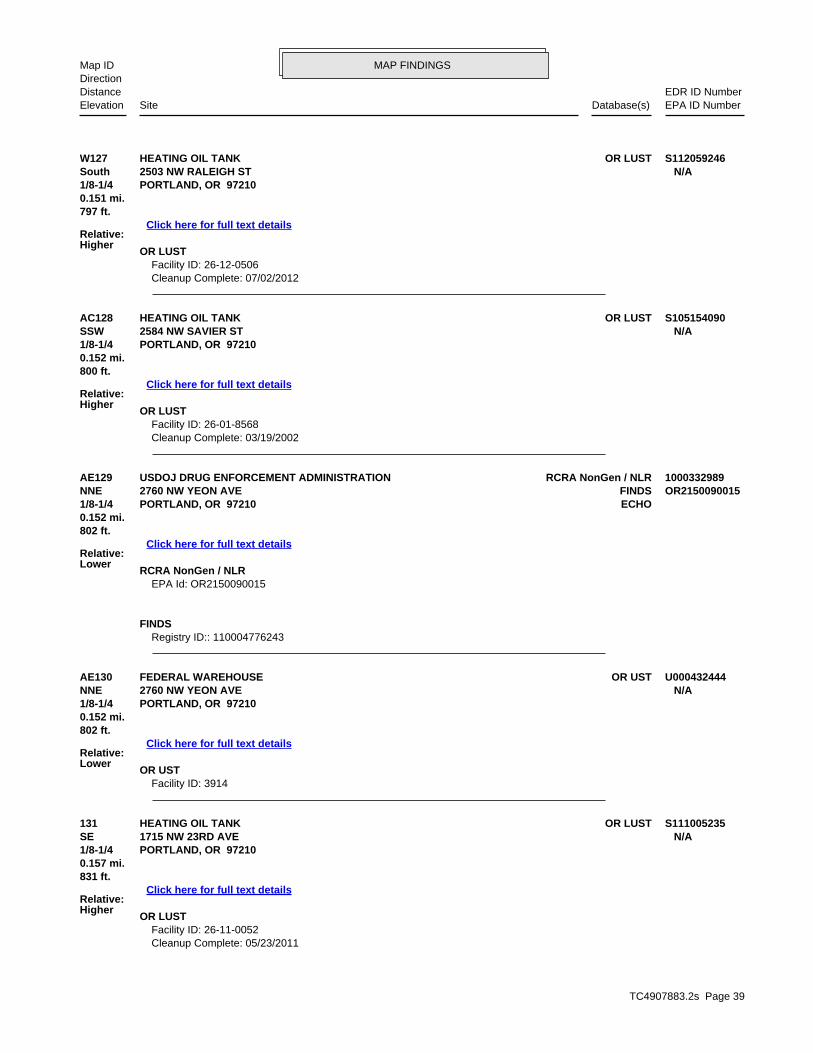
TC4907883.2s Page 39
131 OR LUSTHEATING OIL TANK S111005235SE 1715 NW 23RD AVE N/A1/8-1/4 PORTLAND, OR 97210
Relative:Higher
Click here for full text details
0.157 mi.831 ft.
OR LUST Facility ID: 26-11-0052 Cleanup Complete: 05/23/2011
AE130 OR USTFEDERAL WAREHOUSE U000432444NNE 2760 NW YEON AVE N/A1/8-1/4 PORTLAND, OR 97210
Relative:Lower
Click here for full text details
0.152 mi.802 ft.
OR UST Facility ID: 3914
AE129 RCRA NonGen / NLRUSDOJ DRUG ENFORCEMENT ADMINISTRATION 1000332989NNE FINDS2760 NW YEON AVE OR21500900151/8-1/4 ECHOPORTLAND, OR 97210
Relative:Lower
Click here for full text details
0.152 mi.802 ft.
RCRA NonGen / NLR EPA Id: OR2150090015
FINDS Registry ID:: 110004776243
AC128 OR LUSTHEATING OIL TANK S105154090SSW 2584 NW SAVIER ST N/A1/8-1/4 PORTLAND, OR 97210
Relative:Higher
Click here for full text details
0.152 mi.800 ft.
OR LUST Facility ID: 26-01-8568 Cleanup Complete: 03/19/2002
W127 OR LUSTHEATING OIL TANK S112059246South 2503 NW RALEIGH ST N/A1/8-1/4 PORTLAND, OR 97210
Relative:Higher
Click here for full text details
0.151 mi.797 ft.
OR LUST Facility ID: 26-12-0506 Cleanup Complete: 07/02/2012
MAP FINDINGSMap IDDirection
EDR ID NumberDistanceEPA ID NumberDatabase(s)SiteElevation

TC4907883.2s Page 40
AD134 OR LUSTGRIFFITH RUBBER MILLS 1000644241ENE OR UST2249 NW 22ND N/A1/8-1/4 PORTLAND, OR 97210
Relative:Lower
Click here for full text details
0.161 mi.850 ft.
OR LUST Facility ID: 26-89-0022
AA133 OR USTRELIANCE ELECTRIC 1000246028East 2315 NW 21ST PL N/A1/8-1/4 PORTLAND, OR 97210
Relative:Lower
Click here for full text details
0.159 mi.837 ft.
OR UST Facility ID: 10114
AA132 RCRA-LQGRELIANCE ELECTRIC INDUSTRIAL SERVICE CENTER‎ 1001489515East OR ECSI2315 NW 21ST PL ORD0969898271/8-1/4 OR VCPPORTLAND, OR 97210
Relative:Lower
Click here for full text details
0.159 mi. FINDS837 ft. OR HSIS
OR MANIFESTECHO
RCRA-LQG EPA Id: ORD096989827
OR ECSI State ID Number: 4851 Investigation: No Further Action
OR VCP ECS Site ID: 4851
FINDS Registry ID:: 110004787561
OR HSIS Facility Id: 001301
OR MANIFEST Status: Small quantity generator Status: Large quantity generator Status: Conditionally exempt generator EPA Id: ORD096989827 Status: LQG Status: CEG Status: SQG
MAP FINDINGSMap IDDirection
EDR ID NumberDistanceEPA ID NumberDatabase(s)SiteElevation

TC4907883.2s Page 41
AF138 OR LUSTHEATING OIL TANK S102959461South 2434 NW RALEIGH STREET N/A1/8-1/4 PORTLAND, OR 97210
Relative:Higher
Click here for full text details
0.169 mi.892 ft.
OR LUST Facility ID: 26-97-0948
AF137 OR LUSTHEATING OIL TANK S102959460South 2462 NW RALEIGH N/A1/8-1/4 PORTLAND, OR 97210
Relative:Higher
Click here for full text details
0.169 mi.890 ft.
OR LUST Facility ID: 26-98-0065
AD136 RCRA NonGen / NLRGAC/FLEXOPREP 1004770329ENE FINDS2187 NW REED ST ORD9826545351/8-1/4 ECHOPORTLAND, OR 97210
Relative:Lower
Click here for full text details
0.166 mi.877 ft.
RCRA NonGen / NLR EPA Id: ORD982654535
FINDS Registry ID:: 110004794553
AD135 OR LUSTCET ENTERPRISES U003859345ENE OR UST2187 NW REED ST N/A1/8-1/4 PORTLAND, OR 97210
Relative:Lower
Click here for full text details
0.166 mi.877 ft.
OR LUST Facility ID: 26-01-0015 Cleanup Complete: 03/15/2002
OR UST Facility ID: 12127
GRIFFITH RUBBER MILLS (Continued) 1000644241
Cleanup Complete: 05/06/1989
OR UST Facility ID: 2884
MAP FINDINGSMap IDDirection
EDR ID NumberDistanceEPA ID NumberDatabase(s)SiteElevation

TC4907883.2s Page 42
AH142 OR LUSTPOPE RIGGING LOFT, INC. S100500542ESE 2126 NW WILSON N/A1/8-1/4 PORTLAND, OR 97209
Relative:Lower
Click here for full text details
0.177 mi.936 ft.
OR LUST Facility ID: 26-89-0077 Cleanup Complete: 08/16/1989
AF141 OR LUSTHEATING OIL TANK S104908193South 2486 NW RALEIGH N/A1/8-1/4 PORTLAND, OR 97210
Relative:Higher
Click here for full text details
0.173 mi.911 ft.
OR LUST Facility ID: 26-01-5567 Cleanup Complete: 12/13/2001
AB140 RCRA NonGen / NLRNACCO MATERIALS HANDLING GROUP INC 1001489544West 2701 NW VAUGHN STE 900 ORD9871873251/8-1/4 PORTLAND, OR 97210
Relative:Higher
Click here for full text details
0.172 mi.906 ft.
RCRA NonGen / NLR EPA Id: ORD987187325
AG139 OR LUSTDAVID CASCADDEN U003115507South OR UST1533 NW 24TH AVE N/A1/8-1/4 PORTLAND, OR 97210
Relative:Higher
Click here for full text details
0.171 mi.904 ft.
OR LUST Facility ID: 26-96-0164 Cleanup Complete: 08/07/2000
OR UST Facility ID: 11582
HEATING OIL TANK (Continued) S102959461
Cleanup Complete: 01/16/1998
MAP FINDINGSMap IDDirection
EDR ID NumberDistanceEPA ID NumberDatabase(s)SiteElevation

TC4907883.2s Page 43
146 OR LUSTESCO CORPORATION U000432443North OR UST2770 NW YEON N/A1/8-1/4 PORTLAND, OR 97210
Relative:Lower
Click here for full text details
0.184 mi.973 ft.
OR LUST Facility ID: 26-93-0168 Cleanup Complete: 10/21/1996
OR UST Facility ID: 6966
AJ145 OR LUSTWHITE GMC TRUCKS OF PORTLAND INC 1000397175WNW OR UST2705 NW NICOLAI ST N/A1/8-1/4 PORTLAND, OR 97210
Relative:Lower
Click here for full text details
0.181 mi.958 ft.
OR LUST Facility ID: 26-90-0045 Cleanup Complete: 05/10/1990
OR UST Facility ID: 7927
AJ144 RCRA-CESQGGENERAL TOOL & SUPPLY CO 1004770114WNW 2705 NW NICOLAI ST ORD1030059711/8-1/4 PORTLAND, OR 97210
Relative:Lower
Click here for full text details
0.181 mi.958 ft.
RCRA-CESQG EPA Id: ORD103005971
AI143 OR USTKEVETY INC U003115546NE 2245 NW NICOLAI STREET N/A1/8-1/4 PORTLAND, OR 97210
Relative:Lower
Click here for full text details
0.179 mi.947 ft.
OR UST Facility ID: 11622
MAP FINDINGSMap IDDirection
EDR ID NumberDistanceEPA ID NumberDatabase(s)SiteElevation

TC4907883.2s Page 44
AL150 RCRA NonGen / NLRFAIRMOUNT MINERALS LTD 1008374941NW OR HSIS2710 NW INDUSTRIAL ST ORQ0000240041/8-1/4 OR MANIFESTPORTLAND, OR 97210
Relative:Lower
Click here for full text details
0.188 mi.994 ft.
RCRA NonGen / NLR EPA Id: ORQ000024004
OR HSIS Facility Id: 107422
OR MANIFEST
AK149 SEMS-ARCHIVEMARATHON U.S. REALTIES, INC. 1003880602NNW 2615-2619 N.W. INDUSTRIAL STREET ORD9871725821/8-1/4 PORTLAND, OR 97210
Relative:Lower
Click here for full text details
0.188 mi.990 ft.
SEMS-ARCHIVE Site ID: 1001315 EPA Id: ORD987172582
AK148 OR CRLGUILDS LAKE S103841677NNW OR ECSI2615-2619 NW INDUSTRIAL ST. N/A1/8-1/4 OR ENG CONTROLSPORTLAND, OR 97210
Relative:Lower
Click here for full text details
0.188 mi.990 ft.
OR CRL Facility Id: 404 Facility Status: OPERATION & MAINTENANCE
OR ECSI State ID Number: 404 Investigation: Listed on the CRL/Inventory
OR ENG CONTROLS Site Id: 404
AF147 OR LUSTHEATING OIL TANK S118140542South 1516 NW 25TH AVE N/A1/8-1/4 PORTLAND, OR 97210
Relative:Higher
Click here for full text details
0.185 mi.977 ft.
OR LUST Facility ID: 26-15-0491 Cleanup Complete: 10/28/2015
MAP FINDINGSMap IDDirection
EDR ID NumberDistanceEPA ID NumberDatabase(s)SiteElevation

TC4907883.2s Page 45
AN153 OR ECSISTATES BATTERY CO. 1006864484NNE OR VCP2258 NW SUFFOLK ST N/A1/8-1/4 FINDSPORTLAND, OR 97210
Relative:Lower
Click here for full text details
0.190 mi.1001 ft.
OR ECSI State ID Number: 1007 Investigation: Suspect
OR VCP ECS Site ID: 1007
FINDS Registry ID:: 110014273160
AN152 SEMS-ARCHIVESTATES BATTERY CO INC 1003880278NNE 2258 NW SUFFOLK ST ORD9809846861/8-1/4 PORTLAND, OR 97210
Relative:Lower
Click here for full text details
0.190 mi.1001 ft.
SEMS-ARCHIVE Site ID: 1000518 EPA Id: ORD980984686
AM151 RCRA NonGen / NLRARCHITECTURAL SIGNING NW IN 1008892307East OR MANIFEST2121 NW YORK ST ORQ0000248561/8-1/4 PORTLAND, OR 97210
Relative:Lower
Click here for full text details
0.190 mi.1001 ft.
RCRA NonGen / NLR EPA Id: ORQ000024856
OR MANIFEST Status: Small quantity generator Status: Conditionally exempt generator EPA Id: ORQ000024856 Status: SQG Status: CEG
FAIRMOUNT MINERALS LTD (Continued) 1008374941
Status: Large quantity generator EPA Id: ORQ000024004 Status: LQG
MAP FINDINGSMap IDDirection
EDR ID NumberDistanceEPA ID NumberDatabase(s)SiteElevation

TC4907883.2s Page 46
AI157 OR LUSTKEVETY INC S100500598NE 2211 NW NICOLAI STREET N/A1/8-1/4 PORTLAND, OR 97210
Relative:Lower
Click here for full text details
0.194 mi.1022 ft.
OR LUST Facility ID: 26-96-0515 Cleanup Complete: 03/10/1998
AF156 OR LUSTHEATING OIL TANK S113230922South 2455 NW QUIMBY ST N/A1/8-1/4 PORTLAND, OR 97210
Relative:Higher
Click here for full text details
0.193 mi.1017 ft.
OR LUST Facility ID: 26-12-1420 Cleanup Complete: 03/18/2013
AH155 OR LUSTMALLORY SAFETY & SUPPLY LLC S103415007East OR HSIS2135 NW 21ST AVE N/A1/8-1/4 PORTLAND, OR 97209
Relative:Lower
Click here for full text details
0.190 mi.1003 ft.
OR LUST Facility ID: 26-12-0164 Cleanup Complete: 03/12/2012
OR HSIS Facility Id: 120697
AH154 RCRA-CESQGARMSTRONG MFG 1004769817East FINDS2135 NW 21ST AVE ORD0090336061/8-1/4 ECHOPORTLAND, OR 97209
Relative:Lower
Click here for full text details
0.190 mi.1003 ft.
RCRA-CESQG EPA Id: ORD009033606
FINDS Registry ID:: 110004779044
MAP FINDINGSMap IDDirection
EDR ID NumberDistanceEPA ID NumberDatabase(s)SiteElevation

TC4907883.2s Page 47
AG162 OR MANIFESTCOLLIER & COMPANY CONSTRUCTION INC S109052199South 1507 NW 24TH AVE STE 200 N/A1/8-1/4 PORTLAND, OR 97210
Relative:Higher
Click here for full text details
0.195 mi.1027 ft.
OR MANIFEST EPA Id: ORQ000017921
AG161 OR LUSTHEATING OIL TANK S117881131South 1507 NW 24TH AVE N/A1/8-1/4 PORTLAND, OR 97210
Relative:Higher
Click here for full text details
0.195 mi.1027 ft.
OR LUST Facility ID: 26-15-0354 Cleanup Complete: 10/20/2015
AG160 RCRA NonGen / NLRCOLLIER & COMPANY CONSTRUCTION INC 1005417953South FINDS1507 NW 24TH AVE STE 200 ORQ0000179211/8-1/4 ECHOPORTLAND, OR 97210
Relative:Higher
Click here for full text details
0.195 mi.1027 ft.
RCRA NonGen / NLR EPA Id: ORQ000017921
FINDS Registry ID:: 110012258617
AF159 OR LUSTHEATING OIL TANK S108572565South 2479 NW QUIMBY ST N/A1/8-1/4 PORTLAND, OR 97210
Relative:Higher
Click here for full text details
0.194 mi.1023 ft.
OR LUST Facility ID: 26-07-0308 Cleanup Complete: 06/14/2007
AO158 OR LUSTHEATING OIL TANK S107135388SSW 2656 NW SAVIER N/A1/8-1/4 PORTLAND, OR 97210
Relative:Higher
Click here for full text details
0.194 mi.1022 ft.
OR LUST Facility ID: 26-05-1244 Cleanup Complete: 07/11/2005
MAP FINDINGSMap IDDirection
EDR ID NumberDistanceEPA ID NumberDatabase(s)SiteElevation

TC4907883.2s Page 48
AP166 OR ASTKAISER PERMANENTE S111251092West OR HSIS2850 NW NICOLAY ST STE 150 N/A1/8-1/4 PORTLAND, OR 97210
Relative:Lower
Click here for full text details
0.199 mi.1053 ft.
OR AST Facility Id: 072461
OR HSIS Facility Id: 072461
AL165 OR USTUNITED BEER DISTRIBUTING U000432496NW 2619 NW INDUSTRIAL N/A1/8-1/4 PORTLAND, OR 97210
Relative:Lower
Click here for full text details
0.195 mi.1031 ft.
OR UST Facility ID: 8939
AL164 RCRA-CESQGCITY OF PORTLAND - GUILDS LAKE 1014473250NW 2615 THRU 2619 NW INDUSTRIAL S ORQ0000297401/8-1/4 PORTLAND, OR 97210
Relative:Lower
Click here for full text details
0.195 mi.1031 ft.
RCRA-CESQG EPA Id: ORQ000029740
AL163 OR MANIFESTCITY OF PORTLAND - GUILDS LAKE S112231382NW 2615 THRU 2619 NW INDUSTRIAL ST N/A1/8-1/4 PORTLAND, OR 97210
Relative:Lower
Click here for full text details
0.195 mi.1031 ft.
OR MANIFEST Status: Large quantity generator EPA Id: ORQ000029740 Status: LQG
COLLIER & COMPANY CONSTRUCTION INC (Continued) S109052199
Status: CEG
MAP FINDINGSMap IDDirection
EDR ID NumberDistanceEPA ID NumberDatabase(s)SiteElevation

TC4907883.2s Page 49
AQ169 OR LUSTCARSON OIL CO INC 1000643062SE OR UST2169 NW THURMAN N/A1/8-1/4 PORTLAND, OR 97210
Relative:Lower
Click here for full text details
0.203 mi.1072 ft.
OR LUST Facility ID: 26-93-0048 Cleanup Complete: 08/17/1993
OR UST Facility ID: 5103
AL168 OR LUSTGRIFFITH RUBBER MILLS S104329163NW OR HSIS2625 NW INDUSTRIAL N/A1/8-1/4 PORTLAND, OR 97210
Relative:Lower
Click here for full text details
0.201 mi.1063 ft.
OR LUST Facility ID: 26-12-0311 Cleanup Complete: 04/25/2012
OR HSIS Facility Id: 004033
AL167 RCRA-CESQGGRIFFITH RUBBER MILLS 1004769813NW FINDS2625 NW INDUSTRIAL AVE ORD0090274911/8-1/4 OR MANIFESTPORTLAND, OR 97210
Relative:Lower
Click here for full text details
0.201 mi. ECHO1063 ft.
RCRA-CESQG EPA Id: ORD009027491
FINDS Registry ID:: 110004778731
OR MANIFEST EPA Id: ORD009027491 Status: CEG
MAP FINDINGSMap IDDirection
EDR ID NumberDistanceEPA ID NumberDatabase(s)SiteElevation

TC4907883.2s Page 50
AR172 OR ASTESCO CORPORATION S108659713NNE OR HSIS2211 NW BREWER N/A1/8-1/4 OR MANIFESTPORTLAND, OR 97210
Relative:Lower
Click here for full text details
0.209 mi. OR NPDES1106 ft.
OR AST Facility Id: 003222
OR HSIS Facility Id: 003222
OR MANIFEST Status: Small quantity generator Status: Conditionally exempt generator EPA Id: ORD987173184 Status: CEG Status: SQG
OR NPDES WQ File Nbr: 104836
AR171 RCRA-CESQGESCO CORP 1000324913NNE TRIS2211 NW BREWER ST 97210SCCRP2211N1/8-1/4 ECHOPORTLAND, OR 97210
Relative:Lower
Click here for full text details
0.209 mi.1106 ft.
RCRA-CESQG EPA Id: ORD987173184
TRIS TRIS ID: 97210SCCRP2211N
AM170 OR LUSTSOUTHWEST INDUSTRIAL SUPPLY U000432268ENE OR UST2353 NW 21ST AVE N/A1/8-1/4 PORTLAND, OR 97204
Relative:Lower
Click here for full text details
0.203 mi.1074 ft.
OR LUST Facility ID: 26-90-0068 Cleanup Complete: 10/25/1990
OR UST Facility ID: 10263
MAP FINDINGSMap IDDirection
EDR ID NumberDistanceEPA ID NumberDatabase(s)SiteElevation

TC4907883.2s Page 51
AI177 RCRA-SQGSCHOOLHOUSE ELECTRIC CO 1019909735NE ECHO2181 NW NICOLAI ST ORQ0000355541/8-1/4 PORTLAND, OR 97210
Relative:Lower
Click here for full text details
0.217 mi.1147 ft.
RCRA-SQG EPA Id: ORQ000035554
AT176 OR LUSTHEATING OIL TANK S110638926SSE 1616 SE 23RD AVE N/A1/8-1/4 PORTLAND, OR 97214
Relative:Higher
Click here for full text details
0.216 mi.1142 ft.
OR LUST Facility ID: 26-10-0731 Cleanup Complete: 01/13/2011
AO175 OR LUSTHEATING OIL TANK S116760481SSW 2653-2657 NW RALEIGH ST N/A1/8-1/4 PORTLAND, OR 97210
Relative:Higher
Click here for full text details
0.215 mi.1135 ft.
OR LUST Facility ID: 26-14-0348 Cleanup Complete: 12/01/2014
AS174 OR LUSTHEATING OIL TANK S104658137SSE 2367 NW QUIMBY STREET N/A1/8-1/4 PORTLAND, OR 97210
Relative:Higher
Click here for full text details
0.214 mi.1132 ft.
OR LUST Facility ID: 26-00-0658 Cleanup Complete: 05/31/2000
AO173 OR LUSTHEATING OIL TANK S106776788SW 2686 NW SAVIER N/A1/8-1/4 PORTLAND, OR 97213
Relative:Higher
Click here for full text details
0.210 mi.1108 ft.
OR LUST Facility ID: 26-97-0657 Cleanup Complete: 02/02/1999
MAP FINDINGSMap IDDirection
EDR ID NumberDistanceEPA ID NumberDatabase(s)SiteElevation

TC4907883.2s Page 52
AT182 RCRA-CESQGDREW PAINTS INC 1000434857SSE OR ECSI1525 NW 23RD AVE ORD0392236641/8-1/4 OR LUSTPORTLAND, OR 97210
Relative:Higher
Click here for full text details
0.220 mi. OR UST1163 ft. OR HSIS
RCRA-CESQG EPA Id: ORD039223664
OR ECSI State ID Number: 4465 Investigation: Suspect
AS181 OR LUSTHEATING OIL TANK S102590006SSE 2355 NW QUIMBY N/A1/8-1/4 PORTLAND, OR 97210
Relative:Higher
Click here for full text details
0.220 mi.1159 ft.
OR LUST Facility ID: 26-97-0328 Cleanup Complete: 06/25/1997
AV180 OR LUSTHEATING OIL TANK S114397486South 2434 NW QUIMBY ST N/A1/8-1/4 PORTLAND, OR 97210
Relative:Higher
Click here for full text details
0.218 mi.1151 ft.
OR LUST Facility ID: 26-13-1002 Cleanup Complete: 03/12/2014
AV179 OR LUSTHEATING OIL TANK S107465971South 2456 NW QUIMBY ST N/A1/8-1/4 PORTLAND, OR 97210
Relative:Higher
Click here for full text details
0.218 mi.1149 ft.
OR LUST Facility ID: 26-05-1940
AU178 OR USTMEDICA, ROSE, JOYCE, HOMER U000432471SE 2206 NW THURMAN N/A1/8-1/4 PORTLAND, OR 97210
Relative:Higher
Click here for full text details
0.217 mi.1148 ft.
OR UST Facility ID: 10532
MAP FINDINGSMap IDDirection
EDR ID NumberDistanceEPA ID NumberDatabase(s)SiteElevation

TC4907883.2s Page 53
AP184 OR ECSISCHMITT FORGE INC 1000694940West OR UST2765 NW NICOLAI ST ORD9871952451/8-1/4 OR VCPPORTLAND, OR 97210
Relative:Lower
Click here for full text details
0.222 mi. RCRA NonGen / NLR1173 ft. FINDS
ECHO
OR ECSI State ID Number: 1347 Investigation: No Further Action
OR UST Facility ID: 10968
OR VCP ECS Site ID: 1347
RCRA NonGen / NLR EPA Id: ORD987195245
FINDS
AM183 OR LUSTAMERICAN PACIFIC CORP U000432368ENE OR UST2320 NW 21ST AVE N/A1/8-1/4 PORTLAND, OR 97209
Relative:Lower
Click here for full text details
0.221 mi.1169 ft.
OR LUST Facility ID: 26-91-0153 Cleanup Complete: 07/02/1996
OR UST Facility ID: 4185
DREW PAINTS INC (Continued) 1000434857
OR LUST Facility ID: 26-96-0448 Facility ID: 26-10-0246 Cleanup Complete: 10/17/1996 Cleanup Complete: 02/03/2011
OR UST Facility ID: 4014
OR HSIS Facility Id: 007964
MAP FINDINGSMap IDDirection
EDR ID NumberDistanceEPA ID NumberDatabase(s)SiteElevation

TC4907883.2s Page 54
AU188 OR USTCARSON OIL CO INC U000432425SE 2191 NW SAVIER ST N/A1/8-1/4 PORTLAND, OR 97210
Relative:Higher
Click here for full text details
0.229 mi.1211 ft.
OR UST Facility ID: 3049
187 OR ECSITHOMSON MACHINERY CO. S111256126East OR LUST2236 NW 21ST AVE. N/A1/8-1/4 PORTLAND, OR 97209
Relative:Lower
Click here for full text details
0.226 mi.1193 ft.
OR ECSI State ID Number: 5256 Investigation: Suspect
OR LUST Facility ID: 26-15-0559 Cleanup Complete: 07/28/2015
AT186 OR LUSTSAVIER STREET LOFTS S112225378SE 2244 NW SAVIER ST N/A1/8-1/4 PORTLAND, OR 97210
Relative:Higher
Click here for full text details
0.225 mi.1186 ft.
OR LUST Facility ID: 26-12-0833 Cleanup Complete: 06/18/2013
AW185 OR LUSTHEATING OIL TANK S110510167SW 2700 NW SAVIER ST N/A1/8-1/4 PORTLAND, OR 97210
Relative:Higher
Click here for full text details
0.224 mi.1182 ft.
OR LUST Facility ID: 26-10-0503 Cleanup Complete: 01/13/2011
SCHMITT FORGE INC (Continued) 1000694940
Registry ID:: 110004804604
MAP FINDINGSMap IDDirection
EDR ID NumberDistanceEPA ID NumberDatabase(s)SiteElevation

TC4907883.2s Page 55
AS192 RCRA NonGen / NLRPPG INDUSTRIES INC 1000644385SSE FINDS2360 NW QUIMBY ORD9871922671/8-1/4 ECHOPORTLAND, OR 97210
Relative:Higher
Click here for full text details
0.235 mi.1240 ft.
RCRA NonGen / NLR EPA Id: ORD987192267
FINDS Registry ID:: 110004803240
AY191 RCRA NonGen / NLREC POWER SYSTEMS 1004771782ESE FINDS1835 NW 21ST AVE ORQ0000142821/8-1/4 ECHOPORTLAND, OR 97209
Relative:Lower
Click here for full text details
0.235 mi.1239 ft.
RCRA NonGen / NLR EPA Id: ORQ000014282
FINDS Registry ID:: 110004819876
AX190 RCRA NonGen / NLRALLIED WORKS ARCHITECTURE INC 1004771070SW FINDS2768 NW THURMAN ST ORQ0000009011/8-1/4 ECHOPORTLAND, OR 97210
Relative:Higher
Click here for full text details
0.232 mi.1225 ft.
RCRA NonGen / NLR EPA Id: ORQ000000901
FINDS Registry ID:: 110004809226
AW189 OR LUSTHEATING OIL TANK S105556588SW 1625 NW 27TH N/A1/8-1/4 PORTLAND, OR 97210
Relative:Higher
Click here for full text details
0.230 mi.1217 ft.
OR LUST Facility ID: 26-02-0807 Cleanup Complete: 03/10/2003
MAP FINDINGSMap IDDirection
EDR ID NumberDistanceEPA ID NumberDatabase(s)SiteElevation
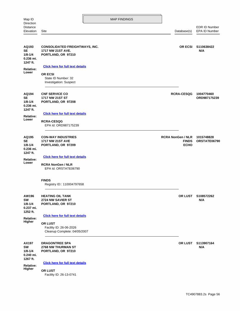
TC4907883.2s Page 56
AX197 OR LUSTDRAGONTREE SPA S113907164SW 2768 NW THURMAN ST N/A1/8-1/4 PORTLAND, OR 97210
Relative:Higher
Click here for full text details
0.240 mi.1267 ft.
OR LUST Facility ID: 26-13-0741
AW196 OR LUSTHEATING OIL TANK S108572262SW 2724 NW SAVIER ST N/A1/8-1/4 PORTLAND, OR 97210
Relative:Higher
Click here for full text details
0.237 mi.1252 ft.
OR LUST Facility ID: 26-06-2026 Cleanup Complete: 04/05/2007
AQ195 RCRA NonGen / NLRCON-WAY INDUSTRIES 1015748828SE FINDS1717 NW 21ST AVE ORSTATE067901/8-1/4 ECHOPORTLAND, OR 97209
Relative:Lower
Click here for full text details
0.236 mi.1247 ft.
RCRA NonGen / NLR EPA Id: ORSTATE06790
FINDS Registry ID:: 110004797658
AQ194 RCRA-CESQGCNF SERVICE CO 1004770460SE 1717 NW 21ST ST ORD9871752391/8-1/4 PORTLAND, OR 97208
Relative:Lower
Click here for full text details
0.236 mi.1247 ft.
RCRA-CESQG EPA Id: ORD987175239
AQ193 OR ECSICONSOLIDATED FREIGHTWAYS, INC. S110638422SE 1717 NW 21ST AVE. N/A1/8-1/4 PORTLAND, OR 97210
Relative:Lower
Click here for full text details
0.236 mi.1247 ft.
OR ECSI State ID Number: 32 Investigation: Suspect
MAP FINDINGSMap IDDirection
EDR ID NumberDistanceEPA ID NumberDatabase(s)SiteElevation

TC4907883.2s Page 57
AZ202 OR LUSTCOLUMBIA DISTRIBUTING CO. U000432434WNW OR UST2448 NW 28TH AVE N/A1/8-1/4 PORTLAND, OR 97210
Relative:Lower
Click here for full text details
0.243 mi.1282 ft.
OR LUST Facility ID: 26-90-0158 Cleanup Complete: 10/18/1990
OR UST
AV201 OR LUSTHEATING OIL TANK S106777652South 2441 NW PETTYGROVE ST N/A1/8-1/4 PORTLAND, OR 97210
Relative:Higher
Click here for full text details
0.242 mi.1280 ft.
OR LUST Facility ID: 26-04-2431 Cleanup Complete: 01/12/2007
AW200 OR LUSTHEATING OIL TANK S111834752SW 2703 NW RALEIGH ST N/A1/8-1/4 PORTLAND, OR 97210
Relative:Higher
Click here for full text details
0.242 mi.1277 ft.
OR LUST Facility ID: 26-12-0188 Cleanup Complete: 02/22/2013
AX199 OR LUSTHEATING OIL TANK S106475876SW 2751 NW SAVIER ST N/A1/8-1/4 PORTLAND, OR 97210
Relative:Higher
Click here for full text details
0.241 mi.1272 ft.
OR LUST Facility ID: 26-04-1059 Cleanup Complete: 11/15/2004
AT198 OR LUSTHEATING OIL TANK S104189317SSE 1524 NW 23RD AVE N/A1/8-1/4 PORTLAND, OR 97210
Relative:Higher
Click here for full text details
0.240 mi.1269 ft.
OR LUST Facility ID: 26-99-1138 Cleanup Complete: 11/03/2006
MAP FINDINGSMap IDDirection
EDR ID NumberDistanceEPA ID NumberDatabase(s)SiteElevation

TC4907883.2s Page 58
AS206 OR LUSTHEATING OIL TANK S101385037SSE 2336 NW QUIMBY N/A1/8-1/4 PORTLAND, OR 97210
Relative:Higher
Click here for full text details
0.245 mi.1292 ft.
OR LUST Facility ID: 26-95-5044
AV205 OR LUSTHEATING OIL TANK S116760564South 2485 NW PETTYGROVE ST N/A1/8-1/4 PORTLAND, OR 97210
Relative:Higher
Click here for full text details
0.243 mi.1285 ft.
OR LUST Facility ID: 26-14-0486
AV204 OR LUSTHEATING OIL TANK S110048145South 2463 NW PETTYGROVE ST N/A1/8-1/4 PORTLAND, OR 97210
Relative:Higher
Click here for full text details
0.243 mi.1283 ft.
OR LUST Facility ID: 26-09-0679
AZ203 RCRA NonGen / NLRSTUDIO CONCEPTS INC 1004771071WNW FINDS2448 NW 28TH AVE ORQ0000009351/8-1/4 ECHOPORTLAND, OR 97210
Relative:Lower
Click here for full text details
0.243 mi.1282 ft.
RCRA NonGen / NLR EPA Id: ORQ000000935
FINDS Registry ID:: 110004809253
COLUMBIA DISTRIBUTING CO. (Continued) U000432434
Facility ID: 5366
MAP FINDINGSMap IDDirection
EDR ID NumberDistanceEPA ID NumberDatabase(s)SiteElevation

TC4907883.2s Page 59
BA210 OR LUSTHEATING OIL TANK S106116913SSE 1410 NW 24TH AVE N/A1/8-1/4 PORTLAND, OR 97212
Relative:Higher
Click here for full text details
0.248 mi.1310 ft.
OR LUST Facility ID: 26-03-2382 Cleanup Complete: 09/12/2006
209 OR CRLSFI PROPERTY S109493944West OR ECSI2407 NW 28TH AVE. N/A1/8-1/4 OR ENG CONTROLSPORTLAND, OR 97210
Relative:Lower
Click here for full text details
0.248 mi. OR UIC1309 ft.
OR CRL Facility Id: 5103 Facility Status: No Further Action (Conditional)
OR ECSI State ID Number: 5103 Investigation: Listed on the CRL/Inventory
OR ENG CONTROLS Site Id: 5103
AW208 OR LUSTHEATING OIL TANK S111429787SW 2715 NW RALEIGH ST N/A1/8-1/4 PORTLAND, OR 97210
Relative:Higher
Click here for full text details
0.248 mi.1309 ft.
OR LUST Facility ID: 26-11-1154 Cleanup Complete: 03/26/2012
AW207 OR LUSTHEATING OIL TANK S109843430SW 2665-2667 NW RALEIGH N/A1/8-1/4 PORTLAND, OR 97210
Relative:Higher
Click here for full text details
0.245 mi.1295 ft.
OR LUST Facility ID: 26-09-0306
MAP FINDINGSMap IDDirection
EDR ID NumberDistanceEPA ID NumberDatabase(s)SiteElevation

TC4907883.2s Page 60
214 RCRA-SQGCENVEO GRAPHIC ARTS CENTER 1000347199East OR ECSI2000 NW WILSON ST ORD0090516651/4-1/2 OR LUSTPORTLAND, OR 97209
Relative:Lower
Click here for full text details
0.252 mi. OR UST1330 ft. ICIS
FINDSOR HSIS
OR MANIFESTECHO
RCRA-SQG EPA Id: ORD009051665
OR ECSI
BC213 OR LUSTHEATING OIL TANK S108987294WSW 1934 NW 28TH PL N/A1/4-1/2 PORTLAND, OR 97210
Relative:Higher
Click here for full text details
0.252 mi.1328 ft.
OR LUST Facility ID: 26-07-1854 Cleanup Complete: 09/10/2008
BB212 OR BROWNFIELDSROMAINE ELECTRIC - OREGON S111249473WSW OR HSIS9331 NE COLFAX ST STE 203 N/A1/4-1/2 PORTLAND, OR 97220
Relative:Higher
Click here for full text details
0.250 mi.1322 ft.
OR BROWNFIELDS envid: 6049 Status: Prospective Purchaser Agreement
OR HSIS Facility Id: 004499
BB211 OR ECSIROMAINE ELECTRIC S119162012WSW OR VCP1831 NW 28TH AVE. N/A1/4-1/2 PORTLAND, OR 97210
Relative:Higher
Click here for full text details
0.250 mi.1322 ft.
OR ECSI State ID Number: 6049 Investigation: Suspect
OR VCP ECS Site ID: 6049
MAP FINDINGSMap IDDirection
EDR ID NumberDistanceEPA ID NumberDatabase(s)SiteElevation

TC4907883.2s Page 61
BA216 OR LUSTHEATING OIL TANK S114397514SSE 1404 NW 24TH AVE N/A1/4-1/2 PORTLAND, OR 97210
Relative:Higher
Click here for full text details
0.254 mi.1343 ft.
OR LUST Facility ID: 26-13-1049 Cleanup Complete: 04/10/2014
BB215 OR LUSTHEATING OIL TANK S105981383WSW 2829 NW UPSHUR N/A1/4-1/2 PORTLAND, OR 97210
Relative:Higher
Click here for full text details
0.254 mi.1341 ft.
OR LUST Facility ID: 26-03-1488 Cleanup Complete: 10/18/2003
CENVEO GRAPHIC ARTS CENTER (Continued) 1000347199
State ID Number: 187 Investigation: No Further Action
OR LUST Facility ID: 26-89-0091 Cleanup Complete: 06/19/1989
OR UST Facility ID: 7352
ICIS FRS ID:: 110000487296
FINDS Registry ID:: 110000487296
OR HSIS Facility Id: 001054
OR MANIFEST Status: Small quantity generator Status: Large quantity generator EPA Id: ORD009051665 Status: SQG Status: LQG
MAP FINDINGSMap IDDirection
EDR ID NumberDistanceEPA ID NumberDatabase(s)SiteElevation

TC4907883.2s Page 62
BE221 OR LUSTBOISE CASCADE CORPORATION U000432371ESE OR UST2017 NW VAUGHN ST N/A1/4-1/2 PORTLAND, OR 97209
Relative:Lower
Click here for full text details
0.260 mi.1374 ft.
OR LUST Facility ID: 26-89-0163
BD220 OR LUSTHEATING OIL TANK S105247381SW 2756 NW SAVIOR ST N/A1/4-1/2 PORTLAND, OR 97210
Relative:Higher
Click here for full text details
0.260 mi.1373 ft.
OR LUST Facility ID: 26-02-5194 Cleanup Complete: 04/25/2002
AX219 OR LUSTROSENFELD, JOHN U002235041SW OR UST2761 NW SAVIER ST N/A1/4-1/2 PORTLAND, OR 97210
Relative:Higher
Click here for full text details
0.258 mi.1362 ft.
OR LUST Facility ID: 26-95-0032 Cleanup Complete: 01/05/1996
OR UST Facility ID: 11482
218 OR LUSTHEATING OIL TANK S100497337NNE 2901 NW FRONT AVENUE N/A1/4-1/2 PORTLAND, OR 97210
Relative:Lower
Click here for full text details
0.256 mi.1353 ft.
OR LUST Facility ID: 26-93-6006 Cleanup Complete: 03/18/1993
AW217 OR LUSTHEATING OIL TANK S108573018SW 2750 NW SAVIER ST N/A1/4-1/2 PORTLAND, OR 97210
Relative:Higher
Click here for full text details
0.255 mi.1345 ft.
OR LUST Facility ID: 26-07-0176
MAP FINDINGSMap IDDirection
EDR ID NumberDistanceEPA ID NumberDatabase(s)SiteElevation

TC4907883.2s Page 63
BF224 OR LUSTHEATING OIL TANK S105711158South 2440 NW PETTYGROVE STREET N/A1/4-1/2 PORTLAND, OR 97210
Relative:Higher
Click here for full text details
0.267 mi.1411 ft.
OR LUST Facility ID: 26-02-1136
BD223 OR LUSTHEATING OIL TANK S105556521SW 2766 NW SAVIER ST N/A1/4-1/2 PORTLAND, OR 97210
Relative:Higher
Click here for full text details
0.266 mi.1403 ft.
OR LUST Facility ID: 26-02-0701 Cleanup Complete: 07/20/2015
222 OR ECSIAMERICAN MACHINE & GEAR INC S111245818WNW OR VCP2770 NW INDUSTRIAL N/A1/4-1/2 OR HSISPORTLAND, OR 97210
Relative:Lower
Click here for full text details
0.263 mi.1388 ft.
OR ECSI State ID Number: 2261 Investigation: No Further Action
OR VCP ECS Site ID: 2261
OR HSIS Facility Id: 022256
BOISE CASCADE CORPORATION (Continued) U000432371
Facility ID: 26-06-1332 Cleanup Complete: 08/07/1989 Cleanup Complete: 01/10/2007
OR UST Facility ID: 5368
MAP FINDINGSMap IDDirection
EDR ID NumberDistanceEPA ID NumberDatabase(s)SiteElevation

TC4907883.2s Page 64
229 OR LUSTCONSOLIDATED FREIGHTWAYS U000432350SE OR UST2222 NW RALEIGH ST N/A1/4-1/2 PORTLAND, OR 97210
Relative:Higher
Click here for full text details
0.278 mi.1466 ft.
OR LUST Facility ID: 26-92-0025 Cleanup Complete: 12/03/1996
OR UST
BA228 OR LUSTHEATING OIL TANK S112225441South 1333 NW 24TH AVE N/A1/4-1/2 PORTLAND, OR 97210
Relative:Higher
Click here for full text details
0.273 mi.1440 ft.
OR LUST Facility ID: 26-12-0923 Cleanup Complete: 09/27/2012
BH227 OR LUSTHEATING OIL TANK S106475263South 1331 NW 25TH AVENUE N/A1/4-1/2 PORTLAND, OR 97210
Relative:Higher
Click here for full text details
0.272 mi.1436 ft.
OR LUST Facility ID: 26-04-0194
BG226 OR LUSTHEATING OIL TANK S107596177SSE 1430 NW 23 AVE N/A1/4-1/2 PORTLAND, OR 97210
Relative:Higher
Click here for full text details
0.272 mi.1435 ft.
OR LUST Facility ID: 26-05-2445 Cleanup Complete: 03/14/2006
BB225 OR LUSTHEATING OIL TANK S107465875WSW 2825 NW THURMAN ST N/A1/4-1/2 PORTLAND, OR 97210
Relative:Higher
Click here for full text details
0.271 mi.1430 ft.
OR LUST Facility ID: 26-05-1797 Cleanup Complete: 02/21/2006
MAP FINDINGSMap IDDirection
EDR ID NumberDistanceEPA ID NumberDatabase(s)SiteElevation

TC4907883.2s Page 65
BC232 OR LUSTHEATING OIL TANK S107135312WSW 1937 NW 28TH PL N/A1/4-1/2 PORTLAND, OR 97210
Relative:Higher
Click here for full text details
0.281 mi.1485 ft.
OR LUST Facility ID: 26-05-1139 Cleanup Complete: 08/25/2005
AY231 OR LUSTE C COMPANY U000432439ESE OR UST2121 NW THURMAN N/A1/4-1/2 OR MANIFESTPORTLAND, OR 97210
Relative:Lower
Click here for full text details
0.280 mi.1476 ft.
OR LUST Facility ID: 26-91-0480 Cleanup Complete: 11/25/1996
OR UST Facility ID: 9764
OR MANIFEST Status: Small quantity generator Status: Large quantity generator EPA Id: ORD987194297 Status: SQG Status: LQG
BH230 OR LUSTHEATING OIL TANK S105463668South 1311 NW 25TH AVE N/A1/4-1/2 PORTLAND, OR 97210
Relative:Higher
Click here for full text details
0.279 mi.1471 ft.
OR LUST Facility ID: 26-02-5611 Cleanup Complete: 06/26/2002
CONSOLIDATED FREIGHTWAYS (Continued) U000432350
Facility ID: 1994
MAP FINDINGSMap IDDirection
EDR ID NumberDistanceEPA ID NumberDatabase(s)SiteElevation

TC4907883.2s Page 66
BJ236 SEMS-ARCHIVENUDELMAN AND SON INC 1002998931NW 2707 NW NELA ST ORD0277440931/4-1/2 PORTLAND, OR 97210
Relative:Lower
Click here for full text details
0.285 mi.1504 ft.
SEMS-ARCHIVE Site ID: 1001205 EPA Id: ORD027744093
BJ235 OR ECSINUDELMAN & SON, INC. S103842001NW OR UIC2707 NW NELA ST. N/A1/4-1/2 PORTLAND, OR 97210
Relative:Lower
Click here for full text details
0.285 mi.1504 ft.
OR ECSI State ID Number: 966 Investigation: Suspect
BI234 OR LUSTHEATING OIL TANK S102076082WSW 2020 NW 29TH N/A1/4-1/2 PORTLAND, OR 97211
Relative:Lower
Click here for full text details
0.284 mi.1501 ft.
OR LUST Facility ID: 26-91-0259 Cleanup Complete: 02/14/2008
233 OR ECSIPGE - STATION E S106044944NE OR VCP2635 NW FRONT AVE. N/A1/4-1/2 PORTLAND, OR 97210
Relative:Lower
Click here for full text details
0.283 mi.1494 ft.
OR ECSI State ID Number: 3976 Investigation: No Further Action
OR VCP ECS Site ID: 3976
MAP FINDINGSMap IDDirection
EDR ID NumberDistanceEPA ID NumberDatabase(s)SiteElevation

TC4907883.2s Page 67
BK240 OR LUSTDASIC INTERNATIONAL CORP U004015080NNE OR UST3125 NW FRONT AVE N/A1/4-1/2 PORTLAND, OR 97210
Relative:Lower
Click here for full text details
0.289 mi.1524 ft.
OR LUST Facility ID: 26-90-0220 Cleanup Complete: 02/11/1991
OR UST
BK239 OR ECSIDASIC INTERNATIONAL CORP. 1006864258NNE FINDS3125 NW FRONT AVE N/A1/4-1/2 PORTLAND, OR 97210
Relative:Lower
Click here for full text details
0.289 mi.1524 ft.
OR ECSI State ID Number: 110 Investigation: Suspect
FINDS Registry ID:: 110014270779
BD238 OR LUSTHEATING OIL TANK S106777525SW 2775 NW RALEIGH ST N/A1/4-1/2 PORTLAND, OR 97210
Relative:Higher
Click here for full text details
0.288 mi.1519 ft.
OR LUST Facility ID: 26-04-2251 Cleanup Complete: 02/23/2005
237 OR ECSIILWU LOCAL 8 S106475321ENE OR LUST2435 NW FRONT AVE N/A1/4-1/2 OR VCPPORTLAND, OR 97209
Relative:Lower
Click here for full text details
0.285 mi.1505 ft.
OR ECSI State ID Number: 5173 Investigation: No Further Action
OR LUST Facility ID: 26-04-0272 Cleanup Complete: 08/30/2006
OR VCP ECS Site ID: 5173
MAP FINDINGSMap IDDirection
EDR ID NumberDistanceEPA ID NumberDatabase(s)SiteElevation

TC4907883.2s Page 68
BE244 OR LUSTBUILDERS APPLIANCE SUPPLY U000432373ESE OR UST2012 NW VAUGHN N/A1/4-1/2 PORTLAND, OR 97209
Relative:Lower
Click here for full text details
0.295 mi.1555 ft.
OR LUST Facility ID: 26-92-0342 Cleanup Complete: 02/05/1993
OR UST
BF243 OR LUSTHEATING OIL TANK S119015343South 2463 NW OVERTON ST N/A1/4-1/2 PORTLAND, OR 97210
Relative:Higher
Click here for full text details
0.291 mi.1538 ft.
OR LUST Facility ID: 26-16-0926
BF242 OR LUSTHEATING OIL TANK S110141273South 2455 NW OVERTON ST N/A1/4-1/2 PORTLAND, OR 97210
Relative:Higher
Click here for full text details
0.291 mi.1536 ft.
OR LUST Facility ID: 26-09-0995 Cleanup Complete: 01/27/2010
241 OR LUSTFRED N BAY NEWS CO U000432451NNW OR UST3155 NW YEON AVE N/A1/4-1/2 OR HSISPORTLAND, OR 97210
Relative:Lower
Click here for full text details
0.289 mi.1525 ft.
OR LUST Facility ID: 26-90-0160 Cleanup Complete: 11/23/1990
OR UST Facility ID: 1956
OR HSIS Facility Id: 022901
DASIC INTERNATIONAL CORP (Continued) U004015080
Facility ID: 4620
MAP FINDINGSMap IDDirection
EDR ID NumberDistanceEPA ID NumberDatabase(s)SiteElevation

TC4907883.2s Page 69
BI248 OR LUSTHEATING OIL TANK S114397457WSW 2000 NW 29TH AVE N/A1/4-1/2 PORTLAND, OR 97210
Relative:Higher
Click here for full text details
0.297 mi.1568 ft.
OR LUST Facility ID: 26-13-0949 Cleanup Complete: 01/22/2014
BL247 OR LUSTHEATING OIL TANK S104658326WSW 2855 NW THURMAN STREET N/A1/4-1/2 PORTLAND, OR 97210
Relative:Higher
Click here for full text details
0.295 mi.1560 ft.
OR LUST Facility ID: 26-00-5065 Cleanup Complete: 11/09/2000
BD246 OR LUSTHEATING OIL TANK S106777635SW 2804 NW SAVIER N/A1/4-1/2 PORTLAND, OR 97210
Relative:Higher
Click here for full text details
0.295 mi.1558 ft.
OR LUST Facility ID: 26-04-2410 Cleanup Complete: 02/23/2005
BG245 OR LUSTHEATING OIL TANK S102076076SSE 2287 NW PETTYGROVE N/A1/4-1/2 PORTLAND, OR 97209
Relative:Higher
Click here for full text details
0.295 mi.1556 ft.
OR LUST Facility ID: 26-91-0364 Cleanup Complete: 12/23/1991
BUILDERS APPLIANCE SUPPLY (Continued) U000432373
Facility ID: 10053
MAP FINDINGSMap IDDirection
EDR ID NumberDistanceEPA ID NumberDatabase(s)SiteElevation

TC4907883.2s Page 70
BN252 OR LUSTHEATING OIL TANK S102417400SSW 2624 NW PETTYGROVE N/A1/4-1/2 PORTLAND, OR 97210
Relative:Higher
Click here for full text details
0.299 mi.1577 ft.
OR LUST Facility ID: 26-97-0004 Cleanup Complete: 04/22/1997
BI251 OR LUSTHEATING OIL TANK S117565705WSW 1944 NW 29TH AVE N/A1/4-1/2 PORTLAND, OR 97210
Relative:Higher
Click here for full text details
0.299 mi.1577 ft.
OR LUST Facility ID: 26-14-1597 Cleanup Complete: 08/26/2015
BM250 SEMS-ARCHIVEZEHRUNG CORP 1000370441East RCRA NonGen / NLR2201 NW 20TH ORD0107294991/4-1/2 PORTLAND, OR 97208
Relative:Lower
Click here for full text details
0.297 mi.1570 ft.
SEMS-ARCHIVE Site ID: 1000390 EPA Id: ORD010729499
RCRA NonGen / NLR EPA Id: ORD010729499
BF249 OR LUSTHEATING OIL TANK S111210533South 1303 NW 24TH AVE N/A1/4-1/2 PORTLAND, OR 97210
Relative:Higher
Click here for full text details
0.297 mi.1569 ft.
OR LUST Facility ID: 26-11-0347 Cleanup Complete: 12/09/2011
MAP FINDINGSMap IDDirection
EDR ID NumberDistanceEPA ID NumberDatabase(s)SiteElevation
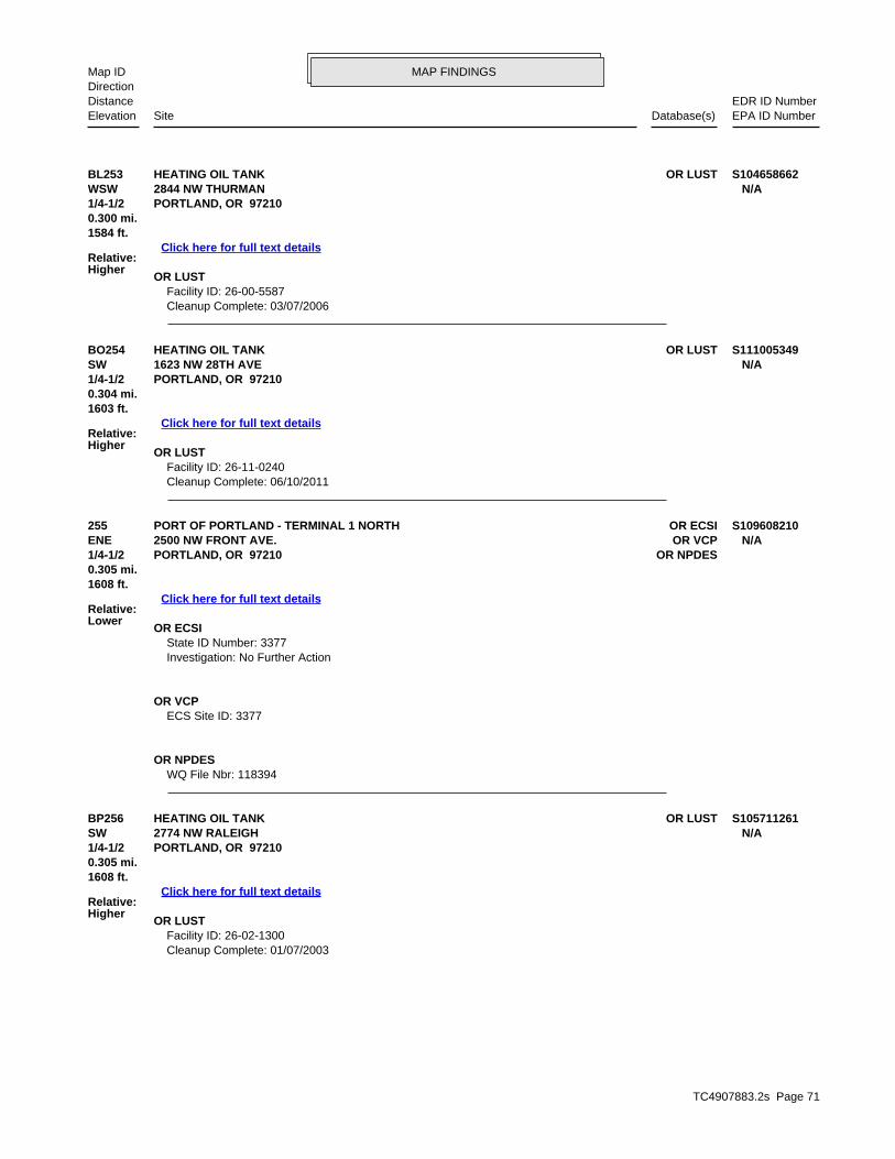
TC4907883.2s Page 71
BP256 OR LUSTHEATING OIL TANK S105711261SW 2774 NW RALEIGH N/A1/4-1/2 PORTLAND, OR 97210
Relative:Higher
Click here for full text details
0.305 mi.1608 ft.
OR LUST Facility ID: 26-02-1300 Cleanup Complete: 01/07/2003
255 OR ECSIPORT OF PORTLAND - TERMINAL 1 NORTH S109608210ENE OR VCP2500 NW FRONT AVE. N/A1/4-1/2 OR NPDESPORTLAND, OR 97210
Relative:Lower
Click here for full text details
0.305 mi.1608 ft.
OR ECSI State ID Number: 3377 Investigation: No Further Action
OR VCP ECS Site ID: 3377
OR NPDES WQ File Nbr: 118394
BO254 OR LUSTHEATING OIL TANK S111005349SW 1623 NW 28TH AVE N/A1/4-1/2 PORTLAND, OR 97210
Relative:Higher
Click here for full text details
0.304 mi.1603 ft.
OR LUST Facility ID: 26-11-0240 Cleanup Complete: 06/10/2011
BL253 OR LUSTHEATING OIL TANK S104658662WSW 2844 NW THURMAN N/A1/4-1/2 PORTLAND, OR 97210
Relative:Higher
Click here for full text details
0.300 mi.1584 ft.
OR LUST Facility ID: 26-00-5587 Cleanup Complete: 03/07/2006
MAP FINDINGSMap IDDirection
EDR ID NumberDistanceEPA ID NumberDatabase(s)SiteElevation

TC4907883.2s Page 72
BR261 OR LUSTHEATING OIL TANK S105556438WSW 1916 NW 29TH AVE N/A1/4-1/2 PORTLAND, OR 97210
Relative:Higher
Click here for full text details
0.308 mi.1624 ft.
OR LUST Facility ID: 26-02-0559 Cleanup Complete: 10/17/2002
BO260 OR LUSTHEATING OIL TANK S104658519SW 2788 NW RALEIGH ST N/A1/4-1/2 PORTLAND, OR 97210
Relative:Higher
Click here for full text details
0.307 mi.1620 ft.
OR LUST Facility ID: 26-00-5366 Cleanup Complete: 01/16/2001
BL259 OR LUSTHEATING OIL TANK S117880919WSW 2865 NW THURMAN ST N/A1/4-1/2 PORTLAND, OR 97210
Relative:Higher
Click here for full text details
0.305 mi.1612 ft.
OR LUST Facility ID: 26-15-0032
BQ258 OR LUSTHEATING OIL TANK S118452459SSW 1425-1429 NW 27TH AVE N/A1/4-1/2 PORTLAND, OR 97210
Relative:Higher
Click here for full text details
0.305 mi.1610 ft.
OR LUST Facility ID: 26-15-1712 Cleanup Complete: 05/31/2016
BQ257 OR LUSTHEATING OIL TANK S104974240SSW 1425 NW 27TH AVE N/A1/4-1/2 PORTLAND, OR 97210
Relative:Higher
Click here for full text details
0.305 mi.1610 ft.
OR LUST Facility ID: 26-01-5733 Cleanup Complete: 05/24/2001
MAP FINDINGSMap IDDirection
EDR ID NumberDistanceEPA ID NumberDatabase(s)SiteElevation

TC4907883.2s Page 73
BS265 OR LUSTHEATING OIL TANK S118673537SE OR SPILLS1621 NW 21ST AVE N/A1/4-1/2 OR NPDESPORTLAND, OR 97209
Relative:Lower
Click here for full text details
0.311 mi.1640 ft.
OR LUST Facility ID: 26-16-0854 Facility ID: 26-16-1025 Cleanup Complete: 07/22/2016
OR SPILLS Facility ID: 2016-2311
OR NPDES WQ File Nbr: 124565
BG264 OR LUSTHEATING OIL TANK S102959453SSE NW PETTIGROVE BETWEEN NW 23RD & 24TH N/A1/4-1/2 PORLTAND, OR 97209
Relative:Higher
Click here for full text details
0.309 mi.1629 ft.
OR LUST Facility ID: 26-90-0036 Cleanup Complete: 04/18/1990
BP263 OR LUSTHEATING OIL TANK S109204623SW 2745 NW QUIMBY ST N/A1/4-1/2 PORTLAND, OR 97210
Relative:Higher
Click here for full text details
0.308 mi.1626 ft.
OR LUST Facility ID: 26-08-0745 Cleanup Complete: 07/14/2008
BN262 OR LUSTHEATING OIL TANK S105856629SSW 2646 NW PETTYGROVE STREET N/A1/4-1/2 PORTLAND, OR 97210
Relative:Higher
Click here for full text details
0.308 mi.1624 ft.
OR LUST Facility ID: 26-03-0713 Cleanup Complete: 06/24/2003
MAP FINDINGSMap IDDirection
EDR ID NumberDistanceEPA ID NumberDatabase(s)SiteElevation

TC4907883.2s Page 74
BT270 OR LUSTMCCRACKEN MOTOR FREIGHT INC U000432470North OR UST3147 NW FRONT AVE N/A1/4-1/2 PORTLAND, OR 97210
Relative:Lower
Click here for full text details
0.314 mi.1658 ft.
OR LUST Facility ID: 26-91-0048
BM269 WA SWF/LFIRON MOUNTAIN S118401790East 2116 NW 20TH AVE N/A1/4-1/2 PORTLAND, WA 97209
Relative:Lower
Click here for full text details
0.313 mi.1654 ft.
WA SWF/LF Facility ID: 1704
BO268 OR LUSTHEATING OIL TANK S108572166SW 2824 NW SAVIER ST N/A1/4-1/2 PORTLAND, OR 97210
Relative:Higher
Click here for full text details
0.312 mi.1647 ft.
OR LUST Facility ID: 26-06-1780 Cleanup Complete: 02/25/2008
267 OR LUSTHEATING OIL TANK S102590010WNW 2535 NW 28TH AVENUE N/A1/4-1/2 PORTLAND, OR 97210
Relative:Lower
Click here for full text details
0.311 mi.1642 ft.
OR LUST Facility ID: 26-97-0282 Cleanup Complete: 09/27/2011
BS266 OR LUSTCONWAY INC. U000432348SE OR UST1621 NW 21ST AVE N/A1/4-1/2 PORTLAND, OR 97209
Relative:Lower
Click here for full text details
0.311 mi.1640 ft.
OR LUST Facility ID: 26-87-0037 Cleanup Complete: 06/27/1988
OR UST Facility ID: 1996
MAP FINDINGSMap IDDirection
EDR ID NumberDistanceEPA ID NumberDatabase(s)SiteElevation

TC4907883.2s Page 75
BU274 OR LUSTHEATING OIL TANK S108572226South 2474 NW OVERTON ST N/A1/4-1/2 PORTLAND, OR 97210
Relative:Higher
Click here for full text details
0.317 mi.1672 ft.
OR LUST Facility ID: 26-06-1931 Cleanup Complete: 01/31/2007
BU273 OR LUSTHEATING OIL TANK S104658293South 2434 NW OVERTON N/A1/4-1/2 PORTLAND, OR 97210
Relative:Higher
Click here for full text details
0.316 mi.1669 ft.
OR LUST Facility ID: 26-00-5009 Cleanup Complete: 07/25/2000
BR272 OR LUSTHEATING OIL TANK S109346983WSW 1931 NW 29TH AVE N/A1/4-1/2 PORTLAND, OR 97210
Relative:Higher
Click here for full text details
0.316 mi.1669 ft.
OR LUST Facility ID: 26-08-1252 Cleanup Complete: 10/01/2008
BP271 OR LUSTHEATING OIL TANK S104658518SW 1530 NW 28TH AVE N/A1/4-1/2 PORTLAND, OR 97210
Relative:Higher
Click here for full text details
0.314 mi.1658 ft.
OR LUST Facility ID: 26-00-5365 Cleanup Complete: 02/14/2001
MCCRACKEN MOTOR FREIGHT INC (Continued) U000432470
Cleanup Complete: 09/01/2008
OR UST Facility ID: 8085
MAP FINDINGSMap IDDirection
EDR ID NumberDistanceEPA ID NumberDatabase(s)SiteElevation

TC4907883.2s Page 76
BW279 OR ECSIDOLAN PROPERTY S110638693NE OR LUST2700 NW FRONT AVE. N/A1/4-1/2 OR VCPPORTLAND, OR 97210
Relative:Lower
Click here for full text details
0.320 mi. OR NPDES1689 ft.
OR ECSI State ID Number: 6147 Investigation: Suspect
OR LUST Facility ID: 26-10-1102 Cleanup Complete: 04/01/2011
BW278 WA SWRCYQUANTUM RESOURCE RECOVERY S116383684NE 2700 NW FRONT AVE N/A1/4-1/2 PORTLAND, OR 97210
Relative:Lower
Click here for full text details
0.320 mi.1689 ft.
BV277 OR LUSTHEATING OIL TANK S102959465West 2310 NW 29TH N/A1/4-1/2 PORTLAND, OR 97210
Relative:Lower
Click here for full text details
0.318 mi.1678 ft.
OR LUST Facility ID: 26-97-0974
BN276 OR LUSTHEATING OIL TANK S110141181SSW 2666 NW PETTYGROVE ST N/A1/4-1/2 PORTLAND, OR 97210
Relative:Higher
Click here for full text details
0.317 mi.1674 ft.
OR LUST Facility ID: 26-09-1227 Cleanup Complete: 02/09/2010
BU275 OR LUSTHEATING OIL TANK S117881092South 2424 NW OVERTON ST N/A1/4-1/2 PORTLAND, OR 97210
Relative:Higher
Click here for full text details
0.317 mi.1673 ft.
OR LUST Facility ID: 26-15-0290 Cleanup Complete: 09/04/2015
MAP FINDINGSMap IDDirection
EDR ID NumberDistanceEPA ID NumberDatabase(s)SiteElevation

TC4907883.2s Page 77
BQ283 OR LUSTHEATING OIL TANK S102417407SSW 2705 NE PETTYGROVE N/A1/4-1/2 PORTLAND, OR 97210
Relative:Higher
Click here for full text details
0.324 mi.1710 ft.
OR LUST Facility ID: 26-96-0405
BX282 OR LUSTHEATING OIL TANK S109346906South 1225 NW 25TH AVE N/A1/4-1/2 PORTLAND, OR 97210
Relative:Higher
Click here for full text details
0.323 mi.1707 ft.
OR LUST Facility ID: 26-08-1086 Facility ID: 26-09-0504 Cleanup Complete: 11/05/2008 Cleanup Complete: 12/04/2009
BY281 OR LUSTHEATING OIL TANK S102778371SSW 2680 NW PETTYGROVE N/A1/4-1/2 PORTLAND, OR 97210
Relative:Higher
Click here for full text details
0.322 mi.1701 ft.
OR LUST Facility ID: 26-92-5073 Cleanup Complete: 04/23/1993
BX280 OR LUSTHEATING OIL TANK S102520939South 2544 NW OVERTON N/A1/4-1/2 PORTLAND, OR 97210
Relative:Higher
Click here for full text details
0.322 mi.1701 ft.
OR LUST Facility ID: 26-97-0150 Cleanup Complete: 09/29/2000
DOLAN PROPERTY (Continued) S110638693
OR VCP ECS Site ID: 6147
OR NPDES WQ File Nbr: 121208 WQ File Nbr: 123179
MAP FINDINGSMap IDDirection
EDR ID NumberDistanceEPA ID NumberDatabase(s)SiteElevation

TC4907883.2s Page 78
BZ287 OR LUSTHEATING OIL TANK S111005332South 1234 NW 24TH AVE N/A1/4-1/2 PORTLAND, OR 97210
Relative:Higher
Click here for full text details
0.330 mi.1743 ft.
OR LUST Facility ID: 26-11-0202 Cleanup Complete: 05/24/2011
BX286 OR LUSTHEATING OIL TANK S102520937SSW 2574 NW OVERTON N/A1/4-1/2 PORTLAND, OR 97210
Relative:Higher
Click here for full text details
0.328 mi.1732 ft.
OR LUST Facility ID: 26-97-0075 Cleanup Complete: 02/06/1998
BJ285 OR ECSILONGVIEW CITY LAUNDRY & CLEANERS INC 1001128165NW RCRA NonGen / NLR2737 NW NELA ST ORQ0000051401/4-1/2 FINDSPORTLAND, OR 97210
Relative:Lower
Click here for full text details
0.327 mi. ECHO1728 ft.
OR ECSI State ID Number: 1395 Investigation: Suspect
RCRA NonGen / NLR EPA Id: ORQ000005140
FINDS Registry ID:: 110004812551
BZ284 OR LUSTHEATING OIL TANK S106475831SSE 2376 NW OVERTON STREET N/A1/4-1/2 PORTLAND, OR 97210
Relative:Higher
Click here for full text details
0.325 mi.1714 ft.
OR LUST Facility ID: 26-04-0996 Cleanup Complete: 07/12/2004
HEATING OIL TANK (Continued) S102417407
Cleanup Complete: 03/25/1997
MAP FINDINGSMap IDDirection
EDR ID NumberDistanceEPA ID NumberDatabase(s)SiteElevation

TC4907883.2s Page 79
BY291 OR LUSTHEATING OIL TANK S104974463SSW 2710 NW PETTYGROVE ST N/A1/4-1/2 PORTLAND, OR 97210
Relative:Higher
Click here for full text details
0.339 mi.1790 ft.
OR LUST Facility ID: 26-01-6074 Cleanup Complete: 09/19/2001
CA290 OR LUSTHEATING OIL TANK S112225555SW 2873-79 NW SAVIER N/A1/4-1/2 PORTLAND, OR 97210
Relative:Higher
Click here for full text details
0.337 mi.1780 ft.
OR LUST Facility ID: 26-12-1113 Cleanup Complete: 11/13/2012
289 OR LUSTTRANSCON LINES U000432495NNW OR UST3182 NW 26TH AVE N/A1/4-1/2 OR SPILLSPORTLAND, OR 97210
Relative:Lower
Click here for full text details
0.331 mi.1749 ft.
OR LUST Facility ID: 26-91-0113 Cleanup Complete: 09/03/1992
OR UST Facility ID: 5265
OR SPILLS Facility ID: 2013-2638
BX288 OR LUSTHEATING OIL TANK S111834807SSW 2584 NW OVERTON ST N/A1/4-1/2 PORTLAND, OR 97210
Relative:Higher
Click here for full text details
0.330 mi.1745 ft.
OR LUST Facility ID: 26-12-0280 Cleanup Complete: 07/23/2012
MAP FINDINGSMap IDDirection
EDR ID NumberDistanceEPA ID NumberDatabase(s)SiteElevation

TC4907883.2s Page 80
CA296 OR LUSTHEATING OIL TANK S111210574WSW 1724-28 NW 29TH AVE N/A1/4-1/2 PORTLAND, OR 97210
Relative:Higher
Click here for full text details
0.343 mi.1813 ft.
OR LUST Facility ID: 26-11-0409 Cleanup Complete: 08/01/2011
BL295 OR LUSTHEATING OIL TANK S104974272WSW 2894 NW THURMAN ST N/A1/4-1/2 PORTLAND, OR 97210
Relative:Higher
Click here for full text details
0.341 mi.1798 ft.
OR LUST Facility ID: 26-01-5778 Cleanup Complete: 08/23/2001
BU294 OR LUSTHEATING OIL TANK S109204406South 2465 NW NORTHRUP ST N/A1/4-1/2 PORTLAND, OR 97210
Relative:Higher
Click here for full text details
0.341 mi.1798 ft.
OR LUST Facility ID: 26-08-0397 Cleanup Complete: 09/12/2008
293 OR LUSTHEATING OIL TANK S100921230ESE 1995 NW UPSHUR N/A1/4-1/2 PORTLAND, OR 97209
Relative:Lower
Click here for full text details
0.339 mi.1792 ft.
OR LUST Facility ID: 26-94-0073 Cleanup Complete: 11/28/1994
CB292 OR LUSTHEATING OIL TANK S100497228SSE NW OVERTON, BETWEEN NW 23RD & 24TH N/A1/4-1/2 PORTLAND, OR 97209
Relative:Higher
Click here for full text details
0.339 mi.1791 ft.
OR LUST Facility ID: 26-90-0037 Cleanup Complete: 01/25/1990
MAP FINDINGSMap IDDirection
EDR ID NumberDistanceEPA ID NumberDatabase(s)SiteElevation

TC4907883.2s Page 81
CC301 OR LUSTHEATING OIL TANK S103248165SSW 2624 NW OVERTON STREET N/A1/4-1/2 PORTLAND, OR 97210
Relative:Higher
Click here for full text details
0.347 mi.1834 ft.
OR LUST Facility ID: 26-98-0639 Cleanup Complete: 08/21/1998
BO300 OR LUSTHEATING OIL TANK S108987365SW 2832 NW RALEIGH ST N/A1/4-1/2 PORTLAND, OR 97210
Relative:Higher
Click here for full text details
0.345 mi.1824 ft.
OR LUST Facility ID: 26-07-1887
BX299 OR LUSTHEATING OIL TANK S112225578South 2537 NW NORTHRUP N/A1/4-1/2 PORTLAND, OR 97210
Relative:Higher
Click here for full text details
0.345 mi.1821 ft.
OR LUST Facility ID: 26-12-1150 Cleanup Complete: 01/16/2013
CC298 OR LUSTHEATING OIL TANK S119015330SSW 1225 NW 26TH AVE N/A1/4-1/2 PORTLAND, OR 97210
Relative:Higher
Click here for full text details
0.345 mi.1821 ft.
OR LUST Facility ID: 26-16-0906 Cleanup Complete: 09/23/2016
BX297 OR LUSTHEATING OIL TANK S103839121South 2529 NW NORTHRUP N/A1/4-1/2 PORTLAND, OR 97210
Relative:Higher
Click here for full text details
0.344 mi.1817 ft.
OR LUST Facility ID: 26-99-0567 Cleanup Complete: 08/12/1999
MAP FINDINGSMap IDDirection
EDR ID NumberDistanceEPA ID NumberDatabase(s)SiteElevation

TC4907883.2s Page 82
CD305 OR LUSTHEATING OIL TANK S101385035SE 1400 NW 22 N/A1/4-1/2 PORTLAND, OR 97210
Relative:Higher
Click here for full text details
0.349 mi.1841 ft.
OR LUST Facility ID: 26-94-0207 Cleanup Complete: 02/14/1995
BX304 OR LUSTHEATING OIL TANK S115330511South 2555 NW NORTHRUP ST N/A1/4-1/2 PORTLAND, OR 97210
Relative:Higher
Click here for full text details
0.348 mi.1837 ft.
OR LUST Facility ID: 26-13-1316 Cleanup Complete: 03/17/2014
BY303 OR LUSTHEATING OIL TANK S105154089SSW 2685 NW OVERTON ST N/A1/4-1/2 PORTLAND, OR 97210
Relative:Higher
Click here for full text details
0.348 mi.1836 ft.
OR LUST Facility ID: 26-01-8297 Cleanup Complete: 12/07/2001
BV302 OR LUSTCAMERON GREAT LAKES INC S111247564West OR HSIS2335 NW 29TH AVE N/A1/4-1/2 PORTLAND, OR 97210
Relative:Lower
Click here for full text details
0.348 mi.1836 ft.
OR LUST Facility ID: 26-15-1488 Cleanup Complete: 01/06/2016
OR HSIS Facility Id: 004981
MAP FINDINGSMap IDDirection
EDR ID NumberDistanceEPA ID NumberDatabase(s)SiteElevation
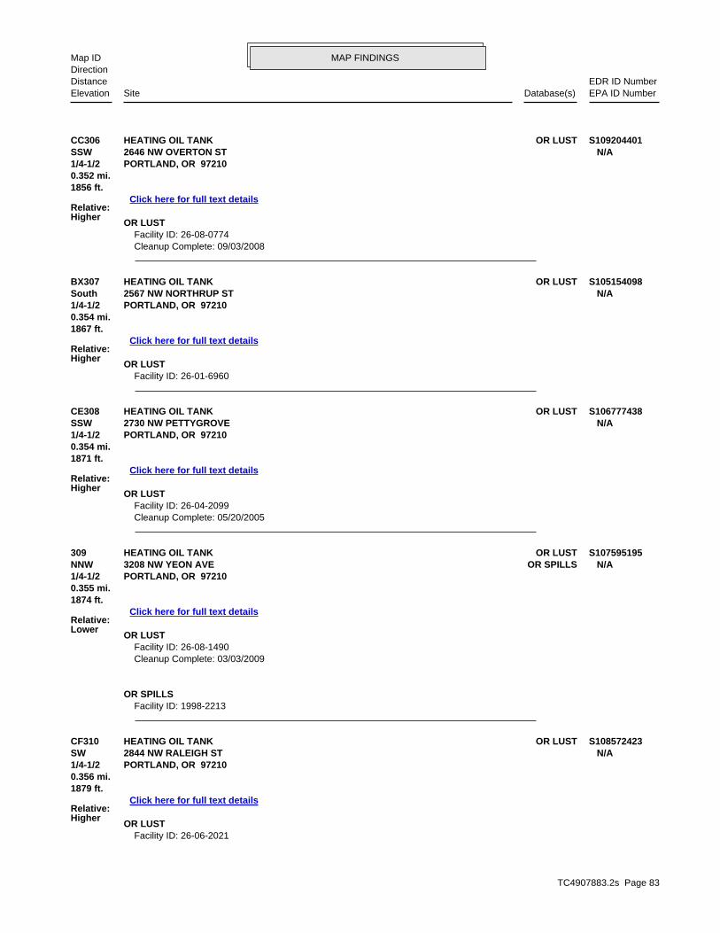
TC4907883.2s Page 83
CF310 OR LUSTHEATING OIL TANK S108572423SW 2844 NW RALEIGH ST N/A1/4-1/2 PORTLAND, OR 97210
Relative:Higher
Click here for full text details
0.356 mi.1879 ft.
OR LUST Facility ID: 26-06-2021
309 OR LUSTHEATING OIL TANK S107595195NNW OR SPILLS3208 NW YEON AVE N/A1/4-1/2 PORTLAND, OR 97210
Relative:Lower
Click here for full text details
0.355 mi.1874 ft.
OR LUST Facility ID: 26-08-1490 Cleanup Complete: 03/03/2009
OR SPILLS Facility ID: 1998-2213
CE308 OR LUSTHEATING OIL TANK S106777438SSW 2730 NW PETTYGROVE N/A1/4-1/2 PORTLAND, OR 97210
Relative:Higher
Click here for full text details
0.354 mi.1871 ft.
OR LUST Facility ID: 26-04-2099 Cleanup Complete: 05/20/2005
BX307 OR LUSTHEATING OIL TANK S105154098South 2567 NW NORTHRUP ST N/A1/4-1/2 PORTLAND, OR 97210
Relative:Higher
Click here for full text details
0.354 mi.1867 ft.
OR LUST Facility ID: 26-01-6960
CC306 OR LUSTHEATING OIL TANK S109204401SSW 2646 NW OVERTON ST N/A1/4-1/2 PORTLAND, OR 97210
Relative:Higher
Click here for full text details
0.352 mi.1856 ft.
OR LUST Facility ID: 26-08-0774 Cleanup Complete: 09/03/2008
MAP FINDINGSMap IDDirection
EDR ID NumberDistanceEPA ID NumberDatabase(s)SiteElevation

TC4907883.2s Page 84
CF314 OR LUSTHEATING OIL TANK S108572766SW 2854 NW RALEIGH ST N/A1/4-1/2 PORTLAND, OR 97210
Relative:Higher
Click here for full text details
0.363 mi.1919 ft.
OR LUST Facility ID: 26-07-0537 Cleanup Complete: 11/13/2007
CD313 OR LUSTROSAN PROPERTY S118347840SE 2140 NW QUIMBY ST N/A1/4-1/2 PORTLAND, OR 97210
Relative:Higher
Click here for full text details
0.363 mi.1918 ft.
OR LUST Facility ID: 26-15-1371
312 OR LUSTHEATING OIL TANK S104658259WNW OR HSIS2455 NW 29TH N/A1/4-1/2 PORTLAND, OR 97210
Relative:Lower
Click here for full text details
0.361 mi.1908 ft.
OR LUST Facility ID: 26-00-0814 Cleanup Complete: 12/14/2000
OR HSIS Facility Id: 114191
BT311 OR LUSTHEATING OIL TANK S102959457North 3060 NW FRONT AVENUE N/A1/4-1/2 PORTLAND, OR 97209
Relative:Lower
Click here for full text details
0.357 mi.1885 ft.
OR LUST Facility ID: 26-98-0081 Cleanup Complete: 10/17/2001
HEATING OIL TANK (Continued) S108572423
Cleanup Complete: 04/25/2007
MAP FINDINGSMap IDDirection
EDR ID NumberDistanceEPA ID NumberDatabase(s)SiteElevation

TC4907883.2s Page 85
CB319 OR LUSTHEATING OIL TANK S105154095SSE 2256 NW OVERTON ST N/A1/4-1/2 PORTLAND, OR 97210
Relative:Higher
Click here for full text details
0.369 mi.1946 ft.
OR LUST Facility ID: 26-01-8159 Cleanup Complete: 11/14/2001
CA318 OR LUSTHEATING OIL TANK S116760524SW 2896 NW SAVIER ST N/A1/4-1/2 PORTLAND, OR 97210
Relative:Higher
Click here for full text details
0.367 mi.1937 ft.
OR LUST Facility ID: 26-14-0420
CE317 OR LUSTHEATING OIL TANK S102417403SSW 2701 NW CORNELL ROAD N/A1/4-1/2 PORTLAND, OR 97210
Relative:Higher
Click here for full text details
0.367 mi.1936 ft.
OR LUST Facility ID: 26-96-0009 Cleanup Complete: 03/19/1996
CG316 OR LUSTHEATING OIL TANK S108834671South 1134 NW 25TH AVE N/A1/4-1/2 PORTLAND, OR 97210
Relative:Higher
Click here for full text details
0.365 mi.1925 ft.
OR LUST Facility ID: 26-07-1228 Cleanup Complete: 12/11/2007
CE315 OR LUSTHEATING OIL TANK S110737805SSW 2747 NW CORNELL RD N/A1/4-1/2 PORTLAND, OR 97210
Relative:Higher
Click here for full text details
0.365 mi.1925 ft.
OR LUST Facility ID: 26-10-1264 Cleanup Complete: 07/19/2011
MAP FINDINGSMap IDDirection
EDR ID NumberDistanceEPA ID NumberDatabase(s)SiteElevation

TC4907883.2s Page 86
324 OR LUSTHEATING OIL TANK S117365536SSE 2244 NW OVERTON ST N/A1/4-1/2 PORTLAND, OR 97210
Relative:Higher
Click here for full text details
0.374 mi.1974 ft.
OR LUST Facility ID: 26-14-1275 Cleanup Complete: 03/18/2015
CI323 OR LUSTHEATING OIL TANK S111005310South 2374 NW NORTHRUP ST N/A1/4-1/2 PORTLAND, OR 97210
Relative:Higher
Click here for full text details
0.373 mi.1967 ft.
OR LUST Facility ID: 26-11-0174
CH322 OR LUSTHEATING OIL TANK S119015411South 2556 NW NORTHRUP ST N/A1/4-1/2 PORTLAND, OR 97210
Relative:Higher
Click here for full text details
0.372 mi.1965 ft.
OR LUST Facility ID: 26-16-1048
CC321 OR LUSTHEATING OIL TANK S105981704SSW 2637 NW NORTHRUP N/A1/4-1/2 PORTLAND, OR 97210
Relative:Higher
Click here for full text details
0.372 mi.1962 ft.
OR LUST Facility ID: 26-03-2010 Cleanup Complete: 05/21/2010
CF320 OR LUSTHEATING OIL TANK S111210629SW 2864 NW RALEIGH ST N/A1/4-1/2 PORTLAND, OR 97210
Relative:Higher
Click here for full text details
0.371 mi.1960 ft.
OR LUST Facility ID: 26-11-0489 Cleanup Complete: 09/19/2011
MAP FINDINGSMap IDDirection
EDR ID NumberDistanceEPA ID NumberDatabase(s)SiteElevation

TC4907883.2s Page 87
CF329 OR LUSTHEATING OIL TANK S104908208SW 2855 NW CORNELL RD N/A1/4-1/2 PORTLAND, OR 97210
Relative:Higher
Click here for full text details
0.377 mi.1988 ft.
OR LUST Facility ID: 26-01-5588 Cleanup Complete: 08/16/2001
CH328 OR LUSTHEATING OIL TANK S107596344South 2572 NW NORTHRUP ST N/A1/4-1/2 PORTLAND, OR 97209
Relative:Higher
Click here for full text details
0.376 mi.1984 ft.
OR LUST Facility ID: 26-05-2432 Cleanup Complete: 02/21/2006
CI327 OR LUSTHEATING OIL TANK S105981435South 1127 NW 24TH AVE N/A1/4-1/2 PORTLAND, OR 97210
Relative:Higher
Click here for full text details
0.375 mi.1980 ft.
OR LUST Facility ID: 26-03-1569 Cleanup Complete: 02/02/2004
CG326 OR LUSTHEATING OIL TANK S103839122South 1121 NW 25TH AVE N/A1/4-1/2 PORTLAND, OR 97210
Relative:Higher
Click here for full text details
0.375 mi.1980 ft.
OR LUST Facility ID: 26-99-0234 Cleanup Complete: 10/18/2012
325 OR LUSTHEATING OIL TANK S110292547WSW 2922 NW THURMAN ST N/A1/4-1/2 PORTLAND, OR 97210
Relative:Higher
Click here for full text details
0.375 mi.1980 ft.
OR LUST Facility ID: 26-10-0117 Cleanup Complete: 05/11/2010
MAP FINDINGSMap IDDirection
EDR ID NumberDistanceEPA ID NumberDatabase(s)SiteElevation

TC4907883.2s Page 88
331 RCRA-SQGSULZER PUMPS US INC 1000234729NNE OR CRL2800 NW FRONT AVE ORD0090246051/4-1/2 OR ECSIPORTLAND, OR 97210
Relative:Lower
Click here for full text details
0.377 mi. OR LUST1992 ft. OR UST
OR ASTOR VCPOR HSIS
OR MANIFESTOR NPDES
RCRA-SQG EPA Id: ORD009024605
OR CRL Facility Id: 1235 Facility Status: EXPANDED PRELIMINARY ASSESSMENT
OR ECSI State ID Number: 1235 Investigation: Listed on the CRL/Inventory
OR LUST Facility ID: 26-04-2299
OR UST Facility ID: 6835
OR AST Facility Id: 006697
OR VCP ECS Site ID: 1235
OR HSIS Facility Id: 006697
OR MANIFEST Status: Small quantity generator
CA330 OR LUSTHEATING OIL TANK S109204390WSW 2924 & 2928 NW SAVIER ST N/A1/4-1/2 PORTLAND, OR 97210
Relative:Higher
Click here for full text details
0.377 mi.1991 ft.
OR LUST Facility ID: 26-08-0476 Cleanup Complete: 08/12/2008
MAP FINDINGSMap IDDirection
EDR ID NumberDistanceEPA ID NumberDatabase(s)SiteElevation

TC4907883.2s Page 89
334 OR LUSTMAGID PROPERTY S102778359West 2300 NW 30TH AVE N/A1/4-1/2 PORTLAND, OR 97210
Relative:Lower
Click here for full text details
0.379 mi.2001 ft.
OR LUST Facility ID: 26-88-0055 Cleanup Complete: 09/16/1988
333 OR LUSTCONSOLIDATED FREIGHTWAYS QUIMBY ST 1000383963SE OR UST2050 NW QUIMBY ST ORD0331328121/4-1/2 RCRA NonGen / NLRPORTLAND, OR 97209
Relative:Higher
Click here for full text details
0.379 mi.2001 ft.
OR LUST Facility ID: 26-89-0305 Facility ID: 26-95-0308 Cleanup Complete: 06/19/2012 Cleanup Complete: 09/26/1997
OR UST Facility ID: 1999
RCRA NonGen / NLR EPA Id: ORD033132812
CF332 OR LUSTHEATING OIL TANK S105075930SW 2874 NW RALEIGH ST N/A1/4-1/2 PORTLAND, OR 97210
Relative:Higher
Click here for full text details
0.379 mi.2000 ft.
OR LUST Facility ID: 26-01-6396 Cleanup Complete: 08/17/2009
SULZER PUMPS US INC (Continued) 1000234729
EPA Id: ORD009024605 Status: SQG
OR NPDES WQ File Nbr: 102334
MAP FINDINGSMap IDDirection
EDR ID NumberDistanceEPA ID NumberDatabase(s)SiteElevation

TC4907883.2s Page 90
CL339 OR LUSTHEATING OIL TANK S108572829SW 1270 NW SUMMIT AVE N/A1/4-1/2 PORTLAND, OR 97210
Relative:Higher
Click here for full text details
0.387 mi.2042 ft.
OR LUST Facility ID: 26-07-0934 Cleanup Complete: 08/29/2007
CI338 OR LUSTHEATING OIL TANK S114397616South 1115 NW 24TH AVE N/A1/4-1/2 PORTLAND, OR 97210
Relative:Higher
Click here for full text details
0.384 mi.2030 ft.
OR LUST Facility ID: 26-13-1238 Cleanup Complete: 11/04/2013
CK337 OR LUSTHEATING OIL TANK S105154088WNW OR UIC2720 NW 29TH AVE N/A1/4-1/2 PORTLAND, OR 97210
Relative:Lower
Click here for full text details
0.382 mi.2016 ft.
OR LUST Facility ID: 26-01-8143 Cleanup Complete: 06/19/2002
CJ336 OR LUSTHEATING OIL TANK S100921233SW 2895 NW RALEIGH N/A1/4-1/2 PORTLAND, OR 97210
Relative:Higher
Click here for full text details
0.382 mi.2015 ft.
OR LUST Facility ID: 26-94-6004 Cleanup Complete: 03/04/1994
CI335 OR LUSTHEATING OIL TANK S107135527SSE 2346 NW NORTHRUP N/A1/4-1/2 PORTLAND, OR 97210
Relative:Higher
Click here for full text details
0.379 mi.2002 ft.
OR LUST Facility ID: 26-05-1448 Cleanup Complete: 11/04/2005
MAP FINDINGSMap IDDirection
EDR ID NumberDistanceEPA ID NumberDatabase(s)SiteElevation

TC4907883.2s Page 91
CM343 OR CRLGALVANIZERS CO. S119015036West 2406 NW 30TH AVE. N/A1/4-1/2 PORTLAND, OR 97210
Relative:Lower
Click here for full text details
0.391 mi.2065 ft.
OR CRL Facility Id: 1196 Facility Status: Source Control Decision
CM342 OR ECSIGALVANIZERS CO. S119161949West OR VCP2406 NW 30TH AVE. N/A1/4-1/2 PORTLAND, OR 97210
Relative:Lower
Click here for full text details
0.391 mi.2065 ft.
OR ECSI State ID Number: 1196 Investigation: Listed on the CRL/Inventory
OR VCP ECS Site ID: 1196
CL341 OR LUSTHEATING OIL TANK S118452382SW 2840 NW CORNELL RD N/A1/4-1/2 PORTLAND, OR 97210
Relative:Higher
Click here for full text details
0.388 mi.2047 ft.
OR LUST Facility ID: 26-15-1591 Cleanup Complete: 05/25/2016
CL340 OR LUSTHEATING OIL TANK S109051944SW 1268 NW SUMMIT AVE N/A1/4-1/2 PORTLAND, OR 97210
Relative:Higher
Click here for full text details
0.387 mi.2044 ft.
OR LUST Facility ID: 26-08-0069 Cleanup Complete: 09/17/2008
MAP FINDINGSMap IDDirection
EDR ID NumberDistanceEPA ID NumberDatabase(s)SiteElevation

TC4907883.2s Page 92
CH348 OR LUSTHEATING OIL TANK S106777666South 2549 NW MARSHALL ST N/A1/4-1/2 PORTLAND, OR 97210
Relative:Higher
Click here for full text details
0.396 mi.2089 ft.
OR LUST Facility ID: 26-04-2455
CF347 OR LUSTHEATING OIL TANK S102959458SW 1532 NW 29TH N/A1/4-1/2 PORTLAND, OR 97210
Relative:Higher
Click here for full text details
0.395 mi.2084 ft.
OR LUST Facility ID: 26-98-0057
CE346 OR LUSTHEATING OIL TANK S116561690SSW 1240 NW SUMMIT AVE N/A1/4-1/2 PORTLAND, OR 97210
Relative:Higher
Click here for full text details
0.394 mi.2080 ft.
OR LUST Facility ID: 26-14-0292 Cleanup Complete: 07/21/2014
345 OR LUSTHEATING OIL TANK S102959456East OR SPILLS2200 NW FRONT N/A1/4-1/2 PORTLAND, OR 97209
Relative:Lower
Click here for full text details
0.392 mi.2069 ft.
OR LUST Facility ID: 26-97-0931 Cleanup Complete: 03/19/1998
OR SPILLS Facility ID: 2014-2705
CM344 OR LUSTHEATING OIL TANK S119015599West 2406 NW 30TH N/A1/4-1/2 PORTLAND, OR 97210
Relative:Lower
Click here for full text details
0.391 mi.2065 ft.
OR LUST Facility ID: 26-98-0955 Cleanup Complete: 04/24/2001
MAP FINDINGSMap IDDirection
EDR ID NumberDistanceEPA ID NumberDatabase(s)SiteElevation

TC4907883.2s Page 93
CJ352 OR LUSTHEATING OIL TANK S104657972SW 2911 NW RALEIGH N/A1/4-1/2 PORTLAND, OR 97210
Relative:Higher
Click here for full text details
0.402 mi.2123 ft.
OR LUST Facility ID: 26-00-0434 Facility ID: 26-07-0858 Cleanup Complete: 07/25/2000 Cleanup Complete: 09/11/2007
CO351 OR LUSTHEATING OIL TANK S102778357East 2001 NW 19TH N/A1/4-1/2 PORTLAND, OR 97209
Relative:Lower
Click here for full text details
0.402 mi.2122 ft.
OR LUST Facility ID: 26-87-0012 Facility ID: 26-97-0676 Cleanup Complete: 08/17/1987 Cleanup Complete: 02/16/2006
CN350 OR LUSTHEATING OIL TANK S105154091SW 2858 NW CORNELL RD N/A1/4-1/2 PORTLAND, OR 97210
Relative:Higher
Click here for full text details
0.399 mi.2108 ft.
OR LUST Facility ID: 26-01-8430 Cleanup Complete: 03/18/2002
CH349 OR LUSTHEATING OIL TANK S104304353South 2533 NW MARSHALL N/A1/4-1/2 PORTLAND, OR 97210
Relative:Higher
Click here for full text details
0.396 mi.2092 ft.
OR LUST Facility ID: 26-00-0118 Cleanup Complete: 10/17/2001
HEATING OIL TANK (Continued) S106777666
Cleanup Complete: 03/24/2005
MAP FINDINGSMap IDDirection
EDR ID NumberDistanceEPA ID NumberDatabase(s)SiteElevation

TC4907883.2s Page 94
CK355 RCRA-CESQGGENERAL ELECTRIC INTERNATIONAL INC GEII 1000214160WNW OR ECSI2727 NW 29TH AVE ORD0018184421/4-1/2 OR USTPORTLAND, OR 97210
Relative:Lower
Click here for full text details
0.406 mi. OR VCP2143 ft. OR MANIFEST
RCRA-CESQG EPA Id: ORD001818442
OR ECSI State ID Number: 4003 Investigation: Suspect
OR UST Facility ID: 1923
OR VCP ECS Site ID: 4003
OR MANIFEST Status: Small quantity generator Status: Large quantity generator Status: Conditionally exempt generator EPA Id: ORD001818442 Status: CEG Status: LQG Status: SQG
CQ354 OR LUSTHEATING OIL TANK S107845162SE 2165 NW OVERTON ST N/A1/4-1/2 PORTLAND, OR 97210
Relative:Higher
Click here for full text details
0.403 mi.2128 ft.
OR LUST Facility ID: 26-06-0103 Cleanup Complete: 07/05/2006
CP353 OR LUSTHEATING OIL TANK S105154097SSW 2668 NW CORNELL RD N/A1/4-1/2 PORTLAND, OR 97210
Relative:Higher
Click here for full text details
0.403 mi.2126 ft.
OR LUST Facility ID: 26-01-8175 Cleanup Complete: 11/27/2001
MAP FINDINGSMap IDDirection
EDR ID NumberDistanceEPA ID NumberDatabase(s)SiteElevation

TC4907883.2s Page 95
CN359 OR LUSTHEATING OIL TANK S104819980SW 2870 NW CORNELL RD N/A1/4-1/2 PORTLAND, OR 97210
Relative:Higher
Click here for full text details
0.411 mi.2168 ft.
OR LUST Facility ID: 26-00-5825
CT358 OR LUSTCONSOLIDATED FREIGHTWAYS U000432349ESE OR UST1947 NW SAVIER ST N/A1/4-1/2 PORTLAND, OR 97209
Relative:Lower
Click here for full text details
0.410 mi.2167 ft.
OR LUST Facility ID: 26-92-0329 Facility ID: 26-00-5364 Cleanup Complete: 06/24/1996 Cleanup Complete: 11/13/2003
OR UST Facility ID: 1997
CS357 OR LUSTQUALITY PIE S102417409SSE 1111 NW 23RD AVE N/A1/4-1/2 PORTLAND, OR 97210
Relative:Higher
Click here for full text details
0.410 mi.2166 ft.
OR LUST Facility ID: 26-96-0433 Cleanup Complete: 10/21/1996
CR356 OR LUSTHEATING OIL TANK S106777274WSW 3025 NW VAUGHN ST N/A1/4-1/2 PORTLAND, OR 97210
Relative:Higher
Click here for full text details
0.408 mi.2152 ft.
OR LUST Facility ID: 26-04-1842 Cleanup Complete: 10/21/2004
MAP FINDINGSMap IDDirection
EDR ID NumberDistanceEPA ID NumberDatabase(s)SiteElevation

TC4907883.2s Page 96
CP364 OR LUSTHEATING OIL TANK S108572430SSW 2662 NW CORNELL RD N/A1/4-1/2 PORTLAND, OR 97210
Relative:Higher
Click here for full text details
0.413 mi.2182 ft.
OR LUST Facility ID: 26-07-0042
CR363 OR LUSTHEATING OIL TANK S104658020WSW 3026 NW VAUGHN N/A1/4-1/2 PORTLAND, OR 97210
Relative:Higher
Click here for full text details
0.412 mi.2178 ft.
OR LUST Facility ID: 26-00-0501 Cleanup Complete: 05/31/2000
CL362 OR LUSTHEATING OIL TANK S104024136SW 2857 NW WESTOVER N/A1/4-1/2 PORTLAND, OR 97210
Relative:Higher
Click here for full text details
0.412 mi.2178 ft.
OR LUST Facility ID: 26-99-0718 Cleanup Complete: 10/12/1999
CL361 OR LUSTHEATING OIL TANK S118869306SW 2861 NW WESTOVER RD N/A1/4-1/2 PORTLAND, OR 97210
Relative:Higher
Click here for full text details
0.412 mi.2177 ft.
OR LUST Facility ID: 26-16-0613
CO360 OR LUSTA-BOY ELECTRIC U003859344ESE OR UST1919 NW 19TH AVE N/A1/4-1/2 PORTLAND, OR 97209
Relative:Lower
Click here for full text details
0.411 mi.2170 ft.
OR LUST Facility ID: 26-96-0640 Cleanup Complete: 05/03/2002
OR UST Facility ID: 12135
MAP FINDINGSMap IDDirection
EDR ID NumberDistanceEPA ID NumberDatabase(s)SiteElevation

TC4907883.2s Page 97
CP368 OR LUSTHEATING OIL TANK S104658224SSW 2658 NW CORNELL ROAD N/A1/4-1/2 PORTLAND, OR 97210
Relative:Higher
Click here for full text details
0.418 mi.2207 ft.
OR LUST Facility ID: 26-00-0764 Cleanup Complete: 09/26/2000
CJ367 OR LUSTHEATING OIL TANK S111210548SW 1529 NW 29TH AVE N/A1/4-1/2 PORTLAND, OR 97210
Relative:Higher
Click here for full text details
0.416 mi.2194 ft.
OR LUST Facility ID: 26-11-0367 Cleanup Complete: 03/18/2014
CV366 OR LUSTHEATING OIL TANK S111332546South 2474 NW MARSHALL ST N/A1/4-1/2 PORTLAND, OR 97210
Relative:Higher
Click here for full text details
0.415 mi.2191 ft.
OR LUST Facility ID: 26-11-0778 Cleanup Complete: 12/07/2011
CU365 OR LUST1825 NW 19TH AVENUE S116561666ESE 1825 NW 19TH AVE N/A1/4-1/2 PORTLAND, OR 97209
Relative:Lower
Click here for full text details
0.414 mi.2185 ft.
OR LUST Facility ID: 26-14-0255 Cleanup Complete: 08/20/2014
HEATING OIL TANK (Continued) S108572430
Cleanup Complete: 08/22/2007
MAP FINDINGSMap IDDirection
EDR ID NumberDistanceEPA ID NumberDatabase(s)SiteElevation

TC4907883.2s Page 98
CT373 OR LUSTHEATING OIL TANK S105154085ESE 1955 NW RALEIGH N/A1/4-1/2 PORTLAND, OR 97209
Relative:Lower
Click here for full text details
0.428 mi.2259 ft.
OR LUST Facility ID: 26-01-8034 Cleanup Complete: 12/18/2001
CS372 OR LUSTHEATING OIL TANK S105856596SSE 2342 NW MARSHALL STREET N/A1/4-1/2 PORTLAND, OR 97210
Relative:Higher
Click here for full text details
0.427 mi.2253 ft.
OR LUST Facility ID: 26-03-0667 Cleanup Complete: 10/24/2003
CW371 OR LUSTHEATING OIL TANK S108060515SSW 2646 NW CORNELL RD N/A1/4-1/2 PORTLAND, OR 97210
Relative:Higher
Click here for full text details
0.423 mi.2231 ft.
OR LUST Facility ID: 26-06-1014 Cleanup Complete: 08/17/2006
CT370 OR LUSTHEATING OIL TANK S105154087ESE 1965 NW RALEIGH ST N/A1/4-1/2 PORTLAND, OR 97209
Relative:Lower
Click here for full text details
0.420 mi.2219 ft.
OR LUST Facility ID: 26-01-8036 Cleanup Complete: 04/01/2002
369 OR LUSTHEATING OIL TANK S102417398South 2544 NW MARSHALL N/A1/4-1/2 PORTLAND, OR 97209
Relative:Higher
Click here for full text details
0.420 mi.2215 ft.
OR LUST Facility ID: 26-96-0609
MAP FINDINGSMap IDDirection
EDR ID NumberDistanceEPA ID NumberDatabase(s)SiteElevation

TC4907883.2s Page 99
CU378 OR LUSTOREGON STATE HWY PROPERTY S102959716ESE NW 19TH & THURMAN N/A1/4-1/2 PORTLAND, OR 97023
Relative:Lower
Click here for full text details
0.435 mi.2299 ft.
OR LUST Facility ID: 26-88-0066 Cleanup Complete: 12/12/1988
377 OR LUSTHEATING OIL TANK S113230916West 3049 NW WILSON ST N/A1/4-1/2 PORTLAND, OR 97210
Relative:Lower
Click here for full text details
0.431 mi.2277 ft.
OR LUST Facility ID: 26-12-1412 Cleanup Complete: 01/07/2013
376 OR LUSTHEATING OIL TANK S118452292SSE 2251 NW MARSHALL ST N/A1/4-1/2 PORTLAND, OR 97210
Relative:Higher
Click here for full text details
0.430 mi.2270 ft.
OR LUST Facility ID: 26-15-1449 Cleanup Complete: 04/04/2016
CX375 OR LUSTHEATING OIL TANK S108572681SW 2901 NW QUIMBY ST N/A1/4-1/2 PORTLAND, OR 97210
Relative:Higher
Click here for full text details
0.430 mi.2270 ft.
OR LUST Facility ID: 26-07-0593 Cleanup Complete: 08/01/2007
CS374 OR LUSTHEATING OIL TANK S117565733SSE 2334 NW MARSHALL ST N/A1/4-1/2 PORTLAND, OR 97210
Relative:Higher
Click here for full text details
0.429 mi.2266 ft.
OR LUST Facility ID: 26-14-1653 Cleanup Complete: 03/03/2015
MAP FINDINGSMap IDDirection
EDR ID NumberDistanceEPA ID NumberDatabase(s)SiteElevation

TC4907883.2s Page 100
CZ383 OR LUSTHEATING OIL TANK S104974294WSW 3045 NW THURMAN N/A1/4-1/2 PORTLAND, OR 97210
Relative:Higher
Click here for full text details
0.439 mi.2316 ft.
OR LUST Facility ID: 26-01-5813 Cleanup Complete: 07/16/2001
CY382 OR LUSTHEATING OIL TANK S116760500SW 2846 NW WESTOVER RD N/A1/4-1/2 PORTLAND, OR 97210
Relative:Higher
Click here for full text details
0.438 mi.2315 ft.
OR LUST Facility ID: 26-14-0387 Cleanup Complete: 12/03/2014
CY381 OR LUSTHEATING OIL TANK S111005360SW 2850 NW WESTOVER RD N/A1/4-1/2 PORTLAND, OR 97210
Relative:Higher
Click here for full text details
0.437 mi.2309 ft.
OR LUST Facility ID: 26-11-0256 Cleanup Complete: 09/28/2011
CY380 OR LUSTHEATING OIL TANK S108834693SW 2862 NW WESTOVER RD N/A1/4-1/2 PORTLAND, OR 97210
Relative:Higher
Click here for full text details
0.437 mi.2307 ft.
OR LUST Facility ID: 26-07-1584 Cleanup Complete: 12/11/2007
CR379 OR LUSTHEATING OIL TANK S104024139WSW 3055 NW VAUGHN ST N/A1/4-1/2 PORTLAND, OR 97210
Relative:Higher
Click here for full text details
0.436 mi.2301 ft.
OR LUST Facility ID: 26-99-1027
MAP FINDINGSMap IDDirection
EDR ID NumberDistanceEPA ID NumberDatabase(s)SiteElevation

TC4907883.2s Page 101
CY388 OR LUSTHEATING OIL TANK S113907193SW 2878 NW WESTOVER RD N/A1/4-1/2 PORTLAND, OR 97210
Relative:Higher
Click here for full text details
0.441 mi.2329 ft.
OR LUST Facility ID: 26-13-0783 Cleanup Complete: 01/06/2014
CR387 OR LUSTHEATING OIL TANK S109204569West 3060 NW WILSON STREET N/A1/4-1/2 PORTLAND, OR 97210
Relative:Higher
Click here for full text details
0.441 mi.2328 ft.
OR LUST Facility ID: 26-00-0601 Facility ID: 26-08-0409 Cleanup Complete: 07/28/2000 Cleanup Complete: 11/07/2008
DA386 OR LUSTHEATING OIL TANK S111332520South 2415 NW LOVEJOY ST N/A1/4-1/2 PORTLAND, OR 97210
Relative:Higher
Click here for full text details
0.440 mi.2324 ft.
OR LUST Facility ID: 26-11-0733 Cleanup Complete: 11/18/2011
DA385 OR LUSTHEATING OIL TANK S108572549South 2425 NW LOVEJOY ST N/A1/4-1/2 PORTLAND, OR 97210
Relative:Higher
Click here for full text details
0.439 mi.2319 ft.
OR LUST Facility ID: 26-07-0371 Cleanup Complete: 06/06/2007
CQ384 OR LUSTHEATING OIL TANK S104657938SE 2140-2142 NW OVERTON STREET N/A1/4-1/2 PORTLAND, OR 97209
Relative:Higher
Click here for full text details
0.439 mi.2317 ft.
OR LUST Facility ID: 26-00-0386 Cleanup Complete: 04/11/2000
MAP FINDINGSMap IDDirection
EDR ID NumberDistanceEPA ID NumberDatabase(s)SiteElevation

TC4907883.2s Page 102
392 OR ECSISULZER PUMPS HOUSTON INC. 1004769998WNW OR VCP2551 NW 30TH AVE ORD0581451371/4-1/2 RCRA NonGen / NLRPORTLAND, OR 97210
Relative:Lower
Click here for full text details
0.448 mi. FINDS2365 ft. OR MANIFEST
OR UICECHO
OR ECSI State ID Number: 146 Investigation: No Further Action
OR VCP ECS Site ID: 146
RCRA NonGen / NLR EPA Id: ORD058145137
FINDS Registry ID:: 110004784564
DB391 OR LUSTHEATING OIL TANK S105075935South 2373 LOVEJOY ST N/A1/4-1/2 PORTLAND, OR 97210
Relative:Higher
Click here for full text details
0.445 mi.2349 ft.
OR LUST Facility ID: 26-01-6620 Cleanup Complete: 09/11/2001
CT390 OR LUSTHEATING OIL TANK S105154086ESE 1935 NW RALEIGH ST N/A1/4-1/2 PORTLAND, OR 97209
Relative:Lower
Click here for full text details
0.444 mi.2345 ft.
OR LUST Facility ID: 26-01-8035 Cleanup Complete: 12/18/2001
CV389 OR LUSTHEATING OIL TANK S107596243South 2445 NW LOVEJOY ST N/A1/4-1/2 PORTLAND, OR 97210
Relative:Higher
Click here for full text details
0.443 mi.2340 ft.
OR LUST Facility ID: 26-05-2335 Cleanup Complete: 02/21/2006
MAP FINDINGSMap IDDirection
EDR ID NumberDistanceEPA ID NumberDatabase(s)SiteElevation

TC4907883.2s Page 103
CW396 OR LUSTHEATING OIL TANK S106116726SSW 2626 NW CORNELL ROAD N/A1/4-1/2 PORTLAND, OR 97210
Relative:Higher
Click here for full text details
0.451 mi.2382 ft.
OR LUST Facility ID: 26-03-0655 Cleanup Complete: 06/08/2004
DB395 OR LUSTHEATING OIL TANK S105154096SSE 2343 NW LOVEJOY ST N/A1/4-1/2 PORTLAND, OR 97210
Relative:Higher
Click here for full text details
0.451 mi.2379 ft.
OR LUST Facility ID: 26-01-6814 Cleanup Complete: 11/27/2001
394 OR LUSTWADE MANUFACTURING U000432498West OR UST2420 NW 31ST N/A1/4-1/2 PORTLAND, OR 97210
Relative:Lower
Click here for full text details
0.450 mi.2375 ft.
OR LUST Facility ID: 26-92-0161 Cleanup Complete: 04/16/1997
OR UST Facility ID: 1862
DB393 OR LUSTHEATING OIL TANK S102959459SSE 2355 NW LOVEJOY STREET N/A1/4-1/2 PORTLAND, OR 97210
Relative:Higher
Click here for full text details
0.448 mi.2368 ft.
OR LUST Facility ID: 26-97-0803
SULZER PUMPS HOUSTON INC. (Continued) 1004769998
OR MANIFEST EPA Id: ORD058145137 Status: CEG
MAP FINDINGSMap IDDirection
EDR ID NumberDistanceEPA ID NumberDatabase(s)SiteElevation

TC4907883.2s Page 104
401 OR LUST29TH STREET CARDLOCK U004135501NW OR UST3037 NW 29TH AVE N/A1/4-1/2 OR SPILLSPORTLAND, OR 97210
Relative:Lower
Click here for full text details
0.458 mi. OR HSIS2417 ft.
OR LUST Facility ID: 26-06-0760 Facility ID: 26-07-0772 Cleanup Complete: 02/07/2007 Cleanup Complete: 08/29/2007
CY400 OR LUSTHEATING OIL TANK S108572282SW 2853 NW FAIRFAX TERR N/A1/4-1/2 PORTLAND, OR 97210
Relative:Higher
Click here for full text details
0.457 mi.2411 ft.
OR LUST Facility ID: 26-06-1855 Cleanup Complete: 06/01/2007
399 OR LUSTHEATING OIL TANK S106475557SSE 2323 NW LOVEJOY ST N/A1/4-1/2 PORTLAND, OR 97210
Relative:Higher
Click here for full text details
0.455 mi.2404 ft.
OR LUST Facility ID: 26-04-0616 Cleanup Complete: 08/31/2004
DD398 OR LUSTHEATING OIL TANK S105856571SW 2896 NW WESTOVER RD N/A1/4-1/2 PORTLAND, OR 97210
Relative:Higher
Click here for full text details
0.454 mi.2396 ft.
OR LUST Facility ID: 26-03-0635 Cleanup Complete: 05/21/2003
DC397 OR LUSTHEATING OIL TANK S117565624SSW 2751 NW WESTOVER RD N/A1/4-1/2 PORTLAND, OR 97210
Relative:Higher
Click here for full text details
0.451 mi.2383 ft.
OR LUST Facility ID: 26-14-1457 Cleanup Complete: 06/08/2015
MAP FINDINGSMap IDDirection
EDR ID NumberDistanceEPA ID NumberDatabase(s)SiteElevation

TC4907883.2s Page 105
403 OR LUSTHEATING OIL TANK S117880917SSW 2825 NW FAIRFAX TER N/A1/4-1/2 PORTLAND, OR 97210
Relative:Higher
Click here for full text details
0.460 mi.2430 ft.
OR LUST Facility ID: 26-15-0030 Cleanup Complete: 03/13/2015
DE402 OR ECSIGRAY’S CRANE U004015020North OR LUST3445 NW FRONT AVE N/A1/4-1/2 OR USTPORTLAND, OR 97202
Relative:Lower
Click here for full text details
0.459 mi. OR VCP2423 ft.
OR ECSI State ID Number: 4008 Investigation: No Further Action
OR LUST Facility ID: 26-92-0029 Cleanup Complete: 09/17/1996
OR UST Facility ID: 422
OR VCP ECS Site ID: 4008
29TH STREET CARDLOCK (Continued) U004135501
OR UST Facility ID: 3617
OR SPILLS Facility ID: 2000-0120
OR HSIS Facility Id: 017245
MAP FINDINGSMap IDDirection
EDR ID NumberDistanceEPA ID NumberDatabase(s)SiteElevation
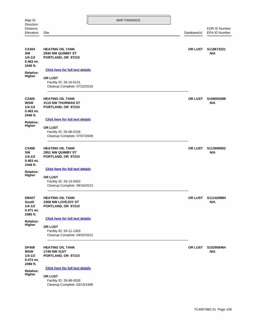
TC4907883.2s Page 106
DF408 OR LUSTHEATING OIL TANK S102959464WSW 1749 NW 31ST N/A1/4-1/2 PORTLAND, OR 97210
Relative:Higher
Click here for full text details
0.473 mi.2496 ft.
OR LUST Facility ID: 26-98-0026 Cleanup Complete: 03/19/1998
DB407 OR LUSTHEATING OIL TANK S111429884South 2368 NW LOVEJOY ST N/A1/4-1/2 PORTLAND, OR 97210
Relative:Higher
Click here for full text details
0.471 mi.2485 ft.
OR LUST Facility ID: 26-11-1303 Cleanup Complete: 04/02/2012
CX406 OR LUSTHEATING OIL TANK S113906952SW 2951 NW QUIMBY ST N/A1/4-1/2 PORTLAND, OR 97210
Relative:Higher
Click here for full text details
0.463 mi.2446 ft.
OR LUST Facility ID: 26-13-0402 Cleanup Complete: 08/16/2013
CZ405 OR LUSTHEATING OIL TANK S109052088WSW 3115 NW THURMAN ST N/A1/4-1/2 PORTLAND, OR 97210
Relative:Higher
Click here for full text details
0.463 mi.2446 ft.
OR LUST Facility ID: 26-08-0156 Cleanup Complete: 07/07/2008
CX404 OR LUSTHEATING OIL TANK S118673221SW 2930 NW QUIMBY ST N/A1/4-1/2 PORTLAND, OR 97210
Relative:Higher
Click here for full text details
0.463 mi.2445 ft.
OR LUST Facility ID: 26-16-0141 Cleanup Complete: 07/22/2016
MAP FINDINGSMap IDDirection
EDR ID NumberDistanceEPA ID NumberDatabase(s)SiteElevation

TC4907883.2s Page 107
DB413 OR LUSTHEATING OIL TANK S106856953South 2358 NW LOVEJOY ST N/A1/4-1/2 PORTLAND, OR 97210
Relative:Higher
Click here for full text details
0.479 mi.2531 ft.
OR LUST Facility ID: 26-05-0579 Cleanup Complete: 08/03/2006
DG412 OR LUSTHEATING OIL TANK S105463664WSW 1936 NW 32ND AVE N/A1/4-1/2 PORTLAND, OR 97210
Relative:Higher
Click here for full text details
0.478 mi.2525 ft.
OR LUST Facility ID: 26-02-0152 Cleanup Complete: 04/03/2015
411 OR LUSTHEATING OIL TANK S112059196SSW 2661 NW LOVEJOY ST N/A1/4-1/2 PORTLAND, OR 97210
Relative:Higher
Click here for full text details
0.478 mi.2524 ft.
OR LUST Facility ID: 26-12-0425 Cleanup Complete: 09/16/2014
410 OR LUSTHEATING OIL TANK S100500597ESE 1900 NW 18TH AVE N/A1/4-1/2 PORTLAND, OR 97209
Relative:Lower
Click here for full text details
0.474 mi.2505 ft.
OR LUST Facility ID: 26-91-0163 Cleanup Complete: 04/27/1991
DG409 OR LUSTHEATING OIL TANK S104658227WSW 3133 NW VAUGHN N/A1/4-1/2 PORTLAND, OR 97210
Relative:Higher
Click here for full text details
0.474 mi.2502 ft.
OR LUST Facility ID: 26-00-0767 Cleanup Complete: 11/06/2000
MAP FINDINGSMap IDDirection
EDR ID NumberDistanceEPA ID NumberDatabase(s)SiteElevation

TC4907883.2s Page 108
418 OR LUSTHYDRAULIC & AIR EQUIPMENT COMPANY 1000353957ESE OR UST1925 NW QUIMBY ST N/A1/4-1/2 PORTLAND, OR 97209
Relative:Lower
Click here for full text details
0.484 mi.2555 ft.
OR LUST Facility ID: 26-91-0065 Cleanup Complete: 01/14/2002
OR UST
DH417 OR LUSTHEATING OIL TANK S109051955SE 2049 NW OVERTON N/A1/4-1/2 PORTLAND, OR 97209
Relative:Higher
Click here for full text details
0.483 mi.2551 ft.
OR LUST Facility ID: 26-08-0327 Cleanup Complete: 07/11/2008
DB416 OR LUSTHEATING OIL TANK S118347836South 916 NW 24TH AVE N/A1/4-1/2 PORTLAND, OR 97210
Relative:Higher
Click here for full text details
0.483 mi.2549 ft.
OR LUST Facility ID: 26-15-1364 Cleanup Complete: 05/03/2016
DF415 OR LUSTHEATING OIL TANK S109578123WSW 1725 NW 31ST AVE N/A1/4-1/2 PORTLAND, OR 97210
Relative:Higher
Click here for full text details
0.482 mi.2546 ft.
OR LUST Facility ID: 26-09-0029 Cleanup Complete: 05/22/2009
414 OR LUSTHEATING OIL TANK S108572789SW 2960 NW QUIMBY ST N/A1/4-1/2 PORTLAND, OR 97210
Relative:Higher
Click here for full text details
0.481 mi.2538 ft.
OR LUST Facility ID: 26-07-0330 Cleanup Complete: 06/06/2007
MAP FINDINGSMap IDDirection
EDR ID NumberDistanceEPA ID NumberDatabase(s)SiteElevation

TC4907883.2s Page 109
DH422 OR LUSTHEATING OIL TANK S105463661SE 2025 NW OVERTON ST N/A1/4-1/2 PORTLAND, OR 97209
Relative:Higher
Click here for full text details
0.487 mi.2569 ft.
OR LUST Facility ID: 26-02-5706 Cleanup Complete: 05/20/2002
421 OR LUSTHEATING OIL TANK S103839116South 908 NW 25TH AVE N/A1/4-1/2 PORTLAND, OR 97210
Relative:Higher
Click here for full text details
0.487 mi.2569 ft.
OR LUST Facility ID: 26-99-0539 Cleanup Complete: 07/27/1999
DD420 OR LUSTHEATING OIL TANK S106475393SW 2883 NW FAIRFAX TERRACE N/A1/4-1/2 PORTLAND, OR 97210
Relative:Higher
Click here for full text details
0.485 mi.2560 ft.
OR LUST Facility ID: 26-04-0380 Cleanup Complete: 07/02/2004
DC419 OR LUSTHEATING OIL TANK S113230895SSW 2808 NW CUMBERLAND RD N/A1/4-1/2 PORTLAND, OR 97210
Relative:Higher
Click here for full text details
0.484 mi.2556 ft.
OR LUST Facility ID: 26-12-1388 Cleanup Complete: 05/13/2013
HYDRAULIC & AIR EQUIPMENT COMPANY (Continued) 1000353957
Facility ID: 4496
MAP FINDINGSMap IDDirection
EDR ID NumberDistanceEPA ID NumberDatabase(s)SiteElevation

TC4907883.2s Page 110
DD426 OR LUSTHEATING OIL TANK S104658080SW 2921 NW FAIRFAX TERRACE N/A1/4-1/2 PORTLAND, OR 97210
Relative:Higher
Click here for full text details
0.492 mi.2598 ft.
OR LUST Facility ID: 26-00-0576 Cleanup Complete: 06/22/2000
425 OR LUSTHEATING OIL TANK S104333317ESE OR CDL1700 NW THURMAN N/A1/4-1/2 OR HAZMATPORTLAND, OR 97209
Relative:Lower
Click here for full text details
0.491 mi. OR HSIS2592 ft.
OR LUST Facility ID: 26-95-0261 Cleanup Complete: 06/05/1996
OR CDL Incident Number: 960121 Facility Id: 960121
OR HAZMAT Facility Id: 960121
OR HSIS Facility Id: 003763
DF424 OR LUSTHEATING OIL TANK S118452307WSW 1820 NW 32ND AVE N/A1/4-1/2 PORTLAND, OR 97210
Relative:Higher
Click here for full text details
0.490 mi.2586 ft.
OR LUST Facility ID: 26-15-1477 Cleanup Complete: 12/04/2015
423 OR LUSTHEATING OIL TANK S104907957SSW 2806 NW FAIRFAX TERRACE N/A1/4-1/2 PORTLAND, OR 97210
Relative:Higher
Click here for full text details
0.487 mi.2572 ft.
OR LUST Facility ID: 26-01-5206 Cleanup Complete: 04/05/2001
MAP FINDINGSMap IDDirection
EDR ID NumberDistanceEPA ID NumberDatabase(s)SiteElevation

TC4907883.2s Page 111
431 OR LUSTUNOCAL 5452 U004015074SSE OR UST926 NW 23RD N/A1/4-1/2 PORTLAND, OR 97209
Relative:Higher
Click here for full text details
0.496 mi.2621 ft.
OR LUST Facility ID: 26-89-0050 Facility ID: 26-90-0280 Cleanup Complete: 07/12/1989 Cleanup Complete: 11/21/1990
OR UST
DF430 OR LUSTHEATING OIL TANK S102778377WSW 1744 NW 32ND N/A1/4-1/2 PORTLAND, OR 97210
Relative:Higher
Click here for full text details
0.496 mi.2617 ft.
OR LUST Facility ID: 26-97-0655 Cleanup Complete: 11/05/2009
DH429 OR LUSTHEATING OIL TANK S102959455SE 2056 NW OVERTON STREET N/A1/4-1/2 PORTLAND, OR 97209
Relative:Higher
Click here for full text details
0.495 mi.2613 ft.
OR LUST Facility ID: 26-97-0978
428 OR LUSTHEATING OIL TANK S116760617SE 1133 NW 21ST AVE N/A1/4-1/2 PORTLAND, OR 97209
Relative:Higher
Click here for full text details
0.494 mi.2610 ft.
OR LUST Facility ID: 26-14-0563 Cleanup Complete: 01/07/2015
427 OR LUSTHEATING OIL TANK S113668815South 2539 NW WESTOVER RD N/A1/4-1/2 PORTLAND, OR 97210
Relative:Higher
Click here for full text details
0.493 mi.2603 ft.
OR LUST Facility ID: 26-13-0102 Cleanup Complete: 11/19/2013
MAP FINDINGSMap IDDirection
EDR ID NumberDistanceEPA ID NumberDatabase(s)SiteElevation

TC4907883.2s Page 112
434 OR CRLPORT OF PORTLAND - TERMINAL 1 SOUTH S110730163East OR ECSI2100 NW FRONT AVE. N/A1/2-1 OR INST CONTROLPORTLAND, OR 97209
Relative:Lower
Click here for full text details
0.503 mi. OR VCP2655 ft. OR NPDES
OR UIC
OR CRL Facility Id: 2642 Facility Status: Partial No Further Action
OR ECSI State ID Number: 2642 Investigation: Listed on the CRL/Inventory
OR INST CONTROL
DE433 OR ECSIPORT OF PORTLAND - TERMINAL 2 S108662797North OR VCP3556 NW FRONT AVE N/A1/2-1 OR SPILLSPORTLAND, OR 97210
Relative:Lower
Click here for full text details
0.501 mi. OR NPDES2647 ft.
OR ECSI State ID Number: 2769 Investigation: No Further Action
OR VCP ECS Site ID: 2769
OR SPILLS Facility ID: 2010-2152 Facility ID: 2000-2577
OR NPDES WQ File Nbr: 114024 WQ File Nbr: 107985
432 OR LUSTHEATING OIL TANK S105981367South 2353 NW KEARNEY STREET N/A1/4-1/2 PORTLAND, OR 97210
Relative:Higher
Click here for full text details
0.497 mi.2622 ft.
OR LUST Facility ID: 26-03-1465 Cleanup Complete: 10/30/2003
UNOCAL 5452 (Continued) U004015074
Facility ID: 1068
MAP FINDINGSMap IDDirection
EDR ID NumberDistanceEPA ID NumberDatabase(s)SiteElevation

TC4907883.2s Page 113
436 SEMS-ARCHIVEMOGUL CORP NW 31ST AVE 1000425355WNW OR ECSI2852 NW 31ST AVE ORD0457693531/2-1 OR VCPPORTLAND, OR 97210
Relative:Lower
Click here for full text details
0.532 mi. RCRA NonGen / NLR2809 ft. FINDS
ECHO
SEMS-ARCHIVE Site ID: 1000412 EPA Id: ORD045769353
OR ECSI State ID Number: 1307 Investigation: No Further Action
OR VCP ECS Site ID: 1307
RCRA NonGen / NLR EPA Id: ORD045769353
FINDS Registry ID:: 110004782833
435 OR ECSIRAPID TRANSFER CO. (FORMER) S115330275East OR VCP2030 NW 17TH AVE. N/A1/2-1 PORTLAND, OR 97209
Relative:Lower
Click here for full text details
0.508 mi.2682 ft.
OR ECSI State ID Number: 5870 Investigation: Suspect
OR VCP ECS Site ID: 5870
PORT OF PORTLAND - TERMINAL 1 SOUTH (Continued) S110730163
Site Id: 2642
OR VCP ECS Site ID: 2642
OR NPDES WQ File Nbr: 111839
MAP FINDINGSMap IDDirection
EDR ID NumberDistanceEPA ID NumberDatabase(s)SiteElevation

TC4907883.2s Page 114
438 OR ECSINW 16TH STORAGE, LLC S109493960ESE OR VCP1323 NW 16TH AVE. N/A1/2-1 PORTLAND, OR 97209
Relative:Lower
Click here for full text details
0.675 mi.3564 ft.
OR ECSI State ID Number: 5120 Investigation: No Further Action
OR VCP
437 OR ECSISOLENIS LLC S108660254NNW OR AST3366 NW YEON AVE N/A1/2-1 OR CDLPORTLAND, OR 97210
Relative:Lower
Click here for full text details
0.559 mi. OR SPILLS2950 ft. OR HAZMAT
OR HSISOR MANIFEST
OR NPDES
OR ECSI State ID Number: 988 Investigation: Suspect
OR AST Facility Id: 004606
OR CDL Incident Number: 930381 Facility Id: 930381
OR SPILLS Facility ID: 2000-3072
OR HAZMAT Facility Id: 940120 Facility Id: 930381
OR HSIS Facility Id: 004606
OR MANIFEST Status: Large quantity generator EPA Id: ORD009058314 Status: LQG
OR NPDES WQ File Nbr: 38192
MAP FINDINGSMap IDDirection
EDR ID NumberDistanceEPA ID NumberDatabase(s)SiteElevation

TC4907883.2s Page 115
DI441 OR ECSIHOYT STREET RAILYARD - BLOCK 26 (SW QUARTER) S118673052ESE OR ENG CONTROLS1620 NW 14TH AVE. N/A1/2-1 OR INST CONTROLPORTLAND, OR 97209
Relative:Lower
Click here for full text details
0.701 mi. OR VCP3703 ft.
OR ECSI State ID Number: 6103 Investigation: Suspect
OR ENG CONTROLS Site Id: 6103
OR INST CONTROL Site Id: 6103
DI440 OR ECSIHOYT STREET RAILYARD - BLOCK 29 S119162025ESE OR VCPNORTHEAST OF NW SAVIER ST. & 14TH AVE. N/A1/2-1 PORTLAND, OR 97209
Relative:Lower
Click here for full text details
0.698 mi.3688 ft.
OR ECSI State ID Number: 6162 Investigation: Suspect
OR VCP ECS Site ID: 6162
439 OR CRLBURLINGTON NORTHERN RAILROAD LAKE YARD S105613598NW OR ECSI3500/3930 NW YEON N/A1/2-1 OR VCPPORTLAND, OR 97210
Relative:Lower
Click here for full text details
0.697 mi.3680 ft.
OR CRL Facility Id: 100 Facility Status: Source Control Decision
OR ECSI State ID Number: 100 Investigation: Listed on the CRL/Inventory
OR VCP ECS Site ID: 100
NW 16TH STORAGE, LLC (Continued) S109493960
ECS Site ID: 5120
MAP FINDINGSMap IDDirection
EDR ID NumberDistanceEPA ID NumberDatabase(s)SiteElevation

TC4907883.2s Page 116
443 OR CRLLEVEL 3 COMMUNICATIONS INC S111256746ESE OR ECSI1335 NW NORTHRUP N/A1/2-1 OR ASTPORTLAND, OR 97209
Relative:Lower
Click here for full text details
0.793 mi. OR ENG CONTROLS4188 ft. OR INST CONTROL
OR VCPOR HSIS
OR CRL Facility Id: 2313 Facility Status: No Further Action (Conditional)
OR ECSI State ID Number: 2313 Investigation: Listed on the CRL/Inventory
OR AST Facility Id: 082693 Facility Id: 099520
OR ENG CONTROLS Site Id: 2313
OR INST CONTROL
442 OR ECSIUNOCAL 0738 U004015073SE OR LUST930 NW 18TH N/A1/2-1 OR USTPORTLAND, OR 97209
Relative:Lower
Click here for full text details
0.740 mi. OR VCP3907 ft.
OR ECSI State ID Number: 1396 Investigation: No Further Action
OR LUST Facility ID: 26-88-0061 Cleanup Complete: 05/19/1993
OR UST Facility ID: 921
OR VCP ECS Site ID: 1396
HOYT STREET RAILYARD - BLOCK 26 (SW QUARTER) (Continued) S118673052
OR VCP ECS Site ID: 6103
MAP FINDINGSMap IDDirection
EDR ID NumberDistanceEPA ID NumberDatabase(s)SiteElevation

TC4907883.2s Page 117
444 SEMS-ARCHIVECOLUMBIA AMERICAN PLATING CO 1000425978WNW OR ECSI3003 NW 35TH AVE ORD0687889261/2-1 OR VCPPORTLAND, OR 97210
Relative:Lower
Click here for full text details
0.816 mi. OR BROWNFIELDS4310 ft. OR CDL
OR SPILLSOR HAZMAT
RCRA NonGen / NLRPRPICIS
FINDSOR MANIFEST
OR NPDESECHO
SEMS-ARCHIVE Site ID: 1000439 EPA Id: ORD068788926
OR ECSI State ID Number: 29 Investigation: No Further Action
OR VCP ECS Site ID: 29
OR BROWNFIELDS envid: 29 Status: NO FURTHER STATE ACTION REQUIRED
OR CDL Incident Number: 910024 Facility Id: 910024
OR SPILLS Facility ID: 2003-0943
OR HAZMAT Facility Id: 910024
LEVEL 3 COMMUNICATIONS INC (Continued) S111256746
Site Id: 2313
OR VCP ECS Site ID: 2313
OR HSIS Facility Id: 082693 Facility Id: 099520
MAP FINDINGSMap IDDirection
EDR ID NumberDistanceEPA ID NumberDatabase(s)SiteElevation

TC4907883.2s Page 118
445 OR CRLHILL INVESTMENT U000432458NW OR ECSI3322 NW 35TH AVE N/A1/2-1 OR LUSTPORTLAND, OR 97210
Relative:Lower
Click here for full text details
0.826 mi. OR UST4360 ft.
OR CRL Facility Id: 1076 Facility Status: State Expanded Preliminary Assessment recommended (XPA)
OR ECSI State ID Number: 1076 Investigation: Listed on the CRL/Inventory
OR LUST Facility ID: 26-89-0280 Cleanup Complete: 07/31/2000
OR UST Facility ID: 4358
COLUMBIA AMERICAN PLATING CO (Continued) 1000425978
Facility Id: 030034
RCRA NonGen / NLR EPA Id: ORD068788926
ICIS FRS ID:: 110000894587
FINDS Registry ID:: 110000894587
OR MANIFEST Status: Small quantity generator Status: Large quantity generator EPA Id: ORD068788926 Status: SQG Status: LQG
OR NPDES WQ File Nbr: 121301
MAP FINDINGSMap IDDirection
EDR ID NumberDistanceEPA ID NumberDatabase(s)SiteElevation

TC4907883.2s Page 119
DJ448 OR ECSIHOYT STREET RAILYARD - BLOCK 20 S118673061ESE OR ENG CONTROLSNW 11TH AVE. BTWN PETTYGROVE & QUIMBY STS. N/A1/2-1 OR INST CONTROLPORTLAND, OR 97209
Relative:Lower
Click here for full text details
0.866 mi. OR VCP4574 ft.
OR ECSI State ID Number: 6116 Investigation: Suspect
OR ENG CONTROLS Site Id: 6116
OR INST CONTROL Site Id: 6116
OR VCP ECS Site ID: 6116
447 OR ECSIGOLDENDALE ALUMINUM CO. S108658471NNE OR VCP2600 N RIVER ST. N/A1/2-1 OR UICPORTLAND, OR 97227
Relative:Lower
Click here for full text details
0.841 mi.4441 ft.
OR ECSI State ID Number: 2440 Investigation: No Further Action
OR VCP ECS Site ID: 2440
446 OR ECSICARSON OIL - NW 35TH AVE. S119161950WNW OR VCP3125 NW 35TH AVE. N/A1/2-1 PORTLAND, OR 97210
Relative:Lower
Click here for full text details
0.834 mi.4405 ft.
OR ECSI State ID Number: 1405 Investigation: Suspect
OR VCP ECS Site ID: 1405
MAP FINDINGSMap IDDirection
EDR ID NumberDistanceEPA ID NumberDatabase(s)SiteElevation

TC4907883.2s Page 120
449 RCRA-LQGCONTAINER MANAGEMENT SERVICES L.L.C. 1000369027WNW OR ECSI3000 NW ST HELENS RD ORD0277506451/2-1 OR LUSTPORTLAND, OR 97210
Relative:Lower
Click here for full text details
0.869 mi. OR UST4587 ft. OR VCP
OR HAZMATFINDS
OR HSISOR MANIFEST
ECHO
RCRA-LQG EPA Id: ORD027750645
OR ECSI State ID Number: 4784 Investigation: Suspect
OR LUST Facility ID: 26-93-0113 Cleanup Complete: 01/24/1996
OR UST Facility ID: 4095
OR VCP ECS Site ID: 4784
OR HAZMAT Facility Id: 970187
FINDS Registry ID:: 110000894569
OR HSIS Facility Id: 002032
OR MANIFEST Status: Large quantity generator EPA Id: ORD027750645 Status: LQG
MAP FINDINGSMap IDDirection
EDR ID NumberDistanceEPA ID NumberDatabase(s)SiteElevation

TC4907883.2s Page 121
452 OR CRLANRFS HOLDINGS INC. S111245531WNW OR ECSI3333 NW 35TH AVE. N/A1/2-1 OR NPDESPORTLAND, OR 97210
Relative:Lower
Click here for full text details
0.889 mi.4693 ft.
OR CRL Facility Id: 1820 Facility Status: Remedial Investigation recommended (RI)
OR ECSI State ID Number: 1820 Investigation: Listed on the CRL/Inventory
DJ451 OR ECSIHOYT STREET RAILYARD - BLOCK 17 S115330274ESE OR ENG CONTROLS1315 NW 11TH AVE. N/A1/2-1 OR INST CONTROLPORTLAND, OR 97209
Relative:Lower
Click here for full text details
0.878 mi. OR VCP4635 ft.
OR ECSI State ID Number: 5867 Investigation: No Further Action
OR ENG CONTROLS Site Id: 5867
OR INST CONTROL Site Id: 5867
OR VCP ECS Site ID: 5867
450 OR CRLPACIFIC STATES GALVANIZING (FORMER) S102521614SE OR ECSI820 NW 15TH AVE. N/A1/2-1 OR VCPPORTLAND, OR 97209
Relative:Lower
Click here for full text details
0.875 mi.4618 ft.
OR CRL Facility Id: 1024 Facility Status: SITE INVESTIGATION
OR ECSI State ID Number: 1024 Investigation: Listed on the CRL/Inventory
OR VCP ECS Site ID: 1024
MAP FINDINGSMap IDDirection
EDR ID NumberDistanceEPA ID NumberDatabase(s)SiteElevation

TC4907883.2s Page 122
454 OR ECSIHOYT STREET RAILYARD - BLOCK 15 S116734840ESE OR ENG CONTROLS1075 NW NORTHRUP ST. N/A1/2-1 OR INST CONTROLPORTLAND, OR 97209
Relative:Lower
Click here for full text details
0.914 mi. OR VCP4824 ft.
OR ECSI State ID Number: 5894 Investigation: Suspect
OR ENG CONTROLS Site Id: 5894
OR INST CONTROL Site Id: 5894
OR VCP ECS Site ID: 5894
453 OR ECSIHEATING OIL TANK S103842283ESE OR LUST1220 NW MARSHALL ST N/A1/2-1 OR VCPPORTLAND, OR 97209
Relative:Lower
Click here for full text details
0.890 mi. OR UIC4697 ft.
OR ECSI State ID Number: 1331 Investigation: No Further Action
OR LUST Facility ID: 26-02-0322 Cleanup Complete: 08/12/2002
OR VCP ECS Site ID: 1331
ANRFS HOLDINGS INC. (Continued) S111245531
OR NPDES WQ File Nbr: 107658 WQ File Nbr: 112482
MAP FINDINGSMap IDDirection
EDR ID NumberDistanceEPA ID NumberDatabase(s)SiteElevation

TC4907883.2s Page 123
DK457 OR ECSIPACIFICORP ALBINA RIVERLOTS S109493957East OR VCPLOTS NEAR BASE OF THE FREMONT BRIDGE N/A1/2-1 PORTLAND, OR 97227
Relative:Lower
Click here for full text details
0.929 mi.4903 ft.
OR ECSI State ID Number: 5117 Investigation: Suspect
OR VCP ECS Site ID: 5117
DK456 OR ECSIROSS ISLAND SAND & GRAVEL - N RIVER ST. S115330261East 1208 N RIVER ST. N/A1/2-1 PORTLAND, OR 97227
Relative:Lower
Click here for full text details
0.919 mi.4852 ft.
OR ECSI State ID Number: 5577 Investigation: Suspect
455 OR CRLHOYT ST. RAIL YARD - THE FIELDS S110764046ESE OR ECSIEAST OF NW 11TH AVE. AND NORTH OF OVERTON ST. N/A1/2-1 OR ENG CONTROLSPORTLAND, OR 97209
Relative:Lower
Click here for full text details
0.917 mi. OR VCP4843 ft. OR BROWNFIELDS
OR CRL Facility Id: 5443 Facility Status: No Further Action (Conditional)
OR ECSI State ID Number: 5443 Investigation: Listed on the CRL/Inventory
OR ENG CONTROLS Site Id: 5443
OR VCP ECS Site ID: 5443
OR BROWNFIELDS envid: 5443 Status: No Further Action (Conditional)
MAP FINDINGSMap IDDirection
EDR ID NumberDistanceEPA ID NumberDatabase(s)SiteElevation

TC4907883.2s Page 124
460 OR CRLWIRFS PROPERTY S106497164NW OR ECSI3720 NW YEON AVE. N/A1/2-1 OR VCPPORTLAND, OR 97210
Relative:Lower
Click here for full text details
0.972 mi. OR MANIFEST5130 ft.
OR CRL Facility Id: 2424 Facility Status: FEASIBILITY STUDY
OR ECSI State ID Number: 2424 Investigation: Listed on the CRL/Inventory
OR VCP ECS Site ID: 2424
OR MANIFEST
459 OR ECSICENTENNIAL MILLS DIV - ADM MILLING CO 1000642461ESE OR LUST1362 NW NAITO PKWY N/A1/2-1 OR USTPORTLAND, OR 97209
Relative:Lower
Click here for full text details
0.968 mi. OR VCP5110 ft.
OR ECSI State ID Number: 5136 Investigation: Suspect
OR LUST Facility ID: 26-01-5648 Facility ID: 26-09-0689 Cleanup Complete: 11/20/2001 Cleanup Complete: 02/08/2010
OR UST Facility ID: 2855
OR VCP ECS Site ID: 5136
458 OR ECSIRIVERTEC PROPERTY S105614520SE 1233 NW KEARNEY ST. N/A1/2-1 PORTLAND, OR 97209
Relative:Lower
Click here for full text details
0.949 mi.5010 ft.
OR ECSI State ID Number: 3067 Investigation: Suspect
MAP FINDINGSMap IDDirection
EDR ID NumberDistanceEPA ID NumberDatabase(s)SiteElevation

TC4907883.2s Page 125
461 OR ECSIWILHELM TRUCKING CO 1000240385WNW OR LUST3250 NW ST HELENS RD PO BOX 10363 ORD0797924531/2-1 OR USTPORTLAND, OR 97210
Relative:Lower
Click here for full text details
0.977 mi. OR AST5158 ft. OR VCP
RCRA NonGen / NLRPADSFINDS
OR HSIS
OR ECSI State ID Number: 69 Investigation: Suspect
OR LUST Facility ID: 26-89-0230 Cleanup Complete: 02/19/1990
OR UST Facility ID: 3493
OR AST Facility Id: 018586
OR VCP ECS Site ID: 69
RCRA NonGen / NLR EPA Id: ORD079792453
PADS EPAID:: ORD079792453
OR HSIS Facility Id: 018586
WIRFS PROPERTY (Continued) S106497164
Status: Small quantity generator Status: Conditionally exempt generator EPA Id: ORD987187952 Status: CEG Status: SQG
MAP FINDINGSMap IDDirection
EDR ID NumberDistanceEPA ID NumberDatabase(s)SiteElevation

TC4907883.2s Page 126
463 OR CRLTRUMBULL ASPHALT PLANT S102080093NW OR ECSI3750 NW YEON AVE. N/A1/2-1 OR SPILLSPORTLAND, OR 97210
Relative:Lower
Click here for full text details
0.978 mi.5164 ft.
OR CRL Facility Id: 1160 Facility Status: Remedial Investigation recommended (RI)
OR ECSI State ID Number: 1160 Investigation: Listed on the CRL/Inventory
OR SPILLS Facility ID: 2004-1472
462 OR ECSIRIVER ST. CEMENT TERMINAL S108662246East OR AST1050 N RIVER ST N/A1/2-1 OR VCPPORTLAND, OR 97227
Relative:Lower
Click here for full text details
0.977 mi. OR SPILLS5158 ft. OR HSIS
OR NPDES
OR ECSI State ID Number: 5449 Investigation: Suspect
OR AST Facility Id: 014277
OR VCP ECS Site ID: 5449
OR SPILLS Facility ID: 2008-0799 Facility ID: 2004-1922 Facility ID: 1998-1390
OR HSIS Facility Id: 014277
OR NPDES WQ File Nbr: 44571
MAP FINDINGSMap IDDirection
EDR ID NumberDistanceEPA ID NumberDatabase(s)SiteElevation

TC4907883.2s Page 127
465 OR CRLSTATION PLACE REDEVELOPMENT (AKA HORSE BARN) S105614268ESE OR ECSI1100 TO 1300 NW 9TH AVE. N/A1/2-1 OR ENG CONTROLSPORTLAND, OR 97209
Relative:Lower
Click here for full text details
0.993 mi. OR INST CONTROL5242 ft. OR VCP
OR BROWNFIELDS
OR CRL Facility Id: 2407 Facility Status: Partial No Further Action
OR ECSI State ID Number: 2407 Investigation: Listed on the CRL/Inventory
OR ENG CONTROLS
464 OR CRLUPRR - ALBINA YARD S102521605ENE OR ECSI1135 N KNOTT ST. N/A1/2-1 OR VCPPORTLAND, OR 97227
Relative:Lower
Click here for full text details
0.985 mi. OR SPILLS5201 ft. OR NPDES
OR CRL Facility Id: 178 Facility Status: REMEDIAL DESIGN
OR ECSI State ID Number: 178 Investigation: Listed on the CRL/Inventory
OR VCP ECS Site ID: 178
OR SPILLS Facility ID: 2011-2082 Facility ID: 2008-1834 Facility ID: 2008-1705 Facility ID: 2008-0431 Facility ID: 2006-2172 Facility ID: 2006-1964 Facility ID: 2005-2857 Facility ID: 2005-2778 Facility ID: 2005-2775 Facility ID: 2015-3034 Facility ID: 1996-2407 Facility ID: 1996-2402 Facility ID: 1996-2343
OR NPDES WQ File Nbr: 102121
MAP FINDINGSMap IDDirection
EDR ID NumberDistanceEPA ID NumberDatabase(s)SiteElevation

TC4907883.2s Page 128
STATION PLACE REDEVELOPMENT (AKA HORSE BARN) (Continued) S105614268
Site Id: 2407
OR INST CONTROL Site Id: 2407
OR VCP ECS Site ID: 2407
OR BROWNFIELDS envid: 2407 Status: Partial No Further Action
MAP FINDINGSMap IDDirection
EDR ID NumberDistanceEPA ID NumberDatabase(s)SiteElevation

ED
R Inc.
ED
R Inc.
ED
R Inc.
ED
R Inc.
ED
R Inc.
ED
R Inc.
ED
R Inc.
ED
R Inc.
ED
R Inc.
ED
R Inc.
ED
R Inc.
ED
R Inc.
ED
R Inc.
ED
R Inc.
ED
R Inc.
ED
R Inc.
ED
R Inc.
ED
R Inc.
ED
R Inc.
ED
R Inc.
ED
R Inc.
ED
R Inc.
ED
R Inc.
ED
R Inc.
ED
R Inc.
ED
R Inc.
ED
R Inc.
ED
R Inc.
ED
R Inc.
ED
R Inc.
ED
R Inc.
ED
R Inc.
ED
R Inc.
ED
R Inc.
ED
R Inc.
ED
R Inc.
ED
R Inc.
ED
R Inc.
ED
R Inc.
ED
R Inc.
ED
R Inc.
ED
R Inc.
ED
R Inc.
ED
R Inc.
ED
R Inc.
ED
R Inc.
ED
R Inc.
ED
R Inc.
ED
R Inc.
ED
R Inc.
ED
R Inc.
ED
R Inc.
ED
R Inc.
ED
R Inc.
ED
R Inc.
ED
R Inc.
ED
R Inc.
ED
R Inc.
ED
R Inc.
ED
R Inc.
ED
R Inc.
ED
R Inc.
ED
R Inc.
ED
R Inc.
ED
R Inc.
ED
R Inc.
ED
R Inc.
ED
R Inc.
ED
R Inc.
ED
R Inc.
ED
R Inc.
ED
R Inc.
ED
R Inc.
ED
R Inc.
ED
R Inc.
ED
R Inc.
ED
R Inc.
ED
R Inc.
ED
R Inc.
ED
R Inc.
OR AIRS Oregon Title V Facility Listing Department of Environmental Quality 12/31/2014 02/19/2016 03/15/2016OR AOC COL Columbia Slough City of Portland Environmental Services 08/10/2005 05/17/2006 06/16/2006OR AOC MU East Multnomah County Area City of Portland Environmental Services 10/07/2002 10/22/2002OR AST Aboveground Storage Tanks Office of State Fire Marshal 09/01/2016 09/20/2016 11/11/2016OR BROWNFIELDS Brownfields Projects Department of Environmental Quality 11/01/2016 11/17/2016 01/31/2017OR CDL Uninhabitable Drug Lab Properties Department of Consumer & Business Services 12/23/2016 12/27/2016 01/31/2017OR CDL 2 Clandestine Drug Lab Site Listing Oregon State Police 03/23/2016 05/06/2016 06/13/2016OR COAL ASH Coal Ash Disposal Sites Listing Department of Environmental Quality 12/31/2015 09/08/2016 11/14/2016OR CRL Confirmed Release List and Inventory Department of Environmental Quality 11/01/2016 11/17/2016 01/31/2017OR DRYCLEANERS Drycleaning Facilities Department of Environmental Quality 05/02/2016 05/03/2016 06/13/2016OR ECSI Environmental Cleanup Site Information System Department of Environmental Quality 01/01/2017 01/06/2017 03/17/2017OR ENG CONTROLS Engineering Controls Recorded at ESCI Sites Department of Environmental Quality 01/01/2017 01/06/2017 03/17/2017OR Financial Assurance 1 Financial Assurance Information Listing Department of Environmental Quality 12/27/2016 12/30/2016 01/31/2017OR Financial Assurance 2 Financial Assurance Information Listing Department of Environmental Quality 01/21/2017 01/24/2017 03/17/2017OR HAZMAT Hazmat/Incidents State Fire Marshal’s Office 10/01/2016 11/02/2016 11/14/2016OR HIST LF Old Closed SW Disposal Sites Department of Environmental Quality 04/01/2000 07/08/2003 07/18/2003OR HSIS Hazardous Substance Information Survey State Fire Marshal’s Office 09/01/2016 09/20/2016 11/11/2016OR INST CONTROL Institutional Controls Recorded at ESCI Sites Department of Environmental Quality 01/01/2017 01/06/2017 03/17/2017OR LUST Leaking Underground Storage Tank Database Department of Environmental Quality 10/04/2016 11/17/2016 01/31/2017OR NPDES Wastewater Permits Database Department of Environmental Quality 08/08/2016 08/09/2016 11/11/2016OR OR MANIFEST Manifest Information Department of Environmental Quality 12/31/2015 05/24/2016 08/10/2016OR RGA HWS Recovered Government Archive State Hazardous Waste Facilitie Department of Environmental Quality 07/01/2013 01/03/2014OR RGA LF Recovered Government Archive Solid Waste Facilities List Department of Environmental Quality 07/01/2013 01/13/2014OR RGA LUST Recovered Government Archive Leaking Underground Storage Tan Department of Environmental Quality 07/01/2013 12/27/2013OR SPILLS Spill Data Department of Environmental Quality 01/03/2017 01/04/2017 01/31/2017OR SPILLS 90 SPILLS90 data from FirstSearch FirstSearch 05/01/2006 01/03/2013 02/22/2013OR SWF/LF Solid Waste Facilities List Department of Environmental Quality 01/21/2017 01/24/2017 03/17/2017OR SWRCY Recycling Facility Location Listing Department of Environmental Quality 11/29/2016 12/01/2016 02/01/2017OR UIC Underground Injection Control Program Database Department of Environmental Quality 12/28/2016 01/06/2017 03/17/2017OR UST Underground Storage Tank Database Department of Environmental Quality 10/04/2016 11/17/2016 01/31/2017OR VCS Voluntary Cleanup Program Sites DEQ 01/03/2017 01/06/2017 03/17/2017US 2020 COR ACTION 2020 Corrective Action Program List Environmental Protection Agency 04/22/2013 03/03/2015 03/09/2015US ABANDONED MINES Abandoned Mines Department of Interior 03/14/2017 03/17/2017 04/07/2017US BRS Biennial Reporting System EPA/NTIS 12/31/2013 02/24/2015 09/30/2015US COAL ASH DOE Steam-Electric Plant Operation Data Department of Energy 12/31/2005 08/07/2009 10/22/2009US COAL ASH EPA Coal Combustion Residues Surface Impoundments List Environmental Protection Agency 07/01/2014 09/10/2014 10/20/2014US CONSENT Superfund (CERCLA) Consent Decrees Department of Justice, Consent Decree Library 09/30/2016 11/18/2016 02/03/2017US CORRACTS Corrective Action Report EPA 12/12/2016 12/28/2016 02/10/2017US DEBRIS REGION 9 Torres Martinez Reservation Illegal Dump Site Locations EPA, Region 9 01/12/2009 05/07/2009 09/21/2009US DOCKET HWC Hazardous Waste Compliance Docket Listing Environmental Protection Agency 06/02/2016 06/03/2016 09/02/2016US DOD Department of Defense Sites USGS 12/31/2005 11/10/2006 01/11/2007US DOT OPS Incident and Accident Data Department of Transporation, Office of Pipeli 07/31/2012 08/07/2012 09/18/2012US Delisted NPL National Priority List Deletions EPA 12/05/2016 01/05/2017 02/03/2017US ECHO Enforcement & Compliance History Information Environmental Protection Agency 12/11/2016 12/20/2016 02/17/2017US EDR Hist Auto EDR Exclusive Historic Gas Stations EDR, Inc.US EDR Hist Cleaner EDR Exclusive Historic Dry Cleaners EDR, Inc.US EDR MGP EDR Proprietary Manufactured Gas Plants EDR, Inc.
TC4907883.2s Page GR-1
GOVERNMENT RECORDS SEARCHED / DATA CURRENCY TRACKING
St Acronym Full Name Government Agency Gov Date Arvl. Date Active Date

US EPA WATCH LIST EPA WATCH LIST Environmental Protection Agency 08/30/2013 03/21/2014 06/17/2014US ERNS Emergency Response Notification System National Response Center, United States Coast 09/26/2016 09/29/2016 11/11/2016US FEDERAL FACILITY Federal Facility Site Information listing Environmental Protection Agency 11/07/2016 01/05/2017 04/07/2017US FEDLAND Federal and Indian Lands U.S. Geological Survey 12/31/2005 02/06/2006 01/11/2007US FEMA UST Underground Storage Tank Listing FEMA 01/01/2010 02/16/2010 04/12/2010US FINDS Facility Index System/Facility Registry System EPA 07/15/2016 09/07/2016 11/11/2016US FTTS FIFRA/ TSCA Tracking System - FIFRA (Federal Insecticide, Fu EPA/Office of Prevention, Pesticides and Toxi 04/09/2009 04/16/2009 05/11/2009US FTTS INSP FIFRA/ TSCA Tracking System - FIFRA (Federal Insecticide, Fu EPA 04/09/2009 04/16/2009 05/11/2009US FUDS Formerly Used Defense Sites U.S. Army Corps of Engineers 01/31/2015 07/08/2015 10/13/2015US FUELS PROGRAM EPA Fuels Program Registered Listing EPA 11/21/2016 11/22/2016 02/03/2017US FUSRAP Formerly Utilized Sites Remedial Action Program Department of Energy 12/23/2016 12/27/2016 02/17/2017US HIST FTTS FIFRA/TSCA Tracking System Administrative Case Listing Environmental Protection Agency 10/19/2006 03/01/2007 04/10/2007US HIST FTTS INSP FIFRA/TSCA Tracking System Inspection & Enforcement Case Lis Environmental Protection Agency 10/19/2006 03/01/2007 04/10/2007US HMIRS Hazardous Materials Information Reporting System U.S. Department of Transportation 12/28/2016 12/28/2016 02/03/2017US ICIS Integrated Compliance Information System Environmental Protection Agency 11/18/2016 11/23/2016 02/10/2017US IHS OPEN DUMPS Open Dumps on Indian Land Department of Health & Human Serivces, Indian 04/01/2014 08/06/2014 01/29/2015US INDIAN LUST R1 Leaking Underground Storage Tanks on Indian Land EPA Region 1 10/27/2015 10/29/2015 01/04/2016US INDIAN LUST R10 Leaking Underground Storage Tanks on Indian Land EPA Region 10 01/07/2016 01/08/2016 02/18/2016US INDIAN LUST R4 Leaking Underground Storage Tanks on Indian Land EPA Region 4 02/05/2016 04/29/2016 06/03/2016US INDIAN LUST R5 Leaking Underground Storage Tanks on Indian Land EPA, Region 5 02/17/2016 04/27/2016 06/03/2016US INDIAN LUST R6 Leaking Underground Storage Tanks on Indian Land EPA Region 6 12/11/2015 02/19/2016 06/03/2016US INDIAN LUST R7 Leaking Underground Storage Tanks on Indian Land EPA Region 7 10/09/2015 02/12/2016 06/03/2016US INDIAN LUST R8 Leaking Underground Storage Tanks on Indian Land EPA Region 8 10/13/2015 10/23/2015 02/18/2016US INDIAN LUST R9 Leaking Underground Storage Tanks on Indian Land Environmental Protection Agency 02/25/2016 04/27/2016 06/03/2016US INDIAN ODI Report on the Status of Open Dumps on Indian Lands Environmental Protection Agency 12/31/1998 12/03/2007 01/24/2008US INDIAN RESERV Indian Reservations USGS 12/31/2014 07/14/2015 01/10/2017US INDIAN UST R1 Underground Storage Tanks on Indian Land EPA, Region 1 10/20/2015 10/29/2015 01/04/2016US INDIAN UST R10 Underground Storage Tanks on Indian Land EPA Region 10 01/07/2016 01/08/2016 02/18/2016US INDIAN UST R4 Underground Storage Tanks on Indian Land EPA Region 4 02/05/2016 04/29/2016 06/03/2016US INDIAN UST R5 Underground Storage Tanks on Indian Land EPA Region 5 11/05/2015 11/13/2015 01/04/2016US INDIAN UST R6 Underground Storage Tanks on Indian Land EPA Region 6 12/03/2015 02/04/2016 06/03/2016US INDIAN UST R7 Underground Storage Tanks on Indian Land EPA Region 7 09/23/2014 11/25/2014 01/29/2015US INDIAN UST R8 Underground Storage Tanks on Indian Land EPA Region 8 01/26/2016 02/05/2016 06/03/2016US INDIAN UST R9 Underground Storage Tanks on Indian Land EPA Region 9 02/25/2016 04/27/2016 06/03/2016US INDIAN VCP R1 Voluntary Cleanup Priority Listing EPA, Region 1 07/27/2015 09/29/2015 02/18/2016US INDIAN VCP R7 Voluntary Cleanup Priority Lisitng EPA, Region 7 03/20/2008 04/22/2008 05/19/2008US LEAD SMELTER 1 Lead Smelter Sites Environmental Protection Agency 12/05/2016 01/05/2017 02/10/2017US LEAD SMELTER 2 Lead Smelter Sites American Journal of Public Health 04/05/2001 10/27/2010 12/02/2010US LIENS 2 CERCLA Lien Information Environmental Protection Agency 02/18/2014 03/18/2014 04/24/2014US LUCIS Land Use Control Information System Department of the Navy 12/28/2016 01/04/2017 04/07/2017US MLTS Material Licensing Tracking System Nuclear Regulatory Commission 08/30/2016 09/08/2016 10/21/2016US NPL National Priority List EPA 12/05/2016 01/05/2017 02/03/2017US NPL LIENS Federal Superfund Liens EPA 10/15/1991 02/02/1994 03/30/1994US ODI Open Dump Inventory Environmental Protection Agency 06/30/1985 08/09/2004 09/17/2004US PADS PCB Activity Database System EPA 01/20/2016 04/28/2016 09/02/2016US PCB TRANSFORMER PCB Transformer Registration Database Environmental Protection Agency 02/01/2011 10/19/2011 01/10/2012US PRP Potentially Responsible Parties EPA 10/25/2013 10/17/2014 10/20/2014
TC4907883.2s Page GR-2
GOVERNMENT RECORDS SEARCHED / DATA CURRENCY TRACKING
St Acronym Full Name Government Agency Gov Date Arvl. Date Active Date

US Proposed NPL Proposed National Priority List Sites EPA 12/05/2016 01/05/2017 02/03/2017US RAATS RCRA Administrative Action Tracking System EPA 04/17/1995 07/03/1995 08/07/1995US RADINFO Radiation Information Database Environmental Protection Agency 01/04/2017 01/06/2017 02/10/2017US RCRA NonGen / NLR RCRA - Non Generators / No Longer Regulated Environmental Protection Agency 12/12/2016 12/28/2016 02/10/2017US RCRA-CESQG RCRA - Conditionally Exempt Small Quantity Generators Environmental Protection Agency 12/12/2016 12/28/2016 02/10/2017US RCRA-LQG RCRA - Large Quantity Generators Environmental Protection Agency 12/12/2016 12/28/2016 02/10/2017US RCRA-SQG RCRA - Small Quantity Generators Environmental Protection Agency 12/12/2016 12/28/2016 02/10/2017US RCRA-TSDF RCRA - Treatment, Storage and Disposal Environmental Protection Agency 12/12/2016 12/28/2016 02/10/2017US RMP Risk Management Plans Environmental Protection Agency 02/01/2017 02/09/2017 04/07/2017US ROD Records Of Decision EPA 11/25/2013 12/12/2013 02/24/2014US SCRD DRYCLEANERS State Coalition for Remediation of Drycleaners Listing Environmental Protection Agency 01/01/2017 02/03/2017 04/07/2017US SEMS Superfund Enterprise Management System EPA 10/10/2016 10/20/2016 01/06/2017US SEMS-ARCHIVE Superfund Enterprise Management System Archive EPA 10/10/2016 10/20/2016 01/06/2017US SSTS Section 7 Tracking Systems EPA 12/31/2009 12/10/2010 02/25/2011US TRIS Toxic Chemical Release Inventory System EPA 12/31/2014 11/24/2015 04/05/2016US TSCA Toxic Substances Control Act EPA 12/31/2012 01/15/2015 01/29/2015US UMTRA Uranium Mill Tailings Sites Department of Energy 09/14/2010 10/07/2011 03/01/2012US US AIRS (AFS) Aerometric Information Retrieval System Facility Subsystem ( EPA 10/12/2016 10/26/2016 02/03/2017US US AIRS MINOR Air Facility System Data EPA 10/12/2016 10/26/2016 02/03/2017US US BROWNFIELDS A Listing of Brownfields Sites Environmental Protection Agency 03/02/2017 03/02/2017 04/07/2017US US CDL Clandestine Drug Labs Drug Enforcement Administration 09/30/2016 12/05/2016 02/10/2017US US ENG CONTROLS Engineering Controls Sites List Environmental Protection Agency 11/15/2016 11/29/2016 02/03/2017US US FIN ASSUR Financial Assurance Information Environmental Protection Agency 10/11/2016 11/16/2016 02/03/2017US US HIST CDL National Clandestine Laboratory Register Drug Enforcement Administration 09/30/2016 01/05/2017 02/10/2017US US INST CONTROL Sites with Institutional Controls Environmental Protection Agency 11/15/2016 11/29/2016 02/03/2017US US MINES Mines Master Index File Department of Labor, Mine Safety and Health A 02/08/2017 02/28/2017 04/07/2017US US MINES 2 Ferrous and Nonferrous Metal Mines Database Listing USGS 12/05/2005 02/29/2008 04/18/2008US US MINES 3 Active Mines & Mineral Plants Database Listing USGS 04/14/2011 06/08/2011 09/13/2011US UXO Unexploded Ordnance Sites Department of Defense 10/25/2015 01/29/2016 04/05/2016
NY NY MANIFEST Facility and Manifest Data Department of Environmental Conservation 01/30/2017 02/01/2017 02/13/2017WI WI MANIFEST Manifest Information Department of Natural Resources 12/31/2015 04/14/2016 06/03/2016
Oil/Gas PipelinesSource: PennWell CorporationPetroleum Bundle (Crude Oil, Refined Products, Petrochemicals, Gas Liquids (LPG/NGL), and SpecialtyGases (Miscellaneous)) N = Natural Gas Bundle (Natural Gas, Gas Liquids (LPG/NGL), and Specialty Gases(Miscellaneous)). This map includes information copyrighted by PennWell Corporation. This informationis provided on a best effort basis and PennWell Corporation does not guarantee its accuracy nor warrantits fitness for any particular purpose. Such information has been reprinted with the permission of PennWell.
Electric Power Transmission Line DataSource: PennWell CorporationThis map includes information copyrighted by PennWell Corporation. This information is provided on a besteffort basis and PennWell Corporation does not guarantee its accuracy nor warrant its fitness for anyparticular purpose. Such information has been reprinted with the permission of PennWell.
TC4907883.2s Page GR-3
GOVERNMENT RECORDS SEARCHED / DATA CURRENCY TRACKING
St Acronym Full Name Government Agency Gov Date Arvl. Date Active Date

US AHA Hospitals Sensitive Receptor: AHA Hospitals American Hospital Association, Inc.US Medical Centers Sensitive Receptor: Medical Centers Centers for Medicare & Medicaid ServicesUS Nursing Homes Sensitive Receptor: Nursing Homes National Institutes of HealthUS Public Schools Sensitive Receptor: Public Schools National Center for Education StatisticsUS Private Schools Sensitive Receptor: Private Schools National Center for Education StatisticsOR Daycare Centers Sensitive Receptor: Child Care Listings Employment Department
US Flood Zones 100-year and 500-year flood zones Emergency Management Agency (FEMA)US NWI National Wetlands Inventory U.S. Fish and Wildlife ServiceOR State Wetlands Wetlands Inventory Data Oregon Geospatial Enterprise OfficeUS Topographic Map U.S. Geological Survey
STREET AND ADDRESS INFORMATION
© 2015 TomTom North America, Inc. All rights reserved. This material is proprietary and the subject of copyright protectionand other intellectual property rights owned by or licensed to Tele Atlas North America, Inc. The use of this material is subjectto the terms of a license agreement. You will be held liable for any unauthorized copying or disclosure of this material.
TC4907883.2s Page GR−4
GOVERNMENT RECORDS SEARCHED / DATA CURRENCY TRACKING
St Acronym Full Name Government Agency Gov Date Arvl. Date Active Date

HAHN AND ASSOCIATES, INC.
Appendix F
City of Portland Subject Property Heating Oil Tank Records


HAHN AND ASSOCIATES, INC.
Appendix G
Oregon Department of Environmental Quality Leaking Underground Storage Tank Program
Hampel Site

Oregon Department of Environmental QualityHAMPEL ENTERPRISES
Summary InformationGeneral Site Information
26-88-0135 Basic Incident InformationSite Name: HAMPEL ENTERPRISES Received Date: 03/28/1988
Address: 2233 NW 23RD Status: CLOSED
PORTLAND, 97210 Tank Type: Regulated Tank
County: MULTNOMAH File Status: Administrative Closure
UST Facility Id: 6318
Project Manager N/A - Project Completed.
Assessment Information
Cause ofRelease:
OTHER Source ofRelease:
NOTREPORTED
DiscoveryMethod:
DECOMMISSIONING
Media Effected Contaminants Released>Soil >MiscGas
Management InformationRelease Stopped
Date:Cleanup Start
Date:11/16/1992 Cleanup End
Date:11/16/1992
Site DocumentsClick the link to view the document.
File Name Category File Size MB Upload DateLUST26-88-0135.pdf Closure Letter 0.0280 1/22/2013
Department of Environmental Quality700 NE Multnomah Street, Suite 600 Portland, OR 97232
Hours: Mon-Fri, 8 a.m.-5 p.m
Web Documents for HAMPEL ENTERPRISES http://www.deq.state.or.us/Webdocs/Forms/Output/FPController.as...
1 of 2 5/22/17, 4:55 PM


Oregon Department of Environmental QualityHAMPEL ENTERPRISES
Summary InformationTwo 1,000-gallon USTs and two dispensers were removed from the SE corner of the site in 1988.In late March 2016 about 57 tons of PCS were removed from around the former UST excavationpit. The excavation extended onto the adjacent property to the south. Residual soil concentrationsmet Level 2 Soil Matrix cleanup standards.General Site Information
26-16-0267 Basic Incident InformationSite Name: HAMPEL ENTERPRISES Received Date: 03/04/2016
Address: 2233 NW 23RD AVE Status: CLOSED
PORTLAND, 97210 Tank Type: Regulated Tank
County: MULTNOMAH File Status: No Further Action
Site Type: Soil Matrix Cleanup UST Facility Id: 6318
Project Manager N/A - Project Completed.
Assessment Information
Cause ofRelease:
UNKNOWN Source ofRelease:
TANK DiscoveryMethod:
SITEASSESSMENT
Media Effected Contaminants Released>Soil >MiscGas >Diesel
Management InformationRelease Stopped
Date:Cleanup Start
Date:03/28/2016 Cleanup End
Date:05/05/2016
Work Reported InformationWork Reported Reported DateSoil Matrix Cleanup 4/11/2016
Site DocumentsClick the link to view the document.
File Name Category File Size MB Upload Date26-16-0267 NFA Letter.pdf No Further Action Letter 0.8736 5/5/2016
Web Documents for HAMPEL ENTERPRISES http://www.deq.state.or.us/Webdocs/Forms/Output/FPController.as...
1 of 2 5/22/17, 4:50 PM

26-16-0267 Soil CleanupReport.pdf
Reports 4.9733 4/21/2016
Department of Environmental Quality700 NE Multnomah Street, Suite 600 Portland, OR 97232
Hours: Mon-Fri, 8 a.m.-5 p.m
Email: [email protected] | Phone: 503-229-5696 | Fax: 503-229-6124
Website Feedback Accessibility Privacy Policy
Web Documents for HAMPEL ENTERPRISES http://www.deq.state.or.us/Webdocs/Forms/Output/FPController.as...
2 of 2 5/22/17, 4:50 PM


HAHN AND ASSOCIATES, INC.
Appendix H
ESCO Site: Regulatory Records Oregon Department of Environmental Quality
Environmental Protection Agency

DEQ Home (http://www.deq.state.or.us/)/ Land Quality (http://www.oregon.gov/DEQ/LQ/index.shtml)/
Environmental Cleanup (../cu/index.htm)/ ECSI (ecsi.htm)/ Site Summary Full Report
Environmental Cleanup Site Information (ECSI) Database Site Summary Full Report - Details for
Site ID 112, ESCO Plant #3
This report shows data entered as of April 25, 2017 at 3:20:50 PM
This report contains site details, organized into the following sections: 1) Site Photos (appears only if the site has
photos); 2) General Site Information; 3) Site Characteristics; 4) Substance Contamination Information; 5)
Investigative, Remedial and Administrative Actions; and 6) Site Environmental Controls (i.e., institutional or
engineering controls; appears only if DEQ has applied one or more such controls to the site). A key to certain
acronyms and terms used in the report appears at the bottom of the page.
Note: DEQ may have posted online documents related to this site. If so, they would be available for viewing or
downloading on ECSI Summary Page (http://www.deq.state.or.us/Webdocs/Forms/Output
/FPController.ashx?SourceIdType=11&SourceId=112)
Go to DEQ's Facility Profiler (http://deq12.deq.state.or.us/FP20/Fpdetail.aspx?SiteID=1243) to see a site map as well
is information on what other DEQ programs may be active at this site.
General Site Information
Site ID: 112 Site Name: ESCO Plant #3 CERCLIS No:
Address: 2141 NW 25th Ave. Portland 97210
County: Multnomah Region: Northwest
Other location
information:NW 25th and Vaughn
Investigation Status: Suspect site requiring further investigation
Brownfield Site: No NPL Site: NoOrphan Site:
No
Study Area:
No
Property: Twnshp/Range/Sect: 1N , 1E , 28 Tax Lots:
Latitude:
45.5374 deg.
Longitude:
-122.703 deg. Site Size:
Other Site Names:
Site Characteristics
State of Oregon: Department of Environmental Quality http://www.deq.state.or.us/lq/ECSI/ecsidetailfull.asp?seqnbr=112#a...
1 of 3 4/25/17, 3:21 PM

General Site Description:
Site History:
Contamination Information: On June 26, 1980, Pete Ressler (DEQ-NWR) observed a runoff from Esco
property near the railroad tracks.
Manner and Time of Release: Time of release unknown
Hazardous Substances/Waste
Types:
phenols
Pathways: Soil contamination possible.
Environmental/Health
Threats:
Status of Investigative or
Remedial Action:
Discharge problem corrected - no apparent removal or remedial action noted -
possible de minimis screening.
Data Sources: Complaint and source files, DEQ NW Region; inspection reports;
correspondence from owner and/or operator; monitoring data; Hazardous
Waste Manifests; lab results.
Substance Contamination Information
Substance Media Contaminated Concentration Level Date Recorded
PHENOLS Soil 2.8 ppm
Investigative, Remedial and Administrative Actions
Action StartDate
Compl.Date
Resp. Staff LeadPgm
Site added to database 07/29/1988 Michael
ZollitschSAS
Site Screening recommended (EV) (Primary
Action)02/12/1994 02/12/1994 Daniel Crouse SAS
Key to Certain Acronyms and Terms in this Report:
CERCLIS No.: The U.S. EPA's Hazardous Waste Site identification number, shown only if EPA has been involved at
Department of Environmental Quality(http://www.oregon.gov/DEQ/ )
Programs and Projects ∠ Regulations∠ Data and Reports∠ Permits∠ Get Involved∠ About Us∠
State of Oregon: Department of Environmental Quality http://www.deq.state.or.us/lq/ECSI/ecsidetailfull.asp?seqnbr=112#a...
2 of 3 4/25/17, 3:21 PM

the site.
Region: DEQ divides the state into three regions, Eastern, Northwest, and Western; the regional office shown is
responsible for site investigation/cleanup.
NPL Site: Is this site on EPA's National Priority List (i.e., a federal Superfund site)? (Y/N).
Orphan Site: Has DEQ's Orphan Program been active at this site? (Y/N). The Orphan Program uses state funds
to clean up high-priority sites where owners and operators responsible for the contamination are absent, or are
unable or unwilling to use their own resources for cleanup.
Study Area: Is this site a Study Area? (Y/N). Study Areas are groupings of individual ECSI sites that may be
contributing to a larger, area-wide problem. ECSI assigns unique Site ID numbers to both individual sites and to
Study Areas.
Pathways: A description of human or environmental resources that site contamination could affect.
Lead Pgm: This column refers to the Cleanup Program affiliation of the DEQ employee responsible for the
action shown. SAS or SAP = Site Assessment; VCS or VCP = Voluntary Cleanup; ICP = Independent Cleanup; SRS
or SRP = Site Response (enforcement cleanup); ORP = Orphan Program.
For more information on this site contact the Northwest regional office (/NWR/offices.htm).
Department of Environmental Quality (http://www.oregon.gov/DEQ/)
700 NE Multnomah Street, Suite 600 Portland, OR 97232
Hours: Mon-Fri, 8 a.m.-5 p.m
Email: [email protected] (mailto:[email protected]) | Phone: 503-229-5696 | Fax: 503-229-6124
Website Feedback (http://www.oregon.gov/Pages
Accessibility (http://www.oregon.gov/pages/accessibility.aspx)
Privacy Policy (http://www.oregon.gov/DAS/ETS/EGOV/pages/termsconditions.aspx)
Department of Environmental Quality(http://www.oregon.gov/DEQ/ )
Programs and Projects ∠ Regulations∠ Data and Reports∠ Permits∠ Get Involved∠ About Us∠
State of Oregon: Department of Environmental Quality http://www.deq.state.or.us/lq/ECSI/ecsidetailfull.asp?seqnbr=112#a...
3 of 3 4/25/17, 3:21 PM


Oregon DEQ Hazardous Waste Site Report [Close Report]
EPA ID: ORD009028259 Active
CommonName:
Esco Corporation
Employeecount:
0 Activity Start: 5/14/1992
Location: 2141 NW 25TH AVEPORTLAND OR 97210MULTNOMAH County
Latitude: 45.5374 45° 32' 14.0000'' Longitude: -122.7030 -122° 42' 10.8000''
SIC Codes: 3325 - STEEL FOUNDRIES
Facility is a Hazardous Waste GeneratorCurrent Status: LQG as of 3/30/2017
Hazardous Waste Generation Reporting History
ReportYear
GeneratorStatus
Number of WasteStreams Tons Generated Sent Date Received
Date
2016 SQG 6 5.942664 12/16/2016 02/21/2017
WasteStream:
Unpunctured Aerosol Cans andResidual Contents Source: Painting and coating
WasteCodes: D001 CAS Codes:
Form: Compressed gases
Reported: 1130.00 LB = 512.46 KG ManagedOnsite: 0.00 KG
Shipments:01/08/2016 008821340FLE ORD089452353 250.00
LB
Incineration - thermaldestruction other than use as afuel
03/03/2016 008821339FLE ORD089452353 100.00LB
Incineration - thermaldestruction other than use as afuel
03/03/2016 008821339FLE ORD089452353 10.00LB
Incineration - thermaldestruction other than use as afuel
06/02/2016 009009951FLE ORD089452353 75.00LB
Incineration - thermaldestruction other than use as afuel
07/07/2016 008987881FLE ORD089452353 110.00LB
Incineration - thermaldestruction other than use as afuel
07/21/2016 009010156FLE ORD089452353 125.00LB
Incineration - thermaldestruction other than use as afuel
Hazardous Waste Detail Report http://www.deq.state.or.us/msd/profilerreports/HazWasteDetail.asp...
1 of 24 5/11/17, 12:27 PM

09/06/2016 009010162FLE ORD089452353 170.00LB
Incineration - thermaldestruction other than use as afuel
10/06/2016 009010167FLE ORD089452353 90.00LB
Incineration - thermaldestruction other than use as afuel
11/03/2016 009960286FLE ORD089452353 150.00LB
Incineration - thermaldestruction other than use as afuel
11/17/2016 009010247FLE ORD089452353 50.00LB
Incineration - thermaldestruction other than use as afuel
WasteStream:
Isopropanol Based Mold WashesSolid and Liquids Source: Painting and coating
WasteCodes: D001 CAS Codes:
Form: Other organic liquid (specify in comments)
Reported: 11390.00 LB = 5165.36 KG ManagedOnsite: 0.00 KG
Shipments:03/03/2016 008821339FLE ORD089452353 1200.00
LB
Incineration - thermaldestruction other than use as afuel
03/17/2016 007449110FLE ORD089452353 1640.00LB
Incineration - thermaldestruction other than use as afuel
05/13/2016 008987880FLE ORD089452353 1320.00LB
Incineration - thermaldestruction other than use as afuel
06/02/2016 009009951FLE ORD089452353 120.00LB
Incineration - thermaldestruction other than use as afuel
05/13/2016 008987880FLE ORD089452353 1280.00LB
Incineration - thermaldestruction other than use as afuel
06/02/2016 009009951FLE ORD089452353 1120.00LB
Incineration - thermaldestruction other than use as afuel
07/21/2016 009010156FLE ORD089452353 550.00LB
Incineration - thermaldestruction other than use as afuel
07/21/2016 009010156FLE ORD089452353 1600.00LB
Incineration - thermaldestruction other than use as afuel
10/20/2016 009960253FLE ORD089452353 880.00LB
Incineration - thermaldestruction other than use as afuel
11/17/2016 009010247FLE ORD089452353 800.00LB
Incineration - thermaldestruction other than use as afuel
Hazardous Waste Detail Report http://www.deq.state.or.us/msd/profilerreports/HazWasteDetail.asp...
2 of 24 5/11/17, 12:27 PM

12/22/2016 006954632FLE ORD089452353 880.00LB
Incineration - thermaldestruction other than use as afuel
WasteStream:
Triethylamine Catalyst for IsocureBinder Source: Cleanup of spill residues (Not part of an
ongoing remediation project)
WasteCodes: U404 CAS Codes:
Form: Other organic liquid (specify in comments)
Reported: 151.00 LB = 68.48 KG ManagedOnsite: 0.00 KG
Shipments:03/17/2016 007449110FLE ORD089452353 151.00
LBIncineration - thermal destructionother than use as a fuel
WasteStream:
Waste Pepset 1000 Binder fromSpills Source: Cleanup of spill residues (Not part of an
ongoing remediation project)
WasteCodes: ORU188 CAS Codes:
Form: Other organic liquid (specify in comments)
Reported: 192.00 LB = 87.07 KG ManagedOnsite: 0.00 KG
Shipments:03/17/2016 007449110FLE ORD089452353 160.00
LB
Incineration - thermaldestruction other than use as afuel
07/11/2016 008987882FLE ORD089452353 32.00LB
Incineration - thermaldestruction other than use as afuel
WasteStream:
Waste Enamel Paint containingFlammable Carriers Source: Discarding off-specification or
out-of-date chemicals or products
WasteCodes: D001 CAS Codes:
Form: Paint, ink, lacquer, or varnish
Reported: 185.00 LB = 83.90 KG ManagedOnsite: 0.00 KG
Shipments:03/17/2016 007449110FLE ORD089452353 80.00
LBIncineration - thermal destructionother than use as a fuel
11/17/2016 009010247FLE ORD089452353 55.00LB
Incineration - thermal destructionother than use as a fuel
09/06/2016 009010162FLE ORD089452353 50.00LB
Physical treatment(adsorption/absorption/separation/stripping/dewatering)
WasteStream:
Waste Flammable Liquidscontaining Alkanes and Naphtha Source: Discarding off-specification or
out-of-date chemicals or products
WasteCodes: D001 CAS Codes:
Hazardous Waste Detail Report http://www.deq.state.or.us/msd/profilerreports/HazWasteDetail.asp...
3 of 24 5/11/17, 12:27 PM

Form: Other organic liquid (specify in comments)
Reported: 56.00 LB = 25.40 KG ManagedOnsite: 0.00 KG
Shipments:05/13/2016 008987880FLE ORD089452353 56.00
LBIncineration - thermal destructionother than use as a fuel
2015 SQG 13 3.1676975 12/10/2015 03/01/2016
WasteStream:
Triethylamine Catalyst for IsocureBinder Source: Discarding off-specification or
out-of-date chemicals or products
WasteCodes: D001 CAS Codes:
Form: Other organic liquid (specify in comments)
Reported: 32.00 LB = 14.51 KG ManagedOnsite: 0.00 KG
Shipments:02/15/2015 006052437FLE NED981723513 8.00
LBIncineration - thermal destructionother than use as a fuel
05/15/2015 007663217FLE UTD981552177 24.00LB
Incineration - thermal destructionother than use as a fuel
WasteStream:
Flammable Corrosive Liquid - JointSealing Compound Source: Discarding off-specification or
out-of-date chemicals or products
WasteCodes: D001, D002 CAS Codes:
Form: Lab packs with no acute hazardous waste
Reported: 5.00 LB = 2.27 KG ManagedOnsite: 0.00 KG
Shipments:10/08/2015 007449071FLE UTD981552177 5.00
LBIncineration - thermal destructionother than use as a fuel
WasteStream:
Thermometer Mercury impactedGlycerin and Cleanup Debris Source: Accidental contamination of products,
materials or containers
WasteCodes: D009 CAS Codes:
Form: Waste liquid mercury
Reported: 46.00 LB = 20.86 KG ManagedOnsite: 0.00 KG
Shipments:07/09/2015 008820920FLE ORD089452353 14.00
LBLandfill or surface impoundmentthat will be closed as landfill
07/09/2015 008820920FLE ORD089452353 32.00LB
Stabilization prior to land disposalat another site
WasteStream:
Isopropanol Based Mold WashesSolid and Liquids Source: Other production or service-related
processes (specify in comments)
WasteCodes: D001 CAS Codes:
Form: Other inorganic liquid (specify in comments)
Hazardous Waste Detail Report http://www.deq.state.or.us/msd/profilerreports/HazWasteDetail.asp...
4 of 24 5/11/17, 12:27 PM

Reported: 2438.00 LB = 1105.63 KG ManagedOnsite: 0.00 KG
Shipments:01/15/2015 007453436FLE NED981723513 120.00
LB
Incineration - thermaldestruction other than use as afuel
01/15/2015 007453436FLE NED981723513 200.00LB
Incineration - thermaldestruction other than use as afuel
01/15/2015 007453436FLE NED981723513 125.00LB
Incineration - thermaldestruction other than use as afuel
09/28/2015 007449051FLE UTD981552177 48.00 LBIncineration - thermaldestruction other than use as afuel
07/31/2015 007671121FLE UTD981552177 80.00 LBIncineration - thermaldestruction other than use as afuel
07/31/2015 007671121FLE UTD981552177 115.00LB
Incineration - thermaldestruction other than use as afuel
10/08/2015 007449071FLE UTD981552177 1750.00LB
Incineration - thermaldestruction other than use as afuel
WasteStream:
Zipstick Adhesive containingAcetone Source: Discarding off-specification or
out-of-date chemicals or products
WasteCodes: D001 CAS Codes:
Form: Other organic liquid (specify in comments)
Reported: 10.00 LB = 4.54 KG ManagedOnsite: 0.00 KG
Shipments:04/02/2015 007663238FLE UTD981552177 10.00
LBIncineration - thermal destructionother than use as a fuel
WasteStream:
3-D Printer Adhesive MSDSindicates Water Reactive Source: Discarding off-specification or
out-of-date chemicals or products
WasteCodes: D003 CAS Codes:
Form: Lab packs with no acute hazardous waste
Reported: 8.00 LB = 3.63 KG ManagedOnsite: 0.00 KG
Shipments:04/23/2015 007453433FLE NED981723513 8.00
LBIncineration - thermal destructionother than use as a fuel
WasteStream:
Unpunctured Aerosol Cans andResidual Contents Source: Painting and coating
WasteCodes: D001 CAS Codes:
Hazardous Waste Detail Report http://www.deq.state.or.us/msd/profilerreports/HazWasteDetail.asp...
5 of 24 5/11/17, 12:27 PM

Form: Compressed gases
Reported: 3286.00 LB = 1490.20 KG ManagedOnsite: 0.00 KG
Shipments:04/23/2015 007453433FLE NED981723513 150.00
LB
Incineration - thermaldestruction other than use as afuel
05/05/2015 007663217FLE UTD981552177 90.00LB
Incineration - thermaldestruction other than use as afuel
05/14/2015 008149208FLE UTD981552177 880.00LB
Incineration - thermaldestruction other than use as afuel
06/04/2015 007671085FLE UTD981552177 100.00LB
Incineration - thermaldestruction other than use as afuel
06/25/2015 008149379FLE UTD981552177 50.00LB
Incineration - thermaldestruction other than use as afuel
07/09/2015 007443468FLE UTD981552177 75.00LB
Incineration - thermaldestruction other than use as afuel
07/31/2015 007671121FLE UTD981552177 15.00LB
Incineration - thermaldestruction other than use as afuel
08/06/2015 007671124FLE UTD981552177 175.00LB
Incineration - thermaldestruction other than use as afuel
03/16/2015 006052436FLE NED981723513 86.00LB
Incineration - thermaldestruction other than use as afuel
01/15/2015 007453436FLE NED981723513 85.00LB
Incineration - thermaldestruction other than use as afuel
01/29/2015 007663176FLE UTD981552177 375.00LB
Incineration - thermaldestruction other than use as afuel
02/19/2015 077663200FLE UTD981552177 70.00LB
Incineration - thermaldestruction other than use as afuel
01/07/2015 007443471FLE UTD981552177 200.00LB
Incineration - thermaldestruction other than use as afuel
08/27/2015 007671126FLE UTD981552177 25.00LB
Incineration - thermaldestruction other than use as afuel
09/28/2015 007449051FLE UTD981552177 450.00LB
Incineration - thermaldestruction other than use as afuel
08/27/2015 00767126FLE ORD089452353 85.00LB
Incineration - thermaldestruction other than use as afuel
Hazardous Waste Detail Report http://www.deq.state.or.us/msd/profilerreports/HazWasteDetail.asp...
6 of 24 5/11/17, 12:27 PM

11/05/2015 007449089FLE ORD089452353 150.00LB
Incineration - thermaldestruction other than use as afuel
12/03/2015 008821338FLE ORD089452353 225.00LB
Incineration - thermaldestruction other than use as afuel
WasteStream:
Lab Pack Sall Products containgCorrosives and Amines Source: Discarding off-specification or
out-of-date chemicals or products
WasteCodes: D002 CAS Codes:
Form: Lab packs with no acute hazardous waste
Reported: 26.00 LB = 11.79 KG ManagedOnsite: 0.00 KG
Shipments:01/29/2015 007663176FLE UTD981552177 26.00
LBIncineration - thermal destructionother than use as a fuel
WasteStream: Unrecyclable Parts Washer Solvent Source: Dip, flush or spray rinsing
WasteCodes: D001 CAS Codes:
Form: Concentrated non-halogenated (e.g., non-chlorinated) solvent
Reported: 160.00 LB = 72.56 KG ManagedOnsite: 0.00 KG
Shipments:12/03/2015 008821338FLE ORD089452353 160.00
LB
Incineration - thermaldestruction other than use as afuel
WasteStream:
Lab Pack Small Quantities ofProducts containing Acetone andMEK
Source: Discarding off-specification orout-of-date chemicals or products
WasteCodes: D001 CAS Codes:
Form: Lab packs with no acute hazardous waste
Reported: 91.00 LB = 41.27 KG ManagedOnsite: 0.00 KG
Shipments:04/23/2015 007453433FLE NED981723513 16.00
LBIncineration - thermal destructionother than use as a fuel
01/29/2015 007663176FLE UTD981552177 75.00LB
Incineration - thermal destructionother than use as a fuel
WasteStream:
Waste Lithiium Hydride - LaboratoryStandard Source: Other one-time or intermittent
processes (specify in comments)
WasteCodes: D003 CAS Codes:
Form: Explosives or reactive organic solids
Hazardous Waste Detail Report http://www.deq.state.or.us/msd/profilerreports/HazWasteDetail.asp...
7 of 24 5/11/17, 12:27 PM

Reported: 10.00 LB = 4.54 KG ManagedOnsite: 0.00 KG
Shipments:02/19/2015 007663201FLE WAD991281767 10.00
LBIncineration - thermal destructionother than use as a fuel
WasteStream:
Waste Enamel Paint containingFlammable Carriers Source: Cleaning out process equipment
WasteCodes: D001 CAS Codes:
Form: Paint, ink, lacquer, or varnish
Reported: 368.00 LB = 166.89 KG ManagedOnsite: 0.00 KG
Shipments:06/11/2015 007443477FLE UTD981552177 24.00
LBIncineration - thermal destructionother than use as a fuel
09/28/2015 007449051FLE UTD981552177 48.00LB
Incineration - thermal destructionother than use as a fuel
10/08/2015 007449071FLE UTD981552177 96.00LB
Incineration - thermal destructionother than use as a fuel
01/29/2015 007663176FLE UTD981552177 200.00LB
Incineration - thermal destructionother than use as a fuel
WasteStream:
Waste Pepset 1000 Binder fromSpills Source: Cleanup of spill residues (Not part of
an ongoing remediation project)
WasteCodes: ORU188 CAS Codes:
Form: Other organic liquid (specify in comments)
Reported: 505.00 LB = 229.02 KG ManagedOnsite: 0.00 KG
Shipments:07/31/2015 007671121FLE UTD981552177 200.00
LB
Incineration - thermaldestruction other than use as afuel
08/27/2015 007671126FLE UTD981552177 240.00LB
Incineration - thermaldestruction other than use as afuel
02/19/2015 007663200FLE UTD981552177 50.00LB
Incineration - thermaldestruction other than use as afuel
12/03/2015 008821338FLE ORD089452353 15.00LB
Incineration - thermaldestruction other than use as afuel
2014 SQG 17 2.6452655 12/15/2014 02/27/2015
WasteStream: Pep Set Binders Source: Discarding off-specification or
out-of-date chemicals or products
WasteCodes: ORU165 CAS
Codes:
Form: Other organic liquid (specify in comments)
Hazardous Waste Detail Report http://www.deq.state.or.us/msd/profilerreports/HazWasteDetail.asp...
8 of 24 5/11/17, 12:27 PM
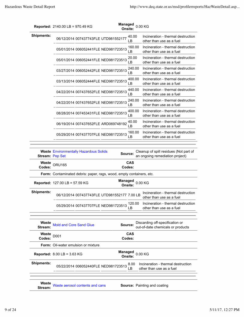
Reported: 2140.00 LB = 970.49 KG ManagedOnsite: 0.00 KG
Shipments:06/12/2014 007437743FLE UTD981552177 40.00
LBIncineration - thermal destructionother than use as a fuel
05/01/2014 006052441FLE NED981723513 160.00LB
Incineration - thermal destructionother than use as a fuel
05/01/2014 006052441FLE NED981723513 20.00LB
Incineration - thermal destructionother than use as a fuel
03/27/2014 006052442FLE NED981723513 240.00LB
Incineration - thermal destructionother than use as a fuel
03/13/2014 006052444FLE NED981723513 400.00LB
Incineration - thermal destructionother than use as a fuel
04/22/2014 007437652FLE NED981723513 440.00LB
Incineration - thermal destructionother than use as a fuel
04/22/2014 007437652FLE NED981723513 240.00LB
Incineration - thermal destructionother than use as a fuel
08/28/2014 007453431FLE NED981723513 400.00LB
Incineration - thermal destructionother than use as a fuel
06/19/2014 007437652FLE ARD069748192 40.00LB
Incineration - thermal destructionother than use as a fuel
05/29/2014 007437707FLE NED981723513 160.00LB
Incineration - thermal destructionother than use as a fuel
WasteStream:
Environmentally Hazardous SolidsPep Set Source: Cleanup of spill residues (Not part of
an ongoing remediation project)
WasteCodes: ORU165 CAS
Codes:
Form: Contaminated debris: paper, rags, wood, empty containers, etc.
Reported: 127.00 LB = 57.59 KG ManagedOnsite: 0.00 KG
Shipments:06/12/2014 007437743FLE UTD981552177 7.00 LB Incineration - thermal destruction
other than use as a fuel
05/29/2014 007437707FLE NED981723513 120.00LB
Incineration - thermal destructionother than use as a fuel
WasteStream: Mold and Core Sand Glue Source: Discarding off-specification or
out-of-date chemicals or products
WasteCodes: D001 CAS
Codes:
Form: Oil-water emulsion or mixture
Reported: 8.00 LB = 3.63 KG ManagedOnsite: 0.00 KG
Shipments:05/22/2014 006052440FLE NED981723513 8.00
LBIncineration - thermal destructionother than use as a fuel
WasteStream: Waste aerosol contents and cans Source: Painting and coating
Hazardous Waste Detail Report http://www.deq.state.or.us/msd/profilerreports/HazWasteDetail.asp...
9 of 24 5/11/17, 12:27 PM

WasteCodes: D001 CAS
Codes:
Form: Concentrated non-halogenated (e.g., non-chlorinated) solvent
Reported: 1690.00 LB = 766.42 KG ManagedOnsite: 0.00 KG
Shipments:06/26/2014 007443160FLE UTD981552177 1320.00
LB
Incineration - thermaldestruction other than use as afuel
07/31/2014 007443188FLE UTD981552177 60.00 LBIncineration - thermaldestruction other than use as afuel
11/19/2014 006052438FLE NED981723513 80.00 LBIncineration - thermaldestruction other than use as afuel
05/22/2014 006052438FLE NED981723513 10.00 LBIncineration - thermaldestruction other than use as afuel
09/05/2014 007453432FLE NED981723513 60.00 LBIncineration - thermaldestruction other than use as afuel
10/09/2014 007453434FLE NED981723513 80.00 LBIncineration - thermaldestruction other than use as afuel
09/17/2014 007453437FLE NED981723513 80.00 LBIncineration - thermaldestruction other than use as afuel
WasteStream: Waste epoxy containing amines Source: Other one-time or intermittent
processes (specify in comments)
WasteCodes: D002 CAS
Codes:
Form: Other organic liquid (specify in comments)
Reported: 16.00 LB = 7.26 KG ManagedOnsite: 0.00 KG
Shipments:03/06/2014 005039133FLE UTD981552177 8.00
LBIncineration - thermal destructionother than use as a fuel
02/06/2014 006738229FLE UTD981552177 8.00LB
Incineration - thermal destructionother than use as a fuel
WasteStream: Waste corrosive organic Source: Other one-time or intermittent
processes (specify in comments)
WasteCodes: D002 CAS
Codes:
Form: Aqueous waste containing cyanides
Reported: 40.00 LB = 18.14 KG ManagedOnsite: 0.00 KG
Shipments:05/22/2014 006052440 NED981723513 40.00
LBIncineration - thermal destructionother than use as a fuel
Hazardous Waste Detail Report http://www.deq.state.or.us/msd/profilerreports/HazWasteDetail.asp...
10 of 24 5/11/17, 12:27 PM

WasteStream: Miscellaneous chemicals Source: Discarding off-specification or
out-of-date chemicals or products
WasteCodes: D001 CAS
Codes:
Form: Other organic liquid (specify in comments)
Reported: 106.00 LB = 48.07 KG ManagedOnsite: 0.00 KG
Shipments:03/27/2014 006052442FLE NED981723513 48.00
LBIncineration - thermal destructionother than use as a fuel
07/10/2014 0074533439FL NED981723513 50.00LB
Incineration - thermal destructionother than use as a fuel
06/19/2014 007437675FLE ARD069748192 8.00LB
Incineration - thermal destructionother than use as a fuel
WasteStream:
Waste Flammable Liquids containingAcetone Source: Discarding off-specification or
out-of-date chemicals or products
WasteCodes: D001 CAS
Codes:
Form: Concentrated non-halogenated (e.g., non-chlorinated) solvent
Reported: 112.00 LB = 50.79 KG ManagedOnsite: 0.00 KG
Shipments:05/22/2014 006052440FLE NED981723513 80.00
LBIncineration - thermal destructionother than use as a fuel
03/13/2014 006052444FLE NED981723513 32.00LB
Incineration - thermal destructionother than use as a fuel
WasteStream:
Waste Flammable Liquids withkerosene, phenol and naphthalene Source: Discarding off-specification or
out-of-date chemicals or products
WasteCodes: D001 CAS
Codes:
Form: Concentrated non-halogenated (e.g., non-chlorinated) solvent
Reported: 8.00 LB = 3.63 KG ManagedOnsite: 0.00 KG
Shipments:07/16/2014 007453438FLE NED981723513 8.00
LBIncineration - thermal destructionother than use as a fuel
WasteStream:
Waste Paint containingnon-halogenated carriers Source: Discarding off-specification or
out-of-date chemicals or products
WasteCodes: D001, F003, F005 CAS
Codes:
Form: Paint, ink, lacquer, or varnish
Reported: 240.00 LB = 108.84 KG ManagedOnsite: 0.00 KG
Hazardous Waste Detail Report http://www.deq.state.or.us/msd/profilerreports/HazWasteDetail.asp...
11 of 24 5/11/17, 12:27 PM

Shipments:11/19/2014 006052438FLE NED981723513 40.00
LBIncineration - thermal destructionother than use as a fuel
02/20/2014 006738241FLE NED981723513 80.00LB
Incineration - thermal destructionother than use as a fuel
04/22/2014 00743652FLE NED981723513 120.00LB
Incineration - thermal destructionother than use as a fuel
WasteStream: Waste paint with toluene and xylene Source:
Other routine cleanup not part ofongoing remediation (specify incomments)
WasteCodes: D001 CAS
Codes:
Form: Paint, ink, lacquer, or varnish
Reported: 120.00 LB = 54.42 KG ManagedOnsite: 0.00 KG
Shipments:05/01/2014 006052441FLE NED981723513 120.00
LBIncineration - thermal destructionother than use as a fuel
WasteStream:
Waste Solids Containing FlammableSolids Source: Painting and coating
WasteCodes: D001 CAS
Codes:
Form: Paint, ink, lacquer, or varnish
Reported: 40.00 LB = 18.14 KG ManagedOnsite: 0.00 KG
Shipments:01/30/2014 006740569FLE ARD069748192 40.00
LBIncineration - thermal destructionother than use as a fuel
WasteStream: Waste Bioset Binders Source: Other production or service-related
processes (specify in comments)
WasteCodes: D001 CAS
Codes:
Form: Other organic liquid (specify in comments)
Reported: 728.00 LB = 330.15 KG ManagedOnsite: 0.00 KG
Shipments:05/01/2014 006052441FLE NED981723513 240.00
LBIncineration - thermal destructionother than use as a fuel
05/01/2014 006052441FLE NED981723513 360.00LB
Incineration - thermal destructionother than use as a fuel
07/10/2014 007453439FLE NED981723513 64.00LB
Incineration - thermal destructionother than use as a fuel
07/10/2014 007453439FLE NED981723513 64.00LB
Incineration - thermal destructionother than use as a fuel
WasteStream:
Toxic Liquids containing CarbonTetrachloride and Tetrachlorethylene Source: Discarding off-specification or
out-of-date chemicals or products
Hazardous Waste Detail Report http://www.deq.state.or.us/msd/profilerreports/HazWasteDetail.asp...
12 of 24 5/11/17, 12:27 PM

WasteCodes: D001, D019, D039, F002 CAS
Codes:
Form: Other organic liquid (specify in comments)
Reported: 8.00 LB = 3.63 KG ManagedOnsite: 0.00 KG
Shipments:03/27/2014 006052442FLE NED981723513 8.00
LBIncineration - thermal destructionother than use as a fuel
WasteStream: Discarded unused enamel paint Source: Painting and coating
WasteCodes: D001 CAS
Codes:
Form: Paint, ink, lacquer, or varnish
Reported: 32.00 LB = 14.51 KG ManagedOnsite: 0.00 KG
Shipments:07/24/2014 007453430FLE NED981723513 16.00
LBIncineration - thermal destructionother than use as a fuel
07/16/2014 007453438FLE NED981723513 16.00LB
Incineration - thermal destructionother than use as a fuel
WasteStream: Waste paint containing MEK Source: Painting and coating
WasteCodes: D001, D035 CAS
Codes:
Form: Paint, ink, lacquer, or varnish
Reported: 48.00 LB = 21.77 KG ManagedOnsite: 0.00 KG
Shipments:09/05/2014 007453432FLE NED981723513 48.00
LBIncineration - thermal destructionother than use as a fuel
WasteStream: Waste aluminium oxide Source: Process equipment change-out or
discontinue use of equipment
WasteCodes: D003 CAS
Codes:
Form: Metal salts or chemicals not containing cyanides
Reported: 370.00 LB = 167.80 KG ManagedOnsite: 0.00 KG
Shipments:11/06/2014 007453435FLE ARD069748192 370.00
LBIncineration - thermal destructionother than use as a fuel
2013 SQG 17 1.13727397276875 09/10/2013 02/28/2014
WasteStream: Aerosol Puncture Station Residue Source: Painting and coating
WasteCodes: D001, F003, F005 CAS
Codes:
Form: Concentrated halogenated/ non-halogenated solvent mixture
Hazardous Waste Detail Report http://www.deq.state.or.us/msd/profilerreports/HazWasteDetail.asp...
13 of 24 5/11/17, 12:27 PM

Reported: 588.78 LB = 267.01 KG ManagedOnsite: 0.00 KG
Shipments:07/01/2013 005039215FLE NED981723513 16.68
LBIncineration - thermal destructionother than use as a fuel
11/13/2013 006052439FLE NED981723513 41.70LB
Incineration - thermal destructionother than use as a fuel
11/07/2013 005039337FLE NED981723513 30.00LB
Incineration - thermal destructionother than use as a fuel
02/06/2013 005038980FLE UTD981552177 125.10LB
Incineration - thermal destructionother than use as a fuel
03/27/2013 005038988FLE UTD981552177 83.40LB
Incineration - thermal destructionother than use as a fuel
05/29/2013 005039164FLE UTD981552177 83.40LB
Incineration - thermal destructionother than use as a fuel
10/02/2013 005039194FLE UTD981552177 125.10LB
Incineration - thermal destructionother than use as a fuel
11/26/2013 006740565FLE UTD981552177 83.40LB
Incineration - thermal destructionother than use as a fuel
WasteStream:
Absorbents used to pick up spilledTriethylamine Source: Cleanup of spill residues (Not part
of an ongoing remediation project)
WasteCodes: U404 CAS
Codes:
Form: Contaminated debris: paper, rags, wood, empty containers, etc.
Reported: 125.00 GAL = 226.75 KG ManagedOnsite: 0.00 KG
Shipments:07/25/2013 005057363FLE ARD069748192 85.00
GALIncineration - thermal destructionother than use as a fuel
08/07/2013 005039176FLE ARD069748192 2.00GAL
Incineration - thermal destructionother than use as a fuel
09/05/2013 005039296FLE NED981723513 3.00GAL
Incineration - thermal destructionother than use as a fuel
07/06/2013 005039219FLE NED981723513 20.00GAL
Incineration - thermal destructionother than use as a fuel
07/02/2013 005038991FLE UTD981552177 15.00GAL
Incineration - thermal destructionother than use as a fuel
WasteStream: Partially Filled Aerosol Cans Source: Painting and coating
WasteCodes: D001, U080 CAS
Codes:
Form: Concentrated halogenated/ non-halogenated solvent mixture
Reported: 33.00 LB = 14.97 KG ManagedOnsite: 0.00 KG
Shipments:03/13/2013 005038975FLE ARD069748192 5.00
LBIncineration - thermal destructionother than use as a fuel
06/18/2013 005039207FLE ARD069748192 2.00LB
Incineration - thermal destructionother than use as a fuel
Hazardous Waste Detail Report http://www.deq.state.or.us/msd/profilerreports/HazWasteDetail.asp...
14 of 24 5/11/17, 12:27 PM

06/17/2013 005039205FLE NED981723513 10.00LB
Incineration - thermal destructionother than use as a fuel
03/20/2013 005038987FLE UTD981552177 10.00LB
Incineration - thermal destructionother than use as a fuel
10/31/2013 005039264FLE UTD981552177 4.00LB
Incineration - thermal destructionother than use as a fuel
03/06/2013 005038927FLE UTD981552177 2.00LB
Incineration - thermal destructionother than use as a fuel
WasteStream:
Waste Epoxy materials that containsamines Source: Other one-time or intermittent
processes (specify in comments)
WasteCodes: D002 CAS
Codes:
Form: Other inorganic solids (specify in comments)
Reported: 49.70 LB = 22.54 KG ManagedOnsite: 0.00 KG
Shipments:11/07/2013 005039337FLE NED981723513 6.00
LBIncineration - thermal destructionother than use as a fuel
12/12/2013 005039206FLE NED981723513 35.70LB
Incineration - thermal destructionother than use as a fuel
10/31/2013 005039264FLE UTD981552177 8.00LB
Incineration - thermal destructionother than use as a fuel
WasteStream: Cleaning Liquids and Soaps Source: Discarding off-specification or
out-of-date chemicals or products
WasteCodes: D002 CAS
Codes:
Form: Caustic aqueous waste without cyanides
Reported: 35.00 GAL = 132.38 KG ManagedOnsite: 0.00 KG
Shipments:07/25/2013 005057363FLE ARD069748192 15.00
GAL
Chemical treatment(reduction/destruction/oxidation/precipitation)
12/12/2013 005039206FLE NED981723513 15.00GAL
Incineration - thermal destructionother than use as a fuel
WasteStream:
Waste Process Chemical that containsPhenol Source: Discarding off-specification or
out-of-date chemicals or products
WasteCodes: U165, U188 CAS
Codes: 108-95-2
Form: Other organic liquid (specify in comments)
Reported: 18.00 GAL = 74.25 KG ManagedOnsite: 0.00 KG
Shipments:07/25/2013 005057363FLE ARD069748192 4.00
GALIncineration - thermal destructionother than use as a fuel
12/12/2013 005039206FLE NED981723513 14.00GAL
Incineration - thermal destructionother than use as a fuel
Hazardous Waste Detail Report http://www.deq.state.or.us/msd/profilerreports/HazWasteDetail.asp...
15 of 24 5/11/17, 12:27 PM

WasteStream:
Waste Flammable Liquids containingsome acetone and mineral spirits Source: Discarding off-specification or
out-of-date chemicals or products
WasteCodes: D001, U002 CAS
Codes:
Form: Concentrated non-halogenated (e.g., non-chlorinated) solvent
Reported: 13.00 GAL = 44.28 KG ManagedOnsite: 0.00 KG
Shipments:11/21/2013 006740557FLE UTD981552177 13.00
GALIncineration - thermal destructionother than use as a fuel
WasteStream: Off Spec alcohol-based wash Source: Discarding off-specification or
out-of-date chemicals or products
WasteCodes: D001 CAS
Codes:
Form: Other organic liquid (specify in comments)
Reported: 15.00 GAL = 120.91 KG ManagedOnsite: 0.00 KG
Shipments:11/13/2013 006052439FLE NED981723513 15.00
GALIncineration - thermal destructionother than use as a fuel
WasteStream:
Waste solids containing solventsTetrachloroethylene and MethyleneChloride
Source: Discarding off-specification orout-of-date chemicals or products
WasteCodes: D019, F001, F002, U080, U210 CAS
Codes:
Form: Concentrated halogenated (e.g., chlorinated) solvent
Reported: 3.00 LB = 1.36 KG ManagedOnsite: 0.00 KG
Shipments:11/07/2013 005039337FLE NED981723513 3.00
LBIncineration - thermal destructionother than use as a fuel
WasteStream: Hydrochloric Acid Source: Discarding off-specification or
out-of-date chemicals or products
WasteCodes: D002 CAS
Codes:
Form: Spent concentrated acid
Reported: 1.25 GAL = 4.97 KG ManagedOnsite: 0.00 KG
Shipments:08/07/2013 005039176FLE ARD069748192 1.00
GALIncineration - thermal destructionother than use as a fuel
05/23/2013 005057358FLE UTD981552177 0.25GAL
Incineration - thermal destructionother than use as a fuel
Hazardous Waste Detail Report http://www.deq.state.or.us/msd/profilerreports/HazWasteDetail.asp...
16 of 24 5/11/17, 12:27 PM

WasteStream:
Solid Waste Used to Absorb FlammableLiquid Source: Cleanup of spill residues (Not part
of an ongoing remediation project)
WasteCodes: D001 CAS
Codes:
Form: Contaminated debris: paper, rags, wood, empty containers, etc.
Reported: 25.00 GAL = 156.11 KG ManagedOnsite: 0.00 KG
Shipments:12/31/2013 006738194FLE NED981723513 25.00
GALIncineration - thermal destructionother than use as a fuel
WasteStream:
Liquid containing TCE and MethyleneChloride Source: Discarding off-specification or
out-of-date chemicals or products
WasteCodes: D019, U080, U210, U211 CAS
Codes:
Form: Concentrated halogenated (e.g., chlorinated) solvent
Reported: 3.00 GAL = 11.69 KG ManagedOnsite: 0.00 KG
Shipments:11/07/2013 005039337FLE NED981723513 3.00
GALIncineration - thermal destructionother than use as a fuel
WasteStream:
Flammable Liquids Containing AcetoneMethylethylketone Source: Discarding off-specification or
out-of-date chemicals or products
WasteCodes: D001, D035 CAS
Codes:
Form: Concentrated non-halogenated (e.g., non-chlorinated) solvent
Reported: 6.00 GAL = 20.44 KG ManagedOnsite: 0.00 KG
Shipments:10/17/2013 006738170FLE UTD981552177 6.00
GALIncineration - thermal destructionother than use as a fuel
WasteStream:
Flammable Liquid Containing Napthaand Xylene Source: Discarding off-specification or
out-of-date chemicals or products
WasteCodes: D001, U161, U239 CAS
Codes:
Form: Concentrated non-halogenated (e.g., non-chlorinated) solvent
Reported: 4.00 GAL = 13.17 KG ManagedOnsite: 0.00 KG
Shipments:12/12/2013 005039206FLE NED981723513 4.00
GALIncineration - thermal destructionother than use as a fuel
WasteStream:
Flammable Liquid Containing Xyleneand Methylethylketone Source: Discarding off-specification or
out-of-date chemicals or products
WasteCodes: D001, U239 CAS
Codes:
Form: Concentrated non-halogenated (e.g., non-chlorinated) solvent
Hazardous Waste Detail Report http://www.deq.state.or.us/msd/profilerreports/HazWasteDetail.asp...
17 of 24 5/11/17, 12:27 PM

Reported: 5.00 GAL = 16.46 KG ManagedOnsite: 0.00 KG
Shipments:08/07/2013 005039176FLE ARD069748192 5.00
GALIncineration - thermal destructionother than use as a fuel
WasteStream:
Waste Flammable Liquids containingsome xylene and mineral spirits Source: Discarding off-specification or
out-of-date chemicals or products
WasteCodes: D001 CAS
Codes:
Form: Other organic liquid (specify in comments)
Reported: 3.00 GAL = 9.08 KG ManagedOnsite: 0.00 KG
Shipments:10/31/2013 005039264FLE UTD981552177 3.00
GALIncineration - thermal destructionother than use as a fuel
WasteStream:
Waste Flammable Liquids with NoSolvents Source: Discarding off-specification or
out-of-date chemicals or products
WasteCodes: D001 CAS
Codes:
Form: Paint thinner or petroleum distillates
Reported: 2.00 LB = 0.91 KG ManagedOnsite: 0.00 KG
Shipments:10/31/2013 005039264FLE UTD981552177 2.00
LBIncineration - thermal destructionother than use as a fuel
2005 CEG 0 12/21/2005 03/20/2006
2003 CEG 0 12/30/2003 02/23/2004
2002 CEG 0 12/24/2002 02/28/2003
2001 CEG 0 12/26/2001 02/20/2002
2000 CEG 0 01/05/2001 03/14/2001
1999 CEG 0 01/06/2000 03/13/2000
1998 SQG 1 0.313 03/23/1999 03/24/1999
WasteStream:
Unused off-spec liquid resinbinders Source: Discarding off-specification
material
Waste Codes: D003 CAS Codes:
Form: Reactive or polymerizable organic liquid
Reported: 690.00 LB = 313.00 KG ManagedOnsite: 0.00 KG
Shipments: 08/14/1998 080398 ILD085349264 176.00 LB Fuel blending
04/14/1998 02167 TXD074196338 514.00 LB Fuel blending
1997 CEG 0 01/06/1998 02/20/1998
Hazardous Waste Detail Report http://www.deq.state.or.us/msd/profilerreports/HazWasteDetail.asp...
18 of 24 5/11/17, 12:27 PM

1996 SQG 2 0.153 12/30/1996 02/27/1997
WasteStream:
Off-spec foundry binderresins. Source: Discarding off-specification material
Waste Codes: D001 CAS Codes:
Form: Reactive or polymerizable organic liquid
Reported: 300.00 LB = 136.00 KG ManagedOnsite: 0.00 KG
Shipments: 03/25/1996 066208 CAD050806850 300.00 LB Incineration-liquids
WasteStream: Surplus nitric acid Source: Discarding out-of-date products or
chemicals
Waste Codes: D002 CAS Codes:
Form: Spent acid without metals
Reported: 3.00 GAL = 17.00 KG ManagedOnsite: 0.00 KG
Shipments: 04/25/1996 042597 WAD991281767 3.00 GAL Neutralization only
1995 CEG 0 12/27/1995 03/07/1996
1994 LQG 2 2.909 12/30/1994 03/17/1995
WasteStream: Sulfuric Acid Scrubber Solution, Sand. Source: Air pollution control
devices
WasteCodes: D002 CAS Codes:
Form: Spent acid without metals
Reported: 4000.00 LB = 1818.00 KG ManagedOnsite: 0.00 KG
Shipments: 05/09/1994 94031 WAD991281767 4000.00 LB Neutralization only
WasteStream:
Chromium Alloy Metal Slag and CastingSands. Source: Other
WasteCodes: D007 CAS Codes: N090
Form: Other "dry" ash, slag, or thermal residue
Reported: 2400.00 LB = 1091.00 KG ManagedOnsite: 0.00 KG
Shipments:12/14/1994 41124 IDD073114654 2400.00
LBStabilization/chemical fixation usingcementitious and /or pozzolanic
1993 CEG 0 12/30/1993 03/01/1994
1992 SQG 2 2.069 12/29/1992 03/01/1993
WasteStream:
Safety-Kleen solvent from parts washers. Containspetroleum naphtha. Source: Flush
rinsing
WasteCodes: D001, D039 CAS Codes:
Hazardous Waste Detail Report http://www.deq.state.or.us/msd/profilerreports/HazWasteDetail.asp...
19 of 24 5/11/17, 12:27 PM

Form: Paint thinner or petroleum distillates
Reported: 4192.00 LB = 1905.00 KG ManagedOnsite: 0.00 KG
Shipments: 01/13/1992 70368 ORD000712067 434.00 LB Fractionation/distillation
01/28/1992 45828 ORD000712067 307.00 LB Fractionation/distillation
02/11/1992 28648 ORD000712067 217.00 LB Fractionation/distillation
02/26/1992 03323 ORD000712067 352.00 LB Fractionation/distillation
03/09/1992 82697 ORD000712067 389.00 LB Fractionation/distillation
03/23/1992 58916 ORD000712067 307.00 LB Fractionation/distillation
04/06/1992 95969 ORD000712067 262.00 LB Fractionation/distillation
04/20/1992 71473 ORD000712067 307.00 LB Fractionation/distillation
05/07/1992 54849 ORD000712067 389.00 LB Fractionation/distillation
05/22/1992 34654 ORD000712067 266.00 LB Fractionation/distillation
06/03/1992 18942 ORD000712067 217.00 LB Fractionation/distillation
06/18/1992 98479 ORD000712067 307.00 LB Fractionation/distillation
08/06/1992 48691 ORD000712067 438.00 LB Fractionation/distillation
WasteStream:
Safety-Kleen solvent from parts washers. Contains metals& benzene. Source: Flush
rinsing
WasteCodes: D006, D018 CAS Codes:
Form: Halogenated solvent
Reported: 360.00 LB = 164.00 KG ManagedOnsite: 0.00 KG
Shipments: 01/13/1992 70367 ORD092895481 72.00 LB Fractionation/distillation
02/26/1992 03322 ORD092895481 36.00 LB Fractionation/distillation
04/06/1992 95968 ORD092895481 72.00 LB Fractionation/distillation
08/11/1992 28530 ORD092895481 36.00 LB Fractionation/distillation
09/27/1992 77459 ORD092895481 72.00 LB Fractionation/distillation
11/02/1992 23271 ORD981766124 72.00 LB Other solvent recovery
1991 SQG 7 25.601 11/01/1991 05/14/1992
WasteStream:
SAFETY-KLEEN SOLVENT FROM PARTS WASHERS.CONTAINS PETROLEUM NAPHTHA. Source: Flush rinsing
WasteCodes: D001, D039 CAS Codes:
Form: Paint thinner or petroleum distillates
Reported: 6935.00 LB = 3152.00 KG ManagedOnsite: 0.00 KG
Shipments: 01/02/1991 50285 ORD092895481 307.00 LB Fractionation/distillation
01/16/1991 11724 ORD092895481 86.00 LB Fractionation/distillation
01/30/1991 82623 ORD092895481 307.00 LB Fractionation/distillation
02/13/1991 58326 ORD092895481 303.00 LB Fractionation/distillation
02/27/1991 30429 ORD092895481 262.00 LB Fractionation/distillation
Hazardous Waste Detail Report http://www.deq.state.or.us/msd/profilerreports/HazWasteDetail.asp...
20 of 24 5/11/17, 12:27 PM

03/13/1991 34094 ORD092895481 86.00 LB Fractionation/distillation
03/26/1991 74477 ORD092895481 352.00 LB Fractionation/distillation
04/10/1991 51801 ORD092895481 258.00 LB Fractionation/distillation
04/30/1991 23402 ORD092895481 262.00 LB Fractionation/distillation
05/08/1991 95386 ORD092895481 176.00 LB Fractionation/distillation
05/23/1991 66395 ORD092895481 307.00 LB Fractionation/distillation
07/03/1991 90626 ORD092895481 172.00 LB Fractionation/distillation
07/15/1991 67464 ORD092895481 307.00 LB Fractionation/distillation
07/31/1991 44018 ORD092895481 434.00 LB Fractionation/distillation
08/12/1991 19936 ORD092895481 262.00 LB Fractionation/distillation
08/29/1991 95035 ORD092895481 217.00 LB Fractionation/distillation
09/09/1991 69613 ORD092895481 307.00 LB Fractionation/distillation
09/27/1991 48118 ORD092895481 217.00 LB Fractionation/distillation
10/10/1991 24645 ORD092895481 479.00 LB Fractionation/distillation
10/25/1991 78034 ORD092895481 262.00 LB Fractionation/distillation
11/07/1991 78074 ORD092895481 307.00 LB Fractionation/distillation
11/18/1991 37084 ORD092895481 389.00 LB Fractionation/distillation
12/04/1991 33910 ORD092895481 352.00 LB Fractionation/distillation
12/16/1991 26114 ORD092895481 217.00 LB Fractionation/distillation
12/30/1991 02557 ORD092895481 307.00 LB Fractionation/distillation
WasteStream:
SAFETY-KLEEN SOLVENT FROM PARTS WASHERS.CONTAINS METALS AND BENZENE. Source: Flush rinsing
WasteCodes: D006, D018 CAS Codes:
Form: Paint thinner or petroleum distillates
Reported: 378.00 LB = 172.00 KG ManagedOnsite: 0.00 KG
Shipments: 02/13/1991 58326 ORD092895481 90.00 LB Fractionation/distillation
05/08/1991 95386 ORD092895481 72.00 LB Fractionation/distillation
07/31/1991 44018 ORD092895481 72.00 LB Fractionation/distillation
09/09/1991 69613 ORD092895481 36.00 LB Fractionation/distillation
10/25/1991 78033 ORD092895481 72.00 LB Fractionation/distillation
12/04/1991 33909 ORD092895481 36.00 LB Fractionation/distillation
WasteStream:
ELECTRIC ARC FURNACE DUST GENERATEDFROM STEEL MELTING. CONTAINS CHROMIUM. Source: Air pollution
control devices
WasteCodes: D007 CAS Codes:
Form: Other waste inorganic solids
Reported: 38128.00 LB = 17331.00 KG ManagedOnsite: 0.00 KG
Shipments: 12/01/1991 12003 IDD073114654 38128.00 LB Stabilization - type unknown
Hazardous Waste Detail Report http://www.deq.state.or.us/msd/profilerreports/HazWasteDetail.asp...
21 of 24 5/11/17, 12:27 PM

WasteStream:
NAOH CLEANING TANK SOLUTION FOR FOUNDRYPATTERNS. CONTAINS LEAD. Source: Caustic (alkali)
cleaning
WasteCodes: D002, D006, D007, D008 CAS Codes:
Form: Caustic solution with metals but no cyanides
Reported: 666.00 LB = 303.00 KG ManagedOnsite: 0.00 KG
Shipments:08/01/1991 08013 WAD092300250 666.00
LBAqueous organic and inorganictreatment-type unknown
WasteStream:
SAFETY-KLEEN SOLVENT FROM PARTS WASHER.CONTAINS PETROLEUM NAPHTHA. Source: Flush rinsing
WasteCodes: D001, D039 CAS Codes:
Form: Paint thinner or petroleum distillates
Reported: 2902.00 LB = 1319.00 KG ManagedOnsite: 0.00 KG
Shipments: 09/27/1991 48116 ORD000712067 45.00 LB Fractionation/distillation
10/10/1991 24641 ORD000712067 131.00 LB Fractionation/distillation
10/25/1991 78029 ORD000712067 45.00 LB Fractionation/distillation
10/30/1991 91827 ORD000712067 86.00 LB Fractionation/distillation
11/06/1991 78070 ORD000712067 90.00 LB Fractionation/distillation
11/18/1991 57081 ORD000712067 131.00 LB Fractionation/distillation
12/04/1991 33904 ORD000712067 45.00 LB Fractionation/distillation
12/10/1991 24986 ORD000712067 86.00 LB Fractionation/distillation
12/16/1991 26112 ORD000712067 45.00 LB Fractionation/distillation
12/30/1991 02553 ORD000712067 176.00 LB Fractionation/distillation
01/02/1991 50281 ORD092895481 131.00 LB Fractionation/distillation
01/16/1991 11719 ORD092895481 45.00 LB Fractionation/distillation
01/21/1991 98302 ORD092895481 86.00 LB Fractionation/distillation
01/28/1991 82621 ORD092895481 90.00 LB Fractionation/distillation
02/14/1991 58321 ORD092895481 131.00 LB Fractionation/distillation
02/27/1991 30427 ORD092895481 45.00 LB Fractionation/distillation
03/12/1991 04669 ORD092895481 45.00 LB Fractionation/distillation
03/15/1991 18528 ORD092895481 86.00 LB Fractionation/distillation
03/26/1991 74473 ORD092895481 176.00 LB Fractionation/distillation
04/12/1991 51799 ORD092895481 45.00 LB Fractionation/distillation
04/17/1991 38277 ORD092895481 86.00 LB Fractionation/distillation
04/30/1991 23399 ORD092895481 45.00 LB Fractionation/distillation
05/09/1991 95381 ORD092895481 131.00 LB Fractionation/distillation
05/23/1991 66329 ORD092895481 90.00 LB Fractionation/distillation
05/27/1991 55723 ORD092895481 86.00 LB Fractionation/distillation
07/03/1991 90623 ORD092895481 45.00 LB Fractionation/distillation
Hazardous Waste Detail Report http://www.deq.state.or.us/msd/profilerreports/HazWasteDetail.asp...
22 of 24 5/11/17, 12:27 PM

07/15/1991 67461 ORD092895481 176.00 LB Fractionation/distillation
07/31/1991 44014 ORD092895481 131.00 LB Fractionation/distillation
08/12/1991 19932 ORD092895481 45.00 LB Fractionation/distillation
08/29/1991 95031 ORD092895481 131.00 LB Fractionation/distillation
09/09/1991 69608 ORD092895481 90.00 LB Fractionation/distillation
09/19/1991 60578 ORD092895481 86.00 LB Fractionation/distillation
WasteStream:
SAFETY-KLEEN SOLVENT FROM PARTS WASHERS.CONTAINS PETROLEUM NAPHTHA. Source: Flush rinsing
WasteCodes: D001, D039 CAS Codes:
Form: Paint thinner or petroleum distillates
Reported: 6935.00 LB = 3152.00 KG ManagedOnsite: 0.00 KG
Shipments: 09/27/1991 48118 ORD000712067 217.00 LB Fractionation/distillation
10/10/1991 24645 ORD000712067 479.00 LB Fractionation/distillation
10/25/1991 78034 ORD000712067 262.00 LB Fractionation/distillation
11/07/1991 78074 ORD000712067 307.00 LB Fractionation/distillation
11/18/1991 57084 ORD000712067 389.00 LB Fractionation/distillation
12/04/1991 33910 ORD000712067 352.00 LB Fractionation/distillation
12/16/1991 26114 ORD000712067 217.00 LB Fractionation/distillation
12/30/1991 02557 ORD000712067 307.00 LB Fractionation/distillation
01/02/1991 50285 ORD092895481 307.00 LB Fractionation/distillation
01/16/1991 11724 ORD092895481 86.00 LB Fractionation/distillation
01/30/1991 82623 ORD092895481 307.00 LB Fractionation/distillation
02/13/1991 58326 ORD092895481 303.00 LB Fractionation/distillation
02/27/1991 30429 ORD092895481 262.00 LB Fractionation/distillation
03/13/1991 34094 ORD092895481 86.00 LB Fractionation/distillation
03/26/1991 74477 ORD092895481 352.00 LB Fractionation/distillation
04/10/1991 51801 ORD092895481 258.00 LB Fractionation/distillation
04/30/1991 23402 ORD092895481 262.00 LB Fractionation/distillation
05/08/1991 95386 ORD092895481 176.00 LB Fractionation/distillation
05/23/1991 66395 ORD092895481 307.00 LB Fractionation/distillation
07/03/1991 90626 ORD092895481 172.00 LB Fractionation/distillation
07/15/1991 67464 ORD092895481 307.00 LB Fractionation/distillation
07/31/1991 44018 ORD092895481 434.00 LB Fractionation/distillation
08/12/1991 19936 ORD092895481 262.00 LB Fractionation/distillation
08/29/1991 95035 ORD092895481 217.00 LB Fractionation/distillation
09/09/1991 69613 ORD092895481 307.00 LB Fractionation/distillation
WasteStream:
SAFETY-KLEEN SOLVENT FROM PARTS WASHERS.CONTAINS METALS AND BENZENE. Source: Flush rinsing
WasteCodes: D006, D018 CAS Codes:
Hazardous Waste Detail Report http://www.deq.state.or.us/msd/profilerreports/HazWasteDetail.asp...
23 of 24 5/11/17, 12:27 PM

Form: Paint thinner or petroleum distillates
Reported: 378.00 LB = 172.00 KG ManagedOnsite: 0.00 KG
Shipments: 02/13/1991 58326 ORD092895481 90.00 LB Fractionation/distillation
05/08/1991 95386 ORD092895481 72.00 LB Fractionation/distillation
07/31/1991 44018 ORD092895481 72.00 LB Fractionation/distillation
09/09/1991 69613 ORD092895481 36.00 LB Fractionation/distillation
10/25/1991 78033 ORD092895481 72.00 LB Fractionation/distillation
12/04/1991 33909 ORD092895481 36.00 LB Fractionation/distillation
Hazardous Waste Detail Report http://www.deq.state.or.us/msd/profilerreports/HazWasteDetail.asp...
24 of 24 5/11/17, 12:27 PM

!"##"#$%&#'()&*+,-./01-2&3/4010.5&6-789.&:&;<=>&:&?@&;*A
*/B-&#&8C&$D..7EF""-4D8G-7/GB8H"2-./01-2IC/4010.5I9-789.JC02K##LLLLMN$OPM
Related Reports Regulatory Information Other Regulatory Reports
ESCO CORP2141 NW 25TH AVE, PORTLAND, OR 97210
FRS (Facility Registry Service) ID: 110000487394EPA Region: 10Latitude: 45.5374Longitude: -122.703Locational Data Source: EISIndustry: Primary Metal ManufacturingIndian Country: N
Detailed Facility Report
Facility Summary
Enforcement and Compliance Summary
Statute Insp (5Years)
Date of LastInspection
ComplianceStatus
Qtrs in NC (Non-Compliance) (of 12)
Qtrs in SignificantViolation
Informal EnforcementActions (5 years)
Formal EnforcementActions (5 years)
Penalties from Formal EnforcementActions (5 years)
EPA Cases (5years)
Penalties from EPACases (5 years)
CAA 3 03/23/2016 0 0 1 -- -- -- --
RCRA 1 07/15/2015 NoViolation
2 0 1 -- -- -- --
TSCA 1 12/18/2014 -- -- -- -- -- -- -- --
Quarters
12-Quarter Violation History
Under Development
1 2 3 4 5 6 7 8 9 10 11 12
RCRA
CAA

!"##"#$%&#'()&*+,-./01-2&3/4010.5&6-789.&:&;<=>&:&?@&;*A
*/B-&(&8C&$D..7EF""-4D8G-7/GB8H"2-./01-2IC/4010.5I9-789.JC02K##LLLLMN$OPM
Air Pollutant Report Clean Air Act (CAA): Operating Major(OR0000004105102068)Clean Water Act (CWA): No InformationResource Conservation and Recovery Act(RCRA): Active (H ) SQG (ORD009028259)Safe Drinking Water Act (SDWA): NoInformation
Air Emissions Inventory (EIS):8220611Greenhouse Gas Emissions(eGGRT): No InformationToxic Releases (TRI):97210SCCRP2141N
Facility/System Characteristics
Facility SIC (Standard Industrial Classification) Codes
System Identifier SIC Code SIC Desc
TRI 97210SCCRP2141N 3325 Steel Foundries
Facility NAICS (North American IndustryClassification System) Codes
System Identifier NAICS Code NAICS Description
EIS 8220611 331513 Steel Foundries (Except Investment)
TRI 97210SCCRP2141N 331513 Steel Foundries (Except Investment)
AIR OR0000004105102068 331513 Steel Foundries (Except Investment)
Facility/System Characteristics
System Statute Identifier Universe Status Areas Permit ExpirationDate
IndianCountry Latitude Longitude
FRS 110000487394 N 45.5374 -122.703
AIR CAA OR0000004105102068 Major Emissions Operating CAAGACTM, CAAMACT, CAASIP,CAATVP N
EIS CAA 8220611 OPERATING N 45.5374 -122.703
TRI EP313 97210SCCRP2141N Toxics ReleaseInventory
Last Reported for2015 N 45.53706 -122.70323
RCR RCRA ORD009028259 SQG Active (H ) N 45.537224 -122.702636
TSCA TSCA 100605784 N
TSCA TSCA TSCA8158 N
Facility Address
System Statute Identifier Facility Name Facility Address
FRS 110000487394 ESCO CORP 2141 NW 25TH AVE, PORTLAND, OR 97210
AIR CAA OR0000004105102068 ESCO CORPORATION 2141 NW 25TH AVE, PORTLAND, OR 97210
EIS CAA 8220611 ESCO CORPORATION 2141 NW 25TH AVE, PORTLAND, OR 97210
TRI EP313 97210SCCRP2141N ESCO CORP 2141 NW 25TH AVE, PORTLAND, OR 97210
RCR RCRA ORD009028259 ESCO CORPORATION 2141 NW 25TH AVE, PORTLAND, OR 97210
TSCA TSCA 100605784 ESCO CORP 2141 N.W. 25TH AVE., PORTLAND, OR 97210
TSCA TSCA TSCA8158 ESCO CORP 2141 N.W. 25TH AVE., PORTLAND, OR 97210

!"##"#$%&#'()&*+,-./01-2&3/4010.5&6-789.&:&;<=>&:&?@&;*A
*/B-&O&8C&$D..7EF""-4D8G-7/GB8H"2-./01-2IC/4010.5I9-789.JC02K##LLLLMN$OPM
RCR ORD009028259 331513 Steel Foundries (Except Investment)
Reservation Name Tribe Name EPA Tribal ID Distance to Tribe (miles)
No data records returned
Facility Tribe Information
Enforcement and Compliance
Compliance Monitoring History (5 years)
Statute Source ID System Inspection Type LeadAgency Date Finding
CAA OR0000004105102068 AIR TV ACC Receipt/Review State 02/16/2017 Finding: No Facility Report Deviations
CAA OR0000004105102068 AIR Stack Test State 05/11/2016Findings: Pass Pollutants: Carbon monoxide, Lead, NITROGEN OXIDES NO2, PARTICULATE MATTER < 10UM, PARTICULATE MATTER < 2.5 UM, Sulfur dioxide, TOTAL PARTICULATE MATTER, VOLATILE ORGANICCOMPOUNDS (VOCS)
CAA OR0000004105102068 AIR Stack Test State 05/05/2016Findings: Pass Pollutants: Carbon monoxide, Lead, NITROGEN OXIDES NO2, PARTICULATE MATTER < 10UM, PARTICULATE MATTER < 2.5 UM, Sulfur dioxide, TOTAL PARTICULATE MATTER, VOLATILE ORGANICCOMPOUNDS (VOCS)
CAA OR0000004105102068 AIR FCE On-Site State 03/23/2016
CAA OR0000004105102068 AIR TV ACC Receipt/Review State 02/18/2016 Finding: No Facility Report Deviations
CAA OR0000004105102068 AIR Stack Test State 06/25/2015Findings: Pass Pollutants: Carbon monoxide, Lead, NITROGEN OXIDES NO2, PARTICULATE MATTER < 10UM, PARTICULATE MATTER < 2.5 UM, Sulfur dioxide, TOTAL PARTICULATE MATTER, VOLATILE ORGANICCOMPOUNDS (VOCS)
CAA OR0000004105102068 AIR TV ACC Receipt/Review State 02/27/2015 Finding: No Facility Report Deviations
CAA OR0000004105102068 AIR FCE On-Site State 05/23/2014
CAA OR0000004105102068 AIR Stack Test State 03/04/2014 Findings: Pass Pollutants: TOTAL PARTICULATE MATTER
CAA OR0000004105102068 AIR Stack Test State 02/28/2014 Findings: Pass Pollutants: MANGANESE & MANGANESE COMPOUNDS
CAA OR0000004105102068 AIR Stack Test State 02/28/2014 Findings: Pass Pollutants: CADMIUM COMPOUNDS
CAA OR0000004105102068 AIR Stack Test State 02/28/2014 Findings: Pass Pollutants: ARSENIC COMPOUNDS
CAA OR0000004105102068 AIR Stack Test State 02/28/2014 Findings: Pass Pollutants: LEAD COMPOUNDS
CAA OR0000004105102068 AIR Stack Test State 02/28/2014 Findings: Pass Pollutants: Nickel compounds
CAA OR0000004105102068 AIR Stack Test State 02/28/2014 Findings: Pass Pollutants: COLBALT COMPOUNDS
CAA OR0000004105102068 AIR Stack Test State 02/28/2014 Findings: Pass Pollutants: MERCURY COMPOUNDS
CAA OR0000004105102068 AIR Stack Test State 02/28/2014 Findings: Pass Pollutants: Selenium
CAA OR0000004105102068 AIR Stack Test State 02/28/2014 Findings: Pass Pollutants: TOTAL PARTICULATE MATTER
CAA OR0000004105102068 AIR Stack Test State 02/28/2014 Findings: Pass Pollutants: Antimony compounds
CAA OR0000004105102068 AIR Stack Test State 02/28/2014 Findings: Pass Pollutants: Chromium compounds
CAA OR0000004105102068 AIR TV ACC Receipt/Review State 02/23/2014 Finding: No Facility Report Deviations
CAA OR0000004105102068 AIR Stack Test State 02/14/2014 Findings: Pass Pollutants: TOTAL PARTICULATE MATTER
CAA OR0000004105102068 AIR TV ACC Receipt/Review State 02/12/2014
CAA OR0000004105102068 AIR Stack Test State 01/24/2014 Findings: Pass Pollutants: TOTAL PARTICULATE MATTER

!"##"#$%&#'()&*+,-./01-2&3/4010.5&6-789.&:&;<=>&:&?@&;*A
*/B-&M&8C&$D..7EF""-4D8G-7/GB8H"2-./01-2IC/4010.5I9-789.JC02K##LLLLMN$OPM
Three Year Compliance Status by Quarter
Informal Enforcement Actions (5 Years)
CAA OR0000004105102068 AIR Stack Test State 01/23/2014 Findings: Pass Pollutants: TOTAL PARTICULATE MATTER
CAA OR0000004105102068 AIR TV ACC Receipt/Review State 03/21/2013 Finding: No Facility Report Deviations
CAA OR0000004105102068 AIR TV ACC Receipt/Review State 02/19/2013
CAA OR0000004105102068 AIR FCE On-Site State 09/12/2012
RCRA ORD009028259 RCRCOMPLIANCEEVALUATIONINSPECTION ON-SITE
State 07/15/2015 Violations Or Compliance Issues Were Found
TSCA/ §8 3600117097 ICIS Premanufacture Notice;
Inventory Rule EPA 12/18/2014
Entries in italics are not considered inspections in official counts.
Compliance Summary Data
Statute Source ID Current SNC (Significant Non-compliance)/HPV (High Priority Violation) Description Current As Of Qtrs in NC (Non-Compliance) (of 12)
CAA OR0000004105102068 No 05/06/2017 0
RCRA ORD009028259 No 05/06/2017 2
Statute Program/Pollutant/Violation Type QTR 1 QTR 2 QTR 3 QTR 4 QTR 5 QTR 6 QTR 7 QTR 8 QTR 9 QTR 10 QTR 11 QTR 12
CAA (Source ID: OR0000004105102068) 07/01-09/30/14
10/01-12/31/14
01/01-03/31/15
04/01-06/30/15
07/01-09/30/15
10/01-12/31/15
01/01-03/31/16
04/01-06/30/16
07/01-09/30/16
10/01-12/31/16
01/01-03/31/17
04/01-06/30/17
Facility-Level Status NoViol
NoViol
HPV History
ViolationType Agency Programs Pollutants
Historic Violations
Statute Program/Pollutant/Violation Type QTR 1 QTR 2 QTR 3 QTR 4 QTR 5 QTR 6 QTR 7 QTR 8 QTR 9 QTR 10 QTR 11 QTR 12
RCRA (Source ID: ORD009028259) 07/01-09/30/14
10/01-12/31/14
01/01-03/31/15
04/01-06/30/15 07/01-09/30/15 10/01-12/31/15 01/01-
03/31/1604/01-
06/30/1607/01-
09/30/1610/01-
12/31/1601/01-
03/31/1704/01-
06/30/17
RCRA Facility-Level Status In Viol In Viol
Violation Agency
RCRA Generators - Pre-transport OR JUL-15-2015 SEP-17-
2015
RCRA Generators - Pre-transport OR JUL-15-2015 OCT-05-
2015
RCRA Generators - Pre-transport OR JUL-15-2015 SEP-17-
2015
RCRA Generators - Pre-transport OR JUL-15-2015 JUL-15-
2015
RCRA Generators - Pre-transport OR JUL-15-2015 JUL-15-
2015
Statute System Source ID Type of Action Lead Agency Date
CAA AIR OR0000004105102068 Notice of Violation State 09/04/2013
RCRA RCR ORD009028259 WRITTEN INFORMAL State 09/03/2015
Formal Enforcement Actions (5 Years)

!"##"#$%&#'()&*+,-./01-2&3/4010.5&6-789.&:&;<=>&:&?@&;*A
*/B-&!&8C&$D..7EF""-4D8G-7/GB8H"2-./01-2IC/4010.5I9-789.JC02K##LLLLMN$OPM
ICIS (Integrated Compliance Information System) Case History (5 years)
Water Quality
Toxics Release Inventory History of Reported Chemicals Released in Pounds per Year at Site
TRI Pollution Prevention Report Air Pollutant Report
Statute Source ID Type of Action Lead Agency Date Penalty Penalty Description
No data records returned
Primary Law/Section Case No. Case Type Lead Agency Case Name Issued/Filed Date Settlement Date Federal Penalty State/Local Penalty SEP (Supplemental Environmental Project) Cost Comp Action Cost
No data records returned
Environmental Conditions
PermitID
CombinedSewer
System?
Number of CSO(Combined SewerOverflow) Outfalls
12-Digit WBD (Watershed BoundaryDataset) HUC (RAD (Reach Address
Database))
WBD (Watershed Boundary Dataset)Subwatershed Name (RAD (Reach Address
Database))
State Waterbody Name (ICIS(Integrated Compliance Information
System))
ImpairedWaters
ImpairedClass
Causes ofImpairment(s)by Group(s)
Watershed with ESA(Endangered Species Act)-
listed Aquatic Species?
No data records returned
Waterbody Designated Uses
Reach Code Waterbody Name Exceptional Use Recreational Use Aquatic Life Use Shellfish Use Beach Closure Within Last Year Beach Closure Within Last Two Years
No data records returned
Air Quality
Non-Attainment Area? Pollutant(s)
No Ozone
No Lead
Yes Particulate Matter
No Sulfur Dioxide
Pollutants
TRI Facility ID Year Total Air Emissions Surface Water Discharges Off-Site Transfers to POTWs (Publicly Owned Treatment Works) Underground Injections Releases to Land Total On-site Releases Total Off-site Releases
97210SCCRP2141N 2015 332 0 7 0 332 14,116

!"##"#$%&#'()&*+,-./01-2&3/4010.5&6-789.&:&;<=>&:&?@&;*A
*/B-&)&8C&$D..7EF""-4D8G-7/GB8H"2-./01-2IC/4010.5I9-789.JC02K##LLLLMN$OPM
Demographic Profile of Surrounding Area (3 Miles)
97210SCCRP2141N 2014 609 0 7 609 22,279
97210SCCRP2141N 2013 2,552 0 4 2,552 32,845
97210SCCRP2141N 2012 3,737 0 9 3,737 41,210
97210SCCRP2141N 2011 4,999 0 7 4,999 47,720
97210SCCRP2141N 2010 5,971 0 8 5,971 39,160
97210SCCRP2141N 2009 3,329 0 5 3,329 26,855
97210SCCRP2141N 2008 15,176 0 15,176 191,214
97210SCCRP2141N 2007 21,856 0 21,856 184,360
Toxics Release Inventory Total Releases and Transfers in Pounds by Chemical and Year
Chemical Name 2015 2014 2013 2012 2011 2010 2009 2008 2007
4,4'-ISOPROPYLIDENEDIPHENOL 0 0 0 0 0 0 0
ALUMINUM (FUME OR DUST)
ALUMINUM OXIDE (FIBROUS FORMS)
CERTAIN GLYCOL ETHERS 12,627 19,289
CHROMIUM
CHROMIUM COMPOUNDS(EXCEPT CHROMITE OREMINED IN THE TRANSVAAL REGION) 3,160 4,872 6,098 8,523 10,075 8,195 4,923 25,186 24,337
DIISOCYANATES 7 10 8 11 10 10 8 11 9
ISOPROPYL ALCOHOL (MANUFACTURING,STRONG-ACID PROCESS ONLY,NO SUPPLIER)
LEAD COMPOUNDS 70 162 203 246 270 291 168 224 173
MANGANESE
MANGANESE COMPOUNDS 10,449 16,330 20,956 27,957 32,287 26,887 16,825 158,789 153,445
MERCURY
MOLYBDENUM TRIOXIDE 3 6 7 10 30 30 20 62 65
NICKEL
NICKEL COMPOUNDS 759 1,508 5,006 4,103 5,122 4,311 3,749 8,133 7,448
PHENOL 3,119 4,097 4,925 5,407 4,491 1,358 1,450
Demographic Profile
This section provides demographic information regarding the community surrounding the facility. ECHO compliancedata alone are not sufficient to determine whether violations at a particular facility had negative impacts on publichealth or the environment. Statistics are based upon the 2010 US Census and American Community Survey data, andare accurate to the extent that the facility latitude and longitude listed below are correct. The latitude and longitude areobtained from the EPA Locational Reference Table (LRT) when available.
Radius of Area: 3 Land Area: 93% Households in Area: 59,191

!"##"#$%&#'()&*+,-./01-2&3/4010.5&6-789.&:&;<=>&:&?@&;*A
*/B-&$&8C&$D..7EF""-4D8G-7/GB8H"2-./01-2IC/4010.5I9-789.JC02K##LLLLMN$OPM
Center Latitude: 45.53706 Water Area: 7% Housing Units in Area: 65,053
Center Longitude: -122.70323 Population Density: 4,387/sq.mi. Households on Public Assistance: 1,344
Total Persons: 115,552 Percent Minority: 24% Persons Below Poverty Level: 38,187
Race Breakdown Persons (%) Age Breakdown Persons (%)
White: 91,832 (79%) Child 5 years and younger: 4,560 (4%)
African-American: 8,983 (8%) Minors 17 years and younger: 13,665 (12%)
Hispanic-Origin: 7,109 (6%) Adults 18 years and older: 101,887 (88%)
Asian/Pacific Islander: 5,996 (5%) Seniors 65 years and older: 11,815 (10%)
American Indian: 1,081 (1%)
Other/Multiracial: 7,660 (7%)
Education Level (Persons 25 & older) Persons (%) Income Breakdown Households (%)
Less than 9th Grade: 2,078 (2.48%) Less than $15,000: 12,034 (21.06%)
9th through 12th Grade: 3,494 (4.17%) $15,000 - $25,000: 6,432 (11.26%)
High School Diploma: 11,482 (13.72%) $25,000 - $50,000: 12,493 (21.87%)
Some College/2-yr: 21,271 (25.41%) $50,000 - $75,000: 9,115 (15.96%)
B.S./B.A. or More: 45,393 (54.22%) Greater than $75,000: 17,054 (29.85%)

HAHN AND ASSOCIATES, INC.
Appendix I
Portland Harbor Superfund Site Information

Portland Harbor Superfund Site
Entity Date(s) of GNL(s) Recipient of Most Recent GNL Current Correspondence Address Facility Address
Elkem Metals Inc. February 2011
Geir KvernmoPresidentElkem Metals Inc.Airport Office Park, Building 2400 Rouser RoadMoon Township, Pennsylvania 15108-2749
11920 N. Burgard Road
Equilon Enterprises, LLC December 2000
Anthony Palagyi Equilon Enterprises LLC10602 NE 38th PlKirkland, WA 98109
Mr. William E. Platt IIISenior Manager, Environmental ClaimsShell Oil Company910 Louisiana, Suite 685Houston, TX 77002
3800 NW St. Helens Road
ESCO Corporation March 2010
Kevin S. ThomasVice President & General CounselESCO Corporation1650 NW Naito Parkway, Suite 200Portland, OR 97209
2141 NW 21st Avenue2760 – 2770 NW Yeon Avenue2211 NW Brewer Avenue2245 NW Suffolk Street
Exide Technologies, Inc. November 20013
Robert M. CarusoPresident & Chief Executive OfficerExide Technologies, Inc.13000 Deerfield ParkwayBuilding 200Milton, Georgia 30004
5909 Northwest 61st Avenue2258 Northwest Suffolk Street
ExxonMobil Oil Corporation December 2000April 2006
Brian J. Harrison Major Projects Manager Global Remediation ExxonMobil Refining & Supply Company607 ExxonMobil Road Billings, MT 59101
Dave Robersonde maximis, inc.2203 Timberloch Place, Suite 213The Woodlands, Texas 77380
Mark A. Zuschek, Esq.ExxonMobil Law Department3225 Gallows RoadFairfax, Virginia 22037
9420 NW St Helens Road
FMC Corp April 2006
John F. Stillman Environmental Counsel FMC Corporation 1735 Market Street Philadelphia, PA 19103
Andrea E. UtechtVice President, General Counsel, and Secretary FMC Corporation1735 Market StreetPhiladelphia, PA 19103
4012-4350 NW Front Ave.4850 NW Front Ave.
Foss Maritime Company December 2000April 2006
Frank Williamson President Foss Maritime Company 660 W. Ewing Street Seattle, WA 98119
Frank WilliamsonGeneral CounselFoss Maritime Company660 W Ewing StreetSeattle, WA 98119
9030 NW Saint Helens Rd
Foster Poultry Farms (FKA Lynden Farms) March 2010
Ronald Foster, CEOFoster Poultry Farms1000 Davis StreetLivingston, CA 95334
James MarnattiDirector of Environmental AffairsFoster Poultry Farms1333 Swan Street PO Box 831Livingston, CA 95334
6135 North Basin Avenue
Page 6 of 18

OF11OF15
OF16OF17
OF18OF19
OF22
OF22C
OF22D
OF49OF50
OF52
OF10AOF13OF14
OF19AOF22B
OF24
OF42
OF43OF44OF44A
OF45
OF46
OF47
OF48
OF52A
OF52C
OF53
OF53A
OFM-1OFM-2
OFM-3
OFS-1 OFS-2
OFS-5
OFS-6
OF52D
OF23
WR-306
WR-307
WR-510
MillerCreek
2406
2375 2362
5864
60692362
183
170
1196
1096
84
1302
272277
2356
74 271
14141624
1885
2361
3395
2183236
4236
7
1405
3901
24241160
141
1989
2350
2437
2769
3036
398
40031398
1593
1076
4784
115
1641
3215
1239
1155
15282377
2761
137
2426146
1328 811307
69
260
1430
24522370
1840
2066
169
1080
1686
2355
24074590
1781338
2352
1026
966
4655
160
4535
3295 3807
2442
4461
2372 4560
2371
4008
2365
4015
2441
2353
2348
3343
2363
2104
1753
2013 2017
49111
1075
117
1277
988
3301281
333
1235
878
25 135155
1139
138
395
970
397134
1019
794 1036
100
110
1395
1764696
29
9351067
4797
18205055177
2366
4960
23512373
1962
51095117
1189
2376
4920
172 2642
2378
2440
5136
44
2446
2454
2423
404 5059
3976
5103
4409
4497
556154495577
5307
187
271
178
178
5117
1080
17725160
155
3377
5685
5686
5437
5437
54375437
5437
52385761
5529
5437
5 2 C5 2 C
S 6S 6S 1S 1 S 2S 2 S 5S 5
M 3M 3
2 2 B2 2 B
2 22 2
1 81 8
1 61 6
4 84 8
M 2M 2
5 25 25 2 A5 2 A5 05 0 4 94 9
M 1M 1
1 9 A1 9 A
1 91 9
1 41 4
5 35 3
2 2 C2 2 C
1 0 A1 0 A4 24 2
1 31 31 51 5
4 74 7
2 2 D2 2 D
1 11 1
4 4 A4 4 A
5 3 A5 3 A
1 71 7
5 2 D5 2 D
4 34 34 54 5
RM-1
2
RM-13
RM-1
1
RM-0
RM-1
RM-6
RM-7
RM-1
0
RM-5
RM-4
RM-3
RM-2
RM-8 RM
-9
Source: Esri, DigitalGlobe, GeoEye, Earthstar Geographics, CNES/Airbus DS, USDA, USGS, AEX, Getmapping, Aerogrid, IGN, IGP, swisstopo, and the GISUser Community
C O L U M B I AR I V E R
R I V E R
C o l u m b i aS l o u g h
B Y B E EL A K E
S M I T HL A K E
M u l t n o m a h C h a n n e l
W I L L A M E T T E
R I V E R
W I L L A M E T T E
Fi g ure 4 .1
VancouverWA
Portland Metro 26
2630
5
205
405 84
MAPPEDAREA
C o l u
m b i aS l o u g h
PORTLAND HARBOR STUDY AREAStatus o f Stormwater
Source Control EvaluationsJanuary 2016
LEGEND
Environmental Cleanup Sites from OR DEQ Environmental Cleanup Site Inventory (ECSI) database.Taxlots from Metro RLIS. Outfalls from City of Portland BES.
0 0.25 0.5 0.75 1Miles
0 2,000 4,000 6,000Feet
* Not all outfalls depicted are currently active.
Portland Harbor Watershed BoundaryWillamette River MileRM-4
City of Portland Outfall
ODOT Contribution to Outfall
City Stormwater Basin Boundary4 34 3
Source Control Decision / No Further Action IssuedNeed for Source Control Evaluation to be Determined / Low Priority Source Control Evaluation In ProgressSource Control Evaluation Needed
Source Control Evaluation Not Needed
EPA LeadEnvironmental Cleanup Site (ECSI)1840 Private Outfall
Port of Portland Outfall
ODOT Outfall