j. indian soc. remote sens geomorphicsignatures 2008
TRANSCRIPT
J. Indian Soc. Remote Sens. (December 2008) 36:361–373
ORIGINAL ARTICLE
Geomorphic Signatures of Active Tectonics in Bist Doab InterfluvialTract of Punjab, NW India
C.M. Bhatt . P.K. Litoria . P.K. Sharma
Received: 6 December 2007 / Accepted: 20 November 2008
Keywords
C.M. Bhatt ( )1 . P.K. Litoria . P.K. SharmaPunjab Remote Sensing Centre,Ludhiana-1410041 National Remote Sensing Agency,Hyderabad
e-mail: [email protected]
Photonirvachak
123
Abstract Bist Doab interfluvial tract in the north-western part of Punjab (India) has been investigatedfor geomorphic signatures of active tectonics usingremotely sensed data and geographical informationsystem (GIS). The anomalous river flow, abruptchanges in flow direction, angular drainage,compressed meanders, asymmetry of river bends,high channel sinuosity, abandoned channels,waterlogged and marshy areas observed along thecourses of Beas and Sutlej rivers and their tributariesindicate tectonically active nature of the terrain. The
strong control exercised by the NE-SW and NW-SEtrending lineaments on the drainage network is wellevident in the form of long straightened slopedeviatory courses, definite changes in channelpattern and sharp knee bend turns taken by theseasonal rivulets. The asymmetric and elongatednature of watersheds and straight to curvilinearmountain fronts quantified through morphotectonicanalysis are characteristic of tectonically activesettings and further corroborate the evidences ofactive tectonics.
Introduction
The convergence of Indian plate with the Eurasianplate is accommodated by the active thrusts andfaults and is expressed in the associated geomorphicfeatures (Sati et al., 2007). The displaced geomorphicsurfaces, river terraces, alluvial fans and topographicridges are some of the potential indicators of activetectonics manifested along these thrusts and faults

362 J. Indian Soc. Remote Sens. (December 2008) 36:361–373
123
(Nakata, 1972). Active tectonic movements along theHimalyan Frontal Thrust (HFT) and the sub-surfacehidden ridges have played an important role in themorphological evolution of the present daytopographic and physiographic features in the Sub-Himalayan zone. An integrated multi-disciplinaryapproach using drainage, geomorphological andstructural features is very useful in evaluation ofactive tectonics. The information about geomorphicindicators of active tectonics can be retrievedthrough analysis of topographic maps, aerialphotographs, satellite data and quantification ofmorphotectonic indices (Keller, 1986). Significantimprovement in spatial and spectral resolutions ofsatellite data, image processing techniques andadvancement in computing resources has enabledthe geomorphologists to carry out more quantitativeand precise analysis of geospatial data. The imageinterpretation techniques are less time consumingthan the conventional ground surveys, which ifcoupled with limited field checks yield valuableinformation. Many workers have used remote sensingand GIS techniques to identify and quantify morpho-structural evidences of active tectonics. Malik andNakata (2003) identified active faults and variousgeomorphic evidences of active tectonics using aerialphotographs along the north-western frontalHimalayan zone. Thakur and Pandey (2004) useddigitally processed IRS-LISS III images fordelineating geomorphic expression of differenttectono-startigraphic units and faults in GarhwalSub-Himalayas. Jain and Sinha (2005) usedsequential satellite images to study the response ofactive tectonics on the alluvial Bagmati river in theeastern part of India. Virdi et al. (2006) used aerialphotographs, satellite imagery and topographicalmaps supported by field checks to study neotectonicactivity and its control on the drainage in the north-western part of the Himalaya. Recently, Goswami andPant (2007) have used satellite data to delineate andmap geomorphic indicators of active tectonics tosubstantiate field based observations in Kota-
Pawalgarh Duns of Central Kumaun, Sub-Himalayas.In the present study, an attempt has been made toidentify and document various geomorphicindicators of active tectonics using satellite data,supported by limited field check and throughquantification of morphotectonic parameters, in BistDoab interfluvial tract of Punjab.
Study Area
The study area is located in the Indian Sub-Himalayan zone and is one of the major interfluvialtracts in north-western part of India. It is enclosedbetween the Beas and Sutlej rivers on the two sidesand Siwalik hills on the third side (Fig. 1). It has aspread of 9060 sq. kms. and lies between 74057’ to76040 east longitudes and 30057’ to 32004’ northlatitudes. Beas and Sutlej are the two main perennialrivers draining the area. The West (Black) Beindraining the western part and the East (White) Beindraining the eastern part are the two main tributariesof river Beas and Sutlej. Besides the, numerousseasonal rivulets (choes/khads) debouching from theSiwalik hills, make a strong impact on the landutilization and geomorphological landscape of thearea.
Data Used and Methodology
Indian Remote Sensing satellite data (IRS-P6, LISSIII) of March 2005 with a spatial resolution of 23.5 mwas used to identify and delineate geomorphological,structural and drainage features. Image enhancementtechniques and different band combinations wereapplied for better visualization, interpretation andcreation of geospatial database. The orientations ofthe image identified lineaments and streams werestatistically analyzed with the help of Rose diagram.The digital database was analysed to quantifymorphotectonic indices like mountain front sinuosity(Smf), basin elongation ratio (Re), drainage basin

123
363J. Indian Soc. Remote Sens. (December 2008) 36:361–373
Fig. 1 Geological and geomorphological map of the study area. Boxes S1-S5 along Sutlej River, and B1-B3 along BeasRiver are the sections selected for highlighting the structural control evidences.
shape (Bs), asymmetry factor (AF) and channelsinuosity (S).
Geological and Geomorphological Setting
The study area is a part of the tectonically formedIndo-Gangetic trough. Barring the Siwalik hills ofUpper Tertiary, the entire area is covered byQuaternary sediments brought down by the riversof Indus drainage system. Geomorphologically, thearea comprises of six major geomorphic units viz.hills, alluvial fans, piedmont plain, alluvial plain,aeolian plain and the flood plain (Fig. 1). The Siwalik
hills are composed of poorly lithified sandstones andconglomerates, whereas the piedmont plains aremade up of coarse textured, poorly sorted sedimentsbrought down by the streams. The alluvial depositsare composed of sand, silt and clay intermixed withcalcareous concretions (kankar) and pebbles invarying proportions. The older alluvial sediments ofMiddle to Upper Pleistocene age constitutesterraced alluvial deposits, whereas the neweralluvium of Upper Pleistocene to Recent ageoccupies comparatively lower levels adjoining thepresent day streams and rivers. The thickness ofalluvial sediments has been estimated to be about4500 m near Dasuya in Hoshiarpur district and 2523

364 J. Indian Soc. Remote Sens. (December 2008) 36:361–373
123
m near Adampur in Jalandhar district (Karunakaranand Ranga Rao 1979). The aeolian deposits presentin the form of sand sheets are composed of mediumto coarse grained sands. The Siwaliks trending inNW-SE direction, exhibit a long, linear to sinuouselongated anticlinal ridge. The ridge is bounded atthe north-western end by ENE-WSW trending Beasand at the south-east corner by the NE-SW trendingSutlej transverse faults (F1&F3). The Beas and Sutlejrivers incise through the limbs of the anticlinal ridgeat the NW and SE corners to form water gaps (Fig.1). The Himalyan Frontal Thrust (HFT) passing alongthe Siwalik foothills, marks a sharp physiographicboundary between the Sub-Himalayas and thePunjab alluvial plains. It is considered as one of themost active zones of deformation. Besides, the HFTin the north, gradual movements along the sub-surface hidden ridges/basement highs concealedunder the thick cover of alluvial settlements (Aithalet al., 1964) causes the ground slopes and streamgradients to modify.
Drainage Analysis
Tectonic deformation causes change in channelslope, inducing variations in channel morphology,fluvial processes and hydrological characteristics ofa river. The strong structural control and variousfluvial anomalies observed along the courses andflood plains of Sutlej (Fig. 2&3) and Beas (Fig. 4),their tributaries East and West Bein (Fig. 5a) and theseasonal rivulets (Fig. 5b) traversing the Siwalikshave been discussed below.
Sutlej River
The 196 km long westward course of river Sutlej inthe area shows high sinuosity and strong structuralcontrol, marked by a number of sharp and abruptchanges. Five sections, two each in upstream (S1 &S2) and lower reaches (S4 & S5) and one inmidstream reaches (S3) along Sutlej river course have
been selected to highlight the evidences of structuralcontrol (Fig. 1). In the upstream reaches (S1), the riverafter taking a sharp U turn from south-west to westdirection and incising through the limbs of theanticlinal ridge enters the Punjab plains near Ropartown (Fig. 2a). This is the most remarkable featureof drainage network in an active fold and thrust beltsystem (Burbank & Anderson, 2000). The suddenchange in flow direction towards west also marks asharp topographic break as the drainage network onthe northern and southern sides of the Sutlej, flowsin NE to SW following the natural gradient. In theupper reaches (S2), the river after flowing for 14 kmtakes an abrupt change near village Chota Daudpurfrom south-west to north-west direction and flowsfor almost 13 km against the gradient (Fig. 2b). Inthe midstream reaches (S3), the river leaving its east-west course near village Allowal, flows against thenatural gradient for five kilometers in north-westdirection, before taking a sharp right angle turn insouth-west direction downstream of village Mianwal(Fig. 2c). In the lower reaches (S4), a remarkablechange in the flow direction of river Sutlej can beobserved downstream of village Bhaini from almosteast-west to north-west direction. The river defyingthe regional slope moves in north-west direction foralmost straight for 39 km before resuming its east-west course near village Mundi Kalu (Fig. 2d).Further the rivers course (S5), downstream of villageTibbi Taik to its confluence with river Beas nearHarike is marked by asymmetry of river bends andhigh sinuosity. The river abandoning its east-westcourse near village Manuwala takes an abrupt changein southerly direction and after travelling for adistance of two kilometers, it takes a tight hair pinbend turn in north-west direction near villageBhupewala. It flows for six kilometers, against thegradient before again taking an upside U turn nearvillage Rukhnewala to finally join river Sutlej nearHarike (Fig. 2e). The sequential analysis of channelconfiguration between village Tibbi Taik and Harikeshows that the river has undergone significant

123
365J. Indian Soc. Remote Sens. (December 2008) 36:361–373
Fig. 2 Fluvial anomalies observed along the course of river Sutlej (a) displacement of Siwaliks; (a-e) abrupt changes inflow direction; (b-e) flow against gradient; ((b-d) straightened courses; (e) compressed meanders and (b, c & f) palaeo/abandoned channels.
366 J. Indian Soc. Remote Sens. (December 2008) 36:361–373
123
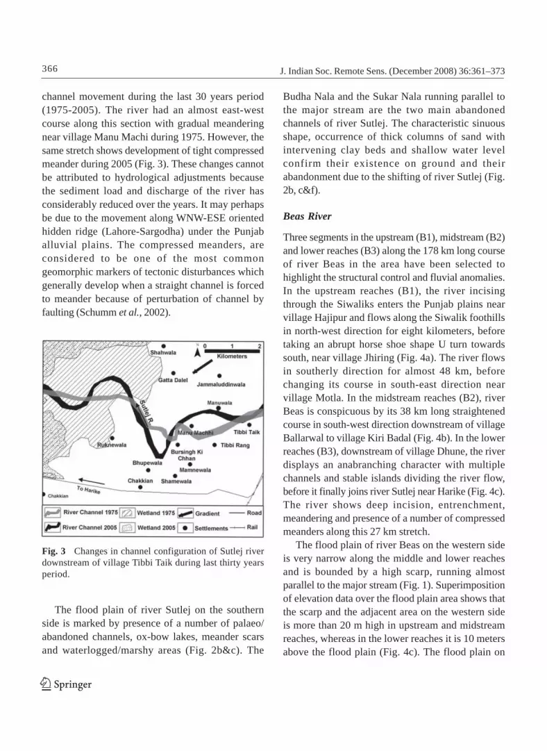
channel movement during the last 30 years period(1975-2005). The river had an almost east-westcourse along this section with gradual meanderingnear village Manu Machi during 1975. However, thesame stretch shows development of tight compressedmeander during 2005 (Fig. 3). These changes cannotbe attributed to hydrological adjustments becausethe sediment load and discharge of the river hasconsiderably reduced over the years. It may perhapsbe due to the movement along WNW-ESE orientedhidden ridge (Lahore-Sargodha) under the Punjaballuvial plains. The compressed meanders, areconsidered to be one of the most commongeomorphic markers of tectonic disturbances whichgenerally develop when a straight channel is forcedto meander because of perturbation of channel byfaulting (Schumm et al., 2002).
Budha Nala and the Sukar Nala running parallel tothe major stream are the two main abandonedchannels of river Sutlej. The characteristic sinuousshape, occurrence of thick columns of sand withintervening clay beds and shallow water levelconfirm their existence on ground and theirabandonment due to the shifting of river Sutlej (Fig.2b, c&f).
Beas River
Three segments in the upstream (B1), midstream (B2)and lower reaches (B3) along the 178 km long courseof river Beas in the area have been selected tohighlight the structural control and fluvial anomalies.In the upstream reaches (B1), the river incisingthrough the Siwaliks enters the Punjab plains nearvillage Hajipur and flows along the Siwalik foothillsin north-west direction for eight kilometers, beforetaking an abrupt horse shoe shape U turn towardssouth, near village Jhiring (Fig. 4a). The river flowsin southerly direction for almost 48 km, beforechanging its course in south-east direction nearvillage Motla. In the midstream reaches (B2), riverBeas is conspicuous by its 38 km long straightenedcourse in south-west direction downstream of villageBallarwal to village Kiri Badal (Fig. 4b). In the lowerreaches (B3), downstream of village Dhune, the riverdisplays an anabranching character with multiplechannels and stable islands dividing the river flow,before it finally joins river Sutlej near Harike (Fig. 4c).The river shows deep incision, entrenchment,meandering and presence of a number of compressedmeanders along this 27 km stretch.
The flood plain of river Beas on the western sideis very narrow along the middle and lower reachesand is bounded by a high scarp, running almostparallel to the major stream (Fig. 1). Superimpositionof elevation data over the flood plain area shows thatthe scarp and the adjacent area on the western sideis more than 20 m high in upstream and midstreamreaches, whereas in the lower reaches it is 10 metersabove the flood plain (Fig. 4c). The flood plain on
Fig. 3 Changes in channel configuration of Sutlej riverdownstream of village Tibbi Taik during last thirty yearsperiod.
The flood plain of river Sutlej on the southernside is marked by presence of a number of palaeo/abandoned channels, ox-bow lakes, meander scarsand waterlogged/marshy areas (Fig. 2b&c). The

123
367J. Indian Soc. Remote Sens. (December 2008) 36:361–373
Fig. 4 Fluvial anomalies observed along the course of Beas river (a) abrupt change in flow direction (north-west tosouth); (b) straightened course, presence of high scarp (west side) and numerous fluvial features (east side) alignedparallel to the main stream and (c) presence of compressesd meanders & wetland.

368 J. Indian Soc. Remote Sens. (December 2008) 36:361–373
123
the eastern side is much wider especially in themiddle and the lower reaches, and its width variesbetween 16 and 20 km. On this side of the flood plain,a number of fluvial features like palaeo/abandonedchannels, meander scars, oxbow lakes and marshy,waterlogged or ponded areas (jhils/chambs)especially in the middle and lower reaches can beseen (Fig. 4b). Few of such fluvial features can alsobe observed in the upstream reaches, on the westernside of Beas flood plain (Fig. 1 & 4a). The Terkiana,Zahzura, Nahran and Kanjli on the eastern side andthe Khanuwan and Kalabagh on the western side arethe prominent jhils. The longitudinal nature of fluvialfeatures oriented parallel to the major stream and theconcavity of the meander scars indicate that the riverhas migrated towards west in the lower and middlereaches, whereas towards east in the upstreamreaches. The presence of scarp and evidences of riverentrenchment on the western side indicate upliftmentwhereas, low lying, marshy and waterlogged areason the eastern side suggest subsidence.
East, West Bein and Seaonal Rivulets
The tributaries of Sutlej (East Bein) and Beas (WestBein) and seasonal rivulets traversing the Siwaliksshow various evidences which are characteristic oftectonically controlled courses. Fluvial anomalies likeabrupt changes in flow direction, anomalous riverflow, angular drainage, high sinuosity andentrenchment along the courses of East Bein andWest Bein can be clearly observed on satellite data(Fig. 5a). The seasonal rivulets traversing from north-east limb of the Siwaliks can be seen taking sharpknee bend turns towards north-west direction, alongthe strike direction of thrusts and faults (Fig. 5b).
Lineament and Stream Orientation Analysis
Comparison of stream and lineament orientationshelps in assessing lineament control, exercised onthe drainage architecture (Raj et al., 2003). The lower
order streams being the youngest component ofdrainage network adjust/orient themselves to therecent tectonic phase. Lineament and streamorientation analysis were carried out using rosediagram (Fig. 6). The Bist Doab area is mainlycharacterized by NE-SW, NNE-SSW and ENE-WSWtrending lineaments, which control the flow of mostof the seasonal rivulets/choes in the area and showsmaximum incision along them (Fig. 6). A number ofminor lineaments trending in NW-SE, and E-Wdirections are also present. The 5-8 km long straightcourses in NW-SE and NE-SW direction displayedby river Sutlej and 39 km long straight course in SWdirection by river Beas reflects the strong lineamentcontrol on the drainage network. The streamorientation analysis for five selected watersheds,shows that the lower order streams are orientedmainly in NE-SW, NNE-SSW, ENE-WSW, NW-SEand WNW-ESE directions (Fig. 5). The orientationanalysis of lower order streams shows systematicpresence of NW-SE and WNW-ESE oriented streams,which are confined to limited areas in the lineamentanalysis. This suggests that NW-SE and WNW-ESEtrending tectonic directions may have beenreactivated in recent times and the effects have beenreflected by stream channels, which respond quicklyto the tectonic stresses.
Morphotectonic Analysis
Morphotectonic analysis is widely used as a basicreconnaissance tool for geomorphic evaluation ofactive tectonics. The morphotectonic indicescomputed to substantiate the role of active tectonicsin Bist Doab area have been briefly discussed below.
Basin Elongation Ratio (Re)
The basin elongation ratio (Re) proposed by Bulland Mc Fadden (1977) is one of the proxy indicatorsof recent tectonic activity (Cuong & Zuchiewicz,2001). It is defined as the ratio of the drainage basin

123
369J. Indian Soc. Remote Sens. (December 2008) 36:361–373
Fig. 5 Structural control on the drainage network observed along the courses of (a) East and West Bein and (b) Seasonalrivulets.
Fig. 6 Rose diagram showing orientation of (a) lineament and (b) streams
area (A) to the maximum basin length (L) i.e. Re=(2√A: √ð)/L. The Re values less than 0.50, between0.50-0.75 and more than 0.75 are characteristic of
tectonically active, slightly active and inactivesettings respectively. The Re values were computedfor 55 watersheds located on the south-western

370 J. Indian Soc. Remote Sens. (December 2008) 36:361–373
123
slope of the Siwalik hills (Fig. 7). The Re values forwatersheds ranged between 0.24 and 1.0. In 47watersheds, Re value were less than 0.50, whereasin six watersheds it was less than 0.75 and in theremaining two watersheds more than 0.75. The valuesof Re being less than 0.75 for 53 watersheds out ofthe total 55 analysed, points towards the slight totectonically active settings.
Drainage Basin Shape (Bs)
The drainage basin shape (Bs) index quantifies theplanimetric shape of a basin to the distance betweenthe two most distal points in the basin (Ramirez-Herrera, 1998). It is defined as the ratio of the length
of the basin, measured from its outlet to the mostdistal point in the drainage divide (Bi), to the widthof the basin, measured across the short axis (Bw) i.e.Bs = Bi/Bw. This index reflects the differencesbetween elongated basins with high values of Bs andmore circular basins with comparatively low values.Basins with elongated shapes are characteristic oftectonically active areas, where the streams areprimarily down cutting. This method was applied toanalyse drainage basins shapes of 55 watersheds(Fig. 7). The watersheds in general have a moderateto marked elongated shape (Bs average 2.93) and areoriented in NE-SW direction (Fig. 7). Bs values for14 watersheds varied between 4.16 and 6.29, whereas
Fig. 7 Location of watersheds, mountain fronts and channel segments selected for computation of morphotectonicindices

123
371J. Indian Soc. Remote Sens. (December 2008) 36:361–373
for 28 watersheds it was between 2.14 and 3.75 andfor the remaining 13 it ranged between 0.35 and 1.95.The high to moderate Bs values obtained for 42 outof the 55 considered, point towards the tectonictilting. The elongated shape of the watershedsmay be due to the upliftment of Siwaliks along theHFT.
Drainage Basin Asymmetry (AF)
Drainage basin asymmetry (AF) analysis helps inidentifying neotectonic activity in area underlain byweakly consolidated surficial material (Cox, 1994). Itis defined as AF=100 (Ar/At), where Ar is the areaof the basin to the right of the bank stream and Atis the total area of the drainage basin. The asymmetryfactor is a qualitative index, which helps inevaluating basin asymmetry. In a stable settingenvironment AF is 50 and if values of AF are moreor less than 50, suggests a tilt. The asymmetry factorwas computed for selected 16 watersheds with welldeveloped drainage network (Fig. 7). The watershedslocated on the north-west side of the Siwalik hillshave AF values more than 50, ranging between 54.35and 77.88 and the main stream flowed closer to theleft margin of the watershed. The AF values for thewatersheds located on the south-east side are lessthan 50, varying between 19.38 and 32.38 and themain stream flowed closer to the right margin of thewatershed. The variation in AF values of thewatersheds on the two sides could be attributed tothe differential upliftment of the Siwaliks along theNNE-SSW trending fault (F2), passing through theregion.
Mountain Front Sinuosity (Smf)
Mountain front sinuosity (Smf) is a reconnaissancetool to identify areas of tectonic activity. It is definedas the ratio of the length of the mountain front alongthe foot of the mountain at the pronounced break ofslope (Lmf) to the straight line length of themountain front (Ls) i.e. Smf=Lmf/Ls. This index
reflects the balance between erosion producingirregular/sinuous fronts and tectonic forces creatingstraight mountain fronts. Tectonically active frontshave Smf values less than 1.4 (Rockwell et al., 1984).Mountain fronts with lesser activity, but stillreflecting active tectonics have Smf values between1.4 and 3, whereas Smf values more than 3 areassociated with inactive fronts (Bull & Mc Fadden,1977). The Smf values computed for 14 (A to N)Siwalik mountain fronts ranged between 1.02 and1.48 (Fig. 7). Mountain front sinuosity for 12 out ofthe 14 fronts had Smf value less than 1.4, whereasfor the remaining two (C and M) it was more than1.4. The straight to curvilinear mountain profiles(Smf<1.4) for twelve mountain fronts out of the 14analysed is characteristic of tectonically activenature of these fronts.
Channel Sinuosity (S)
The channel sinuosity analysis helps inunderstanding the effect of terrain characteristics onthe river course and vice-versa. It is defined as theratio of the stream length (SL) to the valley length(VL) i.e. S=SL/VL (Muller, 1968). The index value of1.0 indicates straight course, whereas between 1.0and 1.5, sinuous river shape and value of S morethan 1.5 represents a meandering course. Thesinuosity values varied between 1.1 and 1.6 for riverSutlej, between 1.0 and 1.5, for river Beas, between1.1 and 1.6 for East Bein and between 1.1 and 2.0 forWest Bein (Fig. 7). The lower stream reaches of riverBeas (segments 15, 16), West Bein (segments 9, 10& 11) and river Sutlej (14, 16 & 18) are characterizedby high sinuosity values as compared to the upperand midstream reaches. High sinuosity values wereobserved all along the course of East Bein.
Conclusions
The study of satellite data supported by limited fieldchecks and analysis of geospatial database using GIS
372 J. Indian Soc. Remote Sens. (December 2008) 36:361–373
123
helps in identification of geomorphic indicators ofactive tectonics and quantification of morpho-tectonic parameters. The strong control exercised bythe NE-SW and NW-SE lineaments on the drainagenetwork is reflected by the long straightened course,abrupt changes in the flow direction, water gaps andthe sharp knee bend turns. The presence of a highscarp running along the Beas river on the westernside and numerous fluvial features like palaeo/abandoned channels, meander scars, ox-bow lakes,high channel sinuosity, compressed meanders,waterlogged and marshy areas on the eastern sideindicates upliftment of the western side andsubsidence on the eastern side. The upliftment ofthe Siwaliks along the HFT is evident in the form ofelongated and asymmetric nature of the watershedsand straight to curvilinear mountain fronts. Thevarious geomorphic signatures of active tectonicsobserved in the area are characteristic of an activenature of the terrain.
Acknowledgements The authors are thankful to Dr.A.K. Saraf, Department of Earth Science, IIT, Roorkeefor providing constructive comments and valuablesuggestions to improve the manuscript.
References
Aithal VS, Gopal Krishnan G, Prem Nath, Murty YK,Brij Nandan and Das N (1964) Gravity and magneticsurveys in the plains of Punjab. Proc. Sec. 2, 22nd
Indian Geological Congress, New Delhi, 179-188Bull WB and Mc Fadden LM (1977) Tectonic
geomorphology north and south of the Garlock Fault,California. J of Geomorphology 1:15-32
Burbank DW and Anderson RS (2000) Tectonicgeomorphology. Blackwell Scientific, Oxford, pp. 270
Cox RT (1994) Analysis of drainage basin asymmetry asa rapid technique to identify areas of possibleQuaternary tilt-block tectonics: an example from theMississippi embayment. Geological Society ofAmerican Bulletin 106: 571-581
Cuong NQ and Zuchiewicz WA (2001) Morphotectonicproperties of the Lo River Fault near Tam Dao in NorthVietnam. J of Natural Hazards and Earth SystemSciences 1:15-22
Goswami KP and Pant CC (2007) Geomorphology andtectonics of Kota-Pawalgarh Duns, Central KumaunSub-Himalaya. Current Science 92(4):685-690
Jain V and Sinha R (2005) Response of active tectonicson the alluvial Baghmati River, Himalayan forelandbasin, eastern India. J of Geomorphology 70:339-356
Karunakaran C and Ranga Rao (1979) Status ofexploration for hydrocarbons in the Himalayan region-contribution to stratigraphy and structure. GeologicalSurvey of India, Publication 41:1-66
Keller E (1986) Investigation of active tectonics: use ofsurfacial earth processes. In: Wallace RE (Eds). Activetectonics studies in Geophysics. National AcademyPress, Washington, D.C., pp. 136-147
Malik NJ and Nakata T (2003) Active fault and relatedlate Quaternary deformation along the north-westernHimalayan frontal zone, India. Annals of Geophysics46(5):917-936
Muller JE (1968) An introduction to the hydraulic andtopographic sinuosity indexes. Annals Association ofAmerican Geographers 58:371-385
Nakata T (1972) Geomorphic history and crustalmovements of the foothills of the Himalayas. Reportof Tohoku University Japan, 7th series (Geography)22:39-177
Raj R, Bhandari S, Maurya DM and Chamyal LS (2003)Geomorphic indicators of active tectonics in the KarjanRiver Basin, Lower Narmada Valley, western India. Jof Geological Society of India 62:739-752
Ramirez-Herrera MA (1998) Geomorphic assessement ofactive tectonics in the Acambay Graben, Mexicanvolcanic belt. Earth Surface Processes and Landform23:317-332
Rockwell T, Keller E and Jhonson D (1984) Tectonicgeomorphology of alluvial fans and mountain frontsnear Ventura, California. (Eds Morisawa M andHack TJ), Tectonic Geomorphology. Publ. in Geo-morphology, State Union of New York, Binghamton,pp. 183-207
Sati SP, Sundriyal YP and Rawat GS (2007) Geomorphicindicators of neotectonic activity around Srinagar(Alaknanda basin), Uttarakhand. Current Science 92(6):824-829

123
373J. Indian Soc. Remote Sens. (December 2008) 36:361–373
Schumm SA, Simont JF and Hulbrook JM (2002) Activetectonics and alluvial rivers. Cambridge University,press
Thakur VC and Pandey AK (2004) Late Quaternarytectonic evolution of Dun in fault bend/propagationfold system, Garhwal, Sub-Himalaya. Current Science87(11):1567-1576
Virdi NS, Philip G and Bhattacharya S (2006) Neotectonicactivity in the Markanda and Bata river basins,Himachal Pradesh, NW Himalaya. A morphotectonicapproach. International J of Remote Sensing 27(9-10):2093-2099