hydrogeochemical evaluation of western anatolian mineral waters
TRANSCRIPT

Hydrogeochemical evaluation ofWestern Anatolian mineral watersI.F. Barut Æ N. Erdogan Æ E. Basak
Abstract Turkey lies on the Alpine-Himalayan beltwhich is one of the most important geothermal beltsin the World. Therefore, there are numerous mineralwaters in Anatolia where geological and tectonicactivities are intense. Archeological studiesconducted in Anatolia, which is the cradle of variouscivilizations, reveal the fact that mineral water hasbeen used as a spa in many areas.The scope of this study is to evaluate mineral watersin Western Anatolia and their use in thermal resortsfor balneological purposes. In this respect, 50thermal waters used in spa centers were analyzed forvarious physical, chemical and bacteriologicalparameters.Among the 50 waters tested, 40 are thermomineralwaters while 10 are acratothermal waters. Some ofthese waters have distinct chemical compositions.Their temperatures are between 21 and 90 �C.Various types of mineral water source occur withinthis region: 5 of these are sulfurous, 1 has carbondioxide, 29 have fluorine, 1 has iodine and 3 aresaliferous. The thermomineral sources with salinecharacteristics have balneotherapy potential fortreating skin illnesses including psoriasis andrheumatological illnesses.Some waters with appreciable bicarbonate andsulfate concentrations can also be used forbalneotherapy; for example for use as a cure forchronic inflammatory diseases of gastrointestinaland urinary systems. They could also be used as a
cure for prophylactic and metaphylactic treatmentof urolithiasis.However, among 38 sampling sites, 12 sites arebacteriologically contaminated. This indicates thatregulations governing the protection of such zonesare not properly enforced and that water sourceswithin these regions are not sufficiently protected orinspected.
Keywords Western Anatolia Æ Mineral waters ÆHydrogeochemical Æ Balneological evaluation
Introduction
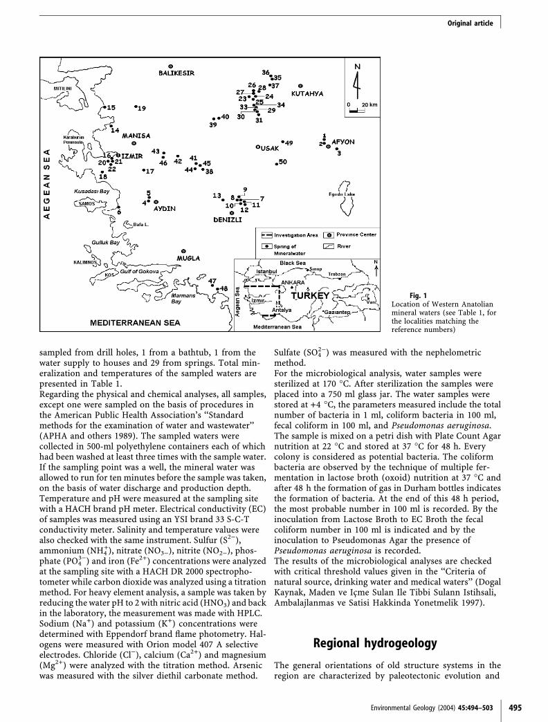
Active tectonism in Anatolia have produced various geo-logical structures which explain the presence of numeroushot springs and cold mineral waters with varying tem-peratures and chemical compositions. Archeologicalstudies performed in Anatolia, which is the cradle ofvarious civilizations, reveal findings of interest regardingthe use of mineral waters. Many of the baths in the regionare derived from the Roman, Seljuk, Byzantium andOttoman Empires and are still in use today.Western Anatolia has undergone intense tectonic activity.The numerous hot springs in this region are used fortourism and balneotherapy purposes. In this study theauthors will make some suggestions for the use of mineralwaters and spa tradition is studied scientifically. In thisrespect, the Istanbul University Research Fund supporteda research project. Within the frame of this project, a totalof 50 water sampling sites were selected, namely in Afyon(site number 3, Fig. 1), Aydin (3), Denizli (7), Izmir (9),Kutahya (15), Manisa (9), Mugla (2), and in Usak (2).Distribution of water sampling sites is shown in Fig. 1.Geographic distribution of mineral waters is generally af-fected by neotectonic horst and graben systems developedas a result of active tectonism in the Aegean region.
Sampling and field studies
In this study, thermal waters were sampled in differentperiods between 1991 and 1999. Nineteen waters were
Received: 18 October 2002 / Accepted: 31 August 2003Published online: 29 October 2003ª Springer-Verlag 2003
I.F. Barut (&)Istanbul University,Institute of Marine Sciences and Management,Muskile sok., Vefa, 34470 Istanbul, TurkeyE-mail: [email protected]: 0212 2304469
N. Erdogan Æ E. BasakMedical Faculty, Medical Ecology andHydroclimatology Department,Istanbul University, Istanbul, Turkey
494 Environmental Geology (2004) 45:494–503 DOI 10.1007/s00254-003-0904-0
Original article
sampled from drill holes, 1 from a bathtub, 1 from thewater supply to houses and 29 from springs. Total min-eralization and temperatures of the sampled waters arepresented in Table 1.Regarding the physical and chemical analyses, all samples,except one were sampled on the basis of procedures inthe American Public Health Association’s ‘‘Standardmethods for the examination of water and wastewater’’(APHA and others 1989). The sampled waters werecollected in 500-ml polyethylene containers each of whichhad been washed at least three times with the sample water.If the sampling point was a well, the mineral water wasallowed to run for ten minutes before the sample was taken,on the basis of water discharge and production depth.Temperature and pH were measured at the sampling sitewith a HACH brand pH meter. Electrical conductivity (EC)of samples was measured using an YSI brand 33 S-C-Tconductivity meter. Salinity and temperature values werealso checked with the same instrument. Sulfur (S2)),ammonium (NH4
+), nitrate (NO3)), nitrite (NO2)), phos-phate (PO4
3)) and iron (Fe2+) concentrations were analyzedat the sampling site with a HACH DR 2000 spectropho-tometer while carbon dioxide was analyzed using a titrationmethod. For heavy element analysis, a sample was taken byreducing the water pH to 2 with nitric acid (HNO3) and backin the laboratory, the measurement was made with HPLC.Sodium (Na+) and potassium (K+) concentrations weredetermined with Eppendorf brand flame photometry. Hal-ogens were measured with Orion model 407 A selectiveelectrodes. Chloride (Cl)), calcium (Ca2+) and magnesium(Mg2+) were analyzed with the titration method. Arsenicwas measured with the silver diethil carbonate method.
Sulfate (SO42)) was measured with the nephelometric
method.For the microbiological analysis, water samples weresterilized at 170 �C. After sterilization the samples wereplaced into a 750 ml glass jar. The water samples werestored at +4 �C, the parameters measured include the totalnumber of bacteria in 1 ml, coliform bacteria in 100 ml,fecal coliform in 100 ml, and Pseudomonas aeruginosa.The sample is mixed on a petri dish with Plate Count Agarnutrition at 22 �C and stored at 37 �C for 48 h. Everycolony is considered as potential bacteria. The coliformbacteria are observed by the technique of multiple fer-mentation in lactose broth (oxoid) nutrition at 37 �C andafter 48 h the formation of gas in Durham bottles indicatesthe formation of bacteria. At the end of this 48 h period,the most probable number in 100 ml is recorded. By theinoculation from Lactose Broth to EC Broth the fecalcoliform number in 100 ml is indicated and by theinoculation to Pseudomonas Agar the presence ofPseudomonas aeruginosa is recorded.The results of the microbiological analyses are checkedwith critical threshold values given in the ‘‘Criteria ofnatural source, drinking water and medical waters’’ (DogalKaynak, Maden ve Icme Sulan Ile Tibbi Sulann Istihsali,Ambalajlanmas ve Satisi Hakkinda Yonetmelik 1997).
Regional hydrogeology
The general orientations of old structure systems in theregion are characterized by paleotectonic evolution and
Environmental Geology (2004) 45:494–503 495
Fig. 1Location of Western Anatolianmineral waters (see Table 1, forthe localities matching thereference numbers)
Original article
N-S compression of Western Anatolia. Whereas, youngstructure systems in this region are characterized byneotectonic evolution and a N-S distribution of linea-ments. As a result of the neotectonic activity, someimportant fault zones and graben systems were
developed in Western Anatolia. In Western Anatolia,there are a vast number of Neogene occurrences thatdeveloped in basins of different size. These Neogenesediments are generally terrestrial facies (lacustrine orvolcanic).
496 Environmental Geology (2004) 45:494–503
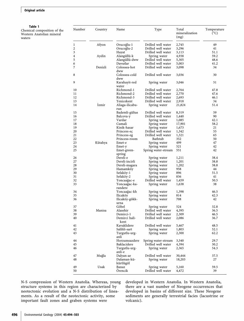
Table 1Chemical composition of theWestern Anatolian mineralwaters
Number Country Name Type Totalmineralization(mg)
Temperature(oC)
1 Afyon Orucoglu-1 Drilled well water 2,745 492 Orucoglu-2 Drilled well water 3,296 413 Hayat Drilled well water 3,113 51.14 Aydin Alangullu-k Spring water 4,938 59.25 Alangullu-dww Drilled well water 5,305 48.66 Davutlar Drilled well water 5,003 41.27 Denizli Colossea-hot
dwwDrilled well water 3,098 34
8 Colossea-colddww
Drilled well water 3,036 30
9 Karahayit-redwater
Spring water 3,046 51
10 Richmond-1 Drilled well water 2,764 47.811 Richmond-2 Drilled well water 2,770 47.612 Richmond-3 Drilled well water 2,693 46.113 Yenicekent Drilled well water 2,918 3414 _Izmir Aliaga-ilicabu-
runSpring water 21,824 51.4
15 Bademli-gultas Drilled well water 8,319 5916 Balcova-y Drilled well water 1,440 9017 Vardar Spring water 1,085 42.118 Cumali Spring water 17,901 58.219 Kinik-hasar Spring water 1,673 2120 Princess-ec Drilled well water 1,342 5521 Princess-eg Drilled well water 1,321 6522 Princess-room Bathtub 352 5023 Kutahya Emet-e Spring water 499 4724 Emet-y Spring water 521 4225 Emet-green-
springSpring water-stream 551 42
26 Dereli-e Spring water 1,211 38.427 Dereli-incirli Spring water 1,201 38.828 Dereli-magara Spring water 1,202 38.829 Hamamkoy Spring water 958 4430 Sefakoy-1 Spring water 896 51.531 Sefakoy-2 Spring water 836 4132 Yoncaagac-e Drilled well water 1,459 50.533 Yoncaagac-ka-
randereSpring water 1,638 38
34 Yoncaagac-kh Spring water 1,398 46.535 Ilicakoy Spring water 814 42.336 Ilicakoy-gokk-
urnaSpring water 708 42
37 Gobel Spring water 524 32.838 Manisa Alasehir Drilled well water 4,395 36.539 Demirci-1 Drilled well water 2,309 46.540 Demirci hali-
kentDrilled well water 2,086 36.7
41 Kavaklidere Drilled well water 5,467 48.542 Salihli-sart Spring water 1,803 52.143 Turgutlu-urg-
anliSpring water 2,300 62.2
44 Horzumsazdere Spring water-stream 3,540 29.745 Baklacidere Drilled well water 4,394 30.246 Turgutlu-urg-
anli-eSpring water 2,365 54.3
47 Mugla Dalyan-ae Drilled well water 30,444 37.548 Dalaman-ku-
kurtlugolSpring water 18,203 27
49 Usak Banaz Spring water 5,160 59.550 Orencik Drilled well water 4,472 39
Original article

Menderes Massif is exposed in most parts of the WesternAnatolia and has an area of 200·300 km and consistspredominantly of metamorphic rock series. Gediz, Kucuk,Buyuk Menderes, Akcay and Cine Rivers run through theMenderes Massif. The northern and eastern boundaries ofthe massiv are not distinct. The Menderes Massif is sur-rounded by the West Taurids to the south and the Izmir-Ankara ophiolite belt to the east. The width of the massif is200 km between Mugla and Simav and 150 km betweenDenizli and Turgutlu.To the south of Menderes Mountain lies the SW AnatolianTaurid mountains. They are formed from an ancient nu-cleus and have a SW-NE alignment. They are covered by arange of detrital and carbonaceous rocks and form adome. To the south of the dome there are inverted folds,which continue along the Aegean coast (Graciansky 1965).Earlier researchers (Graciansky 1965, 1972) described therocks of the massif as an ‘‘AUTOCHTHON’’, an ‘‘AL-LOCHTHON’’ and a ‘‘NEO-AUTOCHTHON’’.An autoch-thon sequence consists of a nucleus of gneiss and migmatiterocks overlain by covering groups of various schist units,Permian, and Paleocene calcareous sediments. The Alloch-thon sequence is formed by Paleozoic and Mesozoic sedi-ments. They are also called the Tauros Belt. This allochthonband has a neotectonic contact with the Menderes Massif(Akat and others1975). In some places within the region theautochthon and allochthon groups have some similarities.However, Late Paleocene red limestones around Milas-Mugla are believed to be a key bed for distinguishing theautochthon and allochthon series (Barut 2001).According to regional hydrogeologic observations, thermalwaters in the region generally issue through fault zones andfrom the faults that form the graben systems. Marble, calc-schist and quartzite zones within the metamorphics of theMenderes Massiv (marble, calc-schist, quartzite, variousschist and gneiss units) are permeable and they form themost important thermal water aquifer. A number of thermalwaters can be explained in this way are Afyon-Omer-Gecek,Denizli-Yenice (13, Fig. 1), Karahayıt (9), Manisa-SalihliAlasehir (42), Usak, Izmir-Bayındır and Kutahya.Paleozoic formations contain clayey schist, meta-sand-stones and crystalline limestones. Meta-sandstones andcrystalline limestones comprise the main aquifer. Pliocenevolcanites, Quaternary alluvium and molasse deposits are
observed in recharge areas. The formation of Izmir-Bal-cova (16) thermal springs can be explained in this way.Neogene claystone, marl, limestone and volcanic unitsincluding andesite, basalt and agglomerate are widelyexposed in Denizli-Karahayıt, Afyon and Izmir-Balcovabasins. In the Afyon and Denizli geothermal areas, lime-stones and basalts comprise the main reservoir. Theoverlying Travertine deposits and Quaternary alluviumunits consist of sand, clay and conglomerate are believedto be the secondary reservoir where cold groundwater andthermal waters are mixed. In addition to these aquiferunits, fault zones were also important conduits for watercirculation.In the Mugla region, from Datca peninsula at Marmaris-Koycegiz and Fethiye at Denizli-Burdur, Acıpayam, Gol-Hasar, and Tefenni, the plutons consist of peridotites withsmall volumes of pyroxenite, dunite and gabbro. AroundIzmir, Manisa, and Usak there is evidence of volcanismoriginating from the Miocene, Pliocene, Pleistocene, andcontinue into the Holocene (Ercan 1979).All thermal waters being studied were formed by the heatingof deeply circulating meteoric water within the geothermalgradient and their rise to the surface has been through fault-fracture zones. Besides spring waters in Afyon, Izmir,Kutahya, Usak, Denizli and Aydın, the water production inthese areas was increased by drilled wells. Natural springwaters are used only in the Manisa-Salihli-Sart and Tur-gutlu-Urganlı fields (Turkiye Jeotermal Envanteri 1996).Paleozoic marble, quartzite, calc-schist and Neogenelimestone and basalts are the primary aquifers in theregion. Graben-forming fault and fracture zones in eacharea are also important aquifer zones for the circulationand storage of waters.
Physical and chemicalcharacteristics of waters
Temperature (T)Waters of the Aegean region are classified as thermalwaters. Water temperatures of springs and wells arebetween 21 and 90 �C (Fig. 2). Temperatures of the studied
Environmental Geology (2004) 45:494–503 497
Fig. 2T(�C) characterization of mineral waters
Original article
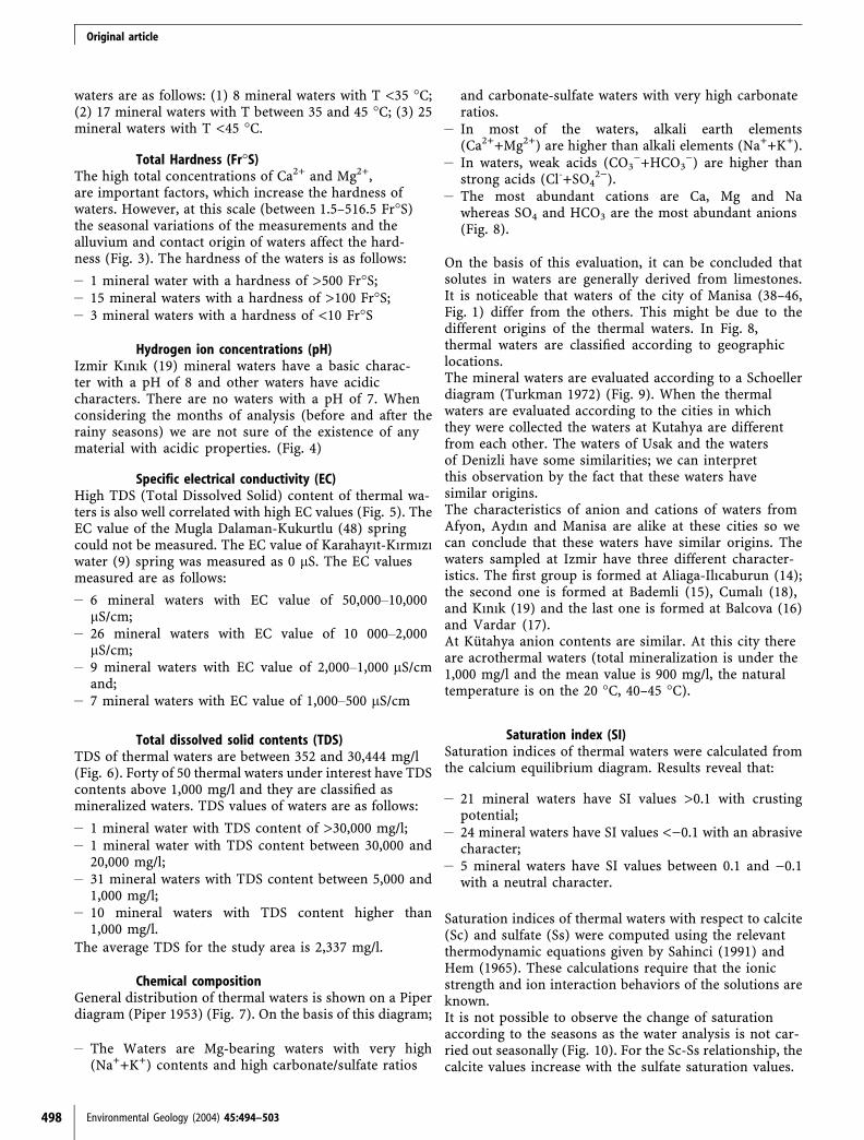
waters are as follows: (1) 8 mineral waters with T <35 �C;(2) 17 mineral waters with T between 35 and 45 �C; (3) 25mineral waters with T <45 �C.
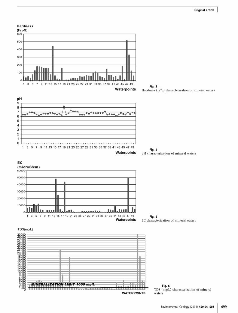
Total Hardness (Fr�S)The high total concentrations of Ca2+ and Mg2+,are important factors, which increase the hardness ofwaters. However, at this scale (between 1.5–516.5 Fr�S)the seasonal variations of the measurements and thealluvium and contact origin of waters affect the hard-ness (Fig. 3). The hardness of the waters is as follows:
– 1 mineral water with a hardness of >500 Fr�S;– 15 mineral waters with a hardness of >100 Fr�S;– 3 mineral waters with a hardness of <10 Fr�S
Hydrogen ion concentrations (pH)Izmir Kınık (19) mineral waters have a basic charac-ter with a pH of 8 and other waters have acidiccharacters. There are no waters with a pH of 7. Whenconsidering the months of analysis (before and after therainy seasons) we are not sure of the existence of anymaterial with acidic properties. (Fig. 4)
Specific electrical conductivity (EC)High TDS (Total Dissolved Solid) content of thermal wa-ters is also well correlated with high EC values (Fig. 5). TheEC value of the Mugla Dalaman-Kukurtlu (48) springcould not be measured. The EC value of Karahayıt-Kırmızıwater (9) spring was measured as 0 lS. The EC valuesmeasured are as follows:
– 6 mineral waters with EC value of 50,000–10,000lS/cm;
– 26 mineral waters with EC value of 10 000–2,000lS/cm;
– 9 mineral waters with EC value of 2,000–1,000 lS/cmand;
– 7 mineral waters with EC value of 1,000–500 lS/cm
Total dissolved solid contents (TDS)TDS of thermal waters are between 352 and 30,444 mg/l(Fig. 6). Forty of 50 thermal waters under interest have TDScontents above 1,000 mg/l and they are classified asmineralized waters. TDS values of waters are as follows:
– 1 mineral water with TDS content of >30,000 mg/l;– 1 mineral water with TDS content between 30,000 and
20,000 mg/l;– 31 mineral waters with TDS content between 5,000 and
1,000 mg/l;– 10 mineral waters with TDS content higher than
1,000 mg/l.The average TDS for the study area is 2,337 mg/l.
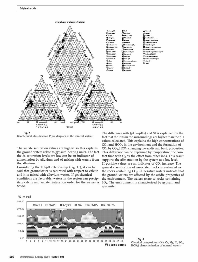
Chemical compositionGeneral distribution of thermal waters is shown on a Piperdiagram (Piper 1953) (Fig. 7). On the basis of this diagram;
– The Waters are Mg-bearing waters with very high(Na++K+) contents and high carbonate/sulfate ratios
and carbonate-sulfate waters with very high carbonateratios.
– In most of the waters, alkali earth elements(Ca2++Mg2+) are higher than alkali elements (Na++K+).
– In waters, weak acids (CO3)+HCO3
)) are higher thanstrong acids (Cl-+SO4
2)).– The most abundant cations are Ca, Mg and Na
whereas SO4 and HCO3 are the most abundant anions(Fig. 8).
On the basis of this evaluation, it can be concluded thatsolutes in waters are generally derived from limestones.It is noticeable that waters of the city of Manisa (38–46,Fig. 1) differ from the others. This might be due to thedifferent origins of the thermal waters. In Fig. 8,thermal waters are classified according to geographiclocations.The mineral waters are evaluated according to a Schoellerdiagram (Turkman 1972) (Fig. 9). When the thermalwaters are evaluated according to the cities in whichthey were collected the waters at Kutahya are differentfrom each other. The waters of Usak and the watersof Denizli have some similarities; we can interpretthis observation by the fact that these waters havesimilar origins.The characteristics of anion and cations of waters fromAfyon, Aydın and Manisa are alike at these cities so wecan conclude that these waters have similar origins. Thewaters sampled at Izmir have three different character-istics. The first group is formed at Aliaga-Ilıcaburun (14);the second one is formed at Bademli (15), Cumalı (18),and Kınık (19) and the last one is formed at Balcova (16)and Vardar (17).At Kutahya anion contents are similar. At this city thereare acrothermal waters (total mineralization is under the1,000 mg/l and the mean value is 900 mg/l, the naturaltemperature is on the 20 �C, 40–45 �C).
Saturation index (SI)Saturation indices of thermal waters were calculated fromthe calcium equilibrium diagram. Results reveal that:
– 21 mineral waters have SI values >0.1 with crustingpotential;
– 24 mineral waters have SI values <)0.1 with an abrasivecharacter;
– 5 mineral waters have SI values between 0.1 and )0.1with a neutral character.
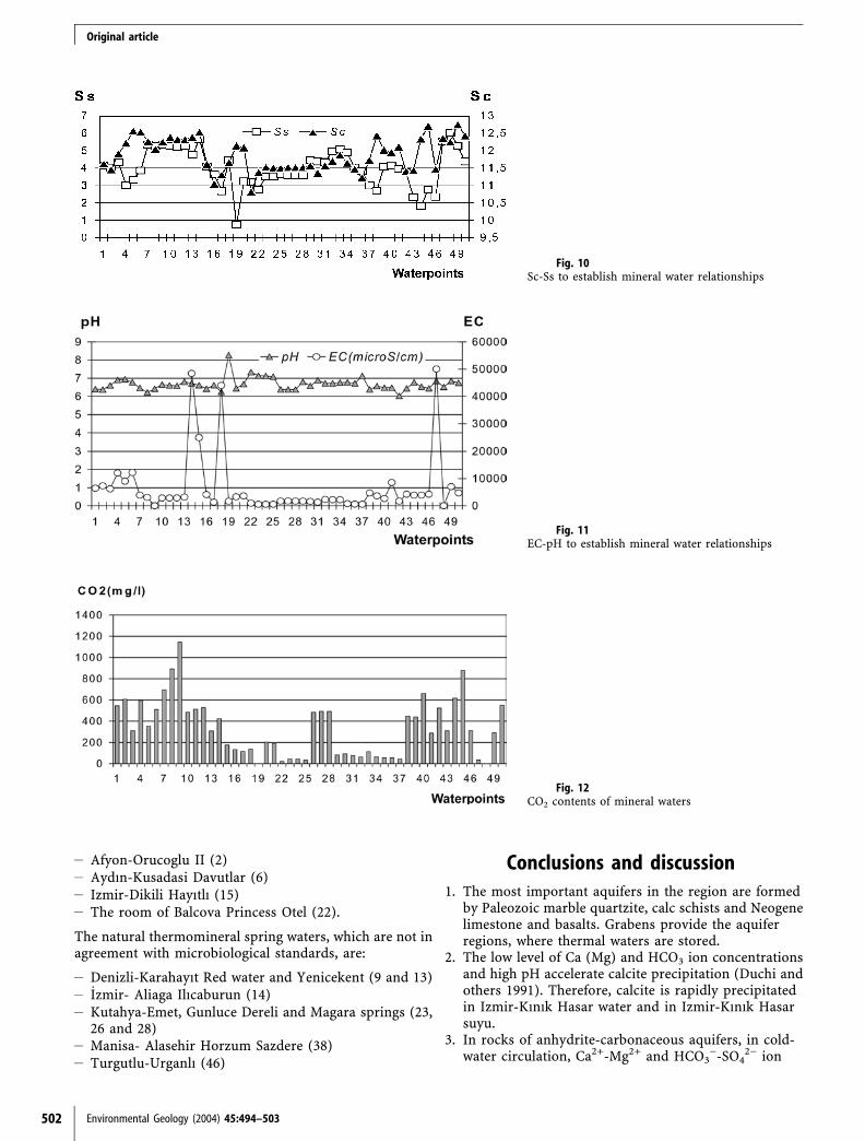
Saturation indices of thermal waters with respect to calcite(Sc) and sulfate (Ss) were computed using the relevantthermodynamic equations given by Sahinci (1991) andHem (1965). These calculations require that the ionicstrength and ion interaction behaviors of the solutions areknown.It is not possible to observe the change of saturationaccording to the seasons as the water analysis is not car-ried out seasonally (Fig. 10). For the Sc-Ss relationship, thecalcite values increase with the sulfate saturation values.
498 Environmental Geology (2004) 45:494–503
Original article
Environmental Geology (2004) 45:494–503 499
Fig. 3Hardness (FroS) characterization of mineral waters
Fig. 4pH characterization of mineral waters
Fig. 5EC characterization of mineral waters
Fig. 6TDS (mg/L) characterization of mineralwaters
Original article
The sulfate saturation values are highest so this explainsthe ground waters relate to gypsum-bearing units. The factthe Ss saturation levels are low can be an indicator ofalimentation by alluvium and of mixing with waters fromthe alluvium.Considering the EC-pH relationship (Fig. 11), it can besaid that groundwater is saturated with respect to calciteand it is mixed with alluvium waters. If geochemicalconditions are favorable, waters in the region can precip-itate calcite and sulfate. Saturation order for the waters isSc>Ss.
The difference with (pH—pHs) and SI is explained by thefact that the ions in the surroundings are higher than the pHvalues calculated. This explains the high concentrations ofCO3 and HCO3 in the environment and the formation ofCO2 by CO3, HCO3 changing the acidic and basic properties.This difference can be explained by temperature, the con-tact time with O2 by the effect from other ions. This resultsupports the alimentation by the system at a low level.SI positive values are an indicator of CO3 increase. Thegeneral classification of associated rocks is evaluated asthe rocks containing CO3. SI negative waters indicate thatthe ground waters are affected by the acidic properties ofthe environment. The waters relate to rocks containingSO4. The environment is characterized by gypsum andepsomite.
500 Environmental Geology (2004) 45:494–503
Fig. 7Geochemical classification Piper diagram of the mineral waters
Fig. 8Chemical compositions (Na, Ca, Mg, Cl, SO4,HCO3) characterization of mineral waters
Original article

Statistical analysisA statistical analysis has been conducted in order todetermine the chemical composition of Western Anatolianmineral waters and the interaction between rocks andwater. The relationships between anions and cations ofsampling points, the total mineralization and the effect oftemperature have been analyzed using the SPSS (SPSS forWindows release 10.0.1, 1999, standard version) program.The results are as follows:
– For the relationship between the temperature and thetotal mineralization, the regression analysis is realizedbut a significant effect was not observed (r‡0.038);
– For the chemical composition the correlation analysis isrealized for Na, Cl, Ca, Mg with SO4. A reasonablecorrelation is obtained between Mg and Ca. (r‡0.5)
– Within factor analysis the variance of anion and cationare separated according to two factors; the first factor is
Ca, Mg and SO4, and the second factor is Na, and Cl.The cumulative value of these 2 factors is 83%. We canconclude that the division by groups is significant sta-tistically. For the rock-water interrelation the first groupis formed by the waters with Ca, Mg and SO4, while Naand Cl waters form the second group. All samplingpoints have a relationship with the second factor.
The lithology sampling points and the physical andchemical properties of waters are evaluated together. Thefirst group of waters is affected by calcareous rocks,dolomites and marl. The second group is formed by thecoastal aquifers and mixed with saline waters.
The microbiological content of watersAmong 38 sampling points, 26 are drilled wells and 12 arenatural thermomineral spring waters. The results of theanalysis show that in 4-drilled wells and in 8 natural springwaters bacteria are observed as an indicator of pollution.The thermomineral waters, which are not in agreementwith the microbiological standards, are:
Environmental Geology (2004) 45:494–503 501
Fig. 9Hydrogeochemical classification Schoeller diagram of mineral watersaccording to countries
Original article
– Afyon-Orucoglu II (2)– Aydın-Kusadasi Davutlar (6)– Izmir-Dikili Hayıtlı (15)– The room of Balcova Princess Otel (22).
The natural thermomineral spring waters, which are not inagreement with microbiological standards, are:
– Denizli-Karahayıt Red water and Yenicekent (9 and 13)– _Izmir- Aliaga Ilıcaburun (14)– Kutahya-Emet, Gunluce Dereli and Magara springs (23,
26 and 28)– Manisa- Alasehir Horzum Sazdere (38)– Turgutlu-Urganlı (46)
Conclusions and discussion1. The most important aquifers in the region are formed
by Paleozoic marble quartzite, calc schists and Neogenelimestone and basalts. Grabens provide the aquiferregions, where thermal waters are stored.
2. The low level of Ca (Mg) and HCO3 ion concentrationsand high pH accelerate calcite precipitation (Duchi andothers 1991). Therefore, calcite is rapidly precipitatedin Izmir-Kınık Hasar water and in Izmir-Kınık Hasarsuyu.
3. In rocks of anhydrite-carbonaceous aquifers, in cold-water circulation, Ca2+-Mg2+ and HCO3
)-SO42) ion
502 Environmental Geology (2004) 45:494–503
Fig. 10Sc-Ss to establish mineral water relationships
Fig. 11EC-pH to establish mineral water relationships
Fig. 12CO2 contents of mineral waters
Original article

groups are separated. Considering the Cl species, dur-ing the water circulation in aquifer and fine-grainedmarine Neogene sediments, syngenetic waters aremixed with percolation.
4. High CO2 concentration in waters is attributed to thefact that the region is affected by active tectonism(Fig. 12). The presence of SiO2 in carbonate mineralsindicates that CO2 is formed via a decarbonation pro-cess (Fyfe and others 1978) but not in low temperatureconditions (<200 �C) (Barnes and others 1978).
5. From 38 sampling points: 26 are drilled well samplingpoints and 12 are natural sampling points. For thepoints with bacteriological pollution there are 4 fromdrilled well sampling points and 8 are of natural origin.
Acknowledgements This research has been supported by theIstanbul University Research Fund (Project No: 874/090896). Theauthors would like to thank to Dr.Bio. H.Demirtas for conductingthe biological analyses. We also extend our warmest thanks toProf.Dr. Namık Yalcın.
References
Akat U and others (1975) Menderes Masifi Guneyi GB TorosKusagı Iliskisi,(on rapor). MTA Raporu No.5488, Ankara, 58 pp
APHA, AWWA, WEF (American Public Health Association,Water Environment Federation) (1989) Standard methods forthe determination of water and wastewater. American PublicHealth Association, Washington, DC, 1391pp
Barnes S and others (1978) Global distribution of carbon dioxidedischarges and major zones of Seismicity. U.S. Geological SurveyResources Investigations, Open-File Report, vol 132, pp 72–79
Barut IF (2001) Milas (Mugla)-Ekinambarı ve Savran TuzluKaynaklarının Hidrokimyasal Arastırması. PhD Thesis, I.U. FenBilimleri Enstitusu, Istanbul, 189 pp
Dogal Kaynak (1997) MADEN VE ICME SULARI _ILE TIBBISULARIN ISTIHSALI, AMBALAJLANMASI VE SATISI HAK-KINDA YONETMELIK. Resmi Gazete 18.10.1997, Sayı 23144
Duchi V and others (1991) Chemical relationship between dis-charging fluids in the Siena-Radicofani Graben and the deepfluids produced by the geothermal fields of Mt. Amiata, TorreAlfina and Latera (Central Italy). J Volcanol Geotherm Res31:401–413
Ercan T (1979) Batı Anadolu, Trakya ve Ege adalarındaki Seno-zoyik volkanizması. Jeoloji Muh Dergisi, Sayı:9
Fyfe WS, Price FJ, Thompson AB (1978) Fluids in the Earth’scrust. Elsevier, Amsterdam, 382 pp
Graciansky, PC (1965) Menderes Masifi Guney Kıyısı BoyuncaGorulen Metamorfizma Hakkında Acıklamalar. MTA Dergisi, 64pp
Graciansky PC (1972) Recherches Geologiques Dans Le TaurusLycien. Fac Sci Universite Paris-Sud (Orsay), vol 896, 762 pp
Hem JD (1965) Study and interpretation of the chemical char-acteristics of natural Water, 2nd edn. Geological Survey Water-Supply Paper 1473, US Government Printing Office, Washing-ton, DC, 269 pp
Piper AM (1953) A graphic procedure in the geochemical inter-pretation of water analyses. US Geol Survey, Groundwater Note 12
Sahinci A (1991) Yeraltısuları Jeokimyası. D.E.Uni Muh Mim FakYayını, 394 pp
Turkiye Jeotermal Envanteri (1996) Maden Tetkik ve AramaGenel Mudurlugu. Ankara
Turkman M (1972) Su Kimyası Calısmaları Rehberi. DS_I Mat-baası, Ankara
Environmental Geology (2004) 45:494–503 503
Original article