geo-demographical outlook for jerusalem
TRANSCRIPT
Applied Research Institute-Jerusalem (ARIJ)P.O.Box 860, Caritas Street
Bethlehem, Palestinewww.arij.org
A Paper entitled:
Geo-Demographical Outlook for Jerusalem
Prepared By:
Jad Isaac, Suhail Khalilieh and Ahmad El-Atrash
Submitted To:
1st International Conference on “URBAN PLANNING INPALESTINE”
October 6, 2008
OUTLINE
1. Abstract
2. Focus Area
3. Background
3.1 Chronological Changing of Boundaries
3.2 De-Palestinization of Jerusalem – Israeli
Practices in Jerusalem
3.2.1 BOX THEM IN: Land Expropriation/Confiscation
3.2.1.1 Master Plan 2000 – 2020
3.2.1.2 Housing Density
3.2.2 SQUEEZE THEM OUT: The Colonies, Outposts and
Bypass Roads
3.2.3 FENCE THEM OFF: The Separation Wall
3.2.4 CRACK THEM OUT: House Demolishing & Budget
Allocations
3.2.4.1 House Demolition Policy
3.2.4.2 Israeli Jerusalem Municipality Budget Allocation for the Year
2003
4. Business-As-Usual Master-Planning in Jerusalem
1
4.1 Demographic Engineering in Jerusalem
4.1.1 Gross Population Density
4.2 Israeli Construction in East Jerusalem - Post
Annapolis
5. Concluding Notes
6. Bibliography and Sources
Geo-Demographical Outlook for Jerusalem
1.ABSTRACT
Jerusalem is an epicenter of a series of contested
confrontations and events both from the past and
throughout modern history; today it is a living
paradigm of distinctive apartheid that is epitomized,
among many of its other forms, in the urban planning
system practiced in the City, where indigenous
2
Palestinian Jerusalemites have substandard living
rights.
This paper will attempt to demonstrate and expose
Israeli Occupation planning and building policies and
uncover the systematic discrimination adopted and
practiced against Arab-Palestinians. This
discrimination is mainly manifested in the prejudiced
zoning classifications of occupied East Jerusalem in
favor of illegal Israeli-Jewish existence there to that
of the Palestinian population, which include, among
others: discrimination in building permits and regulations, confiscating
and razing land, erecting and expanding illegal Israeli colonies and
outposts, paving Israeli designated roads, demolishing Palestinian houses,
and now excluding entire Arab-Palestinian communities with the
Separation Wall.
Furthermore, the paper will work on the delineation
of de facto Israeli administrative changes of the
demarcated Jerusalem City boundary set within the
United Nations partition plan of November 29, 1947,
where the City of Jerusalem comes under “Corpus
Seperatum” status and is to be administered by a
Special International Regime. The paper will also show
3
the ramifications of the unilaterally and illegally
imposed “new municipal boundaries” post the 1967
Israeli occupation of East Jerusalem, which is
currently 10 time its original size, ending with the
2005 “Jerusalem 2020 Master-plan.”
Jerusalem, according to the Israeli adopted
Masterplan-2020, has “NO AREA” for future Arab
Jerusalemite development, with more than half of its
total area already considered built-up area. According
to the master-plan about one-quarter of East Jerusalem
is “temporarily” zoned as green areas, thus keeping the
possibility for future Palestinian urban expansion to
only 6%.
The paper studies, analyzes, and projects the de facto
Israeli planning paradigm, which results in new
building styles and a manipulating land-use policy
practiced on the basis of unjustified security concerns
and demographic considerations in order to manipulate
the demographic balance in Jerusalem in favor of the
Jewish population. The Israeli presence in East
Jerusalem tipped from 0% pre-1967 to 47% in 2007,
whereas the Palestinian presence in West Jerusalem
4
plummeted from 23% to 0%. Ostensibly, the carefully
enacted demographic policy adopted by the Israeli
Jerusalem Municipality was the cornerstone of the
planning theme for Jerusalem. Under this planning theme
Palestinian existence is confined to a maximum of one-
quarter of the city’s population with an end goal of
the de-Palestinization of Jerusalem, jeopardizing the
inevitable destiny of Palestinian statehood with
Jerusalem as its sovereign capital.
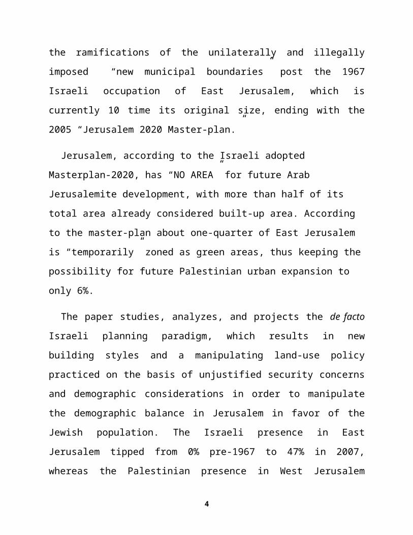
2.FOCUS AREA: JERUSALEM GOVERNORATE
The Palestinian
Jerusalem Governorate
sits in the central
part of the West Bank
(See Map 1); it has an
area of 353.68 Km2 and
is home to 407,459
Palestinian
Jerusalemites (PCBS,
2006). The city of
Jerusalem is the
5
Map 1: Jerusalem's GovernorateLocation in the Occupied Palestinian
Territory
capital and heart of Palestinian statehood. It holds
hundreds of the most sacred religious and spiritual
sites, such as the church of the Holy Sepulcher, Via
Delarosa, Al-Aqsa mosque, the Dome of the Rock and many
others. For this reason, Jerusalem and its religious
sites became the focal point for pilgrimages from all
over the world.
3.BACKGROUND3.1 Chrono(logical) Changing of Boundaries
In the period 1948-1967, Jerusalem was to remain
separate under international supervision, a "Corpus
Seperatum" in the words of the United Nations (See Map
2). In November, 1947, the United Nation General
Assembly, in its 128th plenary session, passed
Resolution 181 partitioning Palestine into two states,
one for Jews and the other for Arabs. The Arab
Palestinians rejected the plan as it confiscated 52.5%
of what they owned from Mandate Palestine. The Jews,
who owned only 6% of the land, were allocated 55.5%
against 44.5% to the Arabs, who owned 94% of the land.
However, because of the 1948 War, Israeli conquest
6
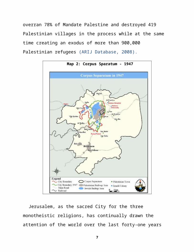
overran 78% of Mandate Palestine and destroyed 419
Palestinian villages in the process while at the same
time creating an exodus of more than 900,000
Palestinian refugees (ARIJ Database, 2008).
Map 2: Corpus Sparatum - 1947
Jerusalem, as the sacred City for the three
monotheistic religions, has continually drawn the
attention of the world over the last forty-one years
7
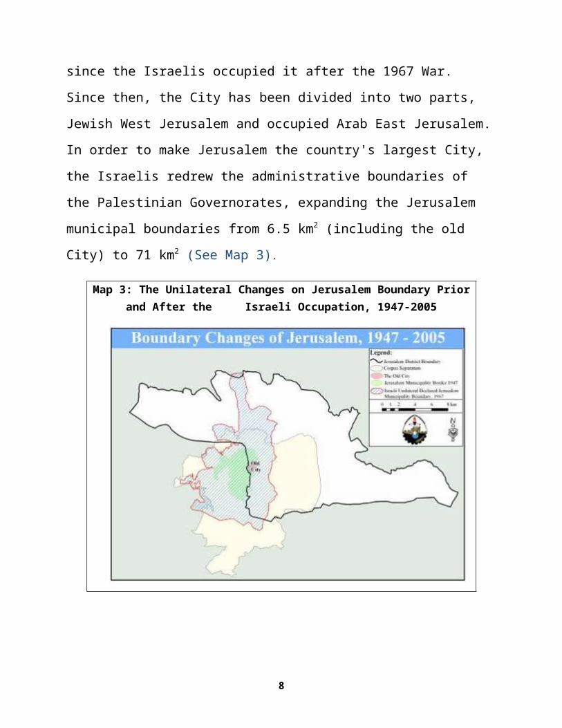
since the Israelis occupied it after the 1967 War.
Since then, the City has been divided into two parts,
Jewish West Jerusalem and occupied Arab East Jerusalem.
In order to make Jerusalem the country's largest City,
the Israelis redrew the administrative boundaries of
the Palestinian Governorates, expanding the Jerusalem
municipal boundaries from 6.5 km2 (including the old
City) to 71 km2 (See Map 3).
Map 3: The Unilateral Changes on Jerusalem Boundary Priorand After the Israeli Occupation, 1947-2005
8
The new boundaries of the City were delineated for
security and demographic considerations and in order to
create geographic integrity and demographic superiority
for the Jewish population in Jerusalem. In order to
accomplish this, the redrawing of Jerusalem municipal
boundaries excluded the densely populated Palestinian
communities (the residences but not the lands) in the
north, including Beit Iksa and Beir Nabala, whereas the
sparsely populated communities’ lands in the south were
included (Bethlehem and Beit Sahour)1. However, the
municipal planning deliberations were of secondary
importance in setting the new boundaries.
After 1948 Israel acquired control over the Arab
properties in West Jerusalem by virtue of the
Absentee’s Property Law of 1950, where the Arabs were
banned from their properties after being driven out in
1948. Paradoxically, the Jews who “lost” their
properties after 1948 in East Jerusalem were permitted
under Israeli law after 1967 to take back their
properties or receive an appropriate compensation.
1 The land confiscated due to the IJM’s decision of the expansion of the Jerusalem municipal boundaries are parts of the British division of the middleand northern parts of Palestinian villages and cities, which is totally different than the existing administrative boundaries.
9
Meanwhile, Israeli occupation authorities after 1967
activated the British Mandate Land Ordinance to
expropriate around 85% of the lands included within the
illegally expanded East Jerusalem area, leaving no
space for needed future natural expansion and for the
indigenous Palestinian communities to cope with natural
population growth (ARIJ, 2007 a).
3.2 De-Palestianization of Jerusalem – IsraeliPractices in Jerusalem
Since its occupation of East Jerusalem in 1967,
Israeli physical domination in East Jerusalem was
implemented through thoroughly enacted policies to
establish irreversible and exclusive control over land
and its resources by confiscating and razing lands,
erecting and expanding illegal Israeli colonies, paving
bypass roads, destroying Palestinian houses, and now
building the Separation Wall in and around East
Jerusalem. Table (1) indicates some of the Israeli
violations in the Jerusalem Governorate after the
eruption of the second (Al-Aqsa) Intifada.
Table 1: Israeli violations in Jerusalem Governorate during theyears 2000-2008
10
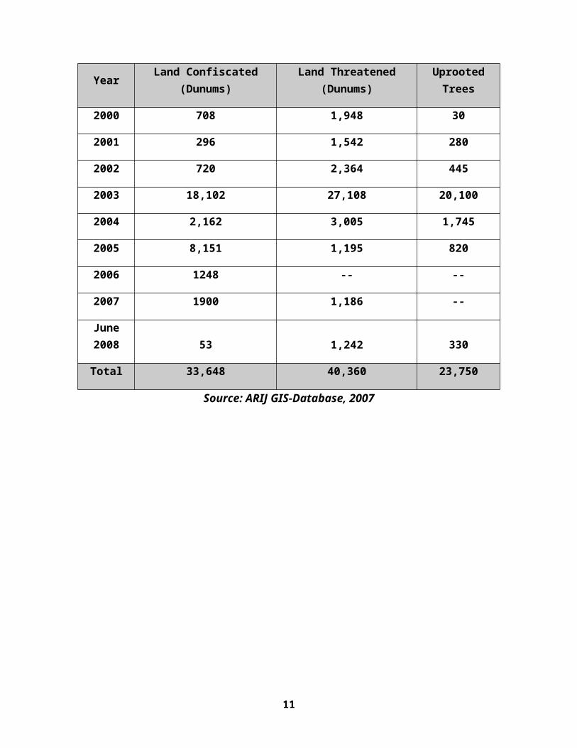
Year Land Confiscated(Dunums)
Land Threatened(Dunums)
UprootedTrees
2000 708 1,948 30
2001 296 1,542 280
2002 720 2,364 445
2003 18,102 27,108 20,100
2004 2,162 3,005 1,745
2005 8,151 1,195 820
2006 1248 -- --
2007 1900 1,186 --
June2008 53 1,242 330
Total 33,648 40,360 23,750
Source: ARIJ GIS-Database, 2007
11
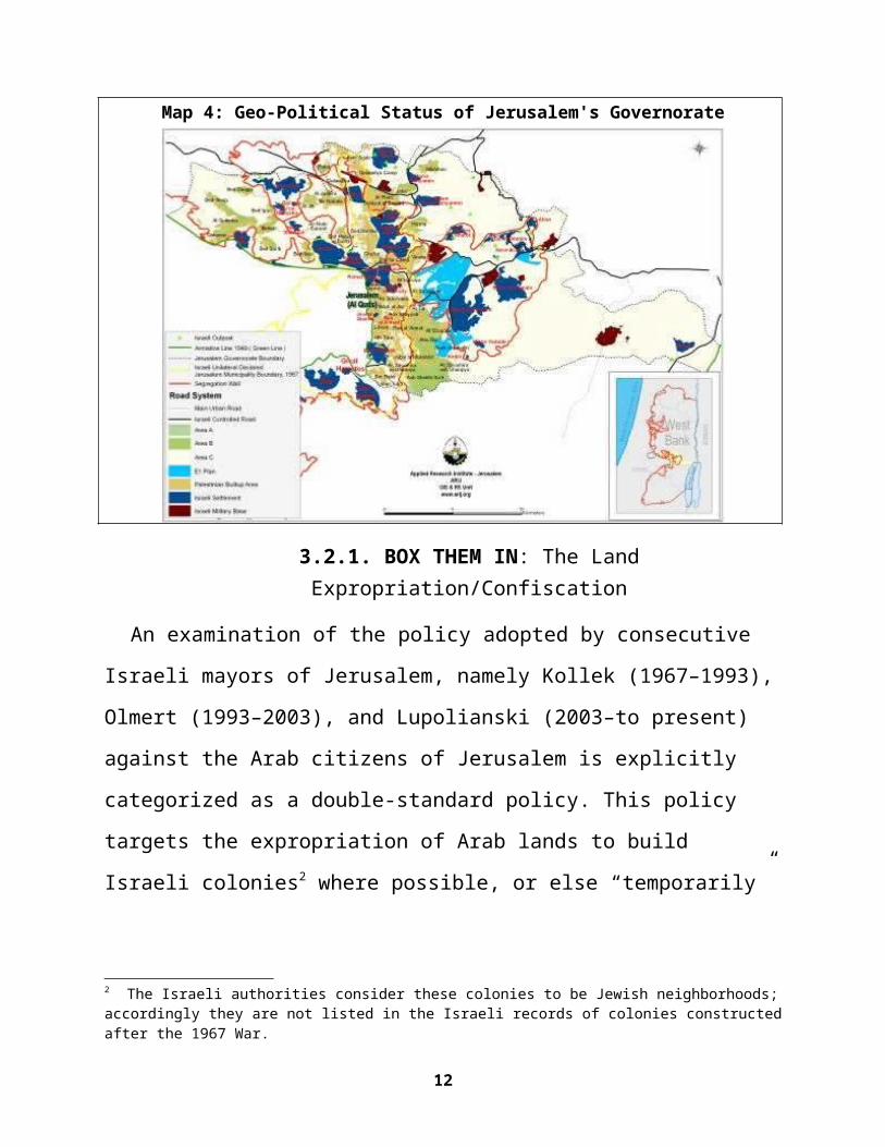
Map 4: Geo-Political Status of Jerusalem's Governorate
3.2.1. BOX THEM IN: The LandExpropriation/Confiscation
An examination of the policy adopted by consecutive
Israeli mayors of Jerusalem, namely Kollek (1967–1993),
Olmert (1993–2003), and Lupolianski (2003–to present)
against the Arab citizens of Jerusalem is explicitly
categorized as a double-standard policy. This policy
targets the expropriation of Arab lands to build
Israeli colonies2 where possible, or else “temporarily”
2 The Israeli authorities consider these colonies to be Jewish neighborhoods;accordingly they are not listed in the Israeli records of colonies constructedafter the 1967 War.
12
zoning lands in the eastern parts of the city as green
areas where it is illegal to build.
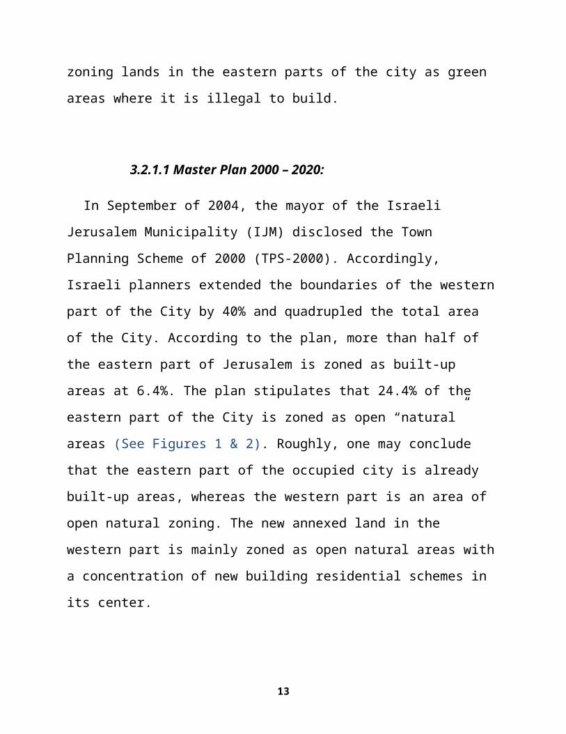
3.2.1.1 Master Plan 2000 – 2020:
In September of 2004, the mayor of the Israeli
Jerusalem Municipality (IJM) disclosed the Town
Planning Scheme of 2000 (TPS-2000). Accordingly,
Israeli planners extended the boundaries of the western
part of the City by 40% and quadrupled the total area
of the City. According to the plan, more than half of
the eastern part of Jerusalem is zoned as built-up
areas at 6.4%. The plan stipulates that 24.4% of the
eastern part of the City is zoned as open “natural”
areas (See Figures 1 & 2). Roughly, one may conclude
that the eastern part of the occupied city is already
built-up areas, whereas the western part is an area of
open natural zoning. The new annexed land in the
western part is mainly zoned as open natural areas with
a concentration of new building residential schemes in
its center.
13
14
Source: ARIJ GIS-Database, 2008
3.2.1.2 Housing Density:
Average housing density per room among Arab
Jerusalemites was 1.65 percent higher than that in
Jewish residential areas in 2005. The density among
Arabs was 1.4 persons per room, while the density among
Jews was 0.85 (Margalit, 2006).
According to the TPS – 2000, the estimated housing
unit's capacity in the Arab sector is 40% less than
that of the Jewish sector. The assessment revealed that
the Arab sector capacity is set to include only up to
96,000 housing units; 58,000 housing units already
exist, 38,000 of which are built without building
permits, whereas the capacity in the Jewish sector is
250,000 housing units; 142,000 of which already exist.
3.2.2 SQUEEZE THEM OUT: Colonies, Outposts andBypass Roads
The IJM deliberately adopted a Land Use policy in
Jerusalem that encourages Jewish growth while confining
Palestinian growth within the city.
The first Israeli colony in Jerusalem was inside the
Old City immediately following the 1967 War, when the
15
Israeli Army destroyed more than 700 buildings to
expand the Jewish quarter. Throughout the years of
occupation, Israeli colonies mushroomed inside the
Israeli defined municipal boundary of Jerusalem and the
surrounding area. The colonies in Jerusalem may be
classified by administrative association as colonies
inside the municipal boundary (in J1 area), and
colonies within Jerusalem governorate (J2 area), and
they are 18 colonies. Additionally, Israeli settler
organizations are infiltrating and initiating colony
cores in the hearts of Palestinian neighborhoods, such
as the colony in Al- Sheikh Jarrah around Shimon Ha
Zadik and the colony core in Silwan, Al -Tur and Ras
Al-Ammoud (ARIJ, 2007 a).
The colonies in the Jerusalem Governorate occupy an
area of 38,902 dunums (38.902 Km²) with an estimated
colonist population of 256,037. Additionally, 18
Israeli outposts were established between 1996 and
2005. Consecutive Israeli governments have also worked
to link the established colonies with each other and
consequently with Israel proper by creating a network
of bypass roads throughout the West Bank that stretches
16

in length more than 800 Km. Jerusalem's share of this
network is 91.3 Km in and around the Governorate. An
additional 64.164 kilometers of bypass road also awaits
approval by the Israeli government before it goes into
the execution phase in and around the Jerusalem
Governorate. These roads are designed to fit
alterations to the new status of roads as created by
the Separation Wall (ARIJ GIS-Database, 2005).
Israel hasn’t desisted from its colonial expansion
program anytime since the signing of the Oslo Accords.
In fact, Israel has adopted a more intense approach to
developing colonies in Jerusalem. This has resulted in
an increase of colony areas between 1996 (25,069
Dunums) and 2005 (44,684 Dunums) of 78% (i.e. 19615
Dunums), which reflects Israeli plans to maintain
dominance over Jerusalem by means of creating facts on
the ground that will make the Jewish presence in
occupied East Jerusalem an irrefutable fact. Plans are
also prepared for large annexations to existing
colonies. These may be considered new colonies of their
own and are located near Har Homa (1,080 Dunums) and
near Ma’ale Adumim; this is known as the E1 plan and
17
will confiscate 12,500 Dunums from nearby Palestinian
villages.
3.2.3 FENCE THEM OFF: The Separation Wall
One of the most controversial areas being targeted by
the Israeli Separation Wall in the occupied West Bank
is East Jerusalem. On this issue Israel is upholding
its illegal claim on the occupied City as being part of
what Israel calls the "unified City". As they translate
their claim into tangible steps they enact plans to
selectively enwrap areas considered significant to
fulfill the Israeli vision in the occupied City with
nearly 71 Km (53%) of the 133+ Km Separation Wall set
to enclose the Jerusalem Governorate and separate it
from the West Bank (ARIJ, 2007 b).
Upon completion the Israeli Separation Wall in East
Jerusalem will confine future development of
Palestinian localities to marginal proportions, while
including major colonial blocs (Ma'ale Adumim, Giv'at
Ze'ev and Har Adar colony northwest of Jerusalem)
within the Separation Wall, as well as a range of open
spaces and nature reserves that are likely to change in
status to become areas reserved for future colonial
18
development projects. Eventually, the affects of the
Israeli Separation Wall will hit the entire occupied
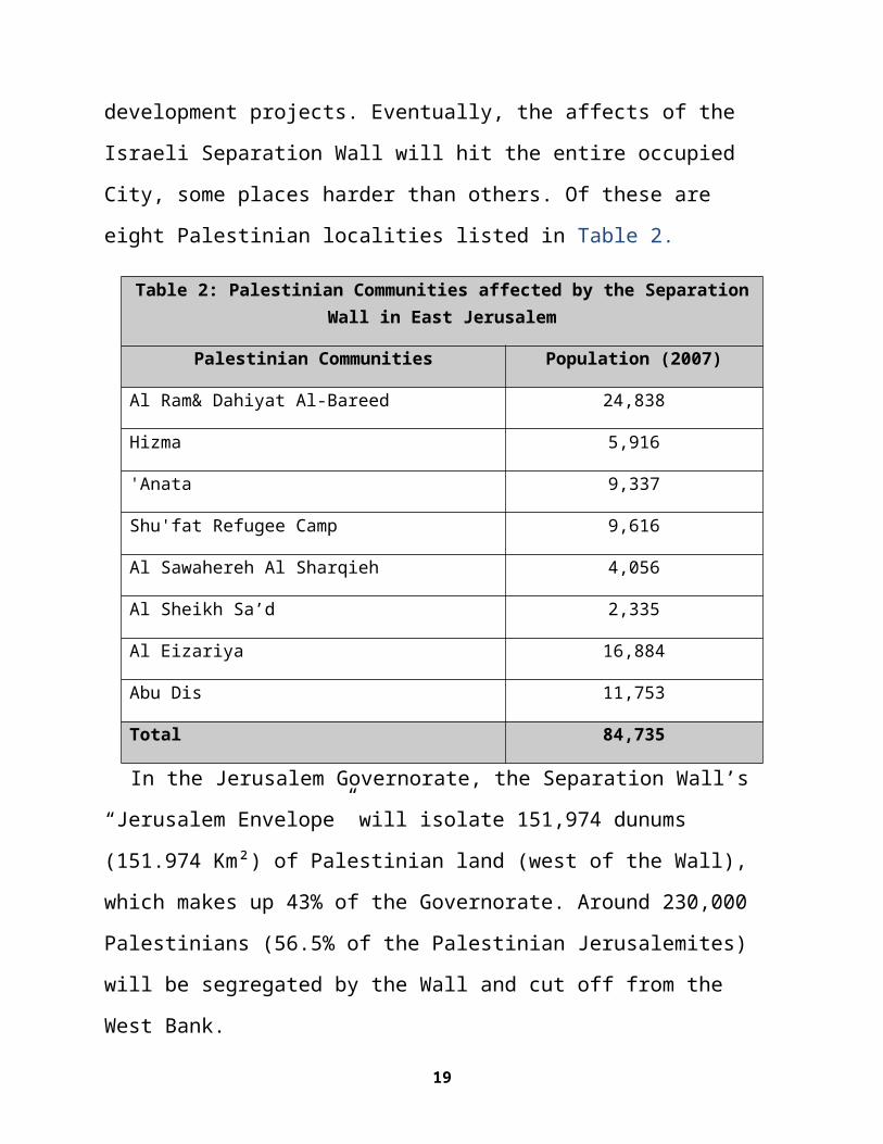
City, some places harder than others. Of these are
eight Palestinian localities listed in Table 2.
Table 2: Palestinian Communities affected by the SeparationWall in East Jerusalem
Palestinian Communities Population (2007)
Al Ram& Dahiyat Al-Bareed 24,838
Hizma 5,916
'Anata 9,337
Shu'fat Refugee Camp 9,616
Al Sawahereh Al Sharqieh 4,056
Al Sheikh Sa’d 2,335
Al Eizariya 16,884
Abu Dis 11,753
Total 84,735
In the Jerusalem Governorate, the Separation Wall’s
“Jerusalem Envelope” will isolate 151,974 dunums
(151.974 Km²) of Palestinian land (west of the Wall),
which makes up 43% of the Governorate. Around 230,000
Palestinians (56.5% of the Palestinian Jerusalemites)
will be segregated by the Wall and cut off from the
West Bank.
19
Consequently, Palestinians' movement to or from the
isolated part of Jerusalem will be controlled
completely by Israeli occupation forces, and Jerusalem,
which is the main service provider and religious center
for most of the population, will be inaccessible to the
more than 3.5 million Palestinians living in the West
Bank and the Gaza Strip.
Entrance to isolated agricultural lands will be
restricted to those who are able to prove land
ownership authenticated by the Israeli civil
administration, which means that only the owners who
have their names listed in the ownership deeds (usually
the eldest of the families) will receive permits.
Furthermore, issuance of permits by the Israeli civil
administration will be on a seasonal basis; hence, the
owners will find it difficult to manage their
cultivated lands on their own, especially since the
permits do not allow for additional labor and/or
equipment.
3.2.4 CRACK THEM OUT: House Demolition & BudgetAllocations
3.2.4.1 House Demolition Policy:
20
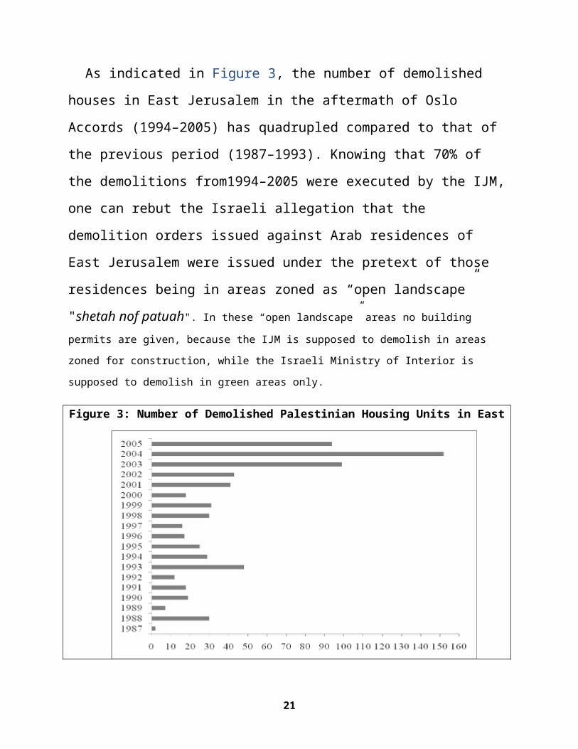
As indicated in Figure 3, the number of demolished
houses in East Jerusalem in the aftermath of Oslo
Accords (1994–2005) has quadrupled compared to that of
the previous period (1987–1993). Knowing that 70% of
the demolitions from1994–2005 were executed by the IJM,
one can rebut the Israeli allegation that the
demolition orders issued against Arab residences of
East Jerusalem were issued under the pretext of those
residences being in areas zoned as “open landscape”
"shetah nof patuah". In these “open landscape” areas no building permits are given, because the IJM is supposed to demolish in areas
zoned for construction, while the Israeli Ministry of Interior is
supposed to demolish in green areas only.
Figure 3: Number of Demolished Palestinian Housing Units in East
21
Jerusalem, 1987-2005
ARIJ GIS-Data Base (2005)
3.2.4.2 Allocation of Israeli Jerusalem Municipality Budget for the Year2003:
In 2003 Palestinian residents of Jerusalem were
allocated only 12% of the municipal budget although
these people make up 33% of the total residents. Due to
this discriminatory policy and a shortage in services,
67% of the Palestinian families in Jerusalem live below
the poverty line, while the percentage of people living
below the poverty line in West Jerusalem is 29%.
Overall, Palestinian Jerusalemites’ share of the
22
services’ budget is less than 12%, meaning a four-to-one
difference in spending per person between Jews and Palestinians
(Margalit, 2006). As an example, there is one kilometer
of paved road for every 710 persons in the western part
of the city, compared to one kilometer of paved road
for every 2,448 persons in Palestinian neighborhoods in
East Jerusalem, as well as one public garden for every
447 persons in West Jerusalem compared to one for every
7,362 persons in Palestinian neighborhoods in East
Jerusalem; and there is one kilometer of sewage system
for every 743 persons in West Jerusalem compared to one
kilometer for every 2,809 persons in East Jerusalem.
Furthermore, the municipality neglects basic street
sanitation in the Palestinian neighborhoods in East
Jerusalem (ARIJ, 2007 a).
4.BUSINESS-AS-USUAL MASTER-PLANNING IN JERUSALEM 4.1 Demographic Engineering in Jerusalem
As prescribed, Israeli policy in Jerusalem is aimed
at keeping demographic supremacy in their favour by the
initiation of an unprecedented spate of building
schemes in the aftermath of the 1967 War. However, this
supremacy or “anthropogenic population growth”
23
represents a false reality. Though Jewish gross
population density inside the 1947 Jerusalem municipal
boundary was almost four times of that of Palestinians
in 1948, they remain the minority even including the
later illegally declared 1967-Jerusalem municipal
boundary.
Due to the fact that Jerusalem is under occupation,
the de facto Jewish presence in the city came at the
expense of the Arab Palestinian presence, especially in
the western part (See Figure 4). The exodus of
Palestinian Muslims and Christians from historical
Palestine in general, and Jerusalem in particular,
which began after the 1948 War and accelerated after
the 1967 War, has caused a situation in which now a
majority of Palestinians are living outside historical
Palestine. This has created a demographic de-
cosmopolitanization of the city of Jerusalem, where
even Jewish neighborhoods, such as the Jewish quarter
of Jerusalem, once a “mixed neighborhood,” has become
exclusively Jewish as settlers illegally took over
lands and properties formerly owned by Palestinian
Arabs.
24
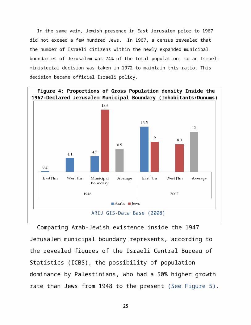
In the same vein, Jewish presence in East Jerusalem prior to 1967
did not exceed a few hundred Jews. In 1967, a census revealed that
the number of Israeli citizens within the newly expanded municipal
boundaries of Jerusalem was 74% of the total population, so an Israeli
ministerial decision was taken in 1972 to maintain this ratio. This
decision became official Israeli policy.
Figure 4: Proportions of Gross Population density Inside the1967-Declared Jerusalem Municipal Boundary (Inhabitants/Dunums)
ARIJ GIS-Data Base (2008)
Comparing Arab–Jewish existence inside the 1947
Jerusalem municipal boundary represents, according to
the revealed figures of the Israeli Central Bureau of
Statistics (ICBS), the possibility of population
dominance by Palestinians, who had a 50% higher growth
rate than Jews from 1948 to the present (See Figure 5).
25
To this end, demography was utilized to shape
geography. This is intrinsically linked to the “ethnic
cleansing; un-mixing of people” concept, which has
always been the corollary to unilateral Israeli
partition plans, epitomized by the construction of the
Separation Wall. Arab Jerusalemites were slowly but
strategically cleansed from their own homes and
properties. For instance, soon after the 1967 War,
Israeli Authorities bulldozed the Palestinian Al-
Magharba Quarter, which became later the Plaza of the
Wailing Wall, or “Al-Bouraq Wall.” However, when taking
into account other dimensions of demographic
engineering, such as socio-economic rather than merely
political and cultural interventions, other factors
present themselves. Some of these factors are not
unilateral, as in the case of the ongoing Israeli
practices, but are actually bilateral, and supposedly
could be reconciled with the cessation of Israeli
practices and the establishment of a credible
Palestinian state with Jerusalem as its sovereign
capital.
Figure 5: Supposedly Natural Growth Inside the 1947-JerusalemMunicipal Boundary
26
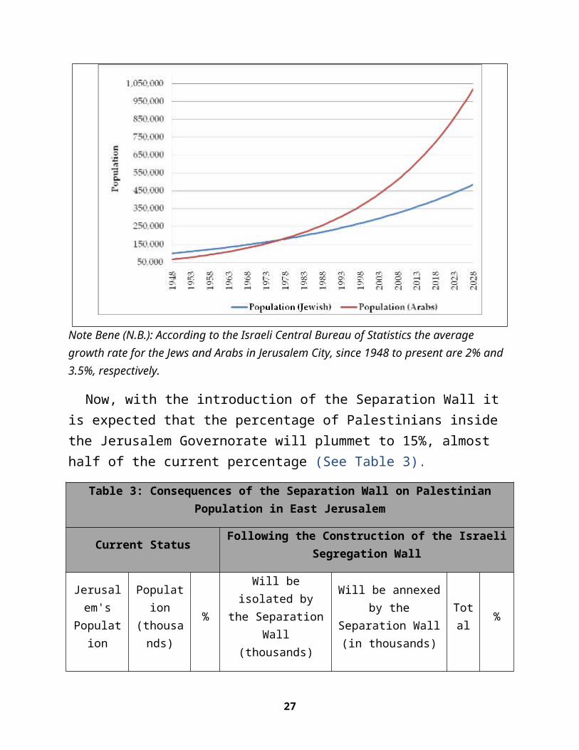
Note Bene (N.B.): According to the Israeli Central Bureau of Statistics the average growth rate for the Jews and Arabs in Jerusalem City, since 1948 to present are 2% and 3.5%, respectively.
Now, with the introduction of the Separation Wall it is expected that the percentage of Palestinians inside the Jerusalem Governorate will plummet to 15%, almost half of the current percentage (See Table 3).
Table 3: Consequences of the Separation Wall on PalestinianPopulation in East Jerusalem
Current Status Following the Construction of the IsraeliSegregation Wall
Jerusalem's
Population
Population
(thousands)
%
Will beisolated by
the SeparationWall
(thousands)
Will be annexedby the
Separation Wall(in thousands)
Total %
27
Palestinians 254 35 130 0 124 15
Jews 470 65 0 210 680 85
Total 724 100 804 100
ARIJ GIS-Data Base (2008)
4.1.1 Gross Population Density
Jerusalem’s Old City, along with East and West Jerusalem,
stands today as one of the most rapidly growing cities, mainly
due to the Israeli policy of illegally accommodating Jewish
immigrants in the City at the expense of the indigenous
Palestinian population. Also, it is worth mentioning that the
Israeli authorities concentrate on accommodating the ultra-
orthodox Jews, who are famous for rapid population growth.
Strategically, the IJM and Israeli authorities subsidize the
living expenses of this segment of the population to accomplish
their Zionist colonization scheme. However, the presence of the
ultra-orthodox poses a potential source of tension in the City
because of an increasing tendency to extremism among ultra-
orthodox communities.
28
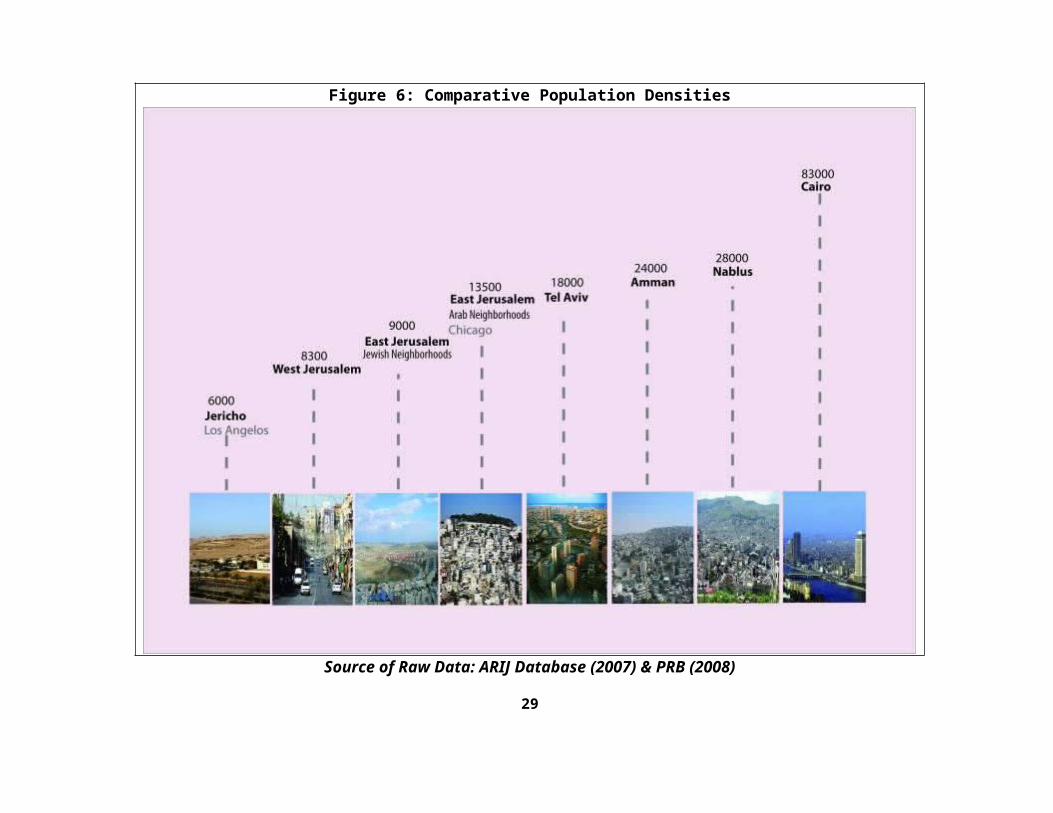
Figure 6: Comparative Population Densities
Source of Raw Data: ARIJ Database (2007) & PRB (2008)
29
4.2 Israeli Construction in East JerusalemPost Annapolis
In the months following the Annapolis conference,
which was held on the 26th of November 2007 in the
United States of America, several statements and
declarations were announced either by the Israeli
Municipality of Jerusalem City or by the Israeli
Ministry of Housing & Construction, which included
bids and plans to add thousands of housing units to
Israeli Colonies in the occupied West Bank. Most of
these were in colonies within the City of Jerusalem
(See Map5). It is clear from these statements that
Israel is not willing to include Jerusalem within
any Final Status negotiations as according to the
road map, which “obligates Israel to freeze settlement activities
in the West Bank, especially in Jerusalem City.”
Map 5: Israeli Construction in East Jerusalem PostAnnapolis
30
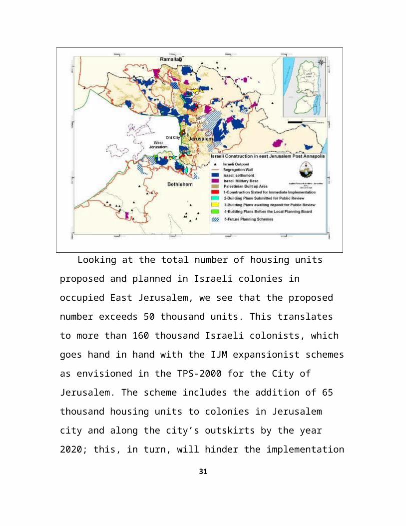
Looking at the total number of housing units
proposed and planned in Israeli colonies in
occupied East Jerusalem, we see that the proposed
number exceeds 50 thousand units. This translates
to more than 160 thousand Israeli colonists, which
goes hand in hand with the IJM expansionist schemes
as envisioned in the TPS-2000 for the City of
Jerusalem. The scheme includes the addition of 65
thousand housing units to colonies in Jerusalem
city and along the city’s outskirts by the year
2020; this, in turn, will hinder the implementation
31
of the Safdie plan, which proposes an expansion of
Jerusalem built-up areas at the western side of the
City, and re-zoning land in Har Harat and Lavan
Ridge from open space to construction zones.
On the other hand, Israel is upholding its
illegal claim over the occupied city as being part
of what Israel calls the “Unified City” as they
translate their claim into tangible steps. This
includes plans to selectively enwrap areas
considered significant to fulfill the Israeli
vision in the occupied city.
Eventually, the consequences of the Israeli
Separation Wall will affect the entire occupied
city, some places harder than others. 183,000
Palestinians living in 15 Palestinian communities
will be affected and segregated by the Wall, thus
being cut off from the rest of the West Bank; at
the same time, the addition of housing units will
add a total of over 200,000 Israeli colonists to
the current colonial population of the city.
32
Overall, the process of colony building and wall
construction will add up to around 300,000 Israeli
colonists to the current population of the city of
Jerusalem, which would change the demographic
situation in the city and impose a new reality on
the ground that cannot be ignored once negotiations
over final status issues begin.
5. CONCLUDING NOTES
Israel has breached International Law and
violated obligations under Humanitarian Law to
which it is a State Party. The violated obligations
include the prohibition on deportation and transfer
of civilian populations, the destruction of
civilian property, and the unlawfully impeded
liberty of movement and the right to work, health,
education, and adequate housing. Furthermore, the
pace of construction in Israeli colonies in
Jerusalem and the strangulation of the city with a
series of Israeli colonies from all directions is
one of a successive series of Israeli defiance’s of
international laws and UN resolutions, including 33
Security Council resolution 446 (1979)), which
states that “the policy and practices of Israel in establishing
settlements in the Palestinian and other Arab territories occupied
since 1967 have no legal validity and constitute a serious obstruction
to achieving a comprehensive, just and lasting peace in the Middle
East.” Furthermore, Security Council resolution No.
452 (in 1979), which “Calls upon the Government and people
of Israel to cease, on an urgent basis, the establishment, construction
and planning of settlements in the Arab territories occupied since
1967, including East Jerusalem;”
Changing the borders from green to gray-
concrete, as expected, hasn’t ended the conflict
between Israelis and Palestinians that was
characterized by Edward Said (1998) as “two separate
narratives converging on the same landscape.” On the
contrary, Israeli occupation practices, epitomized
by the building of the Separation Wall, has
resulted in resource depletion, shortage of
freshwater supplies, degradation of the
environment, increases in unemployment, increases
in poverty rates, decreases in agricultural
production, and in the incapacitation of the 34
Palestinian National Authority (PNA) to adequately
fund and develop social and physical
infrastructures for Palestinian communities, as it
(i.e. PNA) has lost control over land designated
for present-day and future development.
The Israeli occupation forces’ policy of creating
facts on the ground was enacted by employing
architectural and planning knowledge. However,
these disciplines could also be used as a tool of
resistance, as Said affirmed, “Reality must be approved
not accommodated to” (Said, 2000). These methods of
resistance need a more concerted effort from
Palestinians in order to take advantage of its
value in their struggle against Israeli occupation
practices.
It is evident that all facets of Palestinian
development, including the social sector, was and
are affected by Israeli occupation of Jerusalem in
a way that makes envisioning sustainability and
viability of the Palestinian community a fairytale.
35
6. SOURCES AND BIBLIOGRAPHY
Applied Research Institute - Jerusalem – ARIJ, Israelization of Jerusalem (2007-A), Unpublished.
Applied Research Institute - Jerusalem – ARIJ, Fact Sheet of Jerusalem (2007-B).
Applied Research Institute - Jerusalem – ARIJ, GIS Database (2005-2008).
Israeli Central Bureau of Statistics – ICBS (2007). <http://www.cbs.gov.il/ishuvim/ishuv2006/bycode.xls>.
Margalit, Meir (2006), Discrimination in the Heart of theHoly City, Jerusalem International Peace and Cooperation Center – IPCC.
Palestinian Central Bureau of Statistics – PCBS(2004). Small Area Population, Revised Estimates 2004-
36

2006. < http://www.pcbs.gov.ps/Portals/_pcbs/populati/ pop08.aspx >.
Population Reference Bureau – PRB (2005). World Population Data Sheet. < http://www.prb.org/pdf06/06WorldDataSheet.pdf > .
Said, Edward (1998), Palestine: memory, innovation andSpace.
Said, Edward (2000), The End of the Peace Process: Oslo and After.
Weizman, Eyal (2007), Hollow Land – Israel’s Architecture of Occupation.
“East Jerusalem – The Current Planning Situation: A Survey of Municipal Plans and Planning Policy,” Ir Shalem – Jerusalem, 1998.
“Report On Israeli Settlement”, Foundation forMiddle East Peace (FMEP), www.fmep.org
37