m.tech geo informatics & surveying technology
TRANSCRIPT
M.TECHGEO INFORMATICS &
SURVEYING TECHNOLOGY
ACADEMIC REGULATIONSCOURSE STRUCTURE
ANDDETAILED SYLLABUS
JAWAHARLAL NEHRU TECHNOLOGICAL UNIVERSITY HYDERABADKUKATPALLY, HYDERABAD – 500 085.
(Applicable for the batches admitted from 2013-14)

M.TECH. GEO INFORMATICS & SURVEYING TECHNOLOGY 2013-14 2
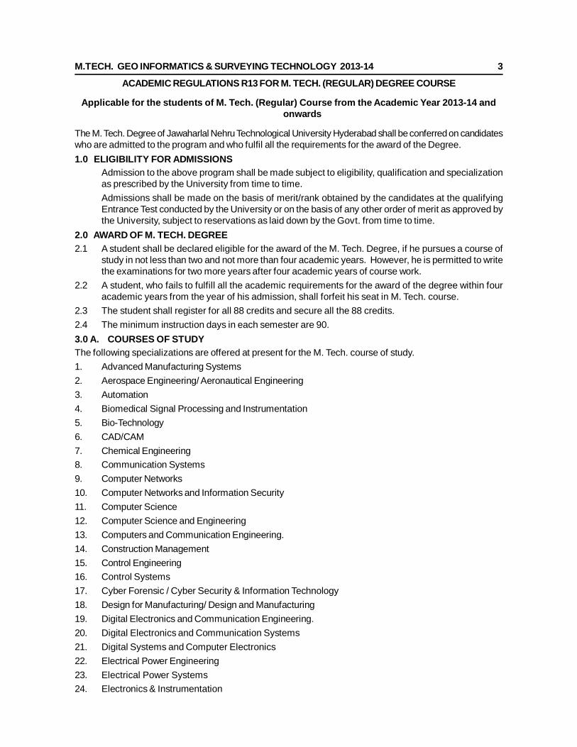
M.TECH. GEO INFORMATICS & SURVEYING TECHNOLOGY 2013-14 3
ACADEMIC REGULATIONS R13 FOR M. TECH. (REGULAR) DEGREE COURSE
Applicable for the students of M. Tech. (Regular) Course from the Academic Year 2013-14 andonwards
The M. Tech. Degree of Jawaharlal Nehru Technological University Hyderabad shall be conferred on candidateswho are admitted to the program and who fulfil all the requirements for the award of the Degree.1.0 ELIGIBILITY FOR ADMISSIONS
Admission to the above program shall be made subject to eligibility, qualification and specializationas prescribed by the University from time to time.Admissions shall be made on the basis of merit/rank obtained by the candidates at the qualifyingEntrance Test conducted by the University or on the basis of any other order of merit as approved bythe University, subject to reservations as laid down by the Govt. from time to time.
2.0 AWARD OF M. TECH. DEGREE2.1 A student shall be declared eligible for the award of the M. Tech. Degree, if he pursues a course of
study in not less than two and not more than four academic years. However, he is permitted to writethe examinations for two more years after four academic years of course work.
2.2 A student, who fails to fulfill all the academic requirements for the award of the degree within fouracademic years from the year of his admission, shall forfeit his seat in M. Tech. course.
2.3 The student shall register for all 88 credits and secure all the 88 credits.2.4 The minimum instruction days in each semester are 90.3.0 A. COURSES OF STUDYThe following specializations are offered at present for the M. Tech. course of study.1. Advanced Manufacturing Systems2. Aerospace Engineering/ Aeronautical Engineering3. Automation4. Biomedical Signal Processing and Instrumentation5. Bio-Technology6. CAD/CAM7. Chemical Engineering8. Communication Systems9. Computer Networks10. Computer Networks and Information Security11. Computer Science12. Computer Science and Engineering13. Computers and Communication Engineering.14. Construction Management15. Control Engineering16. Control Systems17. Cyber Forensic / Cyber Security & Information Technology18. Design for Manufacturing/ Design and Manufacturing19. Digital Electronics and Communication Engineering.20. Digital Electronics and Communication Systems21. Digital Systems and Computer Electronics22. Electrical Power Engineering23. Electrical Power Systems24. Electronics & Instrumentation
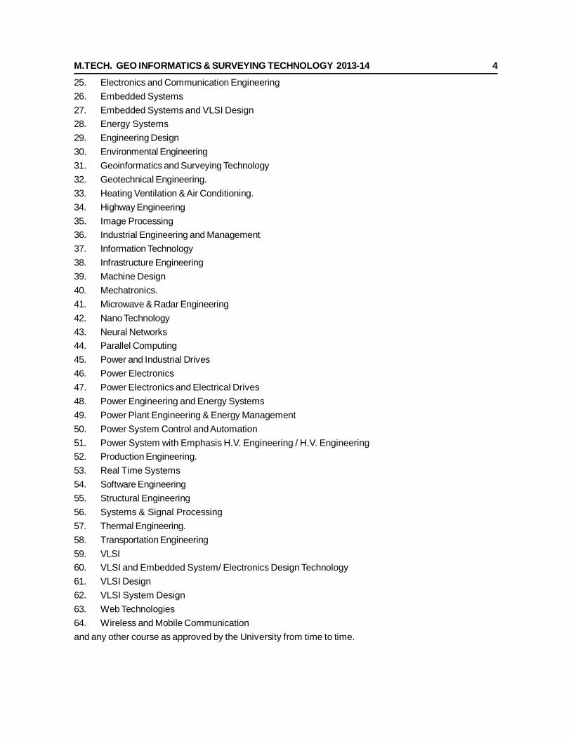
M.TECH. GEO INFORMATICS & SURVEYING TECHNOLOGY 2013-14 4
25. Electronics and Communication Engineering26. Embedded Systems27. Embedded Systems and VLSI Design28. Energy Systems29. Engineering Design30. Environmental Engineering31. Geoinformatics and Surveying Technology32. Geotechnical Engineering.33. Heating Ventilation & Air Conditioning.34. Highway Engineering35. Image Processing36. Industrial Engineering and Management37. Information Technology38. Infrastructure Engineering39. Machine Design40. Mechatronics.41. Microwave & Radar Engineering42. Nano Technology43. Neural Networks44. Parallel Computing45. Power and Industrial Drives46. Power Electronics47. Power Electronics and Electrical Drives48. Power Engineering and Energy Systems49. Power Plant Engineering & Energy Management50. Power System Control and Automation51. Power System with Emphasis H.V. Engineering / H.V. Engineering52. Production Engineering.53. Real Time Systems54. Software Engineering55. Structural Engineering56. Systems & Signal Processing57. Thermal Engineering.58. Transportation Engineering59. VLSI60. VLSI and Embedded System/ Electronics Design Technology61. VLSI Design62. VLSI System Design63. Web Technologies64. Wireless and Mobile Communicationand any other course as approved by the University from time to time.
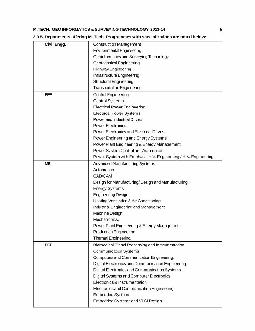
M.TECH. GEO INFORMATICS & SURVEYING TECHNOLOGY 2013-14 5
3.0 B. Departments offering M. Tech. Programmes with specializations are noted below:Civil Engg. Construction Management
Environmental EngineeringGeoinformatics and Surveying TechnologyGeotechnical EngineeringHighway EngineeringInfrastructure EngineeringStructural EngineeringTransportation Engineering
EEE Control EngineeringControl SystemsElectrical Power EngineeringElectrical Power SystemsPower and Industrial DrivesPower ElectronicsPower Electronics and Electrical DrivesPower Engineering and Energy SystemsPower Plant Engineering & Energy ManagementPower System Control and AutomationPower System with Emphasis H.V. Engineering / H.V. Engineering
ME Advanced Manufacturing SystemsAutomationCAD/CAMDesign for Manufacturing/ Design and ManufacturingEnergy SystemsEngineering DesignHeating Ventilation & Air ConditioningIndustrial Engineering and ManagementMachine DesignMechatronics.Power Plant Engineering & Energy ManagementProduction EngineeringThermal Engineering.
ECE Biomedical Signal Processing and InstrumentationCommunication SystemsComputers and Communication Engineering.Digital Electronics and Communication Engineering.Digital Electronics and Communication SystemsDigital Systems and Computer ElectronicsElectronics & InstrumentationElectronics and Communication EngineeringEmbedded SystemsEmbedded Systems and VLSI Design
M.TECH. GEO INFORMATICS & SURVEYING TECHNOLOGY 2013-14 6
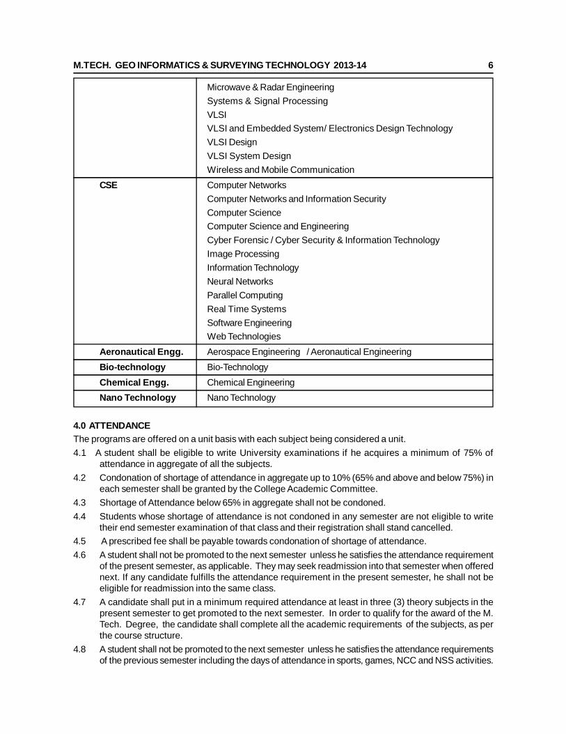
Microwave & Radar EngineeringSystems & Signal ProcessingVLSIVLSI and Embedded System/ Electronics Design TechnologyVLSI DesignVLSI System DesignWireless and Mobile Communication
CSE Computer NetworksComputer Networks and Information SecurityComputer ScienceComputer Science and EngineeringCyber Forensic / Cyber Security & Information TechnologyImage ProcessingInformation TechnologyNeural NetworksParallel ComputingReal Time SystemsSoftware EngineeringWeb Technologies
Aeronautical Engg. Aerospace Engineering / Aeronautical EngineeringBio-technology Bio-TechnologyChemical Engg. Chemical EngineeringNano Technology Nano Technology
4.0 ATTENDANCEThe programs are offered on a unit basis with each subject being considered a unit.4.1 A student shall be eligible to write University examinations if he acquires a minimum of 75% of
attendance in aggregate of all the subjects.4.2 Condonation of shortage of attendance in aggregate up to 10% (65% and above and below 75%) in
each semester shall be granted by the College Academic Committee.4.3 Shortage of Attendance below 65% in aggregate shall not be condoned.4.4 Students whose shortage of attendance is not condoned in any semester are not eligible to write
their end semester examination of that class and their registration shall stand cancelled.4.5 A prescribed fee shall be payable towards condonation of shortage of attendance.4.6 A student shall not be promoted to the next semester unless he satisfies the attendance requirement
of the present semester, as applicable. They may seek readmission into that semester when offerednext. If any candidate fulfills the attendance requirement in the present semester, he shall not beeligible for readmission into the same class.
4.7 A candidate shall put in a minimum required attendance at least in three (3) theory subjects in thepresent semester to get promoted to the next semester. In order to qualify for the award of the M.Tech. Degree, the candidate shall complete all the academic requirements of the subjects, as perthe course structure.
4.8 A student shall not be promoted to the next semester unless he satisfies the attendance requirementsof the previous semester including the days of attendance in sports, games, NCC and NSS activities.
M.TECH. GEO INFORMATICS & SURVEYING TECHNOLOGY 2013-14 7
5.0 EVALUATIONThe performance of the candidate in each semester shall be evaluated subject-wise, with a maximumof 100 marks for theory and 100 marks for practicals, on the basis of Internal Evaluation andEnd Semester Examination.
5.1 For the theory subjects 60 marks shall be awarded based on the performance in the EndSemester Examination and 40 marks shall be awarded based on the Internal Evaluation. The internalevaluation shall be made based on the average of the marks secured in the two Mid Term-Examinationsconducted-one in the middle of the Semester and the other immediately after the completion ofinstruction. Each mid term examination shall be conducted for a total duration of 120 minutes withPart A as compulsory question (16 marks) which consists of four sub-questions and carries 4 markseach and Part B with 3 questions to be answered out of 5 questions each question for 8 marks. If anycandidate is absent from any subject of a mid-term examination, an on-line test will be conducted forhim by the University. The details of the Question Paper pattern for End Examination (Theory) isgiven below:
The End semesters Examination will be conducted for 60 marks which consists of two parts viz.i).Part-A for 20 marks, ii). Part –B for 40 marks.
Part-A is compulsory question where it consists of five questions one from each unit and carries fourmarks each. This will be treated as Question 1.
Part-B consists of five Questions (numbered from 2 to 6) carries 8 marks each. Each of thesequestions is from one unit and may contain sub-questions. For each question there will be an“either” “or” choice (that means there will be two questions from each unit and the student shouldanswer only one question)
5.2 For practical subjects, 60 marks shall be awarded based on the performance in the EndSemester Examinations and 40 marks shall be awarded based on the day-to-day performance asInternal Marks.
5.3 There shall be two seminar presentations during I year I semester and II semester. For seminar, astudent under the supervision of a faculty member, shall collect the literature on a topic and criticallyreview the literature and submit it to the department in a report form and shall make an oral presentationbefore the Departmental Academic Committee consisting of Head of the Department, Supervisorand two other senior faculty members of the department. For each Seminar there will be onlyinternal evaluation of 50 marks. A candidate has to secure a minimum of 50% of marks to bedeclared successful.
5.4 There shall be a Comprehensive Viva-Voce in II year I Semester. The Comprehensive Viva-Voce willbe conducted by a Committee consisting of Head of the Department and two Senior Faculty membersof the Department. The Comprehensive Viva-Voce is intended to assess the students’ understandingof various subjects he has studied during the M. Tech. course of study. The Comprehensive Viva-Voce is evaluated for 100 marks by the Committee. There are no internal marks for the ComprehensiveViva-Voce.
5.5 A candidate shall be deemed to have secured the minimum academic requirement in a subject if hesecures a minimum of 40% of marks in the End semester Examination and a minimum aggregateof 50% of the total marks in the End Semester Examination and Internal Evaluation taken together.
5.6 In case the candidate does not secure the minimum academic requirement in any subject (asspecified in 5.5) he has to reappear for the End semester Examination in that subject. Acandidate shall be given one chance to re-register for each subject provided the internal markssecured by a candidate are less than 50% and so has failed in the end examination. In such a case,the candidate must re-register for the subject(s) and secure the required minimum attendance. Thecandidate’s attendance in the re-registered subject(s) shall be calculated separately to decideupon his eligibility for writing the end examination in those subject(s). In the event of the studenttaking another chance, his internal marks and end examination marks obtained in the previousattempt stand cancelled.
5.7 In case the candidate secures less than the required attendance in any subject, he shall not bepermitted to write the End Examination in that subject. He shall re-register the subject when next
M.TECH. GEO INFORMATICS & SURVEYING TECHNOLOGY 2013-14 8
offered.5.8 Laboratory examination for M. Tech. courses must be conducted with two Examiners, one of them
being the Laboratory Class Teacher and the second examiner shall be another Laboratory Teacher.6.0 EVALUATION OF PROJECT/DISSERTATION WORK
Every candidate shall be required to submit a thesis or dissertation on a topic approved by theProject Review Committee.
6.1 A Project Review Committee (PRC) shall be constituted with Principal as Chairperson, Heads of allthe Departments offering the M. Tech. programs and two other senior faculty members.
6.2 Registration of Project Work: A candidate is permitted to register for the project work after satisfyingthe attendance requirement of all the subjects, both theory and practical.
6.3 After satisfying 6.2, a candidate has to submit, in consultation with his project supervisor, the title,objective and plan of action of his project work to the Departmental Academic Committee for approval.Only after obtaining the approval of the Departmental Academic Committee can the student initiatethe Project work.
6.4 If a candidate wishes to change his supervisor or topic of the project, he can do so with the approvalof the Departmental Academic Committee. However, the Departmental Academic Committee shallexamine whether or not the change of topic/supervisor leads to a major change of his initial plans ofproject proposal. If yes, his date of registration for the project work starts from the date of change ofSupervisor or topic as the case may be.
6.5 A candidate shall submit his status report in a bound-form in two stages at least with a gap of 3months between them.
6.6 The work on the project shall be initiated at the beginning of the II year and the duration of the projectis two semesters. A candidate is permitted to submit Project Thesis only after successful completionof theory and practical course with the approval of PRC not earlier than 40 weeks from the date ofregistration of the project work. For the approval of PRC the candidate shall submit the draft copy ofthesis to the Principal through Head of the Department and make an oral presentation before thePRC.
6.7 Three copies of the Project Thesis certified by the supervisor shall be submitted to the College/School/Institute.
6.8 The thesis shall be adjudicated by one examiner selected by the University. For this, the Principalof the College shall submit a panel of 5 examiners, eminent in that field, with the help of the guideconcerned and head of the department.
6.9 If the report of the examiner is not favourable, the candidate shall revise and resubmit the Thesis, inthe time frame as decided by the PRC. If the report of the examiner is unfavourable again, the thesisshall be summarily rejected.
6.10 If the report of the examiner is favourable, Viva-Voce examination shall be conducted by a boardconsisting of the Supervisor, Head of the Department and the examiner who adjudicated the Thesis.The Board shall jointly report the candidate’s work as one of the following:A. ExcellentB. GoodC. SatisfactoryD. UnsatisfactoryThe Head of the Department shall coordinate and make arrangements for the conduct of Viva- Voceexamination.If the report of the Viva-Voce is unsatisfactory, the candidate shall retake the Viva-Voce examinationonly after three months. If he fails to get a satisfactory report at the second Viva- Voce examination,he will not be eligible for the award of the degree.
M.TECH. GEO INFORMATICS & SURVEYING TECHNOLOGY 2013-14 9
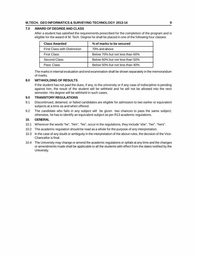
7.0 AWARD OF DEGREE AND CLASSAfter a student has satisfied the requirements prescribed for the completion of the program and iseligible for the award of M. Tech. Degree he shall be placed in one of the following four classes:
Class Awarded % of marks to be securedFirst Class with Distinction 70% and aboveFirst Class Below 70% but not less than 60%Second Class Below 60% but not less than 50%Pass Class Below 50% but not less than 40%
The marks in internal evaluation and end examination shall be shown separately in the memorandumof marks.
8.0 WITHHOLDING OF RESULTSIf the student has not paid the dues, if any, to the university or if any case of indiscipline is pendingagainst him, the result of the student will be withheld and he will not be allowed into the nextsemester. His degree will be withheld in such cases.
9.0 TRANSITORY REGULATIONS9.1 Discontinued, detained, or failed candidates are eligible for admission to two earlier or equivalent
subjects at a time as and when offered.9.2 The candidate who fails in any subject will be given two chances to pass the same subject;
otherwise, he has to identify an equivalent subject as per R13 academic regulations.10. GENERAL10.1 Wherever the words “he”, “him”, “his”, occur in the regulations, they include “she”, “her”, “hers”.10.2 The academic regulation should be read as a whole for the purpose of any interpretation.10.3 In the case of any doubt or ambiguity in the interpretation of the above rules, the decision of the Vice-
Chancellor is final.10.4 The University may change or amend the academic regulations or syllabi at any time and the changes
or amendments made shall be applicable to all the students with effect from the dates notified by theUniversity.
M.TECH. GEO INFORMATICS & SURVEYING TECHNOLOGY 2013-14 10
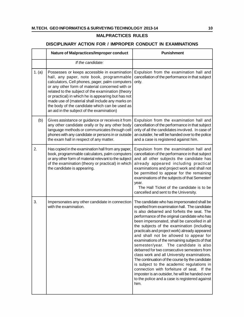
MALPRACTICES RULES
DISCIPLINARY ACTION FOR / IMPROPER CONDUCT IN EXAMINATIONS
1. (a)
(b)
2.
3.
Nature of Malpractices/Improper conduct
If the candidate:
Possesses or keeps accessible in examinationhall, any paper, note book, programmablecalculators, Cell phones, pager, palm computersor any other form of material concerned with orrelated to the subject of the examination (theoryor practical) in which he is appearing but has notmade use of (material shall include any marks onthe body of the candidate which can be used asan aid in the subject of the examination)
Gives assistance or guidance or receives it fromany other candidate orally or by any other bodylanguage methods or communicates through cellphones with any candidate or persons in or outsidethe exam hall in respect of any matter.
Has copied in the examination hall from any paper,book, programmable calculators, palm computersor any other form of material relevant to the subjectof the examination (theory or practical) in whichthe candidate is appearing.
Impersonates any other candidate in connectionwith the examination.
Punishment
Expulsion from the examination hall andcancellation of the performance in that subjectonly.
Expulsion from the examination hall andcancellation of the performance in that subjectonly of all the candidates involved. In case ofan outsider, he will be handed over to the policeand a case is registered against him.
Expulsion from the examination hall andcancellation of the performance in that subjectand all other subjects the candidate hasalready appeared including practicalexaminations and project work and shall notbe permitted to appear for the remainingexaminations of the subjects of that Semester/year. The Hall Ticket of the candidate is to becancelled and sent to the University.
The candidate who has impersonated shall beexpelled from examination hall. The candidateis also debarred and forfeits the seat. Theperformance of the original candidate who hasbeen impersonated, shall be cancelled in allthe subjects of the examination (includingpracticals and project work) already appearedand shall not be allowed to appear forexaminations of the remaining subjects of thatsemester/year. The candidate is alsodebarred for two consecutive semesters fromclass work and all University examinations.The continuation of the course by the candidateis subject to the academic regulations inconnection with forfeiture of seat. If theimposter is an outsider, he will be handed overto the police and a case is registered againsthim.
M.TECH. GEO INFORMATICS & SURVEYING TECHNOLOGY 2013-14 11
Expulsion from the examination hall andcancellation of performance in that subjectand all the other subjects the candidate hasalready appeared including practicalexaminations and project work and shall notbe permitted for the remaining examinationsof the subjects of that semester/year. Thecandidate is also debarred for twoconsecutive semesters from class work andall University examinations. The continuationof the course by the candidate is subject tothe academic regulations in connection withforfeiture of seat.
Cancellation of the performance in thatsubject.
In case of students of the college, they shallbe expelled from examination halls andcancellation of their performance in thatsubject and al l other subjects thecandidate(s) has (have) already appeared andshall not be permitted to appear for theremaining examinations of the subjects of thatsemester/year. The candidates also aredebarred and forfeit their seats. In case ofoutsiders, they will be handed over to thepolice and a police case is registered againstthem.
Expulsion from the examination hall andcancellation of performance in that subjectand all the other subjects the candidate hasalready appeared including practicalexaminations and project work and shall notbe permitted for the remaining examinationsof the subjects of that semester/year. Thecandidate is also debarred for twoconsecutive semesters from class work andall University examinations. The continuationof the course by the candidate is subject tothe academic regulations in connection withforfeiture of seat.
Smuggles in the Answer book or additional sheetor takes out or arranges to send out the questionpaper during the examination or answer book oradditional sheet, during or after the examination.
Uses objectionable, abusive or offensive languagein the answer paper or in letters to the examinersor writes to the examiner requesting him to awardpass marks.
Refuses to obey the orders of the ChiefSuperintendent/Assistant – Superintendent / anyofficer on duty or misbehaves or createsdisturbance of any kind in and around theexamination hall or organizes a walk out orinstigates others to walk out, or threatens theofficer-in charge or any person on duty in oroutside the examination hall of any injury to hisperson or to any of his relations whether by words,either spoken or written or by signs or by visiblerepresentation, assaults the officer-in-charge, orany person on duty in or outside the examinationhall or any of his relations, or indulges in anyother act of misconduct or mischief which resultin damage to or destruction of property in theexamination hall or any part of the College campusor engages in any other act which in the opinionof the officer on duty amounts to use of unfairmeans or misconduct or has the tendency todisrupt the orderly conduct of the examination.
Leaves the exam hall taking away answer scriptor intentionally tears of the script or any partthereof inside or outside the examination hall.
4.
5.
6.
7.
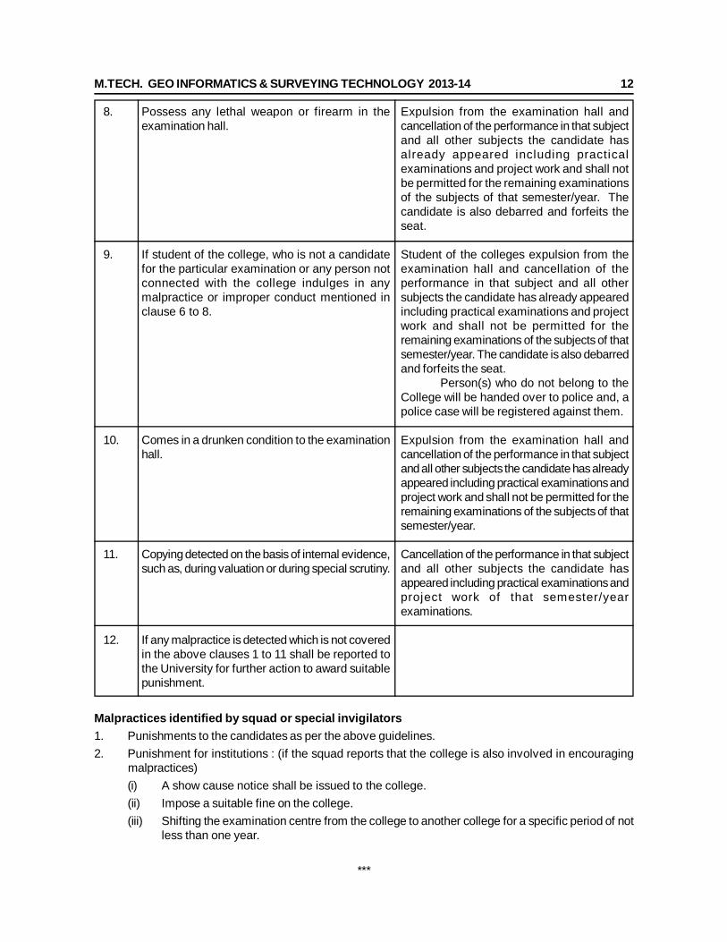
M.TECH. GEO INFORMATICS & SURVEYING TECHNOLOGY 2013-14 12
Expulsion from the examination hall andcancellation of the performance in that subjectand all other subjects the candidate hasalready appeared including practicalexaminations and project work and shall notbe permitted for the remaining examinationsof the subjects of that semester/year. Thecandidate is also debarred and forfeits theseat.
Student of the colleges expulsion from theexamination hall and cancellation of theperformance in that subject and all othersubjects the candidate has already appearedincluding practical examinations and projectwork and shall not be permitted for theremaining examinations of the subjects of thatsemester/year. The candidate is also debarredand forfeits the seat. Person(s) who do not belong to theCollege will be handed over to police and, apolice case will be registered against them.
Expulsion from the examination hall andcancellation of the performance in that subjectand all other subjects the candidate has alreadyappeared including practical examinations andproject work and shall not be permitted for theremaining examinations of the subjects of thatsemester/year.
Cancellation of the performance in that subjectand all other subjects the candidate hasappeared including practical examinations andproject work of that semester/yearexaminations.
Possess any lethal weapon or firearm in theexamination hall.
If student of the college, who is not a candidatefor the particular examination or any person notconnected with the college indulges in anymalpractice or improper conduct mentioned inclause 6 to 8.
Comes in a drunken condition to the examinationhall.
Copying detected on the basis of internal evidence,such as, during valuation or during special scrutiny.
If any malpractice is detected which is not coveredin the above clauses 1 to 11 shall be reported tothe University for further action to award suitablepunishment.
8.
9.
10.
11.
12.
Malpractices identified by squad or special invigilators1. Punishments to the candidates as per the above guidelines.2. Punishment for institutions : (if the squad reports that the college is also involved in encouraging
malpractices)(i) A show cause notice shall be issued to the college.(ii) Impose a suitable fine on the college.(iii) Shifting the examination centre from the college to another college for a specific period of not
less than one year.
***
M.TECH. GEO INFORMATICS & SURVEYING TECHNOLOGY 2013-14 13
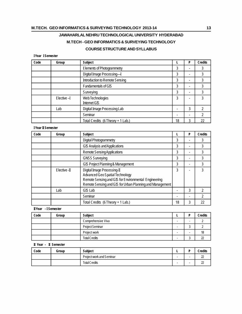
JAWAHARLAL NEHRU TECHNOLOGICAL UNIVERSITY HYDERABADM.TECH - GEO INFORMATICS & SURVEYING TECHNOLOGY
COURSE STRUCTURE AND SYLLABUSI Year I Semester
Code Group Subject L P CreditsElements of Photogrammetry 3 - 3Digital Image Processing—I 3 - 3Introduction to Remote Sensing 3 - 3Fundamentals of GIS 3 - 3Surveying 3 - 3
Elective –I Web Technologies 3 - 3Internet GIS
Lab Digital Image Processing Lab - 3 2Seminar - - 2Total Credits (6 Theory + 1 Lab.) 18 3 22
I Year II Semester
Code Group Subject L P CreditsDigital Photogrammetry 3 - 3GIS Analysis and Applications 3 - 3Remote Sensing Applications 3 - 3GNSS Surveying 3 - 3GIS Project Planning & Management 3 - 3
Elective -II Digital Image Processing-II 3 - 3Advanced Geo Spatial TechnologyRemote Sensing and GIS for Environmental EngineeringRemote Sensing and GIS for Urban Planning and Management
Lab GIS Lab - 3 2Seminar - - 2Total Credits (6 Theory + 1 Lab.) 18 3 22
II Year - I Semester
Code Group Subject L P CreditsComprehensive Viva - - 2Project Seminar - 3 2Project work - - 18Total Credits - 3 22
II Year - II Semester
Code Group Subject L P CreditsProject work and Seminar - - 22Total Credits - - 22
M.TECH. GEO INFORMATICS & SURVEYING TECHNOLOGY 2013-14 14
JAWAHARLAL NEHRU TECHNOLOGICAL UNIVERSITY HYDERABADM. Tech – I Year – I Sem. (GIST)
ELEMENTS OF PHOTOGRAMMETRYUnit I:Introduction to Photogrammetry & Vertical Photographs: Definition of Photogrammetry - types ofphotographs, vertical aerial photographs, Geometry of vertical photographs, Scale of a vertical photographover flat terrain, Scale of a Vertical photograph over variable terrain - average photo scale, methods ofdetermining scale of vertical photographs, Ground coordinates from a vertical photograph, Relief Displacement,Flying height of a vertical photograph, Error evaluation.Unit II:Stereoscopic Parallax: Photographic “Flight-Line” Axes for Parallax Measurement – Monoscopic methodsParallax measurement – Principle of the Floating Mark – Stereoscopic methods of Parallax Measurement– Parallax equation – Elevations by parallax Differences – Approximate Equation for elevations from ParallaxDifferences – Measurement of Parallax Differences with Stereoscope& Parallax Bar- Parallax CorrectionGraph – Computing Flying Height and Air Base – Error Evaluation.Unit III:Elementary Methods of Planimetric Mapping for GIS, Photomaps & Mosaics : Planimetric Mappingby Direct Tracing – Planimetric Mapping with Reflection and Projection Instruments – Georeferencing ofDigital Imagery – Planimetric Mapping Using a Tablet Digitizer – Heads-up Digitizing – Photomaps andmosaics, Kinds of mosaics, uncontrolled digital mosaics, semi controlled Digital mosaics and ControlledDigital MosaicsUnit IV:Tilted Photographs: Introduction, Angular Orientation in Tilt, Swing, and Azimuth, Auxiliary Tilted Photocoordinate system, Scale of a Tilted Photograph, Relief Displacement on a Tilted Photograph, TiltDisplacement, Angular Orientation in Omega, Phi and Kappa, Determining the elements of Exterior Orientation,Rectification of Tilted photographs, Geometry of Rectification, Analytical Rectification, Optical-MechanicalRectification, Digital Rectification, Atmospheric Refraction in tilted aerial photographs.Unit V:Stereoscopic Plotting Instruments: Classification of stereoscopic Plotters - Direct optical projection Stereoplotters: components, Projection systems, Viewing systems, Measuring and tracing systems, InteriorOrientation, Relative Orientation, Absolute Orientation, Analytical plotter: Introduction, System componentsand Methods of operations and its advantages. Project planning: Flight planning: Introduction, Photographicend lap and side lap, Purpose of the Photography, Photo Scale, Flying Height, Stereoscopic PlotterConsiderations, Ground coverage, Weather conditions, Season of year, Flight Map, Specifications, Costestimating and Scheduling.TEXT BOOK:1. Elements of Photogrammetry by PAUL R. WOLF, 3rd edition, ISBN 007-123689-9.2. Introduction to Modern Photogrammetry (Paperback) by Edward M. Mikhail, James S. Bethel.REFERENCE:1. Manual of Photogrammetry – American Society of Photogrammetry By ALBERT.D.2. Aerial Photographic Interpretation by D. R. Lueder, McGraw-Hill Companies.3. Photogrammetry- Vol I by Krauss, J., - Springler – Verlag Publications.4. Photogrammetry 3rd Edition by Moffitt, Francis H. & Mikhail, Edward M., - Harper and Row Publishers.5. Principles and Applications of Photo Geology By SHIV PANDEY.
M.TECH. GEO INFORMATICS & SURVEYING TECHNOLOGY 2013-14 15
JAWAHARLAL NEHRU TECHNOLOGICAL UNIVERSITY HYDERABAD M. Tech – I Year – I Sem. (GIST)
DIGITAL IMAGE PROCESSING-IUnit I:Sensor, Satellite Data, and Data Model: Satellite systems, Data acquisition & storage - Data formats -Data products.-Image display system.
Sensor model-Resolutions - Pixel characters - Image formation. The histogram and its significance- ENTROPYand its significance -Univariate & multivariate Image statistics – Spatial Statistics.
Unit II:Geometric Preprocessing: Over view of Image Processing, Geometric distortion, Image registration,resampling, orthorectification – Image Mosaic.
Unit III:Image Enhancements: Image characteristics- Spectral signatures .contrast enhancements- Image domainfiltering. first order, second order ,directional filters , linear and non linear filters, Spatial enhancement,Multiband enhancements, ratioing, indices and Principal component analysis , Point, local and regionaloperators - Fourier transform-Fourier domain filtering, Ideal, Butterworth and Gaussian filters; scale-spacetransform, wavelet transform.
Unit IV:Information Extraction: Classification algorithms: Non- parametric, parametric, Feature extraction, UnSupervised, training sets-Supervised methods and algorithms.
Accuracy Assessment: Sources of Classification Error, Interpretation of the Error Matrix. Measurement ofClassification Accuracy
Unit V:Image Analyses : Pattern recognition, boundary detection and representation, textural and contextualAnalysis.
TEXT BOOKS:1. John R.Jenson, .Introductory Digital Image Processing., Prentice Hall Series, 1996.
2. John A. Richards, Springer-Verlag, .Remote Sensing Digital Image Analysis. 1999.
3. Lillisand T.M and R.W.Kiefer (2004) 4th edition. Remote sensing and image interpretation, John Wiley& Sons, New York.
4. Rafael C.Gonzalez, .Digital Image Processing (2nd Edition)., Prentice Hall, 2002.
5. Remote sensing models and methods for Image processing. Schowengerdt 2nd edition.
6. Remote Sensing: The Quantitative Approach, edited by Swain, P.H.and Davis, S.M. Mc Graw Hills.
REFERENCES1. David L. Verbyla .Satellite Remote sensing of Natural Resource Management., Lewis publishers,
Florida.
2. Anil K. Jain .Fundamentals of Digital Image Processing. Prentice Hall Publications, USA.
3. Image Analysis, Classification and change Detection in Remote Sensing . Mortan J.Century Taylorand Francis, 2007.
M.TECH. GEO INFORMATICS & SURVEYING TECHNOLOGY 2013-14 16
JAWAHARLAL NEHRU TECHNOLOGICAL UNIVERSITY HYDERABAD M. Tech – I Year – I Sem. (GIST)
INTRODUCTION TO REMOTE SENSINGUnit I:Fundamentals: Definition – Scope – types- chronological development – Energy sources – ElectroMagnetic RadiationEnergy interactions: Energy interaction in the atmosphere – atmospheric windows –energy interactionwith earth surface features- spectral reflectance patterns for different regions of EMR. Factors affectingremote sensing Spectral signaturesPlatforms: Types of Platforms – Ideal and real remote sensing system. Advantages and limitations ofsatellite remote sensing.Unit II:Satellites and Sensors: Satellite programs of the world - Geostationary satellites and its orbits: sensorcharacteristics and their applications. Remote Sensing Satellites : Coarse, Medium and High resolutionSatellites - LANDSAT, SPOT, IRS, IKONOS , Quick bird, World View and other recent satellites – scanningand orbiting mechanisms – resolutions –Spatial – Spectral – Temporal - Radiometric - Image Interpretationelements.Unit III:Thermal Remote Sensing: Radiant flux – heat transfer – thermal infrared radiation – thermal propertiesof materials – emissivity of materials – thermal inertia of Earth surface features.Thermal IR detection and imaging – characteristics of TIR images. Factors controlling IR Survey – applications.Unit IV:Microwave Remote Sensing: meaning – airborne radar system – SLAR – components, imaging system,wavelengths – range and azimuth resolution – real aperture and synthetic aperture systems, geometry ofradar images - mosaics. image characteristics: wavelength, surface roughness, orientation, moisture content,polarization, look direction and look angle, physical properties, electrical properties: dielectric constant,topographic factors, layover, fore shadowing, radar shadow, corner reflection.Unit V:Hyper Spectral Remote Sensing: Spectroscopy, Image cube, hyperian/HYSI, Spectral matching, DigitalSpectral Data , Libraries, Application of Hyperspsectral data, MODIS.TEXT BOOKS:1. Lillisand T.M and R.W.Kiefer (2004) 4th edition. Remote sensing and image interpretation, John Wiley
& Sons, New York.2. JOHN R.JENSEN “Remote sensing for Environment ”Pearson edition Pvt Ltd, New Delhi.3. Anji Reddy, M., (2001) Remote Sensing and Geographical Information Systems, 2nd edition, BS
Publications, Hyderabad.4. George Joseph,(2005) Fundamentals of Remote sensing 2nd edition , University press, Pvt, Ltd,
Hyderabad .5. Remote sensing by JAMES B.CAMPBEL published by Taylor & fancies Ltd.6. Sabins F.F Jr Latest Remote Sensing: Principles and Interpretation, W.H.Freeman & Co., New YorkREFERENCES:1. Hayesm L., [1991] Introduction to Remote Sensing, Taylor and Fransis Publication, London.2. Gibso, P., and Clare H.Power, [2000] Introductory Remote Sensing Principles and concepts, Routledge,
1st edition, London.3. Henderson, F. M., and Anthony J. Lewis, 1998, Manual of Remote Sensing, Volume 2, Principles
and Application of Imaging Radar, 3rd Edition, John Wiley and Sonc Inc, Canada, USA.
M.TECH. GEO INFORMATICS & SURVEYING TECHNOLOGY 2013-14 17
JAWAHARLAL NEHRU TECHNOLOGICAL UNIVERSITY HYDERABADM. Tech – I Year – I Sem. (GIST)
FUNDAMENTALS OF GISUnit I:Introduction to GIS & Data Structures: Spatial Elements, Spatial Measurement Level, Coordinatessystems, Grids, projections , Spatial Location and Reference, Spatial Patterns, Geographic Data Collection,Populations and Sampling Schemes, Inferences from Samples.Data Structures: Computer Database Structures for Managing Data, Hierarchical Data Structures, NetworkSystems, Database Management Systems, RDBMS, Relational Model – Structure, Relational algebra,Relational calculus, Commercial query languages, SQL, QUEL, Query by example.Unit II:Types of GIS Data Models and Input Devices: Graphic Representation of Entities and Attributes, GISData Models, Raster Models, Vector Models, Input Devices, Raster, Vector, Reference Frameworks andTransformation, Map Preparation and the Digitizing Process.Unit III:GIS Data Input Methods and Data Storage and Editing: Methods of Vector Input, Method of RasterInput, Remote sensing, Raster Data Input, External Databases. - Storage of GIS Databases, Storing ofRaster Data, Editing the GIS Database, Detecting and Editing Errors of Different Types, Entity Errors:Vector, Attribute Errors: Raster and Vector, Dealing with Projection Change, Edge Matching, Conflation andRubber Sheeting, Templating.Unit IV:Database Systems & Entity Relationship Model: Definition, Purpose, Data abstraction, Instances andSchemes, Data independence, Introduction to DDL, DML, Database manager, Database administrator,Database users, Overall system structure.Entity Relationship Model: Entities, Entity sets, Relationships, Relationship sets, Mapping constraints,Primary keys, E-R diagrams, Reduction of E-R diagrams to tables, Generalization, Aggregation.Unit V:Concepts of Data Warehousing & ETL Architecture: Basic concepts, Data warehouse ImplementationApproach, Architecture – Data Acquisition – Extraction, Transformation and Loading- Data Mart, comparisonof OLTP & DSS -Schemas, Dimension table – Facts- Different ScenariosTEXT BOOKs:1. Fundamental of GIS by MICHAEL N DEMERS – MN DEMERS, Published by John Wiley & Sons Inc2. Principles of GIS by P.A. Burrough, Rachael Mc Donnell.3. 3. Principles of Geographical Information Systems for Land Resources Assessment by P.A. Burrough.4. Database System concepts by HENRY F. KORTH, Abraham Siberschatz Mc Graw 1988.5. Database Management Systems by Raghurama Krishnan, Johannes Gehrke, TATA McGrawHill 3rd
Edition.6. Data Warehousing, Data Mining & OLAP, by Alex Berson and Stephen J. Smith, “Tata McGraw
– Hill Edition, Tenth Reprint 2007.REFERENCES:1. Geographic Information System- An Introductory – Jeffrey Star and John Estates – Pretence Hall Inc.2. Basic Readings in Geographic Information System – Marble, D.F and Calkins, H.W – Spad Systems
Ltd.3. Database Management Systems by P.Radha Krishna HI-TECH Publications 2005.
M.TECH. GEO INFORMATICS & SURVEYING TECHNOLOGY 2013-14 18
JAWAHARLAL NEHRU TECHNOLOGICAL UNIVERSITY HYDERABAD M. Tech – I Year – I Sem. (GIST)
SURVEYINGUnit I:Fundamentals of Surveying: Principles of surveying, types of surveying, classification of surveys &maps, Plan Vs Map, Accuracy Vs Precision, sources and kinds of error; Least Squares adjustments andapplications.
Unit II:Surveying & Levelling: Chains: types, errors in chaining, chain triangulation, basic problems in chainsurveying; Compass: types, designation of bearings, azimuth, bearing, relationship between bearings &azimuths. Plane table: instruments used for plane table survey, methods of plane tabling.
Leveling – definition, leveling instruments, methods of leveling (Dumpy level, Theodolite , Digital Level);Tacheometric surveying – principle, methods to determine horizontal distance, uses of Tachometric Surveying.
Unit III:EDM & Total Station: Principle, instrument characteristics, accessories, operation, EDM without reflectingprisms; Total Station – types, instrument description, field techniques, Traversing, motorized total stations;field procedures for total stations in topographic surveys.
Unit IV:Topographical Surveying: Concepts and Techniques: Definition, Procedure in topographic surveying ,uses of topographical maps, Relief, methods of representing relief, contour and contour interval,characteristics of a contour, methods of locating contours, Interpolation of contours, Dam Surveys.
Unit V :Project Planning I: Systems of Co-ordinates, constitution of survey party, Planning, execution andcompletion of a topographical survey, Quality Vs Quantity. Case Studies.
TEXT BOOKS:1. Text Book of Plane Surveying By David Clark Part I and Part II.
2. Text Book of Surveying by Punmia Part I and Part II.
REFERENCES:1. Surveying and Leveling – Agor.
2. Principles of Cartography – K. S. Singh.
M.TECH. GEO INFORMATICS & SURVEYING TECHNOLOGY 2013-14 19
JAWAHARLAL NEHRU TECHNOLOGICAL UNIVERSITY HYDERABAD M. Tech – I Year – I Sem. (GIST)
WEB TECHNOLOGIES(Elective-I)
Unit I:Introduction of HTML and XML: Introduction to client server system, HTML 5 protocols: HTTP, SMTP,POP3, MIME, IMAP, and FTP. HTML- Common tags, List, Tables, Forms, Frames, Cascading StyleSheet(CSS), Introduction to XML, Comparative study of XML and HTMl, XML: Document Type Definition, Schema,Parsers (Dom and SAX).
Unit II:JavaScript: Introduction to javascript, javascript objects, programming using java script if-else, switch,popup box, while loop, for loop, event handling.
Unit III:Introduction to Microsoft .NET framework: Introduction to Microsoft .NET framework: arrays, operators,flow control statements, functions and properties, collection and generics. Getting started with ASP.NET –web forms, controls-web form validation, website navigation, enhancing websites using master pages.
Unit IV:State Management and Error handling: Error handling, debugging and tracking ASP.NET, statemanagement in ASP.NET application, web user control and custom web server control, globalization, webservice protocols (SOAP, WSDL, DISCO, VDDI).
Unit V:.NET framework and web services: Web services and .NET framework(exposing web services, consumingweb services, .NET remoting, namespace, web service architecture), ADO.NET programming objects andarchitecture, connected model (command objects), disconnected model (data sets), introduction to LINQ.
TEXT BOOK:Web programming, building Internet application, Chris Bates 2nd edition WILEY Dreamtech.
REFERENCES:1) Pro ASP.Net 4 in C# 2010 by Mathew MacDonald, Adan Freeman (paperback).
2) Beginning ASP.net 4: in C# & VB (Wrox programer to programmes by Ima Spanjaars (paper back).
3) An Introduction to Web design and programming, Wang, Thomson.

M.TECH. GEO INFORMATICS & SURVEYING TECHNOLOGY 2013-14 20
JAWAHARLAL NEHRU TECHNOLOGICAL UNIVERSITY HYDERABAD M. Tech – I Year – I Sem. (GIST)
INTERNET GIS(Elective-I)
Unit I:Introduction to Distributed Internet GIS: Introduction, Distributed GIS – Basic components, Applications.Networking: Network environment protocols, TCP/IP, LAN, WAN, Data exchange b/w 2 terminals.
Unit II:Client/Server Computing: Client, server, glue, client-server system partition, 2-tier, 3-tier & n-tierarchitectures, advantages & disadvantages of client-server architecture.
Unit III:Distributed Component Framework: DCOM and .NET, DCOM Architecture and Interface, Advantages &disadvantages of DCOM, CORBA, CORBA Architecture and Interface, advantages & disadvantages CORBA.
Unit IV:Web Services in GIS Domain : Interoperability in GIS, OGC and its specifications, OGC specificationsfor GIS web services (WMS, WFS, WCS, WPS, SLD etc) Google Earth, KML Virtual Earth & Bhuvan.
Unit V:Web mapping: Static map publishing, clickable maps, architecture of static web publishing, web mappingarchitecture
Client -HTML viewer, HTTP server with CGI, Map server & other server, side applications, Web-Mappingoptions & objects, Web mapping applications.
TEXT BOOK1. Internet GIS – “Distributed Geographic Information Services For Internet And Wireless Networks” –
by Zhong-ren peng and Ming- Hsiang Tsou.
M.TECH. GEO INFORMATICS & SURVEYING TECHNOLOGY 2013-14 21
JAWAHARLAL NEHRU TECHNOLOGICAL UNIVERSITY HYDERABAD M. Tech – I Year – I Sem. (GIST)
DIGITAL IMAGE PROCESSING LABORATORY1. Reading and Displaying Satellite Data from BIL, BSQ and BIP formats
2. Generation of False Color Composite (FCC)
3. Geo referencing the base map / image
4. Geometric correction of satellite image
5. Extracting area of Interest and Mosaicing.
6. Enhancement using Band ratio and NDVI
7. Enhancement using different Filtering techniques
8. Principal Component Analysis (PCA)
9. Image Fusion Techniques
10. Fourier Analysis
11. Unsupervised Classification
12. Supervised Classification & accuracy assessments
13. Change detection
14. Aerial Traingulation & Ortho rectification with LPS.
M.TECH. GEO INFORMATICS & SURVEYING TECHNOLOGY 2013-14 22
JAWAHARLAL NEHRU TECHNOLOGICAL UNIVERSITY HYDERABAD M. Tech – I Year – II Sem. (GIST)
DIGITAL PHOTOGRAMMETRYUnit I:Introduction & Digital Photogrammetric Work Stations: Definition of Digital Photogrammetry & ItsDevelopment, Comparison between Three Phases of Photogrammetry (Analogue, Analytical and Digital)Advantages of Digital PhotogrammetryHardware & Software Components of DPWS, Various Inputs for Digital Photogrammetry: Control Pointselection, Scanned Photo, Digital Photographs, Remote Sensing ImageryPhotogrammetric Scanners: Principle of Image Scanning, Configuration of Scanners, Method of Scanning,File Format and Size.Unit II:Image Measurements & their Refinement: Introduction to Coordinate Systems And Image Measurements,Simple Scales for Photographic measurements, Measuring Photo Coordinates with Simple Scales,Trilaterative method of Photo Coordinate Measurement, Measurement of Photo Coordinates with TabletDigitizers, Mono Comparator measurement of Photo Coordinates.Refinement of Measured Image Coordinates: Distortions of Photographic Films and Paper, ShrinkageCorrection, Lens Distortions Corrections, Atmospheric Refraction Correction, Earth Curvature Correction,Reduction of Coordinates to an Origin at the Principal Point.Unit III :Orientation Proceduresin Digital Photogrammetry: Inner orientation (IO), Mathematical transformations,Epipolar geometry, Exterior Orientation (EO), Auto Tie Point Generation, Digital Image Matching Process:Area Based, Feature and Relation Based, Collinearity ConditionSpace Resection Method, Space Intersection, Aerial Triangulation and Bundle Block Adjustment, Use OfGPS And IMU in Digital PhotogrammetryUnit IV :3D Visualization & Stereo-Compilation: Principle and Method of 3d Visualization: Anaglyph Polarizedand Hybrid Techniques, Feature Extraction, Feature Coding, Data Model and Feature Class.Definition DEM, DTM, DSM, Various Inputs to DEM/DTM, DTM Specification And Accuracy, Application ofDTM, Various Interpolation Techniques: Grid, TIN, Break Lines, Mass Points, Digital Orthophoto Generation(Pre-processing, Main processing, Post processing) and its uses.UNIT V :Air Borne Laser Terrain Mapping (Lidar): Introduction to Laser Ranging, Principle of LiDAR, SystemComponents, Range Measurements, LiDAR Error Sources, Accuracy, Applications & Advantages of ALTM.TEXT BOOKS:1. Elements of Photogrammetry with application in GIS (3rd edition)- Paul R. Wolf & bon A. Dewitt,
McGraw Hill.2. Digital Photogrammetry by Karl Krauss.3. Introduction to Modern Photogrammetry (Paperback)by Edward M. Mikhail, James S. Bethel.REFERENCE BOOKS:1. Manual of Photogrammetry – American society of Photogrammetry & R.S by Albert.D.2. Photogrammetry by Francis H. Moffitt, Edward M. Mikhail.3. Modern Photogrammetry – Deward M. Midhail.4. Photogrammetry Vol-I by – Drauss J, Springler- Verlag publication.5. Digital Photogrammetry by –Michel Kasser & Yves. Egels.6. Geographic information systems an introduction by Bernhardsen, 3rd edition.

M.TECH. GEO INFORMATICS & SURVEYING TECHNOLOGY 2013-14 23
JAWAHARLAL NEHRU TECHNOLOGICAL UNIVERSITY HYDERABAD M. Tech – I Year – II Sem. (GIST)
GIS ANALYSIS & APPLICATIONSUnit I:Spatial analysis & Arrangements: Spatial analysis: Introduction, Analysis framework, defining spatialcharacteristics, working with higher level objects, measuring polygons, measuring shape, measuring distance.Spatial Arrangements: Point patterns, Thiessen Polygons, Area patterns, linear patterns, Directionality andcontinuity of linear and aerial objects, Gravity model, Routing and Allocation, missing variables, Overlay andtypesUnit II:Statistical surfaces and classification: Surfaces, surface mapping, sampling the statistical surface,DEM, Raster interpolation- methods, Uses, Weighted Analysis, Classification Principles, ReclassificationElements, Neighborhood Functions, Polygonal Neighborhoods, Buffers.Unit III:Natural Resource Applications: Forest management - Forestry: Resource Inventory, Forest Fire Growthmodeling – Wild life management.Land: Land use Planning, Watershed Management studies – Water - Identification of Ground Water Recharge- Resource Information System.Unit IV:LIS, Utilities & LBS Applications: LIS: Land Information System (LIS) - Tax mapping - Other LIS applications.Utilities applications: Water - Electric & Telecommunication.LBS: Location Based Services Applications: Vehicle Tracking: Automatic Vehicle Location (AVL) -Components of AVL: In Vehicle Equipment, Various Communication Channel, Web Server, Client - VehicleTracking - Alarms used in Vehicle Tracking, Fleet Management - Vehicle Navigation - Emergency Call:Address Geocoding, Distress Call ApplicationUnit V:Health & Environment Applications: Health applications: Disease Surveillance, Health Information System- 3D GIS.Environment: Planning & Policy - Water Pollution - Air Pollution –Noise Pollution -Climate Change.REFERENCES:1. Laura Lang, Managing Natural Resources with GIS, ESRI Press,1998.2. Uzair M.Shamsi, U.M.Shamsi GIS Tools for Water, Wastewater and Stormwater Systems, Asce
Press, 2002.3. Alan L., MD Melnick, Introduction to Geographic Information Systems for Public Health, Aspen
Publishers, 1st Edition,2002.4. Amim Hammad, Hassan karimi, Telegeoinformatics: Location-based Computing and Services, CRC
Press, 1st Edition,2004.5. Paul A Longley, Michael F Goodchild, David J Maguire, David W Rhind, Geographical Information
Systems, Volume I and II, John Wiley and Sons, Inc., 1999.6. Van Dijk M.G.Bos, GIS and Remote Sensing Techniques in Land-And-Water_Management, Kluwer
Academic Publishers, 2001.7. Laura Lang, GIS for Health Organizations, ESRI Press, 2000.8. Lisa Godin, GIS in Telecommunications Management, ESRI Press, 1st Edition, 2001.
M.TECH. GEO INFORMATICS & SURVEYING TECHNOLOGY 2013-14 24
JAWAHARLAL NEHRU TECHNOLOGICAL UNIVERSITY HYDERABAD M. Tech – I Year – II Sem. (GIST)
REMOTE SENSING APPLICATIONSUnit I:Forest & Water Applications: Forests – Forest type classification using multispectral data and densitymapping. Forest stock mapping. Forest change detection. Forest fire detection and burned area mappingand fire vulnerability assessment. Applications of Laser in vegetation studies – Aerial and terrestrial.
Water –Surface water resources assessment and management, Reservoir sedimentation. Performanceevaluation of command areas. Integrated watershed development, water quality monitoring and mapping.Wetland mapping. Snow and Glaciers: Snow Cover Mapping, Glacier Mapping, Forecasting snow meltrunoff.
Unit II:Soil & Agriculture Applications: Soils– Soil mapping including generation of derivative maps like landcapability, land irrigability and suitability for specific purpose. Land degradation mapping and monitoring,Soil erosion assessment and modeling, Soil moisture estimation using thermal and microwave data.
Agriculture- Crop inventory and acreage estimation. Crop yield modeling – Crop production forecasting-FASAL program. Vegetation Indices- Crop condition assessment, Precision Agriculture– Real-time cropmonitoring.
Unit III:Urban Applications: Concepts of Urban and Regional planning and its applications, urban services andnetwork planning, Urban landuse planning Urban growth /Sprawl; Slum detection, monitoring and updating,Study of Transportation Systems.
Unit IV:Environmental Studies: Remote Sensing satellites for environmental Studies- an Overview; EnvironmentalPolicy- Legislation on water, air, noise, environmental protection act with special reference to legislation inIndia. Environmental Impact Assessment- an overview concepts, strategies, & methodologies.
Unit V:Disaster Management - Types of disasters – earthquakes and Tsunamis – volcanoes – landslides. Use ofGIS in Risk Assessment, Mitigation & Preparedness.
TEXT BOOKS:1. Lillisand T.M and R.W.Kiefer (2004) 4th edition. Remote sensing and image interpretation, John
Wiley & Sons, New York.
2. JOHN R.JENSEN “Remote sensing for Environment” Pearson edition Pvt Ltd, New Delhi.
3. Anji Reddy, M., (2001) Remote Sensing and Geographical Information Systems, 2nd edition, BSPublications, Hyderabad.
4. George Joseph,(2005) Fundamentals of Remote sensing 2nd edition , University press, Pvt, Ltd,Hyderabad .
5. Remote sensing by JAMES B.CAMPBEL published by Taylor & fancies Ltd.
6. Sabins F.F Jr Latest Remote Sensing: Principles and Interpretation, W.H.Freeman & Co., New York.
7. Nyle C. Brady, Nature and Properties of Soils 9th Edition Eurasia Publishing House (P) Ltd., NewDelhi.
8. Ravi P. Gupta, 2003, Remote Sensing Geology. Springer-Verlag Berlin, Heidelberg, Germany.
M.TECH. GEO INFORMATICS & SURVEYING TECHNOLOGY 2013-14 25
REFERENCES:1. American Society of Photogrammetry, (Latest edition). Manual of Remote Sensing , ASP, Fall church,
Virgina.
2. Barett, E.C.,[1990] Satellite Remote Sensing for Hydrology and Water Management, Garden andBreach Science Publications, Switzerland.
3. Buiter, H.J., and Jan G.P.W. Clevers, [1999].Land Observation by Remote Sensing, Taylor and Francis,1999, London.
4. Skidmore, A., and Hendrik Prins ( Editors),[2002] Environmental Modelling with GIS and RemoteSensing, Taylor and Francis Ltd., 2 nd Edition, London.
5. Alexey Bunkin and Konstantin Voliak, Laser Remote Sensing of the Ocean, John Wiley and Sons.2001, Canada.
WEBSITESww2010.atmos.uiuc.edu/(Gh)/guides/rs/sat/goes/home.rxml
www.ccrs.nrcan.gc.ca/ccrs/misc/issues/hazards_e.html#spills
www.crisp.nus.edu.sg/~research/research/forest/forest.html
www.cr.usgs.gov/earthshots/slow/tableofontents
www.indiana.edu/~climate/336/rsdata.html
www.nrsa.gov.in/engnrsa./spacesolutions/index.html
www.unn.ac.uk/~evgpl/eog/rsguide/rsguide.htm
www. terraweb.wr.usgs.gov/coastal.html
M.TECH. GEO INFORMATICS & SURVEYING TECHNOLOGY 2013-14 26
JAWAHARLAL NEHRU TECHNOLOGICAL UNIVERSITY HYDERABAD M. Tech – I Year – II Sem. (GIST)
GNSS SURVEYINGUNIT I :Basics : Definition - Fundamental goals of Geodesy - Definitions - basic concepts - Historical perspective -development applications in Satellite Geodesy - Geoid and Ellipsoid satellite orbital motion - Keplerianmotion - Kepler?s Law - Perturbing forces - Geodetic satellite
UNIT II :Different Techniques : Determination of direction by photography - SECOR - Electronic observationtechniques - Doppler effect - Positioning concept - Development of TRANSIT satellites.
UNIT III :Satellite System : GPS - Different segments - space control and user segments - satellite configuration -GPS signal structure - Orbit determination and Orbit representation Anti Spoofing and Selective Availability- Task of control segment - GPS receivers - main receiver components - Example of GPS receivers.
UNIT IV :GPS Data Processing : GPS observables - code and carrier phase observation - linear combination andderived observables - concept of parameter estimation - data processing - software modules - solutions ofcycle slips ambiguities RINEX format. Concepts of rapid static methods with GPS semi kinematic and purekinematic methods - basic constellation of satellite geometry & accuracy measures.
UNIT V :Applications of Satellite Geodesy : Geodetic control surveys, Cadastral surveying, Photogrammetry &Remote Sensing, Engineering applications and Monitoring - GIS. GLONASS , GALILEO, COMPASS andIRNSS satellite configuration comparison - Satellite Laser Ranging & Applications - Concepts of satellitealtimetry.
TEXTBOOKS:1. Satellite Geodesy by GUNTER SEEBER, Copy Right 2003 by WALTER DE GRUYTER 1993, ISBN:
3-11-017549-5.
2. Global Positioning System – Theory and Practice – Hofmann W.B, Lichtenegger. H, Collins. J –Springer Verlag Wein, New York.-2008
3. “GPS Satellite Surveying”, Alfred Leick 3rd Edition, John Wiley and Sons 2004.
REFERENCES:1. Global Navigation Satellite Systems by G. S. Rao 2010 Tata McGraw Hill Education Pvt Ltd.
2. “GPS Theory, Algorithms and Applications Guocheng Xu,” Springer-Verlag, 2003.

M.TECH. GEO INFORMATICS & SURVEYING TECHNOLOGY 2013-14 27
JAWAHARLAL NEHRU TECHNOLOGICAL UNIVERSITY HYDERABAD M. Tech – I Year – II Sem. (GIST)
GIS PROJECT PLANNING & MANAGEMENTUnit I:GIS Project Management Process: Project phases and Project life cycle, project stakeholders, systemdevelopment lifecycle, Software development models, Project initiation, systems planning and methodology,systems analysis and user requirements studies, GIS software evaluation and selection, Hardwareconsiderations and acquisition, Geographic database design – conceptual, logical, and physical datamodeling, planning and database issues - screening of project ideas, selection of project based on techno-economic feasibility analysis.Unit II:Geo-informatics Project Planning: Government Geo-informatics projects, Corporate or Enterprise GIS,Health GIS, Census GIS, GIS Market/Business, GIS Strategic Plan, Needs Assessment and RequirementsAnalysis, Organizational Involvement, Evaluating Existing Data, Accuracy, Completeness. Maintenance,Software and hardware Selection, Technical Environment, Assessing Costs and Benefits, Pulling theneeds and ends together.Unit III:Project Scope Cost & Quality Management: Scope: Scope-Project scope definition, Creation of WBS,Scope verification, Scope change control.Costs : Elements of cost, costing techniques, resources planning, cost components of a geo -informaticsproject- men, Hardware and software costs, cost of Remote Sensed Data /Imageries, Maintenance cost,organizational cost, service charges, outsourcing cost, pricing the product / service. Cost budgeting.Quality: Quality Planning, Quality Assurance and Quality Control.Unit IV:Project Appraisal and Scheduling: Project Appraisal - Project appraisal Methods -Discounting and nondiscounting techniques, Benefit Cost Ratio, Break Even Point Analysis, Cost and Return simulation, returnon investment.Project scheduling- network analysis, PERT and CPM techniques, Gant chart, time and cost crashing.Project cost and time control, feed back mechanisms, quality control / quality assurance. Datastandards, interoperability, ISO standards.Unit V:Trends in GIS and Risk Management: Enterprise GIS, Corporate GIS, BPO in GIS, Spatial DataWarehouse, Interoperability and Open GIS, NSDI.Risk management planning, project risk identification, quantitative and qualitative risk analysis, risk responseplanning, risk monitoring and control.REFERENCE BOOKS:1. A guide to the Project Management Body of Knowledge -2000 edition, Project Management Institute,
USA.2. The Design and Implementation of Geographic Information Systems, John E. Harmon, Steven J.
Anderson by Wiley Publishers ISBN: 0-471-20488-93. Geographic Information Systems, abridged by Paul A Longley, Michael F Goodchild, David J.4. Maguire, and David W. Rhind, second edition, 2005.5. Project Management using PERT / CPM – Weist & Levy, PHI6. Concepts and Techniques of Geographic Information System by C P Lo Albert K W Yeung, 2002,
EEEPrantice Hall of India Private Ltd.7. Project Management PERT / CPM & Precedence Diagramming Moder, Philip, Galgotia.8. UNIDO Guide to Project Appraisal.
M.TECH. GEO INFORMATICS & SURVEYING TECHNOLOGY 2013-14 28
JAWAHARLAL NEHRU TECHNOLOGICAL UNIVERSITY HYDERABAD M. Tech – I Year – II Sem. (GIST)
DIGITAL IMAGE PROCESSING-II(Elective-II)
Unit – I:Image Resolution: Correction and calibrations- Noise Reduction – Global, Local and Periodic, radiometriccalibrations, Senor Calibrations, Atmospheric Correction, Topographic Correction.
Unit -II:Advance Enhancement: Advanced Enhancement Techniques. PCA, Tasseled Cap Transformation, MNFTransformation, Independent Component Analysis. Color Transformation – RGB to IHS, Natural ColorTransformation. Data Fusion Techniques: IHS, Multiplicative, Brovey and Wavelet Based Transformation.
Unit – III:Image Compression Techniques: Data compression: Methods- lossless & Lossy –Techniques- DFT,wavelet, JPEG, Cosine transformations.
Unit – IV:Classifications: Parametric & Non Parametric- Training sets Statistics, Minimum distance to mean,Maximum Likelyhood, ANN, Weight Vector, Support Vector Machine, Decision Tree Approach, Conceptsof hierarchical decision tree for Multi Temporal data, GLCM & Texture based classifiers. Sub pixel classifiers:Fuzzy Classification.
K Mean, ISO Data, Fuzzy K Means, Fuzzy ML Classifiers, Expert and Artificial Intelligence Based Systems,Mathematical Morphology.
Unit – V:Hyper Spectral Image & Change Detection Analysis: Data Visualization, Dimensional Reduction, FeatureExtraction – Characteristic, Pixel Purity Index, Hyper Spectral Mapping Methods: - SAM, Spectral FeatureFiltering, Spectral Unmixing.
Change Detection: Nature of Change Detection, Introduction to Change Detection algorithms. PostClassification- Comparision, Ratioing, Vegetative Indices, Change Vector Analysis.
TEXT BOOKS:1. John R.Jenson, “Introductory Digital Image Processing”, Prentice Hall Series, 1996.
2. John A.Richards, Springer-Verlag, “Remote Sensing Digital Image Analysis” 1999.
3. Rafael C.Gonzalez, “Digital Image Processing (2nd Edition)”, Prentice Hall, 2002.
4. Remote sensing models and methods for Image processing – Schowengerdt 2nd edition.
5. Anil K. Jain “Fundamentals of Digital Image Processing” Prentice Hall Publications, USA.
REFERENCES1. David L. Verbyla “Satellite Remote sensing of Natural Resource Management”, Lewis publishers,
Florida.
2. Image Analysis, Classification and change Detection in Remote Sensing – Mortan J.Century ,Taylorand Francis, 2007.
M.TECH. GEO INFORMATICS & SURVEYING TECHNOLOGY 2013-14 29
JAWAHARLAL NEHRU TECHNOLOGICAL UNIVERSITY HYDERABAD M. Tech – I Year – II Sem. (GIST)
ADVANCED GEOSPATIAL TECHNOLOGY(Elective-II)
Unit-I:Introduction to Web and Internet GIS: Distributed Geospatial Services, Server side Internet GIS, Clientside Internet GIS and different web GIS architectures, evolution of web mapping.
Unit-II:Centralized and Distributed Web GIS Application Framework: Introduction to centralized, distributed,enterprise and mobile GIS applications, database servers in enterprise environment, web service framework,XML, SOAP and other web service standards .
Unit -III:Web Services in GIS Domain: Interoperability in GIS, OGC and its specifications, OGC specifications forGIS web services (WMS, WFS, WCS, WPS, SLD etc)
GIS Servers –commercial (Arc GIS Server) and open source (UMN Map Server, Geo-server), OGC GML andmetadata standards, Quality of web GIS Service and Security issues in Distributed GIS.
Unit-IV:Web mapping application development tools: Introduction to HTML, JavaScript, PHP, .Net frameworkfor web applications, web GIS API (Open Layer or Arc GIS), EPSG and Proj4 libraries, XML and GMLschema creation, OGC web service publishing and consuming (WMS, WFS and WCS), SLD creation.
Data querying, processing and analysis in multi-user environment, introduction to AJAX, Web 2.0, 3D webgeo-visualizations and Semantic web service. Data security, performance tuning for web mapping application.
Unit-V:Web Mapping Services & Open Source GIS Software: Spatial data infrastructure- NSDI, Distributedgeo-processing, spatial decision analysis in web GIS environment, OGC WPS, Symantec web
Architectures and Database connections, GRASS, POST GRE SQL, JUMP, etc.
SUGGESTED BOOKS:1. Network GIS- Yang, Chaowei, Wong, David W.S., Kafatos, Menas, ISBN: 978-3-540-36768-0.
2. Internet GIS: Distributed Geographic Information Services for the Internet and Wireless Networks-Zhong-Ren Peng and Ming-Hsiang Tsou John Wiley and Son Inc.
3. Distributed GIS- Frederic P. Miller, Agnes F. Vandome and John McBrewster, ISBN: 6130275595.
4. Online resources available in Internet on suggested topic, published research papers, articles andtechnical manuals, Wikipedia- the free encyclopedia.

M.TECH. GEO INFORMATICS & SURVEYING TECHNOLOGY 2013-14 30
JAWAHARLAL NEHRU TECHNOLOGICAL UNIVERSITY HYDERABAD M. Tech – I Year – II Sem. (GIST)
REMOTE SENSING AND GIS FOR ENVIRONMENTAL ENGINEERING(Elective-II)
UNIT I:Remote Sensing Applications to Environmental Studies : Introduction, Environmental satellites GEOS,NOAA, AVHRR, CZCR Monitoring land, water, atmosphere and ocean using Remote Sensing Data, casestudies.
UNIT II:Soil Degradation Study : Taxonomical classification of soils, soil survey interpretation and mapping,impact of agricultural and industrial activity on soil properties. Soil salinity/alkalinity, erosion studies,Applications of GIS in assessing soil salinity, erosion productivity etc.
UNIT III:Water Quality and Ground Water Pollution : Classification of water quality for various purposes. Database creation and quality modeling using GIS. Database Creation and maintaining water supply network,sewerage network using GIS. Case studies. Aquifer Vulnerability Intrinsic and specific Vulnerability, DRASTIC,SINTACS MODELS MODFLOW, MT3D, contaminant transport model. Case studies using AHP techniques.
UNIT IV:Air Quality Modeling : Atmosphere: Chemicals, Particulate matters present in the atmosphere, allowablelimits, Remote Sensing technique to monitor atmosphere constituents, air pollution due to industrial activity,modeling using GIS. Case Studies.
UNIT V:Environmental Management : Revenue management-environment and ecological concerns- Resourcedevelopment in remote areas-Impacts of anthropogenic activity- Solid Waste management- Carbon footprintsand sinks, carbon trading, carbon credits and marketing, Indian and international status
TEXT BOOKS & REFERENCES:1. Ian L.Pepper, charles P.Gerbaand Mark L.Brusseau, Environmental and pollution science 2006.
2. Savigny.D De and Wijeyaratne .P GIS for Health and Environment, Stylus publication, 1994.
3. Reger D.Griffin, Air Quality Assessment andMmanagement (second edition), 2006.
4. Donald L.Wise, Remediation for Hazardous waste contaminated soils 1994.
5. Integrated Solid Waste Management Techobanoglous George, Hilary Theisen, Samuel Vigi,Mc Graw– Hill Inc, Singapore. 1993.
6. Michele Campagna, GIS for sustainable development, 2005.
M.TECH. GEO INFORMATICS & SURVEYING TECHNOLOGY 2013-14 31
JAWAHARLAL NEHRU TECHNOLOGICAL UNIVERSITY HYDERABAD M. Tech – I Year – II Sem. (GIST)
REMOTE SENSING AND GIS FOR URBAN PLANNING AND MANAGEMENT(Elective-II)
UNIT I :Introduction : Remote sensing for detection of urban features – Scale and resolution – Scope and limitations– Interpretation from Aerial and satellite images – Digital image processing techniques – Image fusion.
UNIT II:Settlement Mapping : Classification and settlement – settlement structure – Segmentation of Built-upareas – Classification algorithms – Land use/ Land cover mapping – change detection – high resolutionremote sensing.
UNIT III:Analysis and Planning : Urban morphology – Housing typology – Population estimation from remotesensing – Infrastructure demand analysis – Urban renewal Land suitability analysis – Plan formulation –Regional, Master and detailed development – Use of remote sensing and GIS in plan preparation – Urbaninformation system – Web GIS
Unit Iv:Transportation Planning : Mapping transportation network – Classification – Optimum route/ shortestroute – Alignment planning – Traffic and parking studies – Accident analysis.
UNIT V :Current Trends : Urban growth modeling – Expert systems in planning – 3D city models – ALTM – Landuse Transportation interaction models – Intelligent transportation systems .
TEXT BOOKS & REFERENCES :1. Juliana Maantay, John Ziegler, John Pickles, GIS for the Urban Environment, Esri Press 2006.
2. Allan Brimicombe, GIS Environmental Modeling and Engineering, CRC; 1 edition 2003.
3. Paul Longley, Michael Batty, Spatial Analysis: Modeling in a GIS Environment Wiley,1997.
4. Michael F. Goodchild, Louis T. Steyaert , Bradley O. Parks, Carol Johnston, David Maidment, MichaelCrane , Sandi Glendinning, GIS and Environmental Modeling: Progress and Research Issues(Hardcover) by,Publisher: Wiley; 1 edition, 1996.
5. Roland Fletcher, The Limits of Settlement Growth: A Theoretical Outline (New)
M.TECH. GEO INFORMATICS & SURVEYING TECHNOLOGY 2013-14 32
JAWAHARLAL NEHRU TECHNOLOGICAL UNIVERSITY HYDERABAD M. Tech – I Year – II Sem. (GIST)
GIS LAB1. Map Scanning & Geo referencing.
2. Map Reading: Topomap, Satellite Image, Aerial Photos, Watershed Atlas.
3. Image Interpretation for base map preparation.
4. Preparation of Drainage Maps.
5. Preparation of Slope maps.
6. Preparation of Watershed Maps.
7. Preparation of Land Use/Land Cover Maps.
8. Change Detection and Map updation.
9. Hands on pocket and Mirror Stereoscope.
10. Surveying with Total Station, GPS & DGPS.