theriault wv geo explorer article
TRANSCRIPT
39
WEST VIRGINIA HISTORY, New Series, vol. 8, no. 1 (Spring 2014): 39–66Address correspondence concerning this article to William Theriault; e-mail: [email protected]
The West Virginia GeoExplorer Project: Using Digital Technology to Study
Time, Place, and PeopleWilliam D. Theriault
On Saturday, October 29, 2011, Shepherd University’s Historic Preserva-tion Program presented a symposium on the West Virginia GeoExplorer
Project (WVGP). The program marked the culmination of a one-year grant sponsored by the West Virginia Humanities Council to assist in the design and creation of an innovative, web-based resource for exploring the history, culture, and architecture of West Virginia.1
WVPG’s audience is broad. It includes middle-school students who need to complete a class assignment and graduate students who need to find, orga-nize, and analyze mountains of information. It also includes traditional profes-sional and amateur historians, preservationists and park rangers, genealogists, city planners, and technology buffs; both reluctant users of digital devices and those who regard smart phones as extensions of their body. WVGP’s content currently focuses on Jefferson County, West Virginia, but it can be expanded to accommodate other counties, the entire state, or the nation. (See Part V.)
This paper is aimed at traditional and public historians who are inter-ested in place and local history and in making the insights gained from their research accessible and useful to the public. The first part explains how the West Virginia GeoExplorer Project started and became what it is today. Parts two and three include a nontechnical explanation of what WVGP does and how you can use it. Part four describes how WVGP works.
I. Background
The seed for the West Virginia GeoExplorer Program was planted in the mid-1970s. After finishing my doctoral dissertation (typed several times on a Remington Selectric), I left academia with a diploma and a score of shoeboxes full of 4” by 6” index cards—the raw material for my dissertation. Most of the cards were gone by my second move, but I hadn’t lost the urge to find a better way to collect, organize, and reuse what I had researched.
Moving to Jefferson County, West Virginia, in the early 1980s, I discov-ered an area that had a rich heritage and a wealth of historical information. Unfortunately, much of it was not accessible to people who wanted to research the county’s past. For the scholar who needed to be familiar with this topic (or at least some part of it), there was no detailed, extensive overview of primary
40 West Virginia History, N.S. 8, No.1, Spring 2014
and secondary sources for writing Jefferson County history. Perhaps this lack was the reason almost half a century had passed since anyone attempted a com-prehensive history of Jefferson County. Or maybe it was the sheer magnitude of materials available and their dispersal throughout the nation. Or maybe it was the lack of adequate finding aids that might have put the researcher in touch with the resources.
For the student who wanted to write a decent research paper or the teacher wishing to incorporate local sources into the history curriculum, the best bet had been to examine the publications of the Jefferson County Histori-cal Society and the other major works on county history. Yet, the historical society Magazine was thinly indexed, and most other volumes on local his-tory were placed in special reference collections. Old histories had become artifacts, kept from general circulation because of their rarity, fragility, and economic value.
For landowners who wanted to learn about the place where they lived or the original settler of their property, there was no straightforward way to identify and acquire relevant materials.2 Aspiring genealogists probably had the easiest job because of the large number of persons researching family history. Yet they too were often at a loss to locate the closest, most reliable resources.
The original, 1990s Explorer project grew out of my need to replace the note cards and shoeboxes with a more reliable way to store and organize the source materials I had accumulated. At the same time, I hoped to share what I had collected and learned with others. My approach was shaped by the technology available in West Virginia at that time. Internet connections were slow and often unreliable in rural areas; personal computers had very limited data storage, processing, and graphical capabilities; and sophisticated mapping features were unaffordable or unavailable to most researchers. At the same time, fairly cheap hypertext software appeared, letting historians escape from the constraints of the linear historical narrative.3 Now they could link from one part of their text to another, create parallel narratives that explored various scenarios, or let readers pause to examine source material.
For the first time, researchers with limited knowledge of the computer sciences and modest budgets could design and produce searchable libraries containing relatively large collections of multimedia resources. In 1996, the West Virginia Explorer Project was published on compact disc under a grant from the West Virginia Humanities Council. This compact disc was the pre-cursor of the current West Virginia GeoExplorer Project.
During the decade that followed publication of the West Virginia Explorer CD, enormous strides were taken in providing Internet access and in increasing the data storage, processing power, and graphical capabilities
The West Virginia GeoExplorer Project 41
of personal computers. As a result of these changes, projects like the 2005 Philadelphia GeoHistory Project were initiated with the goal of developing a web-based repository of geographically organized historical information about a place, its geography, its buildings, and its people.4 At the same time, many historians quickly realized that they lacked the skills and financial resources needed to develop such projects. Attempting to bridge the information gap, scholars like Anne Kelly Knowles and Ian N. Gregory began to explore the uses of geospatial information studies (GIS) and other digital research tools in historical research. Since then, they have served as intermediaries between the technicians needed to create these projects and the historians who wanted to use this technology to analyze geographical information and publish their findings.5
The West Virginia GeoExplorer Project has been launched in an age when the uses of digital technology in historical studies are still being dis-covered and the ground rules for practitioners of digital history are still being developed.
II. What WVGP Does
The West Virginia GeoExplorer Project includes three major components:• A digital archive containing searchable abstracts and transcriptions
of many documents, facsimiles of maps and other primary and secondary sources, and photographs;
• A public access catalog, similar to those found in most academicand public libraries, plus some specialized search features that allowyou to locate information by time, person, and place;
• A geographic information system (GIS) containing map informa-tion for property boundaries, roads, streams, railroads, and specifictypes of features (e.g., historic structures by type, trees by species).(See Part IV for details.)
Two more components are scheduled to be incorporated in 2014:
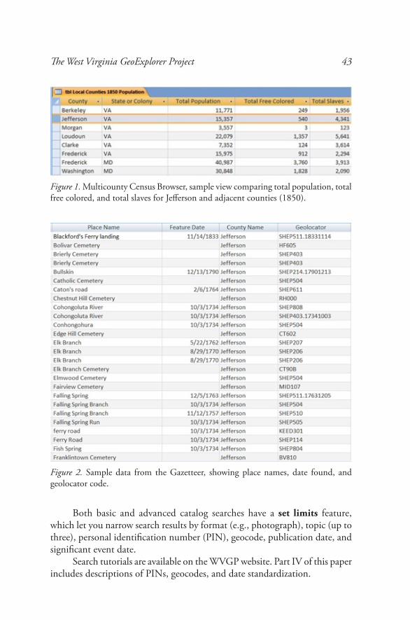
• A multicounty census browser (Figure 1) that compares summa-rized federal census data (1790 to the present) for Jefferson Countyand its neighbors (i.e., Frederick and Loudoun Counties, Virginia;Frederick and Washington Counties, Maryland; and Berkeley andMorgan Counties, West Virginia). This feature will provide localhistory researchers with the context needed to place their findingsin perspective and will encourage them to explore the reasons forperceived similarities and differences.
42 West Virginia History, N.S. 8, No.1, Spring 2014
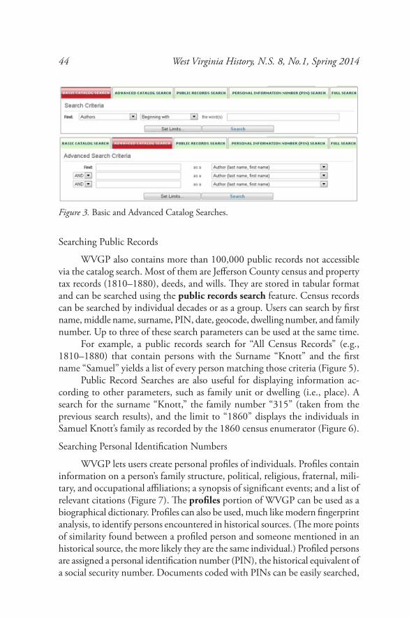
• A gazetteer (Figure 2) of place names linked to the GIS compo-nent and the catalog, providing users with access to location maps, documentary sources, and other relevant information.6
A. The Digital Archive
WVGP seeks to satisfy the historian’s need to confront original sources without traveling to scores of repositories or specialized websites. The archive contains digital facsimiles (pictures) of thousands of maps, wills, deeds, newspapers, and other sources in the public domain or used with the author’s permission. Each item is catalogued individually and can be located using the catalog search feature. The archive currently includes more than 5,000 issues of nineteenth century Jefferson County newspapers and more than 14,000 local photographs dating from 1840 to the present.
In addition to these pictures of documents, the archive contains abstracts and transcriptions of many digital sources. These transcribed materials can be searched in ways that are not available for digital facsimiles. (See Part IV for details.)
Some primary sources, such as census, tax, birth, death, and marriage records, were originally created in tabular form. These materials can be transcribed into database format, allowing the information to be searched, manipulated, and analyzed in a variety of ways. WVGP currently includes a database of Jefferson County Federal Census records from 1810 to 1880. Work is now under way to expand the scope to include later decades and to the other tabular resources just mentioned.
B. The Public Access Catalog (and Other Search Features)
The large digital archive is not very useful unless you can find what you are looking for. Since “you” might be a scholar, an eighth grader, a GIS-savy cartographer, or a genealogist, one of WVGP’s challenges has been to develop finding aids that match users’ needs and comfort levels.
For the historian, WVGP’s public access catalog has many of the features you are used to seeing in the online catalogs offered by academic and public libraries. It currently includes over 50,000 bibliographic records, most of them related to Jefferson County, West Virginia.
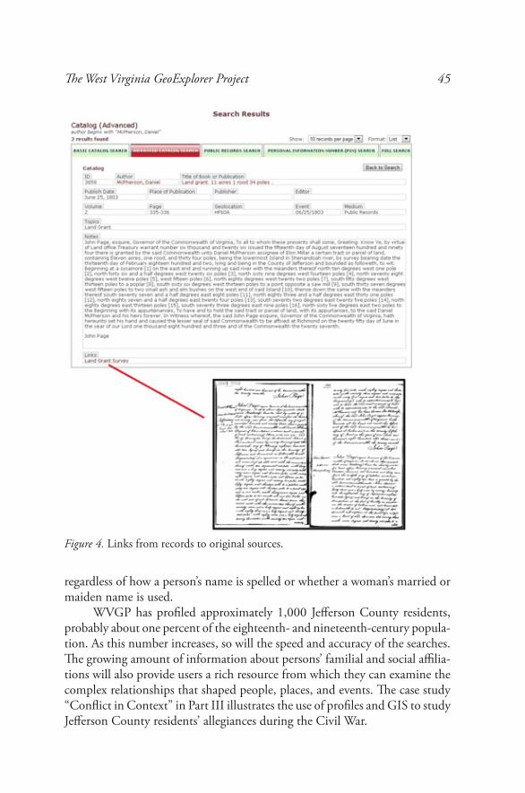
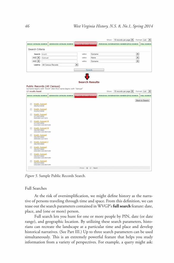
Users can perform catalog searches by clicking the search feature and selecting the basic catalog search or advanced catalog search option (Figure 3). The former allows you to search by author, title/caption, or text. The latter lets you use up to three of these parameters in a single query and is often described as a Boolean search. When facsimiles of original sources are available, search results contain links to these materials (Figure 4).
The West Virginia GeoExplorer Project 43
Both basic and advanced catalog searches have a set limits feature, which let you narrow search results by format (e.g., photograph), topic (up to three), personal identification number (PIN), geocode, publication date, and significant event date.
Search tutorials are available on the WVGP website. Part IV of this paper includes descriptions of PINs, geocodes, and date standardization.
Figure 2. Sample data from the Gazetteer, showing place names, date found, and geolocator code.
Figure 1. Multicounty Census Browser, sample view comparing total population, total free colored, and total slaves for Jefferson and adjacent counties (1850).
44 West Virginia History, N.S. 8, No.1, Spring 2014
Searching Public Records
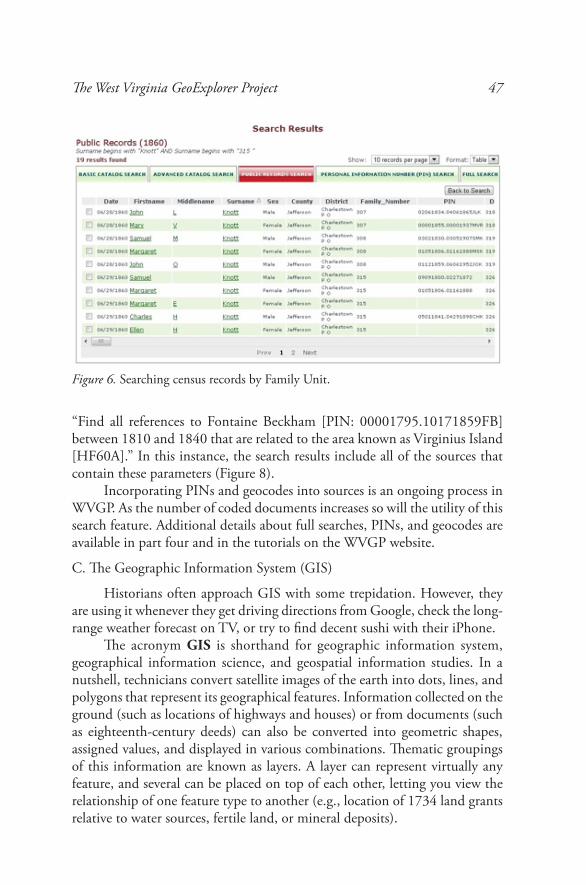
WVGP also contains more than 100,000 public records not accessible via the catalog search. Most of them are Jefferson County census and property tax records (1810–1880), deeds, and wills. They are stored in tabular format and can be searched using the public records search feature. Census records can be searched by individual decades or as a group. Users can search by first name, middle name, surname, PIN, date, geocode, dwelling number, and family number. Up to three of these search parameters can be used at the same time.
For example, a public records search for “All Census Records” (e.g., 1810–1880) that contain persons with the Surname “Knott” and the first name “Samuel” yields a list of every person matching those criteria (Figure 5).
Public Record Searches are also useful for displaying information ac-cording to other parameters, such as family unit or dwelling (i.e., place). A search for the surname “Knott,” the family number “315” (taken from the previous search results), and the limit to “1860” displays the individuals in Samuel Knott’s family as recorded by the 1860 census enumerator (Figure 6).
Searching Personal Identification Numbers
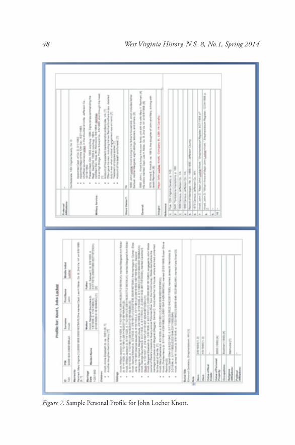
WVGP lets users create personal profiles of individuals. Profiles contain information on a person’s family structure, political, religious, fraternal, mili-tary, and occupational affiliations; a synopsis of significant events; and a list of relevant citations (Figure 7). The profiles portion of WVGP can be used as a biographical dictionary. Profiles can also be used, much like modern fingerprint analysis, to identify persons encountered in historical sources. (The more points of similarity found between a profiled person and someone mentioned in an historical source, the more likely they are the same individual.) Profiled persons are assigned a personal identification number (PIN), the historical equivalent of a social security number. Documents coded with PINs can be easily searched,
Figure 3. Basic and Advanced Catalog Searches.
The West Virginia GeoExplorer Project 45
regardless of how a person’s name is spelled or whether a woman’s married or maiden name is used.
WVGP has profiled approximately 1,000 Jefferson County residents, probably about one percent of the eighteenth- and nineteenth-century popula-tion. As this number increases, so will the speed and accuracy of the searches. The growing amount of information about persons’ familial and social affilia-tions will also provide users a rich resource from which they can examine the complex relationships that shaped people, places, and events. The case study “Conflict in Context” in Part III illustrates the use of profiles and GIS to study Jefferson County residents’ allegiances during the Civil War.
Figure 4. Links from records to original sources.
46 West Virginia History, N.S. 8, No.1, Spring 2014
Full Searches
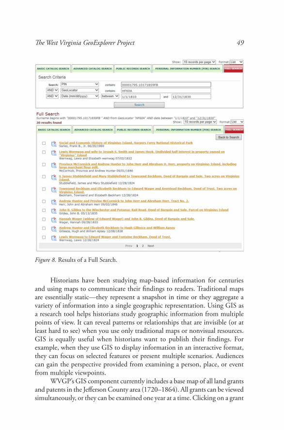
At the risk of oversimplification, we might define history as the narra-tive of persons traveling through time and space. From this definition, we can tease out the search parameters contained in WVGP’s full search feature: date, place, and (one or more) person.
Full search lets you hunt for one or more people by PIN, date (or date range), and geographic location. By utilizing these search parameters, histo-rians can recreate the landscape at a particular time and place and develop historical narratives. (See Part III.) Up to three search parameters can be used simultaneously. This is an extremely powerful feature that helps you study information from a variety of perspectives. For example, a query might ask:
Figure 5. Sample Public Records Search.
The West Virginia GeoExplorer Project 47
“Find all references to Fontaine Beckham [PIN: 00001795.10171859FB] between 1810 and 1840 that are related to the area known as Virginius Island [HF60A].” In this instance, the search results include all of the sources that contain these parameters (Figure 8).
Incorporating PINs and geocodes into sources is an ongoing process in WVGP. As the number of coded documents increases so will the utility of this search feature. Additional details about full searches, PINs, and geocodes are available in part four and in the tutorials on the WVGP website.
C. The Geographic Information System (GIS)
Historians often approach GIS with some trepidation. However, they are using it whenever they get driving directions from Google, check the long-range weather forecast on TV, or try to find decent sushi with their iPhone.
The acronym GIS is shorthand for geographic information system, geographical information science, and geospatial information studies. In a nutshell, technicians convert satellite images of the earth into dots, lines, and polygons that represent its geographical features. Information collected on the ground (such as locations of highways and houses) or from documents (such as eighteenth-century deeds) can also be converted into geometric shapes, assigned values, and displayed in various combinations. Thematic groupings of this information are known as layers. A layer can represent virtually any feature, and several can be placed on top of each other, letting you view the relationship of one feature type to another (e.g., location of 1734 land grants relative to water sources, fertile land, or mineral deposits).
Figure 6. Searching census records by Family Unit.
48 West Virginia History, N.S. 8, No.1, Spring 2014
Figure 7. Sample Personal Profile for John Locher Knott.
The West Virginia GeoExplorer Project 49
Historians have been studying map-based information for centuries and using maps to communicate their findings to readers. Traditional maps are essentially static—they represent a snapshot in time or they aggregate a variety of information into a single geographic representation. Using GIS as a research tool helps historians study geographic information from multiple points of view. It can reveal patterns or relationships that are invisible (or at least hard to see) when you use only traditional maps or nonvisual resources. GIS is equally useful when historians want to publish their findings. For example, when they use GIS to display information in an interactive format, they can focus on selected features or present multiple scenarios. Audiences can gain the perspective provided from examining a person, place, or event from multiple viewpoints.
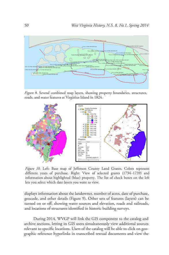
WVGP’s GIS component currently includes a base map of all land grants and patents in the Jefferson County area (1720–1864). All grants can be viewed simultaneously, or they can be examined one year at a time. Clicking on a grant
Figure 8. Results of a Full Search.
50 West Virginia History, N.S. 8, No.1, Spring 2014
displays information about the landowner, number of acres, date of purchase, geocode, and other details (Figure 9). Other sets of features (layers) can be turned on or off, showing water sources and elevation, roads and railroads, and locations of structures identified in historic building surveys.
During 2014, WVGP will link the GIS component to the catalog and archive sections, letting its GIS users simultaneously view additional sources relevant to specific locations. Users of the catalog will be able to click on geo-graphic reference hyperlinks in transcribed textual documents and view the
Figure 10. Left: Base map of Jefferson County Land Grants. Colors represent different years of purchase. Right: View of selected grants (1734–1739) and information about highlighted (blue) property. The list of check boxes on the left lets you select which date layers you want to view.
Figure 9. Several combined map layers, showing property boundaries, structures, roads, and water features at Virginius Island in 1824.
The West Virginia GeoExplorer Project 51
location on GIS maps. Our long-term goal is to link individuals recorded in census records to their residence as recorded in each decennial census, pro-viding a rich resource for demographic analysis of Jefferson County from the antebellum period, through the Civil War, to Reconstruction, and beyond.
A second WVGP map depicts Virginius Island, an industrial site adjacent to Harpers Ferry, West Virginia, that was incorporated in 1825 (Figure 10). Thus far, Shepherd University students have located and transcribed hundreds of newspaper resources mentioning its citizens, its industry, and the floods that shaped the growth, development, and demise of this small town. Several GIS map layers have been created to help historians visualize and understand this location.
A third, recently added map depicts the town of Harpers Ferry, including all of its streets, natural features, and building lots. In the future, we hope to create an interactive map similar to the Philadelphia GeoHistory Network’s Mapping West Philadelphia, 1777 that focuses on John Brown’s 1859 raid on Harpers Ferry. (See note 4.)
III. USING WVGP
To any visitor or resident a landscape is certainly the composite of wood-lands, meadows, fields, waterways, mills, dwellings, barns, fences, roads, streets, courthouses, shops, stores, and so forth. But any landscape . . . is much more than the sum of its parts. Encoded in the landscape is the story of its origins. . . . The social mechanisms of community formation, the developing economies of farming, trade, and manufacture, the tech-nological changes underpinning economic activity, the evolving structures of society, the alterations in the politics of human relations from the local to the national, and the changing roles of religion and ideas in all aspects of life—all are engraved on the land. Reading the land or landscape at any time and place in the past is therefore a way of writing history.
—Warren Hofstra, The Planting of New Virginia (2005)7
The West Virginia GeoExplorer Project includes a variety of tools that you can use to research, re-create, and read a landscape at any time period or geographic location. This section provides several examples of how you can use WVGP as a practitioner of public history.
The Digital Archives
WVGP’s digital archive is intended to provide both professionals and the public with access to the materials they need to re-create and read the histori-cal landscape. It is also designed to help you expand the resources available to meet your information needs.
52 West Virginia History, N.S. 8, No.1, Spring 2014
Materials in the archive are either in the public domain or included with the permission of the authors. They are accessible via the catalog search features described in Part II. You may also contribute digital copies of materials that you, your colleagues, or students utilize in your own projects.
Although WVGP is a collaborative web site containing the collective work of many individuals, it is not open source like a Wikipedia. That is, it does not allow you to directly add, edit, delete, or modify content. All contributions are reviewed before being included. We currently have a memoranda of agree-ment with several collaborating institutions, and individual contributors are providing digital copies and transcriptions of the deeds, wills, and newspaper articles that they are using in their own research.
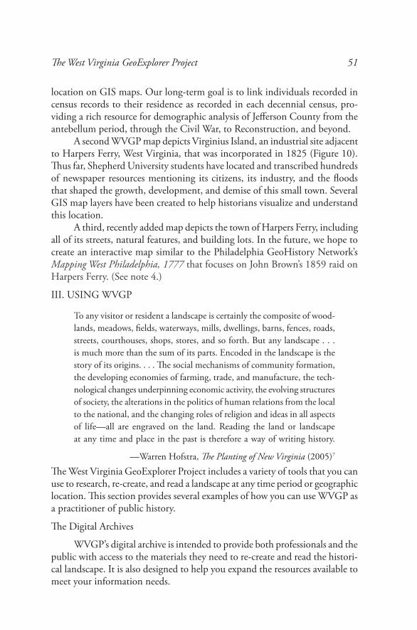
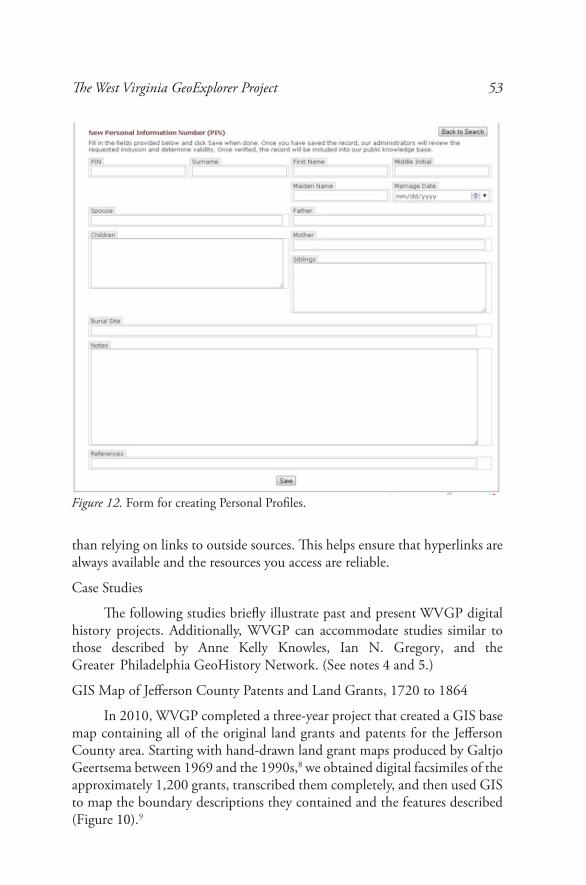
Online forms (currently in testing) will be available early in 2014 for persons wanting to add new catalog entries or personal profiles (Figures 11 and 12).
Digital Editions of Early Publications and Teaching Materials
Although WVGP does not yet include digitally edited and annotated editions of early publications or teaching materials, we expect some to appear in 2014. Authors can create personal profiles to use as biographical sketches, link to digital copies of primary sources, and share peer-reviewed notes on persons, places, and events. WVGP stores its digital materials internally rather
Figure 11. Form for new catalog entries.
The West Virginia GeoExplorer Project 53
than relying on links to outside sources. This helps ensure that hyperlinks are always available and the resources you access are reliable.
Case Studies
The following studies briefly illustrate past and present WVGP digital history projects. Additionally, WVGP can accommodate studies similar to those described by Anne Kelly Knowles, Ian N. Gregory, and the Greater Philadelphia GeoHistory Network. (See notes 4 and 5.)
GIS Map of Jefferson County Patents and Land Grants, 1720 to 1864
In 2010, WVGP completed a three-year project that created a GIS base map containing all of the original land grants and patents for the Jefferson County area. Starting with hand-drawn land grant maps produced by Galtjo Geertsema between 1969 and the 1990s,8 we obtained digital facsimiles of the approximately 1,200 grants, transcribed them completely, and then used GIS to map the boundary descriptions they contained and the features described (Figure 10).9
Figure 12. Form for creating Personal Profiles.
54 West Virginia History, N.S. 8, No.1, Spring 2014
Each land grant has been given a unique geocode that historians can use much like modern researchers use zip codes for demographic analysis. Property subdivisions that fall within the footprint of a specific land grant all bear the same geocode prefix plus a date indicating the year it was created. By incorporating geocodes into historical documents, WVGP helps researchers locate information that falls within this meaningful geographical unit and build a historical landscape. (See Part IV for details.)
After the Flood: How the Great Pumpkin Flood Changed Jefferson County10
The Potomac River forms the boundary line between Maryland and Jefferson County in the Eastern Panhandle of West Virginia. Maryland owns the river up to the West Virginia shore. Throughout the eighteenth and nine-teenth centuries, the Virginia –West Virginia shoreline was considered prime real estate, both for providing access to water transportation and for supplying waterpower to numerous local industries.
During that period, several major floods ravaged the area, causing prop-erty damage and loss of life. Significant events, such as the flood of 1870, received substantial attention from the local and national press, and the exis-tence of several detailed maps of the area have helped historians pinpoint the damage caused by the flood and the events that followed.
Information on eighteenth-century floods in the area is much harder to find. No detailed eighteenth-century map exists, and literature of the pe-riod contains few references to these catastrophes. The great pumpkin flood of October 1753 is a good example. Waters rose so high that they swept off pumpkins that Native Americans had left to dry in the fields well above the Potomac River’s flood plain. Aside from the name of the flood, little contem-porary information appeared to exist.
The GIS Map of Jefferson Patents and Land Grants (Figure 10) and the land records from which it was created helped researchers understand the land acquisition process and parse the language of the documents for clues as to why the flood affected some landowners more than others. The ability of the GIS component to provide a dynamic view of an area through time was just what was needed to discover long lost information about the great pumpkin flood of 1753.
Getting a land grant in mid-eighteenth-century Virginia was a three-step process. First, you obtained a warrant from the property owner (the colony of Virginia or Thomas Lord Fairfax). The warrant gave you permission to obtain a survey in a particular area (e.g., about 400 acres on the west side of the Shenandoah River). Next, you took the warrant to a surveyor and paid him to create a detailed description and map of the desired property boundaries. Finally, you presented the survey to the property owner, paid the appropriate
The West Virginia GeoExplorer Project 55
fee, and received a deed based on the boundary description in the survey. Both warrants and surveys were transferrable, and there was usually a one-year wait-ing period between submitting a survey and receiving a grant. Obtaining a grant could take a little more than a year, but some took more than a decade. The French and Indian War made the process even slower. Meanwhile, the Potomac River continued to flow, indifferent to the activities of the people settled on its banks.
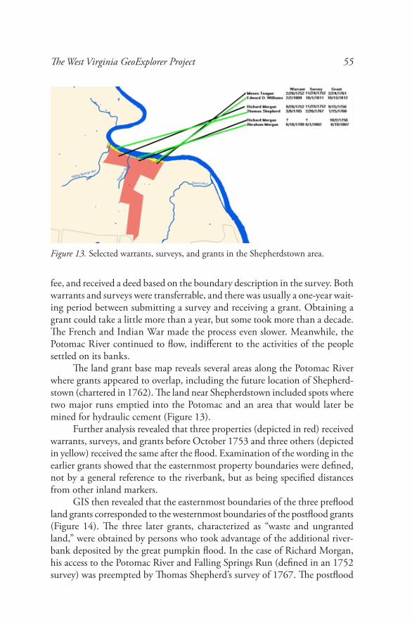
The land grant base map reveals several areas along the Potomac River where grants appeared to overlap, including the future location of Shepherd-stown (chartered in 1762). The land near Shepherdstown included spots where two major runs emptied into the Potomac and an area that would later be mined for hydraulic cement (Figure 13).
Further analysis revealed that three properties (depicted in red) received warrants, surveys, and grants before October 1753 and three others (depicted in yellow) received the same after the flood. Examination of the wording in the earlier grants showed that the easternmost property boundaries were defined, not by a general reference to the riverbank, but as being specified distances from other inland markers.
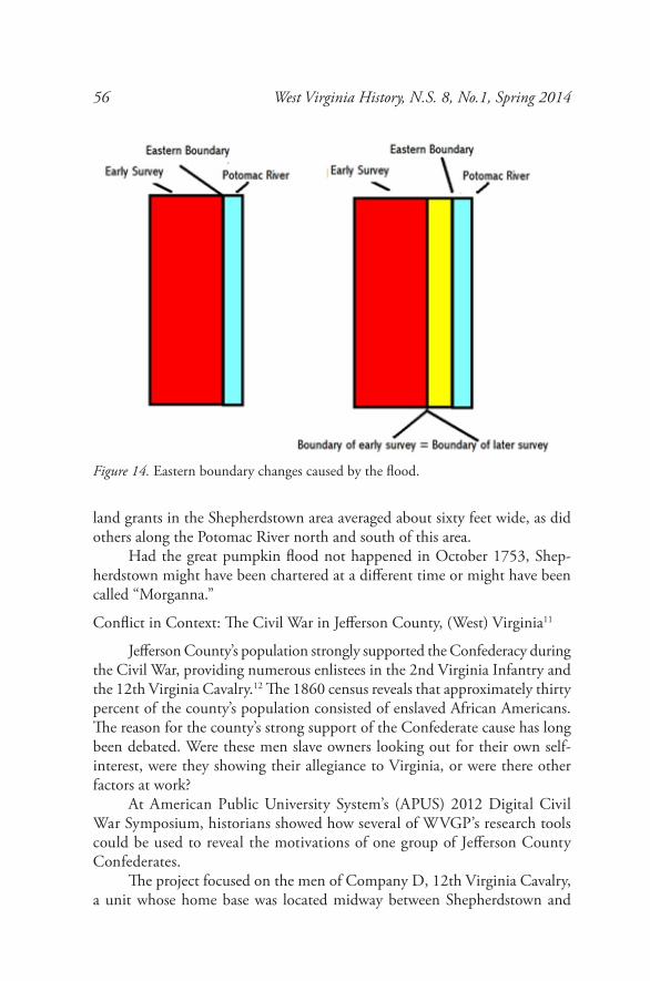
GIS then revealed that the easternmost boundaries of the three preflood land grants corresponded to the westernmost boundaries of the postflood grants (Figure 14). The three later grants, characterized as “waste and ungranted land,” were obtained by persons who took advantage of the additional river-bank deposited by the great pumpkin flood. In the case of Richard Morgan, his access to the Potomac River and Falling Springs Run (defined in an 1752 survey) was preempted by Thomas Shepherd’s survey of 1767. The postflood
Figure 13. Selected warrants, surveys, and grants in the Shepherdstown area.
56 West Virginia History, N.S. 8, No.1, Spring 2014
land grants in the Shepherdstown area averaged about sixty feet wide, as did others along the Potomac River north and south of this area.
Had the great pumpkin flood not happened in October 1753, Shep-herdstown might have been chartered at a different time or might have been called “Morganna.”
Conflict in Context: The Civil War in Jefferson County, (West) Virginia11
Jefferson County’s population strongly supported the Confederacy during the Civil War, providing numerous enlistees in the 2nd Virginia Infantry and the 12th Virginia Cavalry.12 The 1860 census reveals that approximately thirty percent of the county’s population consisted of enslaved African Americans. The reason for the county’s strong support of the Confederate cause has long been debated. Were these men slave owners looking out for their own self-interest, were they showing their allegiance to Virginia, or were there other factors at work?
At American Public University System’s (APUS) 2012 Digital Civil War Symposium, historians showed how several of WVGP’s research tools could be used to reveal the motivations of one group of Jefferson County Confederates.
The project focused on the men of Company D, 12th Virginia Cavalry, a unit whose home base was located midway between Shepherdstown and
Figure 14. Eastern boundary changes caused by the flood.
The West Virginia GeoExplorer Project 57
Harpers Ferry, Virginia. Personal profiles were created on 182 members of Company D, nearly the entire roster throughout the war. Profiles included an individual’s parents, siblings, spouse, and children as well as his political, military, occupational, fraternal, and religious affiliations (Figure 7). Each man was assigned a PIN. Family members were also assigned PINs.
PINs were assigned to selected individuals in WVGP’s digitized census records from 1810 to 1880, the profiles serving to establish identity. The project’s catalog database was also searched and profiles similarly used to assign PINs to sources containing identified persons. As additional sources became available, they were scanned and transcribed and coded with dates, PINs, and geocodes. This process not only helped organize digital resources but also provided numerous parameters that could be used to analyze the information.
Using this approach, WVGP was able to determine where members of Company D and their extended family lived, how they voted, where they worshipped, whom they worked for, and whether they owned real estate and personal property (e.g., slaves).
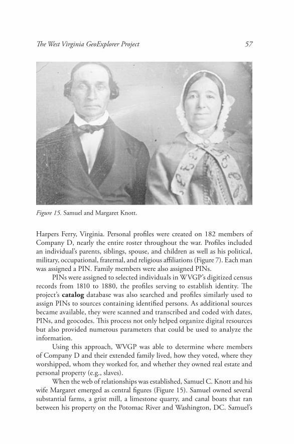
When the web of relationships was established, Samuel C. Knott and his wife Margaret emerged as central figures (Figure 15). Samuel owned several substantial farms, a grist mill, a limestone quarry, and canal boats that ran between his property on the Potomac River and Washington, DC. Samuel’s
Figure 15. Samuel and Margaret Knott.
58 West Virginia History, N.S. 8, No.1, Spring 2014
economic clout was matched by Margaret’s spiritual influence. Considered the “high priestess” of the local Methodist church, she played a significant role in the religious life of the community. The couple were teetotalers and not slave owners, and their five sons and four daughters were married into virtually every important family in the area. Four of their sons enlisted in Company D, including John Locher Knott, who became major of the unit.
Approximately half of Company D’s members enlisted in the field and did not come from Jefferson County. However, more than half of the local enlistees were relatives, tenants, employees, or congregants of Samuel and Margaret Knott. Although a small number of this group did own slaves, Company D’s clan-like social structure (with Samuel and Margaret Knott at the center) appears to have played an important role in their support of the Confederate cause.
Future research into the interrelationships among members of other local infantry and cavalry units should reveal whether they had similar moti-vations, and exploring these relationships through the Reconstruction period and beyond will provide insight into how these men and their families fared after the war.
IV. How It Works
This section describes how WVGP has adapted computer-based search techniques to locate and analyze information in historical sources and should help users interpret the results of their searches.
You have probably tuned into TV programs in which crime-fighting heroes track the bad guys’ every move, delve into their public and private records, and analyze mountains of data to determine what criminals have done (or plan to do). Although TV programs tend to downplay the limita-tions of such techniques, the techniques can yield significant results. Such knowledge is possible because modern, electronic records often contain codes that identify individuals, dates, and locations and simplify computerized data analysis.
Although these modern data collection and analytical techniques can be applied to historical sources, researchers must first overcome the problem of ambiguity. WVGP has developed several data-coding techniques that can be used to facilitate the search and retrieval of information in historical sources and the analysis of results. These codes can be added as fields in the database and in the GIS, and they can be incorporated into textual materials via digital annotation.
The West Virginia GeoExplorer Project 59
Personal Names
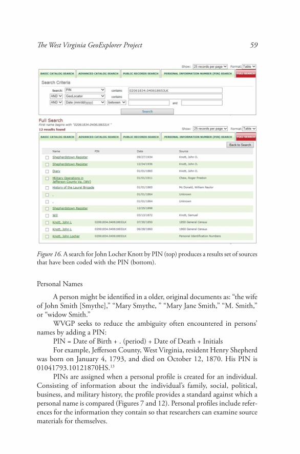
A person might be identified in a older, original documents as: “the wife of John Smith [Smythe],” “Mary Smythe, ” “Mary Jane Smith,” “M. Smith,” or “widow Smith.”
WVGP seeks to reduce the ambiguity often encountered in persons’ names by adding a PIN:
PIN = Date of Birth + . (period) + Date of Death + InitialsFor example, Jefferson County, West Virginia, resident Henry Shepherd
was born on January 4, 1793, and died on October 12, 1870. His PIN is 01041793.10121870HS.13
PINs are assigned when a personal profile is created for an individual. Consisting of information about the individual’s family, social, political, business, and military history, the profile provides a standard against which a personal name is compared (Figures 7 and 12). Personal profiles include refer-ences for the information they contain so that researchers can examine source materials for themselves.
Figure 16. A search for John Locher Knott by PIN (top) produces a results set of sources that have been coded with the PIN (bottom).
60 West Virginia History, N.S. 8, No.1, Spring 2014
When PINs are added to digitized census records, a single PIN search will display relevant data in numerous sources (Figure 16).
Locations
For historians trying to re-create a historic landscape, place names can pose a challenge. Locations in older original sources often include ambigu-ous references such as “on the old Smith place” or “fifty shoots of an arrow northeast of his cabin.” Names for the same location may change over time, reflecting new ownership or altered geographic features. Modern designations for the same site frequently are written in numerical codes (e.g., zip codes or longitude and latitude), meaningful only to persons with specialized knowledge or willing to consult a reference. Even modern addresses can be awkward to use and can change over time.
WVGP seeks to reduce such geographic ambiguity by creating geocodes that designate the original (parent) properties and by assigning them to GIS
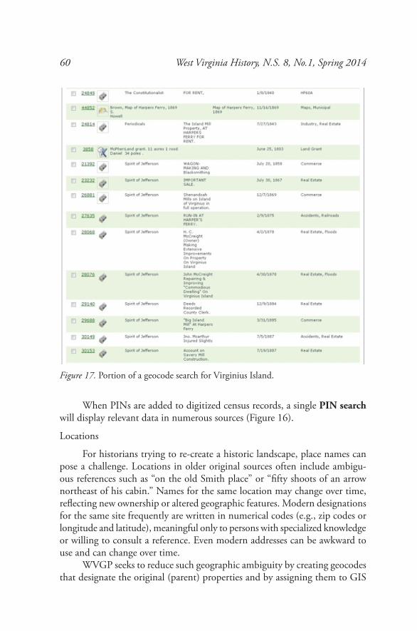
Figure 17. Portion of a geocode search for Virginius Island.
The West Virginia GeoExplorer Project 61
maps, data tables, and text.The historical equivalent of zip codes, geocodes, can be used to identify
a specific location at a unique point in time, making them valuable additions to both relational databases and to tables underlying GIS maps. The codes can be inserted into textual web documents as invisible codes (HTML comments) or into census records as separate fields. When present, they enable researchers to perform detailed demographic analyses derived from historical information, much as those performed on modern data.14
Historians can use geocodes to create a chronological chain of property ownership and features (the geographical equivalent of a family tree). With this resource, they can re-create an historical landscape and narrative. For example, Figure 17 illustrates part of the search results for the geocode for Virginius Island. These results can be sorted by time to produce a timeline for a specific area.
Dates
Dates in historical documents are frequently presented in relative terms or in nonstandard format, such as “the cabin burned three days after her hus-band died” or “he died on the 21st day of October one thousand seventeen hundred and eighty at the age of seventy years, four months, and thirteen days.” Research can often determine when an event actually occurred, and text can be encoded with dates translated into standardized format to facilitate searching and analysis. Date fields can be easily added to GIS and database tables to add precision.
The most dramatic improvements in search capability occur in searches of encoded text. Transcribed sources (deeds, newspaper articles, etc.) are first coded in HTML format and then specific information about persons, dates, and locations is inserted in comment fields as needed.
For example, a newspaper article might appear to the web viewer in this format: “Suspicious character James Lynch appeared at Harpers Ferry Saturday last. He called at the residence of Harpers Ferry Armory Superintendent Col. Barbour and requested an interview. . . . “
The digitally annotated, searchable version (not visible to the reader) would appear like this:
<p>”Suspicious character James Lynch <!-- PIN: 04051829.12241862JL --> appeared at Harpers Ferry Saturday last<!-- Date: October 1, 1859 --> . He called at the residence <!-- GEO: HF605.01021858 --> of Harpers Ferry Armory Superintendent Col. Barbour <!-- PIN: 04171829.04041866AB --> and requested an interview....”</p>
62 West Virginia History, N.S. 8, No.1, Spring 2014
Coding takes time, requires some expertise, and may be impractical for a database that encompasses a very wide area. WVGP approaches these issues by recruiting persons (e.g., genealogists, college students, and scholars) who are comfortable performing these tasks, and it prioritizes data coding on a project-by-project basis. For example, the project to study Virginius Island near Harpers Ferry is coding sources relevant to that effort. This data will be added to WVGP and be available for other research efforts.
V. Conclusion
The West Virginia GeoExplorer Program is ready for public historians to use as a tool to meet their own research needs.
WVGP’s conceptual model has been developed and its components populated with data, primarily from Jefferson County, West Virginia. The linkage of the various project parts has been tested and additional program-ming is underway to make the pieces fit together. We expect this work to be completed in 2014.
WVGP can be readily expanded to accommodate additional counties and the entire state. This expansion will give residents greater access to informa-tion about their heritage and will help them explore the dynamic relationship between our natural and cultural landscapes. Future goals include:• Incorporating additional information on Jefferson County and
exploring potential uses for this dense, richly indexed resource;
• Partnering with universities, libraries, and governmental agencies in other parts of West Virginia to create additional, local project nodes;
• Linking these local nodes to share information and skills, makingWVGP a truly statewide resource and a model for other areas.
This project was conceived to be a collaborative effort. Collaboration will pose challenges of its own, and new working relationships must be forged for WVGP to reach its full potential.
Notes
1 The West Virginia GeoExplorer website is located at www.wvgeohistory.org. Dr. Anne Knowles, associate professor of geography at Middlebury College, served as keynote speaker. Other speakers included Shepherd University professors Dr. Keith Alexander, coordinator of the historic preservation program and principal investigator for the project; Dr. Ann Legreid, dean of the School of Business and Social Sciences; and Dr. Julia Sandy-Bailey, assistant professor of history. They were joined by Dr. William D. Theriault, Ms. Victoria Myers, and Ms. Christine Toms.
The West Virginia GeoExplorer Project 63
WVGP was founded by William D. Theriault and is sponsored by the Jefferson County, West Virginia, Historic Landmarks Commission, a branch of the county government. The project is intended to be a collaborative effort of West Virginia institutions and individual volunteers who wish to explore West Virginia history using digital resources.Organizations supporting the project currently include Shepherd University, Jefferson County Emergency Services Department, Jefferson County Planning Commission, Jefferson County Assessor’s and Mapping Offices, Harpers Ferry National Historic Park, Harpers Ferry Historical Association, Historic Harpers Ferry, The Town of Harpers Ferry, The Middleway Conservancy, The Charles Town Historic Landmarks Commission, The Jefferson County Historical Society, The Berkeley County Historical Society, and American Public University System.
2 For example, if you wanted to examine the deeds related to your property, from the earliest parcel to the present, your journey would take you to Richmond; Charleston, West Virginia; and Morgantown, as well as the court houses in Orange and Frederick Counties, Virginia, and Berkeley and Jefferson Counties, West Virginia.
3 Hypertext is accentuated text, normally colored and underlined, that is displayed on a computer screen. Clicking the highlighted text with a mouse opens another display window, providing a view of additional information.
4 The Philadelphia GeoHistory Project has grown into the Greater Philadelphia GeoHistory Network (www.philageohistory.org) under the direction of the Philadelphia Area Consortium of Special Collections Libraries. This project includes a resource browser, an interactive maps viewer, and other resources. One of its most recent endeavors, Mapping West Philadelphia, 1777 (http://www.archives.upenn.edu/WestPhila1777/map.php) utilized information from deed books and other primary sources to produce an interactive map re-creating land ownership in the surrounding area at the time of the American Revolution.
5 Knowles’s book, Past Time, Past Place, includes her own introduction to historical GIS and a glossary of GIS terms, both indispensable resources for novices. It also contains articles by other authors who use GIS as a tool to conduct research and present their findings. Some of the topics explored by these authors include:• Did the place where people lived determine whether they were accused or
accusers in Salem?• Does detailed information about the location of businesses, farms, and
voters on a local level reveal the causes of the Civil War?• What do the location and distribution of farming and dust storms tell us
about how the Dust Bowl of the 1930s was created?• How can we visualize battlefield conditions of the Civil War?Knowles’s subsequent anthology, Placing History (2008), provides additional case studies and a digital supplement on CD.
64 West Virginia History, N.S. 8, No.1, Spring 2014
6 Both the census browser and the gazetteer can be expanded to include information from other counties.
7 Warren R. Hofstra, The Planting of New Virginia: Settlement and Landscape in the Shenandoah Valley (Creating the North American Landscape) (Baltimore: Johns Hopkins University Press, 2005), p. 51.
8 Galtjo L. Geertsema, Cadastral Index Maps of Berkeley, Jefferson, and Morgan Counties, West Virginia, and Other Sections of Old Frederick County, Virginia (Martinsburg, WV: privately printed, 1969–1995), pp. 1-8.
9 The land grants spanned a period from about 1720 to the Civil War. While the 1969 to 1990 maps provided a static view of all the grants in a one-hundred-and-forty-year period, the GIS versions allow you to examine land acquisition year by year, isolate the holdings of an individual over time, and explore the relationship between land acquisition and natural resources such as water, soil fertility, and elevation. The names of places and features included in these grants and in later property transactions have been extracted from these sources and matched with their geocodes to create a gazetteer (available in 2014).
10 William D. Theriault, “After the Flood: How the Great Pumpkin Flood Changed Jefferson County” (lecture, Shepherd University, WVGP Symposium, Shepherdstown, WV, October 29, 2011).
11 Donald Watts and William D. Theriault, “Conflict in Context: The Civil War in Jefferson County, (West) Virginia” (lecture, American Public University System’s Symposium: Civil War Studies and the Digital (R)Evolution, Charles Town, WV, March 30, 2012).
12 See Dennis E. Frye, 12th Virginia Cavalry (Lynchburg, Va.: H.E. Howard, Inc., 1988), and 2nd Virginia Infantry (Lynchburg, Va.: H.E. Howard, Inc., 1984).
13 PINs do not need to be composed of birth and death dates. They just need to be unique. However, date-based PINs help users locate relevant search results: for example, information containing events that fall within the lifespan of the individual.
14 Example: The code HF60A.05251803 is made up of several components: 1) The US Geological Survey map quadrangle (HF); 2) a unique number that identifies the land grant within that quadrangle (60A); and 3) the date on which the grant was recorded (May 25, 1803). In addition to searching by geocode, users can search by the name of the property owner, recording date, USGS quadrangle, or any combination.Virginia land records are inherently ambiguous for a variety of reasons, including recording and transcription errors by the surveyor or the land records clerk, the experience of the surveyor, differences in surveying tools used and the wear and tear to which they were subjected, or less often fraud or negligence. The boundaries of the land records depicted in the GIS component of the project reflect these original ambiguities and may contain property boundaries that overlap or fail to meet precisely. In general, these ambiguities were resolved over time through resurvey, litigation, or legislation. As we
The West Virginia GeoExplorer Project 65
encounter documents that attempt to resolve these ambiguities, they will be added to the GIS component.WVGP uses geocodes because we believe that referencing the “parent” property is similar to a technique used by landowners who reference their ancestry to establish their own identity. Furthermore, eighteenth- and nineteenth-century property transactions are more often subdivisions of an original property than a recombinations of several original grants. The subdivisions usually contain references to the original property boundaries and are therefore useful in determining the general location of a property. WVGP provides for the additional use of longitude and latitude coordinates and uses them primarily where modern surveys or archeological investigations have identified specific features at specific locations.
