exploration and development as on 09.10.2019(1).pmd
TRANSCRIPT
4-1
EXPLORATION & DEVELOPMENT
Indian Minerals Yearbook 2018 (Part- I : GENERAL REVIEWS)
57th Edition
EXPLORATION AND DEVELOPMENT
(FINAL RELEASE)
GOVERNMENT OF INDIA
MINISTRY OF MINES
INDIAN BUREAU OF MINES
Indira Bhavan, Civil Lines,
NAGPUR – 440 102
PHONE/FAX NO. +91712 – 2565471,2562216
PBX : +91712 - 2562649, 2560544, 2560648
E-MAIL : [email protected] Website: www.ibm.gov.in
February, 2020
4-2
EXPLORATION & DEVELOPMENT
4 Exploration & Development
NATIONAL MINERAL POLICY
The Hon'ble Supreme Court in its judgement
dated 2.8.2017 in the Writ Petition (Civil ) No.114
of 2014 inter alia directed the Union of India to
revisit the National Mineral Policy (NMP), 2008
and announce a fresh and more effective and
meaningful policy.
In compliance with the directions of the Hon'ble
Supreme Court, Ministry of Mines (MoM) vide its
Order No. 15/1/2017-MV dated 14.08.2017 had
constituted a Committee.
The Committee included representatives from
Central Ministries, State Governments, Industry
Associates, Professional Bodies and it also
consulted NGOs and many other Stakeholders. The
Committee went about the cosultative process with
problem-solving approach and held four meetings
wherein exhaustive discussions on the issues raised
by the stakeholders were deliberated.
The Committee submitted its report to the
Ministry on 31.12.2017. Based on the report
submitted by the committee, Ministry of Mines
prepared a draft National Mineral Policy (NMP), 2018
and uploaded it on the official website of the Ministry
on 10.01.2018 for seeking comments/suggestions
from the stakeholders.
Based on the Committee Report and the inputs
received from stakeholders during subsequent
consultations, the Ministry of Mines prepared the
National Mineral Policy 2019. The Union Cabinet in
its meeting held on 28.02.2019 approved the
“National Mineral Policy 2019”. The salient features
of the “National Mineral Policy 2019” are as follows:
• It proposes to increase the production of
major minerals by 200% in 7 years. It also
proposes to reduce trade deficit in mineral
sector by 50% in 7 years.
• It aims to attract private investment
through incentives like financial package,
right of first refusal at the time of auction etc.
or any other appropriate incentive as per
international practice.
• Introduces the concept of Exclusive Mining
Zones having in-principle statutory
clearances for grant of mining lease. It also
proposes to identify crit ically fragile
ecosystem and declare such areas as ‘no-go
areas’/inviolate areas.
• It emphasises implementation of all relevant
Acts/Rules related to rehabili tation &
resettlement and welfare of tribal communities
while grant of mineral concessions.
• Encourages states to auction mineral blocks
with pre-embedded statutory clearances.
• To institutionalise the mechanism for ensuring
sustainable growth of Mining Sector an inter-
ministerial body is proposed.
• Endeavors shall also be made to grant mining
the status of Industry.
• In case of small deposits of precious metals
and base metals, the establishment of common
smelting and refining facilities shall be
encouraged.
• It seeks to align downstream regulations for
the exploration, development and acquisition
of overseas mineral assets for ensuring its
adequate supply which are not available in
the country.
• It focuses on a long term export-import policy
for the Mineral Sector to provide stability for
investing in large scale commercial mining
activity.
• Efforts shall be made to benchmark and
harmonize royalty and all other levies and
taxes with mining jurisdiction across the world.
• It also introduces the concept of Inter-
Generational Equity which is also recognised
by the Hon’ble Supreme Court in various
judgments.
The complete report of NMP-2019 is given in
the review on 'Mineral Policy and Legislation' in
''General Reviews'.
4-3
EXPLORATION & DEVELOPMENT
ORGANISATIONS INVOLVED
GSI, DGMs of various States, Public Sector
companies like NMDC, MECL, MOIL, etc., continued
their efforts in respect of surveying, mapping and
exploration of new deposits and re-assessment of
old deposits/mines during 2017-18.
The Oil and Natural Gas Corporation (ONGC)
and Oil India Limited (OIL), the two National Oil
Companies (NOC) and a few private and joint
venture companies were engaged in exploration and
production activities of oil and natural gas, including
Coal-bed Methane in the country.
IBM
Indian Bureau of Mines (IBM), as a facilitator
to the Mineral Industry, provides technical
consultancy services for conducting feasibility
studies, environment impact assessments,
environment management plans, etc; to play
the role of National Repository of mineral data
through maintaining a data bank of mines and
minerals by developing advanced IT based
Mineral Information System; carries out mining
research project on need-based aspects of mining;
conducts mineral beneficiation studies, including
mineralogical testing and chemical analysis
and prepares mineral maps.
During 2017-18 (up to September, 2017),
98 multi - mineral lease hold maps on a scale of
1:50,000, with corresponding forest overlays
in respect of various states were under finalisation.
To encourage value addition and mineral
conservation, IBM carried out 2,425 ore dressing
investigations, 21,092 chemical analysis, 1,254
mineralogical examinations and 5 in-plant study.
The Project on Mining Surveillance System
(MSS) was undertaken by the Indian Bureau of
Mines, Ministry of Mines and BISAG
(Bhaskaracharya Institute for Space Applications
and Geo-informatics) of Ministry of Electronics and
Information Technology (MEITY) to develop a
system for detection of incidence of illegal mining
by use of space technology and Surveillance of area
up to 500 m outside the lease boundary to check
incidences of illegal mining.
IBM undertakes preparation of National
Inventory of mineral resources on a quinquennial
basis. Under this programme, implementation of
UNFC system was adopted in 2002 replacing the
earlier resource classification based on Indian
system. Subsequently, NMI as on 1.4.2005 and
1.4.2010 were updated and updating of NMI as on
1.4.2015 was completed for all 71 minerals including
25 minor minerals. Mineral wise chapters in respect
of 71 minerals for “NMI:An Overview (As on
01.04.2015)" were prepared and uploaded on IBM
web portal as a part of dissemination of information
on resources of minerals in the country.
GSI
GSI pursued its most fundamental and basic
mapping programme of systematic geological
mapping in 2017-18 and had completed 9960.51
sq. km large-scale mapping, 112.3 sq. km detailed
mapping and 1,29,710 m drilling as against previous
year's achievement of 8043.10 sq. km large-scale
mapping, 145.63 sq. km detailed mapping and
1,39,071.98 m drilling. Out of the total mappable areas
of 3.146 million sq. km of the country, 3.119 million
sq. km has been covered so far by systematic
mapping bringing the total coverage to 99.14%.
Resources Established
Resources augmented by GSI during 2017-18 are
given below:
i) A total resource of 113.53 million tonnes high
grade iron ore (including 12.71 million tonnes
low grade) has been estimated in Gandhalpada
South-East, Part -B, Kendujhar district, Odisha.
ii) A total resource of 13.34 million tonnes of low
grade iron ore (including 2.88 million tonnes
high grade) has been estimated in Jhumka-
Pathiriposhi, west block, Sundargarh district,
Odisha.
iii) Iron ore resource of 16.20 million tonnes of high
grade (including 1.13 million tonnes low grade)
has been established in Rengalabehra North-
East extension block in Kendujhar district,
Odisha.
iv) Estimated iron ore resources in Gandhalpada
South block, Kendujhar district, Odisha is 61.72
million tonnes at >45% Fe cut-off.
v) Estimated a net 361.909 million tonnes of
limestone resources in Umkyrpong area, Litang
Valley, East Jaintia Hills district, Meghalaya.

4-4
EXPLORATION & DEVELOPMENT
vi) Estimated 289.269 million tonnes of cement grade
limestone resources in Samasi-Pala block, Litang
Valley, East Jaintia Hills district, Meghalaya.
vii) Estimated 630.02 million tonnes of blendable/
beneficiable/portland cement grade limestone
resources in East of Laphet area, Litang Valley,
East Jaintia Hills district, Meghalaya.
Marine and Coastal Survey
Marine Survey
GSI continued its offshore geoscientific studies
both in Exclusive Economic Zone (EEZ) and Territorial
Waters (TW) of India. Survey in the near-shore
zones i.e. 0 m to 10 m isobaths were carried out using
hired mechanical boats.
Marine and Coastal Survey Division (M&CSD)
has completed seabed mapping of 1,32,585 sq. km
out of 1,50,000 sq. km in 5 km × 2 km grid within
Territorial Water and 18,42,552 sq. km out of 18,64,900
sq. km in the Exclusive Economic Zone beyond
Territorial Waters on reconnaissance scale. Total
EEZ coverage including TW is 19,99,784 sq. km out
of a total EEZ area of 20,14,900 sq. km. During field
session 2017-18, R.V. Samudra Ratnakar carried out
56,130 sq. km of multibeam bathymetry. Seabed
survey of an area of 6,650 sq. km utilising coastal
launch RV Samudra Shaudhikama in the areas off
Gujarat and 1,295 sq. km in contiguous zone off Kerala
were completed besides other parametric surveys. A
total of 854 LKM of multichannel seismic survey was
also carried out. Nine cruises onboard of RV Samudra
Ratnakar including one spill over previous field
session, seven cruises onboard of RV Samudra
Kaustubh and RV Samudra Shaudhikama each,
besides three coastal survey items and one RP item
were taken up during 2017-18.
The following marine geoscientific surveys were
carried out during 2017-18 field season:
R.V. Samudra Ratnakar
1. SR-026 (Spill over): Study of tectonic setup of
Bay of Bengal and Andaman-Nicobar subduction
complex within EEZ of India by systematic
multi-channel seismic survey.
2. SR-031: Gas Hydrate investigation in Andaman
Sea.
3. SR-032: Search for REY (Rare Earth Elements &
Yttrium) in ferromanganese crust on the
submerged ridges and surface/subsurface
sediments east of Chetlat Island around
Lakshadweep Group of Islands, Arabian Sea.
4. SR-033: Preliminary search for phosphorite over
sea mount (Calicut Mt.) off Calicut, Kerala.
5. SR-034: Preliminary assessment of lime mud in
the continental margin off Gujarat (Block IV).
6. SR-036: Preliminary assessment of lime mud in
the continental margin off Gujarat (Block V).
7. SR-037: Swath bathymetric survey of the middle
fan segment of Bengal Fan within the EEZ off
Pentakota to Pudimadaka, Andhra Pradesh.
8. SR-038: Study of morphological and tectonic set
up along with Geology of Andaman Sea within
EEZ of India.
9. SR-039: Investigation for Rare Earth Elements &
Yttrium (REY) in the Fe-Mn crust in the southern
Part of the West Sewell Ridge.
RV Samudra Kaustubh
1. ST-259: Systematic shallow seismic surveys
within the territorial waters in the shelf area off
Dalhousie Island (Sunderban Delta), West
Bengal.
2. ST-260: Systematic shallow seismic surveys
within the territorial waters in the shelf area north
of Shortt’s Island, Odisha.
3. ST-262: Geophysical (Seismic) Survey within the
Territorial Waters off Gangapatnam, Andhra
Pradesh Coast, Bay of Bengal.
4. ST-263: Geophysical (Seismic) Surveys within
the Territorial Waters off Ongole, Andhra
Pradesh Coast, Bay of Bengal.
5. ST-258: Placer mineral and construction grade
Sand resources evaluation in the Territorial
waters, off Bheemunipatnam, Andhra Pradesh.
6. ST-261: Placer mineral resource evaluation in the
territorial waters off Behuda River Mouth,
Odisha.
7. ST-264: Search for both REE and Placer Mineral
resource in the shelf area off Vedaranyam,
Nagapattinam District, Tamil Nadu.
RV Samudra Shaudhikama
1. SD-276: Multi thematic mapping of Contiguous
Zone by geological and geophysical surveys
beyond Territorial Waters in Arabian Sea off
Thiruvanthapuram, Kerala.
4-5
EXPLORATION & DEVELOPMENT
2. SD-277: Mapping of the seabed off Jakhau,
Gujarat.
3. SD-278: Seabed mapping off Jhanjhmer,
Gujarat (Block-IV) beyond TW of India.
4. SD-279: Seabed mapping off Alang, Gujarat
(Block - V) beyond TW of India.
5. SD-280: Seabed mapping off Valsad, Gujarat
(Block-VI) beyond TW of India.
6. SD-281: Evaluation of Heavy Mineral resources
in marine sediments off Alang, Gujarat (Block 1).
7 . SD-282: Mul t i themat ic mapping of
Contiguous Zone beyond Territorial Water in
Arabian Sea off Kazhakuttam, Kerala.
Airborne Geophysical Survey
GSI pursued airborne geophysical survey for
generating database by employing magnetic and
raiometric techniques through Twin Otter Airborne
Survey System (TOASS). The survey was
followed by data processing, preparation of
aerogeophysical maps and interpretations that
help in ground evaluation and add information to
geological maps and would aid prospecting and
exploration for minerals. The data from the aerial
surveys thus form an important backup for refining
the geological understanding of an area, with
focus on identification of favourable locales of
mineralisation, crustal structure, etc.
During 2017-18, the airborne magnetic and
rad iomet r ic surveys da ta p rocess ing and
interpretation over Alwar-Neem Ka Thana area in
parts of Rajasthan, Haryana & Uttar Pradesh was
in various stage of process. The study of this area
was proposed for two field session i.e. 2016-18.
The significant anomalies noticed in the area are:
i) Magnetic anomalies of high frequencies along
NE-SW occurring towards south of Dudu over the
alluvium covered areas, appear to be due to the
extension of causative sources of Archaean i.e.,
Bhilwara Supergroup (BSG) comprising Sandmata
and Mangalwar Complex, ii) broad anomalies of
low frequencies over the alluvium covered areas
towards northeast of Dudu corresponding to
deeper causative sources appear to indicate
deeper basement features and iii) the anomalies
of high frequencies with NE-SW trends observed
towards nor thern par t o f the a rea a round
Shahpura, north of Duasa, west of Alwar and
south of Narnaul indicating causative sources of
shallower nature appear to be associated with the
folded structures of Alwar basin, where several
base metal prospects have been reported.
MECL
The highlights of exploration carried out by
MECL during 2017-18 are given below:
i) The company has carried out 6.32 lakh metre
of exploratory drilling for various minerals,
out of which 5.12 lakh metre was through
departmental resources and 1.19 lakh metre
from outsourcing.
ii) A total of 215 sq. km area has been covered
with detailed geological mapping for various
minerals in different parts of the country.
In addition to this about 3,447 sq. km of
regional geological mapping has also been
carried out in various minerals block explored
through NMET funding and also carried out
3.53 lakh metre of geophysical logging.
iii) In laboratories, a total of 85,614 samples were
ana lysed for chemica l ana lys i s and
mineralogical analysis and petrographic
studies.
iv ) A to ta l o f 63 geologica l repor t s o f
detailed exploration, geophysical survey,
environmental & remote sensing studies for
different minerals were submitted which led
to addition of 2,656 million tonnes of mineral
resources.
v) During 2017-18, a total of 2,656 million tonnes
of mineral resources were es tabl ished.
Mineral-wise details of resources estimated
by MECL are as under:
• Coal - A total of 1,037.73 million tonnes of
coa l resources were es tab l i shed in
Godavar i va l ley, Jhar ia , Sonha t &
Singraul i Coal f ie ld in the s ta tes of
Telangana, Jharkhand, Chhattisgarh &
Madhya Pradesh.
• Lignite - 672.25 million tonnes of lignite
resources were established in Rajasthan
& Tamil Nadu.
• Iron Ore - 136.74 million tonnes of iron
ore resources were established in Sandur
Schist Belt, & Chitradurga Schist belt,
Karnataka; Sundargarh, Odisha; and
Purbanera belt, Rajasthan.
4-6
EXPLORATION & DEVELOPMENT
• Copper - 36.32 million tonnes of copper
resources were established in Singhbhum,
Jharkhand.
• Molybdenum - 5.65 million tonnes of
molybdenum resources established in
Harur-Uttangarai belt, Tamil Nadu.
• Gold - 32.262 million tonnes of gold ore
resources were established in KGF,
Karnataka.
• Limestone - 700.93 million tonnes of
limestone resources were established in
Palnadu basin in Telangana, Bilaspur in
Chhattisgarh and Satna in Madhya Pradesh.
• Manganese ore - 0.29 million tonnes of
manganese ore resources were established
in Mandri Panchala, Bhandara,
Maharashtra.
• Bauxite - 33.29 million tonnes of bauxite
Chhattisgarh.
MINERAL-WISE EXPLORATIONACTIVITIES
Petroleum and Natural Gas
A number of new initiatives have been taken to
promote Exploration and Production activities in the
country. A multidimensional approach has been
adopted for furthering the objective of enhancing
energy security of the country through increased
domestic production and improved investment
climate in the country. Some of the policy initiatives
taken by the Government for exploration and
development of oil and gas in the country are as
under:
The operator can explore and produce
conventional as well as unconventional hydrocarbon
such as Coal Bed Methane (CBM), Shale etc under a
single license.
Opening up of India’s sedimentary basins
through open acreage policy will provide option for
the companies for selection of Exploration blocks.
They will also not be required to wait till the formal
bid round is launched by the government as the open
acreage area will be available throughout the year
for bidding.
Exploration will be allowed through out the
contract period. One of the major restrictions under
Production Sharing Contract (PSC) was regarding
exploration after the completion of exploration phase.
The Hydrocarbon Exploration Licencing Policy (HELP)
addresses the same and allows exploration throughout
the contract period.
Exploration Phase for onshore areas have been
increased from 7 years to 8 years and for offshore
increased from 8 years to 10 years.
As part of the Government’s effort to increase
domestic production, Discovered Small Field (DSF)
Policy was introduced for fast-tracking the
monetisation of un-monetised small fields/ discoveries
of Nationa Oil Companies (NOCs) under Nomination
regime and relinquished discoveries under the PSC
regime. Some of the notable features of DSF bid in
addition to HELP features are: (i) No prior technical
experience required enabling ease of entry for non-
E&P players; (ii) No upfront bonus; (iii) Exploration
allowed during the entire contract period; and (iv)
Ready availability of nearby processing facilities. DSF
Bid round-I was launched in 2016 which was a roaring
success. Seeing the success of DSF round I, DSF
round-II was launched in 2018 with 59 discoveries on
offer with an in-place volume of 190 million tonnes of
oil and oil equivalent gas.
During the year 2017-18, ONGC has made 12
discoveries (5 new prospects and 7 new pools).
The major success was an Oil discovery from well
WO-24-3 (WO-24-C) which has indicated potential of
about 29.74 MMtoe of In-place Hydrocarbon Volume
in the discovery area and the discovery is under further
assessment through appraisal exploratory efforts.
During 2017-18, cumulative of 11,65,996 LKM of
2D seismic and 3,03,673 SKM of 3D seismic have
been acquired and 6,766 exploratory wells have been
drilled by PSUs. Indian private Exploration &
Production companies (E & P) acquired a cumulative
of 1,28,944 LKM of 2D seismic and 1,09,471 SKM of
3D seismic data and drilled 367 exploration wells.
Foreign companies have carried out 64,790 LKM of
2D seismic survey, 22,143 SKM of 3D seismic survey
and drilled 249 exploration wells.
Ultimate reserves of oil and oil equivalent of gas
(O+OEG) established by ONGC, OIL and Pvt./JVs
under PSC and CBM regime as on 31.03.2018 are placed
at 4203.64 million metric tonnes. During 2017-18,
accretion in ultimate reserve has been 108.76 million
metric tonnes of O+OEG.
4-7
EXPLORATION & DEVELOPMENT
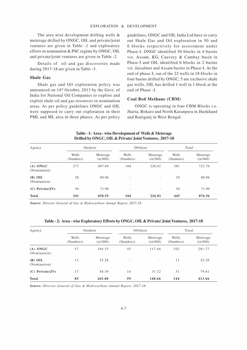
The area wise development drilling wells &
meterage drilled by ONGC, OIL and private/joint
ventures are given in Table -1 and exploratory
efforts in nomination & PSC regime by ONGC, OIL
and private/joint ventures are given in Table -2.
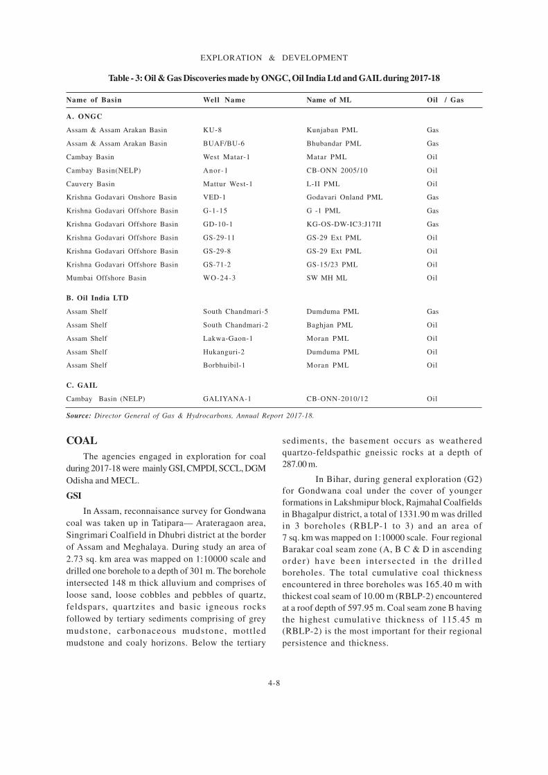
Details of oil and gas discoveries made
during 2017-18 are given in Table -3.
Shale Gas
Shale gas and Oil exploration policy was
announced on 14th October, 2013 by the Govt. of
India for National Oil Companies to explore and
exploit shale oil and gas resources in nomination
areas. As per policy guidelines ONGC and OIL
were supposed to carry out exploration in their
PML and ML area in three phases. As per policy
guidelines, ONGC and OIL India Ltd have to carry
out Shale Gas and Oil exploration in 50 and
6 blocks respect ively for assessment under
Phase-I. ONGC identified 50 blocks in 4 basins
viz. Assam, KG, Cauvery & Cambay basin in
Phase-I and OIL identified 6 blocks in 2 basins
viz. Jaisalmer and Assam basins in Phase-I. At the
end of phase-I, out of the 22 wells in 18 blocks in
four basins drilled by ONGC, 5 are exclusive shale
gas wells. OIL has drilled 1 well in 1 block at the
end of Phase -I.
Coal Bed Methane (CBM)
ONGC is operating in four CBM Blocks i.e.
Jharia, Bokaro and North Karanpura in Jharkhand
and Raniganj in West Bengal.
Table - 2: Area - wise Exploratory Efforts by ONGC, OIL & Private/ Joint Ventures, 2017-18
Agency Onshore Offshore Total
Wells Meterage Wells Meterage Wells Meterage
(Numbers) (in'000) (Numbers) (in'000) (Numbers) (in'000)
(A) ONGC 57 164.33 45 117.44 1 0 2 281.77
(Nomination)
(B) OIL 11 52.28 - - 11 52.28
(Nomination)
(C) Private/JVs 17 48.39 14 31.22 31 79.61
Total 85 265.00 59 148.66 1 4 4 413.66
Source: Director General of Gas & Hydrocarbons Annual Report, 2017-18.
Table - 1: Area - wise Development of Wells & Meterage
Drilled by ONGC, OIL & Private/ Joint Ventures, 2017-18
Agency Onshore Offshore Total
Wells Meterage Wells Meterage Wells Meterage
(Numbers) (in'000) (Numbers) (in'000) (Numbers) (in'000)
(A) ONGC 277 497.69 104 226.01 381 723.70
(Nomination)
(B) OIL 28 80.96 - - 28 80.96
(Nomination)
(C) Private/JVs 36 71.90 - - 36 71.90
Total 341 650.55 104 226.01 445 876.56
Source: Director General of Gas & Hydrocarbons Annual Report, 2017-18.
4-8
EXPLORATION & DEVELOPMENT
Table - 3: Oil & Gas Discoveries made by ONGC, Oil India Ltd and GAIL during 2017-18
Name of Basin Well Name Name of ML Oil / Gas
A. ONGC
Assam & Assam Arakan Basin KU-8 Kunjaban PML Gas
Assam & Assam Arakan Basin BUAF/BU-6 Bhubandar PML Gas
Cambay Basin West Matar-1 Matar PML Oil
Cambay Basin(NELP) Anor-1 CB-ONN 2005/10 Oil
Cauvery Basin Mattur West-1 L-II PML Oil
Krishna Godavari Onshore Basin VED-1 Godavari Onland PML Gas
Krishna Godavari Offshore Basin G-1-15 G -1 PML Gas
Krishna Godavari Offshore Basin GD-10-1 KG-OS-DW-IC3:J17II Gas
Krishna Godavari Offshore Basin GS-29-11 GS-29 Ext PML Oil
Krishna Godavari Offshore Basin GS-29-8 GS-29 Ext PML Oil
Krishna Godavari Offshore Basin GS-71-2 GS-15/23 PML Oil
Mumbai Offshore Basin WO-24-3 SW MH ML Oil
B. Oil India LTD
Assam Shelf South Chandmari-5 Dumduma PML Gas
Assam Shelf South Chandmari-2 Baghjan PML Oil
Assam Shelf Lakwa-Gaon-1 Moran PML Oil
Assam Shelf Hukanguri-2 Dumduma PML Oil
Assam Shelf Borbhuibil-1 Moran PML Oil
C. GAIL
Cambay Basin (NELP) GALIYANA-1 CB-ONN-2010/12 Oil
Source: Director General of Gas & Hydrocarbons, Annual Report 2017-18.
COAL
The agencies engaged in exploration for coal
during 2017-18 were mainly GSI, CMPDI, SCCL, DGM
Odisha and MECL.
GSI
In Assam, reconnaisance survey for Gondwana
coal was taken up in Tatipara— Arateragaon area,
Singrimari Coalfield in Dhubri district at the border
of Assam and Meghalaya. During study an area of
2.73 sq. km area was mapped on 1:10000 scale and
drilled one borehole to a depth of 301 m. The borehole
intersected 148 m thick alluvium and comprises of
loose sand, loose cobbles and pebbles of quartz,
feldspars, quartzites and basic igneous rocks
followed by tertiary sediments comprising of grey
mudstone, carbonaceous mudstone, mottled
mudstone and coaly horizons. Below the tertiary
sediments, the basement occurs as weathered
quartzo-feldspathic gneissic rocks at a depth of
287.00 m.
In Bihar, during general exploration (G2)
for Gondwana coal under the cover of younger
formations in Lakshmipur block, Rajmahal Coalfields
in Bhagalpur district, a total of 1331.90 m was drilled
in 3 boreholes (RBLP-1 to 3) and an area of
7 sq. km was mapped on 1:10000 scale. Four regional
Barakar coal seam zone (A, B C & D in ascending
order) have been intersected in the dr i l led
boreholes. The total cumulative coal thickness
encountered in three boreholes was 165.40 m with
thickest coal seam of 10.00 m (RBLP-2) encountered
at a roof depth of 597.95 m. Coal seam zone B having
the highest cumulative thickness of 115.45 m
(RBLP-2) is the most important for their regional
persistence and thickness.

4-9
EXPLORATION & DEVELOPMENT
In Chhattisgarh, regional exploration for coal in
Sendur block, Tatapani- Ramkola coalfield in Surguja
district. The survey comprises drilling of 2,026.10 m
with coal core samples of 52.85 m and geophysical
logging of 1,224.65 m. Three regional Barakar coal
seams (Seam-II to III & XIII in ascending order) and
few local seams with thickness ranging from less than
a metre to 29.86 m (cumulative thickness of Seam
Zone III) have been intersected between the depths
of 299.66 m and 762.13 m. Seam Zone III is the
thickest. Geophysical logging shows good
correlation with coal seams recorded by core logging.
Exploration for coal was carried out in Tendumuri
block, Mand-Raigarh coalfield in Raigarh district.
Exploration involved large scale mapping of
3 sq. km area on 1:10000 scale, drilling of 2,306.85 m,
geophysical logging of 1151.56 m and 169.84 m coal
core sampling. Twelve regional Barakar coal seams/
zones (Seam I to X, XII & XIII in ascending order)
have been intersected between the depths of 16.26
m to 659.61 m. Thickness of individual coal seam/
zone varies from 0.75 m to 14.67 m. Seam IV is the
thickest seam with cumulative thickness of 14.67 m
(in 2 split sections). Borehole data indicates three
normal faults in the area. Exploration carried out for
coal in Jobro (West) block, Mand-Raigarh coalfield
in Raigarh district comprises a total drilling of 2,766.50
m in six boreholes, geophysical logging of 1,694.59
m, large scale mapping of 3.5 sq. km area on 1:10,000
scale and 158.09 m coal core sampling. Seven regional
Barakar coal seams/ zones (Seam III, IV, V, VI+VII,
VIII, IX & X in ascending order) and a few local coal
seams within Raniganj Formation and Barren
Measure have been intersected between the depths
of 8.30 m and 576.95 m. Thickness of individual
regional coal seam/ zone varies from 0.53 m to 17.09
m. Seam zone VI+VII is the thickest seam.
The cumulative coal thickness varies from 7.69 m to
17.09 m. Seam V is another important and thick seam
zone intersected in the block with a maximum coal
thickness of 16.88 m.
In Madhya Pradesh, exploration for coal by scout
drilling was carried out in Tummi-Kharsol area,
Sohagpur Coalfield in Anuppur & Umaria districts.
The study involved a total of 2,462.55 m drilling,
mapping of 44 sq. km on 1:25,000 scale and
geophysical logging of 1,359.58 m in three boreholes.
Four regional coal seams (Seam-I to IV in ascending
order) and few local seams, with cumulative
individual seam thickness ranging from 0.50 m to
2.65 m, have been intersected between the depths of
269.00 m and 420.60 m. Seam-III occurs as the thickest
seam i.e. 1.20 m to 1.75 m. Cumulative thickness of
coal varies from 4 m to 5 m. In Shahdol district,
preliminary study for generation of baseline data of
in-situ gas content within shale horizons of Lower
Gondwanas was taken up in Semra Area. The gas
desorption test was conducted in borehole SSSG-1
of 981 m depth encompassing 471.30 m of Raniganj,
220.60 m of Barren Measures and 289.10 m of Barakar
strata were intersected. A thick basic intrusive body
(158.30 m thick) has been intruded within Raniganj
Formation at shallow depth of 67.90 m. Occurrence
of carbonaceous shale/sil tstone is very rare
throughout entire intersected lower Gondwana
sequence in borehole SSSG-1. Twelve core samples
of carbonaceous shale/ siltstone were collected
within a depth range from 581.50 m to 909.00 m for
gas desorption test. Desorbed gas content of all
studied samples is very low (max. 22cc) whereas the
weight of samples varies from 1615 gm to 2275 gm.
Regional exploration for coal was taken up in Sarai –
Uphradol block, Singrauli coalfield in Singrauli
district. Drilling of 3,816.95 m in six boreholes,
geophysical logging of 1465.28 m and core samples
of about 102.75 m and large scale mapping of 7 sq.
km on 1:10,000 scale was completed. All the six
boreholes have been intersected Barren Measures
with thickness ranging from 190.72 m to 230.84 m.
The Talchir strata are encountered in four boreholes.
Seven regional Barakar coal seams/ along with three
local seams and one Raniganj coal seam have been
intersected in the boreholes. The cumulative coal
thickness ranges from 0.51 m to 6.42 m. Regional
Barakar coal seams continuation was established for
3 km along strike and about 1.0 km along dip direction.
In Chhindwara district, exploration for coal in
Bamhanwara sector, Pench Valley Coal field was
carried out comprising total drilling of 4,64,725 m in
thirteen boreholes, mapping of 41.00 sq. km area on
1:10,000 scale and geophysical borehole logging of
948.75 m. Mapping reveals that the area is covered
with Deccan Trap. Five numbers of flows have been
delineated based on subsurface data. The three
boreholes i.e. PBH-7, 8 & 10 which encounter Barakar
Formation (25 m – 60 m) within a depth range from

4-10
EXPLORATION & DEVELOPMENT
262.60 m to 445.510 m were closed in a depth range of
286.60 m to 453.60 m. Cumulative thickness of coal
(III, IV and V in descending order) varied from 10.85
m to 11.51 m.
In Nagaland, reconnaissance survey (G4) for
coal was taken up around Alongtaki in Mokokchung
district. Large - scale geological mapping of 50 sq.
km area was carried out on 1:10000 scale. Coal
occurrences reported in the form of seams, lenses,
streaks and pockets within sandstones of Jenam,
Bhuban and Tipam. The notable coal seams observed
in the Jenam Formation includes: i) Near Alosi Tsu
with a strike length of 3.3 m and thickness of about
12 cm, ii) East of Longtho village with a strike length
of 2 m and 0.05 m thickness, iii) Near Tayeba Tsu
with a strike length of 8 m and 15 m thick and iv)
About 4 m thick on eastern bank of Dessoi River
with a strike length of 20 m. Besides, a coal layer
with a strike length of 7 m and thickness varying
from 0.01 to 0.45 m is also seen along the road transect
between Teyaba Tsu and Alongtaki village.
In Odisha, general exploration for coal was
carried out in Kantaikoliya north block, Talcher
coalfield, Angul district. Exploration comprises
mapping of 2 sq. km area of on 1:10,000 scale and
drilling of two boreholes to a total depth of 1083.90
m. A total area of 4 sq. km was mapped in 1:10000
scales and total meterage of 2260.10 m was drilled.
The area is covered by rocks of Kamthi Formation.
The lithounits of Kamthi Formation (max thickness
184.42 m), Barren Measure (max thickness 136.38 m),
Barakar Formation (Max thickness 363.68 m) and
Karharbari Formation (max thickness 115.13 m) have
been intersected in the boreholes. Ten regional coal
seam zones (II to XI in ascending order) were
intersected between the depth ranges from 151.40 m
to 518.85 m in Barakar Formation. The cumulative
coal thickness varies from 44.62 m to 69.96 m. The
seam zone IX is the thickest seam (14.08 m to 21.67
m) and it has been intersected between the depth
ranges from 216.30 m to 328.31 m. In Jharsuguda
district, a G2 level general exploration was carried
out for coal in Teteliabahal Block, Ib-River coalfield.
A total of 5 sq. km area was geologically mapped on
1:10,000 scale; 4,975.60 m drilling was carried out in 6
boreholes and 3,299 m geophysical borehole logging
was done in four completed boreholes. A total of
716.49 m coal core samples were gathered. Four
regional coal seam zones of Raniganj Formation i.e.
R-IV, R-III, R-II, and R-I and four regional coal seam
zones of Barakar Formation i.e. Belpahar, Parkhani,
Lajkura and Rampur have been intersected in the
boreholes. Coal seam zones of Raniganj Formation
occur at shallow depth i.e. within 350 m, between
89.33 m and 312.43 m depth. Cumulative coal
thickness of R-IV, R-III, R-II, and R-I intersected in
the boreholes varies from 0.90 m to 14.45 m. The coal
seam zones of Barakar Formation have been
intersected between 280.89 m (IBTB-1) and 881.92 m
(IBTB-6) depth. Cumulative coal thickness of
Belpahar, Parkhani and Lajkura seam zones varies
from 6.27 m to 10.65 m, 20.50 m to 25.79 m and 64.33 m
to 71.33 m, respectively. Rampur seam zone has been
intersected in boreholes IBTB-1, 5 and 6 with
cumulative coal thickness varying from 4.84 m to
18.21 m. Lajkura is the thickest among the Barakar
coal seam zones. In Sundargarh district, a G2 level
general exploration was carried out for coal in
Kendudihi block, Ib-river coalfield. A total of
3 sq. km area was geologically mapped on 1:10,000
scale. 2,766.10 m drilling was carried out in 4
boreholes; 392.27 m coal core samples were generated
and 1,310.10 m borehole geophysical logging was
done in two boreholes. The boreholes intersected
the rocks of Raniganj, Barren Measure, Barakar and
Karharbari. Two regional coal seam zones of Raniganj
Formation i.e. R-II, and R-I and four regional coal
seam zones of Barakar Formation i.e. Parkhani,
Lajkura, Rampur and Ib have been intersected in the
boreholes. Coal seam zones of Raniganj Formation
occur at shallow depth i.e. within 300 m, between
7.90 m and 62.50 m depth. R-II seam (2.86 m cumulative
thickness) has been intersected in borehole IBKD-1.
Cumulative coal thickness of R-I varies from 4.50 m
to 5.36 m. The coal seam zones of Barakar Formation
have been intersected between 244.06 m and 747.24
m depth. Cumulative coal thickness of Parkhani,
Lajkura, Rampur and Ib seam zones varies from 5.91
m to 7.74 m, 26.17 m to 37.35 m, 45.62 m to 55.92 m and
1.99 m to 13 m, respectively.
In Telangana state, a G3 stage exploration was
taken up for coal by drilling in the western
extension of Pagaderu west sector, southern part
of main basin of Godavari valley coalfield. A total
of 2,125.20 m of drilling has been drilled in four
boreholes. A total of 136.61 m of coal has been
sampled. The Lower Kamthi coal seam zones (V to
I) and the Barakar coal seam zones (A&B, No I

4-11
EXPLORATION & DEVELOPMENT
seam, C and Thick seam) intersected within the depth
range from 15.70 m to 695.00 m with individual seam
thickness varying from 0.50 m to 3.92 m. Occurrence
of coal has been proved along the strike extension
of 2 km and dip extension of 5 km and estimated a
tentative resource of 100 million tonnes with quality
of coal varies from C to G grade.
In Telangana state, regional exploration for coal
by scout drilling in north west of Dorli block, north-
western part of Godavari valley coalfield in Adilabad
district was taken up. The coal bearing Lower
Gondwana sequence under the cover of Deccan trap
was reported in the north western part of Dorli area
during geological mapping on 1:25000 scale. The
Barakar coal seams are exposed in the nala section
of the area. The maximum thickness of traps
established by geophysical survey using gravity and
magnetic methods varies from 40 m to 150 m. Further
north-west of Chintaguda area the trap thickness
gradually increases with maximum thickness
recorded 250 m.
In West Bengal, general exploration (G2) for
Coal and Lignite was carried out in Rakshitpur north
block, Raniganj Coalfield, Bardhaman district. A total
of four boreholes were drilled to a cumulative depth
of 2,179.90 m. Raniganj Formation hosts four
regional coal seam/ seam zones (R-IX, R-VIII, R-VII
& R-Basal) with cumulative thickness ranging from
0.67 m to 5.10 m were intersected in the depth range
of 298.65 m to 710.35 m. One lignite seam of 0.40 m
thickness had been encountered at the depth of
194.10 m in borehole no. RRKN-3. A fossiliferous
zone of 6.10 m thickness had been intersected at the
depth of 50.60 m in borehole no. RRKN-3. Large scale
mapping of 4 sq. km on 1:10,000 scale was also
carried out. A general exploration for Gondwana Coal
under the cover of Rajmahal Formation was carried
out in Agaya block within Dholkatha-Garia area,
Rajmahal-Birbhum Coalfield, Birbhum district. Total
five boreholes were drilled to a total depth of 2,550.05
m. Regional coal seam zone I and II have been
encountered within the coal bearing Barakar
Formation in the depth range of 197.70 m to 462.11
m. Total 147.32 m cumulative coal thickness has been
intersected in five boreholes with thickest coal seam
of 13.05 m. Maximum thickness of different
formations reported in five boreholes are alluvium
9.20 m, Rajmahal Formation 192.80 m, Infratrappeans
24.78 m, Dubrajpur Formation 3.20 m, Barakar
Formation 325.79 m, Talchir Formation 13.50 m,
Basement metamorphic ~ 6 m and intrusive dyke +54
m.
Directorate of Geology, Odisha
Exploration for coal over an area of 7.56 sq. km
was continued from previous field session in
Madhupur block of Ib Valley coalfield, Jharsuguda
district. Total 2,911.10 m drilling was carried out
during the year 2017-18.
The Singareni Collieries Company Ltd (SCCL)
During 2017-18, SCCL has explored the area to
locate the presence of economic viable coal deposits
and established its nature, shape and grade. Total
350 exploratory boreholes were drilled to a
cumulative depth of 1,09,109 m and established
proved reserves of 72.64 million tonnes with
cumulative reserves position at the end of 2017-18
at 10,474.90 million tonnes. The exploration work
was carried out in the SCCL command area situated
in Adilabad, Khammam, Karimnagar and Warangal
districts of Telangana state.
CMPDIDuring 2017-18, CMPDI continued its coal
exploration activities mainly in CIL and Non-CIL/
Captive Mining Blocks. Exploration in CIL blocks was
taken up to cater the needs of the project planning/
production support needs of subsidiaries of CIL;
whereas, exploration in Non-CIL/Captive Mining
Blocks was undertaken to facilitate allotment of coal
blocks to prospective entrepreneurs. A total of 140
to 160 drills were deployed in 2017-18, out of which
66 drills were departmental drills.
CMPDI deployed its departmental resources for
detailed exploration of CIL/Non-CIL blocks; whereas
State Governments of Madhya Pradesh and Odisha
deployed resources in CIL blocks only. Besides,
eight other contractual agencies have also deployed
resources for detailed drilling/exploration in CIL/
Non-CIL blocks.
In 2016-17, CMPDI and its contractual agencies
took up exploratory drilling in 118 blocks/mines
spread over 18 coalfields in six states. Out of 118
blocks/mines, 42 were Non-CIL/Captive blocks and
76 CIL blocks/mines. Departmental drills of CMPDI
took up exploratory drilling in 50 blocks/mines,
whereas, contractual agencies drilled in 68 blocks/

4-12
EXPLORATION & DEVELOPMENT
mines. CMPDI extended its technical supervision in
promotional/NMET exploration work undertaken by
MECL in coal sector (CIL areas) in 8 blocks. On behalf
of Ministry of Coal, DGM, Nagaland has also carried
out promotional exploration in one block and CMPDIL
in two coal blocks of a total of 1.347 lakh meter of
promotional (regional) drilling was undertaken in coal
and lignite during 2017-18 through, CMPDI.
Table - 4: Exploratory Drilling by CMPDI (Departmental and Outsourcing) in 2017-18
Sl. Agency Target Exploratory drilling Achieved
No. (lakh m) achieved (lakh m) (%)
1. Departmental 4 .750 4 .505 9 5
2. Outsourcing
i) State Govts. 0 .030 0 .021 7 1
ii) MECL (MoU) 4 .000 4 .688 1 1 7
iii) Tendering (CIL/Non-CIL Blocks) 3 .720 4 .446 1 2 0
Total 12 .500 13 .661 1 0 9
A total of 13.661 lakh m of exploratory drilling
was carried out by CMPDI in 2017-18 through
departmental resources (4.750 lakh m) and
outsourcing (9.156 lakh m) to State Governments/
MECL/Tendering (CIL/Non-CIL blocks). Details of
exploratory drilling carried out by CMPDI in 2017-18
are given in Table - 4.
LIGNITE
GSI
The details of investigation for lignite during
2017-18 by GSI is given below:
In Tamil Nadu, a preliminary exploration for
Lignite was carried out in Kalari East Sector,
Ramanad sub-basin in Ramananthapuram district. A
total of five vertical boreholes were completed for a
cumulative drilling depth of 2,667.20 m Lignite seams
intersected in all the five boreholes and individual
seam thickness varies from 1.0 to 16.50 m. Cumulative
thickness of lignite seams varies from 16.0 to 22.4 m
and cumulative parting thickness varies from 29.30
to 39.00 m. Three main lignite seams intersected in
the upper, middle and lower portion of the lignite
zone. The top most seams are thicker admeasuring
from 10.20 m to 16.50 m. The middle and bottom seams
are generally thinner. The content of fixed carbon
varies from 14.9 to 34.8% and the calorific value
ranges from 1,848 to 3,510 K.cal/kg.
Directorate of Geology, Odisha
Exploration for coal over an area of 7.56 sq. km
was continued from previous field session in
Madhupur block of Ib valley coal field, Jharsuguda
district. During the year 2017-18, total 2911.10 m
drilling was carried out.
DGM, Rajasthan
During 2016-17, exploration for lignite was
continued n/v Diyatra, Tehsil Kolayat, Bikaner
distr ict . Eleven boreholes were dri l led to a
cumulative depth of 1,976.40 m and estimated
0.36 million tonnes of lignite resources and
17.14 million tonnes of lignitic shale resources.
In Bikaner district, regional mineral survey near
villages Nathwato ki Dhani, Sewra, Nagarasar, Bera
ki Dhani in Kolayat Tehsil was taken up with an
objective to explore new lignite deposits in border
region of Bikaner, Jaisalmer and Jodhpur districts.
No indicat ion of l igni te was found during
tubewell sludge study. During 2017-18 exploration
programme a total 285.00 m of drilling in 3 boreholes
were carr ied out and collected 10 samples.
The thickness of lignite seam is 5.00 m and
average thickness of overburden is 157.00 m.
The progressive average of lignite/overburden ratio
is 1:24.18. During the year, lignite shale reserves
has been estimated at 1.04 million tonnes.
Neyveli Lignite Company India Ltd
In Tamil Nadu, exploration for lignite in
Palayamkottai and Veeranam block, Cuddalor district
was taken up through NMET scheme to bring the
resources into proved category. In Palayamkottai
block (32.00 sq. km area), 65 boreholes were drilled

4-13
EXPLORATION & DEVELOPMENT
to a total depth of 9,316.0 m and 550 samples were
collected for chemical analysis. In Veeranam block
(150.00 sq. km area), 55 boreholes were drilled to a
total depth of 14,423.0 m and 208 samples were
collected for chemical analysis. The drilling
continuing at 400 m grid interval.
In Rajasthan, promotional exploration funded by
Ministry of Coal was taken up in Kheduli, Matasukh-
Lunsara and Pyau south blocks. In Kheduli block, 53
boreholes were drilled to a total depth of 13,518.30 m
and collected 75 samples for chemical analysis. The
block is promising. The exploration results of other
two blocks i.e. Matasukh-Lunsara block, Nagaur
district drilled and Pyau south block, Churu district
are not promising blocks. The exploration in these
two blocks were completed.
NON-FERROUS METALS
BASE METALS
GSI, MECL and Directorate of Geology, Odisha
conducted investigations for copper, lead and zinc
ores in different parts of the country during 2017-18.
GSI
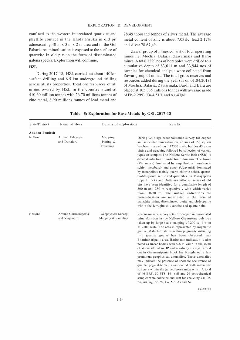
The details of exploration activities carried out
by GSI during 2017-18 are given in Table-5.
MECL
Exploration for copper in Sidheswar copper
deposits east Singhbhum district, Jharkhand was
taken up with an objective to establish i) the depth
continuity of lodes at around 5th level , ii) continuity
of lodes upto and beyond 8th level and estimate the
total resources of copper and to carry out the
deviation survey of the exploratory boreholes. The
deposit extends over a strike length of about 2.0 km
from the north-eastern of the Kendadih mine. During
G1 level exploration, MECL mapped 2.59 sq. km area,
14 nos boreholes drilled to cumulative depth of
3,636.10 m and collected 866 nos primary samples for
Cu, 29 nos check samples for Cu, 25 polished section
and 16 petrographic study and 25 samples for specific
gravity determination. Out of a total 8.923 million
tonnes with 1.20% Cu estimated at 0.5% cut-off and
0.8% pay limit, about 3.283 million tonnes with 1.20%
Cu estimated under measured category (331) , 3.029
million tonnes with 1.18% Cu under indicated
category (332) and 2.611 million tonnes with 1.19%
Cu under inferred category (332) [Estimated upto 9th
level]. During G2 level exploration in Nandup (East)-
Bayanbil (combined) block, East Singhbhum district,
Jharkhand, MECL mapped 0.54 sq. km area an 1:1000
scale, drilled 10 boreholes to a cumulative depth of
1883.50 m and collected and analysed 1158 nos
samples including 60 primary samples for Au, Ag &
W and 37 composite samples for Cu, Ni, Co, Mo and
W. A total resources of 6.5653 million tonnes under
indicated category have been estimated with the
grade of 1.19% Cu at 0.5% Cu cut-off and 12.315
million tonnes (332) with the grade of 0.89% Cu at
0.2% Cut-off. In Surda copper mine block, East
Singhbhum district, a G1 level exploration was carried
out with the objectives to establish i) the depth
continuity of loads at around 17th level , ii)
continuity of lodes up to and beyond 20th level and
iii) deviation survey of the exploratory boreholes.
Exploration involved mapping of 3.02 sq. km on
1:4,000 scale, 7,483.60 m drilling in 8 boreholes and
sampling and chemical analysis of 1543 nos of primary
samples for Cu, 74 nos check samples for Cu, 34 nos
of composite samples for Cu, Ni and Co, 26 nos
samples for Au, 26 nos samples for XRD and
spectroscopy and 85 nos samples for minerogrphy,
petrography and specific gravity determination.
About 15.085 million tonnes resources with average
thickness of 5.83 m and average grade of 1.00% Cu
has been estimated at 0.5% cut-off with 0.8% pay
limit under measured/indicated category. The
exploration of Surda block and Sidheswar copper
deposit was carried out for HCL whereas Nandup-
Bayanbill (combined) for Ministry of Mines.
Directorate of Geology, Odisha
Geophysical investigation for base metal was
taken up in north of Kesharpur, Mayurbhanj district.
Exploration was carried by SP survey of 1 sq. km on
1:2000 scale and IP survey of 0.75 sq. km on 50 m x 20
m spacing . Anomalous zones of causative bodies
were indentified for further investigation.
DMG, Rajasthan
Base Metal & Noble Metal
During 2016-17, investigation for locating base
metal and noble metal was taken up n/v Jotri Peepal,
Piruka Teski in Pahari Tehsil, Bharatpur district,
Rajasthan. An area of 50.0 sq. km was mapped on
1:50,000 scale, 15.0 sq. km on 1:10000 scale and
2.0 sq. km on 1:4,000 scale. Lead mineralisation is
4-14
EXPLORATION & DEVELOPMENT
Table - 5: Exploration for Base Metals by GSI, 2017-18
State/District Name of block Details of exploration Results
During G4 stage reconnaissance survey for copper
and associated mineralization, an area of 150 sq. km
has been mapped on 1:12500 scale, besides 43 cu m
pitting and trenching followed by collection of various
types of samples.The Nellore Schist Belt (NSB) is
divided into two litho-tectonic domains. The lower
(Vinjamuru) dominated by amphibolites, hornblende
schist, metabasalt and upper (Udayagiri) dominated
by metapelites mainly quartz chlorite schist, quartz-
biotite-garnet schist and quartzites. In Masayapetta
tippa hillocks and Duttaluru hillocks, series of old
pits have been identified for a cumulative length of
300 m and 250 m respectively with width varies
from 10-30 m. The surface indications for
mineralisation are manifested in the form of
malachite stains, disseminated pyrite and chalcopyrite
within the ferruginous quartzite and quartz vein.
Reconnaissance survey (G4) for copper and associated
mineralisation in the Nellore Greenstone belt was
taken up by large scale mapping of 200 sq. km on
1:12500 scale. The area is represented by migmatite
gneiss. Malachite stains within pegmatite intruding
into granite gneiss has been observed near
Bhattinivaripalli area. Barite mineralisation is also
noted as linear bodies with 5-6 m width in the south
of Venkatadripalem. IP and resistivity surveys carried
out in Garemanipenta block has brought out a few
prominent geophysical anomalies. These anomalies
may indicate the presence of sporadic occurrence of
quartz/ pegmatite veins associated with malachite
stringers within the garnetiferous mica schist. A total
of 46 BRS, 50 PTS, 161 soil and 26 petrochemical
samples were collected and sent for analysing Cu, Pb,
Zn, Au, Ag, Sn, W, Co, Mo, As and Ni.
Andhra Pradesh
Nellore Around Udayagiri Mapping,
and Duttaluru Pitting &
Trenching
Nellore Around Garimanipenta Geophysical Survey,
and Vinjamuru Mapping & Sampling
confined to the western intercalated quartzite and
phyllite contact in the Khola Piruka in old pit
admeasuring 40 m x 3 m x 2 m area and in the Gol
Pahari area minerlisation is exposed to the surface of
quartzite in old pits in the form of disseminated
galena specks. Exploration will continue.
HZL
During 2017-18, HZL carried out about 140 km
surface drilling and 6.5 km underground drilling
across all its properties. Total ore resources of all
mines owned by HZL in the country stand at
410.60 million tonnes with 26.70 millions tonnes of
zinc metal, 8.90 millions tonnes of lead metal and
28.49 thousand tonnes of silver metal. The average
metal content of zinc is about 7.03%, lead 2.17%
and silver 78.67 g/t.
Zawar group of mines consist of four operating
mines i.e. Mochia, Balaria, Zawarmala and Baroi
mines. A total 1229 nos of boreholes were drilled to a
cumulative depth of 83,611 m and 33,944 nos of
samples for chemical analysis were collected from
Zawar group of mines. The total gross reserves and
resources added during the year (as on 01.04.2018)
of Mochia, Balaria, Zawarmala, Baroi and Bara are
placed at 105.835 millions tonnes with average grade
of Pb-2.29%, Zn-4.51% and Ag-43g/t.
( C o n t d )
4-15
EXPLORATION & DEVELOPMENT
Reconnaissance survey for copper and possible
associated gold mineralisation was taken up by large
scale mapping of 52 sq. km on 1:12500 scale. A total
of 3 major mineralised zones was delineated. A 500-
700 m width shear zone (Zone I) has been recorded
near Dedollo. Oxidation, limonitisation and boxworks
have been observed in this zone. A 180-200 m width
shear zone (Zone II) was seen near Leporiang. The
host rock is quartzite with specks of pyrite grains.
Another Zone of 80-100 m width (Zone III), recorded
in the old Bubiya road near to Lodosho village, the
rock type being phyllite. In this zone a quartz vein
has been observed with pyrite, chalcopyrite and
bornite mineralisation.
Reconnaissance survey for Base metals in the area
involves large scale mapping of 100 sq. km area on
1:12500 scale along with 15 LKM of geophysical
survey. Total 28 pegmatite samples for REE/ RM
analysis and 27 BRS for Nb-Ta analysis were collected.
Two heavy minerals samples were also collected for
base metal analysis. The main lithology of the study
area is calc-silicate rocks.
Reconnaissance survey for multi-metal deposit in the
North and West of Tosham, district, (G-4): The target
was to intersect the geophysical causative body, which
was estimated on the basis of magnetic and SP
anomaly at a vertical depth of 350 m ±10. Borehole
HBNT-1 was planned to intersect geophysical
anomaly. The borehole was drilled up to a depth of
167 m, but due to continuous/persistent drilling
problems the borehole was abandoned at a depth of
167 m within alluvium (Quaternary sediments). The
scout borehole HBNT-01 was again drilled as borehole
HBNT-01A. Again, due to continuous/persistent
drilling problems borehole had been abandoned at the
depth of 282.30 m. In Tirumalapuram hillock,
disseminated sulphide i.e pyrite, chalcopyrite and
covellite, malachite and azurite are seen in massive
quartzite ± ferruginous. The trace elements like Co,
Cr, Cu, Ni, Th, V and Ge are highly concentrated in
Chintalgunta and Sarvarabad area over the lithology
of meta-anorthosite, quartz chlorite schist and
quartzite. The analytical results of 25 BRS channel
samples indicated average copper content of 0.25%
over 2 m.
General Exploration (G2)for Copper mineralisation
in extended block, North of Golwa involved detailed
mapping of 0.51 sq. km on 1:2000 scale.
The calcareous quartz-biotite schist is host of copper
State/District Name of block Details of exploration Results
Table - 5 (Contd)
Arunachal Pradesh
East Kameng Around Bubiya- Mapping
and Papumpare Laporiang area
Gujarat
Sabarkantha Around Vadali Geophysical survey,
area Mapping & Sampling
Haryana
Bhiwani Around Khanak- Drilling
Ratera-Kirawar-
Jamalpur area
Mahendragarh North of Golwa Mapping
Drilling
( C o n t d )

4-16
EXPLORATION & DEVELOPMENT
State/District Name of block Details of exploration Results
sulphide mineralisation. A total of 3,429.40 m of drilling
has been carried out. Three levels of boreholes have
been drilled. Based on the analytical data, the strike
length of copper sulphide mineralisation is approx. 800
m with average width varying between 8 m to 22 m.
The content of copper varies between 0.3 to 0.42%.
The principal ore minerals are chalcopyrite, bornite,
chalcocite, covellite and pyrite. The mineralisation
occurs as disseminations, thin veinlets along foliation/
fracture plane, stringers and fracture fillings.
Reconnaissance Survey for Copper and Associated Base
Metals Mineralisation was taken up by large scale
mapping of 130 sq. km on 1:12,500 scale. The
investigated area is mainly occupied by the tremolite
bearing impure marble, massive phyllite, interbedded
phyllite and quartzite unit, interbedded phyllite and ash
(pyrite bearing) bed. The veins are about 0.1 m to 2 m
in thickness. The major sulphides seen in the area are
pyrite, bornite, pyrrhotite and chalcopyrite.
Geophysical Survey by Chargeability, Resistivity,
Magnetic and SP methods was carried out in Kalba,
Thanawas and Nayan area and showed magnetic
anomaly of -450 gamma to the north of tremolite bearing
impure marble and higher chargeability values in the
south western corner near to the proximity of
interbedded phyllite and ash beds. The chemical analysis
of 76 samples for Cu, Pb, Zn and Ag shown the highest
value of Cu.
Reconnaissance survey was taken up for copper and
associated base metal mineralisation by geological
mapping on 1:12500 scale. Major rock-types seen in
the area include bedded quartzite interlayered with
amphibole marble, garnetiferous quartz-biotite schist,
etc are traversed by number of pegmatite bodies of
varying dimensions as well as quartz, calcite veins. At
two isolated hillocks near Raghunathpur, surface
manifestations of mineralisation are found in the form
of malachite stains, iron incrustations and rarely
dissemination of chalcopyrite, bornite, pyrite within
the garnetiferous quartz-biotite schist and amphibole
marble.
General exploration for copper mineralisation involved
detailed mapping of 0.50 sq. km on 1:2000 scale. The
mineralisation is hosted by the calcareous quartz-biotite
schist.Total 538.40 m meter drilling in five boreholes
were carried out. Study of drill holes cores show the
sulphide mineralisation is in the form of specks,
dissemination and fracture filling of chalcopyrite,
bornite, covellite, pyrrhotite and pyrite, which are
mostly associated with thin veins/veinlet of calcite and
rarely with quartz veins. Visual estimation of copper
mineralisation from various boreholes ranges from
0.01% to 0.2%. A total of 120 channel samples in eight
channel lines of 1.00 m to 16.00 m length each were
collected and the average grade of Cu mineralisation
ranges from 0.02% to 0.4% Cu. 30 pitting and trenching
samples shows significant value of copper mineralisation.
Table - 5 (Contd)
Mahendragarh Kalba- Geophysical Survey
Thanawas- Mapping & Drilling
Nayan Area
Narnaul, Raghunathpur, Mapping
Dharsu, Bashirpur area
South of Gangutana Mapping
extension Drilling
Pitting/
Trenching
& Sampling
(Contd)

4-17
EXPLORATION & DEVELOPMENT
Table - 5 (Contd)
State/District Name of block Details of exploration Results
Reconnaissance survey for Copper and REE minerals
was taken up in parts of Jamotha and Kaplas granites
and its surrounding rocks by mapping 50 sq. km area on
1:12500 scale and 127 nos of BRS, 26 nos of PCS, 10
nos of HM, 15 nos of EPMA, 50 nos of PTS, 30 nos of
soil samples and 19 nos of stream sediment samples
were collected.
Reconnaissance survey for Copper and associated
mineralisation was taken up in Cambrian sequence in
and around Banihal-Shalgadali-Hale Maidan areas. Large
scale mapping of 50 sq. km on 1:12,500 scale was carried
out. Five old workings were observed from agglomerate
and volcanic tuff near Dooligam village and slag dumps
were also observed in the downslope. Presence of
malachite stains in the rocks of old workings near
Dooligam, Banihal were also observed. Copper
mineralisation is noticed at some places in quartz veins,
in Machal and Ramsu Formation, which are very
irregular in nature and range from few millimeters to
1.27 m in width, the most common minerals found
along these veins are chalcopyrite and bornite.
During preliminary exploration for delineation of
Copper and REE mineralisation was in Lingasugur taluk,
detailed mapping of 2.0 sq. km and drilling of 800 m
was carried out. The different styles of mineralisation
in the host granite comprise the disseminations of
sulphides, stockwork zones and veinlets, represented
mainly by 1 mm-thick veinlets with quartz-chlorite ±
specularite ± pyrite and chalcopyrite and (2) cm-thick
veins composed of quartz-chlorite-carbonate-pyrite
±chalcopyrite ±bornite ±sphalerite. The main sulphides
in the area are present as chalcopyrite, pyrite and
bornite. Three first level boreholes intersected
mineralisation at vertical 60 m depth and drilled in 200
m. The fourth borehole of second level borehole is still
running at 313.0 m inclined depth in the mineralised
zone. Total 264 nos of samples was generated and sent
for analysis. Chemical analysis of 46 samples has given
weighted average 0.15% Cu over 23.0 m with maximum
and minimum of 0.7 and 140 ppm respectively.
Reconnaissance survey for multi-metallic mineralisation
was taken up in and around Nerlakere, Maddakere,
Gollarahalli, Kachipura areas. The area is occupied by
the gneisses with several enclaves of ultramafic rock.
The conglomerate horizon is traced up to 50 to 100 m
wide extending over a length of nearly 2 km. Samples
collected from Banded Ferrugenious chert exhibits a
few anomalous value for gold (180 ppb to 400 ppb).
Chemical analysis of few stream sediment samples
recorded Au values ranging from 49 to 64 ppb. Samples
collected from talc chlorite schist showed Cr value
ranging from 500 to 3300 ppm and Ni from 400 to
1300 ppm.
Jammu & Kashmir
Kathua Bani area Mapping
& Sampling
Ramban Banihal-Shalgadali- Mapping
Hale Maidan areas
Karnataka
Raichur Machanur block Mapping
Drilling &
Sampling
Chitradurga Around Nerlakere, Sampling
Maddakere, Gollarahalli
& Kachipura area
(Contd)
4-18
EXPLORATION & DEVELOPMENT
Table - 5 (Contd)
State/District Name of block Details of exploration Results
During G3 level preliminary exploration for basemetal
(Zn) mineralisation, a total of 9 boreholes were drilled
to a cumulative depth of 1,284.75 m. All boreholes
intersected the sulphide mineralisation except two. At
1% Zn cut-off, only one borehole MPBBK-07 could
intersect a 4.77 m wide Zn zone with average 1.065%
Zn. However, at 0.5% Zn cut-off, the borehole
MPBBK-01 reveals presence of a 5.15 m wide Zn zone
with 0.542% average zinc and borehole MPBBK-04
indicates 4.01 m wide Zn zone with 0.503% average
Zn. The borehole MPBBK-05 reveals 3.12 m and 17.40
m wide Zn zones with 0.569% and 0.502% average Zn
respectively and borehole MPBBK-07 indicates 12.30
m and 6.00 m wide Zn zones with 0.549% and 0.514%
average Zn respectively at 0.5% Zn cut-off.
Preliminary exploration for copper and associated
mineralisation was carried out in Minjhari north block
by drilling six boreholes upto a total depth of 1,249.70
m. Initially four boreholes were drilled at shallower level
(120 m and 90 m vertical depth of intersection).
However, significant mineralisation could not be
intersected in these four boreholes except faint
chalcopyrite dissemination. Subsequently, the fifth
borehole drilled at deeper level could intersect very good
sulphide mineralisation from 241.50 m to 259.80 m &
267.00 to 281.30 m depth. This has given a signature
of deep seated mineralisation. Therefore, another
borehole is drilled up to 205.70 m depth.
During reconnaissance survey for establishing copper
and associated mineralisation, an area of 50 sq. km was
mapped on 1:12,500 scale. Two prominent quartz veins
were mapped. The Wassera quartz vein is continuously
exposed for about 2.0 km length and width ranging from
5-40 m. The Seoni quartz vein is exposed towards SE of
village for strike length of about 1 km width varying
from 5 to 30 m. The Wassera quartz vein shows very
sparse primary chalcopyrite mineralisation in
dissemination form and secondary malachite
encrustations. Soil sample (100 nos) is collected from
the soil covered area. Chemical results of 30 BRS show
Cu values ranging from 10 ppm to 1000 ppm with most
of the values below 200 ppm. Southern part of quartz
vein is comparatively rich in Cu than northern part.
A G3 level exploration for establishing zones of copper
and associated mineralisation was carried out by
Geophysical survey for 12.44 LKM and detailed
mapping for 1 sq. km on 1:2,000 scale. Total 2,000.5
m drilling was completed in 11 boreholes. Out of 11
boreholes, 9 boreholes are first level and two boreholes
are second level. Based on the intersection of mineralized
zones of first level boreholes, three second level
boreholes were drilled for 120 m vertical depth. All
mineralised boreholes were sampled at 0.5 m length and
sent for chemical analysis. Bedrock samples of quartz
chlorite veins show copper value ranging from 15 ppm
to 0.69%. Selected trench samples show copper value
ranging from 20 ppm to 555 ppm.
Madhya Pradesh
Betul Kehalpur (east) block Drilling
Maharashtra
Chandrapur Minjhari North block Drilling
(Contd)
Wassera-Seoni area Mapping &
Sampling
Gadchiroli & Ghanpur-Mudholi- Geophysical Survey
Chandrapur West block Mapping, Drilling &
Sampling

4-19
EXPLORATION & DEVELOPMENT
Table - 5 (Contd)
State/District Name of block Details of exploration Results
A reconnaissance survey for base metals was taken up by
large scale mapping of 50 sq. km on 1:12500 scale.
Visible metallic lustre (pyrite) specks are seen in mica
schist/ phyllitic rocks along with quartz veins at Aho-
Yangtam, Andheri Khola sections. Quartz veins within
the amphibolite bands exposed in Selele Khola section
show specks of pyrite. Malachite, azurite stains were
observed within garnetiferous mica schist of Gorubathan
Formation at Kadamtam, Assam and Samdur areas.
Intense leaching within the mica schist and phyllitic
rocks was observed at Adampul and Lower Shari areas.
During reconnaissance survey for base metal
mineralisation in Rolep-Chuzachen-Barapathang area,
an area of 50 sq. km was mapped on 1:12500 scale. The
signature of mineralisation i.e. sulphide mineralisation
in the form of leaching effects, visible metallic luster
and specks of pyrite and chalcopyrite was seen within
Darjeeling Gneiss at North Rigu area, Dokchin, Subeni
Dara and Lingtam-Kuikhola road section. In the area
around Dokchin, sulphide mineralisation is observed
within Darjeeling gneiss, whereas around South Rigu,
leaching effect is observed in calc-silicate rocks associ-
ated with amphibolites. Leaching effect is also observed
at the contact between Lingtse Granite Gneiss and
phyllite at Dalapchand - Arithar - Rhenock road junc-
tion area.
Preliminary exploration (G3) for base metals and
associated precious metals was carried out in Tehla-
Bighota area, Rajgarh tehsil. An area of 2.0 sq. km was
mapped on 1:2000 scale. Drilling in two boreholes were
completed and one in progress. Mineralisation is
observed in the form of pyrite, pyrrhotite, chalcopyrite
and chalcocite. The analytical results of BRS indicate
maximum 0.3% Cu, 0.20% Zn, 0.34 ppm Au and 470
ppm Ni. Two mineralized zones viz. MZ-1 & MZ-II
based on surface manifestations including presence of
intense malachite stains and fresh sulphides in the form
of pyrite, pyrrhotite, chalcopyrite and chalcocite were
demarcated.
Preliminary Exploration (G3) for base metals and
associated precious metals in Mundiyawas-Khera area
was carried out involving mapping of 0.9 sq. km area
by detailed geological mapping. The host rocks of Cu
mineralisation viz. felsic meta-volcanic, tremolite
bearing dolomitic marble and cherty quartzite are
observed. Surface manifestations of mineralisation
marked by malachite stains and presence of fresh
sulphides in form of chalcopyrite, arsenopyrite,
pyrrhotite, and galena were observed within felsic
volcanics as well as tremolite bearing dolomitic marble.
A scapolite bearing zone was observed in western part
of detailed mapping area.
S i k k i m
East Sikkim Pachekhani- Mapping
Pakyong-Mamring-
Assam
(Contd)
Rolep-Chuzachen- Mapping
Barapathang area
Rajasthan
Alwar Pai ka Guwara block Mapping, Drilling &
Sampling
Khera North block Mapping
4-20
EXPLORATION & DEVELOPMENT
Table - 5 (Contd)
State/District Name of block Details of exploration Results
General exploration (G2) for copper and associated
precious metals was carried out in Mundiyawas - Khera
area. A total of 2,435 m of drilling covering a strike
length of 470 m, besides 100 cu m of pitting-trenching
carried out along 8 nos of channels were completed. All
the boreholes drilled intersected considerable sulphide
mineralisation in the form of specks, stringers,
disseminations, vein filled and occasionally massive
chalcopyrite, pyrrhotite and arsenopyrite. The
analytical results of channel samples indicate a 7 m
zone with 0.41% Cu. The part analytical results of
borehole RJMU-12 indicate a 2.05 m x 0.37% Cu (at
0.2% cut-off) between 110.80 m to 112.85 m depth.
The part analytical results of borehole RJMU-127
indicate a 2.50 m x 0.23% Cu (at 0.2% cut-off) between
92.10 m to 94.60 m depth.
General exploration for copper and associated gold and
silver mineralisation was carried out in Mundiyawas-
Khera area. A total of 1,963.75 m of drilling covering a
strike length of 260 m besides 105 cu m of pitting-
trenching with collection of 100 PTS were completed.
All the boreholes drilled have intersected significant
sulphide mineralisation in the form of specks, stringers,
disseminations, vein filled and foliation parallel
pyrrhotite, chalcopyrite and arsenopyrite. A borehole
analytical results indicate a 9.35 m x 0.35% Cu (at
0.2% cut-off) between 52.55 m -61.90 m depth. Drilling
is continuing.
Reconnaissance survey for copper and associated
precious metals involved mapping of 107 sq. km area
on 1:12,500 scale with collection of 312 BRS, 51 PTS,
20 PCS, 35 PS, 21 OM, 10 XRD and 11 EPMA samples.
The surface indication of mineralisation is observed in
the form of old working, ferruginisation, brecciation
and occasional occurrences of malachite staining. The
grab samples collected from ferruginized rocks show
high value of Cu ranging from 0.14 to 0.43%. Channel/
trench laid over the mineralised zone show 40 m x
0.35% Cu and Co ranging from 230 ppm to 0.4%.
Reconnaissance survey for base metal involved large
scale mapping of 50 sq. km area on 1:12,500 scale with
collection of 200 BRS, 20 PCS, 22 PS, 20 OM, 5 XRD
and 5 EPMA samples. In Kaled and Jaisinghpura and
Paimpura areas, mineralisation has been seen in the
form of malachite staining, limonitisation, ferruginous
encrustation, specks of pyrite and chalcopyrite.
Chalcopyrite, covellite and pyrrhotite occur as smaller,
disseminated isolated primary grains.
During reconnaissance survey (G4) for base metal an
area of 1.52 sq. km was mapped on 1:2,000 scale and
collected of 320 BRS, 106 PTS, 16 PS and 06 samples
each for OM and XRD samples. The massive quartzite
in the central part of the Jashma Ridge is brecciated at
places along NW-SE trending fractures is ferruginised
and oxidised at places. Bedrock samples have been
collected from the ferruginized unit for basemetal and
Au analysis.
Rajasthan
Alwar Mundiyawas block Drilling, Pitting/
Trenching
& Sampling
(Contd)
Khera SE block Drilling, Pitting/
Trenching
& Sampling
Jhiri-Piplai-Kalaid- Mapping
Lothawas block Trenching
& Sampling
Alwar & Kaled, Jaisinghpura Mapping
Dausa Nimla areas & Sampling
Chittaurgarh Jashma ridge area Mapping
& Sampling

4-21
EXPLORATION & DEVELOPMENT
Table - 5 (Contd)
State/District Name of block Details of exploration Results
Reconnaissance survey (G4) for base metal
mineralisation involved mapping of 100 sq. km on
1:12500 scale with collection of 259 BRS, 50 PTS, 7
PCS, 12 samples each for PS & OM and 10 XRD samples.
The surface evidences of copper mineralisation were
observed in the form of malachite stains, gossanization
within magnetite quartzite and associated phyllite and
ultramafics. Development of magnetite was also observed
within serpentinite. A band of Wollastonite with length
of 300 m and width of about 50 m was recorded in the
western part of Dewal village.
During preliminary exploration for copper
mineralisation of the Eastern Khetri Metallotect a total
of six boreholes were drilled to a total depth of 1,054.2
m and collected 550 CS and 20 PCS. The Babai-Tonda
Lineament is the host rock for copper mineralisation.
The boreholes were planned to intersect mineralised
zone at 60 m vertical depth. Chalcopyrite is the main
ore mineral in the mineralised zone and it occurs as
specks and disseminations within the brecciated rock,
both in clast as well as matrix.
Preliminary exploration for copper and associated
mineralisation in the northeast continuity of Malwali
block, eastern Khetri Metallotect involved mapping of
0.75 sq. km on 1:2000 scale and collection of 350 BRS,
20PS, 10 OM and 5 EPMA samples. Silicified quartzite,
brecciated rock, amphibolite, banded amphibole
quartzite, calc-silicate rock, quartz mica schist, hornblende
schist, banded magnetite quartzite, pegmatite, quartz
and albitite vein are the main rock types identified. Six
old workings were marked. Mineralisation in the form
of malachite staining continues to occur in the brecciated
rock.
General Exploration (G2) for Copper and associated
mineralisation in Mangalwar Complex involving a total
3,665.45 m drilling in 15 boreholes with collection of
1,409 CS. Out of 15 nos of boreholes, 7 nos of boreholes
were of first level, 6 boreholes of second level
intersections and 2 boreholes of third level intersections.
All fifteen boreholes except one borehole have
intersected significant copper mineralisation.
Preliminary exploration for base metal mineralisation
in Bhudoli-Basadi area comprises drilling of 11 boreholes
to a total depth of 2,278 m and collection of 787 CS.
The general strike of bedding is N10°E-S10° W with
steep dip on both sides. The mineralisation is in the
form of fine specks of chalcocite, bornite and native
copper as dissemination, later remobilized along veins/
veinlets of quartz/ calcite/ epidote/ albite/ K-feldspar
occasionally with covellite and chalcopyrite
Preliminary Exploration (G3) for base metal
mineralisation in Kharagbinjpur area involved a total
of 1088 m drilling in 07 boreholes. All the boreholes
intersected impure marble with calcite and quartz veins/
veinlets. The mineralisation is in the form of very fine
specks of bornite and chalcocite dissemination,
occasionally with chalcopyrite, native copper and
covellite.
(Contd)
Dungarpur Dewal-Methali (Metali)- Mapping &
Khan mine area Sampling
Jhunjhunu Between Bokri and Drilling &
Malwali prospects Sampling
Malwali block Mapping
& Sampling
Rajsamand Gangas block Drilling
& Sampling
Sikar Khora block Drilling
& Sampling
Sikar Dhabala West block Drilling
4-22
EXPLORATION & DEVELOPMENT
Table - 5 (Concld)
State/District Name of block Details of exploration Results
Preliminary exploration (G3) for base metal was taken
up by drilling 9 boreholes to a total depth of 1,632.80
m. Five boreholes were of first level and 4 boreholes of
second level. The analytical results of first level
boreholes RJSNE-01 indicate the significant mineralized
zones. Borehole RJSNW-01 intersected mineralised zone
between 76.25 m to 82.5 m of Cu 0.23%; Borehole
RJSNW-03 intersected mineralised zone between 47.75
m to 60.05 m of Cu 0.35%; Borehole RJSNE-04
intersected mineralised zone between 63.25 m to 69.35
m of Cu 0.4%.
Reconnaissance Survey (G4) for base metal in Nim Ka
Thana involved large scale mapping of 117 sq. km on
1: 12500 scale with collection of 400 BRS, 21 PCS, 12
PS, 23 OM, 05 each XRD and EPMA samples. The area
is represented by the quartzite with patches of mica
schist. Copper mineralisation in the form of malachite,
chalcopyrite and bornite is present within the impure
micaceous marble. Copper mineralisation in the form
of malachite stains and specks of chalcopyrite observed
in the impure marble, quartzite and malachite stains in
mica schist in Hirwala area.
Preliminary exploration (G3) for copper involved
detailed geological mapping on 1:2000 scale covering
an area of 1.50 sq. km besides 482 nos. of BRS including
200 nos. of channel sample from 10 nos of channels and
51 cu m of pitting- trenching. Five prominent mineralised
zones viz. MZ-I to MZ-V have been demarcated on the
basis of surface indication of copper mineralisation in
the form of malachite stains, fresh sulphides i.e.
chalcocite, bornite and chalcopyrite. The width of
mineralised zones on surface varies from <1 to 40 m.
The chemical analytical results of channel-01 indicate
three mineralised zones viz. 07 m x 0.19% Cu; 05 m x
0.36% Cu and 02 m x 0.11% Cu; channel-02 indicates
one mineralised zone 12 m x 0.13% Cu and channel-03
indicate 01 m x 0.10% Cu and 01 m x 0.11% Cu.
General exploration (G2) for base metal mineralisation
was taken up by drilling 15 boreholes to a cumulative
depth of 2618.6 m. Sulphide mineralisation intersected
in the form of disseminated and vein filled chalco pyrite,
borite, pyrite and chalcopyrite. Copper mineralisation
also occur in the form of vug and vein filled bornite and
covellite. Part analytical results shows copper values
vary from 0.23% to 0.4%.
Reconnaissance survey (G4) for copper mineralisation
was taken up involving large scale mapping of 50 sq.
km area on 1:12500 scale with collection of 155 BRS,
56 PTS, 55 SS, 15 PS, 5 each for OM and XRD samples.
The mineralisation is seen within quartz veins. Four
mineralised fragmentary quartz veins with encrustations
of malachite and specks of pyrite & chalcopyrite were
noted around Ladana village. A mineralised limonitised
quartz vein of size 10 m x 70 m with encrustations of
malachite and specks of pyrite & chalcopyrite has been
recorded. Another ferruginous quartz vein of dimension
10 m x 120 m with encrustations of malachite and
disseminations of pyrite, bornite, chalcopyrite has been
observed. Towards the north of Khartana village,
metasedimentary sequence occurs including quartz mica
schist, gritty quartzite, amphibole schist, dolomite,
garnetiferous amphibolites, etc.
Sikar Eastern part of Drilling &
southern extension Sampling
of Nanagwas block
Ganeshwar-Dariba area Mapping &
Sampling
South Ghatiwala block Mapping &
Sampling
Udaipur Ladana Extension area Mapping &
Sampling
Western part of southern Drilling
Nanagvas block
4-23
EXPLORATION & DEVELOPMENT
BAUXITE
GSI
In Chhattisgarh, general exploration for
bauxite was carried out in Sardhapat block, Jashpur
district. Detailed mapping of 4.0 sq. km area was
completed. A total of 88 boreholes were drilled to a
cumulative depth of 1336.00 m and collected 435 core
samples, 10 each of BRS, PCS, XRD and 5 ore
petrography samples. Total 48 boreholes had
encountered bauxite of thickness varying from
30 cm to 3.00 m.
In Gujarat, reconnaissance survey for lateritic
bauxite and lithomargic clay was taken up around
Umarsar and Guneri areas in western Kachchh
district. The survey comprises mapping of 5.1 sq. km
on 1:5000 scale with collection of 250 BRS/PTS
samples, 10 XRD, 20 TS/ OS samples besides 5
section measurements and 125.38 cu m pitting/
trenching. The oldest rock units are represented by
feldspathic sandstone, ferruginous sandstone,
ironstone, glauconitic sandstone-shale, fossiliferous
ironstone and trigonia bed. Basalt is highly altered
due to lateralisation.
In Jharkhand, preliminary exploration for bauxite
and associated minerals (Ti, V, Ga etc) in Risahattoli
block, Serangdag plateau, Gumla district was carried
out. An area of 4.80 sq. km area was mapped on
1:4000 scale. The litho units mapped are granite/
granite gneiss, bauxite, variegated clay, laterite and
lateritic soil. A total of 22 boreholes were drilled. The
thickness of bauxite zone intersected in the boreholes
varied from 1.00 m to 7.25 m. Analytical results of
two boreholes show Al2O
3 values vary from 36.87 -
45.58 % and SiO2% values vary from 3.42 - 7.75%. In
Pakur and Sahebganj districts, preliminary
exploration (G3) for bauxite and associated minerals
(Ti, V, Ga etc.) was carried out in Karmatanr sector.
The promising area for bauxite and associated
minerals (Ti, V, Ga etc.) was drilled for 800 m by 29
boreholes and mapped around 4.0 sq. km area on
1:4000 scale with collection of 50 BRS, 200 CS
samples. The different lithounits intersected in the
boreholes include lateritic soil, laterite, lateritic
bauxite, clay.
In Kerala, during general exploration for bauxite
in Narala block, Mulleri, Kasargod district an area of
1.5 sq. km was mapped on 1:4000 scale, drilled 48
bore holes for a total depth of 600 m and collected a
total of 224 number of core samples, 10 PS, 5 PCS
and for analysis. Besides, thirty pit samples and one
bauxite sample for XRD studies were also collected.
Boreholes were drilled to a depth ranging from 8.40
m to 18.80 m.
In Meghalaya, preliminary exploration (G3) for
lateritic bauxite and associated minerals in the eastern
part of Umsung area, West Khasi Hills district was
carried out involving mapping of 50 sq. km on 1:12500
scale and 1.5 sq. km on 1:2000 scale. Significant high
level bauxite deposits were delineated which includes
09 major bodies and 06 small bodies of lateritic
bauxite. Bauxite profile thickness varies from 3 m to
more than 7 m. The chemical results from 35 BRS
samples shows Al2O
3 content varying from 30.99%
to 67.15% (average 50.29%), SiO2 content varying
from 0.10% to 45.51% (average 9.65%) and Fe2O
3
content varying from 3.79% to 37.81% (average
16.98%) with associated gallium values in the range
of 36 to 113 ppm, avg. 84.14 ppm.
Directorate of Geology and Mining, Chhattisgarh
During 2017-18, G2 level exploration for bauxite
in Sarbhanja block, Mainpat tehsil, Surguja district,
Chhattisgarh was carried out. Bauxite deposits of
Mainpat plateau is confined within lateritic profile.
and concentrated up to upper limit of lithomarge
within lateritic profile. Exploration involved mapping
of 100.00 sq. km on 1:50000 scale and 1.00 sq. km on
1:4000 scale; drilling of 1,377.50 m in 136 borehole;
pitting of 38 cu m and collected 1154 samples.
Resources estimated under indicated category at 0.30
million tonnes. In Pathrai & Pathrai-East block, an
area of 70.00 sq. km was mapped on 1:50000 scale
and 0.80 sq. km on 1:4000 scale. About 402 cu m
material was excavated in 20 pits and 94 nos of drill
holes were drilled to a cumulative depth of 985.45
m. Total 670 samples were collected for analysis.
Total resources estimated at about 0.60 million
tonnes under indicated category.
Directorate of Geology and Mining, Jharkhand
In Gumla district, G2 level exploration was carried
in Lodhapat, Bisunpur block with an objective to
demarcate and delineate the potential deposit of
bauxite. An area of 0.743 sq. km was mapped on
1:4000 scale and 17 boreholes drilled for a cumulative
depth of 273.55 m. Total 351 samples were collected

4-24
EXPLORATION & DEVELOPMENT
for chemical analysis. About 4.0 million tonnes of
bauxite resources under indicated category was
estimated in the area.
MECL
In Chhattisgarh, a G4 stage exploration in Saraipani
Dadar and Sendurkhar blocks, Kabirdham district was
carried out with the objectives to i) prove existence of
bauxite both along the longer axis and shorter axis of
the plateau and ii) know the quality and the thickness
of bauxite horizons to assess the bauxite resources in
the blocks both quantitatively and qualitatively etc.
During exploration in Saripani Dadar block, MECL
carried out mapping of 0.80 sq. km area on 1:2000 scale,
drilling of 5 boreholes for cumulative meterage of 146.00
m; sampling and analysis of 10 nos outcrop & 118 nos
of primary core samples for Al2O
3 , SiO
2, Fe
2O
3,TiO
2,
LOI; 6 nos composite samples were analysed for CaO,
MgO, Al2O
3 , SiO
2, Fe
2O
3, TiO
2, SO
3, P
2O
5, V
2O
5, Na
2O,
K2O and LOI; 18 nos samples were sent for REE analysis.
Estimated about i) 1.29 million tonnes net in situ bauxite
resources with an average grade of 43.89% Al2O
3 , 6.86%,
SiO2, 18.53% Fe
2O
3, 5.62% TiO
2 and 24.00% LIO at 40%
Al2O
3 and 8% SiO
2 cut-off under reconnaissance
category, ii) 1.55 million tonnes net insitu bauxite
resources with an average grade of 34.45% Al2O
3 , 6.47%
SiO2, 27.44% Fe
2O
3, 4.69% TiO
2 and 18.58% LOI at 30%
Al2O
3 (Threshold value) under reconnaissance
category. In Sendurkhar block, exploration work
comprised 133.00 m core drilling in 5 boreholes, 0.80 sq.
km area mapping on 1:2000 scale, sampling and analysis
of 30 nos outcrop and 90 nos primary core samples for
Al2O
3 , SiO
2, Fe
2O
3, TiO
2, LOI, 10 nos composite samples
were analysed for CaO, MgO Al2O
3 , SiO
2, Fe
2O
3, TiO
2,
SO3, P
2O
5, V
2O
5, Na
2O, K
2O and LOI. Besides, 25 nos
samples were sent for REE analysis. About 32.00 million
tonnes net insitu resources of reconnaissance categories
at +30% Al2O
3 (Threshold value) has been estimated
with average grade of 16.27% SiO2 and 34.35% Al
2O
3.
The exploration in these two blocks were funded by
National Mineral Exploration Trust .
FERROUS MINERALSCHROMITE
GSI
In Nagaland, preliminary exploration (G3) for
chromium, nickel, copper and associated base metal was
taken up in Naga Hills Ophiolite, Phek district. A total
of 1.5 sq. km area was studied. The litho units exposed
in the study area are peridotite, serpentinised peridotite,
basalt, polymictic conglomerate and oceanic pelagic
sediment. The analytical results show Cr values range
from 175 to 3,556 ppm and Ni from 15 to 2966 ppm.
Magnetic survey of 10.4 L km indicated four zones of
moderate to high anomaly over cumulate and/or
serpentinite. The anomaly value ranges from -1809 nT
to 2174 nT.
In Odisha, during reconnaissance survey (G4) for
chromite around Asurbandha-Mahupal area, Dhenkanal
district an area of 100 sq. km was mapped on 1:12500
scale along with pitting/ trenching and collection of
200 BRS, 10 petro-chemical samples and 37 pit samples.
Chromiferous laterite was noticed in south of
Kanchanbahali village. Chromite pebbles in a pit near
Bhusal area are seen within laterite. Magnetite floats
are seen over laterite around Baruan village. The
occurrence of chromite is pocket type and distribution
is erratic. The places that are showing indication of
chromite are soil covered. During reconnaissance
survey for chromite ore in Mangobindapur - Dangadi
area, an area of 100 sq. km was mapped on 1:12500
scale with collection of 214 BRS/SS and 50 PTS samples.
Thin bands of talc-schist are also observed near
Garhpur area. Most parts of the mapped area are covered
by alluvium and laterite. The thickness of the laterite
observed in the quarries, ponds and also inferred from
local borewells varies from 2 to 20 m. Analytical results
of 26 samples show the Cr value ranging from 0.02 % to
0.62 % and Ni value ranging from 0.005% to 0.15%. 18
samples show Au value <0.05 ppm.
Directorate of Geology, Odisha
In Odisha, Directorate of Geology, carried out
exploration for chromite in Madhuban area in Keonjhar
district. The work includes mapping of 2.08 sq. km on
1:5000 scale and excavation of 76 cu m. Total 56 samples
for chemical analysis were collected. No perceptible
chromite mineralisation was noticed.
OMC
During 2017-18, OMC carried out exploration for
chromite in mining leases held by OMC in Jajpur district
- i) South Kaliapani: mapping on 1:1000/1:2000 scale in
16 ha/103 ha, respectively, chemical analysis of 558 nos
of samples and 4,885.60 m core drilling in 25 bore holes;
ii) Sukrangi: mapping on 1:1000 scale in 32 ha, chemical
analysis of 105 nos samples and 306.40 m core drilling
in 6 boreholes, one is feebly potential; iii) Saruabil
and Sukrangi: Total core drilling of 1,033.30 m in 6
boreholes, analysed 21 nos samples; In Keonjhar
district- Bangur mine: mapping on 1:200 scale in 0.03
4-25
EXPLORATION & DEVELOPMENT
Ha, chemical analysis of 117 nos samples and 5,379
m core drilling in 19 boreholes.
IRON ORE
GSI
In Andhra Pradesh, preliminary exploration (G3)
for iron ore and gold was carried out in Velligallu
schist belt, Chittoor district. Exploration comprised
detailed mapping of 3.0 sq. km, bed rock sampling
and drilling. The lithounit studied in the area are
banded magnetite quartzite (BMQ), dolerite dyke,
pegmatite and granite, etc. BMQ occurs at the crestal
part of the ridge. Several younger granitic apophyses,
dolerite dykes and pegmatite cut across the BMQ
bands all along the block area. 210 nos BRS, 10 nos
OM, 10 nos PS and 10 nos of petrochemical samples
were collected. BIF band on Errakonda hill was
analysed and 200 ppb value of Au was obtained.
The average Fe content in this BIF is 38.05% Fe over
15 m width.
In Assam, preliminary exploration (G3) for low
grade iron ore was carried out in Chandradinga area,
Goalpara district. Three distinct bands of BMQ-BHQ
have been delineated in the study area. Two
boreholes were intersected iron formation in the form
of BMQ-BHQ and powdery iron ore from 0.0 m to 41
m and 0.0 m to 32 m, respectively. The iron formations
have disseminated sulphide grains mainly pyrite,
chalcopyrite, bornite and malachite. Iron formation
is low grade in which total Fe in BMQ varies from 25
wt.% to 46.82% and few reach up to 59.40% in
powdery iron ore (black ferruginous sand). The rocks
belonging to mafic-ultramafic suite have been
reported which consists of gabbro as the dominant
lithounit along with peridotite, tremolite actinolite
schist and pyroxenite. Peridotite shows cumulus
texture in which intercumulus phase is pyroxene. A
broad magnetic anomaly fluctuating in nature has
been observed with values varying from 7,804 nT to
-4,926 nT. Smooth magnetic anomaly, in increasing
trend, has been observed towards north. In
Bongaigaon, Dhubri and Kokrajhar districts, a
reconnaissance survey was carried out for iron ore
in Chakrasila, Nadangiri and Bhumeswar area. The
study area comprises of granite gneisses, migmatites,
Banded Magnetite Quartzite (BMQ) and
amphibolites which is further intruded by later
pegmatite and quartz veins and surrounded with the
loose yellowish gritty soil of quaternary Chappar
Formation. In Lalmati block, BMQ occurs as
discontinuous patches and extend for a cumulative
strike length of 300 m with average lateral extension
of 2-4 m and maximum depth extension of 10 m. BMQ
in Shiljan block occurs as patchy boulders for a
cumulative strike length of 200 m and depth continuity
1-2 m. The rock composed of 30-35% magnetite,
20-25% hornblende and 40-50% quartz. Dark bands
mainly composed of two generations of magnetite.
Highest magnetic value recorded from Lalmati block
is 1,187 nT and Shiljan block is 557.3 nT.
In Bihar, preliminary exploration for magnetite
was carried out around Majos, Jamui district. A total
of 3.0 sq. km detailed mapping i.e.1:2000 scale was
carried out. During mapping discontinuous bands
of BMQ was seen for a strike length of 350 m with
width varying from 50 m to 100 m. Majority of the
area is covered by alluvium. Magnetite also occurs
in crystal form within quartzite indicating
re-crystallization. Small dumps of slag are present
around Majos and Jalai. Analytical results of 48 BRS
samples show >45% Fe content with maximum
concentration of 56.08%. Analytical results of 28 PTS
samples show more than 45% Fe with maximum
content of 54.13%. A total of 1000.60 m was drilled in
11 nos of boreholes. All the boreholes show Fe value
>40% and maximum and minimum Fe content is 45.9%
over 6.15 m in borehole MJ-01 and 35.28% over 8 m
in borehole MJ-07.
In Jharkhand, preliminary exploration for iron ore
and manganese ore was carried out in the gap areas
of iron ore concentrated locales near Baraiburu in
the north-western part of horse-shoe syncline, West
Singhbhum district. Detailed mapping of 2 sq. km
area on 1:4000 scale was carried out in Baraiburu
block. The ore body is mostly of hematite which
contains pockets of blue dust. Two bands of BHJ are
present in the form of thin and discontinuous band
and occur as small outcrop in the central portion of
the block. At places clast (hematite, BHJ, jasper)
supported conglomerate with gritty nature, and
conglomerate which is lateritised and contains
manganese is present. Mn-ore occurs as pockets
within the upper shale. Analytical results of 30 nos
of BRS and 6 nos of pitting/ trenching samples
indicate Fe value ranging from 21.30% (min) in Fe
laterite to 60.44% (max) in hard lumpy ore and Mn
value ranging from 4.89% (min) in Mn-laterite to
43.05% (max) in Mn-ore.
4-26
EXPLORATION & DEVELOPMENT
In Madhya Pradesh, reconnaissance survey for
low grade iron ore was taken up in Mahakoshal belt
in Gandhigram, Parakhuri, Chauphal & Baheraha and
Kochita-Bhatha-Pokhra-Bharuhi areas of Sidhi
district. In Gandhigram, Parakhuri, Chauphal &
Baheraha area, large scale mapping of 100 sq. km on
1:12500 scale and detailed mapping of 2 sq. km on
1:4,000 scale was completed. The different
lithologies identified were intrusives, BIF/BHQ/
BJQ, phyllite bearing andalusite and biotite, chlorite
schist/ talc chlorite schist/ chlorite-biotite schist and
patch of dolomite. Jungel group of rocks was also
mapped overlying the Mahakoshal group of rocks and
represented by purple shale/ phyllite and quartzite
with pebbly horizon. During the survey, total 220 nos
BRS, 100 nos PTS, 25 nos PS and 10 nos OM and
channel samples were collected for study. In
Kochita-Bhatha-Pokhra-Bharuhi areas, four bands of
BIF have been identified in the mapped area in which
1st and 3rd bands are continuous and have strike
extension of about 10 km with average thickness of
5 m, at places around 50 m. Another two bands of
BIF have been noticed with thinly laminated iron bands
intercalated with phyllite, quartzite and chert layers.
The cumulative thickness of each band varies from
10 m to 50 m. The composition of iron layer is
mostly hematite. Proto-ore is predominant and
observed throughout the study area. The chemical
analysis of 35 BRS indicate content of Fe2O
3 varies
from 6.51 to 81.25%. In Madhya Pradesh during
preliminary exploration for iron ore mineralisation
in Dhaurra - Urdaurra block of Bundelkhand gneissic
complex in Tikamgarh district, a total 10 boreholes
were drilled to a total meterage of 1,226 m. Among
them 08 nos of boreholes were planned as 1st level
boreholes at 50 m vertical depth with 200 m
borehole spacing and two 2nd level boreholes were
drilled at 100 m vertical depth. Specks of sulphides
mainly pyrite and minor chalcopyrite and pyrrhotite
are seen along these veins. The true thickness of ore
body intersected in the boreholes varies from 15.40
to 70.84 m. The grade of iron ore visually estimated
varies from 35 to 55% Fe. In Tikamgarh district, G2
level general exploration for iron ore mineralisation
in Dhaukan block of Bundelkhand Gneissic
Complex, was carried out by drilling 6 boreholes
to a total depth of 962 m. Thickness of ore body
varies from boreholes to boreholes. The visual
grade estimate varies from 40 to 55% Fe. Specks of
sulphides mainly pyrite & chalcopyrite were noticed
in BMQ. The total strike length of ore body is about
950 m in this block and surface width varies from 40-
60 m.
In Maharashtra, reconnaissance survey (G4)
for delineating low-grade iron ore and associated
elements was taken up in Laterites of Shiroda area
of Sindhudurg district. During study detached BIF
bands, manganese rich laterites and remnants/
relicts of BIF bands within laterites were seen at
many p laces . S ix BIF bands and two
mangani fe rous bands were observed . The
chemical results of BRS samples from BIF show
56-60% Fe and laterites show 26-40% Fe. The
values of associated elements viz. manganese and
chromium are also encouraging. BIF samples show
4% Mn in Sateli area, 3.2% Mn in SW of Kondura
and 3.7% Mn in Aros area while laterite samples
show Mn values of 19,650 ppm and 18,776 ppm in
and around Aros, 2,965 ppm in Guldube, 2,550 ppm
in Agralvadi, 1,440 and 2,080 ppm in and around
Kondura and 1300 ppm in Sunsuravadi areas.
Higher values of Au are 32 6ppb from BIF of
Tiroda area, 44 ppb to the south of Guldube, 201
ppb in Sateli, 142 ppb in BIF and 32 ppb and 46
ppb in laterite of Aros area, 32 ppb in laterite of
Talavna area. Anomalous Cr values are observed
in laterite of Arauli area (10,000 ppm), Talavna area
(5,075 ppm) and in Guldube area (2,043, 3,540 &
5,214 ppm). XRD analyses of samples collected
from Tiroda Iron ore mine area indicate presence
of ramsbeckite. Sample collected from north of
Kondura indicate presence of anandite and from
nor th of Aros market indica te presence of
wroewolfeite.
In Meghalaya, reconnaissance survey (G4) for
Titaniferous Vanadiferous–Magnetite was taken
up around Mawkyndoor area in West Jaintia Hills
district . Large scale geological mapping on
1:12500 scale covering 50 sq. km area was carried
out in Sung Val ley Ul t ramaf ic -Alka l ine–
Carbonatite Complex (SUACC) and its adjacent
areas. A total of 110 nos of samples were collected
for analysis of major oxides and trace elements.
Analytical results of different rock types except
apatite magnetite rocks show Fe2O
3 values less

4-27
EXPLORATION & DEVELOPMENT
than 20%, Ti up to 5.83% and vanadium up to a
maximum of 273 ppm.
In Odisha, preliminary exploration (G3) for iron
ore was carried out in Gandhalpada South-East,
part – B in Kendujhar district. The exploration
comprises detailed mapping of 0.12 sq. km and
drilling of 960.55 m in 11 boreholes. These
boreholes were closed at depths of 108.10 m, 60.00
m, 79.20 m, 75.00 m, 93.10 m, 95.20 m, 134.00 m,
90.45 m, 73.00 m, 79.50 m and 73.00 m respectively
and have intersected thick ore zone of 99.00 m,
35.00 m, 18.00 m, 52.40 m, 93.00 m, 55.00 m, 122.00
m, 61.00 m, 21.00 m, 30.00 m and 66.00 m
respec t ive ly. The mapped a rea compr ises
lateritised hard laminated ore (HLO) and soft
laminated ore (SLO) r ich soi l and la ter i te .
Preliminary iron ore resources estimated over 0.81
sq. km area in the block is placed at 113.53 million
tonnes, which includes 98.90 million tonnes of
high grade powdery ore, 1.90 million tonnes of
high grade lumpy ore and 12.71 million tonnes of
low grade ore. General Exploration for iron ore was
carried out in Rengalaberha North-East extension
block, Kendujhar district. Detailed mapping of
0.28 sq. km on scale 1:2000 and drilling of 1501.05
m in 15 boreholes were completed. The rock types
exposed are mainly Fe-laterite iron ore (Hard
Laminated Ore, Soft Laminated Ore and lateritic
ore/ lateritised laminated ore and fragmentary ore).
The cumulative thickness of ore zones intersected
are 58.55 m, 48.55 m, 98.50 m, 130.50 m, 53.05 m,
26.50 m, 86.00 m, 70.00 m, 83.90 m, 72.90 m, 32.35
m, 44.60 m, and 19.45 m in boreholes OKR-23, to
OKR-34 and OKR-37 respectively. The intersected
ore zones include hard laminated ore, purple
powdery ore, lateritised ore and soft laminated ore
with intercalations of shale/ ferruginous shale with
minor pieces of chert. The ore zones thickness
intersected in the boreholes varies from 19.45 m
to 130.50 m. The preliminary iron ore resource
estimated at 16.20 million tonnes which includes
15.07 million tonnes high grade iron ore and 1.13
mill ion tonnes low grade iron ore. General
explorat ion for i ron ore was carr ied out in
Gandhalpada South block in Kendujhar district.
During study detailed mapping in 0.85 sq. km area
with 50 cu m of trenching and pitting and collection
of 1,424 core samples, 50 PTS, 37 CS for P2O
5 and
52 check samples were carried out. A total of
2,246.50 m of drilling was carried out in 20
boreholes with depth varies from 73.40 m to 140.95
m. The cumulative thickness of the ore zone
encountered in boreholes varies from 11.00 m to
111.00 m. The main litho units exposed are shale,
iron ore (hard laminated ore, soft laminated ore,
lateritic iron ore and powdery iron ore), laterite/
Fe-laterite, float ore and soil. Preliminary resource
estimated over an area of 0.45 sq. km is placed at
61.72 million tonnes with >45% Fe cut-off. An area
of 1.28 sq. km was mapped on 1:4000 scale during
preliminary exploration for iron ore in Jhumka-
Pathiriposhi west block in Sundargarh district. The
study was continuation of previous field work.
The mapped area comprises of lateritised BHJ. A
total of 407.50 m drilling was carried out in 06
boreholes i.e. from SJP-1 to SJP-6. The width of
the ore zone intersected in boreholes are 30.00 m,
25.00 m, 31.45 m, 28.00 m, 18.90 m and 6.70 m
respectively. A total drilling of 359.02 m was carried
out till March, 2018, which includes 259.90 m of
in-house spill over drilling and 99.12 m of out
sourced drilling. Ore zone thickness intersected
in boreholes SJP-7 to SJP-14 varies from 9.80 m to
54.65 m. Preliminary iron ore resources estimated
over 0.64 sq. km area is placed at 13.34 million
tonnes which includes 2.88 million tonnes of high
grade iron ore and 10.46 million tonnes of low grade
iron ore.
In Tamil Nadu, recconnaissance survey for
Iron ore in banded magnetite quartzite was taken
up between Vellalakundam-Singipuram in Salem
district. The study involved large scale mapping
of 100 sq. km on 1:12500 scale and 124 cu m of
p i t t ing and t rench ing . The BMQ band of
Godumalai hil ls (Band-I) is extending from
Agrahara Nattarmangalam to 970 m hills NW of
Seshanchavadi. The BMQ band is 8 km long with
width of 6 m to 86 m. BMQ bands of Singipuram
and Vepillaipatti area are the two major bands in
the southern block. Width of Singipuram Band
(Band-II) varies from 3 m to 11 m with strike length
of 6 km and the width of Vepillaipatti band (Band-
III) from 4 m to 8 m with strike length of 3.5 km.
BMQ bands a re mass ive and the wid th of
individual magnetite band varies from 0.1 cm to
0.7 cm. The magnetite quartzite ratio is 1:1 to 1:3.
Apart from these bands, five minor bands M1, M2,
M3, M4 and M5 with strike length 1 km, 875 m,

4-28
EXPLORATION & DEVELOPMENT
750 m, 750 m and 560 m respectively were mapped
in the area.
In Uttar Pradesh, preliminary exploration (G3)
for iron ore was carried out in Mahakoshal Group,
block ‘A’ Bharhari area in Sonbhadra district.
Explora t ion involved de ta i l ed mapping of
1.5 sq. km on 1:2000 scale and drilling. The rock
types exposed in ex tended Block ‘A’ a re
variegated phyllite, felsic tuff, Banded Hematite
Chert / Jasper (BIF), banded ferruginous phyllite
and dolerite dykes. The strike length of BIF band
is 2.62 km. The BIF band exposed at the hilltop
has thickness of 8-25 m. A total of 307.25 m drilling
was carried out in 3 boreholes i.e. SBE-1, SBE-2
and SBE-3. A 0.80 m fractured BIF was intersected
at 67.90 m depth in SBE-1. SBE-2 borehole was
drilled to a depth of 94.05 m, which revealed the
presence of BIF at the depth from 41.5 to 42 m (0.5
m) and fractured BIF with limonitic/goethetic and
chart bands from 86.01 m to 94.05 m. The SBE-3
borehole was drilled to a depth of 93.10 m, in
which BIF has been intersected from 70 m to 89 m
(19 m).
MECL / NMDC
The details of exploration for iron ore carried
out by MECL and NMDC during 2017-18 are given
in Table -6.
Directorate of Geology and Mining, Jharkhand
In West Singhbhun district, exploration was
carried out in Diriburu, Raika area involving
mapping of 2.94 sq. km area on 1:4000 scale and
drilling of 02 boreholes for cumulative depth of
182.0 m. Total 70 nos samples were collected for
chemical analysis. Resources will be estimated
after completion of drilling. In Thakura, Nuia area,
3.63 sq. km area was mapped on 1:4000 scale and
five boreholes were drilled to a cumulative depth
of 163.10 m. Besides, 72 core samples also
collected for chemical analysis. The resoruces will
be estimated after completing of drilling.
Directorate of Geology, Odisha
During 2017-18, Directorate of Geology,
Odisha has taken up exploration to assess iron
ore resources in Dholtapahar, Sundergarh district.
An area of 0.60 sq. km was mapped on 1:2000 scale.
Cumulative drilling of 700.25 m was completed and
collected 216 samples for chemical analysis.
Directorate of Mining & Geology, Rajasthan
In Jaipur dirstict, exploration to prove iron ore
reserves was taken up near village Morija, Tehsil
Chomu. During exploration work, iron ore bands
and open pit of iron have been marked. The area
covering 100 sq. km was mapped on 1:50000, 20.00
sq. km on 1:10000 scale and 2.10 sq. km on 1:4000
and col lected 28 nos samples for chemical
analysis. Besides, 30 LKM covered in geophysical
survey. In Bhilwara district, exploration for iron
and clay was continued from FS 2015-16 near
village Siyar, Dalesing Ka Kheda, Kalundiya and
Arjankheri. An area of 15.0 sq. km was mapped on
1:10000 scale and 4 boreholes were drilled for a
total depth of 201.0 m. An area of 1.5 sq. km was
mapped around villages Bhakliya-Chandgarh-
Adsipura-Rebbariyo ki Dhani-Jeewakera-Downi.
Total 27 nos of samples were analysed for iron
and clay. Drilling is contiuning. In Karuli district,
exploration to locate iron ore body was taken up
near village Karwari to Rara Shahur, Kalyanpur
Sayater, Jatwara in Hindaun tehsil. Regional
mineral survey of 125.0 sq. km area on 1:10000 scale
and 1.0 sq. km area on 1:4000 scale was carried
out. The iron ore occur in the form of thin banding
with intercalated quartzite. Total 12 samples for
chemical analysis were collected. Resources were
not estimated as depth persistence of breciated
ferruginous quartzite is not clearly known. In
Alwar district, state directorate has carried out
exploration for iron ore, manganese ore and other
economic minerals near villages Nalpur, Sanoli,
Dughera, Tehsil Behror. Exploration involved
mapping of 100 sq. km on 1:50000 scale, 10 sq. km
on 1:10000 scale, 1 sq. km on 1:4000 scale and
collected 8 samples.
Earlier during 2016-17, exploration to prove
iron ore reserves was taken up near village Morija,
Tehsil Chomu, Jaipur district, Rajasthan. During
exploration work, iron ore bands and open pit of
iron have been marked. The area covering 100 sq.
km was mapped on 1:50000, 20.00 sq. km on
1:10000 scale and 2.10 sq. km on 1:4000 scale and
collected 28 nos samples for chemical analysis.
Besides, 30 LKM covered in geophysical survey.
In Bhilwara district, exploration for iron and clay

4-29
EXPLORATION & DEVELOPMENT
was continued from field session 2015-16 near
village Siyar, Dalesing Ka Kheda, Kalundiya and
Arjankheri. An area of 15.0 sq. km was mapped on
1:10000 scale and 4 boreholes were drilled for a
total depth of 201.0 m. An area of 1.5 sq. km on
1:4000 sca le was mapped a round v i l l ages
Bhakliya-Chandgarh-Adsipura-Rebbariyo ki
Dhani-Jeewakhera-Downi. Total 27 samples were
analysed for iron and clay. Drilling is continuing.
In Karauli district, exploration to locate iron ore
body was taken up n/v Karwari to Rara Shahur,
Kalyanpur Sayata, Jatwara in Hindaun tehsil,
Regional mineral survey of 125.0 sq. km area was
carried out together with mapping of 10.0 sq. km
on 1:10000 scale and 1.0 sq. km area on 1:4000
scale. The iron ore occurs in the form of thin
banding with intercalated quartzite. Total 12
samples for chemical analysis were collected.
Resources were no t es t imated as dep th
persistence of brecciated ferruginous quartzite is
not clearly known.
Directorate of Geology & Mining, Uttar Pradesh
In Uttar Pradesh, a G4 level exploration
was taken up with the objective to explore iron
ore deposit in solda-uudana area, Lalitpur district.
An area of about 61.87 sq. km has been covered
under geological traversing and the same was
mapped on 1:12500 scale. About 121 cu m pitting
and trenching work was done in 4 pits and one
trench. About 0.56 sq. km area has been covered
by Magnetic and S.P. survey. Total 309 samples
were collected for chemical analysis. About 10 sq.
km area seems to be potential for detailed iron
ore exploration.
OMC
During 2017-18, OMC carried out exploration
in its nine iron mines and two iron & magnanese
mines located in Keonjhar and sundargarh
districts, Odisha. Exploration activities carried out
in i) Daitari mine with an objective to prove the
ore body up to a depth on 810 mRL for detail mine
planning. Quarry area of 24 ha was mappled on
1:2000 scale. Re-assessed resources of the mine
placed at 187.21 million tonnes with (+)45% Fe; ii)
Kumritar mine with an objective to delineate the
ore disposition and assessement of reserves. An
area of 21 ha was mapped on 1:2000 scale and total
resources of the mine is placed at 180.85 million
tonnes including 42.85 million tonnes of (+)45%
Fe resources; iii) Rantha mine - An area of 22.0 ha
was mapped on 1:2000 scale and re-assessed
resources are placed at 18.701 million tonnes
including 2.466 million tonnes of 45-58% Fe: iv)
Koira-Kasira mine- An area of 20 ha was mapped
on 1:2000 scale and total resources estimated at
7.77 million tonnes including 4.97 million tonnes
of (+)45% Fe: v) Koira-Bhanjapalli mine-An area
22.0 ha was mapped on 1:2000 scale and resources
estimated at 6.948 million tonnes including 2.138
million tonnes of 45-58% Fe: vi) Tiringpahar mine-
An area of 79.3 ha was mapped on 1:1000 scale;
vii) Khandbandh mine-An area of 45 ha was
mapped on 1:1000 scale; viii) Dubna-Sekradihi Fe-
Mn mine-24.00 ha area mapped on 1:1000 scale;
ix) Seremda Bhadrasahi Fe-Mn mine- An area of
13.0 ha was mapped on 1:500/1:1000 scale, drilled
16 boreholes for cumulative depth of 677.0 m. and
745 nos samples analysed. Total resources in the
area are placed at 11.92 million tonnes.
MANGANESE ORE
GSI
In Andhra Pradesh, general exploration for
manganese ore was carried out in Devada Area,
Vijayanagaram district. The survey entangled
mapping of 1 sq. km on 1:2000 scale, 100 BRS, 10
petrochemical sampling, 30 PS, 20 OM, 5 XRD, 10
EPMA, 2 ore beneficiation, 100 PTS and 600 m
drilling and 200 core sampling and 10 LKM
geophys ica l su rvey. The Khonda l i t e su i te
comprises of lower feldspathic quartzite unit
followed by quartzite, garnet-sillimanite gneiss
and calc-granulite. Petrographic study of selected
khondalite sample shows presence of quartz,
feldspar and almandine garnet and opaques i.e.
Mn ores. Ore petrographic study shows presence
of mostly two types of Mn ores i.e. pyrolusite and
ps i lomelane . There a re var ious types o f
replacement texture seen to occur between
pyrolusite and psilomelane such as gradual,
inward, skeletal, and complete. Poikilitic inclusion
of pyrolusite is noted within psilomelane.
In Madhya Pradesh, preliminary exploration
of manganese mineralisation in Gudma block, an
extension of Western Ukwa block, Balaghat
4-30
EXPLORATION & DEVELOPMENT
district was carried out involving drilling of 7
boreholes to a cumulative depth of 1009.7 m and
collection of 20 BRS, 10 samples each for PS and
PCS, 10 nos of samples for REE and 5 nos of
samples for XRF. A total of 5.74 m ore horizon
inc lud ing mangani fe rous quar tz i t e was
intersected. The thickness of ore horizon varies
from 0.25 m to 1.38 m. It was seen that though the
ore horizon is persisting there is decrease in width
of ore body in str ike continuity in western
direction and as well as in dip direction. In
Jabalpur and Katni districts, reconnaissance
survey (G4) for manganese ore was taken up in
Tola Block, Sihora and Dheemarkhera Tehsil.
Detailed geological mapping on 1:4000 scale for 2
sq. km area and 10 Line km of geophysical survey
was taken up. The main rock types in the area are
banded quartzite, cherty quartzite, brecciated
jasper quartzite which occurs as detached and
isolated bodies dotted around Tola-Gada Itwa area
that is largely covered by lateri te, soil and
alluvium. A total of nine trenches and thirteen
numbers of test pits were carried out.
In Odisha , pre l iminary explora t ion for
Manganese ore in Tala-Chhelianal Block in the
central sector of the Eastern Ghats Granulite Belt,
Rayagada district was carried out entangling
detailed geological mapping of 1 sq. km area along
with 65cu m of pitting/ trenching and 384.4 m
drilling in seven boreholes. Three discontinuous
manganese ore bands were delineated for a strike
length of 150 m, 50 m and 50 m respectively with
width varying from 6 to 20 m. Manganese ore band
was intersected in a borehole for a cumulative
width of 4.4 m and is mainly powdery in nature.
The manganese minerals found in ore are generally
pyrolus i te , ps i lomelane and cyrptomelane .
Chemical analysis of 50 bedrock samples shows
Mn content varies from 0.42% to 39.60%. Chemical
analysis of 151 trench samples shows Mn content
varies from 0.01% to 33.52 % in which 75 nos of
samples have shown >10% Mn values and 28
samples have shown Mn values >20%. Mn content
in the ore zone varies from 2.19% to 33.52%. The
average grade as determined from the ore zone in
12 trenches is 16.45% Mn over 8 m width. During
preliminary exploration in Anujurhi Block in the
central sector of the Eastern Ghats Granulite Belt,
Rayagada district an area of 1.5 sq. km was
covered by detai led mapping and 213.80 m
drilling in three boreholes. The manganiferous
ore body of 800 m strike length with an average
width of 10 m within khondalite and quartzite was
demarcated. The ore zone could be traceable with
d iscont inuous /de tached outcrops showing
varying width ranging from 8 to 24 m. The chief
minera l s a re pyro lus i te , ps i lomelane ,
cryptomelane and todorokite. Total 64 CS was
col lected. Analyt ical resul ts of 85 bedrock
samples indicate Mn content varies from 0.25%
to 30.76 %, Fe 2.27% to 33.97%, P 0.14% to
1.65% and SiO2 11.56 to 80.22%. Analytical
results of PTS show Mn in the range of 0.21% -
22.51% with an average grade 13.25% over 5.0 m
width. Preliminary exploration in Rukunibori -
Loharpadar block in the central sector of eastern
ghats granulite belt, Rayagada district was carried
out involving mapping of 1.5 sq. km area on 1:2000
scale and 500 m drilling. The manganese ore zone
with strike length of 180 m and width varying up
to 8 m have been delineated. The ore is hard and
lumpy and Mn content in ore zone ranges from
12.42 – 28.91% Mn with an average of 18.18%.
The value of P2O5 remains <3.5% in this area.
Three boreholes intersected the ore zone at 30 m
vertical depth. The ore zone in Loharpadar block
has 500 m length with width varying up to 12 m.
The manganese ore i s hard , s i l iceous wi th
intercalations of quartz and having Mn content
of 11.38 - 39.55% with mean value of 20.2% in bed
rock samples. 6 nos of boreholes were completed
which have intersected the ore zone at 30 m
vertical depth having maximum width intersected
at 16 m. In Kalahandi district, reconnaissance
survey for manganese ore was taken up in
Tekartola-Brahmani area. An area of 100 sq. km
was mapped on 1:12500 scale and collection of
100 bed rock samples, 50 pitting / trenching
samples, 5 OM sample and 10 XRD samples were
comple ted . Manganese ore minera l s a re
concentrated within the manganiferous quartzite.
A discontinuous ore zone was delineated in the
western slope of 519 hill range near Tekartola and
the ore bodies occur in the form of lenses,
stringers and as fragmented bands. Four linear
bands of manganese mineralisation of dimension
4-31
EXPLORATION & DEVELOPMENT
i) 30 m X 13 m trending NW-SE, ii) 60 m X 15 m
trending NE-SW, iii) 15 m X 10 m trending NW-SE
and iv) 50 m X 09 m trending NW-SE were located
in the area. A Reconnaissance survey (G4) was
taken up in and a round Raidan ipadar –
Kundeijharan area in eastern ghats granulite belt,
Kalahandi district. An area of 100 sq. km was
mapped on 1:12500 scale along with 50 cu m of
trenching. The rock types exposed are khondalite,
pyroxene granulite, quartzite, amphibolites,
garne t i fe rous grani te -gneiss , ca lc s i l ica te ,
pegmatite, quartz veins. Manganese mineralisation
in the Bazargarh reserve forest near Taprang
village has been traced for a strike length nearly
500 m with an average width of 15 m. Few trench
samples (5 nos) show Mn content from 9% to 18%.
In Telangana, a preliminary exploration
(G4) was taken up in the Pranhita-Godavari basin,
Adilabad district. Two horizons of manganese
mineralisation are observed within the massive
limestone. Lower manganese horizon extends over
35 km with thickness of 0.4 m to 1 m. Upper
manganese horizon is poorly developed showing
thickness of about 0.1 m and is discontinuous in
nature. An area of 100 sq. km was mapped on
1:12500 scale in two blocks i.e. Gurra-Rampur
block and Kanpa-Junapani block. Further, 102 BRS,
20 PCS, 10 PS, 20 ORM and 48 PT samples were
collected. Geophysical survey and scout drilling
of 200 m was also carried out. Three boreholes
were drilled in Gurra-Rampur block and one in
Kanpa-Junapani block. However, manganese
mineralisation was encountered only in one
borehole of Gurra-Rampur block at a depth of 25
m which suggest that depth continuation of
manganese horizon is irregular/erratic and not
potential for further exploration.
Directorate of Geology and Mining, Rajasthan
During 2016-17, G4 level exploration to locate
manganese ore mineralisation was taken n/v
Rupkhera, Wagaicha, Nawagaon in Sajjangarh tehsil,
Banswara district, Rajasthan. An area of 5.0 sq. km
was mapped on 1:10000 scale and 1.0 sq. km on 1:4000
scale. Manganese ore minerlisation in the area was
traced over a strike length of about 2.0 km. Results
of chemical analysis are awaited.
MECL
In Maharashtra, a G4 level exploration in Lanjera-
Futala block, Bhandara district and Mandri-
Panchala block, Nagpur district was carried out with
the objectives to i) geological mapping on 12500 scale
and to demarcate the rock types of manganese
bearing Mansar formation, ii) collect samples and
analyse them for Mn content, iii) estimate Mn ore
resources as per minerals (Evidence of Mineral
Contents) Rules 2015, etc. In Bhandara district,
exploration involved mapping of 8 sq. km area on
1:12500 scale, drilling of 7 boreholes to a cumulative
depth of 518.00 m and sampling & chemical analysis
of 151 nos Estimated about 75.67 thousand tonnes
of Mn ore resources with average grade of 14.37%
Mn at cut-off 10% Mn. In Nagpur district, exploration
was carried by mapping of 2.50 sq. km area on 1:12500
scale, drilling to a cumulative depth 500 m in 4
boreholes. Sampling and analysis of 165 samples
were carried out. Estimated about 213.87 thousand
tonnes of Mn ore resources with an average grade
of 23.21% Mn, 0.98% P2O
5, 8.58% MnO
2, 12.86%
Fe2O
3 and 31.76% SiO
2, at cut-off 10% Mn. Aforesaid
two exploration work were funded through NMET.
MOIL
During 2017-18, a total of 23,468 m exploratory
drilling involving 98 boreholes in 12 maganese ore
mines were carried out. Among these 12 mines, two
mines viz, Dongri buzurg & Chikla manganese mines
are situated in district Bhandara & six mines vix,
Kandri, Mansar, Beldongri, Gumgaon, Old Satuk &
New Satuk mines were situated in district Nagpur,
Maharashtra State. Four mines viz, Ukwa, Balaghat,
Tirodi and Sitapatore/Sukli mines were situated in
district Balaghat, Madhya Pradesh. The reported
reserves/resources of manganese ore as on 1.4.2018
of all the mines owned by MOIL were estimated at
87.25 million tonnes. Ukwa ( 13.84 million tonnes),
Bharweli (24.77 million tonnes), Tirodi (0.75 million
tonnes), Sitapatore & Sukli (0.15 million tonnes &
0.16 million tonnes), Chikla (4.67 million tonnes),
Dongri Buzurg (18.06 million tonnes), Kandri
(12.17 million tonnes), Mansar (5.65 million
tonnes), Beldongri (0.19 million tonnes), Old Satuk
(0.50 million tonnes), New Satuk (0.03 million
tonnes) and Gumgaon (6.31 million tonnes). Total
831 samples were analysed.
4-32
EXPLORATION & DEVELOPMENT
Table - 6:Exploration for Iron Ore by MECL & NMDC 2017-18
MECL
Karnataka
Tumkuru M/s Milan-Minerals 1:1000 0.9955 28 2114.0 2762
(ML-1842),
K.K.Kaval village,
Hosadurga Taluka
A G1 level of exploration was
carried out with the objective
of boreholes fixation,
preparation of geological map
of the mine lease area, to assess
the strike and depth continuity
of iron ore in the lease area,
determination of lumps and
fines ratio, determination of
mineralised area and associated
minerals with quantification
as per threshold values,
exploration in accordance with
mineral (Evidence of Mineral
Contents) Rules-2015 and
estimation of resources etc.
The manganese ore reserves
were estimated at 11.133
million tonnes with the
average grade of 13.99% Mn,
29.11% Fe, 24.89% SiO2
and
1.92% Al2O
3 at10% Mn cut-
off. Iron ore reserves were
estimated at 0.436 million
tonnes with average grade of
47.32% Fe, 13.74% SiO2, 3.11
Al2O
3, 5.87% Mn and 5.78%
MnO2 at 45% Fe cut-off.
A G1 level of exploration was
carried out with the objective
of boreholes fixation,
preparation of geological map
of the mine lease area, to assess
the strike and depth continuity
of iron ore in the lease area,
determination of lumps and
fines ratio, determination of
mineralised area and associated
minerals with quantification as
per threshold values,
exploration in accordance with
Mineral (Evidence of Mineral
Contents) Rules-2015 and
estimation of resources etc. A
net reserves/resources of 0.985
million tonnes have been
estimated over a strike length
of 600 m with average grade
of Fe 48.25%, SiO2 17.59% and
Al2O
3 3.93% at 45% Fe cut-
off. Besides, a net reserves/
resources of 0.548 million
tonnes of manganese ore with
13.66% Mn, 26.32% SiO2 and
25.19% Al2O
3 have been
estimated at 10% Mn cut-off.
(Contd)
Agency/ Locat ion Geological mapping Drilling Sampling Remarks
Mineral/
State/Distr ict Scale Area Boreholes Meterage
(ha )
Chitradurgai Smt. R.Razian 1:1000 0.1254 14 885.0 1179
Khanum,
(ML-2557),
Dodda Byalodakere
Village, Hosadurga
Taluka.

4-33
EXPLORATION & DEVELOPMENT
Table - 6 (Contd)
(Contd)
A G1 level of exploration was
carried out with the objective
of boreholes fixation,
preparation of geological map
of the mine lease area, to assess
the strike and depth continuity
of iron ore in the lease area,
determination of lumps and
fines ratio, determination of
mineralised area and associated
minerals with quantification as
per threshold values,
exploration in accordance with
Mineral (Evidence of Mineral
Contents) Rules-2015 and
estimation of resources etc.
The iron ore resources were
estimated at 0.343 million
tonnes over a strike length of
165.0 m with 48.84% Fe,
19.40% SiO2 and 5.42% Al
2O
3
under measured and indicated
categories (331/332).
A G2 level of exploration was
carried out with the objective
of boreholes fixation,
preparation of geological map
of the mine lease area, to assess
the strike and depth continuity
of iron ore in the lease area,
determination of lumps and
fines ratio, determination of
mineralised area and associated
minerals with quantification as
per threshold values,
exploration in accordance with
Mineral (Evidence of Mineral
Contents) Rules-2015 and
estimation of resources etc.
The iron ore reserves/
resources were estimated at
0.787 million tonnes over a
strike length of 178.0 m with
Fe 52.05%, SiO2 14.01% and
Al2O
3 6.70% at 45% cut-off.
Resources at 35% Fe cut-off
has been estimated at 5.611
million tonnes with grade of
Fe 39.99%, SiO2 34.4% and
Al2O
3 4.29% under indicated
category (332).
A G3 level of exploration was
carried out with the objective
of boreholes fixation,
preparation of geological map
on the mine lease area, to assess
the strike and depth continuity
of iron ore in the lease
Agency/ Locat ion Geological mapping Drilling Sampling Remarks
Mineral/
State/Distr ict Scale Area Boreholes Meterage
(ha )
Karnataka
Ballari Shri P.Abu 1:1000 0.1385 10 965.0 1068
Bakar Mine
lease area (ML-2183)
Siddapur village of
NEB Range,
Sandur Taluka.
M/s Associated 1:1000 0.1014 6 615.5 593
Mining Company
(ML-2434), Near
Ramandurg village
of Ramandurg range,
Sundur Taluka.
M/s S.B. Minerals 1:1000 0.7125 5 474.0 558
(ML-2515),
Vysankera village,
Ramgad Range,
Sundur Taluka.
4-34
EXPLORATION & DEVELOPMENT
Table - 6 (Contd)
(Contd)
area, determination of lumps
and fines ratio, determination
of mineralised area and
associated minerals with
quantification as per threshold
values, exploration in
accordance with Mineral
(Evidence of Mineral
Contents) Rules-2015 and
estimation of resources etc. A
total of 0.322 million tonnes
of iron ore reserves/resources
have been estimated with
54.38% Fe, 17.72% SiO2 and
3.36% Al2O
3 at 45% Fe cut-off
and 7.328 million tonnes with
average grade of 37.80% Fe,
39.53% SiO2 and 2.58% Al
2O
3
at 35% Fe cut off.
A G1 level of exploration was
carried out with the objective
of boreholes fixation,
preparation of geological map
of the mine lease area, to assess
the strike and depth continuity
of iron ore in the lease area,
determination of lumps and
fines ratio, determination of
mineralised area and associated
minerals with quantification as
per threshold values,
exploration in accordance with
Mineral (Evidence of Mineral
Contents) Rules-2015 and
estimation of resources etc. A
total of 0.639 million tonnes
net reserves/ resources with
average grade of 6.85% Mn,
7.25% MnO2
have been
estimated at 10% Mn cut-off.
A G1 level of exploration was
carried out with the objective
of boreholes fixation,
preparation of geological map
of the mine lease area, to assess
the strike and depth continuity
of iron ore in the lease area,
determination of lumps and
fines ratio, determination of
mineralised area and associated
minerals with quantification
as per threshold values,
exploration in accordance with
Mineral (Evidence of Mineral
Contents) Rules-2015 and
estimation of reserves/resources
etc. Iron ore net reserves of
0.995 million tonnes has
been estimated with average
Agency/ Locat ion Geological mapping Drilling Sampling Remarks
Mineral/
State/Distr ict Scale Area Boreholes Meterage
(ha )
Tumkuru Smt.Kamalabai 1:1000 0.1344 5 460.0 865
(Manganese ore) (ML-1442)
Manchikatte village
Chickanayakanahalli
Taluka.
M/s.Matha Minerals 1:1000 1.2916 23 1723.0 3854
(ML- 2600),
Kondli & Mudalpalya
Village, Gubbi Taluka
4-35
EXPLORATION & DEVELOPMENT
Table - 6 (Contd)
grade 48.05% Fe, 15.98% SiO2
and 5.58% Al2O
3 at 45% Fe cut-
off. A total of 2.795 million
tonnes net reserves/resourceswith average grade 36.57% Fe,
33.69% SiO2
and 4.55% Al2O
3
have been estimated at 35% Fe
cut-off. Manganese ore reserves/resources have been estimated at
1.442 million tonnes withaverage grade of 10.97% Mn.
A G1 level of exploration was
carried out with the objective ofboreholes fixation, preparation
of geological map on the minelease area, to assess the strike and
depth continuity of iron ore inthe lease area, determination of
lumps and fines ratio,determination of mineralised area
and associated minerals withquantification as per threshold
values, exploration in accordancewith Mineral (Evidence of
Mineral Contents) Rules-2015and estimation of resources etc.
A net reserves/resources of 1.387million tonnes with average grade
of 51.78% Fe, 11.46% SiO2
and4.89% Al
2O
3 have been estimated
at 45% cut-off. At 35% Fe cut-off, a net 2.579 million tonnes
reserves/resources have beenestimated with average grade of
44.47% Fe, 21.71% SiO2 and
4.14% Al2O
3. Manganese ore
reserves have been estimated at0.718 million tonnes with
average grade of 11.08% Mnunder measured/indicated
category (331/332).
A G2 level exploration was carriedout with the objective to generate
additional sub-surface data bydrilling in-filling boreholes
between earlier drilled GSIboreholes and to upgrade the
earlier estimation of grade andore resources. The exploration /
project was funded by NMET.The gross reserves/resources at
55% Fe cut-off has beenestimated as 35.86 million tonnes
and the net reserves/resources as32.27 million tonnes after
considering 10% depreciationfactor. Similarly, 11.21 million
tonnes of gross reserves/resourcesand 10.09 million tonnes of net
resources at > 45% to <55% Fecut-off is estimated separately.
(Contd)
M/s.Canara Minerals 1:1000 0.1152 13 1196.0 3353
(ML-2635)
Gubbi village
Shillandra Taluka
Agency/ Locat ion Geological mapping Drilling Sampling Remarks
Mineral/
State/Distr ict Scale Area Boreholes Meterage
(ha )
Odisha
Sundargarh Chandi-poshi 1:2000 0.89 12 781.0 1461
Block

4-36
EXPLORATION & DEVELOPMENT
Table - 6 (Concld)
A G2 level exploration was
carried out with the objectives
to generate additional sub-
surface data by drilling in-
filling boreholes between
earlier drilled GSI boreholes
and to upgrade the earlier
estimation of grade and ore
resources. The exploration /
project was funded by NMET.
The gross reserves/resources at
55% Fe cut-off has been
estimated as 44.04 million
tonnes and the net reserves/
resources as 39.64 million
tonnes after considering 10%
depreciation factor. Similarly,
2.76 million tonnes of gross
resources and 2.48 million
tonnes of net resources at
>45% to <55% Fe cut-off is
estimated separately.
A G2 level exploration was
carried out with the objective
to explore the presence of ore
body and estimation of
available resources in the
Block I and II. Out of the total
estimated iron ore reserves/
resources of 27.18 million
tonnes, about 3.566 million
tonnes with 22.58% Fe has
been estimated under indicated
category (332) and about
23.602 million tonnes with
22.55% Fe under inferred
category (333).
Reserves/Resources were
estimated at 22.07 million
tonnes.
Entire lease area mapped on
1:2000 scale. Reserves
estimation is under process.
Reserves estimation is under
process.
Reserves estimation is under
process.
Agency/ Locat ion Geological mapping Drilling Sampling Remarks
Mineral/
State/Distr ict Scale Area Boreholes Meterage
(ha )
Sundargarh Purhei-bahal 1:2000 0.36 6 449.0 672
block
Rajasthan
Bhilwara RINL Block - - 16 1462.0 1648
I&II, Phase II
NMDC
Karnataka
Ballari Kumaraswamy - - 31 2644.00 907
iron ore mine-
B and C block
Chattisgarh
Dantewada
(South Bastar) Bailadila Iron ore - - 52 5451 -
Mines Bacheli D-5
D-10 - - 14 1010.5 -
Kirandul complex 1:2000 - 24 2079 -
Deposit-11ML
(11B,11C)
Kirandul complex 1:2000 - 9 992 -
Deposit-14
(Area 322.368H)
Kirandul complex 1:2000 - 10 727 -
Deposit-14 NMZ
(Area 506.742H)

4-37
EXPLORATION & DEVELOPMENT
RARE EARTHS ELEMENTS (REE)
GSI
In Bihar, reconnaissance survey for rare earth
elements (REE) and rare metals (RM) was carried out
in and around Simaltala and Katoriya area, Bihar Mica
belt within Chhotanagpur gneissic complex, Jamui
and Banka districts. During survey an area of 200 sq.
km was mapped on large scale in Block - I and Block-
II with 100 cu m of pitting/ trenching. Besides, col-
lected 151 BRS, 100 samples each of PTS and stream
sediment/ soil samples, 35 nos of PS, 20 nos of PCS,
10 nos for EPMA, 15 samples each of SEM-EDX and
XRD samples. The analytical results of BRS from
Block-I reveal that the tREE (La-Lu) concentration
varies from 1 ppm to 919 ppm with average tREE of
194.83 ppm. Out of these samples 72 nos of samples
are having tREE concentration higher than 146 ppm
and varies from 146.15 ppm to 919 ppm while 14 nos
of samples have tREE concentration of > 500 ppm.
In Chhattisgarh, reconnaissance survey for REE
and associated minerals in and around Gobra-
Salebhat areas, Gariaband district was carried. The
mapped area comprises of granite, grey granite, bi-
otite rich granite, brecciated quartz reef, quartzo-feld-
spathic vein/ reef and dolerite/ gabbro dykes. The
maximum value of tREE received so far is 879 ppm.
LREE bearing mineral called allanite is observed
which is scattered all over the slide in good amount.
In Gujarat, reconnaissance survey for REE
mineralisation and other RM was carried out in
Godhra Granitoids of Chhota Udepur district. The
survey involves mapping of 100 sq. km on 1:12,500
scale and collected 100 nos BRS, 50 SS, 10 regolith,
50 PTS, 30 PS, 8 OM, and 10 XRD samples. Prelimi-
nary exploration for REE and other RM was carried
out in Ambadungar Carbonatite Complex, Kawant
Taluka, Chhota Udepur district. The area comprises
different varieties of carbonatite, carbonate sand-
stone, phonolite, basalt, dolerite dyke and quartz
veins. A total of eight boreholes were drilled to a
cumulative of 1075 m and collected 928 core samples.
The analytical results of sample showed encourag-
ing value (0.3% average grade with 0.25% cut-off)
for REE and Nb (300 ppm average grade with 200
ppm cut-off) concentration.
In Kerala, during reconnaissance survey for the
possible occurrence of REE and other RM
mineralisation in Ambalavayal granite, Wayanad
district large scale mapping of 100 sq. km on 1:12500
scale was carried out. Besides, a total of 120 of BRS,
61 of channel samples, 16 of petrochemical samples,
55 of regolith samples and 15 of petrographical
samples were collected. The litho units in the area
are metapyroxenite, talc-tremolite-sericite schist, and
banded magnetite quartzite. PGC is represented by
hornblende-biotite gneiss which is the main litho unit
in the study area. 78 nos of pegmatite were identified
and mapped. Total REE ranges from 82.3 ppm to
1,632.7 ppm with mean of 563.1 ppm in 24 nos of
granite and 35.8 ppm to 1,781.5 ppm with mean of
364.6 ppm in 22 of pegmatites. Cu and Mo value range
from 10 ppm to 4,382 ppm with mean of 161 ppm and
40 ppm to 1,590 ppm with mean of 677 ppm in granite.
Two metapyroxenite samples show Ni value 1,877
ppm and 593 ppm.
In Karnataka, reconnaissance survey for
Delineating the REE bearing zone around Koppal
Syenite, Koppal district was taken up by mapping of
150 sq. km on 1:12500 scale with systematic 200 cu m
trenching (100 trench samples), 101 BRS,
13 petrochemical samples, 10 XRD, 46 PS, 25 soil and
25 HM has been completed. The area exposes rocks
of migmatite, alkali pyroxenite/ amphibolite,
variants of syenite, basic dykes like gabbro and
dolerite and acidic younger intrusive like quartz, aplite
and pegmatite vein. The analytical result revealed
total REE (tREE) in BRS varies from 43.58 to 2469.41
ppm. Highest values are noticed over mafic rock in
the southern part of the area. In trench samples REE
value varies from 178.33 ppm to 1801.72 ppm. The
tREE value in the soil sample varies from 313.48 to
2991.38 ppm. In Raichur & Gulbarga districts, recon-
naissance survey for delineating the REE bearing
zones around Shorapur, Rastapur, Jalibenchi,
Wanadurg and Hosakeri was carried out by mapping
of 100 sq. km area on 1:12500 scale along with pit-
ting/ trenching of 200 cu m, besides collection of 101
BRS, 107 PTS, 50 SS, 44 PS, 32 petrochemical study
and 10 for EPMA samples. The major litho-domains
exposed in the area are Peninsular gneissic
complex-II, closepet granite, younger intrusives and
Bhima group, more dominantly occupied by closepet
granite.
In Madhya Pradesh, reconnaissance survey for
REE and RM mineralisation was carried out in parts
of Murha- Bhawargarh Fort- Nishana-Chopardhana
areas, Betul district by large scale mapping of 100
sq. km area on 1:12500 scale. The mapping reveals
4-38
EXPLORATION & DEVELOPMENT
presence of garnetiferous quartz mica schist, por-
phyritic augen gneiss, grey granite gneiss, horn-
blende-biotite pink granite and biotite rich grey gran-
ite and mafic rocks. The granitoids are intruded by
quartz and pegmatite veins. Beryl crystals are found
in quartz and pegmatite veins in the area. The ana-
lytical results of samples indicate Be varying from
<1 ppm to 20.9 ppm, Sc from 5.9 ppm to 11.5 ppm, Rb
from 12.6 ppm to 1579.0 ppm, Sr from 1.6 ppm to 380.9
ppm, Y from 1.4 ppm to 193.8 ppm, Nb from 1.3 ppm
to 518.0 ppm, Mo <5 ppm to 28.9 ppm, Sn from <5
ppm to 22.3 ppm, Cs from 0.49 ppm to 62.81 ppm, Ta
from <0.2 ppm to 140.3 ppm and W from <5 ppm to
12.8 ppm. The total REE value in these samples var-
ies from 10.64 ppm to 1611.5 ppm. The LREE values
vary from 9.96 ppm to 1498.74 ppm and HREE value
varies from 0.63 ppm to 112.79 ppm.
In Maharashtra, reconnaissance survey for
locating REE and RM mineralisation in Granite and
associated pegmatite veins of Sausar Mobile Belt, in
Khapa-Alesur area, Bhandara district was carried out
involving large scale mapping of 50 sq. km area,
pitting/ trenching and sampling. Four numbers of
complex and zoned pegmatites was demarcated
having beryl mineralisation apart from garnet,
tourmaline and micas making likely hosts for Be, Li
and REE. Pit samples were collected from the talus
horizons of pegmatites and stream channels near
granite. The heavy fraction of stream sediments and
talus material was also collected from the 1st and 2nd
order streams of the area under study. During
reconnassaince survey in Nawegaon-Goreghat-
Chawari areas, Nagpur district an area of 50 sq. km
was mapped on large scale and pitting/trenching and
sampling were also carried out. Four numbers of com-
plex and zoned pegmatites have been delineated and
mapped. These pegmatites have beryl mineralisation
apart from garnet, tourmaline and micas. Apatite and
xenotime grain are also observd in pegmatites.
Tungsten (scheelite) mineralisation has been reported
in foliated granites. Reconnaissance survey for REE &
RM mineralisation in granitoids and pegmatite bodies
was carried out in Kinwat and Sendgi area, Nanded and
Yavatmal districts. An area of 50 sq. km was mapped on
1:12500 scale and collected 75 nos BRS, 50 nos samples
each of SSS and PTS, 15 nos of petrochemical samples.
BRS of K-feldspar granite have yielded a total REE value
of 1,100 ppm and tungsten value showed maximum of
300 ppm. In Sindhudurg district, a reconnaissance
survey for delineating REE rich and associated min-
erals in Kaladgi supergroup was carried out involv-
ing large scale mapping of 80 sq. km along with the
collection of 122 nos of talus/ regolith, 35 nos of
SSS 15 nos of pit samples, 10 samples each of BRS,
PCS & XRD and 15 PS. The area comprises mainly
of BIF, tremolite schist, serpentinite and amphibo-
lite, basement gneiss, mafic and felsic intrusives,
etc. The target lithologies were granitoids and
pegmatites. The analytical results indicate REE from
500 to 1,120 ppm from 14 nos of talus/ regolith
samples. The zirconium (Zr) value ranges from 85
ppm to 3,226 ppm. In SSS samples, total REE ranges
between 200 ppm to 500 ppm and highest value of
Zr is 1,816 ppm.
In Meghalaya, reconnaissance survey for REE
in was carried out in the area around Jirang and area
between Umsophria-Warmawsaw, Ri-Bhoi district.
The study involved mapping of 50 sq. km on 1:12500
scale. The main litho units noted in the area are gran-
ite gneiss, cordierite gneiss and migmatites. The ana-
lytical results of 50 bedrock samples show that the
tREE values of range from 198 ppm to 1,067 ppm. Soil
samples collected from the weathered granitic rocks
near Jirang area shows tREE values of 397 ppm to
1,075 ppm. The tREE values of the pit samples col-
lected from “A” horizon and “B” soil horizons ranges
from 203 ppm to 780 ppm. In West Khasi Hills district,
reconnaissance survey for REE and associated ele-
ments in laterite in Nongbyrki block was carried out
by large scale mapping of 50 sq. km on 1:12500 scale
followed by surface exploration of 25 cu m by pitting/
trenching. Analytical results show average alumina
(Al2O
3 ~ 45%) concentration in laterite. ICP-MS re-
sults of five bedrock samples show high anomaly of
tREE (Total REE ~ 2500 ppm) in A, B & C horizon on
top of potash rich porphyritic granite of South Khasi
batholith. During reconnaissance survey in
Nongjyllieh block laterite for REE and associated ele-
ments an area of 50 sq. km was mapped on 1:12500
scale and three bauxite bodies, over gneissic
charnockite, covering an area of 0.033 sq. km were
identified in Lawse (0.019 sq. km), Mawduh (0.003 sq.
km) and Nongjyllieh (0.011 sq. km) villages. In
Lawse, the bauxite body contains 37.17 to 27.04% of
Al2O
3 . The tREE value of Lawse section ranges from
154.06 to 1799.74 ppm.
4-39
EXPLORATION & DEVELOPMENT
In Odisha, reconnaissance survey for REE in
the alkaline rocks and associated pegmatites in
association with the Eastern Ghats rocks around
Rairakhol area, Sambalpur district was carried out
with mapping of 100 sq. km on 1:12500 scale. The
alkaline units exposed mainly include nepheline sy-
enite and syenite. Petrography, SEM-EDX and EPMA
study indicate that nepheline syenite and syenites
are the host rock for REE. The REE phases are mainly
observed in association with feldspar, apatite, am-
phibole, sphene and zircon; along their grain mar-
gins, as crack fillings and occasionally within the
grains. Total 276 nos of samples was collected for
analysis.
In Rajasthan, reconnaissance survey for REE
and RM mineralisation in and around Redana area,
Barmer district was carried out by mapping of 100
sq. km on 1:12500 scale. The rocks of Malani Ig-
neous Suite and Unclassified Delhi supergroup are
exposed in the area. The major litho-units in the area
are pink granite, leucocratic granite and E-W
trending later felsic and mafic bodies/ dykes.Inter-
tonguing relationship between the Siwana type
granite and basement pink granite was recorded.
Felsic and basic bodies range in width from 2 m to
about 50 m with lateral extension of 100 m to 1.5 km.
Bedrock samples were collected from different litho-
units. Petrographic studies of intrusive Siwana type
granite reveals that the rocks are mainly composed
of feldspar, quartz along with alkali amphibole.
During reconnaissance survey for REE mineralisation
in Siwana area, Barmer district, an area of 100 sq. km
was mapped on 1:12500 scale and collected 200
BRS, 25 PTS, 21 PS, PCS & EPMA 10 samples each
and 5 XRD samples. Two major rock suites i.e.
plutonic phase and volcanic phase were observed.
The plutonic phase consists of coarse grained
porphyritic granite and is the youngest unit in the
area. Volcanic phase consists of three rock types. In
Bhilwara district, reconnaissance survey for REE and
associated mineralisation in Phulia –Umedpura -
Bhimpura area was carried out involving mapping of
100 sq. km on 1:12500 scale. The area exposes mainly
composite gneisses and migmatites. Composite
gneisses include banded gneisses, streaky gneisses
and porphyritic/ augen gneisses. One gabbroic body
showing spheroidal weathering is noted in south of
Phullya. The general trend of gneissosity is NE-SW
dipping at high angle towards NW. Three new basic
intrusive bodies were identified. Total 250 BRS, 52
PTS, 16 PS, 11 XRD, 15 OM and 09 PCS were
collected. In Sirohi district, reconnaissance survey
for rare metals mineralisation was carried out in
Sibagaon area The survey comprised detailed
mapping of 1.5 sq. km on 1:1000 scale with collection
of 564 BRS samples, 50 PTS and 10 PCS samples.
The rock types in the study area are mainly
calc-silicate, quartzite, dolomitic marble, mica schist,
granite gneiss and pegmatite. Other rare metal rich
minerals such as lepidolite, spodumene and beryl are
also present in pegmatites. Chemical analyses by
hand held XRF has revealed very high value ranging
fron1,098 ppm to 5,141 ppm of Rb in pegmatites only.
Sr mineralisation is also present in pegmatites and in
calc-silicates. Sr value in ranges from 36.40 ppm to
1,618 ppm and in in pegmatites it varies from 0 to
407.14. Reconnassance survey for REE and Tung-
sten in Jaswantpura – Pander area, Jalore/Bhilwara
districts involving large scale mapping of 100 sq. km
on 1:12500 scale and collection of 215 BRS, 30 PTS
and 4 XRD samples were carried out. The rock types
exposed in the area are mainly migmatite gneiss/
augen gneiss, calc-scilicate rock/ calc gneiss, and
garnetiferous mica schist, dolomite and amphibolite
which are intruded by pegmatite and quartz veins.
Pegmatite thickness ranges from few cm to 5 m.
In Tamil Nadu, during reconnaissance survey
for RM and REE in the southern extension of alka-
line carbonatite complex in parts of Mechchery and
Perumbalai taluks, Salem and Dharmapuri districts
an area of 100 sq. km was mapped on 1:12500 with
collection of 106 BRS, 25 PS, 15 nos each of PCS &
OM, 10 EPMA, 16 XRD and regolith & colluvial 50
samples each. Besides, 30 nos of sample were
collected from pyroxenite to assess the potential of
platinum group of elements. The major litho units
demarcated in the area includes fuchsite quartzite,
amphibolite, banded magnetite quartzite, meta-gab-
bro, hornblende biotite gneiss, epidote hornblende
gneiss, migmatite gneiss, quartzo- feldspathic gneiss,

4-40
EXPLORATION & DEVELOPMENT
pyroxenite, syenite, carbonatite, quartz reef and
quartz pegmatite veins. Pyroxenite, syenite,
carbonatite occurs as intrusive and quartz reef and
quartz pegmatite vein occurs as acid intrusive. Two
carbonatite bodies are also delineated. Carbonatite
body from about 500 m south of Pottaneri shows an
average value of REE up to 2447.48 ppm. Total REE
ranges from 465.46 to 3941.40 ppm which includes
range of LREE 438.79 to 3785.33 ppm and HREE 26.67
to156.06 ppm. In Vellore and Dharmapuri districts,
reconnaissance survey for rare metals and REE was
carried in Koratti complex involving large scale
mapping of 100 sq. km. The various rock types
mapped with an emphasis on REE mineralisation in
the area are syenites, carbonatite, syenitoidal
pegmatite, pyroxenite and hornblende biotite gneiss.
The intrusive carbonatite body extends for a strike
length of 1 km with width varies from 30 m to 120 m.
Carbonatite is intruded into the pyroxenite in the
north and has syenite and gneiss in the southern
contact. Samples from syenite variety show REE
values ranging from 83 ppm to 412 ppm, pegmatite
samples show REE value from 86 ppm to 131 ppm.
One sample from pyroxenite shows REE value up to
644 ppm. Eleven bedrock samples collected from the
carbonatite show total REE varying from 632 to 2,066
ppm.
In Uttar Pradesh, reconnaissance survey for REE
and tungsten mineralisation in Dudhi granitoid com-
plex, Gulaljharia-Sagoban area, Sonbhadra
district was taken up. Large scale mapping of 135 sq.
km on 1:12500 scale was carried out. The major
lithological units identified are K-feldspar granite
gneiss, biotite granite, K-feldspar granite, unakite,
amphibolite and marble. The younger intrusives
occur in the form of milky white quartz vein and peg-
matite vein. The K-feldspar granite gneiss is pink
colour, deformed, rich in K-feldspar porphyroclasts,
exposed in most part of study area. Pegmatite veins
in K-feldspar granite gneiss is pink colour, medium
to coarse grained rich in K-feldspar while pegmatites
in sheared biotite granite is light grey colour, very
coarse to pegmatitic nature. The columbite grains
are associated with pegmatite vein and may be a
source for REE and associated rare metals in the study
area. The pegmatite veins in Kudri, Anjangira &
Deohar area show yellowish green fluorescence
under UV light that may be powellite.
STATE DIRECTORATES
Directorate Mining & Geology, Rajasthan
During 2016-17, regional mineral survey in
Bambdi nadi area near village Sevron Kin Dhani and
Sodha kin Dhani area, Rajasthan was taken up with
an objective to search for Rare Earth Elements. An
area of 120 sq. km was covered on 1:50000 scale and
18 nos of samples were collected during survey. Two
carbonatite dykes are observed in and around Bambdi
Nadi, Sevron ki Dhani. One carbonatite dyke is
exposed up to 30 m in length and 1.0 to 2.0 m in
width. Second carbonatite dyke is 42.0 m in length
and 2.70 m in width. Three carbonatite samples have
indicated REE values near Bambdi, Sodha Ki Dhani
in Sindhari tehsil. The REE value ranging from 0.02%
to 0.05%. Yttrium ranges from 27.69 to 51.10. The
area seems to be anomalous zone having high values
of REE.
STRATEGIC METALS
TUNGSTEN
GSI
In Chhattisgarh, reconnaissance survey (G4) for
tungsten and associated mineralisation in Nawadih-
Pendari-Uskoni-Atauri area, Balrampur district was
carried out. An area of 100 sq. km was mapped on
1:12,500 scale. The main lithologies observed are
biotite granite, ortho-gneisses and meta-
sedimentaries of Chhotanagpur Gneissic Complex.
The meta-sedimentaries comprise mainly of massive
& schistose quartzites, calc-silicate, garnet-quartz-
mica schist and meta-conglomerate. The general trend
of the rocks is NW-SE with moderate to steep dips
toward SW and NE. A total of 109 BRS were collected.
The results of chemical analyses reveal very low
values of tungsten (W<20 ppm) except three samples
being analysed more than 20 ppm. The highest value
of tungsten is 153.6 ppm from a sample of pegmatite
from Pendari area. Monazite, xenotime and allanite
grains were detected in augen gneiss and quartz-
tourmaline vein. Few grains of xenotime are identified
in association with rutile and Th-silicate in a quartz-
tourmaline vein sample. Zircon grains observed in
granite, augen gneiss, pegmatite, quartz-tourmaline
vein, tourmalinite and calc-silicate samples. Pyrite,
gold, copper, chalcopyrite grains were identified in
calc-silicate samples.
4-41
EXPLORATION & DEVELOPMENT
In Rajasthan, reconnaissance survey for
Tungsten, gold and silver mineralisation in and
around Daganwada area, Jaipur district was
carried out involving mapping of 100 sq. km on
1:12,500 scale with collection of 203 BRS, 25 PTS,
8 SS, 27 PS, 10 ORM/OM, 51 PCS, 5 EPMA and 05
XRD samples. The rocks present in the area are
represented by silicified/ ferruginised quartzite,
granite gneiss, chlorite schist, gritty/ feldspathic
quartzite and dolomitic/ impure marble with thin
bands of grey quartzite, vitreous white quartzite.
These rocks are intruded by thin quartz veins and
basic dykes. Granites are exposed in the form of
scanty outcrops within the thick alluvium cover.
Two varieties of granite i.e. porphyritic and non-
porphyr i t ic a re exposed in the s tudy area .
Pre l iminary exp lora t ion for tungs ten and
associated mineralisation was carried out around
Rewat hill, Degana, Nagaur district. A total 1,754
m of drilling and collection of 450 core samples
from 36 drilled boreholes has been completed.
Rock types exposed in the area mainly include
granite. Numerous quartz and pegmatite veins
intrude the granite. Wolframite mineralisation has
been observed within quartz veins. Concentration
of tungsten mineralisation is more along quartz
veins/ pegmati te veins intruded in grani te .
Analytical result of 70 core samples of borehole
RJDB-1 indicate that W values ranges between
86.60 ppm to 4,924.37 ppm with an average of
782.21 ppm. XRD analysis shows two phases of
tungsten bearing minerals present in the area viz.
Ferberite (FeWO4) and Huebnerite (MnWO
4). In
Sirohi district, reconnaissance survey for W, Sn
and associated rare metals mineralisation was
taken up in Dewa-Ka-Bera, Saliyon ka Bera & Bara
Bera area. G-4 stage investigation comprising of
large scale mapping of 100 sq. km area on 1: 12,500
scale with collection of 226 nos BRS and 20 nos
PCS samples have been carried out. The Delhi
Supergroup is constituted of phyllite intercalated
with schist/ quartzite, calc silicate, quartzite &
mica schist. In the south-eastern part, coarse to
medium grained tourmaline rich pegmatite were
sampled for t in & tungsten mineral isat ion.
Scheelite mineralisation is associated with the
intrusive contact of granite & calc silicate rocks.
A reconnaissance survey for tungsten and lithium
was taken up in Sohela-Karola area. The survey
comprises large scale mapping of 100 sq. km on
1:12,500 scale with collection of 252 nos BRS, 50
nos PTS, 305 nos PCS and 50 nos PS samples. The
different lithology demarcated include gneisses,
quartzite, mica- schist, amphibolite and amphibole
marble rocks. These are intruded by pegmatite,
metabasic dyke and quartz-tourmaline veins.
Surface indications of mineralisation are in the form
of malachite stains in the quartzite and calc silicate
rocks and magnetite rich bands within the quartzites.
Samples from pegmatite rich zones have been
collected to know the presence of tungsten and
associated mineralisation. A reconnaissance survey
for tungsten and lithium was taken up in Kotariya-
Pipaliya-Gurha area. The project involved large scale
mapping of 130 sq. km on 1:12,500 scale with
collection of 30 PTS samples. The major litho units
exposed in the area are granite, mica schist,
conglomerate and pegmatites. Well developed
tourmaline crystals (few mm to 4cm along longer
axis), feldspar, muscovite and quartz are very
common within pegmatite. Trenches have been laid
in pegmatites intruding biotite bearing granite and
biotite-muscovite schist. Clusters of large tourmaline
crystals have been identif ied in pegmati te .
Lepidolite (?) bearing pegmatite bodies are
recorded in south west of Koliyon Ki Dhani. Pillow
basalt is recorded west of Hemandai village.
In Uttarakhand, a reconnaissance survey for
tungsten, molybdenum, rare-metal and REE
mineralisation was taken up in tertiary granites and
Central Crystallines of Higher Himalaya, Chamoli
district. An area of 51 sq. km was covered by large
scale mapping on 1:12,500 scale. The geology of
the area comprises of migmatites, garnet-sillimanite
gneiss, quartzite and phyllites. Seven bodies of
granite have been mapped around Malari area. The
rock types mapped are calc-gneiss, micaceous
quartzite and migmatites. Migmatites are observed
to the north of Mana area and along tract of
Badrinath-Hanuman Chatti sector. A small patch of
mica granite with minor tourmaline granite vein was
seen on the vertical cliff to the north-west of Mana
area. A small patch of tourmaline granite was
observed in the calc-gneiss to the east of Badrinath
area.

4-42
EXPLORATION & DEVELOPMENT
TITANIUM, VANADIUM & GALLIUM
GSI
In Bihar, reconnaissance survey was taken up for
strategic minerals i.e. Titanium (Ti), Vanadium (V) &
Gallium (Ga) in laterite exposed in and around Adhaura
area, parts of toposheet no. 63P/9 & 10, Kaimur district.
The study involved large scale mapping of 124 sq. km
on 1:12500 scale in Block- A and Block-B, along with
pitting/ trenching and collection of BRS, PCS and SSS.
Three major lateritic bodies were delineated in Block-A
having maximum dimension 2.5 km x 0.3 km, 1.5 km x 0.5
km and 3.5 km x 0.9 km, respectively. The laterite bodies
are very closely associated with lineaments where
ground evidences like silicification, slickensides &
ferruginisation/ limonitisation have been observed in
sandstone. In Block-B, isolated patches of laterite
bodies were observed. Analytical results of 44 laterite
samples show TiO2 varying from 1.05% to 12.71%, V
varying from 109 ppm to 1365 ppm and Ga varying from
19 ppm to 112 ppm.
MOLYBDENUM
GSI
In Madhya Pradesh, a reconnaissance survey
for molybdenum and related sulphide mineralisation
was carried out in Bundelkhand granitic complex
(BGC) in Sandna- Garha area, Chhatarpur district.
Molybdenum and related sulphide mineralisation
indications have been seen in migmatite, non-
porphyritic, pink granite, quartz veins/ reefs and
pegmatites. Molybdenite mineralisation is
characterised by studded orange yellow hallows.
Indication of sulphide mineralisation in the form of
specks of chalcopyrite, pyrite, malachite and azurite
was noticed in fractures planes.
MECL
In Tamil Nadu, exploration was carried out in
Vellammpatti south block, a part of Harur-Uttangarai
belt, Dharamapuri district with an objective to
ascertain the conformity of molybdenum mineralised
zones intersected in the earlier drilled boreholes by
GSI & MECL and to increase the confidence level of
resources estimation. An area of 1.10 sq. km was
mapped on 1:1000 scale and 9 boreholes were drilled
to a total depth of 1251 m. Study further involved
sampling and chemical analysis of 685 nos of primary
and check samples (595 samples for Mo, Pb & Cu),
50 nos for W & Co, 21 nos of composite samples for
Mo, Pb, Cu, W, Co, Au, Ag & Re (Rhenium).
Geotechnical study was carried out in one borehole.
Total resources estimated at 3.128 million tonnes with
an average grade of 0.081% Mo at 0.03% Mo cut-off
up to vertical depth of 325 m over a strike length of
about 1,150.0 m out of 1,350.0 m total strike length of
the block. Out of these, measured resources estimated
at 1.504 million tonnes and indicated resources at
1.213 million tonnes with an average grade of 0.079%
Mo and inferred resources at 0.411 million tonnes
with an average grade of 0.093% Mo. In Marudipatti
central block which is located in the Harur-Uttangarai
belt and lies in the south-eastern part of Dharmapuri
district, MECL carried out mapping of 0.5 sq. km area
on 1:1000 scale with an objective to ascertain the
thickness of ore body/mineralised zones intersected
in boreholes drilled by GSI and to test the depth
extension of body with consistency and reliability
of the grade of ore zones over a promising strike
length of 400 m to 450 m up to 100-150 m vertical
depth together with increasing the confidence level
of resource estimation up to G2 level. During
investigation, 9 boreholes were drilled of cumulative
depth of 1,335 m over an area of 0.5 sq. km and
collected & analysed 585 nos of primary and check
samples (493 primary samples for Mo, Pb, Cu, Zn),
60 nos of primary samples each for W & Co and Au
& Ag, 15 nos composite samples for Mo, Pb, Cu, W,
Co, Au, Ag. Besides, samples for XRD and
spectroscopic studies, petrological and mineralogical
studies were also collected. Geotechnical studies was
carried out in one borehole. Total resources estimated
at 2.094 million tonnes with an average grade of
0.036% Mo at 0.01% Mo cut-off. Out of the total
resources, measured resources estimated at 0.842
million tonnes with an average grade of 0.039% Mo,
indicated resources at 1.08 million tonnes with
average grade of 0.032% Mo and inferred resources
at 0.172 million tonnes with an average grade of
0.043% Mo. In Vellempatti central block, Dharmapuri
district exploration was carried out with an objective
to i) ascertain the thickness of ore body/mineralised
zones intersected in boreholes of GSI, ii) test the
depth extension of the ore body intersected in GSI
boreholes at shallow levels, iii) establish the
consistency and reliability of grade of ore zone over
a promising strike length of 1,300 m and up to vertical
depth of 100 to 125 m, iv) exploration work to be
carried out as per minerals (Evidence of Mineral
Contents) Rules, 2015 and v) increase confidence

4-43
EXPLORATION & DEVELOPMENT
level of resource estimation. An area of 1.33 sq. km
was mapped on 1:1000 scale and 13 boreholes were
drilled to a cumulative depth of 2,112.0 m.
Total 927 nos of samples were collected and
analysed for Mo, Pb, Cu, W, Sn, Ta, Nb, Co, Au and
Ag. Besides, petrological and mineralogical studies
and specific gravity determination were also
undertaken. Geotechnical study of one borehole
carried out. The quartz reef with associated
molybdenite mineralisation is exposed in the north-
south and NNE-SSW to NNW-SSE trending low
ridges and intersects the gabbroic dyke. Total
resources estimation in this block are placed at
1.9107 million tonnes with 0.038% Mo at 0.01%
Mo cut-off. Out of total resources, 0.4069 million
tonnes with 0.035% Mo estimated under indicated
category and remaining 1.5038 million tonnes with
0.039% Mo under inferred category.
MARINE & COASTAL SURVEY
GSI
During investigations for Rare Earth Elements
& Yttrium (REY) in the Fe-Mn Crust in the southern
part of the Sewell Ridge, Andaman Sea, a survey
covering an area of 3,200 sq. km was carried. The
exploration methodologies involved multibeam
echo sounder survey along with gravity and magnetic
survey. Fe-Mn crust/ nodules were collected from
10 locations from the north south trending ridge
(WSR) and one recovered from an inactive volcanic
cone adjacent to WSR. The average Fe content is
around 18%, while average Mn content lies in
between 18% - 20%. The Ni content generally lies
in between 3,000 - 3,800 ppm, while Co content ranges
in between 900-1,500 ppm. Apart from this the total
average REE values in Sewell ridge is approximately
1,000 ppm. A grab sample revealed the presence of
heavy minerals like ilmenite, magnetite, mica,
tourmaline, zircon and monazite.
Placer mineral resource evaluation was taken up
in the Territorial Waters off Gopalpur, Odisha. A total
of 5 water samples at two levels of 5 m and 15 m were
collected. In total 11 vibro cores and 55 grab samples
were collected. The sediments mainly consists of
coarse, medium and fine sand, silty sand, clayey sand
and clay. The bulk total average wt% of heavy
mineral off Gopalpur area is ~6.42 %. Minerals
identified are ilmenite, garnet, sillimanite, zircon,
monazite, rutile, while other non-economic heavy
minerals are hornblende, pyroxenes etc.
During preliminary search for Phosphorite over
Sea Mount (Calicut Mt.) off Calicut, Kerala, swath
bathymetry, sub-bottom profiling and magnetic
surveys along with grab, core and dredge sampling
operations were carried out in 2,700 sq. km. Flat
topped region of Mount-1 is as shallow as 20 m,
while Elikalpeni bank summit is just 12 m below
sea level. A total of 45 grab and 2 core samples were
collected from the area. Ferromanganese crust and
phosphorites were recovered from both the slopes
of the sea mount from depths between 500 and 800
m. Mineralised crust occurs as 1-4 mm coating over
weathered basic rock of basaltic composition. On
preliminary analysis ferromanganese crust is seen
enriched in Fe (67%), Mn (3885 ppm), Zn (245
ppm), Ni (158 ppm) and Co (81 ppm) and
phosphorite with P2O
5 content of 21%.
An area of 6,950 sq. km was surveyed in search
of REY in ferromanganese crust on the submerged
ridges and surface/ subsurface sediments east of
Chetlat Island around Lakshadweep group of Islands,
Arabian Sea. The area can be divided into 2 distinct
parts based on seafloor topography. The eastern part
has a smooth monotonous seafloor with few
isolated very small topographic high. The western
part has prominent topographic highs represented
as ridges. Magnetic data varies from 40,315 to
40,806nT. A strong magnetic linear feature oriented
in NW-SE with more than 100nT gradient observed.
Total 60 nos of surface sediment samples and one
gravity core were collected. The topographic highs/
top of ridges had very poor to no recovery of sample
due to hard nature of bottom. A gravity core of 250
cm length collected at water depth of 2,100 m is
made up of very loose, brown clay (0–6cm) to grey
sticky clay with microforms.
During search for both REE and placer mineral
resource in the shelf area off Vedaranyam,
Nagapattinam district, Tamil Nadu, an area of 250 sq.
km was covered with 142 lkm of bathymetric survey
and collected 68 vibro cores, 11 grab sediment
samples and 5 nos of water samples. The bathymetric
data reveals that from east to west, the sea bottom is
gently sloping varying in water depths from 4.0 to
14.8 m. A total of 150 sub samples were generated for
sedimentological and geochemical studies. Presence
of heavy minerals is noticed in both surface and
bottom sediments.

4-44
EXPLORATION & DEVELOPMENT
An area of 50 sq. km was surveyed to assess
the resources of placer mineral and construction
grade sand in the Terr i tor ia l waters , off
Bhimunipatnam, Andhra Pradesh. 55 coast parallel
traverses and the 2D and 3D grid models were
prepared. A total of 66 vibro core samples were
collected. The onboard observation indicated that
the sea bed is blanketed by grayish brown fine
sand at shallower depths and brownish medium
sand within the depths from 16 to 22 m with
patches of coarse sand and fine sand at deeper
depths in southern part. The total non-magnetic
heavy mineral resources computed vary from
1.68 to 10.12 wt% with an average of 4.30 wt%.
Dur ing eva lua t ion of heavy minera l
resources in marine sediments off Alang, Gujarat
(Block-1) , good concen t ra t ion of heav ies
especially ilmenite & magnetite were reported
along the sandy beach of northern part. Monazite
also occurs in considerable amount. The heavy
mineral percentage varies from 0.039 to 91.18.
The total economic heavies ranges from 0 to 38%
and includes ilmenite, magnetite, leucoxene,
pyroboles, zircon, rutile, kyanite, monazite,
epidote, etc. About 93 lkm of bathymetric survey
were carried out. A total of 18 vibro cores and
54 gravity cores were collected.
During preliminary evaluation of heavy
mineral resource potential in the near shore area
off Portonova (Parangipettai) Cuddalore district,
Tamil Nadu, an area of 56 sq. km of near shore sea
bed was covered with systematic bathymetric
survey and sediment sampling at 1.0 km x 0.5 km
grid pattern. A total of 17 beach profiles were taken
perpendicular to the coast at 4 km interval. During
the post monsoon survey 21 nos of onshore
sediment samples and 07 nos of pit samples (17
sub samples) were collected. Pits were taken with
the range of depth varying from 1.5 m to 2.0 m.
Magnetic minerals weight percentage in the
samples varies from 0.46 to 10.52% with the
average of 4.55%. An area of 56 sq. km was covered
in the near-shore domain with 130 lkm of single
beam bathymetric survey along the coast extending
from Pudupettai to Toduvai. A total of 110 grab
samples from near shore area and 29 samples from
the shoreline domain were collected. Water
samples were col lected from five s tat ions.
Electrical conductivity varies from 47.72 to 48.1
with the average of 47.72 mS/cm.
A preliminary survey for heavy mineral
occurrence in the near shore area off Santapalle-
Bhimunipatnam, North Andhra Pradesh coast was
carried out by boat survey covering an area of 50 sq.
km by taking 50 lkm traverses from 0 to 10 m isobath.
Forty four sea bed sediment grab samples were
collected for sedimentological and heavy mineral
studies. The grab samples collected revealed that
the weight percent of offshore non-magnetic heavy
minerals show variation from 1.6 to 19.33 % with an
average of 7.52%.
During reconnaissance survey of heavy minerals
occurrence along the beaches and shallow offshore
between Ambika and Auranga River, South Gujarat,
systematic collection of samples was carried out in
approximately 10 sq. km. A total of 30 samples
representing beaches, berm and dunes have been
collected. About 24 grab samples were also collected
from offshore. Total 10 water samples were collected
during boat survey.
PLATINUM GROUP OF METALS (PGM)
GSI
In Kerala, preliminary exploration for Platinum
Group of Minerals (PGM) in Vellamari block,
Attapadi Valley, Palakkad district, was carried out
involving mapping of about 0.75 sq. km on 1:1000
scale and identification of the important rock units
in the area. Sulphide mineralisation in the form of
fresh specks of pyrite, chalcopyrite and pyrrhotite
has been noticed mainly in metapyroxenite and the
contacts of meta pyroxenite with meta-gabbro and
amphibolite. This sulphide rich zone demarcated is
the main target lithology for PGE exploration.
Pitting/ trenching of 50 cu m was carried out and
collected 66 nos of trench samples and also
collected 87 nos of BRS and 50 nos of SSS 25 nos
of PS, 10 nos of PCS, 15 nos of ORM, 06 nos of
EPMA, 06 nos of SEM and 10 nos of XRD samples.
A total of 121 m drilling have been carrieded in
scout boreholes with a maximum depth of about 80
m. The important litho units intersected in borehole
are quartzo feldspathic gneiss, amphibolites, meta
gabbro and meta pyroxenite with sulphide
mineralisation. An important PGE mineralised zone
was traced for 300 m strike length further NE. Total
10 nos of BRS were collected and analysed for PGE
(Pt+Pd) and values ranges from 170 ppb to 3,759 ppb
with weighted average of 1,926.40 ppb in a 5 m wide
zone. Besides one additional PGE bearing
4-45
EXPLORATION & DEVELOPMENT
metapyroxenite zone was establish in Trench-17 just
100 m to 120 m south of the northern PGE bearing
zone. In this band a 0.50 m wide PGE bearing zone i.e.
Pt=1668 ppb and Pd=2378 ppb a total of 4046 ppb
Pt+ Pd established. A total of 5 nos of scout boreholes
are proposed in PGE zone.
In Tamil Nadu, reconnaissance survey for PGE
mineralisation in Torrapadi Ultramafic complex,
Tiruvannamalai area, Tiruvannamalai district was
carried out involving mapping of 110 sq. km on 1:12500
scale and collected 148 nos of BRS, 100 nos of PTS, 20
nos of PS, 25 nos of petrochemical, 25 nos of OM, 15
nos of EPMA and 15 nos of SEM-EDEX samples. The
area is mainly represented by charnockite, quartzo-
feldspathic rocks and ultramafic rocks i.e. pyroxenite,
gabbro, gabbro norite and gabbroic anorthosite. Two
types of pyroxenes are observed here one is green to
bottle green and second one is black in colour.
Rhythmic layering is observed in the form of alternate
layers of pyroxene and plagioclase feldspar in gabbro
and pyroxenite in Torappadi hill. Quartz veins are also
observed in gabbro in eastern part of the hill. Ni values
ranges from 155 ppm to 921 ppm while Cr ranges from
0.03 % to 0.85%.
In Uttar Pradesh, reconnaissance survey for PGE
mineralisation and associated Ni and Co was carried
out in Jungel ultramafics around Garda-Bhitri area,
Sonbhadra district. The survey involved large mapping
of 125 sq. km on 1:12500 scale. The area is mainly
represented by basalt, vesicular/ amygdular and olivine
rich basalts, agglomerate and lamprophyre along with
sporadic occurrence of serpentinite and ultramafics.
The olivine rich basalt in Harsadand and Baheradand,
the ultramafic body near Baheradand, serpentinite in
Jarkarhwa and gabbro in Sobna-Bhitri are the mafic
and ultramafic lithounits which have been mapped and
sampled for PGE mineralisation.
Directorate of Geology & Mining, Uttar Pradesh
DGM, UP taken up a exploration work in Ikauna
area, Lalitpur district. An area of 0.4 sq. km was mapped
on 1:1000 scale with digging of two trenches of
dimensions 18 m x 1.0 m x1.5 m and 23 m x 1.0 m x 1.5 m
and analysed 336 nos of samples. PGE is hosted by
peridotite & tale actinolite schist over a strike length of
2 km with depth persistence of 60 m in Ikauna area. A
borehole was drilled to a depth of 180 m and estimated
about 7.0 million tonnes of PGE ore (@ 0.49 ppm PGE)
under indicated category. In eastern extension of
Ikauna ultramafic tract, geological mapping of 36 sq.
km on 1:12500 scale was carried out and G4 level
exploration is in progress.
DIAMOND
GSI
In Andhra Pradesh, reconnaissance survey for
kimberlite in the Wajrakarur Kimberlite field Anantapur
district was taken up. An area of 750 sq. km was covered
in reconnaissance survey and collected 204 systematic
stream sediment sampling. The EPMA results of the
heavies confirmed its Kimberlite affinity. An anomalous
area of 4.5 sq. km was covered by ground magnetic
survey and a total of 31 traverses were taken for detailed
magnetic surveys in continuous recording mode to
locate hidden kimberlite bodies and suggested 12
locations for testing. In the catchment area of Krishna
- Munneru –Paleru rivers along Krishna river alluvial
tracts, an aerial reconnaissance studies and geological
survey of 1500 sq. km on 1:50000 scale was carried out
for Primary source rocks of secondary diamonds. The
rock types observed in the area are hornblende biotite
granite, alkali feldspar granite, pegmatite veins,
lamproite dykes, gabbro and dolerite dykes with
secondary carbonate veins, etc. Most of the mafic
dykes came across during mapping are associated with
secondary carbonate veins. A new gabbro dyke of strike
length of 2.5 km with varying width from 50 m to 100 m
was identified in west of Nallabandagudem village. A
total 302 nos of stream sediment samples were
systematically collected and processed. 173 nos of
heavy mineral grains were submitted for EPMA analysis.
On the basis of semi quantitative data received for 35
nos of samples in the form of oxides, the grains were
identified as Cr-pyroxene, clinopyroxene,
orthopyroxene, ilmenite, epidote, etc. The Cr-pyroxene
grains were recovered from 3rd order stream sediment
sample. Rock samples were collected from ultramafic
bodies and 8 nos of sample submitted each for
petrological studies and XRD analysis. In Cuddapah
district, a reconnaissance survey was carried out by
covering an area of 750 sq. km to locate primary source
for diamonds in the Penneru and Papaghni river basins,
between Pulivendla and Khajipet. An integrated
structural lineament map has been prepared. Key
element dispersion maps were prepared for the target
elements and its paragenetic group using NGCM data.
Rocks of PGC-II, Cuddapah supergroup and Kurnool
group are exposed. During the survey, a total of 203
nos of stream sediment samples were collected and
processed for the recovery of heavy mineral
concentrates. Total 49 suspected grains were submitted
for EPMA analysis which reveals non-kimberlitic
affinity viz., almandine garnet, Mn-ilmenite, etc.
4-46
EXPLORATION & DEVELOPMENT
In Chhattisgarh, during reconnaissance survey for
Kimberlite clan rocks (KCR) in Gariaband and Dhamtari
districts, a total of 150 nos of stream sediment samples
were collected and processed. The petrochemical data
of two samples shows SiO2 values range from 46.91%
to 50.65% with high alumina (9.27% to 10.56%), Fe2O
3
(11.3 % to 12%) and CaO (7.69% to 5.84%). These rocks
are also composed of high MgO (12.41% to 15.4%),
high Cr values (1500 ppm to 1100 ppm), Ni values (425
to 490 ppm) and Co values with low K2O values (0.51%
to 0.71%). The area shows presence of chromite bearing
rocks in the vicinity due to the presence of high
chromium and nickel. The samples of garnets in the
termite hills near Dhawalpur Girhola and Gaurghat areas
were collected for analysis. In Mahasamund, Gariaband
and Raipur districts, reconnaissance survey for KCR
was carried out over an area of 700 sq. km. Four target
blocks T-1 to T-4 were demarcated for detailed ground
checks and systematic stream sediment sampling. A
total of 20 nos of PS, 20 nos of PCS and 10 nos of PTS
from mafic and ultramafic rocks were collected. Besides,
a total of 150 stream sediment samples were collected
and processed for heavy mineral separation and a total
of 450 heavy mineral were selected for SEM-EDX and
EPMA studies. Glauconitic sandstone observed
sporadic as well as in layered nature. The KCR are
suspected based upon recovered Cr- spinel, Ilmenite &
Cr- diopside. Gold occurrence was reported from 2nd
order nala, west of Rajpalpur.
In Karnataka, reconnaissance survey was carried
out to locate Kimberlite in Kotturu Block, Ballari and
Chitradurga districts. Lineament map and drainage map
of the study area were prepared. A total of 154 nos SSS,
5 no. PS and 5 nos petrochemical samples have been
collected. An outcrop of Talc-tremolite-actinolite schist
rock was noted 800 meter SW of Hunsekotte village.
Samples processing carried out and only 1 mm to 0.5
mm and 0.5 mm to 0.3 mm size factions were taken up
for further concentration and heavy mineral studies.
Heavy mineral study carried out to identify the
kimberlite indicator. 24 nos of suspected grains from
SSS were studied by EPMA. In Raichur district,
reconnaissance survey to locate KCR in Gabbur block
was carried out based on a few geophysical anomalous
zones reported by the airborne magnetic and
spectrometric studies of the Narayanpet - Raichur area.
Most of the heavy minerals recovered are non-
kimberlitic and of crustal origin and include amphibole,
pyroxene, ilmenite, spinel, tourmaline, zircon, etc. The
analytical result showed the presence of microdiamond
with nitrogen impurities. The cathodoluminicence
imaging for the suspected grains were carried out to
study the details and growth structures of the grains.
In Bagalkot district, reconnaissance survey (G4) to
locate Kimberlites in Bagalkot block was carried out by
aerial reconnaissance studies of 750 sq. km area and
reconnaissance survey of 720 sq. km area on 1:50000
scale. A total of 182 stream sediment samples were
systematically collected and processed for heavy
minerals. A total of 8 petrological samples were collected
and studied and 5 rock samples were analysed for whole
rock and trace elements. About 20 grains belonging to
9 stream sediment samples were analysed by EPMA.
Those suspected grains include garnet, ilmenite and
diopside.
In Telangana, a reconnaissance survey (G4) was
taken up for locating primary source rocks of diamond
in Kodangal-Parigi block, Mahabubnagar and Vikarabad
districts. Aerial reconnaissance and satellite imagery
study of 1500 sq. km and field reconnaissance survey
of 780 sq. km was carried out on 1:50000 scale and
collected 218 stream sediment samples, 218 heavy
mineral samples, 25 petrological samples and 6
petrochemical samples. The stream sediment samples
were processed for recovery of kimberlite indicator
minerals/heavy minerals. Microscopic study and EPMA
analysis were carried out. Source rock could not be
identified.
PRECIOUS MINERALS
GOLD
The GSI, MECL & DGM, UP were engaged in the
exploration for gold during 2017-18. An account of
exploration work done by GSI is given in Table-7.
MECL
In Karnataka, G2 level exploration in Kolar Gold
Field (KGF), Kolar was carried out with the objectives
i) resources estimation of 6 dumps (except Kennedy's
dump) to the measured/indicated categories, ii)
explored smaller dumps, iii) re-assessing of existing
tonnage and grade, iv) value addition of BGML
assests and v) firming of gold recovery through
beneficiation and recovery of by-products, if any.
The study area lied in KGF extending from mine dump
no.13 in the north to mysore mine dump (Dump No.1)
in south. An area of 1.55 sq. km mapped on 1:1000
scale. Total 66 boreholes were drilled to a cumulative
depth of 1055.80 m. Shallow pitting of 25 cu m was
done in 25 pits of dimension 1 m*1 m*1 m and collected
2175 samples for various analysis. Besides,
beneficiation study was also carried out in 5 nos of
samples. The resources estimated by 2D grid model
through MINEX software in dumps is placed at 32.262
million tonnes with an average grade of 0.75 g/t Au
under indicated category. The project was taken up
by MECL for Ministry of Mines.

4-47
EXPLORATION & DEVELOPMENT
Directorate of Geology & Mining, Uttar Pradesh
In Uttar Pradesh, DGM has taken up exploration
work in Hardi area (western block), Sonbhadra district
with an objective to search for gold deposit in Hardi
area. Detailed investigation of eastern block showed
a gold deposit extending over a strike length of 1.2
km with average width and depth of 15.5 m and 18 m,
respectively. The average grade of the ore is 0.30
ppm. On the basis of encouraging results in Hardi
eastern block, the exploration comprised geological
mapping of 0.75 sq. km area on 1:2000 scale,
excavation of 110 cu m through 7 trenches,
geochemical sampling – 150 nos chemical analysis
of 12 samples, petrological study of 10 samples and
04 bulk samples was carried out in Hardi western
block. In Berwar area, Lalitpur district search for
placer gold was carried out by geological mapping
of 2.3 sq. km on 1:5000 scale and about 0.66 sq. km on
1:2000 scale. The S.P., magnetic and resistivity
survey of about 0.25 sq. km area was completed.
About 117 cu m material has been excavated in two
trenches. Two boreholes were drilled for a cumulative
depth of 98.21 m and collected 216 samples for
analysis. An average grade of 0.16 g/t Au was
recorded based on chemical analysis.
INDUSTRIAL MINERALS
The details of exploration carried out for
industrial minerals by GSI, State governments and
Central/State Undertakings during 2017-18 are given
in Table - 8. Exploration work carried out by Govt. of
Rajasthan during 2017-18 is also furnished in said
table.
Arunachal Pradesh
Lower Subansiri Poss-Kamcha area Mapping During reconnaissance survey for gold and associatedmineralisation in the metasedimentary sequenceof Bomdila Group in Possa-Kamcha area, an areaof 50 sq. km was mapped on 1:12500 scale. Twoiron sulphide mineralised zones have beendelineated. Iron-sulphide mineralised zone withingrey phyllite and carbonaceous phyllite has beenobserved within the discontinuous outcrops havingwidth of 2 to 4 m over a strike length of 0.5 km.The iron bands are <1 cm to 4 cm thick and occuras intercalations with phyllite. At places the sulphideconcentration is significantly high where in pyrite,chalcopyrite is observed to occur as clusters, smearsand disseminated within the carbonaceous phyllite.A sulphide-rich zone in the form of richdisseminations of pyrite, chalcopyrite and othersulphides within mafic-rich phyllite rock has alsobeen delineated southeast of Peti along Pith Pabungnala. The mineralised zone has a NE-SW strikeand is exposed at two places having width of 3 to 6m over a strike length of 1 km with intervening
soil covered tract.
During reconnaissance survey for gold andassociated minerals in northern part of Veligallu
schist belt and adjoining areas, parts of Cuddapahand Ananthapur district, an area of 312 sq. km was
covered in reconnaissance survey and large scalemapping of 150 sq. km on 1:12500 scale was carried
out. A total of 355 samples were collected. Asignificant zone of mineralisation was identified
in the northern part of the NERP block. The quartzvein in the mineralised zone is characterised by
malachite stains and presence of sulphides in theform of disseminated pyrite and bornite. Ore
microscopic studies revealed that chalcocite and
chalcopyrite are the main copper sulphide phases.
Table - 7: Exploration for Gold by GSI, 2017-18
State/District Location Details of work done Results obtained/Remarks
(Contd)
Andhra Pradesh
Cuddapah & Northern part of Mapping
Ananthapur Veligallu Schist belt & &
adjoining areas, Sampling
4-48
EXPLORATION & DEVELOPMENT
A dolerite dyke observed to the west of thealteration zone is rich in sericite and quartz. Threebedrock samples collected from the mineralisedzone assayed Cu values ranging from 0.17% to1.13%. Subsequently, channel sampling was carriedat an interval of 1 m, and two samples analysed1.26% & 1.07% for Cu.
A reconnaissance survey for gold, silver andassociated minerals was taken up in the parts ofKurnool district, Andhra Pradesh and Raichurdistrict, Karnataka. Large scale mapping of 156sq. km on 1:12500 scale in four blocks namelyBlock I, Block-II, Block-III and Block-IV wascarried out and demarcated a 1.2 km long and 280m wide zone of sulphide bearing metavolcanic nearMadhavaram area that falls to the west of Block-I. Near Idipunur area, sheared sulphide mineralisedquartz reef characterised by the presence of pyriteand chalcopyrite with minor covellite andmeasuring 130 m X 60 m has been identified.Channel sampling of the Idipunur quartz reefindicated that the concentration of sulphides ismore in its central portion. In the trench quartzwith pyrite and other yellowish sulphides isobserved. Analytical results of 8 channel samplesshow low incidence of gold mineralisation withgold values ranging from 40 ppb to 189 ppb. Inthe NW part of Block-I, the malachite bearingboulders are spread over an area of 0.5 sq. kmindicating concealed zone of copper mineralisation.Tourmaline bearing pegmatite has been identifiedin NNE of Buddinni area in Block 1 for a length ofabout 1.5 km with thickness of 8 m. In Mirzapurarea Block-1, highly altered quartz reef showingevidences of mineralisation in the form ofnumerous anastomizing quartz vein as well ascarbonatite vein has been observed with length of210 m and width 60 m.
Reconnaissance survey for gold and associatedsulphide mineralisation in Dongripali, Jamjuri &Kurlupali area comprising large scale mapping of100 sq. km on 1:12500 scale and ASTER data studywas taken up. Gabbro dyke with sulphidemineralisation and quartz vein with pyrite, galenamineralisation is found in the area. The rocks havesuffered three phases of deformation. S
1 and S
2 are
at low angle in most of the area. The trend ofschistosity varies from NNE-SSW to NNW-SSE,with steep westerly and easterly dips. The outcroppattern is controlled by S
2 schistosity. The later
dykes and most of the quartz veins intruded alongS
2 planes. 50 cu m of trenching and sampling has
been carried out in 8 locations across strike toexpose BIF and quartz veins. Total 50 nos of BRS,145 nos of stream sediments and 15 nos of soilsamples were collected for analysis. Gold grainswere retrieved from one location through panningand the heavies were sent to the laboratory foranalysis. Beryl mineralisation is found in graniteand the sample has been submitted for REEanalysis.
During preliminary exploration for gold in BhitarDari block a total of 475.15 m drilling was carriedout. The suspected gold mineralisation is foundassociated with sulphide (dissemination, stringersand veins type), wall rock alterations, shearing,silicification (quartz veins/ veinlets) within shearedconglomerate, tuffaceous phyllite, ultramafics,talc-tremolite schist, phyllite, slaty phyllite,
Andhra Pradesh and
Karnataka
Kurnool and Raichur Block I, Block-II, Mapping
Block-III & Sampling
Table - 7 (Contd)
State/District Location Details of work done Results obtained/Remarks
(Contd)
Chhattisgarh
Mahasamund Dongripali, Jamjuri Mapping
& Kurupali area Trenching
& Sampling
Jharkhand
East Singhbhum Bhitar dari block Drilling
4-49
EXPLORATION & DEVELOPMENT
(Contd)
Table - 7 (Contd)
Gujarat
Jamnagar Jamjodhpur Block Mapping
(Alech Hills) Pitting
Sampling
quartz-sericite schist (?) and main sulphides viz.,pyrite, chalcopyrite, arsenopyite, pyrrhotite. Inborehole JEB-1, sulphide mineralisation has beennoticed from 39.40 m - 39.58 m for about 0.18 mlength. This 18 cm zone has very high specificgravity and yielded up to 13.7 ppm of Au andvalues ranges from 310 ppb -800 ppb. Base metals,show concentration in the range of Cu: 8 - 8400ppm, Pb: 9 - 575 ppm and Zn: 8ppm - 1.28%.Gold grains were found in the 18 cm zone withintuffaceous phyllite in borehole JEB-1. Nano goldgrains in the order of 2 µm - 3 µm were also observedin slaty phyllite.
Reconnaissance survey for Gold and associatedminerals in Jamjodhpur Block (Alech Hills) wascarried out. The study involved mapping of 100sq. km on 1:12500 scale and collection of 25 nosof pitting/ channel/ groove samples and 108 nos ofBRS. Total 6 carbonate veins/ dyke have beendelineated and channel samples at regular intervalwere collected. Samples both from basalt andgranophyre near the basalt-granophyre contact werealso collected. Few shining minerals, white in colour,visible through pocket lens, were observed withinbasalt at the granophyre and basalt contact nearBhojakua Ness, north of Malvada village. A smallchert vein is exposed around south of AndhariyaNess within the Rhyolite which extends up toBochvdi Ness. Systematic sampling with 10 minterval was carried out.
During reconnaissance survey for gold andassociated minerals in Sirigiri block in parts ofBellary district, large scale mapping of 132 sq. kmon 1:12500 scale with collection of 364 sampleswas carried out. A total of five bands of BIF havebeen observed in the schist belt intercalated withmeta-argillite, phyllite, greywacke and acidvolcanics. The area has undergone at least threephases of deformation. The possible zones of goldmineralisation are marked by hydrothermalalterations in the form of wide spreadepidotisation, sulphidisation, carbonatisation andsilicification in pink granite. The analytical resultsof 80 bed rock samples do not show anyencouraging gold values except three spot valuesi.e. 62 ppb, 88 ppb and 400 ppb collected fromsheared pink granite.
During reconnaissance survey (G4) for gold andpolymetals, north of Madanyakkanahalli in andaround Bullanahalli-Chikkannanahalli areas,mapping of 100 sq. km area on 1:12500 scale wascarried out besides systematic pitting/ trenching,bedrock sampling and scout drilling. A total of 1.00sq. km area on 1:1000 scale was covered by detailedmapping in two blocks viz., Lingnannahalli Northand South blocks. The litho units in the area arephyllite, BIF, granophyre, banded magnetitequartzite and few blue quartz veins. Two BRSsamples from Lingnannahalli South Block showedgold values of 2500 ppb and 450 ppb. A boreholedrilled to a depth of 110 m depth and encounteredfour mineralised zone having pyrite andarsenopyrite as disseminated. Total 25 nos of coresamples were collected for analysis.
State/District Location Details of work done Results obtained/Remarks
Karnataka
Ballari Sirigiri block Mapping
Sampling
Chitradurga North of Madanyakk- Mapping
anahalli and Bullanahalli- geological
Chikkannanahalli area survey scout
drilling
sampling

4-50
EXPLORATION & DEVELOPMENT
State/Distr ict Locat ion Details of work done Results obtained/Remarks
Table - 7 (Contd)
Raichur Chikka-Honakuni Mapping,
area Geological
surveys
Drilling
sampling
Rangaswamy Betta Drilling
Yemmebetta Lakshmipura Sampling
& Tarikers area
(Contd)
Reconnaissance survey (G4) for gold and
associated minerals was taken up around Chikka-
Honakuni area. An area 100 sq. km on 1:12500
scale and 1.02 sq. km area on 1:1000 scale was
mapped for the study. The lithologies identified
are felsic volcanic rock and granite intruded by
quartz reef and basic dyke. The l i tho-units
exposed in this area are felsic volcanic,
pegmatitic granite and metabasic rock. The felsic
volcanic is light to dark grey and is enriched in
magnetite and is intruded by numerous linear
pink, K-feldspar bearing, porphyritic granite
which are pegmatitic at places. During Ground
Geophysical surveys, 20 L.km IP & resistivity
and 27 L.km of magnetic survey was carried out
in the area. The anomaly maps show 3 NNW-
SSE high chargeability zones with the old working
situated in the south-east part of the central IP
anomaly. Scout drilling of 468 m was completed.
BRS samples have shown Au values < 25 ppb. 93
PTS were analysed with two samples having Au
values 5.6 ppm and 2.5 ppm while the remaining
samples have given Au values less than 150 ppb.
G3 stage preliminary exploration for Gold was
carried out in Ajjanahalli Block-F. Ajjanahalli
Block-F, is characterised by several higher order
congruous antiform and synform with relatively
low inter limb angle. The mineralisation is
characterised by sulphide dissemination along with
quartz-carbonate veins/vein lets within the
sheared BIF. Total 1201.40 m of drilling was
carried out in 8 boreholes (KTAF-1 to 8) and
collected 450 core samples. Chemical analysis of
boreholes KTAF-1 showed high gold values as
0.112 ppm / 0.5 m (42.75 m to 43.25 m), 0.324
ppm/ 0.5 m (85.35 m to 85.85 m) and 0.13 ppm/
0.5 m (139.50 m to 140.0 m) in the borehole
KTAF-1. In borehole KTAF-2, the high gold
values are 0.16 ppm / 1.5 m (102 m to 103.5 m),
and 0.14 ppm / 2 m (107.5 m to 109.5 m). The
Au mineralisation is confined to sheared/
brecciated BIF with quartz-carbonate veins/
veinlets having sulphides like pyrrhotite, pyrite,
arsenopyrite and chalcopyrite. The favourable
loci for mineralisation are low strain domains.
Reconnaissance survey was carried out for gold
around Rangaswamy Betta, Yemmebetta,Lakshmipura and Tarikere areas, in Kunigal Schist
Belt. An area of 114 sq. km was mapped on1:12500 scale with collection of total 508
samples. The major rock units exposed in thearea are granite gneiss and migmatites while the
schist belt comprises of amphibolites, talc-tremolite-actinolite schist, calc-silicates,
metapelites, banded magnetite quartzite, gruneritebearing BIF, banded manganiferous formation with
intermittent ferruginous phyllite and chloriteschist. Gold mineralisation is mostly associated
with BIF along with sheared quartz veins andpegmatites. Alteration is seen in the form of
limonitisation, sericitization and sulphidisation.
The Au values in BRS samples near Laxmipura
area varies from 100 ppb to 565 ppb.
Tumakuru Ajjanahalli Block F Mapping
Sampling
4-51
EXPLORATION & DEVELOPMENT
Table - 7 (Contd)
(Contd)
A reconnaisance Survey for Gold was carried out inTimmanahalli block. An area of 1.5 sq. km was
mapped on 1:1000 scale and collected of 325samples. Gold mineralisation is sporadic in nature.
Out of 290 nos of samples, only 07 samples haveshown encouraging Au value of >100 ppb and the
highest value recorded was 975 ppb. All the goldvalues were reported from BIF samples collected
from different bands indicating that themineralisation is restricted to BIF. The BIF samples
which yielded values were characterised by thepresence of fine disseminated pyrites. The other
sulphides associated with mineralised BIF werearsenopyrite and chalcopyrite. The ore
microscopic and EPMA studies carried out suggestthe presence of invisible gold (lattice gold)
associated with pyrite.
Reconnaissance survey was carried out for goldaround Rangaswamy Betta, Yemmebetta,Lakshmipura and Tarikere areas, in Kunigal SchistBelt. An area of 114 sq. km was mapped on 1:12500scale with collection of total 508 samples.The major rock units exposed in the area aregranite gneiss and migmatites while the schist beltcomprises of amphibolites, talc-tremolite-actinolite schist, calc-silicates, metapelites, bandedmagnetite quartzite, grunerite bearing BIF, bandedmanganiferous formation with intermittentferruginous phyllite and chlorite schist. Goldmineralisation is mostly associated with BIF alongwith sheared quartz veins and pegmatites.Alteration is seen in the form of limonitisation,sericitisation and sulphidisation. The Au values inBRS samples near Laxmipura area varies from 100ppb to 565 ppb.
Reconnaissance survey for gold in and aroundMattattur-Ponmala area, Malappuram district,:The project involves LSM of 100 sq. km on1:12500. The rocks identified in the study areaare mafic granulite, charnockite, quartzofeldspathic rock, migmatite/hornblende gneiss,granite, pegmatite, vein quartz, dolerite andlaterite. Sulphide bearing quartz veins have beenmapped, in which pyrite, chalcopyrite and borniteare observed as disseminations. Fifteen oldworkings in the form of lateral excavation withinlaterite have been mapped in and around Ponmala-Mattattur area. Out of the total 363 samplescollected, analytical results of 181 samples haveyielded gold value ranging from <0.05 ppm to 0.07ppm, while the arsenic content ranges from <1.00
to 1000 ppm.
Reconnaissance survey was carried out for gold in
the Karimpuzha-Thalipuzha sector of Nilambur.
An area of 132 sq. km was mapped on 1:12500
scale. Quartz veins and pegmatites are emplaced
mainly in the gneisses. Trenching & pitting, soil
sampling and geophysical survey were carried out
in the area. A total of 362 samples were collected
for study. During panning of stream sediment
samples, 3-4 visible specks of gold were reported
in most of the samples. Analytical results of two
BIF samples from Tumbi Mala showed gold values
0.18 ppm and 0.07 ppm.
Tumakuru Timmanahalli Block, Mapping
Sleemanabad areas Sampling
State/District Location Details of work done Results obtained/Remarks
Yemmebetta, Mapping
Lakshmipura & Sampling
Tarikere area
Karimpuzha-Thalipuzha Mapping
sector of Nilambur Trenching/
pitting
Sampling
Kerala
Malappuram Mattattur-Ponmala area Mapping
Sampling

4-52
EXPLORATION & DEVELOPMENT
Table - 7 (Contd)
Madhya Pradesh
Sidhi Thapna-Garhor Mapping
Baghara area Sampling
Reconnaissance Survey of Gold and associatedsulphide mineralisation was taken up in mafic/ultramafic rocks in Thapna-Garhor-Baghara area.LSM of 100 sq. km on 1:12500 scale revealed thepresence of phyllites, ferruginous quartzite, banded
iron formation (BIF) with ferruginous chert, chertbreccia, dolomite, metabasics, mafic and ultramaficrocks and conglomerate, sandstone andporcellanite unit. Mafic/ultramafic rocks are fineto coarse grained, meso-melanocratic in natureand show some evidences of sulphidemineralisation in the form of pyrite andchalcopyrite specks. The regional trend of rocksis E-W to ENE-WSW direction with south-easterlydip direction. The BIF bands are characterised bylaminations of hematite and/or magnetite alternatewith quartzite and chert bands. Collected 150
samples from study area. PTS samples were alsocollected and sent for analysis.
During reconnaissance survey for Gold in thevolcano-sedimentary rocks of Bonai-Keonjhar beltin Kantalasua-Kulanga areas, an area of 110.0 sq.km was mapped on 1:12500 scale. The rock typesindentified in the study area are quartzite, quartzmica schist, amphibolite, metavolcanics, quartzvein, pegmatite, dolerite and laterite. Pyrite cubesare occasionally noticed in the contact zone ofsheared quartzite. The contact zone between themetavolcanics and sheared quartzite is marked byalteration with development of fuchsite andsericite. Analytical result received so far showssilver (Ag) value ranging from <0.2 to 0.28 ppmin 3 stream sediment samples and <0.2 ppm to0.42 ppm in 13 soil samples. One bed rock samplehas yielded value of 0.75 ppm of Ag in quartzvein.
Reconnaissance survey for gold and associatedmetals mineralisation was taken up in areas betweenDevla Pal and Narwari. The survey involved largescale mapping of 100 sq. km on 1:12500 scalewith collection of 445 samples. Major rock typesexposed in the area include quartzite, phylliticdolomite, slate, dolomite, dolomitic marble,dolomitic phyllite and carbonaceous phyllite.Surface indication of mineralisation is observed inthe form of ferruginisation, malachite stainings,sulphide dissemination and presence of oldworkings. Based on surface evidences, twomineralised zones was delineated and systemicallysampled.
Reconnaissance survey for gold and associatedmineralisation was taken up between Nandavel andDhandawali areas. The investigation involved LSMof 100 sq. km on 1:12500 scale along withcollection of 445 samples. The rocks exposedcomprises of mainly garnet mica schist, quartziteand amphibolites which are intruded by quartz andpegmatite veins. On the basis of old workings,malachite staining and wall rock alteration, a 1.5km long and 2 m to 5 m wide zone has beendemarcated in chlorite schist about 1.25 kmnorthwest of Nandavel village. This zone has beensystemically sampled.
State/District Location Details of work done Results obtained/Remarks
(Contd)
Odisha
Keonjhar and Kantalasua- Mapping &
Dhenkanal Kulanga area Sampling
Rajasthan
Pratapgarh & Devla Pal Mapping &
Udaipur & Narwari Sampling
Udaipur Nandavel & Mapping &
Dhandawali areas Sampling

4-53
EXPLORATION & DEVELOPMENT
Table - 7 (Concld)
State/District Location Details of work done Results obtained/Remarks
Reconnaissance survey was taken up for goldmineralisation in southern and western extensionof the Sonapahari prospect, Kumbhiya-Haripurarea. An area of 125 sq. km was mapped on 1:12500scale. The desultory presence of sulphide mineralssuch as pyrite, bornite and galena along with theleaching of sulphide minerals, presence of yellowstreaks in quartz veins as well as the boxworkstructures were noticed in phyllites.
Reconnaissance survey was taken up for gold
mineralsation in Kishunpurva area. The area was
covered by large scale mapping of 100 sq. km area
on 1:12500 scale. The surface manifestation of
mineralisation in the area was seen in form of brown,
green and black oxidation surfaces in void space of
quartz veins along with the specks of pyrite,
chalcopyrite, bornite and arsenopyrite in smoky quartz
veins.
Reconnaissance survey was taken up for gold
mineralisation in Gurmura-Gurbani area. The survey
involves large scale mapping of 110 sq. km on
1:12500 scale. The area comprises of phyllites
and meta-greywacke. The phyllites are intruded by
milky white/smoky quartz veins/reefs and cut across
by dolerite dykes. Signatures of mineralisation are
found in form of scorodite, specks of galena,
arsenopyrite, pyrite and arsenian-pyrite in quartz
veins/reefs. Scorodite is found in quartz veins/reefs
and occurs as fracture and joint filling.
Reconnaissance survey for gold mineralisation was
carried out in Phaphrakund - Amarsoti area. The study
involves large scale mapping on 1:12500 scale, along
with bedrock sampling, pitting and trenching. The area
comprises of variegated phyllite, chlorite phyllite with
thin chert bands, meta-greywacke, impersistent
quartzite bands, all intruded by quartz and dolerite
dykes. Scorodite, a path finder of gold, was seen at 8
locations as fracture/cavity filling in the quartz veins,
around Jurra, Obra village, Mangrauha and Kondari.
Arsenopyrite and gossanised quartz veins was also
noted north-west of Sonpahari.
Reconnaissance Survey for gold and associated
basemetal mineralisation was carried out within granite
gneiss and amphibolite of Chhotanagpur gneissic
complex in and around Bara Urma-Puriara-Damda-
Bamundiha area. Large scale mapping of about 100
sq. km area on 1:12500 scale was carried out along
with the collection of 246 samples. Disseminated
oxides and sulphides was noticed in the meta-basic
rocks exposed near Kandoya. The quartz vein
exposed near Rajapela also bears considerable
sulphides and oxides. Sulphide minerals present are
mainly represented by chalcopyrite, pyrite and
arsenopyrite, whereas, oxides are magnetite and
ilmenite. The analytical results of 8 nos of BRS
from amphibolites and calc-silicate rock show Au
values ranging between 50 ppb and 58 ppb. The Au
values of 4 soil samples collected from smoky quartz
vein and amphibolite ranges between 50 ppb and 70
ppb. Out of 16 nos of unit cell samples 7 nos of
samples, from unit cell 111 and 112, show Au value
ranging from 50 ppb to 65 ppb.
Uttar Pradesh
Sonbhadra Kumphiya-Haripur Mapping &
area Sampling
Sonbhadra Kishunpurva Mapping
area
Gurmura-Gurbani Sampling
area
Phaphrakund-Amarsoti Mapping
area Trenching/
pitting
Sampling
West Bengal
Purulia Urma-Puriara- Mapping &
Damda-Bamundiha Sampling
area

4-54
EXPLORATION & DEVELOPMENT
Table - 8: Exploration for Industrial Minerals by GSI, DMG/DGM, MECL & GMDC, 2017-18
GSI
Andalusite
Uttar Pradesh
Sonbhadra ‘C’ Block of 1:2000 1.50 9 500.00 -
Pulwar area ,
‘D’ Block of 1:2000 1.50 - 500.00 -
Pulwar area
Barytes
Maharashtra
Chandrapur Naleswar- - 100.0 - - -
Tukum area
(Contd)
A G3 stage preliminary
exploration was carried out in
this area, Mahakoshal Group.
The litho units reported in the
area are andalusite bearing
phyllite and intrusives viz.
leucogranite and quartz-
tourmaline/ quartz veins,
pegmatite veins and dolerite
dyke shows andalusite crystals
in the rocks. Study of the drill
cores and surface investigations
suggests that andalusite
mineralisation is present from
the surface to the 35 m vertical
drilled depth and the host rock
is andalusite bearing phyllite.
G3 stage preliminary
exploration in Mahakoshal
Group was carried out. The
investigated area exposes
alumina rich meta sediments in
the form of andalusite bearing
phyllites and/ or schists. The
andalusite crystals occur as
porphyroblasts within a matrix
of mica, chlorite and quartz
within the phyllites or schists.
During G4 stage reconnaissance
survey has been carried out for
baryte and associated
mineralisation. The various
rock types exposed in the area
are pink granite, Pakhal
sandstone, etc. Baryte occurs
as veins and veinlets in pink
granite. Analytical results of 75
BRS samples show Barium (Ba)
varies from 24.36% to 58.39%
with an average of 48.74%.
Baryte of Phutana shows 55 to
57% of Ba with minor
sulphides, such as Cu value
ranges between 10 ppm to 55
ppm, Pb ranging from 10 ppm
to 20 ppm. In Dongar Haldi
area, Ba content varies from
36.95% to 55.91%. In 25 pit
and trench samples, Ba value
ranges from 47.36% to 58.65%.
Agency/ Locat ion Geological mapping Drilling Sampling Remarks
Mineral/
State/Distr ict Scale Area Boreholes Meterage
(sq. km)
4-55
EXPLORATION & DEVELOPMENT
Table - 8 (Contd)
G3 stage preliminary
exploration for fertilizer
mineral (Glauconite) was carried
out alongwith pitting/
trenching of 50 cu m material.
The rock types in the area
include fawn limestone,
glauconitic sandstone, welded
felsic tuff, etc. Glauconite
occurs as squeezed grains
pellets, coatings over sand
grains and as inter-granular
filling in glauconitic sandstone.
Bed rock samples shows 2.43%
to 4.65% K2O whereas fine
grained sandstone intercalated
with shale indicated 2.73% to
5.37% K2O and welded felsic
tuff analysed K2O content in
the range of 4.40% to 5.22%.
In core samples K2O ranging
from 3.27% to 5.67%. The
K2O content in the first
borehole ranges from 3.90% to
5.61% in fine grained sandstone
intercalated with black shale; in
second borehole it ranges from
4.34% to 4.36% in glauconitic
sandstone and 4.55% to 5.67%
in fine grained sandstone
intercalated with black shale. In
the third borehole K2O values
range from 3.27% to 3.91% in
fine grained glauconitic
sandstone, from 4.58% to
5.06% in fine grained sandstone
intercalated with green shale
and 4.30% to 5.66% in fine
grained sandstone intercalated
with black shale.
G4 stage reconnaissance survey
has been carried out for
glauconitic sandstone and
Limestone. The study area
exposes limestone and shale/
clay intercalated sequences
having well developed
horizontal laminations. The
maximum exposed thickness of
limestone is 35-45 m with wide
lateral extent. Analytical results
indicate an average CaO% of
44.15%. Al2O
3, Fe
2O
3, P
2O
5 and
SiO2 are within desirable limits.
Agency/ Locat ion Geological mapping Drilling Sampling Remarks
Mineral/
State/Distr ict Scale Area Boreholes Meterage
(sq. km)
Glauconite
Bihar
Rohtas Chutia- 1:4000 4.0 10 1000.0 672
-Nauhatta area
Around Khari 1:12500 100.0 - - -
Ghata
(Contd)
4-56
EXPLORATION & DEVELOPMENT
G4 s tage reconna i s sance
survey for g lauconi te has
been carried out in this area.
Glaucon i t e minera l i sed
zones were in te rsec ted a t
14.5 m depth in a borehole
and the depth persistence of
the minera l i sed zone was
obse rved up to 110 m in
other borehole. Analyt ical
results indicates K2O values
rang ing f rom 4 .71% to
5 .99% in sands tone
in te rca la ted wi th
glauconite. The glauconite
in te r sec ted in d i f fe ren t
boreholes occurs mainly in
two fo rms v iz . pe l l e t a l
forms (found in medium to
coarse sands tone) and as
layered form, found in most
of the rocks hav ing f iner
grain size (siltstone/ shale/
l imestone).
G4 s t age reconna i s sance
survey has been carried out
fo r g laucon i t e and
associated mineralisation in
th i s a rea which i s
rep resen ted by redd i sh
brown and g rey i sh whi t e
glauconitic as well as non-
glauconi t ic quar tz areni te
and green to reddish-brown
shale. The strike length of
glauconite bearing sandstone
ex tends fo r abou t 14 km
with width of about 150 to
400 m. The g laucon i t i c
band shows glauconites of
var ious s izes (1 mm to 4
mm) and shapes (main ly
e l l ip t i ca l ) , co lour o f
g laucon i t e g ra ins va r i e s
f rom pa le g reen to da rk
green to greenish black. The
K2O percen tage in the
glauconitic sandstone varies
from 0.35 to 1.08% in BRS,
0.56 to 1.15% in PTS and
0.54 to 0.95% in PCS.
(Contd)
Table - 8 (Contd)
Agency/ Locat ion Geological mapping Drilling Sampling Remarks
Mineral/
State/Distr ict Scale Area Boreholes Meterage
(sq. km)
Rohtas Shahpur- 1:12500 50.0 5 500.0 206
Akbarpur area
Chhattisgarh
Mahasamund Around 1:12500 100.0 - - -
Bhalukona,
Khairmal area

4-57
EXPLORATION & DEVELOPMENT
Table - 8 (Contd)
G3 stage preliminary
investigation has been
carried for glauconitic shale/
sandstone. Mapping of area
unveiled the presence of
sandstone, l imestone and
glauconitic shale. The maximum
thickness of the glauconite
shale is up to 5 m and minimum
varies from 15 to 16 cm. Three
bands were traced along with
thin limestone intercalations.
Fawn limestone is underlain by
bluish-green colour glauconitic
shale, which is well exposed all
along the strike length.
G4 stage reconnaissance
survey was taken up along with
detailed mapping for locating
graphite and possible tungsten
mineralisation in the Eastern
Ghat. Pitting and trenching of
167 cu m were carried out.
The study area exposes various
litho-units such as Khondalite
Group and Charnockite Group
which are in turn traversed by
various pegmatite and quartz
veins and Migmatite Group of
rocks. A mineralised body of
graphite has been traced for a
strike length nearly 70 m with
width of 1 to 2 m near old
working no. 8. Two BRS sample
show uranium value 7.03 ppm
in khondalite and 9.40 ppm in
migmatite. Tungsten values are
<5 ppm in all BRS samples. Fixed
carbon value ranges from 4.54%
to 10.8%.
During G3 level preliminary
investigation, four discontinuous
lenses of quartz schist and
carbonaceous phyllite/ schist
associated graphite were
delineated. In Dupit area an
enriched band of graphite-
quartz schist was delineated for
a strike length of 400 m with an
average width of 20 m. A band
of intensely crenulated quartz
mica schist with flakes of
graphite (2 – 5 mm) was also
delineated extending up to a
strike length of 60 m. One
(Contd)
Agency/ Locat ion Geological mapping Drilling Sampling Remarks
Mineral/
State/Distr ict Scale Area Boreholes Meterage
(sq. km)
Madhya Pradesh
Singrauli Barhat block, - - - - -
Chitrangi Tehsil
Arunachal Pradesh
Upper Subansiri Around Taliha - - - - -
Graphite
Andhra Pradesh
East Godavari Area between 1:2000 1.03 - - -
Utla and Gangavaram

4-58
EXPLORATION & DEVELOPMENT
(Contd)
Table - 8 (Contd)
borehole intersected graphitic
schist from 7 to 8.5 m; graphitic
marble from 17 to 33 m, 38 to 63
m and 73 to 86 m along borehole
length. Preliminary
beneficiation studies indicated
about 10% fixed carbon content
in the graphitic marble.
G4 level reconnaissance survey
comprising mapping followed
by 46.52 cu m trenching and 10
L.km geophysical survey along
with collection of bedrock
samples, petrochemical samples
and trench samples were carried
out. The graphite schist occurs
associated with quartz sericite
schist, grey quartzite and calc
silicates. The graphite schist
reported as small lenses in the
area with inconsiderable strike
continuity. The graphite schist
varies in length from less than
3 m to 50 m and width from less
than 50 cm to 1.5 m. Fixed carbon
content in few samples varies
from 7.6 to 25.2%.
G4 stage reconnaissance
survey for graphite
mineralisation in carbonaceous
phyll i te was carried out
involving mapping, sampling
and 100 cu m trenching. Two
bands of carbonaceous phyllite
have been delineated. In second
band, sulphide mineralisation
also noticed. Analytical results
of 10 BRS samples indicate more
than 4% fixed carbon value.
Maximum value of fixed carbon
is 6.1% and minimum value of
fixed carbon is 0.1%, rest 56
samples show fixed carbon
value ranging from 0.2% to
6.0%. Out of 100 PTS samples
collected, 30 samples yielded
fixed carbon value ranging from
0.3% to 2.8%. Vanadium value
from 41 BRS ranges from 178
ppm to 1231 ppm. In five BRS
samples the vanadium values
ranges from 583 ppm to 1231
ppm and in one PTS, i t is
reported 688 ppm.
Chhattisgarh
Surguja Kennapara, - 107.0 - - -
Tolkipara and
Manikpur area
Jharkhand
Ranchi Around 1:12500 100.0 - - 245
Papirda-Jopno-
Kubasai areas
Agency/ Locat ion Geological mapping Drilling Sampling Remarks
Mineral/
State/Distr ict Scale Area Boreholes Meterage
(sq. km)

4-59
EXPLORATION & DEVELOPMENT
(Contd)
Table - 8 (Contd)
During G4 stage
reconnaissance survey for
graphite in this area, three
graphite bands in Golighat-
Junawani-Borgaon area
(Block-I) and three graphitic
schist bands in Rathipur-
Chikhli-Bhopali area (Block-
II) were delineated. Near
Golighat village a graphite
schist band occurs as lensoidal
body within the granite
gneiss. The fixed carbon (FC)
values ranges from 3.49% to
18.14%. Another graphite
schist band, is noticed in the
southeast of Makra village.
In Rathipur-Chikhli-Bhopali
area, three graphitic schist
bands area delineated. A
graphitic band (Band-I) with
micaceous and phyll i t ic
partings is exposed near Baba
Mandir for a strike length of
about 1.2 to 1.35 km with
thickness varying from 4 to
12 m. The average fixed
carbon value recorded in this
band-I is 7%-8%. Another
graphitic band (Band-II) is
exposed SW of Bhopali and
extends for a strike length of
about 1.7 to 1.8 km with
average value of fixed carbon
varying from 6% to 8%. One
more graphitic band (Band-
III) exposed for about 3.5 km
to 4 km in SW of Bhopali
have recorded average fixed
carbon value of 9%.
During G3 level preliminary
exploration for graphite, 35
cu m of trenching was done
in the area. Graphite
mineralisation has been
delineated through pitting and
trenching for a length of 40-
45 m with width of about 4-
5 m. All the four boreholes
intersected sporadic graphite
mineralisation at different
depths along the boreholes
except 1.0 m graphite zone
in borehole ODDAN-01 and
10 cm in borehole ODDAN-
4 with minor sulphides in the
form of specks, stringers and
occasional disseminations of
pyri te, pyrrhoti te and
chalcopyrite.
Madhya Pradesh
Betul Golighat – 1:12500 102.0 - - -
Junawani
-Borgaon and
Rathipur-Chikhli-
Bhopali areas
Odisha
Angul Dandatapa block - 1.5 4 328.1 152
Agency/ Locat ion Geological mapping Drilling Sampling Remarks
Mineral/
State/Distr ict Scale Area Boreholes Meterage
(sq. km)
4-60
EXPLORATION & DEVELOPMENT
(Contd)
Table - 8 (Contd)
Potash
Rajasthan
Ganganagar Satipura - - 8 6250.60 2604
sub-basin of Nagaur-
Ganganagar basin
Jharkhand
Garhwa Around 1:12500 100.0 - - 125
Muskaniya-
Sinduria area
Agency/ Locat ion Geological mapping Drilling Sampling Remarks
Mineral/
State/Distr ict Scale Area Boreholes Meterage
(sq. km)
G3 level preliminary
exploration has been carried out.
Two core sample of borehole
RJNGS-01B indicates significant
K2O value of 13.85% and
13.73%. Again two core samples
of borehole RJNGS-04A also
indicates high values of K2O i.e.
20.72% and 25.29%.Core
sample of borehole RJNGS-02
also indicates significant 20.72%
K2O.
G4 level reconnaissance survey
has been taken up in Shaliyan
Formation, which comprises of
black chert, dark brown to black
shale, phosphatic shale,
phosphatic granular chert and
grey siltstone and shale. In the
trench samples value of P2O5
has been reported less than 1%.
The Cambrian succession of
Regional Korgai Syncline
contains ichnofossils.
Ten ichnogenera identified
include: Cruziana tenella,
Diplichnites isp., Rusothycus
isp., Diplocraterion,
Palaeophycus isp., Skolithos
isp., Dimorphicus obliques,
Diplichnites gouldi, Rusophycus
isp., and Palaeophycus tubularis.
G4 level reconnaissance survey
for phosphate and potash
fertilizer mineral has been
carried out by large scale
mapping. Four major folding
structures viz; Panda anticline,
Amrora syncline, Konmandra
anticline, Ghagra syncline, were
demarcated in the area.
Brecciated, ferruginised variety
of cherty (porcelainitic) shale,
black splintery calcareous shale,
dolomitic limestone, arkosic
sandstone and black chert
showed good phosphatic values.
Chemical analysis of green shale,
cherty shale, black and green
chert indicates the presence of
significant potash (5-8% K2O).
Phosphorite
Himachal Pradesh
Sirmaur Lower Tal 1:12500 50.0 - - -
Korgai Syncline 1:1000 0.5
4-61
EXPLORATION & DEVELOPMENT
Table - 8 (Contd)
G4 stage survey for
phosphorite was carried out
in the Ib River Coalfield.
The phosphorite occurs as
nodules upto 20 cm in size
and sporadic in nature has
been reported within siltstone
and claystone and within fine
grained sandstone. At some
places, the siltstone and
claystone itself found to be
phosphatic.The phosphorite
has a maximum thickness of
0.5 m.
G2 stage general exploration
for limestone was carried out
in this area which comprises
of limestone, at places it is
traversed by calcite veins.
The l imestone has been
intersected on an average
depth of 1 m to 6 m. Out of
the 33 boreholes drilled, 22
boreholes are considered
positive. Pyrite crystals and
calcite veins are noted in
cores. The types of samples
like core samples, BRS, PCS,
XRD collected were sent for
analysis . The analytical
results of 3 BRS samples and
10 PCS samples have shown
CaO value upto 45.34%.
Analytical results of 110 nos
of core samples reported CaO
value upto 51.43%.
G2 stage general exploration
for flux grade limestone was
carried out by detailed
mapping. Drilling of 36
boreholes was planned at 400
m x 400 m grid pattern in
flaggy limestone. The north
eastern part of the area has
been occupied by the flaggy
limestone. The top limestone
layer up to 17 m depth is of
flux grade, followed by cement
grade limestone. The cement
grade limestone is reported up
to 45 m depth in the southern
part of the area.
(Contd)
Agency/ Locat ion Geological mapping Drilling Sampling Remarks
Mineral/
State/Distr ict Scale Area Boreholes Meterage
(sq. km)
Odisha
Sundargarh Around 1:12500 100.0 - - -
Chhatabar-
Surulata area
Limestone
Chhattisgarh
Raigarh Laladhurwa- 1:4000 4.0 33 1301.5 1162
Jognipali block
Karnataka
Gulbarga Wadi area 1:4000 5.5 - - -

4-62
EXPLORATION & DEVELOPMENT
G2 stage general exploration
for Limestone was carried out
in NW of Hanamaneri block.
The area is comprised of grey
limestone, variegated lime-
stone, grey/ white dolomite
and argil l i te. All the
li thounits contain l imited
intercalated marl and argillite.
The grey limestone occurring
as bands are varying from a
few mm to 30 cm
alternating with marl .
Carbonate veins are tra-
versed along/ across grey
limestone. Eighteen bore-
holes had intersected grey
limestone, variegated lime-
stone with intercalation of
marl/ dolomite/ argil l i te
bands/ laminae; grey/ white
dolomite in four boreholes
and weathered limestone/ do-
lomite in three boreholes.
Analytical results show CaO
value ranging between
38.42% and 52.40% / 26.10%
and 48.60% respectively.
G3 level preliminary
exploration for l imestone/
dolomite was carried out in
west of Varchagal area. During
drilling, seven boreholes have
intersected the dolomite unit,
six boreholes have
intersected alternating units
of dolomite and soil horizon,
three boreholes intersected
ferruginous/ calcretised/
lateri t ic zone with soil
horizon and one borehole has
intersected an argil l i te
dominant unit with thin
lamellae of limestone. The
analytical results of 4 core
samples indicates the CaO
value ranging between 25 to
39.04%, MgO between 16.02
to 19.05%, SiO2 is around 1%,
Al2O
3 from 0.19 to 0.31%,
Fe2O
3 from 0.24 to 0.40%,
Na2O from 0.13 to 0.18%,
K2O from 0.09 to 0.18%,
MnO is 0.01 and P2O
5 is
<0.01%.
(Contd)
Table - 8 (Contd)
Agency/ Locat ion Geological mapping Drilling Sampling Remarks
Mineral/
State/Distr ict Scale Area Boreholes Meterage
(sq. km)
Bagalkot Hanamaneri 1:4000 4.3 24 1200.0 594
block
Varchagal area 1:4000 3.4 17 817.0 29

4-63
EXPLORATION & DEVELOPMENT
Table - 8 (Contd)
G3 level preliminary
exploration for SMS grade
limestone was carried out in
this area. Lithology includes
limestone, dolomite and shale.
All the boreholes intersected
limestone units comprises of
grey limestone, pink
limestone, argillite units and
variegated limestone. Based on
the drilling data of boreholes,
it is observed that the eastern
portion of the block has a thick
soil cover of around 5-7 m while
western portion has an average
soil thickness of 3 m. It is
followed by a fractured/
weathered/ eroded (pothole)
zone of around 20 m thick
overlying limestone/
dolomite/ shale. Grey
limestone samples have
analysed CaO values up to
52%.
G2 stage general exploration
for Flux Grade Limestone was
carried out around Bahmanhalli
area. A block measuring 5 sq.
km area was proposed for study.
Stylolitic limestone is
intersected in almost all the
boreholes. The depth range of
intersection of stylolitic
limestone varies from 4 m to
36 m with an average thickness
of 15 to 20 m. Towards the
northern part of the block
intersection of stylolitic unit
is at higher depths.
G3 stage preliminary
exploration for limestone was
carried out in this block. The
Prang limestone is the target
horizon and has an average
thickness of 70.93 m. The
common foraminifers are
Nummulites sp., Discocyclina
sp., Assilina sp., Alveolina sp.,
and Nummulites. The overall
grade of limestone is
Cement (Portland) grade and
resources were estimated at
289.27 million tonnes.
(Contd)
Agency/ Locat ion Geological mapping Drilling Sampling Remarks
Mineral/
State/Distr ict Scale Area Boreholes Meterage
(sq. km)
Bagalkot East of Varchagal 1:4000 2.2 - 809.5 -
Gulbarga Bahmanhalli area - - 20 916.75 -
Meghalaya
East Jaintia In Samasi- 1:4000 3.0 15 1267.12 -
Hills Pala block
(Litang Valley)

4-64
EXPLORATION & DEVELOPMENT
Table - 8 (Contd)
G3 stage preliminary
exploration for limestone has
been carried out in this area.
The major litho-units exposed
are splintery shale, siltstone
and marl which are underlain
by a very thick highly
fossiliferous Upper Sylhet
(Prang) Limestone. The
average thickness of Upper
Sylhet limestone intersected
along nine boreholes is 93 m.
A net reserves of 361.909
million tonnes has been
estimated. Very enriched
phosphorite nodules horizons
in lower part of Kopili
Formation have been noticed.
The phosphatic nodules are of
various shape and size varies
from 2 mm to 8 cms. Chemical
analysis of marl and phosphate
nodules shows P2O
5 of 4.4%
and 15.75%, respectively.
During G3 level preliminary
exploration, it is observed that
upper Sylhet limestone is
overlain by Kopili Formation
and underlain by upper Sylhet
sandstone. The thickness of
limestone varies from 60.05 m
to 115.2 m. The Kopili
Formation overlying Upper
Sylhet limestone was
encountered in four boreholes
with an average thickness of
25.97 m. Limestone resources
in the area have been estimated
at 630.02 million tonnes mostly
of blendable/ beneficiable
cement /portland grade.
G3 level preliminary
exploration for Prang
limestone in Litang Valley
shows an average thickness of
120 m. The common
foraminifers are Nummulites
sp. , Discocyclina sp., etc
studies show that the bio-clast
is represented mainly by
foraminifera shells and broken
shell fragments which forms a
coarser framework of grains
and are cemented by calcite
and have carbonate mud as the
matrix.
(Contd)
Agency/ Locat ion Geological mapping Drilling Sampling Remarks
Mineral/
State/Distr ict Scale Area Boreholes Meterage
(sq. km)
East Jaintia Umkyrpong area - - 9 959.10 -
Hills
East of Laphet area1:4000 3.0 - 953.2 -
(Litang Valley)
South of Akshe area1:4000 3.0 5 662.3 -
(Litang Valley)

4-65
EXPLORATION & DEVELOPMENT
Rajasthan
Jaisalmer Area South of - 125.0 13 - 123
Khuiala
Pohar area - 125.0 15 - 123
Tanasar - 9.6 15 747.0 224
(east) block
Table - 8 (Contd)
G4 stage reconnaissance
survey for SMS/cement grade
limestone was taken up in
this area by large scale
mapping. Limestone/clayey
limestone were intersected in
eight boreholes. In borehole
RJK 05, 8.10 m thick hard
and compact limestone was
intersected from the ground
level and clayey limestone of
11.80 m thickness intersected
upto a depth of 21.30 m with
thin clay part ings. In
borehole RJK-10 a total
width of 29.50 m clayey
limestone was intersected.
G4 level reconnaissance
survey for SMS/ cement grade
limestone was taken up in
Pohar area. Boreholes were
drilled between 30 m to 50 m
in depth. Low sil ica
limestone was intersected in
upper 10 m depth.
The thickness of individual
bands of l imestone varies
from 0.20 m to 1.50 m.
At some places presence of
very thin arenaceous bands
were noticed within low silica
limestone.
G3 level preliminary
exploration for low sil ica
SMS grade l imestone was
carried out. The grey
brownish shale and greyish-
white coarse grained
foraminiferal l imestone is
seen in the south-western
part. Limestone of Bandah
Formation cumulative
thickness varies from 2.99 m
to 16.66 m and intersected
clay thickness ranges from
14.59 m to 39.40 m.
Intersected thickness
(cumulative) of limestone of
Khuiala Formation varies
from 0.7 m to 12.00 m.
(Contd)
Agency/ Locat ion Geological mapping Drilling Sampling Remarks
Mineral/
State/Distr ict Scale Area Boreholes Meterage
(sq. km)
4-66
EXPLORATION & DEVELOPMENT
G3 level preliminary
exploration for low silica SMS/
Cement grade limestone was
carried out in the study area.
Limestone of Bandah
Formation intersected ranges in
thickness (cumulative) from
6.99 m to 16.61 m and
intersected cumulative
thickness of clay ranges from
26.95 m to 38.01 m.
Intersected cumulative
thickness of limestone of
Khuiala Formation ranges from
0.97 m to 3.66 m. In one
borehole pyritiferous shale
containing forams and
carbonized remains of plant was
intersected at 27.40 m depth.
Four nos of deposits i.e. i)
Derab : 1600 m x 900 m, ii)
Tentulikhunta : 700 m x 500
m, iii) Barupada : 200 m x
150 m and iv) Baharpada-
Jamurhiha : 2300 m x 500 m
were identified.
The surface area of four
decorative stone ocurrences
are i) Tulsipal-30,350.055
sq.m ii)Nalatangra-23,280.337
sq.m,iii) Nuagaon- 4,719.4642
sq. m and iv) Sarapa -
18,399.734 sq. m.
Pyrophyllite occurs in the old
abandoned mines below
quartzite having thickness of
30 m. The thickness of ore
body is about 4 to 5 m.
In si tu garnet mineralised
zone extends for a cumulative
length of 100 m and width of
50 m with thickness proved
up to 4 m depth. Total
4810 kg samples were
collected. The garnet is of
abrasive grade.
The thickness of
dissiminated graphite varied
from 1.20 m to 18.80 m and
encountered up to maximum
depth of 29.50 m.
Decorative Stone
Odisha
Gajapati Antarba & 1:25000 210.0 - - 57
Kandha Adaba
Dhenkanal & Tulsipal, 1:25000 213.0 - - 66
Angul Nalatangra,
Nuagaon &
Sarapa
Pyrophyllile
Kendujhar Roduan 1:2000 0.508 - - 20
Garnet
Angul & Birlamunda 1:2000 1.145 - - 42
Kendujhar & Sarai villages
Graphite
Rayagada Jagdalpur 1:2000 0.297 24 515.0 140
Agency/ Locat ion Geological mapping Drilling Sampling Remarks
Mineral/
State/Distr ict Scale Area Boreholes Meterage
(sq. km)
Table - 8 (Contd)
Jaisalmer Tanasar - 6.4 10 501.0 112
(west) block
(Contd)

4-67
EXPLORATION & DEVELOPMENT
Agency/ Locat ion Geological mapping Drilling Sampling Remarks
Mineral/
State/Distr ict Scale Area Boreholes Meterage
(sq. km)
Directorate of Mining
& Geology, Jharkhand
Graphite
Palamu Ponchi area, 1:2000 0.10 5 270.00 100
Satbarwa block
Dulsulma, 1:2000 0.40 23 1004.50 292
Satbarwa block
Rewaratu 1:4000 0.70 7 313.50 86
Bhusariatola 1:2000 1.50 - - 9
Chanpi 1:4000 0.07 - - 10
Limestone/Dolomite
Garhwa Village-Khutia 1:4000 1.17 21 705.9 485
Block-Dhurki
Ranchi Piyartanr, 1:4000 1.12 12 551.8 452
Block-Khalari
Table - 8 (Contd)
During G2 stage exploration,
4 pit t ing/trenching were
carried out. The carbon
content in surface samples
varied from 3.55% to 46.28%
and in core samples it varies
between 2.03% to 10.51%.
Resources estimated at 0.243
mill ion tonnes under
indicated category.
Analysis report of the surface
samples shows carbon
content varied between 2.3%
to 13.44% and in core
samples i t varied between
2.56% to 12.23%. Resources
estimated at 1.48 mill ion
tonnes under indicated
category.
Six trenches were digged and
excavated 180 cu m material.
Resources estimated at 0.17
million tonnes.
Four trenches were digged and
excavated 28 cu m material.
The area fal ls under eco-
sensitive zone.
Five trenches were digged and
excavated 100 cu m material.
Further investigation will be
proposed after completion of
mapping.
i)Total indicated category
resources of dolomite
estimated at 25.87 thousand
tonnes with an average grade
of MgO-1.4%, CaO-41.86%
and SiO2-14.67%.
ii)Dolomite resources
estimated at 1.528 mill ion
tonnes under indicated
category with an average
grade of MgO -18.95%, CaO-
30.28% and SiO2-4.58%.
Resources estimated at about
0.54 million tonnes.
(Contd)
4-68
EXPLORATION & DEVELOPMENT
The lithology of area mainly
comprises aluminous laterite
over burden followed by
lateritic clay, variegated clay.
The average thickness of
aluminous laterite overburden
is about 4 m and that of low
grade china clay is about
8.5 m. The tentative indicated
category resources of low grade
china clay were estimated in
the area at 11.00 million
tonnes and that of aluminous
laterite at 5.00 million tonnes.
The average thickness of
aluminous laterite overburden
is about 6 m and that of low
grade china clay is about 18 m.
The tentative indicated
category resources of low grade
china clay in the area estimated
at 4.00 million tonnes and that
of aluminous laterite at 2.00
million tonnes.
The average thickness of
overburden is about 5 m and
that of low grade china clay is
about 13 m. The tentative
indicated category resources of
low grade china clay in the
area were estimated at 20.00
million tonnes and aluminous
laterite at 7.5 million tonnes.
Two dolomite bands have been
mapped i.e. one from village
Khamnor is Kalore of strike
length of 7.5 km with an
average width of 1.5 km and
another from Karoli Ki Dhani
to Asi Bavri of strike length of
7.00 km with an average width
of 1.00 km. Chemical analysis
result awaited.
Thickness of SMS grade
limestone varies from
6.75 m to 15.00 m and
underlying chalky cement
grade limestone varies from
27.00 m to 38.00 m. The
exploration will contiune.
Table - 8 (Contd)
Ezhum Vayal area, - - 4 140.50 46
Alakkad Desham,
Panappuzha village,
Thaliparamba Taluka.
Agency/ Locat ion Geological mapping Drilling Sampling Remarks
Mineral/
State/Distr ict Scale Area Boreholes Meterage
(sq. km)
Ooradipara, Koipra - - 20 591.00 170
area, Vellora Desham,
Vellora village,
Thaliparamba Taluka.
Directorate of Mining & Geology, Rajasthan
Dolomite and other economic minerals
Rajsamand N/v Unwas, 1:10000 20.00 - - 14
Khamnor, 1:4000 1.00
Semal,Semalli
Bhagal, Asi Bavri,
etc., Khamnor
Tehsil, Nathdwara.
Yellow Limestone
Jaisalmer Jajiya Kuldhra 1:50000 50.00 - - -
Bhojaniyon 1:10000 10.00
Ki dhani, etc.. 1:2000 2.00
Directorate of Mining & Geology,
Kerala
Aluminous laterite/China clay
Kannur Karakundu area, - - 16 414.50 104
Alakkad Desham,
Panappuzha village,
Thaliparamba Taluka
(Contd)
4-69
EXPLORATION & DEVELOPMENT
Thickness of SMS and cement
grade limestone varies from
6.75 m to 15.00 m and chalky
grade limestone from 27.00 m
to 38.00 m. The exploration
will continue. Resources will be
calculated after receiving
complete chemical analysis of
core samples.
The limestone exposed to east
of village Jhak. Few isolated
outcrops of impure limestone
was exposed due east of
Jakholai.
The limestone mapped in the
area having strike length of 8.5
km with width of more than 2
km. The exploration will
contiune. Reserves were not
estimated.
Exploration will continue in
field session 2018-19.
Exploration by drilling has
been carried out on 800 m x
800 m and 1600 m x 1600 m
grid pattern and resources
were estimated at about
149.65 mill ion tonnes of
cement grade l imestone.
Further drilling will continue
in field session 2018-19.
Limestone encountered in
boreholes is grayish to dark
grayish in colour and medium
grained and crystalline.
Limestone seems to be of
cement grade. Bands of Marble
have been located west of
village Sarangawas over a strike
length of 500 m with width
varying from 100 m - 215 m.
The second phase drilling will
be carried on 400 m x 400 m
grid pattern in field session
2018-19.
Table - 8 (Contd)
Agency/ Locat ion Geological mapping Drilling Sampling Remarks
Mineral/
State/Distr ict Scale Area Boreholes Meterage
(sq. km)
Limestone-SMS and cement grade
Jaisalmer N/v Sam 1:10000 15.00 15 600.00 500
1:6336 3.00
Limestone
Ajmer and Around villages 1:50000 150.0 - - 16
Nagaur Pilwa, Chinwali, 1:6000 15.0
Dhandota, etc. 1:4000 02.0
Chittorgarh Samriya Kalan, 1:10000 5.00 - - -
Nalhuramji Ka 1:4000 3.00
Khera, Meghniwas
and Mandna
Begun-Taluka.
Bhilwara Ratiyakhera, 1:10000 30.00 6 324.00 261
Dhakarkhedi, 1:4000 6.75
Dola ka Jhopda,
Biharipura,
Rampuriya,
Daulji ka Khera
and Ladpura,
Mandalgarh Tehsil.
Nagaur N/v Desh, - - 7 313.00 -
Jayal Tehsil.
Limestone, Marble, Granite
Pali N/v Sarangawas, 1:5000 100.00 2 190.00 38
Sonana and Aana, 1:1000 10.00
Tehsil Desuri 1:4000 2.00
(Contd)
4-70
EXPLORATION & DEVELOPMENT
Limestone possibilitise could
not be establilshed in the area.
Exploration was taken up to
prove concealed limestone
reserves in gap areas of Kotputli
limestone belt.
-
The marginal cement grade
limestone resources estimated
at 1.69 million tonnes under
indicated category and 0.79
million tonnes under inferred
category.
Limestone with calc schist have
been mapped in an area of
3650 m x 40-800 m near
villages Shivpuraghata, Rawal-
Ka-Bariya, Jhak, etc. Similarly
seven limestone bands have
been mapped near village
Kotra-Ka-Bariya and Banola,
Tehsil Beawar.
N/v Jaberiya, two impure
limestone bands of dimensions
250 m x 30 to 40 m and
200 m x 20-40 m was mapped.
The dolomite is intermittently
exposed for about a strike
length of 4.4 km with width
of 50-150 m. Limestone
occurring as thin band of 1-2 m
and seems to be siliceous in
nature.
About 0.5 sq. km potential area
of yellow limestone suitable for
dimensional stone having
thickness from 0.5 m to 1.50
m have been located n/v Jajiya
Dedha, Bhojaniyon Ki Dhani.
-
The marble band is
intermittently exposed for
about 7 km strike length with
width of 30 to 240 m. Near
village Asoda, three marble area
of each 4 ha were delineated
for auction.
Table - 8 (Contd)
Agency/ Locat ion Geological mapping Drilling Sampling Remarks
Mineral/
State/Distr ict Scale Area Boreholes Meterage
(sq. km)
Alwar N/v Badh Beleta, - - 2 51.5 -
Raini
Jaipur and N/v Bithloda, 1:4000 3.20 1 33.0 06
Alwar Mandha, Bhankri,
Karoi, Nayabas, etc.
Jhunjhun and N/v Parasrampura, 1:4000 2.00 - - -
Sikar Gothra
Sirohi Aburoad Tehsil, 1:10000 10.00 6 400.00 64
Pindwara 1:4000 1.00
Limestone and Dolomite
Ajmer Shyamgarh, 1:10000 10.0 - - 36
Pakriyawas, 1:4000 2.0
Kanakheda,
Kesarpura, etc
Tehsil Beawar.
Tonk N/v Khalilpura, 1:10000 5.0 - - 06
Dodwari, Davri, 1:4000 2.0
Jabriya, etc.
Dolomite
Pratapgarh N/v Pipliya, 1:50000 50.0 - - -
Karnal, Bikalwas, 1:10000 10.0
Vijaniya, etc 1:4000 1.0
Tehsil Dariyawad
Yellow limestone
Jaisalmer N/v Jajiya 1:50000 50.0 - - -
1:10000 10.0
1:40000 02.0
Gypsum
Nagaur N/v Jodhyasi, 1:50000 300.0 - - 06
Mandha, Hinguniya,
Titri and Chau
Marble
Banswara N/v Asoda, 1:2000 2.25 - - -
Gara Himmatshing,
Bassi Chandsing
and Lasara.
Tehsil Garhi
(Contd)
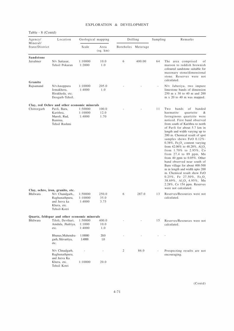
4-71
EXPLORATION & DEVELOPMENT
The area comprised of
maroon to reddish brownish
coloured sandstone suitable for
masonary stone/dimensional
stone. Reserves were not
calculated.
N/v Jaberiya, two impure
limestone bands of dimension
250 m x 30 to 40 m and 200
m x 20 to 40 m was mapped.
Two bands of banded
haematite quartzite &
ferruginous quartzite were
noticed. First band observed
from south of Karithra to north
of Pavli for about 5.7 km in
length and width varying up to
200 m. Chemical result of spot
samples shows FeO 0.12%-
0.38%, Fe2O
3 content varying
from 42.06% to 48.28%, Al2O
3
from 1.70% to 2.95%, Co
from 27.4 to 89 ppm, Mn
from 40 ppm to 0.05%. Other
band observed near south of
Baru village for about 400-500
m in length and width upto 200
m. Chemical result show FeO
0.25%, Fe 27.50%, Fe2O
3
38.69%, Al2O
3 4.95%, Mn
2.28%, Co 154 ppm. Reserves
were not calculated.
Reserves/Resources were not
calculated.
Reserves/Resources were not
calculated.
-
Prospecting results are not
encouraging.
Table - 8 (Contd)
Agency/ Locat ion Geological mapping Drilling Sampling Remarks
Mineral/
State/Distr ict Scale Area Boreholes Meterage
(sq. km)
Sandstone
Jaisalmer N/v Sattasar, 1:10000 10.0 6 400.00 64
Tehsil Pokaran 1:2000 1.0
Granite
Rajsamand N/vAnoppura 1:10000 205.0 - - -
Jemakhera, 1:4000 1.0
Hirakheda, etc.
Deogarh-Tehsil.
Clay, red Ochre and other economic minerals
Chittorgarh Pavli, Baru, 1:50000 100.0 - - 11
Karithra, 1:10000 12.0
Muroli, Rud, 1:4000 1.70
Bamina,
Tehsil Rashmi
Clay, ochre, iron, granite, etc.
Bhilwara N/v Chandgarh,, 1:50000 250.0 6 287.0 13
Raghunathpura, 1:10000 35.0
and Jeeva ka 1:4000 3.75
Khera, etc.
Tehsil-Kotri
Quartz, feldspar and other economic minerals
Bhilwara Tiloli, Devthari, 1:50000 400.0 - - 15
Amdala, Jhalriya, 1:1000 10.0
etc. 1:4000 1.0
Bhunas,Mahendra- 1:10000 20.0 - - -
garh, Shivartiya, 1:4000 1.0
etc.
N/v Chnadgarh, - - 2 86.0 -
Raghunathpura,
and Jeeva Ka
Khera, etc. 1:10000 20.0
Tehsil Kotri
(Contd)
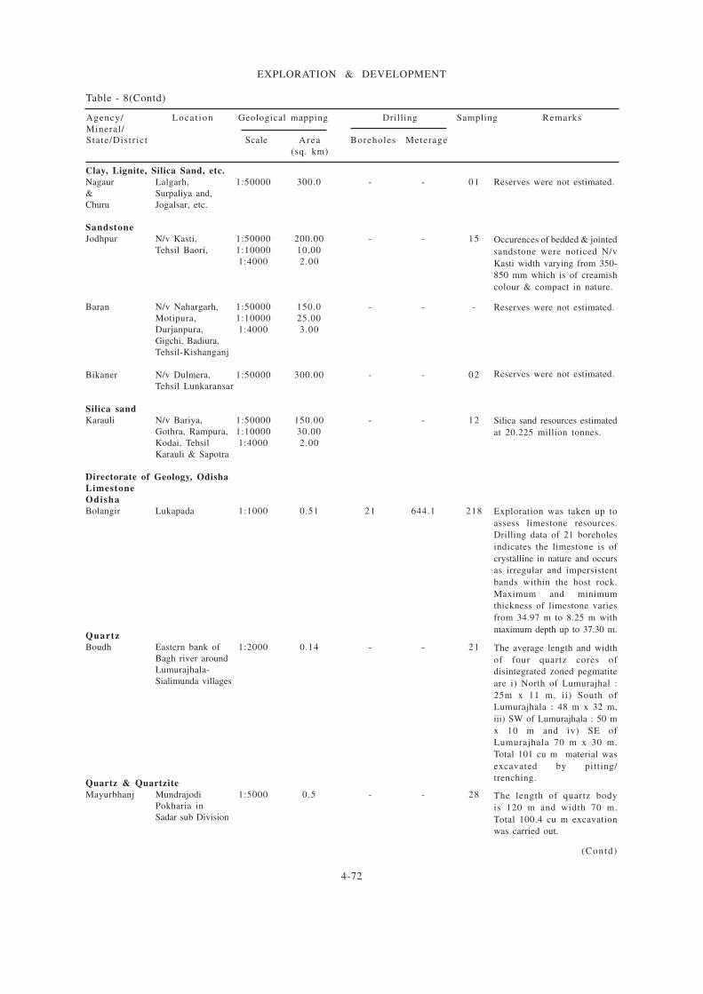
4-72
EXPLORATION & DEVELOPMENT
Reserves were not estimated.
Occurences of bedded & jointed
sandstone were noticed N/v
Kasti width varying from 350-
850 mm which is of creamish
colour & compact in nature.
Reserves were not estimated.
Reserves were not estimated.
Silica sand resources estimated
at 20.225 million tonnes.
Exploration was taken up to
assess limestone resources.
Drilling data of 21 boreholes
indicates the limestone is of
crystalline in nature and occurs
as irregular and impersistent
bands within the host rock.
Maximum and minimum
thickness of limestone varies
from 34.97 m to 8.25 m with
maximum depth up to 37.30 m.
The average length and width
of four quartz cores of
disintegrated zoned pegmatite
are i) North of Lumurajhal :
25m x 11 m, ii) South of
Lumurajhala : 48 m x 32 m,
iii) SW of Lumurajhala : 50 m
x 10 m and iv) SE of
Lumurajhala 70 m x 30 m.
Total 101 cu m material was
excavated by pitting/
trenching.
The length of quartz body
is 120 m and width 70 m.
Total 100.4 cu m excavation
was carried out.
Table - 8(Contd)
Agency/ Locat ion Geological mapping Drilling Sampling Remarks
Mineral/
State/Distr ict Scale Area Boreholes Meterage
(sq. km)
Clay, Lignite, Silica Sand, etc.
Nagaur Lalgarh, 1:50000 300.0 - - 01
& Surpaliya and,
Churu Jogalsar, etc.
Sandstone
Jodhpur N/v Kasti, 1:50000 200.00 - - 15
Tehsil Baori, 1:10000 10.00
1:4000 2.00
Baran N/v Nahargarh, 1:50000 150.0 - - -
Motipura, 1:10000 25.00
Durjanpura, 1:4000 3.00
Gigchi, Badiura,
Tehsil-Kishanganj
Bikaner N/v Dulmera, 1:50000 300.00 - - 02
Tehsil Lunkaransar
Silica sand
Karauli N/v Bariya, 1:50000 150.00 - - 12
Gothra, Rampura, 1:10000 30.00
Kodai, Tehsil 1:4000 2.00
Karauli & Sapotra
Directorate of Geology, Odisha
Limestone
Odisha
Bolangir Lukapada 1:1000 0.51 21 644.1 218
Quartz
Boudh Eastern bank of 1:2000 0.14 - - 21
Bagh river around
Lumurajhala-
Sialimunda villages
Quartz & Quartzite
Mayurbhanj Mundrajodi 1:5000 0.5 - - 28
Pokharia in
Sadar sub Division
(Contd)
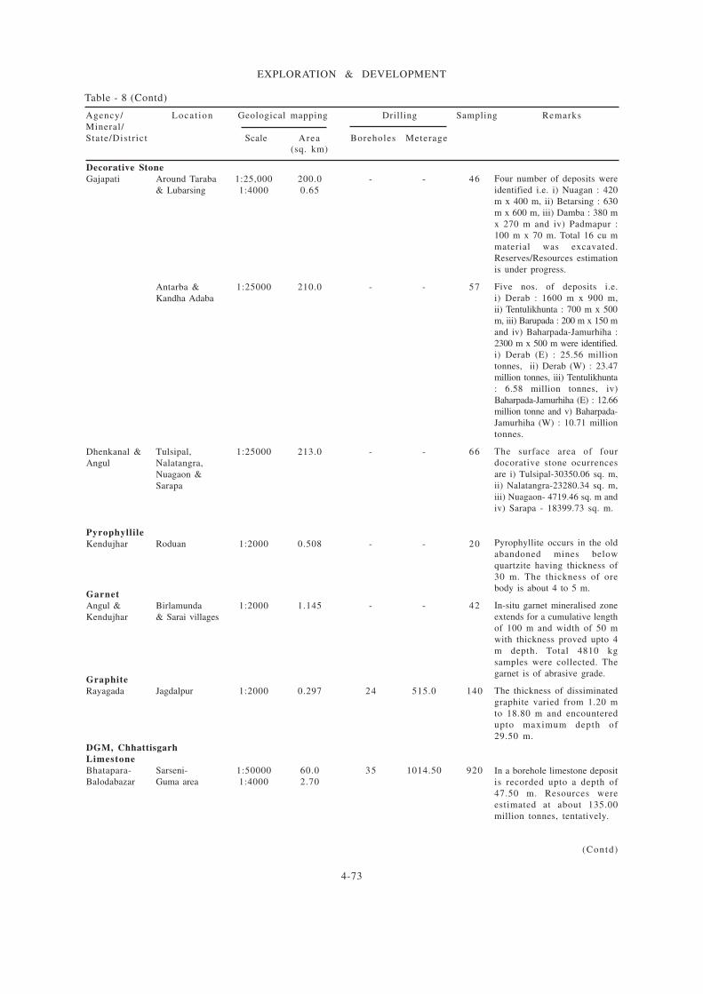
4-73
EXPLORATION & DEVELOPMENT
Decorative Stone
Gajapati Around Taraba 1:25,000 200.0 - - 46
& Lubarsing 1:4000 0.65
Antarba & 1:25000 210.0 - - 57
Kandha Adaba
Dhenkanal & Tulsipal, 1:25000 213.0 - - 66
Angul Nalatangra,
Nuagaon &
Sarapa
Pyrophyllile
Kendujhar Roduan 1:2000 0.508 - - 20
Garnet
Angul & Birlamunda 1:2000 1.145 - - 42
Kendujhar & Sarai villages
Graphite
Rayagada Jagdalpur 1:2000 0.297 24 515.0 140
DGM, Chhattisgarh
Limestone
Bhatapara- Sarseni- 1:50000 60.0 35 1014.50 920
Balodabazar Guma area 1:4000 2.70
Table - 8 (Contd)
Agency/ Locat ion Geological mapping Drilling Sampling Remarks
Mineral/
State/Distr ict Scale Area Boreholes Meterage
(sq. km)
Four number of deposits were
identified i.e. i) Nuagan : 420
m x 400 m, ii) Betarsing : 630
m x 600 m, iii) Damba : 380 m
x 270 m and iv) Padmapur :
100 m x 70 m. Total 16 cu m
material was excavated.
Reserves/Resources estimation
is under progress.
Five nos. of deposits i.e.
i) Derab : 1600 m x 900 m,
ii) Tentulikhunta : 700 m x 500
m, iii) Barupada : 200 m x 150 m
and iv) Baharpada-Jamurhiha :
2300 m x 500 m were identified.
i) Derab (E) : 25.56 million
tonnes, ii) Derab (W) : 23.47
million tonnes, iii) Tentulikhunta
: 6.58 million tonnes, iv)
Baharpada-Jamurhiha (E) : 12.66
million tonne and v) Baharpada-
Jamurhiha (W) : 10.71 million
tonnes.
The surface area of four
docorative stone ocurrences
are i) Tulsipal-30350.06 sq. m,
ii) Nalatangra-23280.34 sq. m,
iii) Nuagaon- 4719.46 sq. m and
iv) Sarapa - 18399.73 sq. m.
Pyrophyllite occurs in the old
abandoned mines below
quartzite having thickness of
30 m. The thickness of ore
body is about 4 to 5 m.
In-situ garnet mineralised zone
extends for a cumulative length
of 100 m and width of 50 m
with thickness proved upto 4
m depth. Total 4810 kg
samples were collected. The
garnet is of abrasive grade.
The thickness of dissiminated
graphite varied from 1.20 m
to 18.80 m and encountered
upto maximum depth of
29.50 m.
In a borehole limestone deposit
is recorded upto a depth of
47.50 m. Resources were
estimated at about 135.00
million tonnes, tentatively.
(Contd)
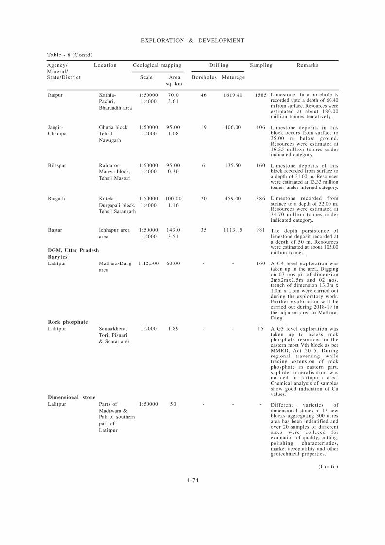
4-74
EXPLORATION & DEVELOPMENT
Raipur Kathia- 1:50000 70.0 46 1619.80 1585
Pachri, 1:4000 3.61
Bharuadih area
Jangir- Ghutia block, 1:50000 95.00 19 406.00 406
Champa Tehsil 1:4000 1.08
Nawagarh
Bilaspur Rahtator- 1:50000 95.00 6 135.50 160
Manwa block, 1:4000 0.36
Tehsil Masturi
Raigarh Kutela- 1:50000 100.00 20 459.00 386
Durgapali block, 1:4000 1.16
Tehsil Sarangarh
Bastar Ichhapur area 1:50000 143.0 35 1113.15 981
area 1:4000 3.51
DGM, Uttar Pradesh
Barytes
Lalitpur Mathara-Dang 1:12,500 60.00 - - 160
area
Rock phosphate
Lalitpur Semarkhera, 1:2000 1.89 - - 15
Tori, Pisnari,
& Sonrai area
Dimensional stone
Lalitpur Parts of 1:50000 50 - - -
Madawara &
Pali of southern
part of
Latitpur
Limestone in a borehole isrecorded upto a depth of 60.40m from surface. Resources wereestimated at about 180.00million tonnes tentatively.
Limestone deposits in thisblock occurs from surface to35.00 m below ground.Resources were estimated at16.35 million tonnes underindicated category.
Limestone deposits of thisblock recorded from surface toa depth of 31.00 m. Resourceswere estimated at 13.33 milliontonnes under inferred category.
Limestone recorded fromsurface to a depth of 32.00 m.Resources were estimated at34.70 million tonnes underindicated category.
The depth persistence oflimestone deposit recorded ata depth of 50 m. Resourceswere estimated at about 105.00million tonnes .
A G4 level exploration wastaken up in the area. Diggingon 07 nos pit of dimension2mx2mx2.5m and 02 nos.trench of dimension 13.3m x1.0m x 1.5m were carried outduring the exploratory work.Further exploration will becarried out during 2018-19 inthe adjacent area to Mathara-Dang.
A G3 level exploration wastaken up to assess rockphosphate resources in theeastern most Vth block as perMMRD, Act 2015. Duringregional traversing whiletracing extension of rockphosphate in eastern part,suphide mineralisation wasnoticed in Jaitupura area.Chemical analysis of samplesshow good indication of Cuvalues.
Different varieties ofdimensional stones in 17 newblocks aggregating 300 acresarea has been indentified andover 20 samples of differentsizes were colleced forevaluation of quality, cutting,polishing characteristics,market acceptatility and othergeotechnical properties.
Table - 8 (Contd)
(Contd)
Agency/ Locat ion Geological mapping Drilling Sampling Remarks
Mineral/
State/Distr ict Scale Area Boreholes Meterage
(sq. km)

4-75
EXPLORATION & DEVELOPMENT
A G3 level exploration wascarried out with an objectiveto i) demarcate the limestoneoccurrence in the area bydrilling boreholes at 40 m x400 m grid interval, ii) findout quantity and quality/gradeof limestone, etc. Theexploration was funded byNMET. The major rockformation of the area aredolomite, shaly limestone/dolomitic limestone andlimestone of Raipur group.Reserves/Resources estimated43.65 millon tonnes oflimestone with an averagegrade of CaO 44.54%, MgO1.41%, SiO
2 8.18%, Al
2O
3
1.05%, Fe2O
3 1.53% and LOI
38.16% under inferredcategory (333).
A G3 level exploration wascarried out with an objective toi)demarcate the limestoneoccurrences at shallow depth bydrilling at 800 m x 800 m gridinterval, ii) find out quality oflimestone and iii) carry outexploration as per Mineral(Evidence of Mineral contents)Rule 2015, etc. The explorationwork was funded by NMET.Reserves/Resources wereestimated at 131.10 milliontonnes of limestone with CaO45.26%, MgO 2.04%, SiO
2
10.05%, Al2O
3 1.58%, Fe
2O
3
1.18% and LOI 38.09% underinferred category (333).
A G2 level exploration wascarried out with an objectiveto i) demarcate the limestoneoccurrence in the area bydrilling boreholes at 400m x400 m grid intervel, ii)estimate the quantity andquality/grade of limestone andiii) carry out exploration as perMineral (Evidance of Mineralcontents) Rule, 2015, MineralAuction Rule, 2015, etc. Thework was funded by NMET.The rock formation of thearea comprises sandstone, shaleand limestone. Reserves/Resources of limestone wereestimated at 68.02 milliontonnes with an average gradeof CaO 44.71%, MgO 2.33%,SiO
2 10.50%, Al
2O
3 1.68%,
Fe2O
3 1.61% and LOI 37.43%
under inferred category. (332)
Table - 8 (Contd)
Agency/ Locat ion Geological mapping Drilling Sampling Remarks
Mineral/
State/Distr ict Scale Area Boreholes Meterage
(sq. km)
MECL
Chhattisgarh
Bilaspur Ranigaon 1:10000 6.5 15 492.5 167
Gondaiya block
Kota Tehsil
Madhya Pradesh
Satna Naubasta- 1:10000 15 7 305.00 111
Kolard block
Nagod Tehsil
Satna Gunchihai 1:5000 6.5 38 1461.0 549
block, Rampur
Baghelan Tehsil
(Contd)
4-76
EXPLORATION & DEVELOPMENT
A G3 level exploration wascarried out with an objective to
i) demarcate the limestoneoccurrence in the area by drillingboreholes at 400 x 400 m gridintervel, ii) estimate thequantity and quality/grade oflimestone and iii) carry outexploration as per Mineral(Evidence of Mineralcontents) Rule, 2015, MineralAuction Rule, 2015, etc. Theprojcet was funded by NMET.Reserves/Resources of
limestone were estimated at264.4051 million tonnes withan average grade of CaO44.46%, MgO 2.17%,SiO
2 9.55% Al
2O
3 1.97%, Fe
2O
3
1.48% and LOI 37.59% underindicated & inferred categories.
A G3 level exploration wascarried out with an objective toi) demarcate the limestoneoccurrence in the area by drilling
boreholes at 800 m x 800 mgrid interval, ii) estimate thequantity and quality/grade oflimestone and iii) carry outexploration as per Mineral(Evidence of MineralContents) Rule, 2015, MineralAuction Rule, 2015, etc. Theproject was funded by NMET.Reserves/Resources oflimestone were estimated at41.68 million tonnes with anaverage chemical composition
of CaO 46.39%, MgO 0.73%,SiO
2 10.90%, Al
2O
3 1.30%,
Fe2O
3 1.09% and LOI 38.01%
under inferred category.
A G3 level exploration wascarried out with an objective toi) demarcate the limestoneoccurrence in the area by drillingboreholes at 800m x 800 m gridinterval, ii) find out thequantity and quality/grade of
limestone and iii) carry outexploration as per Mineral(Evidence of MineralContents)Rule, 2015, Mineral(Auction) Rule, 2015, etc. Theexploration was funded byNMET. Reserves/Resources ofestimated at 80.21 milliontonnes with an average gradeof CaO 47.10%, MgO 1.22%,SiO
2 9.75%, Al
2O
3 1.32%, Fe
2O
3
1.00% and LOI 38.22% under
inferred category.
Table - 8 (Contd)
Satna Jamodi- 1:10000 31 83 3731.00 1641
Mahanna block,
Khamriya,Pasiyan,
Phutainaha,
Phutondhi and
Ramsthan areas,
Raghurajnagar-
Tehsil.
Telangana
Suryapet Pasupulsbodu 1:5000 1.36 3 108.0 95
block,
Janpahad village,
Nereducherla
Mandal
Sultanpur 1:5000 1.39 3 130.0 142
block,
Mattampally
Mandal.
Agency/ Locat ion Geological mapping Drilling Sampling Remarks
Mineral/
State/Distr ict Scale Area Boreholes Meterage
(sq. km)
(Contd)

4-77
EXPLORATION & DEVELOPMENT
(con td)
Table - 8 (Contd)
Suryapet Saidulnama 1:5000 1.70 3 127.0 136
block,Mahanadi
Gudem village,
Palakeedu
Mandal
GMDC
Bauxite
Gujarat
Sirmaur Naredil - - 14 28.5 06
Lignite
Gujarat
Sirmaur Tagadi Block-A, - - 14 28.5 06
Block-B
Mevase - - - - -
Tadkeshwar 1:5000 - - - -
Kachchh - 1:5000 - - - -
Mata no Madh 1:5000 - - - -
Fluorite
Chhota Udepur Ambadonger mine 1:5000 - - - -
A G3 level exploration was
carried out with an objective
to i) demarcate the limestone
occurrence in the area by
drilling boreholes at 800 x 800
m grid interval, ii) find out the
quantity/grade and quality of
limestone and iii) carry out
exploration as per Mineral
(Evidence of Mineral contents)
Rule, 2015, Mineral (Auction)
Rule, 2015, etc. The exploration
was funded by NMET.
Reserves/Resources estimated
at 71.86 million tonnes with
an average grade of CaO
46.79%, MgO 0.84%, SiO2
10.02% Al2O
3 1.22%, Fe
2O
3
1.01% and LOI 38.03%.
About 0.07 millions tonnes
resources were estimated.
Lignite is brownish black, in
colour, amorphous and fine
grained in nature.The total
resources were estimated at
114.72 million tonnes.Out of
this the total resources estimated
in block - A is 89.56 million
tonnes and in block B has been
estimated at 25.16 million
tonnes.
Resources were about 19
million tonnes.
Resources were about 14.85
million tonnes at the end of
March, 2018.
Resources were about 14.85
million tonnes at the end of
March, 2017.
Resources were not estimated.
Agency/ Locat ion Geological mapping Drilling Sampling Remarks
Mineral/
State/Distr ict Scale Area Boreholes Meterage
(sq. km)
4-78
EXPLORATION & DEVELOPMENT
Agency/ Locat ion Geological mapping Drilling Sampling Remarks
Mineral/
State/Distr ict Scale Area Boreholes Meterage
(sq. km)
Table - 8 (Contd)
DGM, 2016-17
Rajasthan
Ajmer Around Mehgaon, 1:50000 150 - - 26
Nituti,Gingoli, 1:10000 15
Jajota,Jhak,etc. 1:2000 3
village, Border area
of Ajmer & Nagaur
N/v Shyamgarh, 1:10000 10.0 4 600 557
Pakriyawas, 1:2000 4.0 - - -
Kanakheda,
Kesarpura, etc.
Tehsil Beawar
Tonk N/v Khalilpura, 1:50000 50.0 12 600.0 219
Dodwari, Devri 1:10000 10.0
Jabriya, etc. 1:2000 4.0
Tehsil-Tonk
Alwar/ N/v Bithoda, 1:4000 2.10 4 269 53
Jaipur Mandha, Bhankri,
Karoi, Nayabas,etc.
Tehsil-Kotputali
Jaipur distt and
Tehsil-Thanagazi
Alwar-distt
An exploration of around 200sq. km area was taken up withan objective to locatelimestone, dolomite, flourite,baryte, soapstone, whitequartzite and other economicminerals. Ferruginousgossanised zone was observedin silicified quartizite/amphibolites, calc silicate n/vMahegaon in the south tovillage Gingoli in north over astrike length of 11 km withwidth of 4.5 km. Specks ofpyrite, chalcopyrite andpyrrhotite have been observedin quartzite, amphibolite andcalc silicate.
During exploration of area,three bands in impurelimestone admeasuring about4500 m x 200-350 m, 800 m x8-13 m, 635 m x 19-28 m weremapped n/v Kotra-Ka-Bariya-Banola, Shivpura-ghata,Gowaliya and Dhandhiya, etc.Similarly five bands oflimestone measuring about1000 m x 30-85 m,110 m x 10-23 m, 620 m x12-42 m, 1270 m x 110-400m and 1910 m x 3 00-840 mwere mapped n/v Kanakhera,Khetakhera and Kasarpur.Limestone in the area is fineto medium grained, hard,compact, fractured, jointed andweathered at surface.
A search for cement gradelimestone was taken up in thearea. Two limestone bandswere mapped around Devri andKurera. The first band is about500 m north of village Devriextends for a strike length of700 m with 45-50 m. width.The second band is about 350m east of village Devri andextend to a strike length of500 m with width of about 8-10 m. The limestone isgrayish-white to greenish grayin colour, medium grained andcrystalline in nature.
Total reasources wereestimated at about 50.17million tonnes.
(Contd)
4-79
EXPLORATION & DEVELOPMENT
(Contd)
Table - 8 (Contd)
Jhunjhunu/ N/v Parasrampura, 1:4000 3.0 - - 26
Sikar Gothra area, etc.
Tehsil-Nawalgarh,
Jhunjhunu distt
Udaipur N/v Bikarni- 1:50000 100.0 - - 10
Kagwas- 1:10000 10.0
Sandmaria, 1:4000 1.0
Tehsil-Kotra
Dungarpur Rama,Dad, 1:4000 2.0 4 596 338
Padla-jani,
Nandli Ahara,
Bhatoli, Munger,
Sabla,Tehsil-Aspur
Bhilwara Phul ji ki 1:10000 20.0 - - -
Kheri-Sopura- 1:4000 2.75
Shyamgarh-Amartiya-
Bharnda-Ratiya
Kheda-Dhakad Kheri
Shamgarh-Phulji ki Khera-
Amartiya-Chitauriya-
Bharenda
Pali N/v Virampura, 1:50000 300.0 - - 37
Ki Bhagal, 1:10000 20.0
Tehsil-Bali 1:4000 2.0
Jaisalmer N/v Kam al ka, 1:10000 15.0 26 1217.0 800
Goal of 1:2000 4.0
Sam area tehsil
Limestone, Masonry stone, Bajri and other economic minerals
Bikanar N/V Soniyasar, 1:50000 250.0 - - -
Kumpalsar, 1:10000 10.0
Dhaneru, Badela,
etc., Dungargarh Tehsil
Agency/ Locat ion Geological mapping Drilling Sampling Remarks
Mineral/
State/Distr ict Scale Area Boreholes Meterage
(sq. km)
Further exploration by
outsourcing or under NMETfund is proposed.
N/v kyara and Bikarni, medium
grained limestone, at placessil iceous in nature are
continued in southern sideextended for 500 m and 1700 m
in length with width varies form50-300 m. Total length of
limestone is 4 to 4.5 kmincluding extension of old
explored band. Limestone isintruded by small pegmatite
vein.
The exploration in this area
was commenced in 2014-15.The l ight pinkish grey to
grayish white coloured fine tomedium grained, hard and
compact intermittently exposedcrystalline limestone band was
geologically mapped in detailn/v Bhatoli. Limestone band is
exposed over a length of about3 km with varied width of 10 m
to 15 m from North East toSouth West of village Bhatoli.
Limestone band mapped in
the area extends for a strikelength of about 7 km with
width varying from 2 km to2.4 km. The project will
continue in FS 2017-18.
Two limestone band have
been mapped in the area i.e.one band extends for about
1700 m with width varyingfrom 150 m to 500 m and
other limestone band extendsfor a strike length of 1500 m
with width varying from 200m to 500 m.
Resources were estimated atabout 355 million tonnes of
cement grade limestone and 65millon tonnes of SMS grade
limestone.
The area is occupied with sand
and medium to high sanddunes. Project discontinued
due to non-encountering ofpromising limestone.

4-80
EXPLORATION & DEVELOPMENT
Agency/ Locat ion Geological mapping Drilling Sampling Remarks
Mineral/
State/Distr ict Scale Area Boreholes Meterage
(sq. km)
Table - 8 (Contd)
The area is occupied with sand
and medium to high sand dunes.
Project discontinued due to
non-encountering to promising
limestone.
The area is concealed and no
esposures of limestone were
found on surface. The project
was not considered for next
field season.
Limestone and ferruginous
quartzite were reported in the
area. Limestone found n/v
Fatehpura, Simbhu ka bas,
Patan, Andhwadi, etc.
Ferruginous brecciated
quartzite is associated with
limestone. The CaO is less
than 33% and iron is up to
44% in brecciated ferruginous
quartzites n/v Kharkhari
Chawand Singh, tehsil Reni.
In the block (No.4) area
drilling was carried out on 800
m x 800 m and 1600 m x 1600
m grid pattern and established
the occurrence and depth
persistence of limestone.
Resources were estimated at
about 516.66 million tonnes
of cement grade limestone.
The limestone was seen along
chambal river in 4000 m x
500-1200 m area n/v Padra-
Aniyala and 1200 m x 200-
250 m area n/v Barod. The
limestone appeared to cement
grade. Resources were not
estimated due to lack of data
on depth persistence of
limestone. The project will
continue.
Limestone
Bikaner N/v Soniyasar, 1:50000 250.0 - - -
Kumpalsar, 1:10000 10.0
Dhaneru, Badela,
etc., Dungargarh Tehsil
Sawai N/v Padra, 1:50000 125.0 - - 36
Madhopur Aniyala, Barod 1:10000 10.0
Tehsil-Khandar 1:4000 2.0
Nagaur N/v Taras & - - 26 1000.0 698
Khorwa,
Tehsil Khinwsar
(Contd)
Bikaner Sarunda, Bhadla 1:10000 15.0 - - -
and Sobhana
village of Nokha
Tehsil
Alwar N/v Dangarwara, 1:50000 150.0 - - 15
Dhamrer,Thonsra,1:10000 10.0
Digaora,Toda 1:4000 3.0
Gyan Singh,
Chhillori, etc
Tehsil-Rajgarh

4-81
EXPLORATION & DEVELOPMENT
Agency/ Locat ion Geological mapping Drilling Sampling Remarks
Mineral/
State/Distr ict Scale Area Boreholes Meterage
(sq. km)
Table - 8 (Contd)
(Contd)
Exploration was started in
2014-15 with an objective to
locate cement grade limestone
deposit in the area. About 119
m cummulative thickness of
grey limestone with thin shale
intersection were reported in
all boreholes. Cement/
blendable grade limestone exist
in the area. Resources will be
estimated after the receipt of
chemical analysis data.
The limestone band mapped in
the area having strike length
of about 8.5 km with width of
more than 2.0 km. It is
massive, non crystalline,
compact and fine grained with
greyesh colour and varigated
in upper part and purplish-pink
and argillaceous in lower part.
Limestone seems to be of
cement grade. The project will
continue.
i) A limestone band near village
Nitaura was mapped for a strike
length of about 220 m with
exposed width up to 50-80.
The limestone seems to be
cement grade; ii) A limestone
band extend for the strike
length of more than 5.5 km
with exposed width of 500 m-
700 m was seen from village
or to north of Derna; iii) A
limestone band extend for the
strike length of more than
1.0 km with exposed width of
30 m - 200 m was mapped
around Naijamin village; iv)
Jharoli-Laj-Phulera-Nitaura
limestone band is
intermittently extends for
strike length of more than 25
km with exposed width up to
300.0 m. The detailed
chemical analysis results of
Derna Wada area shows
average CaO content of
limestone is 50.26% with about
4% SiO2 & MgO and about 1%
to less than 1% Fe2O
3. The
limestone band around Derna
to south of Wara village is
cement grade to high grade.
Chittorgarh Rasulpura, Bansa - - 4 209.0 119
& Pirkhera,
Phachar Ahiran,
Tehsil-Nimbahera
Chittorgarh Samriya kalan, 1:10000 17.50 - - 22
Nathuramji ka 1:4000 2.0
Khera, Meghniwas
and Mandna
Tehsil-Begun
Sirohi Tehsil-Aburoad 1:10000 10.0 4 222.0 64
Pindwara 1:4000 2.25

4-82
EXPLORATION & DEVELOPMENT
Table - 8 (Contd)
Agency/ Locat ion Geological mapping Drilling Sampling Remarks
Mineral/
State/Distr ict Scale Area Boreholes Meterage
(sq. km)
Nagaur N/v Awad and - - 26 1000.0 739
Khera,
Tehsil-Jayal
The boreholes drilled in the area
intersected limestone for a
cumulative thickness of 0.50 m
to 24.85 m. The limestone of
area is of good quality high grade
limestone. Resources estimated
in the area are placed at
371.696 million tonnes of
cement grade limestone.
Exploratory drilling will
continue.
-
Limestone, Clay, Silica Sand, etc.
Bundi N/v Kathoda, 1:50000 150.0 - - -
Mani,Bishan Pura, 1:10000 15.0
Sodanpura,Kalyani, 1:4000 1.5
Karwar, Antarda,
etc Tehsil-Nainwa
Laterite,Clay, Red ochre, Glauconitic shale, etc.
Baran N/v Bhanpur 1:50000 150.0 - - -
Pureni, Semri, 1:10000 15.0
Baseri, Amrod, 1:4000 1.5
Majola, Thana
Kasba,
Tehsil-Shahbad
-
Laterite, high-grade Limestone, Bentonite, Clays, Ochre, etc
Jhalawar Deccan Trap 1:50000 150.0 - - -
areas of tehsil 1:10000 15.0
Jhalrapatan, 1:4000 1.5
Pirawa, Pach-
Pahar, Gangdhar,
Aklera, Manoharthana
and Khanpur.
-
(Contd)
Decorative and Masonry Stone
Udaipur N/v Lunk, 1:50000 100.0 - - -
Tehsil-Kotra 1:10000 10.0
1:4000 1.0
.
N/v Lunk medium to coarse
grained, hard and compact,
greenish grey to grey coloured
Erinpura granite is exposed and
porphyritic in nature seems to
bear good blockablity in
boulders, knobs and sheets.
4-83
EXPLORATION & DEVELOPMENT
Table - 8(Contd)
Agency/ Locat ion Geological mapping Drilling Sampling Remarks
Mineral/
State/Distr ict Scale Area Boreholes Meterage
(sq. km)
Minor Minerals and other economic minerals
Dungarpur N/v Ganeshpur, 1:50000 200.0 - - 6
Tehsil-Aspur, 1:10000 10.0
Ghughra & Inder 1:4000 2.5
Khet(Rampur)
Tehsil-Dungarpur
.
An area of 2.0 sq. km was
covered under detailedmapping in three blocks
namely a) Ganeshpur block, b)Gughra block and c)Inderkhet
block. In Ganeshpur block, inan area of 1.0 sq. km, the light
yellow coloured, fine tomedium grained, hard and
compact quartzite withfractures, etc is exposed for
about 1,100 m in length and150 m to 300 m of average
width. In Gughra block, lightyellowish coloured fine to
medium grained, hard quartziteis exposed over an area of 1.0
sq. km. The quartzite may beuseful for building construction
purpose. In Inderkhet block,light yellowish to brownish
coloured, medium grained,hard quartzite is exposed over
an area of 0.50 sq. km. No newmineral found. Project
Completed.Granite
Jalore N/v Nosara, 1:4000 2.0 - - 11
and Nosra ki dhani
Tehsil-Ahore
.
Outcrop of granite having
dimension of 500 m x100 m n/v
Nosara and 250x150 m n/v
Nosra ki Dhani were mapped.
Granite is brownish to creamish
in colour, medium to coarse
grained and blockable in nature.
(Contd)
Silica Sand
Jaisalmer N/v Neran, 1:50000 100.0 - - 12
Nehari Talai etc 1:10000 10.0
Tehsil-Pokaran 1:2000 2.0
.
About 1.0 sq. km area have
been identified for white friable
sand stone of 1 m to 2 m exposed
thickness. Few chemical
analysis showed SiO2
content
varies from 85.72% to 92.70%
and Fe2O
3 content varies from
0.42% to 1.06%.Sand stone (Building stone and masonary)
Jodhpur N/v Kumaro, 1:50000 130.0 - - 35
ki dhani and 1:10000 10.0
Joganion ka 1:4000 2.0
Bhakar, Tehsil-
Balesar
Isolated outcrops of sand stone
were mapped to north of village
Kumaro ki Dhani in 600 m x
800 m area. Massive and
jointed and sandstone is exposed
n/v Joganion Ka Bhakar (3 km
x 2 km), Devatu (122m x
119 m and 146 m x 107 m)
and Raikon Ki Dhani (1000 m
x 750 m), etc. It is creamish to
pink coloured, medium to coarse
grained, bedded and compact
sandstone and can be used as
building/masonry stone.
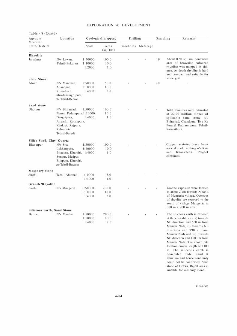
4-84
EXPLORATION & DEVELOPMENT
Table - 8 (Contd)
Agency/ Locat ion Geological mapping Drilling Sampling Remarks
Mineral/
State/Distr ict Scale Area Boreholes Meterage
(sq. km)
(Contd)
Rhyolite
Jaisalmer N/v Lawan, 1:50000 100.0 - - 19
Tehsil-Pokaran 1:10000 10.0
1:2000 1.0
About 0.50 sq. km pontential
area of brownish coloured
rhyolite was mapped in this
area. At depth rhyolite is hard
and compact and suitable for
stone grit.Slate Stone
Alwar N/v Mandhan, 1:50000 150.0 - - 20
Anandpur, 1:10000 10.0
Khundroth, 1:4000 3.0
Shivdansingh pura,
etc.Tehsil-Behror
-
Sand stone
Dholpur N/v Bhiramad, 1:50000 100.0 - - -
Pipret, Padampura,1:10000 10.0
Dangripura, 1:4000 1.0
Jorgarhi, Kacchpura,
Kankret, Rajpura,
Rahrai,etc.
Tehsil-Basedi
Total resources were estimated
at 22.20 million tonnes of
splittable sand stone n/v
Bhiramad, Chandpura, Teja Ka
Pura & Dadraunipura, Tehsil-
Sarmathura.
Silica Sand, Clay, Quartz
Bharatpur N/v Sita, 1:50000 100.0 - - -
Lakhanpura, 1:10000 10.0
Bhagora, Kharairi, 1:4000 1.0
Sonpur, Madpur,
Bijepura, Dhurairi,
etc.Tehsil-Bayana
Copper staining have been
noticed in old working n/v Kair
and Khankheda. Project
continues.
Masonary stone
Sirohi Tehsil-Aburoad 1:10000 5.0 - - -
1:4000 1.0
-
Siliceous earth, Sand Stone
Barmer N/v Mandai 1:50000 200.0 - - -
1:10000 10.0
1:4000 2.0
The siliceous earth is exposed
at three localities i.e. i) towards
NE direction and 560 m from
Mandai Nadi, ii) towards NE
direction and 990 m from
Mandai Nadi and iii) towards
NE direction and 1600 m from
Mandai Nadi. The above pits
location covers length of 1100
m. The siliceous earth is
concealed under sand &
alluvium and hence continuity
could not be confirmed. Sand
stone of Devka, Rajral area is
suitable for masonry stone.
Granite/Rhyolite
Sirohi N/v Mungeria 1:50000 200.0 - - -
1:10000 10.0
1:4000 2.0
Granite exposure were located
to about 2 km towards N-NNE
of Mungeria village. Outcrops
of rhyolite are exposed to the
south of village Mungeria in
300 m x 200 m area.

4-85
EXPLORATION & DEVELOPMENT
Table - 8 (Concld)
Agency/ Locat ion Geological mapping Drilling Sampling Remarks
Mineral/
State/Distr ict Scale Area Boreholes Meterage
(sq. km)
Granite
Jalore N/v Panchota, 1:4000 2.00 - - 11
and Tarwara,
Tehsil-Ahore.
Barmer and N/v Ranakdev, 1:50000 150.00 - - -
Jaisalmer Mehrari area. 1:10000 10.0
1:4000 2.00
Barmer N/v Gujron Ka 1:50000 150.00 - - 07
Talla 1:10000 10.00
(Chuli Dungri) 1:4000 1.00
Phyllite, Limestone, Clay, Silica sand, etc.
Bundi Chainpuriya, 1:50000 100.0 - - -
Bheemganj,
Tarkia, Deroli,
Narayanpura,
Tonkra, etc.
Tehsil Hindoli.
Quartz, feldspar and Granite
Sirohi Tehsil Shivganj 1:10000 10.0 - - 01
1:4000 1.00
-
-
-
-
-
Clay, Red ochre, Silica sand
Chittorgarh Bhadesar, 1:50000 200.0 - - 33
Hatipura, 1:10000 11.50
Sand, Palri, 1:4000 1.0
Pagara,etc.
Tehsil-Bhadesar
The regional mineral survey of
the area revealed i) the
ferruginous cherty brecciated
quartzite (hosting red ochre
and china clay) intermittently
exposed for about 18 km in
length and 200 m to 500 m in
width from north of Hattipur
Minana in south. The silica
sand band was observed n/v
Tejpura/Tejpura ki dhani; ii)
another band was exposed
intermittently for about 12.50
km in length with width of 200
m to 2.50 km from north of
Japharkheda tosand in south.
Apart from this, silica sand
band having dimension 70 m x
10-15 m was also seen at the
foot hills n/v sand, Shergarh
area; iii) A laterite bed was
noted in the west of Palri
village to sand. Prospecting
work completed.