description of the gold belt
TRANSCRIPT
DESCRIPTION OF THE GOLD BELT.GEOGRAPHIC RELATIONS.
The principal gold belt of California includes a portion of the Sierra Nevada lying between the parallels of 37° 30' and 40° north latitude. It is bounded on the west by the Sacramento and San Joaquin valleys, and on the east by a diagonal line extending from about longitude 120° 40' in the neighborhood of the fortieth parallel to lon gitude 119° 40' in the neighborhood of parallel 37° 30'. There are other gold-bearing regions in the State, both to the north and south of this belt, but by far the largest quantity of gold is produced within these limits. The area thus denned contains approximately 9000 square miles. At the northern limit the gold deposits are scattered over nearly the entire width of the range, while to the south the productive region narrows to small dimensions, continuing as a very narrow strip for some distance south of latitude 37° 30'. The whole southern part of the range is comparatively barren. North of the fortieth parallel the range is not without deposits, but the country is flooded with lavas which effectu ally bury the larger part of them.
GENERAL GEOLOGY.
The rocks of the Sierra Nevada are of many kinds and occur in very complex associations. They have been formed in part by deposition beneath the sea and in part by intrusion as igneous.masses, as well as by eruption from vol canoes. All of them except the latest have been more or less metamorphosed.
The northern part of the range, west of longi tude 120° 30', consists prevailingly of clay-slates and of schists, the latter having been produced by the metamorphism of both ancient sediments and igneous rocks. The trend of the bands of altered sediments and of the schistose structure is gener ally from northwest to southeast, parallel to the trend of the range, but great masses of granite and other igneous rocks have been intruded among these schists, forming irregular bodies which interrupt the regular structure and which are generally bordered each by a zone of greater metamorphism. These slates and schists and their associated igneous masses form the older of two great groups of rocks recognized in the Sierra Nevada. This group is generally called the Bed rock series.
Along the western base of the Sierra occur beds of sandstone and clay, some of which contain thin coal seams. These are much younger than the mass of the range and have not shared the met amorphism of the older rocks. They dip gently westward beneath later deposits, which were spread in the waters of a shallow bay occupying the Valley of California and portions of which have been buried beneath recent river alluvium.
Streams flowing down the western slope of the Sierra in the past distributed another formation of great importance the Auriferous gravels. The valleys of these streams served also as channels for the descent of lavas which poured out from volcanoes near the summit. Occupying the valleys, the lavas buried the gold-bearing gravels and forced the streams to seek new channels. These have been worn down below the levels of the old valleys, and the lava beds, with the gravels which they protect, have been isolated on the summits of ridges. Thus the Auriferous gravels are preserved in association with lavas along lines which descend from north east toward southwest, across the trend of the range. The nearly horizontal strata along the western base, together with the Auriferous gravels and later lavas, constitute the second group of rocks recognized in the Sierra Nevada. Compared with the first group, the Bed-rock series, these may be called the Superjacent series.
BED-ROCK SERIES.
PALEOZOIC EEA.
During the Paleozoic era, which includes the periods from the end of the Algonkian to the end of the Carboniferous, the State of Nevada west of longitude 117° 30' appears to have been a land area of unknown elevation. This land probably extended westward into the present State of California and included part of the area now occupied by the Sierra Nevada. Its western
*Jointly prepared by Geo. F. Becker, H. W. Turner, and Waldemar Lindgren, 1894. Revised January, 1897.
shore was apparently somewhat west of the present crest, and the sea extending westward received Paleozoic sediments which now consti tute a large part of the central portion of the range.
At the close of the Carboniferous the Paleozoic land area of western Nevada subsided, and dur ing the larger part of the Juratrias period it was at least partly covered by the sea. At the close of the Juratrias the Sierra Nevada was upheaved as a great mountain range, the disturbance being accompanied by the intrusion of large amounts of granitic rock.
The Auriferous slate series comprises all of the sedimentary rocks that entered into the composi tion of this old range of Juratrias time. Forma tions representing the Algonkian and all of the Paleozoic and Juratrias may therefore form part of the Auriferous slate series.
Fossils of Carboniferous age have been found in a number of places, and the presence of Silu rian beds at the northern end of the range, north of the fortieth parallel, has been determined. A conglomerate occurs in the foothills of Amador and Calaveras counties, interbedded with slates containing Carboniferous limestone; this con glomerate is therefore presumably of Carbonif erous age. The conglomerate is evidence of a shore, since it contains pebbles of quartzite, horn- blende-porphyrite, and other rocks, which have been rounded by the action of waves. The presence of lava pebbles in the conglomerate shows that volcanic eruptions began at a very early date in the formation of the range, for the hornblende-porphyrite pebbles represent lavas similar to the hornblende-andesites of later age.
The great mass of the Paleozoic sediments of the Gold Belt consists of quartzite, mica-schist, sandstone, and clay-slate, with occasional lime stone lenses. On the maps of the Gold Belt these sediments are grouped under two forma tions :
(1) The Robinson formation, comprising sedi ments and trachytic tuffs. This contains fossils showing the age to be upper Carboniferous. The formation is known on the Gold Belt series of maps only in the Downieville quadrangle, a short distance south of the fortieth parallel.
(2) The Calaveras formation, comprising by far the largest portion of the Paleozoic sediments of the Gold Belt. Rounded crinoid stems, corals (Lithostrotion and Clisiophyllum), Foraminifera (Fusulina), and bivalves have been found in the limestone lenses, and indicate that a considerable portion at least of this formation belongs to the middle or lower Carboniferous. In extensive areas of the Calaveras formation no fossils have, however, been found, and older rocks may be present in these. It is not likely that post-Car boniferous rocks are present in these non-fossil- iferous areas.
POST-CAEBONIFEEOUS UPHEAVAL.
After the close of the Carboniferous and before the deposition of at least the later Juratrias beds (Sailor Canyon, Mariposa, and Monte de Oro for mations), an upheaval took place by which the Carboniferous and older sediments under the then retiring sea were raised above water level, forming part of a mountain range. The beds were folded and compressed and thus rendered schistose. Smaller masses of granite and other igneous rocks were intruded at this time.
JUEATEIAS PEEIOD.
The areas of land and sea which existed during the earlier part of this period are scarcely known. Fossiliferous strata showing the former presence of the Juratrias sea have been recognized in the southeastern portion of the range, at Mineral King, where the sediments are embedded in intrusive granite; at Sailor Canyon, a tributary of American River; in Plumas County at the north end of the range about Genesee Valley and elsewhere; and in the foothill region from Butte to Mariposa counties in the slates of the Mariposa nd Monte de Oro formations.
The land mass that originated with the post- Carboniferous upheaval became by gradual eleva tion very extensive toward the end of the Jura trias period. This continental mass of late Jurassic time probably reached eastward at least as far as the east base of the Wasatch Mountains. This conclusion is based on the fact that the latest Jurassic beds of California, the Monte de
Oro and the Mariposa slates, are found only on the western flank of the Sierra Nevada. During the earlier part of the Juratrias period portions of the Great Basin were under water, as is shown by the fossiliferous beds of that age in Eldorado Canyon south of Virginia City and in the Hurn- boldt Mountains, but nowhere from the foothills of the Sierra Nevada to the east base of the Wasatch, if we except certain beds near Genesee Valley, are any deposits known which are of late Jurassic age.
The following formations have been recognized on the Gold Belt maps:
(1) The Mariposa formation, which occurs in narrow bands along the western base of the range. The strata are prevailingly clay-slates, which are locally sandy and contain pebbles of rocks from the Calaveras formation. Tuffs from contemporaneous porphyrite eruptions also occur in them. The fossils of these beds, such as Aucella and Perisphinctes, have their nearest analogues in Russia, and indicate a very late Jurassic age.
(2) The Monte de Oro formation, occurring to the northeast of Oroville. This consists of clay- slate and conglomerate containing plant remains of late Jurassic age.
(3) The Sailor Canyon formation, which appears well up toward the summit of the range, and consists of clay-slates, altered sandstones, and tuffs. It is separated from the Mariposa forma tion by a broad belt of the Calaveras formation. The fossils indicate that the period of its deposi tion covered both the later part of Triassic and the earlier part of Jurassic time.
(4) The Milton formation, which has thus far afforded no fossils; it is lithologically similar to a portion of the Sailor Canyon series, and future research may show that it really was deposited at the same time.
THE POST-JUEATEIAS UPHEAVAL.
Soon after the Mariposa formation had been deposited the region underwent uplift and com pression. The result of uplift was the develop ment of a mountain range along the line of the Sierra Nevada. The Coast Range also was prob ably raised at this time. The action of the forces was such as to turn the -Mariposa strata into a nearly vertical position, and to fold them and other Juratrias beds in with the older Paleozoic strata. The Juratrias clay-shales, in consequence of pressure, now have a slaty structure, which appears to coincide in most cases with the bed ding. This epoch was one of intense eruptive activity. The Mariposa and other Juratrias and older beds were injected with granite and other intrusive rocks. There is evidence that igneous rocks were intruded in varying quantities at dif ferent times; but that the intrusion of the great mass of the igneous rocks accompanied or imme diately followed the upheavals is reasonably cer tain. Those beds that now form the surface were then deeply buried in the foundations of the range.
The disturbance following the deposition of the Mariposa beds was the last of the move ments which compressed and folded the Aurifer ous slate series. The strata of succeeding epochs, lying nearly horizontal or at low angles, prove that since they were accumulated the rock mass of the Sierra Nevada has not undergone much compression. But the fact that these beds now occur above sea-level is evidence that the range has undergone elevation in more recent time.
THE GOLD-QUARTZ VEINS.
The extent of the gold deposits has been indi cated in the introduction to this description. In character they may be classed as primary, or deposits formed by chemical agencies, and sec ondary, or those formed from the detritus pro duced by the erosion of the primary deposits. The primary deposits are chiefly gold-quartz veins, fissures in the rock formed by mountain- making forces and filled with gold-bearing quartz deposited by circulating waters. The gold-quartz veins of the Sierra Nevada are found in irregular distribution chiefly in the Auriferous slates and associated greenstone-schists and por- phyrites, but they also occur abundantly in the granitic rocks that form isolated areas in the slate series. While some gold-quartz veins may ante date the Jurassic period, it is reasonably certain that most of them were formed shortly after the
post-Juratrias upheaval, and that their age, therefore, is early Cretaceous.
SUPERJACENT SERIES.
OEETACEOUS PEEIOD.
Since no beds of early Cretaceous age are known in the Sierra Nevada, it is presumed that during the early Cretaceous all of the present range was above water.
During the late Cretaceous the range subsided to some extent, allowing the deposition of sedi ments in the lower foothill region. These deposits are known as the Chico formation, and consist of sandstone with some conglomerate. In the area covered by the Gold Belt maps this formation is exposed only near Folsom on the American River up to an elevation of 400 feet, and in the Chico district at elevations of from 500 to 600 feet. Since their deposition these strata have been but slightly disturbed from their original approximately horizontal position, but the larger part of them has been eroded or covered by later sediments.
Auriferous gravels are found to some extent in the Chico formation for instance, near Fol som showing that the gold-quartz veins had already been formed before its deposition.
EOCENE PEEIOD.
In consequence of slow changes of level with out marked disturbance of the Chico formation, a later deposit formed, differing from it some what in extent and character. The formation has been called the Tejon (Tay-hone'). It appears in the Gold Belt region at the Marysville Buttes, in the lower foothills of the Sonora district, and it is extensively developed in the southern and western portion of the Great Valley of California. During the Eocene the Sierra Nevada remained a separate, low mountain range, erosion continu ing with moderate rapidity but no great masses of gravels accumulating.
NEOCENE PEEIOD.
The Miocene and Pliocene periods, forming the later part of the Tertiary, have in this atlas been united under the name of the Neocene period. During the Neocene a large part of the Great Valley of California seems to have been under water, forming perhaps a gulf connected with the sea by one or more sounds across the Coast Ranges. Along the eastern side of this gulf was deposited during the earlier part of the Neo cene period a series of clays and sands to which the name lone formation has been given. It follows the Tejon, and appears to have been laid down upon it, without an interval of disturbance or erosion. Marine deposits of the age of the lone formation are known within the Gold Belt only at the Marysville Buttes. Along the eastern shore of the gulf the Sierra Nevada, at least south of the fortieth parallel, during the whole of the Neocene formed a low range drained by numerous rivers. The shore-line at its highest position was several hundred feet above the present level of the sea, but it may have fluctu ated somewhat during the Neocene period. The lone formation appears along this shore-line as a brackish-water deposit of clays and sands, fre quently containing beds of lignite.
The Sierra Nevada during this period was a range with comparatively low relief. The drain age system during the Neocene had its sources near the modern crest of the range, but the channels by no means coincided with those of the present time. Erosion gradually declined in intensity and auriferous gravels accumulated in the lower reaches of these Neocene rivers, the gold being derived from the croppings of veins. Such gravels could accumulate only where the slope of the channel and the volume of water were sufficient to remove the silt while allowing the coarser or heavier masses to sink to the bottom with the gold.
During the latter part of the Neocene period volcanic activity, long dormant, began again, and floods of lavas, 1 consisting of rhyolite, andesite, basalt, and plagioclastic glassy rocks chemically allied to trachyte, were ejected from volcanic vents, and these eruptions continued to the end of the Neocene. These lavas occupy
1 The term "lava" is here used to include not only such material as issued from volcanic vents in a nearly anhydrous condition and at a very high temperature, but also tuff-flows and mud-flows, and, in short, all fluid or semifluid effusive volcanic products.

small and scattered areas in the southern part of the Gold Belt, increasing in volume to the north until, north of the fortieth parallel, they cover almost the entire country. They were extruded mainly along the crest of the range, which still is crowned by the remains of the Neocene volcanoes. An addition to the gold deposits of the range, in the form of gold-quartz veins and irregular thermal impregnations, attended this period of volcanic activity.
When the lavas burst out they flowed down the river channels. The earlier flows were not sufficient to fill the streams, and became inter- bedded with gravels. They are now represented by layers of rhyolite and rhyolite-tuffs, sometimes altered to "pipe-clay." The later andesitic and basaltic eruptions were of great volume, and for the most part completely choked the channels into which they flowed. The rivers were thus obliged to seek new channels substantially those in which they now flow.
Fossil leaves have been found in the pipe-clay, and in other fine sediments at numerous points. Magnolias, laurels, figs, poplars, and oaks are represented. The general character of the flora is thought to indicate a warm and humid climate, and has been compared with the present flora of the South Atlantic Coast of the United States.
THE NEOCENE UPHEAVAL.
In the latter part of the Neocene period a great dislocation occurred along a zone of faulting at the eastern base of the Sierra Nevada, and the grade of the western slope of the range was increased. These faults are sharply marked from Owens Lake up to Honey Lake. There was also a series of faults formed apparently at the very close of the Neocene within the mass of the range in Plumas County. Near the crest the Sierra Nevada is intersected by a system of fissures, often of striking regularity; it is believed that these fissures originated during the Neocene upheaval.
PLEISTOCENE PERIOD.
During Cretaceous, Eocene, and Neocene times the Sierra Nevada had been reduced by erosion to a range with gentle slopes, and the andesitic eruptions had covered it with a deep mantle of lava flows. The late Neocene upheaval increased the grade of the western slope greatly, and the rivers immediately after this disturbance found new channels and, rejuvenated, began the work of cutting deep and sharply incised canyons in the uplifted crustal block.
A period of considerable duration elapsed between the emission of the lava flows which displaced many of the rivers and the time of
maximum glaciation. In this interval most of the deep canyons of the range were formed. Such, for example, are the Yosemite Valley on the Merced Kiver, the great canyon of the Tuolumne, and the canyon of the Mokelumne. The erosion of these gorges may have been facilitated by the fissure system referred to above, for many of the rivers of the range appear to follow one or another set of parallel fissures for a long distance.
At what point the limit between the Neocene and the Pleistocene should be drawn is a some what difficult question. On the maps of the Gold Belt the great andesitic flows are supposed to mark the close of the Neocene, and this divi-« /
sion is in fact the only one that can be made with out creating artificial distinctions. But it is not positively known that this line corresponds exactly to that drawn in other parts of the world between these periods.
The Sierra, from an elevation of about 5000 feet upward, was long buried under ice. The ice widened and extended the canyons of pre existing topography and removed enormous amounts of loose material. It seems otherwise to have protected from erosion the area it covered and to have accentuated the steepness of lower slopes. Small glaciers still exist in the Sierra.
During the earlier part of the Pleistocene period the Great Valley was probably occupied for a time by a lake dammed by the post-Miocene uplift of the Coast Ranges. Later in the Pleistocene this lake evidently was drained and alluvial deposits were spread over the valley. There is no valid reason to believe that the central and southern part of the Sierra has under gone any important dynamic disturbance during the Pleistocene period, but renewed faulting with small throw has taken place along the eastern base of the range in very recent times.
IGNEOUS ROCKS.
Rocks of igneous origin form a considerable part of the Sierra Nevada. The most abund ant igneous rocks there found are of granitic character. Rocks of the granitic series are believed to have consolidated under great press ure and to have been largely intruded into over lying formations at the time of great upheavals; they are thus deep-seated rocks, exposed only after great erosion has taken place.
The rocks called diabase and augite-porphyrite on the Gold Belt maps are not usually intrusive, but largely represent surface lavas which have been folded in with the sedimentary rocks and correspond to modern basalt and augite-andesite. In like manner hornblende-porphyrite corresponds to hornblende-andesite, quartz-porphyrite to dacite, and quartz-porphyry to rhyolite. In the
Sierra Nevada the diabases and porphyrites are of pre-Eocene age, and contain in most cases secondary minerals, such as epidote, zoisite, ura- lite, and chlorite. The unaltered equivalents of these rocks basalt, andesite, dacite, and rhyo lite are, in the Sierra Nevada, chiefly of Neo cene or later age.
Tuffs are volcanic ashes formed by explo sions accompanying the eruptions. Mixed with water, such material forms mud flows; and when volcanic ashes fall into bodies of water they become regularly stratified like sedimentary rocks and may contain fossil shells. Breccias are formed by the shattering of igneous rocks into irregular angular fragments. Tuffaceous breccias contain angular volcanic fragments cemented by a consolidated mud of volcanic ashes.
GLOSSARY OF ROCK NAMES.
The sense in which the names applied to igne ous rocks have been employed by geologists has varied and is likely to continue to vary. The sense in which the names are employed in this folio is as follows:
Peridotite. A granular intrusive rock gener ally composed principally of olivine and pyroxene, but sometimes of olivine alone.
Serpentine. A rock composed of the mineral serpentine, and often containing unaltered remains of pyroxene or olivine. Serpentine is usually a decomposition product of rocks of the peridotite and pyroxenite series.
Pyroxenite. A granular intrusive rock com posed principally of pyroxene.
Gabbro. A granular intrusive rock consisting of soda-lime or lime feldspars and pyroxene, or more rarely hornblende.
Diabase. An intrusive or effusive rock com posed of soda-lime feldspar (often labradorite) and pyroxene (more rarely hornblende). The feldspars are lath-shaped. The pyroxene is often partly or wholly converted into green, fibrous hornblende or uralite. From this change, also frequent in gabbros, rocks result which are refer red to as uralite-diabase or uralite-gabbro.
Diorite. A granular intrusive rock consisting principally of soda-lime feldspar (chiefly andesine or oligoclase) and hornblende or pyroxene (some times also biotite).
Quartz-diorite. A granular intrusive rock com posed of soda-lime feldspar and quartz, usually with some hornblende and brown mica.
Granodiorite. A granular intrusive rock hav ing the habitus of granite and carrying feldspar, quartz, biotite, and hornblende. The soda-lime feldspars are usually considerably and to a vari able extent in excess of the alkali feldspars. This granitoid rock occupies a position intermediate
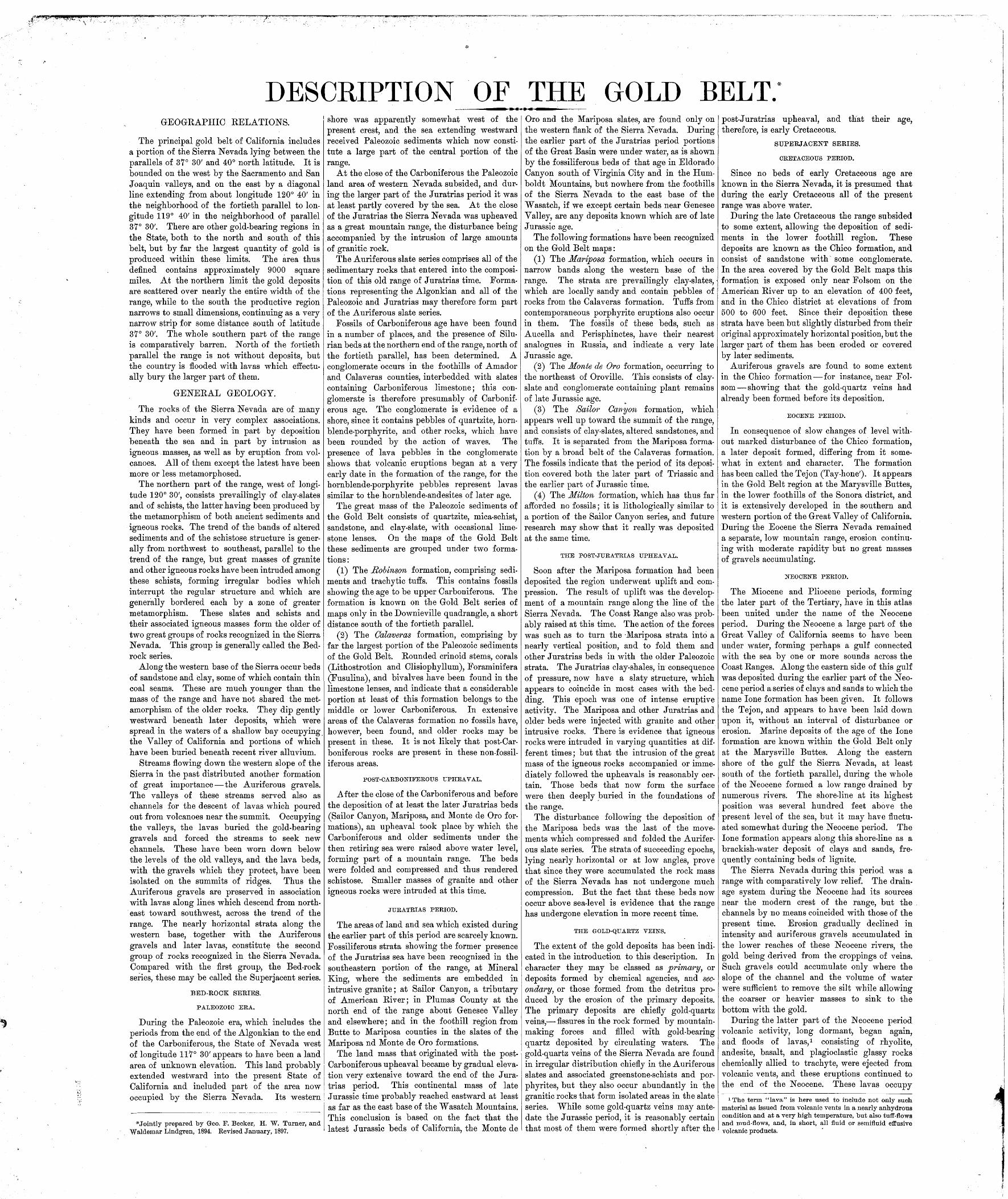
GENERALIZED SECTION OF THE FORMATIONS OF THE GOLD BELT.
SUPERJACENT SERIES
BED-ROCK SERIES
PERIOD.
&«
. J O,1,0
H5
. 1X
0 IK W
CRETACEOUS
JURATRIAS
CARBONIFEROUS AND OLDER
FORMATION NAME.
Recent.River and shore gravels.
River and shore gravels.
lone.
Tejon.
Chico.
Monte de Oro.
Mariposa. Milton.
Sailor Canyon.
Intrusive granitic rocks.
Robinson.
Calaveras.
Intrusive granitic rocks.
FORMA TION.
SYMBOL.
PalPgv
Ng
Ni
Et
Kc
Jo
Jm Jml Js
g|. grd
Crb
Cc
gr grd
COLUMNAR SECTION.
^^ ~T3° ~T= =
'!w?v^mm?®®$%m-,?».$t$$%$ii!i/f,%ffi(Mip3?M
W^w3^£$i' : ''&'S^A:i -'J&^ : ''''?\'*y'.$::-i
:jjjjjjj$^$M
'^^&f*7+£i£&;'f̂ £'':~^''fj''^r^i^M''^?^®!
liiiPP^^PM^lifp^^^
I
^I'^/l^o^'A-rl
THICKNESS IN FEET.
1-1001-100
10-400
10-10010-100
50-800
10-300
50-400
1000 or more
4000 or more
CHARACTER OF ROCKS.
Soil and gravel.Sand, gravel, and conglomerate.
Gravel, sandstone, and conglomerate.
Shale or clay rock.Sandstone.
. . Coal stratum.
Clay and sand, with coal seams.
Sandstone and conglomerate.
Tawny sandstone and conglom erate.
GREAT UNCONFORMITY
Black clay-slate, with interbedded greenstones and some conglom erate.
T T TVf f~1 f\ TVT Tjl f\ TJ TIT T 'P "V
Argillite,. limestone, quartzite, chert, and mica-schist, with inter- bedded greenstones.
between a granite and a quartz-diorite, and is in fact closely related to the latter. The large areas occupied by it and the constancy of the type justify the special name.
Granite. A granular intrusive rock composed % of quartz, alkali and soda-lime feldspars, mica, and sometimes hornblende.
Aplite (also called Granulite). A granitoid rock usually occurring as dikes, and consisting principally of quartz and alkali feldspar.
Syenite. A granular intrusive rock composed chiefly of alkali feldspars, usually with some soda-lime feldspars and hornblende or pyroxene.
Amphibolite, amphibolite-schist. A massive or schistose rock composed principally of green hornblende, with smaller amounts of quartz, feldspar, epidote, and chlorite, and usually derived by metamorphic processess from augite- porphyrite, diabase, and other basic igneous rocks.
Augite-porphyrite. An intrusive or effusive porphyritic rock with larger crystals of augite and soda-lime feldspars in a finer groundmass composed of the same constituents.
Hornblende-porphyrite. An intrusive or effu sive porphyritic rock consisting of soda-lime feldspars and brown hornblende in a fine ground- mass.
Quartz-porpJiyrite. An intrusive or effusive porphyritic rock consisting of quartz and soda- lime feldspar, sometimes with a small amount of hornblende or biotite.
Quartz-porphyry. An intrusive or effusive porphyritic rock, which differs from quartz-por- phyrite in containing alkali feldspars in excess of soda-lime feldspars.
Hhyolite. An effusive rock of Tertiary or later age. The essential constituents are alkali feldspars and quartz, usually with a small amount of biotite or hornblende in a groundmass, which is often glassy.
Andesite. An effusive porphyritic rock of Tertiary or later age. The essential constituents are soda-lime feldspars (chiefly oligoclase and andesine) and ferromagnesian silicates (horn blende, pyroxene, or biotite), in a groundmass of feldspar microlites and magnetite, usually with some glass. The silica is ordinarily above 56 per cent. When quartz is also present the rock is called a dacite.
Basalt. An effusive rock of Tertiary or later age, containing basic soda-lime feldspars, much pyroxene, and usually olivine. The silica content is usually less than 56 per cent. It is often dis tinguished from andesite by its structure.
Trachyte. An effusive rock of Tertiary or later age, composed of alkali and soda-lime feld spars, with biotite, pyroxene, or hornblende.

DESCRIPTION OF THE PYRAMID PEAK QUADRANGLE.TOPOGRAPHY.
An account of the relations of the mountains, pla teaus, rivers, and lakes within this quadrangle, with descriptions of the aspects of the district.
The Pyramid Peak quadrangle includes the territory between the meridians of 120° and 120° 30'west longitude and the parallels of 38° 30' and 39° north latitude. The quadrangle is 34.5 miles long and 27 miles wide, and contains 931.5 square miles. It embraces portions of Placer, Eldorado, Amador, Calaveras, and Alpine counties, eastern Eldorado County occupying the central and main portion of it.
Relief. The quadrangle includes a part of the summit region of the Sierra Nevada, southwest of Lake Tahoe, the elevations ranging from 3000 feet above sea-level in the canyon of the South Fork of the American Kiver to 10,430 feet on the summit of Round Top Peak. The relief is of the most varied character. The level meadows south of Lake Tahoe contrast with the rugged cliffs of the peaks surrounding them, and these again with the forest-covered plateaus and deeply incised canyons to the west. In grandeur and beauty the region rivals any part of the High Sierra.
In spite of all local irregularities produced by vigorous trenching, the part of the quadrangle west of a line drawn from Mokelumne Peak to Tells Peak shows topographic features strongly resembling those generally found in the Sierra Nevada well up toward the divide. It may be considered as an irregular plateau with a gentle westerly slope, above which hills, often level-top ped, rise to a height of 500 or 1000 feet. Such are Robbs Peak, Alder Hill, and Leek Spring Hill. This plateau is cut in two by the deep can yon of the South Fork of the American River, the northerly portion being limited in the northwest corner by the Rubicon River, the southerly in the southeast corner by the Mokelumne River. Both parts are extensively dissected by a large number of creeks, generally flowing in a westerly direc tion in sharp V-shaped canyons; and where the smaller canyons are crowded the plateau char acter becomes correspondingly less pronounced. The general elevation of the plateau in the south west corner is nearly 4500 feet, while the highest point reached at the base of the Pyramid Peak Range is about 8000 feet. The Rubicon and American rivers have cut their canyons to an average depth of 2000 feet; the Mokelumne Can yon, south of Mokelumne Peak, is 4500 feet deep.
North of the American River the plateau is terminated toward the east by the Pyramid Peak Range, rising in rough and jagged outlines to elevations of from 9000 to 10,000 feet. The broad, glaciated valley of the Rubicon divides the Pyramid Peak Range from a complex of sharp peaks separated by glacial valleys and rising at the head of glacial amphitheaters; this complex extends from Ralston Peak to the northern boundary of the quadrangle, and a dozen points attain an elevation above 9000 feet. An abrupt escarpment descends eastward from these high ridges and peaks to the level of Lake Tahoe.
South of the American River the plateau may be considered to extend as far eastward as Bryans Ridge, south of Echo Lake, where it attains an elevation of over 8500 feet, but immediately south of this there rise above it the irregular mountain complexes around Twin Lakes and Silver Lake which culminate in Round Top Peak*. Again, near the southern boundary of the quadrangle, there towers above the plateau, the sharp and rocky Mokelumne Peak, from which a descent of 4500 feet in less than 2 miles carries one down to the bottom of the magnificent chasm of the Mokelumne River.
Drainage. The narrow strip to the east of the main divide drains northward through the Upper Truckee River into Lake Tahoe, the southwestern part of which falls within this quadrangle. Lake Tahoe again drains through the Truckee River into Pyramid and Winnemucca lakes, in the Great
*The high rounded mountain 2 miles northeast of Twin Lakes was designated Round Top on the maps of the Wheeler Survey; in the work of the Coast and Geodetic Survey and of the Geological Survey this name has been transferred though rather inappropriately to the sharp peak southeast of Twin Lakes, the highest in the vicinity.
Basin. The latter two lakes have no outlet. Lake Tahoe, one of the largest and most beautiful mountain lakes in the United States, has a maxi mum length from north to south of 21 miles and a maximum width of 12 miles. Its areal extent is approximately 190 square miles, only 20 square miles, however, lying within the limits of this quadrangle. The elevation of its surface is 6225 feet. The few soundings available show that, except at the shoals at the southern end, due to sediments brought down by the Upper Truckee, the shores slope, rapidly below water level to depths of over 1000 feet, and that the maximum depths, ranging from 1400 to 1645 feet, are found along the central north-south line, the deepest soundings being recorded near the northern shore.
The larger part of the drainage is toward the Pacific. Branches of the American River drain the northern portion, the waters finally finding their way to the Sacramento River, while the southern portion is drained by the Cosumnes and Mokelumne rivers, both flowing into the San Joaquin River. Of the branches of the Ameri can, the Rubicon is the most northern; it heads a short distance north of Pyramid Peak and flows in a north-northwesterly direction in a broad open valley, and then, making a big bend north of the boundary line, returns southwesterly in a deep and narrow canyon. The region between the Rubicon and the South Fork of the American is drained by Silver Creek, which empties into the South Fork farther westward; the several branches of Silver Creek spread out in fan shape and receive nearly the entire westerly drainage of Pyramid Peak Range. The grade of the Rubicon River within this quadrangle averages 143 feet to the mile. The South Fork of the American River, which flows in a deep canyon almost due west, receives no important tributaries from the north, and only two large ones from the south, Alder Creek and Silver Fork. The grade of the South Fork averages 168 feet to the mile, but is very variable, ranging from 50 feet up. Attention is called to the fact that the South Fork does not, like a normal river, split up into branches which, with gradually increasing grade, head among the higher peaks of the range; its cany on is beheaded at Audrain Lake by the precipitous trench of the Upper Truckee.
The several forks of the Cosumnes River, from Camp Creek on the north to the South Fork of the Cosumnes, drain the southwestern plateau, and the more important among them head in the vicinity of Alder Hill, the elevation of which is Y900 feet; they do not reach the summit of the range. The grade is generally above 100 feet to the mile, and sometimes reaches 500 feet. Finally, the southeastern portion of the quadrangle is drained by the Mokelumne River and its several branches. In the deep Mokelumne Canyon the grade ranges from 120 feet to 250 feet to the mile.
Many beautiful glacial lakes are found along the summit region. The largest occur on the slope toward Lake Tahoe, Fallen Leaf Lake being 3 miles long, while Echo Lake and Cascade Lake are of smaller extent. The most notable ones on the western slope are Loon Lake, near the northern boundary of the quadrangle, and Silver Lake, at the head of the Silver Fork.
Vegetation and culture. In the larger and western part of the quadrangle the summits of the ridges, and to a less extent the canyon-slopes, are covered with soil and support a luxuriant forest growth of coniferous trees. The abundant occurrence of deciduous trees is confined to the western border, where oaks mingle with the conifers, and to occasional places along the water courses, where willows and alders flourish. Scrubby oak-brushes have, however, been noted up to an elevation of 7500 feet. The pines, firs, and cedars attain the greatest dimensions and most perfect development in a belt ranging in elevation from 2500 to 6000 feet, the most valu able varieties being the yellow pine (Pinus ponderosd), the sugar pine (Pinus lambertiana), the Douglas fir (Abies douglasii), and the cedar (Libocedrus decurrens). A similar growth of excellent timber is also found on the lower slopes adjoining Lake Tahoe. Smaller areas free from
timber are usually covered by a dense and often almost impenetrable growth of manzanita bushes and other varieties of chaparral. The higher elevations, from 6000 to 9000 feet, are character ized by various species of firs, and also by the tamarack (Pinus contortd). The silver fir, a tree of great beauty, grows chiefly above an elevation of 8000 feet. The timber of the higher belt is of much less desirable quality than that from the lower elevations.
Within a zone bordered on the west by a line drawn from Loon Lake to Echo, Silver Lake, and Mokelumne Peak, and on the east by the foot of the escarpment facing Lake Tahoe and Lake Valley, glacial erosion has removed most of the soil; as a consequence, this summit area is char acterized by vast stretches of bare rock, over which only smaller patches of forest growth are scattered. In the timber belt proper there is a notable absence of grassy meadows; the ground is usually covered by a thick, olive-green carpet of tar weed. Above an elevation of 5500 feet there are, on the other hand, many small scat tered meadows with rich pasture, in which wild flowers blossom during the short summer months.
The climate, though more severe in the higher than in the lower altitudes, is generally character ized by dry, warm summers, with only occasional thunder showers, and by a heavy snowfall during the winter; in severe winters the snow may accumulate to a depth of 20 feet on the level. The temperature at an elevation -of 6000 feet may reach 90° F. in the summer, while during the winter the thermometer scarcely ever falls below 0° F. or 18° C. On the other hand, frosts frequently occur during the summer at elevations above 6500 feet. The annual precipitation ranges from 40 inches at elevations of about 3000 feet to a maximum of TO inches at an elevation of 7000 feet. Over the Lake Tahoe basin the precipita tion is decidedly smaller than at a corresponding altitude on the western slope.
There are no cities or towns within the quad rangle. In fact, the permanent population is probably less than 100, and is chiefly confined to the southwestern corner. A few people remain during the winter at the road stations along the South Fork, and a few winter at the southern shore of Lake Tahoe. During the summer, how ever, the region is populated by cattlemen and sheepmen, who drive their herds and flocks from the dry pastures of the foothills to the fresh meadows of the mountains. The delightful summer climate also brings a great number of visitors, for whose convenience there are several stopping-places at the southern end of the great lake and along the main highways.
The principal industries are cattle-raising and timber-cutting, the latter chiefly near the western boundary and near Lake Tahoe. Gold-mining occupies a very subordinate position, though there are some placer mines and quartz-prospects in the southwest corner.
Three chief transmontane highways cross the quadrangle. The road from Georgetown to Lake Tahoe crosses the northwest corner, from Uncle Toms Cabin to Gerle Creek; the central and most important road, from Placerville to points in Lake Valley and Nevada, follows the South Fork of the American, crossing the divide by Johnson Pass; the third, from the lower part of Amador County to points in Alpine County and Nevada, follows in general the divide between the Cosumnes and Mokelumne rivers, crossing the divide at Carson Pass, just east of the eastern boundary line. Beside these, there" are a great number of roads and trails, so that travel on horseback at least is easy except in the higher, glaciated regions.
The abundant water supply is utilized by means of storage reservoirs and ditches for irriga tion and mining at lower elevations. The princi pal ditches are the Georgetown Water Company's, diverting the headwaters of Little Rubicon and Gerle creeks, with a reservoir at Loon Lake, and the Placerville Water Company's, taking their supply from the South Fork and Silver Fork, with a reservoir at Silver Lake. There are sev eral smaller ditches for mining purposes in the southwestern part, and a large reservoir at Bear
River which furnishes water for a ditch lower down on the Mokelumne River, supplying the lower part of Amador County. The Placerville and the Georgetown ditches have each a capacity of several thousand miners'. inches. The import ant watershed of Silver Creek is not yet utilized.
GEOLOGY.
A classification, description, and statement of the occurrences of the several Mnds of rocks found in the quadrangle.
BED-ROCK SERIES.
This series consists of the sedimentary rocks which were uplifted and compressed during or before the post-Jurassic mountain-building dis turbance, together with the igneous rocks asso ciated with or earlier than this upheaval.
SEDIMENTARY ROCKS.
Details of character and distribution.
It should be first stated that no fossils have been found in any of the sedimentary rocks of the Bed-rock series shown on this sheet, and that therefore the assignment of ages to these as given below is in all cases tentative only. The deter minations are, however, based on a comparison with formations of approximately known age in adjoining districts, and therefore, in general, pos sess a strong degree of probability.
Calaveras formation. The rocks referred to this formation occupy several areas along the western and southwestern border of the quad rangle. They extend only a few miles eastward, the area in the southwestern corner reaching the farthest point in that direction; and they are separated by bays of granitic rock, some of which reach far out into the adjoining Placerville quad rangle. The very irregular and jagged contact well indicates the tearing asunder of the older slate formation by the intrusive granitic magmas. These schist masses form the eastern edge of that large body of more or less altered sedi mentary rock referred to the Calaveras formation and represented on the Placerville sheet. Imper fect fossils have been found in the Calaveras for mation indicating clearly a Paleozoic and prob ably a Carboniferous age. While it is probable that this series is of the same age throughout, this can not be considered proved, but on account of lithologic similarity the whole has been included in the Calaveras formation, which is defined as consisting of Paleozoic beds whose ages can not at present be further determined.
The whole of the Calaveras formation in the eastern part of the Placerville quadrangle and in this quadrangle has a pronounced siliceous char acter; it consists of altered sandstones grading into quartzite, and clay-slates grading into mica ceous schists. The nature of this metamorphism is partly regional, due to dynamic movements affecting a large part of the Sierra Nevada, chiefly occurring prior to the great granitic intrusions, and partly local, due to heat and emanations from enormous masses of intruded granitic magmas. While the latter metamorphism is superimposed upon the former and the phenomena resulting from each are not always easy to discriminate, it is clearly seen that the extremely altered sedi ments are found only at contacts with the granitic rocks, and that the degree of metamorphism gradually decreases away from these contacts. The contact zones are here very wide, typical contact-metamorphic rocks often being found 2 miles from the contacts, or even farther in case of projecting masses of sedimentary rocks surrounded on all sides by granite. It does not appear prob able that any of these rocks are of Archean age.
Less altered rocks, the clastic character of which is clearly apparent, occur at a few places near the western border of the quadrangle. They are principally dark clay-slates and quartzitic rocks which under the microscope show their fragmental origin. Such rocks occur on Silver Creek near the western boundary, on Sly Park Creek, at Fort Grizzly, and southeast of Tarrs Saw Mill. But the larger part of the Calaveras formation in this quadrangle is occupied by the contact-metamorphic schists. In places especially

exposed to the action of the granitic'magma, such as the projecting points at Ellicott's bridge south of Orelli's ranch, at Brockliss's bridge west of Bullion Bend, and in the isolated areas near Brownell's ranch, the rock is converted to normal fine-grained gneiss or mica-schist, and at these places the contacts with the granite, usually dis tinct and sharp, are liable to become indistinct. Somewhat farther away the schists are finer- grained, and are generally of a brownish color from the biotite which they contain. They often carry andalusite, characteristic of contact rocks, in well-developed crystals, and such rocks may be found more than a mile distant from the contact. A typical andesite-schist was collected on the hill 1 mile south of the canyon of the North Fork of the Cosumnes, near the western bound ary-of the quadrangle, 3 miles from the granite.
Excellent exposures are found in the deep canyons of Silver Creek, Camp Creek, and the North Fork of the Cosumnes, but they are not easily accessible. The schistosity is indicated on the outcrops by lines straight on the whole but delicately wavy in detail; heavy benches alternate with streaks in which the lamination is very fine. Nodules and nests of apparently segregated quartz are common. On the ridges and slopes distinct outcrops are rarely seen, as the rock there weathers to a dark-red soil.
The area south of Hams, in the southwestern corner of the quadrangle, is also intensely altered; micaceous schists and a striped green and white schist, consisting of pyroxene, quartz, feldspar, and wollastonite, evidently a product of contact- metamorphic action on limestone, appear in this vicinity.
The stratification can be observed beyond doubt only in rare conditions, as for instance where quartzite and black clay-slate alternate, but, where distinguished, the stratification in most cases approximately coincides with the superimposed schistosity. In the northern por tion of the quadrangle the strike of the schis tosity is generally due north and the dip either about vertical or westward at a steep angle, this being contrary to the general rule farther down the slope. South of the South Fork of the American the strike is more irregular, but gener ally east-west, while the dip is always within 20° of the perpendicular and usually to the north. Thus, in the canyon of the North Fork of the Cosumnes, one-quarter mile from the contact, a strike of east-west with dip 75° N. was observed. This dip symbol has been omitted on the map. An examination of the southeastern part of the Placerville map and the northeastern part of the Jackson map will show that the series in these regions also has an abnormal east-west strike. The cause may possibly be sought in the mechanics of the intrusion, the slates in this vicinity being especially torn up by deeply incised bays of granitic rock. Horizontal and inclined joints also traverse the schists, separating them into rhomboidal fragments. The contact of the schists with the granitic rock is usually best defined where the contact line runs parallel to the schistosity; wherever it cuts across the strike a stronger metamorphism accompanied by a feather- ing-out of the schists and by an injection of gran itic magma is often noted.
Juratrias. A few isolated areas of schists, quartzites, and highly altered tuffs are scattered on both sides of the crest in the northern part of the Pyramid Peak quadrangle. They are in most cases clearly of sedimentary origin and have been extensively metamorphosed by the granitic rocks along the contacts. There is no reason for con sidering them as older than the main sedimentary series on the western slope; in fact, they are sometimes less disturbed and less metamorphosed than the former. One of the principal reasons for referring them to the Juratrias a reference which is made with doubt, however is their position in the continuation of strata known to be of that age in the Truckee quadrangle, adjoining northward; another is that the principal mass, near Mount Tallac, is intimately connected with large masses of dark-green porphyrite and por- phyrite-tuff, which is characteristic of the Jura trias at Sailor Canyon (Truckee quadrangle) and northward. The color of the outcrops of these schist areas is usually reddish-brown, contrasting strongly with the light-gray granodiorite.
The two small areas, at the northern boundary consist of quartzite and black slates, the latter I
altered near the contacts to gneissoid micaceous schists. The contacts are usually sharp, extremely so at a point where the road crosses the western area. At other places, as on the west side of Loon Lake, the contact is very ill defined, the reddish granitic outcrops in the area marked "gr" being everywhere mixed with schistose fragments.
The long and narrow area west of Tells Peak is strongly metamorphosed and is composed of gneissoid schists, quartzites, and mica-chlorite- andalusite-schists.
The largest area of supposed Juratrias lies in Kockbound Valley, between Mount Tallac and the Pyramid Peak Range. It has a roughly triangular form and is distinguished by out crops of dull-gray or brown color. These consist of a series of clearly stratified black slates and white quartzitic rocks. Beautifully banded, hard rocks, dark-gray and white, also occur in Rock- bound Valley. The normal strike appears to be north-northwest, with a dip of about 45° to the east, which is very much less than the normal dip of the sedimentary rocks on the western slope. In the western part of the area the rocks are disturbed and dip in different directions. In the vicinity of Suzy Lake white quartzitic rocks outcrop, less clearly stratified, often, indeed, appearing massive. The microscope shows that the banded rocks from Rockbound Valley and from, the Suzy Lake region are porphyrite-tuffs, probably deposited contemporaneously with the eruption of the large porphyrite mass of Mount Tallac. Dikes of typical diabase - porphyrite were noted on the western shore of Suzy Lake. On the western slope of Rockbound Valley uralite-porphyrites appear, which would seem to lie conformably'in the sedimentary series and which have been made somewhat schistose by pressure. The contact with the granite and grano diorite is generally sharp, and dikes of both rocks are found in the sedimentary series near the contact. The metamorphosing influence of the granitic rocks is clearly marked for a dis tance of at least one-half mile from the contacts, the sediments being more or less schistose and micaceous. Smaller masses, included in the granite, are converted to gneissoid schists. The large point running out in diorite south of Glen Alpine Springs is especially metamorphosed to a high degree, and consists of schistose amphibolite with many streaks of epidote and tourmaline. The contact of the sedimentary rocks with the porphyrites of Mount Tallac is not very distinct, tuffs, breccias, and dikes occurring along it north west of Glen Alpine Springs. The slate area to the east of Mount Tallac consists of clay-slates and quartzites; near the porphyrite a striped, tuffaceous slate occurs, similar to that of Rock- bound Valley. A much contorted, calcareous quartzite was noted to the northeast of Mount Tallac. Outcrops of quartzite also occur east of Fallen Leaf Lake.
Four miles southeast of Silver Lake there is an ill-defined area of white quartzitic rock mixed in a very irregular manner with granitic dikes and masses. This area has doubtfully been referred to the Juratrias series.
IGNEOUS ROCKS.
Details of character and distribution.
Granite. A normal biotite-granite, or granitite, as the variety is also called, occupies several large areas at Loon Lake, and others along the Pyramid Peak Range, at Echo Lake, at Mokel- umne Peak, and about the headwaters of the Cosumnes River. Its outcrops are generally dis tinguished by a light yellowish or reddish color, due to the sequioxide of iron contained in the orthoclase, and, especially in the glaciated portions, they contrast strongly with the grayish-white croppings of the granodiorite. Usually coarse grained, it consists of quartz, orthoclase, albite, and biotite. It is harder and of a firmer texture than the latter rock, and its masses form the highest and roughest ridges in the region. For the same reason bowlders of granite are much more abundant than those of granodiorite. While it varies somewhat in appearance and constitu tion, yet it is a typical granite. The contacts with the granodiorite are sometimes sharp, but more commonly much pegmatite, diorite, and granite-porphyry occur on the contacts, making them indistinct. In other places transition forms may be observed, hornblende and plagioclase
making their appearance. The different areas will be described in a more detailed manner.
The areas west of Loon Lake are variable in composition and appearance. The one adjoining Loon Lake is composed of a reddish, medium- grained granitic rock which contains many schist fragments and is traversed by dikes of normal granodiorite. The area south of the schists occupies some rough and pointed hills and shows great variation. The principal rock is, however, a medium-grained granite, distinctly porphyritic by larger orthoclase crystals, but containing more plagioclase than the normal granitite.
The large granite area occupying the summits of the Pyramid Peak Range and spreading north ward across the valley of the Rubicon is, on the whole, of uniform appearance and composition. The crags and pinnacles of the narrow ridges, along which it is difficult and dangerous to pass, testify to its high resistance to erosion. The strong jointing traversing the rock and dipping westward has caused a more moderate slope in that direction, while precipitous cliffs often mark the eastern face. The top of Pyramid Peak is made up of a pile of enormous blocks, evidently produced by the collapse of jointed pinnacles. The rock is coarse-grained, yellowish or reddish, and has a decided tendency toward a roughly porphyritic structure; the orthoclase appears as large grains and imperfect prisms, of reddish- gray color, up to 2 cm. long; the quartz is very prominent in dark-gray rounded grains up to 1 cm. in diameter, while the black mica and smaller feldspar and quartz grains lie between these larger constituents. A specimen from the south ern base of the bowlder pyramid of Pyramid Peak contains 73 per cent quartz, 1,2 per cent lime, 5.4 per cent potassa, and 3 per cent soda. North of Tells Peak the rock contains some horn blende and plagioclase, forming a type somewhat approaching granodiorite, but in the Rubicon Valley it again becomes normal. The contacts with the schist are well defined, as are those with the granodiorite in many places, though in others they become very indistinct and the rocks appear to grade over one into another, as along the con tact crossing the Rubicon Valley. Even where the contact is comparatively well defined, it is extremely common to find dikes and masses of pegmatitic, aplitic, and dioritic character along the line of junction. The occurrences in the glaciated cirques at the head of Blakeley Creek and of : the Middle Fork of Silver Creek are especially interesting. Bays of normal granodio rite here reach up to the summit of the range from the east, and at the western end of these bays lie dark, dioritic rocks traversed by light- colored, mostly pegmatitic dikes. In Blakeley Basin a large dike-like mass of granite breaks across the bay and connects the granite masses on the north and the south. South and southwest of the sharp, isolated peak, which has an eleva tion of 9500 feet, the granite assumes a finer- grained habit and weathers to a bright-red color. Here its outcrops are strikingly rounded. Four miles west of Morattini's ranch a narrow belt of singularly mixed rocks, dioritic and granitic, extends across the granite. It begins on the east by an extremely sharply defined triangular area of dark hornblendic diorite, bordering with dis tinct contacts against both the granite and the granodiorite. Westward this soon becomes very ill-defined and mixed with light-colored granitic rocks. Breccias may often be noted, the acid rock always forming the cement.
The granite of Echo Lake, forming the sharp peaks on the north and south sides, is similar to that of Pyramid Peak.
The area of Mokelumne Hill is composed prin cipally of a medium-grained, light-colored rock containing small scattered foils of biotite and weathering reddish. In places, however, as on the summit of the peak, the rock is of coarser grain. The microscope shows it to be composed chiefly of orthoclase, microcline, and quartz. The rock is not uniform, and on the northern slope of the peak there are many scattered streaks of dark hornblendic rock, sometimes schistose in struc ture. The contacts are generally indistinct except on the northwestern side, the passage from granite to granodiorite taking place within short distances.
The large mass of granite in the southwestern part borders on the north against the diorites of the South Fork of the American, on the west
against the schists of the Calaveras formation, and on the east against granodiorite. Its out crops are not so prominent as those of the other areas, and the resistance to weathering is not so great, as is shown by the smoother, crumbling outcrops; nor is the color of the weathered rock so distinctly reddish. The normal rock is coarse grained and light yellowish-gray; the average grain is about 5 mm., while larger quartz grains and orthoclase crystals may reach 1 cm. and give the rock a somewhat porphyritic aspect. Scat tered foils of black mica attain 2 mm. in diameter. In composition and structure the rock is almost identical with that of Pyramid Peak, and its char acter remains constant over large areas.
Near Hams station the rock exhibits some variations. For 2 miles north and east there occurs mixed with the normal rock a reddish, aplitic variety, and dark dioritic patches occur in it near the junction of Cat Creek with the Middle Fork of the Cosumnes. South of Hams, adjoin ing the schist area, the light-colored granite con tains large foils of black mica and is mixed with aplitic and dioritic rocks.
On Camp Creek for 3 miles east of the diorite contact the granite contains hornblende and more plagioclase than usual, forming an intermediate type between granite and granodiorite. Fine grained or porphyritic variations often occur near the diorite contacts, which are thereby made indistinct and ill defined. Thus a granite with porphyritic orthoclase crystals in a groundmass with abundant mica and hornblende occurs one- fourth mile northwest of Bryants Saw Mill. Finer-grained, reddish, aplitic granite occurs near Slippery Ford, along the indistinct granodiorite contact.
The area southeast of the Ice House consists of a reddish, medium-grained granite, with scattered foils of black mica. Near Brownell is a dike of aplitic granite made up of orthoclase, albite, and quartz; below, along the road in the canyon, it splits up into several smaller dikes breaking through the diorite.
Along the crest of the range, south of latitude 38° 30', a very coarse and distinctly porphyritic granite occurs, characterized by very large, well- developed orthoclase crystals. This variety does not appear within the Pyramid Peak quadrangle, but a few large glacial bowlders of this rock were found in the upper Truckee Valley.
It has become evident, from more detailed studies, that a few of the areas indicated as grano diorite on the Placerville sheet, adjoining to the west, should rather be classed as granite. These are the area of Sand Mountain, the area about Crystal mine, and the two small masses east of this, at the eastern boundary of the Placerville quadrangle.
Granodiorite. The granodiorite is the prevail ing rock, occupying a broad belt extending across the whole quadrangle from north to south. It is of an easily crumbling nature, and falls readily to pieces under the destructive forces of erosion and weathering. The grayish-white outcrops are of rounded form. This form and the brilliant light color are especially marked in the glaciated region. The granodiorite is a medium-grained to coarse-grained rock, the average diameter of the grains being 2 to 3 mm. The grayish quartz and white feldspar grains are of about equal size; the quartz is decidedly less prominent than in the granite, and the feldspar does not reach the dimensions attained in the latter rock. Black mica and hornblende are usually present in about equal quantities. The foils of the former reach 2 or 3 mm. in diameter, while the hornblende is roughly prismatic, the crystals sometimes reaching 1 cm. in length. A slight porphyritic aspect may occasionally be attained by the rock in conse quence of this crystallographic development of the hornblende. Titanite is nearly always pres ent in small, isolated, brownish grains. A typical rock from the northwestern shore of Silver Lake contained 67.5 per cent silica, 3.6 per cent lime, 3.66 per cent potassa, and 3.47 per cent soda.
The appearance and composition of the rock are very constant over large areas, with only small variations in the quantity of hornblende and black mica. In a few places the quantity of hornblende diminishes, and the rock then assumes a habit more similar to that of granite, as at Buck Island Lake, between Rubicon Peak and Rubicon Point, and in the area east of Fallen Leaf Lake.

Microscopical and chemical investigation shows the rock at these points to be a granodiorite, though rather rich in orthoclase.
Diorite. A number of smaller areas of diorite occur connected both with the granite and with the granodiorite. The typical diorite is a dark- green, medium-grained to coarse-grained rock, composed chiefly of dark-green hornblende in prisms or irregular grains, a little black mica, and white plagioclase. Normal quartz-diorites are not abundant, as the rock usually takes up consider able orthoclase at the same time as quartz. Many rocks along the South Fork of the American from Slippery Ford down are, however, undoubtedly quartz-diorites. A normal diorite from Pyramid Peak contained 51.5 per cent silica, 10.2 per cent lime, 1.08 per cent potassa, and 2.9 per cent soda. The diorite at many places contains pyroxene, forming transitions to gabbro, and it is almost impossible, in fact, strictly to separate these two rocks. Gradual transitions from granodiorite to diorite are extremely common, but the latter rock is quantitatively entirely subordinate. Normal syenite has not been recognized; rocks intermedi ate in composition between a syenite and a diorite occur to some extent, but can scarcely be separated from the diorites. Smaller areas of diorite sometimes occur, both in granodiorite, as at Rubicon Point and west of Rubicon Peak, and in granite, as at the head of the Middle Fork of the Cosumnes. They also occur at the contacts of granodiorite and schist, as at Ellicott's bridge and near Westmoreland. The diorite occurring in the Pyramid Peak Range has already been mentioned.
The large area between Devils Basin and Echo Lake lies between granite and granodiorite, with schist and augite-porphyrite joining on the north. The larger part consists of a dark, medium- grained, dioritic rock with frequent transitions to quartz-diorite and granodiorite, especially on the western side. At the western end of Echo Lake the rock is impregnated with pyrite, the decom position of which gives the outcrops a reddish color. One mile southwest of Angora Peak there is considerable variation in grain and basicity; streaks of gneissoid rock also appear. Dark, coarse-grained diorites continue southeast of Echo Lake to the eastern boundary of the quadrangle. The diorite and quartz-diorite of Round Top show very gradual transitions toward the sur rounding granodiorite and toward the enclosed patches of black gabbro and pyroxenite.
The diorite area contained in the granite about Pi Pi Valley and Dogtown is of greatly variable habit. Pyroxene occurs at many places. At Lanes Tunnel the rock is an augite-biotite-diorite, while one-quarter of a mile below Dogtown an olivine-hornblende-gabbro is found. A uralite- gabbro occurs at the head of Steeley Fork.
The area near the eastern boundary on Camp Creek and the North Fork of the Cosumnes varies from a biotite-diorite to an olivine-uralite- gabbro. The contacts of these areas toward the granite are usually indistinct, and many cases of apparent transitions occur. East of Dogtown pegmatitic dikes are injected in the diorite.
At the contact of granite and granodiorite on Camp Creek south of Morrison the two rocks are separated by a zone one-fourth of a mile wide containing diorite mixed with pegmatitic dikes.
An almost bewildering complexity is found in the diorite area following the canyon of the South Fork of the American River from Bullion Bend up to Slippery Ford. The area is enclosed by granite and schists on the north and south sides, and is bordered by granodiorite on the east and west. Good exposures are seen along the road, as well as along the Placerville ditch on the southern side of the canyon. Normal grano diorite appears at the boundary, continuing west ward into the granodiorite area of Soldier Creek (Placerville quadrangle). This changes gradually to the complex diorite area of Bullion Bend. On the northern side of Bullion Bend the rock is largely gabbroitic, typical gabbro, sometimes with approximation to diabasic structure, occur ring at many places.
At Moores station there are very fine exposures of granite dikes injecting and brecciating the fine-grained, dark niica-diorite. Westward along the. road, the rock changes one-half mile from Moores to coarse and dark olivine-gabbro, and the dikes of granite cease to appear; three- quarters of a mile from Moores the rock becomes
Pyramid Peak 3.
very coarse, containing large crystals of horn blende ; nearer to the schist contact, biotite- gabbro appears. A small mass of coarse granite reaches the road one-half mile east of Moores, and penetrates and brecciates the surrounding diorite. On the grade leading up to the Ice House, light, medium-grained diorite or granodiorite first appears beyond the granite, while nearer to the schist contact gabbro was noticed.
From Moores up to Slippery Ford mica-diorites prevail, frequently changing in grain, and in many places running over into nearly normal granodio rite. The best exposures seen along the ditch are as follows: From south of Moores to Plum Creek there is a dark, fine-grained diorite contain ing dikes of granite. At the point one-half mile north of Ditch Camp 7 there is again the same diorite with dikes of granite. On the point before Wolf Creek is reached the rock is a nearly normal granodiorite, changing within a short dis tance to coarse, dark diorite, which continues to within 1000 feet of Wolf Creek; then follow lighter, medium-grained quartz-diorites. One mile beyond Wolf Creek dikes of granite again begin to appear. Fine exposures of granite, slightly porphyritic, appear in Alder Creek. Beyond Alder Creek coarse, dark diorite appears. Beyond the narrow wedge of highly altered gneissoid schist nearly normal granodiorite appears, but this soon becomes darker and passes over into the gabbro areas below Slippery Ford.
Two miles below Slippery Ford, on the main road, the granodiorite begins to grow darker, and a coarse diorite appears. Extending half a mile farther down are diorites of varying grain, the lighter varieties at many places having been injected into the darker; then several dikes of pegmatitic granite appear, beyond which diorites of changing habit are again found. These short notes will illustrate the extremely variable char acter of this area.
Gabbro. Although there are many occurrences of gabbro among the western diorites, only a few areas are occupied by normal gabbro which can be mapped as such. Of this nature are the irreg ular masses in granodiorite or diorite near the Kirkwood and Woods settlements and northwest of Round Top, very dark green, coarse-grained, heavy rocks. In the Kirkwood area a uralitic rock occurs, evidently derived from gabbro or pyroxen ite, while other specimens show the composition and structure of an augite-diorite. Specimens from the Woods mass show a biotite-gabbro, closely related to a diabase, while the area near Round Top contains an entirely normal gabbro. All transitions between granodiorite, diorite, and gabbro may be seen in this vicinity.
The irregular areas north and south of the river a few miles west of Slippery Ford generally consist of dark-green, coarse rock composed of dark-green pyroxene and large grains of reddish- gray, basic plagioclase. Microscopic evidence shows that they are entirely normal uralite- gabbros. A specimen from the area 5J miles west of Slippery Ford shows the composition of a very basic olivine-gabbro, almost to be classed as a peridotite. The contacts of the gabbro with the granite are fairly sharp and well defined, but toward the diorite abundant transitions may be noted.
The succession of the granitic rocks. There is hardly any doubt that all of the granitic rocks are later than the altered sedimentary rocks and the augite-porphyrite, but it must be confessed that in spite of good exposures the evidence as to the relative age of the granite, granodiorite, diorite, and gabbro is not decisive and in some respects is even contradictory. There is some evidence, based on the general form of the Pyra mid Peak granite area and the manner in which it includes the slate fragments, as well as on the occurrence in it of dikes of a rock allied to grano diorite, tending to show that the granite was intruded earlier than the granodiorite. On the other hand, it is unquestionably true that the granite of the southwestern corner sends out numerous dikes in the diorite of the South Fork of the American River; this diorite again shows numerous local transitions to apparently normal granodiorite; so that, if it be conceded that this diorite area is of appromimately 'the same age as the main granodiorite mass, it follows that the granite is later than the granodiorite. The prob ability is that the intrusion both of the granite and of the granodiorite was accompanied by
minor intrusions of acid and basic magmas, and that there are diorites, pegmatites, and aplites of the age of the granodiorite and of the granite, the granite being the older rock. Only on this supposition can the contradictory testimony be explained. The diorites of the canyon of the South Fork of the American and the smaller areas along the western boundary would then belong to the period of granitic intrusions, while those of Round Top and the Pyramid Peak Range would belong to the granodiorite.
Augite-porphyrite. Most conspicuous among the mountains rising south of Lake Tahoe is Mount Tallac, with its dark, rocky escarpment facing east, its broad shoulder sloping more gently southward, and its precipices crowning the glacial cirques toward the north. It is built up of a dark, massive rock which frequently has been called basalt. The normal rock is dark- green in color, and often shows well-defined crystals of augite mostly converted into second ary hornblende. The feldspars are rarely promi nent; the groundmass is dark and fine-grained; in places it is somewhat amygdaloid. It ranges in structure from a typical diabase-porphyrite to an augite-porphyrite, according to the variations of structure in the groundmass. Schistose struc ture sometimes appears; at the summit of Mount Tallac the rock is converted to a dark-brown or spotted dark-green and dark-brown, roughly schistose rock. A specimen taken 200 feet below the summit, on the trail, proved to be a uralite- porphyrite, which along certain lines has been subjected to strong crushing, producing schistose structure. Specimens from the top show porphy ritic augite and plagioclase in a greatly altered groundmass filled with brown mica and some tourmaline. Other specimens from the top are tourmaline-biotite-schists, carrying also some horn blende and feldspar; there can scarcely be any doubt that this rock represents merely an extremely altered form of the porphyrite. On the road one-half mile east of Glen Alpine Springs, also, the porphyrite is changed to a dark- green schist, often filled with pyrite. Secondary brown mica is very frequently present, developing in all the constituents of the rock. The occur rence of breccia along the western contact has already been mentioned. The northern contact is generally sharp, and along the excellent out crops in the glacial cirques there is no indication that the porphyrite forms a flow on top of the granitic rocks. At the southern contact with the diorite, where Glen Alpine Springs bears N. 15° W., many veins are found filled with quartz, epidote, and tourmaline, the latter being in the center of the vein, the epidote next, and the quartz next the walls. The projecting point of porphyrite 1 mile west of Glen Alpine Springs contains very much epidote and is partly schis tose. Certain of the phenomena of metamor- phism in this rock, notably the development of biotite and tourmaline, may with great prob ability be attributed to the influence of the granitic magma. There is no doubt of the inti mate connection of the augite-porphyrite with the adjoining sedimentary series. Whether it should be considered as an intrusion or a flow or succession of flows is a question which is still unsettled, but it is probably of intrusive origin. Similar porphyrite masses occur connected with Juratrias strata at Sailor Canyon (Truckee quad rangle) and at other places farther north.
SEQUENCE OF EOCKS AND STEUCTUEAL FEATUEES.
An account of the relative ages of the rock-masses and the effects they have suffered.
In the sequence of rocks deduced from the study of this district the Paleozoic slates and schists of the Calaveras formation are determined to be the oldest. The schistose structure was produced before the granitic eruptions, which affected the adjoining schists only by making them more crystalline. Next in age follow the probably Juratrias areas along the crest, and their accompanying tuffs and porphyrite masses. This series is similarly affected by contact met- amorphism, but shows much less evidence of schistose structure. Still later occurred the intru sions of the rocks of the granitic series; these are almost certainly all of very late Jurassic or early Cretaceous age. It can not be said that the suc cession of the different granitic rocks has been 'definitely ascertained, but the granite is probably older than the granodiorite. By their intrusion
the granitic rocks fractured the sediments along extremely irregular lines; sedimentary masses were torn away and now lie in the granitic bodies as detached fragments. The granitic rocks are entirely unaffected by the prevailing schistosity. All the rocks are more or less traversed by joints, but it is along a narrow zone following the summit region that the jointing becomes especially promi nent. From Tells Peak to the vicinity of Round Top the jointing or sheeting is strongly developed, and it is excellently exposed in the glaciated canyons of Summit Creek and Silver Fork. There is one set of joints extending ENE.-WSW. which appears to be vertical. Joints belong ing to this system were also noted in the grano diorite along the upper parts of Camp Creek and the North Fork of the Cosumnes. There are two other sets, both of which have a direction of NNE.-SSE., but dip in opposite directions at angles varying from 15° to 40°. While these systems have not been studied in detail, slight faulting has been noted in places along the joints.
Only at one place are there indications of extensive faulting. The abrupt slope from Rubi con Peak to Echo Lake has been interpreted as an old fault scarp, erosion not being adequate to account for it. The reasons for this interpreta tion can not be fully set forth except by describ ing areas beyond the limits of the Pyramid Peak quadrangle. Suffice it to say that the evidence is clear that Lake Tahoe already existed in Neocene time and that it is probable that this faulting took place toward the close of the Cretaceous period. Along the western shore of the lake the slope continues steep below the water-line to a depth of about 1000 feet. The fault is probably located at some distance from the shore, and the throw gradually lessens toward Echo Lake. South of Echo Lake the canyon of the Upper Truckee has obviously been excavated by erosion. There are no evidences of Neocene or post- Neocene faults.
SUPERJACENT SERIES.
NEOCENE.
An account of the river gravels, lava flows, and former valleys in their relations to one another and to modern topographic features.
Auriferous gravels. The Neocene gravels which lay upon the old bed-rock surface of the range, such as it was before being flooded by lava and trenched by the modern canyons, are very sparingly represented in this quadrangle, if not entirely missing. The rivers which accumulated such large masses of gravel lower down on the slope of theSierra Nevada deposited scarcely any debris near their headwaters. Only along the western boundary of the quadrangle is this for mation found, and generally in such very small exposures that it can not be indicated on the map. It occurs in intimate connection with rhyolitic tuffs, and, as is natural, only in the bottom of the old depressions.
The three small areas indicated as rhyolite on the hill northwest of Bullion Bend are occupied by gravels of the rhyolitic period reaching a thick ness of 40 feet. The gravel is well-rounded river- wash, and contains pebbles of rhyolite, quartz, slate, and granitic rocks. A few feet of gravel lies in the deeper, post-rhyolitic, lava-capped channel a little farther east. Eight feet of granitic gravel is exposed below the rhyolite at Ditch Camp 7. A few feet of often imperfectly washed gravel, com posed mostly of quartz and metamorphic schist, lies at different places under the lava along the Neocene depression extending down to Fort Grizzly by Dogtown, Mayer, and Barneys. One mile west of Dogtown the channel is cut by two creeks and offers the best exposures. The follow ing section is exposed: On the granitic bed-rock rests 10 feet of gravel and sand; above follows 3 feet of white rhyolitic tuff, again covered by 15 feet of coarse and fine sand. The whole is capped by andesitic breccia. Near Fort Grizzly there must be accumulations of similar or greater thick ness, but the bottom of the channel is not well exposed.
Basalt. In two places evidences appear of an old basaltic eruption antedating the andesite and probably also the rhyolite. The first of these is 2 miles south of Kirkwood's ranch, where a small exposure of a black normal basalt occurs below the rhyolite. The second is near the southern boundary, southeast of Hams station, where sev eral smaller areas of a similar basalt cap the

ridges. While the exposures do not seem decisive, it is probable that this basalt also is older than the andesite.
JRhyolite. The occurrence of rhyolite is con fined almost entirely to the southern part of the quadrangle and only a relatively small number of square miles are occupied by this rock. A flow of rhyolite once filled the bottom of the Neocene valley of the South Fork of the Ameri can and the lower Mokelumne and its Dogtown tributary, but is now partly eroded, partly cov ered by andesite. The places of eruption of this acid lava were located without doubt in the east ern portion of the area here mapped. The prin cipal flow can be traced to the high volcanic com plex about 4 miles south of Echo. Flowing down a steep tributary, it found the main Neocene river near the present bend of Silver Fork, and fol lowed it down by Morrisons and Plum Creek. A small flow of this lava followed the Dogtown tributary by Pi Pi Valley and Sopiago Creek to the larger areas at Fort Grizzly. Whence this flow and that of the Dogtown tributary came is uncertain; it appears as if there might have been a local eruption in this vicinity, for between Fort Grizzly and Silver Lake no trace of the rock is found.
Before the andesitic eruption the surface of the rhyolite suffered considerable erosion, so that its thickness differs much in different places. The heaviest masses are not found near the place of eruption but near the western boundary of the quadrangle. A maximum thickness of 400 feet is found on Plum Creek, while ordinarily it does not exceed 300 feet, and is often much less. A tendency to form steep bluffs distinguishes the rock in many places. It is commonly massive, tuffs occurring only near the western boundary. The normal rhyolite is a white, gray, or pink, fine-grained rock, somewhat porous and easily dressed with the hammer. It carries small sani- dine and quartz crystals in a fine-grained, streaky groundmass (lithoidal rhyolite). Very rarely a little brown mica appears. A somewhat peculiar variety occurring near the bend of Silver Fork weathers in gray, rounded outcrops and contains very abundant crystals of quartz, feldspar, and mica. A tendency to a tuffaceous and brecciated texture may often be noted. A small mass of white rhyolitic tuff is found in a gulch in the andesite north of Twin Lakes.
Andesite. The andesitic flows were the latest of the Neocene series of eruptions and cover large areas in the southern part and in the northwest ern corner of the quadrangle, while the northeast ern part is remarkably free from them. In general, the andesitic rocks now form the tops of the ridges, but the contact line with the underlying granitic or schistose series is far from being as regular and even as it often is at lower elevations on the slope of the Sierra; indeed, proofs are everywhere abundant that the surface upon which the andesitic lavas flowed out was an irregular one, possessing considerable relief. The present canyons are, however, cut considerably below the Neocene surface, and during this proc ess a great part, perhaps half, of the original volume of the lava flows has been removed. It is evident that the flows once covered continu ously nearly the whole southern half of this quad rangle, and that only a few higher bedrock points near Round Top, Mokelumne Hill, and possibly Leek Spring Hill projected above the volcanic plateau. On the other hand, it is also evident that the larger part of the northern, higher half has never been submerged in a similar manner. In the deeper part of the old channels the ande site often rests on rhyolite, but over the larger part of the area it lies directly on granitic or schistose rocks. These appear, in the few cases where good exposures are seen, to be soft and crumbling, but no evidence of any notable accu mulations of debris has ever been found except in some of the channels, as stated above. The thickness of the flows is considerable. In the northwestern corner it reaches 1000 feet; in the southwestern part it ranges from a few hundred up to 1000 feet along the deeper drainage channels. The greatest thickness is found on the northeast side of Silver Lake, where it reaches 2000 feet.
The andesitic flows form, in the western part of the quadrangle, well-defined, flat-topped ridges, well covered by vegetation and affording few good exposures. The soil is dark-red, and angular or
roughly rounded gray or brown andesite bowlders are abundantly strewn over the surface. In the eastern, glaciated part the exposures are very much better; in numberless places the beauti fully bedded structure is brought out, resulting from the superimposing of numerous flows of slightly differing structure. These long slopes of a somber, dark-gray or reddish-gray color, covered by scanty herbage or scattered trees, alternate with precipitous walls strongly resem bling fortifications with scarps, parapets, and buttresses. In places where erosion has carried its work still further, as in the vicinity of Thim ble Peak, peaks and pinnacles of the most fantas tic form result. Among other fine exposures may be noted Castle Point, on the Amador grade, and Old Round Top, north of Twin Lakes.
The andesitic flows consist almost entirely of tuffs and tuffaceous breccias in an indefinite number of sheets, differing in hardness as well as in size and frequency of the andesite bowlders, the latter ranging up to several feet in diameter. They all consist of angular andesite fragments bound in a cement of finer andesitic detritus very little non-andesitic material is present, though occasional granitic bowlders may occur. The andesite is a dark, rough, and porous rock containing porphyritic crystals of plagioclase and almost invariably pyroxene, principally augite, but also hypersthene; hornblende is less abundant, but also common; the groundmass varies from microcrystalline to glassy. Flows of massive andesite occur rarely, but near the volcanic centers the tuffs and breccias often contain necks of massive hornblende-andesite, as on Old Round Top, north of Twin Lakes. The largest volcanic neck is represented by Round Top Peak, made up chiefly of hornblende-andesite; and a flow of a similar gray hornblende-andesite is noted to the east of Thimble Peak. Andesites containing mica are rare, though found on Round Top and at the southern edge of the complex 4 miles south of Echo. The marked stratified structure and the similarity of the breccias over the whole slope of the Sierra are evidences that the rocks were spread over the area as thin successive mud flows. All of the flows slope westward at an angle of from 1 to 3 degrees. Andesitic sandstones bearing more evidences of having been deposited in a volcanic lake occur at Round Lake. While no well-defined craters are now visible, it is prob able that all of the volcanic material was erupted from rounded orifices or vents under the lava masses north and south of Twin Lakes, the vents finally being stopped up by necks of massive andesite. The breccia flows in the northwestern corner originated in the volcanoes of Mount Mildred, shown on the Truckee sheet.
The Neocene topography. As there are, within this region, no evidences of Neocene or post- Neocene faulting, nor evidences which would lead to the belief that any strongly marked deforma tions of the surface have occurred, it follows that a study of the numerous contact lines of the Neocene eruptives with the underlying bed-rock series may give a correct idea of the detailed topography of the surface on which these flows were spread. Over a large portion of the region it would indeed be feasible to reconstruct the Neocene surface and indicate the relief by con tour lines.
The different degrees of resistance to disinte gration offered by rocks influence the Neocene as well as the Recent topography, the highest points in both consisting of granite or schists. Along the main Neocene valleys of the South Fork of the American and the Mokelumne there is evi dence of the existence of two channels, the later one being eroded between the rhyolitic and the andesitic flows. This inter-volcanic erosion pro duced an irregular surface of the rhyolite, and in many places the new channel cut through the rhyolite and trenched the bed-rock surface below that rock. This is shown near the bend of Silver Fork, northwest of Bullion Bend, near Morgan, and on Sopiago Creek, while along Plum Creek it is evident that the rhyolite flows, which here are very deep, had not been cut through. In no case does the later channel lie more than 100 feet below the old one, and the general char acter of the surface was not affected by this erosion.
In general the Neocene topography consisted of broad plateaus and high, level-crested ridges ; the rivers flowed between these in sharply defined
valleys with steep slopes, not quite so abrupt, however, as the modern canyons.
A well-defined depression is indicated by the contact lines in the region lying between the Rubicon and the Little South Fork. The deepest part of this channel is now from 600 to 700 feet above the bottom of the present canyon, and it continued westward to Ellicott's, joining the Neocene Middle Fork in the northeastern corner of the Placerville quadrangle. Immediately south of this channel the bed-rock rises abruptly, 1000 feet in a mile, to the flat-topped ridges of Robbs Peak, which is a conspicuous feature in the land scape even at the present time. This high pla teau, now deeply dissected by the forks of Silver Creek, was undoubtedly more extensive in Neo cene times, though already at that time it was considerably eroded. Silver Creek probably drained into the South Fork of the American below the andesite table of Peavine Ridge. As indicated by the andesite areas, Silver Creek has deepened its channel by only a few hundred feet at most at the junction of the forks, and it is evi dent that the granodiorite in its upper drainage formed an extensive plateau, somewhat lower than that of Robbs Peak on account of the softer char acter of the rock.
The river-channel corresponding to the South Fork of the American left this quadrangle at the hydraulic mines 1 mile northwest of Bullion Bend, to continue down the slope by Pacific House (on the south side of the present river) and Placerville. Near this point, where it is 600 feet above the present river bed, it branches, and the two forks can be traced upward as follows: The first, crossing the present river again, is found near Ditch Camp 7 and on Plum Creek above this; then it appears again at Morrison's ranch, on Alder Creek; it then makes a more northerly swing, and is found on both sides of Hells Delight Valley, and crosses Silver Fork at the great bend of that stream; thence it crosses again and enters under the eastern andesite areas, one branch heading at Thimble Peak and another north of Twin Lakes. A smaller tributary is noted descending from the high complex north east of the bend of Silver Fork. The second fork, a very important one, joining the first near Bullion Bend, followed very nearly the present river course up to Audrain Lake.
Along this latter channel the andesite, at sev eral places between Bullion Bend and Slippery Ford, descends suddenly on the northern canyon slope, as near Moores and west of Brownells, plainly indicating the existence of a deep and narrow channel. The andesite is in place, its posi tion being due neither to faults nor to landslides. The lowest elevations reached are 600 feet above the present stream channel, the bed-rock rising 1000 feet within a mile of the lowest depression. One and a half miles southwest of Slippery Ford post-office a small andesite mass is found, 600 feet above the river, and others occur at low eleva tions east of this. The old river channel here probably makes a bend, following Silver Fork a few miles up, and then, crossing under the andesite area, again appears in the canyon of the modern river, 500 feet above its bed. The lowest andesite on the trail from Slippery Ford up Silver Fork has been located, by repeated aneroid meas urements based upon Slippery Ford, at an eleva tion of 5000 feet, and this figure agrees well with the probable grade of the old river. West of Georgetown Junction the old canyon was deep and abrupt, the slopes rising rapidly 1500 feet to the rolling high plateau. East of this point isolated andesite areas occur southwest of Echo, 700 feet above the modern river, and between Echo and Phillips, 500 feet above the same. These facts are extremely interesting, showing that the modern canyon is, all along the river, only about 500 feet below the Neocene trench. Near Phillips the latter was 2000 feet deep and 3 miles wide; north and south extended the Neocene high plateau. The andesite areas between Wilson and Georgetown Junction indi cate clearly that this plateau rose gradually toward the Pyramid Peak Range. Though along this range the volcanic rocks are absent, it is certain that this lofty barrier of hard rock, now dissected into peaks and pinnacles, in Neocene times formed a continuous level-topped ridge, corresponding to that of Robbs Peak, and rising 3000 feet above the Neocene channels. It is also probable that the Upper Rubicon is a
Neocene drainage line, and that the Tallac system of peaks rose to more pronounced level summits to the east of the Rubicon. Indeed, evidence from adjoining regions shows that the whole depression of Lake Tahoe Avas already outlined in Neocene times.
It has already been noted that the canyon of the present South Fork is suddenly cut off at Johnsons Pass, near Audrain Lake, by the deep and narrow trench of the Upper Truckee, and that the river has no normal headwaters. The andesite occurring in it proves that the Canyon of the Upper South Fork existed practically in its present form before the andesitic eruptions. From this peculiar windgap of Johnsons Pass (elevation 7400 feet) another entirely similar windgap, 1500 feet deep, lying to the southeast, may be perceived across the Little Truckee Can yon. This is Luthers Pass (elevation 7700 feet), leading over into Hope Valley (Markleeville quadrangle), and the watershed of the Carson River. No other explanation of these facts appears possible than that the South Fork of the American formerly rose in Hope Valley, that the Carson River has captured the headwaters, and that the Upper Truckee has cut the canyon in two. As it is known that Hope Valley was a few hundred feet lower than Luthers Pass at the time of the andesite flows, it may be concluded that these events happened long before the begin ning of the volcanic eruptions.
The other branch of the Neocene South Fork headed, as noted above, near Round Top, and its headwaters were of a normal character. Near the western boundary of the quadrangle it was separated from the tributaries of the Mokelumne by a comparatively low divide, but its canyon deepened rapidly eastward and is well exposed by Alder Creek, cutting across the channel, at Morrison. A narrow ridge 1500 feet high sepa rated this branch from the northerly fork, just described. Southward the slopes also rose rapidly 1500 feet to the rolling high granitic plateau culminating at Leek Spring Hill. East of this the topography gradually grew" more rugged, and the character of broad shoulders of granodiorite separated by deep canyons is very clearly indi cated by the contact lines. From the western boundary of the quadrangle to Morrison the Neo cene channel has an approximate grade of 130 feet to the mile, while from Morrison to the bend of Silver Fork the grade may be in the vicinity of 110 feet; between the latter place and Twin Lakes the grade is nearly 200 feet to the mile.
The watershed of the Neocene Mokelumne River in this region coincides, roughly speaking, with its present drainage, but also takes in the headwaters of the present Cosumnes. The Neo cene channel of the Mokelumne is exposed near Fort Grizzly, from which place it continues south west below the andesite ridge into the Jackson quadrangle. It can be traced upward, crossing Tiger Creek at Tarrs Saw Mill and Panther Creek near Dutch Henry. It probably crossed the southern boundary near Westmoreland, and is again found in the Big Trees quadrangle south of the present river.
South of this channel line the andesite contact rises several hundred feet, but the great Mokel umne Canyon has eroded the larger part of the Neocene valley slope. Northeast of Dutch Henry the Neocene surface rose 1700 feet in 2 miles, to the level of the plateau of Leek Spring Hill. The modern canyon of the Mokelumne is in this vicinity no less than 1200 feet below the Neocene river. The andesite areas north of Mokelumne Peak show the existence of a deep and narrow channel, a tributary to the main Neocene river, Mokelumne Peak rising 2000 feet above it in a distance of 1 mile.
An important tributary, which will be referred to as Dogtown Creek, joined the Mokelumne at Fort Grizzly and extended northward to Camp Creek. With its several branches it occupies the rather wide Neocene valley lying between the Leek Spring Hill Plateau and another high plateau in the adjoining Placerville quadrangle of which Baltic Peak is the remnant, rising to an elevation of 5100 feet. The channel has an aver age grade of 100 feet to the mile and was about 13 miles long, the present elevation along its deepest part ranging from 5100 feet on the north to 3800 feet at its junction with the anain river. East of it the slope rises gradually to the Leek Spring Hill Plateau.

Evidence collected from other parts of the range has shown that the Neocene channels with a direction NNW.-SSE. have the lowest grades, while the maximum and abnormal grades are exhibited by the channels running ENE.-WSW.; and it has been held that this is strong evidence in favor of a westward tilting of the range as a whole.
While this kind of evidence is much more meager in this quadrangle than farther west, where Neocene auriferous stream channels abound, yet some facts indicate that similar relations obtain here. Being nearer to the headwaters, it is natural that steeper grades in general should be expected.
The fact that the relatively small Neocene channel extending from north to south and join ing the old Mokelumne channel at Fort Grizzly has a fall of only about 100 feet to the mile, while the principal Neocene river channels, running in general from east to west, have an average grade of 150 feet to the mile, certainly points in the same direction as the evidence from the lower slopes.
PLEISTOCENE.
An account of the former distribution of glaciers and the features of the scenery which have resulted.
JSarlier epoch of erosion. The post-andesitic period, which here is taken to coincide with the Pleistocene, comprises two divisions. During the earlier time intense erosion excavated the canyons which now score the slope. There is no evidence of glaciation during this time.
Basalt. In the northwestern part of the Pyra mid Peak quadrangle are several smaller basaltic flows, generally capping the ridges, which con tinue northward beyond the boundaries. Their occurrence indicates several independent vents of ejection, and the adjacent topography shows that considerable erosion has taken place since their eruption. On the other hand, the basalt is dis tinctly later than the andesite, as is directly proved by the occurrence of a well-defined dike in andesite on the point between the Rubicon and Little South Fork. The same is proved by the small isolated basalt flow between Strawberry Creek and Sayles Canyon, which decidedly indi cates that the surface on which the andesite flowed out had been eroded several hundred feet before the basaltic eruption took place. Abun dant morainal matter frequently covers these areas, so that the age is certainly pre-Glacial.
The rock may therefore be considered of early Pleistocene age, the andesitic eruptions being supposed to close the Neocene period. The basalt frequently forms tables bordered by steep bluffs with imperfect columnar structure. The rock is black, fine-grained, sometimes scoriaceous, usually showing abundant brown or yellow olivine crys tals, and is in all respects a normal basalt. It contains but little glass.
Epoch of glaciation. The later part of the Pleistocene period was characterized by exten sive glaciation, the traces of which are plainly marked everywhere near the crest of the range. Finally the glaciers receded, giving to the region its present aspect. Even the smallest traces of actual glaciers have now disappeared, though patches of snow remain during the summer above an elevation of 8000 feet. The largest snow fields lie on the northeast side of the Pyramid Peak Range.
The area once completely covered by ice, neve, and snow comprises nearly one-half of the 930 square miles of the quadrangle. Its western limit is clearly indicated by the moraines stretch ing from the head of Gerle Creek down to Bear and Mokelumne rivers. East of this irregular line everything was ice-covered, except the peaks, above an elevation of about 8500 feet. The lower part of Lake Valley and Mokelumne Canyon were also free from ice. Tongues of ice extended from this grand mer de glace down the valleys and canyons, carrying with them and depositing as morainal heaps and walls the enormous masses of loose debris swept away from higher eleva tions. While smaller debris heaps may be found at higher elevations, the great moraines lie at elevations ranging from 5000 to 7000 feet. Above this extend vast stretches of dazzling white granitic rock-surface, worn bare and rounded and frequently scratched and striated by rocks held firmly by the moving ice sheet. There are few
Pyramid Peak 5.
more imposing sights than the ice-swept rock- deserts of the upper Rubicon or the Devils Basin. While a striation of the rounded outcrops is fre quently observed, it is often absent where it would be expected. In explanation of this the observation may be recorded that the polished and striated surfaces have a marked tendency to scale oft' in thin flakes, only a fraction of an inch thick. This was especially noted in the glacial cirques on the west side of the Pyramid Peak Range. The areas designated moraines on the map include only the heavier deposits of the terminal, lateral, and ground moraines; scattered thin drift is not indicated. The moraines are composed of rough and angular, not waterworn, bowlders of all sizes, admixed with sand and finer detritus. The topographic form of the valleys changes as soon as the lower limit of glaciation is reached. Below, they are narrow and V-shaped; above, broader and U-shaped, often also characterized by stretches occupied by small meadows separated by rocky .portions with steep grade. The long lateral moraines at lower eleva tions often form conspicuous topographic features. The region of the high peaks of the Pyramid Peak and Tallac ranges is characterized by fre quent glacial cirques, separated by sharp ridges (aretes) leading up to rocky, jagged points. Lakes of glacial origin, in basins either formed by morainal dams or scooped out of the rock, are common in the once ice-bound region. Many grassy flats or meadows represent dried-up or drained lakes.
The principal glaciers which projected from the main ice and neve fields were as follows: The largest glacier, that which once filled the Rubicon Valley, probably terminated in the Truckee quadrangle, adjoining northward. The Gerle Creek branch, filling the valley of the same name to the north of the boundary of the Pyramid Peak quadrangle, deposited its terminal moraines a short distance below this boundary line. The Little Rubicon branch filled the well-polished rock-basin of Loon Lake, and left its well-defined terminal 2 miles below Forni. An excellently defined morainal wall indicates its lateral extent on the basalt table northeast of Filipini's ranch, and it connects across a gap with the less well defined lateral of the large glacier filling the North Fork of Silver Creek. In these, as well as numerous other instances, it is very plain that when the glacier made a bend most of the load was deposited on the outside of the curve. The well-marked lateral moraines of the latter glacier cap the ridges southwest of Bassi's ranch, the southeasterly one being especially well preserved. Its terminal moraine is not clearly marked, but is probably represented by the morainal masses in Union Valley at an elevation of 5000 feet, thus reaching an unusually low elevation. The rocks in the low gap just east of the large basalt area of Union Valley bear every evidence of hav ing been worn by ice.
The extensive moraines of the Middle and South forks of Silver Creek join in the vicinity of Wilson's and Windmuller's ranches. The accumulations may in places reach a depth of 100 feet. Wilson Valley was evidently once a lake or swamp, retained by the terminal moraine below. On the ridges on both sides of the South Fork of Silver Creek there are no glacial traces in the shape of scattered drift; it would be easy to discover any granitic bowlders on the flat lava tables on the south side had the glaciation once extended farther west than is indicated by the end of the moraines on the map. A smaller glacier extended down the southwesterly slope of Pyramid Peak for a few miles, as far down as Forni's meadow. There are no indications that any of the glaciers from the western side of the Pyramid Peak Range extended down into the canyon of the American River.
Owing to the peculiar character of the drainage of the South Fork of the American River, it con tained no large glacier, being in this respect unlike the other forks of the same river. No decided evidence of former glaciation has been discovered below the mouth of Strawberry Creek. Devils Basin, a broad depression east of Pyramid Peak, dotted with little lakes filling rock-basins, is really a continuation of the Rubicon Valley, from which it is separated only by a low divide. The large ice sheet once filling it extended down to the South Fork of the American, reaching, however, no farther down than Echo, where its
comparatively small terminal moraines now lie. A short distance above Echo there is a knob 700 feet high, rounded especially on its eastern side by ice action, to the south of which rises the nearly perpendicular cliff of Lovers Leap, 1000 feet high, which has great similarity to the cliffs of the Yosemite. The vertical joints traversing the granodiorite have evidently facilitated the forming of this scarp, and glacial sapping at its foot has also been an important factor. The moraines of the Devils Basin glacier lie chiefly on the eastern side of the great bend the ice stream was forced to make where it reached the main river. High up on the trail leading to Ralstons Peak a magnificent view of this glacier path and its moraines is obtained. Above rises a vast extent of clean-swept and polished, white grano diorite, with the towering Pyramid Peak in the background; below recedes the narrowing canyon of the river, with the moraines, which appear insignificant in comparison with the denuded surface. On the western side the upper limit of the ice sheet is marked only by a narrow but sharply drawn lateral moraine, sloping downward at the rate of about 800 feet to the mile. On the east a crescent-shaped and double lateral moraine is thrown across the river like a dam. It is 1^ miles long, three-fourths of a mile wide, and 600 feet high at most. Of the two parallel walls, indicating two stages of glaciation, the outer is the larger. Minor glaciers, one coming down the creek south of Pyramid Peak and others occupying Strawberry Creek and Sayles Canyon, also reached the river. Behind the crescent moraine the river was dammed up to a depth of at least 200 feet, sandy and gravelly deposits now marking the extent of the flooded area, but in the course of time the morainal barrier was trenched by a narrow canyon, and meadows now extend over the site of the lake.
Above these meadows, in the vicinity of Phillip's ranch, there is much scattered drift, but no well-defined moraines are found until the can yon which heads 1 mile north of Bryan's ranch is reached. This tributary contained a well-defined glacier, which threw its western lateral moraine across the main river, damming it again and causing swamps and meadows about Audrains Lake. Immediately east of this lake is Johnsons Pass, at the suddenly ending canyon of the South Fork. The Echo Lake glacier pushed part of its lateral moraine over into the valley of the main river, while the glacier itself escaped toward Lake Valley. The glacier once filling the canyon heading 1 mile northeast of Bryan's a-anch like wise threw part of its moraine over toward Audrain Lake, while the main ice stream found its way into Lake Valley.
South of the American River the tongues of the ice sheet divided themselves between Silver Fork and the Mokelumne tributaries. The Silver Fork glacier, fed by the neve fields of the cirques of Round Top, Thimble Peak, and the vicinity of Silver Lake, was of imposing extent, and its ice- swept, broad valleys rival those of the Rubicon system. The deep flows of andesitic breccia of this region do not present the desolation of the glaciated granitic area, for, owing to the crumbling nature of the rock, it soon produces a fair soil, which supports scattered timber and in summer is covered with patches of grass and flowering alpine herbs. The well-defined lateral and terminal moraines, which are singularly small in extent, lie near the junction of the main branches of Silver Fork, no indications of glaciation being found below an elevation of 5500 feet. The Bear River glacier left its lateral moraines piled up against the breccia flows high up on both sides of the canyon, and a terminal moraine lies a mile below the dam. The glacier extended down at least to an elevation of 5500 feet. The bare, desolate canyon of Cold Creek also contained an ice stream, which left a lateral moraine 3 miles north of Mokelumne Peak and other well-defined morainal walls near the mouth of the canyon; the glacier may have descended into the Mokel umne Canyon. Summit Creek was doubtless also occupied by a glacier, but it probably did not extend down to the junction with the main river. The glacier which once filled the great Mokelumne Canyon to the east of the boundary line of the quadrangle may have extended a short distance into the quadrangle, but this is doubt ful. No moraines are found in these precipitous canyons.
There remains to be mentioned certain glacial deposits along the canyon of the Rubicon which tend to show that the great glacier, fed by its many tributaries, extended much farther west ward than had at first been supposed. Among these is the scattered but shallow drift on the andesite table in the extreme northwestern cor ner, extending over into the adjoining Colfax, Placerville and Truckee quadrangles. Further, a well-defined, though short, moraine lies on the andesitic ridge west of Uncle Toms Cabin; and scattered, often large, granite bowlders occur along the crest of the ridge from Uncle Toms Cabin up to an elevation within 300 feet of the summit of Robbs Peak on the northern side. Scattered drift of granodiorite also occurs gener ally over the andesite table between the Rubicon and the Little South Fork of the Rubicon. These facts admit of scarcely any other explanation than that the whole basin of the Rubicon River in this vicinity was at one time filled with ice. If it was, the tongue of the glacier in the canyon must have projected into the adjoining Placerville quadrangle, reaching a least elevation of about 3000 feet. This seems, however, difficult to believe, for the canyon of the Rubicon does not in the Pyramid Peak quadrangle present such decided evidence of glaciation as would be expected if the whole deep valley had been filled with ice. More detailed examination may be needed to settle this point. An earlier and more extensive period of glaciation can scarcely be assumed, for elsewhere within the quadrangle there are no such occurrences as those stated above, outside of the clearly marked glacial limit. North of the boundary, in the Truckee quad rangle, the glaciation of the Rubicon Valley is clearly and indubitably indicated.
Glaciers of the eastern slope. The peculiar and narrow drainage basin of .the Upper Truckee River, which with its deep trench separates the watershed of the American from that of the Car son River, bears ample evidence of once having contained a glacier, the neve fields of which must have connected with those of the adjoining glaciers on the west. The upper valley is, as usual, swept bare. Where the road leaves Lake Valley to wind up to the summit of Luthers Pass, toward Hope Valley, a considerable amount of lateral and ground moraine is found. The final terminal moraines begin about 1 mile above Myers. There are at least six of them within a distance of 3 miles, indicating stages in the retreat of the glacier, and they are well marked by low, crescent- shaped ridges, best visible from a high point on the adjoining ridges. Below Myers no morainal matter is found. The glacier filling the basin whose lower part is now occupied by Echo Lake seems to have flowed out through a gap about one-half mile northwest of the present outlet, the knobs rising above the lake and the slope toward Lake Valley being worn smooth. It flowed down the steep rocky wall, a veritable cascade of ice, and its terminal semi-circular moraines, joining those of the Lake Valley glacier, lie around the little lake at the foot of the scarp.
While the glaciers draining toward Lake Tahoe were comparatively short, their moraines are unusually well marked and of large size. The Fallen Leaf glacier, occupying the basin of the same name, swept everything bare above the head of the lake, the only well-indicated lateral moraine of the upper drainage being found north east of Half Moon Lake. At the head of Fallen Leaf Lake the glaciated surface reaches at least 1000 feet above the valley, but Angora Point (elevation 8625 feet) shows by its rocky crags that it must have been above the ice line. On both sides of Fallen Leaf Lake the lateral moraines are very large and typical. The eastern is 3 miles long, from one-half to 1 mile wide, and 900 feet high, gradually sloping at its northern end. Being on the outer side of the bend the glacier was forced to make, it is natural that this moraine should have received the largest amount of debris. The moraines are composed of granitic and porphyritic rubble. The westerly lateral moraines are beautifully indicated; there are at least three of them, forming sharp parallel ridges, sometimes splitting in two at the lower end. The terminal moraines have dammed Fallen Leaf Lake, the surface of which lies less than 100 feet above Lake Tahoe. There are at least three, and probably four, low terminal moraines, from 15 to 45 feet high, forming crescent-shaped walls

surrounding the lower end of the lake. These moraines generally split in two near the western end; between them lie little flats covered with pebbles and sand.
The glaciers once occupying Cascade Lake and Emerald Bay are similar to the Fallen Leaf glacier, but smaller. Cascade Lake lies somewhat over 100 feet above Lake Tahoe. Its upper, clean-swept and polished drainage basin is nearly circular in shape and contains several small lakes. On both sides of Cascade Lake lie lateral moraines up to 2 miles long and 500 feet high, and a well-defined terminal moraine dams its outlet. This glacier evidently did not reach the present shore of Lake Tahoe. The ridge between Emerald Bay and Cascade Lake forms a medial moraine common to both glaciers. Emerald Bay connects with Lake Tahoe by a narrow inlet. The upper glacial basin and the lateral moraines, 600 feet high, are as well defined as those pre viously described. No terminal moraine is vis ible, but the debris dropped at the end of the glacier now forms a shallow bar across the inlet to the bay.
During a part, at least, of the glacial period the surface of Lake Tahoe stood several hundred feet higher than at the present time, so that many of the glaciers must have projected into the lake. But there is no evidence that the glaciers once filled-the whole of the basin of Lake Tahoe.
Lake-beds. The lower part of Lake Valley is filled with sand and fine, well-washed gravel, forming terraces rising gradually a few hundred feet above the river, which in places has produced shallow, alluvial flats of recent date. On the point of the ridge southeast of Myers waterworn pebbles are found at an elevation of 6800 feet, but in large quantities only from 6700 feet down. West of Myers the terrace rises to 6700 feet; north of the same place pebbles are found on the southern end of the granitic hill up to 6600 feet, while on the northern point they reach to 6500 feet. On the northern end of the moraines of Fallen Leaf Lake pebbles are found as high as 6800 feet, though these may well have been derived from small local streams of the glacier. On the western side of Fallen Leaf Lake a fairly well defined pebble beach occurs at 6500 feet. Taken in conjunction with observations from other parts of the lake, these facts clearly indicate that during the Glacial period Lake Tahoe stood at a higher level than now, and that some time it stood continuously at about an elevation of 6500 feet, or 275 feet higher than at present. The higher benches near Myers may in part have been formed by the ancient flood plain at the mouth of the Upper Truckee. There are also indications that before the Glacial period the level was still higher. Since that period it has been steadily receding, and terraces are formed in places from 20 to 50 feet above the lake level. It is thus evident that in Glacial times the ice streams must have projected far into the lake,
and that the lake must have been filled with ice bergs and icefloes.
Alluvium. Alluvium is present only in very subordinate quantities. Small gravel bars occur at intervals along the larger rivers and creeks. Within the glaciated area are many smaller meadows, produced by the draining of glacial lakes. The largest alluvial areas lie at the south ern end of Lake Tahoe, and consist of grassy and swampy meadows only a few feet above the level of the lake.
ECONOMIC GEOLOGY.
A statement of the occurrences of gold and oilier mineral resources.
AURIFEROUS GRAVELS.
Auriferous gravels of Pleistocene or earlier periods are very sparingly present in this quad rangle.
Neocene gravels. The more important Neocene drainage channels and their deposits are described above. In the southwestern part of the quad rangle the Neocene gravels contain gold, and have been worked in many places. The main channel of the Neocene South Fork, coming down from the vicinity of Round Top, passed by the sites of Morrison, Ditch Camp 7, and Bullion Bend. The first gravels are met with at Ditch Camp 7, where a small patch, about 8 feet thick, has been hydraulicked with satisfactory results. On the hill northwest of Bullion Bend, 600 feet above the present river, are several small patches of gravel, with a maximum depth of 40 feet, con taining rhyolite pebbles. They are marked " Nr " on the map. These have been washed with good success, and some gravel still remains. A deeper post-rhyolitic channel, though less rich, has been worked under the lava 1 mile eastward.
The rest of the Neocene gravels in the quad rangle are found along the tributary joining the old Mokelumne River at Fort Grizzly and extend ing, branching with a general north-south direc tion, up toward the old divide north of Camp Creek, the Cosumnes not being represented in the Neocene drainage. Beginning on the north, the shallow gravels under the lava have been worked at and west of Van Horn Creek, a tribu tary to the North Fork of the Cosumnes; near the head of Steeley Fork, where some hydraulic work has been done; and 1 mile east of Dogtown, where the channel crosses the two branches of the North Fork of the Middle Fork. Here a few feet of gravel resting on granitic bed-rock is cov ered by rjjyolitic tuffs, and considerable work has been done by means of sluicing and hydraul- icking, the banks reaching a height of about 30 feet at Candell's and Estee's claims. The ground is said to have been very rich in places. The channel continues southward to Mayer, and is there indicated again by rhyolitic tuffs covering gravels of slight thickness. At this point the gravels are very profitably washed on a small
scale. Four miles west of Mayer, on the same ridge, is another and smaller channel, on which some work has been done at the head of the rich Russian Ravine and at Acksley's claim, one-half mile northeast of Lanes Tunnel. The gravel is shallow and covered by a white tuff. Quartz pebbles are common here, as in the other channels. Lane's tunnel was driven 900 feet under the lava in order to find this channel, but is said to have been located at too high an elevation. South of Mayer, across the Middle Fork of the Cosumnes, a little hydraulic work has been done on the same channel. Southwest of this, small hydraulic cuts indicate where the higher or rhyolitic chan nel crosses Sopiago Creek. A lower post-rhyolitic channel crosses the same creek at Barneys. At Fort Grizzly this important tributary joined the old Mokelumne River. A great deal of placer mining has been done in this locality, and a little is still being done. The rhyolite here attains a maximum thickness of 300 feet, and at Fort Grizzly goes down to the level of the creek, so that it is not probable that the very bottom of the Mokelumne channel is exposed. There is a considerable quantity of partly washed quartz and metamorphic pebbles, but the actual thick ness of gravel below the rhyolite is probably not great.
Pleistocene gravels. The gravels in the whole northeastern part of the region are practically barren, though in some streams occasional colors may be found. In the southwestern part the gravels in some places are rich enough to be worked, though poor compared to the deposits farther down on the slope of the Sierra. The workable deposits, as a rule, begin to appear along the eastern edge of the Calaveras formation, though some are found on the adjoining granite and diorite. Some placer gold is found on Little Silver Creek and on Silver Creek, in the Cala veras formation; a little occurs also on the South Fork of the American River, at the western boundary of the quadrangle, and the different branches of the Cosumnes have been worked with some profit at various places along the western border. One of the richest gulch deposits was found at Russian Ravine, a small tributary from the north to the Middle Fork of the Cosumnes, 3 miles west of Morgans, from which it is said that gold to the value of $50,000 was extracted. The various tributaries to the Mokelumne River along the southern margin of the quadrangle are prac tically barren. Some fine gold occurs in the gravels of Silver Fork, north of Hells Delight, but scarcely in workable quantities. Some rich placer ground is said to have been found long ago in a gulch about 1 mile southwest of Mokel umne Peak.
GOLD-QUARTZ VEINS.
No quartz veins are at present worked in the Pyramid Peak quadrangle, though at a few places some prospecting is carried on. On the whole the
granodiorite is characterized by an almost com plete absence of quartz veins, while they occur, though not abundantly, in the Calaveras forma tion and in granite and diorite.
In the area north of the South Fork a few irregular, nearly barren quartz veins are found in the Calaveras formation. The quartz occurring in the granodiorite is generally of a pegmatitic origin.
A very well defined quartz vein occurs a mile north of Round Top in diorite. It is from 1 to 3 feet thick, and has been prospected by means of several small holes and tunnels. Assay values up to $100 per ton are said to have been obtained from this quartz, which has a favorable appear ance and carries a little iron and copper pyrite, as well as some galena. A short distance eastward the mining districts of Alpine County begin. A small quartz vein carrying arsenopyrite was noticed on the north side of Mokelumne Peak. Several quartz veins occur in the granite south of Slippery Ford on the South Fork, one vein carrying some copper being found on the south ern side of the first high point between the river and Silver Fork. Similar nearly barren veins occur near Ditch Camp 7. On the North Fork of the Cosumnes River, from 1 to 2 miles above the mouth of Van Horn Creek, there are, in granite, several quartz veins and superficial gravels derived from them, which have been prospected to a slight extent. Quartz prospects are also found on the North Fork of the Cosumnes, north of Ham's road station.
IRON.
Abundant loose fragments of magnetite are found in a gulch emptying into the North Fork of the Cosumnes 2 miles above Van Horn Creek.
BUILDING STONES.
The granodiorite of many parts of the glaci ated country would furnish good building stone, were there any demand for such material. The rhyolite also furnishes an excellent stone which may be easily dressed.
SOILS.
The distribution of the deep soils has already been alluded to under the head of Vegetation and culture. As practically no agriculture is carried on, the subject has no particular interest. Deep, dark-red, clayey soils cover the lava-capped ridges, especially along the western margin of the quadrangle, and are evidently very fertile. At some places, such as Slippery Ford on the South Fork, the granodiorite also produces a good soil. Clover, alfalfa, vegetables, and apples are easily raised below an elevation of 4500 feet, wherever water for irrigating purposes is avail able.
WALDEMAR LINDGREN,Geologist.
December, 1896.