the rif belt
TRANSCRIPT

Chapter 5The Rif Belt
A. Chalouan, A. Michard, Kh. El Kadiri, F. Negro, D. Frizon de Lamotte,J.I. Soto and O. Saddiqi
This chapter is dedicated to the memory of our friendPr. Ahmed Ben Yaıch, whose promising scientific activity hasbeen interrupted too early, and of Gabriel Suter, the father ofthe Rifian geological mapping, just disappeared after a longMoroccan career.
5.1 General
References: Considering only the most recent and general references, we may citeFrizon de Lamotte et al. (1991), Martınez-Martınez & Azanon (1997), Chalouanet al. (2001), Platt et al. (2003a), Chalouan & Michard (2004), Frizon de Lamotte
A. ChalouanDepartment of Earth Sciences, Mohammed V-Agdal University, Faculty of Sciences,BP 1014, Rabat-Agdal, Morocco, e-mail: [email protected]
A. MichardUniversite de Paris-Sud (Orsay) and Ecole Normale Superieure (Paris), 10 rue des Jeuneurs,75002 Paris, e-mail: [email protected]
Kh. El KadiriAbdelmalek-Essaadi University, Faculty of Sciences, BP. 2121, M’Hannech II,93003 Tetouan, Morocco, e-mail: [email protected]
F. NegroInstitut de Geologie et d’Hydrogeologie, Universite de Neuchatel, 11, rue Emile Argand,CP 158, 2009 Neuchatel, Suisse, e-mail: [email protected]
D. Frizon de LamotteUniversite de Cergy-Pontoise, Dept. Sciences de la Terre et de l’Environnement,(CNRS, UMR 7072) 95 031 Cergy cedex, France, e-mail: [email protected]
J.I. SotoDepartamento de Geodinamica e Instituto Andaluz de Ciencias de la Tierra(CSIC-Univ. Granada) Campus Fuentenueva s/n 18071, Granada (Spain), e-mail: [email protected]
O. SaddiqiUniversite Hassan II, Faculte des Sciences Aın Chok, Laboratoire Geodynamique etThermochronologie, BP 5366 Maarif, Casablanca, Maroc, e-mail: [email protected]
A. Michard et al., Continental Evolution: The Geology of Morocco. Lecture Notes 203in Earth Sciences 116, c© Springer-Verlag Berlin Heidelberg 2008

204 A. Chalouan et al.
et al. (2004), Crespo-Blanc & Frizon de Lamotte (2006), and Michard et al. (2006).The most recent offshore campaigns in the Alboran Sea, Gulf of Cadiz, and AlgerianBasin are reported by Chalouan et al. (1997), Comas et al. (1999), Maldonado et al.(1999), and Mauffret et al. (2004, 2007). The role of the Gibraltar Arc tectonicson the Messinian salinity crisis is considered by Jolivet et al. (2006), Loget & VanDen Driessche (2006), and Maillard et al. (2006). Further geophysical referencesare given in Sect. 5.3. An historical review of the concept of Gibraltar Arc has beenpublished by Durand-Delga (2006).
5.1.1 The Rif Belt, a Segment of the Mediterranean Alpine Belts
The Rif Belt belongs to a much larger orogen, i.e. the Betic-Rif-Tell orogen,which itself is part of the still larger Mediterranean Alpine belts (Fig. 5.1; see alsoChap. 1.1, Fig. 1.2). The Rif Belt occupies a key position in this orogenic system.On the one hand, it forms the westernmost part of the Maghrebide belt, which ex-tends along the North African coast, and continues eastward to Sicily and Calabriain southern Italy. On the other hand, it forms the southern limb of the Gibraltar Arc,the northern limb of which corresponds to the Betic Cordilleras (Fig. 5.2).
The Gibraltar Arc is one of the tighter orogenic arcs (oroclines) worldwide. Italso corresponds to the western tip of the Alpine belts. The Gibraltar Arc closesalmost completely the Mediterranean to the west (Fig. 5.3), and exemplifies the
Gulf of Lion
Ligurian-
Provençal
basin
I o n i a n
S e a
n a i r e g l A
n i s a b
Alboran Sea
s d n a l s I c i r a e l a B
h g
u o r t a i c n
e l a V
a e S c i t a i r d A
Tunis Malaga
Greater Kabylia
Lesser Kabylia
Sardo- Balearic basin
Foreland areas, a: Europe; b: Africa-Adria
Nevado-Filabrides
Flysch Nappes
Fig. 5.2
Foredeeps Betic-Maghrebides :
4mm/y
6mm/y
Tyrrhenian Sea
0 0 5 2
0 0 5 1
5° 0° 5° 10° 15°
Oran
Algiers Edough
Rabat
Peloritani
Calabria
b r a h G
a b
Internal Zones (black: peridotites)
External Zones
n a i r e
b I
s t l e b n a l a t a C
L A
S
P
S
E
N I
N
N
E P
A
a c i s
r o
C
a i n i d r a S
Sicily S A R E L L I D R O C C I T E B
R I F
MOROCCAN MESETA
s a l t A e l d d i
M
s u a e t a l P h g i H
s a l t A n a r a h a S
s a l t A n a i s i n
u T
40°
35°
r i v i u q l a d a u G basin
Undifferenciated Alpine belts
Intracontinental belts
R
BB
Gibraltar strait
IBERIAN MESETA
0 500 km
L L E T Fig. 5.7
P Y R E N E E S
N-F
Fig. 5.1 The Rif Belt in the frame of the West Mediterranean Alpine belts. Empty arrows: directionand rate of recent Africa-Europe convergence (NUVEL 1A model, DeMets et al., 1994; Morel &Meghraoui, 1996). BB: Beni Bousera; N-F: Nevado-Filabrides; R: Ronda

5 The Rif Belt 205
F I
R
L L
E T
A E S N A R O B L A
? t s u r c c i n a e c O
S A R E L L I D R O
C C I T E B
5 . 5 . g i F
O
C
C
O
R
O
M
A
I R
E
G
L A
S P A I N
5000
2500
0
m –5000
–2500
Fig. 5.2 Elevation map of the Gibraltar Arc and Alboran Sea area from ETOPO2 Global DataBase (Courtesy of F. Negro). For location, see Fig. 5.1. Red line with teeth: External front of theBetic and Maghrebide orogens
intimate association of two opposite processes, i.e. mountain building and subse-quent collapse. The latter process formed the Alboran Sea in the core of the systemwhile thrusts and folds propagated towards the external zones. The Gibraltar Archas a counterpart at the eastern end of the Maghrebides, i.e. the Calabrese Arc.Both arcs originate from the same geodynamic process, which resulted in the clo-sure of the Ligurian-Maghrebian Tethys and opening of the West Mediterranean
GC
CN
Serrania de Ronda(Western Betics)
R i f r a n g e
Alboran Sea
S
VFig. 5.3 Aerial view looking southeast-ward on the Alboran Sea surrounded by the Gibraltar Arc.The plane is crossing the Serrania de Ronda. G: Gibraltar; C: Ceuta; CN: Cabo Negro. The Strait ofGibraltar passes between G and C. The clouds from the Atlantic Ocean are stopped by the Dorsalerange of the Haouz, south of Ceuta

206 A. Chalouan et al.
Sea. Paradoxically, this evolution started from the Late Eocene and lasted for about30 million years while the Africa-Europe convergence was going on (see Chap. 1,Fig. 1.12). This is explained by the roll-back of the Tethyan subduction beneath theEuropean lithosphere (Sect. 5.7).
Due to its position between the Atlantic Ocean and the Mediterranean Sea, theGibraltar Arc played a major role in the evolution of the famous Messinian salin-ity crisis (5.9–5.3 Ma), which deeply marked the morphology of the Mediterraneanareas and the coeval sedimentation. Folding in the External Zones related to plateconvergence during the Messinian (∼6Ma) contributed to the closure of the South-Rif Corridor, i.e. the last gate for the Atlantic waters entering in the Mediterranean.Closure of the seaway was ensured by the regional uplift related to the developmentof the Trans-Moroccan Hot Line (Chap. 4), also responsible for the Trans-Alboranmagmatism. By the early Pliocene, the opening of the Strait of Gibraltar allowed thecool, low-salinity Atlantic waters to enter again the Mediterranean Basin (Fig. 5.4).This event can be ascribed either to normal fault activity within the Strait, or to ageneral downthrow of the whole Arc due to westward roll-back of the underlyingsubduction (see Sect. 5.7), or to both causes. Moreover, during the late Messinianwhen the Mediterranean Sea level was at its lower stand, the Gibraltar threshold hasbeen incised by a deep canyon where Atlantic waters finally rushed.
5.1.2 Structural Domains
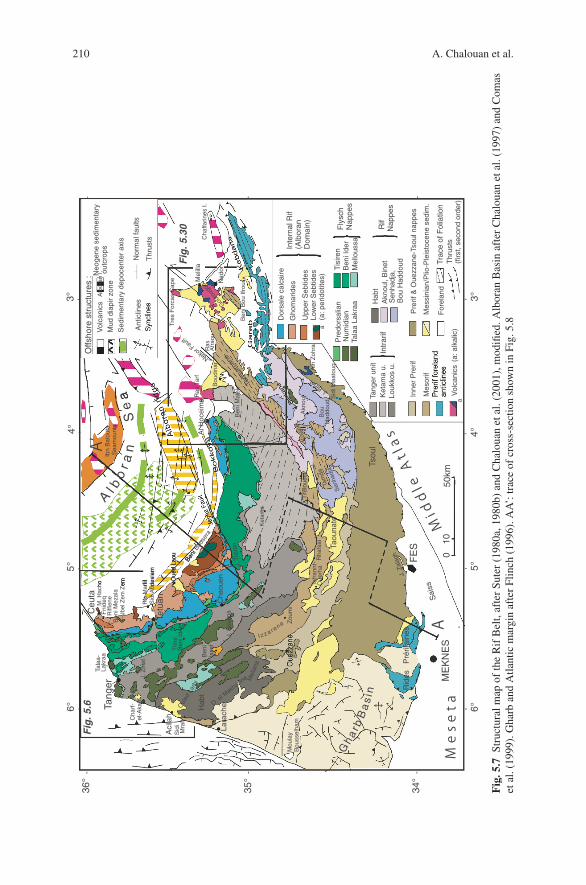
Three main structural domains form the Gibraltar Arc, from inside to outside andbottom to top, (i) the Internal Zones, or Alboran Domain; (ii) the Maghrebian Fly-schs, and (iii) the External Zones (Fig. 5.5). Each domain consists of tectonic com-plexes of stacked units or nappes with similar lithologies within a given complex,but contrasting from one complex to the other. This results in different surface mor-phologies and spectral signatures (Fig. 5.6). The structural map (Fig. 5.7) and asso-ciated cross-section (Fig. 5.8) highlight the principal structural lines of the Rif Beltbased on extensive, integrated studies and mapping at scale 1:50000.
5.1.2.1 Internal Zones (Alboran Domain)
The Internal Zones consist of continental units displaced westward over severalhundreds of kilometres, thus representing a genuine exotic terrane. Considering thegrade of Alpine metamorphic recrystallization in these units, we can recognize twocomplexes, which respectively form the upper and lower plates of a metamorphiccore complex. In the Rif and western Betics, the lower plate corresponds to theSebtide and Alpujarride units, respectively, both dominantly consisting of relativelydeep crustal rocks such as mica-schists, migmatites and granulites associated withmantle peridotites (Beni Bousera, Ronda). Another deep complex occurs in Centraland Eastern Betics beneath the Alpujarrides, namely the Nevado-Filabride complex,

5 The Rif Belt 207
Fig. 5.4 Distribution of the Pliocene deposits in the Messinian canyons of the internal part of theGibraltar Arc, after Loget & Van Den Driessche (2006), modified. The canyon of the Strait ofGibraltar, now filled with breccias, was used by the Atlantic waters 5.3 Ma ago to rush into theMediterranean Basin
which displays meta-ophiolites at its top. The upper plate consists of the Ghomaride(Rif) and Malaguide (Betics) complexes, which overlie the Sebtide-Alpujarridethrough a regional detachment. They include Paleozoic rocks affected by a Variscanmetamorphism partly superimposed by weak Alpine recrystallization, and relicts oftheir Mesozoic-Cenozoic cover.
Sebtide-Alpujarride rocks were cored in the Alboran Basin (Fig. 5.5), which fullyjustifies the name of “Alboran Domain” given to the Internal Zones. A similar meta-morphic structure can be recognized in the Algerian Kabylides, Peloritan Mountainsof Sicily, and Calabria. Thus, these varied exotic terranes were admittedly parts ofthe same continental domain AlKaPeCa (Bouillin, 1984), including the “Alboran
after Loget and Van Den Driessche, 2006
MALAGA
M e s s i n i a n A t l a n t i c s h
o r e l i t r a M
o a L
s a s s i r e t ’ M d
e c r
o h l a
d a
u G
M
l i t r a M a
o a L
s a s s i r e t ’’tttM d
N
Alboran Domain
Flysch nappes
External Zones
Post-Early Pliocene slumping
Pliocene clays
Late Messinian-Early Pliocene channels
Confirmed onshore extension of Messinian canyons
Probable onshore Messinian canyons
Relics of Messinian forerunner streams

208 A. Chalouan et al.
Fig. 5.5 Structural map of the Gibraltar Arc, modified from Chalouan & Michard (2004). AlboranBasin after Comas et al. (1999); Gulf of Cadiz after Maldonado et al. (1999); Miocene kine-matics after Frizon de Lamotte et al. (1991) and Martınez-Martınez & Azanon (1997). BB: BeniBousera; BM: Beni Malek; FF: Fahies Fault; JF: Jebha Fault; NF: Nekor Fault; R: Ronda; Tems.:Temsamane
microplate” of Andrieux et al. (1971), before being deformed and dispersed. Theinitial location of AlKaPeCa is controversial as this domain may correspond eitherto a distal part of the Iberian margin or to an isolated microcontinent within westernTethys (Sect. 5.7). Note that the name of “Mesomediterranean Block”, sometimesused instead of AlKaPeCa, is misleading since the Mediterranean Sea developedafter the AlKaPeCa split.
Nevado-Filabrides complexa: Mulhacen; b: Veleta
Foreland basement
Meseta and Atlascover series
Detached Atlasiccover at Prerif frontPrerif
Intrarif, Mesorif, Rif nappesa: Beni Malek serpentinites
Alpujarride-Sebtide nappesa: Ronda/Beni Bousera peridotites
Malaguide-Ghomaridenappes
“Dorsale calcaire” units
Maghrebian Flyschs Neogene volcanicsForedeep basins
Main thrust contact, onshoreIdem, offshore; Betic-Rifolistostrome front
Fold axis, normal fault (offshore)
Strait
Malaga
Granada
Gharb Basin
Guadalquivir Basin
Fes
4°
egdiR naroblA
Sub-Betic Zone
Mellila
Al HoceimaFJ
FN
FF ODP 976DSDP 121
a
a
a
b
4°5°
Miocene thrusttransport direction
Miocene extensionaltransport direction
6°
segdiR naifiR-erP
35°
36°
Cadiz
Taza
M i d d l eA t l a s H i g h
P l a t e a u s
t a
Tems.BM
100 km
BB
R
Kenitra
Rabat
6.5 .giF
Ceuta(Sebta)
of GibraltarTangiers
Alboran I. 36°
beraG
Saiss
Tetuan
Me s e

5 The Rif Belt 209
The Alboran Domain and its eastern equivalents include also a complex ofMesozoic-Cenozoic thrust sheets dominated by Triassic-Liassic carbonates. Thisis the Dorsale Calcaire, which appears as discontinuous ranges at the front of, andgenerally below the more internal crustal units. The Dorsale Calcaire units representremnants of the former southern passive margin of AlKaPeCa. These units can betraced northward around the Gibraltar Arc up to the Granada meridian.
5.1.2.2 Maghrebian Flyschs
The Maghrebian Flyschs nappe complex originates from the Ligurian-MaghrebianOcean, which connected the Central Atlantic and Alpine Oceans from Jurassic toPaleogene (see Chap. 1, Figs. 1.5, 1.8). The final suturing of the Maghrebian Oceanbetween AlKaPeCa and Africa by the Late Oligocene-Early Miocene resulted inthe formation of a nappe stack consisting of the dominantly turbiditic sediments(“flyschs”) accumulated within the oceanic basin. These nappes root beneath theInternal Zones and overlie the External Zones (Figs. 5.7, 5.8). Part of the Flyschnappes has been back-thrust over the northern Ghomarides (J. Zemzem and Riffienemassifs south of Ceuta).
The Flyschs nappes are exposed widely in western Betics (Campo de Gibraltar;Fig. 5.5), up to the Granada transect. According to Algerian nomenclature
Martil
Oued Lao
Ceuta
Tanger
J. Musa
z u
o a
H
J. Zemzem
eriac
lac
elas
roD
Cabo Negro(Sebtides)
M. Hacho(Sebtides)
s e d i r a
m o h G
Beni Mezala(Sebtides)
s e
d i r
a m
o h
GCap Spartel
Num.
eppa
N na
idi
muN
.N
neri
siT
Num.
Ksar EsSghir
.N
redI
ine
B
.N
neri
siT
.N
redI
ine
B
J. Zinat
U. Cret.(Intrarif)
)fir
artn
I( .t
erC .
U
asss
uole
M.
N .mu
N +
Habt Miocene N.(Intrarif)
ALBORAN SEANAECO CIT
NALTA
RATLARBIG FO TIARTSN
10 kmTetouan
Fig. 5.6 Landsat image of northern Rif. Location: see Figs. 5.5 and 5.7. The different structuralzones shown here are (from E to W) the Internal Zones (Sebtides, Ghomarides, Dorsale calcaire),the Flysch Nappes (Tisiren, Beni Ider, Meloussa, Numidian), and the underlying External Zones(restricted to their internal part, i.e. Intrarif from Tanger and Habt). Num. N: Numidian Nappe.Basically, the image shows a collapsed accretionnary prism in front of a partly collapsed and im-merged buttress
210 A. Chalouan et al.
Akn
oul
Ain
Zoh
ra
Dor
sale
cal
caire
Upp
er S
ebtid
es
Inte
rnal
Rif
(Alb
oran
D
omai
n)
Pre
dors
alia
nN
umid
ian
Tala
a La
kraa
Tisi
ren
Ben
i Ide
rM
ello
ussa
Fly
sch
Nap
pes
Tang
er u
nit
Louk
kos
u.K
etam
a u.
Intr
arif
Mes
orif
Inne
r P
rerif
Hab
tA
knou
l, B
inet Tr
ace
of F
olia
tion
Mes
sini
an/P
lio-P
leis
toce
ne s
edim
.
Vol
cani
cs
- ----
- 3°
Gho
mar
ides
Low
er S
ebtid
es(a
: per
idot
ites)
Thr
usts
(firs
t, se
cond
ord
er)
Pre
rif &
Oue
zzan
e-Ts
oul n
appe
s
Rif
Nap
pes
Tang
er
Fig
. 5.6
Fig
. 5.3
0
Tala
a-La
kraa
J. Z
inat
Fni
deq
Riff
iene
Ben
iMez
ala
Tetu
an
Bou
dina
rR
asA
frao
u
Tres
For
cas
Cap
e Mel
illa
Cha
ffarin
es I.
Nad
or
Tem
sam
ane
Sid
i Maa
toug
J. T
ifelo
uest
Taou
nate
Rha
fsai
Tafr
annt
-O
uerh
a
FE
S
ME
KN
ES
Zou
mi
I z z a rene
Rid
es
Pré
rifai
nes
Cha
rf-
el-A
kab
Hab
t
Aci
lah
Lara
che
Sid
i M
raït
Ben
iIs
sef
Oul
adLa
rbi
Tle
ta
Ben
i Ide
r
O. el Makh
azine
J.Ti
sire
nJ.
Sou
kna
Ket
ama
Cha
ouen
--
-
-
NekorFault
-
Sai
ss
Gouro
ugou
Ben
i Bou
Ifro
urB
eni M
alek
Tsou
l
J.Za
lagh
B
ouH
addo
ud
Mel
iana
Kou
ine
Se
a
M. H
acho
Tam
da
Sen
hadj
aa
a
J.Binet
(a: a
lkal
ic)
A
-
-
50km
010ouse
raA
l Hoc
eim
a
- 4°
- 5°6°-
-
-
-
-
-
4°6°
3°5°
Ras
Tar
f
A’
Al b
or a
n
Ibn
Bat
outa
Sea
mou
nts
Ceu
ta
Alb
oran
I.
-
Sen
hadj
a,
Bou
Had
doud
Neo
gene
sed
imen
tary
out
crop
sV
olca
nics
Mud
dia
pir
zone
Ant
iclin
esN
orm
al fa
ults
Offs
hore
str
uctu
res
:
Sed
imen
tary
dep
ocen
ter
axis
Thr
usts
Gh
ar b
Ba
si n
M e s e t a
MiddleAtlas
For
elan
d
Mou
lay
Bou
ssel
ham
Rio
Mar
tilS
idi A
bdes
lam
Oue
d La
ou neBi B
Jbel
Zem
Zem
34°
35°
36°
Fig
.5.7
Stru
ctur
alm
apof
the
Rif
Bel
t,af
ter
Sute
r(1
980a
,198
0b)
and
Cha
loua
net
al.(
2001
),m
odifi
ed.A
lbor
anB
asin
afte
rC
halo
uan
etal
.(19
97)
and
Com
aset
al.(
1999
).G
harb
and
Atla
ntic
mar
gin
afte
rFl
inch
(199
6).A
A’:
trac
eof
cros
s-se
ctio
nsh
own
inFi
g.5.
8

5 The Rif Belt 211
Lith
osph
eric
man
tle
- - - - - -
20100 30 40 km
40302010
- - - - -
Upp
er C
rust
Alb
oran
Bas
in
For
elan
d, F
ored
eep
Pre
rif n
appe
Inne
r P
rerif
Mes
orif
Intr
arif
Mag
hreb
ian
F
lysc
hsA
lbor
an D
omai
n
Ibn
Bat
outa
seam
ount
sM
e -P
Q
(Ceu
ta)
TJ
Saï
ss
UM
1-2
MM
-UM
1
R
ides
prér
ifain
esJ
Oue
zzan
e
Nap
pe“S
ofs”
C-U
M1U
J-CTa
ouna
teS
enha
dja/
Tam
da
LMM
Louk
kos
B. I
ssef
M
MN
umid
ian
B. I
der
Mel
lous
aTisi
ren
Dor
sale
Pd.
M-U
M
30 kmLC
Ke
U
2M
U
2M
NE
SW
Low
er C
rust
Gho
mar
ides
Seb
tides
(B. B
ouse
ra)
5010
015
020
0 km
Mo
ho
..
.. .
..
..
.. .
. ......... ..
.....
...........
..
..
.... .
?
Tife
loue
st
UC
Tg
Ast
heno
sphe
re
Teth
yan
cru
st ?
MS
Z
Fig
.5.8
Cru
stal
cros
s-se
ctio
nof
the
Rif
Bel
t,m
odifi
edfr
omC
halo
uan
etal
.(20
01),
and
corr
espo
ndin
gB
ougu
eran
omal
yaf
ter
Favr
e(1
995)
.Moh
oan
dba
seof
litho
sphe
rede
pth
afte
rFa
vre
(199
5),T
orne
etal
.(20
00),
Friz
onde
Lam
otte
etal
.(20
04),
Fulle
aU
rchu
lute
guie
tal.
(200
6).L
ocat
ion
inFi
g.5.
7.A
bbre
viat
ions
:B
.:B
eni;
C:C
reta
ceou
s;J:
Low
er-M
iddl
eJu
rass
ic;L
CK
e:L
ower
Cre
tace
ous
ofK
etam
a;L
MM
:Low
er-M
iddl
eM
ioce
ne;M
M:M
iddl
eM
ioce
ne;M
SZ:M
esor
ifSu
ture
Zon
e;Pd
:Pre
dors
alia
n;T
:Tri
assi
c;T
g:Ta
nger
Uni
t;U
M:U
pper
Mio
cene
(1:T
orto
nian
“pre
-nap
pe”;
2:U
pper
Tort
onia
n-Pl
ioce
ne“p
ost-
napp
e”);
UJ-
C:
Upp
erJu
rass
ic-C
reta
ceou
s.C
onve
ntio
nall
ithol
ogic
sign
atur
es(s
chem
atic
)
212 A. Chalouan et al.
(cf. Sect. 5.3), the more internal and higher units are referred to as the Mauretaniannappes (in the Rif, J. Tisiren and Beni Ider nappes), whereas the more external andlower units are named the Massylian nappes (Chouamat-Melloussa and Numidiannappes). All these nappes of oceanic origin mark a suture zone beneath the Alboranterrane (Fig. 5.8), although ophiolitic remnants are lacking along the suture, exceptin Algeria and, more significantly, in Calabria.
5.1.2.3 External Zones
The External Zones of each limb of the Gibraltar Arc originate from two distinctpaleomargins of Africa and Iberia, respectively. Therefore, contrary to the InternalZones and Flyschs nappes, the Rif and Betic External Zones do not display anystratigraphic/structural continuity across the Strait of Gibraltar, except in the up-permost and youngest units of the accretionary prism located offshore in the Gulfof Cadiz. The Subbetic Zone proceeds from a starved paleomargin and displays athin-skinned tectonics, whereas the more complex Rif-Tell Externides proceed froman abundantly sedimented margin and display both thick-skinned and thin-skinnedstructural styles.
In the External Rif (Figs. 5.7, 5.8), we may distinguish three structural zones,from north to south and top to bottom, the Intrarif, Mesorif and Prerif, whichderive from more and more proximal parts of the African paleomargin, respec-tively. Within each of these zones, we may again distinguish deep rooted, pa-rautochthonous units (more or less detached from their original basement), anddiverticulated, superficial gravity-driven nappes. Metamorphic recrystallizationsreaching the chloritoid-bearing greenschist-facies conditions occur in the deep In-trarif (Ketama) and eastern Mesorif (North Temsamane) units, on both sides of theNekor fault. Serpentinite and metabasite slivers (Beni Malek) crop out along the lat-ter fault, which likely corresponds to a segment of an intracontinental (intra-margin)minor suture recognisable eastward up to Algeria (Sect. 5.4).
Two major, ENE to NE-trending left-lateral faults, namely the Jebha Fault, southof the Northern Rif Internal Zones, and the Nekor Fault in the Eastern Rif, give ev-idence, at the map scale, of the obliquity of the movement of the Alboran Domainrelative to Africa. The tectonic structures observed in the External units and overly-ing Flysch outliers all show an externalward displacement, i.e. toward the NeogenePrerif foredeep. The foredeep is widely developed and poorly deformed in the west,i.e. in the Gharb (Rharb) Basin, equivalent to the Guadalqivir Basin (Betic fore-deep). In contrast, the foredeep changes to a deformed, narrow corridor south ofEastern Rif, and finally vanishes east of Taza, where the Mesorif outliers directlyoverlie the Middle Atlas foreland.
5.1.2.4 Alboran Basin and Trans-Alboran Magmatism
The Alboran Basin opened at the rear/east of the belt during the latest Oligocene-Early Miocene. This is a synorogenic basin with a thinned continental crust, which

5 The Rif Belt 213
incorporates stretched elements of the orogen. Up to 8 km of turbidites and mudsaccumulated in the western sub-basin where numerous mud diapirs occur. In thecentral and eastern parts of the basin, as well as on its southern and northernborders, an important calc-alkaline magmatism developed during the Middle-LateMiocene. This is the Trans-Alboran magmatic province, i.e. the western part ofthe Maghrebian magmatic province, which includes numerous granitic massifs inAlgeria (Sect. 5.6).
The Alboran sediments are affected by open folds and strike-slip faults (AlboranRidge) dated from the Late Miocene (Messinian) and resulting from the ongoingAfrica-Europe convergence.
5.1.3 Lithospheric Structure
References: The crustal structure of the African margin was described by Favre(1995). Overall descriptions of the Gibraltar Arc lithosphere, based mainly on seis-mological data and geophysical modeling, have been published by Seber et al.(1996), Calvert et al. (2000), Gurrıa & Mezcua (2000), Torne et al. (2000), Gutscheret al. (2002), Spakman & Wortel (2004), Frizon de Lamotte et al. (2004), FulleaUrchulutegui et al. (2006), Bokelman & Maufroy (2007). The thermal structure isdescribed by Polyak et al. (1996) and Rimi et al. (1998). Concerning the EasternAlboran Basin and next Algerian-Balearic Basin, see Mauffret et al. (2004), Domziget al. (2006), and Schettino & Turco (2006).
The continental crust north and especially south of the Alboran Basin is ratherpoorly known due to lack of deep seismic survey. However, the varied geophysicalmethods already used indicate great thickness variations in the crust and hetero-geneities in the mantle.
In the Rif foreland, seismic refraction studies image a 30 km thick continentalcrust, with a 9–10 km thick lower crust (Chap. 1, Fig. 1.20; cf. Fig. 5.8 above).Modelling of crustal and lithospheric thickness or density variations that integratesboth elevation and geoid anomalies yields evidence (assuming local isostasy) of apoorly marked orogenic root beneath Central Rif (Moho at 34 km depth), followedby a quick Moho rise toward the Alboran Basin. In the western sub-basin wherethe water depth does not exceed 1 km (Figs. 5.2, 5.8), the Moho is located at about18–20 km, associated with a thinned, 15–18 km continental crust. East of the Albo-ran Ridge, water depth increases up to 2.5 km, and the crust thickness decreases to∼12km: the eastern Alboran sub-basin is transitional toward the Algerian-BalearicBasin the crust of which is likely oceanic.
The mantle lithosphere thickness is less constrained. Taking into account the highthermal gradients observed in the basin axis, Torne et al. (2000) inferred a thicknessof about 20–30 km. In contrast, seismic studies led Calvert et al. (2000) to suggestthat asthenosphere comes in contact with the Alboran thinned continental crust, andeven penetrates as a wedge between the Gibraltar Arc crust and underlying litho-spheric mantle (delamination). The latter hypothesis is neither confirmed nor con-tradicted by the more recent geophysical studies (Sect. 5.7). Fullea Urchulutegui

214 A. Chalouan et al.
et al. (2006) modelling leads to rather greater thicknesses beneath the westernsub-basin (Fig. 1.18). In the cross-section (Fig. 5.8), we schematically delineatethe depth to the asthenosphere at shallow level beneath the Alboran Sea and as-sume that it crosscuts the subducting African lithosphere, consistent with the slabbreak-off hypothesis. The latter hypothesis is supported by the geochemistry of theTrans-Alboran magmatism (Sect. 5.6) and by the 3D seismic tomography imag-ing (Sect. 5.7). Waveforms of body waves that traverse the Alboran Sea confirmthe presence of an anomalous mantle underlying the basin (Bokelman & Maufroy,2007).
North of the Alboran Sea, the continental crust again thickens beneath the BeticCordilleras, following a roughly symmetrical pattern as described above in the Rif.Below the Strait of Gibraltar, the crust is up to 30–32 km thick (Fig. 1.18). This isconsistent with the current concept of an orogenic arc above an active east-dippingsubduction zone (Sect. 5.7).
5.2 Internal Zones (Alboran Domain)
The following sections describe the stratigraphy and structure of the Rif InternalZones, i.e. of the Moroccan part of the Alboran Domain. However, we will alsorefer frequently to Betic data, as they complement usefully the geological data onthis exotic terrane.
5.2.1 Sebtides
References: Most of the recent literature concerning the Sebtide complex dealswith its metamorphic structure and petrology: see Bouybaouene (1993), Saddiqiet al. (1995), Bouybaouene et al. (1998), Montel et al. (2000), El Maz & Guiraud(2001), Haissen et al. (2004). Negro et al. (2006) consider both the Sebtides andtheir Betic counterparts (Alpujarrides). The Beni Bousera peridotites were repeat-edly studied: see Reuber et al. (1982), Saddiqi et al. (1988), Pearson et al. (1989),Kornprobst et al. (1990), Kumar et al. (1996), Tabit et al. (1997), Pearson et al.(2004), and Downes (2007). Their Betic equivalents (Ronda), even more frequentlyinvestigated, are recently considered by Sanchez-Gomez et al. (2002), Platt et al.(2003b), Tubıa et al. (2004), Cuevas et al. (2006), and Downes (2007), with ref-erences therein. The isotopic ages reported below are from Platt & Whitehouse(1999), Argles et al. (1999), Montel et al. (2000) and Sanchez-Rodriguez & Gebauer(2000). Kabylian data are summarized by Michard et al. (2006), with referencestherein.
The Sebtide complex crops out in four tectonic windows beneath the Ghomaridenappes (Figs. 5.7, 5.9), i.e. from N to S, the Beni Mezala anticline, Ceuta-MonteHacho massif, Cabo Negro promontory, and eventually the much larger Beni

5 The Rif Belt 215
x
a Pliocene and Quaternary(a)External Rif and Flyschs(b)
J. Zemzem klippe (flyschs)
Talembote
CEUTA
J.Zemzem
MARTIL
OUED-LAOU
a
b c
0 5 10Km
TARERHA
BOU AHMED
TALEMBOTE
A
JEBHA
ASSIFANE
GHOMARIDES
SEBTIDES
A E
S
N A
R O
B L
A
Beni-Hozmar
Koudiat-Tiziane
Aakaili
Dorsale calcaire,J. Musa (Tariquides)Federico /Filali units
Kinzigites (a)Peridotites (b)Orthogneiss (c)
b
Cabo Negro
Ras Araben
Monte Hacho
TETOUAN
Ras Akaili
Zaouia
CHEFCHAOUEN
Thrust
Detachment
Strike slip fault
Tamernout
STEHA
FNIDEQ
Beliounis
J.Fahs
J. Moussa
Beni Mezalaantiform
Beni Bouseraantiform
Ha
ou
zR
i dg
e
Fig. 5.10
III
II
I
WSW
SW
NESW
ENE
M. Hacho
J. Zemzem
FnideqBeni Mzala
Dradia
K. Tizian
TalemboteTizagarine
Sidi Mohamedel - Filali
Beni BouseraRasAaraben
Beni Hozmar Ras Aakaili
1
0
-1
1
0
-1
1
0
-1
0 5 10 15 km
Aquitanian-Burdigalian
Middle-UpperTriassic
?
II
III
B
I
Fig. 5.12
Steep normal fault
Fig. 5.13
CHERAFATE
5°30 5°00
35°30’
Fig. 5.9 Structural map (A) and cross-sections (B) in the Northern Rif Internal Zones, afterChalouan & Michard (1990), modified. The Ghomaride-Sebtide nappe stack was folded beforeand after the unconformable onlap of the “post-nappe” formations (e.g. at Fnideq in Sect. B-I).The J. Zemzem and Haouz backthrusts occurred during the second shortening event

216 A. Chalouan et al.
Bousera antiform. Each of these windows, except Cabo Negro, consists of a stackof nappes with different pre-Alpine protoliths and contrasted metamorphic grades(Sect. 5.4.2).
5.2.1.1 Basement Units
The oldest rocks, likely Paleozoic in age or even Precambrian, crop out in the BeniBousera antiform (Fig. 5.10). This large antiformal structure deforms a stack of twothick basement units, from bottom to top, the Beni Bousera and Filali units, andtheir more or less detached metamorphic cover units, referred to as the Federicoimbrications (Fig. 5.11A).
The Beni Bousera unit consists of a huge peridotite body, at least 2 km thick,topped by discontinuous slivers of granulites (kinzigites). Together with their Alpu-jarride counterpart (Ronda peridotites of the Los Reales nappe), the Beni Bouseraperidotites are among the largest infracontinental mantle massif worldwide(Figs. 5.10, 5.12). The dominant lithology is a spinel lherzolite including pyrox-enite layers which yielded graphitized diamond pseudomorphs. This indicates anearly equilibration at more than 140 km depth followed by a retromorphic evolutionat about 50 km depth. The metagabbroic pyroxenite and garnet pyroxenite layersinterbedded within the ultrabasites are deformed by isoclinal folds associated witha high temperature foliation. Only some of these pyroxenites display geochemi-cal evidence of being related to recycled oceanic crust, whereas the others are bestexplained by crustal accumulation in mantle-derived magmas (Downes, 2007). In-tensely foliated harzburgites occur close to the top of the ultrabasite massif, someof them including garnet crystals whose origin is controversial. Serpentinization in-creases toward the sheared envelope of the peridotite body.
Fig. 5.10 View of the Beni Bousera massif looking SE-ward. See Fig. 5.9A for location. ub: ul-trabasites (∗: location of Fig. 5.12); k: kinzigites (top of Beni Bousera unit); gn: gneisses (baseof Filali unit). The Ras (Cape) Araben is made of a downthrown element of the Aakaili nappe(Ghomaride). Photo by O. Saddiqi

5 The Rif Belt 217
The crustal rocks immediately above the peridotites consist mainly of acidicgranulites (kinzigites) with garnet-sillimanite±kyanite-graphite assemblages(Sect. 5.5). Some basic granulites are interbedded within the acidic ones, such asthe Ichendirene HP-granulites, which exhibit mineral assemblage including pyrope-rich garnet, jadeite-rich clinopyroxene and rutile, indicative of an equilibration atP > 16kbar, 760–820 ◦C. The latter P-T conditions are closely similar to those ofthe garnet-bearing peridotite equilibration.
It is worth noting that the Beni Bousera and Ronda peridotites have become dis-connected with the mantle as they were thrust over a deeper Sebtide-Alpujarridecrustal unit, which corresponds to the migmatitic orthogneiss of Monte Hacho
Mt. Hacho orthogneisses
Lherzolites with pyroxenitelayers
Leucogranite dykes (red)
Harzburgites, dunites
Kinzigites, basic granulites
Migmatites, leptynites
Mica-schists
Dark purple-bluish phyllites (Permian)
Quartzites (Early Triassic)Dolomites (Mid Triassic)
HTU
OSO
CIREDEF
T I N
U I L A L I F
TIN
U A
RESU
OB I
NEB
NEJO
TIN
U
0
1000
2000 m
AFig. 5.11 Synthetic litho-stratigraphy of the pre-Triassic series of the Alboran Domain in the RifBelt. (A): Sebtides, after Bouybaouene (1993), Saddiqi (1995), Negro (2005); (B–D): Ghomaridenappes, after Chalouan & Michard (1990), modified

218 A. Chalouan et al.
Fig. 5.11 (continued)
(Ceuta) and Ojen (Betics), associated with thick marbles in Andalucia (SierraBlanca). Partial melting within this deep crustal material resulted in the intrusionof cordierite-andalusite-bearing granite dykes across both the northern and southernperidotite massifs.
The age and emplacement mechanisms of the Ronda and Beni Bousera peri-dotites have been repeatedly questioned. Some authors assume that they originatefrom a Miocene hot asthenospheric diapir coeval with the opening of the Albo-ran Sea, whereas others argue that they formed during the Paleozoic, being up-lifted first during the opening of the Tethys Ocean, then during the Alpine orogeny

5 The Rif Belt 219
Fig. 5.12 Lherzolite outcropsalong the Beni Bouserashoreline east of Bou Ahmed(see Figs. 5.9 and 5.10 forlocation). Arrow: pyroxenitelayers. The steep, NE-dippingfractures are likely related tothe Ras Araben normal fault(background left)
VSE
(Sect. 5.7.4.4). The latter hypothesis is supported by a great variety of isotopic dat-ings such as: the ages close to 300 Ma obtained on relict minerals from the kinzig-ites (U-Pb on zircon cores, and garnet-armoured monazite grains); the garnet-wholerock Sm-Nd isochron age of 235.1± 1.7Ma obtained from Ronda pyroxenites; the286±5Ma U-Pb age from oscillatory-zoned domains from the euhedral zircon frac-tion in Ronda garnet pyroxenites; and the U-Pb zircon core ages from the samerocks, 178± 6Ma, 143± 16Ma, 131± 3Ma recording successive steps of coolingduring the Triassic-Early Cretaceous Tethyan rifting.
The Filali unit overlies the Beni Bousera unit through a subtractive ductile shearzone, as the migmatites at the bottom of the Filali (Fig. 5.13) are equilibrated under8 kbar, 780 ◦C, i.e. at much lower pressure than the underlying granulites. Above thegneisses, the Filali unit is made of mica-schists the mineral assemblages of whichchange more progressively upward, from garnet-biotite-sillimanite to garnet-biotite-staurolite-kyanite, and finally chlorite-chloritoid-muscovite±biotite±kyanite. An-dalusite is ubiquitous in these metapelites, and the coexistence of the three Alsilicates suggests a polycyclic metamorphic history with an Alpine evolution(Sect. 5.5) superimposed on a Variscan one. Indeed, Variscan to Jurassic ages wereobtained from some high-grade Alpujarride rocks, such as the Torrox gneiss (equiv-alent to the Monte Hacho gneiss), dated at 285±5Ma (U-Pb zircon), and the eclogiteincluded in the Ojen gneisses (183±3Ma, U-Pb on magmatic zircon core).
5.2.1.2 Metamorphic Cover Units
The Upper Sebtides or Federico units consist of metasediments, affected only byAlpine recrystallizations. They form thrust imbrications where the same lithostrati-graphic sequence is repeated several times with downward increasing metamorphicgrade. In the Beni Mezala antiform (Figs. 5.9, 5.14), four superimposed, relativelythin units (500–1000 m) are folded together forming an antiformal stack beneath theGhomarides units. Each unit displays the three main formations ascribed from bot-tom to top, to Permian-Triassic, Lower Triassic and Middle-Upper Triassic Alpine-type sequences (Fig. 5.15A1). The Permian-Triassic deposits consist of red pelitesin the uppermost unit (Tizgarine), purple phyllites in the intermediate unit (Boquete

220 A. Chalouan et al.
Fig. 5.13 Migmatitic gneiss from the Filali unit, with a pervasive boudinage fabric affecting a dykeof garnet-bearing meta-aplite (below the hammer). Note the complex, polyphase structure of theserocks (superimposed Variscan and Alpine deformations). Cabo Negro south cliffs (see Fig. 5.9Afor location). Photo by O. Saddiqi
Fig. 5.14 The Beni Mezala (BM) massif along the Fnideq-Ksar Es-Sghir road, 3 km NW fromFnideq (see Fig. 5.9 for location). Note the duplication of the stratigraphic levels of the low-est BM1 and BM2 Federico units in the foreground: P-T, Permian-Triassic metapelites andquartzites; Td: Middle Triassic dolomites. Background: Upper Federico units (BA: Boquete An-jera; Tz: Tizgarine), dominated by the Jebel Fahs Dorsale unit (DI), which includes Upper Triassicdolomites and Hettangian limestones (Td-Lc). The post-nappe fold axis plunges SSW

5 The Rif Belt 221
Fig. 5.15 Detail stratigraphy of the cover sequences from representative units of the Alboran Do-main in the Rif Belt. (A): Triassic series, after Chalouan (1996). (B and C): Liassic-Eocene and“post-nappe” series of the Ghomarides, after El Kadiri et al. (1992) and Serrano et al. (2006),respectively
Anjera), and of dark (“color de humo”, smokg) quartz-phyllites in the lowest units(Beni Mezala 2 and 1). This color evolution can be correlated with change inmetamorphic grade (Sect. 5.5). Light-colored quartzites are placed in the LowerTriassic, and compare with the Brianconnais quartzites of Western Alps. Theyare overlain by Middle-Upper Triassic dolomitic marbles, which locally yieldedGyroporella (Dasycladaceae) of Middle Triassic age. Remarkably, no youngerstratigraphic level was ever recognized in the Sebtides or the Alpujarrides, whichis possibly related to a tectonic detachement of the upper units (Sect. 5.7.4.3). Bycontrast, the stratigraphic sequence of the upper Federico unit is completed down-ward by probable Upper Carboniferous greywacke formations. The base of theBeni Mezala unit is made of the Benzu mica-schists, closely similar to the Filaliones.
On top of the Beni Bousera antiform, similar metamorphic imbrications oc-cur. However, in this southern region the lowest Federico unit, here labelled theSouk-el-Had unit, seemingly remained in stratigraphic contact over the Filali mica-schists, as similar metamorphic assemblages are found on both sides of their com-mon limit (Sect. 5.5). Note that similar Permian and Triassic imbrications alsooccur on top of the Los Reales nappe of western Betics (Casares units, Benarrabaimbrications).

222 A. Chalouan et al.
5.2.2 Ghomarides
References: The Paleozoic stratigraphy of the Ghomaride–Malaguide Complexhas been described by Herbig & Mamet (1985) and Herbig (1989) in Spain, andby Chalouan & Michard (1990) in Morocco. The pre-Alpine relationships of thiscomplex, and of the Alboran microplate in general with the other Hercynian seg-ments of Western Mediterranean have been discussed by von Raumer et al. (2003),Trombetta et al. (2004), Helbing et al. (2006), Sanz de Galdeano et al. (2006),Micheletti et al. (2006).
The Triassic unconformable deposits have been described by Baudelot et al.(1984), Chalouan (1996), and Diez (2000). On the other hand, Feinberg et al. (1990),El Kadiri et al. (1992), Durand-Delga et al. (1993), Maate (1996), Martın-Martınet al. (1997, 2006), Martın-Algarra et al. (2000), El Kadiri et al. (2001), Serranoet al. (2006) described the post-Triassic deposits. Concerning the late orogenicbasins of eastern and central Betics (i.e. the youngest deposits which overlie theGhomarides as well as the deeper nappes complexes), see Weijermars et al. (1985),Montenat et al. (1987), Weijermars (1991), Garcıa-Duenas et al. (1992), Orozcoet al. (1999).
The Ghomaride complex includes four nappes (Fig. 5.9) with different Paleozoicstratigraphy (Fig. 5.11B1–4). The nappes are separated from each other by relics oftheir Mesozoic-Cenozoic cover, mostly Triassic in age. The larger nappes, i.e. frombottom to top, Aakaili, Koudiat Tizian, and Beni Hozmar nappes crop out in north-ern Rif and partly in the Bokkoya. The highest, Talembote nappe forms a largetectonic klippe over the Dorsale in the Oued Lao area and some small outcrops inthe Bokkoya (Fig. 5.7).
5.2.2.1 Paleozoic Formations
The Ghomaride Paleozoic formations are folded and recrystallized (Fig. 5.16), con-trary to their Mesozoic-Cenozoic cover deposits. Therefore, they must be regardedas Variscan chips in the Rif Alpine belt.
The Lower Paleozoic sequences are rather homogeneous from one nappe toanother, contrary to the Devonian (Fig. 5.11B2–4). The terrigeneous Ordoviciandeposits consist of phyllites with interleaved quartzite and meta-conglomerates. Car-bonate layers first appear in the Silurian sequence, which contains black Graptolith-bearing cherts (Llandovery). This sequence is followed upward by a trilogy pillowbasalts-lydites-micrites with Orthoceras, Tentaculites and Conodonts, all indicatingthe Lochkovian. These pelagic limestones are substituted by much thicker Orthoceraslimestones in the Talembote nappe, with incipient reef buildings: this is the begin-ning of a strong paleogeographic differenciation. In the Aakaili nappe, the Devoniansedimentation continues with distal calci-turbidites (“calizas alabeadas” = “tortuouslimestones”: cf. Fig. 5.16) where Famennian levels are dated near the top of the se-quence. In the Koudiat Tizian nappe, a proximal, terrigeneous flysch (greywackesand pelites) is found. In the Beni Hozmar nappe, the latter deposits are substituted

5 The Rif Belt 223
v
vWNW
Fig. 5.16 Superimposed Eovariscan folds in the Upper Devonian calciturbidites of the Aakailinappe (Lower Ghomarides) at Tamernout beach (see Fig. 5.9 for location). Scale is given by theperson sitting on the left (arrow). A tight syn-metamorphic P1 fold is deformed by the P2 folds,which are associated with a SE-dipping crenulation cleavage
by thinner Tentaculite-bearing marls and limestones. Eventually, massive limestones(“calcaires zebres”) with Favosites reef-mounds occur in the Talembote nappe.
The Lower and Middle Paleozoic formations are affected by an Eovariscanfolding phase associated with greenschist-facies metamorphism prior to the trans-gression of the unconformable Carboniferous sediments. The earliest Carboniferouslevels are dated from the late Tournaisian in the Malaguides, which indicates a lateFamennian-early Tournaisian age of the Eovariscan phase. The Carboniferous de-posits begin with a lower sequence of proximal, turbiditic greywackes ending (atleast in the Beni Hozmar and Talembote nappes) with coarse olistotromal conglom-erates and boulders of Late Visean shallow water limestones. This lower, proxi-mal sequence is followed upward by a more distal sequence interleaved by lime-stones with Late Visean-lower Namurian microfossils. Conglomeratic mass flowstoward the bottom of this upper sequence contain pebbles reworked from the ear-lier Carboniferous sediments, the Silurian – Devonian deformed series, and evenfrom a granitic and metamorphic basement, which is unknown in the Ghomaride-Malaguide complex, but occurs in the Kabylides.
The Aakaili Carboniferous sedimentation ends at Ceuta with coarse conglom-eratic deposits comparable to the early Late Carboniferous Marbella Conglomer-ates in the Malaguides. Both conglomerates include peraluminous granite pebblesand resemble coeval conglomerates from Menorca (Balearic Islands), likely sourcedfrom Central Iberia (Sanz de Galdeano et al., 2006). Likewise, the Early Carbonif-erous sediments of both the Ghomarides and Malaguides strongly recall those fromMenorca. However, they also resemble the coeval deposits from the Moroccan East-ern Meseta, and contrast with those of Western Meseta where the Eovariscan phaseis virtually lacking (Chalouan & Michard, 1990). Both cases support an eastern ori-gin for the Ghomaride-Malaguide Complex in the Alpine, pre-collisional setting (cf.Sect. 5.7.4.3).
The restoration of the initial position of these Variscan chips, and more gen-erally of the AlKaPeCa basement (Alboran microplate), at the beginning of thePaleozoic evolution is hindered by the superimposed effects of both the Variscanand Alpine orogenic cycles. Recent attempts of restoration have been based on

224 A. Chalouan et al.
U-Pb zircon datings of the orthogneisses from the Alboran microplate elements. TheLesser Kabylia orthogneisses and the Peloritan porphyroids yielded Mid-Ordovicianmagmatic ages, which compare with the age obtained from the Sardinia gneisses(Trombetta et al., 2004; Helbing et al., 2006), suggesting relationships with theVariscan segments of south-western Europe. Contrastingly, Micheletti et al. (2006)obtained Late Neoproterozoic-Early Cambrian magmatic ages from the Calabrianaugen gneisses, suggesting relationships with the high-K granitoid suite of the Anti-Atlas. The latter authors assume that the “Alboran microplate” – or, at least, itsCalabrian part, detached from Gondwana after the early rifting and drifting of theAvalonian-Cadomian terranes (Raumer et al., 2003). Accordingly, the AlKaPeCabasement appears to be composed of different terranes whose collage resulted fromthe Variscan orogeny. The position of this complex after the western Tethys openingis discussed in Sect. 5.7.4.3.
5.2.2.2 Mesozoic-Cenozoic Cover
The post-Variscan sedimentation begins with Middle-Upper Triassic unconformablered beds (Fig. 5.15A2). These are thick, mainly fresh water deposits such aschannelled quartzose conglomerates, arkosic sandstones, and gypsum intercalatedferrugineous clays. Paleogeographically, the entire succession evokes a mostlyemergent continental shelf. Palynological data indicate the late Anisian-Ladinian(Baudelot et al., 1984) or Ladinian-Carnian (Diez, 2000). Locally, the clasticsequence is followed upward by dolomitic carbonates dated from the Carnian. Ex-tensional tectonics related to the Tethyan opening is recorded by frequent synsedi-mentary faults and some alkaline basalt flows.
The remainder of the cover sequence occurs only in discrete strips. North ofTetuan, the El Onzar strip (Fig. 5.15B) overlies the Koudiat Tizian nappe, whereastwo other strips (Belouazene, Kellalyine) occur beneath the latter nappe and overliethe Aakaili one through a tectonic contact which partly or totally cuts out the Triassicsandstones. Further to the north and west of Fnideq, the truncated Dradia strip lieson top of Beni Hozmar Paleozoic sediments (Fig. 5.9B).
In the most representative outcrops, the Triassic red beds are followed upwardby Upper Triassic dolomites, passing up into massive limestones of Early Liassicage. This is a typical shelf sequence of the pre-rift stage. A possible emersion issuggested by karst-like structures formed during the Early-Middle Liassic: at thattime, the area would correspond to the Tethyan rift shoulder or to the head ofsome large tilted block. However, the area is certainly submerged during the Toar-cian as ammonites from that stage are reworked within breccias topping the deeplyfractured Liassic limestones. The breccias are in turn topped by Microcodium lime-stones (Dradia) followed upward by whitish, bioclastic sandy limestones with Num-mulites, Alveolines, and Discocyclines of Ypresian, Lutetian and Bartonian age.These Lower-Middle Eocene layers are, in turn, locally topped (Jebha, Fig. 5.9) byUpper Eocene conglomerates, which contain Hercynian granite pebbles (Iberian orKabylian basement-sourced?)
The lack of any post-Toarcian sedimentary record up to the Late Cretaceous canbe interpreted as being the result of a long-lasting emersion, or alternatively as the
5 The Rif Belt 225
consequence of the Late Cretaceous-Eocene erosion of a thin Jurassic-Cretaceoussedimentary veil (Sect. 5.7). Indeed, some Malaguide sections show preservedMesozoic deposits. In such sections, Martın-Martın et al. (2006) describe the fol-lowing events: (i) emersion of the Triassic-Liassic platform before the Domerian(karst); (ii) rifting and submersion of the platform during the Middle-Upper Liassic(Toarcian – Dogger cherts and micrites); (iii) break-up unconformity at the bot-tom of Upper Jurassic pelagic limestones, either nodular or not; (iv) Cretaceousmarls/calcschists deposited during thermal subsidence of the rifted area. These dataallow us to correlate the Malaguide-Ghomaride domain with the Internal Dorsaleone (Sect. 5.3.2).
5.2.2.3 Oligocene-Miocene “Post-Nappe” Cover
The youngest levels of the late orogenic, deeply unconformable Ghomaride-Mala-guide cover, include two groups of formations (Fig. 5.15C), defined at the Betic-Rifscale, i.e. from bottom to top, (i) the late Oligocene-Aquitanian Ciudad GranadaGroup, and (ii) the Burdigalian Vinuela Group (Serrano et al., 2006). The FnideqFormation and its Betic counterpart the Alozaina Fm. both belong to the CiudadGranada Group. They begin with quartzose conglomerates passing upward to al-ternating sandstones and marls with benthic and pelagic fossils of Late Oligoceneand Aquitanian age. These deposits are diachronous, being dated from the latestRupelian (∼29Ma) in Eastern Betics (Sierra Espuna), and from the Aquitanian nearMalaga (Western Betics).
The Sidi-Abdeslam Fm (Vinuela Group) outcrops are usually separated fromthose of the Fnideq Fm. For example, the Beni Maaden coarse conglomeratesbelonging to the Sidi Abdeslam Fm directly overlie the Paleozoic sediments. How-ever, at Talembote (Fig. 5.15C), the Fnideq Fm. is unconformably overlain by con-glomerates and green siliceous marls with Radiolaria and Foraminifera from thelatest Aquitanian-earliest Budigalian. Thus, these levels can be correlated with theVinuela (Las Millianas) Fm. defined around the Malaga basin. Their pebbles andboulders originate from local sources (Paleozoic and Triassic-Eocene units of theGhomaride-Malaguide nappes). Cordierite migmatites, orthogneisses and phyllitescomparable to the Kabylides upper plate basement or to the Sebtides-Alpujarridescrustal rocks can also be observed. However, in Andalucia, the Vinuela Fm. clearlycontains Alpujarride rocks such as peridotites, kinzigites and garnet gneisses. There-fore, parts of the previously buried Alpujarride units have been exposed as early as20–19 Ma ago.
Again at Talembote, the upper levels of the Vinuela Group correspond to brown-tobacco pelites, which yield nannoplankton assemblages of Early-MiddleBurdigalian age. These levels contain sandstone intercalations comparable to theNumidian layers (“Neonumidian” of Andalucia), as well as olistostromes carryingrocks from the whole Internal complexes and locally from the Flysch nappes. Bythat time (∼19–18Ma), the Sebtide-Alpujarride units are totally exhumed, and theslopes inside the Gibraltar Arc are directed toward the Alboran Basin.

226 A. Chalouan et al.
The latter formations are referred to as “post-nappe” formations as they uncon-formably overlie the varied Ghomaride-Malaguide nappes, and are never pinchedin between. The Late Eocene uplift of the Paleozoic basement (granite pebblesat Jebha) and the deep erosion prior to the Oligocene-Aquitanian onlap suggeststrong compressional deformations during the Late Eocene-Oligocene. In the east-ern Malaguides (Sierra Espuna), some of the cross-sections constrain the age ofnappe emplacement in the “middle” Oligocene (i.e. ∼28Ma± 1Ma). The CiudadGranada deposits postdate this phase, being coeval with the beginning of the moun-tain belt collapse. The Vinuela deposits accumulate under the same extensionalregime, and are contemporaneous with the opening of the Alboran Sea. Since thelate Burdigalian (∼18–17Ma), these internal “post-nappe” formations are affectedby major tectonic events, which cause the Dorsale and Flyschs to be thrust onto themore external domains, with backthrusting of parts of the Dorsale (Haouz range)and Flysch units (J. Zemzem) over the Ghomarides. Therefore, the so-called “post-nappe” formations of the Alboran Domain are indeed synorogenic deposits.
In Central and Eastern Betic Cordilleras, transgressive deposits of Serravallian,Tortonian and Messinian age unconformably overlie the “post-nappe” formationsand underlying terranes, including the Nevado-Filabrides. They occupy large syn-clines, which can be regarded as emerged parts of the Alboran Basin itself, andformed through two main stages, before and after the Messinian. They representlate- to post-orogenic deposits: the exhumation of the Nevado-Filabride domesfrom 14 to 9 Ma controlled the depocentre evolution between 12 and 8 Ma. Inthe internal Rif, the post-Burdigalian deposits are restricted to Pliocene marls andconglomerates accumulated within the canyons formed during the Messinian salin-ity crisis (Fig. 5.4).
5.2.3 Dorsale Calcaire and Predorsalian
References: The most important and more or less recent works concerning theDorsale are those by Wildi et al. (1977), Wildi (1979), Nold et al. (1981),Baudelot et al. (1984), Ben Yaıch et al. (1986, 1988), El Hatimi et al. (1991), ElKadiri et al. (1992), Maate et al. (1993), El Kadiri (2002a, 2002b), El Kadiri et al.(2005). The neptunian dykes from the Algerian Dorsale (Djurdjura), Sicily andCalabria are described by Bouillin & Bellomo (1990) and Bouillin et al. (1999).Concerning the Predorsalian units, see Mourier et al. (1982), De Wever et al. (1985),Durand-Delga & Olivier (1988), El Hatimi et al. (1988), Olivier (1990), El Kadiriet al. (1990), Hlila et al. (1994), Durand-Delga & Maate (2003), Durand-Delga et al.(2005, 2007). The Jebha Fault is described by Olivier (1981–1982) and Leblanc &Olivier (1984).
5.2.3.1 General
The Dorsale calcaire (Calcareous Range) is a complex tectonic domain, but itsMesozoic-Paleogene paleogeographic evolution is well constrained by a wealth of

5 The Rif Belt 227
paleontological and sedimentological data. There, the deformed relics of the southpaleomargin of the Alboran Domain may be observed, as exposed below (see alsoSect. 5.7.4.3). However, the initial relative location of the ca. 30 elementary units or“nappes”, which compose the Dorsale from the Strait of Gibraltar to Jebha and theBokkoya (Fig. 5.17) is controversial. As for the Predorsalian, it consists of highly
Fig. 5.17 Structural map of the “Dorsale calcaire” from Northern Rif (A) and Bokkoya area (B),and synthetic stratigraphic columns of the units, classified as Internal and External Dorsale unitsaccording to their stratigraphy. The Liassic strata are white massive limestones (“Lias blanc”)in the Internal Dorsale, whereas they are dark cherty limestones (“Lias a silex”) in the ExternalDorsale. The Internal-type unit D2 is intercalated within the External domain, either due to pale-ogeographic variations or out-of-sequence thrust. The maps also show the syntectonic formationsof Late Oligocene-Aquitanian age (Ametrasse-Bettara units, Bokkoya Tertiary Sole) at the front ofthe nappe stack. Note that the town of Chaouen is frequently referred to as Chefchaouen

228 A. Chalouan et al.
disrupted stratigraphic sections pinched within the narrow suture zone beneath theAlboran continental block, and admittedly corresponds to a former transition zonetoward the Maghrebian Flyschs oceanic basin.
The two regions where the Dorsale units crop out in the Rif range, i.e. theNorthern Rif and Bokkoya, are separated one from each other by the Jebha Fault,which extends offshore beneath the Alboran Ridge (Fig. 5.7). The geometry of theJebha Fault is that of a sinistral lateral ramp with respect to the Internal Zonemain thrust. The fault likely developed as a tear fault in the Internal Zone al-lochthon in front of a transverse structure of the underlying African margin. Dueto an accessory vertical throw, the fault exposes a beautiful section across the Dor-sale nappes and underlying units (Fig. 5.18). From there to the Tetouan valley,the Dorsale corresponds to a stack of moderately dipping imbrications, thrust overthe Predorsalian, the Flyschs and the External Zones, and overlain either by theGhomarides (Talembote) or the Sebtides (lower Oued Lao valley). This suggests acomplex evolution of the main Alboran thrust (out-of-sequence thrust, and late ex-tensional inversion; see Sect. 5.7). By contrast, in the Haouz range (north of Tetouan,Fig. 5.6) the varied Dorsale imbrications are nearly vertical and show a fan-likestructure.
The Dorsale and Predorsalian stratigraphy corresponds to three contrasting se-quences, which encompass the Triassic – Miocene time interval. The oldest, LateTriassic – Liassic sequence forms the competent part of the nappes, and on the otherhand, allowed the authors to classify the varied nappes into “Internal Dorsale” and“External Dorsale” although, in some cases, this traditional classification does notcorrespond to the actual position of the nappes. The intermediate, Liassic–Paleocenesequence records the evolution of a Tethyan paleomargin, and finally the youngest,Eocene-Miocene sequence records that of the Alpine orogeny.
Fig. 5.18 Southwest corner of the Northern Rif Dorsale, looking NW-ward from the Ketama-Bab Taza road. Location: see Fig. 5.17. Note the lack of any Flysch Nappe outcrop between thePredorsalian and Intrarif (Tanger) units along the Jebha-Cherafat wrench fault. A huge rock fallslid recently from J. Akroud down to the Ametrasse houses

5 The Rif Belt 229
5.2.3.2 Triassic-Liassic Massive Carbonates
Triassic-Liassic massive carbonates characterize the Dorsale range. In some casesthese calcareous slabs overlie upper Carnian evaporites (Fig. 5.19A), which clearlycompare with the corresponding levels of the Ghomarides (Fig. 5.15A2, A3), and
Fig. 5.19 (A): Comparison of the Late Triassic-Early Liassic stratigraphy of the Internal versusExternal Dorsale domains. LPD: Upper limit of primary dolomite. – (B): Hypothetic paleogeog-raphy, after El Kadiri & Faouzi (1996), modified. The horst within the external platform wouldcorrespond to unit D2, Fig. 5.17. A simpler paleogeographic pattern could be alternatively imag-ined, assuming a complex thrust tectonics (out-of-sequence D2 thrust)

230 A. Chalouan et al.
played a major role in the detachment of the Dorsale units from their original (andcontroversial) basement.
The carbonate sequence itself begins with greyish dolomites. These are dolomiticbreccias in the Internal Dorsale units (ID), and laminated, stromatolithic dolomitesfollowed by alternating limestones-dolostones layers in the External Dorsale units(ED). They represent the Norian, Rhetian and Hettangian pro parte intervals.Their facies are typically Alpine, comparable with the coeval deposits of internalBrianconnais, Eastern Alps or Tuscany, and strongly contrast with the German fa-cies of the Maghrebide and Betic External Zones.
The differences between ID and ED units increase in the Hettangian-Sinemurianmassive limestone levels. ID units comprise white limestones, devoid of laminateddolomicrite facies, but still rich in stromatolitic structures and Dasycladaceae. Incontrast, ED units display dark limestones, partly dolomitic (cellular limestones),but where Ammonoidae now occur. These lateral changes suggest that two neigh-bouring paleogeographic domains occurred at that time, i.e. a confined, shallowwater, although subsiding basin (ID), and a deeper basin opened toward the oceanicdomain (ED). In other words, ID units correspond to the internal carbonate shelfof the former passive margin, and ED to the external shelf, which is supportedby their Jurassic-Cretaceous evolution (Sect. 5.2.3.3). This initial setting has beenso deeply altered by the Oligocene-Miocene tectonics that it seems risky to inferfrom the present-day location of the varied units any more specific arrangementof the broad paleogeographic reconstruction such, for example, the occurrence ofan internal-type horst in the middle of the external shelf (a proposal of one of us,K.E.K, which is shown in Fig. 5.19B).
5.2.3.3 Jurassic-Paleocene Pelagic Formations
During the Jurassic, sedimentation became condensed and pelagic throughout theDorsale domain, with some significant gaps in the stratigraphic record. This sug-gests a submarine plateau setting. However, some differences still occur betweenthe ID and ED.
In the Internal Dorsale (Fig. 5.17, columns D3, D4), following sedimentation ofthe Sinemurian white limestones, we observe a gap, which may attain a few mil-lions years (D4: late Sinemurian – early Carixian), and involves an emersion withpaleokarst. Then the karst is submerged and is filled and progressively covered bythin middle Carixian sediments, followed by Domerian and Toarcian ammoniticorosso nodular limestones. A second gap involving some erosion in part of the sec-tions corresponds to the Middle Jurassic and the basis of Late Jurassic. It ends withthe sedimentation of late Kimmeridgian-Tithonian radiolarites, followed upward bySaccocoma micritic limestones, then Calpionella limestones from the Tithonian-Berriasian. A third gap corresponds to the Early Cretaceous and part of the LateCretaceous. It is accompanied by some erosion of the previous pelagic sedimentsand locally (Hafa Ferkenich) by fault scarp breccias. Cenomanian and/or Turonianpelagic sediments are locally preserved, but in most cases sedimentation resumes

5 The Rif Belt 231
later with the “Couches rouges” and “Couches blanches” Globotruncana marls sed-imentation, dated from the Campanian and Maastrichtian, respectively. The pre-orogenic sedimentation ends with Paleocene Globigerina black shales.
The origin of the successive gaps, and particularly of the younger ones (Toarcian-Kimmeridgian and Berriasian-Campanian) is a matter of debate. The interventionof aerial erosion and karstification has been suggested by one of us (K.E.K.) evenfor the two younger gaps, based on the observation of dissolution breccias andspeleothems (palissadic calcite) on both sides of the pelagic infillings. However, thefact that these gaps occur between deep, pelagic episodes would suggest (A.M.) sub-marine gaps related to the existence of sea floor currents. It is worth noting that nep-tunian dykes with calcite prisms disposed radially to any interface between pelagicinfilling and country rock was described in Paleozoic phyllites and granites fromvaried eastern Dorsale segments (Djurdjura, Peloritan Mountains, Calabria). Addi-tional studies are needed to check these alternative interpretations.
In the External Dorsale (ED), there is no aerial karst during the Early Liassic, andammonitico rosso deposits are observed as early as the late Sinemurian (Fig. 5.20).During this time interval, the ID belongs to the rift shoulder by contrast with the sub-siding ED. Cherty limestones (which correspond to slope facies) are deposited thereduring Middle Liassic, then marly limestones during the Toarcian, and radiolaritesduring the Middle Jurassic and most of the Late Jurassic. The middle-late Tithonianand Berriasian correspond to Aptychus micrites as in the ID, but in the ED thesemicrites form the matrix of chaotic breccias (Cherafat, El Queddane). This suggestsan increasing activity of normal faults related to the Tethyan rifting (Sect. 5.7). Sub-sequently, during the Cretaceous-Paleocene times, the DE evolution compares withthat of the DI.
5.2.3.4 Eocene-Lower Miocene Unconformable Formations
A dramatic paleogeographic change took place during the Eocene, like in theGhomaride-Malaguide domain. As early as the Early Eocene, unconformable sandybioclastic limestones (J. Gorgues) and Nummulite rich, chaotic breccias accumulateover the varied Mesozoic formations. In places the latter breccias are overlain byMiddle-Late Eocene bioclastic limestones (J. Lakraa). Other sections display con-glomerates, calcareous sandstones and bioclastic limestones from the Late Eocene(J. Akroud). Hence, the Dorsale domain was strongly uplifted during the Eocene,compared to its Cretaceous position.
The Eocene sediments sometimes covered by ferrugineous crusts are overlain byLower-Middle Oligocene coloured marls, followed upward by reddish-brown mi-caceous sandstones dated as Late Oligocene-Aquitanian. Conglomeratic and evenchaotic formations first appear in the coloured marls, and then become abundant(Bettara, Taghzoute, Ametrasse, Tertiary sole of the Bokkoya). These deposits againevoke those from the Ghomaride-Malaguide (see Fig. 5.15, and also Fig. 5.42). Theyare synorogenic formations deposited just before the emplacement of the Dorsaleslivers and overturned folds onto the Predorsalian domain. Likewise, the Haouz

232 A. Chalouan et al.
Fig. 5.20 An example ofJurassic “condensed series”from the External Dorsale,east flank of Hafat Nator,4 km SW of Tetouan (unit D5in Fig. 5.17), after El Kadiri(1992), modified. Note thatthe pelagic facies begin laterin the Internal Dorsale, i.e. inthe Domerian(ammonitico-rosso) andTithonian (radiolarites)
backthrusting over the Ghomarides arose after the Early Burdigalian. Note that theOligocene-Miocene deposits labelled “post-nappe” in the Ghomaride-Malaguiderealm are “pre-nappe” in the Dorsale domain indicating a progressive outward mi-gration of the deformation.
5.2.3.5 Predorsalian Domain
The narrow Predorsalian domain corresponds to relics of the transition zone be-tween the continental margin of the Internal Zones (Dorsale domain) and the oceanic

5 The Rif Belt 233
domain of the Maghrebian Flyschs. In fact, it is strongly disrupted along the suture,which separates these major domains. Two typical examples of Predorsalian sec-tions from Northern Rif deserve illustration, namely the J. Moussa and Cherafatesections.
The J. Moussa (Fig. 5.21) is homologous to the Gibraltar Rock north of theStrait: they are the Ancients Pillars of Hercules. Their specific stratigraphic suc-cession defines the “Tariquide Ridge” sub-domain (after the Arabic name of theGibraltar Rock: Jebel Tariq). The J. Moussa succession (Fig. 5.20, right) beginswith Triassic-Lower Liassic carbonates comparable with those of the Internal Dor-sale, then continues from Toarcian onward in a way similar to that of the ExternalDorsale, except that the Aalenian-Bajocian radiolarites are substituted by nodular,ammonite-rich limestones. During the Late Jurassic, the ridge status of the sub-domain is only justified relative to the distal DE domain. Interestingly, the sequencecontinues upward with terms comparable with both the Dorsale and Beni Ider Flyschsuccessions: “Aptychus complex” of Early Cretaceous age, Maastrichtian-Paleocene“Couches rouges”, Upper Eocene-Oligocene coloured marls including upward in-creasing clastic-nummulitic mud flows. The sequence ends with Aquitanian holo-quartzose sandstones with quartz pebbles (Numidian facies) and Lower Burdigalianbrown pelites, which compare with the Ghomaride “post-nappe” formations as wellas with the “pre-nappe” Dorsale equivalents.
The Cherafate (Chrafat) klippes occupy a smaller surface than the J. Moussaunit, and correspond to sedimentary klippes slid within the Tertiary clays of theAmetrasse unit (Fig. 5.18). The main, Beni Derkoul klippe shows an overturned
Fig. 5.21 The J. Moussa massif as seen from Beliounis (Ben Younes) village (the so-calledpanorama de la Mujer Muerta). For location, see Fig. 5.9. Together with the homologous GibraltarRock, the J. Moussa Group defines the Tariquide sub-zone of the Predorsalian distal zone (Durand-Delga et al., 2005, 2008). In contrast, the J. Fahs belongs to the proximal Internal Dorsale do-main (unit D3) of the Alboran block paleomargin. The J. Moussa massif and the Ras Leonasliver overthrust the Predorsalian Cenozoic formations (BS, BP). The houses of Beliounis arebuilt on a middle Pleistocene uplifted terrace. BP: Brown tobacco pelites (Burdigalian); BS: Be-liounis sandstones (Aquitanian-lower Burdigalian); F: fault; LJ: Lower Liassic limestones; RGP:Maastrichtian-Paleocene red and grey pelites; UJ: Upper Jurassic radiolarites; UT: Upper Triassicdolomites

234 A. Chalouan et al.
Fig. 5.22 Jurassicradiolarite/calci-radiolaritefrom the Predorsalian BeniDerkoul outcrops. Location:see Fig. 5.18. Note theS-vergent chevron-like foldsthat affect these well beddedsediments, associated with anorth-dipping shear plane(upper left)
N S
sequence including more distal terms than the coeval facies from the neighbour-ing Dorsale, such as thick Upper Jurassic radiolarites/calciradiolarites (Fig. 5.22).Therefore, they do not originate from the Dorsale, but from a specific domain,i.e. the Predorsalian domain.
The “Bokkoya Tertiary Sole” allows us to separate two periods of olistostromeemplacement, (i) the Late Oligocene, with a source area in the External Dorsale,and (ii) the Burdigalian, with a source area in the Internal Dorsale. Between botholistostrome accumulations, the sequence includes Aquitanian marls with interbed-ded Numidian-facies sandstones. The original substratum of this “Tertiary Sole” isunknown.
5.3 Maghrebian Flyschs
References: The main recent works on the Maghrebian Flyschs stratigraphy in theGibraltar Arc are those by Thurow & Kuhnt (1986), Durand-Delga & Olivier (1988),Esteras et al. (1995), Olivier et al. (1996), Durand-Delga et al. (1999), Puglisi et al.(2001), Zaghloul (2002), El Kadiri et al. (2003, 2006), Zaghloul et al. (2007). Thepublications by Chalouan et al. (2006b) and Crespo-Blanc & Frizon de Lamotte(2006) more specifically address the Flysch nappe structure. Correlations at theMaghrebide scale and paleogeographic reconstructions are addressed by Bouillin(1986), Hoyez (1989), Durand-Delga et al. (2000), Guerrera et al. (2005), and DeCapoa et al. (2007).
As defined in Sect. 5.1.2.2, the Maghrebian Flyschs form relatively thin, but ex-tensive thrust-nappes over the External Zones and restricted back-thrust elements(e.g. J. Zemzem) over the Ghomaride-Malaguide complex (Figs. 5.5, 5.6, 5.7 5.8).Turbidite sequences (“flyschs”) are dominant in these nappes, but clay-dominatedsequences occur at the bottom of each nappe (“pre-flysch” sequences).
From an historical point of view, it is worth noting that the occurrence of largeFlysch inliers over the Kabylian Oligocene-Miocene cover have been used as anargument for an internal origin of the Flyschs. This “ultra-kabylian” hypothesis,warmly debated in the 60s–70s, has been abandoned since.

5 The Rif Belt 235
5.3.1 Mauretanian Nappes
Above a thin Jurassic series including Upper Jurassic radiolarites, the Tisirennappe series (Fig. 5.23A) begins with a pre-flysch sequence consisting of Ap-tychus and Calpionella marly limestones from the Berriasian-Valanginian. Thissequence played the role of a decollement level at the bottom of the compe-tent Flysch mass. The first turbidite sequence consists of graded siliciclastic lay-ers interleaved with argillaceous-pelitic horizons where palynomorphs indicate aHauterivian-Barremian age (Fig. 5.24). Then, a dominantly pelitic sequence oc-curs (Barremian-early Aptian interval), followed upward by a new turbiditic cy-cle (late Aptian-middle Albian). The lateral extent of these facies is considerable,i.e. from Western Betics (Los Noguales) to Algeria (Guerrouch), and to Sicily(Monte Soro).
The Beni Ider nappe series represents the detached (“diverticulated”) upper partof the Mauretanian basin infilling. It includes a lower “pre-flysch” series, whichoperated as a decollement level between the Tisiren and Beni Ider successions. The“pre-flysch” series (Fig. 5.23B) begins with upper Albian-Cenomanian-Turonianspongolites and black shales. These levels are followed upward by Upper Creta-ceous coloured pelites and calciturbidites, which most often include breccias withcarbonate elements from the Dorsale domain. The Campanian layers also includereef fragments and Rudists of unknown origin, whereas the Maastrichtian flyschcontains Permian-Triassic (Verrucano) fragments likely reworked from Ghomarideor similar sources. Calciturbidite flows, emplaced during the Paleocene, includereworked Microcodium. Thick sandstone layers with local nummulite accumu-lations correspond to the Early Eocene, and nummulitic turbidites represent theMiddle-Late Eocene. The Eocene-Oligocene transition is marked by the emplace-ment of chaotic breccias and olistoliths within greenish-reddish pelites (“flyschcolore”).
The series is topped by a thick sandy-micaceous turbidite accumulation(Fig. 5.23C), referred to as the “Flysch greso-micace” (Sandy-Micaceous Flysch)or “Flysch a Lepidocyclines” throughout the Maghrebides, or “Algeciras Flysch”in Andalucia, and dated by planctonic foraminiferans and nannoplankton from LateOligocene to middle Burdigalian. One can recognize two main turbidite sequences(I, III) and a dominantly pelitic sequence (II) in between. Sequence I ends withan olistostrome where Dorsale fragments are reworked (Jurassic and Eocene lime-stones), as well as low grade metamorphic elements (Ghomaride?). Sequence II in-cludes by place (Anjra unit) Numidian-like layers. Eventually, the flysch series endswith brown pelites and breccias with schist elements (sequence IV), which closelycompare with the Sidi Abdeslam Fm (Sect. 5.2.2.3).
Each Mauretanian nappe displays a particular structural style in relation with itsparticular mechanical stratigraphy. Weak layers dominate in the Beni Ider nappe,allowing external-verging folds to form. Contrastingly, the stiff Tisiren material re-sults in the formation of thrust sheets over the previously detached Beni Ider nappe.It is worth noting that the Tertiary cover of the Mauretanian Flyschs does not existalong the Bokkoya transect, suggesting that they have been back-thrust over the In-

236 A. Chalouan et al.
Fig
.5.2
3St
ratig
raph
yof
the
Mau
reta
nian
Flys
chs
from
the
Rif
Bel
t.(A
):J.
Tis
iren
napp
e,af
ter
Dur
and-
Del
gaet
al.(
1999
),m
odifi
ed.T
heJu
rass
icba
seof
the
napp
e(r
adio
lari
tes,
basa
lts,l
ocal
lyL
iass
iclim
esto
nes)
isno
tsho
wn.
–(B
)(“P
refly
sch”
)an
d(C
)(“F
lysc
h”)
ofth
eB
eniI
der
napp
e(d
etac
hed
from
the
top
ofth
eT
isir
ense
ries
),af
ter
ElK
adir
ieta
l.(2
003,
2006
),Z
aghl
oule
tal.
(200
7)

5 The Rif Belt 237
a
b
c
d
e
e
N
<
Fig. 5.24 Southern slope of the J. Tisiren, viewed from the Ketama-Bab Taza road (see Fig. 5.7 forlocation). The turbiditic sequence represents a 30 Ma interval, with Upper Berriasian-Valanginian(a, b), Upper Valanginian-Hauterivian (c, d), and Upper Hauterivian, Barremian, Aptian and lowerAlbian (e). Stratigraphic dates are based on nannofloras from the most pelagic episodes (Durand-Delga et al., 1999)
ternal Zones, similar to the J. Zemzem and Riffiene klippes south of Ceuta and totheir widespread equivalents over the Kabylias.
5.3.2 Massylian Nappes
The name of the Chouamat-Meloussa nappe was based on two localities of theCentral Rif and Tanger (Tangier) area, respectively. This nappe compares with theMassylian nappe sensu stricto of Algeria, and occurs as sheared sheets beneaththe Mauretanian or Numidian nappes. This supports the idea that the Massylianbasin was located externally with respect to the Mauretanian, and that the Numidianrepresents the detached upper part of the Massylian sedimentary pile.
The Chouamat-Meloussa series begins with an Aptian-Albian siliciclastic flysch,relatively fine grained when compared with the coeval Tisiren flysch. This 700 m-thick flysch formation is followed upward by thin (20 m) black cherts and calcareousmicrobreccias dated as Cenomanian-Turonian, and then by Senonian pelites andmicrobreccias (100 m). This specific succession can be correlated to the north withthe Mauretanian one, and to the south with the Intrarif (Ketama unit; see below).
The Numidian nappe is named after the particular lithologic facies of the “nu-midian sandstones”, defined as early as 1890 in the Kabylian coast. Such sandstonesmake up most of the Numidian nappe, which can be easily identified from Sicily toAndalucia (Algibe sandstones). In the Rif Belt, the Numidian nappe comprises ex-tended, but relatively thin thrust elements or klippes. They include tilted, foldedand occasionally overturned beds (J. Zinat) abruptly truncated along the nappesole thrust (Fig. 5.25). The Numidian allochthons overlay the varied Intrarif units(either directly or through Chouamat-Melloussa slivers), except the J. Zemzem
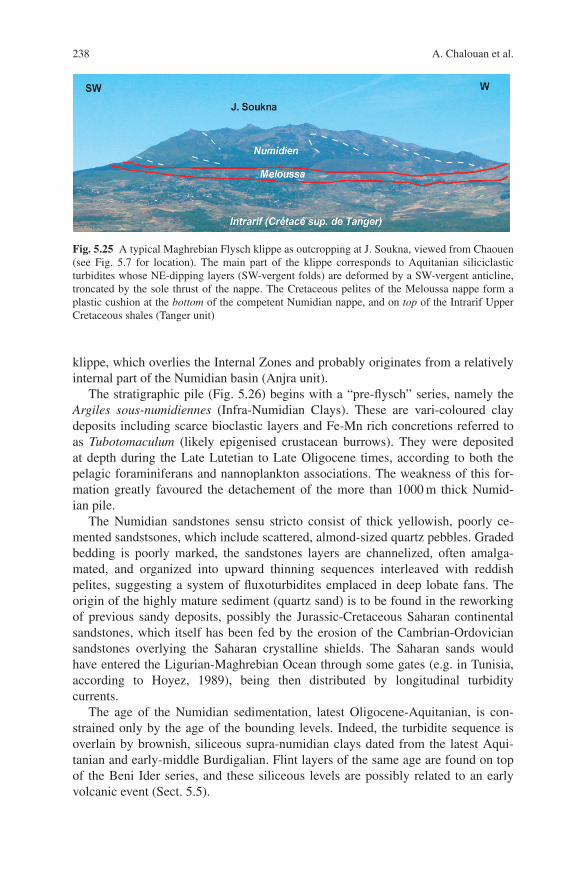
238 A. Chalouan et al.
Fig. 5.25 A typical Maghrebian Flysch klippe as outcropping at J. Soukna, viewed from Chaouen(see Fig. 5.7 for location). The main part of the klippe corresponds to Aquitanian siliciclasticturbidites whose NE-dipping layers (SW-vergent folds) are deformed by a SW-vergent anticline,troncated by the sole thrust of the nappe. The Cretaceous pelites of the Meloussa nappe form aplastic cushion at the bottom of the competent Numidian nappe, and on top of the Intrarif UpperCretaceous shales (Tanger unit)
klippe, which overlies the Internal Zones and probably originates from a relativelyinternal part of the Numidian basin (Anjra unit).
The stratigraphic pile (Fig. 5.26) begins with a “pre-flysch” series, namely theArgiles sous-numidiennes (Infra-Numidian Clays). These are vari-coloured claydeposits including scarce bioclastic layers and Fe-Mn rich concretions referred toas Tubotomaculum (likely epigenised crustacean burrows). They were depositedat depth during the Late Lutetian to Late Oligocene times, according to both thepelagic foraminiferans and nannoplankton associations. The weakness of this for-mation greatly favoured the detachement of the more than 1000 m thick Numid-ian pile.
The Numidian sandstones sensu stricto consist of thick yellowish, poorly ce-mented sandstsones, which include scattered, almond-sized quartz pebbles. Gradedbedding is poorly marked, the sandstones layers are channelized, often amalga-mated, and organized into upward thinning sequences interleaved with reddishpelites, suggesting a system of fluxoturbidites emplaced in deep lobate fans. Theorigin of the highly mature sediment (quartz sand) is to be found in the reworkingof previous sandy deposits, possibly the Jurassic-Cretaceous Saharan continentalsandstones, which itself has been fed by the erosion of the Cambrian-Ordoviciansandstones overlying the Saharan crystalline shields. The Saharan sands wouldhave entered the Ligurian-Maghrebian Ocean through some gates (e.g. in Tunisia,according to Hoyez, 1989), being then distributed by longitudinal turbiditycurrents.
The age of the Numidian sedimentation, latest Oligocene-Aquitanian, is con-strained only by the age of the bounding levels. Indeed, the turbidite sequence isoverlain by brownish, siliceous supra-numidian clays dated from the latest Aqui-tanian and early-middle Burdigalian. Flint layers of the same age are found on topof the Beni Ider series, and these siliceous levels are possibly related to an earlyvolcanic event (Sect. 5.5).

5 The Rif Belt 239
Fig. 5.26 Stratigraphy of the Numidian nappe from the J. Zinat (left) and Tangier (Tanger) Moun-tain (two columns on the right; note the different vertical scale used in the left-hand column). SeeFigs. 5.6 and 5.7 for location
As a whole, the Numidian flysch appears to be coeval with the Beni Idersandy-micaceous flysch. Thus, it is not suprising to find mixed series such as theTalaa-Lakrah (Tanger) and Bolonia (Andalucia) series. Their stratigraphy com-pares with the Beni Ider one, except the occurrence of interbedded Numidian-type

240 A. Chalouan et al.
sandstones layers with almond-like quartz pebbles, sometimes located within sand-balls. This suggests that southeastern, Numidian inputs were converging with north-ern ones (Beni Ider).
5.3.3 Paleogeography
The Maghrebian Flyschs nappes, which display turbiditic sequences of Cretaceous-Tertiary age are detached from an oceanic or thinned continental crust domain.Ophiolite slivers occur at the bottom of the more or less recrystallized flyschs fromsouthern Apennine Calabria, Sicily, and even beneath the Lesser Kabylia allochthon(Rekkada-Metletine serpentinites, gabbros, pillow basalts and radiolarites datedfrom the Jurassic). Interestingly, the Achaiche Mauretanian unit, also overthrust bythe Lesser Kabylia massif, displays a continental margin-type pre-flysch series withPaleozoic metapelites, Triassic sandstones, Liassic carbonates intruded by thick sillsof basalts, limestones and radiolarites of Dogger-Malm age, and Berriasian pillowbasalts. Further west, Middle-Upper Jurassic pillow basalts and radiolarites associ-ated with siliceous micrites crop out beneath the Mauretanian nappe south of theBokkoya (Izroutene), whereas an agglomerate of Middle Jurassic limestones andvariolitic pillows occurs at the bottom of the J. Chouamat Massylian nappe. Pillowbasalts are also found as olistoliths within the Bokkoya Tertiary sole. In contrast, nobasalt occurs in the Ouareg sheet beneath the Tisiren nappe close to Targuist, theseries of which displays only Toarcian-Bajocian calciturbidites and Middle-UpperJurassic radiolarites.
It is suggested that the Ligurian-Maghrebian basin was a true oceanic basin in itseastern, wider part, whereas it was floored mostly by thinned continental thrust inits narrower western part. However, the tomographic studies image a deep cold slab,about 600 km wide E-W and N-S below the south Balearic basin, which would cor-respond to a former Ligurian-Maghrebian oceanic substrate subducted down to thebase of the asthenosphere (Sect. 5.7). This indicates additionally that not only mostof the Ligurian-Maghrebian crust, but also a large part of the overlying sedimentsdisappeared by subduction: the Flysch nappes and their scarce basal slivers are tinyremnants of the lost oceanic domain.
The Mauretanian sub-basin was located on the northern side of the Maghrebianbasin, as indicated by the detrital elements reworked from the AlKaPeCa domain inthe Beni Ider breccias and coarse turbidites. The sandy-micaceous flysch was prob-ably fed by the erosion of the Ghomarides-Malaguides and equivalent Kabylian ter-ranes, like the “post-nappe” cover of these mostly Paleozoic domains. Conversely,the Massylian sediments accumulated on the southern side of the Maghrebian basin,close to the African margin. This is consistent with the similarities between the Cre-taceous series of the Massylian nappes and Intrarif units (see below), and also withthe African source of the Numidian turbidites.
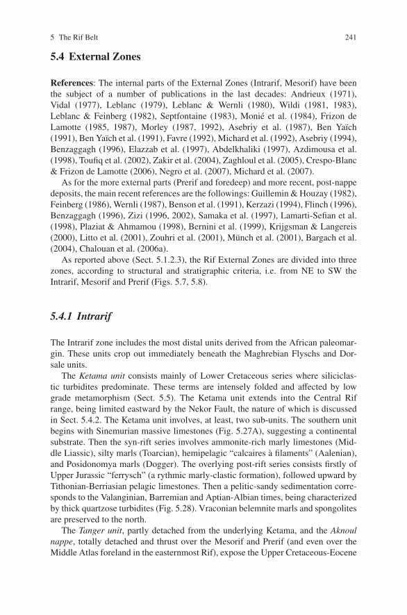
5 The Rif Belt 241
5.4 External Zones
References: The internal parts of the External Zones (Intrarif, Mesorif) have beenthe subject of a number of publications in the last decades: Andrieux (1971),Vidal (1977), Leblanc (1979), Leblanc & Wernli (1980), Wildi (1981, 1983),Leblanc & Feinberg (1982), Septfontaine (1983), Monie et al. (1984), Frizon deLamotte (1985, 1987), Morley (1987, 1992), Asebriy et al. (1987), Ben Yaıch(1991), Ben Yaıch et al. (1991), Favre (1992), Michard et al. (1992), Asebriy (1994),Benzaggagh (1996), Elazzab et al. (1997), Abdelkhaliki (1997), Azdimousa et al.(1998), Toufiq et al. (2002), Zakir et al. (2004), Zaghloul et al. (2005), Crespo-Blanc& Frizon de Lamotte (2006), Negro et al. (2007), Michard et al. (2007).
As for the more external parts (Prerif and foredeep) and more recent, post-nappedeposits, the main recent references are the followings: Guillemin & Houzay (1982),Feinberg (1986), Wernli (1987), Benson et al. (1991), Kerzazi (1994), Flinch (1996),Benzaggagh (1996), Zizi (1996, 2002), Samaka et al. (1997), Lamarti-Sefian et al.(1998), Plaziat & Ahmamou (1998), Bernini et al. (1999), Krijgsman & Langereis(2000), Litto et al. (2001), Zouhri et al. (2001), Munch et al. (2001), Bargach et al.(2004), Chalouan et al. (2006a).
As reported above (Sect. 5.1.2.3), the Rif External Zones are divided into threezones, according to structural and stratigraphic criteria, i.e. from NE to SW theIntrarif, Mesorif and Prerif (Figs. 5.7, 5.8).
5.4.1 Intrarif
The Intrarif zone includes the most distal units derived from the African paleomar-gin. These units crop out immediately beneath the Maghrebian Flyschs and Dor-sale units.
The Ketama unit consists mainly of Lower Cretaceous series where siliciclas-tic turbidites predominate. These terms are intensely folded and affected by lowgrade metamorphism (Sect. 5.5). The Ketama unit extends into the Central Rifrange, being limited eastward by the Nekor Fault, the nature of which is discussedin Sect. 5.4.2. The Ketama unit involves, at least, two sub-units. The southern unitbegins with Sinemurian massive limestones (Fig. 5.27A), suggesting a continentalsubstrate. Then the syn-rift series involves ammonite-rich marly limestones (Mid-dle Liassic), silty marls (Toarcian), hemipelagic “calcaires a filaments” (Aalenian),and Posidonomya marls (Dogger). The overlying post-rift series consists firstly ofUpper Jurassic “ferrysch” (a rythmic marly-clastic formation), followed upward byTithonian-Berriasian pelagic limestones. Then a pelitic-sandy sedimentation corre-sponds to the Valanginian, Barremian and Aptian-Albian times, being characterizedby thick quartzose turbidites (Fig. 5.28). Vraconian belemnite marls and spongolitesare preserved to the north.
The Tanger unit, partly detached from the underlying Ketama, and the Aknoulnappe, totally detached and thrust over the Mesorif and Prerif (and even over theMiddle Atlas foreland in the easternmost Rif), expose the Upper Cretaceous-Eocene

242 A. Chalouan et al.
Fig
.5.
27St
ratig
raph
yof
the
Intr
arif
“roo
ted
units
”.(A
):K
etam
aun
it,af
ter
Friz
onde
Lam
otte
(198
5).
–(B
):L
oukk
osun
it,af
ter
Les
pina
sse
(197
5).
–(C
):Ta
nger
unit;
Saf
Lah
man
eN
eoge
nese
quen
ceaf
ter
Zag
hlou
leta
l.(2
005)
.Saf
Lah
man
eis
loca
ted
25km
sout
hof
Tang
er(T
angi
er)
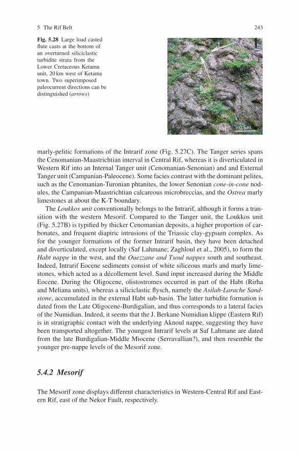
5 The Rif Belt 243
Fig. 5.28 Large load castedflute casts at the bottom ofan overturned siliciclasticturbidite strata from theLower Cretaceous Ketamaunit, 20 km west of Ketamatown. Two superimposedpaleocurrent directions can bedistinguished (arrows)
0,5 m
V
2
V 1
marly-pelitic formations of the Intrarif zone (Fig. 5.27C). The Tanger series spansthe Cenomanian-Maastrichtian interval in Central Rif, whereas it is diverticulated inWestern Rif into an Internal Tanger unit (Cenomanian-Senonian) and and ExternalTanger unit (Campanian-Paleocene). Some facies contrast with the dominant pelites,such as the Cenomanian-Turonian phtanites, the lower Senonian cone-in-cone nod-ules, the Campanian-Maastrichtian calcareous microbreccias, and the Ostrea marlylimestones at about the K-T boundary.
The Loukkos unit conventionally belongs to the Intrarif, although it forms a tran-sition with the western Mesorif. Compared to the Tanger unit, the Loukkos unit(Fig. 5.27B) is typified by thicker Cenomanian deposits, a higher proportion of car-bonates, and frequent diapiric intrusions of the Triassic clay-gypsum complex. Asfor the younger formations of the former Intrarif basin, they have been detachedand diverticulated, except locally (Saf Lahmane; Zaghloul et al., 2005), to form theHabt nappe in the west, and the Ouezzane and Tsoul nappes south and southeast.Indeed, Intrarif Eocene sediments consist of white siliceous marls and marly lime-stones, which acted as a decollement level. Sand input increased during the MiddleEocene. During the Oligocene, olistostromes occurred in part of the Habt (Rirhaand Meliana units), whereas a siliciclastic flysch, namely the Asilah-Larache Sand-stone, accumulated in the external Habt sub-basin. The latter turbidite formation isdated from the Late Oligocene-Burdigalian, and thus corresponds to a lateral faciesof the Numidian. Indeed, it seems that the J. Berkane Numidian klippe (Eastern Rif)is in stratigraphic contact with the underlying Aknoul nappe, suggesting they havebeen transported altogether. The youngest Intrarif levels at Saf Lahmane are datedfrom the late Burdigalian-Middle Miocene (Serravallian?), and then resemble theyounger pre-nappe levels of the Mesorif zone.
5.4.2 Mesorif
The Mesorif zone displays different characteristics in Western-Central Rif and East-ern Rif, east of the Nekor Fault, respectively.

244 A. Chalouan et al.
5.4.2.1 Western and Central Rif
In the central part of the Rif range, the Mesorif zone is also termed Zone des Fenetres(“Window Zone”) as it is characterized by antiforms with Lower-Middle Miocenerocks in the core (e.g. Tamda, J. Kouine), and mainly Mesozoic thrust units abovethem. The allochthonous units have two possible origins, either infra- or supra-Ketama (see Figs. 5.7, 5.8 for location).
The Tifelouest-Tafraout-Afress-Rhafsaı group of infra-Ketama units correspondsto folded duplexes at the very front of the Ketama massif, being rooted beneath themassif. The Senhadja nappe is also part of the infra-Ketama units, but appears asunrooted klippes on top of the autochthonous Miocene turbidites and olistostrome.The Bou Haddoud nappe has the same infra-Ketama origin as the Senhadja nappe,but extends more to the south over the Prerif units.
The Mesozoic series typical of the Tifelouest group are found also in the Iz-zarene forest of Western Rif, as well as in the “Zone des Sofs”, i.e. the rocky ridgesthat underline the Mesorif-Prerif boundary. Everywhere within this fragmenteddomain, rapid facies and thickness changes in the Lower and Middle Jurassicformations indicate the synsedimentary activity of normal faults, and character-ize the paleomargin syn-rift evolution (Fig. 5.29). The post-rift sequence beginswith the Callovian-Oxfordian “ferrysch”, followed by Kimmeridgian andTithonian-Berriasian micrites, and Neocomian pelites. The syn-orogenic, Cenozoicsedimentation begins with unconformable, blocky marls, probably Late Oligocenein age (M. Durand-Delga, written comm., 2007) as they contain both Nummulitesand Lepidocyclines. These nummulitic marls are unconformably overlain by achaotic complex (Oligocene-Aquitanian?) followed upward by the Aquitanian-Serravallian turbidites cited above. The Mesozoic formations are strongly foldedand foliated, whereas the Lower-Middle Miocene formations are moderately de-formed and only anchimetamorphic (Sect. 5.5). The occurrence of foliated Eocenepebbles in the Oligocene-Aquitanian chaotic complex yield evidene of a LateEocene-Oligocene phase of synmetamorphic deformation. In the Zoumi unit ofWestern Rif, the Miocene formations compare with those of Central Rif, but theolder formations are not metamorphic.
The Senhadja “nappe” includes hectometre- to kilometre-sized blocks (Taıneste,Merzouk, Azrou Akchar) on top of the Middle Miocene turbidites. The reworkedMesozoic layers compare with those of the Tifelouest, but they are accompaniedby Triassic elements (reddish sandstones and pelites, spilitic dolerites and gabbros)and even by Paleozoic material (quartzites, phyllites). Therefore, the basement itselfis clearly involved in the External Rif deformation, likely due to inversion of thepaleomargin normal faults.
As for the supra-Ketama units, they correspond mainly to the already quotedAknoul nappe, detached from the Ketama unit on top of the Cenomanian under-compacted clays, and to the J. Berkane Numidian klippe transported on top of thelatter nappe. Note that the underlying Bou Haddoud unit displays a remarkable, con-tinuous “K-T” section, dated precisely with planktonic Foraminifera (Toufiq et al.,2002).

5 The Rif Belt 245
E : M
id-D
om
eria
n ,
Toar
cian
, Aal
enia
nF
: Aal
enia
n, B
ajo
cian
G :
Bat
ho
nia
n, C
allo
vian
, Oxf
ord
ian
Tile
loue
st T
afra
out R
hafs
ai
Pos
idon
omya
mar
ls
Ket
ama
Afr
ess
Tim
chat
ouin
eM
erzo
uk“F
erry
sch”
slum
psco
nden
sed
stra
ta
“Cal
caire
s à
filam
ents
” (
Pos
idon
omya
lmst
.)M
arl-l
imes
tone
alte
rnat
ions
amm
oniti
co r
osso
Upp
erca
rbon
ate
brec
cias
Spo
nge
bioh
erm
sM
assi
velim
esto
nes
evap
orite
leac
hing
Syn
sedi
men
tary
faul
ts
mud
mou
nds
Dol
omite
Eva
porit
esLo
wes
tbr
ecci
as
?
?
?
cond
ense
d st
rataAm
mon
ite-r
ich
lmst
.
SE
NW
A :
Het
tan
gia
n-E
arly
Sin
ému
rien
C :
Late
Sin
emu
rian
-Ear
ly C
arix
ian
D
: M
id C
arix
ian
-Do
mer
ian
Low
erca
rbon
ate
brec
cias
Alg
al li
mes
tone
s
thre
shol
dla
guna
??
B :
Mid
dle
-Lat
e Si
nem
uri
an
SE
NW
6°4°
2°
Ra
ba
t
Ou
jda
Fes
A L
B O
R A
N
S E
A
R I
F
ME
SE
TA
-A
TL
AS
DO
MA
IN
Alb
oran
Dom
ain
Tan
ger
Fly
sch
Nap
pes
Pal
eom
argi
nun
its
Stu
died
sect
ion
afte
r F
avre
, 199
2
Fig
.5.2
9Te
cton
ican
dse
dim
enta
ryev
olut
ion
ofth
eA
fric
anpa
leom
argi
ndu
ring
the
Jura
ssic
atth
eM
esor
if-I
ntra
rif
bord
er(T
ifel
oues
tand
Ket
ama
units
),af
ter
Favr
e(1
992)
,mod
ified

246 A. Chalouan et al.
5.4.2.2 Eastern Rif
The structural setting of the Central Rif is disturbed eastward by a large tectonic cor-ridor, referred to as the Nekor Fault (“accident du Nekor”), which is a NE-trendingleft-lateral wrench fault oblique to the general trend of the Rif-Tell belt (Figs. 5.5,5.7). The importance of this fault is well indicated by its association with a low-velocity zone at 5 km depth, coinciding with high conductivity and low-gravitystructure, interpreted as a fault gouge zone and fluid-filled subsurface rock matrix(Serrano et al., 2003). East of the fault, the Mesorif can be easily recognized in theSouth Temsamane sub-zone (unit I, Fig. 5.30). The Mesorif zone can be followednorthward to the Mediterranean coast in the North Temsamane sub-zone, throughseveral steps of increasing deformation and metamorphic grade (Sect. 5.5.3). TheIntrarif zone disappears undersea, and crops out again only in the Oran region eastof the Algerian border.
The South Temsamane stratigraphy is complete and easily recognized fromthe Liassic to Upper Cretaceous levels, up to the unconformable Lower-MiddleMiocene turbidites. In contrast, the stratigraphic formations are less continuous andless easily dated in the North Temsamane sub-zone, which consists of more or lessdiverticulated units (II–VII from S to N), duplicated and folded together during thepre-Miocene synmetamorphic event. Their metasediments are deformed into over-turned folds stretched along their WSW-trending axes, which is consistent with asinistral throw during the Alboran Terrane-Africa oblique collision (Sect. 5.7).
Two isolated massifs involving metamorphic units occur in Eastern Rif, i.e., (i)the Tres-Forcas (Trois-Fourches) massif (unit VIII), whose lowest unit likely con-tinues the North Temsamane system upward; and (ii) the Khebaba unit (unit IX),which overlies the South Temsamane, being located beneath the Aknoul nappe. TheKhebaba massif structural setting thus compares with that of the Senhadja klippes,but the Khebaba shows a metamorphic grade comparable with that of the northern-most Temsamane unit (Ras Afraou; Sect. 5.5.3).
In the North Temsamane domain, gabbroic sills intrude the Jurassic-Cretaceousformations, being affected also by the regional syntectonic recrystallization. Thesemetagabbros and metadolerites testify to the importance of the paleomargin thinningin the distal Mesorif area during the Late Jurassic-Early Cretaceous.
Such crustal thinning is still better documented by the occurrence of a ser-pentinite massif, namely the Beni Malek massif, in the Nekor Fault corridor. Themassif forms a kilometre scale lense at the bottom of the Ketama unit, and over-lies a metasedimentary unit (Igarmaouas unit) intermediate between the Ketamaand North Temsamane complexes (Fig. 5.30C). The ultrabasites (altered spinellherzolite) are partly draped by a cover sequence consisting of limestones withophiolitic clasts (Late Jurassique-Early Cretaceous?). Laterally, the massive serpen-tinites are replaced by greenschists, which correspond to metabasites and recrys-tallized serpentinite-gabbro sands. The Beni Malek unit is interpreted as a sliver ofoceanic crust originated from an Alpine-type oceanic crust, where tectonic denuda-tion of mantle rocks plays a major role with respect to magmatism. Modelling ofthe regional magnetic anomaly suggests that the serpentinite and greenschist sliver

5 The Rif Belt 247
II
III
IV VI V
VII
VIII 9.8-4.6 Ma
12-13 Ma
N
A
B
10 km
NADOR
MELILLA
Kebdani
Driouch
Boudinar
Tafersit
Cabo de Tres Forcas
El Râs Târf
Râs Afraou Gourougou
AL HOCEIMA a y o k k o B
A L B O R A N S E A
Ben Tieb
Beni Bou Ifrour
N - T e m s a m a n e s t r u c t u r a l t r e n d
t l u a f r o k e N
Cross- section B
500 m
0 m
Ras Afraou (VII)
Taliouine (VI) Ijer (V)
1000 m
Jurassic marbles Paleozoic-Triassic (?) Cretaceous calcschists and quartzites
Cretaceous metabasites
Messinian-Pliocene
Jbel Mahjar (IV) NW SE
X
X’
1 km
6-8, 2.5 Ma
Beni Malek
Skifat
Taryat anticline
Aknoul nappe
Senhadja-Bou Haddoud nappes
Ketama unit F
I R
A
R
T
N
I
. . .
.
. . . . . .
. . .
.
. .
. . . . . . .
. . . . . . . . . . . .
.
SE NW
Beni Malek
1320 m 1022 m
Serpentinites
j-c (?)
Igarmaouas unit
K e t a m a u n i t
K e t a m a u n i t
Nekor Fault
Temsamane
0
2000
2000 m
500
1000
0 500 m
X-X’
]
C
Cross-section Fig. 5.39B
I
Midar
a b a b e h K
Foreland (Gareb)
Igarmaouas unit
Beni Malek serpentinites and Skifat greenschists
ZA
Imzirene (III) Tafersit (II)
MP-LT Temsamane units (Ras Afraou, Tres Forcas, Khebaba) Other North Temsamane units
South Temsamane unit
F
I R
O
S
E
M
Low-grade greenschist Ctd-schists
b e r a G
Flyschs units
Dorsale Calcaire
Messinian-Pliocene
Volcanic rocks (K/Ar ages)
+ M e t a m o r p h i c g r a d e -
Quaternary
Fig. 5.30 Structure and metamorphism of the Eastern Rif. Schematic structural map (A) and cross-section (B) after Frizon de Lamotte (1985), Negro et al. (2007), and Michard et al. (2007), modi-fied. Khebaba massif after Darraz & Leblanc (1989). K/Ar ages (Ma) of post-orogenic volcanoesafter El Azzouzi et al. (1999) and Munch et al. (2001). XX’: trace of lower cross-section (C); ZA:Zaouyet Sidi Hadj Ali. – (C): Geological cross-section of the Beni Malek ultrabasite massif (YY’)after Michard et al. (1992), and 2D interpretation of the regional aeromagnetic anomaly (XX’) sug-gesting the occurrence of a cryptic ultrabasic body, after Elazzab et al. (1997). j-c(?): carbonateswith serpentinite clasts (Upper Jurassic-Lower Cretaceous?)
is derived from a deeper and larger serpentinite body obducted onto the Mesorifunits (Fig. 5.30C). This would indicate that a minor, intracontinental (intra-margin)suture zone occurs between an Intrarif distal block and a Mesorif-Prerif proximalmargin. Serpentinite outcrops are known on top of the Tres-Forcas massif. In fact,the trace of this suture can be followed eastward at least up to the Oran region,and likely up to the Cheliff Mountains south of Algiers. To the west, the suture islikely buried beneath the Intrarif thrust, whose lateral ramp corresponds to the NekorFault.

248 A. Chalouan et al.
5.4.3 Prerif Zone and Foredeep
The main, external Prerif Zone comprises Upper Cretaceous-Eocene and Middle-Upper Miocene marly-argillaceous formations detached from their Jurassic-EarlyCretaceous basement and slid towards the foredeep (Figs. 5.7, 5.8). The Triassicclay and salt complex formed diapirs and rock glaciers within the Cretaceous for-mations. The diapiric complex frequently includes ophite bodies of Late Triassic-Early Liassic age. Subsequently, the Triassic diapirs and the resedimented Triassiccomplex are incorporated within the Prerif nappes (Figs. 5.31, 5.32).
The Jurassic-Lower Cretaceous formations themselves are detached from theirPaleozoic basement and now form an alignement of carbonate slivers in the inter-nal Prerif Zone, also labelled the “sof line”. The “sof” Mesozoic series compareswith the Mesorif as they exhibit Upper Jurassic “ferrysch” and Lower Cretaceousmarly limestones with turbidite intercalations. The Upper Cretaceous-Eocene marlsare followed upward by Middle-Upper Eocene to Middle Miocene detrital forma-tions including, in particular, the Eocene-Oligocene Sidi Mrayt sandstones, whichwere fed from the external foreland through the Meliana paleo-canyon. The latterstratigraphic levels lack in the External Prerif, suggesting a flexural uplift of theproximal margin south of the Mesorif, which played the role of an early foredeepduring the Early-Middle Miocene.
The foredeep subsidence began during the Middle-Late Miocene at the front ofthe Rif-Tell tectonic prism, through flexural bending of the African plate due to tec-tonic overburden, and/or to slab pull from the subducting Maghrebian Ocean litho-sphere (Sect. 5.7). In the central Fes-Meknes region, the Rides prerifaines are lateanticlines formed after the synsedimentary emplacement of the Prerif nappe withinthe foredeep. Their varied axial trends (E-W, NE-SW and N-S) are controlled bythe varied normal faults inherited from the paleomargin. The Mesozoic series of theRides prerifaines compares with that of the Middle Atlas foreland (sandy carbonatesof Dogger age, Late Jurassic-Early Cretaceous gap). It is unconformably overlain byMiddle-Upper Miocene molassic sandstones, then by Upper Miocene sandy marlswithin which the front of the nappe is interleaved (Fig. 5.33; see also Chap. 6).
Further west in the Gharb Basin, industrial boreholes evidence the Miocene mo-lasse onlapping onto the Caledonian-Variscan Sehoul Block barely covered by thinCretaceous deposits. Near Rabat, the molasse directly overlies the Paleozoic base-ment. The lack of Jurassic formations and the reduction of Cretaceous sediments canbe ascribed to the uplift of the Atlantic rift shoulder (Chap. 4). The molasse trans-gression onto the foreland occurred earlier in the eastern areas (Langhian) than in thewestern (Tortonian). Subsequently, sandy marls accumulated in the foredeep duringthe Tortonian. At that time, the Prerif formations, already overlain by the Intrarifnappes (Ouezzane, Tsoul, Aknoul) detached and slid on top of the foredeep sed-iments under submarine, synsedimentary conditions (olistostromes). The cover ofthe nappe consists again of terrigeneous muds of Late Tortonian-Messinian age, la-belled the Miocene post-nappe and followed upward by similar deposits of Plioceneage. The regression occurred after the middle Pliocene (Saiss “Sables fauves”).The collapse of the orogenic prism resulted in the transgression of the post-nappe

5 The Rif Belt 249
ili Fi di Smet syStl uaF
amr oL
ni A
met syStl uaF
sayadu Osedal az N
met syStl uaF
- bej aHl E-i ar uogA
met syStl uaFgaggehC
ni A
533
30
Ain
Lor
ma
nuohreZ.J
sfeK.J
afuonnaK.J
Mou
lay
Idris
s
J. O
utita
J. T
ratt
hgal aZ. J
aar DuoB. J
010
56
530
633
30
530
ni saB
br ahR
saal aB. J
Nap
pe P
rerif
aine
2
11
12
Mai
n in
herit
edfa
ult s
yste
ms
σ 1di
rect
ion
σ 3di
rect
ion
ni saB
ssi aS
N
auolehK.J
ayat euguoM
taflesT.J
Pale
ozo
icb
asem
ent
Tria
ssic
-Lo
w. L
iass
ic
Jura
ssic
to
Cre
tace
ou
s
Nap
pe
Prer
ifain
e
Mio
cen
e to
Qu
ater
nar
y
Qu
ater
nar
y vo
lcan
ics
ahciA
Id.,
show
n in
Fig
. 5.3
1
afte
r S
ani e
t al
., 20
07
ht eB deu O
Fig
.5.3
1St
ruct
ural
map
ofth
ePr
erif
fron
tin
the
area
ofth
eR
ides
Prer
ifai
nes,
with
loca
tion
ofth
eO
NH
YM
seis
mic
profi
les
and
indu
stri
alw
ells
,aft
erSa
niet
al.(
2007
),m
odifi
ed.N
ote
the
impo
rtan
ceof
the
faul
tsy
stem
sin
heri
ted
from
the
Var
isca
nev
olut
ion
ofth
eba
sem
ent
and
activ
edu
ring
the
Tri
assi
c-Ju
rass
icev
olut
ion.
The
sefa
ults
heav
ilyco
ntro
lthe
Neo
gene
defo
rmat
ion

250 A. Chalouan et al.
dg, h
NV
Fig. 5.32 The Late Triassic complex of the External Prerif, 25 km NW of Fes city. The complexincludes red-brown clays, evaporites (g: gypsum; h: halite), and a neck of spilitic dolerites (d). Theleached salt turns the bed of oued Mellah white (“mellah”=salted, in Arabic). In the background,Cretaceous and Miocene marls
deposits onto the Mesorif domain of Central-Eastern Rif. These deposits are nowpreserved in post-nappe synclines, which formed contemporaneously with the Ridesprerifaines anticlines. The Rif foredeep connects offshore with the Betic one in thesubmarine accretionary prism of the Gulf of Cadiz (Fig. 5.5).
5.5 Metamorphism
In the Gibraltar Arc, metamorphism characterizes essentially the Internal Zones(Alboran Domain), and more particularly the Ghomarides-Malaguides and Sebtides-Alpujarrides. In the Dorsale units, very low-grade, post-Eocene metamorphism oc-curs only along the internal border of the range and along the Jebha Fault. In thetwo former complexes, as well as in their Kabylian equivalents, one can clearlyseparate, (i) Variscan metamorphism, which is the main recrystallization episode inthe Ghomarides-Malaguides and the Kabylian upper units (i.e. the “upper plate” ofthe broad metamorphic structure), and (ii) Alpine metamorphism, which hardly af-fects the bottom of the upper plate, but deeply concerns the lower (Kabylian lowerunits, Sebtides-Alpujarrides, and Nevado-Filabrides in Central-Eastern Betics). Asa whole, these upper and lower plate units define a dismembred metamorphic corecomplex, which records a tectonic evolution involving, initially, the subduction ofthe lower plate, and subsequently its exhumation (Sect. 5.7).
Metamorphic recrystallization also affects part of the External Zones in the Cen-tral and Eastern Rif, and their Tellian equivalents. Although the metamorphic gradeis moderate or low in these units, it is a useful tool to delineate the intracontinentalsuture zone, which is also marked by the Beni Malek massif of serpentinites andgreenschists.
5.5.1 Ghomaride Metamorphism
References: A limited number of works address the metamorphism of theGhomaride, e.g. Chalouan & Michard (1990), Michard et al. (2006), Negro et al.

5 The Rif Belt 251M
KF
10M
KF
11M
KF
12M
KF
13
LIN
E M
KF
2
Sid
i Fili
Faul
t
WN
WE
SE
?
OC
-1
MK
F17 M
KF
87
MK
F6
MK
F5
MK
F4
MK
F2
LIN
E M
KF
11
NE
SW
NW
SE
LIN
E M
KF
21
MG
-1M
KF
20
MK
F18
2 km
2 km
2 km
0 1 2 3 4T
WT
(se
c)
0 1 2 3
0 1 2 3T
WT
(se
c)
Fig
.5.3
3In
terp
rete
dse
ism
icpr
ofile
sac
ross
the
Rid
espr
erif
aine
s,af
ter
Sani
etal
.(20
07),
mod
ified
.See
Fig.
5.31
for
loca
tion;
(A):
Profi
leM
KF2
;(B
):Pr
ofile
MK
F11;
(C):
Profi
leM
KF2
1.T
heco
lour
sin
dica
teth
edi
ffer
ent
units
asfo
llow
s.L
ight
red:
unde
fined
Pale
ozoi
c;vi
olet
:T
rias
sic
units
,ev
apor
ites;
ligh
tbl
ue:
Jura
ssic
units
(Low
er-M
iddl
eL
iass
ic,A
alen
ian-
Baj
ocia
n);
ligh
tbr
own:
Low
er-M
iddl
eM
ioce
nefo
rede
epun
its(m
olas
ses)
belo
wth
ePr
erif
napp
e;li
ght
gree
n:Pr
erif
napp
eco
mpl
ex;y
ello
w:U
pper
Mio
cene
-Plio
cene
fore
deep
depo
sits
.Not
eth
ecr
osse
dor
ient
atio
nof
profi
les
(Aan
dB
),w
hich
corr
espo
nds
toth
ecu
rved
tren
dof
the
outc
ropp
ing
antic
linal
ridg
es(F
ig.5
.31)
.Pro
file
(C)i
llust
rate
sa
Tri
assi
cdi
apir
first
empl
aced
duri
ngth
eC
reta
ceou
san
dth
enpi
nche
dan
dre
activ
ated
duri
ngth
ePl
io-Q
uate
rnar
ysh
orte
ning
even
t(cf
.Roc
aet
al.,
2006
)

252 A. Chalouan et al.
(2006). A very low grade recrystallization of the overlying Dorsale units was de-scribed locally by Olivier et al. (1992). In the Betics, the Malaguide metamorphismhas been discussed by Platt et al. (2003b) and Negro et al. (2006). A review of theKabylian upper plate metamorphism is given in Michard et al. (2006).
The Ghomaride Mesozoic-Cenozoic series are virtually devoid of metamorphicrecrystallization. Contrastingly, two superimposed metamorphic histories can bedistinguished in the Paleozoic terranes, Variscan and Alpine, respectively, althoughthe latter concerns only the lower part of the lowest nappe (Aakaili).
The Variscan evolution itself is divided into two episodes (Sect. 5.2.2.1). The firstaffects the Lower and Middle Paleozoic series, but not the Carboniferous. This Eo-variscan episode is characterized by low grade greenschist-facies recrystallizationscoeval with the formation of superimposed, NE-trending folds (P1 and P2 folds inFig. 5.16). The second, Hercynian-Alleghanian episode affects the whole Paleozoicpile, being mainly identified in the Carboniferous formations by very low grade re-crystallizations and NW-trending folds. The overlying, unfolded Triassic depositsshow only a diagenetic evolution.
However, K-Ar datings of Paleozoic samples from the Ghomaride nappes fail toyield any exact Variscan date. In contrast, they reveal a progressive variation of themeasured ages from 259± 5Ma in the uppermost nappe to 25 Ma at the bottom ofthe lowest, just in contact with the Sebtides schists (Fig. 5.34). This suggests that aheating event affected the base of the Ghomaride pile, contemporaneously with theunderlying Sebtides, i.e. at about 23 Ma (Sect. 5.5.2). This thermal event has beencalibrated recently by Raman spectroscopy of carbonaceous material: T reached∼500 ◦C at the bottom of the Aakaili nappe whereas it remained below ∼300 ◦Cin the upper part of the nappe and overlying units (Fig. 5.34). Similar observationswere made in the Malaguides. This Oligocene-Miocene thermal event caused biotiteand andalusite growth at the very bottom of the Ghomaride-Malaguide complex,and can be ascribed to the major extension phase responsible for the opening of theAlboran Basin (Sect. 5.7).
5.5.2 Sebtide Metamorphism
References: Many recent publications concern the Sebtide-Alpujarride metamor-phism. To concentrate on the Sebtide metamorphism, we must refer to the follow-ing papers, which include many Betic references: (i) for the Lower Sebtides (BeniBousera and Filali), Saddiqi et al. (1988), Kornprobst et al. (1990), Saddiqi (1995),Kumar et al. (1996), Bouybaouene et al. (1998), Azanon et al. (1998), El Maz etGuiraud (2001), Haissen et al. (2004), Negro et al. (2006); (ii) for the Upper Sebtides(mainly Beni Mezala), Bouybaouene (1993), Zaghloul (1994), Goffe et al. (1996),Michard et al. (1997), Vidal et al. (1999), Agard et al. (1999), Negro (2005), Janotset al. (2006), Michard et al. (2006), Negro et al. (2006).
The age of the Sebtide-Alpujarride metamorphism has been repeatedly investi-gated. Let us particularly refer to Monie et al., 1991, 1994), Sosson et al. (1998),

5 The Rif Belt 253
5°30' W 5°00' W
35°30' N
<330°C
495°C
460°C
420°C
488°C
501°C
330°C
402°C
426°C 445°C
330°C
<330°C <330°C
<330°C <330°C
420°C 333°C
<330°C
<330°C
<330°C
<330°C
<330°C
<330°C
<330°C
330°C
TETOUAN
CEUTA
Cabo Negro
Beni Bousera
l i t r a M d e u O
Jebha
Zaouia after Negro, 2005, modified
133±4.0 Ma K-Ar Ages (Chalouan & Michard, 1990)
25.3±0.9 Ma
30.7±1.5 Ma
62±2.5 Ma
98±3.0 Ma
183±6.0 Ma
259±5.0 Ma
133±4.0 Ma
RSCM Temperatures (Negro et al., 2006)
Peridotites
Kinzigites
Filali schists & gneisses
Beni Mezala-Souk el Had
Boquete de Anjera
Tizgarine
Ghomarides
Aakaili
Beni Hozmar
Koudiat Tiziane
Upper Sebtides
Lower Sebtides
Monte Hacho (Ceuta) orthogneisses
Dorsale
330°C
Maghrebian Flyschs
External Zones
35°30' N
0 10 20 km
35°00' N
Maghrebian Flyschs
Beni Mezala
Souk el Had
Fig. 5.34 The Alpine thermal event in the Ghomaride nappes: progressive variation of the K-Arwhite mica ages (after Chalouan & Michard, 1990) and maximum T recorded in the Paleozoicrocks (RSCM method; Negro et al., 2006)
Argles et al. (1999), Platt & Whitehouse (1999), Blichert-Toft et al. (1999),Sanchez-Gomez et al. (1999), Zeck et Whitehouse (1999), Montel et al. (2000),Sanchez-Rodriguez & Gebauer (2000), Esteban et al. (2004), Platt et al. (2003b,2005), Janots et al. (2006), Platt et al. (2006). A review of the Kabylian dates can befound in Michard et al. (2006).

254 A. Chalouan et al.
In the Sebtides, Alpujarrides and equivalent Kabylian units, the most conspicu-ous metamorphic record results from the Alpine evolution, and the previous evolu-tion of the corresponding crustal and mantle rocks is seldom recorded, because ofthe high grade of the Alpine metamorphism.
5.5.2.1 Alpine Recrystallizations in Northern Upper Sebtides
The Federico units of the Beni Mezala post-nappe antiform (Figs. 5.9, 5.14, 5.35A)offer the best opportunity to calibrate the Alpine metamorphism as most of its rockmaterial is Permian and Triassic, and consists mostly of metapelites (Sect. 5.2.1.2).In the uppermost unit (Tizgarine), the cookeite-pyrophyllite-low Si phengite assem-blages correspond to low pressure, low temperature conditions (Fig. 5.35C). In theunderlying, Boquete Anjera unit, sudoite, Mg-chlorite and phengite occur in thequartz veins whereas chloritoid is abundant in the matrix; the corresponding meta-morphic conditions can be estimated at ∼7kbar, 300–380◦C, i.e. intermediate pres-sure and temperature. Deeper in the antiform, the upper Beni Mezala unit (BM2)displays Mg-carpholite relics within chloritoid or kyanite-bearing intrafolial quartzveins. This corresponds to blueschist facies (HP-LT) conditions, between 8 kbar,380 ◦C and 13 kbar, 450 ◦C. Eventually, in the lower Beni Mezala unit (BM1), Mg-carpholite relics associated with talc-phengite assemblages within quartz-kyanitesegregations indicate that eclogite facies conditions have been reached, between13–15 kbar, 450◦C, and 15–18 kbar, 550 ◦C. The underlying Benzu schists com-pare with the Filali recrystallized Paleozoic basement, and show garnet-chloritoid-phengite-quartz assemblages equilibrated at P>14kbar, T∼550 ◦C.
The earliest retrograde path is constrained in BM1 by tremolite-talc andphlogopite-chlorite associations, and appears virtually isothermal (Fig. 5.35C). Sub-sequently, further exhumation occurs at decreasing T, being accompanied by parag-onite, muscovite, chlorite, kaolinite, cookeite and margarite growth. Microstructuralobservations indicate that these crystallizations were contemporaneous with a duc-tile, top-to-the-north extensional shearing (Fig. 5.35A).
The reported data indicate that the Sebtide units were buried by subduction(HP-LT conditions) down to 60 km at least for some of them (eclogite facies), thentectonically exhumed, forming a pile of tectonic units separated by subtractive con-tacts (P and T gaps). The corresponding geodynamic setting is discussed hereafter(Sect. 5.7).
5.5.2.2 Alpine Recrystallizations in the Southern Upper Sebtidesand Lower Sebtides
The Federico units on top of the Beni Bousera antiform (Fig. 5.9) show Alpinemineral assemblages similar to those of their northern equivalents (Beni Mezala),except for the lowest, Souk-el-Had unit. The latter unit contains phengite-chlorite-phlogopite-kyanite assemblages, and late growth of andalusite and cordierite, which

5 The Rif Belt 255
Benzou sub-unit (Grt-Ctd-high- Siphg.)
Tizgarineunit (Cookeite-Pyroph.)
Boquete Anjera unit (Sudoite-Ctd)
BM 2 unit (Cookeite-Ky, relic Carph.)
BM 1 unit (Talc-Phg-Ky, relic Carph.) . Souk-el-Had unit (Ctd-Chl,Ky-Phl-Phg, Cord, And)
Federico units
Schist s
Gneisses
a: Chl±Ky±Ctd b: Gt-Std±Ky c: Sil-Bi±Kfs
Filali unit
Kinzigites
Ultrabasites
Beni Bousera unit
Fnidek
Benzou
G
s e
d i
r a
m
o h N
0 3 k m A
. J
s e i h a F
F . .
Ceuta
B i
n e
M
a l a
z e
Ceuta
J e b h a . f
A
B
T etuan
D
o r
s a
l e
c a
l c
a i
r e
A
l b
o r
a n
S e a
N
0 5 k m
Mter
Ichendirene granulites
e l
a s
r o
D
G h o m a r i d e s
N
Bou Ahmed
Zaoui a
Ras Araben
B
Filali
Ti zgarine
a c b
a
c
B i
n e
B
a r
e s
u o
Souk-el-Had
b
Taregha
Steha
P ( kbar )
T (°C )
-
-
-
- 20
15
10
5
-
400 600
-
Sill
And
Ky
-
200
1 0 C
°
k / m
Ti zgarin e
Benzu
And
SillKy
m k / C ° 0 2
1 0 ° C
k / m
Ichendirene granulite s
kinzigite s
Filali gneisses
c F ilali schist s ( b,c) b -
-
-
- 20
15
10
5
-
400 -
600
-
800
-
1000 T ( °C)
Souk- el-Had
C
BM2
BM1
BA
Beni Mzala antiform
Beni Bousera antiform
a)
b)
Fig. 5.35 Metamorphic structure and P-T conditions of the Sebtide units, after Bouybaouene(1993), Saddiqi (1995), Michard et al. (1997, 2006), and Negro et al. (2006). (A): Beni Mezalaantiform. – (B): Beni Bousera antiform; a–c: Filali schist metamorphic zones. – (C): Correspond-ing P-T estimates. Arrows: sense of shear inferred in late metamorphic structures
suggests an evolution at 12 kbar, 550–600 ◦C (Figs. 5.35B, C), i.e. under a highergeotherm than the northern unit.
As for the underlying Filali mica-schists (Fig. 5.35B), their upper part displayschlorite-chloritoid-muscovite ± biotite ± kyanite assemblages (zone “a”), chang-ing downward into garnet-biotite-staurolite-kyanite (zone “b”), and finally, garnet-biotite-sillimanite assemblages (zone “c”). Andalusite is almost ubiquitous, andshows syn- to post-kinematic character (Fig 5.36A). The coexistence of the three

256 A. Chalouan et al.
A B
Fig. 5.36 High grade rocks from the Lower Sebtides (see Fig. 5.35 for location). (A): Quartzsegregation with pink andalusite crystals, zone (b) of the Filali schist unit south of Taregha. – (B):Kinzigites from the Beni Bousera unit top slivers east of Bou Ahmed, with large garnet crystalswhose asymmetric quartz-phengite-green spinel pressure shadows indicate top-to-the-NW, non-coaxial shear strain. The mylonitic matrix shows quartz-retromorphic kyanite-sillimanite ribbonsand biotite-graphite foliae. Coin diameter: 15 mm. Photos by O. Saddiqi
Al-silicate polymorphs prooves the complexity of the metamorphic history, wherekyanite growth seems to have preceded that of the high-temperature polymorphs.The assumed metamorphic conditions range from 7 kbar, 580 ◦C in zone “b” to8 kbar, 680◦C in zone “c”, and finally reach 8 kbar, 780◦C in the gneisses.
A dramatic pressure gap (which implies a tectonic omission) occurs betweenthe Filali and Beni Bousera units. The kinzigite (or granulite) garnet-sillimanite ±kyanite-graphite assemblages characterize P-T conditions at 9–13 kbar, 800–850 ◦C(Figs. 5.35C, 5.36B). However, the Ichendirene metabasite lense contains a pri-mary assemblage pyrope-jadeite rich pyroxene-kyanite-rutile-plagioclase-quartz,which corresponds to peak metamorphic conditions at 16–20 kbar, 760–820◦C(Fig. 5.35C). The peak conditions in the underlying spinel-garnet harzburgites aresimilar, 18–20 kbar, 850–900 ◦C. In contrast, within the peridotite massif itself, stillhigher P-T conditions are recorded by the garnet-corindon-bearing pyroxenites,P>20kbar, 1200–1350 ◦C.
Thus, the P-T conditions recorded in the Lower Sebtides typifie a higher geothermthan those from the Upper Sebtides. The reason for this contrast probably arisesfrom the different location of these complexes within the subduction zone (Sect. 5.7),together with the different nature of the dominant rock material (Permian-Mesozoicsediments versus crustal basement and mantle rocks).
5.5.2.3 Dating the Sebtide-Alpujarride Metamorphism
The occurrence of Sebtide-Alpujarride pebbles and minerals reworked in the earliestBurdigalian detrital formations from Andalucia, and in the early-middle Burdigalianformations from the Rif (Sect. 5.2.2.3) testifies that part of the Sebtide-Alpujarridewere already exhumed up to the surface at that time (ca. 20–18 Ma). Previously, dur-ing sedimentation of the earliest post-nappe formations (Fnideq, Alozaina) upon theGhomarides-Malaguides during the latest Oligocene-Aquitanian (23–20 Ma), the

5 The Rif Belt 257
Sebtides-Alpujarrides (which belong to the lower plate) were totally hidden beneaththe Ghomaride-Malaguide upper plate. In other words, the metamorphic units havebeen exhumed during the late Oligocene-Burdigalian interval (23–18 Ma), whichcorresponds to the beginning of the Alboran Sea opening (Sect. 5.7).
Recent isotopic datings are consistent with these stratigraphic constraints; theyalso help to precise the age of the thermal peak, but fail to attain with certaintythat of the pressure peak itself. In the southern Sebtides (Fig. 5.37), most of theresults concentrate in the range 30–25 Ma to 18 Ma, and more particularly between23 and 20 Ma, whatever the isotopic method. The only exceptions are a 66 Ma Lu-Hfage, probably devoid of geologic meaning, and the ages close to 300 Ma whichcorrespond to Variscan relic minerals. This is a good indication that the thermal peak(T > 600 ◦C, admittedly the closure temperature for U-Pb zircon method) occurredat about 25–23 Ma. Subsequently, a rapid exhumation down to T< 300 ◦C took placeat ∼20Ma (K-Ar biotite dates).
Cpx-Grt, 25 ± 1Lu-Hf (b),
Jebha fault
GhomaridesTizgarine,Boquete
Thrust fault
a
Detachment faultSouk-el-Had
Filali mica-schists
Filali gneisses
Beni Bousera kinzigitesBeni Bousera ultramaficsa: leucogranite
Zaouia fault
Do
rsale
5 km
N
wm 19.4 ± 1.2,
23.0 ± 3.0
bi, 21.3 ± 0.8,20.9 ± 0.8
bi, 24.6 ± 0.9,22.5 ± 0.8 (*)
bi, 20.5 ± 0.8
bi, 19.8 ± 0.8,20.5 ± 1.0
Cpx-Grt, 20.1 ± 6.9,23.0 ± 7.3 (a);
19.2 ± 5.6 (e);Sm-Nd, Grt-wr,
23.6 ± 4.3 (b)
wr isoch., 18.3 ± 1.0
U-Pb SHRIMP, Zr core, 297 ± 17 (c)U-Pb SHRIMP, Zr rim, , 22.7 ± 0.3 (f)
Lu-Hf, 66.4, 30.6±3 (b)±1.5
U-Th Mo (armoured), 294 ± 29; id. (interstitial), >30 (d)
Rb-Sr (e),
Fig. 5.37 Isotopic datings of the Sebtide units from the Beni Bousera antiform. The ellipses showthe K-Ar and 39Ar-40Ar (∗) results obtained on biotite (bi) and white micas (wm) by R. Montigny,analyst, in Michard et al. (1991). Other dates (framed in rectangles): (a) Kumar et al. (1996); (b)Blichert-Toft et al. (1999); (c): Sanchez-Rodriguez & Gebauer (2000); (d): Montel et al. (2000);(e) : Polve (1983); (f): Platt et al. (2003a). Mo (arm)/(interst): armoured/interstitial monazite

258 A. Chalouan et al.
Dates from the Alpujarrides are fairly consistent with the Sebtides ones. Theyshow a striking concentration between 22 and 19 Ma, besides of some Variscan ages,already quoted above (Sect. 5.2.1.1). Partial melting occurred in the Ojen gneissesbeneath the Ronda peridotites at about 18–20 Ma according to the age of cordierite-bearing leucogranite dykes in the peridotites.
The age of the peak of pressure was precised via 39Ar-40Ar dating of the phen-gites from the low grade units (i.e. where the measured age equal the crystallizationage). A minimum age of ca. 25 Ma was obtained in Central Alpujarrides, and twominimum ages in the Beni Mezala, ca. 23 and 27 Ma. A much higher figure, 48 Ma,was ultimately obtained from Eastern Alpujarrides, together with younger dates upto 20 Ma. According to Platt et al. (2005), the Alpujarride burial would have begunduring the Early Eocene. However, the 48 Ma date possibly corresponds to excessargon, as it seems likely that the pressure peak should be close to the thermal peak,i.e. at ca. 30–25 Ma (Michard et al., 2006). We recall that the Malaguides thrust aredated stratigraphically at about 28Ma±1Ma (Sect. 5.2.2.3).
5.5.3 External Zone Metamorphism
References: Metamorphism is very limited in the External Zones, and the numberof related publications alike: Monie et al. (1984), Frizon de Lamotte (1985), Leikineet al. (1991), Favre (1992), Michard et al. (1992), Azdimousa et al. (1998), Negroet al. (2007), Michard et al. (2007). The equivalent zones in the Algerian Tell aredescribed by Guardia (1975), and Kireche (1993).
In the External Rif, metamorphism affects only parts of the central and east-ern regions, namely the Ketama unit (Intrarif), the Tifelouest group of units (in-ternal Mesorif), and the North Temsamane units on the east side of the NekorFault (Figs. 5.7, 5.30A). Additionally, two isolated massifs, i.e. the Tres Forcas andKhebaba massifs are related to the North Temsamane metamorphic zone.
5.5.3.1 West of the Nekor Fault
The Ketama rock materials are recrystallized under low grade greenschist faciesconditions, with temperature seemingly lower in the north (∼200–250◦C) than inthe south (∼300 ◦C) under pressure close to ∼3 kbar. Recrystallization was coevalwith S- or SE-vergent recumbent or overturned folds (Fig. 5.38A), refolded by up-right folds. Tentative K-Ar datings did not yield reliable results due to the low meta-morphic grade and abundance of clastic muscovite grains. In contrast, apatite fissiontrack analysis indicates that the post-metamorphic cooling down to ca. 100 ◦C oc-curred at about 14–15 Ma.
A closely similar tectonic-metamorphic evolution can be observed, and datedstratigraphically in the Tifelouest units where syntectonic recrystallization affectsthe series up to the Late Oligocene blocky marls inclusively (cf. Sect. 5.4.2.1).

5 The Rif Belt 259
A B
SSW NNE
Fig. 5.38 Synmetamorphic structures from the External Rif. (A): Slaty cleavage S1 and minor foldsin the inverted limb of a major fold; Aptian-Albian upper part of the Ketama unit, 33 km north ofTaounate (see Fig. 5.7 for location). – (B): Sub-horizontal foliation and associated recumbent minorfolds in the eastern part of the Ras Afraou unit (north of Kebdani; see Fig. 5.30 for location). Therock material includes metapelites, quartzites and rare carbonate layers, probably Paleozoic in age
The metasedimentary duplexes are unconformably overlain by unmetamorphosedmelange with foliated Mesozoic elements, followed upward by the Lower-MiddleMiocene turbidites. Therefore, the metamorphism of the Tifelouest and (probably)Ketama units probably occurred during the Late Oligocene (∼28–23Ma). Then, thetectonic prism thickened and migrated southward onto the Mesorif. As a result, up-right folds with axial-plane cleavage developed in the Mesorif units (crenulationcleavage in the foliated Tifelouest material, and spaced pressure solution cleavagein the Lower-Middle Miocene deposits). This very low grade metamorphic eventtook place during the Serravallian-early Tortonian interval, before the transgressionof the late Tortonian-Messinian post-nappe sediments, and probably resulted of thecollision of the Alboran block against Africa (Sect. 5.7). In contrast, the earlier,Late Oligocene metamorphism depends on another tectonic event, which affecteddominantly the regions east of the Nekor Fault.
5.5.3.2 East of the Nekor Fault
The South Temsamane units only display an anchimetamorphic evolution as inthe Central Rif windows. In contrast, the North Temsamane units exhibit green-schist facies recrystallizations the grade of which increases upward in the tectonicpile, indicating a post-metamorphic stacking event. Usual mineral assemblages arechlorite-phengite-quartz-albite in metapelites, and tremolite-epidote-albite-chlorite-sphene in metabasites (Unit VI). Chloritoid appears in the highest, Ras Afraouunit (Unit VII), in association with Si-rich phengite. There, peak P-T conditionsare estimated at 7–8 kbar, 350 ± 30 ◦C, which corresponds to medium pressure,low temperature (MP-LT) metamorphism. The coeval, ductile structures includeS-vergent overturned folds and gently dipping foliation (Fig. 5.38B) associatedwith strong SW- to SSW-trending stretching lineation and top-to-the-WSW shearindicators.
The Tres-Forcas massif (Taryat anticline) crops out beneath the late Tortonian-Messinian deposits (Fig. 5.39B, C). The massif is cored by likely Paleozoic

260 A. Chalouan et al.
Tres Forcas volcano(sandstones, marls, reefs, tuffites)
Temsamane units (Mesorif) Middle-Upper Tortonian Messinian (a: rhyolite)
NNWSSE
10 km
0
m
500
–500
Tarjat anticlineGourougou
volcano
aB
C
C
m6m5
Carboni-ferous?
m6 tfm5 cgt
SSE NNWAzrou Bou Lebene(old mine)
Melilla platform
Serpentiniteand chloritite
Ctd-schists(U. VIII)
Upper Miocene Upper Miocene
. . . . .
Tarjat
0
m
500
–5002 4 6 km
MersaTaidant
Metapelites Quartzites Carbonates
Qz
m5
m6
A
N
V
Fig. 5.39 The Cape Tres-Forcas volcano and its tectonic setting (see Fig. 5.30 for location). (A):The volcanic massif viewed from the ancient Azrou n’Bou Lebene mine. Qz: cataclastic quartzitelayer from the top of the metamorphic “Temsamane VIII” unit; m5: Middle-upper Tortonian; m6:Messinian; tf: volcanic tufs and breccias, lahars; Rhy: rhyolites (2: with amphibole-biotite; 3:with pyroxene). – (B): Cross-section from the Tres-Forcas volcanic-sedimentary complex (Up-per Tortonian-Messinian; age of rhyolites: 9.8–4.6 Ma) to the Melilla platform where the youngestlava flows (6.4–5.7 Ma), originated from the Gourougou strato-volcano, are interbedded. Structuraldata after the geologic map of Morocco, sheet Melilla (1983), and personal observations. K/Ar andstratigraphic dates after Hernandez et al. (1987), Cornee et al. (1996), and Munch et al. (2001). –(C): Cross-section of the Taryat anticline (Temsamane Unit VIII), after Michard et al. (2007)
quartz-phyllites, quartzites and marble recrystallized under P-T conditions hardlyhigher than those of the Ras Afraou unit (∼8kbar, 400±30 ◦C). This “Unit VIII” ofthe Temsamane system is overlain by slivers of serpentinites, chloritites and jaspes,homologous of the Beni Malek unit, and finally topped by pelites and sandstones ofprobable Carboniferous age.
The Khebaba-Zaouyet Sidi Hadj Ali unit consists of dismembered terranes in-cluding Paleozoic rocks (Devonian metapelites, Early Carboniferous flysch) and

5 The Rif Belt 261
their former cover series (Permian-Triassic red beds, dolomites, marbles, and gyp-sum). These rocks are recrystallized under MP-LT conditions similar to those of theTres-Forcas metamorphic unit. The structural position of the Khebaba massif com-pares with that of the Senhadja klippes as the massif is topped by the Aknoul nappeand lies over the south Mesorif.
Preliminary 40Ar-39Ar phengite datings (Monie et al., 1984) yielded an age of28.6± 1Ma for the peak metamorphism of Unit V, with a low grade stage at 8 Ma.Negro (2005) obtained three groups of 40Ar-39Ar results from the Ras Afraou andTres Forcas phyllites. A group of minimum ages at 23–20 Ma characterizes thehigh-Si phengite grains preserved in the intrafolial quartz segregates; it is referred tothe peak pressure metamorphism, whose age would be close to 28–23 Ma. A secondgroup of results at 15–10 Ma characterizes the phengite lamellae from the foliation;it is referred to the ductile deformation associated to the southwestward exhuma-tion of the metamorphic units (Negro et al., 2007). Eventually, the dates of 10–6 Maobtained from the illite-kaolinite-bearing retromorphic samples may represent latebrittle-ductile deformation.
5.5.3.3 Interpretation: The External Maghrebide Suture Zone
As the metamorphic grade and reddish colour of some of the Ras Afraou andKhebaba metapelite outcrops evoke those of the Upper Sebtide Permian-Triassiclevels in the Boquete Anjera unit, certain authors assumed that the Ras Afraou,Tres-Forcas and Khebaba units originated possibly from the Sebtide domain, hav-ing been thrust above the Dorsale and Flyschs domains (e.g. Suter, 1980a, 1980b;Negro et al., 2007). However, new examination of these units led Michard et al.(2007) to favour an external origin, as admitted by Faure-Muret & Choubert (1971a,1971b) and Frizon de Lamotte (1985). This is strongly suggested by the continuousmetamorphic gradient observed from the South Temsamane to North Temsamaneunits (Fig. 5.30). Moreover, the lack of Dorsale or Flysch slivers at the bottom ofthe Ras Afraou unit, and the fact that the Khebaba unit is overlain by the Aknoulnappe obviously contradict an origin from the Internal Zones.
Therefore, the hypothesis arises that the External Rif MP-LT metamorphism isrelated to a N-dipping subduction zone extending between the Intrarif and Mesorifzones of the African paleomargin (Michard et al., 2007). This is supported bythe occurrence of serpentinite remnants in the Beni Malek and Tres-Forcas mas-sifs. West of the Nekor Fault, which is a lateral ramp for the Ketama SE-vergingthrust, the “Mesorif suture zone” is probably hidden beneath the Intrarif. How-ever, a volcanogenic level with gabbro and diabase clasts occurs at the bottom ofthe Ketama series (Zaghloul et al., 2003), suggesting a western continuation of theformer thinned crust zone. This hypothetic intra-margin (intracontinental) suturecontinues eastward at least up to the Oran coastal massifs where serpentinites andchloritoid-bearing metapelites occur beneath the most internal Tell units (Guardia,1975; Fenet, 1975). Accordingly, the Mesorif suture zone can also be referred to asthe “External Maghrebide Suture Zone” (Michard et al., 2007).

262 A. Chalouan et al.
5.6 Syn- to Post-Orogenic Magmatism
References: The Cenozoic magmatism of the Gibraltar Arc and Maghrebide belt hasbeen repeatedly considered in the last decades : Hernandez et al. (1987), Turner et al.(1999), Zeck et al. (1999), El Bakkali et al. (1998), El Azzouzi et al. (1999), Mauryet al. (2000), Munch et al. (2001), Coulon et al. (2002), Savelli (2002), Duggen et al.(2004), Gill et al. (2004), and Pecerillo & Martinotti (2006). The earliest magmaticintrusions were described by Hernandez et al. (1976), Torres-Roldan et al. (1986),and Cuevas et al. (2006). Thermal spring geochemistry has been recently addressedby Tassi et al. (2006).
In the eastern part of the Gibraltar Arc and the Algerian-Tunisian Maghrebides,magmatism essentially developed during the Miocene. However, the magmatic cli-max was preceded by discrete magmatic events as early as the Paleocene, andfollowed by a very recent volcanic activity, which extends widely outside of theMaghrebide belt, in the Atlas and Anti-Atlas domains (see Chap. 4).
5.6.1 Early Magmatic Events
Eocene alkaline magmatism took place here and there in the African margin (e.g.Tamazert; Chap. 4). In the eastern Prerif, basanites emplaced at Sidi Maatoug, north-east of Taza (Fig. 5.7). These lava flows are dated by the occurrence of pyroxenecrystals reworked from associated ashes in the neighbouring lower-middle Pale-ocene sediments. Moreover, they yielded a 57±7Ma Rb-Sr date, and basanite peb-bles occur in the Oligocene formations close to the volcanic body (Hernandez et al.,1976). Such volcanism can be assigned to a local extensional/transtensional setting.
Another early magmatic event, probably more significant, concerns the emplace-ment of an andesitic dyke swarm in the western Malaguides. The dykes werefirst dated by K/Ar at ∼23Ma (Torres-Roldan et al., 1986). Recent datings by40Ar-39Ar yielded both older and younger ages: 30± 0.9Ma (Turner et al., 1999)and 33.6± 0.6Ma (Duggen et al., 2004), and on the other hand several ages in therange 19.8–17.4 Ma. The older ages are consistent with the dyke emplacement in theMalaguide terrane prior to its thrust deformation (∼28Ma; see Sect. 5.2.2.3). TheK/Ar system was likely disturbed by the heating event that affected the Malaguidenappe stack at about 25–23 Ma. The dominant N15E trend of the less deformeddykes suggests a dominant E-W extension of the Malaguide-Ghomaride terrane dur-ing the Early Oligocene. Moreover, the major and trace elements data and Sr-Ndisotopes data favour derivation of the Malaga dykes through the subduction process(Duggen et al., 2004).
As for the leucogranitic dykes, which intrude the Ronda and Beni Bousera peri-dotites and their country rocks, they are younger, 20–19 Ma (Sect. 5.5.2.2), and gen-erally less deformed. They are assigned to partial melting of the crustal unit beneaththe peridotite slab (Ojen, Monte Hacho) during the thermal peak, at about 21 Ma(see above). This early and limited magmatism is coeval with the initial opening ofthe most active Alboran Basin.

5 The Rif Belt 263
5.6.2 The “Orogenic”, Post-Collisional Magmatism
The so-called “orogenic magmatism” of the Rif Belt is part of a large belt, whichstretches from Tunisia to eastern Morocco, then forms a number of volcanic cen-ters in the Alboran Sea (in particular the Alboran Island itself), and finally ex-tends to eastern Betic Cordilleras (“Trans-Alboran magmatism”; Fig. 5.40). Thiswidespread magmatism is labelled “orogenic” as it generally displays petrologic andgeochemical signatures typical for supra-subduction zone (SSZ) calc-alkaline mag-mas. However, it differs from a genuine SSZ orogenic magmatism by its moderate
* **
*****
*** *
*
**** **
6°
0 100 km
38°
2°4°
36°
34°
Tres Forcas
Beni Saf
Cabo de Gata
Alboran Is.
Gourougou
Guilliz
Mazarron
Cartagena
0°
Tangier
Malaga
Gibraltar
Granada
Nijar
Almeria
Murcia
Alicante
Tetouan
Cadiz
1000200
20001000200
Melilla Oran
2000
Fes
Sidi MaatougLamproites
Alkaline volcanism
Calc-alkaline volcanism
Anatectic magmatism
Shoshonitic volcanism
*
B
Oc
ea n i c c r u s t
9.3-9.4
10.8
7-9
14-7
8.9-7.3
8.1-6.8
Nador
2.9-2.3
18.5
12-9
Yusuf Ridge10.7
17-68.7
Al Mansour Seamount
9.8-4.6*
9-5.4**4.7-2.6**
6.9-0.6
Oujda3.8-3.1
11.7-7.5***
5.6-1.5***
3.9-0.8***
13-12***Ras Tarf
0 500 Km
Tangier121416
1315
Oran
12
34
5
6
78
9
10
11
Tunis
Algiers
A T L A S D O M A I Nafter Maury et al., 2000A
5° 0° 10°
35°
5°
40°
M A G H R E B I D E S B E LT
Kabylias
Sebtides
Fig. 5.40 Distribution of the late- to post-orogenic magmatism in the Maghrebides and GibraltarArc. (A): Maghrebian magmatic belt, after Maury et al. (2000), modified. G: granodiorite (withgabbro at Cap de Fer) and associated volcanics; Vo/m/po: orogenic/mixed/post-orogenic volcanos.1 La Galite (G); 2 Mogods (Vpo); 3 Nefza (m); 4 Cap de Fer-Edough (G); 5 Filfila (G); 6 CapBougaroun (G); 7 Beni Touffout (G); 8 El Aouana (Vo); 9 Bejaıa-Amizour (G); 10 Algerois (G);11 Cherchell (G); 12 Oranie (Vo, Vm, Vpo); 13 Oujda (Vpo); 14 Gourougou-Trois Fourches (Vo,Vm, Vpo); 15 Guilliz (Vm, Vpo); 16 Ras Tarf (Vo). – (B): Eastern Rif, Eastern Betics and Trans-Alboran domain, after Hernandez et al. (1987), El Azzouzi et al. (1999) and Duggen et al. (2004).Ages (Ma) reported mainly after Duggen et al. (2004, with reference therein), except (∗), afterHernandez et al. (1987), (∗∗), after Munch et al. (2001), and (∗∗∗), after Maury et al. (2000)
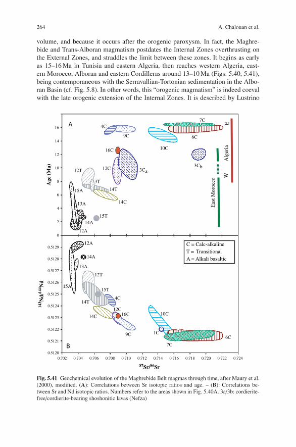
264 A. Chalouan et al.
volume, and because it occurs after the orogenic paroxysm. In fact, the Maghre-bide and Trans-Alboran magmatism postdates the Internal Zones overthrusting onthe External Zones, and straddles the limit between these zones. It begins as earlyas 15–16 Ma in Tunisia and eastern Algeria, then reaches western Algeria, east-ern Morocco, Alboran and eastern Cordilleras around 13–10 Ma (Figs. 5.40, 5.41),being contemporaneous with the Serravallian-Tortonian sedimentation in the Albo-ran Basin (cf. Fig. 5.8). In other words, this “orogenic magmatism” is indeed coevalwith the late orogenic extension of the Internal Zones. It is described by Lustrino
0
2
4
6
8
10
12
14
16
0.5123
0.5124
0.5125
0.5126
0.5127
0.5128
0.5129
0.5120
0.5121
0.5122
0.702 0.704 0.706 0.708 0.710 0.712 0.714 0.716 0.718 0.720 0.722 0.724
9C
10C
4C
16C14C
12C
12A
15A
14A
13A
12T
14T
15T
C = Calc-alkalineT = TransitionalA = Alkali basaltic
143 N
d/14
4 Nd
87Sr/86Sr
Age
(M
a)
6C
7C
15A
12A
13A
14A15T
12T
14T
9C
10C
4C
16C
14C
12C
6C
7C
3Ca3Cb
3T
1C
EW
Alg
eria
Eas
t Mor
occo
A
B
Fig. 5.41 Geochemical evolution of the Maghrebide Belt magmas through time, after Maury et al.(2000), modified. (A): Correlations between Sr isotopic ratios and age. – (B): Correlations be-tween Sr and Nd isotopic ratios. Numbers refer to the areas shown in Fig. 5.40A. 3a/3b: cordierite-free/cordierite-bearing shoshonitic lavas (Nefza)

5 The Rif Belt 265
& Wilson (2007) as a part of the much larger circum-Mediterranean anorogenicCenozoic igneous province.
The magmatic belt includes granodiorite massifs (e.g. Beni Bou Ifrour), butin most cases magmatism corresponds only to volcanic complexes of andesites,dacites, rhyodacites and rhyolites flows, dykes and sills. The lavas are generallyK-enriched, up to shoshonitic compositions (Oran region, Gourougou south ofMelilla). Their Sr-Nd-Pb-O isotope compositions suggest a lithospheric mantleorigin with a strong crustal imprint (Fig. 5.41). The magmatic evolution ends at10–7 Ma with the emplacement of transitional, calc-alkaline/alkaline basalts, an-desitic basalts and trachy-andesites (Gourougou, Guilliz), and lamproites (Murcia).
As a whole, the detailed geochemical data now available give evidence of twodistinct sources, i.e. (i) a main source in a subcontinental lithospheric mantlemodified by the subduction of a lithospheric slab, and (ii) the overlying continen-tal crust locally affected by partial melting (garnet-cordierite granites), which havecontaminated the ascending calc-alkaline magmas. Many authors (e.g. Maury et al.,2000) hypothesize a direct link between this magmatic evolution and the Africanplate subduction, ending with the oceanic slab tear-off (Sect. 5.7). The upwardflow of enriched asthenospheric mantle through the tear would have triggered melt-ing of the lithospheric mantle already metasomatised during a previous subductionepisode. Later, partial melting would have occurred at the uprising asthenosphere-lithosphere boundary, thus generating basalts having transitional character.
5.6.3 Recent Alkaline Magmatism of the Morocco Hot Line
An alkaline, intraplate-type volcanism took place at both the east and west tips ofthe Maghrebian magmatic belt in the most recent period, from 6 to 0.8 Ma. In con-trast with the earlier magmas, the new ones also occur outside of the Maghrebidebelt. The volcanic centers now occur along a NE-trending belt extending from theTrans-Alboran zone (Fig. 5.40B) to the Middle Atlas domain (Chap. 4) and to theAnti-Atlas (J. Siroua volcano). The magmatic rocks are alkaline basalts, basanites,hawaites, and nephelinite, lacking crustal contamination (Fig. 5.41). Their geochem-ical signature compares with that of the intra-oceanic island basalts, and suggests therole of an asthenospheric “hot line”, labelled the Morocco Hot Line (MHL) in theChap. 4 of the present volume. Such interpretation is consistent with the gravimet-ric and geodetic modelling of the lithosphere (cf. Chap. 1), and the lack of welldefined age versus position trend. The MHL could extend from the Canary Islandsto southeast Spain at least.
It is worth noting that CO2-rich thermal springs with 3He anomalies are likely re-lated to this hot line. They are mainly distributed along a NE-SW trend from Nadorto Taza, and from Fes (Moulay Yacoub) to Oulmes south of the Rif frontal thrust.The contemporary presence of 3He anomalies and minor recent basalt outcrops in-dicate that CO2 originates from mantle degassing or deep hydrothermal systems inthese thermal discharges (Tassi et al., 2006).

266 A. Chalouan et al.
5.7 Mountain Building
The future Rif-Betic or Gibraltar Arc orogenic domain was created by the breakingdown of Pangea and opening of the Central Atlantic and western Tethys Oceans(Figs. 1.5, 1.9). The oceanic corridor between Iberia and Africa was always nar-row (200–300 km). However, oceanic lithosphere occurred everywhere north of theMaghreb margin and west of the Adria plate (the “African promontory”; Fig. 1.9A),being most probably connected with the Alpine oceanic lithosphere. At about75 Ma, the latter ocean began to close by subduction of the European plate beneaththe Adria margin. Further to the southwest the scenario in the Ligurian-MaghrebideOcean is still a matter of debate.
In this section, we discuss those geodynamic processes, which resulted in thebuilding of the Rif mountains. This cannot be done without taking into accountthe entire Gibraltar Arc. After an abridged synopsis of the successive events in duechronological order (Sect. 5.7.1), and the presentation of the kinematic data and pa-leomagnetic rotations (Sect. 5.7.2), we first present the most recent orogenic period,which is also the best understood, i.e. the Oligocene-Neogene interval (Sect. 5.7.3).Based on this reconstruction, which is currently accepted, we then discuss the earlierand much debatable stages of the Rif-Betic orogeny (Sect. 5.7.4). The last Sect. 5.8presents the present-day stress field in the region, which has important environ-mental consequences and completes the orogenic evolution up to contemporarytimes.
5.7.1 Abridged Orogenic Chronology and First Interpretations
References: The recent stratigraphic and radiochronologic references are indicatedin the preceding Sects. (5.3–5.6), and some of them recorded in the legend ofFig. 5.42. Synthetic tables are proposed by Duggen et al. (2004), and Jolivet et al.(2006) concerning the metamorphic, magmatic and tectonic events.
Mountain building of the Betic Cordilleras and Maghrebides is basically the finalproduct of the Africa-Eurasia plate convergence since ca. 70 Ma ago (see Chap. 1,Fig. 1.10). Africa-Europe convergence in the west, along the Gibraltar transect, islesser than in the east, along the Sicilian transect, by approximately a factor 2. Inthe Gibraltar transect, the orogenic domain suffered in total 250 km of N-S shorten-ing from Late Cretaceous to Tortonian, and 50 km of further NW shortening untilpresent day. Convergence is directed WNW since ∼3Ma (Fig. 1.10).
Before discussing the geodynamic processes that formed the belt, it is convenientto summarize the chronology of the orogenic events (Fig. 5.42), as recorded by thestratigraphic, metamorphic and magmatic data reported above (sect. 5.2 to 5.6). Ateach step, the suggested geodynamic interpretation will be shortly noted hereafterin italics.
The earliest sedimentary events recording significant tectonic movements are ob-served during the Late Cretaceous in the Alboran (AlKaPeCa) Internal Domain. In

5 The Rif Belt 267
the Dorsale units, Senonian hemipelagic deposits (Couches rouges) overlie, throughan unconformity, the Tithonian-Berriasian limestones. Chaotic breccias interbed-ded within the “scaglia”-type deposits (Hafa Ferkenich in the Rif Internal Dorsale,Djurdjura in Algeria; Raoult, 1974) suggest an increasing tectonic activity.
By the end of this period, during the Paleocene-Eocene, the Ghomaride-Mala-guide-Kabylides continental domain and its proximal margin (Internal Dorsale) firstemerged, before being converted into a shallow marine platform fringing emergedlands. The interpretation of this major event is not straightforward, but it canrecord the overriding of a subduction zone if the uplifted block belonged to theactive margin. At the northern (northwestern) boundary of the Maghrebian Flyschbasin (Mauretanian basin), sandy turbidites and coarse olistostromes first appeared,whereas the southern part of the oceanic trough (Massylian basin) had pelagic sed-imentation. This suggests that a subduction trench was formed by the Middle-LateEocene at the Dorsale-Maghrebian ocean transition (Fig. 5.23).
In contrast, the African paleomargin itself remained virtually quiescent through-out Late Cretaceous to Eocene time. In the Prerif zone, Triassic evaporites and asso-ciated rocks are resedimentated in the Upper Cretaceous marls. Such phenomenonsuggests the ascent of diapirs up to the Cretaceous seafloor. This was probably aresult of an extensional/transtensional regime, in agreement with the Paleocene al-kaline basalts erupted in the eastern Prerif (Sidi Maatoug).
Contractional events first occurred during the Late Eocene-Oligocene, beingmostly concentrated in the Internal (Alboran) Domain. These are: (i) stacking of theGhomaride-Malaguide nappes, locally dated at about 28 Ma, and associated withdeep erosion and coarse conglomerate deposits; (ii) turbiditic and olistostrome-rich sedimentation with internal alimentation in the Dorsale-Predorsalian-internalFlysch Trough (Beni Ider-Algeciras Flyschs); (iii) metamorphism in the Sebtide-Alpujarride units, the peak of which occurred at ∼30Ma, although some earlierisotopic ages (48 Ma) have been obtained; and (iv) emplacement of andesitic basaltdykes in the Malaguides (33–30 Ma). The latter two events are indicative of an on-going subduction during the Oligocene. The Dorsale and Ghomaride-Malaguideunits were located in the arc domain above the subduction zone where the Sebtide-Alpujarride units were buried.
During this Eocene-Oligocene period, coarse turbiditic influx increased in thenorthern part of the Flysch Trough (Fig. 5.23), which was progressively consumed,whereas its southern part was almost devoid of contemporary turbidites (Fig. 5.26).Likewise, most of the External Rif remains undisturbed, but the Intrarif-Mesorifboundary acted as a minor suture zone (from the Nekor-Beni Malek to the Oranmassifs at least). This view is supported by the occurrence of the Tifelouest duplexessealed by Oligocene-Miocene chaotic breccias and turbidites, and by the age of thegreenschist to MP-LT metamorphism of the Ketama–Temsamane massifs, dated atca. 28–23 Ma.
At the transition from Oligocene to Miocene (latest Oligocene-Early Burdi-galian, 25–18 Ma), the upper plate, i.e. the Ghomaride-Malaguide-Kabylian range,was eroded, faulted, and progressively submerged. Contemporaneously, the buriedSebtide-Alpujarride units were exhumed under increasing geothermal gradients.

268 A. Chalouan et al.
. . .t
. .
. . .
. .
. . .
. .
. . .
. .
. . .
. . . .
. . .
. .
. . .
. . .
. .
. . .
. .
PL
IOC
EN
E
PL
EIS
TOC
EN
E
. . .
. . .
. . .
. . .
(U. C
reta
c.)
_ _
__
_ _
__
_ _
_ _
_ _
_ _
__
_ _
__
_ _
_ _
_ _
_ _
__
_ _
__
_ _
_ _
_ _
_ _
_
_ _
_ _
_ _
__
_ _
__
_ _
_ _
_ _
_ _
__
_ _
__
_ _
_ _
_ _
_ _
__
_ _
__
_ _
_ _
_ _
_ _
__
_ _
__
_ _
_ _
_ _
_ _
_ _
_ _
_ _
_
_ _
_ _
_ _
__
_ _
__
_ _
_ _
_ _
_ _
__
_ _
__
_ _
_ _
_ _
_ _
__
_ _
__
_ _
_ _
_ _
_ _
__
_ _
__
_ _
_ _
_ _
_ _
__
_ _
__
_ _
_ _
_ _
_ _
__
_ _
__
_ _
_ _
_ _
_ _
__
_ _
__
_ _
_ _
_ _
_ _
__
_ _
__
_ _
_ _
_ _
_ _
__
_ _
__
_ _
_
_ _
__
_ _
__
_ _
_
_ _
__
_
_
__
_ _
__
_ _
_
_ _
__
_
_
__
_ _
__
_ _
__
_
_
__
_ _
__
_ _
__
_
_
__ _
_ _
__
_ __
_ _
__
_ _
_
. . .
. . .
. . .
. . .
. . .
. . .
. .
. .
. .
. .
. .
. .
_ _
_
_ _
__
_ _
_ _
__
_ _
. . .
. . .
_ _
_
_ _
_. .
. . .
._
_ _
. . .
. . .
_ _
_
_ _
_
. . .
. . .
. . .
. . .
. . .
. . .
. . .
. . .
. . .
. . .
. . .
. . .
. . .
. . .
_ _
_
_ _
_
_ _
_
_ _
_
_ _
_
_ _
_
_ _
_
_ _
__
_ _
. . .
. . .
. . .
. . .
. . .
. . .
. . .
. . .
. . .
. . .
. . .
. . .
.
. . .
_
_
. . .
. . .
_ _
_
_ _
__
_ _
. . .
. . .
. . .
. . .
. . .
. . .
_ _
_
_ _
__
_ _
. . .
. . .
. . .
. . .
_ _
_
. . .
. . .
_ _
_
_ _
_
. . .
. . .
_ _
_
. . .
. . .
_ _
_
_ _
_
. . .
. . .
. . .
. . .
. . .t
. .
. . .
. .. .
.t .
.. .
. . .
.. .
. . .
.. .
. . .
.. .
. . .
.. .
.t .
.. .
. . .
. . .t
. .
. . .
. . .
. . .
. . .
. . .
.
. . .
.. .
. .
. .t
. .. .
. .
. .t
. .. .
t . .
. .t
. .. .
t . .
. . .
.. .
. .
_ _
. .t
. .
. . .
.. .
. .
_ _
. . .
.
_
_ _
_ _
_ _
_
_ _
_ _
_
_ _
_ _
_
_ _
_ _
_ _
_ _
_
_ _
_ _
_ _
__
_ _
_ _
_ _
_ _
_ _
_ _
_
_ _
_ _
_ _
__
_ _
_ _
_ _
_ _
_ _
_ _
_
_ _
_ _
_ _
_
_ _
_ _
_ _
__
_ _
_ _
_ _
_ _
_ _
_ _
__
_ _
_ _
_ _
_ _
_ _
_ _
_
_ _
_ _
_ _
_
_ _
_ _
_ _
_
. . .
. . .
. . .
. . .
.
. . .
. . .
. . .
. . .
.
. . .
. . .
. . .
. . .
._
_ _
_ _
_ _
_ _
_ _
_ _
_. .
. . .
. . .
. . .
. .
. .
. .
. . .
. . .
.
. .
. .
. . .
. . .
.
_
_ _
_ _
_
_
_ _
_ _
_
_
_ _
_ _
_
_
_ _
_ _
_
_
_ _
_ _
_
. .
. .
. . .
. . .
.
.
. . .
. . .
. . .
. . .
. . .
. . .
. . .
. . .
. . .
. . .
. . .
. . .
. . .
. . .
. . .
. . .
. . .
. . .
. . .
. . .
. . .
. . .
. . .
. . .
. . .
. . .
. . .
. . .
_ _
_ _
_ _
_ _
_ _
_ _
__
_ _
_ _
__
_ _
_ _
__
_ _
_ _
_ _
_ _
_ _
_ _
_ _
_ _
__
_ _
_ _
__
_ _
_ _
_
. .
. . _
.. .
_ .
. . .
_ .
. _ .
. . _
. . _
. .
...
......
.
. .
. . .
.
. . .
.
. . .
.. .
. .
. .
. _ ._
.
_
. . .
. .. .
. . .
. . .
. .
. . .
_ .
. . _
. .
_ _
_
__
_
_ _
_
_ _
_
_
__
_
_ _
_
_ _
_
_
__
_
_ _
_
. . .
. . .
_ . _
. . _
. . _
. ._
. . _
. ._
. . .
. . .
_ . .
. . _
. . .
. .
. _ .
. . .
. _ .
. . .
_ . .
. . .
_ . .
. . .
_ . .
. . .
._ .
. . .
_ . .
. . .
_ .
. . .
_
_
_
_
_
__
_
_
_
_
__
_
_
__
_
+
+
++
__
__
_ _
_ _
_ _
_ _
_ _
_ _
__
_ _
__
__
__
__
__
___
_
__
__
__
__
__
__
__
_
_ _
_ _
__
_ _
_
__
_ _
__
_ _
_ _
__
_ _
_.
. .
. .
. .
. .
. .
. .
._
_ _
_ _
__
_ _
_
___ . .
. .
. .
.
. .
. .
. .
._
_ _
__
_ _
_
_ _
_
_ _
t _
__
_ _
__
t _
__
_
_ _
.
.
.
..
.
.
.
.
.
.
..
.
.
.
.
.
.
.
. .
. .
..
. .
. .
. .
.
.. .
. . .
. .
_ _
_ _
_ _
t _
__
_ _
__
_ _
_. .
. . .
. .
. . .
. . .
._
_ _
__
_ _
_. .
. . .
. .
_ _
_
_
_ _
_
_
_ _
_
_
_ _
_
_
_ _
_
_
_ _
_
_
_
. . .
. .
_. .
. . .
_
_
_ _
_
_ _
_
_
_ _
_
_
__
_ _
_ _
..
....
.
. . .
. .. .
. . .
. . .
. .
. . .
. .
. . .
. .
. . .
. .
_ _
__
_ _
_ _
__
_ _
_ _
_. .
t .
.
_ _
. . .
. . .
. . .
.
_ _
_
_
__
_
_ _
_
. . .
. . .
. . .
. . .
. . .
. . .
. .
. . .
. . .
. . .
. . .
. . .
. . .
. .
_ _
_
_
_ _
_
_
_ _
_
_
_. .
. . .
. . .
.
. . .
. . .
. . .
. . .
. . .
. . .
. . .
. . .
. . .
. . .
. . .
. . .
. . .
. . .
. . .
. . .
. . .
. . .
. . .
. . .
. . .
++
++
P A L A E O C E N EE O C E N EO L I G O C E N EM I O C E N E
RU
PE
LIA
N
TH
AN
ET
IAN
YP
RE
SIA
N
LU
TE
TIA
N
Str
atig
rap
hy Do
mai
ns
ME
SS
INIA
N
TOR
TON
IAN
SE
RR
AVA
LL
IAN
LA
NG
HIA
N
BU
RD
IGA
LIA
N
AQ
UIT
AN
IAN
CH
AT
TIA
N
PR
IAB
ON
IAN
BA
RT
ON
IAN
DA
NIA
N
Fo
rela
nd
,
Fo
red
eep
Pre
rif,
Rif
ian
nap
pes
__
Ma
1.8
5.3
5.3
7.2
11.6
15.7
13.6
20.4
28.4
33.9
33.9
28.4
15.7
37.2
40.4
48.6
55.8
58.7
65.5
23.0
23.0
Do
rsal
e
calc
aire
Pre
-d
ors
.G
ho
mar
ides
M
alag
uid
es
Seb
tid
es
Alp
uja
rrid
esA
lbo
ran
Sea
Nev
ado
-F
ilab
rid
es
[21-
24]
_ _
_ _
_ _
_
_
__
_
_ _
_
. .
. .
. .
.
. .
.
(U
. Cre
tac.
- Lia
ssic
)
( C
reta
c.- L
iass
ic)
.( L
iass
ic)
.( L
iass
ic)
++
++
. . .
. . .
. . .
_ _
_ _
_. .
t .
.
_ . . .
. .
. .
. .
.
_ _
_ _
F
e-M
n
F
e-M
n
F
e
F
e
_
_
W
E
W
E
. . .
. . .
_ . .
. . _
. . .
. ._
. . .
. ._
. . .
. . .
_ . .
. . _
. . .
. . _
. . .
.
. . .
_ .
.
.
.
. . .
.. .
. .
. . .
.
. . .
.. . .
..
. .
.. .
_ .
. _ .
. __
_ _
_ _
_ _
_. .
. . .
.
Gha
rb
Ext
erna
l Inte
rnal
Rid
es
Rid
es
. . _ _
_
_ _
_
_ _
_ _
_
_
_ _
_ _
. . .
t
tt
Det
ach
ed
fro
m th
e
Tisi
ren
Fly
sch
Gra
nite
pebb
les
Gho
mar
ide
c
last
s
. . .
. . .
. . .
. .
t. .
. . .
.. .
. . .
.. .
. . .
.. .
. . .
.. .
. . .
.. .
. . .
._
_ _
_ _
_
. . .
. .. .
. . .
. . .
. .
. . .
. .
. . .
. .
_ _
_
_
_ _
_
_
_ _
_
_
_ _
_
_
[Sra
Esp
una]
[Mal
aga
dyke
s]
_ _
_
_
__
_
_ _
_
_ _
_
_
_
_ _
_
_
_ _
_
_
_ _
_
_
_ _
_
_
_ _
_
_
_ _
_
_
_ _
_
_
_
_ _
_
_
_
_
_ _
_
_ _
_
_
_
_
_ _
_
_ _
_
_
__
_
_ _
_
_ _
_
_
__
_
_ _
_
_ _
_
_
__
_
_ _
_
_ _
_
_
__
_
_ _
_
_ _
_
_
__
_
_ _
_
_ _
_
_
__
_ _
_ _
_ _
_ _
__
_ _
_ _
_ _
_ _
_ _
_ _
_ _
_ _
. . .
. .
t
. . .
. .
t
_
_
_
_ _
_
_
_ _
_
_
_ _
.
. . .
.
. . .
.
. . .
.
. . .
.
. . .
.
. . .
.
. . .
.
. . .
_
_
_ _
_
_
. .
. .
. .
. .
. .
. .
. .
. .
_ _
_
_
_ _
_
_
_ _
_
_
_ _
_
_
. .
. .
. .
. .
. .
. .
. .
. .
. .
. .
. .
. .
_
_
_
_
_ _
_
_
_
_
_
_
_ _
_
_
. .
. .
.
.
. .
. .
.
.
. .
. .
. .
.
. .
. .
. .
.
. .
. .
. .
.
. .
. .
. .
.
. .
. .
. .
.
. .
. .
. .
.
[10,
12]
[13]
[14]
[15,
16]
[16,
17,
18]
[17,
18,
20]
[1, 2
, 18]
[1, 3
-5, 1
8, 1
9][1
, 3,
5, 6
, 18]
[3, 4
, 7-9
, 18]
[10,
11]
Sidi Maatoug
(E. B
etic
s ba
sins
)
(Gib
ralta
r, M
artil
, Tirh
ines
se r
ias)
Ciu
dad
Gra
nada
Fni
deq
-
O. G
harr
aq
Viñuela
S. A
bdes
lam
(Bet
ics)
(Kab
ylie
s)
Tala
a L
akra
a
Jbel
Bin
et;
Ben
i Iss
ef ?
Ben
i Iss
ef ?
Saï
ssG
uilli
zP
ost-
napp
e sy
nclin
es
Tres
For
cas
Gou
roug
ou
Cha
rf
Al A
kab
t t
RIDES PRERIFAINES
Pre
rifTs
oul
Mes
ori
fIn
trar
ifN
um
idia
n(M
assy
l.)B
eni I
der
(Mau
re-
tan
ian
)
Ras
Tar
f
Pre
dors
alia
n &
Z
em
J. Z
e m
Sidi MraïtSidi Mraït
Det
ach
ed f
rom
the
Mel
lou
ssa
Ch
ou
amat
U. C
reta
c. F
lysc
h
Eas
t
TIFELOUEST
TANGER
Saf Lahmame
Rirha - Acilah - Larache
TEMSAMANE NORD
IZZARENE - ZOUMI
._
.
EXTERNAL PRERIF
INTERNAL PRERIF
KETAMA-AKNOUL
H A B T
Fe
F
e
_ _
_
_
_
_ _
_
_
_
_ _
_
_
_
. . .
. . .
. . .
Oue
zzan
e
_
__
_
cl
ays
Tubo
to-
mac
ulum
Akn
oul
deta
chm
ent
Sen
hadj
a
??
U-P
b Z
r,Lu
-Hf G
t
D3
D2
D1
ZF
T
Ar-
Ar
Hb
Ar-
Ar
Ph
Ar-
Ar
Ph
Ar-
Ar
Ph
? ??
AF
T
_ _
_
_
_ _
_
_ _
_
+ +
+ +
+
+ +
+ +
+
+ +
+ +
+
+ +
+ +
+
+ +
+ +
+ +
+ +
+
+ +
+ +
+
+ +
+ +
+
+ +
+ +
+
+ +
+ +
+ +
+ +
+ +
+
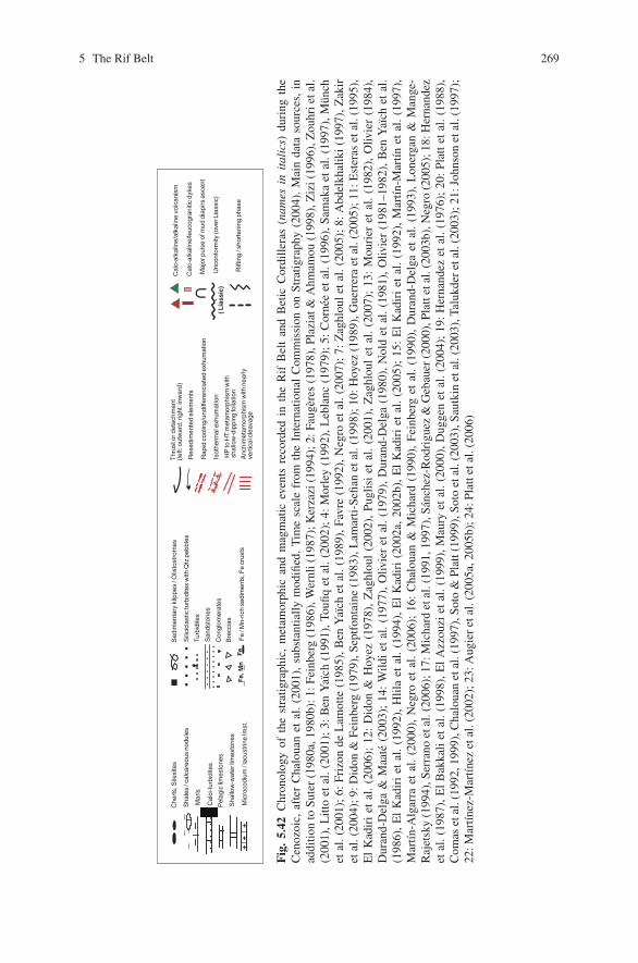
5 The Rif Belt 269
. . .
. .
_
_
_
__
_
. . .
. . .
. . .
.( L
iass
ic)
F
e, M
n
Fe
Unc
onfo
rmity
(ove
r Lia
ssic
)
Fe
/ Mn-
rich
sedi
men
ts, F
e cr
usts
Sha
les
/ cal
care
ous
nodu
les
Che
rts,
Sile
xite
s
Mic
roco
dium
/ la
cust
rine
lmst
.
Pel
agic
lim
esto
nes
Sha
llow
-wat
er li
mes
tone
s
++
+
Sili
cicl
astic
turb
idite
s w
ith Q
tz p
ebbl
es
San
dsto
nes
Con
glom
erat
es
Turb
idite
s
Cal
ci-t
urbi
dite
s
Bre
ccia
s
Mar
ls
HP
to H
T m
etam
orph
ism
with
sh
allo
w-d
ippi
ng fo
liatio
n
Anc
him
etam
orph
ism
with
nea
rlyve
rtic
al c
leav
age
Res
edim
ente
d el
emen
ts
Rap
id c
oolin
g/un
diffe
renc
iate
d ex
hum
atio
n
Isot
herm
al e
xhum
atio
n+
++
Fig
.5.
42C
hron
olog
yof
the
stra
tigra
phic
,m
etam
orph
ican
dm
agm
atic
even
tsre
cord
edin
the
Rif
Bel
tan
dB
etic
Cor
dille
ras
(nam
esin
ital
ics)
duri
ngth
eC
enoz
oic,
afte
rC
halo
uan
etal
.(2
001)
,su
bsta
ntia
llym
odifi
ed.
Tim
esc
ale
from
the
Inte
rnat
iona
lC
omm
issi
onon
Stra
tigra
phy
(200
4).
Mai
nda
taso
urce
s,in
addi
tion
toSu
ter
(198
0a,1
980b
):1:
Fein
berg
(198
6),W
ernl
i(19
87);
Ker
zazi
(199
4);2
:Fau
gere
s(1
978)
,Pla
ziat
&A
hmam
ou(1
998)
,Ziz
i(19
96),
Zou
hrie
tal.
(200
1),L
itto
etal
.(20
01);
3:B
enY
aıch
(199
1),T
oufiq
etal
.(20
02);
4:M
orle
y(1
992)
,Leb
lanc
(197
9);
5:C
orne
eet
al.(
1996
),Sa
mak
aet
al.(
1997
),M
unch
etal
.(20
01);
6:Fr
izon
deL
amot
te(1
985)
,Ben
Yaı
chet
al.(
1989
),Fa
vre
(199
2),N
egro
etal
.(20
07);
7:Z
aghl
oul
etal
.(20
05);
8:A
bdel
khal
iki
(199
7),Z
akir
etal
.(20
04);
9:D
idon
&Fe
inbe
rg(1
979)
,Sep
tfon
tain
e(1
983)
,Lam
arti-
Sefia
net
al.(
1998
);10
:Hoy
ez(1
989)
,Gue
rrer
aet
al.(
2005
);11
:Est
eras
etal
.(19
95),
El
Kad
iri
etal
.(2
006)
;12
:D
idon
&H
oyez
(197
8),
Zag
hlou
l(2
002)
,Pu
glis
iet
al.
(200
1),
Zag
hlou
let
al.
(200
7);
13:
Mou
rier
etal
.(1
982)
,O
livie
r(1
984)
,D
uran
d-D
elga
&M
aate
(200
3);
14:
Wild
iet
al.(
1977
),O
livie
ret
al.(
1979
),D
uran
d-D
elga
(198
0),
Nol
det
al.(
1981
),O
livie
r(1
981–
1982
),B
enY
aıch
etal
.(1
986)
,E
lK
adir
iet
al.
(199
2),
Hlil
aet
al.
(199
4),
El
Kad
iri
(200
2a,
2002
b),
El
Kad
iri
etal
.(2
005)
;15
:E
lK
adir
iet
al.
(199
2),
Mar
tın-M
artın
etal
.(1
997)
,M
artın
-Alg
arra
etal
.(2
000)
,N
egro
etal
.(2
006)
;16
:C
halo
uan
&M
icha
rd(1
990)
,Fe
inbe
rget
al.
(199
0),
Dur
and-
Del
gaet
al.
(199
3),
Lon
erga
n&
Man
ge-
Raj
etsk
y(1
994)
,Ser
rano
etal
.(20
06);
17:M
icha
rdet
al.(
1991
,199
7),S
anch
ez-R
odri
guez
&G
ebau
er(2
000)
,Pla
ttet
al.(
2003
b),N
egro
(200
5);1
8:H
erna
ndez
etal
.(19
87),
El
Bak
kali
etal
.(19
98),
El
Azz
ouzi
etal
.(19
99),
Mau
ryet
al.(
2000
),D
ugge
net
al.(
2004
);19
:H
erna
ndez
etal
.(19
76);
20:
Plat
tet
al.(
1988
),C
omas
etal
.(19
92,1
999)
,Cha
loua
net
al.(
1997
),So
to&
Plat
t(19
99),
Soto
etal
.(20
03),
Saut
kin
etal
.(20
03),
Talu
kder
etal
.(20
03);
21:J
ohns
onet
al.(
1997
);22
:Mar
tınez
-Mar
tınez
etal
.(20
02);
23:A
ugie
ret
al.(
2005
a,20
05b)
;24:
Plat
teta
l.(2
006)

270 A. Chalouan et al.
Turbiditic sedimentation then invaded the entire, residual Flysch Trough and theIntrarif domain. By the end of this period, during the Middle Miocene (16–11 Ma),shortening encroached the Flysch Trough, Intrarif, and Subbetic domains.
Nevertheless, extension in the central part of the Alboran Domain continued dur-ing the whole Miocene (Late Burdigalian-Early Tortonian, 18–9 Ma), resulting inthe continued subsidence and the development of the Alboran Sea in the west. Thisprotracted extension at the core of the Alboran Domain was accompanied by con-spicuous calc-alkaline volcanism. It was also coeval with the outward displacementof the turbiditic depocenters and thrust contacts into the Mesorif domain, and theninto the Prerif domain. Obviously, plate convergence is not the only process at work,as shortening is combined with extension in the Alboran Domain. This is interpretedthrough the retreat of the Maghrebian subduction zone with tearing and break-off ofthe plunging slab (see below).
Finally, during the Late Tortonian-Pleistocene times (9 Ma to Present), theMediterranean Sea overlay large parts of the orogen, due to late orogenic collapseof the tectonic prism. However, contractional processes mostly related to plate con-vergence also operated at some places (e.g. Alboran Ridge, post-nappe synclines ofthe Mesorif), being still active in the Rides prerifaines. Alkaline basalts emplacedin the eastern Rif, in relation with the Morocco Hot Line (Sect. 5.6.3) superimposedonto the Maghrebide-Betic structures.
5.7.2 Kinematic Data and Paleomagnetic Rotations
References: Kinematic data (transport direction and sense of shear) have been col-lected throughout the Gibraltar Arc by many authors and for different time in-tervals. They are presented synthetically in the following works (with referencestherein): (i) for the Sebtide-Alpujarride units (late Oligocene-Miocene deforma-tions), by Garcıa-Duenas et al., 1992, 1995), Michard et al. (1997), Chalouan et al.(1995, 1997), Balanya et al. (1997), Martınez-Martınez & Azanon (1997), Azanon& Crespo-Blanc (2000), and Booth-Rea et al. (2004); (ii) for the Nevado-FilabrideComplex (Middle-Late Miocene deformation) by Martınez-Martınez et al. (2002)and Augier et al. (2005a); (iii) for the External Zones of the entire orogenic arc(Early-Late Miocene to Pleistocene deformation) by Frizon de Lamotte et al. (1991),Crespo-Blanc & Campos (2001), Aıt Brahim et al. (2002), Platt et al. (2003a) – apaper discussed by Michard et al. (2005), Zakir et al. (2004), Bargach et al. (2004),and Crespo-Blanc & Frizon de Lamotte (2006). Concerning paleomagnetic investi-gations, a number of references are given in the caption to Fig. 5.43. Other pertinentworks are those by Villalain et al. (1994), Platt et al. (2003a), Villasante-Marcoset al. (2003), Osete et al. (2004), Krijgsman & Garces (2004), and Cifelli et al.(2008).
Kinematic indicators are widespread in the Sebtides (Fig. 5.35), and come fromthe top of the Beni-Bousera peridotites and the Federico units (Upper Sebtides) in theBeni Mezala area. They are associated with retrogressive mineral phases, and thenrelated to the exhumation processes. They show a remarkably constant top-to-NW

5 The Rif Belt 271
120°
74°118°
79°
134°
46°70°
72°
2°
2°
3°
Paleomagnetic rotations(clockwise / anticlockwise,strong / weak)
Paleozoic of Malaga
Alpujarride-Sebtideultramafic massifs
Gibraltar
Beni Bousera
Beni Malek
Ronda
46°
5
5
Late Jurassic-Early Cretaceous limestones/components
Ultramafics, > c. 21 Ma components
> c. 21 Ma components
10 Calc-alkaline dykes, 30–33 Ma components
11
11
Calc-alkaline volcanics, 18–4 Ma components12
3°
10
4
3
1
14°
6
.7
8
9
Ductile kinematicindicators, c. 21 MaNek
or F.
Pal
omar
es F
.
Jebha F.100 km
Fault-related recent ACWrotations
2
13 Neogene sediments,
Fig. 5.43 Paleomagnetic rotations (mean site values) in the Betic-Rif Belt, after Feinberg et al.(1996) and Chalouan & Michard (2004), modified. The inferred approximate N–S strike of thepre-Early Miocene orogen is shown schematically by the alignement of the three ultrabasic bodiesin the mid-Alboran area. This also restores the main ductile shear directions of the west GibraltarArc, as reported by Michard et al. (1997), Balanya et al. (1997), Martınez-Martınez et al. (2002),into an broadly N-S trend. 1: Najid et al. (1981); 2: Elazzab & Feinberg (1994); 3: Saddiqi et al.(1995); 4: Feinberg et al. (1996); 5–9: Platzmann (1992), Platzmann et al. (1993), Allerton et al.(1994); 10: Platzmann et al. (2000), Calvo et al. (2001); 11, 12: Calvo et al. (1997); 13: Matteiet al. (2006)
(Beni Bousera) and top-to-N (Beni Mezala) direction of shear. In the northern branchof the Gibraltar Arc, i.e. in the western Alpujarrides, coeval kinematic indicatorspoint to top-to-N to top-to-NE shear. This strongly suggests that the correspondingexhumation tectonics originally occurred with a top-to-N sense of shear, and thatthe metamorphic units carrying the stretching lineations were bended during a fur-ther stage. Assuming that the recorded exhumation phase occurred at ca. 23–20 Ma,the curvature of the arc would have developed after the lowermost Miocene.
Paleomagnetic data permit to precise the latter conclusion (Fig. 5.43). Rotationsof the Late Jurassic and Late Cretaceous limestones are mostly anticlockwise inthe Rif Dorsale units, and clockwise in the Betic Dorsale and Penibetic (InternalSub-Betic) zones. Similar opposite rotations are observed both in the Beni Bouseraand Ronda peridotites, and within their leucogranite dykes. This observation en-ables us to demonstrate that rotations occurred after the cooling of these rocks (ca.20 Ma). The moderate anticlockwise rotation measured in the Beni Malek ultra-mafics and overlying metasediments can be assigned to the sinistral deformationalong the Nekor fault zone. At first sight, opposite and low rotations inferred incalc-alkaline volcanic rocks (cf. sites 1, 11, and 12; Fig. 5.43) suggest that rotationwithin the arc was completed at ca. 13–7 Ma. However, paleomagnetic results from

272 A. Chalouan et al.
NW SE
Fig. 5.44 An example of Miocene normal fault from the southern Alboran Sea shore: the Cape ofTres Forcas NW-dipping fault, cutting across the Late Tortonian-Messinian basal conclomerates atthe north boundary of the Tarjat anticline (see Fig. 5.39 for location). The fault operated duringthe Messinian subsidence of the Cape Tres-Forcas block, with alternating normal and sinistralmovements
Neogene sedimentary sequences from the Betic Chain show also that vertical axisrotation continued after the Late Miocene (Mattei et al., 2006; Cifelli et al., 2008).In summary, bending of the Gibraltar Arc occurred mostly during the Early-MiddleMiocene, i.e. during the climax of extension, but continued afterwards.
Transport direction along Miocene thrusts display a broadly radiating patternin the External Zones of the Arc (Fig. 5.5). They show a dominant westwardcomponent, thus suggesting a westward migration of the Gibraltar Arc. Such senseof displacement is clearly recorded in the N-Temsamane domain (Fig. 5.30) and re-sults congruent with the one observed in the low-angle detachment that separates theAlpujarride Complex from the underlying Nevado-Filabride Complex. There, top-to- west shearing evolved from ductile to brittle conditions between ca. 12 and 8 Ma,contemporaneously with subsidence in the nearby Serravallian-Tortonian basins ofthe Betic Cordillera. The coeval, extensional directions associated with brittle nor-mal faults all around the Alboran basin itself are roughly centripetal (Figs. 5.5, 5.44).These observations are consistent with the formation of an orogenic arc, by simul-taneous frontal thrusting and back, centripetal extension, in the context of a west-directed slab retreating process.
5.7.3 Oligocene-Neogene: The Slab Retreat Process
References: The role of the slab retreat process in the opening of the Mediterraneanbasins and dispersal of the AlKaPeCa units was advocated by Rehaut et al. (1984),Frizon de Lamotte (1985), Malinverno & Ryan (1986), Royden (1993), Lonergan& White (1997), Doglioni et al. (1998), Frizon de Lamotte et al. (1991, 2000), andJolivet & Faccenna (2000), among others. Recent papers describing the GibraltarE-dipping slab and associated accretionary prism, based on marine geophysics,seismology and/or tomography are those by Torelli et al. (1997), Calvert et al.(2000), Gutscher et al. (2002), Faccenna et al. (2004), and Spakman & Wortel(2004). The occurrence of edge delamination is particularly advocated by Seber

5 The Rif Belt 273
et al. (1996), Calvert et al. (2000), and Fadil et al. (2006). A detailed kinematicreconstruction of the movements of the Mediterranean microblocks (except Albo-ran) is proposed by Schettino & Turco (2006). Other seismological and geodeticalreferences are reported in Chap. 1, Sect. 1.4.
Recently acquired seismological data offer convincing evidence for active east-dipping oceanic subduction below the western Aboran Sea. An east-dipping slabof subducted lithosphere is clearly imaged by tomography in the Western Mediter-ranean mantle (Fig. 5.45). Beneath the Betic-Rif-Alboran region, a positive (fast)P-wave velocity anomaly (i.e. a cold, dense body respective to the warmer ambientmantle), interpreted as a subducting slab, is found from the base of the crust acrossthe entire upper mantle, down to the 660 km discontinuity. The deeper part of theanomaly extends beneath SE Spain, north of the Alboran basin. The upper part of theslab connects with the Atlantic oceanic lithosphere west of the Strait of Gibraltar.Evidence for current activity of this subducting slab is offered by seismicity dis-tribution and seismic-reflection profiling (Fig. 5.46). Intermediate depth earthquakehypocentres are concentrated in the Alboran Sea, where plate curvature increasesabruptly, probably due to P and T dependant dehydration reactions in the plungingslab. The deepest part of the slab coincides with the locus of deep earthquakes be-neath southern Spain. On the Atlantic side, multichannel seismic profiling has im-aged the “olistostrome” of the Gulf of Cadiz as an eastward-thickening accretionary
200 km
563 km Depth km
after Spakman & Wortel, 2004
Fig. 5.45 Vp tomography of the Western Mediterranean area, after Spakman & Wortel (2004). Left:horizontal sections at 200 km and 563 km depth. Right: E-W vertical section across the Alboran-southern Algerian basin down to 1000 km depth, with location map. Dashed lines represent mantlediscontinuities at 410 and 660 km depth

274 A. Chalouan et al.
earthquake depth (km)
Lisbon
W Alboran Sea
Betics
Atlas
Gorringe B.
20
16
22 Inte
rnal
Extern
al
Rif
Mb7.1, 1954
Mw5.2, 1993
Mw5.9, 1994
Ms7.91969
Africa
Iberia
Portugal
Morocco
Spain
Eurasian Plate
African Plate
RAM
NorthAmericanPlate
SISMAR MCS profile 16 (cf. fig. C)
0
5
'BB .gif
B'
3 ??
???
??
7
B
A
C
38°
36°
34°
12° 10° 8° 6° 4° 2° 0°
15
0(km)
180 km
*Gharb
B0
100
0 100 200 300 400 500 600 700
km
km–60
asthenosphereasthenosphere
oceanic lithosphere
A l b o r a n S e aStrait of Gibraltar
0
10
20km
20
100 200 300 km
Vertical exaggeration × 5
after Gutscher et al., 2002
after Thiébot and Gutscher, 2006
after Gutscher, in litt. 2007
150 200 >600100500
Fig. 5.46 (continued)

5 The Rif Belt 275
wedge (“Atlantis wedge”), overlying eastward dipping undeformed sediments andbasement. Although some authors suggest that subduction is not active at present(e.g. Mauffret et al., 2007), the east-dipping reflectors deforming the seafloor indi-cate active ramp thrusts, thus suggesting that subduction is still active.
The shape of the Betic-Alboran subducting slab at a depth of 200 km correlateswith the arcuate shape of the Gibraltar Arc and is also consistent with the spatialdistribution of calc-alkaline volcanism in the back-arc domain. These observationsoffer a coherent timing for the kinematic evolution of the slab roll-back duringthe Miocene (Fig. 5.47). The subduction trench progressively turned from E-W toroughly N-S trend, through tearing and detachment along both the Iberia and theMaghreb margins. Indeed, no north-dipping slab is observed by tomography alongthe Algerian-Moroccan coast. The influx of asthenospheric mantle in the lithospheretear-zones resulted in calc-alkaline magmatism, which tracks the westward mantletearing (16–7 Ma in Algeria versus 12–6 Ma in Morocco and Alboran).
�
Fig. 5.46 (continued) The active subduction beneath Gibraltar. (A) Geographic map with shadedrelief and location of epicentres (1973–Present; M> 3) and some focal mechanisms, after Gutscheret al. (2002). Red thrust teeth symbols indicate Gibraltar Arc; green thrust teeth symbols indicateactive “Atlantis” accretionary wedge. SISMAR seismic reflection profiles in orange; position ofbottom seismometers as small, lined up red triangles. Seismicity sampling box for B is also indi-cated. – (B): Simplified lithospheric cross-section showing the distribution of earthquake hypocen-ters (sampling box in A), and the geometry of the upper plate (Gibraltar block), lower plate andaccretionary prism, after Thiebot & Gutscher (2006). – (C): Detailed cross-section of the accre-tionary prism along the SISMAR MCS Profile 16 (for location, see A and B), after M.-A. Gutscher(pers. comm., 2007)
Roll-back after
detachment
Late Mioceneslab detachment
Stalling of roll-backenecoiM ylraE
gniraet erehpsohtil
Lithosphere tearing Middle Mioceneslab detachment
10 Ma
23 Ma
after Spakman & Wortel, 2004
Fig. 5.47 Cartoon of the Miocene slab roll-back and lateral detachment and tearing of theMaghrebian-Ligurian oceanic slab in the Alboran area, after Spakman & Wortel (2004). The greypattern shows the present-day position of the slab at 200 km depth (see Fig. 5.45). Relative positionof Africa with respect to fixed Iberia is shown at 23 Ma, 10 Ma and Present

276 A. Chalouan et al.
In this generally accepted scenario, the Alboran Basin spread in a back-arc po-sition, similar to the Provencal and Valencia Basin (Fig. 5.48D, E). Mauffret et al.(2007) proposed that the western part of the Alboran Basin could have developedin a fore-arc position, but this is just open to discussion. It must be emphasized that
IBERIC PLATE
AFRICAN PLATE
APULIAN PLATE
EUROPEAN PLATE
A A
S A
S t a m p f l i & M a r c h a n t 1 9 9 7
A L K A P E C A
A
A l p i n
e O .
I o n i a n O .
L a c o m b e & J o l i v e t 2 0 0 5
45 N
35 N
C
50 Ma
A L K A P E C A
E
“One-subduction models”
110 Ma
L a c o m b e & J o l i v e t 2 0 0 5
45 N
15 Ma
AL- KA-
A C - E
P
Cross-section Fig. 5.50 E
I B E R I A
S
B r C
20 N N e v a d o - F .
V a l a i s a n O .
M i c h a r d e t a l . 2 0 0 2
20 N
140 Ma
B
S - V a c
r i s
o
a n f r n t
T u
s c .
L i g
u r i
a n
O .
M a g h r e b i a n O .
B e t i c O .
A D R I A
A L K A P E C A
A l p i n e O .
S e s i a
M i c h a r d e t a l . 2 0 0 2
A L K A P E C A
D Cross-section Fig. 5.50 D
“Two-subduction models”
30 Ma A l p i n e s u b d u c .
A p e n n i n i c s u b d u c .
Fig. 5.48 Alternative scenarios for the Mesozoic setting of AlKaPeCa continental blocks and thesuccessive positions of the subduction zone(s), after Michard et al. (2006), modified. Left: singlesubduction hypothesis; AlKaPeCa blocks were parts of SE Iberia during Early Cretaceous (A);during Tertiary convergence (C), the SE dipping Alpine subduction coexists with a NW-dippingLigurian-Maghrebian subduction south of Corsica. – Right: two-subductions hypothesis; during theMesozoic (B), AlKaPeCa formed a microcontinent separated from Iberia by a Betic oceanic arm;during the Eocene (D), a hypothetic SW extension of the Alpine subduction closes the Betic Ocean,being followed by the Ligurian-Maghrebian subduction at ca. 30 Ma. The Oligocene-Miocene evo-lution by back-arc extension and slab roll-back (E) is identical in both scenarios

5 The Rif Belt 277
the slab subduction does not result from E-W plate convergence but from passivesinking of unstable lithosphere into the mantle, within the narrow oceanic corridorbetween Iberia and Africa. At the scale of the Western Mediterranean, the sub-ducted Ligurian lithosphere is now found at the base of the upper mantle, and asnarrow, steeply dipping slabs in the Gibraltar Arc and its mirror image, i.e. theCalabrian Arc.
Slab roll-back was able to transport the fragments of the Betic-Rif Internal Zones(which were probably concentrated along the Balearic margin by the Eocene-EarlyOligocene; see below) towards their present-day position with a predicted, dominantENE-WSW trending extension. Slab roll-back also accounts for the rotations ofthe Alpujarride-Sebtide structures and paleomagnetic components during the EarlyMiocene, as described above (Fig. 5.43).
5.7.4 Late Cretaceous-Eocene: The Debatable Issues of the EarlySubduction-Collision Tectonics
References: Tectonic scenarios for this period are still warmly debated. Corre-lations with the Alps in terms of plate tectonics have been repeatedly addressedsince the late 70s: see reviews and references in Bouillin (1984) and Michard et al.(2002). Certain authors emphasized the role played by collisional processes and late-orogenic extension in the origin and evolution of the Betic-Rif orogen (e.g. Platt &Vissers, 1989; Turner et al., 1999; Houseman & Molnar, 2001). The occurrence ofsubduction is now widely accepted, although two competing models are proposed:(i) a single, NW-dipping subduction (e.g. Jolivet & Faccenna, 2000; Stampfli &Marchant, 1997; Stampfli et al., 2002; Lacombe & Jolivet, 2005; Jolivet et al., 2006),and (ii) two opposite subductions operating successively (e.g. Andrieux et al., 1989;Doglioni et al., 1999; Frizon de Lamotte et al., 2000; Lopez Casado et al., 2001,Michard et al., 2002; Chalouan & Michard, 2004; Guerrera et al., 2005; Pecerillo &Martinotti, 2006). A discussion of these alternative models is proposed in Michardet al. (2006), and summarized hereafter.
5.7.4.1 Plate Tectonic Setting
During the latest Cretaceous-Paleogene times, NW-Africa moves northward rel-ative to Eurasia by 200–250 km in the Morocco-Iberia transect (cf. Sect. 1.1,Fig. 1.10). Taking into account the shortening between Iberia and stable Europe(ca. 100 km across the Pyrenean belt), 100–150 km must have been consumedsouth of Iberia. As shortening across the Atlas is negligible up to the Neogene(Chap. 4), most of this shortening must have been accommodated by subductionof the Ligurian-Maghrebian oceanic lithosphere. During the Early Cretaceous, theLigurian-Maghrebian (or, shortly, Ligurian) ocean was a triangular area connectingCentral Atlantic, Alpine and Ionian oceans (Chap. 1, Fig. 1.9). When the Alpineocean closed during the Eocene by subduction of the European plate below Adria,subduction affected most likely the Ligurian lithosphere, and thus may have dragged

278 A. Chalouan et al.
down some parts of the nearby continental blocks, thus generating HP-LT metamor-phism in some of the AlKaPeCa units.
However, the location and number of subduction zones in the Ligurian area dur-ing the Late Cretaceous-Paleogene are questionable, as well as the location of theAlKaPeCa units (and particularly the Alboran Domain) at the onset of convergence.Several authors proposed that AlKaPeCa was part of the southeastern Iberian mar-gin, close to Sardinia and the Balearic Islands (Fig. 5.48A). In contrast, others(included the authors of the present chapter) suggested that AlKaPeCa formed amicrocontinent within the Ligurian oceanic area (Fig. 5.48B). In the latter hypoth-esis, a southwestward projection of the SE-dipping Alpine subduction could havebeen responsible for the consumption of the oceanic lithosphere between AlKa-PeCa and Iberia (Fig. 5.48D). Metabasites and meta-serpentinites located towardthe top of the Nevado-Filabride Complex can be taken as evidence for this inter-pretation. In consequence the Nevado-Filabrides could correspond to the distal partof the Iberian margin (as suggested recently by Platt et al., 2006). In contrast, inthe “single-subduction hypothesis”, the Ligurian subduction zone could have beenlocated at the southeastern boundary of the AlKaPeCa units as early as the LateCretaceous. As shown in Fig. 5.48C, this implies a flip-like reversal of the Alpinesubduction from a SE dip along the Corsica-Northern Apennine transect to a NWdip along the AlKaPeCa-Southern Apennine/Maghreb transects. In both hypothe-ses, the future Alpine terranes of the western Mediterranean were located next tothe Iberian margin, immediately before the slab retreat process responsible for theirmigration and opening of the Mediterranean Sea (Fig. 5.49).
5.7.4.2 The Nevado-Filabrides Issue
References: A new scenario was proposed by Platt et al. (2006) based on the youngdating (ca. 18–14 Ma) of the Nevado-Filabride high-pressure (HP) metamorphism(under eclogite facies conditions). However, and due to the nature of this metamor-phism, other scientists inferred older ages, ranging from Middle Eocene to EarlyMiocene, as for example Monie et al. (1991), Lopez Sanchez-Vizcaıno et al. (2001),Puga et al. (1999, 2002a, 2002b), De Jong (2003), and Augier et al. (2005b).
None of the above tectonic scenarios attain a consensus, partly due to the lack ofunequivocal information on the Nevado-Filabride Complex, its stratigraphy, the ageof the high pressure (HP) metamorphism, the initial relationships with respect to theAlpujarride-Malaguide complexes in the Betic Cordillera, and its former positionin the western Mediterranean. Did the Nevado-Filabride separate from the Iberianmargin (e.g. Fig. 5.48B) or from the African one (Bouillin, 1984)? Or did it forman independent terrane located either north or south of the Alpujarride-Malaguidecomplex? Moreover, it was assumed that the Nevado-Filabride HP metamorphism(with eclogite facies rocks) was older or simultaneous with the Alpujarride one, butmost recent datings at ca. 18–14 Ma (U-Pb in zircon, Lopez Sanchez-Vizcaıno et al.,2001; Lu-Hf in garnet, Platt et al., 2006) now conflict with others radiometric agesat ca. 40–30 Ma (in situ laser 40Ar/39Ar on phengite, Augier et al., 2005b). This, of

5 The Rif Belt 279
afte
r S
chie
ttino
& T
urco
(20
06),
mod
ified
30 M
a (L
ate
Rup
elia
n)
NS
R
SS
R
CO
R
CA
L
ST
B
SC
H LK
A
GK
A
IBZ
MA
L
MIN
AD
RIA
IBE
RIA
EU
RO
PE
N
A
E
C
O
N
A
I
R
U
G
I L - N
A
I
B
E
R
H
G
A
M
AL
B
SC
R
Fig
.5.4
9Pl
ate
tect
onic
reco
nstr
uctio
nof
the
Wes
tern
Med
iterr
anea
nm
icro
plat
esat
30M
a,i.e
.by
the
begi
nnin
gof
thei
rdi
srup
tion,
afte
rSc
hetti
no&
Tur
co(2
006)
,m
odifi
ed.
Red
lines
are
exte
nsio
nce
ntre
s.St
raig
htbl
ack
line
sar
est
rike
-slip
faul
ts.
Cur
ved
blac
kli
nes
with
teet
har
esu
bduc
tion
zone
s(n
ote
the
hypo
thet
ized
flip
infr
onto
fsou
ther
nC
orsi
ca).
Arr
ows
repr
esen
tdir
ectio
nan
dm
agni
tude
ofm
otio
nre
lativ
eto
Eur
asia
.Thi
ckre
dli
neac
ross
Alb
oran
corr
espo
nds
tocr
oss-
sect
ion
inFi
g.5.
50.A
LB
:A
lbor
an;
CA
L:
Cal
abri
a;C
OR
:C
orsi
ca;
GK
A:
Gre
ater
Kab
ylia
;IB
Z:
Ibiz
a;L
KA
:L
esse
rK
abyl
ia;
MA
L:
Mal
lorc
a;M
IN:
Men
orca
;NSR
:Nor
ther
nSa
rdin
ia;S
CH
:Sar
dini
anC
hann
el;S
CR
:Sou
ther
nC
orsi
ca;S
SR:S
outh
ern
Sard
inia
;ST
B:S
outh
Tyrr
heni
anB
lock

280 A. Chalouan et al.
course, results in very distinct reconstructions of the pre-Oligocene evolution of theAlboran Domain.
In particular, Platt et al. (2006) suggest that two phases of continental sub-duction operated successively; with (i) a Paleogene, north-dipping Alpujarridesubduction beneath the Malaguides, then (ii) an Early Miocene, south-dippingNevado-Filabride subduction underneath the Malaguide-Alpujarride stack. Assum-ing this interpretation, Early Miocene subduction of the Nevado-Filabrides is coevalwith the pervasive extension of the upper terranes of the Alboran Domain (Alpu-jarrides and Malaguides) and with the slab retreating described above. This sce-nario corresponds to the Burdigalian-Langhian interval, very close to the onset ofcontinental to shallow-marine sedimentation observed in some of the sedimentarybasins placed close to the Nevado-Filabrides. Therefore, it probably indicates thatsubduction was followed immediately by ultra-rapid exhumation of this terrane andconcomitant subsidence during the Middle Miocene. However, one cannot rule outconfidently that some of these ages could have been rejuvenated during the isother-mal exhumation episode.
5.7.4.3 Internal Paleogeography of the Alboran Domain
The respective location of the Sebtide-Alpujarride, Ghomaride-Malaguide andDorsale units in the initial paleogeography are seldom addressed in the tectonicscenarios for Betic-Rif mountain building. However, this paleogeographic problemis quite important because its solution puts strong constraints on the interpreta-tion of the Sebtide-Alpujarride metamorphism. The Dorsale domain was certainlylocated at the south border of the continental domain as it represents its passivemargin north of the Maghrebian Flyschs oceanic arm. If we assume with Durand-Delga (1980, 2006) that the Sebtide-Alpujarride domain was located north of theGhomaride-Malaguide and formed an uplifted, deeply eroded part of the continen-tal domain, then a south-dipping subduction must be hypothetized to explain thepresent-day structure (Fig. 5.50A, B), and the Sebtide-Alpujarride metamorphismcould then be nearly coeval with that of the Nevado-Filabrides. In contrast, wemay assume with Wildi et al. (1977) that the Sebtide-Alpujarride units representthe former Paleozoic-Middle Triassic basement of the Dorsale units, as the latterare detached on the Carnian evaporites. In that case, the Sebtide-Alpujarride unitswere located south of the Ghomaride-Malaguide domain (Fig. 5.50C), and the corre-sponding subduction would dip northward, being distinct from the Nevado-Filabride(Fig. 5.50D). The present-day structural setting (Fig. 5.50E) seems more easily ob-tained (after the slab roll-back evolution) in the frame of the latter hypothesis thanof the former. Discussing more deeply the above scenarios, either in map view orin cross-section, would clearly be beyond the scope of this chapter. They must beregarded as working hypotheses, not as the only possible answers to the Rif-Beticconundrum.

5 The Rif Belt 281
Filali-B. Bousera
FedericoMaghrebian ocean Dorsale Ghomarides
Ghomarides
X X
X X X
XX X
X XX
X X X X
X
XX
X
XXX
X
XX
XX X
XXX
X
Betic ocean
Nevado-Filabrides
Sebtides
Sebtides
Nevado-Filabrides
Mauretanianflyschs
Continental crust
Oceanic crust
SSE NNWPredor-salian
Pre-dorsalian
Mauretanianflyschs
Ghomarides-Malaguides
Ghomarides-Malaguides
Alboran Terrane
after Chalouan et al., 2001
GhomaridesAlpujarrrides
Malaguides
Maghrebianocean Betic
subductionzone
Dorsalecalcaire
Dorsalecalcaire
DorsaleSebtides
Sebtides-Alpujarrides
Sebtides-Alpujarrides
Nevado-FilabridesMulhacen Veleta
Iberiancrust
Alboran SeaR I F B E T I C S
asthenosphereNevado-Filabrides
C: Early-Middle Eocene (50–40 Ma)A: Early-Middle Eocene (50–40 Ma)
D: Oligocene (30–25 Ma)B: Oligocene (30-25 Ma)
SSE NNW
Beni Bousera-Ronda
African crust~ 100 km
after Chalouan & Michard, 2004
E: Early-Middle Miocene (18–14 Ma)
Nevado-Filabrides
Fig. 5.50 Alternative hypotheses for the Betic-Rif mountain building in cross-section, afterChalouan & Michard (2004). (A, B): In this scenario (Chalouan et al., 2001), the Sebtide-Alpujarride domain (future lower plate) is initially located north of the Ghomaride-Malaguidedomain (future upper plate), and then enters in a south-dipping subduction zone. – (C, D): In thisscenario, the Sebtide-Alpujarride complex forms the basement of the Dorsale units which detachon the Carnian evaporites and form the accretionary prism together with the Flysch units duringthe north-dipping Oligocene-Miocene subduction
5.7.4.4 The Peridotite Emplacement
References: Literature concerning the Gibraltar Arc peridotites abounds. The mostsignificant and essentially recent references are given directly in the following text.
The Gibraltar Arc peridotites are among the largest infracontinental mantle rockoutcrops worldwide. Their emplacement mechanisms have been certainly more de-bated than if they were part of an ophiolite. Ophiolititic peridotites would have beenregarded as dismembred thrust unit obducted during the early collisional stages ofthe Betic-Rif orogeny, comparable to the Alps and Apennine ophiolites. This man-ner of thinking was first adopted by Kornprobst (1974), and by Reuber et al. (1982)who interpreted the Beni Bousera peridotites as “cold” slivers of Jurassic infracon-tinental mantle included in the Cenozoic nappe stack. However, this “cold” tectonicinterpretation was challenged as early as the eve of the 70s by a “hot” diapiric inter-pretation suggesting that the Ronda peridotites originate from a Neogene astheno-spheric mantle diapir (Loomis, 1972; Obata, 1980). This “hot” emplacement theory
282 A. Chalouan et al.
was based, at that time, on poor geochronologic, petrologic and structural data, butstill inspires a trend of thinking today.
The diapiric emplacement theory essentially rests on the late Oligocene-EarlyMiocene multimethod isotopic ages obtained from the ultrabasites and (mostly)from their country rocks, whose recrystallization would be allegedly caused by theperidotite emplacement. Moreover, the theory takes advantage of the occurrence ofcoeval mantle uplift recorded in the Alboran Basin area. In recent years, evidencewas derived from the occurrence of a high temperature, low-pressure plagioclaseperidotites associated with a recrystallization front toward the bottom of the Beticperidotite massifs (Van der Wal & Vissers, 1993; Lenoir et al., 2001; Tubıa et al.,2004). According to Tubıa et al. (2004), the Ronda peridotites would have a dualorigin, including a cold sub-continental lithosphere (garnet and spinel domains),uplifted during the Mesozoic (cf. Reuber et al., 1982), and a hot (virtually intrusive)Miocene asthenosperic diapir.
However, Vissers et al. (1995) recognized that “there is no immediate causal rela-tionship between the emplacement of the peridotites and the thermal metamorphicevent [in the crustal rocks]: both rock bodies were affected by a thermal pulse atdifferent levels”. On the other hand, the diapiric emplacement theory has to con-sider the fact that the peridotites are included as relatively thin thrust sheets (lessthan 3 km thick) within the Alpujarrides crystalline nappe stack (Lundeen, 1978).Montel et al. (2000) suggested that a compressional event would have brought thediapir head on top of the adjoining continental crust immediately after the allegeddiapir ascent (dated at 20–30 Ma). Platt et al. (2003b) and Tubıa et al. (2004) rec-ognized that the 25–20 Ma interval corresponds to a well documented regime ofextensional tectonics in the Alboran domain, and then proposed that interleavingof the peridotite sliver within the crustal nappe stack would result from a complexsequence of extensional detachements. However, others authors emphasized thatextensional tectonics alone cannot account for the early tectonic evolution of theAlpujarride-Sebtide nappe stack, particularly the occurrence of HP-LT recrystalliza-tion below and above the peridotites (Michard et al., 1991, 1997; Torne et al., 1992;Sanchez-Gomez et al., 2002; Chalouan & Michard, 2004). The emplacement modelproposed by Sanchez-Gomez et al. (2002) includes the following steps during theBetic-Rif orogeny (i.e. after the Paleozoic-Mesozoic evolution of the Tethyan mar-gin lithosphere): (i) pre-Miocene subduction-collision and HP-LT metamorphism;(ii) early exhumation of the Alpujarride crust, which produced its thinning and therise of the peridotites up to c. 18 km depth; (iii) contractive emplacement of a peri-dotite slab onto the crust, recorded in the footwall of the thrust by a HT melange,overturned folds with HT crenulation cleavage, and a complete inversion of theOjen-Blanca footwall unit in the HT-LP conditions of the plagioclase peridotites;and (iv) Miocene collapse of the Alboran Basin, with dismembering of the formerperidotite slab, granite generation at 22–18 Ma, and plastic flow of serpentinites be-tween the peridotite bodies. This scenario is compatible with the tectonic schemeof Fig. 5.50. Moreover, a close parallelism with the emplacement history of theLower Penninic infracontinental peridotites of Western Alps can be remarked (e.g.Geisspfad Complex; Pastorelli et al., 1995; Bianchi et al., 1998).
5 The Rif Belt 283
5.8 Neotectonics, Seismicity and Present-Day Stress Field
References: The references concerning the Gibraltar Arc active tectonics are in-dicated within the following text. They are implemented by those associated withChap. 1, Sect. 1.4.
The active deformation of the Gibraltar Arc has been evidenced years ago, basedon the differential uplift of the Quaternary terraces (Cadet et al., 1977; Bruckner &Radtke, 1986; Hillaire-Marcel et al., 1986; Zazo et al., 1999). Such very recent de-formations and the present-day stress field itself result mainly of the ongoing Africa-Eurasia plate convergence (see Chap. 1, Sect. 1.4), with little (if any) contribution ofthe subduction process described above (Sect. 5.7.4). The stress field evolution fromthe late Miocene-Pliocene to the present-day, and the associated active fault struc-ture have been discussed repeatedly in the Maghrebian region (e.g. Morel, 1989;Morel & Meghraoui, 1996; Aıt Brahim et al., 2002; Bargach et al., 2004; Meghraouiet al., 2004).
Detailed structural observations demonstrate that very recent deformation oc-curred at the front of the Rif Belt. Recent shortening is clearly visible in the RidesPrerifaines (Fig. 5.31), where Plio-Quaternary conglomerates are locally vertical-ized (e.g. J. Tratt next to Fes city) and display pressure solution imprints record-ing the entire progression of the folding process (Bargach et al., 2004; Chalouanet al., 2006a). Further to the west, in the northern Gharb Basin near the MoulayBouselham lagoon (Figs. 5.7, 5.46), high-rate (up to 14 mm/yr) uplift has affectedthe lagunal deposits since 2400 BP (Benmohammadi et al., 2007). This local de-formation is likely related to argilokinetic deformation of the Prerif front, also evi-denced offshore by mud volcanoes. Around the Strait of Gibraltar region in southernIberia, uplift rates have been calculated for the Late Interglacial period, using ma-rine terraces by Zazo et al. (1999). The deformation rates deduced from these studiesmust be regarded with caution, due to possible chronological bias (see Plaziat et al.,Chap. 8, this vol.). Nevertheless, these authors showed that to the west of the Straitof Gibraltar, the terraces suffered differential uplift, whereas to the east (along thenorthern margin of the Alboran Sea) they were affected by subsidence. Coastal up-lift would result from the Africa-Iberia convergence accommodated by conjugateNE-SW sinistral and NW-SE dextral strike-slip faults. These active faults connectin depth with scattered seismic swarms and merge into a shallow (12–9 km depth)brittle-ductile transition (Fernandez-Ibanez & Soto, 2008).
Available GPS measurements yielded further evidence for active deformation re-lated to the ongoing plate convergence in the Alboran region (cf. Chap. 1, Fig. 1.17).Recent geodetical observations in permanent stations (Reilly et al., 1992; Fernandeset al., 2003, 2004; Fadil et al., 2006; Stich et al., 2006; Serpelloni et al., 2007) depicta broad view of the present-day velocity field of the region. Although its precise re-construction deserves further studies, preliminary data suggest a W-to-SW motionof the front of the Gibraltar Arc in the Rif region. Most of the stations surroundingthe Alboran Sea region show a distinctive motion with respect to the overall patternof Africa-Eurasia convergence inferred from global geodetic models. These motions

284 A. Chalouan et al.
reflect independent motions of crustal blocks, bounded by active faults, which sug-gest active delamination processes (see also Chalouan et al., 2006a).
However, the dense seismic activity of the Alboran area (cf. Fig. 1.16) yieldsprobably the most robust evidence for the ongoing deformation of the GibraltarArc (e.g., Grimison & Chen, 1986; Udıas & Buforn, 1991; Rebai et al., 1992;Buforn et al., 2004; Stich et al., 2006; Serpelloni et al., 2007). Fernandez-Ibanezet al. (2007) have recently compiled four types of stress indicators (wellborebreakouts, earthquake focal plane mechanisms, young geologic fault slip data, andhydraulic fracture orientations) to reconstruct the present-day stress field of theGibraltar Arc. They indicate a regional NW-SE compressive stress field result-ing from Africa-Eurasia plate convergence (Fig. 5.51A). In some particular re-
Fig. 5.51 The Present-day stress field of the Gibraltar Arc, after Fernandez-Ibanez et al. (2007).(A): Gradients of crustal thickness variation in the Gibraltar Arc and synthetic stress regime map.Moho contour lines (in km) are taken from Torne et al. (2000). AB, Algerian Basin; AR, AlboranRidge; EAB, East Alboran Basin; SAB, South Alboran Basin; WAB, West Alboran Basin. Majorsedimentary depocenters (in green). NF: normal faulting; NS: predominantly normal faulting withstrike-slip component; SS: strike-slip faulting; TS: predominantly thrust faulting with strike-slipcomponent; TF: thrust faulting; U: unknown stress regime. – (B): Tectonic sketch of the Gibral-tar Arc showing the active fault structure, the associated stress rotations, and suggested mode ofdeformation partitioning within the Africa-Eurasia plate boundary. SHmax orientation and stressrotation with respect to the regional stress field are taken from Fig. 5.51A (blue circles, clock-wise rotation; red circles, anticlockwise rotation; white, no rotation). Large arrows correspond tothe Africa-Eurasia relative motion according to NUVEL-1A (DeMets et al., 1994). AD, AlboranDomain; ALF, Alpujarras fault zone; AF, Alhoceima fault zone; AMF, Alhama de Murcia fault;ARF, Alboran Ridge fault; CF, Carboneras fault; JF, El-Jebha fault; MF, Maro-Nerja fault zone;NF, Nekor fault; PF, Palomares fault; YF, Yusuf fault

5 The Rif Belt 285
Fig. 5.51 (continued)
gions, deviations of SHmax are observed with respect to the regional stress field.They are gentle-to-moderate (22–36◦) anticlockwise rotations located along theNorth Alboran margin and moderate-to-significant (36–78◦) clockwise rotationsaround the Trans-Alboran Shear Zone (TASZ) (Fig. 5.51B). This is a broad faultzone, with a probable weak strength, and composed of different left-lateral strike-slip fault segments running from the eastern Betics to the Alhoceima region inthe Rif and resulting in a major bathymetric high in the Alboran Sea (the Alb-oran Ridge fault zone). Some of these stress rotations appear to be controlledby steep gradients of crustal thickness variation across the North Alboran mar-gin (Fig. 5.51A) and/or differential loading imposed by thick sedimentary accu-mulations in basin depocenters parallel to the shoreline. Other stress perturbationsmay be related to active left-lateral, strike-slip deformation within the TASZ thatcrosscuts the entire orogenic arc on a NE–SW trend and represents a key elementto understand present-day deformation partitioning in the Western Mediterranean(Fig. 5.51B).
Acknowledgments The stimulating reviews of an early draft by Pr. Jean-Pierre Bouillin (Univ.Joseph-Fourier, Grenoble) and Pr. Michel Durand-Delga are gratefully acknowledged. Pr. R. Maury(Brest University) reviewed the section dedicated to the magmatism, and B. Purser the entire textfor English. Thanks are also due to the colleagues who kindly provided the original files of anumber of figures. This work results for a long collaboration between French, Spanish (GranadaUniversity) and Moroccan teams involved in the Betic-Rif geology. The authors thank their re-spective Universities for their constant support. AC and AM thank the “Office National des

286 A. Chalouan et al.
Hydrocarbures et des Mines” (ONHYM) for supporting their 2006 field trip in the Rif togetherwith Saıd Aıt Brahim. AM also acknowledges the “Service des Publications” of the Ministryof Mines and Geology, Rabat, for kindly providing maps. For recent years, DFL and FN ac-knowledge funding by CNRS-INSU “Relief de la Terre” program, by the French-Moroccan “Ac-tion integree” Volubilis, Project MA/05/125, by the Junta de Andalucia (KEK), and (FN) by theFrench-Spanish “Action Integree” Picasso. JIS acknowledges support given by the Spanish projectCSD2006-00041.
References
Abdelkhaliki L., Evolution tectono-sedimentaire des depots gravitaires dans le Prerif interne etl’unite du Habt (Rif externe occidental, Maroc): mise en place dans les bassins neogenesd’avant-fosse. These Doct. Univ. Mohammed V, Rabat, 1997, 176p.
Agard P., Jullien M., Goffe B., Baronnet A., Bouybaouene M., The evidence for high-temperature(300 ◦C) smectite in multistage clay-mineral pseudomorphs in pelitic rocks (Rif, Morocco),Eur. J. Mineral. 11 (1999) 655–668.
Aıt Brahim L., Chotin P., Hinaj S., Abdelouafi A., El Adraoui A., Nakcha C., Dhont D., CharroudM., Sossey Alaoui F., Amrhar M., Bouaza A., Tabyaoui H., Chaouni A., Paleostress evolutionin the Moroccan African margin from Triassic to Present, Tectonophysics 357 (2002) 187–205.
Allerton S., Reicherter K., Platt J.P., A structural and paleomagnetic study of a section through theeastern Subbetic, southern Spain, J. Geol. Soc. London 151 (1994) 659–668.
Andrieux J., La structure du Rif central, Notes Serv. Geol. Maroc 235 (1971) 1–155.Andrieux J., Fontbote J.M., Mattauer M., Sur un modele explicatif de l’arc de Gibraltar, Earth
Planet. Sci. Lett. 12 (1971) 191–198.Andrieux J., Frizon de Lamotte D., Braud J., A structural scheme for the Western Mediterranean
area in Jurassic and Early Cretaceous times, Geodin. Acta 3 (1989) 5–15.Argles T.W., Prince C.I., Foster G.L., Vance D., New garnets for olds? Cautionary tales from young
mountain belts, Earth Planet. Sci. Lett. 172 (1999) 301–309.Asebriy L., Evolution tectonique et metamorphique du Rif central (Maroc): Definition du domaine
subrifain, These Doct. Etat, Univ. Mohammed V, Rabat, 1994, 283p.Asebriy L., De Luca P., Bourgois J., Chotin P., Resedimentation d’age senonien dans le Rif central
(Maroc): consequences sur les division paleogeographiques et structurales de la chaıne, J. Afr.Earth Sci. 6 (1987) 9–17.
Augier R., Agard P., Monie P., Jolivet L., Robin C., Booth-Rea G., Exhumation, doming and slabretreat in the Betic Cordillera (SE Spain): in situ 40Ar/39Ar and P-T-d-t paths for the Nevado-Filbrides Complex, J. Metamorphic Geol. 23 (2005a) 357–381.
Augier R., Jolivet L., Robin C., Late orogenic doming in the eastern Betic Cordilleras: finalexhumation of the Nevado-Filabride complex and its relation to basin genesis, Tectonics 24(2005b) TC 4003, doi:10.1029/2004TC001687.
Azanon J.M., Garcıa-Duenas V., Goffe B., Continental collision, crustal thinning and nappe form-ing during the pre-Miocene evolution of the Alpujarride complex (Alboran Domain, Betics),J. Struct. Geol. 19 (1998) 1055–1071.
Azanon J.M., Crespo-Blanc A., Exhumation during a continental collision inferred from thetectonometamorphic evolution of the Alpujarride Complex in the central Betics (AlboranDomain, SE Spain), Tectonics 19 (2000) 549–565.
Azdimousa A., Bourgois J., Poupeau G., Montigny R. Histoire thermique du massif de Ketama(Maroc): sa place en Afrique du Nord et dans les Cordilleres betiques, C. R. Acad. Sci. 326(1998) 847–853.
Balanya J.C., Garcıa-Duenas V., Azanon J.M., Sanchez-Gomez M., Alternating contractional andextensional events in the Alpujarride nappes of the Alboran Domain (Betics, Gibraltar Arc),Tectonics 16 (1997) 226–238.

5 The Rif Belt 287
Bargach K., Ruano P., Chabli A., Galindo-Zaldivar J., Chalouan A., Jabaloy A., Akil M., AhmamouM., Sanz de Galdeano C., Benmakhlouf M., Recent tectonic deformations and stresses in thefrontal part of the Rif Cordillera and the Saıss Basin (Fes and Rabat regions, Morocco), PureAppl. Geophys. 161 (2004) 521–540.
Baudelot S., Bouhdadi S,. Durand-Delga M., Datation palynologique du Trias moyen au sein desgres rouges “permo-triasiques” des environs de Tetouan (Rif septentrional, Maroc), C.R. Acad.Sci. Paris 299 (1984) 1061–1068.
Ben Yaıch A., Evolution tectono-sedimentaire du Rif externe centre-occidental (regions de M’Silaet Ouezzane, Maroc): la marge africaine du Jurassique au Cretace; les bassins neogenesd’avant-fose These Doct. Etat, Univ. Pau et Pays de l’Adour, 1991, 308p.
Ben Yaıch A., Durand-Delga M., Feinberg H., Maate A., Magne J., Implications de niveauxdu Miocene inferieur dans les retrocharriages de la Dorsale rifaine (Maroc): signification al’echelle de l’arc de Gibraltar, C. R. Acad. Sci. 302 (1986) 587–592.
Ben Yaıch A., Duee G., El Hatimi N., El Kadiri Kh., La formation a klippes sedimentaires d’ageoligo-burdigalien du Rif septentrional (Maroc): signification geodynamique, Notes Serv. Geol.Maroc 334 (1988) 99–126.
Ben Yaıch A., Duee G., Souquet P., Fondecave-Wallez M.J., Les gres de Zoumi: Depots turbidi-tiques d’une avant-fosse miocene (Burdigalien-Serravallien) dans le Rif occidental (Maroc),C. R. Acad. Sci. Paris 309 (1989) 1819–1825.
Ben Yaıch A., Hervouet Y, Duee G., Les turbidites calcaires du passage Jurassique-Cretace du Rifexterne occidental (Maroc): processus et controle de depot, Bull. Soc. Geol. Fr. 162 (1991)841–850.
Benmohammadi A., Griboulard R., Zourarah B., Carruesco C., Mehdi K., Mridekh A.,El Moussaoui A., Mhamdi Alaoui A., Carbonel P., Loudeix L., Hyperactive neotectonic nearthe South Rifian front lifted Late Quaternary lagunal deposits (Atlantic Morocco), C. R. Geosci.339 (2007) 831–839.
Benson R.H., Rakic-El Bied K., Bonaduce G., An important current reversal (influx) in the Rifiancorridor (Morocco) at the Tortonian-Messinian boundary: the end of Tethys Ocean, Paleo-ceanography 6 (1991) 164–192.
Benzaggagh M., Le Malm superieur et le Berriasien dans le Prerif interne et le Mesorif (Rif,Maroc): stratigraphie, sedimentologie, paleogeographie et evolution tectono-sedimentaire,These Doct. Univ. Mohammed V, Rabat, 1996, 403p.
Bernini M., Boccaletti M., Gelati R., Moratti G., Papani G., El Mokhtari J., Tectonics and sedimen-tation in the Taza-Guercif basin, northern Morocco: implications for the Neogene evolution ofthe Rif-Middle Atlas orogenic system, J. Petrol. Geol. 22 (1999) 115–128.
Bianchi G., Martinotti G., Oberhansli R., Metasedimentary cover sequences and associated metab-asites in he Sabbione Lale zone, Formazza Valley, Italy, NW Alps, Schweiz. Mineral. Petrol.Mitt. 78 (1998) 133–146.
Blichert-Toft J., Albarede F., Kornprobst J., Lu-Hf isotope systematics of garnet pyroxenites fromBeni Bousera, Morocco: implications for basalt origin, Science 283 (1999) 1303–1306.
Bokelman G., Maufroy E., Mantle structure under Gibraltar constrained by dispersion of bodywaves, Geoph. Res. Lett. 34 (2007) L22305.
Booth-Rea G., Azanon J.M., Garcıa-Duenas V., Extensional tectonics in the northeastern Betics(SE Spain): case study of extension in a multi layered upper crust with contrasting rheologies,J. Struct. Geol. 26 (2004) 2039–2058.
Bouillin J.P., Nouvelle interpretation de la liaison Apennin-Maghrebides en Calabre; consequencessur la paleogeographie tethysienne entre Gibraltar et les Alpes, Rev. Geol. Dyn. Geogr. Phys.25 (1984) 321–338.
Bouillin J.P., Le “bassin maghrebin”: une ancienne limite entre l’Europe et l’Afrique a l’ouest desAlpes, Bull. Soc. Geol. Fr. (8) 2 (1986) 547–558.
Bouillin J.P., Bellomo D., Les filons sedimentaires jurassiques de Longobuco-Caloveto (Calabre,Italie); application a l’etude des paleostructures d’une arge tethysienne, Geodin. Acta 4 (1990)111–120.

288 A. Chalouan et al.
Bouillin J.P., Dumont T., Mouterde R., Somma R., Hippolyte J.C., Un escarpement sous-marinpermanent du Lias a l’Eocene, dans la dorsale Peloritaine (Sicile, Italie), C. R. Acad. Sci. Paris328 (1999) 347–352.
Bouybaouene M.L., Etude petrologique des metapelites des Sebtides superieures, Rif interne,Maroc, These Doct. Etat, Univ. Mohamed V, Rabat, 1993, 160p.
Bouybaouene M.L., Goffe B., Michard A., High-pressure granulites on top of the Beni Bouseraperidotites, Rif Belt, Morocco: a record of an ancient thickened crust in the Alboran domain,Bull. Soc. Geol. Fr. 169 (1998) 153–162.
Bruckner H., Radtke H., Paleoclimatic implications derived from profiles along the SpanishMediterranean coast, in Lopez-Vera, F. (Ed.), Quaternary Climate in Western Mediterranean,Univ. Complutense Madrid (1986) 467–486.
Buforn E., Bezzeghoud M., Udıas A., Pro C., Seismic sources on the Iberia-African plate boundaryand their tectonic implications, Pure Appl. Geophys. 161 (2004) 623–646.
Cadet J.P., Fourniguet J., Gigout M., Guillemin M., Pierre G., L’histoire tectonique recente(Tortonien a Quaternaire) de l’Arc de Gibraltar et des bordures de la mer d’Alboran. III:Neotectonique des littoraux,. Bull. Soc. Geol. Fr. 19 (1977) 600–605.
Calvert A., Sandvol E., Seber D., Barazangi M., Roecker S., Mourabit T., Vidal F., Alguacil G.,Jabour N., Geodynamic evolution of the lithosphere and upper mantle beneath the Alboranregion of the western Mediterranean: constraints from travel time tomography, J. Geophys.Res. 105 (2000) B5 10871–10898.
Calvo M., Vegas R., Osete M.-L., Paleomagnetic results from Upper Miocene and Pliocene rocksfrom the Internal Zone of the eastern Betic Cordilleras (southern Spain), Tectonophysics 277(1997) 271–283.
Calvo M., Cuevas J., Tuba J.M., Preliminary paleomagnetic results on Oligocene-early Miocenemafic dykes from southern Spain, Tectonophysics 332 (2001) 333–345.
Chalouan A., Les depots du Trias du Rif interne: temoins de deux paleomarges tethysiennes envoie d’individualisation, in Medina F. (Ed.), Le Permien et le Trias du Maroc: etat des connais-sances, Pumag Edit., Marrakech (1996) 155–179.
Chalouan A., Michard A, The Ghomarides nappes, Rif coastal Range, Morocco: a Variscan chipin the Alpine belt, Tectonics 9 (1990) 1565–1583.
Chalouan A., Ouazani-Touhami A., Mouhir L., Saji R., Benmakhlouf M., Les failles normalesa faible pendage du Rif interne (Maroc) et leur effet sur l’amincissement crustal du domained’Alboran, Geogaceta 17 (1995) 107–109.
Chalouan A., Saji R., Michard A., Bally A.W., Neogene tectonic evolution of the south-western Alboran basin as inferred from seismic data off Morocco, AAPG Bull. 81 (1997)1161–1184.
Chalouan A., Michard A., Feinberg H., Montigny R., Saddiqi O., The Rif mountain building(Morocco): a new tectonic scenario, Bull. Soc. Geol. Fr. 172 (2001) 603–616.
Chalouan A., Michard A., The Alpine Rif Belt (Morocco): a case of mountain building ina subduction-subduction-transform fault triple junction, Pure appl. Geophys. 161 (2004)489–519.
Chalouan A., Galindo-Zaldıvar J., Akil M., Marın C., Chabli A., Ruano P., Bargach K., Sanzde Galdeano C., Benmakhlouf M., Ahmamou M., Gourari L., Tectonic wedge expulsion inthe southwestern front of the Rif Cordillera (Morocco), in Moratti, G., Chalouan, A. (Eds),Tectonics of the Western Mediterranean and North Africa, Geol. Soc. London, Spec. Publ. 262(2006a) 101–118.
Chalouan A., El Mrihi A., El Kadiri Kh., Bahmad A., Salhi F., Hlila R., Mauretanian flysch nappein the northwestern Rif Cordillera (Morocco): deformation chronology and evidence for a com-plex nappe emplacement, in Moratti, G., Chalouan, A. (Eds.), Tectonics of the Western Mediter-ranean and North Africa, Geol. Soc. London, Spec. Publ. 262 (2006b) 161–175.
Cifelli F., Mattei M., Porreca M., New paleomagnetic data from Oligocene-Upper Miocene sedi-mentsin the Rif Chain (Northern Morocco): insights on the Neogene tectonic evolution of theGibraltar Arc, J. Geophys. Res. 113, B02104 (2008) doi:10.1029/2007JB005271.

5 The Rif Belt 289
Comas M.C., Garcıa-Duenas V., Jurado M.J., Neogene tectonic evolution of the Alboran Sea fromMCS data, Geo-Mar. Lett., 12 (1992) 157–164.
Comas M.C., Platt J.P., Soto J.I., Watts A.B., The origin and tectonic history of the Alboran basin:insights from ODP leg 161 results, in Zahn R., Comas M.C., Klaus A. (Eds.), Proc. OceanDrill. Program, Sci. Res., 161 (1999) 555–580.
Cornee J.J., Saint-Martin J.P., Conesa G., Andre J.P., Muller J., Benmoussa A., Anatomie dequelques plates-formes carbonatees progradantes messiniennes de Mediterranee occidentale,Bull. Soc. Geol. Fr. 167 (1996) 495–507.
Coulon C., Megartsi M., Fourcade S., Maury M., Bellon H., Louni-Hacini L.A., Cotten J., CoutelleA., Hermitte D., Post-collisional transition from calc-alkaline to alkaline volcanism duringthe Neogene in Oranie (Algeria): magmatic expression of a slab breakoff, Lithos 62 (2002)87–110.
Crespo-Blanc A., Campos J., Structure and kinematics of the South Iberian paleomargin and itsrelationship with the Flysch Trough units: extensional tectonics within the Gibraltar Arc fold-and-thrust belt (western Betics), J. Struct. Geol. 23 (2001) 1615–1630.
Crespo-Blanc A., Frizon de Lamotte D., Structural evolution of the External Zones derived fromthe Flysch Trough and the South Iberian and Maghrebian paleomargins around the GibraltarArc: a comparative study, Bull. Soc. Geol. Fr. 177 (2006) 267–282.
Cuevas J., Esteban J.J, Tubıa J.M., Tectonic implications of the granite dyke swarm in the Rondaperidotites (Betic Cordilleras, southern Spain), J. Geol. Soc. London 163 (2006) 631–640.
Darraz C., Leblanc D., Interpretation du massif paleozoıque du Khebaba (Rif oriental, Maroc)comme extrusion d’un lambeau de la nappe externe des Senhadja, C. R. Acad. Sci. Paris 308(1989) 71–74.
De Capoa P., Di Staso A., Perrone V., Zaghloul M.N., The age of the fordeep sedimentation in theBetic-Rifian Mauretanian units: a major constraints for the reconstruction of the evolution ofthe Gibraltar Arc, C. R. Geosci. (2007) 161–170.
De Jong K., Very fast exhumation of high-pressure metamorphic rocks with excess 40Ar and in-herited 87Sr, Betic Cordilleras, southern Spain, Lithos 70 (2003) 91–110.
De Wever P., Duee G., El Kadiri Kh., Les series stratigraphiques des klippes de Chrafate (Rifseptentrional, Maroc): Temoins d’une marge continentale subsidente au cours du Jurassique-Cretace, Bull. Soc. Geol. Fr. (8) 1 (1985) 363–379.
DeMets C., Gordon R.G., Argus D.F., Stein S., Effects of recent revisions to the geomagnetic rever-sal time scale on estimate of current plate motions, Geophys. Res. Lett. 21 (1994) 2191–2194.
Didon J., Hoyez B., Les series a facies mixte, numidien et greso-micace, dans le Rif occidental(Maroc), C. R. Somm. Soc. Geol. Fr. 6 (1978) 304–307.
Didon J., Feinberg H., Donnees nouvelles sur l’age et la signification geodynamique du Miocenedes Beni-Issef: importance de la tectonique burdigalienne dans le Rif septentrional (Maroc),C. R. Somm. Soc. Geol. Fr. 7 (1979) 183–187.
Diez J.B., Geologıa y Paleobotanica de la Facies Buntsandstein en la Rama Aragonesa de laCordillera Iberica. Implicaciones bioestratigraficas en el Peritethys Occidental. Unpubl. Tesisdoctoral Univ. Zaragoza-Univ. Paris-6, 2000, 424p.
Doglioni C., Mongelli F., Pialli G., Boudinage of the Alpine belt in the Apenninic back-arc, Mem.Soc. Geol. It. 52 (1998) 457–468.
Doglioni C., Fernandez M., Gueguen E., Sabat F., On the interference between the earlyApennines-Maghrebides back-arc extension and the Alps-Betics orogen in the Neogene geo-dynamics of the Western Mediterranean, Bull. Soc. Geol. It. 118 (1999) 75–89.
Domzig A., Yelles K., Le Roy C., Deverchere J., Bouillin J.-P., Bracene B., Mercier de Lepinay B.,Le Roy P., Calais E., Kherroubi A., Gaullier V., Savoye B., Pauc H., Searching for the Africa-Eurasia Miocene boundary offshore western Algeria (MARADJA’03 cruise), C.R. Geosci. 338(2006) 80–91.
Downes H., Origin and significance of spinel and garnet pyroxenites in the shallow lithosphericmantle: ultramafic massifs in orogenic belts in Western Europe and NW Africa, Lithos 99(2007) 1–24.

290 A. Chalouan et al.
Duggen S., Hoernle K., Van den Bogaard P., Harris C., Magmatic evolution of the Alboran region:the role of subduction in forming the Western Mediterranean and causing the Messinian SalinityCrisis, Earth Planet. Sci. Lett. 218 (2004) 91–108.
Durand-Delga M., La Mediterranee occidentale, etapes de sa genese et problemes structuraux liesa celle-ci, Mem. Soc. Geol. Fr. 10 (1980) 203–224.
Durand-Delga M., Geological adventures and misadventures of the Gibraltar Arc, Z. deuts. Gesel.Geowiss. 157 (2006), 687–716.
Durand-Delga M., Olivier Ph., Evolution of the Alboran block margin from Early Mesozoic toEarly Miocene time, in Jacobshagen, V.H. (Ed.), The Atlas system of Morocco, Lect. NotesEarth Sci. 15 (1988) 465–480.
Durand-Delga M., Feinberg H., Magne J., Olivier Ph., Anglada R., Les formation oligo-miocenesdiscordantes sur les Malaguides et les Alpujarrides et leurs implications dans l’evolutiongeodynamique des Cordilleres betiques (Espagne) et de la Mediterranee d’Alboran, C. R. Acad.Sci. Paris 317 (1993) 679–687.
Durand-Delga M., Gardin S., Olivier Ph., Datation des Flyschs eocretaces mauretaniens desMaghrebides: la formation du Jbel Tisirene, C. R. Acad. Sci. Paris 328 (1999) 701–709.
Durand-Delga M, Rossi P., Olivier Ph., Puglisi D., Situation structurale et nature ophiolitiquede roches basiques jurassiques associees aux flyschs maghrebins du Rif (Maroc) et de Sicile(Italie), C. R. Acad. Sci. 331 (2000) 29–38.
Durand-Delga M., Maate A., Illustration de la zone Tariquide au Jurassique: le rocher deLechkrach, dans le Rif septentrional (Province de Tetouan, Maroc), Trav. Inst. Sci. Rabat, Ser.Geol. Geogr. Phys., 21 (2003) 127–134.
Durand-Delga M., Gardin M., Esteras M., Paquet H., Le domaine Tariquide (arc de Gibraltar,Espagne et Maroc): successions sedimentaires et evenements structuraux au Lias et au Dogger,C. R. Geosci. 337 (2005) 787–789.
Durand-Delga M., Esteras M., Olivier Ph., The Tariquides (Gibraltar Arc): structural and paleo-geographic issues, Rev. Soc. Geol. Espana 20 (2007) 119–134.
Elazzab D., Feinberg H., Paleomagnetisme des roches ultrabasiques du Rif externe (Maroc), C. R.Acad. Sci. Paris 318 (1994) 351–357.
Elazzab D., Galdeano A., Feinberg H., Michard A., Prolongement en profondeur d’une ecailleultrabasique allochtone: traitement des donnees aeromagnetiques et modelisation 3D desperidotites des Beni Malek (Rif, Maroc), Bull. Soc. Geol. Fr. 168 (1997) 667–683.
El Azzouzi M., Bernard-Griffiths B., Bellon H., Maury R.C., Pique A., Fourcade S., Cotten J.,Hernandez H., Evolution des sources du volcanisme marocain au cours du Neogene, C. R.Acad. Sci. Paris 329 (1999) 95–102.
El Bakkali S., Gourgaud A., Bourdier J.L., Bellon H., Gundogdu N., Post-collision neogene vol-canism of the Eastern Rif (Morocco): magmatic evolution through time, Lithos 45 (1998)523–543.
El Hatimi N., Ben Yaich A., El Kadiri K., Evolution meso-cenozoıque a la limite zones internes-zones externes dans la chaıne rifaine, Bull. Inst. Sci. Rabat 12 (1988) 9–18.
El Hatimi N., Duee G., Hervouet Y., La Dorsale calcaire du Haouz: ancienne marge continentalepassive tethysienne (Rif, Maroc), Bull. Soc. Geol. Fr. 162 (1991) 79–90.
El Kadiri Kh., Description de nouvelles especes de radiolaires jurassiques de la Dorsale calcaireexterne (Rif, Maroc), Rev. Esp. Paleont., num. extra. (1992) 37–48.
El Kadiri Kh., Jurassic ferruginous hardgrounds from the “Dorsale Calcaire” and the Jbel MoussaGroup (internal Rif, Morocco) stratigraphical context and paleoceanographic consequences ofmineralization processes, Geol Romana 36 (2002a) 33–70.
El Kadiri Kh., “Tectono–eustatic sequences” of the Jurassic successions from the Dorsale Cal-caire (Internal Rif Morocco) evidence from a eustatic and tectonic scenario, Geol. Romana 36(2002b) 71–104
El Kadiri Kh., Linares A., Oloriz F., Les elements du Groupe du Jbel Moussa (Chaıne Calcaire RifMaroc) evolutions stratigraphique et geodynamique au cours du Jurassique–Cretace, Comm.Serv. Geol. Portugal 76 (1990) 141–161.

5 The Rif Belt 291
El Kadiri Kh., Linares A., Oloriz F., La Dorsale calcaire rifaine (Maroc septentrional): evolutionstratigraphique et geodynamique durant le Jurassique-Cretace, Notes Mem. Serv. Geol. Maroc336 (1992) 217–265.
El Kadiri Kh., Faouzi M., Les formations carbonatees massives de la Dorsale calcaire externe (Rifinterne, Maroc), un exemple de plate-forme tidale sous controle geodynamique durant le Triasmoyen-Lias inferieur. Mines Geol., Rabat, 55 (1996) 79–92.
El Kadiri K., Chalouan A., El Mrihi A., Hlila R., Lopez-Garrido A., Sanz de Galdeano C., SerranoF., Kerzazi K., Les formations sedimentaires de l’Oligocene superieur-Miocene inferieur dansl’unite ghomaride des Beni-Hozmar (secteur de Talembote, Rif septentrional, Maroc), EclogaeGeol. Helv. 94 (2001) 313–320.
El Kadiri K.h., El Kadiri K.E., Raouti A., Sedimentologie et ichnologie des calciturbidites duCretace superieur – Oligocene inferieur de la serie mauretanienne (nappe des Beni Ider, Rifseptentrional, Maroc): implications paleogeographiques, Bull. Inst. Sc. Rabat, 25 (2003) 73–91.
El Kadiri K.h., Serrano F., Hlila R., Liemlahi H., Chalouan A., Lopez-Garrido A.C.,Guerra-Merchan A., Sanz-de-Galdeano C., Kerzazi K., El Mrihi A., Lithostratigraphy andsedimentology of the latest Cretaceous-early Burdigalian Tamezzakht Succession (NorthernRif, Morocco): consequences for its sequence stratigraphic interpretation, Facies 50 (2005)477–503.
El Kadiri Kh., El Kadiri K., Chalouan A., Bahmad A., Salhi F., Liemlahi H., Hlila H.,Transgressive-Regressive Facies cycles in late Cretaceous calciturbidites from the MauretanianSeries (Beni Ider thrust sheet, Northwestern external Rif, Morocco): application of the “FaciesTract/Facies Sequence” concepts, in Moratti G., Chalouan A. (Eds.), Tectonics of the WesternMediterranean and North Africa, Geol. Soc. London, Spec. Publ. 262 (2006) 177–192.
El Maz A., Guiraud M., Paragenese a faible variance dans les metapelites de la serie de Filali (Rifinterne marocain): description, interpretation et consequence geodynamique, Bull. Soc. Geol.Fr. 172 (2001) 469–485.
Esteban J.J., Sanchez-Rodrıguez L., Seward D., Cuevas J., Tubıa J.M., The late thermal history ofthe Ronda area, southern Spain, Tectonophysics 389 (2004) 81–92.
Esteras M., Feinberg H., Durand-Delga M., Nouveaux elements sur l’age des gres numidiens de lanappe d’Aljibe (Sud-Ouest de l’Andalousie, Espagne), in 4th Coloquio Internacional sobre elEnlace fijo del Estrecho de Gibraltar, SCEG, Madrid, 1995, 103–118.
Faccenna C., Piromallo A., Crespo-Blanc A., Jolivet L., Rossetti F., Lateral slab deformationand the origin of the Mediterranean arcs, Tectonics 23 (2004), 23, TC1012, doi:10.1029/2002TC001488.
Fadil A., Vernant P., McClusky S., Reilinger R., Gomez F., Ben Sari D., Mourabit T., Feigl K.,Barazangi M., Active tectonics of the western Mediterranean: geodetic evidence for rollback ofa delaminated subcontinental lithosphere slab beneath the Rif Mountains, Geology 34 (2006)529–532.
Faugeres J.C., Les Rides sud-rifaines: evolution sedimentaire et structurale d’un bassin atlantico-mesogeen de la marge africaine, These Doct. Etat, Univ. Bordeaux I, 1978, 480p.
Faure-Muret A., Choubert G., Note au sujet des nappes de charriage des Temsamane (Rif oriental,Maroc), C. R. Acad. Sci. Paris 272 (1971a) 2657–2660.
Faure-Muret A., Choubert G., Le Maroc. Domaine rifain et atlasique, in Tectonique de l’Afrique,UNESCO, 1971b, pp. 17–46, 2 pl.
Favre P., Geologie des massifs calcaires situes au front S de l’unite de Ketama (Rif, Maroc), Publ.Dept. Geol. Paleonto. Univ. Geneve (11) 1 (1992) 138p.
Favre P., Analyse quantitative du rifting et de la relaxation thermique de la partie occidentale dela marge transformante nord-africaine: le Rif externe (Maroc). Comparaison avec la structureactuelle de la chaıne, Geodin. Acta 8 (1995) 59–81.
Feinberg H., Les series tertiaires des zones externes du Rif (Maroc); biostratigraphie,paleogeographie et apercu tectonique, Notes Mem. Serv. Geol. Maroc 315 (1986) 1–192.
Feinberg H., Maate A., Bouhdadi S., Durand-Delga M., Maate M., Magne J., Olivier Ph., Signi-fications des depots de l’Oligocene superieur-Miocene inferieur du Rif interne (Maroc) dansl’evolution geodynamique de l’arc de Gibraltar, C. R. Acad. Sci. Paris 310 (1990) 1487–1495.

292 A. Chalouan et al.
Feinberg H., Saddiqi O., Michard A., New constraints on the bending of the Gibraltar Arc frompaleomagnetism of the Ronda peridotite (Betic Cordilleras, Spain), in Morris A., Tarling D.H.(Eds.), Paleomagnetism and Tectonics of the Mediterranean Region, Geol. Soc. London, Spec.Publ. 105 (1996) 43–52.
Fenet B., Recherche sur l’alpinisation de la bordure septentrionale du Bouclier africain a partird’un element de l’Orogene nord-maghrebin: les Monts du Djebel Tessala et les Massifs dulittoral oranais, These Doct. Etat, Univ. Nice, 1975, 301p.
Fernandes R., Ambrosius B.A.C., Noomen R., Bastos L., Wortel M.J.R., Spakman W., GoversR., The relative motion between Africa and Eurasia as derived from ITRF2000 and GPS data,Geophys. Res. Lett. 30 (2003) 1828, doi:1810.1029/2003GL017089.
Fernandes R.M.S., Bastos L., Ambrosius B.A.C., Noomen R., Matheussen S., Baptista P., Recentgeodetic results in the Azores Triple Junction region, Pure Appl. Geophys. 161 (2004) 683–699.
Fernandez-Ibanez F., Soto J.I., Zoback M.D., Morales J., Present-day stress field inthe Gibraltar Arc (western Mediterranean), J. Geophys. Res. 112 (2007) B08404,doi:10.1029/2006JB004683.
Fernandez-Ibanez F., Soto, J.I., Crustal rheology and seismicity in the Gibraltar Arc (westernMediterranean), Tectonics 27, TC 2007 (2008) doi: 10.1029/2007TC002192.
Flinch F.J., Accretion and extensional collapse of the external Western Rif (Northern Morocco), inZiegler P.A., Horvath F. (Eds.), Peri-Tethys Memoir 2: structure and prospects of Alpine basinsand forelands, Mem. Mus. Nation. Hist. Natur. Paris 170 (1996) 61–85.
Frizon de Lamotte D., La structure du Rif oriental (Maroc), role de la tectonique longitudinale etimportance des fluides. These Doct. Etat, Univ. P. et M. Curie, Paris, 85-03, 1985, 436p.
Frizon de Lamotte D., Un exemple de collage synmetamorphe: la deformation miocene des Tem-samane (Rif externe, maroc), Bull. Soc. Geol. Fr. (8) 3 (1987) 337–344.
Frizon de Lamotte D., Andrieux J., Guezou J.-C., Cinematique des chevauchements neogenes dansl’Arc betico-rifain: discussion sur les modeles geodynamiques, Bull. Soc. Geol. Fr. 169 (1991)611–626.
Frizon de Lamotte D., Saint Bezar B., Bracene R., Mercier E., The two main steps of the Atlasbuilding and geodynamics of the western Mediterranean, Tectonics 19 (2000) 740–761.
Frizon de Lamotte D., Crespo-Blanc A., Saint-Bezar B., Comas M., Fernandez M., Zeyen H.,Ayarza H., Robert-Charrue C., Chalouan A., Zizi M., Teixell A., Arboleya M.L., Alvarez-Lobato F., Julivert M., Michard A., TRASNSMED-transect I [Betics, Alboran Sea, Rif, Mo-roccan Meseta, High Atlas, Jbel Saghro, Tindouf basin], in: Cavazza W., Roure F.M., SpakmanW., Stampfli G.M., Ziegler P.A. (Eds.), The TRANSMED Atlas – the Mediterranean region fromcrust to mantle, Springer, Berlin (2004) ISBN 3-540-22181-6, CD Rom.
Fullea Urchulutegui J., Fernandez M., Zeyen H., Lithospheric structure in the Atlantic-Mediterranean transition zone (southern Spain, norther Morocco): a simple approach from re-gional elevation and geoid data, C. R. Geosci. 338 (2006) 140–151.
Garcıa-Duenas V., Balanya J.C., Martınez-Martınez J.M., Miocene extensional detachment in theoutcropping basement of the northern Alboran Basin (Betics) and their tectonic implications,Geo-Mar. Lett. 12 (1992) 88–95.
Garcıa-Duenas V., Balanya J.C., Sanchez-Gomez M., El despegue extensional de Lahsene ylos jirones de serpentinitas del anticlinal de Taryat (Melilla, Rif), Geogaceta 17 (1995)138–139.
Gill R.C.O., Aparicio A., El Azzouzi M., Hernandez J., Thirlwall M.F., Bourgois J., Marriner G.F.,Depleted arc volcanism in the Alboran Sea and shoshonitic volcanism in Morocco: geochemicaland isotopic constraints on Neogene tectonic processes, Lithos 78 (2004) 363–388.
Goffe B, Azanon J.M., Bouybaouene M.L., Jullien M., Metamorphic cookeite in Alpinemetapelites from Rif (northern Morocco) and Betic chains (southern Spain), Eur. J. Mineral. 6(1996) 897–911.
Grimison N.L., Chen W.-P., The Azores-Gibraltar plate boundary: focal mechanisms, depth ofearthquakes, and their tectonic implications, J. Geophys. Res. 91 (1986) 2029–2047.
Guardia P., Geodynamique de la marge alpine du continent africain d’apres l’etude de l’Oranienord-occidentale, These Doct. Etat, Univ. Nice, 1975, 286p.
5 The Rif Belt 293
Guerrera F., Martın-Martın M., Perrone V., Tramontana M., Tectono-sedimentary evolution of thesouthern branch of the Western Tethys (Maghrebian Flysch basin and Lucanian ocean): conse-quences for Western Mediterranean geodynamics, Terra Nova 17 (2005) 358–367.
Guillemin M., Houzay J.P., Le Neogene post-nappes et le Quaternaire du Rif nord-oriental(Maroc). Stratigraphie et tectonique des bassins de Melilla, du Kert, de Boudinar et du pied-mont des Kebdana, Notes Mem. Serv. Geol. Maroc 314 (1982) 7–238.
Gurrıa E, Mezcua J., Seismic tomography of the crust and lithospheric mantle in the BeticCordillera and Alboran Sea, Tectonophysics 329 (2000) 99–119.
Gutscher M.A., Malod J., Rehault J.P., Contrucci I., Klingelhoefer F., Mendes-Victor L., SpakmanW., Evidence for active subduction beneath Gibraltar, Geology 30 (2002) 1071–1074.
Haissen F., Garcia-Casco A., Torres-Roldan R., Aghzer A., Decompression reactions inhigh-pressure granulites from Casares-Los Reales units of the Betic-Rif Belt (S Spain andN Morocco), J. Afr. Earth Sci. 39 (2004) 375–383.
Helbing H., Frisch W., Pons P.D., South Variscan accretion: sardinian constraints on the intra-Alpine Variscides, J. Struct. Geol. 28 (2006) 1277–1291.
Herbig H-G., Carboniferous paleogeography of the West-Mediterranean Paleotethys, C. R. 11thInt. Congr. Strat. Geol. Carboniferous, Beijing 1987, 4 (1989) 186–196.
Herbig H.-G., Mamet B., Stratigraphy of the limestone boulders, Marbella Formation (BeticCordillera, Southern Spain), C.R. 10eme Congr. Intern. Strat. Geol. Carbonifere, Madrid 1983,1 (1985) 199–212.
Hernandez J., Leblanc D., Marcais J., Une manifestation volcanique d’age paleocene dans le Rif(Maroc): les laves basaltiques de Sidi Maatoug, Bull. Soc. Geol. Fr. (7) 18 (1976) 697–705.
Hernandez J., de Larouziere F.D., Bolze J., Bordet P., Le magmatisme neogene betico-rifain et lecouloir de decrochement trans-Alboran, Bull. Soc. Geol. Fr. (8) 3 (1987) 257–267.
Hillaire-Marcel C., Carro O., Causse C., Goy J. L., Zazo C., Th/U dating of Strombus bubonius-bearing marine terraces in southeastern Spain, Geology 14 (1986) 613–616.
Hlila R., Sanz de Galdeano C., Structure de la chaıne du Haouz (Rif interne, Maroc). Interpretationet aspects chronologiques, C. R. Acad. Sci. Paris 318 (1994) 1261–1266.
Houseman G. A., Molnar P., Mechanisms of lithospheric rejuvenation associated with continentalorogeny, in Miller J.A., Holdsworth R.E., Buick I.S., Hand M. (Eds.), Continental reactivationand reworking, Geol. Soc. London, Spec. Publ. (2001) 13–38.
Hoyez B., Le Numidien et les flyschs oligo-miocenes de la bordure sud de la Mediterranee occi-dentale, These Doct. Etat, Univ. Lille, 1989, 464p.
Janots E., Negro F., Brunet F., Goffe B., Engi M., Bouybaouene M.L., Evolution of the REE min-eralogy in HP-LT metapelites of the Sebtides complex, Rif, Morocco: monazite stability andgeochronology, Lithos 87 (2006) 214–234.
Johnson C., Harbury N., Hurford A.J., The role of extension in the Miocene denuda-tion of the Nevado-Filabride Complex, Betic Cordillera (SE Spain), Tectonics 16 (1997)189–204.
Jolivet L., Faccenna C., Mediterranean extension and the Africa-Eurasia collision, Tectonics 19(2000) 1095–1106.
Jolivet L., Augier R., Robin C., Suc J.P., Rouchy J.M., Lithospheric-scale geodynamic context ofthe Messinian salinity crisis, Sedim. Geol. 188–189 (2006) 9–33.
Kerzazi K., Etudes biostratigraphique du Miocene sur la base des foraminiferes planctoniques etnannofossiles calcaires dans le Prerif et la marge atlantique du Maroc (site 547A du DSDP Leg79); apercu sur leur paleoenvironnement. These Univ. P. et M. Curie, Paris, 1994, 230p.
Kireche O., Evolution geodynamique de la marge tellienne des Maghrebides d’apres l’etude dudomaine parautochtone schisteux (Massifs du Cheliff et d’Oranie, de Blida-Bou Maad, desBabors et Bibans), These Doct. Etat, Univ. Nice, 1993, 328p.
Kornprobst J., Contribution a l’etude petrographique et structuralede la Zone interne du Rif (Marocseptentrional), Notes Mem. Serv. Geol. Maroc, 251 (1974) 1–256.
Kornprobst J., Piboule M., Roden M., Tabit A., Corundum-bearing garnet clinopyroxenites at BeniBousera (Morocco): original plagioclase-rich gabbros recrystallized at depth within the mantle,J. Petrol. 31 (1990) 717–745.

294 A. Chalouan et al.
Krijgsman W., Langereis C.G., Magnetostratigraphy of the Zobzit and Koudiat Zarga sections(Taza-Guercif basin, Morocco): implications for the evolution of the Rifian Corridor, MarinePetrol. Geol. 17 (2000) 359–371.
Krijgsman W., Garces M., Paleomagnetic constraints on the geodynamic evolution of the GibraltarArc, Terra Nova 16 (2004) 281–287.
Kumar N., Reisberg L., Zindler A., A major and trace elements and strontium, neodymium, andosmium isotopic study of a thick pyroxenite layer from the Beni Bousera ultramafic complexof northern Morocco, Geochim. Cosmochim. Acta 60 (1996) 1429–1444.
Lacombe O., Jolivet L., Structural and kinematic relationships between Corsica and the Pyrenees-Provence domain at the time of the Pyrenean orogeny, Tectonics 24 (2005) TC1003doi:10.1029/2004TC001673.
Lamarti-Sefian N., Andre J.-P., El Hajjaji Kh., Pouyet S., Ben Moussa A. Une plate-forme ouvertea facies bryomol: le bassin Miocene superieur de Charf El Akab (Maroc atlantique), C. R. Acad.Sci. Paris 327 (1998) 377–383.
Leblanc D., Etude geologique du Rif externe oriental au nord de Taza (Maroc), Notes Mem. Serv.Geol. Maroc 281 (1979) 1–159.
Leblanc D., Wernli R., Existence probable d’un important charriage dans l’unite de Ketama (Rif,Maroc), C. R. Soc. Phys. Hist. Nat. Geneve 15 (1980) 154–156.
Leblanc D., Feinberg H., Nouvelles donnees stratigraphiques et structurales sur le Numidien duRif oriental (Maroc). Implications geodynamiques, Bull. Soc. Geol. Fr. (7) 24 (1982) 861–865.
Leblanc D., Olivier P., Role of strike-slip faults in the Betic-Rifian orogeny, Tectonophysics 101(1984) 345–355.
Leikine M., Asebriy L., Bourgois J., Sur l’age du metamorphisme anchi-epizonal de l’unite deKetama, Rif central (Maroc), C. R. Acad. Sci. Paris 313 (1991) 787–793.
Lenoir X., Garrido C.J., Bodinier J.L., Dautria J.M., Gervilla F., The recrystallization front ofthe Ronda peridotite: evidence for melting and thermal erosion of subcontinental lithosphericmantle beneath the Alboran bBasin, J. Petrol. 42 (2001) 141–158.
Lespinasse P., Geologie des zones externes et des flyschs entre Chaouen et Zoumi (Centre de laChaıne rifaine, Maroc), These Doct. Etat, Univ. P. & M. Curie, Paris, 1975, 247p.
Litto W., Jaaidi E., Dakki M., Medina F., Etude sismo-structurale de la marge nord du bassin duGharb (avant-pays rifain, Maroc): mise en evidence d’une distension d’age miocene superieur,Eclogae Geol. Helv. 94 (2001) 63–73.
Loget N., Van Den Driessche J., On the origin of the Strait of Gibraltar, Sedim. Geol. 188–189(2006) 341–356.
Lonergan L., Mange-Rajetsky M., Evidence for Internal Zone unroofing from foreland basin sedi-ments, Betic Cordillera, SE Spain, J. Geol. Soc. London 151 (1994) 515–529.
Lonergan L., White N., Origin of the Betic-Rif mountain belt, Tectonics 16 (1997) 504–522.Loomis T.H., Diapiric emplacement of the Ronda high-temperature ultramafic intrusion, southern
Spain, Geol. Soc. Am. Bull. 83 (1972) 2475–2496.Lopez Casado C., Sanz de Galdeano C., Molina Palacios S., Henares Romero J., The structure of
the Alboran Sea: an interpretation from seismological and geological data, Tectonophysics 338(2001) 79–95.
Lopez Sanchez-Vizcaıno V., Rubatto D., Gomez-Pugnaire M.T., Trommsdorff V., Muntener O.,Middle Miocene high-pressure metamorphism and fast exhumation of the Nevado-FilabrideComplex, SE Spain, Terra Nova 13 (2001) 327–332.
Lundeen M.T., Emplacement of the Ronda peridotite, Sierra Bermeja, Spain, Geol. Soc. Am. Bull.89 (1978) 172–180.
Lustrino M., Wilson M., The circum-Mediterranean anorogenic Cenozoic igneous province, EarthSci. Rev. 81 (2007) 1–65.
Maate A., Estratigrafia y evolucion paleogeografica alpina del dominio gomaride (Rif interno,Marruecos), Tesis doct. Univ. Granada, 1996, 397p.
Maate A., Sole De Porta N., Martin-Algarra A., Donnees paleontologiques nouvelles sur le Carniendes series rouges des Maghrebides (Ghomarides et Dorsale calcaire du Rif septentrional,Maroc), C. R. Acad. Sci. Paris (1993) 316 II 137–143.

5 The Rif Belt 295
Maillard A., Gorini C., Mauffret A., Sage F., Lofi J., Gaullier V., Offshore evidence of polyphaseerosion in the Valencia basin (NW Mediterranean): scenario for the Messinian salinity crisis,Sedim. Geol. 188–189 (2006) 69–91.
Maldonado A., Somoza L., Pallares L., The Betic orogen and the Iberian-African boundary in theGulf of Cadiz: geological evolution (central North Atlantic), Marine Geol. 155 (1999) 9–43.
Malinverno A, Ryan B.F., Extension in the Tyrrhenian Sea and shortening in the Appenines asresult of arc migration driven by sinking of the lithosphere, Tectonics 5 (1986) 227–245.
Martın-Algarra A., Messina A., Perrone V., Russo S., Maate A., Martın-Martın M., A lost realm inthe Internal domains of the Betic-Rif orogen (Spain and Morocco): evidence from conglomer-ates and consequences for Alpine geodynamic evolution, J. Geol. 108 (2000) 447–467.
Martın-Martın M., El Mamoune B., Martın-Algarra A., Serra-Kiel J., La formation As, datee del’Oligocene, est impliquee dans les charriages des unites Malaguides superieures de la SierraEspuna (zones internes betiques, province de Murcie, Espagne), C. R. Acad. Sci. Paris 325(1997) 861–868.
Martın-Martın M., Martın-Rojas I., Caracuel J.E., Estevez-Rubio A., Martın-Algarra A., SandovalJ., Tectonic framework and extensional pattern of the Malaguide complex from Sierra Espuna(Internal Betic Zone) during Jurassic-Cretaceous: implications for the Westernmost Tethys geo-dynamic evolution, Int. J. Earth Sci. (2006) doi:10.1007/s00531-005-0061-7.
Martınez-Martınez J.M., Azanon J.M., Mode of extensional tectonics in the southeastern Betics(SE Spain): implications for the tectonic evolution of the peri-Alboran orogenic system, Tec-tonics 16 (1997) 205–225.
Martınez-Martınez J.M., Soto J.I., Balanya J.C., Orthogonal folding of extentional detachments:structure and origin of the Sierra Nevada elongated domes (Betics, SE Spain), Tectonics 21/3(2002) 1012, doi:10.1029/2001TC001283.
Mattei M., Cifelli F., Martın Rojas I., Crespo Blanc A., Comas M., Faccenna C., Porreca M.,Neogene tectonic evolution of the Gibraltar Arc: new paleomagnetic constrains from the Beticchain, Earth Planet. Sci. Lett. 250 (2006) 522–540.
Mauffret A., Frizon de Lamotte D., Lallemant S., Gorini C., Maillard A., E-W opening of theAlgerian basin (Western Mediterranean), Terra Nova 16 (2004) 257–264.
Mauffret A., Ammar A., Gorini C., Jabour H., The Alboran Sea (Western Mediterranean) revisitedwith a view from the Moroccan margin, Terra Nova 19 (2007) 195–203.
Maury R.C., Fourcade S., Coulon C., El Azzouzi M., Bellon H., Coutelle A., Ouabadi A., SemroudB., Megartsi M., Cotten J., Belanteur O., Louni-Hacini A., Pique A., Capdevila R., HernandezJ., Rehault J.-P., Post-collisional Neogene magmatism of the Mediterranean Maghreb margin:a consequence of slab breakoff, C. R. Acad. Sci. 331 (2000) 159–173.
Meghraoui M., Maouche S., Chemaa B., Cakir Z., Aoudia A., Harbi A., Alasset P.J., Ayadi A.,Bouhadad Y., Benhamouda F., Coastal uplift and thrust faulting associated with the Mw =
6.8 Zemmouri (Algeria) earthquake of 21 May, 2003, Geophys. Res. Lett. 31 (2004) L19606,doi:19610.11029/12004GL020466.
Michard A., Goffe B., Chalouan A., Saddiqi O., Les correlations entre les Chaınes betico-rifaineset les Alpes et leurs consequences, Bull. Soc. Geol. Fr. 162 (1991) 1151–1160.
Michard A., Feinberg H., Elazzab D., Bouybaouene M.L., Saddiqi O., A serpentinite ridge in acollisional paleomargin setting: the Beni Malek massif, External Rif, Morocco, Earth Planet.Sci. Lett. 113 (1992) 435–442.
Michard A., Goffe B., Bouybaouene M., Saddiqi O., Late Hercynian-Mesozoic thinning in theAlboran domain: metamorphic data from the northern Rif, Morocco, Terra Nova 9 (1997)1–8.
Michard A., Chalouan A., Feinberg H., Goffe B., Montigny R., How does the Alpine belt endbetween Spain and Morocco? Bull. Soc. Geol. Fr. 173 (2002) 3–15.
Michard A., Frizon de Lamotte D., Chalouan A., Comment on “The ultimate Arc: differentialdisplacement, oroclinal bending, and vertical axis rotation in the External Betic-Rif arc” by J.P.Platt et al. Tectonics 24 (2005) TC 1005, 1–3.
Michard A. Negro F., Saddiqi O., Bouybaouene M.L., Chalouan A., Montigny R., Goffe B.,Pressure-temperature-time constraints on the Maghrebide mountain building: evidence from

296 A. Chalouan et al.
the Rif-Betic transect (Morocco, Spain), Algerian correlations, and geodynamic implications,C. R. Geosci. 338 (2006) 92–114.
Michard A., Frizon de Lamotte D., Negro F., Saddiqi O., Serpentinite slivers and metamorphism inthe External Maghrebides: arguments for an intracontinental suture in the African paleomargin(Morocco, Algeria), Rev. Soc. Geol. Espana 20 (2007) 173–185.
Micheletti F., Barbey P., Fornelli A., Piccarreta G., Deloule E., Latest Precambrian to EarlyCambrian U-Pb zircon ages of augen gneisses from Calabria, with reference to the Alb-oran microplate in the evolution of the peri-Gondwana terranes, Int. J. Earth Sci. (2006)doi:10.1007/s00531-006-0136-0.
Monie P., Frizon de Lamotte D., Leikine M., Etude geologique preliminaire par la methode39Ar/40Ar du metamorphisme alpin dans le Rif externe (Maroc). Precisions sur le calendriertectonique tertiaire, Rev. Geol. Dynam. Geogr. Phys. 25 (1984) 307–317.
Monie P., Galindo Zaldivar J., Gonzalez Lodeiro F., Goffe B., Jabaloy A., 40Ar/39Ar geochronol-ogy of Alpine tectonism in the Betic Cordilleras (southern Spain), J. Geol. Soc. London 148(1991) 288–297.
Monie P., Torres-Roldan R.L., Garcıa-Casco A., Cooling and exhumation of the Western BeticCordilleras, 40Ar/39Ar thermochronological constraints on a collapsed terrane, Tectonophysics238 (1994) 353–379.
Montel J.-M., Kornprobst J., Vielzeuf D., Preservation of old U-Th-Pb ages in shielded monazites:example from the Beni-Bousera Hercynian kinzigites (Morocco), J. Metam. Geol. 18 (2000)335–342.
Montenat C., Ott d’Estevou P., Masse P., Tectonic-sedimentary charcter of the Neogene basinsevolving in a crustal transcurrent shear zone (SE Spain), Bull. Cent. Res. Explor.-Prod. Elf-Aquitaine 11 (1987) 1–22.
Morel J.C., Etats de contrainte et cinematique de la chaıne rifaine (Maroc) du Tortonien a l’actuel,Geodin. Acta 3 (1989) 283–294.
Morel J.C., Meghraoui M., Goringe-Alboran-Tell tectonic zone: a transpression system along theAfrica-Eurasia plate boundary, Geology 24 (1996) 755–758.
Morley C.K., Origin of a major cross-element zone: Moroccan Rif, Geology 15 (1987) 761–764.Morley C.K., Notes on Neogene basin history of the western Alboran Sea and its implications for
the tectonic evolution of the Rif-Betic orogenic belt, J. Afr. Earth Sci. 14 (1992) 57–65.Mourier T., Frizon de Lamotte D., Feinberg H., Etapes de la structuration tertiaire dans le chaınon
des Bokoyas, C. R. Acad. Sci. Paris 294 (1982) 1147–1150.Munch P., Stephan R., Cornee J.J., Saint-Martin J.P., Feraud G., Ben Moussa A., Restric-
tion des communications entre l’Atlantique et la Mediterranee au Messinien: apport de latephrochronologie dans la plate-forme carbonate et le basin de Mellila-Nador (Rif oriental,Maroc), C. R. Acad. Sci. Paris 332 (2001) 569–576.
Najid D., Westphal M., Hernandez J., Paleomagnetism of Quaternary and Miocene lavas fromNorth-East and Central Morocco, J. Geophys. 49 (1981) 149–152.
Negro, F., Exhumation des roches metamorphiques du Domaine d’Alboran: etude de la chaınerifaine (Maroc) et correlation avec les Cordilleres betiques (Espagne), These Doct. Univ. Paris-XI Orsay, 2005, 250p.
Negro F., Beyssac O., Goffe B., Saddiqi O., Bouybaouene M.L., Thermal structure of theAlboran Domain in the Rif (northern Morocco) and the Western Betics (southern Spain).Constraints from Raman spectroscopy of carbonaceous material, J. Metamorph. Geol. (2006)doi:1111/j.1525-1314.2006.00639.
Negro F., Agard P., Goffe B., Saddiqi O., Tectonic and metamorphic evolution of the Temsamaneunits, External Rif (northern Morocco). Implications for the evolution of the Rif and the Betic-Rif arc, J. Geol. Soc. London 164 (2007) 824–842.
Nold M., Uttinger J., Wildi W., Geologie de la Dorsale calcaire entre Tetouan et Assifane (Rifinterne, Maroc), Notes Mem. Serv. Geol. Maroc 300 (1981) 1–233.
Obata M., The Ronda peridotite: Garnet-, spinel-, and plagioclase-lherzolite facies and the P-Ttrajectories of a high-temperature mantle intrusion, J. Petrol. 21 (1980) 533–572.

5 The Rif Belt 297
Olivier Ph., L’accident de Jebha-Chrafate (Rif, Maroc), Rev. Geol. Dyn. Geogr. Phys. 22 (1981–1982) 201–212.
Olivier Ph., Evolution de la limite entre zones internes et zones externs dans l’arc de Gibraltar(Maroc, Espagne), These Doct. Etat, Univ. Toulouse, 1984, 229p.
Olivier Ph., Les unites de Beni-Derkoul (Rif, Maroc). Place et signification dans l’evolution alpinede la marge nord de la Tethys maghrebine, Bull. Soc. Geol. Fr. (8) 6 (1990) 145–154.
Olivier Ph., Leikine M., Decrouez D., Caracterisation et interpretation d’Eocene moyen-superieurepimetamorphique dans les zones internes rifaines (Maroc septentrional), C. R. Acad. Sci. Paris314 (1992) 499–506.
Olivier Ph., Durand-Delga M., Manivit H., Feinberg H., Peybernes B., Le substratum jurassiquedes flyschs mauretaniens de l’ouest des Maghrebides: l’unite de Ouareg (region de Targuist,Rif, Maroc), Bull. Soc. Geol. Fr. 167 (1996) 609–616.
Orozco M., Molina J.M., Crespo-Blanc A., Alonso-Chaves F.M., Palaeokarst and rauhwacke devel-opment, mountain uplift and subaerial sliding of tectonic sheets (northern Sierra de los Filabres,Betic Cordilleras, Spain), Geol. Mijnb. 78 (1999) 103–117.
Osete M.L., Villalain J.J., Palencia A., Osete C., Sandoval J., Garcıa-Duenas V., New palaeomag-netic data from the Betic Cordillera: constraints on the timing and the geographical distributionof tectonic rotations in southern Spain, Pure Appl. Geophys. 161 (2004) 1–22.
Pastorelli S., Martinotti G., Piccardo G.B., Rampone E., Scambelluri M., The Geisspfad Complexand its relationships with the Monte Leone Nappe (Lower Pennine, Western Alps), Rend. Acc.Naz. Lincei 14 (1995) 349–358.
Pearson D.G., Davies G.R., Nixon P.H., Milledge H.J., Graphitized diamonds from a peri-dotite massif in Morocco and implications for anomalous diamond occurrences, Nature 335(1989) 60–66.
Pearson D.G., Nowell G.M., Re-Os and Lu-Hf isotope constraints on the origin and age of pyrox-enites from the Beni Bousera peridotites massif: implications for mixed peridotites-pyroxenitemantle sources, J. Petrol. 45 (2004) 439–455.
Pecerillo A., Martinotti G., The Western Mediterranean lamproitic magmatism: origin and geody-namic significance, Terra Nova 18 (2006) 105–117.
Platt J.P., Soto J.I., Whitehouse M.J., Hurford A.J., Kelley S.P., Thermal evolution, rate of exhuma-tion, and tectonic significance of metamorphic rocks from the floor of the Alboran extensionalBasin, Western Mediterranean, Tectonics, 17 (1988) 671–689.
Platt J.P., Vissers R.L.M., Extensional collapse of thickened continental lithosphere: a workinghypothesis for the Alboran Sea and Gibraltar Arc, Geology 17 (1989) 540–543.
Platt J.P., Whitehouse M.J., Early Miocene high-temperature metamorphism and rapid exhumationin the Betic Cordillera (Spain): evidence from U-Pb zircon ages, Earth Planet. Sci. Lett. 171(1999) 591–605.
Platt J.P., Allerton S., Kirker A., Mandevill C., Mayfield A., Platzmann E.S., Rimi A., The ulti-mate Arc: differential displacement, oroclinal bending, and vertical axis rotation in the ExternalBetic-Rif arc, Tectonics 22 (2003a) 1017, 1–29.
Platt J.P., Argles T.W., Carter A., Kelley S.P., Whitehouse M.J., Lonergan N., Exhumation of theRonda peridotite and its crustal envelope: constraints from thermal modelling of a P-T-timearray, J. Geol. Soc. London 160 (2003b) 655–676.
Platt J.P., Kelley S.P., Carter A., Orozco M., Timing of tectonic events in the Alpujarride Complex,Betic Cordillera, S. Spain, J. Geol. Soc. London 162 (2005) 451–462.
Platt J., Anczkiewicz R., Soto J.-I., Kelley S.P., Thirwall M., Early Miocene subduction and rapidexhumation in the west Mediterranean, Geology 34 (2006) 981–984.
Platzmann E.S., Paleomagnetic rotations and kinematics of the Gibraltar Arc, Geology 20 (1992)311–314.
Platzmann E.S., Platt J.P., Olivier P., Paleomagnetic rotations and fault kinematics in the Rif Arcof Morocco, J. Geol. Soc. London 150 (1993) 707–718.
Platzmann E.S., Platt J.P., Kelley S.P., Large clockwise rotations in an extensional allochthon,Alboran Domain (Southern Spain), J. Geol. Soc. London 17 (2000) 1187–1197.

298 A. Chalouan et al.
Plaziat J.-C., Ahmamou M., Les differents mecanismes a l’origine de la diversite des seismites,leur identification dans le Pliocene du Saıss de Fes et de Meknes (Maroc) et leur significationtectonique, Geodin. Acta 11 (1998) 182–203.
Polve M.., Les isotopes du Nd et du Sr dans les lherzolites orogeniques: contribution a ladetermination de la structure et de la dynamique du manteau superieur, These Univ. Paris-VII,1983, 361p.
Polyak B.G., Fernandez M., Khutorskoy M.D., Soto J.I., Basov I.A., Comas M.C., Khain V.Y.,Agapova G.V., Mazurova I.S., Negredo A., Tochitsky V.O., de la Linde J., Bogdanov N.A.,Banda E., Heat flow in the Alboran Sea, western Mediterranean, Tectonophysics 263 (1996)191–218.
Puga E., Nieto J.M., Dıaz de Federico A., Bodinier J.L., Morten L., Petrology and metamorphicevolution of ultramafic rocks and dolerite dykes of the Betic Ophiolitic Association (MulhacenComplex, SE Spain): evidence of eo-Alpine subduction following an ocean-floor metasomaticprocess, Lithos 49 (1999) 23–56.
Puga E., Dıaz de Federico A., Nieto J.M., Tectonostratigraphic subdivision and petrological charac-terisation of the deepest complexes of the Betic zone: a review, Geodin. Acta 15 (2002a) 23–43.
Puga E., Ruiz Cruz M.D., Dıaz de Federico A., Polymetamorphic amphibole veins in metabasaltsfrom the Betic ophiolitic association at Cobdar, southern Spain: relics of ocean-floor metamor-phism preserved through the Alpine orogeny, Canad. Mineral. 40 (2002b) 67–83.
Puglisi D., Zaghloul M.N., Maate A., Evidence of sedimentary supply from plutonic sources in theOligocene-Miocene flyschs of the Rifian Chain (Morocco): provenance and paleogeographicimplications, Bull. Soc. Geol. It. 120 (2001) 55–68.
Raoult J.F., Geologie du centre de la Chaıne numidique (Nord du Constantinois, Algerie), Mem.Soc. Geol. Fr. 53–121 (1974), 163p.
Raumer J.F. von, Stampfli G.M., Bussy F., Gondwana derived microcontinents – the constituentsof the Variscan and Alpine collisional orogens, Tectonophysics 365 (2003) 7–22.
Rebai S., Phillip H., Taboada A., Modern tectonic stress field in the Mediterranean Region-Evidence for variation in stress directions at different scales, Geophys. J. Intern. 110 (1992)106–140.
Rehaut J.P., Boillot G., Mauffret A., The western Mediterranean Basin geological evolution, Ma-rine Geol. 55 (1984) 447–477.
Reilly W.I., Frederich G., Hein G.W., Landau H., Almazan J.L., Caturla J.L., Geodetic deter-mination of crustal deformation across the Strait of Gibraltar, Geophys. J. Intern 111 (1992)391–398.
Reuber I., Michard A., Chalouan A., Juteau T., Jermoumi B., Structure end emplacement of thealpine-type peridotite from Beni Bousera, Rif, Morocco: a polyphase tectonic interpretation,Tectonophysics 82 (1982) 231–251.
Rimi A., Chalouan A., Bahi L., Heat flow in the westernmost part of the Alpine Mediterraneansystem (the Rif, Morocco), Tectonophysics 285 (1998) 135–146.
Roca E., Sans M., Koyi H.A., Polyphase deformation of diapiric areas in models and in the easternPrebetics (Spain), AAPG Bull. 90 (2006) 115–136.
Royden L.H., Evolution of retreating subduction boundaries formed during continental collision,Tectonics 12 (1993) 629–638.
Saddiqi O., Exhumation des roches profondes, peridotites et roches metamorphiques HP-BT dansdeux transects de la chaıne alpine: Arc de Gibraltar et Montagnes d’Oman, These Doct. Etat,Univ. Casablanca Aın Chock, 1995, 245p.
Saddiqi O., Reuber I., Michard A., Sur la tectonique de denudation du manteau infracrustal dansles Beni Bousera, Rif septentrional, Maroc, C. R. Acad. Sci. 307 (1988) 657–662.
Saddiqi O., Feinberg H., Elazzab D., Michard A., Paleomagnetisme des peridotites des BeniBousera (Rif interne, Maroc): consequences pour l ‘evolution miocene de l’Arc de Gibraltar,C. R. Acad. Sci. 321 (1995) 361–368.
Samaka F., Ben Yaıch A., Dakki M., Hcaine M., Bally A.W., Origine et inversion des bassinsmiocenes supra-nappes du Rif Central (Maroc). Etude de surface et de subsurface. Exempledes bassins de Taounate et de Tafrannt, Geodin. Acta 10 (1997) 30–40.

5 The Rif Belt 299
Sanchez-Gomez M., Azanon J.M., Garcıa-Duenas V., Soto J.I., Correlation between metamor-phic rocks recovered from site 976 and the Alpujarride rocks of the Western Betics, in ZahnR., Comas M.C., Klaus A. (Eds.), Proc. Ocean Drilling Program, Sci. Results 161 (1999)307–317.
Sanchez-Gomez M., Balanya J.C., Garcıa-Duenas V., Azanon J.M., Intracrustal tectonic evolutionof large lithosphere mantle slabs in the western end of the Mediterranean orogen (GibraltarArc), in Rosenbaum G., Lister G.S. (Eds.), Reconstruction of the Alpine-Himalayan Orogent,J. Virt. Explorer 8 (2002) 23–34.
Sanchez-Rodriguez L., Gebauer D., Mesozoic formation of pyroxenites and gabbros in the Rondaarea (southern Spain), followed by early Miocene subduction metamorphism and emplacementinto the middle crust: U-Pb sensitive high-resolution ion microprobe dating of zircon, Tectono-physics 316 (2000) 19–44.
Sani F., Del Ventisette C., Montanari D., Bendkik A., Chenakeb M., Structural evolution of theRides Prerifaines (Morocco): structural and seismic interpretation and analogue modelling, Int.J. Earth Sci. 96 (2007) 685–706.
Sanz de Galdeano C., El Kadiri K., Simancas J.F., Hlila R., Lopez-Garrido A.C., El Mrihi A.,Chalouan A., Palaeogeographical reconstruction of the Malaguide-Ghomaride Complex (Inter-nal Betic-Rifian Zone) based on Carboniferous granitoid pebble provenance, Geol. Carpath. 57(2006) 327–336.
Sautkin A., Talukder A.R., Comas M.C., Soto J.I., Alekseev A., Mud volcanoes in the Alboran Sea:evidence from micropaleontological and geophysical data, Mar. Geol., 195 (2003) 237–261.
Savelli C., Time-space distribution of magmatic activity in the western Mediterranean and periph-eral orogens during the past 30 Ma (a stimulus to geodynamic considerations), J. Geodyn. 34(2002) 99–126.
Schettino A., Turco E., Plate kinematics of the Western Mediterranean region during the Oligoceneand Early Miocene, Geophys. J. Int. 166 (2006) 1398–1423.
Seber D., Barazangi M., Ibenbrahim A., Demnati A., Geophysical evidence for lithosphericdelamination beneath the Alboran sea and the Rif-Betic mountains, Nature 379 (1996)785–790.
Septfontaine M, La formation du Jbel Binet (Rif externe oriental, Maroc), un depot “ante-nappes” d’age miocene superieur. Implications paleotectoniques, Eclogae Geol. Helv. 76(1983) 581–609.
Serpelloni E., Vannucci G., Pondrelli S., Argnani A., Casula G., Anzidei M., Balde P., GasperiniP., Kinematics of the Western Africa-Eurasia plate boundary from focal mechanisms and GPSdata, Geophys. J. Intern 169 (2007) 1180–1200.
Serrano F., Sanz de Galdeano C., El Kadiri Kh., Guerra-Merchan A., Lopez-Garrido A.C., Martın-Martın M., Hlila R., Oligocene-early Miocene cover of the Betic-Rifian Internal Zone. Revisionof its geologic significance, Eclogae Geol. Helv., 2006, doi:10.1007/s00015-006-1186-9.
Serrano I., Zhao D., Morales J., Torcal F., Seismic tomography from local crustal earthquakesbeneath eastern Rif Mountains of Morocco, Tectonophysics 367 (2003) 187–201.
Sosson M., Morillon A.C., Bourgois J., Feraud G., Poupeau G., Saint-Marc P., Late exhumationstages of the Alpujarride complex (Western Betic Cordilleras, Spain): new thermochronologicaland structural data on Los Realaes and Ojen nappes, Tectonophysics 285 (1998) 255–273.
Soto J.I., Platt J.P., Petrological and structural evolution of high-grade metamorphic rocks from thefloor of the Alboran Sea basin, Western Mediterranean, J. Petrol. 40 (1999) 21–60.
Soto J.I., Comas M.C., Talukder A.R., Evolution of the mud diapirism in the Alboran Sea (WesternMediterranean), AAPG Intern. Conv. Barcelona, Extend. Abst. (2003) 1–6.
Spakman W., Wortel M.J.R., A tomographic view on western Mediterranean geodynamics, inCavazza W, Roure F., Spakman W., Stampfli G.M., Ziegler P. (Eds.), The TRANSMED Atlas-The Mediterranean region from crust to mantle, Springer V., Berlin, Heidelberg (2004) 31–52.
Stampfli G.M., Marchant R., Geodynamic evolution of the Tethyan margins of the Western Alps,in Pfiffner O.A., Lehner P., Heitzman P.Z., Mueller S., Steck A. (Eds.), Deep structure of theSwiss Alps- Results from NRP 20, Birkhauser, Basel (1997) 139–153.

300 A. Chalouan et al.
Stampfli G.M., Borel G.D., Marchant R., Mosar J., Western Alps geological constraints on westernTethyan reconstructions, in Rosenbaum G., Lister, G.S. (Eds.), Reconstruction of the Evolutionof the Alpine-Himalayan Orogen, J. Virt. Explorer 8 (2002) 77–106.
Stich D., Serpelloni E., Mancilla F., Morales J., Kinematics of the Iberia-Maghreb plate contactfrom seismic moment tensors and GPS observations, Tectonophysics 426 (2006) 293–317.
Suter G., Carte geologique du Rif, 1/500.000, Notes Mem Serv. Geol. Maroc (1980a) 245a.Suter G., Carte structurale du Rif, 1/500.000, Notes Mem Serv. Geol. Maroc (1980b) 245b.Tabit A., Kornprobst J., Wooland A.B., Les peridotites a grenat du massif des Beni Bousera
(Maroc): melanges tectoniques et interdiffusion du fer et du magnesium, C. Acad. Sci. Paris325 (1997) 665–670.
Talukder A.R., Comas M.C., Soto J.I. Pliocene to recent mud diapirism and related mud volca-noes in the Alboran Sea (Western Mediterranean), in Van Rensbergen P., Hills R.R., MaltmanA., Morley C. (Eds.), Subsurface Sediment Mobilisation, Geol. Soc. London, Spec. Publ. 216(2003) 443–459.
Tassi F., Vaselli O., Moratti G., Piccardi L., Minissale A., Poreda R., Delgado Huertas A., BendkikA., Chenakeb M., Tedesco D., Fluid geochemistry versus tectonic setting: the case study ofMorocco, in Moratti G., Chalouan A. (Eds.), Tectonics of the western Mediterranean and northAfrica, Geol. Soc. London, Spec. Publ. 262 (2006) 131–145.
Thiebot E., Gutscher M.-A., The Gibraltar Arc seismogenic zone (part 1): constraints on a shalloweast dipping fault plane source for the 1755 Lisbon earthquake provided by seismic data, gravityand thermal modeling, Tectonophysics 426 (2006) 135–152.
Thurow J., Kuhnt W., Mid-Cretaceous of the Gibraltar Arch Area., in Summerhayes C.P.,Shackleton N.J. (Eds.), North Atlantic Palaeoceanography, Geol. Soc. London Spec. Publ. 22(1986) 423–445.
Torelli L., Sartori R., Zitellini N., The giant chaotic body in the Atlantic Ocean off Gibraltar: newresults from a deep seismic reflection survey, Marine Petrol. Geol. 14 (1997) 125–138.
Torne M., Banda E., Garcıa-Duenas V., Balanya J.C., Mantle-lithosphere bodies in the Alborancrustal domain (Ronda peridotites, Betic-Rif orogenic belt), Earth Planet. Sci. Lett. 110 (1992)163–171.
Torne M., Fernandez M., Comas M.C., Soto J.I., Lithospheric structure beneath the Alboran basin:results from 3D gravity modeling and tectonic relevance, J. Geophys. Res. 105 B2 (2000),3209–3228.
Torres-Roldan R.L., Poli G., Pesserillo A., An early Miocene arc-tholeitic magmatic dike eventfrom the Alboran Sea: evidence for precollisional subduction and back-arc crustal extension inthe westernmost Mediterranean, Geol. Rundsch. 75 (1986) 219–234.
Toufiq A., Bellier J.-P., Boutakiout M., Feinberg H., La coupe d’Oulad Haddou (Rif externe ori-ental): un affleurement continu de la transition Cretace-Paleogene au Maroc, revele par lesForaminiferes planctoniques, C. R. Geosci. 334 (2002) 995–1001.
Trombetta A., Cirrincione R., Corfu F., Mazzoleni P., Pezzino A., Mid-Ordovician U-Pb ages ofporphyroids in the Peloritan Mountains (NE Sicily): palaeogeographical implications for theevolution of the Alboran microplate, J. Virt. Explorer 161 (2004) 265–276.
Tubıa J.M., Cuevas J., Esteban J.J., Tectonic evidence in the Ronda peridotites, Spain, for mantlediapirisme related to delamination, Geology 32 (2004) 941–944.
Turner S.P., Platt J.P., George R.M.M., Kelley S.P., Pearson D.G., Nowell G.M., Magmatism as-sociated with orogenic collapse of the Betic-Alboran Domain, SE Spain, J. Petrol. 40 (1999)1011–1036.
Udıas A., Buforn E., Regional stresses along the Eurasia-Africa plate boundary derived from focalmechanisms of large earthquakes, Pure Appl. Geophys. 136 (1991) 433–448.
Van der Wal D., Vissers R.L.M., Uplift and emplacement of upper mantle rocks in the WesternMediterranean, Geology 21 (1993) 1119–1122.
Vidal J.-C., Structure actuelle et evolution depuis le Miocene de la chaıne rifaine (partie sud del’Arc de Gibraltar), Bull. Soc. Geol. Fr. 19 (1977) 789–796.
Vidal O., Goffe B., Bousquet R., Parra T., Calibration and testing of an empirical chloritoid-chloriteMg-Fe exchange thermometer and thermodynamic data for daphnite, J. Metamorph. Geol. 17(1999) 25–39.

5 The Rif Belt 301
Villalain J.J., Osete M.L., Vegas R., Garcıa-Duenas V., Heller F., Widespread Neogene remagneti-zation in Jurassic limestones of the South-Iberian paleomargin (Western Betics, Gibraltar Arc),Phys. Earth Planet. Int. 85 (1994) 15–33.
Villasante-Marcos V., Osete M.L., Gervilla F., Garcıa-Duenas V., Paleomagnetic study of theRonda peridotites (Betic Cordillera, southern Spain), Tectonophysics 377 (2003) 119–141.
Vissers R.L.M., Platt J.P., Van der Wal D., Late orogenic extension of the Betic Cordillera and theAlboran Domain: a lithospheric view, Tectonics 14 (1995) 786–803.
Weijermars R., Geology and tectonics of the Betic Zone, SE Spain, Earth Sci. Rev. 31 (1991)153–236.
Weijermars R., Roep Th.B., Van den Eeckhout B., Postma G., Klverlaan K., Uplift history of aBetic fold nappe inferred from Neogene-Quaternary sedimentation and tectonics(in the SierraAlhamilla and Almerıa, Sorbas and Tabernas Basins of the Betic Cordilleras, SE Spain), Geol.Mijnb. 64 (1985) 397–411.
Wernli R., Micropaleontologie du Neogene post-nappes du Maroc septentrional et descriptionsystematique des foraminiferes planctoniques, Notes Mem. Serv. Geol. Maroc 331 (1987)1–266.
Wildi W., Evolution de la plat-forme carbonatee de type austro-alpin de la Dorsale calcaire (Rifinterne, Maroc septentrional) au Mesozoıque, Bull. Soc. Geol. Fr. (7) 21 (1979) 49–56.
Wildi W., Le Ferrysch: cone de sedimentation detritique en eau profonde a la bordure nord-ouestde l’Afrique au Jurasique moyen a superieur (Rif externe, Maroc), Eclog. Geol. Helv. 74 (1981)481–527.
Wildi W., La chaıne tello-rifaine (Algerie, Maroc, Tunisie): structure, stratigraphie et evolution duTrias au Miocene, Rev. Geol. Dyn. Geogr. Phys. 24 (1983) 201–297.
Wildi W., Nold M., Uttinger J., La Dorsale Calcaire entre Tetouan et Assifane (Rif interne, Maroc),Eclogae Geol. Helv. 70 (1977) 371–415.
Zaghloul M.N., Les unites Federico septentrionales (Rif interne, Maroc): inventaire desdeformations et contexte geodynamique, These Doct. Univ. Mohammed V Rabat, 1994, 218p.
Zaghloul M.N., La sedimentation silico-clastique oligo-miocene de type “flysch” dans le Rif,Maroc: evolution et correlations a l’echelle de la chaıne maghrebide, These Doct. Etat, Univ.Tetouan, 2002, 329p.
Zaghloul M.N., Amri I., El Moutchou B., Mazzoli S., Ouazani-Touhami A., Perrone V., First evi-dence of Upper Jurassic-Lower Cretaceous oceanic-derived rocks in the Ketama unit (ExternalRif Zones, Morocco), in Intern. Congr. 3Ma, Casablanca, Abstr. Vol., 2003, 70.
Zaghloul M.N., Di Staso A., Gigliuto L.G., Maniscalco R., Puglisi D., Stratigraphy and provenanceof Lower and Middle Miocene strata within the External Tanger Unit (Intrarif sub-domain,External domain, Rif, Morocco): first evidence, Geol. Carpath. 56 (2005) 517–530.
Zaghloul M.N., Di Staso A., De Capoa P., Perrone V., Occurrence of upper Burdigalian silex-ite beds within the Beni Ider Flysch Fm. In the Ksar-es-Sghir area (Maghrebian FlyschBasin, Northern Rif, Morocco): stratigraphic correlations and geodynamic implications, Ital.J. Geosci. 2 (2007) 223–239.
Zakir A., Chalouan A., Feinberg H., Evolution tectono-sedimentaire d’un domaine d’avant-chaıne:exemple des bassin d’El-Habt et de Sidi Mrayt, Rif externe nord-occidental (Maroc); precisionsstratigraphiques et modelisation tectonique, Bull. Soc. Geol. Fr. 175 (2004) 383–397.
Zazo C., Silva P.G., Goy J.L., Hillaire-Marcel C., Ghaleb B., Lario J., Bardajı T., Gonzalez A.,Coastal uplift in continental collision plate boudaries: data from the Last Interglacial marineterraces of the Gibraltar Strait area (south Spain), Tectonophysics 301 (1999) 95–109.
Zeck H.P., Kristensen A.B., Nakamura E., Inherited Paleozoic and Mesozoic Rb-Sr isotopic sig-natures in Neogene calc-alkaline volcanics, Alboran volcanic province, SE Spain, J. Petrol. 40(1999) 511–524.
Zeck H.P., Whitehouse M.J., Hercynian, Pan-African, Proterozoic and Archean ion-microprobezircon ages from a Betic core complex, Alpine belt, W Mediterranean – consequences for itsP-T-t path, Contrib. Mineral. Petrol. 134 (1999) 134–149.
Zizi M., Triassic-Jurassic extension and Alpine inversion in Northern Morocco, inZiegler P.,Horvath F. (Eds.), Peri-Tethys Memoir 2: structure and prospects of Alpine basins and fore-lands, Mem. Mus. Nation. Hist. Natur. Paris 170 (1996) 87–101.

302 A. Chalouan et al.
Zizi M., Triassic-Jurassic extensional systems and their Neogene reactivation in northern Morocco(the Rides prerifaines and Guercif basin), Notes Mem. Serv. Geol. Maroc 416 (2002) 1–138.
Zouhri L., Lamouroux C., Buret C., La Mamora, charniere entre la Meseta et le Rif: son im-portance dans l’evolution geodynamique post-paleozoıque du Maroc, Geodin. Acta 14 (2001)361–372.