construction - business
TRANSCRIPT
Published by: National Construction CouncilContact: T: +255 222131321 | +255 22 2118887 | E: [email protected] | W: www.ncc.go.tz
Appraisal of Rutting in Asphalt Layers: A case of
the Morogoro - Gairo Road in Tanzania
10
22
28
44
Julius Nyerere Hydropower Project -2115Mw
Users’ Experience on Spatial Qualities of Trans-formed Building Spaces: A Case of Kariakoo, Dar es
Salaam, Tanzania
Opening up Dar es Salaam Gateway by Widening
Kimara - Kibaha Road to Eight Lanes - An Overview of Project Implementation
INSIDE
OPENING UP DAR ES SALAAM GATEWAY BY WIDENING KIMARA - KIBAHA ROAD
TO EIGHT LANES - AN OVERVIEW OF PROJECT IMPLEMENTATION
CONSTRUCTIONBUSINESSVol. 14 | December 2021 | ISSN: 08566232
NATIONAL CONSTRUCTION COUNCIL | 3
NATIONAL CONSTRUCTION COUNCIL BARAZA LA TAIFA LA UJENZI
Construction Business Journal
COVER FEATURE
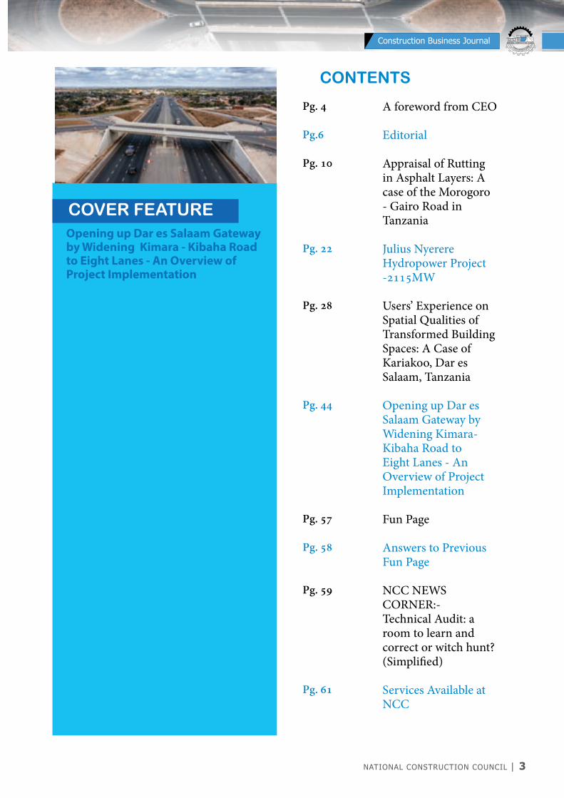
CONTENTS
Opening up Dar es Salaam Gateway by Widening Kimara - Kibaha Road to Eight Lanes - An Overview of Project Implementation
A foreword from CEO
Editorial
Appraisal of Rutting in Asphalt Layers: A case of the Morogoro - Gairo Road in Tanzania
Julius Nyerere Hydropower Project -2115MW
Users’ Experience on Spatial Qualities of Transformed Building Spaces: A Case of Kariakoo, Dar es Salaam, Tanzania
Opening up Dar es Salaam Gateway by Widening Kimara-Kibaha Road to Eight Lanes - An Overview of Project Implementation
Fun Page
Answers to Previous Fun Page
NCC NEWS CORNER:-Technical Audit: a room to learn and correct or witch hunt? (Simplified)
Services Available at NCC
Pg. 4
Pg.6 Pg. 10
Pg. 22
Pg. 28
Pg. 44
Pg. 57
Pg. 58
Pg. 59
Pg. 61
4 | NATIONAL CONSTRUCTION COUNCIL
NATIONAL CONSTRUCTION COUNCIL BARAZA LA TAIFA LA UJENZI
Construction Business Journal
Dear Reader,
Thank you for spending time to read and possibly study the articles in this issue of the Construction Business Journal. The
Journal is aimed at sharing research findings and practice experiences of construction industry stakeholders in Tanzania. In this issue, we have packed for you very informative articles. You will get to learn what has been observed in the research appraising rutting in asphalt layer of the Morogoro to Gairo road segment. Another exiting and informative article is about technical details of works being carried out to realize the prestigious Julius Nyerere Hydro Power Project (JNHPP). Please study this article and get to know the nine (9) crucial components of the project, and what our experts are accomplishing in this strategic project. There is also an article giving the reader, the opportunity to appreciate the analysis of an Architect about how the spatial qualities of building spaces in Kariakoo - Dar es Salaam have evolved. The article will bring you memories of the old Kariakoo buildings and what the professionals have done to bring the spaces you see today.
If you have driven along Ubungo – Kibaha in recent days, then you will appreciate the profession discussions of this road segment. Indeed, the Issue has an article discussing the benefits brought about by widening the segment of Morogoro Road from Ubungo to Kibaha. Have you ever wondered what are the benefits of technical audits in construction projects? Please don’t worry, because there is a digest by the expert on the usefulness on the properly done technical audits in construction project. Just study this article and you will have all your questions answered. The editorial is yet another informative article. It discusses how the mechanistic – Empirical pavement design procedure can be used to achieve cost effectiveness in construction and maintenance of paved roads. With all these articles, I am delighted to wish you a good read and exiting study of the articles in our Journal knowing that we have packed for you good and informative articles. I profoundly thank all the authors and the editorial team for the work done to make the publishing of this Issue possible. Last, we would be delighted to receive more articles from all our stakeholders. This is your Journal, so please feel free to send in your articles for review and publication. We also encourage you to send in your comments about this Journal, just remember, together we can shape this Journal to be the best, thank you.
I wish You a Very Prosperous Year 2022.
Matiko S. Mturi (PhD, PE)Chief Executive Officer
A FOREWORD FROM CEO
NATIONAL CONSTRUCTION COUNCIL | 5
NATIONAL CONSTRUCTION COUNCIL BARAZA LA TAIFA LA UJENZI
Construction Business Journal

6 | NATIONAL CONSTRUCTION COUNCIL
NATIONAL CONSTRUCTION COUNCIL BARAZA LA TAIFA LA UJENZI
Construction Business Journal
MECHANISTIC-EMPIRICAL PAVEMENT DESIGN PROCEDURE FOR COST EFFECTIVE CONSTRUCTION AND REHABILITATION OF PAVED ROADS IN TANZANIA
Construction of paved roads is regarded as expensive due to; high costs associated with road construction
materials which are often used in large quantities, hiring or purchasing of different types of plant and equipment including the cost of huge quantities of fuel they consume and the cost of labour for different professions, trades and skills as well as costs associated with other environmental and social considerations. All these add up to the total cost of paved roads. In unprecedented circumstances, the cost of paved roads could be disappointingly high when defects and distresses in the completed asphalt courses appear within two months to one year of placement. This creates a loss of expected performance of affected roads very early before they attain their design life. In such cases, beside the loss of capital invested during construction, costly repercussions may ensue: such as traffic safety hazard, negative economic impact including other social and even political setbacks. Hence, correct and robust pavement designs, including good quality construction workmanship on the pavement structure is of paramount importance. This is to ensure adequate pavement performance and appropriate financial planning for maintenance during their design
EDITORIAL
Editorial Board
Eng. Dr. Frank E. NgoiyaChairman
Qs. Dorine J. SilayoMember
Evance Nicholas N.Member
Eng. Moses L. LwivaSecretary
Eng. John F. HauleMember
Published by: National Construction CouncilContact: T: +255 222131321 | +255 22 2118887 | E: [email protected] | W: www.ncc.go.tz
Appraisal of Rutting in Asphalt Layers: A case of
the Morogoro - Gairo Road in Tanzania
10
22
28
44
Julius Nyerere Hydropower Project -2115Mw
Users’ Experience on Spatial Qualities of Trans-formed Building Spaces: A Case of Kariakoo, Dar es
Salaam, Tanzania
Opening up Dar es Salaam Gateway by Widening
Kimara - Kibaha Road to Eight Lanes - An Overview of Project Implementation
INSIDE
OPENING UP DAR ES SALAAM GATEWAY BY WIDENING KIMARA - KIBAHA ROAD
TO EIGHT LANES - AN OVERVIEW OF PROJECT IMPLEMENTATION
CONSTRUCTIONBUSINESSVol. 14 | December 2021 | ISSN: 08566232
NATIONAL CONSTRUCTION COUNCIL | 7
NATIONAL CONSTRUCTION COUNCIL BARAZA LA TAIFA LA UJENZI
Construction Business Journal
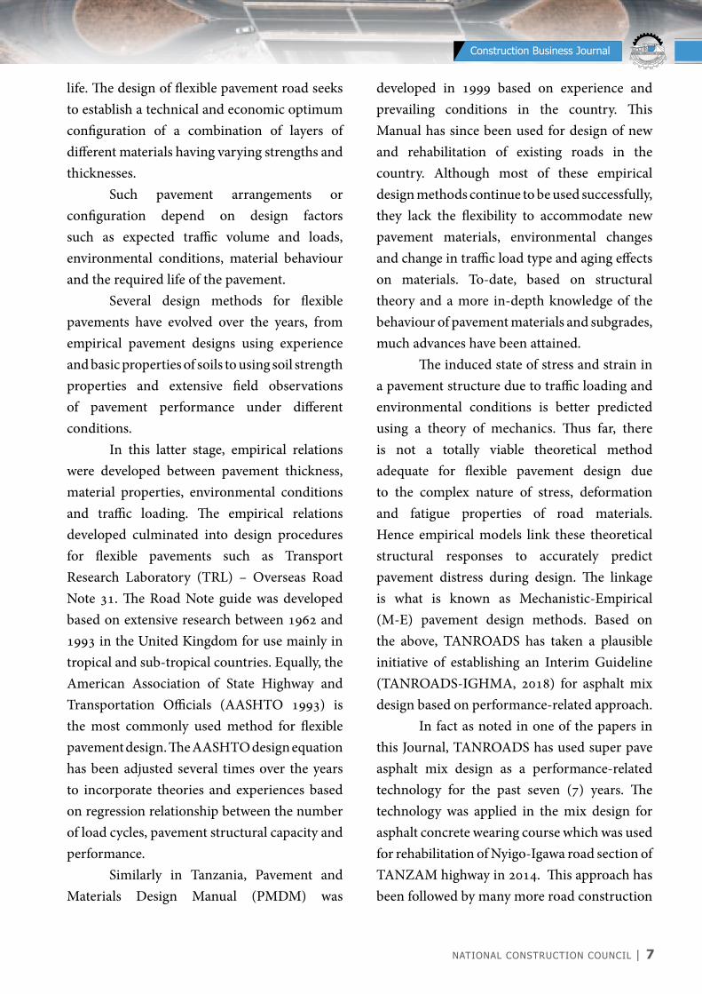
life. The design of flexible pavement road seeks to establish a technical and economic optimum configuration of a combination of layers of different materials having varying strengths and thicknesses. Such pavement arrangements or configuration depend on design factors such as expected traffic volume and loads, environmental conditions, material behaviour and the required life of the pavement. Several design methods for flexible pavements have evolved over the years, from empirical pavement designs using experience and basic properties of soils to using soil strength properties and extensive field observations of pavement performance under different conditions. In this latter stage, empirical relations were developed between pavement thickness, material properties, environmental conditions and traffic loading. The empirical relations developed culminated into design procedures for flexible pavements such as Transport Research Laboratory (TRL) – Overseas Road Note 31. The Road Note guide was developed based on extensive research between 1962 and 1993 in the United Kingdom for use mainly in tropical and sub-tropical countries. Equally, the American Association of State Highway and Transportation Officials (AASHTO 1993) is the most commonly used method for flexible pavement design. The AASHTO design equation has been adjusted several times over the years to incorporate theories and experiences based on regression relationship between the number of load cycles, pavement structural capacity and performance. Similarly in Tanzania, Pavement and Materials Design Manual (PMDM) was
developed in 1999 based on experience and prevailing conditions in the country. This Manual has since been used for design of new and rehabilitation of existing roads in the country. Although most of these empirical design methods continue to be used successfully, they lack the flexibility to accommodate new pavement materials, environmental changes and change in traffic load type and aging effects on materials. To-date, based on structural theory and a more in-depth knowledge of the behaviour of pavement materials and subgrades, much advances have been attained. The induced state of stress and strain in a pavement structure due to traffic loading and environmental conditions is better predicted using a theory of mechanics. Thus far, there is not a totally viable theoretical method adequate for flexible pavement design due to the complex nature of stress, deformation and fatigue properties of road materials. Hence empirical models link these theoretical structural responses to accurately predict pavement distress during design. The linkage is what is known as Mechanistic-Empirical (M-E) pavement design methods. Based on the above, TANROADS has taken a plausible initiative of establishing an Interim Guideline (TANROADS-IGHMA, 2018) for asphalt mix design based on performance-related approach. In fact as noted in one of the papers in this Journal, TANROADS has used super pave asphalt mix design as a performance-related technology for the past seven (7) years. The technology was applied in the mix design for asphalt concrete wearing course which was used for rehabilitation of Nyigo-Igawa road section of TANZAM highway in 2014. This approach has been followed by many more road construction

8 | NATIONAL CONSTRUCTION COUNCIL
NATIONAL CONSTRUCTION COUNCIL BARAZA LA TAIFA LA UJENZI
Construction Business Journal
and rehabilitation projects including recently the project of widening Kimara-Kibaha section of Morogoro road as reported in another paper in this Journal. Hence the importance of recommendation put forward in one of the papers of this Journal by the author from TANROADS, regarding shifting from empirical to Mechanistic-Empirical approach cannot be overstated. The approach will include inter alia, characterisation of local pavement material properties such as resilient modulus, dynamic modulus and rutting parameters as necessary for design of new and rehabilitation projects. This editorial would like to add voice to the recommendation that, shifting from the current PMDM as an empirical pavement design method to Mechanistic-Empirical flexible
pavement design procedure is a commendable action to take. It is important because on one hand, significant developments in pavement technology have taken place since its publication more than 20 years ago. On the other hand, there have been concerns about traffic overloading scenarios including use of super single tyres and increased volume of heavy goods vehicles coupled with adverse climatic conditions on Tanzania roads. Hence, when such design procedure is adopted in tandem with good workmanship in the construction of roads, improved performance of paved roads in Tanzania will be ascertained.
NCC PUBLICATIONS


10 | NATIONAL CONSTRUCTION COUNCIL
NATIONAL CONSTRUCTION COUNCIL BARAZA LA TAIFA LA UJENZI
Construction Business Journal
1.0 INTRODUCTION
Rutting in asphalt layers is a distress mode that is manifested as a permanent deformation of bituminous material along the wheel paths. The low shear resistance and
inadequate compaction of the asphalt concrete layer during construction may have a significant impact on rut formation [1]. Asphalt, being visco-elastic material, is very sensitive to temperature. In this regard, equiviscous mixing
APPRAISAL OF RUTTING IN ASPHALT LAyERS: A CASE OF THE MOROGORO - GAIRO ROAD IN
TANZANIAJohn T Malisa1, Prof David Mfinanga2, Dr Joseph Annochie-Boateng3, Prof James Maina4
1. Senior Pavement Engineer / Central Materials Laboratory (CML) / University of Dar es Salaam (PhD Candidate) / Tanzania National Roads Agency (TANROADS) / Dar es Salaam.
2. Professor / Transportation and Geotechnical Engineering, University of Dar es Salaam, DSM3. Council for Scientific and Industrial Research (CSIR), South Africa.4. University of Pretoria - South Africa.
Abstract: Rutting in flexible pavements occurs as a gradual accumulation of irrecoverable deformation due to repeated traffic loading. In bituminous pavement layers, rutting can be caused by a multitude of factors, including low shear strength and or inadequate compaction in the field. Rutting that exceeds the allowable limit before its design life is of concern as it leads to safety concerns to road users and high maintenance cost. The causes of rutting in asphalt layers have not been adequately established and documented in Tanzania. This paper presents the causes of excessive rutting observed in asphalt layers for the sections of Morogoro-Gairo road, through field and laboratory study. The studied section of the road is in a moderate to dry climatic zone, with maximum 7-day average pavement temperatures of 61 °C. The study recorded severe rutting as deep as 140 mm in this section. Even on some newly rehabilitated sections, the in-situ air voids have decreased to values less than 1%, which are lower than the critical minimum value of 3% suggested in the design standards, implying that the asphalt in the field is unstable. The aggregate grading was as per the specified job mix formula. This paper points out the inappropriate mix design method as the primary cause of the observed rutting, covering inter alia, deficiencies in the material selection and testing. To improve rutting performance, this paper recommends the adoption of a performance-related asphalt mix design approach, shifting from empirical to the mechanistic-empirical for both new and rehabilitation design approach, improvement of construction quality control and investment in local-based research on asphalt and binders to establish appropriate criteria and specifications.
Keywords: Asphalt pavement, Rutting, Performance-related tests, Morogoro-Dodoma road, Falling Weight Deflectometer
NATIONAL CONSTRUCTION COUNCIL | 11
NATIONAL CONSTRUCTION COUNCIL BARAZA LA TAIFA LA UJENZI
Construction Business Journal
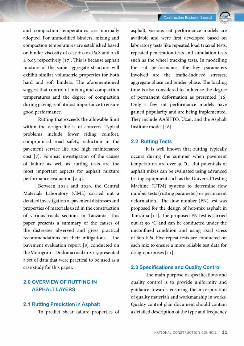
and compaction temperatures are normally adopted. For unmodified binders, mixing and compaction temperatures are established based on binder viscosity of 0.17 ± 0.02 Pa.S and 0.28 ± 0.03 respectively [17]. This is because asphalt mixture of the same aggregate structure will exhibit similar volumetric properties for both hard and soft binders. The aforementioned suggest that control of mixing and compaction temperatures and the degree of compaction during paving is of utmost importance to ensure good performance. Rutting that exceeds the allowable limit within the design life is of concern. Typical problems include lower riding comfort, compromised road safety, reduction in the pavement service life and high maintenance cost [7]. Forensic investigation of the causes of failure as well as rutting tests are the most important aspects for asphalt mixture performance evaluation [2-4]. Between 2014 and 2019, the Central Materials Laboratory (CML) carried out a detailed investigation of pavement distresses and properties of materials used in the construction of various roads sections in Tanzania. This paper presents a summary of the causes of the distresses observed and gives practical recommendations on their mitigations. The pavement evaluation report [8] conducted on the Morogoro – Dodoma road in 2019 presented a set of data that were practical to be used as a case study for this paper.
2.0 OVERVIEW OF RUTTING IN
ASPHALT LAyERS
2.1 Rutting Prediction in Asphalt
To predict shear failure properties of
asphalt, various rut performance models are available and were first developed based on laboratory tests like repeated load triaxial tests, repeated penetration tests and simulation tests such as the wheel tracking tests. In modelling the rut performance, the key parameters involved are the traffic-induced stresses, aggregate phase and binder phase. The loading time is also considered to influence the degree of permanent deformation as presented [16] Only a few rut performance models have gained popularity and are being implemented. They include AASHTO, Uzan, and the Asphalt Institute model [16]
2.2 Rutting Tests
It is well known that rutting typically occurs during the summer when pavement temperatures are over 40 °C. Rut potentials of asphalt mixes can be evaluated using advanced testing equipment such as the Universal Testing Machine (UTM) systems to determine flow number tests (rutting parameter) or permanent deformation. The flow number (FN) test was proposed for the design of hot-mix asphalt in Tanzania [11]. The proposed FN test is carried out at 50 °C and can be conducted under the unconfined condition and using axial stress of 600 kPa. Five repeat tests are conducted on each mix to ensure a more reliable test data for design purposes [11].
2.3 Specifications and Quality Control
The main purpose of specifications and quality control is to provide uniformity and guidance towards ensuring the incorporation of quality materials and workmanship in works. Quality control plan document should contain a detailed description of the type and frequency
12 | NATIONAL CONSTRUCTION COUNCIL
NATIONAL CONSTRUCTION COUNCIL BARAZA LA TAIFA LA UJENZI
Construction Business Journal
of inspection, sampling, and testing deemed necessary to measure and control the various properties required by agency specifications [15].
3.0 STUDy APPROACH
3.1 Description of the Case study
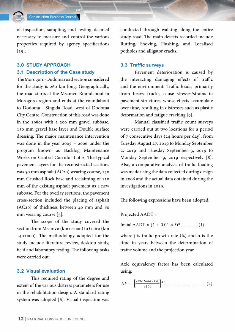
The Morogoro-Dodoma road section considered for the study is 260 km long. Geographically, the road starts at the Msamvu Roundabout in Morogoro region and ends at the roundabout to Dodoma - Singida Road, west of Dodoma City Centre. Construction of this road was done in the 1980s with a 200 mm gravel subbase, 150 mm gravel base layer and Double surface dressing. The major maintenance intervention was done in the year 2005 – 2006 under the program known as Backlog Maintenance Works on Central Corridor Lot 2. The typical pavement layers for the reconstructed sections was 50 mm asphalt (AC20) wearing course, 150 mm Crushed Rock base and reclaiming of 150 mm of the existing asphalt pavement as a new subbase. For the overlay sections, the pavement cross-section included the placing of asphalt (AC20) of thickness between 40 mm and 80 mm wearing course [5]. The scope of the study covered the section from Msamvu (km 0+000) to Gairo (km 140+000). The methodology adopted for the study include literature review, desktop study, field and laboratory testing. The following tasks were carried out:
3.2 Visual evaluation
This required rating of the degree and extent of the various distress parameters for use in the rehabilitation design. A standard rating system was adopted [6]. Visual inspection was
conducted through walking along the entire study road. The main defects recorded include Rutting, Shoving, Flushing, and Localised potholes and alligator cracks.
3.3 Traffic surveys
Pavement deterioration is caused by the interacting damaging effects of traffic and the environment. Traffic loads, primarily from heavy trucks, cause stresses/strains in pavement structures, whose effects accumulate over time, resulting in distresses such as plastic deformation and fatigue cracking [9]. Manual classified traffic count surveys were carried out at two locations for a period of 7 consecutive days (24 hours per day), from Tuesday August 27, 2019 to Monday September 2, 2019 and Tuesday September 3, 2019 to Monday September 9, 2019 respectively [8]. Also, a comparative analysis of traffic loading was made using the data collected during design in 2006 and the actual data obtained during the investigations in 2019.
The following expressions have been adopted:
Projected AADT =
where j is traffic growth rate (%) and n is the time in years between the determination of traffic volume and the projection year.
Axle equivalency factor has been calculated using:

NATIONAL CONSTRUCTION COUNCIL | 13
NATIONAL CONSTRUCTION COUNCIL BARAZA LA TAIFA LA UJENZI
Construction Business Journal
Design traffic loading has been estimated using the following expression:
Where: t1= average daily number of standard axles in the year of traffic surveyr = annual growth rate, andn = calculated period in years
3.4 Falling Weight Deflectometer (FWD)
tests
Falling Weight Deflectometer (FWD) is a non-destructive measurement tool for pavement surface deflections that are used to determine the in-situ structural performance of an existing pavement structure. The use of the FWD is widespread across the pavement design industry and is used to identify areas of weak pavement, back-calculate layer properties for use in overlay designs and estimate the remaining life of the structure. In this study, the FWD tests were conducted at 100 m staggered intervals. To simulate the standard axle load of 80 kN, the FWD tests were carried out using an impact load of 40 kN. The FWD data were processed using FWD Primax 4.0 software.
3.5 Pavement coring through asphalt
layers
Pavement coring was carried out on asphalt layers to extract cores for visual assessment of any notable distress in the layers and laboratory study. A total of 21 individual asphalt cores were used for determining various
properties of the paved mix. It was assumed that cores taken from the shoulders would have been less affected by traffic compaction hence would relatively better reflect the volumetric characteristics of the asphalt. The cores were checked for strength (Indirect Tensile Strength), asphalt mixture volumetric as well as binder content, aggregate grading and properties.
3.6 Rut depth measurements
Rut depth measurements were used to assess the functional condition of the road and also indicating structural integrity. A standard 2-metre straight edge with a calibrated wedge for rut depth measurements was used for rut depth measurement along the road [6].
3.7 Test pit profiling
A total of five test pits were opened along the studied road section at five locations (km 19+600, 33+000, 45+000, 86+350 and 131+850) to characterize the pavement materials for structural assessment, measurement of pavement layer thicknesses as well as giving additional information to supplement other field test results.
3.8 Laboratory study to characterise
the asphalt material The bulk density (Gmb) and the Theoretical Maximum Density (Gmm) values are required to calculate the air voids content (VIM) in the cores. Rice Method [14] was used to determine the Gmm. Calculation of the air voids was based on the following expression:
14 | NATIONAL CONSTRUCTION COUNCIL
NATIONAL CONSTRUCTION COUNCIL BARAZA LA TAIFA LA UJENZI
Construction Business Journal
4.0 ANALySIS OF RESULTS AND
DISCUSSION
4.1 General
This section presents findings from the assessment of the quality of asphalt materials used, the effect of traffic on rutting index and
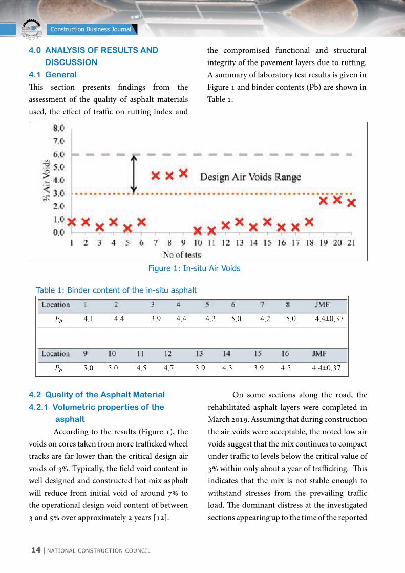
the compromised functional and structural integrity of the pavement layers due to rutting. A summary of laboratory test results is given in Figure 1 and binder contents (Pb) are shown in Table 1.
4.2 Quality of the Asphalt Material
4.2.1 Volumetric properties of the
asphalt
According to the results (Figure 1), the voids on cores taken from more trafficked wheel tracks are far lower than the critical design air voids of 3%. Typically, the field void content in well designed and constructed hot mix asphalt will reduce from initial void of around 7% to the operational design void content of between 3 and 5% over approximately 2 years [12].
On some sections along the road, the rehabilitated asphalt layers were completed in March 2019. Assuming that during construction the air voids were acceptable, the noted low air voids suggest that the mix continues to compact under traffic to levels below the critical value of 3% within only about a year of trafficking. This indicates that the mix is not stable enough to withstand stresses from the prevailing traffic load. The dominant distress at the investigated sections appearing up to the time of the reported
Figure 1: In-situ Air Voids
Table 1: Binder content of the in-situ asphalt
NATIONAL CONSTRUCTION COUNCIL | 15
NATIONAL CONSTRUCTION COUNCIL BARAZA LA TAIFA LA UJENZI
Construction Business Journal
investigation was rutting. If the air void is too low, the mix becomes prone to flushing. Test results from extraction (Table 1) indicate that the binder content is generally as per the Job Mix Formula requirements. Research [13] shows that low binder contents cause fatigue cracking and excessive binder cause bleeding and permanent deformation. This suggests that the method used for binder
selection and determination of optimum binder content may not be appropriate for the given climate and loading.
4.2.2 Recovered Aggregate Grading
and Properties
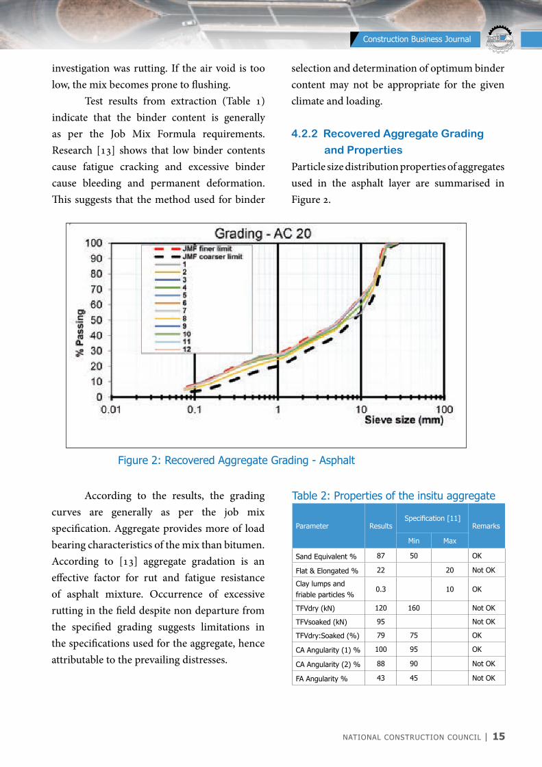
Particle size distribution properties of aggregates used in the asphalt layer are summarised in Figure 2.
Figure 2: Recovered Aggregate Grading - Asphalt
According to the results, the grading curves are generally as per the job mix specification. Aggregate provides more of load bearing characteristics of the mix than bitumen. According to [13] aggregate gradation is an effective factor for rut and fatigue resistance of asphalt mixture. Occurrence of excessive rutting in the field despite non departure from the specified grading suggests limitations in the specifications used for the aggregate, hence attributable to the prevailing distresses.
Table 2: Properties of the insitu aggregate
Parameter ResultsSpecification [11]
Remarks
Min Max
Sand Equivalent % 87 50 OK
Flat & Elongated % 22 20 Not OK
Clay lumps and friable particles %
0.3 10 OK
TFVdry (kN) 120 160 Not OK
TFVsoaked (kN) 95 Not OK
TFVdry:Soaked (%) 79 75 OK
CA Angularity (1) % 100 95 OK
CA Angularity (2) % 88 90 Not OK
FA Angularity % 43 45 Not OK
16 | NATIONAL CONSTRUCTION COUNCIL
NATIONAL CONSTRUCTION COUNCIL BARAZA LA TAIFA LA UJENZI
Construction Business Journal
Table 2 shows that most of the shape properties of the aggregate could not be fulfilled. A more angular and rough textured aggregate particles are preferred in asphalt mixes due to their ability to provide better interlock, internal friction, mechanical stability and hence offer resistance to rutting. It may be noted that shape properties are not part of Marshall mix design
method, and were not evaluated during the mix design.
4.2.3 Indirect Tensile Strength
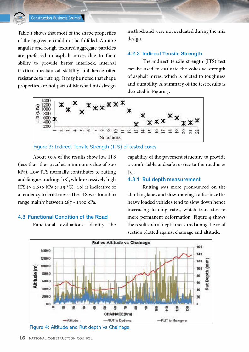
The indirect tensile strength (ITS) test can be used to evaluate the cohesive strength of asphalt mixes, which is related to toughness and durability. A summary of the test results is depicted in Figure 3.
About 50% of the results show low ITS (less than the specified minimum value of 800 kPa). Low ITS normally contributes to rutting and fatigue cracking [18], while excessively high ITS (> 1,650 kPa @ 25 °C) [10] is indicative of a tendency to brittleness. The ITS was found to range mainly between 287 - 1300 kPa.
4.3 Functional Condition of the Road
Functional evaluations identify the
capability of the pavement structure to provide a comfortable and safe service to the road user [3].4.3.1 Rut depth measurement
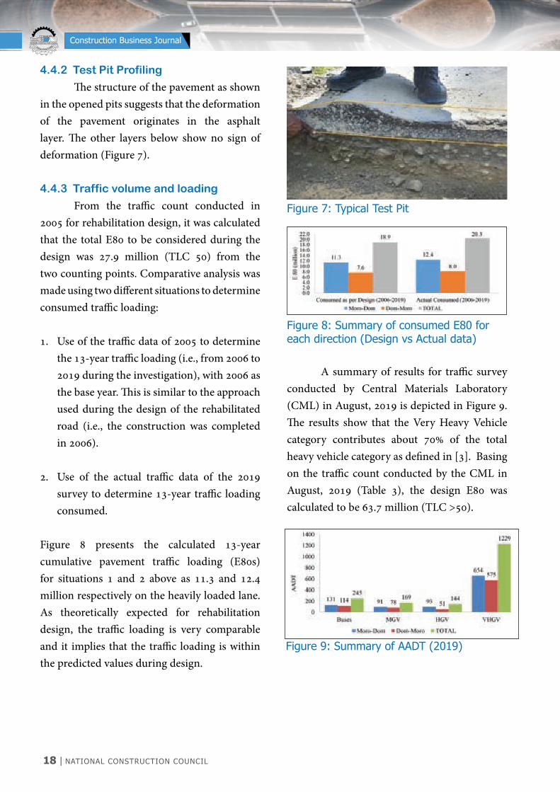
Rutting was more pronounced on the climbing lanes and slow-moving traffic since the heavy loaded vehicles tend to slow down hence increasing loading rates, which translates to more permanent deformation. Figure 4 shows the results of rut depth measured along the road section plotted against chainage and altitude.
Figure 3: Indirect Tensile Strength (ITS) of tested cores
Figure 4: Altitude and Rut depth vs Chainage

NATIONAL CONSTRUCTION COUNCIL | 17
NATIONAL CONSTRUCTION COUNCIL BARAZA LA TAIFA LA UJENZI
Construction Business Journal
The altitude graph (Figure 4) shows that the direction towards Dodoma is generally uphill, with climbing lanes at around km 2+000 to 4+000 and 70+000 to 120+000. Rutting is more pronounced on these sections, with values measuring up to 140 mm towards Dodoma (heaviest lane) and 58 mm towards Morogoro as shown in Figures 4 and 5.
4.3.2 Visual evaluation
The sections that had more pronounced rut had other more distress such as patches, cracks, alligator cracks and potholes. The dominant distress was rutting (Figure 5).
Figure 5: Severe rutting (Direction to Dodoma)
4.4 Structural Integrity of the Road
Structural evaluations are carried out to determine whether the pavement will carry the traffic it has been designed for and can be carried out at any time in the pavement’s life. The remaining structural capacity can be determined and compared with the traffic that the pavement has carried, or is expected to carry over the remainder of its life [6]. The structural integrity of the road pavement was assessed by carrying out Falling Weight Deflectometer (FWD) tests, opening test pits and assessing the traffic loading.
4.4.1 Falling Weight Deflectometer
Tests.
From FWD results, the considered indicators for failure in asphalt considered were residual pavement life and the design traffic class. It is observed that the residual life of the pavement is almost negligible and it would require an overlay up to 300 mm which means that urgent intervention of the pavement is required. According to the results (Figure 6), the road pavement has a negligible residual life, less than a year when compared to the design traffic loading using the current traffic.
Figure 6: (FWD) Road Evaluation Report
18 | NATIONAL CONSTRUCTION COUNCIL
NATIONAL CONSTRUCTION COUNCIL BARAZA LA TAIFA LA UJENZI
Construction Business Journal
4.4.2 Test Pit Profiling
The structure of the pavement as shown in the opened pits suggests that the deformation of the pavement originates in the asphalt layer. The other layers below show no sign of deformation (Figure 7).
4.4.3 Traffic volume and loading
From the traffic count conducted in 2005 for rehabilitation design, it was calculated that the total E80 to be considered during the design was 27.9 million (TLC 50) from the two counting points. Comparative analysis was made using two different situations to determine consumed traffic loading:
1. Use of the traffic data of 2005 to determine the 13-year traffic loading (i.e., from 2006 to 2019 during the investigation), with 2006 as the base year. This is similar to the approach used during the design of the rehabilitated road (i.e., the construction was completed in 2006).
2. Use of the actual traffic data of the 2019 survey to determine 13-year traffic loading consumed.
Figure 8 presents the calculated 13-year cumulative pavement traffic loading (E80s) for situations 1 and 2 above as 11.3 and 12.4 million respectively on the heavily loaded lane. As theoretically expected for rehabilitation design, the traffic loading is very comparable and it implies that the traffic loading is within the predicted values during design.
Figure 8: Summary of consumed E80 for each direction (Design vs Actual data)
Figure 9: Summary of AADT (2019)
Figure 7: Typical Test Pit
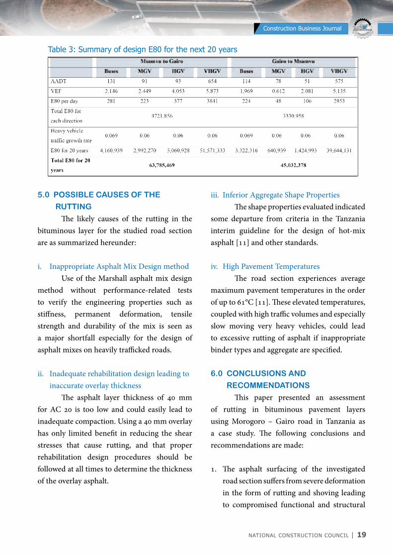
A summary of results for traffic survey conducted by Central Materials Laboratory (CML) in August, 2019 is depicted in Figure 9. The results show that the Very Heavy Vehicle category contributes about 70% of the total heavy vehicle category as defined in [3]. Basing on the traffic count conducted by the CML in August, 2019 (Table 3), the design E80 was calculated to be 63.7 million (TLC >50).
NATIONAL CONSTRUCTION COUNCIL | 19
NATIONAL CONSTRUCTION COUNCIL BARAZA LA TAIFA LA UJENZI
Construction Business Journal
5.0 POSSIBLE CAUSES OF THE
RUTTING
The likely causes of the rutting in the bituminous layer for the studied road section are as summarized hereunder:
i. Inappropriate Asphalt Mix Design method Use of the Marshall asphalt mix design method without performance-related tests to verify the engineering properties such as stiffness, permanent deformation, tensile strength and durability of the mix is seen as a major shortfall especially for the design of asphalt mixes on heavily trafficked roads.
ii. Inadequate rehabilitation design leading to inaccurate overlay thickness
The asphalt layer thickness of 40 mm for AC 20 is too low and could easily lead to inadequate compaction. Using a 40 mm overlay has only limited benefit in reducing the shear stresses that cause rutting, and that proper rehabilitation design procedures should be followed at all times to determine the thickness of the overlay asphalt.
Table 3: Summary of design E80 for the next 20 years
iii. Inferior Aggregate Shape Properties The shape properties evaluated indicated some departure from criteria in the Tanzania interim guideline for the design of hot-mix asphalt [11] and other standards.
iv. High Pavement Temperatures The road section experiences average maximum pavement temperatures in the order of up to 61°C [11]. These elevated temperatures, coupled with high traffic volumes and especially slow moving very heavy vehicles, could lead to excessive rutting of asphalt if inappropriate binder types and aggregate are specified.
6.0 CONCLUSIONS AND
RECOMMENDATIONS
This paper presented an assessment of rutting in bituminous pavement layers using Morogoro – Gairo road in Tanzania as a case study. The following conclusions and recommendations are made:
1. The asphalt surfacing of the investigated road section suffers from severe deformation in the form of rutting and shoving leading to compromised functional and structural

20 | NATIONAL CONSTRUCTION COUNCIL
NATIONAL CONSTRUCTION COUNCIL BARAZA LA TAIFA LA UJENZI
Construction Business Journal
integrities of the road.2. The rutting originated in the asphalt
concrete layer rather than pavement layers below it.
3. The Marshall asphalt mix design method adopted is not appropriate for the project road.
4. The design traffic loading predicted during the design is comparable to the actual traffic loading obtained during the reported investigations suggesting that the traffic study was carried out properly.
5. The overall structural integrity of the pavement has been grossly reduced.
6. To improve the rutting performance of asphalt layers, the following recommendations are made:i. Adopt a performance-related asphalt
mix design approach. Materials selection (aggregate and binder) should be based on performance-related tests.
ii. Shift from empirical to mechanistic-empirical rehabilitation design approaches to come up with more appropriate pavement structures for a given road. This would require development and /or customising a pavement design software for the country.
iii. Improve the construction practices and the major issue is construction quality and acceptance.
iv. Invest in research on asphalt and bituminous binders and come up with local based specifications.
ACKNOWLEDGEMENTS
The authors would like to acknowledge the Tanzania National Roads Agency (TANROADS) for funding this study. The authors also extend appreciation to the technical staff at CML for assisting in the testing of material samples from the case study road.
REFERENCES
[1] Safwat Fadhil Said, Abubeker Worake Ahmed and Håkan Carlsson. “Evaluation of rutting of asphalt concrete pavement under field-like conditions” Pavement Engineering, 2016.[2] J. Ahmad, M. Y. Abdul Rahman and M. R. Hainin, Rutting Evaluation of Dense Graded Hot Mix Asphalt Mixture, Institute of Infrastructure Engineering and Sustainable Management, Faculty of Civil Engineering, University Teknologi MARA, Shah Alam, Malaysia.[3] Ministry of Works (MOW). 1999. Pavement and Materials Design Manual. DSM, Tanzania.[4] O. Sirin, H-J. Kim, M. Tia, and B. Choubane, “Comparison of rutting resistance of unmodified and SBS-modified Superpave mixtures by accelerated pavement testing,” Construction and Building Materials, vol. 22, no. 3, pp. 286–294, 2008.[5] Carlo Fabricius, “Backlog Maintenance Works on Central Corridor, Lot 2: Morogoro – Dodoma road,” Evaluation report Asphalt Concrete Quality, project No.8.ACP.TA.22, 2006.[6] Ministry of Works MoW (2003). Field Testing Manual[7] Chance Liley, “Rutting: Causes, prevention, and repairs”, Illinois Asphalt Pavement Association, February, 2018
NATIONAL CONSTRUCTION COUNCIL | 21
NATIONAL CONSTRUCTION COUNCIL BARAZA LA TAIFA LA UJENZI
Construction Business Journal
[8] Ministry of Works (MOW), “Pavement evaluation along Morogoro – Dodoma road”, CML, August, 2019.[9] A. T. Papagiannakis and E. A. Masad, “Pavement Design and Materials”[10] Sabita Manual 35: Design and Use of Asphalt in Road Pavements[11] Ministry of Works (MoW) (TZ), 2018: Interim guideline for the design of hot-mix asphalt [12] Verhaeghe, B.M.J.A., Myburgh, P.A., and Denneman, E (2007). 9th Conference on Asphalt Pavements for Southern Africa, Strategic Highway Research Program. Gaberone, Botswana.
[13] TRB, 2004 and Taher et al., 2011[14] Ministry of Works (MOW). 2000. Laboratory Testing Manual[15] AASHTO R 10-06, “Standard practice for definition of terms related to quality and statistics as used in highway construction”[16] Jelagin D, Ahmed A, Lu Xiaohu, Said S (2018). Asphalt layer rutting performance prediction tools. Swedish National Road and Transport Research Institute.[17] Asphalt Institute (2014). MS-2 Asphalt Mix Design Methods[18] Interim Guidelines for The Design of Hot-Mix Asphalt in South Africa.
22 | NATIONAL CONSTRUCTION COUNCIL
NATIONAL CONSTRUCTION COUNCIL BARAZA LA TAIFA LA UJENZI
Construction Business Journal
ABBREVIATIONS;
TANESCO Tanzania Electric Supply CompanyRCC Roller Compacted ConcreteDT Diversion TunnelMW MegawattsHPP Hydropower Projectm.a.s.l mean above sea levelPMF Probable Maximum FloodCSI Computer and Structural Inc.EU European EL ElevationRMR Rock Mass Rating
JULIUS NyERERE HyDROPOWER PROJECT -2115MWEng. Mwanji Y.Mhaka1 and Eng. Said Kimbanga2
1. Investment department, TANESCO LTD, DODOMA. ([email protected]) 2.Investment department, TANESCO LTD, DODOMA. ([email protected])Abstract:
This detailed technical article is submitted for essence of public awareness for ongoing construction of Julius Nyerere Hydropower Project in Rufiji river along the Stigler’s gorge. It describes some aspects of major Engineering works with which in combination result into hydropower plant. The Article has nine (9) Main project components. These include Main Dam, Power House, Water Intake, Power Water Ways, Diversion Tunnel, Saddle Dams, Permanent Bridge, Permanent Roads and Employer Operation Village.Keywords: Roller Compacted Concrete, Reservoir, Project, Waterways, Diversion Tunnel
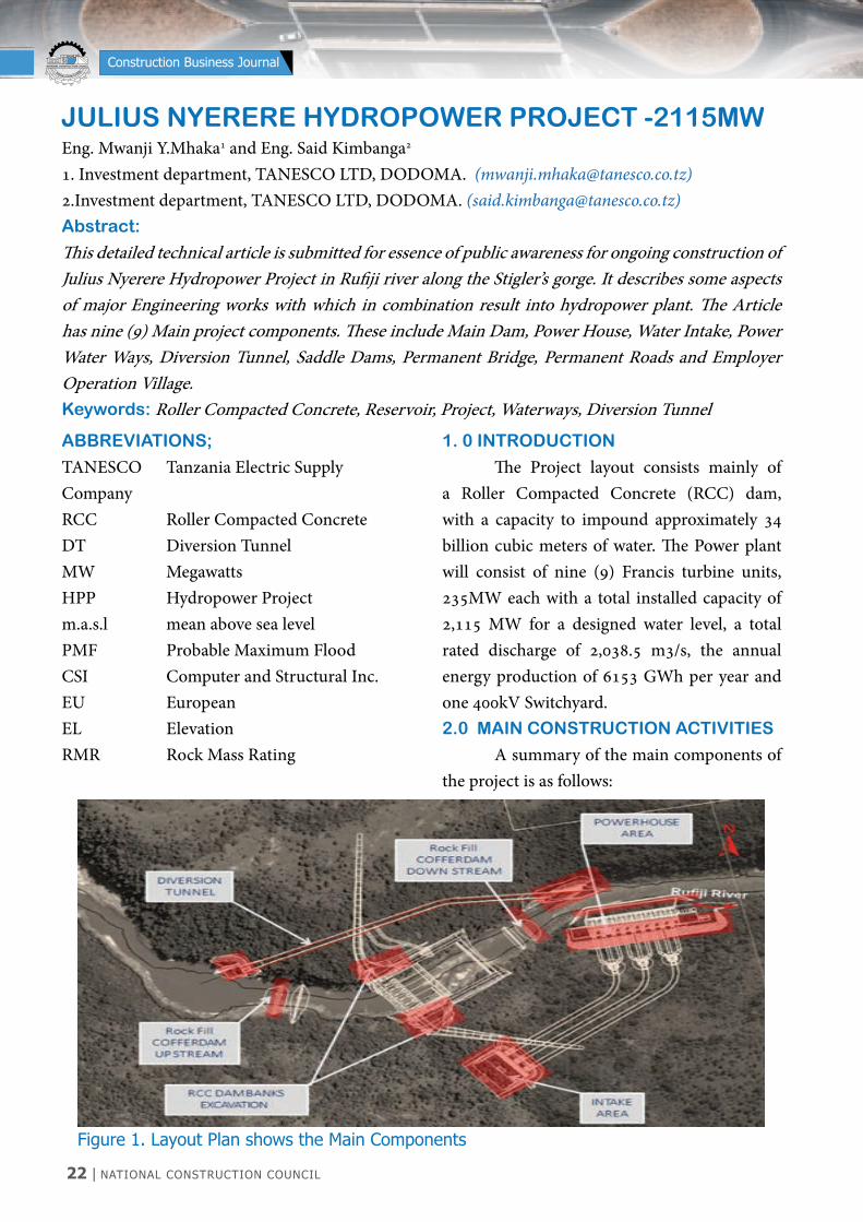
Figure 1. Layout Plan shows the Main Components
1. 0 INTRODUCTION
The Project layout consists mainly of a Roller Compacted Concrete (RCC) dam, with a capacity to impound approximately 34 billion cubic meters of water. The Power plant will consist of nine (9) Francis turbine units, 235MW each with a total installed capacity of 2,115 MW for a designed water level, a total rated discharge of 2,038.5 m3/s, the annual energy production of 6153 GWh per year and one 400kV Switchyard.2.0 MAIN CONSTRUCTION ACTIVITIES
A summary of the main components of the project is as follows:

NATIONAL CONSTRUCTION COUNCIL | 23
NATIONAL CONSTRUCTION COUNCIL BARAZA LA TAIFA LA UJENZI
Construction Business Journal
i. Main Dam
The hydraulic structures of the Project principally include a roller compacted concrete gravity dam (131 m height), 4 saddle dams on the right bank (an emergency spillway on saddle dam 1), a power waterways and a surface powerhouse on the right bank, and a diversion tunnel at the left bank. The RCC gravity dam has a crest elevation of 190.00 m.a.s.l.; a wave wall has a crest elevation of 191.20 m.a.s.l., a dam foundation elevation of 59.00 m.a.s.l., and the maximum dam height of 131 m. The Reservoir normal operating level is 184 m.a.s.l. The crest width is 10m and the crest length of 1025m. The flood release structure consists of a crest spillway (141 m long), two medium outlets (with 8 m diameter at elevation 110), and auxiliary over flow spillway at saddle dam 1. The crest spillway is used to release the regular flood with a sill elevation of 165.3 m.a.s.l. The auxiliary overflow spillway with a pier top elevation of 186.0 m.a.s.l. and the length is 1432 m is used to release the 10,000-year occurrence period flood.
ii. Power Water Ways
Three Power-tunnels are on the right bank, each tunnel for three units (nine units in total). The average length is 675 m and 11 m diameter, and the unit available discharge is 235 m3/s. The intake elevation is 136.00 m.a.s.l. and 112 m width.
iii. Power house
The surface Powerhouse is located on the right bank with a total installed capacity of 2115 MW ((9 × 235 MW vertical Francis turbine generator units).
The scheme consists of nine Francis turbine units with total installed capacity of 2115 MW. The Powerhouse is of surface type with one block for erection bay, one block for installation of 9 units and one block for control and administration building. The Main dimensions of the Power House building are as follows; Maximum width of powerhouse building in machine hall including transformer deck = 60.96 m Clear width of main inlet valve gallery = 9.15 m, Overall length of Powerhouse building = 307.0 m, Height of Powerhouse from level 42.7m to 95.3m = 52.60m, Height above ground level 30 m
iv. Saddle dams
Four saddle dams on the long ridge to the south of the main dam where the existing ground level is lower than crest elevation. “Emergency (Auxiliary) Spillway” on the Saddle Dam 1, as the complementary flood discharge measure during PMF flood.
v. Permanent Road Access
The main approach road starts from 800 meters north of the existing airport, and go north to south. It crosses the Rufiji River through a bridge and ends at the right bank of the river to the right shoulder of the power station. The road is 5.44km long and 10m wide. Also there are other permanent roads which are connecting various permanent works, these include road P2(1.43km0, P3(0.56km), P4(2.61km), P5(1.41km) and T26(13.41km).
vi. Permanent bridge
The structure is a three-span continuous bridge with total span of 250 meters along the
24 | NATIONAL CONSTRUCTION COUNCIL
NATIONAL CONSTRUCTION COUNCIL BARAZA LA TAIFA LA UJENZI
Construction Business Journal
PGL. The mid span length is 120 meters and the other two spans are 65 meters each. The bridge surface width is 11 meters with 8 meters’ carriage-way and two side foot-ways of 1.5 meters each. The superstructure is continuous pre-stressed box girder resting monolithically on two hollow pier towers and supported on bearings above two closed abutments. The substructure foundations shall be deep foundations with casted in situ bored piles. To reduce the vulnerability of the bridge to damage from scour and hydraulic loads, considering the following points:
a. Limiting the number of piers in the channel and piers alignment with the direction of flood flows.
b. Estimating the long-term profile degradation over the service life of the bridge.
c. Estimating the combination of existing or likely future conditions and flood events that might be expected to result in the deepest scour for design conditions.
Analysis of concrete segmental bridges requires consideration of variation of design parameters with time as well as the construction schedule and method of erection. This, in turn, requires the use of a finite element model by CSI Bridge developed to trace the time- dependent response of segmentally erected. Pre-stressed concrete bridges through construction and under service loads. Elastic analysis and beam theory may be used to determine design moments, shears, and deflections. The effects of creep, shrinkage, and temperature differentials shall be considered as
well as the effects of shear lag. Results of elastic analyses should be evaluated with consideration of possible variations in the modulus of elasticity of the concrete, variations in the concrete creep and shrinkage properties, and the impact of variations in the construction schedule on these and other design parameters.
vii. Employer Permanent Village
The permanent camp and temporary camp will be located at the left bank near the dam for the hydropower station, where comprehensive services, including office, accommodation, recreation, entertainment and fitness services, will be provided for the hydropower station operation and management personnel.
a) Planned layout
The building is arranged to be ensure that most buildings have good lighting and landscape views. The planning of the camp is divided into three areas. The names of camps to the north and south are outdoor sports areas, office and living service areas, and accommodation areas.The outdoor sports area is located on the northern side of the project. The main plan is an outdoor parking area, a football field, a tennis courts, a basketball and netball courts and a swimming pool. The office and living service area is divided into three parts, which are composed of office center, Reception and operation building, Facilities building. The office and living service area is the core area of the camp. It uses a central axis symmetrical layout. In addition, it combines outdoor spaces such as entrance plazas and water landscapes

NATIONAL CONSTRUCTION COUNCIL | 25
NATIONAL CONSTRUCTION COUNCIL BARAZA LA TAIFA LA UJENZI
Construction Business Journal
on the central axis. This approach creates an atmosphere of architectural stability. Houses are divided into four areas. From the south to the north, they are type IV house (Multiple living accommodation), type III house, type II house and type I house. On the south side of the type IV house is a clinic. Land boundary will be set a well-fenced compound (masonry wall 1 m high+ wire mesh+ 3 rows of barbed wire and watching towers), Provide employers with a safe and comfortable office and living space. The employer’s permanent camp was built in reference to Tanzania Standard Specifications for Road Works 2000, Section 1400.There is nothing involved in this specification, we design it in conjunction with the relevant EU specifications.
b) Traffic organization
The internal traffic uses a circular road layout. The purpose of this approach is to facilitate the rapid arrival of vehicles and personnel in various areas of the camp. The main road is located around the office area and the general staff quarters. The width of the road is 6m and the turning radius of the road is 6m. The camp has two exits and entrances. The main entrance is located on the east side of the central part of the site, leading to the office and living area. The secondary entrance is located on the south and north side of the site and leads to the dormitory and sportive area. The external road is a new road on the east side of the land, with a road width of 10m. The road connects the employer’s permanent camp to the dam area of the hydropower station.All internal roads will be paved by surface dressing asphalt thick MIN thickness 3cm
viii. Diversion Tunnel
The Diversion Tunnel is located on the left bank of the Rufiji River being at Temporary Access Road T6 (El.: 78.80 m), Chainage: 2+960.0 m with a Total Length of 703.76 m. In order to make possible the construction of the Diversion Tunnel, it will be built cofferdams upstream and downstream of the structure, whose construction details are presented in specific documents for this purpose. The tunnel control structure is positioned upstream of the tunnel inlet portal with Invert Level: 68.50 m. In middle part of the Diversion Tunnel will be excavated an Additional Tunnel (of size: 8.0 m*7.0 m) with a 147.67 m length & Portal Elevation EL.: 83 m that intersection the DT at CH.: 0+330.6 m to expedite the rate of Tunnel Excavation Progress by increasing the two excavation faces. The Adit Tunnel underground excavation volume is nearly 8638 m3. The Diversion Tunnel Outlet with Invert Level: El.: 65.0 m. The diversion tunnel is composed of inlet Gradient Section + Body Section + Plugging Section. The size of the Diversion Tunnel after RCC CY20 Concrete Mix Design Lining is 12m * 17m (W*H. The underground excavation volume of DT is approximately 189,447 m3. The inlet slope of the diversion tunnel is excavated at a height of 65.5 m with the bottom elevation EL64.5m and the top elevation EL132.0m. The open excavation height of diversion tunnel outlet is 75.8m with the bottom elevation EL 64.2 m and the top elevation EL 140 m. The total open excavation volume of DT Inlet is approximately 81,959m3, and the total excavation volume of DT Outlet is approximately 175,104m3.
26 | NATIONAL CONSTRUCTION COUNCIL
NATIONAL CONSTRUCTION COUNCIL BARAZA LA TAIFA LA UJENZI
Construction Business Journal
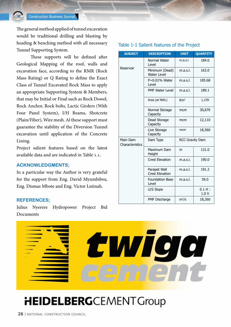
The general method applied of tunnel excavation would be traditional drilling and blasting by heading & benching method with all necessary Tunnel Supporting System. These supports will be defined after Geological Mapping of the roof, walls and excavation face, according to the RMR (Rock Mass Rating) or Q Rating to define the Exact Class of Tunnel Excavated Rock Mass to apply an appropriate Supporting System & Members, that may be Initial or Final such as Rock Dowel, Rock Anchor, Rock bolts, Lactic Girders (With Four Panel System), I/H Beams, Shotcrete (Plain/Fiber), Wire mesh. Al these support must guarantee the stability of the Diversion Tunnel excavation until application of the Concrete Lining. Project salient features based on the latest available data and are indicated in Table 1.1.
SUBJECT DESCRIPTION UNIT QUANTITY
Reservoir
Normal Water Level
m.a.s.l. 184.0
Minimum (Dead) Water Level
m.a.s.l. 163.0
P=0.01% Water Level
m.a.s.l. 185.68
PMF Water Level m.a.s.l. 189.1
Area (at NWL) Km2 1,159
Normal Storage Capacity
mcm 30,670
Dead Storage Capacity
mcm 12,110
Live Storage Capacity
mcm 18,560
Main Dam Characteristics
Dam Type RCC Gravity Dam
Maximum Dam Height
m 131.0
Crest Elevation m.a.s.l. 190.0
Parapet Wall Crest Elevation
m.a.s.l. 191.2
Foundation Base Level
m.a.s.l. 59.0
U/S Slope 0.1 H : 1.0 V
PMF Discharge m3/s 18,260
Table 1-1 Salient features of the Project
ACKNOWLEDGMENTS;
In a particular way the Author is very grateful for the support from Eng. David Myumbilwa, Eng. Dismas Mbote and Eng. Victor Lutinah.
REFERENCES;
Julius Nyerere Hydropower Project Bid Documents


28 | NATIONAL CONSTRUCTION COUNCIL
NATIONAL CONSTRUCTION COUNCIL BARAZA LA TAIFA LA UJENZI
Construction Business Journal
1.0 INTRODUCTION
Kariakoo area is one of the urban settlements that have a long history of undergoing morphological, physical, social and environmental transformation covering several eras including pre.colonial, colonial, post-independence and the current times. Each of the changes in the above eras have contributed to what the area is as of today. Transformation
of urban settlements have thus brought changes in the quality of urban spaces which have either positively or negatively affected the built environment in various aspects. Alcock et al. (1985) were of the opinion that such transformation radically changes the image of an area, which in turn reacts to users visually, physically, psychologically, environmentally and emotionally.
USERS’ EXPERIENCE ON SPATIAL QUALITIES OF TRANSFORMED BUILDING SPACES:
A CASE OF KARIAKOO, DAR ES SALAAM, TANZANIA
Ombeni AndrewSenior Lecturer, Ardhi University, School of Architecture Construction Economics and ManagementTel. +255 764 400 491 | E-mail: [email protected]
Abstract
Transformation of urban spaces in developing countries is taking place at unprecedented rate and this calls for the need to investigate users’ experience in the newly created spaces. A study was conducted in the downtown area of Kariakoo, in Dar es Salaam, to investigate the quality of the transformed building spaces (basement and elevated spaces) according to users’ experience. In this accord, attributes of spatial quality, light intensity, noise level, escape routes and water were investigated by tapping on users’ experience and through parametric measurements. Quantitative and qualitative methods were applied in this study where about 40 buildings with basement and elevated commercial spaces were intensively studied. This was followed by questionnaires where 100 users were requested to recite their experience regarding spatial quality of the basement and elevated commercial spaces. It was found out that most of the basement spaces which are in use lack proper qualities of accessibility, daylight, air circulation, water services and conducive access routes for the users (owners and customers) as well as fire services. Based on the findings, the study acknowledges the importance of transforming basement and elevated spaces as they contribute to the growth of the informal sector and the national economy at large; however, such transformation should be guided by city professionals to ensure that important aspects of day lighting, air circulation, ventilation, clear access and escape routes are within the ergonomic scale and human comfort.
Key words: Space, noise level, light intensity, basement, elevated spaces

NATIONAL CONSTRUCTION COUNCIL | 29
NATIONAL CONSTRUCTION COUNCIL BARAZA LA TAIFA LA UJENZI
Construction Business Journal
Urban spatial qualities have been linked to air quality measurements such as concentrations of Sulfur Oxide (SOx) and Nitrogen Oxide (NOx) emissions, carbon monoxide levels, and low-level ozone exposure, plus other measures such as urban traffic density and noise levels (Adams, 2013). Quality is defined by various scholars where it is mainly linked and applied to the urban environment (Kamp, Leidelmeijer, Marsman & de Hollander, 2003). Other scholars (Lansing and Marans, 1969) have linked quality urban environment with conveyance of a sense of wellbeing and satisfaction to its population through characteristics that may be physical, social or symbolic; whereas, Porteous (1971) defined environmental quality as “a complex issue involving subjective perceptions, attitudes and values which vary among groups and individuals. A study by Pacione (2003) asserts that “in contrast to the objective definition of urban environmental quality, urban livability is a relative rather than an absolute term whose precise meaning depends on the place, time and purpose of the assessment, and on the value system of the assessor” (see also Pacione 1990, 1993). His contention is that quality is not an attribute inherent in the environment but is a behaviour-related function of the interaction of environmental characteristics and human characteristics. Spatial quality is the perception of quality of physical space. People perceive space through the relationships between physical elements such as walls, ceilings, doors, windows, and columns, and the void created by these elements (Von Meiss, 1997). The quality of the space is directly related to the quality of the relationships between these elements,
such as the size of windows and dimensions of the room, and ceiling heights (Von Meiss 1997). This is unlike the situation in Kariakoo basement commercial spaces where the quality of space is questionable since no one is aware of the proportion between the dimensions and number of commercial compartments to the number of users and customers on a daily basis. Authors who study spatial quality can be grouped into several categories. There are those who think that spatial quality should be linked with issues such as views and spatial transitions between public and private spaces as determinants of quality of spaces. This group focuses on sense and scale, liveliness, and safety. The second group links the determinants of spatial quality with how people perceive space, where they consider things like coherence of space, complexity of space, mystery of space etc. The third group studies the quality of space in terms of its physical characteristics which they think influence spatial perception. The last group of authors studies the quality of space in terms of specific topics such as daylight and privacy in dwellings.
2.0 LITERATURE REVIEW
Literature concerning spatial quality is wide and it differs from one author to another; however, relative to the case of Kariakoo, there are parameters which are taken as part of research variables which include the quality of light in the basements, physical accessibility, air quality, noise, safety against fire and floods, relationship between public space and entrance to basement and elevated corridors. The main objective of the study was to investigate the perception of spatial quality as experienced by the users in the two newly developed spaces,
30 | NATIONAL CONSTRUCTION COUNCIL
NATIONAL CONSTRUCTION COUNCIL BARAZA LA TAIFA LA UJENZI
Construction Business Journal
i.e. basement commercial spaces and elevated commercial corridors. Uytenhaak (2008) highlights the relevance and potential of spatial quality in urban environments where he considers spatial quality as an instrument for improving urban environments on building and neighbourhood scales. The main spatial quality related issues are privacy, transition between public and private domains, articulation between the micro scale of architectonic details (such as facade composition) and the macro scale of the neighbourhood, building heights and density, views and daylight (ibid). Transformation in Kariakoo has shown the demise of privacy spaces (court yards), alteration of transition spaces between public and private, as well as entire changes of street elevations and introduction of basement and elevated commercial spaces. Valid questions that need to be asked are: What is the quality of these spaces in the users’ perception? How do people experience these new spaces visually, spatially, functionally, etc? What is the implication of the changes in the long run if they lack the qualities described in literature? For example, a study by Swai and Deguchi (2009a) showed previous spatial transition between streets and the former Swahili buildings as an important feature in Kariakoo. In the current situation, most of these single storey Swahili buildings have been transformed into multi-storey structures, some of them with basement and elevated commercial balconies. There is a completely different visual street scape varying from building to building as well as from street to street. There is a research gap between existing literature and the current study in the fact that, of all the authors mentioned above, none has
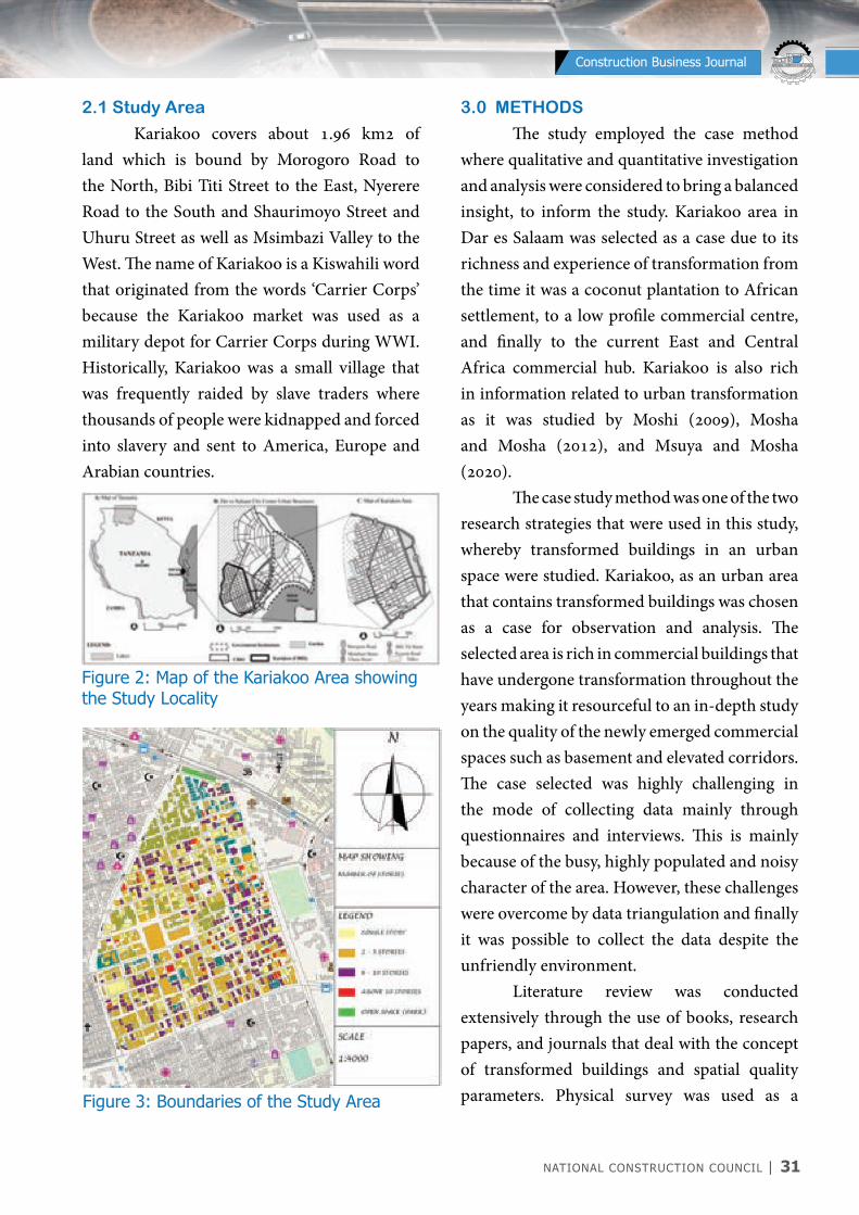
looked into micro spaces in buildings such as entrances to basements, escape routes, interior commercial spaces in the basements, noises and air quality within the basement space.Moreover, most of the literature does not focus on understanding the users’ perception and experience in relation to spatial quality. The current study sought to fill this gap and raise awareness to users, developers and designers so that they could address the spatial quality in the transformed spaces in order to meet owners and users’ expectations. Literature has shown that discourse on spatial transformation is expressed and experienced in terms of several parameters which include environmental qualities (air, light, noise, smell); physical qualities (entrances, walkways, finishes, stairways, escape routes); visual qualities (proportions, materials, harmony, pattern order, balance, symmetry) and functional qualities (interaction, relationship, operations, convenience). In line with findings from literature, discourse on spatial qualities is expressed in terms of physical, visual, functional and environmental parameters. Literature goes further to show that these parameters affect each other in one way or another, making a complex web as illustrated in Figure 1.
Figure 1: Schematic Interaction between Spatial Transformation and Spatial Quality
NATIONAL CONSTRUCTION COUNCIL | 31
NATIONAL CONSTRUCTION COUNCIL BARAZA LA TAIFA LA UJENZI
Construction Business Journal
2.1 Study Area
Kariakoo covers about 1.96 km2 of land which is bound by Morogoro Road to the North, Bibi Titi Street to the East, Nyerere Road to the South and Shaurimoyo Street and Uhuru Street as well as Msimbazi Valley to the West. The name of Kariakoo is a Kiswahili word that originated from the words ‘Carrier Corps’ because the Kariakoo market was used as a military depot for Carrier Corps during WWI. Historically, Kariakoo was a small village that was frequently raided by slave traders where thousands of people were kidnapped and forced into slavery and sent to America, Europe and Arabian countries.
Figure 2: Map of the Kariakoo Area showing the Study Locality
Figure 3: Boundaries of the Study Area
3.0 METHODS
The study employed the case method where qualitative and quantitative investigation and analysis were considered to bring a balanced insight, to inform the study. Kariakoo area in Dar es Salaam was selected as a case due to its richness and experience of transformation from the time it was a coconut plantation to African settlement, to a low profile commercial centre, and finally to the current East and Central Africa commercial hub. Kariakoo is also rich in information related to urban transformation as it was studied by Moshi (2009), Mosha and Mosha (2012), and Msuya and Mosha (2020). The case study method was one of the two research strategies that were used in this study, whereby transformed buildings in an urban space were studied. Kariakoo, as an urban area that contains transformed buildings was chosen as a case for observation and analysis. The selected area is rich in commercial buildings that have undergone transformation throughout the years making it resourceful to an in-depth study on the quality of the newly emerged commercial spaces such as basement and elevated corridors. The case selected was highly challenging in the mode of collecting data mainly through questionnaires and interviews. This is mainly because of the busy, highly populated and noisy character of the area. However, these challenges were overcome by data triangulation and finally it was possible to collect the data despite the unfriendly environment. Literature review was conducted extensively through the use of books, research papers, and journals that deal with the concept of transformed buildings and spatial quality parameters. Physical survey was used as a

32 | NATIONAL CONSTRUCTION COUNCIL
NATIONAL CONSTRUCTION COUNCIL BARAZA LA TAIFA LA UJENZI
Construction Business Journal
of the buildings include basement spaces while others do not have such basement spaces. Based on the nature of the settlement in Kariakoo (narrow roads, poor drainage, lack of open spaces, small plots about 300 m2), construction of multi-storey structures have made the place more compact thus seriously affecting circulation of air and manoeuvring spaces even to enter the basement spaces. Some developers have combined two plots to get much bigger basement space (560 m2). The study area has various building types in terms of use. These include commercial residential buildings (410), buildings which are used only for commercial activities (170), buildings that are used for commercial and institutional activities (18), buildings that are used for residential purposes only (43), and buildings that are used only for institutional activities (12). All of these total to 653 buildings within the study area. Out of these buildings, 51 have elevated commercial spaces whereas 47 buildings have a basement, and 12 have both basement and elevated spaces. 4.1.1 Basement Spaces
The city’s Municipality gave a directive that due to shortage of parking spaces, developers in the Kariakoo area are required to include underground parking spaces in their development plans. To the contrary, developers converted these underground parking spaces into commercial spaces which are currently used for shopping and storage. This has become a new trend by which developers have taken advantage of the loose regulations on supervision of the approved plans. Due to this laxity, development plans which had originally been approved by the Municipality with parking spaces were later
strategy by which information was gathered in the field after visiting the site, familiarising with the whole area, identifying the buildings with basements and elevated commercial corridors, and then collecting the required data from each chosen building. Data was collected via mapping, observation, questionnaires, interviews, photographing and measurements. Interviews and questionnaires were used to obtain first hand information regarding the conditions and experience from the daily users of the buildings in the area, who were mainly businessmen and customers. Observation as a tool for data collection was vital in triangulation of information from the information obtained from the people to the actualities. Mapping, measuring and photographing were used to capture and report the precise condition of the area. Measurement tools (e.g. Laser Distance Meter) were used to get the exact characteristics of a certain physical quantity; for example, the dimensions of the rentable spaces and circulation spaces were taken by a laser meter while noise levels and light intensity levels were measured by special Smartphone applications. This was done to understand the quality of the spaces in relation to the type of activities taking place versus the number of people using the spaces, amount of light, and noise levels.
4.0 RESULTS AND DISCUSSION
4.1 Nature and Use of Buildings in the
Study Area
Originally, Kariakoo had single-storey Swahili buildings most of which have been transformed into multi-storey structures ranging from two to 12 storey buildings. Some

NATIONAL CONSTRUCTION COUNCIL | 33
NATIONAL CONSTRUCTION COUNCIL BARAZA LA TAIFA LA UJENZI
Construction Business Journal
Figure 4: Entrances to Underground Commercial Spaces
Figure 5: Entrances to Elevated Commercial Spaces Commercial Spaces
converted into underground spaces for shopping activities (Figure 4). As already mentioned, the interest of this study was to investigate the qualities of these spaces in multiple aspects. It was found that in the study area, there are about 40 buildings with basement commercial spaces. Some of these have inlets and outlets while others have only inlets which are also used as outlets. Some of these buildings have their basements connected. Basement spaces can be put in different categories depending on the type of activities being conducted. Just over a half (52%) of all the basement buildings are associated with businesses that involve selling clothing materials; 17% are associated with selling of shoes; 6% sell musical and electronic appliances, 25% are associated with a variety of other isolated things that could not be grouped, e.g. fruits, food products, spare parts etc. Selling and buying was the most dominant activity in both basement and elevated spaces.
4.1.2 Elevated Spaces
Elevated commercial spaces were established in Kariakoo from around the year 2004 due to a demand for shopping activities (Swai & Deguchi, 2009b). These are commercial spaces (shops) located in the first floor and are accessed by staircases located on the outside of the buildings (Figure 5). Most of the staircases seem very temporary due the nature of materials used and the location of these staircases, some of them jutting into the streets. Most of these spaces are used for selling clothes, shoes and electronic products.

34 | NATIONAL CONSTRUCTION COUNCIL
NATIONAL CONSTRUCTION COUNCIL BARAZA LA TAIFA LA UJENZI
Construction Business Journal
4.2 Types of Commercial Activities
within the Study Area
Kariakoo area is dominated with all types of commercial activities making it the biggest and most vibrant market in East and Central Africa. The place has been a historical commercial centre since Arab and Germany occupation as well as post colonial era. The market nature of Kariakoo has been transforming from time to time as per social and market needs. The strategic location of Kariakoo within Dar es Salaam is one of the factors making it a huge marketplace, because it is accessible from all other areas. Again, Kariakoo has a mixture of social groups from low, middle and high income groups, in such a way that it generates its production and consumption social groups from within. Currently, Kariakoo area attracts customers from within and outside the country. The study area is in the heart of the most active and vibrant commercial hub with various commercial activities including clothing, electronics, building materials, domestic appliances, foodstuffs, shoes etc. Since the interest of this study was on buildings with underground and elevated commercial spaces, the author documented specific types of activities in these buildings where, it was revealed that out of the identified basement buildings in the selected area, 21 out of 40 (52%) of all the basement buildings deal with commercial activities that involve selling clothing materials (Figure 6). Only 17% are associated with selling shoes, while 6% sell musical appliances plus electronic equipment. A quarter (25%) of these activities is associated with a variety of other assorted items that could not be grouped, e.g. fruits, food materials, spare
parts etc. The majority of the spaces are used to sell clothes and related materials possibly because of the nature of the business, which needs more enclosure compared to the rest of the businesses.
Figure 6: Commercial activities in Underground Spaces
Figure 7: Different Building Uses
4.3 Qualities of Various Spaces within
the Study Area
4.3.1 Temperature and Humidity
Underground commercial spaces in Kariakoo are neither purely parking nor basement spaces in terms of their design and functionality. Moreover, their original design was not to accommodate a large number of

NATIONAL CONSTRUCTION COUNCIL | 35
NATIONAL CONSTRUCTION COUNCIL BARAZA LA TAIFA LA UJENZI
Construction Business Journal
people and functions as they accommodate today. This is what prompted the author to conduct an interview on the perception of the users (temporary and permanent users) towards their experience in working in high humidity and temperature. Temporary users are customers who visit the basement places during shopping time, which can be a short time experience; while permanent users are the ones who conduct selling activities everyday and stay in these spaces from morning to evening. The majority of the basement users (temporary 22%, permanent 30%) reported that the area is moderately hot and humid while (73%, 67%) admitted that the area is very hot and humid. Some of the users claimed that the hot condition is contributed by petty traders selling their goods just at the entrances of the basements leading to blockage of air flow (Figure 8). The difference in responses is probably due the fact that the temporary users can sense the effects of temperature and humidity more easily as they move from the ground floor to the basement, while those who stay in the basement floor for a long time have adapted themselves to the quality of these spaces in such a way that they no longer feel that uncomfortable.
Figure 8: Display of Goods at Entrances Blocking Air Circulation
After interviewing the users, the author observed that most of the basements are extremely hot (32oC) and artificial means of ventilation are commonly applied to mitigate the effect of temperature and humidity. About 83% of the basement users admitted using electric fans to lower the hot and humid temperature conditions, while 15% do nothing and accept the situation. Moreover, 2% of the respondents had other means of dealing with the discomfort like using hand fans or spending some time outside the basements. Working in buildings with high temperatures and humidity has been a concern by the Occupational Healthy and Safety (2019) where it is stated:
Workplaces that are buildings need to be capable of maintaining a temperature range that is comfortable and suitable to work. Workplace temperatures that are too high or too low can contribute to fatigue, heat illness and cold-related medical conditions[……] Optimum comfort for sedentary work is between 20°C and 26°C, depending on the time of year and clothing worn.
Reflecting on the standards proposed in the excerpt, it becomes apparent that the working environment for commercial spaces, which are underground, is exposing users into diseases that may affect their lives in future.
4.3.2 Noise Levels
Kariakoo area, like many other parts of Tanzania, has been experiencing frequent power cuts causing businesspeople to opt for standby generators as alternative means of power supply in their commercial workplaces. During the study, it was observed that nearly every other shop had a small standby generator,

36 | NATIONAL CONSTRUCTION COUNCIL
NATIONAL CONSTRUCTION COUNCIL BARAZA LA TAIFA LA UJENZI
Construction Business Journal
meaning that a single building with ten shops might have up to ten standby generators. About 35% of shop owners use generators as a source of power during power cuts as seen in Figure 9. Users’ perception in terms of noise levels was recorded in various spaces where the results show that over two-thirds of the users (69%) of the basement spaces complained of high levels of noise in the area, while less than a quarter (20%) claimed that the noise levels were moderate. Some said they were not sure whether the noise levels could be termed low or high. However, respondents admitted that the noise levels varied quite significantly depending on the type of business conducted and the number of people at a particular time. Also, it was noted that the source of noise was not only from generators but also from loud music from different shops, audio-advertisements (using loud-speakers) and the type of activities. With the use of noise detecting mobile apps the following data was obtained in the specified buildings.
Figure 9: Sources of Light in the Basements during Power Cut
The recorded measurements of sound levels were taken to triangulate the responses obtained from the questionnaire in different basement spaces. A range of sound levels was set so that comparative analysis
could be carried out. The range was <25 dB (minimum recorded level), 25 dB-75 dB, >75 dB (maximum recorded level). No space was recorded with readings below 25 dB. About 14 out of 40 (35%) basements recorded average sound levels between 25 dB and 75 dB, and 26 (65%) were recorded with maximum readings above 75 dB before power rationing. The levels were anticipated to go higher during shortage of electricity as most of the buildings are run by generators in this condition. Acoustics study shows that noise levels above 120 dB produce physical pain in the human ear which may lead to development of codes on acoustics. The EPA Levels Document (US-EPA, 1974) went further and recommended an 8-hour Leq level of no more than 75 dBA to protect public health for purposes of conserving hearing alone (Marshall, 2006, pp.105-106). Also, the U.S. Occupational Safety and Health Administration (OSHA) has set legal standards concerning noise exposure to workers in the workplace. The legal limit is 90 dBA (as measured using the slow meter response) for an 8-hour workday with a 5 dBA per time halving tradeoffs. This means that a worker should not be exposed to more than 85 dBA for 16 hours, 90 dBA for 8 hours, 95 dBA for 4 hours, 100 dBA for 3 hours, 105 dBA for 2 hours, 110 dBA for 1 hour, or 115 dBA in any time (ibid). Most of the basements do not have any noise problems except when generators are running. Furthermore, it was observed that most of the basements experiencing higher noise levels are located along/near busy streets like Congo and Aggrey streets. It was also noted that despite a good number of respondents claiming they would be able to escape during a fire outbreak, the conditions
NATIONAL CONSTRUCTION COUNCIL | 37
NATIONAL CONSTRUCTION COUNCIL BARAZA LA TAIFA LA UJENZI
Construction Business Journal
inside the basements do not favour quick exist. This is mainly because of the small number and size of stairs leading outside the areas as well as congestion of people and materials. On the basis of such observations, it is obvious that people conducting commercial activities in the study area are not aware of the fact that they are being exposed to noise levels beyond the accepted ranges which in the long run will affect their lives.
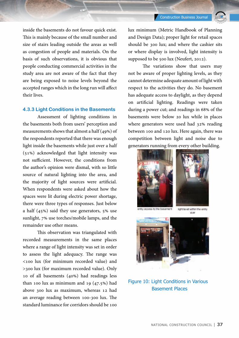
4.3.3 Light Conditions in the Basements
Assessment of lighting conditions in the basements both from users’ perception and measurements shows that almost a half (49%) of the respondents reported that there was enough light inside the basements while just over a half (51%) acknowledged that light intensity was not sufficient. However, the conditions from the author’s opinion were dismal, with so little source of natural lighting into the area, and the majority of light sources were artificial. When respondents were asked about how the spaces were lit during electric power shortage, there were three types of responses. Just below a half (45%) said they use generators, 5% use sunlight, 7% use torches/mobile lamps, and the remainder use other means. This observation was triangulated with recorded measurements in the same places where a range of light intensity was set in order to assess the light adequacy. The range was <100 lux (for minimum recorded value) and >300 lux (for maximum recorded value). Only 10 of all basements (40%) had readings less than 100 lux as minimum and 19 (47.5%) had above 300 lux as maximum, whereas 12 had an average reading between 100-300 lux. The standard luminance for corridors should be 100
lux minimum (Metric Handbook of Planning and Design Data); proper light for retail spaces should be 300 lux; and where the cashier sits or where display is involved, light intensity is supposed to be 500 lux (Neufert, 2012). The variations show that users may not be aware of proper lighting levels, as they cannot determine adequate amount of light with respect to the activities they do. No basement has adequate access to daylight, as they depend on artificial lighting. Readings were taken during a power cut; and readings in 68% of the basements were below 20 lux while in places where generators were used had 32% reading between 100 and 120 lux. Here again, there was competition between light and noise due to generators running from every other building.
Figure 10: Light Conditions in Various Basement Places
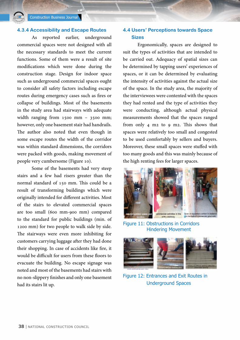
38 | NATIONAL CONSTRUCTION COUNCIL
NATIONAL CONSTRUCTION COUNCIL BARAZA LA TAIFA LA UJENZI
Construction Business Journal
4.3.4 Accessibility and Escape Routes
As reported earlier, underground commercial spaces were not designed with all the necessary standards to meet the current functions. Some of them were a result of site modifications which were done during the construction stage. Design for indoor space such as underground commercial spaces ought to consider all safety factors including escape routes during emergency cases such as fires or collapse of buildings. Most of the basements in the study area had stairways with adequate width ranging from 1500 mm – 3500 mm; however, only one basement stair had handrails. The author also noted that even though in some escape routes the width of the corridor was within standard dimensions, the corridors were packed with goods, making movement of people very cumbersome (Figure 10). Some of the basements had very steep stairs and a few had risers greater than the normal standard of 150 mm. This could be a result of transforming buildings which were originally intended for different activities. Most of the stairs to elevated commercial spaces are too small (600 mm-900 mm) compared to the standard for public buildings (min. of 1200 mm) for two people to walk side by side. The stairways were even more inhibiting for customers carrying luggage after they had done their shopping. In case of accidents like fire, it would be difficult for users from these floors to evacuate the building. No escape signage was noted and most of the basements had stairs with no non-slippery finishes and only one basement had its stairs lit up.
4.4 Users’ Perceptions towards Space
Sizes
Ergonomically, spaces are designed to suit the types of activities that are intended to be carried out. Adequacy of spatial sizes can be determined by tapping users’ experiences of spaces, or it can be determined by evaluating the intensity of activities against the actual size of the space. In the study area, the majority of the interviewees were contented with the spaces they had rented and the type of activities they were conducting, although actual physical measurements showed that the spaces ranged from only 4 m2 to 9 m2. This shows that spaces were relatively too small and congested to be used comfortably by sellers and buyers. Moreover, these small spaces were stuffed with too many goods and this was mainly because of the high renting fees for larger spaces.
Figure 12: Entrances and Exit Routes in Underground Spaces
Figure 11: Obstructions in Corridors Hindering Movement
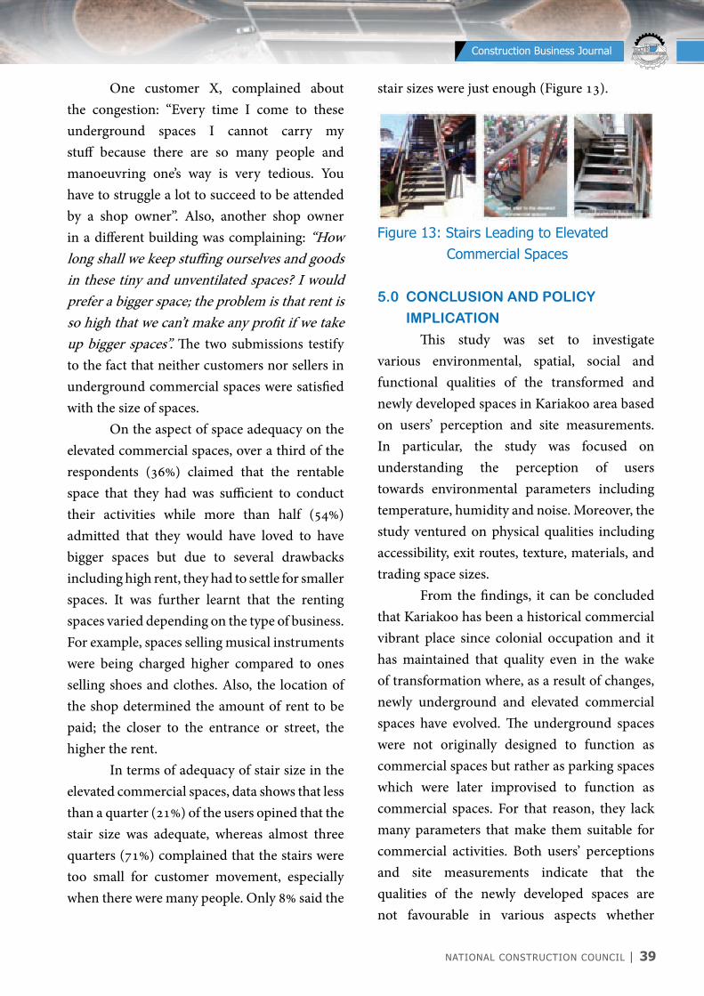
NATIONAL CONSTRUCTION COUNCIL | 39
NATIONAL CONSTRUCTION COUNCIL BARAZA LA TAIFA LA UJENZI
Construction Business Journal
One customer X, complained about the congestion: “Every time I come to these underground spaces I cannot carry my stuff because there are so many people and manoeuvring one’s way is very tedious. You have to struggle a lot to succeed to be attended by a shop owner”. Also, another shop owner in a different building was complaining: “How long shall we keep stuffing ourselves and goods in these tiny and unventilated spaces? I would prefer a bigger space; the problem is that rent is so high that we can’t make any profit if we take up bigger spaces”. The two submissions testify to the fact that neither customers nor sellers in underground commercial spaces were satisfied with the size of spaces. On the aspect of space adequacy on the elevated commercial spaces, over a third of the respondents (36%) claimed that the rentable space that they had was sufficient to conduct their activities while more than half (54%) admitted that they would have loved to have bigger spaces but due to several drawbacks including high rent, they had to settle for smaller spaces. It was further learnt that the renting spaces varied depending on the type of business. For example, spaces selling musical instruments were being charged higher compared to ones selling shoes and clothes. Also, the location of the shop determined the amount of rent to be paid; the closer to the entrance or street, the higher the rent. In terms of adequacy of stair size in the elevated commercial spaces, data shows that less than a quarter (21%) of the users opined that the stair size was adequate, whereas almost three quarters (71%) complained that the stairs were too small for customer movement, especially when there were many people. Only 8% said the
stair sizes were just enough (Figure 13).
Figure 13: Stairs Leading to Elevated Commercial Spaces
5.0 CONCLUSION AND POLICy
IMPLICATION
This study was set to investigate various environmental, spatial, social and functional qualities of the transformed and newly developed spaces in Kariakoo area based on users’ perception and site measurements. In particular, the study was focused on understanding the perception of users towards environmental parameters including temperature, humidity and noise. Moreover, the study ventured on physical qualities including accessibility, exit routes, texture, materials, and trading space sizes. From the findings, it can be concluded that Kariakoo has been a historical commercial vibrant place since colonial occupation and it has maintained that quality even in the wake of transformation where, as a result of changes, newly underground and elevated commercial spaces have evolved. The underground spaces were not originally designed to function as commercial spaces but rather as parking spaces which were later improvised to function as commercial spaces. For that reason, they lack many parameters that make them suitable for commercial activities. Both users’ perceptions and site measurements indicate that the qualities of the newly developed spaces are not favourable in various aspects whether

40 | NATIONAL CONSTRUCTION COUNCIL
NATIONAL CONSTRUCTION COUNCIL BARAZA LA TAIFA LA UJENZI
Construction Business Journal
lighting was also poor due to congestion caused by a large number of people in the day time. A study by Phillips (2004) showed that proper lighting in the working environment is an important aspect or else, people working in poor lit spaces are prone to what is described as Seasonal Affected Disorder (SAD) which makes people moody and depressed, have low energy, lose interest to activities and feel sluggish and agitated. The same author has gone further by iterating that poor natural light to users may lead to Sick Building Syndrome (SBS) which is associated with acute discomfort, headache, throat irritation, difficulty in concentration and sensitivity to odours. Also, a few basements experience overflow of surface run off during the rainy season, which deters customers from entering the basements. The study commends efforts by developers and encourages them to reconsider the planning of underground and elevated commercial spaces due to land scarcity and value in the Kariakoo area. The Municipality also ought to ensure proper design and supervision of these new spaces in order to meet users’ expectations as well as design standards. All design standards for basement entrances, exit routes, proper design of staircases according to architectural and engineering norms are supposed to be adhered to in both submitted plans as well as instituting strict regulations during construction of the same in order to avoid recurrence of a similar situation.
6.0 REFERENCES
Adams, M. 2013. Wellbeing and the Environment, Part 1. Vol. 2, in Quality of Urban Spaces and Wellbeing, edited by Wiley online Library.
environmental, physical, emotional, functional or visual. Therefore such newly developed spaces need to be improved to meet the desired users’ needs. Specifically, the temperature and air quality in both the basement building spaces and elevated floors is poor; that is why users have opted for artificial means to regulate these conditions. All the same, they are yet to reach the recommended comfortable standards. Based on the nature of the activities that are conducted in the basement and elevated floors, noise levels seem to vary from moderate noise levels on the basement areas to high noise levels on the elevated floors. This is because the elevated floors are more exposed to the exterior environment compared to the basement spaces. Further, the study shows that circulation routes for people and goods as well as escape routes are generally below architectural standards in terms of size, orientation and number. This poses safety risk to both temporary and permanent users in the underground spaces. Due to this, there is general dissatisfaction on the size of rentable spaces by both sellers and buyers in a way that they create unconducive environment for commercial activities especially in clothing stores which are always crowded with people. Lighting conditions in the transformed buildings are extremely poor in the basements, leading to poor visibility especially for customers dealing with clothes. Such customers are colour specific and in the wake of poor light, it becomes difficult to make the right choice. Basically, basements have no sources of natural light incorporated in the design; instead, sources of light are improvised from case to case by the tenants. A less similar case was observed in the elevated commercial spaces although
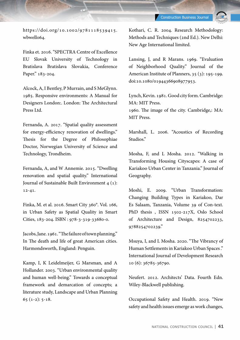
NATIONAL CONSTRUCTION COUNCIL | 41
NATIONAL CONSTRUCTION COUNCIL BARAZA LA TAIFA LA UJENZI
Construction Business Journal
https://doi.org/10.1002/9781118539415.wbwell064.
Finka et. 2016. “SPECTRA Centre of Excellence EU Slovak University of Technology in Bratislava Bratislava Slovakia, Conference Paper.” 183-204.
Alcock, A, I Bentley, P Murrain, and S MeGlynn. 1985. Responsive environments: A Manual for Designers London:. London: The Architectural Press Ltd.
Fernanda, A. 2017. “Spatial quality assessment for energy-efficiency renovation of dwellings.” Thesis for the Degree of Philosophiae Doctor, Norwegian University of Science and Technology, Trondheim.
Fernanda, A, and W Annemie. 2015. “Dwelling renovation and spatial quality.” International Journal of Sustainable Built Environment 4 (1): 12-41.
Finka, M. et al. 2016. Smart City 360°. Vol. 166, in Urban Safety as Spatial Quality in Smart Cities, 183-204. ISBN : 978-3-319-33680-0.
Jacobs, Jane. 1961. “The failure of town planning.” In The death and life of great American cities. Harmondsworth, England: Penguin.
Kamp, I, K Leidelmeijer, G Marsman, and A Hollander. 2003. “Urban environmental quality and human well-being.” Towards a conceptual framework and demarcation of concepts; a literature study, Landscape and Urban Planning 65 (1-2): 5-18.
Kothari, C. R. 2004. Research Methodology: Methods and Techniques (2nd Ed.). New Delhi: New Age International limited.
Lansing, J, and R Marans. 1969. “Evaluation of Neighborhood Quality.” Journal of the American Institute of Planners, 35 (3): 195-199. doi:10.1080/01944366908977953.
Lynch, Kevin. 1981. Good city form. Cambridge: MA: MIT Press.1960. The image of the city. Cambridge,: MA: MIT Press.
Marshall, L. 2006. “Acoustics of Recording Studios.”
Mosha, F, and L Mosha. 2012. “Walking in Transforming Housing Cityscapes: A case of Kariakoo Urban Center in Tanzania.” Journal of Geography.
Moshi, E. 2009. “Urban Transformation: Changing Building Types in Kariakoo, Dar Es Salaam, Tanzania, Volume 39 of Con-text.PhD thesis , ISSN 1502-217X, Oslo School of Architecture and Design, 8254702233, 9788254702239.”
Msuya, I, and L Mosha. 2020. “The Vibrancy of Human Settlements in Kariakoo Urban Spaces .” International Journal of Development Research 10 (6): 36785-36790.
Neufert. 2012. Architects’ Data. Fourth Edn. Wiley-Blackwell publishing.
Occupational Safety and Health. 2019. “New safety and health issues emerge as work changes,
42 | NATIONAL CONSTRUCTION COUNCIL
NATIONAL CONSTRUCTION COUNCIL BARAZA LA TAIFA LA UJENZI
Construction Business Journal
A new report on Occupational Safety and Health (OSH).” https://www.ilo.org/global/about-the-ilo/newsroom/news/WCMS_686571/lang--en/index.htm.
OHS Offices. 2019. Temperature and humidity - . Accessed November 2020. https://www.ohsrep.org.au/offices_temperature_and_humidity_-_what_are_the_rules.
Pacheco, A., et al. 2013. “Spatial Quality Indicators for Energy Renovation of Residential Buildings.” Central Europe towards Sustainable Buildings CESB13.
Pacione, M. 1993. “Perception and evaluation of urban environmental quality.” In The quality of the urban lifespace–a geographical perspective, edited by UNESCO, 17-42. Rome.
Pacione, M. 1990. “URBAN LIVEABILITY.” A REVIEW, Urban Geography 11 (1): 1-30. doi:10.2747/0272-3638.11.1.1.
Pecione, M. 2003. “Urban environmental quality and human wellbeing.” A Social Geographical Perspective, Landscape and Urban Planning 65 (1-2): 19-30.
Phillips, D. 2004. Daylighting: Natural Light in Architecture, An imprint of Elsevier, Linacre House, Jordan Hill. London: Oxford OX 28DP.
Porteous, J. 1971. “Design with People: “The Quality of the Urban Environment” Environment and Behavior.” 3 (2): 155.
Rapoport, A. 1994. “A critical look at the concept ‘place.” Edited by R. B. Singh and Varanasi:
Banaras Hindu University, The spirit and power of place: Human environment and sacrality. National Geographical Journal of India 31–45.
Singh, R. B. n.d. “The spirit and power of place: Human environment and sacrality, Varanasi: Banaras Hindu University.” (National Geographical Society of India, Publication 41.Google Scholar.) 34-45.
Sora, K. et al. 2008. “Computing Spatial Qualities for Architecture, Georgian Institute of Architecture, Proceedings, 477ACADIA 08 › Silicon + Skin › Biological Processes and Computation.”
Swai, O, and A. Deguchi. 2009a. “Transformation of Residential Units into Commercial Spaces in the Central Business District of Dar es Salaam, Tanzania.” Journal of Asian Architecture and Building Engineering 8 (1): 159-166.
U.S- EPA. 1974. ““Information of Levels of Environmental Noise Requisite to Protect Public Health and Welfare with an Adequate Margine of Safety,” EPA 440/9-74-004.”
Uytenhaak, R. 2008. Cities Full of Space: Qualities of Density. Rotterdam: 010 Publishers.
Von Meiss, P. 1997. “Elements of Architecture: From Form to Place. New York: Taylor & Francis.”
Von Meiss, P. 1997. “Elements of Architecture: From Form to Place. New York: Taylor & Francis.”

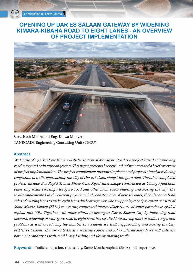
44 | NATIONAL CONSTRUCTION COUNCIL
NATIONAL CONSTRUCTION COUNCIL BARAZA LA TAIFA LA UJENZI
Construction Business Journal
OPENING UP DAR ES SALAAM GATEWAy By WIDENINGKIMARA-KIBAHA ROAD TO EIGHT LANES - AN OVERVIEW
OF PROJECT IMPLEMENTATION
Surv. Issah Mbura and Eng. Kulwa Munyeti;TANROADS Engineering Consulting Unit (TECU)
Abstract
Widening of 19.2 km long Kimara-Kibaha section of Morogoro Road is a project aimed at improving road safety and reducing congestion. This paper presents background information and a brief overview of project implementation. The project complement previous implemented projects aimed at reducing congestion of traffic approaching the City of Dar es Salaam along Morogoro road. The other completed projects include Bus Rapid Transit Phase One, Kijazi Interchange constructed at Ubungo junction, outer ring roads crossing Morogoro road and other main roads entering and leaving the city. The works implemented in the current project include construction of new six lanes, three lanes on both sides of existing lanes to make eight lanes dual carriageway whose upper layers of pavement consists of Stone Mastic Asphalt (SMA) as wearing course and intermediary course of super pave dense-graded asphalt mix (SP). Together with other efforts to decongest Dar es Salaam City by improving road network, widening of Morogoro road to eight lanes has resulted into solving most of traffic congestion problems as well as reducing the number of accidents for traffic approaching and leaving the City of Dar es Salaam. The use of SMA as a wearing course and SP as intermediary layer will enhance pavement capacity to withstand heavy loading and slowly moving traffic.
Keywords: Traffic congestion, road safety, Stone Mastic Asphalt (SMA) and superpave.
NATIONAL CONSTRUCTION COUNCIL | 45
NATIONAL CONSTRUCTION COUNCIL BARAZA LA TAIFA LA UJENZI
Construction Business Journal
1.0 INTRODUCTION
The widening of Kimara–Kibaha road to eight (8) lanes start from the roundabout at Kimara Mwisho near Dar es Salaam Rapid Transit (DART) Bus Terminal and ends at the former weighbridge station at Kibaha, covering a total length of 19.2 km. This road section is part of Morogoro road which is a gateway to most parts of Tanzanian mainland regions and neighbouring countries including Democratic Republic of Congo (DRC), Malawi, Zambia, Burundi, Uganda and Rwanda. This paper presents an overview of project for widening of Kimara-Kibaha road section (19.2 km), as Government’s effort to reduce traffic congestion and improve road safety along Morogoro road. Also, the paper present details of Superpave Asphalt mixes that have been used as upper layers of the road pavement structure to enhance skid resistance and ensure durability of the road. The paper starts with an introduction in section one followed by project background in section two. Section three describes features of Kimara - Kibaha road widening project while section four elucidates its construction and traffic management. The local content considered for this project is described in section five and finally a conclusion is drawn.
2.0 PROJECT BACKGROUND
The section of Morogoro road which is geographically within Dar es Salaam region is a strategic East-West trunk road located right in the middle of Dar es Salaam. It consists of two segments; the first is a section from the City Centre to Kimara with dual carriageway for traffic travelling in opposite directions and Bus Rapid Transit facilities in the middle. Before commencement of the current project,
the second section between Kimara and Kibaha (19.2 km) was a single carriageway two lanes, for traffic travelling in opposite directions. This road is the primary route for vehicular traffic coming and going to almost all regions of the country except Mtwara, Lindi and some districts of Coast region. It also saves most of the land locked countries within East and Central Africa region. The road was rehabilitated back in 1998 using sand and blast furnace slag stabilized with pozzolana as the base course with asphalt concrete wearing course. Two decades later the road experienced excessive increase in outbound and inbound traffic to the City from the newly developed small satellite towns at Kimara Mwisho, Mbezi, Kibamba including Mloganzila referral hospital, Kiluvya and Kibaha. Equally heavy traffic to and from other parts of the country and the neighbouring countries resulted into increased traffic congestion and traffic loading along Morogoro road and adjacent roads network. Prior to commencement of the road widening project in 2018, the existing conditions of Morogoro road from Kimara to Chalinze were poor due to prevalent congestion as well as severe traffic loading. The fleet of vehicles passing this road daily had reached almost above 70,000 vehicles per day. There were also several accident-prone spots due to rutting which prevented the road from fulfilling its required level of service. In fact the travel time between Kimara and Kibaha a distance of only 19.2 kilometres took between three (3) to four (4) hours at pick hours.
2.1 Previous Strategies for Reduction
of Traffic Congestion along
Morogoro Road
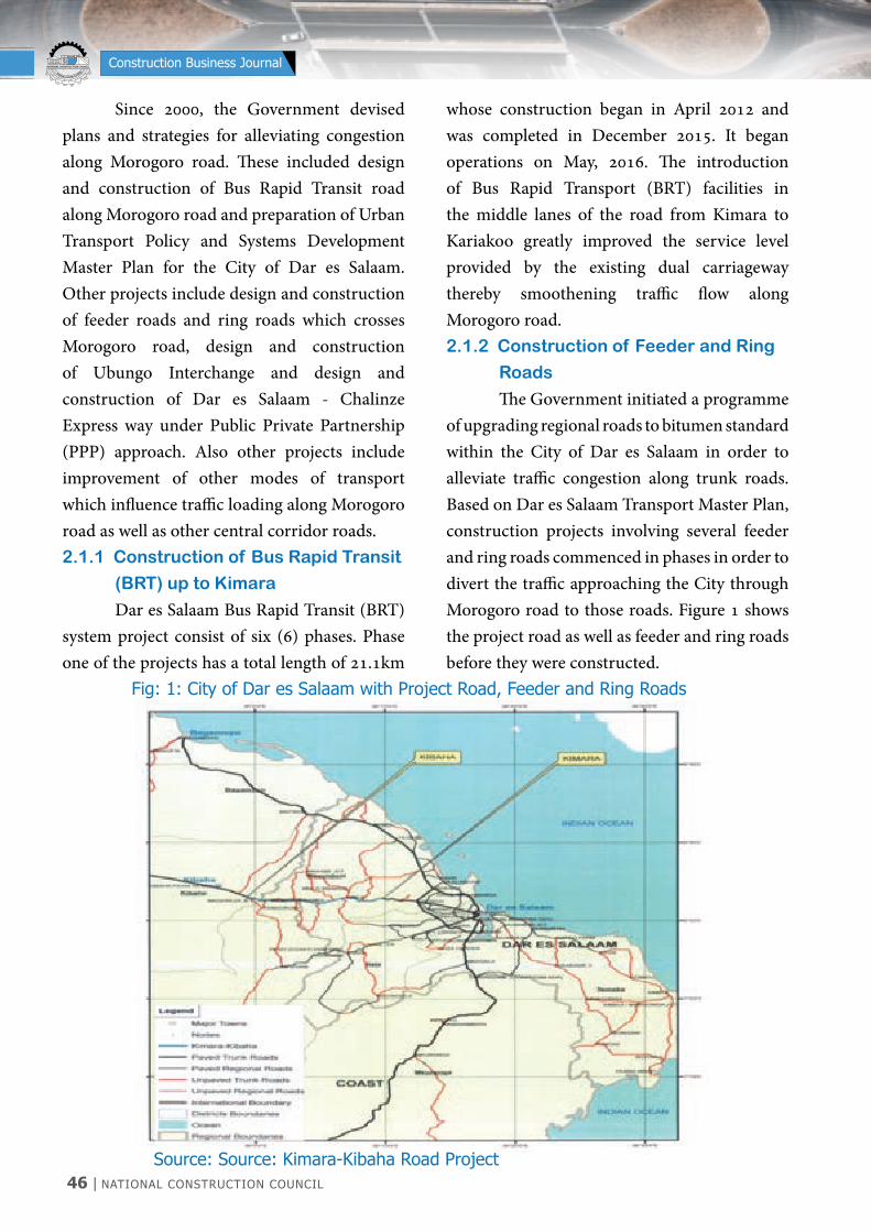
46 | NATIONAL CONSTRUCTION COUNCIL
NATIONAL CONSTRUCTION COUNCIL BARAZA LA TAIFA LA UJENZI
Construction Business Journal
Since 2000, the Government devised plans and strategies for alleviating congestion along Morogoro road. These included design and construction of Bus Rapid Transit road along Morogoro road and preparation of Urban Transport Policy and Systems Development Master Plan for the City of Dar es Salaam. Other projects include design and construction of feeder roads and ring roads which crosses Morogoro road, design and construction of Ubungo Interchange and design and construction of Dar es Salaam - Chalinze Express way under Public Private Partnership (PPP) approach. Also other projects include improvement of other modes of transport which influence traffic loading along Morogoro road as well as other central corridor roads.2.1.1 Construction of Bus Rapid Transit
(BRT) up to Kimara
Dar es Salaam Bus Rapid Transit (BRT) system project consist of six (6) phases. Phase one of the projects has a total length of 21.1km
whose construction began in April 2012 and was completed in December 2015. It began operations on May, 2016. The introduction of Bus Rapid Transport (BRT) facilities in the middle lanes of the road from Kimara to Kariakoo greatly improved the service level provided by the existing dual carriageway thereby smoothening traffic flow along Morogoro road.2.1.2 Construction of Feeder and Ring
Roads
The Government initiated a programme of upgrading regional roads to bitumen standard within the City of Dar es Salaam in order to alleviate traffic congestion along trunk roads. Based on Dar es Salaam Transport Master Plan, construction projects involving several feeder and ring roads commenced in phases in order to divert the traffic approaching the City through Morogoro road to those roads. Figure 1 shows the project road as well as feeder and ring roads before they were constructed.
Source: Source: Kimara-Kibaha Road Project
Fig: 1: City of Dar es Salaam with Project Road, Feeder and Ring Roads
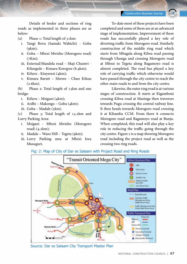
NATIONAL CONSTRUCTION COUNCIL | 47
NATIONAL CONSTRUCTION COUNCIL BARAZA LA TAIFA LA UJENZI
Construction Business Journal
Details of feeder and sections of ring roads as implemented in three phases are as below:(a) Phase 1: Total length of 31km:
i. Tangi Bovu (Samaki Wabichi) - Goba (9km);
ii. Goba – Mbezi Mwisho (Morogoro road) (7Km);
iii. External/Mandela road – Maji Chumvi - Kilungule – Kimara Korogwe (8.4km);
iv. Kifuru - Kinyerezi (4km); v. Kimara Baruti – Msewe - Chuo Kikuu
(2.6km).(b) Phase 2: Total length of 13km and one bridge:
i. Kifuru – Msigani (4km);ii. Ardhi – Makongo – Goba (4km);iii. Goba – Madale (5km).
(c) Phase 3: Total length of 13.2km and Lorry Parking Area:
i. Msigani - Mbezi Mwisho (Morogoro road) (4.2km);
ii. Madale – Wazo Hill – Tegeta (9km);iii. Lorry Parking area at Mbezi kwa
Musuguri.
To-date most of these projects have been completed and some of them are at an advanced stage of implementation. Improvement of these roads has successfully played a key role of diverting traffic from Morogoro road. Similarly construction of the middle ring road which starts from Mbagala along Kilwa road passing through Ukonga and crossing Morogoro road at Mbezi to Tegeta along Bagamoyo road is almost completed. The road has played a key role of carrying traffic which otherwise would have passed through the city centre to reach the other main roads to and from the city centre. Likewise, the outer ring road is at various stages of construction. It starts at Kigamboni crossing Kilwa road at Mazinga then traverses towards Pugu crossing the central railway line. It then heads towards Morogoro road crossing it at Kibamba CCM. From there it connects Morogoro road and Bagamoyo road at Bunju. When completed, this road will also play a key role in reducing the traffic going through the city centre. Figure 2 is a map showing Morogoro road including the project road as well as the crossing two ring roads.
Fig: 2: Map of City of Dar es Salaam with Project Road and Ring Roads
Source: Dar es Salaam City Transport Master Plan
48 | NATIONAL CONSTRUCTION COUNCIL
NATIONAL CONSTRUCTION COUNCIL BARAZA LA TAIFA LA UJENZI
Construction Business Journal
2.1.3 Construction of Ubungo
Interchange
Construction of Ubungo Interchange is another milestone project which was aimed at reducing delays at Ubungo intersection where four tier major roads intersect. The constructed two-level overpasses run along Morogoro road and Sam Nujoma/Mandela roads respectively. Its construction commenced in May 2017 and was completed in December 2020. During its inauguration in February 2021, the interchange was renamed Kijazi Interchange in honour of the late Chief Secretary, Engineer John Kijazi. The Interchange has provided the long-awaited solution to the problem of chronic traffic jam used to happen at Ubungo intersection.
2.1.4 Proposed Dar es Salaam -
Chalinze Expressway
This project was thought to be one of the long-term solutions to ease transportation congestion between Dar es Salaam Port and Chalinze town which is located at about 100 km west of Dar es Salaam along Morogoro road. The road was planned to be a six lanes toll road whose method of project delivery was proposed to be Public Private Partnership (PPP). Despite its importance, this project could not take off as planned due to world economic crisis which emerged in 2008. The crisis hindered the participation of both private as well as the public sector players from implementing the project.
2.1.5 Improvement of Other Modes of
Transport
It is believed that improvement of other modes of transport which operates parallel to the Central Corridor roads will automatically
alleviate traffic loading along Morogoro road. Hence the Government is implementing several projects including improvement of the Central Railway System and the Port of Dar es Salaam. Currently, construction of Standard Gauge Railway (SGR) from Dar es Salaam to Mwanza and Kigoma is ongoing concurrently with upgrading of the existing railway line to Meter Gauge Railway (MGR). Improvements of the Port of Dar es Salaam involves construction of additional berths to cater for roll on and roll off (ro-ro) cargo services as well as construction of dry port at Kwala, Vigwaza near Chalinze which is at final stages of construction. It is expected that when these developments on Port and Railway are completed, they will provide a huge relief to traffic loading and congestion along Morogoro road and other Central Corridor roads since a big chunk of cargo will be transported by the railway system.
3.0 WIDENING OF KIMARA – KIBAHA
ROAD PROJECT
Widening of Kimara-Kibaha road is being carried out by M/s Estim Construction Company of Tanzania for 30 months contract period. The contract is under the supervision of TANROADS Engineering and Consulting Unit (TECU), Dar es Salaam region. The contractor was procured using Public Procurement Regulatory Authority (PPRA) rules and guidelines under Design and Build Contract. The project is being financed by the Government of United Republic of Tanzania through its consolidated budget. This section describes implementation of the road widening project including key features of the project, relocation of utilities from road construction corridor followed by design and construction
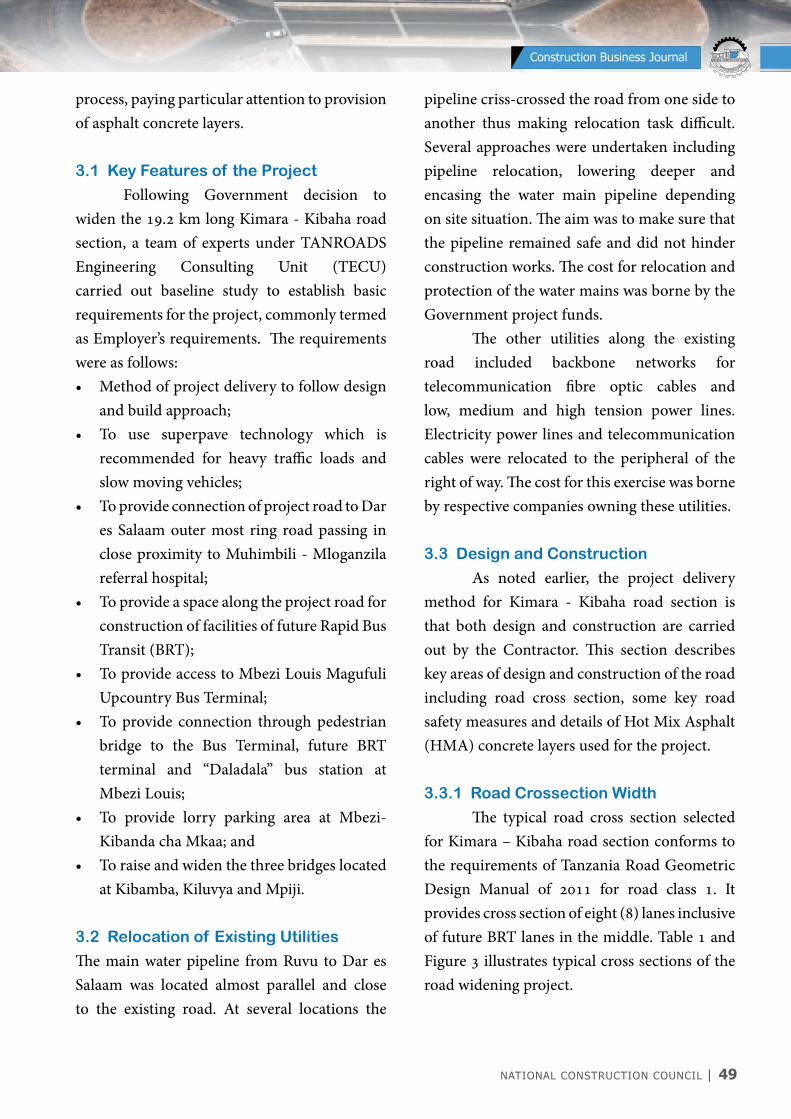
NATIONAL CONSTRUCTION COUNCIL | 49
NATIONAL CONSTRUCTION COUNCIL BARAZA LA TAIFA LA UJENZI
Construction Business Journal
process, paying particular attention to provision of asphalt concrete layers.
3.1 Key Features of the Project
Following Government decision to widen the 19.2 km long Kimara - Kibaha road section, a team of experts under TANROADS Engineering Consulting Unit (TECU) carried out baseline study to establish basic requirements for the project, commonly termed as Employer’s requirements. The requirements were as follows:• Method of project delivery to follow design
and build approach;• To use superpave technology which is
recommended for heavy traffic loads and slow moving vehicles;
• To provide connection of project road to Dar es Salaam outer most ring road passing in close proximity to Muhimbili - Mloganzila referral hospital;
• To provide a space along the project road for construction of facilities of future Rapid Bus Transit (BRT);
• To provide access to Mbezi Louis Magufuli Upcountry Bus Terminal;
• To provide connection through pedestrian bridge to the Bus Terminal, future BRT terminal and “Daladala” bus station at Mbezi Louis;
• To provide lorry parking area at Mbezi-Kibanda cha Mkaa; and
• To raise and widen the three bridges located at Kibamba, Kiluvya and Mpiji.
3.2 Relocation of Existing Utilities
The main water pipeline from Ruvu to Dar es Salaam was located almost parallel and close to the existing road. At several locations the
pipeline criss-crossed the road from one side to another thus making relocation task difficult. Several approaches were undertaken including pipeline relocation, lowering deeper and encasing the water main pipeline depending on site situation. The aim was to make sure that the pipeline remained safe and did not hinder construction works. The cost for relocation and protection of the water mains was borne by the Government project funds. The other utilities along the existing road included backbone networks for telecommunication fibre optic cables and low, medium and high tension power lines. Electricity power lines and telecommunication cables were relocated to the peripheral of the right of way. The cost for this exercise was borne by respective companies owning these utilities.
3.3 Design and Construction
As noted earlier, the project delivery method for Kimara - Kibaha road section is that both design and construction are carried out by the Contractor. This section describes key areas of design and construction of the road including road cross section, some key road safety measures and details of Hot Mix Asphalt (HMA) concrete layers used for the project.
3.3.1 Road Crossection Width
The typical road cross section selected for Kimara – Kibaha road section conforms to the requirements of Tanzania Road Geometric Design Manual of 2011 for road class 1. It provides cross section of eight (8) lanes inclusive of future BRT lanes in the middle. Table 1 and Figure 3 illustrates typical cross sections of the road widening project.
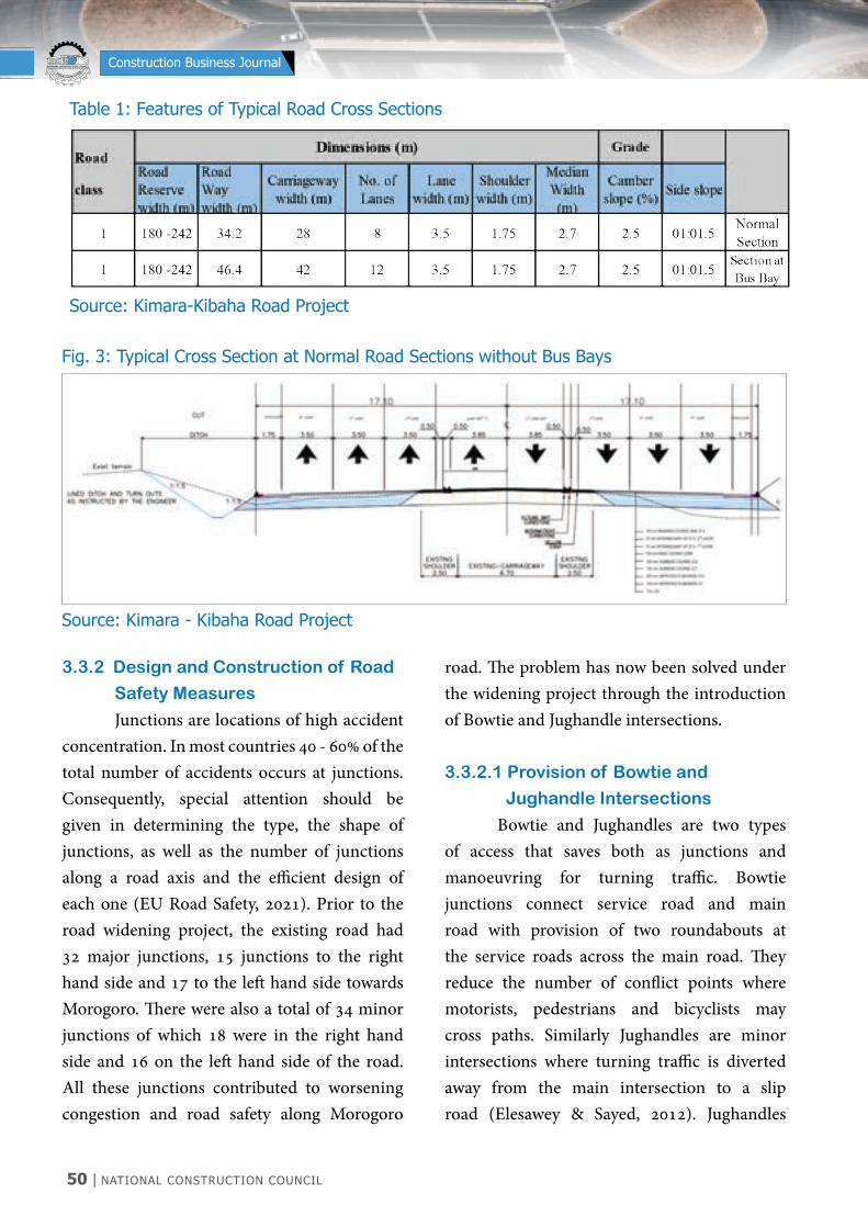
50 | NATIONAL CONSTRUCTION COUNCIL
NATIONAL CONSTRUCTION COUNCIL BARAZA LA TAIFA LA UJENZI
Construction Business Journal
3.3.2 Design and Construction of Road
Safety Measures
Junctions are locations of high accident concentration. In most countries 40 - 60% of the total number of accidents occurs at junctions. Consequently, special attention should be given in determining the type, the shape of junctions, as well as the number of junctions along a road axis and the efficient design of each one (EU Road Safety, 2021). Prior to the road widening project, the existing road had 32 major junctions, 15 junctions to the right hand side and 17 to the left hand side towards Morogoro. There were also a total of 34 minor junctions of which 18 were in the right hand side and 16 on the left hand side of the road. All these junctions contributed to worsening congestion and road safety along Morogoro
road. The problem has now been solved under the widening project through the introduction of Bowtie and Jughandle intersections.
3.3.2.1 Provision of Bowtie and
Jughandle Intersections
Bowtie and Jughandles are two types of access that saves both as junctions and manoeuvring for turning traffic. Bowtie junctions connect service road and main road with provision of two roundabouts at the service roads across the main road. They reduce the number of conflict points where motorists, pedestrians and bicyclists may cross paths. Similarly Jughandles are minor intersections where turning traffic is diverted away from the main intersection to a slip road (Elesawey & Sayed, 2012). Jughandles
Table 1: Features of Typical Road Cross Sections
Source: Kimara-Kibaha Road Project
Fig. 3: Typical Cross Section at Normal Road Sections without Bus Bays
Source: Kimara - Kibaha Road Project
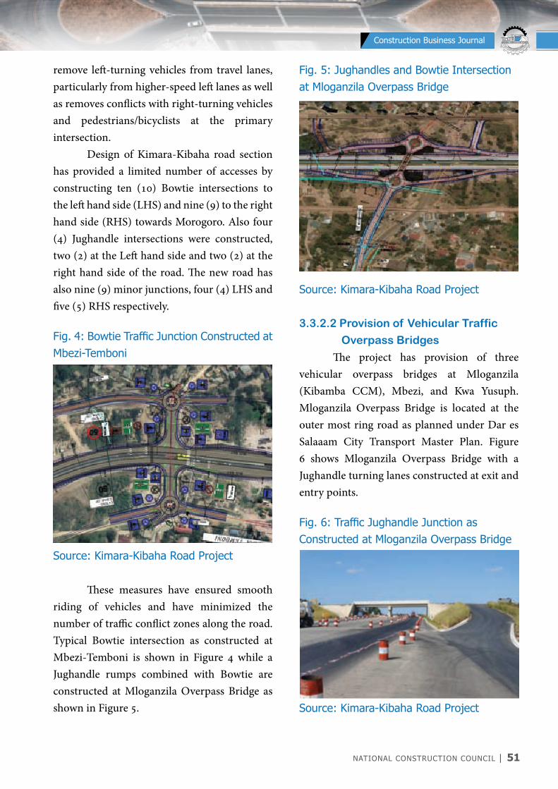
NATIONAL CONSTRUCTION COUNCIL | 51
NATIONAL CONSTRUCTION COUNCIL BARAZA LA TAIFA LA UJENZI
Construction Business Journal
Fig. 5: Jughandles and Bowtie Intersection at Mloganzila Overpass Bridge
Source: Kimara-Kibaha Road Project
3.3.2.2 Provision of Vehicular Traffic
Overpass Bridges
The project has provision of three vehicular overpass bridges at Mloganzila (Kibamba CCM), Mbezi, and Kwa Yusuph. Mloganzila Overpass Bridge is located at the outer most ring road as planned under Dar es Salaaam City Transport Master Plan. Figure 6 shows Mloganzila Overpass Bridge with a Jughandle turning lanes constructed at exit and entry points.
Fig. 6: Traffic Jughandle Junction as Constructed at Mloganzila Overpass Bridge
Source: Kimara-Kibaha Road Project
remove left-turning vehicles from travel lanes, particularly from higher-speed left lanes as well as removes conflicts with right-turning vehicles and pedestrians/bicyclists at the primary intersection. Design of Kimara-Kibaha road section has provided a limited number of accesses by constructing ten (10) Bowtie intersections to the left hand side (LHS) and nine (9) to the right hand side (RHS) towards Morogoro. Also four (4) Jughandle intersections were constructed, two (2) at the Left hand side and two (2) at the right hand side of the road. The new road has also nine (9) minor junctions, four (4) LHS and five (5) RHS respectively.
Fig. 4: Bowtie Traffic Junction Constructed at Mbezi-Temboni
Source: Kimara-Kibaha Road Project These measures have ensured smooth riding of vehicles and have minimized the number of traffic conflict zones along the road. Typical Bowtie intersection as constructed at Mbezi-Temboni is shown in Figure 4 while a Jughandle rumps combined with Bowtie are constructed at Mloganzila Overpass Bridge as shown in Figure 5.

52 | NATIONAL CONSTRUCTION COUNCIL
NATIONAL CONSTRUCTION COUNCIL BARAZA LA TAIFA LA UJENZI
Construction Business Journal
3.4 Design and Construction of Hot Mix
Asphalt Concrete Layers
3.4.1 Pavement Structure
The Kimara - Kibaha road section is among heavily trafficked sections of Morogoro road with traffic volume of more than 70,000 vehicles per day. Its pavement structure is made up of 350mm upper subgrade (150mm G7 and
200mm G15 layers), 300mm subbase (150mm C1 and 150mm C2), 150mm granular base course (CRR), 150mm intermediary course of Superpave (SP) compacted in two layers of 75mm thickness each and 50mm Stone Mastic Asphalt (SMA) as per pavement configuration shown in Figure 7.
The above pavement structure was designed using Ethiopian Roads Authority (2013), Manual for Flexible Pavement Design Volume 1. The Manual provides a standardized approach for design of flexible pavement including design traffic loading of 50-80 million equivalent standard axles which is appropriate for design traffic loading for Kimara - Kibaha road section. The decision to use Ethiopian design manual was prompted by the fact that Tanzania Pavement and Materials Design Manual has limitation on the maximum value of design traffic loading which is up to design traffic load of 50 million equivalent standard axles (TLC 50) only. This loading is far less than the design traffic loading of 80 million equivalent standard axles on the project road.
3.4.2 Superpave (SP) and Stone Mastic
Asphalt (SMA) Mix Design
Technologies
In the pavement structure, the granular materials for improved subgrade, subbase and base course (CRR) are typical and well known pavement materials used for construction of most roads in Tanzania. However, the materials used for construction of bituminous layers in this project are not common, thus requiring exposition. They consist of 150mm Superpave (SP) 37.5 as intermediary layer of asphalt concrete materials in two layers and the 50mm top most wearing course of Stone Mastic Asphalt (SMA).Both Superpave and SMA are acknowledged to be rut-resistant mixes. These layers have been designed according to Interim
Fig. 7: Pavement Structure of Kimara-Kibaha Road
Source: Kimara - Kibaha Road Project
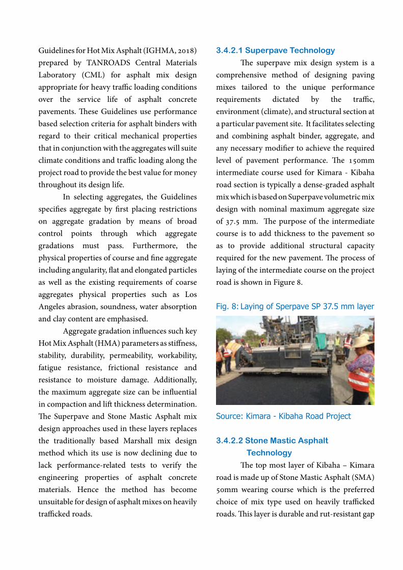
Guidelines for Hot Mix Asphalt (IGHMA, 2018) prepared by TANROADS Central Materials Laboratory (CML) for asphalt mix design appropriate for heavy traffic loading conditions over the service life of asphalt concrete pavements. These Guidelines use performance based selection criteria for asphalt binders with regard to their critical mechanical properties that in conjunction with the aggregates will suite climate conditions and traffic loading along the project road to provide the best value for money throughout its design life. In selecting aggregates, the Guidelines specifies aggregate by first placing restrictions on aggregate gradation by means of broad control points through which aggregate gradations must pass. Furthermore, the physical properties of course and fine aggregate including angularity, flat and elongated particles as well as the existing requirements of coarse aggregates physical properties such as Los Angeles abrasion, soundness, water absorption and clay content are emphasised. Aggregate gradation influences such key Hot Mix Asphalt (HMA) parameters as stiffness, stability, durability, permeability, workability, fatigue resistance, frictional resistance and resistance to moisture damage. Additionally, the maximum aggregate size can be influential in compaction and lift thickness determination. The Superpave and Stone Mastic Asphalt mix design approaches used in these layers replaces the traditionally based Marshall mix design method which its use is now declining due to lack performance-related tests to verify the engineering properties of asphalt concrete materials. Hence the method has become unsuitable for design of asphalt mixes on heavily trafficked roads.
3.4.2.1 Superpave Technology
The superpave mix design system is a comprehensive method of designing paving mixes tailored to the unique performance requirements dictated by the traffic, environment (climate), and structural section at a particular pavement site. It facilitates selecting and combining asphalt binder, aggregate, and any necessary modifier to achieve the required level of pavement performance. The 150mm intermediate course used for Kimara - Kibaha road section is typically a dense-graded asphalt mix which is based on Superpave volumetric mix design with nominal maximum aggregate size of 37.5 mm. The purpose of the intermediate course is to add thickness to the pavement so as to provide additional structural capacity required for the new pavement. The process of laying of the intermediate course on the project road is shown in Figure 8.
Fig. 8: Laying of Sperpave SP 37.5 mm layer
Source: Kimara - Kibaha Road Project
3.4.2.2 Stone Mastic Asphalt
Technology
The top most layer of Kibaha – Kimara road is made up of Stone Mastic Asphalt (SMA) 50mm wearing course which is the preferred choice of mix type used on heavily trafficked roads. This layer is durable and rut-resistant gap

54 | NATIONAL CONSTRUCTION COUNCIL
NATIONAL CONSTRUCTION COUNCIL BARAZA LA TAIFA LA UJENZI
Construction Business Journal
mix. Essentially, the binder contents for SMA 12.5mm and SMA 9.5mm mixes are typically in the range of 5.6 – 6.5% by mass of the mix. Figure 9 shows the process of laying of 50mm Stone Mastic Asphalt wearing course.
Fig. 9: Laying of Finishing Layer (SMA 12.5), 50mm Thickness
Source: Kimara - Kibaha Road Project
4.0 CONSTRUCTION AND TRAFFIC
MANAGEMENT
As noted before, the scope of works for this project besides observing road safety and traffic management during construction, involved upgrading to bitumen standards eight lanes road between Kimara and Kibaha (19.2km). It also comprised construction of lorry parking area at Mbezi-Kibanda cha Mkaa for upcountry lorries, construction of six (6) bridges, two parallel bridges adjacent the old bridge in the middle, across each of the three main rivers, namely Luguruni, Kiluvya and Mpiji. A brief description of traffic management during construction as well as bridges construction process is provided in this section.
4.1 Safety and Traffic Management
Prior to the start of construction activity, a service road at the buffer of road reserve was
graded asphalt mixture that relies on a concept of stone-on-stone contact. The gap grading offers strength and the rich mortar binder enhances its stiffness and durability. The SMA mixture consists of two major components: a “skeleton” of large sized aggregate known as active grains and a “mortar”, or mastic, consisting of fine aggregate known as passive grains. In essence, SMA mortar or mastic is a mixture of bitumen, fines, mineral filler, and a stabilizing agent. A stabilizing agent is normally used to provide adequate stability of the bitumen in order to prevent drainage or drain down of the bitumen during transport and placement. At the bottom, and in the bulk of the layer, the voids in the aggregate structure are almost entirely filled by the mastic whilst at the surface the voids are only partially filled. This mix results in a rough and open surface texture providing good skidding resistance at all speeds and facilitates the drainage of surface water. Due to the voids between the coarse aggregate being partially filled with the rich mastic, the resulting air voids are lower than would otherwise be the case with a conventional dense graded asphalt. SMA has excellent structural and functional advantage including superior rut resistance, decreased ageing, improved durability, superior cracking resistance, excellent ride quality, superior skid resistance and lower noise characteristics than dense graded asphalt. Stone Mastic Asphalt (SMA) typical parameters are that the coarse aggregates having sizes greater than 4.75 mm sieve are at least 70% of the aggregate by weight. The fine aggregates constitute 16-24% and the filler fraction is in the range 8-10%. Some stabilizers, mainly cellulose fibres constitute about 0.4% of the
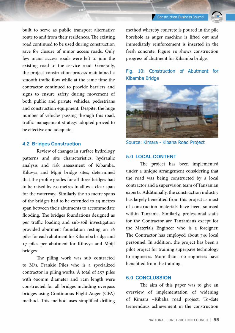
NATIONAL CONSTRUCTION COUNCIL | 55
NATIONAL CONSTRUCTION COUNCIL BARAZA LA TAIFA LA UJENZI
Construction Business Journal
built to serve as public transport alternative route to and from their residences. The existing road continued to be used during construction save for closure of minor access roads. Only few major access roads were left to join the existing road to the service road. Generally, the project construction process maintained a smooth traffic flow while at the same time the contractor continued to provide barriers and signs to ensure safety during movement of both public and private vehicles, pedestrians and construction equipment. Despite, the huge number of vehicles passing through this road, traffic management strategy adopted proved to be effective and adequate. 4.2 Bridges Construction
Review of changes in surface hydrology patterns and site characteristics, hydraulic analysis and risk assessment of Kibamba, Kiluvya and Mpiji bridge sites, determined that the profile grades for all three bridges had to be raised by 2.0 metres to allow a clear span for the waterway. Similarly the 20 metre spans of the bridges had to be extended to 25 metres span between their abutments to accommodate flooding. The bridges foundations designed as per traffic loading and sub-soil investigation provided abutment foundation resting on 16 piles for each abutment for Kibamba bridge and 17 piles per abutment for Kiluvya and Mpiji bridges. The piling work was sub contracted to M/s. Frankie Piles who is a specialized contractor in piling works. A total of 257 piles with 600mm diameter and 12m length were constructed for all bridges including overpass bridges using Continuous Flight Auger (CFA) method. This method uses simplified drilling
method whereby concrete is poured in the pile borehole as auger machine is lifted out and immediately reinforcement is inserted in the fresh concrete. Figure 10 shows construction progress of abutment for Kibamba bridge.
Fig. 10: Construction of Abutment for Kibamba Bridge
Source: Kimara - Kibaha Road Project
5.0 LOCAL CONTENT
The project has been implemented under a unique arrangement considering that the road was being constructed by a local contractor and a supervision team of Tanzanian experts. Additionally, the construction industry has largely benefitted from this project as most of construction materials have been sourced within Tanzania. Similarly, professional staffs for the Contractor are Tanzanians except for the Materials Engineer who is a foreigner. The Contractor has employed about 746 local personnel. In addition, the project has been a pilot project for training superpave technology to engineers. More than 100 engineers have benefitted from the training.
6.0 CONCLUSSION
The aim of this paper was to give an overview of implementation of widening of Kimara –Kibaha road project. To-date tremendous achievement in the construction
56 | NATIONAL CONSTRUCTION COUNCIL
NATIONAL CONSTRUCTION COUNCIL BARAZA LA TAIFA LA UJENZI
Construction Business Journal
of this road using local Tanzanian professionals has been realised. Together with the other efforts of decongesting Dar es Salaam city roads by improving its road network, widening of Morogoro road to eight lanes has proved to be a solution that has long been awaited. The project has resulted into solving traffic congestion problems as well as reducing the number of accidents. Specifically there has been a notable improvement of traffic flow over the new road, three lanes on both sides whereby travel time from Kimara to Kibaha has been substantially reduced from three to four hours to about less than 30 minutes during pick hours. The use of superpave intermediary layer and SMA wearing course has provided a durable road which is resistant to rutting. About three months after opening to traffic the six lanes of the road, there has not been any noticeable distress of the asphalt concrete wearing course. Hence it is expected that the road’s life span will be longer compared to other types of asphalt concrete mixtures and hence provide savings in maintenance cost during its design life.
7.0 ACKNOWLEDGEMENT
We would like to thank the management of TANROADS Agency for authorising the writing of this paper. We also thank management and engineers of organizations and individuals who provided facilitation and valuable comments during the writing of this paper. They include TECU Team supervising
the Project, staff of Tanroads Dar es Salaaam Regional Office and staff of Central Material Laboratory.
REFERENCES:
European Union (2021), Mobility and Transport, Road Safety. Available at https://ec.europa.eu/transport/road_safety/home_en
Mohamed Elesawey and Tarek Sayed (2013), Analysis of unconventional arterial intersection designs (UAIDs), State-of-the-art methodologies and future research directions, Transportmetrica A: Transport Science Vol.9 No.10 pp. 860 -895. Available at https://www.researchgate.net/publication/254324134.
NAPA (1998), Designing and Constructing SMA mixtures - State - of - the- Practice. USA: National Asphalt Pavement Association, Quality Improvement Series 122, USA.
Nunn, M.E. (1994), Evaluation of Stone Mastic Asphalt (SMA): A High Stability Wearing Course Material. Transport Research Laboratory Project.
TANROADS-IGHMA (2018), Interim Guideline for the Design of Hot Mix Asphalt. Dar es Salaam, Ministry of Works Transport and Communicatio

NATIONAL CONSTRUCTION COUNCIL | 57
NATIONAL CONSTRUCTION COUNCIL BARAZA LA TAIFA LA UJENZI
Construction Business Journal
Contract Contractor Daywork Engineer Harmer Preambles Provision Quantities Rehabilitation Specification ToolsRemeasurement
CONSTRUCT WORDS
Kuelekea Kulia4. Mpangilio wa mambo katika shughuli6. Ulinzi wa madhara yasiyotarajika7. Huwasilishwa kufuatana na mualiko wa kutoa huduma au bidhaa9. Utengeneza umbo la kazi ya saruji
Kuelekea Chini1. Yenye kukaribia uhalisia2. Hutumika kupima wima3. Inamlazimu mtu kutimiza5. Makubaliano ya kisheria8. Kupitia jambo kwa nia ya kujiridhisha
JENGA MANENO
7
9
8
65
4
1 2 3
Fun Page

NATIONAL CONSTRUCTION COUNCIL | 59
NATIONAL CONSTRUCTION COUNCIL BARAZA LA TAIFA LA UJENZI
Construction Business Journal
TECHNICAL AUDIT: A ROOM TO LEARN AND CORRECT OR WITCH HUNT? (SIMPLIFIED)
NCC NEWS CORNER
By Qs. Dorine Jackson
1.0. INTRODUCTION The word Audit is associated with formal or methodical examining, reviewing, and investigating. Different professional groups define preferred methods for conducting examinations and investigations (Russell, 2000)There are various type of audit conducted depending on the requirements. Some of the Audits conducted in different disciplines are, Human Resource Audit, Management Audit, Financial Audit, Procurement Audit, Technical Audit and so much more. With Construction Industry in mind, we are going to glimpse at Technical Audit. Technical Audit has become more vibrant in various sectors and more so in the construction industry. So what is Technical Audit? The Engineering Council of London defined Technical Audit as: a continuing appraisal of technical objectives and capabilities in the context of overall business and marketing plans. It focuses attention on the importance of engineering resources and their effective use throughout the design, production and marketing processes (Lowe & Ridgway, 1999)A simple definition of Technical Audit is a check
done by an expert to assess deficiencies and recommend means of improvement. Technical Audit check is performed on technical aspects of a project under review. From the definition we learn two major things; one, the type of person who conducts the technical audit and two, the general purpose of the audit. Focusing on the person who conducts the technical audit, the definition says “an expert.” This means that for a proper technical audit a person must be conversant in the subject matter of audit. Why then should we have experts in the matter to be audited? The answer to this lies in the second lesson from the definition, “to assess deficiencies and recommend means of improvement.” To be able to evaluate a process, system or proposal one has to be conversant in that area. He/she must be able to speak fluent on the matters to be audited. In that manner the auditor can be able to spot the deficiencies and come up with credible mechanism for improvement.
2.0.WHy TECHNICAL AUDIT There are many reasons why technical audit should be conducted depending on the organization set up and requirement. However, an overall need for technical audit is to mitigate risks associated with the process, project, or system in the spirit of ensuring that there is value for money on the invested resources. One may wonder further, if the immediate need for technical audit is to mitigate risks then the appropriate time to conduct technical audit will be at the beginning. But that is not entirely the case. Technical audit can be conducted at
60 | NATIONAL CONSTRUCTION COUNCIL
NATIONAL CONSTRUCTION COUNCIL BARAZA LA TAIFA LA UJENZI
Construction Business Journal
any stage when there is such a need. For risks cannot all at once be known or anticipated. In any case, when an audit is conducted be it financial, management or technical audit, findings should be well written/recorded and presented in a standard format that is easy to understand. The auditor should present his/her finding by also giving a clear insight on what was supposed to be done, what caused the observed issue, what are the implication(s) and give recommendation(s) in a way that the auditee is able to understand and learn from the findings and be in a position to give responses were required to do so. These responses can be used by the auditor to refine his/her findings and give out a proper or final recommendation. However, there is a catch; responses that are to be addressed to the auditor must have supporting evidence that clearly respond to the findings. This way, the auditor can judge whether or not the responses are valid to his/her finding. As stated earlier, Technical Audit can be conducted at any stage; this can also mean that, there can be a follow-up audit. In a follow-up audit, the auditor is required to observe if the recommendation he/she has previously given have been worked on. Results on the status of previously audit recommendations will definitely give a clear picture as to what extent the auditee has learnt and corrected the deficiencies. There has been a negative presumption on Technical Audit, especially in the construction industry that the aim of the exercise is to accuse and prosecute the auditee. This is not correct. Technical Audit is a room to learn, correct and improve performance. This can be at an individual level or institutional level. If technical audit is not a bad thing, why is it shunned? The answer is simple, reluctant to change. Auditees may have their ways of doing things in a wrong way thinking that they are correct. They have been doing it that way
for so long to the extent that one considers it to be a norm. This is where the misconception of technical audit occurs. The auditor will come with the recommendation of a correct way of doing things but the auditee may still be hanging to the old ways. Furthermore, the auditee will have remarks on the findings but have no supporting evidence, which will result to the auditor maintaining their findings.
3.0. CONCLUSION Technical audit is not a witch hunt rather an opportunity to learn shortcomings and areas of improvement. A proper and constructive technical audit is that which involves parties, the auditor and the auditee. An important pre requisite is that, the auditor should be an expert on the subject matter, he/she should focus on the extent and or terms of reference of his/her audit assignment and should give findings supported with facts and not opinions. In the course of conducting such an assignment, a technical auditor should not forget to keep all the evidences in support of his/her findings. As there might be cases where findings are being challenged or the auditee has played around with information. On the other hand, the auditee should be cooperative in providing the auditors with documents and other materials required for the audit to be able to fully provide a fact-oriented explanation of any concern raise and should be ready to learn and adapt to changes
REFERENCESLowe, A., & Ridgway, K. (1999). The University of Sheffield’s Technical Audit Programme. Industry and Higher Education Volume: 13 , 337-338.Russell, J. (2000). The Quality Audit Handbook, Second Edition. In J. Russell, The Quality Audit Handbook, Second Edition (p. xxv). Milwaukee, Wisconsin: ASQ Quality Press.

NATIONAL CONSTRUCTION COUNCIL | 61
NATIONAL CONSTRUCTION COUNCIL BARAZA LA TAIFA LA UJENZI
Construction Business Journal
The major services provided by the NCC include sector coordination, advisory services, and settlement of disputes, training, technical auditing, research, publications and information support.
SECTOR CO-ORDINATION National Construction Council coordinates the construction sector through policy is formulated by Ministry and Strategic Interventions, promoting the evolution of a conducive Institutional Framework and organizing Construction Industry Forums.
ADVISORy SERVICES National Construction Council provides advisory services to various stakeholders of the construction industry in areas including project planning, procurement and contract administration of works and consultancy services, project cost management, value for money auditing to mention just a few.
SETTLEMENT OF DISPUTES Since 1982, National Construction Council has been coordinating resolution of construction project disputes, by mainly appointing Conciliators, adjudicators and arbitrators. Accordingly, NCC has a panel of Arbitrators from whom parties can choose mediators, adjudicators and arbitrators. Dispute through arbitration and adjudication resolution is guided by the NCC Arbitration Rules and NCC Adjudication Rules respectively. The number of cases handled by NCC since it started coordinating is more than two hundred arbitration cases.
TRAINING The National Construction Council is continuously implementing a number of practical oriented training initiatives. The major areas covered include: procurement, contract administration, project management, cost estimating. legal aspects of construction contracts, technical auditing, arbitration,
SERVICES AVAILABLE AT NCC claims management, contractor training, Public Private Partnerships (PPPs), labour based technology in road maintenance rehabilitation and construction, building maintenance, computer – based cost estimating and project management. Taylormade courses are conducted on need basis from clients.
TECHNICAL AUDIT SERVICES The aim of technical auditing of construction projects is to provide top management and investors/financiers with an independent review, analysis, appraisal, comments and recommendations on those project management activities, which are adversely affecting successful project performance. This is in line with the requirements of the Act, which requires NCC to promote quality management including provision of technical auditing services in the construction industry. Technical audit of construction projects are being carried out for the purpose of highlighting deficiencies and recommending measures for improved performance.
TECHNICAL PUBLICATIONS AND INFORMATION SUPPORT Over the years, NCC has been progressively establishing a central reservoir of information for the construction industry. NCC publishes technical guidelines, maintains data banks, and manages a reference library. Available publications include: price fluctuation formula and indices, arbitration rules, adjudication rule, directory of construction materials, construction industry technical guidelines, basic statistical data for the construction industry and standard contract agreements for building works. This is also a technical publication of NCC.
REGIONAL AND INTERNATIONAL COLLABORATION The Council has been participating in the World Road Association (PIARC) activities, International Council for Research and Innovation in Building and Construction and has been receiving documents from the same.
National Construction CouncilT: +255 222131321 | +255 22 2118887E: [email protected] | W: www.ncc.go.tz