combining objects, appearance, geometry and topology for
TRANSCRIPT

Understanding the Real World: Combining Objects,
Appearance, Geometry and Topology for Semantic Mapping
Andrzej Pronobis, and Patric Jensfelt
Abstract
A cornerstone for mobile robots operating in man-made environments and inter-acting with humans is representing and understanding the human semantic conceptsof space. In this report, we present a multi-layered semantic mapping algorithmable to combine information about the existence of objects in the environment withknowledge about the topology and semantic properties of space such as room size,shape and general appearance. We use it to infer semantic categories of rooms andpredict existence of objects and values of other spatial properties. We perform ex-periments offline and online on a mobile robot showing the efficiency and usefulnessof our system.
1 Introduction
In this report we focus on the understanding of space to, for example, facilitateinteraction between humans and robots and increase the efficiency of the robotperforming tasks in man-made environments. We consider applications where therobot is operating in an indoor office or domestic environment, i.e. environmentswhich have been made for and are, up until now, almost exclusively inhabited byhumans. In such an environment human concepts such as rooms and objects andproperties such as the size and shape of rooms are important, not only for the sake ofthe interaction with humans but also for knowledge representation and abstractionof spatial knowledge. We will describe the system in the context of a mobile robot(see Fig. 1) but most of the system would remain unchanged if used as part of, e.g.,a wearable device.
The main contribution of this work is a way of combining information aboutthe existence of objects, the appearance, geometry and topology of space for se-mantic mapping in a principled manner. It builds on our previous work [16] wherewe presented a system for multi-cue integration of laser and vision data for placecategorization. A fundamental difference from that work is that we now have de-

F4 PAPER F. UNDERSTANDING THE REAL WORLD
MetricMapping
TopologyMaintenance
DoorDetection
RoomFormation
Spatial PropertyCategorization
Spatio-temporalIntegration
Conceptual MapMaintenance
ProbabilisticInference
Images
LaserScans
Figure 1: Dora the Explorer as well as the elements and the data flow inside thesemantic mapping system.
coupled the lowest levels of information from the categorization by introducing theso called properties. This allows us to incorporate additional sources of knowledgeand describe the space at much finer level of granularity.
Comparing to our previous approach, the vision and laser pipe lines now feedinto modules estimating the values of appearance and geometric properties of spaceinstead of directly categorizing rooms. In this way room categories are not directlydefined based on the low level sensor data but in terms of spatial properties. Thishas several advantages. It paves the way for better scalability. It makes trainingof new categories easier and is therefore an important step towards a system thatis able to support life-long learning. The properties can correspond to humanconcepts of space. The use of such human understandable properties provides bettersupport for verbalization of knowledge, e.g., the corridor is large (size property) andelongated (shape property) as well as the dual, i.e., interpreting what a human saysand ultimately learning models for new categorizes based on human input. Finally,additional spatial properties such as based on objects or even actions observed inthe environment can be easily incorporated.
We believe that objects play an important role in understanding space. Intro-ducing properties describing the existence of certain objects provides a seamlessway to integrate objects in the above mentioned system. A by-product of the sys-tem presented in this report is that it allows for predicting the existence of objectsand the values of spatial properties. That is, given that, for example, appearanceand shape indicate that a certain room is a kitchen the object properties associatedwith such room category might suggest that it is likely to find a cereal box in thatroom.
Our new system also allows for human input being treated in the same principled
2. RELATED WORK F5
way as the information from a camera or a laser scanner. That is, if a humantells us that there is a certain object nearby or that we are in the room nextto the kitchen this type of information can be incorporated. Furthermore, byincorporating information about the topology of space we can infer properties ofspace even without having made any observations there. For example, starting inan office the system would be able to say that it is very likely that the neighbouringroom is a corridor because that is the typical topology.
Another advantage with the property based system is that it allows us to trainthe level above the properties in the system directly using ground truth information.That is, instead of training based on the outcome from the low level processing wecan train with data from common sense databases or crawling the internet forinformation about typical topologies, objects-room relations, etc.
The presented approach is evaluated offline on a comprehensive database, COLD-Stockholm, capturing appearance and geometry of almost 50 rooms belonging todifferent semantic categories as well as online in the same environment on a mobilerobot.
1.1 Outline
Section 2 relates the work in this report to what has been presented in the literature.Section 3 goes into a bit more detail about spatial understanding and more specif-ically about the employed spatial model. In Section 4 we describe the propertieswe use in the system and in Section 5 we describe our conceptual map. Section 6gives a system overview and describes how its components are connected. Section 7describes the experimental setup and Section 8 presents experimental results forroom categorization both offline and online. Finally, Section 9 draws conclusionsand suggests avenues for future research.
2 Related Work
The system we present here provides a much broader functionality than a plainplace categorization system, but as place categorization is one of its typical uses,we give an overview of the work in that research field. Place categorization hasbeen addressed both by the computer vision and the robotics community. In com-puter vision the problem is often referred to as scene categorization. Althoughalso related, object categorization methods are not covered here. However, as al-ready mentioned, we believe that objects are key to understanding space and wewill include them in our representation but will make use of standard methods forrecognizing/categorizing them.
In computer vision one of the first works to address the problem of place cate-gorization is [20] based on the so called "gist" of a scene. One of the key insights inthe paper is that the context is very important for recognition and categorizationof both places and objects and that these processes are intimately connected. Placerecognition is formulated in the context of localization and information about the
F6 PAPER F. UNDERSTANDING THE REAL WORLD
connectivity of space is utilized in a Hidden Markov Model (HMM). Place catego-rization is also addressed using an HMM. In [24] the problem of grouping imagesinto semantic categories is addressed. It is pointed out that many natural scenesare ambiguous and that the performance of the system is often quite subjective.That is, if two people are asked to sort the images into different categories theyare likely to come up with different partitions. [24] argue that typicality is a keymeasure to use in achieving meaningful categorizations. Each cue used in the cate-gorization should be assigned a typicality measure to express the uncertainty whenused in the categorization, i.e. the saliency of that cue. The system is evaluatedin natural outdoor scenes. In [2] another method is presented for categorization ofoutdoors scenes based on representing the distribution of codewords in each scenecategory. In [26] a new image descriptor, PACT, is presented and shown to givesuperior results on the datasets used in [20, 2].
In robotics, one of the early systems for place recognition is that of [21] wherecolor histograms are used to model the appearance of places in a topological mapand place recognition performed as a part of the localization process. Later [10]uses laser data to extract a large number of features used to train classifiers usingAdaBoost. This system shows impressive results based on laser data alone. Thesystem is not able to identify and learn new categories: adding a new categoryrequired off-line re-training, no measure of certainty and it segmented space onlyimplicitly by providing an estimate of the category for every point in space. In [11]this work is extended to also incorporate visual information in the form of objectdetections. Furthermore, this work also adds an HMM on top of the point-wiseclassifications to incorporate information about the connectivity of space and makeuse of information such as offices are typically connected to corridors. In [13, 14] avision-only place recognition system is presented. Super Vector Machines (SVMs)are used as classifiers. The characteristics are similar to those of [10]; cannot identifyand learn new categorizes on-line, only works with data from a single source andclassification was done frame by frame. In [8, 15] a version of the system supportingincremental learning is presented. The other limitations remains the same. In [12]a measure of confidence is introduce as a means to better fuse different cues andalso provide the consumer of the information with some information about thecertainty in the end result. In [16] the works in [10, 13, 14] are combined usingan SVM on top of the laser and vision based classifiers. This allows the system tolearn what cues to rely on in what room category. For example, in a corridor thelaser based classifier is more reliable than vision whereas in rooms the laser doesnot distinguish between different room types. Segmentation of space is done basedon detecting doors that are assumed to delimit the rooms. Evidence is accumulatedwithin a room to provide a more robust and stable classification. It is also shownthat the method support categorization and not only recognition. In [25] the workfrom [26] is extended with a new image descriptor, CENTRIS, and a focus onvisual place categorization in indoor environment for robotics. A database, VPC,for benchmarking of vision based place categorization systems is also presented.A Bayesian filtering scheme is added on top of the frame based categorization to
3. SEMANTIC SPATIAL UNDERSTANDING F7
increase robustness and give smoother category estimates. In [18] the problemof place categorization is addressed in a drastically different and novel way. Theproblem is cast in a fully probabilistic framework which operates on sequences ratherthan individual images. The method uses change point detection to detect abruptchanges in the statistical properties of the data. A Rao-Blackwellized particle filterimplementation is presented for the Bayesian change point detection to allow forreal-time performance. All information deemed to belong to the same segmentis used to estimate the category for that segment using a bag-of-words technique.In [28] a system for clustering panoramic images into convex regions of space indoorsis presented. These regions correspond roughly with the human concept of roomsand are defined by the similarity between the images. In [22] panoramic images fromindoor and outdoor scenes are clustered into topological regions using incrementalspectral clustering. These clusters are defined by appearance and the aim is tosupport localization rather than human robot interaction. The clusters thereforehave no obvious semantic meaning.
As mentioned above [11] makes use of object observations to perform the placecategorization. In [4] objects also play a key role in the creation of semantic mapsand the anchoring problem, i.e., that of associating sensor level information with thesame entity at the symbolic level, is studied. In [19] a 3D model centered aroundobjects is presented as a way to model places and to support place recognition.In [23] a Bayesian framework for connecting objects to place categories is presented.In [27] the work in [11] is combined with detections of objects to deduce the specificcategory of a room in a first-order logic way.
3 Semantic Spatial Understanding
In order to build a semantic mapping system, it is necessary to make certain as-sumptions about how the vast body of the spatial knowledge should be represented.The functionality of our system is centred around the representation of complex,cross-modal, spatial knowledge that is inherently uncertain and dynamic. The rep-resentation employed here follows the principles presented in [17]. In addition tosupporting standard applications such as localisation and path planning, it inte-grates instance knowledge with conceptual world knowledge using a probabilisticframework. Below, we first describe the fundamental concepts that we use to de-scribe space and then present an overview of a spatial knowledge representation ontop of which our system is built.
3.1 The Ontology of Space
Our primary assumption is that spatial knowledge should be abstracted. Thiskeeps the complexity under control, makes the knowledge more robust to dynamicchanges, and allows to infer additional knowledge about the environment. One ofthe most important steps in abstraction of spatial knowledge is discretization ofcontinuous space. In our view, the environment is decomposed into discrete areas
F8 PAPER F. UNDERSTANDING THE REAL WORLD
called places. Places connect to other places using paths which are generated asthe robot travels the distance between them. Thus, places and paths constitute thefundamental topological graph of the environment.
An important concept employed by humans in order to group locations is thatof a room. Rooms tend to share similar functionality and semantics which makethem a good candidate for integrating semantic knowledge over space. In the caseof indoor environments, rooms are usually separated by doors or other narrowopenings. Thus, we propose to use a door detector and perform reasoning aboutthe segmentation of space into rooms based on the doorway hypotheses.
Many other concepts than simply those related to the topology are being usedby humans to describe space. In this work, we focus on the combination of objects,which we believe are strongly related to the semantic category of a place where theyare typically located, with other spatial properties. As properties, we identify shapeof a room (e.g. elongated), size of a room (e.g. large, compared to other typicalrooms) as well as the general appearance of a room (e.g. office-like appearance).
3.2 Spatial Knowledge Representation
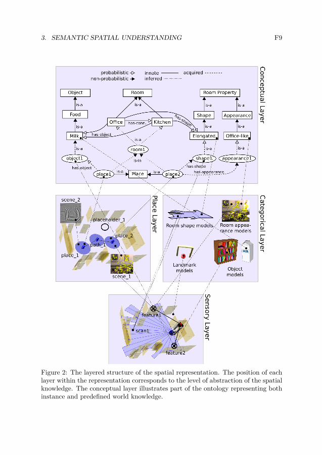
The spatial knowledge representation on top of which we build our system is pre-sented in Fig. 2. It consists of four layers corresponding to different levels of ab-straction, from low-level sensory input to high-level conceptual symbols. Each layerdefines its own spatial entities and the way the agent’s position in the world is rep-resented.
The knowledge is abstracted and represented only as accurately as necessary,and uncertainty is present at all levels. This keeps the complexity of the represen-tation under control, makes the knowledge more robust to dynamic changes, andallows to infer additional knowledge about the environment.
The lowest level of our representation is the sensory layer. This maintains anaccurate representation of the robot’s immediate environment. Above this are theplace and categorical layers. The place layer discretises continuous space into a finitenumber of places, plus paths between them. As a result, the place layer representsthe topology of the environment. The categorical layer contains categorical models(in our case pre-trained) of the robot’s sensory information which are not specificto any particular location or environment. These could be the sensory models ofobject categories, but also values of spatial properties such as an elongated shapeor office-like appearance. On top of this, the conceptual layer creates a unifiedrepresentation relating sensed instance knowledge to general conceptual knowledge.It includes a taxonomy of human-compatible spatial concepts which are linked tothe sensed instances of these concepts drawn from lower layers. It is the conceptuallayer which contains the information that kitchens commonly contain cereal boxesand have certain general appearance and allows the robot to infer that the cornflakesbox in front of the robot makes it more likely that the current room is a kitchen. Inthe following sections, we focus on the concrete implementations of the principlesoutlined here and algorithms maintaining the representations in each of the layers.
3. SEMANTIC SPATIAL UNDERSTANDING F9
Figure 2: The layered structure of the spatial representation. The position of eachlayer within the representation corresponds to the level of abstraction of the spatialknowledge. The conceptual layer illustrates part of the ontology representing bothinstance and predefined world knowledge.
F10 PAPER F. UNDERSTANDING THE REAL WORLD
4 Categorical Models of Sensory Information
The system employs categorical models of sensory information which abstract theinformation into a set of spatial concepts. These models correspond to the categor-ical layer of the spatial representation.
Independent models of shape, size and appearance properties are built. To pro-vide sufficient robustness and tractability in the presence of noisy, high-dimensionalinformation, we use non-linear kernel-based discriminative classifier models, namelySupport Vector Machines, as proposed in [16]. Those models are trained on featuresextracted directly from the robot’s sensory input. Following [16], we use a set ofsimple geometrical features extracted from laser range data in order to train theshape and size models. The appearance models are build from two types of visualcues, global, Composed Receptive Field Histograms (CRFH) and local based on theSURF features discretized into visual words [1]. We compute CRFH from secondorder normalised Gaussian derivative filters applied to the illumination channel attwo scales. The two visual features are further integrated using the GeneralizedDiscriminative Accumulation Scheme (G-DAS [16]). In case of SVMs, special caremust be taken in choosing an appropriate kernel function. Here we used the RBFkernel for the geometrical shape model and χ2-kernel for the visual appearancemodel.
The models are trained from sequences of images and laser range data recordedin multiple instances of rooms belonging to different categories and under variousdifferent illumination settings (during the day and at night). By including severaldifferent room instances into training, the acquired model can generalise sufficientlyto provide categorisation rather than instance recognition. In order to measurethe uncertainty associated with the generated hypotheses, confidence measures arederived from the distances between the classified samples and discriminative modelhyperplanes [16].
5 The Conceptual Map
The key component of our semantic mapping approach is the probabilistic concep-tual map which can be seen as a realization of the conceptual layer of the spatialrepresentation. In order to fully exploit the uncertainties provided by the multi-modal lower-level models, the robot needs to be capable of uncertain reasoning onthe conceptual level. Below, we first present the uncertain ontology of the con-ceptual map relating sensed instance knowledge and general conceptual knowledge.Then, we provide an implementation of the map in terms of a probabilistic graphicalmodel.
5.1 Uncertain Ontology
The ontology of spatial concepts and instances of those concepts implemented in theconceptual map is presented in Fig. 2. In order to represent the uncertainty associ-

5. THE CONCEPTUAL MAP F11
ated with some of the relationships, we extended the standard ontology notation byannotating relations as either probabilistic or non-probabilistic. The resulting on-tology defines a taxonomy of concepts through hyponym relationships (is-a) as wellas relations between concepts (has-a). As in [27], the ontology distinguishes threeprimary sources of knowledge: predefined (taxonomy and conceptual common-senseknowledge, e.g. the likelihood that cornflakes occur in kitchens), acquired (knowl-edge acquired using the robot’s sensors), and finally inferred (knowledge generatedinternally, e.g. that the room is likely to be a kitchen, because you are likely tohave observed cornflakes in it). We could further differentiate between acquiredknowledge and asserted knowledge which can be obtained by interaction with ahuman.
The ontology ties the concepts to instance symbols derived from the lower levelrepresentations. The instance knowledge includes the presence of objects and sensedspatial properties such as shape, size, appearance and topology. The conceptualknowledge comprises common-sense knowledge about the occurrence of objects inrooms of different semantic categories, and the relations between these categoriesand the aforementioned spatial properties.
In our system, the “has-a” relations for rooms, objects, shapes, sizes and appear-ances were acquired by analysing common-sense knowledge available through theworld wide web (for details see [5]) as well as annotations available together withthe database described in this report. The relation linking rooms and objects wasfirst bootstrapped using a part of the Open Mind Indoor Common Sense database1.Obtained object-location pairs were then used to generate ‘obj in the loc’ queriesto an online image search engine. The number of returned hits was used to obtainthe probabilities of existence of an object of a certain category in a certain typeof room. All relations that were not directly present in the obtained results, wereassumed to hold with a certain constant probability.
5.2 Probabilistic Inference
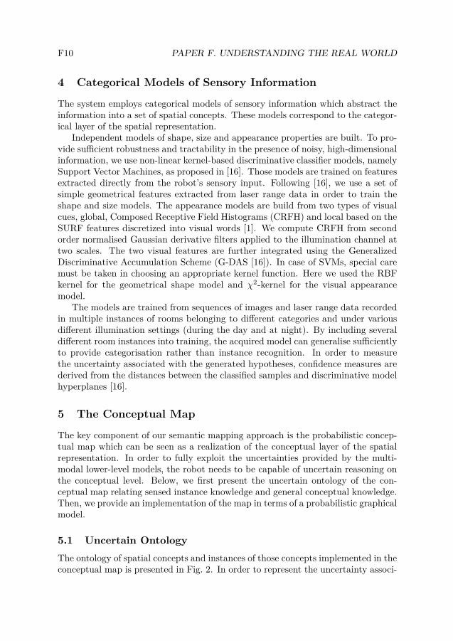
The conceptual map constructed according to the ontology presented above wasimplemented using a chain graph probabilistic model [7]. Chain graphs are a naturalgeneralization of directed (Bayesian Networks) and undirected (Markov RandomFields) graphical models. As such, they allow for modelling both “directed” causalas well as “undirected” symmetric or associative relationships, including circulardependencies.
The joint density f of a distribution that satisfies the Markov property associ-ated with a chain graph can be written as [7]:
f(x) =∏
τ∈ T
f(xτ |xpa(τ)),
1http://openmind.hri-us.com/
F12 PAPER F. UNDERSTANDING THE REAL WORLD
Figure 3: Structure of the chain graph model compiled from the conceptual map.The vertices represent random variables. The edges represent the directed andundirected probabilistic relationships between the random variables. The texturedvertices indicate observations that correspond to sensed evidence.
where pa(τ) denotes the set of parents of vertice τ . This corresponds to an outerfactorization which can be viewed as a directed acyclic graph with vertices rep-resenting the multivariate random variables Xτ , for τ in T (one for each chaincomponent). Each factor f(xτ |xpa(τ)) factorizes further into:
f(xτ |xpa(τ)) =1
Z(xpa(τ))
∏
α∈A(τ)
φα(xα),
where A(τ) represents sets of vertices in the normalized undirected graph Gτ∪pa(τ),such that in every set, there exist edges between every pair of vertices in the set.The factor Z normalizes f(xτ |xpa(τ)) into a proper distribution.
In order to perform inference on the chain graph, we first convert it into a factorgraph representation and apply an approximate inference engine, namely LoopyBelief Propagation [9], to comply with time constraints imposed by the roboticapplications.
The structure of the chain graph model is presented in Fig. 3. The structureof the model depends on the topology of the environment. Each discrete placeis represented by a set of random variables connected to variables representingsemantic category of a room. Moreover, the room category variables are connectedby undirected links to one another according to the topology of the environment.
6. SYSTEM OVERVIEW F13
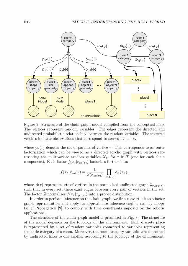
Figure 4: The Poisson distributions modelling the existence of a certain numberof objects in a room on the example of computers present in a double office and aprofessor’s office.
The potential functions φrc(·, ·) represent the type knowledge about the connectivityof rooms of certain semantic categories.
The remaining variables represent shape, size and appearance properties of spaceand presence of a certain number of instances of objects as observed from eachplace. These can be connected to observations of features extracted directly fromthe sensory input. As explained in Section 4, these links are quantified by thecategorical models in the categorical layer. Finally, the functions psh(·|·), psi(·|·),pa(·|·), poi
(·|·) utilise the common sense knowledge about object, spatial propertyand room category co-occurrence to allow for reasoning about other properties androom categories.
The conditional probability distributions poi(·|·) are represented by Poisson dis-
tributions. The parameter λ of the distribution allows to set the expected numberof object occurrences. This is exemplified in Fig. 4 presenting two distributionscorresponding to the relation between the number of computers in different typesof offices used later in the experiments. In the specific case of the double office,we set the expected number of computers to two. However, in all remaining cases,including the professor’s office, the parameter λ was calculated to match the prob-ability of there being no objects of a certain category as provided by the commonsense knowledge databases. The result is that the room is more likely to be a doubleoffice rather than a professor’s office if there are multiple computers in it.
6 System Overview
Having described the representations and the primary elements of the system, wenow explain the data flow through the system and mention all the remaining com-ponents. A coarse visualization of the data flow is presented in Fig. 1.
F14 PAPER F. UNDERSTANDING THE REAL WORLD
The layered structure of the spatial knowledge representation naturally permitsthe existence of data driven processes that abstract knowledge existing in the lower-level layers to contribute to knowledge in higher-level layers. This is the generalprinciple reflected by the data flow described below. In order to make those pro-cesses tractable, the updates are performed only if a substantial change (accordingto a modality-specific heuristic) has occurred.
First, mapping and topology maintenance processes create the place map. ASLAM algorithm [3] builds a metric map of the environment which can be seenas the sensory layer of the representation. The metric map is further discretizedinto places distributed spatially in the metric map. The places together with pathsobtained by traversing from one place to another constitute the place map of theplace layer. Then, based on the information about the connectivity of places andthe output of a template-based laser door detector, a process forms rooms by clus-tering places that are transitively interconnected without passing a doorway. Sincethe door detection algorithm can produce false positives and false negatives, roomformation must be a non-monotonic process to allow for knowledge revision. Roomformation and maintenance is handled by a general purpose rule engine, which isable to make non-monotonic inferences in its symbolic knowledge. The approach isan adaptation of the one by [6].
The categorical models are provided with sensory information from the laserrange finder and a camera. This information is classified and confidence estimatesare provided indicating the similarity of the sensory input to each of the categoricalmodels. The estimated confidence information is then accumulated over each ofthe viewpoints observed by the robot while being in a certain place [16] and furthernormalised to form potentials. The categorisation results are fed back into thechain graph triggering an inference in the probabilistic model. Accordingly, roomcategorisation is performed as a result of the reasoning process in the conceptualmap.
7 Experimental Scenario
All the categorical models used in the experiments were trained on the COLD-Stockholm database. COLD-Stockholm is a new database acquired as an extensionof the COLD database2. Several parts of the database were previously used duringthe RobotVision@ImageCLEF3 contests and proved to be challenging in the contextof room categorization.
7.1 The COLD-Stockholm Database
The database consists of multiple sequences of image, laser range and odometrydata. The sequences were acquired using the MobileRobots PowerBot robot plat-
2http://www.cas.kth.se/COLD3http://www.robotvision.info
7. EXPERIMENTAL SCENARIO F15
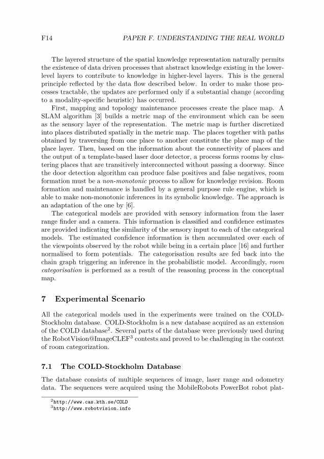
Figure 5: Examples of images from the COLD-Stockholm database acquired in9 different rooms. A video illustrating the acquisition process is available on thewebsite of the database.
form equipped with a stereo camera system in addition to a laser scanner. Theacquisition was performed on four different floors (4th to 7th) of an office environ-ment, consisting of 47 areas (usually corresponding to separate rooms) belongingto 15 different semantic and functional categories and under several different illu-mination settings (cloudy weather, sunny weather and at night). The floors arestructurally similar but the indivudual rooms are quite different. The robot wasmanually driven through the different floors of the environment while continuouslyacquiring images at a rate of 5fps. Each data sample was then labelled as belongingto one of the areas according to the position of the robot during acquisition. Ex-amples of images from the COLD-Stockholm database are shown in Fig. 5. Moredetailed information about the database can be found online4.
4http://www.cas.kth.se/cold-stockholm
F16 PAPER F. UNDERSTANDING THE REAL WORLD
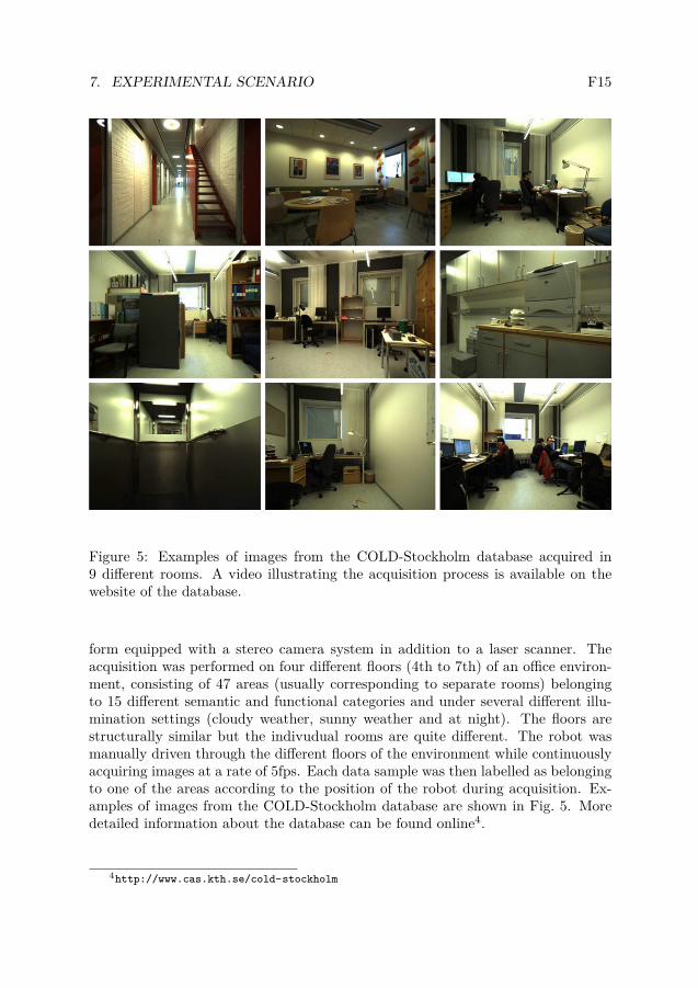
Property Cues Classification rate
Shape Geometric features 84.9%Size Geometric features 84.5%Appearance CRFH 80.5%Appearance BOW-SURF 79.9%Appearance CRFH + BOW-SURF 84.9%
Table 1: Classification rates obtained for each of the properties and cues.
7.2 Experimental Setup
In order to guarantee that the system will never be tested in the same environmentin which it was trained, we have divided the COLD-Stockholm database into twosubsets. For training and validation, we used the data acquired on floors 4, 5 and7. The data acquired on floor 6 were used for testing during our offline experimentsand the online experiment was performed on the same floor.
For the purpose of the experiments presented in this report, we have extendedthe annotation of the COLD-Stockholm database to include 3 room shapes, 3 roomsizes as well as 7 general appearances. The room size and shape, were decided basedon the length ratio and maximum length of edges of a rectangle fitted to the roomoutline. These properties together with 6 object types defined 11 room categoriesused in our experiments. The values of the properties as well as the room categoriesare listed in Fig. 8.
8 Experiments
We performed two types of experiments. First, offline to evaluate the performanceof our property classifiers. Then, we used the models obtained during the offlineexperiments and performed real-time semantic mapping on a mobile robot.
8.1 Offline Experiments
The offline experiments evaluated the performance of each of the property cate-gorizers separately. First, the rooms having the same values of properties weregrouped to form the training and validation datasets. Then, parameters of themodels were obtained by cross-validation. Finally, all training and validation datawere collected together and used for training the final models which were evaluatedon test data acquired in previously unseen rooms.
The classification rates obtained during those experiments for each of the prop-erties and cues are presented in Tab. 1. The models were trained and tested on3 different shapes, 3 different sizes and 7 different appearances. The rates wereobtained separately for each of the classes and then averaged in order to excludethe influence of unbalanced testing set. We can see that all classifiers provided a
8. EXPERIMENTS F17
Shape Size
Appearance Appearance AppearanceCRFH BOW-SURF CRFH + BOW-SURF
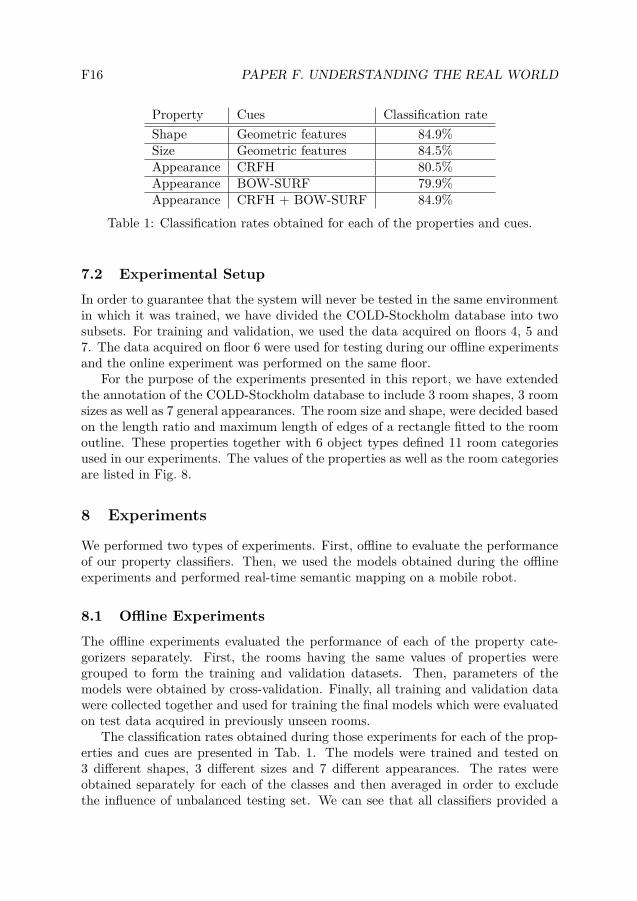
Figure 6: Confusion matrices for the offline experiments with sensory categoricalmodels of each of the properties.
recognition rate above 80%. Additionally, we see that integrating two visual cues(CRFH and BOW-SURF) increased the classification rate of the appearance prop-erty by almost 5%. Moreover, from the confusion matrices in Fig. 6 we see thatthe confusion occurs always between property values being semantically close andin case of appearance is largely reduced by cue integration.
8.2 Online Experiments
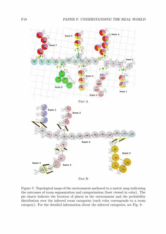
The models obtained during the offline experiments were used in the semanticmapping system during the online experiments. The experiments were performedon the 6th floor of the building where the COLD-Stockholm database was acquired,i.e. in the part which was not used for training. The robot was manually driventhrough 15 different rooms while performing real-time semantic mapping withoutrelying on any previous observations of the environment. The obtained maps ofparts of the environment (A and B) are presented in Fig. 7.
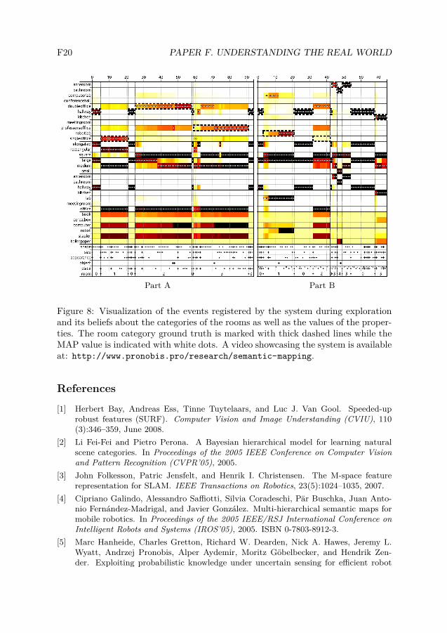
The robot recorded beliefs about the shapes, sizes, appearances, objects foundand the room categories for every significant change event in the conceptual map.The results for the two parts of the environment are presented in Fig. 8. Eachcolumn in the plot corresponds to a single event and the source of that event is
F18 PAPER F. UNDERSTANDING THE REAL WORLD
Part A
Part B
Figure 7: Topological maps of the environment anchored to a metric map indicatingthe outcomes of room segmentation and categorization (best viewed in color). Thepie charts indicate the location of places in the environment and the probabilitydistribution over the inferred room categories (each color corresponds to a roomcategory). For the detailed information about the inferred categories, see Fig. 8.
9. CONCLUSIONS AND FUTURE WORKS F19
indicated using dots (changes) and crosses (additions) at the bottom. At certainpoints in time, the robot was provided with asserted human knowledge about thepresence of objects in the environment.
By analysing the events and beliefs for part A, we see that the system correctlyidentified the first two rooms as a hallway and a single office using purely shape,size and general appearance (there are no object related events for those rooms).The next room was properly classified as a double office, and that belief was furtherenhanced by the presence of two computers. The next room was initially identifiedas a double office until the robot was given information that there is a single com-puter in this room. This was an indication that the room is a single person officethat due to its dimensions is likely to belong to a professor.
Looking at part B, we see that the system identified most of the room categoriescorrectly with the exception of a single office which due to a misclassification ofsize was incorrectly recognized as a double office. The experiment proved that thesystem can deliver an almost perfect performance by integrating multiple sourcesof semantic information.
A video illustrating showing the system in action is available online at http:
//www.pronobis.pro/research/semantic-mapping.
9 Conclusions and Future Works
In this report we have presented a probabilistic framework combining heterogenous,uncertain, information such as object observations, the shape, size and appearanceof rooms for semantic mapping. A graphical model, more specifically a chain-graph,is used to represented the semantic information and perform the inference over it.We introduced the concept of properties between the low level sensory data and thehigh level concepts such as room categorizes. The properties allowed us to decouplethe learning processes at the different levels and pave the way for better scalability.By making the properties understandable to humans, possibilities open in terms ofspatial knowledge verbalization and interpretation of human input.
There are several ways in which the work presented in this report can be ex-tended. We intend to look closer at how to define new categories based on a humandescription. For example, a person might describe a student canteen as a largeroom, kitchen like with very many tables. We will also look at ways to make thesegmentation of space part of the estimation process as is made in PLISS [18].We further plan to investigate more applications where the semantic informationprovided by our system can be utilized.
Acknowledgement
This work was supported by the SSF through its Centre for Autonomous Systems(CAS) and the EU FP7 project CogX. The help by Alper Aydemir, Moritz Göbel-becker and Kristoffer Sjöö is also gratefully acknowledged.
F20 PAPER F. UNDERSTANDING THE REAL WORLD
Part A Part B
Figure 8: Visualization of the events registered by the system during explorationand its beliefs about the categories of the rooms as well as the values of the proper-ties. The room category ground truth is marked with thick dashed lines while theMAP value is indicated with white dots. A video showcasing the system is availableat: http://www.pronobis.pro/research/semantic-mapping.
References
[1] Herbert Bay, Andreas Ess, Tinne Tuytelaars, and Luc J. Van Gool. Speeded-uprobust features (SURF). Computer Vision and Image Understanding (CVIU), 110(3):346–359, June 2008.
[2] Li Fei-Fei and Pietro Perona. A Bayesian hierarchical model for learning naturalscene categories. In Proceedings of the 2005 IEEE Conference on Computer Visionand Pattern Recognition (CVPR’05), 2005.
[3] John Folkesson, Patric Jensfelt, and Henrik I. Christensen. The M-space featurerepresentation for SLAM. IEEE Transactions on Robotics, 23(5):1024–1035, 2007.
[4] Cipriano Galindo, Alessandro Saffiotti, Silvia Coradeschi, Pär Buschka, Juan Anto-nio Fernández-Madrigal, and Javier González. Multi-hierarchical semantic maps formobile robotics. In Proceedings of the 2005 IEEE/RSJ International Conference onIntelligent Robots and Systems (IROS’05), 2005. ISBN 0-7803-8912-3.
[5] Marc Hanheide, Charles Gretton, Richard W. Dearden, Nick A. Hawes, Jeremy L.Wyatt, Andrzej Pronobis, Alper Aydemir, Moritz Göbelbecker, and Hendrik Zen-der. Exploiting probabilistic knowledge under uncertain sensing for efficient robot
REFERENCES F21
behaviour. In Proceedings of the 22nd International Joint Conference on ArtificialIntelligence (IJCAI’11), Barcelona, Spain, 2011.
[6] Nick A. Hawes, Marc Hanheide, Jack Hargreaves, Ben Page, and Hendrik Zender.Home alone: Autonomous extension and correction of spatial representations. InProceedings of the 2011 IEEE International Conference on Robotics and Automation(ICRA’11), Shanghai, China, 2011.
[7] Steffen L. Lauritzen and Thomas S. Richardson. Chain graph models and their causalinterpretations. Journal Of The Royal Statistical Society Series B, 64(3):321–348,2002.
[8] Jie Luo, Andrzej Pronobis, Barbara Caputo, and Patric Jensfelt. Incremental learningfor place recognition in dynamic environments. In Proceedings of the 2007 IEEE/RSJInternational Conference on Intelligent Robots and Systems (IROS’07), pages 721–728, San Diego, CA, USA, October 2007.
[9] Joris M. Mooij. libDAI: A free and open source C++ library for discrete approximateinference in graphical models. Journal of Machine Learning Research (JMLR), 11:2169–2173, 2010.
[10] Oscar Martinez Mozos, Cyrill Stachniss, and Wolfram Burgard. Supervised learn-ing of places from range data using AdaBoost. In Proceedings of the 2005 IEEEInternational Conference on Robotics and Automation (ICRA’05), Barcelona, Spain,2005.
[11] Oscar Martinez Mozos, Rudolph Triebel, Patric Jensfelt, Axel Rottmann, and Wol-fram Burgard. Supervised semantic labeling of places using information extractedfrom sensor data. Robotics and Autonomous Systems (RAS), 55(5):391–402, 2007.
[12] Andrzej Pronobis and Barbara Caputo. Confidence-based cue integration for visualplace recognition. In Proceedings of the 2007 IEEE/RSJ International Conference onIntelligent Robots and Systems (IROS’07), pages 2394–2401, San Diego, CA, USA,October 2007.
[13] Andrzej Pronobis, Barbara Caputo, Patric Jensfelt, and Henrik I. Christensen. Adiscriminative approach to robust visual place recognition. In Proceedings of the 2006IEEE/RSJ International Conference on Intelligent Robots and Systems (IROS’06),Beijing, China, October 2006.
[14] Andrzej Pronobis, Barbara Caputo, Patric Jensfelt, and Henrik I. Christensen. Arealistic benchmark for visual indoor place recognition. Robotics and AutonomousSystems (RAS), 58(1):81–96, January 2010. URL http://linkinghub.elsevier.
com/retrieve/pii/S0921889009001146.
[15] Andrzej Pronobis, Jie Luo, and Barbara Caputo. The more you learn, the less youstore: memory-controlled incremental SVM for visual place recognition. Image andVision Computing (IMAVIS), 28(7):1080–1097, July 2010. URL http://linkinghub.
elsevier.com/retrieve/pii/S0262885610000314.
[16] Andrzej Pronobis, Oscar Martinez Mozos, Barbara Caputo, and Patric Jensfelt.Multi-modal semantic place classification. The International Journal of RoboticsResearch (IJRR), Special Issue on Robotic Vision, 29(2-3):298–320, February 2010.
[17] Andrzej Pronobis, Kristoffer Sjöö, Alper Aydemir, Adrian N. Bishop, and PatricJensfelt. Representing spatial knowledge in mobile cognitive systems. In 11th Inter-national Conference on Intelligent Autonomous Systems (IAS-11), Ottawa, Canada,

F22 PAPER F. UNDERSTANDING THE REAL WORLD
August 2010. URL http://www.pronobis.pro/publications/pronobis2010sprep.
pdf.
[18] Ananth Ranganathan. PLISS: Detecting and labeling places using online change-point detection. In Proceedings of Robotics: Science and Systems (RSS’10), Zaragoza,Spain, June 2010.
[19] Ananth Ranganathan and Frank Dellaert. Semantic modeling of places using objects.In Proceedings of Robotics: Science and Systems (RSS’07), 2007.
[20] Antonio Torralba, Kevin P. Murphy, William T. Freeman, and Mark A. Rubin.Context-based vision system for place and object recognition. In Proceedings of the9th IEEE International Conference on Computer Vision (ICCV’03), 2003.
[21] Iwan Ulrich and Illah Nourbakhsh. Appearance-based place recognition for topo-logical localization. In Proceedings of the 2000 IEEE International Conference onRobotics and Automation (ICRA’00), San Francisco, CA, USA, 2000.
[22] Christoffer Valgren and Achim J. Lilienthal. Incremental spectral clustering andseasons: Appearance-based localization in outdoor environments. In Proceedings ofthe 2008 IEEE International Conference on Robotics and Automation (ICRA’08),pages 1856–1861, May 2008. ISBN 978-1-4244-1646-2.
[23] Shrihari Vasudevan and Roland Siegwart. Bayesian space conceptualization and placeclassification for semantic maps in mobile robotics. Robotics and Autonomous Systems(RAS), 56:522–537, 2008.
[24] Julia Vogel and Bernt Schiele. A semantic typicality measure for natural scene cate-gorization. Annual Pattern Recognition Symposium (DAGM’04), 2004.
[25] Jianxin Wu, Henrik I. Christensen, and James M. Rehg. Visual place categorization:problem, dataset, and algorithm. In Proceedings of the 2009 IEEE/RSJ InternationalConference on Intelligent Robots and Systems (IROS’09), 2009.
[26] Jianxin Wu and James M. Rehg. Where am I: place onstance and category recognitionusing spatial PACT. In Proceedings of the 2008 IEEE Conference on Computer Visionand Pattern Recognition (CVPR’08), June 2008. ISBN 978-1-4244-2242-5.
[27] Hendrik Zender, Oscar Martinez Mozos, Patric Jensfelt, Geert-Jan M. Kruijff, andWolfram Burgard. Conceptual spatial representations for indoor mobile robots.Robotics and Autonomous Systems (RAS), 56(6):493–502, June 2008.
[28] Zoran Zivkovic, Olaf Booij, and Ben Kröse. From images to rooms. Robotics andAutonomous Systems (RAS), Special Issue From Sensors to Human Spatial Concepts,55(5):411–418, 2007.