archaeological survey of hascombe hillfort, surrey
TRANSCRIPT
Surrey Archaeological Society Hascombe Hillfort 1
Hascombe Hillfort
Analytical and magnetometry surveys
County: Surrey
District: Waverley
Parish: Hascombe
NGR: TQ 005 386
SAM No.: 23012
Surrey HER: 676
Surveyed: 2008 - 2009
Report by: Rose Hooker & Judie English
Surrey Archaeological Society, Castle Arch, Quarry Street, Guildford GU1 3SX
Surrey Archaeological Society Hascombe Hillfort 2
Surrey Archaeological Society Hascombe Hillfort 3
CONTENTS
Summary 6
Introduction
LOCATION, GEOLOGY AND TOPOGRAPHY, VEGETATION 6
AND PRESENT LAND USE
ARCHAEOLOGICAL AND HISTORICAL SUMMARY 7
The analytical survey
METHOD 17
THE EARTHWORKS 18
THE WIDER CONTEXT 26
The magnetometry survey
METHOD 34
RESULTS 37
Interpretation 38
Acknowledgements 48
Bibliography 49
Distribution 52
Surrey Archaeological Society Hascombe Hillfort 4
LIST OF ILLUSTRATIONS
Frontispiece
Figure 1 Geology of the area around Hascombe hillfort 7
Figure 2 Topographical position of Hascombe hillfort 8
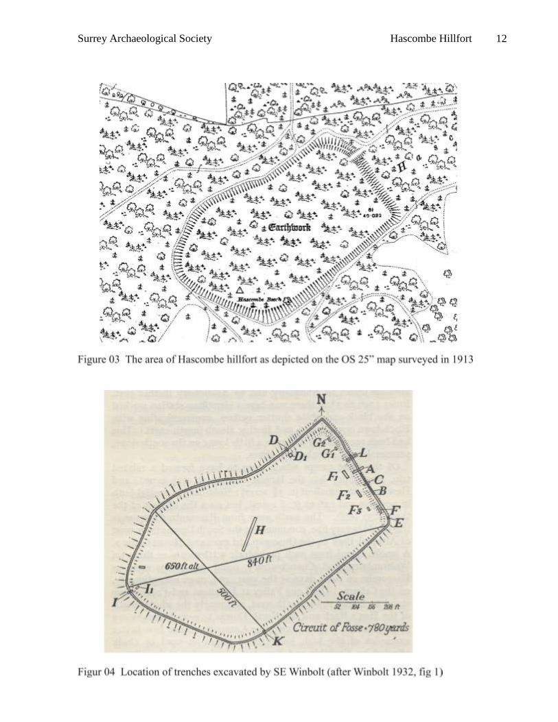
Figure 3 Hascombe hillfort from the OS 25” map surveyed in 1913 12
Figure 4 Location of trenches excavated in 1931 (Winbolt 1932, fig 1) 12
Figure 5 Location of trenches excavated in 1975 & 1977 (Thompson 1979 fig 12) 14
Figure 6 Middle Iron Age shouldered jar (by Mike Seager Thomas) 15
Figure 7 Extract from map by Johan Blaeu drawn 1648 15
Figure 8 Analytical survey 19
Figure 9 Annotated analytical survey 20
Figure 10 Analytical survey showing modern features 21
Figure 11 Low lying area to east of entrance 22
Figure 12 Dog’s grave 22
Figure 13 Carriageway on south-east side of hillfort 24
Figure 14 Path from carriageway to knoll 24
Figure 15 Carriageway on north-west side of hillfort 25
Figure 16 ‘Hascombe Beech’ felled October 16th 1987 25
Figure 17 Track rounding north-west corner of hillfort 27
Figure 18 Track as cut terrace on northern flank of ridge 27
Figure 19 Bank surrounding top of knoll 28
Figure 20 ‘Standing stone’ marking path to knoll 28
Figure 21 Decorative planting on the knoll 29
Surrey Archaeological Society Hascombe Hillfort 5
Figure 22 Decorative planting between the knoll and the hillfort 29
Figure 23 Hascombe Park pale 31
Figure 24 Distance marker on Godalming to Alfold Crossways turnpike road 31
Figure 25 Portion of map surveyed 1825 (SHC 1327/1) 32
Figure 26 Quarry on track from Hascombe village to hillfort 33
Figure 27 Cart pull-off close to quarry 33
Figure 28 Results of magnetometry survey 35
Figure 29 Interpretation of results from magnetometry survey 36
Figure 30 Iron Age sites mentioned in text 40
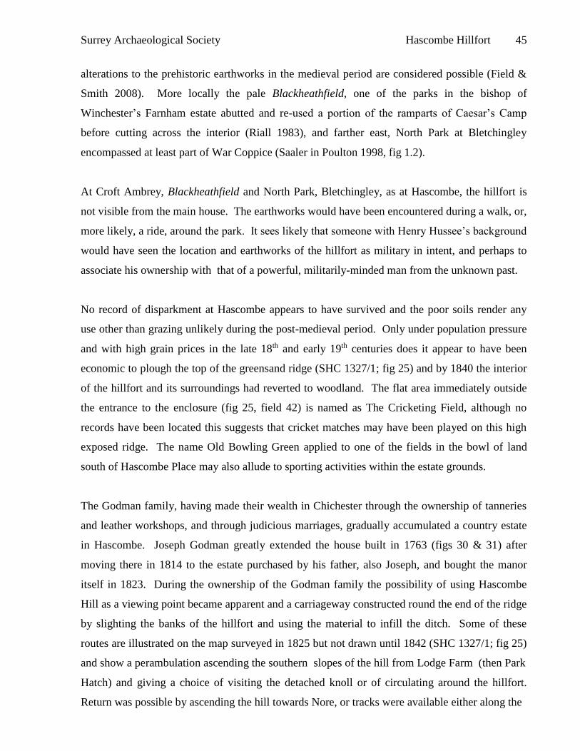
Figure 31 Park Hatch as built in 1763 46
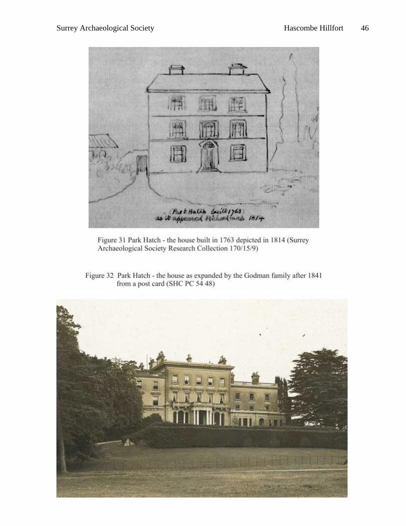
Figure 32 Park Hatch in approximately 1910 46
Figure 33 Modern stone circle at Park Hatch 48
Surrey Archaeological Society Hascombe Hillfort 6
Summary
Analytical survey and interpretation of the earthworks of the ‘hillfort’ on Hascombe Hill,
Hascombe, has allowed suggestions to be made regarding its role as a highly visible monument
in its local setting. Both location and design are seen as influenced by the natural topography
which has been sculpted to meet a range of potential requirements. Magnetometry survey failed
to indicate evidence of intensive permanent occupation but a number of anomalies which may
indicate the positions of pits or hearths were located and a tentative identification of an
underlying field system has been made. Re-assessment of pottery from previous excavations has
suggested that Hascombe and Holmbury hillforts had a contemporary genesis and their location
and affinities are discussed in view of this finding. A place for these hillforts within
developments in the exploitation of resources from the western Low Weald is sought. The
enclosure of Hascombe Hill within a park of probable medieval date, and its subsequent
landscaping as part of the gardens attached to Park Hatch are also discussed.
Introduction
LOCATION, GEOLOGY AND TOPOGRAPHY, VEGETATION AND PRESENT LAND USE
Hascombe hillfort is situated at the southern end of a spur some 1400m long which extends
southwards from the main greensand ridge and bounds the western side of the Bramley Wey
valley. This flat topped ridge, a notable landform within its locality, has extensive views to east
and south, and to the north the long, level ridge of the Hog’s Back, part of the North Downs, can
be seen; however, the view to the west is blocked by the high ground of Holloways Heath. The
view eastwards, back along the scarp slope of the greensand, includes Holmbury hillfort and
Leith Hill, whilst that southwards encompasses both the ridge representing the watershed
between the south flowing Arun and the north flowing Wey and the chalk of the South Downs.
The hillfort itself occupies the high point at the end of the ridge, at 198m OD, but a small knoll
lies to its south-east, separated from the high point by a shallow valley. The ridge comprises
Hythe Beds, one of the formations of the Lower Greensand, which itself contains both soft
sandstone and harder bands of chert which resist erosion and cap most high points. On
Hascombe Hill, as elsewhere, these bands can form corrugations in the land surface usually
running from north to south.
Surrey Archaeological Society Hascombe Hillfort 7
The spring line usually emerges at the foot of the escarpment, where permeable greensand
overlies the relatively impermeable Atherfield Clay but a damp area supporting rushes suggests
water may have been available within the interior of the hillfort and there is virtually always
standing water outside the north-eastern rampart.
In general, the greensand ridge carries an acid, infertile podzol which supports heathland
vegetation with heathers, heaths, gorse and bracken predominating. In some areas stands of
conifers have been planted, occasional oak, whitebeam and rowan (mountain ash) survive whilst
cessation of use for grazing has allowed birch to become pervasive. Bilberries, locally known as
hurts, are widespread and have given the name Hurtwood to the area between Guildford and
Dorking. On Hascombe Hill the slopes were clad with decorative planting of beech which later
self seeded but the famous ‘Hascombe Beeches’ were largely felled by the gales of 1987 and
1991, causing not inconsiderable damage to the ramparts of the hillfort itself.
The geology and topography of the area around Hascombe hillfort are shown in figures 01 and 02
respectively.
ARCHAEOLOGICAL AND HISTORICAL SUMMARY
The earliest accounts of Hascombe hillfort which appear to have survived date to the early 18th
century. At this time the relatively square shape of the enclosure lead to its being assigned to the
Romano-British period, for example:
Surrey Archaeological Society Hascombe Hillfort 8
Surrey Archaeological Society Hascombe Hillfort 9
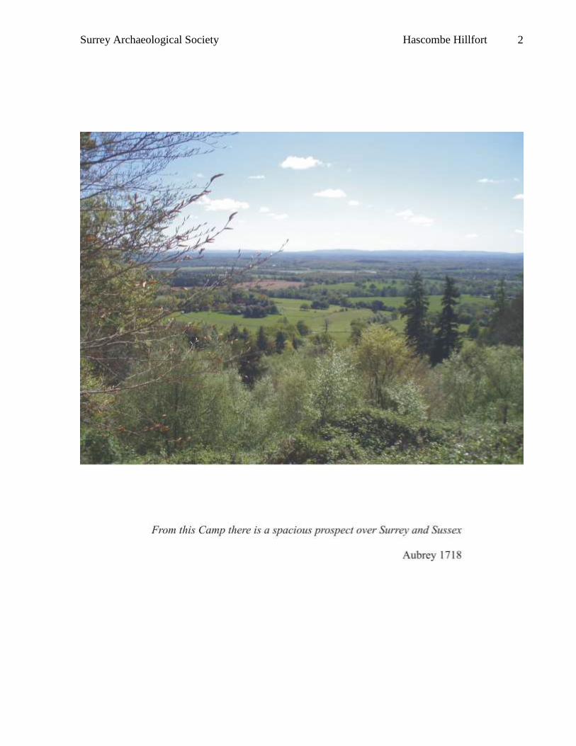
“In this parish, on the hill called Castle Hill, is the remains of a Roman Camp; the works of
which are single, and the Camp almost square. According as the ground allows it, and the
works not great, which are manifest signs of a Roman Camp. From this Camp is a spacious
prospect over Surrey and Sussex and a convenient place to make a map” (Aubrey 1718).
Interestingly, Aubrey notes both that the shape of the hillfort was governed by the topography
and that there was an extensive view to the south. This description was repeated two decades
later:
“There is a camp, taken to be Roman, Castle Hill. Many of these earthworks about
England pass by the name of Castle Hill, being upon an eminence, but showing no broken
walls or remains of buildings” (Salmon 1736).
We are fortunate to have a detailed description of the earthworks on Hascombe Hill from a
notable local field archaeologist which is worth quoting in full (Lasham 1895):
The principal banks are well defined; it has an inner, an outer, and a bank running round the
base of the hill. All the banks appear to be formed of rubble or sandstone, and, although
broken in fragments, the banks are very compact. Careful search did not reveal the spot
where the stone was quarried; it is possible however, that the top of the hill may have been
shaved off and so utilized. The absence of water, at least in the shape of springs on the hill,
would seem to indicate (unless there are wells as yet undiscovered) that it was simply a
fort, and not used as a residence: water is procurable about a quarter of a mile from the base
of the hill. At the time of the writer’s visit there appeared to be inserted in the east bank
two drain or flue pipes, about five feet from the top of the bank. There seemed to be a
doubt as to these being Roman, as no excavation has ever been made in the camp. The
entrance to the fort at the east end appears to be carefully and substantially made, the stone
used being the same as that composing the banks; it is about 9 feet wide, and there are well
defined banks on either side. Some rough measurements, taken by the Rev. T S Cooper,
gave the length of the bank on the south side as 570 feet; this is the side facing the Weald.
The ground here falls away abruptly, and the banks appear to have been removed or
denuded, and the ditch below filled, probably with the debris from banks above. The bank
on the east side is some 300 feet, and is well defined, especially at the south end, which is
Surrey Archaeological Society Hascombe Hillfort 10
very steep. The west bank follows the line of the hill, and its elevation being great, but
little fortification would be needed. The north bank follows the line of the hill more or less
at the west end, but is mainly straight and well defined. The outer bank on the east is some
300 feet long, and is also well marked. Other banks are to be seen, all made up of broken
sandstone; further east, they descend the hill to Park Hatch. Not far from the east bank is a
circular, well defined cutting in the soil, which may be an enclosure set apart for either
defence or burial (? a British oppidum).
This well observed description provided some evidence for dating alterations to the hillfort and
its immediate surroundings and will be further discussed below.
By the early 20th century less certainty about the date was expressed but otherwise little further
understanding of this, and the other hillforts situated on the greensand, had been gained.
“On Hascombe Hill, at the western end, is an ancient camp. It is roughly rectangular,
following the slope of the hill, and from the curiously rectangular form of the ground it
makes a sort of square of 200 yards. Water was procurable a little way down the hill.
Lieu-Colonel Godwin Austen has found sling stones on the hill, rounded flint pebbles,
where no such should be geologically, and Mr Godman found a good flint arrow head
lower down the southern slope” (Malden 1902-12, III, 102)
Despite this, Hascombe hillfort appears to have escaped the attention of the Ordnance Survey,
and does not appear on the early editions of the 25” maps but that published in 1916 shows a very
simple outline of the enclosure and this appears to be the only survey of the site which has been
undertaken (figure 03). The map published in 1871 does show a path which closely follows the
line of the northern and western earthworks and this probably represents the terrace walk
constructed for those residing at ‘the mansion’, probably Park Hatch, to enjoy the views
(Manning & Bray 1809, 2, 64). Whilst described as having been cut, it is possible that material
from a bank was used to fill a ditch thus creating a terrace.
Two excavations are known to have taken place at Hascombe hillfort, one in the 1930s (Winbolt
1932) and the other in the 1970s (Thompson 1979).
Surrey Archaeological Society Hascombe Hillfort 11
The earliest of these involved a number of trenches concentrated on the north-eastern leg of the
earthworks (Winbolt 1932; figure 04). Winbolt makes the point that the 1440 yard (1320m) ridge
stretching south-west to north-east from Lox Hill to Creek Copse provides a notable landmark
when viewed from the Weald to the south and south-west. In considering this view he says:
“The south view from Hascombe Camp over the Weald is very fine, commanding the South
Downs from west of Arundel Park to the Ouse Gap at Lewes and Mount Caburn. A smoke
signal from such prehistoric settlements as those on Wolstanbury and Chanctonbury could
be easily seen on Hascombe on most days of the year, and, more exceptionally, on the
Caburn” (Winbolt 1932).
The same author also notes that to the north-west, Crooksbury and the Hog’s Back, and to the
north-east, Ranmore, stand out on the horizon. Mr Joseph Godman is noted as having a
collection of worked flint from the hill including both leaf-shaped and barbed and tanged
arrowheads. Winbolt targeted his trenches on positions similar to those where he had located
evidence of occupation at Holmbury hillfort (Winbolt 1930) and found the remains of hearths
(trenches F2, G1 and G2). In trench F1 burnt sandstone and a piece of carstone (iron rich
sandstone) encouraged the belief that iron may have been smelted within the enclosure. On the
basis of the simplicity of the design of the entrance, Winbolt placed the construction of
Hascombe hillfort to the period of the earliest of the Celtic invaders in the 6th century BC
(Hawkes type A, Hawkes 1931), and considered that abandonment in the mid-1st century BC
resulted from centralisation under a small number of developed hillforts and desertion of the
remainder. Winbolt also investigated the ‘terrace walk’ and, having noted the presence of
remains of a ditch on the inner side, and a bank on the outer, showed by excavation (trenches D, I
and K) that the walk had indeed been constructed by filling an original ditch with material from
an original bank. Trench D also located iron slag but a further trench, D1 on the figure but D2 in
the text, failed identify a bloomery furnace. In trench K, at the most sheltered quadrant of the
enclosure, Winbolt found a square pit in the bottom of the ditch containing pottery, charcoal,
sand and sandstone burnt at a high temperature and a small amount of iron slag – his best
evidence for iron working on this site. The use of the ditch for this procedure would have been
necessitated by the exposed nature of the site and the location makes it unlikely that the iron
working dated to a later period. Winbolt’s prescience in regarding Hascombe as contemporary
with Holmbury and dating to the Early Iron Age will be discussed below.
Surrey Archaeological Society Hascombe Hillfort 12
Surrey Archaeological Society Hascombe Hillfort 13
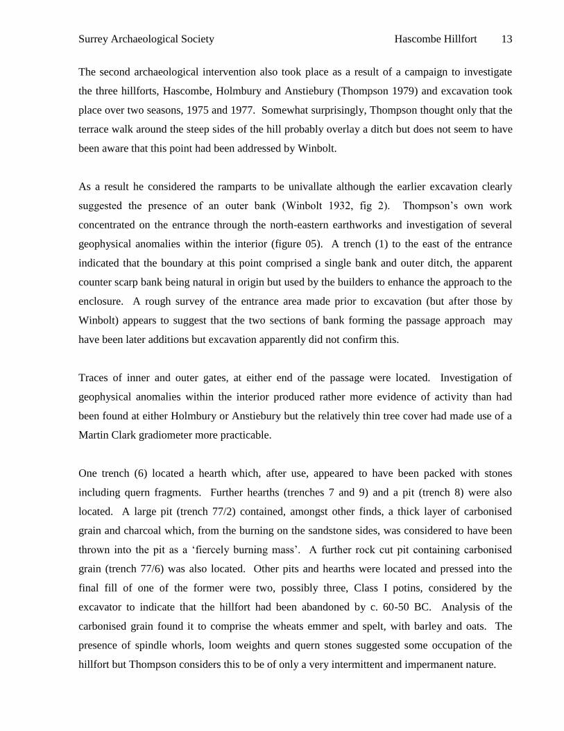
The second archaeological intervention also took place as a result of a campaign to investigate
the three hillforts, Hascombe, Holmbury and Anstiebury (Thompson 1979) and excavation took
place over two seasons, 1975 and 1977. Somewhat surprisingly, Thompson thought only that the
terrace walk around the steep sides of the hill probably overlay a ditch but does not seem to have
been aware that this point had been addressed by Winbolt.
As a result he considered the ramparts to be univallate although the earlier excavation clearly
suggested the presence of an outer bank (Winbolt 1932, fig 2). Thompson’s own work
concentrated on the entrance through the north-eastern earthworks and investigation of several
geophysical anomalies within the interior (figure 05). A trench (1) to the east of the entrance
indicated that the boundary at this point comprised a single bank and outer ditch, the apparent
counter scarp bank being natural in origin but used by the builders to enhance the approach to the
enclosure. A rough survey of the entrance area made prior to excavation (but after those by
Winbolt) appears to suggest that the two sections of bank forming the passage approach may
have been later additions but excavation apparently did not confirm this.
Traces of inner and outer gates, at either end of the passage were located. Investigation of
geophysical anomalies within the interior produced rather more evidence of activity than had
been found at either Holmbury or Anstiebury but the relatively thin tree cover had made use of a
Martin Clark gradiometer more practicable.
One trench (6) located a hearth which, after use, appeared to have been packed with stones
including quern fragments. Further hearths (trenches 7 and 9) and a pit (trench 8) were also
located. A large pit (trench 77/2) contained, amongst other finds, a thick layer of carbonised
grain and charcoal which, from the burning on the sandstone sides, was considered to have been
thrown into the pit as a ‘fiercely burning mass’. A further rock cut pit containing carbonised
grain (trench 77/6) was also located. Other pits and hearths were located and pressed into the
final fill of one of the former were two, possibly three, Class I potins, considered by the
excavator to indicate that the hillfort had been abandoned by c. 60-50 BC. Analysis of the
carbonised grain found it to comprise the wheats emmer and spelt, with barley and oats. The
presence of spindle whorls, loom weights and quern stones suggested some occupation of the
hillfort but Thompson considers this to be of only a very intermittent and impermanent nature.
Surrey Archaeological Society Hascombe Hillfort 14
On the dating of this hillfort Thompson clearly felt quite secure and, using a number of
radiocarbon dates, an archaeo-magnetic date for the burnt sandstone in the pit, diagnostic pottery
and the presence of potins, placed the construction and occupation of the enclosure in the Late
Iron Age. Indeed, he went so far as to suggest that it, together with Holmbury and Anstiebury,
was built as a response to the Caesarian invasion of 54BC and destroyed in obedience to peace
terms imposed by the Romans. The purpose underlying their construction was defensive and
Thompson specifically rejected the possibility that these monuments could be seen as examples
of conspicuous construction.
Concerns that the dating assigned to the greensand hillforts did not correlate with that from other
areas where hillforts have been recognized as having originated earlier in the IA led to a re-
assessment of the pottery from Thompson’s excavations at Hascombe, Holmbury and Anstiebury
(Seager Thomas 2008; forthcoming). In summary, both Hascombe and Holmbury have produced
small amounts of post-Deverel-Rimbury pottery dated to the early 1st millennium BC and
indicative of activity in the area though not construction of the enclosures. This pottery was not
recognized in Thompson’s (1979) report and probably dates to the centuries after c.800BC.
Surrey Archaeological Society Hascombe Hillfort 15
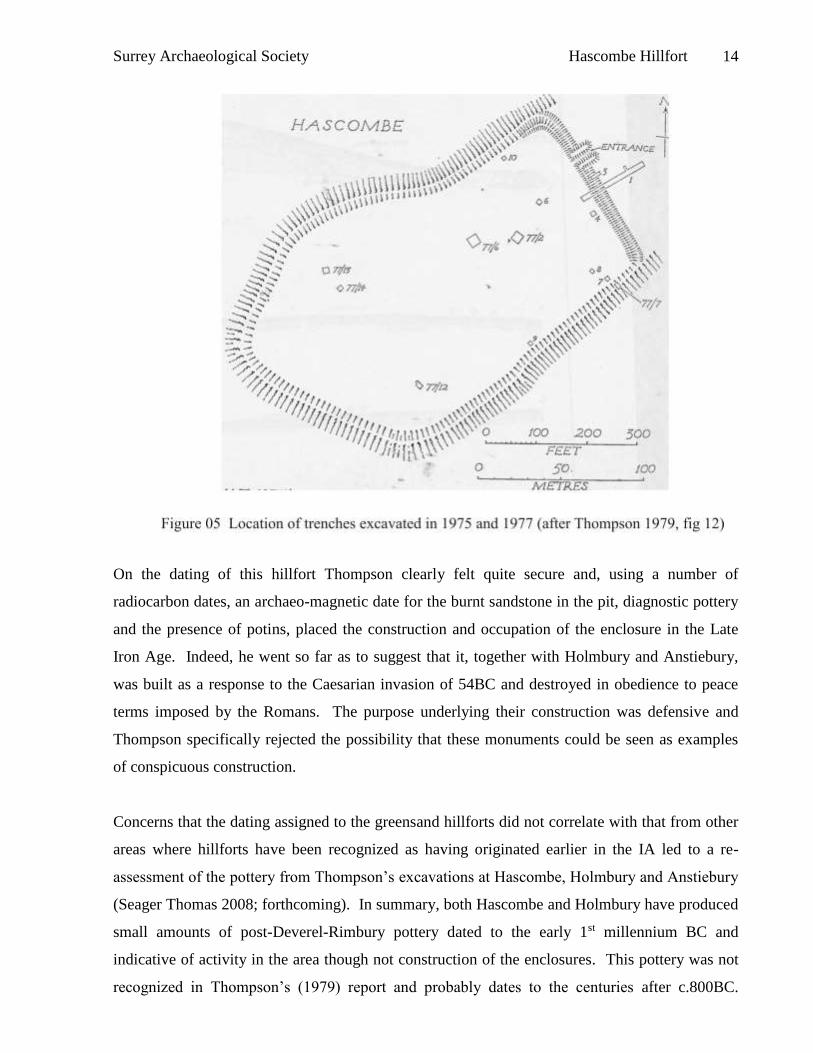
Middle Iron Age pottery (fig 06), dating to between c.400BC and c.100BC dominates the
assemblages from Hascombe and Holmbury but forms a relatively minor component of that from
Anstiebury. At this latter site mainly pottery from the Late Iron Age and into the Romano-British
period was recovered.
The presence of pottery from as far afield as Cornwall places Middle Iron Age Hascombe within
a trade / exchange network recognized elsewhere in southern Britain (Cunliffe 2005) but of
perhaps greater interest in attempting to place the greensand hillforts of Surrey within a wider
context is the observation that the pottery assemblage feels to have primarily Sussex, rather than
Wessex or Thames Valley connections.
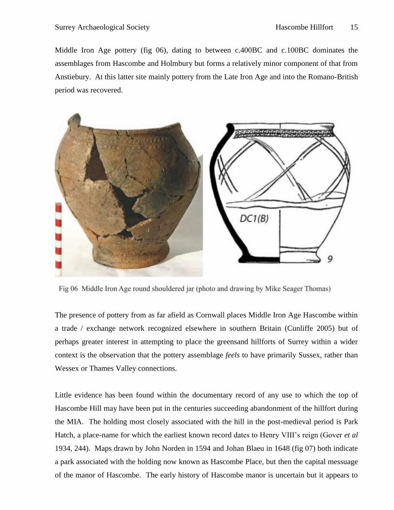
Little evidence has been found within the documentary record of any use to which the top of
Hascombe Hill may have been put in the centuries succeeding abandonment of the hillfort during
the MIA. The holding most closely associated with the hill in the post-medieval period is Park
Hatch, a place-name for which the earliest known record dates to Henry VIII’s reign (Gover et al
1934, 244). Maps drawn by John Norden in 1594 and Johan Blaeu in 1648 (fig 07) both indicate
a park associated with the holding now known as Hascombe Place, but then the capital messuage
of the manor of Hascombe. The early history of Hascombe manor is uncertain but it appears to
Surrey Archaeological Society Hascombe Hillfort 16
have been one of several manors which resulted from the breakup of the Late Saxon estate of
Bramley. In 1241-2 Richard and John of Hascombe were described as tenants of Bramley and
manorial status may not have been granted until the tenure of Henry Hussee in the early 14th
century. He was granted right of free warren in 1307 and may have been responsible for the
creation of the park, although no direct documentary evidence appears to have survived (Malden
1911, 3, 102-3). The further possibilities raised by Hussee’s ownership will be discussed later in
this report. Given the relative position of Nore, to the north-east of Hascombe Hill, it would
appear that the hill and its hillfort were not included within the park, but the presence of places
named as Park Hatch and Lodge Farm, with a large bank and ditch which could well have been a
park pale, to the south-east of the hill and immediately adjacent to the latter holding strongly
suggests that Hascombe Hill was within Hascombe Park in the medieval and post-medieval
periods.
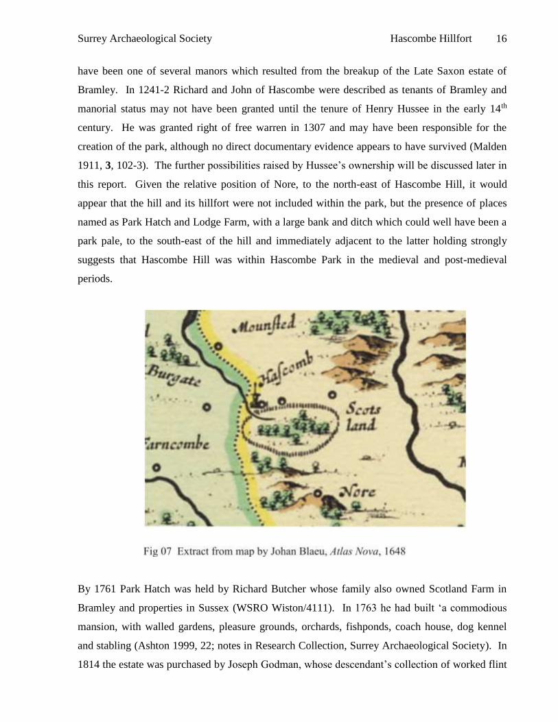
By 1761 Park Hatch was held by Richard Butcher whose family also owned Scotland Farm in
Bramley and properties in Sussex (WSRO Wiston/4111). In 1763 he had built ‘a commodious
mansion, with walled gardens, pleasure grounds, orchards, fishponds, coach house, dog kennel
and stabling (Ashton 1999, 22; notes in Research Collection, Surrey Archaeological Society). In
1814 the estate was purchased by Joseph Godman, whose descendant’s collection of worked flint
Surrey Archaeological Society Hascombe Hillfort 17
from Hascombe Hill is noted above. Godman increased the size of the Park Hatch estate and
eventually purchased the manor of Hascombe from Sir Henry Edmund Austen of Shalford in
1823. A map surveyed in 1825 by Edward Fuller for Joseph Godman, but not drawn until 1842,
depicts the ramparts of the hillfort as tree covered but the interior as arable land and a number of
paths are also shown (SHC 1327/1; fig 25). On this map an un-named holding on the site of the
present Lodge Farm south-east of Hascombe Hill was placed within the land of Hascombe Farm,
now Hascombe Place, indicating that in 1825 the hill was still associated with the manorial caput.
By 1841, with decreasing grain prices rendering marginal land less profitable and an increasing
interest in the Surrey Hills as a desirable place to live and to beautify, the arable land was gone
and the hill, now certainly part of the Park Hatch estate, was covered by woodland, (SRO
864/1/79-80).
In 1851 Joseph Godman II enlarged Park Hatch mansion and further work was undertaken in the
1890s by his son. His grandson sold Park Hatch and during WWII the house was used to billet
Canadian troops and was later occupied by the National Fire Service. Soon after purchase of the
estate by the Duke of Westminster in 1951 the house, by then in bad repair, was demolished.
The analytical survey
METHOD
The survey was carried out by members of the Surrey Archaeological Society, under the
leadership of the authors, over the winter of 2208/09, using the time of year when vegetation,
particularly bracken, was at its lowest. Some areas, particularly the south-eastern portion of the
interior which had not been cleared of dense vegetation, and portions of the slopes covered by
wind-felled trees and subsequent opportunistic regeneration, could not be subjected to detailed
survey, and it is acknowledged that this will have prevented recognition of fine detail in those
areas.
A framework of control points was provided using a total station and offsets from tapes placed
between these points were used to survey the earthworks of the hillfort and the location of these
points checked using a Garmin Etrex personal navigator. The wider context was surveyed using
a combination of tapes laid by compass from fixed points marked on relevant large scale OS
maps and point location also using a Garmin Etrex personal navigator. The area between the
knoll and the hillfort, where earthworks on the slopes had been created to join these two moieties
Surrey Archaeological Society Hascombe Hillfort 18
is tree-covered and the survey involved over-long tape traverses – it is recognised that some
accuracy was lost in this area.
THE EARTHWORKS
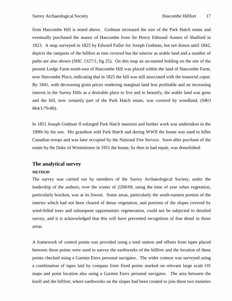
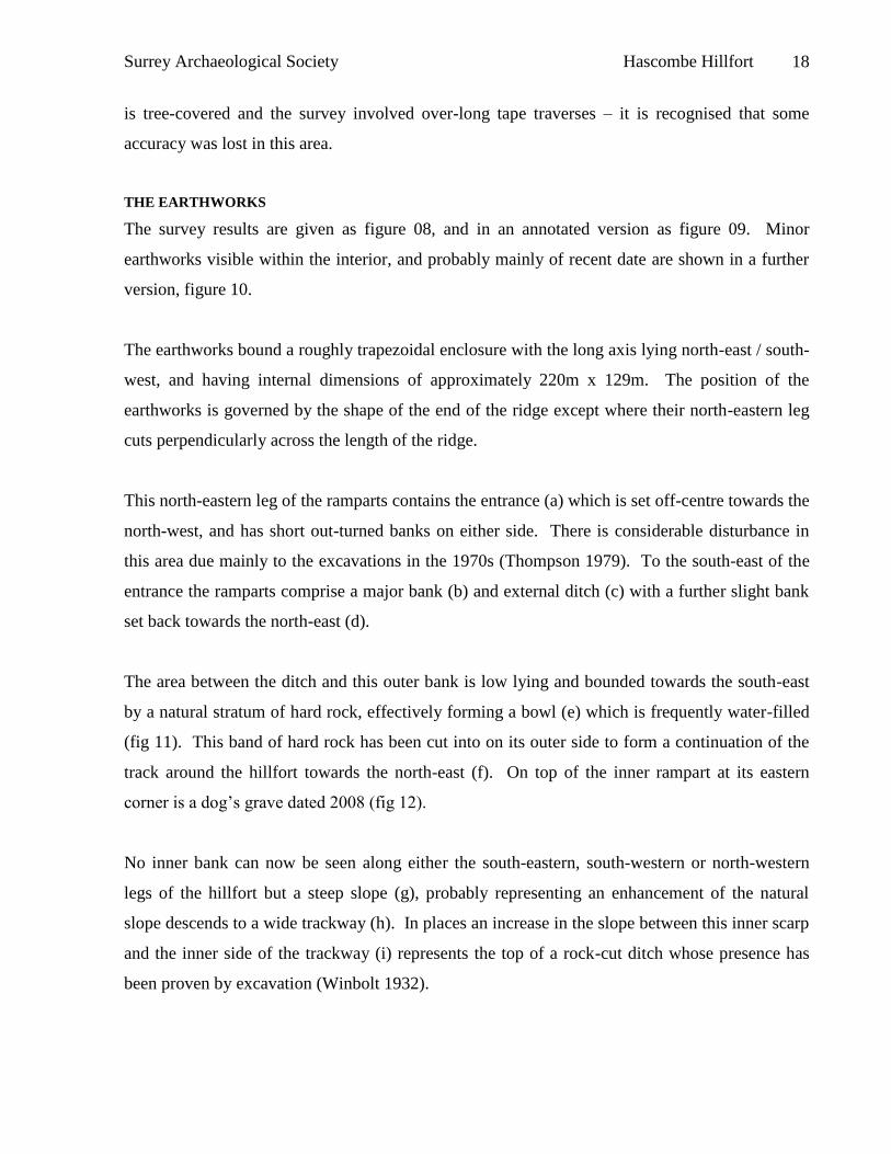
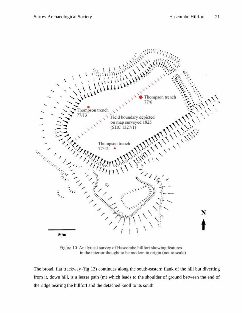
The survey results are given as figure 08, and in an annotated version as figure 09. Minor
earthworks visible within the interior, and probably mainly of recent date are shown in a further
version, figure 10.
The earthworks bound a roughly trapezoidal enclosure with the long axis lying north-east / south-
west, and having internal dimensions of approximately 220m x 129m. The position of the
earthworks is governed by the shape of the end of the ridge except where their north-eastern leg
cuts perpendicularly across the length of the ridge.
This north-eastern leg of the ramparts contains the entrance (a) which is set off-centre towards the
north-west, and has short out-turned banks on either side. There is considerable disturbance in
this area due mainly to the excavations in the 1970s (Thompson 1979). To the south-east of the
entrance the ramparts comprise a major bank (b) and external ditch (c) with a further slight bank
set back towards the north-east (d).
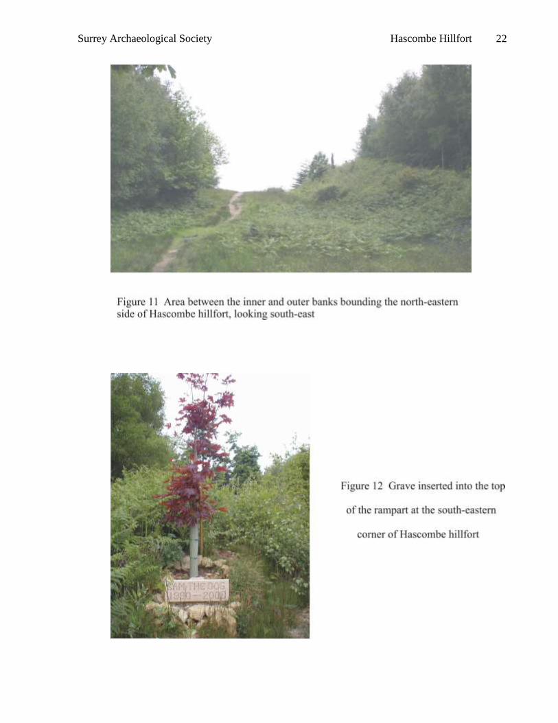
The area between the ditch and this outer bank is low lying and bounded towards the south-east
by a natural stratum of hard rock, effectively forming a bowl (e) which is frequently water-filled
(fig 11). This band of hard rock has been cut into on its outer side to form a continuation of the
track around the hillfort towards the north-east (f). On top of the inner rampart at its eastern
corner is a dog’s grave dated 2008 (fig 12).
No inner bank can now be seen along either the south-eastern, south-western or north-western
legs of the hillfort but a steep slope (g), probably representing an enhancement of the natural
slope descends to a wide trackway (h). In places an increase in the slope between this inner scarp
and the inner side of the trackway (i) represents the top of a rock-cut ditch whose presence has
been proven by excavation (Winbolt 1932).
Surrey Archaeological Society Hascombe Hillfort 19
Below the trackway is a steep slope (j) which could be seen to be a rock-cut scarp where exposed
by the root plates of fallen trees and below that a further scarp (k) which appeared man-made but
could possibly be natural in origin.
Surrey Archaeological Society Hascombe Hillfort 20
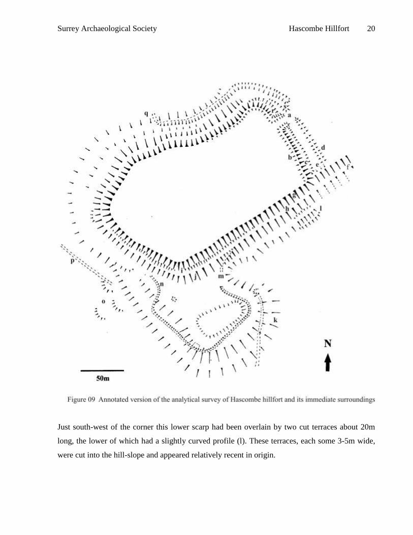
Just south-west of the corner this lower scarp had been overlain by two cut terraces about 20m
long, the lower of which had a slightly curved profile (l). These terraces, each some 3-5m wide,
were cut into the hill-slope and appeared relatively recent in origin.
Surrey Archaeological Society Hascombe Hillfort 21
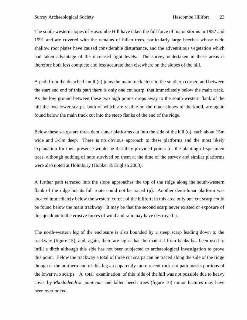
The broad, flat trackway (fig 13) continues along the south-eastern flank of the hill but diverting
from it, down hill, is a lesser path (m) which leads to the shoulder of ground between the end of
the ridge bearing the hillfort and the detached knoll to its south.
Surrey Archaeological Society Hascombe Hillfort 22
Surrey Archaeological Society Hascombe Hillfort 23
The south-western slopes of Hascombe Hill have taken the full force of major storms in 1987 and
1991 and are covered with the remains of fallen trees, particularly large beeches whose wide
shallow root plates have caused considerable disturbance, and the adventitious vegetation which
had taken advantage of the increased light levels. The survey undertaken in these areas is
therefore both less complete and less accurate than elsewhere on the slopes of the hill.
A path from the detached knoll (n) joins the main track close to the southern corner, and between
the start and end of this path there is only one cut scarp, that immediately below the main track.
As the low ground between these two high points drops away to the south-western flank of the
hill the two lower scarps, both of which are visible on the outer slopes of the knoll, are again
found below the main track cut into the steep flanks of the end of the ridge.
Below these scarps are three demi-lunar platforms cut into the side of the hill (o), each about 15m
wide and 3-5m deep. There is no obvious approach to these platforms and the most likely
explanation for their presence would be that they provided points for the planting of specimen
trees, although nothing of note survived on them at the time of the survey and similar platforms
were also noted at Holmbury (Hooker & English 2008).
A further path terraced into the slope approaches the top of the ridge along the south-western
flank of the ridge but its full route could not be traced (p). Another demi-lunar platform was
located immediately below the western corner of the hillfort; in this area only one cut scarp could
be found below the main trackway. It may be that the second scarp never existed or exposure of
this quadrant to the erosive forces of wind and rain may have destroyed it.
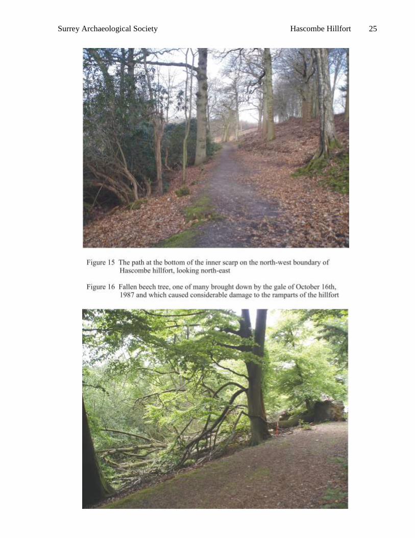
The north-western leg of the enclosure is also bounded by a steep scarp leading down to the
trackway (figure 15), and, again, there are signs that the material from banks has been used to
infill a ditch although this side has not been subjected to archaeological investigation to prove
this point. Below the trackway a total of three cut scarps can be traced along the side of the ridge
though at the northern end of this leg an apparently more recent rock-cut path masks portions of
the lower two scarps. A total examination of this side of the hill was not possible due to heavy
cover by Rhododendron ponticum and fallen beech trees (figure 16) minor features may have
been overlooked.
Surrey Archaeological Society Hascombe Hillfort 24
Surrey Archaeological Society Hascombe Hillfort 25
Surrey Archaeological Society Hascombe Hillfort 26
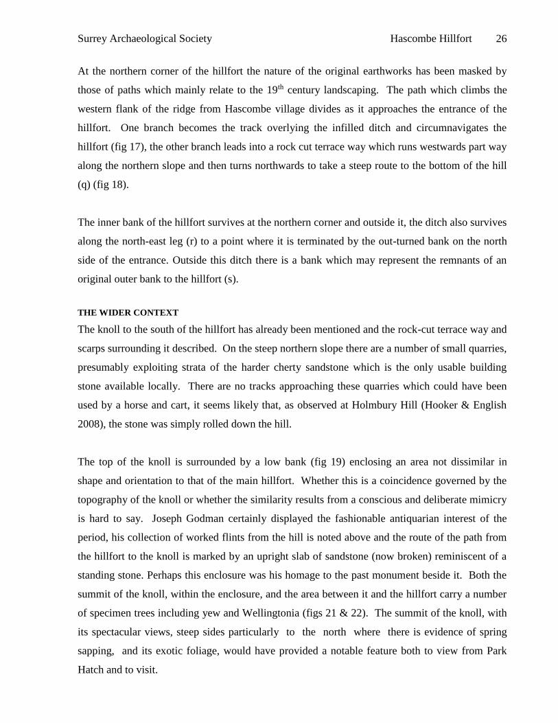
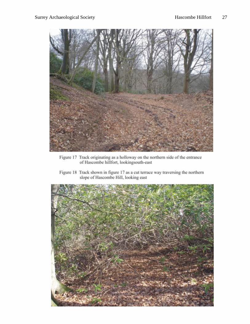
At the northern corner of the hillfort the nature of the original earthworks has been masked by
those of paths which mainly relate to the 19th century landscaping. The path which climbs the
western flank of the ridge from Hascombe village divides as it approaches the entrance of the
hillfort. One branch becomes the track overlying the infilled ditch and circumnavigates the
hillfort (fig 17), the other branch leads into a rock cut terrace way which runs westwards part way
along the northern slope and then turns northwards to take a steep route to the bottom of the hill
(q) (fig 18).
The inner bank of the hillfort survives at the northern corner and outside it, the ditch also survives
along the north-east leg (r) to a point where it is terminated by the out-turned bank on the north
side of the entrance. Outside this ditch there is a bank which may represent the remnants of an
original outer bank to the hillfort (s).
THE WIDER CONTEXT
The knoll to the south of the hillfort has already been mentioned and the rock-cut terrace way and
scarps surrounding it described. On the steep northern slope there are a number of small quarries,
presumably exploiting strata of the harder cherty sandstone which is the only usable building
stone available locally. There are no tracks approaching these quarries which could have been
used by a horse and cart, it seems likely that, as observed at Holmbury Hill (Hooker & English
2008), the stone was simply rolled down the hill.
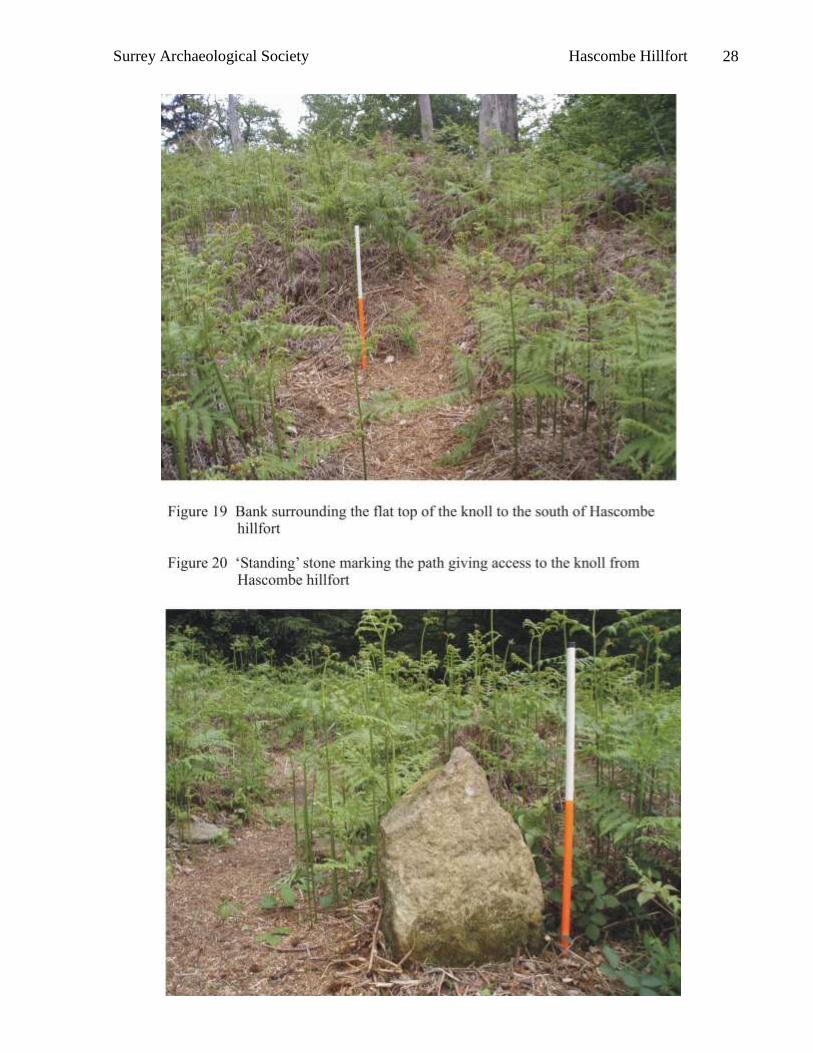
The top of the knoll is surrounded by a low bank (fig 19) enclosing an area not dissimilar in
shape and orientation to that of the main hillfort. Whether this is a coincidence governed by the
topography of the knoll or whether the similarity results from a conscious and deliberate mimicry
is hard to say. Joseph Godman certainly displayed the fashionable antiquarian interest of the
period, his collection of worked flints from the hill is noted above and the route of the path from
the hillfort to the knoll is marked by an upright slab of sandstone (now broken) reminiscent of a
standing stone. Perhaps this enclosure was his homage to the past monument beside it. Both the
summit of the knoll, within the enclosure, and the area between it and the hillfort carry a number
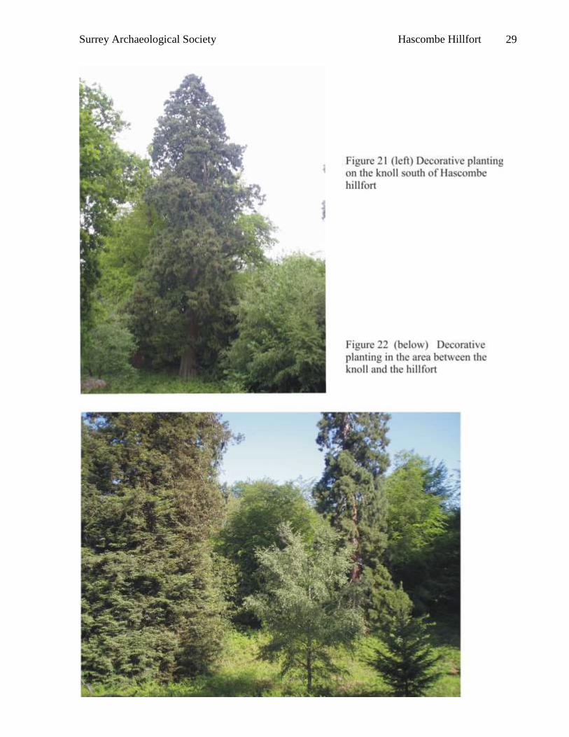
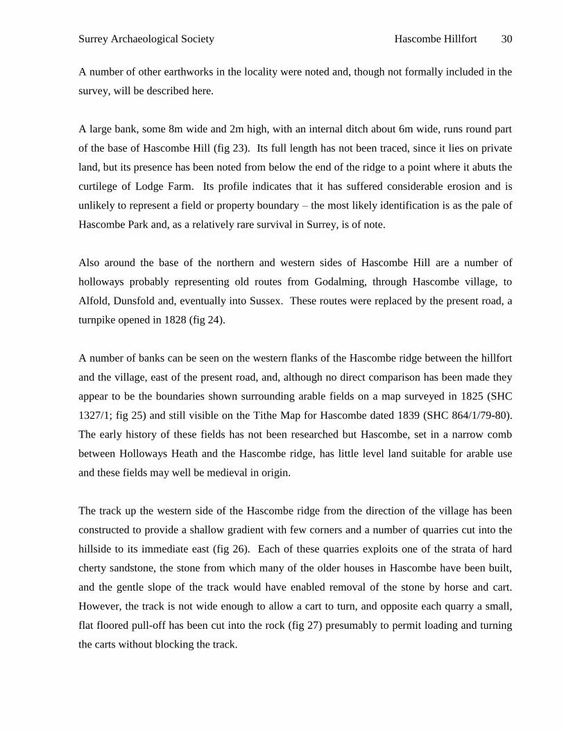
of specimen trees including yew and Wellingtonia (figs 21 & 22). The summit of the knoll, with
its spectacular views, steep sides particularly to the north where there is evidence of spring
sapping, and its exotic foliage, would have provided a notable feature both to view from Park
Hatch and to visit.
Surrey Archaeological Society Hascombe Hillfort 27
Surrey Archaeological Society Hascombe Hillfort 28
Surrey Archaeological Society Hascombe Hillfort 29
Surrey Archaeological Society Hascombe Hillfort 30
A number of other earthworks in the locality were noted and, though not formally included in the
survey, will be described here.
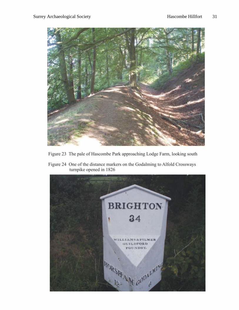
A large bank, some 8m wide and 2m high, with an internal ditch about 6m wide, runs round part
of the base of Hascombe Hill (fig 23). Its full length has not been traced, since it lies on private
land, but its presence has been noted from below the end of the ridge to a point where it abuts the
curtilege of Lodge Farm. Its profile indicates that it has suffered considerable erosion and is
unlikely to represent a field or property boundary – the most likely identification is as the pale of
Hascombe Park and, as a relatively rare survival in Surrey, is of note.
Also around the base of the northern and western sides of Hascombe Hill are a number of
holloways probably representing old routes from Godalming, through Hascombe village, to
Alfold, Dunsfold and, eventually into Sussex. These routes were replaced by the present road, a
turnpike opened in 1828 (fig 24).
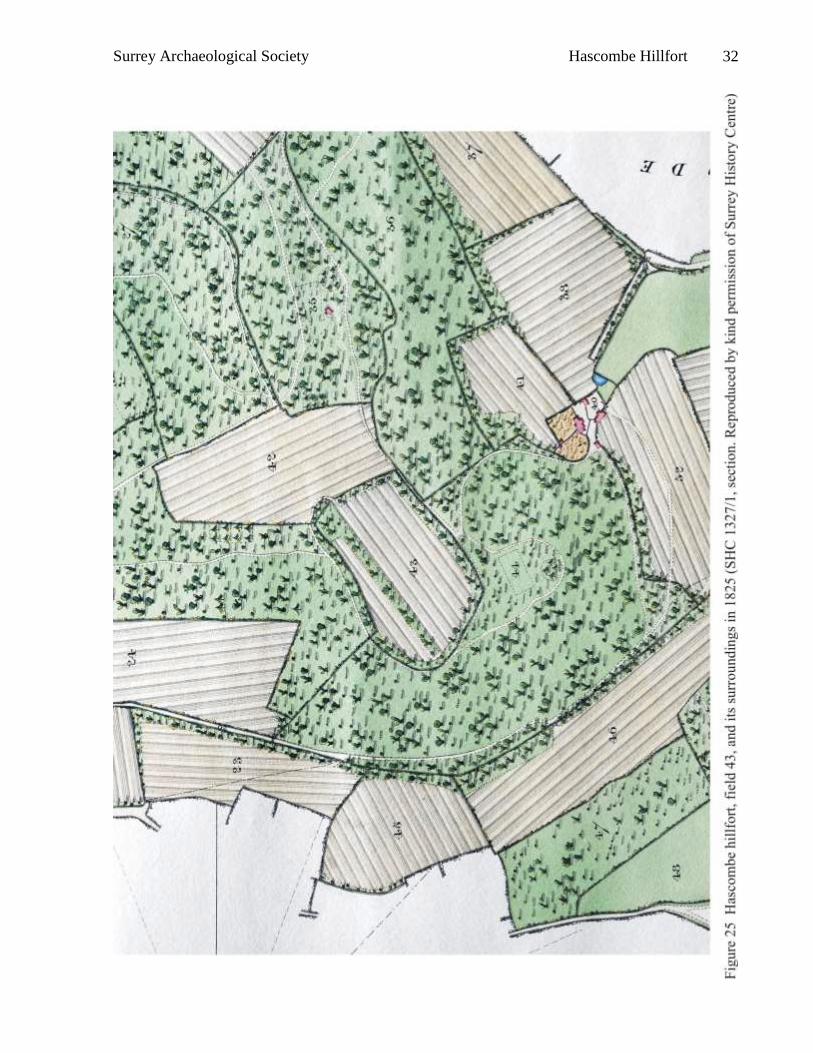
A number of banks can be seen on the western flanks of the Hascombe ridge between the hillfort
and the village, east of the present road, and, although no direct comparison has been made they
appear to be the boundaries shown surrounding arable fields on a map surveyed in 1825 (SHC
1327/1; fig 25) and still visible on the Tithe Map for Hascombe dated 1839 (SHC 864/1/79-80).
The early history of these fields has not been researched but Hascombe, set in a narrow comb
between Holloways Heath and the Hascombe ridge, has little level land suitable for arable use
and these fields may well be medieval in origin.
The track up the western side of the Hascombe ridge from the direction of the village has been
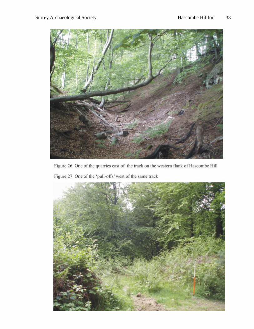
constructed to provide a shallow gradient with few corners and a number of quarries cut into the
hillside to its immediate east (fig 26). Each of these quarries exploits one of the strata of hard
cherty sandstone, the stone from which many of the older houses in Hascombe have been built,
and the gentle slope of the track would have enabled removal of the stone by horse and cart.
However, the track is not wide enough to allow a cart to turn, and opposite each quarry a small,
flat floored pull-off has been cut into the rock (fig 27) presumably to permit loading and turning
the carts without blocking the track.
Surrey Archaeological Society Hascombe Hillfort 31
Surrey Archaeological Society Hascombe Hillfort 32
Surrey Archaeological Society Hascombe Hillfort 33
Surrey Archaeological Society Hascombe Hillfort 34
The magnetometry survey
METHOD
The survey was undertaken using a Geoscan FM256 fluxgate gradiometer and the data processed
using Geoplot software.
That area of the interior of the enclosure which was considered sufficiently free from vegetation
was divided into a series of 30m x 30m grids orientated magnetic north / south. Each 30m grid
square was surveyed by making repeated parallel traverses across it, starting in the SW corner,
with the first traverse made in a northerly direction. Each traverse was separated by a distance of
1m from the last; the first and last traverses being 0.5m from the nearest parallel grid square edge.
Readings were taken along each traverse at 0.25m intervals, the first and last reading being
0.125m from the nearest grid square edge.
The traverses were walked in so called ‘zig-zag’ fashion, in which the direction of travel
alternated between adjacent traverses to maximize survey speed. The magnetometer was kept
facing northwards regardless of the direction of travel to minimise heading error. Corrections
made to the measured values were to zero-mean each instrument grid square or partial grid square
to equalise instrument ‘drift’ and the magnetometer was re-set to zero after each grid. Areas
close to the edge of the interior of the enclosure were surveyed using the same method but
interpolating dummy part or whole traverses as necessary and positions of obstacles within the
grid squares, mainly piles of felled timber, were replaced by dummy points. Corrections made
using Geoplot software included edge matching and spike removal.
It is the opinion of the makers of the Geoscan instrument that two sensors placed 0.5m apart
cannot produce a true estimate of vertical magnetic gradient unless the bottom sensor is far
removed from the ground surface. Hence, when results are presented the difference between the
field intensity measured by the top and bottom sensors is quoted in units of nano-Tesla (nT)
rather than in the units of magnetic gradient, nano-Tesla per metre (nT/m) (Martin 2008).
Where areas of high magnetism were located a return visit to site was made to identify and
eliminate those whose position corresponded with bonfires relating to modern clearance work.
Surrey Archaeological Society Hascombe Hillfort 35
Surrey Archaeological Society Hascombe Hillfort 36
Surrey Archaeological Society Hascombe Hillfort 37
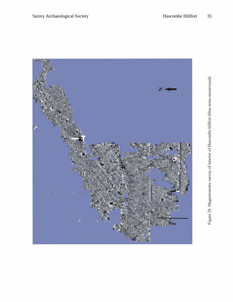
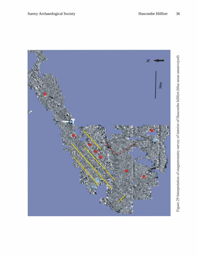
RESULTS
The results obtained from the magnetometer survey are shown in figure 28 and in an annotated
version in figure 29). They were somewhat disappointing, although in line with those gathered
with more primitive equipment at Anstiebury, Holmbury and Hascombe (Thompson 1979; Clark
1990, 86-87). Under laboratory conditions it has been shown that magnetic enhancement in
Lower Greensand soils is very strong (Tite 1972) which should suggest that this type of survey
would locate features both relatively small in size and indicative of minor heating episodes. The
lack of anomalies may therefore truly reflect lack of human activity, but two factors need to be
born in mind. Firstly, if it is correct that the interior of Hascombe hillfort had been ploughed
prior to the construction if the enclosure, podzolisation process had probably already been
initiated (unfortunately no samples were collected for palynography during the 1970s
excavation), and this would reduce the differentiation between bed-rock and fill, and thus
differences in magnetic susceptibility. Secondly, ploughing during the 19th century may would
have destroyed superficial features and initiated an unknown amount of erosion. However, this
lack of features revealed by magnetometry is paralleled at two other hillforts located on sandy
soils, Buckland Rings on river terrace gravels overlying sands of the Bagshot Series and Caesar’s
Camp (Farnham), where plateau gravels overlie Barton Sands (Payne et al, 2006, 27-28).
The survey at Hascombe was limited to the area of the interior which had been cleared of
vegetation and some portions of the cleared area were covered with piles of logs and were thus
not available. The northern portion of the interior was in general ‘noisier’ than the southern, with
the division approximately on the line of the 19th century field boundary (figs 10 & 25), the
northern part is at a lower level than the southern and presumably has less of a build up of mor.
A number of slight, linear features, parallel to each other and to the main axis of the ridge, with
one perpendicular (yellow on fig 29) may represent field boundaries, possibly from prior to the
construction of the hillfort. Two linear features, joining to form a corner (red dotted line on fig
29) may represent an enclosure of unknown date and of the remaining small features some are in
the position of trenches excavated in the 1970s (turquoise on fig 29; Thompson 1979, fig 12)
whilst the remainder (red on fig 29) presumably indicate the positions of further pits or, possibly
hearths. The overall impression, however, is one of limited human activity within the interior of
the hillfort. It should however be noted that vegetation prevented survey close to the ramparts
over much of the circuit, a location where a number of hearths were found during earlier
excavations.
Surrey Archaeological Society Hascombe Hillfort 38
Interpretation of analytical survey
The earliest evidence of human activity on Hascombe Hill located during this survey is the
possible field system whose boundaries appear on the magnetomery survey underlying the
interior of the hillfort. This, together with the finding of post-Deverel-Rimbury tradition pottery
within the assemblage excavated in the 1970s (Thompson 1979; Seager Thomas 2008,
forthcoming), encourage the belief that farming the light sandy soils may have originated during
the Late Bronze Age. A report of ‘suspicious markings’ in the modern fields above Hascombe
village and of low cross banks on the ridge approaching the hillfort could not be substantiated but
the perception of the fieldworker involved in recognising the scarps on the north side of the
hillfort as part of the earthwork enclosure then considered to be univallate encourages belief that
the report may be accurate (Boyden 1958).
It is not our intention to assess the effect of changing views on the purposes underlying the
construction of hillforts on the interpretation of those on the Surrey greensand since that has
already been undertaken (Hooker & English 2008). In outline, early belief that these enclosures
were constructed for strictly military concerns and that changes in design could be explained
simply in terms of changing forms of offensive warfare was causal in the interpretation of
Holmbury, Hascombe and Anstiebury hillforts as contemporary, constructed in the 1st century BC
in response to the Caesarian invasions of 55 and 54BC, and short lived, being destroyed as a
result of peace agreements with Caesar (Thompson 1979). By that time however, work on
Danebury hillfort in Hampshire had uncovered a long lived and changing occupation with many
concerns, including large food storage capacity and a complex use of pits for structured deposits,
which belied a purely military genesis (Cunliffe 1995). It has also been recognised that some
hillforts are sited in positions that reduce their defensibility – for example both the Caburn
(Drewett & Hamilton 1999) and Holmbury (Hooker & English 2008) clearly visible from the
outside. Hillforts have been associated with other manifestations of power – the ability and right
to separate a portion of land with massive earthworks, the power over labour required to build the
ramparts, particularly in areas of hard rock, and the theatricality of presenting those approaching
with a level line of ramparts set against the skyline and or complex, multi-layer entrances have all
been discussed (for example Bowden & McOmish 1987; 1989). More recently, an attempt has
been made to weave these disparate strands of though together, recognising that warfare is itself a
heavily formalised and ritualised pursuit (for example Armit 2007). A further view on this line is
Surrey Archaeological Society Hascombe Hillfort 39
that although hillforts themselves may not have been physically involved in warfare, their
presence may have had a deterrent effect through their display of power, warfare itself being
limited to raiding, skirmishing and small-scale, formalised combat (James 2007). While the term
‘hillfort’ is a generic description for enclosures with multiple and changing uses it is probably
now of little use; these same enclosures mark special places visibly and permanently in a manner
understood within an increasingly complex and, probably, aggressive society. They celebrate
stages in the multi-factorial development of tribalism and statehood.
Recognition that Holmbury and Hascombe were contemporary in construction, that both showed
some evidence of earlier activity in the form of post-Deverel-Rimbury tradition pottery, and that
their main period of occupation was during the Middle Iron Age, and their possible Sussex links,
contrasting with later dates for Anstiebury and Felday (Seager Thomas 2008, forthcoming)
encourages a consideration of these hillforts in a wider context.
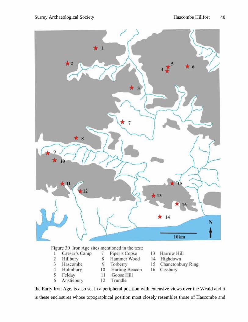
The western end of the Weald is ringed by a series of hillforts stretching from the Trundle in
West Sussex to Anstiebury in Surrey, and that many of these are situated on dominant
promontories (Boyden 1958). The list comprises the Trundle, Goosehill Camp, Harting Beacon,
Chanctonbury, Harrow Hill, Highdown, Cissbury and Torberry on the chalk of the South Downs,
Hammer Wood, Hascombe, Hillbury, Holmbury, Felday and Anstiebury on the greensand ridge,
Caesar’s Camp (Farnham) of the Bagshot Series superficial sandy deposits to the north of the
North Downs and Piper’s Copse on Weald Clay (fig 30). Of these, there is no dating evidence
for Caesar’s Camp (Riall 1983) but its position in the landscape speaks of a northern rather than a
southern concern, nor for Hillbury, although here the only major earthworks provide an
impressive approach uphill from the south, and both have been excluded from this consideration.
The hillforts in Sussex have been studied and a relationship noted between their date and their
landscape position, resulting in a discussion of concerns which changed over time ((Hamilton &
Manley 1997). The earliest hillforts are found in peripheral positions and are dated to the Late
Bronze Age, with some continuing in use into the Early Iron Age or later. Of these
Chanctonbury Ring and Harting Beacon have produced pottery dated to c. 8th / 7th centuries BC
(Barrett 1980), and both are situated on top of the northern scarp of the South Downs with
extensive views over the Weald, but none of the coastal plain to the south. Harrow Hill and
Highdown may also date to this period and face seawards. Goosehill Camp, constructed during
Surrey Archaeological Society Hascombe Hillfort 40
the Early Iron Age, is also set in a peripheral position with extensive views over the Weald and it
is these enclosures whose topographical position most closely resembles those of Hascombe and
Surrey Archaeological Society Hascombe Hillfort 41
Holmbury. These enclosures have, in general, rather slight ramparts but do exhibit a choice of
position which produced a strong visual impact from the direction of approach. They show little
sign of permanent occupation but their predominant concern is one of viewing and evaluating
specific portions of the landscape, in several cases the Low Weald (ibid).
By the Middle Iron Age this concern seems to have changed, and with it the location of the new
hillforts. The Trundle and Cissbury date to this period, both dominate blocks of chalk down
defined by major river valleys, and both show signs of more intensive activity. Their central
downland positions effectively hide them from the Weald and they can be described as
‘dramatically inscribed regional landmarks for scattered downland communities’ (ibid).
Torberry provides an intermediate between these two positions. Located on the northern scarp of
the South Downs, a peripheral position, it has been assigned a Middle Iron Age date but
originated as a promontory enclosure and has produced Early Iron Age pottery of 5th / 4th century
date (Cunliffe 1976). Its early phase may represent the start of a movement around the western
end of the Weald, although it later gained a central role if not position.
The two remaining Sussex sites, Hammer Wood (Boyden 1958) and Piper’s Copse (Winbolt
1930) are both assigned construction dates in the Late Iron Age although both have also produced
earlier material. These enclosures, the former located on the greensand ridge and the latter in the
Low Weald, are generally thought to be part of a group concerned with increasing exploitation of
Wealden iron ores later in the Iron Age.
The association between hillforts and iron working is far from clear-cut. A number of Wealden
hillforts have produced evidence of iron production, pre-eminent among which is Garden Hill
(Money 1980) where a smelting furnace and a forging hearth together with large amounts of slag
have been dated to the 1st century BC. Iron working is also evidenced at High Rocks (Money
1968), Dry Hill Camp (Winbolt & Margery 1833), Piper’s Copse (Winbolt 1930) and Saxonbury
(Winbolt 1930), mainly in Late Iron Age contexts. However, ironworking is far from solely the
preserve of those who worked within hillforts. A primary production site at Cracwcellt
(Merioneth) had an estimated output of either one tonne smithed blooms or half a tonne of
refined bars, and experimental work suggests each kilogram of bar iron would have required the
input of one tonne timber and 25 man-days work (Crew 1998). The wealth generated by this
Surrey Archaeological Society Hascombe Hillfort 42
production may well have underpinned the economies of the nearby hillfort at Bryn y Castell and
others in the Dolgellau valley. Within the south-east a similar relationship has been suggested
between the iron production site at Brooklands and the hillfort of St George’s Hill (Hanworth &
Tomalin 1977) and a smithing hearth was located at Purberry Shot, Ewell together with bloomery
slag (Lowther 1946-7). It has, however, been argued that since evidence of forging is found on
small farmstead sites there was no centralised control over production, which should instead be
regarded as heterarchical (Ehrenreicht 1991). In any consideration of the western Weald it is
worth remembering that the dedication of the Romano-British temple at Farley Heath, Guildford,
appears to have been to the gods Taranis, Sucellus and their consort Nantosvelta, who are
associated with ironworking (Goodchild 1938). In most of these cases, however, the iron
working is associated with Late Iron Age settlement and the process may well have been
differently regarded earlier in the period.
At Hascombe considerable evidence for iron working was found during the 1930s excavations
(Winbolt 1932) but, surprisingly, none were reported from the later investigations (Thompson
1979). The most interesting feature from the earlier campaign was a square, flat-bottomed pit
containing burnt sandstone, charcoal, pottery and iron slag, and thought by the excavator to
represent a forging or smithing site. This pit was located in the ditch of the hillfort, just west of
its southern corner (fig 04, trench K). If this identification is correct the location, neither inside
nor outside the enclosure, could have addressed safety issues, but could also indicate the placing
of a dangerous transformation process in a liminal zone.
Metalworking may be seen as having metaphorical connections with other facets of life and in the
case of iron production links with procreation and agriculture have been suggested (Giles 2007).
Old materials may be incorporated into new furnaces to emphasise continuity (Herbert 1993, 36)
and pottery found within the furnace fabric at Brooklands, Weybridge has been interpreted in this
light (Hingley 1997). On African iron working sites furnaces may be anthropomorphised into
fertile women by decorating them with ‘breasts’, or scarification designs (Herbery 1993, 32), and
the male smelters and forgers banned from sexual relations with their wives as such congress
would be regarded as adulterous (Haaland 2004). Given such considerations the production of
what was to become a mundane metal, iron, may have been undertaken in the ditch at Hascombe,
at a point above a steep scarp and with an extended view over lower ground, for other than
pragmatic reasons.
Surrey Archaeological Society Hascombe Hillfort 43
Southern links between Holmbury and Hascombe hillforts in Surrey and the area to the south are
suggested by some of the pottery, which ‘feels’ to be in the Sussex tradition rather than that of
either the Thames valley or Wessex (Seager Thomas 2006; forthcoming) and the finding of
querns made of sandstone from the Petworth / Midhurst area (Peacock 1979). Perhaps the
Middle Iron Age hillforts of Hascombe and Holmbury should be seen as addressing the same
concerns as the Late Bronze Age / Early Iron Age enclosures on the South Downs, but when the
southern influence reached farther afield onto the Surrey greensand. The topographical positions
of the Late Iron Age enclosures associated with iron working suggest ‘a more fragmentary
“view” of space and time’ (Hamilton & Manley 1997) but at Hascombe and Holmbury, perhaps
at an uncomfortable distance from the ‘home’ area, visibility was still of overwhelming
importance.
Neither Holmbury nor Hascombe survived into the Late Iron Age, their role being taken by
Anstiebury and the less prominent site of Felday. Both sites show some evidence of activity in
the Middle Iron Age but they may well have come into use under very different political
conditions – Anstiebury at least was to survive into the Romano-British period (Hayman 2008).
The full extent of Hascombe Park has not been investigated but the large bank and ditch
bounding the base of the western and southern slopes of Hascombe Hill, and incorporating the
original site of Park Hatch, now a farm named Lodge Farm, represents the pale in that area. The
park is likely to have included land to the south of the present Hascombe Place, then the manorial
caput, land within a bowl bounded to the south and east by the high, steep-sided greensand ridge.
The field known in 1825 (SHC1327/1) as The Hare Warren located within that bowl of land may
indicate the position of a park feature. No record has been found of the impartment of Hascombe
but the most likely owner appears to be Henry 1st Baronet Hussee. This Henry’s father, also
Henry Hussee had been a major landowner in Sussex and elsewhere, and had benefited from his
loyalty to the king at the Battle of Evesham, holding among other posts that of Constable of
Porchester Castle In 1266 he was granted a licence ‘to enclose a place at Hertinge (Harting in
Sussex) with a dyke and wall of stone and lime, and to crenellate the same’, and he also imparked
the high ground close to his grand house (Moor, 1929-32). His son was frequently summoned to
serve the king, putting down a rebellion in Gascony in 1294, in military service against the Scots
in 1297, 1299 and often to 1323 and, as a knight in the Rape of Chichester, he was enrolled for
Surrey Archaeological Society Hascombe Hillfort 44
defence of the coast in 1296. He was summoned to the Great Council at Westminster in 1324
and in the same year served again against the Gascons.
Henry 1st Baron Hussee was granted right of free warren in his demesne lands in Danhurst in
Bramley (now Painshill) in 1307 (Val Charter Rolls 1300-1326, 82) but it is not clear that he
actually owned Hascombe Manor at this time or, indeed, if Hascombe Manor existed. The
earliest documentary record of his ownership of Hascombe is in 1332, after his death (Cal Inq
post mortem vii, no 468). It appears that some time before he had acquired the reversion of the
manor from Sir Henry Sturmey who was himself only a reversioner. The holder of the manor
was Joan, wife of John de Wintershall (another Bramley manor located to the north of
Hascombe) and she may also have been the wife of Walter de Huntingfield, a major Kentish
landowner, from whom the manor is later said to have come to Henry Hussee.
The question arises as to whether the inclusion of the Iron Age hillfort on Hascombe Hill within
the medieval park, probably but not certainly by Henry Hussee, should be seen as a deliberate act.
Although familiar concepts to prehistorians the manipulation of landscape for symbolic effect,
the use of past monuments to enhance present ownership claims and the requirement of allowing
the past to influence the present in terms of ‘special’ places have found little cadence for
medievalists. That appears to be changing – in a recent study comes the comment ‘prehistoric
archaeology arguably has much to offer the medieval landscape historian interested in
understanding the experiential dimension of past land use……..In particular we need to pay
attention to the ‘symbolising faculty of the medieval mind. To those who inhabited it, the
medieval landscape was full of symbolism, packed with references to religion and the work of
God. It was inherent, in a way now almost unimaginable, for medieval people to disaggregate
‘natural’ surroundings and see flora and fauna as symbols for higher things – in short, to
transform the countryside into allegory’ (Creighton 2009, 6-7).
Hascombe is not the only example of the inclusion of a hillfort either within a medieval park or
within its viewshed. At Peveril (Derbyshire) two large windows in the great chamber of the
castle give in one case a view of the hillfort on Mam Tor and, in the other, of the church in the
seigneurial borough below – surely a case of conscience linking of present with past holders of
power. At Pencarrow (Cornwall) a ringwork was included within a medieval estate garden whilst
at Croft Ambrey (Hereford) the park pale encloses the hillfort in its locally dominant position and
Surrey Archaeological Society Hascombe Hillfort 45
alterations to the prehistoric earthworks in the medieval period are considered possible (Field &
Smith 2008). More locally the pale Blackheathfield, one of the parks in the bishop of
Winchester’s Farnham estate abutted and re-used a portion of the ramparts of Caesar’s Camp
before cutting across the interior (Riall 1983), and farther east, North Park at Bletchingley
encompassed at least part of War Coppice (Saaler in Poulton 1998, fig 1.2).
At Croft Ambrey, Blackheathfield and North Park, Bletchingley, as at Hascombe, the hillfort is
not visible from the main house. The earthworks would have been encountered during a walk, or,
more likely, a ride, around the park. It sees likely that someone with Henry Hussee’s background
would have seen the location and earthworks of the hillfort as military in intent, and perhaps to
associate his ownership with that of a powerful, militarily-minded man from the unknown past.
No record of disparkment at Hascombe appears to have survived and the poor soils render any
use other than grazing unlikely during the post-medieval period. Only under population pressure
and with high grain prices in the late 18th and early 19th centuries does it appear to have been
economic to plough the top of the greensand ridge (SHC 1327/1; fig 25) and by 1840 the interior
of the hillfort and its surroundings had reverted to woodland. The flat area immediately outside
the entrance to the enclosure (fig 25, field 42) is named as The Cricketing Field, although no
records have been located this suggests that cricket matches may have been played on this high
exposed ridge. The name Old Bowling Green applied to one of the fields in the bowl of land
south of Hascombe Place may also allude to sporting activities within the estate grounds.
The Godman family, having made their wealth in Chichester through the ownership of tanneries
and leather workshops, and through judicious marriages, gradually accumulated a country estate
in Hascombe. Joseph Godman greatly extended the house built in 1763 (figs 30 & 31) after
moving there in 1814 to the estate purchased by his father, also Joseph, and bought the manor
itself in 1823. During the ownership of the Godman family the possibility of using Hascombe
Hill as a viewing point became apparent and a carriageway constructed round the end of the ridge
by slighting the banks of the hillfort and using the material to infill the ditch. Some of these
routes are illustrated on the map surveyed in 1825 but not drawn until 1842 (SHC 1327/1; fig 25)
and show a perambulation ascending the southern slopes of the hill from Lodge Farm (then Park
Hatch) and giving a choice of visiting the detached knoll or of circulating around the hillfort.
Return was possible by ascending the hill towards Nore, or tracks were available either along the
Surrey Archaeological Society Hascombe Hillfort 46
Surrey Archaeological Society Hascombe Hillfort 47
ridge with a gradual descent into Hascombe village or by a stepper descent to the turnpike road.
These and other tracks located during the survey attest use of the hill as part of a pleasure ground
attached to Park Hatch. On the southern corner of the knoll a square cutting off the track may
have provided a seat from which the view could be admired and the decorative planting also
dates to this period. The track around the hillfort was lined with beech trees, the famous
Hascombe Beeches, whilst the knoll was topped by a small cluster of Wellingtonias (Sequoia
gigantean), a newly discovered tree introduced to Britain in 1853 (Rackham 1976, revised edition
1990, 160). Other specimen trees adorn the slopes but many which may have been planted on the
demi-lunes and planting terraces located during the survey have gone. The intriguing possibility
exists that the pipes seen by Lasham (1895 quoted above) protruding from the inner bank on the
east side of the hillfort may also date to this phase. Reed growth in the interior suggests a water
source which may have been tapped to feed a water feature of some sort, perhaps that Victorian
favourite, a fernery.
With the loss in status and eventual demolition of the house at Park Hatch more distant parts of
the estate reverted to woodland and heathland vegetation, much of which has been cleared from
the interior of the hillfort in the last two years. The past has not been forgotten and a further layer
of recall was added in 1995 when the Modern Order of Druids erected a stone circle below the
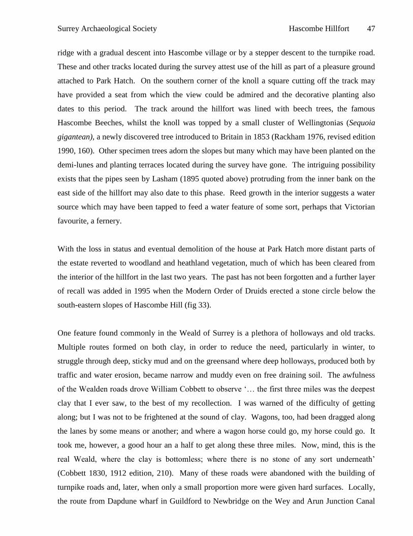
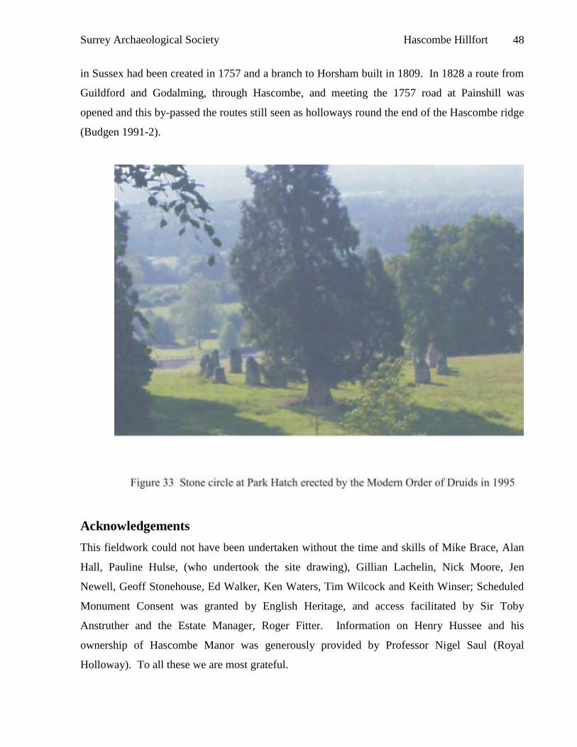
south-eastern slopes of Hascombe Hill (fig 33).
One feature found commonly in the Weald of Surrey is a plethora of holloways and old tracks.
Multiple routes formed on both clay, in order to reduce the need, particularly in winter, to
struggle through deep, sticky mud and on the greensand where deep holloways, produced both by
traffic and water erosion, became narrow and muddy even on free draining soil. The awfulness
of the Wealden roads drove William Cobbett to observe ‘… the first three miles was the deepest
clay that I ever saw, to the best of my recollection. I was warned of the difficulty of getting
along; but I was not to be frightened at the sound of clay. Wagons, too, had been dragged along
the lanes by some means or another; and where a wagon horse could go, my horse could go. It
took me, however, a good hour an a half to get along these three miles. Now, mind, this is the
real Weald, where the clay is bottomless; where there is no stone of any sort underneath’
(Cobbett 1830, 1912 edition, 210). Many of these roads were abandoned with the building of
turnpike roads and, later, when only a small proportion more were given hard surfaces. Locally,
the route from Dapdune wharf in Guildford to Newbridge on the Wey and Arun Junction Canal
Surrey Archaeological Society Hascombe Hillfort 48
in Sussex had been created in 1757 and a branch to Horsham built in 1809. In 1828 a route from
Guildford and Godalming, through Hascombe, and meeting the 1757 road at Painshill was
opened and this by-passed the routes still seen as holloways round the end of the Hascombe ridge
(Budgen 1991-2).
Acknowledgements
This fieldwork could not have been undertaken without the time and skills of Mike Brace, Alan
Hall, Pauline Hulse, (who undertook the site drawing), Gillian Lachelin, Nick Moore, Jen
Newell, Geoff Stonehouse, Ed Walker, Ken Waters, Tim Wilcock and Keith Winser; Scheduled
Monument Consent was granted by English Heritage, and access facilitated by Sir Toby
Anstruther and the Estate Manager, Roger Fitter. Information on Henry Hussee and his
ownership of Hascombe Manor was generously provided by Professor Nigel Saul (Royal
Holloway). To all these we are most grateful.
Surrey Archaeological Society Hascombe Hillfort 49
Bibliography
Armit, I 2007 Hillforts at war: from Maiden Castle to Taniwaha Pā, Proc Prehist Soc 73, 25-37
Ashton, WD 1999 A History of Hascombe – a Surrey Village, privately printed and published
Aubrey, J 1718 The Natural History and Antiquities of the County of Surrey, London: Curll;
republished in facsimile, 1975, Dorking: Kohler & Coombes
Barrett, JC 1980 The pottery of the Late Bronze Age in lowland Britain, Proc Prehist Soc 46,
297-320
Bowden, M & McOmish, D 1987 The required barrier, Scottish Archaeol rev 4, 76-84
Bowden, M & McOmish, D 1989 Little boxes: more about hillforts, Scottish Archaeol Rev 6, 12-
15
Boyden JR 1958 Excavations at Hammer Wood, Iping: 1957 Sussex Archaeol Coll 96, 149-163
Budgen, C 1991-2 The Bramley and Rudgwick Turnpike Trust, Surrey Archaeol Coll 81, 97-102
Clark, A 1990 Seeing beneath the soil: prospecting methods in archaeology, London: Batsford
Cobbett, W 1830 Rural Rides, 1912 edition London: Dent
Creighton, O 2009 Designs upon the Land: elite landscapes of the Middle Ages, Woodbridge:
The Boydell Press
Crew, P 1998 Excavations at Crawcwellt West, Merioneth, 1990-1998, a late prehistoric upland
iron-working settlement, Archaeol in Wales 38, 22-35
Cunlifffe, B 1976 The pre-Roman Iron Age hillfort at Torberry, Sussex: in: Cunliffe, B (ed) Iron
Age sites in Central Southern England, Yrok: CBA Research Report 16, 1-29
Cunliffe, B 1995 Danebury: n Iron Age hillfort in Hampshire. Vol 6: a hillfort community in
perspective, London: CBA Research Report 102
Cunliffe, B 2005 Iron Age Communities in Britain, 4th edn, London: Routledge
Drewett, P & Hamilton, S 1999 Marking time and making space: excavations and landscape
studies at the Caburn hillfort, East Sussex, 1996-98, Sussex Archaeol Coll 137, 7-37
Ehrenreich, RM 1991 Metalworking in Iron Age Britain: hierarchy or heterarchy? In: Ehrenreich,
RM (ed) Metals in society: theory beyond regional analysis, Philadelpia: MASCA, 69-80
Field, D & Smith, N 2008 Croft Ambrey, Aymestrey, Herefordshire: investigation and analytical
survey of earthworks, Swindon: English Heritage Research Department Report Series no 36-2008
Surrey Archaeological Society Hascombe Hillfort 50
Giles, M 2007 Making metal and forging relations: ironworking in the British Iron Age, Oxford J
Archaeol 26, 395-413
Goodchild, RG 1938 A priest’s sceptre from the Romano-Celtic temple at Farley Heath, Surrey,
Antiq J 18, 391-396
Gover, JEB, Mawer, A & Stenton, FM 1934 The Place-names of Surrey, Cambridge: English
Place-name Society 11, 1982 edition
Haaland, R 2004 Technology, transformation and symbolism: ethnographic perspectives in
European iron working, Norwegian Archaeol Rev 37, 1-19
Hamilton, S & Manley, J 1997 Points of view: prominent enclosures in 1st millennium BC
Sussex, Sussex Archaeol Soc 135, 93-112
Hanworth, R & Tomalin, DJ 1977 Brooklands, Weybridge: the excavation of an Iron Age and
medieval site, Guildford: Surrey Archaeol Soc Res Vol 4
Hayman, G 2008 Archaeological excavations at Anstiebury Camp hillfort, Coldharbour, in 1989
and 1991, Surrey Archaeol Coll 94, 191-208
Herbert, E 1993 Iron, gender, and power: rituals of transformation in African societies,
Indianapolis: Bloomington
Hingley, R 1997 Iron, ironworking and regeneration: a study of the symbolic meaning of
metalworking in Iron Age Britain, in: Gwilt, A & Haselgrove, C (eds) Reconstructing Iron Age
Societies, Oxford: Oxbow Monogr 71, 9-15
Hooker, R & English, J 2008 Holmbury Hillfort, Surrey: an archaeological survey, privaltely
circulated report
James, S 2007 A bloodless past: the pacification of Early Iron Age Britain, in: Haselgrove, C &
Pope, R (eds) The Earlier Iorn Age in Britain and the near Continent, Oxford: Oxbow, 160-173
Lasham, F 1895 Camps, earthworks, tumuli & c. in West Surrey Surrey Archaeol Coll 12, 145-
156
Lowther, AWG 1946-7 Excavations at Purberry Shot, Ewell, Surrey, Surrey Archaeol Soc 50,
(1949), 9-46
Malden, HE (ed) 1911 The Victoria History of the County of Surrey, London: HMSO
Manning, O & Bray, W 1804-14 The History and Antiquities of the County of Surrey, 1-3,
London: John White
Martin, L 2008 Marden henge, Wiltshire – report on geophysical survey April 2008, English
Heritage Research Department Report Series 70-2008
Surrey Archaeological Society Hascombe Hillfort 51
Money, JH 1980 Garden Hill, Sussex, Britannia 11, 398-400
Moor, C 1929-32 The Knights of Edward I, Oxford: Harleian Society
Payne, A, Corney, M & Cunliffe, B 2006 The Wessex Hillforts project: extensive survey of
hillfort interiors in central southern England,,Swindon: English Heritage
Peacock, DPS 1979 Petrology of the querns from Holmbury and Hascombe, in: Thompson
(1979), 315
Rackham, O 1976 Trees and woodland in the British landscape, revised edition 1990 London:
Phoenix
Riall, N 1983 Excavations at Caesar’s Camp, Aldershot, Hampshire, Proc Hants Field Club &
Archaeol Soc 39, 47-55
Saaler, M 1998 Venars and Hextalls: the historical evidence 1307-1573 in: Poulton, R The lost
manor of Hextalls, Little Pickle, Bletchingley, Kingston: Surrey County Council, 3-6
Salmon, N 1736 Antiquities of Surrey, London: privately published
Seager Thomas, M 2008 A re-contextualization of the prehistoric pottery from the Surrey hillforts
of Hascombe, Holmbury and Anstiebury, privately circulated report
Seager Thomas, M forthcoming A re-contextualization of the prehistoric pottery from the Surrey
hillforts of Hascombe, Holmbury and Anstiebury, to be submitted to SyAC
Thompson, FH 1979 Three Surrey hillforts: excavations at Anstiebury, Holmbury and Hascombe,
1972-77, Antiq J 59, 245-318
Tite, MS 1973 The influence of geology on the magnetic susceptibility of soils on archaeological
sites, Archaeometry 14, 229-236
Winbolt, SE 1930 Excavations at Saxonbury Camp, Sussex Archaeol Coll 71, 222-236
Winbolt, SE 1932 Excavations at Hascombe Camp, Godalming, SyAC 40, 78-96
Winbolt, SE & Margery, ID 1933 Dry Hill Camp, Lingfield, Surrey Archaeol Coll 41, 79-92
Distribution
Dr Richard Massey (English Heritage) Roger Fitter (Estate Manager)
Ann Clark (English Heritage) Tony Howe (Surrey County Council)
National Monuments Record Surrey Archaeological Society
Sir Toby Anstruther (Landowner) Participants on request