the vrČevo - gorica hillfort
TRANSCRIPT
225
Martina Čelhar ODJELA ZA ARHEOLOGIJUSVEUČILIŠTE U ZADRU
OBALA PETRA KREŠIMIRA IV/223000 ZADAR
UDK: 903.4(497.5 Gorica)”637/638”PRETHODNO PRIOPĆENJE / PRELIMINARY PAPER
PRIMLJEN/ RECEIVED 05. 08. 2012.PRIHVAĆEN/ ACCEPTED 10. 11. 2012.
GRADINA VRČEVO – GORICA
Probes at the hillfort of Vrčevo-Gorica have established several settlement horizons and its continuous habitation through much of the Bronze and Iron Age. The lack of findings from the Hellenistic and Roman period indicates the end of life and the abandonment of the hill probably before the Roman conquest of this area. The size of the settlement as well as other numerous remains of material culture evidence that Vrčevo was certainly one of the main centres of Liburnian culture.
KEY WORDS: Vrčevo, hillfort, Bronze Age, Iron Age, Liburnians
Sondiranjem na gradinskom naselju Vrčevo – Gorica utvrđeno je više naseobinskih horizonata i kontinuirana naseljenost kroz veći dio brončanog i željeznog doba. Odsustvo nalaza helenističke i rimske epohe indicira prestanak života i napuštanje gradine vjerojatno prije rimskih osvajanja ovog prostora. Veličina naselja, kao i mnogobrojni ostaci materijalne kulture, svjedoče da je Vrčevo svakako bilo jedno od središnjih naselja liburnske kulturne grupe.
KLJUČNE RIJEČI: Vrčevo, gradina, brončano doba, željezno doba, Liburni
THE VRČEVO – GORICA HILLFORT
226
ma
rtin
a č
elh
ar:
gra
din
a v
rčev
o –
go
rica
DID
ORA
26/
2722
5 - 2
40
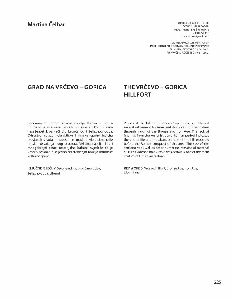
Gradina Vrčevo smještena je na najvišem vrhu kose (213 mnv) u blizini naselja Gorica u općini Sukošan (Sl. 1). Već je na prvi pogled jasno da je riječ o gradini koja svojom veličinom spada u red najvećih gradinskih naselja na prostoru Liburnije sa znatnim ostatcima materijalne kulture razasutim po njezinoj površini. Unatoč tome dosad je arheološki gotovo u potpunosti zanemarena. Kao arheološki lokalitet spominje je Alačević još 1879. god. u svom opisu starina u benkovačkom području.1 Ruševine utvrde na Vrčevu opisuje i L. Jelić koji se ograničio na prikaz srednjovjekovnog i novovjekovnog povijesnog okvira, kao i materijalnih ostataka tog vremena.2 Značaj Vrčeva kao prapovijesnog naselja dotakli su tek Š. Batović i S. Čače.3 Pored skice tlocrta i opisa najznačajnijih karakteristika lokaliteta, Batović je donio i neke površinske nalaze keramike, među kojima i ulomak apulske keramike kojim podupire dataciju lokaliteta u željezno doba.4 Nešto detaljniji opis, također temeljen na terenskom pregledu, donosi u svojoj disertaciji i S. Čače.5
Podaci oba autora se u načelu više-manje podu-daraju, s naglaskom na iznimnom obrambenom sustavu s tri koncentrična bedema i nizom tera-sa s znatnim kulturnim slojem. Doista, područje
1 G. Alacevich, 1879, 12.
2 Jelić navodi da se Vrčevo prvi put spominje 1371. godine kao posjed rogovske opatije. Podizanje kule vezuje uz zadarsku vlastelu Tetriće, a popravak i obnovu uz vojvodu Julija Sforzu Pallavicina početkom druge polovice 16. st. Za vrijeme ciparskog rata Vrčevo potpada pod tursku vlast sve do ponovnog osvajanja i rušenja po nalogu generala L. Foscola u 17. st. Unatoč rušenju, Vrčevo je i u 19. st. imalo ulogu stražarnice, zbog svog iznimnog položaja i pregleda nad cijelim primorjem i Kotarima. Temeljne ostatke zidova uokolo kule Jelić povezuje s građevinskom aktivnošću rogovskih benediktinaca i vlastele Tetrića. L. Jelić, 1898, 114-115. Srednjovjekovne i novovjekovne ostatke spominju, uglavnom prenoseći Jelićeve podatke, još i: B. Gušić, 1971, 172; R. Jurić, 1990, 291; F. Smiljanić, 1990, 325, bilj. 43.
3 Željeznodobno naselje na Vrčevu spominje i Ilakovac, no samo uzgredno opisujući predrimska naselja na području Vranske regije. B. Ilakovac, 1971, 85-86.
4 Š. Batović, 1971, 20 i d., sl. 14-16; 2004, 857, 868 (fig. 4, 19), 872 i d.
5 S. Čače, 1985, 730-732, 819-820.
The hillfort of Vrčevo is located on the highest point of the spur (213 m above sea level) near the village of Gorica in the district of Sukošan (Fig. 1). Already at first sight it is clear that this is a hillfort which by its size ranks among the highest hillfort settlements in the area of Liburnia, with a considerable number of remains of material culture scattered on its surface. In spite of this, archaeologically it has so far been almost completely neglected. As a site it was mentioned by Alačević back in 1879 in his description of the antiquities in the area of Benkovac.1 The ruins of the hillfort at Vrčevo were also described by L. Jelić, who only gave an overview of the Medieval and Modern Age historical framework, as well as the material remains of that time.2 The importance of Vrčevo as a pre-historic settlement was only just touched on by Š. Batović and S. Čače.3 Along with the sketch of the ground plan and description of the most significant features of the site, Batović also presented some surface pottery findings, among which a fragment of Apulian ceramics which supports the dating of the site to the Iron Age.4 A somewhat more detailed description, also based on a terrain survey, was given by S. Čače in his doctoral dissertation.5
1 G. Alacevich, 1879, 12.
2 Jelić claims that Vrčevo was first mentioned as a possession of Rogovska abbey. The construction of the tower is connected with the Zadar squires Tetrići, and its repair and restoration to the Duke Julius Sforza Pallavicini at the beginning of the second half of the 16th century. During the Cyprius war, Vrčevo fell under the Turkish rule until the re-conquest and destruction ordered by general L. Foscolo in the 17th century. Despite its destruction, in the 19th century Vrčevo played the role of a watchtower because of its exceptional geographical position and the controlling view of the entire coastline and Kotari. The basic remains of the walls around the tower are associated by Jelić with the construction activity of the Benedictines from the abbey and the squires Tetrići. L. Jelić, 1898, 114-115. The Medieval and Modern Age remains are also mentioned, mainly transferring Jelić’s data by: B. Gušić, 1971, 172; R. Jurić, 1990, 291; F. Smiljanić, 1990, 325, note 43.
3 The Medieval and Modern Age remains are also mentioned although only incidentally by Ilakovac when he was describing the pre-Roman settlements in the area of Vrana region. B. Ilakovac, 1971, 85-86.
4 Š. Batović, 1971, 20 ff., fig. 14-16; 2004, 857, 868 (fig. 4, 19), 872 ff.
5 S. Čače, 1985, 730-732, 819-820.
227
ma
rtin
a č
elh
ar:
the v
rčev
o –
go
rica
hil
lfo
rtD
IDO
RA 2
6/27
225
- 240
Vrčeva se već na prvi pogled izdvaja od okolnih vr-hova kose po znatnoj količini tamnosmeđe zemlje na površini, za razliku od crvenice koja ispunjava krški teren na ostatku kose. Zbog znatne količine zemlje Vrčevo je 50-ih godina prošlog stoljeća po-šumljeno, što onemogućava eventualno detektira-nje obrambenih struktura putem zračnih ili sate-litskih snimaka. Višestrukim terenskim pregledom ustanovili smo da je teško sa sigurnošću govoriti o tri koncentrična bedema na gradini. Unutrašnji prsten bedema vjerojatno treba prepoznati u na-sipu koji leži ispod ogradnog zida srednjovjekov-ne tj. novovjekovne utvrde na tjemenu gradine na osnovi razlike u sedimentaciji između dva nasipa, te povremenom odstupanju od linije. Za definitiv-nu potvrdu neizbježna su arheološka istraživanja ove pozicije.
Dva pretpostavljena vanjska bedema je teško utvrditi prema postojećem stanju na terenu. Na pojedinim dijelovima primjetna je veća
The data of both authors is basically more or less compatible with the emphasis on an exceptional de-fence system with three concentric walls and a series of terraces with a significant cultural layer. Indeed, the area of Vrčevo already at first sight is singled out from the surrounding points on the spur by a large quantity of dark brown soil on the surface, in contrast to the red soil which fills the karst terrain of the rest of the spur. Due to the large amount of soil, Vrčevo was covered by forest in the 50s of the last century, which makes it impossible to detect the defence system by air or satellite photography. By multiple terrain sur-veys it was established that it was difficult to speak about three concentric walls on the hill. The internal ring of the wall should probably be discerned in the embankment which lies under the fence-wall of the Medieval i.e. Modern Age fort, on the crown of the hill, on the basis of the difference in sedimentation between the two embankments and the occasional deviation from the line. For a definite confirmation of this, archaeological research of this site is inevitable.
SL. 1. Zračna snimka gradine Vrčevo (http://www.arkod.hr) FIG. 1. Air photograph of Vrčevo hillfort (http://www.arkod.hr).
228
ma
rtin
a č
elh
ar:
gra
din
a v
rčev
o –
go
rica
DID
ORA
26/
2722
5 - 2
40
koncentracija lomljenog amorfnog kamenja, ali to je daleko od kompaktnih nasipa kakve poznajemo s drugih gradinskih lokaliteta. Znatniji nasip širine 2,5 m i dužine od oko 100 m,6 vidljiv je na zapadnoj i sjeverozapadnoj strani već u podnožju gradine, nakon čega se lomi prema unutrašnjosti gradine skoro pod pravim kutem i dalje nastavlja u dužini od tridesetak metara. Njegova funkcija na tom dijelu je nejasna zato jer ne zaokružuje šire područje, te možda treba računati s mogućnošću početka stvaranja još jedne terase. Na većem dijelu lokaliteta, na rubovima terasa, tlocrtno se naziru ostatci kamenih konstrukcija u vidu niza kamenja ili čak dva lica zida (posebno dobro vidljivo na istočnoj terasi gradine) koji su možda interpretirani kao bedem, iako je ustvari riječ o podzidima terasa, što je i potvrđeno iskopavanjem probne sonde na predzadnjoj sjevernoj terasi.
Naselje je zapremalo značajnu površinu od cca 470x250 m. Glavni ulaz svakako treba tražiti na južnoj strani gradine, kako su to već uočili Š. Batović
6 Mjestimično su vidljiva lica zida građena u suhozidnoj tehnici od lomljenog vapnenca.
The two assumed external walls are difficult to confirm according to the current situation on the terrain. In certain areas a larger concentration of crushed amorphous stone is noticeable, but it is far from the compact embankments known from other hillfort sites. The larger embankment, 2.5 m wide and approximately 100 m long, is especially visible on the western and north-western side already at the foot of the hill and after that it winds towards the interior of the hillfort almost at the right angle, where it can be traced for another approximately 30 m.6 Its function at this part is unclear because it does not encircle a wider area, and the possibility of the creation of yet another terrace should be considered. On the greater part of the site, on the edge of the terraces, ground plans of the remains of stone constructions can be seen as an arrangement of stone, or even two faces of the wall, (especially well noticeable on the eastern terrace of the hillfort) which might be interpreted as a wall, although these are in fact support walls of terraces, which was confirmed by excavation of the test probe on the penultimate northern terrace.
6 In some places , the face of a wall is visible, built of crushed stone in drystone wall technique.
SL. 2. Zapadni profil sonde (foto: M. Čelhar) FIG. 2. Western profile of the probe (photo: M. Čelhar).
229
ma
rtin
a č
elh
ar:
the v
rčev
o –
go
rica
hil
lfo
rtD
IDO
RA 2
6/27
225
- 240
i S. Čače, uz stari kolski put koji vodi iz Podvršja.7 Unutar naselja moramo računati, s obzirom na prostornu dispoziciju naselja, s radijalnim i koncentričnim komunikacijama.
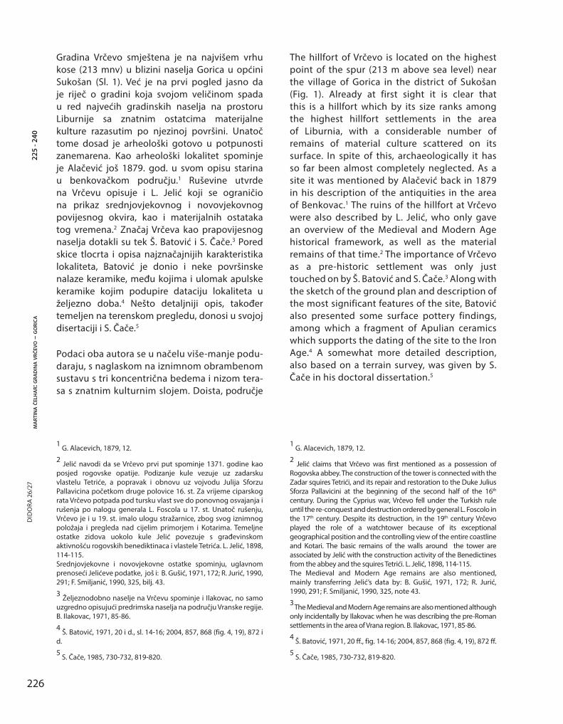
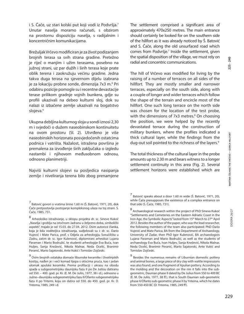
Brežuljak Vrčevo modificiran je za život podizanjem brojnih terasa sa svih strana gradine. Pretežno je riječ o manjim i užim terasama, posebno na južnoj strani, uz par dužih i širih terasa koje prate oblik terena i zaokružuju većinu gradine. Jedna takva duga terasa na sjevernom dijelu izabrana je za lokaciju probne sonde, dimenzija 7x3 m.8 Pri odabiru pozicije pomogle su i recentne devastacije terase prilikom gradnje vojnih bunkera, gdje su profili ukazivali na debeo kulturni sloj, dok su nalazi iz izbačene zemlje ukazivali na bogatstvo slojeva.9
Ukupna debljina kulturnog sloja u sondi iznosi 2,30 m i svjedoči o dužem naseobinskom kontinuitetu na ovom prostoru (Sl. 2). Utvrđeno je više naseobinskih horizonata posvjedočenih ostatcima podnica i vatrišta. Nažalost, istražena površina je premalena za izvođenje širih zaključaka o izgledu nastambi i njihovom međusobnom odnosu, odnosno planimetriji.
Najviši kulturni slojevi su posljedica nasipanja zemlje i niveliranja terena bilo zbog prenamjene
7 Batović govori o vratima širine 1,60 m (Š. Batović, 1971, 20), dok Čače pretpostavlja postojanje kompleksnog ulaza na toj strani. S. Čače, 1985, 731.
8 Arheološko istraživanje, u sklopu projekta dr. sc. Sineve Kukoč „Naselja i groblja na istočnom Jadranu u željezno doba, simbolički aspekti“, trajalo je od 15.03. do 27.04. 2012. Osim autorice članka, koja je bila voditeljica istraživanja, sudjelovali su i: dr. sc. Dario Vujević i Mate Parica, prof. s Odjela za arheologiju Sveučilišta u Zadru, zatim dr. sc. Igor Kulenović, diplomirani arheolozi Lujana Paraman i Mario Bodružić, te studenti arheologije Eva Buća, Ivan Huljev, Sanja Knežević, Nikola Malnar, Neda Ocelić, Branimir Peranić, Mario Sajatovski, Ante Vukić i Tomislav Zojčeski.
9 Osim brojnih ostataka domaće liburnske keramike i životinjskih kostiju, nađen je i veći komad lijepa s otiscima pruća, kao i jedan ulomak apulske keramike. Prema profilaciji i ukrasu na obodu spada u subgeometrijsku daunijsku fazu II po De Juliisu datiranu od 550. – 400. god. pr. Kr. (E. M. De Juliis, 1977, 38 i d.), odnosno u Južno–daunijsku subgeometrijsku fazu II/Ofanto subgeometrijsku fazu II po Yntemi, koju on datira od 550. do 450. god. pr. Kr. D. Yntema, 1985, 249 i d.
The settlement comprised a significant area of approximately 470x250 metres. The main entrance should certainly be looked for on the southern side of the hillfort as it was already noticed by Š. Batović and S. Čače, along the old unsurfaced road which comes from Podvršje.7 Inside the settlement, given the spatial disposition of the village, we must rely on radial and concentric communications.
The hill of Vrčevo was modified for living by the raising of a number of terraces on all sides of the hillfort. They are mostly smaller and narrower terraces, especially on the south side, along with a couple of longer and wider terraces which follow the shape of the terrain and encircle most of the hillfort. One such long terrace on the north side was chosen for the location of the test probe, with the dimensions of 7x3 metres.8 On choosing the position, we were helped by the recently devastated terrace during the construction of military bunkers, where the profiles indicated a thick cultural layer, while the findings from the dug-out soil pointed to the richness of the layers.9
The total thickness of the cultural layer in the probe amounts up to 2.30 m and bears witness to a longer settlement continuity in this area (Fig. 2). Several settlement horizons were established which are
7 Batović speaks about a door 1.60 m wide (Š. Batović, 1971, 20), while Čače presupposes the existence of a complex entrance on that side (S. Čače, 1985, 731).
8 Archaeological research within the project of PhD Sineva Kukoč “Settlements and Cemeteries on the Eastern Adriatic Coast in the Iron Age, the Symbolic Aspects” lasted from 15th March to 27th April 2012. Besides the author of the paper, who was the lead researcher, the following members of the team also participated: PhD Dario Vujević and Mate Parica, BA from the Department of Archaeology, University of Zadar, then PhD Igor Kulenović, BA archaeologists Lujana Paraman and Mario Bodružić, as well as the students of archaeology Eva Buća, Ivan Huljev, Sanja Knežević, Nikola Malnar, Neda Ocelić, Branimir Peranić, Mario Sajatovski, Ante Vukić and Tomislav Zojčeski.
9 Besides the numerous remains of Liburnian domestic pottery and animal bones, a large piece of dry clay with wattle impressions was also found, and one fragment of Apulian pottery. According to the molding and the decoration on the rim it falls into the sub-geometric, Daunian phase II dated by De Julius from 550 to 400 BC (E. M. De Juliis, 1977, 38 ff.), that is South Daunian sub-geometric phase II/Ofanto sub-geometric phase II by Yntema, which he dates from 550-450 BC (D. Yntema, 1985, 249 ff ).
230
ma
rtin
a č
elh
ar:
gra
din
a v
rčev
o –
go
rica
DID
ORA
26/
2722
5 - 2
40
prostora u gospodarske svrhe ili zbog povlačenja objekata prema unutrašnjosti gradine zbog erozije terase. Naime, taloženjem kulturnih slojeva i povećanjem njihove debljine, prapovijesni stanovnici Vrčeva svakako su se susreli s problemom erozije koju su pokušavali sanirati i zaustaviti gradnjom podzida. Unutar sonde utvrđeno je postojanje tri takva podzida od kojih je svaki mlađi više povučen prema centru gradine. Gornji slojevi nemaju nikakvih čvrstih formacija, a obiluju značajnom količinom fragmentiranog keramičkog materijala i životinjskih kostiju. Unutar keramičkog korpusa najbrojnije su poluloptaste zdjele s uvučenim obodom i veće posude s obodom izvijenim prema van, dok od dekoracije prevladavaju plastični ukrasi, kanelure i ukrasi nastali utiskivanjem prsta. Zabilježena su i dva fragmenta keramike ukrašena plastičnom valovnicom, koje Š. Batović smješta u zadnju fazu liburnske grupe.10
U slojevima ispod pola metra dubine počinje se pojavljivati i drugačiji materijal, iako još u skromnim količinama. Riječ je o koštanim iglama s plosnatom i kružno perforiranom glavom, čija uglačanost i istrošenost govori o utilitarnom, a ne ukrasnom karakteru, koštanim šilima, keramičkim pršljenovima i ulomcima brončanih predmeta, od kojih treba izdvojiti iglu s ušicom (Sl. 3).
Na dubini od 95 cm utvrđeno je postojanje prvog naseobinskog objekta. Riječ je o ostacima podnice u vidu sloja od nabijene i zapečene zemlje s komadićima lijepa, koja nije ravnomjerno sačuvana na cijeloj površini objekta. Međutim, dobro je sačuvana substrukcija podnice, odnosno naboj od sitnog kamenja koji mjestimično ima debljinu i do 20 cm. Objekt zauzima južni dio sonde i nije otkriven u cijelosti jer se nastavlja pod južni i istočni profil. Otkriven je u dužini 2,40 x 2 m. Na zapadnoj strani objekta nađen je veći kamen s kružnom udubinom po sredini. Riječ je o artificijelnoj, a ne prirodnoj udubini. Kako na tom dijelu, uz kamen, prestaje i podnica objekta, a
10 Š. Batović, 1987, 373.
evidenced by the remains of floors and hearth stones. Unfortunately, the researched surface is too small to draw broader conclusions about the appearance of the living quarters and their inter-relations i.e. planimetry.
The highest cultural layers are a consequence of pil-ing up soil and levelling the terrain either because of the conversion of space for economic purposes or because of the withdrawing of the objects towards the interior of the hillfort due to terrace erosion. Namely, during the sedimentation of cultural layers and the increase in their thickness, the inhabitants of pre-historic Vrčevo must have encountered the problem of erosion which they tried to salvage and prevent by constructing a support wall. Within the probe the existence of three such support walls was established, of which each younger one is more with-drawn towards the centre of the hillfort. The upper layers do not have any firm formations and are rich in the amount of fragmented ceramic material and ani-mal bones. Among pottery finds the most numerous are hemispherical bowls with indented rims and big-ger vessels with outcurved rims. The most numerous decorations include plastic ornaments, cannelures and ornaments created by finger impression. There are also two fragments of pottery decorated with a plastic wave, which Š. Batović dates to final phase of the Liburnian group.10
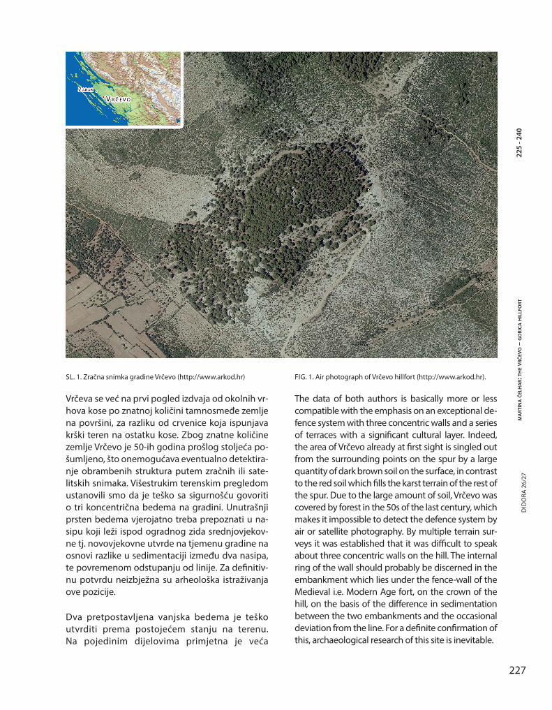
In the layers under half a metre in depth, different material emerges, although still in modest amounts. These are bone needles, flat with a round perforated head whose smoothness and wear reveal their utilised and not decorative character, bone awls, ceramic whorls and fragments of bronze items among which a needle with an eye should be singled out (Fig. 3).
At a depth of 95 cm, the existence of the first inhabited object was established. These are the remains of a floor in the form of flattened and baked earth with pieces of dry clay, which were not evenly preserved on the entire surface of the
10 Š. Batović, 1987, 373.
231
ma
rtin
a č
elh
ar:
the v
rčev
o –
go
rica
hil
lfo
rtD
IDO
RA 2
6/27
225
- 240
prema komparaciji s nekim drugim prapovijesnim nalazištima, nije isključeno da kamen s udubinom zapravo predstavlja temeljni kamen za nosač vrata.11 U neposrednoj blizini kamena pronađeni su ručni žrvanj, glačana kamena sjekira, više keramičkih pršljenova i koštana igla s kružnom perforacijom na trokutastoj glavi, materijalni ostatci koji govore o svakodnevnim djelatnostima ljudi nastanjenih u ovom objektu.
Objekt se rasprostire do 2 metra dužine prema sjeveru i tu se na njegovom rubu uočava nekoliko većih kamenja koje je, međutim, teško povezati s eventualnim temeljima suhozidnih konstrukcija. Na istoj razini, na rubu terase dalje prema sjeveru, definiran je novi podzid terase, širok 1 metar i
11 Batović spominje veću količinu takvog kamenja s udubinama pronađenih istraživanjima željeznodobnog naselja u Radovinu. Nažalost, niti jedan nije pronađen in situ. Š. Batović, 1987a, 114.
object. However, the sub-structure of the wall is well-preserved i.e. the compressed gravel which in places is up to 20 cm thick. The object occupies the south part of the probe and has not been excavated completely as it continues under the south and east profile. The excavated length is 2.40 times 2 m. On the west side of the object a large stone with a circular depression in the middle was found. It is an artificial and not natural depression. As in the part by the stone the floor of the object stops, and according to the comparison with some other pre-historic sites, it cannot be ruled out that the stone with the depression actually represents a foundation stone for supporting the door.11 In close proximity to the stone, a hand-held grindstone, a smooth stone axe, several ceramic
11 Batović mentions a large amount of stones with a depression excavated during the research of the Iron Age settlement in Radovin. Unfortunately, none were found in in situ. Š. Batović, 1987a, 114.
SL. 3. Izbor koštanog alata iz sonde (foto: M. Parica) FIG. 3. Selection of bone tools from the probe (photo: M. Parica).
232
ma
rtin
a č
elh
ar:
gra
din
a v
rčev
o –
go
rica
DID
ORA
26/
2722
5 - 2
40
građen većinom od sitnog kamenja, s par kamena većih dimenzija, nabacanog bez reda u nasip.
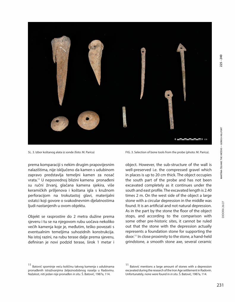
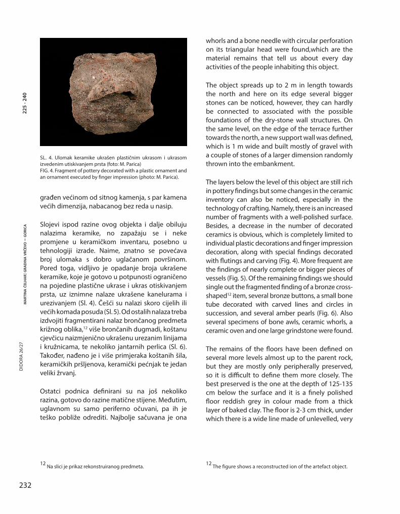
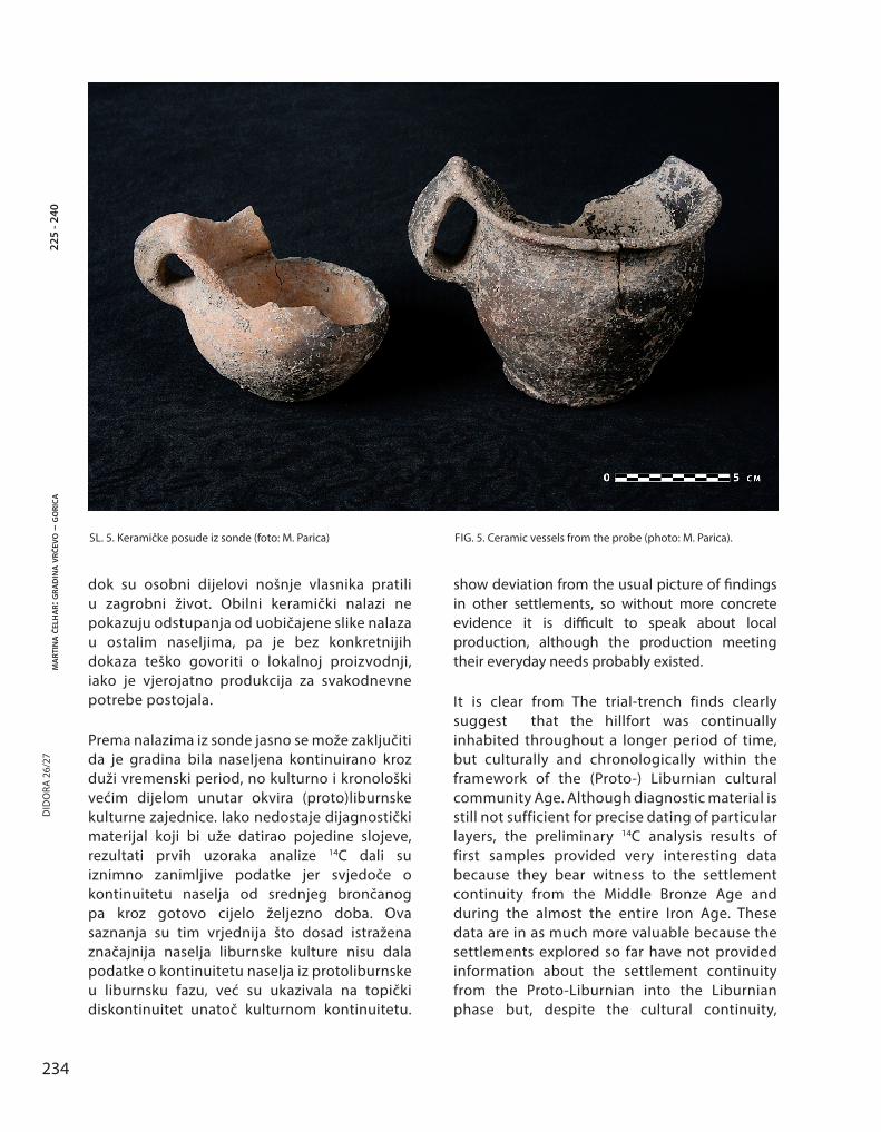
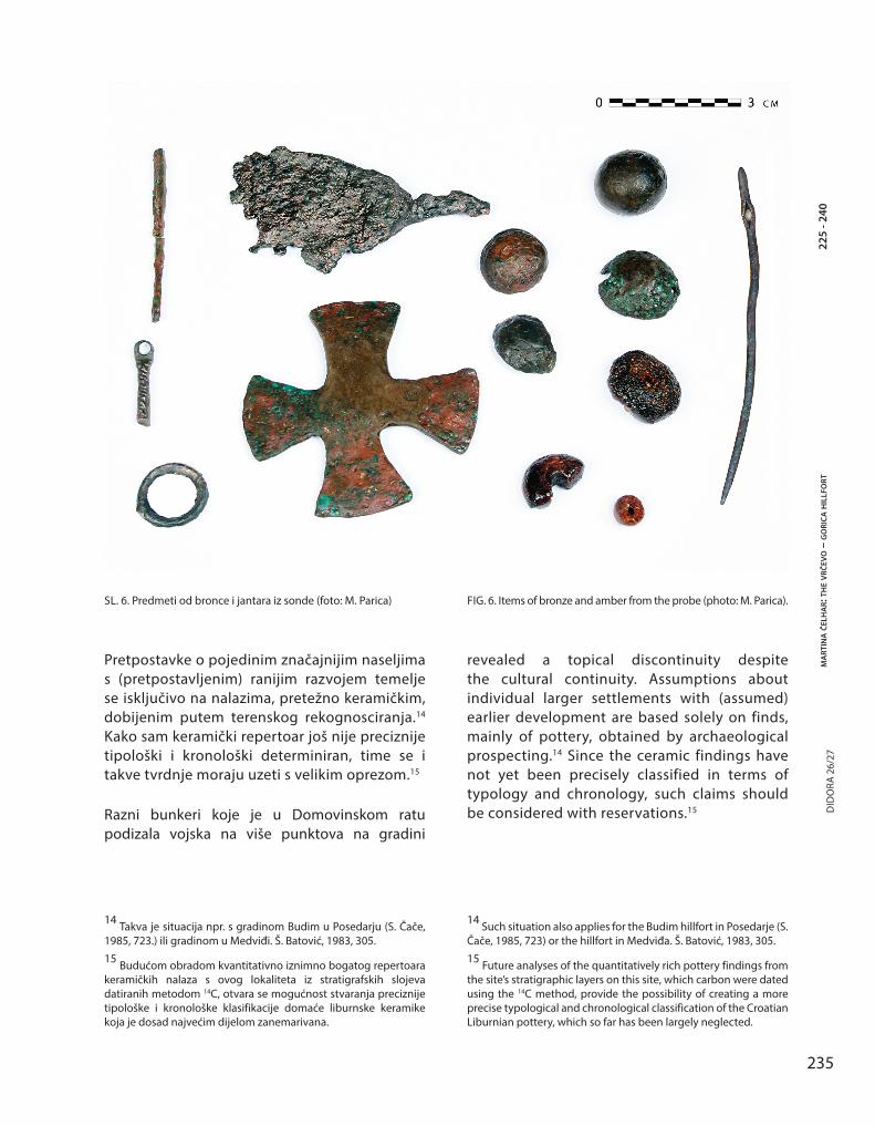
Slojevi ispod razine ovog objekta i dalje obiluju nalazima keramike, no zapažaju se i neke promjene u keramičkom inventaru, posebno u tehnologiji izrade. Naime, znatno se povećava broj ulomaka s dobro uglačanom površinom. Pored toga, vidljivo je opadanje broja ukrašene keramike, koje je gotovo u potpunosti ograničeno na pojedine plastične ukrase i ukras otiskivanjem prsta, uz iznimne nalaze ukrašene kanelurama i urezivanjem (Sl. 4). Češći su nalazi skoro cijelih ili većih komada posuda (Sl. 5). Od ostalih nalaza treba izdvojiti fragmentirani nalaz brončanog predmeta križnog oblika,12 više brončanih dugmadi, koštanu cjevčicu naizmjenično ukrašenu urezanim linijama i kružnicama, te nekoliko jantarnih perlica (Sl. 6). Također, nađeno je i više primjeraka koštanih šila, keramičkih pršljenova, keramički pećnjak te jedan veliki žrvanj.
Ostatci podnica definirani su na još nekoliko razina, gotovo do razine matične stijene. Međutim, uglavnom su samo periferno očuvani, pa ih je teško pobliže odrediti. Najbolje sačuvana je ona
12 Na slici je prikaz rekonstruiranog predmeta.
whorls and a bone needle with circular perforation on its triangular head were found,which are the material remains that tell us about every day activities of the people inhabiting this object.
The object spreads up to 2 m in length towards the north and here on its edge several bigger stones can be noticed, however, they can hardly be connected to associated with the possible foundations of the dry-stone wall structures. On the same level, on the edge of the terrace further towards the north, a new support wall was defined, which is 1 m wide and built mostly of gravel with a couple of stones of a larger dimension randomly thrown into the embankment.
The layers below the level of this object are still rich in pottery findings but some changes in the ceramic inventory can also be noticed, especially in the technology of crafting. Namely, there is an increased number of fragments with a well-polished surface. Besides, a decrease in the number of decorated ceramics is obvious, which is completely limited to individual plastic decorations and finger impression decoration, along with special findings decorated with flutings and carving (Fig. 4). More frequent are the findings of nearly complete or bigger pieces of vessels (Fig. 5). Of the remaining findings we should single out the fragmented finding of a bronze cross-shaped12 item, several bronze buttons, a small bone tube decorated with carved lines and circles in succession, and several amber pearls (Fig. 6). Also several specimens of bone awls, ceramic whorls, a ceramic oven and one large grindstone were found.
The remains of the floors have been defined on several more levels almost up to the parent rock, but they are mostly only peripherally preserved, so it is difficult to define them more closely. The best preserved is the one at the depth of 125-135 cm below the surface and it is a finely polished floor reddish grey in colour made from a thick layer of baked clay. The floor is 2-3 cm thick, under which there is a wide line made of unlevelled, very
12 The figure shows a reconstructed ion of the artefact object.
SL. 4. Ulomak keramike ukrašen plastičnim ukrasom i ukrasom izvedenim utiskivanjem prsta (foto: M. Parica)FIG. 4. Fragment of pottery decorated with a plastic ornament and an ornament executed by finger impression (photo: M. Parica).
233
ma
rtin
a č
elh
ar:
the v
rčev
o –
go
rica
hil
lfo
rtD
IDO
RA 2
6/27
225
- 240
na dubini od 125 do 135 cm ispod površine, a riječ je o fino uglačanoj podnici crvenkasto sive boje od debelog sloja zapečene gline. Podnica je debela 2 do 3 cm, ispod čega se nalazi ili sitno kamenje ili zapečena zemlja. Na rubovima ove podnice pojavljuje se široka linija neravne jako zapečene i kompaktne zemlje bijele boje. Zapečenost podnice, ali i rubnog nasipa ukazuju na jako gorenje, što možda sugerira da se radi o objektu s ognjištem. Podnica je jasno uočljiva u zapadnom profilu sonde i jasno je da se nastavlja pod njega.
U razini s najstarijom hodnom površinom i ostatcima podnice, tek nešto iznad matične stijene, leži najstariji, prvotni podzid. Izgrađen je od debljeg sloja sitnog kamenja koje leži na velikom amorfnom kamenju i izvedbom je znatno kompaktniji od gornja dva podzida.13
Životinjske kosti pronađene u sondi, kao indikator gospodarske djelatnosti, već na prvi pogled pokazuju uobičajenu sliku poznatu s drugih liburnskih naselja, među kojima primat imaju kosti ovaca i koza uz kosti ostalih domaćih životinja. Nađen je i šiljak roga jelena. Česti su nalazi morskih školjaka, puževa, a izdvojena je i jedna kost ribe, koje su, svakako, predstavljale važan udio u prehrani zajednice. Stočarstvo i zemljoradnja su svakako bili temelj gospodarstva, dok je o obrtima teško, s obzirom na trenutni stupanj poznavanja, nešto više reći. Ostatci metalurške djelatnosti nisu zasad utvrđeni, a i sama količina metalnih nalaza je skromna, što i nije neuobičajeno za naselja. Očito je da je metal, u područjima koja nisu bila rudno bogata, predstavljao značajnu vrijednost i u slučajevima istrošenosti ili daljnje neupotrebljivosti bio reutilitariziran,
13 Iako se taj najstariji podzid dimenzijama i načinom gradnje značajno razlikuje od gornjih, mlađih podzida, na ovom stupnju istraženosti nema argumenata da mu pridodamo fortifikacijski karakter. Ukoliko je i riječ o fortifikaciji onda se ona mora vezati isključivo za stariji vremenski odsječak života naselja. Naime, krajem starijeg željeznog doba već egzistira mlađi, srednji podzid dok je istovremeno najniži suhozid već u potpunosti prekriven tijekom vremena nataloženim naseobinskim slojem i on tad zasigurno ima funkciju podzida terase, nikako fortifikacijske strukture.
well-baked and compact soil, white in colour. The hardness of the floor as well as the edge of the embankment indicate heavy burning, which might suggest this be an object with a hearth. The floor is clearly visible on the west profile of the probe and it is obvious that it continues underneath it.
On the level of the oldest walking surface and the remains of the floor, just a little above the main stone, lies the oldest primary support wall. It was built from a thicker layer of gravel which lies on the large amorphous stones, and was built rather more compactly than the upper two support walls.13
Animal bones found in the probe as an indicator of economic activity, already at first glance reveal the usual picture known from the other Liburnian settlements, amongst which primarily are the bones of sheep and goats along with the bones of other domestic animals. The tip of a deer horn has also been found. The findings of seashells and snails are frequent and a fish bone was also found, fish being certainly an important part of the diet of the Iron Age population. Cattle breeding and farming were definitely the basis of the economy of this Iron Age community, while it is difficult, given the current level of knowledge, to say more about the trades. The remains of metallurgical activity have not been established yet, and the amount of metal findings is also very modest, which is not that unusual for settlements. It is obvious that metal, in areas deficient in ore, represented a significant value, and when it was worn out or could not be used any longer, it was re-used, while personal clothing items were taken by their owners to the after-life. The amount of ceramic findings do not
13 Although this oldest support wall differs substantially from the upper, later support walls in terms of its dimensions and construction method from the upper, later support walls, there are no arguments to support its fortification character at this level stage of exploration of the site excavation. If it indeed is a fortification then it should be associated solely with the earlier time period of life in the settlement. Namely, towards the end of the Early Iron Age, the later, middle support wall is had already been present towards the end of the Early Iron Age, while at the same time the lowest dry stone wall was already entirely covered with the settlement layer, which accumulated over time, and at this point it definitely functioned as a support wall for the terrace and not as a fortification structure.
234
ma
rtin
a č
elh
ar:
gra
din
a v
rčev
o –
go
rica
DID
ORA
26/
2722
5 - 2
40
show deviation from the usual picture of findings in other settlements, so without more concrete evidence it is difficult to speak about local production, although the production meeting their everyday needs probably existed.
It is clear from The trial-trench finds clearly suggest that the hillfort was continually inhabited throughout a longer period of time, but culturally and chronologically within the framework of the (Proto-) Liburnian cultural community Age. Although diagnostic material is still not sufficient for precise dating of particular layers, the preliminary 14C analysis results of first samples provided very interesting data because they bear witness to the settlement continuity from the Middle Bronze Age and during the almost the entire Iron Age. These data are in as much more valuable because the settlements explored so far have not provided information about the settlement continuity from the Proto-Liburnian into the Liburnian phase but, despite the cultural continuity,
dok su osobni dijelovi nošnje vlasnika pratili u zagrobni život. Obilni keramički nalazi ne pokazuju odstupanja od uobičajene slike nalaza u ostalim naseljima, pa je bez konkretnijih dokaza teško govoriti o lokalnoj proizvodnji, iako je vjerojatno produkcija za svakodnevne potrebe postojala.
Prema nalazima iz sonde jasno se može zaključiti da je gradina bila naseljena kontinuirano kroz duži vremenski period, no kulturno i kronološki većim dijelom unutar okvira (proto)liburnske kulturne zajednice. Iako nedostaje dijagnostički materijal koji bi uže datirao pojedine slojeve, rezultati prvih uzoraka analize 14C dali su iznimno zanimljive podatke jer svjedoče o kontinuitetu naselja od srednjeg brončanog pa kroz gotovo cijelo željezno doba. Ova saznanja su tim vrjednija što dosad istražena značajnija naselja liburnske kulture nisu dala podatke o kontinuitetu naselja iz protoliburnske u liburnsku fazu, već su ukazivala na topički diskontinuitet unatoč kulturnom kontinuitetu.
SL. 5. Keramičke posude iz sonde (foto: M. Parica) FIG. 5. Ceramic vessels from the probe (photo: M. Parica).
235
ma
rtin
a č
elh
ar:
the v
rčev
o –
go
rica
hil
lfo
rtD
IDO
RA 2
6/27
225
- 240
Pretpostavke o pojedinim značajnijim naseljima s (pretpostavljenim) ranijim razvojem temelje se isključivo na nalazima, pretežno keramičkim, dobijenim putem terenskog rekognosciranja.14 Kako sam keramički repertoar još nije preciznije tipološki i kronološki determiniran, time se i takve tvrdnje moraju uzeti s velikim oprezom.15
Razni bunkeri koje je u Domovinskom ratu podizala vojska na više punktova na gradini
14 Takva je situacija npr. s gradinom Budim u Posedarju (S. Čače, 1985, 723.) ili gradinom u Medviđi. Š. Batović, 1983, 305.
15 Budućom obradom kvantitativno iznimno bogatog repertoara keramičkih nalaza s ovog lokaliteta iz stratigrafskih slojeva datiranih metodom 14C, otvara se mogućnost stvaranja preciznije tipološke i kronološke klasifikacije domaće liburnske keramike koja je dosad najvećim dijelom zanemarivana.
revealed a topical discontinuity despite the cultural continuity. Assumptions about individual larger settlements with (assumed) earlier development are based solely on finds, mainly of pottery, obtained by archaeological prospecting.14 Since the ceramic findings have not yet been precisely classified in terms of typology and chronology, such claims should be considered with reservations.15
14 Such situation also applies for the Budim hillfort in Posedarje (S. Čače, 1985, 723) or the hillfort in Medviđa. Š. Batović, 1983, 305.
15 Future analyses of the quantitatively rich pottery findings from the site’s stratigraphic layers on this site, which carbon were dated using the 14C method, provide the possibility of creating a more precise typological and chronological classification of the Croatian Liburnian pottery, which so far has been largely neglected.
SL. 6. Predmeti od bronce i jantara iz sonde (foto: M. Parica) FIG. 6. Items of bronze and amber from the probe (photo: M. Parica).
236
ma
rtin
a č
elh
ar:
gra
din
a v
rčev
o –
go
rica
DID
ORA
26/
2722
5 - 2
40
pokazuju da se bogati kulturni slojevi nalaze i na istočnoj i zapadnoj strani gradine. Na južnom pak dijelu Vrčeva na površini se zapažaju temeljni suhozidni ostaci kuća, kakvi doduše nisu neposredno otkriveni u samoj sondi. Nalazi objekata bez kamenih temelja česta su pojava na istraživanim liburnskim gradinama.16 Treba spomenuti i značajnu količinu površinskih nalaza, posebno na jugoistočnom dijelu gradine, a to su veći ulomci keramike bez primjesa, odnosno velikih posuda za skladištenje hrane – dolia.
Odsustvo materijala helenističkog i rimskodobnog repertoara indicira prestanak života naselja možda već u posljednjim stoljećima liburnske samostalnosti, a svakako svjedoči da u rimsko doba život na ovoj poziciji nije nastavljen. Zamiranje života po svoj prilici nije bilo naglo, a svakako ne nasilno, jer takvih stratigrafskih pokazatelja nema. Ujedno taj podatak ne dopušta gradinu determinirati kao jednu od Plinijevih liburnskih civitates, pošto je njegov popis većinom nastao na osnovu izvora iz kasnog republikanskog perioda.17 Međutim, prema veličini i znatnom kulturnom sloju, Vrčevo je svakako bilo središnje naselje u starijim razdobljima.
Pitanje granica teritorija koji joj je gravitirao je teško sa sigurnošću utvrditi. Svojim položajem ipak ukazuje da je vjerojatno prvenstveno bila orijentirana na iznimno plodna polja u unutrašnjosti (sa značajnim izvorima pitke vode), gdje graniči s teritorijem Gradine u Nadinu (Nedinum). Jezgru teritorija čine područja današnjih sela Debeljak, Galovac, Gorica, Donje i Gornje Raštane. Unatoč iznimnoj vizualnoj preglednosti šire okolice, prva primorska kosa joj zatvara pogled na samu obalu uz pojedine uske prirodne prolaze. Unatoč tome, svakako je moglo doći i do pretenzija ove zajednice ka iskorištavanju nedalekih morskih resursa, a udaljenost od nekih 3 km svakako nije bila neka značajnija relacija koja nije mogla biti
16 Š. Batović, 1987, 99.
17 Uvjete i kriterije koje naselja trebaju ispunjavati da bi se mogla povezati s Plinijevim popisima vidi kod: S. Čače, 1993, 30. Za kartu naseobinskih centara 2. i 1. st. pr. Kr. vidi: S. Čače, 2006, 72, map 4.
Various bunkers, which during the war in Croatia were raised by the army on more localities of the hill, show that there are rich cultural layers on the eastern and western side of the hillfort as well. On the south part of Vrčevo though, one can notice on the surface the foundation of dry stone remains of houses, which admittedly were not directly discovered in the probe itself. The findings of the objects without stone foundations are a frequent occurrence on the researched Liburnian hillforts.16 A significant number of surface findings should also be mentioned especially on the southeastern part of the fort, and these are mostly pottery fragments without additions, that is large vessels for storing food – dolia.
The absence of materials from the Hellenistic and Roman repertoire indicates the end of life of the settlement probably already in the last centuries of the Liburnian independence, and it certainly confirms that in the Roman period, life on this location did not continue. The end of life was most probably gradual and certainly not violent since such stratigraphic indicators do not exist. At the same time this data does not allow determining the hillfort as one of Pliny’s Liburnian civitates, as his list was based mostly on the source from the late Republican period.17 However, according to its size and rather cultural layer, Vrčevo was certainly a central settlement in old periods.
The question of the boundaries of the territory which gravitated to it is difficult to establish with certainty. Its position, none the less indicates it was probably primarily oriented to very fertile fields in the hinterland (with important sources of fresh water), where it bordered with the territory of the hillfort in Nadin (Nedinum). The core of the territory was made up of the areas of today’s villages of Debeljak, Galovac, Gorica, Donje and Gornje Raštane. Despite a very commanding view of the wider surroundings, the first maritime spur
16 Š. Batović, 1987, 99.
17 Conditions and criteria required for the settlements to be associated with the Pliny’s lists see in S. Čače, 1993, 30. For the map of settlement centres from the 2nd and 1st century BC see: S. Čače, 2006, 72, map 4.
237
ma
rtin
a č
elh
ar:
the v
rčev
o –
go
rica
hil
lfo
rtD
IDO
RA 2
6/27
225
- 240
ostvarena na dnevnoj razini. Iako se zajednice uz Pašmanski kanal uglavnom definiraju kroz prizmu klastera manjih zajednica upućenih na tijesnu suradnju, s obzirom na neosporan značaj naselja na Vrčevu i snažni naseobinski horizont koji nije moguće ustanoviti niti na jednoj drugoj gradini u bližoj okolici, čini se vjerojatnijim da je prostor oko Sv. Petra i Turnja sa svojim gradinama bio interesna sfera upravo ove moćne zajednice.
Međutim, očito se u procesu povezivanja širih teritorija u domenu jednog većeg teritorijalnog centra, dokumentirano u antičkim izvorima prikazom stanja s kraja republikanskog razdoblja, a što svakako vuče korijene iz nešto starijeg perioda, Vrčevo nije uspjelo nametnuti kao aktivni čimbenik i polako gubi svoj značaj, te na njemu uskoro zamire život. Vjerojatno je takvoj situaciji pridonio i sam položaj Vrčeva. Prvenstveno se to odnosi na neposrednu blizinu Zadra koji u ovom razdoblju započinje sa znatnom ekspanzijom svog teritorija.18 Tome u prilog možda govori i stanje u doba antike, kad je biogradski kraj bez značajnijih centara, vjerojatno zbog interesne sfere zadarske kolonije.19
Lokalitet Vrčevo u Gorici svakako zaslužuje punu pažnju istraživača, a napose s obzirom na značajan potencijal za bolje razumijevanje početaka razvoja velikih gradinskih naselja na liburnskom prostoru i prerastanja istih u centre željeznog doba, kao i društvenih i gospodarskih promjena u mlađem željeznom dobu na ovom prostoru. Svakako je pitanje obrambenih konstrukcija zasad otvoreno. Možda treba računati i s mogućnošću da je dio kamene građe naknadno upotrijebljen za utvrdu na tjemenu gradine. Posebnu pozornost treba posvetiti odnosu s okolnim vrhovima kose, koji redom svi na sebi imaju suhozidne konstrukcije, a na njima ili između njih primjetan je veći broj
18 Za teritorij Zadra u kasno željezno doba i razdoblju početka principata vidi: S. Čače, 2006, 71, map 3; 1990, 206-207.
19 S. Čače, 1990, 208-209; B. Ilakovac, 1971, 86-91; B. Nedved, 1990, 241 i d.
blocks its view of the coast itself and individual natural passages. Nevertheless, this community may also have had pretensions to exploiting the nearby sea maritime resources, since the distance of approximately 3 km is such that could have been covered daily. Communities along the Pašman channel are mainly seen as a cluster composed of smaller communities, which were compelled to close co-operatione closely. However, considering the indisputable importance of the Vrčevo settlement on Vrčevo and a strong settlement horizon, which cannot be established in any other nearby hillfort, it seems more probable that the area around Sveti Petar and Turanj with their hillfort was the sphere of interest of this powerful community.
However, it is obvious that in the process of connecting wider territories into a domain of a larger territorial centre, documented in ancient sources by the description of the situation in the late Republican period, which certainly had its roots in a somewhat older period, Vrčevo failed to assert itself as an active factor and slowly lost its importance, so that life soon ended. In all likelihood the very position of Vrčevo contributed to such a situation. This mainly refers to the immediate proximity of Zadar, which at this point began to expand its territory significantly.18 This may be supported by the fact that in ancient times the Biograd area did not have any major centres, probably due to the interest sphere of the Zadar colony.19
The Vrčevo site in Gorica definitely deserves researchers’ full attention primarily due to its large potential for a better understanding of the beginnings of the hillfort settlements development in Liburnia, their transformation into the Iron Age centres, and the social and economic changes in the Late Iron Age in this area. For the time being the issue of defence structures is certainly open.
18 For the territory of Zadar in the late Iron Age and early Principality see: S. Čače, 2006, 71, map 3; 1990, 206-207.
19 S. Čače, 1990, 208-209; B. Ilakovac, 1971, 86-91; B. Nedved, 1990, 241 ff.
238
ma
rtin
a č
elh
ar:
gra
din
a v
rčev
o –
go
rica
DID
ORA
26/
2722
5 - 2
40
kamenih humaka.20 Vjerojatno treba računati na različitu funkcionalnu i kronološku determinaciju ovih objekata, od kojih je dio služio naselju na Vrčevu, bilo za čuvanje stoke ili neku drugu namjenu. Također, nije još ni utvrđen položaj nekropole naselja, iako su, prema pričama starijih mještana često nalaženi grobova s kamenim škrinjama uokolo gradine.21 Nadamo se da će buduća istraživanja razriješiti dio opsežne problematike vezane kako uz sam lokalitet, tako i uz shvaćanje šire razvojne dinamike naselja i naseljenosti na ovom prostoru u brončano i željezno doba.
20 Od SZ prema JI to su redom: Ročkova glavica, Debeljak, Glavica ili Veliki Čičikan, Žilovača i Torine. Osim Ročkove glavice koja ima terase i nešto zemlje na površini, svi ostali ograđeni prostori su gotovo bez kulturnog sloja i veći dio površine im prikriva matična stijena. Impozantne strukture bedema nalazimo na Glavici, koja pored toga ima i površinski vidljive ostatke suhozidnih prostorija, najvećim dijelom uz bedem na istočnoj strani gradine. Posebno se izdvaja položaj Torine s ograđenim prostorom pravokutnog oblika i vidljivim ulazom na sjevernoj strani, dok se nasuprot, kao dio južnog zida nalazi veliki humak, po svemu sudeći nastao prije izgradnje zida. Taj je humak dio niza humaka koji se u ravnini pružaju preko ove kose. Linearna tendencija pružanja humaka možda upućuje na njihovu markacijsku, a vjerojatno i simboličku ulogu u prostoru.
21 Podatak dugujem gospodinu Davoru Ročku kojem se na ovom mjestu zahvaljujem na svim informacijama i značajnoj pomoći koju mi je pružio.
It might also have been possible that part of the stone structure was subsequently used for the fort at the top of the hill. Special attention should be paid to the relationship with the surrounding tops on the spur, which all had drystone wall constructions, and on them or among them a number of stone mounds is noticeable.20 Different functional and chronological determination of these objects should certainly be taken into consideration, part of which served the settlement of Vrčevo, either for guarding livestock or for other uses. The position of the village necropolis has not been established yet, although according to stories of some elderly residents, graves with stone chests were often found around the hillfort.21 It is our hope that future research will resolve some of the issues related to the site itself as well as the understanding of the broader developmental dynamics of the settlements and habitation in this area in the Bronze and Iron Ages.
20 From NW to SE they are in the following order: Ročkova glavica, Debeljak, Glavica or Veliki Čičikan, Žilovača and Torine. Besides Ročkova glavica, which has terraces and some soil on the surface, all the other enclosures are with almost no cultural layer and a large part of their surface is hidden by the main stone. Imposing structures of the walls were found on Glavica, which in addition has visible surface remains of drystone walled premises, mostly along the wall on the eastern side of the hillfort. Especially distinguished is the position of Torine with an enclosed space of rectangular shape and a visible entrance on the north side, while opposite it, as a part of the south wall there is a large mound, apparently formed before the construction of the wall. This mound is part of a number of mounds which extend across the flat surface of this spur.
21 I owe this information to Mr. Davor Ročko, to whom I express my warmest thanks for all the information and assistance which he provided for me.
239
ma
rtin
a č
elh
ar:
the v
rčev
o –
go
rica
hil
lfo
rtD
IDO
RA 2
6/27
225
- 240
Literatura/Bibliography
G. Alacevich, 1879 – Rovine antiche nel Distretto politico di Benkovac, Bulletino di Archeologia e Storia Dalmata, II, Split, 1879, 10-12.
Š. Batović, 1971 – Problemi prapovijesti na području Vrane i Biograda, Radovi Instituta Jugoslavenske akademije znanosti i umjetnosti u Zadru, sv. XVIII, Zadar, 1971, 9-73.
Š. Batović, 1983 – Liburnska kulturna skupina, Praistorija jugoslavenskih zemalja IV, Sarajevo, 1983, 304-330.Š. Batović, 1987 – Liburnska grupa, Praistorija jugoslavenskih zemalja V, Sarajevo, 1987, 339-390.Š. Batović, 1987a – Ostaci nastambi željeznog doba na našem primorju, Arheološki radovi i rasprave 10, Zagreb, 1987, 93-121.Š. Batović, 1990 – Novija istraživanja prapovijesti u biogradskom kraju, Biogradski zbornik 1, Zadar, 1990, 85-195.Š. Batović, 2004 – Caractéristiques des agglomérations fortifiées dans la region des Liburniens, U osvit povijesti, Zbornik
odabarnih radova, Opera selecta II, Zadar, 2004, 853-900. S. Čače, 1985 – Liburnija u razdoblju od 4. do 1. stoljeća prije nove ere, Doktorska disertacija (rukopis), Filozofski fakultet u Zadru,
Zadar, 1985.S. Čače, 1990 – Blandona i susjedna središta, Prilog antičkoj topografiji biogradskog područja, Biogradski zbornik 1, Zadar, 1990,
197-212.S. Čače, 1993 – Broj liburnskih općina i vjerodostojnost Plinija (Nat. hist. 3, 130; 139-141), Radovi Filozofskog fakulteta u Zadru
32 (19), Zadar, 1993, 1-36.S. Čače, 2006 – South Liburnia at the Beginning of the Principate: Jurisdiction and Territorial Organization, Les routes de
l’Adriatique antique, Bordeaux-Zadar, 2006, 65-79.E. M. De Juliis, 1977 – La ceramica geometrica della Daunia, Firenca, 1977.B. Gušić, 1971 – Starohrvatsko naseljenje Ravnih Kotara, Radovi Instituta Jugoslavenske akademije znanosti i umjetnosti u Zadru,
sv. XVIII, Zadar, 1971, 137-192.B. Ilakovac, 1971 – Vranska regija u rimsko doba, Radovi Instituta Jugoslavenske akademije znanosti i umjetnosti u Zadru, sv. XVIII,
Zadar, 1971, 75-136.L. Jelić, 1898 – Povjesno-topografske crtice o biogradskom primorju, Vjesnik hrvatskog arheološkog društva, n.s., sv. III, Zagreb,
1898, 33-126.R. Jurić, 1990 – Srednjovjekovni spomenici na biogradskom području, Biogradski zbornik 1, Zadar, 1990, 279-318.B. Nedved, 1990 – Biogradski kraj u rimsko doba, Biogradski zbornik 1, Zadar, 1990, 213-246.F. Smiljanić, 1990 – Teritorij i granice sidraške županije u srednjem vijeku, Biogradski zbornik 1, Zadar, 1990, 319-333.D. Yntema, 1985 – The Matt-painted Pottery of Southern Italy, A General Survey of the Matt-painted Styles of Southern Italy during
the final Bronze Age and the Iron Age, Utrecht, 1985.
