a lithosphere-scale structural model of the barents sea and
TRANSCRIPT
Solid Earth, 6, 153–172, 2015
www.solid-earth.net/6/153/2015/
doi:10.5194/se-6-153-2015
© Author(s) 2015. CC Attribution 3.0 License.
A lithosphere-scale structural model of the Barents Sea and
Kara Sea region
P. Klitzke1,2, J. I. Faleide3, M. Scheck-Wenderoth1,2, and J. Sippel1
1Helmholtz Centre Potsdam, GFZ German Research Centre for Geosciences, Potsdam, Germany2RWTH Aachen University, Dept. of Geology, Geochemistry of Petroleum and Coal, Aachen, Germany3Department of Geosciences, University of Oslo, Oslo, Norway
Correspondence to: P. Klitzke ([email protected])
Received: 27 May 2014 – Published in Solid Earth Discuss.: 10 July 2014
Revised: 2 December 2014 – Accepted: 14 December 2014 – Published: 12 February 2015
Abstract. We introduce a regional 3-D structural model of
the Barents Sea and Kara Sea region which is the first to com-
bine information on the sediments and the crystalline crust as
well as the configuration of the lithospheric mantle. There-
fore, we have integrated all available geological and geo-
physical data, including interpreted seismic refraction and re-
flection data, seismological data, geological maps and previ-
ously published 3-D models into one consistent model. This
model resolves four major megasequence boundaries (earli-
est Eocene, mid-Cretaceous, mid-Jurassic and mid-Permian)
the top crystalline crust, the Moho and a newly calculated
lithosphere–asthenosphere boundary (LAB). The thickness
distributions of the corresponding main megasequences de-
lineate five major subdomains (the northern Kara Sea, the
southern Kara Sea, the eastern Barents Sea, the western Bar-
ents Sea and the oceanic domain comprising the Norwegian–
Greenland Sea and the Eurasia Basin). Relating the subsi-
dence histories of these subdomains to the structure of the
deeper crust and lithosphere sheds new light on possible
causative basin forming mechanisms that we discuss.
The depth configuration of the newly calculated LAB and
the seismic velocity configuration of the upper mantle cor-
relate with the younger history of this region. The western
Barents Sea is underlain by a thinned lithosphere (80 km) re-
sulting from multiple Phanerozoic rifting phases and/or the
opening of the NE Atlantic from Paleocene/Eocene times
on. Notably, the northwestern Barents Sea and Svalbard are
underlain by thinnest continental lithosphere (60 km) and a
low-velocity/hot upper mantle that correlates spatially with a
region where late Cenozoic uplift was strongest. As opposed
to this, the eastern Barents Sea is underlain by a thicker litho-
sphere (∼ 110–150 km) and a high-velocity/density anomaly
in the lithospheric mantle. This anomaly, in turn, correlates
with an area where only little late Cenozoic uplift/erosion
was observed.
1 Introduction
Though of increasing economic relevance, intra-continental
basins are poorly understood in terms of processes control-
ling their evolution (Allen and Allen, 2013; Cloetingh and
Burov, 2011; Gac et al., 2013; Heine et al., 2008). To com-
prehend the influence of possible causative subsidence mech-
anisms as mentioned by Heine et al. (2008), the present-
day lithosphere-scale geological configuration needs to be
assessed. Essential progress can be made by integrated 3-D
models. Such models can be used as a base for structural
analysis but also to constrain the distribution of physical
properties (i.e. density and temperature) and their impact on
different processes.
The Barents Sea and Kara Sea region is situated in such an
intra-continental setting bordered by the ancient East Euro-
pean Craton in the southeast and two young passive margins
in the north and in the west (Fig. 1). This region has expe-
rienced a manifold tectonic history involving multiple oro-
genies, episodes of intense subsidence and young continen-
tal break-up. Thereby, the orogenies are assumed to locally
have set the structural grain of the deeper lithosphere which
entailed different types of basin formation mechanisms. Due
to the assumed potential for hydrocarbon resources, the geo-
dynamically complex setting of the Barents Sea and Kara Sea
Published by Copernicus Publications on behalf of the European Geosciences Union.

154 P. Klitzke et al.: 3-D model of the Barents–Kara Sea
region has been in the focus of both academic and industry-
driven studies for decades which have contributed to the ac-
cumulation of a large geological and geophysical database.
Recent studies made significant progress in integrating
data for larger parts of the Barents Sea. These studies focused
either on the sedimentary succession (Clark et al., 2013a, b;
Henriksen et al., 2011b), the crystalline crust (Hauser et
al., 2011; Marello et al., 2013; Ritzmann et al., 2007) or ad-
dress only subparts of the Barents Sea and Kara Sea region
(Barrère et al., 2009; Breivik et al., 2003, 2005; Glørstad-
Clark, 2011; Piskarev and Shkatov, 2012; Ritzmann and
Faleide, 2009). Consequently, there is only limited knowl-
edge about spatial correlations between the thickness config-
uration of the sedimentary succession, the crystalline crust
and the lithospheric mantle for the greater Barents Sea and
Kara Sea region.
In the frame of this study, we extend the region of interest
beyond the Barents and Kara shelves towards the west- and
northwards adjoining young oceanic domains and towards
the ancient craton (Baltica) in the southeast. We aim to in-
tegrate all publicly available geological and geophysical data
(from the Norwegian and Russian parts of the shelf) into a
lithosphere-scale regional 3-D model that resolves the first-
order characteristics of the sedimentary fill, the crystalline
crust and the lithospheric mantle. Subsequently, we analyse
how far characteristics of the 3-D structural model provide
new insights into the relation between these different depth
levels in different subdomains. In particular, the variations of
sedimentary thicknesses (subdivided into megasequences re-
flecting the main geological episodes) over the entire region
are integrated with information on the underlying lithosphere
for the first time and discussed in the context of regional geo-
dynamics.
2 Geological setting
The tectonic evolution of the Barents Sea and Kara Sea re-
gion (Fig. 1) is characterised by several orogenic phases
which assembled different lithospheric domains (Gac et
al., 2013; Gee et al., 2006; Gudlaugsson et al., 1998; Marello
et al., 2013; Otto and Bailey, 1995; Pease and Scott, 2009;
Ritzmann and Faleide, 2007, and references therein). It is
well known that the composite and heterogeneous basement
has experienced locally intense subsidence since Paleozoic
times that gave way to the accumulation of up to a 20 km
thick sedimentary succession (Johansen, 1992). The corre-
sponding present-day configuration of the top crystalline
crust reveals structural highs and lows of different wave-
lengths across the Barents and Kara shelves implying that
subregions are underlain by different basement domains and
structural grains (Figs. 1, 2).
After the assemblage of the East European Craton
(Baltica) at ca. 2.0–1.7 Ga (Bogdanova et al., 2008) the first
major tectonic event involving plate accretion occurred in the
Figure 1. Superimposed bathymetry/topography (IBCAO 3.0;
Jakobsson et al., 2012) with outlines of structural highs (red) and
lows (blue). The stippled lines mark the position of five repre-
sentative profiles (see Fig. 6) crossing most prominent geologi-
cal provinces. (AH) – Admiralty High; (BB) – Bjørnøya Basin;
(GH) – Gardarbanken High; (HFB) – Hammerfest Basin; (HB) –
Harstad Basin; (HJH) – Hjalmar Johansen High; (LH) – Loppa
High; (LS) – Ludlov Saddle; (NB) – Nordkapp Basin; (NH) –
Norsel High; (NSW) – North Siberian Weir; (OB) – Olga Basin;
(SB) –Sørvestsnaget Basin; (SKT) – South Kara Trough; (SHB) –
Stappen High with Bjørnøya Island; (TD) – Tiddlybanken Basin;
(TO) – Timan Orogen; (TB) – Tromsø Basin; (VU) – Vize-Ushakov
Rise; (VVP) – Vestbakken Volcanic Province.
latest Precambrian in the course of the Timanian Orogeny
(Fig. 2; Kostyuchenko et al., 2006; Roberts and Siedlecka,
2002). The Timan Range, a present-day topographic high
(Fig. 1) located in the southeast of the study area, gives proof
of this collisional event. Orogeny-associated terrane accre-
tion proceeded northeastwards from the Timan Range at least
to the Timan–Pechora Basin and is assumed to have con-
tinued northwards beneath the eastern Barents Sea as far as
to the northern Kara Sea (Gee and Pease, 2004; Lorenz et
al., 2007; Pease and Scott, 2009). Earliest sedimentation in
these regions is reported as having occurred in latest Pre-
cambrian times (Ivanova et al., 2011; Klimenko et al., 2011;
Lorenz et al., 2007).
The Caledonian Orogeny, caused by the collision between
Laurentia and Baltica to form Laurussia (Late Cambrian to
Silurian), affected mainly the area of the western Barents
Sea. The crystalline crust beneath the southwestern Bar-
ents Sea is supposed to represent the northward continuation
of the Caledonian thrusts cropping out in northern Norway
(Figs. 1, 2; Breivik et al., 1998, 2005; Marello et al., 2013;
Ritzmann and Faleide, 2007). The onshore fold and thrust
belts compose a series of NE–SW striking nappes – a strike
direction that dominates also the structural configuration of
Solid Earth, 6, 153–172, 2015 www.solid-earth.net/6/153/2015/
P. Klitzke et al.: 3-D model of the Barents–Kara Sea 155
the basement beneath the southwestern Barents Sea (Breivik
et al., 1998; Faleide et al., 1993; Ritzmann and Faleide,
2007). This trend is disputed in recent studies (Gernigon
and Brönner, 2012; Gernigon et al., 2014). However, the
oldest sediments found in the depressions of the southwest-
ern Barents Sea result from post-Caledonian rifting in late
Carboniferous–Permian times and gave way to the formation
of e.g. the Nordkapp Basin and the Ottar Basin (Fig. 2; Gud-
laugsson et al., 1998; Ritzmann and Faleide, 2007).
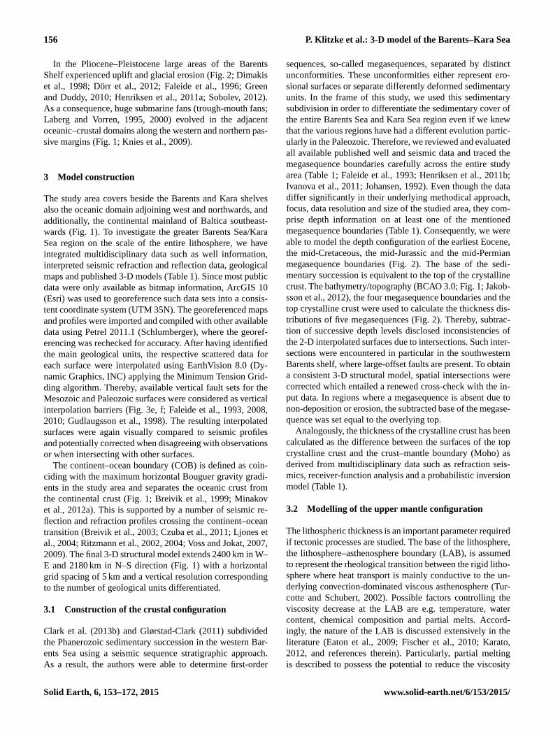
The last major orogenic phase affecting larger parts of the
Barents Sea and Kara Sea, the Uralian Orogeny, was initiated
by the collision of Laurussia with Siberia and Kazakhstan
in Late Devonian to Late Permian times (Fig. 2; Otto and
Bailey, 1995; Puchkov, 2009; Steer et al., 1998). Evidence
of this compressional deformation are the Ural Mountains
which continue structurally along the Pai-Khoi and Novaya
Zemlya fold-and-thrust belts as far as to the Taimyr region
in the northeast of the study area (Fig. 1). In Late Triassic
to ?Early Jurassic (post-Uralian) times, Novaya Zemlya ex-
perienced final westwards upthrusting. The westward curved
shape of the Novaya Zemlya fold-and-thrust belt structurally
delimits the southern Kara Sea (Fig. 1) whereby the curvature
is assumed to originate from a pre-collisional embayment of
Laurussia (Scott and Howard, 2010).
Another tectonic event at the Permian–Triassic transition
was the magmatic activity associated with the eruption of
the Siberian Traps. Traces of this event are found directly
eastwards of the southern Kara Sea in the West Siberian
Basin as widespread flood basalts and long-lived subsidence
from Middle Jurassic to Cenozoic times (Fig. 2; Nikishin et
al., 2002; Reichow et al., 2005; Saunders et al., 2005; Vyssot-
ski et al., 2006). Time-wise coinciding with these collisional
and thermal events, the East Barents Sea basin experienced
major subsidence in Permian–Triassic times (Figs. 1, 2). Sev-
eral published studies discuss the nature of the observed
rapid subsidence in the East Barents Sea basin since there are
no major extensional faults and thus a classical rift scenario
is unlikely (Aplonov et al., 1996; Gac et al., 2012, 2013;
Ivanova et al., 2011; Johansen, 1992; O’Leary et al., 2004;
Petrov et al., 2008; Semprich et al., 2010). Oldest sediments
of the South Kara Sea basin are assumed to have accumulated
in response to rifting in the Late Permian to Middle Triassic
followed by a post-rift thermal subsidence phase lasting until
Cenozoic times (Nikishin et al., 2011).
In Middle Jurassic to Early Cretaceous times intense rift-
ing occurred in the southwestern Barents Sea (Fig. 2; Faleide
et al., 1993, 2008). Thereby, the location of maximum subsi-
dence shifted westwards with respect to the older (Carbonif-
erous and Late Permian–Triassic) rift basins and resulted in
the development of the deep Tromsø Basin, the Sørvestsnaget
Basin and the Bjørnøya Basin (Fig. 1). A renewed westward
shift in the locus of rifting took place in Late Cretaceous to
Paleocene times and resulted in the deposition of thick sedi-
mentary sequences in the Sørvestsnaget Basin and the Vest-
bakken Volcanic Province along the western Barents Sea that
Figure 2. Stratigraphic megasequences resolved in the 3-D struc-
tural model in relation to regional tectonic events.
formed a sheared margin during this time interval (Faleide et
al., 1993, 2008).
Continental break-up of the Norwegian–Greenland Sea
and the Eurasia Basin started in late Paleocene to earliest
Eocene times (Figs. 1, 2; Faleide et al., 2008). Thereby,
the Norwegian–Greenland Sea opened gradually northwards
along a megashear system which constituted a structural link
to the Eurasia Basin. The oceanic gateway between the two
oceans (Fram Strait) opened finally in mid-Miocene times
(Engen et al., 2008).
www.solid-earth.net/6/153/2015/ Solid Earth, 6, 153–172, 2015
156 P. Klitzke et al.: 3-D model of the Barents–Kara Sea
In the Pliocene–Pleistocene large areas of the Barents
Shelf experienced uplift and glacial erosion (Fig. 2; Dimakis
et al., 1998; Dörr et al., 2012; Faleide et al., 1996; Green
and Duddy, 2010; Henriksen et al., 2011a; Sobolev, 2012).
As a consequence, huge submarine fans (trough-mouth fans;
Laberg and Vorren, 1995, 2000) evolved in the adjacent
oceanic–crustal domains along the western and northern pas-
sive margins (Fig. 1; Knies et al., 2009).
3 Model construction
The study area covers beside the Barents and Kara shelves
also the oceanic domain adjoining west and northwards, and
additionally, the continental mainland of Baltica southeast-
wards (Fig. 1). To investigate the greater Barents Sea/Kara
Sea region on the scale of the entire lithosphere, we have
integrated multidisciplinary data such as well information,
interpreted seismic refraction and reflection data, geological
maps and published 3-D models (Table 1). Since most public
data were only available as bitmap information, ArcGIS 10
(Esri) was used to georeference such data sets into a consis-
tent coordinate system (UTM 35N). The georeferenced maps
and profiles were imported and compiled with other available
data using Petrel 2011.1 (Schlumberger), where the georef-
erencing was rechecked for accuracy. After having identified
the main geological units, the respective scattered data for
each surface were interpolated using EarthVision 8.0 (Dy-
namic Graphics, INC) applying the Minimum Tension Grid-
ding algorithm. Thereby, available vertical fault sets for the
Mesozoic and Paleozoic surfaces were considered as vertical
interpolation barriers (Fig. 3e, f; Faleide et al., 1993, 2008,
2010; Gudlaugsson et al., 1998). The resulting interpolated
surfaces were again visually compared to seismic profiles
and potentially corrected when disagreeing with observations
or when intersecting with other surfaces.
The continent–ocean boundary (COB) is defined as coin-
ciding with the maximum horizontal Bouguer gravity gradi-
ents in the study area and separates the oceanic crust from
the continental crust (Fig. 1; Breivik et al., 1999; Minakov
et al., 2012a). This is supported by a number of seismic re-
flection and refraction profiles crossing the continent–ocean
transition (Breivik et al., 2003; Czuba et al., 2011; Ljones et
al., 2004; Ritzmann et al., 2002, 2004; Voss and Jokat, 2007,
2009). The final 3-D structural model extends 2400 km in W–
E and 2180 km in N–S direction (Fig. 1) with a horizontal
grid spacing of 5 km and a vertical resolution corresponding
to the number of geological units differentiated.
3.1 Construction of the crustal configuration
Clark et al. (2013b) and Glørstad-Clark (2011) subdivided
the Phanerozoic sedimentary succession in the western Bar-
ents Sea using a seismic sequence stratigraphic approach.
As a result, the authors were able to determine first-order
sequences, so-called megasequences, separated by distinct
unconformities. These unconformities either represent ero-
sional surfaces or separate differently deformed sedimentary
units. In the frame of this study, we used this sedimentary
subdivision in order to differentiate the sedimentary cover of
the entire Barents Sea and Kara Sea region even if we knew
that the various regions have had a different evolution partic-
ularly in the Paleozoic. Therefore, we reviewed and evaluated
all available published well and seismic data and traced the
megasequence boundaries carefully across the entire study
area (Table 1; Faleide et al., 1993; Henriksen et al., 2011b;
Ivanova et al., 2011; Johansen, 1992). Even though the data
differ significantly in their underlying methodical approach,
focus, data resolution and size of the studied area, they com-
prise depth information on at least one of the mentioned
megasequence boundaries (Table 1). Consequently, we were
able to model the depth configuration of the earliest Eocene,
the mid-Cretaceous, the mid-Jurassic and the mid-Permian
megasequence boundaries (Fig. 2). The base of the sedi-
mentary succession is equivalent to the top of the crystalline
crust. The bathymetry/topography (BCAO 3.0; Fig. 1; Jakob-
sson et al., 2012), the four megasequence boundaries and the
top crystalline crust were used to calculate the thickness dis-
tributions of five megasequences (Fig. 2). Thereby, subtrac-
tion of successive depth levels disclosed inconsistencies of
the 2-D interpolated surfaces due to intersections. Such inter-
sections were encountered in particular in the southwestern
Barents shelf, where large-offset faults are present. To obtain
a consistent 3-D structural model, spatial intersections were
corrected which entailed a renewed cross-check with the in-
put data. In regions where a megasequence is absent due to
non-deposition or erosion, the subtracted base of the megase-
quence was set equal to the overlying top.
Analogously, the thickness of the crystalline crust has been
calculated as the difference between the surfaces of the top
crystalline crust and the crust–mantle boundary (Moho) as
derived from multidisciplinary data such as refraction seis-
mics, receiver-function analysis and a probabilistic inversion
model (Table 1).
3.2 Modelling of the upper mantle configuration
The lithospheric thickness is an important parameter required
if tectonic processes are studied. The base of the lithosphere,
the lithosphere–asthenosphere boundary (LAB), is assumed
to represent the rheological transition between the rigid litho-
sphere where heat transport is mainly conductive to the un-
derlying convection-dominated viscous asthenosphere (Tur-
cotte and Schubert, 2002). Possible factors controlling the
viscosity decrease at the LAB are e.g. temperature, water
content, chemical composition and partial melts. Accord-
ingly, the nature of the LAB is discussed extensively in the
literature (Eaton et al., 2009; Fischer et al., 2010; Karato,
2012, and references therein). Particularly, partial melting
is described to possess the potential to reduce the viscosity
Solid Earth, 6, 153–172, 2015 www.solid-earth.net/6/153/2015/
P. Klitzke et al.: 3-D model of the Barents–Kara Sea 157
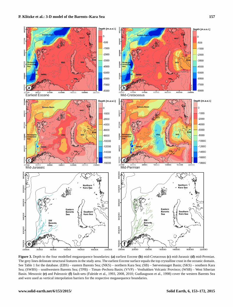
Figure 3. Depth to the four modelled megasequence boundaries: (a) earliest Eocene (b) mid-Cretaceous (c) mid-Jurassic (d) mid-Permian.
The grey lines delineate structural features in the study area. The earliest Eocene surface equals the top crystalline crust in the oceanic domain.
See Table 1 for the database. (EBS) – eastern Barents Sea; (NKS) – northern Kara Sea; (SB) – Sørvestsnaget Basin; (SKS) – southern Kara
Sea; (SWBS) – southwestern Barents Sea; (TPB) – Timan–Pechora Basin; (VVP) – Vestbakken Volcanic Province; (WSB) – West Siberian
Basin. Mesozoic (e) and Paleozoic (f) fault-sets (Faleide et al., 1993, 2008, 2010; Gudlaugsson et al., 1998) cover the western Barents Sea
and were used as vertical interpolation barriers for the respective megasequence boundaries.
www.solid-earth.net/6/153/2015/ Solid Earth, 6, 153–172, 2015
158 P. Klitzke et al.: 3-D model of the Barents–Kara Sea
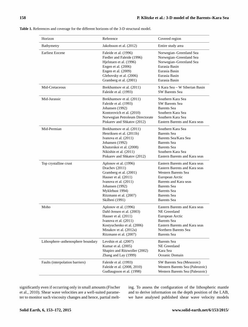
Table 1. References and coverage for the different horizons of the 3-D structural model.
Horizon Reference Covered region
Bathymetry Jakobsson et al. (2012) Entire study area
Earliest Eocene Faleide et al. (1996) Norwegian–Greenland Sea
Fiedler and Faleide (1996) Norwegian–Greenland Sea
Hjelstuen et al. (1996) Norwegian–Greenland Sea
Engen et al. (2006) Eurasia Basin
Engen et al. (2009) Eurasia Basin
Glebovsky et al. (2006) Eurasia Basin
Gramberg et al. (2001) Eurasia Basin
Mid-Cretaceous Brekhuntsov et al. (2011) S Kara Sea – W Siberian Basin
Faleide et al. (1993) SW Barents Sea
Mid-Jurassic Brekhuntsov et al. (2011) Southern Kara Sea
Faleide et al. (1993) SW Barents Sea
Johansen (1992) Barents Sea
Kontorovich et al. (2010) Southern Kara Sea
Norwegian Petroleum Directorate Southern Kara Sea
Piskarev and Shkatov (2012) Eastern Barents and Kara seas
Mid-Permian Brekhuntsov et al. (2011) Southern Kara Sea
Henriksen et al. (2011b) Barents Sea
Ivanova et al. (2011) Barents Sea/Kara Sea
Johansen (1992) Barents Sea
Khutorskoi et al. (2008) Barents Sea
Nikishin et al. (2011) Southern Kara Sea
Piskarev and Shkatov (2012) Eastern Barents and Kara seas
Top crystalline crust Aplonov et al. (1996) Eastern Barents and Kara seas
Drachev (2011) Eastern Barents and Kara seas
Gramberg et al. (2001) Western Barents Sea
Hauser et al. (2011) European Arctic
Ivanova et al. (2011) Barents and Kara seas
Johansen (1992) Barents Sea
Myklebust 1994) Barents Sea
Ritzmann et al. (2007) Barents Sea
Skilbrei (1991) Barents Sea
Moho Aplonov et al. (1996) Eastern Barents and Kara seas
Dahl-Jensen et al. (2003) NE Greenland
Hauser et al. (2011) European Arctic
Ivanova et al. (2011) Barents Sea
Kostyuchenko et al. (2006) Eastern Barents and Kara seas
Minakov et al. (2012a) Northern Barents Sea
Ritzmann et al. (2007) Barents Sea
Lithosphere–asthenosphere boundary Levshin et al. (2007) Barents Sea
Kumar et al. (2005) NE Greenland
Shapiro and Ritzwoller (2002) Kara Sea
Zhang and Lay (1999) Oceanic Domain
Faults (interpolation barriers) Faleide et al. (1993) SW Barents Sea (Mesozoic)
Faleide et al. (2008, 2010) Western Barents Sea (Paleozoic)
Gudlaugsson et al. (1998) Western Barents Sea (Paleozoic)
significantly even if occurring only in small amounts (Fischer
et al., 2010). Shear wave velocities are a well-suited parame-
ter to monitor such viscosity changes and hence, partial melt-
ing. To assess the configuration of the lithospheric mantle
and to derive information on the depth position of the LAB,
we have analysed published shear wave velocity models
Solid Earth, 6, 153–172, 2015 www.solid-earth.net/6/153/2015/
P. Klitzke et al.: 3-D model of the Barents–Kara Sea 159
based on surface wave tomography (Levshin et al., 2007;
Shapiro and Ritzwoller, 2002).
The regional BARMOD data set (Levshin et al., 2007) is
a 3-D shear wave velocity grid with a horizontal resolution
of 50 km and 5 km in the vertical direction and is based on
inverted group-velocity measurements of Love and Rayleigh
waves. The 3-D grid comprises information on the 3-D shear
wave velocity distribution for large parts of the upper man-
tle beneath the Barents Sea and northernmost Scandinavia,
Novaya Zemlya, Svalbard, Franz Josef Land and the west-
ern parts of the southern Kara Sea. Thereby, the path density
of Love and Rayleigh waves and the corresponding resolu-
tion of the BARMOD model are highest in the western Bar-
ents Sea and southeastern Barents Sea and are rather low for
the southern Kara Sea. In the oceanic domain, the extent of
BARMOD is restricted to the eastern part of the Norwegian–
Greenland Sea. Vertically, BARMOD reaches down to a
maximum depth of 250 km.
As the easternmost continental parts of the study area are
not covered by the BARMOD data set, we used the global
data set CUB1.0 of Shapiro and Ritzwoller, (2002) as a
source of information on the mantle shear wave velocity con-
figuration for this region. This complementary data set has a
horizontal resolution of 2◦ and a vertical resolution of 4 km
and is also considered in the BARMOD data set.
Both BARMOD and CUB1.0 data sets show mantle shear
wave velocities that decrease with increasing depth over a
certain depth interval. This zone laterally varies in thickness
and depth. Thereby, the deeper the inversion zone occurs the
higher are the shear wave velocities. We have determined the
depth range of this zone of reduced shear velocities for each
XY -position of the 3-D velocity models by calculating the
differences in shear wave velocities (1vs) between pairs of
vertically adjacent grid nodes. Therefore, the shear wave ve-
locity of a grid node located at shallower depth, z1, is sub-
tracted from the velocity at a grid node at larger depth, z2,
respectively:
1vs = vs,z2− vs,z1. (1)
Accordingly, the 3-D geometry of the mantle zone where
a velocity inversion with depth appears, is defined by grid
nodes characterised by 1vs < 0. This reduction corresponds
to an inversion of the usual, pressure-controlled trend of in-
creasing velocities with increasing depth (1vs > 0) as ev-
ident above and below this zone of decreasing velocities.
1vs is not uniform over these depth ranges but tends to in-
crease in magnitude from the upper and lower limits of this
low-velocity zone (LVZ) towards its centre. In the central
parts of the LVZ the vertical velocity gradient is of up to
1vs = 0.02 kms−1 per kilometre. We interpreted the depth
where the incremental velocity reduction is greatest for an
XY -position (1vs =minimum) as the depth at which the
geotherm cuts the solidus of mantle rock to induce first
significant partial melting. Hence, we mapped the depth of
1vs =minimum over the spatial extension of BARMOD and
CUB1.0 and interpret it as the depth distribution of the LAB.
In the narrow oceanic domain, the BARMOD data set
is restricted to the easternmost part of the Norwegian–
Greenland Sea and the resolution of CUB1.0 is too coarse.
Therefore, we were forced to find an alternative approach to
derive the depth position of the LAB in the oceanic domain.
Interestingly, Zhang and Lay (1999) detected a negative cor-
relation of mid-oceanic spreading rates with recorded surface
waves velocities in the Pacific, the Indian and the Atlantic
oceans. Slow mid-oceanic spreading rates, as observed in the
Atlantic Ocean, are associated with slow mantle upwelling
which is thought to lead to a rigidification of the mantle
material at greater depths than, for example, in the fast-
spreading Pacific Ocean. Deep rigidification of mantle ma-
terial is also observed for the ultraslow-spreading Knipovich
Ridge in the Norwegian–Greenland Sea (Dick et al., 2003;
Huang and Solomon, 1988; Sauter et al., 2011). Addition-
ally, Zhang and Lay (1999) noticed only a minor lithospheric
thickness increase in the Atlantic Ocean with increasing age
of the seafloor. Based on their observations the authors set
up an empirical equation to calculate the oceanic lithospheric
thickness (L) as a function of age (t) for the Atlantic Ocean:
L= 44.6+ 0.8 ·√
t . (2)
The Gakkel Ridge in the Eurasia Basin is, like as the
Knipovich Ridge in the Atlantic Ocean, an ultraslow-
spreading ridge characterised by spreading rates slower than
20 mma−1 (Dubinin et al., 2013, and references therein).
This justifies the application of the equation of Zhang and
Lay (1999) also for the Eurasia Basin. Accordingly, we cal-
culated the oceanic lithosphere thickness using the oceanic
age grid of Müller et al. (2008). Where BARMOD extends
into the oceanic domain, the depth of the determined LAB is
consistent with the LAB modelled according to Zhang and
Lay (1999) which again justifies the used approach.
To derive the first depth map of the LAB for the entire
study area, we integrated the velocity-derived information
(BARMOD, CUB 1.0), oceanic-age related depths as well
as information from S-receiver functions for NE Greenland
(Kumar et al., 2005).
4 Results
4.1 Structure of the sedimentary infill
The bathymetry/topography (Fig. 1) represents the upper-
most surface of the 3-D structural model and shows typical
shallow water depths (average of about −300 m) over the
shelf, whereby single archipelagos (Novaya Zemlya, Sval-
bard, Franz Josef Land) rise to more than 1000 m a.s.l. The
northern and western boundaries of the shelf are charac-
terised by passive margins and a rather steep bathymetric
slope defining the transition to the up to −4000 m deep
www.solid-earth.net/6/153/2015/ Solid Earth, 6, 153–172, 2015

160 P. Klitzke et al.: 3-D model of the Barents–Kara Sea
oceanic domain of the Norwegian–Greenland Sea and the
Eurasia Basin.
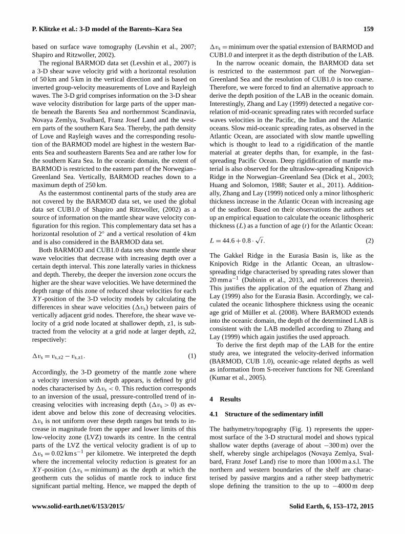
The earliest Eocene interface (Fig. 3a) represents
the shallowest megasequence boundary and equals the
bathymetry/topography over wide parts of the continental
domain. Only in the southwesternmost Barents Sea do de-
pressions define the transition to the oceanic domain. In
the latter, the earliest Eocene surface reaches depths of
more than 8000 m close to the COB. Similar depressions
occur also along the northern passive margin in the Eura-
sia Basin. The earliest Eocene megasequence boundary in
the oceanic domain is equivalent to the top of the crys-
talline crust. According to the depth differences between
the bathymetry/topography and the earliest Eocene surface,
the thickness distribution of the earliest Eocene present
sediments show thickness maxima mostly restricted to the
oceanic domain (up to 7500 m) whereas significant continen-
tal deposits of this age are restricted to the southwesternmost
Barents Sea (Fig. 4a).
The mid-Cretaceous megasequence boundary (Fig. 3b) re-
veals minor depressions in the South Kara Sea basin, in the
West Siberian Basin, in the southern part of the East Bar-
ents Sea basin and is more markedly in the western Barents
Sea (Sørvestsnaget Basin, Vestbakken Volcanic Province).
Accordingly, these basins exhibit the largest depth differ-
ences between the mid-Cretaceous and the overlying earli-
est Eocene surface, which is clearly outlined in the calcu-
lated thickness distribution of the mid-Cretaceous–Paleocene
megasequence (Fig. 4b). Within the southern Kara Sea a
mid-Cretaceous–Paleocene depocentre reveals a prominent
N–S trend. The subbasins of the western Barents Sea, on
the other hand, depict different strike directions of thickness
maxima ranging from N–S in the west (Vestbakken Volcanic
Province) to rather ENE–WSW in the east (Hammerfest and
Nordkapp basins). Thereby, the wavelength of thickness vari-
ations is much shorter in the western Barents Sea than across
the remaining study area. These pronounced thickness vari-
ations in the western Barents Sea reflect the structural effect
of offsets along relatively closely spaced faults (see Meso-
zoic faults in Fig. 3e).
The mid-Jurassic and the mid-Permian megasequence
boundaries (Fig. 3c, d) show similar geometries as the over-
lying mid-Cretaceous surface with narrow and deep depres-
sions in the western Barents Sea and rather wide depres-
sions in the East Barents Sea basin and the southern Kara
Sea. The corresponding sediments of the mid-Jurassic–mid-
Cretaceous megasequence attain thicknesses of up to about
11 000 m in the western Barents Sea within a N–S to NE–
SW fan-shaped structure (Fig. 4c, d). Further east in the East
Barents Sea basin and the South Kara Sea basin, the mid-
Jurassic–mid-Cretaceous unit is characterised by moderate
thicknesses (< 3000 m) arranged in a bowl-shaped geometry
following the curvature of Novaya Zemlya.
The mid-Permian–mid-Jurassic sediment maxima show a
similar distribution pattern to the overlying unit whereby
this megasequence is considerably thicker in the basins of
the western Barents Sea (absolute thickness of ∼ 15 000 m),
the eastern Barents Sea (∼ 10 500 m) and southern Kara Sea
(∼ 6000 m; Fig. 4d).
The deepest megasequence overlying the top of the crys-
talline crust is the pre-mid-Permian megasequence (Fig. 4e)
which encompasses numerous small-scale thickness maxima
which are mainly related to the topography of the top crys-
talline crust (Fig. 4f). The western Barents Sea is marked
by rather thin pre-mid-Permian sediments which attain up to
∼ 10 000 m in the northern part of the Kara Sea and in the
East Barents Sea basin.
The crystalline crust (Figs. 4f, 5b) is divided by the COB
(continent–ocean boundary) into an oceanic and a continen-
tal domain (Fig. 1). In the oceanic domain, the top crys-
talline crust is modelled as being identical with all megase-
quence boundaries, since the oceanic crust is younger than
the youngest megasequence boundary in the model.
In the continental domain, the top of the crystalline
crust reveals significant depth variations (Fig. 4f), especially
across the wide shelf areas though the bathymetry is rather
uniform (Fig. 1). Given this flatness of the top of the sedi-
ments and the consistency of the 3-D structural model, the
depth variations of the crystalline crust directly reflect the
cumulative thickness variations of the sedimentary megase-
quences. Accordingly, depressions of the top crystalline crust
correlate with domains of larger sediment thickness. The
deepest depressions of the top crystalline crust descend down
to 14 000 m in the northern and southern Kara Sea and to
almost 20 000 m in the East Barents Sea basin and in the
western Barents Sea. The distance between basement highs
and lows is considerably smaller in the western Barents Sea
(< 100 km) compared to the East Barents Sea and Kara Sea
basins (∼ 500 km). The eastern Barents Sea and the Kara Sea
are both subdivided into two subbasins separated by struc-
tural highs of the crystalline crust (Fig. 4f). Thereby, the
prominent structural high separating the northern and south-
ern Kara Sea follows the topographic highs illustrated by the
Ural Mountains, the Pai-Khoi and Novaya Zemlya fold-and-
thrust belts and the Taimyr region (Fig. 1).
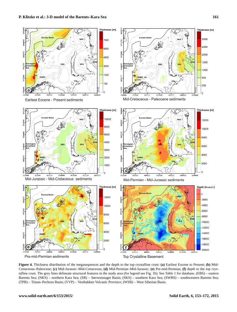
4.2 Crust and mantle structure
The depth map of the Moho illustrates a stepwise W–E
deepening structure (Fig. 5a) with shallowest depths beneath
the oceanic domain (<−15 km), moderate depths beneath
the shelf (−35 km) and largest depths beneath the continen-
tal mainland (<−50 km). Moreover, the continental Moho
is essentially shallower (−24 km) beneath regions situated
close to the COB and NW of Svalbard. Beneath the East Bar-
ents Sea basin and the northern Kara Sea, the Moho topogra-
phy is flat at about −30 km even below prominent sediment
maxima (see Fig. 4d–e). The South Kara Sea basin is under-
lain by similar Moho depths which are increasing towards
the Uralian Orogen in the south, Novaya Zemlya in the west
Solid Earth, 6, 153–172, 2015 www.solid-earth.net/6/153/2015/
P. Klitzke et al.: 3-D model of the Barents–Kara Sea 161
Figure 4. Thickness distribution of the megasequences and the depth to the top crystalline crust: (a) Earliest Eocene to Present; (b) Mid-
Cretaceous–Paleocene; (c) Mid-Jurassic–Mid-Cretaceous; (d) Mid-Permian–Mid-Jurassic; (e) Pre-mid-Permian; (f) depth to the top crys-
talline crust. The grey lines delineate structural features in the study area (for legend see Fig. 1b). See Table 1 for database. (EBS) – eastern
Barents Sea; (NKS) – northern Kara Sea; (SB) – Sørvestsnaget Basin; (SKS) – southern Kara Sea; (SWBS) – southwestern Barents Sea;
(TPB) – Timan–Pechora Basin; (VVP) – Vestbakken Volcanic Province; (WSB) – West Siberian Basin.
www.solid-earth.net/6/153/2015/ Solid Earth, 6, 153–172, 2015
162 P. Klitzke et al.: 3-D model of the Barents–Kara Sea
Figure 5. Structure of the deeper crust and the upper mantle: (a) depth to the Moho; (b) thickness of the crystalline crust; (c) depth to the
lithosphere–asthenosphere boundary (LAB); (d) thickness of the lithospheric mantle. See Table 1 for the database. (EBS) – eastern Barents
Sea; (NKS) – northern Kara Sea; (SKS) – southern Kara Sea; (SWBS) – southwestern Barents Sea; (TPB) – Timan–Pechora Basin; (WSB)
– West Siberian Basin.
and Taimyr Peninsula in the north (up to −50 km). Conse-
quently, the crystalline crust is thickest below these thrust
and fold belts and towards the Scandinavian shield in the
south (Fig. 5b). Below the shelf, the crystalline crust is mod-
erately thick (locally up to 33 km) and thinned below regions
covered by the thickest sediments (SW Barents Sea basins,
East Barents Sea basin, South Kara Sea basin). The oceanic
domain is defined by typical crustal thicknesses of 7 km.
As found for the Moho, also the modelled LAB exhibits a
comparable step-like W–E deepening with a shallow oceanic
LAB (−50 km), a depth range from −60 to −155 km be-
neath the Barents Sea and the largest depths beneath the
Kara Sea and the continental mainland (down to −200 km;
Fig. 5c). Wider domains of a rather flat LAB alternate with
narrower transitional domains marked by steep depth gra-
dients. Thereby, the LAB is cutting with depth also higher
shear wave velocities. The thickness distribution of the litho-
spheric mantle thickness follows the described W–E trend
of the LAB relief (Fig. 5d). The thinnest lithospheric mantle
is found below the oceanic domain (40 km), the westernmost
Barents Sea and Svalbard (35 km, Fig. 5d). Beneath the shelf,
the lithospheric mantle thickens successively from the west-
ern Barents Sea (70 km) eastwards below the East Barents
Sea basin (110 km) and beneath Novaya Zemlya (135 km).
The Kara Sea and the continental domain are underlain by
largest lithospheric mantle thicknesses (175 km). Also, re-
cently published LAB maps show the trend of an shallow
LAB beneath Svalbard and a strong deepening towards the
Barents Shelf and the continental mainland, though the abso-
lute depths vary significantly between these models (Gung et
al., 2003; Koptev and Ershov, 2011; McKenzie and Priestley,
2008; Priestley and McKenzie, 2006).
The integrated structural configuration of the entire
lithosphere, including the sedimentary megasequences, the
Solid Earth, 6, 153–172, 2015 www.solid-earth.net/6/153/2015/
P. Klitzke et al.: 3-D model of the Barents–Kara Sea 163
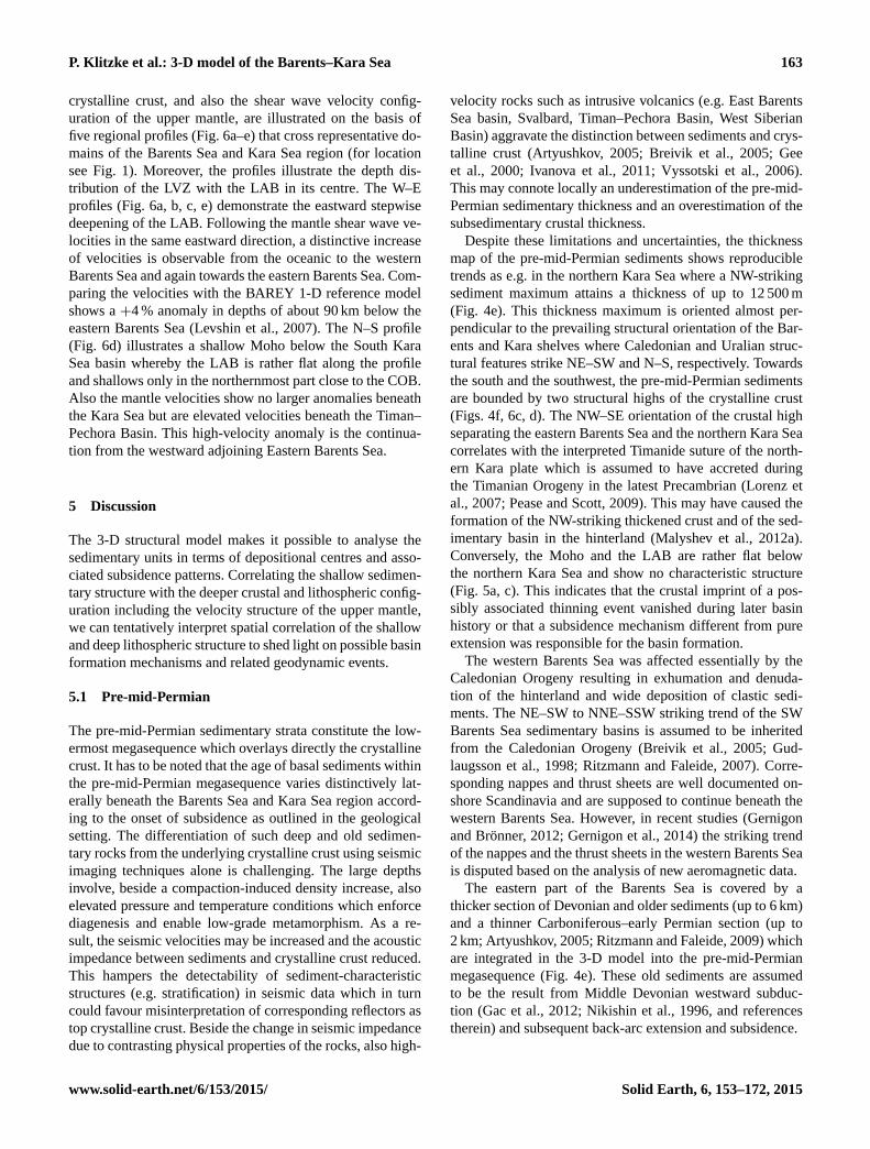
crystalline crust, and also the shear wave velocity config-
uration of the upper mantle, are illustrated on the basis of
five regional profiles (Fig. 6a–e) that cross representative do-
mains of the Barents Sea and Kara Sea region (for location
see Fig. 1). Moreover, the profiles illustrate the depth dis-
tribution of the LVZ with the LAB in its centre. The W–E
profiles (Fig. 6a, b, c, e) demonstrate the eastward stepwise
deepening of the LAB. Following the mantle shear wave ve-
locities in the same eastward direction, a distinctive increase
of velocities is observable from the oceanic to the western
Barents Sea and again towards the eastern Barents Sea. Com-
paring the velocities with the BAREY 1-D reference model
shows a +4 % anomaly in depths of about 90 km below the
eastern Barents Sea (Levshin et al., 2007). The N–S profile
(Fig. 6d) illustrates a shallow Moho below the South Kara
Sea basin whereby the LAB is rather flat along the profile
and shallows only in the northernmost part close to the COB.
Also the mantle velocities show no larger anomalies beneath
the Kara Sea but are elevated velocities beneath the Timan–
Pechora Basin. This high-velocity anomaly is the continua-
tion from the westward adjoining Eastern Barents Sea.
5 Discussion
The 3-D structural model makes it possible to analyse the
sedimentary units in terms of depositional centres and asso-
ciated subsidence patterns. Correlating the shallow sedimen-
tary structure with the deeper crustal and lithospheric config-
uration including the velocity structure of the upper mantle,
we can tentatively interpret spatial correlation of the shallow
and deep lithospheric structure to shed light on possible basin
formation mechanisms and related geodynamic events.
5.1 Pre-mid-Permian
The pre-mid-Permian sedimentary strata constitute the low-
ermost megasequence which overlays directly the crystalline
crust. It has to be noted that the age of basal sediments within
the pre-mid-Permian megasequence varies distinctively lat-
erally beneath the Barents Sea and Kara Sea region accord-
ing to the onset of subsidence as outlined in the geological
setting. The differentiation of such deep and old sedimen-
tary rocks from the underlying crystalline crust using seismic
imaging techniques alone is challenging. The large depths
involve, beside a compaction-induced density increase, also
elevated pressure and temperature conditions which enforce
diagenesis and enable low-grade metamorphism. As a re-
sult, the seismic velocities may be increased and the acoustic
impedance between sediments and crystalline crust reduced.
This hampers the detectability of sediment-characteristic
structures (e.g. stratification) in seismic data which in turn
could favour misinterpretation of corresponding reflectors as
top crystalline crust. Beside the change in seismic impedance
due to contrasting physical properties of the rocks, also high-
velocity rocks such as intrusive volcanics (e.g. East Barents
Sea basin, Svalbard, Timan–Pechora Basin, West Siberian
Basin) aggravate the distinction between sediments and crys-
talline crust (Artyushkov, 2005; Breivik et al., 2005; Gee
et al., 2000; Ivanova et al., 2011; Vyssotski et al., 2006).
This may connote locally an underestimation of the pre-mid-
Permian sedimentary thickness and an overestimation of the
subsedimentary crustal thickness.
Despite these limitations and uncertainties, the thickness
map of the pre-mid-Permian sediments shows reproducible
trends as e.g. in the northern Kara Sea where a NW-striking
sediment maximum attains a thickness of up to 12 500 m
(Fig. 4e). This thickness maximum is oriented almost per-
pendicular to the prevailing structural orientation of the Bar-
ents and Kara shelves where Caledonian and Uralian struc-
tural features strike NE–SW and N–S, respectively. Towards
the south and the southwest, the pre-mid-Permian sediments
are bounded by two structural highs of the crystalline crust
(Figs. 4f, 6c, d). The NW–SE orientation of the crustal high
separating the eastern Barents Sea and the northern Kara Sea
correlates with the interpreted Timanide suture of the north-
ern Kara plate which is assumed to have accreted during
the Timanian Orogeny in the latest Precambrian (Lorenz et
al., 2007; Pease and Scott, 2009). This may have caused the
formation of the NW-striking thickened crust and of the sed-
imentary basin in the hinterland (Malyshev et al., 2012a).
Conversely, the Moho and the LAB are rather flat below
the northern Kara Sea and show no characteristic structure
(Fig. 5a, c). This indicates that the crustal imprint of a pos-
sibly associated thinning event vanished during later basin
history or that a subsidence mechanism different from pure
extension was responsible for the basin formation.
The western Barents Sea was affected essentially by the
Caledonian Orogeny resulting in exhumation and denuda-
tion of the hinterland and wide deposition of clastic sedi-
ments. The NE–SW to NNE–SSW striking trend of the SW
Barents Sea sedimentary basins is assumed to be inherited
from the Caledonian Orogeny (Breivik et al., 2005; Gud-
laugsson et al., 1998; Ritzmann and Faleide, 2007). Corre-
sponding nappes and thrust sheets are well documented on-
shore Scandinavia and are supposed to continue beneath the
western Barents Sea. However, in recent studies (Gernigon
and Brönner, 2012; Gernigon et al., 2014) the striking trend
of the nappes and the thrust sheets in the western Barents Sea
is disputed based on the analysis of new aeromagnetic data.
The eastern part of the Barents Sea is covered by a
thicker section of Devonian and older sediments (up to 6 km)
and a thinner Carboniferous–early Permian section (up to
2 km; Artyushkov, 2005; Ritzmann and Faleide, 2009) which
are integrated in the 3-D model into the pre-mid-Permian
megasequence (Fig. 4e). These old sediments are assumed
to be the result from Middle Devonian westward subduc-
tion (Gac et al., 2012; Nikishin et al., 1996, and references
therein) and subsequent back-arc extension and subsidence.
www.solid-earth.net/6/153/2015/ Solid Earth, 6, 153–172, 2015
164 P. Klitzke et al.: 3-D model of the Barents–Kara Sea
Figure 6.
Solid Earth, 6, 153–172, 2015 www.solid-earth.net/6/153/2015/

P. Klitzke et al.: 3-D model of the Barents–Kara Sea 165
Figure 6. Five profiles illustrating the main geological units and the velocity structure (BARMOD, CUB1.0) on crustal and lithosphere scale
(for location see Fig. 1b; LVZ – low velocity zone). The thinning factors are calculated with reference values of 32 and 200 km for the
crystalline basement and the lithospheric mantle, respectively. Vertical exaggeration of the crustal-scale profiles: 5×, vertical exaggeration
of the lithosphere-scale profiles: 3×.
5.2 Mid-Permian to Paleocene
The mid-Permian to Paleocene interval encompasses three
megasequences (mid-Permian–mid-Jurassic, mid-Jurassic–
mid-Cretaceous, mid-Cretaceous–Paleocene). The thickness
configurations of the respective megasequences show that the
Barents Sea and Kara Sea region experienced significant sub-
sidence during this time interval. Thereby, the amount and
the geometry of the subsidence varies strongly through time
in different subdomains, which can be related to certain tec-
tonic and geodynamic developments. While the eastern Bar-
ents Sea and the southern Kara Sea are assumed to be af-
fected by compression in response to the Uralian Orogeny
in Late Triassic–Early Jurassic times, the western Barents
Sea experienced different extensional phases from late Pa-
leozoic to Paleocene times. In response to the locally varying
lithospheric configurations and the different prevalent stress
fields which most-likely influenced basin formation, the mid-
Permian to Paleocene tectonic evolution of the eastern Bar-
ents Sea/southern Kara Sea and of the western Barents Sea
are analysed separately in the following.
5.2.1 Eastern Barents Sea/southern Kara Sea
The main part of the preserved sedimentary succession
in the East Barents Sea basin corresponds to the mid-
Permian–mid-Jurassic megasequence (Fig. 4d) while the
two overlying megasequences are distinctively thinner
www.solid-earth.net/6/153/2015/ Solid Earth, 6, 153–172, 2015

166 P. Klitzke et al.: 3-D model of the Barents–Kara Sea
(mid-Jurassic–mid-Cretaceous, mid-Cretaceous–Paleocene;
Fig. 4b, c). The pre-mid-Jurassic sediment configura-
tion in the southern Kara Sea is less well constrained
due to lacking borehole data. However, seismic profiles
(Ivanova et al., 2011; Malyshev et al., 2012b; Nikishin
et al., 2011; Stoupakova et al., 2011) indicate that a
significant amount of mid-Permian to mid-Jurassic sedi-
ments is present beneath the southern Kara Sea as also
indicated by the model (Figs. 4d, 6b, d). The overly-
ing megasequences (mid-Jurassic–mid-Cretaceous and mid-
Cretaceous–Paleocene) also show decreasing thicknesses.
This implies that the East Barents Sea basin – and maybe
also the southern Kara Sea – experienced strong subsidence
in an early tectonic phase followed by weaker subsidence un-
til Paleocene times. The Moho is at comparable depths be-
low both basins (at about 33 km) but deepens substantially
beneath Novaya Zemlya forming a structural boundary be-
tween the two basins (Figs. 5b, 6b).
There are also significant differences between the East
Barents Sea basin and the South Kara Sea basin. The pre-
served mid-Permian–mid-Jurassic megasequence is distinc-
tively thicker in the East Barents Sea basin (10 500 m) com-
pared to the South Kara Sea basin (6500 m) indicating
stronger subsidence west of Novaya Zemlya (Figs. 4d, 6b). In
contrast, for the mid-Jurassic–mid Cretaceous and the mid-
Cretaceous–Paleocene megasequences the amount of pre-
served sediments is higher in the South Kara Sea basin (3300
and 1700 m) than in the East Barents Sea basin (2200 and
600 m). This implies a general eastward shift of major subsi-
dence over Mid-Permian to Paleocene times.
Two major geodynamic events coincide with the deposi-
tion of the mid-Permian–mid-Jurassic sedimentary megase-
quence in the East Barents Sea basin and the South Kara
Sea basin. The first event, the Uralian Orogeny, is preserved
as a present-day topographic high in concert with a deep
Moho along the northern Ural Mountains, the Pai-Khoi and
Novaya Zemlya fold-and-thrust belts and the Taimyr region
(Figs. 2, 6b; Puchkov, 2009; Steer et al., 1998). The sec-
ond geodynamic event corresponds to the eruption of flood
basalts forming the Siberian Traps at the Permian–Triassic
boundary (Cherepanova et al., 2013; Vyssotski et al., 2006).
Widespread eruption of flood basalts due to rise of a mantle
plume is held responsible to have induced post-Permian ther-
mal subsidence of the West Siberian Basin. The proximity of
the East Barents Sea basin and the South Kara Sea basin to
the Uralian orogenic root, the West Siberian Basin and the
major subsidence during the mid-Permian–mid-Jurassic time
interval points a close link between the basin formation and
these two geodynamic events.
For the East Barents Sea and South Kara Sea basins, nu-
merous subsidence mechanisms have been postulated in re-
cent years. They include among others (i) a foreland basin
evolution (Petrov et al., 2008), (ii) multiphase extension
(Ivanova et al., 2006; O’Leary et al., 2004) or (iii) a com-
pressive lithospheric buckling and phase changes (Gac et
al., 2012, 2013; Semprich et al., 2010). Whatever the mecha-
nism controlling the strong Late Permian to Early Triassic
subsidence, pure extension of the crust appears to be un-
likely since traces of pronounced extension in the form of
corresponding large normal faults and strong crustal thinning
are absent in the basin (Ivanova et al., 2011; Khutorskoi et
al., 2008).
A mechanism that might explain the development of the
East Barents Sea basin is lithospheric buckling (Gac et
al., 2012) that has been discussed also for other basins (Cloet-
ingh and Burov, 2011). An initial extensional phase in Devo-
nian times may have resulted in underplating of magmatic
material beneath the present-day East Barents Sea basin. The
compressional stress in the course of the Uralian Orogeny
could have induced folding of the lithosphere, which may
have involved densification of the magmatic body and led
to the observed strong subsidence in Late Permian to Early
Triassic times (Gac et al., 2012, 2013; Semprich et al., 2010).
An important observation is the spatial correlation of the East
Barents Sea basin with the extent of the high shear wave ve-
locity anomaly in the lithospheric mantle (Fig. 6a, b; Levshin
et al., 2007). The authors relate the anomaly with subduction
in the course of the Caledonian and/or Uralian Orogenies.
Whatever their origin, the high mantle velocities probably re-
flect higher densities which, in turn, might have caused deep-
seated negative buoyancy and shallow subsidence of the East
Barents Sea basin.
In contrast to the East Barents Sea basin, the lithospheric
mantle below the southern Kara Sea reveals high shear wave
velocity anomalies (Fig. 6b, d), which excludes densification
of the upper mantle as a driving subsidence mechanism. An
alternative mechanism is therefore needed to explain the ob-
served mid-Permian–mid-Jurassic sediment thickness maxi-
mum here. A first subsidence stage of the southern Kara Sea
is described as rifting-induced with N–S oriented graben-
like structures in late Paleozoic to early Mesozoic times
due to orogenic collapse (Ivanova et al., 2011; Malyshev et
al., 2012b; Nikishin et al., 2011; Stoupakova et al., 2011).
The extensional regime is hard to explain with the main com-
pressional phase on Novaya Zemlya up to Late Triassic–
Early Jurassic times (Scott and Howard, 2010). Thus, the
deep N–S striking graben-like structures in the southern Kara
Sea may originate also from a transtensional regime as part
of the Uralian Orogeny (Nikishin et al., 2011). Continuous
seismic reflections interpreted as sedimentary layers indi-
cate that from the mid-Jurassic on, the South Kara Sea basin
adopted a clear bowl-shaped geometry where faulting did
not play a significant role for creating accommodation space
(Ivanova et al., 2011). To explain the subsidence in the South
Kara Sea basin, we might have to widen the view. The man-
tle plume and related magmatism beneath the West Siberian
Basin is thought to have reached also below the South Kara
Sea basin (Saunders et al., 2005; Vyssotski et al., 2006) and
might thus, have caused thermal cooling following Siberian
Traps magmatism. Alternatively, the West Siberian mantle
Solid Earth, 6, 153–172, 2015 www.solid-earth.net/6/153/2015/
P. Klitzke et al.: 3-D model of the Barents–Kara Sea 167
plume might have caused negative dynamic topography to
its flanks contributing to subsidence across the wider Barents
Sea and Kara Sea region. In fact, the BARMOD shear veloc-
ity model shows in depths of 50 km a low-velocity anomaly
indicating a thermal anomaly (Fig. 6d; Levshin et al., 2007).
However, a remnant from the rifting history or the Siberian
plume seems to be unlikely, since the mantle would have
thermally re-equilibrated meanwhile. Additionally, the res-
olution of BARMOD is rather low for the southern Kara Sea
region.
5.2.2 Western Barents Sea
In contrast to the wide and bowl-shaped structural depres-
sion of the eastern Barents Sea, the western Barents Sea is
traversed by a system of structural lows and highs of the top
crystalline crust (Fig. 4f) with corresponding locally thick
sedimentary packages (Fig. 4a–e). These NE–SW- or NNE–
SSW-striking narrow troughs are structurally limited by ma-
jor late Paleozoic and Mesozoic normal faults that cover the
entire western Barents Sea (Fig. 3e, f).
The sediment thickness distribution indicates that rifting
and hence subsidence shifted westwards with time, as ob-
servable in the sedimentary megasequence which thickens
towards the west with decreasing age (Fig. 4b–e). Major
rifting in the southwestern Barents Sea continued in mid-
Jurassic times giving birth to deep basins (Tromsø Basin,
the Sørvestsnaget Basin and the Bjørnøya Basin; Faleide et
al., 1993). In the Early Cretaceous, the northern Barents Sea
was uplifted – a phenomenon that has been related to the
Arctic Large Igneous Province (Basov et al., 2009; Drachev
and Saunders, 2006; Maher and Harmon, 2001; Minakov et
al., 2012b; Worsley, 2008). The uplifted areas provided a ma-
jor sediment source for the subsiding basins in the southwest-
ern Barents Sea. Late Cretaceous–Paleocene rifting resulted
in the formation of pull-apart basins, and finally in break-up
of the Norwegian–Greenland Sea (Faleide et al., 1993, 2008;
Libak et al., 2012). The rifting history is also reflected in
the subsedimentary configuration in terms of a thinned crys-
talline crust and lithospheric mantle (Fig. 5b, d) as well as by
the rather low velocities of the upper mantle (Fig. 6a, b, c, e).
5.3 Earliest Eocene to present
The continental break-up and the opening of the Norwegian–
Greenland Sea started in Paleocene–Eocene times. Subse-
quently, the ocean opened progressively northwards along a
mega-shear system with assumed rifting and the formation
of pull-apart basin in the westernmost Barents Sea (Engen
et al., 2008; Faleide et al., 2010). In late Cenozoic times,
widespread but locally varying uplift affected the Barents
Sea and Kara Sea region and resulted in significant erosion
of the uppermost sediments. Accordingly, youngest strata are
missing across wide parts of the shelf (Fig. 4a–c). The tim-
ing and triggering mechanisms behind this uplift are still un-
der debate. Beside isostatic rebound in response to melting
of thick Pliocene/Pleistocene ice sheets (Green and Duddy,
2010; Henriksen et al., 2011a), also a tectonic pulse prior
to the onset of glaciations has been proposed (Dimakis et
al., 1998). In fact, regional synchronous uplift is observed
for wider parts of the Arctic which would imply a regional
trigger such as the Iceland mantle plume. This deep ther-
mal mantle anomaly is assumed to account for the anomalous
shallow seafloor of the NE Atlantic Ocean (Fig. 1; Skogseid,
2014).
In the Barents Sea and Kara Sea region however, strongest
Cenozoic uplift occurred on Svalbard which coincides spa-
tially with a thin continental lithosphere and slow shear wave
velocities pointing to high temperatures in the upper man-
tle (Figs. 5d, 6c; Dimakis et al., 1998; Green and Duddy,
2010; Henriksen et al., 2011a; Japsen et al., 2010). Dörr
et al. (2013) have stated that Svalbard experienced an iso-
static uplift phase around ∼ 36 Ma due to magmatic activ-
ity during the formation of the northwards adjoining Yermak
Plateau. According to the authors, a second uplift phase may
have been induced by thinning of the lithospheric mantle be-
neath Svalbard. This phenomenon is assumed to be caused by
small-scale mantle convection due to the adjacent Knipovich
and Gakkel mid-oceanic ridges rather than the effect of
plume activity. A recent study by Omang and Kierulf (2011)
reveals that Svalbard is still experiencing uplift and that fluc-
tuations of ice sheets cannot explain the observed uplift rates.
Consequently, the low-velocity and hot upper mantle may
still contribute to present-day vertical movements.
In contrast to the northwestern shelf edge, late Cenozoic
uplift and erosion was less pronounced (∼ 500–1000 m) in
the eastern Barents Sea (Henriksen et al., 2011a; Sobolev,
2012). Thereby, the area affected by the least erosion corre-
lates spatially with the outline of the East Barents Sea basin
but also with a domain where highest velocities in the litho-
spheric mantle (Fig. 6b, c) are observed. Consequently, the
high velocities which are associated with a strong lithosphere
may have contributed not only to the formation of the East
Barents Sea basin in Paleozoic/Mesozoic times but may have
also prevented significant uplift in late Cenozoic times.
6 Summary and conclusions
We have constructed a 3-D structural model of the greater
Barents Sea and Kara Sea region that resolves the first-order
characteristics of its sedimentary cover, its crystalline crust
as well as of its lithospheric mantle. A large amount of multi-
disciplinary geophysical and geological data were integrated,
to model the best-possible structural configuration of the fol-
lowing continental subdomains: (1) the northern Kara Sea,
(2) the southern Kara Sea, (3) the eastern Barents Sea and
(4) the western Barents Sea.
1. The North Kara Sea basin is covered mainly by pre-mid-
Permian sediments indicating that its major subsidence
www.solid-earth.net/6/153/2015/ Solid Earth, 6, 153–172, 2015
168 P. Klitzke et al.: 3-D model of the Barents–Kara Sea
phase was prior to the adjacent sedimentary basins. The
related sediment maximum is separated from the Bar-
ents Sea by a NW-striking thickened crystalline crust
which may have originated from the late Neoprotero-
zoic Timanian Orogeny.
2. The southern Kara Sea reveals a rather independent
evolution from its northern counterpart. A distinctively
deeper LAB delimits the sedimentary basin from the
Barents Sea and may suggest an affiliation with the
Siberian plate. The South Kara Sea basin lacks major
pre-mid-Permian sediments, but has accumulated the
major part of its sedimentary infill in mid-Permian to
earliest Eocene times. Thereby, the younger sedimen-
tary megasequences are thinner, implying a decaying
subsidence with time that was either of thermal origin
related to magmatism or due to negative dynamic topog-
raphy in the course of the West Siberian mantle plume.
3. Thickest sediments in the eastern Barents Sea have been
preserved from the mid-Permian–mid-Jurassic megase-
quence indicating strong subsidence back then. The
sedimentary succession in the East Barents Sea basin
shows no larger extensional faults but is coinciding spa-
tially with anomalously high shear wave velocities in
the lithospheric mantle that may have played an essen-
tial role during the evolution of this sedimentary basin.
Lithospheric buckling with associated phase transitions
(Gac et al., 2012, 2013; Semprich et al., 2010) could
be one explanation the intense subsidence in Permian to
Triassic times. The high-velocity anomaly in the litho-
spheric mantle beneath the eastern Barents Sea may
have contributed to accelerated Permian to Triassic sub-
sidence and might be responsible for less intense uplift
of the eastern Barents Sea in late Cenozoic times.
4. The southwestern Barents Sea exhibits a classical rift
system with major extensional faults. The amounts of
sediments deposited as megasequences increase with
time towards the present-day COB indicating a west-
ward shift in rifting. The shallow Moho and LAB as
well as low seismic shear wave velocities in the man-
tle indicating high mantle temperatures are consistent
with the assumption of a rift scenario. The continental
LAB is shallowest below Svalbard and the northwest-
ern Barents Sea where strong late Cenozoic uplift and
volcanism are observed.
In the next steps, the 3-D structural model will be tested
against independent observables such as gravity and tem-
perature. Constraining the present-day lithosphere-scale
3-D thermal field provides implications about the regional
strength of the lithosphere and thus, will be essential to fur-
ther unravel the evolution of the Barents Sea and Kara Sea
region and the mechanisms behind subsidence and uplift.
Acknowledgements. We acknowledge financial support by Statoil
for parts of the work reported on here. Also we would like to
thank for constructive discussions with colleagues involved in
the BarMod project currently funded by the Research Council of
Norway and Statoil, and in the CALE project.
The service charges for this open access publication
have been covered by a Research Centre of the
Helmholtz Association.
Edited by: R. Carbonell
References
Allen, P. A. and Allen, J. R.: Basin Analysis: Principles and
Application to Petroleum Play Assessment, 3rd Edn., Wiley-
Blackwell, 2013.
Aplonov, S. V., Shmelev, G. B., and Krasnov, D. K.: Geodynam-
ics of the Barents-Kara Shelf: Geophysical Evidence, Geotec-
tonics+, 30, 309–326, 1996.
Artyushkov, E.: The formation mechanism of the Barents basin,
Russ. Geol. Geophys., 46, 700–713, 2005.
Barrère, C., Ebbing, J., and Gernigon, L.: Offshore prolongation of
Caledonian structures and basement characterisation in the west-
ern Barents Sea from geophysical modelling, Tectonophysics,
470, 71–88, doi:10.1016/j.tecto.2008.07.012, 2009.
Basov, V. A., Ebbing, J., Gernigon, L., Korchinskaya, M. V., Koren,
T., Kosteva, N. V., Kotljar, G. V., Larssen, G. B., Litvinova, T.,
Negrov, O. B., Olesen, O., Pascal, C., Pchelina, T. M., Petrov,
O. V., Petrov, Y. O., Sjulstad, H.-I., Smelror, M., Sobolev, N. N.,
Vasiliev, V., and Werner, S. C.: Geological history of the Barents
Sea, edited by: Smelror, M., Petrov, O., Larssen, G., and Werner,
S., Geological Survey of Norway, Trondheim, Norway, 1–138,
2009.
Bogdanova, S. V., Bingen, B., Gorbatschev, R., Kheraskova,
T. N., Kozlov, V. I., Puchkov, V. N., and Volozh, Y. A.:
The East European Craton (Baltica) before and during
the assembly of Rodinia, Precambrian Res., 160, 23–45,
doi:10.1016/j.precamres.2007.04.024, 2008.
Breivik, A. J., Faleide, J. I., and Gudlaugsson, S. T.: South-
western Barents Sea margin: late Mesozoic sedimentary
basins and crustal extension, Tectonophysics, 293, 21–44,
doi:10.1016/S0040-1951(98)00073-0, 1998.
Breivik, A., Verhoef, J., and Faleide, J.: Effect of thermal con-
trasts on gravity modeling at passive margins: results from
the western Barents Sea, J. Geophys. Res., 104, 15293–15311,
doi:10.1029/1998JB900022, 1999.
Breivik, A. J., Mjelde, R., Grogan, P., Shimamura, H., Murai,
Y., and Nishimura, Y.: Crustal structure and transform margin
development south of Svalbard based on ocean bottom seis-
mometer data, Tectonophysics, 369, 37–70, doi:10.1016/S0040-
1951(03)00131-8, 2003.
Breivik, A. J., Mjelde, R., Grogan, P., Shimamura, H., Murai, Y.,
and Nishimura, Y.: Caledonide development offshore–onshore
Svalbard based on ocean bottom seismometer, conventional seis-
mic, and potential field data, Tectonophysics, 401, 79–117,
doi:10.1016/j.tecto.2005.03.009, 2005.
Solid Earth, 6, 153–172, 2015 www.solid-earth.net/6/153/2015/
P. Klitzke et al.: 3-D model of the Barents–Kara Sea 169
Brekhuntsov, A. M., Monastyrev, B. V., and Nesterov, I. I.: Distribu-
tion patterns of oil and gas accumulations in West Siberia, Russ.
Geol. Geophys.+, 52, 781–791, doi:10.1016/j.rgg.2011.07.004,
2011.
Cherepanova, Y., Artemieva, I. M., Thybo, H., and Chemia, Z.:
Crustal structure of the Siberian craton and the West Siberian
basin: An appraisal of existing seismic data, Tectonophysics,
609, 154–183, doi:10.1016/j.tecto.2013.05.004, 2013.
Clark, S. A., Faleide, J. I., Hauser, J., Ritzmann, O., Mjelde, R.,
Ebbing, J., Thybo, H., and Flüh, E.: Stochastic velocity inversion
of seismic reflection/refraction traveltime data for rift structure
of the southwest Barents Sea, Tectonophysics, 593, 135–150,
doi:10.1016/j.tecto.2013.02.033, 2013a.
Clark, S. A., Glorstad-Clark, E., Faleide, J. I., Schmid, D., Hartz,
E. H., and Fjeldskaar, W.: Southwest Barents Sea rift basin evo-
lution: comparing results from backstripping and time-forward
modelling, Basin Res., 25, 1–17, doi:10.1111/bre.12039, 2013b.
Cloetingh, S. and Burov, E.: Lithospheric folding and sedi-
mentary basin evolution: a review and analysis of forma-
tion mechanisms, Basin Res., 23, 257–290, doi:10.1111/j.1365-
2117.2010.00490.x, 2011.
Czuba, W., Grad, M., Mjelde, R., Guterch, A., Libak, A., Krüger,
F., Murai, Y., and Schweitzer, J.: Continent-ocean-transition
across a trans-tensional margin segment: off Bear Island, Bar-
ents Sea, Geophys. J. Int., 184, 541–554, doi:10.1111/j.1365-
246X.2010.04873.x, 2011.
Dahl-Jensen, T., Larsen, T. B., Woelbern, I., Bach, T., Hanka, W.,
Kind, R., Gregersen, S., Mosegaard, K., Voss, P., and Gudmunds-
son, O.: Depth to Moho in Greenland: receiver-function analy-
sis suggests two Proterozoic blocks in Greenland, Earth Planet.
Sc. Lett., 205, 379–393, doi:10.1016/S0012-821X(02)01080-4,
2003.
Dick, H. J. B., Lin, J., and Schouten, H.: An ultraslow-
spreading class of ocean ridge, Nature, 426, 405–412,
doi:10.1038/nature02128, 2003.
Dimakis, P., Braathen, B. I., Faleide, J. I., Elverhøi, A., and Gud-
laugsson, S. T.: Cenozoic erosion and the preglacial uplift of
the Svalbard–Barents Sea region, Tectonophysics, 300, 311–327,
doi:10.1016/S0040-1951(98)00245-5, 1998.
Dörr, N., Clift, P. D., Lisker, F., and Spiegel, C.: Why is Sval-
bard an island? Evidence for two-stage uplift, magmatic under-
plating, and mantle thermal anomalies, Tectonics, 32, 473–486,
doi:10.1002/tect.20039, 2013.
Dörr, N., Lisker, F., Clift, P. D., Carter, A., Gee, D. G., Tebenkov,
A. M., and Spiegel, C.: Late Mesozoic–Cenozoic exhumation
history of northern Svalbard and its regional significance: Con-
straints from apatite fission track analysis, Tectonophysics, 514–
517, 81–92, doi:10.1016/j.tecto.2011.10.007, 2012.
Drachev, S. and Saunders, A.: The Early Cretaceous Arctic LIP: its
geodynamic setting and implications for Canada Basin opening,
in: Proceedings of the Fourth International Conference on Arctic
Margins, US Department of the Interior, Anchorage, 216–223,
2006.
Drachev, S. S.: Chapter 25 Tectonic setting, structure and
petroleum geology of the Siberian Arctic offshore sedimen-
tary basins, Geological Society, London, Memoirs, 35, 369–394,
doi:10.1144/M35.25, 2011.
Dubinin, E. P., Kokhan, A. V., and Sushchevskaya, N. M.: Tectonics
and magmatism of ultraslow spreading ridges, Geotectonics, 47,
131–155, doi:10.1134/S0016852113030023, 2013.
Eaton, D. W., Darbyshire, F., Evans, R. L., Grütter, H.,
Jones, A. G., and Yuan, X.: The elusive lithosphere–
asthenosphere boundary (LAB) beneath cratons, Lithos, 109, 1–
22, doi:10.1016/j.lithos.2008.05.009, 2009.
Engen, Ø., Frazer, L. N., Wessel, P., and Faleide, J. I.: Pre-
diction of sediment thickness in the Norwegian–Greenland
Sea from gravity inversion, J. Geophys. Res., 111, B11403,
doi:10.1029/2005JB003924, 2006.
Engen, Ø., Faleide, J. I., and Dyreng, T. K.: Opening of the Fram
Strait gateway: A review of plate tectonic constraints, Tectono-
physics, 450, 51–69, doi:10.1016/j.tecto.2008.01.002, 2008.
Engen, Ø., Gjengedal, J. A., Faleide, J. I., Kristoffersen, Y., and El-
dholm, O.: Seismic stratigraphy and sediment thickness of the
Nansen Basin, Arctic Ocean, Geophys. J. Int., 176, 805–821,
doi:10.1111/j.1365-246X.2008.04028.x, 2009.
Faleide, J. I., Vågnes, E., and Gudlaugsson, S. T.: Late Mesozoic-
Cenozoic evolution of the south-western Barents Sea in a re-
gional rift-shear tectonic setting, Mar. Petrol. Geol., 10, 186–214,
doi:10.1016/0264-8172(93)90104-Z, 1993.
Faleide, J. I., Solheim, A., Fiedler, A., Hjelstuen, B. O., Ander-
sen, E. S., and Vanneste, K.: Late Cenozoic evolution of the
western Barents Sea-Svalbard continental margin, Global Planet.
Change, 12, 53–74, doi:10.1016/0921-8181(95)00012-7, 1996.
Faleide, J. I., Tsikalas, F., Breivik, A. J., Mjelde, R., Ritzmann,
O., Engen, O., Wilson, J., and Eldholm, O.: Structure and evo-
lution of the continental margin off Norway and the Barents Sea,
Episodes, 31, 82–91, 2008.
Faleide, J. I., Bjørlykke, K., and Gabrielsen, R. H.: Geology of
the Norwegian Continental Shelf, in: Petroleum Geoscience:
From Sedimentary Environments to Rock Physics, edited by:
Bjørlykke, K., Springer-Verlag, Berlin, Heidelberg, 467–499,
doi:10.1007/978-3-642-02332-3_22, 2010.
Fiedler, A. and Faleide, J. I.: Cenozoic sedimentation along
the southwestern Barents Sea margin in relation to uplift
and erosion of the shelf, Global Planet. Change, 12, 75–93,
doi:10.1016/0921-8181(95)00013-5, 1996.
Fischer, K. M., Ford, H. A., Abt, D. L., and Rychert, C. A.: The
Lithosphere-Asthenosphere Boundary, Annu. Rev. Earth Pl. Sc.,
38, 551–575, doi:10.1146/annurev-earth-040809-152438, 2010.
Gac, S., Huismans, R. S., Podladchikov, Y. Y., and Faleide, J. I.: On
the origin of the ultradeep East Barents Sea basin, J. Geophys.
Res., 117, B04401, doi:10.1029/2011JB008533, 2012.
Gac, S., Huismans, R. S., Simon, N. S. C., Podladchikov, Y. Y.,
and Faleide, J. I.: Formation of intracratonic basins by litho-
spheric shortening and phase changes: a case study from the
ultra-deep East Barents Sea basin, Terra Nova, 25, 459–464,
doi:10.1111/ter.12057, 2013.
Gee, D. G. and Pease, V.: The Neoproterozoic Timanide Orogen of
eastern Baltica: introduction, Geological Society, London, Mem-
oirs, 30, 1–3, doi:10.1144/GSL.MEM.2004.030.01.01, 2004.
Gee, D. G., Beliakova, L., and Pease, V.: New, single zircon (Pb-
evaporation) ages from Vendian intrusions in the basement be-
neath the Pechora Basin, northeastern Baltica, Polarforschung,
Bremerhaven, Alfred Wegener Institute for Polar and Marine Re-
search & German Society of Polar Research, 68, 161–170, 2000.
www.solid-earth.net/6/153/2015/ Solid Earth, 6, 153–172, 2015
170 P. Klitzke et al.: 3-D model of the Barents–Kara Sea
Gee, D. G., Bogolepova, O. K., and Lorenz, H.: The Timanide,
Caledonide and Uralide orogens in the Eurasian high Arctic,
and relationships to the palaeo-continents Laurentia, Baltica and
Siberia, Geological Society, London, Memoirs, 32, 507–520,
doi:10.1144/GSL.MEM.2006.032.01.31, 2006.
Gernigon, L. and Brönner, M.: Late Palaeozoic architecture and
evolution of the southwestern Barents Sea: insights from a new
generation of aeromagnetic data, Journal of the Geological Soci-
ety, 169, 449–459, doi:10.1144/0016-76492011-131, 2012.
Gernigon, L., Brönner, M., Roberts, D., Olesen, O., Nasuti, A., and
Yamasaki, T.: Crustal and basin evolution of the southwestern
Barents Sea: From Caledonian orogeny to continental breakup,
Tectonics, 33, 347–373, doi:10.1002/2013TC003439, 2014.
Glebovsky, V. Y., Kaminsky, V. D., Minakov, A. N., Merkur’ev,
S. A., Childers, V. A., and Brozena, J. M.: Formation of the Eura-
sia Basin in the Arctic Ocean as inferred from geohistorical anal-
ysis of the anomalous magnetic field, Geotectonics, 40, 263–281,
doi:10.1134/S0016852106040029, 2006.
Glørstad-Clark, E.: Basin analysis in the western Bar-
ents Sea area: the interplay between accommodation
space and depositional systems, University of Oslo, Oslo,
doi:10.1016/j.marpetgeo.2010.02.008, 2011.
Gradstein, F. M., Ogg, J. G., and Hilgen, F. J.: On The
Geologic Time Scale, Newsletters Stratigr., 45, 171–188,
doi:10.1127/0078-0421/2012/0020, 2012.
Gramberg, I., Verba, V., and Verba, M.: Sedimentary Cover Thick-
ness Map-Sedimentary Basins in the Arctic, Polarforschung, 69,
243–249, 2001.
Green, P. and Duddy, I.: Synchronous exhumation events around
the Arctic including examples from Barents Sea and Alaska
North Slope, Petroleum Geology Conference series, 7, 633–644,
doi:10.1144/0070633, 2010.
Gudlaugsson, S., Faleide, J. I., Johansen, S. E., and Breivik, A. J.:
Late Palaeozoic structural development of the South-western
Barents Sea, Mar. Petrol. Geol., 15, 73–102, doi:10.1016/S0264-
8172(97)00048-2, 1998.
Gung, Y., Panning, M., and Romanowicz, B.: Global anisotropy
and the thickness of continents, Nature, 422, 707–711,
doi:10.1038/nature01559, 2003.
Hauser, J., Dyer, K. M., Pasyanos, M. E., Bungum, H., Faleide,
J. I., Clark, S. A., and Schweitzer, J.: A probabilistic seismic
model for the European Arctic, J. Geophys. Res., 116, 1–17,
doi:10.1029/2010JB007889, 2011.
Heine, C., Müller, R. D., Steinberger, B., and Torsvik,
T. H.: Subsidence in intracontinental basins due to dy-
namic topography, Phys. Earth Planet. In., 171, 252–264,
doi:10.1016/j.pepi.2008.05.008, 2008.
Henriksen, E., Bjornseth, H. M., Hals, T. K., Heide, T., Kiryukhina,
T., Klovjan, O. S., Larssen, G. B., Ryseth, A. E., Ronning,
K., Sollid, K., and Stoupakova, A.: Uplift and erosion of the
greater Barents Sea: impact on prospectivity and petroleum
systems, Geological Society, London, Memoirs, 35, 271–281,
doi:10.1144/M35.17, 2011a.
Henriksen, E., Ryseth, A. E., Larssen, G. B., Heide, T., Ron-
ning, K., Sollid, K., and Stoupakova, A. V.: Tectonostratig-
raphy of the greater Barents Sea: implications for petroleum
systems, Geological Society, London, Memoirs, 35, 163–195,
doi:10.1144/M35.10, 2011b.
Hjelstuen, B., Elverhøi, A., and Faleide, J.: Cenozoic erosion and
sediment yield in the drainage area of the Storfjorden Fan, Global
Planet. Change, 12, 95–117, doi:10.1016/0921-8181(95)00014-
3, 1996.
Huang, P. Y. and Solomon, S. C.: Centroid Depths of Mid-Ocean
Ridge Earthquakes: Dependence on Spreading Rate, J. Geophys.
Res., 93, 13445–13477, doi:10.1029/JB093iB11p13445, 1988.
Ivanova, N. M., Sakoulina, T. S., and Roslov, Y. V.: Deep seismic
investigation across the Barents–Kara region and Novozemel-
skiy Fold Belt (Arctic Shelf), Tectonophysics, 420, 123–140,
doi:10.1016/j.tecto.2006.01.011, 2006.
Ivanova, N. M., Sakulina, T. S., Belyaev, I. V., Matveev, Y. I., and
Roslov, Y. V.: Depth model of the Barents and Kara seas accord-
ing to geophysical surveys results, Geological Society, London,
Memoirs, 35, 209–221, doi:10.1144/M35.12, 2011.
Jakobsson, M., Mayer, L., Coakley, B., Dowdeswell, J. A., Forbes,
S., Fridman, B., Hodnesdal, H., Noormets, R., Pedersen, R.,
Rebesco, M., Schenke, H. W., Zarayskaya, Y., Accettella, D.,
Armstrong, A., Anderson, R. M., Bienhoff, P., Camerlenghi, A.,
Church, I., Edwards, M., Gardner, J. V., Hall, J. K., Hell, B.,
Hestvik, O., Kristoffersen, Y., Marcussen, C., Mohammad, R.,
Mosher, D., Nghiem, S. V., Pedrosa, M. T., Travaglini, P. G., and
Weatherall, P.: The International Bathymetric Chart of the Arctic
Ocean (IBCAO) Version 3.0, Geophys. Res. Lett., 39, L12609,
doi:10.1029/2012GL052219, 2012.
Japsen, P., Green, P. F., Bonow, J. M., Rasmussen, E. S., Chalmers,
J. A., and Kjennerud, T.: Episodic uplift and exhumation along
North Atlantic passive margins: implications for hydrocarbon
prospectivity, Petroleum Geology Conference series, 7, 979–
1004, doi:10.1144/0070979, 2010.
Johansen, S. E., Ostisty, B. K., Birkeland, Ø., Fedorovsky, Y. F.,
Martirosjan, V. N., Christensen, O. B., Cheredeev, S. I., Ig-
natenko, E. A., and Margulis, L. S.: Hydrocarbon potential in the
Barents Sea region: play distribution and potential, in Norwegian
Petroleum Society Special Publications, 2, 273–320, 1993.
Karato, S.: On the origin of the asthenosphere, Earth Planet. Sc.
Lett., 321–322, 95–103, doi:10.1016/j.epsl.2012.01.001, 2012.
Khutorskoi, M. D., Viskunova, K. G., Podgornykh, L. V.,
Suprunenko, O. I., and Akhmedzyanov, V. R.: A temper-
ature model of the crust beneath the Barents Sea: In-
vestigations along geotraverses, Geotectonics, 42, 125–136,
doi:10.1134/S0016852108020039, 2008.
Klimenko, S. S., Anischenko, L. A., and Antoshkina, A. I.: The
Timan-Pechora sedimentary basin: Palaeozoic reef formations
and petroleum systems, Geological Society, London, Memoirs,
35, 223–236, doi:10.1144/M35.13, 2011.
Knies, J., Matthiessen, J., Vogt, C., Laberg, J. S., Hjelstuen,
B. O., Smelror, M., Larsen, E., Andreassen, K., Eidvin, T.,
and Vorren, T. O.: The Plio-Pleistocene glaciation of the
Barents Sea–Svalbard region: a new model based on re-
vised chronostratigraphy, Quaternary Sci. Rev., 28, 812–829,
doi:10.1016/j.quascirev.2008.12.002, 2009.
Kontorovich, A. E., Epov, M. I., Burshtein, L. M., Kaminskii, V. D.,
Kurchikov, A. R., Malyshev, N. A., Prischepa, O. M., Safronov,
A. F., Stupakova, A. V., and Suprunenko, O. I.: Geology and hy-
drocarbon resources of the continental shelf in Russian Arctic
seas and the prospects of their development, Russ. Geol. Geo-
phys.+, 51, 3–11, doi:10.1016/j.rgg.2009.12.003, 2010.
Solid Earth, 6, 153–172, 2015 www.solid-earth.net/6/153/2015/

P. Klitzke et al.: 3-D model of the Barents–Kara Sea 171
Koptev, A. I. and Ershov, A. V.: Thermal thickness of the Earth’s
lithosphere: a numerical model, Moscow University Geology
Bulletin, 66, 323–330, doi:10.3103/S014587521105005X, 2011.
Kostyuchenko, S., Sapozhnikov, R., Egorkin, A., Gee, D. G.,
Berzin, R., and Solodilov, L.: Crustal structure and tectonic
model of northeastern Baltica, based on deep seismic and poten-
tial field data, Geological Society, London, Memoirs, 32, 521–
539, doi:10.1144/GSL.MEM.2006.032.01.32, 2006.
Kumar, P., Kind, R., Hanka, W., Wylegalla, K., Reigber, C., Yuan,
X., Woelbern, I., Schwintzer, P., Fleming, K., Dahl-Jensen, T.,
Larsen, T. B., Schweitzer, J., Priestley, K., Gudmundsson, O.,
and Wolf, D.: The lithosphere–asthenosphere boundary in the
North-West Atlantic region, Earth Planet. Sc. Lett., 236, 249–
257, doi:10.1016/j.epsl.2005.05.029, 2005.
Laberg, J. S. and Vorren, T. O.: Late Weichselian submarine debris
flow deposits on the Bear Island Trough Mouth Fan, Mar. Geol.,
127, 45–72, doi:10.1016/0025-3227(95)00055-4, 1995.
Laberg, J. S. and Vorren, T. O.: Flow behaviour of the sub-
marine glacigenic debris flows on the Bear Island Trough
Mouth Fan, western Barents Sea, Sedimentology, 47, 1105–
1117, doi:10.1046/j.1365-3091.2000.00343.x, 2000.
Levshin, A. L., Schweitzer, J., Weidle, C., Shapiro, N. M., and
Ritzwoller, M. H.: Surface wave tomography of the Barents
Sea and surrounding regions, Geophys. J. Int., 170, 441–459,
doi:10.1111/j.1365-246X.2006.03285.x, 2007.
Libak, A., Eide, C. H., Mjelde, R., Keers, H., and Flüh, E. R.:
From pull-apart basins to ultraslow spreading: Results from the
western Barents Sea Margin, Tectonophysics, 514–517, 44–61,
doi:10.1016/j.tecto.2011.09.020, 2012.
Ljones, F., Kuwano, A., Mjelde, R., Breivik, A., Shima-
mura, H., Murai, Y., and Nishimura, Y.: Crustal transect
from the North Atlantic Knipovich Ridge to the Sval-
bard Margin west of Hornsund, Tectonophysics, 378, 17–41,
doi:10.1016/j.tecto.2003.10.003, 2004.
Lorenz, H., Männik, P., Gee, D., and Proskurnin, V.: Geology of
the Severnaya Zemlya Archipelago and the North Kara Ter-
rane in the Russian high Arctic, Int. J. Earth Sci., 97, 519–547,
doi:10.1007/s00531-007-0182-2, 2007.
Maher, J. and Harmon, D.: Manifestations of the Cretaceous High
Arctic Large Igneous Province in Svalbard, J. Geol., 109, 91–
104, doi:10.1086/317960, 2001.
Malyshev, N. A., Nikishin, V. A., Nikishin, A. M., Obmetko, V. V.,
Martirosyan, V. N., Kleshchina, L. N., and Reydik, Y. V.: A
new model of the geological structure and evolution of the
North Kara Sedimentary Basin, Dokl. Earth Sci., 445, 791–795,
doi:10.1134/S1028334X12070057, 2012a.
Malyshev, N. A., Nikishin, V. A., Obmetko, V. V., Ikhsanov, B. I.,
Reydik, Y. V., Sitar, K. A., and Shapabaeva, D. S.: Geological
Structure and Petroleum System of South Kara Basin, in: 5th
EAGE St. Petersburg International Conference and Exhibition on
Geosciences – Making the Most of the Earths Resources, Saint
Petersburg 2012, doi:10.3997/2214-4609.20143593, 2012b.
Marello, L., Ebbing, J., and Gernigon, L.: Basement inhomo-
geneities and crustal setting in the Barents Sea from a combined
3D gravity and magnetic model, Geophys. J. Int., 193, 557–584,
doi:10.1093/gji/ggt018, 2013.
McKenzie, D. and Priestley, K.: The influence of lithospheric
thickness variations on continental evolution, Lithos, 102, 1–11,
doi:10.1016/j.lithos.2007.05.005, 2008.
Minakov, A., Faleide, J. I., Glebovsky, V. Y., and Mjelde, R.:
Structure and evolution of the northern Barents-Kara Sea con-
tinental margin from integrated analysis of potential fields,
bathymetry and sparse seismic data, Geophys. J. Int., 188, 79–
102, doi:10.1111/j.1365-246X.2011.05258.x, 2012a.
Minakov, A., Mjelde, R., Faleide, J. I., Flueh, E. R., Dannowski,
A., and Keers, H.: Mafic intrusions east of Svalbard imaged
by active-source seismic tomography, Tectonophysics, 518–521,
106–118, doi:10.1016/j.tecto.2011.11.015, 2012b.
Müller, R. D., Sdrolias, M., Gaina, C., and Roest, W. R.:
Age, spreading rates, and spreading asymmetry of the
world’s ocean crust, Geochem. Geophy. Geosy., 9, Q04006,
doi:10.1029/2007GC001743, 2008.
Myklebust, R.: Magentic mapping of the Barents Sea (MMBS)—
Unpublished Interpretation report, 1994.
Nikishin, A. M., Ziegler, P. A., Stephenson, R. A., Cloetingh, S.,
Furne, A. V., Fokin, P. A., Ershov, A. V, Bolotov, S. N., Koro-
taev, M. V., and Alekseev, A. S.: Late Precambrian to Triassic
history of the East European Craton: dynamics of sedimentary
basin evolution, Tectonophysics, 268, 23–63, 1996.
Nikishin, A. M., Ziegler, P. A., Abbott, D., Brunet, M.-F., and Cloet-
ingh, S.: Permo–Triassic intraplate magmatism and rifting in
Eurasia: implications for mantle plumes and mantle dynamics,
Tectonophysics, 351, 3–39, doi:10.1016/S0040-1951(02)00123-
3, 2002.
Nikishin, V. A., Malyshev, N. A., Nikishin, A. M., and Obmetko,
V. V.: The Late Permian-Triassic system of rifts of the South
Kara sedimentary basin, Moscow University Geology Bulletin,
66, 377–384, doi:10.3103/S0145875211060093, 2011.
O’Leary, N., White, N., Tull, S., Bashilov, V., Kuprin, V., Nat-
apov, L., and Macdonald, D.: Evolution of the TimanPechora
and South Barents Sea basins, Geol. Mag., 141, 141–160,
doi:10.1017/S0016756804008908, 2004.
Omang, O. C. D. and Kierulf, H. P.: Past and present-day ice mass
variation on Svalbard revealed by superconducting gravime-
ter and GPS measurements, Geophys. Res. Lett., 38, L22304,
doi:10.1029/2011GL049266, 2011.
Otto, S. C. and Bailey, R. J.: Tectonic evolution of the north-
ern Ural Orogen, J. Geol. Soc. London, 152, 903–906,
doi:10.1144/GSL.JGS.1995.152.01.03, 1995.
Pease, V. and Scott, R. A.: Crustal affinities in the Arctic Uralides,
northern Russia: significance of detrital zircon ages from Neo-
proterozoic and Palaeozoic sediments in Novaya Zemlya and
Taimyr, J. Geol. Soc. London, 166, 517–527, doi:10.1144/0016-
76492008-093, 2009.
Petrov, O. V., Sobolev, N. N., and Koren, T. N.: Palaeozoic and
Early Mesozoic evolution of the East Barents and Kara Seas sed-
imentary basins, Norweg. J. Geol., 88, 227–234, 2008.
Piskarev, A. and Shkatov, M.: Energy potential of the Russian Arc-
tic Seas – Choice of Development Strategy, 1st Edn., Elsevier,
2012.
Priestley, K. and McKenzie, D.: The thermal structure of the litho-
sphere from shear wave velocities, Earth Planet. Sc. Lett., 244,
285–301, doi:10.1016/j.epsl.2006.01.008, 2006.
Puchkov, V. N.: The evolution of the Uralian orogen, Geo-
logical Society, London, Special Publications, 327, 161–195,
doi:10.1144/SP327.9, 2009.
Reichow, M. K., Saunders, A. D., White, R. V., Al’Mukhamedov,
A. I., and Medvedev, A. Y.: Geochemistry and petrogenesis
www.solid-earth.net/6/153/2015/ Solid Earth, 6, 153–172, 2015
172 P. Klitzke et al.: 3-D model of the Barents–Kara Sea
of basalts from the West Siberian Basin: an extension of the
Permo–Triassic Siberian Traps, Russia, Lithos, 79, 425–452,
doi:10.1016/j.lithos.2004.09.011, 2005.
Ritzmann, O. and Faleide, J. I.: Caledonian basement of the western
Barents Sea, Tectonics, 26, 1–20, doi:10.1029/2006TC002059,
2007.
Ritzmann, O. and Faleide, J. I.: The crust and mantle lithosphere in
the Barents Sea/Kara Sea region, Tectonophysics, 470, 89–104,
doi:10.1016/j.tecto.2008.06.018, 2009.
Ritzmann, O., Jokat, W., Mjelde, R., and Shimamura, H.:
Crustal structure between the Knipovich Ridge and the Van
Mijenfjorden (Svalbard), Mar. Geophys. Res., 23, 379–401,
doi:10.1023/B:MARI.0000018168.89762.a4, 2002.
Ritzmann, O., Jokat, W., Czuba, W., Guterch, A., Mjelde, R., and
Nishimura, Y.: A deep seismic transect from Hovgård Ridge
to northwestern Svalbard across the continental-ocean transi-
tion: A sheared margin study, Geophys. J. Int., 157, 683–702,
doi:10.1111/j.1365-246X.2004.02204.x, 2004.
Ritzmann, O., Maercklin, N., Inge Faleide, J., Bungum, H.,
Mooney, W. D., Detweiler, S. T., Faleide, J. I., and Bungurm,
H.: A three-dimensional geophysical model of the crust in the
Barents Sea region: model construction and basement charac-
terization, Geophys. J. Int., 170, 417–435, doi:10.1111/j.1365-
246X.2007.03337.x, 2007.
Roberts, D. and Siedlecka, A.: Timanian orogenic deformation
along the northeastern margin of Baltica, Northwest Rus-
sia and Northeast Norway, and Avalonian–Cadomian con-
nections, Tectonophysics, 352, 169–184, doi:10.1016/S0040-
1951(02)00195-6, 2002.
Saunders, A. D., England, R. W., Reichow, M. K., and White, R. V.:
A mantle plume origin for the Siberian traps: uplift and exten-
sion in the West Siberian Basin, Russia, Lithos, 79, 407–424,
doi:10.1016/j.lithos.2004.09.010, 2005.
Sauter, D., Sloan, H., Cannat, M., Goff, J., Patriat, P., Schaming, M.,
and Roest, W. R.: From slow to ultra-slow: How does spreading
rate affect seafloor roughness and crustal thickness?, Geology,
39, 911–914, doi:10.1130/G32028.1, 2011.
Scott, R. and Howard, J.: Offset and curvature of the Novaya
Zemlya fold-and-thrust belt, Arctic Russia, Petroleum Geology
Conference series, 7, 645–657, doi:10.1144/0070645, 2010.
Semprich, J., Simon, N. S. C., and Podladchikov, Y. Y.: Density
variations in the thickened crust as a function of pressure, tem-
perature, and composition, Int. J. Earth Sci., 99, 1487–1510,
doi:10.1007/s00531-010-0557-7, 2010.
Shapiro, N. M. and Ritzwoller, M. H.: Monte-Carlo inversion
for a global shear-velocity model of the crust and upper
mantle, Geophys. J. Int., 151, 88–105, doi:10.1046/j.1365-
246X.2002.01742.x, 2002.
Skilbrei, J. R.: Interpretation of depth to the magnetic basement in
the northern Barents Sea (south of Svalbard), Tectonophysics,
200, 127–141, doi:10.1016/0040-1951(91)90010-P, 1991.
Skogseid, J.: Mantle plume related dynamic uplift and plate kine-
matics: The NE Atlantic case with global implications, EGU
General Assembly, Vienna, Austria, 27 April–2 May, EGU2014-
16896, 2014.
Sobolev, P.: Cenozoic uplift and erosion of the Eastern Barents Sea
– constraints from offshore well data and the implication for
petroleum system modelling, Z. Dtsch. Ges. Geowiss., 163, 309–
324, doi:10.1127/1860-1804/2012/0163-0323, 2012.
Steer, D. N., Knapp, J. H., Brown, L. D., Echtler, H. P., Brown,
D. L., and Berzin, R.: Deep structure of the continental litho-
sphere in an unextended orogen: An explosive-source seismic
reflection profile in the Urals (Urals Seismic Experiment and
Integrated Studies (URSEIS 1995)), Tectonics, 17, 143–157,
doi:10.1029/97TC03056, 1998.
Stoupakova, A. V., Henriksen, E., Burlin, Y. K., Larsen, G. B.,
Milne, J. K., Kiryukhina, T. A., Golynchik, P. O., Bordunov,
S. I., Ogarkova, M. P., and Suslova, A. A.: The geological
evolution and hydrocarbon potential of the Barents and Kara
shelves, Geological Society, London, Memoirs, 35, 325–344,
doi:10.1144/M35.21, 2011.
Turcotte, D. L. and Schubert, G.: Geodynamics, Cambridge Univer-
sity Press, Cambridge, UK, 2002.
Voss, M. and Jokat, W.: Continent-ocean transition and voluminous
magmatic underplating derived from P-wave velocity modelling
of the East Greenland continental margin, Geophys. J. Int., 170,
580–604, doi:10.1111/j.1365-246X.2007.03438.x, 2007.
Voss, M. and Jokat, W.: From Devonian extensional collapse
to early Eocene continental break-up: an extended transect
of the Kejser Franz Joseph Fjord of the East Greenland
margin, Geophys. J. Int., 177, 743–754, doi:10.1111/j.1365-
246X.2008.04076.x, 2009.
Vyssotski, A. V., Vyssotski, V. N., and Nezhdanov, A. A.: Evolu-
tion of the West Siberian Basin, Mar. Petrol. Geol., 23, 93–126,
doi:10.1016/j.marpetgeo.2005.03.002, 2006.
Worsley, D.: The post-Caledonian development of Svalbard
and the western Barents Sea, Polar Res., 27, 298–317,
doi:10.1111/j.1751-8369.2008.00085.x, 2008.
Zhang, Y. and Lay, T.: Evolution of oceanic upper mantle struc-
ture, Phys. Earth Planet. In., 114, 71–80, doi:10.1016/S0031-
9201(99)00047-3, 1999.
Solid Earth, 6, 153–172, 2015 www.solid-earth.net/6/153/2015/