2014 - the subfossil tree deposits from the garonne valley and thei implications on holocene...
TRANSCRIPT
Hy
Thim
JeaVaLa
Univ
1. I
inteof tpalet aconLeu
C. R. Geoscience xxx (2014) xxx–xxx
A R
Artic
Rece
Acce
Avai
Keyw
Sub
Blac
Garo
Holo
Allu
Fran
*
G Model
CRAS2A-3179; No. of Pages 8
Plim
163
http
drology, Environment
e subfossil tree deposits from the Garonne Valley and theirplications on Holocene alluvial plain dynamics
n-Michel Carozza *, Laurent Carozza, Philippe Valette, Muriel Llubes,nessa Py, Didier Galop, Mihaela Danu, Laurie Ferdinand, Melodie David,urent Sevegnes, Laurent Bruxelles, Marc Jarry, Francis Duranthon
ersity of Strasbourg (UDS), Department of Geography, 3, rue de l’Argonne, 67083 Strasbourg cedex, France
ntroduction
Alluvial fossil and subfossil tree trunks are of greatrest to document formation, evolution and destructionhe riparian forest vegetation in order to characterize
aeo-ecosystems as once more highlighted (Finsingerl., 2013; Lezine et al., 2013) but also as a source tostrain alluvial valley building processes (Becker, 1993;schner, 1992).
Subfossil tree trunks are frequent in Post-glacial alluvialinfills of temperate and central European rivers (DanubeRiver, Becker, 1975; Vistula River, Kalicki and Krapiec,1995; Starkel, 1995; Warta River, Dzieduszynska andPetera-Zganiacz, 2012; Maine River, Becker and Schirmer,1977; Morava River, Kolar and Ribnicek, 2011; MiddleRhine River, Striedtler, 1988; Tegel et al., 1999; RhoneRiver, Bravard, 1986; Salvador, 1991). The tree trunks arecalled subfossils as if they are old trees, they still mainlyconsist of lignin and cellulose. Their dark colour is relatedto the interaction between the water ferrous compoundsand the tannins of the matter (van Burck et al., 2012).Quercus is the most common species found in the alluvialdeposits but other hardwood species can also be found:
T I C L E I N F O
le history:
ived 22 January 2014
pted after revision 31 January 2014
lable online xxx
ords:
fossil trunk
k oak
nne
cene
vial plain
ce
A B S T R A C T
Subfossil tree trunks deposits are common in large rivers, but their status as a source for
dating alluvial sequences and palaeoenvironmental studies is still discussed. Particularly
their origin and the process(es) of deposition as well as a possible remobilization were
pointed as a limit to their use to document river alluvial changes. In this work we report
the discovery of the largest subfossil trunks deposits in the Garonne valley. These new data
are compared to the previous ones. A set of 17 tree trunks and more than 300 smaller wood
fragments were collected. The xylologic study shows the prevalence of Quercus and a
single occurrence of Ulmus. These two hardwood species are commonly associated with
riparian forest. The 14C dating carried out on seven trunks and a single branch of Quercus on
the outermost identified growth rings, indicates age ranging from 8400–8000 cal. BP for
the oldest fragment (bough) to 4300–4000 cal. BP for the most recent tree trunk.
Radiocarbon ages of the trunks are aggregated into two main periods: 5300–5600 cal. BP
(four trunks) and 4300–4000 cal. BP (three trunks). The radiocarbon (charcoal) dating of
the top of the alluvial sequence overlaying the trunks gives an age between 1965–1820
and 1570–1810 cal. BP, i.e. between the 2nd and the 5th c. AD. In addition, the discovery of
two unpublished subfossil tree trunks deposits in Finhan are reported (six trunks). At the
light of these results, we discuss previously proposed models for the Garonne floodplain
building.
� 2014 Academie des sciences. Published by Elsevier Masson SAS. All rights reserved.
Corresponding author.
E-mail address: [email protected] (J.-M. Carozza).
Contents lists available at ScienceDirect
Comptes Rendus Geoscience
ww w.s c ien c edi r ec t . c om
ease cite this article in press as: Carozza J-M, et al. The subfossil tree deposits from the Garonne Valley and theirplications on Holocene alluvial plain dynamics. C. R. Geoscience (2014), http://dx.doi.org/10.1016/j.crte.2014.01.001
1-0713/$ – see front matter � 2014 Academie des sciences. Published by Elsevier Masson SAS. All rights reserved.
://dx.doi.org/10.1016/j.crte.2014.01.001
J.-M. Carozza et al. / C. R. Geoscience xxx (2014) xxx–xxx2
G Model
CRAS2A-3179; No. of Pages 8
alder, ash, maple, beech. More rarely, softwood species alsoexist: pine, lime. . . Quercus overrepresentation is related totaphonomic processes rather than to the ecologicalcomposition of the riparian forests (Leuschner, 1992).Once dead, tree trunks can be stored in the floodplain andpreserved for millennia (Becker, 1993).
The use of subfossil tree trunks for the dating alluvialsequences is hugely dependent on the nature of thedeposit. If subfossil tree trunks are in situ, i.e. upright androoted, their chronostratigraphic is clearly established aspalaeosol. In this case, usually, only the rooted strains arefound. The same is not true for subfossil trees foundunrooted. These tree trunks can be longer and reach morethan twenty meters long. These tree trunks may haveexperienced a complex history between the time of theirdeath and their final incorporation into the sedimentaryrecord. In this sense, subfossil tree trunks must beconsidered as specific component of the sedimentary load,with it specific transfer time within the fluvial system. Thecorrelation with transfer time of sediments of variousgranulometry (Chabaux et al., 2012) or with the fluvialpattern (Schumm, 1977) is currently poorly documented.Kalicki and Krapiec (1995) suggested that once the treetrunks fall in the channel, they can be buried in situ ortransported and reworked within the river channel.Distinguishing between these two situations in the fieldis often impossible and only absolute (14C) or relative(dendrochronology) dating provides reworking evidences.The chronostratigraphic meaning of unrooted subfossiltrees is then more difficult to establish. The time gapseparating the age of the oldest tree from the youngest onecould be considered as an indicator of the complexity of thetree trunk deposits history. Indeed, homogeneous depositsfrom a chronological point of view would reflect the rapidburial of tree trunks by one or a set of major floods, whileheterogeneous one reflects at least one stage of storage-erosion and mixing with younger trunks. However, theclustering of dates (14C or dendrochronological) into twosets can also be the result of the accumulation processes.Kalicki and Krapiec (1995) have shown that the tree trunkscan be transported by different ways: flotation for lightweight woods—the recent dead tree trunks not yetwaterlogged—or as bedload for heavy weight woods—the older waterlogged and reworked tree trunks. Thecoexistence of these two processes leads to the apparentstratification (pseudo-stratification) of subfossil trees inmeandering rivers. Thus, the use in the alluvial context ofsubfossil tree trunks as chronological markers needs agood understanding of the deposit and must be based onmultiple dating.
In the case of the Garonne valley, little attention hasbeen paid prior to this study to subfossil tree trunksdiscovered by chance. Up to now, only two small depositshave been published (Fig. 1) in Muret, upstream ofToulouse (Bourgeat et al., 1984), and in Golfech, in themiddle reach of the Garonne (Rieucau, 1971). In spite of thescarcity of these data, they were used to propose astratigraphical model of the floodplain building by down-stream progradation (Bourgeat et al., 1984). According tothese authors, the floodplain of the Garonne River is older(i.e. Pleniglacial) in its upper course and younger (Late
Glacial to Early Holocene) in its lower part. The Pleniglacialage of the upper floodplain is inferred by: (1) thegeomorphological correlation with the terminal morainesof the Garonne valley in Barbazan basin (La Serre andValcabrere-Labroquere moraines); (2) the discovery ofElephas Trogontherii in the Palaminy gravel pit excavatingthe Fz1 alluvial level (Meroc, 1967, figure 1); and (3) thedecreasing age of subfossil tree trunks in the downstreamdirection. More, this model could account for thechronological contradictions of the former works. Indeed,Hubschman (1972, 1975) dated the Garonne floodplainupstream of Toulouse Pleniglacial in age (Hubschman,1972, 1975), while the reach downstream of Toulouse isattributed to the Holocene by Enjalbert (1960) and Cavaille(1965, 1969).
In this work we report on the discovery of the largestdeposit ever encountered in the Garonne valley close toBourret and propose a review of published and unpub-lished data on subfossil tree trunks. On this basis, we refinethe sketch of evolution of the Garonne floodplain forma-tion between Toulouse and the Tarn River junction. Wehighlight the relevant consequences of these radiocarbondates on the timing and process of the Garonne valleybuilding downstream from Toulouse.
2. The study area
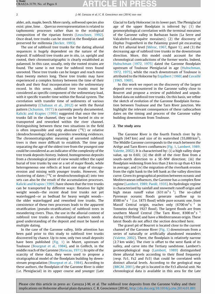
The Garonne River is the fourth French river by itslength (647 km) and size of its watershed (55,000 km2).The Middle Garonne corresponds to the reach between theAriege and Tarn Rivers confluences (Fig. 1, Lambert, 1989;Valette, 2002). It is characterised by: (i) a high valley slopevalue, up to 0.6%; (ii) the drift of the river flow from asouth–north direction to a SE–NW direction; (iii) thefloodplain widening from less than 2 km to up than 4.5 kmin average; and (iv) the migration of the riverbank erosionfrom the right bank to the left bank as the valley directioncurve. Given its geographical position between oceanic andMediterranean influences, the Garonne has a complex flowregime (Lambert, 1989; Parde, 1935). Its hydrologic regimeis characterised by rainfall and snowmelt runoff origin andhigh mean runoff value (631 m3 s�1). The so-calledPyrenean oceanic floods generate outflow up to8500 m3 s�1 (i.e. 1875 flood) while pure oceanic one, fromMassif Central origin, reaches only (6700 m3 s�1 inTonneins during 1927 flood). The largest floods are fromsouthern Massif Central (The Tarn River, 8300 m3 s�1
during 1930 flood) and have a Mediterranean origin. Theselatest floods do not affect the section described here.
The gravel pit of Bourret is located close to the currentchannel of the Garonne River (Fig. 1) downstream from aseries of naturally or artificially abandoned meanders(Valette, 2002). There, the floodplain is relatively narrow(2.7 km wide). The river is offset to the west flank of itsvalley, and carve into the Tertiary sandstone. Lambert’sgeomorphological map (Lambert, 1989) distinguishedthree alluvial levels according to their flood frequency(resp. Fz1, Fz2 and Fz3) that could be correlated withdistinct alluvial levels. According to the geological map(BRGM, 2001), the pit is located in the Fz3 alluvial unit. Nochronological data is available in this area for the Late
Please cite this article in press as: Carozza J-M, et al. The subfossil tree deposits from the Garonne Valley and theirimplications on Holocene alluvial plain dynamics. C. R. Geoscience (2014), http://dx.doi.org/10.1016/j.crte.2014.01.001
Glaby
SoubetHoltheunk
9 mat i
3. S
on
J.-M. Carozza et al. / C. R. Geoscience xxx (2014) xxx–xxx 3
G Model
CRAS2A-3179; No. of Pages 8
Plim
cial to Holocene alluvial formations. Results obtainedBruxelles et al. (2010) and Carozza et al. (2013) in theth of the Middle Garonne suggest that Fz1 is datedween the Late Glacial to the middle part of the firstocene (c. 8900 cal. BP) and Fz2 from the second part of
Holocene (post 4400 cal BP). The age of the Fz3 unit isnown in this area.
According to geotechnical data, the Fz3 unit reaches 7 to of thickness and is mainly composed of gravel (3 to 6 m)ts base and of sand and silt at its top (from 1 to 5 m).
tudy methods
The pit gravel of Bourret was systematically surveyed
consists of seventeen tree trunks, some reaching over 15 min length and more than 1.4 m in diameter. They werecollected during two field campaigns, out of theirsedimentary context as they were removed from theextraction pit by the operator. The location of the treetrunks and their burial depth were estimated according tothe information provided by the operator for each treetrunk. The burying depth ranges from 6 to 9 m. Entire treetrunks sections were sampled to proceed to their radio-carbon dating and dendrochronological study. In addition,all wood fragments more than 5 cm long were system-atically collected to provide a first evaluation of the specifictaphonomy of the tree trunks. More than 300 woodfragments were picked up. The identification of the tree
Fig. 1. Map of the study area and location of the places mentioned in the text. Topographic data are from IGN (BD Alti, 25 m).
nks and wood fragments was performed on wood chips
several occasions. The subfossil tree trunks deposit truease cite this article in press as: Carozza J-M, et al. The subfossil tree deposits from the Garonne Valley and theirplications on Holocene alluvial plain dynamics. C. R. Geoscience (2014), http://dx.doi.org/10.1016/j.crte.2014.01.001
J.-M. Carozza et al. / C. R. Geoscience xxx (2014) xxx–xxx4
G Model
CRAS2A-3179; No. of Pages 8
mounted between slide and slip cover. The samples showaltered and deformed anatomical structures (cell collapse)related to pre-burying alteration and alternated humidi-fication–desiccation periods during post-burial time. Inaddition, calcitic inclusions are abundant, and the woodstructure is partly mineralized, leading to difficulties inspecies identification.
Radiocarbon dating was performed on the external treerings for each one of the tree trunks (three to five tree ringsfor each individual). Because of scratching and abrasion bybedload during transport, the sapwood is missing on tree
trunks, and it is not possible to provide a cambial age. The14C ages of subfossil tree trunks are generally under-estimated by around 25 years (Szepertyski, pers. com.).
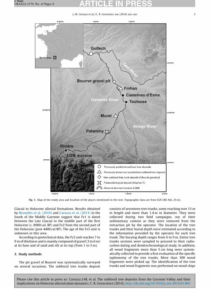
According to its position close to the tree trunksdeposit, a sedimentary cross-section was chosen. Tocomplete these observations, two ERT profiles located onthe same place, but with different electrodes spacing (resp.1 and 2 m, Figs. 2 and 3), were made. We used these data tocomplete the observation of the deeper part of thefloodplain, which contains subfossil trees that cannot beobserved directly due to the watertable height. In addition
Fig. 2. ERT profile close to the Bourret gravel pit (electrode spacing: 2 m). Boreholes are from BRGM (BSS, access online: http://infoterre.brgm.fr/).
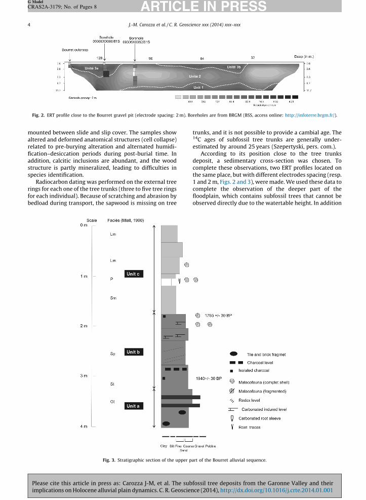
Fig. 3. Stratigraphic section of the upper part of the Bourret alluvial sequence.
Please cite this article in press as: Carozza J-M, et al. The subfossil tree deposits from the Garonne Valley and theirimplications on Holocene alluvial plain dynamics. C. R. Geoscience (2014), http://dx.doi.org/10.1016/j.crte.2014.01.001
andgeodessev
4. R
4.1.
seq
propromovarvarbashigis cthe(130.5twopro
preinteassmaat icutandandshouni
norverplasomfloostraconinteand
Tab
Tabl
Pl
Bo
Bo
Bo
Bo
Bo
Bo
Bo
Bo
Bo
Bo
All t
J.-M. Carozza et al. / C. R. Geoscience xxx (2014) xxx–xxx 5
G Model
CRAS2A-3179; No. of Pages 8
Plim
to cross-validate these data, boreholes from the Frenchlogical database (BSS from BRGM), were also usedpite the paucity and vagueness of data it contains. Onlyen boreholes are available for this area.
esults
General stratigraphic organisation of the alluvial
uence
An overview on the whole sequence stratigraphy isvided by the ERT profiles (Fig. 2). The low-resolutionfile (electrodes spacing 2 m, 124 m length) reached thelassic bedrock, a less than 30 V m unit, at a depthying between 9 to 13 m (Unit 1). The thickness of Unit 2ies from 5 to 10 m depending on both the shape of itse and the bottom of the upper unit (Unit 3). Unit 2 has ah resistivity comprised between 130 and 700 V m thatompatible with a detrital origin (sand and gravel). At
top, Unit 3 is composed of low-resistivity materials0 to 16 V m). The thickness of this unit varies between
and 6 m and shows a lens-shaped organisation, with maxima at 40 and 125 m from the beginning of thefile (resp. Unit 3a and 3b).The data from the BRGM’s BSS confirm these inter-tations. The 09306X0081/81S drilling (Fig. 3) hasrsected Unit 3a and encountered channel facies
ociations at its bottom (pebbles and gravel) andrginal to channel abandonment facies (sand and silt)ts top. By contrast, the 09306X0082/81S drilling, whichs Unit 2, shows the absence of gravel channel deposits
intersected only floodplain alluvial facies (sand, silt clay). The direct observation on the field section alsows the dominance of sandy to silty clay facies in thist.The reference section, ca. 4.0 m height, located at thetheastern corner of the gravel pit (Fig. 3) shows thetical succession from natural-levee and proximal floodin (medium to coarse sands with planar stratification,
etimes slightly oblique, units a and b) to distaldplain deposits (fine sands and silts with intercalatedtified planar palaeosol, unit c) on its top. These data aresistent with the geophysical one and allow us torpret the sequence as meander-like palaeochannels
associated flood plain.
4.2. Radiocarbon dating of the deposit
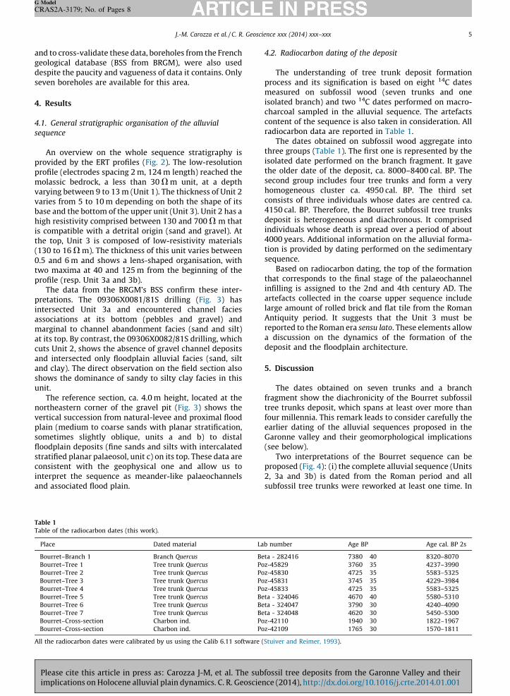
The understanding of tree trunk deposit formationprocess and its signification is based on eight 14C datesmeasured on subfossil wood (seven trunks and oneisolated branch) and two 14C dates performed on macro-charcoal sampled in the alluvial sequence. The artefactscontent of the sequence is also taken in consideration. Allradiocarbon data are reported in Table 1.
The dates obtained on subfossil wood aggregate intothree groups (Table 1). The first one is represented by theisolated date performed on the branch fragment. It gavethe older date of the deposit, ca. 8000–8400 cal. BP. Thesecond group includes four tree trunks and form a veryhomogeneous cluster ca. 4950 cal. BP. The third setconsists of three individuals whose dates are centred ca.4150 cal. BP. Therefore, the Bourret subfossil tree trunksdeposit is heterogeneous and diachronous. It comprisedindividuals whose death is spread over a period of about4000 years. Additional information on the alluvial forma-tion is provided by dating performed on the sedimentarysequence.
Based on radiocarbon dating, the top of the formationthat corresponds to the final stage of the palaeochannelinfilling is assigned to the 2nd and 4th century AD. Theartefacts collected in the coarse upper sequence includelarge amount of rolled brick and flat tile from the RomanAntiquity period. It suggests that the Unit 3 must bereported to the Roman era sensu lato. These elements allowa discussion on the dynamics of the formation of thedeposit and the floodplain architecture.
5. Discussion
The dates obtained on seven trunks and a branchfragment show the diachronicity of the Bourret subfossiltree trunks deposit, which spans at least over more thanfour millennia. This remark leads to consider carefully theearlier dating of the alluvial sequences proposed in theGaronne valley and their geomorphological implications(see below).
Two interpretations of the Bourret sequence can beproposed (Fig. 4): (i) the complete alluvial sequence (Units2, 3a and 3b) is dated from the Roman period and allsubfossil tree trunks were reworked at least one time. In
le 1
e of the radiocarbon dates (this work).
ace Dated material Lab number Age BP Age cal. BP 2s
urret–Branch 1 Branch Quercus Beta - 282416 7380 � 40 8320–8070
urret–Tree 1 Tree trunk Quercus Poz-45829 3760 � 35 4237–3990
urret–Tree 2 Tree trunk Quercus Poz-45830 4725 � 35 5583–5325
urret–Tree 3 Tree trunk Quercus Poz-45831 3745 � 35 4229–3984
urret–Tree 4 Tree trunk Quercus Poz-45833 4725 � 35 5583–5325
urret–Tree 5 Tree trunk Quercus Beta - 324046 4670 � 40 5580–5310
urret–Tree 6 Tree trunk Quercus Beta - 324047 3790 � 30 4240–4090
urret–Tree 7 Tree trunk Quercus Beta - 324048 4620 � 30 5450–5300
urret–Cross-section Charbon ind. Poz-42110 1940 � 30 1822–1967
urret–Cross-section Charbon ind. Poz-42109 1765 � 30 1570–1811
he radiocarbon dates were calibrated by us using the Calib 6.11 software (Stuiver and Reimer, 1993).
ease cite this article in press as: Carozza J-M, et al. The subfossil tree deposits from the Garonne Valley and theirplications on Holocene alluvial plain dynamics. C. R. Geoscience (2014), http://dx.doi.org/10.1016/j.crte.2014.01.001
J.-M. Carozza et al. / C. R. Geoscience xxx (2014) xxx–xxx6
G Model
CRAS2A-3179; No. of Pages 8
this scenario, the subfossil tree trunks are confined inchannels of the Roman period and only give a terminus post
quem age for the alluvial sequence. This model is difficultto reconcile with the geometry of the palaeochannel (Unit3a and 3b), which does not exceed a 6-m thickness; (ii) thealluvial sequence is composed of two diachronic units. Atthe bottom, Unit 2 corresponds to a conserved ‘‘old layer’’.Its age is given by the youngest tree trunk date, ca.4150 cal. BP, which records the last stage of deposition ofthis unit. Unit 3 is dated from the Roman epoch andaggrades over Unit 2. This last stratigraphic organisation iscompatible with previous observations in Castelnau-d’Estretefond (Carozza et al., 2013).
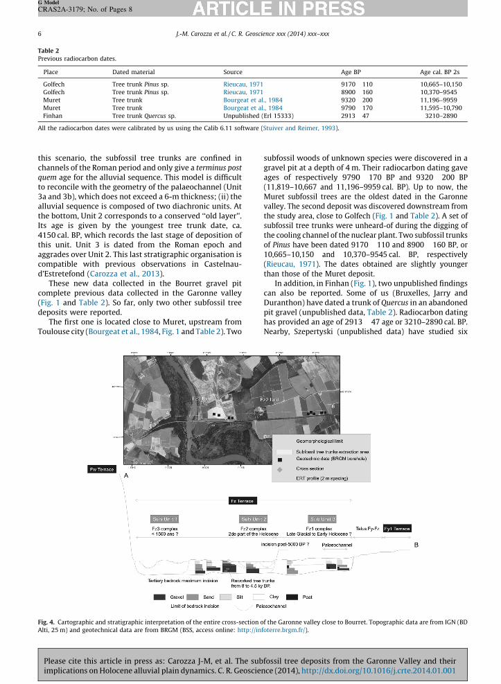
These new data collected in the Bourret gravel pitcomplete previous data collected in the Garonne valley(Fig. 1 and Table 2). So far, only two other subfossil treedeposits were reported.
The first one is located close to Muret, upstream fromToulouse city (Bourgeat et al., 1984, Fig. 1 and Table 2). Two
subfossil woods of unknown species were discovered in agravel pit at a depth of 4 m. Their radiocarbon dating gaveages of respectively 9790 � 170 BP and 9320 � 200 BP(11,819–10,667 and 11,196–9959 cal. BP). Up to now, theMuret subfossil trees are the oldest dated in the Garonnevalley. The second deposit was discovered downstream fromthe study area, close to Golfech (Fig. 1 and Table 2). A set ofsubfossil tree trunks were unheard-of during the digging ofthe cooling channel of the nuclear plant. Two subfossil trunksof Pinus have been dated 9170 � 110 and 8900 � 160 BP, or10,665–10,150 and 10,370–9545 cal. BP, respectively(Rieucau, 1971). The dates obtained are slightly youngerthan those of the Muret deposit.
In addition, in Finhan (Fig. 1), two unpublished findingscan also be reported. Some of us (Bruxelles, Jarry andDuranthon) have dated a trunk of Quercus in an abandonedpit gravel (unpublished data, Table 2). Radiocarbon datinghas provided an age of 2913 � 47 age or 3210–2890 cal. BP.Nearby, Szepertyski (unpublished data) have studied six
Fig. 4. Cartographic and stratigraphic interpretation of the entire cross-section of the Garonne valley close to Bourret. Topographic data are from IGN (BD
Table 2
Previous radiocarbon dates.
Place Dated material Source Age BP Age cal. BP 2s
Golfech Tree trunk Pinus sp. Rieucau, 1971 9170 � 110 10,665–10,150
Golfech Tree trunk Pinus sp. Rieucau, 1971 8900 � 160 10,370–9545
Muret Tree trunk Bourgeat et al., 1984 9320 � 200 11,196–9959
Muret Tree trunk Bourgeat et al., 1984 9790 � 170 11,595–10,790
Finhan Tree trunk Quercus sp. Unpublished (Erl 15333) 2913 � 47 3210–2890
All the radiocarbon dates were calibrated by us using the Calib 6.11 software (Stuiver and Reimer, 1993).
Alti, 25 m) and geotechnical data are from BRGM (BSS, access online: http://infoterre.brgm.fr/).
Please cite this article in press as: Carozza J-M, et al. The subfossil tree deposits from the Garonne Valley and theirimplications on Holocene alluvial plain dynamics. C. R. Geoscience (2014), http://dx.doi.org/10.1016/j.crte.2014.01.001
subgralogandandtyskBP.
mamoMudiscareyeldesBruCas15,strecommathestagEarandCasepito 5shopub201
GarMuPalthedowGlaabaStaby
dowcou
6. C
in din
rewof
seqfracwitradkingeoto
pos
con
J.-M. Carozza et al. / C. R. Geoscience xxx (2014) xxx–xxx 7
G Model
CRAS2A-3179; No. of Pages 8
Plim
fossil trunks of Quercus discovered in the abandonedvel pit of the Clos de l’ılot. According to dendrochrono-ical data, five of the tree trunks have been synchronized
are contemporaries. The last one cannot be synchronised is probably reworked. For synchronised trees, Szeper-i has proposed death dates ranging from 9470 to 9296 cal
These new data collected in the Middle Garonne do nottch the continuous downstream progradation buildingdel proposed by Bourgeat et al. (1984). If the upstreamret’s subfossil wood deposit remains the oldestovered in the Garonne, the Bourret and Finhan deposits
more recent than the Golfech one. In addition, thelow-silts (a set of fluvial to paludal sedimentary faciescribed by Hubschman, 1975) recently dated byxelles et al. (2010) and Bruxelles and Jarry (2011) intelnau-d’Estretefonds (17,640–16,930 Cal. BP and070–14,210 cal. BP) do not fit with this model. Down-am to Toulouse, the Garonne floodplain appears as aplex unit built during the LGM to the Holocene. Three
in stages of construction may be identified: (1) during LGM, the yellow silt unit was deposited. This aggradinge remains poorly documented but seems to overlap the
ly Holocene (Carozza et al., 2013); (2) between ca. 8900 5000 cal. BP, as previously shown by the work aroundtelnau-d’Estretefonds (Carozza et al., 2013). Thissode is interrupted by a major phase of incision close000 cal. BP; (3) between c. 2900 cal. BP to present as
wn by the present results in Bourret and the previouslylished one in Castelnau-d’Estretefonds (Carozza et al.,3).
By contrast, the hypothetical diachronism between theonne alluvial plain upstream and downstream ofret, evidenced by the palaeontological finding ofaminy in the Fz unit, remains an open question. In all
cases, the data on both the upstream and thenstream sector are difficult to conciliate with the Late
cial age (14.6 ka 10Be to 13.1 ka 10Be) proposed for thendonment of the Fxb fluvial terrace near Riviere bynge et al. (2014). The possible over crossing of the LGMthe Late Glacial to Early Holocene alluvial terracesnstream to Toulouse suggested by Lambert (1989)
ld explain this anomaly.
onclusion
The radiocarbon dates obtained on subfossil tree trunksead position indicate that the deposit is heterogeneousorigin and has experienced at least one phase oforking. There is no simple relationship between the age
the subfossil tree trunks and the age of the alluvialuence that contain. The transfer time of this organiction of the alluvial sediments is difficult to correlateh the mineral fraction one. Consequently, isolatediocarbon or dendrochronological dates obtained on thisd of deposits must be used with caution to establish achronological model of alluvial floodplain formation orassess the riparian forest biodiversity because ofsible mixes.The results and data obtained in this study lead to
trunks and their geochronological assumptions, as dis-cussed here for the Garonne lower alluvial plain. Thus, thebuilding model of the Garonne alluvial plain by acontinuous downstream progradation between LGM andHolocene lapses. The stratigraphical relationship betweenthe plain upstream and downstream of Muret remainsproblematic and could be explained by crossing thealluvial terraces. This hypothesis and its implications onthe Aquitaine Basin evolution during the Upper Pleistoceneto the Holocene remain to be investigated.
The subfossil tree trunks deposit discovered in Bourretis the most important to date in the Garonne valley. Thexylologic study shows they are associated with the riparianforest re-conquest dominated by Quercus during the firstpart of the Holocene. However, the overrepresentation ofhardwood species (Quercus or Ulmus) is a direct conse-quence of the deposit formation process, i.e. floodplainrecycling and storage/unstorage of tree trunks in thefloodplain and transport. The least resistant species(Corylus, Salix. . .) identified by palynological works duringthis period (Carozza et al., work in progress) probablysuffered greater damage and mechanical destructionduring transport phases.
Acknowledgements
The authors thank the MGM company and his staff fortheir assistance and cooperation during field works. Thiswork was supported by the GAL&ET program (FrenchMinistry of Environment) and the Collective ResearchProgramme of the French Ministry of Culture ‘‘Evolution ofmiddle Garonne during the Holocene’’.
References
Becker, B., 1975. Dendrochronological observations on the postglacialriver aggradation in the southern part of central Europe. BiuletynGeologiczny 19, 127–136.
Becker, B., 1993. An 11,000-year German oak and pine dendrochronologyfor radiocarbon calibration. Radiocarbon 35, 201–213.
Becker, B., Schirmer, W., 1977. Paleoecological study on the Holocenevalley development of the Maine river, southern Germany. Boreas 6,303–321.
Bourgeat, F., Icole, M., Revel, J.-C., 1984. Les terrasses alluviales dans lesPetites-Pyrenees et l’avant-pays molassique : les conditions de leurmise en place. Bull. Assoc. Fr. Etude Quat. 21 (1–3) 60–66.
Bravard, J.-P., 1986. Le Rhone, du Leman a Lyon. La Manufacture, Lyon,451 p.
BRGM, 2001. Notice de la carte geologique de Saint-Nicolas de Lagrave,0929. BRGM Orleans, 13 p.
Bruxelles, L., Jarry, M., 2011. Climatic conditions, settlement patterns andcultures in the Paleolithic: the example of the Garonne Valley (South-west France). J. Hum. Evol. 61 (5) 538–548.
Bruxelles, L., Pons, F., Magnin, F., Bertrand, A., 2010. Ages et modalite de lamise en place de la couverture limoneuse de la basse plaine de laGaronne d’apres l’exemple du site de Fontreal (Castelnau-d’Estrete-fonds, Haute Garonne). Quaternaire 21, 339–348.
van Burck, U., Wagner, F.E., Lerf, A., 2012. Mossbauer studies of subfossiloak. Hyperfine Interact 208, 105–110.
Carozza, J.-M., Valette, P., Carozza, L., Llubes, M., Ferdinand, L., EdouObame, S., Sevegnes, L., 2013. L’architecture de la basse plaine dela Garonne en aval de Toulouse : premiers resultats. Quaternaire 24(4) 455–464.
Cavaille, A., 1965. Les unites morphologiques des basses plaines de laGaronne. Rev. Geogr. Pyr. S. O. 36 (3) 243–278.
Cavaille, A., 1969. Les terrasses de la Garonne a l’ouest de Toulouse. Livret-guide excursion A6, Pyrenees orientales et centrales, Roussillon et
Languedoc occidental. 8e congres INQUA, Paris16–23. sider with wariness previous works on subfossil treeease cite this article in press as: Carozza J-M, et al. The subfossil tree deposits from the Garonne Valley and theirplications on Holocene alluvial plain dynamics. C. R. Geoscience (2014), http://dx.doi.org/10.1016/j.crte.2014.01.001

J.-M. Carozza et al. / C. R. Geoscience xxx (2014) xxx–xxx8
G Model
CRAS2A-3179; No. of Pages 8
Chabaux, F., Blaes, E., Granet, M., di Chiara Roupert, R., Stille, P., 2012.Determination of transfer time for sediments in alluvial plains using238U-234U-230Th disequilibria: the case of the Ganges river system.C. R. Geoscience 344 (11–12) 688–703.
Dzieduszynska, D., Petera-Zganiacz, J., 2012. Geologic position of theYounger Dryas subfossil forest in the Warta River valley, centralPoland. Bull. Geol. Soc. Finland 84, 69–79.
Enjalbert, H., 1960. Les pays aquitains. Le modele et les sols. These.Imprimerie Biere, Bordeaux, 618 p.
Finsinger, W., Dos Santos, T., McKey, D., 2013. Estimating variation instomatal frequency at intra-individual, intra-site, and inter-taxonom-ic levels in populations of the Leonardoxa africana (Fabaceae) complexover environmental gradients in Cameroon. C. R. Geoscience 345 (7–8) 350–359.
Hubschman, J., 1972. L’age de la basse plaine garonnaise, des Pyrenees auconfluent du Tarn. C. R. Acad. Sci. Paris, Ser. D 275, 651–653.
Hubschman, J., 1975. Morphogenese et pedogenese quaternaire dans lepiemont des Pyrenees garonnaises et ariegeoises. These. UniversiteToulouse, 745 p.
Kalicki, T., Krapiec, M., 1995. Problems of dating alluvium using buriedsubfossil tree trunks: lessons from the ‘black oaks’ of the VistulaValley, Central Europe. Holocene 5 (2) 243–250.
Kolar, T., Ribnicek, M., 2011. Dendrochronological and radiocarbon datingof subfossil wood from the Morava River basin. Geochronometria 38(2) 155–161.
Lambert, R., 1989. Atlas hydrogeomorphologique de la Garonne. Inedit.Leuschner, H.H., 1992. Subfossil trees. In: Bartholin, T.S., Berglund, B.E.,
Eckstein, D., Schweingruber, F.H., Eggertsson, O. (Eds.), Tree-ringsand Environment. Proc. Int. Symp. Lundqua Report 34, Ystad, pp.193–197.
Lezine, A.-M., Holl, A.F.-C., Lebamba, J., Vincens, A., Assi-Khaudjis, C.,Fevrier, L., Sultan, E., 2013. Temporal relationship between Holocenehuman occupation and vegetation change along the northwestern
margin of the Central African rainforest. C. R. Geoscience 345 (7–8)327–335.
Meroc, L., 1967. Circonscription de Midi-Pyrenees, section Haute-Gar-onne. Gallia Prehistoire 10 (2) 339–411.
Parde, M., 1935. Le regime de la Garonne. Rev. Geogr. Pyr. S. O. 6, 105–262.Rieucau, L., 1971. Des arbres fossiles dans la basse plaine de la moyenne
Garonne. C. R. Somm. Soc. geol. Fr. 6, 317–318.Salvador, P.-J., 1991. Le theme de la metamorphose fluviale dans les
plaines alluviales du Rhone et de l’Isere : bassin de Malville et ombilicde Moirans (Bas-Dauphine). These. Univ. Lyon 3, 498 p.
Schumm, S.A., 1977. The Fluvial System. Wiley, New York, 338 p.Stange, K.M., van Balen, R.T., Kasse, C., Vandenberghe, J., Carcaillet, J.,
2014. Linking morphology accros the glaciofluvial interface: a 10Besupported chronology of the glacier advances and terrace formationin the Garonne River, northern Pyrenees, France. Geomorphology 207,71–95.
Starkel, 1995. Evolution of the Vistule valley during the last 15,000years. Polish Academy of Science, Geographical Studies, Spec. Issue,167 p.
Striedtler, C., 1988. Le Rhin en Alsace du Nord au Subboreal. Genese d’uneterrasse fluviatile holocene et son importance pour la mise en valeurde la vallee. Bull. Assoc. Fr. Etudes Quat. 25 (1) 5–11.
Stuiver, M., Reimer, P.J., 1993. Extended 14C database and revised CALIBradiocarbon calibration program. Radiocarbon 35, 215–230.
Tegel, W., Barthe, F., Kintz, C., Lauer, P., Le Saint Quino, T., Rohmer Schohn,E., Thavot, P., Jude, R., 1999. Les chenes subfossiles de la graviered’Herrlisheim (Bas-Rhin). Etude dendrochronologique pour une con-tribution a l’etude de l’evolution des forets riveraines du Rhin.Nachrichtenblatt Arbeitskreis Unterwasserarchaologie (NAU) 5, 49–51.
Valette, P., 2002. Les paysages de la Garonne : les metamorphoses d’unfleuve (entre Toulouse et Castets-en-Dorthe). These de Geographie.Universite de Toulouse Le Mirail, 554 p.
Please cite this article in press as: Carozza J-M, et al. The subfossil tree deposits from the Garonne Valley and theirimplications on Holocene alluvial plain dynamics. C. R. Geoscience (2014), http://dx.doi.org/10.1016/j.crte.2014.01.001