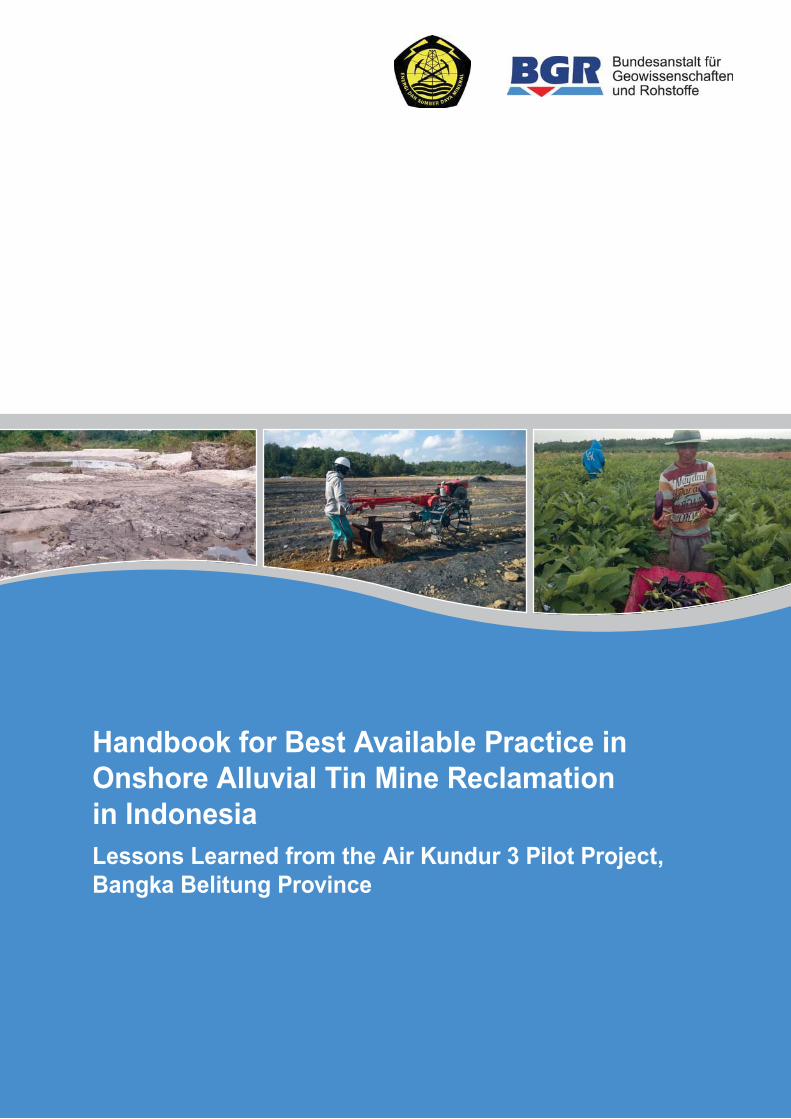
handbook for best available practice in onshore alluvial tin
TRANSCRIPT
Tjahyandari Iskandar,
June
Tbk. -
wati
Tjahyandari
/Jakarta June
Handbook for Best Available Practice in Onshore Alluvial Tin Mine Reclamation in Indonesia
Table of Content
I. Introduction .................................................................................... 1
A. Background of this Handbook ....................................................................................... 1
B. Regulatory Context ....................................................................................................... 2
C. Reclamation Responsibilities ........................................................................................ 2
D. Tin Mining and Reclamation on Bangka and Belitung .................................................. 3
E. Short-term versus Long-term Perspectives on Reclamation ......................................... 4
II. Guidelines and Concepts for Implementing Reclamation ......... 6
A. Initial Evaluation of Reclamation Areas and Community Capacity ................................ 6
A.1. Planning Parameters and Risk Assessments ..................................................... 6
A.2. Engaging the Community in the Reclamation Process ....................................... 6
B. Technical Preparation of the Reclamation Area ............................................................ 9
B.1. Area Design ........................................................................................................ 9
B.2. Management of Mine Pits with Ponds (Kolongs) .............................................. 10
B.3. Landscaping and Erosion Control ..................................................................... 11
B.4. Access and Maintenance Road Construction ................................................... 11
B.5. Flood Control and Buffer Zones ........................................................................ 12
B.6. Water Reservoirs and Irrigation ........................................................................ 13
C. Plant Cultivation Activities ........................................................................................... 14
C.1. Mapping for Estimating the Soil Suitability for Reclamation Plants .................. 14
C.2. Pre-Greening Activities ..................................................................................... 15
C.3. The Planting Hole System and Cover Crops .................................................... 15
C.4. Planting in Forest Areas ................................................................................... 16
C.5. Planting in Agricultural Areas ............................................................................ 18
D. Nursery Operation and Compost Production .............................................................. 22
D.1. Nursery House Operation ................................................................................. 22
D.2. Compost Production ......................................................................................... 23
E. Maintenance and Monitoring ....................................................................................... 24
E.1. Maintenance Procedures .................................................................................. 24
E.2. Monitoring Procedures ...................................................................................... 26
III. Technical Implementation Details for Reclamation .................. 27
A. Tin Mining and the Potential for Residual Tin ............................................................. 27
B. Soil Texture ................................................................................................................. 28
B.1. Determination of Soil Texture ........................................................................... 28
B.2. Soil Compaction ................................................................................................ 32
C. Management of Drainage, Erosion and Flooding Risks .............................................. 33
C.1. The Buffer Zone Concept ................................................................................. 34
C.2. Flooding Risk Evaluation: Infiltration and Climate Impact ................................. 35
C.3. Drainage Infrastructure ..................................................................................... 36

Handbook for Best Available Practice in Onshore Alluvial Tin Mine Reclamation in Indonesia
C.4. Calculation of Potential Soil Erosion Rates ...................................................... 44
C.5. Mine Pond (Kolong) Risks ................................................................................ 45
C.6. Maps and Baseline Reporting ........................................................................... 45
D. Water Quality and Irrigation ........................................................................................ 46
D.1. Water Quality Standards ................................................................................... 46
D.2. Estimating Irrigation Requirements ................................................................... 48
E. Composting Procedures .............................................................................................. 50
E.1. Heap Compost .................................................................................................. 50
E.2. Block Compost .................................................................................................. 51
F. Maintenance and Monitoring of Reclamation Success ............................................... 53
F.1. Analyzing Soil Fertility ....................................................................................... 53
F.2. Soil Fertility and Plant Nutrient Requirements .................................................. 54
F.3. Typical Reclamation Plants and their Fertilizer Requirements ......................... 56
F.4. Plant Health ...................................................................................................... 57
F.5. Regulatory Evaluation and Criteria for Successful Reclamation ...................... 60
G. Conceptual Approach to Community Engagement ..................................................... 65
G.1. Introduction ....................................................................................................... 65
G.2. Preparation for Community Engagement ......................................................... 67
IV. Annex ............................................................................................ 69
A. Pilot Projects on Reclamation in Bangka Belitung Province ....................................... 69
A.1. Development of Fodder Plants Project, Bukit Kijang ........................................ 69
A.2. Master Plan of Reclamation Garden Project, Air Jangkang ............................. 70
A.3. Mapping of Reclamation Area Project, Bangka Island ..................................... 71
A.4. “Bhabinkamtibmas” Go Green Reclamation Project, Selinsing ........................ 72
A.5. BPDASHL Reclamation Project, Belilik ............................................................ 73
A.6. Babel Compost Block Production and Application Project ............................... 74
A.7. Pilot Cooperation Exchange on Sustainable Tin Mining, Air Kundur 3 ............. 75
A.8. Sustainable Reclamation Green for Good ........................................................ 76
A.9. Indonesia Tin Working Group Project ............................................................... 77
A.10. Matras Rice Paddy Field Reclamation Project .............................................. 78
A.11. Koba Reclamation Project ............................................................................. 79
B. Bibliography ................................................................................................................ 80
C. Abbreviations and Glossary ........................................................................................ 82
C.1. Acronyms .......................................................................................................... 82
C.2. Glossary ............................................................................................................ 82

Handbook for Best Available Practice in Onshore Alluvial Tin Mine Reclamation in Indonesia

Handbook for Best Available Practice in Onshore Alluvial Tin Mine Reclamation in Indonesia
1
I. INTRODUCTION
A. Background of this Handbook
The reclamation of mining areas represents one of the most important challenges for the
sustainable management of the tin mining sector in Bangka Belitung Province, Indonesia.
Indonesia’s regulatory framework defines the various requirements for implementing
reclamation and post-mining activities. Stakeholders are always required to directly consult the
details of the applicable regulations as a first step. This handbook shall provide additional
recommendations for affected stakeholders for implementing reclamation, building on these
regulations. The handbook aims to illustrate examples towards Best Available Practice in
reclamation while noting that these procedures could be further improved and updated with
increasing implementation experience.
The content of this handbook is based on lessons learned at the Air Kundur 3 pilot reclamation
project which involved several Indonesian technical partners whose work was facilitated
through a cooperation between the Indonesian Ministry of Energy and Mineral Resources
(ESDM) and the German Federal Institute for Geosciences and Natural Resources (BGR).
Reflecting this project background, the handbook only applies to the reclamation of alluvial tin
mining activities as opposed to hard rock tin mining activities that require drilling and blasting
and may include underground mining methods. The handbook further only applies to onshore
tin mining activities. The technical experts responsible for developing this handbook are
represented by the IPB University (Bogor Agricultural University) and the Bandung Institute of
Technology (ITB), with additional contributions by Belitung Timur Regency and the BGR.
The pilot project and this handbook focus on the technical level of the reclamation process.
The lessons learned presented in this handbook should be seen as complementary to other
national and international initiatives supporting sustainable reclamation in Indonesia. There
are a number of pilot projects underway in Bangka Belitung Province including different
aspects such as testing optimized maintenance for specific plant species (e.g., through the
Ministry of Agriculture), applying new compost preparation techniques (e.g., Watershed and
Protected Forest Management Center) or developing reclamation business models for local
communities, among others (e.g., through the initiative of the Indonesia Tin Working Group
implemented by the Responsible Minerals Initiative).
► See Chapter IV.A for an overview on different local pilot projects on reclamation
The development of this handbook was inspired by discussions with Indonesian stakeholders
as well as by the example provided by the Frugal Rehabilitation Methodology developed for
artisanal and small-scale mining in Mongolia (The Asia Foundation, 2016). The technical
information contained in this handbook is organized in a way that allows the reader to study
specific topics of interest without the need to read through the whole document. The
information may be useful for the stakeholders of the mining sector – Izin Pertambangan
Rakyat/IPR (Artisanal Mining Permit) operators, Izin Usaha Pertambangan Operasi
Produksi/IUP OP (Mining Permit for Production Stage) operators, Izin Usaha Pertambangan
Khusus Operasi Produksi/IUPK OP (Special Mining Permit for Production Stage) operators,
the local government of Bangka Belitung Province, and mine regulators and inspectors. The
handbook also provides information for the communities living close to tin mining areas and
students dealing with mining and reclamation questions.

Handbook for Best Available Practice in Onshore Alluvial Tin Mine Reclamation in Indonesia
2
B. Regulatory Context
According to the Minerals and Coal Mine Law No 4/2009 reclamation is a progressive activity
applying to all stages of mining. Its purpose is to restore and improve the environment and the
ecosystem quality in order to return the function of the land according to the mine closure
planning. Mine closure comprises planned activities to be implemented following the (partial or
complete) termination of mining activities. They aim to restore the area’s environmental and
social functions according the local conditions in the whole mining area and its surroundings.
The reclamation efforts require planning, management, implementation, maintenance and
monitoring, all supported by an adequate budget as defined in submitted reclamation and mine
closure planning documents.
The available land area in Bangka Belitung province, as an environmental resource, is limited
and non-renewable so that sustainable land management of ex-mining areas (and beyond) is
important. Reclamation targets, therefore, must refer to the Spatial Plan (RTRW) of the national
administration, Bangka Belitung Province, and the local Regency (Kabupaten) or City (Kota).
Land management needs to consider land productivity and the local economic development,
safety, social balance and ecological factors in order to be sustainable.
Sustainable resource management forms a spectrum ranging from the impacts of tin mining –
as the province’s main economic activity – to alternative forms of land use that can be
established in the context of reclamation and post-mining activities. The local or regional land
use planning regulation is used as a guidance to define whether a certain location is suitable
as a mining area in the first place. If according to the land use regulation the area is suitable
for mining activities, an Environmental Impact Assessment shall be conducted which shall be
consulted during later reclamation activities. Pre- and post-mining land use planning, typically
as forestry area or “Area for other usage” (APL), defines the base for reclamation.
Over the past few years, the reclamation and post mine closure regulations have been updated
several times by the government in order to encourage more consistent reclamation and mine
closure results, both technically and financially. The current laws and regulations that are used
as references for the reclamation of mining activities comprise the Law on Mineral and Coal
Mining No 4/2009 and the Decree of the Minister of Energy and Mineral Resources
No. 1827/K/30/MEM/2018 concerning Guidelines for Implementing Good Mining Techniques.
This regulation also defines the details with regards to the reclamation bonds to be paid and
recovered by mine concession holders based on successful reclamation. For alluvial tin mine
areas located in forestry areas, the reclamation activities must additionally follow the
Regulation of the Minister of Forestry No P04/Menhut-II/2011 for the Forest Reclamation
Guidance.
C. Reclamation Responsibilities
Mine permit holders have the main responsibility for reclamation. This includes the operators
or owners of a people mining license (IUPR), mine permit (IUP) and special mining business
license (IUPK) for production. Exploration mine permit owners who have finished the feasibility
study must apply for approval of their reclamation and mine closure plan by either the Ministry
or the Governor according to their respective authority. The reclamation and mine closure plan
documents are submitted for review together with the application for the production stage of
either the IUPR, IUP, or IUPK. The reclamation and mine closure plan has to be arranged
according to an approved Environmental Impact Assessment (AMDAL).
Handbook for Best Available Practice in Onshore Alluvial Tin Mine Reclamation in Indonesia
3
Mine permit holders are required to provide reclamation guarantee funds (bonds) in order to
secure the reclamation process. The funds are deposited into a joint account in a government
bank, time deposit government bank, guarantee bank or account reserve. The deposited
reclamation guarantee does not eliminate the need for mine permit holders to implement and
finance the reclamation process according to the reclamation plan. Once a certain stage of
reclamation has been completed, the government evaluates these reclamation efforts against
formal success criteria. If the reclamation results do not meet the success criteria, the
government can appoint a third party to instead facilitate the area’s reclamation, using the
deposited guarantee funds. If the resulting costs exceed the deposited funds, any additional
costs will be charged to the mine permit holder.
Once the technical reclamation process has been completed, the mine permit holder is
required to implement proper maintenance and monitoring activities until all reclamation stages
have been accepted by the government according to the applicable success criteria. The
typical period for implementing maintenance and complying with all success criteria is three
years. For reclamation of larger mines, this is a progressive process that may cover different
mining blocks at different time periods.
D. Tin Mining and Reclamation on Bangka and Belitung
Alluvial tin deposits on Bangka and Belitung are often found below a cover of 10-20 m of
overburden sediments (usually sand with few layers of clay) that are removed and dumped as
waste in order to mine the underlying mineralized layer of tin ore in open pits. Tin mining
typically involves gravity-driven processing in order to enrich the mined ore and produce tin
ore concentrates. The leftovers from this processing – tailings – are sand-rich material that is
dumped in the landscape; dams may be constructed to stabilize mine ponds or tailings.
The different elements of the mining process – waste, tailings, and the open pit morphology
(typically associated with mine ponds – kolongs) – and their impact on soil fertility and plant
growth need to be managed for reclamation. As the scale of these impacts differs from one
place to the next, the resulting reclamation costs may also show significant differences
between different locations. Reclamation of deteriorated areas with strongly disturbed surface
morphology, high risks or challenging environmental legacies will be more expensive.
Therefore, all reclamation costs need to be appropriately budgeted with regards to the specific
situation of the area. The reclamation budget must consider longer-term maintenance and
monitoring activities over a sufficient period of time.
The technical method of alluvial tin mining is relatively simple using either small-scale manual
mining and processing methods or mechanized equipment for hydraulic mining. Typical
techniques include hand panning, the use of gravel pumps and monitors, and sluicing for
gravity separation. Depending on the techniques used, mining may cause a range of obvious
environmental impacts such as changes to the area’s morphology, but also less obvious
impacts such as changes to the groundwater table. These latter impacts may be detected
through a hydrological survey.
The area of mining operation ranges from small (<1 hectare) to large (hundreds or thousands
hectares concession area). Reclamation of large areas becomes difficult to manage.
Therefore, it is necessary to perform progressive reclamation where mined-out blocks of the
mining concession will already undergo reclamation while other areas on the concession are
still being actively mined. The sequence of areas for progressive reclamation should be
selected based on the mine plan.
Handbook for Best Available Practice in Onshore Alluvial Tin Mine Reclamation in Indonesia
4
Tin ore is an abundant resource in Bangka Belitung Province and its small-scale exploitation
is straightforward. Artisanal and small-scale tin mining may, therefore, fulfill an important
economic function for local people. Small-scale mining activities should take place on a formal
base through a partnership with an IUP concession holder. In these cases, the IUP concession
holder will be responsible for environmental management and reclamation after the tin ore has
been extracted. However, in some cases, artisanal and small-scale mining activities may also
have occurred informally, outside of formal mining concessions. These informal miners did not
pay reclamation and mine closure bonds such that the environmental damage they caused
now represents a sustainability challenge for the society.
In addition, mine operators tend to maximize profit generation rather than maximizing tin
extraction when performing mining and processing operations. As a result, in combination with
geological factors, the recovery rate of tin may be relatively low in some mining operations.
Consequently, tailings material (and possibly some mine waste) still contains significant
residual tin resources. This may cause abandoned or closed mines to become targets for
informal re-mining by local people during periods of rising tin prices, even in cases where these
mines previously underwent closure and reclamation according to the applicable regulatory
standards and plans. As such, these risks for re-mining activities are another sustainability
challenge for reclamation in Bangka Belitung Province.
E. Short-term versus Long-term Perspectives on Reclamation
Tin ore has been mined in Bangka Belitung province for more than 300 years. Many areas in
the province show severe environmental destruction due to past mining activities. There are
high local expectations that all of these areas should be converted into productive land that
creates economic benefits for local communities and replaces income lost due to the
termination of tin mining activities. However, although the economic benefit for communities is
of high importance, it is unlikely that this target can be easily achieved in the short term and at
a broad scale, unless unrealistic amounts of budget were available.
As a minimum, reclamation is supposed to restore the mined land to the natural conditions
before mining activities started, or to convert it into an otherwise economically useful state.
Due to the local abundance of granites, the natural fertility of soils in Bangka Belitung province
is not very high. Existing topsoil was removed when mining activities started and, in most
cases, it has not been stockpiled for later use such that it is now lost. The widespread
deposition of mine waste and tailings creates problematic conditions for plant growth, even for
cover crops, which reinforces erosion and flooding risks.
Therefore, assuming that there is only a limited availability of reclamation funds, a short-term
target for reclamation of many ex-mining areas of Bangka Belitung province could be to focus
on improving the soil conditions for plant growth. This could be achieved by implementing a
masterplan involving simple erosion control measures and planting of cover crops and trees,
leading to the progressive improvement of soil fertility parameters (organic content, texture
etc.) and the development of forests. This is a slow process that may require at least 10-20
years to show any significant progress. During this time period, local communities would
receive little economic benefits from the affected areas. They might hence require other forms
of support as part of a larger socio-economic concept that also includes capacity building.
In the longer term, once the soil fertility parameters have developed towards being more
beneficial for plant growth, the land may be progressively converted into other forms of
agricultural or agroforestry use. This conversion may ultimately lead to increased economic

Handbook for Best Available Practice in Onshore Alluvial Tin Mine Reclamation in Indonesia
5
benefits for local communities. Extra (priority) budget may be invested into the reclamation of
selected ex-mining areas that show less degradation and, hence, are more suitable for
immediate agricultural or agroforestry land use due to faster recovery of soil fertility and
improved conditions for plant growth. In order to facilitate such land use planning, it would be
useful to progressively generate mapping data on soil fertility parameters at a high spatial
resolution for the province of Bangka Belitung.
Handbook for Best Available Practice in Onshore Alluvial Tin Mine Reclamation in Indonesia
6
II. GUIDELINES AND CONCEPTS FOR IMPLEMENTING RECLAMATION
A. Initial Evaluation of Reclamation Areas and Community Capacity
Reclamation planning efforts are performed long before commencing the actual reclamation
process. Ideally, reclamation of mined-out zones should be implemented step by step in
parallel to ongoing mining activities. The following chapter provides background information
on some basic evaluations than can help to ensure cost-effective and sustainable reclamation.
A.1. Planning Parameters and Risk Assessments
A number of parameters and risks influence the success prospects for sustainable reclamation
in a given area. Adequate evaluation of these parameters and risks with adjustment of the
reclamation plan design requires the collection of baseline data. Chapter III provides detailed
information on these factors. Prominent risks and parameters that should be evaluated include:
Risks for re-mining of the area by informal small-scale miners after reclamation due to
residual tin ore contents.
► See Chapter III.A for information on residual tin ore resources
Erosion risks influencing soil stability, riverbeds and flooding.
► See Chapter III.C for erosion control measures
Availability of water of sufficient quality to support the reclamation process. This
includes consideration of short-term planning for optimized reclamation in the annual
rainy-dry season cycle and longer-term climatic developments.
► See Chapter III.D for water quality standards and irrigation planning
Socio-economic factors where the local community does not appreciate or is not
involved in the reclamation process and there is no long-term community business
model. This further includes the question of land ownership and land use planning after
the initial period of reclamation and area maintenance.
► See Chapter III.H for the background concept of community engagement
Also note that health and safety needs to be managed throughout the reclamation process.
This refers to the operation of equipment and to the area itself. For example, dangerous areas
such as tailings deposits that seem to be partly liquefied (easy to sink in) should be clearly
marked as they are not suited to support operation of heavy equipment.
A.2. Engaging the Community in the Reclamation Process
The socio-economic situation of local communities is one of the most important factors
determining the level of success and sustainability of any reclamation program. This situation
is related to the individual demographic conditions, education levels, social structure, job
availability, and business opportunities as wealth determinants of the communities living close
to ex-mining sites. Communities can play a positive role in the reclamation process as well as
in later maintenance of the area or in associated post-mining business models. If they can
become engaged as stakeholders, investors or landowners of ex-mining land, they can act as
Handbook for Best Available Practice in Onshore Alluvial Tin Mine Reclamation in Indonesia
7
supporters of the long-term reclamation targets and reduce risks such as informal re-mining of
the area.
The socio-economic situation of local communities and their potential role with regards to
developing reclamation and post-mining concepts may differ from one place to the next.
Therefore, there is no standardized “one size fits all” approach. It is important to understand
the individual situation of local communities in sufficient detail before implementing the
reclamation project.
Gaining an adequate understanding of the dynamics and capacity of local communities may
be achieved through a community baseline assessment. This is typically facilitated by
experienced social experts working closely with the community using focus group discussions
and other tools. As a part of this process, an appropriate mechanism should be developed in
order to facilitate continuous and regular communication and exchange between the
community and the organization responsible for reclamation.
Some relevant questions and considerations related to understanding and engaging the
community in the reclamation program include the following – these may be considered when
planning a community baseline assessment or similar exercise.
What is the level of awareness and willingness of different local community members
(especially young, low level educated, and underemployment people, formal and
informal leaders, and local businessmen and women) to be engaged in the reclamation
program and in possible business models related to area maintenance and post-mining
activities? What are their individual expectations on reclamation of the area and can
these be considered for planning of reclamation targets?
Whenever possible, it is advisable to strengthen the organizational capacity of the
community’s business activities. This can be achieved by engaging with rural economic
institutions such as cooperatives or village-owned enterprises, that is, BUMDES. The
creation and progressive professionalization of these organizations should be
supported. Government support options for access to necessary credit or micro-finance
options should be clarified. Ideally, the organization (possibly with some external
support) should have the capacity to develop a business plan related to the reclamation
process and subsequent post-mining activities.
If community organizations or rural economic institutions are new, they may not have
the capacity to take responsibility for all but only for some aspects of the reclamation
process. They may also have limited financial resources and management capacities,
for example, to work as subcontractors. In these cases it is helpful to discuss individual,
specific business models within the overall reclamation program with communities, for
example, establishing a BUMDES or cooperative business units for providing
reclamation extensional services (e.g., to provide compost), fishery, cattle farming etc.
Where this is not feasible, engaging individual community members for certain services
(e.g., as casual workers or equipment lenders) represents a second-best solution.
The engagement with local communities should take place on an appropriate formal
and legal base, for example, through an agreement between the community and the
mine concession holder responsible for reclamation. The land ownership status should
be clarified before a mining concession has been reclaimed and is returned to the
government. Any possible conflicts over land ownership, community access to the land
and resulting risks (e.g., encroachment by third parties) should be addressed.
Handbook for Best Available Practice in Onshore Alluvial Tin Mine Reclamation in Indonesia
8
If the land owners are known, an agreement with the community should be established
regarding their involvement in developing the area. If there are no land owners
registered, the community should be encouraged to claim the land for themselves by
following the appropriate regulatory procedures. In order to develop a mutually
balanced agreement and a sustainable community self-claiming of the land, it is
recommended that the village (Kepala Desa/the village leader and BPD/the village
consultative body) and local government support the community.
Reclamation or post-mining activities require certain technical skills in the community. These
should be evaluated through a capacity assessment. In some cases, local people may be
trained in order to acquire the necessary skills. Possible examples include:
Experience in collecting samples and doing quality testing of the river, kolong, and well
waters. This may allow community involvement as local technicians during reclamation
and monitoring. If people do not have this experience, can they participate in sampling
activities in order to better understand and give credibility to the process?
Experience in agriculture. This may allow their involvement in the following activities:
o Plant hole preparation, application of soil improvement materials (red soil,
compost, lime, fertilizer), and planting of seedlings or cover crops
o Local supply of compost or acting as a producer of on-site compost
o Local supply of seedlings or caretaker of local nursery facilities
o Maintenance and monitoring the growth and health of cover crops and
reclamation plants
Experience in fishing or fish farming. This may allow involving local people as users of
water resources in mine ponds that are not closed through backfilling in the reclamation
process.
Experience in construction. This may allow people providing support services for cut
and fill operations (landscaping), road or buildings construction. Are community
organizations or individual members managing any equipment (such as bulldozers or
excavators) in appropriate condition that can be used for reclamation?
Experience in cattle farming. This may allow using the reclamation area for cattle
grazing, if the area is large and will provide sufficient grass as fodder. The cattle manure
may be used as fertilizer.
Experience in agroforestry. This involves processing wood for various local purposes
such as furniture. In the long term, this may also include growing of high-value tropical
trees whose wood can be exported.
Experience in business planning and management. Any community enterprise or
cooperative requires adequate business planning and management skills in order to
function properly and be an efficient business partner. For example, members of the
community need to understand the local market conditions for potential products they
would like to produce. Therefore, general capacity building should be supported
regarding these skills. This further includes decision making structures inside
cooperatives or BUMDES and, later on, marketing skills for selling products.
► See Chapter III.H for the background concept of community engagement
Handbook for Best Available Practice in Onshore Alluvial Tin Mine Reclamation in Indonesia
9
B. Technical Preparation of the Reclamation Area
B.1. Area Design
For the purpose of developing a reclamation plan for the ex-mining area, it is necessary to
check land status and land cover condition, and to prepare base maps of the area.
Check the status of the ex-mining land by referring to maps of land status and the
Spatial Plan (RTRW). Is it a forest or an Area for Other Usage (APL)? These maps can
be obtained from both Bappelitbangda Office of the Province and Districts.
Obtain topographic maps at scales that can adequately describe the micro-topographic
condition of the area. These maps may not be available at sufficient resolution; in that
case, new maps can be created, e.g. using a drone in order to build a three-dimensional
model of the landscape. Ideally, contour lines should be resolved with a height
difference of 1 meter, so they can also describe land cover conditions including size,
depth, and distribution of kolong, height of overburden pile, etc.
The size of one unit of reclamation area is often less than 10 ha. Topographic maps covering
the region are generally available at 1:50,000 scale that is not useful to interpret land cover
conditions of areas less than 10 ha size. Therefore, another possible way that can be applied
is by using a drone to produce air imageries, or to use satellite data. The resulting images
should then be analyzed by a GIS (Geographical Information System) expert to provide
information on land cover and topographic condition of the area.
Set the general reclamation design of the area by combining land status, RTRW, land
cover, and topographic information derived from the maps or satellite/drone images (or
digital elevation model).
Clarify the scale of cut and fill operations for landscaping. This process requires
sufficient time, financial resources, and a detailed evaluation of erosion risks, e.g. due
to surface runoff of water. Management of erosion risks is required after landscaping.
► See Chapter III.C for details on erosion risks
After cut and fill operations for land preparation, perform a mapping of soil texture and
soil water content. Align the reclamation plan with the actual soil conditions found at
the area.
► See Chapter III.B for details on soil mapping
Consult with agricultural and forestry experts as well as the local community regarding
the types of plants to be used for reclamation, based on regulations and formal targets
as well as soil texture type and planned improvement procedures.
► See Chapter III.F for reclamation plant selection and maintenance
Discuss and adjust the selected plants for reclamation with local farmers, BUMDES
etc. regarding their recommendations and experience as well as in the context of the
general business model of the local community. Consider local market conditions for
the community business model and adjust planting zones and schedules accordingly
(e.g., control the amount of harvest products to arrive at the market during a given
period).
Handbook for Best Available Practice in Onshore Alluvial Tin Mine Reclamation in Indonesia
10
Adjust reclamation plan design to the chosen types of plants or crops to be cultivated
(forestry trees, perennial crops, annual crops, or horticultural crops?) as this will
determine the detail plan of land preparation, planting grid, seedlings requirement, as
well as the dose of red soil, compost, lime, and fertilizers or alternatives (e.g., biochar,
manure and rise husks or other organic residues) for soil improvement.
Consider the integration of necessary or optional supporting infrastructure (inspection
roads, drainage and irrigation system, warehouse, nursery facilities, on-site
composting).
► See Chapter III.C for engineering examples on drainage channels
► See Chapter III.D for more background on irrigation
► See Chapter III.E for information on composting
B.2. Management of Mine Pits with Ponds (Kolongs)
The past tin mining activities resulted in a scattered distribution of kolongs in the region, with
strong differences in terms of size, depth, water volume and quality that determine its usage
as source of water for domestic activities, irrigation, fish cultivation, etc. For these types of
usage, the water quality needs to comply with the applicable regulation.
If there is any possibility (availability of overburden material, heavy equipment, etc.), small
sized and shallow kolongs should be closed during landscaping through backfilling. Otherwise,
re-sloping should be implemented where kolong slopes are not steeper than the natural angle
of repose of the excavated material; this angle varies with the water content and grain size
distribution of the material.
Larger mine ponds can act as water reservoirs (connected to the irrigation system) or fulfill
economic functions such as fishery or, in some cases tourism. Large kolongs should also be
integrated into the drainage system to act as buffers of water volumes. Appropriate safety
measures should be considered as defined below.
Close small and shallow kolongs during landscaping through backfilling. For small and
large kolongs where backfilling is not possible consider resloping. Perform a slope
stability analysis for dangerous areas.
When acting as water reservoir, determine the size and depth of the larger kolongs in
the reclamation area to estimate their dimension and water volume. Use topographic
maps or drone images to assist. Consider the seasonal change in rainfall and its impact
on kolong water level.
Determine the quality of kolong water by referring to the Government Regulation
No. 82/2001 or applicable regional regulation.
For permanent large kolongs that are not closed during landscaping: When doing
revegetation, plant forestry trees or perennial crops at close planting distance along the
edge of kolong as a living or green fence to minimize risks of accident (people falling
into the pond), and install sign boards for safety, health, and environmental awareness
at strategic positions along each kolong in the area.

Handbook for Best Available Practice in Onshore Alluvial Tin Mine Reclamation in Indonesia
11
Check with the local community organization regarding their experience in fishing or
fish farming for economic use of the kolong.
► See Chapter III.C.5 on kolong risk management
B.3. Landscaping and Erosion Control
Archipelagic areas of tropical regions such as Bangka and Belitung islands are characterized
by a dynamic weather and hydrological conditions. Heavy rain or very dry conditions with high
temperatures alternate throughout the year. Reclamation areas, therefore, should be protected
from drought or landslide, soil erosion, and excessive run-off water that can sweep away
compost, lime, fertilizers, and even the newly planted plant seedlings. Especially for the open
area (lacking vegetation cover) that is not yet landscaped and having pits, channels or piles of
mine overburden, it is necessary to do soil conservation efforts by terracing the land and
grading the soil surface to obtain a stable area.
Landscaping is done by cut and fill techniques using heavy equipment that may cause soil
compaction. Although the possibility of soil compaction to occur in sandy soils is much lower
than in soils with high clay content, soil compaction should be avoided anywhere in the area.
► See remarks on soil compaction in Chapter III.A
Do landscaping by conducting cut and fill technique to prepare terraced lands with
slope <5% and height difference between land units <1 m to reduce potential soil
erosion. This activity includes soil grading and construction of inspection roads,
drainage channels, and soil and water conservation measures.
Construct an adequate drainage system in order to prevent erosion or flooding,
manage surface water runoff and avoid water-logged conditions in the soil. When
planning the drainage system, consider the regional topography including the potential
for water inflow from surrounding areas.
Protect the functionality of the drainage system with adequate measures such as
sediment traps (barriers) or lining of ditches in order to avoid the formation of erosion
gullies. Consider the protection of infrastructure such as access roads when
engineering the drainage system. The drainage system requires regular maintenance.
► See Chapter III.C on erosion risks and drainage
Implement other measures (cover crops etc.) to reduce soil erosion to a minimum.
Check how community organizations could be involved for providing labor force and
heavy machinery such as bulldozers or excavators. Check that their equipment has
appropriate quality to allow safe handling. Clarify supervision procedures in order to
make sure all activities respect occupational health and safety.
B.4. Access and Maintenance Road Construction
To facilitate implementation, maintenance, and monitoring of the reclamation activities, access
and inspection roads should be constructed.
Construct an inspection roads network with a dimension allowing to facilitate small-
scale transport of tools, equipment, red soil, compost, lime, fertilizers, plant, and other
inputs.
Handbook for Best Available Practice in Onshore Alluvial Tin Mine Reclamation in Indonesia
12
Access roads must be able to support the weight of trucks that may carry heavy loads
of materials (10-20 tons). Roads may be constructed using more stable concrete
material or less expensive compacted earth design. Truck access may be more difficult
during rainy season. Depending on the reclamation plan, truck access may need to be
possible both in dry and rainy season.
Road construction design should consider adequate drainage facilities in order to
protect against erosion. Roads and associated drainage facilities require regular
maintenance.
Involve the local community in road construction, ideally as subcontractor at the
organizational level (BUMDES or Cooperative), otherwise on an individual base.
B.5. Flood Control and Buffer Zones
Flooding is a significant risk during the rainy season on Bangka island. Flooding may occur at
the reclamation site itself due to heavy rainfall and rising water levels in nearby rivers. Flooding
has also a regional impact and flood management should consider the regional catchment
area in order to minimize potential damage further downstream.
Rivers may contain little water in the dry season but periodical high water flow during
rainy season. Flood control measures must be based on rainy season flooding risks
and consider multi-year meteorological trends.
Ask among the local community members regarding their experience with flooding
events in the past: which areas have a high risk and what is the frequency? Consider
this information for planning of flood control measures.
Flood control refers to sewer pipes below access roads or other critical infrastructure
to manage heavy rainfall. If present, integrate the network of large mine ponds
(kolongs) as water reservoirs into a drainage system that may buffer water and prevent
flooding of certain areas or roads.
Flooding risks of the reclamation area through rivers can be managed through different
approaches. The best approach is to establish wide buffer zones (flood plains) next to
the river where controlled flooding is allowed. These buffer zones should be populated
with plants that are suitable to survive in temporary flooding scenarios (waterlogged
soil), such as Eucalyptus or Sengon. A buffer zone provide protection for local areas
with valuable crops at higher altitudes of the reclamation site. It further slows down
water flow velocity in the river and, as such, reduces downstream flooding risks.
Levees may be constructed to protect areas with valuable crops against flooding from
rivers. These levees should be constructed behind buffer zones where they are not
subject to high erosion risks. In these cases, they can be stabilized through plants.
Constructing levees directly next to a river is very risky due to high erosion risks and
should be avoided in favor of establishing buffer zones. If this is not possible, levees
have to be stabilized. This can be done using large, heavy stones or debris (e.g., in
gabiones) in high-erosion areas of the levee, and plants (bamboo, grass) in more
protected areas of the levee. A civil engineering (hydraulic) evaluation of river water
flow patterns is required in order to identify areas of high erosion; note that these areas
can change through time and that erosion can also take place at the base of the levee,
below protection measures at the water surface.
Handbook for Best Available Practice in Onshore Alluvial Tin Mine Reclamation in Indonesia
13
Flood control may also refer to alterations of the river bed or morphology for
stabilization or flow modification. If a mining company wants to perform a hydraulic
evaluation for planning these interventions, they will require advanced civil engineering
expertise in order to calculate river flow rates etc. The regional catchment impact of
any interventions needs to be carefully evaluated in order to avoid creating problems
in other locations (downstream). Especially smaller companies may not have the
necessary in-house qualification for such evaluations and may need to contract
external experts.
► See Chapter III.C.1 for examples on buffer zones
B.6. Water Reservoirs and Irrigation
Abundant rainfall is required to support initial plant growth for reclamation. The average amount
of annual rainfall across the Bangka Belitung islands may be overall similar, but the monthly
rainfall distribution pattern might be different from district to district. The latter is important for
determining the beginning of the planting period which should coincide with the beginning of
the rainy season; usually this is the period from October to January, but it can vary between
the districts by one month, and it can also vary from year to year.
Obtain and review rainfall data, e.g., average monthly rainfall and number of rainy days,
for the period of the last 10 years.
Speak to local farmers about their experience with rainy season patterns.
Irrigation is necessary during the rainy season and especially outside of the rainy season.
Water for irrigation purposes may be sourced from rainfall water, surface water reservoirs or
groundwater. Surface water reservoirs are frequently represented by mine ponds (kolongs);
these are usually recharged by rainwater and hence their water level may be partly or
completely reduced during the dry season. However, depending on the area topography and
hydrology, larger kolongs may also be recharged from ground water which may provide
recharge during the dry season. If local irrigation needs cannot be fulfilled from kolong water,
groundwater resources can be accessed by constructing small production wells. The water
quality of all potential reservoirs should be checked to comply with the applicable regulatory
standards with regards to planting crops.
► See Chapter III.D for details of water quality standards
To plan and construct irrigation infrastructure, it is necessary to consider data for crop type,
crop water requirement (evapotranspiration), rainfall, and soil physical properties (water
storage capacity defined by texture, porosity, and permeability). Therefore, irrigation system
planning should be assisted by a hydrologist and an agricultural expert.
Identify one or more suitable water reservoirs. Evaluate the total volume of water
reservoirs and correlate it with the irrigation requirements of reclamation plants
(evapotranspiration) during the dry season.
If kolongs act as reservoirs for irrigation, make sure that water quality is suitable and
consider the seasonal fluctuation of kolong water level. Measure the depth of the kolong
and calculate the total volume of water. Evaluate if the kolong can act as reservoir with
sufficient water throughout the dry season. Clarify if the kolong is connected to the
groundwater and may thus get recharge independently of rainfall (requires hydrological
evaluation).
Handbook for Best Available Practice in Onshore Alluvial Tin Mine Reclamation in Indonesia
14
Accessing and distributing the water from these reservoirs requires installing a pump
connected to an iron-made tower (typically 2-3 m height with water storage tank at the
top) for supplying water to the irrigation pipes.
Construct irrigation pipes with diameter (typically PVC material, 1 inch), length and
distribution system (sprinkler nozzles) adjusted to the evapotranspiration needs of
reclamation plants assuming application twice per week.
Note that irrigation requirements for plants may be higher in the early stages of
reclamation.
If local water availability is low consider using drought stress-resistant reclamation
plants.
C. Plant Cultivation Activities
C.1. Mapping for Estimating the Soil Suitability for Reclamation Plants
Ex-tin mining lands in Bangka Belitung Islands are dominated by soils with sandy texture and
no organic matter; only small parts are finer textured soils. Additionally, the soil pH is relatively
low. These types of soil have an extremely low fertility with a very limited capacity to provide
nutrients and to store water. Due to their texture, they are also prone to soil compaction.
Consequently, plant growth on these soils is very weak and the land’s agricultural productivity
is low.
There are also local areas where clay-rich soils are found. Clay-rich soils have different colors
depending on the individual clay minerals and content – they can have blue-grey, white-grey
and reddish colors. This type of soil may also have limiting physical and chemical parameters:
The clay-rich soils have a low pH and their high clay content causes waterlogged conditions in
the soil.
Waterlogged conditions refer to water saturation or wet soil conditions over a longer time period
which may inhibit growth of some plants. Wet soil conditions may occur in areas with high clay
content, in ponds, in topographically low areas, in areas with soil compaction, and in regularly
flooded areas (flood plains). Adequate drainage measures are required in order to remove
excess water. Puddles on the surface may indicate waterlogged conditions.
In order to facilitate successful plant growth, soil fertility and water storage capacities need to
be improved by optimizing soil organic matter content and clay content. This is achieved by
mixing different components such as coarse-grained soil, clay-rich soil, compost, lime and
fertilizer. Due to economic and logistic reasons, this kind of soil improvement is commonly
applied in individual plant holes rather than across the whole area. The plant hole procedure
is described in more detail in this chapter.
Mapping of soil texture as well as of flooded or wet areas at the reclamation site is a useful
step in order to plan the soil improvement procedures and to determine the ideal distribution
and types of reclamation plants to be used. Mapping should be carried out by a skilled soil
surveyor. For a quick, reconnaissance mapping this step takes about 1 hour per hectare of
reclamation land. Depending on the level of detail of the soil texture mapping and the
heterogeneity of soil textural classes found in the area, the process may also take longer.
► Refer to the procedures in Chapter III.B to determine soil textural class
Handbook for Best Available Practice in Onshore Alluvial Tin Mine Reclamation in Indonesia
15
► See Chapter III.C.6 for general information on maps
The following recommendations apply for the mapping of soil textures:
Perform the mapping directly at the site after implementation of landscaping activities.
Determine and classify soil texture of the area. If the soil mapping is performed by a
non-specialist, it can be done in a simplified form: classify the soil texture as fine,
medium or coarse, except in areas of clay-type soils (kong material) that should be
specified separately.
► See Chapter III.B for details of soil texture classification
The color code of the ternary diagram in Chapter III.B illustrates how different soil
textures impact on reclamation: green = good conditions (little improvement required),
yellow = medium conditions (moderate improvement required) and orange = bad
conditions (significant improvement required). The soil improvement procedures at
individual plant holes can be adjusted according to the soil mapping results. For
example, areas with significant clay content may require little or no addition of extra
clay from external sources.
Consider the results of soil mapping at the area for planning of reclamation, that is,
when evaluating the suitability and maintenance requirements for different reclamation
plants with regards to substrate type (coarse or fine-grained) or adaption to
waterlogged conditions.
The soil map of the site is based on surface observations. In reality, the soil properties
change continuously. While the map should be used for orientation of planning the
reclamation process and planting activities, the details can be adjusted case-by-case
based on the soil properties found directly at the planting hole.
According to the mapping results on soil textures in different parts of the area, the reclamation
area planting design and the need for adding soil ameliorants can be adjusted.
C.2. Pre-Greening Activities
After completion of mining activities or landscaping (cut and fill), the soil of the area does not
have any significant vegetation cover; this makes it susceptible to erosion. Pre-greening
activities can be implemented in order to cover the bare soil with cover crops before the actual
start of reclamation activities with other plants. As such, pre-greening activities are a
temporary, intermediate step.
Pre-greening of the reclamation area reduces soil erosion and increases the availability of
nitrogen nutrients and soil organic matter which improves soil fertility for later reclamation
plants. Cover crops for pre-greening activities can also be used for producing compost. To
facilitate pre-greening, the cover crops themselves may already require limited addition of
certain soil improvement materials or maintenance in order to grow properly.
C.3. The Planting Hole System and Cover Crops
The soils in Bangka Belitung Province are often degraded and have low fertility. Therefore,
plant growth in this soil is naturally limited. Physically, sandy soils have a very low water holding
capacity; chemically, they have a very low cation exchange capacity and low pH. These soil
properties are considered as the most limiting factors for plant growth.
Handbook for Best Available Practice in Onshore Alluvial Tin Mine Reclamation in Indonesia
16
In order to ensure long-term successful plant growth, this handbook recommends cultivating
reclamation plants using the planting hole system of a certain dimension with additions of red
soil, compost, biochar, lime and fertilizer to be mixed with biomass of pre-cultivated cover crops
(from pre-greening) or other sources of biomass material. This procedure is intended to
improve the soil fertility since ex-tin mining areas are dominated by sandy textured infertile
soils (mine tailings and overburden).
By applying the planting hole system, the young seedlings of reclamation plants will grow in a
fertile media. The soil in the planting hole has better water storage capacity and serves as a
nutrient depot, especially for nutrients available at mildly acidic to neutral soil pH levels. It is
expected that when the plant roots penetrate the ground outside the holes at an age of about
3 months or older, they have developed enough reserves to cope with the difficult conditions
for plant growth prevailing in the surrounding substrate (mine tailings and overburden) outside
of the planting hole. The soil outside the planting hole is expected to have a lower pH than in
the planting hole which can improve availability of certain micronutrients that are mobile under
these lower pH conditions.
Planting holes are prepared for individual trees – in areas cultivated with forest trees, the
planting grid is commonly 4 m x 4 m maximum planting distance (that is, a minimum of
625 trees / ha). During the first years of growth, the planted trees will not yet have formed a
connecting canopy. This means that huge areas of open space occur in the early reclamation
stage where the soil is not protected from erosion. In order to protect this soil surface, cover
crops should be planted across this area between the planting holes.
Cover crops are sown as a mixture of seeds applied to the area. Not all of these
seedlings will grow well but it is expected that at least one or two types will be able to
adapt to the local conditions and show good growth performance. Where this is not the
case, soil amelioration may be required.
An overview on the growth performance of various cover crops in different soil types
can be found in the report by Nurtjahya & Franklin (2019).
Check if there is any potential for local farmers to provide cover crop seeds, compost,
manure, charcoal, or other consumables for soil amelioration. If not, could they be
trained to provide such consumables in the future?
► See table in Chapter III.F.3 for overview on typical reclamation plants including cover crops
C.4. Planting in Forest Areas
According to the applicable regulation, revegetation of reclamation areas with forest land status
must be implemented using forestry trees of the fast growing species or multi-purpose tree
species such as Sengon (Paraserianthes falcataria) or local adaptive species. Such forestry
trees and local adaptive species can also be planted in areas classified as Area for Other
Usage (APL).
► See Chapter III.F.5 for reclamation success criteria in forest areas
In forest areas, it is difficult to expect high socio-economic benefits from the reclamation
program for the communities because after accomplishment of the program the land is under
management of Ministry of Environment and Forestry, which obviously will conserve the land.
However, the reclamation process should be seen only as a first step in a longer-term
development program which will eventually generate socio-economic benefits. To protect the

Handbook for Best Available Practice in Onshore Alluvial Tin Mine Reclamation in Indonesia
17
revegetated land in forest areas from re-mining or informal mining activities, the responsible
ministry needs to perform monitoring and evaluation activities and raise public awareness on
conserving the environmental (ecosystem) functions and services of the land.
It is possible to generate socio-economic benefits for communities from the forested APL land
in the longer term; after reclamation, the land is under management of the regional government
that holds authorization to give legal permission to convert the land for other utilizations. At this
point, based on a contractual agreement, the forest can be harvested and used by the
community, for instance as carpentry woods or raw material for the pulp industry. The regional
government should then facilitate the establishment of related industries in the area. Also,
establishing and maintaining a forest with trees and cover crops for several years will lead to
long-term improvement of soil fertility parameters, increasing the potential for later agricultural
activities.
Planting grids and planting procedures
According to the Minister of Forestry Regulation No. P.4/Menhut-II/2011 concerning Guidelines
for Forest Reclamation, the maximum planting grid distance for forestry trees is 4 m x 4 m to
obtain a minimum target population of 625 plants per hectare. However, the regulation allows
for more flexibility in the maximum planting grid distance if it refers to an area with Area for
Other Usage (APL) status instead of a forestry area. The planting grid established on any
reclamation area shall always consider vegetation types to support optimum vegetation
growth. The plant seedlings to be transplanted should be at least of 1-3 months age or of
60 cm height, with good growth performance.
At a reclamation area with forest or APL status, implement the following activities:
Prepare a planting grid at a maximum distance of 4 m x 4 m to obtain a minimum target
population of 625 plants per hectare.
Prepare planting holes with a dimension of 0.6 x 0.6 x 0.6 m3. Place dug soil at one
side of the hole at soil surface for mixing with soil improvement materials. Mix biomass
of pre-harvested legume cover crops with the dug soil.
A week later, do soil quality improvement or amelioration with (1) adding clay-rich soil
at dose of 130 kg/hole to increase 10% clay content of the bulk media assuming that
clay-rich soil (such as red soil) typically contains 30% clay (re-calculate, if different), (2)
adding compost at dose of minimum 15 kg/hole to increase soil organic matter content
to 5%, (3) add lime at a dose of 1.5 ton/Ha or about 2.5 kg/hole to alleviate aluminum
toxicity and increase soil pH to about 6.5, and (4) add NPK 15:15:15 fertilizer at dose
of 400 g/hole to fulfill plant requirement of essential macro nutrients. Mix them with the
mixture of cover crop biomass and dug soil and put the mixture into the planting hole.
A week later proceed to transplant forestry tree seedlings with precaution not to disturb
the seedlings’ roots when opening polybags.
Can the local community organization be included in providing materials or services for
composting and soil improvement?
Handbook for Best Available Practice in Onshore Alluvial Tin Mine Reclamation in Indonesia
18
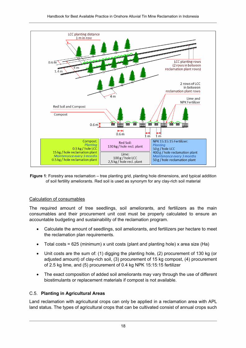
Figure 1: Forestry area reclamation – tree planting grid, planting hole dimensions, and typical addition
of soil fertility ameliorants. Red soil is used as synonym for any clay-rich soil material
Calculation of consumables
The required amount of tree seedlings, soil ameliorants, and fertilizers as the main
consumables and their procurement unit cost must be properly calculated to ensure an
accountable budgeting and sustainability of the reclamation program.
Calculate the amount of seedlings, soil ameliorants, and fertilizers per hectare to meet
the reclamation plan requirements.
Total costs = 625 (minimum) x unit costs (plant and planting hole) x area size (Ha)
Unit costs are the sum of: (1) digging the planting hole, (2) procurement of 130 kg (or
adjusted amount) of clay-rich soil, (3) procurement of 15 kg compost, (4) procurement
of 2.5 kg lime, and (5) procurement of 0.4 kg NPK 15:15:15 fertilizer
The exact composition of added soil ameliorants may vary through the use of different
biostimulants or replacement materials if compost is not available.
C.5. Planting in Agricultural Areas
Land reclamation with agricultural crops can only be applied in a reclamation area with APL
land status. The types of agricultural crops that can be cultivated consist of annual crops such
Handbook for Best Available Practice in Onshore Alluvial Tin Mine Reclamation in Indonesia
19
as mango, water guava, etc. and horticultural crops such as tomatoes, chili pepper, eggplant,
etc. Perennial crops / trees such as sengon (Paraserianthes falcataria) and rubber (Hevea
brassiliensis) are also permissible. In some situations, it may be a good approach to mix certain
agricultural crops with forest trees in a combined planting grid. This approach may have
advantages in terms of erosion stability and soil fertility. When considering a mixed planting
approach in an APL area, refer to the previous chapter on forest tree cultivation in combination
with the planting procedures described below.
Planting grids and planting procedures
At a reclamation area with APL status, implement the following activities:
In general, can the local community organization be included in providing materials or
services for composting and soil improvement?
For perennial crops:
Prepare planting grid at 4 m x 4 m distance for Sengon to get 625 plant population or
at 3 m x 6 m distance for rubber to get 556 plant population.
Prepare planting hole with dimension of 0.6 m x 0.6 m x 0.6 m. Place the dug soil at
one side of the hole at soil surface.
Mix biomass of pre-harvested legume cover crops with the dug soil.
A week later, do amelioration with (1) clay-rich soil at dose of 130 kg/hole to increase
10% clay content of the media with assumption that clay-rich soil used contains 30%
clay, (2) compost at dose of minimum 15 kg/hole to increase soil organic matter content
to 5%, (3) lime at dose of 1.5 ton/ Ha or about 2.5 kg/hole to alleviate aluminum toxicity
and increase soil pH to about 6.5, and (4) NPK 15:15:15 fertilizer at dose of 400 g/hole
to fulfil the macro nutrients requirement of the plant. Then, mix them with the mixture
of cover crop biomass and dug soils and put into the planting hole.
A week later proceed to transplant the seedlings with precaution not to disturb the roots
when opening polybags.
For annual crops (mango, guava, etc.):
Prepare adequate planting grid, e.g. at 10 m x 10 m distance to get 100 plant
population.
Prepare planting hole with dimension of 0.6 m x 0.6 m x 0.6 m. Place the dug soil at
one side of the hole at soil surface.
Mix the biomass of pre-harvested legume cover crops with the dug soil.
A week later, do amelioration with (1) clay-rich soil at dose of 130 kg/hole to increase
10% clay content of the soil media with assumption that red soil used contain 30% clay,
(2) compost at dose of minimum 15 kg/hole to increase soil organic matter content to
5%, (3) lime at dose of 1.5 ton/ Ha or about 2.5 kg/hole to alleviate aluminum toxicity
and increase soil pH to about 6.5, and (4) NPK 15:15:15 fertilizer at dose of 400 g/hole
to fulfil the macro nutrients requirement of the plant. Then, mix them with the mixture
of cover crop biomass and dug soils and then put into the planting hole.
Handbook for Best Available Practice in Onshore Alluvial Tin Mine Reclamation in Indonesia
20
A week later proceed to transplant the seedlings with precaution not to disturb the roots
when opening polybags.
Figure 2: APL area reclamation – planting grid, planting hole dimensions, and typical addition of soil
fertility ameliorants for annual plants. Red soil is used as synonym for any clay-rich soil material
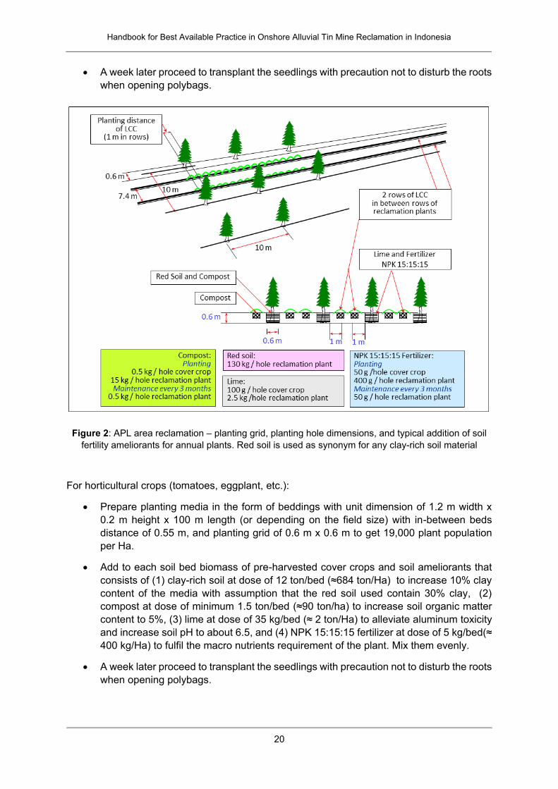
For horticultural crops (tomatoes, eggplant, etc.):
Prepare planting media in the form of beddings with unit dimension of 1.2 m width x
0.2 m height x 100 m length (or depending on the field size) with in-between beds
distance of 0.55 m, and planting grid of 0.6 m x 0.6 m to get 19,000 plant population
per Ha.
Add to each soil bed biomass of pre-harvested cover crops and soil ameliorants that
consists of (1) clay-rich soil at dose of 12 ton/bed (≈684 ton/Ha) to increase 10% clay
content of the media with assumption that the red soil used contain 30% clay, (2)
compost at dose of minimum 1.5 ton/bed (≈90 ton/ha) to increase soil organic matter
content to 5%, (3) lime at dose of 35 kg/bed (≈ 2 ton/Ha) to alleviate aluminum toxicity
and increase soil pH to about 6.5, and (4) NPK 15:15:15 fertilizer at dose of 5 kg/bed(≈
400 kg/Ha) to fulfil the macro nutrients requirement of the plant. Mix them evenly.
A week later proceed to transplant the seedlings with precaution not to disturb the roots
when opening polybags.
Handbook for Best Available Practice in Onshore Alluvial Tin Mine Reclamation in Indonesia
21
Figure 3: APL area reclamation – planting grid, planting hole dimensions, and typical addition of soil
fertility ameliorants for horticultural crops
Calculation of consumables
Calculate the amount of seedlings, soil ameliorants, and fertilizers to fulfil the
requirement for y Ha land.
For perennial crops – rubber is as follows:
Total costs = 556 x unit costs x area size (Ha)
Unit costs are the sum of: (1) digging the planting hole, (2) procurement of 130 kg (or
adjusted amount) of clay-rich soil, (3) procurement of 15 kg compost, (4) procurement
of 2.5 kg lime, and (5) procurement of 0.4 kg NPK 15:15:15 fertilizer
For annual crops
Total costs = 100 x unit costs x area size (Ha)
Unit costs are the sum of: (1) digging the planting hole, (2) procurement of 130 kg (or
adjusted amount) of clay-rich soil, (3) procurement of 15 kg compost, (4) procurement
of 2.5 kg lime, and (5) procurement of 0.4 kg NPK 15:15:15 fertilizer
For horticultural crops
Total costs = 57 beds x unit costs x area size (Ha)
Unit costs are the sum of: (1) constructing 57 planting beds, (2) procurement of 12 ton
(or adjusted amount) of clay-rich soil, (3) procurement of 1.5 ton compost, (4)
procurement of 35 kg lime, and (5) procurement of 5 kg NPK 15:15:15 fertilizer
Note that the exact composition of added soil ameliorants may vary through the use of different
bio-stimulants or replacement materials if compost is not available.
Handbook for Best Available Practice in Onshore Alluvial Tin Mine Reclamation in Indonesia
22
D. Nursery Operation and Compost Production
The capacity of local suppliers to provide plant seedlings and compost as well as composting
raw materials is often limited compared to the demand for reclamation. Purchasing these
materials from far away will increase their costs or they may not be available at all. Therefore,
particularly for reclamation areas with a size of ≥10 ha, it may be useful to construct a nursery
or composting facilities to support longer term sustainability of the reclamation program with
an agricultural or horticultural component.
Note that on-site production of compost or seedlings in new facilities may not be sufficient in
order to meet all the needs (required amounts) of the reclamation process. However, these
materials can also make a partial contribution to the reclamation process, either immediately,
during the subsequent maintenance period, or in the long term according to the established
community business model for the area.
The effectiveness of support infrastructure can be improved if production of the materials starts
in advance of the start of the reclamation process. This is possible, for example, in case of a
progressive reclamation process over a longer time period. The facilities may produce compost
that can be added to the site every year, allowing it to progressively expand its agricultural or
horticultural part through time.
The success of on-site production of compost or seedlings depends on the economic feasibility
and the community business model to operate such facilities. It is preferably done in cases
where self-sustaining area maintenance is less expensive than buying compost, plant
seedlings and other materials from local suppliers. If possible, the local community shall
progressively take responsibility to operate the nursery and compost management. This may
require building their capacities in this regard and concluding a formal agreement.
Construct nursery, warehouse, and/or on-site composting facilities in cases where this
is useful and economically feasible. Consider the size and expected production rates
(compost, seedlings etc.) of such facilities as required.
Grow plants, e.g. leguminous cover crops, which can be used as raw material for
compost production
Grow seedlings and prepare compost in advance of the next planting season
Are local community organizations able to support the construction of buildings or roads
by providing building materials such as bricks or cement? Can the community be
involved in construction activities by providing manpower or acting as a subcontractor?
Is there any long-term business model by the local community (e.g., BUMDES,
cooperative or local farmers) that would involve operation of composting facilities or
nurseries?
D.1. Nursery House Operation
For construction of a nursery house for tree seedlings, consider the amount of seeds required
for the area at a given time. Consider that 1 m² in a nursery facility may host about 25 seedlings
as described below. Assuming reclamation of 1 ha area with 625 trees may require growing
about 800 seedlings (assuming 80% viability of trees and associated replanting needs) implies
that a nursery facility of about 30 m² size would be necessary. In order to manage reclamation
Handbook for Best Available Practice in Onshore Alluvial Tin Mine Reclamation in Indonesia
23
of larger areas, it may therefore be beneficial to implement the process progressively over a
longer time period of multiple planting seasons.
The quality of media significantly determines the quality of seedlings which, in turn, will
determine the success and sustainability of the planting program. Therefore, the seedling
media must be prepared properly.
Prepare seedling media that consist of top soil and compost mixture of 1:1 ratio in
seedling trays. The compost quality requirement is of C/N ratio of 10-20. Add water a
little bit higher than field capacity water content condition (until water drops at the
bottom of tray due to gravitation).
Sow seeds of cover crops or reclamation plants or crops in seedling tray and cover it
with humid paper until the seeds are propagated. Then, after 1-2 weeks, transplant the
young seedlings into polybags containing 1 kg media of the same composition, place
at nursery benches, and take care properly by watering regularly (2 times a week or as
required) using sprinkler irrigation system for 1-3 months.
During the period of maintenance in the nursery facility for 1-3 months, the seedlings
have to be taking care of properly, particularly in terms of watering, to maintain water
content of the media at field capacity level to prevent drought. Protect seedlings from
the sun using a para-net cover at about 1 m above the seedling bench.
D.2. Compost Production
Compost is one of the main ameliorants that should be available and used as a component of
seedling and reclamation plant growth media. It is a source of several nutrients essential for
plant growth as well as of soil organic matter which provides prominent roles and functions in
improving the physical, chemical, and biological qualities of the infertile soils commonly found
in ex tin mining land. The quality of compost is determined by its content ratio of Carbon (C)
and Nitrogen (N). The quality requirement of a compost for soil improvement purposes in the
case of land reclamation is of C/N ratio of 10-20. For practical determination, mature compost
can be identified by its color (dark brown or black), structure (crumb), odor (odorless) and
weight (light-weight).
Procure compost from the local suppliers, if available, in order to stimulate the local
economy and avoid high transportation costs.
If no sufficient amounts are available, consider building the capacities of local farmers
etc. to act as compost suppliers. If local farmers receive capacity building very early on
in the reclamation process, they may be able to supply compost at a later stage.
Due to high application dose requirements and the limited amount of compost that can often
be provided by local suppliers, it may be useful to produce compost on-site in the reclamation
area, particularly for areas with a size of >10 Ha. This requires local availability of organic
material at the site which can be used to produce compost, e.g. from pre-greening activities.
While compost is the most effective growth medium for plants, it may not be available in
sufficient amounts. In these cases, organic biomass can be added to the soil without
composting; this will still improve soil fertility by increasing soil organic matter content. Raw
materials that can be used as an alternative to compost include an appropriate mixture of plant
biomass residues (e.g., from traditional markets or local gardens), poultry and cattle manure,

Handbook for Best Available Practice in Onshore Alluvial Tin Mine Reclamation in Indonesia
24
rice husks and rice husk ash obtained from rice mills, midrib and empty bunches of oil palm or
biochar from palm oil production, solid waste of drinking water treatment, etc.
► See Chapter III.E for information on composting procedures
E. Maintenance and Monitoring
Maintenance over a sufficient time period is a critical process to ensure the sustainability of
reclamation. Maintenance should not only consider maintenance of the plants but also
maintenance of the established infrastructure, such as roads, erosion and sedimentation
control infrastructure, or irrigation pipes. These elements should be regularly controlled
through monitoring and repaired, if necessary. Monitoring of plant health is equally important
in order to identify problems early and adjust maintenance procedures in order to minimize
damage.
General considerations for good maintenance and monitoring include:
Involve the local community in maintenance and monitoring activities in order to ensure
common understanding of problems and performance expectations. If possible,
support development of local community organizations and their business models to
be involved in maintenance and post-mining activities.
To prevent the possibility that reclamation was not implemented properly and this only
becomes visible several years later, the maintenance and monitoring activities should
be carried out properly from the seedling transplantation day until the plant age of at
least 3 years. A longer-term perspective of maintenance and monitoring activities is
preferable for ensuring sustainability of the reclamation program.
The reclamation itself should be improved by performing corrective actions immediately
once a problem is encountered, without waiting for the planned schedule or after the
reclamation process has been completed. Therefore, monitoring of risks or problems
related to plant growth, land stability, and environmental condition should be carried
out properly and immediate corrective actions should be applied. For instance,
managing the symptoms of plant disorders are of priority and the most important
corrective actions; replacing dead plants should only be considered as a last effort.
An important motivation for performing adequate maintenance and monitoring is to
prevent and protect the reclamation lands from re-mining or informal mining activity.
The local community should be engaged to play a role as custodian of the land.
► See Chapter III.F for maintenance and monitoring procedures and targets
E.1. Maintenance Procedures
Irrigation
Irrigation of the reclamation area in the rainy season is just necessary during periods of
insufficient soil water content. In normal days during the rainy season, irrigation is not required.
Irrigation during the dry season is usually necessary for most plants, especially for young plants
The average annual rainfall intensity in Bangka Belitung Island is high, amounting to
2454-3218 mm/year or 205-268 mm/month, but its monthly distribution is quite different among
districts. Do regular irrigation in case of hot days with very high evapotranspiration when the
Handbook for Best Available Practice in Onshore Alluvial Tin Mine Reclamation in Indonesia
25
soil has insufficient water content (typically two times per week). Note that different plants may
have different irrigation requirements; some plants may be adapted to dry conditions.
Fertilization
Fertilization is the addition of essential plant nutrients to the soil to fulfill the plant’s growth
requirements. The maintenance fertilization defined below only applies for forestry and
perennial trees. This activity is carried out at least 5 times, i.e. at the plants ages of 1 month,
3 months, 6 months, 1 year, and 2 years after transplanting to the field. After 2 years of good
care, the plants are big enough to grow sustainably as long as they can be protected from
serious attacks of pests and diseases. Fertilization for trees is carried out as follows:
Prepare grooves about 20-40 cm around the tree or shrub. Place NPK 15:15:15
fertilizer along the grooves at the recommended dose. Cover again with soil.
If some parts of the plant show symptoms of plant disorders due to nutrient deficiencies,
apply fertilization out of the planned schedule.
Plant protection
Plant protection is usually done by application of pesticides; it is intended to control pests and
diseases infection to the plant parts that can affect the roots, seedlings, leaf or stem. When
applying pesticides follow the instructions provided in the package of the pesticide (dose, mode
of application, frequency).
Apply organic farming techniques to reduce the use of pesticides. From an ecological
perspective, it may be an advantage to obtain good plant health using less pesticides. It is
recommended to do regular maintenance for this purpose as a preventive action which is better
than the curative one. It may be an advantage to cultivate several plant species, for instance
by including local species in the same field to reduce vulnerability to certain pests which can
easily affect monocultures.
Replanting
Replanting is replacing dead (or sick) plants with new healthy seedlings. Usually, 10-20% of
the seedlings may not grow well due to different reasons (e.g., bad seedling quality, plant
damage, insufficient soil water content, diseases etc.); these plants have to be replaced.
Replanting should be considered as the last action after the above described maintenance
procedure found failure to overcome the problem. The replanting procedure for trees is as
follows:
Check the reason why replacing the individual plant is necessary. Depending on this
evaluation, decide whether a new planting hole needs to be established or whether the
replacement plant can be introduced into the existing planting hole.
New planting holes may be required in case the previous plant died from certain
persistent pests or soil problems related to the specific planting hole (e.g., mistakes
made in the preparation of soil ameliorants added to the planting hole).
The replacement seedlings should be about 60 cm in height with a diameter of the root
neck of about 3 mm, with straight stems, not infected by pest and disease, or ideally
about the same age and size as the dead plant to be replaced.
The soil around the seedlings should be carefully re-compacted after planting.
Handbook for Best Available Practice in Onshore Alluvial Tin Mine Reclamation in Indonesia
26
E.2. Monitoring Procedures
Physical land stability
Regularly monitor for the presence of cracks, grooves, ditches or erosion gullies
throughout the reclamation area, particularly after heavy rains at sloping parts of the
land. Do corrective action immediately when such a problem is encountered. Consider
the safety impact of erosional features, such as landslide risks.
► See Chapter III.C for managing erosion risks
Quality of surface water and ground water
Perform sampling of wells water, river water, and former mine pit (kolong) water
regularly according to the applicable regulation.
Check the water quality in the field (for parameters such as water color, pH, and
turbidity) and other parameters listed in the appendix of Government Regulation No.
82/2001 in the reference laboratory.
► See Chapter III.D for details on water quality
Plant growth performance
Perform plant growth performance monitoring using sampling method at ages of 3, 6,
9, and 12 months.
Compare data of cover crops planting plan and realization with the observation or field
test results.
Measure reclamation plants’ height (cm), stem diameter (cm), crown width (cm), and
percentage of the healthy plant.
Calculate the percentage of plant growth per plot by comparing the number of living
plants in the field with the planned number of plants per Ha.
Categorize plant growth performance into 3 categories, i.e. healthy, less healthy, and
wilted plants. The percentage of healthy plants is calculated by dividing the number of
healthy plants with the total number of living plants.
► See Chapter III.F for details on performance monitoring targets
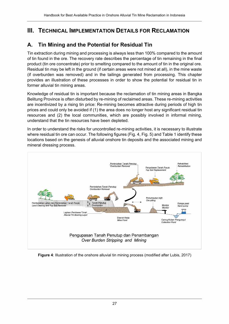
Handbook for Best Available Practice in Onshore Alluvial Tin Mine Reclamation in Indonesia
27
III. TECHNICAL IMPLEMENTATION DETAILS FOR RECLAMATION
A. Tin Mining and the Potential for Residual Tin
Tin extraction during mining and processing is always less than 100% compared to the amount
of tin found in the ore. The recovery rate describes the percentage of tin remaining in the final
product (tin ore concentrate) prior to smelting compared to the amount of tin in the original ore.
Residual tin may be left in the ground (if certain areas were not mined at all), in the mine waste
(if overburden was removed) and in the tailings generated from processing. This chapter
provides an illustration of these processes in order to show the potential for residual tin in
former alluvial tin mining areas.
Knowledge of residual tin is important because the reclamation of tin mining areas in Bangka
Belitung Province is often disturbed by re-mining of reclaimed areas. These re-mining activities
are incentivized by a rising tin price: Re-mining becomes attractive during periods of high tin
prices and could only be avoided if (1) the area does no longer host any significant residual tin
resources and (2) the local communities, which are possibly involved in informal mining,
understand that the tin resources have been depleted.
In order to understand the risks for uncontrolled re-mining activities, it is necessary to illustrate
where residual tin ore can occur. The following figures (Fig. 4, Fig. 5) and Table 1 identify these
locations based on the genesis of alluvial onshore tin deposits and the associated mining and
mineral dressing process.
Figure 4: Illustration of the onshore alluvial tin mining process (modified after Lubis, 2017)
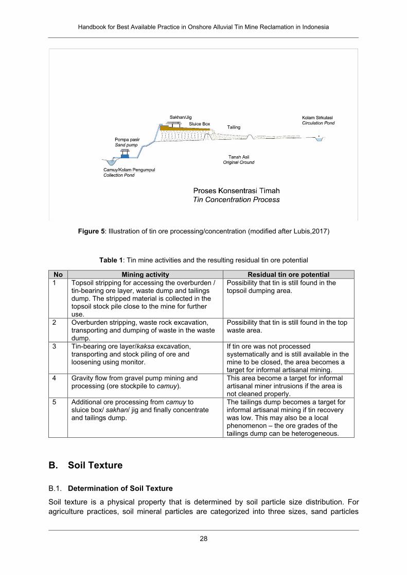
Handbook for Best Available Practice in Onshore Alluvial Tin Mine Reclamation in Indonesia
28
Figure 5: Illustration of tin ore processing/concentration (modified after Lubis,2017)
Table 1: Tin mine activities and the resulting residual tin ore potential
No Mining activity Residual tin ore potential
1 Topsoil stripping for accessing the overburden / tin-bearing ore layer, waste dump and tailings dump. The stripped material is collected in the topsoil stock pile close to the mine for further use.
Possibility that tin is still found in the topsoil dumping area.
2 Overburden stripping, waste rock excavation, transporting and dumping of waste in the waste dump.
Possibility that tin is still found in the top waste area.
3 Tin-bearing ore layer/kaksa excavation, transporting and stock piling of ore and loosening using monitor.
If tin ore was not processed systematically and is still available in the mine to be closed, the area becomes a target for informal artisanal mining.
4 Gravity flow from gravel pump mining and processing (ore stockpile to camuy).
This area become a target for informal artisanal miner intrusions if the area is not cleaned properly.
5 Additional ore processing from camuy to sluice box/ sakhan/ jig and finally concentrate and tailings dump.
The tailings dump becomes a target for informal artisanal mining if tin recovery was low. This may also be a local phenomenon – the ore grades of the tailings dump can be heterogeneous.
B. Soil Texture
B.1. Determination of Soil Texture
Soil texture is a physical property that is determined by soil particle size distribution. For
agriculture practices, soil mineral particles are categorized into three sizes, sand particles
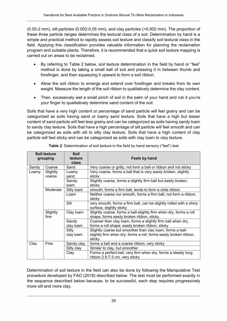
Handbook for Best Available Practice in Onshore Alluvial Tin Mine Reclamation in Indonesia
29
(0.05-2 mm), silt particles (0.002-0.05 mm), and clay particles (<0.002 mm). The proportion of
these three particle ranges determines the textural class of a soil. Determination by hand is a
simple and practical method to rapidly assess soil texture and classify soil textural class in the
field. Applying this classification provides valuable information for planning the reclamation
program and suitable plants. Therefore, it is recommended that a quick soil texture mapping is
carried out on areas to be reclaimed.
By referring to Table 2 below, soil texture determination in the field by hand or “feel”
method is done by taking a small ball of soil and pressing it in between thumb and
forefinger, and then squeezing it upward to form a soil ribbon.
Allow the soil ribbon to emerge and extend over forefinger and breaks from its own
weight. Measure the length of the soil ribbon to qualitatively determine the clay content.
Then, excessively wet a small pinch of soil in the palm of your hand and rub it you’re
your finger to qualitatively determine sand content of the soil.
Soils that have a very high content or percentage of sand particle will feel grainy and can be
categorized as soils having sand or loamy sand texture. Soils that have a high but lesser
content of sand particle will feel less grainy and can be categorized as soils having sandy loam
to sandy clay texture. Soils that have a high percentage of silt particle will feel smooth and can
be categorized as soils with silt to silty clay texture. Soils that have a high content of clay
particle will feel sticky and can be categorized as soils with clay loam to clay texture.
Table 2: Determination of soil texture in the field by hand sensory (“feel”) test
Soil texture grouping
Soil texture class
Feels by hand
Sandy Coarse Sand Very coarse or gritty, not form a ball or ribbon and not sticky
Loamy Slightly coarse
Loamy sand
Very coarse, forms a ball that is very easily broken, slightly sticky
Sandy loam
Slightly coarse, forms a slightly firm ball but easily broken, sticky
Moderate Silty loam smooth, forms a firm ball, tends to form a clots ribbon
Loam Neither coarse nor smooth, forms a firm ball, not form a ribbon, sticky
Silt very smooth, forms a firm ball, can be slightly rolled with a shiny surface, slightly sticky
Slightly fine
Clay loam Slightly coarse, forms a ball-slightly firm when dry, forms a roll shape, forms easily broken ribbon, sticky
Sandy clay loam
Coarser than clay loam, forms a slightly firm ball when dry, forms a roll shape, easily broken ribbon, sticky
Silty clay loam
Slightly coarse but smoother than clay loam, forms a ball-slightly firm when dry, forms a roll, forms easily broken ribbon, sticky
Clay Fine Sandy clay forms a ball and a coarse ribbon, very sticky
Silty clay Similar to clay, but smoother
Clay Forms a perfect ball, very firm when dry, forms a steady long ribbon 2.5-7.5 cm, very sticky
Determination of soil texture in the field can also be done by following the Manipulative Test
procedure developed by FAO (2018) described below. The test must be performed exactly in
the sequence described below because, to be successful, each step requires progressively
more silt and more clay.
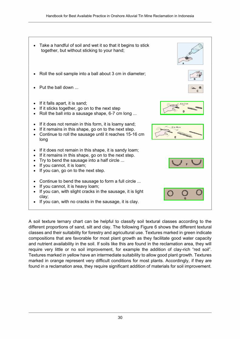
Handbook for Best Available Practice in Onshore Alluvial Tin Mine Reclamation in Indonesia
30
Take a handful of soil and wet it so that it begins to stick together, but without sticking to your hand;
Roll the soil sample into a ball about 3 cm in diameter;
Put the ball down ...
If it falls apart, it is sand; If it sticks together, go on to the next step Roll the ball into a sausage shape, 6-7 cm long ...
If it does not remain in this form, it is loamy sand; If it remains in this shape, go on to the next step. Continue to roll the sausage until it reaches 15-16 cm
long
If it does not remain in this shape, it is sandy loam; If it remains in this shape, go on to the next step. Try to bend the sausage into a half circle ... If you cannot, it is loam; If you can, go on to the next step.
Continue to bend the sausage to form a full circle ... If you cannot, it is heavy loam; If you can, with slight cracks in the sausage, it is light
clay; If you can, with no cracks in the sausage, it is clay.
A soil texture ternary chart can be helpful to classify soil textural classes according to the
different proportions of sand, silt and clay. The following Figure 6 shows the different textural
classes and their suitability for forestry and agricultural use. Textures marked in green indicate
compositions that are favorable for most plant growth as they facilitate good water capacity
and nutrient availability in the soil. If soils like this are found in the reclamation area, they will
require very little or no soil improvement, for example the addition of clay-rich “red soil”.
Textures marked in yellow have an intermediate suitability to allow good plant growth. Textures
marked in orange represent very difficult conditions for most plants. Accordingly, if they are
found in a reclamation area, they require significant addition of materials for soil improvement.
Handbook for Best Available Practice in Onshore Alluvial Tin Mine Reclamation in Indonesia
31
Figure 6: Ternary plot for classification of soil textures (based on US Department of Agriculture).
Green, yellow and orange colors indicate high, intermediate, and low suitability of soil texture for
optimized growth of typical reclamation plants.
Most soils found in ex-mining areas in Bangka and Belitung islands represent mine tailings
with a texture of either sand or loamy sand as indicated in the following Figure 7. If significant
clay-rich soil (e.g., “red soil”) is added to and mixed with these substrates, their textural
composition can be changed towards a more beneficial texture for plant growth. It is not
possible to facilitate this textural change at a large scale; therefore soil improvement is focused
on selective areas such as plant holes and/or the top horizon of the soil surface.
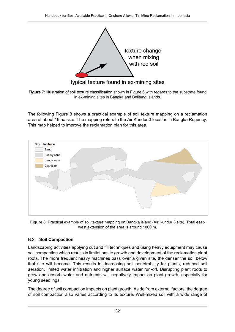
Handbook for Best Available Practice in Onshore Alluvial Tin Mine Reclamation in Indonesia
32
Figure 7: Illustration of soil texture classification shown in Figure 6 with regards to the substrate found
in ex-mining sites in Bangka and Belitung islands.
The following Figure 8 shows a practical example of soil texture mapping on a reclamation
area of about 19 ha size. The mapping refers to the Air Kundur 3 location in Bangka Regency.
This map helped to improve the reclamation plan for this area.
Figure 8: Practical example of soil texture mapping on Bangka island (Air Kundur 3 site). Total east-
west extension of the area is around 1000 m.
B.2. Soil Compaction
Landscaping activities applying cut and fill techniques and using heavy equipment may cause
soil compaction which results in limitations to growth and development of the reclamation plant
roots. The more frequent heavy machines pass over a given site, the denser the soil below
that site will become. This results in decreasing soil penetrability for plants, reduced soil
aeration, limited water infiltration and higher surface water run-off. Disrupting plant roots to
grow and absorb water and nutrients will negatively impact on plant growth, especially for
young seedlings.
The degree of soil compaction impacts on plant growth. Aside from external factors, the degree
of soil compaction also varies according to its texture. Well-mixed soil with a wide range of
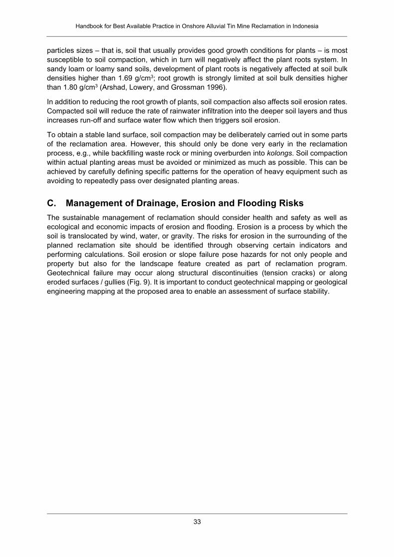
Handbook for Best Available Practice in Onshore Alluvial Tin Mine Reclamation in Indonesia
33
particles sizes – that is, soil that usually provides good growth conditions for plants – is most
susceptible to soil compaction, which in turn will negatively affect the plant roots system. In
sandy loam or loamy sand soils, development of plant roots is negatively affected at soil bulk
densities higher than 1.69 g/cm3; root growth is strongly limited at soil bulk densities higher
than 1.80 g/cm3 (Arshad, Lowery, and Grossman 1996).
In addition to reducing the root growth of plants, soil compaction also affects soil erosion rates.
Compacted soil will reduce the rate of rainwater infiltration into the deeper soil layers and thus
increases run-off and surface water flow which then triggers soil erosion.
To obtain a stable land surface, soil compaction may be deliberately carried out in some parts
of the reclamation area. However, this should only be done very early in the reclamation
process, e.g., while backfilling waste rock or mining overburden into kolongs. Soil compaction
within actual planting areas must be avoided or minimized as much as possible. This can be
achieved by carefully defining specific patterns for the operation of heavy equipment such as
avoiding to repeatedly pass over designated planting areas.
C. Management of Drainage, Erosion and Flooding Risks
The sustainable management of reclamation should consider health and safety as well as
ecological and economic impacts of erosion and flooding. Erosion is a process by which the
soil is translocated by wind, water, or gravity. The risks for erosion in the surrounding of the
planned reclamation site should be identified through observing certain indicators and
performing calculations. Soil erosion or slope failure pose hazards for not only people and
property but also for the landscape feature created as part of reclamation program.
Geotechnical failure may occur along structural discontinuities (tension cracks) or along
eroded surfaces / gullies (Fig. 9). It is important to conduct geotechnical mapping or geological
engineering mapping at the proposed area to enable an assessment of surface stability.
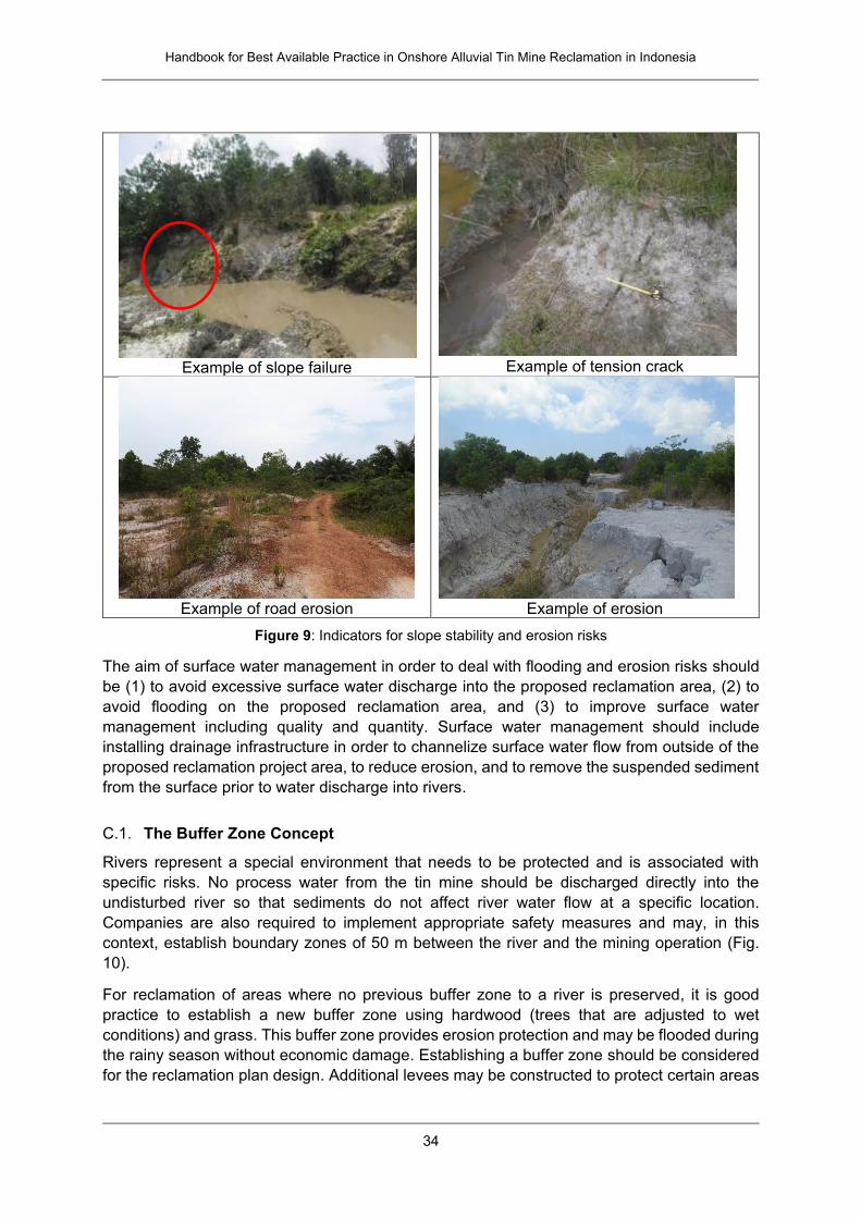
Handbook for Best Available Practice in Onshore Alluvial Tin Mine Reclamation in Indonesia
34
Example of slope failure
Example of tension crack
Example of road erosion
Example of erosion
Figure 9: Indicators for slope stability and erosion risks
The aim of surface water management in order to deal with flooding and erosion risks should
be (1) to avoid excessive surface water discharge into the proposed reclamation area, (2) to
avoid flooding on the proposed reclamation area, and (3) to improve surface water
management including quality and quantity. Surface water management should include
installing drainage infrastructure in order to channelize surface water flow from outside of the
proposed reclamation project area, to reduce erosion, and to remove the suspended sediment
from the surface prior to water discharge into rivers.
C.1. The Buffer Zone Concept
Rivers represent a special environment that needs to be protected and is associated with
specific risks. No process water from the tin mine should be discharged directly into the
undisturbed river so that sediments do not affect river water flow at a specific location.
Companies are also required to implement appropriate safety measures and may, in this
context, establish boundary zones of 50 m between the river and the mining operation (Fig.
10).
For reclamation of areas where no previous buffer zone to a river is preserved, it is good
practice to establish a new buffer zone using hardwood (trees that are adjusted to wet
conditions) and grass. This buffer zone provides erosion protection and may be flooded during
the rainy season without economic damage. Establishing a buffer zone should be considered
for the reclamation plan design. Additional levees may be constructed to protect certain areas
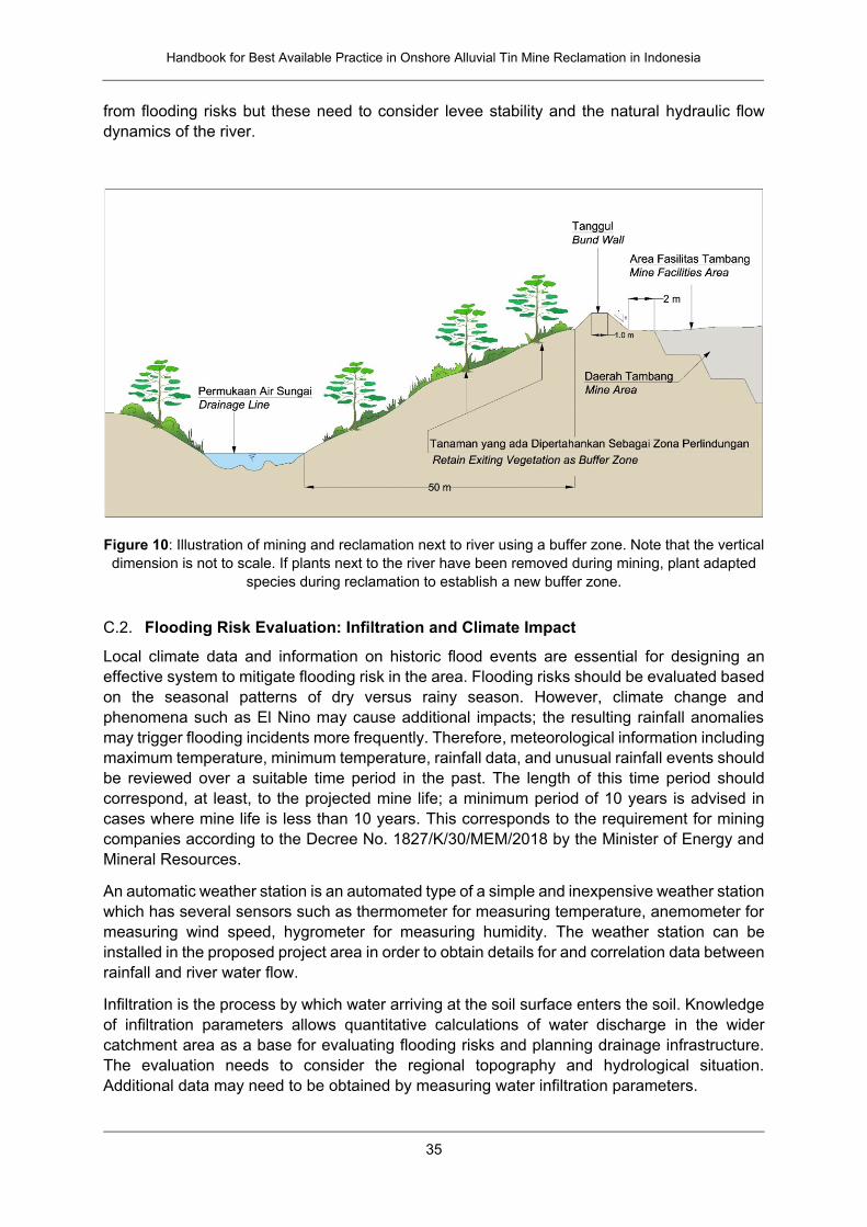
Handbook for Best Available Practice in Onshore Alluvial Tin Mine Reclamation in Indonesia
35
from flooding risks but these need to consider levee stability and the natural hydraulic flow
dynamics of the river.
Figure 10: Illustration of mining and reclamation next to river using a buffer zone. Note that the vertical
dimension is not to scale. If plants next to the river have been removed during mining, plant adapted
species during reclamation to establish a new buffer zone.
C.2. Flooding Risk Evaluation: Infiltration and Climate Impact
Local climate data and information on historic flood events are essential for designing an
effective system to mitigate flooding risk in the area. Flooding risks should be evaluated based
on the seasonal patterns of dry versus rainy season. However, climate change and
phenomena such as El Nino may cause additional impacts; the resulting rainfall anomalies
may trigger flooding incidents more frequently. Therefore, meteorological information including
maximum temperature, minimum temperature, rainfall data, and unusual rainfall events should
be reviewed over a suitable time period in the past. The length of this time period should
correspond, at least, to the projected mine life; a minimum period of 10 years is advised in
cases where mine life is less than 10 years. This corresponds to the requirement for mining
companies according to the Decree No. 1827/K/30/MEM/2018 by the Minister of Energy and
Mineral Resources.
An automatic weather station is an automated type of a simple and inexpensive weather station
which has several sensors such as thermometer for measuring temperature, anemometer for
measuring wind speed, hygrometer for measuring humidity. The weather station can be
installed in the proposed project area in order to obtain details for and correlation data between
rainfall and river water flow.
Infiltration is the process by which water arriving at the soil surface enters the soil. Knowledge
of infiltration parameters allows quantitative calculations of water discharge in the wider
catchment area as a base for evaluating flooding risks and planning drainage infrastructure.
The evaluation needs to consider the regional topography and hydrological situation.
Additional data may need to be obtained by measuring water infiltration parameters.
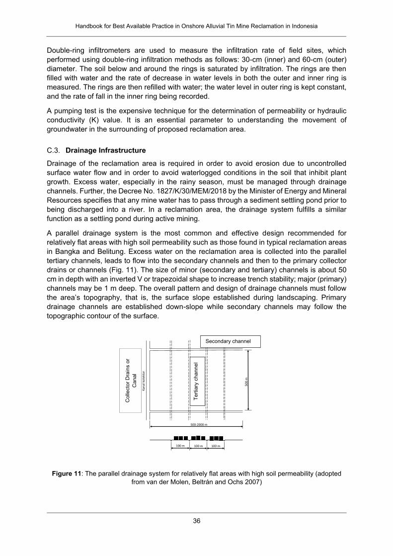
Handbook for Best Available Practice in Onshore Alluvial Tin Mine Reclamation in Indonesia
36
Double-ring infiltrometers are used to measure the infiltration rate of field sites, which
performed using double-ring infiltration methods as follows: 30-cm (inner) and 60-cm (outer)
diameter. The soil below and around the rings is saturated by infiltration. The rings are then
filled with water and the rate of decrease in water levels in both the outer and inner ring is
measured. The rings are then refilled with water; the water level in outer ring is kept constant,
and the rate of fall in the inner ring being recorded.
A pumping test is the expensive technique for the determination of permeability or hydraulic
conductivity (K) value. It is an essential parameter to understanding the movement of
groundwater in the surrounding of proposed reclamation area.
C.3. Drainage Infrastructure
Drainage of the reclamation area is required in order to avoid erosion due to uncontrolled
surface water flow and in order to avoid waterlogged conditions in the soil that inhibit plant
growth. Excess water, especially in the rainy season, must be managed through drainage
channels. Further, the Decree No. 1827/K/30/MEM/2018 by the Minister of Energy and Mineral
Resources specifies that any mine water has to pass through a sediment settling pond prior to
being discharged into a river. In a reclamation area, the drainage system fulfills a similar
function as a settling pond during active mining.
A parallel drainage system is the most common and effective design recommended for
relatively flat areas with high soil permeability such as those found in typical reclamation areas
in Bangka and Belitung. Excess water on the reclamation area is collected into the parallel
tertiary channels, leads to flow into the secondary channels and then to the primary collector
drains or channels (Fig. 11). The size of minor (secondary and tertiary) channels is about 50
cm in depth with an inverted V or trapezoidal shape to increase trench stability; major (primary)
channels may be 1 m deep. The overall pattern and design of drainage channels must follow
the area’s topography, that is, the surface slope established during landscaping. Primary
drainage channels are established down-slope while secondary channels may follow the
topographic contour of the surface.
Figure 11: The parallel drainage system for relatively flat areas with high soil permeability (adopted
from van der Molen, Beltrán and Ochs 2007)
500-2000 m
50
0 m
100 m 100 m 100 m
Kan
alko
lekt
or
Parit sekunder
Par
it t
ers
ier
Secondary channel
Tert
iary
channel
Colle
cto
r D
rain
s o
r
Canal
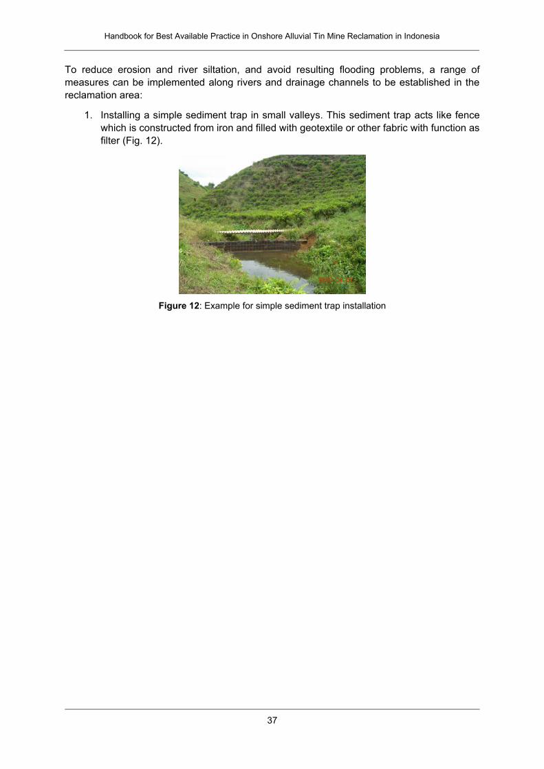
Handbook for Best Available Practice in Onshore Alluvial Tin Mine Reclamation in Indonesia
37
To reduce erosion and river siltation, and avoid resulting flooding problems, a range of
measures can be implemented along rivers and drainage channels to be established in the
reclamation area:
1. Installing a simple sediment trap in small valleys. This sediment trap acts like fence
which is constructed from iron and filled with geotextile or other fabric with function as
filter (Fig. 12).
Figure 12: Example for simple sediment trap installation
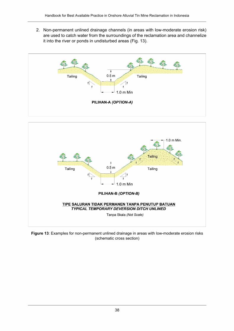
Handbook for Best Available Practice in Onshore Alluvial Tin Mine Reclamation in Indonesia
38
2. Non-permanent unlined drainage channels (in areas with low-moderate erosion risk)
are used to catch water from the surroundings of the reclamation area and channelize
it into the river or ponds in undisturbed areas (Fig. 13).
Figure 13: Examples for non-permanent unlined drainage in areas with low-moderate erosion risks
(schematic cross section)
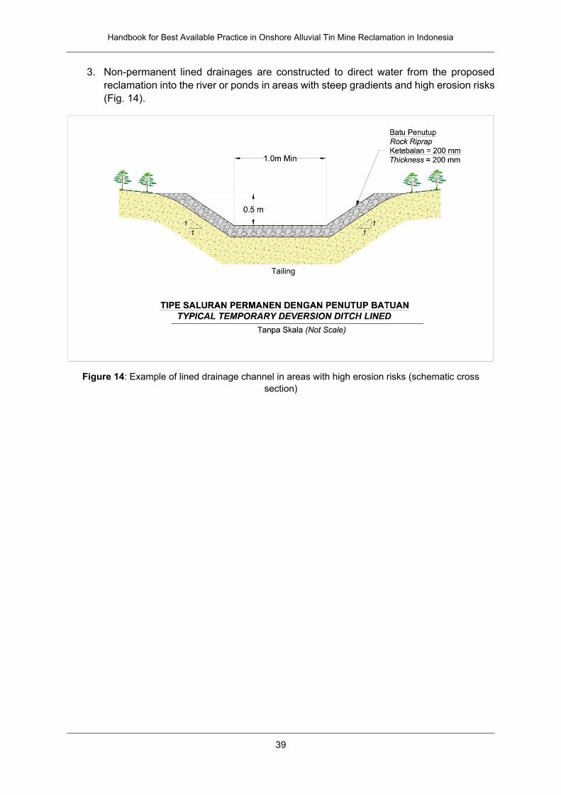
Handbook for Best Available Practice in Onshore Alluvial Tin Mine Reclamation in Indonesia
39
3. Non-permanent lined drainages are constructed to direct water from the proposed
reclamation into the river or ponds in areas with steep gradients and high erosion risks
(Fig. 14).
Figure 14: Example of lined drainage channel in areas with high erosion risks (schematic cross
section)
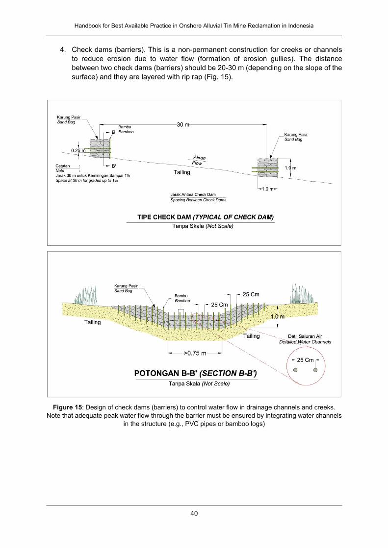
Handbook for Best Available Practice in Onshore Alluvial Tin Mine Reclamation in Indonesia
40
4. Check dams (barriers). This is a non-permanent construction for creeks or channels
to reduce erosion due to water flow (formation of erosion gullies). The distance
between two check dams (barriers) should be 20-30 m (depending on the slope of the
surface) and they are layered with rip rap (Fig. 15).
Figure 15: Design of check dams (barriers) to control water flow in drainage channels and creeks.
Note that adequate peak water flow through the barrier must be ensured by integrating water channels
in the structure (e.g., PVC pipes or bamboo logs)
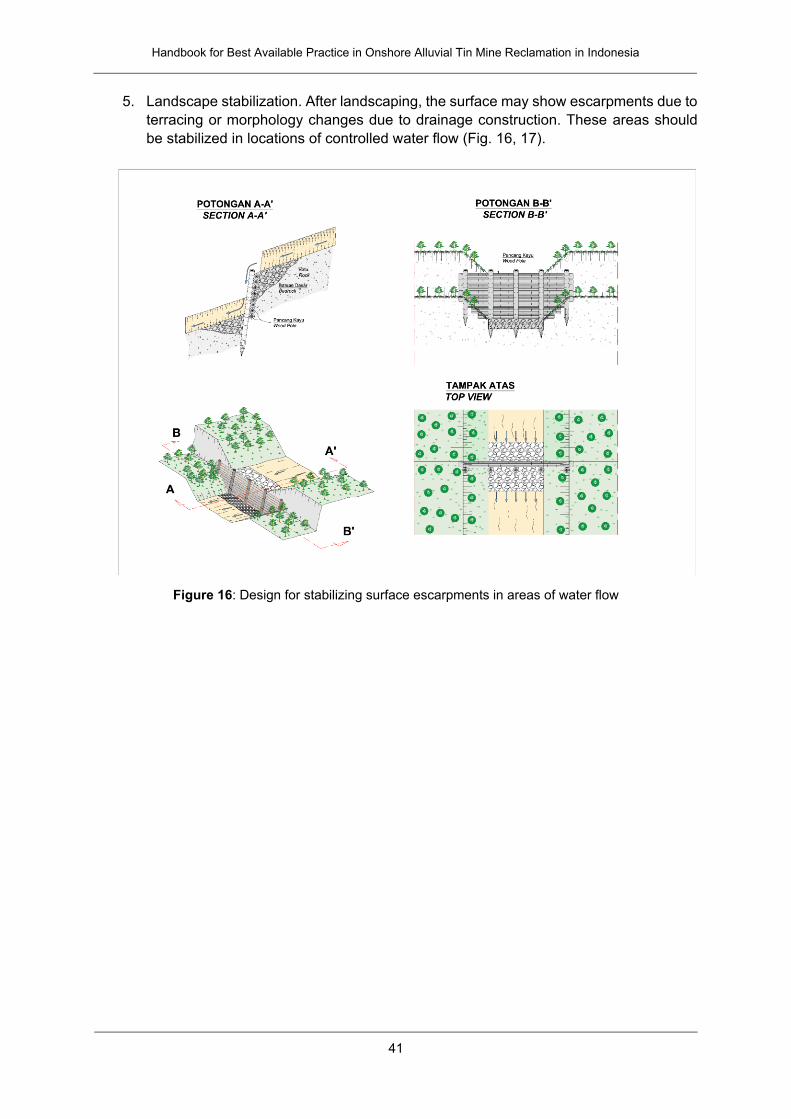
Handbook for Best Available Practice in Onshore Alluvial Tin Mine Reclamation in Indonesia
41
5. Landscape stabilization. After landscaping, the surface may show escarpments due to
terracing or morphology changes due to drainage construction. These areas should
be stabilized in locations of controlled water flow (Fig. 16, 17).
Figure 16: Design for stabilizing surface escarpments in areas of water flow
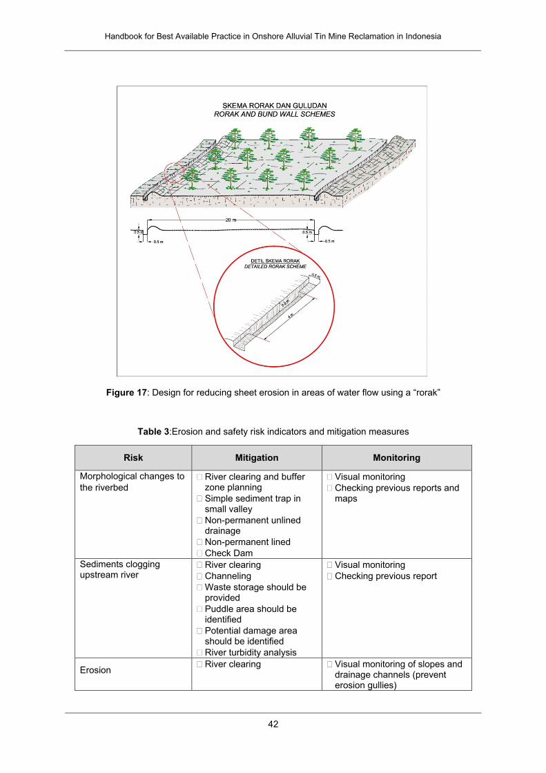
Handbook for Best Available Practice in Onshore Alluvial Tin Mine Reclamation in Indonesia
42
Figure 17: Design for reducing sheet erosion in areas of water flow using a “rorak”
Table 3:Erosion and safety risk indicators and mitigation measures
Risk Mitigation Monitoring
Morphological changes to
the riverbed
River clearing and buffer zone planning
Simple sediment trap in small valley
Non-permanent unlined drainage
Non-permanent lined
Check Dam
Visual monitoring
Checking previous reports and maps
Sediments clogging upstream river
River clearing
Channeling
Waste storage should be provided
Puddle area should be identified
Potential damage area should be identified
River turbidity analysis
Visual monitoring
Checking previous report
Erosion River clearing Visual monitoring of slopes and
drainage channels (prevent erosion gullies)

Handbook for Best Available Practice in Onshore Alluvial Tin Mine Reclamation in Indonesia
43
Channeling and drainage, maintain drainage infrastructure
Protect surface with plants, cover crops or para-nets
Checking previous report
Flooding Surface water management
Sediment control close to source
Protection upstream of the proposed reclamation project
Direct water from undisturbed area to the disturbed river by the past or present mining activities
Visual monitoring
Checking previous reports
Identification of unstable locations
Current river flow measurement
River fluctuation analysis (e.g. stream gauge)
All the structures must be monitored weekly or after heavy rainfall
Accumulated sediment must be removed to safe place which no erosion product entering the river
General safety Avoid steep slopes, deep
cuttings, and undercutting of slopes.
Building the buffer zone prior to mining
Tin mine activities cannot be allowed directly to the river, at least 5 m boundary must be constructed
Progressive reclamation must be applied for whole mine activities
Visual monitoring
Checking previous report
Water pollution Surface water treatment
Sediment control close to source
Protection upstream of the proposed reclamation project
Visual monitoring
Checking previous reports
Current water flow measurement
River fluctuation analysis (stream gauge)
Laboratory test of water quality
Accumulated sediment must be removed to safe place which no erosion product entering the river
Water quality can be influenced by organic material and impact on chemical processes
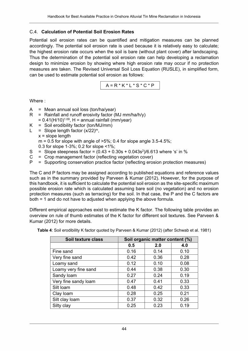
Handbook for Best Available Practice in Onshore Alluvial Tin Mine Reclamation in Indonesia
44
C.4. Calculation of Potential Soil Erosion Rates
Potential soil erosion rates can be quantified and mitigation measures can be planned
accordingly. The potential soil erosion rate is used because it is relatively easy to calculate;
the highest erosion rate occurs when the soil is bare (without plant cover) after landscaping.
Thus the determination of the potential soil erosion rate can help developing a reclamation
design to minimize erosion by showing where high erosion rate may occur if no protection
measures are taken. The Revised Universal Soil Loss Equation (RUSLE), in simplified form,
can be used to estimate potential soil erosion as follows:
A = R * K * L * S * C * P
Where :
A = Mean annual soil loss (ton/ha/year) R = Rainfall and runoff erosivity factor (MJ mm/ha/h/y)
= 0.41(H/10)1.09, H = annual rainfall (mm/year) K = Soil erodibility factor (ton/MJ/mm) L = Slope length factor (x/22)m,
x = slope length m = 0.5 for slope with angle of >5%; 0.4 for slope angle 3.5-4.5%; 0.3 for slope 1-3%; 0.2 for slope <1%;
S = Slope steepness factor = (0.43 + 0.30s + 0.043s2)/6.613 where ‘s’ in % C = Crop management factor (reflecting vegetation cover) P = Supporting conservation practice factor (reflecting erosion protection measures) The C and P factors may be assigned according to published equations and reference values such as in the summary provided by Parveen & Kumar (2012). However, for the purpose of this handbook, it is sufficient to calculate the potential soil erosion as the site-specific maximum possible erosion rate which is calculated assuming bare soil (no vegetation) and no erosion protection measures (such as terracing) for the soil. In that case, the P and the C factors are both = 1 and do not have to adjusted when applying the above formula. Different empirical approaches exist to estimate the K factor. The following table provides an
overview on rule of thumb estimates of the K factor for different soil textures. See Parveen &
Kumar (2012) for more details.
Table 4: Soil erodibility K factor quoted by Parveen & Kumar (2012) (after Schwab et al. 1981)
Soil texture class Soil organic matter content (%)
0.5 2.0 4.0
Fine sand 0.16 0.14 0.10
Very fine sand 0.42 0.36 0.28
Loamy sand 0.12 0.10 0.08
Loamy very fine sand 0.44 0.38 0.30
Sandy loam 0.27 0.24 0.19
Very fine sandy loam 0.47 0.41 0.33
Silt loam 0.48 0.42 0.33
Clay loam 0.28 0.25 0.21
Silt clay loam 0.37 0.32 0.26
Silty clay 0.25 0.23 0.19

Handbook for Best Available Practice in Onshore Alluvial Tin Mine Reclamation in Indonesia
45
C.5. Mine Pond (Kolong) Risks
Initial landscaping work at the reclamation site will seek to cover (backfill) open kolong mine
ponds and establish a certain manageable area topography. However, the amount of
effectively movable material will not always be sufficient to fill all existing kolongs. In addition,
it is possible that some kolongs can fulfill a reclamation function such as providing a water
reservoir for irrigation. Therefore, if necessary, the landscaping work in the area should
prioritize backfilling of small kolongs while larger kolongs may be left open. The number,
dimension, and location of the kolongs should be aligned with the data provided in the mine’s
feasibility study and in the associated environmental impact assessment.
The reclamation program for kolongs comprises: stabilization of the pit walls, securing of the
kolong perimeter, water treatment and water monitoring, and maintenance of the kolong
reclamation program. If a kolong pit cannot be covered by backfilling it is necessary to stabilize
it and to provide adequate health and safety. To this end, the walls of a kolong should be
protected against erosion and landslides by establishing cover vegetation and re-sloping of the
walls towards lower angles. The kolong walls should not be steeper than the natural angle of
repose of the excavated material. This angle will vary with different soil texture. A slope stability
analysis may be performed to assess the safe design of a kolong using numerical modeling to
gain safety factor information.
Abandoned mines with kolongs have different levels such that kolongs can be several meters
deep. In these cases, warning signs should be installed and slope angles should be managed.
Safety management for kolong walls should include warning signs and fences which may
include a “natural fence” through appropriate plants. Human activities such as swimming
should be prohibited in abandoned mine ponds and fishing can only be allowed for special
kolongs where the water quality was assessed and fishing forms part of the reclamation and
post-mining concept.
C.6. Maps and Baseline Reporting
Planning of mining, reclamation and general risk management requires preparation and
studying of adequate maps and baseline information. A map is defined as a representation on
a flat surface of a whole or part of an area. The basic map should consist of several basic
elements, such as map title, contour, scale information, coordinate projection, legend, north
direction (true north, magnetic north, grid north, declination), index map, map credit (source of
data, name of cartographer, date of the map).
Drafting and combining different map types will improve the planning data for the reclamation
project, such as geological maps, engineering geological maps, geomorphological maps,
detailed topographic maps, borehole location maps, geophysical survey maps, soil texture
maps, water sampling maps, hydrogeological maps, and potential hazard maps. The most
important map for planning is a proper topographic map. At the Geological Research and
Development Centre at Jl. Diponegoro 57 in Bandung, topographic and hydrogeological maps
can be bought. Other maps are produced by companies themselves based on investigations
in the field. It can be beneficial to find or refer to historical of topographic or geological map as
this may reveal information about past land use, erosion, and flooding. Old exploration and
mine planning maps may provide information on residual tin content of the site and risks for
intrusions by informal miners. Maps for land use planning are available through the
government.
Handbook for Best Available Practice in Onshore Alluvial Tin Mine Reclamation in Indonesia
46
An inspection of the available infrastructure and location of the site (remoteness) is necessary.
Access conditions to the proposed reclamation project must be identified, including distance
to infrastructure (e.g. roads, but also reclamation equipment and materials), access, ownership
and permit (road and bridge), and dimension of access condition. Public facilities should be
identified, such as electricity lines, base transceiver station towers, television transmitter
stations and other main facilities. The land utilization inside the mining permit (IUP) must be
identified, such as agriculture, informal mining, meadow, recreation, etc. The protected forest
must be identified in detail, including distance from the proposed area and boundaries.
D. Water Quality and Irrigation
D.1. Water Quality Standards
Water intended to be used for reclamation purposes such as plant watering, cattle or fish
farming is commonly stored in mine ponds (kolong). If necessary, a well may be dug in order
to access groundwater, based on a hydrological study. In order to use water for different
reclamation or post-mining purposes, the water quality needs to comply with governmental
regulations. The quality standard for waste water from tin mining activities is defined in
Regulation No. 04/2006 of the Minister of State of Environment. The classification of water
quality in general is stipulated as four classes according to Indonesian Government Regulation
No 82/2001 article 8:
Class One, water usable for standard water of drinking water and/or other designation
requiring the same quality of water as the usage.
Class Two, water usable for water recreation infrastructure/facility, hot-water fish
cultivation, animal husbandry, watering plants and/or other designation requiring the
same quality of water as the usage.
Class Three, water usable for breeding of hot-water fish, watering plants and other
designation requiring the same quality of water as the usage.
Class Four, water usable for watering plants and/or other designation requiring the
same quality of water as the usage.
Table 5: Water quality standards of Government Regulation No 82/2001
Parameter Unit Class
I II III IV
Temperature °C Deviation 3 Deviation 3 Deviation 3 Deviation 5
TDS (total dissolved solids)
mg/L 1000 1000 1000 2000
TSS (total suspended solids)
mg/L 50 50 400 400
pH 6-9 6-9 6-9 5-9
BOD mg/L 2 3 6 12
COD mg/L 10 25 50 100
DO mg/L 6 4 3 0
P-Total mg/L 0.2 0.2 1 5 N-NO3 mg/L 10 10 20 20 NH3-N mg/L 0.5 (-) (-) (-)
Arsenic mg/L 0.05 1 1 1
Cobalt mg/L 0.2 0.2 0.2 0.2
Handbook for Best Available Practice in Onshore Alluvial Tin Mine Reclamation in Indonesia
47
Parameter Unit Class
I II III IV
Barium mg/L 1 (-) (-) (-)
Boron mg/L 1 1 1 1
Selenium mg/L 0.01 0.05 0.05 0.05
Cadmium mg/L 0.01 0.01 0.01 0.01
Chromium (VI) mg/L 0.05 0.05 0.05 1
Copper mg/L 0.02 0.02 0.02 0.2
Iron mg/L 0.3 (-) (-) (-)
Lead mg/L 0.03 0.03 0.03 1
Manganese mg/L 0.1 (-) (-) (-)
Mercury mg/L 0.001 0.002 0.002 0.005
Zinc mg/L 0.05 0.05 0.05 2
Chloride mg/L 600 (-) (-) (-)
Cyanide mg/L 0.02 0.02 0.02 (-)
Fluoride mg/L 0.5 1.5 1.5 (-)
Nitrite mg/L 0.06 0.06 0.06 (-)
Sulfate mg/L 400 (-) (-) (-)
Free Chlorine mg/L 0.03 0.03 0.03 (-)
Sulphur mg/L 0.002 0.002 0.002 (-)
Fecal Coliform MPN/100L
100 1000 2000 2000
Total Coliform MPN/100L
1000 5000 10000 10000
Gross-A Bq/L 0.1 0.1 0.1 0.1
Gross-B Bq/L 1 1 1 1
Oil and Grease μg/L 1000 1000 1000 (-)
Detergent MBAS μg/L 200 200 200 (-)
Phenol μg/L 1 1 1 (-)
BHC μg/L 210 210 210 (-)
Aldrin/Dieldrin μg/L 17 (-) (-) (-)
Chlordane μg/L 3 (-) (-) (-)
DDT μg/L 2 2 2 2
Heptachlor & Heptachlor epoxide
μg/L 18 (-) (-) (-)
Lindane μg/L 56 (-) (-) (-)
Methoxychlor μg/L 35 (-) (-) (-)
Endrin μg/L 1 4 4 (-)
Toxaphene μg/L 5 (-) (-) (-)
Based on Government Regulation No. 82/2001, water for irrigation purposes (including during
reclamation) belongs to Class IV. Of this class, the easiest water quality parameter to check in
the field is the pH value; this is typically done by using a pH paper strip. The standard quality
criteria of water pH for irrigation is 5-9. For pH measurement, take one strip of pH paper, dip it
in the water, and then compare color change of the pH paper strip with the most fitted colors
showing different pH values given in the pH paper pack.
Besides pH, water quality can also be indicated from its color and turbidity. Blue-green colored
and clear water usually indicates a high level of acidity and low pH. Such acid water cannot be
utilized for irrigation. The turbidity of water is related to the dispersion level of clay particles.
Using water with high turbidity to irrigate land can increase the clay content of the soil, but it
may cover the plant leaves and block the photosynthesis process if applied directly to plants.
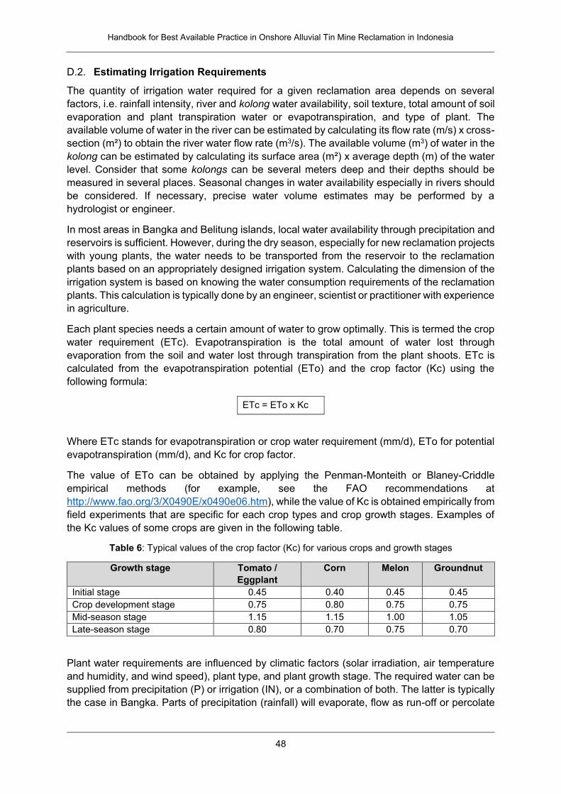
Handbook for Best Available Practice in Onshore Alluvial Tin Mine Reclamation in Indonesia
48
D.2. Estimating Irrigation Requirements
The quantity of irrigation water required for a given reclamation area depends on several
factors, i.e. rainfall intensity, river and kolong water availability, soil texture, total amount of soil
evaporation and plant transpiration water or evapotranspiration, and type of plant. The
available volume of water in the river can be estimated by calculating its flow rate (m/s) x cross-
section (m²) to obtain the river water flow rate (m3/s). The available volume (m3) of water in the
kolong can be estimated by calculating its surface area (m²) x average depth (m) of the water
level. Consider that some kolongs can be several meters deep and their depths should be
measured in several places. Seasonal changes in water availability especially in rivers should
be considered. If necessary, precise water volume estimates may be performed by a
hydrologist or engineer.
In most areas in Bangka and Belitung islands, local water availability through precipitation and
reservoirs is sufficient. However, during the dry season, especially for new reclamation projects
with young plants, the water needs to be transported from the reservoir to the reclamation
plants based on an appropriately designed irrigation system. Calculating the dimension of the
irrigation system is based on knowing the water consumption requirements of the reclamation
plants. This calculation is typically done by an engineer, scientist or practitioner with experience
in agriculture.
Each plant species needs a certain amount of water to grow optimally. This is termed the crop
water requirement (ETc). Evapotranspiration is the total amount of water lost through
evaporation from the soil and water lost through transpiration from the plant shoots. ETc is
calculated from the evapotranspiration potential (ETo) and the crop factor (Kc) using the
following formula:
ETc = ETo x Kc
Where ETc stands for evapotranspiration or crop water requirement (mm/d), ETo for potential
evapotranspiration (mm/d), and Kc for crop factor.
The value of ETo can be obtained by applying the Penman-Monteith or Blaney-Criddle
empirical methods (for example, see the FAO recommendations at
http://www.fao.org/3/X0490E/x0490e06.htm), while the value of Kc is obtained empirically from
field experiments that are specific for each crop types and crop growth stages. Examples of
the Kc values of some crops are given in the following table.
Table 6: Typical values of the crop factor (Kc) for various crops and growth stages
Growth stage Tomato /
Eggplant
Corn Melon Groundnut
Initial stage 0.45 0.40 0.45 0.45
Crop development stage 0.75 0.80 0.75 0.75
Mid-season stage 1.15 1.15 1.00 1.05
Late-season stage 0.80 0.70 0.75 0.70
Plant water requirements are influenced by climatic factors (solar irradiation, air temperature
and humidity, and wind speed), plant type, and plant growth stage. The required water can be
supplied from precipitation (P) or irrigation (IN), or a combination of both. The latter is typically
the case in Bangka. Parts of precipitation (rainfall) will evaporate, flow as run-off or percolate
Handbook for Best Available Practice in Onshore Alluvial Tin Mine Reclamation in Indonesia
49
into the soil layers. Only water held in the root zone of the soil can be effectively utilized by
crops. In practice, the amount of rainfall that can be used effectively by plant can be calculated
using the following formula (Brouwer and Heibloem 1986):
Pe = 0.8 P – 25, if P > 75, which is the case for the region of Bangka and Belitung island
Where P stands for precipitation and Pe for effective precipitation, both in mm/month.
If the effective precipitation is not enough to fulfill the plant water needs in a given month
(consider seasonal fluctuation), then the resultant water deficiency can be supplied by irrigation
(IN) which can be calculated by the following formula:
IN = ETc + Perc – Pe
Where IN stands for irrigation needs, ETc for plant or crop water requirement, Perc for water
loss through percolation, and Pe for effective precipitation, all in mm/month. Water loss through
percolation depends on the soil texture; for clay textured soils it is about 4 mm/day while for
sandy soils it is about 8 mm/day.
Example
The water irrigation needs in August for corn cultivation in sandy soil, if the values of
ETo is 6 mm/day (determined by Penman-Monteith method), the value of Kc is 0.7, and
the rain intensity is 100 mm/month, can be calculated as follow:
IN = ETc + Perc – Pe
ETc = ETo x Kc = 6 x 0.7 = 4.2 mm/day = 4.2 x 30 days = 126 mm/month
Perc = assumed to be 8 mm/day = 8 x 30 days = 240 mm/month
Pe = (0.8 x 100) – 25 = 55 mm/month
IN = 126 + 240 – 55 = 311 mm/month = 311/30 = 10.4 mm/day
Hence, the water irrigation needs for corn in August is 311 mm/month or 10.4 mm/ day.
Note that the above calculation refers to an area of 1 m². It needs to be converted into the
required volume of water irrigation by multiplying it with the size of the planned agricultural
area; for 1 m², 10.4 mm corresponds to 10.4 liters. If the crop irrigation needs must be met by
water pumping, then the pump capacity or the discharge volume will determine how long the
pump must operate. For practical examples of calculations of agricultural plant water needs
refer to Brouwer and Heibloem (1986).
Irrigation procedures for trees are different from agricultural irrigation calculations. Depending
on the selected method of irrigation, irrigation water requirements may also be calculated per
tree, rather than per area. Irrigation may be beneficial during plant growth and during fruit
development of fruit trees such as mango. Aside from traditional irrigation, new methods have
been developed to reduce water consumption, such as micro-irrigation using drips or special
sprinkler systems. Water consumption per tree depends not only on climatic conditions and
soil parameters but also on the age of the tree. For example, mango trees may variably require

Handbook for Best Available Practice in Onshore Alluvial Tin Mine Reclamation in Indonesia
50
50-400 liters of water per day and plant for optimized fruit development and, hence, economic
benefit. It is recommended to consult with forestry and horticulture experts for planning an
appropriate irrigation process for different tree types.
E. Composting Procedures
Compost may be produced through different techniques adapted to the local context. It is
useful to perform test trials using different raw materials available from the surrounding areas
for on-site compost production. The possible advantages of using block compost and block
fertilizer can also be tested, such as simplifying the work process and avoiding workers
applying loose compost without discipline by changing the recommended doses in planting
holes.
E.1. Heap Compost
The heap or pile composting technique is relatively simple and not expensive to apply. The
common or alternative raw materials for its application should be available locally. In addition,
it is necessary to provide supplemental materials that consist of a mixture of topsoil, bio-
fertilizer containing biomass decomposing microbes, as well as lime, nitrogen and phosphate
fertilizer as starter of composting reaction.
Place the mixture above the chopped raw materials at 1:1 ratio and make a heap or
pile layer with layers of 20 cm each until about 1.5 m height and cover it with tarpaulin
canvas.
Do watering every day and check the heap temperature to ensure that composting
reaction is occurring (indicated by increasing temperature with time).
Mix the heap once a week until mature compost is produced (dark colored and odorless
fine material).
Figure 18: Illustration of heap composting; it can be implemented inside or outside of a composting
house
Note that when constructing a composting house for heap composting the estimated amount
of compost for reclamation needs to be considered for the expected output. For example, one
hectare of reclamation area may require, on average, addition of about 10-15 tons of compost;
1.5 kg NPK 15:15:15
2.0 kg fresh manure
per 16 m2
Chopped green plant biomass
15 – 30 cm (leaves,
vegetable tops)
Soil 0.5 cm
Cover with
5 cm soil
1 –
1.8
m
2 – 2.5 m
Cover with canvas
Handbook for Best Available Practice in Onshore Alluvial Tin Mine Reclamation in Indonesia
51
assuming a density of 1 g/cm³, this corresponds to 10-15 m³ compost. In contrast, one heap
of compost with 1.5 m height and 2 m diameter corresponds to 4.7 m³ of material. This implies,
three compost heaps would be required to cover the amount of compost needed for 1 ha of
reclamation area. In addition, the composting house will require adequate leachate and
aeration management and chopping facilities.
E.2. Block Compost
Block compost refers to a cube of compressed compost (and nutrients) with a hole in its upper
side to grow one plant seedling after propagated or germinated from the seeds. When it is
ready to be transplanted, the young seedling is put into the hole with caution not to crush or
twist the roots to reduce transplant shock, and then the block is planted into the planting hole
in the field. The Watershed and Protected Forest Management Center (Balai Pengelolaan
Daerah Aliran Sungai dan Hutan Lindung, BPDASHL) of Bangka Belitung Province has been
practicing the production and usage of block compost and field trials are being undertaken.
This block compost is called Babel Compost (see following figure). So far, it has been reported
that by applying this technique the seedlings are growing well with good growth performance
in the field; better and more sustained plant growth may be expected compared to applying
the planting hole technique. However, this still needs to be confirmed through longer-term
monitoring. The Watershed and Protected Forest Management Center of Bangka Belitung
Province informs that the production cost of Babel Compost is about Rp 14,300,000 for a
population of 1,100 plants planted at a 3 m x 3 m planting grid. These would will be further
reduced to almost half (Rp. 8,125,000) per Ha for a 625 plant population planted in a 4 m x 4
m planting grid as recommended for reclamation area.
Figure 19: Babel Compost block with 20 cm x 20 cm x 20 cm dimension, with a hole diameter of about
10 cm for forest crop or slightly more for fruit crop
The main formula for producing block compost consists of mixing 60% sieved compost with
40% litter of plant leaves. Tapioca is added as an adhesive (to this end, two tablespoons of
tapioca flour are added to 1 liter of water that is subsequently boiled). If available, an alternative
formula for block compost is to mix 50% elephant manure, 20% cow or other manure, and 30%
litter of plant leaves. In that case, elephant manure functions as an adhesive.
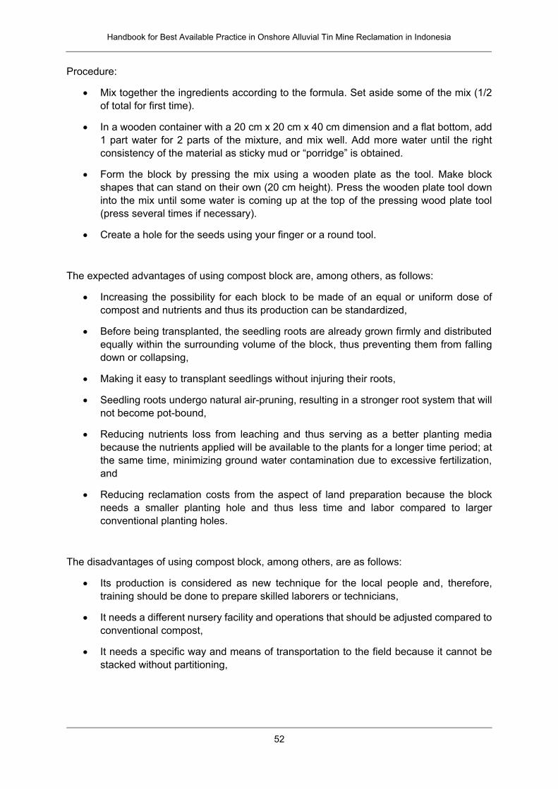
Handbook for Best Available Practice in Onshore Alluvial Tin Mine Reclamation in Indonesia
52
Procedure:
Mix together the ingredients according to the formula. Set aside some of the mix (1/2
of total for first time).
In a wooden container with a 20 cm x 20 cm x 40 cm dimension and a flat bottom, add
1 part water for 2 parts of the mixture, and mix well. Add more water until the right
consistency of the material as sticky mud or “porridge” is obtained.
Form the block by pressing the mix using a wooden plate as the tool. Make block
shapes that can stand on their own (20 cm height). Press the wooden plate tool down
into the mix until some water is coming up at the top of the pressing wood plate tool
(press several times if necessary).
Create a hole for the seeds using your finger or a round tool.
The expected advantages of using compost block are, among others, as follows:
Increasing the possibility for each block to be made of an equal or uniform dose of
compost and nutrients and thus its production can be standardized,
Before being transplanted, the seedling roots are already grown firmly and distributed
equally within the surrounding volume of the block, thus preventing them from falling
down or collapsing,
Making it easy to transplant seedlings without injuring their roots,
Seedling roots undergo natural air-pruning, resulting in a stronger root system that will
not become pot-bound,
Reducing nutrients loss from leaching and thus serving as a better planting media
because the nutrients applied will be available to the plants for a longer time period; at
the same time, minimizing ground water contamination due to excessive fertilization,
and
Reducing reclamation costs from the aspect of land preparation because the block
needs a smaller planting hole and thus less time and labor compared to larger
conventional planting holes.
The disadvantages of using compost block, among others, are as follows:
Its production is considered as new technique for the local people and, therefore,
training should be done to prepare skilled laborers or technicians,
It needs a different nursery facility and operations that should be adjusted compared to
conventional compost,
It needs a specific way and means of transportation to the field because it cannot be
stacked without partitioning,
Handbook for Best Available Practice in Onshore Alluvial Tin Mine Reclamation in Indonesia
53
From an agronomic point of view, problems may arise because compost block does
not contain red soil (clay) that is considered as a very important input to improve the
texture of the planting media, and
The seedling roots will penetrate the infertile soil outside the block after a shorter period
of growth time since the block dimension is smaller than that of the conventional
planting hole. Once the roots penetrate the infertile soil, which also has low water
storage capacity, above-ground plant growth speed will be reduced as the plant adjusts
to the less fertile environment.
F. Maintenance and Monitoring of Reclamation Success
Sustainable reclamation requires meeting the regulatory success criteria while also ensuring
long-term success of the reclamation and post-mining concept, after the reclamation bond has
been reclaimed. This refers to the soil fertility and long-term health of plants grown on the
reclamation site as further presented in this chapter. It further refers to social and economic
factors based on the community engagement – it may be worthwhile discussing with the local
community regarding setting joint targets and monitoring criteria with regards to social and
economic factors, e.g., the success of business models.
► See Chapters II.A.2 and III.G on community engagement
F.1. Analyzing Soil Fertility
Soil analyses are done before planting and during maintenance and monitoring periods. The
results of the soil analysis before the planting period are to be used as the basis to develop
doses recommendation for soil quality improvement inputs, while soil analysis during
maintenance and monitoring period is intended to check the effects of inputs application and
land management practices to the growth performance of reclamation plants and as the basis
for conducting corrective actions. Soil analysis is done for selected soil chemical properties
including soil pH, aluminum saturation, organic carbon content, total Nitrogen (N), available
phosphorus (P), exchangeable potassium (K), cation exchange capacity (CEC), and base
saturation; and for selected soil physical properties including rooting depth, field slope or
topography, soil texture, and soil bulk density.
Soil pH is the most common and important measurement in standard soil analysis. Many soil
chemical and biological reactions are controlled by soil pH. Nitrogen, phosphorus, and
potassium are the most three essential plant nutrients that are often found in deficient
concentration level in the soil, therefore they are becoming the major components of fertilizer.
The concentration level of plant nutrients in soils can be categorized into deficient (low),
sufficient (medium), or surplus (high) to support plant growth.
The roles and functions of soil organic matter are important in determining soil chemical and
biological fertility status. It releases nutrients for plant growth and biological activities, promotes
soil aggregation and texture development for optimized physical properties, and acts as buffer
against harmful substances. The content of soil organic matter is estimated from the analysis
of soil organic carbon concentration.
Cation exchange capacity (CEC) is a measure of soil capacity to exchange or retaining and
releasing cations. Soil CEC affects many aspects of soil chemistry; among others this includes
the soil capacity to retain plant nutrient cations (e.g. NH4+, K+, Ca2+, and Mg2+) thereby
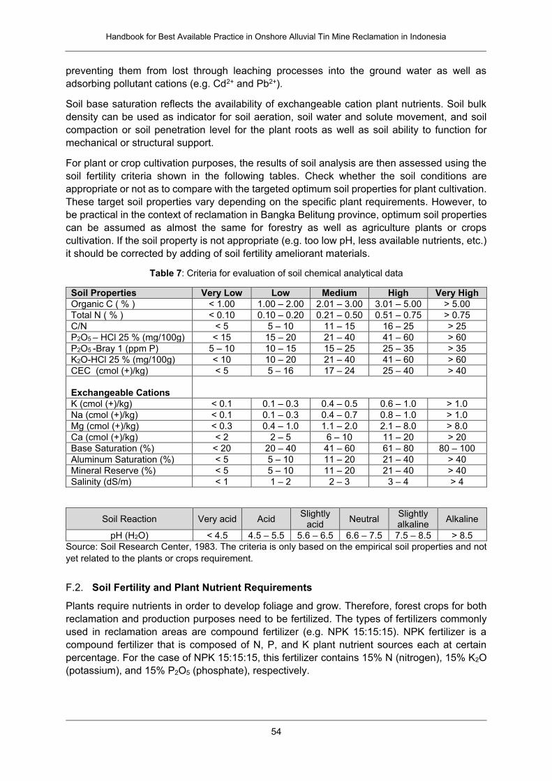
Handbook for Best Available Practice in Onshore Alluvial Tin Mine Reclamation in Indonesia
54
preventing them from lost through leaching processes into the ground water as well as
adsorbing pollutant cations (e.g. Cd2+ and Pb2+).
Soil base saturation reflects the availability of exchangeable cation plant nutrients. Soil bulk
density can be used as indicator for soil aeration, soil water and solute movement, and soil
compaction or soil penetration level for the plant roots as well as soil ability to function for
mechanical or structural support.
For plant or crop cultivation purposes, the results of soil analysis are then assessed using the
soil fertility criteria shown in the following tables. Check whether the soil conditions are
appropriate or not as to compare with the targeted optimum soil properties for plant cultivation.
These target soil properties vary depending on the specific plant requirements. However, to
be practical in the context of reclamation in Bangka Belitung province, optimum soil properties
can be assumed as almost the same for forestry as well as agriculture plants or crops
cultivation. If the soil property is not appropriate (e.g. too low pH, less available nutrients, etc.)
it should be corrected by adding of soil fertility ameliorant materials.
Table 7: Criteria for evaluation of soil chemical analytical data
Soil Properties Very Low Low Medium High Very High
Organic C ( % ) < 1.00 1.00 – 2.00 2.01 – 3.00 3.01 – 5.00 > 5.00
Total N ( % ) < 0.10 0.10 – 0.20 0.21 – 0.50 0.51 – 0.75 > 0.75
C/N < 5 5 – 10 11 – 15 16 – 25 > 25
P2O5 – HCl 25 % (mg/100g) < 15 15 – 20 21 – 40 41 – 60 > 60
P2O5 -Bray 1 (ppm P) 5 – 10 10 – 15 15 – 25 25 – 35 > 35
K2O-HCl 25 % (mg/100g) < 10 10 – 20 21 – 40 41 – 60 > 60
CEC (cmol (+)/kg) < 5 5 – 16 17 – 24 25 – 40 > 40
Exchangeable Cations
K (cmol (+)/kg) < 0.1 0.1 – 0.3 0.4 – 0.5 0.6 – 1.0 > 1.0
Na (cmol (+)/kg) < 0.1 0.1 – 0.3 0.4 – 0.7 0.8 – 1.0 > 1.0
Mg (cmol (+)/kg) < 0.3 0.4 – 1.0 1.1 – 2.0 2.1 – 8.0 > 8.0
Ca (cmol (+)/kg) < 2 2 – 5 6 – 10 11 – 20 > 20
Base Saturation (%) < 20 20 – 40 41 – 60 61 – 80 80 – 100
Aluminum Saturation (%) < 5 5 – 10 11 – 20 21 – 40 > 40
Mineral Reserve (%) < 5 5 – 10 11 – 20 21 – 40 > 40
Salinity (dS/m) < 1 1 – 2 2 – 3 3 – 4 > 4
Soil Reaction Very acid Acid Slightly
acid Neutral
Slightly alkaline
Alkaline
pH (H2O) < 4.5 4.5 – 5.5 5.6 – 6.5 6.6 – 7.5 7.5 – 8.5 > 8.5
Source: Soil Research Center, 1983. The criteria is only based on the empirical soil properties and not
yet related to the plants or crops requirement.
F.2. Soil Fertility and Plant Nutrient Requirements
Plants require nutrients in order to develop foliage and grow. Therefore, forest crops for both
reclamation and production purposes need to be fertilized. The types of fertilizers commonly
used in reclamation areas are compound fertilizer (e.g. NPK 15:15:15). NPK fertilizer is a
compound fertilizer that is composed of N, P, and K plant nutrient sources each at certain
percentage. For the case of NPK 15:15:15, this fertilizer contains 15% N (nitrogen), 15% K2O
(potassium), and 15% P2O5 (phosphate), respectively.
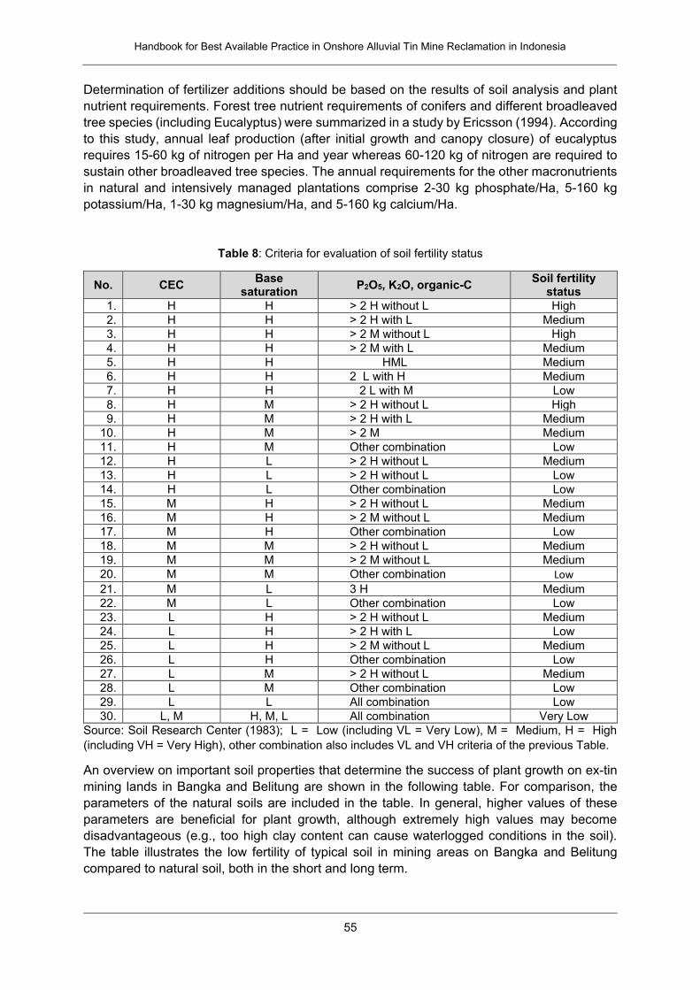
Handbook for Best Available Practice in Onshore Alluvial Tin Mine Reclamation in Indonesia
55
Determination of fertilizer additions should be based on the results of soil analysis and plant
nutrient requirements. Forest tree nutrient requirements of conifers and different broadleaved
tree species (including Eucalyptus) were summarized in a study by Ericsson (1994). According
to this study, annual leaf production (after initial growth and canopy closure) of eucalyptus
requires 15-60 kg of nitrogen per Ha and year whereas 60-120 kg of nitrogen are required to
sustain other broadleaved tree species. The annual requirements for the other macronutrients
in natural and intensively managed plantations comprise 2-30 kg phosphate/Ha, 5-160 kg
potassium/Ha, 1-30 kg magnesium/Ha, and 5-160 kg calcium/Ha.
Table 8: Criteria for evaluation of soil fertility status
No. CEC Base
saturation P2O5, K2O, organic-C
Soil fertility status
1. H H > 2 H without L High
2. H H > 2 H with L Medium
3. H H > 2 M without L High
4. H H > 2 M with L Medium
5. H H HML Medium
6. H H 2 L with H Medium
7. H H 2 L with M Low
8. H M > 2 H without L High
9. H M > 2 H with L Medium
10. H M > 2 M Medium
11. H M Other combination Low
12. H L > 2 H without L Medium
13. H L > 2 H without L Low
14. H L Other combination Low
15. M H > 2 H without L Medium
16. M H > 2 M without L Medium
17. M H Other combination Low
18. M M > 2 H without L Medium
19. M M > 2 M without L Medium
20. M M Other combination Low
21. M L 3 H Medium
22. M L Other combination Low
23. L H > 2 H without L Medium
24. L H > 2 H with L Low
25. L H > 2 M without L Medium
26. L H Other combination Low
27. L M > 2 H without L Medium
28. L M Other combination Low
29. L L All combination Low
30. L, M H, M, L All combination Very Low
Source: Soil Research Center (1983); L = Low (including VL = Very Low), M = Medium, H = High
(including VH = Very High), other combination also includes VL and VH criteria of the previous Table.
An overview on important soil properties that determine the success of plant growth on ex-tin
mining lands in Bangka and Belitung are shown in the following table. For comparison, the
parameters of the natural soils are included in the table. In general, higher values of these
parameters are beneficial for plant growth, although extremely high values may become
disadvantageous (e.g., too high clay content can cause waterlogged conditions in the soil).
The table illustrates the low fertility of typical soil in mining areas on Bangka and Belitung
compared to natural soil, both in the short and long term.
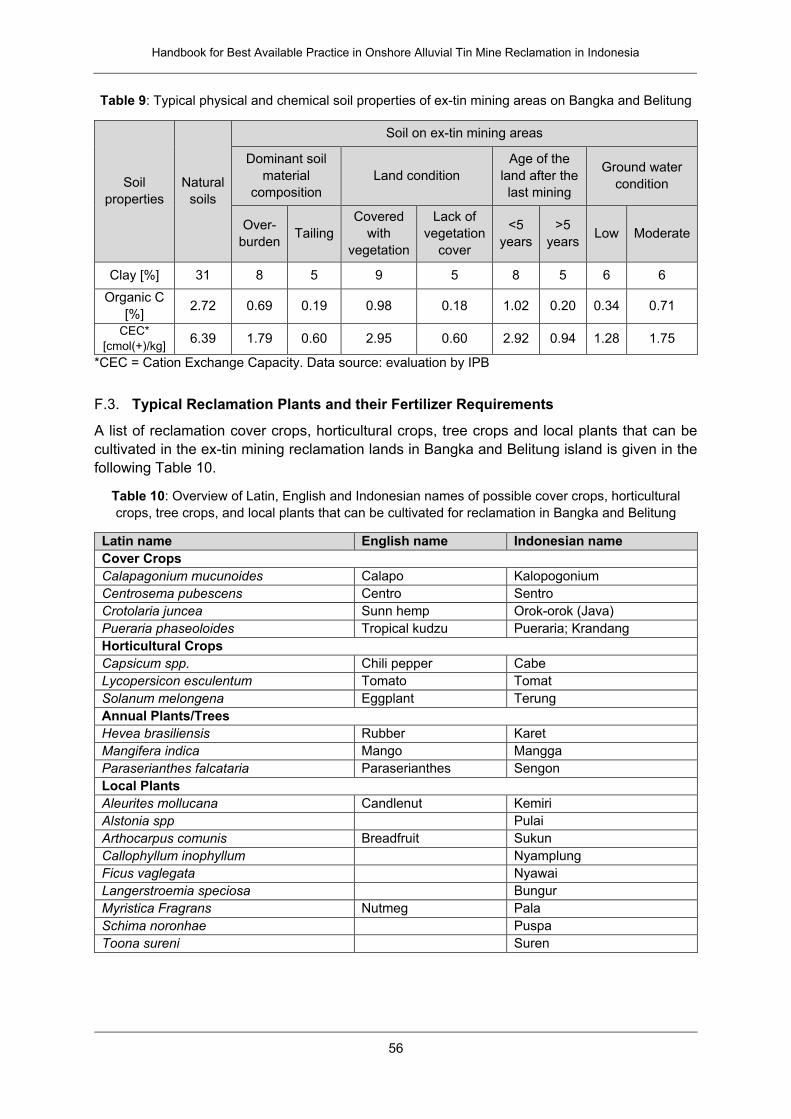
Handbook for Best Available Practice in Onshore Alluvial Tin Mine Reclamation in Indonesia
56
Table 9: Typical physical and chemical soil properties of ex-tin mining areas on Bangka and Belitung
Soil
properties
Natural
soils
Soil on ex-tin mining areas
Dominant soil
material
composition
Land condition
Age of the
land after the
last mining
Ground water
condition
Over-
burden Tailing
Covered
with
vegetation
Lack of
vegetation
cover
<5
years
>5
years Low Moderate
Clay [%] 31 8 5 9 5 8 5 6 6
Organic C
[%] 2.72 0.69 0.19 0.98 0.18 1.02 0.20 0.34 0.71
CEC*
[cmol(+)/kg] 6.39 1.79 0.60 2.95 0.60 2.92 0.94 1.28 1.75
*CEC = Cation Exchange Capacity. Data source: evaluation by IPB
F.3. Typical Reclamation Plants and their Fertilizer Requirements
A list of reclamation cover crops, horticultural crops, tree crops and local plants that can be
cultivated in the ex-tin mining reclamation lands in Bangka and Belitung island is given in the
following Table 10.
Table 10: Overview of Latin, English and Indonesian names of possible cover crops, horticultural
crops, tree crops, and local plants that can be cultivated for reclamation in Bangka and Belitung
Latin name English name Indonesian name
Cover Crops
Calapagonium mucunoides Calapo Kalopogonium
Centrosema pubescens Centro Sentro
Crotolaria juncea Sunn hemp Orok-orok (Java)
Pueraria phaseoloides Tropical kudzu Pueraria; Krandang
Horticultural Crops
Capsicum spp. Chili pepper Cabe
Lycopersicon esculentum Tomato Tomat
Solanum melongena Eggplant Terung
Annual Plants/Trees
Hevea brasiliensis Rubber Karet
Mangifera indica Mango Mangga
Paraserianthes falcataria Paraserianthes Sengon
Local Plants
Aleurites mollucana Candlenut Kemiri
Alstonia spp Pulai
Arthocarpus comunis Breadfruit Sukun
Callophyllum inophyllum Nyamplung
Ficus vaglegata Nyawai
Langerstroemia speciosa Bungur
Myristica Fragrans Nutmeg Pala
Schima noronhae Puspa
Toona sureni Suren
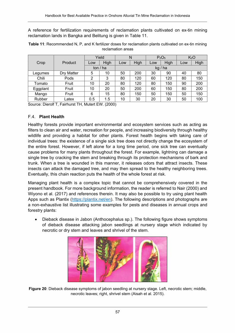
Handbook for Best Available Practice in Onshore Alluvial Tin Mine Reclamation in Indonesia
57
A reference for fertilization requirements of reclamation plants cultivated on ex-tin mining
reclamation lands in Bangka and Belitung is given in Table 11.
Table 11: Recommended N, P, and K fertilizer doses for reclamation plants cultivated on ex-tin mining
reclamation areas
Crop Product
Yield N P2O5 K2O
Low High Low High Low High Low High
ton / ha kg / ha
Legumes Dry Matter 5 10 50 200 30 90 40 80
Chili Pods 2 3 80 120 60 120 80 150
Tomato Fruit 10 20 80 120 80 150 90 200
Eggplant Fruit 10 20 50 200 60 150 80 200
Mango Fruit 6 15 80 150 50 150 50 150
Rubber Latex 0.5 1.5 10 30 20 30 50 100
Source: Dierolf T, Fairhurst TH, Mutert EW. (2000)
F.4. Plant Health
Healthy forests provide important environmental and ecosystem services such as acting as
filters to clean air and water, recreation for people, and increasing biodiversity through healthy
wildlife and providing a habitat for other plants. Forest health begins with taking care of
individual trees: the existence of a single sick tree does not directly change the ecosystem of
the entire forest. However, if left alone for a long time period, one sick tree can eventually
cause problems for many plants throughout the forest. For example, lightning can damage a
single tree by cracking the stem and breaking through its protection mechanisms of bark and
trunk. When a tree is wounded in this manner, it releases odors that attract insects. These
insects can attack the damaged tree, and may then spread to the healthy neighboring trees.
Eventually, this chain reaction puts the health of the whole forest at risk.
Managing plant health is a complex topic that cannot be comprehensively covered in the
present handbook. For more background information, the reader is referred to Nair (2000) and
Wiyono et al. (2017) and references therein. It may also be possible to try using plant health
Apps such as Plantix (https://plantix.net/en). The following descriptions and photographs are
a non-exhaustive list illustrating some examples for pests and diseases in annual crops and
forestry plants:
Dieback disease in Jabon (Anthocephalus sp.). The following figure shows symptoms
of dieback disease attacking jabon seedlings at nursery stage which indicated by
necrotic or dry stem and leaves and shrivel of the stem.
Figure 20: Dieback disease symptoms of jabon seedling at nursery stage. Left, necrotic stem; middle,
necrotic leaves; right, shrivel stem (Aisah et al. 2015).
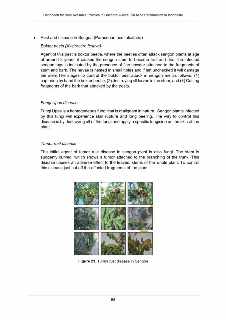
Handbook for Best Available Practice in Onshore Alluvial Tin Mine Reclamation in Indonesia
58
Pest and disease in Sengon (Paracerianthes falcataria)
Boktor pests (Xystrocera festiva)
Agent of this pest is boktor beetle, where the beetles often attack sengon plants at age
of around 3 years. it causes the sengon stem to become frail and die. The infected
sengon logs is indicated by the presence of fine powder attached to the fragments of
stem and bark. The larvae is nested in small holes and if left unchecked it will damage
the stem.The stages to control the boktor pest attack in sengon are as follows: (1)
capturing by hand the boktor beetle, (2) destroying all larvae in the stem, and (3) Cutting
fragments of the bark that attacked by the pests.
Fungi Upas disease
Fungi Upas is a homogeneous fungi that is malignant in nature. Sengon plants infected
by this fungi will experience skin rupture and long peeling. The way to control this
disease is by destroying all of the fungi and apply a specific fungiside on the skin of the
plant.
Tumor rust disease
The initial agent of tumor rust disease in sengon plant is also fungi. The stem is
suddenly curved, which shows a tumor attached to the branching of the trunk. This
disease causes an adverse effect to the leaves, stems of the whole plant. To control
this disease just cut off the affected fragments of the plant.
Figure 21. Tumor rust disease in Sengon
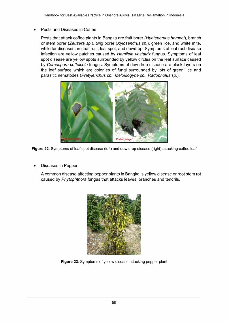
Handbook for Best Available Practice in Onshore Alluvial Tin Mine Reclamation in Indonesia
59
Pests and Diseases in Coffee
Pests that attack coffee plants in Bangka are fruit borer (Hyetenemus hampei), branch
or stem borer (Zeuzera sp.), twig borer (Xylosandrus sp.), green lice, and white mite,
while for diseases are leaf rust, leaf spot, and dewdrop. Symptoms of leaf rust disease
infection are yellow patches caused by Hemileia vastatrix fungus. Symptoms of leaf
spot disease are yellow spots surrounded by yellow circles on the leaf surface caused
by Cercospora coffeicola fungus. Symptoms of dew drop disease are black layers on
the leaf surface which are colonies of fungi surrounded by lots of green lice and
parasitic nematodes (Pratylenchus sp., Meloidogyne sp., Radopholus sp.).
Figure 22: Symptoms of leaf spot disease (left) and dew drop disease (right) attacking coffee leaf
Diseases in Pepper
A common disease affecting pepper plants in Bangka is yellow disease or root stem rot
caused by Phytophthora fungus that attacks leaves, branches and tendrils.
Figure 23: Symptoms of yellow disease attacking pepper plant
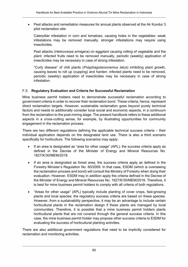
Handbook for Best Available Practice in Onshore Alluvial Tin Mine Reclamation in Indonesia
60
Pest attacks and remediation measures for annual plants observed at the Air Kundur 3
pilot reclamation site:
Caterpillar infestation in corn and tomatoes, causing holes in the vegetables: weak
infestations may be removed manually, stronger infestations may require using
insecticides.
Pest attacks (Helicoverpa armigera) on eggplant causing rotting of vegetable and the
plant: infected fruits need to be removed manually, periodic (weekly) application of
insecticides may be necessary in case of strong infestation.
“Curly disease” of chili plants (Polyphagotarsonemus latus) inhibiting plant growth,
causing leaves to roll up (cupping) and harden: infected plants need to be removed,
periodic (weekly) application of insecticides may be necessary in case of strong
infestation.
F.5. Regulatory Evaluation and Criteria for Successful Reclamation
Mine business permit holders need to demonstrate successful reclamation according to
government criteria in order to recover their reclamation bond. These criteria, hence, represent
direct reclamation targets. However, sustainable reclamation goes beyond purely technical
factors and needs to additionally consider local social and economic aspects, in a continuum
from the reclamation to the post-mining stage. The present handbook refers to these additional
aspects in a cross-cutting sense, for example, by illustrating opportunities for community
engagement in the reclamation process.
There are two different regulations defining the applicable technical success criteria – their
individual application depends on the designated land use. There is also a third scenario
specifically for horticulture. The following scenarios may apply:
If an area is designated as “area for other usage” (APL), the success criteria apply as
defined in the Decree of the Minister of Energy and Mineral Resources No.
1827/K/30/MEM/2018.
If an area is designated as forest area, the success criteria apply as defined in the
Forestry Minister’s Regulation No. 60/2009. In that case, ESDM (which is overseeing
the reclamation process and bond) will consult the Ministry of Forestry when doing their
evaluation. However, ESDM may in addition apply the criteria defined in the Decree of
the Minister of Energy and Mineral Resources No. 1827/K/30/MEM/2018. Therefore, it
is best for mine business permit holders to comply with all criteria of both regulations.
“Areas for other usage” (APL) typically include planting of cover crops, fast-growing
plants and local species; the regulatory success criteria are based on these species.
However, from a sustainability perspective, it may be an advantage to include certain
horticultural plants in the reclamation design if these plants are managed by local
communities. Therefore, it is possible that a mine business permit holders plants
horticultural plants that are not covered through the general success criteria. In this
case, the mine business permit holder may propose other success criteria to ESDM for
evaluating the success of horticultural planting activities.
There are also additional government regulations that need to be implicitly considered for
reclamation and monitoring activities.
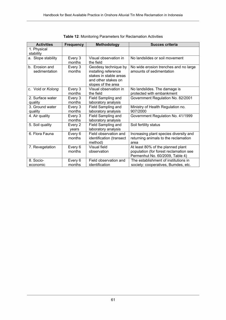
Handbook for Best Available Practice in Onshore Alluvial Tin Mine Reclamation in Indonesia
61
Table 12: Monitoring Parameters for Reclamation Activities
Activities Frequency Methodology Succes criteria
1. Physical stability
a. Slope stability Every 3 months
Visual observation in the field
No landslides or soil movement
b. Erosion and sedimentation
Every 3 months
Geodesy technique by installing reference stakes in stable areas and other stakes on slopes of the area
No wide erosion trenches and no large amounts of sedimentation
c. Void or Kolong Every 3 months
Visual observation in the field
No landslides. The damage is protected with embankment
2. Surface water quality
Every 3 months
Field Sampling and laboratory analysis
Government Regulation No. 82/2001
3. Ground water quality
Every 3 months
Field Sampling and laboratory analysis
Ministry of Health Regulation no. 907/2000
4. Air quality Every 3 months
Field Sampling and laboratory analysis
Government Regulation No. 41/1999
5. Soil quality Every 2 years
Field Sampling and laboratory analysis
Soil fertility status
6. Flora Fauna Every 6 months
Field observation and identification (transect method)
Increasing plant species diversity and returning animals to the reclamation area
7. Revegetation Every 6 months
Visual field observation
At least 80% of the planned plant population (for forest reclamation see Permenhut No. 60/2009, Table 4)
8. Socio-economic
Every 6 months
Field observation and identification
The establishment of institutions in society: cooperatives, Bumdes, etc.
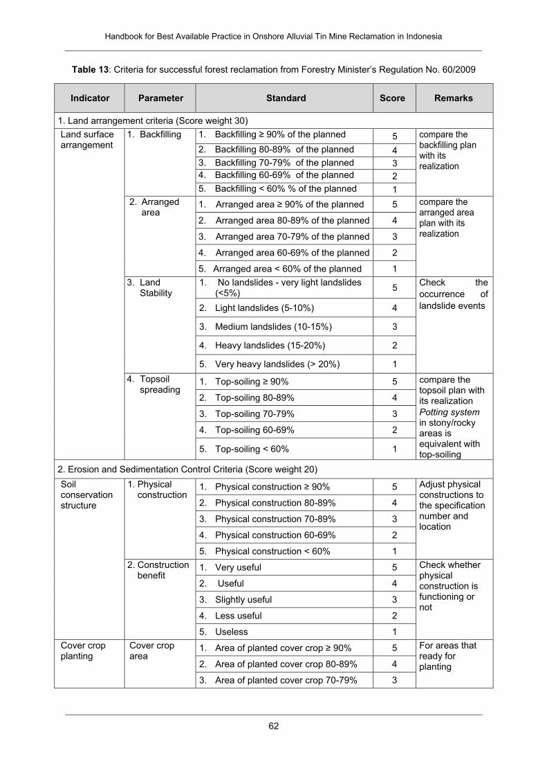
Handbook for Best Available Practice in Onshore Alluvial Tin Mine Reclamation in Indonesia
62
Table 13: Criteria for successful forest reclamation from Forestry Minister’s Regulation No. 60/2009
Indicator Parameter Standard Score Remarks
1. Land arrangement criteria (Score weight 30)
Land surface arrangement
1. Backfilling 1. Backfilling ≥ 90% of the planned 5 compare the backfilling plan with its realization
2. Backfilling 80-89% of the planned 4
3. Backfilling 70-79% of the planned 3
4. Backfilling 60-69% of the planned 2
5. Backfilling < 60% % of the planned 1
2. Arranged area
1. Arranged area ≥ 90% of the planned 5 compare the arranged area plan with its realization
2. Arranged area 80-89% of the planned 4
3. Arranged area 70-79% of the planned 3
4. Arranged area 60-69% of the planned 2
5. Arranged area < 60% of the planned 1
3. Land Stability
1. No landslides - very light landslides (<5%)
5 Check the
occurrence of
landslide events 2. Light landslides (5-10%) 4
3. Medium landslides (10-15%) 3
4. Heavy landslides (15-20%) 2
5. Very heavy landslides (> 20%) 1
4. Topsoil spreading
1. Top-soiling ≥ 90% 5 compare the topsoil plan with its realization
Potting system in stony/rocky areas is equivalent with top-soiling
2. Top-soiling 80-89% 4
3. Top-soiling 70-79% 3
4. Top-soiling 60-69% 2
5. Top-soiling < 60% 1
2. Erosion and Sedimentation Control Criteria (Score weight 20)
Soil conservation structure
1. Physical construction
1. Physical construction ≥ 90% 5 Adjust physical constructions to the specification number and location
2. Physical construction 80-89% 4
3. Physical construction 70-89% 3
4. Physical construction 60-69% 2
5. Physical construction < 60% 1
2. Construction benefit
1. Very useful 5 Check whether physical construction is functioning or not
2. Useful 4
3. Slightly useful 3
4. Less useful 2
5. Useless 1
Cover crop planting
Cover crop area
1. Area of planted cover crop ≥ 90% 5 For areas that ready for planting 2. Area of planted cover crop 80-89% 4
3. Area of planted cover crop 70-79% 3
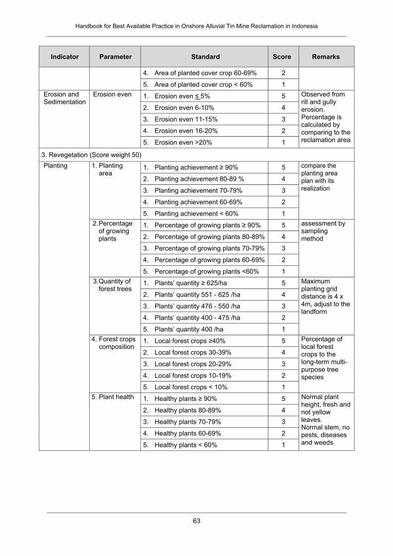
Handbook for Best Available Practice in Onshore Alluvial Tin Mine Reclamation in Indonesia
63
Indicator Parameter Standard Score Remarks
4. Area of planted cover crop 60-69% 2
5. Area of planted cover crop < 60% 1
Erosion and Sedimentation
Erosion even 1. Erosion even ≤ 5% 5 Observed from rill and gully erosion. Percentage is calculated by comparing to the reclamation area
2. Erosion even 6-10% 4
3. Erosion even 11-15% 3
4. Erosion even 16-20% 2
5. Erosion even >20% 1
3. Revegetation (Score weight 50)
Planting 1. Planting area
1. Planting achievement ≥ 90% 5 compare the planting area plan with its realization
2. Planting achievement 80-89 % 4
3. Planting achievement 70-79% 3
4. Planting achievement 60-69% 2
5. Planting achievement < 60% 1
2. Percentage of growing plants
1. Percentage of growing plants ≥ 90% 5 assessment by sampling method 2. Percentage of growing plants 80-89% 4
3. Percentage of growing plants 70-79% 3
4. Percentage of growing plants 60-69% 2
5. Percentage of growing plants <60% 1
3. Quantity of forest trees
1. Plants’ quantity ≥ 625/ha 5 Maximum planting grid distance is 4 x 4m, adjust to the landform
2. Plants’ quantity 551 - 625 /ha 4
3. Plants’ quantity 476 - 550 /ha 3
4. Plants’ quantity 400 - 475 /ha 2
5. Plants’ quantity 400 /ha 1
4. Forest crops composition
1. Local forest crops ≥40% 5 Percentage of local forest crops to the long-term multi-purpose tree species
2. Local forest crops 30-39% 4
3. Local forest crops 20-29% 3
4. Local forest crops 10-19% 2
5. Local forest crops < 10% 1
5. Plant health 1. Healthy plants ≥ 90% 5 Normal plant height, fresh and not yellow leaves. Normal stem, no pests, diseases and weeds
2. Healthy plants 80-89% 4
3. Healthy plants 70-79% 3
4. Healthy plants 60-69% 2
5. Healthy plants < 60% 1
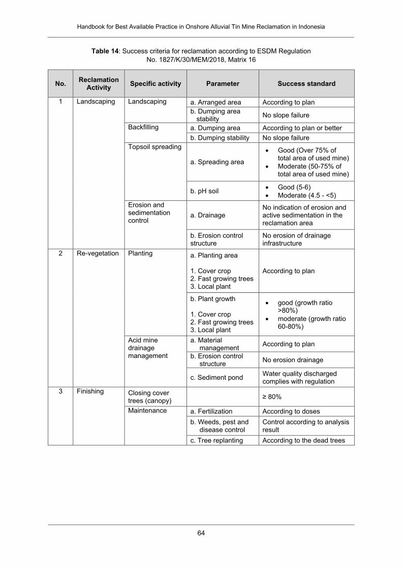
Handbook for Best Available Practice in Onshore Alluvial Tin Mine Reclamation in Indonesia
64
Table 14: Success criteria for reclamation according to ESDM Regulation
No. 1827/K/30/MEM/2018, Matrix 16
No. Reclamation
Activity Specific activity Parameter Success standard
1 Landscaping Landscaping a. Arranged area According to plan
b. Dumping area stability
No slope failure
Backfilling a. Dumping area According to plan or better
b. Dumping stability No slope failure
Topsoil spreading
a. Spreading area
Good (Over 75% of total area of used mine)
Moderate (50-75% of total area of used mine)
b. pH soil Good (5-6)
Moderate (4.5 - <5)
Erosion and sedimentation control
a. Drainage No indication of erosion and active sedimentation in the reclamation area
b. Erosion control structure
No erosion of drainage infrastructure
2 Re-vegetation Planting a. Planting area 1. Cover crop 2. Fast growing trees 3. Local plant
According to plan
b. Plant growth 1. Cover crop 2. Fast growing trees 3. Local plant
good (growth ratio >80%)
moderate (growth ratio 60-80%)
Acid mine drainage management
a. Material management
According to plan
b. Erosion control structure
No erosion drainage
c. Sediment pond Water quality discharged complies with regulation
3 Finishing Closing cover trees (canopy)
≥ 80%
Maintenance a. Fertilization According to doses
b. Weeds, pest and disease control
Control according to analysis result
c. Tree replanting According to the dead trees
Handbook for Best Available Practice in Onshore Alluvial Tin Mine Reclamation in Indonesia
65
G. Conceptual Approach to Community Engagement
G.1. Introduction
The present chapter outlines one of the possible concepts behind community engagement in
the reclamation context. This descriptions complements the practical suggestions on
community engagement that are provided throughout this handbook.
► See Chapter II.A.2 for an overview on practical steps and further consider the
individual community-specific recommendations provided in other chapters
What is Community Engagement?
There is no commonly agreed definition for “community engagement” in mining and other
sectors – different experts have provided different definitions for the process. The term is often
used interchangeably with a number of other concepts such as community consultation,
participation, collaboration and empowerment. Toolkits provide further guidance on community
engagement strategies and priorities (e.g., Li et al., 2014).
For this handbook, community engagement is understood as the process of building
relationships and trust for working collaboratively with community groups side-by-side as long-
term partners (stakeholders, citizens, and interest groups related to the reclamation and post
mining project/program), building a coalition of support on a range of sustainable reclamation
and post-mining steps/processes, programs, and services to address related issues or to
create changes that impact the well-being of those groups. The involvement of specific
community groups may vary according to the scale and importance of the reclamation project
and may range from the local or sub-district level to larger district or even provincial level.
Community engagement is a planned and organized process through which communities learn
how they can contribute or acquire the skills, attitudes and abilities for active participation. It
encompasses a wide variety of interactions between individuals, groups or corporations
representing the mine concession holders with government and communities. These
interactions range from information sharing to community consultation and, in some instances,
active community participation in decision-making processes to improve the quality of its
decisions. The engagement process can be formal or informal, direct or indirect, as cross-
cutting issues or steps that enable citizens and communities to better understand the
processes of and builds their capacity to participate in deliberative processes by gaining
confidence, skills, knowledge and experience.
Why Community Engagement Matters for Sustainable Reclamation and Post-Mining
It is difficult to secure the areas of reclamation and post-mining programs or projects from
illegal activities – especially where are located in remote areas, surrounded by ASM activities,
palm estates or plantations – without assistance and support by all stakeholders. Through
community engagement, local community and interest groups play a meaningful role in that
land security issue, the deliberations, discussions, decisions and/or implementation of
sustainable reclamation and post-mining projects and programs will affect them. It empowers
those from the community to learn about sustainable reclamation and post-mining issues,

Handbook for Best Available Practice in Onshore Alluvial Tin Mine Reclamation in Indonesia
66
allowing them to see multiple sides and increasing the likelihood that projects and/or solutions
will be widely accepted.
Community engagement allows concession holders and the local government (village, regency
and province) to take on roles as facilitators, supporters, and collaborators – offering them
enhanced perspectives while giving a stronger voice to the community and stakeholders.
Drawing on local knowledge from diverse groups creates solutions that are both practical and
effective. Moreover, community engagement should aim to increase the level of trust between
communities, concession holders, and the government, builds ownership of the projects, and
bridges the gap by connecting people who are not currently part of the projects. In Indonesia,
there is experience with complex community engagement processes in the gold sector such
as the Kelian mine closure in East Kalimantan.
► References for this process are provided in the Annex IV.A of this handbook, for
example the Go Green reclamation project at Selinsing
Principles and Core Values for Effective Community Engagement
Community members represent different social, economic and environmental interest groups.
People may be of local origin or migrants from other parts of the country, and they have
different business interests and expertise, such as farmers, traders or miners. Recognizing
stakeholders, citizens, and interest groups related to the reclamation and post-mining
project/program as the community's most valuable resource, and understanding their various
strengths and interests, unleashes creativity and acknowledges collaboration as the primary
catalyst to move the community forward. The approach to community engagement is guided
by the following principles:
Integrity: community engagement should be transparent and clear in scope, role, and
purpose – what part of the reclamation processes or post-mining activities could/does
the community realistically be engaged/want to be involved in? What role could/does
the community want to play in the reclamation process or post-mining activities? What
does the community consider as successful reclamation or post-mining scenario?
Inclusiveness: community engagement should be accessible and balanced and
capture a full range of values and perspectives – what capacity and resource (including
the financial, organizational and technical expertise) does the community have in order
to plan and implement certain activities according the role it wants to play in the
reclamation process or post-mining activities? Does the community have realistic
expectations about its own capacities and the targets of reclamation/post mining? What
opportunities and support options exist in the community, the government, the
concession holder, and other stakeholders that can be involved in implementing and
managing reclamation, maintenance, monitoring and post-mining activities through
land security and spatial planning policy supports, long term or sustainable financial,
organizational, and technical expertise supports?
Dialogue: community engagement should promote dialogue and open genuine
discussion among stakeholders, interest groups, and other reclamation or post-mining
champions – it should be supported by timely and accurate information, be used to
weigh options, and develop common understandings on a successful reclamation or
post-mining. Involving local academic institutions may help in understanding the
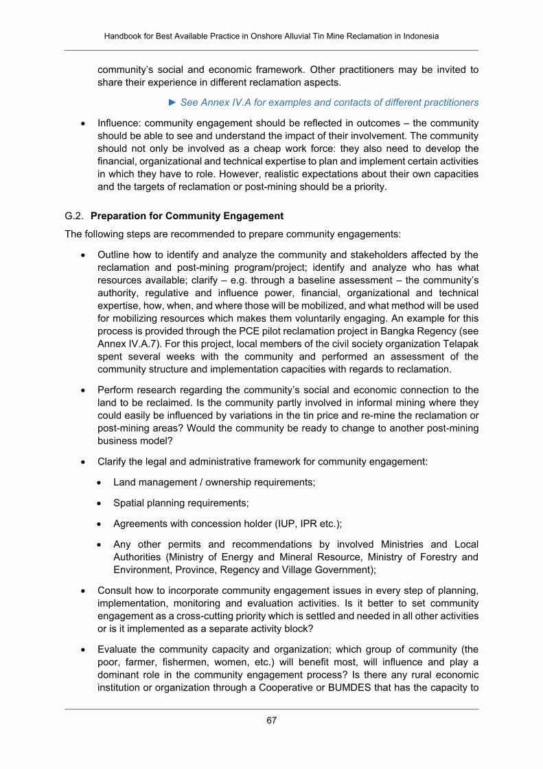
Handbook for Best Available Practice in Onshore Alluvial Tin Mine Reclamation in Indonesia
67
community’s social and economic framework. Other practitioners may be invited to
share their experience in different reclamation aspects.
► See Annex IV.A for examples and contacts of different practitioners
Influence: community engagement should be reflected in outcomes – the community
should be able to see and understand the impact of their involvement. The community
should not only be involved as a cheap work force: they also need to develop the
financial, organizational and technical expertise to plan and implement certain activities
in which they have to role. However, realistic expectations about their own capacities
and the targets of reclamation or post-mining should be a priority.
G.2. Preparation for Community Engagement
The following steps are recommended to prepare community engagements:
Outline how to identify and analyze the community and stakeholders affected by the
reclamation and post-mining program/project; identify and analyze who has what
resources available; clarify – e.g. through a baseline assessment – the community’s
authority, regulative and influence power, financial, organizational and technical
expertise, how, when, and where those will be mobilized, and what method will be used
for mobilizing resources which makes them voluntarily engaging. An example for this
process is provided through the PCE pilot reclamation project in Bangka Regency (see
Annex IV.A.7). For this project, local members of the civil society organization Telapak
spent several weeks with the community and performed an assessment of the
community structure and implementation capacities with regards to reclamation.
Perform research regarding the community’s social and economic connection to the
land to be reclaimed. Is the community partly involved in informal mining where they
could easily be influenced by variations in the tin price and re-mine the reclamation or
post-mining areas? Would the community be ready to change to another post-mining
business model?
Clarify the legal and administrative framework for community engagement:
Land management / ownership requirements;
Spatial planning requirements;
Agreements with concession holder (IUP, IPR etc.);
Any other permits and recommendations by involved Ministries and Local
Authorities (Ministry of Energy and Mineral Resource, Ministry of Forestry and
Environment, Province, Regency and Village Government);
Consult how to incorporate community engagement issues in every step of planning,
implementation, monitoring and evaluation activities. Is it better to set community
engagement as a cross-cutting priority which is settled and needed in all other activities
or is it implemented as a separate activity block?
Evaluate the community capacity and organization; which group of community (the
poor, farmer, fishermen, women, etc.) will benefit most, will influence and play a
dominant role in the community engagement process? Is there any rural economic
institution or organization through a Cooperative or BUMDES that has the capacity to
Handbook for Best Available Practice in Onshore Alluvial Tin Mine Reclamation in Indonesia
68
manage this process? Is it advisable to establish a new reclamation business unit within
the Cooperative or BUMDES? Can existing business units (such as agriculture,
farming, or fresh water fishery) of rural economic institutions be adapted to include
reclamation activities? What are typical steps to operationalize or facilitate such units,
what are the advantages of this organizational form?
Support the community and organization with the technical assistances so that they
can be involved in implementing and managing reclamation, maintenance, monitoring
and post-mining activities. Refer to realistic expectations about their own capacities
and the targets of reclamation and post-mining; what opportunities exist in order to
support community development? For example, universities, trainers and expert
advisors on certain topics like agriculture or fishery on ex-mining area? What support
options are offered by the government?
Scale the socio-economic life and the time bound of the reclamation and post-mining
project that the community could invest. It may not possible for every community
providing compost, equipment etc. It may be more economic to specialize on certain
reclamation activities or to join up in a network with other communities or organization
(cooperative or BUMDES). What are appropriate time scales to achieve success in
community development? Do these time scales correlate with existing regulatory time
scales on maintenance, handover of areas etc.?
Effective community engagement sometimes requires letting go of some of the traditional reins
of power that coming from influenced local leaders or interest groups, and trusting that citizens
can and will effectively engage in the reclamation or post-mining issues. The result is a building
and strengthening of partnerships that is healthy for a community and can more effectively
address issues facing the community. Community engagement increases the influence and
ability to achieve desired changes for the community in nearly any scenario, including the
implementation of reclamation or post-mining programs.
Handbook for Best Available Practice in Onshore Alluvial Tin Mine Reclamation in Indonesia
69
IV. ANNEX
A. Pilot Projects on Reclamation in Bangka Belitung Province
A.1. Development of Fodder Plants Project, Bukit Kijang
Stakeholders
The project is managed by Center for Agricultural Land Research and Development (Balai Besar Sumber Daya Lahan Pertanian, BBSDLP), Ministry of Agriculture
Contact: Nurul Ichsan/Sulista, Regional Development Planning and Research Agency (Badan Perencanaan, Penelitian dan Pembangunan Daerah, Bappelitbangda), Bangka Belitung Province ([email protected] / [email protected])
Key features
Implementation period: 2016-2019
Location: An ex-tin mining concession area of PT Timah in Bukit Kijang Village, Central Bangka District
Activities: Cultivation of 16 types of fodder plants, such as elephant grass or napier grass (Pennisetum purpureum), and indigo (Indigofera sp.)
Cultivation of Pennisetum purpureum and Indigofera sp. in an ex-tin mining concession area
of PT Timah in Bukit Kijang Village, Central Bangka District.
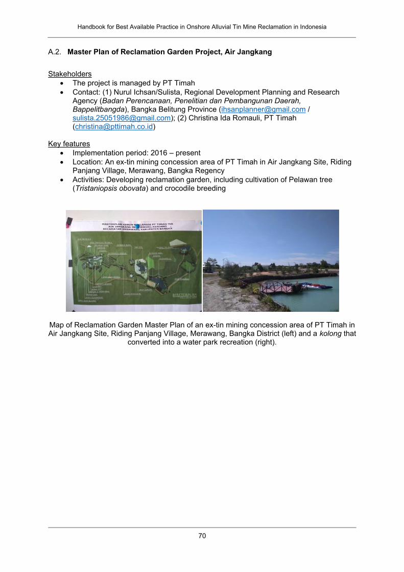
Handbook for Best Available Practice in Onshore Alluvial Tin Mine Reclamation in Indonesia
70
A.2. Master Plan of Reclamation Garden Project, Air Jangkang
Stakeholders
The project is managed by PT Timah
Contact: (1) Nurul Ichsan/Sulista, Regional Development Planning and Research Agency (Badan Perencanaan, Penelitian dan Pembangunan Daerah, Bappelitbangda), Bangka Belitung Province ([email protected] / [email protected]); (2) Christina Ida Romauli, PT Timah ([email protected])
Key features
Implementation period: 2016 – present
Location: An ex-tin mining concession area of PT Timah in Air Jangkang Site, Riding Panjang Village, Merawang, Bangka Regency
Activities: Developing reclamation garden, including cultivation of Pelawan tree (Tristaniopsis obovata) and crocodile breeding
Map of Reclamation Garden Master Plan of an ex-tin mining concession area of PT Timah in Air Jangkang Site, Riding Panjang Village, Merawang, Bangka District (left) and a kolong that
converted into a water park recreation (right).
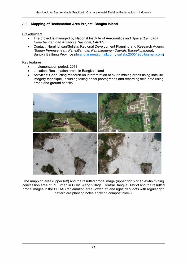
Handbook for Best Available Practice in Onshore Alluvial Tin Mine Reclamation in Indonesia
71
A.3. Mapping of Reclamation Area Project, Bangka Island
Stakeholders
The project is managed by National Institute of Aeronautics and Space (Lembaga Penerbangan dan Antariksa Nasional, LAPAN)
Contact: Nurul Ichsan/Sulista, Regional Development Planning and Research Agency (Badan Perencanaan, Penelitian dan Pembangunan Daerah, Bappelitbangda), Bangka Belitung Province ([email protected] / [email protected])
Key features
Implementation period: 2018
Location: Reclamation areas in Bangka Island
Activities: Conducting research on interpretation of ex-tin mining areas using satellite imagery technique, including taking aerial photographs and recording field data using drone and ground checks
The mapping area (upper left) and the resulted drone image (upper right) of an ex-tin mining concession area of PT Timah in Bukit Kijang Village, Central Bangka District and the resulted drone images in the BPDAS reclamation area (lower left and right; dark dots with regular grid
pattern are planting holes applying compost block).
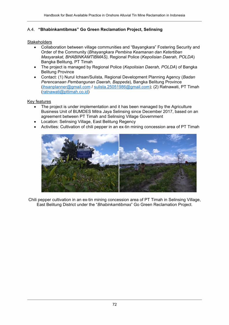
Handbook for Best Available Practice in Onshore Alluvial Tin Mine Reclamation in Indonesia
72
A.4. “Bhabinkamtibmas” Go Green Reclamation Project, Selinsing
Stakeholders
Collaboration between village communities and “Bayangkara” Fostering Security and Order of the Community (Bhayangkara Pembina Keamanan dan Ketertiban Masyarakat, BHABINKAMTIBMAS), Regional Police (Kepolisian Daerah, POLDA) Bangka Belitung, PT Timah
The project is managed by Regional Police (Kepolisian Daerah, POLDA) of Bangka Belitung Province
Contact: (1) Nurul Ichsan/Sulista, Regional Development Planning Agency (Badan Perencanaan Pembangunan Daerah, Bappeda), Bangka Belitung Province ([email protected] / [email protected]); (2) Ratnawati, PT Timah ([email protected])
Key features
The project is under implementation and it has been managed by the Agriculture Business Unit of BUMDES Mitra Jaya Selinsing since December 2017, based on an agreement between PT Timah and Selinsing Village Government
Location: Selinsing Village, East Belitung Regency
Activities: Cultivation of chili pepper in an ex-tin mining concession area of PT Timah
Chili pepper cultivation in an ex-tin mining concession area of PT Timah in Selinsing Village,
East Belitung District under the “Bhabinkamtibmas” Go Green Reclamation Project.
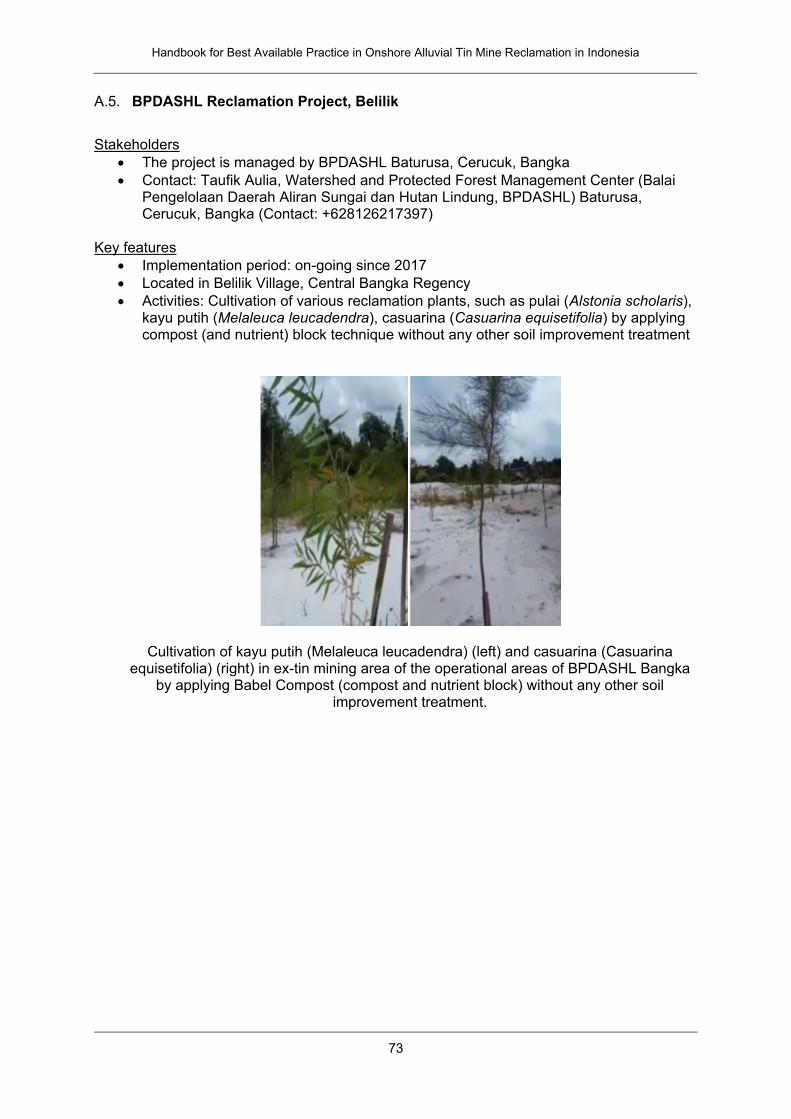
Handbook for Best Available Practice in Onshore Alluvial Tin Mine Reclamation in Indonesia
73
A.5. BPDASHL Reclamation Project, Belilik
Stakeholders
The project is managed by BPDASHL Baturusa, Cerucuk, Bangka
Contact: Taufik Aulia, Watershed and Protected Forest Management Center (Balai Pengelolaan Daerah Aliran Sungai dan Hutan Lindung, BPDASHL) Baturusa, Cerucuk, Bangka (Contact: +628126217397)
Key features
Implementation period: on-going since 2017
Located in Belilik Village, Central Bangka Regency
Activities: Cultivation of various reclamation plants, such as pulai (Alstonia scholaris), kayu putih (Melaleuca leucadendra), casuarina (Casuarina equisetifolia) by applying compost (and nutrient) block technique without any other soil improvement treatment
Cultivation of kayu putih (Melaleuca leucadendra) (left) and casuarina (Casuarina equisetifolia) (right) in ex-tin mining area of the operational areas of BPDASHL Bangka
by applying Babel Compost (compost and nutrient block) without any other soil improvement treatment.
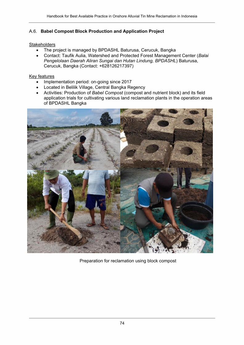
Handbook for Best Available Practice in Onshore Alluvial Tin Mine Reclamation in Indonesia
74
A.6. Babel Compost Block Production and Application Project
Stakeholders
The project is managed by BPDASHL Baturusa, Cerucuk, Bangka
Contact: Taufik Aulia, Watershed and Protected Forest Management Center (Balai Pengelolaan Daerah Aliran Sungai dan Hutan Lindung, BPDASHL) Baturusa, Cerucuk, Bangka (Contact: +628126217397)
Key features
Implementation period: on-going since 2017
Located in Belilik Village, Central Bangka Regency
Activities: Production of Babel Compost (compost and nutrient block) and its field application trials for cultivating various land reclamation plants in the operation areas of BPDASHL Bangka
Preparation for reclamation using block compost
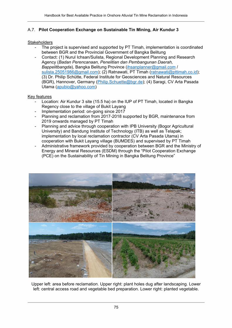
Handbook for Best Available Practice in Onshore Alluvial Tin Mine Reclamation in Indonesia
75
A.7. Pilot Cooperation Exchange on Sustainable Tin Mining, Air Kundur 3
Stakeholders
- The project is supervised and supported by PT Timah, implementation is coordinated between BGR and the Provincial Government of Bangka Belitung
- Contact: (1) Nurul Ichsan/Sulista, Regional Development Planning and Research Agency (Badan Perencanaan, Penelitian dan Pembangunan Daerah, Bappelitbangda), Bangka Belitung Province ([email protected] / [email protected]); (2) Ratnawati, PT Timah ([email protected]); (3) Dr. Philip Schütte, Federal Institute for Geosciences and Natural Resources (BGR), Hannover, Germany ([email protected]); (4) Saragi, CV Arta Pasada Utama ([email protected])
Key features
- Location: Air Kundur 3 site (15.5 ha) on the IUP of PT Timah, located in Bangka Regency close to the village of Bukit Layang
- Implementation period: on-going since 2017 - Planning and reclamation from 2017-2018 supported by BGR, maintenance from
2019 onwards managed by PT Timah - Planning and advice through cooperation with IPB University (Bogor Agricultural
University) and Bandung Institute of Technology (ITB) as well as Telapak; implementation by local reclamation contractor (CV Arta Pasada Utama) in cooperation with Bukit Layang village (BUMDES) and supervised by PT Timah
- Administrative framework provided by cooperation between BGR and the Ministry of Energy and Mineral Resources (ESDM) through the “Pilot Cooperation Exchange (PCE) on the Sustainability of Tin Mining in Bangka Belitung Province”
Upper left: area before reclamation. Upper right: plant holes dug after landscaping. Lower left: central access road and vegetable bed preparation. Lower right: planted vegetable.
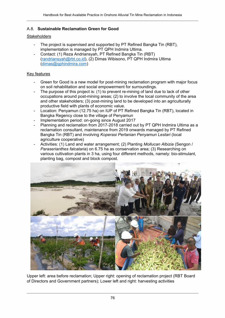
Handbook for Best Available Practice in Onshore Alluvial Tin Mine Reclamation in Indonesia
76
A.8. Sustainable Reclamation Green for Good
Stakeholders
- The project is supervised and supported by PT Refined Bangka Tin (RBT), implementation is managed by PT QPH Indmira Ultima.
- Contact: (1) Reza Andriansyah, PT Refined Bangka Tin (RBT) ([email protected]), (2) Dimas Wibisono, PT QPH Indmira Ultima ([email protected])
Key features
- Green for Good is a new model for post-mining reclamation program with major focus on soil rehabilitation and social empowerment for surroundings.
- The purpose of this project is: (1) to prevent re-mining of land due to lack of other occupations around post-mining areas; (2) to involve the local community of the area and other stakeholders; (3) post-mining land to be developed into an agriculturally productive field with plants of economic value.
- Location: Penyamun (12.75 ha) on IUP of PT Refined Bangka Tin (RBT), located in Bangka Regency close to the village of Penyamun
- Implementation period: on-going since August 2017 - Planning and reclamation from 2017-2018 carried out by PT QPH Indmira Ultima as a
reclamation consultant, maintenance from 2019 onwards managed by PT Refined Bangka Tin (RBT) and involving Koperasi Pertanian Penyamun Lestari (local agriculture cooperative)
- Activities: (1) Land and water arrangement; (2) Planting Mollucan Albizia (Sengon / Paraserianthes falcataria) on 6.75 ha as conservation area; (3) Researching on various cultivation plants in 3 ha, using four different methods, namely: bio-stimulant, planting bag, compost and block compost.
Upper left: area before reclamation; Upper right: opening of reclamation project (RBT Board
of Directors and Government partners); Lower left and right: harvesting activities
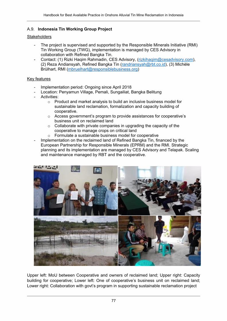
Handbook for Best Available Practice in Onshore Alluvial Tin Mine Reclamation in Indonesia
77
A.9. Indonesia Tin Working Group Project
Stakeholders
- The project is supervised and supported by the Responsible Minerals Initiative (RMI) Tin Working Group (TWG), implementation is managed by CES Advisory in collaboration with Refined Bangka Tin.
- Contact: (1) Rizki Haqim Rahmadin, CES Advisory, ([email protected]), (2) Reza Andiansyah, Refined Bangka Tin ([email protected]), (3) Michèle Brülhart, RMI ([email protected])
Key features
- Implementation period: Ongoing since April 2018 - Location: Penyamun Village, Pemali, Sungailiat, Bangka Belitung - Activities:
o Product and market analysis to build an inclusive business model for sustainable land reclamation, formalization and capacity building of cooperative.
o Access government’s program to provide assistances for cooperative’s business unit on reclaimed land
o Collaborate with private companies in upgrading the capacity of the cooperative to manage crops on critical land
o Formulate a sustainable business model for cooperative - Implementation on the reclaimed land of Refined Bangka Tin, financed by the
European Partnership for Responsible Minerals (EPRM) and the RMI. Strategic planning and its implementation are managed by CES Advisory and Telapak. Scaling and maintenance managed by RBT and the cooperative.
Upper left: MoU between Cooperative and owners of reclaimed land; Upper right: Capacity
building for cooperative; Lower left: One of cooperative’s business unit on reclaimed land;
Lower right: Collaboration with govt’s program in supporting sustainable reclamation project
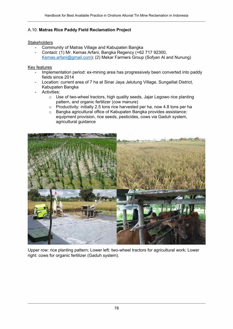
Handbook for Best Available Practice in Onshore Alluvial Tin Mine Reclamation in Indonesia
78
A.10. Matras Rice Paddy Field Reclamation Project
Stakeholders
- Community of Matras Village and Kabupaten Bangka - Contact: (1) Mr. Kemas Arfani, Bangka Regency (+62 717 92300,
[email protected]); (2) Mekar Farmers Group (Sofyan Al and Nunung) Key features
- Implementation period: ex-mining area has progressively been converted into paddy fields since 2014
- Location: current area of 7 ha at Sinar Jaya Jelutung Village, Sungailiat District, Kabupaten Bangka
- Activities: o Use of two-wheel tractors, high quality seeds, Jajar Legowo rice planting
pattern, and organic fertilizer (cow manure) o Productivity: initially 2.5 tons rice harvested per ha, now 4.8 tons per ha o Bangka agricultural office of Kabupaten Bangka provides assistance:
equipment provision, rice seeds, pesticides, cows via Gaduh system, agricultural guidance
Upper row: rice planting pattern; Lower left: two-wheel tractors for agricultural work; Lower
right: cows for organic fertilizer (Gaduh system).
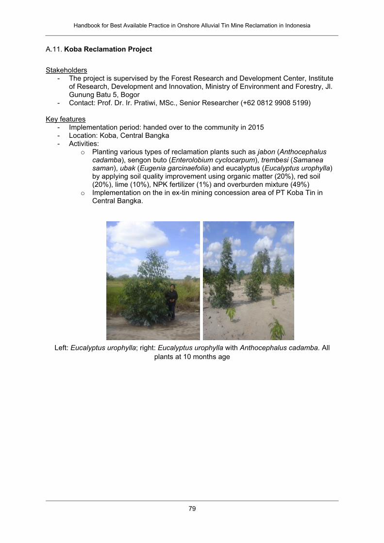
Handbook for Best Available Practice in Onshore Alluvial Tin Mine Reclamation in Indonesia
79
A.11. Koba Reclamation Project
Stakeholders
- The project is supervised by the Forest Research and Development Center, Institute of Research, Development and Innovation, Ministry of Environment and Forestry, Jl. Gunung Batu 5, Bogor
- Contact: Prof. Dr. Ir. Pratiwi, MSc., Senior Researcher (+62 0812 9908 5199) Key features
- Implementation period: handed over to the community in 2015 - Location: Koba, Central Bangka - Activities:
o Planting various types of reclamation plants such as jabon (Anthocephalus cadamba), sengon buto (Enterolobium cyclocarpum), trembesi (Samanea saman), ubak (Eugenia garcinaefolia) and eucalyptus (Eucalyptus urophylla) by applying soil quality improvement using organic matter (20%), red soil (20%), lime (10%), NPK fertilizer (1%) and overburden mixture (49%)
o Implementation on the in ex-tin mining concession area of PT Koba Tin in Central Bangka.
Left: Eucalyptus urophylla; right: Eucalyptus urophylla with Anthocephalus cadamba. All
plants at 10 months age
Handbook for Best Available Practice in Onshore Alluvial Tin Mine Reclamation in Indonesia
80
B. Bibliography
Applicable Laws and Regulations
Republic of Indonesia Mineral and Coal Mining Law, Law No. 4/2009
Republic of Indonesia Government Regulation No. 82/2001 concerning Water Quality
and Control over Water Pollution
Republic of Indonesia, Regulation of the Minister of State of Environment No. 04/2006
concerning Quality Standards for Waste Water from Tin Mining Business and Activities
Republic of Indonesia, Forestry Minister’s Regulation No. 60/2009 concerning
Guideline for Evaluation of Successful Forest Reclamation
Republic of Indonesia, Minister of Energy and Mineral Resources Regulation
No. 78/2010 on Reclamation and Post-Mining
Republic of Indonesia, Minister of Forestry Regulation No. P4/Menhut-II/2011
concerning Forest Reclamation Guidelines
Decree of the Minister of Energy and Mineral Resources of the Republic of Indonesia
No. 1806/K/30/MEM/2018 concerning Guidelines for Implementation of Compilation,
Evaluation, Approval of Work Plans and Budget Costs and Reports on Mineral and
Coal Mining Business Activities
Decree of the Minister of Energy and Mineral Resources of the Republic of Indonesia
No. 1827/K/30/MEM/2018 concerning Guidelines for Implementing Good Mining
Techniques
Regional Regulation of Bangka Belitung Province No. 7 of 2014 concerning
Management of Mineral Mining
Other Cited References
Aisah AR, Soekarno BPW, Achmad. 2015: Isolation and identification of fungi
associated with dieback disease of Jabon seedling (Anthocephalus cadamba (Roxb.)
Miq). Journal of Plant Forest Research. 12(3): 153-163 (in Indonesian)
Arshad MA, Lowery B, Grossman B. 1996: Physical tests for monitoring soil quality.
p.123-142. In: Doran JW, Jones AJ (eds.) Methods for Assessing Soil Quality. Soil Sci.
Soc. Am. Spec. Publ. 49. SSSA, Madison, WI. USA.
Brouwer C, Heibloem M. 1986: Irrigation Water Management: Irrigation Water Needs.
Training Manual No. 3. FAO.
Dierolf T, Fairhurst TH, Mutert EW. 2000: Soil Fertility Kit: A Toolkit for Acid Upland Soil
Fertility Management in Southeast Asia Handbook Series. Deutsche Gesellschaft für
Technische Zusammenarbeit (GTZ) GmbH; Food and Agriculture Organization; PT
Katom; and Potash & Phosphate Institute (PPI), Potash & Phosphate Institute of
Canada (PPIC).
Ericsson T. 1994: Nutrient dynamics and requirements of forest crops. New Zealand
Journal of Forestry Science 24(2/3): 133-68.
Handbook for Best Available Practice in Onshore Alluvial Tin Mine Reclamation in Indonesia
81
FAO (2018): Food and Agriculture Organization of the United Nations.
http://www.fao.org/fishery/static/FAO_Training/FAO_Training/General/x6706e/x6706e
06.htm
Parveen, R. & Kumar, U., 2012: Integrated approach of Universal Soil Loss Equation
(USLE) and Geographical Information System (GIS) for soil loss risk assessment in
Upper South Koel Basin, Jharkhand. Journal of Geographic Information System, 4,
588-596. http://dx.doi.org/10.4236/jgis.2012.46061
Li, J., Amlani, A., Bertels. S. (2014): Community engagement – A getting started toolkit
for exploration and development companies. Network for Business Sustainability.
Available online at: https://nbs.net/p/community-engagement-toolkit-for-mining-
companies-02ed3073-adda-480a-a246-faf3d7cf8c20
Lubis, I.Azwardi, 2017: Teknik Penambangan Timah Aluvial (In Bahasa Indonesia;
translated: Alluvial Tin Mining Technique), Humas PT Timah (Persero), Tbk
Nair, KSS (ed.), 2000: Insects and pest diseases in Indonesia forests. an assessment
of the major threat, research efforts, and literature. Center for International Forestry
Research (CIFOR), Bogor, Indonesia, 101 p.
http://www.cifor.org/publications/pdf_files/Insect-pests.pdf
Nurtjahya, E. & Franklin, J.A. (2019): Some physiological characteristics to estimate
species potential as mine reclamation ground cover. Int. J. of Mining, Reclamation and
Environment 33: 75-86. https://doi.org/10.1080/17480930.2017.1333296
Soil Research Center, 1983: Annex of the TOR No. 59 b P3MT/PPT Land Suitability
Classification (in Indonesian).
The Asia Foundation, 2016: Frugal Rehabilitation Methodology – Field Handbook.
Available online at https://asiafoundation.org/publication/frugal-rehabilitation-
methodology/
Van der Molen WH, Beltrán JM, Ochs WJ. 2007: Guidelines and Computer Programs
for the Planning and Design of Land Drainage System. FAO Irrigation and Drainage
Paper 62, Rome.
Wiyono, S., Giyanto, KH Mutaqin, SH Hidayat, Supramana, dan Widodo. 2017:
Emerging Diseases pada Tanaman Pertanian: Strategi dan Opsi Kebijakan
Pengendalian. “Kemunculan Penyakit Baru dan Impor Benih”. Simposium Nasional
Fitopatologi (In Bahasa Indonesia; translated: Emerging Diseases on Agricultural
Plants: Strategies and Options for Control Policies. "Emergence of New Diseases and
Import of Seeds". The National Phytopathology Symposium).
https://repository.ipb.ac.id/jspui/bitstream/123456789/88181/1/Emerging%20Disease
s%20pada%20Tanaman%20Pertanian.pdf
Handbook for Best Available Practice in Onshore Alluvial Tin Mine Reclamation in Indonesia
82
C. Abbreviations and Glossary
C.1. Acronyms
Term Definition
AMDAL Environmental Impact Assessment (Analisis Mengenai Dampak Lingkungan)
APL Area for other usage (Area Penggunaan Lain)
BGR German Federal Institute for Geosciences and Natural Resources (Institut Geosains dan Sumber Daya Alam, Republik Federal Jerman)
BPDASHL Watershed and Protected Forest Management Center (Balai Pengelolaan Daerah Aliran Sungai dan Hutan Lindung)
BUMDES Village-owned enterprise (Badan Usaha Milik Desa)
ESDM
Ministry of Energy and Mineral Resources (Kementerian Energi dan Sumber Daya Mineral)
IUP Mining permit (Izin Usaha Pertambangan)
IUPK
Special Mining Permit (Izin Usaha Pertambangan Khusus)
IPR
Artisanal Mining Permit (Izin Pertambangan Rakyat)
RKL
Environmental Management Plan (Rencana Pengelolaan Lingkungan)
RPL
Environmental Monitoring Plan (Rencana Pemantauan Lingkungan)
RTRW Spatial Plan Rencana Tata Ruang dan Wilayah
UKL
Environmental Management Efforts (Upaya Pengelolaan Lingkungan)
UPL
Environmental Monitoring Efforts (Upaya Pemantauan Lingkungan)
SOP
Standard Operational Procedures (Prosedur Operasi Baku)
C.2. Glossary
Term Definition
Compost Completely decayed organic matter used for conditioning soil. It is dark, odorless and rich in nutrients.
Cover Crop Vegetation grown to protect and build the soil during an interval when the area would otherwise lie fallow.
Germination The initiation of growth by the embryo and development of a young plant from
seed
Kolong Local term for ponds resulting from tin mining activities in Bangka-Belitung Islands
N-P-K An abbreviation for the three main nutrients that have been identified as absolutely necessary for plants are nitrogen (N), phosphorus (P) and potassium (K). These three are also known as “macronutrients,” and are the source of the three numbers commonly found on fertilizer labels.
pH A logarithmic scale from 0-14 that explains the degree of acidity or alkalinity of the water or soil; neutral water has a pH of 7.
Seedbed preparation
Soil treatment prior to seeding to: enhance soil surface layer for seed deposition and optimum opportunity for generation and seedling growth, reduce or eliminate existing vegetation, reduce the effective supply of weed

Handbook for Best Available Practice in Onshore Alluvial Tin Mine Reclamation in Indonesia
83
seed, modify physical soil characteristics, and enhance temperature and water characteristics of the microenvironment.
Seedling A plant that has recently germinated and expanded its seed leaves.
Tailings Mined material rejected after processing when tin concentrate has been extracted; depending on the recovery rate of the processing techniques, the tailings may still contain residual tin ore at low grades.
Topsoil The uppermost layer of unconsolidated material on the Earth’s surface. In this
case, this refers to actual soil (with organic material) rather than sterile media
such as sand tailings without any plant growth.
Transplanting The moving of a plant from one growth medium to another.