1997-1999 activities of the tsunami mitigation subcommittee
TRANSCRIPT
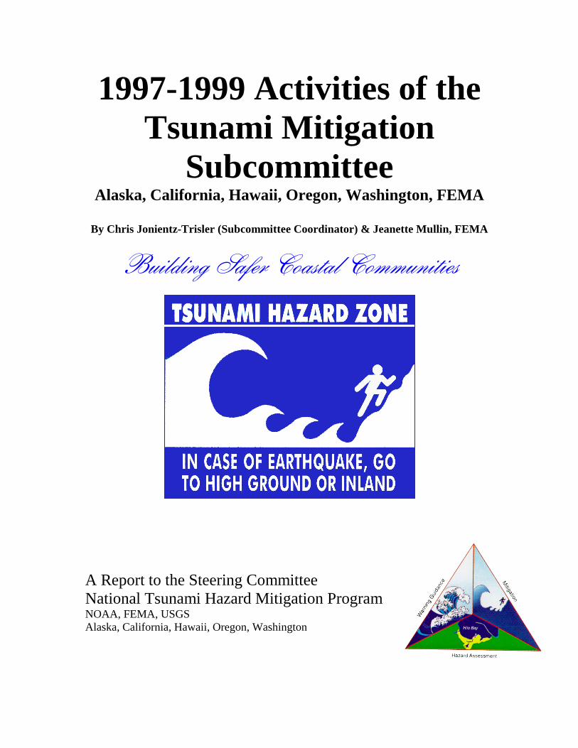
1997-1999 Activities of theTsunami Mitigation
SubcommitteeAlaska, California, Hawaii, Oregon, Washington, FEMA
By Chris Jonientz-Trisler (Subcommittee Coordinator) & Jeanette Mullin, FEMA
����������� ������������������
A Report to the Steering CommitteeNational Tsunami Hazard Mitigation ProgramNOAA, FEMA, USGSAlaska, California, Hawaii, Oregon, Washington
����������������� ����������������� ������ ������������������ ����������� ��� ���!������ ���"#��
$%������& ����'��������(���� �������� �)��� �*�+�&���������������"#�������������
��,�- ���� �������������� ������.�� �������������'��)������ ��/� ����
. ����"#����0�1������������� ����������� ��� ���!������ �
���
��������������
Acknowledgements________________________________________________v
Executive Summary ______________________________________________ vii
����������� �
�� ���������������������� ������� ����������� �������� ����� �� �!"��#�� ��� �$
������ �%���������� �������� $���� �� $$"��#�� ��� $�
&���� ��'�(���)��������*�������� $%���������� �+��������� ,!Surviving a Tsunami -- Lessons from Chile, Hawaii, and Japan__________ 41'��-����.�����/�����0 ��� ,�
�1��&���� ���������2�0��� ,$31��"�(�'� ��2�������4��� ,�
� ��������� ������� �������� ��
� ������� ����������
� ��������������� �������� ��
�!!���� ��

��
�
�������������
������������� �������������������������������������������������������������������������������������������������������������������������������
• ������������������������������������������������ �������������������������������������!���"#$$� ���%��������� �����������#����� ������������&����'�����������(���������)
• �������������������������*�������������������������������������'������������������������������������������������������������������������� �����������'�������� ��������������$����+ ����!����������������������'�����%������,�-��������+.������$������,��%����+�/)�&��)�������0)�.���������� ��)�#��-���� ����������.�'�-)�������� �)��0���� �������,��#�����+�'�����������!��,���1��������+&����1������'�������������'�!�����������.���',)
• -��������������������������$�����-���������%�����#��������1������������������������������������������������������������������)
• !������������������� ������������������������������1������&����������������������������������������������)
• "#$$�° �����&��2�������.������3����������������������������� ������������
�����������)• ���$�
° .�����4�5� �������-����'��.'�1����������-���-�������������������������������6 �����������������������������������������'����������
° ���$�%��7����������������������������������������'�������������������$����"#$$������������� �������������
° ���$�.�����(4����������������������������������������� ����)• 8 & �
° -���1����������9���������������� ������������������������������������)• #������������������������������������������������������������'��������������
���������������������������������������������������'��-������������+1$ ".,�������$������+8 & ,��&������������+ #&$�(,��%��'�3���+%����-�)�-) ),�&�����-�������-������-����'�+��1-,�� �����������+��������������������,��.��-����������+$3�&���)�:�&����)� ���),�����.����%�����+8���)����$3���������,)
$����'�������������'������������ ������������-����������������������������������������������������������������������������������������'���$���*�&�'���������������1���;�-�������*��.��������������!���� �����;�%���*������<������&�����������;�#����*������ ����2���$����3����� �����'����� ������ �����;����1�������*��&�����-������������1���������������)�� ��������������=��������������������8������������������9�����������������������)

��
���
�������������
This report documents progress and provides information about tsunami hazard mitigationproducts and activities produced by the Mitigation Subcommittee of the National TsunamiHazard Mitigation Program (NTHMP). The Subcommittee includes representatives from theStates of Alaska, California, Hawaii, Oregon, Washington, and is chaired by a representativefrom the Federal Emergency Management Agency (FEMA).
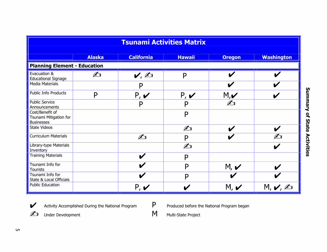
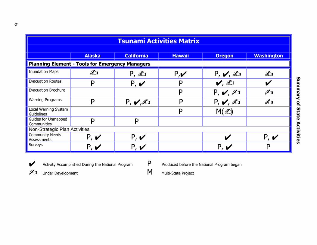
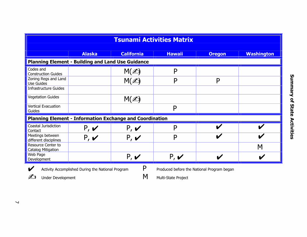
Each State Program develops products in order to promote “tsunami resistant communities”. Inaddition, States collaborate on "multi-State projects" by pooling resources to address commonissues to benefit several States. The States’ activities for the period from 1997 through mid-1999are summarized on pages 5-8. A table is organized according to the strategic planning areasidentified in the Strategic Implementation Plan which defines, prioritizes and coordinates theSubcommittee’s efforts. (Specific information about this plan is found in the Introduction.)Activities in the table are explained more fully in the State specific portion of the report.
Each State also chose a project that especially demonstrates what helps build a “tsunamiresistant community” and these are highlighted in the report. Alaska’s inundation mappingpartnership was established to involve local community leaders in the mapping process and givethem ownership of the project. California’s building of a Tsunami Hazard MitigationConstituency brought together federal, state, and local officials responsible for emergency andcoastal zone management to develop California's strategic plan for tsunami hazard mitigation.Hawaii’s Tsunami Working Group brings together representatives from the state and countyemergency management departments, Pacific Tsunami Warning Center, US Geological Survey,and local tsunami experts to improve and update usability of tsunami information andprocedures. Oregon’s coastal communities were assisted in development of their own localtsunami evacuation brochures. Washington’s tsunami warning and evacuation sign programemphasized the cooperation of the counties in installation of interpretive and evacuation signsalong coastal roads and highways and is consistent with signs placed along the Oregon coast.
The multi-State projects involve several States sharing development input and review andproducts resulting from them. Oregon led a project to develop tsunami public educationmaterials, including bookmarks, brochures, posters, magnets, hazard zone decals, coffee mugs,etc. Washington led creation of a Tsunami Information System for local emergency managers,officials, and others which distributes new research and other information through a newsletter,the TsuInfo Alert. Washington also coordinated publication of Tsunami Survival - Lessons fromChile that provides vivid accounts (and lessons for the future) of how people survived, or didn'tsurvive, the 1960 Chilean tsunami. Two projects underway currently are local guidancedocuments for tsunami warning systems and structures and land use.
As this report demonstrates, the five States have accomplished many activities towards reducingtsunami risks. Besides just documenting their productivity, however, the States' ultimate goal isto make the National Tsunami Hazard Mitigation Program truly national by transferring theinformation and products they have developed to other affected jurisdictions within the UnitedStates and beyond. The States hope their efforts will save individuals, not only in their ownStates, but also in all affected jurisdictions in the United States and potentially around the world.

����
�
������������
�� ��The purpose of this report is to document progress and disseminate information about tsunamihazard mitigation products and activities supported by the National Tsunami Hazard MitigationProgram (NTHMP). The States of Alaska, California, Hawaii, Oregon, and Washington havehighlighted products and activities as models for other states and territories based upon theirsuccess or expected success in reducing tsunami hazards.
������ ��A number of scientific investigations published in the 1980’s showed that large subduction zoneearthquakes had occurred along the Pacific Northwest coast of the United States in past centuriesand were likely to do so again in the future, causing significant damage and loss of life to the fivestates. In 1992, an earthquake near Cape Mendocino in northern California produced a smalltsunami which arrived at nearby coastal communities within twenty minutes of the earthquake.In 1994, a distant tsunami warning for the West Coast tested the state of tsunami readiness on theCascadia coast. A survey of West Coast communities revealed disparate responses occurred as aresult of the warning (see appendix A for copy of report). These events led toward the formationof the National Tsunami Hazard Mitigation Program to provide a consistent message and plan ofaction to mitigate tsunami risk.
���� ����� ����The National Tsunami Hazard Mitigation Program is a Federal/State partnership to reduce risksfrom tsunamis. The National Oceanographic and Atmospheric Administration (NOAA), theFederal Emergency Management Agency (FEMA), the United States Geological Survey(USGS), and the States of Alaska, California, Hawaii, Oregon and Washington have pooled theirvarious expertise to reduce risk as charged by Congress by the following actions:
1. Assessing tsunami hazards,2. Facilitating communication of hazard information,3. Improving early detection of tsunamigenic earthquakes,4. Reducing false tsunami alarms,5. Supporting tsunami mitigation efforts for at-risk communities.
The National Program can be represented by a triangle whose three sides support each other."Mitigation" is one part of the triangle. The other two parts include "Warning Guidance" and"Hazard Assessment." NOAA leads development of a system of deep-water buoys to providebetter warning and real time information by detecting tsunamis at sea. NOAA also staffs theTsunami Inundation Mapping Effort (TIME) Center that provides or assists with modelingefforts for the creation of tsunami inundation maps and will archive the mapping processes andproducts. NOAA chairs the Steering Committee and is the recipient of Congressional fundingfor this program. NOAA distributes some of this funding to the USGS and FEMA forimplementation of their roles in the program. FEMA further distributes funding to the five statesfor both state and multi-state projects. FEMA holds the leadership role in coordinating
�
development of mitigation programs, products, and activities within the MitigationSubcommittee. Similarly, the USGS leads enhancement of existing seismic networks to providereal time detection of tsunamigenic earthquakes.
For more information on the program and updates on projects, visit the National Tsunami HazardMitigation Program website at http://www.pmel.noaa.gov/tsunami-hazard.
�������� ����� �������The Mitigation Subcommittee is a subgroup of the Steering Committee of the National TsunamiHazard Mitigation Program. The Subcommittee is currently made up of representatives from allfive states and FEMA Region 10 whose representative holds the role of Coordinator of theSubcommittee. The Subcommittee is charged with developing tsunami hazard mitigationprograms at the State and local levels. A key component of these programs includes workingwith local officials to develop useful mitigation products and to facilitate use of new inundationmaps being developed under the National Program. Inundation maps are being developed inconjunction with the Tsunami Inundation Modeling Effort (TIME) and geoscientists chosen bythe States to provide local data. These geoscientists are working with TIME modelers to turn themodeling data into usable maps.
���������������������� �����The Subcommittee saw a need for a strategic implementation plan that would define, prioritize,and coordinate the mitigation efforts of the National Program. Recently, the Subcommitteeapproved such a plan for submittal to the Steering Committee. It is available from NOAA asNOAA Technical Memorandum ERL PMEL-113, Strategic Implementation Plan for TsunamiMitigation Projects, L. Dengler, October 1998. It emphasizes the efficient use of availableresources, implementation of the technical results of the National Program at the state and locallevel, collaboration and sharing of information among the states and Federal agencies,incorporation of tsunami issues into existing all-hazards programs, and the reporting anddissemination of program results.
The Plan’s goal is "A tsunami resistant community" that:1. Understands the nature of the tsunami hazard.2. Has the tools it needs to mitigate the tsunami risk.3. Disseminates information about the tsunami hazard.4. Exchanges information with other at-risk areas.5. Institutionalizes planning for a tsunami disaster.
The Strategic Plan provides a framework for the development of specific tools and policies forstates and local communities to reduce the impact of future tsunamis. The plan addresses fivestrategic planning areas:
1. Education2. Tools for Emergency Managers3. Construction, Abatement and Land Use Guidance4. Information Exchange and Coordination5. Long-term Tsunami Mitigation (including recovery planning)
�
Incentives must be found to encourage action in these areas.
Activities supported by the Mitigation Task of the National Program are in the following areas ofemphasis:
1. Improve tsunami education.2. Provide tools to supply guidance and support local planners and emergency managers.3. Create and strengthen links within and among states to support long-term tsunami
mitigation.4. Improve the mitigation science infrastructure.5. Encourage innovation and local sponsorship of tsunami mitigation programs.
This plan’s approach to achieving the goal involves a four year intensive development effortfollowed by continued sustained effort:
Year 1: Assessment of needs and resourcesYear 2: Feasibility studies and product developmentYear 3: Product development and implementationYear 4: Implementation, and evaluationYear 5 and beyond: Implementation and maintenance

�

�������������� ��������
����� ���������� ������ �� ��� ����������
����������� � �������������
������������������� ������
✍ ✔�✍ � ✔ ✔������������ � � ✔ ✔��� ������������� � ��✔ ��✔ ��✔ ✔��� ������������������ � � ✍����������������������������������������
�
����������� ✍ ✔ ✔������� ��������� � ✍ � ✔ ✍ �����!"�!#�������� �������!
✍ ✔������������� � ✔ ���������������������
✔ � ��✔ ✔������������������ ��� $������ �
✔ � ✔ ✔��� ���������� ��✔ ✔ ��✔ ��✔�✍
✔ �������!�����# ��%��&�����%�'����� ������� � ���������������%�'����� �����������
✍ (���&��� �#��� � �� ��"��������)���
�����!��
�� ��� �
������ �
*
�������������� ��������
����� ���������� ������ �� ��� ����������
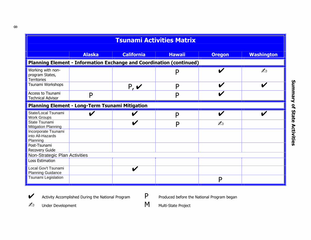
����������� � ����������������� �� �!������ ��
���������#� ✍ ��✍ ��✔ ��✔�✍ ✍���������+����� � ��✔ � ✔�✍ ✔�������������%��� � ��✔�✍ ✍,������������ � ��✔�✍ � ��✔�✍ ✍ ��� ,�����!����-���� ��� � �.✍/-��������(��##������������ � �Non-Strategic Plan Activities�������!'�������������� ��✔ ��✔ ✔ ��✔�����!� ��✔ ��✔ ��✔ �
✔ �������!�����# ��%��&�����%�'����� ������� � ���������������%�'����� �����������
✍ (���&��� �#��� � �� ��"��������)���
�����!��
�� ��� �
������ �
0
�������������� ��������
����� ���������� ������ �� ��� ����������
����������� � �����"������������#����$� �%�����
�����������������-����� �.✍/ �1���+����� ��(��-����� �.✍/ � ��������������-�����
���������-����� �.✍/������� ���������-����� ������������ � �����&����������������� �����������������
������ 2���������������� ��✔ ��✔ � ✔ ✔����������3���������������# ��� ��✔ ��✔ � ✔ ✔+������������������ ����������� �,������&��� �#��� ��✔ ��✔ ✔ ✔
✔ �������!�����# ��%��&�����%�'����� ������� � ���������������%�'����� �����������
✍ (���&��� �#��� � �� ��"��������)���
4
�����!��
�� ��� �
������ �
�������������� ��������
����� ���������� ������ �� ��� ����������
����������� � �����&����������������� ������������������'������ �(
,��5��3��%�"#������������������������
� 4 -
������,��5�%�#� ��4 � 4 4�����������������%��� ������� � � 4
����������� � �����#����� ���������������������State/Local TsunamiWork Groups
4 4 � 4 4State TsunamiMitigation Planning
4 � -Incorporate Tsunamiinto All-HazardsPlanning����"������+������!-����Non-Strategic Plan Activities ������������
Local Gov’t TsunamiPlanning Guidance
4Tsunami Legislation �
4 �������!�����# ��%��&�����%�'����� ������� � ���������������%�'����� �����������
- (���&��� �#��� � �� ��"��������)���
6
�����!��
�� ��� �
������ �
�
������������� �� ����������������
���������
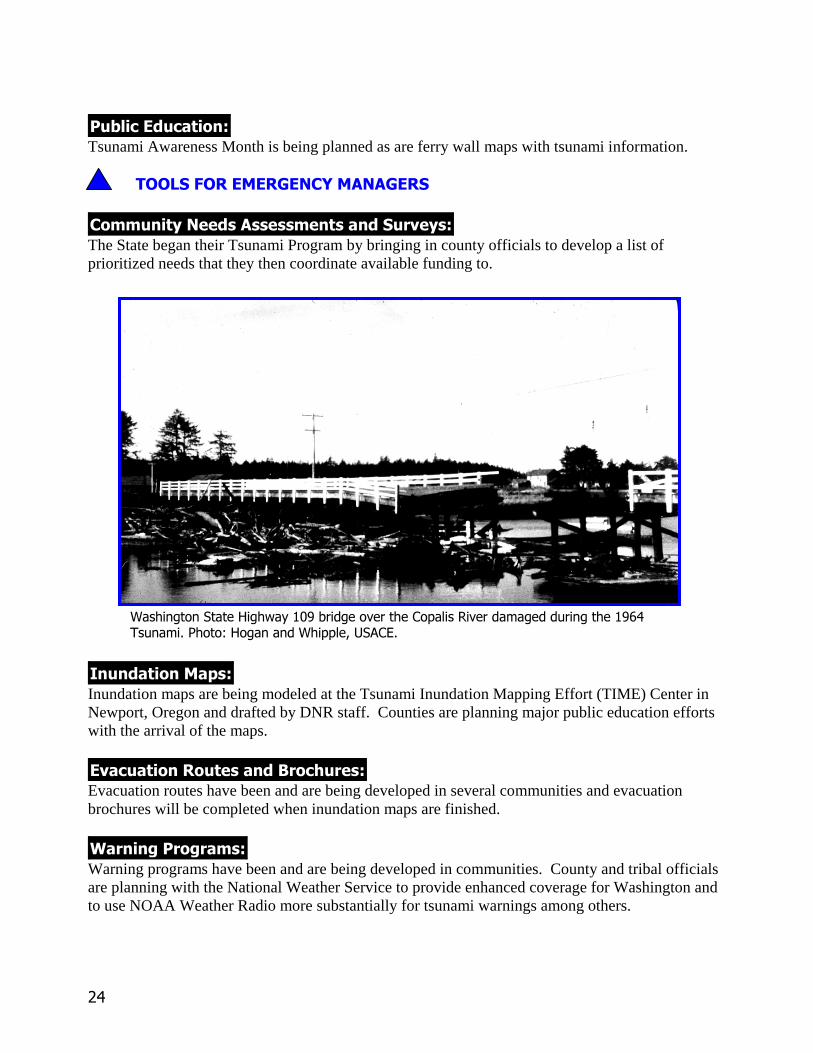
������������������������������Evacuation signs save lives by directing people along appropriate routes to safe places away fromthe tsunami. Kodiak communities will be receiving tsunami inundation maps soon and areinterested in placing evacuation signs. The Alaska Division of Emergency Services (ADES) is alsoworking with Sitka to purchase and place signs. Other communities will receive similar assistance.
�� ������� ������ �������Pamphlets and brochures serve to educate the public to the tsunami hazard and advise them how tostay safe. ADES will continue to provide these to communities.
���!��"�#��$�#%���&�$���%�#�
�����'����������������Community needs assessments provide the basis for prioritizing and implementing mitigationsolutions. ADES is establishing a database for 100 coastal communities to include communityprofiles, historical earthquake/tsunami data, known sources and availability of data, identifyingexisting plans and populations at risk, selecting evacuation routes, providing shelter informationand identifying communications capabilities and limitations.
��������$�(��Inundation maps save lives by providing information ahead of time about the potential for tsunamiimpact in certain areas. Communities can better plan safe egress routes. The maps may also serveas a catalyst for thought about placing future critical facilities in projected impact areas.Geophysical Institute staff at the University of Alaska Fairbanks are developing current maps forKodiak and long term expertise in tsunami modeling to serve Alaska in the future (see case study).
����������#������Appropriate evacuation routes save lives by considering where people would most safely be able toleave potential tsunami impact areas. Knowing ahead of time where the tsunami is less likely toreach, where bridges may be out, and where landslides may accompany an earthquake associatedwith the tsunami allows routes to be planned through less dangerous areas before the event.
)� ���� �� ���Warning programs save lives by alerting people to the arrival of a potentially dangerous tsunami iftime allows and educate them how to respond when the warning is given. Alaska is fortunate to be
��
the home of the Alaska and West Coast Tsunami Warning Center (ATWC). ATWC and ADEShave had a close relationship for many years and continue to work together to provide efficientwarnings to Alaskans. Some communities previously impacted by tsunamis have developed theirown local warning system. ATWC takes their outreach program on the road to the West Coast toinform those communities how best to react to warnings they provide.
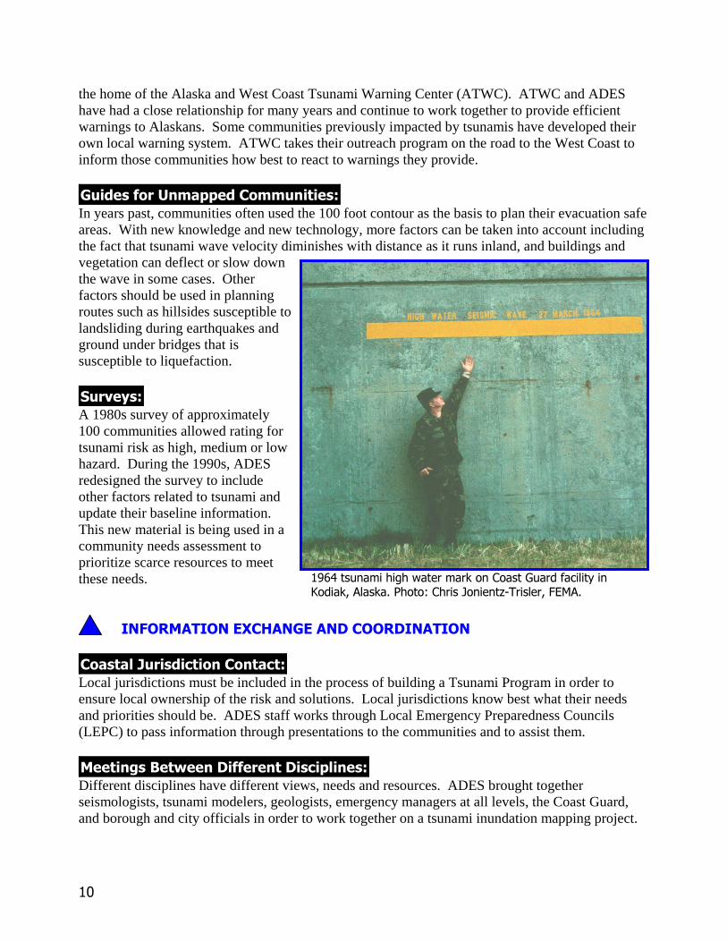
%�������� ���((������������In years past, communities often used the 100 foot contour as the basis to plan their evacuation safeareas. With new knowledge and new technology, more factors can be taken into account includingthe fact that tsunami wave velocity diminishes with distance as it runs inland, and buildings andvegetation can deflect or slow downthe wave in some cases. Otherfactors should be used in planningroutes such as hillsides susceptible tolandsliding during earthquakes andground under bridges that issusceptible to liquefaction.
�� ��'��A 1980s survey of approximately100 communities allowed rating fortsunami risk as high, medium or lowhazard. During the 1990s, ADESredesigned the survey to includeother factors related to tsunami andupdate their baseline information.This new material is being used in acommunity needs assessment toprioritize scarce resources to meetthese needs.
��"�#$�������*�+��%���������#��������
��������,� ����������������Local jurisdictions must be included in the process of building a Tsunami Program in order toensure local ownership of the risk and solutions. Local jurisdictions know best what their needsand priorities should be. ADES staff works through Local Emergency Preparedness Councils(LEPC) to pass information through presentations to the communities and to assist them.
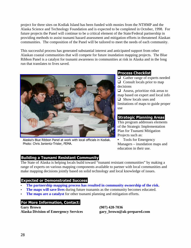
$�������-��.�������� ��������(�����Different disciplines have different views, needs and resources. ADES brought togetherseismologists, tsunami modelers, geologists, emergency managers at all levels, the Coast Guard,and borough and city officials in order to work together on a tsunami inundation mapping project.
��������� �� ������������������������������ � ��� ��� ������������ ����!���� ��"� ��#$%� ������&'(��
��
������������������ �A Tsunami Advisor serves as a valuable source of historical, scientific, and practical informationduring the tsunami crisis. The Alaska Tsunami Warning Center staff has provided this service tothe emergency management community both in times of crisis and during planning activities.
!��%/��#$������$��$���%�����
A State/Local Tsunami Work Group can support a tsunami program or activity very effectively. InAlaska, such a group known as The Blue Ribbon Panel was formed specifically to work with localcommunities in creating tsunami inundation maps and is made up of scientists representingseismology, tsunami modeling, and geology. It also includes emergency managers to guide theusefulness of the maps.
"� �$� ����� ����0��������Gary R. Brown (907) 428-7036Alaska Division of Emergency Services [email protected]
Or
Roger Hansen (907) 474-5533University of Alaska, Geophysical Institute [email protected]
)������ ���� ��������������������������%��� �� ����!�*�+��,�-��
��
������������� �� ���������������� ��
���������
������������������������������Informational and evacuation signage has been developed and installed in Crescent City, Del NorteCounty. Interpretive signs are being installed in Redwood National Park providing generalinformation about tsunamis. Trail head tsunami hazard signs will be installed this year. The Cityof Eureka is reviewing proposals for evacuation zone mapping and signage. As inundation mapsbecome available, other vulnerable counties will develop evacuation plans and signage programs.Interpretive signs are planned for areas subject to inundation in Del Norte and Humboldt Counties.
Both Crescent City (harbor siren installed at this time) and Eureka are considering installation ofsiren warning systems.
���������� �����Media materials help raise general public awareness. Background material and media kits havebeen developed for the north coast. The California Earthquake Program has developed a publicinformation brochure for distribution in areas subject to inundation. San Mateo County developedan education videotape that has been distributed to all coastal jurisdictions. Additional videomaterials, purchased from the National Tsunami Mitigation Program, have been distributed toschool districts in all coastal counties.
�� ������� ������ �������Pamphlets and brochures educate the public on the tsunami hazard and how to remain safe. Inaddition to the brochure and video noted above, Humboldt State University developed anddistributed Living on Shaky Ground: How to Survive Earthquakes and Tsunamis on the NorthCoast. The brochure has been distributed to residents of Del Norte, Humboldt, and northernMendocino Counties. California modified Oregon’s tsunami brochure and is distributing it.
�� ������ ��������������PSAs provide information before and during a crisis. PSAs on the dangers of earthquakes andtsunamis were developed by the Humboldt Earthquake Education Center and Dell'Arts EducationThrough Arts Project in Humboldt County, and broadcast over local cable channels in the northcoast region.
�� ���������� �����Humboldt State University faculty developed materials on the threat of tsunamis for integrationinto primary and secondary science education programs. The materials are an augmentation to
��
FEMA and California curricula on earthquakes, the geosciences, and disaster preparedness.Additional materials are under development and will be disseminated to coastal counties’ offices ofeducation for local distribution to schools. Humboldt State University offers a course, Geology 700-- Tsunami, to teachers and student priorities.
� ��������� �����Training materials deliver the right message and exist to train emergency managers.
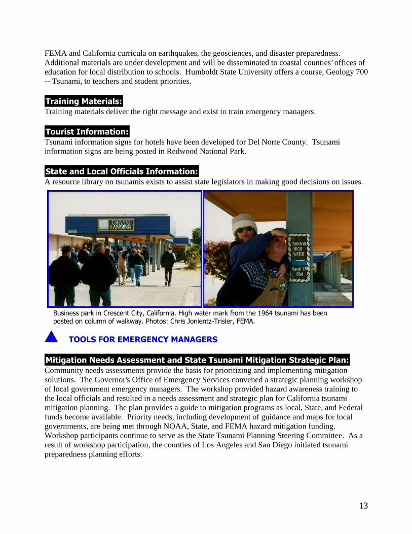
��� ������� �����Tsunami information signs for hotels have been developed for Del Norte County. Tsunamiinformation signs are being posted in Redwood National Park.
���������!������������������ �����A resource library on tsunamis exists to assist state legislators in making good decisions on issues.
���!��"�#����#$���%�����$�#�
���������������������������������������������������� �����������Community needs assessments provide the basis for prioritizing and implementing mitigationsolutions. The Governor’s Office of Emergency Services convened a strategic planning workshopof local government emergency managers. The workshop provided hazard awareness training tothe local officials and resulted in a needs assessment and strategic plan for California tsunamimitigation planning. The plan provides a guide to mitigation programs as local, State, and Federalfunds become available. Priority needs, including development of guidance and maps for localgovernments, are being met through NOAA, State, and FEMA hazard mitigation funding.Workshop participants continue to serve as the State Tsunami Planning Steering Committee. As aresult of workshop participation, the counties of Los Angeles and San Diego initiated tsunamipreparedness planning efforts.
��������� ���� ��������������� ����������� �� �� ������������������ �����!������������������"�����#�� ��$�����%&' ��� �()*+�
��
��������� �&�������In the aftermath of the 1992 Humboldt earthquake and tsunami, California, with the support fromboth FEMA and NOAA, developed and disseminated an earthquake and tsunami planning scenariofor Del Norte, Humboldt, and northern Mendocino Counties. The scenario combined inundationprojections with estimates of ground shaking and structural damage to provide local, State, andFederal disaster planners with a better understanding of the complexity of a near source tsunamievent. Additional inundation maps are being developed with support from the National TsunamiHazard Mitigation Program, FEMA’s National Earthquake Hazards Reduction Program, and theCalifornia Governor’s Office of Emergency Services (OES). The NOAA mapping program, inpartnership with California OES, will develop and distribute inundation projections to SanFrancisco and San Mateo, Santa Barbara, Los Angeles, and San Diego Counties with currentfunding.
$��������� �!�����$��� ���������#��'����������California OES, with support from the National Tsunami Hazard Mitigation Program, FEMA’sNEHRP, and State funds, developed a guidance document to assist local government emergencyplanners in developing response and evacuation plans. The Local Planning Guidance includesbackground information about the tsunami threat, Standardized Emergency Management Systemsplanning procedures, sample plans for cities and counties, notification procedures, and legalguidance for population evacuation. State and local government emergency managers participatedin developing the guidance.
����������#������Appropriate evacuation routes exist where they can be based on the combination of usefulinformation on the inundation maps.
(� ���� �� ���Warning programs exist to trigger use of evacuation routes in some communities.
$�������� ���''������������Unmapped communities often use the 100 foot contour or the highest available ground where thatcontour does not exist as the basis to plan safe areas. Power lines, industrial debris sources andother hazards can be noted but not always avoided. Moving far inland is not always possible either.
�� ��)��Several surveys have been done to assess community needs and to plan possible solutions.
��"�#��������*�+��$���������#��������
��� �����������!��������������,� ����������California OES convenes the State Tsunami Planning Steering Committee as a forum forcoordination and communication of tsunami preparedness planning. The Committee provides inputto State and NOAA program managers on the needs of coastal jurisdictions and provides strategicplanning guidance to the California program. In addition, tsunami planning materials are reviewedby California OES for compliance and consistency with the Standardized Emergency Management
�,
System. OES Coastal and Southern Regions provide staff support and liaison to coastal counties inimplementing tsunami preparedness procedures.
��������-��.�������� ��������'�����Different disciplines have different views, needs and resources. On the North Coast academia,emergency management, police and fire, local businesses, and others have come together to plan.
������(� /�0�'��Several workshops on the North Coast have provided the diverse players a forum to exchangeinformation and ideas on how to make their community more safe. Some of these have resulted infindings and recommendations for action that are then prioritized for implementation.
(� ������������'���Several local jurisdictions share information by web page about tsunamis.
!��$1��#��������������$�����
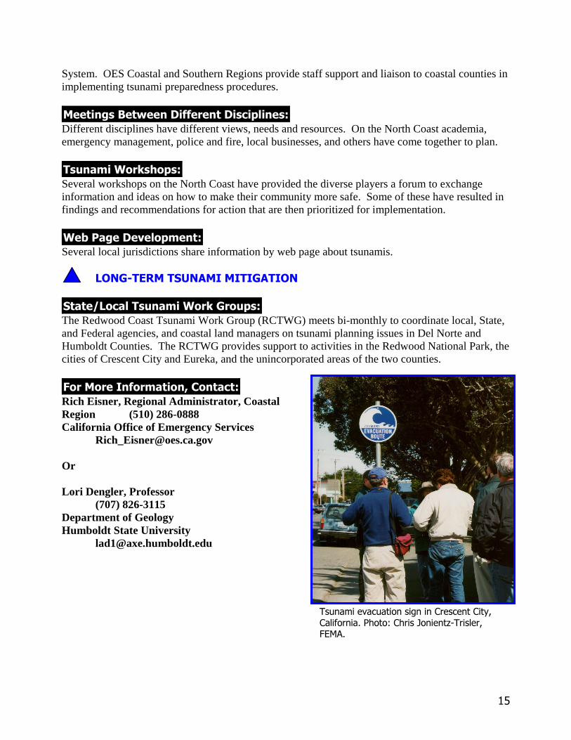
�����2!�����������(� /�$ ��'��The Redwood Coast Tsunami Work Group (RCTWG) meets bi-monthly to coordinate local, State,and Federal agencies, and coastal land managers on tsunami planning issues in Del Norte andHumboldt Counties. The RCTWG provides support to activities in the Redwood National Park, thecities of Crescent City and Eureka, and the unincorporated areas of the two counties.
"� ��� ����� ����3��������Rich Eisner, Regional Administrator, CoastalRegion (510) 286-0888California Office of Emergency Services
Or
Lori Dengler, Professor(707) 826-3115
Department of GeologyHumboldt State University
'������-��������������� ��������������� ����"����#�� ��$�����%&' ��� �()*+�
��
������������� �� ����������������
���������
����������������������������� Hawaiians have had many tragic experiences with tsunamis within their memory. Education andevacuation information about tsunamis exists in the front pages of phone books. They have had asystem of evacuation signs in place in select counties for many years.
��!������� ������ ������ Public memorials in open space areas draw attention to the fact that Hawaiians have died in homesand schools previously located in tsunami inundation areas. In addition, the Pacific TsunamiMuseum provides material and displays in a shopping mall in Hilo.
��!������ ������������� Multihazard PSAs include tsunami information before and during a crisis.
�� ������"��� ���� Curriculum materials about tsunamis have been developed by Dr. Dan Walker, Dr. Doak Cox, Dr.George Curtis, Dr. Augustine Furumoto, Dr. Walter Dudley, Dr. Charles Mader, Dr. Don Thomas,Dr. Laura Kong, Dr. Carl Johnson, Dr. Gerard Fryer and others to teach younger generations whattheir elders know firsthand about tsunamis.
#�! � $%�$&��"��� ���������� $ The International Tsunami Information Center (ITIC) is developing a research resource on tsunamiand houses many fine materials from around the world.
��� ������� ���� Educational and evacuation information about tsunamis exists in the front pages of phone books.There are several memorial sites tourists can visit to learn about tsunami tragedies.
���������#������������������ ���� Much information and expertise from various agencies that research or deal with response andplanning issues exist to educate government officials.
��!������������ Several institutions are rich resources for tsunami information including the International TsunamiInformation Center (ITIC), the Pacific Tsunami Museum and the Center for the Study of ActiveVolcanism (CSAV) at the University of Hawaii, Hilo. A tsunami coloring book has had wide
��
distribution among school children. Also, a new state tsunami hazard safety video will be producedas a key awareness-raising tool. It will be patterned after Oregon’s tsunami video.
���#��'�(��"�()���*�"���)�(�
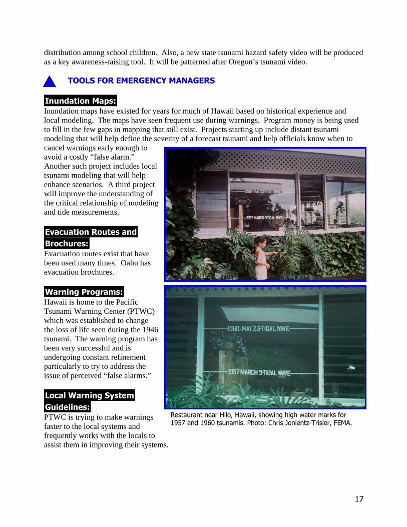
��������"�&� Inundation maps have existed for years for much of Hawaii based on historical experience andlocal modeling. The maps have seen frequent use during warnings. Program money is being usedto fill in the few gaps in mapping that still exist. Projects starting up include distant tsunamimodeling that will help define the severity of a forecast tsunami and help officials know when tocancel warnings early enough toavoid a costly “false alarm.”Another such project includes localtsunami modeling that will helpenhance scenarios. A third projectwill improve the understanding ofthe critical relationship of modelingand tide measurements.
����������(��������+ ��,� �� Evacuation routes exist that havebeen used many times. Oahu hasevacuation brochures.
-� ���� �� �� Hawaii is home to the PacificTsunami Warning Center (PTWC)which was established to changethe loss of life seen during the 1946tsunami. The warning program hasbeen very successful and isundergoing constant refinementparticularly to try to address theissue of perceived “false alarms.”
#�����-� ����$���)�������� PTWC is trying to make warningsfaster to the local systems andfrequently works with the locals toassist them in improving their systems.
������������� ����� ������������������������������������������������������������������� ������!"#������$%&'�
�(
+��#���)�����#��������)�������
������������� ������)����� Codes and construction guides ensure that buildings are safer. Local county building codes exist.
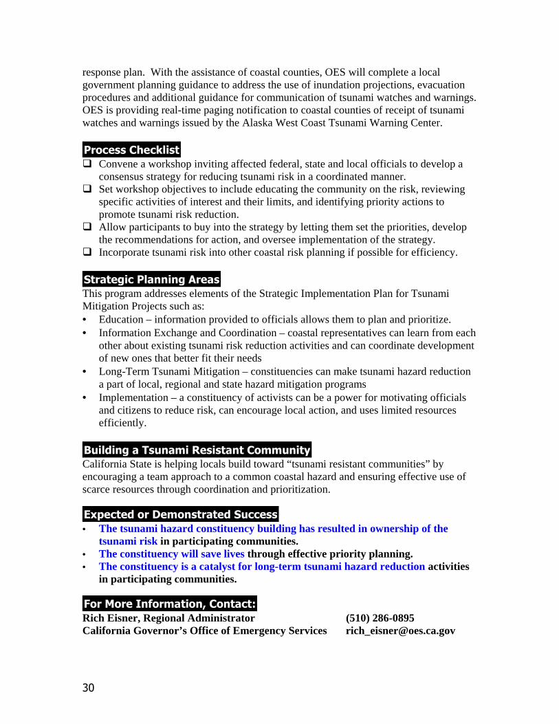
.����(�������������#�������)����� Zoning and land use ensure that sites are safer. Hilo did not rebuild a community in its tsunami-impacted area but instead built a memorial with open space for people to enjoy but not inhabit.There is, however, no restriction on development. A school at Laupahoehoe was relocated faruphill after two dozen children and teachers were lost to a tsunami crashing into the original schoolbuildings and surrounding staff homes. The grounds are now open space with a memorial stone.
/� ����������������)����� Vertical evacuation is used by hotels with open lobbies. Visitors are directed to go to higher floorsin the event of a tsunami.
��'�("�������0����)���������(��������
��������1� ��������������� County Civil Defense officials meet on a regular basis with the State Civil Defense staff, WarningCenter staff and others to discuss tsunami issues.
"�������+����������� ��������&���� Academia, Warning Center staff, and emergency managers work to improve the warning system.
������-� 2�,�&� Tsunami workshops occur regularly in Hawaii and benefit from a rich slate of tsunami experts inthe state and draw international experts to provide their own experience into the mix.
-�!������������&�� Several tsunami web sites exist including: Oahu County, the Pacific Disaster Center (PDC), andthe Pacific Tsunami Museum.
������������������ Hawaii has a long tradition of a Tsunami Advisor that is available to the State Civil Defense toanswer questions and provide needed advice during a tsunami crisis.
#��)%��("������"��"���)�����
�����3#�����������-� 2�) ��&� State Civil Defense coordinates meetings with the county Civil Defense officials and tsunamiscientists including PTWC several times a year or when an issue arises in order to continue toimprove Hawaii’s ability to save lives from tsunamis.
��
������������"�������������� Tsunami mitigation planning is done at the State level as well as at the local level.
'� �"� ����� ����4������� Brian Yanagi (808) 733-4300 ext 552State Civil Defense [email protected] Furumoto (808) 395-1485Consultant [email protected]
')��������*���������+�������,������-�������� ���� �+�� �������#���������������������+�.������������������������������������ �������/�����������������������������-0''1%2/3�
2���.�����.�����+4���&�4�55��������������������6������������� ����� �������#�����,���.������������������758�������������������������������������93�-�,4�
��
������������� �� ����������� ���
���������
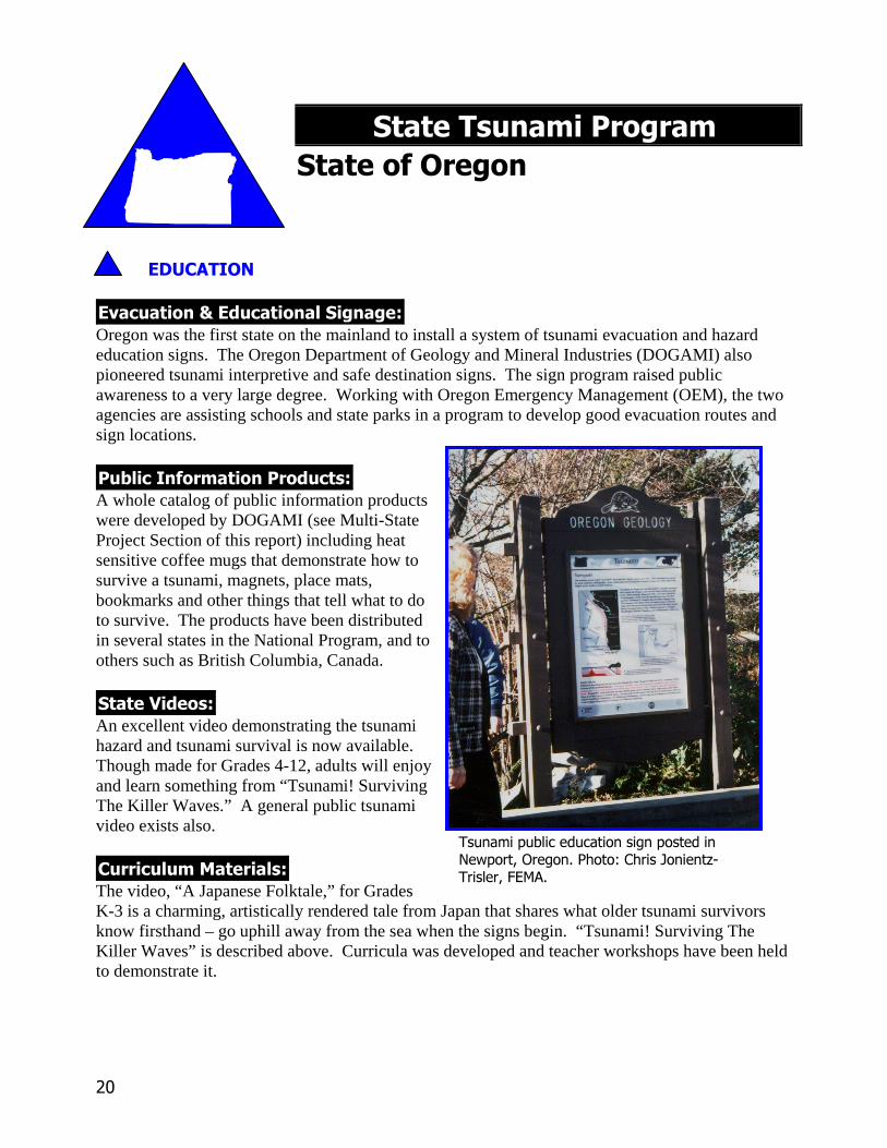
������������������������������Oregon was the first state on the mainland to install a system of tsunami evacuation and hazardeducation signs. The Oregon Department of Geology and Mineral Industries (DOGAMI) alsopioneered tsunami interpretive and safe destination signs. The sign program raised publicawareness to a very large degree. Working with Oregon Emergency Management (OEM), the twoagencies are assisting schools and state parks in a program to develop good evacuation routes andsign locations.
���������� ������ �������A whole catalog of public information productswere developed by DOGAMI (see Multi-StateProject Section of this report) including heatsensitive coffee mugs that demonstrate how tosurvive a tsunami, magnets, place mats,bookmarks and other things that tell what to doto survive. The products have been distributedin several states in the National Program, and toothers such as British Columbia, Canada.
������ ������An excellent video demonstrating the tsunamihazard and tsunami survival is now available.Though made for Grades 4-12, adults will enjoyand learn something from “Tsunami! SurvivingThe Killer Waves.” A general public tsunamivideo exists also.
�� ������!��� �����The video, “A Japanese Folktale,” for GradesK-3 is a charming, artistically rendered tale from Japan that shares what older tsunami survivorsknow firsthand – go uphill away from the sea when the signs begin. “Tsunami! Surviving TheKiller Waves” is described above. Curricula was developed and teacher workshops have been heldto demonstrate it.
��������� ��������������������������������������������������� ��� ���!"#$�
�%
��� ������� �����State agencies are beginning to work with lodging facilities in Oregon to develop evacuation routesand provide brochures to tourist to inform them what to do. Other potential new projects include:working with rental car agencies to place tsunami education material in cars; working with DOT toadd this information to the Oregon State Map; and working with AAA to add similar information totheir newsletter and tour books.
���������"������������������ �����The State agencies have worked to educate government officials with their expertise throughseveral avenues including the Oregon Seismic Safety Policy Advisory Committee.
����������������Along with the continued distribution of public education products and installation of signs, theagencies are planning to develop partnerships with bookstores, libraries, and public and cable TV todisseminate tsunami videos.
���"��#�$��!�$%���&�!���%�$�
�����'���������������������� ��'��Both OEM and DOGAMI have been involved in numerous needs assessments with such groups asschools and communities. They have met with the target groups to discuss needs and run surveysto define a baseline from which to proceed. A special study by DOGAMI in 1995 pointed out thatmost of the critical facilities in many coastal communities are at risk from severe ground shakingand/or tsunami inundation.
��������!�(��Inundation maps were made a few years ago and are being refined through the Tsunami InundationMapping Effort (TIME) Center in Newport, Oregon. The entire Oregon Coast is now mapped andselected areas have been and will be mapped in greater detail.
����������$���������) ��*� ���Evacuation routes have been and are being developed in several communities with accompanyingbrochures designating routes and safe areas.
+� ���� �� ���Warning programs have been and are being developed in communities. One of the first was inCannon Beach which has had a chance to test it a couple of times.
)��"���%�����"��������%�������
,����$�������������"�������%�������� �������Early inundation mapping was linked to legislation requiring new critical facilities such as schoolsto be built outside the tsunami inundation zone.
��
��#�$!�������-�.��%���������$��������
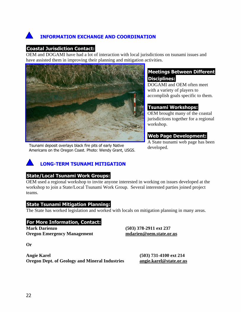
��������/� ����������������OEM and DOGAMI have had a lot of interaction with local jurisdictions on tsunami issues andhave assisted them in improving their planning and mitigation activities.
!�������)��0�������� �������(�����DOGAMI and OEM often meetwith a variety of players toaccomplish goals specific to them.
������+� 1�*�(��OEM brought many of the coastaljurisdictions together for a regionalworkshop.
+��������������(���A State tsunami web page has beendeveloped.
"��%2��$!������!��!���%�����
�����3"�����������+� 1�% ��(��OEM used a regional workshop to invite anyone interested in working on issues developed at theworkshop to join a State/Local Tsunami Work Group. Several interested parties joined projectteams.
������������!���������������The State has worked legislation and worked with locals on mitigation planning in many areas.
#� �!� ����� ����4��������Mark Darienzo (503) 378-2911 ext 237Oregon Emergency Management [email protected]
Or
Angie Karel (503) 731-4100 ext 214Oregon Dept. of Geology and Mineral Industries [email protected]
�������������&�� �'�� ��()������)��� '���&�$������������������������������*���'+�����,-+-�
��
������������� �� ������������������
���������
����������������������������� Signage was based on Oregon’s model. The State and locals worked together to plan and installevacuation and hazard signs. The completed inundation maps will serve as a check on the obviouslocations.
��!������� ������ ������ Washington ordered and distributed many of the products developed by Oregon for publicinformation on tsunamis.
������"����� The State uses a locally broadcast special news hour titled “On Fragile Ground” that describes thehazards of tsunamis, earthquakes and volcanoes. Local scientists and residents are interviewed.The hour is very well organized and keeps interest despite the length of the video and substantialamount of earth science material covered.
�� ������#��� ���� These materials are under development.
$�! � %&�%'��#��� ���������� % The Department of Natural Resources (DNR), Geology Division, has developed two excellentinventories of tsunami materials. One product, The Tsunami Annotated Bibliography, lists mostlyNorthwest publications and appeals to primarily scientists and others dealing with the applicationof science of tsunamis. The other product has been recently revised to appeal to additionalaudiences of far less technical background. This product, TsuInfo Alert newsletter, containsupdated scientific and emergency management type of materials and also includes book reviewsand short articles.
��� ������� ���� Tsunami interpretive signs have been installed in 29 locations along the coast and Island County.Island County Beach Watchers are doing tsunami talks on the beaches and have partnered with theWashington State Department of Transportation Ferry System to provide tsunami/earthquake talksto passengers on the ferries.
���������$������������������ ���� The TsuInfo Alert newsletter is being used to educate government officials, especially as revised.
��
��!������������ Tsunami Awareness Month is being planned as are ferry wall maps with tsunami information.
���$��(�)��#�)*���+�#���*�)�
�����%���������������������� ��%� The State began their Tsunami Program by bringing in county officials to develop a list ofprioritized needs that they then coordinate available funding to.
��������#�'� Inundation maps are being modeled at the Tsunami Inundation Mapping Effort (TIME) Center inNewport, Oregon and drafted by DNR staff. Counties are planning major public education effortswith the arrival of the maps.
����������)���������, ���� �� Evacuation routes have been and are being developed in several communities and evacuationbrochures will be completed when inundation maps are finished.
�� ���� �� �� Warning programs have been and are being developed in communities. County and tribal officialsare planning with the National Weather Service to provide enhanced coverage for Washington andto use NOAA Weather Radio more substantially for tsunami warnings among others.
������� ����� ������ ��� ����� ���� ��� ������� ����� ������ ���� ��� �� �!�����" #����$ ��� �� �������% &�'�("
�)
��(�)#�������-�.��*���������)��������
��������/� ��������������� A lot of contact with local jurisdictions has occurred on outer coast and inland coast locations. TheState Program is heavily driven by the locals and their needs.
#�������,��0�������� ��������'���� Groups effected by tsunami issues are welcome to work together on tsunami issues.
�������� 1���'� Many community and county workshops have been held which generated interest and enthusiasmover addressing tsunami issues. A three state conference on coastal earthquake issues will bringtogether local officials and planners from Alaska, Oregon and Washington to learn from each other.
��!������������'�� A State tsunami web page has been developed and the State has assisted several counties indeveloping their own.
$��*&��)#������#��#���*�����
�����2$������������� 1�* ��'� This state has a strong State/Local Tsunami Work Group that started in 1997 based on local needs.It is made up of all coastal counties, Federal and State emergency managers, geologists,Department of Transportation, NOAA Weather Service, and recently welcomed tribal leaders intothe group. The group is looking to involve local businesses and has recently partnered with amultistate private/public earthquake consortium, the Cascadia Region Earthquake Workgroup(CREW), in a coastal project.
������������#�������������� The State has promoted legislation and worked with locals on mitigation planning in many areas.
(� �#� ����� ����3������� George Crawford (253) 512-7067Washington Emergency Management Division [email protected]
or
Timothy Walsh (360) 902-1432Washington Department of Natural Resources [email protected]

�

��
���������������� �����������������������
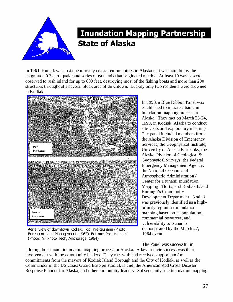
In 1964, Kodiak was just one of many coastal communities in Alaska that was hard hit by themagnitude 9.2 earthquake and series of tsunamis that originated nearby. At least 10 waves wereobserved to rush inland for up to 600 feet, destroying most of the fishing boats and more than 200structures throughout a several block area of downtown. Luckily only two residents were drownedin Kodiak.
In 1998, a Blue Ribbon Panel wasestablished to initiate a tsunamiinundation mapping process inAlaska. They met on March 23-24,1998, in Kodiak, Alaska to conductsite visits and exploratory meetings.The panel included members fromthe Alaska Division of EmergencyServices; the Geophysical Institute,University of Alaska Fairbanks; theAlaska Division of Geological &Geophysical Surveys; the FederalEmergency Management Agency;the National Oceanic andAtmospheric Administration /Center for Tsunami InundationMapping Efforts; and Kodiak IslandBorough’s CommunityDevelopment Department. Kodiakwas previously identified as a high-priority region for inundationmapping based on its population,commercial resources, andvulnerability to tsunamisdemonstrated by the March 27,1964 event.
The Panel was successful inpiloting the tsunami inundation mapping process in Alaska. A key to their success was theirinvolvement with the community leaders. They met with and received support and/orcommitments from the mayors of Kodiak Island Borough and the City of Kodiak, as well as theCommander of the US Coast Guard Base on Kodiak Island, the American Red Cross DisasterResponse Planner for Alaska, and other community leaders. Subsequently, the inundation mapping
Pre-tsunami
Post-tsunami
���������� �������������������������������������������� ���� ���!�����"#$%�&�������������������������������������'�"��'����!�"#$%(&�
�)
project for three sites on Kodiak Island has been funded with monies from the NTHMP and theAlaska Science and Technology Foundation and is expected to be completed in October, 1998. Forfuture projects the Panel will continue to be a critical element of the State/Federal partnership inproviding methods to assist tsunami hazard assessment and mitigation efforts in threatened Alaskancommunities. The composition of the Panel will be tailored to meet the needs of each community.
This successful process has generated substantial interest and anticipated support from otherAlaskan coastal communities that will compete for future inundation mapping projects. The BlueRibbon Panel is a catalyst for tsunami awareness in communities at risk in Alaska and in the longrun that translates to lives saved.
���������������� Gather range of experts needed� Consult locals prior to mapdecisions� Assess, prioritize risk areas tomap based on expert and local info� Show locals uses andlimitations of maps to guide properuse
��������� ������������This program addresses elementsof the Strategic ImplementationPlan for Tsunami MitigationProjects such as:• Tools for EmergencyManagers – inundation maps andeducation in their use.
����������������������������������The State of Alaska is helping locals build toward “tsunami resistant communities” by making arange of experts on various mapping components available to partner with local communities andmake mapping decisions jointly based on solid technology and local knowledge of issues.
���������� ������������������• The partnership mapping process has resulted in community ownership of the risk.• The maps will save lives during future tsunamis as the community becomes educated.• The maps are a catalyst for other tsunami planning and mitigation efforts.
!����������������"�������#Gary Brown (907) 428-7036Alaska Division of Emergency Services [email protected]
������*�����+�,,�������������������'��� �'�������������������-����.������/��������"01 ��
��
������������� � ����������������������� �� ���� ������������
The Governor’s Office of Emergency Services convened a workshop of federal, state andlocal officials responsible for emergency and coastal zone management on May 28 – 29,1997. The goal of the workshop was the development of a consensus strategic plan fortsunami hazard mitigation for the state of California.
The Workshop had the following objectives:• Educate participants on the tsunami threat and regions at risk of inundation• Review activities of the Alaska West Coast Tsunami Warning Center and identify
gaps in notification procedures, technical assistance and resource needs of locals• Review the limits of the tsunami watch/warning procedures for local tsunamis• Identify priority actions to promote and promulgate tsunami hazard mitigation
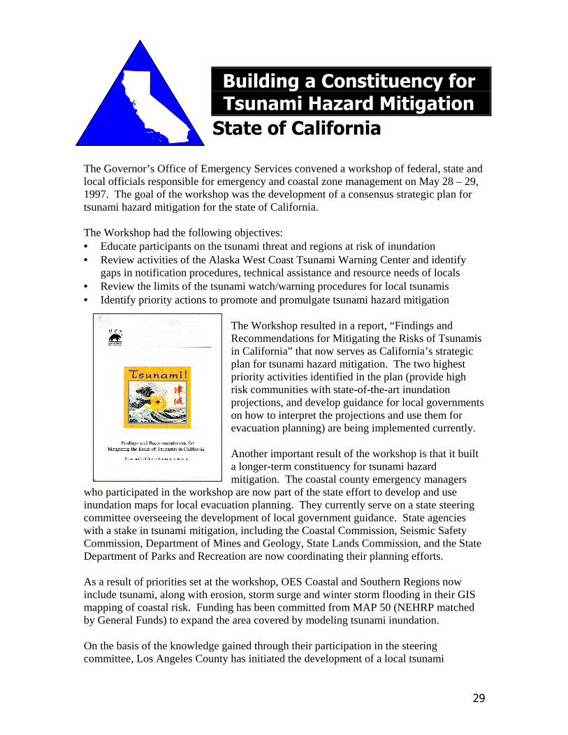
The Workshop resulted in a report, “Findings andRecommendations for Mitigating the Risks of Tsunamisin California” that now serves as California’s strategicplan for tsunami hazard mitigation. The two highestpriority activities identified in the plan (provide highrisk communities with state-of-the-art inundationprojections, and develop guidance for local governmentson how to interpret the projections and use them forevacuation planning) are being implemented currently.
Another important result of the workshop is that it builta longer-term constituency for tsunami hazardmitigation. The coastal county emergency managers
who participated in the workshop are now part of the state effort to develop and useinundation maps for local evacuation planning. They currently serve on a state steeringcommittee overseeing the development of local government guidance. State agencieswith a stake in tsunami mitigation, including the Coastal Commission, Seismic SafetyCommission, Department of Mines and Geology, State Lands Commission, and the StateDepartment of Parks and Recreation are now coordinating their planning efforts.
As a result of priorities set at the workshop, OES Coastal and Southern Regions nowinclude tsunami, along with erosion, storm surge and winter storm flooding in their GISmapping of coastal risk. Funding has been committed from MAP 50 (NEHRP matchedby General Funds) to expand the area covered by modeling tsunami inundation.
On the basis of the knowledge gained through their participation in the steeringcommittee, Los Angeles County has initiated the development of a local tsunami
��
response plan. With the assistance of coastal counties, OES will complete a localgovernment planning guidance to address the use of inundation projections, evacuationprocedures and additional guidance for communication of tsunami watches and warnings.OES is providing real-time paging notification to coastal counties of receipt of tsunamiwatches and warnings issued by the Alaska West Coast Tsunami Warning Center.
��������������� � Convene a workshop inviting affected federal, state and local officials to develop a
consensus strategy for reducing tsunami risk in a coordinated manner.� Set workshop objectives to include educating the community on the risk, reviewing
specific activities of interest and their limits, and identifying priority actions topromote tsunami risk reduction.
� Allow participants to buy into the strategy by letting them set the priorities, developthe recommendations for action, and oversee implementation of the strategy.
� Incorporate tsunami risk into other coastal risk planning if possible for efficiency.
� � �����������������This program addresses elements of the Strategic Implementation Plan for TsunamiMitigation Projects such as:• Education – information provided to officials allows them to plan and prioritize.• Information Exchange and Coordination – coastal representatives can learn from each
other about existing tsunami risk reduction activities and can coordinate developmentof new ones that better fit their needs
• Long-Term Tsunami Mitigation – constituencies can make tsunami hazard reductiona part of local, regional and state hazard mitigation programs
• Implementation – a constituency of activists can be a power for motivating officialsand citizens to reduce risk, can encourage local action, and uses limited resourcesefficiently.
���������������������� � ������� �California State is helping locals build toward “tsunami resistant communities” byencouraging a team approach to a common coastal hazard and ensuring effective use ofscarce resources through coordination and prioritization.
�� �� ������!����� � ����������• The tsunami hazard constituency building has resulted in ownership of the
tsunami risk in participating communities.• The constituency will save lives through effective priority planning.• The constituency is a catalyst for long-term tsunami hazard reduction activities
in participating communities.
"��������#����� ���$��� � %Rich Eisner, Regional Administrator (510) 286-0895California Governor’s Office of Emergency Services [email protected]
��
������������ �������������������
Hawaii is located mid-ocean, serving as a grand central station for trains of tsunami wavesoriginating from anywhere around the Pacific Rim, and has suffered repeated historical loss of livesand property. These waves travel rapidly to strike communities and require specialized personneland systematic pre- and post disaster planning. By Hawaii law, State, City and County CivilDefense (CD) is structured as part of a unified emergency management system. For decades, thissystem has comprehensively reviewed and coordinated all hazards emergency planning, includingtsunamis. In the past decade, the Tsunami Working Group (TWG) grew out of this process. In1998, Hawaii CD continued to support an existing TWG made up of representatives from State andCounty CD, the Pacific Tsunami Warning Center (PTWC), the U.S. Geological Survey, and localtsunami scientists who meet quarterly. CD provides some logistics including airfare coupons fromfunding provided by the National Tsunami Hazard Mitigation Program.
����������������� Include representatives from all levels of pre- and post-disaster planning as a system solution� Include scientific agencies and local experts so that technical information is used correctly� Meet regularly to improve and update usability of information and procedures
������ ���������� ������This program addresses elements of the Strategic Implementation Plan for Tsunami MitigationProjects such as:
��������� �������������������������������������������������������������������� �!����"�#����$������%&'�������()�*
��
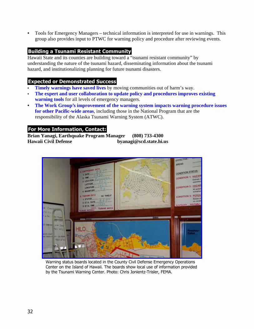
• Tools for Emergency Managers – technical information is interpreted for use in warnings. Thisgroup also provides input to PTWC for warning policy and procedure after reviewing events.
������� �����������������������������Hawaii State and its counties are building toward a “tsunami resistant community” byunderstanding the nature of the tsunami hazard, disseminating information about the tsunamihazard, and institutionalizing planning for future tsunami disasters.
!���������"������������������• Timely warnings have saved lives by moving communities out of harm’s way.• The expert and user collaboration to update policy and procedures improves existing
warning tools for all levels of emergency managers.• The Work Group’s improvement of the warning system impacts warning procedure issues
for other Pacific-wide areas, including those in the National Program that are theresponsibility of the Alaska Tsunami Warning System (ATWC).
#��$���%��������&�������'Brian Yanagi, Earthquake Program Manager (808) 733-4300Hawaii Civil Defense [email protected]
+����,��������������������������#������#�-��.�������)���,�����/��������#�������������0����������� �'��������������������������������������-�����������'������+����,�#����� �!����"�#�����$������%&'�������()�*
��
�������������� ���� ����������� ������ �
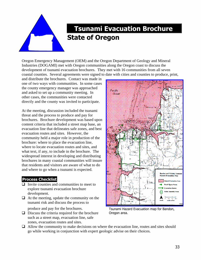
Oregon Emergency Management (OEM) and the Oregon Department of Geology and MineralIndustries (DOGAMI) met with Oregon communities along the Oregon coast to discuss thedevelopment of tsunami evacuation brochures. They met with 16 communities from all sevencoastal counties. Several agreements were signed to date with cities and counties to produce, print,and distribute the brochures. Contact was made inone of two ways with communities. In some casesthe county emergency manager was approachedand asked to set up a community meeting. Inother cases, the communities were contacteddirectly and the county was invited to participate.
At the meeting, discussion included the tsunamithreat and the process to produce and pay forbrochures. Brochure development was based uponcontent criteria that included a street map base, anevacuation line that delineates safe zones, and bestevacuation routes and sites. However, thecommunity held a major role in production of thebrochure: where to place the evacuation line,where to locate evacuation routes and sites, andwhat text, if any, to include in the brochure. Thewidespread interest in developing and distributingbrochures in many coastal communities will insurethat residents and visitors are aware of what to doand where to go when a tsunami is expected.
�� ��������������� Invite counties and communities to meet to
explore tsunami evacuation brochuredevelopment.
� At the meeting, update the community on thetsunami risk and discuss the process to
produce and pay for the brochures.� Discuss the criteria required for the brochure
such as a street map, evacuation line, safezones, evacuation routes and sites.
� Allow the community to make decisions on where the evacuation line, routes and sites shouldgo while working in conjunction with expert geologic advise on their choices.
����������� ������������������� ��������������
��
������������������������This program addresses elements of the Strategic Implementation Plan for Tsunami MitigationProjects such as:• Tools for Emergency Managers – the brochure process interprets technical information about
tsunami inundation into applicable information to save lives.• Education – the brochures provide information to the public on where to go if there is a tsunami
threat.
������������������������������ �������Oregon State is helping locals build toward “tsunami resistant communities” by helping themunderstand the serious tsunami risk and plan for saving lives through appropriate evacuation.
�������� �� �� ����������������• The brochure has resulted in ownership of the tsunami risk in participating communities.• The brochure will save lives by providing appropriate evacuation information to citizens
and visitors.• The brochure is a catalyst for other tsunami hazard reduction activities in participating
communities.
! ��" ���#�� ����� �$�� �����%Mark Darienzo, Earthquake Program Manager (503) 378-2911 extension 237Oregon Emergency Management [email protected]
��
���������������� �������������������
������������������
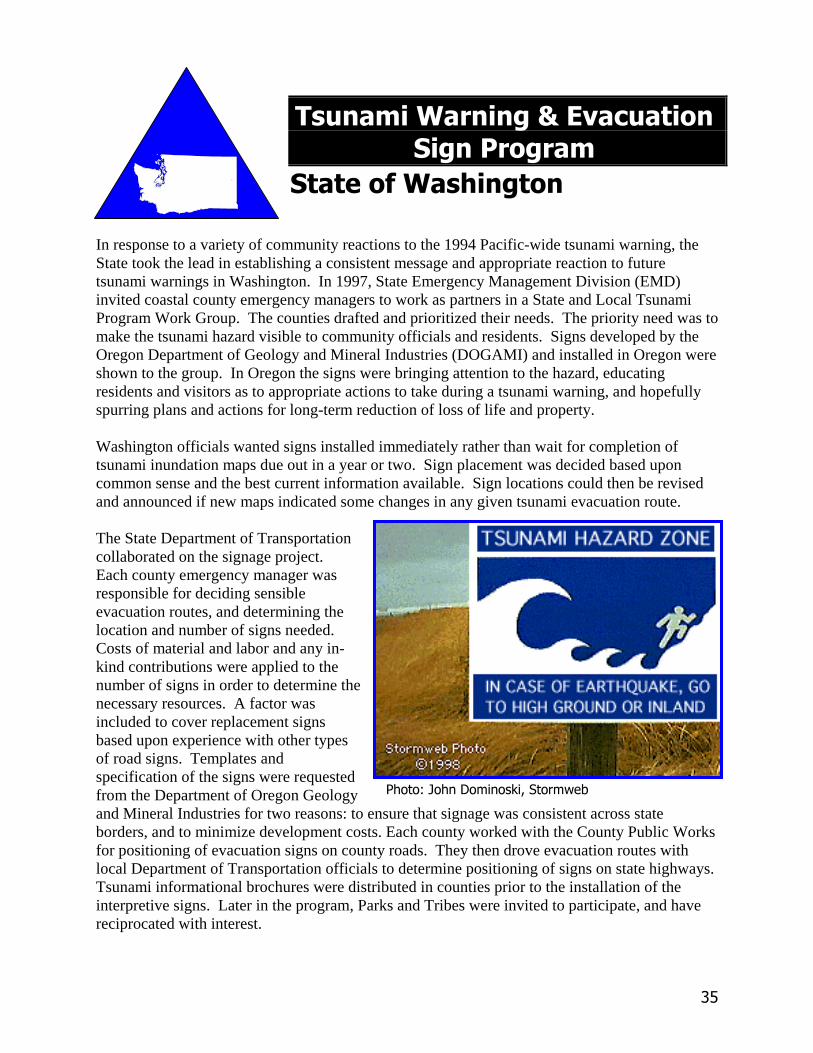
In response to a variety of community reactions to the 1994 Pacific-wide tsunami warning, theState took the lead in establishing a consistent message and appropriate reaction to futuretsunami warnings in Washington. In 1997, State Emergency Management Division (EMD)invited coastal county emergency managers to work as partners in a State and Local TsunamiProgram Work Group. The counties drafted and prioritized their needs. The priority need was tomake the tsunami hazard visible to community officials and residents. Signs developed by theOregon Department of Geology and Mineral Industries (DOGAMI) and installed in Oregon wereshown to the group. In Oregon the signs were bringing attention to the hazard, educatingresidents and visitors as to appropriate actions to take during a tsunami warning, and hopefullyspurring plans and actions for long-term reduction of loss of life and property.
Washington officials wanted signs installed immediately rather than wait for completion oftsunami inundation maps due out in a year or two. Sign placement was decided based uponcommon sense and the best current information available. Sign locations could then be revisedand announced if new maps indicated some changes in any given tsunami evacuation route.
The State Department of Transportationcollaborated on the signage project.Each county emergency manager wasresponsible for deciding sensibleevacuation routes, and determining thelocation and number of signs needed.Costs of material and labor and any in-kind contributions were applied to thenumber of signs in order to determine thenecessary resources. A factor wasincluded to cover replacement signsbased upon experience with other typesof road signs. Templates andspecification of the signs were requestedfrom the Department of Oregon Geologyand Mineral Industries for two reasons: to ensure that signage was consistent across stateborders, and to minimize development costs. Each county worked with the County Public Worksfor positioning of evacuation signs on county roads. They then drove evacuation routes withlocal Department of Transportation officials to determine positioning of signs on state highways.Tsunami informational brochures were distributed in counties prior to the installation of theinterpretive signs. Later in the program, Parks and Tribes were invited to participate, and havereciprocated with interest.
������������� ��� ����������
��
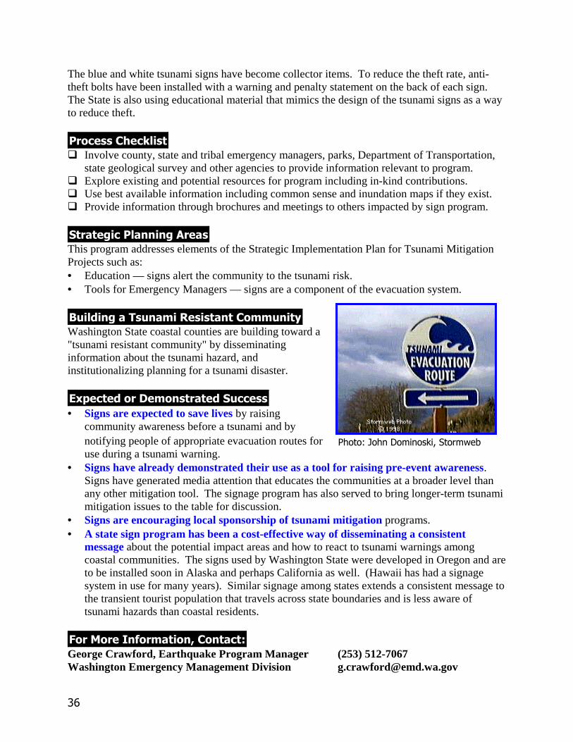
The blue and white tsunami signs have become collector items. To reduce the theft rate, anti-theft bolts have been installed with a warning and penalty statement on the back of each sign.The State is also using educational material that mimics the design of the tsunami signs as a wayto reduce theft.
����������������� Involve county, state and tribal emergency managers, parks, Department of Transportation,
state geological survey and other agencies to provide information relevant to program.� Explore existing and potential resources for program including in-kind contributions.� Use best available information including common sense and inundation maps if they exist.� Provide information through brochures and meetings to others impacted by sign program.
����������������������This program addresses elements of the Strategic Implementation Plan for Tsunami MitigationProjects such as:• Education — signs alert the community to the tsunami risk.• Tools for Emergency Managers — signs are a component of the evacuation system.
��������������������������������������Washington State coastal counties are building toward a"tsunami resistant community" by disseminatinginformation about the tsunami hazard, andinstitutionalizing planning for a tsunami disaster.
� ��������!������������������• Signs are expected to save lives by raising
community awareness before a tsunami and bynotifying people of appropriate evacuation routes foruse during a tsunami warning.
• Signs have already demonstrated their use as a tool for raising pre-event awareness.Signs have generated media attention that educates the communities at a broader level thanany other mitigation tool. The signage program has also served to bring longer-term tsunamimitigation issues to the table for discussion.
• Signs are encouraging local sponsorship of tsunami mitigation programs.• A state sign program has been a cost-effective way of disseminating a consistent
message about the potential impact areas and how to react to tsunami warnings amongcoastal communities. The signs used by Washington State were developed in Oregon and areto be installed soon in Alaska and perhaps California as well. (Hawaii has had a signagesystem in use for many years). Similar signage among states extends a consistent message tothe transient tourist population that travels across state boundaries and is less aware oftsunami hazards than coastal residents.
"��#���$���������%��������&George Crawford, Earthquake Program Manager (253) 512-7067Washington Emergency Management Division [email protected]
������������� ��� ����������

��
������������ ����
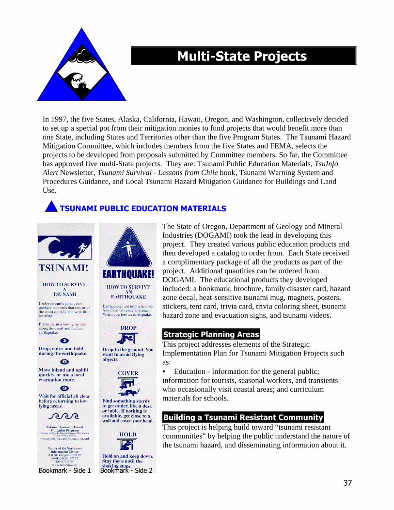
In 1997, the five States, Alaska, California, Hawaii, Oregon, and Washington, collectively decidedto set up a special pot from their mitigation monies to fund projects that would benefit more thanone State, including States and Territories other than the five Program States. The Tsunami HazardMitigation Committee, which includes members from the five States and FEMA, selects theprojects to be developed from proposals submitted by Committee members. So far, the Committeehas approved five multi-State projects. They are: Tsunami Public Education Materials, TsuInfoAlert Newsletter, Tsunami Survival - Lessons from Chile book, Tsunami Warning System andProcedures Guidance, and Local Tsunami Hazard Mitigation Guidance for Buildings and LandUse.
�������������������������������
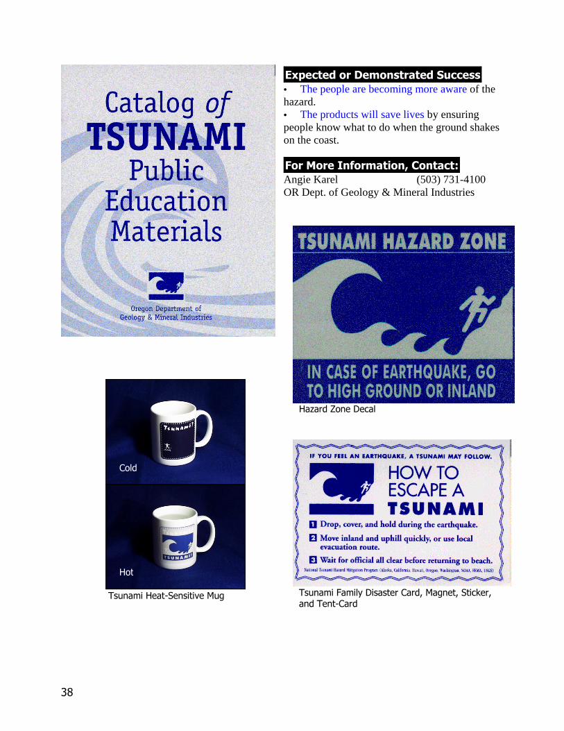
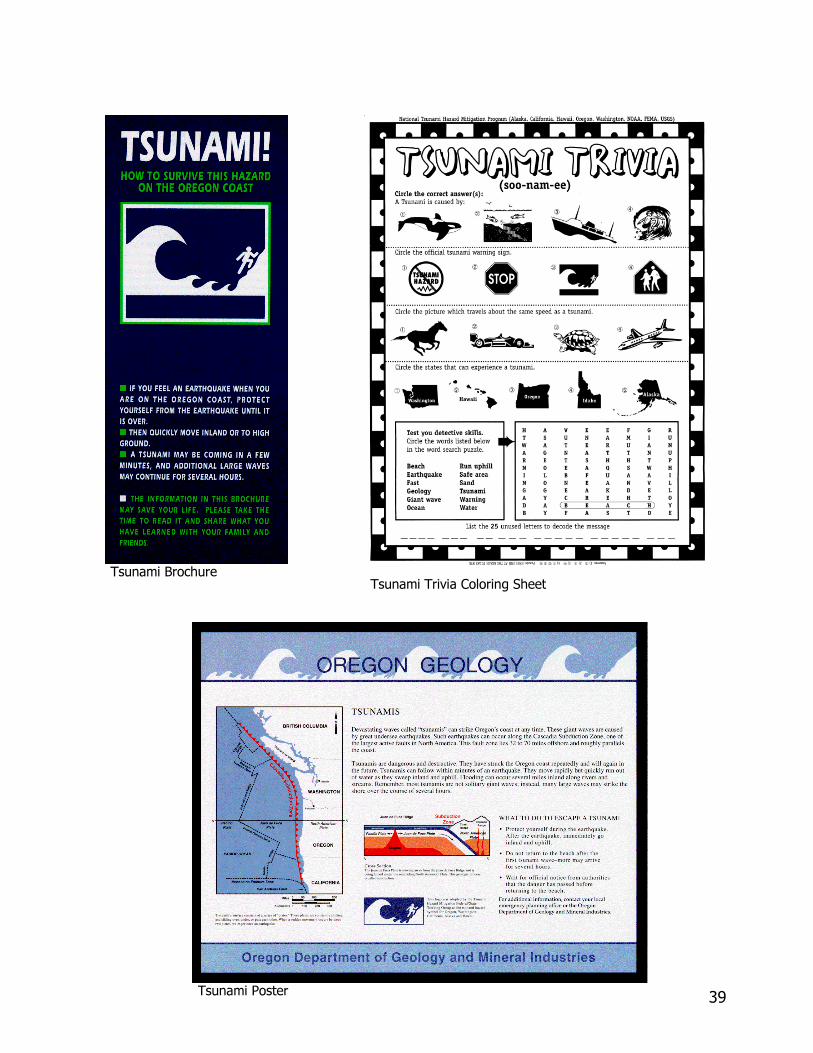
The State of Oregon, Department of Geology and MineralIndustries (DOGAMI) took the lead in developing thisproject. They created various public education products andthen developed a catalog to order from. Each State receiveda complimentary package of all the products as part of theproject. Additional quantities can be ordered fromDOGAMI. The educational products they developedincluded: a bookmark, brochure, family disaster card, hazardzone decal, heat-sensitive tsunami mug, magnets, posters,stickers, tent card, trivia card, trivia coloring sheet, tsunamihazard zone and evacuation signs, and tsunami videos.
��������������������This project addresses elements of the StrategicImplementation Plan for Tsunami Mitigation Projects suchas:• Education - Information for the general public;information for tourists, seasonal workers, and transientswho occasionally visit coastal areas; and curriculummaterials for schools.
�������������� ���������� ����!This project is helping build toward “tsunami resistantcommunities” by helping the public understand the nature ofthe tsunami hazard, and disseminating information about it.
���������� �� ���������� ��
��
�"#��� �� �������������• The people are becoming more aware of thehazard.• The products will save lives by ensuringpeople know what to do when the ground shakeson the coast.
$ �� ���% � ��� �&� �����'Angie Karel (503) 731-4100OR Dept. of Geology & Mineral Industries
����� ���������
����������������������� ������� ����!��������"�� #������#�������#�� ����"��
"��
���
�$
�����������%����������������"��������%���
�������&�����
'(
���������(�������
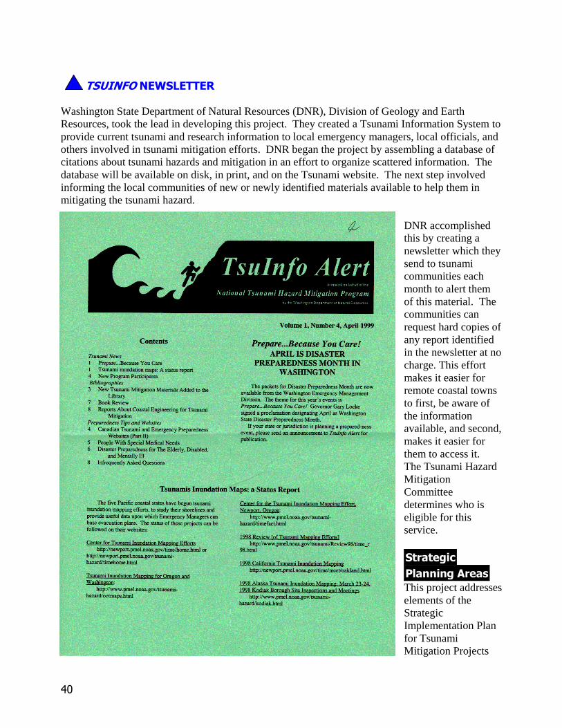
Washington State Department of Natural Resources (DNR), Division of Geology and EarthResources, took the lead in developing this project. They created a Tsunami Information System toprovide current tsunami and research information to local emergency managers, local officials, andothers involved in tsunami mitigation efforts. DNR began the project by assembling a database ofcitations about tsunami hazards and mitigation in an effort to organize scattered information. Thedatabase will be available on disk, in print, and on the Tsunami website. The next step involvedinforming the local communities of new or newly identified materials available to help them inmitigating the tsunami hazard.
DNR accomplishedthis by creating anewsletter which theysend to tsunamicommunities eachmonth to alert themof this material. Thecommunities canrequest hard copies ofany report identifiedin the newsletter at nocharge. This effortmakes it easier forremote coastal townsto first, be aware ofthe informationavailable, and second,makes it easier forthem to access it.The Tsunami HazardMitigationCommitteedetermines who iseligible for thisservice.
��������������������This project addresseselements of theStrategicImplementation Planfor TsunamiMitigation Projects
41
such as:• Tools for Emergency Managers - Exchange of information.• Information Exchange and Coordination - Catalogue existing and new printed and electronic
tsunami media. Provide access to tsunami media.
Building a Tsunami Resistant CommunityThis project is helping build toward “tsunami resistant communities” by disseminating informationabout the hazard and by exchanging information with many at-risk areas.
Expected or Demonstrated Success• The newsletter is an information dissemination tool that serves as a resource center of tsunami
hazard information.
For More Information, Contact:Connie Manson, Librarian (360) 902-1472WA Department of Natural Resources
SURVIVING A TSUNAMI - LESSONS FROM CHILE, HAWAII, AND JAPAN
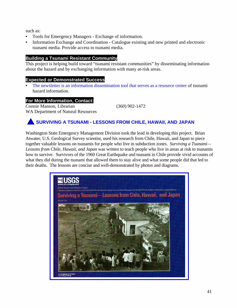
Washington State Emergency Management Division took the lead in developing this project. BrianAtwater, U.S. Geological Survey scientist, used his research from Chile, Hawaii, and Japan to piecetogether valuable lessons on tsunamis for people who live in subduction zones. Surviving a Tsunami—Lessons from Chile, Hawaii, and Japan was written to teach people who live in areas at risk to tsunamishow to survive. Survivors of the 1960 Great Earthquake and tsunami in Chile provide vivid accounts ofwhat they did during the tsunami that allowed them to stay alive and what some people did that led totheir deaths. The lessons are concise and well-demonstrated by photos and diagrams.
'�
��������������������This project addresses elements of the Strategic Implementation Plan for Tsunami MitigationProjects such as:• Education – information for the general public on tsunami hazard.
�������������� ���������� ����!This project is helping build toward “tsunami resistant communities” by demonstrating to peoplehow to quickly respond in an appropriate manner to immediate danger from tsunamis.
�"#��� �� �������������• The lessons from actual victims of the Chilean tsunami are a real-life lesson teaching readers
how to survive in a variety of situations.
$ �� ���% � ��� �&� �����'Brian AtwaterUS Geological Survey
���)�����������*��������
����� �(�������!�� ������ �����+������
The Oregon Department of Geology and Mineral Industries, in coordination with OregonEmergency Management, is leading the development of this project. The project staff will begin byinventorying and evaluating all existing tsunami warning systems and procedures in coastal townsof the Committee member States, and of systems in other States and countries, like Japan. Theidentified systems will be analyzed for their strengths and weaknesses, and recommendations foruniformity will be provided if warranted. The project will culminate in the preparation of aTsunami Warning Systems and Procedures Guidance for local communities highlighting the resultsof the research. The report should be completed by the end of 1999.
� �������� �,�-����������� �+������% �������������������
California Governor's Office of Emergency Services is leading the developing of this project. Thisproject involves identifying land use policy and practices, and building strategies, approaches, andtechniques that would reduce loss of life and property resulting from both near source and distanttsunamis. The project would culminate in the development of a guidance document for localgovernments outlining approaches most likely to reduce loss of life and damage. The documentwill include case studies highlighting actual examples of tsunami mitigation. The report should beavailable by the end of 1999.

��
������������� ����������
"Cascadia Response to October 4, 1994 Kurile Islands Mw 8.3 Earthquake-Induced Tsunami Warning" (presented at American Geophysical Union, Fall 1994meeting)
C. Jonientz-Trisler, J. Berry (Federal Emergency Management Agency, Region 10, FederalRegional Center, 130 - 228th St. SW, Bothell, WA 98021-9796)
A Mw 8.3 Kurile Islands tsunamigenic earthquake on October 4, 1994 triggered a Pacific-widetsunami warning. The warning tested the information system and the state of readiness on theCascadia coast. Responses varied.
Interviews were conducted using a survey questionnaire with province staff for threecommunities in British Columbia, Canada; with four communities in Washington; fourcommunities in Oregon; and three communities in California. Community populations rangedfrom about 1,000 up to about 27,000. Elevation range was sea level to over 100 feet.Communities were located on ocean beaches, bays, inlets, and peninsulas.
Tsunami warning information was unclear and unusable to more than a third of communities,and too slow being updated for 71%. Almost 80% were in contact with neighboringcommunities, but only about 30% had access to a local tsunami expert.
Vulnerability and readiness varied. Almost 80% have critical facilities at risk, and have citytsunami plans. Half of the communities had school tsunami plans. Seventy percent have safe(high) places within a few minutes walking distance. Over a third have landslide hazards, andalmost 80% have vulnerable bridges along their evacuation routes. Over half have tsunamiwarning sirens or fire sirens that would be used in tsunami notification. The average timeestimate for safe evacuation was just over two hours, and ranged from 30 minutes to 6 hours.During peak tourist season, this estimate grew in some cases to a factor of 3 or 4 times more.(Some data for British Columbia communities was unknown as of this writing and will be furtherexplored in the near future.)
On October 4, 90% of the communities’ decision-makers used wave height data from Hawaii todecide what level of response to make. Twenty one percent began city evacuation; 7%evacuated some facilities (not including port or Coast Guard facilities which respondedaccording to their own authority); and 71% of the communities remained on standby status untilthe warning was cancelled. Cancellation occurred about 30 minutes before the wave was due onthe West Coast when it would have been too late to evacuate for most communities.
Many communities feel the warning system needs improvement. Information should be mademore timely and locally usable. Communication must flow two ways: 1) scientists must askresponders what kinds of information systems, formats, and tools that they require for effectiveresponse, and 2) responders must ask scientists what limits exist for information and tools thatthey are basing response decisions upon.
��
Vulnerability and readiness levels vary among communities. These communities have asked forsuch tools as local risk identification and expertise, training, and warning equipment.
Responses varied on October 4, 1994. A regional strategy should be developed to provide moreconsistency in Cascadia coastal communities, including such things as school tsunami plans anddrills.
October 4 is a valuable learning exercise for distant tsunamis with several hours warning and forCascadia tsunamis with immediate response required.
This is preliminary data. The community pool will be increased, county data will be added, andfurther verification and analysis is planned.
��
�����������������������������
National Tsunami Hazard Mitigation Programhttp://www.pmel.noaa.gov/tsunami-hazard
Pacific Marine Environmental Laboratory, NOAA - Tsunami Programhttp://www.pmel.noaa.gov/tsunami
Tsunami Data from the National Geophysical Data Centerhttp://www.ngdc.noaa.gov/seg/hazard/tsu.html
West Coast and Alaska Tsunami Warning Center Home Pagehttp://www.alaska.net/~atwc/index.html
International Tsunami Information Center (ITIC)http://www.shoa.cl/oceano/itic/frontpage.html
Western States Seismic Policy Council Tsunami Hazard Mitigation Committeehttp://www.wsspc.org/tsunami/tsunami.html
Tsunami Warning and Alerting in British Columbia, Canadahttp://hoshi.cic.sfu.ca/~pep/tsunami.html
Russian Tsunami Laboratoryhttp://omzg.sscc.ru/tsulab
The International Journal of the Tsunami Society - Tsunami Linkshttp://www.ccalmr.ogi.edu/STH/links.html
"Tsunami! An On-Line Interactive Resource of Tsunami Information" sponsored by theUniversity of Washington
http://www.geophys.washington.edu/tsunami
Waves of Destruction: Tsunamis - a PBS Specialhttp://www.pbs.org/wnet/savageearth/tsunami/index.html