tsunami annex - los angeles county
TRANSCRIPT
LOS ANGELES COUNTY OPERATIONAL AREA
EMERGENCY RESPONSE PLAN
TSUNAMI ANNEX
MARCH 29, 2006
APPROVED: MARCH 29, 2006
Prepared by the Los Angeles County Office of Emergency Management.
OA Emergency Response Plan – Tsunami Annex
County of Los Angeles
LETTER OF PROMULGATION TO: OFFICIALS, EMPLOYEES, AND RESIDENTS OF LOS ANGELES COUNTY Preservation of life and property is an inherent responsibility of local, state, and federal government. The County of Los Angeles developed this Tsunami Annex to ensure the most effective allocation of resources for the maximum benefit and protection of the public in time of emergency. While no plan can guarantee prevention of death and destruction, well-developed plans, carried out by knowledgeable and well-trained personnel, can minimize losses. The Tsunami Annex establishes the County’s emergency policies and procedures in the event of a tsunami. This annex provides for the coordination of planning efforts among the various emergency departments, agencies, special districts, and jurisdictions that comprise the Los Angeles County Operational Area. The Tsunami Annex conforms to the requirements of the National Incident Management System (NIMS) and the California Standardized Emergency Management System (SEMS). The Tsunami Annex is an extension of the Operational Area Emergency Response Plan (OAERP). The objective of the OAERP is to incorporate and coordinate all County facilities and personnel, along with the jurisdictional resources of the cities and special districts within the County, into an efficient organization capable of responding to any emergency using SEMS, mutual aid and other appropriate response procedures. The Tsunami Annex will be reviewed and exercised periodically and revised as necessary to meet changing conditions. The Los Angeles County Board of Supervisors gives its full support to the Tsunami Annex and urges all officials, employees, and residents, individually and collectively, to share in our commitment to the effective preparedness and response for tsunami events. This letter promulgates the Tsunami Annex which becomes effective upon approval by the Los Angeles County Board of Supervisors. Signed _____________________________________ Date: ________________
Mayor Michael D. Antonovich Los Angeles County Board of Supervisors
OA Emergency Response Plan – Tsunami Annex
County of Los Angeles
APPROVAL BY THE COUNTY OF LOS ANGELES EMERGENCY MANAGEMENT COUNCIL
The County of Los Angeles Emergency Management Council, created by Section 2.68.160 of the Emergency Ordinance, and comprised of key County departments, is responsible for overseeing the preparedness activities of County departments. This includes preparation of plans, emergency and disaster-related training of County employees, and related emergency preparedness activities. The EMC has reviewed and approved the Operational Area Emergency Response Plan – Tsunami Annex. Revisions to the Tsunami Annex will be submitted to the EMC for approval. Signed _____________________________________ Date: ________________ David E. Janssen Chief Administrative Officer Chairman, Emergency Management Council
OA Emergency Response Plan – Tsunami Annex
County of Los Angeles
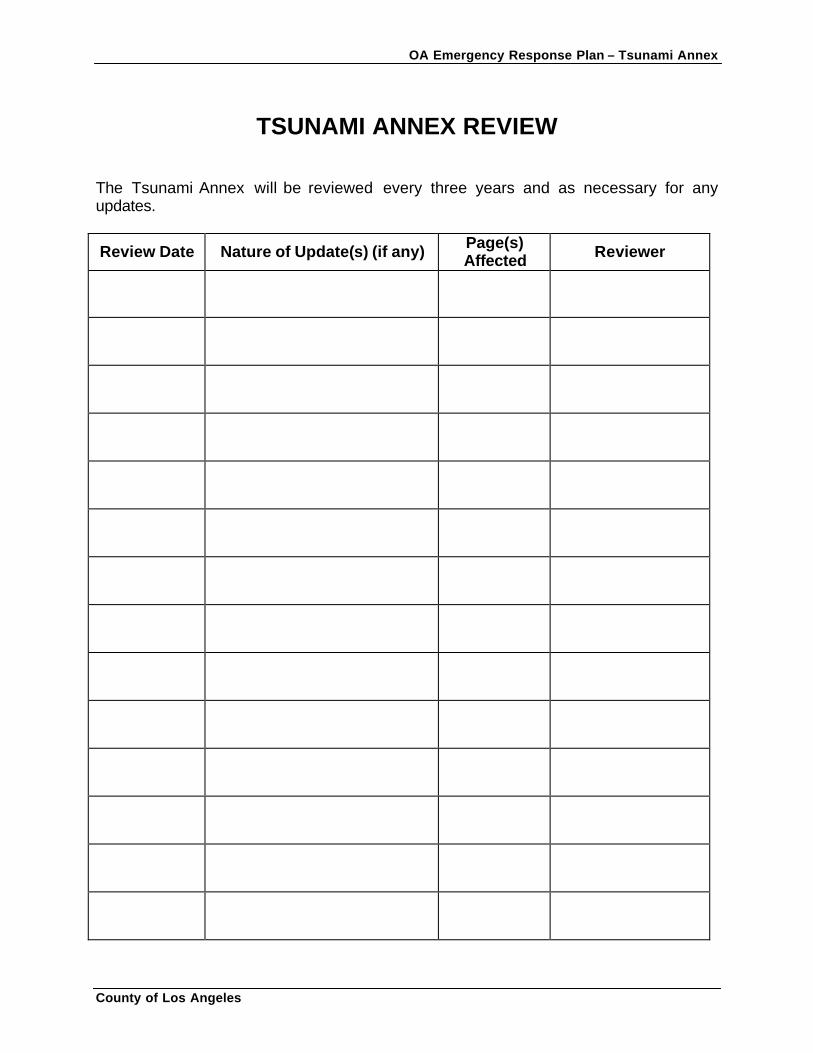
TSUNAMI ANNEX REVIEW The Tsunami Annex will be reviewed every three years and as necessary for any updates.
Review Date Nature of Update(s) (if any) Page(s) Affected Reviewer
OA Emergency Response Plan – Tsunami Annex
County of Los Angeles i
EXECUTIVE SUMMARY Tsunamis generated by both local and distant earthquakes threaten Southern California coastal communities. There is agreement within the tsunami and emergency response communities that technology alone cannot protect coastal habitats in the immediate area from a local, near-source tsunami. When a large earthquake occurs nearby, the first tsunami wave may reach coastal communities within a few minutes of the event. Local populations at risk must be able to recognize the signs of impending tsunami hazards and seek higher ground immediately. While distant-source tsunamis give residents more time to evacuate threatened coastal areas, they increase the need for timely and accurate assessment of the tsunami hazard to avoid costly false alarms. Communities need to be aware of what areas are likely to be flooded. Local decision-makers need to understand the risk and be provided with mitigation tools in order to make informed planning decisions. Planners, emergency responders, and residents need to understand the multi-hazard ramifications of very large local and distant earthquakes and their disruption to the community. This document details the Los Angeles County Operational Area (OA) Tsunami Annex and the procedures necessary to deal with a tsunami’s impact on its communities. The Los Angeles County Emergency Response Plan – Tsunami Annex is not meant to stand alone, but is intended to be used in support of, and in conjunction with State, County and city plans, and their responding agencies’ standard operation procedures. County coastal communities and special districts at risk for a tsunami event are responsible for developing tsunami emergency response plans compatible with the Los Angeles County OA Emergency Response Plan – Tsunami Annex. The policies, procedures, and concepts identified in this annex follow the guidelines established by the following: • United States Department of Homeland Security’s National Incident Management
System (NIMS) • California Standardized Emergency Management System (SEMS) • National Fire Protection Association’s Standard on Disaster and Emergency
Management and Business Continuity Programs (NFPA 1600, 2004 Edition) • National Oceanic and Atmospheric Administration’s (NOAA) National Tsunami
Hazard Mitigation Program (NTHMP) • California Governor’s Office of Emergency Services (OES) Local Planning Guidance
on Tsunami Response (second edition). The Los Angeles County’s Office of Emergency Management (OEM) convened and chaired the OA Tsunami Taskforce to coordinate tsunami planning and response protocols, including the identification and coordination of evacuation routes. This taskforce consisted of representatives from the OA, Disaster Management Areas (A, B, F, G, and H), coastal cities, special districts, major public safety agencies, seismologists, geologists, and tsunami researchers.
OA Emergency Response Plan – Tsunami Annex
County of Los Angeles ii
FOREWORD OVERVIEW The Los Angeles County OA Tsunami Annex consists of six sections. Each section has a specific purpose, as stated below.
Section 1 – Introduction This Section contains the formal language outlining the purpose, scope, mission statement, legal authorities and tsunami hazard to the Los Angeles County OA. Section 2 - Operations This Section outlines the operational priorities, concept of operations, and the sequence of operational activities for a tsunami event within the OA. Section 3 – Organizational Structure This Section identifies the organizational structure for the OA’s tsunami emergency response and recovery efforts. This Section also identifies the various tsunami response organizations at different levels of government during preparedness, response, and recovery phases. Section 4 – Roles and Responsibilities This Section defines the various roles and responsibilities of County departments and agencies in carrying out this annex. Section 5 – Training and Exercises This Section outlines the elements and considerations for a tsunami response training program for emergency response personnel, public education programs, and tsunami exercises. Section 6 – Maintenance This Section outlines the policy and responsibilities for ongoing management and maintenance of this annex.
OA Emergency Response Plan – Tsunami Annex
County of Los Angeles
TABLE OF CONTENTS EXECUTIVE SUMMARY …………………………………………………………………. i FOREWORD .………………………………………………………………………………. ii SECTION 1: INTRODUCTION ..………………………………………………………… 1-1
Background ..…………………………………..………………………….…………… 1-1 Purpose ..………………………………………..………………………....…………… 1-1 Scope ..…………………………………………..……………………………………… 1-1 Assumptions ….………………………………..….……………………….…..……… 1-2 Responsibilities ..……………………………………………………………………… 1-2 Mission ..………………………………………………………………………………… 1-3 Authorities ..……………………………………………………………………………. 1-3 Tsunami Threat to Los Angeles County .………..………………………………… 1-3 Relationship to Other Plans ..…………………….…………………………………. 1-8
SECTION 2: OPERATIONS..……………………………………………………………. 2-1
Operational Priorities..………………………………………………………………. 2-1 Definitions..……………………………………………………………………………. 2-1 Concept of Operations..…………………………………………………………….. 2-1 Sequence of Operational Activities..……………………………………………… 2-2 Alert and Warning Phase..………………………………………………………….. 2-2
Tsunami Alerts..……………………………………………………………………. 2-3 Alert Dissemination Paths ..……………………………………………………….. 2-6
Response and Recovery Phase..………………………………………………….. 2-8 Evacuation and Traffic Control………………………….………………………… 2-10 Area Security and Area Re-entry..……………………………………………….. 2-13 Damage Assessments..…………………………………………………………… 2-14 Emergency Public Information..………………………………………………….. 2-14
SECTION 3: ORGANIZATIONAL STRUCTURE..……………………………………… 3-1
Tsunami Response Organizations..………………………………………………… 3-1
SECTION 4: ROLES AND RESPONSIBILITIES..……………………………………… 4-1
Management Section..………………………………………………………………… 4-1
The Los Angeles County Sheriff’s Department..……………………………….… 4-1 Chief Administrative Office..……………………………………………………….. 4-2 Public Information Officer..……………………………………………………….… 4-2 Safety Officer .……………………………………………………………………..… 4-2
OA Emergency Response Plan – Tsunami Annex
County of Los Angeles
TABLE OF CONTENTS (CONT.)
Operations Section ..…………………………………………………………………. 4-2
County Sheriff’s Department ..……………………………………………………. 4-2 County Fire Department ..…………………………………………………………. 4-3 Department of Public Works ..…………………………………………………….. 4-4 Internal Services Department .……………………………………………………. 4-5 Department of Health Services ..…………………………………………………. 4-5 Department of Mental Health ..……………………………………………………. 4-5 Department of Public Social Services ..………………………………………….. 4-6 County Coroner …………………………………………………………………….. 4-6 Parks and Recreation ..…………………………………………………………….. 4-6 American Red Cross ..……………………………………………………………… 4-6
Planning and Intelligence Section ..……………………………………………….. 4-7 Logistics Section ..……………………………………………………………………. 4 -7
Internal Services Department ..……………………………………………………. 4-7 Finance, Administration and Recovery (FAR) Section ..……………………….. 4-8
Office of Emergency Management ..……………………………………………… 4-8 Coastal Communities/Special Districts ..…………………………………………. 4-9
SECTION 5: TRAINING AND EXERCISES ..…………………………………………… 5-1
Public Tsunami Education Programs ..…………………………………………… 5-1
Emergency Survival Program ..…………………………………………………… 5-2 SECTION 6: MAINTENANCE ..………………………………………………………….. 6-1 REFERENCES ..……………………………………………………………………………. 7-1
LIST OF FIGURES Figure 1: Potential Local-Source Tsunami Regions along the Californian Coast ..…………………………………………………………………………. 1-4 Figure 2: Potential Distant-Source Tsunami Regions for the Californian Coast ..………………………………………………………………………….. 1-6 Figure 3: Tsunami Notification System …….……………………………………………. 2-3 LIST OF TABLES Table 1: Local-source Tsunami Regions of Southern California ……………….. 1-5 Table 2: Likelihood of Tsunami Occurrence and Severity……………………………… 1-7 Table 3: Los Angeles County OA Tsunami Annex Associated Plans, Policies, and Procedures……………………………..…... 1-9 Table 4: General Notification Procedures……………………………………………..…. 2-3 Table 5: Tsunami Response Actions …………………………………………………….. 2-9
OA Emergency Response Plan – Tsunami Annex
County of Los Angeles
TABLE OF CONTENTS (CONT.)
LIST OF TABLES (CONT.) Table 6: Consequence of Distant- and Near-Source Tsunami Events …………….. 2-11 Table 7: Traffic Control Point Closure Levels ……………………………………….... 2-13 Table 8: Tsunami Response Organizations ………………………………………….... 3-2 APPENDICES ..…………………………………………………………………………….. 8-1
Appendix A: Acronyms and Tsunami Terminology …………………………… A-1 Appendix B: Tsunami Background Information ……………………………….. B-1 Appendix C: Los Angeles County OA Organization Matrix ………………….. C-1 Appendix D: Southern California Tsunami Risks ………………………………. D-1 Appendix E: Los Angeles County Tsunami Risk Areas ………………………. E-1 Appendix F: Tsunami Inundation Maps ………………………………………….. F-4 Appendix G: Sample Warnings, Briefings, and Media Releases ……………. G-1 Appendix H: Tsunami Key Contact Phone List …………………………………. H-1 Appendix I: Sample Evacuation Orders ……………………………………….… I-1 Appendix J: Coastal Evacuation Routes for West-Facing Beaches ………… J-1 Appendix K: Potential Tsunami Evacuation Sites ……………………………… K-1 Appendix L: CEOC Tsuanmi Checklists …………………………………………. L-1 CEOC Tsuanmi Watch Checklist …………………………………….…………… L-2 CEOC Tsuanmi Warning Checklist …………………………….………………… L-5 CEOC Tsuanmi Occurrence Checklist ……………………….………………….. L-9 Appendix M: Operational Period Incident Objectives …………………………. M-1 Appendix N: Emergency Survival Program (ESP) Public Education
Campaign……………………………………………………………… N-1
OA Emergency Response Plan – Tsunami Annex
County of Los Angeles 1-1
SECTION 1: INTRODUCTION BACKGROUND A tsunami (seismic sea wave) is a series of ocean waves of extremely long length generated by earthquakes, volcanic eruptions, massive undersea landslides, or any other disturbance that displaces a large water mass from its equilibrium position. As a tsunami crosses the deep ocean the wave may be a hundred miles in length and only a few feet in height. Tsunamis may reach speeds of 600 miles per hour in deep water. As the waves enter shallow coastal waters, their speed decreases and the wave height increases. The waves reach the shore with enough momentum to flatten buildings and trees and to carry ships miles inland. Tsunamis can cause great loss of life and property damage. Following the arrival of the first wave, subsequent waves may increase in height and arrive minutes to hours later. (Refer to Appendices A and B for tsunami-related terminology (A) and further information regarding tsunamis (B)). The Los Angeles County OA Tsunami Annex demonstrates the County’s commitment to the reduction of risks through tsunami p lanning.
PURPOSE The purposes of the Los Angeles County OA Tsunami Annex are to: (1) provide the framework for the OA’s response to tsunamis, including assignment of responsibilities and a description of the actions to be taken by the County upon notification of a Tsunami alert; and (2) establish a countywide understanding of the unique operational concepts, organization, tasks, and coordinated emergency actions of public agencies, utility districts, and other organizations and institutions involved in a tsunami response. Detailed descriptions of how County departments or jurisdictions respond to tsunamis will be located in department- and jurisdiction-specific plans. SCOPE The Los Angeles County Tsunami Annex applies to the Los Angeles County OA only and does not address response and recovery operations for local governments or agencies outside the OA. The primary audiences for this annex are County departments, emergency response agencies, coastal communities, and special districts (transit and school districts) within the OA who hold the responsibility for implementing this annex and/or have responsibilities detailed herein. OEM will share this annex in electronic format with all such entities within the Los Angeles County OA to encourage and assist them with their tsunami planning efforts.
OA Emergency Response Plan – Tsunami Annex
County of Los Angeles 1-2
ASSUMPTIONS This annex is based on the following assumptions: • The most likely causes of the tsunami hazard in Los Angeles County are a seismic
event off the California coast or in the Pacific Rim, and from a landslide in the coastal shelf off the Southern California coast.
• Time to warn the public, evacuate sensitive facilities, establish temporary shelters, and secure coastal areas will vary from minutes to hours.
• After the arrival of the first wave, waves may continue to arrive at intervals for several hours. Risk areas can be reopened two hours after the last observed wave, or two hours after the Estimated Time of Arrival (ETA) has passed without a wave coming ashore.
• Maximum wave height will vary considerably from one location to another. • Withdrawal of the sea may be a precursor to arrival of the wave. • Outflow of water to the sea between crests may be rapid and destructive. • Elapsed time between successive wave crests at a given point is usually 10 to 45
minutes. • Intervals between successive major waves may be similar. If the second wave
arrives 20 minutes after the first, it is likely that a third wave (if there is one) would arrive 20 minutes after the second.
• The first wave may not be the largest. The largest wave usually occurs within the first ten waves, with the second or third typically being the most destructive. Maximum wave activity in bays and harbors is often observed much later than the arrival of the first wave.
RESPONSIBILITIES The responsibilities for developing, implementing, maintaining, and supporting this Tsunami Annex are as follows:
• OEM is responsible for developing and maintaining this annex. • The Los Angeles County Sheriff’s Department is responsible for implementing this
annex. • Other assigned County departments and agencies will carry out their responsibilities
as described in this annex and according to the Los Angeles County OA Organization Matrix (see Appendix C) detailed in the OA Emergency Response Plan (OAERP). All County departments will operate under the umbrella of the County OA using SEMS/NIMS.
• County coastal communities and special districts at risk for a tsunami event are responsible for developing tsunami emergency response plans compatible with the Los Angeles County OA Tsunami Annex. Additionally, each OA jurisdiction at risk for a tsunami event is responsible for developing earthquake, evacuation, and flood plans, as well as standard operating
OA Emergency Response Plan – Tsunami Annex
County of Los Angeles 1-3
procedures, for possible implementation in response to local- or distant-source tsunami events. The expectation is that local governments and response agencies and special districts in the predicted impact areas will implement their plans and standard operating procedures, when appropriate.
MISSION The mission of the Los Angeles County OA is to reduce the potential for loss of life and property from the tsunami hazard by: (1) providing timely, accurate, reliable, and effective tsunami information and support to coastal populations and emergency management within our area of responsibility; and (2) advancing other aspects of tsunami hazard mitigation such as building design and land use, community preparedness and public education. AUTHORITIES Federal/State In 1994, the United States Senate Appropriations Committee directed the NOAA to conduct tsunami-related studies and formulate a plan for reducing tsunami risks to the nation’s coastal residents. The resulting plan, the National Tsunami Hazard Mitigation Program (NTHMP), as well as subsequent studies and workshops sponsored or supported by NOAA, the Federal Emergency Management Agency (FEMA), and California’s OES, have raised the consciousness of public disaster services agencies across California. NOAA’s efforts led to the development of tsunami action plans in some of the most endangered localities, including the Los Angeles County OA. California, rather than developing a stand-alone tsunami hazard assessment mitigation program, elected to partner with the NTHMP. Local In accordance with the State’s SEMS and the County’s Emergency Ordinance (Chapter 2.68), this annex is applicable to all County departments, cities, and special districts. The Los Angeles County Board of Supervisors recognized the criticality of the tsunami hazard to the Los Angeles County OA and directed the development of the Los Angeles County OA Tsunami Annex. TSUNAMI THREAT TO THE COUNTY OF LOS ANGELES This section supplements the tsunami and flooding hazard summary and assessment found in the OAERP and the Los Angeles County All-Hazard Mitigation Plan.
OA Emergency Response Plan – Tsunami Annex
County of Los Angeles 1-4
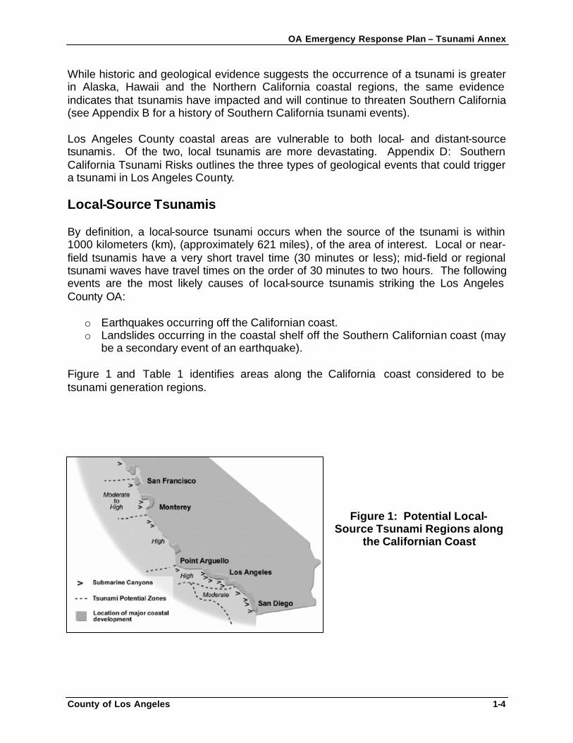
While historic and geological evidence suggests the occurrence of a tsunami is greater in Alaska, Hawaii and the Northern California coastal regions, the same evidence indicates that tsunamis have impacted and will continue to threaten Southern California (see Appendix B for a history of Southern California tsunami events). Los Angeles County coastal areas are vulnerable to both local- and distant-source tsunamis. Of the two, local tsunamis are more devastating. Appendix D: Southern California Tsunami Risks outlines the three types of geological events that could trigger a tsunami in Los Angeles County. Local-Source Tsunamis By definition, a local-source tsunami occurs when the source of the tsunami is within 1000 kilometers (km), (approximately 621 miles), of the area of interest. Local or near-field tsunamis have a very short travel time (30 minutes or less); mid-field or regional tsunami waves have travel times on the order of 30 minutes to two hours. The following events are the most likely causes of local-source tsunamis striking the Los Angeles County OA:
o Earthquakes occurring off the Californian coast. o Landslides occurring in the coastal shelf off the Southern Californian coast (may
be a secondary event of an earthquake).
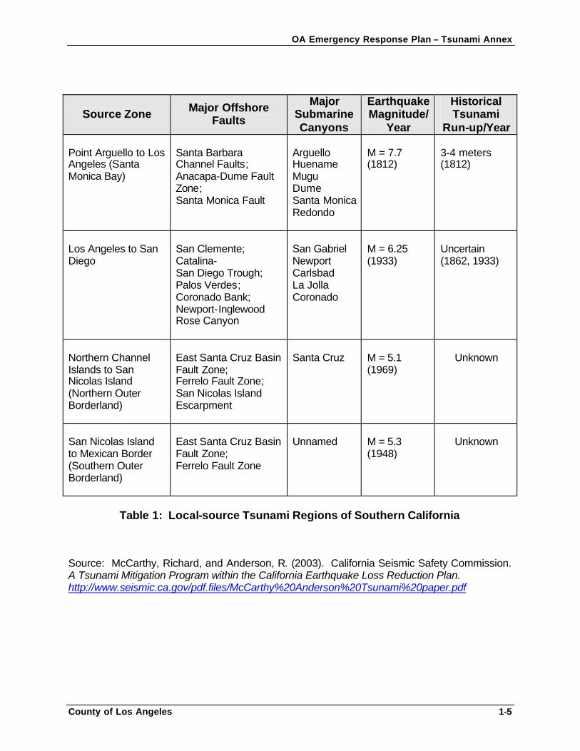
Figure 1 and Table 1 identifies areas along the California coast considered to be tsunami generation regions.
Figure 1: Potential Local-Source Tsunami Regions along
the Californian Coast
OA Emergency Response Plan – Tsunami Annex
County of Los Angeles 1-5
Source Zone Major Offshore Faults
Major Submarine Canyons
Earthquake Magnitude/
Year
Historical Tsunami
Run-up/Year Point Arguello to Los Angeles (Santa Monica Bay)
Santa Barbara Channel Faults; Anacapa-Dume Fault Zone; Santa Monica Fault
Arguello Huename Mugu Dume Santa Monica Redondo
M = 7.7 (1812)
3-4 meters (1812)
Los Angeles to San Diego
San Clemente; Catalina- San Diego Trough; Palos Verdes; Coronado Bank; Newport-Inglewood Rose Canyon
San Gabriel Newport Carlsbad La Jolla Coronado
M = 6.25 (1933)
Uncertain (1862, 1933)
Northern Channel Islands to San Nicolas Island (Northern Outer Borderland)
East Santa Cruz Basin Fault Zone; Ferrelo Fault Zone; San Nicolas Island Escarpment
Santa Cruz
M = 5.1 (1969)
Unknown
San Nicolas Island to Mexican Border (Southern Outer Borderland)
East Santa Cruz Basin Fault Zone; Ferrelo Fault Zone
Unnamed
M = 5.3 (1948)
Unknown
Table 1: Local-source Tsunami Regions of Southern California
Source: McCarthy, Richard, and Anderson, R. (2003). California Seismic Safety Commission. A Tsunami Mitigation Program within the California Earthquake Loss Reduction Plan. http://www.seismic.ca.gov/pdf.files/McCarthy%20Anderson%20Tsunami%20paper.pdf
OA Emergency Response Plan – Tsunami Annex
County of Los Angeles 1-6
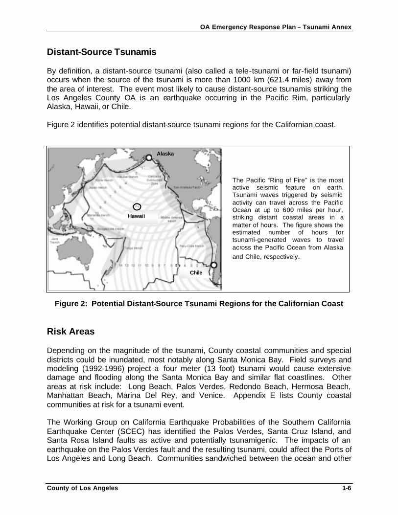
Distant-Source Tsunamis By definition, a distant-source tsunami (also called a tele-tsunami or far-field tsunami) occurs when the source of the tsunami is more than 1000 km (621.4 miles) away from the area of interest. The event most likely to cause distant-source tsunamis striking the Los Angeles County OA is an earthquake occurring in the Pacific Rim, particularly Alaska, Hawaii, or Chile. Figure 2 identifies potential distant-source tsunami regions for the Californian coast.
Figure 2: Potential Distant-Source Tsunami Regions for the Californian Coast
Risk Areas Depending on the magnitude of the tsunami, County coastal communities and special districts could be inundated, most notably along Santa Monica Bay. Field surveys and modeling (1992-1996) project a four meter (13 foot) tsunami would cause extensive damage and flooding along the Santa Monica Bay and similar flat coastlines. Other areas at risk include: Long Beach, Palos Verdes, Redondo Beach, Hermosa Beach, Manhattan Beach, Marina Del Rey, and Venice. Appendix E lists County coastal communities at risk for a tsunami event. The Working Group on California Earthquake Probabilities of the Southern California Earthquake Center (SCEC) has identified the Palos Verdes, Santa Cruz Island, and Santa Rosa Island faults as active and potentially tsunamigenic. The impacts of an earthquake on the Palos Verdes fault and the resulting tsunami, could affect the Ports of Los Angeles and Long Beach. Communities sandwiched between the ocean and other
Chile
Alaska
Hawaii
The Pacific “Ring of Fire” is the most active seismic feature on earth. Tsunami waves triggered by seismic activity can travel across the Pacific Ocean at up to 600 miles per hour, striking distant coastal areas in a matter of hours. The figure shows the estimated number of hours for tsunami-generated waves to travel across the Pacific Ocean from Alaska and Chile, respectively.
OA Emergency Response Plan – Tsunami Annex
County of Los Angeles 1-7
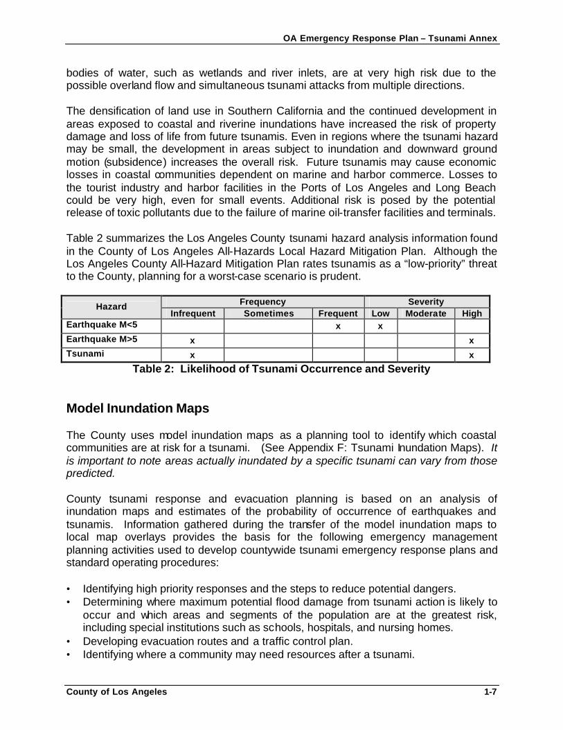
bodies of water, such as wetlands and river inlets, are at very high risk due to the possible overland flow and simultaneous tsunami attacks from multiple directions. The densification of land use in Southern California and the continued development in areas exposed to coastal and riverine inundations have increased the risk of property damage and loss of life from future tsunamis. Even in regions where the tsunami hazard may be small, the development in areas subject to inundation and downward ground motion (subsidence) increases the overall risk. Future tsunamis may cause economic losses in coastal communities dependent on marine and harbor commerce. Losses to the tourist industry and harbor facilities in the Ports of Los Angeles and Long Beach could be very high, even for small events. Additional risk is posed by the potential release of toxic pollutants due to the failure of marine oil-transfer facilities and terminals. Table 2 summarizes the Los Angeles County tsunami hazard analysis information found in the County of Los Angeles All-Hazards Local Hazard Mitigation Plan. Although the Los Angeles County All-Hazard Mitigation Plan rates tsunamis as a “low-priority” threat to the County, planning for a worst-case scenario is prudent.
Frequency Severity Hazard Infrequent Sometimes Frequent Low Moderate High
Earthquake M<5 x x Earthquake M>5 x x Tsunami x x
Table 2: Likelihood of Tsunami Occurrence and Severity Model Inundation Maps The County uses model inundation maps as a planning tool to identify which coastal communities are at risk for a tsunami. (See Appendix F: Tsunami Inundation Maps). It is important to note areas actually inundated by a specific tsunami can vary from those predicted. County tsunami response and evacuation planning is based on an analysis of inundation maps and estimates of the probability of occurrence of earthquakes and tsunamis. Information gathered during the transfer of the model inundation maps to local map overlays provides the basis for the following emergency management planning activities used to develop countywide tsunami emergency response plans and standard operating procedures: • Identifying high priority responses and the steps to reduce potential dangers. • Determining where maximum potential flood damage from tsunami action is likely to
occur and which areas and segments of the population are at the greatest risk, including special institutions such as schools, hospitals, and nursing homes.
• Developing evacuation routes and a traffic control plan. • Identifying where a community may need resources after a tsunami.
OA Emergency Response Plan – Tsunami Annex
County of Los Angeles 1-8
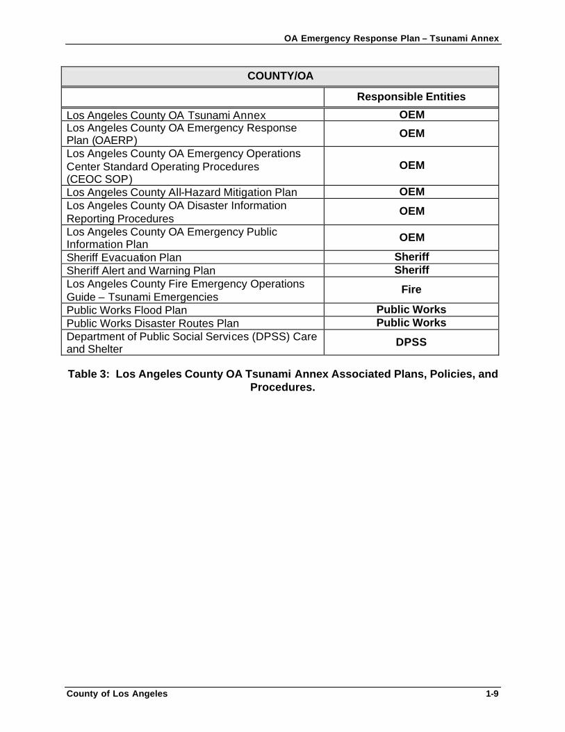
RELATIONSHIP TO OTHER PLANS The Los Angeles County OA Emergency Response Plan – Tsunami Annex is not meant to stand alone, but is intended to be used in support of and in conjunction with State, OA/County, city, and special districts’ emergency response plans, and their responding agencies’ standard operation procedures. This annex is consistent with and augments the OAERP and the CEOC SOP, and the County of Los Angeles All-Hazards Local Hazard Mitigation Plan. The OAERP outlines broad emergency response concepts with appendices detailing emergency response for each hazard faced by the County, including tsunamis, earthquakes and floods. This document is an annex to the OAERP. Additionally, this annex is to be used in conjunction with the CEOC SOP as an operational document. County departments and agencies with assigned tasks outlined in the OAERP, CEOC SOP, and in this Tsunami Annex, are responsible for developing specific mitigation, preparedness, response and recovery procedures and checklists to support these plans. Plans, policies, and procedures to be used in support of, and in conjunction with this annex are listed in Table 3.
OA Emergency Response Plan – Tsunami Annex
County of Los Angeles 1-9
COUNTY/OA
Responsible Entities
Los Angeles County OA Tsunami Annex OEM Los Angeles County OA Emergency Response Plan (OAERP)
OEM
Los Angeles County OA Emergency Operations Center Standard Operating Procedures (CEOC SOP)
OEM
Los Angeles County All-Hazard Mitigation Plan OEM Los Angeles County OA Disaster Information Reporting Procedures
OEM
Los Angeles County OA Emergency Public Information Plan
OEM
Sheriff Evacuation Plan Sheriff Sheriff Alert and Warning Plan Sheriff Los Angeles County Fire Emergency Operations Guide – Tsunami Emergencies
Fire
Public Works Flood Plan Public Works Public Works Disaster Routes Plan Public Works Department of Public Social Services (DPSS) Care and Shelter
DPSS
Table 3: Los Angeles County OA Tsunami Annex Associated Plans, Policies, and
Procedures.
OA Emergency Response Plan – Tsunami Annex
County of Los Angeles 2-1
SECTION 2: OPERATIONS OPERATIONAL PRIORITIES The County of Los Angeles gives consideration to the following issues to assist in emergency response operations prioritization: • Protecting life, the environment, and property. • Meeting the immediate needs of the population, including rescue, medical treatment,
and shelter. • Temporary restoration of facilities essential to the health, safety, and welfare of the
population. • Mitigating hazards which develop as a result of the emergency.
DEFINITIONS Appendix A contains tsunami-related terminology to assist emergency management and response personnel. CONCEPT OF OPERATIONS In order to successfully accomplish the mission statement of this annex, County departments, agencies, coastal cities, special districts, and other jurisdictions will use a multi-agency, multi-disciplinary coordinated approach in response to a tsunami threat or event. The County will use the Incident Command System (ICS) component of the SEMS and the NIMS to manage tsunami events. This annex becomes effective upon notification of a Tsunami Watch or Warning alert issued by the National Weather Service (NWS). (Section 2 defines Tsunami Watch and Warning alerts). Once the OA confirms this alert with OES or the NWS (see Alert Dissemination Paths), authorized personnel may activate the CEOC according to the CEOC Standard Operating Procedures (CEOC SOP) activation protocols or based on the potential threat and its scope. If the CEOC is activated, the CEOC Manager will direct implementation of this annex or applicable portions, as appropriate. If the CEOC is not activated, all or portions of this annex may be implemented at the discretion of the Sheriff’s Department, based on the potential threat and its scope. Any city or special district may activate their respective tsunami emergency response plans for areas under their incident command authority.
OA Emergency Response Plan – Tsunami Annex
County of Los Angeles 2-2
In the event of a Tsunami Watch/Warning and following alert confirmation and threat assessment, local authorities will warn the population in designated risk areas and advise them to move to temporary mass care facilities, if appropriate. Local authorities and emergency managers are responsible for executing evacuation and traffic control plans and implementing area security for areas under a tsunami warning. After local authorities provide a general warning to the public, the highest priority is alerting and moving institutional populations such as schools, hospitals, and convalescent care facilities. The local agency with incident command authority will arrange special procedures for warning, evacuation, and care of institutional occupants. Each agency assigned Incident Command responsibilities will control operations within its area of responsibility. Local governments and agencies in the predicted impact areas will prepare for flooding and implement their tsunami and evacuation plans, as well as implement earthquake plans , as appropriate. SEQUENCE OF OPERATIONAL ACTIVITIES There are two primary phases, or sequences of operational activities for a tsunami event: 1. Alert and Warning Phase
a. Tsunami Alerts b. Alert Dissemination Paths
2. Response and Recovery Phase
a. CEOC Activation b. Evacuation and Traffic Control c. Area Security and Area Re-entry d. Damage Assessment Phase e. Emergency Public Information
ALERT AND WARNING PHASE NOAA’s NWS operates the West Coast/Alaska Tsunami Warning Center (WC/ATWC) in Alaska to monitor potential tsunamis and provide early warning of such waves. The WC/ATWC is responsible for: (1) reporting seismic movement along the North American Coast from the Aleutian Islands south through Baja California; and (2) providing technical advice to emergency managers within its area of responsibility. Since California is vulnerable to local-source tsunamis, the current tsunami warning system does not fully meet California’s needs. There are areas along the California Coast considered to be tsunami generation regions (see Table 1 and Figure 1). The WC/ATWC may not detect a locally generated tsunami in sufficient time to warn local authorities to evacuate potential tsunami-impact areas. At present, detection of such
OA Emergency Response Plan – Tsunami Annex
County of Los Angeles 2-3
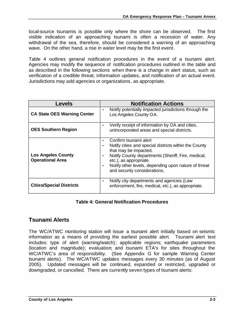
local-source tsunamis is possible only where the shore can be observed. The first visible indication of an approaching tsunami is often a recession of water. Any withdrawal of the sea, therefore, should be considered a warning of an approaching wave. On the other hand, a rise in water level may be the first event. Table 4 outlines general notification procedures in the event of a tsunami alert. Agencies may modify the sequence of notification procedures outlined in the table and as described in the following sections when there is a change in alert status, such as verification of a credible threat, information updates, and notification of an actual event. Jurisdictions may add agencies or organizations, as appropriate.
Levels Notification Actions
CA State OES Warning Center • Notify potentially impacted jurisdictions through the
Los Angeles County OA.
OES Southern Region • Verify receipt of information by OA and cities,
unincorporated areas and special districts.
Los Angeles County Operational Area
• Confirm tsunami alert • Notify cities and special districts within the County
that may be impacted. • Notify County departments (Sheriff, Fire, medical,
etc.), as appropriate. • Notify other levels, depending upon nature of threat
and security considerations.
Cities/Special Districts • Notify city departments and agencies (Law
enforcement, fire, medical, etc.), as appropriate.
Table 4: General Notification Procedures
Tsunami Alerts The WC/ATWC monitoring station will issue a tsunami alert initially based on seismic information as a means of providing the earliest possible alert. Tsunami alert text includes: type of alert (warning/watch) ; applicable regions; earthquake parameters (location and magnitude); evaluation; and tsunami ETA's for sites throughout the WC/ATWC’s area of responsibility. (See Appendix G for sample Warning Center tsunami alerts). The WC/ATWC updates messages every 30 minutes (as of August 2005). Updated messages will be continued, expanded or restricted, upgraded or downgraded, or cancelled. There are currently seven types of tsunami alerts:
OA Emergency Response Plan – Tsunami Annex
County of Los Angeles 2-4
• Tsunami Warning • Tsunami Watch • Tsunami Information Bulletin • Tsunami Advisory • Tsunami Information Message • Tsunami Cancellation • Tsunami Communication Test
Tsunami Warning
The highest level of tsunami alert. A Tsunami Warning is an announcement by the WC/ATWC given to local jurisdictions within an expected impact area after a tsunami triggering event has occurred or when a tsunami has been detected anywhere in the Pacific Basin. For earthquake magnitudes between 7.1 and 7.5, a Tsunami Warning is issued to areas within a 350 km (217.5 miles) along the coast on either side of the epicenter. For earthquake magnitudes greater than 7.5, a Tsunami Warning is issued to areas within a 3 hour tsunami travel-time zone.
Tsunami Watch
The second highest level of tsunami alert. A Tsunami Watch is an announcement by the WC/ATWC given to local jurisdictions outside of the “warning” area that a seismic event has occurred in the Pacific Basin and may have caused a tsunami. For earthquake magnitudes greater than 7.5, a Tsunami Watch is issued to areas within a three to six hour tsunami travel-time zone. The WC/ATWC issues Watches as a means of providing advance alert to areas that could be impacted by a destructive tsunami and indicates these jurisdictions should monitor the event.
Tsunami Information Bulletin
The WC/ATWC issues Informational Bulletins for earthquakes which are not likely to trigger a tsunami dangerous to its area of responsibility. The WC/ATWC releases bulletins to advise participants of the occurrence of an earthquake in the Pacific or near-Pacific area with the evaluation of any of the following situations: (1) that a potentially destructive tsunami has not been generated and there is no danger to the WC/ATWC area of responsibility; (2) that a tsunami capable of causing destruction beyond the local area has been generated; or (3) there is a probability of a tsunami and to advise that a tsunami investigation is underway.
Tsunami Advisory The WC/ATWC issues Advisories for an event outside its area-of-responsibility which poses no imminent threat to its area of responsibility. An Advisory indicates that an area is either outside the current warning and watch regions, or that the tsunami poses no danger to that area. The WC/ATWC will continue to monitor the
OA Emergency Response Plan – Tsunami Annex
County of Los Angeles 2-5
event, issuing updates at regular intervals. As conditions warrant, the Advisory will either be continued, upgraded to a watch or warning, or ended.
Tsunami Information Message The WC/ATWC issues Information Messages when smaller earthquakes (less than the warning threshold) are felt near coastal areas. The WC/ATWC issues Information Messages to assure coastal residents and emergency managers that there is no tsunami danger.
Tsunami Cancellation
After the arrival of the first wave, waves may continue to arrive at intervals for several hours. A cancellation message will be sent when all danger of a tsunami has passed. At present, the WC/ATWC is unable to determine when danger has passed in many areas. Local conditions (e.g., particularly strong currents in channels and harbors), can cause wide variations in tsunami wave action. Consequently, local emergency management officials, and not the WC/ATWC, will make all-clear determinations.
The WC/ATWC will issue a cancellation after either of the following situations: (1) an evaluation of sea level data confirms that a destructive tsunami will not impact the AOR; or (2) following a destructive tsunami when data indicates that the threat has largely subsided to non-destructive levels. Following a destructive tsunami, the WC/ATWC provides guidance to local officials regarding when they can consider the threat to have passed based on local conditions.
In general, after receipt of a Tsunami Warning, agencies can assume all-clear status when their area is free from damaging waves for two hours, unless the WC/ATWC has announced additional ETAs or local conditions warrant continuation of the Tsunami Warning status (OES, Local Planning Guidance). This requires that the local government is able to observe the waves from a safe distance and height. Hence, if no wave or only insignificant waves occur, local agencies may assume all-clear status two hours after the latest ETA announced by WC/ATWC, unless the presence of strong currents in channels and harbors has been noted which may warrant continuation of the Tsunami Warning. The public should not return to low lying areas until the tsunami threat has passed and local authorities announce “all clear”.
Tsunami Communication Test The WC/ATWC issues test messages at unannounced times on a monthly basis to determine delays in disseminating tsunami information, to test the operation of the warning system by the evaluation of two-way communications with interactive personnel response, and to keep communication operating personnel familiar with
OA Emergency Response Plan – Tsunami Annex
County of Los Angeles 2-6
the procedures for handling message traffic pertaining to the Tsunami Warning System.
Alert Dissemination Paths In order to limit the number of agencies contacted in the event of a tsunami, the WC/ATWC generally issues tsunami alerts to only one agency in an administrative area. In California, the State Warning Center (CSWC), operated by OES, is the designated dissemination agency of alerts issued by the WC/ATWC. The CSWC does not undertake any threat analysis and will not advise local governments regarding response issues, such as Emergency Operations Center (EOC) activations or evacuations. The CSWC is only authorized to communicate the original tsunami alert from the WC/ATWC. If the location and magnitude of an earthquake or other triggering event meets the known criteria for generation of a tsunami or if a significant tsunami is detected by sea-level monitoring instrumentation, the WC/ATWC will issue a tsunami warning and watch to the CSWC. Information is sent to the CSWC primarily via the NOAA Weather Wire Satellite System (NWWS), FEMA’s National Warning System (NAWAS) and, alternatively, via e-mail. The CSWC forwards the information to the OES regional duty officer and OAs. The CSWC notifies the OES regional duty officer for all active watch and warning alerts issued in their area of responsibility. The OES regional duty officer will verify that OAs within their area of responsibility received the CSWC watch/warning alerts. The CSWC also passes all information from the WC/ATWC directly to the OA via any of the following primary and alternate methods: • California Law Enforcement Telecommunications System (CLETS) - primary • California Warning System (CALWAS) - primary • Dialogic - primary • Emergency Digital Information System (EDIS) • California Integrated Seismic Network (CISN) • OA Satellite Information System (OASIS) • California Law Enforcement Radio System (CLERS) • Emergency Alert System (EAS) The OA, through the Sheriff’s Department Communications Center (SCC), will first verify and confirm the alert received from the CSWC immediately with the OES regional duty officer (preferred method), CSWC, or the WC/ATWC. OAs are then responsible for
The CSWC does not undertake any threat analysis.
OA Emergency Response Plan – Tsunami Annex
County of Los Angeles 2-7
notifying local coastal cities and special districts (see Appendix H for contact information). Once the SCC confirms the tsunami alert, they will immediately disseminate the information to local jurisdictions and special districts within the alert areas via phone. The SCC will also transmit a redundant alert message, using e-mail and fax. The SCC will notify the Sheriff Department’s Emergency Operations Bureau (EOB), OEM, local police dispatch centers (coastal cities police agencies and coastal sheriff stations), and the Los Angeles County Fire Emergency Command and Control Center (Fire’s ECC). The SCC will also notify the following agencies as appropriate: • Los Angeles County Department of Beaches and Harbors • Los Angeles County Department of Public Works Dispatch Center • Los Angeles County Department of Health Services Medical Alert Center (MAC) • United States Coast Guard Los Angeles Command Center/Los Angeles Station • Port of Los Angeles Police • Los Angeles International Airport Police • Port of Long Beach Police • Long Beach Airport Police OEM will notify other County departments and agencies, as necessary. Fire’s ECC will notify coastal city fire departments, and any contract city and unincorporated coastal area where they provide service. Local law enforcement, with the assistance of Fire and Lifeguard units, will be used to help alert the public to take appropriate action as directed. The SCC will use the EAS to deliver the tsunami warning on local radio and television stations. Additional methods to warn the public may include: • Emergency service units using public address (PA) systems • Providing leaflets door-to-door • Media announcements via radio and television • Announcements on Travelers Information Service • Sounding of sirens (steady blast indicates peacetime emergency), if available
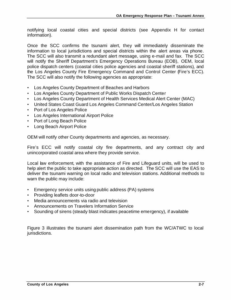
Figure 3 illustrates the tsunami alert dissemination path from the WC/ATWC to local jurisdictions.
OA Emergency Response Plan – Tsunami Annex
County of Los Angeles 2-8
Figure 3: Tsunami Notification System RESPONSE AND RECOVERY PHASE This annex becomes effective upon notification of a Tsunami Watch or Warning issued by the WC/ATWC. Once the SCC confirms the Tsunami Watch/Warning with the CSWC or the WC/ATWC, authorized personnel may activate the CEOC based on the potential threat and its scope or according to the CEOC SOP activation protocols (if two or more cities or the City of Los Angeles activate their EOCs, authorized personnel will activate the CEOC).
OA Emergency Response Plan – Tsunami Annex
County of Los Angeles 2-9
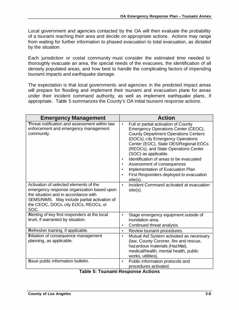
Local government and agencies contacted by the OA will then evaluate the probability of a tsunami reaching their area and decide on appropriate actions. Actions may range from waiting for further information to phased evacuation to total evacuation, as dictated by the situation. Each jurisdiction or costal community must consider the estimated time needed to thoroughly evacuate an area, the special needs of the evacuees, the identification of all densely populated areas, and how best to handle the complicating factors of impending tsunami impacts and earthquake damage. The expectation is that local governments and agencies in the predicted impact areas will prepare for flooding and implement their tsunami and evacuation plans for areas under their incident command authority, as well as implement earthquake plans, if appropriate. Table 5 summarizes the County’s OA initial tsunami response actions.
Emergency Management Action
?Threat notification and assessment within law enforcement and emergency management community. ?
• Full or partial activation of County Emergency Operations Center (CEOC), County Department Operations Centers (DOCs), city Emergency Operations Center (EOC), State OES/Regional EOCs (REOCs), and State Operations Center (SOC) as applicable.
• Identification of areas to be evacuated • Assessment of consequences • Implementation of Evacuation Plan • First Responders deployed to evacuation
site(s). Activation of selected elements of the emergency response organization based upon the situation and in accordance with SEMS/NIMS. May include partial activation of the CEOC, DOCs, city EOCs, REOCs, or SOC.
• Incident Command activated at evacuation site(s).
?Alerting of key first responders at the local level, if warranted by situation.
• Stage emergency equipment outside of inundation area.
• Continued threat analysis. ?Refresher training, if applicable. • Review tsunami procedures. ?Initiation of consequence management planning, as applicable.
• Mutual Aid System activated as necessary (law, County Coroner, fire and rescue, hazardous materials (HazMat), medical/health, mental health, public works, utilities).
?Issue public information bulletin. • Public information protocols and procedures activated.
Table 5: Tsunami Response Actions
OA Emergency Response Plan – Tsunami Annex
County of Los Angeles 2-10
Evacuation and Traffic Control
One of the most critical elements of a tsunami plan is the evacuation and traffic control plan. Each jurisdiction in the County OA at risk for a tsunami event is responsible for developing evacuation and traffic control plans for possible implementation in response to a tsunami event in accordance with legal guidelines for controlling movement of people and property. A specific plan for conducting evacuations in response to a tsunami emergency requires significant coordination with County and local public service agencies involving five (A, B, F, G and H) of the County’s eight Disaster Management Areas (see Appendix H for Disaster Management Areas map). The planning effort to alert and effectively remove large segments of population from coastal communities threatened by such an event will be undertaken as an extension of the Region I Law Enforcement Mutual Aid Emergency Plan and will incorporate the participation of appropriate support agencies designated in the Plan. Evacuation and traffic control plans must address actions taken in response to local- or distant-source events.
Local-Source Tsunami A local-source tsunami requires immediate self-evacuation, possibly through areas already damaged by the earthquake and at risk for after-shocks. If a tsunami occurs without warning, response is largely dependent on the nature of the damage and the dimensions of its impact. It is critical to remember that the location of the event is still dangerous as more and or larger tsunamis carrying debris may occur. While lifesaving and life safety are always the pre-eminent considerations, every effort must be made to evacuate the area, limit access and preserve life safety of inhabitants and responders. Assuming the scene is eventually stabilized, law enforcement, local government, or some combination thereof, will act to secure the perimeter of the area. Other entities, ranging from Fire to Public Works, may support these activities. The overall emergency management organization, using the tenets of SEMS/NIMS, will continue to work to minimize the consequences of the event.
The decision to close beaches and remove emergency equipment and personnel from coastal businesses may be questioned if the tsunami does not occur. In order to reduce individual liability, the County may elect to declare a local emergency. Local jurisdictions also may exercise that option.
OA Emergency Response Plan – Tsunami Annex
County of Los Angeles 2-11
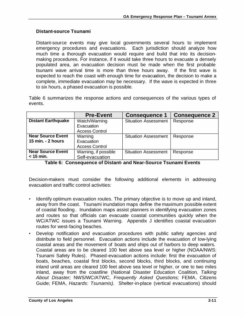
Distant-source Tsunami Distant-source events may give local governments several hours to implement emergency procedures and evacuations. Each jurisdiction should analyze how much time a thorough evacuation would require and build that into its decision-making procedures. For instance, if it would take three hours to evacuate a densely populated area, an evacuation decision must be made when the first probable tsunami wave arrival time is more than three hours away. If the first wave is expected to reach the coast with enough time for evacuation, the decision to make a complete, immediate evacuation may be necessary. If the wave is expected in three to six hours, a phased evacuation is possible.
Table 6 summarizes the response actions and consequences of the various types of events. Pre-Event Consequence 1 Consequence 2 Distant Earthquake Watch/Warning
Evacuation Access Control
Situation Assessment Response
Near Source Event 15 min. - 2 hours
Warning Evacuation Access Control
Situation Assessment Response
Near Source Event < 15 min.
Warning, if possible Self-evacuation
Situation Assessment Response
Table 6: Consequence of Distant- and Near-Source Tsunami Events Decision-makers must consider the following additional elements in addressing evacuation and traffic control activities:
• Identify optimum evacuation routes. The primary objective is to move up and inland, away from the coast. Tsunami inundation maps define the maximum possible extent of coastal flooding. Inundation maps assist planners in identifying evacuation zones and routes so that officials can evacuate coastal communities quickly when the WC/ATWC issues a Tsunami Warning. Appendix J identifies coastal evacuation routes for west-facing beaches.
• Develop notification and evacuation procedures with public safety agencies and distribute to field personnel. Evacuation actions include the evacuation of low-lying coastal areas and the movement of boats and ships out of harbors to deep waters. Coastal areas are to be cleared 100 feet above sea level or higher (NOAA/NWS: Tsunami Safety Rules). Phased-evacuation actions include: first the evacuation of boats, beaches, coastal first blocks, second blocks, third blocks, and continuing inland until areas are cleared 100 feet above sea level or higher, or one to two miles inland, away from the coastline (National Disaster Education Coalition, Talking About Disaster; NWS/WC/ATWC, Frequently Asked Questions; FEMA, Citizens Guide; FEMA, Hazards: Tsunamis). Shelter-in-place (vertical evacuations) should
OA Emergency Response Plan – Tsunami Annex
County of Los Angeles 2-12
only be made if the safety of the citizens can be assured if they remain. If evacuation is impossible, the third floor or higher of a reinforced concrete building may offer protection, but such a building should be used only as a last resort. Shelter in place decisions for areas inside the evacuation areas need to be verified by either the Incident Commander and/or the Operations Section Chief. Boats should be moved to deeper water (at least 100 fathoms). If it is the case that there is concurrent severe weather, it may be safer to leave the boat at the pier and physically move to higher ground.
• Disseminate maps and procedures to public. Ensure maps and procedures are posted in assembly facilities and areas, schools, special facilities, included in telephone books, etc.
• Decide how best to handle the occurrence of both tsunamis and earthquakes. Decision-makers should take into account potential earthquake damage when identifying routes to use for evacuation.
• Consider the special needs of the evacuees. Transportation to shelters and reception centers for those with no other means to evacuate must be considered. (Appendix L identifies potential reception and shelter sites. Actual sites used will be based on site availability and condition at the time of the incident). Special needs groups include the injured, the medically fragile, aged, mobility impaired, deaf, blind, infants and young children, handicapped, and non-English speakers or those who speak English as a second language. Within the inundation area, the local agency with incident command authority will identify special institutions (schools, hospitals, nursing homes, etc.), and will arrange special procedures for warning, evacuation, and care of all such occupants.
• Identify refuge/staging areas with the capacity to shelter the evacuated population. Select landmarks, school facilities, or other well-known public facilities. Care, shelter, communication, and transportation should be available at evacuee refuge/staging areas.
• Develop simplified maps depicting tsunami evacuation zones, evacuation routes, and refuge areas.
Law enforcement will be used to help alert and evacuate residents. The Sheriff’s Department will use the EAS to deliver the tsunami warning and evacuation actions to take via local radio and television stations. Additional methods used to evacuate the public may include: • Emergency service units using PA systems • Providing leaflets door-to-door (Appendix I: Sample Evacuation Order) • Media announcements (Appendix G: Sample Media Messages) • Announcements on Travelers Information Service • Sounding of sirens (steady blast indicates peacetime emergency), if available
OA Emergency Response Plan – Tsunami Annex
County of Los Angeles 2-13
Area Security and Area Re-entry
Area Security
After an area has been evacuated, public safety agencies will set up Traffic Control Points consisting of roadblocks, barricades, and/or a system of patrols to secure evacuated areas. Traffic Control Points require multi-agency coordination. Public safety agencies should use their auxiliaries and volunteers to staff traffic control points.
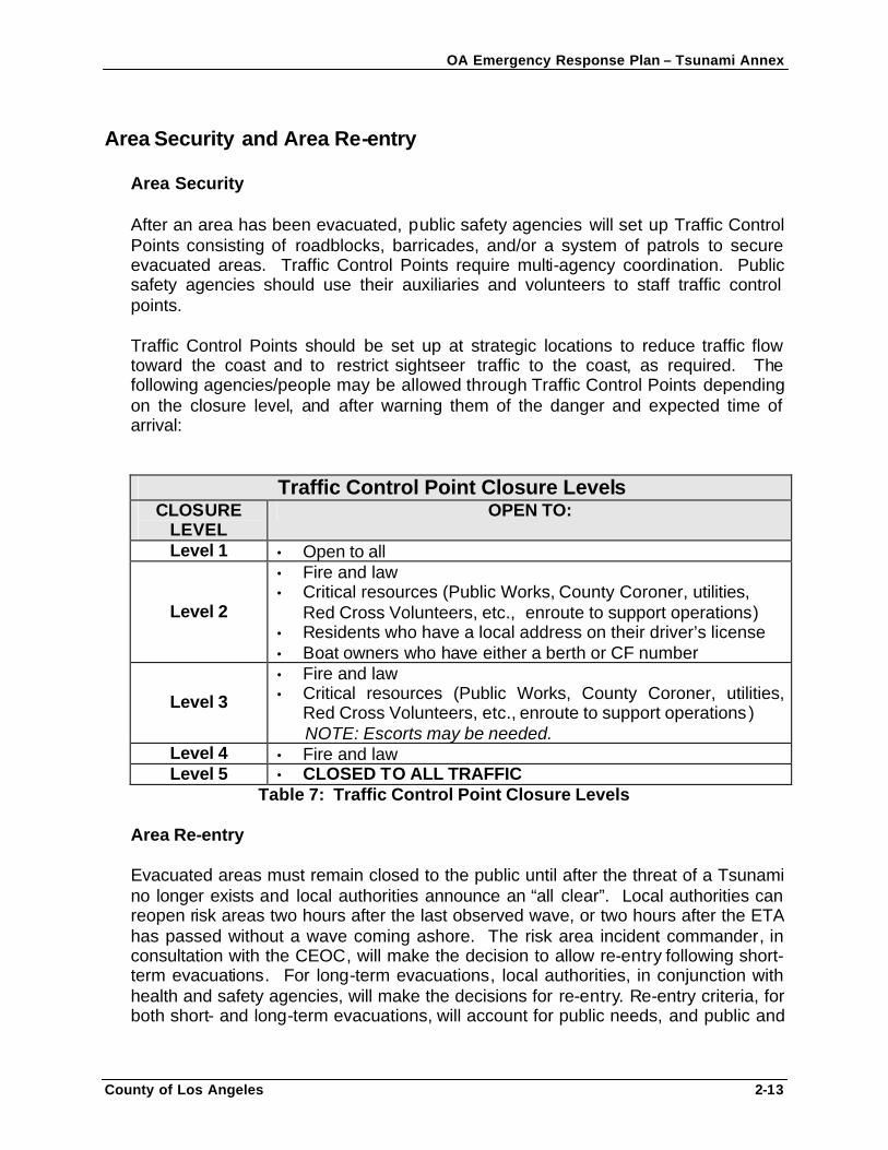
Traffic Control Points should be set up at strategic locations to reduce traffic flow toward the coast and to restrict sightseer traffic to the coast, as required. The following agencies/people may be allowed through Traffic Control Points depending on the closure level, and after warning them of the danger and expected time of arrival:
Traffic Control Point Closure Levels CLOSURE
LEVEL OPEN TO:
Level 1 • Open to all
Level 2
• Fire and law • Critical resources (Public Works, County Coroner, utilities,
Red Cross Volunteers, etc., enroute to support operations) • Residents who have a local address on their driver’s license • Boat owners who have either a berth or CF number
Level 3
• Fire and law • Critical resources (Public Works, County Coroner, utilities,
Red Cross Volunteers, etc., enroute to support operations ) NOTE: Escorts may be needed.
Level 4 • Fire and law Level 5 • CLOSED TO ALL TRAFFIC
Table 7: Traffic Control Point Closure Levels
Area Re-entry
Evacuated areas must remain closed to the public until after the threat of a Tsunami no longer exists and local authorities announce an “all clear”. Local authorities can reopen risk areas two hours after the last observed wave, or two hours after the ETA has passed without a wave coming ashore. The risk area incident commander, in consultation with the CEOC, will make the decision to allow re-entry following short-term evacuations. For long-term evacuations, local authorities, in conjunction with health and safety agencies, will make the decisions for re-entry. Re-entry criteria, for both short- and long-term evacuations, will account for public needs, and public and
OA Emergency Response Plan – Tsunami Annex
County of Los Angeles 2-14
response personnel safety. Residents should enter through control points to ensure that safety and sanitary precautions are provided. Local authorities will control re-entry via media releases, evacuation/staging area coordination, and modification of closure levels at Traffic Control Points. Coordination between the CEOC, local EOCs and all primary and support agencies involved is critical in controlling re-entry.
Damage Assessments All affected County departments, agencies, and coastal cities are responsible for submitting status and damage assessment reports to the OA following an actual tsunami occurrence according to the OA’s Disaster Information Reporting Procedures (DIRP) via the EMIS. Damage assessment includes damage resulting from both tsunamis and earthquakes, if applicable. OEM will use damage assessment information to initiate standard disaster response and recovery procedures outlined in the CEOC SOP. Emergency Public Information The Sheriff’s Department is responsible for media coordination, including:
1. Preparing daily CEOC press briefings. 2. Assisting in the preparation of press announcements for key elected officials. 3. Responding to inquiries from the media in conjunction with appropriate
departmental subject-matter experts. 4. Managing the Joint Information Center (JIC), when activated.
The Sheriff will make every attempt to coordinate emergency public information releases with impacted jurisdictions and agencies in order to ensure consistency. All press briefings and media releases will follow the policies and procedures outlined in the Los Angeles County OA Emergency Public Information Plan.

OA Emergency Response Plan – Tsunami Annex
County of Los Angeles 2-15
OA Emergency Response Plan – Tsunami Annex
County of Los Angeles 3-1
SECTION 3: ORGANIZATIONAL STRUCTURE This annex reflects the organizational structure of the SEMS and the NIMS as outlined in the OAERP. The CEOC may activate based upon the tsunami threat or actual event. Each section of the CEOC Incident Command Structure must focus on several key response and recovery issues unique to a tsunami event (See Roles and Responsibilities). TSUNAMI RESPONSE ORGANIZATIONS Table 7 describes the various tsunami response organizations at different levels of government. It is broken into two time periods: 1) preparedness and 2) notification of potential or actual event.
OA Emergency Response Plan – Tsunami Annex
County of Los Angeles 3-2
Government Level Preparedness Notification of
Potential/Actual Event Role
Federal NOAA NWS NTHMP FEMA
WC/ATWC Access, Notify and Verify
State State OES State agencies
CSWC State Agencies’ DOCs
Notify and Verify
Regional State OES Southern Regional Office State agency district or other offices
State OES REOCs
State agency district offices
Notify, Verify, Assist w/ Threat Assessment
OA (OA)/County Los Angeles County OA Government
CEOC and County DOCs (May include activation of a tsunami threat assessment group)
Notify, Verify, Coordinate and Respond*
Coastal Communities/ Cities
City Government City EOC(s) (May include activation of tsunami threat assessment group)
Notify, Verify, Coordinate and Respond*
Field Incident Command First Responders (Law, Fire & Rescue, Medical, Public Works)
Various special purpose teams, such as the National Guard
Respond as Directed
Table 8: Tsunami Response Organizations * May include the implementation of Evacuation Plans, Care & Shelter, Perimeter Security, Search and Rescue, etc. May proclaim a local emergency and request County or State assistance, as appropriate.
OA Emergency Response Plan – Tsunami Annex
County of Los Angeles 4-1
SECTION 4: ROLES AND RESPONSIBILITIES
The CEOC may activate based upon the tsunami threat or actual event. Each CEOC section of the Incident Command Structure must focus on several key response and recovery issues unique to a tsunami event. In addition, County departments, coastal communities, and special districts have tsunami-specific roles and responsibilities, outlined below, in addition to their assignments and functional requirements as outlined in the OAERP and CEOC SOP (see Appendix C for the County’s OA Organization Matrix). MANAGEMENT SECTION The CEOC will activate the appropriate ICS Sections and staffing assignments based upon the tsunami threat or actual event. The County will use multi-agency, multi-discipline coordination in its response to a tsunami threat or event. The CEOC will facilitate coordination among all responding agencies and disciplines. CEOC staffing will be augmented to expedite response activities, as necessary. Areas of special concern for CEOC Management include: • CEOC coordination. • Information sharing and dissemination, including Board reports and warning the
public. • Coordination with education, child care, and other facilities. County Sheriff’s Department • By County ordinance, the Sheriff is the Director of Emergency Operations during
declared emergencies. The Sheriff’s Department also manages CEOC operations as the CEOC Manager.
• Responsible for implementing this annex. • The CEOC Manager will ensure the completion of the CEOC Tsunami Checklists
found in Appendix L: CEOC Tsunami Checklists. These checklists outline specific actions required of CEOC staff in the event of a tsunami watch, warning, or occurrence.
• Provide scheduled briefings for CEOC staff and other emergency response
personnel. • Responsible for management of CEOC operations. Note: Appendix M identifies sample key Operational Period Objectives for use by the CEOC Manager.
OA Emergency Response Plan – Tsunami Annex
County of Los Angeles 4-2
Chief Administrative Office (CAO) The County CAO is responsible for issuing guidelines to County departments for capturing emergency-related expenditures, and for directing restoration of County government services. Cities are encouraged to establish similar guidelines. The County OEM is part of the CAO and has a number of responsibilities described elsewhere in this annex. Public Information Officer (PIO) The County is committed to a coordinated public information program during a tsunami threat or actual event. Appendix G: Sample Media Releases provide sample standardized tsunami response public information messages that may be used during an event. The PIO will also involve County departments and other jurisdictions and agencies in public information, as needed. Safety Officer During a potential threat or actual event, employee safety and operational security will be key concerns for all CEOC staff. CEOC Safety Officer staff will be trained on tsunami plans and security procedures. During actual emergency operations, CEOC Safety staff will follow heightened safety and security procedures in effect. OPERATIONS SECTION Areas of special concern for the Operations Section include: • Managing emergency operations • Coordination with coastal communities and special districts, as appropriate • Coordinating with OES Southern Region for mutual aid and resource requests • Assessing damage to County facilities • Coordinating evacuation transportation needs • Coordination with utility companies • Coordination with County Public Health on health impacts • Coordination with Department of Public Social Services (DPSS) on refuge areas and
sheltering needs • Coordination with Animal Control on care issues, including care, shelter, and
possible public health concerns County Sheriff’s Department • The Sheriff’s Department will be the lead for:
o Perimeter security o Access control o Traffic/crowd control
OA Emergency Response Plan – Tsunami Annex
County of Los Angeles 4-3
• The Sheriff’s Department is responsible for the alert and notification of the cities and
citizens of the OA. • The Sheriff’s role and responsibilities concerning evacuations, including mass and
spontaneous evacuations , are expressed in Sheriff’s Department policies, the OAERP, and the Los Angeles County Emergency Ordinance.
• The Sheriff’s Department will assume the security function within the CEOC. • The Department will also coordinate with the Coroner on fatality management issues
and assist with damage assessment. • The Sheriff, designated as the Region I Law Enforcement Mutual Aid Coordinator, is
primarily responsible for the overall coordination and dispatch of law enforcement mutual aid resources during major emergencies.
• The Sheriff will provide input on law enforcement logistical support requirements for
the Logistics Section. • Additional areas which the Sheriff’s Department may address are:
o Intelligence concerns o Investigative guidelines and statutory authority o Use of force o Facility and personnel protection
County Fire Department (Fire) • Fire’s mission is to protect lives, property, and the environment by providing prompt,
skillful, cost-effective fire protection and life safety services. This includes response to tsunami emergencies. Additionally, the department is responsible for collecting information on the operational status of water works in the OA.
• The Los Angeles County Fire Chief, designated as the Region 1 Fire Mutual Aid
Coordinator, is primarily responsible for the overall coordination and dispatch of fire and rescue mutual aid resources during major emergencies.
• Fire’s ECC will inform all local fire dispatch centers of all alert messages received
from the SCC. Fire’s ECC notification will be via telephone, e-mail, and fax to the local fire dispatch centers.
• Fire will inform the SCC of any tsunami alert information that it receives through its
Lifeguard Operations Division or Fire Region 1 Mutual Aid contacts. • Fire will maintain and update information for the Planning and Intelligence Section.
OA Emergency Response Plan – Tsunami Annex
County of Los Angeles 4-4
• Fire will provide input on fire and rescue, HazMat, and medical logistical support requirements for the Logistics Section.
• Potential Fire Department activities include:
o Time-critical refresher training procedures (special instructions, etc.). o HazMat support operations o Coordination with EMS and hospitals o Personnel protection issues, including Lookout, Communication, Escape Route,
and Safe Zone (LCES) protocols o Coordination with public works and utilities o Technical support team requirements (Air operations, lifeguards, Baywatch and
Fire boats, Urban Search and Rescue Task Forces, Swift Water Rescue Teams, etc.)
o Logistical support requirements
• Fire may provide support as necessary to law enforcement with the following activities, with the requirement that all Fire personnel observe LCES protocols: o Perimeter and access control o Evacuation operations o Notifications § Jurisdictional damage surveys § Fatalities management
• Potential areas of concern may include: o Addressing environmental needs o Ensuring decontamination procedures
Department of Public Works (DPW) • DPW leads and coordinates advance planning to pre-designate potential major
evacuation routes for unincorporated areas. DPW is not responsible for other jurisdictions unless an agreement is in place to provide such services to that jurisdiction. In responding to a real or potential tsunami event, DPW coordinates with affected jurisdictions on the closing of impacted roadways and on the determination of alternate evacuation routes.
• Public Works will serve as lead for damage assessment. • Potential Public Works activities include:
o Public Works mutual aid o Reconnaissance of public infrastructure (roads, bridges, facilities, and utilities) o Alternate route identification o Building access o Temporary repairs
OA Emergency Response Plan – Tsunami Annex
County of Los Angeles 4-5
o Time-critical refresher training procedures (communication abilities, staging areas, contact numbers, etc.).
o Maintaining and updating information for the Planning and Intelligence Section. Internal Services Department (ISD) • ISD will serve as lead representative for utilities concerns. Potential ISD activities
include:
o Reconnaissance of public infrastructure (utilities) o Utility access rerouting o Temporary repairs o Maintaining and updating information for the Planning and Intelligence Section.
Department of Health Services (DHS) DHS provides and coordinates medical and public health services during disaster response. Public health services may include preventive health services such as control of communicable diseases; coordinating inspection of health hazards in damaged buildings; inspection of vital foodstuffs, water, drugs and other consumables; mosquito and other vector control; and detection and identification of possible sources of contamination dangerous to the general physical condition of the community. • Potential DHS activities include:
o Medical first responder guidelines o Time-critical refresher training procedures (expected injuries; transportation
guidelines as directed by the MAC; etc.) o Coordination with other disciplines, such as HazMat, under ICS o Technical support team requirements (medical epidemiologists, veterinarians,
public health nurses, toxic epidemiologists, environmental health specialists, and health facilities inspectors)
o Mutual aid procedures o Logistical support requirements and contacts (including private sector providers
and vendors) o Procedures to access privately owned and operated medical assets o Decontamination procedures o Mass casualty incident (MCI) concerns
Department of Mental Health (DMH) DMH is the government agency assigned to provide for the psychological and emotional well-being of the community as well as individual victims of a tsunami. Mental health support and psychological operations will be essential elements of the tsunami response approach. DMH will coordinate mental health response activities between the OA, DMA’s and the coastal cities.
OA Emergency Response Plan – Tsunami Annex
County of Los Angeles 4-6
• Potential DMH activities include:
o Staff training for tsunami disasters o Public information and mental health o Mental health support services o Mental health follow-up programs o Integration of mental health with other programs o Support to care and shelter and other operations o Stress management programs for responders
Department of Public Social Services (DPSS) DPSS is the government agency assigned to provide for the emergency care and shelter needs of disaster victims during tsunamis and other disasters. DPSS performs their care and shelter mission in partnership with the American Red Cross. County Coroner The County Coroner is the government agency assigned to provide for the handling of decedents killed by a tsunami and its aftermath. In coordination with other responding agencies and county departments, the County Coroner will identify, determine the circumstances, manner and means of death; collect evidence; process personal effects; notify next of kin; and store the human remains for release to the next of kin. Only the County Coroner will release information on confirmed fatalities. Parks and Recreation Parks and Recreation will assist with fatalities management and care and shelter issues in coordination with the County Coroner and DPSS. Potential care and shelter activities include: • Refresher training for tsunami disaster concerns for staff • Potential mutual aid requirements • Logistical requirements for care and shelter • Care and shelter facilities for tsunami victims, as needed American Red Cross Congress mandated the American Red Cross (ARC) to provide care, shelter and Disaster Victim Inquiry assistance for victims of natural disasters. DPSS works in cooperation with the ARC to provide these services following a natural disaster.
OA Emergency Response Plan – Tsunami Annex
County of Los Angeles 4-7
PLANNING AND INTELLIGENCE SECTION In addition to the standard situation, documentation, demobilization, and resources units, Planning/Intelligence may include units that address emergency management and consequence management concerns specific to tsunami events. Planning/Intelligence will include mapping and geographic information systems (GIS) products. Threat Analysis Planning and Intelligence activities will address two key areas: • General threat analysis • Law enforcement and emergency management activities, including evacuation
planning LOGISTICS SECTION Areas of special concern for the Logistics Section include: • Expediting requests for tsunami-related purchases of goods and services • Procurement and Mutual Aid assistance for issues that cannot be resolved through
normal means Internal Services Department (ISD) County ISD will expedite departments’ requests for tsunami-related purchases of supplies, services, equipment, and facilities required for both the response and recovery phases. ISD will also assist impacted cities having difficulty with procurement, or specific requests. Cities have financial responsibility for goods and services the County procures at their request. During emergency operations, ISD will place particular emphasis on maintaining the operational capabilities of computer systems and telecommunications, including landline and radio systems. • ISD’s primary responsibility is to gather safety assessment information relative to
County facilities and to report their status to the CEOC. Additionally, ISD must determine if County facilities are structurally safe for occupancy, then, if feasible, to facilitate the repair or restoration of damaged and unsafe County facilities to safe operating levels, or secure them to preclude entry.
• Under SEMS, ISD is also the head of the CEOC Logistics Section for the Los
Angeles County OA. • ISD supports other emergency services by providing and repairing vehicles and off-
highway equipment; obtaining fuel, water, temporary power, and essential supplies
OA Emergency Response Plan – Tsunami Annex
County of Los Angeles 4-8
procurement support; and by maintaining and/or restoring computer operations to support critical operations.
• ISD provides a liaison with utilities (except water) concerning the status of electrical,
natural gas, and telecommunications systems. • ISD is the transportation coordinator for mass transportation resources such as the
Metropolitan Transportation Authority (MTA). FINANCE, ADMINISTRAT ION AND RECOVERY (FAR) SECTION This Section is responsible for ensuring that finance and administrative actions in support of OA Emergency Response and Initial Recovery operations are performed in a manner that will facilitate meeting the requirements of State and Federal guidelines for disaster operations. FAR Section priorities during tsunami response and recovery operations are: 1. Developing a disaster declaration, as necessary. 2. Developing the need for liaison to the State and any cities affected by the tsunami. 3. Quickly obtaining information on the status of County government following the occurrence of a tsunami. 4. Developing reports to the Board of Supervisors, key County executives, and the OA (including cities, County departments, special districts). 5. Determining need for liaison with CAO Budget, and IGR staff. 6. Determining need for liaison with DHR staff. 7. Provide support for the Emergency Management Council and other executive
meetings. 8. Early recovery planning to include planning for the transition to a Recovery
Coordination Center and to COR operations. Areas of special concern for the FAR Section during tsunami response and recovery operations include: • Continuity of operations. It will be necessary to ensure continuity of day-to-day
operations during a potential threat or actual tsunami event. • Establishment of guidelines for identifying emergency-related expenditures for
County departments. • Track and document associated costs of an event. It will be necessary to track costs
associated with an actual or potential tsunami event. Office of Emergency Management (OEM) • OEM will staff the various branches of FAR, as necessary.
OA Emergency Response Plan – Tsunami Annex
County of Los Angeles 4-9
• During operations, OEM performs its assigned function of local, State and Federal coordination, CEOC management support, initial recovery, and status reports to the Board of Supervisors.
• Designated OEM staff will oversee the administrative function in the CEOC. • Designated OEM staff will oversee the finance operations within the CEOC with
support from other sections of the CAO department, including the County Disaster Assistance Team.
All affected County departments, agencies, and coastal cities are responsible for submitting status and damage assessment reports to the OA following an actual tsunami occurrence according to the OA’s DIRP via the Emergency Management Information System (EMIS). Damage assessment includes damage resulting from both tsunamis and earthquakes, if applicable. OEM will use damage assessment information to initiate standard disaster response and recovery procedures outlined in the CEOC SOP. COASTAL COMMUNITIES/ SPECIAL DISTRICTS Coastal communities and special districts are responsible for developing tsunami emergency response plans that are compatible with the Los Angeles County OA Tsunami Annex. Coastal Community planning responsibilities include the following:
• Identification of tsunami inundation areas. • Evacuation routes. • Safe Refuge areas. • Posting and maintaining tsunami signage within city boundaries (other than
County or State of California operated beaches and harbors). • Alert and notification of city agencies and activation of city tsunami hazard
plans. • Printing or distribution of tsunami hazard emergency preparedness materials.
OEM will share this annex, in addition to Tsunami Emergency Response Planning Guidelines, in electronic format with coastal communities and special districts within the Los Angeles County OA to encourage and assist them with their tsunami planning efforts. All affected coastal cities are responsible for submitting status and damage assessment reports to the OA following an actual tsunami occurrence according to the OA’s DIRP via the EMIS.
OA Emergency Response Plan – Tsunami Annex
County of Los Angeles 5-1
SECTION 5: TRAINING AND EXERCISES Training and exercises are a crucial component for a successful tsunami response program. It is essential to develop training and exercise programs related to the Los Angeles County’s Tsunami Annex and other tsunami-related plans (evacuation, traffic control, etc.), for County and city response personnel, as well as for the residents in the community. Local jurisdictions may want to develop a comprehensive training and exercise program based upon their own training needs assessment. Exercise support in the form of scenario development and exercise facilitation is available from CA OES and the WC/ATWC. All training and exercise programs should include maintenance of training records by each jurisdiction. All County training and exercises will be in accordance with the County’s training schedule. This schedule may include: tsunami response exercises, tsunami awareness courses, first responder training, and joint training with County departments, coastal communities, and various agencies as appropriate. Communities (emergency response personnel and the public) can benefit by developing and implementing an exercise program to test the training received on local tsunami emergency response plans and other tsunami-related plans (evacuation, flood, earthquake, etc.). Local jurisdictions should consider the following training and exercise areas: • Development of a “Tsunami Response Training Program” for emergency response
personnel. • Public Education Programs • Tsunami exercises OEM will provide Tsunami Emergency Response Planning Guidelines, in electronic format with coastal communities and special districts within the Los Angeles County OA to encourage and assist them with their tsunami training and exercise deve lopment. PUBLIC TSUNAMI EDUCATION PROGRAMS The County of Los Angeles is committed to a proactive public information program to prepare the public for the threat of a tsunami. A sustained public outreach program is needed to gain the long-term support of coastal populations and to institutionalize tsunami preparedness and mitigation. Such a program should encourage consistent information between the State, County, local jurisdictions and communities at risk. Local jurisdictions may want to develop a comprehensive program, based upon a training needs assessment. Communities can use brochures, single-page instructions, periodic warning system tests, electronic and print media information, signs, and emergency response exercises
OA Emergency Response Plan – Tsunami Annex
County of Los Angeles 5-2
to maintain awareness and instill effective response behavior. Public education programs are to include specialized institutions such as schools, hospitals, convalescent-care facilities, and non-English speaking community members. Because of seasonal tourism in many coastal communities, programs should include information designed especially for tourists. Emergency Survival Program OEM, in cooperation with other departments and agencies, developed public education materials to prepare the public for tsunamis. On an ongoing basis, OEM, through the County’s Emergency Survival Program (ESP) public education campaign provides tsunami preparedness information to the coastal communities and all residents throughout the County (Appendix N).
OA Emergency Response Plan – Tsunami Annex
County of Los Angeles 6-1
SECTION 6: MAINTENANCE OEM is responsible for developing and maintaining this annex. OEM will review the Tsunami Annex every three years and as necessary for any updates. Tsunami Key Contact Phone List numbers will be updated as needed and verified on an annual basis.
OA Emergency Response Plan – Tsunami Annex
County of Los Angeles 7-1
REFERENCES
Borrero J, Cho S., Moore J, and Synolakis, C.E. (2005). The Regional Economic Cost of a Tsunami Wave Generated by the Palos Verdes Slide in Acceptable Risk Processes: Natural and Man-made, Taylor and VanMarcke (eds.), ASCE. http://www.usc.edu/dept/tsunamis/2005/pdf/2005_03_28_socalTsunami2.pdf.
California Office of Emergency Services (2000). Local Planning Guidance on Tsunami Response: A Supplement to the Emergency Planning Guidance for Local Governments. California Office of Emergency Services (2004). Multi-hazard Mitigation Plan. California Office of Emergency Services (1998). Emergency Plan. Federal Emergency Management Association (2004) Are You Ready? An In-depth
Guide to Citizen Preparedness http://www.fema.gov/areyouready/preface.shtm Federal Emergency Management Association. Hazards: Tsunamis
http://www.fema.gov/hazards/tsunamis/. McCarthy, Richard, and Anderson, R. (2003). California Seismic Safety Commission.
A Tsunami Mitigation Program within the California Earthquake Loss Reduction Plan. www.seismic.ca.gov/pdf.files/McCarthy%20Anderson%20Tsunami%20paper.pdf
Moley, K., and Dengler, L. (1995). Humboldt State University. Living on Shaky Ground: How to Survive Earthquakes and Tsunamis on the North Coast
http://sorrel.humboldt.edu/~geodept/earthquakes/shaky_ground.html). National Disaster Education Coalition (2004). Talking About Disaster: Guide for
Standard Messages – Tsunamis. Washington D.C. http://disastereducation.org/library/public_2004/Tsunamis.pdf. National Oceanic and Atmospheric Administration, National Weather Service, West
Coast and Alaska Tsunami Warning Center. Tsunami Safety Rules. http://wcatwc.arh.noaa.gov/safety.htm.
National Oceanic and Atmospheric Administration, National Weather Service, West
Coast and Alaska Tsunami Warning Center. Warning Dissemination Research Activities. http://wcatwc.arh.noaa.gov/tsunami5.htm.
National Oceanic and Atmospheric Administration, National Weather Service, West
Coast and Alaska Tsunami Warning Center. West Coast/Alaska Tsunami Warning Center Operations Manual. http://wcatwc.arh.noaa.gov/subpage3.htm.
OA Emergency Response Plan – Tsunami Annex
County of Los Angeles 7-2
National Tsunami Hazard Mitigation Program (2001). Designing for Tsunamis: Seven
Principles for Planning and Designing for Tsunami Hazards. http://www.pmel.noaa.gov/tsunami-hazard/Designing_for_Tsunamis.pdf.
National Weather Service/West Coast and Alaska Tsunami Warning Center, Frequently
Asked Questions. http://wcatwc.arh.noaa.gov/frequently.htm. Oregon State Natural Hazard Mitigation Plan.
http://csc.uoregon.edu/pdr_website/projects/state/snhmp_web/hazard-pages/Tsunamis_web.htm
State of California Seismic Safety Commission (2005). The Tsunami Threat to
California: Findings and Recommendations on Tsunami Hazards and Risks. http://www.seismic.ca.gov/pub/CSSC%2005-03%20Tsunami%20Findings.pdf
United States Geological Survey Western Region Coastal and Marine Geology. Pacific
Sea-Floor Mapping Images. http://walrus.wr.usgs.gov/pacmaps/.

OA Emergency Response Plan – Tsunami Annex
County of Los Angeles 7-3
OA Emergency Response Plan – Tsunami Annex
County of Los Angeles 8-1
APPENDICES APPENDIX A: ACRONYMS AND TSUNAMI TERMINOLOGY APPENDIX B: TSUNAMI BACKGROUND INFORMATION APPENDIX C: LOS ANGELES COUNTY OPERATIONAL AREA
ORGANIZATION MATRIX APPENDIX D: SOUTHERN CALIFORNIA TSUNAMI RISKS APPENDIX E: LOS ANGELES COUNTY TSUNAMI RISK AREAS APPENDIX F: TSUNAMI INUNDATION MAPS APPENDIX G: SAMPLE WARNINGS, BRIEFINGS, AND MEDIA RELEASES APPENDIX H: TSUNAMI KEY CONTACT PHONE LIST APPENDIX I: SAMPLE EVACUATION ORDERS APPENDIX J: COASTAL EVACUATION ROUTES FOR WEST-FACING
BEACHES APPENDIX K: POTENTIAL TSUNAMI EVACUATION SITES APPENDIX L: CEOC TSUNAMI CHECKLISTS APPENDIX M: OPERATIONAL PERIOD INCIDENT OBJECTIVES APPENDIX N: EMERGENCY SURVIVAL PROGRAM (ESP) PUBLIC
EDUCATION CAMPAIGN
OA Emergency Response Plan – Tsunami Annex
County of Los Angeles A-1
APPENDIX A: ACRONYMS AND TSUNAMI TERMINOLOGY
ACRONYMS ARC American Red Cross CALWAS California Alert and Warning System CAO Chief Administrative Office CEOC County Emergency Operations Center CISN California Integrated Seismic Network (CISN) CLERS California Law Enforcement Radio System CLETS California Law Enforcement Telecommunications (Teletype) System CSWC California State Warning Center DOC Department Operations Center DHS Department of Health Services DIRP Disaster Information Reporting Procedures DMH Department of Mental Health DPSS Department of Social Services DPW Department of Public Works EAS Emergency Alert System ECC Los Angeles County Fire Emergency Command and Control Center EDIS Emergency Digital Information System EMIS Emergency Management Information System EOB Emergency Operations Bureau EOC Emergency Operations Center ESP Emergency Survival Program ETA Estimated time of arrival FAR Finance, Administration and Recovery FEMA Federal Emergency Management Agency GIS Geographic Information Systems HazMat Hazardous Materials ICS Incident Command System ISD Internal Services Department JIC Joint Information Center km kilometer LCES Lookout, Communication, Escape Route, and Safe Zone MAC Medical Alert Center MCI Mass Casualty Incident MTA Metropolitan Transportation Authority NAWAS National Alert and Warning System NIMS National Incident Management System NOAA National Oceanic and Atmospheric Administration NTHMP National Tsunami Hazard Mitigation Program
OA Emergency Response Plan – Tsunami Annex
County of Los Angeles A-2
ACRONYMS (CONTINUED) NWS National Weather Service NWWS National Weather Wire Service OA Operational Area OA ERP Operational Area Emergency Response Plan OASIS OA Satellite Information System OEM Office of Emergency Management OES California Office of Emergency Services PA Public Address PIO Public Information Officer PTWC Pacific Tsunami Warning Center REOC Regional Emergency Operations Center (OES) SCC Sheriff’s Department Communications Center SCEC Southern California Earthquake Center SEMS Standardized Emergency Management System SOC State Operations Center SOP Standard Operating Procedures WC/ATWC West Coast/Alaska Tsunami Warning Center
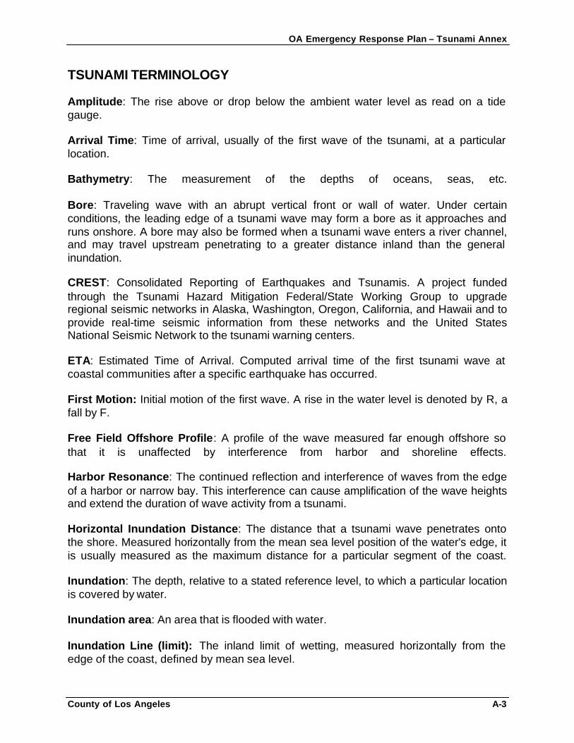
OA Emergency Response Plan – Tsunami Annex
County of Los Angeles A-3
TSUNAMI TERMINOLOGY Amplitude: The rise above or drop below the ambient water level as read on a tide gauge. Arrival Time: Time of arrival, usually of the first wave of the tsunami, at a particular location. Bathymetry: The measurement of the depths of oceans, seas, etc. Bore: Traveling wave with an abrupt vertical front or wall of water. Under certain conditions, the leading edge of a tsunami wave may form a bore as it approaches and runs onshore. A bore may also be formed when a tsunami wave enters a river channel, and may travel upstream penetrating to a greater distance inland than the general inundation. CREST: Consolidated Reporting of Earthquakes and Tsunamis. A project funded through the Tsunami Hazard Mitigation Federal/State Working Group to upgrade regional seismic networks in Alaska, Washington, Oregon, California, and Hawaii and to provide real-time seismic information from these networks and the United States National Seismic Network to the tsunami warning centers. ETA: Estimated Time of Arrival. Computed arrival time of the first tsunami wave at coastal communities after a specific earthquake has occurred. First Motion: Initial motion of the first wave. A rise in the water level is denoted by R, a fall by F. Free Field Offshore Profile: A profile of the wave measured far enough offshore so that it is unaffected by interference from harbor and shoreline effects. Harbor Resonance: The continued reflection and interference of waves from the edge of a harbor or narrow bay. This interference can cause amplification of the wave heights and extend the duration of wave activity from a tsunami. Horizontal Inundation Distance: The distance that a tsunami wave penetrates onto the shore. Measured horizontally from the mean sea level position of the water's edge, it is usually measured as the maximum distance for a particular segment of the coast. Inundation: The depth, relative to a stated reference level, to which a particular location is covered by water. Inundation area: An area that is flooded with water. Inundation Line (limit): The inland limit of wetting, measured horizontally from the edge of the coast, defined by mean sea level.
OA Emergency Response Plan – Tsunami Annex
County of Los Angeles A-4
Leading-Depression Wave: Initial tsunami wave is a trough, causing a draw down of water level. Leading-Positive Wave: Initial tsunami wave is a crest, causing a rise in water level. Also called a leading-elevation wave. Local/Regional Tsunami: Source of the tsunami is within 1000 km of the area of interest. Local or near-field tsunami has a very short travel time (30 minutes or less); mid-field or regional tsunami waves have travel times on the order of 30 minutes to 2 hours. Note: "Local" tsunami is sometimes used to refer to a tsunami of landslide origin. Maremoto: Spanish term for tsunami. Marigram: Tide gauge recording showing wave height as a function of time. Marigraph: The instrument which records wave height. MLLW: Mean Lower Low Water. The average low tide water elevation often used as a reference to measure run-up. Ms: Surface Wave Magnitude. Magnitude of an earthquake as measured from the amplitude of seismic surface waves. Often referred to by the media as "Richter" magnitude. Mw: Moment Magnitude. Magnitude based on the size and characteristics of the fault rupture, and determined from long-period seismic waves. It is a better measure of earthquake size than surface wave magnitude, especially for very large earthquakes. Calibrated to agree on average with surface wave magnitudes for earthquakes less than magnitude 7.5. Normal Earthquake: An earthquake caused by slip along a sloping fault where the rock above the fault moves downward relative to the rock below. Period: The length of time between two successive peaks or troughs. Periods may vary due to complex interference of waves. Tsunami periods generally range from 5 to 60 minutes. Run-up: Maximum height of the water onshore observed above a reference sea level. Usually measured at the horizontal inundation limit. Seiche: An oscillating wave (also referred to as a seismic seawave) in a partially or fully enclosed body of water. May be initiated by long period seismic waves, wind and water waves, or a tsunami. Strike-Slip Earthquake: An earthquake caused by horizontal slip along a fault.
OA Emergency Response Plan – Tsunami Annex
County of Los Angeles A-5
Teletsunami: Source of the tsunami is more than 1000 km (~621 miles) away from area of interest. Also called a distant-source or far-field tsunami. Travel time is greater than 2 hours. Thrust Earthquake: Earthquake caused by slip along a gently sloping fault where the rock above the fault is pushed upward relative to the rock below. The most common type of earthquake source of damaging tsunamis. Tidal Wave: Common term for tsunami used in older literature, historical descriptions, and popular accounts. Tides, caused by the gravitational attractions of the sun and moon, may increase or decrease the impact of a tsunami, but have nothing to do with their generation or propagation. However, most tsunamis (initially) give the appearance of a fast-rising or fast-ebbing tide as they approach shore, and only rarely appear as a near-vertical wall of water. Travel Time: Time (usually measured in hours and tenths of hours) that it took the tsunami to travel from the source to a particular location. Tsunami: A Japanese term derived from the characters "tsu" meaning harbor and "nami" meaning wave. Now generally accepted by the international scientific community to describe a series of traveling waves in water produced by the displacement of the sea floor associated with submarine earthquakes, volcanic eruptions, or landslides. Tsunami Earthquake: A tsunamigenic earthquake which produces a much larger tsunami than expected for its magnitude. Tsunamigenic Earthquake: Any earthquake which produces a measurable tsunami. Tsunami Magnitude: A number that characterizes the strength of a tsunami based on the tsunami wave amplitudes. Several different tsunami magnitude determination methods have been proposed.
OA Emergency Response Plan – Tsunami Annex
County of Los Angeles B-1
APPENDIX B: TSUNAMI BACKGROUND INFORMATION
The following excerpts come from the California Governor’s Office of Emergency Services, Local Planning Guidance on Tsunami Response (second edition). DEFINITION/CAUSES A tsunami is a system of gravity waves formed in the sea by a large-scale disturbance of sea level over a short duration of time. A tsunami can be generated by submarine volcanic eruptions, displacement of submarine sediments, coastal landslides into a bay or harbor, meteor impact, or by vertical displacement of the earth’s crust along a subduction zone/fault. The latter is by far the most frequent cause of tsunamis and, for all practical purposes, the primary cause of tsunamis capable of propagation across an ocean basin. The rupture of the earth’s crust also generates a major earthquake, which can be detected and measured by seismic instrumentation throughout the world. However, because not all major coastal or near-coastal earthquakes produce tsunamis, there is no operational method to determine whether a tsunami has been generated by an earthquake except to note the epicenter of the earthquake and then detect the arrival of the characteristic waves at a network of tide stations.
In the deep and open ocean, tsunamis travel at speeds of 500 to 1,000 kilometers per hour (300 to 600 miles per hour). The distance between successive crests can be as much as 500 to 650 kilometers (300 to 400 miles). However, the successive tsunami waves in the deep sea have such great length and so little height they are not visually recognizable from a surface vessel. In the open ocean, the height of the waves may be no more than 30 to 60 centimeters (1 or 2 feet), and the passing waves produce only a gentle rise and fall of the sea surface. During the April 1946 tsunami impact in Hawaii, ships standing off the coast observed tremendous waves breaking on shore but did not detect any change in sea level at their offshore locations.
Upon reaching shallower water, the speed of the advancing wave diminishes, its wavelength decreases, and its height may increase greatly, owing to the piling up of water. The configuration of the coastline, shape of the ocean floor, and character of the advancing waves all play important roles in the destruction wrought by tsunamis along any coast, whether near the generating area or thousands of kilometers from it. Consequently, detection of a relatively small tsunami at any locality warrants immediate reporting to spread the alarm to all coastal localities of approaching potentially dangerous waves.
The force and destructive effects of tsunamis should not be underestimated. At some places, the advancing turbulent front is the most destructive part of the wave. However, where the rise is quiet, the outflow of water to the sea between crests may be rapid and destructive, sweeping all before it and undermining roads, buildings, and other
OA Emergency Response Plan – Tsunami Annex
County of Los Angeles B-2
infrastructure with its swift currents. During withdrawals of the sea, ships can be thrown against breakwaters, wharves, and other craft, or washed ashore and left grounded.
Additional areas especially vulnerable to tsunamis other than beaches open to the ocean include bay mouths or tidal flats, and river delta areas. In the shallow waters of bays and harbors, tsunamis can initiate a seiche, a seismic sea wave in an enc losed body of water. If the tsunami period is influenced by the close proximity of a bay or harbor, the seiche is amplified with each succeeding wave. Under these circumstances, maximum wave activity is often observed much later than the arrival of the first wave.
A tsunami is not one wave, but a series of waves. The elapsed time between successive wave crests at a given point is usually 10 to 45 minutes. Oscillations of destructive proportions may continue for several hours, and several days may pass before the sea returns to its normal state. Frequently, the second or third wave is the most destructive. In the 1964 Cresent City tsunami, most of the deaths were caused by the debris-carrying second wave.
TSUNAMI CATEGORIES A tsunami can be categorized as local, regional, or Pacific-wide. Those terms describe the potential destruction relative to the tsunami source area.
Local (near-source) Local tsunamis occur soon after the generating event and allow little time for warning and evacuations. Their impact may be large, but in a limited area. For example, in 1958, waves from a local tsunami in Lituya, Alaska ran up 485 meters, but destruction was focused on a small area.
Regional (intermediate) Regional tsunamis are by far the most common. Destruction may be limited because the energy released was not sufficient to generate a destructive Pacific-wide tsunami, or because the source area limited the destructive potential of the tsunami. These events can occur within 15 minutes to 2 hours after the generating event. Areas affected by the tsunamis may not have felt the generating event. Pacific-wide (distant source) Pacific-wide tsunamis are much less frequent, but have a far greater destructive potential. The waves are not only larger initially, but they subject distant coastal areas to their destructive impact as they cross the Pacific basin. For example, the Chilean tsunami of May 22, 1960, spread death and destruction across the Pacific from Chile to Hawaii, Japan, and the Philippines. These events may have long lead times (up to 6 hours), but the breadth of the destruction is wide.
OA Emergency Response Plan – Tsunami Annex
County of Los Angeles B-3
HISTORY OF TSUNAMIS IN CALIFORNIA Two general types of tsunamis could affect the coastal areas of California: local- and distant-source tsunamis. The table below summarizes the tsunamis striking the California coast since the early 1800’s. Local-source Tsunami If a large tsunami-genic earthquake occurs at or near the California coast, the first waves may reach coastal communities within minutes after the ground shaking stops. There is no time for authorities to issue a warning. Mitigation requires an understanding of areas at risk, areas of safety, evacuation routes and a trained public that understands the need to immediately move inland or to higher ground. Though infrequent, California has experienced local tsunamis in the past, and paleotsunami evidence shows major tsunami impact in the recent geologic past. Risk is considered high along the north coast of California, from Crescent City to Cape Mendocino; moderate south of Cape Mendocino to north of Monterey; high south of Monterey to Palos Verdes; and moderate south of Palos Verdes to San Diego. Large local tsunamis may impact the entire California coastline. Waves from an earthquake at the Cascadia Subduction Zone could reach southern California in less than 2 hours. Distant-source Tsunami Very large earthquakes in other areas of the Pacific Rim may also cause tsunamis which could impact California’s coast. The first waves would reach our coastline many hours after the earthquake occurred. Tsunami Warning Centers are responsible for alerting local officials, who may order evacuation. Effective mitigation requires an understanding of the tsunami warning system, local areas at risk, and evacuation planning. Since 1812, 14 tsunamis with wave heights higher than three feet have struck the California coast. Six of these waves were destructive. The Santa Barbara Channel Islands were hit by a tsunami in the early 1800’s. The worst tsunami in recent history resulted from a 1964 Alaskan earthquake and that caused 12 deaths and at least $17 million in damage in northern California. The 1992 Cape Mendocino earthquake produced a 0.5 meter tsunami that reached Humboldt Bay about 15 minutes after the shaking. Although not damaging, this tsunami demonstrated that locally generated tsunamis can reach our coastline quickly. The 1992 Cape Mendocino tsunami triggered more comprehensive analysis of historic tsunami events in California. Research findings now support the belief that the risk from locally generated (nearshore) tsunamis is 1) high along the coast from Crescent City to Cape Mendocino, 2) moderate south of Cape Mendocino to north of Monterey, 3) high south of Monterey to Palos Verdes, and 4) moderate south of Palos Verdes to San Diego.
OA Emergency Response Plan – Tsunami Annex
County of Los Angeles B-4
Paleoseismic evidence suggests that large earthquakes capable of producing local tsunamis recur every two or three hundred years along the Cascadia Subduction Zone (see Figure # 1). Large earthquake-generated tsunami events in Southern California are believed to have similar return periods. In the Cascadia Subduction Zone, a locally generated tsunami may reach the shore in minutes or tens of minutes. The Tsunami Threat to Southern California There is concern that a Cascadia event may have significant impacts on Southern California, similar to those experienced in Crescent City after the 1964 Alaskan earthquake, since the distance between Cascadia and Southern California is about the same as the distance from Alaska to Eureka. Indeed, tide gauges in Santa Barbara detected the tsunami generated by the April 25, 1992 Cape Mendocino earthquake. While not damaging, this event indicates that the southern California coastline is vulnerable to Cascadia events. Several poorly documented local tsunamis caused some damage to southern California communities in the 1800s. Historic records suggest that three tsunamis produced flooding in the Santa Barbara area during this period. In addition, the Working Group on California Earthquake Probabilities of the Southern California Earthquake Center (SCEC) has identified the Palos Verdes, Santa Cruz Island, and Santa Rosa Island faults as active and potentially tsunamigenic. The displacement between the North American and Pacific plate is accommodated in part by the movements along strike-slip faults, some of which are in the offshore borderland. Strike-slip faults were not believed capable of generating damaging tsunamis before the 1994 Mindoro, Philippines event when a strike-slip onshore fault generated a tsunami large enough to move a 6,000-ton barge one mile inland. There is also suggestive evidence of episodes of vertical displacement capable of conventional tsunami generation associated with the offshore extension in the Palos Verdes fault. The impacts of an earthquake on the Palos Verdes fault, and the resulting tsunami, may affect the Ports of Los Angeles and Long Beach, like the 1964 Alaska quake affected Anchorage. The resulting damage would be far larger than the $17 million in damage seen in 1964 in Crescent City. Recent field surveys and modeling (1992-1996) by Professor Costas Synolakis have projected a 4 meter (13 ft.) tsunami that would cause extensive damage and flooding along flat coastlines such as those in Santa Monica Bay or in Orange and San Diego Counties. Communities that are sandwiched between the ocean and other bodies of water -- such as wetlands, river inlets, or salinas -- are at very high risk due to the possible overland flow and simultaneous tsunami attacks from multiple directions. The densification of land use in Southern California and the continued development in areas exposed to coastal and riverine inundations have increased the risk of property damage and loss of life from future tsunamis. Even in locales where the tsunami hazard may be small, the land use development in areas subject to inundation and ground subsidence increases the overall risk. The rapid arrival of waves from a local event and
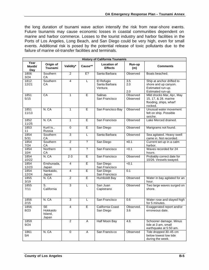
OA Emergency Response Plan – Tsunami Annex
County of Los Angeles B-5
the long duration of tsunami wave action intensify the risk from near-shore events. Future tsunamis may cause economic losses in coastal communities dependent on marine and harbor commerce. Losses to the tourist industry and harbor facilities in the Ports of Los Angeles, Long Beach, and San Diego could be very high, even for small events. Additional risk is posed by the potential release of toxic pollutants due to the failure of marine oil-transfer facilities and terminals.
History of California Tsunamis Year
Month/ Day
Origin of Tsunami Validity* Cause** Location of
Effects Run-up
(m) Comments
1806 3/24
Southern CA
2 E? Santa Barbara Observed Boats beached.
1812 12/21
Southern CA
4 L El Refugio Santa Barbara Ventura
3.5 2.0 2.0
Ship at anchor drifted to shore and up canyon. Estimated run-up. Estimated run-up.
1851 5/15
CA 1 E Salinas San Francisco
Observed Observed
Mild shocks Mar, Apr, May 15, 17, & 28. marine flooding, ships, wharf rocked.
1851 11/13
N. CA 1 E San Francisco Bay Observed Unusual water movement felt on ship. Possible seiche.
1852 11/25
N. CA 1 E San Francisco Observed Lake Merced drained.
1853 11
Kuril Is., Russia
0 E San Diego Observed Marigrams not found.
1854 5/31
Southern CA
3 L Santa Barbara Observed Sea agitated. Heavy swell came in. Not recorded.
1854 7/24
Southern CA
2 ? San Diego <0.1 Current set up in a calm harbor.
1854 10/4
Northern CA
3 ? San Francisco <0.1 Waves recorded for 24 hours.
1854 10/22
N. CA 2-3 E San Francisco Observed Probably correct date for 10/26. Vessels swayed.
1854 12/23
Enshunada, Japan
4 E San Diego San Francisco
<0.1
1854 12/24
Nankaido, Japan
4 E San Diego San Francisco
0.1
1855 3/19
N. CA 2 E Humboldt Bay Observed Water in bay agitated for an hour.
1855 7/11
S. California
3 L San Juan Capistrano
Observed Two large waves surged on shore.
1856 2/15
N. CA 3 L San Francisco 0.6 Water rose and stayed high for 5 minutes.
1856 8/23
SE Hokkaido Island, Japan
4 E California Coast San Diego
Observed. 3.6
Exaggerated report and/or erroneous date.
1859 9/24
2 A Half Moon Bay 4.6 Schooner damage. Minus tide at 3 am, small earthquake at 5:50 am.
1861 5/4
N. CA 0 A San Francis co Observed Tide dropped 30-45 cm below lowest low tide during the week.
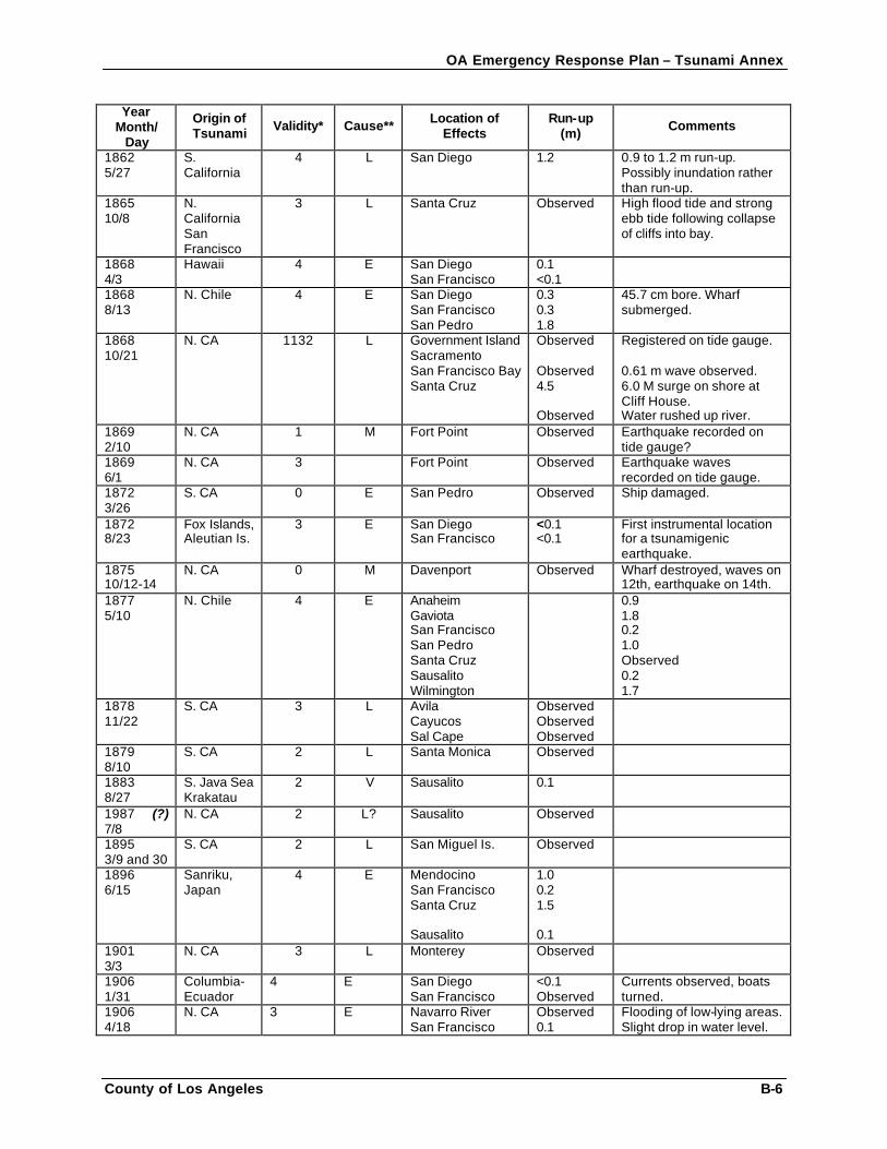
OA Emergency Response Plan – Tsunami Annex
County of Los Angeles B-6
Year Month/
Day
Origin of Tsunami Validity* Cause** Location of
Effects Run-up
(m) Comments
1862 5/27
S. California
4 L San Diego 1.2 0.9 to 1.2 m run-up. Possibly inundation rather than run-up.
1865 10/8
N. California San Francisco
3 L Santa Cruz Observed High flood tide and strong ebb tide following collapse of cliffs into bay.
1868 4/3
Hawaii 4 E San Diego San Francisco
0.1 <0.1
1868 8/13
N. Chile 4 E San Diego San Francisco San Pedro
0.3 0.3 1.8
45.7 cm bore. Wharf submerged.
1868 10/21
N. CA 1132 L Government Island Sacramento San Francisco Bay Santa Cruz
Observed Observed 4.5 Observed
Registered on tide gauge. 0.61 m wave observed. 6.0 M surge on shore at Cliff House. Water rushed up river.
1869 2/10
N. CA 1 M Fort Point Observed Earthquake recorded on tide gauge?
1869 6/1
N. CA 3 Fort Point Observed Earthquake waves recorded on tide gauge.
1872 3/26
S. CA 0 E San Pedro Observed Ship damaged.
1872 8/23
Fox Islands, Aleutian Is.
3 E San Diego San Francisco
<0.1 <0.1
First instrumental location for a tsunamigenic earthquake.
1875 10/12-14
N. CA 0 M Davenport Observed Wharf destroyed, waves on 12th, earthquake on 14th.
1877 5/10
N. Chile 4 E Anaheim Gaviota San Francisco San Pedro Santa Cruz Sausalito Wilmington
0.9 1.8 0.2 1.0 Observed 0.2 1.7
1878 11/22
S. CA 3 L Avila Cayucos Sal Cape
Observed Observed Observed
1879 8/10
S. CA 2 L Santa Monica Observed
1883 8/27
S. Java Sea Krakatau
2 V Sausalito 0.1
1987 (?) 7/8
N. CA 2 L? Sausalito Observed
1895 3/9 and 30
S. CA 2 L San Miguel Is. Observed
1896 6/15
Sanriku, Japan
4 E Mendocino San Francisco Santa Cruz Sausalito
1.0 0.2 1.5 0.1
1901 3/3
N. CA 3 L Monterey Observed
1906 1/31
Columbia-Ecuador
4 E San Diego San Francisco
<0.1 Observed
Currents observed, boats turned.
1906 4/18
N. CA 3 E Navarro River San Francisco
Observed 0.1
Flooding of low-lying areas. Slight drop in water level.
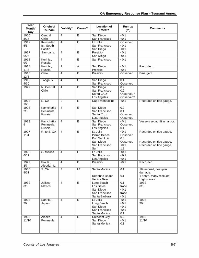
OA Emergency Response Plan – Tsunami Annex
County of Los Angeles B-7
Year Month/
Day
Origin of Tsunami Validity* Cause** Location of
Effects Run-up
(m) Comments
1906 8/17
Central Chile
4 E San Diego San Francisco
<0.1 <0.1
1917 5/1
Kermadec Is., South Pacific
4 E La Jolla San Francisco San Diego
Observed <0.1 <0.1
1917 6/26
Samoa Is. 4 E Presidio San Diego
<0.1 <0.1
1918 9/7
Kuril Is., Russia
4 E San Francisco <0.1
1918 11/8
Kuril Is., Russia
2 A San Diego Presidio
<0.1 <0.1
Recorded.
1918 12/4
Chile 4 E Presidio Observed Emergent.
1919 4/30
Tonga Is. 4 E San Diego San Francisco
0.1 Observed
1922 N. Central Chile
4 E San Diego San Francisco Santa Cruz Los Angeles
0.2 0.2 Observed? Observed?
1923 1/22
N. CA 2 E Cape Mendocino <0.1 Recorded on tide gauge.
1923 2/3
Kamchatka Peninsula, Russia
4 E San Diego San Francisco Santa Cruz Los Angeles
0.2 0.1 Observed Observed
1923 9
Kamchatka Peninsula, Russia
4 E San Diego San Francisco Los Angeles
<0.1 Observed 0.1
Vessels set adrift in harbor.
1927 11/4
N. to S. CA 4 E La Jolla Pismo Beach Port San Luis San Diego San Francisco Surf
<0.1 Observed 0.8 Observed <0.1 1.8
Recorded on tide gauge. Recorded on tide gauge. Recorded on tide gauge.
1928 6/17
S. Mexico 4 E La Jolla San Francisco Los Angeles
<0.1 <0.1 <0.1
1929 3/7
Fox Is., Aleutian Is.
4 E Presidio <0.1 Recorded.
1930 8/31
S. CA 3 L? Santa Monica Redondo Beach Venice Beach
6.1 6.1
16 rescued, boat/pier damage. 1 death, many rescued. High waves.
1932 6/3
Jalisco, Mexico
4 E Long Beach Los Gatos San Diego San Francisco Santa Barbara
0.1 trace <0.1 trace <0.1
1932 6/3
1933 3/2
Sanriku, Japan
4 E La Jolla Long Beach San Diego San Francisco Santa Monica
<0.1 <0.1 <0.1 <0.1 0.1
1933 3/2
1938 11/10
Alaska Peninsula
4 E Crescent City San Diego Santa Monica
0.2 <0.1 0.1
1938 11/10
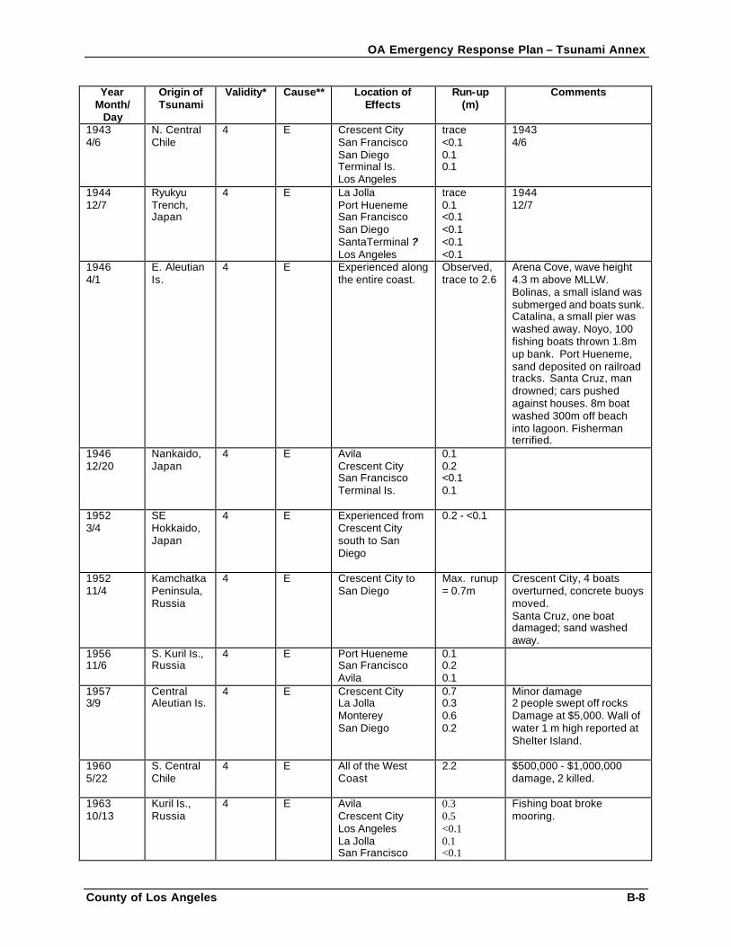
OA Emergency Response Plan – Tsunami Annex
County of Los Angeles B-8
Year Month/
Day
Origin of Tsunami
Validity* Cause** Location of Effects
Run-up (m)
Comments
1943 4/6
N. Central Chile
4 E Crescent City San Francisco San Diego Terminal Is. Los Angeles
trace <0.1 0.1 0.1
1943 4/6
1944 12/7
Ryukyu Trench, Japan
4 E La Jolla Port Hueneme San Francisco San Diego SantaTerminal ? Los Angeles
trace 0.1 <0.1 <0.1 <0.1 <0.1
1944 12/7
1946 4/1
E. Aleutian Is.
4 E Experienced along the entire coast.
Observed, trace to 2.6
Arena Cove, wave height 4.3 m above MLLW. Bolinas, a small island was submerged and boats sunk. Catalina, a small pier was washed away. Noyo, 100 fishing boats thrown 1.8m up bank. Port Hueneme, sand deposited on railroad tracks. Santa Cruz, man drowned; cars pushed against houses. 8m boat washed 300m off beach into lagoon. Fisherman terrified.
1946 12/20
Nankaido, Japan
4 E Avila Crescent City San Francisco Terminal Is.
0.1 0.2 <0.1 0.1
1952 3/4
SE Hokkaido, Japan
4 E Experienced from Crescent City south to San Diego
0.2 - <0.1
1952 11/4
Kamchatka Peninsula, Russia
4 E Crescent City to San Diego
Max. runup = 0.7m
Crescent City, 4 boats overturned, concrete buoys moved. Santa Cruz, one boat damaged; sand washed away.
1956 11/6
S. Kuril Is., Russia
4 E Port Hueneme San Francisco Avila
0.1 0.2 0.1
1957 3/9
Central Aleutian Is.
4 E Crescent City La Jolla Monterey San Diego
0.7 0.3 0.6 0.2
Minor damage 2 people swept off rocks Damage at $5,000. Wall of water 1 m high reported at Shelter Island.
1960 5/22
S. Central Chile
4 E All of the West Coast
2.2 $500,000 - $1,000,000 damage, 2 killed.
1963 10/13
Kuril Is., Russia
4 E Avila Crescent City Los Angeles La Jolla San Francisco
0.3 0.5 <0.1 0.1 <0.1
Fishing boat broke mooring.
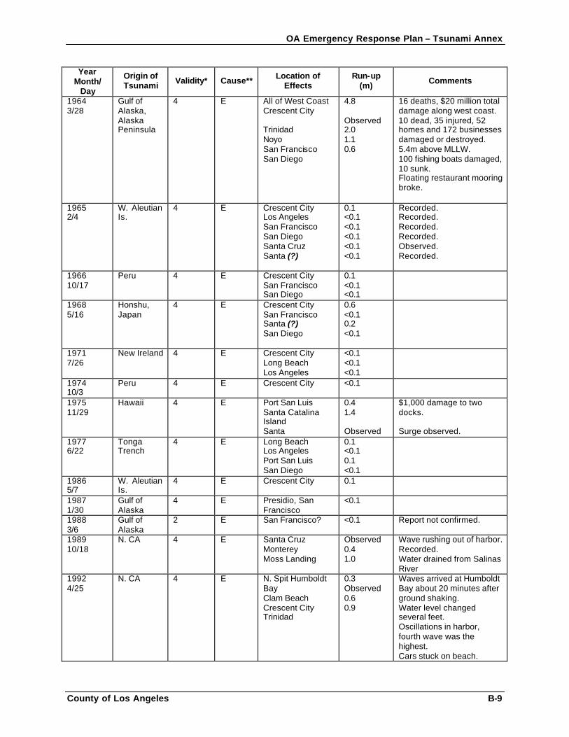
OA Emergency Response Plan – Tsunami Annex
County of Los Angeles B-9
Year Month/
Day
Origin of Tsunami Validity* Cause** Location of
Effects Run-up
(m) Comments
1964 3/28
Gulf of Alaska, Alaska Peninsula
4 E All of West Coast Crescent City Trinidad Noyo San Francisco San Diego
4.8 Observed 2.0 1.1 0.6
16 deaths, $20 million total damage along west coast. 10 dead, 35 injured, 52 homes and 172 businesses damaged or destroyed. 5.4m above MLLW. 100 fishing boats damaged, 10 sunk. Floating restaurant mooring broke.
1965 2/4
W. Aleutian Is.
4 E Crescent City Los Angeles San Francisco San Diego Santa Cruz Santa (?)
0.1 <0.1 <0.1 <0.1 <0.1 <0.1
Recorded. Recorded. Recorded. Recorded. Observed. Recorded.
1966 10/17
Peru 4 E Crescent City San Francisco San Diego
0.1 <0.1 <0.1
1968 5/16
Honshu, Japan
4 E Crescent City San Francisco Santa (?) San Diego
0.6 <0.1 0.2 <0.1
1971 7/26
New Ireland 4 E Crescent City Long Beach Los Angeles
<0.1 <0.1 <0.1
1974 10/3
Peru 4 E Crescent City <0.1
1975 11/29
Hawaii 4 E Port San Luis Santa Catalina Island Santa
0.4 1.4 Observed
$1,000 damage to two docks. Surge observed.
1977 6/22
Tonga Trench
4 E Long Beach Los Angeles Port San Luis San Diego
0.1 <0.1 0.1 <0.1
1986 5/7
W. Aleutian Is.
4 E Crescent City 0.1
1987 1/30
Gulf of Alaska
4 E Presidio, San Francisco
<0.1
1988 3/6
Gulf of Alaska
2 E San Francisco? <0.1 Report not confirmed.
1989 10/18
N. CA 4 E Santa Cruz Monterey Moss Landing
Observed 0.4 1.0
Wave rushing out of harbor. Recorded. Water drained from Salinas River
1992 4/25
N. CA 4 E N. Spit Humboldt Bay Clam Beach Crescent City Trinidad
0.3 Observed 0.6 0.9
Waves arrived at Humboldt Bay about 20 minutes after ground shaking. Water level changed several feet. Oscillations in harbor, fourth wave was the highest. Cars stuck on beach.
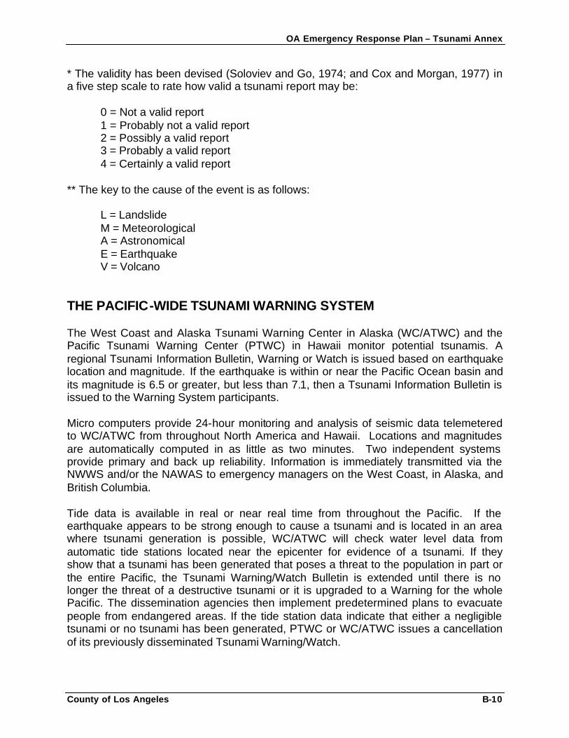
OA Emergency Response Plan – Tsunami Annex
County of Los Angeles B-10
* The validity has been devised (Soloviev and Go, 1974; and Cox and Morgan, 1977) in a five step scale to rate how valid a tsunami report may be:
0 = Not a valid report 1 = Probably not a valid report 2 = Possibly a valid report 3 = Probably a valid report 4 = Certainly a valid report
** The key to the cause of the event is as follows:
L = Landslide M = Meteorological A = Astronomical E = Earthquake V = Volcano
THE PACIFIC-WIDE TSUNAMI WARNING SYSTEM The West Coast and Alaska Tsunami Warning Center in Alaska (WC/ATWC) and the Pacific Tsunami Warning Center (PTWC) in Hawaii monitor potential tsunamis. A regional Tsunami Information Bulletin, Warning or Watch is issued based on earthquake location and magnitude. If the earthquake is within or near the Pacific Ocean basin and its magnitude is 6.5 or greater, but less than 7.1, then a Tsunami Information Bulletin is issued to the Warning System participants. Micro computers provide 24-hour monitoring and analysis of seismic data telemetered to WC/ATWC from throughout North America and Hawaii. Locations and magnitudes are automatically computed in as little as two minutes. Two independent systems provide primary and back up reliability. Information is immediately transmitted via the NWWS and/or the NAWAS to emergency managers on the West Coast, in Alaska, and British Columbia. Tide data is available in real or near real time from throughout the Pacific. If the earthquake appears to be strong enough to cause a tsunami and is located in an area where tsunami generation is possible, WC/ATWC will check water level data from automatic tide stations located near the epicenter for evidence of a tsunami. If they show that a tsunami has been generated that poses a threat to the population in part or the entire Pacific, the Tsunami Warning/Watch Bulletin is extended until there is no longer the threat of a destructive tsunami or it is upgraded to a Warning for the whole Pacific. The dissemination agencies then implement predetermined plans to evacuate people from endangered areas. If the tide station data indicate that either a negligible tsunami or no tsunami has been generated, PTWC or WC/ATWC issues a cancellation of its previously disseminated Tsunami Warning/Watch.
OA Emergency Response Plan – Tsunami Annex
County of Los Angeles B-11
Tsunami estimated time of arrivals will be disseminated for the tide stations within the Tsunami Warning and Watch areas. Additional bulletins are issued by the warning centers at regular intervals until the advisories are either canceled or the existence of a damaging tsunami is confirmed. Agencies contacted then evaluate the probability of a tsunami reaching their area and decide on appropriate action. For California, the information is transmitted to the Governor’s Office of Emergency Services Warning Center and local emergency managers. When the California State Warning Center (CSWC) receives the information from WC/ATWC via NAWAS and/or California Law Enforcement Teletype System (CLETS), the WC/ATWC will announce what areas the message is for, whether it is an Information Bulletin, a Tsunami Watch, or a Tsunami Warning. The Warning Center does not undertake any threat analysis. All information received is passed directly to the OAs via CLETS, California Alert and Warning System (CALWAS) and Emergency Alert System (EAS). Once the information has been sent out the following actions are taken: • Verification is made with the printed copy received via National Weather Service
(NWS) satellite. The information is re-transmitted via CLETS to all sheriff’s offices (SO) of coastal counties and most local police departments (PD). Turn-around time from NWS to CLETS and out is a matter of a few seconds.
NOTE: If the bulletin is only informational and a tsunami has not been generated, or is not expected, then no further action is taken by the CSWC.
• The CSWC immediately polls all SOs of the 19 coastal counties and the CHP dispatch to verify that they received the bulletin via CALWAS. If not, then it is repeated to those counties that need the information. All 19 coastal counties’ SOs are advised to check CLETS for the hard copy and to advise if not received.
• Verbal notification is then made to the OES Executive & Regional Duty Officers
(EDO,RDO) and the following agencies:
• California Division of Mines and Geology • Utilities such as Pacific Bell, San Onofre and Diablo Canyon nuclear plants
and the California Utilities Emergency Association. • Department of Water Resources • FEMA Region IX • California National Guard • Department of Fish and Game, Oil Spill PR • Department of Parks and Recreation. • State Lands Commission • American Red Cross • Department of Health Services Duty Officer • Department of Toxic Substances Control Duty Officer • US Fish and Wildlife Service • Emergency Medical Services Authority
OA Emergency Response Plan – Tsunami Annex
County of Los Angeles B-12
• Federal Aviation Administration • Any other notifications as requested by OES Duty Officers
“All Clears” are issued two hours after the last damaging wave. However, if there is no confirmation of a wave within two hours, the “all clear” is the responsibility of the local government regardless of whether a tsunami has been generated. This requires that the local government is able to observe the waves from a safe distance/height.
A word of caution: Tidal gauges are not a reliable source of information if a damaging tsunami has occurred.
As part of their tsunami plans, OAs should develop procedures for disseminating the information to local jurisdictions and special districts. Local governments should work with the appropriate OA or region to develop the elements of their notification system. NEAR-SOURCE TSUNAMI DETECTION At present, detection of near-source tsunamis is possible only where the shore can be observed. The first visible indication of an approaching tsunami is often a recession of water caused by the trough preceding an advancing wave. Any withdrawal of the sea, therefore, should be considered a warning of an approaching wave. On the other hand, a rise in water level may be the first event. Tide-gauge records of the Chilean tsunami of May 22, 1960, generally showed a rise in water level as the first indication of this tsunami. NEAR-SOURCE TSUNAMI WARNINGS There is agreement within the tsunami and emergency response communities that technology alone, automated warnings that can take up to 15 to 20 minutes to issue, cannot protect coastal inhabitants located in the immediate area of a near-source tsunami. When a large subduction zone earthquake occurs nearby, the first tsunami waves may reach coastal communities within minutes of the event. Local populations at risk should be able to recognize the signs of impending tsunami hazards, such as strong, prolonged ground shaking, and seek higher ground immediately. Communities should be informed, or determine themselves, which areas are likely to be flooded. Development, publication and distribution of inundation maps that define the inundation area, and designation of evacuation routes that indicate safe regions in which to assemble evacuees, can accomplish this. An effort to project potential inundation areas for selected communities in the state is underway. Planners, emergency responders, and residents should try to assess and project the impacts of a very large local earthquake. At-risk regions need near-real-time determination of earthquake source information to assess the nature of the hazard in order to optimize emergency response. Local decision makers need to understand their risk and be provided with mitigation tools in order to make informed planning decisions.
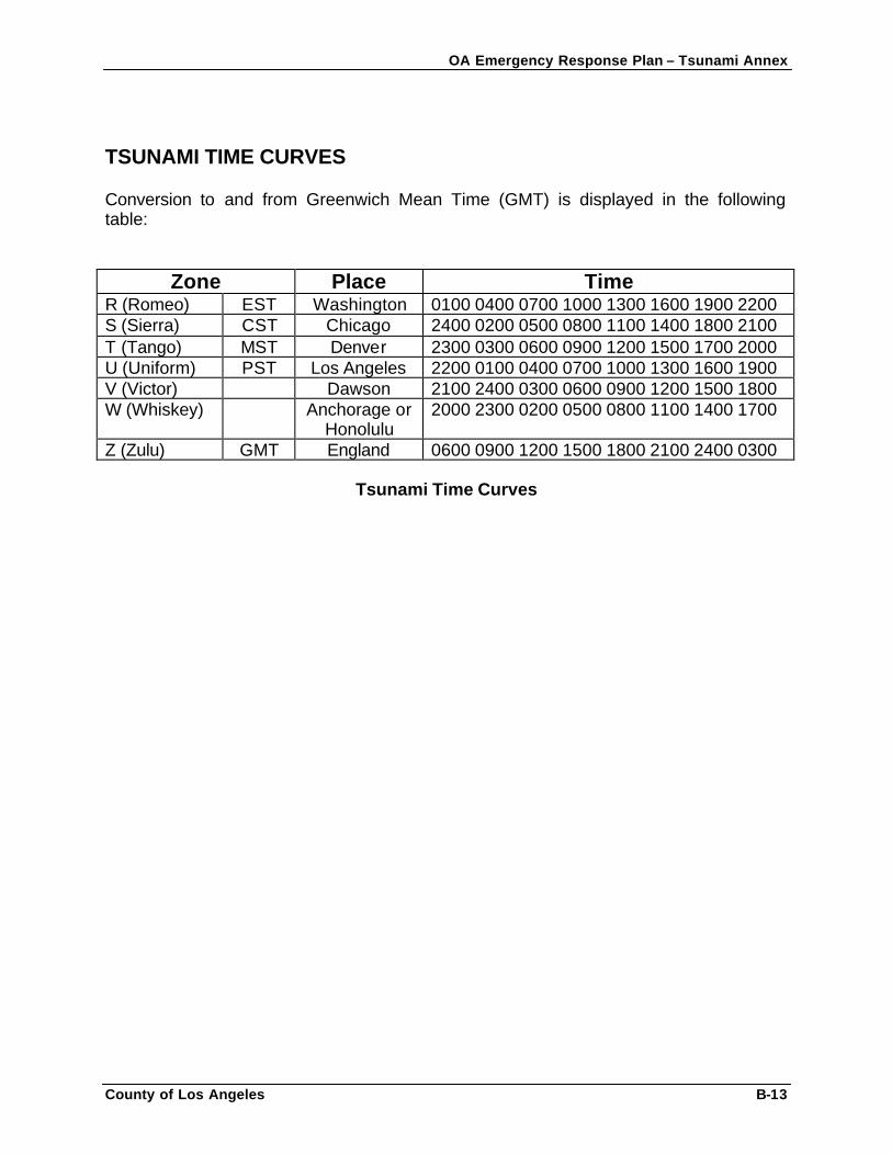
OA Emergency Response Plan – Tsunami Annex
County of Los Angeles B-13
TSUNAMI TIME CURVES Conversion to and from Greenwich Mean Time (GMT) is displayed in the following table:
Zone Place Time R (Romeo) EST Washington 0100 0400 0700 1000 1300 1600 1900 2200 S (Sierra) CST Chicago 2400 0200 0500 0800 1100 1400 1800 2100 T (Tango) MST Denver 2300 0300 0600 0900 1200 1500 1700 2000 U (Uniform) PST Los Angeles 2200 0100 0400 0700 1000 1300 1600 1900 V (Victor) Dawson 2100 2400 0300 0600 0900 1200 1500 1800 W (Whiskey) Anchorage or
Honolulu 2000 2300 0200 0500 0800 1100 1400 1700
Z (Zulu) GMT England 0600 0900 1200 1500 1800 2100 2400 0300
Tsunami Time Curves
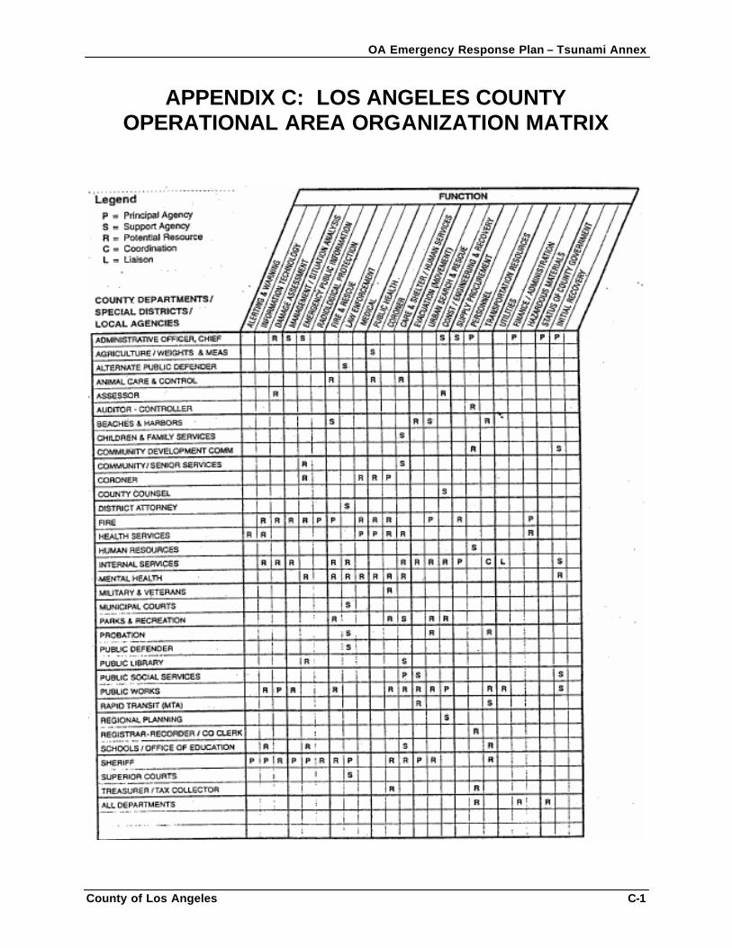
OA Emergency Response Plan – Tsunami Annex
County of Los Angeles C-1
APPENDIX C: LOS ANGELES COUNTY OPERATIONAL AREA ORGANIZATION MATRIX
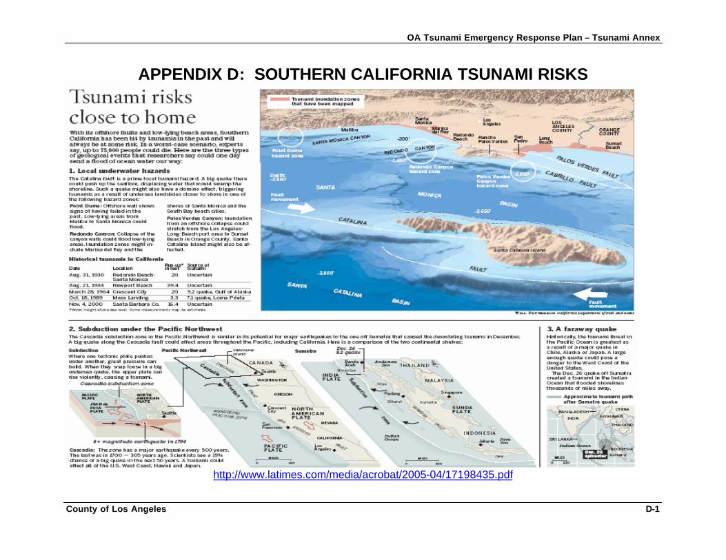
OA Tsunami Emergency Response Plan – Tsunami Annex
County of Los Angeles D-1
APPENDIX D: SOUTHERN CALIFORNIA TSUNAMI RISKS
http://www.latimes.com/media/acrobat/2005-04/17198435.pdf
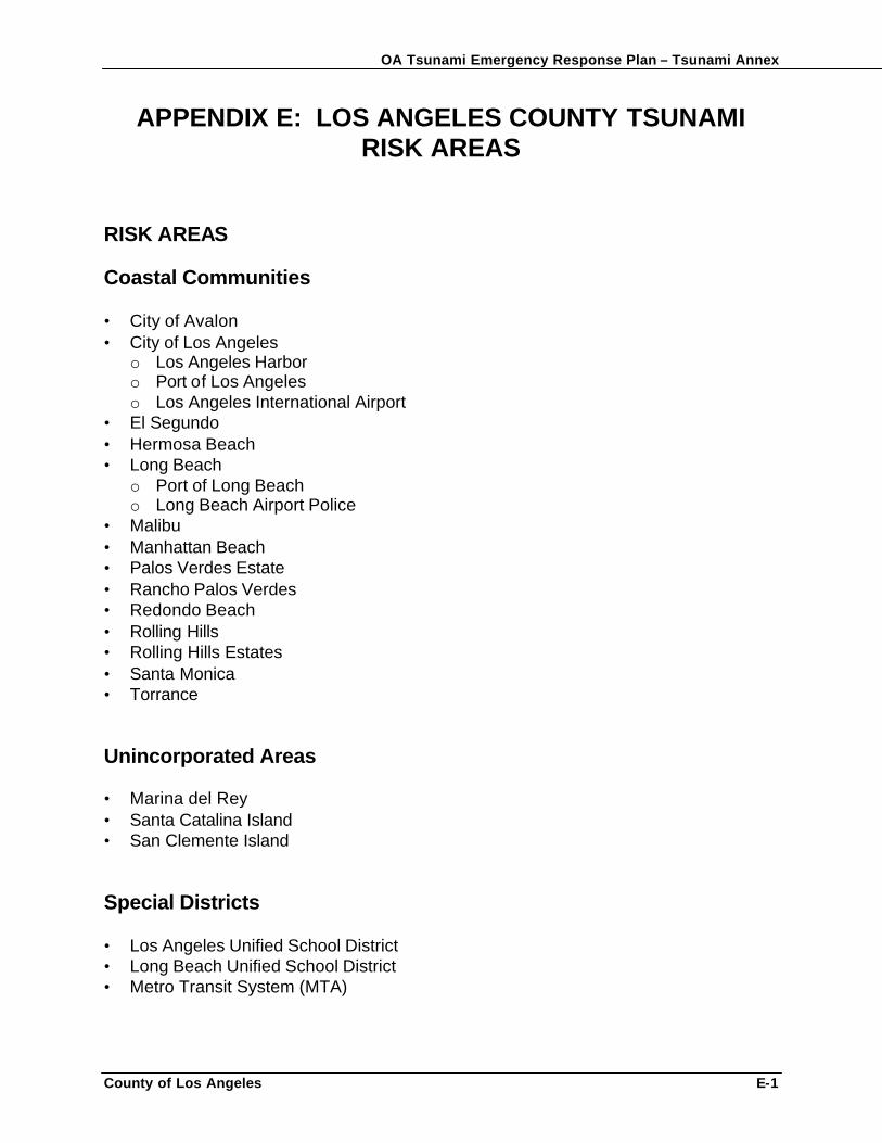
OA Tsunami Emergency Response Plan – Tsunami Annex
County of Los Angeles E-1
APPENDIX E: LOS ANGELES COUNTY TSUNAMI RISK AREAS
RISK AREAS Coastal Communities • City of Avalon • City of Los Angeles
o Los Angeles Harbor o Port of Los Angeles o Los Angeles International Airport
• El Segundo • Hermosa Beach • Long Beach
o Port of Long Beach o Long Beach Airport Police
• Malibu • Manhattan Beach • Palos Verdes Estate • Rancho Palos Verdes • Redondo Beach • Rolling Hills • Rolling Hills Estates • Santa Monica • Torrance Unincorporated Areas • Marina del Rey • Santa Catalina Island • San Clemente Island Special Districts • Los Angeles Unified School District • Long Beach Unified School District • Metro Transit System (MTA)
OA Tsunami Emergency Response Plan – Tsunami Annex
County of Los Angeles F-4
APPENDIX F: TSUNAMI INUNDATION MAPS MODEL INUNDATION MAPS The maps provided on the following pages are tsunami inundation maps for the County of Los Angeles. The first map displays the entire County coastline at risk for a tsunami event. Subsequent Maps 2 – 13, display detailed areas of the County coastline from map 1. Use of Model Inundation Maps California coastal communities need to know the areas where damage is possible from a tsunami in order to prepare for and reduce losses. Local decision makers need to understand their risk in order to make informed planning decisions. The major steps in using the model inundation maps to develop a tsunami vulnerability analysis are: • Transfer information from the model tsunami inundation maps to jurisdiction based maps. • Analyze and confirm the inundation projections by field surveys and detailed topographic review. • Develop map overlays for the following:
o Critical facilities (police, fire, city hall, public works facilities, airports, major supply warehouses)
o Special needs facilities (schools, public assembly, hospitals, convalescent homes)
o Special needs populations (e.g. non-English speakers, physically disabled, elderly, children)
o Transportation lifelines o Hazardous materials sites and facilities o Population demographics
• Identify boundaries of Tsunami Evacuation Zone with well-known landmarks, such
as streets, railroad or freeway rights-of-way, parks, etc. • Identify refuge areas within the Tsunami Evacuation Zone and their shelter capacity
for evacuated population. • Survey proposed evacuation routes to determine post earthquake function of bridges, adjacent buildings, and expected safety of adjacent land uses (avoid hazardous buildings and HazMat sites). • Locate evacuation routes and alternates.
OA Tsunami Emergency Response Plan – Tsunami Annex
County of Los Angeles F-5
Limitations and Use of Inundation Projections Ideally, tsunami response and evacuation planning should be based on reliable models of projected inundation at a given location and estimates of the probability of occurrence of earthquakes and tsunamis based on known as well as recurrence intervals. Unfortunately, both factors are limited by our knowledge of the tsunami history of the Pacific coast of California. Three factors affect the accuracy of inundation projections: the quality of the mathematical model of tsunami wave propagation, the detail of data on topography and bathymetry (underwater topography), and the assumptions made about the origins and mechanism of tsunami generation. The mathematical models now being used by NOAA and the State of California for projecting tsunami inundation are based on a consensus in the scientific community about the propagation of waves from deep ocean to shallow coastal conditions. Furthermore, the models have been calibrated against actual recent tsunamis in Japan. A more important factor in the accuracy of inundation projections is the detail in the topographical and bathymetrical data. A lack of detail in mapping offshore bathymetry, or even seasonal changes in beach conditions, can have a significant impact on model output. Identifying the origin or mechanism of “tsunami genesis” poses additional problems for inundation modeling. Tsunami waves generated from near-source or near-shore earthquakes, or underwater landslides, may vary in impact from those generated by distant subduction zone earthquakes. In order to avoid the conflict over tsunami origin, inundation projections are based on worst-case scenarios. Since the inundation projections are intended for emergency and evacuation planning, flooding is based on the highest projection of inundation regardless of the tsunami origin. As such, projections are not an assessment of the probability of reaching the projected height (probabilistic hazard assessment) but only a planning tool. Inundation projections and resulting planning maps are to be used for emergency planning purposes only. They are not based on a specific earthquake and tsunami. Areas actually inundated by a specific tsunami can vary from those predicted. The inundation maps are not a prediction of the performance, in an earthquake or tsunami, of any structure within or outside of the projected inundation area. *Note: Current OES inundation maps include the region from Palos Verdes to Malibu. State OES inundation maps are based on a worse-case scenario. OEM will update this plan to include all additional inundation maps, as available. OEM will post all current maps, as available, on the County OA website: http://lacoa.org/doclibrary.htm.
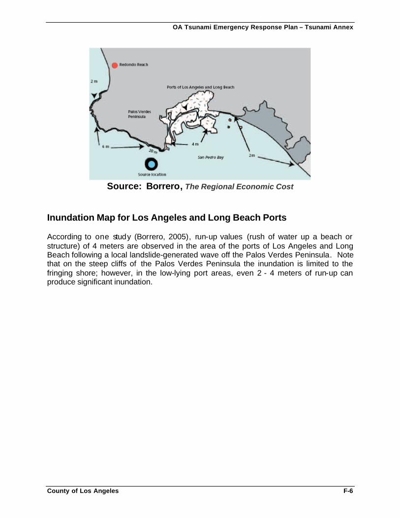
OA Tsunami Emergency Response Plan – Tsunami Annex
County of Los Angeles F-6
Source: Borrero, The Regional Economic Cost
Inundation Map for Los Angeles and Long Beach Ports According to one study (Borrero, 2005), run-up values (rush of water up a beach or structure) of 4 meters are observed in the area of the ports of Los Angeles and Long Beach following a local landslide-generated wave off the Palos Verdes Peninsula. Note that on the steep cliffs of the Palos Verdes Peninsula the inundation is limited to the fringing shore; however, in the low-lying port areas, even 2 - 4 meters of run-up can produce significant inundation.
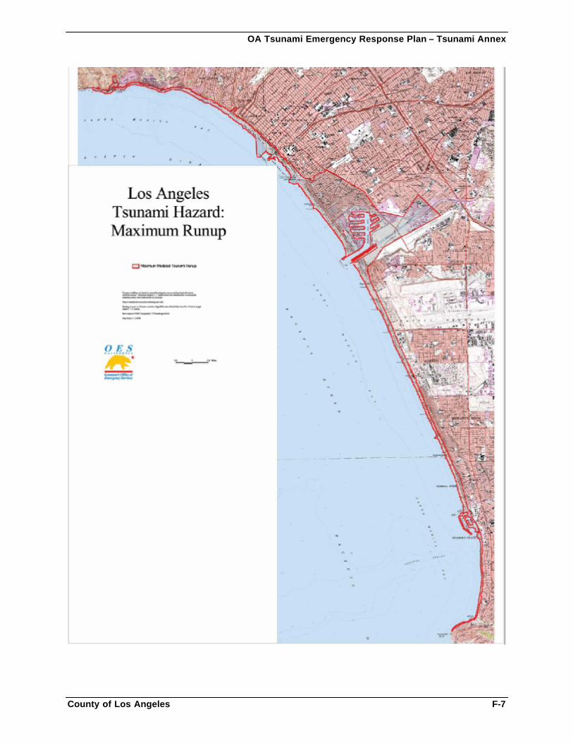
OA Tsunami Emergency Response Plan – Tsunami Annex
County of Los Angeles F-7
OA Tsunami Emergency Response Plan – Tsunami Annex
County of Los Angeles G-1
APPENDIX G: SAMPLE WARNINGS, BRIEFINGS, AND MEDIA RELEASES
Sample Warning Center Tsunami Alerts Sample Briefing Format for Local Agencies Sample Tsunami Briefings
Tsunami Watch Briefing Tsunami Warning Briefing Tsunami Cancellation Briefing
Sample Media Releases
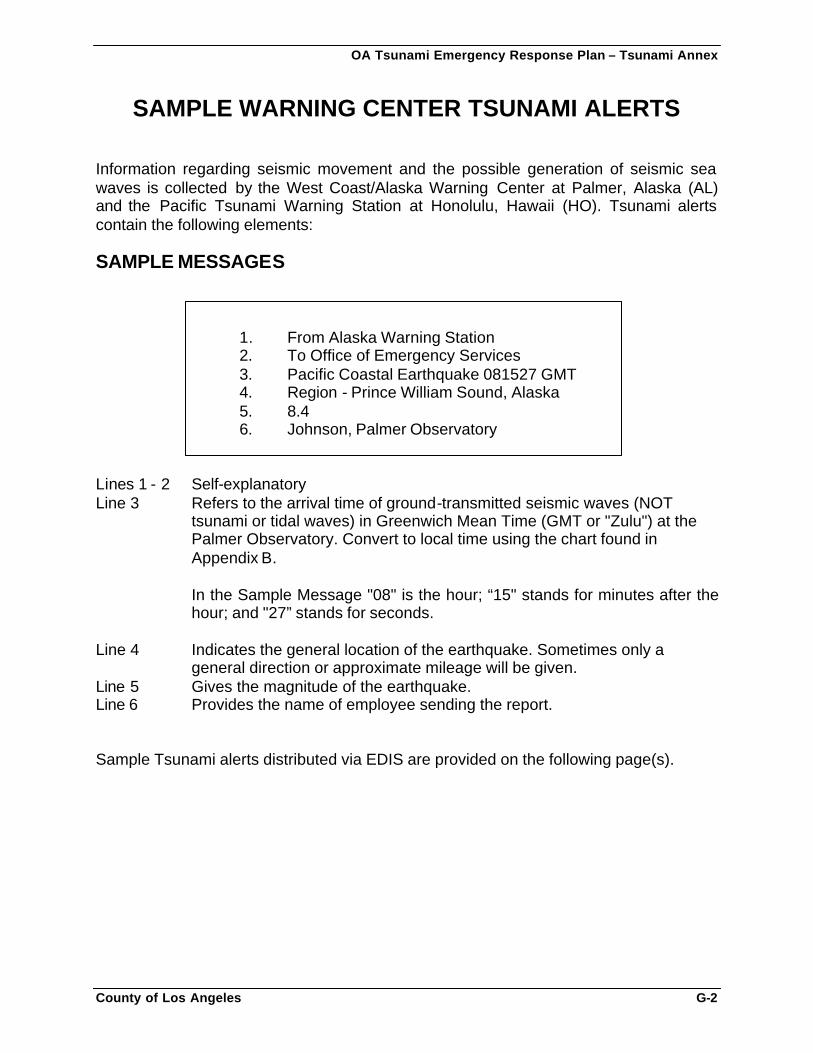
OA Tsunami Emergency Response Plan – Tsunami Annex
County of Los Angeles G-2
SAMPLE WARNING CENTER TSUNAMI ALERTS Information regarding seismic movement and the possible generation of seismic sea waves is collected by the West Coast/Alaska Warning Center at Palmer, Alaska (AL) and the Pacific Tsunami Warning Station at Honolulu, Hawaii (HO). Tsunami alerts contain the following elements: SAMPLE MESSAGES
1. From Alaska Warning Station 2. To Office of Emergency Services 3. Pacific Coastal Earthquake 081527 GMT 4. Region - Prince William Sound, Alaska 5. 8.4 6. Johnson, Palmer Observatory
Lines 1 - 2 Self-explanatory Line 3 Refers to the arrival time of ground-transmitted seismic waves (NOT tsunami or tidal waves) in Greenwich Mean Time (GMT or "Zulu") at the Palmer Observatory. Convert to local time using the chart found in
Appendix B.
In the Sample Message "08" is the hour; “15" stands for minutes after the hour; and "27” stands for seconds.
Line 4 Indicates the general location of the earthquake. Sometimes only a general direction or approximate mileage will be given. Line 5 Gives the magnitude of the earthquake. Line 6 Provides the name of employee sending the report. Sample Tsunami alerts distributed via EDIS are provided on the following page(s).
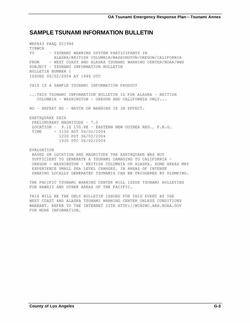
OA Tsunami Emergency Response Plan – Tsunami Annex
County of Los Angeles G-3
SAMPLE TSUNAMI INFORMATION BULLETIN WEPA43 PAAQ 021946 TIBWCA TO - TSUNAMI WARNING SYSTEM PARTICIPANTS IN ALASKA/BRITISH COLUMBIA/WASHINGTON/OREGON/CALIFORNIA FROM - WEST COAST AND ALASKA TSUNAMI WARNING CENTER/NOAA/NWS SUBJECT - TSUNAMI INFORMATION BULLETIN BULLETIN NUMBER 1 ISSUED 06/02/2004 AT 1946 UTC THIS IS A SAMPLE TSUNAMI INFORMATION PRODUCT ...THIS TSUNAMI INFORMATION BULLETIN IS FOR ALASKA - BRITISH COLUMBIA - WASHINGTON - OREGON AND CALIFORNIA ONLY... NO - REPEAT NO - WATCH OR WARNING IS IN EFFECT. EARTHQUAKE DATA PRELIMINARY MAGNITUDE - 7.0 LOCATION - 9.1S 150.8E - EASTERN NEW GUINEA REG., P.N.G. TIME - 1130 ADT 06/02/2004 1230 PDT 06/02/2004 1930 UTC 06/02/2004 EVALUATION BASED ON LOCATION AND MAGNITUDE THE EARTHQUAKE WAS NOT SUFFICIENT TO GENERATE A TSUNAMI DAMAGING TO CALIFORNIA - OREGON - WASHINGTON - BRITISH COLUMBIA OR ALASKA. SOME AREAS MAY EXPERIENCE SMALL SEA LEVEL CHANGES. IN AREAS OF INTENSE SHAKING LOCALLY GENERATED TSUNAMIS CAN BE TRIGGERED BY SLUMPING. THE PACIFIC TSUNAMI WARNING CENTER WILL ISSUE TSUNAMI BULLETINS FOR HAWAII AND OTHER AREAS OF THE PACIFIC. THIS WILL BE THE ONLY BULLETIN ISSUED FOR THIS EVENT BY THE WEST COAST AND ALASKA TSUNAMI WARNING CENTER UNLESS CONDITIONS WARRANT. REFER TO THE INTERNET SITE HTTP://WCATWC.ARH.NOAA.GOV FOR MORE INFORMATION.
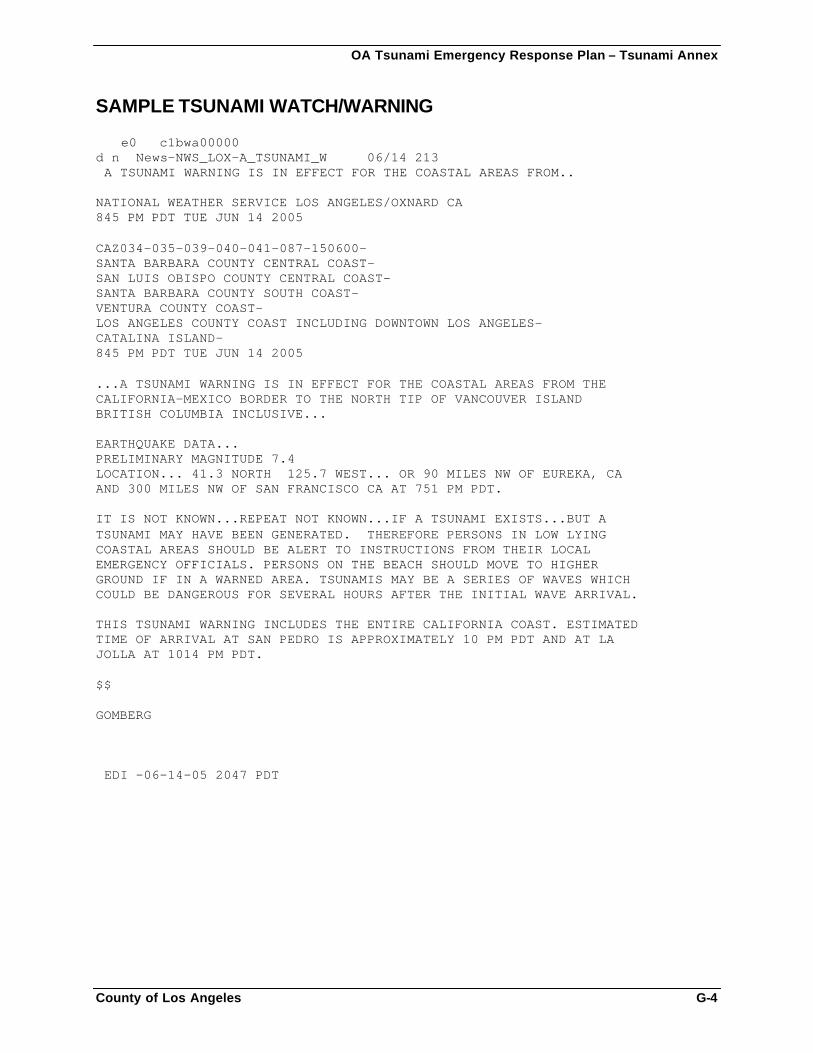
OA Tsunami Emergency Response Plan – Tsunami Annex
County of Los Angeles G-4
SAMPLE TSUNAMI WATCH/WARNING ���e0 c1bwa00000 d n� News-NWS_LOX-A_TSUNAMI_W 06/14 213 �A TSUNAMI WARNING IS IN EFFECT FOR THE COASTAL AREAS FROM.. NATIONAL WEATHER SERVICE LOS ANGELES/OXNARD CA 845 PM PDT TUE JUN 14 2005 CAZ034-035-039-040-041-087-150600- SANTA BARBARA COUNTY CENTRAL COAST- SAN LUIS OBISPO COUNTY CENTRAL COAST- SANTA BARBARA COUNTY SOUTH COAST- VENTURA COUNTY COAST- LOS ANGELES COUNTY COAST INCLUDING DOWNTOWN LOS ANGELES- CATALINA ISLAND- 845 PM PDT TUE JUN 14 2005 ...A TSUNAMI WARNING IS IN EFFECT FOR THE COASTAL AREAS FROM THE CALIFORNIA-MEXICO BORDER TO THE NORTH TIP OF VANCOUVER ISLAND BRITISH COLUMBIA INCLUSIVE... EARTHQUAKE DATA... PRELIMINARY MAGNITUDE 7.4 LOCATION... 41.3 NORTH 125.7 WEST... OR 90 MILES NW OF EUREKA, CA AND 300 MILES NW OF SAN FRANCISCO CA AT 751 PM PDT. IT IS NOT KNOWN...REPEAT NOT KNOWN...IF A TSUNAMI EXISTS...BUT A TSUNAMI MAY HAVE BEEN GENERATED. THEREFORE PERSONS IN LOW LYING COASTAL AREAS SHOULD BE ALERT TO INSTRUCTIONS FROM THEIR LOCAL EMERGENCY OFFICIALS. PERSONS ON THE BEACH SHOULD MOVE TO HIGHER GROUND IF IN A WARNED AREA. TSUNAMIS MAY BE A SERIES OF WAVES WHICH COULD BE DANGEROUS FOR SEVERAL HOURS AFTER THE INITIAL WAVE ARRIVAL. THIS TSUNAMI WARNING INCLUDES THE ENTIRE CALIFORNIA COAST. ESTIMATED TIME OF ARRIVAL AT SAN PEDRO IS APPROXIMATELY 10 PM PDT AND AT LA JOLLA AT 1014 PM PDT. $$ GOMBERG �EDI -06-14-05 2047 PDT�
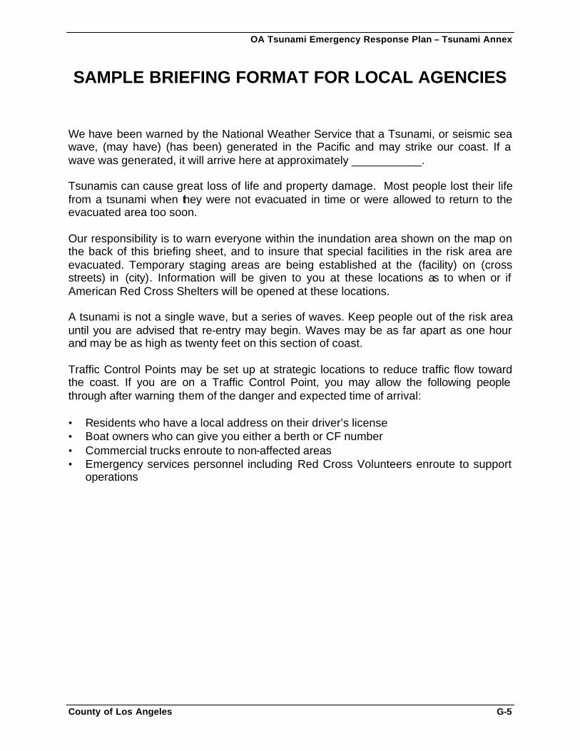
OA Tsunami Emergency Response Plan – Tsunami Annex
County of Los Angeles G-5
SAMPLE BRIEFING FORMAT FOR LOCAL AGENCIES We have been warned by the National Weather Service that a Tsunami, or seismic sea wave, (may have) (has been) generated in the Pacific and may strike our coast. If a wave was generated, it will arrive here at approximately ___________. Tsunamis can cause great loss of life and property damage. Most people lost their life from a tsunami when they were not evacuated in time or were allowed to return to the evacuated area too soon. Our responsibility is to warn everyone within the inundation area shown on the map on the back of this briefing sheet, and to insure that special facilities in the risk area are evacuated. Temporary staging areas are being established at the (facility) on (cross streets) in (city). Information will be given to you at these locations as to when or if American Red Cross Shelters will be opened at these locations. A tsunami is not a single wave, but a series of waves. Keep people out of the risk area until you are advised that re-entry may begin. Waves may be as far apart as one hour and may be as high as twenty feet on this section of coast. Traffic Control Points may be set up at strategic locations to reduce traffic flow toward the coast. If you are on a Traffic Control Point, you may allow the following people through after warning them of the danger and expected time of arrival: • Residents who have a local address on their driver’s license • Boat owners who can give you either a berth or CF number • Commercial trucks enroute to non-affected areas • Emergency services personnel including Red Cross Volunteers enroute to support
operations
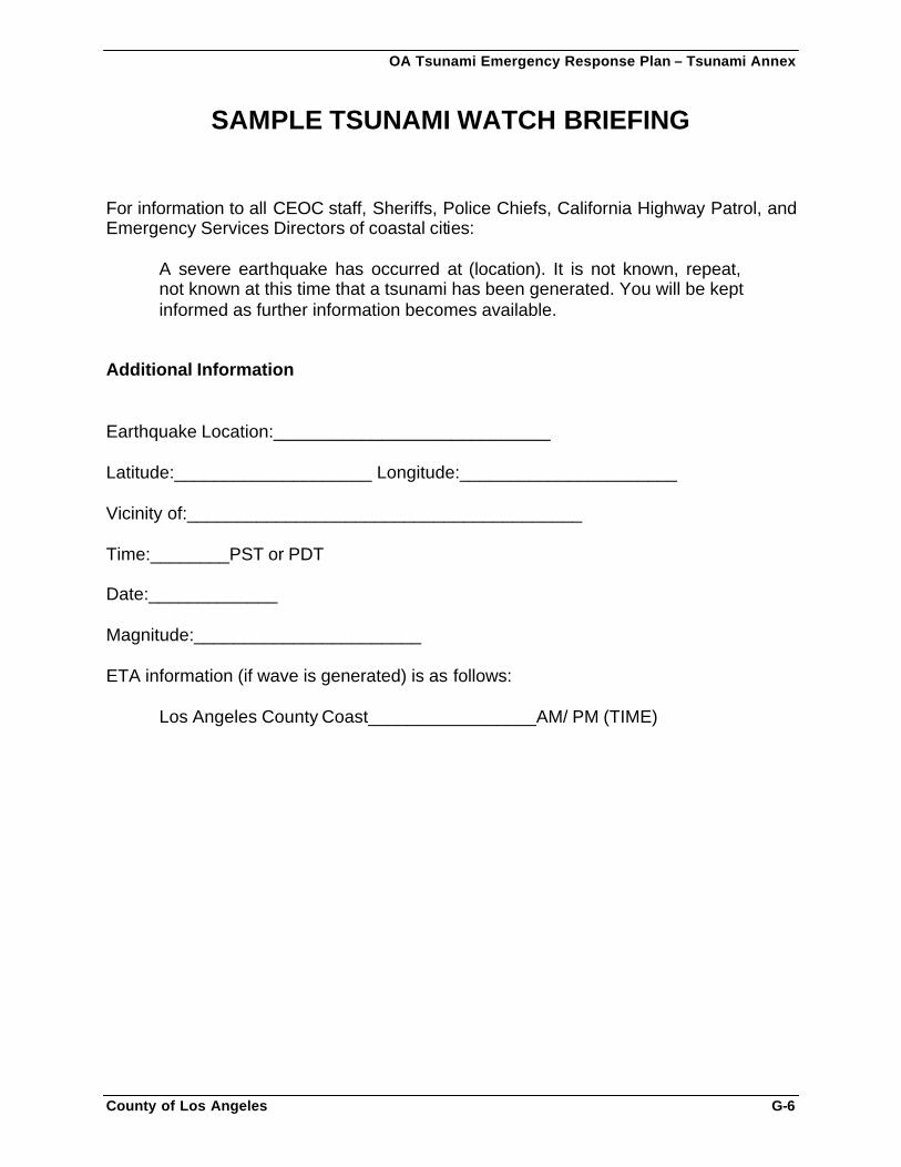
OA Tsunami Emergency Response Plan – Tsunami Annex
County of Los Angeles G-6
SAMPLE TSUNAMI WATCH BRIEFING For information to all CEOC staff, Sheriffs, Police Chiefs, California Highway Patrol, and Emergency Services Directors of coastal cities:
A severe earthquake has occurred at (location). It is not known, repeat, not known at this time that a tsunami has been generated. You will be kept informed as further information becomes available.
Additional Information Earthquake Location:____________________________ Latitude:____________________ Longitude:______________________ Vicinity of:________________________________________ Time:________PST or PDT Date:_____________ Magnitude:_______________________ ETA information (if wave is generated) is as follows:
Los Angeles County Coast_________________AM/ PM (TIME)
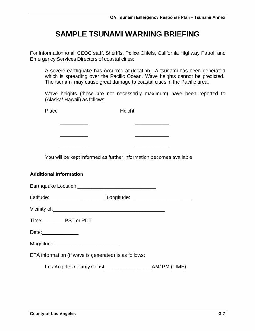
OA Tsunami Emergency Response Plan – Tsunami Annex
County of Los Angeles G-7
SAMPLE TSUNAMI WARNING BRIEFING For information to all CEOC staff, Sheriffs, Police Chiefs, California Highway Patrol, and Emergency Services Directors of coastal cities:
A severe earthquake has occurred at (location). A tsunami has been generated which is spreading over the Pacific Ocean. Wave heights cannot be predicted. The tsunami may cause great damage to coastal cities in the Pacific area. Wave heights (these are not necessarily maximum) have been reported to (Alaska/ Hawaii) as follows: Place Height
__________ ____________
__________ ____________
__________ ____________ You will be kept informed as further information becomes available.
Additional Information Earthquake Location:____________________________ Latitude:____________________ Longitude:______________________ Vicinity of:________________________________________ Time:________PST or PDT Date:_____________ Magnitude:_______________________ ETA information (if wave is generated) is as follows:
Los Angeles County Coast_________________AM/ PM (TIME)
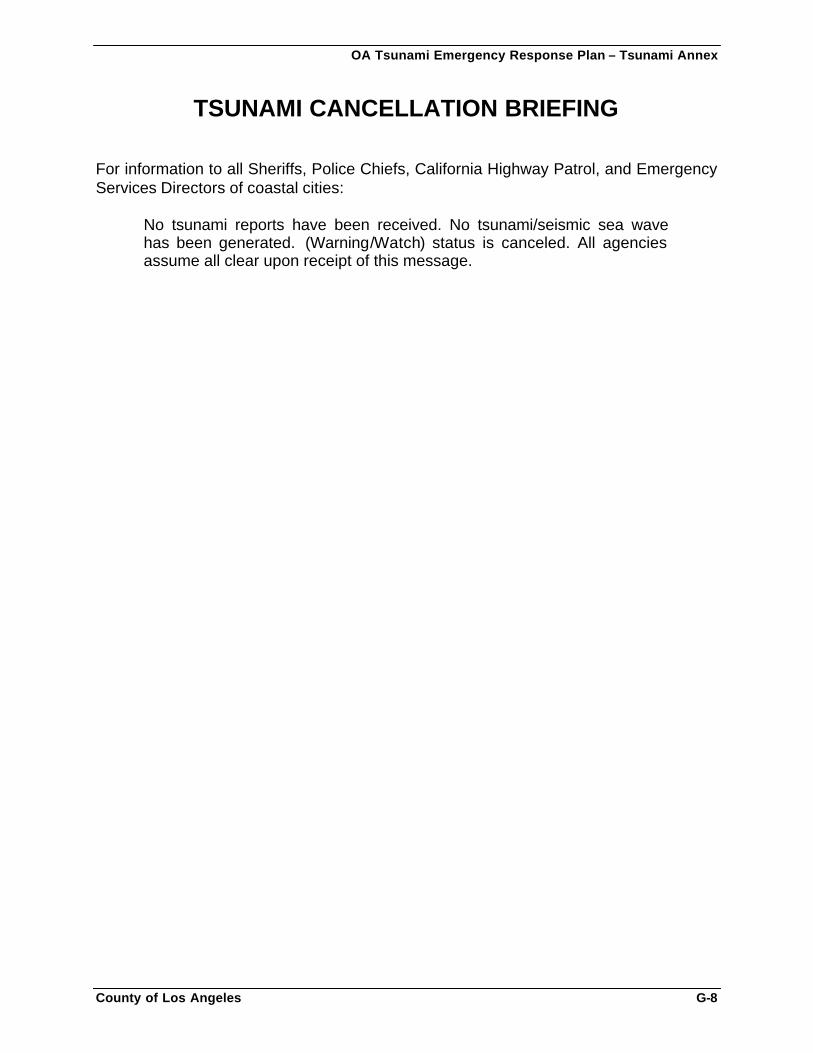
OA Tsunami Emergency Response Plan – Tsunami Annex
County of Los Angeles G-8
TSUNAMI CANCELLATION BRIEFING For information to all Sheriffs, Police Chiefs, California Highway Patrol, and Emergency Services Directors of coastal cities:
No tsunami reports have been received. No tsunami/seismic sea wave has been generated. (Warning/Watch) status is canceled. All agencies assume all clear upon receipt of this message.
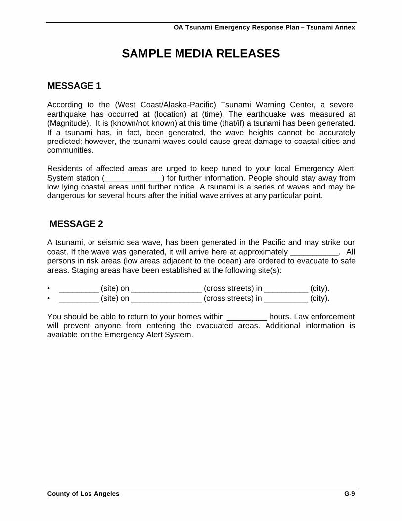
OA Tsunami Emergency Response Plan – Tsunami Annex
County of Los Angeles G-9
SAMPLE MEDIA RELEASES MESSAGE 1 According to the (West Coast/Alaska-Pacific) Tsunami Warning Center, a severe earthquake has occurred at (location) at (time). The earthquake was measured at (Magnitude). It is (known/not known) at this time (that/if) a tsunami has been generated. If a tsunami has, in fact, been generated, the wave heights cannot be accurately predicted; however, the tsunami waves could cause great damage to coastal cities and communities. Residents of affected areas are urged to keep tuned to your local Emergency Alert System station (_____________) for further information. People should stay away from low lying coastal areas until further notice. A tsunami is a series of waves and may be dangerous for several hours after the initial wave arrives at any particular point. MESSAGE 2 A tsunami, or seismic sea wave, has been generated in the Pacific and may strike our coast. If the wave was generated, it will arrive here at approximately ___________. All persons in risk areas (low areas adjacent to the ocean) are ordered to evacuate to safe areas. Staging areas have been established at the following site(s): • _________ (site) on ________________ (cross streets) in __________ (city). • _________ (site) on ________________ (cross streets) in __________ (city). You should be able to return to your homes within _________ hours. Law enforcement will prevent anyone from entering the evacuated areas. Additional information is available on the Emergency Alert System.
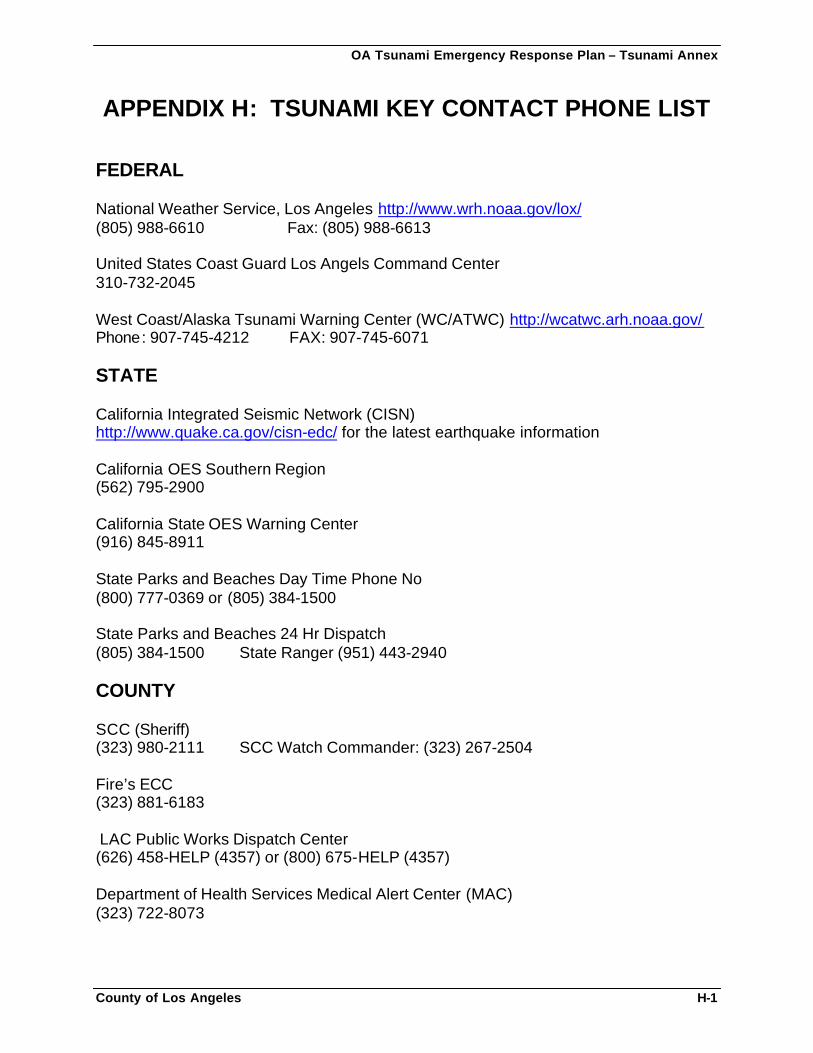
OA Tsunami Emergency Response Plan – Tsunami Annex
County of Los Angeles H-1
APPENDIX H: TSUNAMI KEY CONTACT PHONE LIST FEDERAL National Weather Service, Los Angeles http://www.wrh.noaa.gov/lox/ (805) 988-6610 Fax: (805) 988-6613 United States Coast Guard Los Angels Command Center 310-732-2045 West Coast/Alaska Tsunami Warning Center (WC/ATWC) http://wcatwc.arh.noaa.gov/ Phone: 907-745-4212 FAX: 907-745-6071 STATE California Integrated Seismic Network (CISN) http://www.quake.ca.gov/cisn-edc/ for the latest earthquake information California OES Southern Region (562) 795-2900 California State OES Warning Center (916) 845-8911 State Parks and Beaches Day Time Phone No (800) 777-0369 or (805) 384-1500 State Parks and Beaches 24 Hr Dispatch (805) 384-1500 State Ranger (951) 443-2940 COUNTY SCC (Sheriff) (323) 980-2111 SCC Watch Commander: (323) 267-2504 Fire’s ECC (323) 881-6183 LAC Public Works Dispatch Center (626) 458-HELP (4357) or (800) 675-HELP (4357) Department of Health Services Medical Alert Center (MAC) (323) 722-8073
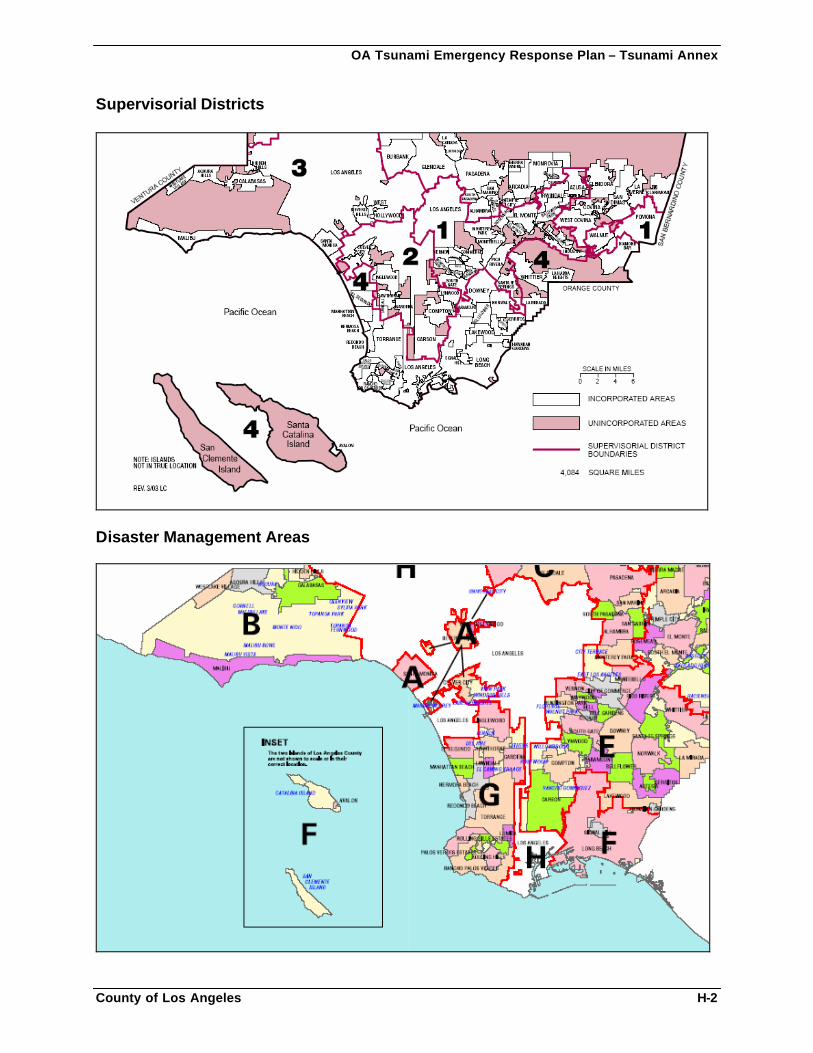
OA Tsunami Emergency Response Plan – Tsunami Annex
County of Los Angeles H-2
Supervisorial Districts
Disaster Management Areas
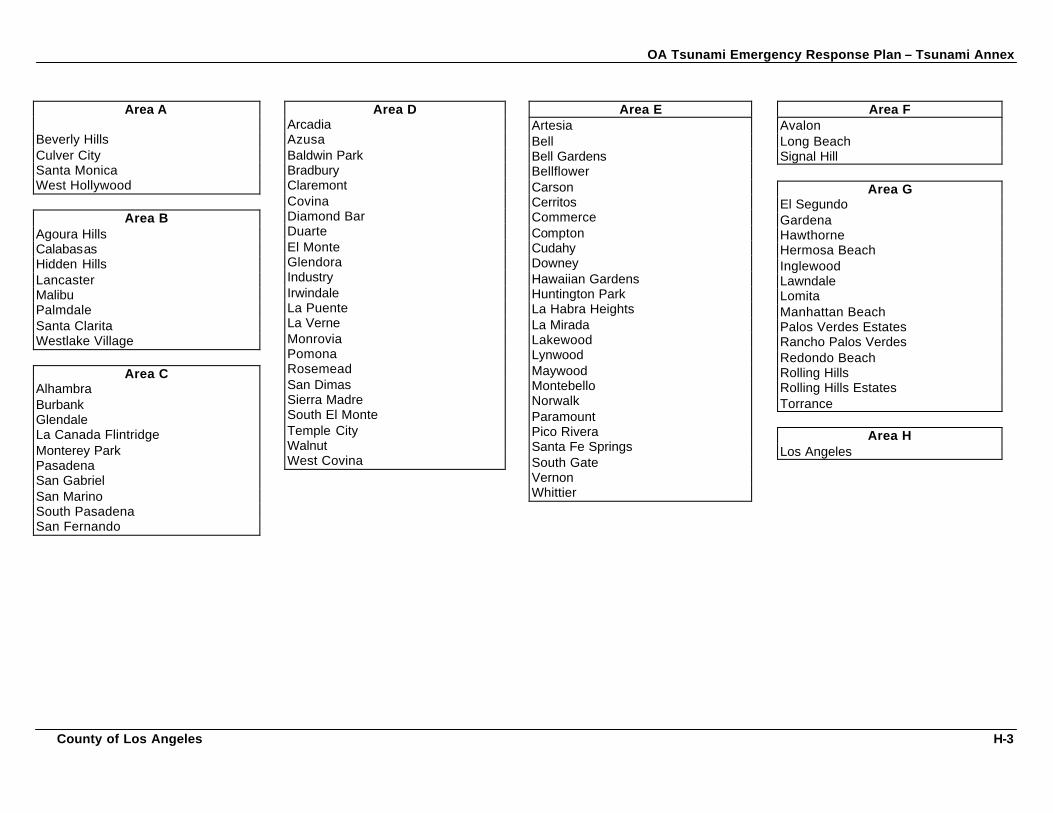
OA Tsunami Emergency Response Plan – Tsunami Annex
County of Los Angeles H-3
Area A Beverly Hills Culver City Santa Monica West Hollywood
Area B Agoura Hills Calabasas Hidden Hills Lancaster Malibu Palmdale Santa Clarita Westlake Village
Area C Alhambra Burbank Glendale La Canada Flintridge Monterey Park Pasadena San Gabriel San Marino South Pasadena San Fernando
Area D Arcadia Azusa Baldwin Park Bradbury Claremont Covina Diamond Bar Duarte El Monte Glendora Industry Irwindale La Puente La Verne Monrovia Pomona Rosemead San Dimas Sierra Madre South El Monte Temple City Walnut West Covina
Area E Artesia Bell Bell Gardens Bellflower Carson Cerritos Commerce Compton Cudahy Downey Hawaiian Gardens Huntington Park La Habra Heights La Mirada Lakewood Lynwood Maywood Montebello Norwalk Paramount Pico Rivera Santa Fe Springs South Gate Vernon Whittier
Area F Avalon Long Beach Signal Hill
Area G El Segundo Gardena Hawthorne Hermosa Beach Inglewood Lawndale Lomita Manhattan Beach Palos Verdes Estates Rancho Palos Verdes Redondo Beach Rolling Hills Rolling Hills Estates Torrance
Area H Los Angeles
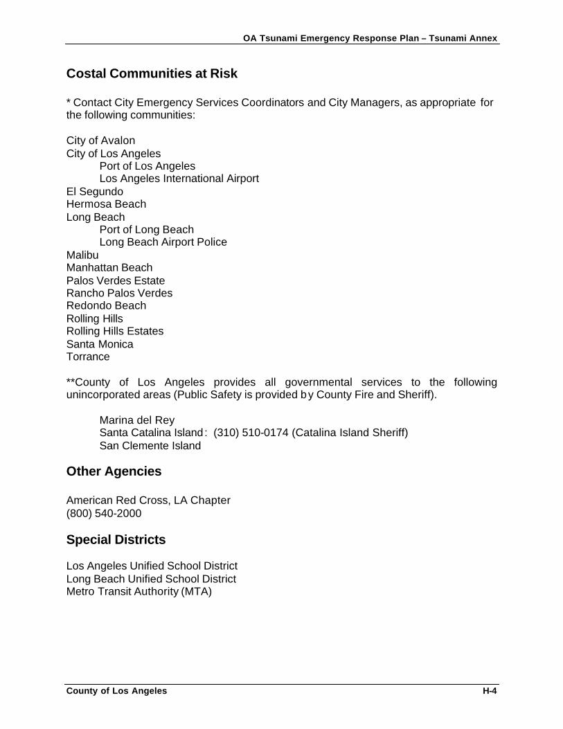
OA Tsunami Emergency Response Plan – Tsunami Annex
County of Los Angeles H-4
Costal Communities at Risk * Contact City Emergency Services Coordinators and City Managers, as appropriate for the following communities: City of Avalon City of Los Angeles
Port of Los Angeles Los Angeles International Airport
El Segundo Hermosa Beach Long Beach
Port of Long Beach Long Beach Airport Police
Malibu Manhattan Beach Palos Verdes Estate Rancho Palos Verdes Redondo Beach Rolling Hills Rolling Hills Estates Santa Monica Torrance **County of Los Angeles provides all governmental services to the following unincorporated areas (Public Safety is provided by County Fire and Sheriff).
Marina del Rey Santa Catalina Island: (310) 510-0174 (Catalina Island Sheriff) San Clemente Island
Other Agencies American Red Cross, LA Chapter (800) 540-2000 Special Districts Los Angeles Unified School District Long Beach Unified School District Metro Transit Authority (MTA)
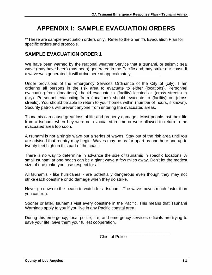
OA Tsunami Emergency Response Plan – Tsunami Annex
County of Los Angeles I-1
APPENDIX I: SAMPLE EVACUATION ORDERS **These are sample evacuation orders only. Refer to the Sheriff’s Evacuation Plan for specific orders and protocols. SAMPLE EVACUATION ORDER 1 We have been warned by the National weather Service that a tsunami, or seismic sea wave (may have been) (has been) generated in the Pacific and may strike our coast. If a wave was generated, it will arrive here at approximately ____________. Under provisions of the Emergency Services Ordinance of the City of (city), I am ordering all persons in the risk area to evacuate to either (locations). Personnel evacuating from (locations) should evacuate to (facility) located at (cross streets) in (city). Personnel evacuating from (locations) should evacuate to (facility) on (cross streets). You should be able to return to your homes within (number of hours, if known). Security patrols will prevent anyone from entering the evacuated areas. Tsunamis can cause great loss of life and property damage. Most people lost their life from a tsunami when they were not evacuated in time or were allowed to return to the evacuated area too soon. A tsunami is not a single wave but a series of waves. Stay out of the risk area until you are advised that reentry may begin. Waves may be as far apart as one hour and up to twenty feet high on this part of the coast. There is no way to determine in advance the size of tsunamis in specific locations. A small tsunami at one beach can be a giant wave a few miles away. Don't let the modest size of one make you lose respect for all. All tsunamis - like hurricanes - are potentially dangerous even though they may not strike each coastline or do damage when they do strike. Never go down to the beach to watch for a tsunami. The wave moves much faster than you can run. Sooner or later, tsunamis visit every coastline in the Pacific. This means that Tsunami Warnings apply to you if you live in any Pacific coastal area. During this emergency, local police, fire, and emergency services officials are trying to save your life. Give them your fullest cooperation. ______________________________ Chief of Police
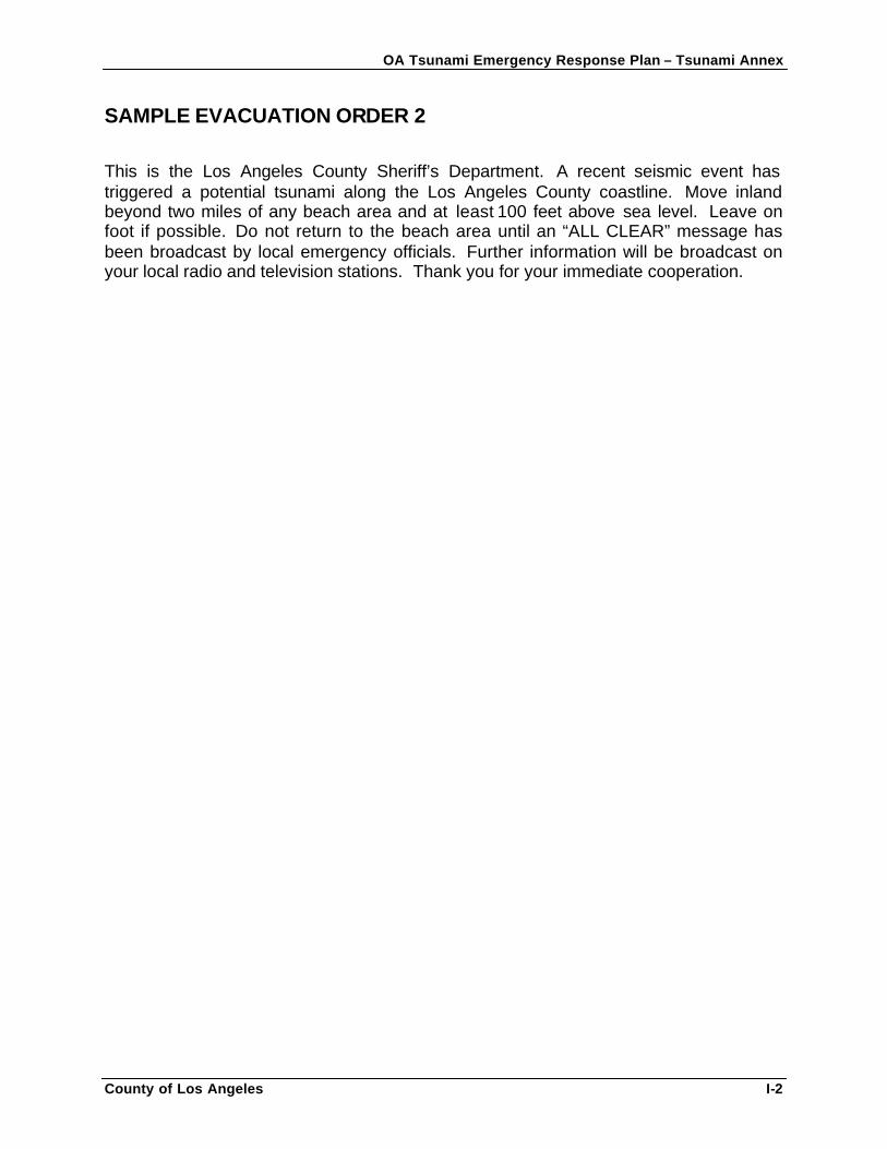
OA Tsunami Emergency Response Plan – Tsunami Annex
County of Los Angeles I-2
SAMPLE EVACUATION ORDER 2 This is the Los Angeles County Sheriff’s Department. A recent seismic event has triggered a potential tsunami along the Los Angeles County coastline. Move inland beyond two miles of any beach area and at least 100 feet above sea level. Leave on foot if possible. Do not return to the beach area until an “ALL CLEAR” message has been broadcast by local emergency officials. Further information will be broadcast on your local radio and television stations. Thank you for your immediate cooperation.
OA Tsunami Emergency Response Plan – Tsunami Annex
County of Los Angeles J-1
APPENDIX J: COASTAL EVACUATION ROUTES FOR WEST-FACING BEACHES
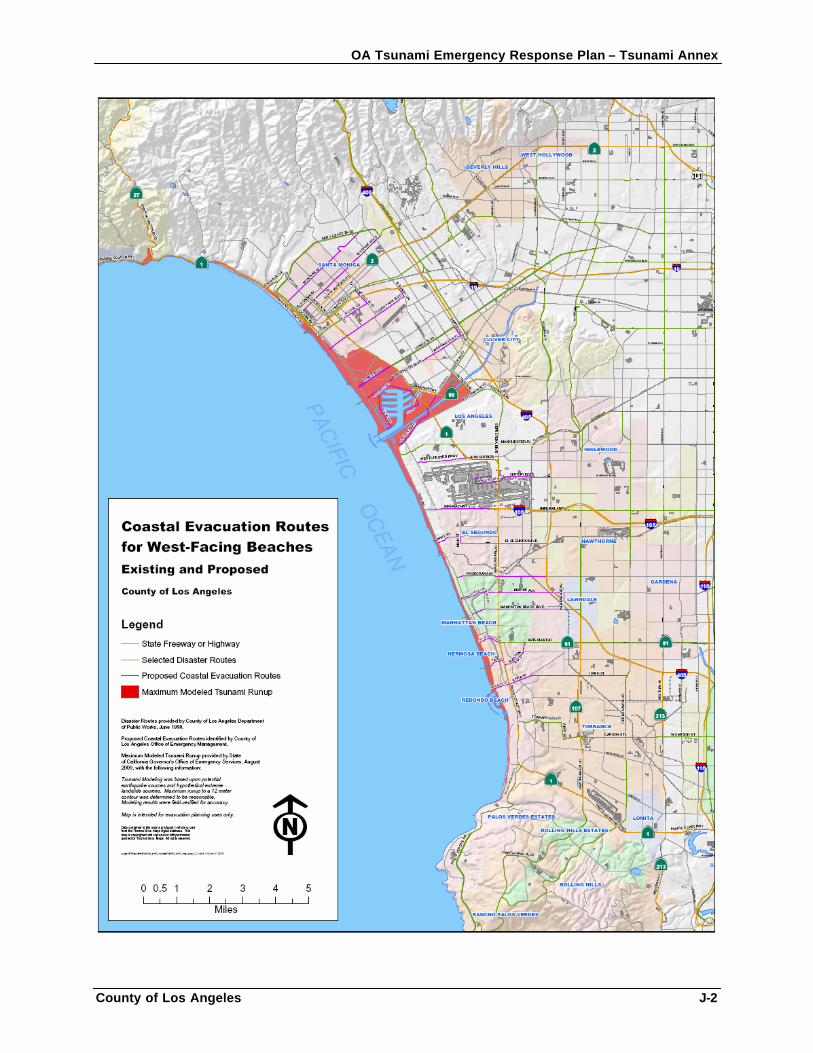
OA Tsunami Emergency Response Plan – Tsunami Annex
County of Los Angeles J-2
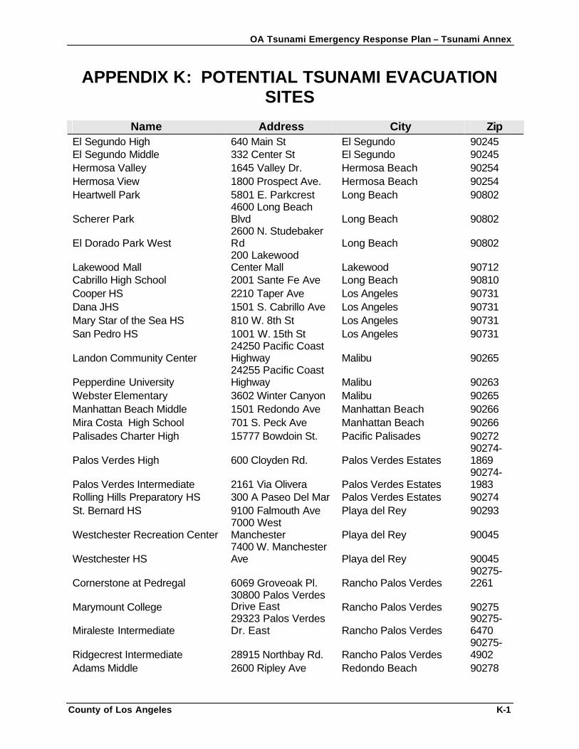
OA Tsunami Emergency Response Plan – Tsunami Annex
County of Los Angeles K-1
APPENDIX K: POTENTIAL TSUNAMI EVACUATION SITES
Name Address City Zip
El Segundo High 640 Main St El Segundo 90245 El Segundo Middle 332 Center St El Segundo 90245 Hermosa Valley 1645 Valley Dr. Hermosa Beach 90254 Hermosa View 1800 Prospect Ave. Hermosa Beach 90254 Heartwell Park 5801 E. Parkcrest Long Beach 90802
Scherer Park 4600 Long Beach Blvd Long Beach 90802
El Dorado Park West 2600 N. Studebaker Rd Long Beach 90802
Lakewood Mall 200 Lakewood Center Mall Lakewood 90712
Cabrillo High School 2001 Sante Fe Ave Long Beach 90810 Cooper HS 2210 Taper Ave Los Angeles 90731 Dana JHS 1501 S. Cabrillo Ave Los Angeles 90731 Mary Star of the Sea HS 810 W. 8th St Los Angeles 90731 San Pedro HS 1001 W. 15th St Los Angeles 90731
Landon Community Center 24250 Pacific Coast Highway Malibu 90265
Pepperdine University 24255 Pacific Coast Highway Malibu 90263
Webster Elementary 3602 Winter Canyon Malibu 90265 Manhattan Beach Middle 1501 Redondo Ave Manhattan Beach 90266 Mira Costa High School 701 S. Peck Ave Manhattan Beach 90266 Palisades Charter High 15777 Bowdoin St. Pacific Palisades 90272
Palos Verdes High 600 Cloyden Rd. Palos Verdes Estates 90274-1869
Palos Verdes Intermediate 2161 Via Olivera Palos Verdes Estates 90274-1983
Rolling Hills Preparatory HS 300 A Paseo Del Mar Palos Verdes Estates 90274 St. Bernard HS 9100 Falmouth Ave Playa del Rey 90293
Westchester Recreation Center 7000 West Manchester Playa del Rey 90045
Westchester HS 7400 W. Manchester Ave Playa del Rey 90045
Cornerstone at Pedregal 6069 Groveoak Pl. Rancho Palos Verdes 90275-2261
Marymount College 30800 Palos Verdes Drive East Rancho Palos Verdes 90275
Miraleste Intermediate 29323 Palos Verdes Dr. East Rancho Palos Verdes
90275-6470
Ridgecrest Intermediate 28915 Northbay Rd. Rancho Palos Verdes 90275-4902
Adams Middle 2600 Ripley Ave Redondo Beach 90278
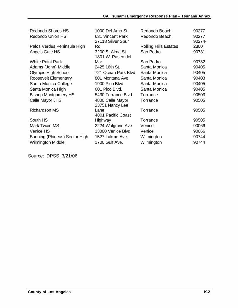
OA Tsunami Emergency Response Plan – Tsunami Annex
County of Los Angeles K-2
Redondo Shores HS 1000 Del Amo St Redondo Beach 90277 Redondo Union HS 631 Vincent Park Redondo Beach 90277
Palos Verdes Peninsula High 27118 Silver Spur Rd. Rolling Hills Estates
90274-2300
Angels Gate HS 3200 S. Alma St San Pedro 90731
White Point Park 1801 W. Paseo del Mar San Pedro 90732
Adams (John) Middle 2425 16th St. Santa Monica 90405 Olympic High School 721 Ocean Park Blvd Santa Monica 90405 Roosevelt Elementary 801 Montana Ave Santa Monica 90403 Santa Monica College 1900 Pico Blvd Santa Monica 90405 Santa Monica High 601 Pico Blvd. Santa Monica 90405 Bishop Montgomery HS 5430 Torrance Blvd Torrance 90503 Calle Mayor JHS 4800 Calle Mayor Torrance 90505
Richardson MS 23751 Nancy Lee Lane Torrance 90505
South HS 4801 Pacific Coast Highway Torrance 90505
Mark Twain MS 2224 Walgrove Ave Venice 90066 Venice HS 13000 Venice Blvd Venice 90066 Banning (Phineas) Senior High 1527 Lakme Ave. Wilmington 90744 Wilmington Middle 1700 Gulf Ave. Wilmington 90744
Source: DPSS, 3/21/06
OA Tsunami Emergency Response Plan – Tsunami Annex
County of Los Angeles L-1
APPENDIX L: CEOC TSUNAMI CHECKLISTS
CEOC Duty Officer Tsunami Watch Checklist CEOC Tsunami Warning Checklist CEOC Tsunami Occurrence Checklist
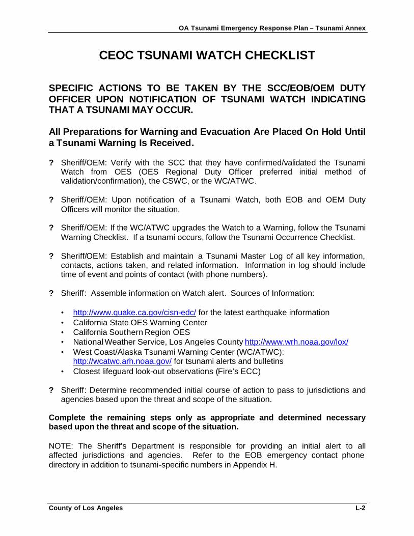
OA Tsunami Emergency Response Plan – Tsunami Annex
County of Los Angeles L-2
CEOC TSUNAMI WATCH CHECKLIST SPECIFIC ACTIONS TO BE TAKEN BY THE SCC/EOB/OEM DUTY OFFICER UPON NOTIFICATION OF TSUNAMI WATCH INDICATING THAT A TSUNAMI MAY OCCUR. All Preparations for Warning and Evacuation Are Placed On Hold Until a Tsunami Warning Is Received. ? Sheriff/OEM: Verify with the SCC that they have confirmed/validated the Tsunami
Watch from OES (OES Regional Duty Officer preferred initial method of validation/confirmation), the CSWC, or the WC/ATWC.
? Sheriff/OEM: Upon notification of a Tsunami Watch, both EOB and OEM Duty
Officers will monitor the situation. ? Sheriff/OEM: If the WC/ATWC upgrades the Watch to a Warning, follow the Tsunami
Warning Checklist. If a tsunami occurs, follow the Tsunami Occurrence Checklist. ? Sheriff/OEM: Establish and maintain a Tsunami Master Log of all key information,
contacts, actions taken, and related information. Information in log should include time of event and points of contact (with phone numbers).
? Sheriff: Assemble information on Watch alert. Sources of Information:
• http://www.quake.ca.gov/cisn-edc/ for the latest earthquake information • California State OES Warning Center • California Southern Region OES • National Weather Service, Los Angeles County http://www.wrh.noaa.gov/lox/ • West Coast/Alaska Tsunami Warning Center (WC/ATWC):
http://wcatwc.arh.noaa.gov/ for tsunami alerts and bulletins • Closest lifeguard look-out observations (Fire’s ECC)
? Sheriff: Determine recommended initial course of action to pass to jurisdictions and agencies based upon the threat and scope of the situation.
Complete the remaining steps only as appropriate and determined necessary based upon the threat and scope of the situation.
NOTE: The Sheriff’s Department is responsible for providing an initial alert to all affected jurisdictions and agencies. Refer to the EOB emergency contact phone directory in addition to tsunami-specific numbers in Appendix H.
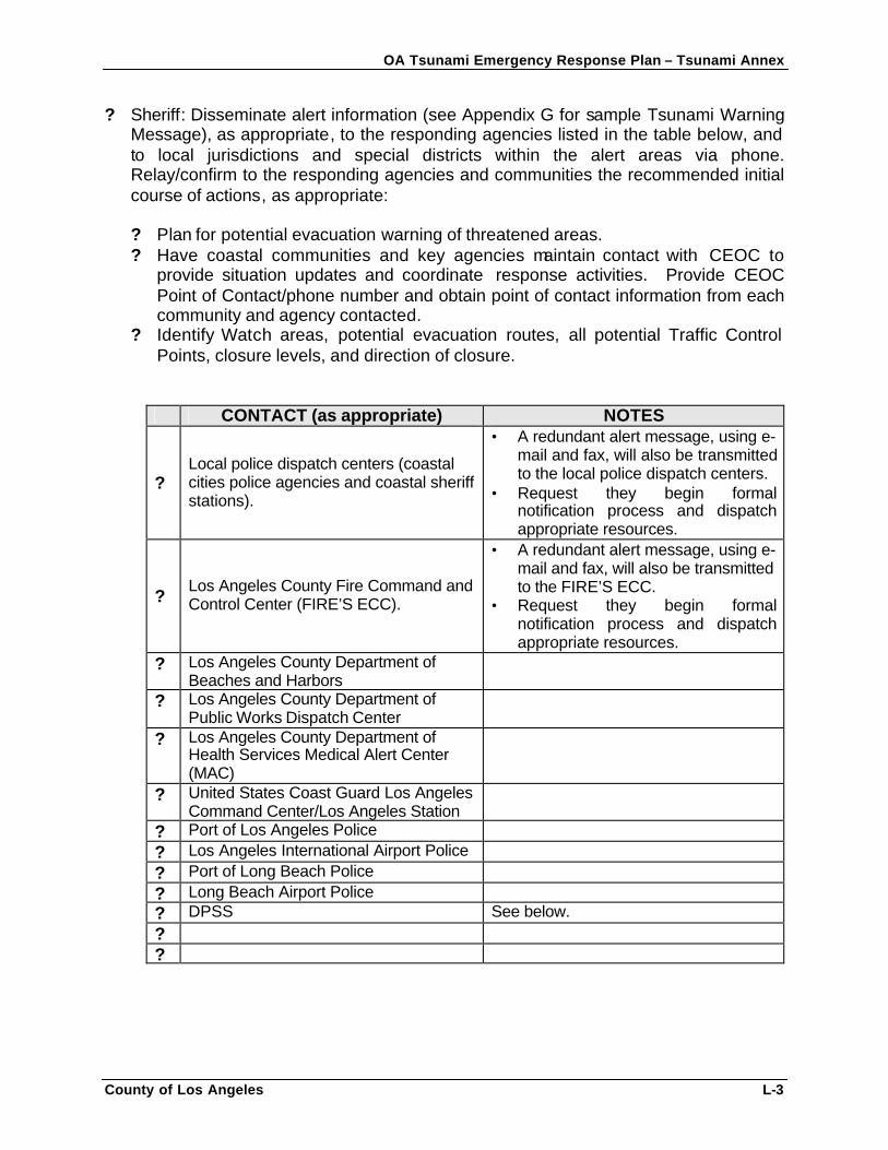
OA Tsunami Emergency Response Plan – Tsunami Annex
County of Los Angeles L-3
? Sheriff: Disseminate alert information (see Appendix G for sample Tsunami Warning Message), as appropriate, to the responding agencies listed in the table below, and to local jurisdictions and special districts within the alert areas via phone. Relay/confirm to the responding agencies and communities the recommended initial course of actions, as appropriate: ? Plan for potential evacuation warning of threatened areas. ? Have coastal communities and key agencies maintain contact with CEOC to
provide situation updates and coordinate response activities. Provide CEOC Point of Contact/phone number and obtain point of contact information from each community and agency contacted.
? Identify Watch areas, potential evacuation routes, all potential Traffic Control Points, closure levels, and direction of closure.
CONTACT (as appropriate) NOTES
? Local police dispatch centers (coastal cities police agencies and coastal sheriff stations).
• A redundant alert message, using e-mail and fax, will also be transmitted to the local police dispatch centers.
• Request they begin formal notification process and dispatch appropriate resources.
? Los Angeles County Fire Command and Control Center (FIRE’S ECC).
• A redundant alert message, using e-mail and fax, will also be transmitted to the FIRE’S ECC.
• Request they begin formal notification process and dispatch appropriate resources.
? Los Angeles County Department of Beaches and Harbors
? Los Angeles County Department of Public Works Dispatch Center
? Los Angeles County Department of Health Services Medical Alert Center (MAC)
? United States Coast Guard Los Angeles Command Center/Los Angeles Station
? Port of Los Angeles Police ? Los Angeles International Airport Police ? Port of Long Beach Police ? Long Beach Airport Police ? DPSS See below. ? ?
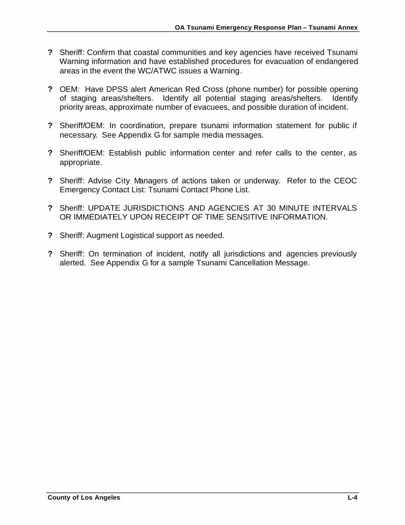
OA Tsunami Emergency Response Plan – Tsunami Annex
County of Los Angeles L-4
? Sheriff: Confirm that coastal communities and key agencies have received Tsunami Warning information and have established procedures for evacuation of endangered areas in the event the WC/ATWC issues a Warning.
? OEM: Have DPSS alert American Red Cross (phone number) for possible opening
of staging areas/shelters. Identify all potential staging areas/shelters. Identify priority areas, approximate number of evacuees, and possible duration of incident.
? Sheriff/OEM: In coordination, prepare tsunami information statement for public if
necessary. See Appendix G for sample media messages. ? Sheriff/OEM: Establish public information center and refer calls to the center, as
appropriate. ? Sheriff: Advise City Managers of actions taken or underway. Refer to the CEOC
Emergency Contact List: Tsunami Contact Phone List. ? Sheriff: UPDATE JURISDICTIONS AND AGENCIES AT 30 MINUTE INTERVALS
OR IMMEDIATELY UPON RECEIPT OF TIME SENSITIVE INFORMATION. ? Sheriff: Augment Logistical support as needed. ? Sheriff: On termination of incident, notify all jurisdictions and agencies previously
alerted. See Appendix G for a sample Tsunami Cancellation Message.
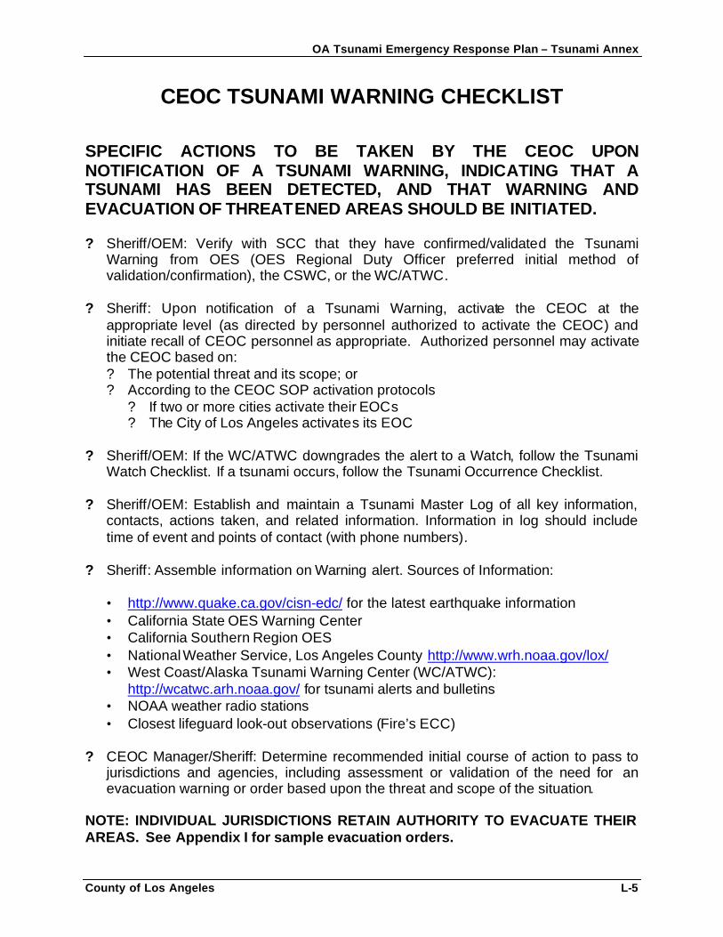
OA Tsunami Emergency Response Plan – Tsunami Annex
County of Los Angeles L-5
CEOC TSUNAMI WARNING CHECKLIST SPECIFIC ACTIONS TO BE TAKEN BY THE CEOC UPON NOTIFICATION OF A TSUNAMI WARNING, INDICATING THAT A TSUNAMI HAS BEEN DETECTED, AND THAT WARNING AND EVACUATION OF THREATENED AREAS SHOULD BE INITIATED. ? Sheriff/OEM: Verify with SCC that they have confirmed/validated the Tsunami
Warning from OES (OES Regional Duty Officer preferred initial method of validation/confirmation), the CSWC, or the WC/ATWC.
? Sheriff: Upon notification of a Tsunami Warning, activate the CEOC at the
appropriate level (as directed by personnel authorized to activate the CEOC) and initiate recall of CEOC personnel as appropriate. Authorized personnel may activate the CEOC based on: ? The potential threat and its scope; or ? According to the CEOC SOP activation protocols
? If two or more cities activate their EOCs ? The City of Los Angeles activates its EOC
? Sheriff/OEM: If the WC/ATWC downgrades the alert to a Watch, follow the Tsunami
Watch Checklist. If a tsunami occurs, follow the Tsunami Occurrence Checklist.
? Sheriff/OEM: Establish and maintain a Tsunami Master Log of all key information, contacts, actions taken, and related information. Information in log should include time of event and points of contact (with phone numbers).
? Sheriff: Assemble information on Warning alert. Sources of Information:
• http://www.quake.ca.gov/cisn-edc/ for the latest earthquake information • California State OES Warning Center • California Southern Region OES • National Weather Service, Los Angeles County http://www.wrh.noaa.gov/lox/ • West Coast/Alaska Tsunami Warning Center (WC/ATWC):
http://wcatwc.arh.noaa.gov/ for tsunami alerts and bulletins • NOAA weather radio stations • Closest lifeguard look-out observations (Fire’s ECC)
? CEOC Manager/Sheriff: Determine recommended initial course of action to pass to jurisdictions and agencies, including assessment or validation of the need for an evacuation warning or order based upon the threat and scope of the situation.
NOTE: INDIVIDUAL JURISDICTIONS RETAIN AUTHORITY TO EVACUATE THEIR AREAS. See Appendix I for sample evacuation orders.
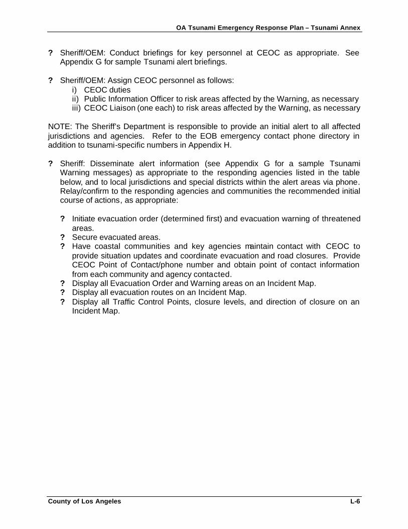
OA Tsunami Emergency Response Plan – Tsunami Annex
County of Los Angeles L-6
? Sheriff/OEM: Conduct briefings for key personnel at CEOC as appropriate. See Appendix G for sample Tsunami alert briefings.
? Sheriff/OEM: Assign CEOC personnel as follows:
i) CEOC duties ii) Public Information Officer to risk areas affected by the Warning, as necessary iii) CEOC Liaison (one each) to risk areas affected by the Warning, as necessary
NOTE: The Sheriff’s Department is responsible to provide an initial alert to all affected jurisdictions and agencies. Refer to the EOB emergency contact phone directory in addition to tsunami-specific numbers in Appendix H. ? Sheriff: Disseminate alert information (see Appendix G for a sample Tsunami
Warning messages) as appropriate to the responding agencies listed in the table below, and to local jurisdictions and special districts within the alert areas via phone. Relay/confirm to the responding agencies and communities the recommended initial course of actions, as appropriate: ? Initiate evacuation order (determined first) and evacuation warning of threatened
areas. ? Secure evacuated areas. ? Have coastal communities and key agencies maintain contact with CEOC to
provide situation updates and coordinate evacuation and road closures. Provide CEOC Point of Contact/phone number and obtain point of contact information from each community and agency contacted.
? Display all Evacuation Order and Warning areas on an Incident Map. ? Display all evacuation routes on an Incident Map. ? Display all Traffic Control Points, closure levels, and direction of closure on an
Incident Map.
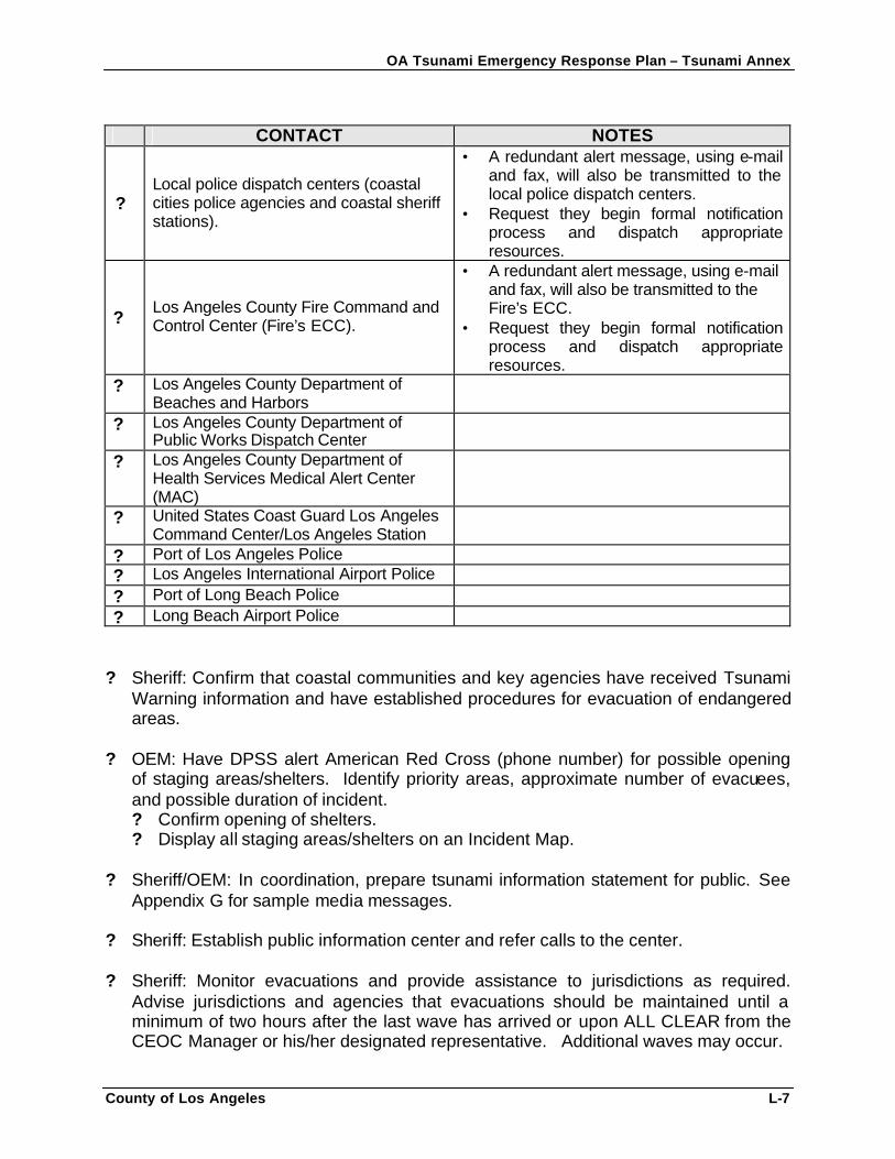
OA Tsunami Emergency Response Plan – Tsunami Annex
County of Los Angeles L-7
CONTACT NOTES
? Local police dispatch centers (coastal cities police agencies and coastal sheriff stations).
• A redundant alert message, using e-mail and fax, will also be transmitted to the local police dispatch centers.
• Request they begin formal notification process and dispatch appropriate resources.
? Los Angeles County Fire Command and Control Center (Fire’s ECC).
• A redundant alert message, using e-mail and fax, will also be transmitted to the Fire’s ECC.
• Request they begin formal notification process and dispatch appropriate resources.
? Los Angeles County Department of Beaches and Harbors
? Los Angeles County Department of Public Works Dispatch Center
? Los Angeles County Department of Health Services Medical Alert Center (MAC)
? United States Coast Guard Los Angeles Command Center/Los Angeles Station
? Port of Los Angeles Police ? Los Angeles International Airport Police ? Port of Long Beach Police ? Long Beach Airport Police
? Sheriff: Confirm that coastal communities and key agencies have received Tsunami
Warning information and have established procedures for evacuation of endangered areas.
? OEM: Have DPSS alert American Red Cross (phone number) for possible opening of staging areas/shelters. Identify priority areas, approximate number of evacuees, and possible duration of incident. ? Confirm opening of shelters. ? Display all staging areas/shelters on an Incident Map.
? Sheriff/OEM: In coordination, prepare tsunami information statement for public. See Appendix G for sample media messages.
? Sheriff: Establish public information center and refer calls to the center. ? Sheriff: Monitor evacuations and provide assistance to jurisdictions as required.
Advise jurisdictions and agencies that evacuations should be maintained until a minimum of two hours after the last wave has arrived or upon ALL CLEAR from the CEOC Manager or his/her designated representative. Additional waves may occur.
OA Tsunami Emergency Response Plan – Tsunami Annex
County of Los Angeles L-8
? Sheriff: Advise City Managers of actions taken or underway. Refer to the CEOC
Emergency Contact List: Tsunami Contact Phone List. ? Sheriff: UPDATE JURISDICTIONS AT 30 MINUTE INTERVALS OR IMMEDIATELY
UPON RECEIPT OF TIME SENSITIVE INFORMATION. ? Sheriff: Augment Logistical support as needed. ? Sheriff: On termination of incident, notify all jurisdictions and agencies previously
alerted. See Appendix G for a sample Tsunami Cancellation Message.
OA Tsunami Emergency Response Plan – Tsunami Annex
County of Los Angeles L-9
CEOC TSUNAMI OCCURRENCE CHECKLIST SPECIFIC ACTIONS TO BE TAKEN BY EACH AGENCY IF A TSUNAMI OCCURS AND DAMAGE RESULTS ? Sheriff: Activate the CEOC to full level as appropriate and if not done so already. ? Sheriff/OEM: Complete Tsunami Warning Checklists steps as appropriate and if not
done so already. ? Sheriff: Advise jurisdictions to maintain full evacuation until minimum of two hours
after arrival of last wave or upon ALL CLEAR from the CEOC Manager or his/her designated representative. Additional waves may occur.
? Sheriff: Advise jurisdictions that after a two-hour safety period, they should secure
damaged areas from re-entry by non-residents and property owners, emergency responders, and the press.
? Sheriff/OEM: Request jurisdictions initiate windshield damage assessment according
to the DIRP via EMIS. Compile area wide Damage Assessment Report for dissemination to the Area Director of Emergency Services, OES Southern Region, and State.
? Sheriff: Prepare for major PIO effort to disseminate information to public about
event. ? Sheriff: Request County health and safety agencies, and other appropriate agencies
to inspect damaged areas to ensure they are safe for residents. ? Sheriff: Upon approval by County health and safety agencies that areas are safe for
resident re-entry, allow residents, property owners, responders, the press, and other authorized individuals to enter area.
? Sheriff: Based on damage, and in coordination with OEM, consider the need for a
Los Angeles County Declaration of Emergency or Disaster. ? Sheriff: Establish response priorities and mutual aid requirements. Keep Southern
Region and State OES up-to-date on events in damaged areas. ? Sheriff: Activation, documentation, communication, and requests for assistance shall
be in conformance with SEMS utilizing EMIS and Response Information Management System (RIMS).
OA Tsunami Emergency Response Plan – Tsunami Annex
County of Los Angeles M-1
APPENDIX M: OPERATIONAL PERIOD INCIDENT OBJECTIVES
Sample objectives for CEOC operational periods include: • Provide for incident personnel and public safety and welfare. • Prioritize and provide support for/to evacuation plan implementation. • Prioritize and provide support for/to Search and Rescue operations. • Prioritize and provide support for/to Emergency Medical Services. • Prioritize and provide support for/to incident stabilization operations . • Manage incident information dissemination and releases through the JIC. • Provide for health and welfare of survivors within inundation area. • Provide incident and evacuated areas security and manage re-entry into area. • Restore/stabilize infrastructure systems and operations • Plan and implement recovery/restoration of environmental impacts. • Provide incident status reports to OES as requested. • Provide media access where public privacy and incident safety will not be
compromised. • Collect and foreword incident public information to Joint Information Center. Management will determine additional objectives based upon the operational period and incident events.
OA Tsunami Emergency Response Plan – Tsunami Annex
County of Los Angeles N-1
APPENDIX N: EMERGENCY SURVIVAL PROGRAM (ESP) PUBLIC EDUCATION CAMPAIGN
The Los Angeles County’s Emergency Survival Program (ESP) public education campaign provides tsunami preparedness information to the coastal communities and all residents throughout the County. The following brochure is a sample of the tsunami-related informational material distributed to County residents.
OA Tsunami Emergency Response Plan – Tsunami Annex
County of Los Angeles N-2
OA Tsunami Emergency Response Plan – Tsunami Annex
County of Los Angeles N-3