a great rascal: leopoldo batres and the map of … · 2018-01-02 · ayer was also one of the...
TRANSCRIPT
Number 127 | Fall 2017
A Publication of the Hermon Dunlap Smith Center for the History of Cartography at the
Newberry Library and the Chicago Map Society
A Great Rascal: Leopoldo Batres and the Map of TeotihuacánSeonaid Valiant
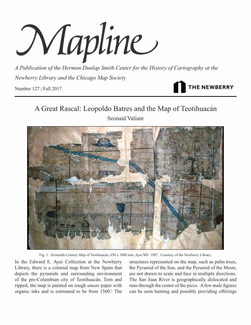
In the Edward E. Ayer Collection at the Newberry Library, there is a colonial map from New Spain that depicts the pyramids and surrounding environment of the pre-Columbian city of Teotihuacán. Torn and ripped, the map is painted on rough amate paper with organic inks and is estimated to be from 1560.1 The
structures represented on the map, such as palm trees, the Pyramid of the Sun, and the Pyramid of the Moon, are not drawn to scale and face in multiple directions. The San Juan River is geographically dislocated and runs through the center of the piece. A few male figures can be seen hunting and possibly providing offerings
Fig. 1. Sixteenth-Century Map of Teotihuacán, 650 x 1000 mm, Ayer MS 1907. Courtesy of the Newberry Library.
2 3
to the gods.In her recent scholarship, Jennifer Saracino
suggests that the map was drafted as a legal document for a land dispute between three indigenous property owners.2 It is difficult to prove this theory with any certainty—there are no notarial markings on the piece itself to indicate that it was actually used in a court case—but if the map was commissioned to settle a dispute, it is fitting, as tracing the history of this map and its circulation reveals the intersection of contentious and often conflicting stories. The map was allegedly found by an Indian man living in the region, and it was then given over to Leopoldo Batres, Mexico’s first Inspector General and Conservator of Archaeological Monuments. Rather than placing the map in the National Museum, however, in 1891 Batres sold it to an American book dealer based in Mexico City, Wilson Wilberforce Blake.3 That the individual responsible for preserving Mexico’s archaeological legacy would choose to sell off such an artifact might seem surprising, but it was hardly an isolated or unusual occurrence. From 1883 until 1911, Teotihuacán was the focus of numerous archeological explorations by Batres, and throughout this period, he would continue to sell off antiquities related to the site, such as the map of Teotihuacán, to foreign buyers. This essay reflects on the broader political context, institutional forces, and personal and professional motivations that may have led Batres to sell the map.
During the last decades of the nineteenth century, the status of archeological zones in Mexico was undergoing a transition as the government sought to exercise greater control over its national patrimony. European antiquarians had long had free reign in Mexico, which had been in a state of political turmoil for most of its brief history. Following the consolidation of political power under President Porfirio Díaz, however, the protection of antiquities—and their exploitation for political ends—became an increasing priority. Combining, strengthening, and clarifying former antiquities laws, the Porfirians passed legislation in 1885 that forbade foreigners from working at archaeological sites, particularly sites in central Mexico, unless they were granted explicit permission by the government. In that year they also founded the national archaeology
department and created the post of the Inspector General and Conservator of Archaeological Monuments of the Republic to oversee it. Leopoldo Batres, at the time a little-known antiquities dealer, was appointed to that position on October 8, 1885, and on October 17 a law was passed outlining his duties and responsibilities.4
These included the obligations to (1) conserve monuments and ruins; (2) impede excavations where proper authorization had not been given; (3) give all artifacts found to the national museum, unless authorized to export them; and (4) prevent antiquities
from leaving Mexico.5 In addition to enforcing this legislation, Batres was assigned the task of excavating and conserving archaeological monuments, such as the site at Teotihuacán.6 This immediately elevated him to a central role in Mexican archeology and placed him on an equal footing—in terms of importance, if not scientific prestige—with the foremost figures in the field.
In accordance with the antiquities law of 1885, Batres, as the national archaeologist, was one of the few people given the authority to allow an archeological artifact to leave the country. Often this authority was exercised to present gifts or souvenirs to prominent visiting foreigners. For example, Batres gave the English travel writer Mrs. Alec Tweedie (née Ethel Harley) a few ancient “whistles, cut out of shells, found close to the altar,” as gifts when she visited his excavation at the site of Escalerillas in 1900.7
This authority could also be exercised, however, to place artifacts on the open market. In 1891, Batres decided to sell two colonial maps of Teotihuacán that were on amate paper. One map was purchased by the philanthropist Duc Joseph Loubat for the anthropologist Marshall Saville to donate to the American Museum
“Blake’s notation highlights the curious, uncertain provenance of the map—a colonial map discovered in a stone box at Teotihuacán by an unnamed Indian at an unknown time—which nonetheless went unquestioned.”

2 3
of Natural History.8 The other map—that which is currently in the Ayer Collection—Batres handed over to the American book dealer Wilson Wilberforce Blake to sell from his unofficial bookshop in Mexico City.9
Blake mounted the disintegrating map on a neutral-toned background, impressed his dealer’s stamp on the background, and penciled around the edges the history of how the item had come to him. Although a small tear in the backing has deleted some of the text, Blake’s note in the top left-hand corner is discernible: “Teotihuacán... Maguey fiber found in stone box excavated some years ago long in the possession of an Indian who sold it to Leopoldo Batres, Conservator of Public Monuments.”10
Blake’s notation highlights the curious, uncertain provenance of the map—a colonial map discovered in a stone box at Teotihuacán by an unnamed Indian at an unknown time—which nonetheless went unquestioned.
In any case, the map would eventually find its way to Chicago, where Blake would sell it personally to the lumber tycoon Edward E. Ayer, most probably when Blake visited the city in 1895.11 Ayer was well known to have a deep interest in materials relating to indigenous history; he would later be listed in the American Library Annual index as a “private book collector” searching
for materials related to the “Indian history of North America.”12 It was Ayer who would eventually give the map to the Newberry Library, of which he was a trustee.13
Blake was only one of many rare book dealers who corresponded with Ayer, and the letters between them provide a fascinating window into the circulation of rare books and artifacts during this period. A series of letters from Blake to Ayer shows that the bookseller tried to persuade Ayer to purchase additional items from him directly by providing lengthy descriptions of how difficult it was to obtain the rare materials that were on offer. Blake encouraged Ayer to respond quickly by offering him discounts and stressed that he might never again have an opportunity to obtain particular items. For example, Blake offered Ayer one of seventy-five copies of a Jesuit manuscript that had never before been for sale. Blake informed Ayer, “This is an opportunity for you to secure one of them and perhaps the only chance of a lifetime, as the Jesuits guard them very carefully.”14 Blake claimed he was offering Ayer the chance to purchase items that were not yet listed in his catalog, such as the record of a “trial of a girl nine years old for heresy,” a collection
Fig. 2. Letter from W. W. Blake to Edward E. Ayer, 1899. Courtesy of the Newberry Library.

4 5
of “46 letters by Iturbide,” and an “Autographed note by Maximilian—written 6 days before he was shot.” In this same letter, Blake tried to entice Ayer by telling him, “You are the only white man that knows that these are in my possession—but of course, if I do not dispose of them before my catalogue is printed, I will insert them there.”15
Ayer was also one of the founders of the Field Museum of Natural History, and it is probable that Blake and Ayer met through the anthropologist Frederick Starr, who had been involved with the Field Museum since the preparations for the World
Columbian Exposition. During the same trip on which Ayer seems to have purchased the map of Teotihuacán, Blake brought over three thousand items collected by his acquaintances the Abadiano brothers. The Abadiano collection was destined to be purchased by Starr for the Walker Museum at the University of Chicago; in 1905, the collection was transferred to the Field Museum.16 In a letter to Starr before his visit, Blake was open about the fact that he was taking the items out of Mexico without a permit from the government, and he stressed that this trip must be kept secret until the items were in Chicago: “But I write this now to impress on the minds of your people that no information of the proposition must reach the public until the goods are safely across the frontier at last. Mexico’s laws do not permit the export of ‘archaeological monuments’ and it is an open question as to whether this collection might be considered as such.”17 After the collection had been transported, Blake informed Starr that he did not wish to repeat this “ticklish” procedure:18 “I ran a very narrow escape in getting the stuff across at Laredo and would not care to take such chances often, although the route was properly ‘greased.’”19
These men spoke openly about their efforts to circumvent Mexican antiquities laws and, in effect, to flout the authority of the Inspector General, Batres. But, as Blake highlights in his letter to Starr, the status of many artifacts was an “open question,” and, after all, it was Batres himself who was responsible for many of these artifacts—including the map of Teotihuacán—entering the marketplace. Ironically, allegations of Batres’s own greed and improprieties served as a would-be justification for individuals like Blake and Starr. Although both Blake and Starr continued to interact professionally with Batres until 1910, neither respected him, and they had no compunctions about sidestepping his authority. Blake told Starr, “Batres says he sold those casts from Teotihuacán to some American. Did you get them? If not, I shall always regret that you and I did not visit him and secure them. He is a great rascal and cheated the poor Indian who found them shamefully.”20
Such personal slanders, while perhaps containing some truth, also reflected the frustrations of European and American antiquarians and archaeologists who
Fig. 3. This map of Teotihuacán, provided by Leopoldo Batres in 1889, displays the layout of the ancient city. It was here that the map later purchased by Edward E. Ayer was found circa 1891. Leopoldo Batres, Teotihuacán: ó La cuidad sagrada de los Tolte-cas (México: Talleres de la Escuela n. de artes y oficios, 1889). Courtesy of the Newberry Library.
4 5
increasingly found their access to important sites curtailed by Batres’s office. They were clearly unhappy to submit to the authority of a Mexican official, particularly one they perceived as a bureaucrat whose scientific training was dubious.21 When Batres tried to wrest control over archaeological artifacts in Mexico, he entered into a contested field where scholars and antiquities dealers felt that they had a stake, and they would not be subdued easily. Batres describes these men and women, in general, as “negociators who consider nothing more than their own pecuniary interest, traveling like the horse of Attila, destroying all that obstructs their way.”22 As the first Inspector General, Batres was tasked with applying antiquities laws on a national scale and identifying objects that belonged to and represented his nation. Asserting that national authority—particularly when it placed him in conflict with European and American archeologists, museums, universities, and collectors—was not an easy task.
Many of the difficulties and issues that Batres faced, both logistical and ideological, were extraordinarily daunting, and he was often the first person to confront them.
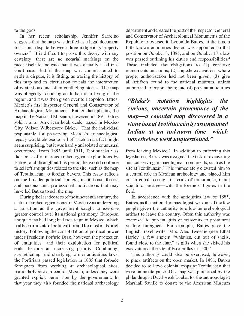
Moreover, despite the importance of Batres’s position, the scale of his digs, and the significance of archeological iconography in promoting Mexican nationalism, he was often underfunded by the Porfirian government. Thus, pressing financial reasons may have encouraged Batres’s decision to sell off items such as the map. Obtaining funding for his elaborate excavations at Teotihuacán was a chronic problem.23 Unlike many of his competitors, such as Duc Joseph Loubat, Batres was not wealthy enough to fund his own excavations, and despite repeated promises of government funding, the Inspector General invariably received less than he anticipated or deemed necessary for his ambitious projects. Díaz was consistently enthusiastic about the work that had been accomplished and did not hesitate
Fig. 4. In 1889, Leopoldo Batres included this drawing of the overgrown Pyramid of the Sun in his first publication about Teotihuacán. The ancient city would become the most important archaeological zone of his career. Leopoldo Batres. Source: Leopold Batres, Teotihuacán: ó La cuidad sagrada de los Tolte-cas (México: Talleres de la Escuela n. de artes y oficios, 1889). Courtesy of the Newberry Library.

6 7
to praise Batres, but nonetheless failed to provide adequate funding. On one occasion late in his career, overcome with frustration, he eventually went so far as to abandon the site and threatened to resign his post as Inspector General; only then was any additional money forthcoming.24 Working under such conditions, it is probable and indeed understandable that Batres was willing to part with certain items in order to finance his excavations at the site, particularly those items that he deemed of minor significance or low quality, those that he suspected of being forgeries, or those for which he retained duplicates.
Another factor that likely contributed to Batres’s decision to sell the map of Teotihuacán to Blake was the question of whether it should, in fact, be considered an antiquity. At this time, the question of the precise status of artifacts recovered from archeological sites—as Blake highlighted above in his letter to Starr—was a matter of some ambiguity. Debates raged over how such material culture should be classified, and such debates intersected with questions of legal authority and ownership. What constituted an antiquity? Was the term properly applicable only to pre-Columbian artifacts? What was the status of items, such as the map of Teotihuacán, that originated in the Colonial period?
In 1897, the Porfirian government sought to bring some clarity to these issues and passed legislation in which antiquities were clearly defined as codices, idols, amulets, and furniture, and at the same time they were ambiguously defined to include anything else that the government estimated to be of interest to the study of the history of the ancient aboriginal populations of the Americas.25 This allowed Batres a great deal of latitude in establishing what artifacts would be privileged and also placed a strong emphasis on the importance of precontact civilizations. Although the map was supposedly found in the ancient city of Teotihuacán, it was clearly crafted in the colonial era, and Batres was chiefly interested in the recovery of pre-Columbian items. This may have contributed to his decision to part with the map, despite the fact that Teotihuacán remained the most important site of Batres’s activities throughout his tenure as Inspector General; he was so devoted to the site, in fact, that he built a museum there specifically dedicated to housing
artifacts from his Teotihuacán excavations. It was for his finds at Teotihuacán that Batres hoped he would be best remembered, and it was on his archeological work there that, for better or worse, his professional reputation would ultimately depend.
Nearly twenty years after selling the map of Teotihuacán to Blake, Batres presented the excavated city and its centerpiece, the Pyramid of the Sun, to the world at the 1910 celebrations of the centennial of Mexican independence; as part of the celebration, Mexico hosted that year’s meeting of the International Congress of Americanists (ICA). In September 1910, Batres led a tour through the excavated city of Teotihuacán for the gathered conference members from the ICA. The congregation included leading anthropologists of the day, such as Franz Boas, Fredrick Starr, and Zelia Nuttall, and it is likely that the bookseller Wilson Wilberforce Blake was there as well. In a letter held in the Newberry Archives, Blake informs Ayer’s niece and librarian Clara Smith—in another indication of the close ties between archaeological scholarship and the marketplace—that he expects to sell most of his inventory when he hosts members of the “Americanist Congress” in his new Mexico City location in September 1910.26
Saracino emphasizes that Teotihuacán was a contested space in the colonial period, and Christina Bueno has shown that it was no less so at the turn of the twentieth century.27 The site of Teotihuacán, and in particular the newly uncovered Pyramid of the Sun, was intended to impress upon its visitors the grandeur and power of Mexico’s archaeological riches, and Batres expected to be praised for his work in excavating it; to his surprise, he was widely condemned by the international community of archaeologists. His grand project at Teotihuacán was intended to provide the centerpiece for the celebration and act as a vivid demonstration of the Díaz regime’s commitment to and identification with Mexico’s archaeological legacy. Unfortunately for Batres, the results were disastrous for his international reputation, and his work was subjected to intense criticism.
In particular, Batres’s contemporaries condemned his excavation of the Pyramid of the Sun, in which he had stripped the pyramid of its murals and

6 7
added an unstable, archeologically controversial platform. Furthermore, the accusation arose that he had lined his own pockets by selling items abroad.28
For example, it had not been forgotten that Batres sold the map of Teotihuacán. Coincidentally, the first piece of modern scholarship on the map was actually presented on the first day of the conference: Stansbury Hagar, who had recently consulted photographs of the map of Teotihuacán taken at the Newberry Library, proposed that it was a celestial map and argued that it gave evidence that Teotihuacán was one of the major centers of a religious cult based on the constellations that stretched across the Americas.29 Frederick Starr noted, after his visit during the ICA, that none of the beautiful pieces he had seen excavated on earlier visits had been placed in the Museo de Teotihuacán, and he questioned their whereabouts. He asked, “But so many, many, fine things have gone—and who knows whether all the unique things hereafter will be kept.”30
Furthermore, the American writer Henry Baerlein claimed that Batres had been overheard at a dinner party saying that his government position did not pay him enough to live in a “gentlemanly style” and that Batres was thereby implying that he augmented his income by trading in antiquities.31 Díaz’s biographer Carleton Beals, interpreting Batres’s behavior as Porfirian policy, went so far as to term Batres a thief and an “adornment” for the Porfirian administration: “A wholesale and retail merchant in antiquities, he rifled the nation of its archaeological treasures, blew up an Uxmal arch to steal a statue, robbed the treasures of Mitla...He also grafted illegal permits to take art objects out of the country. The public joked: ‘Señor Batres, excavating in the pyramids, has already gotten out two automobiles.’”32
Unfortunately for the Inspector General, he did not have long to defend his reputation. Like many other Porfirians, Batres fled Mexico in 1911 to escape the Revolution. That was when his enemies—many of whom were archaeologists he had “driven from the field” by exerting personal authority over Mexico’s archeological zones—began publishing their criticisms of his work at Teotihuacán.33 The reputation of this complicated and controversial figure has never recovered, and he has been widely dismissed as a caricature of the greedy, corrupt Porfirian official. Hopefully, this brief history tracing the
Newberry’s map of Teotihuacán and its circulation has given a window into how that story is more complicated and nuanced than it might at first appear.
Seonaid Valiant, Ph.D. (History, University of Chica-go) is the Curator of Latin American Studies at Ari-zona State University Library and the former Ayer Ref-erence Librarian at the Newberry Library. She is the author of Ornamental Nationalism: Archaeology and Antiquities in Mexico, 1876-1911 (Brill, 2018), which examines international debates over the meaning of Aztec symbols and the professionalization of arche-ology in Mexico at the turn of the twentieth century.
NotesI thank Peter Nekola for suggesting that I write this article. Barbara Mundy kindly introduced me to new resources and to people who understand maps much better than I do. Jennifer Saracino generously shared a draft of her forthcoming article. Once again, Kathleen Feeney set me on the right track in the archive, and I am also grateful to Joseph Mills, who offered comments on this piece.
1 “Map of Teotihuacán,” Newberry Library, Ayer Collection, Oversize-Artifacts Cage, Ayer MS 1907.2 Jennifer Saracino, “Staking claim on native lands: the symbolic power of Indigenous cartographic convention in the Ayer map of Teotihuacán Mexico (1560) and its copies,” in Mapping Nature across the Americas, eds. James Akerman and Kathleen Brosnan, (Chicago: University of Chicago Press), forthcoming.3 “Map of Teotihuacan,” Ayer MS 1907.4 Letter from Leopoldo Batres to Porfirio Díaz, July 12, 1884, Catalog no. 006041, Archivo Porfirio Díaz de la Universidad Iberoamericana.5 Sonia Lombardo de Ruiz and Ruth Solis Vicarte, Antecedentes de las leyes sobre monumentos históricos, 1536-1910 (México D.F.: INHA, 1988), 62.6 Ibid, 40-41.7 Mrs. Alec Tweedie (née Ethel Harley), Mexico, As I Saw It (London: Hurst and Blackett, 1901), 209-213. Leopoldo Batres, Archaeological Explorations in Escalerillas Street, City of Mexico (México: J. Aguilar Vera, 1900, 1902), 5.8 Map of Teotihuacán (San Francisco Mazapan, Teotihuacán, [Amate] American Museum of Natural History, catalog no. 30.1/4438). 9 S. Hagar, “Celestial plan of Teotihuacán,” Congreso Internacional de Americanistas, Septiembre de 1910 (published 1912), 160. A perusal of a few of Blake’s catalogs from 1899 to 1910 shows that Blake often kept five or more of Batres’s own titles in the store. Wilson Wilberforce Blake, Catalogue of Second-Hand Books and Manuscripts: Being a Collection of Rare Volumes Relating Chiefly to Spanish America, (Mexico: F. P. Hoeck), 1899-1910. 10 “Map of Teotihuacan,” Ayer MS 1907.

8 9
11 Letter to Stansbury Hagar from Clara Smith, 29 October 1909, Newberry Archives, Series 02: Edward E. Ayer Papers, 1842-1934, Box 1, Folder 14. Newberry Library. Edward Everett Ayer, “In RE: Founding of the Field Museum,” Fieldiana Anthropology. Curators, Collections, and Contexts: Anthropology at the Field Museum, 1893-2002. New Series, No.26, (September 30, 2003). 49-52.12 The American Library Annual: Including Index to Dates of Current Events; Necrology of Writers; Bibliographies; Statistics of Book Production; Select Lists of Libraries; Directories of Publishers and Booksellers; List of Private Collectors of Books, etc. (New York: Office of the Publishers’ Weekly 1912), 201. 13 Hagar, 60.14 Letter from W.W. Blake to Edward E. Ayer, Mexico, 11 December 1899. Newberry Archives, Series 02: Edward E. Ayer Papers, 1842-1934, Bulk, 1880-1934, Box 1, Folder 4. Newberry Library.15 Letter from W.W. Blake to Edward E. Ayer, 19 November 1898, Newberry Archives, Series 02: Edward E. Ayer Papers, 1842-1934, Bulk, 1880-1934, Box 1, Folder 3. Newberry Library. 16 Donald McVicker, Frederick Starr: Popularizer of Anthropology, Public Intellectual, and Genuine Eccentric (New York: Altamira Press, 2012), 65-66. Dennis Carr, “A Mexican Map Abroad: The Beinecke Map in the Nineteenth and Twentieth Centuries,” Painting a Map of Sixteenth-Century Mexico City: Land, Writing, and Native Rule, edited by Mary E. Miller and Barbara E. Mundy. (Beinecke Rare Book and Beinecke Rare Book and Manuscript Library, Yale University, 2012), 163. 17 W.W. Blake to Fredrick Starr, 5 December 1894. Frederick Starr Papers, Special Collections Research Center (SCRC), University of Chicago Library. Box 1, Folder 11.18 “I can guarantee the delivery of the entire collection on the other side of the Rio Grande—a ticklish thing to do as the government objects for $3,000.” W.W. Blake to Fredrick Starr, 17 November 1894. Frederick Starr Papers, SCRC, University of Chicago Library. Box 1, Folder 11.19 W.W. Blake to Fredrick Starr, 27 February 1895. Frederick Starr Papers, SCRC, University of Chicago Library. Box 1, Folder 11.20 Ibid.21 Zelia Nuttall, “Island of Sacrificios,” American Anthropologist. Volume 12 (1910). Alfred P. Maudslay, “Recent Archaeological Discoveries in Mexico,” The Journal of the Royal Anthropological Institute of Great Britain and Ireland, Volume 43 (London: The Royal Anthropological Institute of Great Britain and Ireland, January-June, 1913), 12. 22 Leopoldo Batres, Archaeological Explorations in Escalerillas Street, City of Mexico (México: J. Aguilar Vera, 1900, 1902), 5.23 Batres’s first attempt to obtain funding came in 1885, only a few weeks into his new position as Inspector General. Batres attempted to persuade Díaz to provide funding for a dig and asked him to supply fifty men from the Ministry of the Military to assist him, but his request was not granted at that time. Letter from Batres to Díaz, November 1885, Catalog no. 009909, Archivo Porfirio Díaz de la Universidad Iberoamericana.24 Frederick Starr Papers, University of Chicago, SCRC, Box 21a,
Folder 4, October 15, 1904, 15, 26.25 Lombardo, 66-68.26 Letter from W.W. Blake to Clara Smith, 27 July 1910, Newberry Archives, Series 02: Edward E. Ayer Papers, 1842-1934, Bulk, 1880-1934, Box 1, Folder 5. Newberry Library. 27 Saracino, forthcoming. Bueno has shown that, before excavating the Pyramid of the Sun, Batres had to purchase every parcel of land around the pyramids and mounds from the peasants and indigenous people that lived and grew food there. Batres and the local people resented each other, and the process became drawn out and expensive. Cristina Bueno, “Teotihuacán: Showcase for the Centennial, Holiday in Mexico: Critical Reflections on Tourism and Tourist Encounters. Edited by Dina Berger and Andrew Grant Wood. (Durham: Duke University Press, 2010), 63-64.28 Henry Baerlein, Mexico, the Land of Unrest; Being Chiefly an Account of What Produced the Outbreak in 1910, Together with the Story of the Revolutions Down to This Day (London: Herbert and Daniel, 1913), 104-105.29 Hagar, 9.30 Frederick Starr Papers, SCRC, University of Chicago Library. Box 21a, Folder 8, notebook #3, 1910, 20. 31 Baerlein, 104-109.32 Carleton Beals, Porfirio Díaz: Dictator of Mexico (Philadelphia: J.B. Lippincott, 1932), 338. Baerlein, 106. 33 Nuttall, Note 1, 282.
Smith Center NewsNewberry Announces NEH-Funded
Summer Seminar, Reading Material Maps
The Smith Center and the Newberry were honored to receive a grant this summer from the National Endowment for the Humanities to support a four-week summer seminar for K-12 schoolteachers.
Reading Material Maps in the Digital Age will be codirected by center director Dr. James Aker-man and Dr. Peter Nekola (Luther College). Sixteen K-12 educators will be selected from a national pool of applicants to participate in the program, which will run from July 9 to August 3, 2018. While inves-tigating current topics and research in the history of cartography, the seminar will offer the participating summer scholars an opportunity to immerse them-selves in one of the world’s finest collections of his-torical map documents, developing their critical map

8 9
reading and scholarly skills, and exploring ways in which they might apply these skills to their teaching.
As its title suggests, next year’s seminar will give particular consideration to digital images of historic maps. It will also look at their role in the meaning and classroom use of the material objects upon which these digital surrogates are based. The exciting pro-gram will feature a series of seminar lectures, work-shops, and field trips. The participants will also devel-op and pursue their own research projects. For further information about the seminar and how to apply, please see: www.readingmaterialmaps.wordpress.com.
The Smith Center Welcomes New Program Assistant
Kara Johnson joins us from Northwestern University, where she recently received her PhD in English. Her dissertation concerns the representation of labor in nine-teenth- and twentieth-century American literature. Ka-ra’s work at the Smith Center—including her position as Managing Editor for Mapline—allows her to think fur-ther about the impact of material history and culture on her research. Alongside her role at The Newberry, she teaches American literature, gender studies, and film at Chicago-area colleges and non-profit institutions.
CMS NEWS
More on Our New LogoIn the last issue of Mapline, Dennis McClendon took us through the process for his design of the Chicago
Map Society logo. He noted that the Chicago stars are used to represent the essence of putting the fea-tures of the spherical earth onto a flat surface. These stars appear on Chicago’s official flag and repre-sent four major events in the city’s history: Incor-poration as a town in 1833; the Great Fire of 1871; the World’s Columbian Exposition of 1893; and, the Century of Progress International Exposition in 1933.
Once again, congratulations to Dennis on his dy-namic design, and also to the City of Chicago, which will celebrate its 175th anniversary on August 5, 2018.
Our May 2017 Meeting:A CMS Member’s Perspective
Wilbert Stroeve
The May meeting of the Chicago Map Society featured Mr. Murray Hudson, a dealer in antique maps, globes, books, and prints. His presentation, focusing on globes that were made in Chicago, traced the many globe-makers that had their operations in this city following the Great Chicago Fire of 1871. In fact, Mr. Hudson noted, “in the century after recovering from the Great Fire of 1871 until the 1970s, Chicago established on its ‘broad shoulders’ the greatest globe design and manu-facturing powerhouse (facilities) in the United States.”
It isn’t often that speakers bring historical items to their presentations. And yet, despite traveling 500 miles, Mr. Hudson brought numerous globes and their stands, including (to mention but a few) a beautiful 1872 A. H. Andrews globe on a metal stand, a miniature Schedler globe on a unique pencil sharpener base from the 1893 World’s Columbian Exposition, and a 1932 Weber Costello globe on an art-deco “flying-V” stand.
Seeing these objects in person made the presenta-tion all the more enjoyable. What struck me is that a globe is not of much use if it isn’t mounted some-how to allow easy rotation and access. Mr. Hudson showed not only globes but variations of stands, an important feature of globes that could be a topic in its own right. Mr. Hudson also showed various manuals and instruction booklets that came with the original

10
globes. This reminded me of when I was a child, and my father had purchased a globe from National Geo-graphic that had a light in it. The globe came with a clear plastic half sphere that had lines and scales on it; one could measure the distance between any two points, and see how that straight line on a sphere would translate to an arc on a 2-dimensional map.
Mr. Hudson has a large stock of rare and an-tique globes, maps, prints and books in his Hall, Tennessee establishment, and he is working dili-gently to make most of his inventory available via the web at www.antiquemapsandglobes.com.
Chicago Cartographic Rarity Fetches Record Price
Mary McMichael Ritzlin & George Ritzlin
James Palmatary’s 1857 bird’s-eye view of Chi-cago was the star performer at the map and book auction conducted September 13, 2017, in Chicago at Leslie Hindman Auctioneers.
Of the 346 lots at the auction, more than 100 con-sisted of maps, atlases, and views. Local collectors and dealers were on hand, and the auction house’s bustling phone bank and computer stations were manned by attentive staff—a dozen or so aides in all.
This large pre-fire imprint (117.5 x 205 cm), a four-sheet lithograph with original hand color—so highly detailed that it even shows individual houses—gen-erated a lot of interest. This example of Palmatary’s Chicago is one of four known copies, considered to be in the best condition of the survivors, and the first to appear at auction in almost a century. Other copies are held at The Chicago History Museum, the Library of Congress, and of course, here at the Newberry Library.Competition was brisk, and excitement in the room rose palpably as bids quickly exceeded $100,000. This number exceeded the pre-sale estimate of $20,000 - 30,000. Spectators broke into applause when they announced the winning phone bid of $160,000, a fi-nal total of $197,000 with the buyer’s premium.
Upcoming Events inOur 2017-2018 Program Year
Thursday, November 16, 2017The Rockford Map Company: County Plat Books for the Twentieth and Twenty-First CenturiesSpeakers: Charlie Lunn and Brock Alekna
Thursday, December 21, 2017Annual Holiday Gala and Members’ Show-and-TellSpeakers: Members of the Chicago Map Society
Thursday, January 4, 2018The Life and Work of Jo Mora*Speaker: Peter Hiller*This event will be co-hosted by the Caxton Club
Thursday, January 18, 2018Beyond Google Maps: Map Usage in the 21st CenturySpeaker: Dennis McClendon
Thursday, February 15, 2018Land Surveying and Mapmaking TransformedSpeaker: Carl Kupfer
Thursday, March 15, 2018Treasures from the Archives of Greeley-Howard-Nor-lin & SmithSpeakers: Don and Tanya Smith
Thursday, April 19, 2018The Maps of the Peruvian Amazon made by the Fran-ciscans in the Second Half of the 18th CenturySpeaker: Carmé Montaner
Thursday, May 17, 2018Book Party celebrating the publication of Neighbor-hoodsSpeaker: Emily Talen
Thursday, June 21, 2018Annual Field Trip to the Barry MacLean CollectionSpeaker: TBA

11
Fig. 5. Charles Williams and C. M. Barnes, Farm House Map Larue Co. Ky.(Chicago: Rand McNally, 1889). Courtesy of the Newberry Library.
Found Maps: Great Maps from Hidden Corners
Jim Akerman
While recently doing some research on the history of American railroad mapping in the nineteenth century, I was astonished to find this gem in the Newberry’s Illinois Central Archives. This land ownership map had been pub-lished by Rand McNally, although the meticulous house-to-house research, design, and drafting was entirely local. Three other copies are reported in the WorldCat online catalogue, including a copy at the University of Chicago.
The Hermon Dunlap Smith Center for the History of Cartography was founded in 1972 to advance knowledge of the his-tory of cartography and to promote the use of the Newberry’s cartographic collections. Among the many programs it sponsors to
achieve these goals are institutes and seminars, research fellow-ships, exhibitions, workshops for educators and public histori-ans, public lecture series, and a variety of print and electronic publications. Director: James R. Akerman
The Chicago Map Society is the old-est map society in North America, and has held monthly meetings at The Newberry since 1976. We typi-cally meet the third Thursday of every month during the academic year (Sep-tember through June). Meetings start
at 5:30 p.m. with a social half-hour, followed by an hour presen-tation on a cartographic subject of interest to our membership.
President: Robert A. Holland

12
First issued in 1976, Mapline is co-published by the Hermon Dunlap Smith Center for the History of Cartography and the Chicago Map Society, both of which are housed at The Newberry in Chicago. Mapline serves to keep its readers informed of each organiza-tion’s work, including their publications and sponsored events. More generally, Mapline is devoted to advancing knowledge of the history of cartography by reporting events, ideas, and isues in the field. In addition to printing short articles reflecting current research, it functions as a bulletin to announce recent acquisitions to the cartographic collections at The Newberry. It also contains brief reports on conferences, exhibitions, societies, and lectures beyond The Newberry.
Managing Editor: Kara Johnson. Editorial Board: James R. Akerman, David Buisseret, Gerald A. Danzer, Robert Holland, D. Brad-ford Hunt, Kara Johnson, Mary McMichael Ritzlin, and Wilbert Stroeve.
Submissions and editorial correspondence may be directed to: Kara Johnson, [email protected]. To receive a subscription to Mapline, please contact:
The Hermon Dunlap Smith CenterNewberry Library
60 W. Walton StreetChicago, IL 60610
Reading Material Maps:An NEH Summer Seminar for K-12 Teachers
July 9, 2018 – August 3, 2018The Newberry Library
Co-Directors: Dr. James Akerman (Newberry Library) and Dr. Peter Nekola (Luther College)
The deadline to apply is March 1, 2018. For more information on the seminar, program faculty, stipend and housing information, and how to apply, please go to the Reading Material Maps website: readingmaterialmaps.wordpress.com.