travel management plan - epa · 2019-04-06 · travel management plan – version 2 (galleria)...
TRANSCRIPT
Travel Management Plan for
Sylvia Park
286 Mount Wellington Highway, Mount Wellington
September 2016
Revision History
Date Issue Description
April 2016 1 Version 1 for “Office G” RC Application
September 2016 2 Version 2 for “Galleria” RC Application

Travel Management Plan – Version 2 (Galleria) Prepared by Sarah Burgess B&A Ref: 3033-11 2 Reviewed by Gerard Thompson
1.0 INTRODUCTION
This Travel Management Plan has been prepared for Sylvia Park, 286 Mount Wellington Highway, Auckland. Sylvia Park is owned by Kiwi Property Limited (Kiwi) and construction began on the centre in 2004.
Sylvia Park has been the subject of two private plan changes. The most recent plan change (2010) resulted in a new concept plan for Sylvia Park (Ref: G14-15) being incorporated into the Operative District Plan. Under the Proposed Auckland Unitary Plan, Sylvia Park is zoned as a Metropolitan Centre. Metropolitan Centres are second only to the CBD as regional hubs for retail, commerce, entertainment, and accommodation.
The current development at Sylvia Park (either already constructed or currently under construction) consists of the following uses:
• Retail: 56,400m² GFA • Food and Beverage: 3,747m² GFA • Other: 13,253m² GFA • Car parks: 4,358 spaces
There are also resource consents in place for four office buildings containing a total of 48,000m² of GFA that have not yet been constructed. Resource consent has also recently been granted for Office Building G, which will provide for 11,300m² GFA of office, and 4,340m² GFA of retail, food and beverage and other activities. This Travel Management Plan has been updated in support of an application for ‘Galleria’, a second storey retail expansion of the southern mall which will provide for 17,720m² of retail space including food and beverage tenancies, plus 303m² of amenity areas (a crèche and toilets). The proposal also involves construction of a new multi-level car parking building known as ‘SEM’ which will provide for 83 new car parking spaces (many spaces are removed by the Galleria addition), bringing the total parking spaces on the site to 4,347.
Sylvia Park is located at the confluence at several pieces of regionally significant infrastructure: the Southern Motorway (State Highway 1) to the south; Mount Wellington Highway to the west; the North Island main trunk rail corridor to the east; and is bisected by the South Eastern Arterial (“SEART”). Sylvia Park has three signalised entry points from the west off Mount Wellington Highway, one from the east off Carbine Road and one from the north off Stud Way (which connects to Waipuna Road via Lynton Road).
The land use activities surrounding Sylvia Park are varied, with light industrial to the east and south, large format retail to the west, and residential to the north and west. It is anticipated that the land uses surrounding Sylvia Park will change over the course of the next 30 years through the application of the Metropolitan Centre to the site and the Mixed Use zoning to the land to the east
Travel Management Plan – Version 2 (Galleria) Prepared by Sarah Burgess B&A Ref: 3033-11 3 Reviewed by Gerard Thompson
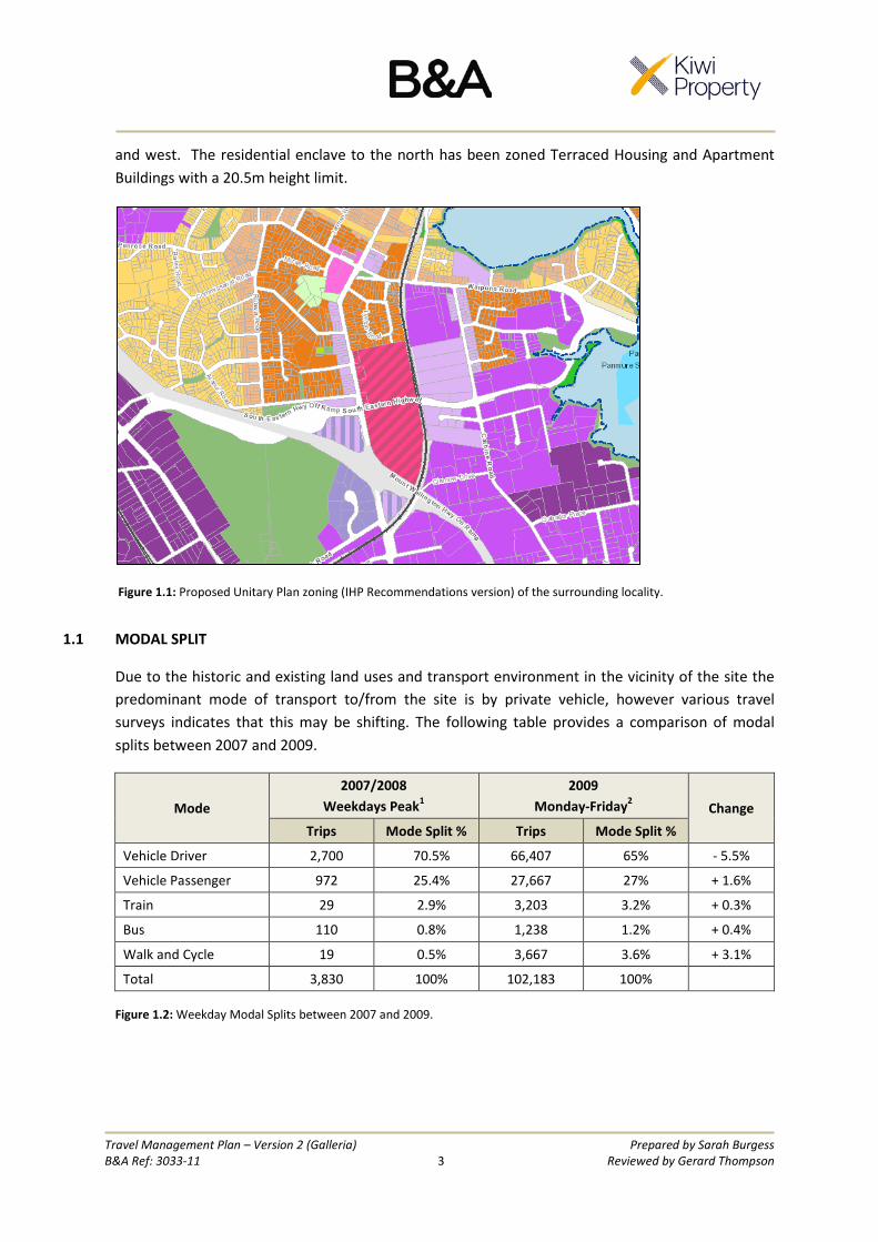
and west. The residential enclave to the north has been zoned Terraced Housing and Apartment Buildings with a 20.5m height limit.
Figure 1.1: Proposed Unitary Plan zoning (IHP Recommendations version) of the surrounding locality.
1.1 MODAL SPLIT
Due to the historic and existing land uses and transport environment in the vicinity of the site the predominant mode of transport to/from the site is by private vehicle, however various travel surveys indicates that this may be shifting. The following table provides a comparison of modal splits between 2007 and 2009.
Mode 2007/2008
Weekdays Peak1 2009
Monday-Friday2 Change
Trips Mode Split % Trips Mode Split %
Vehicle Driver 2,700 70.5% 66,407 65% - 5.5%
Vehicle Passenger 972 25.4% 27,667 27% + 1.6%
Train 29 2.9% 3,203 3.2% + 0.3%
Bus 110 0.8% 1,238 1.2% + 0.4%
Walk and Cycle 19 0.5% 3,667 3.6% + 3.1%
Total 3,830 100% 102,183 100%
Figure 1.2: Weekday Modal Splits between 2007 and 2009.
Travel Management Plan – Version 2 (Galleria) Prepared by Sarah Burgess B&A Ref: 3033-11 4 Reviewed by Gerard Thompson
1 Data Source: Flow Transportation Specialists. (2009). Sylvia Park Business Centre: Proposed Plan Change Integrated Transport Assessment. Auckland: Author, pp. 70. Data is derived from weekday surveys between 16:30-17:30. 2 Data Source: McCormick Rankin Cagney. (2011). Integrated Transport and Land Use: Sylvia Park as a Case Study. Auckland: New Zealand Transport Agency, pp. 26. Data is derived from numerous surveys from 8:00am – 6:00pm/9:00pm.
The data provided by Flow Transportation Specialists and McCormick Rankin Cagney indicates a slight shift from private vehicle use towards public transport between 2007 and 2009. The vehicle driver mode decreased by 5.5%, with walking and cycling, as well as ride-sharing, increasing.
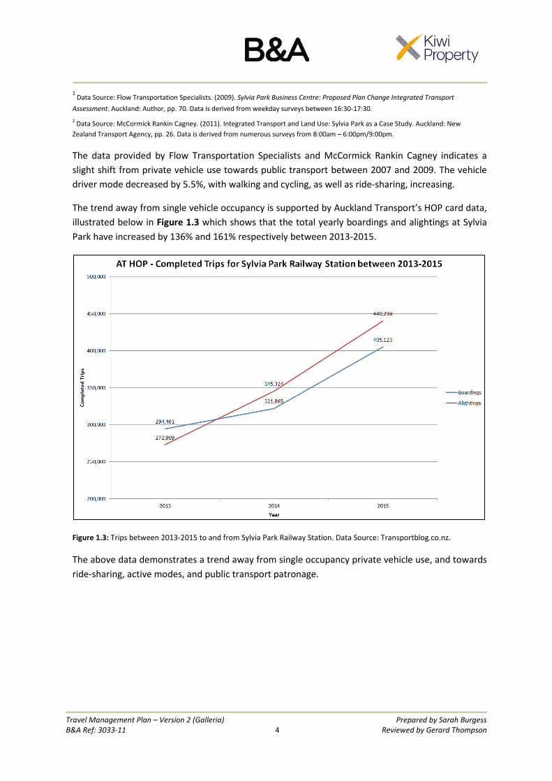
The trend away from single vehicle occupancy is supported by Auckland Transport’s HOP card data, illustrated below in Figure 1.3 which shows that the total yearly boardings and alightings at Sylvia Park have increased by 136% and 161% respectively between 2013-2015.
Figure 1.3: Trips between 2013-2015 to and from Sylvia Park Railway Station. Data Source: Transportblog.co.nz.
The above data demonstrates a trend away from single occupancy private vehicle use, and towards ride-sharing, active modes, and public transport patronage.
Travel Management Plan – Version 2 (Galleria) Prepared by Sarah Burgess B&A Ref: 3033-11 5 Reviewed by Gerard Thompson
2.0 EXISTING PHYSICAL INFRASTRUCTURE AND LINKAGES
2.1 PEDESTRIAN FACILITIES
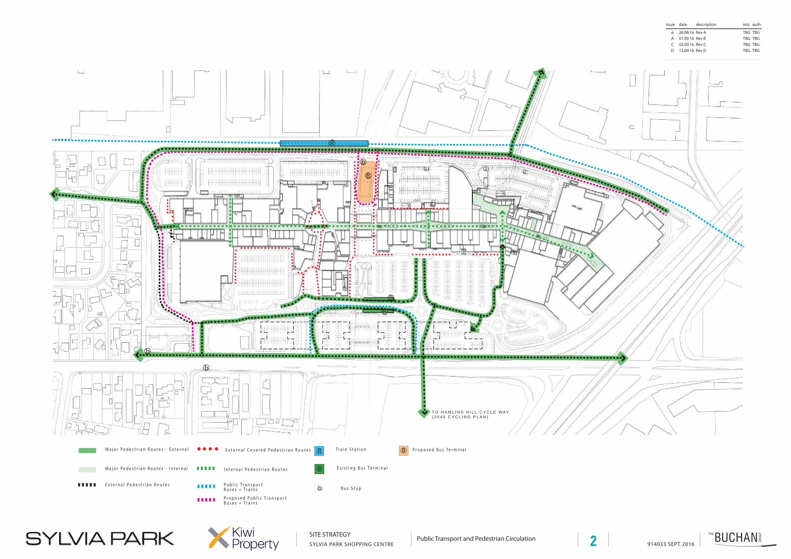
There are a number of pedestrian routes throughout the site, defined by wide footpaths, landscaping and well-lit spaces. As illustrated in Appendix 1, the central internal pedestrian route through the mall connects with the parking areas, which are attractively landscaped and feature numerous crossings, and the ring road at the boundaries of the site. Footpaths are of a generous width, with drop kerbs constructed to reflect pedestrian desire lines and ensure pedestrians of limited mobility are able to walk freely throughout the site. In addition, there are pedestrian connections to outside the site, to Lynton Road, Carbine Road and Mutukaroa-Hamlins Hill via the shared path.
2.2 CYCLING FACILITIES
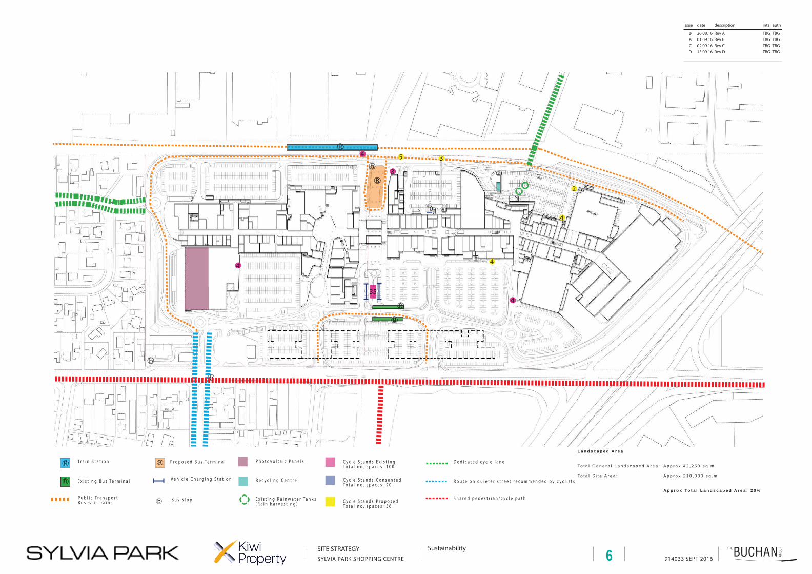
Publicly accessible cycle parks are distributed in various locations throughout the site (see Plan 6 at Appendix 1). For example, there are four cycle racks for eight bikes provided adjacent to the pedestrian overpass walkway to the train station which experience high levels of use as park-and-ride facilities. Four cycle racks for eight bikes are provided outside Pak ‘n’ Save, and the Countdown Supermarket in the southern portion of the site. These cycle parks are located in areas which typically have high volumes of pedestrian traffic which ensures their security through passive surveillance. As with all of Kiwi’s centres throughout the country, Centre Management monitor the utilisation of cycle parking and add and relocate racks as required.
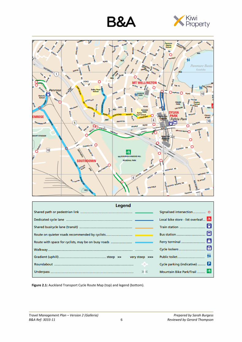
In terms of linkages, there is a dedicated cycle lane that extends from the northern boundary of Sylvia Park along Lynton Road and terminates at Waipuna Road. This was built by Kiwi when they constructed the northern access to the site in 2008. There is also a shared cycle/pedestrian path connecting the southern portion of the site with Mutukaroa-Hamlins Hill. Auckland Transport’s current cycle route map is shown in Figure 2.1:
Travel Management Plan – Version 2 (Galleria) Prepared by Sarah Burgess B&A Ref: 3033-11 6 Reviewed by Gerard Thompson
Figure 2.1: Auckland Transport Cycle Route Map (top) and legend (bottom).
Travel Management Plan – Version 2 (Galleria) Prepared by Sarah Burgess B&A Ref: 3033-11 7 Reviewed by Gerard Thompson
2.3 PUBLIC TRANSPORT
Sylvia Park is located in an area of good access to public transport. There are a number of bus routes, cycle and walkway links, and train access.
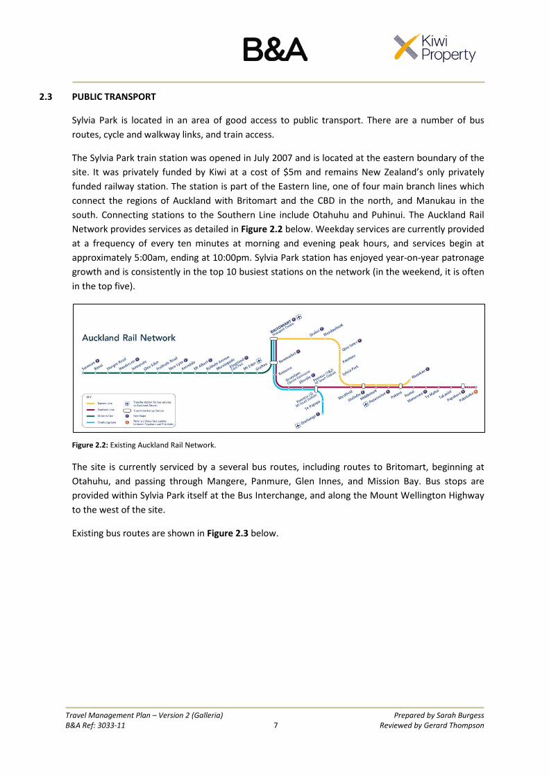
The Sylvia Park train station was opened in July 2007 and is located at the eastern boundary of the site. It was privately funded by Kiwi at a cost of $5m and remains New Zealand’s only privately funded railway station. The station is part of the Eastern line, one of four main branch lines which connect the regions of Auckland with Britomart and the CBD in the north, and Manukau in the south. Connecting stations to the Southern Line include Otahuhu and Puhinui. The Auckland Rail Network provides services as detailed in Figure 2.2 below. Weekday services are currently provided at a frequency of every ten minutes at morning and evening peak hours, and services begin at approximately 5:00am, ending at 10:00pm. Sylvia Park station has enjoyed year-on-year patronage growth and is consistently in the top 10 busiest stations on the network (in the weekend, it is often in the top five).
Figure 2.2: Existing Auckland Rail Network.
The site is currently serviced by a several bus routes, including routes to Britomart, beginning at Otahuhu, and passing through Mangere, Panmure, Glen Innes, and Mission Bay. Bus stops are provided within Sylvia Park itself at the Bus Interchange, and along the Mount Wellington Highway to the west of the site.
Existing bus routes are shown in Figure 2.3 below.

Travel Management Plan – Version 2 (Galleria) Prepared by Sarah Burgess B&A Ref: 3033-11 8 Reviewed by Gerard Thompson
Figure 2.3: Existing bus network, showing connections between Otahuhu and Britomart.
Auckland Transport is currently undertaking a programme of planned bus route changes within the wider eastern Auckland area. This network change will ultimately result in a change in the connections to/from Sylvia Park as indicatively shown in Figure 2.4 below. Higher frequency buses to Panmure will improve total journey times for patrons travelling by public transport from the eastern suburbs to Sylvia Park via the train.

Travel Management Plan – Version 2 (Galleria) Prepared by Sarah Burgess B&A Ref: 3033-11 9 Reviewed by Gerard Thompson
Figure 2.4: Proposed improvements to eastern connections.
In addition to the provision for rail and bus connections, there are a number of taxi stands located throughout the site, including three permanent stands outside Pak ‘n’ Save, and two outside Countown.
2.4 ACCESS AND VEHICLE CIRCULATION
Vehicle access to Sylvia Park is provided through three entry points from the west of Mount Wellington Highway, one from the east off Carbine Road, and one from the north off Stud Way (which connects to Waipuna Road via Lynton Road). The site contains a network of internal roads including a ring road around the perimeter of the site.
2.5 CAR PARKING
Sylvia Park will provide 4,358 parking spaces when the construction of the CEM is complete. Car parking is managed to provide for different users, in zones which establish time restrictions, intended to prioritise retail customers. 81.4% of all parking spaces have a time limit (except for cinema patrons) intended to discourage staff from using customer spaces.
These comprise the following proportions of all existing (as of April 2016) car parking on the site:
• 180 minute time limit = 76.3% • 90 minute time limit = 4.5%

Travel Management Plan – Version 2 (Galleria) Prepared by Sarah Burgess B&A Ref: 3033-11 10 Reviewed by Gerard Thompson
• 240 minute time limit = 0.6% • No time limit = 4.3% (Level 3 of Carpark 5 does not currently display a time limit)
The customer parking above is provided free of charge. Retail staff car parks are charged to the users. Staff parking currently comprises 4.3% of total parking on the site, and is provided in pay and display Carpark 12, with overflow to Levels 4 and 5 of Carpark 5. Reserved parking for staff with barrier arms and swipe card access is provided adjacent to the railway line at the eastern boundary of the site. In addition to the on-site parking for staff, 56 spaces are currently provided at 77 Carbine Road, located on the eastern side of the railway line which are accessed via the overpass and ring road. Resource consent has also recently been granted for 51 additional parking spaces within the western most tenancy of the large warehouse on the site (R/LUC/2016/3705). These parking areas are secure and have swipe card access, and are well-lit and have CCTV cameras.
The locations of the existing and proposed car parking spaces and associated numbers of spaces and time limits on the site are shown on Plan 1 at Appendix 1. Disabled parking spaces and dedicated spaces for parents with prams are provided across the site, also shown in Plan 1. In total, over 60 disabled spaces and 14 parents with prams spaces are currently provided near mall entrances.
Office parking for Office Building G is to comprise 300 dedicated spaces within the upper levels of multi-level Carpark 5. These spaces are to be used exclusively by the office staff during normal business hours, and available for public use at other times. Office parking for Buildings A, B, C and D will be confirmed as they are given effect to in accordance with updated travel management plans.
Parking within the proposed SEM car park will comprise 741 spaces, with 20 disabled spaces and five parents with prams spaces. Similarly to existing parking, all spaces will have a P180 time limit.
Car parks themselves have been designed with clear signage and colour coded zones ensure they are easily identifiable. In the existing multi-level building, active management systems (i.e. green and red lights above each space) have been installed, which indicate how many parking spaces are occupied and where free spaces are, which provides for efficient use of these carparks and simplifies customer navigation. The surface car parks have also recently been upgraded with active management boards at each entrance, which shows the number of spaces available in that car park.
2.6 OTHER
In addition to the infrastructure above, Sylvia Park provides several dedicated motorcycle parking areas, found in locations at the Pak ‘n’ Save parking (Carpark 7), and Carpark 9 at the east of the site. Furthermore, an electric vehicle charging station is located below SEART on the western side of the mall, with two dedicated car parks. Tourist bus operators (including coach parking) are provided for in indented bays on the Ring Road in the eastern part of the site.

Travel Management Plan – Version 2 (Galleria) Prepared by Sarah Burgess B&A Ref: 3033-11 11 Reviewed by Gerard Thompson
3.0 FUTURE INFRASTRUCTURE
3.1 RAIL IMPROVEMENTS AND THE CITY RAIL LINK
The City Rail Link (CRL) is an underground railway link linking Britomart and the city centre with the existing Western line near Mt Eden. Construction has commenced on this large-scale project with the relocation of underground services in Albert Street and Victoria Street. Earlier this year Precinct Properties commenced work on the twin tunnels that run under the Downtown Shopping Centre site. The project is expected to be completed by 2024 and the proposed new link will result in higher frequency trains with more direct services to the city centre for the outer suburbs, reducing traffic volumes through modal shift. In overall terms, removing the Britomart bottleneck will allow trains to operate at 10-minute frequencies on all the commuter lines, including the Eastern Line serving Sylvia Park, thereby making this mode much more attractive (particularly at peak times).
3.2 AMETI BUS STATION AND NEW ACCESS
The Auckland Manukau Eastern Transport Initiative (AMETI) has been underway since 2006. Stage 1, involving works around Panmure has been completed and planning for future stages is currently underway.
This has included a sub-stage involving public transport upgrades around Sylvia Park, including the provision of new bus lanes and a new bus interchange at Sylvia Park. Kiwi has worked closely with Auckland Transport for almost a decade on the AMETI project. It is currently envisaged that buses will bypass the Mt Wellington Motorway Interchange by accessing Sylvia Park from one of the Mt Wellington Highway entrances and exiting via a new road at the southern part of the site. The location of the new bus interchange is yet to be determined but it is likely that this will be located under the SEART flyover in close proximity to the railway station. As part of this project, investigations are also being undertaken to see if the existing hook bridge needs to be removed to improve traffic flow, with some of that capacity being replaced by the new southern access.
In addition to the “Sylvia Park bus lanes” sub stage, AMETI Stage 6 envisages further changes to the roading network on Carbine Road. This could include a new loop road from Carbine Road that would provide access to the railway station from the eastern side. This will provide much better access for people living and working to the east of the railway and will most likely assist in stimulating the redevelopment of the existing industrial land.
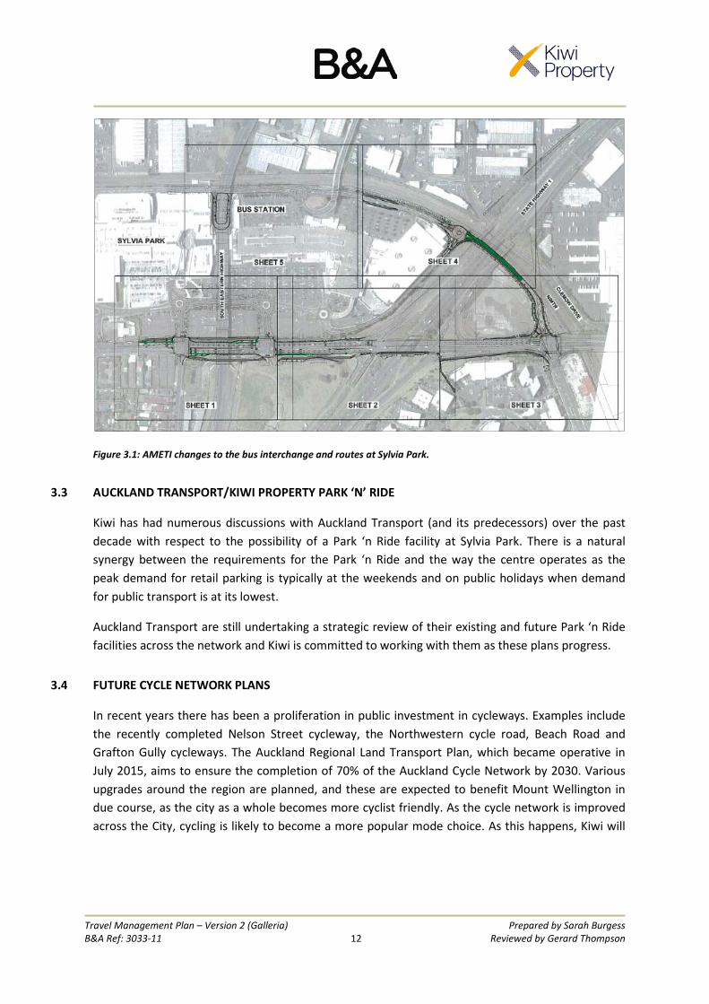
The proposed bus route and station as modified by AMETI is shown in Figure 3.1:
Travel Management Plan – Version 2 (Galleria) Prepared by Sarah Burgess B&A Ref: 3033-11 12 Reviewed by Gerard Thompson
Figure 3.1: AMETI changes to the bus interchange and routes at Sylvia Park.
3.3 AUCKLAND TRANSPORT/KIWI PROPERTY PARK ‘N’ RIDE
Kiwi has had numerous discussions with Auckland Transport (and its predecessors) over the past decade with respect to the possibility of a Park ‘n Ride facility at Sylvia Park. There is a natural synergy between the requirements for the Park ‘n Ride and the way the centre operates as the peak demand for retail parking is typically at the weekends and on public holidays when demand for public transport is at its lowest.
Auckland Transport are still undertaking a strategic review of their existing and future Park ‘n Ride facilities across the network and Kiwi is committed to working with them as these plans progress.
3.4 FUTURE CYCLE NETWORK PLANS
In recent years there has been a proliferation in public investment in cycleways. Examples include the recently completed Nelson Street cycleway, the Northwestern cycle road, Beach Road and Grafton Gully cycleways. The Auckland Regional Land Transport Plan, which became operative in July 2015, aims to ensure the completion of 70% of the Auckland Cycle Network by 2030. Various upgrades around the region are planned, and these are expected to benefit Mount Wellington in due course, as the city as a whole becomes more cyclist friendly. As the cycle network is improved across the City, cycling is likely to become a more popular mode choice. As this happens, Kiwi will

Travel Management Plan – Version 2 (Galleria) Prepared by Sarah Burgess B&A Ref: 3033-11 13 Reviewed by Gerard Thompson
look to augment their currently existing (or planned) end of trip facilities to match (and promote) any increased demand.
3.5 EAST WEST CONNECTIONS PROJECT
The East West Connections Project involves new bus and transit lanes to improve travel times between Mangere and Otahuhu in the west with Sylvia Park in the east. Auckland Transport have identified this connection as being frequently delayed by vehicle congestion. The East West Connections project is one of a series of major improvements proposed which will impact travel to and from Sylvia Park. Bus priority lanes are proposed along parts of the Mount Wellington Highway, Atkinson Avenue, Massey Road and Kirkbride Road which form the Mangere-Otahuhu-Sylvia Park bus route. Auckland Transport’s proposed map of improvements is shown at Figure 3.2.
In addition, Auckland Transport is considering a separated cycleway on Massey Road and part of the Mount Wellington Highway.
The proposed bus priority measures underwent consultation in October 2014, and June-July 2015. The feedback from the consultation process is to be used to investigate the preferred approach and confirm the land or area needed to protect the route by 2017.
Figure 3.2: Proposed bus route improvements between Mangere, Otahuhu and Sylvia Park

Travel Management Plan – Version 2 (Galleria) Prepared by Sarah Burgess B&A Ref: 3033-11 14 Reviewed by Gerard Thompson
3.6 SUMMARY
The aforementioned future investments in infrastructure are expected to result in opportunities for modal shifts, through improved cycling and public transport facilities which will encourage the use of these modes, above private vehicles. A common feature of current public investment in transport is that the focus is now on moving people and freight rather than cars. As a consequence there is significantly more investment in public transport and active modes than has previously been the case. Kiwi remains committed to working with Auckland Transport to deliver public transport improvements in and around Sylvia Park as they recognise there are only limited opportunities to continue to provide additional capacity for private motor vehicles.
4.0 TRAVEL DEMAND MANAGEMENT
4.1 PEAK SPREADING
Sylvia Park’s store hours are managed with the aim to reduce peak vehicle traffic to and from the site at opening and closing times, with stores opening at 9:00am and closing at 7:00pm, seven days per week. The anchor tenants (e.g. Hoyts, Countdown, Pak ‘n Save and The Warehouse) have extended opening hours to 10pm and midnight.
4.2 CAR PARKING MANAGEMENT
Sylvia Park’s parking management strategy aims to ensure parking demand is met while also maximising safety, and avoiding adverse effects with regard to peak hour trip generation. Parking is managed and designed with a hierarchy that prioritises customers, including those requiring disabled spaces and parents with prams, above staff. As discussed in section 2.5 above, customer car parking is provided with time limits to restrict staff use of these areas, and staff have dedicated pay and display areas. In addition, off-site parking is provided for staff which encourages the use of public transport due to the additional walking required. The proposed four level multi-deck car park adjoining Galleria will replace an existing surface level 260 space car park, and will comprise 741 car parks. The construction of this building involves the removal of the existing hook from the railway overpass bridge to the internal ring road, and instead the bridge will connect straight to the upper level of the car park with a pedestrian footpath extending along the northern side.
Kiwi currently employ an independent contractor who regularly patrols car parks to ensure visitor parking is not being used by staff. Tickets are not issued to customers, and staff are given one warning before being ticketed. This ensures time limits are enforced, and therefore meaningful. In addition, staff parking areas are at the outskirts of the site, at a lengthy distance from the mall, which may encourage staff to explore using public transport facilities, which have nearer stops to the mall.

Travel Management Plan – Version 2 (Galleria) Prepared by Sarah Burgess B&A Ref: 3033-11 15 Reviewed by Gerard Thompson
The car parking management measures discussed above are intended to help minimise the number of staff and commuters parking at Sylvia Park, in conjunction with other features such as a number of public transport connections and facilities, to reduce demand for parking in the long term.
4.3 PROMOTING ALTERNATIVE USES
Cycling
As discussed above, a number of visitor cycle parks are distributed throughout the site. The Office G proposal involves the construction of a secure cycle parking facility under SEART with capacity for approximately 48 bikes. In addition, 36 new secure cycle parks are proposed in SEM and CEM, including the uppermost level of SEM to provide convenient parking for cyclists who access the site from Carbine Road. End of trip facilities include an existing shower for staff use near to the centre management offices, and new facilities have been consented for the mezzanine level of the Office Building G. The use of cycle facilities will be encouraged through information distribution to staff members.
Walking
Walking is encouraged through the provision of well lit, wide footpaths which are typically attractively landscaped with a combination of trees and shrubbery. All parts of the site are monitored by CCTV. As part of Galleria the existing hook which connects the railway overpass to the internal ring road will be removed, and the overpass will instead directly connect to the upper level of the car parking building. The footpath will be extended along the northern side of the bridge and pedestrians will be able to enter Sylvia Park via a vertical access core immediately south of the entrance, or they can take a path across the car park to one of the mall entrances. This change is considered to be an improvement for pedestrian entering the site from Carbine Road as the path will be more direct, and pedestrians will no longer be required to use the spiral ramp system and cross the ring road to reach the mall.
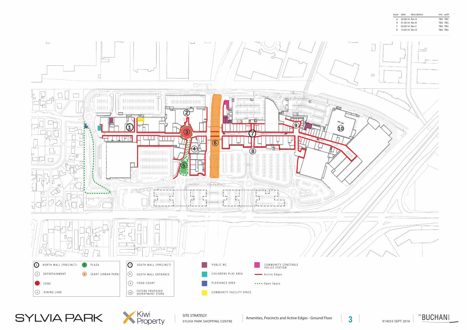
Along the western edge of the building the landscape architect has sought to promote active, engaging building edges through a “series of events” along the western elevation. This includes enhancement and extension of existing seating, paving and planting areas, creation of new and safer pedestrian routes through the carpark to the building, and creation of a new playground feature adjoining the café court of The Terrace addition. Overall it is considered that these modifications to the eastern edge will provide a positive pedestrian experience and attractive visual edge to the building.
Public Transport
The use of public transport as a mode of access to and from the site is encouraged through the provision of a railway station directly adjacent to the site, and a bus interchange within it. Kiwi’s management of parking also encourages the use of public transport by reducing the level of
Travel Management Plan – Version 2 (Galleria) Prepared by Sarah Burgess B&A Ref: 3033-11 16 Reviewed by Gerard Thompson
convenience for staff to drive to work, through parking charges and relocated staff car parks off-site. Use of the trains is promoted through the location of a real-time service board within the shopping centre itself, to simplify checking train timetables for patrons. Regular voiceover updates regarding train arrivals at the station keep passengers informed of any potential delays. Train and bus timetables and advice are available at the Customer Service Desk, which is advertised on the Sylvia Park website on their “Getting here” webpage. In addition, the use of smart phones has led to the development of an Auckland Transport app, which provides real time and route information to simplify taking public transport.
4.4 OTHER CENTRE MANAGEMENT INITIATIVES AND MEASURES
Sylvia Park Countdown currently offers an online ordering and delivery service. Click and collect services are also becoming increasingly popular whereby customers can order items online and collect instore. A similar service is being explored by the centre management in collaboration with Fastway Couriers, whereby customers may drop off or collect items from the customer service desk. These initiatives reduce the amount of time spent shopping and therefore the lengths of stays for customers in car parking or allow the consolidation of multi-purpose trips.
Ride share and carpooling initiatives have been explored by Kiwi in the past, however the small number of staff per retailer, diverse locations and different shifts meant this has not proven viable to date, however this option will be kept in review, particularly noting the increase in office staff members in the coming years.
5.0 MONITORING AND UPDATING
This travel plan will monitored on an ongoing basis and updated every two years or, in conjunction, with any major new resource consent application.
AUTHORS
Gerard Thompson/Sarah Burgess Principal/Planner, Barker & Associates Ltd Date: September 2016
List of other information attached:
Appendix 1: Plans

914033 SEPT 2016
issue date description ints auth
øACD
26.08.1601.09.1602.09.1613.09.16
Rev ARev BRev C Rev D
TBGTBGTBGTBG
TBGTBGTBGTBG
Vehicle Circulation, Carparking Figures, Time Limits, Loading Zones and Disabled/Parent Parking Distribution
SITE STRATEGY
SYLVIA PARK SHOPPING CENTRE
PA R K I N G S PA C E S
P R O P O S E D
1 - 7 4 12 - 4 8 73 - 2 54 - 1 0 85 - 11 3 46 - 6 47 - 4 6 18 - 1 4 89 - 2 6 6
1 0 - 1 0 41 1 - 11 81 2 - 1 5 71 3 - 2 9 81 4 - 1 2 7R R P - 1 4R A I L W AY - 7 2N W S TA F F - 2 3
T O TA L 4 3 4 7
S e r v i c e A c c e s s R o u t e s
V e h i c u l a r R o u t e s
M u l t i L e v e l C a r p a r k i n g
O n G r a d e C a r p a r k i n g
L o a d i n g Z o n e s
A c c e s s R o u t e s
25 4
78 9
36
1
10121314
11
1
64 SPACESP180
LEVEL G = 184 SPACES P180LEVEL 1 = 183 SPACES P180LEVEL 2 = 182 SPACES P180LEVEL 3 = 188 SPACES NO LIMIT LEVEL 4 = 192 SPACES PAY AND DISPLAYLEVEL 5 = 205 SPACES PAY AND DISPLAY
108 SPACESP240
25 SPACES
P180
487 SPACESP180
741 SPACESP180
104 SPACESP90
157 SPACESPAY AND DISPLAY
FOR TENANTS AND EMPLOYEES
298 SPACESP180
127 SPACESP180
23 SPACESP180
148 SPACESP180
266 SPACES TOTALP180
- 22 SPACESP90
72 SPACESSTAFF
461 SPACESBASEMENT -= 234 SPACESP180 WITH 36 P90GROUND = 227 SPACESP180 WITH 35 P90
- P90DX6 DX6 DX10
DX6PX6
DX2
DX10 PX6
DX4
DX6DX3
PX2
DX7
D i s a b l e d P a r k s ( D X _ )
P a r e n t s w i t h P r a m s P a r k s ( P X _ )
D
PX3DX5
PX20
DX5
1134 SPACESP240
LEVEL G = 116 SPACES TBCLEVEL G MEZ = 127 SPACES TBCLEVEL 1 = 114 SPACES TBCLEVEL 1 MEZ = 132 SPACES TBC
LEVEL G = 174 SPACES TBCLEVEL G MEZ = 168 SPACES TBCLEVEL 1 = 219 SPACES TBCLEVEL 1 MEZ = 180 SPACES TBC
11118 SPACES
914033 SEPT 2016
issue date description ints auth
øACD
26.08.1601.09.1602.09.1613.09.16
Rev ARev BRev C Rev D
TBGTBGTBGTBG
TBGTBGTBGTBG
Public Transport and Pedestrian CirculationSITE STRATEGYSYLVIA PARK SHOPPING CENTRE
I n t e r n a l P e d e s t r i a n R o u t e s
E x t e r n a l P e d e s t r i a n R o u t e s
M a j o r P e d e s t r i a n R o u t e s - E x t e r n a l
bb
bbb
E x i s t i n g B u s T e r m i n a l
B u s S t o pbb
B
BBBBB
BBB
M a j o r P e d e s t r i a n R o u t e s - I n t e r n a l
T r a i n S t a t i o n
bbb
RRRRR
BB
P u b l i c T r a n s p o r tB u s e s + T r a i n s
P r o p o s e d P u b l i c T r a n s p o r tB u s e s + T r a i n s
P r o p o s e d B u s T e r m i n a lBE x t e r n a l C o v e r e d P e d e s t r i a n R o u t e s RR
T O H A M L I N S H I L L C Y C L E W AY( 2 0 4 0 C Y C L I N G P L A N )
2
914033 SEPT 2016
issue date description ints auth
øACD
26.08.1601.09.1602.09.1613.09.16
Rev ARev BRev C Rev D
TBGTBGTBGTBG
TBGTBGTBGTBG
Amenities, Precincts and Active Edges - Ground FloorSITE STRATEGYSYLVIA PARK SHOPPING CENTRE
1
2
5
4 8
973
O p e n S p a c e
1
2
3
4
5
6
9
10
7
C O N E
E N T E R T A I N M E N T
N O R T H M A L L ( P R E C I N C T )
D I N I N G L A N E
S O U T H M A L L E N T R A N C ES E A R T ( U R B A N P A R K )
P L A Z A
F O O D C O U R T
S O U T H M A L L ( P R E C I N C T )
6
A c t i v e E d g e s
10
8
F U T U R E P R O P O S E DD E P A R T M E N T S T O R E
C H I L D R E N S P L A Y A R E A
P U B L I C W C
P L E A S A N C E A R E A
C O M M U N I T Y F A C I L I T Y S P A C E
C O M M U N I T Y C O N S T A B L EP O L I C E S T A T I O N
3

914033 SEPT 2016
issue date description ints auth
øABC
26.08.1601.09.1602.09.1613.09.16
Rev ARev BRev CRev D
TBGTBGTBGTBG
TBGTBGTBGTBG
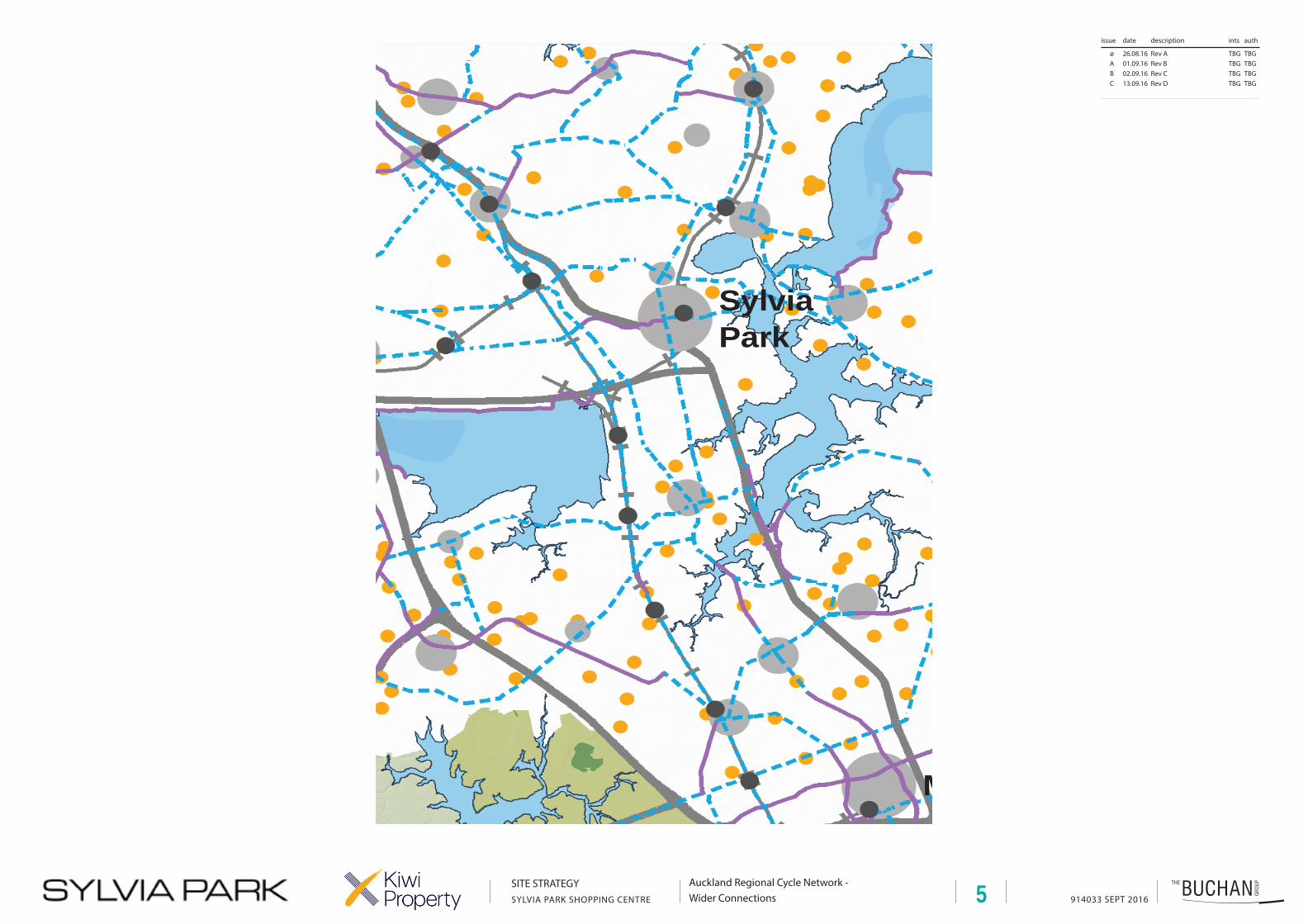
Auckland Regional Cycle Network - Wider Connections
SITE STRATEGYSYLVIA PARK SHOPPING CENTRE
Ha u r a k iG u l f
Ma n u ka uHa r b o u r
Wa i t ema tHa r b o u r
Westgate /Massey
North
Albany
Henderson
New Lynn
Newmarket
SylviaPark
Manukau
Papakura
Takapuna
Botany
CityCentre
AucklandInternational
Airport
´ 0 52.5 Km
H
H
Warkworth
Pukekohe
13.3 AUCKLAND'S REGIONAL CYCLE NETWORK
Existing cycle network
Proposed cycle network
! Metropolitan centre
! Town centre
! City fringe centre
! Local centre
H Satellite town
! Schools
Public Transport Centres
! Bus, ferry & train stations
Ferry
Railway
State highway
o International airport
Last updated: 10 April 1:30pm
Newmarket
SylviaPark
Manukau
Botany
CityCentre
AucklandInternational
Airport
4
914033 SEPT 2016
issue date description ints auth
øABC
26.08.1601.09.1602.09.1613.09.16
Rev ARev BRev CRev D
TBGTBGTBGTBG
TBGTBGTBGTBG
SITE STRATEGYSYLVIA PARK SHOPPING CENTRE
Auckland Regional Cycle Network - Wider Connections
SylviaPark
M
5
914033 SEPT 2016
issue date description ints auth
øACD
26.08.1601.09.1602.09.1613.09.16
Rev ARev BRev C Rev D
TBGTBGTBGTBG
TBGTBGTBGTBG
SustainabilitySITE STRATEGYSYLVIA PARK SHOPPING CENTRE
R e c y c l i n g C e n t r e
E x i s t i n g R a i n w a t e r T a n k s( R a i n h a r v e s t i n g )
P h o t o v o l t a i c P a n e l s
bb
bb
E x i s t i n g B u s T e r m i n a l
B u s S t o pbb
B
BBBBB
BBB
T r a i n S t a t i o n
bbb
RRRRR
BB
V e h i c l e C h a r g i n g S t a t i o n
P u b l i c T r a n s p o r tB u s e s + T r a i n s
P r o p o s e d B u s T e r m i n a lBRR
C y c l e S t a n d s C o n s e n t e dT o t a l n o . s p a c e s : 2 0
L a n d s c a p e d A r e a
To t a l G e n e r a l L a n d s c a p e d A r e a : A p p r o x 4 2 , 2 5 0 s q . m
To t a l S i t e A r e a : A p p r o x 2 1 0 , 0 0 0 s q . m
A p p r o x To t a l L a n d s c a p e d A r e a : 2 0 %
D e d i c a t e d c y c l e l a n e
R o u t e o n q u i e t e r s t r e e t r e c o m m e n d e d b y c y c l i s t s
S h a r e d p e d e s t r i a n / c y c l e p a t h
C y c l e S t a n d s E x i s t i n gT o t a l n o . s p a c e s : 1 0 0
C y c l e S t a n d s P r o p o s e dT o t a l n o . s p a c e s : 3 6
6
4
4
4
2
35
3
4
4
35
10