the southern matese active fault system: new … · the southern matese active fault system: new...
TRANSCRIPT
GNGTS 2014 sessione 1.1
11
thE SoUthERn MAtESE ACtIvE fAULt SyStEM: nEw GEoChEMICAL And GEoMoRPhoLoGICAL EvIdEnCE A. Ascione1, S. Bigi2, G. Ciotoli3,4, A. Corradetti1, G. Etiope4, L. Ruggiero2, P. Sacco2, C. Tartarello2,S. Tavani1, E. Valente5
1 Dipartimento di Scienze della Terra, dell’Ambiente e delle Risorse, Università Federico II, Napoli, Italy2 Dipartimento di Scienze della Terra, Università La Sapienza, Roma, Italy3 Istituto di Geologia Ambientale e Geoingegneria – CNR-IGAG, Roma, Italy4 Istituto Nazionale di Geofisica e Vulcanologia, Sezione Roma 2, Roma, Italy5 Dipartimento di Scienze Umanistiche, Sociali e della Formazione, Università del Molise, Campobasso, Italy
Introduction. Assessment and mitigation of seismic hazard rely on the identification and geometric characterization of active structures. Crucial, to this task, is the definition of the relationships between shallow and deep-seated active structures, through a comprehensive approach combining surface and subsurface geology with seismological information. Indeed the detailed reconstruction of the active tectonics frame at the surface may provide a reliable picture of seismically active structures (e.g., Amoroso et al., 2014), also in those areas featuring complex structural setting, e.g., a strong rheological contrast between deep and shallow structural levels [e.g., the southern Apennines: Ascione et al. (2013)].
The spatial distribution of surface deformation may be effectively detected by a variety of geomorphological indicators, and temporally constrained by the stratigraphical record. However, the topographical signature of faulting depends not only on fault offset and behaviour (in terms of slip per event and recurrence time; e.g., Slemmons and Depolo, 1986), but also on both the resistance to erosion of the faulted bedrock, and the sensitivity of the geomorphological scenario (e.g., Ascione et al., 2013). In areas characterised by highly erodible bedrock types orIn areas characterised by highly erodible bedrock types or alluvial deposits, soil-gas measurement has received much attention as an elective method for tracing active hidden faults (e.g., Baubron et al., 2002; Fu et al., 2005; Ciotoli et al., 2007, 2014; Al-Hilal and Al-Ali, 2010; Walia et al., 2010), and monitoring seismic activity (e.g., Toutain and Baubron, 1999; Yang et al., 2005; Kumar et al., 2009; Walia et al., 2012). The stress/strainThe stress/strain changes related to seismic activity may control fluid circulation at depth forcing crustal fluid to migrate upwards, especially along faults (King, 1986; Ciotoli et al., 2007). Fluid circulation at depth may alter the geochemical characteristics of the fault core (Annunziatellis et al., 2008), which in turn can influence soil gas concentrations at the surface (e.g., Baubron et al., 2002;
001-260 volume 1 11 24-10-2014 16:51:54

12
GNGTS 2014 sessione 1.1
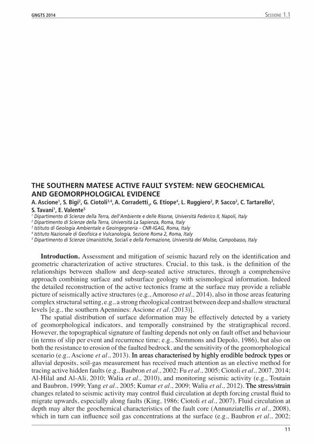
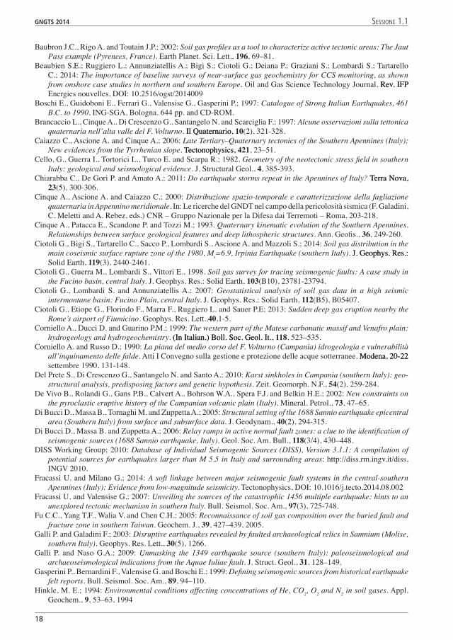
Fig. 1 – Historical earthquakes and seismogenic structures of the Matese area: a) epicenters of historical earthquakes [squares are proportional to the rupture surface produced by the events; from Boschi et al., (1997)] and epicenters of instrumental seismicity between 1983 and 2000 from INGV seismic database (from Milano et al., 2005); the dashed white frame indicates location of the area in b; b) seismogenic sources (from DISS Working Group, 2010), and epicentre (star) and focal mechanism (inset) of the December 29, 2013 earthquake (data from http://cnt.rm.ingv.it/tdmt.html); the white frame indicates location of the Colle Sponeta area.
001-260 volume 1 12 24-10-2014 16:51:56
GNGTS 2014 sessione 1.1
13
Lombardi and Voltattorni, 2010). In fact in seismically active zones anomalous concentrations of various minor and trace gas species (i.e., CO2, Rn, He, H2, CH4) are a widely observed process (e.g., Ciotoli et al., 2007, 2014; Voltattorni et al., 2012). The degassing process, occurring as advective migration of free gas phase in fractured rock volumes at depth, indicates that active faults are characterized by high permeability, and thus act as preferential conduits in the crust (Ciotoli et al., 1998, 2007, 2013, 2014; Toutain and Baubron, 1999; Annunziatellis et al., 2008).
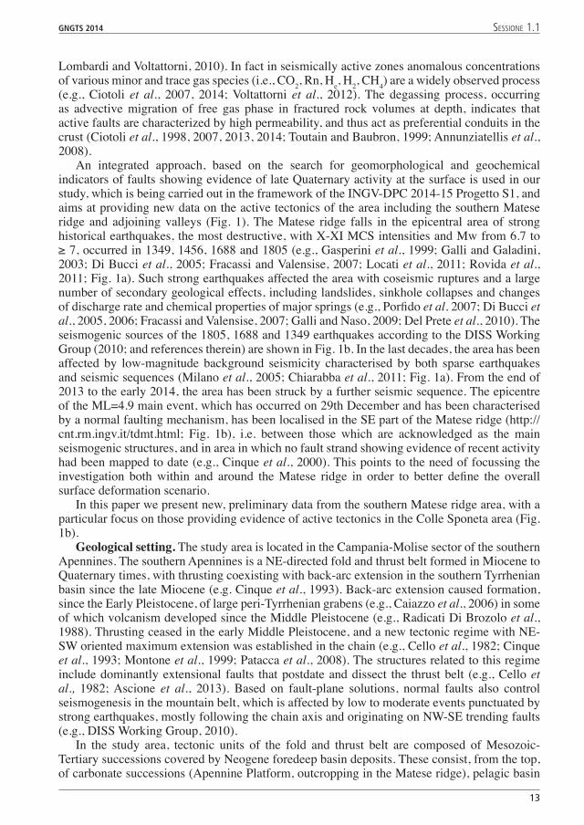
An integrated approach, based on the search for geomorphological and geochemical indicators of faults showing evidence of late Quaternary activity at the surface is used in our study, which is being carried out in the framework of the INGV-DPC 2014-15 Progetto S1, and aims at providing new data on the active tectonics of the area including the southern Matese ridge and adjoining valleys (Fig. 1). The Matese ridge falls in the epicentral area of strong historical earthquakes, the most destructive, with X-XI MCS intensities and Mw from 6.7 to ≥ 7, occurred in 1349, 1456, 1688 and 1805 (e.g., Gasperini et al., 1999; Galli and Galadini, 2003; Di Bucci et al., 2005; Fracassi and Valensise, 2007; Locati et al., 2011; Rovida et al., 2011; Fig. 1a). Such strong earthquakes affected the area with coseismic ruptures and a large number of secondary geological effects, including landslides, sinkhole collapses and changes of discharge rate and chemical properties of major springs (e.g., Porfido et al. 2007; Di Bucci et al., 2005, 2006; Fracassi and Valensise, 2007; Galli and Naso, 2009; Del Prete et al., 2010). The seismogenic sources of the 1805, 1688 and 1349 earthquakes according to the DISS Working Group (2010; and references therein) are shown in Fig. 1b. In the last decades, the area has been affected by low-magnitude background seismicity characterised by both sparse earthquakes and seismic sequences (Milano et al., 2005; Chiarabba et al., 2011; Fig. 1a). From the end of 2013 to the early 2014, the area has been struck by a further seismic sequence. The epicentre of the ML=4.9 main event, which has occurred on 29th December and has been characterised by a normal faulting mechanism, has been localised in the SE part of the Matese ridge (http://cnt.rm.ingv.it/tdmt.html; Fig. 1b), i.e. between those which are acknowledged as the main seismogenic structures, and in area in which no fault strand showing evidence of recent activity had been mapped to date (e.g., Cinque et al., 2000). This points to the need of focussing the investigation both within and around the Matese ridge in order to better define the overall surface deformation scenario.
In this paper we present new, preliminary data from the southern Matese ridge area, with a particular focus on those providing evidence of active tectonics in the Colle Sponeta area (Fig. 1b).
Geological setting. The study area is located in the Campania-Molise sector of the southern Apennines. The southern Apennines is a NE-directed fold and thrust belt formed in Miocene to Quaternary times, with thrusting coexisting with back-arc extension in the southern Tyrrhenian basin since the late Miocene (e.g. Cinque et al., 1993). Back-arc extension caused formation, since the Early Pleistocene, of large peri-Tyrrhenian grabens (e.g., Caiazzo et al., 2006) in some of which volcanism developed since the Middle Pleistocene (e.g., Radicati Di Brozolo et al., 1988). Thrusting ceased in the early Middle Pleistocene, and a new tectonic regime with NE-SW oriented maximum extension was established in the chain (e.g., Cello et al., 1982; Cinque et al., 1993; Montone et al., 1999; Patacca et al., 2008). The structures related to this regime include dominantly extensional faults that postdate and dissect the thrust belt (e.g., Cello et al., 1982; Ascione et al., 2013). Based on fault-plane solutions, normal faults also control seismogenesis in the mountain belt, which is affected by low to moderate events punctuated by strong earthquakes, mostly following the chain axis and originating on NW-SE trending faults (e.g., DISS Working Group, 2010).
In the study area, tectonic units of the fold and thrust belt are composed of Mesozoic-Tertiary successions covered by Neogene foredeep basin deposits. These consist, from the top, of carbonate successions (Apennine Platform, outcropping in the Matese ridge), pelagic basin
001-260 volume 1 13 24-10-2014 16:51:56
14
GNGTS 2014 sessione 1.1
successions (Molise-Sannio Basin, outcropping to the N and E of the ridge), and the buried Apulian platform carbonates (Mazzoli et al., 2000). The thrust pile is dissected by NW-SE extensional structures and E-W trending high-angle faults generally showing left-lateral activity overprinted by either dip-slip or oblique right-lateral motion associated with reactivation during the Middle Pleistocene to Present- tectonic regime (Mazzoli et al., 2000, and references therein). The area including the southern Matese ridge and adjoining valleys is affected by several extensional faults showing geomorphological-stratigraphical evidence of activity during the late Quaternary. These include a dense net of minor (few km long) faults, mostly with NW-SE, E-W and N-S trends, and some major (tens of km long) extensional fault zones with overall WNW-ESE trends (Cinque et al., 2000). The main one of the latter structures bounds towards the NE the middle Volturno river basin (location in Fig. 1b), in which the top of the carbonates is lowered below the sea level (Corniello and Russo, 1990). A further main structure is the ≈ 20 km long Pozzilli–Capriati (Brancaccio et al., 1997), or Aquae Iuliae fault (Galli and Naso, 2009). This fault zone recorded repeated surface ruptures during the late Holocene, with the last one being associated with the Mw ≈ 6.7, 1349 earthquake (Galli and Naso, 2009). To the seismic shaking of this event has been associated the formation of karst collapse sinkholes in the Telese area (Del Prete et al., 2010). Indeed, the Matese ridge southern boundary is characterised by several karst collapse sinkholes, particularly clustered around Telese and Pratella (location in Fig. 1b). Such phenomena are interpreted as the response to intense dissolution associated with the rise of deep-seated fluids along active faults (Santo et al., 2011). Worthy to note, both the Pratella and Telese areas are characterised by mineral springs (Corniello et al., 1999), with the chemical composition of the Telese springs being affected by deep seated inputs along lithospheric faults (Italiano et al., 2000).
The Colle Sponeta area (Fig. 1b) is located in the hanging wall block of the Aquae Iuliae fault, in the SW part of Prata Sannita Quaternary lacustrine basin. It is characterised by a hilly landscape formed in intensely weathered fine-grained alluvial and pyroclastic deposits (Sinno, 1966), which can be related to the older one of the Middle Pleistocene terraced alluvial successions filling the Prata Sannita basin.
Materials and methods. In the area of the southern Matese ridge, geomorphological, structural and soil gas surveys are being carried out with the aim of identifying the spatial distribution, the gas bearing properties and the fault zone architecture of faults showing evidence of activity during the late Quaternary. Meso-structural data have been collected in the study area, to constrain the kinematics of the extensional system. Geomorphological analysis of detail scale (1:5,000 CTR maps) topographic maps has been carried out in order to detect classical geomorphological indicators of vertical surface displacements, e.g. rectilinear scarps/slope breaks and drainage net anomalies.
Soil gas survey has been performed in a small area of about 0.7 km2 located in the Colle Sponeta area (Fig. 1b). A total amount of 233 samples were collected randomly in the study area, which has been selected based on the presence of:
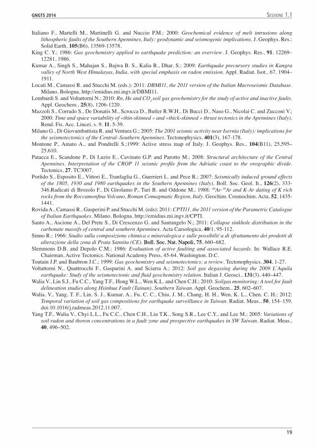
• a N-S trending, up to about 8 m high and about 1 km long, E-facing scarp (hereinafter, Colle Sponeta fault scarp; Figs. 2a and 2b);
• a large sinkhole (diameter of about 10 m), characterised by strong bubbling due to a free gas phase upwelling (Fig. 2c);
• small-sized holes following the toe of the Colle Sponeta fault scarp, associated with bubbling gas in the groundwater;
• dead small animals, probably killed by the high CO2 content above the shallow soil (see next Chapter).
Soil gas samples have been collected using a 6.4 mm, thick-walled, stainless-steel tube onto which steel cylinders are welded to act as pounded in the soil at a depth of about 0.6-0.8 m by using a co-axial hammer (Ciotoli et al., 1998; Beaubien et al., 2013). The used sampling depthThe used sampling depth is sufficient to avoid the influence of infiltrating atmospheric air (Hinkle, 1994). Samples have
001-260 volume 1 14 24-10-2014 16:51:56
GNGTS 2014 sessione 1.1
1�
been collected in July 2014 in a period of stable meteorological conditions (i.e., an average day temperature of 25°C and no precipitation).
Field analyses have been conducted for CO2, CH4, O2, H2S and H2 by directly attaching the probe to a Multiwarn portable gas analyser (Draeger Instruments) which has a measuring range up to 100% for CO2, 0-100% LEL for CH4, up to 1000 ppm for H2S, and up to 100 ppm for H2. Field analyses have been also conducted for Rn by pumping gas directly from the probe into the Lucas cell of an RDA200 detector (EDA-Scintrex Instruments). Further, samples have been collected for laboratory analysis by injecting 60 mL of soil gas into a previously-evacuated, 25 mL stainless-steel canister sealed with a rubber septum. The samples have been analysed forThe samples have been analysed for He on a mass spectrometer (Varian Leak Detector), and then for other gases on Fisons 8000-series bench Gas Chromatographs (GC) equipped with a Flame Ionisation Detector (FID) for the analysis of CH4,C2H2,C2H4, and C3H8, and with a Thermal Conductivity Detector (TCD) for the analysis of CO2, O+ Ar, and N2. The field instrument has been calibrated prior to shippingThe field instrument has been calibrated prior to shipping to the field site.
CO2 flux measurements have been accomplished by using an in-house developed flux chamber system that consists of an accumulation chamber of known volume (V) and surface area (A) connected to an infrared detector within a control unit (Beaubien et al., 2014).
Results and discussion. Preliminary results of the structural analysis indicate the occurrence of a complex 3D framework, characterised by multiple sets of extensional and strike-slip
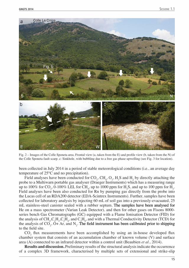
Fig. 2 – Images of the Colle Sponeta area. Frontal view (a, taken from the E) and profile view (b, taken from the N) of the Colle Sponeta fault scarp. c: Sinkhole, with bubbling due to a free gas phase upwelling (see Fig. 3 for location).
001-260 volume 1 15 24-10-2014 16:52:00
1�
GNGTS 2014 sessione 1.1
faults. Such a complexity suitably results from the interplay between regional extension direction and local structural inheritances. The geomorphological analysis has allowed the detection of rectilinear scarps/slope breaks and the drainage net anomalies, which also affect the eroded surfaces formed in the Prata Sannita basin fill. Such indicators point to the occurrence of a network of several hundreds to few km-long fault strands with NW-SE, E-W and N-S trends. Fault scarps with N-S trend are dominating in the Colle Sponeta area. These include the N-S trending, up to about 8 m high and about 1 km long, E-facing Colle Sponeta fault scarp, shown in Figs. 2a and 2b.
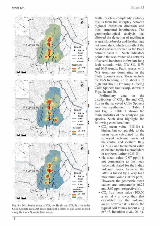
Preliminary data on the distribution of CO2, He and CO2 flux in the surveyed Colle Sponeta area are synthesised in Table 1 and Fig. 3. Table 1 shows the main statistics of the analysed gas species. Such data highlight the following considerations:
• CO2 mean value (6.81%) is higher, but comparable to the mean value calculated for the surveyed volcanic areas of the central and southern Italy (4.77%), and to the mean value calculated for the Latera caldera in northern Latium (9.54%).
• He mean value (7.07 ppm) is not comparable to the mean value calculated for the Italian volcanic areas, because the latter is biased by a very high maximum value (10325 ppm). However, the geometric mean values are comparable (6.22 and 5.67 ppm, respectively);
• CO2 flux mean value (103.60 g m-2 d-1) is lower than that calculated for the volcanic areas, however it is twice the typical soil values (about 40 g m-2 d-1, Beaubien et al., 2014).
Fig. 3 – Distribution maps of CO2 (a), He (b) and CO2 flux (c) in the Colle Sponeta area. All gases highlight a series of gas-vents aligned along the Colle Sponeta fault scarp.
001-260 volume 1 16 24-10-2014 16:52:03
GNGTS 2014 sessione 1.1
1�
Tab. 1 - Main statistical parameters of the soil gas and flux data. CO2 is expressed in %, v/v; He is expressed in ppm; CO2 flux is expressed in g m-2 d-1. GM, geometric Mean; Min, minimium value; Max, Maximum value; LQ, Lower Quartile; UQ, Upper Quartile; 10%, 10th percentile; 90th percentile; Std.Dev, Standard Deviation.
N Mean GM Min Max LQ UQ 10% �0% Std.Dev.
CO2 22� �.�1 2.�� 0.14 ��.00 1.�0 4.40 0.�0 �.�0 14.4�
He �2 �.0� �.22 4.�� 33.30 �.22 �.4� �.12 12.0 �.11
CO2 flux 1�1 103.�0 32.�0 2.�� 230�.2� 1�.�3 4�.34 11.24 113.00 31�.��
The calculated mean maximum values of all gases are very high for an intra-Apennine basin, and comparable with values generally measured in the volcanic areas of the Tyrrhenian margin. This important gas leak is also confirmed by the presence of more permeable migrationThis important gas leak is also confirmed by the presence of more permeable migration pathways linked to a fractured zone (i.e., gas vents), as well as other gas emissions and mineral springs occurring to the south (i.e., Pratella and Ailano).
The analysis of the statistical distribution by using normal probability plots indicates that values above 10% of CO2, 5.7 ppm of He and 70 gm-2d-1 for the flux of CO2 can be considered anomalous for the study area. Fig. 3a-c shows the maps of the distribution of measured gas species in the soil. Maps of the CO2 and He distribution highlight the same spatial pattern of the gas concentration in the soil, and indicate the presence of five major gas vents with diameters ranging from about 45 to 90 m, aligned along the N-S trending Colle Sponeta fault scarp (Fig. 2b); two further minor gas vents occur in the eastern border of the study area.
The map of the CO2 flux clearly highlights the same gas vents along the Colle Sponeta fault scarp, just a little bit shifted, and with more outlined anomalies. This behaviour is caused by the fact that soil gas CO2 has, in general, a wider area of anomalous values around the gas vent centre due to lateral diffusion effects induced by its higher density (Beaubien et al., 2014), and this feature allows tracing the underlying gas-permeable fault. The CO2 flux distribution shows less smooth anomalies with very high values in the core of the gas-vents relative to the surrounding area, resulting in a spatial distribution of anomalous values that decreases rapidly outside the gas-vents (Fig. 3c). This implies that leakage occurs in a restricted area around the core of the gas-vent where sediments geotechnical properties have been locally compromised. Conversely out of the leaking area the diffusive flux is strongly affected by soil type, moisture, etc. (Annunziatellis et al., 2008).
Preliminary data obtained by the geomorphological and soil gas surveys indicate that the Colle Sponeta area is characterised by an advective and localised gas leakage associated with gas vents aligned along the N-S trending Colle Sponeta fault scarp. The presence of aligned gas vents clearly indicates the occurrence of a fractured zone that can be probably associated with the presence of a main fault, as suggested by other shallow evidences of gas migration towards the south (e.g., the sinkhole in Fig. 2c). Worthy to note is the occurrence of abundant He emissions along the fault trace, a rare phenomenon in an area outside the volcanic districts. These evidences suggest the presence of a wider degassing area linked to a regional, deep-rooted active fault zone in the southern Matese area.ReferencesAl-Hilal, M. and Al-Ali, A.; 2010: The role of soil gas radon survey in exploring unknown subsurface faults at Afamia
B dam, Syria. Radiat. Meas., 45, 219–224.Amoroso O., Ascione A., Mazzoli S., Virieux J. and Zollo A.; 2014: Seismic imaging of a fluid storage in the actively
extending Apennine mountain belt, southern Italy. Geophys. Res. Lett., 41, 3802–3809.Annunziatellis A., Beaubien, S.E., Bigi, S., Ciotoli, G., Coltella, M., Lombardi, S.; 2008: Gas migration along fault
systems and through the vadose zone in the Latera caldera (central Italy): Implications for CO2 geological storage. International Journal of Greenhouse Gas Control, 2, 353-372, doi: 10.1016/j.ijggc.2008.02.003
Ascione A., Mazzoli S., Petrosino P. and Valente E.; 2013: A decoupled kinematic model for active normal faults: Insights from the 1980, M
S = 6.9 Irpinia earthquake, southern Italy. Geol. Soc. Am. Bull., 125(7-8), 1239-1259.
001-260 volume 1 17 24-10-2014 16:52:04
1�
GNGTS 2014 sessione 1.1
Baubron J.C., Rigo A. and Toutain J.P.; 2002: Soil gas profiles as a tool to characterize active tectonic areas: The Jaut Pass example (Pyrenees, France). Earth Planet. Sci. Lett., 196, 69–81.
Beaubien S.E.; Ruggiero L.; Annunziatellis A.; Bigi S.; Ciotoli G.; Deiana P.; Graziani S.; Lombardi S.; Tartarello C.; 2014: The importance of baseline surveys of near-surface gas geochemistry for CCS monitoring, as shown from onshore case studies in northern and southern Europe. Oil and Gas Science Technology Journal, Rev. IFP Rev. IFP Energies nouvelles, DOI: 10.2516/ogst/2014009
Boschi E., Guidoboni E., Ferrari G., Valensise G., Gasperini P.; 1997: Catalogue of Strong Italian Earthquakes, 461 B.C. to 1990, ING-SGA, Bologna. 644 pp. and CD-ROM.
Brancaccio L., Cinque A., Di Crescenzo G., Santangelo N. and Scarciglia F.; 1997: Alcune osservazioni sulla tettonica quaternaria nell’alta valle del F. Volturno. Il Quaternario,Il Quaternario, 10(2), 321-328.
Caiazzo C., Ascione A. and Cinque A.; 2006: Late Tertiary–Quaternary tectonics of the Southern Apennines (Italy): New evidences from the Tyrrhenian slope. Tectonophysics,Tectonophysics, 421, 23–51.
Cello, G., Guerra I., Tortorici L., Turco E. and Scarpa R.; 1982. Geometry of the neotectonic stress field in southern Italy: geological and seismological evidence. J. Structural Geol., 4, 385-393.
Chiarabba C., De Gori P. and Amato A.; 2011: Do earthquake storms repeat in the Apennines of Italy? Terra Nova,Terra Nova, 23(5), 300-306.
Cinque A., Ascione A. and Caiazzo C.; 2000: Distribuzione spazio-temporale e caratterizzazione della fagliazione quaternaria in Appennino meridionale. In: Le ricerche del GNDT nel campo della pericolosità sismica (F. Galadini, C. Meletti and A. Rebez, eds.) CNR – Gruppo Nazionale per la Difesa dai Terremoti – Roma, 203-218.
Cinque A., Patacca E., Scandone P. and Tozzi M.; 1993. Quaternary kinematic evolution of the Southern Apennines. Relationships between surface geological features and deep lithospheric structures. Ann. Geofis., 36, 249-260.
Ciotoli G., Bigi S., Tartarello C., Sacco P., Lombardi S., Ascione A. and Mazzoli S.; 2014: Soil gas distribution in the main coseismic surface rupture zone of the 1980, Ms=6.9, Irpinia Earthquake (southern Italy). J. Geophys. Res.:J. Geophys. Res.: Solid Earth, 119(3), 2440-2461.
Ciotoli G., Guerra M., Lombardi S., Vittori E., 1998. Soil gas survey for tracing seismogenic faults: A case study in the Fucino basin, central Italy. J. Geophys. Res.: Solid Earth, 103(B10), 23781-23794.
Ciotoli G., Lombardi S. and Annunziatellis A.; 2007: Geostatistical analysis of soil gas data in a high seismic intermontane basin: Fucino Plain, central Italy. J. Geophys. Res.: Solid Earth, 112(B5), B05407.
Ciotoli G., Etiope G., Florindo F., Marra F., Ruggiero L. and Sauer P.E; 2013: Sudden deep gas eruption nearby the Rome’s airport of Fiumicino. Geophys. Res. Lett.,40,1-5.
Corniello A., Ducci D. and Guarino P.M.; 1999: The western part of the Matese carbonatic massif and Venafro plain: hydrogeology and hydrogeochemistry. (In Italian.) Boll. Soc. Geol. It.,(In Italian.) Boll. Soc. Geol. It., 118, 523–535.
Corniello A. and Russo D.; 1990: La piana del medio corso del F. Volturno (Campania) idrogeologia e vulnerabilità all’inquinamento delle falde. Atti I Convegno sulla gestione e protezione delle acque sotterranee. Modena, 20-22Modena, 20-22 settembre 1990, 131-148.
Del Prete S., Di Crescenzo G., Santangelo N. and Santo A.; 2010: Karst sinkholes in Campania (southern Italy): geo-structural analysis, predisposing factors and genetic hypothesis. Zeit. Geomorph. N.F., 54(2), 259-284.
De Vivo B., Rolandi G., Gans P.B., Calvert A., Bohrson W.A., Spera F.J. and Belkin H.E.; 2002: New constraints on the pyroclastic eruptive history of the Campanian volcanic plain (Italy). Mineral. Petrol., 73, 47–65.
Di Bucci D., Massa B., Tornaghi M. and Zuppetta A.; 2005: Structural setting of the 1688 Sannio earthquake epicentral area (Southern Italy) from surface and subsurface data. J. Geodynam., 40(2), 294-315.
Di Bucci D., Massa B. and Zuppetta A.; 2006: Relay ramps in active normal fault zones: a clue to the identification of seismogenic sources (1688 Sannio earthquake, Italy). Geol. Soc. Am. Bull., 118(3/4), 430–448.
DISS Working Group; 2010: Database of Individual Seismogenic Sources (DISS), Version 3.1.1: A compilation of potential sources for earthquakes larger than M 5.5 in Italy and surrounding areas: http://diss.rm.ingv.it/diss, INGV 2010.
Fracassi U. and Milano G.; 2014: A soft linkage between major seismogenic fault systems in the central-southern Apennines (Italy): Evidence from low-magnitude seismicity. Tectonophysics, DOI: 10.1016/j.tecto.2014.08.002
Fracassi U. and Valensise G.; 2007: Unveiling the sources of the catastrophic 1456 multiple earthquake: hints to an unexplored tectonic mechanism in southern Italy. Bull. Seismol. Soc. Am., 97(3), 725-748.
Fu C.C., Yang T.F., Walia V. and Chen C.H.; 2005: Reconnaissance of soil gas composition over the buried fault and fracture zone in southern Taiwan. Geochem. J., 39, 427–439, 2005.
Galli P. and Galadini F.; 2003: Disruptive earthquakes revealed by faulted archaeological relics in Samnium (Molise, southern Italy). Geophys. Res. Lett., 30(5), 1266.
Galli P. and Naso G.A.; 2009: Unmasking the 1349 earthquake source (southern Italy): paleoseismological and archaeoseismological indications from the Aquae Iuliae fault. J. Struct. Geol., 31, 128–149.
Gasperini P., Bernardini F., Valensise G. and Boschi E.; 1999: Defining seismogenic sources from historical earthquake felt reports. Bull. Seismol. Soc. Am., 89, 94–110.
Hinkle, M. E.; 1994: Environmental conditions affecting concentrations of He, CO2, O2 and N2 in soil gases. Appl. Geochem., 9, 53–63, 1994
001-260 volume 1 18 24-10-2014 16:52:04
GNGTS 2014 sessione 1.1
1�
Italiano F., Martelli M., Martinelli G. and Nuccio P.M.; 2000: Geochemical evidence of melt intrusions along lithospheric faults of the Southern Apennines, Italy: geodynamic and seismogenic implications. J. Geophys. Res.: Solid Earth, 105(B6), 13569-13578.
King C. Y.; 1986: Gas geochemistry applied to earthquake prediction: an overview. J. Geophys. Res., 91, 12269–12281, 1986.
Kumar A., Singh S., Mahajan S., Bajwa B. S., Kalia R., Dhar, S.; 2009: Earthquake precursory studies in Kangra valley of North West Himalayas, India, with special emphasis on radon emission. Appl. Radiat. Isot., 67, 1904–1911.
Locati M., Camassi R. and Stucchi M. (eds.); 2011: DBMI11, the 2011 version of the Italian Macroseismic Database. Milano, Bologna, http://emidius.mi.ingv.it/DBMI11.
Lombardi S. and Voltattorni N.; 2010: Rn, He and CO2 soil gas geochemistry for the study of active and inactive faults. Appl. Geochem., 25(8), 1206-1220.
Mazzoli S., Corrado S., De Donatis M., Scrocca D., Butler R.W.H., Di Bucci D., Naso G., Nicolai C. and Zucconi V.; 2000: Time and space variability of «thin-skinned » and «thick-skinned » thrust tectonics in the Apennines (Italy). Rend. Fis. Acc. Lincei, s. 9, 11, 5-39.
Milano G., Di Giovambattista R. and Ventura G.; 2005: The 2001 seismic activity near Isernia (Italy): implications for the seismotectonics of the Central–Southern Apennines. Tectonophysics, 401(3), 167-178.
Montone P., Amato A., and Pondrelli S.;1999: Active stress map of Italy. J. Geophys. Res., 104(B11), 25,595–25,610.
Patacca E., Scandone P., Di Luzio E., Cavinato G.P. and Parotto M.; 2008: Structural architecture of the Central Apennines. Interpretation of the CROP 11 seismic profile from the Adriatic coast to the orographic divide. Tectonics, 27, TC3007.
Porfido S., Esposito E., Vittori E., Tranfaglia G., Guerrieri L. and Pece R.; 2007: Seismically induced ground effects of the 1805, 1930 and 1980 earthquakes in the Southern Apennines (Italy). Boll. Soc. Geol. It., 126(2), 333-346.Radicati di Brozolo F., Di Girolamo P., Turi B. and Oddone M.; 1988: 40Ar-39Ar and K-Ar dating of K rich rocks from the Roccamonfina Volcano, Roman Comagmatic Region, Italy. Geochim. Cosmochim. Acta, 52, 1435-1441.
Rovida A., Camassi R., Gasperini P. and Stucchi M. (eds); 2011: CPTI11, the 2011 version of the Parametric Catalogue of Italian Earthquakes. Milano, Bologna, http://emidius.mi.ingv.it/CPTI.
Santo A., Ascione A., Del Prete S., Di Crescenzo G. and Santangelo N.; 2011: Collapse sinkhole distribution in the carbonate massifs of central and southern Apennines. Acta Carsologica, 40/1, 95-112.
Sinno R.; 1966: Studio sulla composizione chimica e mineralogica e sulle possibilit`a di sfruttamento dei prodotti di alterazione della zona di Prata Sannita (CE). Boll. Soc. Nat. Napoli,Boll. Soc. Nat. Napoli, 75, 660–682.
Slemmons D.B. and Depolo C.M.; 1986: Evaluation of active faulting and associated hazards. In: Wallace R.E. Chairman, Active Tectonics. National Academy Press, 45-64, Washington, D.C.
Toutain J.P. and Baubron J.C.; 1999: Gas geochemistry and seismotectonics: a review. Tectonophysics, 304, 1-27.Voltattorni N., Quattrocchi F., Gasparini A. and Sciarra A.; 2012: Soil gas degassing during the 2009 L’Aquila
earthquake: Study of the seismotectonic and fluid geochemistry relation. Italian J. Geosci., 131(3), 440–447.Walia V., Lin S.J., Fu C.C., Yang T.F., Hong W.L., Wen K.L. and Chen C.H.; 2010: Soilgas monitoring: A tool for fault
delineation studies along Hsinhua Fault (Tainan), Southern Taiwan. Appl. Geochem., 25, 602–607.Walia, V., Yang, T. F., Lin, S. J., Kumar, A., Fu, C. C., Chiu, J. M., Chang, H. H., Wen, K. L., Chen, C. H.; 2012:
Temporal variation of soil gas compositions for earthquake surveillance in Taiwan. Radiat. Meas., 50, 154–159, doi:10.1016/j.radmeas.2012.11.007.
Yang T.F., Walia V., Chyi L.L., Fu C.C., Chen C.H., Liu T.K., Song S.R., Lee C.Y., and Lee M.; 2005: Variations of soil radon and thoron concentrations in a fault zone and prospective earthquakes in SW Taiwan. Radiat. Meas., 40, 496–502.
001-260 volume 1 19 24-10-2014 16:52:05