the petroleum prospectivity of lebanon: an …logi-lebanon.org/uploaded/2016/6/uhx9tmep_nader, fadi...
TRANSCRIPT

135Journal of Petroleum Geology, Vol. 34(2), April 2011, pp 135-156
© 2011 The Authors. Journal of Petroleum Geology © 2011 Scientific Press Ltd
THE PETROLEUM PROSPECTIVITY OF LEBANON:
AN OVERVIEW
F. H. Nader*
This paper presents an updated review of the petroleum prospectivity of Lebanon. It is based ona re-assessment of the tectono-stratigraphic succession in Lebanon, correlation with nearbycountries and the results of a recent offshore seismic survey. A generalized model illustratingpotential petroleum system(s) in Lebanon is presented with data on Palaeozoic, Mesozoic andCenozoic plays. Major lithological units are described with respect to their source, reservoir andcap-rock potential.
Based on a general review of previous studies and existing data, Lebanese exploration prospectsmay comprise on- and offshore as well as coastal (margin) targets. They include potential Triassicreservoirs in onshore central-northern Lebanon including those at the Qartaba structure. Offshoreplays are discussed with reference to recent seismic profiles; potential offshore targets compriseOligo-Miocene reservoirs sealed by Messinian evaporites as well as deeper Mesozoic reservoirs.
* IFP Energies nouvelles, Sedimentology-StratigraphyDepartment, 1 and 4 Av. Bois Préau, 92852 Rueil-Malmaison, France. present address: Ministry of Energyand Water, Corniche du Fleuve, Beirut, Lebanon.email: [email protected]; [email protected].
Key words: Lebanon, Eastern Mediterranean, Levantinebasin, Qartaba structure.
INTRODUCTION
There has been renewed interest in petroleumexploration on- and offshore Lebanon following therecent disclosure of new offshore seismic data andnew discoveries offshore Israel and the Levantinemargin. The results of recent studies indicating thatthe sedimentary succession offshore Lebanon mayinclude source and reservoirs rocks similar to thosein neighbouring countries have been discussed atrecent international conferences and in professionalpublications (e.g. Breman, 2006; Roberts and Peace,2007; Gardosh et al., 2009; Lie and Trayfoot, 2009;Montadert et al., 2010). Discoveries offshore Israel(e.g. Noa, Mari-B, Tamar, Dalit and Leviathan) haveconfirmed the presence of gas accumulations inPliocene, Miocene and Oligocene sandstones (seewww.nobleenergyinc.com).
To date, there has been no commercial developmentof oil or natural gas in Lebanon. Little exploration has
taken place for the past four decades and earlierexploration efforts were unsuccessful. Only sevenexploration wells have been drilled in Lebanon,between 1947 and 1967; these failed to encounter oilor gas in commercial volumes, or to penetrate rocksolder than the Jurassic Kesrouane Formation whichis the oldest unit exposed at the surface.
Indications of petroleum, however, have beenfound both at outcrop and in wells (Dubertret, 1955;Renouard, 1955; Ukla, 1970; Beydoun, 1977a, 1981).The Upper Cretaceous Chekka Formation, whichconsists of organic-rich mudstones and is wellexposed in southern Lebanon, includes two types ofasphalt. The first is related to in situ maturation oforganic matter; the second is fracture-related and isinterpreted to have migrated from a deeper sourcerock (Al Haddad, 2007). The deeply-buried Triassicsuccession may possess good source (and reservoir)characteristics, and may also contain evaporitic cap-rocks equivalent to those in Syria (Nader andSwennen, 2004b). Recent seismic surveys have drawnattention to the significant potential for hydrocarbon

136 Petroleum prospectivity of Lebanon
accumulations offshore the northern Lebanese coast(Breman, 2006; Montadert et al., 2010).
This paper is intended to reassess the petroleumprospectivity of Lebanon and to update the petroleummodel proposed by Nader and Swennen (2004b). Itincludes data gathered during early onshore exploration(e.g. Renouard, 1955; Beydoun, 1977a and 1981),more recent studies involving regional correlation anddiagenesis (Nader, 2003; Nader and Swennen, 2004a,b) and studies of potential reservoirs and source-rocks(e.g. Doummar, 2005; Al Haddad, 2007). The UpperCretaceous and Cenozoic rock successions, whichhave been relatively little studied in the past, wererecently subjected to a nannofossil-based stratigraphicinvestigation which has permitted more precise datingof the structural evolution of Mount Lebanon (Mülleret al., 2010). Also discussed are the results of recentoffshore seismic surveys (Breman, 2006; Roberts andPeace, 2007; Gardosh et al., 2008, 2009; Montadertet al., 2010).
GEOLOGIC SETTING
Lebanon extends along the eastern coast of theMediterranean Sea (“Levantine margin”) and coversa surface area of 10,450 sq. km. Onshore Lebanonlies within the same Mesozoic basinal area in whichmajor oil- and gasfields have been found in the EasternMediterranean and northern Arabia; whereas theoffshore Eastern Mediterranean has been targeted forCenozoic gas reservoirs (Fig. 1).
The topography of Lebanon is dominated by threemajor structural features (Fig. 2): Mount Lebanon,the Bekaa Valley and Mount Anti-Lebanon. Regional-scale folds include the Anti-Lebanon, Coastal/WesternLebanon, Qartaba and Barouk/Niha flexures. The NE-SW trending Yamouneh Fault, which comprises partof the Levant Fault System, has multiple splays (Fig.2).
The total thickness of Jurassic to Recent strataexposed at the surface is about 5800 m (Nader andSwennen, 2004a; Fig. 3). Using seismic and othergeophysical studies, Roberts and Peace (2007)suggested that the Mesozoic and Cenozoicsuccessions offshore Lebanon comprise at least10,000 m of sedimentary rocks deposited above arifted Triassic – Early Jurassic terrain, including upto 1500 m of Messinian evaporites.
Regional-scale tectonic elements in Lebanoninclude the Palmyride Basin, Levantine Margin, SyrianArc fold belt, and the Levant Fault System. Theseelements have played an important role in definingthe present-day structural and stratigraphic setting ofthe country. The elements are discussed briefly inturn in the following paragraphs.
The Palmyride BasinMost Mesozoic rocks in Lebanon were deposited inthe intraplate Palmyride Basin which extends fromNE Egypt northwards through Israel, Lebanon andSyria to NW Iraq. Subsidence of the Palmyride Basinbegan in the Late Permian and was probably associatedwith the opening of Neo-Tethys (Lovelock, 1984;Sengor et al., 1988). However, Lower Silurian shalesare present within an elongate depocentre roughlyalong the trend of the present-day Palmyrides; thus,Brew et al. (2001) proposed an Early Silurian initiationfor a larger-scale Palmyride-Sinjar Basin. Late Silurianand Devonian sequences are absent, and Early Silurianshales were significantly eroded, as elsewherethroughout the Arabian Plate, during the LateCarboniferous (“Hercynian”) orogenic phase(Sharland et al., 2001).
Brew et al. (2001) suggested that the Palmyridetrough continued to be a depocentre in Syria until theLate Cretaceous. The Palmyride Basin appears to havebeen shallow-marine during the Cretaceous until aCenomanian transgression. Hundreds of metres offluvio-deltaic to shallow-marine sandstones, probablyderived from the Hamad Uplift (Fig. 4), weredeposited on the northern Arabian Platform (Caronand Mouty, 2007). Inversion of pre-existing structuresstarted in the Santonian-Campanian (Ponikarov, 1967;Chaimov et al., 1990) or possibly Late Maastrichtian(Brew et al., 2001) during the first phase of SyrianArc deformation. Local syntectonic depositioncontinued during this inversion event (Chaimov et al.,1993), which is believed to represent a far-field stresseffect of the formation of the peri-Arabian ophioliticbelt (Ricou, 1971; Parrot, 1977) including its NWextension referred to as the Cyprus Arc (Robertsonand Dixon, 1984).
The Levantine MarginStratigraphic correlations based on well data showthat the Jurassic and Cretaceous sequences, andprobably also the Triassic, thicken towards thepresent-day (coastal) Levantine margin (Nader andSwennen, 2004a) which probably coincides with aregional Mesozoic depocentre. Gravity datademonstrate a westward thinning of the continentalcrust beneath onshore Lebanon and Syria (Beydoun,1977b; Khair et al., 1997) and seismic refraction datashow a similar trend westwards and in Israel(Ginzburg and Folkman, 1980; Makris et al., 1983;Netzeband et al., 2006). Bathymetric mapping, therelatively narrow coastal plain and the NNW-SSEalignment of the major structural features in Lebanon,all point to the regional significance of the Levantinemargin. Garfunkel (1989) suggested a Liassic toBajocian age for rifting along this margin, while Walley(2001) favored a Late Triassic – Early Jurassic age.

137F. H. Nader
Fig
. 1. S
imp
lified
map
sh
ow
ing t
he E
ast
ern
Med
iterr
an
ean
an
d N
orth
Ara
bia
n r
egio
ns
an
d t
he e
xte
nt
of t
he a
rea w
here
Tri
ass
ic-J
ura
ssic
basi
ns
as
well a
s m
ajo
r o
ilfield
sare
fo
un
d. L
eb
an
on
is
mark
ed
by t
he r
ed
are
a. M
ap
up
date
d f
rom
May (
1991), A
bo
u S
hagar
(2000)
and r
efe
rences
in t
ext.
35°
30°
25°
40°
45°
35°
30°
0 20
0 km
I R A
Q
S A
U D
I A
R A
B I
A
E G
Y P
T
JORD
AN
S Y
R I A
N
M E D I T
E R
R A
N E
A N
S
E A
Mel
eiha
-U
mba
raka
Tam
ar
Dal
litA
lam
ein
Palm
yra
CY
RE
NA
ICA
PLA
TF
OR
MEu
phra
tes
Gra
ben
SA
HA
RA
PLA
TF
OR
M
A R
A B
I A
NP
L A
T F
O R
M
Abu
Gha
radi
gB
asin
Azr
aqB
asin
ISRA
EL
T U
R K
E Y
Sina
i
NE
Syria
SE T
urke
y
N Ir
aq
CY
PRU
S
LEBA
NON
W e
s t
e r n
D
e s
e r
t N
ileD
elta
Dea
d S
ea
Gul
f of
Sue
z
R E D S E A
ZAGROS
FRONT
TAU
RU
S -
25°
30°
35°
25°
30°
35°
40°
Tria
ssic
-Jur
assi
c B
asin
s
Con
tinen
tal d
omai
n
Terti
ary
Tria
ssic
C
reta
ceou
s
Pal
eozo
ic
Jura
ssic
M
ultip
le
Oil
Gas
O
il / G
as
Indi
cate
d sh
ow
FIE
LD T
YP
E
GE
NE
RA
L A
GE
OF
RE
SE
RV
OIR
LIBY
A
Levi
atha
n
ERAT
OSTH
ENES
SE
AMOU
NT
ODP
-968
O
DP-9
67O
DP-9
65
ODP
-966
MEDI
TERR
ANEA
N RI
DGE
GAZA
WES
T BA
NK

138 Petroleum prospectivity of Lebanon
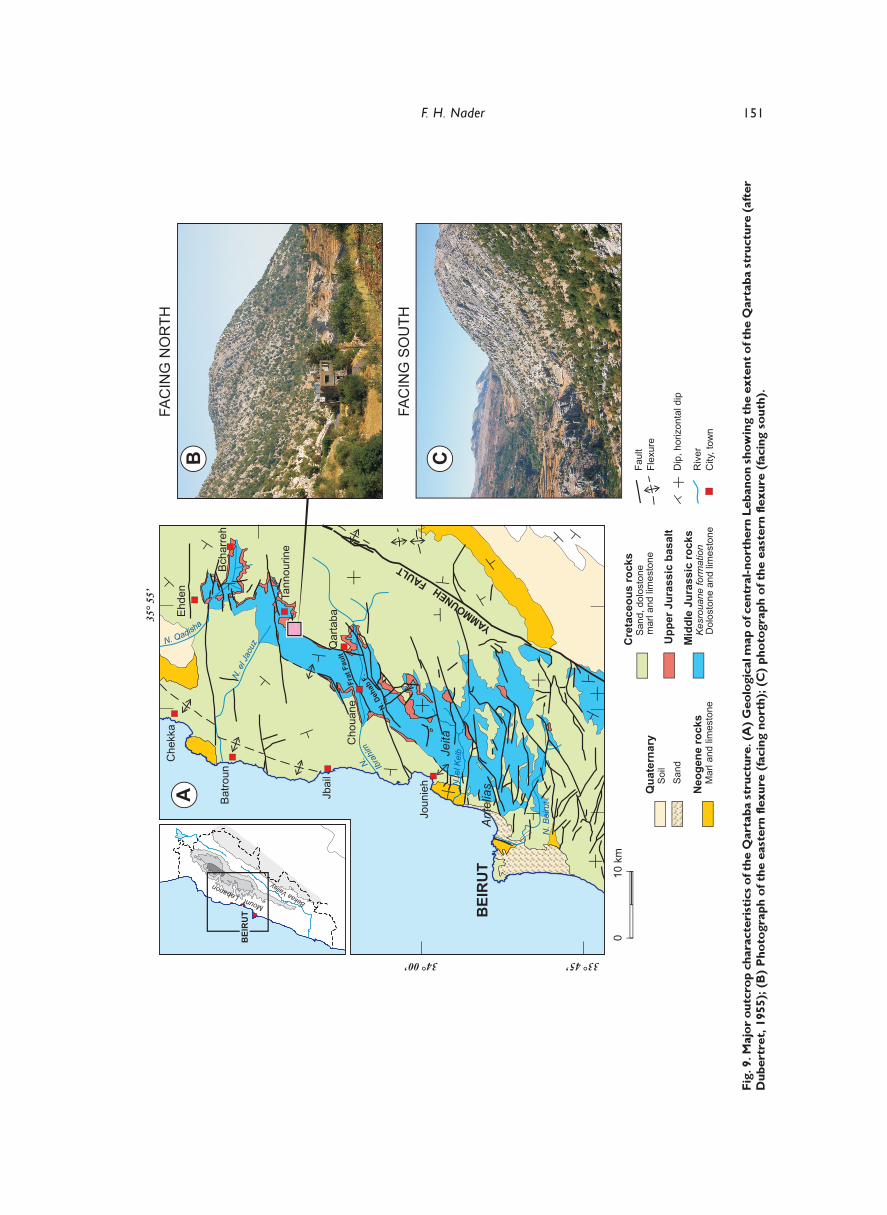
Fig. 2. Simplified geological map of Lebanon. Map shows the locations of the seven exploration wells so fardrilled in Lebanon and of the reported hydrocarbon shows, and also the location of the Qartaba structure.
Compiled from Dubertret (1955), Ukla (1970) and Beydoun and Habib (1995).
200 km
3083Quaternary Sand and lake deposits Late Cenozoic Basalt
Miocene Limestones, conglomerates and lake deposits
Late Cretaceous - Neogene Chalks, limestones and marl
Jurassic Dolostones and limestones with some volcanics
Early -Middle Cretaceous Fluvio-deltaic sandstones overlain by thick marine limestones with some volcanics
SurfaceSubsurface
Major faultAltitude in metersInternational boundaryDeep borehole(+ total depth)
Hydrocarbon shows
36° 30
34°30
34°00
36° 0035° 30
33°30
LEVA
NT F
AULT
SYS
TEM
T U R K E Y
S Y R I A
ISRAEL JORDAN
LEBANON
-200
-100
Terbol (3065 m)
BE
KA
A
YAM
MOU
NEH
FAUL
T
BEIRUT
TripoliCHEKKA
METRITAabrine(620m)
Sour
QART
ABA
STRU
CTUR
E
Ile duPalmier
3083
Tripoli-Homs
Depression
2628
El Qaa(2557 m)
Tell Znoub(1421 m)
Yohmor(2672 m)
HASBAYAAadloun(2150 m)
Mliekh
Sohmor(1423 m)
0 20 km
N
M E D
I T
E R
R A
N E
A N
S E
AB
AR
OU
KST
RU
CTU
RE
MOUNTANTI
-LEBANON
MOUNT LE
BANON
MOUNT HERMON

139F. H. Nader
Recent deep seismic sections from offshore Lebanonshow the presence of a Triassic rifted terrain but nosign of oceanic crust (Roberts and Peace, 2007). TheLevantine Margin constitutes an important featurewhich is clearly observed on seismic sections offshoreLebanon, and which has evolved as a Jurassic-Cretaceous (predominantly carbonate) shelf-edge andslope.
Syrian Arc fold beltThe Syrian Arc is a sigmoidal fold belt extending fromwestern Egypt through Sinai, Israel and Lebanon intothe Palmyrides in Syria (Fig. 4). Krenkel (1924)considered the major structures in Lebanon (e.g. theLebanese mountains and the Bekaa valley) to be relatedto this fold belt (see also Wolfart, 1967). Thesestructures are aligned NNE-SSW, matching the centralsegment of the Arc (see index map in Fig. 4).
In general, the Arc structures are thin-skinnedopen flexures and folds, frequently associated withstrike-slip and reverse faulting (Walley, 1998; Abd El-
Motaal and Kusky, 2003). Freund et al. (1975) andReches et al. (1981) proposed that these structuresresult from inversion of pre-existing extensional faults.According to these authors, the Hebron Monoclinein Israel (a NNE-SSW trending, 35 km long, doubly-plunging monocline) is fault-cored and the normal faultthat was later reactiated preceded the monoclinal fold.Reches et al. (1981) proposed that steeply-dippingnorml faults appear to have been active during theTriassic-Jurassic and were reactivated in reversemotion in the Late Cretaceous to form the monocline.This model is consistent with a proposed Late Triassicto Early Jurassic phase of extension in the Levantregion (Freund et al., 1975). The western and easternsegments of the Syrian Arc (Fig. 4) probably resultedfrom inversion along older extensional SW-NE faults(Late Permian – Early Triassic).
Walley (1998) identified two main episodes ofSyrian Arc folding: Early Senonian and Late Eocene -Late Oligocene. Sawaf et al. (2001) described threeepisodes for the inversion and compression of the
m 0001>
180m
0-180m60m
E
NE
GO
EN
)aM 2 - 32(
E
NE
GO
ELA
P )a
M 32 - 56(
SU
OE
CAT
ER
C )a
M 56 - 241(
CIS
SA
RUJ
)aM 241 - 602(
ET
AL
CIS
SAI
RT
250m
m006
200m
m006
160m90m55m
100m
m008 - 0m003
- 052m004
Chouf Formation (C1)
Miocene Formation (m)
Pliocene Formation (p)
Abeih Formation (C2a1)Mdairej Formation (C2a2)Hammana Formation (C3)
Sannine Formation (C4)
Maameltain Formation (C5)
SHIRANISH Fm (SYRIA)Chekka Formation (C6)
Nummulitic Formation (e)
Salima Formation (J7)Bikfaya Formation (J6)Bhannes Formation (J5)
Kesrouane Formation (J4)
RUTBAH Fm (SYRIA)
Presumed very shallow lagoondisposition in evaporativeenvironment, marked withregressive cycles.
Shallow marine, lagoon and/orinner shelf. The lower stratawere sedimented in shallowerenvironments; whereas the topof the formation exhibits reef-related structures.
Intermittent volcanic fracture-eruptions in very shallow marine(agitated) to continental settings,with limited carbonate (reef)formation
Reef-related environments.
Tidal to supratidal (lagoon).
East (inland) : reef/lagoonWest (coastal) : subtidal/deep.
Change from deep to shallowmarine settings.
Infratidal / outer part of thecontinental shelf.
Basinal (deep marine) andmarginal facies.
Intermontane continental basins(e.g. Bekaa) and deeper open-marine along the coastal area.REEF-FORMATION WITHINTHE COASTAL AREA.
ARID CLIMATE
Widespread reef formationdue to the Atlantic-Pacificoceanic connection.
Local uplift, block-faultingkarstification and volcanicactivity in the central-northernMount Lebanon.
Development of the Levant PassiveMargin (rifting along the margin ofthe Eastern Mediterranean Basin).
Regional regression and fluvio-deltaic sandstones.
Last phase of volcanism (Late Aptian/ Albian) in Mount Lebanon.
GLOBAL TRANSGRESSION
Anticipation to the Syrian Arcfolding - initial collisionof Arabia with the subductiontrench along its north andeastern margins.
1st phase of Syrian Arcfolding - Mount Lebanonstart to emerge. Closure of theNeo-Tethys.
2nd phase of Syrian Arcfolding - major stage ofuplift of Mount Lebanon. TheBitlis suture zone formedbetween Arabia and nothernEurasian Plates.
Strike slip deformation alongthe Yammouneh Fault. Splittingof the Levant micro-plate due tothe continuous collision of Arabiaand Eurasia.OPENING OF THE RED SEA
GLOBAL TRANSGRESSION
SEDIMENTARYREALM MAJOR EVENTSS T R A T I G R A P H Y SURFACE / SUBSURFACE
SHOWS
A BG
A
Hasbaya
Yohmor-1
Yohmor-1ChekkaMetrit
Sohmor-1
A
Metrit
B
B
Terbol-1El Qaa
El Qaa
Terbol-1El Qaa
B
BTell Znoub
S
Nahr ed DehabNahr IbrahimJeitaAntelias
SJeita Tunnel
Mleikh
DolostoneConglomerateMarl
BasaltSandstone
LimestoneMarly limestone Limestone with
chert nodules
Oolitic sandylimestone
Dolomiticlimestone
Surface showSubsurface show
A AsphaltB Bitumen / Coal
S Solid hydrocarbonG Gas
Unconformity / Karstification
? ? ? ?
Fig. 3. General tectono-stratigraphic column for Lebanon with the interpreted depositional environments of
the various rock-units and the corresponding surface and subsurface shows of hydrocarbons (compiled frommany authors cited in the text).

140 Petroleum prospectivity of Lebanon
Syrian Palmyrides (latest Cretaceous, Middle Eoceneand Miocene-to-present). It seems that suchdeformation continued along the eastern segment ofthe arc (inland Syria) slightly later than elsewhere. Themagnitude of the folding increased with time so thatthe final phase seems to have been responsible formost of the uplift (Ponikarov, 1967; Walley, 1998,Sawaf et al., 2001).
The latest phase of deformation identified by Sawafet al. (2001) was masked by activity on the LevantFault System. Here, deformation takes the form ofmotion along the splays of the Levant fault (Fig. 4)and transpressional neo-tectonism affecting MountLebanon (e.g. Gedeon, 1999; Nemer, 1999; Elias etal., 2007) (see below).
Levant Fault SystemThe Levant Fault System extends about 1000 kmfrom the Red Sea (Gulf of Aqaba) to the TaurusMountains in Turkey and currently forms the westernedge of the Arabian Plate. The fault system has abroadly north-south alignment that changes to NNE-SSW in Lebanon. Hancock and Atiya (1979) dividedthe fault system into as many as seven segments,but a three-fold division is common (e.g. Walley, 1998)comprising from south to north the Dead SeaTransform Fault, the NNE-SSW Yammouneh Fault(the Lebanese segment) and the south-north GhabFault (Dubertret, 1966) (Fig. 4).
Left-lateral displacement has been proposed forthe entire Levant Fault System (Quennel, 1958;
36°N
36°N
36°E
36°E
34°N
40°E
34°N
28°N
32°E 38°E
BeirutDamascus
Amman
Jerusalem
Cairo
M E D IT E R R A N E A N
S E A
Syrian Arc Structures LevantineStructures
N
100 km
A l e p p oP a l e o h i g h
H a m a dP a l e o h i g h
BISHRI BLOCK
BILAS BLOCK
YAM
MOU
NEH
FAUL
T Jihar FaultBila
s Fault
0 100 km
FaultAnticline
Uplift / PaleohighCentral / Northern PalmyridesSouthern Palmyrides
HomsDepression
Al-DawwDepression
Jiba
lA
s-S
ahily
ah
GH
AB
FA
ULT
Damascus
BEIRUT
DEA
D S
EA
TRA
NSF
OR
M F
AU
LT
Fig. 4. Simplified maps showing the Palmyride Basin (as well as the Palmyrides fold and thrust belt), the extentof the Syrian Arc fold structures and the Levant Fault System in Lebanon and adjacent countries (modified
from Walley, 1998).

141F. H. Nader
Freund, 1965), although this is not observed along theYammouneh fault (opposed by Dubertret, 1975).Quennel (1958) and Freund et al. (1970) proposed thatsinistral offset of 60-65 km occurred along the DeadSea fault from the latest Oligocene to the Early Miocene,with an additional 40 km during the last 5 Ma.
Motion on the fault system is related to the openingof the Red Sea. An early phase of Red Sea rifting startedbetween 25 to 20 Ma with extension through the Gulfof Suez. Activity on the Dead Sea fault started during alater phase of rifting affecting the Gulf of Aqaba about14 Ma ago (Bayer et al., 1988; Makris and Rihm, 1991),with a second episode of activity from 6-5 Ma to thepresent day, accompanied by extensive magmatism(Garfunkel, 1989) and the onset of transpression inLebanon (Walley, 1998). A structural element recentlyobserved offshore Lebanon was referred to as the“offshore Mount Lebanon thrust” by Elias et al. (2007),who interpreted it to be part of the Levant Fault Systemand to have controlled the growth of Mount Lebanonsince the Late Miocene.
Different amounts of offset have also beenpostulated for the northernmost segment of the Levantfault system (i.e. the Ghab fault; Fig. 4). Displacementof ophiolites cut by the fault in Turkey was used byFreund et al. (1970) to identify some 70 km of sinistraloffset, but this has been disputed (e.g. Quennel, 1984).Chaimov et al. (1990) proposed a total of 40 to 45kmof displacement (Pliocene to present-day), in accordancewith the second episode of displacement identified byQuennel (1958) for the southern portion of the LevantFault System. Of this 40-45 km, shortening of thePalmyride fold-and-thrust belt may have accommodatedsome 20 km of sinistral movement so that strike-slipoffset along the Ghab Fault totalled some 20-25 km.This is demonstrable by offsets of Pliocene basalts(Quennel, 1984), Quaternary alluvial fans and perhapsMesozoic ophiolites (Brew et al., 2001).
DEPOSITIONAL HISTORY
The oldest rock-unit known in Lebanon (at outcrop andin the subsurface) is the Lower Jurassic dolostone (Fig.2). The nature and extent of underlying older rocks canbe extrapolated from surrounding countries.
A number of unconformities are present within theDevonian to Upper Jurassic – Lower Cretaceoussuccession of the northern Arabian Plate (Fig. 5). Manyof these unconformities have been correlated with theboundaries of the Arabian Plate megasequences identifiedby Sharland et al. (2001), and correspond to boundariesof second-order cycles with fining-upward sequences(e.g. within the Palmyride Basin: Wood, 2001). Theunconformities coincide with major eustatic cycles (Haqet al., 1988) and are time-equivalent to phases ofmagmatic activity (Wood, 2001).
PalaeozoicIn Syria, Cambrian rocks include arkosicsandstones (probably derived from a graniticbasement in the south), together with siltstone andshales. The widespread Early to Middle CambrianBurj Limestone Formation (Fig. 5; Brew et al., 2001)is the deepest continuous seismic reflector insubsurface Syria and northern Jordan (McBride etal., 1990; Best et al., 1990). Cambrian rocks areexposed at Al Burj in the southern Jordan Valley(Wetzel and Morton, 1959).
Ordovician strata increase in thicknesssoutheastwards from Aleppo to Rutbah and Jordan(1.6 to 3.5km). Sandstones pass into siltstones andshales (Brew et al., 2001); such facies andthickness variations indicate open-marine conditionsto the east during Ordovician times. An end-Ordovician regional unconformity is associated withuplift in western Saudi Arabia (Sharland et al.,2001).
In the Early Silurian, much of Arabia wasflooded due to deglaciation and important organic-rich source rocks (Upper Ordovician – LowerSilurian “hot shales”) were deposited regionally(Beydoun, 1991). In Syria, these deposits comprisethe Tanf Formation which consists of graptoliticshales whose original thickness may range between500 and 1000 m (Fig. 5; Brew et al., 2001). Loydellet al. (2009) demonstrated that there are a numberof different Lower Silurian “hot shales” in Jordan(thus forming thicker potential source rockintervals), some of which could have been depositedduring an interval of lowered eustatic sea-level,regression and rapid burial of organic matter. UpperOrdovician – Lower Silurian “hot shales” in Iraqwere re-assessed by Aqrawi et al. (2010).
Late Silurian and Devonian rocks are generallyabsent in Arabia, as the Tanf Formation (or itsequivalent) is unconformably overlain directly byCarboniferous siliciclastics which form importantreservoir rocks (e.g. Husseini, 1992; Kohn et al.,1992; Stampfli et al., 2001). In Carboniferoustimes, the Palmyride Basin, together with the easternSinjar extension, flanked to the NW by the AleppoHigh and to the SE by the Rutbah High (Figs 4, 5),formed the main depocentre in Syria (and mostprobably Lebanon), until the onset of Syrian Arcfolding in the Late Cretaceous. The Carboniferoussuccession, whose thickness exceeds 1700 m inthe Palmyride Basin, is mainly composed ofsandstones and sandy shales, together with someminor carbonates (Brew et al., 2001).
Transgressive sedimentation dominates the EarlyPermian succession in Syria, suggesting littletectonic activity at this time (Wood, 2001). Theconfiguration of the Palmyride Basin persisted

142 Petroleum prospectivity of Lebanon
throughout most of the Permian (similarly to theYemen-Oman and central-northern Saudi Arabiabasins), with an eastwards or SEward basinal marineconnection. Permian-Triassic siliciclastics (exceeding1000 m of thickness; Amanous Formation) arepreserved within the Palmyride/Sinjar Basin andinclude both source and reservoir rocks (Brew et al.,2001; Fig. 5). The Aleppo and Rutbah Highs wereemergent throughout the Permian (Figs. 4 and 5). Inthe subsurface of Israel, the Upper Permian consistsof marine sandstones, shales and carbonates up to500 m thick, with a probable hiatus near the Permo-Triassic boundary (Hirsch, 1991).
Mesozoic (pre-Cretaceous)The Triassic rock sequence has a thickness rangingbetween 500 and 1100 m, including open/shallow and
restricted hypersaline carbonates (and evaporites) aswell as continental clastics, in Israel and Jordan(Benjamini et al., 1993). The Early Triassic iscomposed of cyclical trans- and regressive deposits(Hirsch, 1991). In subsurface Syria, the LowerTriassic within the Palmyride Basin is a continuationof the Permian sandstones and shales. The Permianto Lower Triassic Amanous Formation forms the basalunit (Fig. 5). Shales become dominant towards thetop of this formation with dolomites and dolomiticlimestones in the central Palmyride trough.
The top of the Amanous Formation marks either ahalt in rifting (Brew et al., 2001), a decrease inaccommodation space within the Palmyride Basin and/or a phase of tectonic inversion (Wood, 2001).Extremely low sea levels prevailed in the Early Triassic(Haq et al., 1988) and contributed to an extensive
ENEG
OELAPENE
GOEN
AleppoPlateau
SouthPalmyrides Bishri Block
Arabian mega-sequencesRutbah
(Hamad) upliftLebanon
Central /North Palmyrides
W E S N NNE SSW
SERIES /STAGE Sharland et al., 2001
CISSAIRTCISSARUJ
.CATERC
QuaternaryPliocene
Miocene
Oligocene
Eocene
Paleo-cene
Late
Late
Early
Late
EarlyMiddle
Permian
Early
Middle
Cambrian
Ordovician
Silurian
Devonian
Carboniferous
?
?
?
???
Dolomitizedlimestone
Chert
Chekka
ContinentalConglomerates
Jeribe
Shiranish
Ammanous Sandstone
Kurrachine DolostoneKurrachine Anhydrite
HayyanArgillaceous
Burj
Tanf
AP1
AP2
AP3
AP4
AP6
AP7
AP8
AP9
AP10
AP11
AP5
SandstoneShale
LimestoneMarl
ChalkDolostone
AnhydriteVolcanics
Fig. 5. Generalized lithostratigraphic chart showing the Palmyride rock sequence in Syria (from Brew et al.,2001) and Lebanon. Both Aleppo and Rutbah palaeohighs are represented by a major hiatus spanning most ofthe Mesozoic (until the inversion phase which affected the Palmyride Basin). The lithostratigraphic scheme of
Lebanon matches well with that of the Palmyride Basin. Arabian Plate megasequences (from Sharland et al.,2001) are also presented.

143F. H. Nader
unconformity recognized in Israel (Gvirtzman andWeissbrod, 1984; Hirsch, 1991), in Jordan (Wood,2001), in interior Syria (Brew et al., 2001) andelsewhere in the Arabian region (Beydoun, 1991).Areas where the unconformity is absent weredepocentres which remained submerged – e.g. centralPalmyrides, where the Amanous Formation passesgradationally into the overlying Kurrachine Dolomite(Fig. 5). The Middle Triassic Kurrachine Dolomite(or Mulussa B) in Syria directly overlies Permian,Carboniferous and sometimes even Silurian strata(Brew et al., 2001). Dolostones with reservoirpotential dominate the formation in the Palmyridesand in the northern Syrian regions. Source potentialmay be associated with local deep-marine limestones.The inner Palmyride Basin hosts increasingly moreevaporitic deposits (Fig. 5; Wood, 2001).
The overlying Kurrachine Anhydrite (or MulussaC), which forms an excellent seal for the underlyingreservoir and source rock units, was probablydeposited within the Palmyride Basin when the marineconnection was temporarily lost (Wood, 2001). Theanhydrites, found in the subsurface, covered theAleppo High and the Syrian Coastal Ranges (Sawafet al., 2001). The Late Triassic Mulussa D and E arecharacterized by a return to limestones interbeddedwith anhydrites and dolomites and are restricted tothe Palmyride/Sinjar basins. In Israel, the equivalentEarly Carnian Mohilla Formation consists of a thickdolostone and evaporite sequence (reaching 210 m;Druckman and Magaritz, 1991; Benjamini et al.,1993). This coincided with a fall in eustatic sea-leveland the global “Saharan” event at 231 Ma (Hirsch,1991).
An extensive latest Triassic unconformity wasfollowed by a regional transgression which did notaffect the Aleppo and Hamad/Rutbah Highs boundingthe Palmyride Basin (Brew et al., 2001). Early Jurassic(Liassic) sedimentary rocks in the Levantine regionhave similar lithological characteristics to theunderlying Triassic succession and consist ofcyclically-deposited sub- and supratidal carbonates,evaporites and continental clastics (Benjamini et al.1993; Buchbinder and Le Roux, 1993).
Jurassic strata are surface-exposed in severallocations in the Levant. In Sinai and the Negev, theLate Liassic to Kimmeridgian succession, made upof carbonates, marl/shale, sandstones and volcanics,is over 2000 m thick (Hirsch et al., 1998). At MountHermon (SW margin of Anti-Lebanon; Fig. 2),alternating massive and thin-bedded carbonates ofLiassic to Kimmeridgian age are more than 1200 mthick (Mouty and Zaninetti, 1998). The lowerboundary of the Jurassic sequence is still notaccurately defined in Mount Lebanon but previousstudies have considered the oldest dolostones exposed
in the Nahr Ibrahim valley to be Liassic (Renouard,1951; Dubertret, 1955; Nader, 2003). In this case,the Jurassic sequence in Mount Lebanon would beabout 1420 m thick (Fig. 3). In the Palmyrides ofinternal Syria, these rocks were intensively erodedduring the Late Jurassic – Early Cretaceous, and UpperJurassic rocks are absent. The total thickness of theremaining Lower-Middle Jurassic varies between tensand a few hundreds of metres (Mouty, 1997; Moutyand Zaninetti, 1998). There is no clear evidence forthe presence of Tithonian strata in Lebanon, Syria,Jordan and west Iraq (Mouty, 2000).
Early Jurassic strata are characterized in Lebanonand Syria by shallow-marine facies, mostlycarbonates. Within the Palmyride Basin, the LowerJurassic is not distinct from the Upper Triassic as thetransgression that started in the latest Triassiccontinued through the Early Jurassic and coveredmost of Syria and probably all of Lebanon. Theresulting deposits generally consist of grey, fine tomedium crystalline dolostone (locally anhydritic)together with intervals of limestone and marl (Fig. 5;Renouard, 1955; Mouty, 2000; Wood, 2001). Thelagoonal-evaporitic depositional environment thatprevailed throughout most of the Triassic (e.g. HayyanGypsum in Syria) passed progressively into deeper-marine conditions, hence the dominance of mudstones,wackestones and packstones with rare anhydrite (e.g.Renouard, 1955; Walley, 1997; Brew et al., 2001;Wood, 2001) in the Lower Jurassic succession.
The Middle Jurassic (Aalenian to Oxfordian)succession is represented by undifferentiateddolomicrites over 1000 m thick in subsurface Israel(Haifa Formation; Hirsch et al., 1998). A south-northfacies change (i.e. continental passing into shallow-marine) observed for the Early Jurassic was generallyrepeated during the Middle Jurassic. The BqaasemLimestone (Dubertret, 1960) exposed in MountHermon (cf. Fig. 3), consisting of 150 m of ooliticbioclastic limestones, is Bajocian-Bathonian (Moutyand Zaninetti, 1998). These oolitic facies result froma regression at the start of the Bathonian. The Calloviangenerally marks a return to micritic limestones withundifferentiated shallow-marine carbonates in MountLebanon (Bajocian to Oxfordian; Dubertret, 1955).
Uppermost Jurassic rocks cropping out in MountHermon and Anti-Lebanon consist of massivelimestones (Oxfordian-Kimmeridgian; 15 m thick),overlain by a bed, less than a metre thick, of ooliticlimestones of Kimmeridgian age with marl and basaltintercalations (Mouty and Zaninetti, 1998). A similarpattern is observed in Mount Lebanon but the twounits are much thicker. In the Syrian Coastal Ranges,Oxfordian-Kimmeridgian reefal carbonates (NasirahFormation) unconformably underlie Early Cretaceoussandstones (Mouty, 1997).

144 Petroleum prospectivity of Lebanon
Significant erosion occurred by the beginning ofthe Kimmeridgian as the sea retreated westwards andmost of Syria and Lebanon became subaeriallyexposed by the end-Kimmeridgian (Mouty, 2000).This could have been also associated with tectonicmovements in Lebanon (especially in the northern partof the country; Dubertret, 1955; Renouard, 1955;Saint-Marc, 1980; Picard and Hirsch, 1987; NoujaimClark and Boudagher-Fadel, 2001; Walley, 2001).Most of the post-Callovian to Early Albian successionis absent in interior Syria. In addition, Oxfordian-Kimmeridgian alkaline volcanism (which continuedintermittently through the Early Cretaceous) occurredin Mount Lebanon (Bhannes Formation; Fig. 3), Anti-Lebanon, the Syrian Coastal Ranges and thePalmyrides (Mouty et al., 1992). Wilson (1992) andGarfunkel (1992) suggested mantle plume activitycentred in the Levant region throughout the LateJurassic – Early Cretaceous. Nader and Swennen(2004a) discussed the influence of an early phase ofkarstification (ca. Late Jurassic to Early Cretaceous)of the Jurassic carbonates on their reservoirproperties, associated with local uplift in central-northern Mount Lebanon. The overlying UpperJurassic basalts and claystones, as well as LowerCretaceous shales, marls and basalts, may formefficient seals.
Mesozoic (post-Jurassic)Volcanic activity together with associated uplift,emergence and erosion continued into the EarlyCretaceous (Noujaim Clark and Boudagher-Fadel,2001). Contemporaneous block-faulting and fault-reactivation probably related to this volcanism led tolocally enhanced sediment deposition in the PalmyrideBasin (Brew et al., 2001). Robertson and Dixon(1984) associated this faulting with acceleratedspreading in the Eastern Mediterranean Basin. Naderet al. (2004, 2007) investigated hydrothermaldolomitisation associated with the Late Jurassic – EarlyCretaceous faulting and volcanism in central andnothern Lebanon. They demonstrated that fault-associated strata-discordant dolomite bodies enhancethe reservoir potential of the Jurassic succession(Nader and Swennen, 2004a, b).
After a sedimentary hiatus lasting some 25 Ma,widespread distribution of fluvio-deltaic sandstonesand shallow-marine shales (up to hundreds of metresthick) occurred in the Early Cretaceous (Litak et al.,1998; Brew et al., 2001; Wood, 2001) with localvolcanics (Dubertret, 1955). These sandstones includethe Chouf Formation in Lebanon, Palmyra/Rutbahsandstone in Syria, and Kurnub sandstone in Jordan.They are generally dated as Neocomian to Barremianand form a strong seismic and electrical log marker(Wood, 2001). The Hamad and Rutbah Highs remained
emergent at this time and until the Late Cretaceous(cf. Figs. 4 and 5; Brew et al., 2001). The Cretaceoussandstones are believed have been derived locally fromCarboniferous and Permian sandstones. Thisprovenance is also suggested by the fact that thesandstones become more shaly and carbonaceous tothe north, reflecting increasing distances from theHamad and Rutbah Highs. In northern Mount Lebanon,there is local thinning of the sandstones (ChoufFormation); the thickness varies from 300 m in centralLebanon to tens of metres in the Qadisha area in thenorth (cf. Figs. 2 and 3). This is probably due tolocal uplift before and during the deposition of theChouf Formation.
The sandstones pass gradationally up into LateBarremian - Early Aptian nearshore carbonates (oolitic,sandy; e.g. Abeih Formation, Lebanon) and reefalcarbonates (Mdairej Formation, Lebanon) (cf. Figs.3 and 5). The surface-exposed Albian HammanaFormation in Lebanon indicates a brief, local returnto near-shore, supra-tidal conditions (Noujaim, 1977;Doummar, 2005) and/or terrigenous clastic deposition(Walley, 2001), before a sea-level rise in the LateAlbian. In general, slow subsidence and the stabilityof the relatively low sea-level (Haq et al., 1988)combined to result in Albian-Turonian carbonateplatform deposition across most of Syria and Lebanon,e.g. the Sannine and Maameltain Formations inLebanon and the Judea Formation in Syria (Moutyand Al-Maleh, 1983) (Fig. 5). The palaeogeographicconfiguration of shallow to deeper environments alongwestwards and SW trends was maintained. Clear east-west facies changes are observed across MountLebanon (e.g. Sannine Formation; stratigraphicthickness reaching 600 m), corresponding to supratidal- peritidal environments as well as reefal and lagoonsettings and deeper-water pelagic carbonate realms(Ja’ouni, 1971; Walley, 1997; Nader et al., 2006).Thin-bedded, chalky and cherty sediments as well asslump and scour features characterize the SannineFormation in its coastal (western) facies (Nader, 2000;Nader, 2003; Nader et al., 2006).
In Lebanon, the Turonian Maameltain Formation(Fig. 3) has an average thickness of 200 to 300 m.Lithologic and diagenetic features indicate a changefrom deep to shallow-marine conditions duringsedimentation (Noujaim, 1977; Nader, 2000). Wood(2001) proposed an unconformity marking theTuronian-Senonian boundary within the PalmyrideBasin. Müller et al. (2010) confirmed a similar regionalunconformity in Mount Lebanon, based onbiostratigraphic data, spanning the Coniacian to EarlySantonian time interval. As a result of ophioliteobduction and other tectonic factors, northern Arabiaunderwent renewed subsidence throughout theSenonian; the Chekka Formation in Lebanon may reach

145F. H. Nader
600 m in thickness (cf. Fig. 6). Sedimentary faciespoint to increasing water depths after Turonian timesin the Palmyrides (Brew et al., 2001) and in Lebanon(Nader, 2000). The very finely-grained biomicrites(Nader, 2000) represents high sea-level conditions onthe outer part of a continental platform, with pelagicchalk deposition (Walley, 1997). Nevertheless,shallower conditions and even partially emergent zonesoccurred locally until the Late Senonian (Dubertret,1955; Mouty and Al-Maleh, 1983). Phosphaticlimestones are also present within this sequence,mainly in the lower Senonian (Dubertret, 1955). Theirlocation was controlled by palaeogeographic factors(Al-Maleh and Mouty, 1994).
Maastrichtian to Early Eocene strata (e.g. Shiranishand Bardeh Formation in Syria) are characterized byan increase in marl content with planktonic andbenthonic foraminifera, indicating greater water depthsin a low-energy open-marine environment, with thethickest strata occurring in the central areas of thePalmyride Basin (Al-Maleh and Mouty, 1988). Atectonic-induced change in palaeogeography in interiorSyria is indicated by the Paleocene limestone which
sharply overlies the Maastrichtian Shiranish marls(Wood, 2001). In Lebanon, marine deposition inisolated depocentres persisted until the Middle Eocene(Dubertret, 1955). A major phase of tectonismoccurred in the Late Eocene through Late Oligocene,culminating in much of the present-day uplift of MountLebanon during a second phase of Syrian Arc folding.
CenozoicIn the Neogene, the opening of the Red Sea andactivity on the Dead Sea Transform Fault and theLevant Fault System accentuated the uplift of MountLebanon and resulted in the regional-scale present-day topographic structure. Based on geophysical datafrom the 2003 Shalimar offshore survey, Elias et al.(2007) suggested that the uplift of Mount Lebanonwas chiefly driven, since the Late Miocene, by activityon a 160 km long east-dipping thrust system (theMount Lebanon Thrust) located about 20 km offshorethe Lebanese coastline.
During the Paleogene, most of the northern Arabianplatform remained under marine conditions withextensive pelagic deposition (mudstone/wackestone).
N
° 6 3 N
° 2 3
26°E 30°E 34°E
A
C
B B
C
BEIRUT ERATOSTHENES SEAMOUNT
E G D I R N A E N A R R E T I D E M
E N I T N
A V
E L H
T R O
N
N I S
A B
SOUTH LEVANTINE
BASIN
Nile Cone
Thick salt layers Thrust reverse fault Normal fault
Anticline Simplified geologic section interpreted from seismic data
2
4
2
4
Sec TWT
Sec TWT
20 km
20 km
N W S E
P l i o c e n e / Q u a t e r n a r y M e s s i n i a n S a l t
SOUTH LEVANTINE BASIN
Cyprus Arc
Pliocene/Quaternary
SOUTH LEVANTINE BASIN
Cyprus Arc
NORTH LEVANTINE BASIN
Pliocene/Quaternary Messinian Salt
Fig. 6. Structural configuration of the Eastern Mediterranean Basin (A) and simplified geologic sections (B, C)which were interpreted from seismic sections oriented south-north and east-west, respectively. Map and
seismic data from Sage and Letouzey (1990). The locations of the Leviathan, Tamar, Dallit and Mari-B
discoveries are indicated by yellow ovals on the map.

146 Petroleum prospectivity of Lebanon
The Early Eocene Arak Formation (carbonate andsiliciclastic facies) was deposited in shallower waters.Chalk, chalky limestones and marls rich in microfossilsand nannofossils characterize the low-energy pelagiccarbonate deposits of the Middle Eocene (Fig. 5). Formost of the Late Eocene and Oligocene, thePalmyrides region was covered by nummulitic sandylimestones and sandstones with major lateral changeswhich indicate tectonic uplift (Yzbek, 1998).Equivalent strata were either not deposited or erodedin Lebanon.
The second phase of Syrian Arc folding occurredin the Late Eocene (Guiraud and Bosworth, 1997)including uplift of the Syrian Coastal Ranges (Brewet al., 2001). The associated stratigraphic gap inonshore Lebanon spans the Late Eocene andOligocene. The Lebanese meso-scale structures alsodeveloped at this time. This major uplift wasaccompanied by a global sea level fall (Haq et al.,1988). A period of non-deposition and/or erosion inLebanon continued until the mid-Miocene (Figs 3, 5).
Paleogene strata have not yet been properlyclassified in Lebanon, with the exception of the recentbiostratigraphic work of Müller et al. (2010). Surface-exposed Paleocene rocks have been included withinthe Chekka Formation. The Eocene Formation isdivided into early and middle units (Dubertret, 1975;Walley, 1997). The former is composed of marls andchalky limestones with chert in southern Lebanon andthe Bekaa (cf. Fig. 2). The latter is made up ofnummulitic limestone. The total thickness of thesestrata reaches 900 m in southern Bekaa (Fig. 2).According to Müller et al. (2010), a number ofregional hiatuses can be recognized in the Cenozoicrock successions exposed in Lebanon. These are: (i)the topmost Maastrichtian to lowermost Paleocene,(ii) Lower Oligocene, and (iii) lowermost Miocene(Aquitanian to lowermost Burdigalian).
By Middle Miocene times, Mount Lebanon and theAnti-Lebanon were uplifted, and sedimentation washenceforth restricted mainly to the coast and the inlandBekaa basin. Miocene deposits therefore have twodistinct facies. Coastal facies are exposed in the Nahrel Kalb region (central Lebanon) and Jebel Terbol(northern Lebanon; Fig. 2). At Nahr El Kalb, sedimentsconsist of littoral limestones containing corals, algaeand bivalves, passing into conglomerates and beachrocks (Dubertret, 1955; Walley, 1997). At Jebel Terbol,Miocene rocks are composed of creamy limestonesoverlain by well-cemented conglomerates ofcontinental origin (Middle to Late Miocene; Müller etal., 2010). The Miocene section has a stratigraphicthickness ranging between 200 and 300 m (Dubertret,1975; Walley, 1997). In the Bekaa basin, Miocenedeposits are composed of alluvial fan and lacustrineclastics up to 1.5 km thick (Walley, 1997).
A final transition to continental conditionsthroughout Syria and interior Lebanon occurred duringthe Miocene. Deposition of the Senonian – LateOligocene sequence across Syria and Jordan wasterminated by uplift and marine regression (Wood,2001). Subsequently, local uplift and erosion createdintramontane basins including the Bekaa basin. To theNW and west of Mount Lebanon, deeper open-marineconditions prevailed during the Miocene and Pliocene.
Volcanic activity is indicated by Middle Miocenebasalts. Further marine regressions occurred in LateMiocene times as evidenced by hiatuses and depositionof evaporites correlative with the Messinian “salinitycrisis”. The Pliocene sequence (up to 450m thick)shows a progression towards continental depositionwith some basaltic volcanism (Brew et al., 2001).Volcanic rocks were extruded from 24 to 16 Mathroughout western Syria with the exception of theCoastal Ranges. This period approximately coincideswith advanced stages of Arabia-Eurasia plateconvergence (Mouty et al., 1992). The absence ofvolcanism from about 16 to 8 Ma roughly correspondsto an interval when there was little Red Sea spreadingand no movement on the Dead Sea Fault (Hempton,1987).
In Lebanon, the basal Pliocene is marked by animportant transgression (Müller et al.; 2010). Inland,Miocene rocks are overlain unconformably by fluvialand lacustrine sediments of Pliocene to Pleistoceneage. These sediments predominate in the Bekaa andAkkar areas (northern Lebanon; Fig. 2) and have avariable thickness that may reach 500 m (Dubertret,1975). Volcanism in southern and northern Lebanonis represented by basalts and volcanic plumes (AbdelRahman and Nassar, 2004).
Roberts and Peace (2007) discussed thestratigraphy of the Levantine Basin, offshore Lebanonbased on seismic data. They suggested that theshallow-water platform present in coastal Lebanonpasses into a relatively deep basin to the west. Whilehighstand systems tracts within the Levantine Basinare believed to consist of aggrading and back-steppingcarbonate platforms, the lowstand systems tracts maycorrespond to siliciclastics and deep-water carbonateturbidite systems (Gardosh and Druckman, 2006).These are generally sealed by Tertiary shales andMessinian evaporites. The latter appears to be locallybreached by deep-seated faults (observed on seismiclines), especially close to the coastline.
POTENTIAL OFFSHORE ANDONSHORE PLAYS
Hydrocarbon shows in Lebanon were outlined byNader and Swennen (2004a, and references therein);their locations and nature are illustrated in Figs. 2 and

147F. H. Nader
3. Since no hydrocarbon production takes place inLebanon, such hydrocarbon shows are the only directevidence for the petroleum potential of onshoreLebanon and the coastal margin. Five out of the sevendrilled wells intercepted major shows (Fig. 2): thesewere Terbol (TD: 3065 m), El Qaa (TD: 2557 m),Yohmor (TD: 2672 m), Sohmor (TD: 1423 m), andTell Znoub (TD: 1421 m). In addition, Jurassic andCretaceous rock formations include shows in the formof asphalt, bitumen/coal, solid hydrocarbons andnatural gas (Fig. 3).
According to Renouard (1955), some hydrocarbonshows in Lebanon are characterized by the presenceof authigenic quartz (e.g. Metrit, Chekka, south Bekaa;Figs. 2 and 3). He demonstrated the association ofsuch hydrocarbons with quartz cement, invoking thecirculation of hydrothermal fluids oversaturated withsilica and asphalt along faults and fractures. Aqueousinclusions trapped within the quartz crystals indicatehomogenization temperatures of about 150°C, whichcould imply an origin from Triassic or deeper unitson the basis of regional and stratigraphicconsiderations. The Hasbaya heavy oil seeps (Fig. 2),known since prehistoric times, may indicate activemigration (in a liquid state) at the present-day from apossible deep reservoir (Al Haddad, 2007). However,both the mode of occurrence and geochemical analyses(Renouard, 1955) tend to support an allochthonousorigin for the hydrocarbons. This is also consistentwith the suggestion by Horowitz and Langoskey(1965) that the Late Jurassic and Early Cretaceous oilreservoirs (and asphalt seeps) in Israel are derivedfrom pre-Jurassic rocks (probably Triassic), basedon studies of the palynological remains inhydrocarbons. Beydoun (1977a) speculated (based onregional geology) that Triassic and Palaeozoic unitsmay act as source and reservoir rocks in Lebanon.
Offshore Potential PlaysThe initial development of the Eastern MediterraneanBasin has been related to the opening of the Neo-Tethys at the beginning of the Mesozoic. During thecollision of the Afro-Arabian and Eurasian plates inthe Late Cretaceous, the Eastern Mediterranean basinwas cut off from its eastern extension. Sage andLetouzey (1990) divided this basin, based on structuralstudies, into three areas (Fig. 6A): (i) to the north, a“thrust belt” – part of the Alpine orogen and includingthe North Levantine Basin; (ii) in the south, a stableforeland, including the Herodotus Abyssal Plain, the(South) Levantine Basin, the Eratosthenes Plateau andthe Nile Cone; and (iii) an intermediate central areaconsisting of the deformation front (Cyprus Arc, theFlorence Ridge and the Mediterranean Ridge).
The Lebanese offshore covers parts of the southernand northern Levantine basins as well as the Cyprus
Arc. Messinian evaporites are in general thinner inthe northern than the southern Levantine basin (Fig.6B). A seismic line trending east-west and terminatingclose to the Syrian shoreline (Fig. 6C) showswestward thinning of sub-salt (Jurassic andCretaceous) units and the erosional surface belowthe Pliocene-Quaternary section. The thick sub-saltseries to the south of the Cyprus Arc thins in thedirection of the continental margin (Sage andLetouzey, 1990). In the area of the Arc, these rockunits are affected by folds, thrusts and backthrustswhich were synchronous with Messinian evaporitedeposition. At the deformation front, the faults werestill active in the Plio-Quaternary (Fig. 6). Based onsesimic analyses, Sage and Letouzey (1990)suggested that a major compressive phase offshoreCyprus preceded the deposition of the Messinianseries. Compressive structures are also believed tobe present in the Upper Miocene, but most of theshortening is supposed to be pre-Messinian and thesalt does not represent a major décollement. Sageand Letouzey (1990) thought that Cretaceous nappesand ophiolites constituted a likely décollement level.Briais et al. (2004), based on geophysical dataproduced during the offshore 2003 Shalimar survey,described Plio-Quaternary turbidites detached aboveMessinian evaporites and folded some 30 km offshoreLebanon. The regional compressional regime that isbelieved to have begun by the end of the Cretaceous(Syrian Arc folding) seems therefore to have beencontinuously active to the present-day, although withvarying rates. Alternatively, the post-Messinian, Plio-Pleistocene successions appear relatively undeformedexcept where the underlying Messinian saltunderwent deformation (mainly at major collisionzones and/or near the basin margins).
Roberts and Peace (2007) recognized andillustrated 13 potential hydrocarbon plays ranging inage from Triassic to Neogene-Pliocene in the (South)Levantine Basin, offshore Lebanon. These includekarst-associated plays, carbonate build-ups, anticlinesand inversion structures, onlaps and Messinian-related(sub-, intra- and post-salt) plays. For instance, foldsand faults trending SW-NE appear to affectCretaceous and Cenozoic strata on the seismicsections. This general tectonic trend is parallel to theorientation of structures interpreted to result fromSyrian Arc deformation with which they maytherefore be related. Messinian evaporites (up to 1500m thick in the Levantine Basin) are considered to bean effective seal; underlying sediments, if shown tohave good reservoir characteristics, could thereforeprovide promising exploration targets (Roberts andPeace, 2007). The recent discoveries of gasaccumulations in the Tamar, Dalit and Leviathan wellsoffshore Israel (Fig. 6A) encountered important pay-

148 Petroleum prospectivity of Lebanon
zones in sub-salt Oligocene and Miocene sandstonesprobably capped by intra-Miocene shales(www.nobleenergyinc.com).
Two interpreted 3D seismic lines (Fig. 7), withno precise coordinates, were kindly provided by PGS;their detailed interpretation has been discussed atinternational conferences (e.g. Geo2010: Sortemoset al., 2010). The lines confirm most of the potentialplay types which were proposed by Roberts and Peace(2007).
The first line was shot over the (South) LevantineBasin, parallel to the coast about 50 km offshore Beirut(Fig. 7A). The second line (Fig. 7B) was shot withan east-west orientation, starting 70 km offshoreTripoli, passing over the Latakia Ridge (part of thedeformation front separating the southern andnorthern Levantine Basins) and crossing into offshoreCyprus. As indicated by the Tamar well offshore Israeland recent 3D seismic data acquisition, the thicknessof the Cenozoic package, previously estimated fromseismic character, has been revised (Roberts, GGS-Spectrum, pers. comm., 2010; Semb, pers. comm.2010), and is now believed to be thicker thanpreviously thought (up to 6 km).
In the North Levantine Basin (west of the LatakiaRidge), the Messinian evaporites appear to beshallower than those to the east of the Ridge, probablydue to further compression and uplift to the west andnorth of the ridge with respect to the South LevantineBasin. Faulting clearly affects the eastern flank of theLatakia ridge (Fig. 7B). Deformation within thesouthern Levantine Basin appears to have been activeat least until the deposition of the Messinian evaporites.According to the recent PGS data, Oligocene depositsare present in the (South) Levantine Basin (Fig. 7B)and show similar seismic attributes to the Oligocene-Miocene reservoirs recently discovered offshoreIsrael. Taking into account the major uplift and erosionoccurring onshore at the equivalent time (no Oligocenedeposits are found onshore Lebanon), these depositscould be attractive for further exploration as they mayhave originated from the erosion of the platform rocksadjacent to the Eastern Mediterranean basin. This couldalso suggest that the same Oligocene sandstoneswhich are being targeted offshore Israel may extendnorthwards.
2D seismic data from offshore Lebanon hasindicated probable siliciclastic systems in the sub-saltOligo-Miocene succession, including channel systemsand possible sandbodies (Semb, pers. comm. 2010).Gardosh et al. (2008) suggested two depositionalregimes for the Oligo-Miocene gravity-flowsandstones offshore Israel (Fig. 8): channel fillsconfined to intra-slope canyons and unconfined sandsheets and lobes at distal slope locations and on thebasin floor.
Potential source rocks present in the offshoreLevantine Basin are believed to include Senonian-Eocene black shales and marls (Gardosh et al., 2006)and Lower Miocene shales (Dolsen et al., 2005;Gardosh et al., 2006). Miocene deep-marine clastics,turbidites and channel fill sands may form reservoirrocks (Semb, pers. comm. 2008, 2010). Accordingto recent seismic data, potential structures offshoreLebanon may have closures exceeding 50 sq. km andsome exceeding 100 sq. km.
Continental Margin Potential PlaysMiocene rocks exposed in the Lebanese coastal regionand on the Tripoli Islands (Fig. 3) are composed ofshallow-marine limestones (with corals, algae andbivalves) that pass landwards into conglomerates andbeach rocks. The transition from conglomerate toreefal carbonates is at the scale of a few kilometresand is not continuous along the eastern Mediterraneancoastline (Fig. 3), implying that reefs could have beenformed offshore on local palaeo-highs. Miocene reefalcarbonates onshore Lebanon have cavernous porosity;the Hab Cave in Dahr Al Ain, near Tripoli City, is morethan 1500 m in length. Underlying uppermostCretaceous successions may include source rocks andthe overlying thick Messinian evaporites may act as aregional seal (Fig. 7). The Miocene carbonates maytherefore form good reservoir targets. However, it isnot clear if oil migration occurred before or aftersealing. If oil migration occurred during thecompression that preceded deposition of the Messinianevaporites, major oil accumulations are unlikely to haveformed. However, if migration occurred afterdeformation of the Messinian evaporites – and wherethe Messinian seals were not breached by deep-seatedfaults commonly found near the coastline – then theunderlying Miocene may include interesting plays.
Other exploration targets along the continentalmargin may include Upper Cretaceous reefalcarbonates; the Lower Cretaceous Chouf sandstones,equivalent to the Rutbah sandstones in Syria whichform reservoirs in the Euphrates Graben; Jurassicplatform and reefal carbonates influenced by fracture-associated hydrothermal dolomitisation; and Triassicdolomites which may also have source potential. Fig.10 shows swuch potential reservoirs which could becharged by Triassic and/or older source rocks
Onshore Potential PlaysSeismic surveys offshore Tripoli in 1970 and 1971located the compressional Ile du Palmier structure(Fig. 2) (Beydoun, 1977a). A later seismic survey(1993) pointed to the presence of pre-Jurassic salt inthe core of this structure (Beydoun and Habib, 1995),although the extent of diapirism was not clear due tothe poor quality of the seismic data (Nader and

149F. H. Nader
- 3
- 4
- 5
- 6
- 7
S TWT
S TWT
- 2
- 3
- 4
- 5
S N
W E
A
B
Pliocene (base)
Messinian (base)
Miocene (base)
Eocene (unconformity)
Senonian (unconformity)
Messinian (top)
Messinian (base)
Oligocene
Eocene ?
Senonian /older ?
NORTHLEVANTINE BASIN
SOUTHLEVANTINE BASIN
LATAKIA RIDGE
10 km
10 km
Fig. 7. Seismic lines from offshore Lebanon (reproduced courtesy of PGS); (A) sourth-north line from theLevantine Basin in water depths of ~1700 m; (B) west-east seismic line offshore Lebanon and Cyprus in water
depths of ~1500m, traversing the Latakia Ridge.

150 Petroleum prospectivity of Lebanon
Swennen, 2004b). However, the box-fold structuremay overlie a basal detachment (Late Triassic – EarlyJurassic) and the salt may therefore be comparableto the Kurrachine salt of the Palmyrides (Beydounand Habib, 1995).
A geo-electrical survey in the Nahr Ibrahim valley(central Lebanon: location in Fig.8) indicated thepresence of a conductive horizon (interpreted to beevaporitic) at 650 m below the oldest-exposed Jurassicrocks (Renouard, 1955). These inferred evaporitesmay be an extension of the Late Triassic evaporiteswhich are widespread in Syria (Beydoun and Habib,1995; Brew et al., 2001) and southern Israel(Druckman, 1974). If evaporites are present in theMount Lebanon area, the Triassic succession herewould be sealed and protected from the meteoricwaters which invaded the overlying Jurassiccarbonates (Nader and Swennen, 2004a). The pre-Jurassic succession may therefore have explorationpotential in northern Mount Lebanon, particularly atthe Qartaba “horst” structure (Nader and Swennen,2004b) which formed before the end of the Jurassic.
The Qartaba structure (~20 km long, ~5 to 10kmwide) is bounded by two SW-NE trending flexures(Fig. 9A). The flexures are combined with minor faultswhich maybe why Dubertret (1955) and Renouard(1955) described the structure as a horst. Fromstructure-contour mapping, Renouard (1967,
unpublished report) showed that in the subsurfacethe structure may reach a length of 75 km and a widthof 10-25km, with a maximum closure height of 1000m. The eastern limb of the local anticline dips moresteeply (up to 55°; see Fig. 9B, C) than the westernlimb, which has an average dip of 20°.
Beydoun (1977a) also investigated the Qartabastructure and estimated the depth of potential Triassicreservoirs. He chose a location at Qornet al Aaliyehand determined the thicknesses of the underlying rockunits from regional stratigraphic correlations. Heestimated that the boundary between the Permian andthe Triassic at this location was at 1952 m and thatthe Carboniferous began at around 2952 m. Renouard(1967, unpublished report) tentatively identified threesites for exploration well locations at this structure.
DISCUSSION
Potential source rocks in Lebanon correspond to thoserecognized in adjacent countries and includeOrdovician and Silurian (e.g. Tanf “hot shales”),Permo-Triassic, Lower/Middle Jurassic (KesrouaneFormation) and Upper Cretaceous (ChekkaFormation) units. According to regional correlations,Cambrian (Burj limestones), Ordovician,Carboniferous, Permo-Triassic (Kurrachine-equivalent), Jurassic, Cretaceous (Chouf sandstone,
Shorel
ine
Shel
f
Dead Sea
Haitacanyon
Ashdod canyonAfiq canyon
Slope
34°E
32°N
0 50 km
Messinian salt cover
Canyon
Sand sheets
Anticline
Sand in canyonsfillings
Concession zones
N
Fig. 8. Schematic map after
Gardosh et al. (2009) of offshoreIsrael/Palestine with suggesteddistribution of Oligo-Miocene
gravity-flow sands (channel fillingconfined in intra-slope canyons
and sand sheets and lobes ondistal basin floor) based on
seismic and well data. The Tamarconcession area is shown.
151F. H. Nader
FAC
ING
NO
RTH
Qua
tern
ary
S
oil
Dip
, hor
izon
tal d
ip
Faul
t Fl
exur
e
Neo
gene
rock
s
Mar
l and
lim
esto
ne
Mid
dle
Jura
ssic
rock
s
Kes
roua
ne fo
rmat
ion
D
olos
tone
and
lim
esto
ne
Cre
tace
ous
rock
s
San
d, d
olos
tone
mar
l and
lim
esto
ne
San
d U
pper
Jur
assi
c ba
salt
Riv
er
City
, tow
n
010
km
N. e
l Jao
uz
YAMMOUNEHFAULT
34° 00’ 33° 45’
35° 5
5’
BEI
RU
T
Ehd
en
Bch
arre
h
Tann
ourin
e
Che
kka
Bat
roun
Cho
uane
Qar
taba
Joun
ieh
Jbai
l
Jeita
Ant
elia
s
Frat
Fau
lt
N. D
ehab
F.
N. Qadisha
N. e
l Kel
b
N. Ibra
him
N. B
eiru
t
FAC
ING
SO
UTH
BEI
RU
T
Bekaa Valley
AB C
Mount Lebanon
Fig
. 9. M
ajo
r o
utc
rop
ch
ara
cte
rist
ics
of th
e Q
art
ab
a s
tru
ctu
re. (A
) G
eo
logic
al m
ap
of cen
tral-
no
rth
ern
Leb
an
on
sh
ow
ing t
he e
xte
nt
of th
e Q
art
ab
a s
tru
ctu
re (
aft
er
Du
bert
ret,
1955);
(B
) P
ho
togra
ph
of th
e e
ast
ern
fle
xu
re (
facin
g n
ort
h);
(C
) p
ho
togra
ph
of th
e e
ast
ern
fle
xu
re (
facin
g s
ou
th).

152 Petroleum prospectivity of Lebanon
Sannine and Chekka carbonates) as well as Oligo-Miocene carbonates and siliciclatsics may providepotential reservoir rocks. The Kurrachine evaporites(Middle/Upper Triassic), the Bhannes volcanics (UpperJurassic), the Hammana marls (Albian), the Chekkamarls (Senonian) and the Messinian evaporites(offshore) may form efficient seals. Potential trapsmay relate to Syrian Arc folding (post-LateCretaceous); local traps may also have been formedduring Late Jurassic / Early Cretaceous uplift ofnorthern Mount Lebanon and Early Mesozoic rifting.
A schematic model of plays on- and offshoreLebanon is presented in Fig. 10. The model is basedon regional facies correlations and geological history,the few known hydrocarbon indications and shows,an interpretation of available seismic lines andcomparison with nearby countries.
The onshore Qartaba structure constitutes onepotential structural trap (Fig. 9). Within this structure,the Triassic Kurrachine evaporites may form anefficient seal which has protected underlying Triassicreservoirs from degradation by meteoric waters.Hydrocarbons may have been generated by Triassicor underlying source rocks (e.g. Carboniferous,Ordovician/Silurian). In the Palmyride Basin, Syria,analogous source rocks underwent deep burial andgenerated mostly gas; this may have migrated andaccumulated within the Qartaba structure since theLate Jurassic. Similar anticlinal structures are knownin Lebanon (on- and offshore) and include the Ile duPalmier structure near Tripoli.
The shallow-water continental margin offshoreLebanon may have a “layer-cake” stratigraphicarchitecture in which Triassic, Jurassic, Cretaceousand Oligo-Miocene strata including reservoir andsource rock intervals are separated by evaporites(occurring between Triassic and Jurassic sequences),as well as by volcanics, clays and marls (occurringat the Jurassic/Cretaceous and Cretaceous/Paleogeneboundaries) (Fig. 10). Messinian evaporites are alsopresent (Figs. 6A, 10). Hydrocarbons originating inTriassic source rocks may have remained in situ ormigrated into relatively small-scale traps (e.g. the Iledu Palmier structure) sealed by Triassic evaporites.Lower-Middle Jurassic source rocks may havegenerated hydrocarbons, by analogy with Syria, whichwere sealed by Upper Jurassic – Lower Cretaceousvolcanics, marls and clays. Lower Cretaceoussandstones and Cenomanian-Turonian carbonates mayalso include source and reservoir rocks, as validatedby Turonian fossil-fish beds at outcrop and shows invarious wells, provided that they are properly sealed(e.g. by Upper Cretaceous shales or Messininanevaporites)
The maturity of generated hydrocarbons dependson the overburden thickness and the presence or
absence of Oligocene deposits. Fig. 7B showsinterpreted Oligocene strata present near the LatakiaRidge. Offshore Tripoli, potential source rocks in theChekka Formation are believed to underlie asuccession about 1500 m thick. Generatedhydrocarbons may have migrated into overlyingCretaceous reservoir rocks. For example, in theTerbol-1 well in Tripoli City, hydrocarbon shows werereported throughout the Cenomanian succession(limestones and dolostones). Senonian hydrocarbonsmay also have migrated into overlying Miocenereservoirs, assuming that sealing lithologies (similarto those in Syria) are present. Based on the burialhistory and on regional correlation, Senonian sourcerocks are believed to be oil-prone, whereas Jurassicand (definitely) Triassic source rocks are believed toyield gas (cf. Feinstein et al., 2002).
The offshore (South) Levant Basin formed adepocentre for Mesozoic and Cenozoic potentialsource and reservoir rocks overlain by thick Messinianevaporites (Roberts and Peace, 2007). Sub-saltOligocene and Miocene strata include high-qualitysandstone reservoir rocks which have been confirmedby the recent Tamar, Dallit and Leviathan discoveries(locations on Figs. 6A and 8). Other plays suggestedby Roberts and Peace (2007) to exist in the LevantBasin are also plausible. In addition to turbiditesandstones, local platform carbonates in the MiddleMiocene were identified on seismic lines offshorenorthern Lebanon (Semb, pers. comm., 2010). Thesecarbonates may have cavernous porosity, similar toequivalent rocks exposed onshore, due to earlykarstification.
CONCLUSIONS
A schematic model for potential plays in Lebanon ispresented and describes onshore, marginal andoffshore areas:
Onshore plays include the Qartaba structure innorthern Mount Lebanon, which may have a maximumlength of 75 km and a width ranging between 10 and25km; and the Ile du Palmier structure offshoreTripoli.
Triassic, Jurassic, Cretaceous and Oligo-Miocenereservoir rocks along the Lebanese coastline may beseparated by sealing evaporites, volcanics, clays andmarls and overlain by Messinian evaporites. Fracture-related and hydrothermal dolomitisation may enhancethe reservoir properties and vertical connectivity ofthese potential Mesozoic plays. Local carbonateplatforms of Miocene age may provide attractivetargets if capped by Messinian evaporites.
Offshore, turbidite sandstones of Oligocene andMiocene ages (sub- Messinian salt) in the southernLevant Basin have reservoir potential. Underlying

153F. H. Nader
Mesozoic formations could provide suitable sourceand reservoir rocks. Potential reservoirs are sealedby the overlying Tertiary shales and Messinianevaporites.
ACKNOWLEDGEMENTS
The author is grateful to Per Helge Semb (PGS) formaking available the two 3D seismic lines as well asfor a number of discussions which benefited thiscontribution. Fruitful discussions were undertakenwith Jean Letouzey (IFP Energies nouvelles, France)concerning the seismic surveys in the easternMediterranean region. Professor Mikhail Mouty(University of Damascus, Syria) is thanked for hisadvice with the regional geology of the Levant region.Journal review was by Dr. L. Montadert and threeanonymous referees whose comments andsuggestions on the original manuscript areacknowledged with thanks. Pierre Kété and NadiaDoizelet (IFP Energies nouvelles) are acknowledgedfor preparing the figures.
REFERENCES
ABDEL RAHMAN, A-F.M. and NASSAR, P., 2004. Cenozoicvolcanism in the Middle East: petrogenesis of alkali basaltsfrom northern Lebanon. Geol. Mag., 141 (5), 545–563.
ABD EL-MOTAAL, E. and KUSKY, T.M., 2003. Tectonicevolution of the intraplate S-shaped Syrian Arc fold-
thrust belt of the Middle East Region in the context ofplate tectonics: Proceedings of the Third InternationalConference on the Geology of Africa, 2, 139-157.
ABOU SHAGAR, S., 2000. Time-temperature and organicmaturation relations at some wells at the northern NileDelta, Egypt. Journal of African Earth Sciences, 30 (1), 169-181.
AL HADDAD, S., 2007. Petrographic and geochemicalcharacterization of the Hasbaya asphalt and related hostrocks (Senonian Chekka Formation), South Lebanon.M.Sc thesis American University of Beirut, Lebanon, 121pp.
AL-MALEH, K. and M. MOUTY, 1994. Lithostratigraphiccharacteristics of phosphorite deposits and the regionalsedimentational and paleogeographic framework of theirformation in the Palmyrides mountain chain, Middle Syria.Proceedings of the 29th International GeologicalCongress, part C, VSP, p. 225-235.
AQRAWI, A. A. M., GOFF, J. C., HORBURY, A. D., andSADOONI, F. N. 2010. The Petroleum Geology of Iraq.Beaconsfield, Scientific Press Ltd., 424 pp.
BAYER, H.-J., HOTZL, H., JADO, A. R., ROSCHER, B. andVOGGENREITER, W., 1988. Sedimentary and structuralevolution of the northwest Arabian Red Sea margin.Tectonophysics, 153 (1-4), 137-151.
BENJAMINI, C., DRUCKMAN, Y. and ZAK, I., 1993.Depositional cycles in the Ramon Group (Triassic),Makhtesh Ramon. Israel Journal of Earth Sciences, 41, 115-124.
BEST, J. A., BARAZANGI, M., AL-SAAD, D., SAWAF, T. andGEBRAN, A., 1990. Bouger gravity trends and crustalstructure of the Palmyride Mountain belt and surroundingnorthern Arabian platform in Syria. Geology, 18 (12), 1235-1239.
BEYDOUN, Z. R., 1977a. Petroleum prospects of Lebanon:Re-evaluation. AAPG Bull., 61 (1), 43-64.
Pliocene-recent
Messinian Salts(Seal)
Middle TertiaryLower Tertiary
Upper Cretaceous
Lower-Middle Cretaceousb - Margin
Oligocene LSTTurbidites (reservoirs)
Jurassicb - Margin
Chouf sandstone
Hydrothermal dolostone
S e a l e v e l
T r i a
s s
i c
b b
Oligocene LST
SENW Basin (Offshore) Margin (Offshore) Onshore
Fore-reef talus
SOURCEROCKS
SOURCEROCKS
SOURCEROCKS
Modified after PGS (leaflet), F. Nader & Swennen (2004)(Not to scale)
Reef
Reef
Proposed Hc migration
Fig. 10. Schematic petroleum system model for Lebanon, with possible plays offshore, in the continentalmargin and onshore. Potential source rocks (e.g. Upper Cretaceous strata, (pre-)Triassic rocks), reservoirs (e.g.
Oligocene LST sandstones, Triassic dolostones) and seals (e.g. Cenozoic shales and evaporites) are indicated.Proposed hydrocarbon migrations paths are indicated by arrows.
154 Petroleum prospectivity of Lebanon
BEYDOUN, Z. R., 1977b. The Levantine countries: the geologyof Syria and Lebanon (maritime regions). In: A.E.M. Nairn,W.H. Kanes and F.G. Stehli (Eds.), The Ocean Basins andMargins, 4A, The Eastern Mediterranean: New York,Plenum.
BEYDOUN, Z. R., 1981. Some open questions relating to thepetroleum prospects of Lebanon. Journ. Petrol. Geol., 3 (3),303-314.
BEYDOUN, Z. R., 1988. The Middle-East: Regional geologyand petroleum resources. Beaconsfield, Scientific PressLtd..
BEYDOUN, Z. R., 1991. Arabian Plate hydrocarbon geologyand potential – A plate tectonic approach. AAPG Studies inGeology, 3.
BEYDOUN, Z. R. and HABIB, J.G., 1995. Lebanon revisited:New insights into Triassic hydrocarbon prospects. Journ.Petrol. Geol., 18 (1), 75-90.
BREMAN, E., 2006. Oil and gas plays in the East Mediterranean.5th Petroleum Exploration Society of Great Britain/Houston Geological Society, African Conference, London,(Expanded Abstract).
BREW, G., BARAZANGI, M., AL-MALEH, A. K. and SAWAF, T.,2001. Tectonic and geologic evolution of Syria. GeoArabia,6 (4), 573-615.
BRIAIS, A., SINGH, S., TAPPONIER, P., ELIAS, A., SURSOCK,A., JOMAA, R., CARTON, H., DAËRON, M., KING, G.C.P.and JACQUES, E., 2004. Neogene and active shorteningoffshore the reactivated Levant margin in Lebanon: Resultsof the SHALIMAR cruise [abs.]. Eos (Transactions, AmericanGeophysical Union), 85, abs. T53B-0490.
BUCHBINDER, L. G., MAGARITZ, M. and GOLDBERG, M.,1984. Stable isotope study of karstic-relateddolomitization: Jurassic rocks from the coastal plain, Israel.Journ. Sedim. Petrol., 54, 236-256.
BUCHBINDER, L. G. and LE ROUX, J. P., 1993. Inner platformcycles in the Ardon Formation: Lower Jurassic, southernIsrael. Israel Journal of Earth Sciences, 42, 1-16.
BUTLER, R.W.H., McCLELLAND, E. and JONES, R.E., 1999.Calibrating the duration and timing of the Messiniansalinity crisis in the Mediterranean: linked tectonoclimaticsignals in thrust-top basins in Sicily. Journ. Geol. Soc. Lond.,156, 827-835.
CARON, C. and MOUTY, M., 2007. Key elements to clarifythe 110 million year hiatus in the Mesozoic of EasternSyria. GeoArabia, 12 (2), 15-36.
CHAIMOV, T., BARAZANGI, M., AL-SAAD, D., SAWAF, T. andGEBRAN, A.,1990. Crustal shortening in the Palmyridefold belt, Syria and implications for movement along theDead Sea fault system. Tectonics, 9 (6), 1369-1386.
CHAIMOV, T., BARAZANGI, M., AL-SAAD, D. and SAWAF, T.,1993. Seismic fabric and 3-D upper crustal structure ofthe SW intracontinental Palmyride fold belt, Syria. AAPGBulletin, 77 (12), 2032-2047.
DEVYATKIN, E.V., DODONOV, A.E., SHARKOV, E.V., ZYKIN,V.S., SIMAKOVA, A.N., KHATIB, K. and NSEIR, H., 1997.The El-Ghab rift depression in Syria: its structure,stratigraphy and history of development. Stratigraphy andGeological Correlation, 5 (4), 362-374.
DOUMMAR, J., 2005. Sedimentology and diagenesis of theAlbian rock sequence (Upper Hammana-Lower SannineFormations), northern Lebanon. MSc thesis, AmericanUniversity of Beirut, Lebanon, 199 pp.
DRUCKMAN, Y., 1974. The stratigraphy of the Triassicsequence in southern Israel. Israel Geologic Survey Bulletin,64, 92 pp.
DRUCKMAN, Y. D. and MAGARITZ, M., 1991. Geothermalhistory and fluid migration in Permo-Triassic sections insouthern Israel – derived from oxygen isotopes. IsraelJourn. Earth Sciences, 40, 39-45.
DUBERTRET, L., 1955. Carte géologique du Liban au 1/200000
avec notice explicative: Beirut, République Libanaise,Ministère des Travaux Publiques, 74 p.
DUBERTRET, L., 1960. Feuille Hermon, Notice explicative:République Libanaise, Ministère des Travaux Publiques,Beirut.
DUBERTRET, L., 1966. Liban, Syrie et bordure des pays voisins.Tableau stratigraphique avec carte géologique aumillionieme. Notes et Memoires surle Moyen Orient, 8, 251-358.
DUBERTRET, L. 1975. Introduction à la carte géologique au 1/50000 du Liban. Notes et Mémoires sur le Moyen-Orient, 23,345-403.
ELIAS, A., TAPPONIER, P., SINGH, S.C., KING, G.C.P., BRIAIS,A., DAËRON, M., CARTON, H., SURSOCK, A., JACQUES,E., JOMAA, R. and KLINGER, Y., 2007. Active thrustingoffshore Mount Lebanon: Source of the tsunamigenic A.D.551 Beirut-Tripoli earthquake. Geology, 35 (8), 755-758.
FEINSTEIN, S., AIZENSHTAT, Z., MILOSLAVSKI, I., GERLING,P., SLAGER, J. and McQUILKEN, J., 2002. Geneticcharacterization of gas shows in the east Mediterraneanoffshore of SW Israel. Organic Geochemistry, 33 (12), 1401-1413.
FREUND, R., 1965. A model of the structural development ofIsrael and adjacent areas since Upper Cretaceous times.Geological Magazine, 102, 189-205.
FREUND, R., GOLDBERG, M., WEISSBROD, T., DRUCKMAN,Y. and DERIN, B., 1970. The shear along the Dead Sea Rift.Philosophical Transactions of the Royal Society of London, SeriesA, 267, 107-130.
FREUND, R., GOLDBERG, M., WEISSBROD, T., DRUCKMAN,Y. and DERIN, B., 1975. The Triassic-Jurassic structure ofIsrael and its relation to the origin of the EasternMediterranean. Israel Geol. Surv. Bull., 65, 1-26.
GARDOSH, M. and DRUCKMAN, Y., 2006. Seismicstratigraphy, structure and tectonic evolution of theLevantine basin, offshore Israel. In: A.H.F. Robertson andD. Mountrakis, (Eds.), Geol. Soc. Lond., Spec. Pub., 260, 201-227
GARDOSH, M., DRUCKMAN, Y. and BUCHBINDER, B., 2009.The Late Tertiary Deep-Water Siliciclastic System of theLevant Margin – An Emerging Play Offshore Israel. Abstract#10211, AAPG Convention, Denver, Colorado, June 7-10, 2009.
GARDOSH, M., DRUCKMAN, Y., BUCHBINDER, B. andCALVO, R., 2008. The Oligo-Miocene Deepwater Systemof the Levant Basin. Geological Survey of Israel Rep., GSI/33/2008, 73 p.
GARFUNKEL, Z., 1989. Tectonic setting of Phanerozoicmagmatism in Israel. Israel Journ. Earth Sciences, 38, 51-74.
GARFUNKEL, Z., 1992. Darfur-Levant array of volcanics – A140-Ma-long record of hot spot beneath the African-Arabian continent and its bearing on Africa’s absolutemotion. Israel Journ. Earth Sciences, 40, 135-150.
GEDEON, M. A., 1999. Structural analysis of latitudinal faultsin the Mount Lebanon north of Beirut: their kinematicsand their role in the tectonic evolution of Lebanon.Master’s thesis, American University of Beirut, Lebanon.
GINZBURG, A. and FOLKMAN, Y., 1980. The crustal structurebetween the Dead Sea Rift and the Mediterranean Sea.Earth Planetary Science Letters, 51, 181-188.
GRADSTEIN, F. M. and OGG., J., 1996. A Phanerozoic timescale. Episodes, 19, 3-5.
GRIFFITHS, H.M., CLARK, R.A., THORP, K.M. and SPENCER,S., 2000. Strain accommodation at the lateral margin of anactive transpressive zone; geological and seismologicalevidence from the Lebanese restraining bend. Journ. Geol.Soc., Lond., 157, 45-68.
GUIRAUD, R. and BOSWORTH, W., 1997. Senonian basininversion and rejuvenation of rifting in Africa and Arabia:synthesis and implications to plate-scale tectonics.

155F. H. Nader
Tectonophysics, 282 (1-4), 39-82.GVIRTZMAN, G. and WEISSBROD, T., 1984. The Hercynian
geanticline of Helez and the late Palaeozoic history ofthe Levant. In: J. E. Dixon and A. H. F. Robertson (Eds.),The Geological Evolution of the Eastern Mediterranean.Journ. Geol. Soc., Lond., Spec. Pub., 17, 177-186.
HANCOCK, P. L. and ATIYA, M. S., 1979. Tectonic significanceof mesofracture systems associated with the Lebanesesegment of the Dead Sea transform fault. Journ. StructuralGeol., 1 (2), 143-153.
HAQ, B. U., HARDENBOHL, J. and VAIL, P. R., 1988. Mesozoicand Cenozoic chronostratigraphy and eustatic cycles. In:C. K. Wilgus, B. J. Hastings, G. G. Kendall, H. Posamentier,C. A. Ross and J. C. Van Wagoner (Eds.), Sea-level changes:an integrated approach. SEPM Special Publications, 42, 71-108.
HEMPTON, M., 1987. Constraints on Arabian plate motionand extensional history of the Red Sea. Tectonics, 6 (6),687-705.
HIRSCH, F., 1991. Circum-Mediterranean Triassic eustaticcycles. Israel Journ. Earth Sciences, 40, 29-38.
HIRSCH, F., BASSOULLET, J. P., CARIOU, E., CONWAY, B.,FELDMAN, H. R., GROSSOWICZ, L., HONIGSTEIN, A.,OWEN, E. F. AND ROSENFELD, A., 1998. The Jurassic ofthe southern levant. Biostratigraphy, palaeogeography andcyclic events. In: S. Crasquin-Soleau and E. Barrier (Eds.),Peri-Tethys Memoir 4: epicratonic basins of Peri-Tethyanplatforms. Mémoire du Muséum national d’Histoire naturelle,179, 213-235.
HOROWITZ, A. and LANGOZKY, Y., 1965. Preliminarypalynological study of hydrocarbons in Israel. GeologieMijnbouw, 44, 59-63.
HUSSEINI, M. I., 1992. Upper Palaeozoic tectono-sedimentaryevolution of the Arabian and adjoining plates. Journ. Geol.Soc., Lond., 149 (5), 419-429.
JA’OUNI, A. K., 1971. Stratigraphy of north-central Lebanon.Master’s thesis, American University of Beirut, Lebanon.
KHAIR, K., TSOKAS, G. N. and SAWAF, T., 1997. Crustalstructure of the northern Levant region: multiple sourceWerner deconvolution estimates for Bouger gravityanomalies. Geophysics Journal International, 128, 605-616.
KHAIR, K., 2001. Geomorphology and seismicity of the Roumfault as one of the active branches of the Dead Sea faultsystem in Lebanon. Journ. Geophys. Res., 106 ( B3), 4233-4245.
KOHN, B., EYAL, M. and FEINSTEIN, S., 1992. A major LateDevonian – Early Carboniferous (Hercynian) thermo-tectonic event at the NW margin of the Arabian-NubianShield: evidence from zircon fission track dating. Tectonics,11 (5), 1018-1027.
KRENKEL, E., 1924. Der Syrische Bogen. Zentralblatt furMineralogie, Geologie und Palaontologie, 9, 274-281.
LIE, Ø. and TRAYFOOT, M., 2009. Seismic Characterizationof the First 3D Surveys Offshore Cyprus and Lebanon.Abstract #10194, AAPG Convention, Denver, Colorado,June 7-10, 2009.
LITAK, R. K., BARAZANGI, M., BREW, G., SAWAF, T., AL-IMAM, A. and AL-YOUSSEF, W., 1998. Structure andevolution of the petroliferous Euphrates graben system,SE Syria. AAPG Bull., 82 (6), 1173-1190.
LOVELOCK, P. E. R., 1984, A review of the tectonics of thenorthern Middle East region. Geology Magazine, 121 (6),577-587.
LOYDELL, D. K., BUTCHER, A., FRYDA, J., LUNING, S., andFOWLER, M., 2009. Lower Silurian “Hot Shales” in Jordan:a new depositional model. Journ. Petrol. Geol., 32 (3), 261-270.
LUCIC, D., FORSEK, G., IVKOVIC, Z., MARETIC, S.,DUREKOVIC, Z. M., BOROMISA, E. B., BUBNIC, J., KOCH,G. and VELIC, J., 2003. Depositional environment and
reservoir properties of Kurrachine Dolomite andMarkada Formation in Central Palmyrides, Syria.Proceedings of the 22nd International Association ofSedimentaologists (IAS) International Meeting, Opatija -Croatia, 2003, 110 p.
MAKRIS, J. and RIHM, R., 1991. Shear-controlled evolution ofthe Red Sea: pull apart model. Tectonophysics, 198 (2-4),441-466.
MAKRIS, J., BEN-AVRAHAM, Z., BEHLE, A., GINZBURG, P.,GIEZE, P., STEINMETZ, L., WHITMARSH, R.B. andELEFTHERIOU, S., 1983. Seismic refraction profilesbetween Cyprus and Israel and their interpretation.Geophysical Journal, Royal Astronomical Society, 75, 575-591.
MAY, P. R., 1991. The Eastern Mediterranean Mesozoic Basin:evolution and oil habitat. AAPG Bull., 75, 1215-1232.
McBRIDE, J. H., BARAZANGI, M., BEST, J., AL-SAAD, D.,SAWAF, T., AL-OTRI, M. and GEBRAN, A., 1990. Seismicreflection structure of intracratonic Palmyride fold-thrustbelt and surrounding Arabian platform, Syria. AAPG Bull.,74 (3), 238-259.
MONTADERT, L., LIE, Ø., SEMB, P. H. and KASSINIS, S., 2010.New seismic may put offshore Cyprus hydrocarbonprospects in the spotlight. First Break, 28 April 2010, 91-101.
MOUTY, M., 1997. Le Jurassique de la chaîne côtière (Jibal As-Sahilyeh) de Syrie: essai de biozonation par les grandsforaminifères. Earth and Planetary Sciences, 325, 207-213.
MOUTY, M., 2000. The Jurassic in Syria: an overview.Lithostratigraphic and biostratigraphic correlations withadjacent areas. In: S. Crasquin-Soleau and E. Barrier (Eds.),Per i-Tethys Memoir 5: New Data on Peri-TethyanSedimentary Basins: Mémoires du Muséum Nationald’Histoire Naturelle, Paris, 159-168.
MOUTY, M. and AL-MALEH, K., 1983. The geological study ofthe Palmyridian chain using ideal geological sections forexploration purposes and geological survey. GeneralEstablishment of Geology and Mineral Resources, SyrianMinistry of Petroleum and Mineral Resources, Damascus,Syria, ‘Unigeoconsult’, 140 (4), 950 p.
MOUTY, M., DELALOYE, D., FONTIGNIE, D., PISKIN, O. andWAGNER, J. J., 1992. The volcanic activity in Syria andLebanon between Jurassic and Actual. SchweizerischeMineralogische und Petrographische Mitteilungen, 72, 91-105.
MOUTY, M. and ZANINETTI, L., 1998. Le Jurassique du MontHermon (Anti-Liban). Découverte de Trias et de Lias.Archives des Sciences et Compte Rendu, Genève, 51, 295-304.
MÜLLER, C., HIGAZI, F., HAMDAN, W. and MROUEH, M.,2010. Revised stratigraphy of the Upper Cretaceous andCenozic series of Lebanon based on nannofossils. In:Geological Society, London, Special Publication, 341, 287-303.
NADER, F. H., 2000. Petrographic and geochemicalcharacterization of the Jurassic-Cretaceous carbonatesequence of the Nahr Ibrahim region, Lebanon. Master’sthesis, American University of Beirut, Lebanon.
NADER, F. H., 2003. Petrographic and Geochemical Study ofthe Kesrouane Formation (Jurassic), Mount Lebanon:Implications on Dolomitization and Petroleum Geology.Ph.D. thesis, Katholieke Universiteit Leuven, Belgium, 386pp.
NADER, F. H. and SWENNEN, R., 2004a. Petroleum prospectsof Lebanon: Some remarks from sedimentological anddiagenetic studies of Jurassic carbonates. Marine and Petrol.Geol., 21, 427-441.
NADER, F. H. and SWENNEN, R., 2004b. The hydrocarbonpotential of Lebanon: new insights from regionalcorrelations and studies of Jurassic dolomitization. Journ.Petrol. Geol., 27 (3), 253-275.
NADER, F. H., SWENNEN, R. and ELLAM, R., 2004.Stratabound dolomite versus volcanism-associateddolomite: an example from Jurassic platform carbonates

156 Petroleum prospectivity of Lebanon
in Lebanon. Sedimentology, 51, 339-360.NADER, F. H., ABDEL-RAHMAN, A.-F. M. and HAIDAR, A. T.,
2006. Petrographic and chemical traits of Cenomanianplatform carbonates (central Lebanon): implications fordepositional environments. Cretaceous Research, 27, 689-706.
NADER, F. H., SWENNEN, R. and ELLAM, R., 2007. Fieldgeometry, petrography and geochemistry of adolomitization front (Late Jurassic, central Lebanon).Sedimentology, 54, 1093-1110.
NEMER, T., 1999. The Roum fault: extent and associatedstructures. Master’s thesis, American University of Beirut,Beirut.
NETZEBAND, G. L., GOHL, K., HUBSCHER, C. P. ,BENAVRAHAM, Z., DEHGHANI, G. A., GAJEWSKI, D.and LIERSCH, P., 2006. The Levantine Basin crustalstructure and origin. Tectonophysics, 418, 167-188.
NOUJAIM, G., 1977. Pétrographie et environnementssédimentaires de l’Albien, Cénomanien, Turonien dansles environs Nord de Beyrouth (Liban): Diplôme deDocteur 3° cycle, Université Pierre et Marie Curie, ParisVI.
NOUJAIM CLARK, G. and BOUDAGHER-FADEL, M. K., 2001.The larger benthic foraminifera and stratigraphy of theUpper Jurassic/Lower Cretaceous of Central Lebanon.Revue de Micropaléontologie, 44, 215-232.
PARROT, J.-F., 1977. Ophiolites du Nord-Ouest Syrien etévolution de la croûte océanique téthysienne au coursdu Mésozoïque. Tectonophysics, 41, 251-268.
PICARD, L. and HIRSCH, F., 1987. The Jurassic Stratigraphy inIsarel and the Adjacent Countries. Jerusalem, IsraelAcademy of Science.
PONIKAROV, V. P., 1966. The geology of Syria: ExplanatoryNotes on the Geological Map of Syria, scale 1:200 000.Ministry of Industry, Syrian Arab Republic.
PONIKAROV, V. P., 1967. The geology of Syria: ExplanatoryNotes on the Geological Map of Syria, scale 1:500 000.Part I: Stratigraphy, Igneous Rocks and Tectonics: Ministryof Industry, Syrian Arab Republic.
QUENNELL, A. M., 1958. The structural and geomorphicevolution of the Dead Sea Rift: Quarterly Journal of theGeological Society of London, 114, 1-24.
RECHES, Z., HOEXTER, D. F. and HIRSCH, F., 1981. Thestructure of a monocline in the Syrian Arc system, MiddleEast – surface and subsurface analysis. Journ. Petrol. Geol., 3(4), 413-425.
RENOUARD, G., 1951. Sur la découverte du Jurassiqueinférieur (?) et du Jurassique Moyen au Liban. ComptesRendues Académie des Sciences, 232, 992-994.
RENOUARD, G., 1955. Oil Prospects of Lebanon. AAPG Bull.,39 (11), 2125-2169.
RENOUARD, G., 1967. Structural map of Qartaba horst andsurrounding area. Unpublished report, 6 pp, 12 plates.
RICOU, L. E., 1971. Le croissant ophiolitique péri-arabe, uneceinture de nappe mise en place au Crétacé supérieur.Rev. Géogr. Phys. Géol. Dyn., XIII, 327-349.
ROBERTS, G. and PEACE, D., 2007. Hydrocarbon plays andprospectivity of the Levantine Basin, offshore Lebanonand Syria from modern seismic data. GeoArabia, 12 (3),99-124.
ROBERTSON, A. H. F. and DIXON, J. E., 1984. Aspects of thegeological evolution of the Eastern Mediterranean. In: J.E. Dixon and A. H. F. Robertson (Eds.), The GeologicEvolution of the Eastern Mediterranean. Geol. Soc. Lond.,Spec. Pub., 17, 1-74.
SAGE, L. and LETOUZEY, J., 1990. Convergence of the Africanand Eurasian Plate in the Eastern Mediterranean. In: J.Letouzey (Ed.), Petroleum and Tectonics in Mobile Belts.Paris, Editions Technip, 49-68.
SAINT-MARC, P., 1980. Le passage Jurassique-Crétacé et le
Crétacé inférieur de la région de Ghazir (Liban central).Géologie Méditerranéenne, VII, 237-245.
SASS, E. and BEIN, A., 1982. The Cretaceous carbonateplatform in Israel. Cretaceous Research, 3, 135-144.
SAWAF, T., BREW, G. E., LITAK, R. K. and BARAZANGI, M.,2001. Geologic evolution of the intraplate Palmyride Basinand Euphrates fault system, Syria. In: P. A. Ziegler, W.Cavazza, A. H. F. Robertson and S. Crasquin-Soleau (Eds.),Peri-Tethys Memoir 6: Peri-Tethyan Rift / Wrench Basinsand Passive Margins. Mémoire du Muséum national d’Histoirenaturelle, Paris, 86, 441-467.
SEARLE, M. P., 1994. Structure of the intraplate easternPalmyride fold belt, Syria. GSA Bull., 106, 1332-1350.
SENGOR, A. M. C., ALTMER, D., CIN, A., USTAOMER, T. andHSU, K. J., 1988. Origin and assembly of the Tethysideorogenic collage at the expense of Gondwana. In: M. G.Audley-Charles and A. Hallam (Eds.), Gondwana andTethys. Journ. Geol. Soc., Lond., Spec. Pub., 37, 119-181.
SHARLAND, P. R., ARCHER, R., CASEY, D. M., DAVIES, R. B.,HALL, S. H., HEWARD, A. P., HORBURY, A. D. andSIMMONS, M. D., 2001. Arabian Plate sequencestratigraphy. GeoArabia Spec. Pub., 2.
SORTEMOS, T., LOWREY, C.J., SKIPLE, C. and TRAYFOOT,M. 2010. The Levantine Basin – Prospectivity in a FrontierBasin. AAPG GEO 2010 Middle East GeoscienceConference & Exhibition (March 7-10, 2010).
STAMPFLI, G. M., MOSAR, J., FAVRE, P., PILLEVUIT, A. andVANNAY, J.-C., 2001. Permo-Mesozoic evolution of thewestern Tethys realm: the Neo-Tethys East MediterraneanBasin connection. In: P. A. Ziegler, W. Cavazza, A. H. F.Robertson and S. Crasquin-Soleau, (Eds.), Peri-TethysMemoir 6: Peri-Tethyan Rift / Wrench Basins and PassiveMargins. Mémoire du Muséum national d’Histoire naturelle,Paris, 86, 51-108.
UKLA, S., 1970. Subsurface geology and well correlation innorth and central Lebanon. Master’s thesis, AmericanUniversity of Beirut, Lebanon, 125 pp.
WALLEY, C.D., 1997. The Lithostratigraphy of Lebanon: AReview. Lebanese Scientific Research Reports, 10 (1), 81-108.
WALLEY, C.D., 1998. Some outstanding issues in the geologyof Lebanon and their importance in the tectonic evolutionof the Levantine region. Tectonophysics, 298, 37-62.
WALLEY, C. D., 2001. The Lebanon passive margin and theevolution of the Levantine Neotethys. In: P. A. Ziegler, W.Cavazza, A. H. F. Robertson and S. Crasquin-Soleau (Eds.),Peri-Tethys Memoir 6: Peri-Tethyan Rift / Wrench Basinsand Passive Margins. Mémoire du Muséum national d’Histoirenaturelle, Paris, 86, 407-439.
WETZEL, R. and MORTON, D.M., 1959. Contribution a laTransjordanie. Notes et Memoires sur le Moyen Orient, 7, 95-191.
WILSON, M., 1992. Magmatism and continental rifting duringthe opening of the South Atlantic Ocean: a consequenceof Lower Cretaceous super-plume activity. In: B. C. Storey,T. Alabaster and R. J. Pankhurst (Eds.), Magmatism and theCauses of Continental Break-up. Geol. Soc. Lond., Spec.Publ., 68, 241-255.
WOLFART, R., 1967. Geologie von Syrien und dem Libanon.Berlin, Gebruder Borntraeger.
WOOD, B. G. M., 2001. Intraplate primary and subsidiarybasin formation and deformation: an example from centralSyria. Ph.D Thesis, University of Oxford.
YZBEK, M. K., 1998. Calcareous nannofossil zonation andmicrofacies studies on the Eocene sediments of thePalmyridian and Anti-Lebanon region, Syria. Ph.D thesis,Cairo University.