hydrocarbon prospectivity assessment of the ky-field
TRANSCRIPT
241
COOU Journal of Physical Sciences 4 (1), 2021
Website:www.coou.edu.ng
Hydrocarbon Prospectivity Assessment of the KY-Field Coastal Swamp Depobelt, Niger
Delta Basin Nigeria
Ogbonnia K. C, Onuba L. N., Egbunike, M. E., and Nwozor K.K.
Department of Geology, Faculty of Physical Science, Chukwuemeka Odumegwu Ojukwu
University, Uli Campus, Anambra State, Nigeria.
Abstract
The aim of this study is to evaluate various seismic attributes generated from 3D seismic and
well log data for reservoirs characterization of KY-Field of the Coastal Swamp Depobelt,
Niger Delta. The data utilized for these analyses include; 3D seismic cube, 21 wells with their
different log suits, fifteen deviation wells, a check shot data for a single well, and a pressure
data for a single well. The methodology involved a well-coordinated procedure that has to do
with the identification of various lithologies from the gamma ray log, identification of
reservoirs from the resistivity log, regional well correlation, determination of petrophysical
parameters, horizon and fault mapping, time to depth conversion, attribute analysis and
reserve estimation. The results obtained suggested five main reservoirs were identified with
several faults. Five horizons were mapped within the field corresponding to the reservoir top,
depth structure maps generated revealed a massive Northeast-Southwest (NE-SW) trending
anticlinal structure. Petrophysical analysis shows that the reservoirs are good, and the fluid
compartmentalization chart reveals the distributions of fluids across the wells. Finally, the root
mean square (RMS) surface attribute map was used to measure reflectivity and identifies
structural closures within the field of study. This study therefore suggests that the “KY- Field”
has high hydrocarbon potentials with good petrophysical characteristics favorable for
hydrocarbon generations, accumulation, and production.
Keywords: Niger Delta, petrophysical interpretation, seismic attributes, reservoir
characterization, and Facies Analysis.
1.1 Introduction
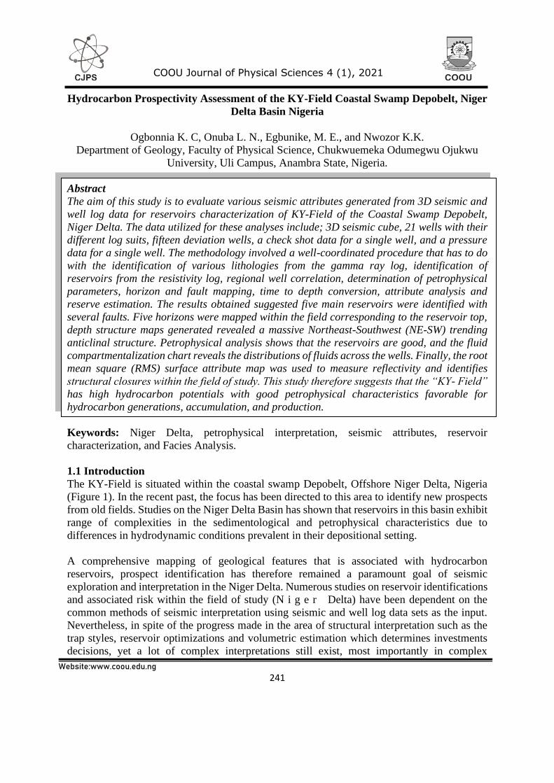
The KY-Field is situated within the coastal swamp Depobelt, Offshore Niger Delta, Nigeria
(Figure 1). In the recent past, the focus has been directed to this area to identify new prospects
from old fields. Studies on the Niger Delta Basin has shown that reservoirs in this basin exhibit
range of complexities in the sedimentological and petrophysical characteristics due to
differences in hydrodynamic conditions prevalent in their depositional setting.
A comprehensive mapping of geological features that is associated with hydrocarbon
reservoirs, prospect identification has therefore remained a paramount goal of seismic
exploration and interpretation in the Niger Delta. Numerous studies on reservoir identifications
and associated risk within the field of study (N i g e r Delta) have been dependent on the
common methods of seismic interpretation using seismic and well log data sets as the input.
Nevertheless, in spite of the progress made in the area of structural interpretation such as the
trap styles, reservoir optimizations and volumetric estimation which determines investments
decisions, yet a lot of complex interpretations still exist, most importantly in complex
242
COOU Journal of Physical Sciences 4 (1), 2021
Website:www.coou.edu.ng
geological settings. These complexities include b u t n o t l i m i t e d t o p o o r resolution
around sub-seismic faults. Within a more geologically complex hydrocarbon habitat like the
Coastal swamp depobelt Niger delta, series of features that are attributed by unknown locations
and time extents which generally are made up of stratigraphic anomalies in a 3D seismic
volume. Furthermore, on seismically mappable fault structures which are ordinarily can be
mapped with the aid of conventional seismic method, a good number of faults below the limit
of seismic resolution also contribute to sub-surface deformation. These fault structures can be
effectively analyzed with the help of seismic attributes in other to quantify how viable a field
is. The reasons of risk assessment in hydrocarbon investigations is to underscore the
possibilities of discovery before drilling of a mapped prospect, in other words the risk factor
plays a tremendous role in hydrocarbon exploration both at prospect and play level.
Nevertheless, the probability of discovery is a measure of value utilized in economic
computational value of the prospect as well as a major factor in assessing undiscovered
resources during either play or prospect evaluation. Finally, the probability of discovery as an
essential input parameter during economic evaluation, a tool in exploration strategy, most
importantly during ranking of prospects, its chance of success and economic values.
2.1 Location and background geology of the study area
The Niger Delta is among the world’s known major hydrocarbon province, located within the
Gulf of Guinea in West Africa. The “KY- Field is situated within the Coastal Swamp Depobelt
in the Southern Part of the Niger delta. The study area covered an area of about 45 km2 of
seismic section. The Figure 1 below shows the location of the basin under study and the field
(KY-Field). It lies on latitude 3 - 7 0N and longitudes 5 - 9 0E and the age of the basin is
Cenozoic. The regional geology, stratigraphy and structure of the Niger Delta Basin have been
extensively discussed by several scholars (Briggs et al., 2009; (Briggs et al., 2009; Burke et al.,
1971; Evamy et al., 1978; Fairhead et al., 2013; Frankl et al., 1967). The delta covers an area
of about 75,000 km2 and is a coarsening upward regressive clastic sequence which reaches a
maximum thickness of 30,000 - 40,000 ft. (9,000 - 12,000 m). The Niger Delta is divided by
three lithostratigraphic units (Fig. 2 below) which represent prograding depositional facies. The
geology of the basin depends mainly on the balance between the rates of sedimentation and
subsidence.
243
COOU Journal of Physical Sciences 4 (1), 2021
Website:www.coou.edu.ng
Figure 1: Geologic/Base map of the Niger Delta showing depobelts and structural
element.
3.1 Materials and Methods
The data set provided for this analysis includes 3D seismic cube, 21 wells with their different
log suits, fifteen deviation wells, a check short data for a single well and a pressure data for a
single well. Also, various geophysical well logs provided such as; caliper, gamma ray,
spontaneous potential, resistivity, density, neutron and sonic logs. The 3D Seismic volume was
provided for this interpretation in SEY-Y format which is a zero phase data with Anti-SEG
(American) polarity convention where a peak represents a negative reflectivity or decreasing
acoustic impedances as well as Petrel 2018 version software was used for this interpretation.
The datasets were loaded into the Schlumberger Petrel Software, 2018 Version and
interpretations of well logs were made from the provided data. KY -Field analyses were carried
out in two phases which are the geological model and the seismic interpretations from where
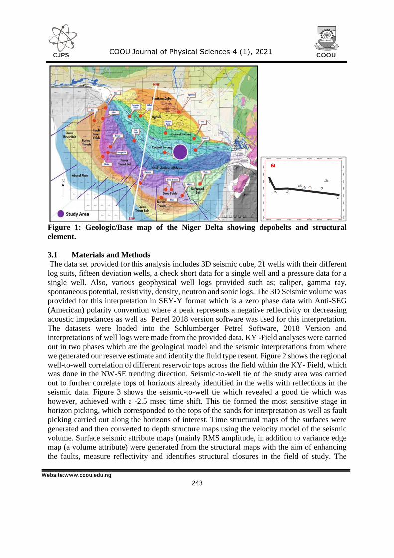
we generated our reserve estimate and identify the fluid type resent. Figure 2 shows the regional
well-to-well correlation of different reservoir tops across the field within the KY- Field, which
was done in the NW-SE trending direction. Seismic-to-well tie of the study area was carried
out to further correlate tops of horizons already identified in the wells with reflections in the
seismic data. Figure 3 shows the seismic-to-well tie which revealed a good tie which was
however, achieved with a -2.5 msec time shift. This tie formed the most sensitive stage in
horizon picking, which corresponded to the tops of the sands for interpretation as well as fault
picking carried out along the horizons of interest. Time structural maps of the surfaces were
generated and then converted to depth structure maps using the velocity model of the seismic
volume. Surface seismic attribute maps (mainly RMS amplitude, in addition to variance edge
map (a volume attribute) were generated from the structural maps with the aim of enhancing
the faults, measure reflectivity and identifies structural closures in the field of study. The

244
COOU Journal of Physical Sciences 4 (1), 2021
Website:www.coou.edu.ng
Correlation four different wells along strike in the study is displayed in Fig. 2 and Fig 3 shows
seismic to well tie performed using well B1.
NW SE
Fig 2: Correlation Panel of four different wells along strike in the study area (wells B1,
A5X, A8Y, and A1)
Fig 3: Seismic to well tie performed using well B1
245
COOU Journal of Physical Sciences 4 (1), 2021
Website:www.coou.edu.ng
4.1 Result and Discussion:
4.1.1 Well Correlation
Based on the gamma ray logs, two lithologies were identified which are sand and shale, the
interval colored yellow is sand, while the interval colored green is shale. From the lithology
log, five reservoirs were identified namely Rev 1, Rev 2, Rev 3, Rev 4, and Rev 5 and correlated
across four wells which are B1, A5X, A8Y and A1 base on the positions of these well within
KY-field. The correlation was done along strike line in a NW-SE trending direction (Fig. 2
above). Observation shows that the reservoirs were consistent. For Rev 1, it revealed a good
lateral continuity of the reservoirs across well, A5X, A8Y, A1 and not present in B1 because
the log was not present at that interval. We also observed that Rev 2 and Rev 3, correlated
along strike lines were consistence, thickens towards the North and thins towards the SE part
of the field. Whereas Rev 4 and Rev 5 were only observed in well B1 and A1 because the depth
of penetration could not get to the reservoir, as a result, logging was not performed up to the
interval were, they are situated at the sub-surface.
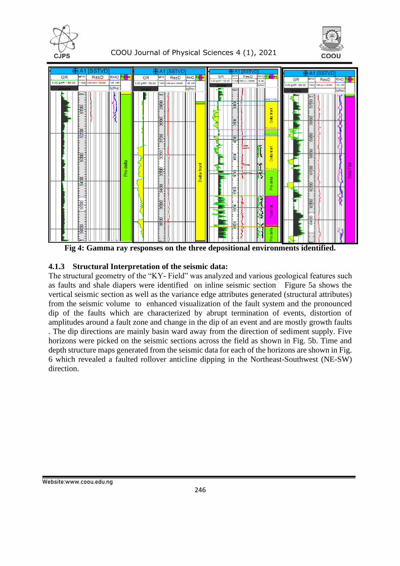
4.1.2 Depositional Environments
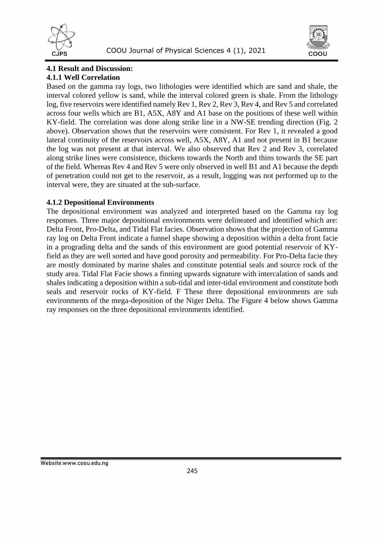
The depositional environment was analyzed and interpreted based on the Gamma ray log
responses. Three major depositional environments were delineated and identified which are:
Delta Front, Pro-Delta, and Tidal Flat facies. Observation shows that the projection of Gamma
ray log on Delta Front indicate a funnel shape showing a deposition within a delta front facie
in a prograding delta and the sands of this environment are good potential reservoir of KY-
field as they are well sorted and have good porosity and permeability. For Pro-Delta facie they
are mostly dominated by marine shales and constitute potential seals and source rock of the
study area. Tidal Flat Facie shows a finning upwards signature with intercalation of sands and
shales indicating a deposition within a sub-tidal and inter-tidal environment and constitute both
seals and reservoir rocks of KY-field. F These three depositional environments are sub
environments of the mega-deposition of the Niger Delta. The Figure 4 below shows Gamma
ray responses on the three depositional environments identified.
246
COOU Journal of Physical Sciences 4 (1), 2021
Website:www.coou.edu.ng
Fig 4: Gamma ray responses on the three depositional environments identified.
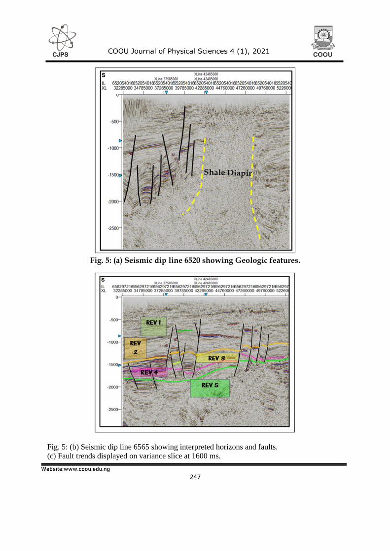
4.1.3 Structural Interpretation of the seismic data:
The structural geometry of the “KY- Field” was analyzed and various geological features such
as faults and shale diapers were identified on inline seismic section Figure 5a shows the
vertical seismic section as well as the variance edge attributes generated (structural attributes)
from the seismic volume to enhanced visualization of the fault system and the pronounced
dip of the faults which are characterized by abrupt termination of events, distortion of
amplitudes around a fault zone and change in the dip of an event and are mostly growth faults
. The dip directions are mainly basin ward away from the direction of sediment supply. Five
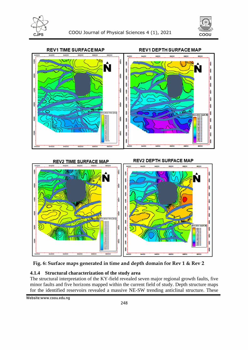
horizons were picked on the seismic sections across the field as shown in Fig. 5b. Time and
depth structure maps generated from the seismic data for each of the horizons are shown in Fig.
6 which revealed a faulted rollover anticline dipping in the Northeast-Southwest (NE-SW)
direction.
247
COOU Journal of Physical Sciences 4 (1), 2021
Website:www.coou.edu.ng
Fig. 5: (a) Seismic dip line 6520 showing Geologic features.
Fig. 5: (b) Seismic dip line 6565 showing interpreted horizons and faults.
(c) Fault trends displayed on variance slice at 1600 ms.
248
COOU Journal of Physical Sciences 4 (1), 2021
Website:www.coou.edu.ng
4.1.4 Structural characterization of the study area
The structural interpretation of the KY-field revealed seven major regional growth faults, five
minor faults and five horizons mapped within the current field of study. Depth structure maps
for the identified reservoirs revealed a massive NE-SW trending anticlinal structure. These
Fig. 6: Surface maps generated in time and depth domain for Rev 1 & Rev 2
249
COOU Journal of Physical Sciences 4 (1), 2021
Website:www.coou.edu.ng
shows that the trap mechanism of KY-field is mainly structural as well as stratigraphic. These
identified faults both growth faults (listric) and few antithetic faults is in line with previous
research made in the Niger Delta which stipulated that the subsurface of the Niger Delta Basin
is extensively deformed by growth faulted structures associated with roll over anticlines. These
growth faults which dominates the structural style of the Niger delta are generally believed to
be triggered up by the movement of the marine shales of the Akata Formation with the
movements further increased by slope instability.
5.1 Conclusions and recommendations
Following the analysis made so far on this field, the usefulness/importance of 3D seismic
attributes revealed in reservoir characterization within the “KY- “Field, Coastal Swamp
Depobelt, Niger Delta. Two separate reservoir sands identified, several faults mapped out, five
horizons were mapped across the area, two prospects identified, a single lead, a Tertiary play,
and the presence of a shale diapir. The environment of deposition of the reservoirs identified
within this field are classified as shallow marine and deep marine. The petrophysical analysis
carried out on the five reservoirs had revealed an average porosity value of 25.4% whereas the
permeability values range between 454-850 md across the reservoirs. Again, the estimated
hydrocarbon volume for prospect A and B was calculated to be 67.65mbls and 14.70 mbls
respectively. This indicates that “KY- Field” has high hydrocarbon potentials due to its
excellent petrophysical characteristics.
References
Briggs, S.E., Cartwright, J. and Davies, R.J., 2009. Crustal structure of the deepwater west
Niger Delta passive margin from the interpretation of seismic reflection data. Marine
and Petroleum Geology, 26(6), pp. 936-950.
Burke, K., Dessauvagie, T. and Whiteman, A., 1971. Opening of the Gulf of Guinea and
geological history of the Benue Depression and Niger Delta. Nature, 233(38), pp. 51-
55.
Evamy, B., Haremboure, J., Kamerling, P., Knaap, W., Molloy, F. and Rowlands, P., 1978.
Hydrocarbon habitat of Tertiary Niger delta. AAPG Bulletin, 62(1), pp. 1-39.
Fairhead, J.D., Green, C.M., Masterton, S.M. AND Guiraud, R., 2013. The role that plate
tectonics, inferred stress changes and stratigraphic unconformities have on the
evolution of the West and Central African rift system and the Atlantic continental
margins. Tectonophysics, 594, pp.118-127.
Frankl, E. and Cordry, E., 1967. The Niger Delta oil province: Recent developments onshore
and offshore, 7th World Petroleum Congress 1967, World Petroleum Congress.