the historic new orleans collection boundaries of present-day louisiana. between colony and state...
TRANSCRIPT
The Historic New Orleans Collection
The Historic New Orleans Collection
AN ExhibitioN
September 30, 2009–May 2, 2010

T H E H I S T OR IC N E W OR L E A N S C OL L E C T IO N2
The history we live differs from the history we write. Viewed in retrospect, history resolves into a series of watershed episodes and clearly demarcated epochs. Hindsight tempts historians to organize events in an intelligible—and comforting—way, a chronological sequence of cause and effect. But history, as lived, is replete with messy details. Disorder is the engine of historical change, complexity the keynote of historical analysis. With this exhibition, Between Colony and State: Louisiana in the Territorial Period, 1803–1812, the curators embrace the chaos of a transformative era.
H Introduction
Contents
2 Introduction
4 Terminology
6 Foundations
8 Land & Demographics
15 Territorial Economy
16 Society & Culture
18 Politics & the Law
22 The 18th State
24 Exhibition Checklist
28 Acknowledgments
The date markers that stake out the territorial period are precise: December 20, 1803, and April 30, 1812. The first denotes the transfer of the former French colony of Louisiana to the United States, the latter the entrance into the Union of the state of Louisiana. Very little about the intervening period can be summarized with similar precision. Between Colony and State offers a thematic survey of the unfolding drama: the clash of agendas, the swelling of population, and the striving of different cultural groups for prominence (and survival). In the end, we learn as much from those themes that remain unresolved as we do from those that teach clear lessons. The alliances created, destroyed, and rejoined in the territorial period foreshadow many of the cultural conflicts of modern Louisiana history.
H H H

3B E T W E E N C O L O N y A N D S T A T E
in flux: three written languages (French, Spanish, and English) were in common use, and the dominance of the Catholic population would soon be challenged by citizens who practiced other faiths. Some residents of the territory pressed for immediate statehood, while others advocated independence from the United States. Indeed, the viability of the United States of America remained in question throughout this period. Unsettled boundary claims with Spain (including the de facto annexation of West Florida in 1810) and rumblings of war with Great Britain were persistent cause for concern.
And yet day-to-day life went on. The city expanded through the addition of suburbs. Émigrés from the former French colony of St. Domingue, some 10,000 strong, reinvigorated the area’s Gallic disposition. The performing arts thrived in theaters and playhouses, and governmental structures and the legal system began to take shape. Port activities provided a constant commercial hum in the background.
H H H
The 524 million acres of the Louisiana Purchase, too vast for effective local governance, was soon divided into two political entities: the territory of Louisiana to the north, and the territory of Orleans to the south. The latter, created by congressional act on March 26, 1804, conforms cartographically, more or less, to the boundaries of present-day Louisiana. Between Colony and State focuses broadly on this territory and specifically on the city of New Orleans. The desire to acquire the port of New Orleans, and thereby sustain the nation’s emerging trans-Appalachian economy, precipitated the Louisiana Purchase. The region’s political, financial, and population hub, New Orleans would be the locus for most of the catalyzing events and enduring decisions of the territorial period. In a story replete with colorful individuals, the city emerges as a significant character in its own right.
Items on display were chosen, whenever possible, to reflect the multiple perspectives that characterized life in the territory. Attitudes toward slavery, security, and economic development differed radically across the region. Even those groups that had no official voices—Native Americans, slaves, and women of all colors and ethnicities—could exert occasional influence through “back channel” efforts. Throughout the exhibition, representative historical figures have been selected to symbolize particular viewpoints or constituencies.
Internal discord complicated the path to statehood. Debates over property—the right to land previously granted, the right to import slaves—proved particularly contentious. Cultural identity remained
Louisiana’s first constitution was drafted in convention at New Orleans and signed on January 22, 1812, by the convention’s president, Julien Poydras, and its secretary, Eligius Fromentin. The document (composed in French as well as English) also bore the signatures of 41 delegates representing the territory’s 12 counties. The surnames of these signers—Marigny, Watkins, Prud’homme, and Wikoff, to list but a few—imply a mosaic of different backgrounds, perspectives, and priorities. Consensus could not have been easy, but it was achieved. Within four months of the convention, Louisiana became the Union’s 18th member. Between Colony and State emphasizes the creative tension that existed in the territory of Orleans, ultimately yielding the multicultural, multifaceted territory known as Louisiana today. H
— John T. Magill, Pamela D. Arceneaux, and John H. Lawrence Exhibition Curators

T H E H I S T OR IC N E W OR L E A N S C OL L E C T IO N4
As the boundaries of empire and state shift over time, so too do linguistic norms. The territory mapped in this exhibition has been known by a variety of names, including Louisiana, la Louisiane, and la Luisiana. The following summary traces the history of the linguistic labels applied to the territory in its various forms between 1683 and 1819.
La Louisiane is the term most often used to describe the North American colony under French governance. The name first appeared on maps in 1683, a year after René-Robert Cavelier, sieur de la Salle, claimed the Mississippi valley in the name of Louis XIV. Louisiana under France was a colony with poorly defined boundaries to the east and west. Cartographers wishing to promote French hegemony in North America showed la Louisiane extending from Canada to the Gulf of Mexico and from the Appalachian Mountains to the Pacific Ocean, though this may seem preposterous in light of British and Spanish holdings to the east and west.
In 1762 France ceded la Louisiane to Spain, its ally in the Seven years’ War, and la Luisiana remained a Spanish colony through 1800, when it was returned to France via the secret treaty of San Ildefonso. Spanish administration persisted, however, for a three-year span during which the colony was la Luisiana in practice and la Louisiane in fact. The ratification of the Louisiana Purchase Treaty, on October 20, 1803, brought this period of indeterminacy to an end. On November 30, at a transfer ceremony in New Orleans, Spain formally retroceded the colony to France; less than three weeks later, on December 20, a second ceremony transferred possession to the United States.
Louisiana (opposite)published 1805; hand-colored engravingby Samuel Lewis, delineator; Henry Schenk Tanner, engraver; Aaron Arrowsmith, publisher
In the immediate aftermath of the 1803 Purchase, the entire territory ceded by France was known as the Louisiana Territory. American administrators quickly adopted more precise designations, dividing the vast territory into Lower Louisiana (the lands below the confluence of the Mississippi and Ohio rivers) and Upper Louisiana. Then, in 1804, the U.S. Congress carved the territory of Orleans from Lower Louisiana as a separate governmental entity. This territory roughly conforms to the contours of today’s state of Louisiana, admitted to the Union in 1812. However, boundary disputes endured until 1819, when the United States and Spain signed the Adams-Onís Treaty, fixing the state’s southwestern limits.
The remainder of the Louisiana Purchase territory became the District of Louisiana following the creation of the territory of Orleans. Later, after Louisiana’s assumption of statehood in 1812, this district was renamed the Missouri Territory. H
H Terminology

5B E T W E E N C O L O N y A N D S T A T E

T H E H I S T OR IC N E W OR L E A N S C OL L E C T IO N6
Commission for William C. C. Claiborne granting him temporary powers as general governor and intendant of the province of Louisiana October 31, 1803by Thomas Jefferson, author
William Charles Cole Claiborne©1903; Goupil gravureby Goupil and Company, publisher
H Foundations

B E T W E E N C O L O N y A N D S T A T E
Twenty days after officially assuming possession of Louisiana for Napoleon’s France, Pierre Clément Laussat transferred the property to William Charles Cole Claiborne and General James Wilkinson, agents of the United States appointed by President Thomas Jefferson.
With the purchase of Louisiana, President Jefferson faced the challenging task of selecting a leader capable of integrating a population whose language, political customs, and religion differed greatly from those of the majority of the American populace. The capacity to guide Louisiana’s inhabitants toward a political landscape that was more representative of the emerging American model was a fundamental component of Jefferson’s expectations for the incoming governor. yet despite repeated attempts to appoint an experienced leader, Jefferson failed to convince any of his preferred candidates (including James Monroe and Revolutionary War hero the Marquis de Lafayette) of the political gains to be had from entering what were essentially the uncharted waters of American colonization.
Instead, Jefferson granted an appointment as governor of the Purchase territory to the 28-year-old Claiborne, then serving as governor of nearby Mississippi Territory. The commission was intended to be a temporary one, until Jefferson managed to coax a more qualified candidate into accepting the post. The most important political appointment of William Claiborne’s career, then, resulted not from any remarkable display of leadership skills but rather from the convenience of his being “on the spot.” Jefferson continued to search
Conjectural View of the Government house, 17611960s; ink on tracing paperby Henry W. Krotzer Jr., draftsman and artist
Dating to 1761, the Government House (or State House) was one of the last governmental buildings constructed during the French regime. Depicted here in a conjectural sketch as it may have looked in 1800, it occupied a site on Decatur and Toulouse streets and survived the great fires of 1788 and 1794. Until it burned in 1828, the Government House was the seat of the Louisiana Legislature.
for a more suitable, and preferably French-speaking, candidate until 1807, when it appears he resigned himself to Claiborne’s permanency.
During Claiborne’s tenure as territorial governor, he made political opponents of several influential Anglo-Americans, including Edward Livingston, Daniel Clark, and James Workman. But his marriages to well-connected Louisiana natives Clarissa Duralde of Attakapas (who died in 1809 of yellow fever) and Cayetena Susanna Bosque y Fangui of New Orleans, and his swift suppression of the 1811 slave uprising along the German Coast, improved his standing. Claiborne’s appointment was renewed each year until 1812, when the governor won a sizable majority in a race against native Jacques Villeré to become the state of Louisiana’s first elected governor. H

T H E H I S T OR IC N E W OR L E A N S C OL L E C T IO N8
Exploring the Territory
The Corps of Discovery, the name given to the expedition led by Meriwether Lewis (President Thomas Jefferson’s personal secretary) and William Clark (a retired U.S. Army captain), is the fact-finding mission most associated with the Louisiana Purchase. Following congressional authorization granted in March 1804, the 43-member Corps departed from St. Louis on May 14. For 28 months the party rode, floated, and walked the northwestern reaches of the territory, all the while compiling data on the territory’s Native American population, flora, fauna, geology, and climate. The map accompanying the three-volume 1815 account of the journey suggests the expedition’s scale.
travels to the Source of the Missouri River and across the American Continent to the Pacific oceanby Meriwether Lewis; London: Longman, Hurst, Rees, Orme, and Brown, 1815
The Lewis and Clark expedition, though the most celebrated, was not the
H Land & Demographics
orders from General Wilkinson to explore the southwestern areas of the Purchase territory, adjacent to Spanish lands. Pike’s second journey blazed what ultimately became known as the Santa Fe Trail. His explorations of the drainage basins of the Arkansas and South Platte rivers resulted in improved maps of the region, though the expedition failed to fulfill one of its primary mandates: to explore the Red River. The party traveled northwest as far as present-day Colorado, where the mountain peak that now bears Pike’s name was identified. Wary of Pike’s presence along their border, Spanish troops captured Pike and his party
only government-sponsored trip launched to explore the reaches of the Louisiana Purchase territory. Two notable exploratory journeys took place under the command of Lieutenant Zebulon M. Pike. Under General James Wilkinson’s orders, Pike left St. Louis in August 1805, ascending the Mississippi River with a laundry list of objectives ranging from the discovery of the Mississippi’s source to the establishment of friendly relations with Native Americans. Pike’s expedition lasted nine months and covered 5,000 miles yet produced little accurate or useful information; it was, however, important in establishing Minnesota as part of the Louisiana Purchase and defining the territory’s northern reaches.
Pike’s next command differed greatly in both its location and result. He set out again from St. Louis in July 1806 with

9B E T W E E N C O L O N y A N D S T A T E
on the Rio Grande and brought them first to Santa Fe and then to Chihuahua, Mexico, where they were held months for questioning before being escorted through Texas to the territory of Orleans. Upon his return to St. Louis, Pike faced charges of conspiracy with the Wilkinson-Burr intrigues but was cleared. Publication of his journal in 1811 brought Pike a brief moment of fame before his 1813 death.
Unlike the Lewis and Clark or Pike expeditions, Captain Amos Stoddard’s exploration of the Purchase territory took place in the course of his duties as a military commander. On March 10, 1804, one day after receiving Upper Louisiana from Spain on behalf of France, Stoddard took control of the territory for the United States. Seven months later, Stoddard began his extensive travels throughout the territory of Orleans and the District of Louisiana. His observations and commentary on subjects ranging from agriculture and geography to politics and culture were published in 1812 as Sketches, Historical and Descriptive, of Louisiana. Stoddard’s Sketches remains an important source for the study of Louisiana’s territorial period. H
The gross contours of Louisiana—first as European colony, later as United States territory—have been drawn and redrawn in war and in peace, in diplomatic session and in legislative debate. The Louisiana Purchase, an undisputed political coup for the United States, failed to resolve the region’s ongoing boundary disputes. Spain and Great Britain continued to jockey for territory, and Louisiana’s borders remained in flux even after the assumption of statehood in 1812. The 1810 annexation of the Florida Parishes (land formerly part of Spanish West Florida) was not confirmed by treaty until 1819, nor was the Texas border secured until the conclusion of the Mexican War in 1848.
But boundary disputes tell only part of the story. Effective governance demands that
The Lay of the Land
internal as well as external lines be clearly drawn. Here enters the land surveyor,charged with reconciling the political language of treaty, the physical reality of terrain, and the insistent claims of personal property. Over the nine-year span of Louisiana’s territorial period, geographic knowledge advanced by leaps and bounds. yet this knowledge was gained at great physical cost. Even a quick glance at Juan Pedro Walker’s Baxa Luisiana (Lower Louisiana) suggests the unforgiving environment in which surveyors labored: trackless stretches of prairie lands and swamps, bayous and marshes, and sinuous and shifting coastal areas.
The surveyor’s task was complicated in Louisiana by the need to reconcile older (French, Spanish, and British) systems of
baxa Luisianabetween 1799 and 1803; ink and watercolorby Juan Pedro Walker, cartographer

T H E H I S T OR IC N E W OR L E A N S C OL L E C T IO N10
measurement with newer models established by the U.S. government. The Public Lands Survey System (PLSS), first implemented in the Ohio River valley in 1785, set standards for surveying lands in the public domain. The U.S. General Land Office (a predecessor of the Bureau of Land Management) commenced surveying the territory of Orleans in 1807. Unlike the long-lot system favored in much of colonial Louisiana, the
A Map of the State of Louisiana with Part of the Mississippi territoryca. 1816; hand-colored engravingby William Darby, surveyor; Samuel Harrison, engraver; John Melish, publisher
PLSS carved terrain into regular grids. Any point on the map could be measured against a fixed vertical meridian and horizontal baseline; in Louisiana, these lines stood at 92° 24I 55II west and 31° 00I 31II north. Working in the field with basic tools—typically a compass and a rod and chain—surveyors proceeded to block out and subdivide sections of the territory.
Early 19th-century maps of Louisiana reveal the evolution of the surveyor’s craft. The first official map of the territory of Orleans, commissioned by Governor Claiborne and produced by Barthélémy Lafon in 1806, shows natural boundaries on three sides: the Sabine River to the west, the
H Land & Demographics
Mississippi River to the east, and the Gulf of Mexico (and tidal lakes) to the south. Only the northern boundary is artificial: a line of latitude corresponding to 33° north. The first map to depict Louisiana as a state—issued by Matthew Carey in 1813 and published the following year in Carey’s General Atlas—includes the recently annexed Florida parishes north and east of Baton Rouge. William Darby was the first surveyor to cover the southwestern reaches of the territory; his 1816 map is rich in detail where Carey’s is lacking. H

11B E T W E E N C O L O N y A N D S T A T E
Slave sale and runaway advertisements from the Courrier de la Louisiane [detail]New Orleans: Thierry & Co., January 24, 1810
In newspapers across the country,slave sale and runaway notices appeared alongside ship schedules and advertisements for livestock, real estate, and dry goods. Federal census returns indicate that Orleans Territory was home to more than 33,000 slaves in 1810, with some 10,824 (32.7%) residing in Orleans Parish. Runaway ads are an exceptionally rich source for details on individual slaves, as they provide intimate physical descriptions of skin, hair, and eye color, body markings (including scarification and “country marks”), and clothing.
Sauvages du Mississipi1821; lithographby Edouard de Montulé, draftsman and artist; Brocas, publisher
The Indian population in Orleans Territory was a diverse assortment of established and recently arrived tribes. Some, like the Biloxi, Pascagoula, Alibamon, Upper Creek, and Choctaw Indians, migrated to the region west of the Mississippi during the latter half of the 18th century, while others, including the territory’s largest tribe, the Caddo, called the region home long before the arrival of European explorers. Historian Daniel Usner estimates the total Indian population during the territorial period to have been as high as 5,000. More precise estimates are difficult to establish, as federal policy excluded Indians from census enumerations until 1860.

T H E H I S T OR IC N E W OR L E A N S C OL L E C T IO N12
Census Figures 1805–1810
1805 1810 % increase
whites f.p.c.* slaves other whites f.p.c. slaves whites f.p.c. slaves
New Orleans 3,043 1,408 2,684 253 4,50 3,332 4,386 48.1% 136.% 63.4%
Faubourg Marigny (est. 1806 ) 681 961 58
Faubourg Ste. Marie 508 158 421 1,143 65 988 125% 315.8% 134.%
Total by group 3,551 1,566 3,105 253 6,331 4,950 5,961 8.3% 216.1% 91.9%
GR AND TOTAL 8,45 1,242 103.5%
Just how many individuals resided in the city of New Orleans at the time of the Purchase remains unclear. Estimates fall between 6,000 and 20,000, though a census completed in August 1805 makes the latter estimate seem unlikely. The 1805 census was part of a series of reforms and public works projects made possible by the organization of the territory of Orleans and the subsequent passage of a city charter for New Orleans on February 17, 1805. The charter provided for 14 elected city council members, a governor-appointed mayor and city recorder, and a council-appointed city treasurer. The census, authorized by the newly formed council on May 11, 1805, captured 8,475 permanent residents of the city of New Orleans and its first suburb, the Faubourg Ste. Marie. This figure included 3,551 whites (41.9%), 1,566 free people of color (18.5%), 3,105 slaves (36.6%), and 253 “other free persons” (2.9%), a vague category typically reserved for Native Americans.
The territorial period was one of rapid
expansion for New Orleans. Farmers and rivermen from Upper Louisiana and Appalachia flooded the city, taking full advantage of their newly secured access to the Mississippi River and port of New Orleans. For those bringing their goods to market, residency was often temporary; most shepherded their cargo downriver, oversaw its sale, and headed home. Other Anglo-Americans, however, viewed New Orleans as a city where fortunes—both political and monetary—could be made, especially if the number of permanent English-speaking residents reached the critical mass necessary to tilt the balance in their favor.
But as had so often been the case in New Orleans’s colonial past, events taking place in Europe conspired to change the course of the city’s development. In an 1808 bid to secure newly conquered Spain, Napoleon Bonaparte forced the Spanish royal family from the throne and installed his brother Joseph. Spaniards’ animosity toward France quickly spilled over into Spain’s Caribbean colony of Cuba, where many former
The City of New Orleans
H Land & Demographics
* free people of color
residents of French St. Domingue had settled during and after the Haitian Revolution. In Cuba, property confiscation and harassment of French-speaking settlers soon turned into a general order of expulsion. On April 10, 1809, Havana governor Sebastian Kindelan issued a ban requiring that “all free French settlers and foreigners regardless of class, status, sex, color, and age, residing in Santiago de Cuba or its vicinities since the advent of the French Revolution” leave the island.
In the span of less than three months, from early May to late July 1809, more than 5,700 refugees from Cuba descended on the city of New Orleans. In total, some 10,000 French-speaking refugees—including whites and free people of color, and their slaves—arrived in New Orleans in 1809–10. Their arrival ensured that New Orleans would remain predominantly Gallic or Afro-Gallic until the late 1840s. It also meant that for decades to come the city would remain linguistically and racially stratified in ways that made New Orleans more similar to urban environments throughout Latin America and the Caribbean than to those elsewhere in the United States. H

13B E T W E E N C O L O N y A N D S T A T E
A View of New orleans taken from the Plantation of MarignyNovember 5, 1803; aquatint with etching and watercolorby John L. Boqueta de Woiseri, printmaker
Drawn and painted views of New Orleans
at the time of the Louisiana Purchase are
scarce, but Woiseri’s sweeping effort
permits a view of the city at a critical
moment in time. Woiseri’s depiction
shows that New Orleans was not a
political and strategic abstraction but a
substantial place with solid buildings,
an active port, and a diverse population.
Bernard de Marigny’s house and
plantation lands, the vantage point for
this panorama, would soon be subdivided
to accommodate the city’s growing
population. In trumpeting the United
States’ acquisition of Louisiana, Woiseri
was either a gambler or clairvoyant. He
published his print some six weeks prior
to the official transfer.

T H E H I S T OR IC N E W OR L E A N S C OL L E C T IO N14
Plan of the City and Suburbs of New orleans from an Actual Survey made by J. tanesse in 1815April 29, 1817; engravingby Jacques Tanesse, surveyor; Rollinson, engraver; Charles Del Vecchio and Pierre Maspero, publishers
By 1803 New Orleans had already spread
beyond the boundaries of the original 1718
French settlement. Faubourg Ste. Marie
was established in 1788, adjacent to the
city’s southwestern, or upriver, border,
and was home to many of the city’s
Anglo-American residents and business
interests. In the decade following the
Purchase, the city’s footprint more than
tripled as new subdivisions carved from
land owned downriver by Bernard de
Marigny (1806) and to the northwest
by Claude Tremé (1810) provided room
for New Orleans’s rapidly growing
population. The new faubourgs attracted
an economically and racially mixed
population, primarily French-speaking,
including a sizable proportion of free
people of color. By 1815, faubourgs Ste.
Marie and Marigny themselves were
surrounded by newly subdivided lands
that included faubourgs Delord (1806), La
Course (1807), Annunciation (1807), Saulet
(1810), and Nouveau Marigny (1810).
H Land & Demographics

15B E T W E E N C O L O N y A N D S T A T E
Steamboat New Orleans1911; relief halftoneby the Historical Society of Western Pennsylvania, publisher
Commissioned by Nicholas and Lydia Roosevelt (Theodore Roosevelt’s great- uncle and -aunt) in 1810, the steamboat New Orleans began its maiden voyage from Pittsburgh to New Orleans on October 11, 1811. The New Orleans measured 148I 6II in length, 32I 6II in width, and weighed just over 370 tons. Designed and built by New Yorkers Robert Fulton and Robert Livingston, the New Orleans was the first steam-powered vessel to travel the Ohio and Mississippi rivers. Its January 1812 arrival in its namesake city helped launch steam power’s century-long domination of America’s waterways.
H Territorial Economy
John McDonogh receipt December 10, 1804
Louisiana’s role as provisioner to the French and Spanish Caribbean, established in the colonial period, continued in the years following the Purchase. Between 1804 and 1814, 64% of all flour passing through the port of New Orleans was bound for Caribbean markets, where it helped fuel the plantation economies of places like Cuba and Jamaica. The Purchase also opened up new markets for the region’s foodstuffs in communities east of the Mississippi. The receipt depicted at left shows a typical provisioning transaction between local merchant and planter John McDonogh (future benefactor of the New Orleans public schools) and William Little, captain of the slave ship Sarah. Between September 24 and December 10, 1804, McDonogh supplied more than 1,100 pounds of meat to the Sarah, a ship likely engaged in the domestic slave trade on the Baltimore-to-New Orleans circuit.

T H E H I S T OR IC N E W OR L E A N S C OL L E C T IO N16
Music & Theater
ew Orleans’s first theater, the Spectacle de la Rue Saint-Pierre, opened on October 4, 1792. Located on St. Peter Street between Bourbon and Royal, the theater was renamed the Théâtre de Saint-Pierre sometime between 1792 and 1796. The first documented operatic performance in New Orleans, André Grétry’s Sylvain, took place here on May 22, 1796. Grétry, whose Sylvain debuted in Paris in 1770, was celebrated for his pastoral style. His popularity in New Orleans spanned three decades, with over 100 performances of Grétry operas in the city between 1796 and 1821.
The Théâtre de Saint-Pierre operated as the city’s only theater until the 1807 opening of the Variétés Amusantes. The Variétés were first housed in a ballroom on St. Philip Street that had once been the site of racially mixed balls, but the theater’s popularity soon prompted its owners to construct a larger performance space. The new theater, renamed the Théâtre de la Rue St. Philippe, opened on January 30, 1808.
The presence of two rival theaters in a small city posed problems. Initially the St. Pierre and St. Philippe alternated performances, preventing direct competition, but when they began simultaneous performances, it strained the pool of local actors and theater personnel. Plans were made to unite the two troupes and operate out of the larger, finer St. Philippe, but the deep rift between the two theater companies prevented a merger. Both theaters operated
H Society & Culture
Silvain [Sylvain}: Comédie en un acte et en versby André-Ernest-Modeste Grétry; Paris: Montulai, ca. 1770
1B E T W E E N C O L O N y A N D S T A T E
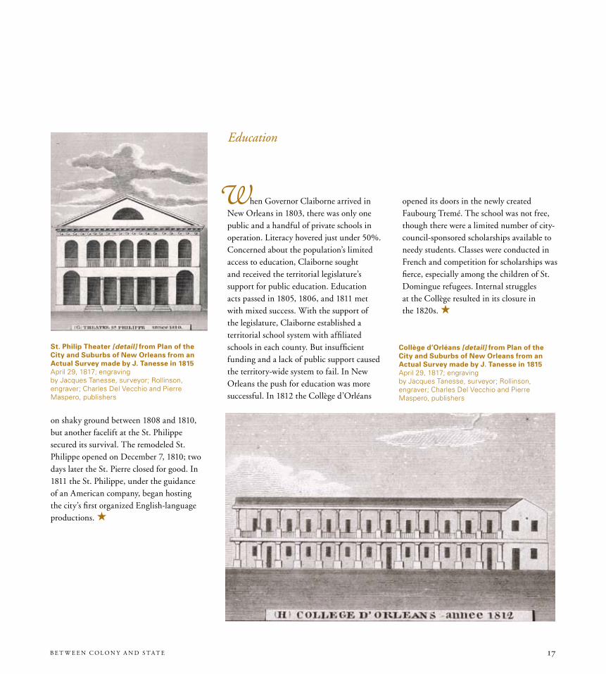
Education
When Governor Claiborne arrived in New Orleans in 1803, there was only one public and a handful of private schools in operation. Literacy hovered just under 50%. Concerned about the population’s limited access to education, Claiborne sought and received the territorial legislature’s support for public education. Education acts passed in 1805, 1806, and 1811 met with mixed success. With the support of the legislature, Claiborne established a territorial school system with affiliated schools in each county. But insufficient funding and a lack of public support caused the territory-wide system to fail. In New Orleans the push for education was more successful. In 1812 the Collège d’Orléans
St. Philip theater [detail] from Plan of the City and Suburbs of New orleans from an Actual Survey made by J. tanesse in 1815April 29, 1817; engravingby Jacques Tanesse, surveyor; Rollinson, engraver; Charles Del Vecchio and Pierre Maspero, publishers
Collège d’orléans [detail] from Plan of the City and Suburbs of New orleans from an Actual Survey made by J. tanesse in 1815April 29, 1817; engravingby Jacques Tanesse, surveyor; Rollinson, engraver; Charles Del Vecchio and Pierre Maspero, publishers
opened its doors in the newly created Faubourg Tremé. The school was not free, though there were a limited number of city-council-sponsored scholarships available to needy students. Classes were conducted in French and competition for scholarships was fierce, especially among the children of St. Domingue refugees. Internal struggles at the Collège resulted in its closure in the 1820s. H
on shaky ground between 1808 and 1810, but another facelift at the St. Philippe secured its survival. The remodeled St. Philippe opened on December 7, 1810; two days later the St. Pierre closed for good. In 1811 the St. Philippe, under the guidance of an American company, began hosting the city’s first organized English-language productions. H

T H E H I S T OR IC N E W OR L E A N S C OL L E C T IO N18
General James Wilkinson©1903; Goupil gravureby Goupil and Company, publisher
Public Plunder1809; broadsideby William Simmons, author
Maryland native James Wilkinson first served as an officer in the Revolutionary War. After settling in Kentucky in the 1780s, he cultivated relationships with Spanish officials in New Orleans. In exchange for trading rights, land, and pension payments granted by Spanish officials, Wilkinson swore an oath of allegiance to Spain and provided intelligence on American political and military objectives in the Trans-Appalachian West. Wilkinson successfully concealed his role as dual agent, and in 1803 he became one of two U.S. commissioners to formally take possession of the Louisiana Purchase territory for the United States. In 1805 President Thomas Jefferson appointed Wilkinson governor of the Louisiana Territory. This powerful position—headquartered in St. Louis and far from official oversight—emboldened Wilkinson to continue in his intrigues with Spanish officials. He appears to have been actively involved in the Burr Conspiracy and was also accused of misuse of public funds. In the broadside printed at right, the “Watchmen” accuse Wilkinson of “public plunder” of the U.S. Treasury in excess of $56,000. Wilkinson was eventually court-martialed and subjected to congressional inquiries for his suspicious activities. He escaped indictment, but his reputation was forever tarnished.
H Politics & the Law

19B E T W E E N C O L O N y A N D S T A T E
Corsair Alligator1813; watercolor by C. Roussel, painter
The corsair Alligator was likely a privateer,
a private vessel of war issued letters of
marque and reprisal by a sponsoring
government. The use of private vessels
of war was critical to U.S. defense
throughout the territorial period because
America lacked a strong standing
naval fleet. In Louisiana, both Governor
Claiborne and U.S. Navy Commandant
Daniel Todd Patterson repeatedly
complained to Washington that naval
assets in New Orleans were insufficient
to police territorial waters. Once open
war broke out with Great Britain in 1812,
the use of privateers augmented the
national force and helped disrupt enemy
commerce.

T H E H I S T OR IC N E W OR L E A N S C OL L E C T IO N20
The Law of the Land
I n 1712, six years before the founding of New Orleans, France established civil government in Louisiana based upon the Coutume de Paris, a code of 16 titles and 362 articles. These laws and ordinances, with the addition of the 1724 Code Noir—which regulated the treatment and actions of slaves and free people of color—formed the basis of the French colonial legal system. In 1769 Spanish Governor Don Alejandro O’Reilly replaced the French code with one based on Las siete partidas, an encyclopedic summary of Spanish law dating to the 13th century. Code law, in both its French and Spanish forms, was based on a civil tradition in which the community property system, principles of forced heirship and implied warranty, free alienation of property, and freedom of contract protected the rights of families and their members and simplified the laws of property and obligations.
Code law differed greatly from the English common law tradition in use
throughout the United States in 1803, in which trial by jury, the writ of habeas corpus, and reliance upon legal precedent were hallmarks. At the time of the Purchase the federal government agreed—at least provisionally—to continue the system of code law. But although President Jefferson intended to eventually replace Louisiana’s civil system with the English common law system in use throughout the rest of the American states and territories, this strategy required thoughtful implementation. As Jefferson’s appointed representative of federal policy, Claiborne understood that hasty action might antagonize the French Creole population or be seen as reneging on the federal government’s initial agreement to respect the territory’s existing laws. He proceeded with caution.
In “An Act for the punishment of crimes and misdemeanors,” approved May 4, 1805, by the Legislative Council of the Territory of Orleans, common law was introduced
to address all criminal matters, except those involving slaves. After some acrimony between the governor and the territorial legislature, the lawmakers passed a resolution in 1806 appointing jurisconsults Louis Moreau-Lislet and James Brown to compile a civil code. The resulting code, adopted March 31, 1808, drew from a dizzying variety of legal sources, including the recently issued Napoleonic Code.
The 1808 code was useful but incomplete. For some areas of jurisprudence, lawyers, judges, and legislators still had to consult earlier, hard-to-locate, and often obscure volumes of colonial law to settle cases. Publications released in 1818 and 1820 attempted to fill the legal gaps, but the issue was not fully addressed until the 1825 publication of the Civil Code of the State of Louisiana—which, with the exception of a handful of revisions made in 1870, governed vast areas of Louisiana’s private law into the late 20th century. H
H Politics & the Law
A translation of the titles on Promises and obligations, Sale and Purchase, and Exchange from the Spanish of Las siete partidasby Louis Moreau-Lislet and Henry Carleton; New Orleans: Roche Brothers, 1818

21B E T W E E N C O L O N y A N D S T A T E
The Batture Controversy
B efore late 19th-century efforts by the United States Army Corps of Engineers began to confine the channel of the Mississippi River with levees and dredging, the waterway’s natural meandering routinely added and removed land along its banks. The beachlike swath of shifting land along the river’s edges was called the batture. The batture’s utility and accessibility varied with the height of the river and the erosive actions of the channel. The case to decide batture ownership became a celebrated—and protracted—legal battle during the territorial period. In 1803, Jean Gravier, a planter and real
estate developer whose property fronted the riverbank, claimed ownership of the batture lands adjoining his own. His claim countered the longstanding assumption that the batture was public property. With the help of attorney Edward Livingston, Gravier successfully brought suit against the city, with Livingston receiving a portion of Gravier’s batture claim as his fee. Despite Gravier’s legal triumph, however, the case did little to alter the popular perception that the batture was public land, and the city distanced itself from further legal dispute by declaring the batture federal land.
By late summer 1807, persistent questions
about batture ownership and growing public contention over the issue led Governor Claiborne to petition President Jefferson in hopes of resolving the situation. Jefferson asserted that the batture belonged to the United States and attempted to use the Squatters’ Act of 1807 to force Livingston from his batture property. Before Jefferson’s order could be carried out, Livingston obtained an injunction from the Superior Court of the Territory of Orleans, but the federally appointed marshal ordered Livingston off the land anyway. With this, a war of pamphlets authored by some of New Orleans’s leading citizens ensued, with each side presenting arguments and counterarguments for rightful ownership. The pamphlet campaign spilled over into the pages of the nation’s leading newspapers, and batture ownership became the subject of court cases and congressional debate.
In 1817 Livingston and others who claimed private ownership of batture property proposed a compromise: they agreed to relinquish claims to the levee and a portion of the batture, as long as the city agreed not to interfere with improvements made to the property. On September 20, 1820, the agreement was finalized. H
the Proceedings of the Government of the United States, in Maintaining the Public Right to the beach of the Missisipi, Adjacent to New-orleans, against the intrusion of Edward Livingston by Thomas Jefferson; New York: Ezra Sargeant, 1812

T H E H I S T OR IC N E W OR L E A N S C OL L E C T IO N22
For all of the differences in linguistic, cultural, and religious practices that made Louisiana so unlike the other 17
On April 30, 1812, Louisiana became the 18th member of the United States. The road to statehood had been long. Residents of Orleans Territory first pressed for statehood in December 1804, when Edward Livingston delivered the “Louisiana Remonstrance” to the U.S. Congress on behalf of Louisiana’s Creole and American planters. In the Remonstrance, the authors railed against restrictions on slavery, the lack of representative government, and Governor Claiborne’s excessive powers and his ignorance of French language and customs. Though the Remonstrance failed to bring about immediate statehood, it did influence a congressional decision in 1805 that made Orleans Territory’s legislative branch an elected one. Six years later, in February 1811, Congress passed the Enabling Act, permitting the territory to draft a constitution and apply for statehood.
Constitution or Form of Government of the State of LouisianaNew Orleans: Jo. Bar. Baird, 1812
Constitution ou forme du gouvernement de l’état de la LouisianeNew Orleans: Thierry, 1812
states, its first constitution was modeled largely on a 1799 model drafted for the Commonwealth of Kentucky. Perhaps not coincidentally, two framers of Louisiana’s constitution—Allan B. Magruder and James Brown—had recently moved from Kentucky to Louisiana. Like many other models of its day, Louisiana’s constitution limited suffrage to property-owning, tax-paying white males who met the one-year residency requirement and turned 21 prior to casting their vote.
Unlike previous state constitutional conventions, however, the Louisiana convention was conducted in French. Julien Poydras of Pointe Coupée Parish was the chairman. The convention mandated that the final draft be promulgated in English; though a French version was not proscribed, one was indeed published. Another key difference was the perpetuation of Louisiana’s civil law tradition. Article IV,
H The Eighteenth State
Section 11 maintained “the existing laws in this territory” and provided that “the legislature shall never adopt any system or code of laws, by general reference to the said system or code, but in all cases, shall specify the several provisions of the laws it may enact.” This article, authored by Bernard de Marigny, maintained civil law in Louisiana and prevented the wholesale adoption of English common law—in use throughout the rest of the nation—despite Claiborne’s objections.
The 1812 constitution maintained New Orleans as the seat of government. And although provisions for amending the constitution were present, no amendments were ever added. The 1812 constitution remained in effect for 33 years, until a new one was adopted in 1845. Of the original framers, only Bernard de Marigny participated in the 1845 convention. H

23B E T W E E N C O L O N y A N D S T A T E
18-star American flagca. 1812; silk and cottonby the female residents of Hope Plantation for Colonel Philip Hicky

T H E H I S T OR IC N E W OR L E A N S C OL L E C T IO N24
FoundationsRemarks on the Late infraction of treaty at New orleansby William Stephens Smith under the pseudonym Coriolanus; New York: Vermilye and Crooker, 180376-649-RL
Acts Passed at the First Session of the Eighth Congress of the United States of AmericaWashington, 180399-123-RL
bonaparte Discussing the Louisiana Purchase treaty with talleyrand and MarboisJune 1904; photomechanical halftone printby Jean André Castaigne, draftsman and artist; H. Davidson, engraver1974.25.10.64
Signing of the Louisiana Purchase treaty by Marbois, Livingston, and Monroe1904; halftoneby Jean André Castaigne, delineator; H. Davidson, engraver 1974.25.10.65
Model of the Cabildo early 20th century; plasterby John Boffato, model makerlent by the Louisiana State Museum
Scene of transfer of Louisiana from France to the United States in the Place d’Armes at New orleans©1901; Goupil gravureby T. de Thulstrup, artist; Goupil and Company, publisher1991.34.25gift of Mr. Thomas Lennox
Louisianapublished 1805; hand-colored engravingby Samuel Lewis, delineator; Henry Schenck Tanner, engraver; Aaron Arrowsmith, publisher1974.74.2
Proclamation au nom de la République Française 1803; broadsideby Pierre Clément Laussat, author96-446-RL
Conjectural View of the Government house, 17611960s; ink on tracing paperby Henry W. Krotzer Jr., draftsman and artist1978.245.7gift of Mr. Leonard V. Huber
Commission for William C. C. Claiborne granting him temporary powers as general governor and intendant of the province of Louisiana October 31, 1803by Thomas Jefferson, author78-115-Lgift of Mr. Claiborne Perrilliat
William Charles Cole Claiborne©1903; Goupil gravureby Goupil and Company, publisher1991.34.26gift of Mr. Thomas Lennox
General James Wilkinson©1903; Goupil gravureby Goupil and Company, publisher1991.34.17gift of Mr. Thomas Lennox
Commission for benjamin Morgan to the post of Secretary of the territory of orleansJuly 19, 1807by Thomas Jefferson, author lent by the Louisiana State Museum
Commission for Peter Derbigny to the post of French and Spanish interpreterDecember 23, 1803by William C. C. Claiborne, author70-07-Lgift of General L. Kemper Williams
H H H
Land and DemographicsLaws, treaties and other Documents, having operation and Respect to the Public Lands1810by Jun. Joseph Gales, printer2002-91-RL
the Laws of the territory of Louisiana Comprising All those Which Are Now Actually in Force within the SameSt. Louis: J. Charless, 180897-352-RL
Sketches, historical and Descriptive, of Louisiana by Amos Stoddard; Philadelphia: Mathew Carey, 181272-90-L.6 73-989-L76-709-RL, gift of Mr. Ralph M. Pons95-508-RL, bequest of Mrs. Anita M. Nolan Pitot
Report of the Committee of Commerce and Manufactures1804by Samuel L. Mitchell, author99-263-RL.2
Exploratory travels through the Western territories of North America by Zebulon Montgomery Pike and Thomas Rees; London: Longman, Hurst, Rees, Orme, and Brown, 181173-29-L
travels to the Source of the Missouri River and across the American Continent to the Pacific oceanby Meriwether Lewis; London: Longman, Hurst, Rees, Orme, and Brown, 181573-991-L
Anonymous letter and map of southeast LouisianaFebruary 30, 18072009.0201
Carte générale du territoire d’orléans comprenant aussi la Floride occidentale et une portion du territoire du Mississipi1806; engravingby Barthélémy Lafon1971.52bequest of Richard Koch
A Map of the State of Louisiana with Part of the Mississippi territoryca. 1816; hand-colored engravingby William Darby, surveyor; Samuel Harrison, engraver; John Melish, publisher1957.57gift of Richard Koch
baxa Luisianabetween 1799 and 1803; ink, watercolor, and pencilby Juan Pedro Walker, cartographer1977.97
Louisiana1814; hand-colored engravingby Mathew Carey, publisher1958.21
Sauvages du Mississipi1821; lithographby Edouard de Montulé, draftsman and artist; Brocas, publisher1974.25.10.159
H Exhibition Checklist

25B E T W E E N C O L O N y A N D S T A T E
A Plan of a tract of Land on bayou boeufOctober 12, 1803; ink and watercolorby Samuel Wells, surveyor1988.142
border bottle with sealed stopperca. 1840; glasslent by the Louisiana State Museum
Jean Etienne de boré©1903; Goupil gravure by Goupil and Company, publisher1991.34.28 ivgift of Mr. Thomas Lennox
A View of New orleans taken from the Plantation of MarignyNovember 5, 1803; aquatint with etching and watercolorby John L. Boqueta de Woiseri, printmaker1958.42
Plan de la ville de la Nouvelle-orléansJanuary 31, 1936, from an 1808 original by Gilbert Joseph Pilié; blueline printby L. Pelletier2008.0001.3
Plan of the City and Suburbs of New orleans from an Actual Survey Made by J. tanesse in 1815April 29, 1817; engravingby Jacques Tanesse, surveyor; Rollinson, engraver; Charles Del Vecchio and Pierre Maspero, publishers1971.4
Plan de la ville et des faubourgs incorporés de la Nouvelle-orléans1870s; ink with watercolorby Claude Jules Allou d’Hémécourt, draftsman1966.33.30
Plan de l’ancien Faubourg MarignyJanuary 1, 1811; inkby Gilbert Joseph Pilié, draftsman1985.39gift of Mr. Jim Mills
the Seat of Mr. Duplantier near New orleans, and Lately occupied as head Quarters, by Genl. J. Wilkinsonca. 1816; hand-colored engravingby G. Birch, draftsman and artist; W. Birch, engraver1960.12gift of Boyd Cruise
Delord-Sarpy house, Jefferson Parish1956; watercolorby Clay Watson, painter1979.25.7
Plan de l’habitation de M. Solet divisée en lotsSeptember 17, 1810; ink by Barthélémy Lafon, draftsman1980.14.2
Subdivision of Robin and Livaudais tractsca. 1811; ink1981.297
Plan of the Front Part of the City of New orleans in 18181827; wood engravingby Gilbert Joseph Pilié, surveyor2003.0016.4.7gift of Mr. Frederick Lee Lawson
Plan des terreins appartenant à by. Lafon et distribués pour être vendus le 15 d’Avrilbetween 1807 and 1812; ink and watercolorby Barthélémy Lafon, draftsman1978.57
Plan d’une portion de terreJune 4, 1811by Jacques Tanesse, draftsman1986.18gift of Mr. Samuel Wilson Jr.
H H H
Territorial EconomySide elevation of the first steamboat New Orleans used to construct a modelca. 19111974.25.33.17
Steamboat New Orleans1911; relief halftoneby the Historical Society of Western Pennsylvania, publisher1974.25.33.84
the Navigatorby Zadok Cramer; Pittsburgh: Zadok Cramer, 1806 2008.0085.1
Regulations for the Port of New-orleans1808; broadside86-2139-RL
Jean Noël Destréhan©1903; Goupil gravure by Goupil and Company, publisher1991.34.28 iigift of Mr. Thomas Lennox
Destréhan Plantation1940s; oil on boardby Homer E. Turner, painter2002.66.10gift of Beverly Turner Lynds
Valcour Aime©1903; Goupil gravureby Goupil and Company, publisher1991.34.28 vgift of Mr. Thomas Lennox
Maison Duverjé à Algerca. 1887; watercolor and pencilby William R. Shaw, draftsman and artist1964.12
John McDonogh receipts between 1804 and 180670-49-L
Slave sale and runaway advertisements from the Courrier de la LouisianeNew Orleans: Thierry & Co., January 24, 181086-2119-RL
Plano figurativo de la posesion dada al Soguero Elias Winters1819; inkby Vicente Sebastián Pintado, surveyor1979.243gift of Mr. Samuel Wilson Jr. in memory of Mrs. Albert Lieutaud
John McDonogh land transaction180989-32-LJohn McDonogh Land Tenure Records, Williams Research Center
Extract from the Rules and Regulations of the bank of orleansca. 1810; broadsideby the Bank of Orleans, author; John Dacqueny, printer86-1998-RL
Map of the south central United States showing the Natchez tracebetween 1812 and 1817; engraving1958.22
Abandoned trace, Madison Countybetween 1940 and 1947; photoprint1974.25.10.156

T H E H I S T OR IC N E W OR L E A N S C OL L E C T IO N26
Natchez trace Road, Claiborne County, near Coonbox Crossroadsbetween 1940 and 1947; photoprint1974.25.10.157
Grindstone Fordbetween 1940 and 1947; photoprint1974.25.10.158
Model of the Custom houseearly 20th century; plasterby Thompson and Foster, model makerslent by the Louisiana State Museum
one-real coin (Spain)1805; silverby T. H., assayerlent by the Louisiana State Museum
one-real coin (Spain)1812; silverby Henrique Buenaventura Azorin and Joaquin Davila Madrid, assayerslent by the Louisiana State Museum
Eight-real coin (Spain)1810; silverby Henrique Buenaventura Azorin and Joaquin Davila Madrid, assayerslent by the Louisiana State Museum
Four-maravedí coin (Spain)1807; copperlent by the Louisiana State Museum
H H H
Society & CultureCustom house [detail] from Plan of the City and Suburbs of New orleans from an Actual Survey made by J. tanesse in 1815April 29, 1817; engravingby Jacques Tanesse, surveyor; Rollinson, engraver; Charles Del Vecchio and Pierre Maspero, publishers1971.4
St. Philip theater [detail] from Plan of the City and Suburbs of New orleans from an Actual Survey made by J. tanesse in 1815April 29, 1817; engravingby Jacques Tanesse, surveyor; Rollinson, engraver; Charles Del Vecchio and Pierre Maspero, publishers1971.4
orleans theater [detail] from Plan of the City and Suburbs of New orleans from an Actual Survey made by J. tanesse in 1815April 29, 1817; engravingby Jacques Tanesse, surveyor; Rollinson, engraver; Charles Del Vecchio and Pierre Maspero, publishers1971.4
Collège d’orléans [detail] from Plan of the City and Suburbs of New orleans from an Actual Survey made by J. tanesse in 1815April 29, 1817; engravingby Jacques Tanesse, surveyor; Rollinson, engraver; Charles Del Vecchio and Pierre Maspero, publishers1971.4
Model of the St. Philip theaterearly 20th century; plasterby Thompson and Foster, model makerslent by the Louisiana State Museum
Silvain [Sylvain]: Comédie en un acte et en versby André-Ernest-Modeste Grétry; Paris: Montulai, ca. 17702007.0313
Le Moniteur de la LouisianeNew Orleans: J. B. L. S. Fontaine, July 22, 180970-76-L.9
Natura lenguarum or theory and Practice of three Languages Compared and Easely Learnedby G. Mt. De Pays; New Orleans: Jerome Bayon, 183279-923-RL
on Royal Street, New orleansJune, 1871; pencil and white washby Alfred Rudolph Waud, draftsman and artist1965.19 i
Aaron burr©1903; Goupil gravureby Goupil and Company, publisher1991.34.27gift of Mr. Thomas Lennox
Public Plunder1809; broadsideby William Simmons, author2001-1-RL.1.1
Philemon thomas©1903; Goupil gravure by Goupil and Company, publisher1991.34.32 iiigift of Mr. Thomas Lennox
Survey of land on north shore of Lake Pontchartrain at junction with tchefuncta RiverJuly 23, 1804; inkby David Bannister Morgan, draftsman1977.128
Plan of the Fort of baton Rouge1814; ink and watercolorby Barthélémy Lafon, draftsman and artist1970.2.16 i,ii
Letter from John Randolph to Secretary of War henry Dearborn requesting information on the state of American and Spanish forces in the territory of orleans and environsDecember 10, 1806 by John Randolph, author86-2129-RL
Postillon del mensagero LuisianesJuly 22, 1811; broadsideby Vincente Folch, author; Joaquín de Lisa and José Antonio Boniquet, publishers2007.0068
H H H
Politics and the LawRegulations for the port of New orleans 1803; broadsideby William Charles Cole Claiborne, author96-225-RL
Police Codeby New Orleans City Council; New Orleans: Jean Renard, 180856-6-L
Corsair Alligator1813; watercolor by C. Roussel, painter1939.7
Plan of the Fort Claiborne, Natchitoches1814; ink and watercolorby Barthélémy Lafon, draftsman and artist1970.2.17
Acts Passed at the First Session of the Legislative Council of the territory of orleansNew Orleans: James M. Bradford, 180560-30-L
A Digest of the Civil Laws Now in Force in the territory of orleansNew Orleans: Bradford & Anderson, 180876-496-RL
H Exhibition Checklist

2B E T W E E N C O L O N y A N D S T A T E
orleans term Reports or Cases Argued and Determined in the Superior Court of the territory of orleansby François-Xavier Martin; New Orleans: John Dacqueny, 181192-395-RLgift of Mrs. Mary Morrison
Copy and translation from the original Spanish Plan Dated 1798 Showing the City of New orleans, its Fortifications and EnvironsApril 1875; lithograph with watercolorby Carlos Laveau Trudeau, surveyor; Alexander Debrunner, draftsman1953.42gift of Boyd Cruise and Harold Schilke
Julien Poydras ©1903; Goupil gravureby Goupil and Company, publisher1991.34.28 igift of Mr. Thomas Lennox
Pierre Derbigny©1903; Goupil gravureby Goupil and Company, publisher1991.34.33 igift of Mr. Thomas Lennox
Edward Livingston©1903; Goupil gravureby Goupil and Company, publisher1991.34.28 iiigift of Mr. Thomas Lennox
the Proceedings of the Government of the United States, in Maintaining the Public Right to the beach of the Missisipi, Adjacent to New-orleans, against the intrusion of Edward Livingston by Thomas Jefferson; New York: Ezra Sargeant, 181276-803-RL
Map from Saulet et al. vs. Shepherd: New orleans batture Caseca. 185876-1462-RL
Examen des droits des Etats-Unis et des prétentions de Mr. Edouard Livingston ur la batture en face du faubourg Ste. Marieby Jean Baptiste Simon Thierry; New Orleans: Thierry & Co., 180876-1065-RL.1gift of Mr. Ralph M. Pons
Message of the President of the United States, Communicating information of the Situation of Sundry Parcels of Ground, in and Adjacent to the City of New orleansby Thomas Jefferson; Washington: A. & G. Way, 180876-862-RL
A Review of the Cause of the New orleans batture and of the Discussions that have taken Place Respecting itby Peter Stephen Du Ponceau; Philadelphia: Jane Aitken, 180965-93-L
Speech of Julien Poydras, Esq., the Delegate from the territory of orleans, in Support of the Right of the Public to the batture in front of the Suburb St. Maryby Julien Poydras; Washington: A. & G. Way, 181076-903-RL
Mémoire à consulter, sur la réclamation de la batture : située en face du faubourg Sainte-Marie de la Nouvelle-orléansby Pierre Derbigny; New Orleans: Jean Renard, 180776-1065-RL.2gift of Mr. Ralph M. Pons
the Laws of Las siete partidastranslated by Louis Moreau-Lislet and Henry Carleton; New Orleans: James M’Karaher, 1820 76-830-RL.1
A translation of the titles on Promises and obligations, Sale and Purchase, and Exchange from the Spanish of Las siete partidasby Louis Moreau-Lislet and Henry Carleton; New Orleans: Roche Brothers, 181886-258-RL
Jacques Villeré©1903; Goupil gravureby Goupil and Company, publisher1991.34.33 iigift of Mr. Thomas Lennox
A l’éditeur de la Louisiana Gazette / to the Editor of the Louisiana Gazette1812; broadsideby William Charles Cole Claiborne and Albert Gallatin, authors86-2140-RL
H H H
The Eighteenth State
Constitution or Form of Government of the State of LouisianaNew Orleans: Jo. Bar. Baird, 1812 61-51-L.1
Constitution ou forme du gouvernement de l’état de la LouisianeNew Orleans: Thierry, 181261-51-L.3
18-star American flagca. 1812; silk and cottonby the female residents of Hope Plantation for Colonel Philip Hickylent by the Louisiana State Museum
Note: All titles follow original spellings

T H E H I S T OR IC N E W OR L E A N S C OL L E C T IO N28
Board of Directors Mrs. William K. Christovich, Chairman Charles Snyder, President John Kallenborn, Vice President Fred M. Smith, Secretary/Treasurer John E. Walker, Immediate Past President Drew Jardine Hunter Pierson Jr. Alexandra Stafford
The Historic New Orleans Collection Priscilla Lawrence, Executive Director John H. Lawrence, Director of Museum Programs Warren J. Woods, Collections Manager/Exhibitions Coordinator
John T. Magill, Pamela D. Arceneaux, and John H. Lawrence, Exhibition Curators Erin Greenwald, Exhibition Editor/Contributing Writer Sarah Doerries, Jessica Dorman, Lo Faber, Amanda McFillen, and Jason Wiese,
Contributing Writers
Terry Weldon, Head Preparator/Exhibition Designer Scott Ratterree, Preparator Larry Falgoust, Jude Solomon, Douglas Stallmer, and Tony Rodgers, Installation Assistants
Steve Sweet, Graphics, Internet, and Interactive
Teresa Devlin and Anne Robichaux, Marketing
Judith H. Bonner, Curatorial Consultant Viola Berman, Maclyn Hickey, Anna Hilderbrandt, and Goldie Lanaux, Registration
Keely Merritt, Teresa Kirkland, and Melissa Carrier, Photography Siva Blake, Charles Christian, Mary Lou Eichhorn, Daniel Hammer, and Rebecca Smith,
Exhibition Research
Susan R. Laudeman and Eddy Parker, Educational Outreach
Alison Cody, Catalogue Design
H H H
H Acknowledgments
The Historic New Orleans Collection would also like to thank the Louisiana State Museum’s Board of Directors and Museum Director Sam Rykels for the loan of items from the museum’s holdings. Director of Collections Greg Lambousy, Curator of Visual Arts Tony Lewis, Curator of Costumes and Textiles Wayne Phillips, Curator of Science and Technology Diana Buckley, and Assistant Registrar Jennae Biddiscombe provided further advice and assistance.
endpapers:
Commission for William C. C. Claiborne granting him temporary powers as general governor and intendant of the province of Louisiana [detail]October 31, 1803by Thomas Jefferson, author78-115-Lgift of Mr. Claiborne Perrilliat
back cover:
18-star American flag [detail]ca. 1812; silk and cottonby the female residents of Hope Plantation for Colonel Philip Hickylent by the Louisiana State Museum

THE HISTORIC NEW ORLEANS COLLECTION(504) 523-4662www.hnoc.org
The Williams Research Center 5 3 3 Ro y a l S tr ee t