the great outdoors plan - dcnr elibrary
TRANSCRIPT

THE GREAT OUTDOORS PLAN
Columbia County Comprehensive Recreation, Parks, Greenways and Open Space Plan
2007

THE GREAT OUTDOORS PLAN Columbia County Comprehensive Recreation,
Parks, Greenways and Open Space Plan 2007
Prepared for:
Columbia County, Pennsylvania
Project Study Committee
Larry L. Keller Edwin F. Lease Chuck Chapman Chuck Henry Keith Sanford Joe Price Alfred Hughes Rachel Swartwood Brian Johnson Kay Chapman Tim Murphy Chris Young Carol Morgan Bob Aungst, Director Columbia County Planning Commission
Prepared by: Yost Strodoski Mears
Toole Recreation Planning
This project was financed in part by a grant from the Community Conservation Partnership Program, under the administration of the Pennsylvania Department of Conservation and Natural Resources, Bureau of
Recreation and Conservation

TABLE OF CONTENTS
Chapter 1: Introduction Plan Purpose and Goals ........................................................................................................... 1-1 Planning Process ...................................................................................................................... 1-1 The Plan as a Guide ................................................................................................................. 1-2
Chapter 2: Community Profile Facts and Figures...................................................................................................................... 2-2 Recommendations.................................................................................................................. 2-10 Public Participation ................................................................................................................ 2-10 Related Plans .......................................................................................................................... 2-13
Chapter 3: Parks & Recreation Facilities Parks Contribute to Quality of Life......................................................................................... 3-1 Columbia County Park Assessment ........................................................................................ 3-1 Configuration of Park Land..................................................................................................... 3-5 Amount of Park Land .............................................................................................................. 3-8 Location of Parks ..................................................................................................................... 3-8 Connections Between Parks .................................................................................................... 3-9 Park and Recreation Facility Trends ....................................................................................... 3-9 Conditions of Park Land........................................................................................................ 3-10 Recommendations.................................................................................................................. 3-14
Chapter 4: Open Space, Greenways & Trails Natural Resources .................................................................................................................... 4-1 Greenways and Trails ............................................................................................................ 4-12 Open Space............................................................................................................................. 4-21 Recommendations.................................................................................................................. 4-26
Chapter 5: Recreation & Tourism Recreation Systems.................................................................................................................. 5-1 Public Needs and Interests....................................................................................................... 5-1 Challenges of the Times .......................................................................................................... 5-2 Pennsylvania Recreation Plan 2004-2008...……………………………………………….5-5 Facility Preference for Improvement and Increase................................................................. 5-6 Tourism..................................................................................................................................... 5-7 Pennsylvania Heritage Tourism Study.................................................................................... 5-8 Center for Rural Pennsylvania Study on Economic Value of Resource Based Sports......... 5-9 Recreation Analysis ................................................................................................................. 5-9 Conclusions and Recommendations ..................................................................................... 5-11
i

ii
Chapter 6: Organization & Management Organization and Management of Parks, Recreation, Trails, Greenways and Open Space in Columbia County ..................................................................................................................... 6-1 Management of Open Space, Greenway and Trail Planning................................................. 6-1 Countywide Parks and Recreation Planning, Management and Operations......................... 6-2 Municipal Recreation............................................................................................................... 6-4 School Districts ........................................................................................................................ 6-4 Conclusions of Open Space, Parks and Recreation Planning, Operations and Management Assessment ............................................................................................................................... 6-6 Recommendations.................................................................................................................... 6-8
Chapter 7: The Great Outdoors Benefits of Parks and Recreation ............................................................................................ 7-2 Columbia County Goals and Objectives................................................................................. 7-3 Goal 1........................................................................................................................................ 7-4 Goal 2........................................................................................................................................ 7-6 Goal 3........................................................................................................................................ 7-7 Goal 4........................................................................................................................................ 7-8 Goal 5...................................................................................................................................... 7-11
Chapter 8: Action Plan Goal 1........................................................................................................................................ 8-1 Goal 2........................................................................................................................................ 8-1 Goal 3........................................................................................................................................ 8-2 Goal 4........................................................................................................................................ 8-2 Goal 5........................................................................................................................................ 8-3
Appendix A - Capital Improvement Costs Appendix B – NAI Site Index by Township Appendix C – North Branch Trail Information Sheet Appendix D – Susquehanna Greenways Map Panel 8 (Columbia County)

The Great Outdoors Plan, the Comprehensive Recreation, Parks, Greenways and Open Space Plan for Columbia County provides direction and strategies for the enhancement of parks, recreation services, greenways, trails, and open space throughout the County. The plan critically assesses the County’s existing parks, natural resources, open space, and landscape assets to create an action plan for the next decade. The Great Outdoor Plan provides a focus for the County and prioritizes initiatives that preserve the great outdoors that citizens value while providing expanded outdoor opportunities. The plan recognizes that not everything can be accomplished at once and that the County must work in partnership with its municipalities and others to achieve its goals.
Plan Purpose and Goals The purpose of the Great Outdoor Plan is to guide the future of park and recreation activities in Columbia County. Parks, recreation facilities, and open space add to the quality of life of a locale and attract residents, businesses, and economic activity. Residents of Columbia County have shared their appreciation for the abundant open space, forests, streams, and parks within their County. Protecting and preserving these important assets requires a clear vision and a plan. The Great Outdoors Plan will provide direction and initiatives for protecting open space and natural resources, creating a connected County through trails and greenways, and improving and expanding recreation and park opportunities. The plan is an advisory document that serves as a long range planning tool for Columbia County.
Planning Process Columbia County began this planning process in 2004. Together the Study Committee, Columbia County Planning Commission, community organizations, and citizens worked together to create this plan. The County retained a team of recreation planners and landscape architects to analyze Columbia County’s parks, open space, and recreation services and work with the Study Committee to develop a plan to improve services and protect open space and greenway corridors.
The public participation process included meetings with the Study Committee, holding an interactive work forum with community organizations and stakeholders, holding work sessions with Planning Commission staff, and completing field reconnaissance. The public participation process and assessment of Columbia County’s parks, recreation, and open space produced key issues for consideration including the following:
Establishing a land use planning program that balances growth and conservation.
Establishing a program to protect and significant natural and cultural resources
Creating and sustaining a network of greenways and trails to connect Columbia County.
Continuing the farmland preservation program.
Using open space, trail, park, and recreation planning as an economic development tool.
Establishing a countywide system of parks and recreation.
The Great Outdoors Plan - Columbia County Comprehensive Recreation, Parks, Greenways and Open Space Plan Chapter 1 - 1

The Great Outdoors Plan - Columbia County Comprehensive Recreation, Parks, Greenways and Open Space Plan Chapter 1 - 2
The Plan as a Guide The Great Outdoors Plan will help to guide County decision-making regarding parks, open space, recreation programs, and their financing. The recommendations are not laws but instead reflect the direction in which Columbia County desires to move forward in enhancing the quality of life for its citizens.
State funding programs are in place to provide grants for plan implementation. By adopting a plan that reflects public participation and sets forth a clear vision of the future, Columbia County will be able to undertake the actions recommended and seek the financial support of various grant programs and its residents.
Uses of the Plan This plan serves as a reference document for overall County planning and management and collaboration with municipalities, organizations, agencies, and the private sector. The recommendations are based upon an investigative and educational process to identify initiatives and opportunities that are important to Columbia County. The plan is intended to be a living document that will play a role in the decisions the County makes about parks, recreation, financing, management, open space preservation, and related planning efforts. The plan may help Columbia County acquire future funding from the Commonwealth of Pennsylvania, federal grant programs, as well as, from local businesses and foundations.
The plan should be reviewed annually prior to budget season. Through this review, accomplishments, needs, and emerging opportunities should be determined. Actions should be adapted to changing circumstances in Columbia County’s pursuit of the identified goals. Budgets should then be based on the formulation of an action plan for the upcoming fiscal year. This proves to be a sound way of targeting resources to identified needs. Additionally, the plan should be updated every ten (10) years as is recommended per the Municipalities Planning Code, Act of 1968, P.L. 805, No. 247 as reenacted and amended.
The Great Outdoors Plan is to be adopted as an amendment to the Columbia County Comprehensive Plan, Phase I dated August 3, 1993, Phase II date August 5, 1994, and any future revisions or amendments of the County Comprehensive Plan.

Facts and Figures
Background and Location History: Columbia County was formed from Northumberland County in March, 1813. In 1798,
Joseph Hopkinson’s song, Hail Columbia, was sung for the first time in the Chestnut Street Theatre, Philadelphia, by a popular young actor. This song at once attained wide currency as a patriotic protest against the undiplomatic and highly reprehensible conduct of Citizen Adet, the French Minister, who addressed the citizens of the United States in a speech designed to incite them against their own government. As a result, the name Columbia became immensely popular as a poetic designation for America. This name is derived from Columbus, the Latinized form of Columbo, the Italian name of the great explorer. Columbia County is comprised of 33 municipalities.
Location: Central Pennsylvania, bordered on the west by Lycoming, Montour, and Northumberland Counties; on the south and east by Schuylkill County; to the east by Luzerne County; and on the north by Sullivan County. Route 11 and 80 traverse the mid-area of the County and provide easy access from the east and west. (See Columbia County Map 2-1)
Area: 489.94 square miles
School Districts: Southern Columbia, Bloomsburg, Millville, Benton, Berwick, and Central Columbia School Districts.
Government: Type: Commission form of government.
Elected Officials: Three member Board of Commissioners, each serving a four-year term.
Parks & Recreation: The Columbia County Planning Commission is responsible for the planning of parks and
recreation for County. Columbia County has two parks: Twin Bridge County Park and Briar Creek Lake County Park.
Population Statistics 2000 Population: 64,151, a 1.5% increase since 1990.
Gender: 52% female and 48% male.
Race/Ethnicity: 97.6% Caucasian, 0.8% African American, 0.5% Asian, 0.9% Latino
Median Age: 40.1 years.
Projections: 60,603 a decrease of 5.5%.
Households and Housing Households: 24,915
Family Households: 16,564 (66.5% of the 24,915 households). In 1990, family households comprised 70.7 %
of the total households.
Persons per Household: 2.42, down from 2.68 in 1990.
Owner Occupied Housing Units: 72.4%, a decrease from 73.5% in 1990.
The Great Outdoors Plan - Columbia County Recreation, Parks, Greenway and Open Space Plan Chapter 2 -2
Median House Value: $87,300 compared with $54,800 in 1990.
Socio-Economic Characteristics 1999 Median Income: Household: $34,094.
Family: $41,398.
Per Capita: $16,973.
Poverty: 7.1% of families, less than Pennsylvania’s rate of 7.8%.
Education: Among those 25 years and older, 80.6% have at least a high school diploma or higher. About 15.8% have a bachelor’s degree or higher.
Employment: 23.7% in management; 25.4% in sales; 24.4% in production; 16.2% in service; 9.4% in construction; 0.9% in agriculture.
Grandparents: In 318 households, the grandparents are responsible as caregivers.
Growth Columbia County grew at less than half the rate (1.5%) of Pennsylvania as a whole (3.5%) in the 1990’s. The United States grew by 12.8 percent. Pennsylvania is one of the slowest growing states in the United States. Columbia County experienced growth most conspicuously in the Buckhorn area along Interstate 80.
Population Trends It is important to note the United States Census Bureau considers any change of 2.5 percent or more significant. While the County grew at a rate of only 1.5 percent, it is important to look at trends within the municipalities and sections of the County. Comparisons among municipalities in Columbia County show a number of significant finding:
The three Townships with the most growth in the 1990’s were Hemlock and Sugarloaf each at 21.2 percent and Jackson at 17.7 percent.
Other Townships with double digit growth include: Benton (11.2%), Orange (10.1%) and Pine (10.3%).
Municipalities with more than 2.5 percent increase include: Briar Creek Borough (5.7%), Locust Township (7.8%), North Centre Township (8%), Main Township (3.9%), Mount Pleasant Township (5.5%), Roaring Creek Township (3.6%), and South Centre Township (4.3%).
Townships that grew at a non-significant rate include: Briar Creek (1.7%), Cleveland (0.7%), Fishing Creek (1.1%), Madison (1.6%), and Montour (1.3%).
Seven of the eight Boroughs lost population. Centralia lost nearly all of its population due to the underground mine fires burning out of control. Catawissa lost about 5.6%, Benton 0.3%, and Orangeville 0.8%. The Town of Bloomsburg lost 0.5 percent.
Millville Borough gained 2.3 percent. Interestingly, Millville has a very strong parks and recreation system. The community also has an active cadre of citizens involved in volunteering for parks and recreation. The community received a $40,000 DCNR grant for a playground for which the community raised the matching funds. DCNR and Penn State University also both developed case studies of Millville’s Parks and Recreation as a model for other small rural communities.
Overall, 56 percent of the municipalities gained population while 44 percent lost population in the 1990’s in Columbia County. Most loss was seen in the Boroughs and their first ring suburbs.
The Great Outdoors Plan - Columbia County Recreation, Parks, Greenway and Open Space Plan Chapter 2 -3
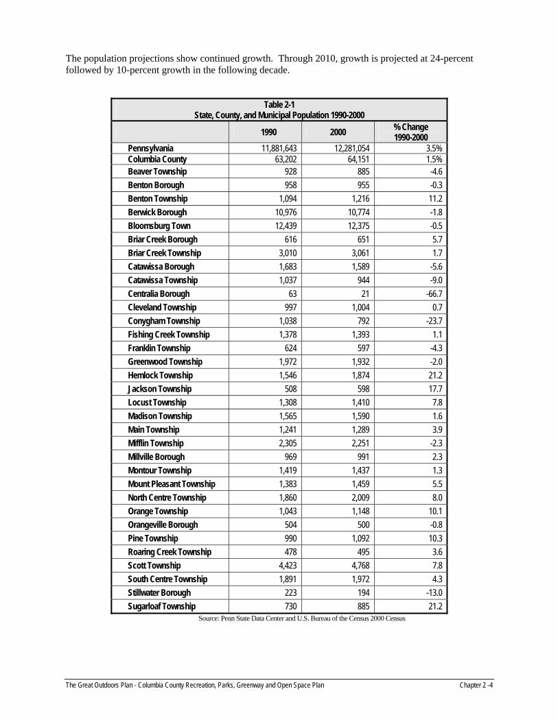
The population projections show continued growth. Through 2010, growth is projected at 24-percent followed by 10-percent growth in the following decade.
Table 2-1 State, County, and Municipal Population 1990-2000
1990 2000 % Change 1990-2000
Pennsylvania 11,881,643 12,281,054 3.5% Columbia County 63,202 64,151 1.5% Beaver Township 928 885 -4.6 Benton Borough 958 955 -0.3 Benton Township 1,094 1,216 11.2 Berwick Borough 10,976 10,774 -1.8 Bloomsburg Town 12,439 12,375 -0.5 Briar Creek Borough 616 651 5.7 Briar Creek Township 3,010 3,061 1.7 Catawissa Borough 1,683 1,589 -5.6 Catawissa Township 1,037 944 -9.0 Centralia Borough 63 21 -66.7 Cleveland Township 997 1,004 0.7 Conygham Township 1,038 792 -23.7 Fishing Creek Township 1,378 1,393 1.1 Franklin Township 624 597 -4.3 Greenwood Township 1,972 1,932 -2.0 Hemlock Township 1,546 1,874 21.2 Jackson Township 508 598 17.7 Locust Township 1,308 1,410 7.8 Madison Township 1,565 1,590 1.6 Main Township 1,241 1,289 3.9 Mifflin Township 2,305 2,251 -2.3 Millville Borough 969 991 2.3 Montour Township 1,419 1,437 1.3 Mount Pleasant Township 1,383 1,459 5.5 North Centre Township 1,860 2,009 8.0 Orange Township 1,043 1,148 10.1 Orangeville Borough 504 500 -0.8 Pine Township 990 1,092 10.3 Roaring Creek Township 478 495 3.6 Scott Township 4,423 4,768 7.8 South Centre Township 1,891 1,972 4.3 Stillwater Borough 223 194 -13.0 Sugarloaf Township 730 885 21.2
Source: Penn State Data Center and U.S. Bureau of the Census 2000 Census
The Great Outdoors Plan - Columbia County Recreation, Parks, Greenway and Open Space Plan Chapter 2 -4

Population Growth vs. Land Consumption A review of land use applications shows an average of 1,577 acres per year in land development for a total of 15,770 for a ten year period. Since the population of Columbia grew by 1.5 percent, this shows that land is being consumed at a faster rate than the population is growing.
The average lot size increased from 4.44 acres in 2001 to 5.67 acres in 2003. Population spreading out instead of being developed within planned growth areas or through Conservation by Design methods causes sprawl.
According to the U.S. Census of 2000, the population of Columbia County is 64,151. Columbia County experienced slow population growth from 1990 to 2000; the increase was not significant at 1.5 percent. Growth is expected to continue at a steady pace. The major change expected for Columbia County is the aging of its citizenry as the baby boomers head into retirement and life expectancy continues to increase. This will require an adjustment in recreation planning with a focus on clients of all ages, not just youth.
Age As interests change throughout one’s lifetime, it is important to look at the age groupings in order to target services. Table 2-2 presents population by major age group changes between 1990 and 2000, as well as, comparisons with municipalities, the County and Pennsylvania. Trends show that proportionately, the younger age groups are decreasing, while the older age groups are increasing with the exception of the 20-44 groups, which dramatically decreased in the 1990’s.
The median age increased from 34.1 in 1990 to 40.1 in 2000.
The important age group of 25 to 44 years of age decreased from 27.6 percent in 1990 to 25.9 percent in 2000. This is the “Brain Drain” age group that is crucial to retaining in a community for economic vitality and growth.
Children five and under decreased as a percentage of the population from 5.9 to 4.9 percent.
Youth 18 and under decreased from 21.8 percent to 20.8 percent.
People 65 years and older are fairly stable at 15.9 percent (15.8 percent in 1990).
Table 2-2 Percent Population by Age Group 2000
Age Group According to Years
Area 0-4
5-9
10-14
15-19
20-24
25-34
35-44
45-54
55-59
60-64
65-74
75-84 85+
Median Age
Pennsylvania 5.9 6.7 7.0 6.9 6.1 12.7 15.9 13.9 5.0 4.2 7.9 5.8 1.9 38.0 Columbia County 4.9 5.7 6.3 8.8 9.3 11.5 14.4 13.5 5.2 4.4 8.0 6.1 1.8 40.1 Beaver Township 5.5 5.6 6.2 7.6 3.8 11.4 17.5 16.2 6.4 4.7 8.1 5.9 0.9 40.8 Benton Borough 6.7 6.4 7.6 8.0 7.4 11.7 14.6 13.5 4.3 4.5 8.8 5.5 0.9 36.5 Benton Township 4.9 6.1 7.0 6.6 3.8 11.8 18.2 15.4 5.5 4.9 9.9 4.5 1.5 40.8 Berwick Borough 5.5 6.9 6.8 6.1 5.4 12.6 14.5 11.9 5.5 4.1 8.6 9.1 3.0 39.5 Bloomsburg Town 3.3 3.4 3.5 18.6 29.0 10.4 8.2 7.6 2.6 2.4 4.8 4.5 1.7 22.4 Briar Creek Borough 5.1 6.5 5.5 6.0 5.8 13.8 12.4 11.7 4.8 4.6 9.5 8.8 5.5 41.2 Briar Creek Township 5.0 5.9 7.1 6.5 4.4 11.8 16.0 16.3 6.7 5.4 8.6 5.2 1.1 41.0 Catawissa Borough 6.9 7.2 6.0 6.5 5.6 12.9 14.0 12.8 4.0 3.7 9.8 8.8 1.9 38.5 Catawissa Township 4.3 5.2 7.3 5.1 2.9 10.6 17.6 19.4 7.1 4.8 8.4 6.0 1.4 43.4 Centralia Borough n/a n/a n/a 4.8 4.8 4.8 14.3 19.0 n/a 14.3 23.8 9.5 4.8 61.5 Cleveland Township 4.0 5.1 7.4 6.0 4.1 10.7 17.3 17.5 6.0 5.8 10.2 5.4 0.7 42.7 Conygham Township 4.5 6.4 5.7 5.8 4.3 11.4 16.0 14.5 5.8 5.4 10.7 7.8 1.5 42.7 Fishing Creek Township 5.2 6.3 6.7 6.2 4.0 12.5 16.9 15.2 7.5 5.1 7.8 5.5 1.1 40.8
The Great Outdoors Plan - Columbia County Recreation, Parks, Greenway and Open Space Plan Chapter 2 -5

Table 2-2, continued Percent Population by Age Group 2000
Age Group According to Years Franklin Township 5.4 5.2 8.2 7.2 4.9 11.1 18.6 16.9 3.5 3.7 10.1 4.5 0.8 40.1 Greenwood Township 5.6 6.6 7.1 8.1 5.5 12.7 17.0 14.4 5.7 5.1 7.0 4.2 0.9 37.5 Hemlock Township 6.4 7.5 7.3 5.8 3.7 13.4 18.4 14.2 5.9 4.2 8.0 4.5 0.9 38.0 Jackson Township 3.2 6.2 7.9 5.9 4.5 10.2 18.4 16.2 5.5 6.5 9.0 5.4 1.2 41.8 Locust Township 4.4 5.5 8.2 6.5 3.0 10.1 18.3 14.4 5.9 5.2 10.4 6.5 1.6 42.0 Madison Township 5.8 5.3 6.1 6.9 5.4 10.3 16.2 18.1 7.5 4.8 8.1 4.5 0.9 41.9 Main Township 6.4 6.6 8.8 9.7 4.6 10.6 16.1 17.1 5.1 4.7 6.5 3.0 0.9 37.5 Mifflin Township 5.2 5.8 8.0 6.4 3.9 12.8 16.9 15.0 6.7 4.9 8.0 5.6 0.7 40.0 Millville Borough 5.2 4.8 6.4 5.0 5.0 12.9 11.1 9.8 5.1 4.8 10.1 12.2 7.4 43.9 Montour Township 5.5 6.3 6.8 6.1 4.7 10.5 16.4 15.9 4.8 6.4 10.0 5.8 0.9 41.6 Mount Pleasant Township 6.6 7.5 6.8 6.7 4.5 11.1 19.5 18.2 5.4 4.2 5.8 3.5 0.3 39.2 North Centre Township 5.0 7.8 9.5 6.7 4.1 12.2 18.3 16.7 5.1 4.3 6.0 3.7 0.7 37.9 Orange Township 5.1 7.4 8.0 7.1 3.2 10.4 19.4 17.7 5.4 4.5 7.1 3.5 1.2 40.2 Orangeville Borough 4.6 6.0 6.2 5.4 4.6 8.2 13.2 10.6 5.4 4.6 10.0 12.8 8.4 46.8 Pine Township 5.9 6.6 7.7 7.2 3.9 13.5 17.4 14.2 6.6 4.7 7.7 3.4 1.3 38.6 Roaring Creek Township 4.2 6.3 6.7 5.1 5.3 9.7 15.4 18.6 5.1 6.1 10.9 5.5 1.4 43.3 Scott Township 4.7 5.1 6.0 6.4 3.5 10.0 13.3 17.0 6.9 5.6 10.6 7.9 3.0 45.5 South Centre Township 5.0 6.0 6.7 6.6 4.7 13.2 15.9 14.8 6.6 5.1 9.1 5.1 1.1 40.1 Stillwater Borough 5.2 3.1 6.7 5.2 5.7 14.4 12.9 19.1 7.2 3.1 9.3 7.7 0.5 43.0 Sugarloaf Township 3.8 5.6 5.9 6.6 5.4 10.8 16.7 13.9 4.7 6.9 12.0 6.4 1.1 42.7
Source: Penn State Data Center and U.S. Bureau of the Census 2000 Census
Different Generations - Different Views of the World Longer lives have produced several generations with different views of the world: Traditionalists, Baby Boomers, Generation X, and Generation Y. Their formative experiences have molded specific preferences and beliefs among these different age groups. Each group has its own attitudes, sensibilities, hot buttons, and cultural expectations. Clarifying the needs and desires of all generations is essential in public service. Finding out how to reach and involve different generations of people in everything from programs and services to funding in parks and recreation in a positive manner is complex. For example, one generation alone, Generation Y, has three segments: adults, teens, and children.
For program planning and public outreach, understanding potential client groups is essential. Figure 2-2 presents information about various generations along with implications for program and service planning and in devising outreach strategies to implement this plan.
The Great Outdoors Plan - Columbia County Recreation, Parks, Greenway and Open Space Plan Chapter 2 -6

The Great Outdoors Plan - Columbia County Recreation, Parks, Greenway and Open Space Plan Chapter 2 -7
Figure 2-1 Generations1 and Implications2
Traditionalists – Born before 1946. Affected by the Great Depression. Hard work. Self-sacrifice. Respect for authority and institutions. Earned their material comforts the good old-fashioned way. Reaching this group: Stress frugality & their right to enjoy the fruits of their labor. Use endorsements of well-known people with wisdom of experience.
Baby Boomers – Born 1946 - 1960. Born into prosperity and affluence. “Permissive” upbringing. Feel special and privileged. Challenge authority. Champion the unconventional. Focused on self-fulfillment. Strong sense of entitlement and self-worth. Reaching this group: Stress family and family activity. Supply products and services that make boomers feel like young active winners.
Gen X – Born 1960 - 1980. Lived with social and economic obstacles that are harder than those faced by Traditionalists and did not exist for Boomers. Technology and media opened them to wider choices in lifestyle than previous generations. Sophisticated and savvy about the world. Skeptical. Reaching this group: Use candor, humor, and pragmatic approaches.
Gen Y (Echo Boomers) – Born 1980 - 2000. Group so large and complex that it is viewed as three distinct groups: adulthood, teens and tweens. Multi-cultural diversity. Broader definition of family. Affected by violence and scandal: Columbine, 9/11, terrorism, and political scandals. More watchful and careful about their personal safety. Mistrustful of the media. Information Age influence: shorter attention spans, boredom, and over-stimulation. Reaching this group: Use technology: videos, computers, WEB. Capitalize on hope and optimism. Inclusive multi-cultural programs and services. Participative planning enabling people to be heard through pulling together.
Family Structure One of the marked changes in Pennsylvania’s population in recent years has been the alteration of the family structure. Households have experienced a decline in married couples and households with children. Households with single people, single heads of households, and single parents have increased. Between 1990 and 2000, the population in Columbia County changed as follows:
Percentage of married-couple householders in Columbia County is 53.8 percent.
Householders living alone is 26.6 percent.
Percentage of non-family households 33.5 percent.
U.S. Census Bureau began to track the number of grandparents as caregivers. In Columbia County, 708 households indicated that the grandparents were responsible for grandchildren.
Proportion of households with all working parents is significant. About 67.3 percent of households with children under the age of six in Columbia County have all parents working.
About 2.6 percent of the population works from home.
Most women work: while 61.7 percent of the employable population is employed, 56.0 percent of females over 16 years are in the work force.
1 Paul, Pamela. September 2001. Getting Inside Gen Y, American Demographics, Volume 23 (9) pp 42-49 2 Smith, J. Walker and Clurman, Ann. 1997. Rocking the Ages: The Yankelovich Report on Generational Marketing. (New York, NY: Harper Business).

Income Columbia County income levels are lower than Pennsylvania as a whole. Pennsylvania exceeds income in all categories in comparison with Columbia County. Although there has been a 40.8 percent increase in household income over the last decade, the level is lower than the Commonwealth’s overall. As people attain higher income levels they tend to participate more in recreational activities and outdoor recreation. The poverty level in the County is about 7.1 percent which is similar to the Commonwealth’s level of 7.8 percent. Table 2-3 presents median per capita income information for the County and the Commonwealth.
Table 2-3 Median Per Capita Income-1999
Area Household % Change 1990-1999 Family Per-Capita
Pennsylvania $40,106 38.0 $49,184 $20,880 Columbia County 34,094 40.8 41,398 16,973 Beaver Township 34,524 40.9 39,231 15,225 Benton Borough 27,968 22.0 32,125 12,831 Benton Township 37,955 43.8 40,625 17,853 Berwick Borough 27,442 34.4 32,357 14,538 Bloomsburg Town 24,868 19.2 39,806 12,819 Briar Creek Borough 23,594 13.0 27,833 13,009 Briar Creek Township 37,743 38.6 41,185 17,818 Catawissa Borough 30,262 47.6 37,292 16,154 Catawissa Township 44,250 40.0 49,375 23,635 Centralia Borough 23,750 42.5 28,750 16,083 Cleveland Township 38,490 43.4 42,824 16,982 Conygham Township 27,292 34.3 35,391 14,230 Fishing Creek Township 38,654 37.7 44,118 18,121 Franklin Township 41,161 52.4 42,750 17,096 Greenwood Township 37,650 62.9 41,473 17,104 Hemlock Township 42,292 44.7 49,097 21,125 Jackson Township 37,250 47.2 40,833 17,016 Locust Township 37,292 43.1 44,539 16,522 Madison Township 38,819 46.6 41,853 19,196 Main Township 41,339 40.4 47,574 19,357 Mifflin Township 37,083 33.6 41,439 17,844 Millville Borough 29,191 23.5 44,063 18,958 Montour Township 38,125 37.1 42,583 18,670 Mount Pleasant Township 43,816 56.0 49,038 20,731 North Centre Township 42,716 46.3 48,229 20,010 Orange Township 52,917 76.8 56,875 22,608 Orangeville Borough 35,000 52.7 43,542 17,167 Pine Township 38,375 49.1 41,750 16,621 Roaring Creek Township 40,625 69.4 43,125 21,725 Scott Township 42,123 35.8 52,286 24,791 South Centre Township 34,764 33.1 40,395 16,600 Stillwater Borough 41,250 92.2 48,750 19,878 Sugarloaf Township 35,521 63.6 41,250 17,444
Source: Penn State Data Center and U.S. Bureau of the Census 2000 Census
The Great Outdoors Plan - Columbia County Recreation, Parks, Greenway and Open Space Plan Chapter 2 -8
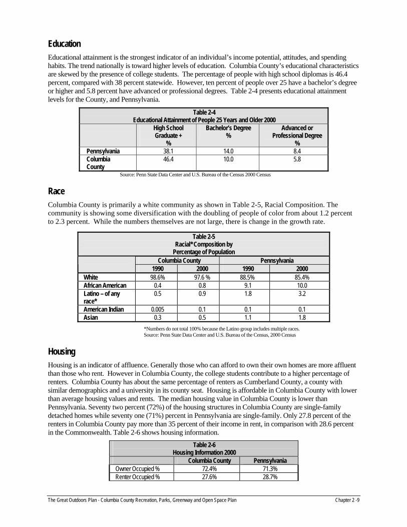
Education Educational attainment is the strongest indicator of an individual’s income potential, attitudes, and spending habits. The trend nationally is toward higher levels of education. Columbia County’s educational characteristics are skewed by the presence of college students. The percentage of people with high school diplomas is 46.4 percent, compared with 38 percent statewide. However, ten percent of people over 25 have a bachelor’s degree or higher and 5.8 percent have advanced or professional degrees. Table 2-4 presents educational attainment levels for the County, and Pennsylvania.
Table 2-4 Educational Attainment of People 25 Years and Older 2000
High School Graduate +
%
Bachelor’s Degree %
Advanced or Professional Degree
% Pennsylvania 38.1 14.0 8.4 Columbia County
46.4 10.0 5.8
Source: Penn State Data Center and U.S. Bureau of the Census 2000 Census
Race Columbia County is primarily a white community as shown in Table 2-5, Racial Composition. The community is showing some diversification with the doubling of people of color from about 1.2 percent to 2.3 percent. While the numbers themselves are not large, there is change in the growth rate.
*Numbers do not total 100% because the Latino group includes multiple races. Source: Penn State Data Center and U.S. Bureau of the Census, 2000 Census
Housing Housing is an indicator of affluence. Generally those who can afford to own their own homes are more affluent than those who rent. However in Columbia County, the college students contribute to a higher percentage of renters. Columbia County has about the same percentage of renters as Cumberland County, a county with similar demographics and a university in its county seat. Housing is affordable in Columbia County with lower than average housing values and rents. The median housing value in Columbia County is lower than Pennsylvania. Seventy two percent (72%) of the housing structures in Columbia County are single-family detached homes while seventy one (71%) percent in Pennsylvania are single-family. Only 27.8 percent of the renters in Columbia County pay more than 35 percent of their income in rent, in comparison with 28.6 percent in the Commonwealth. Table 2-6 shows housing information.
Table 2-6 Housing Information 2000
Columbia County Pennsylvania Owner Occupied % 72.4% 71.3% Renter Occupied % 27.6% 28.7%
Table 2-5 Racial* Composition by
Percentage of Population Columbia County Pennsylvania
1990 2000 1990 2000 White 98.6% 97.6 % 88.5% 85.4% African American 0.4 0.8 9.1 10.0 Latino – of any race*
0.5 0.9 1.8 3.2
American Indian 0.005 0.1 0.1 0.1 Asian 0.3 0.5 1.1 1.8
The Great Outdoors Plan - Columbia County Recreation, Parks, Greenway and Open Space Plan Chapter 2 -9

Table 2-6, continued Housing Information 2000
Columbia County Pennsylvania Detached single family homes %
66.8% 55.9%
Median House Value $87,300 $97,000 Median Gross Rent $448 $531
Source: Penn State Data Center and U.S. Bureau of the Census 2000 Census
Demographic Analysis
Columbia County has highly desirable communities in which to live, raise a family, get an education, recreate, and retire. Housing is affordable. Transportation is convenient making other metropolitan areas easily accessible. Still primarily rural with only four percent of the land area developed for housing, Columbia County remains a “best kept secret” in Pennsylvania. Since the County has not yet been discovered by people who can live anywhere they choose and work from home via the information superhighway, the County has some time to plan for growth that is smart and directed towards achieving balance between conservation and economic developments. Both are compatible in Columbia County.
Columbia County is still a homogeneous community of Caucasian residents. The area is beginning to see diversification with increasing percentage of people of color. The most significant demographic factors related to planning for parks and recreation is the “graying” of the citizenry and the loss of the brain drain group aged 25-44.
Recommendations 1. Use parks and recreation planning as an economic development tool.
2. Conservation, scenic views, lots of activities, interesting town center are all factors that could attract the type of development that people desire.
3. Design and provide facilities that reflect the overall condition of the community. While it is admirable and important to hold the line on taxes, it is equally important to make investments in the community in accordance with public wishes.
4. As the community diversifies, take steps to get input regarding parks and recreation from minority residents. Consider minority representation on advisory boards.
5. With the population changes that have occurred in Columbia County over the last ten years and the austere fiscal climate, it is important to look for ways to serve the citizenry effectively and affordably.
6. It is important to include the Boroughs and the older Townships in the park, recreation, open space, and trail planning for Columbia County. It is equally important to have an investment program in these communities to add the kinds of amenities that people want in the community in which they live. Enhancing the Boroughs and Townships will greatly help to preserve the countryside.
Public Participation The plan featured a strong public participation process that included a steering committee, work session with staff, public forums, and key person interviews.
Study Committee The County created a study committee to participate and guide the planning process. The purpose of the study committee was to provide advice and direction for the project, to serve as a sounding board, to provide key
The Great Outdoors Plan - Columbia County Recreation, Parks, Greenway and Open Space Plan Chapter 2 -10

contacts, and to review and comment on drafts. The committee was comprised of Columbia County Planning Department staff, State Game Commission representative, Penn State Cooperative Extension representative, Columbia County Planning Commission representative, and residents.
Public Forums A public forum was held mid-way through the project to solicit input from interested citizens regarding park and open space issues in Columbia County. The forum was organized around five topical areas: parks, natural resources, cultural and historic resources, agricultural lands, and greenways and trails. Three break-out sessions were held in where attendees could attend three sessions geared to the topics they were most interested in. Each topical session explored resources that are important to Columbia County, identified resources that are threatened, and resources that should be considered for conservation/protection. The results of the brainstorming sessions were posted for all to review and prioritize as to which issues are most important. The forum was well attended by approximately 36 citizens.
Key Person Interviews Key person interviews were completed with individuals that had specific insights into issues related to parks, open space, greenways, and trails in Columbia County. Key person interviews included:
Pennsylvania Game Commission Ricketts Glen State Park Knoebel’s Amusement Park Pennsylvania Power and Light Columbia County Planning Commission staff Trail initiative contacts Businesses Citizens Pennsylvania Department of Conservation and Natural Resources Pennsylvania Environmental Council Town of Bloomsburg Berwick Borough Benton Area School District Southern Columbia Area School District Bloomsburg Area School District Berwick Area School District Millville Area School District Central Columbia School District Northern Columbia Community & Cultural Center Board Bloomsburg University – Quest Program Montour County Recreation Authority Columbia Montour Visitors Bureau Millville Park Board
The Great Outdoors Plan - Columbia County Recreation, Parks, Greenway and Open Space Plan Chapter 2 -11

Findings of the Public Participation Process
The public participation process indicated a clear direction:
There is a love of the great outdoors: the landscape and resources that define the character of Columbia County.
Prioritize the protection of water resources, woodlands, and farmland.
Provide public access to streams for fishing.
Provide additional ballfields and game courts in the Berwick and Bloomsburg areas.
The County has exciting opportunities for developing a network of trails and should work with Montour County to develop and extend the North Shore Trail between Danville and Berwick.
PPL is developing a recreation area in the northern portion of the County that is targeted at community needs. The development schedule for the facility is based on the needs of PPL to beneficially spoil materials from their operations. The facility would contain athletic fields, trails, nature areas, sledding area, and an amphitheater.
The Jamison City area offers a unique historic area and is located in close proximity to Ricketts Glen State Park. Ricketts Glen State Park is one of the most popular State Parks with 3-400,000 visitors annually. A trail connection should be explored to connect Jamison City with the park.
Need for walking and biking areas.
There is potential to link Columbia County to the region and beyond through trails and the Susquehanna Greenway.
School Districts represent important potential partnerships. They also represent a potential way to configure multi-municipal planning and parks, recreation, and open space systems. They are largely untapped resources in Columbia County.
Bloomsburg University and the Quest Program could be a valuable ally in parks, recreation ,greenway and trail planning.
Parks and recreation has developed largely through bootstrap efforts, volunteers, donations, and bequests.
There is minimal public investment in parks, recreation, and open space.
Many people are interested and working on parks, recreation and open space as well as trail projects.
Programs for teens are needed.
After school services for youth from 3:00 to 6:00 P.M. are needed.
A survey in 2006 in the public schools revealed that the two most pressing public needs to be addressed are drug and alcohol abuse and activities and indoor facilities for teens.
The County has a poor rural population that needs special consideration in terms of provision of services and their ability to pay for recreation and have access for transportation.
The Northern Columbia Community & Cultural Center represent a fine model of citizen achievement and parks and recreation. Its long term operation and maintenance needs support and continued investment with revenue generating methods.
The Great Outdoors Plan - Columbia County Recreation, Parks, Greenway and Open Space Plan Chapter 2 -12

Related Plans
Columbia County Inventory Study of Potential Trail/Greenway Opportunities Plan (Peer to Peer Study) This study prepared in 1999 inventoried active and abandoned rail corridors, existing bike and walking trails, and natural features that have the potential to become greenways and trails. Proposed greenways and trails are ranked, a map is provided that located potential rail-to-trails projects, and strategies are provided to develop a system of greenways and trails in Columbia County. The Bloomsburg to Catawissa Trail was recommended as the first to be developed and actions/steps were recommended to make this trail a reality.
Parks & Recreation: Bridge to the Future This Joint Municipal Recreation, Open Space & Recreation Plan for the Town of Bloomsburg and Montour Township, Columbia County was completed in 2003. The plan provides a strategy for these two adjoining municipalities to improve parks and recreation facilities, enhance recreation programs, and meet community needs in the future. The plan identified eight overall goals and lists specific recommendations for actions.
Pennsylvania Greenways Plan: Creating Connections
The Pennsylvania Department of Conservation and Natural Resources (PADCNR) adopted a statewide greenways plan in 2001, Pennsylvania Greenways: An Action Plan for Creating Connections. It set forth the goals that reflect input from thousands of Pennsylvanians including the people of Columbia County. In the public participation process, citizens said the state's outdoor resources are vitally important and a network of greenways should connect every community. This Plan provides a "greenprint" for communities, state government, the private sector, and individual citizens to work as partners in developing an outstanding statewide network of greenways; a system that will be enjoyed by current and future generations of Pennsylvanians. Greenways can provide a strategic approach for municipalities such as Columbia County and regions to plan for "smarter" growth, enhance community character, provide for alternative transportation, and provide educational opportunities in conservation, ecology, and history.
Columbia County can gain by following the recommendations of the state greenways plan tailored for the County itself. Through Pennsylvania’s commitment to greenways, the County can benefit from the State’s technical and financial support through grants for greenways and trails. In order to be competitive for these funds and technical assistance, the County’s greenways and trails should be consistent with the State’s overall goals. The Comprehensive Recreation, Park and Open Space Plan is consistent with the State’s greenways plan.
Statewide Bicycle & Pedestrian Master Plan The Pennsylvania Department of Transportation (PennDOT) prepared the Statewide Bicycle & Pedestrian Master Plan. It consists of five documents:
Executive Summary A Statewide Bicycle and Pedestrian Master Plan Bicycle Planning and Design Guidelines Pedestrian Planning and Design Guidelines Community Design Systems
The plan is based upon a vision for the future which says: Pennsylvania is a place where residents and visitors alike can choose to bicycle and walk. People are able to bicycle and walk with confidence, safety, and security in every community, both for daily transportation and to experience and enjoy the remarkable natural resources of the state. The plan has five important goals:
1. Modify the existing transportation infrastructure to encourage bicycling and walking in targeted rural, suburban, and urban areas of the Commonwealth.
The Great Outdoors Plan - Columbia County Recreation, Parks, Greenway and Open Space Plan Chapter 2 -13

The Great Outdoors Plan - Columbia County Recreation, Parks, Greenway and Open Space Plan Chapter 2 -14
2. Plan, design, construct, and maintain new and improved transportation facilities to accommodate and encourage appropriate use by bicyclists and pedestrians.
3. Provide technical assistance, training, and leadership to support local jurisdictions in improving conditions for bicycling and walking.
4. Implement educational and enforcement programs to reduce crashes involving bicyclists and pedestrians by at least 10 percent through 2020 and to provide a better sense of safety and security for bicyclists and pedestrians.
5. Promote acceptance and welcome bicyclists and pedestrians as users of the transportation system.
Columbia County should support the goals of this plan and seek to incorporate bicycle and pedestrian accommodations into infrastructure planning studies and system upgrades. Columbia County should work closely with PennDOT to achieve the vision of this plan.

Columbia County municipalities have a long tradition of providing community parks. Most communities have their own park where residents play with children, enjoy ball games, and attend community celebrations. Residents take pride in their close to home recreation opportunities while also enjoying convenient access to the great outdoors. The numerous State Game Lands, the Susquehanna River, and near by Ricketts Glen State Park provide abundant opportunities for enjoying nature, hunting, and fishing.
This chapter will explore the recreation facilities that exist in Columbia County, both municipal and County owned, and recommend how parks and recreation opportunities can be enhanced to target recreation needs, meet leisure trends, and provide opportunities for memorable outdoor experiences to residents and visitors alike.
Parks Contribute to Quality of Life In the 21st century, people no longer need to locate near highways and waterways: our culture is now more “plug-in”, thanks to new technology and the World Wide Web and less dependent on traditional commerce centers. Because people and businesses can locate anywhere they want, quality of life is an essential factor in attracting and retaining citizens and businesses. Parks, greenways, trails, and recreation opportunities help define quality of life of a locale.
Columbia County retains the qualities that many look for in a place to live. The scenic landscape, convenient access to protected public lands, access to the Susquehanna River and high quality streams, and the availability of parks and recreation facilities make Columbia County an attractive locale. As growth occurs, retaining these opportunities will be critical to the quality of life for residents in the future.
Columbia County Park Assessment The purpose of the park assessment is to evaluate if recreation needs are being met and to determine how best to meet existing and future needs. The amount and distribution of parkland has been evaluated. Areas of the county that need facilities have been identified, as well as, strategies for linking communities and facilities to create a County-wide greenway network. The existing public recreation facilities in Columbia County have been assessed to determine how they could be improved or expanded, and what changes must be made to comply with safety and accessibility standards. The analysis of parks and recreation facilities was developed through conducting on-site investigation, discussions with the study committee, and input from citizens through the public participation process. Table 3-1, starting below, inventories public recreation lands in Columbia County as well as schools and other quasi-public and protected lands and parks. The Protected Land and Resources Map on page 3-6 illustrates the locations of parks, schools, and protected open space parcels in the County.
Table 3-1 Park/Recreation Land Inventory
County and Municipal Park Acreage Park Type Characteristics/Facilities Municipality
Briar Creek Lake County Park
85.8 Regional Cooperative agreement with Fish and Boat Commission, trout stocked lake, boats (elec. motor), 2 pavilions, parking, open area, softball fields, volleyball courts
Briar Creek Township
Twin Bridge County Park
1.2 Special Purpose Historic twin bridge structures, parking, play equipment, restroom, picnic area.
Fishing Creek Township
The Great Outdoors Plan - Columbia County Comprehensive Recreation, Parks, Greenways and Open Space Plan Chapter 3 - 1

Table 3-1, continued Park/Recreation Land Inventory
County and Municipal Park Acreage Park Type Characteristics/Facilities Municipality
Bloomsburg Town Park
47.4 Community Active and passive recreation facilities, parking, restrooms, swimming pool, band shell, lake.
Town of Bloomsburg
Columbia County Susquehanna Trail
4+/- miles
Linear Trail between Indian Head campground to Iron Street near Fishing Creek
Town of Bloomsburg
Catawissa Community Park
7.3 Community 1 tennis court, 1 youth baseball field, 2 pavilions, playground equipment, open lawn, municipal garage
Catawissa Borough
Espy Park
1.9 Neighborhood 1 pavilion, playground equipment, restrooms, parking, river access
Scott Township
Columbia Park
23.5 Community 2 pavilions, gazebo, trail, 2 tennis courts, 1 youth baseball field, 1 basketball court, parking, restrooms, river access, concession, trails, benches, playground, portable restroom facilities
South Centre Township
Frank Kocher Memorial Park 4 Natural Resource Area
Fishing area, natural areas, trails. Owned by Fishing Creek Watershed Association
Scott Township
Mifflinville Park
8 Neighborhood Pavilion, playground equipment, restrooms, parking,
Mifflin Township
Stillwater Park
3.2 Neighborhood Tennis courts, soccer field, volleyball court, pavilion, picnic tables, playground equipment
Stillwater Borough and Fishing Creek
Township
Ber Vaughn Park
26.15 Community Swimming pool, 3 youth baseball fields, playground and play equipment, shuffle board, tennis, sand volleyball, pavilions
Briar Creek Borough
Millville Community Park
7.5 Community Swimming pool, 2 tennis courts, gazebo, 2 pavilions, 2 basketball courts, youth baseball field, memorial area, playground
Millville Borough
Benton Park 4.5 Neighborhood Playground Benton Borough Benton Athletic Field 6 Neighborhood Athletic Field Benton Borough Benton Soccer and Baseball Fields 22 Neighborhood 2 Soccer and 3 Baseball
Fields Benton Borough
Benton Rodeo Grounds 20 Neighborhood Stadium, six buildings and camping facilities
Benton Borough
PPL Montour Preserve Recreation Area
280+- Regional 2 softball fields, 4 soccer fields, camping area, winter use area, fishing pond, environmental education area
Madison Township
Benton Tennis Courts 0.5 Mini Tennis courts Benton Borough Union Cemetery Monument 0.21 Mini Monument Catawissa
Borough Mt. Pleasant Township Community Center
7.3 Community Soccer fields, basketball courts, pavilion, playground
Mt. Pleasant Township
The Great Outdoors Plan - Columbia County Comprehensive Recreation, Parks, Greenways and Open Space Plan Chapter 3 - 2

Table 3-1, continued Park/Recreation Land Inventory
County and Municipal Park Acreage Park Type Characteristics/Facilities Municipality CARA Park 6.93 Community Tennis courts, pavilions,
benches, playground equipment, restrooms, softball field, baseball field, benches
Catawissa Borough
CARA Park Extension 2.9 Community Baseball field, benches, pavilion, grills
Catawissa Borough
George Eyer Memorial Park 0.5 Mini Monument, benches Catawissa Borough
Catawissa Playground 0.7 Mini Playground equipment, band shell, basketball court, benches
Catawissa Borough
Quaker Grove 0.96 Mini Quaker meeting house, benches
Catawissa Borough
Mainville Park 2.5 Neighborhood Climbing wall, playground equipment, pavilion with picnic tables, bench, basket ball courts, baseball field, port-a-potty
Main Township
Lightstreet Park 3 Neighborhood Tennis courts, basketball courts, volleyball courts, pavilions, playground equipment, memorial, restrooms
Scott Township
Scott School Park 4 Neighborhood Pavilion, restrooms, playground equipment
Scott Township
“The Project” 2 Neighborhood Pavilion, picnic area Locust Township Memorial Park 3 Neighborhood Mifflin Township Little League Football and Baseball Complex
8 Community Football fields and baseball fields
Mifflin Township
Kids Park 5 Community Pavilion, playground equipment, restroom
Mifflin Township
River Park 10 Community Picnic areas Mifflin Township Three Open Lots 3 Neighborhood T-ball fields Mifflin Township Catawissa Legion 22.07 Community Soccer and football fields Montour
Township Limeridge Community Center 3 Community Building, open area South Centre
Township Numidia Community Park 6 Neighborhood Pond, benches, pavilions,
picnic tables, playground equipment
Locust Township
Orangeville Borough Park 1.4 Neighborhood Tennis courts, basketball court, pavilions, playground equipment, benches, picnic tables
Orangeville Borough
Stillwater Memorial Park 3.2 Neighborhood Tennis courts, soccer field, volleyball court, pavilion, picnic tables, playground equipment
Stillwater Borough & Fishing Creek
Township
Total 644.62
Schools School Type Location
Beaver-Main Elementary School Elementary School Beaver Township
Central Columbia Elementary School Elementary School South Centre Township
WW Evans Elementary School Elementary School Montour Township
The Great Outdoors Plan - Columbia County Comprehensive Recreation, Parks, Greenways and Open Space Plan Chapter 3 - 3

Table 3-1, continued Park/Recreation Land Inventory
Schools School Type Location L’Ray Appleman Elementary School Elementary School Benton Borough
Millville Elementary School Elementary School Millville Borough
Orange Street Elementary School Elementary School Berwick Borough
Mulberry Elementary Street School Elementary School Berwick Borough
14th Street Elementary School Elementary School Berwick Borough
G.C. Hartman Elementary School Elementary School Franklin Township
Memorial Elementary School Elementary School Town of Bloomsburg
Bloomsburg Middle School Middle School Town of Bloomsburg
Central Columbia Middle School Middle School South Centre Township
Berwick Middle School Middle School Berwick Borough
Benton Schools Middle/High School Benton Borough
Bloomsburg Senior High School High School Town of Bloomsburg
Central Columbia High School High School South Centre Township
Southern Columbia Area High School High School Franklin Township
Berwick High School High School Berwick Borough
Columbia-Montour Vocational Technical School
High School South Centre Township
Greenwood Friends School Private Greenwood Township
Millville Schools Middle/High School Millville Borough
Saint Columbia School Private Town of Bloomsburg
Columbia County Christian School Private Hemlock Township
Bloomsburg Christian School Private Scott & North Centre Townships
Heritage Christian School Private Berwick Borough
Bloomsburg University University Town of Bloomsburg
Other Public, Quasi-Public, Protected Lands/Parks
Acreage Ownership Characteristics/Facilities Location
Northern Columbia Community and Cultural Center
4.5 Northern Columbia
Community and Cultural Center
Gymnasium, kitchen, arts and crafts room, large game room, library/museum, aerobics room, cardio/fitness room, senior center, 9 court horseshoe pits, skateboard park
Benton Borough
Weiser – Roaring Creek Tract
9,287 Bureau of State Forests
On South Branch Roaring Creek, includes three impoundment areas, parking, road/trail
Columbia (Conygham,
Locust, Cleveland and Roaring Creek
Townships) & Northumberland
counties
Weiser State Forest – Jakey Hollow Natural Area
56.4 Bureau of State Forest
Along a tributary of Little Fishing Creek
Mt. Pleasant Township
Ricketts Glen State Park 93 Bureau of State Parks
Small portion within Columbia County of total 13,050 acre park
Luzern, Sullivan, Columbia counties
State Game Lands 329
Not available
PA Game Commission
Adjacent to Roaring Creek Tract
Roaring Creek
The Great Outdoors Plan - Columbia County Comprehensive Recreation, Parks, Greenways and Open Space Plan Chapter 3 - 4

Table 3-1, continued Park/Recreation Land Inventory
Other Public, Quasi Public, Protected Lands/Parks
Acreage Ownership Characteristics/Facilities Location
State Game Land 226
4,274 PA Game Commission
Designated route 3.5 miles of looped hiking trails. Snowmobile trails on old log trails 14 mi.
Madison and Pine Townships
State Game Land 58
12,646 PA Game Commission
Hiking, Horse and Bicycle trails at base of Firetower Rd. loops to fire tower and returns to beginning, 8 miles total.
Roaring Creek, Catawissa, Main, Mifflin, & Beaver
Townships
State Game Land 55
2,474 PA Game Commission
Hiking trails. Fishing Creek, Briar Creek, & North Centre Townships
State Game Land 13
1,158 PA Game Commission
Small portion in Columbia County
Columbia (Jackson & Sugarloaf
Townships) & Sullivan Counties
Catawissa American Legion
62 Catawissa American
Legion
Soccer field (1 full size or 3 small), football field, parking
Bloomsburg Christian Church
29+- Bloomsburg First Church of
Christ
Pond, picnic pavilion, picnic tables. Adjacent to old Reading RR corridor – connects to Montour Township building and Danville to the west
Montour Township
PA Fish & Boat Commission – Bloomsburg Access Area
PA Fish & Boat Commission
Parking, boat ramp, sign, bench
Town of Bloomsburg
Camp Lavigne
220 Columbia/ Montour
Council of the Boy Scouts of
America
Boy Scout Camp Benton Township
Camp Louise 380 Penn’s Woods Council of the Girl Scouts of
America
Girl Scout Camp Briar Creek Township
Greenway and Susquehanna River Trail +- 6.5 miles
Configuration of Parkland Different types of parks provide differing opportunities for County residents to enjoy. Table 3-2 on page 3-7 presents the Columbia County Park Classification System. It shows the range of park types, their benefits, appropriate facilities, and the maintenance levels appropriate for the type of park and resources available.
Counties typically provide regional parks for resource-based passive recreation, preservation of natural, cultural, and/or historic resources and enjoyment of scenic resources. County parks are complemented by municipal neighborhood and community parks. Many of the parks located throughout Columbia County are small in size and typically provide active recreation opportunities to the community in which they are located. Columbia County has two county-owned park sites: Briar Creek Lake County Park and Twin Bridges Park. Both of these parks are based around the resources found at the park sites.
The Great Outdoors Plan - Columbia County Comprehensive Recreation, Parks, Greenways and Open Space Plan Chapter 3 - 5

Insert Facilities Map
The Great Outdoors Plan - Columbia County Comprehensive Recreation, Parks, Greenways and Open Space Plan Chapter 3 - 6

The Great Outdoor Plan – Columbia County Comprehensive Recreation, Parks, Greenways and Open Space Plan Chapter 3 – 7
Table 3-2 Columbia County Park Classification System
Type/Size/Service Radius Definition Benefits Appropriate Amenities Maintenance Level Mini Park 0-5 acres ¼-mile service radius
Smallest park type, addresses limited recreation need
Provides close to home recreation
Playground Benches, seating area
High level of maintenance associated with well developed park and playground and reasonably high visitation
Neighborhood Park 5-15 acres minimum ½-mile service radius
Focus of neighborhood; in walking/biking distance of visitors
Provides access to basic recreation opportunities
Contributes to neighborhood identity
Establishes sense of community
Play areas Ballfields Game Courts Picnic/Seating Pathways Community gardens
High level of maintenance associated with well-developed park and reasonably high visitation.
Community Park 25-50 acres, preferably 50-80 acres 2-mile service radius
Large park for active & passive recreation; serves residents city-wide. Accommodates large groups.
Variety of recreation opportunities for all ages and interests
Space for organized, large scale, high participation events
Family destination Fitness and wellness
opportunities
Play areas Organized sports facilities Pavilions Permanent restrooms Lighting Amphitheaters Pools, Rinks Parking
Moderate level of maintenance associated with moderate level of development, budget restrictions, inability to perform higher levels of maintenance. Try to get park friends or establish adopt-a-park.
School/Community Park Varies
Parkland adjoining a school used for both recreation and education.
Combines two public entities for expanded year round recreation.
Maximizes public resources Expands recreation
opportunities
Youth-oriented game courts and ball fields Play areas Seating Pathways Lighting Parking
Moderate level of maintenance associated with moderate level of development, budget restrictions, Try to get cooperative agreement with school.
Sports Complex 30+acres; preferably 50-80 acres
Consolidates sports fields and related facilities in a centralized location.
Economy of scale Improved management City showcase Attracts visitors who stimulate
local economy
Ball fields Lighting Spectator Areas Restrooms, Concessions Landscaping Parking
State of the art maintenance applied to high quality facilities. Associated with high visitation; revenue generating facilities, tourism.
Special Use Facility Varies
Facility for a single purpose use. Provides special focus recreation opportunities
Contributes to community identity
Depends on purpose High level of maintenance associated with well-developed park and reasonably high visitation.
Greenways and Trails Varies
Tie park areas together to form a contiguous park environment.
Connects community Reduces auto dependency Improves air quality Contributes most desired
recreation facility for people throughout their lifetime
Attracts visitors
Pathways – multipurpose Trailheads Support facilities Signage
Lowest level of maintenance. Focus on trailheads and trail safety.
Natural Resource Areas/ Preserve Natural areas for the protect and management of natural environment
Protect resources Provide wildlife habitat Offer opportunities for
environmental education
Trails Signage Support facilities
Lower level of maintenance.

Amount of Parkland Columbia County has approximately 600 acres of public parkland that provides active and passive recreation opportunities. This acreage is distributed within 36 parks located primarily in the small towns throughout the County. This equates to 9.35 acres of parkland per 1,000 residents based on the 2000 U.S. census Count population of 64,151.
Over the past 30 years, it has been the accepted practice within the recreation and park profession to adopt a uniform national land standard such as 10 acres per thousand.
NRPA Park, Recreation, and Open Space Guidelines 1995
A population-based analysis is typically used to evaluate active public parkland only. Passive parks, greenways and trails, and nature preserves are not evaluated using an acreage standard because they are typically sized based on the resources, and the area necessary to protect the resource and make it available for public enjoyment.
A standard of 15 acres per thousand population is recommended for Columbia County. This standard was established to preserve the integrity, rural atmosphere, and the economic based tourism potential within Columbia County. This standard addresses and recognizes the changes in recreation patterns over the past 30+ years as well as the needs and desires of Columbia County residents to provide adequate recreation into the future. Using the 15 acre standard, Columbia County should have approximately 962 acres of active public parkland available for residents. Table 3-1, Park/Recreation Land Inventory lists approximately 645 acres of parkland in the County. Of the 645 acres, approximately 9 acres are developed for non-active uses, resulting in approximately 636 acres of active parkland in Columbia County. A deficit of 326 acres of active parkland throughout the County results if the available acreage (636 acres) is subtracted from the standard (962 acres) acreage. This deficit expands to 606 acres if the PPL Recreation Area is not included. The PPL Montour Preserve Recreation Area is designed to include significant open space and passive recreation areas. Inclusion of this facility is not recommended at this time as it is not available for public use. Other park/recreation lands included in Table 3-1 but not included in the parkland calculation because the sites do not offer active recreation opportunities include: Limeridge Community Center, Quaker Grove, George Eyer Memorial Park, Union Cemetery Monument and Frank Kocher Memorial Park.
Location of Parks The Protected Lands and Recreation Facilities Map illustrates the locations of public parkland in Columbia County. The map illustrates the following:
Parkland is not evenly divided throughout the County, most public recreation lands that offer active recreation opportunities are located in the municipalities along the Susquehanna River, central to the County.
The northern and southern portions of the County are not well served with active parkland.
The proposed PPL Montour Recreation Area may offset some of the active recreation needs in the northwestern portion of the County when it is developed. Final land development approval has been granted for this project and the park site will be developed over time as determined by PPL.
Resource-based recreation opportunities are found in the southern portion of the County at the Roaring Creek State Forest and State Game Lands 58.
Resource-based recreation opportunities are found in the northern and northwestern portions of the County at State Game Lands 226 and 13.
The Great Outdoors Plan - Columbia County Comprehensive Recreation, Parks, Greenways and Open Space Plan Chapter 3 - 8

State Game Lands 55 offer resource-based recreation in the east-central portion of the County.
Numerous municipalities within Columbia County do not contain active or resource-based parkland.
Bloomsburg and Berwick have long been the population centers of the County. County residents from the outlying municipalities have traditionally traveled to Bloomsburg and Berwick for shopping, community activities, and recreation.
Connections Between Parks Trails and greenways provide passive recreation opportunities and green corridors of protected open space. Easy access to trails facilitates exercise and fitness, as well as, safe linkage to connected locales. Connecting the parks and protected lands of Columbia County with trails and greenways will add to the livability and quality of life for citizens. The County’s natural and manmade linear resources provide many opportunities to extend a trail and greenway system county-wide. From the Susquehanna River to abandoned rail corridors, Columbia County’s linear resource have the potential to interconnect much of the County. The County is part of the regional Susquehanna River Greenway and is currently developing the Columbia County Susquehanna Trail that will link the Village of Rupert, the Town of Bloomsburg, and the area north of Bloomsburg via a recreation trail. Trails and greenways are further explored in Chapter 4 County Open Space Resources.
Park and Recreation Facility Trends The way we spend our leisure time and the activities we enjoy changes over time. Trends emerge and factors change that impact the parks and recreation facilities that we need in our communities. The following trends emerged as part of the analysis of Columbia County’s parks and recreation facilities.
Public access to streams is becoming more and more difficult with fewer access points available for public use. Private property owners are not permitting public access for fishing and are putting cables across steams to limit canoe/kayak use.
Mountain biking is causing erosion problems on public lands and policies are now limiting use.
There is fragmentation of open space due to sprawl.
People are beginning to see the Susquehanna River as an asset and desire more public access areas.
The tourism potential of the great outdoor areas of the County is becoming more recognized by visitors.
Citizens and visitors are interested in walking and bike riding opportunities throughout the County.
Small improvements to existing parks such as walkways to connect facilities, benches, and restrooms will improve the convenience of using the parks and enhance the visitor experience.
Birding is becoming more popular as a passive recreation opportunity.
Citizens recognize that residential growth will continue in Columbia County and that the landscape of the County will continue to change. Citizens have expressed the desire to preserve open space and the landscape values of the County while providing additional recreation opportunities.
New sports are emerging that have an impact on facilities. These include: in-line hockey and skateboarding.
The Great Outdoors Plan - Columbia County Comprehensive Recreation, Parks, Greenways and Open Space Plan Chapter 3 - 9

Expanding sports seasons and high use demands do not allow the overlapping use of facilities. Dedicated fields are desired for specific sports.
Facilities that enhance the convenience of using parks are desired.
Facilities for winter use of parks are desired.
Trails are very popular among all age groups.
Linear resources exist throughout the County to begin the process of creating a livable, connected community. Emphasize pedestrian and bicycle facilities in planning efforts and explore opportunities for trails and greenways.
Senior adults are more active than ever. Facilities and activity areas are needed that provide opportunities for fitness and wellness activities. Lifetime recreation activities such as golf, tennis, walking, and bicycling will have sustained popularity.
Conditions of Parkland Each park site listed below was viewed during the tour of facilities and subsequent fieldwork (These are only a sampling of the parks listed in Table 3-1). Generally, the parks are in good condition from a maintenance perspective. The findings of the facility inventory for each site have similarities that relate to accessibility and the regulations of the Americans with Disabilities Act (ADA), the safety guidelines of the Consumer Product Safety Commission (CPSC), and recommendations to enhance the users experience through the addition of convenience facilities such as benches, grills, picnic tables, etc. Specific findings of site observations and recreation opportunities include the following:
Briar Creek Lake County Park Park Description: A county park created as a flood control project in cooperation with
the PA Fish and Boat Commission. The site contains a 51 acre lake surrounded by open space.
Active Recreation Facilities: Playground equipment, baseball fields, softball fields, volleyball courts.
Passive Recreation Facilities: Boat ramp, handicap fishing pier, dock, pavilions, picnic areas.
Support Facilities: Parking area, rest rooms.
General Site Observations: The park site is open with the lake as the main focal point. Canada geese inhabit the park site.
Opportunities: Develop facilities for winter use such as a warming hut (with a fireplace) for use when ice skating and cross-country skiing. Develop a trail that loops around the lake. Consider adding a pavilion on the north side of the lake and an age segregated playground. Provide deciduous shade trees in open areas. Allow meadow grasses to grow adjacent to the lake to deter geese. Develop a master plan to illustrate how these ideas can be incorporated into the park site.
Twin Bridge County Park Park Description: This park is a historic/cultural site containing one of the remaining
twin bridges that cross Huntington Creek: East Paden and West Paden. The bridges were constructed in 1884 and the West Paden was damaged beyond repair in 2006. The bridge is currently under reconstruction.
The Great Outdoors Plan - Columbia County Comprehensive Recreation, Parks, Greenways and Open Space Plan Chapter 3 - 10

Active Recreation Facilities: Playground equipment.
Passive Recreation Facilities: Picnic tables, grills, benches, stream access.
Support Facilities: Small parking area, restroom.
General Site Observations: The park site is small and development of facilities is limited. The bridges were damaged by falling trees and the County secured a grant to repair the damage. Subsequent flooding in June 2006 severely damaged one of the bridges as well as other park amenities.
Opportunities: The improvements damaged in the 2006 storm should be assessed and restored as appropriate.
Bloomsburg Town Park Park Description: A community park with both active and passive recreation and
support facilities. The park has frontage on the Susquehanna River and a pond.
Active Recreation Facilities: Six tennis courts, tennis backboard, in-line hockey rink, basketball court, two volleyball courts, three youth baseball fields, one senior baseball field, two small soccer fields, one large soccer field, two playground areas, swimming pool and ice skating.
Passive Recreation Facilities: Trails, garden areas, picnic pavilion/areas, and band shell.
Support Facilities: Parking areas, two restroom buildings, concession/press box, dugouts, and baseball grandstands.
General Site Observations: The park setting with mature trees, river access, and diverse facilities creates a community asset. The rivers edge in the area of the park is clear, accessible, and picturesque. The facilities are well maintained. Crossing Fort McClure Boulevard presents a safety issue.
Opportunities: The Joint Municipal Recreation, Open Space & Recreation Plan for the Town of Bloomsburg and Montour Township outlines numerous facility and site development opportunities. These opportunities should be explored in a master plan for Town Park to guide future renovations and development. Key opportunities include providing river access, extend a trail along the river, and develop trails for accessibility and recreation.
Columbia Park Park Description: A community park located along the Susquehanna River.
Active Recreation Facilities: Two tennis courts, a youth baseball field, playground, and one basketball court.
Passive Recreation Facilities: Raised stage and amphitheater seating, two picnic pavilions, gazebo, river access area, and trail.
Support Facilities: Parking area, concession, portable toilet, bleachers.
General Site Observations: The park provides a well developed community recreation setting with a balance of active and passive facilities and activity areas.
Opportunities: Add restrooms and provide accessible trails to all facilities and to viewing/sitting areas along the river frontage.
The Great Outdoors Plan - Columbia County Comprehensive Recreation, Parks, Greenways and Open Space Plan Chapter 3 - 11

Ber-Vaughn Park Park Description: A community park with diverse recreation facilities.
Active Recreation Facilities: Swimming pool, three youth baseball fields, tennis courts, sand volleyball court, modular playground, and scattered playground equipment.
Passive Recreation Facilities: Picnic pavilions and shuffle board.
Support Facilities: Parking area, restrooms, and bathhouse.
General Site Observations: The park setting is enhanced by mature trees. The picnic pavilions are uniquely arranged in a row offering an organized community atmosphere to the park. There are vehicular and pedestrian conflicts with vehicular drives extending into activity areas and facilities separated by parking/vehicle ways.
Opportunities: There is a need for additional parking. The scattered playground equipment is older models and does not meet the Consumer Products Safety Commission guidelines for safety and should be removed. Trail should be incorporated into the park to access facilities and activity areas and meet the intent of the ADA. The vehicular access should be evaluated to improve safety through traffic calming measures and designated pedestrian crossing areas.
Millville Community Park Park Description: A community park located in the Borough of Millville.
Active Recreation Facilities: A swimming pool, two tennis courts, two basketball courts, a youth baseball field, and playground.
Passive Recreation Facilities: Gazebo, two picnic pavilions, and a memorial area.
Support Facilities: Parking area and bathhouse.
General Site Observations: The park site offers mature vegetation in a traditional community park setting. The park is maximized with recreation facilities. An accessible route is not provided to all facilities.
Opportunities: Develop walkways to provide accessible routes to recreation facilities and activity areas.
Espy Park Park Description: A neighborhood park located in Scott Township along the
Susquehanna River.
Active Recreation Facilities: Playground, small basketball court
Passive Recreation Facilities: River access, picnic pavilion, and horseshoe pits.
Support Facilities: Parking area, grills, and restrooms.
General Site Observations: The small site offer access to the river and picnic opportunities.
The Great Outdoors Plan - Columbia County Comprehensive Recreation, Parks, Greenways and Open Space Plan Chapter 3 - 12

Opportunities: Accessibility improvements should be provided within the park to connect the parking area with the site improvements. Accessible parking spaces should be added to the parking area. Play equipment that does not meet CPSC guidelines should be removed and safety mulch installed.
Catawissa Community Park Park Description: A community park located along the Catawissa Creek in the
Borough of Catawissa.
Active Recreation Facilities: One tennis court, a youth baseball field, two pavilions, and playground equipment.
Passive Recreation Facilities: Open lawn area.
Support Facilities: Parking area and municipal garage.
Frank Kocher Memorial Park Park Description: A natural park located along Fishing Creek.
Active Recreation Facilities: None.
Passive Recreation Facilities: Picnic pavilion, stream access and accessible walking trail.
Support Facilities: Benches, parking, portable toilet, fireplace, and bird boxes.
General Site Observations: The park provide access to the stream for fishing and enjoying the resources of the natural setting. An accessible trail accesses wetlands and the stream. Native vegetation is planted throughout the site and signage promotes environmental education. Stream bank stabilization was funded by DEP and the site is owned by the Fishing Creek Watershed Association.
Opportunities: The park is well developed and no modifications or additions are suggested.
Mifflinville Park Park Description: A small neighborhood park located in Mifflin Township with
frontage on the Susquehanna River.
Active Recreation Facilities: Playground equipment
Passive Recreation Facilities: Picnic pavilion.
Support Facilities: Parking area, benches, and restrooms.
General Site Observations: The site has mature trees and is separated from the river by railroad tracks. There are no accessible paths to the play equipment or pavilion.
PPL Montour Preserve Recreation Area Park Description: A 280-acre+- regional park created by PPL for public benefit.
Facilities described below are based on the 2004 master plan and recently approved for development.
Active Recreation Facilities: Two youth soccer fields, two full size soccer fields, a softball field, horseshoe pits, and an adult baseball field.
The Great Outdoors Plan - Columbia County Comprehensive Recreation, Parks, Greenways and Open Space Plan Chapter 3 - 13

Passive Recreation Facilities: Two picnic pavilions, one warming hut, bird blinds, amphitheater with lawn seating, sledding hill, trail system, fishing pier at the pond, environmental education interpretative signs, group camping area, and open lawn area.
Support Facilities: Parking areas and five comfort stations.
General Site Observations: The site landscape is diverse with open fields, wooded areas, a stream, a farm pond, wetlands, and undulating topography.
Opportunities: The site is proposed for development by PPL as a site for spoiling Stabil-fill, a coal ash by-product from the power plant located in Montour County. Stabil-fill will be placed on the site to create topography suitable for development of recreation facilities. PPL will phase in the development of the park improvements over time as stabil-fill material is available for spoil.
Recommendations Parks along with schools have long been the center of social and recreation activities throughout Columbia County. Most communities have their own park that provides play equipment, athletic fields, game courts, and picnic facilities for active recreation. State Forest and State Game lands provide the protect lands for passive recreation pursuits. As Columbia County looks to the future, a strategy is proposed to launch a County park system and enhance municipal parks with expanded facilities, connections to the river, and linkages through a comprehensive greenway and trail system.
Following are parkland and park development recommendations for Columbia County:
1. Expand the County park system to preserve the natural, historic, and cultural heritage of Columbia County, create a connected County, and promote the economic vitality of the County.
Explore the acquisition of County parkland in areas that do not have convenient access to permanently protected public lands.
- Target a ratio of 15 acres of parkland per 1,000 population as a County recreation standard.
- Target County parkland in areas underserved by existing parks. Three areas for new County parks are proposed: the northeast corner of the County, north of the river in the Hemlock-Mount Pleasant townships area, and in the southern portion of the County.
Seek acres of land for a park that explores the cultural significance of the Jamison City area as well as the natural resources of Sugarloaf Township and the northern reaches of Fishing Creek. Tanneries once existed in this area and remnants of these structures can still be found. Develop a park that explores the heritage of the area as well as opportunities to provide connections to nearby Ricketts Glen State Park, protect greenways, and develop trails along streams with fishing access. This park could be promoted through a partnership with the Montour-Columbia Convention and Visitors Bureau as the southern gateway to Ricketts Glen State Park.
Seek land for a County park central to the growing population base of the County, generally in the Hemlock-Mount Pleasant Townships area. Locate the park site, if possible, to provide access to streams, meadows, and woodlands for resource-based recreation.
New County park sites should contain natural resources, historic/cultural resources, and/or scenic resources. The size of the park should be adequate to protect the resources while providing for public access and enjoyment. If possible, the sites
The Great Outdoors Plan - Columbia County Comprehensive Recreation, Parks, Greenways and Open Space Plan Chapter 3 - 14

should include stream corridors and access for fishing and stream activities should be accommodated.
- Develop a pilot park project associated with the Northern Columbia County Regional Recreation initiative in partnership with the school district. The park would enhance the proposed indoor facility and provide expand recreation opportunities. Tie this park to the northern County park suggested above and explore opportunities to interpret the history and culture of the areas, provide access to Fishing Creek, and create a regional destination in the northeast portion of the County.
- Prioritize acquisition of lands that provide access to the Susquehanna River and streams of the County.
- Promote partnerships with agencies, conservancies, and others such as PPL to promote recreation opportunities in underserved areas of the County.
- Encourage each municipality that does not currently have public recreation facilities to acquire land for close-to-home recreation.
- Target acquisition of land as necessary to preserve the many covered bridges in the County and other historic, cultural, and natural areas that make the County unique and an interesting location to visit and recreate.
Incorporate the rich heritage of the County into existing and proposed parks through interpretative signs, displays, heritage trails, and preservation of historic site elements.
Explore the feasibility of developing special use facilities that will have County-wide appeal.
Expand the size of existing park sites through acquisition of contiguous land.
Acquire parkland to extend designated greenways and trails to connect parks and other destinations throughout the County and regionally.
2. Maximize the use of existing parks to respond to the expanding needs, interests, and desires of citizens and improve the safety, function, convenience, and aesthetics of park sites through the following initiatives:
Complete master plans for Briar Creek Lake County Park, Ber-Vaughn Park, Bloomsburg Town Park, and Columbia County municipal parks, as well as, the greenway corridors, and other park sites as necessary to maximize use, safety, and public benefit. Incorporate public participation as part of the planning process. The master plans should evaluate the functional relationships within existing parks and determine if facilities should be removed, added, renovated, or moved to maximize the use of each park site. Master planning is an important means to address management issues through park design and aligning facilities with recreation trends, as well as, current and projected community needs and requirements of the ADA. Design park sites to provide order to facilities and activity areas. Incorporate the suggestions listed in the park assessments outlined in this plan. The master plans should include the plan for the park sites, as well as, a phased cost estimate that outlines the anticipated development costs.
Provide walking and bicycling trails within parks and to park sites. Trails are enjoyed by all segments of the population and are highly desired recreation facilities. The ADA requires access to recreation facilities and activity areas via an accessible route.
Connect park sites to designated greenways and multi-use trails as possible. Develop trailheads in convenient locations to promote trail use. Extend sidewalks to park locations within neighborhoods.
Enhance park sites to be comfortable and convenient to use by adding benches, trash receptacles, drinking fountains, grills, bike racks, restrooms, and other convenience facilities
The Great Outdoors Plan - Columbia County Comprehensive Recreation, Parks, Greenways and Open Space Plan Chapter 3 - 15

as appropriate. Provide benches near playgrounds, in shaded locations, and at other activity areas for caregivers to sit and watch park activities.
Add signs in each park to identify the park and park ownership.
Incorporate lighting in parks, where appropriate, to maximize the use of existing and proposed facilities.
Provide facilities for lifetime recreation and leisure pursuits such as trails, volleyball courts, tennis courts, and picnic areas.
Consider the needs of the senior adult population. Make facilities pedestrian friendly, convenient to use, and provide sitting areas in the shade that are conveniently spaced along trails and near activity areas. Provide pavilions near parking areas.
3. Develop a plan to provide public access to the Susquehanna River and water-based recreation opportunities.
Seek additional parkland to provide public access to the Susquehanna River for recreation. Target land contiguous to existing riverfront park sites and/or PA Fish & Boat Commission boat access/boat launch sites. There are already numerous parcels with river frontage that have public ownership. Seek land to extend public ownership along the river and connect parcels of public land.
Develop riverfront park sites with water trailhead facilities, boat access/landings area, and water-based recreation amenities to include:
- Boat ramps and docks.
- Stabilized fishing locations.
- Restrooms and parking.
- Convenience facilities such as benches, picnic tables, and restrooms.
- Interpretative signs and displays that provide environmental, historic, and cultural information.
- Directional signage that directs boaters to commercial and community destinations.
- River viewing areas, accessed by trails that meet the requirements of the ADA.
- Trails that connect regionally and explore the park sites.
- Trail lighting as appropriate.
- Public spaces for community events and celebrations.
Consider the potential for flooding when planning improvements within flood prone areas of the Susquehanna River and it tributaries. Limit improvements in flood prone areas and/or design improvements that withstand flood conditions.
Communicate with the Susquehanna Greenway Partnership regarding riverfront development. Tie the development of riverfront facilities to the Susquehanna Greenway and Susquehanna River Trail initiatives.
Partner with the Susquehanna Greenway Partnership and adjacent counties to obtain funding for riverfront park initiatives.
Communicate and work with adjacent counties to extend trails along the Susquehanna River regionally.
Explore public/private partnerships such as boat rentals or restaurant in park sites.
The Great Outdoors Plan - Columbia County Comprehensive Recreation, Parks, Greenways and Open Space Plan Chapter 3 - 16

Explore creation of greenways and trails through land acquisition, easements, donations, and use of existing railroad and utility rights-of-way.
Work with land owners to open land for public access for fishing along the many streams in the County.
4. Create great public places.
Parks are the public spaces of our communities. The care and dedication we commit to their design, development, operations, and ongoing maintenance speaks volumes about a community. Commit to the great design of new parks and the sensitive, thoughtful master planning and renovation of existing parks.
Strive to undertake improvements to the parks that are holistic and not piecemeal in order to provide a sense of presence and accomplishment in the public view.
Provide support and accessory facilities that create premier recreation facilities such as dugouts for baseball fields; picnic areas designed as a unit with grills, picnic tables, horseshoe pits, shaded areas, and water; restrooms in each community park, special use facility and trailhead; and benches outside tennis courts.
Design with nature.
- Protect and enhance natural resources of park sites.
- Provide buffer areas around sensitive natural resources that should have limited or no public access.
- Locate facilities with consideration of prevailing wind and solar orientation.
- Use native plant material to enhance wildlife habitats and minimize maintenance.
- Consider the site soil, underlying geology, ground water, and potential of flooding during the planning and development phase. Soil, geology, depth of ground water, and potential for flooding directly affect facility constructability, drainage, and long-term maintenance.
- Incorporate wetlands, rock outcrops, and hedgerows sensitively into park designs.
- Develop park sites using Best Management Practices for erosion control and stormwater management.
- Reforest open areas with native vegetation that slows surface runoff, promotes infiltration, and reduces erosion. Promote vegetative cover on steep slopes and along stream and the river corridors.
- Protect and increase the width of riparian buffers.
- Promote meadows in lieu of manicured lawns.
Create great playgrounds that promote fun, socialization, learning, and creativity.
Design with consideration of safety and security of the parks for users:
- Provide visual access into the parks from surrounding streets and sidewalks. Avoid designs that create “hidden” areas.
- Provide adequate safety zones around sports facilities and play equipment.
- Provide physical barriers between adjacent roadways and parking areas.
- Where applicable, limit the extent of vehicle penetration into the site and vehicular/pedestrian conflict areas.
- Provide trails of adequate width for the intended user groups.
The Great Outdoors Plan - Columbia County Comprehensive Recreation, Parks, Greenways and Open Space Plan Chapter 3 - 17

What is a Good Playground?
Play is the work of children. Through play, children learn skills to develop into happy and well-adjusted human beings. Playgrounds provide a valuable resource for this process. Playgrounds typically focus on the narrow gross motor skills: running, climbing, and swinging. Important skills such as socialization, language, creativity, and conceptualization are less likely to be developed on play equipment typically available such as swings, climbers, seesaws, and merry-go-rounds.
Elements of a Good Playground – Play areas designed according to the development needs of specific age groups: (2-5 year olds, 6-12 year olds). Playground equipment must conform to the Consumer Product Safety Commission guidelines. This includes safe equipment, design for safety through proper layout, and safe surfaces. Playgrounds should be designed and located within the spirit and standards of the Americans with Disabilities Act. Superstructure - A play superstructure provides a wide range of experiences not possible in traditional equipment with a singular purpose. Every time a child steps onto a superstructure, a variety of choices are presented. Components of superstructures include decks, bridges, ladders, and climbers. Superstructures are sized to accommodate numerous children at once. Tire Swing - In contrast to the traditional belt swing, tire swings can accommodate up to three children at once. This encourages children to develop a sense of cooperation and teamwork. Sand Area - Children love to play in sandboxes. Sand play fosters cooperative and creative play. Dramatic Play Structures – Structures that resemble items such as houses, town buildings, trains, cars, etc., provide the vehicle for children to develop linguistic and conceptual skills. These structures encourage imagination and social skills. They become props for adventures and activities. Paths and Walkways - Paths for tricycles, in-line skates, or wheelchairs provide a way for children to experience independence. Paths with curves provide physical and cognitive challenges for balancing, steering, and turning, and a sense of the body in motion. Trees and Gardens - Trees and shade are essential components of a playground. Relief from the hot summer sun is important. When supervision is possible, gardens provide learning landscapes for appreciation of the environment and nature. Sitting Areas - Benches and shade are necessary for people using a playground. Adults supervising children need a relaxing place to sit. Sitting areas provide a gathering place for socialization and story telling. Seating can be imaginative with cutouts in hills, walls designed for seating, etc. Amenities and Support Facilities – Playgrounds should have drinking fountains, trash receptacles, and nearby bike racks. If the playground is to have a supervised recreation program longer than three hours, it should be located with convenient access to restrooms. Water Play Features - Water play is a favorite activity of pre-schoolers. Where supervision is provided a water play area would be an asset. Water spray fountains near sand play areas add to the imaginative play opportunities. Storage Facilities - Storage facilities are necessary for recreation leaders to store materials and equipment on site.
5. Provide facilities for public uses that comply with accessibility and safety regulations and guidelines.
Evaluate the existing park sites and recreation facilities to determine if the Americans with Disabilities Act (ADA) regulations are being met. Walkways must be developed to provide an accessible route from handicap parking spaces to and between recreation facilities. Playgrounds must offer play equipment that provides play options for the physically challenged. Trails and walkways must be developed so that they do not exceed specified slopes. Athletic fields and courts should be accessible and provided with accessible viewing areas. Fences surrounding game courts should have gates with clear opening widths that meet or exceed the ADA requirements. Picnic areas should offer accessible picnic tables.
The Great Outdoors Plan - Columbia County Comprehensive Recreation, Parks, Greenways and Open Space Plan Chapter 3 - 18

The Great Outdoors Plan - Columbia County Comprehensive Recreation, Parks, Greenways and Open Space Plan Chapter 3 - 19
Provide play equipment that meets the safety criteria and age-segregation criteria of the Consumer Product Safety Commission (CPSC) Guidelines for Public Playground Safety. Remove all equipment that does not meet the CPSC Guidelines. Conduct ongoing safety inspections of playgrounds. Provide adequate safety zones around each piece of play equipment with safety surfacing material that meets the test requirements of the CPSC and the latest American Society of Testing and Materials (ASTM) criteria.
Identify and prioritize improvements needed to bring existing facilities into compliance with the ADA and CPSC. A phased implementation schedule should be developed and improvements should be included in the capital improvement program budget.

Natural Resources Residents of Columbia County are fortunate to have significant open space within easy access from most locales. The State Forests, State Game Lands, Susquehanna River, and many streams provide a network of natural resources and open space that is valued by residents. Columbia County is in the enviable position of having the opportunity to further protect these and other resources ahead of the inevitable growth that the County is beginning to experience. The forest areas, streams, agricultural lands, and Susquehanna River all provide a scenic quality and rural character to the County that promotes a high quality of life. Through a targeted strategy the significant resources of Columbia County can be protected for future generations to enjoy.
Water Resources Rivers – The Susquehanna River is a first hydrologic order water course flowing from its headwaters in New York State to the Chesapeake Bay. The Susquehanna River is the most downstream in hydrologic order. The river bisects Columbia County and all streams in the County are tributary to the river. The Susquehanna River has a Warm Water Fisheries, PA DEP water quality standard classification.
The Susquehanna River in the area of Columbia County is part of the North Branch Susquehanna River Water Trail that is designated between the New York State line and Sunbury, PA. The water trail is under development.
Stream Corridors – Columbia County has numerous streams of significance. Many are second hydrologic order streams which feed into the Susquehanna River including Briar Creek, Tenmile Run, Neals Run, Fishing Creek, Corn Run, Catawissa Creek, and Roaring Creek. The Pennsylvania Department of Environmental Protection defines water quality standards for each stream in the Commonwealth. Classifications for streams in Columbia County are noted below:
Exceptional Value Stream Classification (As shown on the Water Resources Map 4-4) Stony Brook Little Fishing Creek from the source to Lick Run
Trout Stocking Fishes Stream Classification(As shown on the Water Resources Map 4-4) Huntingdon Creek along the main stem between Kitchen Creek to the mouth Fishing Creek from Huntington Creek to Green Creek Green Creek Catawissa Creek along the main stem from Rattling Run to the Mouth. Roaring Creek from Lick Run to the mouth
High Quality Cold Water Fishes Stream Classification (As shown on the Water Resources Map 4-4) West Branch Fishing Creek from Shingle Mill Run to Elk Run East Branch Fishing Creek from the source to the confluence with West Branch Roaring Creek from the source to Lick Run Klingermans Run Fisher Run Furnace Run South Branch Roaring Creek
The Great Outdoors Plan - Columbia County Comprehensive Recreation, Parks, Greenways and Open Space Plan Chapter 4-1

Cold Water Fishes Stream Classification Briar Creek Tenmile Run Neals Run Fishing Creek from confluence of East and West Branches to Huntington Creek Unnamed tributaries of Fishing Creek between Green Creek and the mouth Corn Run Lick Run Little Fishing Creek from Lick Run to the mouth Hemlock Creek Montour Run Unnamed tributaries of Catawissa Creek from Rattling Run to the mouth Cranberry Run Beaver Run Mine Gap Run Scotch Run Unnamed tributaries to Roaring Creek from Lick Run to the mouth
Warm Water Fishes Stream Classification Fishing Creek from Green Creek to the mouth
Water Resources for Recreation – The Pennsylvania Fish and Boat Commission (PAF&BC) has designated portions of seven streams in Columbia County as Class A Wild Trout Waters. Streams with this designation support a population of naturally produced trout of sufficient size and abundance to support a long-term and rewarding sport fishery. A 0.5-mile portion of Fishing Creek, located approximately 180 yards north of the Benton Borough line and north is a Delayed Harvest trout fishing areas with artificial lures only restrictions.
The PAF&BC has designated Briar Creek Lake in Briar Creek Lake County Park as a Select Trout Stocked Lake which is an early season trout stocked waters which allows fishing in the month of March.
There are three PAF&BC boat access and launch ramps in Columbia County: on the Susquehanna River in Bloomsburg, on Briar Creek Lake in Briar Creek Lake County Park, and on the Susquehanna River at Test Track Park.
Riparian Buffers – Stream and river corridors include riparian buffers that should be preserved and protected for the many environmental benefits they provide to include:
Stabilize Streambanks – Deep-rooted vegetation binds the soil along streambanks, stabilizing the banks and preventing erosion during periods of high runoff.
Improve Water Quality – Vegetation along streams traps sediment, nutrients, and pollutants before they enter the stream or groundwater.
Enhance Wildlife Habitats – Trees, shrubs, and grasses along streams provide habitat and travel corridors for many wildlife species.
Reduce Flooding and Sedimentation – Vegetation retains stormwater runoff longer, improves infiltration, and filters sediment from flowing downstream during floods.
The Great Outdoors Plan - Columbia County Comprehensive Recreation, Parks, Greenways and Open Space Plan Chapter 4-2

Keep Streams Cooler and Healthier – Shade from riparian buffers cools the stream waters, increasing the food and oxygen for aquatic life.
Enhance Scenery – Vegetation along streams adds beauty and diversity to the landscape.
Floodplains – Floodplains are lands contiguous to stream corridors that are subject to flooding. The 100-year floodplain is the area that is most frequently mapped and referenced in planning. The 100-year flood plain is the area of the floodplain that floods during a 100-year flood. A 100-year flood has a one percent chance of being equaled or exceeded in magnitude in any giver year. The 100-year floodplain has been adopted by the Federal Insurance Administration as the base flood for purposes of floodplain management measures. Columbia County has approximately 19,613 acres of 100-year floodplain, equating to approximately 6 percent of the County land area. The Water Resources Map (page 4-4) illustrates the 100-year floodplain.
Floodplain areas should be protected to retain the many ecological benefits they provide. Floodplains carry flood waters and should not be developed or built upon with structures that could diminish their carrying capacity. Additionally, floodplains provide areas for groundwater infiltration and riparian buffer vegetation which stabilize stream banks and filters sediment.
Many municipal ordinances contain provisions that regulate use of floodplain areas and protect them as open space to retain their important function in the landscape.
Wetlands – Wetlands are those areas that are inundated or saturated by surface or groundwater at a frequency and duration sufficient to support, and that under normal circumstances do support, a prevalence of vegetation typically adapted for life in saturated soil conditions. Wetland are identified by unique soils (hydric soils), by plants adapted to life in wet environments (hydrophytic vegetation) and by the presence of water (hydrology) during the growing season. Columbia County has approximately 2,702 acres of NWI wetlands, encompassing less than one percent (0.86%) of the County. Columbia County’s wetlands are primarily associated with stream corridor and floodplain areas. Wetlands are protected by State and Federal regulations.
Wetlands provide numerous ecological benefits including ground water recharge, wildlife habitat, flood and sediment control, and stormwater management and should be protect to retain these functions. They are essential to maintaining a sound ecosystem and bio-diversity of plant and animal species.
Wetlands identified through the National Wetlands Inventory (NWI) mapping are shown on the Water Resources Map. The NWI wetlands mapping provides generalized locations for wetlands and should not to be used for regulatory or jurisdictional wetland identification.
Land and Biotic Resources
Steep Slopes – Slopes 15% to 25% and 25% and greater are shown on the Land Resources Map 4-5. These slopes primarily run east-west and are associated with the south shore of the Susquehanna River and the several named mountains of the County: Nescopeck, Knob, Lee, Huntington, Little, Big, and Buck Mountains. Additionally steep slopes are located along many of the stream corridors. Steep slopes are prone to erosion, sedimentation, landslides, and surface and groundwater contamination when land development procedures are not reasonably performed. The steep slopes of Columbia County are primarily wooded. The wooded cover protects steep areas by stabilizing the slopes with root systems and slowing runoff to maximize infiltration. Steep slopes are difficult to build upon and to assure their protection municipal ordinances should contain provisions to protect steep slope areas by limiting clear cut removal of wooded cover and prohibiting development that would accelerate erosion. Columbia County has approximately 5,282 acres of land with slopes in excess of 15 percent, or approximately 1.7 percent of the County.
The Great Outdoors Plan - Columbia County Comprehensive Recreation, Parks, Greenways and Open Space Plan Chapter 4-3

Insert Water Resources Map
The Great Outdoors Plan - Columbia County Comprehensive Recreation, Parks, Greenways and Open Space Plan Chapter 4-4

Insert Land Resources Map
The Great Outdoors Plan - Columbia County Comprehensive Recreation, Parks, Greenways and Open Space Plan Chapter 4-5

The Great Outdoors Plan - Columbia County Comprehensive Recreation, Parks, Greenways and Open Space Plan Chapter 4-6
General Soil Associations and Limitations – According to the Columbia County Natural Areas Inventory issued in 2004, most soils in the County can be classified as supporting woodland, agriculture, or both. Soils supporting woodland
Lordstown-Oquaga Wellsboro-Morris-Oquaga Oquaga-Wellsboro-Morris Wooster-Raveena-Lordstown Weikert-Hartleton Berks-Watson Laidig-Buchanan Dekalb-Edgemont
Soils supporting agriculture Wellsboro-Morris-Oquaga Oquaga-Wellsboro-Morris Chenango-Barbour-Pekin Wooster-Raveena-Lordstown Weikert-Hartleton Berks-Watson Westmoreland-Litz Klinesville-Leckkill Laidig-Buchanan
Soils supporting agriculture and forestry Wellsboro-Morris-Oquaga Oquaga-Wellsboro-Morris Wooster-Raveena-Lordstown Weikert-Hartleton Berks-Watson Laidig-Buchanan
A few of the soils are also suitable for development, they include Weikert-Hartleton, Berks-Watson, Westmoreland-Litz, and Klinesville-Leckkill. Reclaimed strip mines, whose soils are suitable for wildlife habitat and recreation, are also present in the area.
Typically, the best soils for farming are also the most compatible soils for development. This results in a conflict that brings pressures on farmers to sell farmland for development and raises the cost of farmland. The American Farmland Trust, Farming on the Edge report notes that this conflict is occurring nationwide with our highest quality farmland threatened by development. “We’re losing our best land – most fertile and productive – the fastest. The rate of conversion of prime land was 30 percent faster, proportionally, that the rate for non-prime rural land from 1992-1997. This results in marginal land, which requires more resources like water, being put in production.”1 The report determined where the most threatened farmland was located in each state and mapped the most threatened areas.
1 Farming on the Edge – Sprawling Development Threatens America’s Best Farmland, (Wash., D.C.: American Farmland Trust, 1997, 2002).

The Great Outdoors Plan - Columbia County Comprehensive Recreation, Parks, Greenways and Open Space Plan Chapter 4-7
Why Preserve Farmland?
1. Farmland is a rapidly disappearing natural resource. 2. Local farms provide fresh food at a reasonable cost. 3. Protecting local farmland keeps property taxes down. 4. Preserved farmland protects local scenery and promotes local tourism. 5. Local farm businesses support farm and farm-related jobs. 6. Locally protected farms benefit the environment. - Pennsylvania Farmland Preservation Association www.pafarmland.org
Agricultural Preservation Programs – Columbia County has three programs to promote the protection of agricultural lands and farming in the County.
Clean and Green Program – This is a state program that offers landowners a tax break for agreeing to keep their properties as farms, woodland, or pastures. The program allows a differential property assessment based on the value of productive farmland, not development potential. Landowners must have at least 10 acres of farmland to participate. Participation in the Clean and Green Program does not preserve farmland per se, but rather, provides landowner tax benefits through lower assessments. In Columbia County there are presently three thousand, six hundred and fifty (3,650) parcels, totaling one hundred, eighty six thousand, four hundred and seventy eight acres (186,478) enrolled in the Clean and Green Program.
Agricultural Security Area Program (ASA) – This municipal administered program provides certain benefits to landowners. Parcels placed within the program receive a variety of benefits: - Limited protection from local regulations – Local governments may not unreasonably restrict
farming operations and farm structures. Local governments shall provide exceptions for normal agricultural activities within ASA’s when defining public nuisances.
- Limited protection from condemnation of land – The power of state and local agencies to exercise eminent domain over productive farmland in an ASA is limited. Any condemnation of farmland within an ASA must be reviewed by the Agricultural Land Condemnation Approval Board and show that the proposed condemnation would not have an unreasonable adverse affect upon the preservation and enhancement of agriculture or municipal resources within the area; or that there is no reasonable or prudent alternative to utilizing the lands within the ASA.2
- Eligibility for agricultural conservation easements – Landowners enrolled in ASA’s are eligible to participate in the agriculture conservation easement program.
The ASA program does not directly preserve farmland but promotes farming operations by strengthening the farming community’s sense of security in land use and the right to farm. As of March 2006, Columbia County had 58,859 acres within the ASA in 20 municipalities.
Agricultural Conservation Easement Program – This County administered program provides a mechanism for purchasing agricultural conservation easements from willing landowners in ASA’s. Federal, state, and county funds are used to purchase land development rights. The farmer maintains ownership of the land and can continue to farm it but cannot convert the land to non-farm use.
2 Planning for Agriculture, Governor’s Center for Local Government Services, (PA, DCED, February 2003), p. 6.

The agricultural conservation easement is held in perpetuity and provides permanent protection of farmland. Additionally, the landowner benefits from the money generated from the sale of the development rights. Columbia County has 1,904 acres of farmland protected by agricultural conservation easements.
Woodlands – A large percentage of Columbia County is wooded (approximately 54 %). Wooded areas offer thriving ecological systems consisting of a variety of plants and wildlife and should be preserved and enhanced through sensitive planning efforts. Woodlands are significant in steep slope areas for their ability to reduce surface erosion and slow rainwater runoff to provide retention to groundwater suppliers. Woodlands also provide physical benefits such as screening of winds, unwelcome noise, wind-transported elements such as air pollutants and snow; visual barriers to unsightly areas; and wildlife habitat. Woodlands enhance and define recreation and scenic areas and often provide increase property values. The ecological values of woodlands are maximized when fragmentation and forest edge is minimized and larger blocks of woodlands are preserved.
Woodlands in Columbia County are primarily associated with the mountains and stream corridors. Columbia County is fortunate to contain significant woodlands associated with Roaring Creek State Forest and State Game Lands. These woodlands are permanently protected and add to the scenic beauty and recreation opportunities of the County in addition to the ecologic benefits. Municipal ordinances can further protect woodlands by limiting development on steep slope areas, requiring protection of vegetative buffers along streams, and limiting clear cutting.
DCNR Service Foresters assist in regional and county-level planning to conserve natural resources and open space. Foresters develop plans for management of forested land commensurate with their use as recreational areas, educational areas, riparian buffers, and wildlife habitat areas. Foresters provide support for reforestation, riparian buffer plantings, trail construction, wildlife habitat improvement, and income generating forest products harvests.
Columbia County Natural Areas Inventory – This inventory was completed in 2004. The NAI documents the known outstanding natural features of flora, fauna, and geology in the County. The inventory provides maps of natural communities and locations of animals and plant species of special concern. A review of this report found four sites listed as top priority natural areas in Columbia County.
Central Mountain: This area, located at the edge of the Allegheny Plateau in northern Columbia County, as well as parts of Sullivan and Luzerne Counties, contains three items of concern, an Ephemeral/ Fluctuating Pool Natural Community, a Hemlock Palustrine Forest Natural Community, and Scirpus ancistrochaetus, or northeastern bulrush, an endangered plant species of concern.
South Branch Roaring Creek Headwaters: This site is of significance because it contains three different animal species of concern as well as a Hemlock Palustrine Forest Natural Community.
Susquehanna River: This river plays a major role in the biodiversity and overall ecological health of Pennsylvania, as most of the state falls within its watershed. The plant and animal life along the river ranges from Bald Eagles and Osprey to freshwater mussels, including two different animal species of concern. The river’s propensity for flooding have created Big Bluestem-Indian Grass River grasslands, part of the “Riverbed – Bank – Floodplain – Community complex” that is found along the banks of the Susquehanna River. There is 39.4 miles of riverfront land in Columbia County.
South Branch Roaring Creek Watersheds: The extensive forests of the 10-mile long, 9000 acre Trout Run and South Branch Roaring Creek Watersheds provide important habitat as part of the continuously forested ridge and valley complex that stretches from Lackawanna County, Luzerne
The Great Outdoors Plan - Columbia County Comprehensive Recreation, Parks, Greenways and Open Space Plan Chapter 4-8

County to the Susquehanna River. Two animal species of concern were identified in this area, the northern long-eared bat and the long-tailed shrew.
Vulnerable Natural Resources Columbia County totals approximately 313,600 acres. State Game Lands (20,585 acres); State Forests (9,343 acres); and State (93 acres), County (87 acres), and local (233 acres) parks permanently protect approximately 30,341 acres of the County or approximately 9.67 percent. Not included in this calculation is the PPL Montour Preserve Recreation Area which currently is open space and although recreation facilities are planned for the tract, the land is not permanently protected.
Wetlands, floodplains, and steep slopes have a combined acreage of 27,597 acres or approximately 8.8 percent of the County. Areas with these resources are not protected and could be developed but land use regulations and physical limitations constrain these lands making them less vulnerable to development than other lands. As of March 2006 there were approximately 24,661 acres of Columbia County that is already developed, either with home sites, commercial areas, industrial uses, transportation lines, or other uses. Add the developed areas to the permanently protected park and State resource lands (30,341) and lands with permanent agricultural easements (1,904) and Columbia County has a total of 56,906 acres or 18.15 percent of the County land is developed or permanently protected. The remaining lands equal 256,694 acres or 82.85 percent of the County land area that is vulnerable to unplanned growth and development.
GIS analysis was used to assess the risk to these unprotected areas based on a composite analysis of significant resources. A model was developed that prioritize information for the analysis. The model identified the following: Land within a two mile radius of the Route 80 interchanges.
Land along the Route 11 corridor measuring one mile on either side if the corridor.
These lands were identified as areas with high potential for growth. They are outlined on the Conservation Areas Map 4-11 in gray tones.
100-year floodplain lands (2)
Wetlands (2)
Woodlands (2)
Prime farmland (1)
NAI sites (1) [See Appendix B for NAI area names by Township]
Steep slopes > 15% (1)
The six land use areas noted above were weighted with individual assigned values as noted above. The GIS analysis was run to evaluate environmentally sensitive areas and determine areas critical for based on overlapping sensitive areas. The Conservation Areas Map 4-11 illustrates the conservation priorities by creating a continuum scale of 0 (no weighted resources) to 8 (most weighted resources).
The stream corridors with their associated floodplain areas are highlighted on the Conservation Areas Map as the most critical areas for conservation. The streams and water resources include important riparian areas, wetlands, and floodplain that require protection and are critical for maintaining water quality. Also noted as important areas to protect are forested areas and ridges that provides wildlife habitat. The steep slopes of the County’s ridgelines and their wooded cover should be protected to sustain their function in the landscape and minimize erosion that would negatively affect water quality.
The Susquehanna River corridor is weighted as a priority conservation area but falls within the one-mile buffer of Route 11. This inherent conflict is typical of the many communities and transportation routes
The Great Outdoors Plan - Columbia County Comprehensive Recreation, Parks, Greenways and Open Space Plan Chapter 4-9

that originated along the river. Columbia County should work with municipalities along the river to carve out conservation areas that can expand and enhance the riparian buffer of the river.
The Great Outdoors Plan - Columbia County Comprehensive Recreation, Parks, Greenways and Open Space Plan Chapter 4-10

Insert Conservation Areas Map
The Great Outdoors Plan - Columbia County Comprehensive Recreation, Parks, Greenways and Open Space Plan Chapter 4-11

Greenways and Trails Pennsylvania Greenways – An Action Plan for Creating Connections defines Pennsylvania’s Greenways as follows:
A greenway is a corridor of open space. Greenways may vary greatly in scale, from narrow ribbons of green that run through urban, suburban, and rural areas to wider corridors that incorporate diverse natural, cultural and scenic features. They can incorporate both public and private property, and can be land- or water-based. They may follow old railways, canals, or ridge tops, or they may follow stream corridors, shorelines, or wetlands, and include water trails for non-motorized craft. Some greenways are recreational corridors or scenic byways that may accommodate motorized and non-motorized vehicles. Others function almost exclusively for environmental protection and are not designed for human passage. Greenways differ in their location and function, but overall, a greenway will protect natural, cultural, and scenic resources, provide recreational benefits, enhance natural beauty and quality of life in neighborhoods and communities, and stimulate economic development opportunities.
The Pennsylvania Greenways – An Action Plan for Creating Connections provides a vision for Pennsylvania’s greenways as follows:
Pennsylvania and its many partners will develop an outstanding network of greenways across the Commonwealth, creating an asset highly valued by Pennsylvanians and enhancing the quality of life for all. This network of greenways will connect Pennsylvanian’s open space, natural landscape features, scenic, cultural, historic and recreational sites, and urban and rural communities. Greenways will become one of the Commonwealth’s most powerful tools to achieve sustainable growth and livable communities
Benefits of Greenways and Trails Creating a network of green corridors throughout a municipality or region is one means of protecting the areas character and landscape. Greenways provide an array of direct and indirect benefits that add to the quality of life of a region. Protection of green corridors and open spaces provides numerous economic, social, transportation, recreation, and ecological benefits. The benefits of greenways are identified below:
Economic Benefits Increase nearby property values. Precipitate new and expanded businesses related to greenway
and trail use. New businesses will provide employment opportunities and revenues.
Create tourist destinations which will generate expenditures on food, services, and lodging.
Reduce damage and financial loss from flooding by providing buffer areas along stream and river corridors.
The Great Outdoors Plan - Columbia County Comprehensive Recreation, Parks, Greenways and Open Space Plan Chapter 4-12

Social Benefits Provide access to historically and culturally significant features in our communities. Provide opportunities to reconnect with the natural environment and urban fabric of our communities. Help to preserve the character and aesthetic appeal of a place or landscape. Provide significant new public places which can help to
connect people and communities. Increase quality of life. Improve health and wellness of greenway and trail
recreation users. Heighten sensitivity to the natural environment by
providing for interaction between people and nature.
Transportation Benefits Promote non-motorized transportation. Provide safe alternative transportation routes for pedestrians
and bicyclists which will lessen our dependency on automobiles.
Provide emergency access via trails to undeveloped areas. Reduce roadway congestion through redistribution of users
to alternative transportation routes.
Ecological Benefits Promote plant and animal species diversity. Serve as a filtering zone; wetlands absorb
pollutants and nutrients and slow surface run-off.
Provide corridors for wildlife migration and movement.
Preserve and protect vital wildlife, plant, and aquatic habitats.
Improve air quality and reduce noise. Reduce stormwater damage and promote
flood mitigation within protected floodplains.
Protect natural areas. Connect fragmented landscapes. Store and convey floodwaters. Clean up abandoned corridors.
Recreation Benefits Provide areas to jog, walk, bike, ride horses,
and canoe. Serve as sites for passive pursuits such as
The Great Outdoors Plan - Columbia County Comprehensive Recreation, Parks, Greenways and Open Space Plan Chapter 4-13

picnicking, fishing, and enjoying nature. Connect existing and planned trails. Encourage ecotourism. Provide landscapes for environmental education. Provide connections between parks and other protected lands.
Linear Resources of Columbia County Greenways are made up of natural and manmade linear corridors. These corridors may connect community places and open space. Potential greenway corridors in Columbia County include the river, streams and associated floodplain areas, utility corridors, abandoned railroad rights-of-ways, and ridgelines.
Manmade Linear Resources North Shore Railroad: A rail-to-trail project on the former North Shore Railroad line which carries
an active low speed line is in the early stages of discussion. SEDA-COG and the railroad have agreed to a joint use corridor. This 25 mile corridor would connect Berwick with Danville, Montour County. This project is part of the demonstration project “North Branch Canal Trail” for the Susquehanna Greenway. (See page 4-15 Susquehanna Greenway) The rail corridor parallels the north shore of the Susquehanna River. A loop trail is proposed using the rail corridor that somewhat follows Route 11. The loop trail would connect on the western end to the North Shore Railroad corridor near the State Hospital in Danville and on the east near the confluence of Fishing Creek and the Susquehanna River in Montour Township. The North Shore Trail and the trail loop would link to the Columbia County Susquehanna Trail described on page 4-15.
Susquehanna, Bloomsburg & Berwick Railroad: This abandoned rail corridor is located north of and somewhat parallel to Route 80 between Berwick and Bloomsburg, and north to Millville Borough and Madison Township. The rail corridor has been abandoned for approximately 30 years and much of the corridor has been sold to adjoining property owners. Sections of the corridor are no longer intact. Multiple ownership and obliterated sections of the corridor make conversion to public trail use difficult.
Reading Railroad: South of the river this abandoned rail corridor begins just east of the Borough of Catawissa near the Hollingshead Covered Bridge, extends east to Mainville, and continues southeast to the Schuylkill County line. The rail corridor generally follows the Catawissa Creek. The corridor is evident in the field and passable between Catawissa Borough and Mainville where a portion of the corridor is adjacent to State Game Lands 58. In Mainville the corridor crosses Fisher Run Road and is posted with signs to limit access to the public. Southeast of Mainville the corridor goes through a tunnel and is interrupted by a trestle bridge that was removed. North of the river the abandoned corridor runs parallel to Route 11 and extends to Montour County. Because much of this corridor is intact this corridor has potential for conversion to a recreation trail.
Pennsylvania Railroad: The Pennsylvania Railroad parallels the Reading Railroad until east of Mainville where the corridor separates to run east to the Schuylkill County line in northern Beaver Township. There is potential to convert this corridor to a recreation trail.
Bloomsburg & Sullivan Railroad: The Bloomsburg & Sullivan is an abandoned railroad corridor that somewhat parallels PA Route 487, begins near Route 80 where it intersects with the Susquehanna, Bloomsburg, & Berwick. The Bloomsburg & Sullivan runs north through Orangeville and Stillwater to end in Benton. The corridor length is 14.54-miles long and was
The Great Outdoors Plan - Columbia County Comprehensive Recreation, Parks, Greenways and Open Space Plan Chapter 4-14

abandoned in 1970. In many areas the corridor has reverted to adjacent land owners and has been disturbed by farming and other activities. Conversion to a recreation trail would be difficult.
Lehigh Valley Railroad: The Lehigh Valley Railroad is somewhat parallel to PA Route 54 through Centralia between Northumberland and Schuylkill County and is approximately 7.45-miles long. The 1999 rail line inventory report indicated that the line “appears to be in good shape, however local mine fires present aesthetic and liability concerns”.
Conrail Railroad: There is an active Conrail line parallel to the south bank of the Susquehanna River.
Utility corridors.
Natural Linear Resources River and stream corridors are previously described within Water Resources discussions.
Ridgelines to include: (Refer to Conservations Area Map 4-10)
- Huntington Mountain
- Catawissa Mountain
- Nescopeck Mountain
- Buck Mountain
- Little Mountain
- Central Mountain
- Knob Mountain
- Lee Mountain
- McCauley Mountain
Existing Greenway Initiatives Susquehanna Greenway: The Susquehanna Greenway is a 500 mile natural corridor along the
Susquehanna River. (See Appendix D: Susquehanna Greenways Map, Panel 8).The corridor spans 22 Pennsylvania counties and will link natural, cultural, historic, and recreational resources. The Susquehanna River Greenway initiative is being promoted by the Susquehanna Greenway Partnership, a network of interests representing communities, organizations, governments, institutions, business and industry. The Susquehanna Greenway Partnership was formed to guide planning for the Susquehanna Greenway, and to foster public involvement and community action in the development of the Greenway. More information can be viewed at the website www.pagreenways.org.
o Demonstration Project of the Susquehanna Greenway – A pilot project is in the beginning stages for the North Branch Canal Trail. (See Appendix C: North Branch Canal Trail Information Sheet)
North Branch Susquehanna River Water Trail: Water trails are recreation waterways or boat routes suitable for canoes, kayaks and small motorized watercraft. The Susquehanna River in the area of Columbia County is part of the North Branch Susquehanna River Water Trail that extends from the New York State boundary to Sunbury, Northumberland County.
Columbia County Susquehanna Trail: The Columbia County Susquehanna Trail will link the Village of Rupert to the area north of Bloomsburg where the former Bloomsburg, Berwick and
The Great Outdoors Plan - Columbia County Comprehensive Recreation, Parks, Greenways and Open Space Plan Chapter 4-15

Sullivan Railroad intersects Iron Street. The trail will be 4 +/- miles long and future initiatives could extend the trail further both north and south. The trail will cross Fishing Creek, Fort McClure Boulevard, and Mill Race Run via abandoned railroad bridges. This trail development project was funded by DCNR and a federal T-21 grant. There is a possibility of expansion of this trail from its end to Kocher Park in the village of Lightstreet.
Bloomsburg Bikeway System: Bloomsburg has designated streets throughout the municipality to create an interconnected bikeway system. This on-road system traverses the Town and links to Town Park, schools, and the river.
Columbia County Greenway and Trail System A greenways and trail system for Columbia County should be composed of the regional greenway of the Susquehanna Greenway, other regional greenways, municipal greenway corridors, trails, bike lanes, and park, school, and community hubs. The structural components of the Columbia County Greenway System includes greenway corridors which are linear features, destination and origin points referred to as hubs or nodes and links that create a connected system. The key components of the greenway system proposed for Columbia County is described below:
The Great Outdoors Plan - Columbia County Comprehensive Recreation, Parks, Greenways and Open Space Plan Chapter 4-16

Insert Greenways and Trails Map
The Great Outdoors Plan - Columbia County Comprehensive Recreation, Parks, Greenways and Open Space Plan Chapter 4-17

Greenway Corridors The Susquehanna River, streams, ridgelines, and abandoned rail lines make up the primary linear components of the Columbia County greenway and trail network. Natural linear corridors extend regionally beyond municipal boundaries as is the case of the Susquehanna River. Existing and planned trails and bikeways and utility rights-of-way are also corridor components of a comprehensive greenway system.
As can been seen on the Greenways and Trails Map 4-17, the possible greenways have been divided into four sections:
o Land based Greenways – These greenways follow abandoned rail lines within the County.
o Water based Greenways – These greenways follow along the stream corridors within the County.
o Ridgeline based Greenways – These greenways follow two separate ridgelines within the County.
o Land/Water based Greenways - These greenways have the possibility of following either an abandoned rail line or a stream corridor within the County.
Greenway Hubs and Nodes Hubs are the major population centers in a greenway network. They contain all-encompassing elements that help to define a community including commerce areas, residential areas, schools, parks, churches, service areas, and transportation elements. Hubs serve as major origination and destination points for greenway visitors. Within the Columbia County Greenway System the Town of Bloomsburg and the Borough of Berwick are the major hubs.
Nodes are destinations and origination points that are smaller in scale than hubs. They are important to the greenway network and are categorized according to their function or characteristics. The nodes of the Columbia County Greenway System include:
Community Node: A community node is a village or town with limited services including schools, parks, churches, and support services such as a small market or gas station. Catawissa, Millville, Benton, Stillwater, Lightstreet and Mainville are examples of community nodes.
Heritage Node: A heritage node is a locale of historic or cultural significance. Jamison City, Twin Bridge County Park, and other covered bridges are examples of heritage nodes.
Recreation Node: A recreation node is typically a public park site or other recreation destination such as Knoebels Amusement Park. Examples of recreation nodes include Bloomsburg Town Park, Ber-Vaughn Park, Briar Creek Lake County Park, and other community and neighborhood parks. Fish and Boat Commission boat launch sites are also recreation nodes.
Conservation Nodes: Natural areas and environmentally significant areas of wetlands, geology, wildlife habitat, etc. are termed conservation nodes. The State Game Lands, State Forest lands, and the priority sites of the Columbia County Natural Areas Inventory are conservation nodes.
School Nodes: School nodes are locations of public and private schools.
Link Links connect hubs and nodes outside of the designated greenway/trail corridors to the corridors. Links expand the greenway network and add to its function and benefits to the community. Links do not necessarily follow existing linear features. Due to the enormous potential for links within Columbia County these have not been shown on the Greenways and Trails Map 4-15.
The Great Outdoors Plan - Columbia County Comprehensive Recreation, Parks, Greenways and Open Space Plan Chapter 4-18

Protecting greenway corridors is an effective method of protecting open spaces and enhancing the environment. Because greenway corridors are often lands that are not considered developable due to floodplains, wetlands, steep slopes, or their past use, such as rail lines, they are often open but not protected. Protecting these forgotten green corridors preserves and protects sensitive natural areas, reconnects fragmented landscapes, and enhances habitats for wildlife. Green corridors with trails will provide multiple benefits to the citizens of Columbia County and promote tourism that may result in economic development.
Barriers to Greenway and Trail Development Highways, roads, and active railroads can create barriers to greenway and trail development. These features break linear resources and restrict the natural function and recreation value of greenways and trails. Route 80 and 11 are the most restrictive of these barriers. Additionally, the Susquehanna River forms a barrier to a fully connected County. Alternative routes or engineering solutions such as bridges or underpasses must be incorporated to provide a connected network across these barriers. The natural functions of greenways are not as adaptable. These major transportation routes bisect and interrupt the continuity of the greenway corridor for wildlife movement while fragmenting natural communities.
To create a comprehensive greenway system that provides the maximum benefit to the community it is important to find linkages across these barriers. It is important to communicate and work with PennDOT and each municipality to incorporate pedestrian and bicycle friendly linkage solutions when bridges and underpasses are upgraded.
Regional Linkages Columbia County should work with adjacent counties and municipalities and cooperate with regional initiatives such as the Susquehanna Greenway Partnership to develop regional connections that extend beyond the borders of the County.
The Pennsylvania Greenways Partnership Commission and the Greenways Partnership Advisory Committee recently developed a statewide view for Pennsylvania Greenways titled “An Action Plan for Creating Connections.” The plan’s four goals for Pennsylvania’s greenways program include:
Plan and Build Greenway Connections Create a Greenways Organizational Framework Provide Greenways Funding Provide Technical Assistance and Outreach
In keeping with this plan, opportunities for regional linkages will help advance the four goals for Pennsylvania’s greenways program as well as support the development of a greenway network for Columbia County. Potential regional linkages and funding opportunities may be realized through partnering with other counties and municipalities.
Greenways typically extend beyond government boundaries due to the character of the resources these corridors are associated with such as streams, abandoned rail lines and ridge lines. Adjacent counties have also identified greenways as part of their planning efforts and the following lists corridors in common between adjacent counties and Columbia County.
Montour County – Three greenway/trail corridors extend to Montour County: the Susquehanna River Greenway, the North Shore Railroad corridor, and the Reading Railroad corridor. Montour County Comprehensive Park, Recreation & Open Space Plan identifies these greenway and trail opportunities and their potential regional link to Columbia County.
Luzerne County – The Susquehanna Greenway connects the two counties. Additionally, the Susquehanna Warriors Trail Council has developed a rail trail on the rail bed of the abandoned
The Great Outdoors Plan - Columbia County Comprehensive Recreation, Parks, Greenways and Open Space Plan Chapter 4-19

Delaware, Leigh, and Western Railroad. The 18.5 mile trail extends from Kingston, north of Wilkes-Barre south to PPL Riverlands Park and provides a multi-purpose trail for non-motorized activities. A proposed trail along the north shore of the Susquehanna River could extend to connect to this popular trail.
Sullivan County – There are no greenway corridors connecting Sullivan and Columbia counties. Ricketts Glen State Park is located in both counties and connection to trails within the park could facilitate linkages. Sullivan County is preparing to complete a greenway plan in conjunction with Wyoming County.
Lycoming County – Lycoming County is focusing their greenway and trail efforts on the West Branch Susquehanna River. There are no designated trails or greenways in the eastern end of the County that would link to Columbia County. The County Greenway, Park and Recreation plan is in the final draft stage.
Northumberland County – Northumberland County has not completed a greenway plan and has no greenway or trail initiatives that would span between the two counties.
Schuylkill County – The Schuylkill County Open Space & Greenway Plan does not identify any greenway or trail connections that span between the two counties.
Cooperation and partnerships with adjacent counties and municipalities to promote these connections would promote greenway and conservation objectives regionally.
Bicycle/Pedestrian Friendly Communities The existing street and roadway system should be bicycle and pedestrian friendly, as much as possible, throughout the County and its municipalities to create an environment oriented to a human scale rather than to just that of the automobile. Roadways provide opportunities to round out a greenway system by providing trail connections around environmentally sensitive greenway corridors and other obstacles and to create loops in a greenway network. Sidewalks link residential areas to trails within the system. According to the Statewide Bicycle & Pedestrian Master Plan, an element of the State Transportation Plan, the vision for the State is as follows:
“Pennsylvania is a place where residents and visitors of all ages can choose to bicycle and walk. People are able to bicycle and walk with confidence, safety and security in every community, both for daily transportation and to experience and enjoy the remarkable natural resources of the state.”
Columbia County should encourage the development and renovation of roadways as shared use facilities, for bicycles, pedestrian, and vehicles, where possible and feasible from a functional, construction, and safety perspective. This will provide transportation choices to citizens and decrease dependency on automobiles. Roadway designs should consider the comfort and safety of all roadway users. There are several options to consider when enhancing bicycle transportation in a community. Bike routes, bike lanes, and multi-use trails are the facilities most often proposed in this region. Municipalities throughout Columbia County should work with a transportation engineer with experience and knowledge of bicycle facility development to develop a comprehensive approach to integrating bicycle facilities into Columbia County’s transportation network.
The Town of Bloomsburg has designated the Bloomsburg Bikeway System. This system should be maintained and expanded to promote bicycling and walking as a viable option for short commutes, shopping, and traveling to schools and community areas. Berwick Borough should explore designation of a bikeway system, similar to Bloomsburg.
The Great Outdoors Plan - Columbia County Comprehensive Recreation, Parks, Greenways and Open Space Plan Chapter 4-20

Open Space When residents reflect on what they like about Columbia County they talk about the great outdoors and list attributes that can be categorized as open space. The scenic views to Huntington Mountain, the agricultural lands, the stream corridors, the river, and the open land all provide a sense of open space that resident’s value. Residents recognize that the County is experiencing growth that is affecting the landscape and impacting the character of County and the quality of life offered to residents. Open space can be protected and growth can be directed to appropriate areas. Utilizing methods such as ordinance provisions, acquisition, easements, public education, and partnerships with developers and landowners the landscape of Columbia County can be protected for future generations to enjoy.
Open space includes public or private lands and waters that fulfill one or more of the following functions:
Agricultural land preservation. Preservation of wetlands, aquifer recharge areas, and other
sensitive areas. Conservation of natural areas including forestlands,
surface water, and wildlife habitat. Protection for greenways, access to streams, and scenic
corridors. Provisions for outdoor recreational activity (parks, trails,
etc.) Protection of buffers around and within developed areas. Conservation of cultural and historic resources.
Based on this definition open space includes lands that are open to the public such as municipal and state parks, as well as, privately held lands.
Open Space Protection Open space protection can generally be divided into two overall strategies: Protection through acquisition and non-acquisition techniques. Acquisition techniques include fee simple acquisition, donations or gifts, options to buy, bargain sales, purchase of development rights or resource protection rights, purchase and resale, and condemnation. Non-acquisition techniques include conservation easements, deed restrictions, and land use regulations. These techniques are used to protect areas of natural resources as well as corridors for greenways and trails.
Open space protection strategies are outlined below and Table 4-1 at the end of this chapter summarizes each techniques and presents advantages and disadvantages for easy reference.
Strategies for Open Space Protection Through Acquisition
Fee Simple Acquisition Acquiring a parcel outright is probably the most effective method of promoting land protection. Drawbacks include the cost of land, the need to be agile to respond quickly to opportunities, and the
The Great Outdoors Plan - Columbia County Comprehensive Recreation, Parks, Greenways and Open Space Plan Chapter 4-21

long-term management commitment. Government entities such as Columbia County and municipalities, must follow outlined procedures for acquisition of land. Unfortunately the real estate market often moves at a swift pace, with parcels sold within days of becoming available. It is important that the County and municipalities look for ways to respond quickly to potential acquisition opportunities. The following steps are recommended:
■ Evaluate and/or develop County procedure for parkland, greenway, and open space acquisition to determine ways to make it agile and provide a mechanism for quick action on land acquisition.
■ Explore working with local conservancies or land trusts.
■ Develop a formalized parkland acquisition program that evaluates, ranks, and pre-approves parcels that could be purchased if and when they become available.
Collaboration with a non-profit land conservation organization that has similar goals of land protection and preservation of natural resources is important. Equally important is a commitment of funds for the purpose of land acquisition.
Donations or Gifts This option provides permanent protection without public expenditure and may provide tax benefits to the donor if the donation is for preservation or conservation. It is important to let landowners know that the County is interested in protecting open space and greenways corridors through acquisition and that the County intends to be good stewards to the land so that landowners can consider the option of donation when making estate decisions.
Option to Buy This is an agreement with the property owner to purchase or have the right of first refusal to purchase land. This agreement secures the rights of the future purchase but does not set the price or determine when the property would be sold.
Bargain Sale A bargain sale is the purchase of land at less than its appraised market value. The difference in the purchase and fair market value is considered a charitable gift for tax purposes. The education of landowners is critical to make them aware of this option and the potential benefits.
Purchase of Development Rights or Resource Protection Rights This strategy provides the landowner the monetary difference between the values of the land when fully developed with uses permitted by right versus the value of the same parcel remaining undeveloped. This will lower the taxes on the land for the landowner but the cost to purchase the rights may be high.
Purchase and Resale This strategy involves purchase of land by a party desiring to restrict its future use and resold only under condition or restrictive deed conditions. The land remains on the tax roles with this strategy and relieves the original purchaser of continued ownership and maintenance responsibilities.
Condemnation Condemnation is the act of eminent domain or taking of private property for public use. This should be used as a last resort as it may reflect negatively on the land preservation initiative.
The Great Outdoors Plan - Columbia County Comprehensive Recreation, Parks, Greenways and Open Space Plan Chapter 4-22

Strategies for Open Space Protection Through Non-Acquisition Techniques Land use regulation, official maps, and deed restrictions are strategies that provide a means of protecting land without acquiring the land outright. Columbia County should work with municipalities to promote these strategies and incorporate them, as appropriate, into municipal ordinances. It is not the role of the County to write ordinances for the municipalities but rather to provide technical assistance and encourage adoption. Columbia County is in the unique position of serving as the planning agency for 20 of the 33 municipalities. This has major implications for open space conservation through the subdivision, land development, and zoning process. The County is currently rewriting its Subdivision and Land Development Ordinance in which will be included a section for Open Space Developments and the requirement of Mandatory Dedication of Open Space or a required fee in-lieu of the dedication.
Strategies that require land owner involvement such as deed restriction and Growing Greener: Conservation By Design should be promoted through education and outreach.
Conservation Easements A conservation easement is a legally enforceable agreement between the landowner and an agency or non-profit organization that places restrictions on the use of activities on a specific property which aligns with conservation objectives. This is typically less expensive than acquisition of land. The landowner retains rights not surrendered in the easement agreement and the easement provisions are valid and enforceable in perpetuity. Public access may be restricted. Method of enforcement is needed. In addition to a conservation easement on corridor lands intended for trail use, an access easement will provide the general public the right to access or pass through a privately owned land for a defined purpose such as hiking, walking, and biking. Specific activities such as hunting and motorized vehicle use may be prohibited. Like conservation easements, access easements are less expensive than the out-right acquisition of land and the landowner retains rights not surrendered in the easement agreement and the easement provisions are valid and enforceable in perpetuity.
Overlay Zone Land use regulations may designate a zone that is overlaid on an existing zone that adds regulation governing the use of a property. This technique is typically used to protect floodplain, woodlands, and steep slopes. Overlay zones can be designated for specific resources or areas to provide additional environmental protection. This strategy requires enforcement by local government and provides targeted protection of natural resources.
Targeted Ordinance Provisions Municipal ordinance can incorporate provisions that target specific strategies such as tree protection during construction, buffer requirements for sensitive resources such as wetlands and streams, and protection of steep slopes over a specific percent slope.
Growing Greener: Conservation By Design One readily available strategy of protecting open space is to incorporate protection provisions into municipal ordinances. The “Growing Greener – Conservation By Design” program, a collaborative effort of the Pennsylvania Department of Conservation and Natural Resources (DCNR), the Natural Lands Trust, and the Governor’s Center for Local Government Services, incorporates conservation initiatives into municipal codes through a four step initiative. This technique balances conservation and development objectives.
The Great Outdoors Plan - Columbia County Comprehensive Recreation, Parks, Greenways and Open Space Plan Chapter 4-23

1. Perform Community Assessments – Many communities protect floodplains with ordinance requirements but have not completed a comprehensive review of codes and ordinances with the goal of open space protection. A community assessment evaluates land-use regulations and offers recommendations of how to incorporate conservation provisions.
2. Map Potential Conservation Lands – Identify and map primary (contain constrained lands typically controlled by land use regulations – wetlands, etc.) and secondary (contain significant natural and cultural landscape features) conservation areas of a community. This map gives guidance to landowners and developers as to where new development is encourages.
3. Implement Conservation Zoning – Modify zoning to encourage subdivisions that set aside at least 50-percent of the tract being developed as permanent open space and provide density disincentives for not conserving open space.
4. Require Conservation Subdivision Design Process – Require the four-step subdivisions design approach that prioritizes conservation and the preservation of significant natural resources.
Growing Greener Ordinance Assessment An effective means of assessing municipal codes for conservation objectives is to complete a Growing Greener Ordinance Assessment. This assessment evaluates existing municipal ordinance and comprehensive plan and makes recommendations for modifications to strengthen conservation provisions. Columbia County should work with municipalities to complete and implement the recommendations of Growing Greener Ordinance Assessments into Comprehensive Plans, Subdivision and Land Development Ordinances, and Zoning Ordinances.
Transfer of Development Rights This strategy allows development to be directed to specific areas. Property owners can sell development rights to developers for use in areas targeted for development. Open space is preserved by deed restriction on properties that no longer carry development rights.
Mandatory Dedication One mechanism that many municipalities use to ensure that future residents have adequate park and recreation opportunities is to require developers to dedicate public open space within proposed developments. This dedication of land is referred to a mandatory dedication.
In 1989, the Pennsylvania Municipalities Planning Code (MPC), Act. No. 170 of 1988 went into effect. This legislation provides municipalities with the authority to require the dedication of public land for recreation purposes. To comply with this legislation, the County must meet the following requirements:
1. Adopt a recreation plan that establishes open space standards and park service areas, identifies areas in need of open space, and includes a capital improvement program.
2. Develop a mandatory dedication ordinance that contains standards for determining the portion of a development to be dedicated and the amount, if any, of fee to be paid in lieu of land.
3. Create a separate interest bearing account for the placement of any collected fees.
There are several methods employed to determine how much land should be dedicated for open space and parkland or how much fee in lieu of land should be assessed.
Land Dedication Calculations
The Great Outdoors Plan - Columbia County Comprehensive Recreation, Parks, Greenways and Open Space Plan Chapter 4-24

One popular method to determine how much open space should be required in a subdivision is through a per dwelling unit calculation. The County has established a guideline of providing 15 acres of parkland per 1,000 residents. Each municipality should define a parkland standard. The example below uses the 15 acre standard. To derive a per unit calculation, the 1,000 population figure is divided by a municipalities average household size as determined by the U.S. Census. The following calculation results for a community with an average household size of 2.5 persons per dwelling and a population of 10,000 persons:
1,000/2.50 persons per dwelling unit = 400 dwellings
Dividing this number by the desired 15 acres per 1,000 residents’ goal, yields this amount of land:
15 acres/400 dwellings = .0375 acres/dwelling
Therefore, on a subdivision of 50 homes, this .0375 acre requirement would net 1.875 acres of parkland.
Fee Calculations As an alternative to land dedication, the developer may pay a fee to a municipalities mandatory dedication account. A municipality cannot deny a subdivision plan if the developer refuses an alternative to open space dedication. To convert the open space requirement to a fee, a municipality should require the fair market value of the land to be dedicated. Therefore, if the land were appraised at $25,000 per acre this amount would be multiplied by the parkland acreage requirement as derived from the land dedication calculation, as noted above. If a developer decided to pay the fee-in-lieu of parkland for the same 50 home subdivision noted above, the municipality would be paid a fee of $46,875 for mandatory dedication.
Columbia County should encourage each municipality within the County to adopt mandatory dedication ordinances as a means of protecting open space, providing trails, and facilitating trail connections, and providing parkland for their residents. The ordinances should have specific language that defines the characteristic of land appropriate for dedication. Following are provisions that should be considered when drafting an ordinance.
The specific size of the residential subdivision for which the ordinance will apply should be noted. Some municipalities require mandatory dedication for every subdivision, regardless of whether it creates two lots or 100, while other municipalities require mandatory dedication for subdivisions over a certain size, such as five new dwelling units.
The type of land a municipality will accept should be specified. This is especially critical to ensure that municipality’s receive open space that is conducive to its established park and open space standards and that the land dedicated can be used for its intended purpose as parkland. The following criteria are typical for land proposed for open space dedication. Each municipality should consider these criteria and modify as necessary to meet their unique situation:
- The land is a minimum of five acres in size (the typical minimum size of a neighborhood park), contiguous in shape, and has suitable topography and soil conditions for developing recreational facilities.
- The land facilitates a trail connection to an existing park site or creates a trail (or portion of a trail) designated on a municipality/County trail map or official map.
- The land is configured to include natural features worthy of preservation.
The Great Outdoors Plan - Columbia County Comprehensive Recreation, Parks, Greenways and Open Space Plan Chapter 4-25

- The land is easily and safely accessible from all areas of the subdivision with direct access to, and the minimum required lot width along a public street. No roadways should traverse the site.
- A maximum of 15% can consist of floodplain, wetlands, steep slopes, utility easements or right-of-ways, or other features that render the lot un-developable.
- The land should be accessible to utilities such as sewer, water, and power. Municipalities should require that the developer extend utilities to the tract.
- The land should not contain stormwater facilities designed to detain or retain stormwater.
- The land should, where possible, be adjacent to undeveloped tracts, or other dedicated lands to create a single, larger tract.
Official Map A municipality may map existing and proposed features such as parks, greenways, trails, and easements, and through this designation reserve public land. This strategy reserves the right to purchase land by the municipality. Upon action to develop by the landowner or developer the municipality has one year to exercise its right of purchase. Each municipality should develop an official map that identifies the greenways listed in this plan as well as local greenways that provide functional connections to County defined corridors.
Deed Restriction Deed restrictions are restrictions designated as part of a parcels deed that limit in some way the use of a piece of land. Examples include removing vegetation, requiring a portion of the tract to remain undeveloped, maintaining a buffer, etc. The features designated are protected in perpetuity.
Open Space and Resource Protection Conclusions Protecting natural resources, greenways, and open space throughout Columbia County will require the cooperation of the County, municipalities, private landowners, developers, institutions, agencies, and conservancies. This cooperation is key to the success of open space and resource protection strategies recommended for Columbia County. Equally important is education of the general public and landowners regarding the importance of resource protection, their role as landowners, as well as the estate benefits related to land conservation. The municipalities of Columbia County play a critical role in open space resource protection strategies through the inclusion and enforcement of resource protection ordinance provisions and regulations. Acquiring parkland for recreation and open space protection will also enhance the County through preservation of its landscape heritage, natural resources, and scenic qualities.
Recommendations Columbia County has a wealth of open space resources but growth and development have begun to impact their future. Preservation of natural resources is critical to maintaining the quality of life enjoyed by Columbia County residents. Pennsylvanians (90 percent) clearly understand the link between environmental health and human health. But only 64 percent believe that Pennsylvania’s environmental
The Great Outdoors Plan - Columbia County Comprehensive Recreation, Parks, Greenways and Open Space Plan Chapter 4-26

The Great Outdoors Plan - Columbia County Comprehensive Recreation, Parks, Greenways and Open Space Plan Chapter 4-27
and economic development can go hand-in-hand.3 Clean water, productive soils, sustainable natural habitats are all important for Columbia County’s future.
If our waters are degraded we can not readily provide quality drinking water and must invest in expensive treatment to use this natural resource. If we build upon our best soils be will require more fertilizers and additives to produce our foods and feed our livestock. This will require a greater investment of money and time. If we haphazardly develop our land without concern for protection of sensitive natural areas we will not realize the economic benefit from tourism and consumptive and non-consumptive wildlife activities. In 2001, state residents and nonresidents spent $3 billion on wildlife recreation in Pennsylvania.4
Sustaining our natural environment is an ecological necessity for the future stability of the environment and man. Ecosystems, sustain vital ecological functions such as photosynthesis, decomposition, water purification, climate regulation, soil formation, and pest control. All of these processes contribute to the stability of the earth’s environment, which supplies us with the air we breathe, the water we drink, and the food we eat. All are connected by interdependent ecological relationships.5
With this Recreation, Parks, Greenways and Open Space Plan Columbia County is taking an important step toward protecting its critical natural resources. Protection strategies must take a long-term view toward sustainability while balancing growth and development pressures. Our environmental health is more than a social responsibility it is vital to our community and economic health and our quality of life now and in the future. The following recommendations promote smart growth, protection of natural resources, preservation of scenic qualities, conservation of open space, and provide important resource-based recreation opportunities:
1. Encourage municipalities to update ordinances to include resource and open space protection provisions.
Complete a Growing Greener Ordinance Assessment for the 20 municipalities Columbia County serves as the planning agency for and provide technical assistance to the other municipalities. The assessment will review municipal ordinances and make recommendations regarding modifications that promote natural resource protection and open space preservation. Ordinance provisions that promote greenway opportunities and community linkages should be part of this review and ordinance modification process.
Identify local green infrastructure at a municipal level as recommended by the Growing Greener program to balance conservation and development objectives. Develop a map of potential conservation lands. This map should be used by planning commissions, park boards, and zoning staff in their review of development proposals.
Work with municipalities to develop and adopt an official map that promotes the conservation and greenway objectives of each municipality.
Support effective planning and smart growth to steer development away from sensitive natural resources and direct development to designated growth areas. Designate targeted growth areas such as along the Route 80 and 11 corridors and conservation areas such as stream corridors and wooded ridges.
Incorporate provisions into ordinances that target specific resource protections strategies. Each municipality should define the provisions applicable to their community. The following ordinance provisions should be considered.
3 The First Pennsylvania Environmental Readiness for the 21st Century Survey Report (Pennsylvania Center for Environmental Education, 1998), p. 26. 4 2001 National Survey of Fishing, Hunting, and Wildlife-Associated Recreation, Pennsylvania (U.S. Department of the Interior), p. 6. 5 A Heritage for the 21st Century: Conserving Pennsylvania’s Native Biological Diversity (Pennsylvania Fish & Boat Commission), p. 7.

- Buffer and development setbacks from sensitive resources, i.e. wetlands, steam corridors, steep slopes, riparian areas, etc.
- Resource protection ordinances limiting disturbance to sensitive resources, tree protection /removal provisions, hedgerow protection, invasive species controls, etc.
- Natural areas protection provisions that protect wildlife habitat areas, scenic vistas and locales, and other natural areas of significance in Columbia County.
Establish overlay zoning provisions for specific natural resources such as woodlands, prime agricultural soils, steep slopes, stream buffer area, and wetlands.
Provide technical and financial assistance to municipalities to develop or amend mandatory dedication ordinances. Define criteria for land appropriate for dedication and define ordinance provisions that remain aligned with the fair market value of land.
Continue educational workshops to educate the municipalities on the benefits of providing for Open Space Developments within the Subdivision and Land Development Ordinance and in the Zoning Ordinance.
2. Raise public awareness about the importance of protecting Columbia County’s natural resources, farmland, and open space.
Promote public education of landowners regarding their role and opportunities in the protection of significant environmental resources and open space throughout the County.
Promote public awareness regarding farmland protection.
- Educate farmers about the benefits of agricultural conservation easements, ASA’s, and other initiatives that promote the preservation of farmland.
- Raise public awareness about the benefits and challenges facing farmers and productive farms in Columbia County.
- Educate the general public about the benefits of agriculture and farming and how it relates to their daily lives.
Educate landowners about land conservation options.
Educate landowners about estate planning options and benefits that relate to land and land conservation.
Partner with school districts to develop environmental curriculums that relate to the protection and conservation of Columbia County’s natural resources.
3. Protect the productive farmland of Columbia County.
Implement County policies and programs that promote preservation of agriculture lands.
Promote proactive strategies to protect agricultural lands in large contiguous areas. Develop a map of targeted areas for agricultural easements and criteria that will prioritize in-fill and contiguous parcels.
Increase funding for agricultural conservation easements. Work with municipalities to develop municipal-based agriculture conservation easement programs.
Encourage municipal zoning that effectively preserves agriculture lands.
Support effective planning and smart growth to steer development away from the best farmland and direct development to designated growth areas.
The Great Outdoors Plan - Columbia County Comprehensive Recreation, Parks, Greenways and Open Space Plan Chapter 4-28

Promote support of local agriculture products and farmer’s markets.
4. Partner and coordinate open space and resource conservation efforts with other entities.
Partner with and support state agencies, conservancies, watershed associations, and other conservation organizations to protect the County’s natural resources.
Communicate with adjacent counties and municipalities regarding recommendations of this plan, particularity with regard to regional resources such as streams and the ridge line. Work with Luzern and Schuylkill counties regarding the remediation of the Catawissa Creek.
Communicate and partner with the State Game Commission, Wyoming State Forest, and State Parks regarding conservation of natural resources and protection of open space adjacent to their land holdings.
Work with the Susquehanna Greenway Partnership regarding greenways and conservation initiatives along the river.
5. Develop a comprehensive greenway and trail network to connect County-wide.
Create a County-wide greenway and trail network composed of hubs, corridors, and links, which maintain the “green infrastructure” of the County and provide trail opportunities for recreation, transportation, environmental education, and the movement of wildlife.
Protected greenways corridors through the implementation of land use regulations that protect green resources at the municipal level.
Seek conservation easements to protect designated greenway corridors and access easements to develop trails within greenways.
Implement the recommendations of the Columbia County Inventory Study of Potential Trail/Greenway Opportunities.
Complete the development of the Columbia County Susquehanna Trail funded under T-21.
Complete feasibility studies of the abandoned Reading and Bloomsburg & Sullivan rail corridors.
Seek conservation and access easements from developers when new residential development is proposed along designated greenway corridors and to link to designated corridors. Use the official map as a tool to promote this strategy.
Evaluate local roads in terms of bicycle and pedestrian compatibility.
Work with PennDOT and municipal road department to provide bicycle and pedestrian friendly facilities when upgrades are undertaken for public roads.
Communicate with adjacent counties regarding regional greenway opportunities and initiatives.
Work collaboratively with other organizations and counties undertaking planning projects for the Susquehanna River. Work with the Susquehanna Greenway Partnership, the North Central Pennsylvania Conservancy, Pennsylvania Fish and Boat Commission, Montour County, the Chamber of Commerce, and other organizations to promote the benefits and potential of the river and to protect it as a greenways and blueway corridor. Master plan a trail to connect park sites along the Susquehanna River.
The Great Outdoors Plan - Columbia County Comprehensive Recreation, Parks, Greenways and Open Space Plan Chapter 4-29
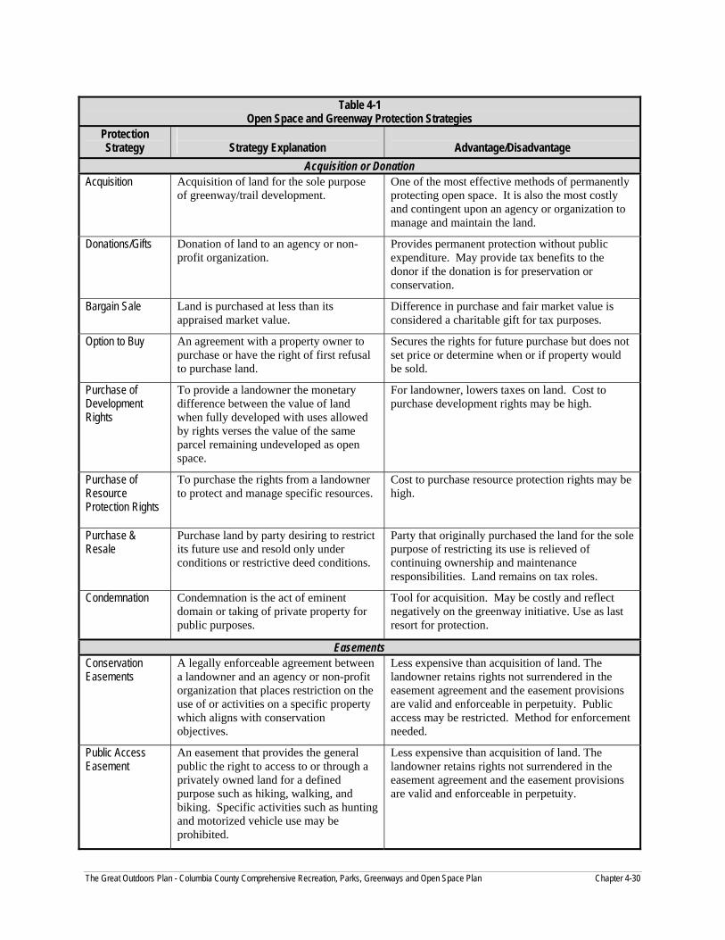
Table 4-1
Open Space and Greenway Protection Strategies Protection Strategy
Strategy Explanation
Advantage/Disadvantage
Acquisition or Donation Acquisition Acquisition of land for the sole purpose
of greenway/trail development. One of the most effective methods of permanently protecting open space. It is also the most costly and contingent upon an agency or organization to manage and maintain the land.
Donations/Gifts Donation of land to an agency or non-profit organization.
Provides permanent protection without public expenditure. May provide tax benefits to the donor if the donation is for preservation or conservation.
Bargain Sale Land is purchased at less than its appraised market value.
Difference in purchase and fair market value is considered a charitable gift for tax purposes.
Option to Buy An agreement with a property owner to purchase or have the right of first refusal to purchase land.
Secures the rights for future purchase but does not set price or determine when or if property would be sold.
Purchase of Development Rights
To provide a landowner the monetary difference between the value of land when fully developed with uses allowed by rights verses the value of the same parcel remaining undeveloped as open space.
For landowner, lowers taxes on land. Cost to purchase development rights may be high.
Purchase of Resource Protection Rights
To purchase the rights from a landowner to protect and manage specific resources.
Cost to purchase resource protection rights may be high.
Purchase & Resale
Purchase land by party desiring to restrict its future use and resold only under conditions or restrictive deed conditions.
Party that originally purchased the land for the sole purpose of restricting its use is relieved of continuing ownership and maintenance responsibilities. Land remains on tax roles.
Condemnation Condemnation is the act of eminent domain or taking of private property for public purposes.
Tool for acquisition. May be costly and reflect negatively on the greenway initiative. Use as last resort for protection.
Easements Conservation Easements
A legally enforceable agreement between a landowner and an agency or non-profit organization that places restriction on the use of or activities on a specific property which aligns with conservation objectives.
Less expensive than acquisition of land. The landowner retains rights not surrendered in the easement agreement and the easement provisions are valid and enforceable in perpetuity. Public access may be restricted. Method for enforcement needed.
Public Access Easement
An easement that provides the general public the right to access to or through a privately owned land for a defined purpose such as hiking, walking, and biking. Specific activities such as hunting and motorized vehicle use may be prohibited.
Less expensive than acquisition of land. The landowner retains rights not surrendered in the easement agreement and the easement provisions are valid and enforceable in perpetuity.
The Great Outdoors Plan - Columbia County Comprehensive Recreation, Parks, Greenways and Open Space Plan Chapter 4-30

Table 4-1, continued Open Space and Greenway Protection Strategies
Protection Strategy
Strategy Explanation
Advantage/Disadvantage
Land Use Regulations Overlay Zone A zone that is overlaid on an existing
zone which adds regulation governing the use of a property. This technique is typically used to protect floodplains, woodlands, and steep slopes. Overlay zones can be designated for specific resources or areas to provide additional environmental protection. Riparian buffers, wetlands, and unique natural areas are resources that could be protected with an overlay zone.
Enforced by local government. Allows targeted protection of natural resources.
Cluster Zoning Cluster zoning promotes the clustering of development and maximizing open space on a tract of land. Ordinance provisions should promote the preservation of sensitive natural resources such as stream corridors, wetlands and hedgerows, contiguous open space, and buffering.
Can reduce construction and infrastructure costs. Must work with developer to ensure that open space is useful as a greenway and linked to other protected open space.
Transfer of Development Rights
Property owners can sell development rights to developers for use in targeted areas. Open space is preserved by deed restrictions on properties that no longer carry development rights.
Allows development to be directed to specific areas.
Mandatory Dedication
Dedication of land from developers for park and recreational purposes. Municipalities must adopt a recreation plan that supports the dedication standards contained in the subdivision and land development ordinance.
Dedicates open space where development is occurring. Fee in lieu of provisions allows fee for land based on fair market value to be used for purchase of land in targeted areas.
Open Space Subdivisions
Open space subdivisions promote preservation of open space through the identification of natural resources and development designs that preserve these resources and significant open space.
Retain the density of the tract being developed. Must work with developer to ensure that open space is useful as a greenway and linked to other protected open space.
Other Methods Official Map A municipality may map existing and
proposed features such as parks, greenways, trails, and easements, and through this designation reserve public land. If a plan for subdivision or development of mapped land is presented, the municipality may withhold approval for a period of one year, giving the municipality the option to purchase or condemn the property.
The official map does not protect land for greenways but merely reserves land for purchase by the municipality.
Deed Restriction Restrictions as part of the deed that limit in some way the use of a piece of land. Examples include removing vegetation, requiring a portion of a tract to remain undeveloped, buffer, etc.
Features protected in perpetuity.
The Great Outdoors Plan - Columbia County Comprehensive Recreation, Parks, Greenways and Open Space Plan Chapter 4-31

The Great Outdoors Plan - Columbia County Comprehensive Recreation, Parks, Greenways and Open Space Plan Chapter 4-32

Many outdoor and nature based recreation opportunities are available in the Columbia County area. The environmental characteristics of Columbia County lend themselves to a variety of enjoyable pursuits in the great outdoors. High impact activities include hunting, fishing, hiking, biking, motorized sports vehicle use, swimming, boating, horseback riding, and so on. Low impact activities include wildlife study, bird watching, photography, picnicking, relaxation, and rejuvenation through nature. These opportunities serve both the people who live here and those who visit Columbia County.
What is Recreation? Recreation is the voluntary participation in any activity that contributes to the improvement of the general health, well being of both the individual and society.
Recreation Systems Recreation can take place in a variety of settings, both indoors and outdoors, provided by governmental, private, non-profit, and commercial providers. For the purposes of this plan, the focus of recreation will be on outdoor recreation primarily at the County level and, secondarily, the potential for creating a County-wide system of parks and recreation through partnerships at appropriate levels in the County. Planning for municipal recreation systems individually needs to happen at the local and regional levels of government, potentially with the assistance of Columbia County. This concept will be explored in the plan.
Outdoor Recreation Spending
The American Recreation Coalition reports that sales of outdoor recreation apparel and gear have reached $80 billion annually.
Public Needs and Interests Understanding the public’s underlying motivation for recreation will help Columbia County to plan and be responsive to the needs of both residents and tourists. The assessment regarding recreation needs was determined based upon:
Plan Study Committee work sessions.
Key person interviews.
Public meeting input.
Review of surveys conducted related to recreation, greenways and trails in the area.
Study Committee, Key Person Interviews and Public Meeting Key person interviews and the public meeting, in conjunction with the guidance of the Study Committee, provided the identification of specific recreation needs in Columbia County.
These findings included the following:
Access to the Susquehanna River and the streams in Columbia County.
Adding bicycle trails and connecting them in the County and regionally.
The Great Outdoors Plan - Columbia County Comprehensive Recreation, Parks, Greenways and Open Space Plan Chapter 5 - 1

The Great Outdoors Plan - Columbia County Comprehensive Recreation, Parks, Greenways and Open Space Plan Chapter 5 - 2
Maintain large tracts of natural areas for hunting.
Providing more events and activities that will serve residents and attract visitors to the County.
Camping.
Water based recreation activities such as swimming and boating.
Historic and cultural types of programs and tours.
Environmental education.
Indoor year round recreation.
More active recreation facilities.
Winter sports areas.
Challenges of the Times Despite increasing participation in recreation, new sports, and activities, and a broadening of the participation base from younger males to both males and females of all ages, there is a conundrum regarding recreation. The conundrum is that obesity and the lack of physical activity in the United States is at an all-time high.1 The United States Surgeon General issued a report in 1996 that physical inactivity among Americans is the number one public health issue.2 Obesity costs the United States $238 billion annually in expenses associated with diseases such as diabetes, stroke, and heart disease not including the cost of treating the obesity itself.3
The Center for Disease Control has stated that public park and recreation departments have a primary role in addressing this issue. They can provide attractive and safe places for people to walk, hike, bike, and enjoy other active pursuits.
Another challenge facing both private enterprise and all arenas of public recreation is that the rapid demand for facilities is outpacing availability and the resources to develop and manage new ones. Combined with rapid development in the metropolitan areas of Pennsylvania, the available open space is dwindling and land costs are escalating. There is an ever-present danger that recreation opportunities for the public in the future may succumb to a large demand and/or tight budget constraints.
It will become increasingly important to find creative ways of bringing recreation opportunities and facilitating healthy active lifestyles of the citizens in the future.
1 U.S. Center for Disease Control. (1999). CDC’s Guidelines for School and Community Programs Promoting Lifelong Physical Activity. <Http://www.cdc.gov/nccdphp/dash/phactag.htm>. 2 Surgeon General. (1996). Physical Activity and Health. Atlanta, GA: U.S. Public Health Service, National Center for Chronic Disease Prevention and Health Promotion. <Http://www.cdc.gov/nccdphp/sgr/npai.htm>. 3 Fox, Maggie. (1999). Obesity costs U.S. $238 Billion A Year – Survey. Reuters: Science Headlines. <Http://daily news.yahoo.com/h/nm/19990916/sc/hralth_obesity_2.html>.
Outdoor Recreation Participation Nearly half of all American families say they spend time together outdoors at least once a month. Recreation is important to families with young children. In 1994, seven out of ten Americans participated in outdoor recreation at least once annually. By 2000, participation had increased to eight out of ten.

Susquehanna Greenway Survey The Susquehanna Greenway Partnership conducted a survey in 2002 to determine the interest in establishing a greenway along 500 miles of the Susquehanna River through 22 counties in Pennsylvania stretching from New York to Maryland. Survey findings were tabulated according to “Reach” of the greenway. Reach 2 includes Columbia and Montour Counties along with portions of Luzerne and Northumberland Counties.
Table 5-1 Susquehanna Greenway Survey
Responses of Reach 2, including Columbia County Item Findings Comments 1. NUMBER OF RESPONDENTS 105 2. SUPPORT CREATION OF THE SUSQUEHANNA GREENWAY (SG) a. Yes 57% Nearly 3 out of 5 support SG b. No 5 c. Maybe/Not Sure 31 3. RESPONDENT’S OWN COMMUNITY SHOULD BE PART OF SG a. Yes 63% b. No 5 c. Maybe/Not Sure 30 4. HEARD ABOUT GREENWAYS BEFORE SURVEY a. Yes 24% b. No 60 c. Maybe/Not Sure 12
3 out of 5 had not heard of greenways
5. HEARD ABOUT THE SG BEFORE SURVEY a. Yes 23% b. No 69 c. Maybe/Not Sure 5
Nearly 70% had not heard about the SG
6. IMPRESSION OF SUSQUEHANNA RIVER a. Highly favorable, an asset 31% 77% positive impression b. Favorable, nice to have it 46 c. Don’t really care about it 13 d. Unfavorable, not nice to have it 4 e. Highly unfavorable, it’s a drawback 1 7. IMPORTANCE: Rated on a scale of 1 (critically important) to 5 (not important) weighted by the frequency of response. The closer to a score of 1, the more important. a. Clean Water 1.5 Clean water most important b. Scenery 2.2 c. Public Access 2.3 d. Natural Resources 2.1 e. Historic Resources 2.6 f. Cultural Resources 2.7 g. Flooding Potential 2.5 8. WHAT BLOCKS YOU FROM USING THE SUSQUEHANNA RIVER? a. Not enough river access 43% b. Too far from residence 12 c. Don’t know what’s available 35 d. Need to learn how to do the activity 8 e. No facilities 31 f. Not interested 16 g. Dirty water 51 h. Trash 19
Dirty water concerns over half of the respondents.
i. Don’t like the river 3
The Great Outdoors Plan - Columbia County Comprehensive Recreation, Parks, Greenways and Open Space Plan Chapter 5 - 3

Table 5-1 (Continued)
Susquehanna Greenway Survey Responses of Reach 2, including Columbia County
Item Findings Comments 9. WHAT SHOULD BE THE MOST IMPORTANT FOCUS OF SUSQUEHANNA GREENWAY? a. Natural resource conservation 16% b. Recreational opportunities 12 c. Economic development 0 d. Protection from flooding 12 e. Protection of heritage resources 2 f. A balance of all the above 51 Achieving balance ranks first. 10. IMPORTNACE OF GREENWAY BENEFITS: Rated on a scale of 1 (important) to 3 (not important) weighted by the frequency of response. The closer to a score of 1, the more important. a. Improve community image 1.3 b. Attract new businesses 1.5 c. Keep existing businesses 1.5
Helping the local communities is overall the most important benefit
d. Attract new residents 1.7 e. Keep residents from moving away 1.6 f. Attract tourists 1.6 g. Be a vacation destination 1.5 h. Help local economy 1.3 i. Make community better place to live 1.2 j. Improve property values 1.4 k. Result in a greenway project in your
community 1.4
l. Result in connecting communities along river with greenways & trails
1.4
11. USE OF THE SUSQUEHANNA RIVER AND LANDS ALONG THE RIVER. Use - Total%
(Frequent%) Would like to But Don’t
a. Scenic drives 65 (18) 13% b. Enjoying peace and quiet 66 (22) 14 c. Enjoying nature 67 (22) 14 d. Enjoying views of river 75 (27) 7 e. Bird watching 27 (7) 9 f. Environmental education 16 (1) 25 g. Photography 32 (4) 16 h. Spending time with family & friends 52 (13) 20 i. Picnicking 30 (7) 23 j. Walking/running 46 (12) 20 k. Hiking 26 (8) 21 l. Biking 21 (9) 19 m. Using riverfront parks 61 (8) 25 n. Horseback riding .3 (0) 9 o. Hunting/trapping 10 (2) 9 p. Fishing 31 (12) 14 q. Boating – motorized 21 (12) 12
The Great Outdoors Plan - Columbia County Comprehensive Recreation, Parks, Greenways and Open Space Plan Chapter 5 - 4

The findings of the Susquehanna Greenway survey indicate that respondents:
Support creation of the greenway.
Need information about what is available and where to access the river in order to take advantage of the opportunties related river-based recreation.
Want to use the river for enjoying the peace and quiet of the riverfront, nature and environmental education, enjoying its scenic beauty, socializing, attending community events there, and using riverfront parks.
Pennsylvania Recreation Plan 2004-2008 The Pennsylvania Department of Conservation and Natural Resources (PADCNR) conducted a strong public participation process as the foundation for the Pennsylvania Recreation Plan. This included a statewide survey and focus groups held regionally throughout the Commonwealth. The findings apply to the Columbia County Recreation, Parks, Greenways, and Open Space Plan. Table 5-2 presents the recreation participation rates by the PADCNR planning region in which Columbia County falls.
Table 5-2 Participation Rates in the Columbia County Planning Region
of PADCNR 2003 Activity Participation Rate(%) Walking for Pleasure or Fitness 71.0% Sightseeing or Driving for Pleasure
54.2
View Natural Scenery 52.1 Picnicking 51.2 Swimming 49.3 Visit Natural or Wilderness Areas 45.5 Nature Walks 34.9 Hiking 33.4 Fishing 32.3 Camping 30.1 Wildlife Watching 26.2 Sledding 24.5 Jogging 24.4 Bicycling 22.4 Boating 19.8 Bird Watching 18.8 Hunting 18.1 Basketball 17.5 Golf 16.2 Tennis 10.7 Softball 10.6 Sports Shooting 9.1 Mountain Biking 8.7 Downhill Skiing or Snowboarding 8.5 Canoeing or Kayaking 8.5 ATVing 8.5 Baseball 8.4 Soccer 7.7 Four wheel driving 7.7
The Great Outdoors Plan - Columbia County Comprehensive Recreation, Parks, Greenways and Open Space Plan Chapter 5 - 5

Table 5-2 (Continued)
Participation Rates in the Columbia County Planning Region of PADCNR 2003
Activity Participation Rate(%) Ice-skating 6.8 Horseback Riding 6.0 Snowmobiling 5.5 Football 5.2 Skateboarding 3.6 Off-Road Motorcycling 3.1 Cross Country Skiing 3.0 Water-Skiing 2.2
Facility Preference for Improvement and Increase The top facilities in the state survey cited for increase include the following:
Sledding areas.
Ice skating areas.
Skateboard and roller blading areas.
Bicycle paths.
Indoor pools.
The state survey also found the top areas that citizens believe need to be improved. These include:
Playgrounds.
Lake and stream swimming areas.
Picnic areas.
Heritage parks and historical sites.
Wildlife areas.
To increase recreation enjoyment and participation, the implications of the Pennsylvania Recreation Plan 2004-2008 for Columbia County include the following:
1. Provide areas for people to walk.
2. Provide natural areas for people to experience wilderness, study nature, and engage in resource based low impact activities.
3. Activities such as swimming, hiking, camping, and picnicking will serve both residents and visitors.
4. Include historic facilities in recreation planning.
5. Local recreation facilities such as swimming pools, playgrounds, sledding areas, and bike paths are important.
6. Some interests are found in County park such as heritage & cultural resources, winter sports, lake swimming, paths for walking, hiking areas, scenic viewing areas, and nature and environmental education facilities.
The Great Outdoors Plan - Columbia County Comprehensive Recreation, Parks, Greenways and Open Space Plan Chapter 5 - 6
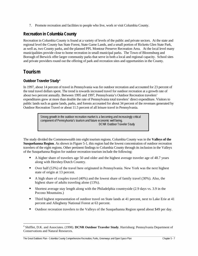
The Great Outdoors Plan - Columbia County Comprehensive Recreation, Parks, Greenways and Open Space Plan Chapter 5 - 7
7. Promote recreation and facilities to people who live, work or visit Columbia County.
Recreation in Columbia County Recreation in Columbia County is found at a variety of levels of the public and private sectors. At the state and regional level the County has State Forest, State Game Lands, and a small portion of Ricketts Glen State Park, as well as, two County parks, and the planned PPL Montour Preserve Recreation Area. At the local level many municipalities provide close to home recreation in small municipal parks. The Town of Bloomsburg and Borough of Berwick offer larger community parks that serve in both a local and regional capacity. School sites and private providers round out the offering of park and recreation sites and opportunities in the County.
Tourism Outdoor Traveler Study4 In 1997, about 14 percent of travel in Pennsylvania was for outdoor recreation and accounted for 23 percent of the total travel dollars spent. The trend is towards increased travel for outdoor recreation at a growth rate of about two percent annually. Between 1995 and 1997, Pennsylvania’s Outdoor Recreation travelers’ expenditures grew at more than double the rate of Pennsylvania total travelers’ direct expenditure. Visitors to public lands such as game lands, parks, and forests accounted for about 34 percent of the revenues generated by Outdoor Recreation Travel or about 11.5 percent of all leisure travel in Pennsylvania.
The study divided the Commonwealth into eight tourism regions. Columbia County was in the Valleys of the Susquehanna Region. As shown in Figure 5-1, this region had the lowest concentration of outdoor recreation travelers of the eight regions. Other pertinent findings to Columbia County through its inclusion in the Valleys of the Susquehanna Region for outdoor recreation tourism include the following:
A higher share of travelers age 50 and older and the highest average traveler age of 48.7 years along with Hershey/Dutch Country.
Over half (53%) of the travel here originated in Pennsylvania. New York was the next highest state of origin at 13 percent.
A high share of couples travel (40%) and the lowest share of family travel (30%). Also, the highest share of adults traveling alone (13%).
Shortest average stay length along with the Philadelphia countryside (2.9 days vs. 3.9 in the Pocono Mountains.)
Third highest representation of outdoor travel on State lands at 41 percent, next to Lake Erie at 41 percent and Allegheny National Forest at 63 percent.
Outdoor recreation travelers to the Valleys of the Susquehanna Region spend about $49 per day.
4 Shifflet, D.K. and Associates. (1998). DCNR Outdoor Traveler Study. Harrisburg: Pennsylvania Department of Conservations and Natural Resources.
Strong growth in the outdoor recreation market is a becoming and increasingly critical component of Pennsylvania’s tourism and future economic well being. DCNR Outdoor Traveler Study

The Great Outdoors Plan - Columbia County Comprehensive Recreation, Parks, Greenways and Open Space Plan Chapter 5 - 8
Source: Pennsylvania Outdoor Recreation Travelers Study. p5.
Pennsylvania Heritage Tourism Study5 Closely related to Outdoor Travel is Heritage Tourism. The Pennsylvania Heritage Tourism Study conducted in 1999 found considerable crossover between heritage travelers and outdoor recreation travelers. The main difference was that heritage tourists tended to be older. This study used the same planning regions as the Outdoor Travelers study. It found low recognition among all of the regions except the Lancaster/Dutch Region. Although recognition of heritage regions was low, satisfaction was high among those who had visited at least one of the regions. About one in four of Pennsylvania’s leisure travelers are a heritage tourist.
Heritage tourism is important to Pennsylvania’s economy. It is also in a growth mode: from 1996 to 1997, heritage tourism increased 23 percent while spending increased by 15 percent. A typical Pennsylvania heritage tourist is:
43.2 years of age.
Among households with the highest average annual household-income levels.
Employed in white-collar positions such as professional or managerial.
Married.
Traveling as a family or in an adult party of three or more.
5 Shifflet, D.K. and Associates. (1999). Pennsylvania Heritage Tourism, Harrisburg: Pennsylvania Department of Conservation and Natural Resources.
Figure 5-1Volume of Outdoor Recreation Travel by Pennsylvania Regions
in 1997 (millions of person-trips)
0
1
2
3
4
5
6
7
8
Series1 6.9 2.32 2.16 1.5 1.29 0.72 0.61 0.41
Hershey/Dutch Country
Pocono Mountains
Philadelphia Countryside Pittsburgh Laurel Highlands Lake Erie Allegheny Natl.
ForestValleys of the Susquehanna

The Great Outdoors Plan - Columbia County Comprehensive Recreation, Parks, Greenways and Open Space Plan Chapter 5 - 9
Center for Rural Pennsylvania Study on Economic Value of Resource Based Sports The Center for Rural Pennsylvania conducted a study on the Economic Value and Impacts of Sport Fishing, Hunting and Trapping Activities in Pennsylvania in 1998.6 The study found that the $9.6 billion that hunters, anglers, and fur takers spent to participate in their activities was more than half of what the Commonwealth spent on its total state budget in 1997. The study also found that another economic benefit was employment based on the more than 88,000 jobs created by these sports. Most survey respondents in this study indicated that communities, families, and individuals benefit from the existence and maintenance of wildlife resources.
Fishing, Boating, and Hunting Numbers in Columbia County The Pennsylvania Fish & Boat Commission tracks fishing and boating licenses purchased in Pennsylvania according to the county in which the licenses were purchased. There is no tracking of where people fish or boat after they purchase their license.
Table 5-3 Fishing, Boating, & Hunting Licenses Purchased
in Columbia County
License Number in 2005 Number in 2003 Change
Fishing 7,399 7,926 -527
Watercraft 3.036 2,895 +131
Hunting 11,291 12,918 -1.627
Annually, there are about 18 million fishing trips in Pennsylvania. A study by the U.S. Fish & Wildlife Service determined the value of these trips translates into $1.3 billion dollars in the Commonwealth’s economy. According to the Pennsylvania Fish & Boat Commission, licensed fisherman make an average of about 10 fishing trips per year. This equates to about $72 per trip. Based on these very rough figures and projections, the value of fishing for those licensed in Columbia County is about $533,000 in the economy, although exactly where they spend their money is unknown. No information is available on just where fishermen are fishing or who comes into Columbia County to fish. These are sketchy figures to give some sense of the economic benefit of fishing.
Recreation Analysis Outdoor recreation is a hallmark of Columbia County. From the Susquehanna River Valley to the mountains and forests, Columbia County personifies the great outdoors. Hunting, fishing, hiking, boating, nature study, and
6 Shafer, E.L. Dick. (1998) Economic Values and Impacts of Sport Fishing, Hunting and Trapping Activities in Pennsylvania, Harrisburg: Center for Rural Pennsylvania.
Heritage Tourism The Pennsylvania Heritage Tourism Study defines Heritage Tourism for Pennsylvania as a broadly defined travel market that encapsulates a wide variety of historic, cultural and outdoors activities. The most popular attractions are Pennsylvania’s historic towns/districts, the Liberty Bell, Gettysburg’s battlefields, Amish country and various museums and attractions throughout the state.
The Great Outdoors Plan - Columbia County Comprehensive Recreation, Parks, Greenways and Open Space Plan Chapter 5 - 10
other outdoor recreation pursuits are readily available here. Outdoor recreation is important for the quality of life and an essential factor in the county’s economy. After agriculture, tourism is the second most important industry in Columbia County. The analysis of recreation in Columbia County found the following:
1. Recreation providers operate completely independently. Communication among various providers could help to deliver services more efficiently and effectively. Collaboration could also help to package individual recreation components in a manner that would create a “critical mass” of recreation.
2. Columbia County spends about $70,000 annually for the park personnel, utilities, equipment and other operating expenses and for Briar Creek Lake Park and Twin Bridges Park. This is not a formal parks department but is instead maintenance support for these two parks. At this time, it appears that this is the extent of the role that Columbia County wishes to have in providing recreation services.
3. The self-directed resource based recreation opportunities in Columbia County could be “branded” as unique to Columbia County in a way that would raise recognition and awareness of the County as a special place in which to live, work, or visit.
4. Columbia County could be the unifying force to bring various recreation providers together in a common vision of providing quality recreation services to the people of Columbia County throughout their lifetime. The County could serve in a leadership capacity to assemble the various providers under an umbrella organization. The goal of the organization would be to foster communication, planning, and program implementation regarding recreation among different independent organizations who would continue to operate independently but in concert with the overall mission of a County-wide system of recreation.
5. Advertising recreation opportunities to the residents and visitors is important. Getting the word out about what is available and where would advance recreation and facilitate participation. Consideration should be given to a recreation WEB site perhaps in conjunction with the Visitors Bureau, Columbia County, and perhaps the school districts.
6. Using recreation opportunities and Columbia County’s great outdoors to promote quality of life as part of the county’s economic development planning would foster both goals: recreation and economic development.
7. Since the County is primarily rural, municipal recreation is a challenge. Close-to-home recreation opportunities are important. Interviews and work sessions revealed that there is a need for close-to-home recreation including facilities and programs. These should include a mix of park and recreation facilities such as ball fields, game courts, bike paths, indoor recreation facilities and natural resource areas.
8. Bloomsburg serves as the prime provider of municipal-type recreation. Town Park with its swimming pool, skate park, playground, pavilions, gazebo, ball fields, game courts, and river access provides recreation opportunities for people to use daily. Town Park draws from throughout the region well beyond the boundaries of Bloomsburg itself. The County has other good examples of municipal recreation including Millville that established a community built park and Benton that is undertaking the feasibility study of a community recreation center.
9. The municipalities need assistance in planning and developing municipal parks and recreation systems. The school districts could become partners in a countywide effort. The five School Districts by their service area could be likely organizing areas for potential multi-municipal partnerships in recreation.
10. Bloomsburg University’s Quest program has the potential to become an important partner in planning outdoor recreation in Columbia County.
11. There is a need for additional municipal recreation facilities throughout the county. The need for sports fields is especially pressing. Citizens are going outside of the County to play in leagues elsewhere as well as to request the use of ball fields in other communities in counties regionally.

The Great Outdoors Plan - Columbia County Comprehensive Recreation, Parks, Greenways and Open Space Plan Chapter 5 - 11
12. With Columbia County’s climate, the need for year round recreation, limitations on school use, the expanding aging population and the increasing obesity problem, the establishment of indoor recreation facilities should be explored. Potential partners could include municipalities, health care providers, Bloomsburg University, and others to be identified.
13. The Columbia Montour Visitors Bureau has indicated that people literally show up with bicycles on their vehicles asking where to ride. Recreation facilities are important to the Bureau. Collaborative use of the hotel tax for recreation projects should continue.
Recommendations Columbia County’s role in recreation is focused on providing recreation facilities in the form of two parks and the development of a countywide system of trails. While not directly recreation related, the County’s role as the planning agency for municipalities has a profound affect on outdoor recreation facilities. Columbia County has some of the best outdoor recreation areas in Pennsylvania for fishing, hunting, and other resource based activities. Potential development could threaten the size, location, and contiguity of these large natural resource areas. Columbia County in collaboration with its municipal clients could foster sensitive land development planning and practices to protect these large areas in the future. That is where the county’s strength in recreation appears to be. At this point, the County does not appear to be in a position to launch a County-wide park system. Columbia County has limited staff and operates within a climate of fiscal austerity. Nevertheless recreation is vitally important both for the quality of life and for economic development. Based upon this premise, the following recommendations could be considered:
1. Step up in a leadership role to bring together the major providers of recreation countywide to develop an agreement of how to work together for enhanced recreation and public service in Columbia County. Designate a Columbia County manager or staff person to take the lead responsibility on this. The person should be viewed by other providers as having some influence in the County along with the ability to work with the County Commissioners. Consider having a County Commissioner as a member of the recreation task force.
2. Provide technical assistance to municipalities in developing parks and recreation systems. Assist the municipalities in applying for grants as well as in informing them about grant programs.
3. Form a regional consortium of school districts and municipalities in addressing local parks and recreation to facilitate the development and provision of close-to-home recreation. Consider developing a pilot project based in one school district with municipal partners in forming a regional recreation coalition. Develop a regional park, recreation and open space plan in this pilot area.
4. Work with the Columbia Montour Visitors Bureau in promoting recreation opportunities in the County. Invest hotel tax funds in creating recreation opportunities that will attract overnight stays.
5. Coordinate recreation opportunities and planning with economic development planning in Columbia County. Include recreation as part of Columbia County’s strategic planning to attract and retain businesses. Seek and use case studies that demonstrate how recreation is a key factor in economic development.
6. Phase in recreation as a function of County government over time. This role could range from a minimal coordination role to foster collaboration and partnerships to a fully functioning recreation professional management team. With predominantly rural municipalities, the County recreation professional would serve as the linchpin for recreation in Colombia County.
7. Explore how indoor recreation could be provided in Columbia County.

Organization and Management of Parks, Recreation, Trails, Greenways and Open Space in Columbia County Providing parks and recreation in rural areas is a challenge. Equally challenging is planning the preservation of open space in an area that is blessed with a plethora of wide open space, forests, farmland, and waterways. As pressure increase in two areas, land conservation and the demand for more and more parks and recreation opportunties, Columbia County and its municipalities are facing important issues of how to achieve the balance of open space preservation with the provision of access to parks, recreation and trails for the public to enjoy them.
Columbia County is at an important point in its history. There is still time, though it pressing, to preserve the open space and natural resources of the County. Columbia County also has some powerful examples of regional parks and recreation initiatives that have been successful to model the way for similar efforts elsewhere in the County. By addressing the management of conservation and recreation in a strategic fashion, Columbia County can foster a balanced countywide system of conservation, recreation and tourism that will forever protect and enhance the way of life so treasured by the people who live work and visit here.
Success in Columbia County: Millville Borough Columbia County is no stranger to excellent community parks and recreation services. In 2003, the Pennsylvania Department of Conservation and Natural Resources published Keys to Success Stories in Community Recreation Initiatives, a book that highlights the Borough of Millville as a model providing rural parks and recreation services. Millville Community Park serves the Borough of Millville, and Greenwood, Pine and Madison Townships.
Millville Community Park has a community pool, a playground, Victorian park lighting, a gazebo, game courts, picnic pavilions, open fields, and a host of recreation program including summer day camps, concerts, community festivals, annual carnival, holiday tree lighting, and places for people to walk and gather. This is all supported through a combination of borough payment of park electrical bills and park maintenance; volunteers; and grants.
Management of Open Space, Greenway and Trail Planning
Columbia County The Columbia County Planning Department is responsible for county planning and also serves as the planning agency for 20 of the 33 municipalities. This is a very favorable position for open space planning. Since land acquisition is expensive and there is a great deal of undeveloped land in Columbia County, most of the gains in land conservation will be achieved through land use planning and subdivision and land use ordinances. The Columbia County Planning Department can directly assist the majority of the municipalities to develop conservation based ordinances. For those that the County does not directly represent for planning, the County could provide technical assistance.
Columbia County can also plan and develop the main corridors of greenways and trails. The county greenway and trail system would serve as the spine to which municipalities and conservation/trail organizations can connect regional and local linkages. The Peer to Peer Study will serve Columbia County as a trail implementation plan and was put in place in 1999. This Comprehensive Park, Recreation, Open Space and Greenway Plan will be the county greenway plan.
The Great Outdoors Plan – Columbia County Recreation, Parks, Greenways and Open Space Plan Chapter 6 - 1

In addition, the County is currently undergoing the process of rewriting its Subdivision and Land Development Ordinance. The rewrite will be incorporating a detailed section on Open Space Development and will also incorporate the idea of Mandatory Dedication of Open Space or an in-lieu of fee within the requirements which will be used for the acquisition of lands to be used for recreation or open space within the County.
The County could also foster multi-municipal open space planning. The goal should be for the County to provide technical support, assistance in helping the municipality to pursue grants, and perhaps financial assistance itself through a potential open space program sometime in the future. The County should not actual do the plans but rather serve in a technical support and “shepherding” role to encourage and support municipalities in working towards sound, practical achievable plans that will be implemented. The county’s capacity to do this would depend upon staff time and expertise in open space planning and conservation-oriented ordinances.
Municipal Open Space Planning The Town of Bloomsburg and Montour Township are the only municipalities with a park, recreation and open space plan. The plan includes greenways and trails. There is limited to no open space planning underway in the other 31 municipalities.
Conservation Planning by Non-Profit Organizations Several conservation plans have been completed for water resources in Columbia County to include:
Fishing Creek Watershed Association completed a summary report of Watershed Condition and Remedial Actions for the Fishing Creek Watershed.
Pennsylvania Environmental Council and the Susquehanna River Basin Commission completed A DCNR Rivers Conservation Plan for the Catawissa Creek Watershed will be completed in 2008.
Catawissa Creek Restoration Association completed a Watershed Restoration Plan to address acid mine drainage within the Catawissa Creek Watershed. The Authority hopes to complete a Rivers Conservation Plan for Catawissa Creek in the near future.
Roaring Creek Valley Conservation association will complete a Coldwater Conservation Plan for the Roaring Creek Watershed in 2008.
Countywide Parks and Recreation Planning, Management and Operations Parks and recreation in Columbia County is configured as discrete independent operations at the state, county, regional, and municipal levels of government.
Commonwealth of Pennsylvania State lands offer the opportunity for partnerships in outdoor recreation and environmental education. With over 30,200 acres of state outdoor recreation lands, these sites offer the potential for Columbia County to partner in the creation of areas for use as county parks. The potential for this is rooted in the commonwealth’s goal of establishing partnerships between state facilities and the communities in which they are located.
State Parks – Pennsylvania Department of Conservation and Natural Resources operates Ricketts Glen State Park in northeastern Columbia County and Luzerne County. The park offers hiking trails, camping, picnicking and scenic beauty for enjoyment and nature study.
The Great Outdoors Plan – Columbia County Recreation, Parks, Greenways and Open Space Plan Chapter 6 - 2

State Gamelands – The Commonwealth operates 20,585 acres of game lands in five locations. Game lands provide opportunties for hunting and during off-season for hiking.
Pennsylvania Department of Conservation and Natural Resources – PADCNR offers grant funding for planning, land acquisition, recreation facility and trail development. A variety of grant programs provide support for municipalities, counties and private non-profit organizations such as land trusts for [arks, recreation, greens, trails, and resource conservation. An example of this funding is support for this park, recreation and open space plan. PADCNR could potentially fund other projects and provide technical assistance in these areas.
Columbia County Columbia County has two parks, Briar Creek Park and Twin Bridges Park (under development). Briar Creek Park is operated by the county maintenance staff. Columbia County does not have a parks and recreation department and at this time does not have the intention to establish such a department. The county budget for this park is about $85,000 annually. While Twin Bridges Park will only be about two acres, its location at the twin covered bridges is a very significant site worthy of a county park designation for its cultural resource value.
Columbia County has taken the lead in establishing a countywide trail system. The County developed a county trail plan in 1999. Columbia County has also been successful in securing $600,000 in federal funds under the Transportation Equity Act (TEA) to develop six miles of rail trails on the abandoned Reading Railroad and Bloomsburg & Sullivan Railroad corridors.
Regional Recreation Northern Columbia County - The Northern Columbia County Community & Cultural Center is comprised of sixteen (16) municipalities from Millville to Shickshinny and from Orangeville to Davidson Township. This service area extends into Luzerne and Sullivan counties by including Shickshinny Borough and Davison Township. The Center, under construction, is a joint venture of many groups that have already raised nearly two million dollars. It will essentially be the future hub of recreation in Northern Columbia County. A formalized partnership should be considered as there are other fine examples of partnerships in the area including the Borough of Millville and the Millville Area School District that have worked together on the Millville Community Park. Combined with the scenic beauty of the region and its attraction for tourism, this area could serve as a pilot project for exploring a formal multi-municipal parks and recreation system that focuses on indoor recreation, the great outdoors, tourism, trails, and conservation. The community center will include a gym, fitness center, commercial kitchen, activity rooms, and senior center. It will be rented out for group use and social events. On the grounds will be a skate park, a wedding grove and trails that connect to the regional trail system. Town of Bloomsburg and Montour Township - The Town of Bloomsburg serves as another recreation hub in Columbia County. The Town and Montour Township developed a joint comprehensive park, recreation and open space plan. The plan contains recommendations for collaboration in recreation, facilities and trails. The Town is the focal point of recreation in the County at present with its Town Park. Neither Bloomsburg nor Montour have a budget for parks and recreation. In Bloomsburg, the community pool is operated as an enterprise fund based on a “break-even” approach to revenues and expenditures. The Town Park Improvement Association raises funds to pay for the Town Park capital improvements and events. Bloomsburg uses the Public Work Department to provide maintenance. The Town Park Improvement Association also was bequeathed a large sum of money to be used for tennis related programs.
The Great Outdoors Plan – Columbia County Recreation, Parks, Greenways and Open Space Plan Chapter 6 - 3

Berwick Borough – There are individual efforts underway within the Berwick community focusing on neighborhood and downtown revitalization. There are also numerous opportunities to plan for community park and recreation enhancements that take advantage of Berwick’s unique location on the Susquehanna River. The Berwick Community Connections initiative will create a concept plan and implementation strategy, identifying the necessary partnerships and actions for success, and determine feasibility of various community enhancement projects. The project will create a unified vision for community development, recreation and quality of life enhancements for the Berwick area.
Municipal Recreation The Millville Park Commission of Millville Borough oversees the operation of Millville Community Park. The Commission is comprised of 13 volunteers who perform all management, programming, grant writing and fundraising functions.
Four municipalities have parks and recreation boards. These include the following:
Benton Park Commission
Millville Park Commission
Bloomsburg Park Commission
Scott Township Park Commission
School Districts School districts in rural areas often serve as the primary recreation provider for communities. The six school districts in Columbia County all provide for the community use of ball fields, game courts and gymnasiums. They have reported varying levels of demand on their facilities and their capacity to meet community needs.
Benton Area School District The Benton Area School District leases ball fields from Benton Borough. School gyms have such great use that they are generally not available for community recreational use. This was one of the compelling reasons behind the development of the Northern Columbia County Community & Cultural Center.
Top Youth Issues: 2006 In 2006, the Berwick Health and Wellness Youth Philanthropy Foundation conducted a survey in the school district regarding community issues and needs. The top two issues were drug and alcohol use and the need for more activities for teens.
Berwick Area School Districts There is a high demand for ball fields and gym time in the Berwick Area School District. The District cannot provide facilities to meet the demand. Increasing sports participation has led groups to seek fields outside of the area as far away as Danville. Each facility is requested at the local school with permission approved by School District Administration.
The Great Outdoors Plan – Columbia County Recreation, Parks, Greenways and Open Space Plan Chapter 6 - 4

Bloomsburg Area School District The Bloomsburg Area School District has four schools in the borough of Bloomsburg as shown in the facility inventory in Chapter 3. The community uses school district facilities for organized sports. There are not enough gyms to accommodate sports. There is a need to connect the schools with community parks, neighborhoods, and other community destinations.
The sports organizations operate independently. The School District, the YMCA, and Bloomsburg University all provide some form of competitive play. Youth sports including the Little League, the Midget Football League and AYSO are significant thus needing more fields in the Bloomsburg area. Adults do not have access to ball fields in the community because youth sports have preference. This amounts to fragmented support for sports. There should be an umbrella sports organization in the community where the various sports providers can come together for the common purpose of serving people in the area with sports throughout their lifetime. The organization should address facilities, services, policies, funding and operations. Partnerships in programs and services could be forged with the university and the school district. A formalized parks and recreation system would center recreational planning and partnerships in a dedicated fashion. Right now, there are no partnerships among these groups for parks and recreation. With a formalized planning system in place with identified goals related to strengthening the community through parks and recreation, partnerships with the university and the school district would be essential.
Millville Area School District There is no real gathering place for the communities within this school district other than the Millville Community Park and the school district campus. The 50 acre campus has sports fields and school buildings used for community recreation. The School District allows the free use of school buildings when staff is on duty. At times when staff has to be called in there is a fee to cover school district expenses. The School District runs recreation programs such as summer camps. Currently, the District reports that it is able to accommodate all requests for use of the facilities for community recreation. The one area where they cannot meet the need is the community demand for safe places to walk. The staff reports the heavy use of roads for walking by people of all ages, especially children and senior adults. The District is interested in developing a series of paths including a perimeter path ( ¾ to one mile long) with interconnecting shorter loop trails of about a half mile in length.
Central Columbia School District The Central Columbia County School District provides facilities for community recreational use. The district swimming pool is used for recreational swimming and private rentals for parties. There is no tracking of requests to determine if requests for facility use can or cannot be accommodated. However, the School District reports the need for programs for youth between the hours of three and six in the afternoon. While children of means have the funds and the transportation to get around to activities in which they participate, the district reports that there are many children without the means to participate in activities nor the transportation to get around to potential program sites.
Southern Columbia School District The Southern Columbia Area School District is composed of Catawissa Borough and the Townships of Catawissa, Cleveland, Franklin, Roaring Creek and Locust in Columbia County and Ralpho in Northumberland County. With a population of 10,000, the District is in a transition form a rural agricultural community to a suburban area. Two educational centers serve the district: an elementary center with grades kindergarten though sixth grade and a Junior/Senior High Center for grades seven through twelve. The district has limited facilities. One gym along with a small gym can only serve school
The Great Outdoors Plan – Columbia County Recreation, Parks, Greenways and Open Space Plan Chapter 6 - 5
district uses and cannot accommodate community recreation as much as the School District would like to do that. There simply is not enough time available. There is no swimming pool in the district. Citizens have to travel to the Sunbury YMCA, the Danville Community Center or use the Knoebels’ pool in the summer. The community uses the high school track for walking and fitness. School fields are also limited serving school uses. During the off season, adult softball uses the softball field in the summer when school is not in session. Students are very active in the arts, sports and activities such as band, after school clubs and special summer enrichment programs in a wide variety of subjects of students at all academic levels. Civic groups use school district facilities for meetings. There is no formal relationship between the school district and the municipalities regarding parks and recreation.
Central Susquehanna Intermediate Unit None of the school districts in Columbia County offers an adult evening school with enrichment classes and programs for people over 18 years of age. The CSIU covers Columbia, Montour, Northumberland, Union and Snyder Counties. It offers a variety of programs offered in local school district facilities. COWS (Computers On Wheels) is a mobile unit with computers that travels around offering computer instruction in various software programs in schools and parks. The programs are mostly focused on GED, technology and family matters, not a broad range of recreation or life-long learning.
Investment in Parks and Recreation Parks and recreation operations in Columbia County are largely supported through volunteer efforts, limited municipal investment, School District support and the county’s operation of about $85,000 annually for Briar Creek County Park. The average per capita investment for municipalities in Pennsylvania was $22.11 in 2003 according to the Pennsylvania Budget and Salary Survey (most recent figures available).
The level of spending in operating parks and recreation is consistent with rural counties and in municipalities with lower income levels. The municipalities have small populations with relatively low incomes. The municipal populations range from 194 to 12,434. Bloomsburg and Berwick have 36 percent of the county population. Two municipalities have about three to five thousand people. The other 29 municipalities have fewer than two thousand people, many with less than one thousand. The average per capita income in Columbia County is only about 80 percent of the average per capita income for Pennsylvania.
Conclusions of Open Space, Parks and Recreation Planning, Operations and Management Assessment Columbia County plays the lead role in planning. The Columbia County Planning Department serves as the planning agency for 20 of the 33 municipalities thus having the potential to play a pivotal role in open space preservation through effective land use planning and regulations. Parks and recreation operations in Columbia County are typical of small, less affluent rural counties. Nevertheless, Columbia County has fine examples of both facilities such as the Bloomsburg Town Park and the Millville Community Park and partnerships such as the Northern Columbia Community and Cultural Center that is currently going full steam ahead through volunteers, grants and private fundraising. Remarkable, this group has raised about $1.8 million to construct the center along with about $200,000 in in-kind services.
The Great Outdoors Plan – Columbia County Recreation, Parks, Greenways and Open Space Plan Chapter 6 - 6

1. Open space planning in Columbia County will become an increasingly important function of county government as development pressures increase. Current staffing level in the Columbia County Planning Department is inadequate to focus on the tasks required by dedicated open space planning.
2. There is no funding program or funds in the budget for open space conservation in Columbia County.
3. Only two municipalities have a parks, recreation and open space plan, which was undertaken jointly. Parks and recreation efforts are mainly in response to pressing community needs and are typically undertaken by volunteers.
4. While Columbia County does not intend to establish a county parks and recreation department at this time, the reality is that the County has two county parks and 10.1 miles (includes the existing six miles and the additional five miles proposed) of trails planned. It is important to consider the formal operation and management of county facilities. The potential expansion of county facilities through the addition of other county parks and the construction of trails merits the discussion of how Columbia County can organize for parks and recreation management. PADCNR recently changed its Circuit Rider program to permit counties to apply for a Circuit Rider position for parks and recreation. A Circuit Rider is a parks and recreation professional who helps various entities plan, develop and implement parks and recreation facilities, programs and services at the county level. A Circuit Rider could plan, direct and manage county parks, recreation facilities, trails, programs and services. The Circuit Rider could also provide technical assistance to regions in the county, school districts and municipalities to provide close to home opportunities. PADCNR provides $9,000 for the Peer Study to be matched with $1,000 by the county for the year long study. PADCNR provides the salary for the Circuit Rider in decreasing amounts over four years at 100 percent, 75 percent, 50 percent and 25 percent with the match provided by the county and/or its partners. This would be a cost effective way for Columbia County to start up a parks and recreation department within a defined time frame.
5. While the County received TEA funds for the rail trail construction, the trail has been developed from Rupert to above Bloomsburg.
6. State game and park lands and forests operate independently and offer the potential for partnerships. This includes the potential for Columbia County to lease land for the purpose of establishing county or regional parks such as in the newly acquired Roaring Creek State Forest.
7. The municipalities are too small in terms of population and resources to provide municipal close to home parks.
8. The schools serve as community hubs. School districts play a vital role in community recreation and serve as the organizing entity for multiple municipalities within their service area.
9. Parks and recreation services are fragmented. The County could take a leadership role in bringing key stakeholders together for the purpose of parks, recreation and open space planning, operations and management.
10. There are limited financial and human resources available for open space, parks recreation and trails.
11. The Northern Columbia Community & Cultural Center is an outstanding example of a “bootstrap”, grass roots effort that took off successfully. This merits further study and support to insure its sustainability and possible expansion of service in parks and recreation regionally in northern Columbia County.
The Great Outdoors Plan – Columbia County Recreation, Parks, Greenways and Open Space Plan Chapter 6 - 7

Recommendations The factors that contributed to the achievements in parks and recreation in north central Pennsylvania, including Columbia County, cited in Keys to Success Stories in Community Recreation Initiatives include the following:
Well-planned strategic vision, clear understanding of existing services and a partnership with leaders of the organizations providing services in place.
Regional perspective and intergovernmental cooperation.
Community needs assessment: Citizen input and building awareness.
Effective civic leaders and “everyday volunteers”.
Soliciting dollars and leveraging resources.
Support of recreation through a combination of free (tax supported) and fee-based recreation programming and facilities.
Effective budget management.
These factors provide solid direction for the recommendations for open space, parks, recreation greenways and trails in Columbia County. The recommendations are as follows:
1. Adopt Vision and Mission Statements Adopt vision and mission statements that set forth the kind of community that can be achieved in Columbia County in part through open space, parks and recreation. Determine Columbia County’s role and mission in county parks, recreation and trails.
2. Show Leadership. Development of strong leadership to articulate the potential and importance of parks and recreation in an aggressive fashion is essential. This is required to demonstrate Columbia County’s commitment to open space, parks and recreation as well as to inspire and cultivate public and non-governmental partnerships to forge ahead in this area. Elected and appointed officials need to do extensive outreach and public education to gain support for open space, parks and recreation initiatives.
3. Work towards a balance of resource conservation and recreation. Tourism is a chief industry of Columbia County. A contributing factor in support of tourism is the scenic beauty and the great outdoors of Columbia County. Therefore it is essential to both protect the open space and natural resources as well as provide recreation opportunties that serve the people who live, work and visit here.
4. Listen and Respond to the Citizenry. Becoming highly responsive to community needs. Involve key stakeholders in the planning process and in undertaking projects.
5. Consider the establishment of a Columbia County Parks, Trails and Recreation Department. With two parks and trails in place, and the need to assist municipalities in developing local parks and recreation opportunities, a county parks and recreation department would be a valuable asset. Consideration should be given to hiring a Circuit Rider with PADCNR funding to establish the department over a five year time frame. The first year would be a study for how the Circuit Rider position and county department. If after this study is completed and a recommendation made to apply for a Circuit Rider, the next four years would be targeted at establishing the department.
The Great Outdoors Plan – Columbia County Recreation, Parks, Greenways and Open Space Plan Chapter 6 - 8

6. Build Columbia County’s Open Space, Park, Recreation and Trail Constituency. Develop a base of public supporters with individuals, community organizations, business, social service organizations, the schools and other private and public organizations.
7. Work collaboratively with others! Select one pilot project to demonstrate how to balance actions and boards. Although Columbia County serves as the planning agency for most of the municipalities in Columbia County and this plan will cover the municipalities, consider developing six multi-municipal park, recreation, greenway, trail and open space plans organized around the six school districts. This planning would provide more detailed direction.
Select a pilot project to demonstrate how parks and recreation could be delivered through partnerships county wide. The pilot project proposed is the Northern Columbia County Initiative
Undertake the Northern Columbia County Regional Recreation Commission project. Piggyback onto the Northern Columbia Community and Cultural Center project. Expand the concept beyond the center alone to incorporate regional parks and recreation, conservation, and natural resource planning.
Apply for a Peer-to-Peer grant to determine how to formalize an agreement among the various entities including the Northern Columbia Community & Cultural Center, the municipalities (including Davidson and Shickshinny), the Benton Area School District, Columbia County and perhaps Luzerne and Sullivan Counties. Involve the Columbia Montour Visitors Bureau in the discussions.
Consider seeking a Circuit Rider grant to hire a regional professional parks and recreation director.
LARA/Bucknell University Partnership
The Lewisburg Area Recreation Authority (LARA) is a multi-municipal parks and recreation agency. Three municipalities contribute a mill of tax funds to help support LARA. In turn LARA generates non-tax funds through programs, fees and charges, concessions and so on. Recently Bucknell University signed on as a partner in the agreement. Bucknell will contribute $15,000 annually for the next five years with a renewable option. The university also provides use of its facilities for community recreation.
Incorporate open space planning, conservation, greenway planning and trail development as
part of this effort.
Use this as a pilot project to model how parks and recreation could work in Columbia County.
8. Adopt a business-like approach for parks and recreation. Collect data, document facts and figures, use organizations for data collection, report and disseminate information to stakeholders. This would be especially important to build the case for parks and recreation as an economic tool in Columbia County. Make the case that open space, parks, recreation and trails are powerful economic development tools. Determine Columbia County’s organizational structure for parks, recreation and trails.
Model: York County Rail Trail Authority
The York County Rail Trail Authority is a private non-profit organization that plans trails, provides technical assistance to municipalities and community organizations about trail
The Great Outdoors Plan – Columbia County Recreation, Parks, Greenways and Open Space Plan Chapter 6 - 9

The Great Outdoors Plan – Columbia County Recreation, Parks, Greenways and Open Space Plan Chapter 6 - 10
development and operation, negotiates multi-municipal agreements regarding trail operation and maintenance, grant writing, partnership development, programs and events, fundraising, advertising, promotion and development of trail friends groups. The authority is funded by the York County Visitors Bureau through the hotel tax proceeds at $50,000 per year annually for ten years. The funding supports professional staff. The York Heritage Rail Trail generates over $10 million annually in economic development.
9. Determine a financing plan for implementing this plan. Funding is needed to:
Conduct a financial feasibility study for Columbia County to determine the potential to support a 20 year open space conservation program (or other multi year timeframe). The program would provide funds for multi-municipal planning, open space acquisition, purchase of conservation easements and development rights, rights-of-way, farmland preservation, trails, parks and greenways. Consider county and municipal components.
Provide technical assistance to municipalities about how to conserve open space through land use planning, conservation by design, and working with developers prior to and throughout land development projects.
Provide technical assistance to municipalities to update and adopt ordinances to conserve land and natural resources. This would include conservation by design planning methods, and ordinances for steep slopes, buffering, tree preservation and trimming, wetlands, vernal pools, riparian buffers, buffers, composting, and mandatory dedication of parkland.
Develop multi-municipal park, recreation, open space, greenway and trail plans. A potential source is a grant from the Pennsylvania Department of Conservation and Natural Resources Keystone Community Grant Program.
10. Implement the Plan. Carry out the actions to be accomplished with a schedule for implementation, who will be responsible and how Columbia County will get the resources to undertake the action.
11. Establish accountability. Adopt practices that insure accountability of tax dollars and other resources as well as that document the clear benefits to the Columbia County.
12. Be Action Oriented. Move quickly and take advantage of emerging opportunities and changing needs. Adopt strategic alliances with organizations such as land trusts and conservancies to move ahead on land preservation/acquisitions quickly in a way that may not be possible by county or local government.
Parks, recreation, trails and conservation organizations in the public and private sectors manage a vast array of complex and challenging functions. Every day, they have a myriad of tasks and projects to handle: Their scope of work could range from helping a Boy Scout earn a badge to orchestrating a community event with thousands of citizens and tourists along with hundreds of details. These functions must be officially delegated to a management entity.
Administrators need a diverse set of skills and techniques to manage these complex systems in the ever-changing and demanding world of open space conservation and public parks and recreation. Successful systems are rooted in effective management. While it is important to do things right, it is even more important to do the right things.

Residents of Columbia County treasure the beauty and rural setting of the County. The great outdoors; the streams, woodland, farmland, mountains, and Susquehanna River provide a diverse landscape that residents’ value and enjoy as part of their leisure pursuits. Residents enjoy hunting and fishing in the State Game Lands and State Forests located throughout the County. They take pride in their heritage and treasure the covered bridges and cultural sites of the County. Protecting the resources that support these activities and preserving the rural character of the County through sound planning practices are the guiding principles of this plan.
Columbia County has done a good job of targeting growth to areas that have the necessary infrastructure and can sustain the resulting impacts of development. But growth will continue to impact the County, especially along the major transportation corridors. There is a sense of urgency in moving forward. Columbia County today retains much of the character and resources that this plan addresses, but protecting the great outdoors and all of its benefits for the next generation is the challenge facing Columbia County.
This chapter is the culmination of the preceding chapters examining park, recreation, open space, greenways, and trails in Columbia County. Through the inventory and assessment of these resources and discussions and input from residents, a vision for the future has been established for Columbia County.
Vision Columbia County is a model of resource conservation and outdoor recreation in Pennsylvania. The abundant natural resources, protected farmland, close-to-home parks, and convenient access to the great outdoors through an interconnected system of greenways and trails that serve as the foundation for outstanding quality of life for the people who live, work, and visit Columbia County. A county-wide system of parks composed of state, county, municipal and private recreation areas provides access to the Susquehanna River, streams, and woodlands for enjoyment of outdoor pursuits, healthful activities, and exploration of the natural environment and the historic and cultural resources of the County. The balance of resource conservation and recreational opportunities supports a vibrant economy. It is fueled by tourism and the benefits of parks and recreation that attract and retain residents and businesses, protect the environment, create a sense of community, and help citizens to enjoy enriched healthy lives.
A strategy for making this vision of Columbia County a reality has been developed as a blueprint for the future: The Great Outdoor Plan. The eight key areas of focus for The Great Outdoors Plan include:
1. Establish a land use planning program that balances growth and conservation to preserve the rural character of the County. Significant natural resources should be identified within the County so that growth can be guided to areas that are compatible with development. Target areas with the necessary infrastructure to support growth. Promote the protection of rural areas through land use regulations and conservation initiatives.
2. Establish a program to protect the significant natural and cultural resources. Protect natural resources that promote water quality and provide wildlife habitat. Protect priority NAI sites throughout the County. Partner with conservancies and state agencies to further this initiative.
3. Create and sustain a network of greenways and trails that connects countywide. Develop a system of trails that interconnect countywide and provide opportunities for fitness and wellness activities, tourism, and alternative transportation. Protect greenways along streams, the river, ridgelines, and abandoned rail lines. Partner with the Susquehanna Greenway Partnership to promote a protected green corridor along the river.
The Great Outdoors Plan – Columbia County Recreation, Parks, Greenways and Open Space Plan Chapter 7 - 1

The Great Outdoors Plan – Columbia County Recreation, Parks, Greenways and Open Space Plan Chapter 7 - 2
4. Continue the farmland preservation program. Continue to participate and support the farmland preservation program in Columbia County. Communicate the benefits of the program to landowners to expand participation.
5. Use open space, trails, park, and recreation planning as an economic development tool. Document the benefits and strategically promote the value of open space, parks, trails, and greenways in Columbia County. Provide convenient information to visitors regarding recreation and tourism opportunities in Columbia County.
6. Establish a countywide system of parks and recreation facilities. Acquire parkland and trail corridors through a combination of donations, easements, purchase, and grants. Launch a County park system that includes resource-based recreation sites, heritage sites, and trails as a means of conserving Columbia County’s unique resources and character.
7. Provide leadership and support to municipalities to promote community parks, trail, and open space initiatives. Provide assistance to municipalities to adopt or update mandatory dedication ordinances for the dedication of recreation land. Assist municipalities strengthen land use regulations that conserve land, protect natural resources, and promote a system of greenways throughout the County..
8. Explore partnerships with conservation organizations and state agencies. Local and county government entities work with increasingly limited funding opportunities and must find creative means of achieving park and open space goals. Partnering with local and state conservancies and agencies such as the Pennsylvania Game Commission to facilitate recreation and conservation goals.
9. Promote the value of parks and recreation to gain public support for park, open space, greenway, and trail initiatives. Define the benefits of parks and recreation to citizens and municipal officials within Columbia County and promote the benefits through a targeted educational campaign.
Benefits of Parks, Recreation, and Open Space Parks, recreation, and open space should be viewed as an investment rather than a cost. Small
investments in recreation, parks, sports, the arts, and conservation often yield significant economic returns. Money generated by capital improvements, events, and the provision of on-going services is spent several times over in the community. Parks and recreation builds a sense of community, strengthens family ties, increases property values, deters crime, and protects the environment.
Property values are higher near open space and trails.1 The economic value of parks and green space has long been established and demonstrated by increased demand for and pricing of parkside properties. Increased property values yield more tax revenues.
Parks and recreation attract businesses to the community. The Joint Economic Committee of the U.S. Congress reported that a community’s quality of life is more important than purely business-related factors when it comes to attracting new businesses.2 Among the factors used by small businesses in choosing a new business location, parks, recreation and open space rank first.3
1 Trust for Public Land. 1994. Healing America’s Cities: Why we must invest in parks. San Francisco, CA: Trust for Public Land Office. 2 National Park Service. (1989). Economics of Parks and Recreation Resource Book. Institute on the economic impact of parks and recreation. Sacramento, California. 3 Crompton, John L., Love, Lisa L., and More, Thomas A. 1997. An Empirical Study of the Role of Recreation, Parks and Open Space in Companies’ (Re) Location Decisions. Journal of Park and Recreation Administration, 15:1. (Champaign, IL: American Academy for Park and Recreation Administration). 37-58.

The Great Outdoors Plan – Columbia County Recreation, Parks, Greenways and Open Space Plan Chapter 7 - 3
Recreation reduces crime and social dysfunction reducing police, justice and incarceration costs4. Public recreation costs only cents per day per person. It costs over $35,000 to incarcerate one youth for a year.
The U.S. Surgeon General identified physical inactivity as the number one public health issue in the United States stating, “Being inactive is as risky to one’s health as smoking”.5 Obesity costs the United States $238 billion per year in expenses from associated diseases such as diabetes, stroke and heart disease not including the cost of treating obesity itself.6
The percentage of young people who are overweight has more than doubled in the past thirty years.7This is the first generation of children that may not live as long as their parents.
The importance of after-school programs for children and youth is becoming increasingly emphasized. Federal legislation is being proposed to support such programs. The U.S. Surgeon General recommends that communities provide a range of developmentally appropriate community sports and recreation programs that are attractive to all young people. It will cost less to provide facilities that deter health problems than treating the problems themselves.
Columbia County Goals and Objectives The goals and recommendations of this plan represent the suggested course of action for the next ten years to achieve the vision for Columbia County. The County should work at the actions incrementally, through an annual action plan. Some recommendations may require more intense planning, partnerships, and long term investment. By having a slate of actions identified and adopted, elected and appointed officials, community organizations, and citizens have a common reference for County plans and goals.
Five goals have been defined for Columbia County:
Goal 1 - Establish a Countywide system of parks and recreation areas comprised of state, county, regional, municipal and private park and recreation areas for present and future generations.
Goal 2 - Protect and conserve open space and natural resources throughout the County.
Goal 3 - Develop a system of open space, greenways, and trails to create a connected County.
Goal 4 - Organize and manage open space planning, natural resource conservation, parks, recreation, greenways and trails in a professional manner that conveys the greatest possible benefit to the public.
Goal 5 - Invest in open space, recreation and tourism initiatives to enhance the economy, health, safety, and welfare of Columbia County.
4 National Recreation and Park Association. 1994. Beyond Fun and Games: Emerging Roles for Parks and Recreation. Arlington, VA: National recreation and Park Association. 5 Surgeon General. (1996). Physical activity and health. Atlanta, GA: U.S. Public Health service, National Center for Chronic Disease Prevention and Health Promotion. Http://www.cdc.gov/nccdphp/sgr/npai.htm 6 Fox, Maggie. Ibid. 7Fox, Maggie. (1999) Obesity Costs U.S. $238 Billion A Year - Survey. Reuters: Science Headlines. Http://daily news.yahoo.com/h/nm/19990916/sc/health_obesity_2.html.

Goal 1- Establish a Countywide system of state, county, and municipal parks that provides adequate parkland and recreation facilities for present and future generations.
Recommendations 1. Establish a goal of a minimum of 15 acres of parkland per thousand residents of Columbia County.
Encourage each municipality to adopt a standard of 15 acres of parkland per thousand residents as a minimum standard. Municipalities should adopt this standard in accordance with the Municipalities Planning Code in order to use it as a basis for the mandatory dedication of parkland.
2. Acquire land for the development of County parks. Target County parkland in areas underserved by existing parks. Three areas for new County parks are
proposed: the northeast corner of the County, north of the river in the Hemlock-Mount Pleasant townships area, and in the southern portion of the County.
- Seek land for a park that explores the cultural significance of the Jamison area as well as the natural resources of Sugarloaf Township and the northern reaches of Fishing Creek. Tanneries once existed in this area and remnants of these structures can still be found. Develop a park that explores the heritage of the area, as well as, opportunities to provide connections to nearby Rickets Glen State Park and protect greenways and develop trails along streams with fishing access. This park could be promoted through a partnership with the Montour-Columbia Convention and Visitors Bureau as the southern gateway to Rickets Glen State Park.
- Seek land for a County park central to the growing population base of the County, generally in the Hemlock-Mount Pleasant townships area. Locate the park site, as possible, to provide access to streams, meadows, and woodlands for resource-based recreation.
Acquire land contiguous to existing parks and within designated greenways corridors to expand park, trail, and greenway opportunities.
Acquire land along streams to provide public access for fishing and to buffer and protect these lands to promote water quality initiatives.
3. Develop County parks to meet conservation, recreation, and greenway/trail goals.
Master plan new park sites through a public participation process that assesses existing and projected recreation needs. Consider the need and feasibility of developing recreation facilities that would serve people county-wide such as a golf course, camping area, or ice rink.
Incorporate environmental education into County park sites. Work with local school districts to tie environmental education opportunities in parks to school curriculum.
4. Support municipal park and trail acquisition and development efforts.
Provide technical and financial assistance to municipalities to develop and update mandatory dedication ordinances. Define criteria of land acceptable for recreation purposes.
Encourage municipalities to work in partnership with school districts to develop regional parks for active recreation in conjunction with school campuses. The smaller rural municipalities typically would find it difficult to afford the cost of developing athletic complexes on their own. The school district campuses have traditionally been the hub of athletic pursuits in most rural areas and working with the school district to develop regional park sites would provide the needed facilities while centralizing recreation destinations. The regional parks could be developed as part of the school district
The Great Outdoors Plan – Columbia County Recreation, Parks, Greenways and Open Space Plan Chapter 7 - 4

campus or additional contiguous land may have to be acquired. Facilities should be developed to meet active recreation needs as well as intergenerational needs such as walking trails for seniors.
Renovate existing parks to improve safety, function, convenience, and aesthetics through the following initiatives.
- Improve existing park sites and recreation facilities to meet ADA (American with Disabilities Act) requirements.
- Provide play equipment that meets the safety criteria and age-segregation requirements of the CPSP (Consumer Product Safety Commission) Guidelines for Public Playground Safety. Remove all equipment that does not meet the CPSC Guidelines. Conduct ongoing safety inspections of playgrounds. Provide adequate safety zones around each piece of play equipment with safety surfacing material that meets the test requirements of the CPSC and the latest American Society of Testing and Materials criteria.
- Identify and prioritize improvements needed to bring existing facilities into compliance with the ADA and CPSC. A phased implementation schedule should be developed and improvements should be included in the capital improvement program budget.
- Provide walking trails in parks and to recreation facilities. Parks along the Susquehanna River should extend walking trails to the river to provide access for fishing and viewing the scenic corridor.
- Enhance parks sites to be comfortable and convenient to use by adding benches, trash receptacles, drinking fountains, bike racks, and restrooms where appropriate. Provide benches near playgrounds, in shaded locations, and at other activity areas for watching park activities.
Explore trail connections between park sites, especially along the Susquehanna River. Connect park sites with designated greenways and trails.
The Great Outdoors Plan – Columbia County Recreation, Parks, Greenways and Open Space Plan Chapter 7 - 5

Goal 2 - Protect and conserve open space and natural resources throughout the County.
Recommendations 1. Promote the protection of natural resources through the County and municipal park system.
Seek parkland for expansion of the park system that includes areas of natural resources and lands that buffer and protect significant resources such as riparian lands that buffer streams and wetlands.
Enhance wildlife habitats by promoting connectivity of open space parcels and minimize fragmentation of natural areas.
Identify and control invasive species within park sites. Conduct an invasive plant survey on an annual basis to monitor the occurrence of such species and to maintain an aggressive eradication program.
Incorporate water quality enhancements to park sites.
- Reforest open areas with native vegetation that slows surface runoff, promotes infiltration, and reduces erosion. Promote vegetative cover on steep slopes.
- Protect and increase the width of riparian buffers.
- Promote meadows in lieu of manicured lawns.
Promote native diversity of vegetation in park sites. Undertake habitat enhancements and educate landowners on the importance of using native species of plants and developing native plantings.
Protect and buffer NAI areas within Columbia County.
2. Promote protection of open space and natural resources within municipal ordinances.
Encourage municipalities to complete Growing Greener Ordinance Assessments.
Map potential conservation lands and reference the map as part of the plan review process for development proposals.
Develop and adopt an official map in municipalities that promotes the conservation of parks, greenways, and identified open space parcels.
Enhance municipal ordinances with provisions that further protect natural resource areas such as steep slope overlays restrictions, wetlands buffers, tree removal restrictions, etc.
Promote agriculture within the County through farm-friendly ordinance provisions, and support of County and State Agricultural Security Programs.
3. Work in partnership with conservancies, conservation organizations, and state agencies to promote the protection of open space and natural resources.
Work with adjacent counties and state agencies to remediate the Catawissa Creek.
The Great Outdoors Plan – Columbia County Recreation, Parks, Greenways and Open Space Plan Chapter 7 - 6

Goal 3 - Develop a system of open space, greenways, and trails to create a connected County.
Recommendations 1. Adopt a Countywide greenway system.
Develop the system composed of hubs and nodes and linkage corridors, to maintain the “green infrastructure” of the County and provide trails for recreation, transportation, and movement of wildlife. Refer to the Columbia County – Greenway and Trails Map 4-15 for system recommendations.
2. Implement the recommendations of the 1999 Columbia County Inventory Study of Potential Trail/Greenway Opportunities. (Peer to Peer Study)
Develop the Columbia County Susquehanna Trail currently funded with a T-21 grant.
See Columbia County – Greenways and Tails Map 4-15 for the Columbia County Susquehanna Trail that was developed based on the Peer to Peer Study.
3. Seek opportunities for recreation, resource protection, and connections along the Susquehanna River.
Work collaboratively with other organizations and counties undertaking planning projects for the Susquehanna River. Work with the Susquehanna Greenway Partnership, the North Central Pennsylvania Conservancy, Pennsylvania Fish and Boat Commission, Montour County, the Chamber of Commerce, and other organizations to promote the benefits and potential of the river.
Seek land that is contiguous to existing riverfront park parcels to create a riverfront park system on both shores of the river. Work to extend public protection of riverfront land through acquisition and easements.
4. Develop a trail that connects park sites along the Susquehanna River.
Master plan this trail and seek funding for acquisition and development from DCNR.
5. Determine the feasibility of developing a trail along the abandoned Reading Railroad corridor in southern Columbia County.
6. Prepare master plans for identified segments of greenways.
Seek municipal partners to undertake the planning.
Determine priorities for planning and implementation. Connections to the Susquehanna River Greenway should be a high priority.
Grow the conceptual greenway corridors through the development process by encouraging each municipality to put conservation into their local plans and ordinances via the Growing Greener program official maps, and other land use planning tools.
Set a goal of accomplishing an identified length of segment of greenway annually. This goal could be a mile per year or an identified link, trailhead, or other measurable unit.
Evaluate local roads in terms of bicycle and pedestrian compatibility to round-out the greenway and trail system and provide links to community destinations.
The Great Outdoors Plan – Columbia County Recreation, Parks, Greenways and Open Space Plan Chapter 7 - 7

Goal 4 - Organize and manage open space planning, natural resource conservation, parks, recreation, greenways, and trails in a professional manner that conveys the greatest possible benefit to the public.
Recommendations 1. Create a management structure for open space, parks, recreation trail, and greenway planning.
Place this function within the Columbia County Planning Department.
Create official roles, responsibilities, mission and goals.
- County Role:
Establish partnerships with municipalities, school districts, business, the Tourism Bureau, private non-profit organizations including conservation and recreation.
Advocate multi-municipal planning
Develop the county open space program
Provide technical assistance to municipalities including information about ordinances, land conservation, grants/funding, and park, greenway, and trail planning.
- Municipal Role:
Develop partnerships with Columbia County and neighboring municipalities and the area school district.
Participate in multi-municipal PROS planning.
Develop and adopt conservation-oriented ordinances
Sustain or establish regional or local PROS Boards.
- Non-Profit Organizations Role:
Work with the County to provide the vehicle for land conservation when lands are imminently threatened by development
Assist Columbia County in developing the education, outreach, promotion, and landowner programs.
Provide training and seminars related to PROS.
Participate in the planning, development, and/or operation of parks, natural areas, greenways, and trails.
- Business and Private Sector Role:
Work with Columbia County in supporting and promoting the economic value of PROS (Parks, Recreation and Open Space).
Work with municipalities and the County in developing smart growth methods for development that will help conserve the county’s beauty and natural resources as well as provide for sound investment by the private sector.
2. Designate an Open Space Coordinator for Columbia County.
Based upon current workload, the Open Space Coordinator should be a new position.
The Great Outdoors Plan – Columbia County Recreation, Parks, Greenways and Open Space Plan Chapter 7 - 8
The Open Space Coordinator should have the knowledge, skills, and aptitude necessary to advance the open space program including three years of experience in open space and natural resource planning; a degree in planning, conservation, or a related field; strong communication skills; and experience in creating and sustaining partnerships.
Job responsibilities would include: Developing an education and outreach program in partnership with other environmental and land conservation organizations. Conducting public education sessions about open space conservation. Working with municipalities in open space, parks, recreation, greenway, and trail planning. Facilitating partnerships and collaborative efforts. Providing elected and appointed officials timely and factual information related to advancing open space planning efforts. Working on the development of a potential Columbia County Open Space Program.
3. Consider the establishment of the Columbia County Department of Parks, Trails, and Recreation.
Apply for a grant from PADCNR for a Peer Study for the purpose of assessing the potential of establishing this department. If the study finds that the creation of a department is supported by the county and its key stakeholders, Columbia County could apply for another grant for PA DCNR for a Circuit Rider. A Circuit Rider is a parks and recreation professional who would be responsible for establishing a stable parks, trails, and recreation department through effective planning, implementation, and partnership building through a combination of tax and non-tax sources. PADCNR would provide funding for the Circuit Rider over four years at decreasing levels from 100 percent to 75 percent to 50 percent and 25 percent in the last year with the match provided by Columbia County. The Circuit Rider could be responsible for:
Planning and management of County parks.
Planning and management of County trails.
Development of nature based recreation programs and services, special events coordination, fitness, and wellness.
Coordination with Columbia Montour Visitors Center regarding tourism and positioning Columbia County facilities and programs as tourism destination.
Seeking grants.
Providing technical assistance to municipalities and multi-municipal partners and potentially school districts in creating close-to-home recreation opportunities. Assisting municipalities and multi-municipal entities with securing grants; facility and park planning; helping local parks and recreation boards and municipalities become and stay informed about public parks, recreation, trails, trail planning, and supporting the development of regional partnerships.
Build upon Briar Creek and Twin Bridges Parks to establish a County department for parks, recreation, greenways, and trails.
Consider using the York County Trail Authority as a model for an alternative approach. Collaborate with the Visitors Bureau to fund this position to create County parks, trails, and events that would both foster tourism and serve people who live and work here.
4. Establish the Columbia County PROS Board (Parks, Recreation and Open Space Board).
Establish a multi-disciplinary committee composed of individuals and representatives of organizations with expertise and interest in open space preservation, natural resource conservation, parks, agriculture, land owners, business, tourism, environmental education, and related areas.
Focus on open space, parks, recreation, greenways, and trails in a unified way.
The Great Outdoors Plan – Columbia County Recreation, Parks, Greenways and Open Space Plan Chapter 7 - 9

Include people with influence in Columbia County.
Develop a mission, roles, responsibilities and “job descriptions” for board members. This should include a County commissioner and representative elected municipal officials.
Invite representatives of other open space boards to provide advice and possibly presentations to the new board.
5. Develop an outreach and educational program for open space preservation.
Work with conservation organizations such as the Nature Conservancy, Natural Lands Trust, and Bloomsburg University in developing the Columbia County Open Space Education and Promotion Program.
Develop methods for conducting the educational programs through a variety of means.
Develop an educational seminar program for elected and appointed officials to learn about opportunties and issues related to open space, park, greenway, and trail planning.
Focus on landowner education and the alternatives to selling land directly for development purposes.
6. Establish the Northern Columbia County PROS Project as a pilot project to demonstrate parks, recreation open space, greenway and trail planning as a unified holistic program.
Piggyback onto the Northern Columbia Community and Cultural Center project. Expand the concept beyond the center alone to incorporate regional parks and recreation, conservation, and natural resource planning.
Apply for a Peer-to-Peer grant to determine how to formalize an agreement among the various entities including the Northern Columbia Community & Cultural Center, the municipalities (including Davidson and Shickshinny), the Benton Area School District, Columbia County, and perhaps Luzerne and Sullivan counties. Involve the Columbia Montour Visitors Bureau in the discussions.
Consider seeking a Circuit Rider grant to hire a regional professional parks and recreation director.
Incorporate open space planning, conservation, greenway planning, and trail development as part of this effort.
Use this as a pilot project to model how parks and recreation could work in Columbia County as a multi-municipal function.
7. Consider the establishment of the Columbia County Parks, Trails, and Recreation Department.
8. Integrate PROS planning and projects with economic development planning.
Parks, recreation, trails, the environment and “lots to do” all spur economic development through the attraction and retention of businesses. Use parks and recreation as a centerpiece in county planning and advertising regarding business.
Document examples of how this works to influence municipalities in their own efforts for economic development and PROS.
The Great Outdoors Plan – Columbia County Recreation, Parks, Greenways and Open Space Plan Chapter 7 - 10

The Great Outdoors Plan – Columbia County Recreation, Parks, Greenways and Open Space Plan Chapter 7 - 11
Goal 5 - Invest in open space, recreation and tourism initiatives to enhance the economy, health, safety, and welfare of Columbia County.
Recommendations 1. Allocate operating funds for open space planning.
Provide a budget of $50,000 – 100,000 annually to provide for an open space coordinator and funds for materials, supplies and potential agreements for the development of educational programs for PROS.
2. Establish a financial planning committee to assess the potential to fund a County open space program.
Retain financial analysts to determine amounts and methods to finance an open space program similar to other counties in Pennsylvania that range from $20 million on up to $150 million. Funding programs could be incremental over time beginning with a relatively smaller amount which could be used for pilot projects to demonstrate success.
Consider whether the County should incur debt for open space preservation as an executive decision or if a voter referendum would be required.
3. Consider providing financial assistance for municipalities to preserve land.
Use other county open space programs to develop the open space program tailored for Columbia County. This would include support for multi-municipal open space planning, land acquisition and purchase of easements and development rights.
Apply to PADCNR to fund multi-municipal park, recreation, greenway, and open space plans.
Consider adding parks, recreation, and open space planning as a component of municipal and regional comprehensive planning projects.
4. Incorporate management and financial planning into all multi-municipal plans for PROS.
Include capital funding for land conservation, park, and trails acquisition and development.
Include operating funds for parks and recreation. Use guidelines from the Pennsylvania Budget and Salary Survey as well as information from regional parks and recreation organizations regarding per capita investment and other funding formulas. Strive to negotiate a stable funding source for regional recreation systems supported by municipal and non-tax sources.
Strive to achieve regional PROS systems through collaborative work with municipalities and school districts that desire to participate. The ultimate configuration could be six regional PROS systems contiguous with school district service areas.

Goal 1 – Establish a Countywide system of parks and recreation areas comprised of state, county, regional, municipal, and private park and recreation areas for present and future generations. Project
Cost
Prio
rity
2007
-09
2010
-12
2013
-16
Adopt 15 acres of parkland per thousand residents as the standard for Columbia County.
Municipal adoption of standard. H
√
⇒
⇒
L √ ⇒
M √ ⇒
H √ ⇒ ⇒
Acquire land for development of County parks, stream access and open space conservation Jamison area park Hemlock-Mount Pleasant townships area park Acquire land contiguous to existing parks and within
designated greenways. Acquire land along streams.
Based on market value of land. Leverage local $ with grants from DCNR.
H
√ ⇒ ⇒
Master plan for future parks and the following existing parks: Briar Creek Lake County Park, Ber-Vaughn Park, Bloomsburg Town Park, and Columbia Park.
Neighborhood Parks – $18,000 - $25,000 Community Parks - $30,000 - $50,000 County/Regional Parks - $60,000 - $80,000
L √
Support municipal park and trail acquisition and development efforts with technical and financial assistance. Promoting partnerships with municipalities, school districts, health and wellness organizations, local non profits, etc.
Staff time and $ to be determined. H √ ⇒ ⇒
Renovate existing parks to improve safety, function, convenience, and aesthetics.
To be determined through master planning and design. Refer to Appendix A. H √ ⇒ ⇒
Goal 2 – Protect and conserve open space and natural resources throughout the County. Project
Cost
Prio
rity
2007
-09
2010
-12
2013
-16
Promote the protection of natural resources through the County and municipal park systems.
Staff time and $ to be determined. H
√ ⇒ ⇒
Promote protection of open space and natural resources within municipal ordinances.
Staff time and legal and planning fees.
H
√ ⇒ ⇒
Work in partnership with conservancies, conservation organizations, and state agencies to promote the protection of open space and natural resources.
Staff time. h
√ ⇒ ⇒
Key √ - Start project ⇒ - Continue implementation H – High Priority M – Medium Priority L – Low Priority
The Great Outdoors Plan - Columbia County Comprehensive Recreation, Parks, Greenways and Open S pace Plan Chapter 8 - 1

Goal 3 – Develop a system of open space, greenways, and trails to create a connected County. Project
Cost
Prio
rity
2007
-09
2010
-12
2013
-16
Adopt a Countywide greenway system. Staff and municipalities time. M
√ ⇒
Implement the 1999 Columbia County Inventory Study of Potential Trail/Greenway Opportunities. (Peer to Peer Study)
T-21 grant for the Columbia County Susquehanna Trail and staff time.
M
√ ⇒ ⇒
Seek opportunities for recreation, resource protection, and connections along the Susquehanna River.
Staff time. H
√ ⇒ ⇒
Master plan the trail that connects the park sites along the Susquehanna River.
$40,000 - $60,000, DCNR grants available.
L
√
Complete a feasibility study for a rail-trail on the Reading Railroad corridor. (This is currently being undertaken by SEDA-COG)
$40,000 - $60,000, DCNR grants available.
L
√ ⇒ ⇒
Prepare master plans for identified greenway segments. $40,000 - $60,000/greenway, DCNR grants available
L
√
Goal 4 – Organize and manage open space planning, natural resource conservation, parks recreation, greenways and trails in a professional manner that conveys the greatest possible benefit to the public.
Project
Cost
Prio
rity
2007
-09
2010
-12
2013
-16
Create a management structure for open space, park, recreation, trail and greenway planning.
Staff time for creating the organizational structure. Staff time in planning functions.
M
√ ⇒
Appoint an open space coordinator. Either a re-assignment of an existing staff person or the addition of a coordinator in the $33,000-38,000 range plus benefits.
L
√
Establish a PROS Board. Volunteer and staff time. M
√ ⇒
Establish an outreach and education program about open space conservation.
Partnerships with conservation organizations. Staff time. Grants.
H
√ ⇒ ⇒
Designate Northern Columbia County PROS project as a pilot project to demonstrate multi-municipal park, recreation trail and greenway planning.
Cost of incorporation in legal fees, often donated. Volunteer time to operate. Staff time to supervise.
M
√ ⇒
Consider the establishment of the Columbia County Parks, Trails and Recreation Department. Apply for a Peer Study.
PADCNR: $9,000. Columbia County: $1,000. Volunteer, staff and administrative time.
L
√
Integrate PROS planning with economic development planning and projects.
Staff time and training programs. L
√
Key √ - Start project ⇒ - Continue implementation H – High Priority M – Medium Priority L – Low Priority
The Great Outdoors Plan - Columbia County Comprehensive Recreation, Parks, Greenways and Open S pace Plan Chapter 8 - 2

The Great Outdoors Plan - Columbia County Comprehensive Recreation, Parks, Greenways and Open S pace Plan Chapter 8 - 3
Goal 5 – Invest in parks, recreation, and open space to sustain and enhance the quality of life in Columbia County into the 21st Century.
Project
Cost
Prio
rity
2007
-09
2010
-12
2013
-16
Provide a budget of $50,000 to 100,000 annually for an open space coordinator and funds for materials, supplies and potential agreements for the development and implementation of educational programs to inform the public and landowners about the importance of land and natural resource conservation.
$50,000-100,000 annually. Investment should result in a return through land conservation and open space preservation projects.
L
√
Retain a financial planning consultant to examine the potential for Columbia County to fund an open space conservation program including funds for county initiatives, planning for regional PROS plans and grants to municipalities and land trusts for land preservation, parks and greenways.
$10,000 - 25,000. L
√
Consider providing financial assistance to municipalities for planning and land conservation. Work with PADCNR to determine if a block grant or other form of planning assistance can be obtained for this planning initiative in Columbia County.
Amount would depend on county capacity and grants obtained. Could phase this in at $4-5 million dollar incremental programs to build a successful track record and public support.
L
√
Fund the assessment of local ordinances in Columbia County for conservation by design as a land preservation technique.
$20,000-50,000. There would be a payback in terms of land that would be preserved through non-acquisition measures.
L
√
Provide funds to assist the County planning staff in developing conservation-oriented ordinances.
Self sufficient through in lieu-of fees from Mandatory Open Space Dedication requirement.
H
√
⇒ ⇒
Incorporate management and financing into all plans dealing with PROS at the county and municipal levels of government. This includes both capital and operating financing information.
Staff time and program requirements for planning projects.
H
√ ⇒ ⇒
Key √ - Start project ⇒ - Continue implementation H – High Priority M – Medium Priority L – Low Priority

The recommendations of this plan will require Columbia County to make both capital and operating expenditures. Determining capital costs can be somewhat nebulous. Many counties and communities use their own work forces and volunteers and are able to save considerable costs. Others are very resourceful and able to secure alternative sources of funding through business contributions, grants, individual donations, or other means.
The following table provides costs for typical park facilities. These costs are based on the best available information as of December 2006 and are subject to change when each project is further evaluated and master planned. The costs assume contracted labor (PA prevailing wage rates) and are installed costs. Site specific costs such as clearing, grading, erosion control, stormwater management, accessibility, utility extensions, etc. must be considered when developing project budgets. These costs are provided as a point of reference when planning capital improvements and should not be relied on as final budget costs.
Park Facilities – Generalized Capital Improvement Costs
Facility Improvement Description Cost Tot Lot/Youth Playground - Small Age segregated with mulch safety
surfacing $40,000 min. - $70,000/area
Tot Lot/Youth Playground - Large Age segregated with mulch safety surfacing
$70,000 min. - $85,000/area
Swings 1 bay, 2 swings with mulch safety surfacing
$4,000-$5,000/1 bay
Picnic Pavilion – Small (16’x24’) Accommodates 4 tables, includes concrete pad
$16,000/each
Picnic Pavilion – Medium (24’x44’) Accommodates 12 tables, includes concrete pad
$34,000/each
Picnic Pavilion – Large (30’x64’) Accommodates 24 tables, includes concrete pad
$55,000/each
Sand Volleyball court Court edging of composite lumber, includes boundary line
$9,000 - $11,000/court
Basketball Court High School size 84’x 50’ with fence $34,000/court In-line Hockey Court With dasher boards, fence, players
box, and color surfacing $110,000/court
Tennis Courts (2) 120’x108’, color surfacing, typically developed in banks of two
$60,000/2 courts
Baseball Field 60’ baseline and 200’ outfield, bases/plates, backstop, min. sideline fence, seeding. Assumes relatively level site with no clearing
$27,000/field
Baseball Field 90’ baseline and 315’ outfield, bases/plates, backstop, min. sideline fence, seeding. Assumes relatively level site with no clearing.
$47,000/field
Softball Field 60’ baseline and 250’ outfield, bases/plates, backstop, min. sideline fence, seeding. Assumes relatively level site with no clearing.
$38,000/field
Soccer Field 225’x360’, goals, seeding. Assumes relatively level site with no clearing.
$32,500/field
The Great Outdoors Plan – Columbia County Recreation, Parks, Greenways and Open Space Plan Appendix A - 1

The Great Outdoors Plan – Columbia County Recreation, Parks, Greenways and Open Space Plan Appendix A - 2
Park Facilities – Generalized Capital Improvement Costs, Continued Facility Improvement Description Cost
Football Field 360’x165’ goal posts, seeding. Assume relatively level site with no clearing.
$26,600/field
Bench 6’ long, wood slots, metal base $900/each Picnic Table 6’ long, wood slats, metal base,
permanent base $1,300/each
Trash Receptacle Wood slat, permanent base $800/each Grill Permanent base, rotating $200 small, $450 large Bike Rack Permanent, fits 7 bikes $600/each Drinking fountain Does not include extension of water
line $3,500/each
Horseshoes Pits Pit edging of composite lumber $1,000/pair Bituminous Trail 6’ wide, bituminous base on stone
base $15/linear foot
Stonedust Trail 6’ wide, stone screenings on stone base
$7.50/linear foot
Concrete Walk 6’ wide, 4” conc. on 4” stone base $30/linear foot