sechura phosphat deeposits
DESCRIPTION
SeChura Phosphat DeepositsTRANSCRIPT
Economic Geolo_gy Vol. 74, 1979, pp. 232-259
Seehura Phosphate Deposits, Their Stratigraphy, Origin, and Composition
T. M. CHENEY, G. H. MCCLELLAN. AND E. S. MONTGOMERY
Abstract
The phosphate deposits in the western Sechura Desert, Peru, occur as pelletal phos- phate in marine sediments of Miocene age. Most of the pellets are concentrated in beds 1 to 1.5 meters thick that contain about 20 percent PaOa. Interbedded with the phos- phorites are diatomite beds 3 to 20 meters thick, that contain 1 to 7 percent P205. Com- binations of these beds form three major phosphatic zones which, in ascending order, are about 38 meters thick with 5.2 percent P205, 6 meters thick with 9.0 percent P205, and 2.5 meters thick with 5.2 percent P203. Within these zones are combinations of beds that are relatively thick and of higher grade. such as the upper part of the lower zone which is about 10 meters thick and contains about 12 percent P205. The composition, general character, thickness, and P205 content of the individual phosphorite and diatomite beds are highly uniform over large areas. Sandstone and tuffs form a minor but characteristic part of this sequence.
Ore from the individual beds and zones is easily upgraded by washing and desliming because of the marked differences between the diatomite particles and the phosphate pellets in size. shape, and density.
Low-amplitude folds and possibly minor faults that developed during deposition play an important role in the distribution of beds within the phosphatic sequence which range from 135 to 215 meters thick.
The $echura deposits are different from other major marine deposits in that they con- sist chiefly of phosphate and diatomire and the pellets are composed of a fluorine-deficient carbonate hydroxyl apatite of a type not known in other marine deposits. The apatite, however, is somewhat similar in composition to that in Holocene diatomaceous ooze on the sea floor off the coasts of Chile and Peru.
Introduction
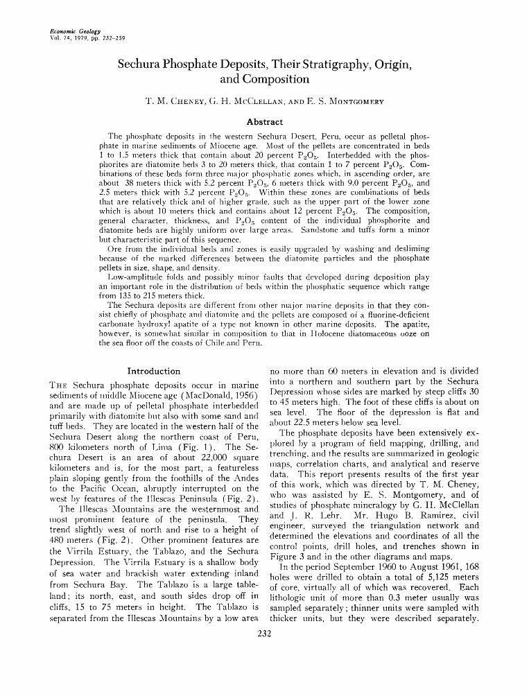
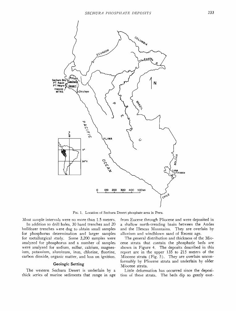
ThE Sechura phosphate deposits occur in marine sediments of middle Miocene age (MacDonald, 1956) and are made up of pelletal phosphate interbedded primarily with diatomite but also with some sand and tuff beds. They are located in the western half of the $echura Desert along the northern coast of Peru, 800 kilometers north of Lima (Fig. 1). The Se- chura Desert is an area of about 22,000 square kilometers and is, for the most part, a featureless plain sloping gently from the foothills of the Andes to the Pacific Ocean, abruptly interrupted on the west by features of the Illescas Peninsula (Fig. 2).
The Illescas Mountains are the westernmost and
most prominent feature of the peninsula. They trend slightly west of north and rise to a height of 480 meters (Fig. 2). Other prominent features are the Virrila Estuary, the Tablazo, and the $echura Depression. The Virrila Estuary is a shallow body of sea water and brackish water extending inland from Sechura Bay. The Tablazo is a large table- land; its north, east, and south sides drop off in cliffs, 15 to 75 meters in height. The Tablazo is separated from the Illescas Mountains by a low area
no more than 60 meters in elevation and is divided
into a northern and southern part by the $echura Depression whose sides are marked by steep cliffs 30 to 45 meters high. The foot of these cliffs is about on sea level. The floor of the depression is flat and about 22.5 meters below sea level.
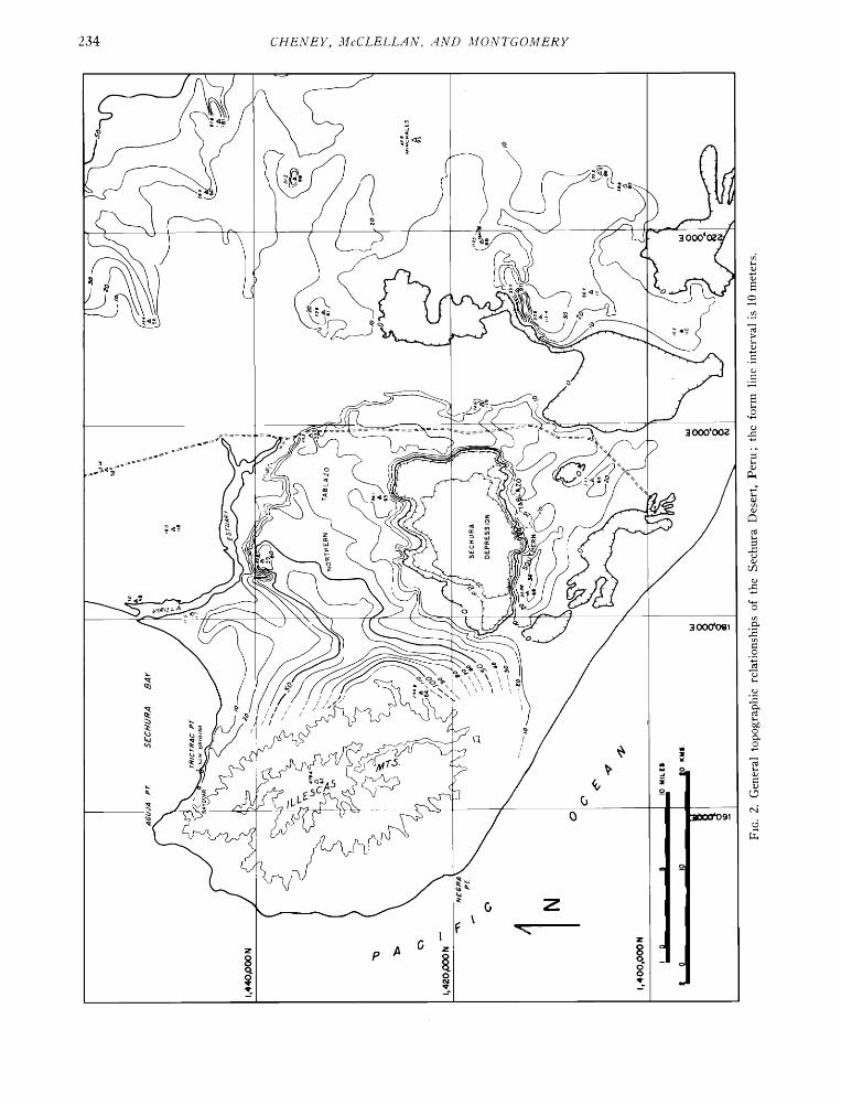
The phosphate deposits have been extensively ex- plored by a program of field mapping, drilling, and trenching, and the results are summarized in g.eologic maps, correlation charts, and analytical and reserve data. This report presents results of the first year of this work, which was directed by T. M. Cheney, who was assisted by E. S. Montgomery, and of studies of phosphate mineralogy by G. H. McClellan and J. R. Lehr. Mr. Hugo B. Ramirez, civil engineer, surveyed the triangulation network and determined the elevations and coordinates of all the
control points, drill holes, and trenches shown in Figure 3 and in the other diagrams and maps.
In the period September 1960 to August 1961, 168 holes were drilled to obtain a total of 5,125 meters of core, virtually all of which was recovered. Each lithologic unit of more than 0.3 meter usually was sampled separately; thinner units were sampled with thicker units, but they were described separately.
232
SECHUR.4 PHOSPHATE DEPOSITS 233
Sechura
PT. Agujo PT. Negro'
Ille$co$ MTN$.
Fro. 1. Location of Sechura
Most sample intervals were no more than 1.5 meters. In addition to drill holes, 30 hand trenches and 20
bulldozer trenches were dug to obtain small samples for phosphorus determination and larger samples for metallurgical study. Some 3,200 samples were analyzed for phosphorus and a number of samples were analyzed for sodium, sulfur, calcium, magnes- ium, potassium, aluminum, iron, chlorine, fluorine, carbon dioxide, organic matter, and loss on ignition.
Geologic Setting
The western Sechura Desert is underlain by a thick series of marine sediments that range in age
Desert phosphate area in Peru.
from Eocene through Pliocene and were deposited in a shallow north-trending basin between the Andes and the Illescas Mountains. They are overlain by alluvium and windblown sand of Recent age.
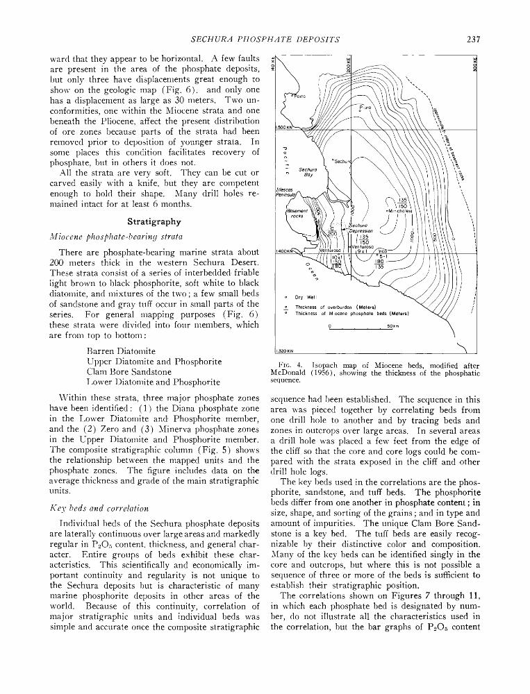
The general distribution and thickness of the Mio- cene strata that contain the phosphatic beds are shown in Figure 4. The deposits described in this report are in the upper 135 to 215 meters of the Miocene strata (Fig. 5). They are overlain uncon- formably by Plioc.ene strata and underlain by older Miocene strata.
Little deformation has occurred since the deposi- tion of these strata. The beds dip so gently east-
234 CHENEY, McCLELL.4N, .4ND MONTGOMERY

ß
ß
ß
830 ß
B-T I•, 813 ß
ß
BT9
B A YOVA R
ß
929 ß
! 8 eBI2 87 ß 89 ß
B22
B5 ß e B:• ß
820 ß
BT•6 .BI •.BT5
BIB ß
•BT2
eQB6A
Q85A ß
Qg6Aß
HTIO /'
Q95A
Q90A ß
Q74A ß
o?¾
).S9
QG9A ß
QSGAß i Q38A--
ß R2 •
R E V E N T A Z 0 N L•
E
0 0 0
eBII
Q93A ß
Q87
eQ84A
Q82A ß
Q88A ß
HTI2
½)9e2A
eQ91A HT 14
T$
NORTHERN
T A B L A ZO
QI6 ß
S 30
NSl ß
1'440,000 m N
,. Q$1A Sl2). ©040A OSSA e
ßQ79A
QI9A ß
SECH URA DE PR
QgSA ß
I
SOUTHERN
ESSION
/\ /
•,27
1;•35,000 m N
\
1'430,000 m N
> (
Qe22 A
AT;' ,%.
0 ;'•A
TABLAZO
AT2
e½ 29A
1'425,000 m. N
ß • 1'420,000 m. N
) /-
S28
)
o
o o
ß Drill Hole
R Hand Trench
E XP LA N ATIO N
0 1 ;' $ 4 • 6• Km ß I I I I I I I
Bulldozer Trench
Triangulation Poinl
FIG. 3. Location of drill holes, trenches, and control points in western Sechura Desert phosphate area, Peru (1961).
SECHUR.4 PHOSPHATE DEPOSITS 237
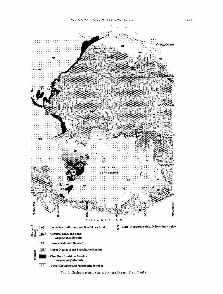
ward that they appear to be horizontal. A few faults are present in the area of the phosphate deposits, but only three have displacements great enough to show on the geologic map (Fig. 6). and only one has a displacement as large as 30 meters. Two un- confornfities, one within the Miocene strata and one beneath the Pliocene, affect the present distribution of ore zones because parts of the strata had been removed prior to deposition of younger strata. In some places this condition facilitates recovery of phosphate, but in others it does not.
All the strata are very soft. They can be cut or carved easily with a knife, but they are compet.ent enough to hold their shape. Many drill holes re- lnained intact for at least 6 months.
Stratigraphy
Miocene phosphate-bearing strata
There are phosphate-bearing marine strata about 200 meters thick in the western Sechura Desert. These strata consist of a series of interbedded friable
light brown to black phosphorite, soft white to black diatomite, and mixtures of the two; a few small beds of sandstone and gray tuff occur in small parts of the series. For general mapping purposes (Fig. 6) these strata were divided into four members, which are from top to bottom:
Barren Diatomite
Upper Diatomire and Phosphorite Clam Bore Sandstone
Lower Diatomite and Phosphorire
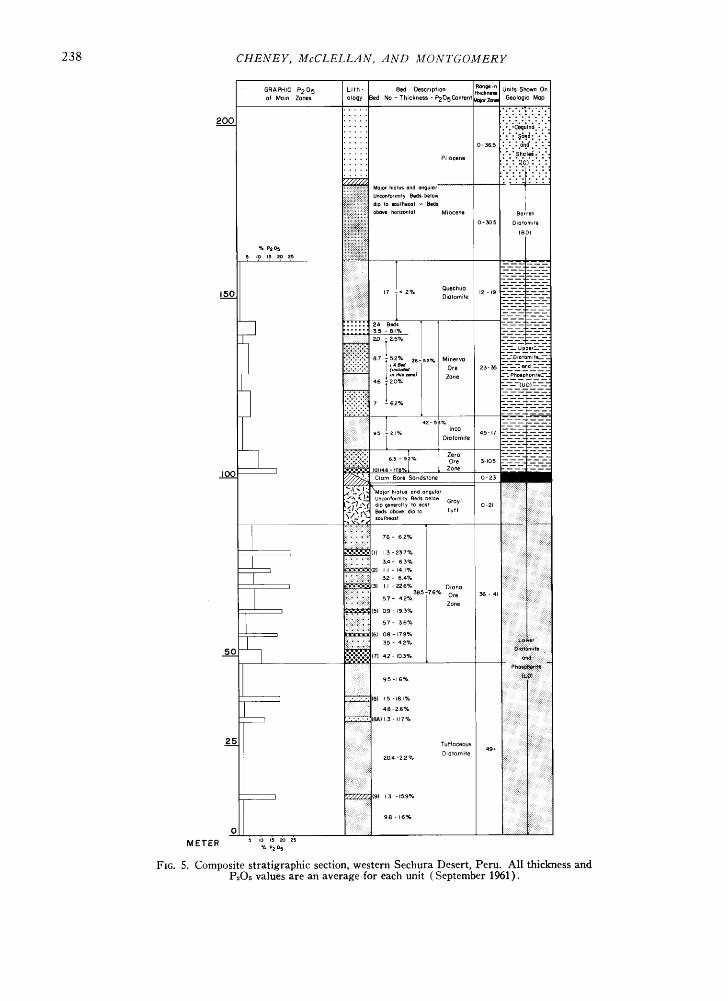
Within these strata, three major phosphate zones have been identified: (1) the Diana phosphate zone in the Lower Diatomite and, Phosphorite member, and the (2) Zero and (3) Minerva phosphate zones in the Upper Diatomite and Phosphorite member. The composite stratigraphic column (Fig. 5) shows the relationship between the mapped units and the phosphate zones. The figure includes data on th.e average thickness and grade of the main stratigraphic units.
Key beds and correlation
Individual beds of the Sechura phosphate deposits are laterally continuous over large areas and markedly regular in P,•O• content, thickness, and general char- acter. Entire groups of beds exhibit these char- acteristics. This scientifically and economically im- portant continuity and regularity is not unique to the $echura deposits but is characteristic of many marine phosphorite deposits in other areas of the world. Because of this continuity, correlation of major stratigraphic units and individual beds was simple and accurate once the composite stratigraphic
Sechuro
x x
135 150
oMInchole:
o 135
o Ory Well
__o Thickness of everburden (Meters) o Thickness ef Miocene phosphote beds (Meters)
0 50•m
I 3;'0 K N
FIG. 4. Isopach map of Miocene beds, modified after McDonald (1956), showing the thickness of the phosphatic sequence.
sequence had been established. The sequence in this area was pieced together by correlating beds from one drill hole to another and by tracing beds and zones in outcrops over large areas. In several areas a drill hole was placed a few feet from the edge of the cliff so that the core and core logs could be com- pared with the strata exposed in the cliff and other drill hole logs.
The key beds used in the correlations are the phos- phorite, sandstone, and tuff beds. The phosphorite beds differ from one another in phosphate content; in size, shape, and sorting of the grains; and in type and amount of impurities. The unique Clam Bore Sand- stone is a key bed. The tuff beds are easily recog- nizable by their distinctive color and composition. Many of the key beds can be identified singly in the core and outcrops, but where this is not possible a sequence of three or more of the beds is sufficient to establish their stratigraphic position.
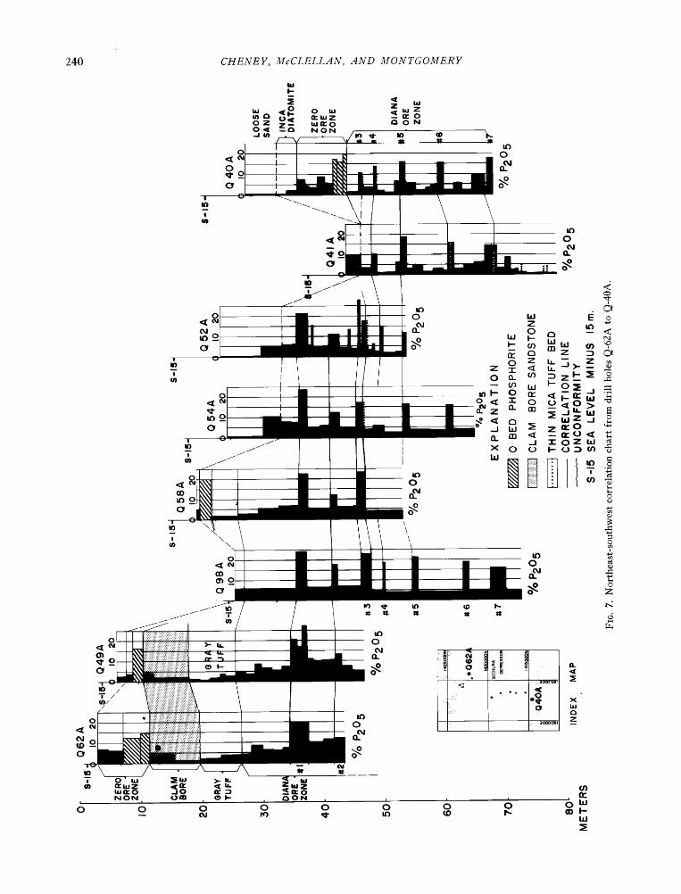
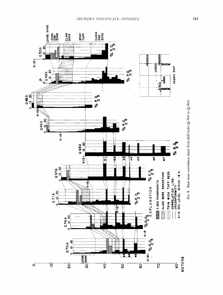
The correlations shown on Figures 7 through 11, in which each phosphate bed is designated by num- ber, do not illustrate all the characteristics used in the correlation, but the bar graphs of P20, content
238 CHENEY, McCLELL.4N, .4ND MONTGOMERY
GRAPHIC P205 L•th- Bed Descr•phon Ran•*n UmtsShown On tl'•ckness
of More Zones ology Bed No - Thickness - P205Contenf aotorZme Geologic Mop
200 ..... .'.'c•u•no.'.' ..... ':':'•&..•:':': • 2•11 0-365 :•;:• Phocene :' :*.Sh.al.e• :' :'. ..... : : :(C) : : :
..... .::: iEi•iiiiiii•iil} Mo•or h,at.s a.d an•.•or
• Unconformlfy Beds below dip Io soulheost -- Beds above hOrlzonlal Miocene Barren
0-305 Diatomlie
% P205 5 •0 15 g>o 25 , , , , ,
T :-•-z- - - - ouec..o
150 iiii :: ii;;iiiii 17 i< 2?ø D,otomlte 12 -•9 - -- -- -X:i:: ::: :;:F::: --
::.:::.::::::: ........
I ::::: 2A Bed, T Z_-_-71-_-- ::::' •-s•?. / ........
87 - --52% Minerva •-•O•atom•ta'--'• Ore 23-35 •-%"• •d - .•
: Zone ---_ Phosphorlte_--• 46
---- (UO)-----
:2::':::f, •' :- _-: :-- 2
,::;u' 'e, sb, ':iiiiii:•!;i _ .2 ; ,.,o, ........ ':-• ,o,,,.e-,,,%l Zo. - ....... IO0 J • Clam Bore Son(•stone D-z, .i •'\ • !_• Unconform•ty Beds below Gray L'•'•_.:• dip •eneral ........ 0-21 •4•_•.f•.• Beds above d,p Io Tuff soufheast
-I \' • -" ,(
I •.'-.'-.-'.'(I) I 3 - 237%
[ •-i::• •:::!: •(2) I I - 14.17o ) (3) I I - •2.6% Dlono
57- 42% Zone
I '----'-'-'-'- (5) 09 - 19 3%
'
I (•A) I 3 - I17%
Dm•omHe
... ...
::
:::::::::::::::: ::: :: ::::::-
':::: :: 98- :::::::::::: ::: ::: :::ix:i::!::
0 ::.:: ::i: :i !:i:i.i:
METER • '•,. '• •o • P2 ø5
Fro. 5. Composite stratigraphic section, western Sechura Desert, Peru. All thickness and P•O• values are an average for each unit (September 1961).
SECHUR•I PHOSPH•ITE DEPOSITS 239 --.
EXP L A N A T I O N
Loose Sand, Alluvium, and Windblown Sand
Coquina, Sand, and Shale Angula• unconformity
Barren Diatomite Member
Upper Diatomite and Phosphorite Member
Clam Bore Sandstone Member Angular unqonfnfmity
Lower Diatomite and Phosphorite Member
Fro. 6. Geologic map, western Sechura Desert, Peru (1961).
Fault: U upthtown side, D downthrown side
240 CHENEY, McCLELL•IN, •IND MONTGOMERY
o
•-I•"o c3 o N NON • I• /4)
T x
(M 0
•.lZ
NON, o
•_a:o
S'ECHUR.4 PHOSPH.4TE DEPOSITS 241
&unto J 0 NON 0 •n •)F OON
ji I
•_o
o
ol
•o •-_
o
o[
0 o • --
ok
0 •
0 •
-- 0
o ß
o
o o •
242 CHENEY, McCLELLAN, AND MONTGOMERY
•,• .• •o
o - -- f- Zbj •.•.. • -- •.
. o zo ¸ x
"'( 0: z t, o ,,•
o ...... i0111111 ii I
1.1.1.1.1'1 i'11 i x. iiiiiii i-ii. iiiiiiiiiiiiiii
,,,,,,,,,,,,, . ,•{•,, ,,,, ,,,,,,,, ,,,,,,,,,,,,,, ii I I iiiiiiiii iii iiii i ii, .-- Ii iii ?•,•,, ...... I .............. iiiii I Iiiiiiiiii i 1.1.1.1 i....i.1.1.1. -•...
[ iiiiiiiii ill[ill iiiiiiiiiii [i [ ß •,[ ß •11 IIIIIIllllll I III I IIIIIIIIIIIIIIIIIIIIIIi
o /
iiiii ! i i i,l,l,igl Ill 111111111111 IIIIIIIIIIIIIIII Iiiiiiiiiiiii I I I iiiiiiiiiiiiiiiiiiiiiiiiiiiiiii
[ / I ........... :•'"" ' •:.,1 ii 71 IIIIIIIIIIl[tlll- IIII1! IIII
I I I I I I I I I : iii1111 i1•I i1{• I IIIIII II I IIIiiiiiiiiiiiiii i
Illl lit II Illl, l[ I I f I I I I I I I Ill[lilllll¾1'lllllll I I I I f I I ! I I I I I I I, I IIIIIIIII IIIIIIIIIIIII IIIIIIII '- IIII1•t I I I I I I I I I I I I I I I I I I I I I I I Iiiiiiiiiiiiiiiii ,,.,.,.,.,,.,... ,,,,,,,,,,,,,,,,,,,,,,,,i, I' ',I,•,•,','.'.' , , -
I't') III1'1 II IIII1,1•1111 .•111 Illlll'l ' iii I IIIIIIIIIIIII1'1 lllll 1 I.IIIIII1.111 ..I...I .•.-; lllllllr.'.111111' IIIIIII IIIIIII I I I I I I Ir-• I I I I I I.$,1¾ I I 1,1,1, III1•1111111•11 0 IIIIII II I.I .... IIIIIIIIIIIIIII •1111111111•'•'- • IIII1¾111111• •.'"'.' • ':'• •1'' I•111111'11¾1111 ':lltil I i•1111111111 • . ¾111¾11•11•11 I e I I I • I I • I I I I I I -•
/ ß ',", '"'' ,:,¾F ,q,; ,',', '"','" ' ',",¾,',',',','h',,,',',',';' •' ,',',',,', .1• ilrlllllh illlllllll •11• IIIIIll Ill I lll.1111. ? IIIIi1• IllIll - i1¾11•11111111¾11•111•1111¾11 •r IiIi1•11¾ I •1111111111111111 ¾11111111•1 • • •1• iiiii •¾111 II1•111•11¾1 •1
c•)o o o o i i i
SECHURA PHOSPHATE DEPOSITS 243
o
z n• bJ T I- n- O Z
0
• • 0
o.• o
0,) o
o •: , o_
o •
! o _.lO om
.-
o N
tl,I
z n• bJ 'r I--
o
,o i-o• 1- 0
-JO
244 CHENEY, McCLELLAN, AND MONTGOMERY
i i
• z z z
SECHUR.4 PHOSPH,4TE DEPOSITS 245
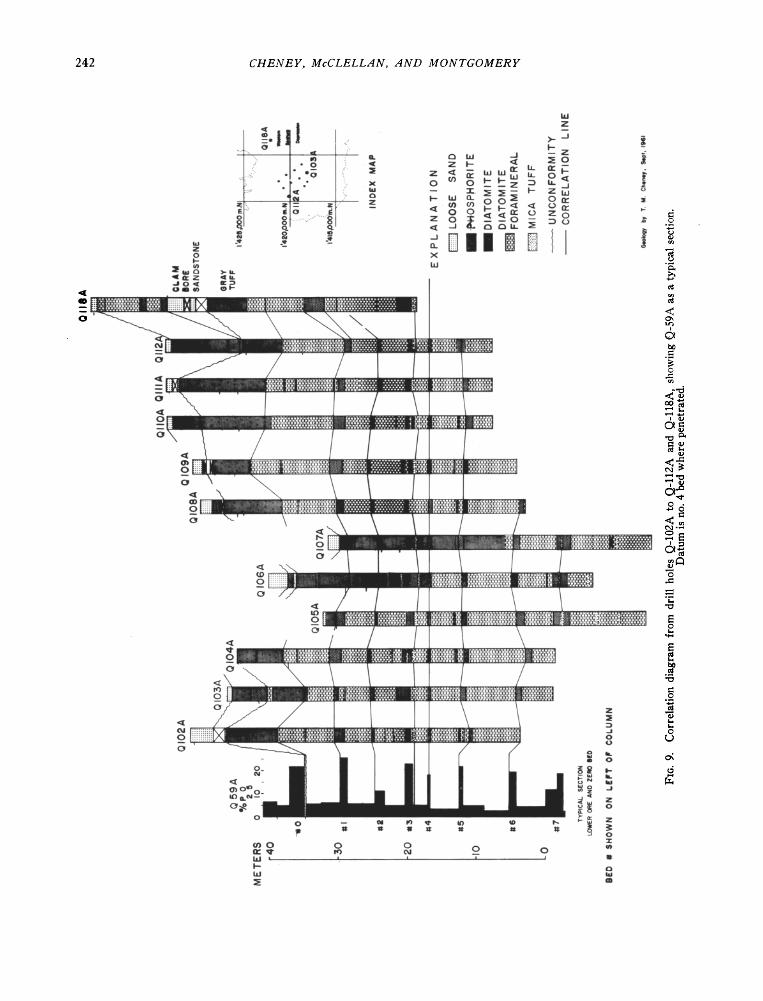
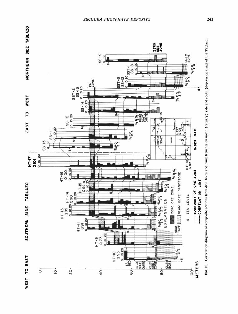
of the beds, combined with such key units as the Clam Bore Sandstone and thin tuff beds (Figs. 7, 8, and 10), illustrate well the continuity of the beds. The regularity of the stratigraphic sequence is shown also by use of only lithologic characteristics for the correlation as in Figure 9. The strata encountered in every drill hole and trench were placed in their proper stratigraphic positions through correlations like those illustrated. The composite stratigraphic section of these strata (Fig. 5) is based on these correlations.
Lower Diatomite and Phosphorire member
The Lower Diatomite and Phosphorite member crops out in the southwestern part of the Sechura Depression, in an area north of the Tablazo fault and in the cliffs in the southern part of the Bayovar area (Fig. 6). This member has been drilled ex- tensively in the western Sechura Depression and Bayovar areas, and a few holes have penetrated it in the western part of the Tablazo. The member con- sists of three units, which are from top to bottom:
Gray Tuff Diana Ore Zone Tuffaceous Diatomire
Tuffaceous Diatomire: The Tuffaceous Diatomite is the lowermost tinit drilled in the western Sechura Desert. The maximun• thickness measured in drill
holes was about 48 meters, but its entire thickness was not drilled. The tinit consists mostly of fora- miniferal diatomite containing less than 2 percent P2Oa and characteristically contains many thin beds of mica tuff. Three phosphorite beds have been recognized--& 8A, and 9 (Fig. 5).
Diana Ore Zone: The Diana Ore Zone is the
richest and thickest of the three major ore zones in the western Sechura Desert. It underlies nmch of
the area and crops out in the western part of the Sechura Depression and in the Bayovar area. It is 35 to 40 m,eters thick and contains 7 to 8 percent P,_,O•. Most of the phosphate is concentrated in seven beds, which have been designated from top to bottom as Nos. 1 to 7 (Fig. 5). The phosphorite beds generally are separated by diatomit. e that con- tains as much as 6.5 percent P20.•. mostly as pelletal phosphate.
Diana Ore Zone--western Sechura Depression: The Diana Ore Zone tinderlies all but the extreme
southwestern part of the western Sechura Depression and crops out in much of the area. Sections of the Diana and typical correlations within the zone drill holes are shown in Figures 7, 8, and 9. In this area, the Diana can be divided into txvo parts. The contact between them is at the base of No. 3 bed
(Fig. 5), which is marked by a persistent gray mica
tuff about 0.3 meter thick in the top of the under- lying diatomite.
The lower part of the Diana averages about 21 meters thick and 6.4 percent P2Oa. It crops out in much of the southwestern Sechura Depression and undoubtedly tinderlies all the northwestern part, but it was too deep to penetrate with the available drill. Phosphorite beds Nos. 4 to 7 are in this part of the Diana. The No. 4 bed is generally less than 0.3 meter thick; Nos. 5 and 6 generally are a little less than 1 meter thick, and all these beds contain about 18 percent P._,Oa. The diatomite between the phos- phate beds 3 to 6 meters thick contains 3.0 to 6.0 percent P2Oa. The No. 7 bed is about 4.3 meters thick and contains tip to 10 percent P203. It con- sists of interbedded phosphorite and diatomite, and it includes a gray micaeous tuff bed, about 0.1 to 0.3 meter thick, which is a distinctive marker. The phosphate pellets are more poorly sorted than in other beds in the interval. The base of the Diana
generally is at the base of the No. 7 bed, but in some areas the 1.5 to 1.8 meters of diatomite beneath it
contains significant phosphate. Results of preliminary tests indicate that ore from
the lower part of the Diana can be upgraded by wash- ing and cycloning to about 27 percent P20.• with recovery of more than 65 percent of the PeOn.
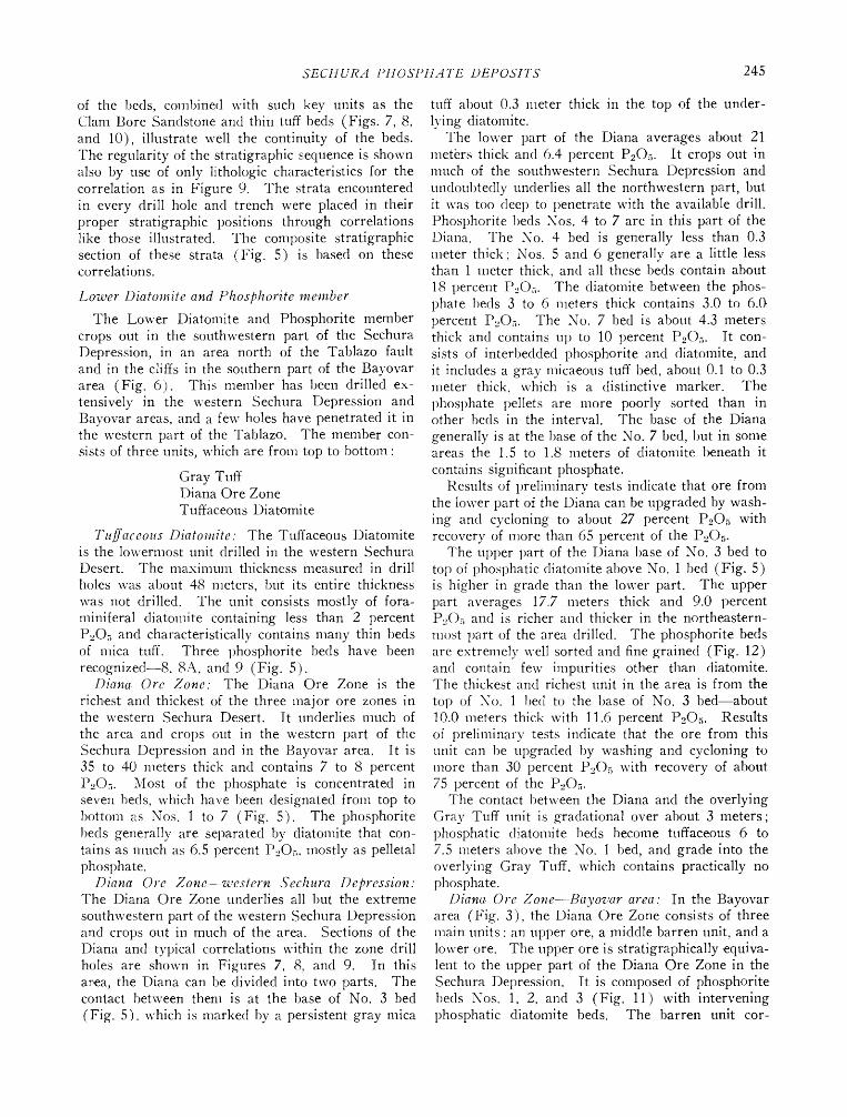
The tipper part of the Diana base of No. 3 bed to top of phosphatic diatomite above No. 1 bed (Fig. 5) is higher in grade than the lower part. The upper part averages 17.7 meters thick and 9.0 percent P2Oa and is richer and thicker in the northeastern- most part of the area drilled. The phosphorite beds are extremely well sort,ed and fine grained (Fig. 12) and contain few impurities other than diatomire. The thickest and richest tinit in the area is from the
top of No. 1 bed to the base of No. 3 bed--about 10.0 meters thick with 11.6 percent P20•. Results of preliminary tests indicate that the ore from this tinit can be upgraded by washing and cycloning to more than 30 percent P20• with recovery of about 75 percent of the P2Oa.
The contact between the Diana and the overlying Gray Tuff unit is gradational over about 3 meters; phosphatic diatomite beds become tuffaceous 6 to 7.5 meters above the No. 1 bed, and grade into the overlying Gray Tuff, which contains practically no phosphate.
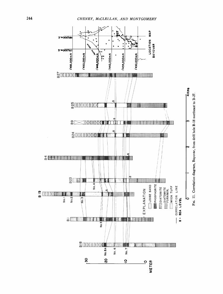
Diana. Ore Zone--Bayovar area: In the Bayovar area (Fig. 3), the Diana Ore Zone consists of three main tinits: an tipper ore, a middle barren unit, and a lower ore. The upper ore is stratigraphically equiva- lent to the tipper part of the Diana Ore Zone in the Sechura Depr.ession. It is composed of phosphorite beds Nos. 1, 2, and 3 (Fig. 11) with intervening phosphatic diatomite beds. The barren unit cor-
246 CHENEY, McCLELLAN, AND MONTGOMERY
20
I0-
5
f\
[.." ... \\ ,,"•--'-,, Diana Ore Zone : "• '.,•' x ', Sechuro D•r•$$ion
ß I.' '".• ,• "' I [/ ...... • ', • Diana - Bayovar ß '"' • tt "'V.. "
/ ",,,X / ] X".
Z•ro •d//" • ' ' -" • / .
.'
24 28 32 35 42 48 60 65 80 I00
I I
/'"
<i:•'• i -'• .t•.-• •-..•...• • 1 170 200 aS0 270 325
TYLER MESH SIZE
40--
35--
30-
20
t5
I0
5
/ •: / •./ ', ',• ''•' .... EXPLANATION / I / / / X • % I
•,•,, ..... ,,;•,,• •,•,•,,• / [..':/ F t ', "-..• ß 4 / •/ X ', "..N / ...-', / • / x , "-.N /..-',' . / / S • '.. •
/..")' /• • X ', '".. /...,• •- -- ,, .... ,,
42 48 60 65 80 I• 115 150 170 200 250 Z70
TYLER MESH SIZE
Fro. 12. Graph showing size and distribution o• washed pellets.
6,7
responds to the interval between the base of the No. 3 bed and beds slightly below the No. 5 bed in the area of the depression. It is consider.ed barren be- cause phosphorite beds Nos. 4 and 5 are very thin or absent, and the intervening diatomite contains fewer
phosphate pellets. The lower ore unit of the Diana zone generally is equivalent to the Sechura Depres- sion from the interval slightly below the No. 5 bed to the base of the No. 7 bed.
The Diana Ore Zone is present in all drill holes
SECHURA PHOSPH.4TE DEPOSITS 247
except B-21 and B-8, where it had been eroded prior to deposition of the Clam Bore Sandstone. In the Bayovar area the lower ore unit constitut.es the bulk of the ore, because phosphorite beds Nos. 1, 2, and 3 are thin or absent, having been eroded from much of the area, either before deposition of the Clam Bore Sandstone or more recently.
Th,e lower ore unit of the Diana Ore Zone in the
Bayovar area averages 10 meters thick and 7.3 percent P2Oa. It is marked at the top by the bed designated No. 5A. which lies below the No. 5 bed. The base of the unit is at th.e base of the No. 7 bed.
The No. 6 bed is present in nearly every drill hole but generally is less than 0.3 meter thick and it ap- parently is represented by a mica tuff bed in part of the area. The No. 7 bed characteristically contains a gray mica tuff bed like that in the Sechura De- pression. This mica tuff bed is not present in all drill holes but where absent usually is represented by a thin diatomire bed.
The middle unit of the Diana zone is mostly diato- mire; it ranges from 5 to 12 meters thick and con- tains less than 3 percent P.,Oa. Th,e No. 4 bed is present only in drill holes B-4 and B-23. The No. 5 bed is distributed irregularly and is thin; its position usually is marked by a slight concentration of phos- phate pellets. On the other hand, in drill hole B-6 it is well developed, and the column here is similar to that in the western Sechura Depression.
The upper ore unit of the Diana zone has been eroded from all 1)ut the extrem.e south-central part of the area. Its maximum thickness, in the vicinity of drill hole B-19, is about 15 meters. Its average thickness, however. is about 6 meters, and it contains 7 to 15 percent P2Oa.
Gray Tuff: Overlying the Diana Ore Zone in the western Sechura Depression and in a small part of the Bayovar area is a soft gray diatomaceous tuff. It crops out in the western depression in the vicinity of drill holes Q-98A, Q-2A, and Q-105A and in the Bayovar area. in the vicinity of drill hole B-4 (Fig. 3). The contact with the underlying Diana is grada- tional.
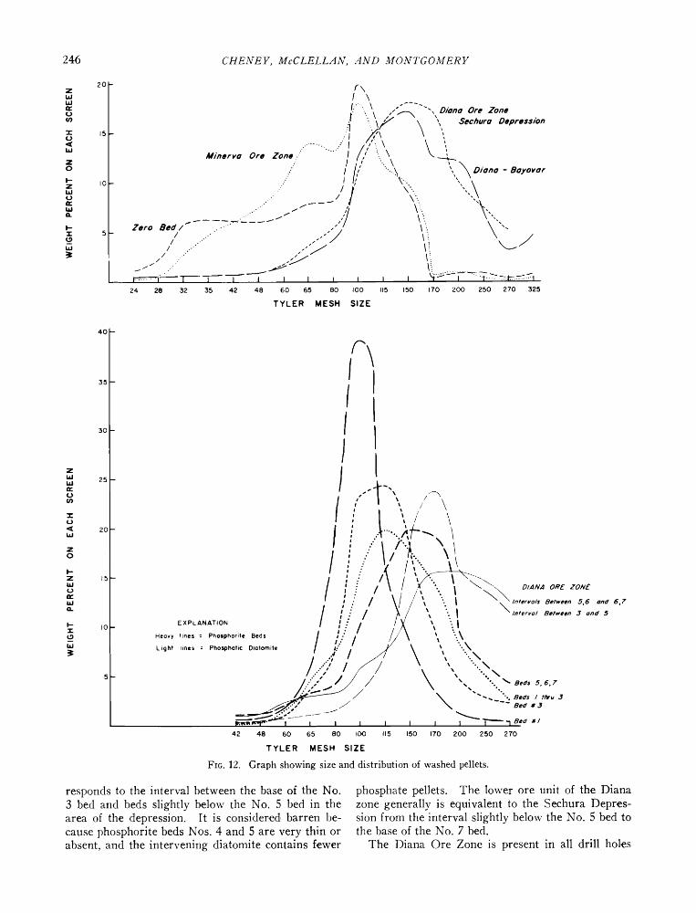
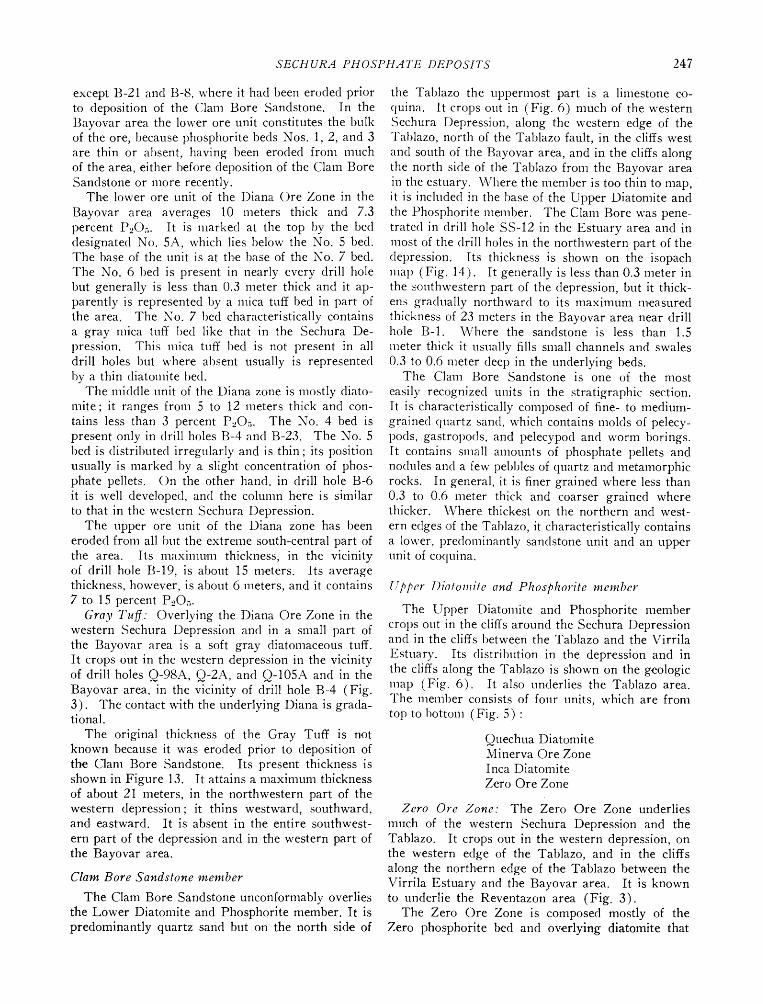
The original thickness of the Gray Tuff is not known because it was eroded prior to deposition of the Clam Bore Sandstone. Its present thickness is shown in Figure 13. It attains a nmximum thickness of about 21 meters, in the northwestern part of the western depression; it thins westward, southward, and eastward. It is absent in the entire southwest-
ern part of th,e depression and in the western part of the Bayovar area.
Clam Bore Sandstone member
The Clam Bor.e Sandstone unconformably ov.erlies the Lower Diatomite and Phosphorite member. It is predominantly quartz sand but on the north side of
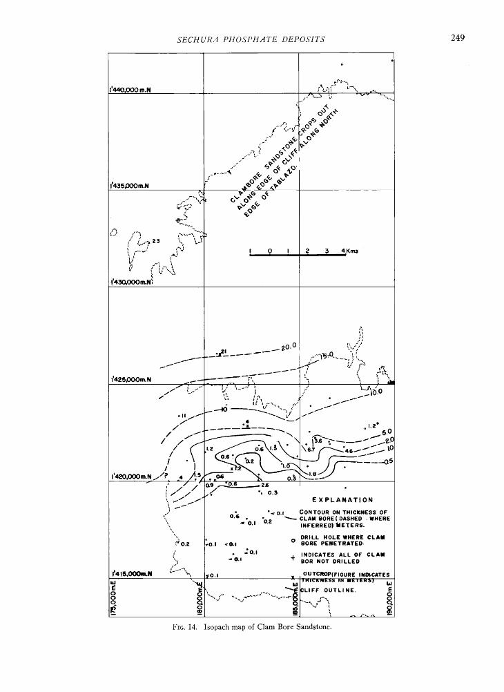
the Tablazo the uppermost part is a limestone co- quina. It crops out in (Fig. 6) nmch of the western Sechura Depression, along the western edge of the Tablazo, north of the Tablazo fault, in th,e cliffs west and south of the Bayovar area, and in the cliffs along the north side of the Tablazo from the Bayovar area in the estuary. Where the member is too thin to map, it is included in the base of the Upper Diatomire and the Phosphorire melnber. The Clam Bore was pene- trated in drill hole SS-12 in the Estuary area and in InOSt of the drill holes in the northwestern part of the depression. Its thickness is shown on the isopach ma 1) (Fig. 14). It generally is less than 0.3 meter in the southwestern part of the depression, but it thick- ens gradually northward to its maximum measured thickness of 23 meters in the Bayovar area near drill hole B-1. \Vhere the sandstone is less than 1.5
Ineter thick it usually fills small channels and swales 0.3 to 0.6 meter deep in the underlying beds.
The Clam Bore Sandstone is one of the most
easily recognized units in the stratigraphic section. It is characteristically composed of fine- to medium- grained quartz sand, which contains molds of pelecy- pods, gastropods, and pelecypod and worm borings. It contains slnall amounts of phosphate pellets and nodules and a few pebbles of quartz and metamorphic rocks. In general, it is finer grained where less than 0.3 to 0.6 meter thick and coarser grained where thicker. \Vhere thickest on the northern and west-
ern edges of the Tablazo, it characteristically contains a lower, predolninantly sandstone unit and an upper unit of coquina.
Upper Diatomire and Phosphorite member
The Upper Diatomire and Phosphorite member crops out in the cliffs around the Sechura Depression and in the cliffs between the Tablazo and the Virrila
Estuary. Its distribution in the depression and in the cliffs along the Tablazo is shown on the g. eologic inap (Fig. 6). It also underlies the Tablazo area. The melnber consists of four units, which are from top to 1)ottom (Fig. 5):
Quechua Diatomire Minerva Ore Zone Inca Diatomire Zero Ore Zone
Zero Ore Zone: The Zero Ore Zone underlies
much of the western Sechura Depression and the Tablazo. It crops out in the western depression, on the western edge of the Tablazo, and in the cliffs along the northern edg. e of the Tablazo between the Virrila Estuary and the Bayovar area. It is known to underlie the Reventazon area (Fig. 3).
The Zero Ore Zone is composed mostly of the Zero phosphorire bed and ov. erlying diatomite that
248 CHENEY, McCLELLAN, AND MONTGO2[ERY
ß
ß
ß ß ß ß
ß
/ •,-'¾ ß ß
ß ß ½
ß ' % I 0 I 2 5 4Km$ i i i i ß ß • •-• •.•. i i
? ß
! 430,000m. N •N .
% ß
ß • .
ß ß
o ß ,•.5 •'•t• •.?/'ø
', ! ':i' • • •.•' ß .. • .
/ ' ,• -• .••.• .o•'• /' • . % • .6.7 + / •/ EXPLANATION • ' ' ' '••• DRILL HOLE
• ß
• ß ß ß •C•OP • . ß ß X { •I•UR• SHOWS
ß • ß ß ß ß CONTOUR LINE,
FIG. 13. Isopach map of Gray Tuff.
SECHUR•I PHOSPH•ITE DEPOSITS 249
I
•/ •e , , , ,
1'4•O•N•
__•l____•.• •o -ø •,•'
_- .?. v ?
/ . . 1'2+
,I. 2 ' ' •
: / / -• 'ø-••.• . • •/ ' EXPLANATION • • o.• * o.I CONTOUR ON THICKNESS OF
• <'0.1 •.2 • CLAM BORE ( DASHED • WHERE INFERRED) METERS.
•N DRILL HOLE WHERE CLAM •"0.• •0.1 <•I 0 BORE PENETRATED-
/ . •o.• L• <O.i + INDICATES ALL OF CLAM BOR NOT DRILLED
•415,•N • .... .. • •0.1 X OUTCROP(FIGURE I N•CATES ß • ! HI•KN• I•
• '• • :LIFF OUTLINE. E
Fro. 14. Isopach map of Clam Bore Sandstone.
250 CHENEY, McCLELL.4N, .4ND MONTGOMERY
contains pelletal phosphate. It averages 6.3 meters thick and 9 percent P20•.
The Zero bed is one of the more poorly sorted, slightly coarser grained phosphorite beds in the stratigraphic section (Fig. 12) and contains more sand grains than the other phosphate beds. Results of preliminary tests suggest that it can be upgraded by washing and cycloning to 24 to 25 percent PeOa. The overlying phosphatic diatomite contains phos- phate pell.ets that are finer grained than those in the Zero bed.
The contact of the Zero Ore Zone with the under-
lying Clam Bore Sandstone generally is gradational, but at a few of the westernmost and northernmost
drill hol.es in the .Sechura Depression and in the Estuary area, a thin diatomire unit is present be- tween the Clam Bore and the Zero bed. In some
places this unit contains more than 4 percent P2Oa. Lateral changes in the Z.ero Ore Zone can be noted
in Figures 7 to 9. In the western and southwestern parts of the Sechura Depression, the zone is com- posed of two distinct units, the Zero bed and over- lying phosphatic diatomite Q-40A (Fig. 7) and HT-10 to Q-95A (Fig. 10). Eastward the zone thickens and the phosphate is more evenly distributed in the column. Comparison of sections along the north side of the Tablazo with those along the south side also shows a slight northeastward decrease in P20• values.
Inca Diatomire: The Inca Diatomite is 3 to 17
meters thick and contains about 1.0 percent P205 although some beds contain as much as 2.8 percent P2Oa. It is composed almost entirely of diatoms and apparently contains no quartz silt or other im- purities except the phosphate, which is mostly fish scales. The Inca crops out in the northwestern part of the Sechura Depression in the area from a line between drill holes Q-46A and Q-50A northward to the cliffs along the Tablazo. It is present also in the cliffs on the western edge of the Tablazo, on the northern edge of the Tablazo from triangulation point Temo to the Virrila Estuary (Figs. 3 and 4), and on th.e western and southwestern edges of the Sechura Depression. The Inca is thickest and purest in the western part of the area (HT-9 to Q-73A, Fig. 10). It thins northeastward, probably by an increase in phosphate content in both the lower and upper parts.
Minerva Ore Zone: The Minerva Ore Zone under- lies the Tablazo north and south of the Sechura De-
pression. It is exposed in the cliffs all around the depression and in the cliffs between the Tablazo and the Estuary. It also has been penetrated by drill holes in the Reventazon area (Fig. 3).
The Minerva Ore Zone characteristically contains an abundance of bones, fish scales, and fish teeth, and certain beds contain many very large bones that were
identified tentatively as whale bones. Some of the phosphorite beds are composed partially of phosphate nodules.
The average thickness and grade of units within the Minerva are shown in Figure 5. In the south- western part of the Tablazo area, south of the Tab- lazo fault, the Minerva contains two phosphorite units. The overall coinposition and character of the Minerva Ore Zone is remarkably constant over a very large area, but it is relatively more variable than any of the other ore units. The phosphorite beds thin, and the diatomite beds thicken, from west to east. In th.e western parts of the Tablazo this zone is thin and high grade, as at HT-9 to Q-73A, where it is 6.7 meters thick and contains 10.3 percent P2Oa. Eastward it thickens markedly: east of HT- 13 to Q-89A it is more than 26 meters thick and contains 5 to 6 percent P20.•. Whereas the total alnount of phosphat.e has doubled between these two sections, the thickness has quadrupled. Most of the increase in thickness reflects an increase in the con- tent of diatomite.
The phosphorite pellets in the Minerva Ore Zone are 1note poorly sorted than those in the Diana but show al)out the same sorting as those in the Zero Ore Zone (Fig. 12). The Minerva zone contains less sand and silt-sized impurities than the Zero Ore Zone and slightly more than the Diana zone. Results of preliminary metallurgical tests on samples from HT-7 through HT-15 in the southwestern Tablazo area indicated that ore from the Minerva zone can be
tipgraded by washing and cycloning to at least 26 percent P.•Oa with recovery of at least 60 percent of the P,zOa.
Quechz•a Diatomire: The Quechua Diatomite ranges in thickness from 0 to 14 meters. It is thick- est in the northeastern part of the Sechura Depres- sion, but its thickness is somewhat irregular, perhaps because it interfingers with and grades into the over- lying Barren Diatomite member. The Quechua is composed mostly of diatoms and is relatively pure, but it contains one or two thin phosphorite beds. In the depression, one thin phosphorite bed which is rather high grade (HT-16 to HT-17, Fig. 10) con- tains many bones and teeth and large amounts of quartz. It probably correlates with a similar bone- bearing bed that cropped out in the extreme south- eastern corner of the Sechura Depression.
Barren Diatomire Member: The Barren Diatomite
member is the uppermost Miocene unit in the west- ern Sechura Desert. It ranges from absence to an estimated 40 meters thick, having been eroded prior to the deposition of the overlying Pliocene sediments; it thickens toward the .east (Fig. 6). The member is present in the cliffs around the eastern part of the depression and along the eastern part of the
SECHUR.4 PHOSPHATE DEPOSITS 251
estuary. In outcrop it usually is stain.ed a yellowish to reddish orange. Although the composition of this unit is not well known, mica flakes are a characteris- tic component, and the stain in the outcrops suggests the presence of other minor impurities.
Pliocene coquina, sand, and shale
Pliocene strata consisting of an interbedded series of coquina, sand, and shale unconformably overlie the phosphate-bearing strata in part of the western Sechura Desert. Their distribution is shown on the
geologic map in Figure 6. These strata are best ex- posed in the cliffs around the Sechura Depression and on the edges of the Tablazo. •
Recent loose sand, alluvium, and windblown sand
Recent loose sand, alluvium, and windblown sand are present over much of the area. Where they are estimated to be more than 1.0 meter thick they are shown in Figure 6. Most of these sediments are windblown sand in the form of dunes or thin sheets
of loose sand. Most of the unit QS on the geologic map is windblown sand.
Structure
The structure of Miocen.e and younger strata in the Sechura Desert is very simpl.e. Slight tilting, minor folding, and minor faulting constitute the ex- tent of deformation. These strata were deformed in
at 1.east three different periods: one during the Mio- cene, one prior to deposition of Pliocene sediments, and one after the Pliocene.
After deposition of the Lower Diatomite and Phosphorite member, the beds were tilted to the northeast and their general strike is now about N10øW. They dip northeast 11 to 14 meters per kilometer (Fig. 15). They also were slightly com- pressed and gently fold. ed. Axes of almost all the folds plunge gently northeastward. The amplitude of these folds is very small and practically unrecog- nizable in the field.
After and perhaps during this deformation, the Lower Diatomire and Phosphorite member and Gray Tuff were partly eroded from the western part of the area. The Clam Bore Sandstone was then
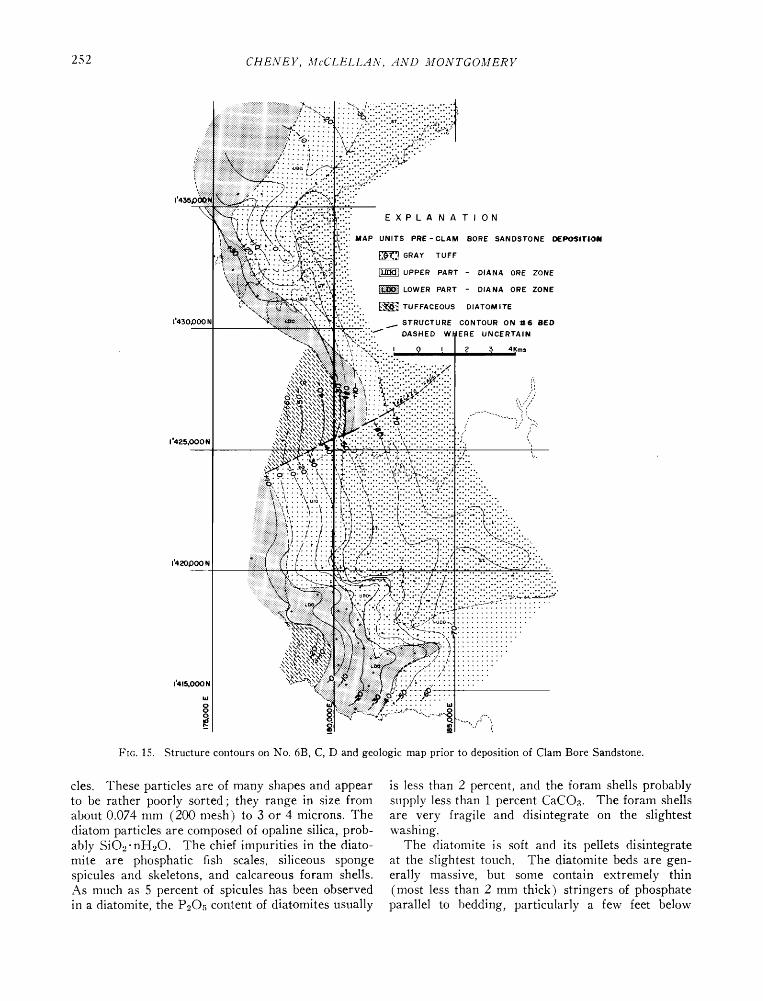
deposited on these truncated beds as shown on th.e geologic map of beds as they probably appeared prior to deposition of the Clam Bore Sandstone (Fig. 15).
The unconformity beneath the Clam Bor.e Sand- stone had a marked effect on the present distribution of the Diana Ore Zone. In general, the Clam Bore was deposited on the essentially plane surface eroded on gently northeast dipping beds, so that it rests on progr.essively older beds toward the southwest.
The unconformity beneath the Clam Bore not only is demonstrated by correlation of drill hol.e data but
also is evident in surface outcrops. In most of the northwestern part of the depression, the Clam Bore rests on Gray Tuff, as observed in outcrops near drill holes Q-105A and Q-1.08A and as evident from drill holes (Figs. 3 and 9). Southwestward, in the vicinity of drill hole Q-2A, the Clam Bore rests on the upper part of the Diana Ore Zone. In the vicinity of drill hole Q-36A, it rests on phosphatic (pelletal) diatomit. e that overlies the No. 7 bed. Still farther southwestward, it rests on the Lower Diatomire and Phosphorite member. On the western edge of the Tablazo in the vicinity of drill holes Q-82A and Q-87A, most of the Diana Ore Zone has been re- moved by erosion prior to deposition of the Clam Bore; in the vicinity of drill holes Q-85A and Q-96A, the Diana Ore Zone is absent. In much of the Bayovar area the Diana Ore Zone is absent, as at drill holes B-18 anti B-21, because of pre-Clam Bore erosion. Hence, in the extreme western and south- western parts of the Sechura Desert the unconform- ity marks the limit of the area of economic interest.
After deposition of the Clam Bore Sandstone, the strata evidently were not deformed again significantly until after deposition of the Upper Diatomite and Phosphorite member. They were then slightly tilted to the southeast (Fig. 16). They strike about N15øE and dip 6 to 8 meters per kilometer to the southeast. They were also compressed slightly so that several minor asymmetrical eastward-trending folds were formed that plunge slightly to the .east.
It is possible that during the first two periods of deformation there was minor faulting because some of the folds shown in Figures 15 and 16 could have restilted partly from faulting. One in particular that may be a fault is shown as a sharp flexure on Figure 15 near grid line 1,420,000 N.
During or after the eastward tilting of the Mio- cene beds they were uplifted and .eroded, so that Pliocene beds were deposited on the truncated sur- face. The Pliocene beds are horizontal insofar as can be determined.
The latest deformation known to have affected any of the strata is definitely post-Pliocene and may be Recent. Evidence of this deformation are the faults
shown in Figure 6 that cut the Pliocene beds. Other evidence for post-Pliocene deformation is the pres- ence of at least one major fault along the east side of the Illescas Mountains, where older alluvial fan material has been dropped against metamorphic rocks.
Petrography Diatomite
The diatomite is marine in origin and consists of indistinct pellets that are aggregates of diatom parti-
252 CHENEY, McCLELLAN, AND MONTGOMERY
1'4:•5
1'430,C)00 I•
::i! !!ii !i x •'x'/!T!'!' !'!!'! !7 x'x7x7: :!i!ii:!• ..... : • ß ß, .'..".."..".. ' '. ß ". •:-?œ) •...,
!ii•;;•t ................................................................... !!?:3 ß ß o .... : .'[: •5 ': ."..' '..' '.-' '..' '.-;-?•'.."
......... • ?::: "i/::: iili :•'::"::"::"::':•;•:::" '
':'" •': •:t:i!::ii::!i:?"- .o
..
..
'.::2' E X P L A N A T I ON o.
MAP UNITS PRE-CLAM BORE SANDSTONE
• GRAY TUFF
:{::i • UPPER PART - DIANA ORE ZONE ::i!!!: :• •OWER PART - D,A.A ORE ZO.E .......
::::::::. • TU FFACEOUS DIATOM ITE .o,O,,
STRUCTURE CONTOUR ON •t6 BED
UNCERTAIN
2 :3 4 Kms
I '425,000 N
1'420,000N
1'415,000N
-- :::::::::::::::::::::::::::::: ß -,::,-- .. ,::, ,::,-- ::
' '.-;•.:;5;• f V.'-':h- • .-•..'""
...
Fro. 15. Structure contours on No. 6B, C, D and geologic map prior to deposition of Clam Bore Sandstone.
cles. These particles are of many shapes and appear to be rather poorly sorted; they range in s•ze from about 0.074 mm (200 m,esh) to 3 or 4 microns. The diatom particles are composed of opaline silica, prob- ably SiO•-nH•O. The chief impurities in the diato- mire are phosphatic fish scales, siliceous sponge spicules and skeletons, and calcareous foram shells. As much as 5 percent of spicul.es has been observed in a diatomire, the P.•O,content of diatomires usually
is less than 2 percent, and the foram shells probably supply less than 1 percent CaCOa. The foram shells are very fragile and disintegrate on the slightest washing.
The diatomite is soft and its pellets disintegrate at the slightest touch. The diatomite beds are gen- erally massive, but some contain .extremely thin (most less than 2 mm thick) stringers of phosphate parallel to bedding, particularly a few feet below

SECHUR.4 PHOSPH.4TE DEPOSITS 253
the main phosphorite beds. Cross-bedding can be seen within some of these stringers.
The color of the diatomite ranges from pure white through brown to dark olive green. The variation in color reflects differences in the interstitial mat.erial, because washed diatom particles are white and sub- translucent to transparent. The color apparently reflects the stat.e of oxidation of the organic material. and the same bed may be white. black, or brown,
depending on its location with respect to the water table or to its water content. \Ve have tended to class the darker beds as foraminiferal diatomires and
the white beds as diatomite, mainly because we can see the forams in the darker beds, but they are difficult to see in the lighter colored beds without a microscope.
Because the diatomite beds are composed of micro- scopic irregular particles and because they ar.e not
1'435,00 0 N,
J
1"430,000 N
/ /
/ / / i
/ / /
/ / ß
I
1'425,000 N
E X PLA NATION
CONTOUR INTERVAL:
5 rn IWESTERN DEPRESSION) IOta (BAYOVAR, TABLAZO AND
ESTUARY AREAS )
,-,'"--"'-CLIFF OUTLINE
ß DRILL HOLE
X OUTCROP
1'420,000 N
1'415,000; O.
/ /
\\ \
t: x\ \\
/1// //' ß ß /
D'. ?: ,, ,,,
ß •. •/t • '. / I / . '• ' / / t / /
• :.•o -• '
Ftc. 16. Structure contours on Clam Bore Sandstone.
254 CHENEY, McCLELLAN, AND MONTGOMERY
highly compacted, the porosity is extremely high, about 90 percent. Because of its high porosity the apparent specific gravity of the pure diatomire is low, about 0.5. Its permeability, however, is low.
Sandstone and tuff
The major sandstone and tuff beds are the Clam Bore Sandstone and the Gray Tuff. Minor beds of Gray Tuff are present in the Diana Ore Zone and the Tuffaceous Diatomite.
The sandstone is of marine origin and consists mostly of fine to medium quartz grains, but it con- tains also scattered phosphate pellets, grains of f.eld- spar and black metamorphic rocks, a few pebbles of quartz and metamorphic rock, and marine fossils. These extraneous materials ar.e distributed homo-
geneously throughout the sandstone and there is little evidence of stratification. The sandstone gen- erally is friable, but in local ar.eas it is hard, especially where it is dry. The color ranges from light brown to a characteristic yellowish orange.
The tuff is also of marine origin and is soft and friable and disintegrates readily in water. It consists mostly of fine to coarse silt and very fine sand-size grains of volcanic glass, feldspar, quartz, and diatoms. The modal grain size is probably slightly less than 0.62 min. The nilnor constituents in this tuff are
mica, amphiboles, sponge spicules, forams, foram tests, and heavy minerals.
The tuff is generally massiv.e bedded and gray to light grayish green. The tuff beds in the Diana Ore Zone and the Tuffaceous Diatomire are a distinctive
light gray in color whether above or below the wat.er table. The Gray Tuff is generally light to medium grayish green where dry and dark grayish green where wet.
Phosphate
The phosphate is marine in origin and consists mostly of pellets of phosphorite, a fluorhydroxycar- bonate apatite. Impurities in the phosphorites are, in decreasing ord.er of abundance, fragments of dia- toms; volcanic glass; soluble sodium, potassium, and magnesium salts: quartz; feldspar; sponge spicules; gypsum; mica: and organic matter.
Although the individual pellets are hard, the phos- phorites are friable and all the subsurface phos- phorites disintegrate in water. The phosphorites in some small areas are cemented, but this is a rare surface or very near surface phenomenon. Gypsum, a secondary mineral, occurs mainly as fracture fillings near the surfac.e and comprises less than 2 percent of the beds penetrated by drill holes.
The phosphorite beds are generally massive and show no apparent evidence of planar stratification. Cross-bedding is common in the lower part of the
phosphate beds but is very indistinct. The upper contact of the phosphorite bed with diatomite is always planar and very sharp, but the lower contact with diatomite beds is nearly always irregular and gradational. The upper part of the diatomit.e beds contains many irregular pockets and stringers of phosphate, and the lower part of the phosphorite beds contains irregular masses and disseminated diatomite.
The phosphorite beds have a high degree of sorting (Fig. 12) and so should be highly porous, but much of the pore space is filled with diatomite and fine silt-sized particles.
The apatite pellets are mostly structureless. They usually contain less than 1 to 2 percent of impurities --fragments of diatoms, sponge spicules, volcanic glass, very fine quartz grains, organic matter, and mica. The apatite pellets in the Zero bed contain more impurities than those in the other main phos- phorite beds. A few of the pellets from the Zero bed have large cores of quartz or feldspar.
Most apatite pellets are subelliptical to ovoid in shape, but rod-shaped and irregularly knobby pellets are not uncommon. The finer pellets are more regular in shape, the larger pellets more irregular. The larger pellets usually have a pitted surface and the smaller pellets a smooth, shiny surface. Many of the larger pellets and nodules probably are ag- glomerates of fine pellets.
The pellets range in color from white to dark brownish black, and pellets from diff. erent parts of the same bed may be of different colors. For ex- ample, pellets from the No. 1 bed are white at one end of an outcrop, reddish brown about 100 meters away, and nearly black at 500 meters, where the bed is below the surface. Hence, color is of no value in correlation or recognition of different beds. In general, however, most of the phosphorite beds are usually light brown or darker, and the difference in color probably reflects the state of oxidation of the organic matter present.
The specific gravity of the individual phosphate pellets ranges from 2.8 to 2.93; the average is about 2.9. The specific gravity of a relatively pure bed, such as the No. 1 phosphorite bed, which contains 28 percent P.oO•, is about 1.65. The specific gravity of washed ore that contains 31 percent P20.• is about 1.7.
In the $echura deposits the apatite is pr. esent mostly as discrete pellets. Other forms present in nilnor amounts are nodules (elliptical and irregular masses larger than 2 mm); oolites (similar to pell.ets but with internal concentric structure); fish teeth, scales. and bones; and casts and internal molds of foraminifera. The pellets range in size from less than 0.43 mm to 2 mm, but 95 perc.ent are between
SECHUR.4 PHOSPH.4TE DEPOSITS 255
0.06 mm (270 mesh) and 0.6 mm (35 mesh) (Fig. 12), and the modal grain size is between 0.175 mm (80 mesh) and 0.12 1rim (150 mesh). More than 75 percent of the apatite pellets are larger than 200 lnesh, but there are significant differences in the size of the pellets in different beds of the deposit. The pellets in the phosphorite beds are usually slightly coarser and better sorted than those in the phosphatic diatomite beds. The pellets in the phosphorite beds from the Zero and Minerva Ore Zones, which are above the Claln Bore Sandston.e, are coarser and more poorly sorted than those in the beds below the Clam Bore Sandstone. The pellets in the upper part of the Diana Ore Zone ar.e coarser and better sorted than those in the lower part of the Diana.
Mineralogy and Chemical Composition of Phosphates
The phosphates of the Sechura deposits are apa- tites, complex calciuln phosphates that are the major commercial sourc. e of phosphates and are known collectively as phosphate rock. They have only one property in coralnon--the structural arrangement of the ions--and their compositions differ consider- ably from that of fiuorapatite, Ca•0(PO4)oF`*, which has long been considered the phosphatic component of phosphate rock. Differences in chemical composi- tion, however, are reflected in differences in be- havior of commercial phosphate concentrates in their conversion to fertilizer materials. The differences
in the several types of apatites reflect the history of their formation in igneous, metamorphic, and sedi- mentary environments.
The chemical compositions of sedimentary apatites range widely; significant amounts of magnesium and sodium may be substituted for calcium, and as much as 25 percent of the phosphorus may be r.eplaced by a joint substitution of carbonate and fluorine, and these apatites are known as francolites, a distinct minerals class (McClellan and Lehr, 1969). Impor- tant sedimentary phosphorite deposits are found in North Africa (Senegal, Togo, Morocco, Algeria, Tunisia), and Near East (Jordan, Israel, Egypt), Asia (India, China, Russia, Vietnam), Australia, North America (United States, Mexico), and South America (Colombia, Peru, Brazil).
Characterization methods
Since apatites are the most important commercial source of phosphate, the charact. erization methods described here are discussed only with respect to apatites. The methods have been applied to apatites from most of the phosphate deposits in the world, and some representative results have been selected to provide a basis for explaining the properties of the Sechura apatite. The examinations included
TABLE 1. Substitutions in the Apatite Structure
Fluorapatite Ca•o(PO4) 6F•
Constituent ion Substituting ion
Ca +2 Na% Sr +2, Mn% K +•, U +4 Mg% RE +•,+a
(lanthonons and yttrium)
p+• C+4, S +6, Si +4, As +d, V+* Cr+6, A1 +a
F-• OH-I, CI-•
O-• F-•, OH-•
Francolite
Ca•0_•_bNa•Mgb (PO4)6_x (COa)xF0.•x (F, OH)•
chemical analysis, X-ray powder diffraction, optical microscopy, and infrared analysis, and a rapid, pre- liminary characterization suitable for broad classifica- tion of phosphorites can be made by these techniques (McClellan and Gremillion, 1976).
Chemical characterization
Most of the more than 25 minor elements that have
been reported to occur in fluorapatites (Table 1) are present in insignificant amounts, and the apatites described in the literature are usually igneous or metamorphic. It has been shown (Lehr et al., 1967; McClellan and Lehr, 1969), however, that the apatites in sedimentary phosphate rocks are ade- quately described by their CaO, Na20, MgO, P20•, F, and CO., contents. Their compositions are repre- sented adequately by the series with end-member empirical formulas of:
fluorapatite, Ca•. (Po•) oF=, and francolite, Ca• o_•q, Na•M gb (PO•) O-x (COa) xF0.4xF•.
The electrostatic imbalance resulting from the sub- stitution of CO/-`* for PO; -• is only partially cor- rected by addition of F 4, and a coupled monovalent cation substitution for calcium is required to main- tain electrostatic neutrality. In sedimentary apatites the cation that most often replaces calcium is sodium, Na+L The compositions of the theoretical end mem- bers are shown in Table 2.
TABLE 2. Theoretical Composition of Fluorapatite and Francolite
Fluorapatite Francolites Constituent (%) (x = 0) x/(6 -- x) •' 0.30 t
CaO 55.6 55.1 PaO.• 42.2 34.0 CO2 0 6.3 F 3.77 5.04 Na•O 0 1.4 MgO 0 0.7
• Maximum degree of substitution predicted for francolite- type apatites.
256 CHENEY, McCELL.4N, .4ND MONTGOMERY
'['ABLE 3. Some Typical Phosphate Rock Compositions
Composition (%)
Source CaO MgO Na20 P205 CO2 F
Western U.S. 55.6 0.13 0.26 40.1 1.59 4.09 Tennessee 55.5 0.24 0.47 38.7 2.71 4.31 Sechura, Peru 51.8 0.29 1.20 32.2 5.68 3.30 Florida 55.5 0.36 0.72 37.1 3.95 4.56 Morocco 55.4 0.43 0.85 36.3 4.53 4.68 North Carolina 55.3 0.52 1.04 35.3 5.36 4.85 Tunisia 55.2 0.60 1.20 34.7 5.70 4.93
in which a and b are the subscripts for Na and Mg, respectively, and appear in the subscript for Ca in the formula of the francolite.
Compositions of typical commercial phosphate rock concentrates among those from which these relation- ships were derived are listed in Table 3. These compositions are arranged in approximate order of carbonate substitution, but they do not cover the en- tire range of possible coinpositions indicated in Table 2.
The compositions of these substituted apatites can be estimated with a degree of certainty suitable for routine analytical evaluation of phosphate conc.en- trates using the inethod described by McClelland and Gremillion (1976) and the following empirical equa- tions.
aob., = 9.369 -- 0.185(X/(6 -- X)) (1)
in which
x/(6 -- x) = mole ratio francolite
crystallographic a-axis dimension as determined by X-ray diffraction (a observed)
subscript for COa in the formula for francolite
CO;t: PO4 in the
or
i = 1.633 - 0.1264(x/(6 -- x)) (2)
in which
i -- average index of refraction of the phosphorire
From the value of x/(6 --x) determined from either equation (1) or equation (2),
a = 1.327 (x/(6 - x)) (3)
b = 0.515(x/(6 - x)) (4)
TABLE 4. Mineral Compositions of Selected Phosphate Rocks •
Weight (%)
Gangue Source Apatite • minerals
Western U.S. 79.8 20.2 Tennessee 82.7 17.3
Sechura, Peru 86.4 13.6 Florida 86.3 13.7 Morocco 88.2 11.8 North Carolina 90.7 9.3 Tunisia 92.2 7.8
• Calculated assuming all samples contain 32 percent P=Os. = Weight percent apatite = actual P=Os/theoretical P.•Oa
(100% apatite).
Effect of apatite composition on rock composition
The composition of the apatite in a phosphorite det.ermined hy this procedure is a useful index to the properties of the phosphate ore. This is illustrated by comparing the theoretical apatite compositions of a representative series of phosphate rocks in Table 4.
This comparison, which is based solely on the cal- culated apatite composition and the P20• content of the phosphate rock, shows that the amount of gangue is not related directly to the P,,Oa content of the rock. Further use can be made of the weight distribution data if the contents of other important constituents of the rock are included. With this additional in-
formation, the distribution of key impurities between the apatite and gangue-mineral fractions can be determined.
This treatment of the data is illustrat.ed in Table 5
with a Sechura phosphate rock. The theoretical apatite composition was calculated from equations (1), (3), and (4), and an overall value of a: 9.339 angstroms. The calculation of the calcium and car- honate contents of the apatite permits calculation of the distribution of these constituents between the
apatite and the gypsum and calcite in the ore. It is apparent that knowledge of the composition
of the apatite provides a means for comparing im-
TABLE 5. Modal Analysis of Chemical Constituents in a Sechura Phosphate Rock Sample
Apatite Gangue Apatite Phosphate fraction • fraction • (Theor.) rock (87%) (13%)
CaO 55.27 51.8 47.9 3.9 P=Oa 37.18 32.2 32.2 -- F 4.53 3.3 3.9 __a COs 3.84 5.7 3.3 2.4 Na=O 0.70 1.2 0.60 0.6 MgO 0.35 0.29 0.30 -- AlcOa 0.21 0.21 Fe=Oa 0.07 0.07 SiO= 4.10 4.10 Sulfate-S 1.31 1.31
t Estimated amounts, derived from the P=Oa ratio (32.2/37.2).
= Includes all nonphosphate diluents such as calcite (5%), gypsum (2%), quartz and silica (4%), and traces of iron- aluminum oxides and halite.
a See discussion of fluorine content in text.
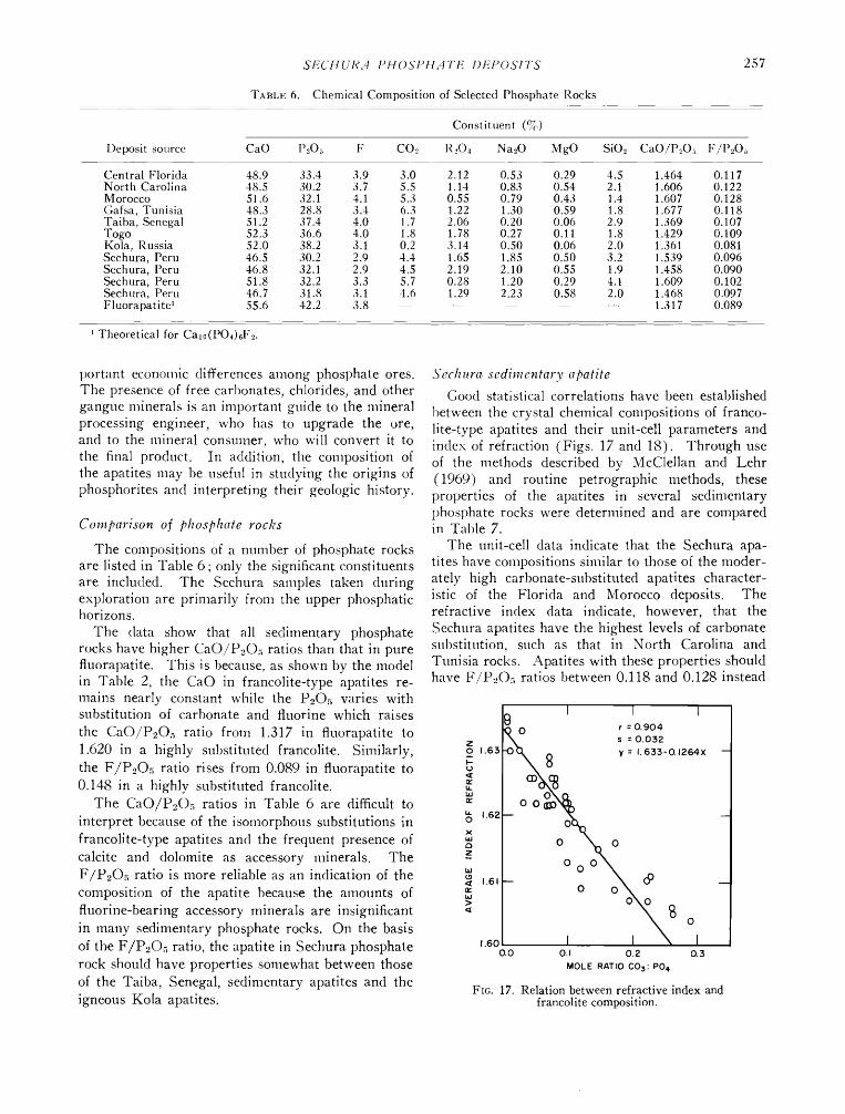
TABLE 6.
SECttUR.q PttOSPH.qTE DEPOSITS
Chemical Composition of Selected Phosphate Rocks
257
Deposit source CaO
Constituent (%)
P20:, F CO.• R._,Oa Na20 MgO SiO2 CaO/P•Oa F/P.,Oa
Central Florida 48.9 North Carolina 48.5 Morocco 51.6 Gafsa, Tunisia 48.3 Taiba, Senegal 51.2 Togo 52.3 Kola, Russia 52.0 Sechura, Peru 46.5 Sechura, Peru 46.8 Sechura, Peru 51.8 Sechnra, Peru 46.7 Fluorapatite • 55.6
33.4 3.9 3.0 2.12 0.53 0.29 4.5 1.464 0.117 30.2 3.7 5.5 1.14 0.83 0.54 2.1 1.606 0.122 32.1 4.1 5.3 0.55 0.79 0.43 1.4 1.607 0.128 28.8 3.4 6.3 1.22 1.30 0.59 1.8 1.677 0.118 37.4 4.0 1.7 2.06 0.20 0.06 2.9 1.369 0.107 36.6 4.0 1.8 1.78 0.27 0.11 1.8 1.429 0.109 38.2 3.1 0.2 3.14 0.50 0.06 2.0 1.361 0.081 30.2 2.9 4.4 1.65 1.85 0.50 3.2 1.539 0.096 32.1 2.9 4.5 2.19 2.10 0.55 1.9 1.458 0.090 32.2 3.3 5.7 0.28 1.20 0.29 4.1 1.609 0.102 31.8 3.1 4.6 1.29 2.23 0.58 2.0 1.468 0.097 42.2 3.8 ..... 1.317 0.089
Theoretical for Ca•o(PO4)6F2.
t)ortant econ.omic differences among phosphate ores. The presence of free carbonates, chlorides, and other gangtie minerals is an important guide to the mineral processing engineer, who has to upgrade the ore, and to the mineral consumer, who will convert it to the final product. In addition, the composition of the apatites may be useful in studying the origins of phosphorites and interpreting their geologic history.
Comparison of phosphate rocks
The compositions of a number of phosphate rocks are listed in Table 6; only the significant constituents are included. The Sechura samples taken during exploration are primarily from the upper phosphatic horizons.
The data show that all sedimentary phosphate rocks have higher CaO/PuOa ratios than that in pure fluorapatite. This is because, as shown by the model in Table 2, the CaO in francolite-type apatites re- mains nearly constant while the P2Oa varies with substitution of carbonate and fluorine which raises
the CaO/P2Oa ratio from 1.317 in fluorapatite to 1.620 in a highly substituted francolite. Similarly, the F/P20.• ratio rises from 0.089 in fluorapatite to 0.148 in a highly substituted francolite.
The CaO/P2Oa ratios in Table 6 are difficult to interpret because of the isomorphous substitutions in francolite-type apatites and the frequent presence of calcite and dolomite as accessory minerals. The F/P20.• ratio is more reliable as an indication of the composition of the apatite because the amounts of fluorine-bearing accessory minerals are insignificant in many sedimentary phosphate rocks. On the basis of the F/P2Oa ratio, the apatite in Sechura phosphate rock should have properties somewhat between those of the Taiba, Senegal, sedimentary apatites and the igneous Kola apatites.
3'echura sedimentary apatite Good statistical correlations have been established
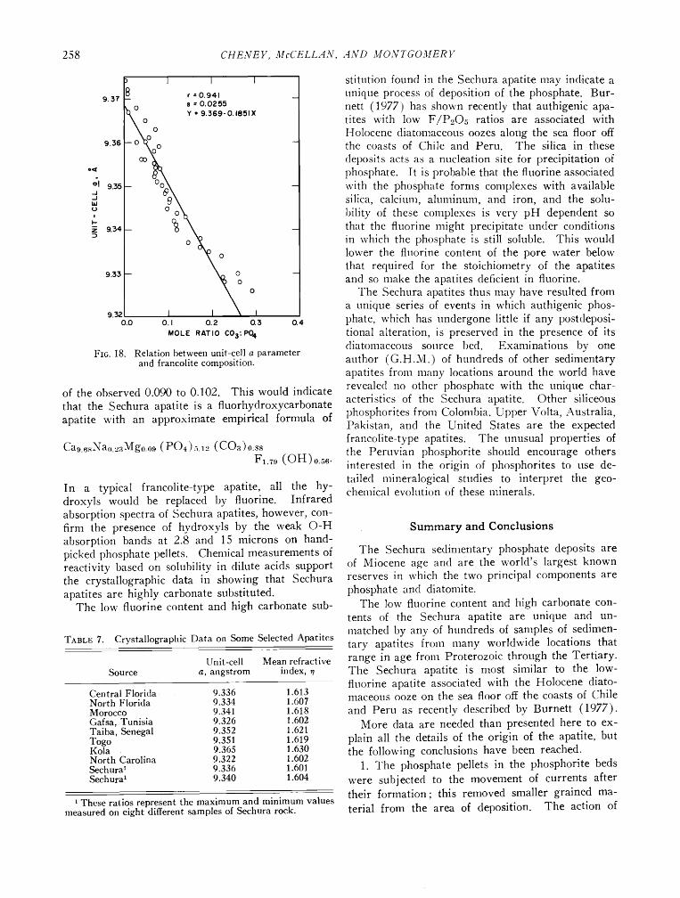
between the crystal chemical compositions of franco- lite-type apatites and their unit-cell parameters and index of refraction (Figs. 17 and 18). Through use of the methods described by McClellan and Lehr (1969) and routine petrographic methods, these properties of the apatites in several sedimentary phosphate rocks were determined and are compared in Table 7.
The unit-cell data indicate that the Sechura apa- tites have compositions similar to those of the moder- ately high carbonate-substituted apatites character- istic of the Florida and Morocco deposits. The refractive index data indicate, however, that the Sechura apatites have the highest levels of carbonate substitution, such as that in North Carolina and Tunisia rocks. Apatites with these properties should have F/P20.• ratios between 0.118 and 0.128 instead
I I I 1
• •'s•mrk• X 8 •: •.s•-o.•s4x
g o o
ø ø ¸ • ,.s,- o o• •
,.so I m N 0.0 0.• 0.2 0.•
MOLE RATIO COs: PO 4
Fro. ]7. Relation between refractive index and francolite composition.
258 CHENEY, McCELL.4N, .4ND MONTGOMERV
I I I
8 r -- 0.941 _ 9.37 --
s = 0.0255
•,•0 0 Y = 9.369-0.1851X 9.36 --Oco•• 0 -
_ O• _
-- O(••O -- 9.33 - I I • - o o
9.3z I 0.0 O. I 0.• 0.3 0.4
MOLE R•TIO CO$:PO 4
Fro. 18. Relation between unit-cell a parameter and francolite composition.
9.35
9.34
of the observed 0.090 to 0.102. This would indicate that the Sechura apatite is a fluorhydroxycarbonate apatite with an approximate empirical formula of
Ca9 6•Nao 2aMgo o9 (PO4).•.,', (COa)o.s8 Fa.79 (OH)o.56.
In a typical francolite-type apatit. e, all the hy- droxyls would be replaced by fluorine. Infrared absorption spectra of $echura apatites, however, con- firm the presence of hydroxyls by th.e weak O-H absorption bands at 2.8 and 15 microns on hand- picked phosphate pellets. Chemical measurements of reactivity based on solubility in dilute acids support the crystallographic data in showing that $echura apatites are highly carbonate substitut.ed.
The low fluorine content and high carbonate sub-
T^m.E 7. Crystallographic Data on Some Selected Apatites
Unit-cell Mean refractive Source a, angstrom index, •
Central Florida 9.336 1.613 North Florida 9.334 1.607 Morocco 9.341 1.618 Gafsa, Tunisia 9.326 1.602 Taiba, Senegal 9.352 1.62l Togo 9.351 1.619 Kola 9.365 1.630 North Carolina 9.322 1.602 Sechura • 9.336 1.601 Sechura • 9.340 1.604
• These ratios represent the maximum and minimum values measured on eight different samples of Sechura rock.
stitution found in the Sechura apatit. e may indicate a unique process of deposition of the phosphate. Bur- nett (1977) has shown recently that authigenic apa- tites with low F/P205 ratios are associated with Holocene diatomaceous oozes along the sea floor off the coasts of Chile and Peru. The silica in these
deposits acts as a nucleation site for precipitation of phosphate. It is probable that the fluorine associated with the phosphate forms complexes with available silica, calcium, aluminuln, and iron, and the solu- bility of these complexes is very pH dependent so that the fluorine might precipitate under conditions in which the phosphate is still soluble. This would lower the fluorine content of the pore water below that required for the stoichiometry of the apatites and so make the apatites deficient in fluorine.
The $echura apatites thus may have resulted from a unique series of events in which authigenic phos- phate, which has tlndergone little if any postdeposi- tional alteration, is preserved in the presence of its diatomaceous source bed. Examinations by one author (G.H.M.) of hundreds of other sedimentary apatites from many locations around the world have revealed no other phosphate with the unique char- acteristics of the $echura apatite. Other siliceous phosphorites from Colombia, Upper Volta, Australia, Pakistan, and the United States are the expected francolite-type apatites. The unusual properties of the Peruvian phosphorite should encourage others interested in the origin of phosphorites to use de- tailed mineralogical studies to interpret the geo- chemical evolution of these minerals.
Summary and Conclusions
The Sechura sedimentary phosphate deposits are of Miocene age and are the world's largest known reserves in which the two principal components are phosphate and diatonfite.
The low fluorine content and high carbonate con- tents of the $echura apatite are unique and un- matched by any of hundreds of samples of sedimen- tary apatites from many worldwide locations that range in age from Proterozoic through the Tertiary. The $echura apatite is most similar to the low- fluorine apatite associated with the Holocene diato- maceous ooze on the sea floor off the coasts of Chile and Peru as recently described by Burnett (1977).
More data are needed than presented here to ex- plain all the details of the origin of the apatite, but the following conclusions have been reached.
1. The phosphate pellets in the phosphorite beds were subjected to the movement of currents after their formation; this removed smaller grained ma- terial from the area of deposition. The action of
SECHUR•t PHOSPHATE DEPOSITS 259
currents is demonstrated by (a) the differences in sorting of the phosphorite pellets in the individual beds; a higher degree of sorting is accompanied by a higher P2On content, i.e., more pellets and less fine- grained interpellet dilutants, (b) tangential contacts of pellets, (c) erosional basal contacts of phosphor- ites with diatomites, and (d) local cross-bedding.
2. The diatomites and phosphatic diatomites were formed in areas subjected to much less current move- ment as evidenced by smaller grain size, poorer sort- ing of contained pellets, and planar basal contacts of diatomite with phosphorite.
3. Tectonism was taking place to a significant de- gree in the area as evidenced by the folding and erosion before deposition of the Clam Bore Sand- stone and the presence of tuffs which indicate vul- canism in nearby areas.
Acknowledgments
Many people contributed directly to the success of the initial exploration. Chief among these were the late George L. Nicol, Edward $. Montgomery, Dr. Alberto Benevides, Dr. Charles F. Park, Jorge Vera Tudela, Joe Huseby, Kathleen Montgomery, and Hugo Ramirez B. Many others gave advice and suggestions that contributed indirectly to the results presented herein, such as Richard P. Sheldon, V. E. McKelvey, and David $. Robertson.
We are particularly indebted to Dr. Donald Ever- hart for his insistence and persistence in convincing us that the data and results presented herein would be of value 15 years after completion of the senior author's work in Sechura.
T. M. C.
R•o DOCE GEOLOGIA E MINERAqXO (DOCEGEO) GRuPo CVRD
RIO DE JANEIRO, BRAZIL G. H. McC.
INTERNATIONAL FERTILIZER DEVELOPMENT CENTER P.O. Box 2040
MUSCLE SHOALS, ALABAMA 35660 E. S. M.
DUVAL CORPORATION 4715 EAST FORT LOWELL
TUCSON. ARIZONa 85712 October 6, 1978
REFERENCES
Altschuler, F. S., Jaffee, E. B., and Cuttitta, Frank, 1956, The aluminum phosphate zone of the Bone Valley Forma- tion, Florida, and its uranium deposits: U. $. Geol. Sur- vey Prof. Paper 300, p. 495-504.
Burnett, W. C., 1977, Geochemistry and origin of phosphorite deposits from off Peru and Chile: Geol. Soc. America Bull., v. 88, p. 813-823.
Lehr, J. R., McClellan, G. H., Smith J.P., and Frazier, A. W., 1967, Characterization of apatites in commercial phos- phate rocks: Colloque International sur Les Phosphates Mineraux Solids, Toulouse, May 16-20, 1967.
MacDonald, G. H., 1956, Miocene of the Sechura Desert, Piura: Sociedad Geologica del Peru, Primeira Congresso Nacional de Geologia, Tome 30, p. 225-242.
McClellan, G. H., and Gremillion, L. R., 1976, Evaluation of Phosphatic Raw Materials: The role of phosphorus in Agriculture, joint TVA-ASA-CSSA-SSSA symposium, June 1-3, 1976, Muscle Shoals, Alabama.
McClellan, G. H., and Lehr, J. R., 1969, Crystal chemical investigation of natural apatites: Am. Mineralogist, v. 54, p. 1374-1391.
Moore, P. B., 1973, Pegmatite phosphate: Descriptive min- eralogy and crystal chemistry: Mineralog. Record, v. 4, p. 103-130.
Trueman, N. A., 1965, The phosphate, volcanic and car- bonate rocks of Christmas Island (Indian Ocean): Geol. Soc. Australia Jour., v. 12, p. 261-283.