riddells creek structure plan - mrsc.vic.gov.au
TRANSCRIPT

Macedon Ranges Shire Council
Riddells Creek Structure Plan September 2013

Parsons Brinckerhoff
Document information
Client: Macedon Ranges Shire Council Title: Riddells Creek Structure Plan Document No: Date: August 2013
Rev Date Details
B 22/07/2013 E Lichkus
C 27/08/2013 E Lichkus
D 06/09/2013 E Lichkus
Author, Reviewer and Approver details
Prepared by:
Emma Lichkus/Peter Dawson
Date: 30/04/2013 Signature:
Reviewed by: Trevor Budge
Date:
30/04/2013 Signature:
Approved by:
Peter Dawson
Date: 30/04/2013 Signature:
Distribution
Macedon Ranges Shire Council , Parsons Brinckerhoff file
©Parsons Brinckerhoff Australia Pty Limited 2013
Copyright in the drawings, information and data recorded in this document (the information) is the property of Parsons Brinckerhoff. This document and the information are solely for the use of the authorised recipient and this document may not be used, copied or reproduced in whole or part for any purpose other than that for which it was supplied by Parsons Brinckerhoff. Parsons Brinckerhoff makes no representation, undertakes no duty and accepts no responsibility to any third party who may use or rely upon this document or the information.
Document owner
Parsons Brinckerhoff Australia Pty Limited ABN 80 078 004 798 Level 15 28 Freshwater Place Southbank VIC 3006 Australia Tel: +61 3 9861 1111 Fax: +61 3 9861 1144 Email: [email protected] www.pbworld.com Certified to ISO 9001, ISO 14001, AS/NZS 4801 A GRI Rating: Sustainability Report 2011

Macedon Ranges Shire Council | Riddells Creek Structure Plan
| i
Contents Page number Page number
Executive Summary iii
Part A: Riddells Creek Structure Plan 1
1. The Riddells Creek Structure Plan Purpose 2
1.1 Study Area, Structure Plan Area and Town Boundary 3
1.2 Existing Context - Neighbourhood Character 3
1.3 Existing Zones 4
2. Vision, Principles and Directions 5
2.1 Vision 5
2.2 Key Themes 5
2.3 Development Framework Plan 5
2.4 Principles 7
2.4.1 Theme 1: Character and role of the town centre 7
2.4.2 Theme 2: Residential development and housing choice 9
2.4.3 Theme 3: Employment, commercial and industrial development 14
2.4.4 Theme 4: Open Space, Natural Systems and Heritage Features 15
2.4.5 Theme 5: Utilities and Infrastructure 17
2.4.6 Theme 6: Environmental Sustainability 18
3. Implementation 19
3.1 Strategies and actions 19
3.2 Zones and Overlays 19
3.2.1 Development Plan Overlay 19 3.2.2 Development Contributions Plan Overlay 20
3.3 Development contributions 20
3.4 Planning Scheme Amendments 20
3.5 Reference Documents 23
3.6 Incorporated Documents 23
3.7 Monitoring and review 23
3.8 Implementation table 24
Part B: Background Report, Riddells Creek Structure Plan 27
1. Regional role, environment and existing context 28
1.1 Metropolitan and regional context 28
1.2 Local context and surrounds 29
1.3 Land use, topography and environmental values 29
1.4 Watercourses, flooding and drainage 30

Macedon Ranges Shire Council | Riddells Creek Structure Plan
| ii
1.5 Population demographics 30
1.6 Heritage and culture 30
1.7 Employment 31
1.8 Transport and parking 32
1.9 Recreation and community facilities 32
1.10 Dwelling types 33
1.11 Bushfire 33
1.12 Infrastructure 34
2. Policy context 35
2.1 Macedon Ranges Settlement Strategy 35
2.2 Strategic direction 35
2.3 Directions for Riddells Creek 39
3. Community and stakeholder engagement 40
3.1 Overview 40
3.2 Community workshops / Character walk 41
3.3 Stakeholder feedback 43
3.4 Submissions received and further correspondence 44
4. Strengths, Weaknesses, Opportunities and Threats – SWOT Analysis 45
4.1 Overview 45
4.2 SWOT Analysis 45
5. Strategic Directions 51
5.1 Neighbourhood Character 51
5.2 Vision 52
5.3 Principles and Directions 52
5.3.1 Character and role of the town centre 52 5.3.2 Residential development and housing
choice 53 5.3.3 Employment, commercial and industrial
development 54 5.3.4 Open Space, Natural Systems and Heritage
Features 55 5.3.5 Utilities and infrastructure 56 5.3.6 Environmental Sustainability 57
6. Planning for Riddells Creek – Strategic Response 59
6.1 Options 59
6.2 Option Assessment 61
6.3 Summary 61
List of appendices Appendix A Existing Planning Zones Appendix B Design Guidelines

Macedon Ranges Shire Council | Riddells Creek Structure Plan
| iii
Executive Summary The Riddells Creek Structure Plan (the Structure Plan) has been prepared by Parsons Brinckerhoff on behalf of the Macedon Ranges Shire Council with input from the local community, Councillors, key stakeholders, government agencies and service providers. The Structure Plan provides the long term vision for the future development of Riddells Creek until 2036 and sets out the framework as to how this vision will be achieved.
The Structure Plan has been developed through:
an analysis of the existing policy context
the preparation of a Neighbourhood Character Study
the preparation of a constraints and opportunities assessment
an extensive consultation process.
Outcomes of this process have identified the overall vision for Riddells Creek and a set of guiding principles which are set out in Part A, Section 2.2.
In addition, a Development Contributions Plan (DCP) has been prepared for the Riddells Creek locality. The DCP will assist with providing funding for infrastructure investments in line with this Structure Plan.
The Draft Structure Plan was placed on public exhibition in May 2013. Submissions received were considered, and where relevant, the document was updated. Details in relation to the key submissions received and the changes made are outlined in Part B, Section 3 of this Structure Plan.
This Structure Plan has two parts:
Part A: contains the vision, the guiding principles and the development framework for Riddells Creek, which is to be used as a guide for decision making in regards to the future development of the township.
This Structure Plan has been developed around the following six key themes:
1. Character and role of the town centre
2. Residential development and housing choice
3. Employment, commercial and industrial development
4. Open space, natural systems and heritage features
5. Utilities and infrastructure
6. Environmental sustainability
The Structure Plan provides a framework for planning and development in the Riddells Creek locality over the next 20 plus years. A series of strategies have been identified to provide a basis for future decision making and a series of actions to implement the Structure Plan. This includes recommendations for key Planning Scheme Amendments, further supporting strategic work and further liaison with key authorities and infrastructure providers.
Part B: contains the context, strategic and policy background, option analysis and details of community consultation that informed the development of this Structure Plan.

Macedon Ranges Shire Council | Riddells Creek Structure Plan
| iv Note: This Development Framework Plan was amended when the Structure Plan was adopted by Council 23/12/2013 - see Appendix C for the adopted version.

Macedon Ranges Shire Council | Riddells Creek Structure Plan
| 1
Part A: Riddells Creek Structure Plan

Macedon Ranges Shire Council | Riddells Creek Structure Plan
| 2
1. The Riddells Creek Structure Plan PurposeThe purpose of the Riddells Creek Structure Plan (the Structure Plan) is to provide the long term vision for the future development of Riddells Creek until 2036 and set out the framework as to how this vision will be achieved.
Over the past 20 years the population of Macedon Ranges Shire has increased as a result of a range of factors including; improvements in transport connections and an increasing preference for the rural lifestyle that the Shire has to offer. These trends are placing pressures on the Shire’s natural and physical resources.
In response, the Macedon Ranges Shire Council (MRSC) completed the Settlement Strategy 2011 (Settlement Strategy) which sets a framework for managing the Shire’s future growth. The Settlement Strategy established a clear hierarchy of urban settlements, from Regional Centres through to Small Towns and Localities. The role of Riddells Creek will change from a ‘small local commuter town’ to a ‘District Town’, accommodating a population of approximately 6,000 people by 2036. This would be an increase of approximately 2,200 persons from its current population of 3,753 persons1. Macedon Ranges Planning Scheme Amendment C84 will introduce the recommendations from the Settlement Strategy into the Planning Scheme.
The Structure Plan seeks to meet these directives by providing for population growth in a logical and ‘planned’ manner, but which is also flexible, allowing for growth which is respectful and commensurate with the preferred character features and values of the township.
1 ABS Census Data, 2011
Photo 1.1 Road reserve avenue planting on Merrifield Street
Photo 1.2 Housing reflective of a consistent neighbourhood

Macedon Ranges Shire Council | Riddells Creek Structure Plan
| 3
Figure 1-1 Riddells Creek Study Area, Structure Plan Area and Town Boundary
1.1 Study Area, Structure Plan Area and Town Boundary
The Study Area is the area identified in the Settlement Strategy and encompasses approximately 3,715 ha bound by Riddells Creek to the south, Macedon Regional Park to the north-west and farming land to the north and east.
The Structure Plan Area is smaller than the Study Area, comprising approximately 1,318 ha and includes land to the north and south of the railway. The Structure Plan Area has been determined based on the vision and principles set out in this Structure Plan.
The Township Boundary shows the extent of the existing township, including the community facilities, retail and commercial areas located along Gisborne-Kilmore Road and Sutherlands Road, and the surrounding residential areas.
Figure 1-1 shows the Study Area, Structure Plan Area and the Township Boundary.
1.2 Existing Context - Neighbourhood Character
Riddells Creek has important built and landscape features which contribute to a distinctive neighbourhood character within its residential, commercial and community areas. The character is strongly derived from the natural landscape setting, of a vegetated backdrop of the Macedon Ranges and deeply incised creek valleys. These elements contribute to both the environmental and visual significance of the town.
The layout of the township has elements such as an underlying grid network of streets, generous vegetated road reserves and centrally located community and civic features that contribute to the formal yet relaxed feel of the town.

Macedon Ranges Shire Council | Riddells Creek Structure Plan
| 4
Within the core town centre area the predominately single storey building form results in a pedestrian scale environment which is legible, easy to move through and has variety.
The townships’ existing residential areas to the north, west and east of the town centre generally consist of dwellings with substantial building setbacks and established gardens. This, together with the expansive road reserves, create streetscapes of visual and environmental value. One of the most recognisable features of the residential areas is the generous size of allotments with dwellings well setback from the road. In the established residential areas the majority of dwellings are of brick or weatherboard construction and are single level.
As Riddells Creek develops over time it will be important to ensure that future growth is not only appropriate to the context, but also reinforces the key attributes that set its character apart from other places. With this in mind, it is not enough to simply say that future development should not ‘detract’ from existing features, but rather future development should physically enhance what is already there.
The local community has identified the importance of the character of the town, being one of the main reasons why people choose to live in Riddells Creek. This Structure Plan seeks to protect the character of the town and residential areas through the application of guiding principles, and design and development controls which reflect the features of the existing context.
To complement the Structure Plan the Preliminary Neighbourhood Character Study has been prepared to identify and assess the existing character features of the area and to make recommendations as to the type and form that future development should take to be consistent with the existing character.
1.3 Existing Zones Riddells Creek town centre consists of a mix of small scale commercial, retail and residential land uses. Land within the town centre is currently zoned
Commercial 1 (C1 Zone) (previously Business 1 Zone) and Commercial 2 (C2 Zone) (previously Business 3 Zone) and Residential 1 Zone (R1Z) under the Macedon Ranges Planning Scheme (the Planning Scheme).
There are smaller areas of Public Park and Recreation Zone (PPRZ), Public Use Zone 1 – Service and Utility (PUZ1) and Public Use Zone 2 – Education (PUZ2) within and surrounding the town centre.
Rural-residential areas to the north and north-west of the town centre are primarily zoned Low Density Residential Zone (LDRZ) and areas to the north-east are zoned Rural Living Zone (RLZ1). To the south of the railway line the gently sloping hills and large vacant lots are a defining feature of the rural landscape. Land within this area is zoned RLZ1 and RLZ5 under the Planning Scheme.
The existing Planning Scheme Zoning map is provided in Appendix A. Details in relation to zoning changes proposed through the implementation of this Structure Plan are provided in Section 3.2.
Photo 1.3 Entrance to Riddells Creek Primary School

Macedon Ranges Shire Council | Riddells Creek Structure Plan
| 5
Photo 2.1 Riddells Creek Railway Station
2. Vision, Principles and Directions2.1 Vision The overall vision for Riddells Creek has been developed through; a review of background material as per previous studies/strategies; the preparation of a Neighbourhood Character Study; the preparation of a constraints and opportunities assessment; and an extensive community consultation process. The Structure Plan vision is as follows:
To provide for the progressive sustainable development of Riddells Creek that enhances its township function, while ensuring that any future development preserves the high environmental, heritage and landscape qualities of the area and reinforces Riddells Creek’s unique character and identity.
2.2 Key Themes A set of guiding principles have been developed based on the Riddells Creek vision and will be used as a basis of determining the appropriateness of development and for directing future infrastructure and service investments.
These principles are focused on the following six themes: 1. Character and role of the town centre2. Residential development and housing choice3. Employment, commercial and industrial development4. Open space, natural systems and heritage features5. Utilities and infrastructure6. Environmental sustainabilityThe following sections outline the key principles, directions and actions. Background information on how these principles have been developed is provided in Part B, Section 5.3 of this Structure Plan.
2.3 Development Framework Plan The Development Framework Plan is based on the vision and principles as set out in the following sections.
All subdivision and development applications will be assessed against the Development Framework Plan. This will provide Council with a guide as to whether it is appropriate for certain areas of land to be developed, taking into account the broader environmental, social and infrastructural impacts.

Macedon Ranges Shire Council | Riddells Creek Structure Plan
| 6 Figure 2-1 Riddells Creek Development Framework Plan
Note: This Development Framework Plan was amended when the Structure Plan was adopted by Council 23/12/2013 - see Appendix C for the adopted version.

Macedon Ranges Shire Council | Riddells Creek Structure Plan
| 7
Photo 2.2 Main Road, single storey building
2.4 Principles 2.4.1 Theme 1: Character and role of the town centre
Overview:
Riddells Creek has a defining village character that provides a separate and ‘unique’ feel compared to other settlements in the Shire. The town centre in particular, plays an important role in establishing this, with the low scale compact commercial and residential development, heritage buildings, generous road reserves and grid layout of streets, creating a relaxed village feel for the town.
The Town Centre Precinct is identified on the Development Framework Plan in Figure 2-1. The area includes a number of small shops and businesses, the Riddells Creek Primary School, a public park as well as the train station and residential land.
The identified strengths of the town centre include the strong urban form and grid layout, compact town centre, wide avenue streets and well located community and civic features. The number of significant heritage buildings and structures located within and surrounding the town centre and train station, which reflect the historical character of the town need to be protected.
The role of the existing commercial centre (particularly the area surrounding Station Street) is to be reinforced, locating commercial development to the existing Commercial Zoned areas.
Principles and Directions about land use are contained in Theme 3. The Town Centre Area is defined in Development Framework Plan. The Town Centre Design Guidelines in Appendix B apply to this area.

Macedon Ranges Shire Council | Riddells Creek Structure Plan
| 8
Figure 2-2 Insert from the Town Centre Design Guidelines
Principle:
New commercial and infrastructure developments within the ‘Town Centre Precinct’ must demonstrate how they will reinforce the village character and role of Riddells Creek.
Directions: Ensure that new commercial/retail development and community facilitiesare located within the town centre.
Provide a high amenity urban environment that is consistent with theTown Centre Area Guidelines including active frontages to streets, as wellas public access and permeability between buildings.
Ensure that new developments are of a form and scale compatible withthe existing town centre development.
Actions:
Prepare a Riddells Creek Town Centre Master Plan.
Introduce provisions into the Planning Scheme that require newdevelopments to demonstrate compliance with the Town Centre AreaDesign Guidelines.
Encourage development and consolidation of commercial, retail andcommunity uses within the town centre in accordance with theDevelopment Framework Plan.
Encourage the development of uses such as of child care and medicalservices, education, and community facilities and complimentary uses toserve the growing population in the existing Commercial 2 Zone.Investigate whether any rezoning is required to facilitate the developmentof this area.

Macedon Ranges Shire Council | Riddells Creek Structure Plan
| 9
Photo 2.3 Dwelling within the Low Density Residential area
2.4.2 Theme 2: Residential development and housing choice
Overview:
The local community has highlighted the importance of the peaceful, rural lifestyle contributing to the distinctive neighbourhood character and the relaxed village ‘feel’ of the town. The natural bush setting back-dropped by forested hills and a deeply incised creek valley contribute to the environmental and visual significance of the area.
The townships’ existing residential areas to the north, west and east of the town centre generally consist of substantial building setbacks and established gardens, which together with the expansive road reserves, create streetscapes of visual and environmental value. One of the most recognisable features of the residential areas is the generous size of allotment with dwellings well setback from the road. In the established residential areas the majority of dwellings are of brick or weatherboard construction and are single level.
Many of the residential areas of Riddells Creek are within a Low Density Residential Zone, and are not connected to mains sewer. The areas north and north west of the township have been identified as being of high risk of ember attack from fire, and therefore not suitable for more intensive development.
As part of the preparation of this Structure Plan, four main growth scenarios were explored (explained in the Riddells Creek Structure Plan Background Report). This analysis has guided the development of the Residential Framework Plan which identifies the preferred locations for growth, and management of change in order to accommodate the projected population growth of the town.
Design Guidelines for the Town Centre Residential Precinct, and the Low Density Residential Precinct are contained in Appendix B. The Preliminary Neighbourhood Character Study April 2013 (and subsequent versions) will be
used to guide planning decisions for new subdivision and development in Riddells Creek.
The local community has identified the importance of the character of the town, being one of the main reasons why people choose to live in Riddells Creek. Equally, the lack of housing diversity has led to concerns that future generations will not be able to afford to settle in the township or that there will be limited accommodation options for people wanting to downsize. To complement the Structure Plan a Preliminary Neighbourhood Character Study has also been prepared which will guide future decisions regarding residential development for Riddells Creek.
A Residential Framework Plan identifying the different residential precincts is provided in Figure 2-3 on page 10.

Macedon Ranges Shire Council | Riddells Creek Structure Plan
| 10
Figure 2-3 Riddells Creek Residential Framework Plan Note: This Residential Framework Plan was amended when the Structure Plan was adopted by Council 23/12/2013 - see Appendix D for the adopted version.

Macedon Ranges Shire Council | Riddells Creek Structure Plan
| 11
Principles:
Promote increased housing densities in appropriate locations in the ‘Town Centre’ and ‘Town Centre Residential Precinct’.
Provide for a range of residential development opportunities within the ‘Priority Residential Development Precinct’ that increases housing diversity and provides greater housing choice.
Residential development located within the ‘Limited Infill Potential Precinct’ and the ‘Priority Residential Development Precinct’ must be of a form and scale compatible with the existing residential character of adjoining and nearby areas.
Directions:
Provide a residential environment that is consistent with the DesignGuidelines contained in Appendix B.
Protect the urban and rural character and amenity of the residential areas.
Consolidate residential growth and development.
Carefully manage infill development in the Limited Infill Area to ensurethat it is complementary to and enhances the character of these areas.
Ensure any new development in the Low Density Residential Area hasregard to fire risk and environmental considerations.
Allow for a range of lot sizes, housing types and lifestyle opportunities tomeet the needs of the community.
Encourage accommodation above/behind commercial uses in the existingCommercial 2 Zone in Sutherlands Road.
Encourage the investigation of the area south of the railway for the futurelong term (20-30 years) residential growth.
Actions:
Implement the Residential Framework Plan and Design Guidelines intothe Planning Scheme via Clause 21 and appropriate tools.
Investigate and implement the Victorian Reformed Residential Zoneswithin Riddells Creek.
Consult with the CFA on applications for new development in the LowDensity Residential Area.
Support development proposals that provide increased housing choice (ie,units, semi-detached dwellings and townhouses) within the ‘Town Centre’and ‘Town Centre Residential Precinct’ as defined in the ResidentialFramework Plan.
Undertake the strategic work to support the rezoning of land and apply theDevelopment Plan Overlay to the Priority Residential DevelopmentPrecinct.
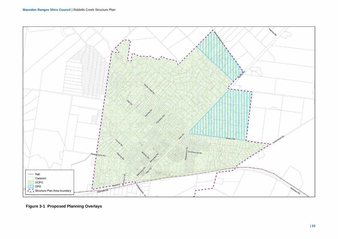
Investigate the application of the Development Plan Overlay to the northeast area of Mount Charlie Road (as shown in Figure 3-1).
Levy development contributions from new Greenfield/Infill development tofund infrastructure.
Investigate the suitability and costs for the development of the area southof the railway as a long term (20-30 years) ‘Future Investigation Area’.
Use the Neighbourhood Character Study to inform and guide decisionmaking for planning applications for subdivision and development inRiddells Creek.
Monitor population growth within the Structure Plan area to ensure thatthere is a sufficient supply of land.

Macedon Ranges Shire Council | Riddells Creek Structure Plan
| 12
Priority Development Precinct
This precinct is the focus for the majority of projected growth in Riddells Creek. A Development Plan Overlay is to be applied. Further investigations as to the suitable zoning and detailed layout of the area needs to be undertaken. A preliminary Indicative Development Plan is included at Figure 2-4.

Macedon Ranges Shire Council | Riddells Creek Structure Plan
| 13
Figure 2-4 Indicative Development Plan

Macedon Ranges Shire Council | Riddells Creek Structure Plan
| 14
2.4.3 Theme 3: Employment, commercial and industrial development
Overview:
Riddells Creek currently provides most of the retail facilities and products to meet the basic needs of local residents through the existing supermarket and speciality shops. As the township grows additional retail, commercial and community facilities will be required.
The Riddells Creek Town Centre is identified on Figure 2-5. There is adequate commercial zoned land to provide for growth in commercial and retail uses.
The community has identified the desire for additional community facilities (public and private), such as medical centres and services, child care and education facilities. These uses are encouraged to locate in the area nominated for potential town expansion. A mix of retail, commercial, civic and community uses are encouraged in the identified town centre commercial core. There are some limited opportunities for residential development above or behind retail or commercial premises.
There is a parcel of vacant Commercial 2 Zoned land located within the town centre to the north of Sutherlands Road (as identified in Theme 1 and Figure 2-5). Uses such as child care and medical services, education andcommunity facilities, aged care and accommodation uses are encouraged inthis location.
The existing Industrial 1 Zoned land is currently underutilised, however contains some modest industrial/light industrial operations. Businesses which service local needs, and are appropriate to the location may develop here over time. Larger scale industrial uses are encouraged to locate to Gisborne and Kyneton.
The Town Centre Design Guidelines in Appendix B apply to this area.
Figure 2-5 Location of commercial and retail activities

Macedon Ranges Shire Council | Riddells Creek Structure Plan
| 15
Principles:
Commercial, employment and industrial land use should meet the demands of the local community, reinforce the role of the town centre and be integrated into the existing township.
Directions:
Promote the role of the town centre as the retail, commercial and civiccore which meets the needs of the local community.
Allow for a range of commercial, retail and industrial land usesappropriately located within the township.
Investigate the location for a small neighbourhood centre in the ‘PriorityResidential Development Precinct’ to provide for the basic needs of thelocal residents. The centre would be limited to a convenience shop andancillary uses.
Protect the role of the existing Industrial 1 Zoned land.
Action:
Encourage the establishment of commercial, community and lightindustrial use and development within the town centre in accordance withthe Development Framework Plan.
Investigate the rezoning of the Commercial 2 Zoned land. Encourageuses such as child care and medical services, education and communityfacilities, aged care and accommodation in this location.
2.4.4 Theme 4: Open Space, Natural Systems and Heritage Features
Overview:
The environmental and heritage features of the Riddells Creek locality are of significant value to the community. These include: the areas of remnant vegetation; roadside planting; waterway corridors; open spaces; and heritage buildings/structures. These features play a significant role in establishing the character and rural nature of the area and also provide recreational opportunities. The local community has identified the need to protect these features and better integrate them within the existing township. Provision of pedestrian and cycling paths along waterway corridors is one example as to how access to the open space areas can be enhanced.
The Development Framework Plan identifies open space corridors and future pedestrian/cycle links along the Riddells Creek waterway. It is recognised that this Creek is intrinsic to the character of the area and should be protected. While this land is currently privately owned, it is envisioned that over time Council or Melbourne Water may purchase land surrounding the Creek to develop these corridors.
Principles:
Protect, restore and enhance the open spaces, existing natural and historic features and landscape values of the area. Provide attractive, safe and functional open spaces that integrate with the township and existing waterway corridors.
Facilitate the development of a network of walking and cycling trails to serve the community and to link with existing features and facilities within the township.
Directions:
Encourage development that is consistent with the Design Guidelines.
Provide well integrated open space corridors.

Macedon Ranges Shire Council | Riddells Creek Structure Plan
| 16
Protect the existing streetscape character through retention of streettrees.
Encourage developments which provide effective landscape treatments,enhancing the amenity of the town centre, residential and rural-residentialareas.
Protect and enhance the visual amenity and environmental features ofroad and waterway corridors.
Encourage the development of open space corridors withpedestrian/cycling linkages along existing waterways and around thetownship.
Require developments within the proposed Development Plan Overlayareas to provide open space networks.
Actions:
Developments must be undertaken in accordance with the DesignGuidelines. These guidelines include requirements for landscapingtreatments.
Investigate the potential to include an Environmental Significance Overlay(ESO) over watercourses within Riddells Creek to protect theenvironmental values through the Planning Scheme framework.
Implement a pedestrian and cycle network by investigating opportunitiesto define land for this purpose.
Undertake a review of the existing VPO to identify areas/road corridorsthat are not currently included within the VPO but which requireprotection. Amend the VPO as required.
Ensure roadside and waterway corridor vegetation is regularly maintainedand re-vegetation undertaken (when required).
Require developments within the proposed Development Plan Overlayareas to provide open space networks.
Figure 2-6 Pedestrian and Cycle Plan.

Macedon Ranges Shire Council | Riddells Creek Structure Plan
| 17
2.4.5 Theme 5: Utilities and Infrastructure
Overview:
Some areas of Riddells Creek are not suitable for future development due to infrastructural capacity, environmental features or future provision constraints. Any future residential or commercial development proposals should demonstrate how the necessary utilities and services (water, sewerage, gas, electricity and road) can be provided and how the costs of the provision can be met by the developer and through the DCP.
The future operation of intersections and roads in the area will depend on where development occurs and the type and form that development takes. It is noted that traffic volumes at the Sunbury-Riddells Creek Road and Gisborne-Gilmore Road intersection are already high (4687 vehicles per day) and any development to the south of the railway will increase the number of vehicles travelling through this intersection as there is only one road access to the town centre from the south. While it is recognised that development to the north of the railway within the Priority Residential Development Precinct will result in an increase in number of vehicles travelling along the Gisborne-Kilmore Road (with currently 4137 vehicles per day), there are other road connections which may be used to access the town centre which would assist in dissipating the traffic impacts (eg, Amess Road, Racecourse Road and Sutherlands Road).
Analysis of traffic impacts will need to be undertaken at the time of planning for the development to identify any required road or intersection upgrades. Full cost benefit assessments of any necessary additional infrastructure are required to determine if there are wider benefits to the community.
The local community has identified the need to improve the pedestrian and cycling linkages throughout the township and provide better access to social and recreational facilities and the residential areas. This will help to achieve a more sustainable, integrated and walkable community, increase safety and reduce the need for further car parking within the town centre and residential streets.
Principles:
New developments to provide for appropriate infrastructure and meet the requirements of the Development Contributions Plan.
Community facilities should meet the demands of the local community and reinforce the role of the town centre as the civic core. Achieve a well-connected and mobile community through all modes of transport.
Directions:
Ensure that infrastructure cost implications of development proposalshave been adequately investigated and can be met for the development.
Levy development contributions from new greenfield/infill development tofund infrastructure through the Development Contributions Plan
Ensure that the car parking demands of the local community areadequately met.
Enhance pedestrian and cycling linkages between open spaces,residential areas and commercial land uses.
Encourage the development and locating of community uses to the landcurrently zoned Commercial 2 in the Town Centre.
Actions:
Finalise a movement network study to promote the development of apedestrian and cycling network in and around the town.
Planning requests for rezoning, subdivision and development mustaddress the relevant infrastructure requirements for futuresubdivisions/development proposals including transport and access,provision of electricity, potable water, gas, telecommunications andsewerage.

Macedon Ranges Shire Council | Riddells Creek Structure Plan
| 18
Apply the Development Contributions Plan (DCP) to levy funding ofinfrastructure including roads and pedestrian/cycle linkages.
Undertake ongoing assessment of community needs and services,particularly in relation to community infrastructure and health.
Facilitate and promote the provision of adequate car parking spaces inand around the railway station and in the town centre through monitoringand review of demand and supply.
2.4.6 Theme 6: Environmental Sustainability
Overview:
Environmental sustainability is taken to mean processes or procedures which will also contribute to sustaining and enhancing the quality of the social economic and natural environment on a long term basis.
It is now widely recognised that social and economic objectives cannot be considered in isolation. The local environment, being the built form, the natural features and the regional context play an important role in contributing to, and the achievement of the social and economic goals of an area. By the same token, it is important to consider the social and economic context when identifying and working towards specific environmental goals.
Principle:
New residential and commercial developments within Riddells Creek should encourage the development of a walkable, self-sufficient community, which promotes sustainable living practices, protects the environmental values of the area and addresses potential climate change (bushfire and flooding) impacts.
Directions:
Promote the development of a walkable community, where people areable to access local services and facilities by walking or cycling from theirhome.
Promote the development of a self-sufficient town centre where residentsare able to access the majority of their basic needs.
Consider long term implications of new developments including climatechange impacts (ie, bushfire risks and flooding impacts) and mitigationmeasures.
Protect and enhance the environmental values of the area including flora,fauna and waterways.
Protect any cultural heritage values identified through site specificinvestigations.
Actions:
Promote infill and new development within the existing township andtownship residential area utilising the capacity of existing infrastructure.
Provide for a range of retail, commercial and community land uses withinthe ‘Town Centre Precinct’.
Identify bushfire and flooding risks when considering new subdivision anddevelopment proposals.
Consider potential impacts on biodiversity, flora, fauna and waterwayswhen assessing new subdivision and development proposals.
Promote developments that seek to enhance existing values (eg,vegetation along Creek corridors).
Have regard to cultural heritage requirements for assessments,particularly along waterways.

Macedon Ranges Shire Council | Riddells Creek Structure Plan
| 19
3. Implementation 3.1 Strategies and actions The Structure Plan provides a framework for planning and development in the Riddells Creek locality over the next 20 plus years with a series of strategies identified to provide a basis for future decision making and actions to implement the Plan.
The initial method of implementation of this Structure Plan will be through the Planning Scheme. This requires the preparation of a Planning Scheme Amendment (PSA) to include the Structure Plan’s strategic directions. This process will also include:
Updating the Municipal Strategic Statement to reflect the directions of this Structure Plan. This will include updating the existing Riddells Creek Township Structure Plan in Clause 21.13-5 of the MSS2.
Further strategic work required to assess the suitability of sites.
A table summarising all actions is provided on Page 24.
3.2 Zones and Overlays One of the key implementation tools of the Structure Plan is rezoning of particular areas of land and the provision of overlays which are consistent with the Development Framework Plan.
On 1 July 2013 the Department of Transport Planning and Local Infrastructure (DTPLI) introduced changes to the existing suite of residential zones. This included introducing new zones, removing some zones and amending the provisions of other zones. The revised suite of residential zones includes:
2 Clause 21.13-5 of Planning Scheme Amendment (PSA) C84 replaces Clause 220.02-5.
Low Density Residential Zone (LDRZ)
Neighbourhood Residential Zone (NRZ)
General Residential Zone (GRZ)
Residential Growth zone (RGZ)
Township Zone (TZ)
Mixed Use Zone (MUZ)
Council has 12 months from 1 July 2013 to introduce the new residential zones into the planning scheme.
In addition, on the 15th July 2013 changes to the Business Zones were introduced into the Victoria Planning Provisions. In all cases land zoned Business 1, Business 2 and Business 5 has now been converted to the Commercial 1 Zone and land zoned Business 3 has been converted to the Commercial 2 Zone.
3.2.1 Development Plan Overlay
The Structure Plan supports the retention of the existing overlays within Riddells Creek including the Vegetation Protection Overlay (VPO), the Heritage Overlay (HO), the Land Subject to Inundation Overlay (LSIO) and the Bushfire Management Overlay (BMO/WMO).
It is recommended that a Development Plan Overlay (DPO) be placed over land within the ‘Priority Residential Development Precinct’ to ensure that development is undertaken in a comprehensive and consistent manner. This will require landholders and developers to prepare a Development Plan before Council can issue any permits for the future subdivision and development of

Macedon Ranges Shire Council | Riddells Creek Structure Plan
| 20
land. An indicative layout for the ‘Priority Residential Development Precinct’ is provided in Figure 2-4 (page 12).
A DPO is also recommended to apply to land in the northern area of the Riddells Creek Structure Plan area, south of Mount Charlie Road, which is currently zoned LDRZ.
A plan showing the Proposed Planning Overlays is in Figure 3.1 on page 23.
3.2.2 Development Contributions Plan Overlay
It is recommended that a Development Contributions Plan Overlay (DCPO) be introduced to apply to all land within the Structure Plan area. This will be based upon the Development Contributions Plan (DCP) to be prepared.
The Development Contributions Plan will identify the contributions required in the form of payments or in-kind works for civic infrastructure improvements.
The purpose of the DCP is to:
Itemise the infrastructure to be provided within Riddells Creek toaccommodate additional forecast growth.
Calculate development contributions applicable to new developmentbased on a share of usage, and
Provide instruction and administrative procedures.
This DCP will form part of the Macedon Ranges Planning Scheme andshould be read in conjunction with it.
3.3 Development contributions It is anticipated that new residential/low density development will occur over time within Riddells Creek. There is an opportunity to seek development contributions in the form of payments or in-kind works for civic infrastructure improvements. This may include roads, bicycle or pedestrian paths, lighting, stormwater infrastructure and open space and community facilities.
In summary a DCP:
Sets out the levies required for new developments to fund plannedinfrastructure investments. A DCP is binding on both the Council andlandholders (developers) and monies must be spent by Council on itemsfor which the money was collected for. The DCP sets out a framework forwhat projects are required, the costs of each project, when it will bedelivered and what is Council’s contribution and the landholdercontribution.
Has the advantage of providing for funding of infrastructure which maynot be directly part of the development. For example, where adevelopment affects land outside the immediate subdivision areas (i.e. anintersection that requires upgrading due to the increase in trafficgenerated by the subdivision), Council can justify the request for thedeveloper to contribute to pay for such an upgrade.
In practice is used to charge new development for its share ofinfrastructure cost. On this basis, existing development is not chargedthrough this funding tool, but is used in the calculation of charges. Inmost cases existing development will benefit from the infrastructureproject and in this context the Council bears the funding ‘gap’.
3.4 Planning Scheme Amendments The primary planning instrument to implement this Structure Plan is through the Macedon Ranges Planning Scheme. This will ensure that any future planning decisions, development and/or subdivision proposals meet the long term vision and principles outlined in this Structure Plan.
It is noted that a range of planning tools will be introduced into the Planning Scheme to implement the directions and guiding principles outlined in this Structure Plan.
Once it has been confirmed that a particular site or area is suitable for rezoning, the relevant Planning Scheme Amendment (PSA) documentation will need to be prepared. Where the Development Plan Overlay has been applied, collaboration between Council and landowners may be required. It is

Macedon Ranges Shire Council | Riddells Creek Structure Plan
| 21
envisaged that some rezoning proposals will be put forward to the Council by developers and landholders (ie. developer led) rather than initiated through Council. At this time discussions with the DTPLI will need to be undertaken to confirm support and authorisation for preparation of the PSA. Justification to support the rezoning will need to provided, which will be based on the relevant assessments and analysis. If required the PSA will go through a Panel Hearing process. The Panel will make recommendations and advise whether the amendment should proceed.
Macedon Ranges Shire Council | Riddells Creek Structure Plan
| 22
Figure 3-1 Proposed Planning Overlays

Macedon Ranges Shire Council | Riddells Creek Structure Plan
| 23
3.5 Reference Documents It is proposed that the adopted version of the Structure Plan should be included as a Reference Document to the Planning Scheme. The supporting Preliminary Neighbourhood Character Study will be completed, adopted and is also intended to be a Reference Document.
3.6 Incorporated Documents The Riddells Creek Development Contributions Plan will become an Incorporated Document in the Schedule to Clause 81 of the Planning Scheme.
3.7 Monitoring and review In order to ensure the effectiveness and future relevance of this Structure Plan it is necessary for regular monitoring to be undertaken to assess its performance against the overall vision and guiding principles of this Structure Plan.
This Structure Plan has been prepared with a 20 plus year horizon, while acknowledging that changes in demand are likely to occur and that the Plan must be responsive and adaptive over time. Therefore, it is necessary that several forms of monitoring be carried out during the implementation period of this Plan. These forms of monitoring include the following:
Review and updating of the Structure Plan to ensure its strategicdirections remain up to date. The Structure Plan should be reviewedinitially in 5 years time from when the Structure Plan is adopted byCouncil to include an examination of trends in the residential andcommercial area land up-take and development. It should also include ananalysis of needs and opportunities, the management of land useconflicts in the region and changes in legislation and land managementpractices that may require examination of specific directions andrecommendations.
Review of Planning Scheme zones, overlay controls and policies toensure that the desired outcomes of the Structure Plan are beingsuccessfully implemented. This should be conducted with Council’sStatutory Planners and include a review of Council’s success innegotiating (including VCAT) positive development outcomes.
Providing additional guidance on key sites as required.
Monitoring of land uses and activity within the Structure Plan area.
Ongoing assessment of community needs and services, particularly inrelation to services and community facilities.

Macedon Ranges Shire Council | Riddells Creek Structure Plan
| 24
3.8 Implementation table Timeframes
Immediate within <1 year
Short-term within 1-5 years
Medium term within 5 -10 years
Long-term within 10+ years
Table 3.1 Implementation Table
Principles Directions Actions Statutory Instrument / Non-statutory instrument
Commencement & Duration (months)
Organisation Responsible
General Provide for the implementation of this Structure Plan through statutory provisions within the Planning Scheme
1. Introduce new provisions in the MSSin the Macedon Ranges PlanningScheme which implements thedirections and actions of theStructure Plan.
Planning Scheme Amendment
Immediate
12-18 months
MRSC, DTPLI
Theme 1. Character and Role of the Town Centre
New commercial and infrastructure developments within the ‘Town Centre Precinct’ must demonstrate how they will reinforce the village character and role of Riddells Creek.
Ensure that new commercial/retail development and community facilities are located within the town centre.
2. Prepare a Riddells Creek TownCentre Masterplan.
3. Encourage development andconsolidation of commercial, retailand community uses within the towncentre in accordance with theDevelopment Framework Plan.
4. Encourage the development of usessuch as child care and medicalservices, education and communityfacilities and complementary uses inthe existing Commercial 2 Zone.Investigate whether any rezoning isrequired to facilitate the developmentof this area.
Strategic Study Immediate
12-18 months
MRSC
Provide a high amenity urban environment that is consistent with the Town Centre Area Guidelines, including active frontages to streets, as well as public access and permeability between buildings.
Ensure that new developments are of a form and scale compatible with the existing town centre development.
5. Introduce provisions into thePlanning Scheme that require newdevelopments to demonstratecompliance with the Town CentreArea Design Guidelines.
Planning Scheme Amendment
Immediate
12-18 months
MRSC
Theme 2. Residential Development and Housing Choice Housing Choice
Promote increased housing densities in appropriate locations in the ‘Town Centre Residential Precinct’.
Provide for a range of residential development opportunities within the ‘Priority Residential Development Precinct’ that increases housing diversity and provides greater housing choice.
Residential development located within the ‘Limited Infill Potential Precinct’ and the ‘Priority Residential Development Precinct’ must be of a form and scale compatible with the existing residential character of adjoining and nearby areas.
Provide a residential environment that is consistent with the Design Guidelines contained in Appendix B.
Encourage accommodation above/behind new commercial uses in the existing Commercial 2 Zone in Sutherlands Road
6. Implement the ResidentialFramework Plan and Designguidelines into the Planning Schemevia Clause 21 and appropriate tools.
7. Investigate and implement theVictorian Reformed ResidentialZones within Riddells Creek.
Planning Scheme Amendment
Immediate
12-18 months
MRSC, DTPLI
Consolidate residential growth and development ‘Priority Residential Development Precinct’.
8. Undertake the strategic work tosupport the rezoning of land andapply the Development Plan Overlayto the Priority ResidentialDevelopment Precinct.
9. Levy development contributions fromnew Greenfield/Infill development tofund infrastructure.
Strategic Planning Project
Short Term MRSC with landowners
Allow for a range of lot sizes, housing types and lifestyle opportunities to meet the needs of the community.
10. Support development proposals thatprovide increased housing choice (ie,units, semi-detached dwellings andtownhouses) within the ‘Town CentrePrecinct’ and ‘Town CentreResidential Precinct’.
N/A N/A N/A
Protect the urban and rural character and amenity of the residential areas.
11. Use the Neighbourhood CharacterStudy to inform and guide decisionmaking or planning applications forsubdivision and development inRiddells Creek.
12. Investigate the application of theDevelopment Plan Overlay to thenorth east area of Mount CharlieRoad (as shown in Figure 3-1).
Strategic Planning Project followed by Planning Scheme Amendment.
Immediate MRSC
Carefully manage infill development in the Limited Infill Potential Precinct to ensure that it is complementary to and enhances the character of these areas.
Ensure any new development in the Low Density Residential Area has regard to fire risk and environmental considerations.
13. Consult the CFA on applications fornew development in the Low DensityResidential Area.
Internal Council protocol
Immediate MRSC

Macedon Ranges Shire Council | Riddells Creek Structure Plan
| 25
Principles Directions Actions Statutory Instrument / Non-statutory instrument
Commencement & Duration (months)
Organisation Responsible
14. Monitor population growth within the Structure Plan area to ensure that there is a sufficient supply of land.
N/A Medium to long term
MRSC
Encourage the investigation of the area south of the railway line for future long term (20-30 years) residential growth.
15. Investigate the suitability and costs for the development of the area south of the railway as a long term (20-30 years) ‘Future Investigation Area’.
Medium to long term
Developers (with support from MRSC)
Theme 3 Employment, commercial and industrial development
Commercial, employment and industrial land use should meet the demands of the local community, reinforce the role of the town centre and be integrated into the existing township.
Promote the role of the town centre as the retail, commercial and civic core which meets the needs of the local community. Allow for a range of commercial, retail and industrial land uses appropriately located within the township. Investigate the location for a small neighbourhood centre in the ‘Priority Residential Development Precinct’. The centre would be limited to a convenience shop and ancillary uses. Protect the role of the existing Industrial 1 Zone land.
16. Encourage the establishment of commercial, community and light industrial use and development within the town centre in accordance with the Development Framework Plan.
17. Investigate the rezoning of the
Commercial 2 Zoned land. Encourage uses such as child care and medical services, education and community facilities, aged care and accommodation in this location.
Refer Action 2 and Action 5.
N/A N/A
Theme 4
Open spaces, natural systems and heritage features
Protect, restore and enhance the open spaces, existing natural and historic features and landscape values of the area.
Provide attractive, safe and functional open spaces that integrate with the township and existing waterway corridors.
Facilitate the development of a network of walking and cycling trails to serve the community and to link with existing features and facilities within the township.
Encourage development that is consistent with the Design Guidelines. Provide well integrated open space corridors. Encourage the development of open space corridors with pedestrian/cycling linkages along existing waterways and around the township. Require developments within the proposed Development Plan Overlay areas to provide open space networks. Provide well integrated open space corridors.
18. Developments must be undertaken in accordance with the Design Guidelines. These guidelines include requirements for landscaping treatments.
Refer Action 2. N/A N/A
19. Investigate the potential to include an Environmental Significance Overlay (ESO) over watercourses within Riddells Creek to protect the environmental values through the Planning Scheme framework.
Planning Scheme Amendment (if required)
Medium 5-10 years
MRSC
20. Implement a pedestrian and cycle network by investigating opportunities to define land for this purpose.
N/A Medium 5-10 years
MRSC
21. Require developments within the proposed Development Plan Overlay areas to provide open space networks.
Planning Scheme Amendment (As per Action 8)
Short Term MRSC with landowners
Protect the existing streetscape character through retention of street trees. Encourage developments which provide effective landscape treatments, enhancing the amenity of the town centre, residential and rural-residential areas. Protect and enhance the visual amenity and environmental features of road and waterway corridors.
22. Undertake a review of the existing VPO to identify areas/road corridors that are not currently included within the VPO but which require protection. Amend the VPO as required.
Planning Scheme Amendment (if required)
Medium 5-10 years
MRSC to undertake review of VPO
23. Ensure roadside and waterway corridor vegetation is regularly maintained and re-vegetation undertaken (when required).
N/A
Ongoing Medium 5-10 years
MRSC to maintain roadside vegetation
Theme 5
Utilities and Infrastructure
Achieve a well-connected and mobile community through all modes of transport.
Enhance pedestrian and cycling linkages between open spaces, residential areas and commercial land uses.
24. Finalise a movement network study to promote the development of a pedestrian and cycling network in and around the town.
Movement Network Study
Short Term
MRSC
New developments to provide for appropriate infrastructure and meet the requirements of the Development Contributions Plan.
Ensure that infrastructure cost implications of development proposals have been adequately investigated and can be met for the development. Levy development contributions from new greenfield/infill development to fund infrastructure through the Development Contributions Plan.
25. Planning requests for rezoning, subdivision and development must address the relevant infrastructure requirements for future subdivisions/development proposals including transport and access, provision of electricity, potable water, gas, telecommunications and sewerage.
N/A Ongoing Developers to liaise with utility and service providers
26. Apply the Development Contributions Plan (DCP) to levy funding of infrastructure including roads and pedestrian/cycle linkages.
Development Contributions Plan to be completed as part of this project.
Immediate
Consultants with MRSC as part of this project
Ensure that the car parking demands of the local community are adequately met.
27. Facilitate and promote the provision of adequate car parking spaces in and around the railway station and in the town centre through monitoring and review of demand and supply.
N/A Ongoing MRSC
Community facilities located within the ‘Infill Potential Precinct’ and
Encourage the development and locating of community uses to the land currently zoned Commercial 2 within the Town Centre area.
28. Undertake ongoing assessment of community needs and services, particularly in relation to community infrastructure and health.
N/A Medium – long term
MRSC

Macedon Ranges Shire Council | Riddells Creek Structure Plan
| 26
Principles Directions Actions Statutory Instrument / Non-statutory instrument
Commencement & Duration (months)
Organisation Responsible
the ‘Priority Residential Development Precinct’ should meet the demands of the local community and reinforce the role of the town centre as the civic core.
Theme 6 Environmental Sustainability
New residential and commercial developments within Riddells Creek should encourage the development of a walkable, self-sufficient community, which promotes sustainable living practices, protects the environmental values of the area and addresses potential climate change (bushfire and flooding) impacts.
Promote the development of a walkable community, where people are able to access local services and facilities by walking or cycling from their home.
29. Promote infill and new developmentwithin the existing township andtownship residential area utilising thecapacity of existing infrastructure withcapacity.
Refer Action 2. N/A N/A
Promote the development of a self-sufficient town centre where residents are able to access the majority of their basic needs.
30. Provide for a range of retail,commercial and community landuses within the ‘Town CentrePrecinct’ and the ‘Priority ResidentialDevelopment Precinct’. This shouldinclude services and facilities thatcater for the everyday needs of thelocal residents (eg, local store).
Refer Action 2 above.
N/A N/A
Consider long term implications of new developments including climate change impacts (ie, bushfire risks and flooding impacts) and mitigation measures.
31. Identify bushfire and flooding risksconsidering new subdivision anddevelopment proposals.
N/A Ongoing MRSC and developers
Protect and enhance the environmental values of the area including flora, fauna and waterways.
Protect any cultural heritage values identified through site specific investigations.
32. Consider potential impacts onbiodiversity, flora, fauna andwaterways when assessing newsubdivision and developmentproposals. Promote developmentsthat seek to enhance existing values(eg, vegetation along Creekcorridors).
33. Have regard to cultural heritagerequirements, particularly alongwaterways.
N/A Ongoing MRSC and developers
Macedon Ranges Shire Council | Riddells Creek Structure Plan
| 27
Part B: Background Report, Riddells Creek Structure Plan

Macedon Ranges Shire Council | Riddells Creek Structure Plan
| 28
1. Regional role, environment and existing context 1.1 Metropolitan and regional context Over the past 20 years, the Macedon Ranges Shire has seen a rapid increase in population as a result of: improvements in road and rail infrastructure; expansion of the Melbourne metropolitan urban boundary; changing work practices and technology; and changes in lifestyle choice with a growing desire for small town and rural-residential lifestyles. While there is an increasing demand for development in the Shire, there is also a general desire by local residents to maintain the character that is reflective of the agricultural land use, the environmental qualities of the Shire, small towns and settlements and low-density residential development. It is anticipated that the majority of population growth in the Shire will continue to occur in the southern and eastern parts of the Shire, in and around the townships of Gisborne, Riddells Creek and Romsey and Kyneton in the north. One of the main objectives of the Shire as detailed in the Municipal Strategic Statement (MSS) which forms part of the Macedon Ranges Planning Scheme, is the need to “concentrate the future urban development in the Shire’s major urban centres and limit the expansion of smaller less accessible communities” (Clause 21.07-1)3.
The Shire’s natural and physical resources play an important role in the economic and social well-being of the Shire. The Shire is recognised for its significant natural and built features (ecological, landscape and heritage) and it will be important to ensure that any new development responds to these qualities and assists in maintaining these values. These features contribute
3 Note that Planning Scheme Amendment C84 proposed changes to Clause 21.07 and introduces recommendation from the Planning Scheme review and the Macedon Ranges Settlement Strategy. While it is proposed to amend Clause 21.07-1, the principle of consolidating urban development within existing centres is still evident in the proposed clauses. In particular Clause 21.04-1 of Amendment C84 seeks to “Ensure urban development is located within existing township areas where adequate services are available”. Amendment C84 went on public exhibition on the 6/11/2012. A decision is yet to be made.
strongly to tourism and recreation, which have become important elements of the economy.
Riddells Creek is located in the southern part of the Macedon Ranges Shire and is approximately 45km northwest of the Melbourne Central Business District (CBD) and 10km to the east of Gisborne. The township is located on the Melbourne to Bendigo railway line, which provides direct access to Bendigo to the north and metropolitan Melbourne to the south. Road access is also provided to the nearby towns of Gisborne, Sunbury and Romsey.
Farming and agricultural production are important contributors to the Shire’s economy. This includes broad scale cropping, grazing and timber plantations. However, it is noted that traditional farming practices are declining with more intensive agricultural activities such as horticulture and viticulture becoming more prevalent. It will be important to ensure that any new development does not impact on productive agricultural land.
In response to these recent changes and recognising the need to plan for expected growth, the MRSC recently completed the Macedon Ranges Settlement Strategy (the Settlement Strategy). The Settlement Strategy projected population growth in Riddells Creek to approximately 6,000 persons between 2006 and 2036 based on current trends. The Settlement Strategy incorporates environmental constraints, community aspirations and government policy to set the direction for accommodating this population growth. The Settlement Strategy also identifies the growth drivers that exist throughout the region including: the regional transport corridor; the ability to commute to Melbourne; and the attractive rural and semi-rural environment that the towns have to offer. Against these drivers of growth, there are numerous constraints including bushfire risk and infrastructure provision which will be important considerations for the implementation of the Riddells Creek Structure Plan.

Macedon Ranges Shire Council | Riddells Creek Structure Plan
| 29
The Settlement Strategy establishes a clear hierarchy of urban settlements with Gisborne identified as the main town in the Shire. Riddells Creek, Romsey and Kyneton are identified as Large Towns while Lancefield and Woodend are listed as District Towns. It notes that Riddells Creek, presently a commuter settlement with a current population of 3,753 people, could become a self-sustained township with a predicted population of 6,000 people by 2036, while relying on other nearby towns for major community facilities (i.e. hospital and secondary school). Under the Settlement Strategy towns are to accommodate sufficient residential, business and industrial land to provide for population increases over time and to ensure that land supply does not constrain economic development.
It is important that this Structure Plan recognises and addresses these trends to ensure that the overall plan for Riddells Creek is reflective of this regional context set by the Shire Council.
1.2 Local context and surrounds Originally established adjacent to the railway line to Northern Victoria in the Nineteenth Century, Riddells Creek also became a site for a workers camp during the building stages of Lancefield Road and Gisborne. Over time the town and surrounding area also became a popular tourist destination, with people drawn to the Macedon Ranges and the attractive rural setting. The improved provision of rail services and upgraded roads further increased population through the Twentieth Century and the town is still growing today.
The nearest major town to Riddells Creek is Gisborne, about 10 km to the west, with a population of 7,289 persons (2011 Census). Gisborne provides the main services for many parts of the Shire, including educational and recreational facilities. Kyneton, the second largest town in the Shire with 6,629 people provides an important employment, retail and service role for the Shire and also provides essential community and social service facilities such as a hospital, sports and aquatic centre.
Romsey, located to the north-east, approximately 13km from Riddells Creek has a current population of 4,412 people (2011 Census). Like Riddells Creek, the population is expected to grow, with an anticipated population of 6,000 people by 2036. At present Romsey has a range of retail businesses however, employment within the town in limited and there is a high level of commuting to surrounding towns and Melbourne.
1.3 Land use, topography and environmental values
The Structure Plan covers approximately 1,318 ha including the Riddells Creek town centre and land north and south of the railway.
There are three main entrances to the town: one from the west along Gisborne-Kilmore Road; one to the north-east from Gisborne-Kilmore Road; and one from the south on Sunbury-Riddells Creek Road. These entrances provide views towards the Macedon Ranges and the surrounding rural landscape.
The northern extent of the Riddells Creek locality is situated at the base of the Macedon Ranges and sits elevated above the town. To the south of Gisborne-Kilmore Road the town’s landform slopes down gently in a southerly direction. The gently sloping hills and large vacant lots to the south of the railway line are a defining feature of the rural landscape.
A Vegetation Protection Overlay (VPO) applies to land to the north of the study area, south of the Macedon Ranges and to roadside vegetation along the section of Gisborne-Kilmore Road north of Sandy Creek Road. There are however other areas of significant vegetation including roadside planting and riparian vegetation along the watercourses which are also worthy of protection due to their contribution to the visual and ecological features of the area.
The Department of Environmental and Primary Industries (DEPI) Ecological Vegetation Classes (EVCs) mapping shows that EVCs are dispersed throughout the RCSP area, located along Riddells Creek, other watercourses

Macedon Ranges Shire Council | Riddells Creek Structure Plan
| 30
and to the south of the Macedon Regional Park. Further site investigations will be required to confirm the presence of, the location and the significance (conservation status) of the EVCs identified in the area. These investigations will need to be undertaken prior to development proposals being put forward to Council to determine the potential impact on ecological values.
1.4 Watercourses, flooding and drainage
There are a number of watercourses that traverse the Shire and which largely shape the topography and environmental features of the landscape. Of note is the Riddells Creek watercourse which flows in an easterly direction through the town and passes under Gisborne-Kilmore Road and the Melbourne-Bendigo railway line. Sandy Creek and Dry Creek flow in a north to south direction, towards the eastern edge of the township. Jacksons Creek is located along the southern boundary of the Structure Plan area and also forms the southern boundary of the Shire.
Low lying areas surrounding Riddells Creek, Sandy Creek and Dry Creek are prone to flooding with these areas identified as being ‘Land Subject to Inundation’ (LSIO) in the Planning Scheme Maps and/ or included within Melbourne Water’s 100 year ARI flood event mapping. This is shown in Figure 4-2 in Section 4. Other than these areas, flooding is not considered to be a major issue for the Riddells Creek locality.
1.5 Population demographics Riddells Creek as defined by the Australian Bureau of Statistics (ABS) covers an area of approximately 83.3 sq kms. As there are no data sets that cover the exact area corresponding to this Structure Plan, the ‘state suburb’ definition as used by ABS has been used as a basis for demographic information for this Structure Plan. The statistics details are as follows:
As at the 2011 Census, Riddells Creek had a total population of 3,753 persons.
The median age of the area was recorded at 39, being lower than the median age of 41 for the Macedon Ranges Shire as a whole.
The current age structure of the Riddells Creek community has only 9% of the population within the 65 plus age group and 36% of the population is below the age of 24 years.
The average household size in Riddells Creek was recorded at 3 person per household, compared to the Macedon Range Shire with an average of 2.7 persons per household.
The population forecasts provided in the Settlement Strategy estimate that the total population will increase by 2,200 people by 2036, taking the population to 6,000 people. These forecasts were reviewed by SGS Economics and Planning and findings confirmed the Settlement Strategy forecasts. The SGS report concludes that approximately 57 ha of additional land is required to be released for future growth to provide for the population target under the Settlement Strategy.
1.6 Heritage and culture There are a number of significant European heritage and cultural heritage items located within and in close proximity to Riddells Creek. In particular, there are three items of heritage significance which are listed on the Victorian Heritage Register (VHR). These are; the rail bridge, the road over the rail bridge and the former Smiths nursery, as identified in Table 1.1.

Macedon Ranges Shire Council | Riddells Creek Structure Plan
| 31
Table 1.1 Heritage sites included on the Victorian Heritage Register
Table 1.2 Heritage sites included on the Macedon Ranges Heritage overlay
There are also multiple local heritage items identified within the Heritage Overlay under the Planning Scheme including Walter Smith Reserve, the Railway Station, St Johns Anglican Church and Bolinda Park.
These are identified in Table 1.2. In addition to these, the Dromkeen homestead, located near the corner of Amess Road and Main Road was previously occupied by the Dromkeen National Gallery for Picture Book Art. The Gallery has relocated and the future use of the site is not yet known. While not included on any heritage listings, the site is recongised by the local community for its character and heritage.
There are two areas of cultural heritage sensitivity identified within the RCSP area: one following the Riddells Creek corridor and the other following the Sandy Creek corridor. Riddells Creek is also identified as being located within Wurundjeri Tribe Land and is within the Loddon Mallee Aboriginal Affairs Victoria Region. Consequently, any works within these areas are subject to the requirements of the Aboriginal Heritage Act 2006, requiring the preparation of Cultural Heritage Management Plans (CHMPs) and a Cultural Heritage Permit for activities that may harm Aboriginal cultural heritage.
1.7 Employment Within the Riddells Creek locality at the 2011 census there were 2,114 persons (over 15 years of age) employed. The main employment industries for people living in the locality are construction (22% of people employed within this industry), transport, postal and warehousing (13% of people employed within this industry), closely followed by manufacturing (12%). It should be noted that this
VHR Identifier
Title Description Address Level of Significance
H2060 Former Smiths Nursery
Established in 1863 and was one of the state’s earliest plant nurseries
721 Kilmore Road, Riddells Creek
Registered
H1437 Rail Bridge Single span semi-circular arched stone structure bridge constructed in 1859
Over Riddells Creek Registered
H1828 Road over rail bridge
Opened in five stages from 1859 to 1864
Gisborne-Kilmore Road, Riddells Creek
Registered
HO Identifier
Title Address Level of Significance
HO82 Milbrook, also Smiths Nursery Kilmore Road, Riddells Creek State (H2060), Local
HO276 St Johns Anglican Church 1-7 Melvin Road, Riddells Creek Local
HO215 Rail bridge over Riddells Creek Railway Reserve State (H1437), Local
HO214 Bridges Echuca to Melbourne Railway
Railway Reserve Local
HO84 Walter Smith Reserve Gisborne Kilmore Road Local
HO277 Yeomans House Station Street Local
HO230 Riddells Creek Mechanics Institute Hall
Sutherlands Road Local
HO87 Riddells Creek Railway Station and Goods Shed, Echuca Melbourne Railway
Hamilton Street Local
HO229 Bolinda Park Sutherlands Road Local

Macedon Ranges Shire Council | Riddells Creek Structure Plan
| 32
represents people who live in Riddells Creek but may work outside the township or the Shire. Data from the 2006 Census indicates that 60% of Riddells Creek’s labour force commutes to Melbourne for work (note that this data was not collected for the 2011 Census). The main mode of travel to work is car (79%), followed by train (10%).
1.8 Transport and parking Riddells Creek is situated directly adjacent to the Melbourne to Bendigo rail line, with the Calder Freeway located approximately 9 km to the west of the town. The Sunbury-Riddells Creek Road and Gisborne-Kilmore Road provide access to Riddells Creek from the south, east and west. Sunbury-Riddells Creek Road carries about 4,687 vehicles per day and connects Riddells Creek with Sunbury to the south. The Gisborne-Kilmore Road which runs in a southwest-northeast direction and connects to Gisborne and Monegeetta carries about 4,137 vehicles per day. Both of these roads are one lane in each direction and are controlled by VicRoads. Second order roads in the area include Sutherlands Road and Amess Road, with the rest of the road network comprising local roads, under the control of Macedon Shire Regional Council. The majority of these roads are sealed, however several are gravel and adequate for only low vehicle traffic volumes.
Public transport to and from Riddells Creek is provided via train, with services operated by V/Line. Travel to Melbourne via train from Riddells Creek takes approximately one hour. A V/Line bus service also connects Riddells Creek to Lancefield. The only other bus services the local school.
Pedestrian facilities such as footpaths within Riddells Creek are generally limited and have been identified as an issue by local residents. Two pedestrian crossings are provided on the Gisborne-Kilmore Road, however there is poor visibility (for pedestrians and vehicles) at the main pedestrian crossing and this presents a safety issue. In addition, many roads in the area do not have footpaths and there is also no cycle network provided within Riddells Creek.
A recent survey of car parking within Riddells Creek, undertaken in preparation of this Structure Plan, found that demand does not exceed supply in the majority of areas within the township during most times of the day. However, the impact on parking demand will depend on the type and form of development supported through the Structure Plan process. For example, if Riddells Creek is to be promoted as a self-sufficient town then car parking demand around the shops and services is likely to increase.
Public Transport Victoria (PTV) has stated that there is sufficient car parking available at the train station to serve existing and future demand based on a population of 6,000 people. PTV has advised that they are about to commence the development of a Network Development Plan for the regional public transport network. This will consider park and ride facilities at the train station.
1.9 Recreation and community facilities Community facilities within Riddells Creek are limited. There is one primary school (Riddells Creek Primary School), located in the eastern end of the town centre and no secondary school.
The Department of Education and Early Childhood Development (Department of Education) has advised that when planning for new government schools, the general policy is:
One primary school for typically 3,000 households
One secondary school for every 10,000 houses (approximately 3 feederprimary schools).
The Department of Education is currently undertaking a secondary school provision study for the eastern part of the Macedon Ranges Shire. Initial contact with the Department of Education has indicated that any new secondary school for the east of the Shire is unlikely to be located within Riddells Creek.

Macedon Ranges Shire Council | Riddells Creek Structure Plan
| 33
There is a pre-school and a kindergarten located on separate sites within the town centre and an early learning school located to the north of Gisborne-Kilmore Road, on the western approach to the town centre. The site of the kindergarten is limited in size and future expansion of this facility may result in it relocating or acquiring more land. There is also one community hall (senior citizen hall), provided within the town centre on Gisborne-Kilmore Road and a post office located to the west of the hall.
The Riddells Creek Recreation Reserve on Sutherlands Road provides sporting and recreation facilities, with multiple sporting and recreation clubs utilising the park for various events throughout the year. This includes the local Australian Football Club, junior Australian Football Club, the local Cricket Club and the local Tennis Club. Two children’s playgrounds and a skate park are also provided by Council, located at Main Road, and within the Recreation Reserve on Sutherlands Road. In addition, there is a Pony Club (Riddells Creek Pony Club) which is located on the corner of Sutherlands Road and Websters Road.
A general practitioner and maternal and child health care centre are also located within the Riddells Creek town centre. For all other medical, community and social service facilities residents are required to travel to Gisborne, Kyneton and Sunbury.
1.10 Dwelling types The vast majority of properties within Riddells Creek consist of detached dwellings with these making up 90% of the housing stock within Riddells Creek (1,202 out of a total of 1,239 private occupied dwellings). This is a significantly higher proportion than the State of Victoria or nationally with these averages being 78% and 81% respectively. Riddells Creek also has a low proportion of one bedroom dwellings (0.4%) compared with Victoria (5%) and nationally (5%). It also has a lower proportion of two bedroom dwellings(4%) compared with Victoria (19%) and nationally (19%). As a result, the number of dwellings with four or more bedrooms is high (50%), compared with Victoria (26%) and Nationally (30%). Only 34 units/flats were
recorded in Riddells Creek in the 2011 census with no semi-detached, row or terraced houses. The housing stock in the town is primarily geared to families with children.
1.11 Bushfire Bushfire has been identified as a particular risk for Riddells Creek. Land to the north of the town centre is included within the Bushfire Management Overlay (BMO/WMO) which identifies areas where the bushfire hazard requires specified bushfire protection measures for subdivision and buildings and works to be implemented.
However, discussions with the CFA has identified that the risk of bushfire within Riddells Creek is much broader. Topography, terrain and vegetation makes the area particularly vulnerable to fire and ember attack. The CFA has noted that the most destructive fires are likely to come from the north and north west and the west. Therefore, land to the north and west of the town centre is at the highest risk of extreme bushfire and ember attack. While extensive clearing of vegetation on the north and western interface could assist in minimising the intensity of an approach fire front, it would not stop a large number of embers falling onto the area. As such these areas have not been identified as suitable for more intensive residential development. The area of potential ember attack is indicatively shown on the Development Framework Plan.
While the CFA notes that land to the east and south of the town centre is also subject to bushfire risk, the likelihood of and intensity of fires in these areas is anticipated to be lower than that of land to the north-west. Land to the east and south of the town centre have some buffering provided from surrounding development which will assist in minimising the spread of fire. However, these areas would still be impacted from ember attack from an intense fire approach from the north-west. These areas have been considered suitable for future growth based on their lower fire risk and this has been noted in Section 6.2 of this Structure Plan.

Macedon Ranges Shire Council | Riddells Creek Structure Plan
| 34
The CFA notes that in planning for new developments it is also important to consider access into and out of the development at a time of fire. Particular consideration needs to be given in terms of fire truck access. Areas with only one access point (into and out of the development) should be avoided. This has been considered in the option analysis when determining areas suitable for future growth (refer Section 6.2 of this Structure Plan).
1.12 Infrastructure An assessment of the existing services and infrastructure capacity was undertaken in preparation of this Structure Plan. In summary it was found that the area has:
Several 100mm and 50mm Telstra conduits, which run along Gisborne-Kilmore Road. The current infrastructure has some capacity toaccommodate future expansion.
A 3ML potable water storage tank north of Riddells Creek which ismanaged by Western Water and provides water supply to the townshiparea. This tank has spare capacity and is able to accommodate anadditional 500 allotments which is equivalent to increasing the populationto 4,900 people. Further investigations will be required.
A 225mm sewer rising main extends from the north-west of the studyarea and passes through the Riddells Creek area and provides sewerreticulation to the township. There is a wastewater treatment plantlocated at the east of the town off Sutherlands Road. The currentwastewater treatment plant has some capacity to accommodateincreases in demand.
A 63mm and 110mm diameter high pressure gas line services thetownship. According to SP AusNet the current assets in the study areahave limited capacity and significant augmentation will be required toaccommodate future growth.
The current fibre optic and telecommunication assets owned by Optus inthe study area are sufficient for growth.
There is no water, sewer or gas reticulation in areas to the south of the railway line and Western Water has advised that a decentralised system will be required. Costs are likely to be around $1,670,000. Melbourne Water has advised that stormwater drainage can be provided locally (ie, drainage channels to the Creek with some localised detention) and that there is no need for a comprehensive drainage scheme in this area.
There are currently two vehicle and pedestrian crossings over the railway providing access to land to the south of the railway: the level crossing at Websters Road; and the grade separated crossing at Sunbury-Riddells Creek Road. However, DPTLI has advised that pedestrian access points or connections across the rail corridor need to be formalised through a grade separated structure (ie, bridge or underpass) primarily for safety reasons. Costs of providing a new pedestrian overpass are likely to be within the vicinity of $4 million. This will be required if development occurs to the south of the railway.
In addition, it is noted that Riddells Creek runs in a southerly direction through the centre of land to the south of the railway. In order for this area to be developed an east to west vehicle bridge crossing would be required to provide access across the Creek, linking to Sunbury-Riddells Creek Road. The costs of providing this bridge are expected to be around $2 million. Long-term a grade separated bridge over the rail will be required to link development areas back to the Riddells Creek town centre. The approximate cost is likely to be between $5 - $15 million.
There is also no water, sewerage or drainage reticulation to land to the north of Amess Road, east of Main Road. Western Water has advised that sewerage and water reticulation could be provided at a cost of approximately $850,000. Melbourne Water has also advised that any future development in this area may require the installation of a Drainage Services Scheme to provide stormwater drainage for this area. The typical cost for the provision of such a scheme is approximately $64,000 per hectare.

Macedon Ranges Shire Council | Riddells Creek Structure Plan
| 35
2. Policy context2.1 Macedon Ranges Settlement
Strategy The Macedon Ranges Settlement Strategy prepared and adopted by the MRSC in July 2011 sets the direction for growth and development of the Macedon Shire over the next twenty years. The Strategy identifies the growth drivers that exist throughout the region, including the regional transport corridors (road and rail), the capacity for residents to commute to Melbourne for work, and the attractive rural and semi-rural environment.
The Strategy specifies a hierarchy of centres, with Gisborne to remain as the main town centre of the Shire with connections to other smaller regional centres and district towns. In particular, the Settlement Strategy recommends growth in Riddells Creek to a population of 6,000 people by 2036. The role of Riddells Creek, which, at present is predominantly a ‘commuter town’, could shift to that of a District Town where the town itself is to be self-sufficient, providing employment opportunities, essential services and variety in accommodation types and sizes.
The Strategy notes that existing residentially zoned land in Riddells Creek could accommodate approximately 4,900 people, however this falls short of meeting the target population by approximately another 1,200 people. Additional land will need to be rezoned and released for more intensive residential purposes to meet the population targets and directives under the Settlement Strategy. The Strategy also notes that in order to achieve this target appropriate planning for growth will need to be undertaken whereby infrastructure and land requirements are investigated and appropriate controls are put in place to protect the character of the existing areas.
The Settlement Strategy notes that there was little opposition to the general concept of growth in Riddells Creek, however there are strong views from the community with regard to the location and form of this development. The retention of the town character and a separation from nearby settlements are critical elements for the Riddells Creek community.
2.2 Strategic direction The State Planning Policy Framework (SPPF), the Municipal Strategic Statement (MSS) and the Local Planning Policy Framework (LPPF) in the Macedon Ranges Planning Scheme set the direction for future growth and development at the state and regional level. The Macedon Ranges Planning Scheme provides a set of strategies and policies and statutory provisions, which control and manage land use change and new development throughout the Shire.
Analysis of the various development objectives under the SPPF and LPPF has identified key themes relevant to the type, form and spatial objectives for Riddells Creek. These are outlined below with discussion provided as to how they apply to Riddells Creek.
It is noted that the Planning Scheme Amendment C84 (Amendment C84) introduces a number of changes to the MSS and the LPPF based on the outcomes of the Settlement Strategy 2011. Amendment C84 was considered by an independent Planning Panel in June 2012 which resulted in an Interim Panel Report being prepared. Recommendations of the Panel Report resulted in a number of changes to the Amendment and these were placed on public exhibition in April – May 2013.
Changes impacting on policy relevant to Riddells Creek are identified in the following section.

Macedon Ranges Shire Council | Riddells Creek Structure Plan
| 36
Settlements
Developing networks of settlements that will support resilient communities and the ability to adapt and change (Clause SPPF 11.05-1)
Preserving and protecting features of rural land and natural resources and features to enhance their contribution to settlements and landscapes (Clause SPPF 11.05-1)
Providing for appropriately located supplies of residential, commercial, and industrial land across a region, sufficient to meet community needs (SPPF 11.05-1)
Maintain the attractiveness and amenity of hinterland towns (SPPF 11.05-2)
Strengthen and enhance the character and identities of towns (SPPF 11.05-2)
The objectives and strategies under the SPPF relating to settlements seek to manage future growth in a sustainable way, by directing development into existing urban areas. In particular, the SPPF seek to ensure that future development appropriately balances growth while ensuring that the features of rural land and resources are protected. Hazards such as bushfire and flooding should also be considered in determining the location and form of development.
The Riddells Creek locality contains a mix of urban and rural living combined with small scale commercial and industrial development. There is an opportunity to consolidate (reduce the spread of urban development and utilise existing space within the current built area) residential land uses and also to expand the commercial and industrial areas to ensure suitable land is available to support the future growth of the town.
In this regard it is important to note that submissions received from the public in response to the Riddells Creek Structure Plan Issues Paper indicated a desire to ensure the town maintains its village style and appeal.
Bushfire and Flooding
Site and design new development to minimise risk to life, property, the natural environment and community infrastructure from natural hazards such as bushfire and flooding (SPPF 11.05-2)
Ensure that strategic and settlement planning assists with strengthening community resilience to bushfire (SPPF 13.05-1).
Riddells Creek is surrounded to the north and north-west by natural bushland and consequently this presents the potential for significant threats to any type of urban development. The planning for Riddells Creek will need to take this into account to increase community resilience and safety. This will be achieved by locating development outside of areas identified by the CFA as being particularly vulnerable to bushfire risks (as previously discussed in Section 1.11).
Flooding risks occur adjacent to the waterways running through the township. Specific development controls outlined in the Planning Scheme will apply to development in flood prone areas. This includes the need for a planning permit to be obtained from Council at which time the susceptibility of the development to flooding and flood damage will be determined.
Built Environment and Heritage
Creating compact neighbourhoods that have walkable distances between activities and where neighbourhood centres provide access to services and facilities to meet day to day needs (SPPF 15.01-3).
The SPPF seeks to consolidate residential development and ensure that future growth is sustainable and compact. Such development presents an opportunity to reduce the reliance on the private motor vehicle and encourage more sustainable forms of travel such as walking and cycling.
The existing town centre of Riddells Creek is relatively small, but there is an opportunity to consolidate the centre through infill, creating a more compact, walkable neighbourhood. This would also reinforce the towns role as the

Macedon Ranges Shire Council | Riddells Creek Structure Plan
| 37
centre of the locality with walkable distances between community facilities, commercial activities and residential land uses.
In addition, the train station, located in close proximity to the town centre also provides the opportunity for the development of a transit-orientated community, with a higher dependence on rail transit as a form of transport. Higher density development around the train station would support this development model, but should consider the existing heritage and neighbourhood character of the area.
Transport
Plan urban development to make jobs and community services moreaccessible by coordinating improvements to public transport, walking andcycling networks with the ongoing development and redevelopment of theurban area (SPPF 18.01-1).
The SPPF seeks to reduce the dependence on the private motor vehicle by co-locating public transport services and facilities, walking and cycling networks. Currently, pedestrian and cycling facilities within Riddells Creek are poor and there is a lack of internal paths connecting facilities and services with the residential areas. Improved linkages would promote better access to shops/services and the train station without the reliance on the private motor vehicle. In addition, promoting these types of transport may also result in less space required for car parking within the town centre and at the train station.
Local Planning Policy Framework
The Municipal Strategic Statement (MSS) is the local strategy and policy to guide growth and development within the Shire. The MSS is presented in the Planning Scheme as part of the LPPF and includes the overall vision as follows:
“to foster economic and cultural diversity, protect natural and cultural heritage assets and creatively enhance attractive and efficient living environments” (MSS 21.06).
The strategic objectives to achieve this vision are centred around the themes of:
Management of urban growth and development
Protection of the environment and landscape
Sustainable rural land management – rural living, environmental livingand agricultural landscapes
Promotion of the Shire’s cultural identity and community values
Encouragement of economic development and tourism
Amendment C84 proposes changes to Clause 21.06. A new Clause (21.03-1) sets out the vision for the Shire and establishes a set of principles based on the themes of Sustainable Living, Community Wellbeing, Sustainable Environment and Infrastructure, Responsible Governance.
In addition, Amendment C84 proposes changes to Clause 22.05 (Townships) by introducing a number of objectives and strategies (through a new Clause 21.13-5) specific to Riddells Creek and the directions from the Settlement Strategy. These are as follows:
Objective 1:
To protect the township’s landscape character, setting and prominentview lines to the surrounding hills.
Strategies:
Ensure new development is confined within established boundaries,especially to the west and north of the town, pending the outlinedevelopment plan process.

Macedon Ranges Shire Council | Riddells Creek Structure Plan
| 38
Ensure location, form and design of new development in the town isconsistent with the town structure plan and minimises fire risk.
Ensure development retains and enhances the uninterrupted views of theMacedon Ranges and tree avenue along Gisborne-Kilmore Road.
Maintain the strong grid pattern of the township.
Enhance the village feel of Riddells Creek through respectfuldevelopment that maximises access to the town’s facilities and servicesand reflects the heritage built form and characteristics.
Ensure development at the edge of the township maintains a clearseparation between Riddells Creek and Gisborne.
Ensure development within the town centre is consistent with the generalstrategic directions set out in Riddells Creek Town Centre Structure Plan1991.
Contain rural residential development to existing areas.
Restrict the clearing of vegetation adjacent to the foothills of MountMacedon.
Encourage development that is low scale and blends with thesurrounding area.
Objective 2:
To reinforce Station Street as the primary commercial focus of the towncentre.
To encourage enhanced commercial development within the town centre.
Strategies:
Maintain and renovate old tree stands around historic town areas andensure native vegetation is retained in other areas.
Facilitate development of Riddells Creek’s weekly shopping role byencouraging strip based commercial development with active frontages.
Integrate tourism and recreation with the town centre’s retail role.
Encourage development which adds to the sustainability of the town,including medical, education and recreation facilities.
Facilitate development which strengthens Station Street’s commercialrole.
Ensure commercial development is encouraged where it can bedemonstrated that:
o Visual and physical links between the two commercial precinctseither side of Gisborne-Kilmore Road will be improved; and
o Built form additions and landscaping at visually exposed sites, suchas the Station
o Street/Gisborne-Kilmore Road intersection, add to the character ofthe town centre.
o The development achieves better integration of the lake reserve intothe town centre.
A discussion on what these objectives and strategies mean for growth within Riddells Creek is provided in Section 2.3.

Macedon Ranges Shire Council | Riddells Creek Structure Plan
| 39
2.3 Directions for Riddells Creek The SPPF and the MSS seek to achieve a number of objectives in relation to managing growth and protecting existing features within Riddells Creek. These are as follows:
Manage growth in a sustainable manner by focusing new and infilldevelopment in and around the existing town.
Protect the current rural and village atmosphere of the town including thegrid street pattern, vegetated road reserves and historic features.
Reinforce the commercial town centre (surrounding Station Street). Thiswill be achieved by locating commercial development within the existingcentre, while maintaining the towns’ character and qualities.
Consolidate and create ‘compact’ urban centres and contain ruralresidential development to existing areas. While Riddells Creek isearmarked for future growth, constraints including flooding, bushfire risk,existing development and heritage protections limit where, and to whatextent, this growth can occur. Consequently, consolidation of the existingurban area should be promoted to ensure that growth can occur withoutimpacting on the natural values of the undeveloped areas.
The ‘buffer’ of rural land between Riddells Creek and surrounding townsis important in enabling Riddells Creek to maintain its own identity.
Photo 2.1 Local supermarket on the corner of Station Street and Sutherlands Road

Macedon Ranges Shire Council | Riddells Creek Structure Plan
| 40
3. Community and stakeholder engagement3.1 Overview This Structure Plan has been prepared with significant input from key stakeholders and the local community. An extensive consultation process involving two community workshops, stakeholder and government agency workshops and ongoing consultation with service providers was undertaken.
Consultation was undertaken in a phased manner, consisting of early consultation to identify opportunities, constraints and to set the overall vision for the area, and further consultation in developing the principles for the Structure Plan. Figure 3-1 illustrates this process.
Prior to this, in 2012 the MRSC prepared an Issues Paper (Riddles Creek Town Structure Plan Issues Paper) to identify the key strategic factors relevant to the future development of the township. 24 submissions were received in response to the Issues Paper. The issues raised in the submissions helped develop the project brief for this Structure Plan.
Consultation as part of the Structure Plan process is a five phase process as follows:
Phase1: Media release in the local papers and information on Council’swebsite providing details of the project and key consultation dates.
Figure 3-1 Community and stakeholder consultation process

Macedon Ranges Shire Council | Riddells Creek Structure Plan
| 41
Phase 2:
Letters sent out to residents within the structure plan area advising of key consultation dates and informing of the community visioning workshop.
Community visioning workshop to identify values, issues and community vision.
Neighbourhood character walk.
Workshop with government agencies and service providers.
The community visioning event and neighbourhood character walk were held on Saturday 1st December 2012. Over fifty residents participated in the workshop which explored what the community values about the township, issues of concern and what should be improved in the future. Following the workshop a Street Walk was held in which 18 participants joined and walked a 1.7km route around the central area of the town. The purpose of the walk was to identify both positive and negative neighbourhood character elements.
Outcomes of the visioning event were recorded, uploaded on Council’s website and sent to workshop participants.
A stakeholder workshop was also held with key authorities and government agencies were invited. Melbourne Water, Western Water, the Country Fire Authority (CFA) and VicRoads attended. The Department of Environment and Primary Industries (DEPI), the Department of Transport, Planning and Local Infrastructure (DTPLI), Telstra, SP AusNet, and the Environment Protection Authority (EPA) were also invited but could not attend. Correspondence via email/phone was received from participants who couldn’t attend, to inform the Structure Plan.
Phases 3 and 4: In preparation of the draft Structure Plan a master-planning workshop was held with members of the local community. Eighteen members of the community attended the event which explored some key development principles in detail. Workshop participants were provided with electronic
‘keepads’ which enabled participants to record their preferences on a range of issues relevant to the planning and development of Riddells Creek. The key themes and feedback received from the community and stakeholder engagement processes are discussed in Section 3.2
A community drop-in session was held on the 19 May 2013 during the exhibition period. Community members were given the opportunity to ask questions and provide feedback at the drop-in session. 38 people attended.
Phase 5: A planning scheme amendment will be prepared and placed on public exhibition. Feedback received will be considered by Council and a decision will be made as to whether the amendment is adopted in full, in part or abandoned.
The key themes and feedback received from the community and stakeholder engagement processes are discussed in Section 3.2.
3.2 Community workshops / Character walk
Overall respondents from the community workshops and character walk identified a number of positive aspects about Riddells Creek and why people choose to live in the area. Some of the key findings included:
People enjoy the rural lifestyle provided by the low-density living and the rural land ‘buffer’ separating Riddells Creek from other towns.
People value the existing town centre character, consisting of wide open streetscapes, avenue planting, low scale development and the rail bridges which provide the ‘gate-way’ to the town.
The natural values are important which includes the open spaces, the Riddells Creek corridor, remnant bushland and surrounding hills

Macedon Ranges Shire Council | Riddells Creek Structure Plan
| 42
The close-knit community with friendly local business operatorscontribute to the ‘village-feel’
The spaciousness of the main roads within the town centre, whichcontribute to the relaxed and rural feel of the town.
Generally people are supportive of development, as this can bringpositive changes. However the type, form and scale of development areimportant and need to be appropriate to the local context.
Generally people felt strongly that the rural lifestyle combined with the natural environmental values make Riddells Creek an attractive area to live.
In response to questions relating to what people’s concerns for the area are, or what they would like to be improved, the following comments were made:
Land and housing is expensive. There are concerns that futuregenerations will not be able to afford to settle in the area.
There is a need for better public transport, additional train services, morebusinesses and basic items in town.
Medium to high density housing could be suitable in the town centre.
Additional community facilities are required to support growth includingan aged care facility, medical centre, secondary school and upgrade ofthe existing primary school.
Pedestrian access is poor, walkways should be provided through townand under the stone bridge across Creek. A footpath to the childcarecentre on Gisborne-Kilmore Road should also be provided.
Additional fire safety measures are required including weed eradication.
Feedback received from the community emphasised the importance of maintaining the existing town identity and character and the natural features of the area while providing for development and infrastructure/services that can cater for growth demands.
Photo 3.1 Community visioning workshop discussions, December 2012
Photo 3.2 Community visioning workshop outcomes, December 2012
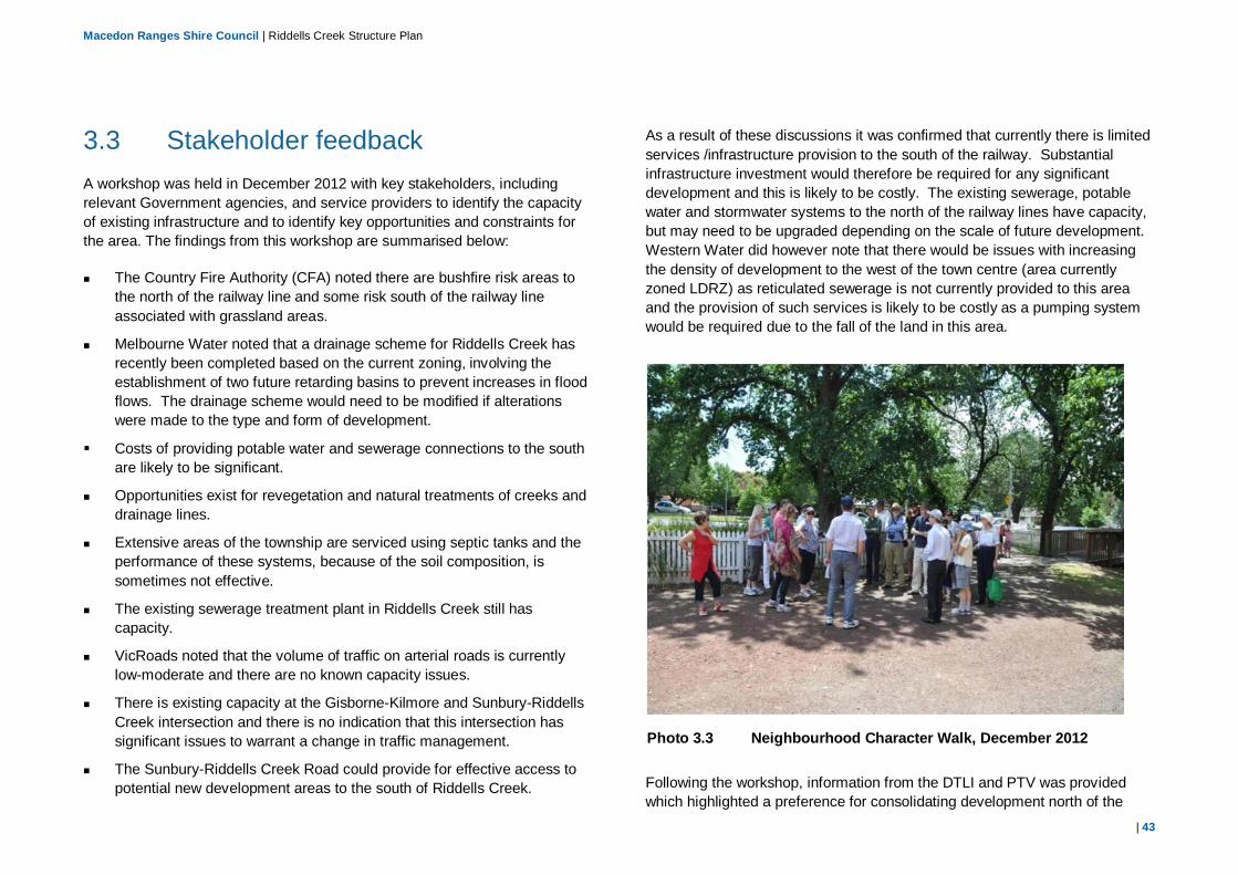
Macedon Ranges Shire Council | Riddells Creek Structure Plan
| 43
3.3 Stakeholder feedback A workshop was held in December 2012 with key stakeholders, including relevant Government agencies, and service providers to identify the capacity of existing infrastructure and to identify key opportunities and constraints for the area. The findings from this workshop are summarised below:
The Country Fire Authority (CFA) noted there are bushfire risk areas tothe north of the railway line and some risk south of the railway lineassociated with grassland areas.
Melbourne Water noted that a drainage scheme for Riddells Creek hasrecently been completed based on the current zoning, involving theestablishment of two future retarding basins to prevent increases in floodflows. The drainage scheme would need to be modified if alterationswere made to the type and form of development.
Costs of providing potable water and sewerage connections to the southare likely to be significant.
Opportunities exist for revegetation and natural treatments of creeks anddrainage lines.
Extensive areas of the township are serviced using septic tanks and theperformance of these systems, because of the soil composition, issometimes not effective.
The existing sewerage treatment plant in Riddells Creek still hascapacity.
VicRoads noted that the volume of traffic on arterial roads is currentlylow-moderate and there are no known capacity issues.
There is existing capacity at the Gisborne-Kilmore and Sunbury-RiddellsCreek intersection and there is no indication that this intersection hassignificant issues to warrant a change in traffic management.
The Sunbury-Riddells Creek Road could provide for effective access topotential new development areas to the south of Riddells Creek.
As a result of these discussions it was confirmed that currently there is limited services /infrastructure provision to the south of the railway. Substantial infrastructure investment would therefore be required for any significant development and this is likely to be costly. The existing sewerage, potable water and stormwater systems to the north of the railway lines have capacity, but may need to be upgraded depending on the scale of future development. Western Water did however note that there would be issues with increasing the density of development to the west of the town centre (area currently zoned LDRZ) as reticulated sewerage is not currently provided to this area and the provision of such services is likely to be costly as a pumping system would be required due to the fall of the land in this area.
Following the workshop, information from the DTLI and PTV was provided which highlighted a preference for consolidating development north of the
Photo 3.3 Neighbourhood Character Walk, December 2012

Macedon Ranges Shire Council | Riddells Creek Structure Plan
| 44
railway line to avoid an increase in traffic at the railway level crossings. Safety concerns regarding crossings and access were raised with regard to development south of the railway line. DPTLI also emphasised the need to integrate transport and land use planning to apply the principles under the Transport Integration Act 2010. An example of this includes designing internal roads to support walking and cycling access around Riddells Creek, which may incorporate providing access to the local childcare centre.
3.4 Submissions received and further correspondence
The Draft Structure Plan was released for public comment in May 2013 providing an opportunity for residents, the local community and key stakeholders to comment on the document. The Council received 342 written submissions on the document, which included 52 individual submissions (3 late) and 290 petitions. The submissions were considered by Council and where relevant the draft document was updated.
A second workshop was held in June 2013 with key stakeholders which included the CFA, Melbourne Water and Western Water. The purpose of this workshop was to consider issues raised through submissions, to identify infrastructure constraints and capacity issues and define costs associated with providing required infrastructure for development within Riddells Creek. Further liaison was also undertaken with the Department of Transport, PTV, SPAusNet and the Department of Education.
The submissions and further consultation with key stakeholders resulted in a number of changes being made to the Draft Structure Plan. The main changes made are as follows:
Restructure of the document to enable the key directions, principles and objectives to be translated in to the Macedon Ranges Planning Scheme through a Planning Scheme Amendment process.
Removal of ‘Area 1’ and ‘Area 2’ (land to the north and west of the town centre) from the ‘Priority Residential Development Precinct”. The CFA advised that these areas are not suitable for further residential development, with the main concern being that increased development will lead to more people being subject to risk.
Update of the Draft Development Framework Plan to show areas of land to the north-east of Riddells Creek as ‘Long Term Strategic Opportunity’. This land is currently outside of the existing Structure Plan boundary as development is beyond the implementation term of this Structure Plan. However, this provides a starting point on possible areas to investigate for development in the future.
Additional information provided within Section 4 and the option analysis in Section 6.2 identifying the potential costs for development of land to the south and north-east of the town centre (Areas 4 and 5). This information was provided from the relevant authorities and is based on estimates using costs from the installation of similar infrastructure in other localities.
Update of the Draft Development Framework Plan to identify a separation buffer to the south of Riddells Creek, protecting the escarpment and view corridors to the south.
Inclusion of two additional guiding principles (Principle 9 and Principle 10) related to the protection of existing infrastructure and environmental sustainability.
Inclusion of design guidelines for some precincts to guide future subdivision and development so that it is respectful of the established and preferred character of areas in Riddells Creek
Inclusion of an indicative Development Plan for the ‘Priority Residential Development Precinct’ located to the north of Amess Road.

Macedon Ranges Shire Council | Riddells Creek Structure Plan
| 45
4. Strengths, Weaknesses, Opportunities andThreats – SWOT Analysis
4.1 Overview Riddells Creek is recognised as having a number of attributes that make it an attractive area for people to live. Submissions received from local residents in relation to the Riddells Creek Structure Plan Issues Paper highlighted the importance of the peaceful, rural environment, with residents expressing a desire to maintain this character.
The methodology for developing the vision for Riddells Creek has involved an iterative process; whereby key themes and ‘big picture’ ideas have been explored at length during stakeholder and community workshops and feedback sought as the vision was developed.
The steps in this process included:
understanding the context or ‘big picture’
analysing and defining the real problem(s) and establishing directions
stimulating ideas to solve the problem(s) and further develop thedirections
assessing and prioritising those ideas to identify the best solution.
This process is illustrated in Figure 4-1.
4.2 SWOT Analysis Prior to establishing the vision, an analysis of the strengths, weaknesses, opportunities and threats for the Riddells Creek locality was undertaken utilising input from desk top studies, reports, policy analysis and community and stakeholder views.
This analysis identified a number of opportunities in the area that should be identified in the Structure Plan as well as identifying existing and future land
use, environmental and infrastructural constraints of the area. A summary of the outcome of this analysis is as follows:
Strengths: The local community has highlighted the importance of the peaceful, rural-lifestyle contributing to the distinctive neighbourhood character and the relaxed ‘village’ feel of the town. The natural bush setting back-dropped by forested hills and a deeply incised creek valley contribute to the environmental and visual significance of the
Figure 4-1 Methodology for developing Riddells Creek Vision

Macedon Ranges Shire Council | Riddells Creek Structure Plan
| 46
area. These are the key elements that contribute to the ‘unique’ feel of the area. It is important to ensure that the Structure Plan recognises these values and protects them through the appropriate siting and design of future development.
A number of additional strengths have been identified as follows:
The main town has a strong urban form established by the grid layout, compact town centre, wide avenue streets and well located community and civic features.
There is a clear separation between the urban and rural land use.
Riddells Creek is located in relatively close proximity to Gisborne and Sunbury, with good access to employment, community facilities and services within these areas.
There are a number of significant heritage buildings and structures located within and surrounding the town centre and train station, which reflect the historical character of the town and which need to be protected.
Significant vegetation particularly along the road reserves and waterways provide attractive views and are important elements in the ‘rural-feel’.
There are important and attractive view corridors from the town towards the forested hills and also from the north over the eastern plains.
Weaknesses/Constraints: The outcomes of the SWOT analysis have identified a number of key issues or constraints for Riddells Creek. These include; areas identified as being subject to bushfire risk; heritage items that require protection; environmental and vegetation features that require protection; and land subject to flooding. These constraints are shown in Figure 4-2.
Photo 4.1 Main Road, single storey building
Photo 4.2 Main Road, roadside planting

Macedon Ranges Shire Council | Riddells Creek Structure Plan
| 47
A number of other issues have been identified as follows:
The lack of pedestrian and cycling facilities has been identified as a keyissue by the local community. Many roads in the area do not havefootpaths or cycle lanes and residents are not encouraged or supported towalk or cycle to access facilities/services within the town. There are oftenpoor linkages between retail, community facilities, recreational facilitiesand residential areas.
The railway line acts as physical barrier between the existing town andareas to the south. Currently, only two crossing points are provided withone being a level crossing at Websters Road and the other being thegrade separated Sunbury-Riddells Creek Road crossing. If developmentwere to occur south of the railway line then the volume of traffic using theexisting level crossing would increase and this is expected to result insafety issues. No new ‘at grade’ road crossings are permitted withinVictoria and a new grade separation across the railway line is likely to bewithin the vicinity of $5-15 million. In addition, development of land to thesouth of the railway will require a new pedestrian overpass as DTLI hasadvised that pedestrian access points need to be formalised. The costs ofproviding this infrastructure are likely to be around $4 million.
Only limited infrastructure is provided to the south of the railway. There iscurrently no gas, sewerage or water provision and the road network isminimal. Western Water has advised that a decentralised wastewatersystem would be required to service the area and cost is likely to beapproximately $1,670,000.
An internal bridge providing access over Riddells Creek would also berequired and these costs are expected to be around $2 million.
There is also no water, sewerage or drainage reticulation to land to thenorth of Amess Road, east of Main Road. A Drainage Services Schemeto provide stormwater drainage for this area is required, with the typicalcosts for the provision of such as scheme being around $64,000 perhectare. Cost of providing sewerage and water reticulation isapproximately $850,000.
Bushfire and flooding risks which have the potential for detrimentalimpacts on existing and future development. Bushfire is a particular risk tothe north and west of the study area, surrounding the Macedon RegionalPark.
Flooding particularly affects areas surrounding watercourses as shown onFigure 4-2. It is important that the potential impacts are considered in theplanning for and design of new developments.
Housing diversity is minimal, with the majority of houses being single leveldetached dwellings (over 90% of stock).
Riddells Creek lacks some of the key infrastructure and servicesconsidered necessary to meet the needs of an increasing population.Additional shopping, medical, education and recreation facilities will berequired to meet a forecast population of 6,000 people by 2036.
Studies undertaken in preparation of this Structure Plan have shown thatparking demand does not currently exceed supply. PTV has confirmedthat there is no requirement to expand the car park based on the futurepopulation of 6,000 people.

Macedon Ranges Shire Council | Riddells Creek Structure Plan
| 48
Figure 4-2 Riddells Creek Planning Scheme Constraint Mapping

Macedon Ranges Shire Council | Riddells Creek Structure Plan
| 49
Opportunities: Riddells Creek is in a strong situation where the town has a well-established town centre, positioned adjacent to a railway station with centrally located community and civic services. It is recognised that appropriately located development could have benefits for existing residents and provide for an increase in population in-line with the population targets established in the Settlement Strategy.
Opportunities identified for the Riddells Creek locality are as follows:
There are areas of vacant residential and business zoned land within and inclose proximity to the town centre which, if developed would assist inconsolidating the urban centre while maintaining the character andpresentation of the outlying residential and rural areas. Such developmentcould provide for mid-block pedestrian links, improved avenue plantingalong road verge areas and provide for more diversity in accommodation.This would further reinforce some of the important village character that isso highly valued in the town.
The large, vacant and flat parcels of land immediately south of the railwayline provide opportunities for future development, however, the suitability ofdeveloping this land will need to be considered within the broader context ofthe town’s development and the costs of providing the requiredinfrastructure and services to this area will need to be investigated. Gradeseparation for a rail crossing is possible at Racecourse Road, which wouldprovide an additional north-south connection and address potential roadcapacity and safety issues associated with future development of the south.However, the costs of providing this connection will be very high and in asituation of competing demand for grade separation at many locationsacross the metropolitan area realistically there is limited prospect of thisbeing publicly funded.
The Settlement Strategy identifies approximately 11.7 hectares of vacantbusiness and industrial land available within the Riddells Creek localitywhich, if developed, could stimulate further economic investment andgrowth, provide increased opportunities for the local community, assist ingrowing the rate base and provide for future infrastructure and serviceinvestment. Developers have expressed an interest in developing business
land in the area and Council has recently approved an application for a new supermarket and specialty shops to the west of Station Street. Council’s decision has been appealed to the Victorian Civil and Administrative Tribunal (VCAT).
The connectivity within and between the town centre, residential areas,social facilities and open spaces can be improved through the provision ofpedestrian and cycling facilities which link these areas. This would not onlyimprove safety but also provide additional recreational activities, enhancethe use of existing ecological corridors and reduce the demand for carparking.
Riddells Creek and the surrounding area is recognised as having a numberof key environmental and heritage attributes that make it an attractivetourist destination. There is an opportunity to build on these importantcharacteristics of the town for its residents and attract more visitors byfacilitating development that meets visitor needs. This may include theprovision of short-stay accommodation, shops and services. The existingresidential and business zoning of sites surrounding the town centre wouldallow for such development.
Future development within Riddells Creek could provide the critical massnecessary to justify investments in social and recreational infrastructure andprovide an increased rate base for funding of such investments. This couldinclude consideration of the need for expansion of the primary school orprovision of a medical and/ or community centre.
Threats: There is potential for detrimental impacts on the natural and physical features of Riddells Creek and the character of the area as a result of insensitive future development. In particular, development which is inappropriately located, designed or sited, may jeopardise the environmental, historical and/or visual attributes that contribute to the overall character of the area. Building design, form and scale should be considered within the context of the surrounding environment. There is a need to ensure appropriate development controls such as building setbacks, façade design and landscaping treatments are introduced which maintain and enhance the ‘village feel’ and character of the town centre and existing residential areas.

Macedon Ranges Shire Council | Riddells Creek Structure Plan
| 50
The potential loss of young and middle aged people due to the lack of opportunities (education and jobs) is a threat, which could lead to a declining population. Residential and tourism opportunities have been identified and may assist in stimulating future growth and create additional employment opportunities.

Macedon Ranges Shire Council | Riddells Creek Structure Plan
| 51
5. Strategic Directions5.1 Neighbourhood Character Riddells Creek has important built and landscape features which contribute to a distinctive neighbourhood character within its residential, commercial and community areas. The character is strongly derived from the natural landscape setting, of a vegetated backdrop of the Macedon Ranges and deeply incised creek valleys. These elements contribute to both the environmental and visual significance of the town.
The layout of the township has elements such as an underlying grid network of streets, generous vegetated road reserves and centrally located community and civic features that contribute to the formal yet relaxed feel of the town. Within the core town centre area the mix of residential and commercial uses and the general single storey form of construction result in a pedestrian scale environment which is legible, easy to move through and has variety.
The townships’ existing residential areas to the north, west and east of the town centre generally consist of substantial building setbacks and established gardens, which together with the expansive road reserves, creates a streetscape of visual and environmental value. One of the most recognisable features of the residential areas is the generous size of allotments with dwellings well setback from the road. In the established residential areas the majority of dwellings are of brick or weatherboard construction and are single level.
As Riddells Creek develops over time it will be important to ensure that future growth is not only appropriate to the context, but also reinforces the key attributes that set its character apart from other places. With this in mind, it is not enough to simply say that future development should not ‘detract’ from existing features, but rather future development should physically enhance what is already there.
The local community has identified the importance of the character of the town, being one of the main reasons why people choose to live within Riddells Creek. This Structure Plan seeks to protect the character of the town and residential areas through the application of guiding principles and design and development controls which reflect the features of the existing context.
To complement the Structure Plan a Preliminary Neighbourhood Character Study has been prepared to identify and assess the existing character features of the area and to make recommendations as to the type and form that future development should take to be consistent with the existing character. The Study identified twenty four separate precinct areas, each of which have their own distinctive character. The Report describes the existing and preferred character for each of the precincts and identifies features which require protection. Further details on the character of these precincts are provided in the Neighbourhood Character precinct assessment sheets attached to the Neighbourhood Character Study.

Macedon Ranges Shire Council | Riddells Creek Structure Plan
| 52
Photo 5.1 Housing within the low density residential area
5.2 Vision The overall vision for Riddells Creek has been developed through a review of background material, policies and strategies, through analysis of the constraints and opportunities of the area and analysis of the Neighbourhood Character Study and through an extensive community consultation. The vision is as follows:
To provide for the progressive sustainable development of Riddells Creek that enhances its township function, while ensuring that any future development preserves the high environmental, heritage and landscape qualities of the area and reinforces Riddells Creek’s unique character and identity.
5.3 Principles and Directions A set of guiding principles have been developed to provide a framework for future decision making in-line with the overall vision for Riddells Creek. These principles have previously been outlined in Part A, Section 2.2. Further discussion on what these principles mean for Riddells Creek is provided below:
5.3.1 Character and role of the town centre
Principle:
New commercial and infrastructure developments within the ‘Town Centre Precinct’ and must demonstrate how they will reinforce the village character and role of Riddells Creek. Directions: Ensure that new commercial/retail development and community facilities
are located within the town centre.
Provide a high amenity urban environment that is consistent with the Town Centre Area Guidelines, including active frontages to streets, as well as public access and permeability between buildings.
Ensure that new developments are of a form and scale compatible with the existing town centre development.
Discussion:
Riddells Creek has a defining village character that provides a separate and ‘unique’ feel compared to other settlements in the Shire. The town centre in particular plays an important role in establishing this, with the low scale compact residential and commercial development, heritage buildings, generous road reserves and grid layout of streets, creating a relaxed-village feel for the town.

Macedon Ranges Shire Council | Riddells Creek Structure Plan
| 53
Originally established around the train station, the town centre also plays an important role in connecting the community, being a focal meeting point and place where people interact. Design Guidelines have been prepared for the Town Centre Area. These guidelines note that buildings should be kept low to medium scale (one – two storey), and set back from the street frontage where appropriate to maintain a pedestrian scale.
5.3.2 Residential development and housing choice
Principles:
Promote increased housing densities in appropriate locations in the ‘Town Centre Precinct’ and ‘Town Centre Residential Precinct’.
Provide for a range of residential development opportunities within the ‘Priority Residential Development Precinct’ that increases housing diversity and provides greater housing choice.
Residential development located within the ‘Limited Infill Potential Precinct’ and the ‘Priority Residential Development Precinct’ must be of a form and scale compatible with the existing residential character of adjoining and nearby areas.
Directions:
Provide a residential environment that is consistent with the DesignGuidelines contained in Appendix B.
Protect the urban and rural character and amenity of the residential areas.
Consolidate residential growth and development ‘Priority ResidentialDevelopment Precinct’.
Carefully manage infill development in the Limited Infill Area to ensure thatit is complementary to and enhances the character of these areas.
Ensure any new development in the Low Density Residential Area hasregard to fire risk and environmental considerations.
Allow for a range of lot sizes, housing types and lifestyle opportunities tomeet the needs of the community.
Encourage accommodation above/behind new commercial uses in theexisting Commercial 2 Zone in Sutherlands Road.
Encourage the investigation of the area south of the railway for the futurelong term (20-30 years) residential growth.
Discussion:
The residential and low density residential areas of Riddells Creek have their own identity characterised by extensive front yards, comprehensive landscape treatments and attractive streetscape frontages. The low density residential areas in particular have generous allotment sizes (ie, > 1000 square metres) with dwellings positioned some distance from the road frontage providing for extensive front yards and open spaces.
The Area of Change Plan provided in Figure 5-1 illustrates how the vision of Riddells Creek will be achieved by protecting areas with established neighbourhood character and environmental values while providing for increased development in other areas more susceptible to change.
In determining appropriate locations for future development a number of locations and growth scenarios were investigated. Details of this investigation are provided in Part B, Section 1 of this Structure Plan. A detailed analysis of these growth options was undertaken to determine the most appropriate area for future development. The assessment found that there is some opportunity for growth through:
Infill residential development in the already established residential and lowdensity residential areas to the north and east of the town centre. It willbe important that the existing character of these areas is maintained asinfill occurs. These areas are referred to as ‘Minimal change’ in Figure5-1.New development/more intensive development within the area to thenorth of Amess Road, within ‘Area 4’ as identified on Figure 5-1. This is

Macedon Ranges Shire Council | Riddells Creek Structure Plan
| 54
referred to as the ‘Priority Residential Development Precinct’ on the Development Framework Plan.
In addition, it is important that a wide range of accommodation is provided that will lead to the creation of a variety of lot sizes and housing types across various levels of affordability, catering for people with differing needs in different stages of their lives and household structures. Unit, semi-detached dwellings or town house development should be directed to areas within and immediately surrounding the town centre, being in close proximity to infrastructure and facilities.
The lack of housing diversity currently within Riddells Creek has led to concerns that future generations will not be able to afford to settle in the township or that there will be limited accommodation options for people wanting to downsize. The local community has also identified the need for an aged care facility to allow members of the community to remain within Riddells Creek as they age.
5.3.3 Employment, commercial and industrial development
Principles:
Commercial, employment and industrial land use should meet the demands of the local community, reinforce the role of the town centre and be integrated into the existing township.
Directions:
Promote the role of the town centre as the retail, commercial and civic corewhich meets the needs of the local community.
Allow for a range of commercial, retail and industrial land usesappropriately located within the township.
Figure 5-1 Area of Change Plan

Macedon Ranges Shire Council | Riddells Creek Structure Plan
| 55
Investigate the location for a small neighbourhood centre in the ‘Priority Residential Development Precinct’ to provide for the basic needs of the local residents. The centre would be limited to a convenience shop and ancillary uses.
Protect the role of the existing Industrial 1 Zoned land.
Discussion:
Riddells Creek currently provides most retail facilities and products to meet the basic needs of local residents through the existing supermarket and speciality shops. However, as the township grows, additional retail, commercial and community facilities will be required to meet the needs of the population. The range of speciality shops and local businesses should be expanded to strengthen and sustain Riddells Creek’s economic base and provide additional services to the local community in line with its township function. In addition, a small local neighbourhood centre with convenience shop and ancillary services is likely to be required within the ‘Priority Residential Development Precinct’. The location and makeup of the neighbourhood centre would be determined during the development plan stage.
The existing Commercial 2 Zone land located within the town centre, to the north of Sutherlands Road is currently vacant. There is potential for this land to be rezoned to allow for a mixture of land uses that would complement the existing facilities and services in Riddells Creek. For example, a medical centre, child care facility, aged care facility or community centre could be located within this area, in close proximity to existing retail and commercial activities. This land may also provide for expansion of the Primary School, currently located to the north. It is noted that Council has recently approved a new supermarket to the west of Station Street.
Additional employment and commercial activities located within the town centre will have positive impacts helping to achieve a compact community orientated development within convenient walking distance of the railway station and existing commercial/community facilities. Employment and
commercial areas and community facilities should be easily accessible to the train station as well as pedestrian and (future) bicycle networks.
5.3.4 Open Space, Natural Systems and Heritage Features
Principles:
Protect, restore and enhance the open spaces, existing natural and historic features and landscape values of the area. Provide attractive, safe and functional open spaces that integrate with the township and existing waterway corridors.
Facilitate the development of a network of walking and cycling trails to serve the community and to link with existing features and facilities within the township.
Directions:
Encourage development that is consistent with the Design Guidelines.
Provide well integrated open space corridors.
Protect the existing streetscape character through retention of street trees.
Encourage developments which provide effective landscape treatments, enhancing the amenity of the town centre, residential and rural-residential areas.
Protect and enhance the visual amenity and environmental features of road and waterway corridors.
Encourage the development of open space corridors with pedestrian/cycling linkages along existing waterways and around the township.
Require developments within the proposed Development Plan Overlay areas to provide open space networks.

Macedon Ranges Shire Council | Riddells Creek Structure Plan
| 56
Discussion: The environmental and heritage features of the Riddells Creek locality are of significant value to the community. These include: the areas of remnant vegetation; roadside planting; waterway corridors; open spaces; and heritage buildings/structures. These features play a significant role in establishing the character and rural nature of the area and also provide recreational opportunities. The local community has identified the need to protect these features and better integrate them within the existing township. Provision of pedestrian and cycling paths along waterway corridors is one example as to how access to the open space areas can be enhanced.
The Development Plan Overlay (DPO) for the Priority Residential Development Precinct (refer Section 2.4.2) should identify a network of open space links and corridors which will need to be provided as part of future developments.
In addition, the Development Framework Plan identifies open space corridors and future pedestrian/cycle links along the Riddells Creek waterway. It is recognised that this Creek is intrinsic to the character of the area and should be protected. While this land is currently privately owned, it is envisioned that overtime Council or Melbourne Water may purchase land surrounding the Creek to develop these corridors.
5.3.5 Utilities and infrastructure
Principles:
New developments to provide for appropriate infrastructure and meet the requirements of the Development Contributions Plan.
Community facilities should meet the demands of the local community and reinforce the role of the town centre as the civic core. Achieve a well-connected and mobile community through all modes of transport.
Directions:
Ensure that infrastructure cost implications of development proposals havebeen adequately investigated and can be met for the development.
Levy development contributions from new greenfield/infill development tofund infrastructure through the Development Contributions Plan.
Ensure that the car parking demands of the local community areadequately met.
Enhance pedestrian and cycling linkages between open spaces,residential areas and commercial land uses.
Encourage the development and locating of community uses to the landcurrently zoned Commercial 2 in the Town Centre.
Discussion:
Some areas of Riddells Creek are not suitable for future development due to infrastructural capacity, environmental features or future provision constraints. Any future residential or commercial development proposals should demonstrate how the necessary utilities and services (water, sewerage, gas, electricity and road) can be provided and how the costs of the provision can be met by the developer and through the DCP.
The future operation of intersections and roads in the area will depend on where development occurs and the type and form that development takes. It is noted that traffic volumes at the Sunbury-Riddells Creek Road and Gisborne-Gilmore Road intersection are already high (4687 vehicles per day) and any development to the south of the railway will increase the number of vehicles travelling through this intersection as there is only one road access to the town centre from the south. While it is recognised that development to the north of the railway within Area 4 will result in an increase in number of vehicles travelling along the Gisborne-Kilmore Road (with currently 4137 vehicles per day), there are other road connections which may be used to access the town centre which would assist in dissipating the traffic impacts (eg, Amess Road, Racecourse Road and Sutherlands Road).

Macedon Ranges Shire Council | Riddells Creek Structure Plan
| 57
Analysis of traffic impacts will need to be undertaken at the time of planning for the development to identify any required road or intersection upgrades. Full cost benefit assessments of any necessary additional infrastructure are required to determine if there are wider benefits to the community.
The local community has identified the need to improve the pedestrian and cycling linkages throughout the township and provide better access to social and recreational facilities and the residential areas. This will help to achieve a more sustainable, integrated and walkable community, increase safety and reduce the need for further car parking within the town centre and residential streets.
It is expected that new developments will assist in enhancing and expanding the pedestrian and cycle network either by setting aside land for pedestrian/cycle paths where this is on private land or contributions as part of the DCP process. Within Area 4 new pedestrian and cycle paths should be identified as part of the DPO and new residential developments will provide this as part of proposal.
5.3.6 Environmental Sustainability
Principle:
New residential and commercial developments within Riddells Creek should encourage the development of a walkable, self-sufficient community, which promotes sustainable living practices, protects the environmental values of the area and addresses potential climate change (bushfire and flooding) impacts.
Directions:
Promote the development of a walkable community, where people are able to access local services and facilities by walking or cycling from their home.
Promote the development of a self-sufficient town centre where residents are able to access the majority of their basic needs.
Consider long term implications of new developments including climate change impacts (ie, bushfire risks and flooding impacts) and mitigation measures.
Protect and enhance the environmental values of the area including flora, fauna and waterways.
Protect any cultural heritage values identified through site specific investigations.
Discussion:
It is now widely recognised that social and economic objectives cannot be considered in isolation. The local environment, being the built form, the natural features and the regional context play an important role in contributing to, and the achievement of the social and economic goals of an area. By the same token, it is important to consider the social and economic context when identifying and working towards specific environmental goals.
Environmental sustainability is taken to mean processes or procedures which will also contribute to sustaining and enhancing the quality of the social economic and natural environment on a long term basis.
There are a number of issues or constraints which may limit the development potential of sites. These include factors such as bushfire risk, flooding and ecological and heritage values. These factors need to be considered as part of any development proposal for sites in this area. In particular, the CFA has identified land to the north and west of Riddells Creek as being subject to extreme bushfire risk and ember attack. It is noted that while only some of the land to the north is included within the Bushfire Management Overlay (BMO), information provided by the CFA has identified that the bushfire risks are much wider and apply to land outside of the BMO.
The CFA identified land to the east and south of the town centre as least likely to be impacted by destructive fire, however, there is still a level of risk. Discussions with the CFA should be undertaken at the time of development of

Macedon Ranges Shire Council | Riddells Creek Structure Plan
| 58
land within Riddells Creek to ensure that adequate building design and defendable space requirements can be achieved.
Other higher order facilities such as medical care, educational (eg, secondary school) and major recreational facilities are located in Gisborne (situated 10km to the west of Riddells Creek) and Kyneton (located 40km to the north north-west of Riddells Creek). These towns also provide employment, retail, service and community facilities such as a hospital, sports and aquatic centre.
It is anticipated that residents in Riddells Creek will continue to utlise the services and facilities in the surrounding areas.

Macedon Ranges Shire Council | Riddells Creek Structure Plan
| 59
6. Planning for Riddells Creek – Strategic Response6.1 Options It is important to ensure that the planning and development supported through the Structure Plan is suited to the locality, builds upon the existing strengths and meets the current and future population demands.
In determining the most appropriate planning strategy for Riddells Creek, four alternative scenarios were developed and their capacity to achieve the vision were considered and evaluated. These options have been developed through an analysis of:
Constraints and opportunities (as identified above);
Existing land capacity (areas of vacant land); and
Appropriateness of future development given the characteristics of thearea and the potential impacts on the neighbourhood character (refer tothe Neighbourhood Character Report and in particular Section 8 whichoutlines the preferred neighbourhood character).
Refer to Figure 6-1 for the location of the development areas.
The options were presented in the Draft Structure Plan which was placed on public exhibition. Feedback received was evaluated and the option analysis revised accordingly. Details in terms of the changes made to the option analysis as a result of feedback received through the submission phase are provided in Section 3.4.
Option 1: Maintain Status Quo
This scenario involves no change to existing planning zones. Infill development would continue on vacant lots in accordance with existing site density controls.
This could include the provision of design and development controls to be included within the Planning Scheme and which would apply to new development to protect the existing character.
Option 2: Development to the North
In this scenario the Structure Plan would provide for the development of Riddells Creek through rezoning of land to the north of the railway as follows:
Option 2A (Development of Area 1): Provision for rezoning anddevelopment of land in existing LDRZ to the north of the town centre inArea 1.
Option 2B (Development of Area 2): Provision for rezoning anddevelopment of land in existing LDRZ to the west of the town centre in Area2.
Option 2C (Development of Area 3): Provision for development of land inexisting R1Z.
Option 2D (Development of Area 4): Provision for rezoning anddevelopment of land in existing RLZ1 to the north-east of the town centre inArea 4.

Macedon Ranges Shire Council | Riddells Creek Structure Plan
| 60
Note that the rezoning and development of the areas identified above would only occur as the demand arises and as development proposals are put forward to Council.
Infill of existing areas could occur under all options above through development on vacant land in accordance with the density controls under the existing zoning.
Option 3: Development to the South of the Railway
In this scenario provision would be made for rezoning and development of land to the south of the railway only (Area 5). Rezoning and development would occur as the demand arises and as development proposals are put forward to Council.
Again, infill of existing areas could occur through development on vacant land in accordance with the density controls under the existing zoning.
Option 4: Development north and south of the Railway
In this scenario the Structure Plan would provide for the development of Riddells Creek north and south of the railway line. This would occur through:
Provision for rezoning of existing LDRZ and RLZ1 land, as per Option 2 above.
Provision for rezoning and development of land to the south of the railway (Area 5), as per Option 3 above.
Infill of existing areas could occur through development on vacant land in accordance with the density controls under the existing zoning.
Figure 6-1 Future Development Scenarios

Macedon Ranges Shire Council | Riddells Creek Structure Plan
| 61
6.2 Option Assessment An assessment of the potential development options has been undertaken using a criteria analysis whereby each option has been given a score based on its ability to meet certain criteria.
The criteria and scoring system used are as follows:
Policy Objectives: Option meets the strategic planning and policy directions for the Shire and the locality, and in particular meets the recommended population projection for Riddells Creek of 6,000 people by 2036 as set out in the Planning Scheme Amendment C84.
Infrastructure: There is sufficient utility and infrastructural capability to provide for the development. Costs of additional infrastructure connections can adequately be met.
Sustainability: Development protects the environmental, heritage and landscape qualities. Development has the potential to promote a walkable, well connected community with good access to public transport. Area is considered suitable for future development taking into consideration potential bushfire risks.
Neighbourhood Character: Option provides for the protection of the neighbourhood character of established areas.
Community Preference: The community has responded positively to this type of development.
Scoring:
Strongly promotes/meets criteria 2 points
Meets criteria 1 point
Does not meet criteria X -1 points
Strongly does not meet criteria (ie, significant issues)
XX -2 points
Table 6.1 on page 10 provides an assessment and provides an overall score for each option.
Note that this assessment has been informed through the SWOT analysis (refer Section 4) and through community and stakeholder consultation.
6.3 Summary Overall, Option 2C (Development of Area 3) had the highest score (7) with Option 4 (Comprehensive Development (north and south)) having the lowest score (-3).
Area 3 is located in close proximity to the town centre and has good access to existing facilities and commercial activities. No significant infrastructure investments are required and no significant issues have been raised by the community regarding development in this area. The CFA also notes that this area has some buffering from direct fire spread.
However, as the target population of 6,000 people cannot be met by only providing for development within Area 3, other options have also been considered in conjunction with Area 3. A total of 57 ha of additional land is required to meet the Settlement Strategy population target. As Area 3 only provides 11 ha of land which can be rezoned to provide for additional growth, land is required in other areas of Riddells Creek too.
Out of the other options identified, Area 4 (Option 2D) is considered the most suitable to provide for further development within Riddells Creek. This is on the basis that this area had the highest score amongst the other developable areas with a total of 6 points and that this option would meet the population target. In addition, there are a number of benefits associated with option (such as good road access, sewerage and water connections which can be provided relatively easily). Feedback received on the Draft Structure Plan indicate that generally community and government agencies are not opposed to growth in this location.

Macedon Ranges Shire Council | Riddells Creek Structure Plan
| 62
This option would also provide flexibility for change responding to future demands while also providing certainty to the local community and the Council as to how Riddells Creek would develop over time.
It is important to note that currently there is no water, sewerage or drainage reticulation to land to the north of Amess Road, east of Main Road (Area 4). Western Water has advised that sewerage and water reticulation could be provided relatively easily, without any substantial costs. However, Melbourne Water has advised that any future development in this area may require the installation of a Development Services Scheme to provide stormwater drainage for this area, with the typical costs for the provision of such as scheme being around $64,000 per hectare.
Development within Area 4 would occur as the demand arises (i.e., Council receives rezoning applications).4
While Option 3 (Area 5) was given only a slightly lower score with 4 points, there are significant infrastructure costs associated with investments required for pedestrian and vehicular rail crossings and sewerage, water and road and utility provision for this option.
In the case of Option 1 (Maintain Status Quo) any future rezoning proposals would need to be assessed on a case-by-case basis and without a detailed Structure Plan directing where development should occur, this may result in ad-hoc development.
On this basis Option 2C (Development in Area 3) and Option 2D (Development in Area 4) is recommended as the preferred option to be taken forward for the development of the Riddells Creek Structure Plan.
4 It is envisioned that future development within Areas 1 and 4 will result in block sizes of approximately 800 – 1,200 sq metres to allow for the preferred neighbourhood character. However, exact lot sizes will be confirmed following the preparation of a Development Plan Overlay as part of the implementation of this Structure Plan.

Macedon Ranges Shire Council | Riddells Creek Structure Plan
| 63
Option Scoring
Key Advantages Key Disadvantages Policy Direction
Infrastructure Sustainability Neighbourhood Character
Community Preference¹
Option 1. Maintain Status Quo
Supports maintaining the existing ‘rural character’ and lifestyle.
Local community familiar with the existing planning policy.
No significant infrastructure upgrades required.
Option does not meet the population target under the Settlement Strategy, with a shortfall of accommodation for approximately 1000 persons. (note that this is based on the Settlement Strategy figure which identified that existing residentially zoned land could accommodate approximately 4,900 people)
Future rezoning development proposals would need to be assessed on a case-by-case basis and this may result in ad-hoc development.
X
Total Score: 5
Option 2A. Development to the north. (Area 1)
Option allows for flexibility over time to meet demands: rezoning and development can occur as the demand arises.
Provides for the maintenance of the existing ‘rural character’ and lifestyle.
Provides a basis with which to assess future development proposals, ensuring that key attributes are maintained/protected or enhanced as per guiding principles.
Sewer upgrades are likely to be required to provide for further development in this area. However, Western Water does not expect the costs to be substantial.
Melbourne Water has confirmed that the existing drainage scheme for the area (which includes two retarding basins to be installed in the future) will need to be slightly revised to accommodate further development. However, this is likely to be relatively straightforward and would not involve significant costs.
Option meets the land demand and population target under the Settlement Strategy. A total of 57ha of additional land is required. Area 1 provides 99ha.²
CFA has identified this area as being subject to extreme bushfire risk and ember attack from the north. CFA argues that this area is not suitable for further residential development, with the main concern being that increased development will lead to more people being subject to risk.
Area noted as having significant ecological values, remnant vegetation and provides habitat for kangaroos.
Limited community support for development in this area. However, some submitters argue that this area is too far away from the town centre and development would not promote a ‘walkable community’.
X X
Total Score: 3
Option 2B. Development to the north. (Area 2)
Option allows for flexibility over time to meet demands: rezoning and development can occur as the demand arises.
Provides for the maintenance of the existing ‘rural character’ and lifestyle.
Provides a basis with which to assess future development proposals, ensuring that key attributes are maintained/protected or enhanced as per guiding principles.
Limited community support for this area on the basis that it is relatively close to the town centre.
Option meets the land demand and population target under the Settlement Strategy. A total of 57ha of additional land is required. Area 2 provides 71ha.
Area subject to extreme bushfire risk and ember attack, similar risk level as Area 1.
No existing sewer infrastructure in this area. Western Water has confirmed that provision of services to this area is likely to be costly as a pumping system would be required.
Environmental values identified surrounding Riddells Creek may be impacted as a result of development in this area.
X X X
Total Score: 0
Option 2C. Development to the north. (Area 3)
Provides for the maintenance of the existing ‘rural character’ and lifestyle.
Provides a basis with which to assess future development proposals, ensuring that key attributes are maintained/protected or enhanced as per guiding principles.
This area is located in close proximity to the town centre and has good access to existing facilities and activities.
No significant infrastructure investments required. Connections can be made relatively easily.
No significant issues have been raised by submitters or through the submission period or through further discussions with Referral Authorities.
CFA notes that this area has some buffering from direct fire spread.
Option does not meet the land demand and population target under the Settlement Strategy. A total of 57ha of additional land is required. Area 3 only provides 11 ha.
X
Total Score: 7
Option 2D. Development to the north. (Area 4)
Option allows for flexibility over time to meet demands: rezoning and development can occur as the demand arises.
Option meets the land demand and population target under the Settlement Strategy. A total of 57ha of additional land is required. Area 4 provides 103 ha
Provides for the maintenance of the existing ‘rural character’ and lifestyle.
Provides a basis with which to assess future development proposals, ensuring that key attributes are maintained/protected or
A Development Services Scheme would be required to provide drainage for this area. Typical costs of provision of a scheme are in the vicinity of $64,000 per ha.
This area is not located within walking distance to the town centre. A small local neighbourhood centre with convenience shop will be required and ancillary services. The location and makeup of the neighbourhood centre would be determined during the development plan stage.
Parts of the land are poorly drained.
X ¹
Table 6.1 Strategic Option Analysis

Macedon Ranges Shire Council | Riddells Creek Structure Plan
| 64
Option Scoring
enhanced as per guiding principles. CFA considers average lot sizes of 1000
square metres within this area to be appropriate as there is a buffer from properties on the northern side to minimise the spread of fire and the land has a gentle slope and is largely cleared. However, additional mitigation measures will need to be considered and discussed with the CFA at the time of development.
Road access to this area is good. Traffic levels on Amess Road and Sutherlands Road are relatively low. Access arrangements would need to discussed with VicRoads at the time of development to determine whether access is more appropriate from Amess Road or Gisborne-Kilmore Road.
Sewerage and water infrastructure will need to be provided to this area, but as advised by Western Water, this can be provided relatively easily and costs are not anticipated to be significant.
There is limited community opposition for development in this area.
Total Score:6
Option 3. Development to the South of the Railway
This area is located in close proximity to the town centre and has the potential to have good access to existing facilities and activities. However, it is noted that direct pedestrian access to the town centre would require the construction of a pedestrian overpass over the railway or underpass, which would be a considerable cost for development.
Development of land to the south of the railway line may avoid the need for further development to occur within established residential areas, helping to maintain the existing character.
A new and distinctive character could be established to the south which could incorporate and implement principles of sustainability.
Development could be in the form of a variety of densities, particularly in relation to the railway station. This could include principles of Transit Orientated Development (TOD). Sufficient space to develop community facilities.
There is a an opportunity to develop a liner reserve along Riddells Creek providing public open space and linking Wybyong Park to the north.
Large areas of unconstrained flat land provide suitable locations for future development.
Melbourne Water has advised that stormwater drainage can be provided locally (drainage channels) and that there is no need for a compressive drainage scheme.
Option meets the land demand and population target under the Settlement Strategy. A total of 57ha of additional land is required. Area 5 provides 138ha.
Note that this option has been given a slightly lower score than Option 2D based on the fact that there may be a significant oversupply of land (which may lead to parcels of being left as ‘vacant’ even though they have been zoned, because the demand for residential land exceeds supply.
Option allows for flexibility over time to meet demands: rezoning and development can occur as the demand arises.
Provides a basis with which to assess future development proposals, ensuring that key attributes are maintained/protected or enhanced as per guiding principles.
Strong community support for this option.
Significant infrastructural investment required for additional rail crossing for development of land to the south. Likely to be approximately $5-15 million.
DPTLI has advised that pedestrian access points or connections across the rail corridor need to be formalised through a grade separated structure (bridge or underpass) for safety reasons. Costs of providing this an additional grade separated pedestrian crossing is likely to be within the vicinity of $4 million.
Significant infrastructural investment required for sewerage and water connections for the development of land to the south of the railway line.
XX ¹
Total Score: 4
Option 4. Development north and south of the Railway
Option allows for flexibility over time to meet demands: rezoning and development can occur as the demand arises.
Development of land to the south of the railway may avoid the need for further development to occur within established residential areas, helping to maintain the existing character.
A new and distinctive character could be established to the south which could incorporate principles of sustainability.
Development could be in the form of a variety of densities, particularly in relation to the railway station. This could include principles of Transit Orientated Development (TOD)
Option results in an oversupply of land. Significant infrastructural investment required for
additional rail crossing for development of land to the south.
Significant infrastructural investment required for sewerage and water connections for the development of land to the south of the railway line.
Option may result in the release of land for development which is surplus to the demand (ie, the development of land to the south prior to further development to the north). This would result in costs to developers or may result in ad-hoc development.
XX XX X ¹
Table 6.1 Strategic Option Analysis

Macedon Ranges Shire Council | Riddells Creek Structure Plan
| 65
Option Scoring
Option may result in urban ‘sprawl’ as areas of land further away from the town centre are developed prior to development occurring in the centre and surrounding established residential areas.
Development may occur in areas identified as subject to extreme fire prone risks.
Total Score:-3
Table 6.1 Strategic Option Analysis
¹ This score has been determined based on an analysis of feedback provided in response to the Riddles Creek Town Structure Plan Issues Paper, the Community Visioning workshop event, the Master-planning workshop and the submissions received ion the Draft Structure Plan.
² Land demand and forecasts are based on report prepared by SGS Economics and Planning ‘Riddells Creek Commercial and Industrial Study’ (July 2013)


Appendix A Existing Planning Zones

RCZ1
GWZ
FZ
RLZ5
RLZ1
FZ
GWZ
LDRZ
FZ
RLZ1
R1Z
RCZ1
PCRZ
RLZ1
RLZ1
R1Z
RLZ1
LDRZ
PCRZ
RLZ5
PCRZ
RCZ1
PCRZ
RCZ1
CA
PUZ1
RLZ4
PUZ6
PPRZ
B1Z
PUZ1
B3Z
RDZ1
PUZ4
RDZ2
RDZ2
PUZ4
PUZ4
RDZ1
PUZ2
RDZ2PPRZ
R1Z IN1ZPPRZ
PUZ1
PUZ5
PCRZ
PPRZB1Z
PUZ1
B1ZPUZ6
PUZ1
Source: Esri, DigitalGlobe, GeoEye, i-cubed, USDA, USGS, AEX, Getmapping, Aerogrid, IGN, IGP, and theGIS User Community
Planning ZonesB1ZB3ZCAFZGWZIN1ZLDRZPCRZPPRZPUZ1PUZ2PUZ4PUZ5PUZ6PUZ7R1ZRCZ1RDZ1RDZ2RLZ1RLZ4RLZ5Study area
\\Aumelf1\proj\M\Macedon_Ranges_Council\2117359A_RIDDELLS_CREEK_STRUCTURE_PLAN\10_GIS\Projects\Maps\2117359A_GIS_004_A2.mxd
www.pb.com.au
0 500 1,000 Metres IScale 1:30,000


Appendix B Design Guidelines

Town Centre Area
Based on the assessment of the existing neighbourhood character within the township of Riddells Creek, there has been a number of objectives, principles and siting and design considerations identified for three key areas of the town. The Town Centre area is considered to be extremely important in contributing to the identity of the township.
The key purpose of the planning and design guidelines is to protect the town centre area from inappropriate development. It also seeks to encourage a more considered approach to future development within this area, and the information which follows should be used during the formulation of development proposals.
• To maintain a relaxed village feel• To provide vitality and interest for
pedestrians• To provide variation in front and
side setback to allow for effectivelandscape treatments
• To enhance the environmentalvalue of drainage lines, andcreate pedestrian links to theseareas.
• New development shall besensitively designed, andresponsive to its overall townshipcontext.
• Building scale is to be restrainedand upper levels to be setbackfrom the street frontage.
• Building design is to acknowledgethe rural context of the townshipand the use of elements suchas peaked roofs, verandahs andtraditional window forms is to besupported.
Town Centre Objectives
Principles
RIDDELLS CREEK STRUCTURE PLANUrban Design Guidelines

1.
Strategic Directions
• Continuous pedestrian access shall be provided along both sides of Main Road and Station Street.
• New Vehicle access points to Main Road and Station Street are to be restricted.
• Opportunity for pedestrian links to and along the drainage lines are to be facilitated.
• New development is to respond to the heritage and rural context of Riddells Creek in a positive way, and to demonstrate site responsiveness and sensitivity to the existing character.
• New Retail frontage is to be provided with sufficient glazing, and appropriate window form, and parapet treatment consistent with the existing character of Riddells Creek.
• The use of verandahs and awnings is required and the use of post supported awnings is acceptable.
• Non-commercial buildings and residential buildings should include setbacks for the provision of landscape treatment.
• Where fencing is required the use of semi-transparent, or open treatments or hedging is appropriate.
Pedestrian and Vehicle Access
Streetscapes
RIDDELLS CREEK STRUCTURE PLANUrban Design Guidelines

2.
• Single storey development along the frontage to Main Road and Station Street is preferred.
• Where upper storeys are required, this should be incorporated beneath the roof profile, or be stepped to accord with the slope.
• Continue to promote pedestrian permeability.
• Harvest surface drainage where appropriate using retention and recycling opportunities.
• Promote energy harvest and storage using photo voltaic panels.
• Material finishes are to reflect the heritage and character of the existing significant buildings where possible.
Building Scale Sustainability
Materials
Images
01 View to the south-east along Station Street towards the Riddells Creek Railway Station
02 View to the south west along Stephens Street
Strategic Directions
RIDDELLS CREEK STRUCTURE PLANUrban Design Guidelines

Town CentreGuidelines
RIDDELLS CREEK STRUCTURE PLANUrban Design Guidelines

Town Residential Area
Based on the assessment of the existing neighbourhood character within the township of Riddells Creek, there has been a number of objectives, principles and siting and design considerations identified for three key areas of the town. The Town Residential area is considered to be extremely important in contributing to the identity of the township.
The key purpose of the planning and design guidelines is to protect the town residential area from inappropriate development. It also seeks to encourage a more considered approach to future development within this area, and the information which fol lows should be used during the formulation of development proposals.
• To maintain the rural character ofthe town and specifically the balancebetween built and landscape areas.
• To ensure that new residentialdevelopment, including front andside setbacks, and building and roofforms are respectful of the existingcharacter and complement ratherthan dominate.
• To maintain the streetscapecharacter by requiring that newdevelopment makes a positivecontribution with orientation
towards the frontage, and effective treatment of fencing using semi- transparent, open or hedging.
Town Residential Objectives
• Built and landscape treatment isto respond to the rural townshipcontext.
• The retention of existing remnanttrees is to be a priority.
• The maintenance of generousallotment size to maximisethe environmental value andvisual appearance of landscapetreatment.
Principles
RIDDELLS CREEK STRUCTURE PLANUrban Design Guidelines

3.
• Where possible driveway access points should be rationalised to reduce the impact on the streetscape and maximise the utility of available land.
• On larger allotments the use of circular driveways is acceptable if this forms part of a landscape frontage.
Vehicle and Pedestrian Access
• The relationship between allotment size and site coverage is to be balanced to visually integrate with the existing neighbourhood character and setting.
• Detached or attached buildings should have a recognisable orientation and address towards the street frontage.
• The use of eaves and verandahs and awnings is to be a positive feature of housing.
• Where the development of two or more dwellings occurs, treatment of each dwelling is to have a recognisable address and identity.
• Continue to encourage single storey development, and where upper storeys are required, that they be incorporated into the roof form.
• The maximum height of built form should be determined by the size of the available allotment with generous setbacks from all boundaries.
• The siting of dwellings is to be consistent with the existing pattern of front and side setbacks and outbuildings are to be located to the rear of the site.
StreetscapesBuilding Form and Siting
Strategic Directions
RIDDELLS CREEK STRUCTURE PLANUrban Design Guidelines

4.
• Retain existing trees where theyare appropriate species and welllocated.
• Setback areas from front andrear boundaries are to beeffectively landscaped withnative and exotic trees andshrubs, particularly where theyare drought tolerant.
• If front fencing is required theuse of low semi-transparentforms, post and wire or lowstone and brick material ispreferred. Hedging or opengarden is preferred.
• If timber or metal palingfences are required along sideboundaries they may be amaximum of 1.7 m high, but amaximum of 1.2 m closer to thestreet frontage.
Landscape Treatment
Images
03 View to the north from the service road of Main Road
04 View to the east from Somerville Lane between Sexton Street and Gap Road
Strategic Directions
RIDDELLS CREEK STRUCTURE PLANUrban Design Guidelines

Township ResidentialGuidelines
RIDDELLS CREEK STRUCTURE PLANUrban Design Guidelines

Low Density Residential Areas
Based on the assessment of the existing neighbourhood character within the township of Riddells Creek, there has been a number of objectives, principles and siting and design considerations identified for three key areas of the town. The Low Density Residential area is considered to be extremely important in contributing to the identity of the township.
The key purpose of the planning and design guidelines is to protect the low density residential area from inappropriate development. It also seeks to encourage a more considered approach to future development within this area, and the information which follows should be used during the formulation of development proposals.
• To maintain the existing and highquality of low density and ruralresidential allotments within theLow Density Residential Zone.
• To provide an effective transitionbetween the township residentialand rural living and farmingzones.
• To maintain the significantlandscape cover within the LowDensity Residential Zone.
Low Density Residential Objectives
• Built and landscape design needto respond to the heritage andrural character setting of RiddellsCreek.
• Respond to the important visualcontext of the town and the highquality views.
• Protection of remnant vegetationwill continue to be a priorityfor all future subdivision anddevelopment.
Principles
RIDDELLS CREEK STRUCTURE PLANUrban Design Guidelines

5.
• New buildings should wherepossible be built from materialsthat reflect the heritage andheritage and rural character ofthe landscape setting.
• The use of contemporarymaterials in a sustainable way isencouraged.
• Outbuildings needs to benon-reflective materials andappropriately landscaped.
• Site selection for dwellings willhave appropriate setback fromdrainage lines, establishedvegetation, and maximiseavailable views.
• The siting and landscapetreatment of outbuildings shouldalso maximise their visualimpact and amenity of adjacentproperties.
• The setbacks of dwellings fromfront, rear and side boundariesshould be generous andallow for effective landscapetreatment.
Materials SelectionSiting
• Consistent with the rural context,heritage, building form is to bewell integrated with the landscapesetting.
• Preference is to be given to singlestorey low profile dwellings inlocations which minimise therequirement for excavation.
• Where upper storey developmentis required the incorporation ofthe upper level within the roofform is desirable.
Building Form
Strategic Directions
RIDDELLS CREEK STRUCTURE PLANUrban Design Guidelines

6.
• Surface drainage along roadways should be maintained as open grassed swales.
• Vehicle crossovers across drainage swales should be designed to accommodate drainage flow without being visually intrusive.
• Street tree planting should consist of informal groups of native trees consistent with existing remnant roadside stands.
• The maintenance of remnant vegetation, and the achievement of adequate and defendable space for bushfire hazard management is required.
• Utilities are to be designed to minimise visual impact and to provide for additional security during bush fire events.
• Supplementary landscape treatment is to reinforce the requirements of effective fire hazard management.
• Use of post and wire for fencing is desirable.
Streetscape Landscape Setting
Images
05 View to north east along Somerville Lane at corner of Gibson Court
06 View to the north east along Plantation Road.
Strategic Directions
RIDDELLS CREEK STRUCTURE PLANUrban Design Guidelines

Low Density ResidentialGuidelines
RIDDELLS CREEK STRUCTURE PLANUrban Design Guidelines

www.pbworld.com
© Parsons Brinckerhoff Australia Pty Ltd ("PB") Copyright in the drawings, informationand data recorded ("the information") is the property of PB. This document and theinformation are solely for the use of the authorised recipient and this document may notbe used, copied or reproduced in whole or part for any purpose other than that which itwas supplied by PB. PB makes no representation, undertakes no duty and accepts noresponsibility to any third party who may use or rely upon this document or the information.NCSI Certified Quality System to ISO 9001. © APPROVED FOR AND ON BEHALF OFParsons Brinckerhoff Australia Pty Ltd. Trademarks provided under license from ESRI.
#
#
#D
D
^
^^
_
__
k#
#
#*
*
*
Sunbury-RiddellsCreek
Road
Gap Rd
MainRd
Kilmore
Rd
Rid
dell
Rd
Sutherlands Rd
Sandy Creek Rd
Amess Rd
Websters Rd
Campbell Rd
Palm
erRd
Mount Charlie
Rd
Markham Rd
Melvins Rd
Yaamba Rd
Wheelwrights Rd
KerrieRd
Nolans Rd
Rac
ecou
rse
Rd
Cornish Rd Bolithos Rd
Mahon
eys Rd
Murray Rd
Plantat
ionRd
Moores
Rd
Riv
e rgu
mR
d
MainRd
k Central civic precinct
#* Child care facility
_̂ Key entry points
D Rail crossing
Existing concrete/gravel path
Potential future pedestrian/cycle routes (2013 - 2030) (notional)
Watercourse
Rail
Cadastre
Low Density Residential
Structure Plan Area boundary
Basins
! ! ! !
! ! ! ! Infill potential precinct
Priority residential development precinct
Potential Mixed Use Zone
Town Centre Precinct - subject to Master Plan
Cemetery
Commercial precinct
Industrial land
Recreation precinct
Riddells Creek Primary School
Train Station
Riddells Creek open space corridor
Low density areas subject to fire risk
Client Name
Data Source: VICMAP (2013) Map No: 2117359A_GIS_014_A16
Author: MB/SH
Approved by: -
Date: 7/12/2014
0 250 500
m
1:25,000
Riddells Creek
Development Framework Plan
\\Apmelfil01\proj\M\Macedon_Ranges_Council\2117359A_RIDDELLS_CREEK_STRUCTURE_PLAN\10_GIS\Projects\Maps\2117359A_GIS_014_A16.mxdMacedon Ranges Council
Projection: Transverse MercatorCoordinate System: GDA 1994 MGA Zone 55
Scale ratio correct when printed at A3 Portrait
±
Long termstrategic
opportunity
pro t ec t i on o f es c arpm e n t , op e n sp a c es a n d v i ew co r r i do r s
Appendix C: Development Framework Plan as adopted 23/12/2013

RD
KILMORE -
GISBORNE
RD CAMPBELL
RD
ANDREW
RD
HU
DSO
N
RD
RD
CAMPBELL
BOLITH
O
SUNBURY - RIDDELLS CREEK
McDONALDS
LA SUN
DO
WN
ERC
T
Creek
LA
RD PALMER
STOKES
Creek
LA
RAILWAY
Jacksons
GISBORNE-K
ILMORE R
OAD
SUTHERLANDS ROAD
GAP ROAD
GYRO CLOSE
SANDY CREEK ROAD
RO
YAL
PAR
AD
EAMESS ROAD
WEBSTERS ROADMARKAMS LANE
BOLITHOS ROAD
MELVINS ROAD
HAMILTON ROAD
WHIT
TAKER LA
NE
WHEELRIGHTS ROAD
MOUNT CHARLIE ROAD
RA
CE
CO
UR
SE
LA
NE
MAHONEYS ROAD
PRIN
CE
ALF
RE
D S
TRE
ET
CORNISH ROAD
PLANTA
TION R
OAD
GAR
DEN PLACE
CHERITO N DRIVESOMERVILLE S
TREET
SEXTON STREETH
UD
SO
N R
OA
D
MAINROAD
MAINROAD
DWYER C
OURT
STUA
RT C
LOS
E
ARROW C
OURT
ARGENT COURT
SOMERVILLE S
TREET
GAP ROADLIMITED INFILL POTENTIAL PRECINCT
Provide for infill development on vacant lots and subdivision in accordance with existing density controls. Low Density Residential Design Guidelines apply. Possible Future Zoning: explore use of Neighbourhood Residential and General Residential Zones with Schedules in existing Residential 1 Zone.
PRIORITY RESIDENTIAL DEVELOPMENT PRECINCT
Focus for future residential development in Riddells Creek. Undertake strategic work to support rezoning of land and application of relevant overlays to develop this precinct. New zone and planning tools to be determined by future work.
TOWN CENTRE
Town centre is the focus for retail, commercial and community uses. Residential development in non residential zones encouraged behind or above commercial or retail premises. Main Road / Station Street Design Guidelines apply.
TOWN CENTRE RESIDENTIAL AREA
Support development proposals that provide increased housing choice (i.e. units, semi-detached dwellings and townhouses). Town Residential Area Design Guidelines apply.
LOW DENSITY RESIDENTIAL AREA
Minimal change due to high fire risk and environmental constraints. Limited Low Density infill opportunities. Area to remain in Low Density Residential Zone.
RIDDELLS CREEK STRUCTURE PLAN Residential Framework Plan© Parsons Brinckerhoff Australia Pty Ltd ("PB") Copyright in the drawings, information and data recorded
("the information") is the property of PB. This document and the information are solely for the use of theauthorised recipient and this document may not be used, copied or reproduced in whole or part for anypurpose other than that which it was supplied by PB. PB makes no representation, undertakes no dutyand accepts no responsibility to any third party who may use or rely upon this document or the information.NCSI Certified Quality System to ISO 9001. © APPROVED FOR AND ON BEHALF OF ParsonsBrinckerhoff Australia Pty Ltd. Trademarks provided under license from ESRI.
Data Source: - Map No: 200840960_GIS_001_A1
Author: -
Approved by: -
±Date: 02/04/2014
Scale ratio correct when printed at A3 LandscapeProjection: Transverse Mercator
Coordinate System: GDA 1994 MGA Zone 55
www.pbworld.comClient Name \\aumelf1\meldata\A346-WAT\PROP\200840960__RIDDELLS_CREEK\10_GIS\Projects\Maps\200840960_GIS_001_A1.mxd
0 250 500
m
Appendix D: Residential Framework Plan as adopted 23/12/2013