protected plant survey report and impact management plan
TRANSCRIPT

Protected Plant Survey Report and Impact Management Plan
Geotechnical Investigations – Calvert to Kagaru
Inland Rail
Document Number: 2-0000-340-IGE-00-RP-0002
Prepared for Australian Rail Track Corporation | 20 July 2018
Suite 1, Level 4, 87 Wickham Terrace Spring Hill QLD 4000
T +61 7 3839 1800 F +61 7 3839 1866
www.emmconsulting.com.au

Protected Plant Survey Report and Impact Management Plan – Calvert to Kagaru
Final
1.0 | Prepared for Australian Rail Track Corporation | 20 July 2018
Prepared by Chagi Weeraseena & Berlinda Ezzy
Approved by Jeromy Claridge
Position Ecologist / Associate Ecologist Position Associate Director
Signature
Signature
Date 20/07/18 Date 20/07/2018
This report has been prepared in accordance with the brief provided by the client and has relied upon the information collected at the time and under the conditions specified in the report. All findings, conclusions or recommendations contained in the report are based on the aforementioned circumstances. The report is for the use of the client and no responsibility will be taken for its use by other parties. The client may, at its discretion, use the report to inform regulators and the public.
© Reproduction of this report for educational or other non-commercial purposes is authorised without prior written permission from EMM provided the source is fully acknowledged. Reproduction of this report for resale or other commercial purposes is prohibited without EMM’s prior written permission.
Document Control
Version Date Prepared by Reviewed by
0.1 10 July 2018 C. Weeraseena B. Ezzy
J. Claridge
1.0 20 July 2018 C. Weeraseena B. Ezzy
J. Claridge
T +61 (0)7 3839 1800 | F +61 (0)7 3839 1866
Suite 1 | Level 4 | 87 Wickham Terrace | Spring Hill | Queensland | 4000 | Australia
www.emmconsulting.com.au

0.1 E.1


0.1 i
Table of contents
Chapter 1 Introduction 1 1.1 Project information 1 1.2 Purpose and scope 2
Chapter 2 Study area 3 2.1 Study area and land use 3 2.2 Geotechnical investigations 3
2.2.1 Soil sampling test pits 3 2.2.2 Auger hole (soil) sampling 3 2.2.3 Borehole (rock) sampling 4 2.2.4 Access tracks 4
Chapter 3 Protected plant survey methodology 5 3.1 Desktop assessment 5 3.2 Field survey methodology 5
3.2.1 Survey areas 5 3.2.2 Survey timing 5 3.2.3 Survey methods 6 3.2.4 Suitably qualified person 6 3.2.5 Property access 7 3.2.6 Authority to conduct surveys 7
Chapter 4 Results 8 4.1 Desktop search results 8
4.1.1 High Risk Trigger Mapping 8 4.1.2 EVNT species with potential to occur 8 4.1.3 Regional ecosystems 10 4.1.4 Property access 11
4.2 Field survey results 11 4.2.1 Sites with no EVNT flora species 11 4.2.2 Sites with EVNT flora species 16
Chapter 5 Melaleuca irbyana species profile 22 5.1 Description 22 5.2 Distribution and habitat 23 5.3 Significance 23 5.4 Threats 24

0.1 ii
Table of contents (Cont'd)
Chapter 6 Impact Management Plan 25 6.1 Avoidance measures 25 6.2 Mitigation measures 25 6.3 Salvage 26 6.4 Offsets 26 6.5 Limitations 26
Chapter 7 References 29
Appendices
A Flora species list B Protected plant survey areas for C2K C Survey Areas – Meanders and EVNT recorded D Survey sites with no land access E Desktop search results
Tables
3.1 Suitably qualified persons 6 4.1 Target EVNT flora 8 4.2 Regional Ecosystems 10 4.3 Survey site summary (no EVNT recorded) 11 4.4 Survey site summary (EVNT species were recorded) 17 7.1 Flora species identified during protected plant flora surveys in C2K section A.1
Figures
1.1 Inland Rail Gowrie to Kagaru 4 1.2 High risk trigger mapping in C2K 1 6.1 Revised locations in Swamp tea-tree TEC 27
Photographs
5.1 Melaleuca irbyana (D. Stanton, 2018) 23

0.1 1
1 Introduction
This report has been prepared to support a clearing application under the Nature Conservation Act 1992 (NC Act) associated with proposed geotechnical investigations in high risk trigger mapping areas. The Australian Rail Track Corporation (ARTC) commissioned protected plant surveys in the Calvert to Kagaru (C2K) section of the Inland Rail Project where geotechnical investigations are proposed in high risk trigger mapping areas to identify the presence of any endangered, vulnerable or near threatened (EVNT) flora species.
This report summarises proposed geotechnical investigations in C2K, identifies the high risk trigger areas and where protected plant surveys have been completed, and the survey results. Specifically, this report provides information to meet requirements of the Protected Plants Assessment Guidelines under the Nature Conservation (Wildlife Management) Regulation 2006 (DEHP 2014).
1.1 Project information
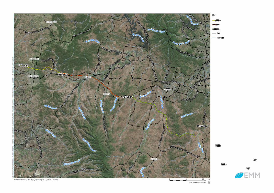
In May 2017 the Federal government announced a long-term investment in Inland Rail, funding a combination of an $8.4 billion equity investment in ARTC and a Public Private Partnership (PPP) for the three most complex elements of the project from Gowrie to Kagaru (G2K). The three sections consist of; Gowrie to Helidon (G2H), Helidon to Calvert (H2C) and Calvert to Kagaru (C2K) (Figure 1.1). This report covers the C2K geotechnical investigations planned to support the PPP.
The C2K Project is a 54 km greenfield single line dual gauge railway corridor which extends from Calvert 28 km west of Brisbane to Kagaru approximately 60 km south of Brisbane CBD (Figure 1.1). The new rail corridor will provide the ‘missing link’ between the existing narrow gauge Queensland Rail Western System and standard gauge ARTC Interstate Coastal Corridor. The proposed alignment corridor passes through a combination of rural and agricultural areas comprising of private, government and commercial properties and land holdings. The largest community near to the corridor is Peaks Crossing.
Key characteristics of the C2K Project include:
• tunnel under Teviot Range being described as Woolooman 1 which is 1,030 m in length;
• three passing loops;
• approximately 28 bridges;
• the alignment crosses five flood plains; Western Creek, Bremer River, Warrill Creek, Purga Creek and Teviot Brook;
• approximately 115 crossings over existing infrastructure, including bridge structures, and level crossings (including occupational crossings); and
• approximately 23 cuttings over 5 m in depth, with the maximum cutting at 28 m in depth, at the northern portal entrance to Woolooman tunnel.
Sections of C2K are mapped as high risk under the NC Act by the Department of Environment and Science (DES) as shown in Figure 1.2. The high risk trigger mapping was downloaded in May 2018 at the commencement of planning for the protected plant surveys. Under the NC Act where clearing is proposed to occur in high risk areas, and there is no relevant exemption, a flora survey of the ‘clearing impact area’ must be undertaken prior to clearing irrespective of the classification of vegetation under the Vegetation

2
Management Act 1999 (VM Act). A protected plant flora survey in high risk trigger areas is required to comply with the Flora Survey Guidelines – Protected Plants Version 2.0 (the Guidelines) (DEHP, 2016).
Studies have shown that geotechnical risk is one such risk area that is transferred to the Private partner of the PPP, and that the more thorough the pre-award Geotechnical Investigation (GI) is the less geotechnical contingency the Private partner will need to build into their price. To provide certainty to prospective commercial partners for the PPP, ARTC will undertake detailed geotechnical investigations for G2K to collect suitable data on surface and sub-surface conditions to reduce the potential pricing risks.
The geotechnical investigations (Section 2.2) will include soil surveys from test pits (Section 2.2.1), soil sampling by auger hole (Section 2.2.2), rock sampling from boreholes (Section 2.2.3), seismic surveys and geological mapping. Facilitative access tracks (Section 2.2.4) will also be required in some areas to gain access to the borehole locations. Before drilling takes place, each location will be visited by a reconnaissance team which will peg and flag the proposed locations. Following this, the drilling crew will mobilise to the site once access, environmental, cultural heritage, utility location and other issues have been suitably resolved.
1.2 Purpose and scope
This report has been prepared to support a clearing application, in accordance with the Flora Survey Guidelines (the Guidelines) (DEHP 2016), for protected plants under the NC Act for proposed geotechnical investigations in the C2K section of the Inland Rail Project. ARTC engaged EMM Consulting in April 2018 to undertake protected plant surveys in mapped high risk trigger areas where geotechnical works were proposed.
A clearing application and supporting report (this report) is required as an EVNT flora species has been recorded within 21 of the clearing impact areas. Clearing impact areas are defined as “an area to be cleared to the extent it is within a high risk area and a buffer zone that is an additional area of 100 m”. The clearing impact areas for C2K are shown in Appendix B. This report presents information on the protected plant surveys that have been undertaken, including results and Impact Management Plan.
As required by the Guidelines this report includes the following information:
• description of the proposed impact areas and mapping of high risk areas;
• details of the suitably qualified persons completing protected plant surveys;
• a description of all possible EVNT plants found, including their supporting habitat;
• a description and justification of the flora survey method selected;
• a map of the area, showing the habitat types, the location of EVNT plants and possible EVNT plants found;
• EVNT population/plot surveys for each EVNT plant and possible EVNT plant found;
• justification of the timing of the flora survey and detail of any limitations associated with the timing of the survey;
• maps showing the locations of EVNT flora in the area to be cleared, the buffer zone, on-ground survey efforts and the properties included in the survey area;

0.1 3
• maps showing the locations where EVNT flora were absent in the area to be cleared, on-ground survey efforts and properties included in the survey area;
• Impact Management Plan that identifies avoidance and mitigation measures in respect to any confirmed records of EVNT flora species;
• responses from the Queensland Herbarium on any unidentified flora species found during survey that have been submitted for identification.
CROWS NEST
BOONAH
IPSWICH
HIGHFIELDS
GATTON
LAIDLEY
TOOWOOMBA
CALVERT
KAGARU
GOWRIE
HELIDON
Br isbane River
Logan River
Bremer River
Western
Creek
OxleyC reek
Laidley Creek
PurgaCreek
South P ine R iver
Tevio
tBrook
NorthPine River
Kings CreekBlackfellow C reek
Dalry mple Cre ek
Buaraba Creek
Tenthill Creek
Northbrook Creek
W arrill C
reek
Ma Ma Creek
BRISBANEVALLEY
HIGHWAYFO
REST
HILL F
ER
NVALE ROAD
MOU NT NEBO
ROAD
KHOL
O ROAD
ESK HAMP TON ROA D
NEWENGLAND HIGHWAY
DAYBORO ROAD
IPSW
ICHBO
ONAH
ROAD
GATTO
NES
KROA
D
WARREGO HIGHWAY
M
OUNTSAMS
ONROAD
WIVENH OESOMERSET
RO AD
BRIGHTV IE W ROAD
IP SWICHMOTORWAY
BEAUDES ERT BOO
N AH R OAD
GATTO
NCLI FTON RO
AD
CENTENA R Y HIGHWAY
FELTON CLIFTONRO AD
MULGOWIE ROAD
CUNNINGHAM HIGHWAY
TEVIO
T ROA
D
WINN R O ADP ECHE Y MACL AGAN ROAD
ATKINSONS DAM ROAD
MUR PHYSCREEKROAD
´
\\Emm
svr1\
emm\
Jobs
\2018
\B180
146 -
Inlan
d Rail
Geo
tech S
uppo
rt\GIS\
02_M
aps\E
CO02
1_Pr
ojectO
vervi
ew_2
0180
710_
01.m
xd 10
/07/20
18
0 10 20km
Gowrie to Helidon (G2H) alignmentHelidon to Calvert (H2C) alignmentCalvert to Kagaru (C2K) alignmentMain roadNamed watercourse
KEY
Source: EMM (2018); QSpatial (2017); GA (2015)GDA 1994 MGA Zone 56
ARTCProtected Plant Survey Rep ort
Figure 1.1
Gowrie to Kagaru – Inland Rail

BROOKWATER
CAMIRA
ALLENVIEW
BLACKSTONE
IPSWICH
KUNKALA
LOAMSIDE
COLLINGWOODPARK
BELLBIRD PARK
CAROLE PARK
ONE MILE
PURGA
ROSEWOOD
SADLIERS CROSSING
AMBERLEY
BLANTYRE
MILBONG
MILORA
MUNBILLA
MOUNT FORBES
MOUNT WALKER
MUTDAPILLY
NEW BEITH
OBUM OBUM
PEAK CROSSING
RADFORD
ROADVALE
SILVERDALE
REDBANKNORTH BOOVAL
RACEVIEWREDBANK PLAINS
RIPLEY
SILKSTONE
SOUTH RIPLEY
LIMESTONERIDGE
UNDULLAH
GAILESGOODNA
SWANBANK
DEEBINGHEIGHTS
SPRINGMOUNTAIN
SPRINGFIELDSPRINGFIELD LAKES
WHITE ROCK
WILLOWBANK
THE BLUFFASHWELL
COLEYVILLE
THAGOONA
WILSONSPLAINS
ANTHONY
CHURCHBANK
WOOLOOMAN
WARRILL VIEW
HARRISVILLE
KENTS LAGOON
EAST RIPLEY
EBBW VALE
EBENEZER
FLINDERSVIEW
GOOLMAN
GREENWOODVILLAGE
LYONS
Purga Cree k
Tevio
t Brook
Bremer River
Bundamba Creek
Oxley Creek
W arrillC
ree k
Mount W
alker Creek
BRISBA NE ROAD
CUNN
INGHA
M HIGHW
AY
IPSWICH ROSE WOOD ROAD
ROSEWOO
DWA
RRILL
VIEW
ROAD
IPSW
ICHBO
ONAHRO
AD
CENTENARYHIG
HWA YKARRABIN ROSEWOOD ROAD
RO SEWOOD LAIDLEY ROAD
´
\\Emm
svr1\
emm\
Jobs
\2018
\B180
146 -
Inlan
d Rail
Geo
tech S
uppo
rt\GIS\
02_M
aps\E
CO02
2_C2
KHigh
Risk_
2018
0710
_01.m
xd 10
/07/20
18
0 5 10km
Helido n to Calvert (H2C) alignmentCalvert to Kagaru (C2K) alignmentMain ro adNamed waterco urseHigh-risk trigger area
KEY
Source: EMM (2018); QSpatial (2017); GA (2015); DEHP (2007)GDA 1994 MGA Zone 56
ARTCPro tected Plant Survey Repo rt
Figure 1.2
High risk trigger mapping –Calvert to Kagaru

0.1 3
2 Study area
2.1 Study area and land use
The study area for the protected plant surveys spans just over 50 km from Calvert to Kagaru and includes approximately 523 geotechnical investigation sites spread out across the proposed rail alignment. The majority of investigation sites are located within cleared and highly modified environments that are primarily used for agricultural purposes. They consist of cropping land, native and exotic pasturelands and regrowth vegetation in flat to undulating areas. Remnant vegetation occurs in some locations, predominantly on steeper slopes of the Teviot Range.
2.2 Geotechnical investigations
The proposed geotechnical investigation sites situated along the rail alignment may consist of:
• seismic surveys – a soil probe is used to take readings and no disturbance required;
• geological mapping – notes are taken and no disturbance required;
• soil surveys from test pits – there will be an estimated disturbance area of 0.8 m2 per pit;
• soil sampling by auger hole – there will be an estimated disturbance area of 0.2 m2 per hole;
• rock sampling from boreholes – there will be an estimated disturbance area of 100 m2 per borehole; and
• access tracks – access tracks will be required to an investigation site where larger vehicles or machines are required. Access tracks will generally be 3 m wide but for boreholes may be up to 5 m wide. Access tracks in most locations should not require any clearing as they can be moved to avoid native vegetation.
A more detailed description of the geotechnical investigation sites where some vegetation clearing and land disturbances may be required is provided below. Overall the geotechnical investigations are of low impact, due to the small area required for each investigation site, flexibility to move the investigation sites and access tracks to be in cleared areas and avoid high biodiversity values including protected plants.
2.2.1 Soil sampling test pits
Test pits and trenches shall be excavated by machine (e.g. rubber tyred back hoe or small tracked excavator) to the required depth to enable visual examination, logging, in-situ testing and sampling from outside the pit or trench as required. The excavation will be left with a slightly raised or mounded surface as a precaution against subsidence. Typically, a trench pit will be completed within a day. The estimated disturbance area for each test pit is 0.8 m2.
2.2.2 Auger hole (soil) sampling
Auger holes will be used where sampling is only required to a shallower depth. They will be drilled using a mobile rig mounted on a four wheel drive light vehicle or small truck. They are usually drilled to a depth of 2 to 25 m below ground level, with a diameter of 75-100 mm to allow for soil and rock sampling from the

0.1 4
auger hole as required. As the rig is mounted on a vehicle the disturbance area required is minor, estimated at 0.2 m2.
2.2.3 Borehole (rock) sampling
Boreholes will be used where sampling is needed at deeper depths and rock is encountered. They will be drilled using a truck or track mounted drill rig. They are usually drilled to a depth of 10 to 250 m deep, with a diameter of 100 mm. Deeper holes may also require a support vehicle carrying drill rods, compressors or pumps. Borehole rigs require a relatively flat drilling platform or pad, and the size is dependent on the terrain and the depth of the hole. Deeper holes may require a disturbance area of 100 m2 to allow for a safe working platform.
Water is usually necessary as a lubricant during the drilling process. Water will be provided under an agreement with a local supplier, and will not be drawn from the site unless specific arrangements have been made with the landholder. Water used for the drilling process is usually contained in a purpose-built tank and recirculated as required until the hole is complete. Following the completion of drilling the water in the tank includes clay and silt in solution and settles over time, after which the water is discharged to land. Where water is required, the volumes are typically between 450 and 900 litres per day.
2.2.4 Access tracks
Access tracks will be preferentially sited in cleared and disturbed areas to avoid the need for any vegetation clearing. For borehole locations, where access to the investigation site may be limited by steep, rugged, uneven, soft, and or heavily vegetated land, there may be a need to construct a temporary track up to 5 m wide to provide safe access for drilling, trenching and ancillary machinery. For auger holes and test pits access tracks will be no wider than 3 m.

0.1 5
3 Protected plant survey methodology
3.1 Desktop assessment
A review of existing information was undertaken to assess ecological characteristics of the study area, including the potential presence of EVNT flora species under NC Act and habitat types.
The following information sources were used in the desktop assessment:
• DES Protected Plants Flora Survey Trigger Map (accessed 5 May 2018);
• Department of the Environment and Energy (DoEE) Protected Matters Search Tool (PMST) with a 7 km buffer zone around the disturbance area;
• Department of Science, Information Technology and Innovation (DSITI) Wildlife Online with a 4 km buffer zone around the disturbance area;
• Department of Natural Resources and Mines (DNRM) Vegetation Management Regional Ecosystem spatial layer (version 10.0); and
• Atlas of Living Australia (ALA) records with a 7 km buffer zone around the disturbance area.
Due to the small scale of proposed disturbance areas and high number of sites spread across the C2K alignment a 7km buffer from the alignment was applied for PMST and ALA searches. This was considered an appropriate distance to pick up any listed flora species that may occur within the areas and habitat types for the geotechnical investigation sites. A 4km buffer was chosen for Wildlife Online to provide a higher level of accuracy for protected plants that may occur in the impact areas. Based on database search results, species profiles for target species were developed. This included a review of biology of target species to assess the suitability of survey timing for each species and to ensure ecologists were aware of the survey methods for any cryptic or hard to find species.
3.2 Field survey methodology
3.2.1 Survey areas
EMM was provided with proposed locations of geotechnical investigation sites for C2K by ARTC. Where these sites occur in high risk trigger mapping areas the ‘clearing impact area’ or ‘survey area’ was identified. This was the proposed investigation site area buffered by 100 m. This was based on section 249 of the Nature Conservation (Wildlife Management) Regulation 2006 (Qld) which defines the clearing impact area to be an area to be cleared to the extent it is within a high risk area and a buffer zone that is an additional area of 100 m.
No request has been made for reduced buffer zones for the protected plant surveys.
3.2.2 Survey timing
The planning for C2K protected plant surveys commenced in early May and field surveys were completed between 16 May 2018 and 28 June 2018. The seasonal timing of surveys has been driven by a need for the geotechnical investigations for C2K to commence in coming months to meet Inland Rail project

0.1 6
deadlines. The specific dates for surveys were also dependent on when land access could be arranged with land owners.
Survey timing in late autumn –early winter is adequate for identifying the presence of a number of EVNT flora species that have been identified as potentially occurring in the study area including Melaleuca irbyana. However this timing is not ideal for herbaceous grasses which die off during these cooler months. Further detail is provided in Table 4.1 on the potential EVNT flora species that could occur in the study area and their most suited timing for surveys.
3.2.3 Survey methods
The protected plant survey was conducted in accordance with the Flora Survey Guidelines – Protected Plants (DEHP, 2016), specifically sections 6.2.2 timed meander survey, 6.2.6 EVNT population survey and section 6.2.7 EVNT plot survey. Clearing impact areas were stratified into habitat types using satellite imagery and regional ecosystem (RE) mapping. RE mapping along the C2K alignment and where REs are within the survey areas is illustrated in Appendix B.
Field surveys were conducted by teams of two ecologists, with each team being led by a suitably qualified person listed in Table 3.1. The primary field survey method used was timed meander surveys as per Section 6.2.2 of the Guidelines where habitat types were traversed randomly with maximum coverage until complete, or until no new species were recorded for 30 minutes. Therefore some survey meanders went for longer than the 30 minutes. One meander per habitat type or a meander covering whole buffer was implemented if the area of each habitat type was less than 2 ha. All flora species (native and non-native) identified during the meander were recorded.
Where an EVNT plant, or possible EVNT plant was recorded, the population extent within the survey area was recorded and a specimen was taken for submission to the Herbarium (where its identification was not evident to the suitably qualified person). EVNT population surveys included taking GPS points or estimating density of the population and recording the population extent by counting individuals in a 20 metre by 20 metre quadrat.
Mapping of impact areas and clearing impact areas is provided in Appendix B. Mapping showing the location of meanders and locations of EVNT records is provided in Appendix C.
3.2.4 Suitably qualified person
In accordance with Section 4.2.1 of the Guidelines, the protected plant surveys were led by suitably qualified persons listed in Table 3.1.
Table 3.1 Suitably qualified persons
Suitably qualified person DES reference Stephen Catchpoole Previously submitted protected plants exemption notification AR098863 Darren Maxwell Previously submitted protected plants exemption notification AR110224 Bruce McLennan Letter approval AR098115 Dave Stanton Dave Stanton meets requirements for a suitably qualified person (has been
endorsed by DES)

0.1 7
3.2.5 Property access
Survey planning included contacting landholders to gain access for field surveys was conducted by ARTC. Reasonable attempts to contact landholders were undertaken in accordance with the requirements of the Guidelines, and where access was not granted or contact was unable to be made, this information was recorded and is presented in Appendix D.
3.2.6 Authority to conduct surveys
EMM Consulting operates under various permits and authorities in Queensland to carry out environmental surveys. These include:
• Scientific User Permit – SUR001555;
• Scientific Purposes Permit – WA006865; and
• Suitable Operator – RSO001725.

0.1 8
4 Results
4.1 Desktop search results
4.1.1 High Risk Trigger Mapping
Large sections of the C2K alignment and associated geotechnical investigation areas are situated within mapped high risk trigger areas on the Protected Flora Trigger Maps (Figure 1.2) and subsequently required a field survey as per the Flora Survey Guidelines – Protected Plants Version 2.0 (DEHP, 2016).
4.1.2 EVNT species with potential to occur
Desktop searches (as provided in Appendix E) identified 22 EVNT flora species as potentially occurring within the study area. These potentially occurring species are listed in Table 4.1 which includes their status under NC Act, habitat requirements and their optimal time of year for survey. Those EVNT flora species identified with Wildnet records are indicated with #.
Table 4.1 Target EVNT flora
Scientific name Common Name NC Act status
Habitat requirements Optimal time of year for survey
Arthraxon hispidus Hairy-joint grass Vulnerable Grows around freshwater springs on coastal foreshore dunes, in shaded small gullies, on creek banks and can also befound in or on the edges of rainforest and in wet eucalypt forest, often near creeks or swamps. The species has also been recorded from seepages in pasture where it is protected by tussock grasses (DEE, 2008a).
Spring (DEE, 2008a).
Bertya ernestiana Vulnerable Grows on skeletal sandy loam soils derived from rhyolite on steep rocky slopes and rock pavements in heath or open eucalypt forest with heath understorey (DEE, 2018a).
Flowers and fruit recorded in April, July and September (DEE, 2018a).
Bosistoa transversa Three-leaved Bosistoa
Not listed Grows in lowland subtropical rainforest up to 300 m above sea level (DEE, 2018b).
Flowers from January to May (DEE, 2018b).
Bulbophyllum globuliforme
Miniature Moss-orchid
Near Threatened
The Miniature Moss-orchid is a host-specific species, only growing on the Hoop Pine. The Hoop pine ((Araucaria cunninghamii) occurs in upland subtropical rainforest communities (DEE, 2018c).
Flowers from May to November (DEE, 2018c).
Cycas ophiolitica Endangered Grows on hills and slopes in sparse, grassy open forest at altitude ranges from 80–400 m above sea level (DEE, 2018d).
Seeds become ripe in March onwards (DEE, 2018d).
Dichanthium setosum
Bluegrass Not listed Grows in heavy basaltic black soils and red-brown loams with clay subsoil. It is often found in
Flowers in summer (DEE, 2018e).

0.1 9
Table 4.1 Target EVNT flora
Scientific name Common Name NC Act status
Habitat requirements Optimal time of year for survey
moderately disturbed areas such as cleared woodland, grassy roadside remnants and highly disturbed pasture (DEE, 2018e).
Macadamia integrifolia
Macadamia nut Vulnerable Grows in remnant rainforest preferring partially open areas such as rainforest edges (DEE, 2018f).
Flowers in January, March and June (DEE, 2018f).
Macadamia tetraphylla
Rough-shelled bush nut
Vulnerable Grows in subtropical rainforest and complex notophyll vineforest (DEE, 2018g).
Flowers from August to October, and fruits between January and April (DEE, 2018g).
Lepidium peregrinum
Wandering pepper-cress
Not listed Grows in the tussock grassland fringe of riparian open forests (DEE, 2014).
Flowers from January to April (DEE, 2014).
Notelaea ipsviciensis
Cooneana Olive Endangered Survives as an understorey plant in degraded, eucalypt dominated dry sclerophyll vegetation communities (DEE, 2018h).
Flowers in July and fruits in October (DEE, 2018h).
Phaius australis Lesser swamp-orchid
Endangered Commonly associated with coastal wet heath/sedgeland wetlands, swampy grassland or swampy forest. Occupied habitat frequently has rainforest elements.(DEE, 2018i).
Flowers from September to November (DEE, 2018i).
Phebalium distans Mt Berryman phebalium
Endangered Grows in semi-evergreen vine thicket on red volcanic soils or in communities adjacent to this vegetation type (DEE, 2018j).
Flowers from September to November (DEE, 2018j).
Planchonella eerwah
Shiny-leaved Condoo
Endangered Grows in subtropical rainforest, dry rainforest and Hoop pine (Araucaria cunninghamii) vine scrub (DEE, 2018k).
Flowers from January to April, and August to September (DEE, 2018k).
Rhaponticum australe
Austral Cornflower
Vulnerable Grows on heavy black or red-brown clay, or clay loams derived from basalt. Populations are often confined to roadsides and cultivation headlands (DEE, 2018l).
Flowers between spring and late summer to autumn (DEE, 2018l).
Samadera bidwillii Quassia Vulnerable Grows in lowland rainforest or on rainforest margins (DEE, 2018m).
Flowers from November to January, and March (DEE, 2018m).
Sophora fraseri Vulnerable Grows in moist habitats, often in hilly terrain at altitudes from 60–660 m on shallow soils along rainforest margins in eucalypt forests or in large canopy gaps in closed forest communities (DEE, 2008b)
Flowers in April and from late August to mid November (DEE, 2008b).
Thesium australe Austral Toadflax Vulnerable Occurs in subtropical, temperate and subalpine climates, in grassy understories, over a wide range of altitudes (DEE, 2018n).
Flowers and fruits throughout the year on the coast (DEE, 2018n).

0.1 10
Table 4.1 Target EVNT flora
Scientific name Common Name NC Act status
Habitat requirements Optimal time of year for survey
Cupaniopsis tomentella#
Boonah tuckeroo Vulnerable Grows in vine thickets predominantly on fertile clay soils (DEE, 2008).
-
Marsdenia coronate#
Slender milkvine Vulnerable Grows in open eucalypt forest and woodland communities on hillslopes and ridge tops with well-drained soils (TSSC, 2013).
Flowers from October to February, and April to June. Fruiting in September (TSSC, 2013).
Melaleuca irbyana#
Swamp Tea-tree Endangered Grows in flat areas that are periodically waterlogged, in eucalypt forest, mixed forest and Melaleuca woodland with a sparse and grassy understory. It grows on poorly draining, heavy clay soils (WetlandInfo, 2018).
Flowers from September to January (WetlandInfo, 2018).
Notelaea lloydii#
Lloyd’s native olive
Vulnerable Occurs on undulating to hilly terrain either in moist gullies or on gentle to steep dry slopes, but is rarely found on rocky outcrops. Soil types are mostly shallow, well drained and stony to very rocky in texture (DEE, 2018a).
Flowers in spring (DEE, 2018a).
Planchonella eerwah#
Shiny-leaved Condoo
Endangered Occurs in subtropical rainforest, dry rainforest and Hoop pine (Araucaria cunninghamii) vine scrub (DEE, 2018b).
Flowers from January to April, June, and August to September (DEE, 2018b).
# indicated species from Wildnet desktop search
4.1.3 Regional ecosystems
Table 4.2 presents the Regional Ecosystems (RE), both remnant and high value regrowth (HVR) that intersect the C2K alignment and occur within the protected plant survey areas. Each RE’s Vegetation Management Act 1999 (VM Act) status is provided. The location of REs along the C2K alignment are illustrated in Appendix B.
Table 4.2 Regional Ecosystems
Regional Ecosystem Description VM Act Status 12.3.3 Eucalyptus tereticornis woodland on Quaternary alluvium. Endangered 12.3.7 Eucalyptus tereticornis, Casuarina cunninghamiana subsp. cunninghamiana
+/- Melaleuca spp. fringing woodland. Least concern
12.3.18 Melaleuca irbyana low open forest on alluvial plains. Endangered 12.9-10.2 Corymbia citriodora subsp. variegata +/- Eucalyptus crebra open forest on
sedimentary rocks. Least concern
12.9-10.7 Eucalyptus crebra +/- E. tereticornis, Corymbia tessellaris, Angophora spp., E. melanophloia woodland on sedimentary rocks.
Of concern
12.9-10.17 Eucalyptus acmenoides, E. major, E. siderophloia +/- Corymbia citriodora
subsp. variegata woodland on sedimentary rocks. Least concern

0.1 11
4.1.4 Property access
During the survey planning phase, access arrangements were made for relevant properties. For those properties where access hasn’t been available ARTC proposes to conduct a pre-clearance ecological survey in the future prior to any geotechnical investigations occurring. The survey will be conducted by a suitably qualified ecologist with the purpose to identify any EVNT flora species within the areas of proposed geotechnical investigations. Any EVNT flora species identified will be avoided. These surveys will be undertaken for all sites and will also be used as an opportunity to assess the presence of fauna breeding places, identify any weeds of significance and complete a general ecological assessment to ensure environmental impacts are avoided and appropriate mitigation measures are put in place.
Properties that were unable to be accessed are shown in Appendix C, with information on the attempts made for land access presented in Appendix D.
4.2 Field survey results
Surveys were undertaken in late autumn and early winter following a period of reasonable low rainfall. The dry conditions prior to these surveys are likely to have made it difficult to detect some species, particularly in grass species (Poaceae) that generally die off during colder months. However, clearing impact areas were surveyed by two ecologists and specific effort was undertaken for the target grass species as the time of year is not conducive to effective identification due to the lack of fertile material. All other target species were considered to be readily available from vegetative material and fruits or flowers. To address the timing constraint for native grass species an additional pre-clearance survey will be undertaken by a suitably qualified ecologist to check a proposed disturbance area for any EVNT flora species prior to disturbance. This is likely to be in spring and summer of 2018/19 which is more optimal timing for these species.
All flora species encountered during protected plant surveys in C2K are listed in Appendix A. Mapping of field survey results is provided in Appendix C and described in additional detail in the following sections.
4.2.1 Sites with no EVNT flora species
Below is a summary of survey site locations where no EVNT flora species were detected within the clearing impact area. Survey sites and survey effort for the sites below are shown in Appendix C.
Table 4.3 Survey site summary (no EVNT recorded)
Site Site Description RE/Habitat Assessment Type Assessment Outcome TP2105 Degraded road
reserve adjacent to an existing railway line
Non-remnant Heavily degraded/modified therefore no meander
No EVNT plants found
TP2764 Degraded road reserve adjacent to an existing railway line
Non-remnant Heavily degraded/modified therefore no meander
No EVNT plants found
AH2533
Degraded exotic grassland dominated by exotic grasses and forbs. Native remnant vegetation to east
Degraded Grassland: Dominated by Chloris guyana*, Cynodon dactylon*, Setaria parviflora* Native remnant woodland (RE12.9-10.27): Canopy dominants include Eucalyptus
Quaternary description and timed 1hr meander
No EVNT plants found in survey area. Site location is degraded habitat that does not provide suitable habitat for EVNT species. Population of Melaleuca irbyana was noted as

0.1 12
Site Site Description RE/Habitat Assessment Type Assessment Outcome tereticornis (forest red gum), Eucalyptus crebra (narrow leaf ironbark) Upper Shrub Layer: Acacia leiocalyx (early flowering black wattle). Native ground cover including Cymbopogon refractus (barbed wire grass), Aristida calycina (dark wiregrass), Aristida personata (purple wiregrass)
occurring outside the clearing impact area approximately 100m to east within remnant woodland.
TP2814
Degraded exotic pasture. Patch of native remnant woodland in south-eastern portion.
Degraded Grassland: Dominated by Cynodon dactylon*, Chloris guyana Native remnant woodland (RE12.9-10.27): Canopy dominants include Eucalyptus tereticornis (forest red gum), Eucalyptus crebra (narrow leaf ironbark): Canopy to 23m with 40% PCC.
Formalised 30min meander transect undertaken
No EVNT plants found.
TP2857 Located on degraded roadside easement with intact remnant vegetation (RE12.9-10.2/12.9-10.7) to the immediate east
Native remnant woodland (RE12.9-10.2): Canopy dominants include Corymbia citriodora (lemon scented gum), Eucalyptus tereticornis (forest red gum), Eucalyptus crebra (narrow leaf ironbark) : Canopy to 25m with 40% PCC. Sparse shrub cover dominated by Acacia maidenii (Maiden’s wattle)
Formalised 30 min meander transect restricted to road reserve due to lack of site access.
No EVNT plants found.
TP2786 Cleared Pasture Paddock
Non-remnant Heavily degraded/modified therefore no meander
No EVNT plants found.
TP2787 Cleared Pasture Paddock
Non-remnant Heavily degraded/modified therefore no meander
No EVNT plants found.
AH2029 Cleared Pasture Paddock
Non-remnant Heavily degraded/modified therefore no meander
No EVNT plants found.
TP2788 Cleared Pasture Paddock
Non-remnant Formalised 30min meander transect undertaken
No EVNT plants found.
TP2791 Small open area surrounded by grassy woodland
RE 12.3.3d Formalised 30min meander transect undertaken
No EVNT plants found.
TP2792 Cleared Pasture Paddock
Non-remnant Formalised 30min meander transect undertaken
No EVNT plants found.
BH2699 Scattered E. tereticornis. Likely no clearing of woody
Non-remnant Formalised 30min meander transect undertaken
No EVNT plants found.

0.1 13
Site Site Description RE/Habitat Assessment Type Assessment Outcome vegetation required
TP2111 Pasture paddock clear of woody vegetation
Non-remnant Formalised 30min meander transect undertaken
No EVNT plants found.
TP2796 Pasture paddock clear of woody vegetation
Non-remnant Formalised 30min meander transect undertaken
No EVNT plants found.
TP2795 Pasture paddock clear of woody vegetation
Non-remnant Formalised 30min meander transect undertaken
No EVNT plants found.
TP2108 Pasture paddock clear of woody vegetation
Non-remnant Formalised 30min meander transect undertaken
No EVNT plants found.
TP2854 Pasture paddock mostly clear of woody vegetation
Non-remnant Formalised 30min meander transect undertaken
No EVNT plants found.
TP2140 Cleared paddock close to access track
Non-remnant Formalised 30min meander transect undertaken
No EVNT plants found.
TP2851 Pasture paddock mostly clear of woody vegetation
Non-remnant Formalised 30min meander transect undertaken
No EVNT plants found.
TP2853 Cleared and on access track
Non-remnant Formalised 30min meander transect undertaken
No EVNT plants found.
TP2139 Woodland. RE: 12.9-10-7. Spotted gum and Narrow-leaved ironbark woodland.
Formalised 30min meander transect undertaken
No EVNT plants found.
BH2715 Woodland RE: 12.9-10-7. Spotted gum and Narrow-leaved ironbark woodland.
Formalised 30min meander transect undertaken
No EVNT plants found.
TP2850 Cleared pasture Non-remnant Formalised 30min meander transect undertaken
No EVNT plants found.
TP2136 Cleared of vegetation – sandstone rocks
Non-remnant Formalised 30min meander transect undertaken
No EVNT plants found.
BH2094 Cleared on sandstone with occasional E. crebra
Non-remnant Formalised 30min meander transect undertaken
No EVNT plants found.
TP2137 Cleared and grassed pasture
Non-remnant Formalised 30min meander transect undertaken
No EVNT plants found.
BH2714 Cleared and grassed pasture
Non-remnant Formalised 30min meander transect undertaken
No EVNT plants found.
TP2138 Cleared and grassed pasture
Non-remnant Formalised 30min meander transect undertaken
No EVNT plants found.
TP2130 Pasture paddock mostly clear of woody vegetation
Non-remnant Formalised 30min meander transect undertaken
No EVNT plants found.
TP2109 Cleared land for pasture
Non-remnant Formalised 30min meander transect
No EVNT plants found.

0.1 14
Site Site Description RE/Habitat Assessment Type Assessment Outcome undertaken
AH2529 Cleared land for pasture
Non-remnant Formalised 30min meander transect undertaken
No EVNT plants found.
BH2694 Adjacent to semi-permanent creek in pasture
Non-remnant Formalised 30min meander transect undertaken
No EVNT plants found.
TP2781 Adjacent to semi-permanent creek in pasture
Non-remnant Formalised 30min meander transect undertaken
No EVNT plants found.
BH2693 Semi-permanent creek
Non-remnant Formalised 30min meander transect undertaken
No EVNT plants found.
TP2780 Adjacent to semi-permanent creek in cleared pasture
Non-remnant Formalised 30min meander transect undertaken
No EVNT plants found.
TP2779 Adjacent to semi-permanent creek in cleared pasture
Non-remnant Formalised 30min meander transect undertaken
No EVNT plants found.
AH2027 Cleared land for pasture
Non-remnant Formalised 30min meander transect undertaken
No EVNT plants found.
TP2784 Cleared land for pasture
Non-remnant Formalised 30min meander transect undertaken
No EVNT plants found in survey area. A M. irbyana was observed 30 metres outside of the 100m impact area, to the north.
AH2028 Cleared land for pasture
Non-remnant Formalised 30min meander transect undertaken
No EVNT plants found.
TP2782 Cleared land for pasture
Non-remnant Formalised 30min meander transect undertaken
No EVNT plants found.
TP2830 Grazed paddock with scattered trees and degraded natural billabong
Non-remnant Informal meander transect undertaken
No EVNT plants found.
TP2141 Grazed paddock with scattered trees
Non-remnant Informal meander transect undertaken
No EVNT plants found.
BH2095 Regrowth spotted gum-narrow leaved ironbark woodland on sandstone; grazed.
Non-remnant Formalised 30min meander transect undertaken
No EVNT plants found.
TP2856 Regrowth spotted gum-narrow leaved ironbark woodland on sandstone; grazed.
Non-remnant Formalised 30min meander transect undertaken
No EVNT plants found.
AH2543 Grazed paddock; creekbank vegetation
Non-remnant Formalised 30min meander transect undertaken
No EVNT plants found.
TP2812 Paddock with trees along Warril Creek, Purga School RD
Non-remnant Formalised 30min meander transect undertaken
No EVNT plants found.

0.1 15
Site Site Description RE/Habitat Assessment Type Assessment Outcome
AH2536 Paddock with trees along Warril Creek, Purga School RD
Non-remnant Formalised 30min meander transect undertaken
No EVNT plants found.
TP2811 Paddock with trees along Warril Creek, Purga School Road
Non-remnant Formalised 30min meander transect undertaken
No EVNT plants found.
BH2805 19-47 Paynes Road, Ebenezer QLD 4340
Non-remnant Highly modified, therefore no meander.
No EVNT plants found.
TP2800 Turf Farm at 285-327 Paynes Road, EBENEZER QLD 4340
Non-remnant Highly modified, therefore no meander.
No EVNT plants found.
TP2816 171 Lubes Road, Purga, QLD
Non-remnant Highly modified, therefore no meander.
No EVNT plants found.
TP2135 Highly modified paddock next to road verge with high impact from stock from adjacent dam
Non-remnant Highly modified, therefore no meander.
No EVNT plants found.
TP2134 Olive Grove/Plantation, Dwyers Road
Non-remnant Highly modified, therefore no meander.
No EVNT plants found.
TP2849 Highly modified paddock next to road verge with high impact from stock from adjacent dam
Non-remnant Highly modified, therefore no meander.
No EVNT plants found.
TP2848 Olive Grove/Plantation, Dwyers Road
Non-remnant Highly modified, therefore no meander.
No EVNT plants found.
TP2847 Olive Grove/Plantation, Dwyers Road
Non-remnant Highly modified, therefore no meander.
No EVNT plants found.
TP2855 Regrowth spotted gum-narrow leaved ironbark woodland on sandstone; grazed.
Non-remnant Formalised 30min meander transect undertaken
No EVNT plants found.
TP2826 Highly modified road verge next to manicured garden in a residency
Non-remnant Highly modified, therefore no meander.
No EVNT plants found.
TP2806 Highly modified road verge
Non-remnant Highly modified, therefore no meander.
No EVNT plants found.
BH2089 Highly modified road verge
Non-remnant Highly modified, therefore no meander.
No EVNT plants found.
BH2695 Cleared land for improved pasture
Non-remnant Highly modified/improved pasture, therefore no meander.
No EVNT plants found.
BH2696 Cleared land for improved pasture
Non-remnant Highly modified/improved
No EVNT plants found.

0.1 16
Site Site Description RE/Habitat Assessment Type Assessment Outcome pasture, therefore no meander.
BH2697 Cleared land for improved pasture
Non-remnant Highly modified/improved pasture, therefore no meander.
No EVNT plants found.
TP2778 Cleared land for improved pasture
Non-remnant Highly modified/improved pasture, therefore no meander.
No EVNT plants found.
AH2026 Cleared land for improved pasture
Non-remnant Highly modified/improved pasture, therefore no meander.
No EVNT plants found.
TP2777 Unnamed Road Reserve
Non-remnant Highly modified/improved pasture, therefore no meander.
No EVNT plants found.
4.2.2 Sites with EVNT flora species
One EVNT flora species was identified at 21 clearing impact areas, being the Swamp tea-tree (Melaleuca irbyana). This species is listed as endangered under the NC Act. The species was commonly found as individual plants or a cluster of individuals both in non-remnant and remnant areas.
A summary of the geotechnical investigation sites and applicable lot and plans where M. irbyana was observed is provided below (Table 4.4) and mapping of M. irbyana records is provided in Appendix C. A species profile is presented in Section 5.

0.1 17
Table 4.4 Survey site summary (EVNT species were recorded)
Site Lot/Plan Site description RE/Habitat Assessment Type Assessment outcome
TP2113 265CH31877 The majority of the meander area with the exception of a small strip at the northern end is dense M. irbyana on heavy cracking clay soils with emergent eucalypt high canopy. The vegetation is a mix of extremely dense regrowth up to 7 metres high with specimen counts up to 3500/ha and more open areas of mature trees with estimated densities of 1000-1500 specimens/ha and canopy height of 8-11 metres. The centre point of the area is clear of vegetation.
12.9-10.27 & 12.3.18
Formalised 30min meander transect undertaken and extended once an endangered species was found.
M. irbyana identified.
TP2801 265CH31877 The majority of the meander area with the exception of a small strip at the northern end is dense M. irbyana on heavy cracking clay soils with emergent eucalypt high canopy. The vegetation is a mix of extremely dense regrowth up to 7 metres high with specimen counts up to 3500/ha and more open areas of mature trees with estimated densities of 1000-1500 specimens/ha and canopy height of 8-11 metres. Centre point within dense M. irbyana with a 6-7 metre canopy height and 90% canopy cover – likely regrowth with old windrows through the area. Heavy cracking clay soils.
12.3.18 with a small patch of 12.9-10-27
Formalised 30min meander transect undertaken and extended once an endangered species was found.
M. irbyana Identified
TP2114 265CH31877 This survey point is in a slightly more open area but close to dense stands of M.irbyana. One meander was contained to the area of mapped RE12.3.18 which has an emergent open canopy of E. tereticornis and E. crebra to 18 metres with a dense (70-80%) subcanopy of M. irbyana (8-9 m high) on deep cracking clay soils. M. irbyana is mostly mature trees with an estimated density of 800 specimens per hectare. A second meander in RE 12.3.19 revealed a sparse canopy of E. crebra, E. tereticornis and E. melanophloia with a light scatter of M. irbyana (approx. density of 15-20 specimens/ ha with some locally dense patches.) Soils are firm sandy light clays. A third meander was undertaken in the narrow strip of cleared ground within the survey buffer for TP2114 and TP2115 adjacent to Paynes Road. There is scattered regrowth within the clearing at an estimated density of 100 – 250 specimens/ha.
RE12.3.18, RE12.3.19 & Non-remnant
Formalised 30min meander transect undertaken and extended once an endangered species was found.
M. irbyana Identified
TP2115 265CH31877 Scattered M. irbyana at this point with E. tereticornis and P. pubescens. This area is more open to the west.
RE12.3.18, RE12.3.19 & Non-remnant
Formalised 30min meander transect undertaken and
M. irbyana Identified

0.1 18
Site Lot/Plan Site description RE/Habitat Assessment Type Assessment outcome
One meander was contained to the area of mapped RE12.3.18 which has an emergent open canopy of E. tereticornis and E. crebra to 18 metres with a dense (70-80%) subcanopy of M. irbyana (8-9 m high) on deep cracking clay soils. M. irbyana is mostly mature trees with a estimated density of 800 specimens per hectare. A second meander in RE 12.3.19 revealed a sparse canopy of E. crebra, E. tereticornis and E. melanophloia with a light scatter of M. irbyana (approx. density of 15-20 stems/ ha with some locally dense patches.) Soils are firm sandy light clays A third meander was undertaken in the narrow strip of cleared ground within the survey buffer for TP2114 and TP2115 adjacent to Paynes Road. There is scattered regrowth within the clearing at an estimated density of 100 – 250 specimens/ha.
extended once an endangered species was found.
TP2802 265CH31877 M. irbyana in this area is a mature thicket on heavy alluvial clay soils with emergent E. crebra and other eucalypts. Counts for M. irbyana range from 200-500/ha with a 7 metre canopy and 30-60% cover. The centre point is in scattered C. tessellaris, E. melanophloia, E. tereticornis, M. irbyana and A. salicina. Adjacent to a dense stand of M. irbyana to the south and east. There is a strip of forest adjacent to Paynes Road that has M. irbyana regrowth after it has previously been cleared.
RE12.3.18, RE12.3.19 & Non-remnant
Formalised 30min meander transect undertaken and extended once an endangered species was found.
M irbyana Identified
TP2775 23CH3150 Pasture paddock clear of woody vegetation
Non-remnant Formalised 30min meander transect undertaken and extended once an EVNT species was found.
M. irbyana points along the road verge adjacent to the paddock.
TP2776 23CH3150 Vegetated road verge with improved pasture adjacent on both sides Non-remnant Incidental M. irbyana points lie within overlapping TP2775.
TP2818 45CH3120 Cleared paddock with scattered M. irbyana regrowth Mapped as 12.9-10.11 and 12.9-10.27 but neither
Formalised 30min meander transect undertaken and extended once an endangered species
Scattered regrowth M. irbyana is the dominant woody vegetation with

0.1 19
Site Lot/Plan Site description RE/Habitat Assessment Type Assessment outcome
ecosystems is present within the surveyed area
was found. 297 specimens.
BH2700 172CH3162 Eucalyptus woodland 12.9-10.27 & Non-remnant
Formalised 30min meander transect undertaken and extended once an endangered species was found.
11 M. irbyana.
TP2797 172CH3162 Centre point of impact area is located between trees and it is likely no clearing is needed.
12.9-10.27 & Non-remnant
Formalised 30min meander transect undertaken and extended once an endangered species was found.
32 M. irbyana in pockets within the survey area
TP2789 261CH3159 Centre point of impact area is located between trees and it is likely no clearing is needed.
12.3.3d Formalised 30min meander transect undertaken and extended once an endangered species was found.
5 M. irbyana within the survey area.
TP2790 261CH3159 Centre point of impact area is located between trees and it is likely no clearing is needed.
12.3.3d Formalised 30min meander transect undertaken and extended once an endangered species was found.
5 M. irbyana within the survey area
TP2783 176RP807143 Centre point of impact area is located in an open field. Non-remnant Formalised 30min meander transect undertaken and extended once an endangered species was found.
A single M. irbyana growing next to an E. crebra.
TP2798 174CH3162 Regrowth shrubland with dominant Acacia leiocalyx (early flowering black wattle). Remnant woodland located to the south-east of site.
Non-remnant shrubland: 60% cover of
Quaternary description and formal timed
Habitat for Melaleuca irbyana

0.1 20
Site Lot/Plan Site description RE/Habitat Assessment Type Assessment outcome
Acacia leiocalyx at a canopy height of 4 -6m. Native remnant woodland (RE12.9-10.27) to south-east
meander (1 hr). associated with regrowth vegetation
AH2031 174CH3162 Regrowth shrubland with dominant Acacia leiocalyx (early flowering black wattle). Remnant woodland
Non-remnant shrubland: 70% cover of Acacia leiocalyx at a canopy height of 4 -6m. Scattered Allocasuarina littoralis (black she-oak) and Eucalyptus melanophloia present. Native remnant woodland (RE12.9-10.27) to south-east.
Quaternary description and formal timed meander (1 hr).
Habitat for M. irbyana associated with remnant vegetation. 5 Melaleuca irbyana within survey area.
TP2813
2SP238337 Degraded exotic pasture on margins of non-remnant vegetation.
Non-remnant: Dominated by Cynodon dactylon*, Chloris guyana
Formalised 1:30min meander transect undertaken
Melaleuca irbyana identified.
TP2120 84CC3477 Open paddock with scattered trees including M. irbyana Non-remnant Formalised 30min 27 M. irbyana

0.1 21
Site Lot/Plan Site description RE/Habitat Assessment Type Assessment outcome
meander transect undertaken and extended once an endangered species was found.
found within the survey area.
TP2815 84CC3477 Paddock with trees including M. irbyana Non-remnant Formalised 30min meander transect undertaken and extended once an endangered species was found.
22 M. irbyana found within survey area.
BH2698 4RP186730 Paddock with trees including M. irbyana Non-remnant Formalised 30min meander transect undertaken
5 M. irbyana found within survey area.
TP2112 172CH3162 Paddock with trees including M. irbyana Non-remnant Formalised 30min meander transect undertaken
1 M. irbyana found within survey area.

0.1 22
5 Melaleuca irbyana species profile
5.1 Description
As described in previous sections of the report, only one EVNT flora species, Melaleuca irbyana, was identified during protected plant flora surveys. The species was found to occur at 21 clearing impact areas, and up to 430 specimens were recorded. The species was predominantly found as individuals (both juvenile and mature specimens (mature specimen shown in Photograph 5.1) or clumps of individuals in cleared areas, or regrowth vegetation. There were some instances where M. irbyana has been found to occur in denser stands and in remnant eucalypt woodlands. Locations of M. irbyana species and communities are shown in mapping in Appendix C.
Melaleuca irbyana is a small tree growing to 8 to 12 m in height (Photograph 5.1). The tree has a thick, spongy, papery bark with small leaves, less than 4 mm long. The leaves are stalkless and pointed, and are pressed close to the branchlets. The canopy is dense and rounded, and consists of very fine, weeping foliage. In summer profuse white brushes, made up of groups of flowers in threes, appear and are followed by tight clusters of woody fruits (OEH, 2018).
M. irbyana grows in flat areas that are periodically waterlogged, in eucalypt forest, mixed forest and Melaleuca woodland with a sparse and grassy understorey. It grows on poorly draining, heavy clay soils (Byrnes 1984; Barlow 1987).
Melaleuca irbyana forms communities that occur in two different structural forms:
• The more common form consists of a dominant eucalypt canopy with an understorey of Melaleuca irbyana thickets 8 to 12 m in height.
• The less common form is an open forest or thicket of Melaleuca irbyana with emergent eucalypt trees with an understorey usually comprised of grasses, sedges and herbs with a few shrubs, vines and possibly orchids present (Logan City Council, 2013).

0.1 23
Photograph 5.1 Melaleuca irbyana (D. Stanton, 2018)
5.2 Distribution and habitat
Melaleuca irbyana and communities in which it occurs are endemic to SEQ and north-eastern NSW and occur in the South Eastern Queensland biogeographic region (DEE, 2018). The communities are distributed in isolated patches dispersed over the local government areas of Beaudesert, Boonah, Logan, Ipswich, Laidley and Esk. Melaleuca irbyana was once common throughout SEQ, but its habitat has been extensively cleared for agriculture and grazing (Logan City Council, 2013).
Melaleuca irbyana grows on poorly drained heavy clay soils in periodically drained areas within eucalypt forests. Seasonally cracking clay soils are known as Tea-tree Clays and these clays are associated with flat plains with wide swampy depressions. Melaleuca irbyana occurs on sedimentary rocks and Quaternary alluvium plains of the Moreton Basin. Average annual rainfall of 853 to 924 mm has been recorded in areas where Melaleuca irbyana occurs (DEE, 2018).
5.3 Significance
The species and communities it occurs within provides habitat for a range of flora and fauna. At least 36 bird species have been recorded in Melaleuca irbyana communities, including forest species that move within the forest vegetation, and woodland or grassland birds that only frequent the interface between the forest and adjacent to more open vegetation. Common bird species include Grey fantail (Rhipidura fulginosa), Golden whistler (Pachycephala pectoralis), Rufous whistler (P. rufiventris) and Black-chinned honeyeater (Melithreptus gularis). Mammals recorded in Melaleuca irbyana forests include Koalas (Phascolarctos cinereus), Short-beaked echidnas (Tachyglossus aculeatus), Eastern grey kangaroos (Macropus giganteus) and Wallabies. A number of frog species are associated with swampy pools that develop after rain (DEE, 2018).

0.1 24
Melaleuca irbyana forests are home to a diverse range of native herbs. Austral cornflower (Stemmacantha australi) and Slender milkvine (Marsdenia coronata) are two endangered plant species known to occur in some Melaleuca irbyana fragments (Logan City Council, 2013).
5.4 Threats
Several factors threaten the population and distribution of the species. Land clearing for grazing, agriculture and rural residential development is considered the greatest threat to Melaleuca irbyana. Clearing results in loss and fragmentation of the vegetation and increased edge effects through disturbances relating to adjacent land use. Melaleuca irbyana is a long-lived species with a slow juvenile growth phase, making young plants particularly susceptible to disturbance from grazing. Heavy grazing can result in loss of biodiversity of groundcover species, prevent regeneration of seedlings, reduce the foliage cover of canopy trees and encourage weed invasion. The species is also known to be selectively cleared for timber harvesting (DEE, 2018o).
More than 40 species of non-native plant are known to have established in Melaleuca irbyana forests. Weeds of particular concern include Lantana (Lantana camara) and Creeping Lantana (L. montevidensis). Other weed species commonly associated with Melaleuca irbyana include Mother-of-millions (Bryophyllum tubiflorum) and Prickly pear (Opuntia stricta) (DEE, 2018o).

0.1 25
6 Impact Management Plan
In all instances where M. irbyana has been recorded, they will be avoided during geotechnical investigations. Geotechnical investigation sites and associated access tracks will be sited away from the species, and suitable buffers put in place, to ensure no direct or indirect impacts will occur. There is flexibility in where investigation sites are placed to ensure EVNT flora species are avoided and suitable buffers are put in place to ensure no indirect impacts occur to the species during the short period works are occurring.
The following sections discuss the potential direct and indirect impacts that may occur, and how these impacts will be avoided and managed.
6.1 Avoidance measures
For those locations where M. irbyana has been recorded ARTC will ensure that prior to any disturbance occurring all M. irbyana are clearly identified in the field and an exclusion zone established (with temporary fencing) around the individuals or patches. A minimum of 10 m exclusion buffer will be established to ensure no vehicles or machinery park or drive near the species, and no earthworks, drilling or stockpiles of spoil from drilling occur near these exclusion zones. Damage to canopies and/or root zones of larger M. irbyana individuals will mean larger exclusion buffers, greater than 10 m, will be required. ARTC commits to altering the location of geotechnical investigation sites and access tracks to ensure all M. irbyana are avoided.
For the four geotechnical sites which were found to occur within patches of the Swamp tea-tree TEC (including individuals of M. irbyana) ARTC has now moved these outside of the TEC and away from any M. irbyana individuals as shown in Figure 6.1.
A key focus for the planning and implementation of geotechnical investigations will be to locate sites in existing cleared and disturbed areas, maximise the use of existing access tracks, and avoid areas of biodiversity value including remnant and regrowth native vegetation, watercourses and riparian areas, protected plants and fauna breeding places.
Where existing tracks are not available, access tracks will be sited to avoid and minimise impacts on native vegetation, including avoidance of any EVNT flora.
6.2 Mitigation measures
ARTC will ensure that any indirect impacts to M. irbyana (or other EVNT flora if they are recorded) are avoided and managed. Potential indirect impacts and solutions to mitigate these impacts are listed below:
• The establishment of some borehole locations will require earthworks to create a flat area for the drilling equipment. Where clearing and earthworks is required it will be ensured this is located away from M. irbyana locations (outside 10 m fenced exclusion zone). All stockpiling of dirt or cleared plant material will be placed outside the exclusion zone to the EVNT flora species to ensure no soil compaction occurs. Fencing will also protect the plants from accidental impacts from vehicles, and machinery.
• In areas where soil disturbance has occurred, or stockpiling of soil is required, sediment runoff is to be appropriately managed. This will be implemented in accordance with an approved Erosion and

0.1 26
Sediment Control Plan by ARTC for geotechnical investigations and include measures that will ensure no sediment runoff occurs near EVNT flora.
• Where possible drainage to the EVNT plants will not be altered. Where sediment fences are required this will only be of short term duration, during the timeframe the GI occurs at any one particular site, and post works every reasonable effort will be made to make sure the overland flow and drainage will be returned to that of pre-disturbance. The excavated areas for trench pits and boreholes will be backfilled to ensure surface runoff is not altered. After exclusion fencing is removed a site inspection report will document (with photographic plates): the successful implementation of protection measures; final state or work site; and M. irbyana present at the completion of works.
• Temporary exclusion fencing will be constructed around identified EVNT flora to prevent vehicles and machinery accidentally striking individuals and to ensure no stockpiling of soil or plant material is placed in these exclusion areas. During pre-clearance surveys, a suitably qualified ecologist will identify M. irbyana individuals within clearing impact areas and will clearly mark a buffer around the tree with high visibility flagging tape. A minimum of 10 m buffers will be applied.
• Weed hygiene protocols will be put in place to ensure that weeds are not spread or introduced into areas of geotechnical investigations. This will include washdown of vehicles and machinery before entering sites and between sites. If disturbance of vegetation (including existing weeds is required) appropriate control measures will be put in place to avoid the spread of weeds occurring. Weeds will be managed under protocols set out under the Queensland Biosecurity Act 2014.
6.3 Salvage
M. irbyana contingent salvage or translocation will not be required as individuals will not be removed. Suitable habitat for M. irbyana is available throughout the study area and all confirmed individuals and communities recorded during field surveys are mapped in Appendix C.
Therefore no impacts or reduced viability to the individuals and population is expected.
6.4 Offsets
No environmental offsets are required as no residual impacts to M. irbyana is expected.
6.5 Limitations
Due to land access being unavailable for some geotechnical investigation sites (as listed in Appendix D) there is the potential that additional M. irbyana or other EVNT flora species could occur within those sites. These sites in high risk trigger mapping areas will be surveyed at a later date as part of a pre-clearance ecology survey prior to any disturbance occurring. The pre-clearance ecology surveys will be conducted by a suitably qualified ecologist of the proposed impact area, and confirm the presence of any EVNT flora species. Any confirmed EVNT flora will be clearly marked and avoided. This may require moving the location of proposed works to ensure a minimum of 10 m exclusion zone is provided.

!! !!!!
!P!P
!P
!P
TP2801
TP2802
TP2114
TP2115
228CC3635265CH31877
2RP197248254CH31200
2RP197248259CH31308
312CH31969259CH31308
257CH31247259CH31308
259CH
31308
280SP
134714
25SP1082092RP198984
11SP1
08209
280SP
134714
CHAMPIONS WAY
PROP
OSED
ROA
D
ROAD
SEPPANEN ROAD
12.9-10.11
12.9-10.11
12.3.18
12.9-10.11
12.3.18
12.3.18
12.3.18
12.3.18
12.3.18
12.3.18
12.3.18
12.3.18
12.9-10.11
12.3.18
12.3.1812.3.18
12.3.18
12.3.18
12.9-10.11
12.9-10.11
12.9-10.11
12.9-10.11
12.9-10.11
12.3.18
12.3.18
12.3.18
12.3.18
12.3.18
12.3.18
TP2113
´
\\Emm
svr1\
emm\
Jobs
\2018
\B180
146 -
Inlan
d Rail
Geo
tech S
uppo
rt\GIS\
02_M
aps\E
CO02
5_C2
KMela
leuca
Irbya
na_2
0180
711_
01.m
xd 11
/07/20
18
0 100 200m
Gowrie to Helidon (G2H) alignmentHelidon to Calvert (H2C) alignmentCalvert to Kagaru (C2K) alignment
!! Survey site!P Alternative test pit location
Road/trackWatercourse/drainage lineCadastral boundaryMelaleuca irbyana TEC
Melaleuca irbyana potential habitat (byVM status, labelled dominant)
Endangered (remnant)Endangered (regrowth)
KEYKAGARU
GOWRIE
CALVERTHELIDON
Source: EMM (2018); QSpatial (2017); GA (2015)GDA 1994 MGA Zone 56
ARTCProtected Plant Survey Report
Figure 6.1
Revised locations in Swamp tea-tree TEC areas

0.1 29
7 References
Barlow, B A 1987, Contributions of a revision of Melaleuca (Myrtaceae), Brunonia 9(2), pp. 173.
Byrnes, N B 1984, A revision of Melaleuca L. (Myrtaceae) in northern and eastern Australia, 1. Austrobaileya 2(1), pp. 72.
DEE 2008. Approved Conservation Advice for Cupaniopsis tomentella (Boonah Tuckeroo). Department of Environment and Energy, Canberra.
DEE 2008a. Approved Conservation Advice for Arthraxon hispidus (Hairy joint-grass). Department of Environment and Energy, Canberra.
DEE 2008b. Approved Conservation Advice for Sophora fraseri. Department of Environment and Energy, Canberra.
DEE 2014. Approved Conservation Advice for Lepidium peregrinum (Wandering Pepper-cress). Department of Environment and Energy, Canberra.
DEE 2018a. Bertya ernestiana in Species Profile and Threats Database, Department of the Environment, Canberra.
DEE 2018b. Bosistoa transversa in Species Profile and Threats Database, Department of the Environment, Canberra.
DEE 2018c. Bulbophyllum globuliforme in Species Profile and Threats Database, Department of the Environment, Canberra.
DEE 2018d. Cycas ophiolitica in Species Profile and Threats Database, Department of the Environment, Canberra.
DEE 2018e. Dichanthium setosum in Species Profile and Threats Database, Department of the Environment, Canberra.
DEE 2018f. Macadamia integrifolia in Species Profile and Threats Database, Department of the Environment, Canberra.
DEE 2018g. Macadamia tetraphylla in Species Profile and Threats Database, Department of the Environment, Canberra.
DEE 2018h. Notelaea ipsviciensis in Species Profile and Threats Database, Department of the Environment, Canberra.
DEE 2018i. Phaius australis in Species Profile and Threats Database, Department of the Environment, Canberra.
DEE 2018j. Phebalium distans in Species Profile and Threats Database, Department of the Environment, Canberra.
DEE 2018k. Planchonella eerwah in Species Profile and Threats Database, Department of the Environment, Canberra.

0.1 30
DEE 2018l. Rhaponticum australe in Species Profile and Threats Database, Department of the Environment, Canberra.
DEE 2018m. Samadera bidwillii in Species Profile and Threats Database, Department of the Environment, Canberra.
DEE 2018n. Thesium australe in Species Profile and Threats Database, Department of the Environment, Canberra.
DEE 2018o. Swamp Tea-tree (Melaleuca irbyana) Forest of South-east Queensland in Community and Species Profile and Threats Database, Department of the Environment, Canberra.
DEE 2018p. Notelaea lloydii in Species Profile and Threats Database, Department of the Environment, Canberra.
DEE 2018q. Planchonella eerwah in Species Profile and Threats Database, Department of the Environment, Canberra.
DEHP 2014. Nature Conservation (Wildlife Management) Regulation 2006 Protected Plants Assessment Guidelines. Department of Environment and Heritage Protection, Queensland.
DEHP 2016. Flora Survey Guidelines – Protected Plants Nature Conservation Act 1992. Department of Environment and Heritage Protection, Queensland.
Logan City Council 2013. Logan’s Melaleuca Irbyana Recovery Plan 2013 – 2023. Logan City Council, Logan.
Office of Environment and Heritage (OEH) 2018. Weeping Paperbark – profile. Office of Environment and Heritage, New South Wales.
Threatened Species Scientific Committee (TSSC) 2013. Commonwealth Listing Advice on Marsdenia coronata (Slender milkvine). Department of Sustainability, Environment, Water, Population and Communities, Canberra.
WetlandInfo 2018. Melaleuca irbyana. Department of Environment and Science, Queensland.

0.1
Appendix A
Flora species list
Table 7.1 Flora species identified during protected plant flora surveys in C2K section
Scientific name Common name NC Act status Comments
Acacia concurrens Least concern Acacia disparrima Hickory wattle Least concern Acacia fimbriata Brisbane golden wattle Least concern Acacia leiocalyx Black wattle Least concern Acacia maidenii Maiden’s wattle Least concern Acacia melanoxylon Blackwood Least concern Acacia podalyriifolia Queensland Silver Wattle Least concern Acacia salicina Doolan Least concern Acacia sp. Least concern Acalypha capillipes Least concern Achyranthes aspera Least concern Adiantum atroviride Least concern Alchornea ilicifolia Native holly Least concern Alectryon subdentatus Least concern Alectryon tomentosus Hairy alectryon Least concern Allocasuarina littoralis Black Sheoak Least concern Allocasuarina sp. Not listed Alphitonia excelsa Soap tree Least concern Alstonia constricta Bitterbark Least concern Alternanthera pungens Khaki weed Not listed Non-native Alyxia ruscifolia chain fruit Least concern Ambrosia artemisiifolia Annual ragweed Not listed Non-native, restricted
invasive plant under the Biosecurity Act 2014
Amyema miquelii Least concern Angophora leiocarpa Rusty gum Least concern Angophora subvelutina Least concern Anredera cordifolia Madeira vine Not listed Non-native, restricted
invasive plant under the Biosecurity Act 2014
Aphananthe philippinensis Rough-leaved elm Least concern Araucaria bidwillii Bunya Pine Least concern Araujia sericifera Moth vine Not listed Non-native Aristida calycina Dark Wiregrass Least concern Aristida personata Purple Wiregrass Least concern Aristida queenslandica Least concern

0.1
Aristida sp. Not listed Arundinella nepalensis Reedgrass Least concern Asclepias curassavica Tropical Milkweed Not listed Non-native Asparagus aethiopicus Basket asparagus fern Not listed Non-native, restricted
invasive plant under the Biosecurity Act 2014
Asparagus africanus Climbing asparagus fern Not listed Non-native, restricted invasive plant under the Biosecurity Act 2014
Atalaya salicifolia Least concern Auranticarpa rhombifolia Least concern Austrostipa ramosissima Least concern Baccharis halimifolia Groundsel bush Not listed Non-native, restricted
invasive plant under the Biosecurity Act 2014
Baloghia inophylla Scrub bloodwood Least concern Bidens pilosa Least concern Boerhavia diffusa Least concern Bothriochloa bladhii Bluestem Least concern Bothriochloa decipiens Least concern Bothriochloa pertusa Not listed Non-native Breynia oblongifolia Coffee bush Least concern Bryophyllum delagoense Mother-of-millions Not listed Non-native, restricted
invasive plant under the Biosecurity Act 2014
Bursaria spinosa Least concern Calotis cuneata Least concern Calotis lappulacea Yellow burr-daisy Least concern Capillipedium spicigerum Scented-top grass Least concern Capparis arborea Brush caper berry Least concern Capparis sarmentosa Scrambling caper Least concern Carissa ovata Currant bush Least concern Cassinia laevis Least concern Casuarina cunninghamiana River She-oak Least concern Celastrus subspicata Least concern Celtis sinensis Chinese celtis Not listed Non-native, restricted
invasive plant under the Biosecurity Act 2014
Chamaecrista nomame Least concern Chamaecrista sp. Not listed Cheilanthes distans Bristly cloak fern Least concern Cheilanthes sieberi Least concern Chloris divaricata Least concern Chloris gayana Rhodes grass Not listed Chloris ventricosa Plump windmill grass Least concern Chrysocephalum apiculatum
Common everlasting Least concern
Chrysopogon fallax Least concern Chrysopogon filipes Least concern

0.1
Cinnamomum camphora Camphor laurel Not listed Non-native, restricted invasive plant under the Biosecurity Act 2014
Cirsium vulgare Spear thistle Not listed Non-native Clerodendrum tomentosum Hairy-leaved lolly bush Least concern Corymbia citriodora Lemon-scented Gum Least concern Corymbia intermedia Pink Bloodwood Least concern Corymbia tessellaris Moreton Bay ash Least concern Corymbia torelliana Cadaghi Least concern Crassula ovata Jade Plant Not listed Non-native Cryptocarya triplinervis var. triplinervis
Three-veined laurel Least concern
Cupaniopsis anacardioides Tuckeroo Least concern Cupaniopsis parvifolia Small-leaved tuckeroo Least concern Cyanthillium cinereum Least concern Cycnogeton procerum Water Ribbons Least concern Cymbidium canaliculatum Least concern Cymbidium sp. Not listed Cymbopogon refractus Barbed wire grass Least concern Cynodon dactylon Bermudagrass Not listed Cyperus exaltatus Tall flatsedge Least concern Cyperus gracilis Least concern Cyperus involucratus Umbrella sedge Not listed Non-native Daviesia ulicifolia Nataive gorse Least concern Dendrobium speciosum King orchid Least concern Denhamia celastroides Broad-leaved boxwood Least concern Denhamia disperma Least concern Derris involuta Native derris Least concern Desmodium sp. Not listed Dianella brevipedunculata Least concern Dianella caerulea Blue flax-lily Least concern Dianella revoluta Spreading Flax-lily Least concern Dichanthium annulatum Sheda Grass Not listed Non-native Dichanthium aristatum Angleton grass Not listed Non-native Dichanthium sericeum Least concern Dichanthium sp. Not listed Non-native Dichondra repens Kidney weed Least concern Digitaria divaricatissima Spreading umbrella grass Least concern Digitaria sp. Not listed Dioscorea transversa Native yam Least concern Diospyros geminata Scaly ebony Least concern Dolichandra unguis-cati Cat's claw creeper Not listed Non-native, restricted
invasive plant under the Biosecurity Act 2014
Doodia aspera Prickly rasp fern Least concern Drypetes deplanchei Yellow tulip Least concern Duranta erecta Golden Dewdrop Not listed Non-native Elattostachys xylocarpa Least concern

0.1
Eichhornia crassipes Water hyacinth Not listed Non-native, restricted invasive plant under the Biosecurity Act 2014
Eleocharis cylindrostachys Least concern Eleocharis sp. Not listed Emilia sonchifolia Lilac Tasselflower Not listed Non-native Enteropogon ramosus Least concern Epaltes australis Spreading nutheads Least concern Eragrostis cilianensis Gray Lovegrass Not listed Non-native Eragrostis curvula African lovegrass Not listed Non-native Eragrostis elongata Least concern Eragrostis parviflora Weeping lovegrass Least concern Eragrostis sororia Least concern Eragrostis sp. Not listed Eragrostis tenuifolia Elastic grass Not listed Non-native Eremophila debilis Winter apple Least concern Erigeron bonariensis Not listed Non-native Erigeron sumatrensis Not listed Non-native Eucalyptus crebra Narrow-leaved ironbark Least concern Eucalyptus melanophloia Silver-leaved ironbark Least concern Eucalyptus melliodora Yellow box Least concern Eucalyptus moluccana Gum-topped box Least concern Eucalyptus tereticornis Forest red gum Least concern Eustrephus latifolius Wombat berry Least concern Ficus macrophylla Moreton Bay Fig Least concern Ficus obliqua Small-leaved Fig Least concern Ficus opposita Sandpaper fig Least concern Ficus rubiginosa Rusty fig Least concern Fimbristylis dichotoma Common fringe-rush Least concern Flindersia australis Crow’s ash Least concern Flindersia collina Broad-leaved leopard tree Least concern Flindersia xanthoxyla Least concern Geranium homeanum Least concern Geranium solanderi Native geranium Least concern Glandularia aristigera Not listed Non-native Glycine sp. Least concern Glycine clandestina Twinning glycine Least concern Glycine tabacina Glycine pea Least concern Gomphocarpus fruiticosus Narrow-leaved cotton-bush Not listed Non-native Gomphocarpus physocarpus
Balloon cotton-bush Not listed Non-native
Gomphocarpus sp. Not listed Gomphrena celosioides Gomphrena weed Not listed Non-native Grevillea robusta Silky Oak Least concern Harpullia pendula Queensland tulipwood Least concern Heliotropium amplexicaule Blue heliotrope Not listed Non-native Heteropogon contortus Black speargrass Least concern Hibiscus heterophyllus Native rosella Least concern

0.1
Hymenosporum flavum Native frangipani Least concern Hyparrenia rufa Thatch Grass Not listed Non-native Imperata cylindrical Blady grass Least concern Jasminum dianthifolium Least concern Jasminum didymum subsp. racemosum
Least concern
Jasminum simplicifolium Stiff Jasmine Least concern Jasminum dianthifolium Forest jasmine Least concern Juncus continuus Least concern Juncus effusus Common rush Not listed Non-native Juncus usitatus Least concern Lantana camara Lantana Not listed Non-native, restricted
invasive plant under the Biosecurity Act 2014
Lantana montevidensis Creeping lantana Not listed Non-native, restricted invasive plant under the Biosecurity Act 2014
Laxmannia gracilis Slender wire lily Least concern Legnephora moorei Round-leaf vine Least concern Lepidium africanum Common peppercress Not listed Non-native Lepidium bonariense Argentine Peppercress Not listed Non-native Lepidium sp. Not listed Leucaena leucocephala Leucaena Not listed Non-native Ligustrum lucidum Large-leaved privet Not listed Non-native, restricted
invasive plant under the Biosecurity Act 2014
Lobelia gibbosa Native lobelia Least concern Lobelia purpurascens White Root Least concern Lomandra filiformis Wattle mat-rush Least concern Lomandra hystrix Matrush Least concern Lomandra longifolia Basket grass Least concern Lomandra multiflora Many-flowered mat-rush Least concern Lophostemon suaveolens Swamp box Least concern Ludwigia peploides Water primrose Not listed Non-native Maclura cochinchinensis Cockspur thorn Least concern Macroptilium atropurpureum
Siratro Not listed Non-native
Macroptilium lathyroides Not listed Non-native Maireana microphylla Least concern Mallotus claoxyloides Green kamala Least concern Mallotus philippensis Red kamala Least concern Malvastrum coromandelianum
Not listed Non-native
Megathyrsus maximus Not listed Non-native Melaleuca bracteata River teatree Least concern Melaleuca irbyana Swamp Tea-tree Endangered Melaleuca viminalis Least concern Melia azedarach White cedar Least concern Melinis repens Red natal grass Not listed Non-native

0.1
Mentha satureioides Native pennyroyal Least concern Mersilea drummondii Common nardoo Least concern Modiola caroliniana Red-flowered mallow Least concern Morus alba White mulberry Least concern Murraya paniculata Least concern Myriophyllum sp. Not listed Nephrolepis falcata Fishtail Fern Not listed Non-native Nerium oleander Oleander Not listed Non-native Nymphaea sp. Waterlily Not listed Nymphoides indica Water snowflake Least concern Opercularia diphylla Least concern Oplismenus aemulus Creeping shade-grass Least concern Oplismenus imbecillis Pademelon grass Least concern Opuntia aurantiaca Jointed Prickly-pear Not listed Non-native, restricted
invasive plant under the Biosecurity Act 2014
Opuntia stricta Prickly pear Not listed Non-native, restricted invasive plant under the Biosecurity Act 2014
Opuntia tomentosa Velvety tree pear Not listed Non-native, restricted invasive plant under the Biosecurity Act 2014
Ottelia ovalifolia Swamp lily Least concern Oxalis corniculata Creeping Woodsorrel Not listed Non-native Ozothamnus diosmifolius White Dogwood Least concern Pandorea pandorana Wonga vine Least concern Panicum coloratum var. makarikariense
Not listed Non-native
Panicum decompositum Australian Millet Least concern Panicum effusum Hairy panic Least concern Panicum maximum Green Panic Grass Not listed Non-native Panicum queenslandicum Coolabah Grass Least concern Parsonsia eucalyptophylla Gargaloo Least concern Parsonsia sp. Not listed Parsonsia straminea Common Silkpod Least concern Paspalum dilatatum Not listed Non-native Passiflora suberosa Corky passionflower Not listed Non-native Pavonia hastata Pink pavonia Not listed Non-native Pellaea paradoxa Heart fern Least concern Persicaria attenuata Least concern Persicaria decipiens Slender knotweed Least concern Philydrum lanuginosum Frogsmouth Least concern Phragmites australis Common reed Least concern Phyla canescens Not listed Non-native Phyllanthus sp. Not listed Phyllanthus virgatus Least concern Pittosporum spinescens Large-fruited orange thorn Least concern Polyscias elegans Celery wood Least concern Portulaca pilosa Not listed Non-native

0.1
Pratia concolor Poison pratia Least concern Pterocaulon redolens Least concern Pyrrosia rupestris Rock felt fern Least concern Rhodosphaera rhodanthema
Deep yellow-wood Least concern
Ripogonum album White supplejack Least concern Rivina humilis Coral berry Not listed Non-native Rostellularia adscendens Least concern Rumex sp. Not listed Schinus terebinthifolius Brazilian Peppertree Not listed Non-native, restricted
invasive plant under the Biosecurity Act 2014
Schoenoplectiella mucronata
Least concern
Sclerolaena birchii Galvanised burr Least concern Sclerolaena tetracuspis Brigalow burr Least concern Senecio madagascariensis Fireweed Not listed Non-native, restricted
invasive plant under the Biosecurity Act 2014
Senna barclayana Smooth Senna Least concern Setaria parviflora Bristlegrass Not listed Non-native Setaria sphacelata South African Pigeon Grass Not listed Non-native Sida cordifolia Flannel weed Not listed Non-native Sida hackettiana Least concern Sida rhombifolia Paddy’s lucerne Not listed Non-native Sida rohlenae Least concern Sida sp. Not listed Sida spinosa Spiny sida Not listed Non-native Sida spinescens Not listed Non-native Smilax australis Barbed-wire vine Least concern Solanum ellipticum Potato bush Least concern Solanum mauritianum Tobacco Weed Not listed Non-native Solanum seaforthianum Brazilian nightshade Not listed Non-native Sorghum halepense Johnson grass Not listed Non-native Sporobolus creber Western rat-tail grass Least concern Sporobolus laxus Least concern Sporobolus pyramidalis Giant Rat's Tail Grass Not listed Non-native, restricted
invasive plant under the Biosecurity Act 2014
Sporobolus sp. Rat’s tail grass Not listed Stachytarpheta australis Not listed Non-native Streblus brunonianus Whalebone tree Least concern Stylosanthes humilis Townsville Stylo Not listed Non-native Stylosanthes scabra Shrubby stylo Not listed Non-native Stylosanthes sp. Not listed Symphyotrichum subulatum Wild aster Not listed Non-native Syzygium sp. Not listed Tagetes minuta Stinking Roger Not listed Non-native Taraxacum officinale Dandelion Not listed Non-native

0.1
Themeda triandra Kangaroo grass Least concern Trifoliate fabaceae Not listed Non-native Trophis scandens subsp. scandens
Burny vine Least concern
Typha sp. Not listed Vachellia farnesiana Mimosa bush Not listed Non-native Velleia paradoxa Spur velleia Least concern Verbena sp. Not listed Verbena bonariensis Purpletop Not listed Verbena bonariensis Verbena officinalis Common Verbena Not listed Verbena bonariensis Vittadinia sulcata Native daisy Least concern Wahlenbergia gracilis Sprawling bluebell Least concern Wahlenbergia sp. Not listed Westringia eremicola Slender westringia Least concern Wikstroemia indica Tie bush Least concern Xanthium occidentale Noogoora burr Not listed Non-native, restricted
invasive plant under the Biosecurity Act 2014