survey of the future marine protected area of platamuni
TRANSCRIPT

Survey of the future Marine Protected Area of Platamuni and the adjacent peninsula of Lustica with emphasis on
marine caves as potential habitats of the endangered Mediterranean monk seal
Vesna Mačić, Aliki Panou, Luigi Bundone, Dušan Varda
This project was financed by Jugopetrol AD Kotor
December, 2013.

2
Survey of the future Marine Protected Area of Platamuni and the adjacent peninsula of Lustica with emphasis on marine caves as potential habitats of
the endangered Mediterranean monk seal Vesna Mačić1, Aliki Panou2, Luigi Bundone2, Dušan Varda3
1Institut za biologiju mora, Kotor, Montenegro, E-mail: [email protected] 2NGO Archipelagos - environment and development, Kifissia, Greece 3NGO MedCEM - Mediterranean Center For Environmental Monitoring, Sutomore, Montenegro Introduction Although the coastline of Montenegro is only about 300 km long, marine ecosystems are still not very well known. Additionally, there are no established Marine Protected Areas (MPAs) yet in the country, although there are some initiatives in that direction. One of the areas planned as a potential MPA by the Ministry of Sustainable Development and Tourism of Montenegro is the area from Cape Platamuni to Cape Žukovac. This area has also been declared as an "Emerald Site" by the same Ministry. Therefore, it is of special interest to carefully survey this area for important habitats and species for future protection according to the regulations of the national and the EU legislation. There are some data from the above

3
area in reports produced by the Regional Activity Center for Special Protected Areas of UNEP (UNEP/RAC/SPA 2008, 2012) concerning the development of marine and coastal protected areas in Montenegro and also in the report "Start up of the “Katič” MPA in Montenegro and assessment of marine and coastal ecosystems along the coast" by DFS Montenegro Engineering (a cooperation between the Ministry of Environment, Land and Sea of Italy and the Ministry of Sustainable Development and Tourism of Montenegro, 2012). However, these data sets are far from complete. Aiming at the promotion of the establishment of the future MPA Platamuni in the mentioned area we surveyed the area from Cape Platamuni to Cape Arza (approximately 35 km) to evaluate the presence of marine caves and, in parallel, potential terrestrial habitats of the endangered Mediterranean monk seal, Monachus monachus (Map 1). The peninsula of Luštica and the area of Donji Grbalj (where the planned future MPA Platamuni is located) is of similar bio-geomorphology and should be considered as one single marine ecosystem/entity altogether. Therefore, we included in this survey also the neighbouring coastline of Luštica.. This project was financed by Jugopetrol AD Kotor. Map. 1. Surveyed area from Cape Arza to Cape Platamuni
surveyed area planned MPA Platamuni Marine caves are an important and endangered habitat listed in Annex I of the EU Habitat Directive (92/43/EEC). They are widely acknowledged for their unique biodiversity and constitute a typical feature of the Mediterranean coastline. This particular ecosystem in the Mediterranean Sea is considered a biodiversity hotspot, appearing to be an important biodiversity reservoir of high representativeness and great scientific interest (sponges, plankton, etc.), deserving further detailed study and protection. There are few definitions for marine caves and in some documents there is no precise definition. In general, marine cave
4
may be considered as naturally formed holes in the rock longer than 5 metres (where a person can enter), completely or just partially submerged. Openings less than 5 metres are hereafter mentioned as “holes”. All these openings are mainly created by the waves' force or by freshwater running into cracks and eroding the rock in millions of years. Sometimes huge caves with stalactites and other beautiful cave rock formations are created. In sea caves, prevailing conditions differ from those of the open sea: the deeper they are the weaker becomes the waves' force allowing fragile organisms to settle. As sunlight becomes less and less intensive, algae different than those growing in the direct sunlight occupy the space, red algae in the majority. Deeper in the cave, where it is too dark even for red algae, more and more sessile animals such as colourful sponges, marine worms residing in their calcareous tubes and bryozoans with their fragile skeletons occupy the walls. Finally, in the very back of deep sea caves where there is no light at all life can hardly exist at all. The water's temperature inside the marine caves is usually lower and more stable than that in open sea in front the cave. These and other ecological factors in marine caves are similar to the conditions in deep sea waters so sometimes we can find there organisms that generally occur in the deep sea. Typical for all those organisms is the reduction of eyes and a less intensive pigmentation. Sea caves are a particular ecosystem in the Mediterranean Sea with a unique marine life. Their bottom and sides have specific communities of marine invertebrates and algae while in the water column inside the cave particular species of plankton different than the species in the open sea can be found. Some of the characteristic animals are: the yellow cup-coral (Leptopsammia pruvoti), various species of sponges (here the species Chondrisia reniformis is completely white), the crustacean Stenopus spinosus, Neptunes' lace Reteporella grimaldii, the spotted goby Thorogobius ephippiatus, sessile polychaetes, bryozoans and many other species. Marine caves are also habitat for some species of endangered bats. They are also an important habitat for resting and reproduction of the endangered Mediterranean monk seal (Monachus monachus). This species of marine mammal is protected by national law and also at the international level by the Barcelona Convention, the Bern Convention, the CITES Convention and the EU Habitat Directive (Annexes II and IV). Unfortunately, no data exist for this species in Montenegro since the 70's when one individual was killed close to Herceg Novi (this case was recorded in a film). Since that time there hasn’t been any other information about the monk seal in Montenegro at all - so the species may have abandoned the coast of the country. However, the status of the monk seal and the available terrestrial habitat i.e. marine caves, are simply unknown along the coast of Montenegro. With respect to the above considerations we decided to include in the survey of marine caves in our study area also the evaluation of potential terrestrial habitats for monk seals. The Mediterranean monk seal can reach 3 metres in length. Males are usually black on the back, females dark or light grey. It can dive up to about 100 metres chasing octopus and fish. As marine mammals breathing with lungs, monk seals need to come to shore to rest and give birth. The pups are suckled and need to learn to swim and find their own food. Due to the disturbance by man all over the open beaches, monk seals resort to quiet sea caves with a patch of beach. Such caves are thus important for the reproduction and survival of the species.The Mediterranean monk seal is the most endangered marine mammal of the

5
European Union. It is the only seal species in the Mediterranean and does not exist anywhere else on the planet. In older times, the species' range extended all over the Mediterranean, the Black Sea and N.W. Africa. Today, monk seals have disappeared from Spain, France and the Black Sea while in some areas only a few individuals still exist, among them Croatia with several monk seal sightings throughout the country, Albania and Italy. The total remaining seal population is estimated to be about 500 individuals - approximately half of them in Greek waters, including the Greek Ionian Sea. Areas such as the coasts of Italy, Montenegro and Albania may be recolonized from the Greek Ionian Sea and/or from Croatia since monk seals can travel log distances within days. Most fishermen all over the Mediterranean traditionally regarded monk seals as enemies and deliberately killed them because of damage incurred to their fishing gear and catch, since seals poach from their nets. Yet, centuries of deliberate killings did not drive the species to extinction. The rapid decline in their population has only become apparent over the last decades. What is to blame? Marine pollution, overfishing and - most importantly - disturbance of the sea caves by humans and the continual and irreversible destruction of the seal’s habitats are the main additional factors for this rapid decline. Ports, streets, hotels and restorants right at the seaside appear everywhere without almost any planning causing thereby a considerable loss of critical habitat for resting and reproduction. Additionally, marine caves with rocks and cliffs above the sea level are an excellent biotope for rare sea birds and also for rare or endemic plants such as Euphorbia dendroides and Limonium angustifolium. In our national Law on nature protection (Sl. list no. 51/08) it is indicated that "speleological objects" are naturally formed holes in the rock longer than 5m, where a person can enter and their entrance is smaller than their length or depth. Unfortunately there are no adequate regulations neither a "Caves' Register" does exist. The preparation of these regulations is ongoing already for some time now, but in those draft regulations there are no details about marine caves. We hope that the results of this project will help also towards the improvement of existing documents and the creation of an appropriate Marine Caves' Register. Material and methods The survey of the coastline from Cape Platamuni to Cape Arza (ca. 35 km) was performed from 16. to 22. September 2013 using the Institute's boat "Nemirna". For the field work, the Institute’s diving equipment, underwater cameras, plastic bags and bottles for taking samples was used. On all locations where a cave or a big hole was noted coordinates were taken by GPS Garmin 76 and notes were taken on maps. During the postprocesing of the data collected all locations were stored by Quantum GIS software. For all registered caves/holes the following basic data were noted and organized in tables: number, location name, geographic coordinates, approximate dimensions (in meters), exposition, morphological characteristics, living organisms, date of survey, living organisms in front of the cave/hole. Where details were noted the orientation and position was always noted as looking from the sea at the cave.

6
Samples of sponges from the Krekavica cave were collected and stored in 70% alcohol until further analysis. The planned mapping of of algal communities at the surface level (upper mediolittoral) along the coastline using GIS was not performed because of bad weather conditions. Results After the field work all data were organized in tables and locations were mapped in Quantum GIS. We decided to present the data for caves and for holes together (Map 2) because some of the holes are very important as habitat for the monk seal and also for many other species. Altogether, 45 features were registered and 21 of them were 5m long or more thus, they are considered as caves according to the definition given above. One cave had an entrance under water and 11 were suitable as terrestrial habitat for monk seals. Map 2. Caves and holes in the surveyed area
The distribution of caves along the coastline from Cape Arza to Cape Platamuni -and without taking into account the numerous holes- may be divided into 3 sub-areas: 1. Area of Plava špilja on the peninsula of Luštica; 2. Trašte Bay, and 3. Krekavica area in the southern

7
part of Donji Grbalj. The positions of these caves are indicated with numbers on map 3. Map 3. Caves in the surveyed area 1. Area of Plava špilja on Luštica peninsula
2. Trašte Bay
3. Krekavica area in the southern part of Donji Grbalj

8
During this research we also encountered several protected species, thus contributing to the general knowledge of their biology and ecology and underlining the ecological importance of this area. Of all protected species found inside the caves or close to them we may underline the presence of the following species (a) Algae and seagrass: Lithophyllum byssoides, Cystoseira amentacea, Posidonia oceanica and Cymodocea nodosa, (b) Molluscs: Pinna nobilis and Lithophaga lithophaga (c) Coral: Cladocora cespitosa, (d) Plants: Euphorbia dendroides and Limonium angustifolium. (e) Birds:Ardeola ralloides, Alcedo athis, Phalacrocorax aristotelis, Acciptier gentilis, Corvus corax and (f) One bat species (Chiroptera). Data for all surveyed features are presented in separate tables for each one.

9
No. 1 location: Arza
Foto: Aliki Panou
coordinates N 42º 23' 27.79'' E 18º 34' 14.02'' dimensions Covered beach 3m wide x 3m high x 4m long exposition West morpho-characteristics Hole with a rocky beach and pebbles in the back of a small inlet. Living organisms Not observed notes date of survey 17. 09. 2013. In front of the cave On some boulders there are lots of algae but rocks are barren

10
No. 5 location: Zlatna vala
Foto: Aliki Panou
coordinates N 42º 22' 51.6'' E 18º 35' 34.3'' dimensions 1m wide x 3m high x 5m long (depth of water 1,5-0m; height inside
1,5m) exposition West morpho-characteristics In the back of the cave there is a small pebble beach about 1 x 1m
completely washed by strong waves. The slope of the beach is around45°.
living organisms It seems that organisms on the rocky walls of the cave are scarce, butbecause of strong waves during the survey careful observation was notpossible
notes On the west side of the inlet from the cave in direction to open seathere are 2 underwater holes which should be checked by divingbecause there is some possibility that they are longer and maybeconnected between each other.
date of survey 17. 09. 2013. In front of the cave Big rocky blocks and boulders while deeper there is pebble and sand.
On the west side of an inlet of 0,5m depth there are algae Cystoseiraamentacea, Corallina elongata and others. Below it is barrensometimes 10m off the coastline. Illegal collecting of Lithophaga lithophaga (date shell) is evident. Thebarren area is not 100% empty of life and has mostly Padinapavonica, than Wrangelia penicillata, Halopteris sp. etc. and some seaurchins. At 4-5m depth there are approximately 20m2 covered with theinvasive alga Caulerpa racemosa. In the middle of the inlet there is a mosaic meadow of seagrassPosidonia oceanica.

11
No. 6 location: rt Franštica
Foto: Aliki Panou
coordinates N 42º 22' 41.8'' E 18º 35' 25.0'' dimensions 6m wide x 5m high x 30m long (depth of water 3-0m; height inside
7m) exposition West morpho-characteristics The wide entrance of the cave begins with an approximate width of
15m and a height of 12m. After the entrance in the cave (6m x 5m)there is inside a big space In the back of the cave there is a beach 10m long. In the middle there is a big rocky block deviding the access to the beach into two parts. The slope of the beach is about 30°.
living organisms It seems that organisms on the rocky walls of the cave are scarce, butbecause of strong waves during the survey careful observation was not possible.
notes Good location for monk seals. At the left side of the cave there are 2small holes and one more on the right side - all should be checked during better sea conditions. This marine cave is marked on the topographic map.
date of survey 18. 09. 2013. In front of the cave Rocky blocks, boulders, barren area, sea urchins, Padina pavonica.
The rest was not possible to observe because of strong waves.

12
No. 8 location: Plava špilja
Foto: Aliki Panou
Coordinates N 42º 22' 26.36'' E 18º 35' 48.34'' Dimensions Two entrances. The bigger entrance is 8m wide x 7m high x 20m
long (depth of water 6m; height inside 25m) Exposition West (and east for the smaller entrance) morpho-characteristics The cave has two entrances. A part of the cave floor is sandy but
mostly it is rocky. There is a inflow of fresh water and some cave rock formations on the walls.
living organisms Close to the entrances there are many algae and sponges, deeper inthe cave assemblages vary and are not very rich. Occasionallythere are bats on the cave's walls.
notes Anthropogenic pressure from touristic boats in summer months isintensive.
date of survey 18. 09. 2013. In front of the cave Rocks, boulders, barren area, Padina pavonica, Cystoseira
amentacea, Posidonia oceanica, Pinna nobilis, little sandy areas, few Lithophyllum byssoides colonies.

13
No. 9 location: close to Plava špilja „niska“
Fotos: Vesna Mačić
coordinates N 42º 22' 26.81'' E 18º 35' 49.51'' dimensions 4m wide x 1m high x 50m long (height inside 20m) exposition South-west morpho-characteristics After the entrance the cave is curved on the right side, so the space and
the beach of the cave are not under the direct impact of the waves. Onthe bottom of the cave there is sand around the entrance and big rounded rocks towards the back of the cave. In the back there is a beach about 10m long and 8m wide with a slope of 40° . After this slope the beach has a orizontal part about 2-3m wide. Inflow of fresh water is evident. On the walls there are some cave rock formations .
living organisms They seem to be not abundant but because of strong waves the situationwas not well observed.
notes Marine life should be checked inside the cave date of survey 18. 09. 2013. In front of the cave Boulders, barren area, Padina pavonica, little sandy areas, few
Lithophyllum byssoides

14
No. 10 location: close to Plava špilja
Foto: Aliki Panou
Foto: Vesna Mačić
coordinates N 42º 22' 26.28'' E 18º 35' 52.43'' dimensions 7m wide x 6m high x 17m long (depth of water 2m; height inside 15m)exposition West morpho-characteristics After the entrance the interior of the cave is high . Close to the back
there is a very narrow part difficult to pass through the water. In thatnarrow part there are very nice, smooth small pools.
living organisms At the entrance of the cave there are massive Corallina elongata assemblages while deeper in the cave there are lots of various sponges and other organisms, while the Balanomorpha group seems most abundant.
notes Living organisms in the cave deserve to be checked better during calmsea.
date of survey 18. 09. 2013. In front of the cave Boulders, barren area, Padina pavonica, small areas with sand. There
are small Lithophyllum byssoides assemblages. On the cliffs above the cave there is Euphorbia dendroides.

15
No. 11 location: Posejdonov grad (big)
Foto: Vesna Mačić
coordinates N 42º 22' 16.01'' E 18º 36' 04.79'' dimensions 8m wide x 10m high x 7m long exposition West morpho-characteristics After the big cave entrance it becomes narrow and ends without a
beach. living organisms At the entrance to the cave there are massive Corallina elongata
assemblages. They are mixed with other sciafilous algae on the walls of the cave close to the entrance while in deeper zones various sponge assemblages are dominant.
notes date of survey 18. 09. 2013. In front of the cave Boulders, barren area, Padina pavonica¸ small sandy areas
16
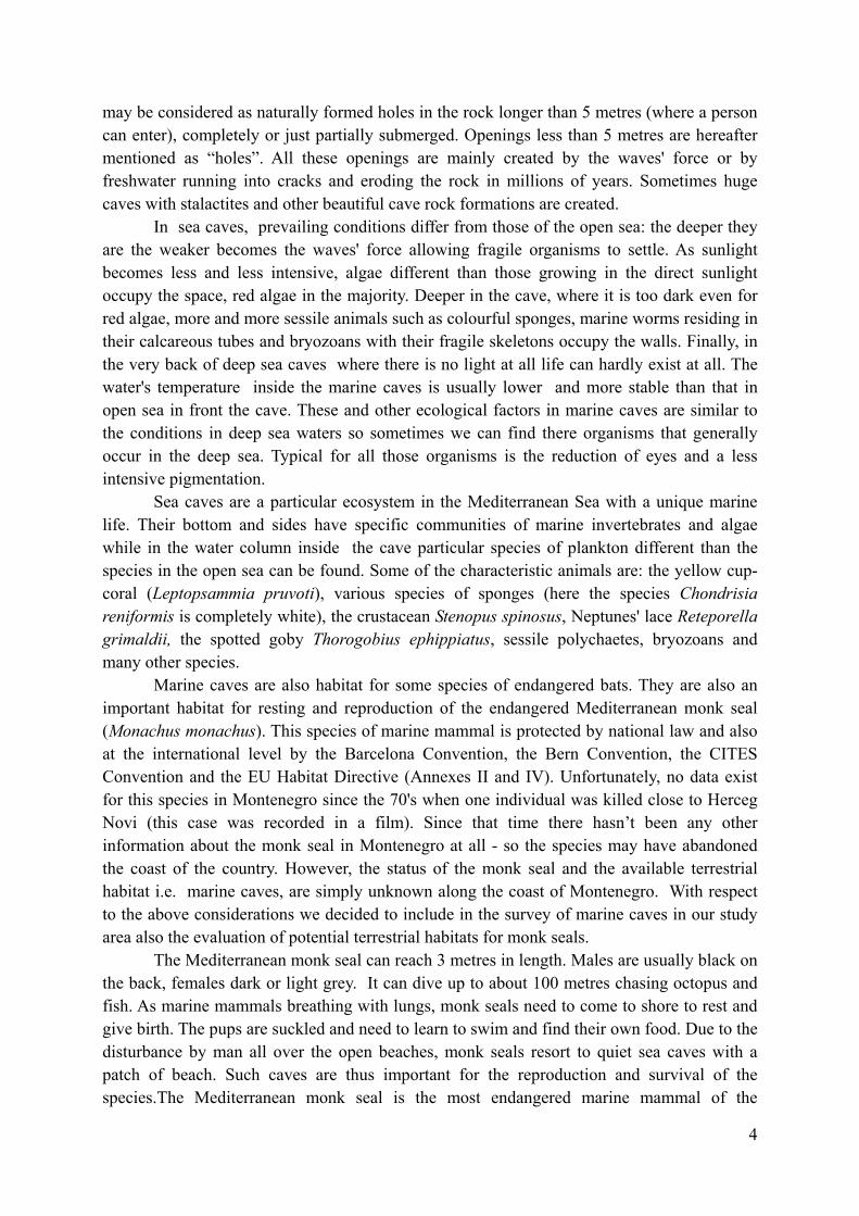
No. 12 location: Posejdonov grad (slits)
Foto: Vesna Mačić
coordinates N 42º 22' 17.11'' E 18º 36' 05.15'' dimensions 1,5m wide x 3m high x 4m long exposition West morpho-characteristics Two entrances are connected under the sea surface and the holes are
ending without a beach. living organisms At the holes' entrances there are lots of Corallina elongacea,
sponges and on the middle wall between the holes there is aCladocora caespitosa colony. Also dark incrusting algae are present inside the holes.
notes date of survey 18. 09. 2013. In front of the cave Lots of Corallina elongacea and few Lithophyllum byssoides.

17
No. 13 location: Posejdonov grad
Foto: Vesna Mačić
coordinates N 42º 22' 17.69'' E 18º 36' 04.65'' dimensions 6m wide x 7m high x 3m long exposition West morpho-characteristics This is an overhang on the coast and there is only a small beach with
a slope of 10º. living organisms notes date of survey 18. 09. 2013. In front of the cave In front of the beach there are boulders with lots of algae but because
of the strong waves only Corallina elongacea was distinguished.

18
No. 14 location: Posejdonov grad (complex right on cape M. Gora)
Foto: Vesna Mačić
coordinates N 42º 22' 15.93'' E 18º 36' 03.61'' dimensions 1m x 1m x 0,5m ; 2m x 1m x 3m; tunnel 3m x 2m x 3m exposition North morpho-characteristics Few small holes and siphons which should be checked by diving and
under calm sea conditions. Towards the open sea there are siphons known by local divers.
living organisms It seems that there are many organisms on the walls of the openings but because of the strong waves they could not be checked.
notes A potential danger for cave organisms could be diving tourism. date of survey 18. 09. 2013. In front of the cave Boulders, Padina pavonica, barren area

19
No. 15 location: "breeding cave" (inlet Veslo west)
Foto: Vesna Mačić
coordinates N 42º 22' 12.10'' E 18º 36' 14.78'' dimensions 7m wide x 8m high x 7m long exposition South-east morpho-characteristics In the cave there is a strong noise like „breathing“ because of some
underwater channels. living organisms On the side walls of the cave there are many sponges while at the
beginning of the cave there are massive Corallina elongataassemblages, Jania rubens, some incrusting red algae and others.
notes Should be checked by diving to explore underwater channels if possible
date of survey 18. 09. 2013. In front of the cave Corallina elongata and Jania rubens are massive but there are also
some Lithophyllum byssoides. Rocky walls in front of the cave are vertical, 5-10m high. At 0,5-1m depth there are some algae (some Cystoseira amentacea) while deeper it is 100% barren with just a few sea urchins.

20
No. 16 location: u. Veslo (west side)
Foto: Vesna Mačić
coordinates N 42º 22' 12.84'' E 18º 36' 17.32'' dimensions 1,5m wide x 6m high x 3m long (depth of water 4m; height inside
3m) exposition North-east morpho-characteristics Very narrow living organisms It seems that there are not many organisms but because of strong
waves the interior was not well surveyed. notes date of survey 18. 09. 2013. In front of the cave Rocks in front of the caves are vertical and just in some places there
are many Corallina elongate close to the surface while deeper there is a barren area.

21
No. 17 location: u. Veslo (bottom of the west side of inlet Veslo)
Foto: Luigi Bundone
coordinates N 42º 22' 15.59'' E 18º 36' 23.72'' dimensions 4m wide x 2m high x 4m long (in the back there is a beach 3m long)exposition South morpho-characteristics After the entrance the cave becomes narrower and ends with a beach
of pebbles and smooth rocks. The slope of the beach is 30°. Inside the cave, on he bottom there are bigger rocks and pebbles.
living organisms On the cave's walls there are scarce marine life, but it should be checked during calm sea conditions.
notes On the east side of this small inlet there are 2 holes which seem to be interesting: possibly they are longer than we could notice so they should be checked by diving during calm sea conditions (N 42º 22' 12.79'' E 18º 36' 22.74'')
date of survey 18. 09. 2013. In front of the cave Boulders, rocks, very dense populations of invasive Caulerpa
reacemosa.

22
No. 18 location: between Plava špilja and Posejdonov grad
Foto: Vesna Mačić
Foto: Vesna Mačić
coordinates N 42º 22' 24.32'' E 18º 35' 56.16'' dimensions 3m wide x 25m high x 10m long (depth of water 4m; height inside
20m) exposition South-east morpho-characteristics Very deep slit and maybe there is a siphon at the end. Inflow of fresh
water is evident. living organisms In the cave there are many sponges and representatives of the group
Balanomorpha. Close to the entrance there are massive assemblagesof Corallina elongata, Jania rubens and other algae. Inside the cave there are some incrusting alge.
notes Inner and deeper part of the cave should be checked by diving. date of survey 18. 09. 2013. In front of the cave Boulders, barren area, some sandy parts. Above the cave there is a
cliff about 30m high.

23
No. 19 location: u. Tijesna luka (complex)
Foto: Aliki Panou
Foto: Vesna Mačić Foto: Vesna Mačić
coordinates N 42º 21' 58.80'' E 18º 36' 58.91'' dimensions 5m wide x 8m high x 30m long (depth of water 4-0,5m; height inside
4m) exposition South-east morpho-characteristics Rocks around the cave are massive, vertical and without vegetation.
The cave has 2 channels and at the end of both there is a small rockyplatform. There is also a small underwater channel that should be checked by diving. On the walls above the sea there are some cave rock formations .
living organisms It seems that there are not many organisms on the cave's walls. Thereare some representatives of the group Balanomorpha, Patella, polychaetes , sponges and others.
notes On the left side of the main entrance (foto) there is another entrance into the cave. Also on the left side few meters further there is a siphon–channel of few meters (foto) and there is possibly an air gap that should be checked by diving.
date of survey 21. 09. 2013. In front of the cave Mostly rocky area with few algae and large barren areas.

24
No. 20 location:. Tijesna luka
Foto: Vesna Mačić
coordinates N 42º 22' 01.4'' E 18º 37' 03.9'' dimensions 3m wide x 6m high x 5m long (depth of water 3m; height inside 5m) exposition South (south-east) morpho-characteristics In the back of the cave there is a narrow slit. Behind this there is a
round hole (probably the end of the cave). living organisms Not analyzed notes Living organisms should be checked date of survey 21. 09. 2013. In front of the cave Not analyzed

25
No. 21 location: u. Oblatna (left from the quarry)
Foto: Vesna Mačić
Foto: Vesna Mačić
coordinates N 42º 22' 29.11'' E 18º 39' 16.55'' dimensions 0,5m wide x 1m high x 3m long (depth of water 1m; height inside
1,5m) exposition North morpho-characteristics This cave is small and hidden behind big rocks. There are 2 small
channel connections with the open sea. On the bottom of the cavethere are pebbles and some big rocks.
living organisms Living organisms are scarce notes date of survey 22. 09. 2013. In front of the cave Pebble, dead matte, invasive Caulerpa racemosa, some Cymodocea
nodosa

26
No. 22 location: u. Oblatna (left from the quarry, rocky block)
Foto: Vesna Mačić
coordinates N 42º 22' 30.13'' E 18º 36' 58.91'' dimensions Overhang with a beach 1 x 2m exposition Nnorth morpho-characteristics The entrance into the small basin is very narrow and in the back of
the basin there is a rocky overhang with smooth rocks. living organisms Not observed notes Very hidden date of survey 22. 09. 2013. In front of the cave Pebble, dead matte, invasive C. racemosa

27
No. 23 location: u. Oblatna (right from the quarry )
Foto: Vesna Mačić
coordinates N 42º 22' 41.73'' E 18º 39' 12.27'' dimensions 2m x wide 1,5m high x 4m long (height inside 1,5m) The „beach“ is
20cm exposition East morpho-characteristics On the roof there are some cave rock formations, fresh water inflow is
evident. On the bottom there are pebbles. living organisms Medium rich biodiversity on the walls with the dominant groups being
sponges and representatives of the Balanomorpha group. On the walls above the sea level there there are red incrusting algae.
notes date of survey 22. 09. 2013. In front of the cave Rocks, barren area with sea urchins, than sandy parts with some
Cymodocea nodosa, dead matte and invasive Caulerpa racemosa

28
No. 24 location: u. Oblatna (left from cafe-bar)
Foto: Vesna Mačić
Fotos: Vesna Mačić
coordinates N 42º 22' 51.46'' E 18º 39' 09.79'' dimensions 10m wide x 3m high x 20m long (height inside 2m, sandy beach 1,5m
long x 4m wide) exposition East morpho-characteristics Wide entrance into the cave - after about 10m it is significantly smaller.
On the walls there are some cave rock formations and fresh water inflow is evident. On the left side of the cave there is a small siphon butit doesn't seem to be long. In the back of the cave there is a small sandy beach. The beach begins with a narrow part of 1 x 1m but after that the space is only a few meters high above the beach.
living organisms At the entrance there are Peyssonellia rubra, and some other algae, a small number of sponges and locally many red incrusting algae.
notes Very good location for monk seals but a potential danger is the crowdedbeach in the vicinity during the summer months.
date of survey 22. 09. 2013. In front of the cave Barren areas and sandy parts with some Cymodocea nodosa.
29
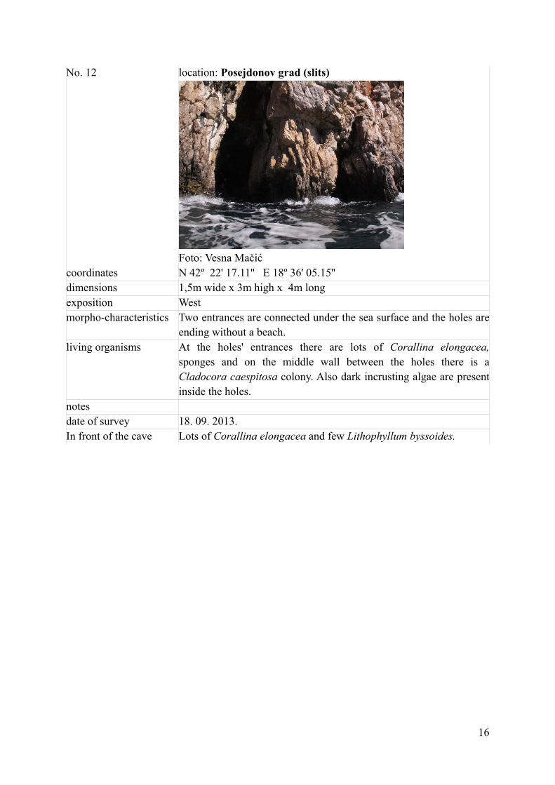
No. 25 location: Trašte „rupa velika“
Foto: Vesna Mačić
coordinates N 42º 23' 08.36'' E 18º 39' 39.28'' dimensions 10m wide x 8m high x 3m long exposition South morpho-characteristics Largely open rock shelter living organisms There are lots of organisms probably because of the relatively bright
light conditions. notes date of survey 22. 09. 2013. In front of the cave Big rocky blocks with some algae and barren areas

30
No. 26 location: Trašte „Orascom“ (crane complex)
Fotos: Vesna Mačić
coordinates N 42º 23' 10.18'' E 18º 39' 59.14'' dimensions 10m wide x 5m high x 25m long (depth of water 4m; height inside
7m) exposition South morpho-characteristics Entrance into the cave seems to consist of 2 entrances but the middle
wall is ending close to the sea surface so that the two entrances above the sea are connected under the sea level. After a big space the cavecontinues with 2 channels. After one siphon there is possibly a beachbut this should be checked. There is evident inflow of fresh water andevident vibration from construction works above the cave(construction of a marina, Orascom).
living organisms Close to the entrance into the cave there are many algae: deeper insidesponges are dominant. In the back of the cave biodiversity is verylow and only some incrusting algae are present above the sea level.
notes Intensive vibration of the terrain because of the ongoing works for theconstruction of a marina. This cave most probably will be destroyed inthe near future. Probably one of the best caves for monk seals in the area of study.
date of survey 22. 09. 2013. In front of the cave Not checked

31
No. 27 location: Trašte „Orascom“ ((left side of cranes)
Fotos: Vesna Mačić
coordinates N 42º 23' 11.17'' E 18º 39' 50.89'' dimensions 4m wide x 5m high x 4m long exposition South morpho-characteristics Wide open cave with a part of the rock hanging from the roof almost
down to the sea level. living organisms The cave has relatively bright light conditons and biodiversity is high.
There are many incrusting red algae (probably Mesophyllum alternans), sponges and others.
notes date of survey 22. 09. 2013. In front of the cave Not checked

32
No. 28 location: Trašte „Orascom“ (middle crane)
Foto: Vesna Mačić
coordinates N 42º 23' 09.82'' E 18º 39' 54.92'' dimensions 2m wide x 1,5m high x 6m long (height inside 2,5m) exposition South morpho-characteristics The cave is ending with a rocky platform about 2m x 1,5m with a
slope of 25º. The cave's bottom is sandy. living organisms Incrusting algae are on the bottom of the cave and there are many
individuals of the Balanomorpha group. Close to the entrance into the cave there are many sponges and at the entrance Corallina elongatais dominant.
notes It will probably be destroyed by the ongoing marina construction(Orascom)
date of survey 22. 09. 2013. In front of the cave Not checked

33
No. 29 location: Trašte (left from suede tube)
Foto: Vesna Mačić
coordinates N 42º 23' 02.14'' E 18º 40' 24.38'' dimensions 2m wide x 1,5m high x 3m long exposition South morpho-characteristics The roof is partially collapsed living organisms Biodiversity is poor and mostly represented by incrusting algae notes date of survey 22. 09. 2013. In front of the cave Not checked

34
No. 30 location: Trašte (right from suege tube)
Fotos: Vesna Mačić
coordinates N 42º 22' 59.94'' E 18º 40' 29.00'' dimensions 2m wide x 2m high x 4m long exposition South morpho-characteristics Very exposed to waves from the south living organisms Incrusting algae are the most common species and they are covering a
big area, especially close to the back of the cave.. At the entrance much more sponges and other organisms.
notes The possible presence of an underwater channel should be checked bydiving.
date of survey 22. 09. 2013. In front of the cave Not checked

35
No. 31 location: Plavi horizonti (left)
Foto: Vesna Mačić
coordinates N 42º 22' 59.73'' E 18º 40' 53.08'' dimensions "pool" e 1m wide x 2,5m long . Depth 1m exposition South morpho-characteristics This pools is connected with the open sea through an underwater
channel. Possibly there are more underwater channels. On the bottom there are pebbles.
living organisms The border of the pool is full of Corallina elongata notes Should be checked by diving for possible underwater channels date of survey 19. 09. 2013. In front of the cave Not observed

36
No. 32 location: Plavi horizonti (left)
Foto: Vesna Mačić
coordinates N 42º 23' 04.33'' E 18º 40' 52.89'' dimensions 2m wide x 1m high x 5m long exposition South-east morpho-characteristics Small cave with 2 siphons connected with the open sea and with a
small beach 3m long and 1,5m wide. living organisms Scarce notes During summer the cave is under anthropogenic pressure date of survey 19. 09. 2013 In front of the cave Pebbles and further deeper sand

37
No. 33 location: Plavi horizonti (right side)
Foto: Luigi Bundone
coordinates N 42º 23' 00.86'' E 18º 41' 05.36'' dimensions 7m wide x 4m high x 3m long exposition South-west morpho-characteristics Rock shelter, above the cave there is macchia. Inside the cave there
is a channel connecting the cave with another 1,5 x 1,5m pebble beach beside.
living organisms Not observed because of strong waves notes Deeper in the inlet Plavi horizonti there are two more overhangs with
beaches of few meters each. Closer to the open sea there is a slit 8mdeep which ends with a 1m pebble beach. During summer highanthropogenic pressure.
date of survey 19. 09. 2013. In front of the cave Boulders and sand

38
No. 34 location: Maslinada (complex)
Foto: Aliki Panou
coordinates N 42º 22' 35'' E 18º 41' 25.5'' dimensions 4m wide x 1m high x 5m long exposition South-west morpho-characteristics Close to the cave, on the left side, there are some smaller holes
which are 1m x 1m, 2m x 1m and 2m x 2m. Some of the small holesare connected under the sea level. On the right side of the cave there is a small pebble beach.
living organisms Low biodiversity notes Good location for monk seals date of survey 20. 09. 2013. In front of the cave Ulvales at the entrance into the cave, boulders, Dasicladus, Padina,
Wrangelia, barren areas, some Posidonia oceanica
39
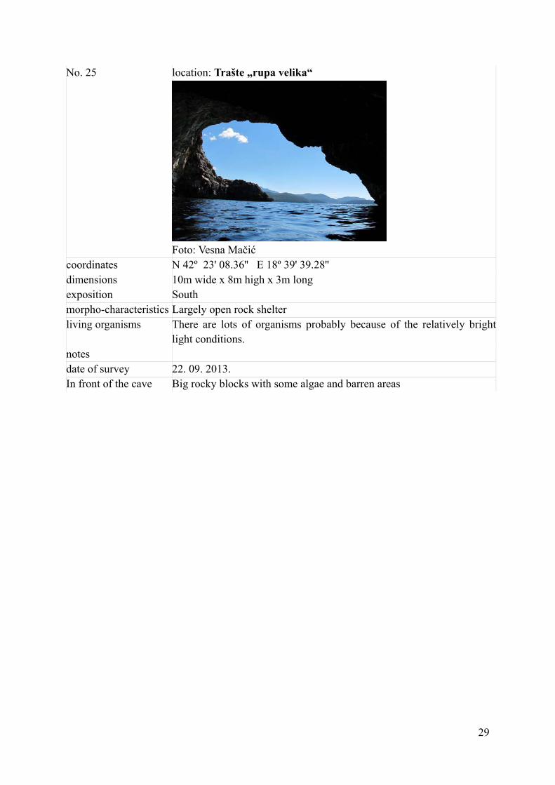
No. 35 location: Maslinada (right)
Foto: Aliki Panou
coordinates N 42º 22' 32.2'' E 18º 41' 17.3'' dimensions 2m wide x 2m high x 4m long exposition West morpho-characteristics In n the back of the cave there is a 1 m pebble beach living organisms Biodiversity on the walls is very low notes date of survey 20. 09. 2013. In front of the cave Not checked because of fishing activity in the surroundings

40
No. 36 location: slit close to Bigova
Foto: Vesna Mačić
coordinates N 42º 22' 05.36'' E 18º 41' 42.54'' dimensions 0,5m wide x 2m hogh x 2m long exposition South-west morpho-characteristics Small slit and on the bottom there are pebbles living organisms Not observed notes date of survey 20. 09. 2013. In front of the cave Not observed

41
No. 37 location: Bigova complex close to the big rock shelter
Fotos: Vesna Mačić
coordinates N 42º 21' 45.30'' E 18º 42' 03.23'' dimensions 3m wide x 1m high x 7m long (depth of water 1m) exposition North-west morpho-characteristics On the right side of the cave there is a big hole
15m wide x 10m high x 5m long with a beach 12m long x 0,5(1)mwide. In front of the cave there is a big rock emerging from the water
living organisms Biodiversity is low but there are some sponges and incrusting algae notes The whole complex is an important location for monk seals. date of survey 20. 09. 2013. In front of the cave Pebbles and few big boulders emerging from the sea. Lots of
sciafilous algae like Peyssonellia sp. Sphaerococcus coronophifolius, while on bigger boulders there are barren areas.
42
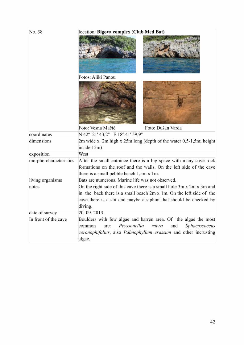
No. 38 location: Bigova complex (Club Med Bat)
Fotos: Aliki Panou
Foto: Vesna Mačić Foto: Dušan Varda
coordinates N 42º 21' 43,2'' E 18º 41' 59,9'' dimensions 2m wide x 2m high x 25m long (depth of the water 0,5-1,5m; height
inside 15m) exposition West morpho-characteristics After the small entrance there is a big space with many cave rock
formations on the roof and the walls. On the left side of the cavethere is a small pebble beach 1,5m x 1m.
living organisms Bats are numerous. Marine life was not observed. notes On the right side of this cave there is a small hole 3m x 2m x 3m and
in the back there is a small beach 2m x 1m. On the left side of thecave there is a slit and maybe a siphon that should be checked bydiving.
date of survey 20. 09. 2013. In front of the cave Boulders with few algae and barren area. Of the algae the most
common are: Peyssonellia rubra and Sphaerococcus coronophifolius, also Palmophyllum crassum and other incrusting algae.

43
No. 39 location: Bigova (south side)
Foto: Aliki Panou
coordinates N 42º 21' 27'38'' E 18º 41' 37.84'' dimensions exposition North morpho-characteristics Not observed living organisms Not observed notes Not entered - should be checked date of survey In front of the cave Not observed
44
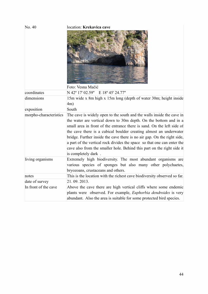
No. 40 location: Krekavica cave
Foto: Vesna Mačić
coordinates N 42º 17' 02.59'' E 18º 45' 24.77'' dimensions 15m wide x 8m high x 15m long (depth of water 30m; height inside
4m) exposition South morpho-characteristics The cave is widely open to the south and the walls inside the cave in
the water are vertical down to 30m depth. On the bottom and in asmall area in front of the entrance there is sand. On the left side ofthe cave there is a cubical boulder creating almost an underwaterbridge. Further inside the cave there is no air gap. On the right side, a part of the vertical rock divides the space so that one can enter thecave also from the smaller hole. Behind this part on the right side itis completely dark .
living organisms Extremely high biodiversity. The most abundant organisms are various species of sponges but also many other polychaetes,bryozoans, crustaceans and others.
notes This is the location with the richest cave biodiversity observed so far.date of survey 21. 09. 2013. In front of the cave Above the cave there are high vertical cliffs where some endemic
plants were observed. For example, Euphorbia dendroides is very abundant. Also the area is suitable for some protected bird species.

45
No. 41 Location: close to Sv. Nikola
Foto: Vesna Mačić
coordinates N 42º 16' 18.53'' E 18º 46' 20.10'' dimensions 2m wide x 3m high x 2m long exposition West morpho-characteristics Just a hole without any important characteristics living organisms Abundant assemblages of Cortalinales specially at the entrance.
Maybe in the past there were trottoirs of Lithophyllum. notes date of survey 21. 09. 2013. In front of the cave Very steep rocky area, there are small Lithophyllum assemblages in
front of the entrance.

46
No. 42 location: close to Sv. Nikola dibble slit
Foto: Aliki Panou
coordinates N 42º 16' 31.7'' E 18º 46' 01.5'' dimensions 1m wide x 1,5m high x 4m long exposition West morpho-characteristics On the right side of the slit there is a hole connecting the open sea
with this cave . living organisms Some Corallina but in general low biodiversity notes date of survey 21. 09. 2013. In front of the cave Corallina and small Lithophyllum

47
No. 43 location: close to Sv. Nikola
Foto: Aliki Panou
coordinates N 42º 16' 32.20'' E 18º 46' 01.82'' dimensions 1m wide x 7m high x 7m long (depth of the water 7m; height inside
5m) exposition West morpho-characteristics The slit is very high and there are vertical high cliffs above. living organisms Not observed well. There are some Corallina colonies notes Marine life should be checked date of survey 21. 09. 2013. In front of the cave Some Lithophyllum colonies, vertical rocks, barren area, but should
be checked better

48
No. 44 Location: close to Krekavice cave (right side)
Foto: Aliki Panou
coordinates N 42º 17' 02.40'' E 18º 45' 26.21'' dimensions 2m wide x 1m high x 3,5m long (depth of seawater 7,5m; height
inside 1m) exposition South (south-west) morpho-characteristics Small hole with overhanging rocks. living organisms High biodiversity with lots of sponges and other organisms. notes date of survey 21. 09. 2013. In front of the cave In front of the entrance there are rocks with barren areas with few
sea urchins.

49
No. 45 location: Saletova cave
Foto: Vesna Mačić
coordinates N 42º 17' 14.75'' E 18º 45' 04.64'' dimensions Entrance is under the water surface. The cave is approximately 25m
wide x 25m long (depth of water 5m; height inside 25m; the beachconsists of of rocks and boulders: slope 40°)
exposition West morpho-characteristics The beach inside the cave is geologically young and consist of sharp
rocks and boulders crashed down recently. On the surface of the water inside the cave there is fresh water. In the water there aresubmerged big boulders. Close to the entrance in the cave and insome parts of the bottom there is very fine sand.
living organisms Biodiversity is not high - most abundant are Annelids with white calcified tubes. There are some anemones, Apogon imberbis, Thorogobius ephippiatus, plankton copepods and others.
notes Interesting polychaetes with long tubes almost in line (not curved),and small polychaetes in white tubes. The cave’s walls are of specific consistency.
date of survey 21. 09. 2013. In front of the cave At the entrance Peyssonellia rubra, incrusting red algae, sciafilous,
Apogon imberbis.
50
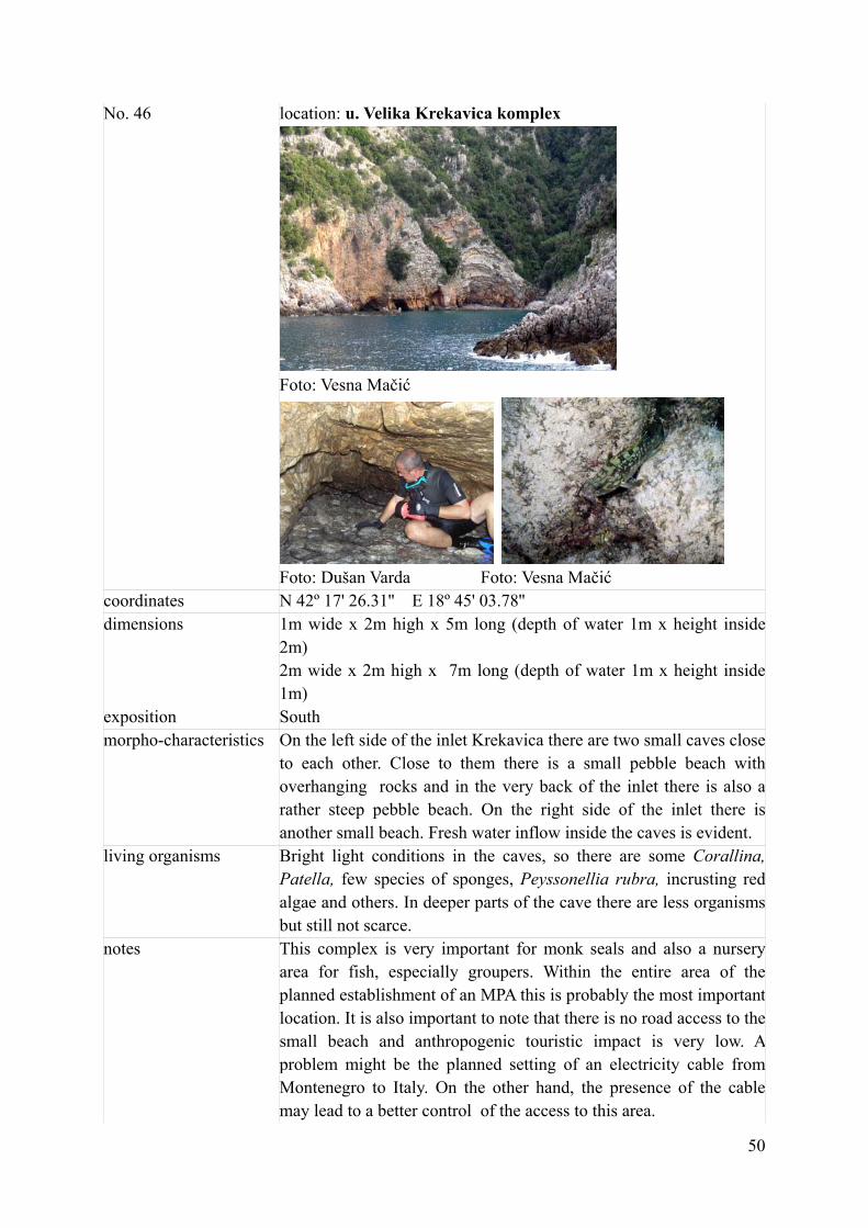
No. 46 location: u. Velika Krekavica komplex
Foto: Vesna Mačić
Foto: Dušan Varda Foto: Vesna Mačić
coordinates N 42º 17' 26.31'' E 18º 45' 03.78'' dimensions 1m wide x 2m high x 5m long (depth of water 1m x height inside
2m) 2m wide x 2m high x 7m long (depth of water 1m x height inside 1m)
exposition South morpho-characteristics On the left side of the inlet Krekavica there are two small caves close
to each other. Close to them there is a small pebble beach withoverhanging rocks and in the very back of the inlet there is also a rather steep pebble beach. On the right side of the inlet there isanother small beach. Fresh water inflow inside the caves is evident.
living organisms Bright light conditions in the caves, so there are some Corallina, Patella, few species of sponges, Peyssonellia rubra, incrusting red algae and others. In deeper parts of the cave there are less organismsbut still not scarce.
notes This complex is very important for monk seals and also a nurseryarea for fish, especially groupers. Within the entire area of the planned establishment of an MPA this is probably the most important location. It is also important to note that there is no road access to thesmall beach and anthropogenic touristic impact is very low. Aproblem might be the planned setting of an electricity cable from Montenegro to Italy. On the other hand, the presence of the cablemay lead to a better control of the access to this area.

51
date of survey 20. 09. 2013. In front of the cave In front the caves there are some boulders with Cystoseira
compressa and some C. amentacea. There is lot of Jania, Corallina and some others. Few young Ephinephelus cosate and E. marginatus, small Scorpenae sp., Mullus surmuletus and small blue fish. Barren area on the rocks with just few sea urchins.

52
No. 47 location: u. Žukovica „veliki porat“ (right side)
Foto: Aliki Panou
coordinates N 42º 19' 35.60'' E 18º 42' 41.43'' dimensions Covered beach 2 m wide x 2 m high x 2m long exposition North morpho-characteristics The pebble beach is covered by a rocky overhang living organisms Not observed notes Few meters further there are some private houses – possibly
anthropogenic impact date of survey 20. 09. 2013. In front of the cave Not observed

53
No. 48 location: u. Žukovica (left side)
Foto: Aliki Panou
coordinates N 42º 19' 48.48'' E 18º 42' 44.25'' dimensions 2m wide x 2m high x 2m long exposition South-west morpho-characteristics Bigger hole, nothing special living organisms notes Fresh water inflow is evident date of survey 20. 09. 2013. In front of the cave Not observed

54
No. 49 location: rt Slatnica
Foto: Vesna Mačić
coordinates N 42º 20' 49.60'' E 18º 41' 44.63'' dimensions 1,5m wide x 1,5m high x 3m long exposition West morpho-characteristics Rocky hole with overhangs living organisms Low biodiversity notes date of survey 20. 09. 2013. In front of the cave Barren area on the rocks.

55
CONCLUSIONS In the area from Cape Arza to Cape Platamuni we registered 21 marine caves from which one has an underwater entrance and 11 locations are suitable as terrestrial habitat for monk seals. Only few marine caves have a relatively deep submerged area (up to 30m depth): most of them are only a few meters deep. In some of the marine caves there is a small pebble or sandy beach. In some caves there are cave rock formations .Beside the marine caves we registered also 24 holes which are less than 5m long, but still important for monk seals or some other rare and endangered species. All together, in the area from Cape Arza to Cape Platamuni we regitered 45 marine caves and holes/slits. During this survey we didn't find any evidence of monk seal presence but some good habitats for the species were registered. The best area with marine caves and also habitats for monk seals in the planned MPA Platamuni is the area of the Krekavica cave and the Krekavica inlet. Altogether, in the surveyed area the following 7 marine protected species were registered : Lithophyllum byssoides, Cystoseira amentacea, Posidonia oceanica, Cymodocea nodosa, Pinna nobilis, Cladocora cespitosa and Lithophaga lithophaga. Additionnally, 2 species of protected plants were noted, namely Euphorbia dendroides and Limonium angustifolium, 5 species of protected birds, namely Ardeola ralloides, Alcedo athis, Phalacrocorax aristotelis, Acciptier gentilis and Corvus corax; and one protected bat species (Chiroptera). Our data can be used for the urgently needed creation of a Cave's Register but also s a basis for future research and protection measures. Because of bad weather condition during the first days of our survey some locations were just noted as potentially interesting and should be checked in the future. One of the outputs of this project was the issue of 2.600 printed brochures on marine caves and monk seals (in Annex I). These brochures were issued aiming at the information of the local public and raising their awarenes about the impornatce of marine caves and endangered species depending on this type of habitat, monk seals in particular. They are being distributed in the schools of the municipalities of Kotor, Tivat and Herceg Novi to which the surveyed area belongs. After the survey some preliminary results were communicated to the public media and publications of 8 media reports are listed in Annex II. This report will be delivered in English and Serbian language to Jugopetrol AD Kotor as the sponsor of the project and also to the following authorities: Ministry of Sustainable Development and Tourism, Ministry of Agriculture and Rural Development, Ministry of Science, Agency for the Environment and Morsko Dobro Agency. Last but not least, the results of this project will be useful for the various groups of stakeholders.
We believe that this donation of Jugopetrol AD Kotor to the Institute of Marine Biology is an excellent example for investing in science and the protection of our environment. Once again we would like to thank Jugopetrol AD Kotor, expecting that our cooperation will be continued and hopefully be a source of inspiration for other donors.

56
Annex I

57

58
Annex II
59
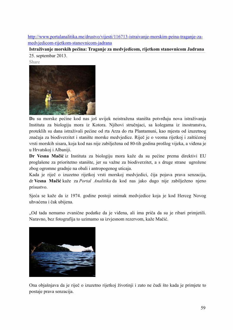
http://www.portalanalitika.me/drustvo/vijesti/116713-istraivanje-morskim-peina-traganje-za-medvjedicom-rijetkom-stanovnicom-jadrana Istraživanje morskih pećina: Traganje za medvjedicom, rijetkom stanovnicom Jadrana25. septembar 2013. Share
Da su morske pećine kod nas još uvijek neistražena staništa potvrđuju nova istraživanjaInstituta za biologiju mora iz Kotora. Njihovi stručnjaci, sa kolegama iz inostranstva,proteklih su dana istraživali pećine od rta Arza do rta Plantamuni, kao mjesta od izuzetnogznačaja za biodiverzitet i stanište morske medvjedice. Riječ je o veoma rijetkoj i zaštićenoj vrsti morskih sisara, koja kod nas nije zabilježena od 80-tih godina prošlog vijeka, a viđena je u Hrvatskoj i Albaniji. Dr Vesna Mačić iz Instituta za biologiju mora kaže da su pećine prema direktivi EUproglašene za prioritetno stanište, jer su važne za biodiverzitet, a s druge strane ugrožene zbog ogromne gradnje na obali i antropogenog uticaja. Kada je riječ o izuzetno rijetkoj vrsti morskoj medvjedici, čija pojava prava senzacija,dr Vesna Mačić kaže za Portal Analitika da kod nas jako dugo nije zabilježeno njeno prisustvo.
Sjeća se kaže da iz 1974. godine postoji snimak medvjedice koja je kod Herceg Novoguhvaćena i čak ubijena.
„Od tada nemamo zvanične podatke da je viđena, ali ima priča da su je ribari primjetili.Naravno, bez fotografija to uzimamo sa izvjesnom rezervom, kaže Mačić.
Ona objašnjava da je riječ o izuzetno rijetkoj životinji i zato ne čudi što kada je primjete topostaje prava senzacija.

60
U Hrvatskoj je jako dugo niko nije vidio, a posljednjih par godina bilo je nekoliko prijava da je viđena čak sa mladuncima, što raduje sve koji rade na zaštiti te vrste.
„Morska medvjedica traži specifična staništa, potebne su joj pećine i to one koje imaju unutramalu plažu na kojoj može da se odmori. To su sisari koji traže mir, a mi sada imamo uzurpiranu obalu i one jednostavno gube staništa. Inače su malobrojne i traže posebno mirnamjesta. U Hrvatskoj takvih mjesta ima mnogo više, njihova je obala velika, i najvjervatnije jeto razlog što je tamo primjećena. Takođe, medvjedica ima u Albaniji i Grčkoj, i zato ih vjerovatno ima i kod nas. One sigurno ovuda prolaze jer preplivavaju ogromna rastojanja imoguće je da se kod nas odmaraju“, kaže Mačić.
Sagovornica Portala Analitika naglašava da je interes istraživača da što više ljudi sazna o medvjedici i da, ukoliko je primjeti, fotografiše. Važno je, kaže, da znaju da kada je vide dajoj se previše ne približavaju, što isto važi i za delfine i kornjače. Bitno nam je da imamoinformacije, ali da životinje ne budu ugrožene prisustvom čovjeka.
Mačić naglašava da je za istraživače bilo važno da obiđu teren od Plantamuna do rta Arze, davide koliko ima pećina, i do sada su, kaže, obišli samo one kojima se vidi ulaz sa mora.
-Za istraživanje pod morem nam treba mnogo više vremena, ljudi i novca. Planirano je da potez od Plantamuna do Bigove bude zaštićena zona u moru. Posebno je važno da na takvimmjestima znamo što imamo, a u uvali Trašte postoje takođe pećine zanimljive za istraživače,sa malim plažama. Problem je što se tamo gradi intenzivno i što će ta staništa biti uništena,kaže Mačić.
Ona ističe da će podatke sa terena sistematizovati i predati Agenciji za životnu sredinu, apripremiće se i kratke brošure o pećinama i medvjedicama. Ove brošure će biti distribuirane

61
prije svega u opštinama Kotor, Tivat i Herceg Novi, jer je istraživanje rađeno u timopštinama.
Nadamo se da je ovo samo početak jednog većeg istraživanja morskih pećina i da će bitinastavljeno u ovom kao i u drugim područjima naše obale, kaže dr Vesna Mačić.
U istraživanju su učestvovali Aliki Panou i Luigi Bundone iz NVO Archipelagos iz Grčke i Dušan Varda iz NVO MedCEM iz Crne Gore.
Naša sagovornica na kraju napominje da zahvalnost duguju firmi Jugopetrol Kotor, koja jefinansirala istraživanje morskih pećina.
S.K.

62
http://skalaradio.com/2013/09/25/more-je-bogatstvo-svih-nas/
10:47 | 25. sep 2013. More je bogatstvo svih nas
more i život u njemu Vesna Mačić Povodoma dana zaštite obale i mora, kao i održivog upravljanja ovim resursima prilka je da se više razmišlja o uticajima čovjeka na naše more koje je još uvijek puno raznovrsnog života i mnogih tajni, kazala je za Skala radio dr Vesna Mačić, naučna radnica u kotorskom Institutu za biologiju mora. Crna Gora imajoš uvijek veoma lijepu obalu iako mnogo više urbanizovanu nego što bi trebalo i bez reda u izgradnji, mišljenja je Mačićeva, iako kako kaže nije protiv ekonomskog, turističkog i bilo kakvog razvoja razvoja, ali s mjerom i u skladu sa ambijentom. Sve ono što se dešava na obali ima uticaja i na more kao i sve one aktivnosti koje se odvijaju na samom moru, kaže Mačićeva. Ona podsjeća na aktivnosti u bokeljskim opštinama i Budvi na prečišćavanju i odvođenju otpadnih voda što je za pohvalu, jer je Bokokotorski zaliv veoma ugrožen sa ogromnom količinom otpadnih voda i evidentne su velike promjene na morskom dnu. “Povlače se neki organizmi koji su tu živjeli stotinama godina, što ukazuje na velike promjene životne sredine. Komunalne otpadne vode, sve veći broj velikih kruzera i jahti kao i raznoraznih barki i plovila prisutnih u zalivu Boke Kotorske utiču na živi svijet u moru, pogotovo što je prisutan i veliki broj ilegalnih aktivnosti, kao što je izlivanje otpadnih voda bez prečišćavanja, izlivanja sa brodova. Sve to dospijeva u more i sve to živi organizmi moraju da istrpe”, objašnjava Mačićeva. Ona podsjeća na nedavno terensko istraživanje morskih pećina stručnjaka Instituta zavoda za biologiju mora iz Kotora u saradnji sa dvije NVO iz Grčke i Crne Gore na potezu od rta Arza do rta Platamuna.

63
Ovaj posao je u potpunosti finanirao kotorski Jugopetrol uz zahvalnost i poziv ostalima da pomognu istraživanje i očuvanje našeg mora, naglasila je dr Mačić. Pomenuto područje je prilično očuvano i potpuno predstavlja prirodnu obalu koja je veoma bogata raznovrsnim biljnim i životinskim svijetom kako u obalnom dijelu tako i u podmorju, i takva područje se moraju zaštititi. “Crna Gora je u obavezi da zaštiti bar 10 odsto obale, a do sada nemamo ni jedno zaštićeno područje u moru. Pripremljena je dokumentacija za proglašavanje zaštićene zone kod Petrovca, ali se ništa još nije uradilo jer nije jasno ko će da upravlja tim zaštićenim piodručjem, da li će to da bude Morsko dobro, ministarstvo, opština. To su stvari koje se odugovlače, a koje su našoj zemlji neophodne. Naučnici iz cijelog svijeta su zaključili da zaštićene zone u moru predstavljaju oazu gdje se živi svijet u moru nesmetano razmnožava i mlađ i određen dio organizama se sa tih područja preliva u susjedna i praktično se na prirodni način obogaćuje prirodna sredina. Stoga je neophodno da se osnuju zaštićene zone kako bi imali barem neke djelove našeg mora koji nijesu pod veoma intenzivnim antropogenim uticajem” navela je ona. Mačićeva vjeruje da će biti još projekta za očuvanje životne sredine i da će oni biti uspješniji jer do sada mnogi savjeti iz Instituta za biologiju mora često ostaju bez konkretnih aktivnosti kako od strane lokalne uoprave tako i sa nivoa nadležnih ministarstava. Uz bolju koordinaciju bilo bi više uspjeha jer je more bogatstvo svih nas i svi građani moraju da vode računa o moru i njegovom živom svijetu, poručila je dr Mačić.

64

65
http://www.radiodux.me/naslovnica/4166-istraili-morske-peine-od-arze-do-paltamuna
ISTRAŽILI MORSKE PEĆINE OD ARZE DO PLATAMUNA
Srijeda, 02 Listopad 2013 12:09
Share on Facebook
Kotor 2. listopada 2013. (Radio Dux) - Stručnjaci Instituta za biologiju mora iz Kotora sa kolegama iz NVO "Archipelagos" iz Grčke i NVO "MedCEM" iz Crne Gore, završili su ovih dana terenski rad – preliminarno istraživanje morskih pećina na obali od rta Arza na sjeveru do rta Platamuni na jugu. Morske pećine su poznate kao stanište od izuzetnog značaja za biodiverzitet i potencijalno su stanište morskih medvjedica, veoma rijetke i zaštićene vrste morskih sisara.
Sredozemna medvjedica jedan je od najugroženijih morskih sisara, te vjerovatno najrijeđi tuljan na svijetu. Broj preživjelih predstavnika ove vrste procjenjuje se na ukupno svega 500-600 jedinki koje uglavnom žive u dvije veće populacije - jednoj u području sjeveroistočnog Mediterana (Grčka, Turska, Kipar) i drugoj u području sjeveroistočnog Atlantika (Cap Blanc uz obale zapadne Afrike i Mauritanije i otočje Desertas u arhipelagu Madeire). Na žalost, u drugim dijelovima nekadašnjeg područja obitavanja ove vrste ona se može smatrati regionalno izumrlom vrstom.
U Hrvatskoj je u pospljednje vrijeme primijećeno prisustvo par promjeraka ovog tuljana, a ima ga povremeno i u Albaniji, te nešto češće u Grčkoj. Imajući u vidu takvu situaciju, stručnjaci Instituta za biologiju mora iz Kotora pretpostavljaju da se sredozemne medvjedice u svom kretanju duž našeg dijal obale Jadrana možda povremeno i ovdje kraće zadržavaju radi odmora. Stoga je preliminarno istraživanje morskih pećina na području Donjeg Grblja i Luštice bio prvi korak kako bi se dobila šira slika o broju i karakteristikama pećina koje su povoljne za boravak sredozemnih medvjedica.
Prema riječima dr Vesne Mačić iz kotorskog Instituta za biologiju mora, da bi sredozemne medvjedice boravile u njima, pećine moraju biti izolovane, daleko od ljudskih aktivnosti, a poželjno je da u sebi imaju i malo žalo – plažu na kome se tuljani mogu odmoriti. Iako tragovci konkretnog prisustva ovog sisara nisu pronadjeni, situacija je ipak takva da ima nade da se sredozemne mevjedice mogu povremeno naći i na našoj obali, ali je za to potrebno sačuvati što više morskih pećina kao za njih najpovoljnijeg prirodsnog staništa.
Do sada inače, nije bilo sistematskog istraživanja biodiverziteta morskih pećina u Crnoj Gori, pa su i na ovim preliminarnim pregledima tih lokaliteta, otkrivene zanimljive stvari zbog

66
specifčnih okolnosti koje vladaju u tim staništima - smanjene vidljivosti i smanjenog hidrodinamizma. Dr Mačić naglašava da se tako već na ulazu u pećine mogu naći neke vrste algi koje inače, rastu isključivo na 30-40 metara dubine mora. U pećinama inače, ima vrlo malo pokretne faune, ali su ta staništa zato bogata različitim vrstama filtratornih organizama - sundjera i briozoa. Znanstvenici su sada uzeli uzorke brojnih vrsta sundjera koje će detaljno analizirati u narednom period u saradnji sa kolegama iz inozemstva.
S.L.
Audio: dr Vesna Macic, Institut za biologiju mora Kotor (ZAHVALA JUGOPETROLU)
Audio: Dragan Srdoc, ribar iz Kotora
•
•
•
•
•

67
•
Foto: S.L.

68
http://skalaradio.com/2013/10/08/najugrozeniji-zasticeni-sisari-morske-medvjedice-u-bokokotorskom-zalivu/ 12:53 | 8. oct 2013. Najugroženiji zaštićeni sisari, morske medvjedice u Bokokotorskom zalivu
morska medvjedica dr Vesna Mačić Istraživanje na području od rta Platamuni do rta Arza je urađeno od strane Instituta za biologiju mora i nevladinih organizacija Mediterananski centar za monitoring Medcem i Argipelagos iz Grčke. Projekat istraživanja morskih pećina je bio finansiran od strane kotorskog “Jugopetrola”, kazala je za Skala radio dr Vesna Mačić, naučna radnica u kotorskom Institutu za biologiju mora. Ono što je bio cilj je da se na pomenutom području istraže lokacije koje su morske pećine pogodne za život morskih medvjedica. Radi se o najugroženijem i najrijeđem sisaru Mediterana i zaštitećenoj vrsti. Morske pećine su takođe zaštićeno prioritetno stanište prema direktivi Evropske Unije o staništima, a kako do sada uopšte nije izučavan ovaj dio morskih staništa kod nas, radi se o početku istraživanja i ono što je bitno da napomenemo, kaže dr Mačić, već u prvom istraživanju nađeno je nekoliko lokacija koje su pogodne za život morskih medvjedica. One u unutrašnjosti imaju male plaže gdje mogu da se odmaraju i da borave neko kraće vrijeme. Cilj je da se tačno utvrde koja su to mjesta koja odgovaraju naseljavanju ovih morskih sisara, kao i mnogih drugih organizama koja se nalaze samo u morskim pećinama. Dr Mačić se nada da će se u daljem periodu malo više pozabaviti ovim istraživanjem i da će o tome informisati javnost. Ona se takođe nada da će sljedećeg mjeseca uraditi brošure o morskim pećinama i morskim medvjedicama, a nakon kompletno urađenog izvještaja javnost će biti informisana o tome, kazala je dr Mačić.

69

70

71