on the positional accuracy of the google earth imagery
TRANSCRIPT
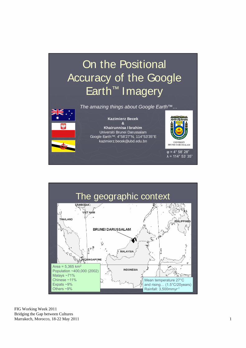
FIG Working Week 2011Bridging the Gap between CulturesMarrakech, Morocco, 18‐22 May 2011 1
On the Positional Accuracy of the Google
Earth™ Imagery
Kazimierz Becek&
Khairunnisa IbrahimUniversiti Brunei Darussalam
Google Earth™: 4°58'27"N, 114°53'35"[email protected]
The amazing things about Google Earth™…
φ = 4° 58’ 28”λ = 114° 53’ 35”
The geographic context
Area = 5,365 km2
Population ~400,000 (2002)Malays ~71%Chinese ~11%Expats ~9%Others ~9%
Mean temperature 27°Cand rising… (1.5°C/20years)Rainfall: 3,500mmyr-1
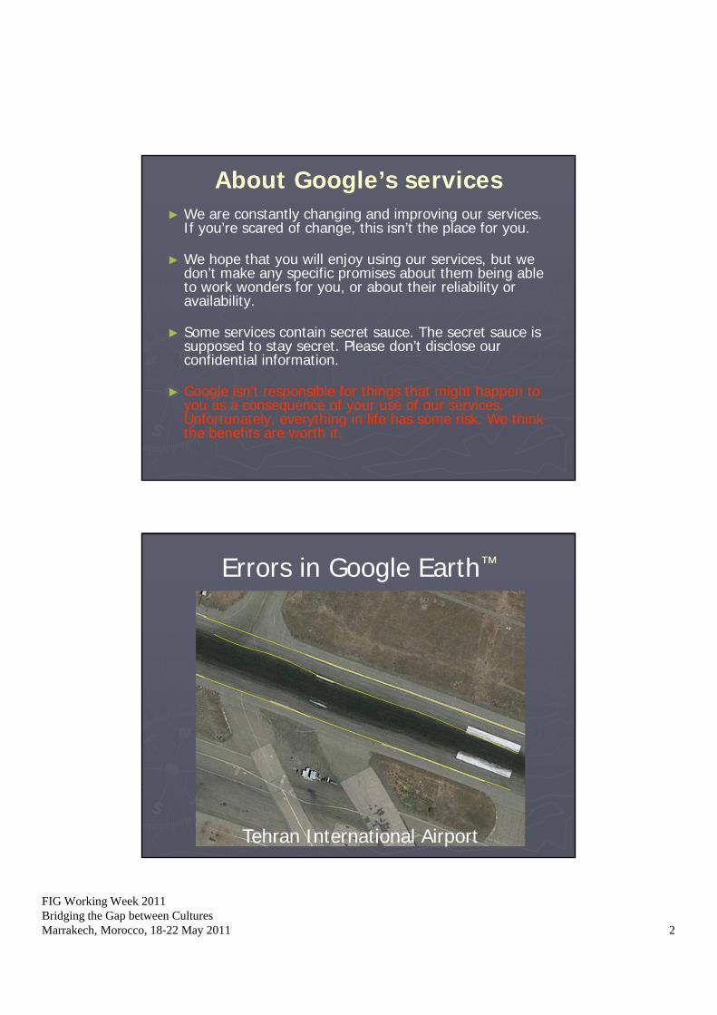
FIG Working Week 2011Bridging the Gap between CulturesMarrakech, Morocco, 18‐22 May 2011 2
About Google’s services► We are constantly changing and improving our services.
If you’re scared of change, this isn’t the place for you.
► We hope that you will enjoy using our services, but we don’t make any specific promises about them being able to work wonders for you, or about their reliability or availability.
► Some services contain secret sauce. The secret sauce is supposed to stay secret. Please don’t disclose our confidential information.
► Google isn’t responsible for things that might happen to you as a consequence of your use of our services. Unfortunately, everything in life has some risk. We think the benefits are worth it.
Errors in Google Earth™
Tehran International Airport
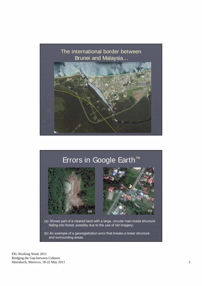
FIG Working Week 2011Bridging the Gap between CulturesMarrakech, Morocco, 18‐22 May 2011 3
The international border betweenBrunei and Malaysia…
Errors in Google Earth™
(b)
(a) Shows part of a cleared land with a large, circular man-made structurefading into forest, possibly due to the use of old imagery;
(b) An example of a georegistration error that breaks a linear structureand surrounding areas.
(a)
FIG Working Week 2011Bridging the Gap between CulturesMarrakech, Morocco, 18‐22 May 2011 4
What is GEDTF?The Global Elevation Data Testing Facility is a
database of features found in the world that are flat, large (>500 m by 15 m) and having smooth homogeneous surface. At present, the database contains about 8,500 runways.
With its strict technical parameters, runway can be a test bed for a range of calibration and accuracy assessment tasks of the air- and space-borne measurement systems.
www.gedtf.org
The GEDTF databaseThe data for the GEDTF were compiled from various
sources.
The structure of a record includes:• Region of the world.• Country.• Airport name.• Runway number.• Latitude and longitude of both ends of runway.• Elevations of both ends of runway.• Length and width of the runway.• Type of surface material (Asphalt, concrete, turf, etc).
www.gedtf.org
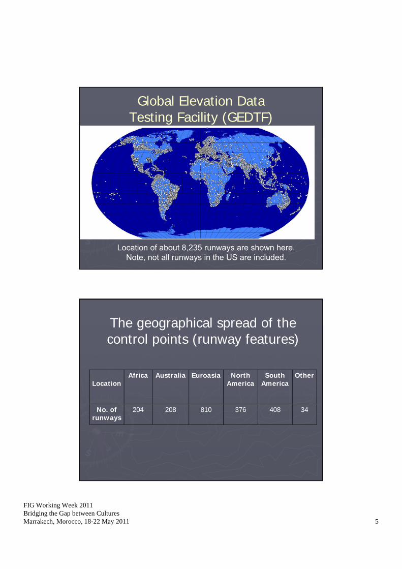
FIG Working Week 2011Bridging the Gap between CulturesMarrakech, Morocco, 18‐22 May 2011 5
Global Elevation DataTesting Facility (GEDTF)
Location of about 8,235 runways are shown here.Note, not all runways in the US are included.
The geographical spread of the control points (runway features)
LocationAfrica Australia Euroasia North
AmericaSouth
AmericaOther
No. of runways
204 208 810 376 408 34

FIG Working Week 2011Bridging the Gap between CulturesMarrakech, Morocco, 18‐22 May 2011 6
Histogram of the Google Earth™ errors
0 200 400 600 800 1000 1200 1400 1600 18000
0.05
0.1
0.15
0.2
0.25
Error: (m)
Rel
ativ
e F
requ
ency
mean = 113.1 mSTD = +/- 182.1 mn = 2045
= +/-(x2 + y2)
0 200 400 600 800 1000 1200 1400 16000
0.1
0.2
0.3
0.4
0.5
0.6
0.7
0.8
0.9
1
x: True minus GoogleEarth positions (m)
F(x
): C
umul
ativ
e D
istr
ibut
ion
valu
es
The Cumulative Distribution Function (CDF) of the disparities in runway positions. A region bordered by the y-axis and the
dashed line is shown in Figure 3 in an enlarged form.
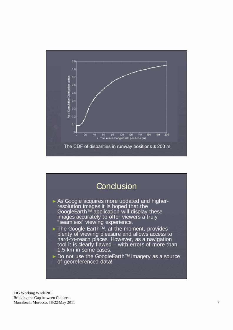
FIG Working Week 2011Bridging the Gap between CulturesMarrakech, Morocco, 18‐22 May 2011 7
0 20 40 60 80 100 120 140 160 180 2000
0.1
0.2
0.3
0.4
0.5
0.6
0.7
0.8
0.9
x: True minus GoogleEarth positions (m)
F(x
): C
umul
ativ
e D
istr
ibut
ion
valu
es
The CDF of disparities in runway positions ≤ 200 m
Conclusion
►As Google acquires more updated and higher-resolution images it is hoped that the GoogleEarth™ application will display these images accurately to offer viewers a truly “seamless” viewing experience.
►The Google Earth™, at the moment, provides plenty of viewing pleasure and allows access to hard-to-reach places. However, as a navigation tool it is clearly flawed – with errors of more than 1.5 km in some cases.
►Do not use the GoogleEarth™ imagery as a source of georeferenced data!
FIG Working Week 2011Bridging the Gap between CulturesMarrakech, Morocco, 18‐22 May 2011 8
The Google Earth™ blog
►www.gearthblog.com/blog/archives/2009/03/about_google_earth_imagery_1.html
Thank you, and please visit Brunei Darussalam!
Nepenthes L.