golder associates - · pdf filegolder associates 17 may 2016 reference no....
TRANSCRIPT
Golder Associates
17 May 2016 Reference No. 1656748-001-P-Rev0
Beau Cong Spire Group Pty Ltd 9/14-26 Audsley St Clayton South VIC 3169
LANDFILL GAS RISK ASSESSMENT
10 ALVINA STREET OAKLEIGH SOUTH
Dear Beau
1.0 INTRODUCTION Spire Group Pty Ltd (Spire) engaged Golder Associates Pty Ltd (Golder) to provide a landfill gas risk assessment as part of the planning process for the redevelopment of the former Clayton West Primary School Site at 10 Alvina Street, Oakleigh South into a residential estate (Figure 1).
2.0 BACKGROUND We understand that the City of Monash (Council) has refused to approve a Development Plan for the site comprising residential development. The matter has been lodged with the Victorian Civil and Administrative Tribunal.
Schedule 5 of the Development Plan Overlay for the site requires a risk assessment of the gas migration from the neighbouring landfill site. The risk assessment must be in accordance with EPA Publication 788.1 Best Practice Environmental Management Guidelines, Siting, design, operation and rehabilitation of landfills October 2010 (BPEM). It is noted that the BPEM has subsequently been updated to Publication 788.3 dated August 2015. This more recent version has been used as the basis for this assessment.
Golder was provided a copy of a landfill gas assessment undertaken for the site:
• Prensa Pty Ltd, March 2014. Landfill Gas Assessment, 10 Alvina Street Oakleigh South, Victoria undertaken for Department of Treasury and Finance (Attachment 3)
We note that in its decision summary in relation to the development from the Council meeting on 29 September 2015 (Section 4.5 — Page 73) that Council states the following:
Risk assessment given proximity to a nearby landfill
The DP05 requires the Applicant to undertake and submit to Council a risk assessment detailing the risk of landfill gas migration from nearby landfills. The risk assessment must be conducted by a
Golder Associates Ply Ltd Building 7, Botanicca Corporate Park, 570 — 588 Swan Street, Richmond, Victoria 3121, Australia (PO Box 6079, Hawthorn West VIC 3122)
Tel: +61 3 8862 3500 Fax: +61 3 8862 3501 www.golder.com
Golder Associates: Operations in Africa, Asia, Australasia, Europe, North America and South America
A.B.N. 64 006 107 857 Golder, Golder Associates and the GA globe design are trademarks of Golder Associates Corporation.
Beau Cong 1656748-001-P-Rev0
Spire Group Pty Ltd 17 May 2016
suitably qualified professional, having regard to the relevant EPA Publication to the satisfaction of the responsible authority.
Instead, the applicant has submitted a 'Report on Environmental Due Diligence Review and Advice' prepared by Golder Associates Pty Ltd dated April 2009. This report was prepared for the Victorian Urban Development Authority (Vic Urban).
The report was prepared in excess of 6 years ago and it is considered appropriate that the current application should be supported by an updated study.
We note that the electronic copy of the environmental reports supplied to Golder by Spire and we understand submitted to Council as part of the planning application were incorrectly formatted. The pages of the electronic reports had been reordered such that the Prensa report did not appear as a separate report from the Golder report nor did it appear in its correct page order. As such, it would have been difficult for Council to identify the Prensa report and read it unless the report were correctly reordered. Hence, it is apparent from Council's decision summary that the Prensa landfill gas risk assessment was not identified by Council in the submitted documents nor highlighted by Spire in its submission.
Golder has reordered the Prensa report to its original format and it is attached to this review. As the report was prepared in 2014 to specifically address the landfill gas risk at the proposed development site, this report has been reviewed as part of our landfill gas risk assessment and forms the basis of this review.
3.0 LEGISLATIVE FRAMEWORK DP05 requires a landfill gas risk assessment in accordance with the BPEM. As previously noted, the BPEM identified in DP05 has been revised twice with the latest version being EPA Publication 788.3 dated August 2015. The updates to the BPEM have not significantly altered the manner in which landfill gas assessment is undertaken compared to that set out in EPA Publication 788.1 dated October 2010. This more recent version has been used as the basis for this assessment.
The BPEM provides guidance relating to the technical requirements for siting, design, operation, management and monitoring landfills in Victoria. The guidance provided in the BPEM is expected to be used as the 'default' for mitigating adverse impacts from landfills. Landfill operators and owners are expected to meet the objectives and required outcomes by implementing the relevant best practice measures described by the BPEM as 'suggested measures'. Further, EPA may require additional measures to be undertaken to protect the environment.
The following elements of the BPEM are considered to be relevant to the assessment of landfill gas risk at the Site:
• The BPEM specifies buffer distances to buildings and structures for Type 3 (solid inert waste) and Type 2 (putrescible waste) landfills as 200 m and 500 m respectively.
• The BPEM identifies the following landfill gas action levels (hereafter referred to as BPEM trigger levels)
• 1% v/v methane and 1.5% v/v carbon dioxide above background concentration within the subsurface geology and subsurface services at the landfill boundary;
• 10000 ppm of methane within the subsurface services on the landfill and within adjacent areas; and
• 5000 ppm of methane within buildings and structures on the landfill and in adjacent areas and 1% v/v methane within buildings.
• The recommended way to evaluate the level of risk posed by landfill gas from an individual site is to conduct a site-specific landfill gas risk assessment (LGRA). Guidance on how to complete a LGRA is provided in the Landfill Licensing Guidelines (EPA Publication 1323.2, August 2011).
• Appendix 2 of the Landfill Licensing Guidelines sets out the basic landfill gas risk assessment process as follows:
• Development of a conceptual model of the landfill and its surroundings;
• Hazard identification and risk screening; and
2/7 er Golder Associates

Beau Cong 1656748-001-P-Rev0
Spire Group Pty Ltd 17 May 2016
• Basic Quantitative risk assessment
These steps have been used in this landfill risk assessment.
4.0 SITE SETTING
4.1 Site Information The development site at 10 Alvina Street has an area of approximately 2.06 ha (Figure 1). It was the former Clayton West Primary School which has now been demolished. An environmental assessment has been undertaken by Golder Associates for VicUrban in 2009 entitled:
• Golder Associates Pty Ltd, Report on Environmental Due Diligence Review and Advice, Former Clayton West Primary School, 10 Alvina Street, Oakleigh South, Victoria dated 27 March 2009
The report concluded that "..the site is unlikely to present a significant contamination liability to VicUrban for the proposed residential use, due to the overall low risk and nature of the soil condition."
The report did not specifically consider the risk of landfill gas migration.
The site is surrounded by residential properties on all sides with the exception of the former Pioneer Talbot Avenue sand quarry across Alvina Street to the south west.
4.2 Site Geology and Hydrogeology The 1:63,360 geological Melbourne Map sheet indicates that the property is underlain by the Brighton Group Formation with Tertiary age sediments consisting of non-marine sands, sandy clay, silt and gravel, as well as shelly silty sands and ferruginous sand.
The depth to groundwater and groundwater flow direction will be influenced by the former quarrying in the area of the site but is expected to be around 10 m.
4.3 Summary of Landfills within the BPEM Buffer Zone The following summaries Golder's understanding of landfilling activities within 500 m of the site in accordance with the buffer distance set out in the BPEM. The understanding is based on the Prensa review, a search of publically available information and our knowledge of the area.
There are two areas of known or suspected landfilling. Both are located within the former Pioneer site at Talbot Avenue to the south west of the site. Figure 1 indicates the two known landfilling areas; the one in the south east of the site is now Talbot Park and the one in the north west of the site remains vacant land and is part of the proposed development site at 1221-1249 Centre Road, Oakleigh South. There is little publically available information on both of these sites but we understand the following.
Talbot Park
• Talbot Park is located a minimum of 350m from the proposed development site (Figure 1);
• The Prensa report indicates that Talbot Park was a former sand quarry that was backfilled with at least 4.2 m thickness of putrescible waste from around 1977-1978;
• The Prensa report states that monitoring by Council around 2009 indicated no migration of gas at the site boundary but the results could not be released by Council as they were confidential.
1221-1249 Centre Road Oakleigh South
• The former landfill is shown in Figure 1 and is located a minimum of 190m from the proposed development site;
• The landfill is not directly identified in the Prensa report. Golder is aware of the presence of the landfill from past reviews of landfilling in the area. Whilst details of the landfilling are not publicly available, it is understood by Golder that the former sand quarry was around 18 m deep. It was partially filled with putrescible waste between 1970 and 1973 after which time it was capped;
cbr Golder 3/7 Associates

Beau Cong 1656748-001-P-Rev0
Spire Group Pty Ltd 17 May 2016
• The site has been the subject of a number of development concepts. A recent search of the Internet indicates a 2015 submission to Council by Talbot Road Finance Pty Ltd for two town planning applications for the site as follows:
• Backfilling and Site Rehabilitation of the Former Quarry (Application TPA/43336)
• Use and Development of the Land for Stockpiling of Earth and Treatment of Fill Material (Application TPA/43337)
• Few details are available but the Council Summary (28 April 2015) identifies and endorsed document submitted to Council with the application as follows:
— Huntingdale Estate Environmental Site Assessment (Site, Groundwater and Landfill Gas Assessment), Coffey Environments, 8 July 2014.
Golder could not locate the document on the Council website but we would expect that this will provide further information on the risk posed by landfill gas to the site and surrounding sites. Given that the site is potentially moving towards redevelopment, should landfill gas be posing a risk to the site or surrounding sites, this risk would need to be mitigated by the site owners prior to development.
5.0 OVERVIEW OF THE PRENSA REPORT
5.1 General Prensa completed the landfill gas risk assessment for Department of Treasury and Finance to support the sale of the site. Prensa is a member of the Australian Contaminated Land Consultants Association (ACLCA) and hence in our opinion comprises "suitably qualified professionals" as required by DP05 for assessing contaminated land issues such as landfill gas.
The stated aim of the report was "...to provide an indication of the potential for landfill gas to be present at the site, which may represent a potential risk to the proposed future residential use of the site."
The scope of work undertaken can be summarised as follows:
• Review of background information to assess landfill gas risks;
• Site inspection and surface monitoring using a portable landfill gas meter;
• Installation of 3 landfill gas monitoring bores including sampling and analysis for landfill gas;
• Provision of an assessment report.
The detail of the background review included discussion with Council and EPA with information included within this review.
5.2 Landfill Gas Monitoring Prensa undertook specific monitoring in January 2014 for landfill gas at subsurface features around the site including two stormwater drains and a sprinkler valve. The monitoring was done with a handheld LFG monitor. The readings at the three locations found no methane and low concentrations of carbon dioxide (up to 0.8%) indicating no accumulation of landfill gas in these features adjacent to the site.
Prensa went on in February 2014 to install three landfill gas probes (GB1 to GB3) in the south west corner of the site (refer Figure 1). The probes are located within the area of the site closest to the two landfills. The probes were closest area were installed to around 2m depth and were screened within the natural soils below the overlying fill.
The probes were sampled by Eurofins MGT on 28 February. This included leak testing of the bore prior to sampling, insitu gas screening and then sampling of the gas for confirmatory laboratory testing. The in-situ gas screening did not indicate the presence of methane above the limit of detection of 0.1 °/0v/v. The subsequent quantification of methane in the laboratory did not detect methane above the limit of reporting of 20 ppm.
4- eIA.
r Golder Associates 4/7

Beau Gong
Spire Group Pty Ltd
1656748-001-P-Rev0
17 May 2016
The results indicate that landfill gas has not been detected in elevated concentrations in the subsurface soils at these three locations closest to the former landfills.
5.3 Prensa Conclusions Prensa develop a conceptual model and undertake and assessment of risk concluding that:
"...based on the results of the LFG sampling, it is considered that the potential for LFG to be present at the Site which would pose a potential health risk to future low density residential users of the site is low."
6.0 LANDFILL GAS RISK ASSESSMENT
6.1 Conceptual Model Based on the background information presented, the following conceptual model has been developed to consider the landfill risks. Table 2 outlines the key risk factors for landfill gas migration in considering the source-pathway-receptor conceptual model for the site.
Table 1: Summary of Risk Factors
Risk Factor Talbot Park Landfill Assessment 1221-1249 Centre Road Oakleigh South Landfill Assessment
Source Risk Factors Age of Filling Approx. 38 years Approx. 43 years
Nature of Waste Putrescible Waste Putrescible Waste
Scale of Filling Unknown but reported filling period only 1 year with 4.2 m thickness of waste
Unknown but filling period 3 years with reported 13 m thickness of waste
Gas Mitigation Measures None None Pathway Risk Factors
Minimum Distance to Site 350m I 190 m Geology Sand and clayey sand geology
Groundwater Expected to be around 10 m depth Receptor Risk Factors
Proposed Development Slab on ground residential use Construction workers and maintenance workers
The risk factors above support the following conceptual model:
• Source: Putrescible waste located within 500 m of the site at two locations
• Pathway: Subsurface migration through sandy geology
• Receptor: Residents and construction workers in the proposed development
6.2 Risk Screening In reviewing the source, pathway and receptor risk factors of the conceptual model, we note the following aspects of each which mitigate the potential for linkage of the three to create and unacceptable risk:
Source
• The potential source of the landfill gas is around 40 years old. Waste degrades over time and its ability to produce methane diminishes. Whilst the time will vary based on many factors, the key period of landfill gas production is generally within 30 years of waste placement. As such the likelihood of sites producing significant quantities of landfill gas that may migrate to the development site is diminished and likely to be low;
• The amount of waste placed in the Talbot Road site in particular was low given it was filled for only a year and so the amount of waste is relatively small generally mitigating the time for and degree of gas generation;
-*
(br Golder Associates 5/7
Beau Cong 1656748-001-P-Rev0
Spire Group Pty Ltd 17 May 2016
• Whilst there were no gas mitigation measures designed for these sites, the current consideration of the 1221-1249 Centre Road Oakleigh South Landfill Assessment for redevelopment indicates that should the site be acting as a landfill gas source, it will be managed in the near future. Furthermore, in the current application to Council for the backfilling of the site, there is evidence that the site has been monitored for landfill gas and that the results have been made available to Council (refer Huntingdale Estate Environmental Site Assessment (Site, Groundwater and Landfill Gas Assessment), Coffey Environments, 8 July 2014.). Given this it would be expected that if the owner or Council were aware of concentrations of landfill gas migrating from the site and impacting upon offsite residential properties that are closer than the development site, then action would have been taken;
Pathway
• Whilst the geology indicates the potential ability for landfill gas to migrate given is permeable nature, the likely poor quality caps, mined and disturbed nature of the site between the landfills and the development site as well as the porous nature of the geology provide opportunity for vertical migration of the gas rather than lateral migration potentially mitigating the amount of gas that could migrate;
• The generally low groundwater level is unlikely to be significantly driving landfill gas migration;
• The distance to the development site of the landfills of around 200 to 400 m also mitigates the potential risk.
Receptor
• There are a significant number of houses that are located closer to the landfills — to the south and east of Talbot Avenue landfill and to the north and west of the 1221-1249 Centre Road landfill (refer Figure 1). It would be expected that if there were a significant receptor risk that these houses would have experienced an issue already;
• The landfill gas monitoring undertaken by Prensa in 2014 including probes installed in the closest corner of the site designed to monitor for gas has not indicated the presence of landfill gas.
6.3 Landfill Gas Risk Assessment Summary Based on the conceptual model and the review of the key risk factors presented above, we consider that the risk of landfill gas migration occurring and causing an unacceptable human health or environmental impact on the proposed residential development at 10 Alvina Street is low and that no further landfill gas investigation or assessment is warranted. This conclusion is supported by the significant age of the placed waste (around 40 years), the distance to the receptor, the current proposals to Council regarding development of the 1221-1249 Centre Road site and the direct monitoring at the site providing no evidence of landfill gas migration to the site.
When considered in the context of the significant number of existing residential properties that are much closer to the two identified landfill site than the proposed development site, the relative landfill gas migration risk is very low.
7M IMPORTANT INFORMATION Your attention is drawn to the document titled - "Important Information Relating to this Report", which is attached to this report (Attachment 2). The statements presented in that document are intended to inform a reader of the report about its proper use. There are important limitations as to who can use the report and how it can be used. It is important that a reader of the report understands and has realistic expectations about those matters. The Important Information document does not alter the obligations Golder Associates has under the contract between it and its client.
Golder 6/7 Associates
Beau Cong 1656748-001-P-Rev0
Spire Group Pty Ltd 17 May 2016
We trust this information meets your requirement. Please do not hesitate to contact the undersigned should you have any questions.
Yours sincerely
GOLDER ASSOCIATES PTY LTD
Ian Kluckow Principal
nf/IMK/nf
Attachments: Attachment 1 - Figure 1 — Locality Plan
Attachment 2 — Important Information
Attachment 3 - Prensa Pty Ltd, March 2014. Landfill Gas Assessment, 10 Alvina Street Oakleigh South, Victoria undertaken for Department of Treasury and Finance
Cc: Thomas Ellicott — Minter Ellison
*4.• 7/7
er Golder Associates

DESIGN
REVIEW IMK
APPROVED IMK
FIGURE
1
Rev. 0
LOCATION MAP
LEGEND
GB Landfill Gas Monitoring Locations (Prensa, 2014)
.1-0. Distance to Former Landfill
Approximate Location of Former Landfill
F-1 Proposed Development Site
NOTES
1. Gas Monitoring locations sourced from Prensa Drawing: 13991 LEG Bore Location, 17/02/2014.
2. Road and property information, sourced from VicMap, 30/03/2015.
3. Imagery dated 19/04/2016, sourced from neannap.com. 4. Location map sourced from Esri online basemaps. COPYRIGHT
Road and property data The State of Victoria, Department of Environment, Water Land and Planning, 2015.
SO
METRES REFERENCE SCALE 1:4,000 (at A31
PROJECTION: GDA 1994 MGA Zone 55
CLIENT
SPIRE GROUP PTY LTD
PROJECT
LANDFILL GAS RISKASSESSMENT
TITLE
PROPOSED DEVELOPMENT LOCATION PLAN
CONSULTANT
Golder Associates
PROJECT No. CONTROL 1656748 001-R
0-,
11
YYYY-MM-DD 2016-05-15
PREPARED CJS

IMPORTANT INFORMATION RELATING TO THIS REPORT
The document ("Report") to which this page is attached and which this page forms a part of, has been issued by Golder Associates Pty Ltd ("Golder") subject to the important limitations and other qualifications set out below.
This Report constitutes or is part of services ("Services") provided by Golder to its client ("Client") under and subject to a contract between Golder and its Client ("Contract"). The contents of this page are not intended to and do not alter Golder's obligations (including any limits on those obligations) to its Client under the Contract.
This Report is provided for use solely by Golder's Client and persons acting on the Client's behalf, such as its professional advisers. Golder is responsible only to its Client for this Report. Golder has no responsibility to any other person who relies or makes decisions based upon this Report or who makes any other use of this Report. Golder accepts no responsibility for any loss or damage suffered by any person other than its Client as a result of any reliance upon any part of this Report, decisions made based upon this Report or any other use of it.
This Report has been prepared in the context of the circumstances and purposes referred to in, or derived from, the Contract and Golder accepts no responsibility for use of the Report, in whole or in part, in any other context or circumstance or for any other purpose.
The scope of Golder's Services and the period of time they relate to are determined by the Contract and are subject to restrictions and limitations set out in the Contract. If a service or other work is not expressly referred to in this Report, do not assume that it has been provided or performed. If a matter is not addressed in this Report, do not assume that any determination has been made by Golder in regards to it.
At any location relevant to the Services conditions may exist which were not detected by Golder, in particular due to the specific scope of the investigation Golder has been engaged to undertake. Conditions can only be verified at the exact location of any tests undertaken. Variations in conditions may occur between tested locations and there may be conditions which have not been revealed by the investigation and which have not therefore been taken into account in this Report.
Golder accepts no responsibility for and makes no representation as to the accuracy or completeness of the information provided to it by or on behalf of the Client or sourced from any third party. Golder has assumed that such information is correct unless otherwise stated and no responsibility is accepted by Golder for incomplete or inaccurate data supplied by its Client or any other person for whom Golder is not responsible. Golder has not taken account of matters that may have existed when the Report was prepared but which were only later disclosed to Golder.
Having regard to the matters referred to in the previous paragraphs on this page in particular, carrying out the Services has allowed Golder to form no more than an opinion as to the actual conditions at any relevant location. That opinion is necessarily constrained by the extent of the information collected by Golder or otherwise made available to Golder. Further, the passage of time may affect the accuracy, applicability or usefulness of the opinions, assessments or other information in this Report. This Report is based upon the information and other circumstances that existed and were known to Golder when the Services were performed and this Report was prepared. Golder has not considered the effect of any possible future developments including physical changes to any relevant location or changes to any laws or regulations relevant to such location.
Where permitted by the Contract, Golder may have retained subconsultants affiliated with Golder to provide some or all of the Services. However, it is Golder which remains solely responsible for the Services and there is no legal recourse against any of Golder's affiliated companies or the employees, officers or directors of any of them.
By date, or revision, the Report supersedes any prior report or other document issued by Golder dealing with any matter that is addressed in the Report.
Any uncertainty as to the extent to which this Report can be used or relied upon in any respect should be referred to Golder for clarification.
GAP Form No. LEGO4 RU July 2015 ill
r Golder Associates

Landfill Gas Assessment
10 Alvina Street
Oaldeigh South, Victoria
Department of Treasury and Finance
March 2014
261-271 Wattletree Road
Malvern VIC 3144
7: 9508 0100
F: 9509 6125
6: admingiprensa.com.au
ABN: 12 142 106 581
Job No: 13991-01: Client No: D0003

rt- -
prensa
Executive Summary
r
p • Prensa was engaged by the Department of Treasury and Finance (DTF) to undertake a landfill gas
(LFG) assessment at former Clayton West Primary School, located at 10 Alvina Street, Oakleigh South
(the Site).
A letter was issued by EPA Victoria (EPAV) relating to the proposed residential rezoning of the Site
and its close proximity to the former Talbot Park landfill. The letter noted that the "Schedide to the
Development Plan Overlay (DP0) requires a site assessment to be undertaken on these sites to
confirm they are suitable for sensitive uses, prior to the redevelopment for such uses."
DTF requested an assessment that would assess the potential for LFG to exist at the Site, based on
the proposed residential development and in light of the comments provided within the EPAV letter.
The objective of the assessment was to provide an indication of the potential for LFG to be present
at the Site, which may represent a potential risk to the proposed future low density residential users
of the Site.
Two (2) assessments have previously been undertaken relating to the Site. One (1) assessment
a—site- iiitOrY ,hiièthe. Oilier d d if ki rigfif)1 wig the
entire Site. The site history review noted the presence of a former quarry located south west of the
Site, which was noted to be disused by 1984. Prensa undertook a review of the two (2) assessments
and noted that the former quarry was rehabilitated into a park (Talbot Park) by 1984.
A desktop review of Talbot Park found that minimal information was publicly available regarding the
use of Talbot Park as a former landfill. Information obtained from EPAV and the City of Monash, indicated that Talbot Park was backfilled with putrescible waste (and possibly also solid inert waste)
between 1977-1978. Council records indicated that the landfill was converted Into a park circa 1988-
1991. Further information obtained from the City of iVionash indicated that LFG sampling undertaken at Talbot Park, circa 5 years ago, indicated that methane gas was not migrating off-site
from the park boundaries.
However, anecdotal evidence provided to Prensa indicated that LFG has been detected at the
boundary between Talbot Park and the Centre Road quarry. As a consequence of the uncertainty
regarding whether LrG is preierit at tlie Tilbot-Park bOUricfailei:litidfil I 'gas' i Cali& cted
at the Site.
LFG monitoring was undertaken by Prensa using a hand held LEG meter at the former Clayton West
Primary School in January 2014. The monitoring reported non-detectable concentrations of methane
at the three (3) locations sampled, which predominantly comprised stormwater drains and service
pits at the Site.
In addition, Prensa installed three (3) LFG bores in the southwest corner of the Site. LFG sampling
and analysis did not report detectable concentrations of methane in the confirmatory samples
collected.
Detailed information about the construction, operation or closure/capping of Talbot Park was largely
unavailable, however based on the following multiple lines of evidence it appears unlikely that the
Site would be at significant risk of LFG impacts from Talbot Park:
D0003:514.0 Liavrori Wear ttevus

prensa • There appeared to have been only relatively minor landfilling practices over a limited period of
time at Talbot Park, with landfilling reported to he over a 2 year period only;
• LFG monitoring at Talbot Park undertaken approximately 5 years ago did not report elevated
LFG concentrations;
• There have been large pockets of residential development in the vicinity of the Site and Talbot
Park, both prior to and since the landfilling was undertaken, and there are no known incidences
of LFG at hazardous concentrations within or nearby adjacent residences;
• Victorian guidance recommends the maintenance of a buffer around a former landfill for 30
years after which time LFG risks are considered to be low. The landfill has been closed for
approximately 26 years, which Is approaching the Victorian EPA 'minimum risk' requirement for
the maintenance of a buffer (30 years);
• The level of capping (if any) installed upon closure of the landfill is unknown. Current nearby site
conditions (with public open spaces and vacant areas) may potentially limit pressure build-up
and lateral migration of LFG to the site;
• Lateral migration of LFG was not encountered during testing at three (3) locations (including two
[23 stormwater drain locations and one [11 sprinkler valve location), tested in January 2014;
• No observable LFG odours or LFG issues were identified at the Site during recent sampling
undertaken in January and February 2014; and
• A buffer distance of approximately 400 m exists between the Site and Talbot Park,
Based on the above information and the LFG monitoring undertaken at the Site, it Is considered that
the potential for methane gas to be present at the Site, which would pose a potential health risk to
future low density residential users of the Site is low.
1)0003:SPF:13991-03. Clayton WestRevO ii March .2.014

• Is '
prensa
Statement of Limitations This document has been prepared in response to specific Instructions from Department of Treasury and Finance to whom
the report has been addressed. The work has been undertaken with the usual care and thoroughness of the consulting
profession. The work Is based on generally accepted standards, practices of the time the work was undertaken. No other
warranty, expressed or implied, is made as to the professional advice included In this report.
The repo,: has been prepared for the use by Department of Treasury and Finance and the use of this report by other
parties may lead to misinterpretation of the issues contained In this report To avoid misuse of this report, Prensa advise
that the ropers should only be relied upon by Department of Treasury and Finance and those par lies expressly referred io
In the Introduction of the report. The report should not be separated or reproduced in part and Prensa should be retained
to assist other professionals who may be affected by the issues addressed in this report to ensure the report is not misused
in any way.
Prensa Is not a professional quantity surveyor (QS) organisation. Any areas, volumes, tonnages or any other quantities
noted in this report are indicative estimates only. The services of a professional QS organisation should be engaged if
quantities are to be relied upon.
Sampling Risks
Prensa acknowledges that any scientifically designed sampling program cannot guarantee all sub-surface contamination
will be detected. Sampling programs are designed based on known or suspected site conditions and the extent and nature
of the sampling and analytical programs will be designed to achieve a level of confidence In the detection of known or
idea- The 566101h 1d"aiialytlaI p forarns" adopted 'will be those that 'maximises • the
probability of Identifying contaminants. Department of Treasury and Finance must therefore accept a level of risk
associated with the possibie. failure to detect certain sub-surface contamination where the sampling and analytical
program misses such contamination. Prensa will detail the nature and extent of the sampling and analytical program used
in the assessment in the assessment report provided.
Environmental site assessments identify actual subsurface conditions only at those points where samples are taken and
when they are taken. Soil contamination can be expected to be non-homogeneous across the stratified soils where present
on site, and the concentrations of contaminants may vary significantly within areas where contamination has occurred. In
addition, the migration of contaminants through groundwater and soils may folow preferential pathways, such as areas of
higher permeability, which may not be intersected by sampling events. Subsurface conditions Including contaminant
concentrations can also change over time. For this reason, the results should be regarded as representative only.
Department of Treasury and Finance recognises that sampling of subsurface conditions may result in some cross
contamination. All care will be taken and the Industry standards used to minimise the risk of such cross contamination
occurring, however, Department of Treasury and Finance recognises this risk and waives any claims against Prensa and
agrees to defend, Indemnify and hold Prensa harmless from any claims or liability for injury or loss which may arise as a
result of alleged cross contamination caused by sampling.
Reliance on information Provided by Others
Prensa notes that where Information has been provided by other parties In order for the works to be undertaken, Prensa
cannot guarantee the accuracy or completeness of this information, Department of Treasury and Finance therefore waives
any claim against the company and agrees to indemnify Prensa for any loss, claim or liability arising from inaccuracies or
omissions in Information provided to Prensa by third parties. No indications were found during our assessments that
Information contained In this report, as provided to Prensa, Is false.
Recommendations for Further Study
The industry recognised methods used In undertaking the works may dictate a staged approach to specific assessments.
The findings therefore of this report may represent preliminary findings In accordance with these industry recognised
methodologies. In accordance with these methodologies, recommendations contained in this report may include a need
for further assessment or analytical analysis. The decision to accept these recommendations and incur additional costs in
doing so will be at the sole discretion of Department of Treasury and Finance and Prensa recognises that that Department
of Treasury and Finance will consider their specific needs and the business risks involved. Prensa does not accept any
liability for losses incurred as a result of Department of Treasury and Finance not accepting the recommendations made
within this report.
L •
DODOISPF:139P'.1-01 claron Wel Ree0'l it; mAral 4014

. .. 5
prensa •Ao.'k4
Table of Contents
f.f '
1 Introduction 0•.:, ., . 1. 1
2 Background p , ... •.•:••.•11;eysi ''''''''''''' 1
3 Objective ''' ..,(..... 1
4 Scope of Works 1 5 Findings
5.1 Site History Findings
5.1.1 Report Review 1,411.4. .2
5.1.2 Online Review •••••-• ..........
5,1.3 EPA Review.. ... .. , . •
5.1.4 City of Monash Review -•• - 3
5,2 Geology 4,...-.1."-,r.i ... . ;.:4.- 4
5.3 Hydrogeology -,.... - ........ ..:,,..4
5.5.1 Surface Water Receptors
5.5.2 Groundwater Database Search
5.4 LFG Monitoring
5,5 Intrusive LFG Assessment .
5.5.1 LFG Bore Installation . . .5
5.5.2 LFG Sampling . .
5.5.3 LEG Analytical Schedule
5.5,4 LFG Criteria ..... .
5.5.5 LFG Results
6 Conceptual Site Model .. ..
6.1 Site Specific Geology
6.2 Potential Sources of LFG Contamination
6.2.1 Off Site .....
6.3 Contaminants of Potential Concern
6.4 Transport Mechanisms and Exposure Pathways
6 .5 Potential Receptors .... . . .. . • • "' •• .'•••ei;i4 .. . .. .. ;..7
7 Significance of Results sio•irmin •diiii.a•.•14 • 7
8 Conclusion , 8 :
9 Application of this Report 4.11, .1, ... ..•••.• 10
6
.... t.p .... • 6
Y 6
... . •• ....... •••
7
. ... . .. .00 4..014/.3114.40i ... .. ........ i••• •-•1 7
7
DO(103:SPF:13991.-D1 Clayton West..Fiev01 Iv March 2014

prensaffl Figures
Appendix A: EPA Documents
Appendix B: Council Documents
Appendix C: LFG Construction Borelogs
Appendix D: Eurofins MGT LFG Analytical Results
' a- (
•
' ;
9.7
r •
.i.narch -

prensa 1 Introduction Prensa was engaged by Department of Treasury and Finance (DTF) to undertake a landfill gas (LFG)
assessment at the former Clayton West Primary School, located at 10 Alvina Street, Oakleigh South,
Victoria (the Site).
A site locality plan has been provided as Figure 1 in the Figures section of this report.
2 Background It was understood that DTP proposes to divest the Site, and as part of the divestment process has
applied for the Site to be rezoned from Public Use Zone-Education to residential in accordance with
the City of Monash Planning Scheme. EPA Victoria (EPAV) prepared a letter 'DEECD Surplus Land
Rezoning Project' addressed to the Department of Transport, Planning and Local Infrastructure,
dated 22 November 2013 (EPAV ref: 5003719), in relation to the proposed re-zoning, The letter
related to the proposed rezoning of three former primary schools and their close proximity to
"Former sand quarries [that] have been historically used for land-filling, which has often included the
filling of putrescible wastes". Specifically in regards to the Site, the letter stated that "Clayton West
Primary School is adjacent to the former Talbot Pork landfill site."
Furthermore, the letter noted that the "Schedule to the Development Plan Overlay (DPO) requires a
site assessment to be undertaken an these sites to confirm they are suitable for sensitive uses, prior
to the development for such uses".
DTF requested a LFG assessment be undertaken to assess the potential for LFG to exist at the Site,
based on the proposed residential redevelopment of the Site and in light of the comments provided
within the EPAV letter.
3 Objective The objective of the LFG assessment was to provide an indication of the potential for LFG to be
present at the Site, which may represent a potential risk to the proposed future residential use of
the Site.
4 Scope of Works As part of the LFG Assessment, Prensa undertook the following:
• Review of environmental assessment reports relating to the Site;
• LFG Desktop review, including liaising with EPAV and the City of Monash;
• Site inspection and monitoring using a portable LFG monitor;
• Supervision of the service clearance of three (3) locations using a Telstra accredited service
locator;
• Supervision of the installation of three (3) LPG bores;
• Supervision of leak testing and sampling of three (3) LFG bores, including methane confirmatory
samples; and
• Preparation of this report outlining the findings.
00003:SPF:13991-01 Clayton West,Rev01 1 March 2014

prensa In completing the above tasks, Prensa undertook works in general accordance with the following:
• Environment Protection Act, 1970;
• State Environment Protection Policy (SEPP), Prevention and Management of Contamination of
Land, 2002;
• National Environment Protection (Assessment of Site Contamination) Measure (NEPM) No.1
Amendment, 2013;
• Victorian EPA Publication 788.1: Best Practice Environmental Management — Siting, Design,
Operation and Rehabilitation of Landfills, 2010;
• Australian Standard 4482.1, Guide to the Investigation and Sampling of Sites with Potentially
Contaminated Soil, Part 1: Non-volatile and Semi-volatile compounds, 2005;
• Australian Standard 4482.2, Guide to the Sampling and Investigation of Potentially
Contaminated Soil, Part 2: Volatile Substances, 1999;
• Victorian EPA Publication 1416: Draft Landfill Gas Fugitive Emissions Monitoring Guidelines,
2011; and
• EPA Publication 1270: Assessment of the Potential for Methane Gas Movement from Victorian
Landfills, 2009.
5—Findings.
5.1 Site History Findings
5.1.1 Report Review
As part of the site history review for Clayton West Primary School, Prensa reviewed the following
documents:
• Atma Environmental (Atma), Phase .1 Environmental Site Assessment: Former Clayton West
Primary School, South Oakleigh, Victoria, 12 February 2008. The scope of this assessment
included a site history review and a site inspection. The report noted that a former quarry was
located adjacent the Site to the west/south west and is subject to an environmental audit
overlay. The assessment undertook a search of Treatment and Disposal Facilities for Prescribed
Wastes on the EPAV website, and found at the time of the assessment that no prescribed waste
or disposal facility was found to be within 1 km of the Site, The historical aerial photographs,
.-dinaktO-15.51,..hiiteiftliiiera of -a 'qui/if)/ -pie, - 16-Cathd-adjadefitibilth" We Of the
Site, which was reported to have expanded in the 1963 aerial photograph and was disused by
1984. No reference was made within the report to the potential for LFG to be present at the
Site.
• Atma, Phase 2 Environmental Site Assessment: Former Clayton West Primary School, South
Oakleigh, Victoria, 15 October 2008, The scope of the assessment Included soil sampling from
thirty-two (32) gridded locations to 1.0 m using a solid stem auger. No reference was made
within the report to the potential for LFG to be present at the Site.
Prensa, Clayton West Primary School Desktop Document Review, 6 December 2011. The scope
.of the assessment included the review of the two Atma assessments. The report noted that the
quarry located south west of the Site, was developed into a recreational park by 1984 (Talbot
Park). No reference was made within the report to the potential for LFG to be present at the
Site.
tvsgrcri2()14
-

prensa 5.1.2 Online Review
A review of online resources confirmed that Talbot Park was a former landfill. A City of Monash
webpage indicated that numerous sand quarries were located around the Clayton and South
Oakleigh areas, with many of these quarries later used as municipal rubbish tips. Talbot Park was
listed as a tip that was later rehabilitated into a park between 19884991.
5.1.3 EPA Review
Prensa contacted EPAV to obtain information regarding Talbot Park and also reviewed several
publicly available EPAV documents. The information obtained from EPAV included the following:
• EPAV provided Prensa with an untitled, un-dated map from the South Eastern Regional Waste
Management Group of old landfills located within the Heatherton/Dingley area. The map
indicated that the former quarry at Talbot Park had been filled. The map also indicated that two
quarries, Consolidated quarries and City of Oaldeigh Ex, formerly existed adjacent to the west
and north of Talbot Park, bounded by Huntingdale Road and Centre Road.
• An untitled excel document provided by EPAV to Prensa indicated that Talbot Park was formerly
a municipal landfill from 1977-1978. Prior to this the park was used as a sand quarry. The host
aquifer was described as unconsolidated sedimentary, and it was reported that a well had been
removed from the park. The landfill type was described as 'filling resource excavation' and the
landfill was filled with both solid inert and putrescible waste. The estimated depth of the pit
was listed as 4.2 m.
• A search of EPAV audit reports indicated that an environmental audit had not been undertaken
at Talbot Park, however two (2) audit reports were found to exist for the northern and southern
portions of the property located adjacent to Talbot Park to the west, west of Talbot Avenue.
Current Melways and the audit reports Indicate that this property was a former quarry. No
reference was made to the risk of LFG migration within the audit reports.
• Prensa reviewed EPA Publication 1270 'Assessment of the potential for methane gas movement
from Victorian Landfills' 2009, which assessed all licensed and formerly licensed landfills
recorded in the EPA's database (a total of 260 landfills) for the potential for methane gas
migration. It was noted that Talbot Park was not listed as a landfill assessed within this
publication.
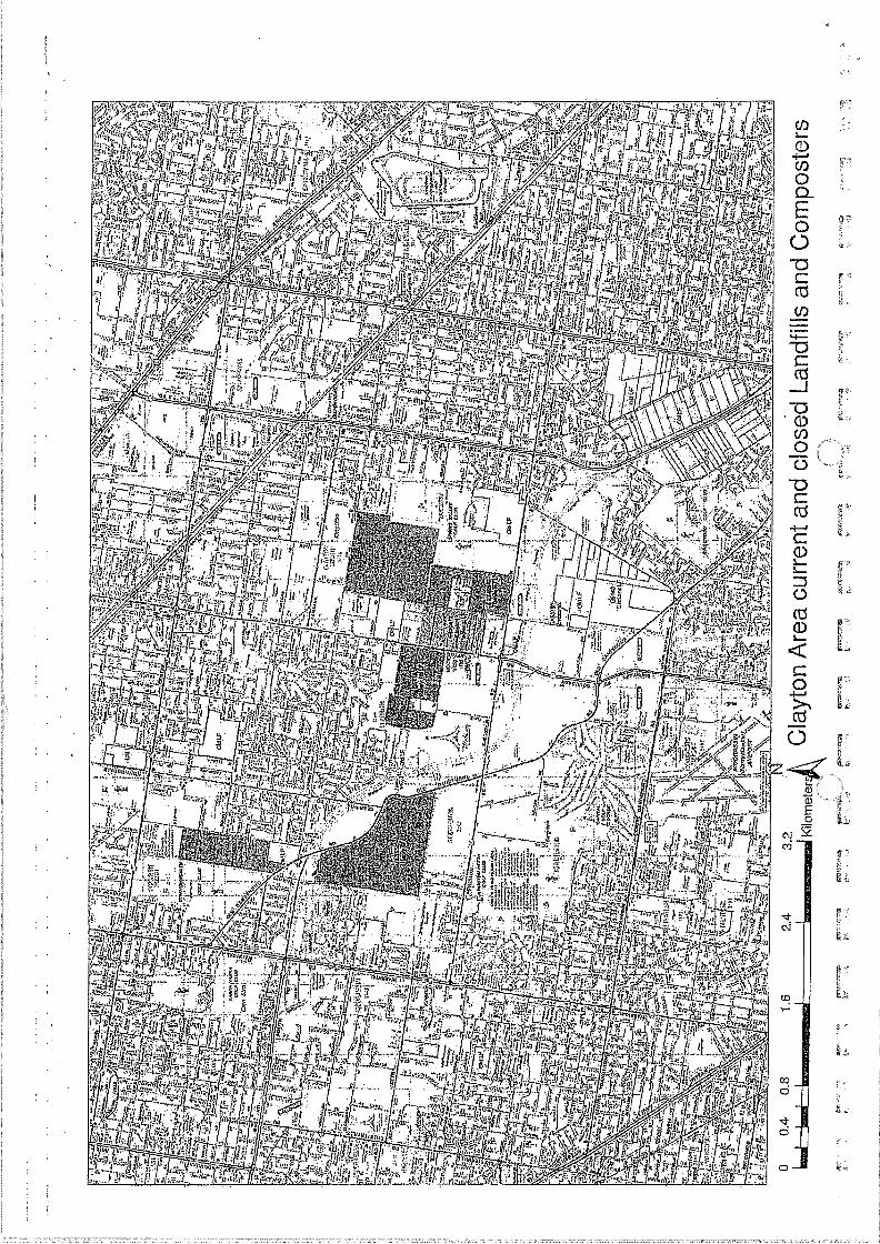
• A publicly available map on the EPA website titled 'Clayton area current and closed Landfills and
Composters' indicates the location of former and current landfills within the Clayton South,
Clarinda and Dingley areas. The map did not indicate that a landfill was formerly located at
Talbot Park.
• Prensa contacted the EPA auditor who is currently undertaking an audit on the former quarry
located adjacent to the west of the Site, located adjacent north and west of Talbot Park, at
1221-1249 Centre Road. The auditor indicated that LFG is present in the monitoring bores
located on the mutual boundary between the former Centre Road quarry and Talbot Park. No
further information was able to be provided to Prensa due to confidentiality reasons.
5.1.4 City of Monash Review
The City of Monash was contacted to obtain council documentation relating to Talbot Park. Written
information obtained from April Williams, Waste Services Project Officer indicated that the council
operated a landfill at Talbot Road, which was filled between 1977-1978, with putrescibie waste. The
landfill was small and some monitoring was undertaken approximately 5 years ago, which showed no
D0003:SPF:13991-01 Clayton We5t,Rev01 3 March 2014
t7.-L
'
1-
.
prensall migration of gas at the boundaries. City of Monash was unable to provide the results of the monitoring
as the documents were confidential. No further information was provided by the City of Monash.
5.2 Geology .
Prensa reviewed the Geological Map Series Melbourne Map Sheet 1:63,360, No. 849, Zone 7,
Ringwood. The map identified Quaternary-aged sand ridges and sand hills at the Site. The Site was
predominantly surrounded by Quaternary aged high level alluvium.
5.3 Hydrogeology
5.5.1 Surface Water Receptors
The closest surface water receptors to the Site were:
• Various lakes within Huntingdale and Metropolitan Golf Course, located approximately 500 m,
900 m and 1.5 km north west;
• Lakes within the former sand quarry, located approximately 400 m south west;
• A lake within Commonwealth Golf Club located approximately 1.4 km south west;
• Karkarook Lake, located approximately 2.8 km south west;
• Scotchman's Creek, located approximately 3 km north; and
theSite: • 7.-r
5.5.2 Groundwater Database Search
A search of the Visualising Victoria's Groundwater online database identified 6 registered
groundwater wells within a 500 m radius of the Site. A review of the bores has been summarised in
Table 1 below.
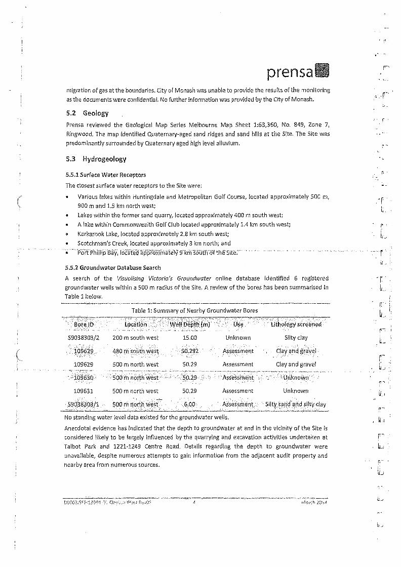
Table 1: Summary of Nearby Groundwater Bores
• Bore ID Location:.• • " Well Depth (m) '• Use titholcigY screened
$9038303/2 200 m south west 15.00 Unknown Silty clay .. . ' • - , . , • . ,
, 109629'. 480 rh south west • 5a292 Assessment Clay and gravel . . . . , - , . . .
109629 500 m north west 50.29 Assessment Clay and gravel
s:109630 • '50 . m north west 5029 ...._- : . .sessmen .. l• • Unknown ....
109631 500 m north west 50.29 Assessment Unknown -
.6,00 Assessment Silty sand and silty clay
No standing water level data existed for the groundwater wells.
Anecdotal evidence has indicated that the depth to groundwater at and in the vicinity of the Site is
considered likely to be largely influenced by the quarrying and excavation activities undertaken at
Talbot Park and 1221-1249 Centre Road. Details regarding the depth to groundwater were
unavailable, despite numerous attempts to gain information from the adjacent audit property and
nearby area from numerous sources.
. . 5$938308/1 500 m north West
r.:Oft0a:SPr-:1309.1..rii as?(.07! ?fl'

prensa 5.4 LEG Monitoring
The former quarry to the south west of the Site (currently Talbot Park) was converted into a landfill
following closure of the quarry. Closed landfills can continue to produce methane gas for many years
following closure, which can potentially migrate offsite through the local geology following a path of
least resistance into buildings and houses nearby.
Sarah Fitzpatrick and Holly Butler of Prensa attended the former Clayton West Primary School site
on Thursday the 16th of January 2014 to conduct a LFG assessment, A hand held GFM410 LFG
monitor was used to statistically measure oxygen, carbon dioxide and methane. Of particular
interest was the presence of methane gas, which Is a known by-product of landfill decomposition,
particularly where putrescible waste has been deposited.
Gas measurements were taken to assess for the presence of landfill related gases, A total of three
(3) measurements were taken at, and adjacent to the Site, as outlined in Table 2 below. Only three
(3) locations were sampled, due to a lack of suitable locations (such as stormwater drains and service
pits) to sample from. The LFG monitor did not register a detectable concentration of methane at any
of the three (3) monitored locations.
Table 2: LFG Monitoring Results
Location Methane (%) Carbon Dioxide (%) &Men (%)
Stormwater drain, southern boundary of the Site
0 0.1 21,1
Stormwater drain, northern pedestrian walkway to the Site
0 0.8 20.5
Sprinkler valve, south eastern corner of the Site
0 0 21.3
As part of the site inspection, several standpipes were noted adjacent to the southern portion of the
Site to the west, in the former Centre Road quarry. A search of the online register of EPA audit sites
and a review of Victoria's Groundwater Database were not able to provide any information to
indicate whether the standpipes were monitoring wells. The audit report prepared for the northern
portion of 1213-1217 Centre Road, Oakleigh South, indicated, that a bore network appears to be
present on the former quarry located north of the property (1221-1249 Centre Road), however, no
assessment or audit report is publicly available for the former quarry (1221-1249 Centre Road),
5.5 Intrusive LEG Assessment
5.5,1 LFG Bore Installation
Three (3) LFG bores (GB1, GB2 and GB3) were installed along the southern and western boundary of
the Site (the closest boundaries to Talbot Park). The LFG bores were installed by Star Drilling on 14th
February 2014, using 50 mm PVC piping for the casing. Where possible, bores were sealed with
bentonite across both fill and natural soil to ensure that the bores were appropriately sealed so that
any gas accumulating would be retained for sampling. The gas bore locations have been illustrated
in Figure 2, provided in the Figures section of this report.
D0003:SPF:13991-01.Ciayton West.fievOl. S March 2014

r "
prensa Table 3 below outlines the construction details of the LFG bores, in accordance with Table 8.3 of EPA
Publication 788.1. G _
Table 3: LFG Bore Construction .,
Gas Bore . Total Depth 'Bore casing Bore screen Screen length
GB1 1.8m 0.0 —1.0 m 1.0 m 0.8 m
GB2 2.0m 0.0 —1.0 m 1.0 m 1.0m
GB3 1.9 m 0.0-1.0 m 1.0-1.9 m 0.9 m
The LEG bore construction logs have been included as Appendix C.
5.5.2 LFG Sampling
Helium leak testing was undertaken prior to sampling, to verify the integrity of the construction seal.
The leak testing was conducted by Eurofins MGT on 28th February 2014. The LFG bores passed the
leak test.
Methane laboratory confirmation samples were also collected using a vacuum chamber to extract
gas into a tedlar bag. The gas as was sampled at a rate of 1L/min using a calibrated sample pump.
. Methane, carbon dioxide, carbon monoxide, oxygen and sulphide readings were also taken using a „ , . . GA2000 LFG Analyser.
All soil gas probes were sampled in accordance with Victorian EPA Draft Publication 1416 September t:..
2011- Subsurface Geology.
5.5.3 LFG Analytical Schedule
Gas was collected into a sample bag and transported to Eurofins-mgt for methane analysis using Gas
• Chromatography — Flame Ionization Detection (GC-FID). r-
r --
L.
• L.
f L_
5.5.4 LFG Criteria
Detectable methane concentrations were compared to Table 6.4 'VG Action Levels' In the EPA
Publication 788.1: Siting, Design, Operation and Rehabilitation of Landfills, 2010, which prescribes
action levels based on the location where methane is detected.
5.5.5 LFG Results . . . . Methane peak concentrations of 0.1 %v/v were detected in 5131 and G82, during sampling. Methane
laboratory confirmation samples were also collected using a vacuum chamber to extract gas into a
Tedlar bag using a calibrated SKC sample pump. Methane was not detected in the samples analysed.
It is noted that a detection of methane is not uncommon In the first twenty seconds of sampling In
LFG bores, as methane is a light compound that can sit at the top of a bore. However, the lab
confirmation results (which have a LOR of 20 ppm or 0.002 %v/v) confirmed that methane was not
present within the stabilised readings above 20 ppm.
The Eurofins MGT LFG assessment report includes further information relating to the methane
assessment and has been included as Appendix D.
00(103:5PM1991 -CY; C!Ave:ln West F02-;03 1;6

prensa 6 Conceptual Site Model
6.1 Site Specific Geology
Prensa reviewed the Geological Map Series Melbourne Map Sheet 1:63,360, No. 849, Zone 7,
Ringwood. The map identified Quaternary-aged sand ridges and sand hills at the Site. The Site was
predominantly surrounded by Quaternary aged high level alluvium.
6.2 Potential Sources of LFG Contamination
6.2.1 Off Site
Potential off site source of LFG contamination is the former landfill property (now Talbot Park)
located approximately 400 m south west of the Site and former potential landfill located at 1221-
1249 Centre Road.
6.3 Contaminants of Potential Concern
The potential contaminant of concern is methane, a known by product of landfill decomposition,
particularly where putrescible waste has been disposed.
6.4 Transport Mechanisms and Exposure Pathways
Methane can migrate through the soil profile, at varying depths above the ground water table.
The main potential exposure pathway for occupants of the Site is vapour inhalation of methane gas.
6.5 Potential Receptors
The on-site human receptors would include the following:
• Contractors during the development of the Site; and
• Users of the proposed future residential development.
7 Significance of Results Based on the site history review undertaken, it is understood that Talbot Park and the surrounding
vacant area adjacent north and north west of Talbot Park, operated as a quarry from sometime
between 1956 to 1988. It appears that Talbot Park was filled with putrescible wastes between 1977-
1978. Aerial photographs indicated that the Talbot Park area was backfilled by 1988, although the
remaining quarry area was not backfilled at this time. Talbot Park area was rehabilitated into a park
sometime between 1988-1991, while the remaining quarry area appeared to have been backfilled
sometime between 1991-2006.
Prensa contacted both EPAV and the City of Monash to obtain information regarding Talbot Park.
Both EPAV and the City of Monash Indicated that Talbot Park was formerly a quarry and was
subsequently used as a landfill, prior to being rehabilitated into a park. City of Monash indicated that
LFG monitoring was undertaken at Talbot Park, circa 5 years ago, which did not detect LFG at Talbot
Park, However, Prensa understands that an audit Is currently being undertaken at the former quarry
located adjacent and north, north west of Talbot Park and anecdotal information exists that suggests
that LFG has been detected in LFG bores located at the boundary of the former Centre Road quarry
and Talbot Park.
D000.3.:5PF:13991-01 Cloyton West.Rev01. 7 March 2014

prensa EPAV Publication 788,1 'Siting, Design, Operation and Rehabilitation of Landfills,' 2009, prescribes
f .' buffer distances to manage LFG Impacts from closed landfills. The buffer distances are measured
from the sensitive land use to the edge of the closest cell, or in the absence of knowledge of the cell
location, the premise boundary is used as the point of measurement. Publication 788.1 indicates r-- that a buffer zone of at least 500 metres should be maintained from buildings or structures for a
minimum period of 30 years following closure, for landfills filled with putrescible waste, It is noted
that Clayton West Primary School is located approximately 400 m north east of Talbot Park, and • r- Talbot Park was rehabilitated at the earliest 26 years ago.
within the buffer zone prescribed in EPAV Publication 788.1, it was considered that there was , r• -
Based an the site history information obtained and given that Clayton West Primary School lies .
potential for methane gas to exist at the Site. Given the uncertainty associated with the potential for
LFG to exist, empirical testing was undertaken to evaluate the risk posed by LFG.
Limited LFG monitoring undertaken using a handheld LFG meter at the former Clayton West Primary
School did not report concentrations of methane at the three (3) locations sampled. Additionally,
three (3) LFG bores were installed in the southwest corner of the Site (the closest corner to Talbot
Park). LFG confirmatory analysis did not report concentrations of methane within the LFG bores.
Therefore, based on the results of the LEG sampling, it is considered that the potential for LFG to be
present at the Site, which would pose a potential health risk to.future low density residential. users
of the Site is low.
8 Conclusion
Two (2) assessments have previously been undertaken relating to the Site. One (1) assessment
involved a site history review, while the other assessment involved grldded soil sampling across the
entire Site. The site history review noted the presence of a former quarry located south west of the
Site, which was noted to be disused by 1984. Prensa undertook a review of the two (2) assessments
and noted that the former quarry was rehabilitated into a park (Talbot Park) by 1984.
A desktop review of Talbot Park found that minimal information was publicly available regarding the
use of Talbot Park as a former landfill. Information obtained from by EPAV and the City of Monash,
indicated that Talbot Park was backfilled with putrescible waste (and possibly also solid inert waste)
between 1977-1978. Council records indicated that the landfill was converted into a park circa 1988-
1991: Further information obtained -from theY City• of Monash -indicated -that LFG sampling
undertaken at Talbot Park, circa 5 years ago, indicated that methane gas was not migrating off-site
from the park boundaries.
However, anecdotal evidence provided to Prensa indicated that LFG has been detected at the
boundary between Talbot Park and the Centre Road quarry. As a consequence of the uncertainty
regarding whether LFG is present at the Talbot Park boundaries, landfill gas sampling was conducted
at the Site.
LFG monitoring was undertaken by Prensa using a hand held LFG meter at the former Clayton West
Primary School in January 2014. The monitoring reported non-detectable concentrations of methane
at the three (3) locations sampled, which predominantly comprised stormwater drains and service
pits at the Site.
• r;-•
0001)3:SPF:126131 01 C.I.Tiistr ncyri! Mich 201

prensa In addition, Prensa installed three (3) LFG bores in the southwest corner of the Site. LFG sampling
and analysis did not report detectable concentrations of methane in the confirmatory samples
collected.
Detailed information about the construction, operation or closure/capping of Talbot Park was largely
unavailable, however based on the following multiple lines of evidence it appears unlikely that the
Site would be at significant risk of LFG impacts from Talbot Park:
• There appeared to have been only relatively minor landfilling practices over a limited period of
time at Talbot Reserve, with landfilling reported to be over a 2 year period only;
• LFG monitoring at Talbot Park, undertaken approximately 5 years ago, did not report elevated
LFG concentrations;
• There have been large pockets of residential development in the vicinity of the Site and Talbot
Park, both prior to and since the landfilling was undertaken, and there are no known incidences
of LFG at hazardous concentrations within or nearby adjacent residences;
• Victorian guidance recommends the maintenance of a buffer around a former landfill for 30
years after which time LFG risks are considered to be low. The landfill has been closed for
approximately 26 years, which is approaching the Victorian EPA 'minimum risk' requirement for
the maintenance of a buffer (30 years);
• The level of capping (if any) installed upon closure of the landfill at Talbot Park is unknown.
Current nearby site conditions (with public open spaces and vacant areas) may potentially limit
pressure build-up and lateral migration of LFG to the Site;
• Lateral migration of LFG was not encountered during testing at three (3) locations (including two
[2] stormwater drain locations and one [1] sprinkler valve location), tested in January 2014;
• No observable LFG odours or LFG Issues were identified at the Site during recent sampling
undertaken In January and February 2014; and
• A buffer distance of approximately 400 m exists between the Site and Talbot Reserve.
Based on the above Information and the LFG monitoring undertaken at the Site, it is considered that
the potential for methane gas to be present at the Site, which would pose a potential health risk to
future low density residential users of the Site is low.
D0003:SPF:13991-01 Clayton Westiley01 3 March 2014 11.1

11,
• 1-
• •
r- L
prensa 9 Application of this Report The report should not be separated or reproduced In part and should be read in its entirety.
Prensa Pty Ltd
Sally Bonham Holly Butler
Principal Environmental Consultant Senior Environmental Consultant
IL
D0003:SPF:33993-01 Carten West Ili 11/01: lo. MIII (.11 2iLI4

prensa
Figures
D0003:SPF:13991-01 Clayton West.Rev01 March 2014

•
R=7: 1 17 "1 g— i Or' 11V-3-7= FL= •7.33 1.
r---
Job at...-. 13991. Client No,:ocool
orensa 261-211. Waltictret Rd (0315SCR 0100 Malvern Vie 3194 F: (0) 95C95125 FO as 220?. Wartietree Rd 14,0 XtlitY1.1/(2.4£1.CD.M.ati Malvern F.a/1 VIC 1.11.95 [email protected]
Client: Department orrre:isury and F ncs
Project: lanai: Gas Assessment
Address: • 10 Aivina Street Oakleigh South
Drawing Title:
Clayton West Site lig:ail iv
a 33 13 IX 1•3
.1S.1•1 3.103i.4
Legend
Site Boundary
Taitot Park Donndtry
Feriner Centre Aped QM: SoUndary
DorzrAit'oxanzns aperori:nan
(maga Sour= Gcrueetarth Pro Moiled:1114.1125 ta
Drawn 57: Gam i.,y: •
SPF 11103/14 1 :-1AB 12/2§/14
orme ;1.3t•SI a..,/•er. ItcY!14aa•
33991 Cuyion A
I

A e• • I. .
P: (33)9508 0100 F: (03) 9509 6125
261-271 Wattletrec Rd Malvern VIC 3144 PO Box 2203 Wattletree Rd PO )1(78S.11%97M.019,9)! Malvern East VIC 3145 [email protected]
Job No.: 13991 Client No.: 00003
prensa
Client Department of Treasury and Finance
Project: Landfill Gas Assessment
Address: 10 Alvina Street, Oaldeigh South
Drawing Title:
Clayton West Landfill Gas Bore Locations
Ill. 27 53
Slier UM WI Moe>
Legend
Landfill Gas Bore
Site Boundary
Not. AS 1,cadens are aperoxirratc
Che:ked by:
HAB
Fole name: 13991 LFG Bore Loca [ion
FtUre number.
2
AevIstrat
A
tame° Seurcet coo& Berth No viewed :07 Fob 2314
Drawn by:
spc
Datel
17/02/14
rum
17/02/14
prensaa
s' r"
Appendix A: EPA Documents ft ..
k.
.r.
.'••r
rif)0(13:".iPP339914!). •lzreon ?.

filP , ,. ici•;.-.,*F4 I: v. tqa 4 ...Ai • . • 1 := .1.1; tf,!: t. :•••?), f•-si 'I.' i ' •••• ' int.5 1, ,•2• • • ,....h, • 44 41 * • • " ; 11 1..1.:: 1, iiP.... ,--;;E. ., { .e.' Ke a c,,
' . • • . tin . . . 11- rl tr.'fil - strt.: PA rii:J 04g Iffilf . .,,, 4?Asfitt• _ st.• ,., til • •,?..• ....tt- , :-. • 4t• -. •:,•;z ‘ , 0J.:91- 6. , t4,4 :kit:, 0"0,! ,.,...!•:;•4 -
7.67.. 8 ,4 o.
, . .
. v.
•, .., i
tt. k...4. 5 _
4 ,-,• 1 , 1.
• ..„.....
i'..-3 ..:,
13:4 ; ?:.,
11 ..., 0
1
&
. ,2c
.
T..t' .
u4i t:
t
t f?
'At
1 ,. I
r,r,,, .,.
.
P. .
;", 1
v 4.. t, .,
I
a
-
1
u
s .i..s1 - , 1 ..,,..6; 4',::. ' ' ' ;tV 0-1;,11 ,-,1,!.v. P,m1 t: i 4,1 i.,,
ET,I.A1 qt:11 4,;•.,, :..0.4 f 4
tilii ,,,3u,g..' ri. q' I t•••.y '8 ' ' Ai ( Y. I 65 1. 45.1 'CI ' y.4 Id. ..; , •-r ,441,„1 .
1. 1 t AI I i 4. 4'
. ./ r,
0..I. .. 4 ,. .• t R... .5..., a • IN 1 k ..‘...0::
ifi4". .L.11.1 g ...
IY.Z kig.':U 0'(.41 1*';:j k•;;;;'.4 g i.134 g ' ki.IV * I;Iii * °$.1:1 4 •.:,','.; g
RE
FU
SE
DIS
PO
SA
L S
UE
S
• Li
• P • •
4 . 4 •

!r
prensall
Appendix B: Council Documents
DO0t13:8PF:13991.01 Clayton West.Rev01 March 2014
.

•S•
prensa
Appendix C: LFG Construction Borelogs
1)00035PF:13991.01 Clayton Weilllev01 March 2014
;

- Client: Department of Treasury and Financo Job Number: 13921 Site Location: 10 Alvina Street, Oaktelgh South Job Type: Landfill Gas Investigation Date: 14/02/2014 License Number: N/A
Driller: Star Drilling Rig: Geoprobe Drill Rig Depth of Hole: 1.6 m Screened Depth: 1.0- 1,8 m Casing/Screen Diameter; 50 mm Top of Casing (m AHD): . . . . _ .. _
Standing Water Level: Easting: Northing: Coord. Sys.: Drawn By: SPF Approved By; SSB
Contment: ' Landfill gas bore
...
...t, - c 0. 0 0 Oi
Well Consteuell0i1
, Q "i 5
t.) : '.., e
4:-....u....a•it-, Sample , I- t
. . ..-
1.0
ra 1.0
• 2.0
4/444
•
41
- -
•--
A 4— Gr00110,0- 0.4 m)
„ ...
BenlDn0e(0.4 - 0.7 rn)
. . . ,. . , .. _
. Sand (0.7 -1.8 rn)
- .
' ,
FILL: SAND (0- 0,3 m) Brown, loose, dry, coarse grained sand, organic matter, dark grey silty clay pockets, angular b(uestone gravel fragments. '
„ . , , _
—
. .. ,.,
FILL: SAND (0.3- 0.5 m) Light grey, loose, dry, brown clay pockets.
. . . ..
--A .,i.i.:.--.'7= • -• NATURAL. SAND (0,5 - 0801) Dark grey to black, loose, dry, coarse groaned, MillOr quartz fragments, -
..
.. ,.....,....
NATURAL: SAND (0.8 - 1.3 m) .. . ... ,.
Light grey, loose, dty, homogeneous.,
.........,,.......-..................._ ... . . . ,..
:_.
_ ..,_
Screan
;§
NATURAL SANE) (1.3 - 1.7 in) Light brown, loose, dry.
Op -1.9 m)
- ---..
NATURAL: SAND (1.7 -1.8 m) Yellow, dense, slightly moist, coarse grained.
End of borehole at 1 .8 m at target depth in natural.
rr —
;71
t ,
1
.;
0
Borehole Log - GB1
Sheet: 1 of 1 prensa

Borehole Log - GB2
Sheet: 1 of 1 prensa
Client: Department of Treasury and Finance Job Number: 13991 Site Location: 10 Alvina Street, Oakleigh South Job Type: Landfill Gas Investigation Date: 14/02/2014 License Number: NIA
Driller: Star Drilling Rig: Geoprobe Drill Rig Depth of Hole: 2.0 m Screened Depth: 1.0- 2.0 m Casing/Screen Diameter: 50 mm Top or Casing (m AHD):
Standing Water Level: Basting: Northing: Coord. Sys.: Drawn By: SPF Approved By; SSB •
Comment: Landfill gas bore
"
Dep
th (
m)
Well Construction
, Me t
hod
Gra
phic
Log
igi...b.rkin. Sample PID
N
N \41
.f4
• ALL SAND (0- 0.3 m) Brown, loose, dry, coarse grained, dark grey sl:ty clay pockets.
• 0 1,54
r\%.1 Grout (0.0 - 0.4 my
FILL: SAND (0.3 - 0.5 m)
• • ,
ti g
Light grey, loose, dry, brown clay pockets, minor concrete fragments.
. - ri --• Contonie (0.4 - 0.7 m) '2
2 NATURAL: SAND (0.5 - 0.6 m) - Black to dark grey, loose, dry, coarse grained sand.
- NATURAL SAND (0.6 -1.3 m)
. Light grey, loose, dry. . . • .
1 a a i . --, 1.0 — —
=
t• =
i = — —
i -
= — _ •
I = : — _ . . . ! -.*-- NATURAL: SAND (1.3 -1.6 m) • ,
4-.-- Light brown, loose, dry. 4 Send (0.7. 2.0 m)
t- — — — ? — — — .
E - 1
- 1.5
_ i a -, _ — _
Saeen (1.0- 2,0 m)
= , NATURAL! SAND (1.6 - 2.0 m) . = = —
• Yellow, dense, slightly moist, coarse grained.
=...-. — •
.,- ---, ,
. •- _ — .
•‘= — 2.0 =. ' •
End of borehole at 2.0 m at target depth In natural.
-
-
-
F

Client: Department of Treasury and Finance Job Number: 13991 Site Location: 10 Alvina Street, Oekleigh Snufh Job Type: Landfill Gas Investigation Date: 14/02/2014 License Number: N/A ,
Driller: Star Drilling Rig: Geoprobe Drill Rig Depth of Hole: 1.9 m Screened Depth: 1.0 - 1.9 m Casing/Screen Diameter: 50 mm Top of Casing (m AHD):
•
Standing Water Level: Easting: Northing: Guard, Sys.: Drawn By: SPF Approved By: SSB
Comment: Landfill gas bore
.= ra. 0
anus 'Conuir uvtlor 1
Ut 0 • Met
hod
Gra
phic :
Log
a.,...,,,...r...r.
, ..
Z.,' ample PIO
..........,.., , f.,.,
•
..._ .....
— 2,0
40r
ft.
ik.‘"Vi4416
VA
rp ,
-
—
.
r, w
— owut no - u.,4 rti)
......
— Bentonite (OA- 0.7 rn)
— -- Sand (0.7-1.5 mj
Scram ;1.0 - LB m)
... . ....,,,
NATURAL: SAND (0 - 0.8 m) Dark grey to black, loose, dry, homogeneous,
...,, .....„.
.....,. .
..........._
, .......„,
f '' =, ,0,1.
t.
ii
.....
. t4-'-----'
, ... ..
NATURAL: SAND (0.8-1.5 m) .Light grey, loose, dry,
, , .. ... . _. . . . .
...
----7'
NATURAL: SAND (1,5 - 1.9 rn) Yellow, dense, slightly moist, coarse grained.
- End of bcirehole at 1,9 m at target depth in natural.
<5,
t •
U.,
iJ
Borehole Log • GB3
Sheet: 1 of 1
tr prensal

;(
prensa,,
Appendix D: NATA Analytical Results
I
1:
Da(103:SPF:13991-01 Clayton Westilev01 March 2614

eu rofi rts rnPt
Landfill Gas Report February 2014
Client: PRENSA
Site Oakieigh South
Eurofins mgt Report No: 410381
t.)
Prepared for;
PRENSA
261-271 Wattletree Rd
Malvern, VIC 3144
Prepared by;
Eurofins I mgt
2-5 Kingston Town Close
Oakleigh, VIC 3166

mgt Table of Contents
1 QUALITY CONTROL 3
1.1 DISTRIBUTION OF REPORT' 3
1.2 AUTHORISING SIGNATURES: -..- 3
2 SCOPE OF WORKS 3
3 TEST METHODS 4
3.1 SUBSURFACE GAS MONITORING 4
3.2 LEAK TE.STING oF GAS BORES 4
33 METHANE LABORATORY CONFIRMATION GAS BAG
4 INSTRUMENTATION 4
4.1 EXTRACTIVE LANDFILL GAS ANALYSER • • . • 4
4.2 EXTRACTIVE HELIUM ANALYSER 4
5 BORE CONSTRUCTION 4
6 GROUND CONDITIONS 5
7 WEATHER CONDITIONS 5
8 SOIL GAS RESULTS SUMMARY 5
8.1 SUBSURFACE GAS MONITORING 5
8.2 METHANE LABORATORY CONFIRMATION RESULTS 5
8.3 GAS BORE LEAK TEST RESULTS
9 APPENDICES 6
APPENDIX 1—Subsurface Monitoring Field Sheets
APPENDIX 2— Leak Testing Field Sheets
APPENDIX 3 — Eurofins mgt Laboratory Confirmation Methane Results
APPENDIX 4—Site Map & Gas Bore Logs
APPENDIX 5 Photos of Sample Setup
APPENDIX 6 — Instrumentation Calibration Data
5

mgt • €: 1 Quality Control
1.1 Distribution of Report:
Date Issued: 3rd March 2014
Delivery method: email
Conies Recipient . . -.. ,.
Copies Distributer
1 Sarah Fitzpatrick' .
PRENSA
261-271 Wattletree Rd,
Malvern, VIC 3144
sarah.fitzbatrickPorensa.com.au _ .
1 Stephen Curwood
Eurofins I mgt
2-5 Kingston Town Close
Oakleigh, VIC 3266
1.2 Authorising Signatures:
Report Prepared by: Stephen Curwood
Field Services Section I-lead - AIR
Report Authorised by: Peter Richardson
Field Services Manager.
NATA Signatory
2 Scope of Works
Eurofins mgt were engaged by PRENSA to conduct gas monitoring on a landfill site located at the
Clayton West Landfill. As requested by PRENSA monitoring was conducted on the three gas bores on
site. Monitoring was conducted in accordance with VIC EPA Draft Publication 1416 September 2011 -
DRAFT LANDFILL GAS FUGITIVE EMISSIONS. The three bores were also leak tested on the day of
sampling.
3
;

L.
r
•
grs
mgt 3 Test Methods
3.1 Subsurface Gas Monitoring
All soil gas Bores were sampled on the 28th February 2014 in accordance with VIC EPA Draft
Publication 1416 September 2011 - DRAFT LANDFILL GAS FUGITIVE EMISSIONS, Section 7
SUBSURFACE GEOLOGY. The extractive landfill gas analyser that was used was the GA2000 — Refer
Appendix 1: Buildings, Service Pits & Subsurface Monitoring Field Sheets.
32 Leak Testing of Gas Bores
All soil gas Bores were leak tested utilising Helium as a tracer in accordance with Eurofins mgt's In-
House Method AISOP002,
3.3 Methane Laboratory Confirmation Gas Bag
Sampling as per Eurofins mgt Alr Method A04 —Tedlar bag collection. Analysis as per Eurofins mgt
Method A06 (Gas Bag - FID).
4 Instrumentation
4.1 Extractive landfill gas analyser
The extractive landfill gas analyser that was used to monitor the soil gas bores on site was the
GA2000 Landfill Gas Analyser. It should be noted that the landfill gas analyser that was used does
meet the performance specifications stated in Table 4.1 of the VIC EPA Draft Publication 1416
September 2011- DRAFT LANDFILL GAS FUGITIVE EMISSIONS. Refer Appendix 6: Instrumentation
Calibration Data.
4.2 Extractive Helium analyser
The Extractive Helium Analyser that we used for leak testing of the bores was the GasCheck 50001s,
This unit was calibrated with certified calibration gas. Refer Appendix 6: Instrumentation Calibration
Data.
5 Bore Construction Each gas bore was constructed with SOmm diameter PVC casing and slotted PVC screen. The bores
were covered by dedicated bore covers that were locked,. Each probe had its own dedicated end cap
that was installed by Eurofins mgt 24 hours prior to sampling. Sampling was conducted using a quick
connect fitting. No deficiencies of the bores were noticed that may have prevented a representative
sample being taken.
Mrs, r -
4

eurorins mgt
6 Ground Conditions The ground conditions encountered at the site on the day of sampling were quite dry. The grass
coverage was mostly short to ankle high, No dead vegetation was observed around the gas bore
locations on the day of sampling.
7 Weather Conditions
Reference to daily weather observations from the BOM website for the closest weather station to
the Oakleigh South site (Moorabbin - see link below) show temperatures on the day of sampling
ranging from 10'C (min) to 24'C (max) and barometric pressures of 1024hPa (9am) and 1021hPa
(3pm), This decrease in pressure throughout the day can aid the upward flow of soil gas due to the
pressure gradient between the vadose zone and the atmosphere. Winds speeds of 15 km/h & 22
km/h were recorded at 9am & 3pm respectively. No rain events were recorded in the three days
prior to the sampling event.
, 9am 3Pm Date Rain
.(iffd'i) Tempera urd - :: -..:(°C)----
Bar metrid Press - 7(1W:a)::. -"" '
Temperature ' - - ' - (°C)-: 7 '
Barometric Press " .(hPa) ' -- - •
28th February 2014 . <1 15 1024 22 1021.
...
Reference Link - littq //www.1:)orn.giov.a*u/d irriatt/dwo/201402btmlilbd6W30 ,S,htm I
8 Soil Gas Results Summary
8.1 Subsurface Gas Monitoring
Refer Appendix 1: Subsurface Monitoring Field Sheets for details.
8.2 Methane Laboratory Confirmation Results
Refer Appendix 3: Eurofins mgt Laboratory Confirmation Methane Results
8.3 Gas Bore Leak Test Results
Refer Appendix 2: Leak Testing Field Sheets
5

s
9 APPENDICES
:1
r-
L
r •
g C.)
6

- APPENDIX I
Subsurface Monitoring Field Sheets
. J

Sample Date: 28.2.14 Ground Conditions: Dry GG1SS Coverage
In-Situ Gas Analysers: GA2000 Probe Description: 50mm PVC with QC fitting
Client:
Site:
Prensa Barometric Pressure: 1024 (9am) & 1021 (3pm)
10 Alvina Street, Oakleigh South Weather Conditions: Sunny, tight Winds
Jr: .
Eurofins mgt IN-SITU ANALYSER - Field Data Sheet
Soil Gas Probe Sample
Time (Hours)
Relative
Pressure (mbar)
In-Situ Readings via Portable Analyser
Comments
(incl. Stabilisation Time)
Flow
Reading (I/hr)
Ave.
VOC's (ppm)
Peak
VOC's (ppm)
Peak
CH4
%v/v
Peak
CO2
%v/v
Min. Stabilised Readings
02
%v/v CH4
%v/v CO2
%v/v 02
%v/v Balance
%v/v CO
ppm 112S
ppm
GB1 11.00 +0.01 0.1 . - - 0.1 1.8 19.3 <0.1 1.8 19.3 78.9 <1 <1 Stable at GO secs
GB1 1118 - - - 0.1 1.8 19.3 <0.1 1.8 19.3 78.9 <1 <1 Stable at 45 secs
GB2 • 1144 +0.05 0.0 - - 0.1 15 19.6 <0.3. 1.5 19.6 78.9 <1 <1 Stable at 75 secs
GB2 1201 - - - - <0.1 1.5 19.4 <0.1 1.5 19.4 79.1 <1 <1 Stable at 30 secs
683 1127 +0.00 0.3 - - <0.1 0.8 20.1 <0.1 0.8 20.1 79.1 <1 <1 Stable at 80 secs
683 1139 - - - <0.1 0.8 20.1 <0.1 0.8 20.1 79.1 <1 <1 Stable at 30 secs
Fleld/Trip Blank 1057 - - - - <0.1 <0.1 <0.1 <0.1 <0.1 <0.1 >95 <0.1 <0.1 -
Notes: Field/Trip Blank undertaken on tedlar bag containing.Instrument grade Nitrogen.
111.2,0,10a soma OIXV,ArZli •.. paTtlIVF* 07.1.1 4 fr:
f0.7,V4,0.7% •
L
-3 ivicz "-.7a tOr..7 " -7% e;14-7. tyl="7": 1[11C-- v."`",!31 4".1r,"."4'1"..""A o C.-- "'a •
.-•• • •-• --• - • -
zr • mc• try , r .11 r • f . • :"-ni

APPENDIX 2-'
Leak Testing Field Sheets
• !1

Purge Analyser: SKC PUMP
Helium Analyser.: GAS CHECK G3
Notes:
eurofins mgt
Eurofins mgt GAS PROBE MONITORING - Helium Leak Test Field Data Sheet.
Sample Date: 28.2.14
Barometric Pressure: 1024 (9am) & 1021 (3pm)
Soil Gas
Probe
Sample
Time
(Hours)
Sample
Depth
(m)
Internal
Diameter
(mm)
Initial
Pre-Purge
Check
(Pass/ Fail)
Pre Purge
He Probe
Reading
(% vol)
Helium
Shroud
Conc.
(%vol)
Holding
Volumes
Removed
Purge
Time
(min)
Post Purge
Helium
Reading
(% vol)
Helium
Leak
Check
(Pass J Fall)
Comments
G81 1108 1.8 50 P255 <1 >95 >3 9 <1 Pass
G82 1150 2.0 50 Pass <1 .
>95 >3 9 <1 Pass
G03 1130 1.9 50 Pass <1 >95 >3 9 <1 Pass
gp • . • ...I Mr Ofr., •••74C1 11=4,;1,,CI imr.fasouni aterr: cro 1111,..cra mers..sa 1. OM— • 'n lir- .:`73 1.1e:•-- • 'It err.“-^.`al car — :a r •. oc=
I. L L. a L .1 t.
' z L_
Client: Prensa
Site: 10 Alvina Street, Oakleigh South
APPENDIX 3 —
Eurofins mgt Laboratory Confirmation Methane Results
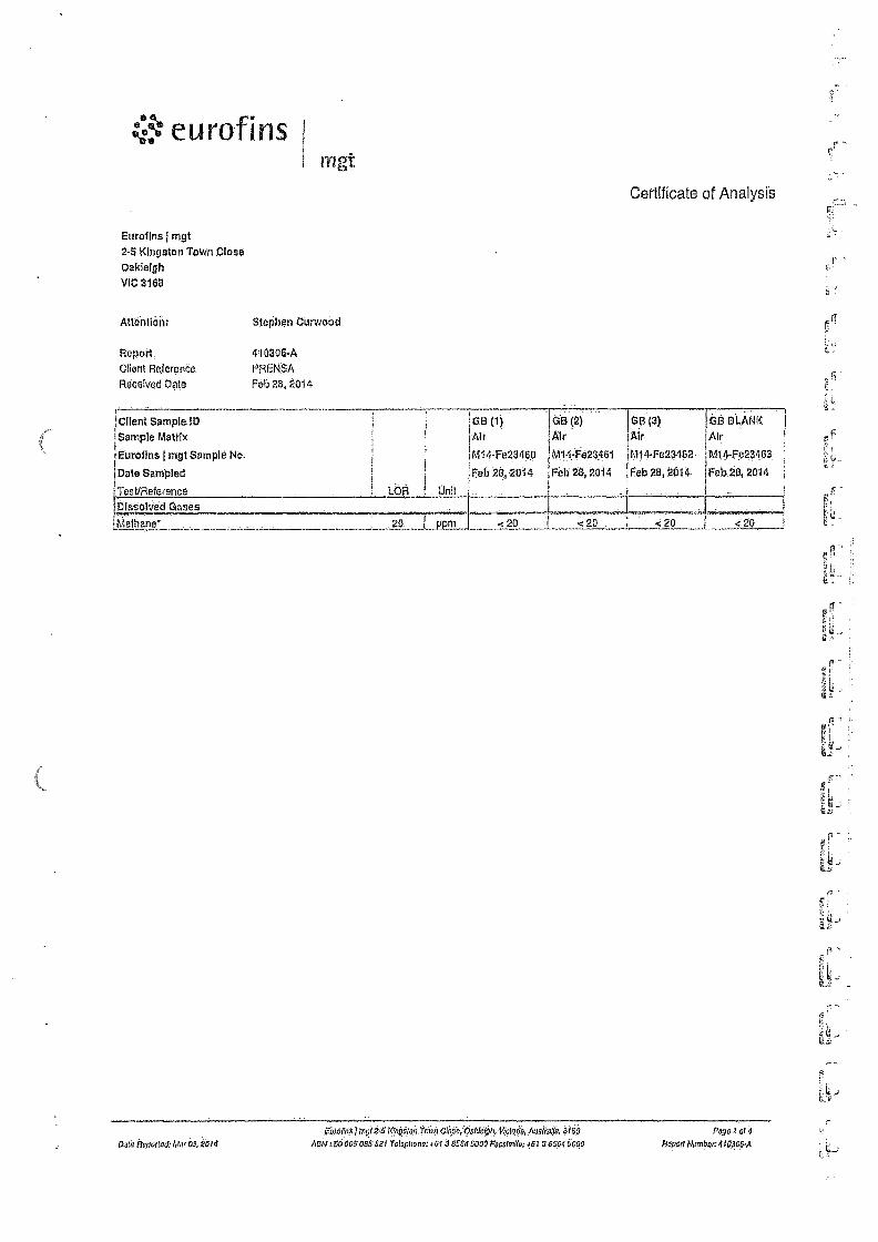
mgt
Certificate of Analysts
Eurans I mgt 2-5 Kingston Town Close Oakle1gh VIC 316a
Attention: Stephen Curwoad
Report 410305-A Client Reference PRENSA Received Date Feb 28, 2014.
!Client Sample ID !Sample Matrix
lEurofIns mgt Sample No.
I Date Sampled :Test/Reference Unit
dB (1) Air
M14+43400
Feb26,2014
.
di (2). I Air
! M10023461
Feb 28,2014
GB (3) Mr
M14-Fe234G2
Feb ni, 2014.
ISEI BLANK Air
M14-Fp23403
Feb 28, 2014
DIssobied Gases . ;h;lethane* 20. PPm <20 1 <20 i<20 420
04'41 Roportad: Mar 03. 0014
giniiki$1mgt GlitikAige144.V4:10„ nosiiorfl, Noe Pogo I o7 4
A01,1 :SO 00$ 005 601 Tots phono:461 3 85045000.Futtaiio: 481 3 8504 5090 Rom !lumbar: 410308•A
eurofins 1 mgt
Eurolins mgt Internal Quality Control Review and Glossary
General 1. Laboratory OC result° for Method Blanks, Duplicates, Matrix Spikes, and Laboratory Control Samples are Included in this OC report Vlore applicable. Additienal DC data may be available on
request.
2. All eel results are reported rico dry bards, unlaca otherwise stated. 3. Actual POLs are matrix dependant:Meted POLs may be reined where sample extract; are diluted duo to inter/aromas. 4. Results are uncorrected for rraddx splices or surrogate recoveries. 5. SVOC analysis on waters are performed on hemegeresed, unfiltered samples. unless rioted otherwise.
6. Samples were analysed en an 'as received bards. 7. This report replaces any Interim results previously Issued.
Holding Times Ploace refer to 'Sample Preservation end Centalner Made' for holding limos (0G31101).
For samples received on the last day at holding Urns, notification at Waling requirements shou'd have been received at least 6 hours prior to eample receipt deadlines as slated on the Semple Receipt Acknowledgment.
11 tho Laboratory did not receive the information In atU requIred timuirame, and regardless at any other integrity issues, sultubly wagged resulle may still be reported. Holding times apply hem the date of scrupling, therefore compliance to these may be ouliede the laboratory's control. 'tNCrrEr pH dupicales ere reported as a wee NOT tie RFD
UNITS mgarg: milligrams per Kaogram
rricmgrams per litre
ppbt Parts per billion
orgi100mir Organiems per 100 millilitres
61PN/100mla Must Probable latimber of argartisme per 1110 rnrlltllllren
TERMS
moil: nelligrame per titre
ppm: Perth per million
la Percentage
((CU: Unite
. °Where a reotsiereararebeen deleenteederneesolia temple. ale recutt le reipreesearien. LOP Limit of Repreting. SPIKE Addition of the analyte to the sample and reported as percentage recovery. 11Pb ilniallen Percent Difinrer.ce between two Duplicate pleras of analysis. LOS Lebere.tory Control Sarnnle - reported as percent recovery CRM Certilled Reference Malarial- mot:fled as percent recovery Method Blank in the case of solid samples these are performed on laboratory certified clove wads.
In the case of water samples those are performed on de-Ionised water, Sum- Surrogete tire addlUon of a like compound to the analyte target and reported as percenlape recovery. Duplicate A second piece of analysis from the same sample and reported In the seem units as the result to show comparison. Belch Duplicate A second piece of analysis from a sample outside of the clients batch of samples but run within the laboratory batch ol analysis, Batch SPIKE Spike recovery reported on a sample from outside of the climes batch el samples but rue within the Laboratory hatch of analysis, USEPA Untied States Environmental Protection Agency
APtiA American Public Health Asocclotion ASLP AutstraGan Standard Leaching Procedure (AS4439.3)
TGLP Toxicity Charade:tette Leaching Procedure cac Cheat of Custody SPA Sample Receipt Advice CF Client Patent -00 was performed on samples pertaining le this report
NCP Non-Client Patera - DC performed on samples not pertaining to Pie report, CH: is representative of the sequence or belch that client samples were analysed within
fg.9 Toxic Equivalency quotient . .
QC - ACCEPTANCE CRITERIA APO DeplIceles: Diable RFD threat:ales Acceptance Criteria is 301k however the following acceptance guldeenos 31'13 equally eel:tremble'
Howls eta limes the LOP ; No Limit Results between 10-20 times the LOR : RFD most its between 050%
Results >20 timaa the LOR : RPD must lie between 0-30%
Surrogate Recoveries : Recoveries must between 50-150% - Phenols 20-130%.
QC DATA GENERAL COMMENTS 1. Whores moult Is reve.ted as aloha then (e), higher than the nominated 1..on. hintst due le either matrix eiterterence, extract dilutive required due to Interferences or contaminate levele within
the trample. high Inch:Mire content or InsuferJent trample provided, 2. Duplicate data [Mown within trio report that slates the word 'BATCH' is a Batch Duplicate from outside of your sample batch, but within the laboratory sample batch at a 1:10 ratio, The Parent
and Duplicate data shown is not data from your samples.
3. Organochloana Pesticide anarysle - where reporting LOS dam, Toeophone a Chlordane are nor added in Me LOS 4 Orearioraileane Pesticide analysis - whore reporting Spike dam, Tosophone is not added to the Spike,
5. Totia faccovmable Hydrcearbene , where reporting Seale S LOS dote.. singfit orate: of commercial Hydronarben pluducto in the range at 012.030 Is added and ire raid) Recovery Is reported In the C10-C14 cnid of the Report.
6. pH and Free Chlonne analyeed in rho laboratory. Analysis on this teat inust begin within 311 minutes of sarnpline.Tharefore laboratory analysla is unlikely lobe completed within holding time. Analysis wiit begin as soon es possible after sarnfie tecalgl.
7 Recovery Data (Settee,' it Surrogates) where chromatographic interference does not allow the determinagnn of Recover/ the teen '1141' appears against that analyte.
a. potycmicrklutod nipticityl3 are SOW() only using Armlike 1260 in Mauls Spikes and LCS's.
aL For Matifx Spikes and ICS results 3 dash' in line report means that the specific analyte was not added to the OC sample.
10. Duplicate RPO's are calculated ham raw analytical data thus It Is possible to have two sets el data.
Data Reported: Mar 03, 2014
5urohne j mg: 2-5 throsam Town Close, Oainovn, sficrotin. Amuale, in 613 Patio it Sri 4
ABN • 50 005 085 521 Telephone: 461 3 8564 5000 Fauskalte: +V 3 8564 5090 Report Number: 418306A

eurofins mgt
Quality Control Results
• .. .
.1 1 ' Test 1 Uni ts i Result 1 1 1 Acceptance I Limits
'Piss Limits
auatifying , Code -- jailleirdiMgMingff.e4M.V.*ZO.r4W-410):5GAMSVIMITICIMMATiNa.3-174514-0.01.N,V4E ...
Dissolved Gases . .. .... . Methane* ..ppm . . <20 . 20 Pass
Mg.°AqigrdtW4.hit...rgirratrZ5.1:taj-Mfl..ttaf':a,,jgkMWF.at:!,4.Z.VW.O..t.:VZi.'Zt4!4V1W,,:gP)We1,L . , j a Dissolved Gases - Methane I . % 101 . . 70-130 J Pass
Test 1 Lab Sample ID 1 sourco °A I Units 1 Result 1 i . • .. • t • •••• Acceptance • Limits ...
Pass Limits
Qualifying . Codo •
e6i1ta 10 ng6agitIRM:gdkWaritaifAkltVjtfgRfMWYAMVLSM§VgSiO4tMIP:VtlikMIMV3;:{isi Dissolved Gases I Result 1 . Methane* M14-Fe23461 I CF % 80 70-190 . . Pass
Test ; QA Lab Sample ID 1 some i Units 1 Result 1 AccePtanco • Limits
Pass Limits
Qualifying Code
fj.TPiattaWikfAZ•ag-VOi.'<7an!;MKKtitiVZ:MWg'•Fiii. MAXAM0.1s;7.gg., 0";,Va.V.Wg..;: .4flif57-MX.14 Dissolved Gases Result 1 Result 2 RPD Miittiine. I M14-Fe23461 CF PPm <20 <20 <1 30% Pass
Dole Reported: AIN 03. 2014 ABN
Euro fins j m0125 Kfropton Town Olose, Oaidolgk Victosta, Ausleaffa. 3166 Page 3 of 4
: 50 005 085621 Telephone: +61 3 8564 5000 Far:skew #61 3 8564 5060 Ripon Number:410306-A
•
rylel:eurofins mgt
ii Qiinlmtints :1 . . I SriIliplirm ha's'. bout ge,iorined 1.)9 F.urolltis I mot porfronnral - Eurofiris 1 oigt 12 NATA accreditcd for the collection at ,,iralet sartip!es'In scrtfanee.
*hit AS 5667.-., ViiitCriart EPA Publication 441 8c. Moll,5ourne Vtirgor-Publicolion , Samplirtizt $ analysis of Trado W.astos, . . . . . .
Bartipleititegrity Olintiotly B.1,049 1,1140, (It kuid) ,t1(A Allumpt•to .011111 wan IM.1.vii • Yoi .Sarisp14 iclirettly 1100.'440 .Yes Ofontdu rumples had Tation bops 19o. Ainney) ccin),a1n014. Int OulatlicitinnI9ido ircobitscl With miranuil he/Wm:loco •Ye, $.0,iiir}iiiri itico).Ve'fisyiliiri.Hig.cf..itigme Y6•0 Som. pmplo.s haws pep) ELIOcaniractqd Nu
•
Aii(hoils.ed By
Potigkhirchion 'cotton t..0
CIJeullrvlsà Santo/ Anatyst•Valaito (VIC)
;Glenn Ja•cktion
Laboratory Manaijer
116;qp9sind • ImileatosNAT6firxicletion don* nol tom Ilus rtathunitoco ol ttuS auevitt Utpuululy dati Id Avon* of; tekjuus.1 EgatUrt;Ig1 /44'.re,g1t3,11,1,t,•̀:,====.47,.1„1.1T.Ilrf,==:=7:4":4̂.1tg117a=r441,`ZraZ411.:14,4Z.7111.Vgg.Y.T.gltellt=P:rg.:=1.11:r.
;-
Colo fl hirt;Murti,7, 414 amain's, mps R-5 lOriguroo /01..71 Otos% Voicloto0, ViGiDPIL AustrOui, 3 IOU POgo 4 of 4
A0f4 : 50 005 403 .521 TolopliOno: I 0 r 0664 5000 Pwitintlle: ...01 3 0501 5000 Roped: Nuinboi: .110303

APPENDIX 4 —
Site Map & Gas Bore Logs

prensa
: Job No: L399 N0400003
3. t*.
'seep . %WM; 14.0"
::Legen.0
teraili Gas 0d1t
cite eoundaty
IntsecSdurre. : Core",. tantt Viewed: .17 Fel: WA teate peedkzn. Ei.1=4411.1te
Project land As s„ssrn2nt
ril Sas l._
Drawing -nue:
Clayton West Landriii Gas Sore Locations .
i91-773 Wettlerret 'Malvern VIC 314:1 PCi ev 7.203 Wattletree Rd .13:1) ailv aln .5-,t VIC 3145
(09 95)3 Ciat, F:103) 95f:a 51-2 vevw.orvvv• rnrAdam
.
aemingereeia.corn...4
Cient Depsrtment of treasury and Finance
Address: 10 Aivina Street, OakleighScutn
omen: ov:
5Pr-
Fike nerde.:
13991 VG Bore LOCatiOn
cv-i2d
I 17/07/14 41.0'
r4.6 ',amt.,: • laew,k,
1 I A
. • ...... . •

prensa Borehole Log - GB1
Sheet: 1 of 1
.NATURAC:-SAND11:3:1.7 m • Light brown, loose, dry, zero plasticIty.
Client: Department of Treasury and Finance Job Number: 13991 Site Location: 10 Alvina Street, Oakleigh South Job Type: Landfill Gas Investigation Date: 14/02/2014 License Number:
Driller: Star Drilfng Rig: Drill RIg Depth of Hole: 1.8m Screened Depth: 1.0 - 1.8 m Casing/Screen Diameter: 50 mm Tap of Casing (m AHD):
Standing Water Level: Easting: Northing: Coord. Sys.: Drawn By: SFF Approved By: SSB
Comment; Landfi I gas bore
4.3.0r...a (Rile
FILL: SAND (0 - 0.3 m) Brown, loose, dry, zero plasticity, coarse gained sand, organic matter, dark grey silty clay pockets, angular bluestone gravel fragments.
FILL: SAND (0.3 -0.5 m) Light grey, loose, dry, zero plasticity, brown clay pockets.
NATURAL: SAND (0.8- 0.6 m) Dark grey to black, loose, dry, zero plastrcity, coarse grained. minor quartz fragments. NATURAL: SAND (0.6- 1,3 m) Light grey, loose, dry, zero plasticity, homogeneous,
NATURAL: SAND (1.7 - 1.8 m)• Yellow, dense, slightly mole!, zero plasticity, coarse • gained. End of borehole at 1.8 m at target depth In natural.
Sample PID Well Construction
Grout 10.0 - 0.4 m)
Certonne (0,1 • 0.7 m)
Sand (0,7- 1,0m)
Screen (1.0 -1,8 in)

fr;
Borehole Log - GB2
Sheet: 1 of '1 prensa
. , Client: Department of Treasury and Elnance Job Number: 13991 Site Location: 10 Alvina Street, Cakleigh South Job Type: Landfill Gas Investigation Date: 14/02/2014 .License Number:,
Driller: Star Drilling Rig: Drill Rig Depth of Hole: 2.0 rn Screened Depth: 1.0 -2.0 m Casing/Screen Diameter: 50 mm Top of Casing (m AHD): ._ .
Standing Water Level: Easting: Northing: Coord. Sys.: Drawn By: SPF Approved By: SSB
COmthent: Lendfil gas bore
Dep
th (
m)
'Cu
WI
Construction M
etho
d .....
.0
A:agars aar.
•
•Samplt: PIO
....
..
-
_
_.
- 1.5
L.
-
..
_
c i
At., 4 V
t.04..
r • N
'r \‘' ,
l't \
Grow (O.o • 0.4 m)
, _ ,
...--.1,4 Bentonite (OA - 0.7 m)
. ..... . . -;-.- Sand (0.7 - 2 0 m)
EL ii
V l'
.
FILL: SAND (0- 0,3 m) Brown, loose, dry, zero plasticity, coarse grained, dark grey silty clay pockets.
.
.
. -
FILL: SAND (0.3 - 0,5 m) Light grey, loose, dry, zero plasticity, brown clay pockets, minor concrete fragments.
-41—o7"-visid — ,
:*
Ea
... -
, ..,-- .\.gretned
NATURAL: SAND (0.5 - 0.6 m) Black, dark- grey loose, dry,zero plasticity, Coarse
d sen, ,
----#̀ NATURAL: SAND (0.6 -1.3 m) Light grey, loose, dry, zero plasticity.
. ....
ar
-.
; 8
- NATURAL: SAND (1:3 ..1.6 m) - -- • - - . - • Light brown, loose, dry, zero plasticity.
Sucen (1.0 . 2,0n1)
NATURAL: SAND (1.6 -2.0 m) Yellow, dense, slightly moist, zero plasticity, coarse grained.
End of borehole et 2.0 m at target depth In natural.

r-
Sheet: 1 of 1
'
1 4
111.
Borehole Log - GB3 prensa
1.0
Said (0 7 - 1.9 In)
Scrsen (1.0 - 1.9 m)
2!Cl
Client: Department of Treasury and Finance Job Number: 13991 Site Location: 10 AlvIna Street, Oakleigh South Job Type: Landfill Gas Investigation Date: 14/02/2014 License Number:
Driller: Star Drilling Rig: Drill Rig Depth of Hole: 1.9 m Screened Depth: 1.0 - 1.9 m Casing/Screen Diameter: 50 mm Top of Casing (m MD):
Standing Water Level: Easting: Northing: Coord. Sys.: Drawn By: SPF Approved By: SSB
Comment: Landfill gas bore
Well Construction
2
— 0.5
6.4curicao 11 Ws
NATURAL: SAND (0 - 0.8 m) Dark grey to black, loose, dry, zero plasticity, homogeneous.
Sample PID
NATURAL: SAND (0.8 -1.5 m) Light grey, loose, dry, zero plasticity.
NATURAL: SAND (1.5 .-1.9 m) Yellow, dense, slightly moist, zero plasticity, coarse grained.
End of borehole at 1.9 m at target depth In natural.

r •
r• .1'
- APPENDIX 5 .....
Photos of Sample Setup
•
I 1 .1
1 '7
I

err..erv-;974-
:
,,
T :1..,....„.,.....-„,..i.
.
„....i.e
.:
..iti....4.:;
:....
:
;:a._ ‘..,4.
„,..,,... -rf 14 1,-...4
z ';A
"-... 4. .. . a ei• s- 14,•04
4,11--r"-. Pre7-"i4,..: Sf ."-. ev•. ,̀
- .. — .0.s..... , ftdk.. • •
.: • t i '' "Il 3A . - - 4,47' • • - ' N ,
. ,.f.j. „..: 4. , ... .7.,
,,x, ,.. .":
52..it....441 ,.. 41:
" .ti.
:.11!...,•'.. .
:a?' ''..
*Tr( ••• ' . - -" ;.1:e •
Photo 1 : Sampling with Landfill Gas Analyser
r's
L .
r f;
Photo 2 : Leak Testing of Gas Bore

yinrr n ,s .s .:..,,ys).5 v.„.,1,,,..a.
.`eui•x Yi-.....;-71. ... • - -•-....t. 4A, A ,,,,„t. . --.4 4474".
. • ...r? 1.,-, A. f.„,....)_, ....... . ...- -c.,..0-4441. , • ,71.=.::::,:.:-.4,-4,..- 4:. .17,417"4-• . •vi.,-, - • • =,,vt.. 4'0 ...!gigi: Y ' - C.•_*-•."-% c•• 'IP'. If•--* • ..f. VA: iit VA' e:1i • .. • p:s.._ .., 1 • 4.Q,el.z.;rezrti;:',' ...7.4. , ,..-... , , ."0:',':-. • emp.ot c1 45. 41,*tif"..,,,,
.T.,..%: ,-.r- • - .:.
-
t_t•Atr l• • 1,1
; ,• • - • •••.-1".•
4. a.
(1, *t.
3
'4te§,44
. !4•1 a12 t
a .
•
±-.....,,,-,-.0--:-'.th:.,2gtw.,... ....... t,,,, ,,03.,,,,,,,,,,,.., ,......z.:rr ..*.,,,,,z-,...hA:45irmx.414.1."."..-..-,...e,*0;;;'; "• ?'n".**-11.̂... "' ' • r,
• ••."29e...ae• 1 ... , ..
.,..,:
,......k,
a"...i.s175...,.'nf.A„.. H: C-,-,41:.:,:,...:;; '•:7 ;L-r--..-z.:,....;:.:1.•;;;'_47-1::,,---.'hr414Hir..ii.,..7:,..a'"-izifitrir'z'rTz:47.14.."••- ,--,;,...- 7,..-.....t ri1.14-L.2.: 5s:''::;:;.,"
-v
z•-•-.1'...r.;:j,•11.7.r.,1,--..k ••,---F.••;.••••rea‘nN••••-•".."4,7,"..4..lerr,.,.42•:::,..._.!.?„1„1:v.,,,.w-„....s.r.„.,..z.....,,,• -,••:1-•.?,..4_, 1.,......0-,....,41 .1........,, „. •-•.• •"Fi.‘
.... 5•••••.4r6Viit.' -•••-+. .--1,---, •••••,..77, Mr. -.--A• 4.• •ir- • ...,- T.I.„.••;,•,:y..,•-....4....„,,,,..,.,„„,...../....i . . •••••'•-•••r:•1•`'''''":"*"..r*„:„.„ ' 74
:.1,-;-:-..c.l.tr..:::,4.m7,-1.--.A.,-.4.....,::1-,4,,. -, • ...: ..4.—"4-.u...., '11.. "..' ''''...,...%?7,e-4.4
".--7.,:....„7.,..........,,..:::-.7.,7: 7:-
..7....,*.....,.."147.gir• . 1;4 i •.:0 • - - - .,•,-• rr.F:-.......4..4.':;.: ..,*,•-•:; ••,
--z•-:
,...e.
4f.o..:m.........,.....:.:44i.,.....,- - •;.„-;.••=,..-14w.a.T...)..• ...,...k.: 4•,,A..-7-7,1W. •1•4-r. -,,.....,-,=-• --,--r-2,,,tic,,"•••• ,,•• - ---v.74,74, ..
•-•,•,—,..K...,.• • •
•-•,•••••••-•
.1
.
7
. .4.
13 1#`41 t ..*.artt, .--..
..." .,,t-,:ras:,0:tar,a, '• 4.1,ty,,..z...,':,e'liN .•:,....t • att. .4.;
f....1..... ' • •••".. ... • ...ts, ,.s. - . • ....... • ....,-,s- . .1 .÷., ", ,••• •L‘' ,- Ill. • : s ,:. .a- r_ n -7>pf.;;,t,.-,11- •••,74-"T" .....14X. W. 11? • N _..• : • -3 ' - ”-: :;,...."7.71/44,:.
Photo 3 : Lab Confirmation Methane Gas Bag Sampling

r.•
't!
sr-
r
APPENDIX 6 —
Instrumentation Calibration Data

. . .. .,. . . Calibrating Gas
, , ..... . Cal Value
. „ . . . . . . Reading
... , . . „. . ... . Span Required
..... ... ... . . , Reading
• ,.. , . .. Pass
CH4 0.0% vol ' 0.0 % — %
H25 0 ppm 0 ppm . ._ N/. — ppm 2'1--
02 0.0% vol O. '0 % T.-I , ... . % ,
CO 0 ppm i ppm V' pprn CO2 0.0% Vol 0,D.. % . . .....„ . % . l--
eurof mgt
GA2000 Serial Number: GA 1 503/09
Calibratiar, Data: 1-f Calibrated by
Calibration Time: Tu)
Operations Check
In Line Filter Check Cleaned/Checked Battery Status %
Calibration s Used
N2 Let Number; .. 1274596
CO2 (CH4 - 1.,qt Number ...„, , 1237007 „
H2S / CO / CH4 / 02 - 170.1,
Cylinder Number: 24
Cylinder Number: 30
Cylinder Number
Calibrating Gas pal Value
"
. . Reading
-
pan Required Reading Pass
0H4 60% vol k). It % ‘7. . 40. 0 %
CH4 - check Only 2.5% vol 2.. c % NI — % . .
H25 25 ppm 24, ppm y _ 9.—s" „ ;ppm
02 .. voi i 0, I' . % e;t3 %
CO 100 ppm 0.2- ppm ppm
1.K17' 002 40% vol fo. Li, % . 41:) 1 4) .%

Thermo Fisher SCIENTiFIC
The world leader in serving science
RENTALS
EQUIPMENT CERTIFICATION REPORT GASCHECK 50001S
This GasCheck 5000is Instrument has been performance checked as follows:
ii Check fully charged Performance check against He
Date.: .-241.1.)Picf
Checked by: e 0
Signature:
P.0.
Please check that the following items are received and that all items are cleaned before return. A minimum $30 cleaning / service / repair charge may be applied to any unclean or damaged items. Items not returned will be billed for at the full replacement cost.
Sent Rec'd Returned
Er 0 0 rf o 0 0/ 0 0 Elf 0 0 Er 0 0
0' 0 0
Ef o 1pf o
0 - 0
1011 0 0 oz 0 0
Processor Signature/Initials:
Description GasCheck 5000is Unit with short probe and nozzle fitted
GasCheck 5000is Unit Operation check / Battery Voltage, (min 5.0V) S. S v Spare battery holder with Spare Alkaline batteries, (min 5.0V) 6. D N
GasCheckis Manual
Quick Guide
Long Probe
Box-Spanner
Screwdriver
Calibration Certificate — Due: ZI /_o_Li is- • Carry Case
19,D.
, Quote Reference 19.--c
; Condition on return
Customer Ref JODI 416.S6 (2. Equipment ID
. C ,s-iccotitit-,
Equipment serial no. .. .. .. Return Date _ . . _ Return Time — —
"We do more than give yOti;feat equiOment... We ;No you great solutions!" Phone: (Free doll) 1300 736 206 I Fox: (Free Gain !moo 675 123 . Email: RornalsAUgrhonnollehozeoro
v..1..11. WW1 Moot. Omni paw jamei 6,0041! 5 CisiOutsirtri•
*AM (mull Lcol 1. 41itsron Raid.
• fame? UN inalift00111 r• ter k "J*1711grd‘ 155 ". 7 metIrdir