golder associates inc. golder associates: operations in ... · pdf filegolder associates inc....
TRANSCRIPT
October 31, 2014 1408140
Mr. Neal Thomas Environmental Program Supervisor Environmental Permitting, Compliance and Enforcement Environmental Protection Division 800 Mercy Drive, Suite 4 Orlando, Florida 32808 SUBJECT: CONSERVATION AREA IMPACT APPLICATION - OUC TAFT SUBSTATION RECONFIGURATION, ORANGE COUNTY, FLORIDA Dear Mr. Thomas: On behalf of Orlando Utilities Commission (OUC), Golder Associates Inc. is pleased to submit the attached Conservation Area Impact (CAI) application for the installation of 2 sets of 3-pole transmission structures to interconnect existing 230-kV transmission lines to a new bay within the reconfigured Taft Substation. No new access roads or transmission structure fill pads are being proposed as part of the Project. The proposed monopole transmission structures will be placed through direct-embed installation. Construction laydown and staging areas will be located within the existing developed areas of the substation property and adjacent access roadways. Wetland impacts will be avoided and minimized through use of temporary construction matting to provide access within wetland areas during transmission structure installation. A total of 1.32 acres of temporary construction matting within low quality freshwater marsh wetlands are proposed; the direct-embed installation of 6 monopoles will permanently impact 0.003 acres of wetlands. All areas of temporarily-impacted wetlands will be restored to grade and allowed to naturally regenerate. An Environmental Resource Permit (ERP No. 48-0330467-001) for the Project was issued by FDEP on October 31, 2014; USACE review of the ERP application is currently underway. Should you have any questions or comments concerning this CAI application submittal, please feel free to contact me at 352-336-5600. Sincerely,
Karl Bullock Project Manager cc: M. Kyhos, OUC J. Newell, POWER Engineers, Inc.
Golder Associates Inc. 6026 NW 1st Place
Gainesville, FL 32607 USA Tel: (352) 336-5600 Fax: (352) 336-6603 www.golder.com
Golder Associates: Operations in Africa, Asia, Australasia, Europe, North America and South America
Rev. 12/3/2013 Page 1 of 6
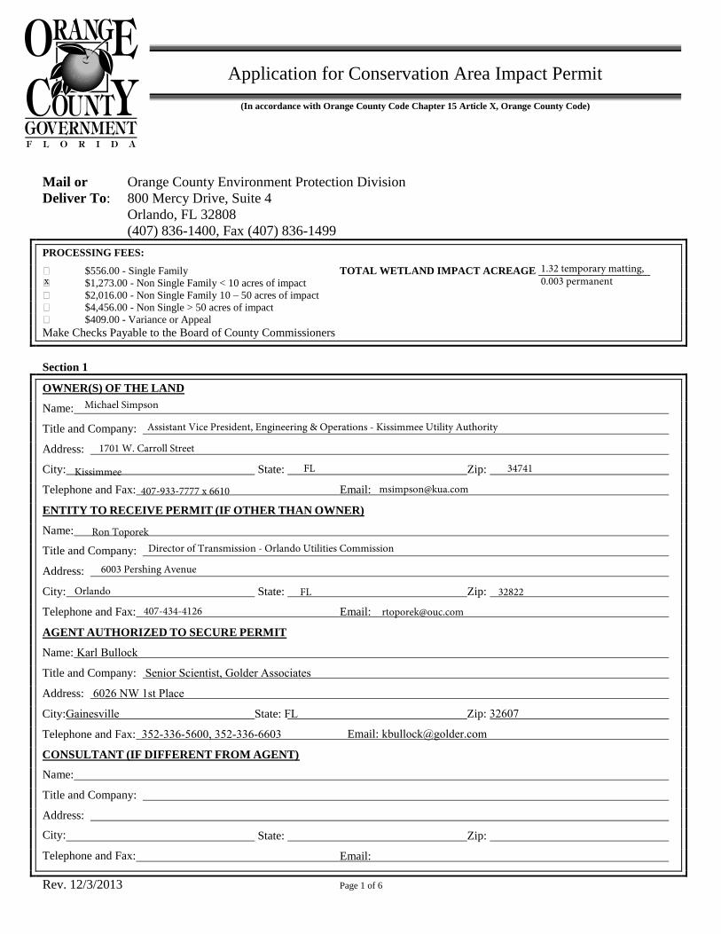
Application for Conservation Area Impact Permit
(In accordance with Orange County Code Chapter 15 Article X, Orange County Code)
Mail or Orange County Environment Protection Division
Deliver To: 800 Mercy Drive, Suite 4
Orlando, FL 32808
(407) 836-1400, Fax (407) 836-1499
PROCESSING FEES:
$556.00 - Single Family TOTAL WETLAND IMPACT ACREAGE _____________________ $1,273.00 - Non Single Family < 10 acres of impact
$2,016.00 - Non Single Family 10 – 50 acres of impact
$4,456.00 - Non Single > 50 acres of impact
$409.00 - Variance or Appeal
Make Checks Payable to the Board of County Commissioners
Section 1
OWNER(S) OF THE LAND
Name:
Title and Company:
Address:
City: State: Zip:
Telephone and Fax: Email:
ENTITY TO RECEIVE PERMIT (IF OTHER THAN OWNER)
Name:
Title and Company:
Address:
City: State: Zip:
Telephone and Fax: Email:
AGENT AUTHORIZED TO SECURE PERMIT
Zip: 32607
Email: [email protected]
Name: Karl Bullock
Title and Company: Senior Scientist, Golder Associates
Address: 6026 NW 1st Place
City:Gainesville State: FL
Telephone and Fax: 352-336-5600, 352-336-6603
CONSULTANT (IF DIFFERENT FROM AGENT)
Name:
Title and Company:
Address:
State: City:
Telephone and Fax: Email:
1.32 temporary matting, 0.003 permanentx
Michael Simpson
Assistant Vice President, Engineering & Operations - Kissimmee Utility Authority
1701 W. Carroll Street
Kissimmee FL 34741
[email protected] x 6610
Ron ToporekDirector of Transmission - Orlando Utilities Commission
6003 Pershing Avenue
Orlando FL 32822
Zip:
Rev. 12/3/2013 Page 3 of 6
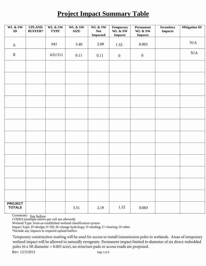
Project Impact Summary Table
WL & SW
ID
UPLAND
BUFFER*
WL & SW
TYPE
WL & SW
SIZE
WL & SW
Not
Impacted
Temporary
WL & SW
Impacts
Permanent
WL & SW
Impacts
Secondary
Impacts
Mitigation ID
PROJECT TOTALS
Comments:
CODES (multiple entries per cell not allowed):
Wetland Type: from an established wetland classification system
Impact Type: D=dredge; F=fill; H=change hydrology; S=shading; C=clearing; O=other
*Include any impacts to required upland buffers
A 641 1.323.40 2.08 0.003
B 631/511 0.11 0.11 0 0
3.51 2.19 1.32 0.003
See below
Temporary construction matting will be used for access to install transmission poles in wetlands. Areas of temporary wetland impact will be allowed to naturally revegetate. Permanent impact limited to diameter of six direct-imbedded poles (6 x 5ft diameter = 0.003 acre), no structure pads or access roads are proposed.
N/A
N/A
Rev. 12/3/2013 Page 4 of 6
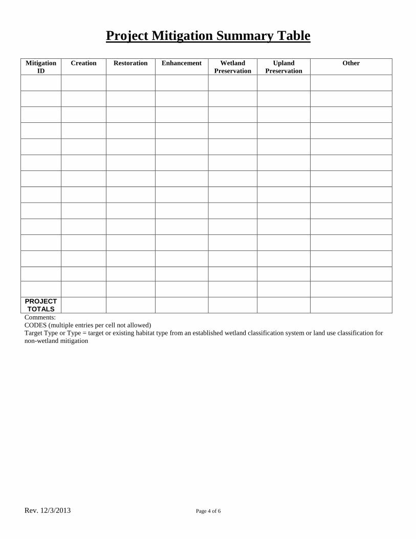
Project Mitigation Summary Table
Mitigation
ID
Creation Restoration Enhancement Wetland
Preservation
Upland
Preservation
Other
PROJECT TOTALS
Comments:
CODES (multiple entries per cell not allowed)
Target Type or Type = target or existing habitat type from an established wetland classification system or land use classification for
non-wetland mitigation

Rev. 12/3/2013 Page 6 of 6
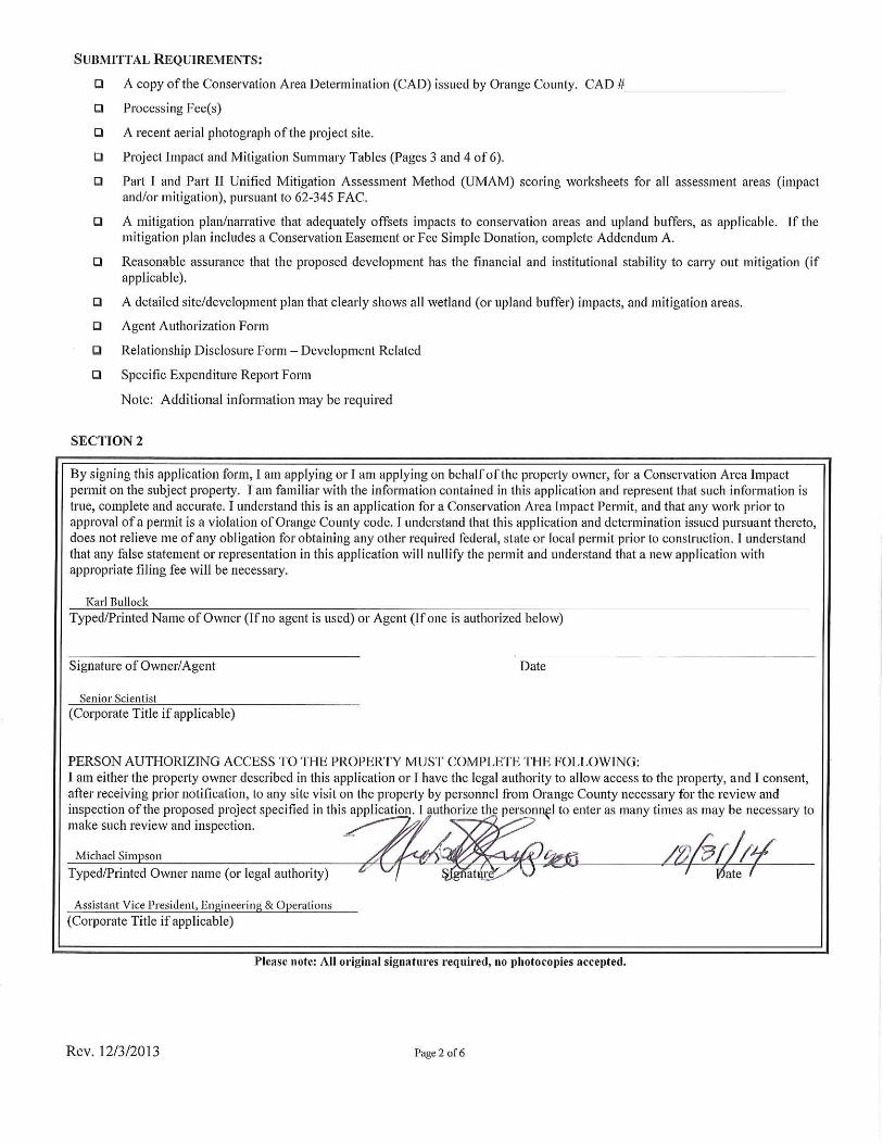
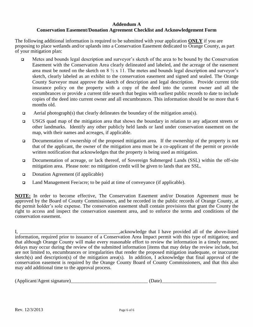
Addendum A
Conservation Easement/Donation Agreement Checklist and Acknowledgement Form
The following additional information is required to be submitted with your application ONLY if you are proposing to place wetlands and/or uplands into a Conservation Easement dedicated to Orange County, as part of your mitigation plan:
Metes and bounds legal description and surveyor’s sketch of the area to be bound by the Conservation
Easement with the Conservation Area clearly delineated and labeled, and the acreage of the easement
area must be noted on the sketch on 8 ½ x 11. The metes and bounds legal description and surveyor’s
sketch, clearly labeled as an exhibit to the conservation easement and signed and sealed. The Orange
County Surveyor must approve the sketch of description and legal description. Provide current title
insurance policy on the property with a copy of the deed into the current owner and all the
encumbrances or provide a current title search that begins with earliest public records to date to include
copies of the deed into current owner and all encumbrances. This information should be no more that 6
months old.
Aerial photograph(s) that clearly delineates the boundary of the mitigation area(s).
USGS quad map of the mitigation area that shows the boundary in relation to any adjacent streets or
other landmarks. Identify any other publicly held lands or land under conservation easement on the
map, with their names and acreages, if applicable.
Documentation of ownership of the proposed mitigation area. If the ownership of the property is not
that of the applicant, the owner of the mitigation area must be a co-applicant of the permit or provide
written notification that acknowledges that the property is being used as mitigation.
Documentation of acreage, or lack thereof, of Sovereign Submerged Lands (SSL) within the off-site
mitigation area. Please note: no mitigation credit will be given to lands that are SSL.
Donation Agreement (if applicable)
Land Management Fee/acre; to be paid at time of conveyance (if applicable).
NOTE: In order to become effective, The Conservation Easement and/or Donation Agreement must be approved by the Board of County Commissioners, and be recorded in the public records of Orange County, at the permit holder’s sole expense. The conservation easement shall contain provisions that grant the County the right to access and inspect the conservation easement area, and to enforce the terms and conditions of the conservation easement.
I, ________________________________________,acknowledge that I have provided all of the above-listed information, required prior to issuance of a Conservation Area Impact permit with this type of mitigation; and that although Orange County will make every reasonable effort to review the information in a timely manner, delays may occur during the review of the submitted information [items that may delay the review include, but are not limited to, encumbrances or irregularities that render the proposed mitigation inadequate, or inaccurate sketch(s) and description(s) of the mitigation area(s). In addition, I acknowledge that final approval of the conservation easement is required by the Orange County Board of County Commissioners, and that this also may add additional time to the approval process.
(Applicant/Agent signature)_______________________________ (Date)______________________
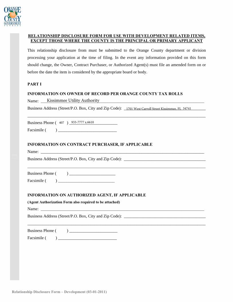
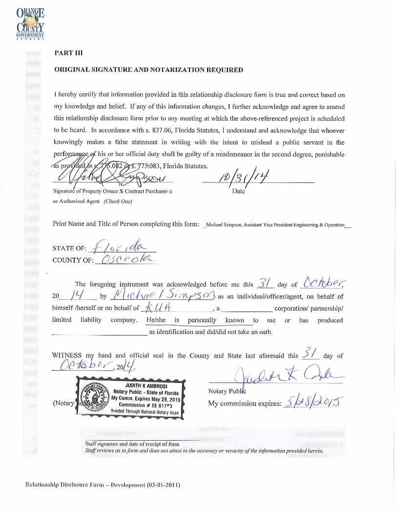
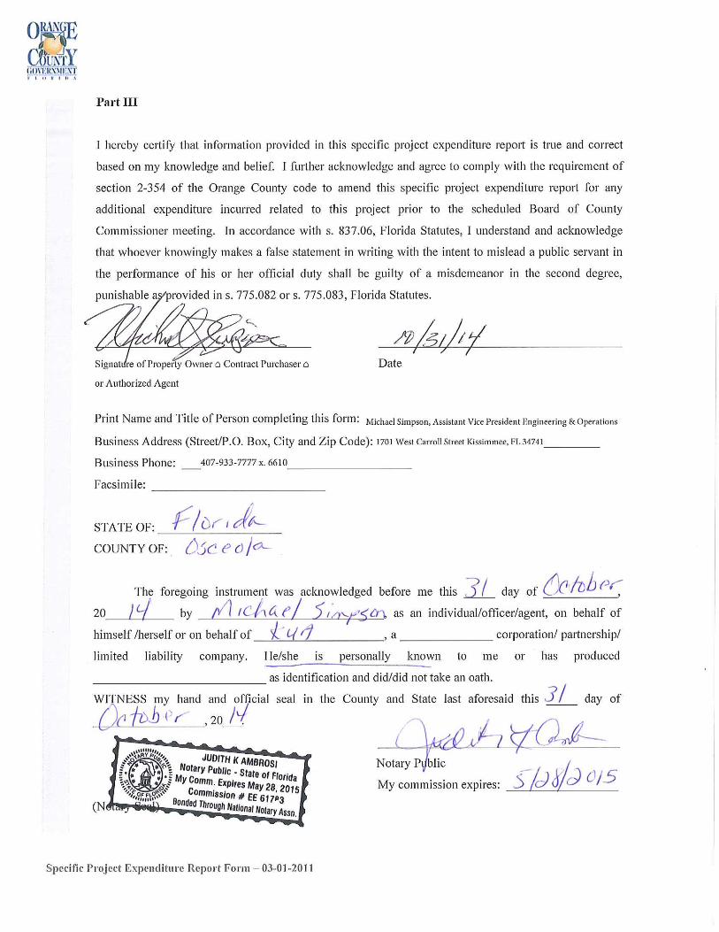
RELATIONSHIP DISCLOSURE FORM FOR USE WITH DEVELOPMENT RELATED ITEMS, EXCEPT THOSE WHERE THE COUNTY IS THE PRINCIPAL OR PRIMARY APPLICANT
This relationship disclosure from must be submitted to the Orange County department or division
processing your application at the time of filing. In the event any information provided on this form
should change, the Owner, Contract Purchaser, or Authorized Agent(s) must file an amended form on or
before the date the item is considered by the appropriate board or body.
PART I
INFORMATION ON OWNER OF RECORD PER ORANGE COUNTY TAX ROLLS
Name: ______________________________________________________________________________
Business Address (Street/P.O. Box, City and Zip Code): _______________________________________
_____________________________________________________________________________________ Business Phone ( ) _______________________
Facsimile ( ) ____________________________
INFORMATION ON CONTRACT PURCHASER, IF APPLICABLE
Name: ______________________________________________________________________________
Business Address (Street/P.O. Box, City and Zip Code): _______________________________________
_____________________________________________________________________________________ Business Phone ( ) ______________________
Facsimile ( ) ___________________________
INFORMATION ON AUTHORIZED AGENT, IF APPLICABLE
(Agent Authorization Form also required to be attached)
Name: ______________________________________________________________________________
Business Address (Street/P.O. Box, City and Zip Code): _______________________________________
_____________________________________________________________________________________ Business Phone ( ) _______________________
Facsimile ( ) ____________________________
Relationship Disclosure Form – Development (03-01-2011)
Kissimmee Utility Authority
1701 West Carroll Street Kissimmee, FL
407 933-7777 x.6610
34741
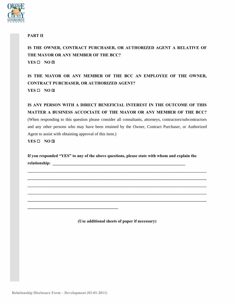
PART II
IS THE OWNER, CONTRACT PURCHASER, OR AUTHORIZED AGENT A RELATIVE OF
THE MAYOR OR ANY MEMBER OF THE BCC?
YES NO
IS THE MAYOR OR ANY MEMBER OF THE BCC AN EMPLOYEE OF THE OWNER,
CONTRACT PURCHASER, OR AUTHORIZED AGENT?
YES NO
IS ANY PERSON WITH A DIRECT BENEFICIAL INTEREST IN THE OUTCOME OF THIS
MATTER A BUSINESS ACCOCIATE OF THE MAYOR OR ANY MEMBER OF THE BCC?
(When responding to this question please consider all consultants, attorneys, contractors/subcontractors
and any other persons who may have been retained by the Owner, Contract Purchaser, or Authorized
Agent to assist with obtaining approval of this item.)
YES NO
If you responded “YES” to any of the above questions, please state with whom and explain the
relationship: _______________________________________________________________
_____________________________________________________________________________________
_____________________________________________________________________________________
_____________________________________________________________________________________
_____________________________________________________________________________________
_____________________________________________________________________________________
___________________________________________
(Use additional sheets of paper if necessary)
Relationship Disclosure Form – Development (03-01-2011)
x
x
x
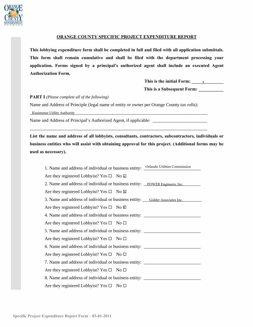
ORANGE COUNTY SPECIFIC PROJECT EXPENDITURE REPORT
This lobbying expenditure form shall be completed in full and filed with all application submittals.
This form shall remain cumulative and shall be filed with the department processing your
application. Forms signed by a principal’s authorized agent shall include an executed Agent
Authorization Form.
This is the initial Form: ______________
This is a Subsequent Form: ___________
PART I (Please complete all of the following)
Name and Address of Principle (legal name of entity or owner per Orange County tax rolls):
______________________________________________________________________________
Name and Address of Principal’s Authorized Agent, if applicable: ________________________
______________________________________________________________________________ List the name and address of all lobbyists, consultants, contractors, subcontractors, individuals or
business entities who will assist with obtaining approval for this project. (Additional forms may be
used as necessary).
1. Name and address of individual or business entity: _________________________
Are they registered Lobbyist? Yes No
2. Name and address of individual or business entity: _________________________
Are they registered Lobbyist? Yes No
3. Name and address of individual or business entity: __________________________
Are they registered Lobbyist? Yes No
4. Name and address of individual or business entity: _________________________
Are they registered Lobbyist? Yes No
5. Name and address of individual or business entity: _________________________
Are they registered Lobbyist? Yes No
6. Name and address of individual or business entity: _________________________
Are they registered Lobbyist? Yes No
7. Name and address of individual or business entity: _________________________
Are they registered Lobbyist? Yes No
8. Name and address of individual or business entity: _________________________
Are they registered Lobbyist? Yes No
Specific Project Expenditure Report Form – 03-01-2011
x
Kissimmee Utility Authority
Orlando Utilities Commission
x
POWER Engineers, Inc.
x
Golder Associates Inc.
x
PART II
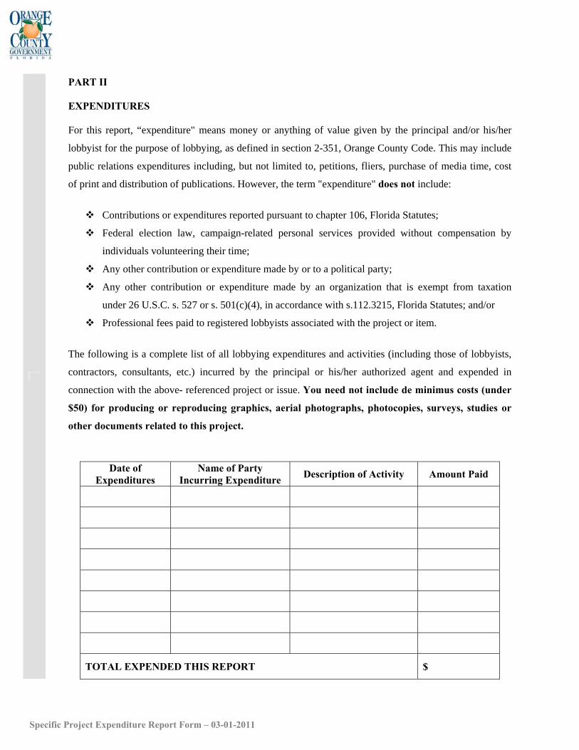
EXPENDITURES
For this report, “expenditure" means money or anything of value given by the principal and/or his/her
lobbyist for the purpose of lobbying, as defined in section 2-351, Orange County Code. This may include
public relations expenditures including, but not limited to, petitions, fliers, purchase of media time, cost
of print and distribution of publications. However, the term "expenditure" does not include:
Contributions or expenditures reported pursuant to chapter 106, Florida Statutes;
Federal election law, campaign-related personal services provided without compensation by
individuals volunteering their time;
Any other contribution or expenditure made by or to a political party;
Any other contribution or expenditure made by an organization that is exempt from taxation
under 26 U.S.C. s. 527 or s. 501(c)(4), in accordance with s.112.3215, Florida Statutes; and/or
Professional fees paid to registered lobbyists associated with the project or item.
The following is a complete list of all lobbying expenditures and activities (including those of lobbyists,
contractors, consultants, etc.) incurred by the principal or his/her authorized agent and expended in
connection with the above- referenced project or issue. You need not include de minimus costs (under
$50) for producing or reproducing graphics, aerial photographs, photocopies, surveys, studies or
other documents related to this project.
Date of Expenditures
Name of Party Incurring Expenditure Description of Activity Amount Paid
TOTAL EXPENDED THIS REPORT $
Specific Project Expenditure Report Form – 03-01-2011

ATTACHMENT A
SITE LOCATION INFORMATION
_̂
24S29E026 24S29E025
24S29E023 24S29E024
24S29E035 24S29E036
24S30E03024S29E027
24S30E01924S29E022
24S30E03124S29E034
24S29E014 24S29E01324S29E015 24S30E018
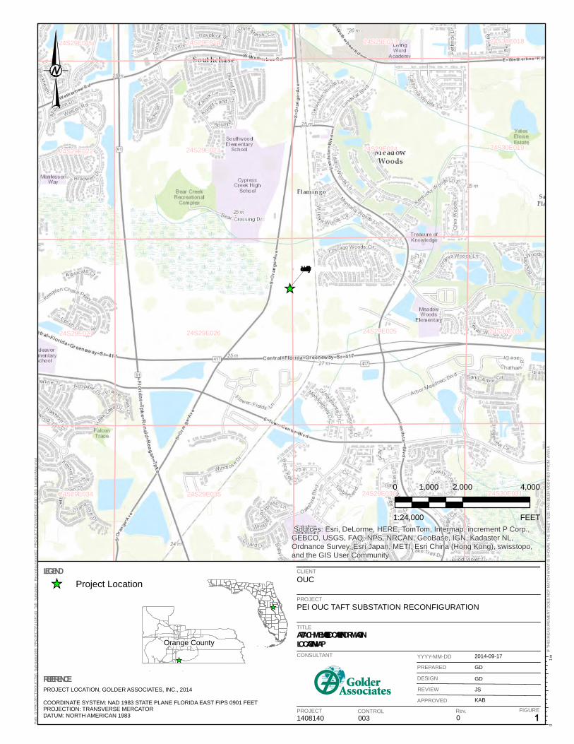
Project Location
Sources: Esri, DeLorme, HERE, TomTom, Intermap, increment P Corp.,GEBCO, USGS, FAO, NPS, NRCAN, GeoBase, IGN, Kadaster NL,Ordnance Survey, Esri Japan, METI, Esri China (Hong Kong), swisstopo,and the GIS User Community
CLIENTOUC
PROJECTPEI OUC TAFT SUBSTATION RECONFIGURATION
TITLEATTACHMENT A – SITE LOCATION INFORMATIONLOCATION MAP
1408140 003 0 1
2014-09-17
GD
GD
JS
KAB
1 in
0Pat
h: G
:\PR
OJE
CTS
\OU
C\T
aft_
Sub
stat
ion\
99_P
RO
JEC
TS\1
4081
40_T
aft_
Sub
stat
ion_
Rec
onfig
urat
ion\
02_P
RO
DU
CTI
ON
\MX
D\1
4081
40_0
03_L
ocat
ionM
ap.m
xd
_̂
IF T
HIS
ME
AS
UR
EM
EN
T D
OE
S N
OT
MAT
CH
WH
AT IS
SH
OW
N, T
HE
SH
EE
T S
IZE
HA
S B
EE
N M
OD
IFIE
D F
RO
M: A
NS
I A
CONSULTANT
PROJECT CONTROL Rev. FIGURE
YYYY-MM-DD
PREPARED
DESIGN
REVIEW
APPROVED
REFERENCEPROJECT LOCATION, GOLDER ASSOCIATES, INC., 2014
COORDINATE SYSTEM: NAD 1983 STATE PLANE FLORIDA EAST FIPS 0901 FEETPROJECTION: TRANSVERSE MERCATORDATUM: NORTH AMERICAN 1983
LEGEND
_̂
Orange County
0 2,000 4,0001,000
FEET1:24,000
_̂ Project Location
Wetland A
Wetland B
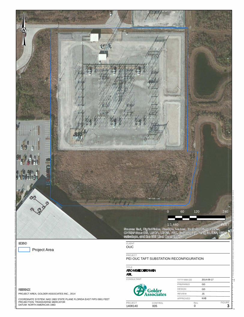
TaftSu bstation
Source: Esri, DigitalGlobe, GeoEye, i-cubed, Earthstar Geographics,CNES/Airbus DS, USDA, USGS, AEX, Getmapping, Aerogrid, IGN, IGP,swisstopo, and the GIS User Community
CLIENTOUC
PROJECTPEI OUC TAFT SUBSTATION RECONFIGURATION
TITLEATTACHMENT A – SITE LOCATION INFORMATIONWETLAND BOUNDARIES
1408140 002 0 2
2014-09-24
GD
GD
JS
KAB
1 in
0Pat
h: G
:\PR
OJE
CTS
\OU
C\T
aft_
Sub
stat
ion\
99_P
RO
JEC
TS\1
4081
40_T
aft_
Sub
stat
ion_
Rec
onfig
urat
ion\
02_P
RO
DU
CTI
ON
\MX
D\1
4081
40_0
02_P
roje
ctA
reaW
etla
nds.
mxd
IF T
HIS
ME
AS
UR
EM
EN
T D
OE
S N
OT
MAT
CH
WH
AT IS
SH
OW
N, T
HE
SH
EE
T S
IZE
HA
S B
EE
N M
OD
IFIE
D F
RO
M: A
NS
I A
CONSULTANT
PROJECT CONTROL Rev. FIGURE
YYYY-MM-DD
PREPARED
DESIGN
REVIEW
APPROVED
REFERENCEPROJECT AREA, GOLDER ASSOCIATES, INC., 2014
COORDINATE SYSTEM: NAD 1983 STATE PLANE FLORIDA EAST FIPS 0901 FEETPROJECTION: TRANSVERSE MERCATORDATUM: NORTH AMERICAN 1983
LEGEND
0 120 24060
FEET1:1,440
Project Area
Approximate Wetland Limits
Source: Esri, DigitalGlobe, GeoEye, i-cubed, Earthstar Geographics,CNES/Airbus DS, USDA, USGS, AEX, Getmapping, Aerogrid, IGN, IGP,swisstopo, and the GIS User Community
CLIENTOUC
PROJECTPEI OUC TAFT SUBSTATION RECONFIGURATION
TITLEATTACHMENT A – SITE LOCATION INFORMATIONAERIAL
1408140 005 0 3
2014-09-17
GD
GD
JS
KAB
1 in
0Pat
h: G
:\PR
OJE
CTS
\OU
C\T
aft_
Sub
stat
ion\
99_P
RO
JEC
TS\1
4081
40_T
aft_
Sub
stat
ion_
Rec
onfig
urat
ion\
02_P
RO
DU
CTI
ON
\MX
D\1
4081
40_0
05_A
eria
l.mxd
IF T
HIS
ME
AS
UR
EM
EN
T D
OE
S N
OT
MAT
CH
WH
AT IS
SH
OW
N, T
HE
SH
EE
T S
IZE
HA
S B
EE
N M
OD
IFIE
D F
RO
M: A
NS
I A
CONSULTANT
PROJECT CONTROL Rev. FIGURE
YYYY-MM-DD
PREPARED
DESIGN
REVIEW
APPROVED
REFERENCEPROJECT AREA, GOLDER ASSOCIATES INC., 2014
COORDINATE SYSTEM: NAD 1983 STATE PLANE FLORIDA EAST FIPS 0901 FEETPROJECTION: TRANSVERSE MERCATORDATUM: NORTH AMERICAN 1983
LEGEND
0 120 24060
FEET1:1,440
Project Area
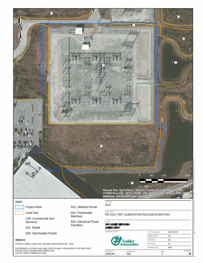
831
641
530
140
530
641
631
631
511
Source: Esri, DigitalGlobe, GeoEye, i-cubed, Earthstar Geographics,CNES/Airbus DS, USDA, USGS, AEX, Getmapping, Aerogrid, IGN, IGP,swisstopo, and the GIS User Community
CLIENTOUC
PROJECTPEI OUC TAFT SUBSTATION RECONFIGURATION
TITLEATTACHMENT A – SITE LOCATION INFORMATIONLAND USE / LAND COVER MAP
1408140 006 0 4
2014-09-24
GD
GD
JS
KAB
1 in
0Pat
h: G
:\PR
OJE
CTS
\OU
C\T
aft_
Sub
stat
ion\
99_P
RO
JEC
TS\1
4081
40_T
aft_
Sub
stat
ion_
Rec
onfig
urat
ion\
02_P
RO
DU
CTI
ON
\MX
D\1
4081
40_0
06_L
andU
se.m
xd
IF T
HIS
ME
AS
UR
EM
EN
T D
OE
S N
OT
MAT
CH
WH
AT IS
SH
OW
N, T
HE
SH
EE
T S
IZE
HA
S B
EE
N M
OD
IFIE
D F
RO
M: A
NS
I A
CONSULTANT
PROJECT CONTROL Rev. FIGURE
YYYY-MM-DD
PREPARED
DESIGN
REVIEW
APPROVED
REFERENCEPROJECT AREA, LAND USE, GOLDER ASSOCIATES INC., 2014
COORDINATE SYSTEM: NAD 1983 STATE PLANE FLORIDA EAST FIPS 0901 FEETPROJECTION: TRANSVERSE MERCATORDATUM: NORTH AMERICAN 1983
LEGEND
0 120 24060
FEET1:1,440
Project Area
Land Use
140: Commercial andServices
511: Swale
530: Stormwater Ponds
631: Wetland Scrub
641: FreshwaterMarshes
831: Electrical PowerFacilities
37
44
20
41
41
Source: Esri, DigitalGlobe, GeoEye, i-cubed, Earthstar Geographics,CNES/Airbus DS, USDA, USGS, AEX, Getmapping, Aerogrid, IGN, IGP,swisstopo, and the GIS User Community
CLIENTOUC
PROJECTPEI OUC TAFT SUBSTATION RECONFIGURATION
TITLEATTACHMENT A – SITE LOCATION INFORMATIONSOIL MAP
1408140 004 0 5
2014-09-24
GD
GD
JS
KAB
1 in
0Pat
h: G
:\PR
OJE
CTS
\OU
C\T
aft_
Sub
stat
ion\
99_P
RO
JEC
TS\1
4081
40_T
aft_
Sub
stat
ion_
Rec
onfig
urat
ion\
02_P
RO
DU
CTI
ON
\MX
D\1
4081
40_0
04_S
oils
.mxd
IF T
HIS
ME
AS
UR
EM
EN
T D
OE
S N
OT
MAT
CH
WH
AT IS
SH
OW
N, T
HE
SH
EE
T S
IZE
HA
S B
EE
N M
OD
IFIE
D F
RO
M: A
NS
I A
CONSULTANT
PROJECT CONTROL Rev. FIGURE
YYYY-MM-DD
PREPARED
DESIGN
REVIEW
APPROVED
REFERENCEPROJECT AREA, GOLDER ASSOCIATES INC., 2014SOILS, USDA/NRCS, 2012
COORDINATE SYSTEM: NAD 1983 STATE PLANE FLORIDA EAST FIPS 0901 FEETPROJECTION: TRANSVERSE MERCATORDATUM: NORTH AMERICAN 1983
LEGEND
0 120 24060
FEET1:1,440
Project Area
Soils
20 - Immokalee Fine Sand
37 - St. Johns Fine Sand
41 - Samsula-Hontoon-Basinger Association, Depressional
44 - Smyrna Fine Sand
ATTACHMENT B
CONSTRUCTION PLANS
!!!!!!
!!!!!!
!! !! !!
!!!!
!!
!!
!!!!
!!
60 ft
120 f
t
110 ft 34 ft
180 ft
214 ft
274 ft
Source: Esri, DigitalGlobe, GeoEye, i-cubed, Earthstar Geographics,CNES/Airbus DS, USDA, USGS, AEX, Getmapping, Aerogrid, IGN, IGP,swisstopo, and the GIS User Community
CLIENTOUC
!! Existing!! Proposed
Existing Transmission LineProposed Transmission LineWetland LimitsTemporary Matting
PROJECTPEI OUC TAFT SUBSTATION RECONFIGURATION
TITLEPROPOSED RECONFIGURATION LAYOUT
1408140 007 0 1
2014-09-30NRLNRLJSKAB
1 in
0Path:
G:\P
ROJE
CTS\O
UC\Ta
ft_Su
bstat
ion\99
_PRO
JECT
S\140
8140
_Taft
_Sub
statio
n_Re
confi
gurat
ion\02
_PRO
DUCT
ION\
MXD\
1408
140_
007_
Reco
nfigu
ration
Plan.m
xd
IF TH
IS ME
ASUR
EMEN
T DOE
S NOT
MAT
CH W
HAT I
S SHO
WN, T
HE S
HEET
SIZE
HAS
BEE
N MO
DIFIE
D FR
OM: A
NSI A
CONSULTANT
PROJECT CONTROL Rev. FIGURE
YYYY-MM-DDPREPAREDDESIGNREVIEWAPPROVED
REFERENCERECONFIGURATION LAYOUT, PEI, 2014TEMPORARY MATTING, GOLDER ASSOCIATES INC., 2014
LEGEND
80 0 8040
FEET1:1,301
a
2
a2
CONDUCTOROPGW SHIELD WIRE
NN
N
Z
Z
25’-0" 25’-0"
PLAN
CONDUCTOR AND SHIELD WIRE ATTACHMENTS
PLAN @ CONDUCTOR
ELEVATION Z-Z
ELEVATION
18
UNITS
18
UNITS
THIS DRAWING WAS PREPARED BY POWER
IS PROHIBITED UNLESS WRITTEN PERMISSION
CONTAINED IN THIS DRAWING FOR ANY PURPOSE
REUSE OF THIS DRAWING OR ANY INFORMATION
AND UNIQUE REQUIREMENTS OF THE PROJECT.
TAKING INTO CONSIDERATION THE SPECIFIC
ENGINEERS, INC. FOR A SPECIFIC PROJECT,
FROM BOTH POWER AND POWER’S CLIENT IS
GRANTED. REV DSGNREVISIONS DATE DRN APPDCKD REFERENCE DRAWINGS FOR 34x44 DWG ONLY
DSGN
DRN
SCALE:
CKD
JOB NUMBER REV
DRAWING NUMBER
G
F
E
1 2 3 4 5 6 7 8
D
C
B
A
ORLANDO UTILITY COMMISSION
230kV 3-POLE DEADEND
CONCEPTUAL DESIGN
133204
1 OF 1
N.T.S.
A
PEI PEI PEI PEIA CONCEPTUAL DESIGN 10/02/14
TAFT SUBSTATION RECONFIGURATIONTRANSMISSION SEQUENCING PLAN
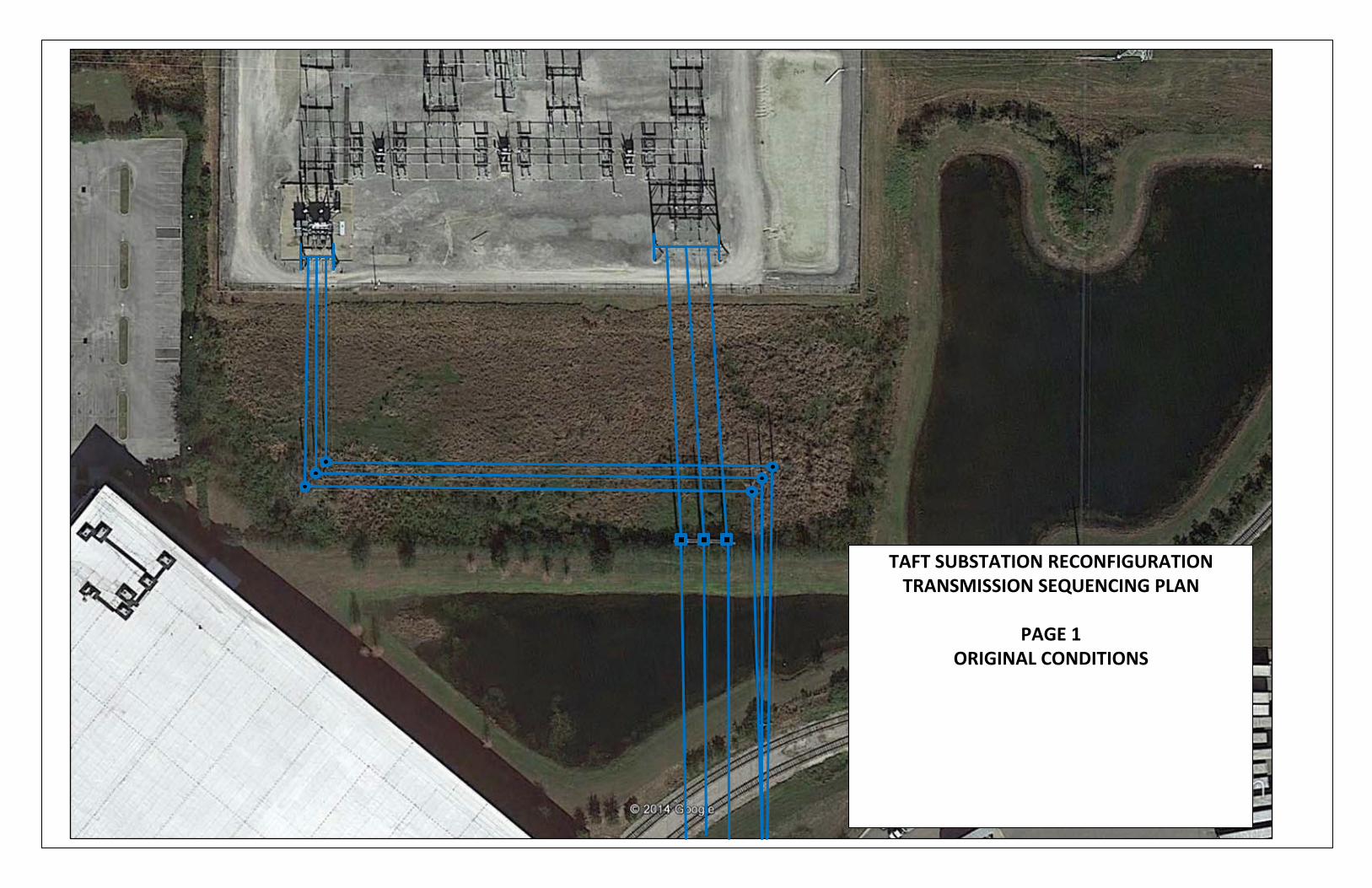
PAGE 1ORIGINAL CONDITIONS
TAFT SUBSTATION RECONFIGURATIONTRANSMISSION SEQUENCING PLAN
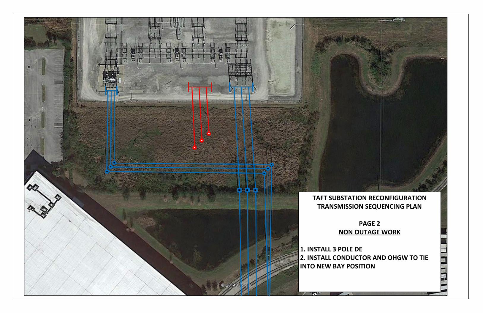
PAGE 2NON OUTAGE WORK
1. INSTALL 3 POLE DE2. INSTALL CONDUCTOR AND OHGW TO TIE INTO NEW BAY POSITION
TAFT SUBSTATION RECONFIGURATIONTRANSMISSION SEQUENCING PLAN
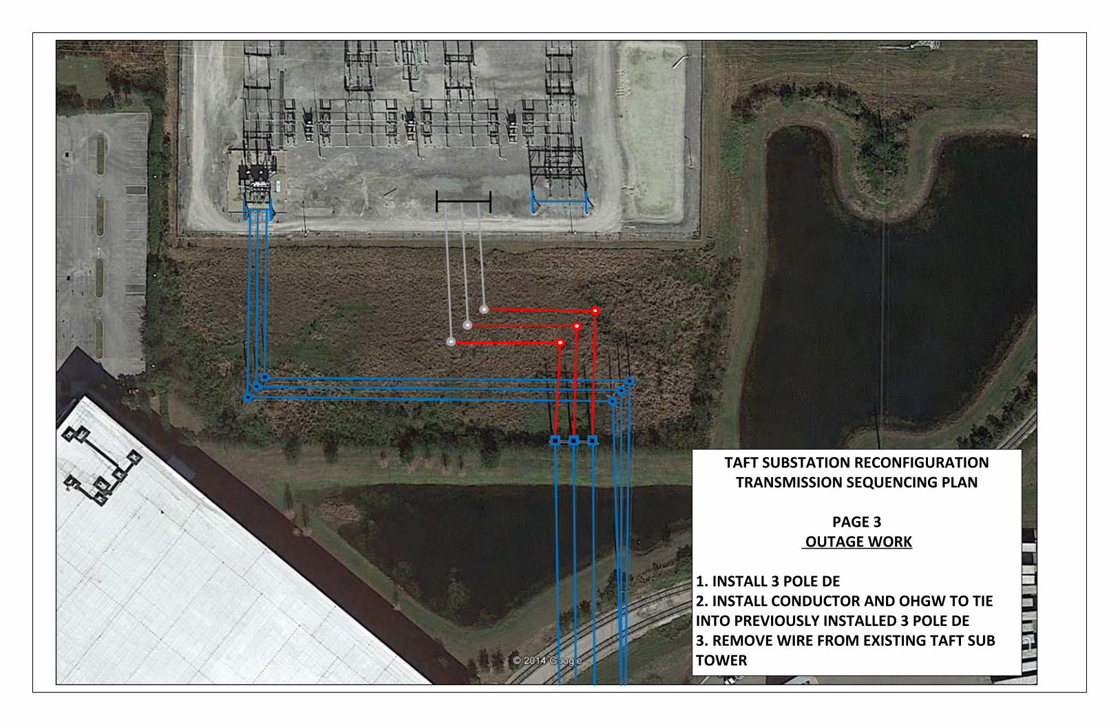
PAGE 3OUTAGE WORK
1. INSTALL 3 POLE DE2. INSTALL CONDUCTOR AND OHGW TO TIE INTO PREVIOUSLY INSTALLED 3 POLE DE3. REMOVE WIRE FROM EXISTING TAFT SUB TOWER
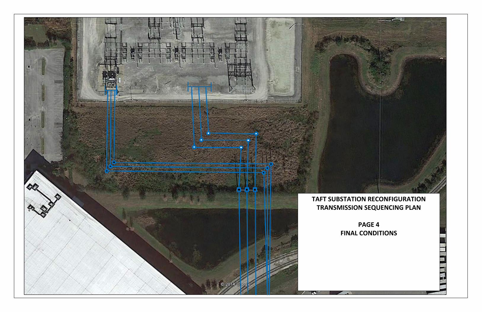
TAFT SUBSTATION RECONFIGURATIONTRANSMISSION SEQUENCING PLAN
PAGE 4FINAL CONDITIONS
ATTACHMENT C
PARCEL DATA AND ADJACENT
PROPERTY OWNERS
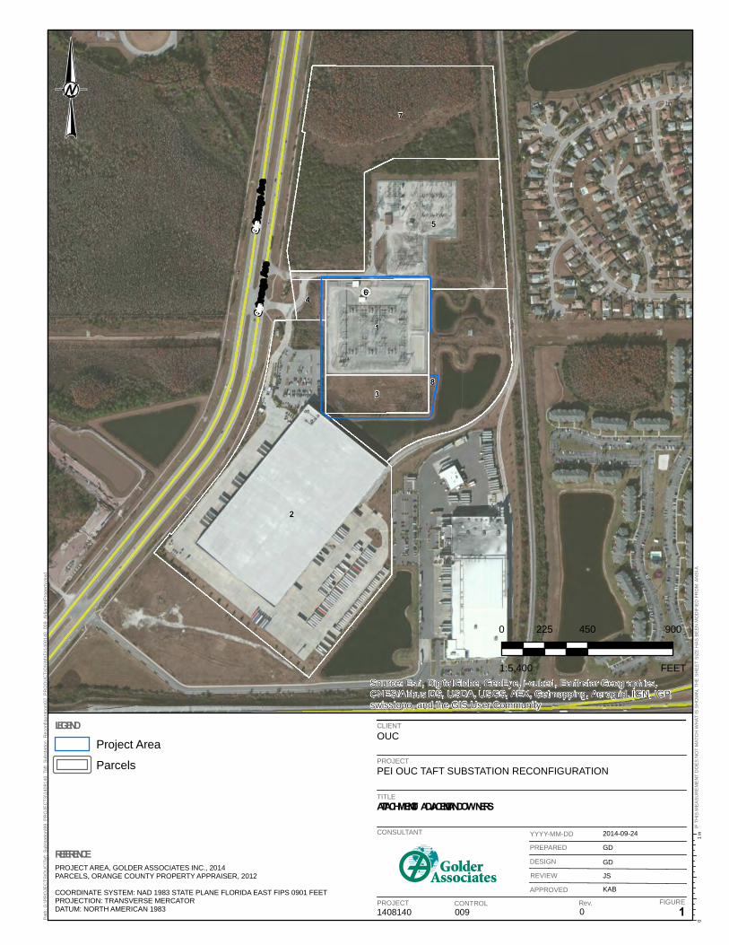
2
7
5
8
1
3
4 6
S Orange Ave
S Orange Ave
Source: Esri, DigitalGlobe, GeoEye, i-cubed, Earthstar Geographics,CNES/Airbus DS, USDA, USGS, AEX, Getmapping, Aerogrid, IGN, IGP,swisstopo, and the GIS User Community
CLIENTOUC
PROJECTPEI OUC TAFT SUBSTATION RECONFIGURATION
TITLEATTACHMENT C – ADJACENT LANDOWNERS
1408140 009 0 1
2014-09-24
GD
GD
JS
KAB
1 in
0Pat
h: G
:\PR
OJE
CTS
\OU
C\T
aft_
Sub
stat
ion\
99_P
RO
JEC
TS\1
4081
40_T
aft_
Sub
stat
ion_
Rec
onfig
urat
ion\
02_P
RO
DU
CTI
ON
\MX
D\1
4081
40_0
09_A
djac
entP
rope
rty.m
xd
IF T
HIS
ME
AS
UR
EM
EN
T D
OE
S N
OT
MAT
CH
WH
AT IS
SH
OW
N, T
HE
SH
EE
T S
IZE
HA
S B
EE
N M
OD
IFIE
D F
RO
M: A
NS
I A
CONSULTANT
PROJECT CONTROL Rev. FIGURE
YYYY-MM-DD
PREPARED
DESIGN
REVIEW
APPROVED
REFERENCEPROJECT AREA, GOLDER ASSOCIATES INC., 2014PARCELS, ORANGE COUNTY PROPERTY APPRAISER, 2012
COORDINATE SYSTEM: NAD 1983 STATE PLANE FLORIDA EAST FIPS 0901 FEETPROJECTION: TRANSVERSE MERCATORDATUM: NORTH AMERICAN 1983
LEGEND
0 450 900225
FEET1:5,400
Project Area
Parcels
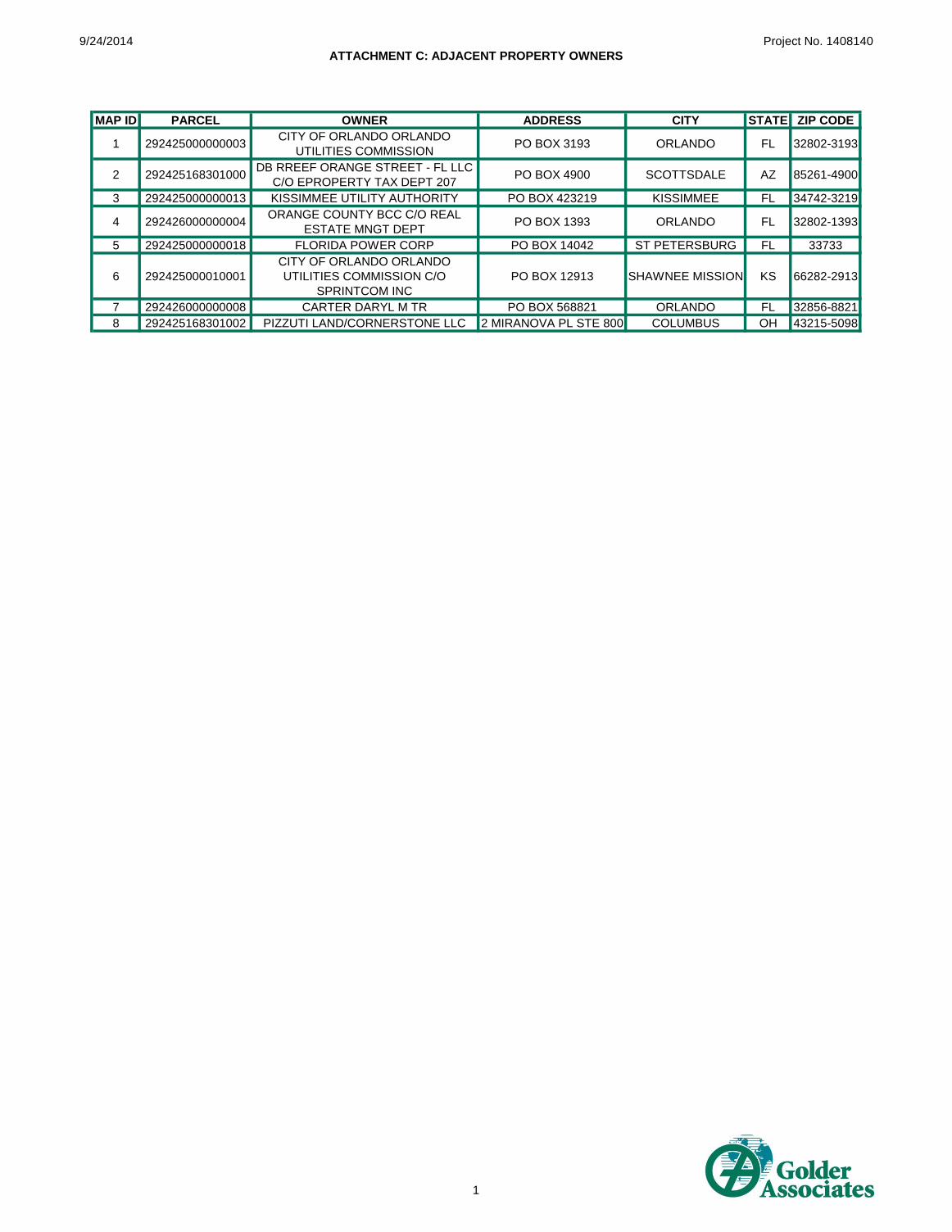
9/24/2014
ATTACHMENT C: ADJACENT PROPERTY OWNERS
Project No. 1408140
MAP ID PARCEL OWNER ADDRESS CITY STATE ZIP CODE
1 292425000000003CITY OF ORLANDO ORLANDO
UTILITIES COMMISSIONPO BOX 3193 ORLANDO FL 32802-3193
2 292425168301000DB RREEF ORANGE STREET - FL LLC
C/O EPROPERTY TAX DEPT 207PO BOX 4900 SCOTTSDALE AZ 85261-4900
3 292425000000013 KISSIMMEE UTILITY AUTHORITY PO BOX 423219 KISSIMMEE FL 34742-3219
4 292426000000004ORANGE COUNTY BCC C/O REAL
ESTATE MNGT DEPTPO BOX 1393 ORLANDO FL 32802-1393
5 292425000000018 FLORIDA POWER CORP PO BOX 14042 ST PETERSBURG FL 33733
6 292425000010001
CITY OF ORLANDO ORLANDO
UTILITIES COMMISSION C/O
SPRINTCOM INC
PO BOX 12913 SHAWNEE MISSION KS 66282-2913
7 292426000000008 CARTER DARYL M TR PO BOX 568821 ORLANDO FL 32856-8821
8 292425168301002 PIZZUTI LAND/CORNERSTONE LLC 2 MIRANOVA PL STE 800 COLUMBUS OH 43215-5098
1
ATTACHMENT DUSACE WETLAND DATASHEETS
UMAM FUNCTIONAL ASSESSMENT FORMS
WETLAND DETERMINATION DATA FORM - Atlantic and Gulf Coastal Plain Region
Adapted from U.S. Army Corps of EngineersAtlantic and Gulf Coastal Plain Region- Interim Version
Slope (%): ________Datum: WGS84
Yes No ____________ (If no, explain in Remarks)Soil , Are circumstances normal? Yes No_____
Soil , (If needed, explain any answers in Remarks)
Yes No __________Yes No __________Yes No __________
Secondary Indicators (minimum of two required)
Yes ______No __________
Yes ______ No _________
Yes ______No __________
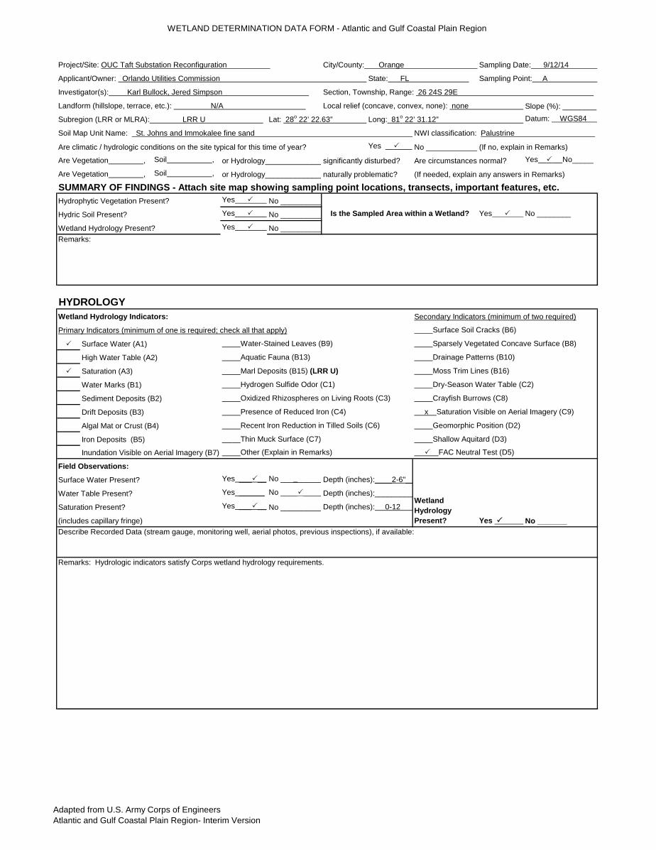
Project/Site: OUC Taft Substation Reconfiguration City/County: Orange Sampling Date: 9/12/14
Applicant/Owner: Orlando Utilities Commission State: FL Sampling Point: A
Investigator(s): Karl Bullock, Jered Simpson Section, Township, Range: 26 24S 29E
Landform (hillslope, terrace, etc.): N/A Local relief (concave, convex, none): none
Subregion (LRR or MLRA): LRR U Lat: 28o 22’ 22.63” Long: 81o 22’ 31.12”
Are Vegetation , or Hydrology______________naturally problematic?
SUMMARY OF FINDINGS - Attach site map showing sampling point locations, transects, important features, etc.Hydrophytic Vegetation Present?
Is the Sampled Area within a Wetland? Yes No ________Hydric Soil Present?
Wetland Hydrology Present?
Soil Map Unit Name: St. Johns and Immokalee fine sand NWI classification: Palustrine
Are climatic / hydrologic conditions on the site typical for this time of year?
Are Vegetation , or Hydrology______________significantly disturbed?
Primary Indicators (minimum of one is required; check all that apply) Surface Soil Cracks (B6)
Remarks:
HYDROLOGYWetland Hydrology Indicators:
High Water Table (A2) Aquatic Fauna (B13) Drainage Patterns (B10)
Surface Water (A1) Water-Stained Leaves (B9) Sparsely Vegetated Concave Surface (B8)
Saturation (A3) Marl Deposits (B15) (LRR U) Moss Trim Lines (B16)
Water Marks (B1) Hydrogen Sulfide Odor (C1) Dry-Season Water Table (C2)
Sediment Deposits (B2) Oxidized Rhizospheres on Living Roots (C3) Crayfish Burrows (C8)
Drift Deposits (B3) Presence of Reduced Iron (C4) x Saturation Visible on Aerial Imagery (C9)
(includes capillary fringe)
Algal Mat or Crust (B4) Recent Iron Reduction in Tilled Soils (C6) Geomorphic Position (D2)
Iron Deposits (B5) Thin Muck Surface (C7) Shallow Aquitard (D3)
Describe Recorded Data (stream gauge, monitoring well, aerial photos, previous inspections), if available:
Remarks: Hydrologic indicators satisfy Corps wetland hydrology requirements.
Inundation Visible on Aerial Imagery (B7) Other (Explain in Remarks) FAC Neutral Test (D5)
Field Observations:
Wetland Hydrology Present? Yes No _______
Surface Water Present? Depth (inches):____2-6"__
Water Table Present? Depth (inches):_________
Saturation Present? Depth (inches): 0-12
Adapted from U.S. Army Corps of EngineersAtlantic and Gulf Coastal Plain Region- Interim Version
Absolute % Cover
Dominant Species?
Indicator Status
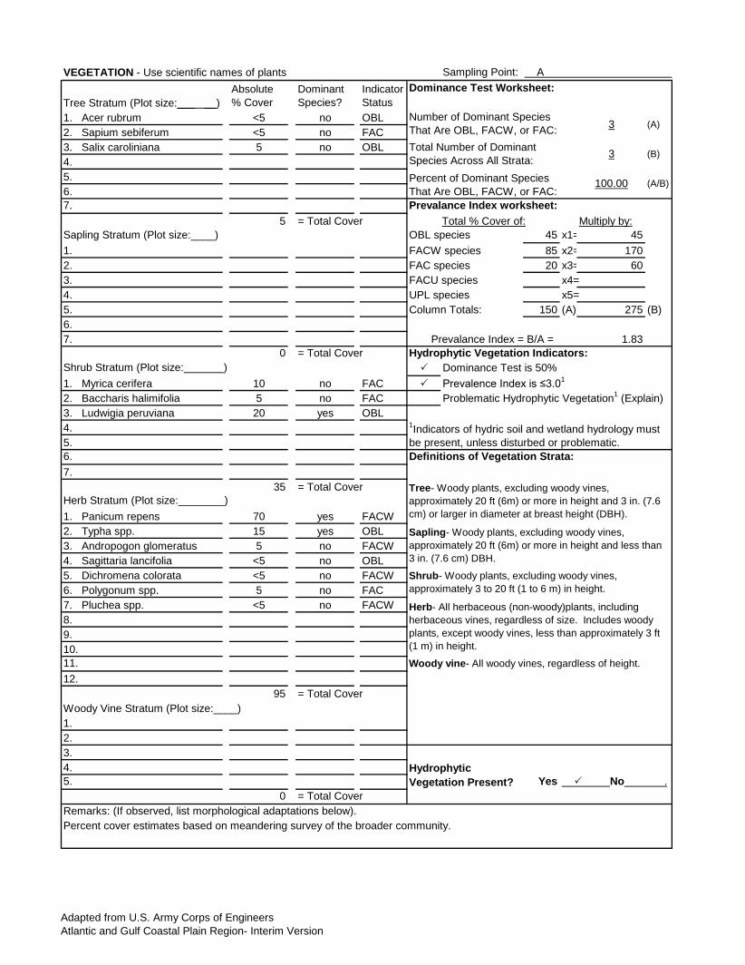
1. Acer rubrum <5 no OBL2. Sapium sebiferum <5 no FAC3. Salix caroliniana 5 no OBL4. 5.6. 7.
5 = Total Cover Multiply by:45 x1= 45
1. 85 x2= 1702. 20 x3= 603. x4=4. x5=5. 150 (A) 275 (B)6. 7. 1.83
0 = Total Cover
1. Myrica cerifera 10 no FAC
2. Baccharis halimifolia 5 no FAC3. Ludwigia peruviana 20 yes OBL4. 5. 6. 7.
35 = Total Cover
1. Panicum repens 70 yes FACW2. Typha spp. 15 yes OBL3. Andropogon glomeratus 5 no FACW4. Sagittaria lancifolia <5 no OBL5. Dichromena colorata <5 no FACW6. Polygonum spp. 5 no FAC7. Pluchea spp. <5 no FACW8. 9. 10. 11. 12.
95 = Total Cover
1. 2. 3. 4. 5. Yes
0 = Total Cover
VEGETATION - Use scientific names of plants Sampling Point: A
Tree Stratum (Plot size:___ __) Dominance Test Worksheet:
Number of Dominant Species That Are OBL, FACW, or FAC: 3 (A)
Total Number of Dominant Species Across All Strata: 3 (B)
Percent of Dominant Species That Are OBL, FACW, or FAC:
100.00 (A/B)
Prevalance Index worksheet:Total % Cover of:
Shrub Stratum (Plot size: ) Dominance Test is 50%
Sapling Stratum (Plot size:____) OBL speciesFACW speciesFAC speciesFACU speciesUPL speciesColumn Totals:
Prevalance Index = B/A =Hydrophytic Vegetation Indicators:
Woody Vine Stratum (Plot size:____)
Prevalence Index is ≤3.01
Problematic Hydrophytic Vegetation1 (Explain)
1Indicators of hydric soil and wetland hydrology must be present, unless disturbed or problematic.Definitions of Vegetation Strata:
Tree- Woody plants, excluding woody vines, approximately 20 ft (6m) or more in height and 3 in. (7.6 cm) or larger in diameter at breast height (DBH).
Herb Stratum (Plot size: )
Sapling- Woody plants, excluding woody vines, approximately 20 ft (6m) or more in height and less than 3 in. (7.6 cm) DBH.
Shrub- Woody plants, excluding woody vines, approximately 3 to 20 ft (1 to 6 m) in height.
Herb- All herbaceous (non-woody)plants, including herbaceous vines, regardless of size. Includes woody plants, except woody vines, less than approximately 3 ft (1 m) in height.
Woody vine- All woody vines, regardless of height.
Hydrophytic Vegetation Present? No .
Remarks: (If observed, list morphological adaptations below).Percent cover estimates based on meandering survey of the broader community.

Adapted from U.S. Army Corps of EngineersAtlantic and Gulf Coastal Plain Region- Interim Version
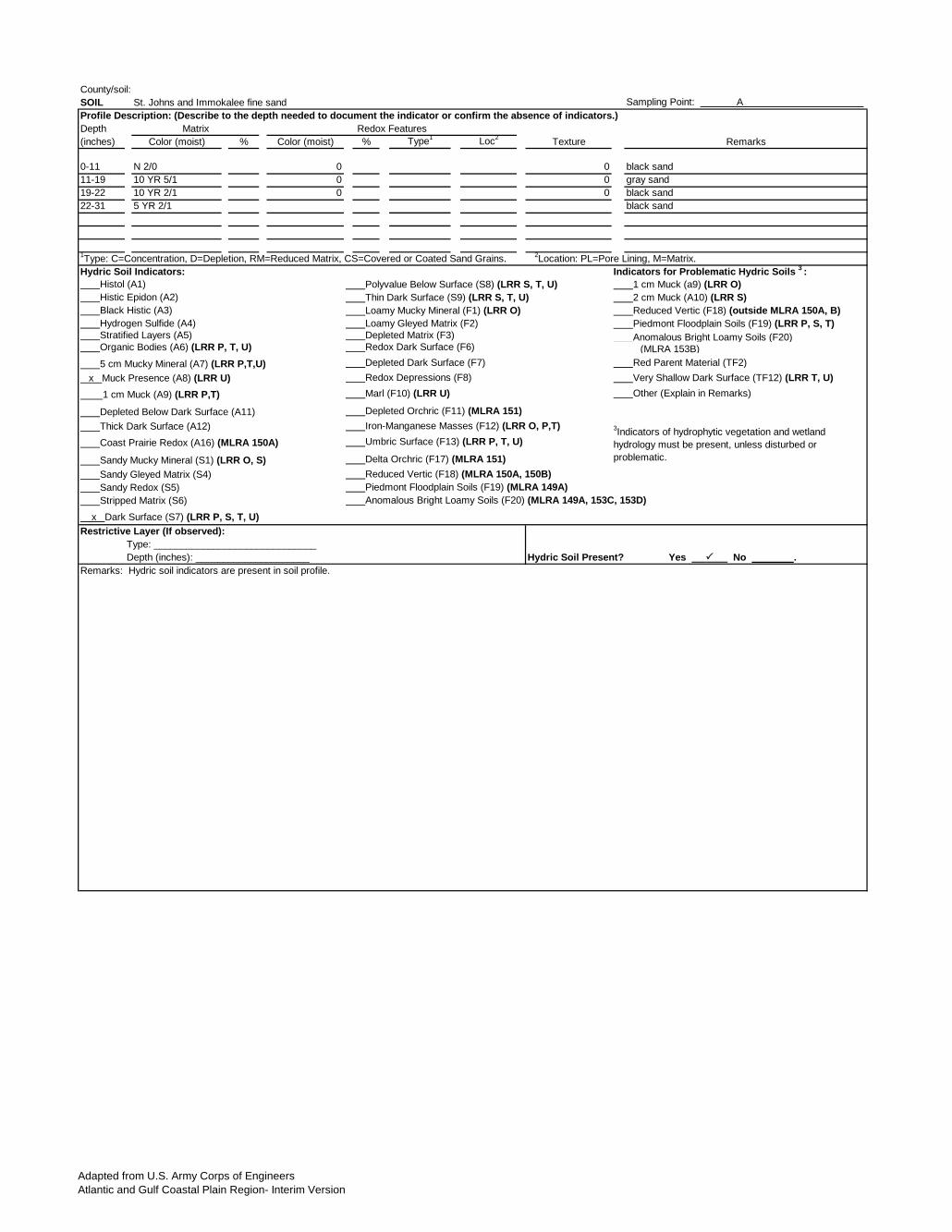
County/soil: SOIL St. Johns and Immokalee fine sand Sampling Point: A
Depth (inches) Color (moist) % Color (moist) % Type1 Loc2 Texture Remarks
0-11 N 2/0 0 0 black sand11-19 10 YR 5/1 0 0 gray sand19-22 10 YR 2/1 0 0 black sand22-31 5 YR 2/1 black sand
Hydric Soil Indicators: Histol (A1) Polyvalue Below Surface (S8) (LRR S, T, U) 1 cm Muck (a9) (LRR O) Histic Epidon (A2) Thin Dark Surface (S9) (LRR S, T, U) 2 cm Muck (A10) (LRR S) Black Histic (A3) Loamy Mucky Mineral (F1) (LRR O) Reduced Vertic (F18) (outside MLRA 150A, B) Hydrogen Sulfide (A4) Loamy Gleyed Matrix (F2) Piedmont Floodplain Soils (F19) (LRR P, S, T) Stratified Layers (A5) Depleted Matrix (F3) Anomalous Bright Loamy Soils (F20) Organic Bodies (A6) (LRR P, T, U) Redox Dark Surface (F6) (MLRA 153B)
Depleted Dark Surface (F7) Red Parent Material (TF2) Redox Depressions (F8) Very Shallow Dark Surface (TF12) (LRR T, U) Marl (F10) (LRR U) Other (Explain in Remarks)
Depleted Orchric (F11) (MLRA 151) Iron-Manganese Masses (F12) (LRR O, P,T) Umbric Surface (F13) (LRR P, T, U)
Delta Orchric (F17) (MLRA 151) Reduced Vertic (F18) (MLRA 150A, 150B) Piedmont Floodplain Soils (F19) (MLRA 149A) Anomalous Bright Loamy Soils (F20) (MLRA 149A, 153C, 153D)
3Indicators of hydrophytic vegetation and wetland hydrology must be present, unless disturbed or problematic.
Coast Prairie Redox (A16) (MLRA 150A)
Sandy Mucky Mineral (S1) (LRR O, S)
Profile Description: (Describe to the depth needed to document the indicator or confirm the absence of indicators.)Matrix Redox Features
1Type: C=Concentration, D=Depletion, RM=Reduced Matrix, CS=Covered or Coated Sand Grains. 2Location: PL=Pore Lining, M=Matrix.Indicators for Problematic Hydric Soils 3 :
5 cm Mucky Mineral (A7) (LRR P,T,U) x Muck Presence (A8) (LRR U) 1 cm Muck (A9) (LRR P,T)
Depleted Below Dark Surface (A11) Thick Dark Surface (A12)
Hydric Soil Present? Yes No .Depth (inches): _____________________Remarks: Hydric soil indicators are present in soil profile.
Sandy Gleyed Matrix (S4) Sandy Redox (S5) Stripped Matrix (S6) x Dark Surface (S7) (LRR P, S, T, U)Restrictive Layer (If observed):
Type: ______________________________

WETLAND DETERMINATION DATA FORM - Atlantic and Gulf Coastal Plain Region
Adapted from U.S. Army Corps of EngineersAtlantic and Gulf Coastal Plain Region- Interim Version
Slope (%): ________Datum: WGS84
Yes No ____________ (If no, explain in Remarks)Soil , Are circumstances normal? Yes No_____
Soil , (If needed, explain any answers in Remarks)
Yes No __________Yes No __________Yes No __________
Secondary Indicators (minimum of two required)
Yes ______No __________
Yes ______ No _________
Yes ______No __________
Describe Recorded Data (stream gauge, monitoring well, aerial photos, previous inspections), if available:
Remarks: Hydrologic indicators satisfy Corps wetland hydrology requirements.
Inundation Visible on Aerial Imagery (B7) Other (Explain in Remarks) FAC Neutral Test (D5)
Field Observations:
Wetland Hydrology Present? Yes No _______
Surface Water Present? Depth (inches):____2-6"__
Water Table Present? Depth (inches):_________
Saturation Present? Depth (inches): 0-12
(includes capillary fringe)
Algal Mat or Crust (B4) Recent Iron Reduction in Tilled Soils (C6) Geomorphic Position (D2)
Iron Deposits (B5) Thin Muck Surface (C7) Shallow Aquitard (D3)
Sediment Deposits (B2) Oxidized Rhizospheres on Living Roots (C3) Crayfish Burrows (C8)
Drift Deposits (B3) Presence of Reduced Iron (C4) x Saturation Visible on Aerial Imagery (C9)
Saturation (A3) Marl Deposits (B15) (LRR U) Moss Trim Lines (B16)
Water Marks (B1) Hydrogen Sulfide Odor (C1) Dry-Season Water Table (C2)
High Water Table (A2) Aquatic Fauna (B13) Drainage Patterns (B10)
Surface Water (A1) Water-Stained Leaves (B9) Sparsely Vegetated Concave Surface (B8)
Primary Indicators (minimum of one is required; check all that apply) Surface Soil Cracks (B6)
Remarks:
HYDROLOGYWetland Hydrology Indicators:
Soil Map Unit Name: St. Johns and Immokalee fine sand NWI classification: Palustrine
Are climatic / hydrologic conditions on the site typical for this time of year?
Are Vegetation , or Hydrology______________significantly disturbed?
Are Vegetation , or Hydrology______________naturally problematic?
SUMMARY OF FINDINGS - Attach site map showing sampling point locations, transects, important features, etc.Hydrophytic Vegetation Present?
Is the Sampled Area within a Wetland? Yes No ________Hydric Soil Present?
Wetland Hydrology Present?
Investigator(s): Karl Bullock, Jered Simpson Section, Township, Range: 26 24S 29E
Landform (hillslope, terrace, etc.): N/A Local relief (concave, convex, none): none
Subregion (LRR or MLRA): LRR U Lat: 28o 22’ 22.63” Long: 81o 22’ 31.12”
Project/Site: OUC Taft Substation Reconfiguration City/County: Orange Sampling Date: 9/12/14
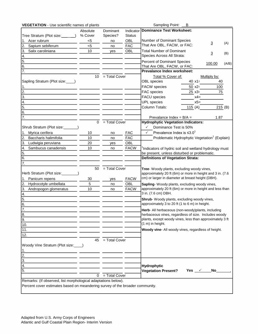
Applicant/Owner: Orlando Utilities Commission State: FL Sampling Point: B
Adapted from U.S. Army Corps of EngineersAtlantic and Gulf Coastal Plain Region- Interim Version
Absolute % Cover
Dominant Species?
Indicator Status
1. Acer rubrum <5 no OBL2. Sapium sebiferum <5 no FAC3. Salix caroliniana 10 yes OBL4. 5.6. 7.
10 = Total Cover Multiply by:40 x1= 40
1. 50 x2= 1002. 25 x3= 753. x4=4. x5=5. 115 (A) 215 (B)6. 7. 1.87
0 = Total Cover
1. Myrica cerifera 10 no FAC
2. Baccharis halimifolia 10 no FAC3. Ludwigia peruviana 20 yes OBL4. Sambucus canadensis 10 no FACW5. 6. 7.
50 = Total Cover
1. Panicum repens 30 yes FACW2. Hydrocotyle umbellata 5 no OBL3. Andropogon glomeratus 10 no FACW4.5.6.7.8. 9. 10. 11. 12.
45 = Total Cover
1. 2. 3. 4. 5. Yes
0 = Total Cover
Hydrophytic Vegetation Present? No .
Remarks: (If observed, list morphological adaptations below).Percent cover estimates based on meandering survey of the broader community.
Woody Vine Stratum (Plot size:____)
Prevalence Index is ≤3.01
Problematic Hydrophytic Vegetation1 (Explain)
1Indicators of hydric soil and wetland hydrology must be present, unless disturbed or problematic.Definitions of Vegetation Strata:
Tree- Woody plants, excluding woody vines, approximately 20 ft (6m) or more in height and 3 in. (7.6 cm) or larger in diameter at breast height (DBH).
Herb Stratum (Plot size: )
Sapling- Woody plants, excluding woody vines, approximately 20 ft (6m) or more in height and less than 3 in. (7.6 cm) DBH.
Shrub- Woody plants, excluding woody vines, approximately 3 to 20 ft (1 to 6 m) in height.
Herb- All herbaceous (non-woody)plants, including herbaceous vines, regardless of size. Includes woody plants, except woody vines, less than approximately 3 ft (1 m) in height.
Woody vine- All woody vines, regardless of height.
Shrub Stratum (Plot size: ) Dominance Test is 50%
Sapling Stratum (Plot size:____) OBL speciesFACW speciesFAC speciesFACU speciesUPL speciesColumn Totals:
Prevalance Index = B/A =Hydrophytic Vegetation Indicators:
Percent of Dominant Species That Are OBL, FACW, or FAC:
100.00 (A/B)
Prevalance Index worksheet:Total % Cover of:
Number of Dominant Species That Are OBL, FACW, or FAC: 3 (A)
Total Number of Dominant Species Across All Strata: 3 (B)
VEGETATION - Use scientific names of plants Sampling Point: B
Tree Stratum (Plot size:___ __) Dominance Test Worksheet:
Adapted from U.S. Army Corps of EngineersAtlantic and Gulf Coastal Plain Region- Interim Version
County/soil: SOIL St. Johns and Immokalee fine sand Sampling Point: A
Depth (inches) Color (moist) % Color (moist) % Type1 Loc2 Texture Remarks
0-11 N 2/0 0 0 black sand11-19 10 YR 5/1 0 0 gray sand19-22 10 YR 2/1 0 0 black sand22-31 5 YR 2/1 black sand
Hydric Soil Indicators: Histol (A1) Polyvalue Below Surface (S8) (LRR S, T, U) 1 cm Muck (a9) (LRR O) Histic Epidon (A2) Thin Dark Surface (S9) (LRR S, T, U) 2 cm Muck (A10) (LRR S) Black Histic (A3) Loamy Mucky Mineral (F1) (LRR O) Reduced Vertic (F18) (outside MLRA 150A, B) Hydrogen Sulfide (A4) Loamy Gleyed Matrix (F2) Piedmont Floodplain Soils (F19) (LRR P, S, T) Stratified Layers (A5) Depleted Matrix (F3) Anomalous Bright Loamy Soils (F20) Organic Bodies (A6) (LRR P, T, U) Redox Dark Surface (F6) (MLRA 153B)
Depleted Dark Surface (F7) Red Parent Material (TF2) Redox Depressions (F8) Very Shallow Dark Surface (TF12) (LRR T, U) Marl (F10) (LRR U) Other (Explain in Remarks)
Depleted Orchric (F11) (MLRA 151) Iron-Manganese Masses (F12) (LRR O, P,T) Umbric Surface (F13) (LRR P, T, U)
Delta Orchric (F17) (MLRA 151) Reduced Vertic (F18) (MLRA 150A, 150B) Piedmont Floodplain Soils (F19) (MLRA 149A) Anomalous Bright Loamy Soils (F20) (MLRA 149A, 153C, 153D)
Hydric Soil Present? Yes No .Depth (inches): _____________________Remarks: Hydric soil indicators are present in soil profile.
Sandy Gleyed Matrix (S4) Sandy Redox (S5) Stripped Matrix (S6) x Dark Surface (S7) (LRR P, S, T, U)Restrictive Layer (If observed):
Type: ______________________________
3Indicators of hydrophytic vegetation and wetland hydrology must be present, unless disturbed or problematic.
Coast Prairie Redox (A16) (MLRA 150A)
Sandy Mucky Mineral (S1) (LRR O, S)
Profile Description: (Describe to the depth needed to document the indicator or confirm the absence of indicators.)Matrix Redox Features
1Type: C=Concentration, D=Depletion, RM=Reduced Matrix, CS=Covered or Coated Sand Grains. 2Location: PL=Pore Lining, M=Matrix.Indicators for Problematic Hydric Soils 3 :
5 cm Mucky Mineral (A7) (LRR P,T,U) x Muck Presence (A8) (LRR U) 1 cm Muck (A9) (LRR P,T)
Depleted Below Dark Surface (A11) Thick Dark Surface (A12)
Site/Project Name Application Number Assessment Area Name or Number
Impact or Mitigation Site? Assessment Area Size
Assessment conducted by: Assessment date(s):
FLUCCs code Further classification (optional)
PART I – Qualitative Description(See Section 62-345.400, F.A.C.)
OUC Taft Substation Reconfiguration Wetland A - Freshwater Marsh
641 Existing Condition 3.40 acres
Basin/Watershed Name/Number Affected Waterbody (Class) Special Classification (i.e.OFW, AP, other local/state/federal designation of importance)
Functions Mitigation for previous permit/other historic use
Kissimmee River / HUC 03090101
Geographic relationship to and hydrologic connection with wetlands, other surface water, uplands
Freshwater marsh surrounding western and southern edges of substation, isolated from other wetlands by access roads, stormwater pond berms, and parking lots.
Assessment area description
Freshwater marsh dominated by nuisance and/or exotic species torpedo grass (Panicum repens ), Peruvian primrose willow (Ludwigia peruviana ), and cattails (Typha latifolia ). A variety of subdominant species are present, including smartweed (Polygonum sp.), arrowhead (Sagittaria
lancifolia ), groundsel tree (Baccharis halimifolia ), bushy broomsedge (Andropogon glomeratus ), wax myrtle (Myrica cerifera ), alligator weed (Alternanthera philoxeroides ), marsh pennywort (Hydrocotyle umbellata ), soft rush (Juncus effusus ), Chinese tallow (Sapium sebiferum ), rattlebox
(Sesbania sp.), starrush whitetop (Rhynchospora colorata ), camphorweed (Pluchea sp.), dogfennel (Eupatorium capillifolium ), and occasional coastal plain willow (Salix caroliniana ) and red maple (Acer rubrum ).
Significant nearby features Uniqueness (considering the relative rarity in relation to the regional landscape.)
Substation, roadways, commercial development Not rare in relation to regional landscape
Wildlife habitat, water treatment and storage N/A
Anticipated Wildlife Utilization Based on Literature Review (List of species that are representative of the assessment area and reasonably expected to be found )
Anticipated Utilization by Listed Species (List species, their legal classification (E, T, SSC), type of use, and intensity of use of the assessment area)
Wading birds, herpetofaunaPossible occasional use by wading birds such as white ibis (SSC),
wood stork (E), little blue heron (SSC), snowy egret (SSC), and tricolor heron (SSC).
Form 62-345.900(1), F.A.C. [ effective date ]
Observed Evidence of Wildlife Utilization (List species directly observed, or other signs such as tracks, droppings, casings, nests, etc.):
Wildlife observations include little blue heron (Egretta caerulea ), red winged blackbird (Agelaius phoeniceus ), great egret (Ardea alba ), mockingbird (Mimus polyglottos ), fish crow (Corvus ossifragus ), and tracks of raccoon (Procyon lotor ).
Additional relevant factors:
K. Bullock Sep-14

w/o pres orcurrent
w/o pres orcurrent
w/o pres orcurrent
currentor w/o pres
OUC Taft Substation Wetland A - Freshwater Marsh
PART II – Quantification of Assessment Area (impact or mitigation)(See Sections 62-345.500 and .600, F.A.C.)
Site/Project Name Application Number Assessment Area Name or Number
Impact or Mitigation Assessment conducted by: Assessment date:
Existing Condition K. Bullock Sep-14
Optimal (10) Moderate(7) Minimal (4) Not Present (0)The scoring of each
indicator is based on what would be suitable for the
type of wetland or surface water assessed
Condition is optimal and fully supports
wetland/surface water functions
Condition is less than optimal, but sufficient to
maintain most wetland/surface waterfunctions
Minimal level of support of wetland/surface water
functions
Condition is insufficient to provide wetland/surface
water functions
.500(6)(b)Water Environment (n/a for uplands)
with
6
Scoring Guidance
.500(6)(a) Location and Landscape Support
Location and landscape support variable is reduced due to location of marsh within surrounding utilities, transmission line ROW, commercial development, and roadways. Individual parameter scores: a) Support to wildlife listed in Part 1 by outside habitats = 6, reduced due to location ajdacent to commercial development, substation, roadways and within cleared transmission line ROW; b) Invasive exotic species = 5, substantial coverage; c) Wildlife access to and from outside = 6, decreased due to limitations imposed by surrounding developed areas; d) functions that benefit fish & wildlife downstream-distance or barriers = 5, moderate benefit, limited connections to downstream areas; e) Impacts to wildlife listed in Part 1 by outside land uses = 5, reduced due to surrounding development; f) Hydrologically connected areas downstream of assessment area = 4, poor connection to other wetlands/surface waters due to perimeter roads; g) Dependency of downstream areas on assessment area = 4, minimal benefit to downstream areas.
with
6
Adjusted mitigation delta = 0.60
.500(6)(c)Community structureThe community structure variable is reduced due to prevalence of nuisance/exotic species and disturbance due to transmission right-of-way maintenance. Individual parameter scores: a) plant community species in the canopy, shrub, or ground stratum = 5, maintenance typically removes shrub/canopy stratum, dominance of exotic species, although native species present; b) invasive exotics or other invasive plant species = 5, significant coverage of exotic/nuisance species; c) regeneration and recruitment = 6, recruitment impacted by ROW maintenance; d) age & size distribution = 6, typical of assessment area type, impacted due to maintanence; e) density and quality of coarse woody debris, snag, den, and cavity = N/A; f) plant condition = 6, slightly reduced due to maintenance; g) land management practices = 6, reduced due to routine maintenance; h) topographic features = 7, typical for assessment area; i) siltation or algal growth in submerged aquatic plant communities = N/A
1. Vegetation and/or 2. Benthic Community
with
6
The water environment score is slightly reduced due to location within developed landscape and alteration of drainage patterns. Individual parameter scores: a) water levels and flows = 5, altered due to land clearing, ditching; b) water level indicators = 6, somewhat reduced compared to typical; c) soil moisture = 7, consistent with expected; d) soil erosion or deposition = 7, little erosion; e) evidence of fire history = N/A; f) vegetation community zonation = 6, typical of assessment area; g) hydrologic stress on vegetation = 6, some upland and transitional species encroachment; h) use by animal species with specific hydrological requirements = 6, due to surrounding altered landscape/altered hydrology; i) vegetative species tolerant of and associated with water quality degradation = 6, exotic species indicative of elevated nutrients present; j) direct observation of water quality = 6, some nutrient enrichment likely due to presence of nuisance/exotic vegetation; K) existing water quality data = N/A; l) water depth wave, wave energy, currents and light penetration = N/A.
Score = sum of above scores/30 (if uplands, divide by 20)
If preservation as mitigation,
If mitigationFor mitigation assessment areas
Delta = [with-current] Time lag (t-factor) =
RFG = delta/(t-factor x risk) = 0.6 Risk factor =
For impact assessment areas
Preservation adjustment factor = FL = delta x acres = with
Site/Project Name Application Number Assessment Area Name or Number
Impact or Mitigation Site? Assessment Area Size
Assessment conducted by: Assessment date(s):
Form 62-345.900(1), F.A.C. [ effective date ]
Observed Evidence of Wildlife Utilization (List species directly observed, or other signs such as tracks, droppings, casings, nests, etc.):
None observed
Additional relevant factors:
K. Bullock Sep-14
Wildlife habitat, water treatment and storage N/A
Anticipated Wildlife Utilization Based on Literature Review (List of species that are representative of the assessment area and reasonably expected to be found )
Anticipated Utilization by Listed Species (List species, their legal classification (E, T, SSC), type of use, and intensity of use of the assessment area)
Wading birds, herpetofaunaPossible occasional use by wading birds such as white ibis (SSC),
wood stork (E), little blue heron (SSC), snowy egret (SSC), and tricolor heron (SSC).
Functions Mitigation for previous permit/other historic use
Kissimmee River / HUC 03090101
Geographic relationship to and hydrologic connection with wetlands, other surface water, uplands
Swale between fenced and paved areas of substation facilities, connect to area of wetland scrub extending outside of project area to the east.
Assessment area description
The swale is infrequently inundated, bordered to the north and south by fenced and paved areas of substation infrastructure. Dominant vegetation within the swale includes torpedo grass (Panicum repens ), bushy broomsedge (Andropogon glomeratus ), and marsh pennywort (Hydrocotyle
umbellata ), while the wetland scrub area includes Peruvian primrose willow (Ludwigia peruviana ), wax myrtle (Myrica cerifera ), elderberry (Sambucus canadensis ), coastal plain willow (Salix caroliniana ), groundsel tree (Baccharis halimifolia ), dogfennel (Eupatorium capillifolium ), and
occasional red maple (Acer rubrum ).
Significant nearby features Uniqueness (considering the relative rarity in relation to the regional landscape.)
Substation, roadways, commercial development Not rare in relation to regional landscape
511/643 Existing Condition 0.11 acres
Basin/Watershed Name/Number Affected Waterbody (Class) Special Classification (i.e.OFW, AP, other local/state/federal designation of importance)
FLUCCs code Further classification (optional)
PART I – Qualitative Description(See Section 62-345.400, F.A.C.)
OUC Taft Substation Reconfiguration Wetland B - Swale/Wetland Scrub

w/o pres orcurrent
w/o pres orcurrent
w/o pres orcurrent
currentor w/o pres
If mitigationFor mitigation assessment areas
Delta = [with-current] Time lag (t-factor) =
RFG = delta/(t-factor x risk) = 0.57 Risk factor =
Score = sum of above scores/30 (if uplands, divide by 20)
If preservation as mitigation, For impact assessment areas
Preservation adjustment factor = FL = delta x acres = with Adjusted mitigation delta =
0.53
.500(6)(c)Community structureThe community structure variable is reduced due to prevalence of nuisance/exotic species and disturbance due to transmission right-of-way maintenance. Individual parameter scores: a) plant community species in the canopy, shrub, or ground stratum = 6, typical of assessment area, reduced due to maintenance and prevalence of exotic species; b) invasive exotics or other invasive plant species = 6, moderate coverage of exotic/nuisance species; c) regeneration and recruitment = 6, recruitment impacted by ROW maintenance; d) age & size distribution = 6, typical of assessment area type, impacted due to maintanence; e) density and quality of coarse woody debris, snag, den, and cavity = N/A; f) plant condition = 6, slightly reduced due to maintenance; g) land management practices = 6, reduced due to routine maintenance; h) topographic features = 7, typical for assessment area; i) siltation or algal growth in submerged aquatic plant communities = N/A
1. Vegetation and/or 2. Benthic Community
with
6
.500(6)(a) Location and Landscape Support
Location and landscape support variable is reduced due to surrounding utilities, transmission line ROW, commercial development, and roadways. Individual parameter scores: a) Support to wildlife listed in Part 1 by outside habitats = 5, reduced due to location ajdacent to commercial development, substation, roadways and within cleared transmission line ROW; b) Invasive exotic species = 5, substantial coverage; c) Wildlife access to and from outside = 6, decreased due to limitations imposed by surrounding developed areas; d) functions that benefit fish & wildlife downstream-distance or barriers = 5, moderate benefit, limited connections to downstream areas; e) Impacts to wildlife listed in Part 1 by outside land uses = 5, reduced due to surrounding development; f) Hydrologically connected areas downstream of assessment area = 4, poor connection to other wetlands/surface waters due to perimeter roads; g) Dependency of downstream areas on assessment area = 4, minimal benefit to downstream areas.
with
5
.500(6)(b)Water Environment (n/a for uplands)
The water environment score is reduced due to location within developed landscape and alteration of drainage patterns. Individual parameter scores: a) water levels and flows = 5, altered due to land clearing, pavement, stormwater ponds; b) water level indicators = 5, somewhat reduced compared to typical; c) soil moisture = 5, altered due to adjacent development; d) soil erosion or deposition = 5, rutting and soil disturbance; e) evidence of fire history = N/A; f) vegetation community zonation = 6, typical of assessment area; g) hydrologic stress on vegetation = 6, some upland and transitional species encroachment; h) use by animal species with specific hydrological requirements = 5, due to surrounding altered landscape/altered hydrology; i) vegetative species tolerant of and associated with water quality degradation = 5, exotic species indicative of elevated nutrients present; j) direct observation of water quality = 5, some nutrient enrichment likely due to presence of nuisance/exotic vegetation; K) existing water quality data = N/A; l) water depth wave, wave energy, currents and light penetration = N/A.
with
5
Scoring Guidance Optimal (10) Moderate(7) Minimal (4) Not Present (0)The scoring of each
indicator is based on what would be suitable for the
type of wetland or surface water assessed
Condition is optimal and fully supports
wetland/surface water functions
Condition is less than optimal, but sufficient to
maintain most wetland/surface waterfunctions
Minimal level of support of wetland/surface water
functions
Condition is insufficient to provide wetland/surface
water functions
Impact or Mitigation Assessment conducted by: Assessment date:
Existing Condition K. Bullock Sep-14
OUC Taft Substation Reconfiguration Wetland B
PART II – Quantification of Assessment Area (impact or mitigation)(See Sections 62-345.500 and .600, F.A.C.)
Site/Project Name Application Number Assessment Area Name or Number

ATTACHMENT E
SITE PHOTOGRAPHS
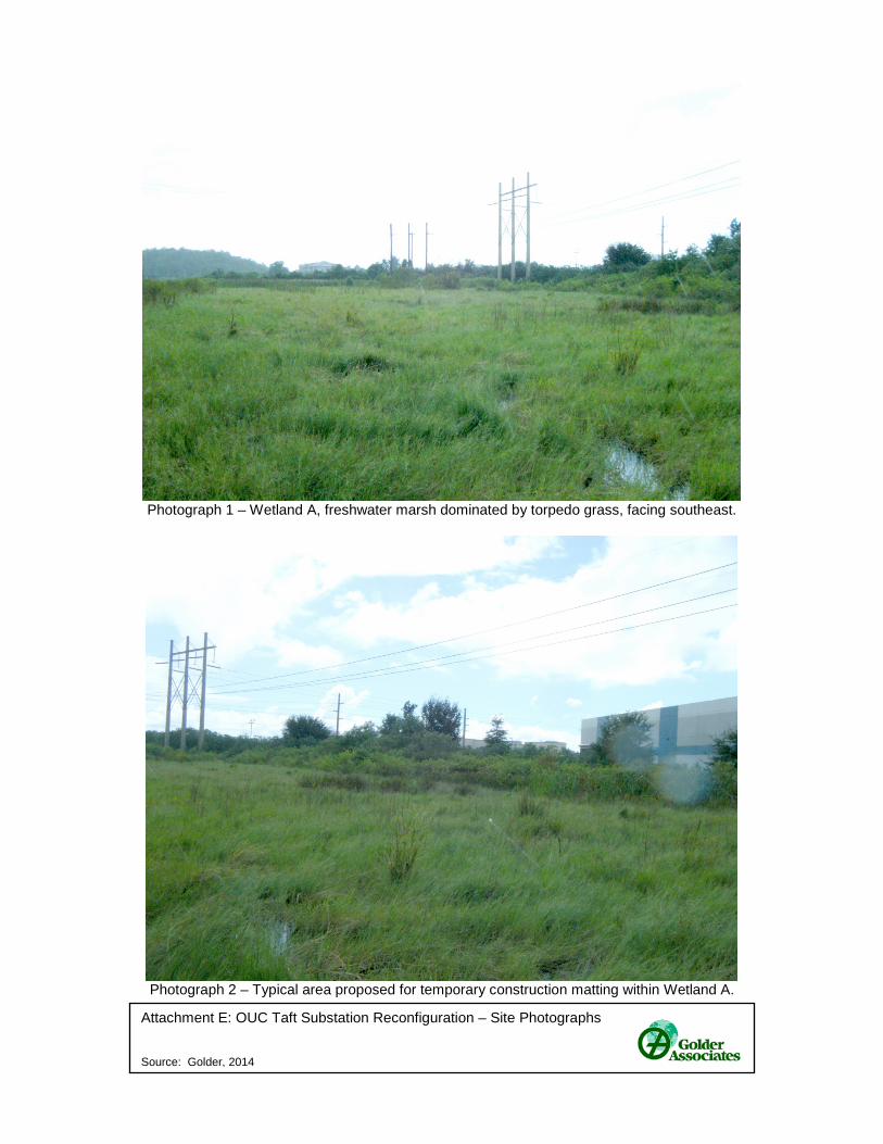
Attachment E: OUC Taft Substation Reconfiguration – Site Photographs Source: Golder, 2014
Photograph 1 – Wetland A, freshwater marsh dominated by torpedo grass, facing southeast.
Photograph 2 – Typical area proposed for temporary construction matting within Wetland A.
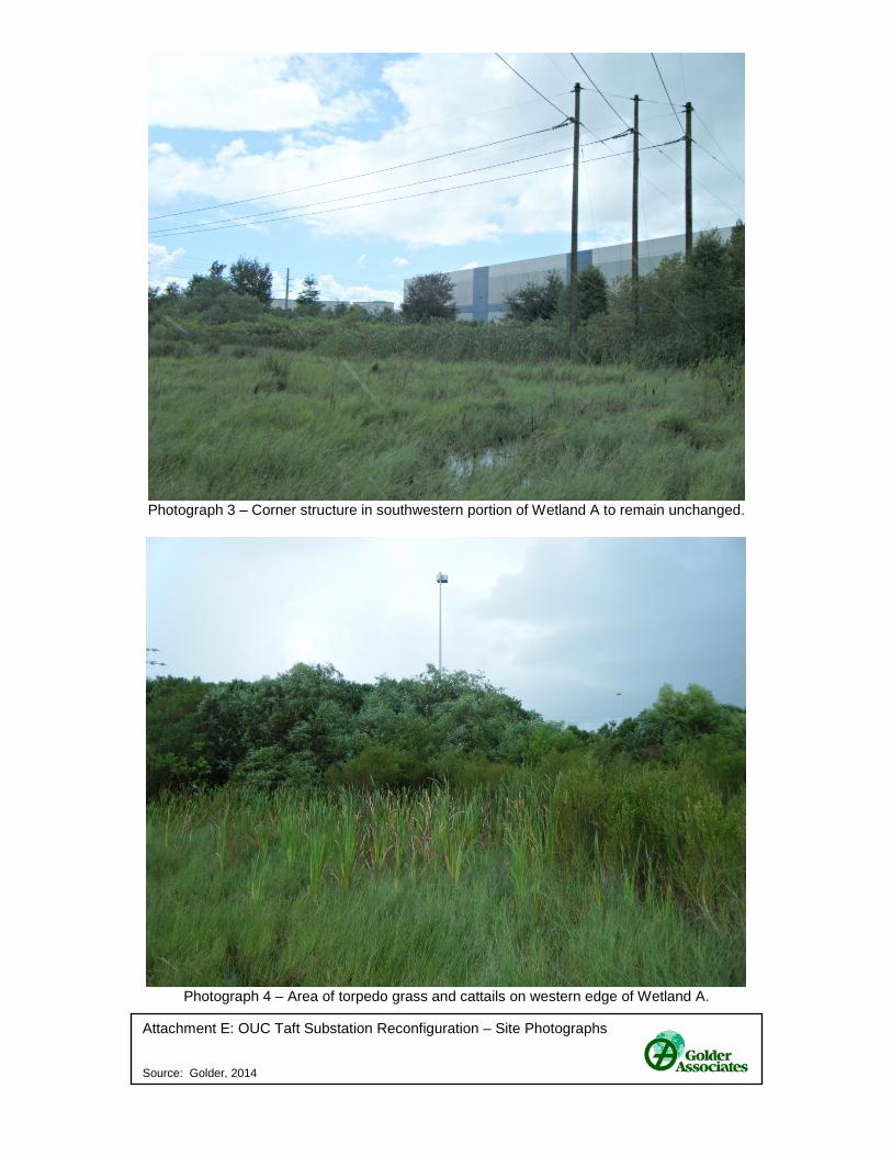
Attachment E: OUC Taft Substation Reconfiguration – Site Photographs Source: Golder, 2014
Photograph 3 – Corner structure in southwestern portion of Wetland A to remain unchanged.
Photograph 4 – Area of torpedo grass and cattails on western edge of Wetland A.
Attachment E: OUC Taft Substation Reconfiguration – Site Photographs Source: Golder, 2014
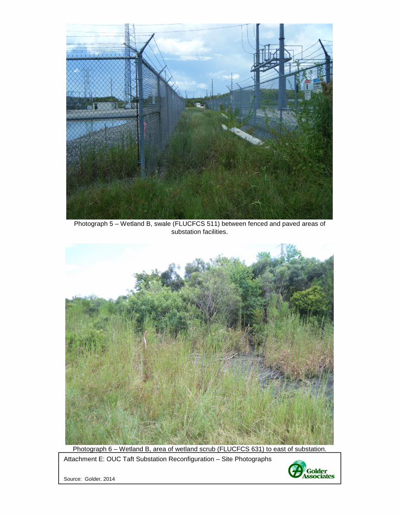
Photograph 5 – Wetland B, swale (FLUCFCS 511) between fenced and paved areas of
substation facilities.
Photograph 6 – Wetland B, area of wetland scrub (FLUCFCS 631) to east of substation.