golder - higp. · pdf filegolder associates 18300 ne union hill road, suite 200 redmond, w a...
TRANSCRIPT

Golder Associates 18300 NE Union Hill Road, Suite 200 Redmond, W A 98052-3333 Telephone Fax
TO: Distribution
SENT VIA:
~ Federal Express
D U.S. Mail
D Courier
D Hand Delivery
D Other:
i
TRAN$MITTAL LETTER
.Golder ~ l\ssociates
DATE: March 18,2003
PROJECT NO.: 963-1532.3115
c:::;:)
:::0("") (.a,) l'T1o ?.3:s: !5 :::0 ~= 3.: ;;v v=; 11'1 ("') (./1 (') rn-3:2 CD rn 'i,. :';
< Zz " > :1'1 (:i")~ -rn .. CJ ~::::; . -, ~ 2:::0
~
See below Technical Memorandum
ANALYTICAL RESULTS OF GROUNDWATER SAMPLES COLLECTED FROM THE PEARL HARBOR (EW A-KUNIA MAUIE:1\) DEEP EXPLORATORY WELL U\OOL~ 02-
REMARKS:
Per Gary Zimmerman/tv
Distribution:
Janet Rosati / US EPA / 2 copies Jeff Cotter / CH2M Hill /1 copy
Dated: March 18,2003 \tlta..L ~O. ?-~4D? ~
Eric Sadoyama / State of Hawaii DOH /1 copy Calvin Oda / Del Monte / 1 copy Tony Garvin / Morgan Lewis Bockius /1 copy Glenn Bauer / State of Hawaii / 1 copy

- -

I I I I I I I I I I I I I I I I I
Golder Associates Inc.
18300 NE Union HIli Road, Suite 200 Redmond, WA USA 98052-3333 Telephone Fax www.golder.com
REC'E1VED
03 MAR 19 pi: 31
TE@W~~RANDUM RESOUHCE MANAGEMENT
TO: EPA Region IX, Ms. Janet Rosati DATE:
FR: Douglas Dunster - Golder Associates Inc. OUR REF: Gary Zimmerman - Golder Associates Inc 1--
March 18, 2003
963-1532.3115
RE: ANALYTICAL RESULTS OF GROUNDWAT~R SAMPLES COLLECTED FROM THE PEARL HARBOR (EWA-KUNIA ~fAUKA) DEEP EXPLORATORY WELL
..rt\OQ\.k ~~. '?-'l-A-O"?,p10~ 7
SUMMARY
In accordance with the procedures described in the EPA approved Sampling and Analysis Plan (SAP), the deep basal monitoring well in the Ewa-Kunia Aquifer System (the Deep Exploratory Well) was sampled on February 11, 2003. Golder Associates Inc. (Golder) sampled the well with the assistance of the State of Hawaii Department of Land and Natural Resources (DLNR) using an electronic point source sampler. Two water quality samples were collected - one at a depth of 50 feet below the top of the water, and one at a depth of 100 feet below the top of the water. The samples were analyzed for volatile organic compounds (VOCs) by EPA Method 8260B and for ethylene dibromide (EDB) and 1,2-dibromo-3-chloropropane (DBCP) by EPA Method 504.1. No compounds were detected in either sample (i.e. all non-detects).
INTRODUCTION
During the summer of 2002, the State of Hawaii Commission on Water Resource Management -Department of Land and Natural Resources (DLNR) installed a groundwater monitoring well in the Ewa-Kunia Basal Aquifer System (well name: Pearl Harbor (Ewa-Kunia Mauka) Deep Exploratory Well). The DLNR has installed the new Deep Exploratory Well to monitor salt-water intrusion within the Ewa-Kunia Aquifer System. The well was constructed to extend through the fresh-water lens and into the saline portion of the aquifer. A solid steel casing extends from the surface to a depth of 660 feet. The well is an open-hole in the basalt bedrock beneath the casing.
In association with the Del Monte Corporation (Oahu Plantation) Superfund site (the Site) study, Del Monte Fresh Produce (Hawaii), Inc. (DMFP) requested permission from DLNR to collected groundwater quality samples from the new Deep Exploratory Well. The well is installed in the same aquifer system and approximately 3.75 miles downgradient ofthe Kunia Well (see Figure 1). DLNR agreed to sampling of the Deep Exploratory Well, but requested that the sampling be conducted with their assistance and that the well be sampled using a point source sampler versus pumping of the well. The DLNR do not want to artificially change the distribution of saline water in the well. Since samples were to be collected in the open-hole portion of the well, typical purging of potentially
I : 1~----------------------
OFFICES ACROSS AFRICA, ASIA, AUSTRALIA, EUROPE, NORTH AMERICA AND SOUTH AMERICA
-

• -III!! III
! " I :::: .. ' III I (. I ...
l1li
III III
• ! .. III III
III -.. -!IIIl .. IIIIJ! -• .. III ... III Wi , ill
I I I I I

I
I I I I I I I I I I I I I I I
March 18, 2003 -2- 963-1532.3115
stagnant well water was not necessary. In conjunction with DLNR, Golder prepared a sampling and analysis plan (SAP) describing the sampling procedures, sample depths, and analytical testing associated with sampling the Deep Exploratory Well. Final approval of the SAP was provided by EPA and the well was sampled on February 11, 2003.
Well Sampling and Analysis
Prior to sample collection the static water level inside the well casing was measured using an electronic water level sounder. The water level was 630.98 feet below the top of casing survey mark, which has an elevation of 646.46 feet above mean sea-level (amsl); thus, the resultant water level elevation was 15.48 ft amsl. The DLNR used an Auslog A033 fluid sampler tool to collect groundwater samples from the Deep Exploratory Well. The A033 sampler is a stainless steel electronic sampler that collects a I-liter sample from predetermined depths. The sampler was lowered down the well to the desired sampling depths using a tri-pod winch system equipped with a depth counter. A motor control valve on the sampler was opened from a logging system at the surface allowing water to enter the sample chamber. The valve was then closed and the sampler brought to the surface. The outside of the sampler was rinsed with deionized water and dried with a clean cloth to prevent water on the outside of the sampler from entering the water quality samples. Water was then discharged from the sampler's bottom valve outlet directly into a I-liter glass sample jar provided by the laboratory. The water was then immediately transferred into the VOA vials required for the 8260B and 504.1 analysis. A new I-liter jar was used for each sample. The water discharges too rapidly to appropriately fill the VOA vials directly from the Auslog sampler.
The sampler was decontaminated prior to sample collection and between samples. Decontamination was conducted by performing a non-phosphate detergent (Alconox) wash, a deionized water rinse, followed by a reagent grade methanol rinse and a final double rinse with laboratory certified clean water.
One groundwater sample was collected at a depth of approximately 50 feet below the top of the water (680 feet bmp). This depth is 18 feet below the bottom of the steel casing, and is in the open-hole portion of the well. A second groundwater sample was collected in the open-hole portion of the well at a depth of approximately 100 feet below the top of the water (730 feet bmp). The depth interval of 50 to 100 feet below the top of the water covers the depths where water supply pumps would likely be installed within wells in the Ewa-Kunia Aquifer system.
Groundwater samples were analyzed for ethylene dibromide (EDB) and dibromochloropropane (DBCP) by EPA Method 504.1; and VOCs by EPA Method 8260B. Groundwater samples were transferred under chain of custody documentation to Sequoia Analytical, located in Petaluma, California, for chemical analyses.
Analytical results were validated by a Golder chemist and entered into the project database. EDB, DBCP, 1,2,3-TCP, DCP and other VOCs were not detected in either of the groundwater samples collected from the Deep Exploratory Well. The attached Table I presents a summary of the test analytes, laboratory detection limits and reporting limits. A copy of the laboratory report is attached.
031803glzl.doc Golder Associates
-

c r ..
I I I I I I
I I I I I I I I I
March 18, 2003 TABLE 1
031803g1z1
Pearl Harbor (Ewa-KuniaMauka) Deep Exploratory Well February 2003 Groundwater Sampling Analytical Results
DM00626 DM00627 DM00628 ANALYTE 50 ft btw 100 ft btw Trip Blank
Method 504.1
1,2-Dibromo-3 -chloropropane ND ND ND
1,2-Dibromoethane (EDB) ND ND ND
Method 8260B
1,1,2-Trichloropropane ND ND ND
1,1-Dichloro-l-nitroethane ND ND ND
1 2,3-Trichloropropane ND ND ND
1,2-Dibromo-3-chloropropane ND ND ND
1,2-Dibromoethane (EDB) ND ND ND
1,2-Dichloropropane ND ND ND
2 3-Dichloro-l-propene ND ND ND
3,3 -Dichloropropene ND ND ND
Benzene ND ND ND
Bromomethane ND ND ND
Carbon tetrachloride ND ND ND
cis-l,2-Dichloroethene ND ND ND
cis-l,3-Dichloropropene ND ND ND
Ethylbenzene ND ND ND
Toluene ND ND ND
trans-l ,2-Dichloroethene ND ND ND
trans-l 3-Dichloropropene ND ND ND
Trichloroethene ND ND ND
Trichloronitromethane ND ND ND
Xylenes (total) I ND ND ND
ND - Not Detected ft btw - feet below top of water - represents depth where sample was collected DL - Detection Limit RL - Reporting Limit Samples Collected on February 11,2003
Golder Associates
963-1532-3115
DL RL UNITS
0.0053 0.01 ug/l
0.011 0.02 ug/l
0.5 0.5 ug/l
0.5 0.5 ug/l
0.08 0.8 ug/l
0.29 1 ug/l
0.04 0.5 ug/l
0.07 1 ug/l
0.5 0.5 ug/l
0.5 0.5 ug/l
0.05 1 ug/l
0.19 1 ug/l
0.06 1 ug/l
0.09 1 ug/l
0.08 0.5 ug/l
0.1 1 ug/l
0.07 1 ug/l
0.09 1 ug/l
0.07 0.5 ug/l
0.06 1 ug/l
0.5 0.5 ug/l
0.28 1 ug/l
-

I I I I I I I I I I I I I I I I I
N
~ /
LEGEND
Central AQUIFER SECTOR NAME
APPROXIMATE GROUNDWATER FLOW DIRECTION
)8( WELL LOCATION
(15.5ft AMSL)2 STATIC WATER LEVEL
': MEASURED 2/18/98 2: MEASURED 2/11/03
Drawing file: 96315323115F01.dwg Mar 17. 2003 - 4:25pm
1500 3000 METERS
o
FIGURE 1 BASAL AQUIFER WELL LOCATIONS
DEL MONTE/OAHU/HI
Golder Associates

,.. I ... ro Sequoi~ t ,., AnalytIcal
C
""" 1
c
-" .. c ; I I I I I
Sequoia Analytical
Golder Associates, Inc.
Level IV DATA PACKAGE
for
DELMONTE Oahu Plantation
Sequoia Analytical Work Order Number P302156
Submitted by:
Sequoia Analytical Petaluma Laboratory
1455 McDowell Blvd. North, Suite D Petaluma, CA 94954
March 5,2003
1455 McDowell Blvd. North, Ste. D Petaluma, CA 94954
FAX
www.sequoialabs.com
1

r .. I t ,... Ii. PI .. ,... L.
r" .. r Ii.
... I .. ,.. l .. ,.. , I .. -t I. -I.
,. ill
I I I I I
1.
2.
3.
4 .
5 .
6.
TABLE OF CONTENTS Work Order No. P302156
Level IV
Case Narrative ................................................................................... 3
Chain of Custody Documentation .................................................... .4
Sample Identification Cross Reference ............................................. 8
Analytical Results (Summary Report) ............................................... 9
Summary Data Method 8260 .......................................................... 18
Summary Data Method 504.1 ....................................................... 168
There are 235 pages included in this data package.
2

E ffi Sequoia E "" Analytical
1455 McDowell Blvd. North, Ste. D Petaluma, CA 94954
FAX
www.sequoialabs.com
t
r .. ,.. I
c
c
i I I I I I
CASE NARRATIVE Level IV
Work Order Number: Client Project ID:
P302156 DelMonte
Condition on receipt/General Comments: The samples were received February 12, 2003. The temperature of the sample cooler upon receipt was six degrees Centigrade. All analytical testing was performed in accordance with the chain-of-custody.
Volatile compounds by Method 8260 All calibration and quality control sample results met the established acceptance criteria with the following exceptions:
The standards for 3,3-Dichloropropene, 1,1,2-Trichloropropane, 2,3-Dichloro-l-propene, 1,1-Dichloro-l-nitroethane, and trichloronitromethane are not currently available or are not standards held currently at Sequoia Analytical. A library search was performed on the requested samples and these analytes were reported as a tentatively identified compounds (TICs). Note that the reporting limits for the TIC compounds are estimated based on the calculation of ten percent of the concentration in the nearest internal standard.
Sample DM00626 was used for MSIMSD for batch 3020523. The carbon tetrachloride and trichloroethene recoveries were above the control limits in the MS and/or MSD. The batch was accepted based on acceptable LCS recoveries.
EDB and nBCP by EPA 504.1 Samples were sent under chain of custoqy to Sequoia Analytical in Morgan Hill. All samples were analyzed within specified holding times and met project acceptance criteria. All calibration and quality control sample results met the established acceptance criteria.
Sample DM00626 was used for MS/MSD for batch 3B19005. All recoveries were within control limits.
Prepared by 3

~ SEQUOIAANALYTICAL .. CHAIN OF CUSTODY
Company Name: l~()\~-4~' ~.sS~tl\'~"\-\.s. s:-.{\\ ~~~. Mailing Address: \ ~ ~\J'\\ ~ '\C. \)i\"x\\"" ~\
o 885 Jarvis Drive • Morgan Hill, CA 95037 • ( o 1455 McDowell Blvd, Suite D. • Petaluma, CA 94954· o 819 Striker Ave., Suite 8 • Sacramento, CA 95834. ( ~ o 1551 Industrial Road • San Carlos, CA 94070. o 404 N. Wiget Lane • Walnut Creek, CA 94598.
Project: ~{(J. -\"' \ ')"?, £..3 \ \ l) ~ \i\~"ffl-~ Billing Address (if different):
CitY:R~,cl ~.(\{'\l\ State:\\11'''' ~ Zip Code: ~ ~n '51, Telephone: Fax#: L..\ '2..~ %'2" ~I.\~~' P.O.#: .I
Report To: D(l~" C\I l\t\ \or- E-mail Address: QC Data: o Levell! (standard) o Level II! fiif Level IV
Sampler: \!...t\f\.l ""'[;-\~~~ t'~k-.. Date I Time Results Required: Sequoia's Work Order #
Turnaround 0 10-15 Working Days 0 72 Hours MANDATORY: ANALYSES REQUESTED (Please orovide method) Time: (Standard TAT) 0 48 Hours CI SDWA (Drin~ng W_I ~ -/ 0 7 Working Days 0 24 Hours o CWA (Waste Water) . ,-'V ~
0 5 Working Days 0 2-8 Hours o RCRA (Hazardous Waste) 1S'.;P!Co: .. '\:::) o Other ~ ~
... ~_~J ~. "' ..... C1ient Date I Time Matrix # of Container Sequoia's ~-~ .. ~~/ Comments!
Sample 1.0. Sampled Desc. Cont. Type Sample # Temp.(lf required)
1. bt'1\C10 ~ 2Cn 2:\\'O~ \\()5\ VI 'Lf Vlf\ P?Da.)%-d 'f... X ~~t.~~~~~ 2. D{1\Q~ ~ L"\ 1:-\\'\))1 \\ \~ Y'f ~ ~ "X ~.
3.U~G~ ~ 1.~ 1.-\\~) L.~'>y, W 1- 'tJ -.....-I ....... -((3 'Iv ~ I
4.
5. C(
6. ~Iit: d'1ddf~ QINrACTn .-'
Not MAtt B 7. ",;.. 0'. )III;'>£; •. , ". A
-'" & -"""·lJIIC I ..... f~,{ "c: 8.
9.
10.
Relinquished By: ~ ~~\.\J r--.... --- Received By: ,,1\ Date / Time: I~\\~~ . \ ~()~ Relinquished By: 'VI' l\ v -........-.. Received By: ( ~Ol'A'Y\ Date / Time: J.rl"~ II?;(J
Relinquished By: ,.
Received By: v
Date/Time: Relinquished By: Re~edBy: Date I Time:
Were Samples Received in Good Condition? ~ Yes Cl No Samples on Ice? ~ Yes Cl No Method of Shipment: Di:J. L Pagelof-L
White: Sequoia Yellow: Sequoia Pink: Client
Q
Iil8 __ IIT.":'.:'13I .... .,ra --- .: .. ,
~ - - - - - -

SEQUOIA ANALYTICAL SAMPLE RECEIPT LOG . :.:, •.. :.;. •• :.-:.:.!o» •. :.;«y ....•. Yi'; •••• d'~:-'-':' : : ....• ~:>:-.«"':,oI>:,., :. ',..,;.; • , " ' "
CLIENT NAME: ~ ~a}e<: DATE Received at Lab: ~--f~ (Drinking water) for
IJ~:1l .. ~ REC. BY (pRIN1) PrfiJ WORKORDER: ~~Oal~
CIRCLE THE APPROPRIATE RESPONSE
~
1. Custody Seal(s) Presentl~ Intact I Broken*
2. Chain-of-Custody ~/Absent* 3. Traffic Reports or - ...,
Packing List: present/~ 4. Airbill: ~~ ;;Presena, r" !IV
5. Airbill #: 'i3Jl ~~g-x-6. SamQle Labels: 1'6:~ I Absent
7. Sample IDs: ~ I Not Listed
o!W,,;,hain-of-Custody , ~/Broken*1 8. Sample Condition:
" Leaking* 9. Does information on
custody reports, traffic
~ reports and sample
~/No* labels agree? -10. Sample received within ,. (JS/NO* hold time:
:. 11. Proper Preservatives
~/NO* .f, used:
; 12. Temp Rec. at Lab:
.' (Acceptance range for samples
! requiring thermal pres.:4+1-2°C) ,:.;~ .• :." -..:,'.: >oI~.::>io:> .x!»;.~x;,-.: ,',"'-; "
Sample Receipt Log Revision 2.1 (11/10100) Replaces Revision 2 (11I00l00)
"""(oJ
\Q/NO*
1M lirlve 1Ir.. La
TIME Received at Lab: regulatory purposes:
LOGIN DATE: J.lt;>.. B (Wastewater) for
regulatory purposes: YE~ LAB SAMPLE DATE
SAMPLE # # CLIENTID DESCRIPTION MATRIX SAMPLED CONDITION (ETC.)
D_M QOll#-Jc 11j:.}v I~ WM? w ?-II ~"1 1-i~ v, '), Yo IA ~ I 1
'V (,22" '0/_11lV \V \1/ I
""" ............... r-....... i'..... I \
'I'-. ) / 'x ........... /" /
...... " ...... ~ / ~ " / /
""- / / ,,/~ I-....... ~ / ) /
""-/ r ~ / .' ""-. - --- L
""- V L .J,; ...... " L / 1 ')
L1 "I.. l I ~ /7J ./ ./ r? ........ - ~ "-'X J / ~/ ~.
/ --- '-/--- .~ V ~
L ..............
'" . *If Circled, contact Project Manager and attach record of resolution.
- - Page of _ .... -- ..

I Client:
Project:
[ Number:
Golder Associates
Del Montel Oahu Plantation
963-1532-3115
Sequoia ADalytical - Petaluma Internal Chain of Custody
Received: 02/12/03 11:30
Received By: Alfredo Lorenzo
TempeC): 6.1
P302156-01 (DM00626) Sampled 02/1110310:51 r ........ .............................. .-.--.- ... -........ -- ..... -... -- .. --.-------.---- .. -... ------ .. ---------- .. -.- ....... --- .. . III P302J56-0i C [VOA HCl} Out in
GeMS Volatiles 02/25103 I I :34 by YNB
L P3021~6~~2 ~~~~.6~~)Sampled 02/11./0~.~_~:14_ ... _ .. _ .. .......... __ ._ ..... _.. .... ____________________ ... _. P302J56-02 B [VOA HCl] Out In
GeMS Volatiles 02/25103 II :34 by YNB
L P302156-03 (DM00628) Sampled 02/11/03 12:00
I
I I I I I I I I I
P302i56-03 A [VOA HCl] Out
GeMS Volatiles 02/25103 11 :34 by YNB
In
P302156
Printed: 3/4/03 3:36:47PM
6
Page 1 of 1

III ffi Sequoi~ £ ~ AnalytIcal
; I
March 04 , 2003
I Doug Dunster Golder Associates
I 18300 N.E. Union Hill Rd, Suite 200 Redmond, WA 98052 RE: Del Montel Oahu Plantation I P302156
1455 McDowell Blvd. North, Ste. D Petaluma, CA 94954
FAX
www.sequoialabs.com
I Enclosed are the results of analyses for samples received by the laboratory on 02/12/03. If you have any questions concerning this report, please feel free to contact me.
I Sincerely,
I Ii I I I I I I I I I
A ELAP Certificate
7

I ~ Sequoia
I ~ Analytical
I
I I I I I I d1l:
I I I I I I
Golder Associates 18300 N.E. Union Hill Rd, Suite 200 Redmond WA, 98052
SampleID
DM00626
DM00627
DM00628
I Sequoia Analytical - Petaluma
I I
Project: Del Montel Oahu Plantation Project Number: 963-1532-3115 Project Manager: Doug Dunster
ANALYTICAL REPORT FOR SAMPLES
Laboratory ID
P302156-01
P302156-02
P302156-03
Matrix
Water
Water
Water
1455 McDowell Blvd. North, Ste. D Petaluma, CA 94954
FAX
www.sequoiaIabs.com
Date Sampled
02111103 10:51
02111103 11:14
02111103 12:00
Reported:
03/04/03 10:57
Date Received
02112/03 11:30
02112/03 11 :30
02/12/03 11:30
The results in this report apply to the samples analyzed in accordance with the chain of custody document. Unless otherwise stated, results are reported on a wet weight basis. This analytical report must be reproduced in its entirety.
8

I ~ Sequoia I '" Analytical
I Golder Associates
18300 N.B. Union Hill Rd, Suite 200
Redmond WA, 98052
Project: Del Montel Oahu Plantation
Project Number: 963-1532-3115 Project Manager: Doug Dunster
1455 McDowell Blvd. North, Ste. D Petaluma, CA 94954
FAX
www.sequoialabs.com
Reported:
03/04/03 10:57
I I
Volatile Organic Compounds by EPA Method 8260B Sequoia Analytical - Petaluma
Analyte Result MDL
I DM00626 (p3021 56-01) Water
Benzene
Sampled: 02111/03 10:51
ND 0.050 Bromomethane ND 0.19
I Carbon tetrachloride 1,2-Dibromo-3-chloropropane 1,2-Dibromoethane (BDB)
ND 0.060 ND 0.29 ND 0.040
cis-l,2-Dichloroethene ND 0.090
I trans-l,2-DichloToethene 1,I-Dichloro-I-nitroethane
ND 0.090 ND 0.50
1,2-Dichloropropane ND 0.070 2,3-Dichloro-l-propene
E 3,3-Dichloropropene ~ j
cis-l ,3-Dichloropropene
ND 0.50 ND 0.50 ND 0.080
trans-l,3-Dichloropropene ND 0.070
t Bthylbenzene Toluene Trichloroethene
ND 0.10 ND 0.070 ND 0.060
Trichloronitromethane ND 0.50
L 1,1,2-Trichloropropane 1,2,3-Trichloropropane
ND 0.50 ND 0.080
Xylenes (total) ND 0.28
C Surrogate: Dibromoj1uoromethane Surrogate: l,2-Dichloroethane-d4
/09% 114%
Surrogate: Toluene-d8 104%
C Surrogate: 4-Bromoj1uorobenzene /06%
I I I I Sequoia Analytical - Petaluma
I I
Reporting Unlit Units Dilution
Received: 02/12/03 11:30
1.0 ugfl
1.0 1.0 1.0
0.50 1.0 1.0
0.50 1.0
0.50 0.50 0.50 0.50
1.0 1.0 1.0
0.50 0.50 0.80
1.0
88-118 81-130 84-115 78.124
Batch Prepared Analyzed
3020523 02/25/03 02/25/03
Method
EPA 8260B
Notes
AF-T
AF-T
AF-T
AF-T
AF-T
The results in this report apply to the samples analyzed in accordance with the chain of custody document. Unless otherwise stated. results are reported on a wet weight basis. This analytical report must be reproduced in its entirety.
9 P~~c ~ VI IV

I ~ Sequoia
I ~ Analytical
1455 McDowell Blvd. North, Ste. D Petaluma, CA 94954
FAX
www.sequoialabs.com
I I I I I I I I ~j!l
E I I I I I I I I
Golder Associates
18300 N.B. Union Hill Rd, Suite 200 Redmond W A, 98052
Analyte
Project: Del Montel Oahu Plantation
Project Number: 963-1532-3115
Project Manager: Doug Dunster
Volatile Organic Com ounds by EPA Method 8260B Sequoia A alytical - Petaluma
Result MDL Units Dilution Batch Prepared Analyzed
Reported:
03/04/03 10:57
Method Notes
DM00627 (P302156-02) Water Sampled: 02111/03 11:14 Received: 02/12/03 11:30
Benzene Bromomethane Carbon tetrachloride 1,2-Dibromo-3-chloropropane 1,2-Dibromoethane (EDB) cis-I,2-Dichloroethene trans-I,2-Dichloroethene I,I-Dichloro-l-nitroethane 1,2-Dichloropropane 2,3-Dichloro-l-propene 3,3-Dichloropropene cis-I,3-Dichloropropene trans-l,3-Dichloropropene Ethylbenzene Toluene Trichloroethene Trichloronitromethane 1,1,2-Trichloropropane I ,2,3-Trichloropropane Xylenes (total)
Surrogate: Dibromojluoromethane Surrogate: 1,2-Dichloroethane-d4
Surrogate: Toluene-d8 Surrogate: 4-Bromojluorobenzene
Sequoia Analytical - Petaluma
ND 0.050
ND 0.19 ND 0.060 ND 0.29 NO 0.040 ND 0.090 NO 0.090
NO 0.50 NO 0.070 NO 0.50 ND 0.50 ND 0.080 ND 0.070
ND 0.10 ND 0.070
ND 0.060
ND 0.50
NO 0.50 ND 0.080
ND 0.28
110% 113%
103% 104%
1.0 1.0 1.0 1.0
0.50 1.0 1.0
0.50 1.0
0.50 0.50 0.50 0.50
1.0 1.0 1.0
0.50 0.50 0.80
1.0
88-118
81-130 84-115
78-124
ugII 3020523 02/25/03 02/25103 EPA 82608
AF-T
AF-T
AF-T
AF-T
AF-T
The results in this report apply to the samples analyzed in accordance with the chain of custody document. Unless otherwise stated, results are reported on a wet weight basis. This analytical report must be reproduced in its entirety.
10
-----------------------------------------------------------------------------------~, ~

I
I I I I
[ ,. L
I I I
Sequoia Analytical
Golder Associates
18300 N.B. Union Hill Rd, Suite 200
Redmond WA, 98052
Project: Del Monte! Oahu Plantation
Project Nwnber: 963-1532-3115
Project Manager: Doug Dunster
Volatile Organic Compounds by EPA Method 8260B Sequoia Analytical - Petaluma
Reporting Analyte Result MDL Limit Units Dilution Batch Prepared
DM00628 (P302156-03) Water Sampled: 02/11/03 12:00 Received: 02112/03 11:30
Benzene NO 0.050 1.0 ug/J 3020523 02125/03
Bromomethane ND 0.19 1.0 Carbon tetrachloride NO 0.060 1.0 1,2-Dibromo-3-chloropropane ND 0.29 1.0 1,2-Dibromoethane (EDB) NO 0.040 0.50 cis-I,2-Dichloroethene NO 0.090 1.0 trans-l,2-Dichloroethene ND 0.090 1.0 I,I-Dichloro-I-nitroethane ND 0.50 0.50 1,2-Dichloropropane ND 0.070 1.0 2,3-Dichloro-I-propene NO 0.50 0.50 3,3-Dichloropropene ND 0.50 0.50 cis-I ,3-Dichloropropene ND 0.080 0.50 trans-I,3-Dichloropropene NO 0.070 0.50
Ethylbenzene NO 0.10 1.0 Toluene NO 0.070 1.0 Trichloroethene ND 0.060 1.0 Trichloronitromethane ND 0.50 0.50 I, I ,2-Trichloropropane ND 0.50 0.50 1,2,3-Trichloropropane ND 0.080 0.80
Xylenes (total) ND 0.28 1.0
Surrogate: DibromoJluoromethane 107% 88-118 . Surrogate: 1.2-Dichloroethane-d4 112% 8/-130
Surrogate: Toluene-d8 104% 84-115
Surrogate: 4-BromoJluorobenzene /05% 78-124
1455 McDowell Blvd. North, Ste. D Petaluma, CA 94954
FAX
www.sequoialabs.com
Analyzed
02/25/03
Reported:
03/04/03 10:57
Method Notes
EPA 8260B
AF-T
AF-T
AF-T
AF-T
AF-T
I Sequoia Analytical- Petaluma The results in this report apply to the samples analyzed in accordance with the chain of custody document. Unless otherwise stated. results are reported on a wet weight basis. This analytical report must be reproduced in its entirety.
I 11 PIl15"" VI 1-.1
I

I ffi Sequoia I '" Analytical
I Golder Associates
18300 N.E. Union Hill Rd, Suite 200
Redmond W A, 98052
Project: Del Monte! Oahu Plantation
Project Number: 963-1532-3115 Project Manager: Doug Dunster
1455 McDowell Blvd North, Ste. D Petaluma, CA 94954
FAX
www.sequoialabs.com
Reported:
03/04/03 10:57
I EDB and nBCP by EPA Method 504.1 Sequoia Analytical - Morgan Hill
I Analyte Result MDL
I DM00626 (P302156-01) Water Sampled: 02lll/03 10:51
1,2-Dibromoethane (EDB) ND 1,2-Dibromo-3-chloropropane ND
I Surrogate: 1,3-Dibromopropane 66.4 %
DM00627 (P302156-02) Water Sampled: 02/11/03 11:14
1,2-Dibromoethane (EDB) ND
I 1 ,2-Dibromo-3 -chloropropane ND
Surrogate: 1,3-Dibromopropane 69.6%
DM00628 (P302156-03) Water Sampled: 02/11/03 12:00
I 1,2-Dibromoethane (EDB) ND
_~!..~.:pibromo-3-chloropropane ND
Surrogate: 1,3-Dibromopropane 70.3 %
t
I I I I Sequoia Analytical - Petaluma
I I
Reporting
Limit Units Dilution Batch Prepared Analyzed Method Notes
Received: 02/12/03 11:30
0.020 ug/l 3819005 02/19/03 02/19/03 EPA 504.1 0.010
37-/02
Received: 02112/03 11:30
0.020 ug/l 3819005 02/19/03 02/19/03 EPA 504.1 0.010
37-102
Received: 02112103 11:30
0.020 ug/l 3819005 02/19/03 02/19/03 EPA 504.1
0.010
37-102
The results in this report apply to the samples analyzed in accordance with Ihe chain of custody document. Unless otherwise stated, results are reported on a wet weight basis. This analytical report must be reproduced in its entirety.
12 P:...o _____ J

lei:) I ,.,
Sequoia Analytical
I I
Golder Associates
18300 N.E. Union Hill Rd, Suite 200 Redmond WA, 98052
Project: DeI Monte/ Oahu Plantation
Project Number: 963-1532-3115 Project Manager: Doug Dunster
1455 McDowell Blvd. North, Ste. D Petaluma, CA 94954
PAX
www.sequoialabs.com
Reported,
03/04/03 10:57
SpAfceeJ
Volatile Organic Compounds by EPA Method 8260B - Quality Control Sequoia ADalytical - Petaluma
I Analyte Result
Batch 3020523 - EPA 5030 waters
Blank (3020523-BLK1)
I Benzene ND
Bromomethane ND
Carbon tetrachloride ND
I 1,2-Dibromo-3-chloropropane ND
! ,2-Dibromoethane (EDB) ND
cis-l,2-Dichloroethene ND
I trans-! ,2-Dichloroethene ND
l, l-Dich!oro-I-nitroethane ND
!,2-Dichloropropane ND
I 2,3-Dichloro-I-propene ND
3,3-Dichloropropene ND
cis-!,3-Dichloropropene ND
I trans-I,3-Dich!oropropene ND
Ethylbenzene ND
Toluene ND
I Trichloroethene ND
Trichloronitromethane ND
1,1,2-Trichloropropane ND
1,2,3-Trichloropropane ND
I Xylenes (total) ND
Surrogate: Dibromofluoromethane 5.31
Surrogate: 1.2-Dlchloroethane-d4 5.36
I Surrogate: Toluene-d8 5.12
Surrogate: 4-Bromojluorobenzene 5.37
LCS (3020523-BS1)
I Benzene 4.97
Bromomethane 5.14
Carbon tetrachloride 5.88
I 1,2-Dibromo-3-chloropropane 5.18
I ,2-Dibromoethane (EDS) 5.44
cis-I,2-Dichloroethene 5.13
I Sequoia Analytical - Petaluma
I I
MDL
0.050
0.19
0.060
0.29
0.040
0.090
0.090
0.50
0.070
0.50
0.50
0.080
0.070
0.10
0.070
0.060
0.50
0.50
0.080
0.28
0.050
0.19
0.060
0.29
0.040
0.090
Reporting Limit Units
Spike Level
Source Result %REC
%REC Limits RPD
RPD Limit Notes
1.0
1.0
1.0
1.0
0.50
1.0
1.0
0.50
1.0
0.5~
0.50
0.50
0.50
1.0
1.0
1.0
0.50
0.50
0.80
l.0
1.0
1.0
l.0
I.Q
0.50
1.0
Prepared & Analyzed: 02125/03 ug/I
5.00 106 88-118 5.00 107 81-130
5.00 102 84-115
5.00 107 78-124
Prepared & Analyzed: 02/25/03
ug/l 5.00 99 76-127
5.00 103 60-130
5.00 118 60-130
5.00 104 80-120
5.00 109 80-120
5.00 103 60-130
AF-T
AF-T
AF-T
AF-T
AF-T
The results in this report apply to the samples analyzed in accordance with the chain of custody document. Unless otherwise stated. results are reported on a wet weight basis. This analytical report must be reproduced in its entirety.
13

I ffi Sequoia I ~ Analytical
I Golder Associates
18300 N.E. Union Hill Rd, Suite 200
Redmond WA, 98052
Project:
Project Number:
Project Manager:
Del Montel Oahu Plantation
963-1532-3115
Doug Dunster
1455 McDowell Blvd. North, Ste. D Petaluma, CA 94954
FAX
www.sequoialabs.com
Reported:
03/04/03 10:57
I Volatile Organic Compounds by EPA Method 8260B - Quality Control
I Sequoia Analytical- Petaluma
Reporting Spike Source %REC RPD Analyte Result MDL Limit Units Level Result %REC Limits RPD Limit Notes
I Batch 3020523 - EPA 5030 waters
LCS P020523-BSl} Prepared & Anal~ed: 02/25/03 trans-I,2-Dichloroethene 4.87 0.090 1.0 ugIJ 5.00 97 60-130
I 1,2-0ichloropropane 5.06 0.070 1.0 5.00 101 60-130
cis-I,3-0ichloropropene 5.46 0.080 0.50 5.00 109 60-130
trans-I,3-0ichloropropene 5.48 0.070 0.50 5.00 110 60-130
I Ethylbenzene 5.21 0.10 1.0 5.00 104 60-130
Toluene 5.04 0.070 1.0 5.00 101 76-127
Trichloroethene 5.98 0.060 1.0 5.00 120 7\-120
I 1,2,3-Trichloropropane 5.14 0.080 0.80 5.00 103 60-130
Xylenes (total) 16.2 0.28 1.0 15.0 108 60-130
Surrogate: Dibromojluoromethane 5.27 5.00 105 88-1/8
Surrogate: 1,2-Dichloroethane-d4 5.31 5.00 106 81-130
£ ." Su"ogate: Toluene-d8 5.30 5.00 106 84-115
Surrogate: 4-Bromojluorobenzene 5.61 5.00 112 78-124
II"' Matrix S~ike {3020S23-MSl} Source: P302156-01 Pre2ared & Anal~ed: 02/25/03
"- Benzene 5.42 0.050 1.0 ugll 5.00 NO 108 76-127
Bromomethane 5.13 0.19 1.0 5.00 NO 103 60-130 , Carbon tetrachloride 6.69 0.060 1.0 5.00 NO 134 60-130 Q-LIM
1,2-0ihromo-3-chloropropane 5.60 0.29 1.0 5.00 NO 112 80-120
1,2-Dibromoethane (EOB) 5.96 0.040 0.50 5.00 NO 119 80-120
cis-I,2-0ichloroethene 5.78 0.090 1.0 5.00 NO 116 60-130
I trans-I,2-Dichloroethene 5.53 0.090 1.0 5.00 NO III 60-130
1,2-0ichloropropane 5.46 0.070 1.0 5.00 NO 109 60-130
cis-I,3-0ichloropropene 5.63 0.080 0.50 5.00 NO 113 60-130
I trans-! ,3-0ichloropropene 5.91 0.070 0.50 5.00 NO 118 60-130
Ethylbenzene 5.71 0.10 1.0 5.00 NO 114 60-130
Toluene 5.60 0.070 1.0 5.00 NO 112 76-127
I Trichloroethene 6.62 0.060 1.0 5.00 NO 132 71-120 Q-LIM
! ,2 ,3-Trichloropropane 5.41 0.080 0.80 5.00 NO 108 60-130
Xylenes (total) 17.6 0.28 1.0 15.0 NO 117 60-130
I Surrogate: Dibromojluoromethane 5.43 5.00 109 88-118
Surrogate: 1,2-Dichloroethane-d4 5.42 5.00 108 81-130
Surrogate: Toluene-dB 5.25 5.00 105 84-1/5
I Sequoia Analytical - Petaluma The results in this report apply to the samples analyzed in accordance with the chain oj custody document. Unless otherwise stated, results are reported on a wet weight basis. This analytical report must be reproduced in its entirety.
I 14
@ P _",_ . _ •• J
I

I ffi Sequoia I '" Analytical
I Golder Associates
18300 N.E. Union Hill Rd, Suite 200 Redmond WA, 98052
Project: Del Montel Oahu Plantation
Project Number: 963-1532-3115 Project Manager: Doug Dunster
1455 McDowell Blvd. North, Ste. D Petaluma, CA 94954
FAX
www.sequoialabs.com
Reported:
03/04/03 \0:57
I Volatile Organic Compounds by EPA Method 8260B - Quality Control Sequoia Analytical - Petaluma
I I I I t [ '" fJIIIII ~ .,
~ ."1
E I I I I I I
Analyte
Batch 3020523 - EPA 5030 waters
Matrix Spike (3020S23·MSl)
Surrogate: 4-BromofluorobellZene
Matrix Spike Dup (3020S23-MSDl)
Benzene
Bromomethane
Carbon tetrachloride
1,2-0ibromo-3-chloropropane
I ,2-0ibromoethane (EDB)
cis-I,2-0ichloroethene
trans-I,2-Dichloroethene
1,2-0ichloropropane
cis-I,3-0ichloropropene
trans-! ,3-0ichloropropene
Ethylbenzene
Toluene
Trichloroethene
1,2,3-Trichloropropane
Xylenes (total)
Surrogate: Dibromofluoromethane
Surrogate: 1,2-Dichloroethane-d4
Surrogate: Toluene-d8
Surrogate.' 4-BromofluorobellZene
Sequoia Analytical. Petaluma
Result
5.74
5.29
5.05
6.46
5.58
5.99
5.51
5.36
5.55
5.49
5.90
5.64
5.47
6.48
5.54
17.3
5.32
5.44
5.37
5.70
Reporting MDL Limit Units
Source:P302156-01
ugll
Source: P302156-01
0.050 1.0 ugll
0.19 1.0
0.060 1.0
0.29 1.0
0.040 0.50
0.090 1.0
0.090 1.0
0.070 1.0
0.080 0.50
0.070 0.50
0.10 1.0
0.070 1.0
0.060 1.0
0.080 0.80
0.28 1.0
Spike Level
Source Result %REC
%REC
Limits
Prepared & Analyzed: 02/25103
5.00 115 78-124
Prepared & Analyzed: 02125103 5.00 ND 106 76-127
5.00 ND 101 60-130
5.00 NO 129 60-130
5.00 ND 112 80-120
5.00 ND 120 80-120
5.00 ND 110 60-130
5.00 ND 107 60-130
5.00 ND III 60-130
5.00 ND 110 60-130
5.00 NO 118 60-130
5.00 ND 113 60-130
5.00 ND 109 76-127
5.00 ND 130 71-120
5.00 ND III 60-130
15.0 NO 115 60-130
5.00 106 88-118
5.00 109 81-130
5.00 107 84-115
5.00 114 78-124
RPD
2
2
3
0.4
0.5
5
3
2
3
0.2
2
2
2
2
RPD
Limit
II
20
20
20
20
20
20
20
20
20
20
13
14
20
20
Notes
Q-LIM
The results in this report apply to the samples analyzed in accordance with the chain of custody document. Unless otherwise stated, results are reported on a wet weight basis. This analytical report must be reproduced in its entirety.
15

I co Sequoia I ,., Analytical
i Golder Associates
18300 N.E. Union Hill Rd, Suite 200 Redmond WA, 98052
Project:
Project Nurnber:
Project Manager:
Del Monte! Oahu Plantation
963-1532-3115 Doug Dunster
1455 McDowell Blvd. North, Ste. D Petaluma, CA 94954
FAX
www.sequoialabs.com
Reported:
03/04/03 10:57
E r.] EDB and DBCP by EPA Method 504.1- Quality Control
L Analyte Result
I Batch 3B19005 - EPA 504
Blank (3B1900S-BLK1)
I ,2-Dibromoethane (EOB) NO
~ 1,2-0ibromo-3-chloropropane ND
Surrogate: 1,3-Dibromopropane 2.09
r'! LCS (3BI9005-BSI)
II I ,2-Dibromoethane (EOB) 0.228
1,2-Dibromo-3-chloropropane 0.220
"" Surrogate: 1,3-Dibromopropane 1.98
II Matrix Spike (3BI900S-MSI)
I ,2-Dibrornoethane (EDB) 0.257 ,.. 1,2-Dibromo-3-chloropropane 0.234
L Surrogate: 1,3-Dibromopropane 2.24
Matrix Spike Dup (3B19005-MSDl) ,. I ,2-Dibromoethane (EDB) 0.296 jc .. 1,2-Dibrorno-3-chloropropane 0.253 -----Surrogate: 1,3-Dibromopropane 2.00 ..
f' " ~ .. I I I I I Sequoia Analytical - Petalwna
I I
Sequoia Analytical- Morgan Hill
ReportiJ:lg Spike Source %REC RPD MDL Limit Units Level Result %REC Limits RPD Limit Notes
Prepared & Analyzed; 02119/03 0.020 ug/l
0.010
2.86 73.1 37-/02
Prepared & Analyzed; 02119/03
o.o~o ug/l 0.250 91.2 70-130
0.010 0.250 88.0 70-130
2.86 69.2 37-102
Source: P302156-01 Prepared & Analyzed: 02119/03 0.020 ug/l 0.250 ND 103 65-135
0.010 0.250 NO 93.6 65-135
2.86 78.3 37-/02
Source: P3021S6-01 Prepared & Analyzed; 02119/03
0.020 ug/l 0.250 ND 118 65-135 14.1 20
0.010 0.250 ND 101 65-135 7.80 20
2.86 69.9 37-102
The results in this report apply to the samples analyzed in accordance with the chain of custody document. Unless otherwise stated, results are reponed on a wet weight basis. This analytical repon must be reproduced in its entirety.
16 P -e>- - ._ - J
I ffi Sequoia I ~ Analytical
I I
Golder Associates
18300 N.E. Union Hill Rd, Suite 200
Redmond W A, 98052
Project: Del Monte! Oahu Plantation
Project Number: 963-1532-3115
Project Manager: Doug Dunster
Notes and Definitions
1455 McDowell Blvd. North, Ste. D Petaluma, CA 94954
FAX
www.sequoialabs.com
Reported:
03/04/03 10:57
I AF-T Tentatively identified compound (using GCIMS).
Q-LIM The percent recovery was outside of the control limits. The samples results may still be useful for their intended purpose.
I DET Analyte DETECTED
ND Analyte NOT DETECTED at or above the reporting limit
NR Not Reported
I dry Sample results reported on a dry weight basis
RPD Relative Percent Difference
I I I I I I I I I I Sequoia Analytical - Petaluma The results in this report apply to the samples analyzed in accordance with the chain of
custody document. Unless otherwise stated, results are reported on a wet weight basis. This analytical report must be reproduced in its entirety.
I 17
I

·' '.
(,,'J-~. . '.
For OfIlclal Use Only! r,
~~ . State of Haw8 \ RECEIVED • COMMISSION ON WATER REjro .. URCE MAN~.tGEMENT
Department of Land and Natural Resources.' .
WELL COMPLETION RE~ORT - PART ,i 0 MAY 13 9 53 . Well Construction , 'I A :.
Instructions: Please prtnt In Ink or type and send completed raport~i with attachments. If ~abIe) to the CommlsskJn on wtt.. R8SQU'Ce Management. P.O. Box 621. HonoIuI • HaweR 96809. The COmmissIOn may not accept InCcrnpIeta reports. ThIs form shaH be subrnlttedwilhln . d8ys of the completion of wortt.For i\W",e.t-INl ~u WlTFR" assistance. please consult the HawaII Wei construction and Punp I nation Standards or cal ihe RegulatIon . V. l''1h1.;) vn un H t: Branch lit 5174225. For updates to this form or addhlonat In nn.tlon. please visit ({if webstte at ESOURCE Mt.NAGEMI:NT hltp:/lwWw.state.ti.uslclnr/cwrml . •
M,\,O~
1. Island: Oahu ~~~~~~~~~~----- ------~---
2. Address: 9-2-04:05
3. OrUling Company: _W!!:a~e~r:..JS~QW(g;~..I.n:qeJ:na..uQWu.a-.J,;.~ ______________ ~.
4. Drilling method used during contructlon: XI Rota . 0 Percussion 10 Other (describe)
S. Date Well Construction (drilled.cased.grouted) COm~leted: 8/14/021 Fill out attached Driller's Log I' rnonthId8y1ye11~
In .ddltlon to the drflltll''s log. If. geologic log INS r' plNse submit t"" this form.
6. Was the subject well cored? 0 Yes XX No; !
1. Initial water-level encountered 628.49 fl below\grOUnd Date and~e of measurement 6/17/02 i :OOPM ! . monttiIda)1)'ilar ;.dIne
8. Step-Drawdown Test completed? 00 No ~ Yes Attach Step-D~ Test I'om"l (12117"w7 SDPTDFomr)
9. Constant Rate Aquifer Test completed? ~ No ~ v,es Attach con.t Rate Aqulrw Test form (12117"-7 CRP1J'),Forn$
Parameters prior to pump test: NA i '
10. Water-level: _________ ft. abo~ msl Date and tlmd of measurement: -=:===-==--__ ! i montiiIdijtyear ttme
Date and time of sampling:
J monthfdaylyaar time' 11. Chloride: ________ ppm
12. Temperature: _______ ~ OF Date and tim of measurement: -===~=.,...-_ I rnonthIClllylyear lima'
13. Fill in the as-bullt section on the other side of t~l~ sheet. ,
i 14. Fill in attached surveyor's report. i . 15. If a pump Is not planned to be Installed. please de~~e(below In the rdm8!1(s section) how wen Is secur~ to
prevent unauthorized access (exampte: lockable ctv~r. threaded COUPII?g. etc.)
16. The proposed manufacturer's rated pump capactt}1ls; gpm at!" head of ft. .
17. Remarks: Well is secured with a lotk~ble cover. ~ i ' :
t i i
[ Water Resources In~l. Inc.
~Drill. :::2CU~~~:' c-17 L1c. No. _..!:.lA~C~50!ol.501J8,,--______ _
S~aMe~ ~ Permittee (print) ;£rec. T. ~(-a:K<J I 'C4c1ef' P,litel:
Signature
Z0 39'i7d
~~r~<~t~ i
, i , ,
, . I
3'i7HI'i7M'i7>i Iln:IM
I Date October 18, 2002
Date
weRT Form R/12101'PllgB 1 (J(4
999LZ88808
/
'I' • t. 'to • •
" '
'...1 '. ~
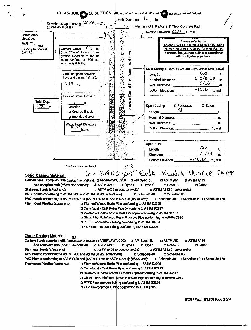
13. AS-BUlL OLL SECTIO~ ~D/ease attach as-buih if different G 'agrsm provided below)
Hole Diameter: 15 in. Elevation at top of casing 646.9i., msl° '\I--''f----+I (to nearest 0.Q1 ft.) --L _ Minimum of 2' Radius & 4" Thick Concrete Pad / I
rBend1:--:-
m-a-:rk---1----------.. 1> . .-.-.:;q ~~ r Ground Elevation:644.96 ft., msl
elevation: //1""\ ;.::~: :'.::',,/~" 'N~"
645.01/l., msl' :.:;. :':. Please refer to the
(Survey to nearest C( ement Gr~. 6)) f ft. ~:~. :::~ >-0.01 ft.) min. 70% Istance rom .... '.;.' ; '. Q)
ground elevation to top of ::.;.;. :;;. Ui water surface or 500 ft., :'.::' . Qj
HAWAII WELL CONSTRUCTION AND PUMP INSTALLATION STANDARDS to ensure that your as-built is in compliance
with applicable standards.
Ylhichever is less.) r--.;... >- ~ .~.~: ! .. ~:' s i'---- Solid Casing: (~ 90% x (Ground Elev.-Water Level Elev»
~:.{. H ~ Length: 660 ft. Annular space between hole and casing (min.3"):
3.18 in. tf .:........ ~ Nominal Diameter: 8 5/8 OD in. V:····: Q) 5/16
I--' ~ .. ;: :.:;.: ~ Wall Thickness: 4 in.
"---------' .. ,-.: :~ .. :.: .• :. ~_ Bottom Elevation: -15 .0 ft., msl
r-
T-o-ta
-
'
~--h--'--' r-R-ock-_-_or-?O:G:ra~veI~:-~-ck-in-g-: -'~C-I' i 1.35) ft. Material: ~ ~ />J
o Crushed Basalt ~ ~~
,-;::=2::::Roun==ded===Gra=v=e='::::::'-1 u ~ ~ V
W"~~~ Elevation: -'¥.,~. '3'~~r.GI""" _...,....._ft. msl' i:L.rViII1
1'· i:"':"""'~ N.
'----____ --J ~~/·<_;''7'TI·1 ~ l;~ c-
<;~,J . .. : .••.. il}t
~ _________ ~>~Z>.:.~I;~~"~:. __ .:~
Bottom Elevation: ________ ft., msl
Open Casing: 0 Perforated NA Length: ____________ ft.
o Screen
Nominal Diameter: ________ in.
Wall Thickness: in.
Open Hole: 725
Length: --------=7:-="7/-:-8:-ft. Diameter: ________ ....:.... __ in.
Bottom Elevation: -740.04 ft.,msl
°msl = mean sea level 0'Z-Solid C8slng Material: to" 1-40 ~ JYf ~l\ - \(U~lt>c \J\.\.QOLe ~ Carbon Steel: compliant with (checlc one or more): a ANSUAWWf\ C200 0 API Spec. 5L a ASTM A53 M ASTM A139
And CXJr11)IIant with (checlc one or morel: ~ ASTM A242 0 Type E 0 Type S a Grade B a Other Stainless Steel: (check one): 0 ASTM A409 (production wells) 0 ASTM A312 (monitor wells) ASS Plastic conforming to ASTM F480 and ASTM 01527: (checlc one) a Schedule 40 a Schedule 80 PVC Plastic conforming to ASTM F480 and (ASTM 01785 or ASTlIII 02241): (check one): a Schedule 40 a Schedule 80 a Schedule 120 Thermoset Plastic: (check one) a Filament Wound Resin Pipe conforming to ASTM 02996
a CentrifugaRy Cast Resir Pipe conforming to ASTM 02997
Open Casing Material: NA
o Reinforced Plastic Molt r Pressure Pipe conforming to ASTM 03517 o Glass Fiber Reinforced Resin Pressure Pipe conforming to AWWA C950 o PTFE Fluorocarbon TtJ 'ng conforming to ASTM 03296 a FEP FJuorocarbon Tubi ~ conforming to ASTM 03296
Carbon Steel: compliant with (checlc one or tm'e): a ANSIIAWW I' C200 0 API Spec. 5L 0 ASTM A53 a ASTM A 139 And compliant with (checlc one or moro): 0 ASTM A242 0 Type E 0 Type S a Grade B a Other
Stainless Steel: (check one): 0 ASTM A409 (Production wells) a ASTM A312 (monitor wells)
ASS Plastic conforming to ASTM F 480 and ASTM 01527: (check pne> C Schedule 40 C Schedule 80 PVC Plastic conforming to ASTM F480 and (ASTM 01785 or ASTI~ 02241): (check one): a Schedule 40 a Schedule 80 a Schedule 120
Thermoset Plastic: (check one) 0 Rament Wound Resin ~ conforming to ASTM 02996 a CentrifugaOy Cast Res/I Pipe conforming to ASTM 02997 a Reinforced Plastic Molt r Pressure Pipe conforming to ASTM 03517 C Glass Fiber Relnrorced Resin Presstn Pipe conforming to AWWA C950 a PTFE Fluorocarbon Tit ng conforming to ASTM 03296 a FEP Fluorocarbon TubllQ conforming to ASTM 03296
weR1 Form W12101 P8{J8 2 cI"

Depth Interval (ft.) 0-25 25-78 78-100 100-138 138-148 148-160 160-180 180-190 190-200 200-210 210-220 220-240 240-260 260-280 280-300 300-310 310-320 320-330 330-360 360-390 390-400 400-410 410-420 420-430 430-440 440-450 450-460 460-470 470-480 480-490 490-520 520-530 530-540 540-550 550-560 560-580 580-590 590-610 610-630 630-640 640-660 660-670
o I
Geologic Log Ewa-Ku ia Middle (2403-02) (Partial Log)
Description No sample collected Red-gray clay, soil, and grit (saprolite) Red clay Gritty brown/red clay Light gray weathered grit (sand siz cuttings) Same as above, except more clay Red grit and clay Same as above, except grayer
Q
Sand size gray cuttings with plagio lase feldspar phenocrysts Mixture of red and gray clay and s nd size cuttings Fine gray grit and clay Same as above, except lighter gra in color Red grit and some clay Stiff gray clay with fine sand size g it Mixture of red and gray clay and s nd size cuttings Reddish gray cuttings containing sightly weathered basalt Gray sand size cuttings Fine gray cuttings with prominent lagioclase feldspar Mixture of red and gray sand size uttings Dense gray aa angular vesicles pr sent Same as above, except cuttings a sand size Fine gray grit Gray dense aa and red sand size uttings Dark reddish brown sand size cutti gs with some clay Same as above, except cuttings a dense and larger Mixture of reddish brown sand siz cuttings and dense dark gray cuttings Reddish gray cuttings containing cay Dark gray aa with microphenocrys s of plagioclase feldspar Very fine sand size gray cuttings Dark gray dense aa Mixture of dense dark gray aa and red basalt Same as above, except minor mic ophenocrysts of olivine Dark gray sand size cuttings Reddish gray sand size cuttings Mixture of dark gray and red sand ize cuttings Mixture of dense dark gray aa and dnes red aa Mixture of light gray and red sand ize cuttings Mixture of dark gray aa and red sand size cuttings Same as above, except between 10 to 620 more red, and between 620 to 630 equal proportion Dark gray sand size cuttings with orne clay Dark gray sand size cuttings with icrophenocrysts of plagioclase feldspar Same as above, except sample c ntains microphenocrysts of olivine

LINDA LINGLE GOVERNOR OF HAWAII
Mr. Andrew Monden State of Hawaii
<:)
STATE OF HAWAII DEPARTMENT OF LAND AND NATURAL RESOURCES
COMMISSION ON WATER RESOORCEMANAGEMENT P.O. BOX 621
HONOLULU. HAWAII 96809
December 30,2003
Department of Land and Natural Resources Engineering Division 1151 Punchbowl St., Room 221 Honolulu, HI 96813
Dear Mr. Monden:
Well Completion Report for Well No. 2403-02
PETER T. YOUNG CHAIRPERSON
MEREDITH J. CHING CLAYTON W. DELA CRUZ
JAMES A. FRAZIER CHIYOME L. FUKINO. M.D. STEPHANIE A. WHALEN
ERNEST Y.W. LAU DEPUTV OIRECTOR
2403-02.wcr
We received your Well Completion Report Part I for the Ewa-Kunia Middle Deep Monitor Well (Well No. 2403-02) on May 21, 2003 and acknowledge that it is complete.
If you have any questions, please contact Lenore Y. Nakama of the Commission staff at
Sincerely,
~~u.~ ERNEST Y.W. LA<D ~-. Deputy Director
LYN:ss
c: The Estate of James Campbell

KLG August 2003
o Kunia Middle Deep Monitor Well
Kunia, Oahu, Hawaii TMK 9-2-004:05 Well No. 2403-02 As-E uilt Section
Drilling Comp eted August 9,2002
Q
Drilling Contractor: Water Resources International
Slab elevation 644.96 ft
670 '
1387 '
15.12'
--1-----25 '
717 '
_-'--__ ----J'----___ 742'
I"
(n t to scale)
Elevation top of casing 646.46 feet
Annulus grouted with 1: 1 sand-cement slurry, 12 Y4 " borehole
Solid Steel Casing 8" ID x 5/16" x 670 feet ASTMA-53
waterlevel (6/17/02)
Bottom of Casing (shoe)
Open hole minimum diameter 7 7/8"
Bottom of Well

o N
~ S<;.ole: I" = 2000'
Fe #1243 FN: &'OKunlaWell.di"ig
0'2--~<b..Lt ~. ~, ~AO? ~ ~II location
~II Name: Peal Harbor ~GI Kunia MaJka)
at Honoullull, E~a, Oahu, Ha~all Tax Map Ke~: '1-2-01 (1st Dlv)
R. M. 1OWIll. OORPORATION " ... 8 , ...
L1G8n58d Prof05!r1ona1 La\(j Surveyor Cet'UflG.ate tt.mber 1O<::)5q
420 ~lalcanllo Rood SUite 411 Honolulu, HoroAaIl q6&11 Octobet'· 24. 2002
.... .... I\) 01

o o
t ...

o o R£. CE. \\/ED
St~te of Hawaii \ '\ A 9: S Z Department of t.d and N~al~oUfces
Engi eering Division r:" , ,I ~t""'~ (\~ '?i ,,\ t:,\\ I CO~'2!'\0}~'-0 <~\r,GtJ'\Efn
MAY II 2 tim R[S\j'\'·I,·· I .r
I
TO: Mr. Ernest Lau, Deputy Direbtor Commission on Water Reso~ces Management
FROM: ~ Eric T. Hirano, ChiefEnginJer ~ ~ o~ I
SUBJECT: Well No. 2403f)f Completi n Reports Pearl Harbor (Ewa-Kunia auka) Deep Exploratory Well Honouliuli, Ewa, Oahu
Job No. 17-0W-H2
Transmitted for your files are the Well Co pletion Reports for the subject well. Enclosed are the following:
1. Well Completion -__ _~ _ . '*' 2. Location Ma ertified Well Eleva~ t\ C \ 3. Driller's Logs 4. As-Built Well Section
Should you have any questions, please call ickey Lee of the Inspection Section at Ext. 7-0280.
Enel.
n:\wld\const\wp\well\oahu\17-ow-h2kunia\well¢omp1.doc I ,
lUll

o o . .
.. J • i" • I.. _, ~

o EWk-~fojl~f{.k Je~/.. , 'Z-4D?~O'Z,
WELL NUMBER: \"7- ()I,.J -ltd-
DRILLER'S LOG (7126199 DL Fonn)
Dates D,pths (ft.) Rock Description, Water Level,etc.
*to >J' I :; i£r ) HITL> /(/1;; 1.-
>r t to 9>' #mzJ> e- 77' f' /2-_ 9:t_' to_1t7._'1 (_~____ ~/' /"" i I]) i ~1,cr ~;r,.r _to _______ _
( , £,1~ ~//' />7 to/S-9 f/;HJI) ~ T(>-.I
I , ,L. _ ~/.L, IrJ to ~~ !4lf1V'> -r/'1,/I? I
~t1 to 9i.s ,Met. V7 f;1Y 9' &r tf I "u..'
F'if' to~ ~ ~tJ RLq:. ¥~t~ Z'p/to ~,'1' ,,<.1($
I -------
~rto"J'J)( ___ J._~ff __ ).t.4_(leb __
~;/Z/If, 4;1(,
¢/t~/'7 4-/7.
o
Depths (ft.) Rock Description, Water Level, etc. ( (
~Jr to ~71 k~ ..f?/i'
{n ( to ;I!" ' __ ~_,I'j--=--___ _
7// to 7.7£' __ Ih_IHZ_'U) __ .I't/:-_· __
#~ 11;1'1 /flll I to It'n' __ ft_l!b ____ _
~to 5ll' __ ~ ____ __
~/\o ~:KI_Mec>_'___t<_~ __ _
Remarks:
~Af -~1 1~61lto /pf3 ~eb ./orr PU!-
~P,:71 f.-);:J
~/z,f
cf/25
11~1~/'H(_~~ _____ p_~ __
J/#7t'to It:tfo' __ fo_. __ h-___ _
lol'l :0 1/"3 c Me-o -~ (JtK , I 0..
i/>J to II~tf __ J_~~ ___ _
Dates
7/tt&' 7h~/2-
7/t ?/.)
7ft" 7/~
7/~
1/~117 .,/t~~

o 0 ~~~~t. 1-4o '>·CY2,
VVELL NUMBER: /7-,,,,,.1-11 v
DRILLER'S LOG (7/26/99 DL Fonn)
Depths (11..) Rock Description, Water Level,etc. Dates
/I~F'to (~.J ; __ ~ __ /~_UL_-;- 7/rr, 1'1
Mel:> JQtret.tL 1/19 1~1 ito I J-/'J'
I~I :71
to I).-W' /'-'te:T) !h.ec:.;f;'-IC. 7t" >~ .. l:J
'~(to I~r:/ __ ;-hnw ___ ~,--_/J_l.t: __
L;>.9;,;' to I!J 1'_' _jvJ_Ia)---J,/~_p_~_~ __
I Jtrlto/JJd/_---'-~ _ __'~ 6c...:.p_I-IL-__
IJ.<J~o /3'f(. , __ J.1_(;;7)--<-/_it_~ __
!!!!itop~/7' __ ~ _ _I_;1-'P-uc-11"itcl!l7'f/ __ Aev __ ~_' --+-,/d_dl-t.._
fItL ~oIJfff ~ 1IJt/~ (JfI to /:lf7! ,4en-Cn-
__ to 7])'3 ______ _
__ to _________ _
__ to _________ _
__ w _________ _
__ to _________ _
__ to _________ _
__ to _________ _
Remarks:
~~~ ,
7/rf I
7/U-
7/>-1 ,II tit fit
Depths (11..) Rock Description, Water Level, etc.
__ to _________ _
__ to _________ _
__ to _________ _
__ to _________ _
__to _________ _
__to _________ _
__to _________ _
__ to _________ _
__to _________ _
__ to _________ _
__ to _________ _
__to _________ _
__to _________ _
__to ______ ~ __ _
__to _________ _
__to _________ _
__to _________ _
__to _________ _
Dates

Department of Commerce & Osumer Affairs - State of Hawaii - PVQCENSE CLASS] Page 1 of 1
Department of Coml'nerce and Consumer Affairs Professional and '~O(:atiOnM'l.icensin9 Division
Professional and Voealjonal Licensing Search
CLASS CODE C57
LICENSE CLASS SCREEN
Please click a link listed below to display the other screen.
There was 1 specific license class on this licensee!
***** LICENSE CLASS FOR THIS LICENSEE ***** LIC: CT-17737 BLAISE CLAY
CLASS TYPE WELL DRILLING
EFFECTIVE 09/09/92
<-Rack New Search->
RESTRICTED STATUS
EMPLQYI;J:S LIST I I EMPLOYERS LIST IIINSURANCEIElONDII LICENSE CLASS
Copyright 2000 Professional and Vocational Licensing I Division I
Hawaii Stat~ homepag~ II DCC~II·prQfessJQnal and Vocational Licensio..1l Division
http://www.ehawaiigov.org/serv/pvl? f=n& a LC&licno=17737&lictp=CT&off=0&nm=BLAI~ 8/7/01

Q
-rk e..\tv~~",,':l Cv\.L -fL.L f-of ~ tk Wo...l..r...o'\.WL FO("I¥\'""+t,,~
-rLe- "-.,~ t ..... ~~.J '(\ev~ ..f- k \(....,~ .... aey Y1<A., J.,;.. (~ 7v.\'. /' ~ I ill \. G-"-o~ e h.v· \~ 6' <-(0. We. cAL) ;"01 Se.e. t "-
lA.V\LC> r-.-h I' ~ l. ~,-( I~ fL.L 10J 7 () r ~ <t t( u ~ .
&(ev</\

-. ,
, .
--- - ------------------

........-
* - 0 f{ ~Q
/~~~' 1:
~ ~,
2.30~ -- OJ I qlv 37" 33
bL ?, l.f I I "'If ~ ~t..fg
f~wl;:J'1f D?3
4/; '1
3YV
0'-\ '1 '1];1 91'"
?;.)&
07 ( 11'31.1 /vj--
3> 1.- '1
L ~O$_O~ , Lf3 v yr~
3L{ '1
2:; 03-07 ~t'~ V1J
uO '31

• 1 Unit
Mitchell K Ohye
02127/200209:45 AM
Elec. Winch L=22.5", W=20", H=21" Weight=100 +- Ibs.
DLS Control Unit L=17.5", W=14", H=13.5" Weight=25 Ibs.
Conductivity Sonde Dia.=4", L=42" Weight=12Ibs.
Water Sampler Dia.=4", L=68" Weight=25 Ibs.
Shipping cost for 1 unit
To: Glenn R BauerlDLNRlStateHiUS@StateHiUS cc:
Subject: Auslog Equipment - Shipping Cost Estimates
Priority Fedex overnight Hon. to Kona Cost Est.
$85.25
$28.25
$13.25
$16.50
143.25
) ~)
t ~J /I) tvdiJ

o o DEPARTMENT OF LAND AND NATURAL RESOURCES
Land Division Engineering Branch
J.l 25 2001
TO: Ms. Linnel T. Nishioka, Deplflty Director Commission on Water Res~tce Management
FROM: Hai-Xada, Admin~;~
: : JUL 25 pi: 4 7
SUBJECT: Job No. 17-0W-H2, Pearlljlarbor (Ewa-Kunia Mauka) Deep Exploratory Well, Oahu
,
Attached is your copy of the fully executed original Well Construction Permit for the subject project.
Should you have any questions, please contact Mr. Andrew Monden, Chief Engineer at extension 7-0230.
DI:ek Attachment

(""J WELL CONSTRUCTION PERMIO Ewa-runia Mauka Deep Monitor, Well No. 2Ae4=or 'l403 rO'2,..-
In accordance with Department of Land and Natural Resources, Commission on Water Resource Management's Administrative Rules Section 13-168, entitled 'Water Use, Wells, and Stream Diversion Works", this document permits the construction and testing of Ewa~ Kunia Mauka Deep Monitor (Well No. 2404-01) at Kunia Road, Oahu, TMK 9-2-04:5, subject to the Hawaii Well Construction & Pump Installation Standards (1/23/97) which include but are not limited to the following conditions:
1.
2.
3.
4.
5.
6.
7.
8.
9.
10.
11.
12.
13.
Th.e: Chairperson of the Commission on Water Resource Management (Commission), P.O. Box 621, Honolulu, HI 96809, shall be notified, in wnting, at least two (2) weeks before any work authorized by this permit commences and staff shall be allowed to inspect installation activities in accordance with § 13-168-15, Hawaii Administrative Rules.
The well construction permit shall be for construction anc;l testing of the well only. A minimum 1114-inch diameter monitor tube shall be permanenUy installed, in a manner acceptable to the Chairperson, to accurately record water levels. The permittee, well operator, and/or well owner shall coordinate with the Chairperson and conduct a pumping test in accordance with the Standards (a pump testing worksheet is atta~he.d). T~e permittee, well operator, and/or well owner shall submit to the Chairperson the test results as a basis for supporting an application to Install a permanent pump and withdraw water for use. No permanent pump may be installed until a pump installation permit is approved and issued by the Chairperson.
In basal ground water, the depth of the well may not exceed one-fourth (1/4) of the theoretical thickness (41 times initial head) of the basal ground water unless otherwise authorized by the Chairpers0f!.
The permittee, well operator, and/or well owner shall incordorate mitigation measures to prevent construction debris from entering the aquatic environment, to schedule work to avoid periods of high rainfall, and to revegetate any deared areas as soon as possible.
In the event that subsurface cultural remains such as ~rtifacts, burials or concentrations of shells or charcoal are encountered during construction, the permittee, well operator, and/or well owner ~hall stop work and contact the Department's Historic Preservation immediately.
I
The proposed well construction shall not adversely affect iexisting or future legal uses of water in the area, induding any surface water or established instream flow standards. This permit or the authbrization to construct the well shall not constitute a determination of correlative water rights. I
The follOwing shall be submitted to the Chairperson within Si~· (60) days after completion of work: a. Well completion report, (attached - P rt I, Well Construction Report). b. Elevation (referenced to mean sea Ie el, msl) survey by a Hawaii-licensed surveyor. c. As-built sectional drawing of the well. I
d. Plot plan and map showing the exact 'ocation of the well. e. Complete pumping test records, indu~ing time, pumping rate, drawdown, chloride content, and other data.
I
The perynitt~LY>'eli op~rator, and/or well owner shall comply:with all applicable laws, rules, and ordinances; non-compliance may be grounds for revocation of mlS permit. I
The well construction permit application is incorporated into this permit by reference and is subject to the Hawaii Well Construction & Pump Installation Standards (January 23,1997; HWCPIS). If the HWCPIS are not followed and as a consequence water is wasted or contaminated, a lien on the property may result.
The permit may be revoked by the Commission if work is not started within six (6) months after the date of app'roval or if work is suspended or abandoned for six (6) months, unless otherwise specified. The work proposed In the well construction permit application shall be completed within two (2) years from the date of permit approval, unless otherwise specified. The permit may be extended by the Chairperson upon a showing of gOOd cause and good-faith performance. A request to extend the permit shall be submitted to the Chairperson no later than three (3) months prior to the date the permit expires. If the commencement date is not met, the Commission may revoke the permit after giving the permittee, well operator, and/or well owner notice of the proposed action and an opportunity to be heard.
If the well is not to be used it must be properly capped. If the well is to be abandoned then the permittee, well operator, and/or well owner must apply for a well abandonment permit in accordance with §13-168-12(f) prior to any well sealing or plugging work.
The permittee, its successors, and assigns shall indemnify, defend, and hold the State of Hawaii harmless from and against any loss, liability, daim, or demand for property damage, personal injury, or death arising out of any act or omission of the applicant, assigns, officers, employees, contractors, and agents under this permit or relating to or connected with the granting of this permit.
Special conditions in the attached cover transmittal letter are incorporated herein by reference
Date of Approval: May 7, 2001 May 7, 2003
rson Commission on Water Resource Management Expiration Date:
I have read the conditions and terms of this permit and unders~and them. I accept and agree to meet these conditions as a prerequisite and underlying condition of my ability to proceed and understand t",at I shall not commence work until I and the driller have signed, dated, and returned the permit to the Commission. I also understand that non-compliance with any permit condition may be grounds for revocation and fines of up to $1000 per day starting from the permit date of approval.
Permittee's Signature: ~ tv Ct~~ -- -fiiite: ~ 23 2111 Ch L~ f.~
Printed Name: GILBERT s. COLOMA-~ Firm or Title: airpersoll.~;DI.NRF; ~
Drille~sSignature: ~~ ~ C-57 License#: 17731 r5.te: 7- /'7':"0/ Printed Name: B I C) I S -(.... el c::t Y Firm or Title: Wtf"'i£r riio y ~ 1'11" ). -tH c... • Please sign both copies of this permit, retum one to the Chairperson, and retain the other for your recordso_ -.,'
Attachment c: USGS
Department of Health! Safe Drinking Water, Wastewater, and Clean Water Branches Oahu Department of Water Supply The Estate of James Campbell
..r:..
o i j \
I.

BENJAMIN J. CAYETANO OOVERNOR OF HAWAII
Mr. Andrew Monden State of Hawaii
o o
STATE OF HAWAII DEPARTMENT OF LAND AND NATURAL RESOURCES
COMMISSION ON WATER RESOURCE MANAGEMENT P.O. BOX 621
HONOLULU. HAWAII 96809
May 10, 2001
Department of Land and Natural Resources Land Division, Engineering Branch 1151 Punchbowl St., Room 221 Honolulu, HI 96813
Dear Mr. Monden:
Well Construction Permit ~Lf-O? "-01/
Ewa-Kunia Mauka Deep Monitor (Well No. ~)
GILBERT S. COLOMA-AGARAN ~
BRUCE S. ANDERSON ROBERT G. GIRALD BRIAN C. NISHIDA
DAVID A. NOBRIGA HERBERT M. RICHARDS. JR.
LlNNEL T. NISHIOKA DEPUTY DIRECTOR
2404-01.wcp
Enclosed are two (2) copies of your approved Well Construction Permit for the captioned well(s) that authorize well construction activities but excludes installation work for your permanent pump. As part of the Chairperson's approval, the following special conditions were added and are part of your permit under Permit Condition 13:
Special Conditions
1. Standard Condition 2 is modified to exempt the permittee from the requirements for a pump test.
2. Standard Condition 3 shall not apply.
3. Standard Condition 7.e. is waived.
4. All aspects of well construction shall comply with the Hawaii Well Construction and Pump Installation Standards (1997), unless prior approval for specifiC exemptions is obtained in advance.
Please sign and have the contractor sign both Rermit originals and retum one for our files.
IMPORTANT - Drilling work shall not commence until a fully signed permit is returned to the Commission. Please provide all the information in this packet to your well drilling contractor. The permittee, well operator, and/or well owner are responsible for all conditions of the permit. This includes ensuring that the well construction contractor, or other party who constructs the well(s), submits a completed Part I of the Well Completion Report form (enclosed) within sixty (60) days after the well const~uctlon work is completed. Be advised that you may be subject to fines of up to $1000 per day for any violations of your permit conditions starting from the permit approval date.
If you have any questions, please call Lenore Nakama of the Commission staff at
~BJ.qt \~~;J~ERT s. COLOMA-AGARANL
Chairperson
Enclosures c. The Estate of James Campbell
/

,
1 \
o WELL CONSTRUCTION PERMIO / Ewa-Kunia Mauka Deep Monitor. Well No. 24.J)4c(ff 1-4o? ~ Ov
:::;:::> In accordance with Department of Land and Natural Resources, Commission on Water Resource Management's Administrative Rules, Section 13-168, entitled "Water Use, Wells, and Stream Diversion Works", this document permits the construction and testing of EwaKunia Mauka Deep Monitor (Well No. 2404-01) at Kunia Road, Oahu, TMK 9-2-04:5, subject to the Hawaii Well Construction & Pump Installation Standards (1/23/97) which include but are not limited to the following conditions:
1.
2.
3.
4.
5.
6.
7.
8.
9.
10.
11.
12.
13.
The Chairperson of the Commission on Water Resource Management (Commission), P.O. Box 621, Honolulu, HI 96809, shall be notified, in writing, at least two (2) weeks before any work authorized by this permit commences and staff shall be allowed to inspect installation activities in accordance with §13-168-15, Hawaii Administrative Rules.
The well construction permit shall be for construction and testing of the well only. A minimum 11/4-inch diameter monitor tube shall be permanently installed, in a manner acceptable to the Chairperson, to accurately record water levels. The permittee, well operator, and/or well owner shal coordinate with the Chairperson and conduct a pumping test in accordance with the Standards (a pump testing worksheet is attached). The permittee, well operator, and/or well owner shall submit to the Chairperson the test results as a basis tor supporting an application to install a permanent pump and withdraw water for use. No permanent pump may be installed until a pump installation permit is approved and issued by the Chairperson.
In basal ground water, the depth of the well may not exceed one-fourth (1/4) of the theoretical thickness (41 times initial head) of the basal ground water unless otherwise authorized by the Chairperson.
The permittee, well operator, and/or well owner shall incorporate mitigation measures to prevent construction debris from entering the aquatic environment, to schedule work to avoid periods of high rainfall, and to revegetate any cleared areas as soon as possible.
In the event that subsurface cultural remains such as artifacts, burials or concentrations of shells or charcoal are encountered during construction, the permittee, well operator, and/or well owner shall stop work and contact the Department's HistoriC Preservation immediately.
The proposed well construction shall not adversely affect existing or future legal uses of water in the area, including any surface water or established instream flow standards. This permit or the authorization to construct the well shall not constitute a determinalion of correlative water rights. .
The following shall be submitted to the Chairperson within sixty (60) days after completion of work: a. Well completion report, (attached - Part I, Well Construction Report). b. Elevation (referenced to mean sea level, msl) survey by a Hawaii-licensed surveyor. c. As-built sectional drawing of the well. d. Plot plan and map showing the exact location of the well. e. Complete pumping test records, including time, pumping rate, drawdown, chloride content, and other data.
The per:mitteEl.Lwell o~rator, and/or well owner shall comply with all applicable laws, rules, and ordinances; non-compliance may be grounds for revocation of lfllS permit
The well construction permit application is incorporated in.o this permit by reference and is subject to the Hawaii Well Construction & Pump Installation Standards (January 23,1997; HWCPIS). If the HWCPIS are not followed and as a consequence water is wasted or contaminated, a lien on the property may result.
The permit may be revoked by the Commission if work is not started within six (6) months after the date of approval or if work is suspended or abandoned for six (6) months, unless otherwise specified. The work proposed in the well construction permit application shall be completed within two (2) years from the date of permit approval, unl~ otherwise specified. The permit may be extended by the Chairperson upon a showing of goOd cause and good-faith performance. A request to extend the permit shall be submitted to the Chairperson no later than three (3) months prior to the date the permit expires. If the commencement date is not met, the Commission may revoke the permit after giving the permittee, well operator, and/or well owner notice of the proposed action and an opportunity to be heard.
If the well is not to be used it must be properly cappe<l. If the well is to be abandoned then the permittee, well operator, and/or well owner must apply for a well abandonment permit in accordance with § 13-168-12(f) prior to any well sealing or plugging work.
The permittee, its successors, and assigns shall indemnify, defend, and hold the State of Hawaii harmless from and against any loss, liability, claim, or demand for property damage, personal injury, or aeath arising out of any act or omission of the applicant, assigns, officers, employees, contractors, and agents under this permit or relating to or connected with the granting of this permit.
Special conditions in the attached cover transmittal letter are incorporated herein by reference. 0 '-I'
Date of Approval: May 7,2001 May 7,2003
GILBERT S. COLOMA-AGARAN, Chai Cr n Commission on Water Resource Management Expiration Date:
I have read the conditions and terms of this permit and understand them. I accept and agree to meet these conditions as a prerequisite and underlying condition of my ability to proceed and understand. that I shall not commence work until I and the driller have signed, dated, and returned the permit to the Commission. I also understand that non-compliance with any permit condition may be grounds for revocation and fines of up to $1000 per day starting from the permit date of approval.
Permittee's Signature: ______________ _ Date: ______ _
Printed Name: Firm or Title: ________________ _
Driller's Signature: ______________ C-57 License # : _____ Date: ______ _
Printed Name: ______________ Firm or Title: ______________ _
Please sign both copies of this permit, return one to the Chairperson, and retain the other for your records.
Attachment c: usGS
Department of Health! Safe Drinking Warer, Wastewater, and Clean Water Branches Oahu Department of Water Supply The Estate of James campbell

f , "
....-' COQSSION ON W~TER RESOURCE MANAQ\IIENT (10/99)
t=. J 'evl'-' ,- .. ~ I..;" (0 ( FROM:---.:'-'---__ fJ't __ -____ DATE:_5-:l~_4-V_.lL..._ ____ SUSPENSE DATE _______ _
_BAUER,G, /" rT CHING, F. ~M.su.. DANBARA, S.
FUJII, N. =z,HARDY, R. ~ _HIGA,D. ~ _HIRANO,E. _ICE,C. _IMATA,R. _JINNAI, R.
LUM, A. ~NAKAMA, L. 2{.NAKANO,D. _ NISHIOKA, L. _OHYE,M. ~SAKODA,E. _SUBIA,S. _ SWANSON, S. _UYENO,D. _YODA,K.
_ KUNIMURA, I. _
,JdoSe 6?O"~~i ~"'~I r f~
.~ ~\~. tJJ. ~t\~j ",'
J~ ~ ~ tI&d1..J
_Approval Signature
:R Information
PLEASE:
See Me Review & Comment Take Action
_Type Draft _Type Final
File _ Xerox _ copies

o o

o o COMMISSION ON WATER RESOURCE MANAGEMENT (10/99)
FROM:_......!:JLI!.!.l!N'-UN_EL"'--____ DATE:, FEB - 9 2001 SUSPENSE DATE _______ _
TO: INIT. TO:
/sAUER, G. L _ LUM, A. _ CHING, F. _ NAKAMA, L. _ DANBARA, S. _ NAKANO, D. _ FUJII, N. _ NISHIOKA, L. _ HARDY, R. _ OHYE, M. ~IGA, D. r:71 _ SAKODA, E. .JL HIRANO, E. c.;;d3 _0_ SUBIA, S. _ ICE, C. _ SWANSON, S. _IMATA, R. _ UYENO, D. _JINNAI, R. _YODA, K.
_Approval _Signature
Information
PLEASE:
See Me Review & Comment Take Action
_Type Draft _Type Final
File _ Xerox _ copies
- KUNIMURA, I. ;:J
~. ~I ~'Cr ~ t ~~:S (lJ..y. 1:1 .... ~k.y._1t. o~ Dc:~e.u--s.s We.. ft,U:.J.. -b ,(esr I r O~ w.1:..~.s
I "I) ~ ~ L~ "I ek "-'we S 3 ---I. t:-IK" \ ~T" ~C! (., ~ , v~
C6f
e o
LINDA LINGLE GOVERNOR OF HAWAII
To: Leinaala Davis
Company: Del Monte
Q
STATE OF HAWAII DEPARTMENT OF LAND AND NATURAL RESOURCES
COMMISSION ON WATER RESOURCE MANAGEMENT P.O. BOX 621
HONOLULU, HAWAII 96809
FACSIMILE TRANSMITTAL
From: Glenn R. Bauer
Date: April 26, 2005
Pages Including Header: 10
PETER T. YOUNG CHAIRPERSON
MEREDITH J. CHING CLAYTON W. DELA CRUZ
JAMES A. FRAZIER CHIYOME L. FUKINO, M.D.
LAWRENCE H. MilKE, M.D., J.D. STEPHANIE A. WHALEN
DEAN A. NAKANO ACTING OEPUTY DIRECTOR
Fax Number:
Phone Number: Subject: Sampling Agreement for Kunia Middle Well
Notes/Comments:
Leinaala,
Here is what I could find in our files, As I mentioned on the phone, Engineering is looking in their files for some agreement with Del Monte/Campbell Est.
Please call if you have any Ruestions.
Aloha, Glenn
P.O. BOX 621, HONOLULU, HAWAII 96809 PHONE: (808) FAX: (808) EMAIL:

(: .. ,
.. BENJAMIN J. CAYETANO GOVERNOR OF HAWAII
TO:
FROM:
SUBJECT:
o o
STATE OF HAWAII DEPARTMENT OF LAND AND NATURAL RESOURCES
COMMISSION ON WATER RESOURCE MANAGEMENT P.O. BOX 621
HONOLULU, HAWAII 96809
February 16, 2001
GILBERT S. COLOMA-AGARAN CHAIRPERSON
BRUCE S. ANDERSON ROBERT G. GIRALD BRIAN C. NISHIDA
DAVID A. NOBRIGA HERBERT M. RICHARDS, JR.
LlNNEL T. NISHIOKA DEPUTY DIRECTOR
I
Andrew Monden, Chief Eng~neer x-O Linnel T. Nishioka, Deputy Director ~ J, U 4-Review of the Statement of Work for Pearl Harbor (Ewa-Kunia Mauka) Deep Exploratory Well
Thank you for allowing us to revie~ the Statement of Work (SOW) provided by Mr. Calvin Oda of Del Monte Corp. attach~d to your February 9,2001 memorandum. Glenn Bauer telephoned Calvin Oda for clarificatipn of questions which arose during our review. Our comments are as follows:
1) Fax P. 3, 2nd Paragraph: Drill CU~!ings will be collected at 10-foot intervals. When the KoolaulWaianae erosional unconfo ity is encountered, then the sampling interval will be every 5 ft. Once into the Waian basalt, sampling will resume to every 10ft. Glenn Bauer will write the geologic log fo this well.
,
2) Fax P. 3, 5th and 6th Paragraphs: he Survey Branch has routinely measured water level gradients within the Ewa-Kunia Aquifer System. Some ofthe wells listed in the 6th
paragraph are used; however, the H nouliuli Well II (2403-04 should be 2303) cannot be used due to a pump in the well. We do monitor well 2303-07, which is the Honouliuli Deep Monitor Well that is located s uth of the Honouliuli II well field. Similarly, the Makakilo Well 2004-04, owned by 13WS, has a pump and cannot be used. If additional monitoring points are necessary, please contact Glenn Bauer ( to coordinate.
3) Fax P. 4, 1st Paragraph: All of the wells measured have surveyed benchmarks accurate to 0.01 ft. According to Calvin Oda, the Del Monte Kunia wells and the Hawaii Country Club well (2603-01) are tied into the same monument located at the Hawaiian Electric Sub-Station at Kunia. The makai wells are tied into other monuments. The new Pearl Harbor (Ewa-Kunia Mauka) Deep Exploratory well should be surveyed to the Kunia monument. The existing Honouliulj Deep Monitor Well should also be resurveyed to that Kunia monument. The resurvey of this well should be added to the construction contract.

(. . / Mr. Andrew Monden Page 2
o o February 16, 2001
4) Fax P. 4, 2.3 Basal Groundwater Sampling: The Survey Branch can use its thief sampler to collect discrete samples for the chloride ion at various elevations in the well. We are not capable to collect samples acceptable to the EPA methods outlined in the SOW. We suggest that DOH Safe Drinking Water Branch provide help in sample collection and analysis (3rd paragraph). It is not clearly stated who will perform and pay for the analysis for the initial two rounds of samples collected. Please let us know if you would like us to check with DOH's Safe Drinking Water Branch.
For subsequent long-term monitoring, we have no objection for Del Monte to place a temporary submersible pump for EPA sampling; however, this pump must be removed immediately so that we can have unfettered access to the well.
If there are any questions, please co*tact me or Glenn Bauer of my staff at
G:\WORK\sURVEy\TEMP\EwaKuniadeepwellDeIMontecornments.doc

TO:
FROM:
SUBJECT:
o o DEPARTMENT OF LAND AND NATURAL RESOURCES
LAND DIVISION ENGINEERING BRANCH
FEB -9 2001
Ms. Linnel T. Nishioka, Deputy Director Commission of Water Resour • e Management
Andrew Monden, Chief Engin er ~~
"'" 'I -Fr- 9 J I "[3
Pearl Harbor (Ewa-Kunia auka) Deep Exploratory Well, Oahu
All : 0 7
In our memorandum of January 12,2001, we ~ndicated that we are proposing to drill a deep exploratory well within the Ewa-Kunia Aquif¢r. A site visit was conducted on January 24, 2001, to select a well site for the subject project. The ite visit was attended by Mr. Calvin Oda from Del Monte, Mr. John Mink (Consultant for Del M nte), Mr. Bert Hatton from Campbell Estate, Mr. Kevin Gooding from the Board of Water upply (BWS), Mr. Glenn Bauer from the Commission on Water Resource Management (CWRM), essrs. Eric Yuasa and Carty Chang from the Engineering Branch (EB). It is our intention 0 tum over this well to CWRM to be used as a permanent monitor well. Please note that the information obtained from this well needs to be shared with Del Monte, the current lessee, Campbell Estate (land owner), and BWS.
Del Monte has prepared a Statement of Work (SOW attached), which describes activities that they would like the State to perform. EB will take care of the activities associated with the construction and may be able to collect and test the basal oundwater, 50 feet below the static water level in accordance with Section 2.3. However, we a e unable to fully comply with SOW Sections 2.2 and 2.3. The SOW specifically designates CW to do the basal groundwater level survey (Section 2.2). The SOW also requests that Del Monte be allowed to collect and analyze basal groundwater samples from the proposed well.
Since the well is proposed to be turned over t6 CWRM and CWRM has been identified in the SOW to perform certain activities, we request your review of the attached SOW to see if the terms and conditions are acceptable. Please provide us with your comments by February 16,2001.
Should you have any questions, please call me at extension
CC:ek Attachments
-----------_.- --------------------
o o
i: < .. - [,n

DEL ~ ~TE RESEARCH
To:
From:
January 25, 2001
Mr. Eric Yuasa, P.E. Department of Land and Natural Resources
Calvin Oda Del Monte Fresh Produce (Hawaii) Inc.
16:2S No.OOS P.Ol
Thank you again for helping me change the flat tire yesterday.
,
Following up on our 8~'te visit regarding the installation of a deep basal monitoring well in the BWa-Kunia Aquifer System is the attahed draft Statement of Work for geologic data, water level~imeasurements, and water quality testing. In addition, a field map marking the approximate proposed location for the eep basal monitor is attached for your information.
!
If there are any ques lions, please call me at (SOS) Thank you for y ur support and assistance in this
matter. ~
;xc: B. Nishida J. Mink B. Hatton
," •. ~'>" ••• Jo ......
.. ;uu .....
-
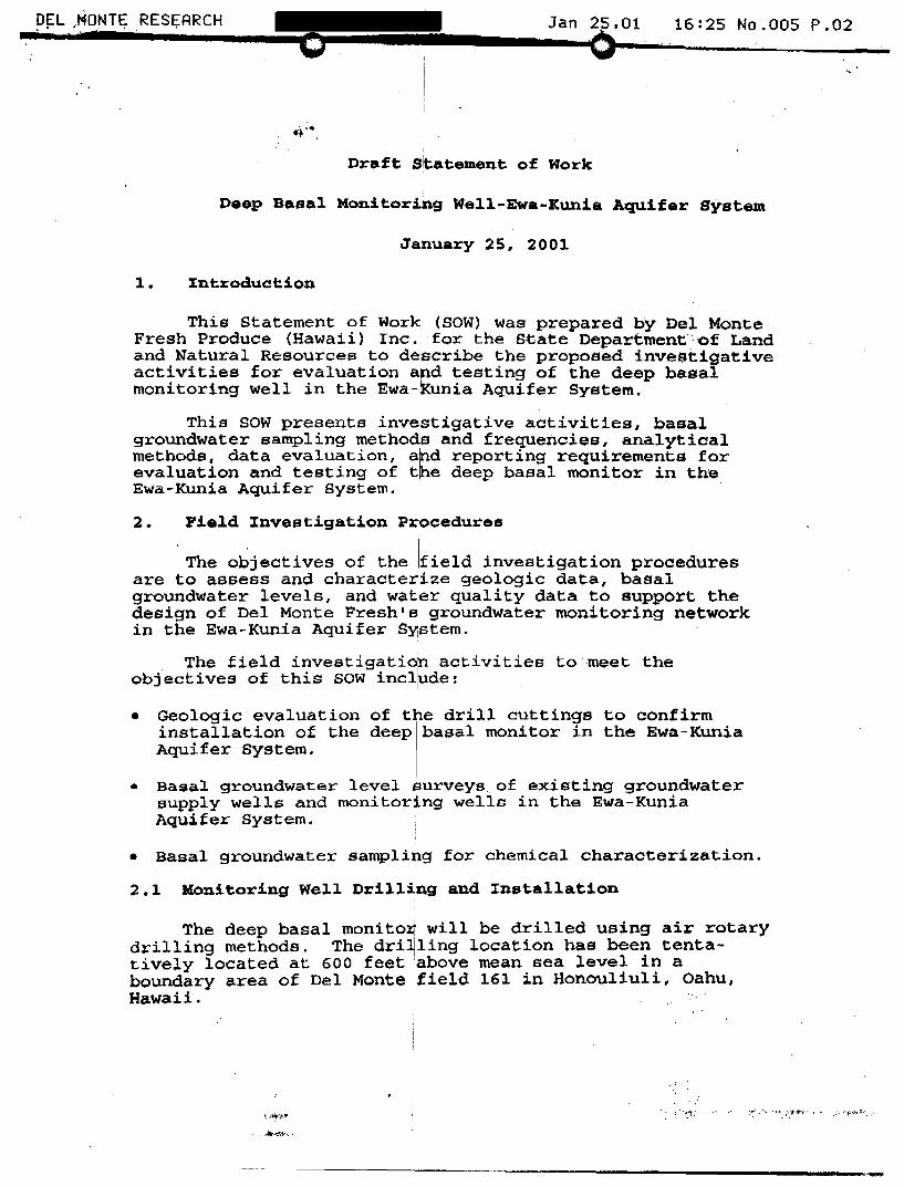
DEL ~ONTE RES~ARCH •• 4 ,
Jan 25.01 16:2S No.OOS P.02
Dr~ft S~~tement of Work
Deep B~s~1 Monitoring Well-Ewa-Xunia Aquifer System
January 25. 2001
1. ~ntroduction
This Statement of Work (SOW) was prepared by Del Monte Fresh Produce (Hawaii) Inc. for the S·tate Department··· of Land and Natural Resources to describe the proposed inve$tigative activities for evaluation and testing of the deep basal monitoring well in the Ewa-Kunia Aquifer System.
I I
This SOW presents investigative activities, basai groundwater sampling metho s and frequencies, analytical methode, data evaluation, a d reporting requirements for evaluation and testing of t e deep basal monitor in the Ewa-Kunia Aquifer System.
2. Field Investigation P cedures
The objectives of the field investigation procedures are to assess and characte~i~e geologic data, basal groundwater levels, and watier quality data to support the design of Del Monte Freshls groundwater monitoring network in the Ewa-Kunia Aquifer SY1stem.
The field investigati~n activities to meet the objectives of this sow inCllUde:
• Geologic evaluation of the drill cuttings to confirm installation of the deep basal monitor in the Ewa-Kunia Aquifer System.
• Basal groundwater level $urveys of existing groundwater supply welle and monitoring wells in the Ewa-Kunia Aquifer System.
• Basal groundwater sampling for chemical characterization.
2.1 Monitoring Wel~ Drill~ng and rnetallation
The deep basal monito~ will be drilled using air rotary drilling methods. The dri~ling location has been tentatively located at 600 feet :above mean sea level in a boundary area of Del Monte ~field 161 in Honouliuli, Oahu, Hawaii.
.... *' ..... '. : "':::' :~ ...... :.t"'· .' ,:. "~:-"':'. "
------------------.--------------------------------------,-
The drilling locati'on, drilling methods, and specifications will be covered in the overall Statement of Work. The borehole diameter will be 14 inchee. The borehole will be drilled to approximately 1,200 feet below the ground surface. After drilling, the monitoring 'well will be caeed with 8 inch diameter steel casing to the basal groundwater water level (approximately 16 feet above mean sea level).
During drilling, drill cuttings will be collected atli)/~ foot intervals and evaluate~' by a trained State hydrogeologist. A borehole log ill be prepared by the State hydrogeologist monitoring t e project for submission to the State Commission on Water isourcesl the Estate of James Campbell, and Del Monte Fresh. Field observations 'will include evaluation of the a prolite zone for perched groundwater, identification! of the contact between the Waianae and Koolau basalts, 'I and identification of fractured/clinker zones. If determined to be necessary, isotopic analysis of select~d drill cuttings will be conducted to evaluate volca~ic sources of geologic forma-tions at depth. :
During drilling, the fbam and drilling fluids will be diverted using an earthen d!itCh into a non-crop area selected by Del Monte Fresh!. When salt water is encountered, the drilling fluids will be returned into the borehole using standard drilling methods.
2.2 Basal Groundwater Levejl Survey
Basal groundwater leve~;l data will be obtained in groundwater supply and monitoring wells hydrogeologically located over the Ewa-Kunia guifer System. The basal groundwater level measureme ts will provide information necessary to evaluate groun~water flow directions and hydraulic gradients. 1_ .
A minimum of two rounds of water level measurements will be performed by the State Commission on Water Resources Management within 6 months of completion of the deep basal monitor., The information on the water.level measurements will be shared with Del Monte Fresh and the Estate of James campbell within 10 'days of completion of each round of water level measurements.
The groundwater supply and monitoring wells that will be considered for water level measurements include: 1) Kunia Well (State Well No. 2703-01); 2) Basal well (State Well No. 2703-02); 3) Hawaii Country Club Well (2603-01); 4) Honouliuli ~II well (2403-04); 5) Basal Monitor P-141, 6) new deep basal monitor; 7) Makakilo Well; and 8) Barbers Point, Shaft. • .\j
\ '~I I~,~A.~· ;Z''W>-- w vU ~.~
,
~EL.MO~TE RESEARCH TEL: -···0 Jan C)'01 16:30 No.OOS P.04
Water levels will be measured by the State Commission on Water Reoourcea Management using an electric water level indicator_ Each well will be shut-off at least two hours prior to collecting water level measurements. To obtain, accura~e water level measurements a professional licensed surveyor will be contracted to survey the surface reference point elevation for each well prior to the start of baoal groundwater level surveys. The accuracy of the water level measurements will be within 0.1 foot.
2.3 Basal Groundwater Sampling
In order to evaluate tne temporal variations in chemical concentrations in ~asal groundwater, ~ series of groundwater samples will bel collected from the deep basal monitor well. !
Initially, two rounds ,of basal groundwater sampleo will L,;.JYIP) '\ be collected after installa~ion of the deep basal monitor. r The State will provide discrete water sampling methods that are acceptable to the Unite Environmental protectio. n AgencY[ for collection of basal 9r0lttndwa~er samples at 50 feet belo~ the static water level. I --- ~
For long-term monitoring, the State will grant Del Monte Fresh with access to collect water samples using a licensed pump contractor on a quarterly basis depending on the sampling schedule approved by EPA Region IX. r--__ .
·The basal groundwater samples collected by Del Monte n Fresh will be analy:zed using EPA methods B260 and 504.1. ,wr The data quality for basal groundwater sampling programs will be analytical level IV. Duplicate samples may be collected by the Hawaii Department of Heal~h Safe Drinking ater Branch and the Honolulu Board of Water Supply.
2.4 Data Validation and B~aluation
The field observations will be evaluated by a trained hydrogeologist and reported in a technical memorandum. The basal groundwater level data and geologic evaluations will be compared with results from previous studies in the region.
The chemical analyses will be used to evaluate water quality in the Ewa-Kunia Aquifer System. If chemicals are detected, additional samples may be collected to confirm the initial sampling results.
- ...• ~: . . ~~

DEL.HQNTE RESEARCH Jan 25.01 .16:30.NQ.OOS P.OS o
'8161
Field 8161
flanled: 10/23/98 to 12/14/98
Net acres: 79.1

." ..... '" , ... .t. ~ o
Scale = 1" = 300'
":;,;,, Map completed 01/15/99 8161
, .~ ,'.J..,~~.:.:ot'.,.~",.,.,..,,~..,.,.., .... ,' .. '. ,~
, ~"" .. ''', ~ .'

Well Background Check
Approved Well No. Well Name Applicant Driller
Ewa-Kunia Mauk State DLNR - Land Division AC-5058
Kaimuki Explorat State DLNR - Land Division AC-5058
Kaimuki Explorat State DLNR - Land Division AC-5058
Kalaeloa Desalt 2 Honolulu BWS [01) AC-5058
Kalaeloa Desalt 1 Honolulu BWS [01) AC-5058
12/6/1995 2902-02 Wahiawa 11-2 Honolulu BWS [01) AC-5058
8/4/1997 2301-46 Waipahu IV-1 Honolulu BWS [01) AC-5058
8/4/1997 2301-45 Waipahu IV-3 Honolulu BWS [01) AC-5058
8/4/1997 2301-44 Waipahu IV-2 Honolulu BWS [01) AC-5058
10/11/2000 2355-15 Kaamilo Deep Mo Honolulu BWS [01) AC-5058
Wednesday, May 09, 2001
Type
WELL
WELL
WELL
WELL
WELL
BOTH
WELL
WELL
WELL
WELL
Well Construction Issued Signed WCR1 Accept
218/1996 2120/1996 1/30/1997 1/30/1997
8/6/1997 1/21/1998 8/20/1998 8/20/1998
8/611997 1/21/1998 8/20/1998 8/20/1998
8/611997 1/21/1998 8/20/1998 8/20/1998
10/17/2000 11912001
Pump Installation Issued Signed WCR2 Accept
6/812000 81712000
0
o
Pagel 0/1

Well No.
Well Name
Applicant
o ~ Z-40 3> -0 1.--
Ewa-Kunia Deep Monitor
dlnr
SECTION 1: WELL LOCATION INFORMATION
Island
Aquifer System
Aquifer Sector
OAHU
PEARL HARBOR
EWA-KUNIA
data
Date of Review
Reviewer
Proposed Use
o
Proposed Withdrawal
System Sustainable Yield
5/10/01
RRI
Other
SECTION 2: WELL SECTION DATA (enterdatfl in grey cells only)
Elevation at top of casing
Ground Elevation
Cement Grout
Rock Packing
Hole Diameter
Total Depth
Estimated Head
Calculated Aquifer Thickness
County Water Supply (YIN ?)
_____ ft., m.s.1.
82 ft.
-----
Solid Casing
Material
Designation
Length
Diameter
Wall Thickness
Casing
Material
Designation
Length
Diameter
Wall Thickness
Openings
Open Hole
Length
Diameter
ft.
in.
SECTION 3: CHECKLIST (values to check are shaded)
Well Depth
Theoretical Thickness of Aquifer
1/4 Aquifer Thickness
Depth of Well below"Sea Level Well Casing
Minimum Wall Thickness
Material
County or Non-County Minimum Thickness per standards
Wall ThJcknassProvlded Minimum Length of Solid Casing
90% of ground to top of aquifer
Length of solid ca$lng ProllldfHl' Ca$lng Material
Annular Space
Depth of Grouting
Calculated Depth of Grouting
Depth of Grol#irrUprovidsd Thickness of Annular Space
Steel
82 ft.
20.5 ft.
740 ft.
non-county
0.250 in.
0:188 in.
565.2 ft.
385 ft. I
--"""A""'STM=""A13P
439.6 ft.
···.·"~1t;.ft,. "1 '3:ln.
. too deep (refer to HWCPIS Section 2.2) (disregard if the well is not basal)
too small (refer to HWCPIS Section 2.4 c)
(disregard this if this is a non-county well)
~~~!1Qw . ~:~:~!: Z~~:~~ ~::!~:~ ~:; : If the cell above reads #N/A, reference HWCPIS)
< ok:aY~i/i'f0 (refer to HWCPIS Section 2.6 c) . okay . ......,.¢' (refer to HWCPIS Section 2.6 d)
Page 1
o 20

Search Results Page 1 of 1
Subdiv/CondoTaxkey Apt 1-9-2-4-5
o o Copyright 5/10/2001 by Hawaii Information Service
• PUBLIC RECORD DATA Property
TnrAddress F
Owner/Lessee JAMES CAMPBELL TRUST ESTATE
Land Beds Baths area
947.54 ac
This information has been supplied by third parties and has not been Independently verified by Hawaii Information Service and Is therefore not uaranteed.
Living area
http://webresearch.hawaiiinformation.comIREsearchl AsplFunctions/Property ISearch TMK.asp? AS/1 DID 1

o DEPARTMENT OF LAND AND NATURAL RESOURCES P ~ ., ':- ,. ! r-:- n
LAND DIVISION .. . ENGINEERING BRANCH
MAY -1 21D p 2: 36
TO:
FROM:
SUBJECT:
Ms. Linnel T. Nishioka, Dep¥ty Director Commission on Water Resotirce Management
Andrew Monden, Chief Engineer ~ ~ Pearl Harbor (Ewa-Kunia Mauka) Deep Exploratory Well, Oahu
,.. ,.',~~;
.- ,
We submit to you for processing the Well Construction Permit application for the subject project.
Should you have any questions, please call Mr. Eric Yuasa of the Project Planning Section at extension
DI:ek Attach.

Slate of HAaii 0 For Omelal Use Only:
COMMISSION ON WATER RESOURCE MANAGMENT Department of Land and Natural Resources APPLICATION FOR PERMIT UWell Construction or 0 Pump Installation
Instructions: Please print In ink or type and send completed applieation with attachments to the CommiUi~nr, .'.y 7 on Water Resource Management, P.O. Box 621, Honolulu, Hawaii 96809. Application must be accompanied by a non-refundable filing fee of 525.00 payable to the Dept. of Land and Natural Resources. The Commission may not accept incomplete applications. For aSSistance, call the RE!gulalion Branch at (Also, ple~~e " check our website at - http://www.hawail.gov/dlnr/dwrm/dwrm.hlml) . !., '
APPLICANT INFORMATION: (Fill out all three, if applicable, and place a check next to the primary b6ntact) , DLNR Engineering Branch '
1. (a)1O WELLOWNER: Land Divjsion Contact Person: Andrew r~onden Mailing Address: 1151 Punchbowl Street Room 221 Honol ul y, HI 96813 Fax: E-mail: ___________ _
(b)[) LANDOWNER: Campbell Estate Contact Person: Tom Heiden
Mailing Address: 1001 Kamokila Blvd., Kaoolei, HI 96707 Fax: E-mail: __________ _
(c) ~ CONTRAcToR!~ater Resources Internati OlUbltact Person: Bl ai se Cl ay
Mailing Address: 1100 Alakea St •• Suite 2900, Hono.lulu, HI 96813
p 2: 36
'. ' .• 1
Phone:
Phone:
Phone:
Fax: E-mail: Lic#: ------------ AC 5058 (circle one: C-57, C-57a, or A)
WELL & PUMP INFORMATION: (Please fill in the diagram on the back of this form.)
2. WElllOCATION/NAME: Pearl Harbor (Ewa-Kunia Mauk(J) Deep Exp. Address Kuni.a Road f;.1, Well
Island: Oahu
Tax Map Key: 9-2-04: 5 Attach the relevant portion of (a) a 7.5-Minute Series USGS topographic map (scale 1':24,000'), and (b) a property tax map, showing well location referenced to established property boundaries.
3. PROPOSED WORK: !} Drill New Well o Deepen o Install New Pump (Check a/l that apply) o Modify Existing Well o Redrill o Modify Pump
o Abandon/Seal' 0 Replace Pump
• Well No.: _____ Be sure to complete and submit well abandonment report upon completion of work.
4. CONSTRUCTION: DOug 0 Bored 0 Driven [J Drilled 0 Radial
Is this well a part of a battery of wells? 0 Yes ID"No (Please describe.)
5. PROPOSED PUMP INFORMATION: Rated Pump Capacity: ..;.N.:!.o/.;..;A ________ gallons per minute
Pump Type (Check one):
o Deep Well Turbine
o Submersible
D Centrifugal
6. PROPOSED USE: (Check a/l that apply)
o Rotary
o Rotary-Displacement
o Rotary-Gear
o Propeller
D ReCiprocating
D Impulse
o Municipal (including hotels, ~tores, etc.)
o Domestic (individual, noncommercial water system) o Irrigation (crop) __________ _
o Military
Powered by:
o Diesel
o Gas
D ElectriC, rated horsepower: _____ _
D Industrial
No. of Dwelling Units: _______ _
No. of Acres: __________ _
OJ Other (explain): mon i torj ng
7. (a) PROPOSED AMOUNT OF WITHDRAWAL: ~ _____ gallons per day
(b) METHOD OF FLOW MEASUREMENT: 0 Flowmeter DOpen-pipe D Weir D Orifice D Other(explain)
OTHER IMPORTANT INFORMATION:
8. PENDING ACTIONS: DCDUA 0 SMA 0 EIS 0 EA lID NONE 0 Other (explain)
9. THE LANDOWNER CERTIFIES THAT THE SUBJ!=CT PROPERTY, OR A PORTION THEREOF, WAS 0 OR WAS
NOT 0 A STATE OF HAWAII LAND PATENT GRiANT ISSUED AFTER 1960. (CHECK WITH YOUR TITLE SEARCH
COMPANY OR THE LAND DIVISION, DEPT. OF LAND AND NATURAL RESOURCES AT FOR HELP)
10. REMARKS, EXPLANATIONS: (If more space IS ne.ded, please attach addilional sheet)
I understand that approval of this application attaches the following standard conditions: 1) the proposed work Is to be completed within' two (2) years of the approval date; 2) the contractor shall submit to the Commission a well completion/abandonment report wilhln 30 days after the completion date of the permitted work; 3) monthly water use data shall be submitted to the Commission; 4) such approval shall not constitute a determination of correlative water rights and shall not guarantee the pump capacity or future use up'to the permitted pump capacity.
~ellowH~~LNR . Slgnature __ '-"'~+1I.q'_~JL-:.=-__
Date !}1J 0 I
Field Checked By ______ _
Date
landownerThr.~~fi~tl of Jam~s
Signature~~ •
Date tJ....w '\ "(..00 I \
con!ractor;;JJf~~ Signature. -
Date "y. 2 :s - " J
Longitude ______ _ Aquifer System Name ____ ~---
State Well No. ?Jr4 O~.' 0 'V Latitude
WCPIFORM (2123/99)
/

, I
I
o 9. PROPOSED WELL SECTION 0 Hole Diameter: 14 In.
Elevation at top of casing 631. 5tt .. msl· (Survey to nearest 0.01 ft.) ...... _L __ ..... ..J Minimum of 2' Radius & 4" Thick Concrete Pad
•. r~ .. J,;:~, \~.:>j:.1 _ Ground Elevation: 630 ft., msl'
1· •• • • .;:1:.:.; ·:'·1.:,·~ -t J I!' •• I~ •• ' ._",. ........ ,. -4, ......... :-. ""M-'~""'-- ~---"""","'"
0t- •• t 0", ',"
: I:·~·.: ..... , ..... -.....;---------------, I ,.' • : .. ···1 Ii.":'.' ~'.
I'· ~. ::".!
Cement Grout: 615 ft. (mi" 70°,," of distance from ground elevation to top of - ......... water surface or 500 ft., I whichever Is less.) ,
Minimum annular space between hole and casing ~ 3"
Rock or Gravel Packing:--=2:;.;:0~_ Material: 0 Crushed Basalt
[XI Rounded Gravel
Water Level Elevation: __ 2 __ ft. msl·
i
I:' :: . , .\ ';.':1
f~} ~/i !.:. >:. :. >:.j ,to ,t ':", ...... . ..
I· ;.'.: ...
,t, ~.
I"'· '.: " 0 ' •
I:~:.t: ~(.
I·~ ., ..... • '\1'
I" • ,,.· •• l
. ~.---.
Please refer to the HAWAII WELL CONSTRUCTION AND . PUMP INSTALLATION STANDARDS to llssure that your construction plans are in
compliance with all existing regulations.
Solid CaSings«~ag~ x (Ground Elev.·Water Level Elev» Material: - ....... .;;..;.._'\""T'I!lr"' __ -rTTI!""""I":~=--_ Materlill Standard: AS I M A-bOb I ype 4 Length: b45 ft. Olalneter: e In. Wall Thickness: ~71b in. Bottom Elevation: (-) 1 ft .• msl'
Open Casing: 0 Perforaled o Screen Materlal: ____________ _ Material Slandard: _________ _ Lenglh: ___________ ft. Olalneter: In. Wan Thickness: In. Openings: sq.ln.IL.F. Bottom Elevation: ft .• msl'
Open Hole: 725 Length: -----,-e------ ft . Diameter: 7 • 5 In. B tt EI tl ( -) 740 ft I' o om eva on: •. ., ms
.i. ... ..... . .. ___ .... _ ... _ ........ _ .. _ .... ___ ....... ... ._ __ ... L.
For non-salt waler Basal Wells - bottom elevation of well should nol be deeper than 1/4 of aquifer Ihickness or, Bottom Elevation of Well Limit = (Waler Elevation _ 41 x Water le
4vel Eleyallon )
Example: Estimated + 2 fl. Water level Elev. -. BoHom Elevation of Well limit" (2. ~) " -18.5 fl .
• The approximate eleva lion must be referenced 10 mean sea level (msl) al the time of application filing. Final elevalions of well components shall be submitted In the Well CompletionMfell Abandonment reports and referenced to a benchmark which has been established by a surveyor licensed by Ihe Stale.
Solid Casing MaterIal:
Steel: compliant wllh (check one or more): 0 ANSIIAWNA C200
And compliant with (check one or more): 0 ASTM A242 0 Type E
Stainless Steel: (check one): 0 ASTM M09 0 ASTM A312
o API Spec. 5L 0 ASTM A53
o Type S 0 Grade B
ABS Plastic conforming to ASTM F480 and ASTM 01527: (check one) 0 Schedule 40 0 Schedule 80
o ASTMA139
IXJ Other ASTM A-606 Type 4
PVC Plastic conforming to ASTM F480 and (ASTM 01785 or ASTM 02241): (check one): 0 Schedule 40 0 Schedule 80
Thermoset Plastic: (check one) 0 Filament Wound Resin Pipe conforming to ASTM 02996
o Cenlrlfugally Cast Resin Pipe conforming 10 ASTM 02997
o Reinforced Plastic Mortar Pressure Pipe conforming 10 ASTM 03517
o Glass Fiber Reinforced Resin Pressure Pipe conforming to AWNA C950
o PTFE Fluorocarbon Tubing conforming to ASTM 03296
o FEP Fluorocarbon Tubing conforming to ASTM 03296
Open CasIng Material: Steel: compliant with (check one or more): 0 ANSIIAWNA C200 0 API Spec. 5L 0 ASTM A53 0 ASTM A 139
And compliant with (check one or more): 0 ASTM A242 0 Type E [] Type S 0 Grade B 0 Other _______ _
Stainless Steel: (oheck oile): 0 ASTM A409 0 ASTM A312
ABS Plastic conforming to ASTM F480 and ASTM 01527: (check one) 0 Schedule 40 0 Schedule 80
PVC Plastic conforming to ASTM F480 and (ASTM 01785 or ASTM 02241): (check one): 0 Schedule 40 0 Schedule 80
Thermoset Plastic: (check one) 0 Filament Wound Resin Pipe Conforming to ASTM 02996
o Centrifugally Cast Resin Pipe conforming to ASTM 02997
o Reinforced Plastic Mortar Pressure Pipe conforming to ASTM 03517
o Glass Fiber Reinforced Resin Pressure Pipe conforming to AWWA C950
o PTFE Fluorocarbon Tubing conforming to ASTM 03296
o FEP Fluorocarbon Tubing conforming to ASTM 03296

~
Pearl Harbor (Ewa-Kunia Mauka) Deep Exploratory WeU Location
State of Hawaii Commission on Water Resource ~anagement Department of Land and Natural esources Application for Permit - Well Cons ruction
Pearl Harbor (Ewa-Kunia Mauka) Dee Exploratory Well USGS Topographic Map 1" = 2000' L/~ 2
)"-~"'l~~-:-r55fl:i~;$i;--:,· y~~~'~ i/\ '\' .~. ' .. , 260-' ~,a ~ "'. ~~.~~ ~~~;11 (( /; - / /' ____ "\)' ) . f ) 1'/ \) ",,",,' ~~. ~ J\ ~. \ '\ • ~~ " \ \ " f I {~\"'. / "-
• \ \, \ :, . - ~-- '\, I !: ! g , ( ~;\ / ~~\ '. \ ' ,~y IJmP1'fT.E,.- -;;--("9' // , ' " ~-~, ~ I , ',. ........ " •. ~
\ \

Pearl Harbor (Ewa-Kunia Mau Deep Exploratory Well Location
~. ~ ••••• ".0
.1 (t
l~ U -I ~
,0 _\
I-, ;.. ~
I • • ~ • til · .. ~ ...
0 • 0 or
~ !
& f
State of Hawaii Commission on Water Resource Management Department of Land and Natural Resources Application for Permit - Well Construction
2
• ~ c " tI'
10./.
~ ~ u e "'" ~ ::s II)
~ ~
Pearl Harbor (Ewa-Kunia Mauka) Deep Exploratory Well Property Tax Map scale as noted