web-gis solutions for the analysis and valorisation of archaeological sites in the mediterranean...
TRANSCRIPT
Web-Based Spatial Data Management 1
Paolo Ardissone ndash Francesca Balossi Restelli ndash Emanuela Borgia ndash Emanuele Brienza
Web-GIS Solutions for the Analysis and Valorisation of Archaeological Sites in the Mediterranean Basin
AbstractenspThe Department of Archaeological Science of the Sapienza Universitagrave di Roma and the Land En-vironment and Geo-Engineering Department of the Politecnico di Torino are involved in a research project (ARCHEOMEDSAT) with the aim of defining the architecture and components of an information system suitable for the management of excavation data and the provision of innovative services to the visitors of archaeological sites in the Mediterranean area Open source software and web accessibility are considered a priority for the fulfilment of such an aim This system also has to be designed to facilitate research activities in these sites and the elaboration of the data retrieved It should become a fundamental tool for archaeolo-gists and other researchers and permit complex queries and multifactorial analyses of stratigraphic and architectural data and that of the single objects found Here too web accessibility has proven useful for a multidisciplinary international collaboration between researchers
Introduction
Seven different Italian universities are at present in-volved in the ARCHEOMEDSAT project (httpwwwricercaitalianaitfirbdettaglio_firb-RBNE03YP9Jhtm httptopografiaunicaitindexphpop tion=com_contentamptask=sectionampid=9ampItemid=63 [28 Nov 2007]) funded by the Italian Ministry of University and Re-search with the aim of creating a system for the man-agement interpretation and realisation of all data ob-tained from extensive archaeological excavations This system is also intended to support research activities and to facilitate their management and logistics This not only involves the excavation of the archaeological sites but also surveys of the territory restoration and conservation interventions and access by non-special-ists to the sites and data To achieve the goal of this re-search project the first step is to organise the informa-tion obtained from the archaeological investigations into a data model and to define rules conventions and file formats that can be integrated and managed in a GIS environment This is in fact the role of our research group to conceive and set up GIS solutions that can be used in different archaeological excava - tions
The Choice of the Archaeological Sites
Three sites which are representative of the different situations in the Mediterranean area and are all be-ing excavated by groups from the Sapienza Univer-
sity (httpw3uniroma1itarcheologiaRicerche 20e20scaviRicerchehtm [28 Nov 2007]) have been chosen as samples on which to build and test our system Arslantepe (httpw3uniroma1it arslantepe [28 Nov 2007]) a long-established settle-ment in Eastern Turkey occupied in prehistoric as well as more recent times the north-eastern slopes of the Palatine Hill and Meta Sudans part of the ancient city of Rome and Elaiussa Sebaste a Hel-lenistic Roman and Byzantine city on the Mediter-ranean coast of Southern Turkey The three sites were chosen because of their different geographi-cal settings and layouts and historical context in order to have a wider view of the exportability and communicability of the system that was being built
Arslantepe is a tell a typical Near Eastern mound made of more than 30 m of superimposed mud brick architecture and archaeological occupation levels spanning from the 5 millennium BC to the Roman and Byzantine periods The stratigraphy of Near Eastern mounds is very complex and particular be-cause of the common practice of cutting terraces into earlier occupations levelling out or moving the ter-rain to prepare for new buildings The most impres-sive finds on the site are those of a Palatial complex of more than 2000 m2 dating back to 3000 BC it was on this monument that the first data formalisation has started Excavation of this site started in 1961 and is now directed by Prof Marcella Frangipane (httpmisartit httpwwwricercaitalianaitfirbdettaglio_firb-RBNE03YP9Jhtm [28 Nov 2007])
2 Layers of Perception ndash CAA 2007
these entities at the bottom (for example you would record with distinct and specific forms a building its rooms their walls floors layers filling the rooms objects in the layers and on the floors etc)
The more widely-used system of ldquostratigraphic unitsrdquo is instead used in the other two sites though with some distinctions in vocabularies or defini-tions stemming from the differences between the two sites The finds are treated in a similar manner each category such as pottery coins bone objects metals glass architectural elements inscriptions is recorded into specific forms which are directly con-nected to their context of retrieval This makes the objects the central element of the GIS system adopt-ed in Rome and in Elaiussa Sebaste with a sort of radial organization of all the data related to these
In the long formalisation process of the excava-tion information which was carried out in order to implement a GIS oriented data structure the Ars-lantepe documentation system proved to be partic-ularly ldquoGIS friendlyrdquo information in fact is already greatly formalised by the recording system itself The construction of the database was more compli-cated however because many more tables and vo-cabularies had to be built
Only in the case of the Palatine excavation had a GIS system running on ESRI software already been constructed whilst in the other two cases work had to start from the very beginning with the formali-sation and organisation of data (site reports forms survey data architectural plans photos etc) Creat-ing terminology and formalising the data was not only useful in making it compatible with GIS com-puter technology but it has offered a critical meth-odological evaluation of the documentation sys-tems which led to the consequent modifications of some specific matters
However not all datasets can be reduced to or summarised by a preset term or sentence In this ar-chaeology still shows its humanistic aspect Archae-ologists need text and memo entries in which infor-mation that is still uninterpretable or incomplete can be collected something which is disliked by computer specialists Even though the data in these records might not be used immediately for any sort of analysis it is always possible that subsequent dis-coveries will be able to offer an explanation There-fore in constructing the database such entries still remain albeit greatly reduced in number In view of future developments an archaeological GIS cannot be a closed structure but must be expandable and infinitely modifiable
The Palatine and Meta Sudans in the centre of both ancient and modern Rome were subject to later rebuildings changes obliterations and super-impositions which makes the management and or-ganisation of research and exhibition of the results difficult Buildings and interventions in the area date back from at least the 6th century BC (an ancient road network) to the 4th century AD Amongst the many important finds during the excavations which started in 2001 under the direction of Prof Clem-entina Panella are a sanctuary in use from the 6th century to Nerorsquos fire of 64 AD part of the Domus Aurea and the Meta Sudans fountain itself which was used with different re-buildings from the Augustean period to the age of Constantine
Elaiussa Sebaste where the excavations started in 1995 under the direction of Prof Eugenia Equini Schneider is a 23 ha wide city with two ports and was first settled on a promontory and later extended into the mainland So far living quarters activity ar-eas (cisterns wells kilns) monumental public build-ings and necropolises have been brought to light A huge Byzantine palace a small basilica a bath and some private houses were excavated on the promon-tory The Roman monumental area on the mainland includes a theatre a commercial agora a public bath building and a huge Corinthian temple which rises on the hill to the south of the city This site is a case of extensive territorial excavation in which complex geological and topographical information has to be matched with archaeological and historical data
Field Documentation Procedures and their Compatibility with a GIS Structure
Distinct methods for the acquisition and organisa-tion of data had been adopted at the three sites as a consequence of the specific necessities and differ-ences between the areas Whilst the Palatine and Elaiussa excavation system has a common basis that of Arslantepe is completely different from the other two This is due to the distinct character of the archaeological finds The common ldquostratigraphic unitrdquo forms are not used in Arslantepe but the for-mat of the documentation entirely depends on the interpretation of the finds as made directly on the field Houses are recorded with a house number rooms with a room number hearths within a room have the room and hearth number etc This creates a kind of pyramidal structure with the largest en-tities at the top and the single finds contained in
Web-Based Spatial Data Management 3
The differences in recording systems for one site and the diversity of the finds and thus of the set vocabularies for the other two led us to build three distinct GIS structures using file formats which are easily exchanged across different plat - forms
Data Management Policy
When designing the GIS data model three main prob-lems had to be faced firstly the different approach-es investigation methodologies and procedures for data collection adopted by each of the archaeological groups involved had to be preserved secondly the system had to permit both the direct acquisition of new excavation data from the field coded according to the project requirements and the ex post reorgani-sation of datasets obtained from studies performed by different specialists or in the past thirdly secu-rity conservation and portability of the stored data and of the system itself had to be guaranteed
Notwithstanding the diversities between the three sites and their documentation procedures we initially tried to conceive a unique GIS data structure shared by the three sites We soon realised though that such a task was impossible as the necessary ho-mogenisation of the data would have invariably re-sulted in a great loss of precious information From a theoretical point of view too we concluded that a single universal recording system was not desir-able different historical periods geographical re-gions geological conformations and thus archaeo-logical contexts even though excavated in the same manner and with the same scientific archaeological methods have their own specificities historical and anthropological issues and we therefore agreed that such distinct archaeological contexts as those of the three sites here sampled should keep their own documentation procedures
The excavation proper and recording of finds is only the first and in some ways the smallest task of archaeologists who then go on to analyse and in-terpret the data The role of GIS is that of joining or comparing information coming from these different research activities and allowing the analysis of the data stored in it Therefore the data model had to allow both these levels of implementation and use The data model was structured so as to preserve the original logic to ensure accuracy and to state the source of the data In general specialistsrsquo require-ments were mediated with the necessity common to
each system of having information organised and coded in an efficient manner Moreover unlike ldquotra-ditionalrdquo databases GIS technologies require alpha-numeric and spatial information to be structured and managed together making the implementation task more complicated The attributes and the rela-tionships between data have to be matched by the definition of the relationships between information and spatial data
In summary therefore we planned a specific GIS-oriented data model for the two archaeological sites of Arslantepe and Elaiussa Sebaste adapted to the requirements of the different contexts and at the same time we designed a common technological approach aimed at ensuring longevity preserva-tion sharing and dissemination of the data Whilst contents data formats and structure and analysis tools were variable for the two sites analogous file formats characterised by a high portability were suggested for the GIS implementation and for the project conservation sharing and dissemination A metadata structure was proposed to describe the contents and format of the data and to allow an ini-tial evaluation of the resources stored in the system In this way the system is able to create data that is loadable and manageable by different GIS software both desktop and web-based both commercial and open source Consequently other GIS projects will be able to integrate this data and gain an insight into the strengths and weaknesses of our method The existing GIS from the Palatine Hill and Meta Sudans excavations was used to test the capacity of commu-nication between the different systems as well as an aid in the development of the database for Elaiussa Sebaste
Translation and Reorganization of Data in Digital Format
The documentation acquired during the excavations can be divided into two main classes alphanumer-ic data and spatial data The three archaeological teams have a long tradition in field data acquisition (both for the spatial and the alphanumeric informa-tion) by now standardised and well coded This was of course respected and maintained since it best describes the archaeological contexts investigated An ER Model reproducing the logic of the alphanu-meric documentation of the paper archives and de-fining some rules standards and guidelines for the creation of CAD files was created In this way data
4 Layers of Perception ndash CAA 2007
after excavations are complete The drawings rep-resent the areas structures and objects using the descriptive capability of the CAD software rather than representing reality using symbols layers or predefined forms for fixed types of objects The on-field survey data is not referenced back to the alpha-numeric data during data entry
The computer-aided (CAD) software programs are conceived to help users generate and visualise the graphic representation of the data without add-ing additional information GIS instead requires information that is structured and organised ac-cording to its meaning and its querying possibili-ties Practically speaking the CAD files created for strictly archaeological purposes are useful for their graphic representations but are not directly load-able in a GIS environment and they cannot be inte-grated with the alphanumeric data
The drawings maps surveys and CAD files have to be reconverted following the data model de-signed for the GIS (Fig 2) The CAD files will popu-late the geometry of the entity classes described by the alphanumeric attributes CAD environments are not usually able to manage more than one attribute for each single entity Therefore the alphanumeric attributes are stored and managed in an external file (csv format) creating a unique key code to link the CAD objects to their attribute records
The main problem is that the layers inside a CAD file are often composed of points polylines closed and open polygons GIS software is not able to un-derstand and interpret this conflicting information It can only manage the geometry of the elements if these are described unambiguously as closed poly-gons polylines or points For these reasons several guidelines were defined and followed in order to
has been and can continuously be imported into a digital format designed to aid the implementation of the GIS project The link between the spatial and alphanumeric components can then be made in a GIS environment as described below
Alphanumeric Data
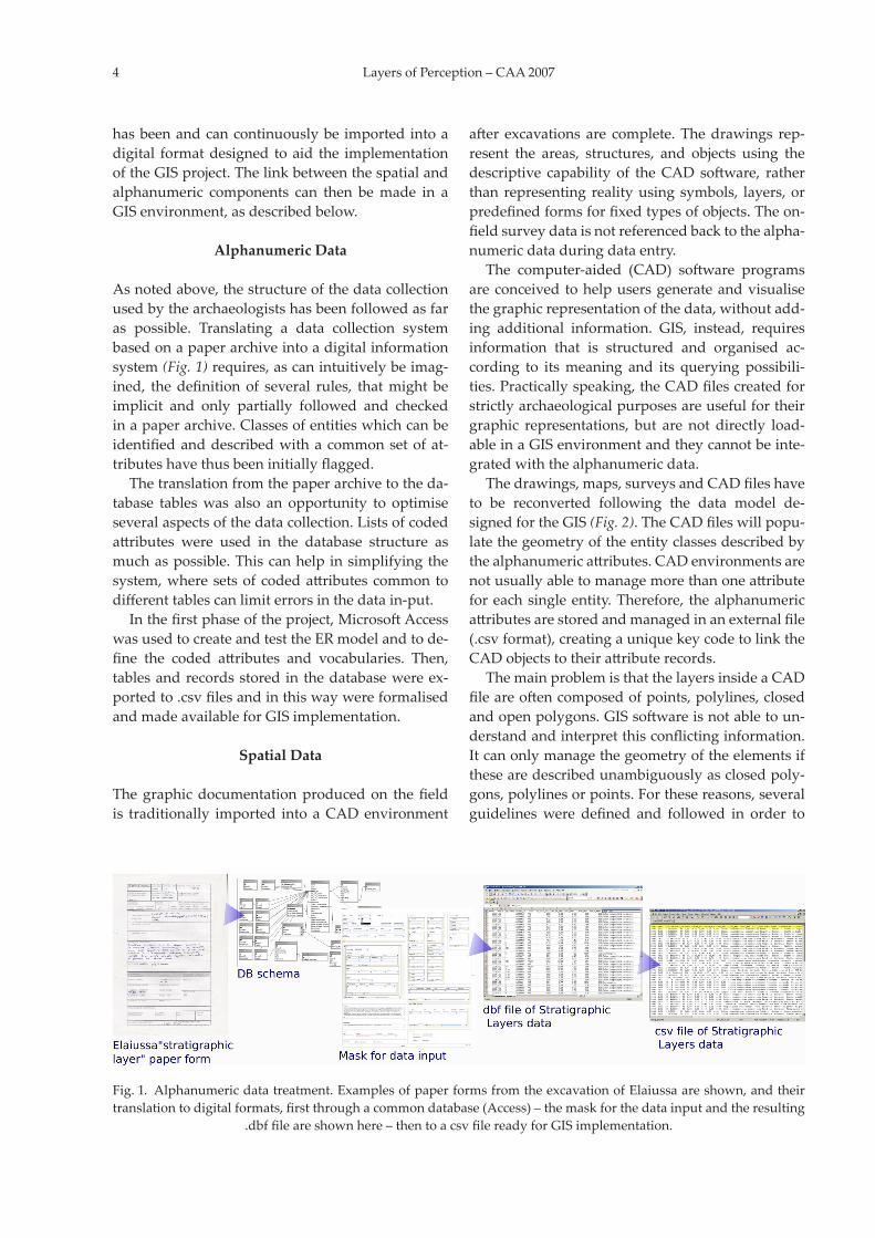
As noted above the structure of the data collection used by the archaeologists has been followed as far as possible Translating a data collection system based on a paper archive into a digital information system (Fig 1) requires as can intuitively be imag-ined the definition of several rules that might be implicit and only partially followed and checked in a paper archive Classes of entities which can be identified and described with a common set of at-tributes have thus been initially flagged
The translation from the paper archive to the da-tabase tables was also an opportunity to optimise several aspects of the data collection Lists of coded attributes were used in the database structure as much as possible This can help in simplifying the system where sets of coded attributes common to different tables can limit errors in the data in -put
In the first phase of the project Microsoft Access was used to create and test the ER model and to de-fine the coded attributes and vocabularies Then tables and records stored in the database were ex-ported to csv files and in this way were formalised and made available for GIS implementation
Spatial Data
The graphic documentation produced on the field is traditionally imported into a CAD environment
Fig 1enspAlphanumeric data treatment Examples of paper forms from the excavation of Elaiussa are shown and their translation to digital formats first through a common database (Access) ndash the mask for the data input and the resulting
dbf file are shown here ndash then to a csv file ready for GIS implementation
Web-Based Spatial Data Management 5
create CAD files which could be easily imported into a GIS environment This problem was faced when converting already acquired data but above all when planning the acquisition of new data in fu-ture campaigns
The conversion of the CAD data in order to fa-cilitate its communication with GIS requires long and complex editing operations Entities have to be singled out and reorganised in new specific layers Areas have to be represented by closed polygons Lines have to be continuous polylines and the geo-metrical information of the entities has to be coher-ent with the class they are going to populate This operation can only be done manually Automatic procedures as the programming of a batch process-ing tool were taken into consideration but it was soon clear that the manual interpretation of the sur-vey outputs by specialists was the only adequate and effective procedure
Creation of a Supporting Management System Based on a Web Architecture
A flexible usage of the GIS and database had to be guaranteed both in the data collection phase and in the completion of the system in order to allow it to be updated at various phases possibly by different people in different places or even simultaneously A supporting management system is thus now being created based on a web architecture
The first and undeniable advantage of using In-ternet technology to publish GIS data is the simplic-ity and economy of the implementation Users who access GIS resources shared using a web server and published on a specific web site no longer need par-ticular hardware configurations or software knowl-edge it is sufficient to connect to the WWW and use a traditional web browser
The system is completely based on open source tools which are considered to be the best solution to achieve the project goals In fact with these tech-nologies it is possible to build complete and flexible solutions by continuously updating software pack-ages and applications and being sure of the efficien-cy of the tools minimizing the set-up and mainte-nance costs
The server is based on a Linux Debian operating system Apache Server which is the most widely-used and powerful has been selected as the web server
All the data is stored in a PostgreSQL DataBase Server combined with its spatial extension PostGIS (httppostgisrefractionsnet Fig 3) In this way both geometric and alphanumeric information is stored in a single tool and as a consequence the ar-chitecture of the system is simple and light
A specific web application based on PHP scripts is being developed to load the alphanumeric data acquired during the excavation phase into the data-base specific forms in a web page are available for a correct and controlled data input In this way data is immediately digitalised and available in the system and for web realisation this solution also avoids problems of misalignment and duplication No plug-ins are needed on the client side Whereas al-phanumeric data are uploaded via web and directly stored in the database and thus immediately acces-sible geometric surveyed data are sent in dxf format to the system These files are structured following the specific directives with simple office work spa-tial data are inserted manually in the database At present dxf2postgis (httpsourceforgenetprojectsdxf2postgis) a tool converting DXF files to PostGIS geometry tables is being tested Using dxf2postgis a single DXF file is converted to a PostgreSQL-Post-GIS SQL script to create and fill tables While the connection between features and attributes is guar-
Fig 2enspSpatial data treatment Archaeological CAD drawings have to be edited to be loadable in a GIS environment This allows the GIS program to recognise and distinguish all the distinct attributes of the finds and plans drawn
6 Layers of Perception ndash CAA 2007
three sites used as case studies in our application because of the long duration of these field projects and the immense amount of data acquired
What this project is trying to tackle in greater depth is how to combine these needs with those of publication and communication of the results of this research to the wider public The choice of working within a web framework seems to be the right one in this case particularly as it easily permits simul-taneous implementation and work on the system Web access permissions or restrictions should also be analysed in more detail and a system for the protection of unpublished and unprocessed data created
The research project also shows how after an ac-curate GIS data model definition open source tech-nologies can be exploited to create low-cost prod-ucts that can be customized according to individual requirements Open source also allows the system to be constantly updated without any further ex-pense
ARCHEOMEDSAT is an on-going project the coming year will be devoted to a thorough testing of the system aimed at its correct functioning for eve-ryday activities on field and in the post-excavation study phase We shall also upload the system onto the web for an experimental phase with restricted access during which we shall request feedback from the first users in order to correct potential errors and make it more user-friendly
Acknowledgements
Our thanks go the coordinator of the ARCHEOMED-SAT project Prof Manzoni for having first formu-
anteed by the group of structured rules for CAD data acquisition and implementation identified in the first phase of the project a procedure for check-ing this has been developed and implemented with a specific tool based on the QGIS (httpqgisorg) interface Using QGIS specialists can access the PostGIS geometry table check and edit the spatial data and then assign to each entity its unique key code to link it to the related attribute records
The geometric data is published using the Uni-versity of Minnesota MapServer (httpmapservergisumnedu) which is an open source develop-ment environment for building web mapping ap-plications the web user interface is based on a MapServer client open framework called Pmapper which takes advantage of Ajax technologies with easy navigation and simple analysis tools
The web page for data insertion has restricted access and only authorized users can log in and add to the data while further security settings are adopted in the firewall and Apache configuration on the server
Each authorized user has their own account on the server and all operations performed are record-ed Suitable security settings are adopted for data storage safety the hard disks have raid controllers to avoid data loss in case of a disk breakdown
Concluding Remarks
The use of GIS in archaeology is common nowadays and its value is becoming more and more evident when it comes to storage management analysis and sharing of data which otherwise would be accessed with difficulty It is even more so in the case of the
Fig 3enspExamples of data input managment and visualisation on the PostgreSQL Database and PostGIS
Web-Based Spatial Data Management 7
lated the ideas and proposed tackling them The work of Professors Equini Schneider Frangipane and Panella directors of the archaeological excava-tions at Elaiussa Sebaste Arslantepe and Palatine for many years is not only instructive but of constant guidance and inspiration providing the best solu-tions to many of the methodological and theoretical problems tackled here ARCHEOMEDSAT involves seven Italian universities (the Universities of Tri-este Pavia Palermo Milano Cagliari Torino and Roma) and it is thanks to the cooperation between all that such significant issues can be so broadly and completely analysed
References
Biswel et al 1995S Biswel L Cropper J Evans C F Gaffney P Leach GIS and excavation a cautionary tale from Shepton Mallet In G Lock Z Stancic (eds) Archaeology and geographic information systems a European perspec-tive (Somerset 1995) 269ndash286
Brienza 2005E Brienza Un GIS intra-site per la Valle del Colosseo Geomedia 1ndash2005 (Roma 2005)
Equini Schneider 1999E Equini Schneider Elaiussa Sebaste I Campagne di scavo 1995ndash1997 (Roma 1999)
Equini Schneider 2003E Equini Schneider Elaiussa Sebaste II Un porto fra Oriente e Occidente (Roma 2003)
Frangipane 1997M Frangipane A 4th millennium templepalace com-plex at Arslantepe-Malatya North-south relations and the formation of early state societies in the northern regions of Greater Mesopotami Paleacuteorient 231 1997 45ndash73
Frangipane 2004M Frangipane Alle origini del potere Arslantepe la collina dei leoni (Milano 2004)
Frangipane Palmieri 1988M Frangipane A Palmieri A protourban centre of the Late Uruk period Perspectives on Protourbani-zation in Eastern Anatolia Arslantepe (Malatya) An Interim Report on 1975ndash1983 campaigns Origini 122 1988 287ndash454
Gillins Wise 1998M Gillins A L Wise (eds) GIS guide to good prac-tise (Oxford 1998)
Panella 1996C Panella (ed) Meta Sudans I Unrsquoarea sacra in Pala-tio e la valle del Colosseo prima e dopo Nerone (Roma 1996)
Panella 2001C Panella La valle del Colosseo prima del Colosseo e la Meta Sudans In A La Regina (ed) Sangue e Arena (Roma 2001) 49ndash67
Panella Zeggio 2004C PanellaS Zeggio Tra Palatino e valle del Colosseo nuovi dati Workshop di Archeologia Classica 1 (Pisa Rome 2004) 65ndash87
Pensabene Panella 1999P Pensabene C Panella (eds) Arco di Costantino Tra archeologia e archeometria (Roma 1999)
Wheatley Gillings 2002D Wheatley M Gillings Spatial technology and ar-chaeology the archaeological applications of GIS (Lon-don 2002)
Paolo ArdissoneDITAG ndash Politecnico di Torino
Corso Duca degli Abruzzi 2410129 Torino
Italypaoloardissonepolitoit
Francesca Balossi RestelliEmanuela Borgia
Emanuele Brienza
Sapienza Universitagrave di RomaDipartimento di Sc Storiche
Arch e Antrop dellrsquoAntichitagravePzzle Aldo Moro 5
00185 RomaItaly
2 Layers of Perception ndash CAA 2007
these entities at the bottom (for example you would record with distinct and specific forms a building its rooms their walls floors layers filling the rooms objects in the layers and on the floors etc)
The more widely-used system of ldquostratigraphic unitsrdquo is instead used in the other two sites though with some distinctions in vocabularies or defini-tions stemming from the differences between the two sites The finds are treated in a similar manner each category such as pottery coins bone objects metals glass architectural elements inscriptions is recorded into specific forms which are directly con-nected to their context of retrieval This makes the objects the central element of the GIS system adopt-ed in Rome and in Elaiussa Sebaste with a sort of radial organization of all the data related to these
In the long formalisation process of the excava-tion information which was carried out in order to implement a GIS oriented data structure the Ars-lantepe documentation system proved to be partic-ularly ldquoGIS friendlyrdquo information in fact is already greatly formalised by the recording system itself The construction of the database was more compli-cated however because many more tables and vo-cabularies had to be built
Only in the case of the Palatine excavation had a GIS system running on ESRI software already been constructed whilst in the other two cases work had to start from the very beginning with the formali-sation and organisation of data (site reports forms survey data architectural plans photos etc) Creat-ing terminology and formalising the data was not only useful in making it compatible with GIS com-puter technology but it has offered a critical meth-odological evaluation of the documentation sys-tems which led to the consequent modifications of some specific matters
However not all datasets can be reduced to or summarised by a preset term or sentence In this ar-chaeology still shows its humanistic aspect Archae-ologists need text and memo entries in which infor-mation that is still uninterpretable or incomplete can be collected something which is disliked by computer specialists Even though the data in these records might not be used immediately for any sort of analysis it is always possible that subsequent dis-coveries will be able to offer an explanation There-fore in constructing the database such entries still remain albeit greatly reduced in number In view of future developments an archaeological GIS cannot be a closed structure but must be expandable and infinitely modifiable
The Palatine and Meta Sudans in the centre of both ancient and modern Rome were subject to later rebuildings changes obliterations and super-impositions which makes the management and or-ganisation of research and exhibition of the results difficult Buildings and interventions in the area date back from at least the 6th century BC (an ancient road network) to the 4th century AD Amongst the many important finds during the excavations which started in 2001 under the direction of Prof Clem-entina Panella are a sanctuary in use from the 6th century to Nerorsquos fire of 64 AD part of the Domus Aurea and the Meta Sudans fountain itself which was used with different re-buildings from the Augustean period to the age of Constantine
Elaiussa Sebaste where the excavations started in 1995 under the direction of Prof Eugenia Equini Schneider is a 23 ha wide city with two ports and was first settled on a promontory and later extended into the mainland So far living quarters activity ar-eas (cisterns wells kilns) monumental public build-ings and necropolises have been brought to light A huge Byzantine palace a small basilica a bath and some private houses were excavated on the promon-tory The Roman monumental area on the mainland includes a theatre a commercial agora a public bath building and a huge Corinthian temple which rises on the hill to the south of the city This site is a case of extensive territorial excavation in which complex geological and topographical information has to be matched with archaeological and historical data
Field Documentation Procedures and their Compatibility with a GIS Structure
Distinct methods for the acquisition and organisa-tion of data had been adopted at the three sites as a consequence of the specific necessities and differ-ences between the areas Whilst the Palatine and Elaiussa excavation system has a common basis that of Arslantepe is completely different from the other two This is due to the distinct character of the archaeological finds The common ldquostratigraphic unitrdquo forms are not used in Arslantepe but the for-mat of the documentation entirely depends on the interpretation of the finds as made directly on the field Houses are recorded with a house number rooms with a room number hearths within a room have the room and hearth number etc This creates a kind of pyramidal structure with the largest en-tities at the top and the single finds contained in
Web-Based Spatial Data Management 3
The differences in recording systems for one site and the diversity of the finds and thus of the set vocabularies for the other two led us to build three distinct GIS structures using file formats which are easily exchanged across different plat - forms
Data Management Policy
When designing the GIS data model three main prob-lems had to be faced firstly the different approach-es investigation methodologies and procedures for data collection adopted by each of the archaeological groups involved had to be preserved secondly the system had to permit both the direct acquisition of new excavation data from the field coded according to the project requirements and the ex post reorgani-sation of datasets obtained from studies performed by different specialists or in the past thirdly secu-rity conservation and portability of the stored data and of the system itself had to be guaranteed
Notwithstanding the diversities between the three sites and their documentation procedures we initially tried to conceive a unique GIS data structure shared by the three sites We soon realised though that such a task was impossible as the necessary ho-mogenisation of the data would have invariably re-sulted in a great loss of precious information From a theoretical point of view too we concluded that a single universal recording system was not desir-able different historical periods geographical re-gions geological conformations and thus archaeo-logical contexts even though excavated in the same manner and with the same scientific archaeological methods have their own specificities historical and anthropological issues and we therefore agreed that such distinct archaeological contexts as those of the three sites here sampled should keep their own documentation procedures
The excavation proper and recording of finds is only the first and in some ways the smallest task of archaeologists who then go on to analyse and in-terpret the data The role of GIS is that of joining or comparing information coming from these different research activities and allowing the analysis of the data stored in it Therefore the data model had to allow both these levels of implementation and use The data model was structured so as to preserve the original logic to ensure accuracy and to state the source of the data In general specialistsrsquo require-ments were mediated with the necessity common to
each system of having information organised and coded in an efficient manner Moreover unlike ldquotra-ditionalrdquo databases GIS technologies require alpha-numeric and spatial information to be structured and managed together making the implementation task more complicated The attributes and the rela-tionships between data have to be matched by the definition of the relationships between information and spatial data
In summary therefore we planned a specific GIS-oriented data model for the two archaeological sites of Arslantepe and Elaiussa Sebaste adapted to the requirements of the different contexts and at the same time we designed a common technological approach aimed at ensuring longevity preserva-tion sharing and dissemination of the data Whilst contents data formats and structure and analysis tools were variable for the two sites analogous file formats characterised by a high portability were suggested for the GIS implementation and for the project conservation sharing and dissemination A metadata structure was proposed to describe the contents and format of the data and to allow an ini-tial evaluation of the resources stored in the system In this way the system is able to create data that is loadable and manageable by different GIS software both desktop and web-based both commercial and open source Consequently other GIS projects will be able to integrate this data and gain an insight into the strengths and weaknesses of our method The existing GIS from the Palatine Hill and Meta Sudans excavations was used to test the capacity of commu-nication between the different systems as well as an aid in the development of the database for Elaiussa Sebaste
Translation and Reorganization of Data in Digital Format
The documentation acquired during the excavations can be divided into two main classes alphanumer-ic data and spatial data The three archaeological teams have a long tradition in field data acquisition (both for the spatial and the alphanumeric informa-tion) by now standardised and well coded This was of course respected and maintained since it best describes the archaeological contexts investigated An ER Model reproducing the logic of the alphanu-meric documentation of the paper archives and de-fining some rules standards and guidelines for the creation of CAD files was created In this way data
4 Layers of Perception ndash CAA 2007
after excavations are complete The drawings rep-resent the areas structures and objects using the descriptive capability of the CAD software rather than representing reality using symbols layers or predefined forms for fixed types of objects The on-field survey data is not referenced back to the alpha-numeric data during data entry
The computer-aided (CAD) software programs are conceived to help users generate and visualise the graphic representation of the data without add-ing additional information GIS instead requires information that is structured and organised ac-cording to its meaning and its querying possibili-ties Practically speaking the CAD files created for strictly archaeological purposes are useful for their graphic representations but are not directly load-able in a GIS environment and they cannot be inte-grated with the alphanumeric data
The drawings maps surveys and CAD files have to be reconverted following the data model de-signed for the GIS (Fig 2) The CAD files will popu-late the geometry of the entity classes described by the alphanumeric attributes CAD environments are not usually able to manage more than one attribute for each single entity Therefore the alphanumeric attributes are stored and managed in an external file (csv format) creating a unique key code to link the CAD objects to their attribute records
The main problem is that the layers inside a CAD file are often composed of points polylines closed and open polygons GIS software is not able to un-derstand and interpret this conflicting information It can only manage the geometry of the elements if these are described unambiguously as closed poly-gons polylines or points For these reasons several guidelines were defined and followed in order to
has been and can continuously be imported into a digital format designed to aid the implementation of the GIS project The link between the spatial and alphanumeric components can then be made in a GIS environment as described below
Alphanumeric Data
As noted above the structure of the data collection used by the archaeologists has been followed as far as possible Translating a data collection system based on a paper archive into a digital information system (Fig 1) requires as can intuitively be imag-ined the definition of several rules that might be implicit and only partially followed and checked in a paper archive Classes of entities which can be identified and described with a common set of at-tributes have thus been initially flagged
The translation from the paper archive to the da-tabase tables was also an opportunity to optimise several aspects of the data collection Lists of coded attributes were used in the database structure as much as possible This can help in simplifying the system where sets of coded attributes common to different tables can limit errors in the data in -put
In the first phase of the project Microsoft Access was used to create and test the ER model and to de-fine the coded attributes and vocabularies Then tables and records stored in the database were ex-ported to csv files and in this way were formalised and made available for GIS implementation
Spatial Data
The graphic documentation produced on the field is traditionally imported into a CAD environment
Fig 1enspAlphanumeric data treatment Examples of paper forms from the excavation of Elaiussa are shown and their translation to digital formats first through a common database (Access) ndash the mask for the data input and the resulting
dbf file are shown here ndash then to a csv file ready for GIS implementation
Web-Based Spatial Data Management 5
create CAD files which could be easily imported into a GIS environment This problem was faced when converting already acquired data but above all when planning the acquisition of new data in fu-ture campaigns
The conversion of the CAD data in order to fa-cilitate its communication with GIS requires long and complex editing operations Entities have to be singled out and reorganised in new specific layers Areas have to be represented by closed polygons Lines have to be continuous polylines and the geo-metrical information of the entities has to be coher-ent with the class they are going to populate This operation can only be done manually Automatic procedures as the programming of a batch process-ing tool were taken into consideration but it was soon clear that the manual interpretation of the sur-vey outputs by specialists was the only adequate and effective procedure
Creation of a Supporting Management System Based on a Web Architecture
A flexible usage of the GIS and database had to be guaranteed both in the data collection phase and in the completion of the system in order to allow it to be updated at various phases possibly by different people in different places or even simultaneously A supporting management system is thus now being created based on a web architecture
The first and undeniable advantage of using In-ternet technology to publish GIS data is the simplic-ity and economy of the implementation Users who access GIS resources shared using a web server and published on a specific web site no longer need par-ticular hardware configurations or software knowl-edge it is sufficient to connect to the WWW and use a traditional web browser
The system is completely based on open source tools which are considered to be the best solution to achieve the project goals In fact with these tech-nologies it is possible to build complete and flexible solutions by continuously updating software pack-ages and applications and being sure of the efficien-cy of the tools minimizing the set-up and mainte-nance costs
The server is based on a Linux Debian operating system Apache Server which is the most widely-used and powerful has been selected as the web server
All the data is stored in a PostgreSQL DataBase Server combined with its spatial extension PostGIS (httppostgisrefractionsnet Fig 3) In this way both geometric and alphanumeric information is stored in a single tool and as a consequence the ar-chitecture of the system is simple and light
A specific web application based on PHP scripts is being developed to load the alphanumeric data acquired during the excavation phase into the data-base specific forms in a web page are available for a correct and controlled data input In this way data is immediately digitalised and available in the system and for web realisation this solution also avoids problems of misalignment and duplication No plug-ins are needed on the client side Whereas al-phanumeric data are uploaded via web and directly stored in the database and thus immediately acces-sible geometric surveyed data are sent in dxf format to the system These files are structured following the specific directives with simple office work spa-tial data are inserted manually in the database At present dxf2postgis (httpsourceforgenetprojectsdxf2postgis) a tool converting DXF files to PostGIS geometry tables is being tested Using dxf2postgis a single DXF file is converted to a PostgreSQL-Post-GIS SQL script to create and fill tables While the connection between features and attributes is guar-
Fig 2enspSpatial data treatment Archaeological CAD drawings have to be edited to be loadable in a GIS environment This allows the GIS program to recognise and distinguish all the distinct attributes of the finds and plans drawn
6 Layers of Perception ndash CAA 2007
three sites used as case studies in our application because of the long duration of these field projects and the immense amount of data acquired
What this project is trying to tackle in greater depth is how to combine these needs with those of publication and communication of the results of this research to the wider public The choice of working within a web framework seems to be the right one in this case particularly as it easily permits simul-taneous implementation and work on the system Web access permissions or restrictions should also be analysed in more detail and a system for the protection of unpublished and unprocessed data created
The research project also shows how after an ac-curate GIS data model definition open source tech-nologies can be exploited to create low-cost prod-ucts that can be customized according to individual requirements Open source also allows the system to be constantly updated without any further ex-pense
ARCHEOMEDSAT is an on-going project the coming year will be devoted to a thorough testing of the system aimed at its correct functioning for eve-ryday activities on field and in the post-excavation study phase We shall also upload the system onto the web for an experimental phase with restricted access during which we shall request feedback from the first users in order to correct potential errors and make it more user-friendly
Acknowledgements
Our thanks go the coordinator of the ARCHEOMED-SAT project Prof Manzoni for having first formu-
anteed by the group of structured rules for CAD data acquisition and implementation identified in the first phase of the project a procedure for check-ing this has been developed and implemented with a specific tool based on the QGIS (httpqgisorg) interface Using QGIS specialists can access the PostGIS geometry table check and edit the spatial data and then assign to each entity its unique key code to link it to the related attribute records
The geometric data is published using the Uni-versity of Minnesota MapServer (httpmapservergisumnedu) which is an open source develop-ment environment for building web mapping ap-plications the web user interface is based on a MapServer client open framework called Pmapper which takes advantage of Ajax technologies with easy navigation and simple analysis tools
The web page for data insertion has restricted access and only authorized users can log in and add to the data while further security settings are adopted in the firewall and Apache configuration on the server
Each authorized user has their own account on the server and all operations performed are record-ed Suitable security settings are adopted for data storage safety the hard disks have raid controllers to avoid data loss in case of a disk breakdown
Concluding Remarks
The use of GIS in archaeology is common nowadays and its value is becoming more and more evident when it comes to storage management analysis and sharing of data which otherwise would be accessed with difficulty It is even more so in the case of the
Fig 3enspExamples of data input managment and visualisation on the PostgreSQL Database and PostGIS
Web-Based Spatial Data Management 7
lated the ideas and proposed tackling them The work of Professors Equini Schneider Frangipane and Panella directors of the archaeological excava-tions at Elaiussa Sebaste Arslantepe and Palatine for many years is not only instructive but of constant guidance and inspiration providing the best solu-tions to many of the methodological and theoretical problems tackled here ARCHEOMEDSAT involves seven Italian universities (the Universities of Tri-este Pavia Palermo Milano Cagliari Torino and Roma) and it is thanks to the cooperation between all that such significant issues can be so broadly and completely analysed
References
Biswel et al 1995S Biswel L Cropper J Evans C F Gaffney P Leach GIS and excavation a cautionary tale from Shepton Mallet In G Lock Z Stancic (eds) Archaeology and geographic information systems a European perspec-tive (Somerset 1995) 269ndash286
Brienza 2005E Brienza Un GIS intra-site per la Valle del Colosseo Geomedia 1ndash2005 (Roma 2005)
Equini Schneider 1999E Equini Schneider Elaiussa Sebaste I Campagne di scavo 1995ndash1997 (Roma 1999)
Equini Schneider 2003E Equini Schneider Elaiussa Sebaste II Un porto fra Oriente e Occidente (Roma 2003)
Frangipane 1997M Frangipane A 4th millennium templepalace com-plex at Arslantepe-Malatya North-south relations and the formation of early state societies in the northern regions of Greater Mesopotami Paleacuteorient 231 1997 45ndash73
Frangipane 2004M Frangipane Alle origini del potere Arslantepe la collina dei leoni (Milano 2004)
Frangipane Palmieri 1988M Frangipane A Palmieri A protourban centre of the Late Uruk period Perspectives on Protourbani-zation in Eastern Anatolia Arslantepe (Malatya) An Interim Report on 1975ndash1983 campaigns Origini 122 1988 287ndash454
Gillins Wise 1998M Gillins A L Wise (eds) GIS guide to good prac-tise (Oxford 1998)
Panella 1996C Panella (ed) Meta Sudans I Unrsquoarea sacra in Pala-tio e la valle del Colosseo prima e dopo Nerone (Roma 1996)
Panella 2001C Panella La valle del Colosseo prima del Colosseo e la Meta Sudans In A La Regina (ed) Sangue e Arena (Roma 2001) 49ndash67
Panella Zeggio 2004C PanellaS Zeggio Tra Palatino e valle del Colosseo nuovi dati Workshop di Archeologia Classica 1 (Pisa Rome 2004) 65ndash87
Pensabene Panella 1999P Pensabene C Panella (eds) Arco di Costantino Tra archeologia e archeometria (Roma 1999)
Wheatley Gillings 2002D Wheatley M Gillings Spatial technology and ar-chaeology the archaeological applications of GIS (Lon-don 2002)
Paolo ArdissoneDITAG ndash Politecnico di Torino
Corso Duca degli Abruzzi 2410129 Torino
Italypaoloardissonepolitoit
Francesca Balossi RestelliEmanuela Borgia
Emanuele Brienza
Sapienza Universitagrave di RomaDipartimento di Sc Storiche
Arch e Antrop dellrsquoAntichitagravePzzle Aldo Moro 5
00185 RomaItaly
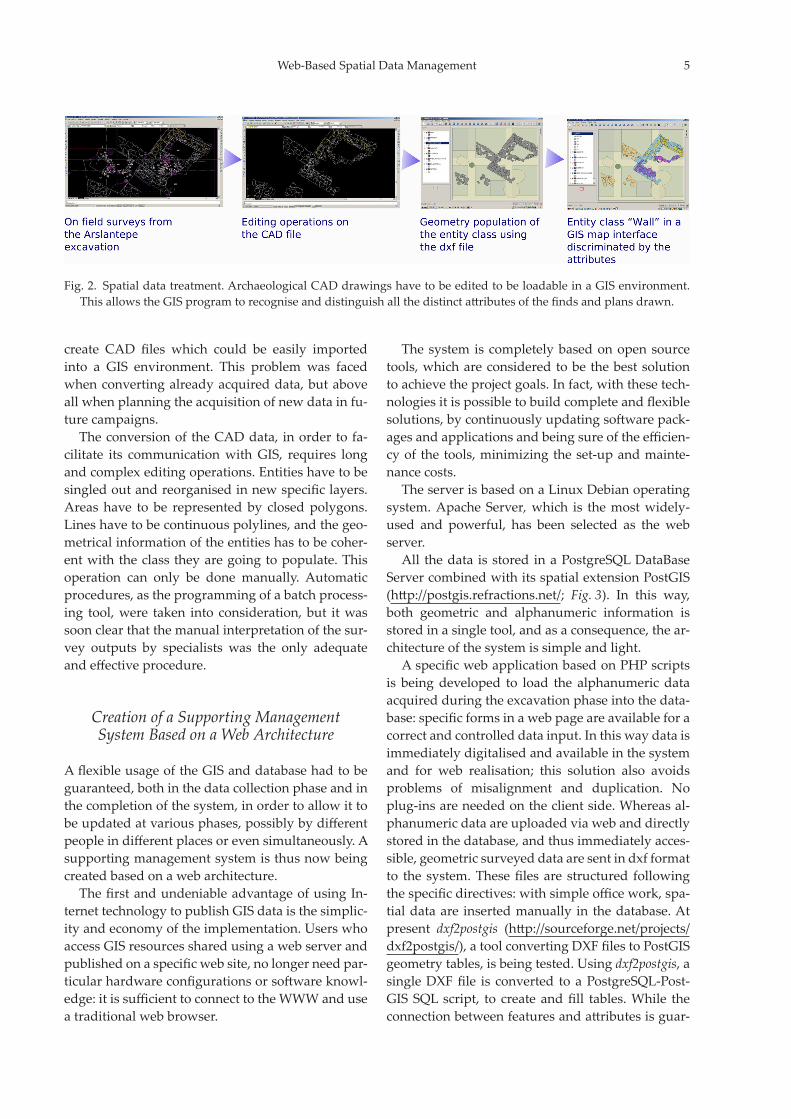
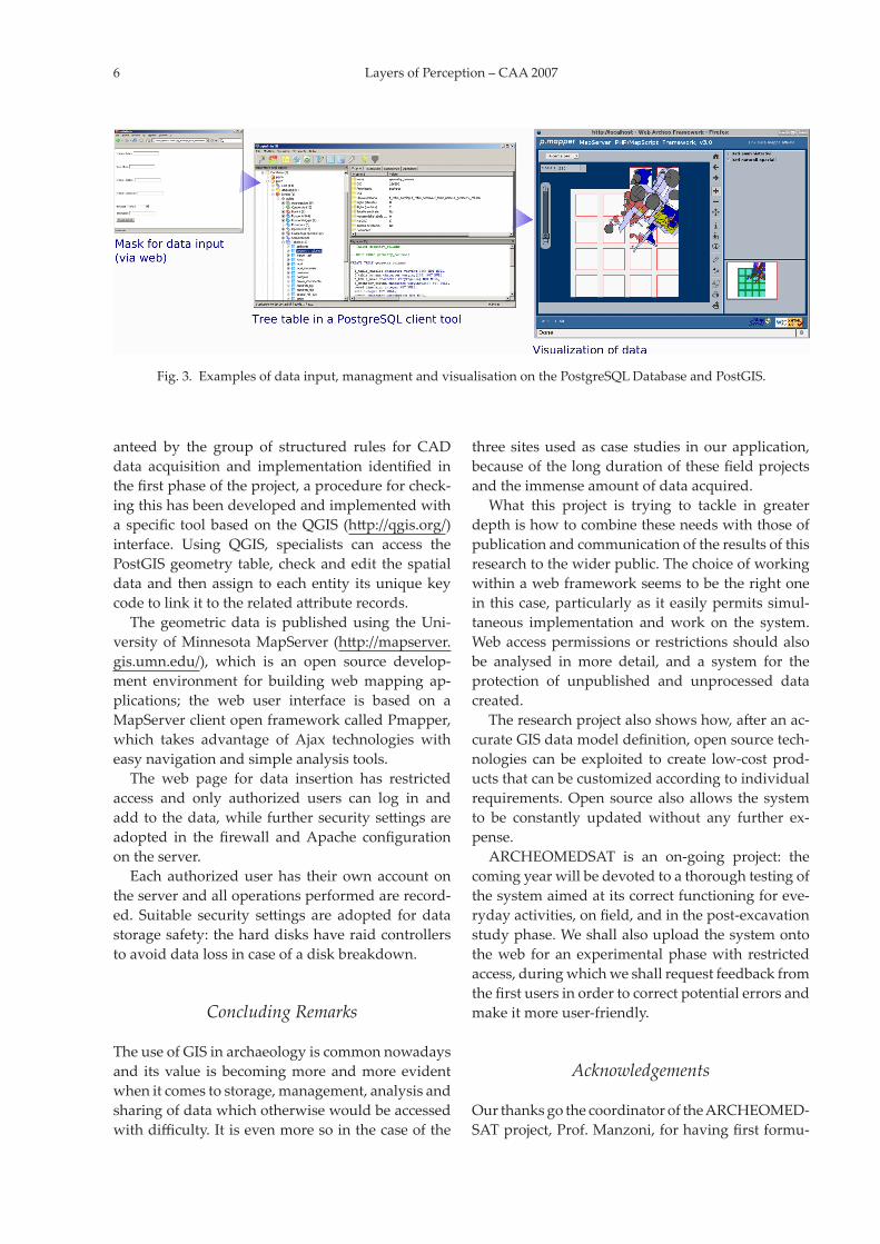