web-based gis and desktop open source gis software: an emerging innovative approach for water...
TRANSCRIPT
D.C. Wyld et al. (Eds.): Advances in Computer Science, Eng. & Appl., AISC 167, pp. 1061–1074. springerlink.com © Springer-Verlag Berlin Heidelberg 2012
Web-Based GIS and Desktop Open Source GIS Software: An Emerging Innovative Approach for Water Resources
Management
Sangeeta Verma, Ravindra Kumar Verma*, Anju Singh, and Neelima S. Naik
Centre of Environmental Studies, National Institute of Industrial Engineering (NITIE), Vihar Lake, Mumbai- 400087, India [email protected]
Abstract. This paper introduces an overview of Web-based GIS and its applications and some of the easily assessable Desktop Open Source GIS Software with easy–to–follow guidance that will help water resource decision-maker and interested stakeholder. Web-based GIS is a prospective application in GIS and represents an important advancement over the traditional desktop GIS. Its application eliminates duplication and inconsistency (which is often possible between GIS professionals) and makes location information conveniently and intuitively accessible across organization/s, at a lower cost per user. Internet provides a medium for processing geo-related information and spatial information to users at an amount larger than traditional GIS. XML and Java have been developed to facilitate the utilization of the internet as well as to provide a coding standard in the software industry. Therefore, in the last few years, there has been a significant development in the area of free and open source GIS software. This paradigm shift from stand-alone GIS to open access Web GIS services provide greater opportunities for sustainable solutions in water resource management and planning.
Keywords: Geographic Information System, Web-based GIS, Water Resource Management, Open Source GIS Software.
1 Introduction
Water is a scarce natural resource. Therefore, managing water resource is extremely important for sustainable development in many parts of the world. The fact that the world faces water crises has become increasingly clear in recent years. These challenges will intensify unless effective and concerted actions are taken [1]. These challenges call for innovative approaches {like Modelling, Remote sensing (RS), Geographic information systems (GIS), Interoperability, Data models, Web services, Web-based GIS, Mobile GIS} because of the dramatic change in water resource management that has occurred during the past few years. Each of these approaches will help water professionals with their work and provide a foundation for continued success.
* Corresponding author.
1062 S. Verma et al.
With respect to water resource management domain, the immediate challenges are (1) to identify the ways in which GIS can facilitate more effective and/or more efficient water resource management (such as development of a GIS module specific for modelling applications that includes multidimensional and time series display capabilities, development of water resource model code for GIS insertion) [2], (2) to develop WebGIS-based Spatial Decision Support Systems (SDSS) that will address specific water resource challenges and problems, and (3) to train the next generation of water resource scientists, engineers, and policy analysts to sustain the continued evolution and appropriate use of Web-based GIS water resource applications [3].
GIS is a system of hardware, software and procedure that capture, store, edit, manipulate, manage, analyse, share and display georeferened data. In order to take advantage of GIS to improve water resources planning and management, it is an attractive idea to integrate GIS with traditional hydrological models (like HEC-1, HEC-2, MODFLOW, SHE, SWAT, BASIN etc.) more efficiently and to include at least some level of spatial effects by partitioning entire watersheds into smaller sub-watersheds and further predict surface, ground water and rainfall-runoff flows. As a result, the interpretation of spatial data becomes easy and increasingly simple to understand.
Since 1980s, various researchers have adopted different approaches, such as loosely coupling, tight coupling and system embedding, to integrate GIS and hydrological models [4]. However, this integration research approach has several important drawbacks. The most important drawback is that the users must install the expensive GIS software and hydrological models in order to use the integrated system. Meanwhile, the integrated system usually has unfriendly user interface and relies on the specific operating system, such as Windows, Linux and Unix. In embedded coupling, another drawback is that the mathematical model is limited by power of the user interface [5]. Consequently, this drawback brings several serious problems, such as the high cost of system deployment and system maintenance, the difficulties in using the integrated system, and the difficulties in collaborating between different users [6, 7] and also increase in system complexity and becomes a challenge for the developers.
Nowadays, GISs have revolutionized many aspect, especially with the advent of the Internet and Web. In WebGIS, the internet technologies are connected with GIS in order to take advantage of their special characteristics, such as easy usability, use the GIS data such as input, adjustment, manipulation, analysis, output of geographical information and to bring out related service on the Internet. Whereas previous stand-alone GISs had restricted application capability on network, the Internet GIS makes it possible to retrieve and analyse spatial data through the web.
Internet also provides a medium for processing geo-related information with no location restrictions. As such, internet reshapes all functions of GIS including: gathering, storing, retrieving, analysing and visualizing data [9]. This shows that internet enables the popularity of the results of GIS analysis and spatial information to users at an amount larger than traditional GIS. Furthermore, respective user may set up an online browse or raising online analysis of spatial subjects free of cost and without any investment for any GIS Software. Extensible Markup Language (XML) and Java have been used to facilitate the development of the internet, to provide a coding standard in the software industry [9] and to make the development of the GIS software much easier. Thus, WebGIS is useful tool for water resource management as
Web-Based GIS and Desktop Open Source GIS Software 1063
it gives users better understanding of the overall picture i.e. locations of rivers/basins, topography of the flooded/drought areas, linkages of geographical factors and natural disasters occurred, water demand and supply thus gives users the ability to find best solution for each area and manage water resources in a sustainable manner.
The Open Geospatial Consortium (OGC) is an organization for geospatial data and web services. In 2000, it has initiated the Open Web Service (OWS) program based on service-oriented architectures and web service, and has proposed several geospatial specifications to support geospatial data sharing and interoperation, such as Web Map Service (WMS), Web Feature Service (WFS), and Web Processing Service (WPS) [9]. WMS has its ability to produce maps rather than its ability to access specific data holdings, and generates spatially referenced maps dynamically. It contains a HTTP interface for requesting geo registered maps from different distributed databases. [10]. WFS defines the interfaces for the access and manipulation of geographical features and elements through Geography Markup Language (GML) [11]. WPS provides standardized interfaces to facilitate publishing, discovering and binding geospatial services that enable spatial processing functions across a network [12]. Therefore, in past few years, there has been a significant development in the area of Free and Open Source geospatial Software (FOSS) in the GIS community. GIS software fulfilling the specific requirements have been distributed with licenses that grant more freedom of use and that support openness, such as licenses used by FOSS GIS projects. For instance, in the last two years, 20 entries have been added to the list of software projects on the website FreeGIS.org ( now containing 330 entries). This shift from traditional planning to open access Web GIS planning services is related to the recognition that structured cooperation provides greater opportunities for sustainable solutions and that cost effective access to baseline data is needed for effective management and planning [13].
This paper focues on need to adopt Web-based GIS tool and easily accessible FOSS in decision making related to water resource management mainly in developing countries that have limited financial resources. The rest of the paper is structured as follows; Section 2 introduces advantages and architecture of Web-based GIS system. While, Sub-section 2, provides easy-to-follow guidance (web address and sources) from where water professions can collect data and download softwares free of cost for WebGIS and SDSS or both, and Section 3 presents a short review of WebGIS applications in water resource management. Finally, Section 4 concludes there view.
2 The Web GIS
WebGIS is a relatively inexpensive way of disseminating spatial data and basic GIS functionality. A good portion of the basic functionality of desktop GIS is now available to users interacting with GIS databases via the World Wide Web (WWW) or an Intranet. The tool has following advantages over conventional GIS (modified from Tripathy (2002) [14]);
• It can be used to disseminate information to large number of local and international users.
• It provides opportunities for public feedback, participation and collaboration in managerial decision making process.
1064 S. Verma et al.
• Users do not have to purchase commercial GIS software. • Users typically do not need extensive training • The application will lead to reduction in cost, since only a GIS server software is
required to be deployed at a centralized location for distributed users. • The GIS data can be accessed any-time any-where, since it requires only Internet
access. • Transfer of copyrighted GIS data need not take place as transfer may be allowed
in image format only. • Data can be stored as centralized data warehouse in an organization to allow easy
maintenance of the data. • Data can be dynamically accessed, so changes made to the data are available
immediately to the distributed users. • Data can be concurrently accessed by many distributed users. • The system can act as full GIS system with input, output, storage, editing,
manipulation, analysis and query function. • Customized application can be developed so that specific information can be
served at specific scale and distributed to the users. • It is also possible to deploy the Internet GIS organization wide using Intranet
capability.
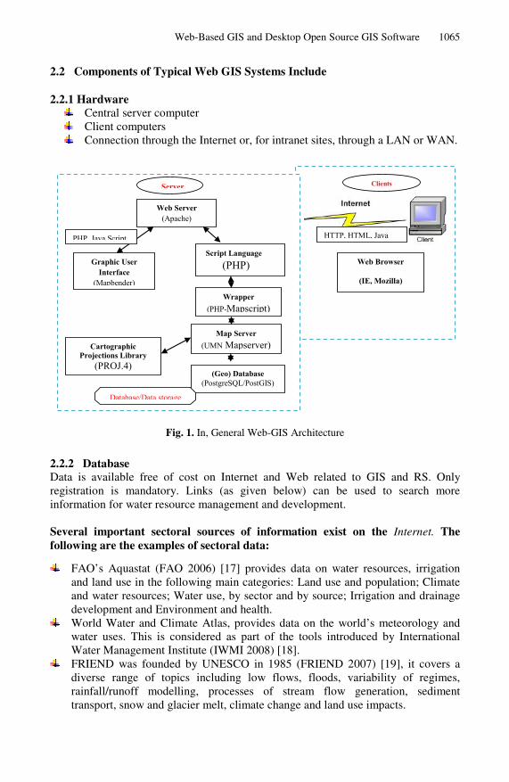
2.1 An Architecture of Typical WebGIS System
The architecture of general WebGIS system is similar to the client/server typical three-tier architecture (Figure 1). In this system, computers are connected in a world wide network and communicate with each other. The communication between various nodes takes place through a protocol, namely TCP/IP. Web browser and Web server are important constituents of Internet. Web browser software (e.g. Mozzilla, Internet Explorer) resides on client machines e.g. desktop or workstation computers. A computer where server software is installed may act as a Web server. It consists of Web server, Web GIS softwares and Database.
The Internet uses a client server approach for distributing information. Information is stored and processed on servers and then sent to a client when it is requested. The request contains information regarding location of Web resource and additional information. HTML is the language that is used to display web pages content on a client’s computer. HTML code is sent between the client and server using the Hypertext Transfer Protocol (HTTP). In web based application scripts are embedded in HTML code. Client side scripting are executed at client-side by web browsers whereas in server side scripting the scripts runs on server side or application servers. The popular server side scripts are PHP, ASP and JSP. JavaScript is a client side object oriented scripting language popular in developing client side application [15]. Common Gateway Interface (CGI) is a standard for writing applications to create Web pages dynamically. CGI standards define how Web servers interact with these software. The applications can be written in a programming language, e.g. C, C++ etc. or a scripting language. The variables are passed through query string to these programs. The applications are called CGI scripts [16].
Web-Based GIS and Desktop Open Source GIS Software 1065
2.2 Components of Typical Web GIS Systems Include
2.2.1 Hardware Central server computer Client computers Connection through the Internet or, for intranet sites, through a LAN or WAN.
Web Server(Apache)
Script Language(PHP)
Wrapper(PHP-Mapscript)
Map Server(UMN Mapserver)Cartographic
Projections Library(PROJ.4)
(Geo) Database(PostgreSQL/PostGIS)
Graphic UserInterface
(Mapbender)
Server Clients
Web Browser
(IE, Mozilla)
HTTP, HTML, Java PHP, Java Script
Database/Data storage
Fig. 1. In, General Web-GIS Architecture
2.2.2 Database Data is available free of cost on Internet and Web related to GIS and RS. Only registration is mandatory. Links (as given below) can be used to search more information for water resource management and development.
Several important sectoral sources of information exist on the Internet. The following are the examples of sectoral data:
FAO’s Aquastat (FAO 2006) [17] provides data on water resources, irrigation and land use in the following main categories: Land use and population; Climate and water resources; Water use, by sector and by source; Irrigation and drainage development and Environment and health.
World Water and Climate Atlas, provides data on the world’s meteorology and water uses. This is considered as part of the tools introduced by International Water Management Institute (IWMI 2008) [18].
FRIEND was founded by UNESCO in 1985 (FRIEND 2007) [19], it covers a diverse range of topics including low flows, floods, variability of regimes, rainfall/runoff modelling, processes of stream flow generation, sediment transport, snow and glacier melt, climate change and land use impacts.
1066 S. Verma et al.
USGS (the U.S. Geological Survey) [20] provide access to water-resources data such as quantity, quality, distribution, and movement of surface and underground waters around the united states and disseminates the data to the public, State and local governments, public and private utilities, and other Federal agencies involved with managing our water resources. The USGS has also developed and continues to develop extensive regional datasets on changes in groundwater levels and the status of the nation’s major aquifer systems [21].
StreamStats [URL 22] allows users to easily obtain stream flow statistics, drainage-basin characteristics, and other information for user-selected sites on streams. Stream Status users can choose locations of interest from an interactive map and obtain information for these locations.
The National Oceanic and Atmospheric Administration (NOAA) monitors nationwide precipitation input- e.g., through the NEXRAD program [23] and individual precipitation stations [24].
India Water Portal [25] provides district wise monthly precipitation data, available on Internet for water resource management.
Other important sources of information are the RS and GIS sites which are available on the World Wide Web sites (adapted from Awad,et al. 2009) [26]:
Global Land Cover Facility (GLCF) and GLOVIS. GLCF located at University
of Maryland provides satellite data of various resolutions and thematic maps, in particular for land use and cover applications at local and global scale [URL 27]. Data available from the site are ETM+, TM, MSS and ASTER. The data are geo-referenced in UTM coordinate system and may be utilized for earth sciences applications. Data may be stacked to create BIL format data. Since 2008, Landsat archives are in public domain and thus data can be downloaded from Internet free of cost [URL 28]. The registration is mandatory. The data which are not processed can be ordered free of cost. High resolution data are also available from the site.
In India, RS data may be purchased on slashed rate from National Remote Sensing Centre (NRSC)-Hydrabad, India [URL 29], Department of Space.
India-WRIS (Water Resources Information System) (2010) [URL 30], a Web-GIS provide a comprehensive, credible, and contextual view of India’s water resources data along with allied natural resources data and information. It also allows users to search, access, visualize, understand, analyze, look into context and study spatial patterns. It is a ‘Single Window’ solution of all water resources and related data in a standardized GIS format in a national framework for water resource assessment and monitoring.
NASA (the USA space research agency), Hydrabad (2008), provides worldwide satellite images, climate data …etc.
NOAA AVHRR [URL 31], imagery is one of the most stable sources of information available freely from the Internet. It is also compatible with NASA's Earth Observing System Data and Information System, enabling global change researchers to more readily gain a greater understanding of planet Earth.
Web-Based GIS and Desktop Open Source GIS Software 1067
MapServer (2007) [32] GIS search engine is an open source development environment for building spatially-enabled internet applications. MapServer is not a full featured GISsystem, nor does it aspire to be. Instead, MapServer excels at rendering spatial data (maps, images and vector data) for the web. Beyond browsing GIS data, MapServer allows to create “geographic image maps”, that is, maps that can direct users to content. For example, the Minnesota Department of Natural Resource (MNDNR) recreation compass provides users with more than 10,000 web pages, reports and maps via a single application. The same application serves as a “map engine” for other portions of the site, providing spatial context where needed.
ESRI’s World Map 1:1,000,000 (ESRI 2004) [33] includes Country Boundaries, Coastlines, Administrative Boundaries, Water Bodies, Perennial Rivers, Intermittent Rivers, Populated Places, Major Roads, Major Trails, Capital Cities, and Major Cities.
ESRI launched the Geography Network [URL 34], global network of spatial data users and providers. It provides the Internet infrastructure to support sharing of geographic information among data providers, service providers, and users around the world. Through the Geography Network, a user can access many types of geographic content, including dynamic maps, downloadable data, and more advanced Web services.
GlobeXplorer is a satellite images portal (GlobeXplorer 2008) [35], commercial satellite images provider, and it is free to browse, search and examine all kinds of satellite images around the world.
Alexandria Digital Library (ADL 2005) [36] is part of the University of California Santa Barbara Libraries. This portal provides search engine to find any type of aerial and satellite images of the world by specifying the geographic extent and the date of the image, these images are free to download.
Another source of an up-to-date satellite images with high resolution is Google Earth (Google, 2008) [37]. This portal provides an easy method to surf the world and search for any spatial feature (river migration, hydro-network, river boundaries etc…)
2.2.3 GIS Software Desktop GIS softwares are needed for processing the satellite data and extracting thematic information. Web GIS software may be used to disseminate spatial data over Web. Several open source and commercial off- the- shelf (COTS) software are available for GIS and Web GIS application. Open source desktop GIS softwares are ILWIS, Quantum GIS, Mapwindow etc. COTS GIS softwares are ArcGIS, MapInfo etc. Open source Web GIS softwares are Mapserver, Geoserver, MapGuide etc. COTS Web GIS software are ArcGIS server, ERDAS Apollo, MapExtreme, Manifold Internet Map Server (IMS) etc. The softwares are available for various platforms, e.g. Windows, Linux, Mac OS and Unix both at 32 bit and 64 bit. COTS softwares vary in their cost. For Web GIS software either the data may be straight away published, e.g. in ArcGIS server, ERDAS Apollo, or require writing codes/HTML pages e.g in Mapserver, MapGuide, MapExtreme etc. Mapserver is a CGI program. Software e.g.
1068 S. Verma et al.
MapGuide, MapExtreme works in modern programming environment. Mapserver software was developed in the mid 1990’s by the University of Minnesota with the assistance of NASA and the Minnesota Department of Natural Resources (MNDNR) [38]. Mapserver is currently managed by the Open Source Geospatial Foundation (OSGeo). The server can be run on several operating systems, e.g. Windows, Linux, Mac OS X etc. It is a CGI program written in C language. It supports shape file format. Map elements, namely thematic map, legend, scalebar, reference etc. can be created. The program uses a Map file, which is a text file. The Map file contains various parameters and details needed for creation of an image file. The image file is embedded in the Web page and depicts the spatial data. HTML documents are often Template HTML files. Mapserver replaces variables, objects etc. in the template file with their values (obtained from query strings, Map files or both). Mapserver tutorial contains HTML files, Java scripts, Map file and data [39].
2.3 Open Source Desktop GIS Software
Open source software is becoming popular and increasingly more reliable than in the past particularly in developing countries for use towards sustainable water resource management [9]. It is commonly used in GIS applications along with their Web address for a further reference (Table 1). Software is considered open source once it complies with the following characteristics [40]:
The source code of the product must be made available. The license allows unlimited redistribution of the product. The license permits the creation of license free derived works. The license does not limit how, where or by whom the product can be used.
Information of open source GIS software exits on the Internet. Few very useful links are:
Open source GIS [URL 41]: This site attempts to build a complete index of Open source/free GIS related software projects. The definition of GIS has been kept loose to encompass a broad range of projects which deal with spatial data. This site stands because of other projects, most notably OSRS,
Freegis [URL 42]: This site organizes software, geodata projects according to the OS, language features. More than 330 relevant softwares are available.
SourceForge [URL 43]: This is a site for all sorts of open source software. It helps to maintain and provide codes for downloads.
OSGeo [URL 44]: This is the website of The Open Source Geospatial Foundation that has been created to support and build the highest-quality open source geospatial software. A list of very popular software packages are listed as OSGeo projects in the OSGeo website.
Wikipedia provides a list of open source GIS software packages [URL 45] and comparisons of some packages were given at [URL 46]. It is noted that both commercial and open source softwares have been included.
Web-Based GIS and Desktop Open Source GIS Software 1069
3 Addressing Water Resources Management through Web-Based GIS and FOSS Approach
Water resource management is combination of (i) rainfall estimation, (ii) watershed management (iii) irrigation water management and identification of potential irrigable lands, (iv) reservoir or lake sedimentation (v) river basin management (vi) dam and drought management (vii) water quality and quantity assessment, (viii) ground water assessment and prospecting (ix) flood forecast and monitoring, (x) low flow estimation, (xi) climate change and Hydrological cycle and (xii) Impact of climate change on available water resources.
Since 1990s, various researchers have adopted WebGIS and Free Open Source Software (FOSS) approach for natural resource management i.e water resource, gained popularity in recent years. Fletcher, et al. [47] developed GIS for stream water management in West Virginia. Choi and Engel [48] have shown that geoprocessing via the web is possible, through creation of a web-based watershed delineation system. Their tool uses the University of Minnesota’s MapServer (University of Minnesota, 2006) as the backend engine, using this map system to obtain an outlet point from the user to begin the delineation process. Their implementation uses a “double-seed array-replacement algorithm to obtain a watershed boundary form point coordinates. Another example of successful web-based geoprocessing is given by Anselin et al. [49] in their Java-based geoprocessing extensions. Their “specific focus is on methods to identify and visualize outliers in maps for rates or proportions. Rathore et al. [39] used an open source internet GIS software (Mapserver) to create an application for dams and drought information and functionalities of a modern internet GIS application for water resource in India. It will provide information about dam storage, hydropower, dam location, rainfall map for different Standarized Precipitation Index (SPI) various time scale etc over the district in India.
Choi et al. [50] examined the relationship between GIS technology and watershed management SDSS by utilizing the prototype conceptual framework SDSS [51] and form a Web-based SDSS, combined integration of two models in SDSS named Long-Term Hydrological Impact Assessment (L-THIA) and Web-based Hydrologic GIS (WHYGIS). This Web-GIS approach is capable to real-time watershed delineation, hydrologic data extraction/preparation functionality, generate watershed boundaries and prepare real time hydrologic data for straightforward operation of hydrologic models via the Internet.
L-THIA, Web DSS structure is comprised of a modeling system, a database system and a graphical user interface, and includes special features for users with limited hydrology knowledge. It is intended to support decision makers who need information regarding the hydrologic impacts of water quantity and quality resulting from land use change.
HYDRA5, Web-based GIS system for catchment management, designed for novice as well as expert users for planning and water quality. It provides a catalogue for search and retrieval of arbitrary data sets, a series of hyper maps with some GIS functionality and links to spatially referenced data, and an analysis and graphing tool for time-series data.
1070 S. Verma et al.
N
ame
R
elea
se
Dev
elop
er
Hom
epag
e
Ope
ratin
g sy
stem
Pr
ogra
mm
ing
Lan
guag
e A
pplic
atio
n
Apa
che
Bat
ik
V 1
.6
Apa
che
http
://xm
lgra
phic
s.apa
che.
org/
batik
/ W
indo
ws,
Linu
x Ja
va 1
.3
Use
imag
es in
the
Scal
able
Vec
tor G
raph
ic
(SV
G)
DIV
A G
IS
V 6
.0.3
C
IP (I
nter
natio
nal P
otat
o C
ente
r, Pe
ru)
http
://re
sear
ch.c
ip.c
giar
.org
/con
fluen
ce/d
ispl
ay/d
ivag
is/H
ome
Win
dow
s onl
y Ja
va w
ith E
clip
se
Mak
e m
aps o
f spe
cies
dis
tribu
tion
data
and
th
eir a
naly
sis
Dee
gree
V
2.1
la
t/lon
, Ger
man
y ht
tp://
ww
w.d
eegr
ee.o
rg/
Win
dow
s onl
y Ja
va 1
.5, t
omca
t 5.
5 Se
rver
/Clie
nt w
eb a
pplic
atio
ns a
nd D
eskt
op
map
ping
Fm
aps
V 0
.0.2
Fm
aps t
eam
ht
tp://
sour
cefo
rge.
net/p
roje
cts/
fmap
s/
Linu
x an
d G
nom
e C
-
FWTo
ols
V 2
.0.6
Pr
ivat
e ht
tp://
fwto
ols.m
apto
ols.o
rg/
Win
dow
s, Li
nux
Java
, pyt
hon
- G
eOxy
gene
V
1.3
G
eOxy
gene
Tea
m
http
://ox
ygen
e-pr
ojec
t.sou
rcef
orge
.net
/ In
depe
nden
t Ja
va
- G
eoSe
rver
V
2.1
.1
Geo
serv
er te
am
http
://ge
oser
ver.o
rg/d
ispl
ay/G
EOS/
Wel
com
e M
acO
S X
, Uni
ces,
and
Win
dow
s Ja
va
Web
GIS
Gen
eric
M
appi
ng T
ools
V
4.3.
1 U
nive
rsity
of H
awai
i ht
tp://
gmt.s
oest
.haw
aii.e
du/
Win
dow
s, Li
nux,
Mac
C
/C++
M
anip
ulat
ing
geog
raph
ic a
nd C
arte
sian
dat
a se
ts a
nd p
rodu
cing
Enc
apsu
late
d Po
stSc
ript
File
(EPS
) G
RA
SS G
IS
V 6
.2.3
G
RA
SS D
evel
opm
ent
Team
ht
tp://
gras
s.itc
.it/
Win
dow
s,Uni
x (L
inux
) C
Sp
atia
l ana
lysi
s and
scie
ntifi
c vi
sual
izat
ion.
gvSI
G
V1.
1.2
Iver
, Gen
eral
itat V
alen
cia,
U
nive
rsid
ad Ja
ume
I, Pr
odev
elop
http
://w
ww
.gvs
ig.g
va.e
s
Win
dow
s, Li
nux,
Mac
OS
X
Java
V
ecto
r dat
a ed
iting
, eas
ily d
igiti
ses b
y sn
appi
ng v
ertic
es to
exi
stin
g no
des a
nd
gene
rate
cor
rect
topo
logy
.
Hid
roSI
G
V.3
.1.1
U
nive
rsity
of C
olom
bia,
Se
deM
edel
lin
http
://ca
ncer
bero
.una
lmed
.edu
.co/
~hid
rosi
g /in
gles
/inde
x.ph
p W
indo
ws,
Linu
x Ja
va
-
ILW
IS
V 3
-04-
02
52o
Nor
th
52o
Nor
th P
rodu
ct p
age
Win
dow
s onl
y M
S V
isua
l 6
Imag
e pr
oces
sing
and
ana
lysi
s, di
gita
l m
appi
ng
KO
SMO
V
1.2
SAIG
S.L
ht
tp://
ww
w.o
peng
is.e
s/
Win
dow
s, M
ac O
S X
, Li
nux
Java
su
bstit
ute
Arc
view
for a
dvan
ced
user
JTS
Topo
logy
Su
ite
V 1
.8.0
V
IVID
Sol
utio
ns
http
://w
ww
.viv
idso
lutio
ns.c
om/jt
s/jts
hom
e.ht
m
Win
dow
s, Li
nux
Java
Map
nik
V.0
.5.1
B
erliO
S D
evel
oper
ht
tp://
map
nik.
org/
W
indo
ws,
Linu
x, M
acO
S
C++
, pyt
hon
Tool
kit f
or d
evel
opin
g G
IS
Map
Win
dow
G
IS
V 4
.5 S
R
Map
Win
dow
ope
n So
urce
Te
am
http
://w
ww
.map
win
dow
.org
/ W
indo
ws o
nly
NET
(VB
,C++
, C
#), N
et
fram
ewor
k 2.
0
Prov
idin
g co
re G
IS a
nd G
IS fu
nctio
ns,
deve
lopi
ng D
ecis
ion
Supp
ort S
yste
m (D
SS)
mez
oGIS
V
.0.1
.5
Priv
ate,
froz
en n
ow
http
;//w
ww
.mez
ogis
.org
/ W
indo
ws a
nd L
inux
py
thon
mon
oGIS
V
0.7
M
onG
IS te
am
http
://w
ww
.mon
ogis
.org
/ W
indo
ws a
nd L
inux
O
GR
/GD
AL
(C++
),Geo
tool
s Ed
iting
and
Vec
tor A
naly
sis
NR
DB
V
.2.3
Pr
ivat
e ht
tp://
nrdb
.co.
uk/
Win
dow
s onl
y C
++
Tool
for d
ispl
ayin
g an
d ed
iting
of s
patia
l da
ta st
ored
in sh
apef
iles
Tab
le1
Lis
tof
Des
ktop
GIS
soft
war
ean
dit
sap
plic
atio
ns
Web-Based GIS and Desktop Open Source GIS Software 1071
(Sou
rce:
mod
ifie
d af
ter
Che
n, e
t al
. 20
10)
Tab
le 1
. (co
ntin
ued)
Ope
n JU
MP
V 1
.2
Ope
n JU
MP
TEA
M
http
://w
ww
.ope
njum
p.or
g/
Win
dow
s, Li
nux,
Mac
O
SX
Java
G
eosp
atia
l map
ping
tool
Ope
nMap
V
4.6.
4 B
BN
Tec
hnol
ogie
s ht
tp://
open
map
.bbn
.com
/ W
indo
ws,
Linu
x, M
ac
OSX
Ja
va
-
OSS
IM
V1.
7.9
O
SSIM
team
ht
tp://
ossi
m.o
rg/O
SSIM
/OSS
IMH
ome.
htm
l W
indo
ws,
Linu
x, M
acO
S X
C
++
RS,
GIS
, im
age
proc
essi
ng,
phot
ogra
mm
etry
Po
stG
IS
V.1
.5.3
R
efra
ctio
ns R
esea
rch
htt:/
/pos
tgis
.refra
ctio
ns.n
et/
Win
dow
s, Li
nux,
Mac
OS
and
othe
r Uni
ces
C, J
ava
Spat
ial d
atab
ase
for G
IS
Qua
ntum
GIS
(Q
GIS
) V
1.7
Q
GIS
Dev
elop
men
t Tea
m
http
://w
ww
.ggi
s.org
/ M
SWin
dow
s, Li
nux,
Mac
O
S X
, PO
SIX
and
oth
er
Uni
ces
C++
, pyt
hon,
and
C
V
iew
Edi
ting,
GR
ASS
-Gra
phic
al u
ser
inte
rface
SAG
A
V 2
.0.3
U
ni. o
f G
oetti
ngen
ht
tp;//
ww
w.sa
ga-g
is.u
ni-g
oetti
ngen
.de/
W
indo
ws a
nd L
inux
C
++
Ana
lysi
s mod
ellin
g, v
isua
lisat
ion
(ras
ter)
, es
peci
ally
terr
ain
hydr
ogra
phic
ana
lysi
s SA
MT
V
.2.8
.1
Inst
itute
of L
ands
cape
Sy
stem
s Ana
lysi
s (ZA
LF)
http
://w
ww
.zal
f.de/
hom
e sa
mt-l
sa/
Uni
x -
Inte
grat
ing
fuzz
y-m
odel
s and
spat
ial
sim
ulat
ion
SavG
IS
V2.
1.5.
0 IR
D (D
evel
opm
ent
Res
earc
h Fr
ench
Inst
itute
) ht
tp://
savg
is.o
rg/
Win
dow
s onl
y -
Shar
pMap
V
0.9
Sh
arpm
ap te
am
http
://w
ww
.cod
eple
x.co
m/S
harp
Map
W
indo
ws a
nd L
inux
C
++
Ren
ders
GIS
vec
tor d
ata
for u
se in
web
and
de
skto
p ap
plic
atio
ns
Terr
aVie
w
V.3
.2.0
D
PI o
f IN
PE
http
://w
ww
.dpi
.inpe
.br/t
erra
view
/inde
x.ph
p W
indo
ws,
Linu
x C
++
Th
uban
V
.1.2
.2
Thub
an T
eam
ht
tp://
thub
an.in
teva
tion.
org/
W
indo
ws a
nd M
ac O
S,
Linu
x an
d ot
her U
nice
s py
thon
G
eogr
aphi
c da
ta v
iew
er
uDIg
V
1.2
.1
Ref
ract
ions
Res
earc
h ht
tp://
udig
.refra
ctio
ns.n
et
Win
dow
s (no
t win
dow
s 20
00, M
ac O
S, L
inux
, and
ot
her U
nice
s
Java
with
Ecl
ipse
V
iew
ing
(OG
C st
anda
rds)
app
licat
ion
fram
ewor
k
Whi
tebo
x V
1.0
7 U
nive
rsity
of G
uelp
h C
entre
for
Hyd
roge
omat
ics
http
://w
ww
.uog
uelp
h.ca
/~hy
drog
eo/W
hite
box/
inde
x.ht
ml
Win
dow
s Py
thon
, C#,
.NET
Sp
atia
l ana
lysi
s on
rast
er d
ata
sets
Kal
ypso
V
10.
10
Join
tly b
y B
jörn
sen
Con
sulti
ng E
ngin
eers
(B
CE)
and
Ham
burg
U
nive
rsity
of T
echn
olog
y,
Ger
man
y
http
://ka
lyps
o.bj
oern
sen.
de/
Linu
x Ja
va
Num
eric
al si
mul
atio
n in
wat
er m
anag
emen
t an
d ec
olog
y
Capa
war
e V
rc 2
In
stitu
to T
ecno
logi
co d
e C
anar
ias (
ITC
) ht
tp://
ww
w.c
apaw
are.
org/
W
indo
ws
C++
G
eogr
aphi
c a
naly
sis a
nd v
isua
lizat
ion
Falc
onV
iew
V
4.2
.1
Geo
rgia
Tec
h R
esea
rch
Inst
itute
ht
tp://
ww
w.fa
lcon
view
.org
/ W
indo
w 2
000,
XP,
Vis
ta
C++
M
appi
ng s
yste
m
1072 S. Verma et al.
Wang et al. [52] developed Web-GIS based river simulation model named GIS-ROUT system for estimating environmental exposure and risk assessment after disposal of chemicals in surface water and their contributions to surface water quality throughout continental United State. It has a number of advantages over common modelling approach such as; (1) its components (WWW, GIS and ROUT) can be as integrated or independent from each other at the same time (2) GIS provides wide range of spatial analytical functions to prepare data for river modeling (3) user-friendly internet-based interface (4) capable of sharing data and simulation results (5) do not require powerful client computer system and (6) better reliability of spatial analysis of the modeling output.
Web-GIS can provide a user-friendly light-weight interface for the users to access geographical data and geographical services using web browser. However, the Web-GIS and hydrological model integrated systems need to manage and process various spatial data, such as, DEM, remote sensing images, land use data, topographic data and various temporal data, such as stream flow data, precipitation data and temperature data. While, FOSS permits users to use, change and improve the software codes within any programming language, and permit to rewrite in multiple languages for particular need. It is often developed in a collaborative manner in a public domain.
Rajani [53], who studied the relevance of FOSS for developing countries. Chen et al. [9] assessed number of Open Source Softwares and suggested 31 suitable Open Source GIS efficient software packages (Table 1), based on their potentiality to identify and shortlist the most suitable and user friendly, which could be used for analysis or designing a system applicable to water resources management mainly in developing countries. Some of related software and their link and application are summarized in Table 1.
4 Conclusions
This paper provides an overview of Web-based GIS and links & sources for RS and GIS data and web address for Desktop Open Source GIS softwares packages for water professionals of developing countries that have limited financial resources. Thus, information about the water resource management and development may be made available on Web using client, namely a Web browser. GIS software is not required at the user desktop. Also, user need not be familiar with GIS to use this data. This indicates great potential of Web GIS in information dissemination on water resource domain. Additionally, numbers of open source Web GIS software are available and thus applications in hydrology and water resources may be created with small budget. Which are freely available on internet and Web for water resource management. Web-based GIS system could be used by any user without installing traditional desktop GIS or COTS Softwares. The Web-based SDSS for watershed management is currently being validated and proved advantageous over traditional desktop applications. In addition, the Internet based approach increases the user base by reducing costs of access to users. This paradigm shift from stand-alone GIS software to Web-based GIS software and Open Source GIS softwares with COTS software will enable us to think above and beyond the technical drawbacks that have occupied us during the past 10 years. This Web-based GIS will also lead to a wide-range application with easy access for water resource management.
Web-Based GIS and Desktop Open Source GIS Software 1073
Acknowledgement. The authors would like to thank anonymous reviewer for the constructive comments and suggestions.
References
[1] WWAP, Water for People, Water for Life, UN World Water Development Report. Prepared as a collaborative effort of 23 UN agencies and convention secretariats co-ordinated by the World Water Assessment Programme, UNESCO, Paris (2003), http://www.unesco.org/wate/wwap/index.shtmlr
[2] Martin, P.H., LeBoeuf, E.J., Dobbins, J.P., Daniel, E.B., Abkowitz, M.D.: Interfacing GIS with water Resource models: A state-of-the-art review. Journal of the American Water Resource Association, 1471–1487 (2005)
[3] http://dusk.geo.orst.edu/ucgis/web/apps_white/water.html [4] McDonnell, R.A.: Including the spatial dimension: Using geographical Information
systems in hydrology. Progress in Physical Geography 20(2), 159–177 (1996) [5] Castrogiovannia, E.M., Loggia, G.L., Noto, L.V.: Design storm prediction and hydrologic
modeling using a web-GIS approach on a free-software platform. Journal of Atmospheric Research 77, 367–377 (2005)
[6] Sui, D.Z., Maggio, R.C.: Integrating GIS with hydrological modeing: practices, problems, and prospects. Journal of Computer, Environment and Urban Systems 23(1), 33–51 (1999)
[7] Al-Sabhan, W., Mulligan, M., Blackburn, G.A.: A real-time hydrological model for flood prediction using GIS and the WWW. Journal of Computer, Environment and Urban Systems 27, 9–32 (2003)
[8] Alesheikh, A.A., Helali, H., Behroz, H.A.: Web GIS: Technologies and Its Application. In: Symposium on Geospatial Theory, Processing and Application (2002), http://www.isprs.org/proceedings/XXXIV/part4/pdfpapers/ 426.pdf (Access on 10.12.2011)
[9] Chen, D., Shams, S., Moreno, C.C., Leone, A.: Assessment of open source GIS software for water resources management in developing countries. Journal of Hydro-environment Research 4(3), 253–264 (2010)
[10] OGC: WMS Implementation Specification, http://portal.opengeospatial.org/files/?artifact_id=1058
[11] OGC: WFS Implementation Specification, http://portal.opengeospatial.org/files/?artifact_id=8339
[12] OGC: OpenGIS Web Processing Service, http://portal.opengeospatial.org/files/?artifact_id=24151
[13] Peng, Z.R.: An assessment framework for the development of Internet GIS. Environment and Planning B: Planning and Design 26(1), 117–132 (1999)
[14] Tripathy, G.K.: Web-GIS based urban planning and information system for municipal corporations-A distributed and real-time system for public utility and town planning. Geospatial Application (2002), http://www.gisdevelopment.net/application/urban
[15] http://www.adobe.com/livedocs/coldfusion/6.1/htmldocs/ introb5.htm
[16] http://en.wikipedia.org/wiki/Common_Gateway_Interface [17] FAO (2006), http://www.fao.org/nr/water/aquastat/main/index.stm [18] International Water Management Institute, IWMI (2008),
http://www.iwmi.cgiar.org/
1074 S. Verma et al.
[19] FRIEND (2007), http://typo38.unesco.org/en/about-ihp/ ihp-partner/friend.html
[20] http://waterdata.usgs.gov/nwis [21] http://water.usgs.gov/cgi/rasabiblio [22] http://water.usgs.gov/osw/streamstats/index.html [23] http://www.roc.noaa.gov/ [24] http://www.websites.noaa.gov/guide/sciences/atmo/precip.html [25] http://indiawaterportal.org/node/7160 [26] Awad, M., Khawlie, M., Darwich, T.: WebBased meta database and its role in improve
water resource management in Mediterranean basin. Journal of Water Resource Management 23, 2669–2680 (2009)
[27] http://glcf.umiacs.umd.edu/index.shtml [28] http://glovis.usgs.gov/ [29] http://www.nrsc.gov.in/ [30] http://www.india-wris.nrsa.gov.in [31] http://www.saa.noaa.gov [32] MapServer (2007), http://mapserver.gis.umn.edu [33] ESRI (2004), http://www.esri.com/data/free_data/index.html [34] http://www.geographynetwork.com [35] GlobalXplorer Satellite Images Portal (2008), http://imageatlas.globexplorer.com [36] Alexandria Digitallibrary, ADLO, Satellite images and GIS Portal (2005),
http://webclient.alexandria.ucsb.edu/ [37] Google Earth GIS and Remote Sensing Databases (2008), http://earth.google.com [38] http://mapserver.org/MapServer.pdf [39] Rathore, D.S., Chalisgaonkar, D., Pandey, R.P., Ahmad, T., Singh, Y.: AWeb GIS
Application for Dams and Drought in India. Indian Society of Remote Sensing 38(4), 670–673 (2010)
[40] Open Source Initiative, http://www.opensource.org/docs/definition.php [41] Open Source GIS, http://opensourcegis.org/ [42] Freegis, http://freegis.org/ [43] SourceForge, http://web.sourceforge.com/ [44] OSGeo, http://www.osgeo.org/ [45] Wikipedia, http://en.wikipedia.org/wiki/List_of_GIS_software [46] http://en.wikipedia.org/wiki/Comparison_of_GIS_software [47] Fletcher, J.J., Sun, Q., Strager, M.P.: GIS application for stream water management in
West Virginia. In: Proc. of International Conferences on Info-tech and Info-net (ICII), vol. 4, pp. 113–123 (2001)
[48] Choi, J.Y., Engel, B.A.: Real-Time Watershed Delineation System Using Web-GIS. Journal of Computing in Civil Engineering 17(3), 189–196 (2003)
[49] Anselin, L., Kim, Y.W., Syabri, I.: Web-based analytical tools for the exploration of spatial data. Journal of Geographic Systems 6, 197–218 (2004)
[50] Choi, J.-Y., Engel, B.A., Farnsworth, R.L.: Web-based GIS and spatial decision support system for watershed management. Journal of Hydroinformatics 7(3), 165–174 (2005)
[51] http://pasture.ecn.purdue.edu/,watergen/owls [52] Wang, X., Homer, M., Dyer, S.D., White-Hull, C., Du, C.: A river water quality model
integrated with a web-based geographic information system. Journal of Environmental Management 75, 219–228 (2005)
[53] Rajani, N., Rekola, J., Mielonen, T.: Free as in education: significance of the free/libre and open source software for developing countries. World Summit on the Information Society (2003)