structuring role of public space in scattered city: emerging centralities of tagus south bank
TRANSCRIPT
Structuring role of public space in scattered city: emerging centralities of Tagus South Bank EURAU’12
ABSTRACT. In metropolitan scattered cities we face the emergence of new
centralities, no longer associated to the existing consolidated city, but offering a
variety of new typologies and services. They function, at the same time, as cores of
attraction at the metropolitan scale, and as areas of interaction in a local urban life
scale. Due to this multi-scale characteristic, some problems are identified in the link
between the metropolitan access and the local scale interaction aspects. In this
paper we will try to understand how is it possible to articulate these multi-scale
centralities with the local urban fabrics, focusing on the role of public space. We will
analyze, in the scope of Lisbon’s Metropolitan Area, Tagus South Bank, and in more
detail some areas of Almada municipality. The hypothesis we place is that public
space can be “the connector element”, able to link different territorial scales,
forming a coherent structure and acting as a referent in urban scattered contexts.
KEYWORDS: public space; multi-scale centralities; articulation; network; Tagus
South Bank.
Ana Júlia Pinto* _ Ana Luísa Brandão**
* CR POLIS, Facultat de Belles Arts, Universitat de Barcelona CESUR, Instituto Superior Técnico, Universidade Técnica de Lisboa Av. Rovisco Pais, 1, 1049-001 Lisboa 00 351 218418323 – [email protected] ** CR POLIS, Facultat de Belles Arts, Universitat de Barcelona CESUR, Instituto Superior Técnico, Universidade Técnica de Lisboa Av. Rovisco Pais, 1, 1049-001 Lisboa 00 351 218418323 – [email protected]
1. Emerging centralities in the scattered city
Changes produced by urban growth and dispersed transformations led to a new context for cities – metropolitan scattered cities – which have polycentric development schemes and are integrated in multiple scale networks and interactions.
They are polarized around different centrality areas that can function as anchor spaces structuring the entire urban network. These emerging centralities (transport interfaces, commercial areas, universities, technological parks, etc.) are not typically associated with the traditional city, instead they cluster around areas of large accessibility, mainly highway accesses or connections with multimode transportation systems. Despite their distance to “traditional centres”, they represent a new variety of typologies and characteristics (specific uses, location, attractiveness, complementary functions, etc.) important in nowadays territorial dynamics. Additionally they are able to combine different territorial scales, functioning at the same time, as cores of attraction at the metropolitan scale and having relevant impact at local scale.
Due to this importance, these multi-scale emerging centralities must be understood not just as individual elements, but as forming a network that structures connections and relations at a metropolitan scale, also playing an important role at local level structures and dynamics (AJUNTAMENT DE BARCELONA, 1987). Although this multi-scale characteristic can represent an opportunity for interaction in a scattered urban context, current examples reveal a number of problems. If at the metropolitan scale the links to these centralities are reasonably solved, most of the solutions do not consider the articulation with the local scale. This brings difficulties in establishing connections and interactions with proximity networks (tunnel-effects, urban fabric ruptures, mobility problems, lack of diversity, etc.).
In this paper we will try to understand how it is possible to establish the articulation between the multi-scale centralities and the local urban fabrics, focusing on the role of public space, in a network based approach. The hypothesis we place is that public space can be “the connector element”, able to link different territorial scales - from a metropolitan area, to a city and local neighbourhood – forming a coherent network and acting as a referent in urban scattered contexts. In the canonical city, this structuring role of public space is easily recognizable in a set of well defined typologies. Our conviction is that in other contexts of suburban growth, rapid
transformations, heterogenic urban fabrics or lack of urban diversity, public space can act in the same way, as an agent of urban qualification: [1] promoting continuity, improving mobility and accessibility conditions in the urban fabric; [2] co-producing strong social and cultural dynamics; and [3] helping to stimulate economic activities.
Using cross–mapping methodologies (LUKES, 2007) and public space network analysis (PINTO, REMESAR, 2012), we will study in Lisbon Metropolitan Area, the emerging anchor spaces of Tagus South Bank and their influence in metropolitan dynamics. In more detail we will analyse a particular case in Almada Municipality, identifying impacts, connections and possibilities to local urban areas links.
2. Analyzing Tagus South Bank
In the scope of Lisbon Metropolitan Area, Tagus South Bank grew supported by industrial development and later on, in a suburban, subsidiary relation to Lisbon central functions and services. In the last decades some investments, urban
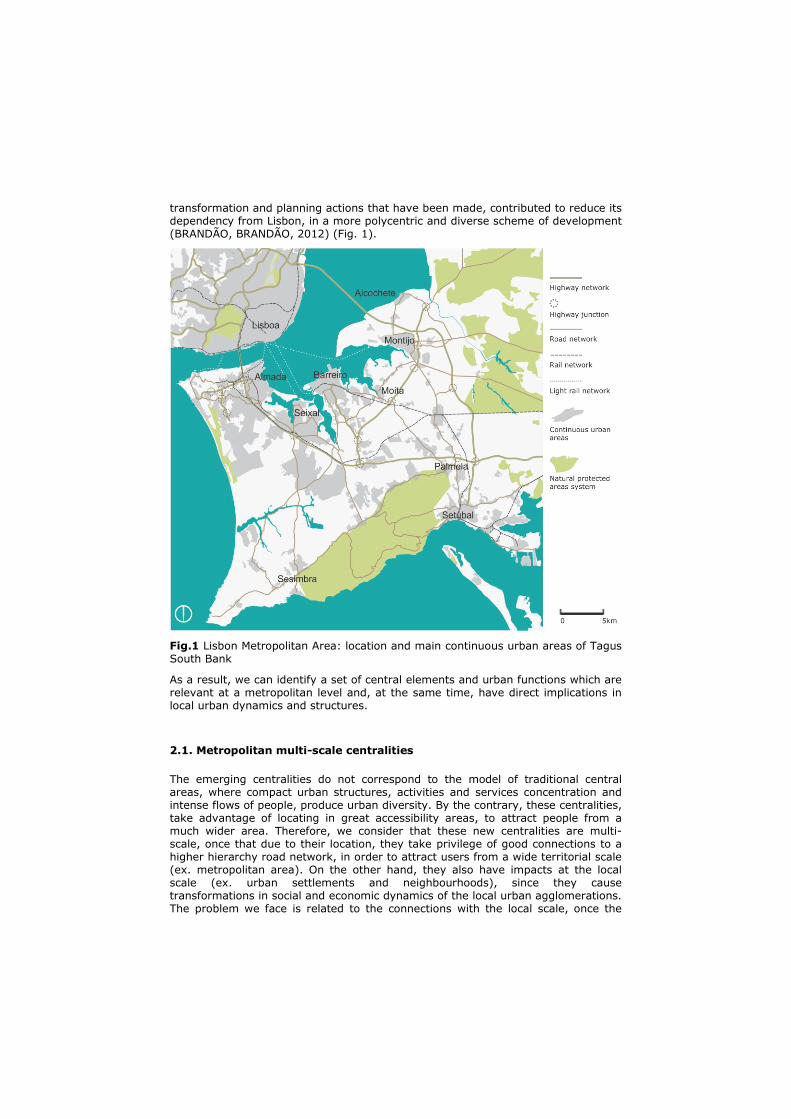
transformation and planning actions that have been made, contributed to reduce its dependency from Lisbon, in a more polycentric and diverse scheme of development (BRANDÃO, BRANDÃO, 2012) (Fig. 1).
Fig.1 Lisbon Metropolitan Area: location and main continuous urban areas of Tagus South Bank
As a result, we can identify a set of central elements and urban functions which are relevant at a metropolitan level and, at the same time, have direct implications in local urban dynamics and structures.
2.1. Metropolitan multi-scale centralities
The emerging centralities do not correspond to the model of traditional central areas, where compact urban structures, activities and services concentration and intense flows of people, produce urban diversity. By the contrary, these centralities, take advantage of locating in great accessibility areas, to attract people from a much wider area. Therefore, we consider that these new centralities are multi-scale, once that due to their location, they take privilege of good connections to a higher hierarchy road network, in order to attract users from a wide territorial scale (ex. metropolitan area). On the other hand, they also have impacts at the local scale (ex. urban settlements and neighbourhoods), since they cause transformations in social and economic dynamics of the local urban agglomerations. The problem we face is related to the connections with the local scale, once the
existing ones do not enable the necessary interaction with the local urban fabrics. So, it is necessary to act at the level of the scale we call intermediate, which is our focus, i. e. the scale that enables the articulation and interaction between the metropolitan centralities and the local urban agglomerations.
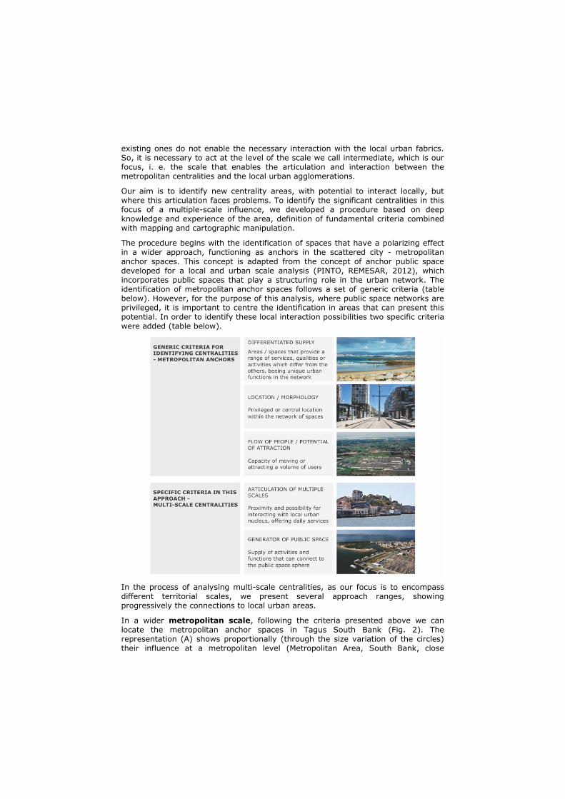
Our aim is to identify new centrality areas, with potential to interact locally, but where this articulation faces problems. To identify the significant centralities in this focus of a multiple-scale influence, we developed a procedure based on deep knowledge and experience of the area, definition of fundamental criteria combined with mapping and cartographic manipulation.
The procedure begins with the identification of spaces that have a polarizing effect in a wider approach, functioning as anchors in the scattered city - metropolitan anchor spaces. This concept is adapted from the concept of anchor public space developed for a local and urban scale analysis (PINTO, REMESAR, 2012), which incorporates public spaces that play a structuring role in the urban network. The identification of metropolitan anchor spaces follows a set of generic criteria (table below). However, for the purpose of this analysis, where public space networks are privileged, it is important to centre the identification in areas that can present this potential. In order to identify these local interaction possibilities two specific criteria were added (table below).
In the process of analysing multi-scale centralities, as our focus is to encompass different territorial scales, we present several approach ranges, showing progressively the connections to local urban areas.
In a wider metropolitan scale, following the criteria presented above we can locate the metropolitan anchor spaces in Tagus South Bank (Fig. 2). The representation (A) shows proportionally (through the size variation of the circles) their influence at a metropolitan level (Metropolitan Area, South Bank, close
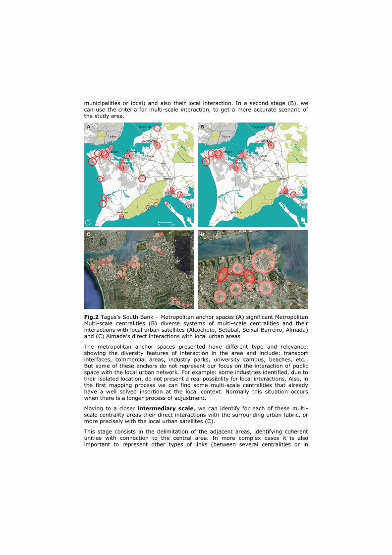
municipalities or local) and also their local interaction. In a second stage (B), we can use the criteria for multi-scale interaction, to get a more accurate scenario of the study area.
Fig.2 Tagus’s South Bank – Metropolitan anchor spaces (A) significant Metropolitan Multi-scale centralities (B) diverse systems of multi-scale centralities and their interactions with local urban satellites (Alcochete, Setúbal, Seixal-Barreiro, Almada) and (C) Almada’s direct interactions with local urban areas
The metropolitan anchor spaces presented have different type and relevance, showing the diversity features of interaction in the area and include: transport interfaces, commercial areas, industry parks, university campus, beaches, etc… But some of these anchors do not represent our focus on the interaction of public space with the local urban network. For example: some industries identified, due to
their isolated location, do not present a real possibility for local interactions. Also, in the first mapping process we can find some multi-scale centralities that already have a well solved insertion at the local context. Normally this situation occurs when there is a longer process of adjustment.
Moving to a closer intermediary scale, we can identify for each of these multi-scale centrality areas their direct interactions with the surrounding urban fabric, or more precisely with the local urban satellites (C).
This stage consists in the delimitation of the adjacent areas, identifying coherent unities with connection to the central area. In more complex cases it is also important to represent other types of links (between several centralities or in
polycentric schemes). The process allows illustrating, in a simple way, the range of connections’ complexity that a centrality can potentiate in its direct surroundings.
The previous interpretative map allows us to follow the approximation to a even more detailed local scale, where each connection system is looked at separately. From scope of multi-scale centralities of Tagus South Bank, the case here illustrated of Almada’s “rótula” (D), represents the most complex and interdependent situation, with several multi-scale centralities connected between themselves and also with a significant group of urban satellite areas with different morphological and social-economical characteristics.
2.2. Connecting with local scale: the case of Almada
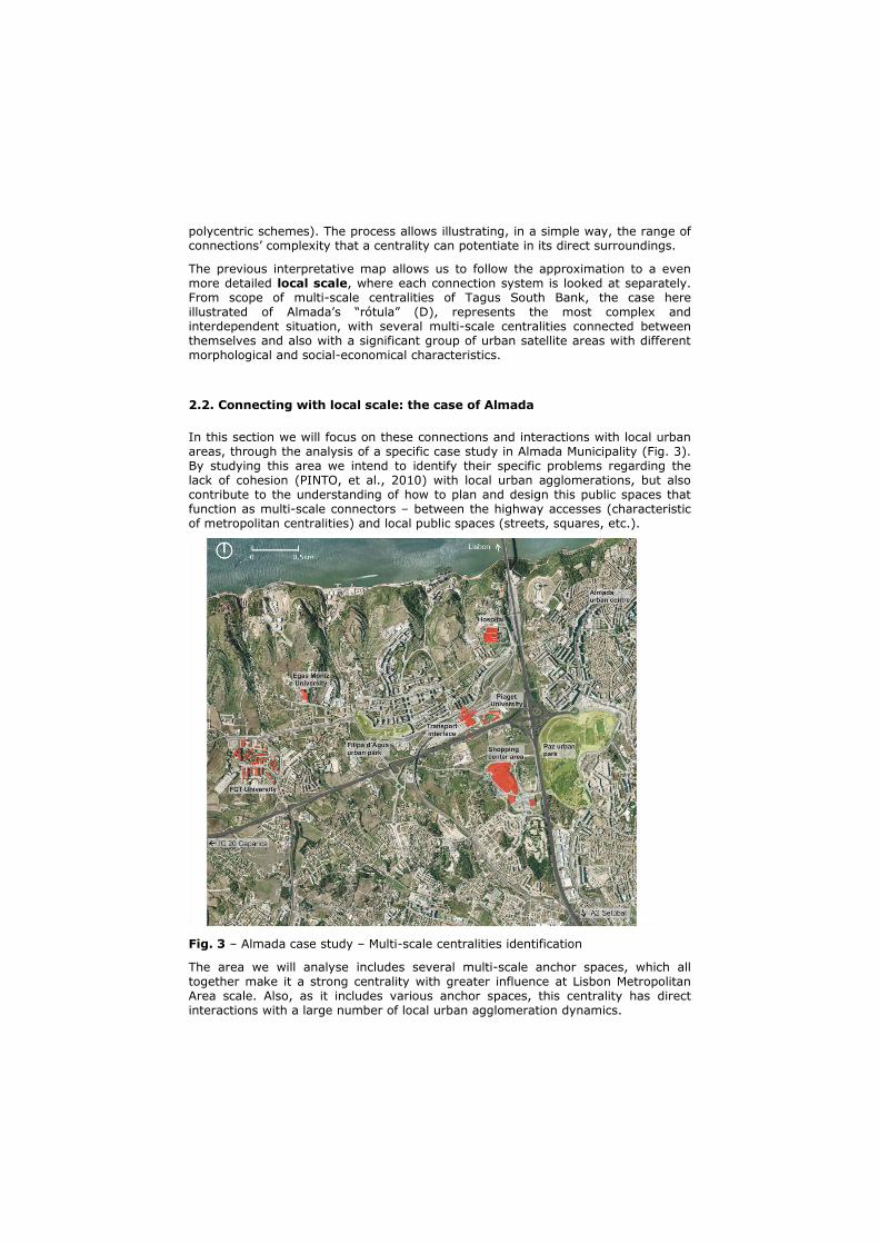
In this section we will focus on these connections and interactions with local urban areas, through the analysis of a specific case study in Almada Municipality (Fig. 3). By studying this area we intend to identify their specific problems regarding the lack of cohesion (PINTO, et al., 2010) with local urban agglomerations, but also contribute to the understanding of how to plan and design this public spaces that function as multi-scale connectors – between the highway accesses (characteristic of metropolitan centralities) and local public spaces (streets, squares, etc.).
Fig. 3 – Almada case study – Multi-scale centralities identification
The area we will analyse includes several multi-scale anchor spaces, which all together make it a strong centrality with greater influence at Lisbon Metropolitan Area scale. Also, as it includes various anchor spaces, this centrality has direct interactions with a large number of local urban agglomeration dynamics.

This multi-scale centrality includes (Fig. 3) [1] Shopping Centre Area; [2] “Pragal” Transport Interface; [3] “Garcia de Horta” Hospital; [4] Faculty of Science and Technology (FCT); [5] Piaget Institute University; [6] Superior Institute of Health Science “Egas Moniz”.
The analysis we develop focuses on the role of public spaces as “the connector element”, enabling the articulation between different territorial scales, forming a coherent structure and acting as a referent in urban scattered contexts.
Our case study analysis is based on cross-mapping methods, and is composed of two different parts:
- The first one is the clear identification of the public spaces that connect the multi-scale centralities with local urban areas.
- The second part is the evaluation of the identified public spaces, using criteria we believe to be indispensable characteristics for a public space able to promote cohesion with the local urban agglomerations.
Through this analysis we intend to recognize the main problems of the existing public space network, and identify the possibilities to solve them, enabling the definition of a “public space multi-scale connector” i.e., what makes it possible to articulate these new centralities with the existing local urban areas.
The first part of our analysis – identification of the public spaces which connect the multi-scale centralities with the local urban areas – consists of four distinct steps (table below). The first one is the identification of the study area’s multi-scale centralities. In this step we map the anchor spaces, i.e. the ones that due to their functions, the activities they offer, their location, or the capacity they have to attract a high flow of users, function has centralities with interactions at different territorial scales – from the metropolitan area to the local urban areas.
The second step is the identification and mapping of the local urban agglomerations. With this step we intend to identify the local urban areas that actually have characteristics of concentrated urban settlements. These areas are the ones that will have stronger interactions with the identified multi-scale centralities and therefore, the ones which we need to guarantee that have quality public space connections to the anchor spaces. In order to indentify these local urban agglomerations we started by considering only the buildings with more than 30m2 and drawing buffers of 15 metres around each one of them. We selected only the set of spaces with more than 35 buildings and primary road access. These are
the local urban agglomerations with a dimension we consider the minimum to be connected to the multi-scale centrality spaces.
The third step is the identification of the existing primary public space network. In the scope of this analysis we consider that this network is composed of the public spaces that assure the main connections between the most important functions / services / facilities and urban agglomerations.
The fourth and last step is the clear identification of the public spaces that connect the centralities to the local urban agglomerations, i.e. the potential multi-scale connector public spaces. These spaces where identified using the cross mapping method by overlapping the information which was mapped on the previous steps. This method of crossing information makes it possible to take into account the links that have to be established between the centralities and the local urban areas, at the same time also considering the primary existing public space network. The reason to consider that this primary public space network is crucial in identifying the areas of multi-scale interaction is that it is this network that allows connection between the major metropolitan road access and the local public space networks.
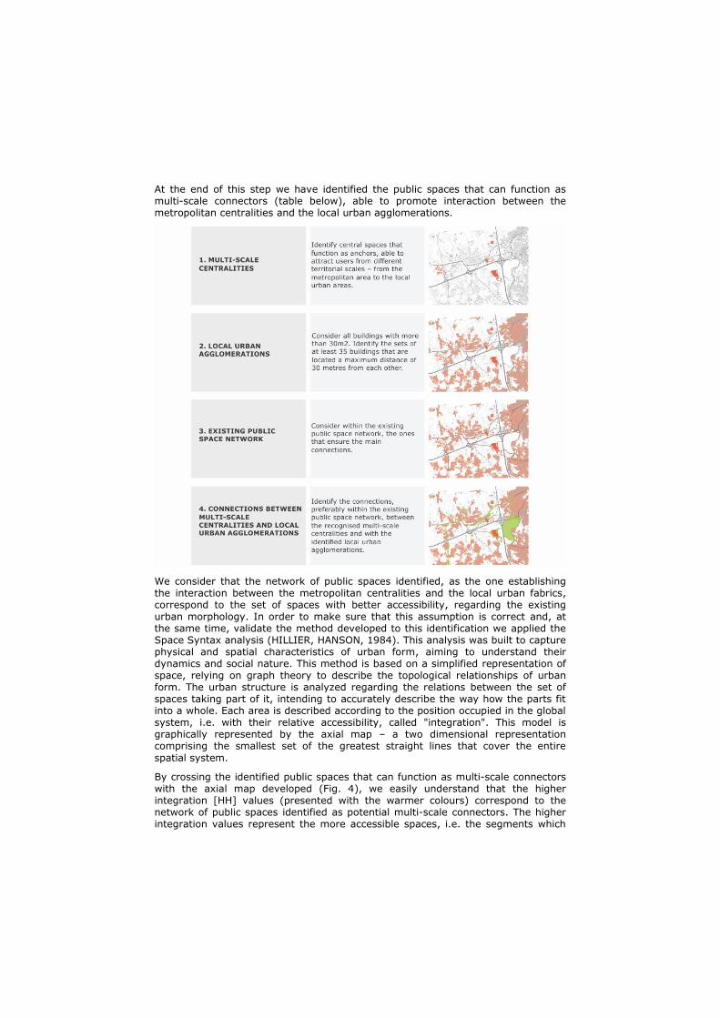
At the end of this step we have identified the public spaces that can function as multi-scale connectors (table below), able to promote interaction between the metropolitan centralities and the local urban agglomerations.
We consider that the network of public spaces identified, as the one establishing the interaction between the metropolitan centralities and the local urban fabrics, correspond to the set of spaces with better accessibility, regarding the existing urban morphology. In order to make sure that this assumption is correct and, at the same time, validate the method developed to this identification we applied the Space Syntax analysis (HILLIER, HANSON, 1984). This analysis was built to capture physical and spatial characteristics of urban form, aiming to understand their dynamics and social nature. This method is based on a simplified representation of space, relying on graph theory to describe the topological relationships of urban form. The urban structure is analyzed regarding the relations between the set of spaces taking part of it, intending to accurately describe the way how the parts fit into a whole. Each area is described according to the position occupied in the global system, i.e. with their relative accessibility, called "integration". This model is graphically represented by the axial map – a two dimensional representation comprising the smallest set of the greatest straight lines that cover the entire
spatial system.
By crossing the identified public spaces that can function as multi-scale connectors with the axial map developed (Fig. 4), we easily understand that the higher integration [HH] values (presented with the warmer colours) correspond to the network of public spaces identified as potential multi-scale connectors. The higher integration values represent the more accessible spaces, i.e. the segments which
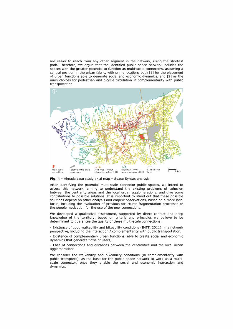
are easier to reach from any other segment in the network, using the shortest path. Therefore, we argue that the identified public space network includes the spaces with the greater potential to function as multi-scale connectors, assuming a central position in the urban fabric, with prime locations both [1] for the placement of urban functions able to generate social and economic dynamics, and [2] as the main choices for pedestrian and bicycle circulation in complementarity with public transportation.
Fig. 4 – Almada case study axial map – Space Syntax analysis
After identifying the potential multi-scale connector public spaces, we intend to assess this network, aiming to understand the existing problems of cohesion between the centrality areas and the local urban agglomerations, and give some contributions to possible solutions. It is important to stand out that these possible solutions depend on other analysis and empiric observations, based on a more local focus, including the evaluation of previous structures fragmentation processes or the people motivation for the use of the new connections.
We developed a qualitative assessment, supported by direct contact and deep knowledge of the territory, based on criteria and principles we believe to be determinant to guarantee the quality of these multi-scale connections:
- Existence of good walkability and bikeability conditions (IMTT, 2011), in a network perspective, including the interaction / complementarity with public transportation;
- Existence of complementary urban functions, able to create social and economic dynamics that generate flows of users;
- Ease of connections and distances between the centralities and the local urban agglomerations.
We consider the walkability and bikeability conditions (in complementarity with public transports), as the base for the public space network to work as a multi-scale connector, once they enable the social and economic interaction and dynamics.
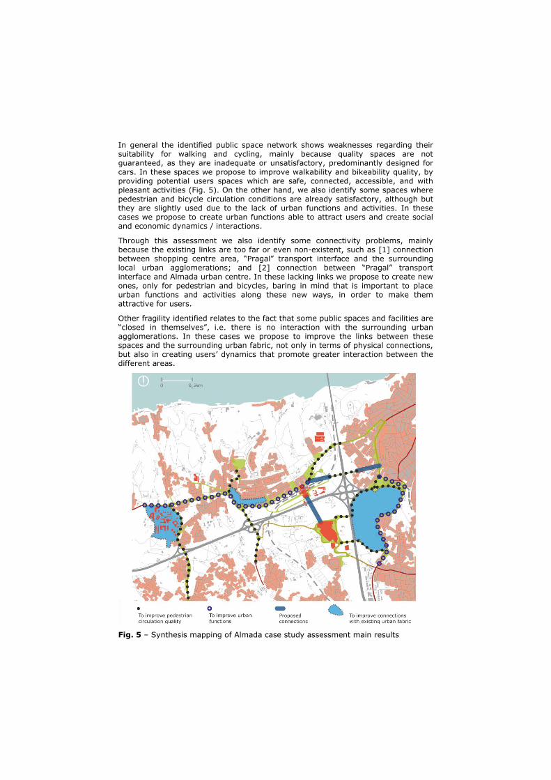
In general the identified public space network shows weaknesses regarding their suitability for walking and cycling, mainly because quality spaces are not guaranteed, as they are inadequate or unsatisfactory, predominantly designed for cars. In these spaces we propose to improve walkability and bikeability quality, by providing potential users spaces which are safe, connected, accessible, and with pleasant activities (Fig. 5). On the other hand, we also identify some spaces where pedestrian and bicycle circulation conditions are already satisfactory, although but they are slightly used due to the lack of urban functions and activities. In these cases we propose to create urban functions able to attract users and create social and economic dynamics / interactions.
Through this assessment we also identify some connectivity problems, mainly because the existing links are too far or even non-existent, such as [1] connection between shopping centre area, “Pragal” transport interface and the surrounding local urban agglomerations; and [2] connection between “Pragal” transport interface and Almada urban centre. In these lacking links we propose to create new ones, only for pedestrian and bicycles, baring in mind that is important to place urban functions and activities along these new ways, in order to make them attractive for users.
Other fragility identified relates to the fact that some public spaces and facilities are “closed in themselves”, i.e. there is no interaction with the surrounding urban agglomerations. In these cases we propose to improve the links between these spaces and the surrounding urban fabric, not only in terms of physical connections, but also in creating users’ dynamics that promote greater interaction between the different areas.
Fig. 5 – Synthesis mapping of Almada case study assessment main results
3. Public Space as multi-scale connector
It is our conviction that public space can be the agent of urban qualification in the context of metropolitan scattered city, being able to act as a multi-scale connector: [1] promoting continuity, improving mobility and accessibility conditions; [2] co-producing strong social and cultural dynamics; and [3] helping to stimulate economic activities.
To plan and design public space networks, aiming to promote this interaction between scales it is necessary to make some adaptations in the way we think of conditions for a multi-scale connector public space:
- Is linked to the idea of an existing network hierarchy, i.e. there is a metropolitan road network and a local network of public spaces and there are also areas of connection between these two scales, able to link different territorial scales.
- Promotes multi-scale interaction and articulation possibilities, as they link the multi-scale centralities to the local urban agglomerations.
- Provides the transition between major accesses and local public spaces dynamics (proximity and diversified urban functions).
- Evolves connections and interactions more than just a physical connection, but also linked with the service provided by these public spaces (functions, activities, identity).
- Allows the connection / transition with the local public space network, they can assure good walkability and bikeability conditions, in articulation with public transport.
- Enables the emergence of new urban functions, capable of generating public space dynamics and appropriation, promoting interaction with the local urban agglomerations.
With this understanding of public spaces it is possible to find solutions for some of the characteristic metropolitan scattered cities problems, related to the emergence of new multi-scale centralities and the need to find balance in connecting the metropolitan accesses to the local scale interaction issues. Thus, we argue that it is possible to articulate these multi-scale centralities with the local urban fabrics, focusing on the role of public space.
4. Notes
The authors gratefully acknowledge the support of Fundação para a Ciência e a Tecnologia (FCT) under the PhD grant SFRH / BD / 62640 / 2009 and PhD grant
SFRH / BD / 69911 / 2010, and to the funding of the projects HAR2009-13989-C02-01 (Spanish Government) and 2009SGR0903 (Catalan Government).
5. Bibliography
AJUNTAMENT DE BARCELONA. Areas de nova centralitat = New downtowns in Barcelona. Barcelona, Ajuntament de Barcelona, 1987.
BRANDÃO, Ana Luísa; BRANDÃO, Pedro. Do industrial ao pós-industrial: Transição e
diversidade urbana - LX/BCN. in On the w@terfront, nº22, Barcelona, 2012.
HILLIER, Bill; HANSON, Julienne. The Social Logic of Space. Cambridge, Cambridge University Press, 1984.
IMTT. Rede Cicláve e Rede Pedonal – Princípios de Planeamento e Desenho. Lisboa, IMTT – Colecção de Brochuras Técnicas / Temáticas, 2011.
LUPEZ, Paul. Suburban Transformations. New York, Princeton Architectural Press, 2007.
PINTO, Júlia; REMESAR, Antoni. Public Space Networks as a Support for Urban Diversity. in Open House International, Vol. 37 No. 2, London, 2012.
PINTO, Júlia; REMESAR, Antoni; BRANDÃO, Pedro; NUNES DA SILVA, Fernando. Towards Urban Cohesion: Planning Public Space Networks, in 46th ISOCARP International Congress, Nairobi, 2010.
6. Biography
Ana Júlia Pinto is a Territorial Engineer and Master in Urbanism and Territorial Management (Technical Institute of Lisbon). At the present she is a PhD student of the program “Public Space and Urban Regeneration” from Barcelona University, developing her thesis on public space networks and urban cohesion, with a scholarship from FCT (Foundation for Science and Technology). She is a scholarship researcher at CESUR (Regional and Urban Systems Research Centre) from Technical Institute of Lisbon, and at CR Polis (Polis Research Centre) from Barcelona University. Her main research interests focus on urban design, public space projects, urban networks, urban regeneration processes and mobility and accessibility systems. She also worked as an urban planner, developing master plans and urban projects, and lectured Urban Planning and Architecture, at Faculty of Science and Technology and at Technical Institute of Lisbon, in Civil Engineer graduation.
Ana Luísa Brandão is an Architect (Technical Institute of Lisbon). At the present she is a PhD student of the program “Public Space and Urban Regeneration” from Barcelona University, developing her thesis on design strategies to manage uncentainty aspects, with a scholarship from FCT (Foundation for Science and Technology). She is a scholarship researcher at CESUR (Regional and Urban Systems Research Centre) from Technical Institute of Lisbon, and at CR Polis (Polis Research Centre) from Barcelona University. Her main research interests focus on urban design, public space projects and urban regeneration processes. She also
worked as an architect, in CCG Arquitectos developing housing and education projects, and lectured at Technical Institute of Lisbon, in Civil Engineer graduation.