strengthening community to prevent flood using participatory approach: case of semarang city,...
TRANSCRIPT
Abstract
The geography of the Semarang City makes this city is frequently suffered from flooding. Land subsidence and sea levelrise are also the main causes of flood in the Semarang City. To cope with this condition, several programs have been made bythe government to mitigate and to adapt floods in the Semarang City. By using comparative analysis, it concludes someprograms are not successful yet. The effort made by the government to develop a program for coastal zone management andprotection against flooding can be efficiently implemented through coordination and participation among stakeholders and thecommunity. Making guidelines for participatory approach is very important step to make programs more understandable formulti-stakeholders. There are two types of guidelines which is the guideline of compensation and share information (Type I)and the guideline of share information only (Type II). From these guidelines, they will know their own roles and the benefits
19
STRENGTHENING COMMUNITY TO PREVENT FLOOD USINGPARTICIPATORY APPROACH
(A CASE OF THE SEMARANG CITY)
Siti MAIMUNAHResearcher
Ministry of Transportation of Republic of Indonesia
Jl. Medan Merdeka Timur No. 5 Jakarta, Indonesia 10110
E-mail: [email protected]
HENDRIDoctoral Student
Graduate School for International Development and Cooperation, Hiroshima University,
1-5-1 Kagamiyama, Higashi-Hiroshima 739-8529, Japan
E-mail: [email protected]
Nurul Shahirawati binti Mohamed ROSLIGraduate Student
37, Lorong Bukit Setongkol 25, Perkampungan Cenderawasih, 25200, Kuantan, Pahang, Malaysia
E-mail: [email protected]
Serge Claudio RAFANOHARANAPost Graduate Student
M.Sc. in IT for NRM, Bogor Agricultural University, SEAMEO BIOTROP Campus
Jalan Raya Tajur Km 6, Bogor - Indonesia
E-mail: [email protected]
Komala Ratna SARIMinistry of Manpower and Transmigration of the Republic of Indonesia
E-mail: [email protected]
Osamu HIGASHIAssociate Professor
Graduate School for International Development and Cooperation, Hiroshima University,
1-5-1 Kagamiyama, Higashi-Hiroshima 739-8529, Japan
E-mail: [email protected]
【Research Note】
Journal of International Development and Cooperation, Vol.18, No.2, 2011, pp. 19-28
of the programs.Keywords; Participatory approach, mitigation and adaptation of floods
1. Introduction
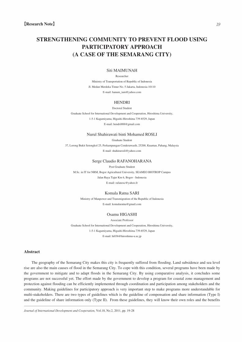
The Semarang City is the capital city of Central Java Province of Indonesia and it is located at the northern Java Islandwith the total population of approximately 1.5 million (Figure 1). From the geographical view, it lies in the 0.5 m to 348 mabove sea level. Based on Public Relation Division of the Semarang City (1993), the Semarang City with the area of 373.7 km2
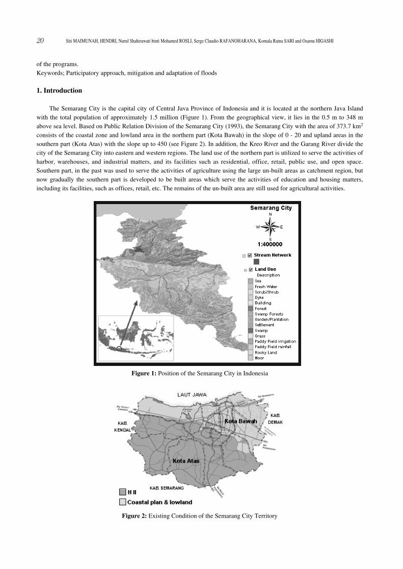
consists of the coastal zone and lowland area in the northern part (Kota Bawah) in the slope of 0 - 20 and upland areas in thesouthern part (Kota Atas) with the slope up to 450 (see Figure 2). In addition, the Kreo River and the Garang River divide thecity of the Semarang City into eastern and western regions. The land use of the northern part is utilized to serve the activities ofharbor, warehouses, and industrial matters, and its facilities such as residential, office, retail, public use, and open space.Southern part, in the past was used to serve the activities of agriculture using the large un-built areas as catchment region, butnow gradually the southern part is developed to be built areas which serve the activities of education and housing matters,including its facilities, such as offices, retail, etc. The remains of the un-built area are still used for agricultural activities.
20 Siti MAIMUNAH, HENDRI, Nurul Shahirawati binti Mohamed ROSLI, Serge Claudio RAFANOHARANA, Komala Ratna SARI and Osamu HIGASHI
Figure 2: Existing Condition of the Semarang City Territory
Figure 1: Position of the Semarang City in Indonesia
In the 1990s, the development was more centralized in the northern coastal and low-lying areas, which led to rapidurbanization and environmental problems such as coastal erosion and sedimentation, over-exploitation of ground waterresources, land subsidence, and tidal inundation. Due to this condition the Semarang City is frequently suffered from flooding.There are two types of flood in the Semarang city; first is caused by river flooding (from the hinterland); and second is causedby sea level rise or high tide.
To reduce negative impact of biophysical degradation against coastal areas, mitigation effort must be made. Mitigation,which is a process of various preventive measurement effort for minimizing negative impact of disaster that is anticipated fromits occurrence in the future at certain areas, is a long term investment for the welfare of layers of community. To deal withdisaster issue, it will require comprehensive mitigation effort which is a combination of physical/ structural effort (creation ofinfrastructure and control facility) and non-physical/ non-structural effort. There is tendency that a demand is directed moretowards mitigation effort as compare to post-disaster response.
In order that coastal areas problems can be dealt with a more long lasting manner, without posing any damage to theecosystem, a more comprehensive approach with a more holistic view are needed. For that purpose, a more comprehensiveapproach of development of coastal areas and balance of interest between the need of inland areas development and coastalareas development, and strengthening cooperation and partnership ties between stakeholder, are needed. To integrate varioussector planning and to provide direction of sustainable coastal areas utilization have therefore summoned for an integratedcoastal management concept.
Current flood risk management schemes are based on the accumulated knowledge of past weather events and scientificassessment based on the hydrological approach, without taking into account the long term impacts of climate change scenariosand the way that it would impact the frequency and intensity of floods. A promising approach to reducing the risk of urbanfloods is to adopt a strategy combining the present approaches that addresses multiple components of risk, with long termclimate change scenarios in different spatial and temporal scales. A comprehensive risk reduction approach has to consider theaspects of reduction of impact considering the issues related to hazard, vulnerability and exposure in a manner that it considersnot only the risk as at present but also future risks. A major challenge for the effective disaster risk reduction in the region is toensure that risk reduction strategies are integrated with broad development strategies, as well as climate change adaptationefforts in an effective and efficient manner and the objectives are to:1. Examine and share experiences on innovative strategies towards flood resilient cities;2. Recommend policy options for effective urban flood management considering climate change.
Moreover, flood management should take account of: (1) reduction of deaths, (2) reduction of economic damage, and (3)enhancement of disaster preparedness.
The objective of this paper is to make a guideline how to mitigate and to adapt the floods in the Semarang City by using aparticipatory approach which involves multi-stakeholders in order to implement some projects successfully.
2. The Current Status of the Semarang City
2.1. The Causes of Flood in the Semarang City(1) Land Subsidence
Due to the rapid growth of population and industrialization in the Semarang City, one of the impacts is groundwater overextraction. According to data provided by Ministry of Public Works the demand of water supply was 57.28 million m3/yr and75.89 million m3/yr in 1995 and 2000 respectively. To meet the demand of water, the people are using the groundwater. So, itcauses the land subsidence in the Semarang City and the sinking area is gradually increasing year by year (Marfai and King,2007). They estimated the increase of sinking area is from 362 ha in 2010 to 1,377.5 ha in 2015 and 2,227 ha in 2020.
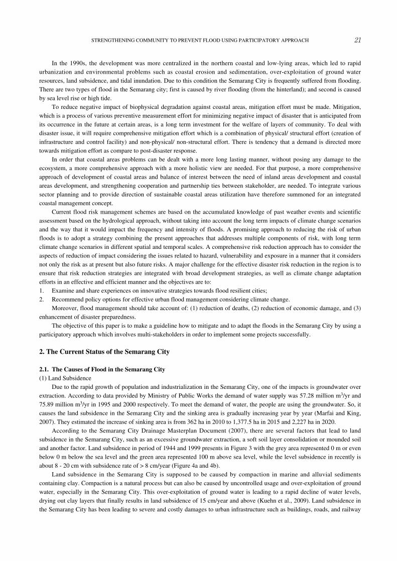
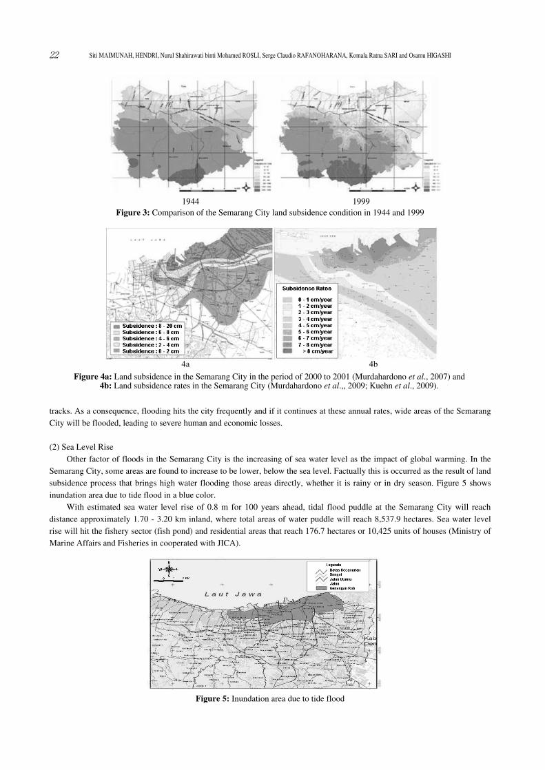
According to the Semarang City Drainage Masterplan Document (2007), there are several factors that lead to landsubsidence in the Semarang City, such as an excessive groundwater extraction, a soft soil layer consolidation or mounded soiland another factor. Land subsidence in period of 1944 and 1999 presents in Figure 3 with the grey area represented 0 m or evenbelow 0 m below the sea level and the green area represented 100 m above sea level, while the level subsidence in recently isabout 8 - 20 cm with subsidence rate of > 8 cm/year (Figure 4a and 4b).
Land subsidence in the Semarang City is supposed to be caused by compaction in marine and alluvial sedimentscontaining clay. Compaction is a natural process but can also be caused by uncontrolled usage and over-exploitation of groundwater, especially in the Semarang City. This over-exploitation of ground water is leading to a rapid decline of water levels,drying out clay layers that finally results in land subsidence of 15 cm/year and above (Kuehn et al., 2009). Land subsidence inthe Semarang City has been leading to severe and costly damages to urban infrastructure such as buildings, roads, and railway
21STRENGTHENING COMMUNITY TO PREVENT FLOOD USING PARTICIPATORY APPROACH
tracks. As a consequence, flooding hits the city frequently and if it continues at these annual rates, wide areas of the SemarangCity will be flooded, leading to severe human and economic losses.
(2) Sea Level RiseOther factor of floods in the Semarang City is the increasing of sea water level as the impact of global warming. In the
Semarang City, some areas are found to increase to be lower, below the sea level. Factually this is occurred as the result of landsubsidence process that brings high water flooding those areas directly, whether it is rainy or in dry season. Figure 5 showsinundation area due to tide flood in a blue color.
With estimated sea water level rise of 0.8 m for 100 years ahead, tidal flood puddle at the Semarang City will reachdistance approximately 1.70 - 3.20 km inland, where total areas of water puddle will reach 8,537.9 hectares. Sea water levelrise will hit the fishery sector (fish pond) and residential areas that reach 176.7 hectares or 10,425 units of houses (Ministry ofMarine Affairs and Fisheries in cooperated with JICA).
22 Siti MAIMUNAH, HENDRI, Nurul Shahirawati binti Mohamed ROSLI, Serge Claudio RAFANOHARANA, Komala Ratna SARI and Osamu HIGASHI
Figure 4a: Land subsidence in the Semarang City in the period of 2000 to 2001 (Murdahardono et al., 2007) and4b: Land subsidence rates in the Semarang City (Murdahardono et al.,, 2009; Kuehn et al., 2009).
4a 4b
Figure 3: Comparison of the Semarang City land subsidence condition in 1944 and 1999
Figure 5: Inundation area due to tide flood
1944 1999
2.2. The Impacts of Flood in the Semarang CityFloods have many impacts not only on physical, social, economic but also on environment. Physical impact is the damage
to public facilities. Social impacts include death, health risks, mental trauma, declining economy, and the disruption ofeducational activities (children cannot go to school), disruption of office activities of public services, lack of food, energy,water and other basic needs. The economic impact includes the loss of materials, disruption of economic activities (one cannotgo to work, late for work, or obstructed the transportation of commodities, etc.). Environmental impacts include water pollution(by pollutants carried by the flood) or vegetation around the river carried away damaged by the floods.
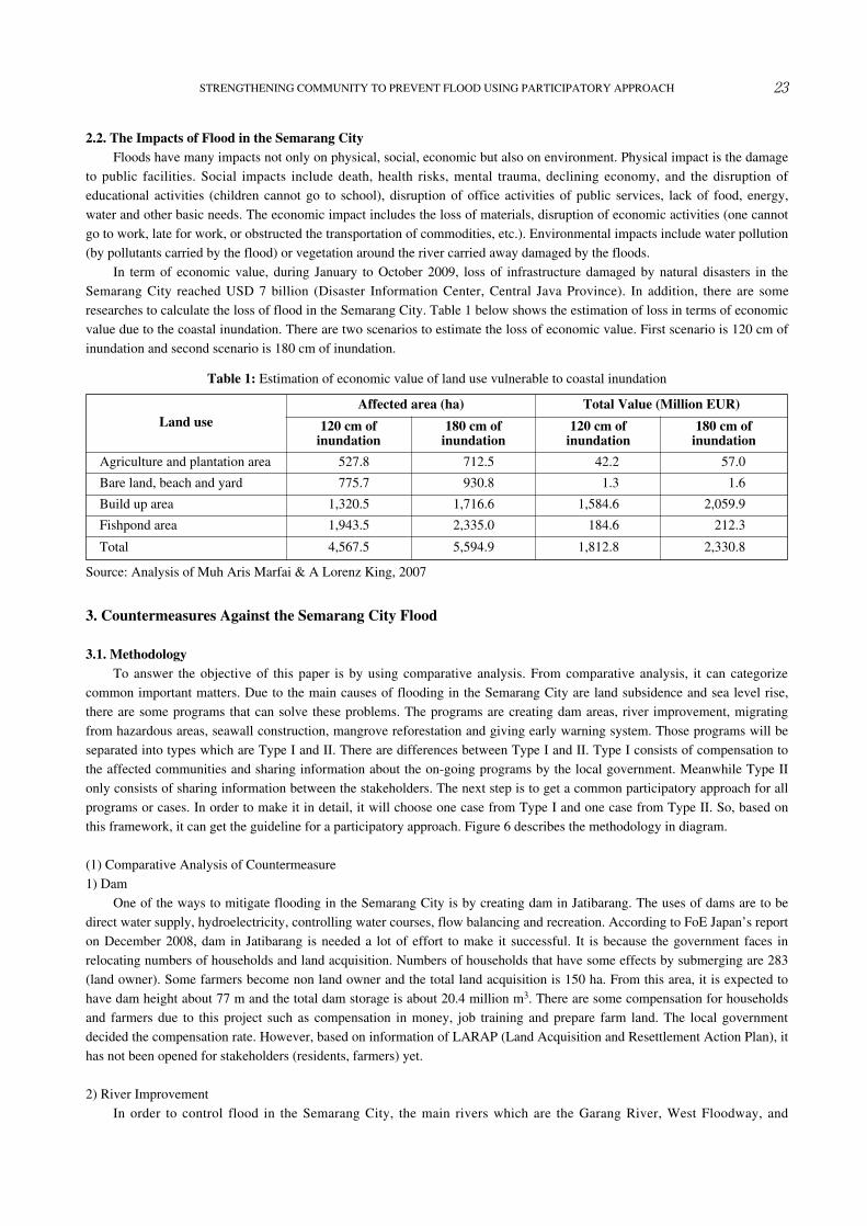
In term of economic value, during January to October 2009, loss of infrastructure damaged by natural disasters in theSemarang City reached USD 7 billion (Disaster Information Center, Central Java Province). In addition, there are someresearches to calculate the loss of flood in the Semarang City. Table 1 below shows the estimation of loss in terms of economicvalue due to the coastal inundation. There are two scenarios to estimate the loss of economic value. First scenario is 120 cm ofinundation and second scenario is 180 cm of inundation.
3. Countermeasures Against the Semarang City Flood
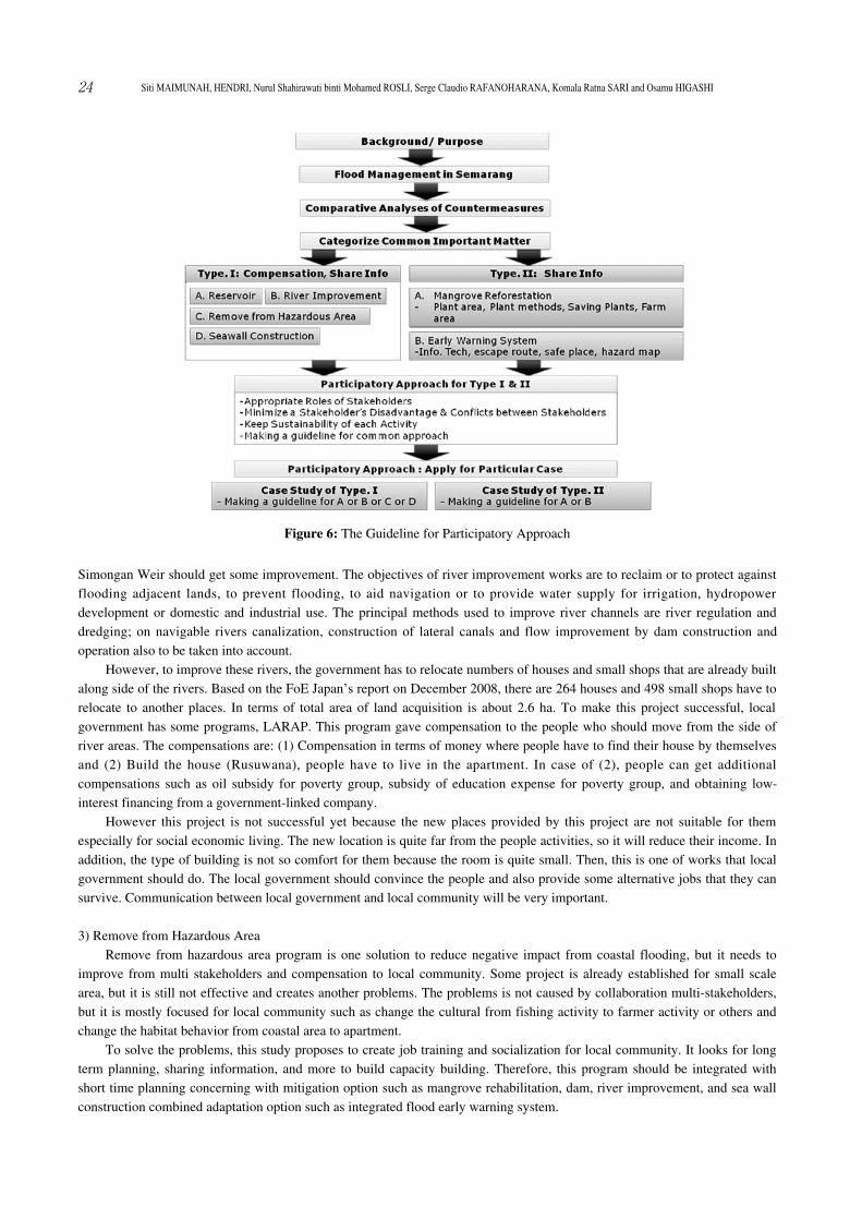
3.1. MethodologyTo answer the objective of this paper is by using comparative analysis. From comparative analysis, it can categorize
common important matters. Due to the main causes of flooding in the Semarang City are land subsidence and sea level rise,there are some programs that can solve these problems. The programs are creating dam areas, river improvement, migratingfrom hazardous areas, seawall construction, mangrove reforestation and giving early warning system. Those programs will beseparated into types which are Type I and II. There are differences between Type I and II. Type I consists of compensation tothe affected communities and sharing information about the on-going programs by the local government. Meanwhile Type IIonly consists of sharing information between the stakeholders. The next step is to get a common participatory approach for allprograms or cases. In order to make it in detail, it will choose one case from Type I and one case from Type II. So, based onthis framework, it can get the guideline for a participatory approach. Figure 6 describes the methodology in diagram.
(1) Comparative Analysis of Countermeasure1) Dam
One of the ways to mitigate flooding in the Semarang City is by creating dam in Jatibarang. The uses of dams are to bedirect water supply, hydroelectricity, controlling water courses, flow balancing and recreation. According to FoE Japan’s reporton December 2008, dam in Jatibarang is needed a lot of effort to make it successful. It is because the government faces inrelocating numbers of households and land acquisition. Numbers of households that have some effects by submerging are 283(land owner). Some farmers become non land owner and the total land acquisition is 150 ha. From this area, it is expected tohave dam height about 77 m and the total dam storage is about 20.4 million m3. There are some compensation for householdsand farmers due to this project such as compensation in money, job training and prepare farm land. The local governmentdecided the compensation rate. However, based on information of LARAP (Land Acquisition and Resettlement Action Plan), ithas not been opened for stakeholders (residents, farmers) yet.
2) River ImprovementIn order to control flood in the Semarang City, the main rivers which are the Garang River, West Floodway, and
23STRENGTHENING COMMUNITY TO PREVENT FLOOD USING PARTICIPATORY APPROACH
Table 1: Estimation of economic value of land use vulnerable to coastal inundation
Land useAffected area (ha) Total Value (Million EUR)
120 cm ofinundation
180 cm ofinundation
120 cm ofinundation
180 cm ofinundation
Agriculture and plantation area 527.8 712.5 42.2 57.0
Bare land, beach and yard 775.7 930.8 1.3 1.6
Build up area 1,320.5 1,716.6 1,584.6 2,059.9
Fishpond area 1,943.5 2,335.0 184.6 212.3
Total 4,567.5 5,594.9 1,812.8 2,330.8
Source: Analysis of Muh Aris Marfai & A Lorenz King, 2007
Simongan Weir should get some improvement. The objectives of river improvement works are to reclaim or to protect againstflooding adjacent lands, to prevent flooding, to aid navigation or to provide water supply for irrigation, hydropowerdevelopment or domestic and industrial use. The principal methods used to improve river channels are river regulation anddredging; on navigable rivers canalization, construction of lateral canals and flow improvement by dam construction andoperation also to be taken into account.
However, to improve these rivers, the government has to relocate numbers of houses and small shops that are already builtalong side of the rivers. Based on the FoE Japan’s report on December 2008, there are 264 houses and 498 small shops have torelocate to another places. In terms of total area of land acquisition is about 2.6 ha. To make this project successful, localgovernment has some programs, LARAP. This program gave compensation to the people who should move from the side ofriver areas. The compensations are: (1) Compensation in terms of money where people have to find their house by themselvesand (2) Build the house (Rusuwana), people have to live in the apartment. In case of (2), people can get additionalcompensations such as oil subsidy for poverty group, subsidy of education expense for poverty group, and obtaining low-interest financing from a government-linked company.
However this project is not successful yet because the new places provided by this project are not suitable for themespecially for social economic living. The new location is quite far from the people activities, so it will reduce their income. Inaddition, the type of building is not so comfort for them because the room is quite small. Then, this is one of works that localgovernment should do. The local government should convince the people and also provide some alternative jobs that they cansurvive. Communication between local government and local community will be very important.
3) Remove from Hazardous AreaRemove from hazardous area program is one solution to reduce negative impact from coastal flooding, but it needs to
improve from multi stakeholders and compensation to local community. Some project is already established for small scalearea, but it is still not effective and creates another problems. The problems is not caused by collaboration multi-stakeholders,but it is mostly focused for local community such as change the cultural from fishing activity to farmer activity or others andchange the habitat behavior from coastal area to apartment.
To solve the problems, this study proposes to create job training and socialization for local community. It looks for longterm planning, sharing information, and more to build capacity building. Therefore, this program should be integrated withshort time planning concerning with mitigation option such as mangrove rehabilitation, dam, river improvement, and sea wallconstruction combined adaptation option such as integrated flood early warning system.
24 Siti MAIMUNAH, HENDRI, Nurul Shahirawati binti Mohamed ROSLI, Serge Claudio RAFANOHARANA, Komala Ratna SARI and Osamu HIGASHI
Figure 6: The Guideline for Participatory Approach
4) Sea Wall ConstructionThe protection of beachfront development and other coastal infrastructure with sea walls and revetments must be studied
and organized carefully. This sort of protection may cause significant erosion of the land on either side of the sea defensestructure, and may even result in the loss of the beach in front of the structure if it is poorly designed and managed. This is notonly the concern of coastal developers, but also among all stakeholders. Basically, lots of conflicts are raised especially whenone group of stakeholders does not accept the rights of another group. For example, fishermen have traditionally used the reefsfor bait fishing or for another purpose related to the reefs. On the other hand, when other stakeholders come to the area, theythink that fishing is destructive. One of the main problems for the Semarang City also is that there is a different perceptionamong the stakeholders on how to resolve the flood in the city. A miscommunication and lack of sharing information cause lotsof conflict. For example, the central government does not exactly know the core of the problem of what is really happening inthe Semarang City in terms of flood. Then, there is no mutual program to resolve the problem and top to bottom system is usedmost of the time which will not resolve the real problem.
However, it is important to notice that the protection should be regarded as a community responsibility. For that, allcommunity members might contribute to the construction and maintenance of beach protection structures such as sea walls andbreakwaters. Sea level rise is the concern of all stakeholders. Some opportunities should be given to the local communitieswhen facing the flood. It will be such a kind of adaptation and mitigation since the structure of the Semarang City itself is avery low land and floods are frequent in this city. Seawall construction might be a very important approach to mitigate thedamage caused by the sea level rise in the Semarang City if the seawall is well designed. A poor designed seawall may result inmore degradation of the coastal area and the reefs.
5) Mangrove ReforestationThe greatest threat in the future mangrove ecosystem is climate change and increase occurrence of climatic happenings.
Important factor in supporting presence of mangrove is salinity and sedimentation level. The change in rainfall pattern posesimpact on distribution and type composition because rainfall controls salt concentration on ground and trees also producingfresh water for mangrove.
Some part of coastal areas in the Semarang City has already been replanted through promotion of public participation byJICA. Although previously, some parts of coastal areas are used for shrimp and fish farming, but it is already damage becauseof sea level rise and coastal erosion. With the program of mangrove reforestation, it will be very useful for them in order toprotect their farms from coastal erosion.
On the other hand, people who support the program somehow don’t know how to conserve mangrove forest properly. Atthis condition, the active role of local government is very important to give an understanding of this project to local communitysuch as conducting workshop and socialization. According to FoE Japan’s report in 2009, the local government conductedmangrove conservation workshop that aims to preserve the entire coastal of the Semarang City and attracts a variety agenciesinvolved in environmental protection.
6) Early Warning SystemBased on problem statements, the mostly disaster from coastal area in the Semarang City is flooding. Therefore, integrated
flood early warning system needs to implement to reduce negative impact from coastal flooding. The system gives earlydetection using better simulation and prediction combined satellite monitoring for high or very-high resolution. The earlywarning system is already established in Jakarta City, but it seems still difficult for implementation. Because the activity is lessinvolve local community, especially for evacuation. To anticipate the problem, this study tries to proposed participatoryapproach using comparative analysis method with focusing for local community.
To establish the integrated flood early warning system, the application and sharing networks create several function andtarget among the multi stakeholders. They have several stakeholders such as Government, Private Sector, and InternationalBodies to contribute finance, decision making, and to set up facilities; while information and communication technology has 2stakeholders (Government and Research Community) distributed to get the information. Before the integrated flood earlywarning system can be easily understood by the public community, the researcher should make interpretations based onobservation data to try to simulate a prediction for alerting the flood. There are important activities to support accuracy andhigh performance for monitoring disaster risk reduction. If the prediction is not an accurate estimation, it can only create low-credible sources for any monitoring agency. The EWS cannot work well to support the network system based on these sources.Therefore, it is required to develop and upgrade the skills of simulation technology for researcher, not only with considerationsfor meteorology and hydrological component but also with ocean interactions.
25STRENGTHENING COMMUNITY TO PREVENT FLOOD USING PARTICIPATORY APPROACH
Furthermore, the sharing networks should be supported by capacity building not only limited to the central government,but also extended to the local community level, quickly bringing brainstormed knowledge, information for easy understanding,and visualization before disasters.
4. Recommendations for the Semarang City Flood
4.1. The Results of Analysis(1) Type I: Compensation and Share Information
There are a number of solutions that can be used in order to mitigate and to adapt to the flood in the Semarang City suchas building dam which can be helpful to mitigate the flood and land subsidence and to have a new source of electricity,improving the river to mitigate the flood, migrating the local people from hazardous area can be used as flood adaptation,constructing sea wall to adapt for sea level rise and high tide, doing reforestation of mangrove to preserve the entire coastal ofthe Semarang City, and early warning system to prepare and evacuate local people to a safe area. Nevertheless, some problemsoccur when implementing these programs. Among them are the impact to the environment, lose of land and jobs, require highbudget, and need long period of time to implement especially for dam.
However, in order to build the best plan and to implement such kind of solution, different stakeholders must be involvedto achieve the goal before, during, and after implementing these approaches. These stakeholders include foreign governmentfor loan and Environmental Impact Assessment (EIA), central and local government to make regulations of compensation,main contractor to do and realize the job, residents and fishers/ farmers to be removed to another safe area and getcompensation from this migrating process, and NGO to check the EIA. One important task of the central and local governmentis urban planning especially in the case of migrating the local people from the hazardous area.
Since there are different stakeholders involved in the project, some conflicts raised among them. The share of informationand insufficiency of compensation are the main core of these conflicts. Moreover, environmental problem can be facedbetween the government, residents, and NGO when building dam, and between government, fisher, and NGO whenconstructing sea wall.
(2) Type II: Share InformationType II consists of sharing information between the stakeholders. There are often conflicts of interest between different
stakeholders groups. The principal practical and moral task of mainstream management involving a variety of stakeholders’interests is to find a workable balance between them. So, in this case, there must be sufficient information about the on-goingprograms or projects involving those stakeholders.
For mangrove reforestation, the project scheme is expected to provide a number of benefits to the environment, society,and economy. The basic concept of mangrove reforestation is to measure the effect by fulfilling both “countermeasures againstclimate change and flood management” and also “adaptation” at the same time. In the other words, answering socioeconomicissues and conducting environmental conservation will mutually repeat the positive growth cycle, and the continuance of theprogram will contribute to the sustainable development.
Thus, local government should give information briefly to the local communities which are affected by this program. Theyshould know about project planning such as concrete contents of the program; project boundary and baseline scenario;monitoring, and environmental impact, or maybe some general guidelines for mangrove reforestation.
Early warning system (EWS) has evolved considerably during the past two decades. Today, EWS exists for just aboutevery hazard - technological, hydrological, meteorological, and anthropogenic. Its function has shifted toward societal risk andvulnerability reduction and toward sustainable development and also is an important tool in a government’s toolbox forachieving sustainable development.
The stakeholders must know the success and limitations of EWS and identified lessons - do’s and don’ts from theexperiences of those who have worked with or helped to develop EWS for a wide range of societal concerns or in this case forflood management. This information will be used to remind about how to make early warning of flood hazards, effective.
4.2. Common Participatory Approach(1) The Guideline of Participatory Approach of Type I
The common importance of Type I is to the affected communities and sharing information about the on-going programs.For the Type I, we can divide the stakeholders into two groups which are government sectors and local people. Governmentsectors consist of Foreign Government, Central Government and Local Government. Then, for local people, there are two types
26 Siti MAIMUNAH, HENDRI, Nurul Shahirawati binti Mohamed ROSLI, Serge Claudio RAFANOHARANA, Komala Ratna SARI and Osamu HIGASHI
of local people. First group is the local people who get some effects from the project such as remove to other place, lose ofland, jobs etc. Second group is people who get some benefits from the project such as flood mitigation, reducing flood risks,etc. Moreover, the local people consist of community leader and common people.
Each stakeholder takes some roles to make the program successful. The guideline of the participatory approach of Type I is:1) Step I: Planning
- Share the philosophy of guideline- Development of plan
2) Step II: Discussion for decision making- Primary arrangement for each community- Government explain about plan for each community- Each community requests something to government- Government reflects each community and has opinions to make a plan- The community leader at each community explain their plan for people in common- Hold the conference- All the stakeholders will attend and then decision making can be made.
3) Step III: Implementation- Government supports for local people through local government meeting- Local government will improve the compensation and request more support to central and foreign government, so the
local people can get benefits.From these three steps, it will minimize complaint or conflicts among stakeholders and it will keep sustainability of the
programs.
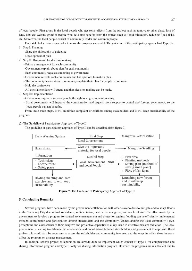
(2) The Guideline of Participatory Approach of Type IIThe guideline of participatory approach of Type II can be described from figure 7.
5. Concluding Remarks
Several programs have been made by the government collaboration with other stakeholders to mitigate and to adapt floodsin the Semarang City due to land subsidence, sedimentation, destructive mangrove, and sea level rise. The effort made by thegovernment to develop a program for coastal zone management and protection against flooding can be efficiently implementedthrough coordination and participation among stakeholders and the community. Understanding the local community’s ownperceptions and assessments of their adaptive and pro-active capacities is a key issue in effective disaster reduction. The localgovernment is leading to elaborate the cooperation and coordination between stakeholders and government to cope with floodproblem. It would also be necessary to assess the stakeholder and community interests, and the ways in which those interestsaffect the program on disaster management.
In addition, several project collaboration are already done to implement which consist of Type I, for compensation andsharing information program and Type II, only for sharing information program. However the programs are insufficient due to
27STRENGTHENING COMMUNITY TO PREVENT FLOOD USING PARTICIPATORY APPROACH
Figure 7: The Guideline of Participatory Approach of Type II
information gap, technology gap, less compensation, and lack cooperation with community leader. Therefore this study tries tomake guideline participatory approach to strengthen community resistance to coastal flood hazard by means of publicawareness action, field investigation and researches by Type I and Type II programs. There is a need to share social-community, technical and technological expertise to deal with flood problems.
References
Abidin, H.Z., et al. (2010), Studying Land Subsidence in Semarang (Indonesia) Using Geodetic Methods. Landslide andSubsidence Monitoring II.
Boon, J., H. Wang, and J. Shen. (2008), Planning for Sea Level Rise and Coastal Flooding. Virginia Institute of MarineScience.
Dewi, A. (2007), Community-Based Analysis of Coping with Urban Flooding: A Case Study in Semarang, Indonesia. MasterThesis. International Institut For Geo-Information and Earth Observation, Enschede, The Netherlands.
Dutschke, M. and R. Wolf. (2007). Reducing Emissions from Deforestation in Developing Countries: The way forward,
Eschborn: W.B. Druckerei GmbH, Hochheim am Mein.FoE Japan’s report. (2009), Website of FoE Japan. Address: ―http:―//w―ww.―foej―apa―n.or―g/, access: August 2010.FoE Japan’s report, (2008), Website of FoE Japan. Address: ―http:―//w―ww.―foej―apa―n.org/, access: August 2010.Kuehn, F. et al. (2008), Detection of Land Subsidence in Semarang/Indonesia Using Persistent Scatterer Interferometry.
Working Paper.Marfai, M., A., & King, L. (2008), Coastal Flood Management in Semarang, Indonesia. Environmental Geology No. 55, page
1507-1518.Marfai, M., A., & King, L, (2008), Potential Vulnerability Implications of Coastal Inundation due to Sea Level Rise for The
Coastal Zone of Semarang City. Environmental Geology No. 54, page 1235-1245.Marfai, M., A., & King, L, (2007), Coastal flood management in Semarang, Indonesia. Springer-Verlag.Ministry of Marine Affairs and Fisheries & Japan International Cooperation Agency. (2009), Means of Adaptation and
Mitigation of Climate Change and Disaster at Coastal Areas and Small Island.Public Works Department of Semarang (PWD). (2007), Semarang City Drainage Masterplan Document. Public Work
Department, Semarang.Rekacewicz, P. & Griggs D. (2001), Climate Change 2001. UNEP/GRID-Arendal.
28 Siti MAIMUNAH, HENDRI, Nurul Shahirawati binti Mohamed ROSLI, Serge Claudio RAFANOHARANA, Komala Ratna SARI and Osamu HIGASHI