slipfaceless ‘whaleback’ dunes in a polar desert, victoria valley, antarctica: insights from...
TRANSCRIPT

Geomorphology 114 (2010) 361–372
Contents lists available at ScienceDirect
Geomorphology
j ourna l homepage: www.e lsev ie r.com/ locate /geomorph
Slipfaceless ‘whaleback’ dunes in a polar desert, Victoria Valley, Antarctica:Insights from ground penetrating radar
C.S. Bristow a,⁎, H.M. Jol b, P. Augustinus c, I. Wallis c
a School of Earth Sciences, Birkbeck College, University of London, Malet Street, London WC1E 7HX, United Kingdomb Department of Geography and Anthropology, University of Wisconsin-Eau Claire, 105 Garfield Avenue, Eau Claire, WI 54702-4004, USAc School of Geography, Geology and Environmental Science, University of Auckland, New Zealand
⁎ Corresponding author. Tel.: +1 775 673 7308 (Telep09), +44 207 679 7710 (Telephone number after Augu
E-mail address: [email protected] (C.S. Bristow).
0169-555X/$ – see front matter © 2009 Elsevier B.V. Adoi:10.1016/j.geomorph.2009.08.001
a b s t r a c t
a r t i c l e i n f oArticle history:Received 22 May 2009Received in revised form 25 July 2009Accepted 3 August 2009Available online 15 August 2009
Keywords:ZibarDuneAccretionAntarcticaMars
The Lower Victoria Valley is one of the McMurdo Dry Valleys, Antarctica, and has the largest concentration ofaeolian sand dunes on the continent. Aeolian bedforms include elongate slipfaceless dunes which have beencalled ‘whaleback’ dunes. These dunes are composed of coarse sand and capped by granule ripples. Groundpenetrating radar (GPR) profiles across one of these dunes reveal low-angle inclined sigmoid/tangential andconvex reflections that are interpreted as strata within the dune. These dipping strata record the migration ofthe whaleback dune and show that they are not sand mantles as previously described but are activelymigrating, long-wavelength, low-amplitude bedforms resembling zibar. An 800 m profile along the axis ofthe dune reveals low-angle dips from west to east showing that the dune has accreted towards the east. GPRprofiles collected at 100 m intervals transverse to the dune axis reveal sets of cross-stratification dippingtowards the south at the eastern end of the dune and towards the north at its western end. These apparentdips are resolved to show that the dune has migrated from west to east, driven by westerly foehn winds andkatabatic winds blowing from the Polar ice cap, whilst at the same time it has been building obliquelytowards the south. Accretion towards the north at the western end of the dune is attributed to reworking ofthe dune sand by easterly winds blowing inland from McMurdo Sound. An unconformity within the dunesuggests that the wind regime has varied in the past. Beneath the unconformity the direction of dunemigration was from west to east, and eastward extension of the dune continues at the present day. However,this is combined with accretion towards the north and west at the western end of the dune which is notrecorded in the older sediments beneath the unconformity. Sand wedge structures that may have takenhundreds to thousands of years to form are found within the dune, and suggest that arid conditions suitablefor dune construction have persisted in Victoria Valley for a considerable time.
© 2009 Elsevier B.V. All rights reserved.
1. Introduction
The Victoria Valley is the most extensive and the northernmost ofthe McMurdo Dry Valleys of Antarctica, and is an east–west trendingvalley close to the Ross Sea (Fig. 1). Lake Vida (350 m elevation)topographically divides the valley and lies at the confluence of theUpper and LowerVictoria valleys. To thewest of Lake Vida the Barwick,Balham and McKelvey valleys and Bull Pass all converge into theVictoria Valley (Fig. 2). The convergent valleys serve to funnel windsfrom the south throughwest to northwest into the Victoria Valley. Theeastern end of the Lower Victoria Valley is blocked by the VictoriaLower Glacier, an extension of theWilson Piedmont Glacier, with LakeVida lying at its western end. The Victoria Valley is thought to haveremained largely ice free for the past 13.6 My (Sugden and Denton,
hone number until Septemberst 09).
ll rights reserved.
2004). The dunes described in this paper lie within the Lower VictoriaValleywhich has the largest concentration of sand dunes in Antarctica.Aeolian dunes in Victoria Valley include barchans, transverse andwhaleback forms, other aeolian sand accumulations include sandsheets, sand ramps, embryonic and protodunes (Lindsay, 1973; Selbyet al., 1974; Calkin and Rutford, 1974; Miotke, 1985). Transverse andbarchan dunes are relatively well known from studies of desert dunes,in addition, recent papers by Speirs et al. (2008) and Bourke et al.(2009) describe sand transport and migration of barchanoid dunes inthe PackardDunefield, Victoria Valley, Antarctica. The structure of coldclimate dunes with alternating layers of snow and sand in Antarcticahave been documented (Morris et al., 1972; Lindsay, 1973; Calkin andRutford, 1974; Selby et al., 1974;Miotke, 1985; Bourke et al., 2009); allof which focus on the barchanoid and transverse dunes of the PackardDunefield. The morphodynamics and internal structure of thewhaleback dunes in Victoria Valley, along with other slipfacelessdunes, including zibar, are virtually unstudied. This paper describesthemorphology of thewhaleback dunes and the internal structure and
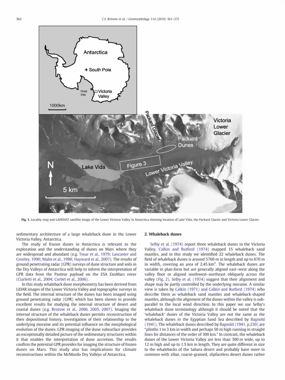
Fig. 1. Locality map and LANDSAT satellite image of the Lower Victoria Valley in Antarctica showing location of Lake Vida, the Packard Glacier and Victoria Lower Glacier.
362 C.S. Bristow et al. / Geomorphology 114 (2010) 361–372
sedimentary architecture of a large whaleback dune in the LowerVictoria Valley, Antarctica.
The study of frozen dunes in Antarctica is relevant to theexploration and the understanding of dunes on Mars where theyare widespread and abundant (e.g. Tsoar et al., 1979; Lancaster andGreeley, 1990; Malin et al., 1998; Hayward et al., 2007). The results ofground penetrating radar (GPR) surveys of dune structure and soils inthe Dry Valleys of Antarctica will help to inform the interpretation ofGPR data from the Pasteur payload on the ESA ExoMars rover(Ciarletti et al., 2004; Corbel et al., 2006).
In this study whaleback dunemorphometry has been derived fromLiDAR images of the Lower Victoria Valley and topographic surveys inthe field. The internal structure of the dunes has been imaged usingground penetrating radar (GPR) which has been shown to provideexcellent results for studying the internal structure of desert andcoastal dunes (e.g. Bristow et al., 2000, 2005, 2007). Imaging theinternal structure of the whaleback dunes permits reconstruction oftheir depositional history, investigation of their relationship to theunderlying moraine and its potential influence on the morphologicalevolution of the dunes. GPR imaging of the dune subsurface providesan exceptionally detailed picture of the sedimentary structures withinit that enables the interpretation of dune accretion. The resultsconfirm the potential GPR provides for imaging the structure of frozendunes on Mars. This study also has implications for climatereconstructions within the McMurdo Dry Valleys of Antarctica.
2. Whaleback dunes
Selby et al. (1974) report three whaleback dunes in the VictoriaValley, Calkin and Rutford (1974) mapped 15 whaleback sandmantles, and in this study we identified 22 whaleback dunes. Thefield of whaleback dunes is around 5760 m in length and up to 670 min width, covering an area of 2.45 km2. The whaleback dunes arevariable in plan-form but are generally aligned east–west along thevalley floor or aligned southwest–northeast obliquely across thevalley (Fig. 2). Selby et al. (1974) suggest that their alignment andshape may be partly controlled by the underlying moraine. A similarview is taken by Calkin (1971) and Calkin and Rutford (1974) whodescribe them as whaleback sand mantles and whaleback-shapedmantles, although the alignment of the dunes within the valley is sub-parallel to the local wind direction. In this paper we use Selby'swhaleback dune terminology although it should be noted that the‘whaleback’ dunes of the Victoria Valley are not the same as thewhaleback dunes in the Egyptian Sand Sea described by Bagnold(1941). The whaleback dunes described by Bagnold (1941, p.230) are“plinths 1 to 3 km in width and perhaps 50 m high running in straightlines for distances of the order of 300 km.” In contrast, the whalebackdunes of the Lower Victoria Valley are less than 300 m wide, up to12 m high and up to 1.5 km in length. They are quite different in sizeto the whalebacks of the Sahara desert and probably have more incommon with zibar, coarse-grained, slipfaceless desert dunes rather

Fig. 2. Oblique aerial photograph taken from a helicopter looking west along the Lower Victoria Valley towards Lake Vida with the Upper Victoria Valley, Barwick, Balham andMcKelvey valleys in the background (Bull Pass is hidden from view). Whaleback dunes are clearly visible to the north of the un-named intermittent river which flows west into LakeVida. The whaleback dunes are elongated from southwest to northeast obliquely across the valley. The dunes have no slipfaces but are slightly asymmetric with the darker, steepedsides facing southeast towards the camera. This view also shows the overall trend of the whaleback dune field which is an up-valley from Lake Vida.
363C.S. Bristow et al. / Geomorphology 114 (2010) 361–372
than Bagnold's whalebacks which are probably large, partiallydegraded, linear dunes, or elongated, residual sand ridges from partlydeflated sand sheets (El Baz, 1998).
Zibar are described as long-wavelength, low-amplitude, migratingbedforms without slipfaces whose surfaces are usually covered byripples or megaripples (Holm, 1960; Warren, 1972; Wilson, 1973;Nielson and Kocurek, 1986; Pye and Tsoar, 1990). Zibar are usuallyassociated with coarse-grained sand and it remains unclear exactlyhow the coarse sand grain-size affects dune morphology although ithas been suggested by Cooke andWarren (1973) that the coarse grainsize has some influence in armouring the dune surface with the coarsesands only being entrained by high velocity winds. In turn, the steepvertical velocity gradient associated with high wind velocity mayrestrict upward growth of dunes and may reduce flow separation inthe lee of the dune (Cooke and Warren, 1973).
The internal structure of whaleback dunes and other slipfacelessdunes such as zibar is poorly documented. This is rather surprisinggiven that zibar are more abundant and more widespread than somebetter known dune forms such as barchan dunes or star dunes (Cookeand Warren 1973). Despite their abundance, modern zibar dunedeposits have only been described in the Algodones dune field whereNielson and Kocurek (1986) observed that zibar deposits contain bedsof wind ripple laminae dipping less than 15°. They describe groups ofsimilarly dipping laminae contained in packages (usually less than afew tens of centimetres thick) bounded by low-angle (less than 10°)truncation surfaces. Strata are usually concordant with the dunesurface and Nielson and Kocurek (1986) describe tangential bottomcontacts and sharp truncations at the top as characteristic of zibardeposits. In Antarctica, Selby et al. (1974) describe horizontal beds ofsand interbeddedwith lenses of snow exposed around the edge of onedune where it was locally eroded by a meltwater stream, and Calkinand Rutford (1974) illustrate interbedded sand and snow. Snow onthe dune surface may be lost through deflation or sublimation in thedry Antarctica air. However, some snow melts forming liquid water
which will either evaporate or freeze. The water which freezes as icewithin the dune forms an ice cement that stabilises the dune.According to Selby et al. (1974, p.558) “The snow releases sufficientmoisture for the dune to be permafrosted to within a few tens ofmillimetres of the surface”. This was confirmed by hand-dug pitswhich could not penetrate more than 15 to 20 cm beneath the dunesurface.
3. Climate
The nearest meteorological station, approximately 7.5 km west ofthe study area, is located at the western end of Lake Vida on the lakeshore at an elevation of 351 m. Winds recorded at Lake Vida arestrongly seasonal and constrained by the valley floor topographywhich influences both wind direction and wind velocity. In summerthe dominant winds are from the east (Nylen et al. 2004) blowinginland fromMcMurdo Sound. During our field-work in November andDecember 2006 we experienced persistent easterly winds every daywith the wind velocity increasing through the day and decreasing atnight. These easterly onshore winds are driven by solar heating of thevalley floor (McKendry and Lewthwaite, 1990, 1992). In winter thereis no solar heating of the valley floor and onshore winds do notdevelop (Nylen et al., 2004). Instead, strong inversions can occur andare particularly intense in the Victoria Valley resulting in the coldesttemperatures measured in the McMurdo Dry Valleys where the meanannual temperature is −30 °C (Doran et al., 2002). During the wintermonths the winds recorded at Lake Vida are dominantly from thenorthwest (Nylen et al., 2004). According to Nylen et al. (2004) thesewinds are katabatic, descending from the polar plateau and funnelleddown the valley with a maximum recorded velocity of 32.3 m/s atLake Vida (Doran et al., 2002). In addition, foehn winds can developwithin the Victoria Valley (Steinhoff et al., 2008;McGowan and Speirs,2008). McGowan and Speirs (2008) document foehn winds from thesouth, and Speirs et al. (2008) show that the combination of increased

Table 2Whaleback dune dimensions derived from LiDAR DEM, the location of each dune isshown on Fig. 3.
Dune Length (m) Width (m) Height (m)
1 400 150 102 398 88 23 300 67 64 230 115 65 197 139 66 518 155 97 920 105 68 873 91 89 376 266 710 434 136 811 577 190 812 386 72 313 163 145 514 1438 120 12 (30)a
15 350 222 716 273 287 717 289 132 318 127 104 219 125 174 220 546 201 621 1148 208 522 220 122 3Average 468 150 6
a Dune 14 locally encroaches into the incised valley of the River and as such could bedescribed as having a range of elevation of 30 m, but a more realistic height, takingallowance of the underlying topography is 12 m. Dunes 16 and 19 have been truncatedby the meltwater stream and appear to be broader than they are longer. All other dunesare elongated along or oblique to the valley axis.
364 C.S. Bristow et al. / Geomorphology 114 (2010) 361–372
temperatures and high wind velocities during and immediately afterfoehn winds can result in increased aeolian sand transport. Theconverging valleys of the Upper Victoria Valley, Barwick, Balham, andMcKelvey valleys and Bull Pass, funnel the foehn and katabatic windsand the onshore winds towards Lake Vida. Within the Lower VictoriaValleywinds are topographically channelled along the valley resultingin a seasonal bimodal wind regime dominated by westerly foehn andkatabatic winds in the winter months and easterly onshore winds inthe summer months.
Katabatic winds recorded in the Victoria Valley are less frequentthan katabatic winds in the other dry valleys (Doran et al., 2002;Nylen et al., 2004). The apparent decrease in frequency is the result ofa pool of cold dense air in the valley bottom that prevents all exceptthe strongest katabatic winds reaching the meteorological station atLake Vida on the valley floor (Doran et al., 2002). It is supposed thatkatabatic winds flow over the pool of cold air in the valley bottom andare therefore not recorded at the meteorological station, althoughMcGowan and Speirs (2008) show that foehnwinds can flush the LakeVida cold air pool.
4. Grainsize
A series of surface sediment samples was collected every 100 malong the axis of the whaleback dune in order to determine the sandsize and investigate potential changes in sand size along the dune(Table 1). The grain size of the sands was determined by dry sievingusing a stack of steel mesh sieves at ¼ phi intervals. Each sample wasshaken for 15 min. Sub-surface samples could not be collectedbecause the dune sand was frozen solid with an ice cement at depthsof 15 to 20 cm. The sand is medium to coarse-grained, graphic meangrain-size (D50) ranges from 0.26 to 0.73 mm, average 0.495 mm(Table 1). In their description of zibar at Algodones, Nielson andKocurek (1986) found that the zibar were coarser grained on theirstoss side (1.0–0.2 mm) and finer grained on their lee side (0.3–0.1 mm). The samples collected along the axis of the whaleback dunein the Victoria Valley do not show a consistent pattern. The meangrain size (D50) is greatest on the top of the dune and appears todecrease at either end of the dune (Table 1). However, there is noconsistent trend in D50 because sample Vic 17, 200 m from the easternend of the whaleback dune, is one of the finer grained samples. Usingthe coarsest 20th percentile C20 there appears to be a more consistentgrain-size trend to decrease towards both ends of the whalebackdune. The fining trend at both ends of the dune may be due todeposition at both ends under a bimodal wind regime.
5. LiDAR data and dune morphometry
Topographic and morphometric data for the whaleback dunes(Table 2) have been derived from LiDAR data acquired in 2001, whichis available from the USGS Antarctic Resource Center (Schenk et al.,
Table 1Grain size of sand samples collected at 100 m intervals along the axis of the whalebackdune imaged by GPR in the Victoria Valley, Antarctica.
Samplenumber
Distancealong duneE-W (m)
Relativeelevation(m)
Graphic meangrainsize D50
(mm)
Coarsest 20thpercentile C20
(mm)
Coarsest 5thpercentile C5
(mm)
Vic 09 0 0 0.52 0.83 1.06Vic 14 100 2.264 0.73 1.18 1.66Vic 17 200 3.349 0.27 0.80 1.90Vic 18 300 1.887 0.72 1.08 1.52Vic 19 400 2.144 0.48 1.36 1.90Vic 20 500 1.533 0.61 1.12 1.60Vic 33 600 2.626 0.46 1.02 1.40Vic 32 700 1.902 0.41 0.86 1.28Vic 31 800 0.742 0.26 0.71 2.10
2004). The length and width of the whaleback dunes have beenmeasured from the LiDAR data using ENVI 4.6 software package. Onthe LiDAR DEM the whaleback dunes can be identified from acombination of surface texture and hillslope shading (Fig. 3). Thesurface texture of the aeolian sand is smooth relative to theunderlying glacial deposits and the hillslope shading picks out theflanks of the dunes. The whaleback dunes have irregular shapes andvary in their morphology. In cross-section they have a smoothrounded profile which is slightly asymmetric and steeper on thesoutheast side. The length of the whaleback dunes has been defined asthe maximum extension of the dune in an approximate along-valleyorientation. The width is taken at the widest point perpendicular tothe long axis of the dune as defined above. Note that in two cases,(dunes 16 and 19), the width exceeds the length because the long axisof the dune is across the valley rather than along the valley. These twodunes have beenmodified bywater flowing in the adjacent un-namedstream which carries glacial meltwater from the Packard and LowerVictoria Glaciers to Lake Vida (labelled Intermittent River in Calkinand Rutford, 1974). The height of the dunes (Table 2) has beendetermined from the LiDAR DEM picking the elevation of the highestpoint along the dune crest and an appropriate elevation for anadjacent interdune area. Because the dunes are within a valley theelevation of the interdune area on the uphill side is higher than theelevation on the downhill side and this can result in an exaggerationof the dune height. This is most apparent when one of the dunes(Dune 14, Table 1) encroaches into the incised stream. Taking theelevation of the base of the stream to the crest of the dune results in aheight of 30 m and exaggerates the dune height which is closer to12 m (Table 2). Dune spacing has not been determined because someof the dunes encroach upon one another and the regular spacing andself-organisation apparent in some desert dune fields are lacking here.Dune lengths average 468 m with a range from 125 to 1438 m, dunewidth averages 150 m with a range from 67 to 287 m. Average duneheight is 6 m with a range from 2 to 12 m. These dimensions areconsistent with the observations of Selby et al. (1974) who surveyedone whaleback dune with a length of 350 m, maximum width of

Fig. 3. LiDAR image of the whaleback dunes in the Lower Victoria Valley. The dune field is 5760 m long and up to 670 mwide, covering an area of approximately 2.45 km2. Numbers 1to 22 indicate the dunes measured in Table 2. Inset shows detail of investigated whaleback dune 21, location of GPR profiles and related figures.
365C.S. Bristow et al. / Geomorphology 114 (2010) 361–372
180 m and a height of about 9 m (Selby et al., 1974), and similar to thezibar of the Tenere Desert which are described as ridges on the orderof 7 m high and spaced between 150 and 400 m apart (Warren, 1971).
6. Ground penetrating radar
Ground penetrating radar (GPR) profiles were collected along andacross one of the largest of the ‘whaleback’ dunes (Dune 21, Fig. 3)using a pulseEKKO 1000 with 900 and 450 MHz antennas. Around3.2 km of data were collected including a continuous 800 m profilealong the axis of the dune and eight cross-profiles spaced 100 m apartalong the length of the dune (Figs. 3 and 4). The 450 MHz antennaswere spaced 0.25 m apart with a step size of 0.1 mwhile the 900 MHzantennas were spaced 0.17 m apart with a step size of 0.05 m. GPRprofiles illustrated in this paper were collected with the 450 MHzantennas (Figs. 5–8). Topographic elevations along the profiles weremeasured at 5 m intervals along the cross-profiles and at 10 mintervals along the long-profile using a Geodimeter 620 Total Station.Topographic corrections have been applied to the data. For depthestimates we have used a velocity of 0.15 m/ns calculated from CMPsurveys on the dune which indicate velocities between 0.14 and0.17 m/ns. These velocities are consistentwith published velocities fordry sand 0.12–0.17 m/ns and ice 0.17 m/ns (Reynolds, 1997). Using avelocity of 0.15 m/ns and the 450 MHz frequency of the antennas thewavelength of the GPR signal is calculated as 0.3 m. Assuming aresolution of ¼ of the wavelength gives a theoretical depth resolutionof 0.075 m.
At the time of the GPR and topographic surveys in December 2006the top of the dune was free of snow and covered by a layer of coarse-grained sand and granule ripples. Beneath the surface the sand wascemented by ice at a depth of around 15 cm. Around the edges of thedune there was still an appreciable layer of snow that had not beenmelted, sublimated or deflated from the dune flanks (Fig. 4). Meltingsnow has locally disturbed the reflection patterns at the end of someof the cross-profiles where an irregular topography caused changes inthe geometry of the antennas as they were moved across the surface(e.g. the right end of Figs. 6 and 8).
7. Ground penetrating radar interpretation
Two approaches are commonly used in the interpretation of GPRprofiles: (1) radar stratigraphy, identifying bounding surfaces atreflection terminations; and (2) radar facies analysis, identifyingsimilar reflection patterns (Jol and Bristow, 2003). Both approacheshave been applied here. Radar reflections within the dunes show
three common patterns or radar facies: continuous sub-horizontalreflections, inclined sigmoid/tangential and convex reflections, andreflection free. Due to the length of the GPR profiles it is not practicalto reproduce them all here and only four representative sections areshown in Figs. 5–8.
Inclined sigmoid/tangential and convex reflections are the dom-inant reflection pattern on the GPR profiles. They are seen on all of theprofiles across the dune and in the profile along the dune crest, thoughthe angle of inclination and the dip direction varies around the dune(see below). On the profile along the dune crest the inclinedreflections dip towards the east at a very low-angle, usually between2 and 4° (Fig. 5). On the profiles across the dune the inclinedreflections are usually a bit steeper, typically 7° and always less than10°. The inclined reflections are locally discontinuous and gentlyundulating. Based on this, the inclined reflections are interpreted asbedding planes marking the former surface of the dune. Thediscontinuous nature of the reflections and the gentle undulationsare attributed to the preservation of granule ripples on the dunesurface. Granule ripples are common on the surface of whalebackdunes in Antarctica. Selby et al. (1974) report granule ripples onwhaleback dunes which range in height from 0.02 to 0.2 m, withwavelengths of 0.05 to 1.5 m, and therefore the larger granule ripplesare well within the resolution of the GPR survey.
The inclined reflections in the eastern end of the dune downlaponto a basal surface characterised by hummocky, discontinuous andparabolic reflections (Fig. 5). This reflection pattern is attributed tounderlying fluvial and glacial sediments beneath the dune deposits.The downlap of the inclined reflections is attributed to dunemigrationas it extends up the valley with the inclined reflections representingthe dune surface that progrades up-valley from west to east.
On the GPR profiles across the dune the inclined reflections diptowards the north and south and are broadly convex at the base of thedune (Fig. 6). The inclined reflections on the cross-profiles show thatas the dune extends along the valley it is also accreting laterally. At theeastern end of the dune there are more inclined reflections dippingtowards the south than towards the north (Fig. 6). This suggests thatas the dune is extending west it is also shifting laterally towards thesouth so that the axis of the dune, represented by the apex of convexreflections, is shifting south at the same time as the dune is extendingtowards the east.
Continuous sub-horizontal reflections are found in the upper partof the profile along the dune crests and reach thicknesses of around4.5 m at the western end of the dune (Fig. 7). The contact between thepackage of sub-horizontal reflections and the underlying inclinedreflections appears to be an erosion surface truncating the inclined

Fig. 4. Oblique aerial photograph of the investigated whaleback dune taken from a helicopter looking east along the valley with the Victoria Lower Glacier in the background. Theposition of the GPR profiles along the length of the dune and at 100 m intervals across the dune is shown, length of axial GPR profile is 800 m.
366 C.S. Bristow et al. / Geomorphology 114 (2010) 361–372
reflections. The cross-profiles perpendicular to the GPR profile alongthe dune crest show that the horizontal reflections dip gently towardsthe north (Fig. 8). The sub-horizontal reflections on the crest line areshowing a strike section along low-angle inclined reflections that aredipping towards the north too.
Areas without reflections can be seen in the lower half of the GPRprofile along the crest at the western end of the dune within theinclined reflections (e.g. at 715 and 775 m, Fig. 7). Adjacent to thesereflection-free zones the reflections are upturned. The reflection-freeareas with associated upturned reflections are interpreted as ice, ormore likely sand wedges, formed within the frozen dune sands. Sandwedges were first described in the McMurdo Dry Valleys by Péwé(1959) and their development has been documented by Berg andBlack (1966), whilst Calkin and Rutford (1974) illustrate a sand filledthermal contraction crack in a sand sheet near Lower Victoria Glacier.Péwé (1959) states that sand wedges extend 1 to 10 ft (0.3 to 3.05 m)below the surface and 0.25 to 4 ft (0.075 to 1.2 m) wide at the toptapering to a feather edge at the base although Berg and Black (1966)
report wedges up to 10 m width in Victoria Valley. The wedge is filledwith structureless sand (Péwé, 1959) or a vertical foliation of sandmay be present (Dijkmans, 1989) while the sediments adjacent to thewedge are deformed upwards and may be vertical or overturned nearthe top of the wedge (Péwé 1959). The reflection-free packages andassociated upturned reflections are attributed to sand wedges wherethe reflection-free areas represent the structureless sands or verticallyfoliated sands within a sand wedge, and the upturned reflections arethe deformed strata on either side (see Fig. 7 interpreted GPR profileat 715 and 775 m). On the GPR profiles the spacing of sand wedgesvaries between 4 and 16 m, with an average of 10 m. The width ofindividual wedges varies but appears to be less than 3 m in the areasurveyed. A comparison of the GPR profiles shown in Figs. 7 and 8 atthe western end of the dune with those illustrated in Figs. 5 and 6indicates that sand wedge structures are more numerous and betterdeveloped at the western end of the dune. The superposition ofinclined strata indicates that the western end of the dune is the olderpart of the dune. This interpretation is consistent with an overall

Fig. 5. Section of GPR profile (450 MHz) along the dune crest from 300 to 200 m showing inclined reflections and basal downlap as the dune extends towards the east.
367C.S. Bristow et al. / Geomorphology 114 (2010) 361–372
migration of the whaleback dune from west to east along the valley,leaving the oldest sediments at the western end and youngingtowards the east, although the sand wedges have since been coveredby younger sands.
8. Discussion
The whaleback dunes of the Lower Victoria Valley are aligned fromwest to east sub-parallel to the valley axis and the dominant winddirections. Although it has been suggested by Selby et al. (1974) andCalkin and Rutford (1974) that their morphology is controlled by theunderlying moraine we found no evidence for this in the whalebackdune that we surveyed. The dune morphology has more in common
Fig. 6. GPR profile across the whaleback dune crest at 100 m (450 MHz) showing inclined tathe same time as it is extending east along the valley.
with long-wavelength, low-amplitude mobile dunes in warm desertregions known as zibar, or an unusual type of linear dune. Zibardeposits are dominated by beds of wind ripple laminae that aregenerally concordant with the dune surface and dipping at less than15º, with tangential bottom contacts and sharp truncations at the top(Nielson and Kocurek, 1986). The GPR profiles across the VictoriaValley whaleback dune show reflection patterns that are concordantwith the dune surface, downlap onto the underlying substrate and aretruncated at the top. Within zibar in the Algodones dune field, Nielsonand Kocurek (1986) observed that the dipping laminae are containedin packages (usually less than a few centimetres thick) bounded bylow-angle (less than 10°) truncation surfaces. The GPR profile imagesindicate similar sediment packages within the whaleback dunes with
ngential/sigmoid reflections indicating that the dune has accreted towards the south at

Fig. 7. GPR profile from 800 to 700 m along crest of dune (450 MHz) at the western end of the dune shows two packages of low-angle inclined reflections separated by a sub-horizontal bounding surface interpreted as an unconformity. There is a change in reflection character at the unconformity. Above the unconformity reflections are sub-horizontalwith little disturbance from sand wedges. Beneath the unconformity reflections are low-angle inclined, these lower reflections which are the oldest part of the dune contain a highnumber of sand wedges.
368 C.S. Bristow et al. / Geomorphology 114 (2010) 361–372
bounding surfaces enclosing dipping strata. Nielson and Kocurek(1986) suggest that the truncation surfaces are formed by thereactivation of the zibar surface that accompanies a change in sand-moving wind direction. Alternating episodes of truncation anddeposition apparent as packages of cross-strata with sigmoidalbounding surfaces seen on the GPR profiles across the whalebackdune can be interpreted in the same way (Fig. 6). Given the marked
Fig. 8. GPR profile at the western end of the dune (800 m cross-line) shows an unconformityside. These inclined reflections correlate with the horizontal reflections at the top of Fig. 7 andprofile along the crest of the dune shown in Fig. 7 intersects with the profile shown here a
seasonal changes in wind direction within Victoria Valley it is possiblethat some of the bounding surfaces represent the annual seasonalwind reversals between summer easterly winds and winter westerlywinds. Overall, the whaleback dune has been migrating towards theeast, driven by the westerly winter winds. It is probably reshaped bythe easterly summer winds and then each winter restarts itsprogradation along the valley floor. There is evidence of deposition
on the southern side and inclined reflections dipping towards the north on the northernindicate that the dune has been accreting towards the north at its western end. The GPRt 50 m.

369C.S. Bristow et al. / Geomorphology 114 (2010) 361–372
on the northwestern dune flank indicating sand transport by easterlywinds during the summer months, thus the whaleback dune appearsto have been migrating from west to east along the valley but alsobuilding obliquely across the valley at both ends (Fig. 9). Sedimentarydips revealed by the GPR images are low-angle, always less than 10°and typically 7° on the cross-profiles and between 2 and 4° on theprofile along the dune crest. Nielson and Kocurek (1986) report dips ofless than 15° in zibar in the Algodones dunes. The low-angle dips maybe due to the coarse grainsize as mean coarsest 20th percentile C20 is0.99 mm in Antarctica and 0.6 mm in Algodones, while the meancoarsest 5th percentile is 1.6 mm in thewhaleback dunes in Antarcticaand 0.7 mm in Algodones. Grain size decreases towards both ends ofthe investigated whaleback dune which is consistent with depositionat either end under the bimodal wind regime. The low relief could alsobe a function of wind velocity, the bimodal winds or permafrost.
Sand dunes normally migrate downwind as a consequence ofsediment erosion on the upwind stoss side and deposition on the leeside. The Victoria Valley whaleback dune is unusual because it showssediment deposition at both ends. Accumulation at both ends of thedunemust require both a bimodal wind regime and suitable sedimentsupply for transport to both ends of the dune. In the Lower VictoriaValley the bimodal wind regime is well established (Selby et al., 1974;Nylen et al., 2004). Sediment is derived locally from the adjacentfluvio-glacial outwash stream which, when in discharge, flows alongthe north side of the dune. The stream runs along the valley floorparallel to the dune and appears to be diverted around it. Because thechannel runs parallel to the dune and diverts around it winds blowingalong the valley can transport sediment onto the dune from thestream bed both upstream and downsteam of the dune. Thecoincident alignment of the wind, stream bed, and dune along theaxis of the valley conspire to produce circumstances where there iscongruence of sediment source, sediment transport and duneaccretion resulting in dune extension in both directions.
The orientation of the other whaleback dunes and their positionwithin the valley indicate that they have been sourced fromsediments along the shores of Lake Vida and the streams that flowinto it. The shores of Lake Vida have not previously been identified as asediment source area within the Victoria Valley. But as observed byCalkin and Rutford (1974), the sediment is likely to be moved backand forth within the valley by the easterly and westerly winds andrecycled between the meltwater streams and dunes. Recycling of
Fig. 9. Synoptic sketch of the internal structure of a whaleback dune based on the interpredominant dune-forming wind is from the west causing the dune to extend eastwards along thwestern end of the dune there is an unconformity overlain by sediments accreting towardsattributed to the bimodal–bipolar wind regime and the coincident alignment of sediment s
sediments is supported by fluvial erosion of dunes reported by Calkinand Rutford (1974), diversion of the stream around dunes (Miotke1985), and dunes within the river channel (Figs. 2–4).
Although the dune surface is covered by a layer of loose,unconsolidated sand during the Austral summer most of the dune isfrozen and attempts to excavate by hand more than 15 to 20 cm wereprevented by solid ice cement. The ice cement will reduce deflationand dune mobility. One consequence will be a reduction in thepotential deflation and sand entrainment from the upwind end of thedune. Reducing deflation at the upwind endwhile sediment continuesto accumulate at the downwind-end will lead to dune extension andelongation resulting in an elongated, low relief dune form. Thus theice cement probably contributes to the low relief and elongatemorphology of the whaleback dunes.
The whaleback dune field is not the only dune field in the LowerVictoria Valley. There is also a field of reversing dunes called thePackard Dunefield which lies along the northern edge of the valleybeneath the Packard Glacier. The Packard dunes have been studied bymany authors (Lindsay, 1973; Calkin and Rutford, 1974; Selby et al.,1974; Miotke, 1985; Speirs et al., 2008; Bourke et al., 2009). Lindsay(1973) and Selby et al. (1974) both record reversal of the Packarddunes but make no observation about longer term migration. Theassumption was that the dunes were essentially stationary with onlyreversing crestlines. However, field measurements demonstrate thatthe dunes show net migration from east to west (Calkin and Rutford,1974; Miotke, 1985; Speirs et al., 2008). These observations aresupported by analysis of aerial photographs (Calkin and Rutford,1974), LiDAR (Bourke et al., 2009) and GPR surveys (Bristow et al.,2008 and submitted for publication) indicating that the Packard dunesare migrating from east to west in the opposite direction to thewhaleback dune. The juxtaposition of two dune fields in the samevalley with two apparently conflicting net migration directions can beexplained by topographic steering of winds along the valley. Fig. 10shows idealised flow lines for westerly winds blowing along theLower Victoria Valley. In this model flow lines converge in the centerof the valley, where the flow lines converge wind velocity shouldincrease. They diverge slightly as they approach the Victoria LowerGlacier at the eastern end of the valley. The flow lines follow the trendof the whaleback dune field which is migrating from west to eastdriven by the westerly winds. The westerly winds would continue upthe valley axis and transport sand onto the sand sheets and sand
tation of GPR profiles along and across a whaleback dune. The strata indicate that thee valley. This eastward extension is accompanied by accretion towards the south. At thethe northwest. Accretion on both ends of the dune at the same time is unusual and isources and sediment transport within the Lower Victoria Valley.

Fig. 10. Model of westerly wind flow lines along the Lower Victoria Valley explaining the juxtaposition of two dunes fields with opposite net migration directions. The WhalebackDunefield which is extending towards the east is aligned with thewesterly winds as they converge into the Lower Victoria Valley. The Packard dunes show net migration towards thewest and are partially sheltered from the westerly winds by drag against the valley wall and by topographic steering which directs wind flow lines towards the valley axis. As a resultthey are relatively more exposed to the east wind. The west wind flow lines continue towards the sand sheets and sand ramps at the base of the Victoria Lower Glacier and blow sandonto the glacier itself (Ayling and McGowan 2006). The edge of the valley bottom and distribution of aeolian sand are based upon mapping by Calkin (1971) and interpretation ofLiDAR data.
370 C.S. Bristow et al. / Geomorphology 114 (2010) 361–372
ramps at the base of the Victoria Lower Glacier and onto the glacieritself (Ayling and McGowan, 2006). The Packard dunes which liealong the northern margin of the valley are less exposed to thewesterly winds due to a combination of topographic steering whichdirects the westerly winds away from the northern valley wall anddrag against the wall. Thus the dominant dune-forming wind in thePackard dunes is the east wind and the dominant dune-forming windon the whaleback dunes is the west wind.
The presence of sand wedges within the whaleback dune indicatessome antiquity for the whaleback dune. Berg and Black (1966)measured the growth of wedges and reported growth rates of 0.5 to3.8 mm/yr. Although the growth rate of sand wedges is inconsistent(Black, 1982) their development to the extent that they can be imagedon GPR profiles with a 10 cm step size suggests hundreds of years ofexposure and dune stability. The sand wedge structures are morenumerous and better developed at the western end of the dune(Fig. 7) which, based on the superposition of inclined strata, isinterpreted to be the older end of the dune. Sand wedges are believedto propagate down from the active layer near the surface but Mackay(1984, 1986) proved that thermal contraction cracks can propagateupwards as well as downwards. Upward development of thermalcontraction cracks and associated sand or ice wedges contemporarywith accumulating sediments are termed syngenetic (Harry andGozdzik, 1988). Syngenetic sand wedges develop synchronously withsediment accumulation. Syngenetic sand wedges and sand veins inaeolian sands are reported by Murton and Bateman (2007), who alsodescribe syngenetic sand veins that grew upward from an unconfor-mity. On the GPR profiles (Figs. 7 and 8) the deformation appears to begreatest at a depth of 2 to 3 m and appears to decrease upwards. Weinterpret changes in sand wedge development within the context ofsand accumulation and dune migration assuming that the VictoriaValley has remained frozen throughout the duration of the sand duneaccumulation. Where the sand wedges and associated deformationare best developed there must have been a reduction in the rate ofsand accumulation and increased dune stability to allow time for sandwedge development. This level is close to the unconformity surfaceidentified on the GPR profile (Fig. 7). Sand wedge deformationappears to decrease vertically through the dune and we interpret thisto indicate an increase in the rate of sediment accumulation wheresyngenetic sand wedges initially kept up with the rate of sedimentaccumulation but decrease upwards as the rate of sand accumulationincreased. The development of sand or ice wedges above an
unconformity surface suggests that older ice or sandwedge structureswithin pre-existing sediments can provide a template for ice or sandwedge development in younger overlying sediments.
An unconformity has been identified within the dune at itswestern end (Figs. 7 and 8). Beneath the unconformity the direction ofdune migration was from west to east and eastward extension iscontinuing at the present day (Fig. 9). Above the unconformity thedune is accreting vertically and towards the north at the western endof the dune. Northward and westward accretion is not recorded in theearlier sediments beneath the unconformity. The change in dunemigration and accretion above the unconformity at the western end ofthe whaleback dune suggests that the wind regime has varied in thepast with reduced incidence of easterly wind driven dune accretionapparent beneath the unconformity. The unconformity surface isassociated with a change in sand wedge structures that may havetaken hundreds to thousands of years to form and suggests that aridconditions suitable for dune construction have persisted in VictoriaValley for a considerable time. Further research is required todetermine the age of the dune and the timing of the unconformityidentified in this study.
9. Conclusions
1. GPR has been successfully used to image the internal structure ofice-cemented dunes in the McMurdo Dry Valleys of Antarctica. Thesuccess of this GPR survey, its depth of penetration and resolutionusing high frequency antennae indicates great potential for furthersurveys of frozen dunes both on Earth and potentially on Mars.
2. The whaleback dunes of the Lower Victoria Valley are not all sandmantles as previously reported (Calkin and Rutford, 1974). Theorientation of the dunes was previously believed to be controlledby the underlying glacial topography (Selby et al., 1974; Calkin andRutford, 1974). We conclude that the orientation of whalebackdunes is only partially controlled by the underlying topography butis primarily controlled by the local wind regime. The winds aretopographically funnelled along the Lower Victoria Valley andhence the valley morphology does influence dune orientation.
3. The dunes are less than 300 m wide, up to 12 m high and lessthan 1.5 km in length. The dune morphology and internal structureare similar to zibar, long-wavelength, low-amplitude slipfacelessdesert dunes.

371C.S. Bristow et al. / Geomorphology 114 (2010) 361–372
4. The Antarctic dunes are capped by an active layer of coarse-grainedsand with granule ripples. Beneath the granule ripples the dunesand is frozen and cemented by ice. Ice cement within the frozendunes probably reduces deflation on the upwind end of the duneresulting in longer, elongated dunes.
5. GPR profiles along and across one of the whale back dunes reveallow-angle sets of sigmoid cross-strata that record dune elongationfrom west to east up-valley with synchronous migration towardsthe south. This oblique migration across the valley floor and up theLower Victoria Valley is driven by westerly katabatic winds thatdrain downslope from the Antarctic polar ice cap and foehn winds.Easterlywinds blowing inland from theRoss Ice Shelf andMcMurdoSound have caused some accretion on the northwestern flank of thedune but the dominant migration/accretion is towards the southand east due to the less frequent but more powerful katabatic andfoehn winds. Together, these winds are topographically-steeredalong the valley and control the distribution and morphodynamicsof aeolian dune bedforms in the Lower Victoria Valley.
6. The west-migrating Packard dunes are interpreted to be relativelysheltered from the west winds due to the topographic steering andwall drag along the northern margin of the valley.
7. The whaleback dune described in this paper is unusual in showingaccretion at both ends. This is attributed to the topographicallycontrolled bimodal polar wind regime, and the coincident align-ment of sediment sources and sediment transport within theLower Victoria Valley.
8. Sandwedges associatedwith thermal contraction crackswithin thedune have been imaged on GPR and may be a useful indicator ofcryoturbation. Sand wedges are more numerous and betterdeveloped in the older, western end of the dune. Sand wedgedeformation appears to increase with depth locally. This isattributed to syngenetic sand wedge development synchronouswith aeolian sand accumulation above an older surface when thedune was more stable. Our observations suggest that sand wedgescan be controlled by the location of pre-existing ice or sandwedgesin underlying strata.
9. The apparent change in accretion at the western end of the dunemight indicates a change in wind regime within the McMurdo DryValleys of Antarctica.
Acknowledgements
We would like to thank Antarctica New Zealand for their supportand the staff at Scott Base for all their assistance in Antarctica. We aregrateful for additional support from the Faculty of Science ResearchFund at Birkbeck University of London (Bristow), an AucklandResearch Committee Grant 3607921 to Augustinus, and Universityof Wisconsin Eau Clair support for Jol. Wallis was supported by aUniversity of Auckland post graduate bursary, the Natasha DivichMemorial Award, and Education New Zealand Post Graduate StudyAbroad Award. We would also like to thank Jeremy Morley (UCL) andNick Lancaster (DRI) for their assistance with the LiDAR data. Themanuscript has been improved following constructive reviews byGreg Botha, an un-named reviewer and the editor Andy Plater.
References
Ayling, B.F., McGowan, H.A., 2006. Niveo-eolian sediment deposits in coastal southVictoria Land, Antarctica: indicators of regional variability in weather and climate.Arctic, Antarctic and Alpine Research 38, 313–324.
Bagnold, R.A., 1941. The Physics of Blown Sand and Desert Dunes. Methuen and Co. Ltd,London. 265p.
Berg, T.E., Black, R.F., 1966. Preliminary measurements of growth on nonsorted polygons,Victoria Land, Antarctica. In: Tedrow, J.F.C. (Ed.), Antarctic soils and soil formingprocesses. American Geophysical Union, Antarctic Research Series 8, pp. 61–108.
Black, R.F., 1982. Patterned-ground studies in Victoria Land. Antarctic Journal of theUnited States 17, 53–54.
Bourke, M.C., Ewing, R.C., Finnegan, D., McGowan, H.A., 2009. Sand dunemovement in theVictoria Valley, Antarctica. Geomorphology. doi:10.1016/j.geomorph.2009.02.028.
Bristow, C.S., Bailey, S.D., Lancaster, N., 2000. The sedimentary structure of linear sanddunes. Nature 406, 56–59.
Bristow, C.S., Lancaster, N., Duller, G.A.T., 2005. Combining ground penetrating radarsurveys and optical dating to determine dune migration in Namibia. Journal of theGeological Society 162, 315–322.
Bristow, C.S., Duller, G.A.T., Lancaster, N., 2007. Age and dynamics of linear dunes in theNamib Desert. Geology 35, 555–558. doi:10.1130/G23369A.
Bristow, C.S., Jol, H.M., Augustinus, P., Wallis, I., 2008. GPR surveys of sand dunes inAntarctica as analogs for dunes on Mars, Planetary Dunes Workshop, Lunar andPlanetary Institute, Alamagordo. Abs, New Mexico. 7004.
Bristow, C.S., Augustinus, P., Wallis, I.C., Jol, H.M., Rhodes, E.D., submitted forpublication. Reversing dunes in the Lower Victoria Valley, Antarctica: Polar desertdune structure, age and migration revealed by GPR and OSL.
Calkin, P.E., 1971. Glacial Geology of the Victoria valley system, southern Victoria LandAntarctica. In: Crary, A.P. (Ed.), Antarctic Snow and Ice Studies II, Antarctic ResearchSeries, Volume 16. American Geophysical Union, Washing DC, pp. 363–412.
Calkin, P.E., Rutford, R.H., 1974. The sand dunes of Victoria Valley, Antarctica.Geographical Review 64, 189–216.
Ciarletti, V., Berhelier, J.J., Edenhofer, D., Hamram, S.E., Herique, A., Hofman, W., Ney, R.,Plettemeier, D., Svedhem, H., 2004. The ground penetrating radar of the WISDOMexperiment (ExoMars Pasteur Instrument Payload). Geophysical ResearchAbstracts 6, 07473.
Cooke, R.U., Warren, A., 1973. Geomorphology in Deserts. Batsford, London.Corbel, C., Hamram, S., Ney, R., Plettmeier, D., Dolon, F., Jeangeot, A., Ciarletti, V.,
Berthelier, J., 2006. WISDOM: an UHF GPR on the EXoMars Mission. EOS Trans. AGU87 (52) Fall Meet. Suppl., Abstract P51D-1218.
Dijkmans, J.W.A., 1989. Frost wedges in an eolian sand sheet near Søndre Strømfjord,W. Greenland and their palaeoenvironmental implications. Zeitschrift fuÉrGeomorphologie N.F. 33, 339–353.
Doran, P.T., McKay, C.P., Clow, G.D., Dana, G.L., Fountain, A.G., Nylen, T.H., Lyons, W.B.,2002. Valley floor climatology observations from the McMurdo dry valleys,Antarctica 1968–2000. Journal of Geophysical Research 107 (D24), 4772.doi:10.1029/2001JD002045.
El Baz, F., 1998. Sand accumulation and groundwater in the eastern Sahara. Episodes 21,147–151.
Harry, D.G., Gozdzik, J.S., 1988. Ice wedges: growth, thaw transformation, andpalaeoenvironmental significance. Journal of Quaternary Science 3, 39–55.
Hayward, R.K., Mullins, K.F., Fenton, L.K., Hare, T.M., Titus, T.N., Bourke, M.C., Colaprete,A., Christensen, P.R., 2007. Mars Global Digital Dune Database and Initial ScienceResults, U.S. Geological Survey Open-File Report 2007-1158, p. 57.
Holm, D.A., 1960. Desert geomorphology in the Arabian Peninsula. Science 132,1369–1379.
Jol, H.M., Bristow, C.S., 2003. GPR in sediments: a good practice guide. In: Bristow, C.S.,Jol, H.M. (Eds.), Ground Penetrating Radar in Sediments. Geological Society SpecialPublication 211, pp. 9–27.
Lancaster, N., Greeley, R., 1990. Sediment volume in the north polar sand sea of Mars.Journal of Geophysical Research 95, 921–927.
Lindsay, J.F., 1973. Reversing barchan dunes in lower Victoria Valley, Antarctica.Geological Society of America Bulletin 84, 1799–1806.
Mackay, J.R., 1984. The direction of ice-wedge cracking in permafrost: downward orupward? Canadian Journal of Earth Sciences 21, 516–524.
Mackay, J.R., 1986. The first 7 years (1978–1985) of ice wedge growth, Illisarvikexperimentally drained lake site, western Arctic coast. Canadian Journal of EarthSciences 23, 1782–1795.
Malin, M.C., Carr, M.H., Danielson, G.E., Davies, M.E., Hartmann, W.K., Ingersoll, A.P.,James, P.B., Masursky, H., McEwan, A.S., Soderblom, L.A., Thomas, P., Veverka, J.,Caplinger, M.A., Ravine, M.A., Soulanille, T.A., Warren, J.L., 1998. Early views of theMartian surface from the Mars Orbital Camera of the Mars Global Surveyor. Science279, 1681–1685.
McGowan, H.A., Speirs, J.C., 2008. The polar foehn of the Victoria Valley, Antarctica.Extended Abstract, 13th Conference on Mountain Meteorology. Whistler, BC.pp. 6.
McKendry, I.J., Lewthwaite, W.D., 1990. The vertical structure of summertime localwinds in the Wright Valley, Antarctica. Boundary-Layer Meteorology 51, 321–342.
McKendry, I.J., Lewthwaite, W.D., 1992. Summertime along-valley wind variations inthe Wright Valley, Antarctica. International Journal of Climatology 12, 587–596.
Miotke, V.F-D., 1985. Die Dünen im Victoria Valley, Victoria-Land, Antarktis. Ein Betragzur äolischen Formung im extreme kalten Klima. Polarforschung 55, 79–125.
Morris, E.C., Mutch, T.A., Holt, H.E., 1972. Atlas of geological features in the Dry Valleysof South Victoria Land, Antarctica. United States Geological Survey InteragencyReport: Astrogeology 52,
Murton, J.B., Bateman, M.D., 2007. Syngenetic sand veins and ant-syngenetic sandwedges, Tuktoyaktuk Coastlands, Western Arctic Canada. Permafrost and Perigla-cial Processes 18, 33–47. doi:10.1002/pp. 577.
Nielson, J., Kocurek, G., 1986. Climbing zibars of the Algodones. Sedimentary Geology48, 1–15.
Nylen, T.H., Fountain, A.G., Doran, P.T., 2004. Climatology of katabatic winds in theMcMurdo Dry Valleys, Southern Victoria Land, Antarctica. Journal of GeophysicalResearch 109, D03114. doi:10.1029/2003JD003937.
Péwé, T.L., 1959. Sand-wedge polygons (tessellations) in the McMurdo Sound RegionAntarctica; a progress report. American Journal of Science 257, 545–552.
Pye, K., Tsoar, H., 1990. Aeolian Sand and Sand Dunes. Unwin Hyman, London. 396p.Reynolds, J.M., 1997. An Introduction to Applied and Environmental Geophysics. Wiley,
New York.

372 C.S. Bristow et al. / Geomorphology 114 (2010) 361–372
Schenk, T., Csatho, B., Ahn, Y., Yoon, T., Shin, S.W., Huh, K.I., 2004. DEM generation fromthe Antarctic LIDAR data. Site Report. http://usarc.usgs.gov/lidar/lidar_pdfs/site_reports_v5.pdf p.49.
Selby, M.J., Rains, R.B., Palmer, R.W.P., 1974. Eolian deposits of the ice free VictoriaValley, southern Victoria Land, Antarctica. New Zealand Journal of Geology andGeophysics 17, 543–562.
Speirs, J.C., McGowan, H.A., Neil, D.T., 2008. Meteorological controls on sand transportand dune morphology in a polar-desert: Victoria Valley, Antarctica. Earth SurfaceProcesses and Landforms 33, 1875–1891. doi:10.1002/esp. 1739.
Steinhoff, D.F., Bromwich, D.H., Speirs, J.C., McGowan, H.A., Monaghan, A.J., 2008. Foehnwinds in the McMurdo Dry Valleys of Antarctica. Extended Abstract, 13thConference on Mountain Meteorology. Whistler, BC. pp. 13.
Sugden, D.E., Denton, G.H., 2004. Cenozoic landscape evolution of the Convoy Range toMaackay Glacier, Transantarctic Mountains: onshore to offshore synthesis.Geological Society of America Bulletin 116, 840–857.
Tsoar, H., Greeley, R., Peterfreund, A.R., 1979. Mars the north polar sand sea and relatedwind pattern. Journal of Geophysical Research 84, 8167–8180.
Warren, A., 1971. Dunes in the Tenere Desert. Geographical Journal 137, 458–461.Warren, A., 1972. Observations on dunes and bimodal sands in the Ténéré Desert.
Sedimentology 19, 37–44.Wilson, I.G., 1973. Ergs. Sedimentary Geology 10, 77–106.